Assessment of Highly Polluted Fluvisol in the Spittelwasser Floodplain Based on National Guideline...
18
- 1 - Date of submission: 22.08.05 Number of pages, figures, tables: 19 / 2 / 10 The original publication is available at www.springerlink.com Assessment of Highly Polluted Fluvisol in the Spittelwasser Floodplain Based on Guideline Values and MNR- Criteria René Schwartz 1* , Joachim Gerth 1 , Helga Neumann-Hensel 2 , Sonja Bley 2 and Ulrich Förstner 1 1 Technische Universität Hamburg-Harburg, Arbeitsbereich Umweltschutztechnik, Eißendorfer Str. 40, D-21071 Hamburg, Germany 2 Dr. Fintelmann & Dr. Meyer Handels- und Umweltschutzlaboratorien GmbH, Mendelssohnstr. 15 D, D-22761 Hamburg, Germany * Corresponding author: [email protected] Abstract Background, Goal and Scope Nearly all large European Rivers have been used as disposal pathways for several unwanted substances. Deposition of the contaminated solids occurs in regions of slack water and also during floods in adjacent floodplains. As a result of the recurrent input, most of the floodplains in central Europe are contaminated by manifold inorganic and organic pollutants, representing a risk for both plants and groundwater at the site, and for areas downstream. The aim of the present paper is to demonstrate and assess the sink and source functions of a highly contaminated ‘fluvisol’ (= alluvial soil) for inorganic and persistent organic pollutants. The extent of contamination is described on the basis of national guidelines. These results are further discussed on the basis of the ‘monitored natural recovery’ (MNR) potential, i.e., with respect to the requirements for the cheapest problem solution for large scale contamination of floodplains. The MNR potential is assessed according to several lines of evidence such as contaminant burial, mechanical and chemical mobility, transformation to less toxic forms, and dilution due to dispersion (Magar and Wenning 2006). Methods The existing inorganic and organic pollutant status and the ecotoxicological potential of the Spittelwasser floodplain near Jeßnitz was documented by analysing several depth profiles of a typical alluvial soil site. Geochemical analyses were performed on solid material and soil solution according to standard procedures using wavelength-dispersive X-ray fluorescence, atomic absorption spectroscopy, ion chromatography and ….. organic chemicals; in laboratory experiments monoliths were continuously irrigated with ionized water at rates equivalent to 2,500 and 500 mm/a, resp. The ecotoxicological status of the samples was studied using different biotests (algae inhibition test, luminescent bacteria test, Daphnia test) for the dissolved and the solid phase. Results and Discussion Assessment was made of the hazard potential of both the solid material and the soil solution according to the German Federal Soil Protection and Contaminated Sites Ordinance (BBodSchV). Relating to the respective maximum contents in the soil profile the overstepping of BBodSchV trigger values is highest for cadmium with a coefficient of 14.3, followed by lead (12.2), zinc (7.3), chromium (5.9) and copper (3.6). Pollutant concentrations in the soil solution exceed the threshold
-
Upload
independent -
Category
Documents
-
view
0 -
download
0
Transcript of Assessment of Highly Polluted Fluvisol in the Spittelwasser Floodplain Based on National Guideline...

- 1 -
Date of submission: 22.08.05
Number of pages, figures, tables: 19 / 2 / 10
The original publication is available at www.springerlink.com
Assessment of Highly Polluted Fluvisol in the Spittelwasser Floodplain Based on Guideline Values and MNR-
Criteria
René Schwartz1*
, Joachim Gerth1 , Helga Neumann-Hensel
2, Sonja Bley
2 and Ulrich Förstner
1
1 Technische Universität Hamburg-Harburg, Arbeitsbereich Umweltschutztechnik, Eißendorfer Str. 40, D-21071 Hamburg,
Germany
2 Dr. Fintelmann & Dr. Meyer Handels- und Umweltschutzlaboratorien GmbH, Mendelssohnstr. 15 D, D-22761 Hamburg,
Germany
* Corresponding author: [email protected]
Abstract
Background, Goal and Scope
Nearly all large European Rivers have been used as disposal pathways for several unwanted substances. Deposition of the
contaminated solids occurs in regions of slack water and also during floods in adjacent floodplains. As a result of the
recurrent input, most of the floodplains in central Europe are contaminated by manifold inorganic and organic pollutants,
representing a risk for both plants and groundwater at the site, and for areas downstream. The aim of the present paper is to
demonstrate and assess the sink and source functions of a highly contaminated ‘fluvisol’ (= alluvial soil) for inorganic and
persistent organic pollutants. The extent of contamination is described on the basis of national guidelines. These results are
further discussed on the basis of the ‘monitored natural recovery’ (MNR) potential, i.e., with respect to the requirements for
the cheapest problem solution for large scale contamination of floodplains. The MNR potential is assessed according to
several lines of evidence such as contaminant burial, mechanical and chemical mobility, transformation to less toxic forms ,
and dilution due to dispersion (Magar and Wenning 2006).
Methods
The existing inorganic and organic pollutant status and the ecotoxicological potential of the Spittelwasser floodplain near
Jeßnitz was documented by analysing several depth profiles of a typical alluvial soil site. Geochemical analyses were
performed on solid material and soil solution according to standard procedures using wavelength-dispersive X-ray
fluorescence, atomic absorption spectroscopy, ion chromatography and ….. organic chemicals; in laboratory experiments
monoliths were continuously irrigated with ionized water at rates equivalent to 2,500 and 500 mm/a, resp. The
ecotoxicological status of the samples was studied using different biotests (algae inhibition test, luminescent bacteria test,
Daphnia test) for the dissolved and the solid phase.
Results and Discussion
Assessment was made of the hazard potential of both the solid material and the soil solution according to the German
Federal Soil Protection and Contaminated Sites Ordinance (BBodSchV). Relating to the respective maximum contents in
the soil profile the overstepping of BBodSchV trigger values is highest for cadmium with a coefficient of 14.3, followed by
lead (12.2), zinc (7.3), chromium (5.9) and copper (3.6). Pollutant concentrations in the soil solution exceed the threshold

- 2 -
values for cadmium, copper and zinc by factors of 6.3 to 12. While DDT is retained there is a considerable translocation of
HCH towards deeper horizons. The algae test confirms a strong toxicity in the top layer of the measured alluvial soil
profile. In contrast no such toxic reactions were indicated by the luminescent bacteria test and the Daphnia test in this
depth. However, the deeper layers (10 - 100 cm) show a toxic reaction by the Daphnia test thus indicating a translocation of
contaminants. None of the criteria in the lines of evidence for applying monitored natural recovery (MNR) is effectually
fulfilled.
Conclusion and Outlook
The natural recovery potential of the soils and sediments in the Spittelwasser area will not be sufficient to achieve medium-
term acceptable conditions for agricultural use and groundwater recharge. In particular, because of the extreme high
concentrations of PCDD/F (> 10.000 ng/kg I-TEQ) in the upper Spittelwasser soil layers any promotion of dispersion
processes would only result in a wider spatial contamination of downstream floodplains, and thus, in an exceedance of the
limit value of 5 ng/kg I-TEQ) for unrestricted agricultural land use.
Further extensions of the MNR concept should include implementation of specific tools and standardized procedures in
relation to fluvisols. Management strategies should address a wider range of relative soft engineering controls. In this
respect, apart from the necessary excavation and safe deposition of highly contaminated materials, less or non-intrusive
procedures like pH-control or capping techniques are particularly promising for the Spittelwasser floodplain.
Key words
River basin management; natural attenuation; soil assessment; heavy metals; pesticides, PCDD/F, algae inhibition test,
luminescent bacteria test, Daphnia test
Introduction
In the past decades to centuries nearly all European Rivers were used for pollutant drainage (Salomons 2005). As a result
the River Elbe is one of the most heavily polluted River systems in Central Europe (Netzband et al. 2002). During flood
events there is a remobilisation of historical contaminated sediments (Förstner et al. 2004) combined with a dissemination
of polluted sediments in the floodplain (Gröngröft et al. 2005). As requested by the European Water-Framework Directive
(EC-WFD) this process has to be avoided by physical stabilisation of contaminated sediments and by physico-chemical
pollutant retention. Without such retention of pollutants in every part of the whole catchment area including the manifold
secondary pollution sources, the high quality standards according to EC-WFD will not be reached within the given deadline
until the year 2015. In the present article, special reference will be given to the characterization of floodplain soils. These
alluvial deposits are most problematic features in many river basins, both as major sinks for contaminants and due to their
spatial extension – i.e. 85 percent of the River Elbe floodplain downstream confluence of River Mulde and Saale exceed
the action value for grassland-usebecause of the amount of mercury (Krüger et al. 2005)
A special example demonstrating the dispersion of highly contaminated sediments in a large catchment area will be shown
here from the so called Chemistry Triangle of the upper Elbe River system. Parts of the land surrounding Bitterfeld-
Wolfen, in particular a 60 km2 large lowland dewatered by the 'Spittelwasser' creek containing approx. 20,000 tons of
sediment, is heavily polluted with toxic and ecotoxic compounds including polychlorinated dibenzo-p-dioxins and furans
(Brack et al. 2002), polychlorinated naphthalenes (Brack et al. 2003), heterocyclic polyaromatic compounds (Brack and
Schirmer 2003), and several pesticides (Popp et al. 1994, Brack et al. 1999). Notably in the case of a higher rate of flow the
Spittelwasser represent a risk for the areas downstream – for the flood sediments of Mulde and Elbe Rivers and, in
- 3 -
particular, for the Port of Hamburg an economic risk due to the increased treatment costs, for the North Sea rather an
ecological risk.
Handling of such problems is a complex task which will go beyond the mere application of technical measures like
poldering, sediment excavation, sediment covering and the shift of river bed (Förstner et al. 2001), and should include
further fields like law, planning, controlling and public relations. The Spittelwasser area was chosen by the organizers of
the international conference ConSoil 2000 for a case comparison and four expert teams from Denmark, Germany,
Netherlands and UK were invited to participate in this Case Study (Anon. 2000). In the study of the German team, a
stepwise approach combining different monitoring techniques and remediation measures was proposed (Förstner et al.
2000): In the 1st step, the development of the ecotoxicological effect potential of sediments and soils in terms of time, may
be investigated and interpreted with the aid of a biological test battery. In the 2nd
step, measures such as the installation of
efficient sediment traps, a point withdrawal of sediments rich in pollutants, yet also the utilization of the processes of
'natural attenuation' in the floodplain area and promotion of plant growth were planned. The 3rd
step in the proposed project
involves testing of the different systems. In the 4th
step, the data obtained shall be recorded for the efficiency control of the
complete implementation of the concept. The efficiency control and aftercare, the 5th step, should be carried out
continuously and in the long term. In 2003 a slightly modified project with special emphasis on the assessment of the
natural recovery potential of the Spittelwasser fluvisols became a part of the KORA joint research programme ‘Natural
retention and controlled decomposition of pollutants for the remediation of contaminated soils and ground water’, funded
by the German Federal Ministry of Education and Research (BMBF).
The focus of the present study is on the potential application of the monitored natural recovery (MNR) concept, which
would represent by far the cheapest way for remediating areas like the Spittelwasser lowlands. Traditionally, the first set of
criteria relates to national guideline values in soil and soil leachates; here, a comparison is made with the data of the
German Federal Soil Protection and Contaminated Sites Ordinance (BBodSchV, Anon. 1999). Then, based on a new MNR-
specific approach involving typical lines of evidence (Magar and Wenning 2006), the question will be raised: Is there
sufficient natural recovery potential to achieve acceptable pollutant levels in a middle-term time scale, and, if not, what
other measures could be taken in support of the natural recovery processes?
1 Material and Methods
1.1 Study site
Fig. 1 shows the location of the study site including the investigated alluvial soil profile which is typical for the
Spittelwasser plain with respect to geological formation, pedological development, hydrological regime, and pollution
status. In the German pedological system the profile is a 'vergleyte Norm-Vega' which means 'Humi-Endogleyic Fluvisol'
according to the World Reference Base for Soil Resources. The pedogenetic substrates are silty, fine sandy alluvial loam
above coarse sandy, fine gravelly alluvial sand.

- 4 -
Fig. 1: Location of the study site with the investigated alluvial soil profile 'Jeßnitz' (nomenclature of soil horizons after AG
Boden, Anon. 1994)
1.2 Methods
Geochemical analyses. The chemical and physical analyses of the soil and water samples were carried out according to
German standard procedures (DIN). Electric conductivity and pH were measured in a aqueous soil suspension according to
DIN 38404-C8 and DIN 38404-C5, respectively. The total content of the elements Na, K, Ca, Mg, Fe, Mn, Cr, Ni, Cu, Zn,
and Pb was measured by wavelength-dispersive X-ray fluorescence (Philips PW 1404). Eight grams of representative
sample material were dried at 105 °C, mixed with 1,6 g of synthetic wax (Hoechst-Wachs C) and pressed at 200 kN to give
a stable pellet for measurement. Total As, Cd, and Hg was extracted by aqua regia digestion (0.5 g soil in 3.6 ml 36 %-HCl
+ 1.2 ml 65 %-HNO3) in a microwave furnace (Perkin Elmer/Paar Physica Multiwave) during a 40-minute treatment at 3
MPa and 200 °C (with 500 W for 5 min, 1000 W for 20 min and a 15-minute cooling step) Elements were measured by
atomic absorption spectrometry (As and Cd: graphite furnace AAS, Perkin Elmer 4110 ZL; Hg: Perkin Elmer FIMS 100
with amalgamation system).
The eluates of column leaching experiments were tested immediately after sampling for pH and electrical conductivity.
Subsequently, the solutions were divided into three subsamples for further laboratory analysis. Samples for anion analysis
were stored at - 18 °C until measurement by ion chromatography using a Dionex ICS 90 system. Samples for cation
analysis were stored at 5 °C and were not preserved chemically because of the low pH in the eluate around pH 4 (Na, K,
Ca, Mg, Cr, Mn, Fe, Ni, Zn, Cu: flame AAS, Perkin Elmer 1100 B; As, Cd, Pb: graphite furnace AAS, Perkin Elmer 4110
ZL).
Column experiments. To characterize the source properties of the soil material two undisturbed soil cores with diameter
12.3 cm and length 45 cm were taken from a location adjacent to the analysed soil profile. In the laboratory the monoliths
were transferred into jacketed column vessels and were continuously irrigated with deionized water at rates between 25 and
5 ml/d (equivalent to 2,500 and 500 mm/a) using an Ismatec peristaltic pump (IPC-N-4). Conditions were kept unsaturated
by water removal through a filter element in the bottom (Robu, pore size 1 to 1.6 µm) and application of an external suction
pressure of - 500 hPa. This resulted in a matrix potential between - 80 hPa and - 300 hPa depending on irrigation rate and

- 5 -
column height. The column temperature was varied stepwise from 20 °C to 10 °C and 5 °C with each step maintained for 8
weeks to simulate seasonal temperature variations.
Ecotoxicological tests. Aquatic ecotoxicity tests were conducted to determine the water-extractable ecotoxicological
potential of the different soil layers. The water extraction was performed according to ISO/DIS 21268-1 (2004) using a dry
soil-to-water ratio of 1:2. The pH value of the eluates was adjusted to 7 ± 0.2. All tests were carried out with eluates in
various dilution steps. Acute toxicity testing was carried out with the bioluminescent bacteria assay with Vibrio fischeri
(NRRL-B-11177, Dr. Lange GmbH, Berlin, Germany) corresponding to EN/DIS 11348-2 (1998). Results were expressed
as percent of loss of luminescence after 30 minutes with a toxicity threshold value of 20 % inhibition. Acute 24-h
immobilization assays with juvenile D. magna (< 24 h old) were conducted as specified in DIN 38412-L30 (Anon. 1989).
The test organisms originated from a D. magna strauss clone that had been cultured under controlled laboratory conditions
in M4 medium (Elendt et al., 1990). The number of daphnids immobile at 24 h is given as percentage with a toxicity
threshold value of 20 %. The algae growth inhibition test with Desmodesmus subspicatus was performed in 24-well
microplates (Eisentraeger et al. 2003) in accordance with the standard protocol DIN 38412-L33 (Anon. 1991). The
parameter of toxicity was the inhibition of the chlorophyll fluorescence (excitation filter: 440 nm; emission filter: 690 nm )
after 72 h.
2 Results and Discussion
2.1 Soil profile description
General data of the 'Jeßnitz' soil profile are listed in Table 1 with the soil horizons indicating the history of soil formation.
The horizons differ considerably in grain size composition as can be concluded from the < 63 µm fraction. Acidity is very
high down to a depth of 120 cm which is probably due to a major acid discharge from the sulphide leaching process by the
photo-chemical combine Wolfen in the second half of the 20th century (Barkowski 1992). The pH value in soils upstream of
the point of discharge are clearly higher. Other potential sources of acidification are acid rain (Haase 1999) and pyrite
weathering (Prein and Mull 1995; Balkenhol 2000). The origin of pyrite could be lignite containing material sedimented
during the main alluvial loam genesis in the middle ages. The pH values in the profile are unfavourable for organisms and
the binding of cationic inorganic pollutants, in particular.
The content of organic carbon in the topsoil (29 % Corg) is very high and the resulting Corg./Ntot. ratio of 29 : 1 is noticeably
wide. Kalbitz (1996) postulated that the reason for both is a reduced mineralisation due to the low pH value in combination
with harmful effects of the manifold inorganic and organic pollutants. A major additional carbon source is anionic
exchange resin consisting of polystyrene-sulphonate beads with particle size < 0.5 mm, which can be found in the upper
two horizons. This material was used for water purification in the chemical combine Bitterfeld. Due to its low water
conductivity compared to the larger particle size resins, the small size fraction was selected and discharged as waste into
the Spittelwasser floodplain. In the north-west of Jeßnitz this resin formed a layer of up to 50 cm. During the Spittelwasser
remediation programme in the mid 1990’s more than thousand tons of this material were removed out of the floodplain
(Lindemann 2000). The residues are now well mixed and firmly retained by biogenic incorporation. A further additional
carbon source could be lignin-rich sludge from cellulose production during World War II (Reichsfaserprogramm which was
deposited in the floodplain as a stable organic material. Below 30 cm depth C org. contents of < 1.0 % are typical for
unpolluted historical alluvial loam. Here the Corg./Ntot. ratio is close (8.8 : 1 to 9.6 : 1). This was found indicative of natural
sedimentation conditions (Neumeister 1964, Schwartz 2001).

- 6 -
Table 1: General pedological data of the 'Jeßnitz' soil profile
depth
(cm) horizon*
texture
< 63 µm (%)
electric
conductivity
(µS/cm)
pH (H2O) pH (CaCl2) Corg.
(%)
Ntot.
(%)
0 - 10 aGo-aoAh 19.7 232 4.15 3.70 29.48 0.98
10 - 20 aGo-aAh 57.9 421 3.50 2.96 8.85 0.55
20 - 30 aAh-aM 62.0 458 3.38 3.01 3.83 0.28
30 - 60 aM 46.4 227 3.89 3.44 0.94 0.10
60 - 80 aGo-aM 16.7 126 4.16 3.61 0.30 0.03
80 - 100 aM-aGro 39.6 205 4.03 3.50 0.65 0.07
100 - 120 II aGor 18.5 200 4.13 3.52 0.39 0.04
* = Nomenclature of soil horizons after AG Boden (1994)
Table 2 lists the total concentration of typical macro and micro nutrients in the 'Jeßnitz' profile. As expected most of these
contents closely correlate with the organic matter and the content of fine grained material. Particularly high concentrations
of sulfur (49 g/kg) und calcium (13 g/kg) in the uppermost layer reflect the high concentrations of these elements in the
polystyrene sulfonate beads. A further source could be the extreme input of air-borne dust from the incineration of lignite
coal during intense industrial activity in the second half of the last century (Haase 1999). The elevated contents of
phosphorous in the upper layers can be explained by releases of colloidal white phosphorous from the former chemical
combine Bitterfeld into the Spittelwasser. The discharge was so high, that after drying and warming in the summer it
started to burn in the floodplain several times. The contents of the other nutrient elements presented in Table 2 are not
extraordinarily high and cannot be related to anthropogenic influence.
Table 2: Macro and micro nutrients in the 'Jeßnitz' soil profile
depth
(cm)
P S Ca Mg Na K Fe Mn
(g/kg)
0 - 10 2.11 49.01 13.11 1.95 2.95 7.23 19.81 0.28
10 - 20 3.00 12.22 2.71 2.27 3.72 12.58 55.46 0.24
20 - 30 1.84 3.88 2.57 3.37 4.93 16.66 41.30 0.63
30 - 60 0.46 0.29 2.64 3.31 5.74 18.53 18.77 0.46
60 - 80 0.34 0.14 1.72 1.70 3.95 14.08 9.27 0.23
80 - 100 0.45 0.26 2.39 3.16 5.23 18.00 18.10 0.44
100 - 120 0.24 0.13 1.88 1.76 4.63 16.26 7.53 0.08
2.2 Pollutants
2.2.1 Solid matter
Concentrations of heavy metals and arsenic in the soil profile 'Jeßnitz' as listed in Table 3 are compared with the
catchment-wide element-specific background values after Kunz et al. (2000). This comparison lacks a common basis
regarding the grain size fraction. The trace element contents of the soil material refer to < 2.0 mm fraction while the
geogenic background is given for the < 20 µm fraction. The soil data based on the size class < 20 µm would be clearly
higher. However, the anthropogenic input of pollutants in the upper 30 cm of the measured profile can clearly be

- 7 -
demonstrated: Mercury is extremely enriched by a factor of 400, due to the long-lasting release from chlorine-alkali
industry reaching the Spittelwasser via untreated effluents (Barkowski 1999). High enrichment factors are found for lead
(8.9), chromium (7.1) and cadmium (6.3), to a lesser extent for copper (4.3), arsenic (3.4) and zinc (1.8). Possible sour ces
of the three latter elements are discharges from the mines in the catchment of the upper Zwickauer Mulde, which can reach
the Spittelwasser lowlands during flood events. Concerning the nickel content in the profile there are no clear signs for an
anthropogenic enrichment.
Table 3: Heavy metal and arsenic contents in the 'Jeßnitz' soil profile and catchment based geogenic element
standard
depth
(cm)
As Cd Ni Cr Cu Pb Hg Zn
(mg/kg)
0 - 10 23.9 5.7 31 229 143 161 24.5 435
10 - 20 143.1 0.9 19 353 126 489 21.5 162
20 - 30 128.7 0.8 23 219 68 251 1.4 186
30 - 60 42.0 0.4 19 51 61 118 0.3 112
60 - 80 15.7 0.2 11 23 30 36 0.2 50
80 - 100 36.4 0.4 17 37 58 76 0.2 97
100 - 120 11.8 0.2 11 21 36 27 0.1 42
geogenic 42 0.9 38 50 33 55 0.06 240
* = Element specific background level after Kunz et al. (2000)
In contrast to the heavy metals and arsenic with natural background concentrations, the contents of the pesticides HCH and
DDT completely originate from industrial processes. HCH and DDT are typically enriched in the upper part of the 'Jeßnitz'
soil profile (Table 4). The high affinity of HCH and DDT to soil organic matter is demonstrated by a comparison with the
Corg. data in Table 1. While DDT does not show any significant 'geotropic' transfer into deeper parts of the profile, the
distribution of the α- and β-isomers of HCH reflect downward migration of these compounds. This corresponds to the
results of Klimanek et al. (2000) and Heinrich et al. (2000) on comparable alluvial soils. The special outcome here is that α-
and ß-HCH can be found down to a depth of 120 cm. In addition, β-HCH as the primary degradation product in the soil
dominates lindane (γ-HCH). The same holds for DDT where the less effective by-products op-DDT, pp'-DDD and pp'-DDE
dominate the industrial target product pp'-DDT. From the narrow ratio of pp'-DDT- to op'-DDT in the upper portion of the
'Jeßnitz' soil profile, it can be concluded that these depositions are old. The original production ratio was approx. 70 % pp '-
DDT to 20 % op'-DDT.
The isomer distribution of both pesticides suggests that the contents in the different soil horizons are a result of
sedimentation processes of discharged residues from several treatment stages (Bruckmeier et al. 1997, Jüttner et al. 1997).
The commercial products γ-HCH and pp’-DDT were found in clearly lower contents as their respective isomers. Source of
the pesticides was the upstream chemical combine Bitterfeld. From the termination of production there has been no new
discharge of pesticides and dioxins in the Spittelwasser system to this day. The present problem is the remobilisation of
contaminated river sediments and also soil particles during flood events.
Table 4: Contents of HCH and DDT isomer and I-TEQ PCDD/F in the 'Jeßnitz' soil profile

- 8 -
depth
(cm)
α-HCH β-HCH γ-HCH Δ-HCH op-
DDE
pp'-
DDE
op-
DDD
op-DDT +
pp'-DDD
pp'-
DDT
I-
TEQPCDD/F
(µg/kg) (µg/kg) (ng/kg)
0 - 10 440.0 702.5 23.3 10.3 66.6 200.5 19.1 714.9 698.0 1,670
10 - 20 535.6 574.3 9.5 b.d.l. 1.6 11.7 24.8 187.0 43.8 12,290
20 - 30 109.0 60.1 0.4 b.d.l. 0.1 0.3 0.1 1.5 0.4 1,060
30 - 60 0.5 6.4 0.3 b.d.l. b.d.l. b.d.l. b.d.l. b.d.l. b.d.l. n.m.
60 - 80 0.4 2.4 0.1 b.d.l. b.d.l. 0.1 0.2 3.9 b.d.l. n.m.
80 - 100 0.2 7.0 b.d.l. b.d.l. b.d.l. b.d.l. b.d.l. b.d.l. b.d.l. n.m.
b.d.l = below detection limit, n.m. = not measured
According to findings at similar sites (Stachel et al. 2004, Umlauf et al. 2005) the contents of polychlorinated dibenzo-p-
dioxins and -furans (PCDD/F) in the Spittelwasser floodplain can be regarded as high (Table 4). Dioxins, furans and also
DDT and HCH are persistent organic pollutants (POPs), which, once released, remain in soils and sediments and
accumulate in organisms. PCDD/F’s were not produced deliberately, but were an unwanted by-product in the pesticide
production. In the observed profile the PCDD/F’s were analysed in the top three layers. Concentrations are given as
International Toxicity Equivalency Factor (I-TEQ) because of reference to the relevant German guideline. The highest
amount was found in the second layer (10 - 20 cm) with 12,300 ng/kg I-TEQ PCDD/F showing that the contamination is
essentially historical and covered by much less contaminated material.
2.2.2 Soil solution
Leaching tests were conducted to determine the pollutant source function of the 'Jeßnitz' soil profile. Pollutant leaching
depends on the pH/redox status and the content of pollutant retaining soil constituents like organic substance, clay minerals ,
oxides and hydroxides. The composition of the soil solution reflects the highly dynamic character of mobilization
processes.
Table 5 shows experimental data of a column leaching experiment carried out in duplicate under non-saturated conditions.
The soil monoliths were irrigated with deionized water at 1000 mm/a and 10 °C. Initially, electrolyt es and pollutants
decreased exponentially and adopted relatively stable values in the leachate after passage of 2.0 pore volumes (PV). The
listed data were measured after 2.5 PV from both columns and represent the source concentrations of the soil material
under “realistic” conditions. The non-saturated conditions are reflected by the redox potential which is still representative
of aerated conditions bordering on beginning nitrate and manganese reduction. This corresponds to low concentrations of
iron and manganese while nitrate and sulphate are relatively high. As due to the low pH there is considerable aluminium
and silicon in the leachate which might indicate weathering of primary silicates (mica, feldspar) and clay minerals.
Aluminium concentration is such that toxic effects to plant roots can be expected (Schmohl 2001).
Table 5: Concentrations and values of selected parameters in the leachate of the 'Jeßnitz' soil profile
parameter (unit) column a column b
redox potential (mV) 402 448
pH 3.85 3.83
conductivity (µS/cm) 371 315

- 9 -
chloride
(mg/l)
10.3 8.3
nitrate 98 68
sulfate 438 413
aluminium
(mg/l)
15.5 15.1
silicon 33.7 39.0
iron 0.17 0.22
manganese 13.1 1.95
magnesium 16.0 14.3
calcium 141 130
In accordance with the acidic reaction conditions the concentration of heavy metals is relatively high, except that of
mercury (Table 6). Arsenic is close to the detection limit due to the fact, that the retention of arsenate is high at low pH.
The heavy metals were more or less constant over the whole experimental period.
HCH could be detected in the column eluates with values between 1 and 2 µg/l for the sum of all isomers. A major
downward migration could be observed for α- und ß-HCH. In contrast, no DDX was detectable in nearly all of 54 eluate
fractions analysed yet. This means, that there is no relevant leaching of this pesticide from the highly contaminated upper
soil horizons. This corresponds to the low water solubility of this compound and its high affinity to soil organic matter
(Kalbitz 1996).
Table 6: Eluate concentrations (arsenic, heavy metals, pesticides) of the 'Jeßnitz' soil profile
[µg/l] column a column b
arsenic < 1.0 < 1.0
lead 88.9 88.5
cadmium 23.2 21.7
chromium 79.8 79.6
copper 657 625
nickel 213 240
mercury < 0.1 < 0.1
zinc 3120 3580
HCH 1.31 2.06
DDT < 0.01 < 0.01
2.3 Ecotoxicology
In contrast to the element specific geochemical analysis ecotoxicological examinations aim at the overall effects of
pollutants on test organisms. Such tests can also be used to verify the pollution retention functions beside their original
designation to demonstrate direct toxicities of the measured alluvial soil. In this study two exposure routes were examined.
The toxic potential of the dissolved pollutants in the soil eluates was measured by the algae test, the Daphnia test and the
luminescent bacteria test. According to the algae test the top horizon (0 - 10 cm) shows the highest toxicity (Fig. 2). The
inhibition of the chlorophyll fluorescence is nearly 90 % even for the eluates with a high dilution factor (1:8). The eluates
of the second to fourth subsoil horizon (10 - 60 cm) cause an inhibition of more than 20 % in the undiluted samples. A

- 10 -
stimulation of the algae growth is found in the eluates of the less contaminated horizons (60 - 120 cm) and in the higher
dilution steps of the upper horizons. This effect has often been observed when using this test (Krebs 2001). The
ecotoxicological effects in the luminescent bacteria test are lower compared to the algae test. A significant inhibition (> 20
%) of the bioluminescence is measured in the non-diluted samples of the upper two soil layers (0 - 20 cm). In the undiluted
eluates of the remaining horizons (20 - 120 cm) an inhibition close to 20 % is found. In the Daphnia test eluates of the
second to the fifth horizon (10 - 80 cm) show the greatest effects having an inhibition of at least 40 % in the second dilution
step (1 in 2). Eluates having a higher dilution factor show no effects on the test organisms.
inh
ibit
ion
(%)
0
20
40
60
80
100
0 - 10 10 - 20 20 - 30 30 - 60 60 - 80 80 - 100 100 - 120
undilluted
daphnia test
1 in 2
daphnia test
undilluted
luminescent
bacteria test
1 in 2
luminescent
bacteria test
-40
-20
0
20
40
60
80
100
0 - 10 10 - 20 20 - 30 30 - 60 60 - 80 80 - 100 100 - 120
inh
ibit
ion
(%)
undilluted
1 in 4
1 in 2
1 in 8
1 in 16
Fig. 2: Ecotoxicological results for the 'Jeßnitz' soil profile: algae inhibition test (left), luminescent bacteria test
and Daphnia test (right)
2.4 Assessment in Relation to National Guideline Values
The hazard potential of the ascertained inorganic and organic pollutants in the alluvial soil profile 'Jeßnitz' has to be
assessed according to the German Federal Soil Protection Act (Bundes-Bodenschutzgesetz, BBodSchG, Anon. 1998) and
the subsidiary German Federal Soil Protection and Contaminated Sites Ordinance (Bundes-Bodenschutzverordnung,
BBodSchV, Anon. 1999). Pollution is assessed by three element specific levels of increasing relevance: precautionary value,
trigger value and action value. In case the precautionary concentration level is exceeded there is the possibility that the
natural soil functions are at risk. Once this level is reached preventive protection requires special observation of soil
properties such as texture, pH value, humus content, and land use.
Precautionary values for heavy metals in soil samples. The element contents in the 'Jeßnitz' soil profile as shown in Table
3 indicate that the respective precautionary values (Table 7) are exceeded. For chromium, copper and mercury the content
of the relevant soil texture class loam/silt applies. Because of the low soil pH value (see above) the concentrations of
cadmium, nickel, zinc, and lead have to be compared with the lower values for the soil texture class sand. Relating to the
respective maximum contents in the soil profile the overstepping is highest for cadmium with a coefficient of 14.3,
followed by lead (12.2), zinc (7.3), chromium (5.9) copper (3.6) and nickel (2.1). This leads to the conclusion that even
with the elevated geochemical background in this area the natural soil functions are classified 'at risk' in the upper soil
horizons.
Table 7: Soil texture based precautionary values (in mg/kg dry mass (DM), < 2.0 mm fraction, aqua regia
digestion) according to the German Federal Soil Protection Ordinance (BBodSchV)
- 11 -
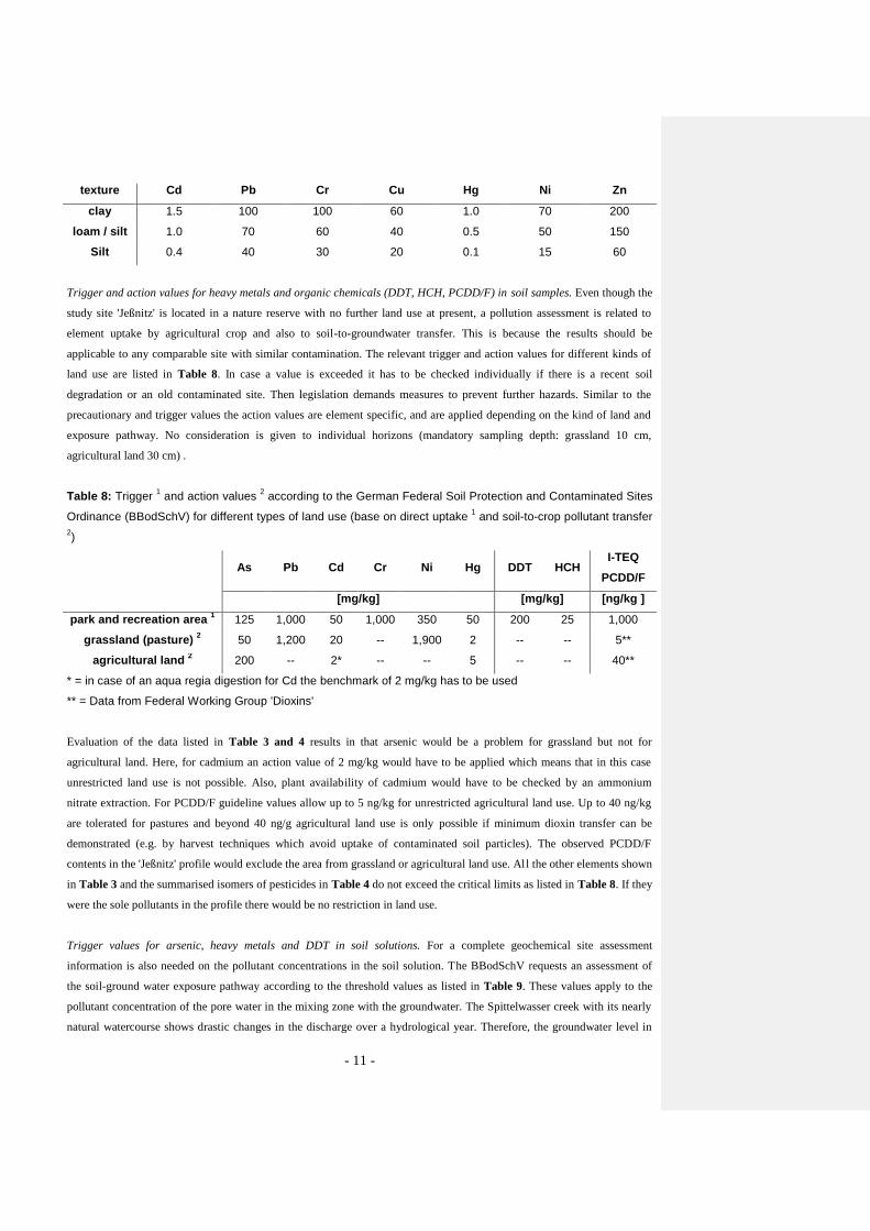
texture Cd Pb Cr Cu Hg Ni Zn
clay 1.5 100 100 60 1.0 70 200
loam / silt 1.0 70 60 40 0.5 50 150
Silt 0.4 40 30 20 0.1 15 60
Trigger and action values for heavy metals and organic chemicals (DDT, HCH, PCDD/F) in soil samples. Even though the
study site 'Jeßnitz' is located in a nature reserve with no further land use at present, a pollution assessment is related to
element uptake by agricultural crop and also to soil-to-groundwater transfer. This is because the results should be
applicable to any comparable site with similar contamination. The relevant trigger and action values for different kinds of
land use are listed in Table 8. In case a value is exceeded it has to be checked individually if there is a recent soil
degradation or an old contaminated site. Then legislation demands measures to prevent further hazards. Similar to the
precautionary and trigger values the action values are element specific, and are applied depending on the kind of land and
exposure pathway. No consideration is given to individual horizons (mandatory sampling depth: grassland 10 cm,
agricultural land 30 cm) .
Table 8: Trigger 1 and action values
2 according to the German Federal Soil Protection and Contaminated Sites
Ordinance (BBodSchV) for different types of land use (base on direct uptake 1 and soil-to-crop pollutant transfer
2)
As Pb Cd Cr Ni Hg DDT HCH
I-TEQ
PCDD/F
[mg/kg] [mg/kg] [ng/kg ]
park and recreation area 1 125 1,000 50 1,000 350 50 200 25 1,000
grassland (pasture) 2 50 1,200 20 -- 1,900 2 -- -- 5**
agricultural land 2 200 -- 2* -- -- 5 -- -- 40**
* = in case of an aqua regia digestion for Cd the benchmark of 2 mg/kg has to be used
** = Data from Federal Working Group 'Dioxins'
Evaluation of the data listed in Table 3 and 4 results in that arsenic would be a problem for grassland but not for
agricultural land. Here, for cadmium an action value of 2 mg/kg would have to be applied which means that in this case
unrestricted land use is not possible. Also, plant availability of cadmium would have to be checked by an ammonium
nitrate extraction. For PCDD/F guideline values allow up to 5 ng/kg for unrestricted agricultural land use. Up to 40 ng/kg
are tolerated for pastures and beyond 40 ng/g agricultural land use is only possible if minimum dioxin transfer can be
demonstrated (e.g. by harvest techniques which avoid uptake of contaminated soil particles). The observed PCDD/F
contents in the 'Jeßnitz' profile would exclude the area from grassland or agricultural land use. All the other elements shown
in Table 3 and the summarised isomers of pesticides in Table 4 do not exceed the critical limits as listed in Table 8. If they
were the sole pollutants in the profile there would be no restriction in land use.
Trigger values for arsenic, heavy metals and DDT in soil solutions. For a complete geochemical site assessment
information is also needed on the pollutant concentrations in the soil solution. The BBodSchV requests an assessment of
the soil-ground water exposure pathway according to the threshold values as listed in Table 9. These values apply to the
pollutant concentration of the pore water in the mixing zone with the groundwater. The Spittelwasser creek with its nearly
natural watercourse shows drastic changes in the discharge over a hydrological year. Therefore, the groundwater level in

- 12 -
the alluvial floodplain soils changes accordingly and a clear determination of the compliance point is not possible. By
definition the top of the permanently water saturated horizon (Gr horizon) could also be used for this purpose. But water
from this horizon has not been sampled so far. Instead, the source concentration was determined by measuring pollutants in
the leachate of the most heavily contaminated top horizons (0 - 50 cm) under well defined conditions in the laboratory.
Mercury and arsenic as the main problem elements in the solid phase were below the detection limit (Table 9) in
comparison to the mean values of Table 6. However, other elements exceeded the permissible inspection value by factors
of 12.8 (Cu), 6.8 (Zn), 4.5 (Cd), 4.5 (Ni), 3.5 (Pb), and 1.6 (Cr). Therefore, the floodplain soils of the Spittelwasser
lowlands, as represented by the Jeßnitz profile, must be considered as a significant diffuse source of pollutants for the
groundwater of this region.
Table 9: Trigger values according to the German Federal Soil Protection and Contaminated Sites Ordinance
(BBodSchV) for the exposure pathway soil-ground water
[µg/l] As Pb Cd Cr Cu Ni Hg Zn DDT
trigger value 10 25 5 50 50 50 1 500 0.1
2.5 Assessment Based on Monitored Natural Recovery Potential
Monitored natural recovery (MNR) is a risk reduction strategy that relies on ongoing, naturally-occurring processes to
contain, destroy, or reduce the bioavailability or toxicity of contaminants in sediments (Anon. 1997). Although no action is
required to initiate or continue the process, natural recovery is considered the result of a deliberate, thoughtful decision; the
latter can only be made following careful site assessment and characterization. Monitored natural recovery remedies rely on
the following physical, chemical, and biological processes (‘lines of evidence’; Magar and Wenning 2006):
1. Contaminant burial and natural deposition with clean sediments over time. The general approach involves core
analyses; vertical contaminant profiles of sediment and soils provide a temporal record of the emission-immission
relationships for different spatial scales (e.g. Westrich and Förstner 2005). Common tools for measuring the active
benthic include beryllium-7 profiles (Fitzgerald et al. 2001), oxic/anoxic profiles, and sediment profile imaging.
Metals and organic chemical show typical enrichment in the upper part (20 - 30 cm) of the core profile. Maximum
enrichment factors compared to background values are > 100 for mercury, and 4.3 to 8.9 for copper, cadmium, chromium
and lead. (section 2.2.1). Considering the respective precautionary concentrations, the maximum content in the soil profile
is overstepping this level with a coefficient of 14.3 for cadmium, followed by lead (12.2), zinc (7.3), chromium (5.9) and
copper (3.6). For arsenic and cadmium in the upper sediment samples, unrestricted land use (e.g., for grassland) is not
possible. The observed PCDD/F of more than 1.000 ng/kg in the upper 30 cm of the Jeßnitz profile would exclude any
agricultural use (>40 ng/kg I-TEQ) and would even be problematic as substrate for park and recreation areas (direct uptake,
> 1.000 ng/kg I-TEQ).
In contrast to geochemical analysis ecotoxicological examination aims at the overall effects of pollutants on test organisms.
Aquatic biotests can also be used to verify pollutant retention by soil material instead of the original purpose to demonstra te
direct toxicities. For the assessment of the water-extractable ecotoxicological potential Eisentraeger et al. (2005) propose a
procedure based on dilution values. The lowest ineffective dilution value (LID) is defined as the lowest dilution with less

- 13 -
than 20 % inhibition in the biotest used. Table 10 shows the lowest dilution factor of the eluates of the different soil layers.
According to Eisentraeger et al. (2005) leaching can occur when the lowest ineffective dilution value (LID) exceeds a value
of four in the algae test or Daphnia test and a value of eight in the luminescent bacteria test. This criterion is only fulfilled
in the top horizon.
Table 10: Ecotoxicological assessment of the retention function of the 'Jeßnitz' soil profile
Horizon Depth
(cm)
Lowest ineffective dilution value (LID)
Algae
Test
Luminescent
bacteria test
Daphnia
Test
aGo-aoAh 0 - 10 16 2 2
aGo-aAh 10 - 20 2 2 3
aAh-aM 20 - 30 2 2 3
aM 30 - 60 2 2 3
aGo-aM 60 - 80 1 2 3
aM-aGro 80 - 100 1 2 3
II aGor 100 - 120 1 2 3
Both chemical and ecotoxicological data on solid samples coincide in the observation, that the highest contamination and
toxicity potential is in the upper part of the fluvisol profile. There is no indication of an effective burial of strongly
contaminated material under fresh and relative clean sediments; the only exception is the example of PCDD/F, where the
uppermost sample (0 - 10 cm) containing 1,670 ng/kg dioxin covers a sample, where the extreme dioxin-concentration of
12,290 ng/kg was observed (see Table 4). Befund Mikrophoto von Sedimentoberfläche
2. Reduced contaminant mobility from sorption, precipitation, and other binding processes. The primary option for the
study of such processes are elution tests on individual substances, either batch or column, and/or ecotoxicological
testing to demonstrate the overall toxic reactions of the pollutants present (Förstner and Gerth 2001). The so-called
‘diagenetic’ effects, which, apart from chemical processes, involve an enhanced mechanical consolidation of soil and
sediment components by compaction and loss of water (Förstner 2003), can be studied from erosion experiments and at
best using sediment cores (see 1).
Under subaquatic conditions, there is a particularly low solubility of metal sulfides compared with the respective carbonate
and oxide conditions. One major prerequisite is the microbial reduction of sulphate; thus, this processes is particularly
important in the marine environment (Kersten 1988). The special feature of fluvisols, compared with most sediment
deposits is their non-saturation with water during of inundation, and like other terrestrial soils, these profiles are
predominant oxidized or suboxic. In addition, there are indications of still massive metal mobilisation due to the low pH (~
4) in the whole fluvisol profile studied (Table 1). Dissolved metals exceeded the permissible inspection value by factors of
12.8 (Cu), 6.8 (Zn), and 4.5 (Cd), representing a significant diffuse source of pollutants for the groundwater of this region .
With respect to the organic chemicals the distribution of the α- and β-isomers of HCH reflect downward migration of these
compounds; both isomers can be found down to a depth of 120 cm (Table 4).
Regarding the mechanical sediment stability, measurement of the critical shear stress of erosion can best be performed on
sediment core profiles with the SETEG-flume (Haag et al. 2001). It allows the measurement of erosion from the top layer

- 14 -
down to a sediment depth of 1,5 m at bed shear stresses of up to 15 Pa. Flow velocity and hence, the corresponding shear
stress are increased incrementally until the critical shear stress of mass erosion is reached; then the sediment material
remaining within the tube is later moved upwards and the procedure is repeated. The system was applied to a floodplain
sediment core taken from the middle Elbe (Förstner and Jacobs 2004); in the upper 13 cm the bottom shear stress was very
low (0.5 Pa), below this easily erodable, organic-rich material, the shear stress values of the floodplain soil/sediment jump
up to 1.5 to 2 Pa.
3. Chemical or biological transformations to less toxic forms. Here, a wide spectrum of methods for both assessment and
prognosis were developed on contaminated soils. Typical for sediments are low redox potentials and effect such as
biodegradation of naphthalene and phenanthrene under sulphate-reducing conditions (Coates et al. 1996) and
dechlorination of PCB increasing with sediment depth and age (Magar et al. 2005).
Degradation of HCH etc., effect of reduced toxicity due to sorption on solid surfaces (Literature)
4. Dispersion of particle-bound contaminants that leads to contaminant concentration reductions. Erosion, transport, and
dispersion of particle-bound contaminants potentially benefit highly contaminated environments and lead to localized
contaminant-concentration reduction; however, these same processes may increase contaminant loading and risk to
downstream areas.
Generally, dispersion of highly contaminated sediments and fluvisols will be a problem rather than a benefit, as it could be
expected, when relatively low contaminant concentrations are further diluted. In the case of the Spittelwasser region, there
is the classical proof for a widespread dispersion of toxic dioxins. Here, congener analysis and multivariate statistical
methods provide direct evidence that a considerable proportion of dioxin pollution in Hamburg harbour sediments (370 km
downstream) originates from former magnesium production at Bitterfeld (Götz et al. 1998). Other substances in the Elbe
sediment have already the typical fingerprint of by the Bitterfeld/Spittelwasser floodplain- E.g., the degree of pollution by
α- und β-HCH was evaluated according to the ARGE-Elbe regulations (Anon. 2004b) for river sediments; the quality
would be class 'IV' which means extreme pollution.
3 Conclusion and Outlook
The studied fluvisol is highly contaminated by mercury (> 100 fold background concentration) and persistent organic
chemicals such as HCH, DDT and PCDD/F (up to 12,290 ng/kg I-TEQ in the layer 10 - 20 cm). From the view of the
German Federal Soil Protection and Contaminated Soil Ordinance (BBodSchV) even the PCDD/F-content of the 0 - 10 cm
layer, would exclude any agricultural use (grassland 5 ng/kg, agriculture 40 ng/kg I-TEQ) and would even be problematic
as substrate for park and recreation areas (direct uptake, > 1.000 ng/kg I-TEQ). Soil solution contents for cadmium, copper
and zinc exceed the threshold values by factors of 6.3 to 12. The ecotoxicological potential was lower than expected from
the geochemical results. This could be indicative of a strong binding of pollutants in the topsoil. At the same time it
becomes obvious that pollutant transfer into the originally uncontaminated deeper layers causes a significant toxicity
reaction in the subsoil. All these results confirm earlier findings that the Spittelwasser area is strongly contaminated and
needs remediation both in respect to unrestricted agricultural use and acceptable groundwater quality.
The type of problem solution is not yet clear, except of the fact, that the natural recovery potential of the soil and sedime nts
will not be sufficient to achieve medium-term acceptable conditions for agricultural use and groundwater recharge. None of
Kommentar [F1]:
Kommentar [F2]:
Kommentar [F3]: Frau Bley, Frau
Neumann-Hensel: Bitte je ein Satz zum
Beispiel HCH-Abbau im Spittelwassergebiet, weitere Literaturzitate
für Abbau in dieser Region (Brack?) sowie
zum Effekt der Toxizitätsabnahme durch
Sorptionseffekte (hier auch eine Brücke zu
Ihren Daten). Am Ende steht die
Feststellung, dass vor allem der geringe Abbau bei PCDD/F das entscheidende
Kriterium für die Nicht-Anwendbarkeit des
MNR-Konzeptes auf die
Spittelwasserregion ist.

- 15 -
the four criteria in the lines of evidence for applying monitored natural recovery (MNR, Magar and Wenning 2006) is
fulfilled: (1) Deposition of clean sediment over time is widely missing, (2a) mechanical stability of the upper, highly
polluted sediment layer cannot be guaranteed (see also 4), (2b) chemical stability of critical metal compound in the oxic
fluvisol, e.g. by sulphide binding of mercury, is significantly lower than under permanent reducing subaquatic conditions,
(3) chemical and biological transformation of critical organic pollutants like dioxin is low, and (4) because of the extreme
high concentrations of PCDD/F (> 10.000 ng/kg I-TEQ) in the upper Spittelwasser soil layers any promotion of dispersion
processes would only result in a wider spatial contamination of downstream floodplains, and thus, in an exceedance of the
limit value of 5 ng/kg I-TEQ) for grassland use.
Beyond the present example showing extreme conditions with respect of pollutant concentrations and mobilities, the new
MNR assessment approach provides a good basis to deal with large-scale, diffuse contamination of floodplains. Further
extensions of this concept should include implementation of specific tools and standardized procedures, with special
emphasis on the characterization of contaminated fluvisols and their functions in the river continuum. Management
strategies should address a wider range of actions including the use of relative soft engineering controls. In this respect,
apart from the necessary excavation and safe deposition of highly contaminated materials, less or non-intrusive procedures
like pH-control or capping techniques are particularly promising, even for the Spittelwasser floodplain.
Acknowledgements
The project is a part of the KORA joint research programme ‘Natural retention and controlled decomposition of pollutants
for the remediation of contaminated soils and ground water’. It is funded by the German Federal Minist ry of Education and
Research (BMBF) under the registration number 033 0519. We are grateful to Dr. F. Walkow of the district authority
(Landratsamt Bitterfeld) for advice and information on the sampling site and for providing access to the area of
investigation, to Dr. G. Umlauf from the European Commission - Joint Research Centre in Ispra (I) for the dioxin analysis
and to Dr. D. Haase from the Centre for Environmental Research Leipzig-Halle (UFZ) for her cooperation.
References
Anonymous (1989): DIN 38412-T30. Deutsche Einheitsverfahren zur Wasser-, Abwasser- und Schlammuntersuchung –
Testverfahren mit Wasserorganismen (Gruppe L) – Teil 30: Bestimmung der nicht akut giftigen Wirkung von Abwasser
gegenüber Daphnien über Verdünnungsstufen (L30). Beuth, Weinheim, Germany
Anonymous (1991): DIN 38412-T3. Deutsche Einheitsverfahren zur Wasser-, Abwasser- und Schlammuntersuchung –
Testverfahren mit Wasserorganismen (Gruppe L) – Teil 33: Bestimmung der nicht giftigen Wirkung von Abwasser
gegenüber Grünalgen (Scenedesmus-Chlorophyll-Fluoreszenstest) über Verdünnungsstufen (L33). Beuth, Weinheim,
Germany.
Anonymous (1994): AG Boden. Bodenkundliche Kartieranleitung, 4 Aufl., Schweizerbart'sche Verlagsbuchhandlung,
Stuttgart, 392 p.
Anonymous (1997): Contaminated sediments in ports and waterways – Clean-up strategies and technologies. NRC, Marine
Board, Committee on Contaminated Marine Sediments. Washington DC, National Academy, 295 p.
Anonymous (1998): BBodSchG . Gesetz zum Schutz des Bodens, BGBl. I, G 5702, Nr. 16 vom 24.3.98, 502-510
Anonymous (1999): BbodSchV. Bundes-Bodenschutz- und Altlastenverordnung vom 17. Juli 1999, BGBl I, Nr. 36 vom
16.7.99, p. 1554
Anonymous (2000): Contaminated Soil 2000 – Case Study ‘Comparison of Solutions for a Large Contamination Based on
Different National Policies’. ConSoil 2000, 7th Intern. FZK/TNO Conference on Contaminated Soil. Leipzig, 165 p.

- 16 -
Anonymous (2004): Gewässergüteberichte der Elbe 2002, Arbeitsgemeinschaft für die Reinhaltung der Elbe, Hamburg, 1 -
22
Balkenhol RK (2000): Experimentelle Untersuchungen und Modellierungen von Folgereaktionen der Pyritverwitterung in
Braunkohletagebau-Haldensedimenten. Dissertation an der Mathematisch-Naturwissenschaftlichen Fakultät der Georg-
August-Universität zu Göttingen, 1-130
Barkowski D (1992): Sanierungsuntersuchung Grube Johannes (Silbersee) in Wolfen/Bitterfeld - Charakterisierung des
Deponieinhalts. In Hille J et al. (Hrsg.): Bitterfeld - Modellhafte ökologische Bestandsaufnahme einer kontaminierten
Industrieregion. Schadstoffe u. Umwelt 10, 233-241
Brack W, Schirmer K (2003): Effect-directed identification of oxygen and sulphur heterocycles as major polycyclic
aromatic cytochrome P4501A-inducers in a contaminated sediment. Environ Sci Technol 37: 3062-3070
Brack W, Altenburger R, Ensenbach U, Möder M, Segner H, Schüürmann G (1999): Bioassay-directed identification of
organic toxicants in river sediment in the industrial region of Bitterfeld (Germany) - A contribution to hazard assessment.
Archives of Environmental Contamination and Toxicology 37, 164-174
Brack W, Schirmer K, Kind T, Schrader S, Schüürmann G (2002): Effect-directed fractionation and identification of
cytochrome P4501A-inducing halogenated aromatic hydrocarbons in a contaminated sediment. Environ Toxicol Chem 21:
2654-2662
Bruckmeier BFA, Jüttner I, Schramm KW, Winkler R, Steinberg CEW, Kettrup A (1997): PCBs and PCDD/Fs in lake
sediments of Großer Arbersee, Bavarian Forest, South Germany. Environmental Pollution 95, 19-25
Coates JD, Woodward J, Allen J, Philip P, Lovley DR (1997): Anaerobic degradation of polycyclic aromatic hydrocarbons
and alkanes in petroleum-contaminated marine harbour sediments. Appl Environ Microbiol 63, 3589-3593
Eisentraeger A, Dott W, Klein J, Hahn S (2003): Comparative studies on algal toxicity testing using fluorometric
microplate and Erlenmeyer flask growth-inhibition assays. Ecotoxicol Environ Safety 54, 346-354
Eisentraeger A, Hund-Rinke K, Roemke J (2005): Assesment of ecotoxicity of contaminated soil using bioassays. In:
Margesin R, Schinner F (Eds.): Manual for Soil Analysis- Monitoring and Assessing Soil Bioremediation, Berlin
Heidelberg, Springer, 321-359
Elendt BP, Bias WR (1990): Trace nutrient deficiency in Daphnia magna cultured in standard medium for toxicity testing.
Effects of the optimization of culture conditions on life history parameters. Water Research 24, 1157-1167
Fitzgerald SA, Klump JV, Swarzenski PW, MacKenzie RA, Richards KD (2001) : Be-7 as a tracer of short-term sediment
deposition in the Fox River. Environ Sci Technol 35, 300-305
Förstner U (2003): Geochemical techniques on contaminated sediments – River basin view. ESPR Environ Sci & Pollut
Res 10, 5868
Förstner U, Gerth J (2001): Natural attenuation – non-destructive processes. In: Stegmann R et al. (eds.): Treatment of
contaminated soils - fundamentals, application and analysis, Berlin, Springer, 567-586
Förstner U, Jacobs P (2004): Schwermetall-Freisetzung aus belasteten Überflutungsflächen in Folge (bio-)chemischer und
physikalischer Einflüsse. In: Geller W et al. (eds): Schadstoffbelastung nach dem Elbehochwasser 2002, ISBN 3-00-
013615-0, Magdeburg, pp 275286
Förstner U, Gerth J, Lindemann M, Wittmann U (2001): Managing contaminated sediments. in-situ sediment treatment
(Spittelwasser case study). Journal of Soils & Sediments 1 (3), 181-187
Förstner U, Heise S, Schwartz R, Westrich B, Ahlf W (2004): Historical contaminated sediments and soils at the river basin
scale - examples from the Elbe River catchment area. Journal of Soils & Sediments 4 (4), 247-260
Förstner U, Wittmann U, Gier S et al. (2000): Case comparison Bitterfeld – German contribution. Compiled by a temporal
working group for the 7th Intern. FZK/TNO-Conference on Contaminated Soil, Leipzig/Germany, Sept 18-22, 2000, 25 p.

- 17 -
Gerth J, Dankwarth F, Förstner U (2001): Natural attenuation of inorganic polluntants - A critical view. In: Stegmann R et
al. (eds.): Treatment of contaminated soils - fundamentals, application and analysis, Berlin, Springer, 603-614
Götz R, Steiner B, Friesel P, Roch K, Walkow F, Maaß V, Reincke H, Stachel B (1998): Dioxin (PCDD/F) in the River
Elbe – investigations of their origin by multivariate statistical methods. Chemosphere 37, 1987-2002
Gröngröft A, Krüger F, Grunewald K, Meißner R, Miehlich G (2005): Plant and soil contamination with trace metals in the
Elbe floodplains: A case study after the flood in August 2002. Acta Hydrochimica et Hydrobiologica 33 (5), 466-474
Haag I, Kern U, Westrich B (2001): Erosion investigation and sediment quality measurement for a comprehensive risk
assessment of contaminated aquatic sediment. Sci Total Environ 266, 249-257
Haase D (1999): Beiträge zur Geoökosystemanalyse in Auenlandschaften - Säurestatus und Pufferfunktion der Waldböden
in den Leipziger Flußauen. Dissertation, UFZ-Report 19/1999, 158 p.
Heinrich K, Lehmann J, Schulz E, Klimanek EM (2000): Untersuchungen zum Transport von beta-HCH aus
Muldeauenböden in Kultur- und Wildpflanzen. In: Friese K et al. (Eds..) Stoffhaushalt von Auenökosystemen - Böden und
Hydrologie – Schadstoffe - Bewertungen. Berlin, Springer, 301-308
Jüttner I, Henkelmann B, Schramm KW, Steinberg CEW, Winkler R, Kettrup A (1997): Occurrence of PCDD/F in dated lake
sediments of the Black Forest, southwestern Germany. Environmental Science and Technology 31, 806-812
Kalbitz K (1996): Untersuchungen zur Freisetzung der gelösten organischen Substanz des Bodens (DOM) und zum Einfluß
der DOM auf die Mobilisierung ausgewählter Schadstoffe in Abhängigkeit von Boden- und Standorteigenschaften.
Dissertation an der Landwirtschaftlichen Fakultät der Martin-Luther-Universität Halle-Wittenberg. UFZ-Report 23/1996,
139 p.
Kersten M (1988): Geochemistry of priority pollutants in anoxic sludges: Cadmium, arsenic, methyl mercury, and
chlorinated organics. In: Salomons W, Förstner U (eds) Environmental Management of Solid Waste. Dredged Material and
Mine Tailings. Berlin, Springer, 170-213
Klimanek EM, Lehmann J, Schulz E (2000): Untersuchungen zur in-situ-Sanierung von β-HCH belasteten Böden der
Muldeaue. In: Friese K et al. (Hrsg.) Stoffhaushalt von Auenökosystemen. Böden und Hydrologie - Schadstoffe -
Bewertungen. Berlin, Springer, 289-300
Krebs F (2001): Ökotoxikologische Baggergutuntersuchung, Baggergutklassifizierung und Handhabungskategorien für
Baggergutumlagerungen.- In: Calmano W (Ed.): Untersuchung und Bewertung von Sedimenten - ökotoxikologische und
chemische Testmethoden. Berlin, Springer, 333-352
Krüger F, Meissner R, Gröngröft A, Grunewald K (2005): Flood induced heavy metal and arsenic contamination of Elbe
River floodplain soils. Acta Hydrochimica et Hydrobiologica 33 (5), 455-465
Kunz B, Starke R, Klemm W, Beuge P (2000): Die Mulde. In: Furrer R et al. (Eds..): Die Belastung der Elbe - Part 2.
Hintergrundbelastung der deutschen Nebenflüsse. Karlsruhe, 39-52
Magar VS, Wenning RJ (2006): The role of monitored natural recovery in sediment remediation. Integrated Environmental
Assessment and Management 2 (1), 66-74
Magar VS, Brenner RC, Johnson G, Quensen JF III (2005): Long-term recovery of PCB-contaminated sediments at the
Lake Hartwell Superfund site: PCB-dechlorination. II - Rates and extent. Environ Sci Technol 39, 3538-3547
Netzband A, Reincke H, Bergemann M (2002): The River Elbe - A case study for the ecological and economical chain of
sediments. Journal of Soils and Sediments 2 (3), 112-116
Neumeister H (1964): Beiträge zum Auenlehmproblem des Pleiße- und Elstergebietes. Wissenschaftliche
Veröffentlichungen des Deutschen Instituts für Länderkunde 21/22, Leipzig, 65-131

- 18 -
Popp P, Kalbitz K, Oppermann G (1994): Application of solid-phase microextraction and gas chromatography with
electron-capture and mass spectrometric detection for the determination of hexachlorcyclehexanes in soil solution. J
Chromatography A 687: 133-140
Prein A, Mull R (1995): Pyritverwitterung in Abraumkippen des Braunkohletagebaus - limitierende Einflüsse und
resultierende Grundwasserkontaminationen. Zeitschrift d. Deutschen Geologischen Gesellschaft 146, 46-151
Salomons W (2005): Sediments in the catchment-coast continuum. Journal of Soils and Sediments 5 (1), 2-8
Schmohl N. (2001): Bedeutung des Apoplasten für die Aluminiumtoxizität bei höheren Pflanzen. Dissertation am
Fachbereich Biologie der Universität Hannover, 142 p.
Schwartz R (2001): Die Böden der Elbaue bei Lenzen und ihre möglichen Veränderungen nach Rückdeichung. Hamburger
Bodenkundliche Arbeiten 48, 391 p.
Stachel B, Götz R, Herrmann T, Krüger F, Knoth W, Päpke O, Rauhut U, Reincke H, Schwartz R, Steeg E, Uhlig S (2004):
The Elbe flood in August 2002 - occurrence of polychlorinated dibenzo-p-dioxins, polychlorinated dibenzofurans
(PCDD/F) and dioxin-like PCB in suspended particulate matter (SPM), sediment and fish. Water Science and Technology
50 (5), 309-316
Umlauf G, Bidoglio G, Christoph EH, Kampheus J, Krüger F, Landmann D, Schulz AJ, Schwartz R, Severin K, Stachel B,
Stehr D (2005): The situation of PCDD/Fs and dioxin-like PCBs after the flooding of River Elbe and Mulde in 2002. Acta
Hydrochimica et Hydrobiologica 33 (5), 543-554
Westrich B, Förstner U (2005): Assessing catchment-wide emission-immission relationships from sediment studies. J Soils
& Sediments 5 (4), 197-200
Witt O, Keller M, ter Hulscher D, Lehmann M, Westrich B (2003): Untersuchungen zum Resuspensionsrisiko belasteter
Sedimentablagerungen im Rhein. Vom Wasser 101, 189204