Assessing Water Quality Impacts of Community Defined Land Use Change Scenarios for the Douglas...
24
19 Assessing Water Quality Impacts of Community Defined Land Use Change Scenarios for the Douglas Shire, Far North Queensland Iris Bohnet 1 , Jon Brodie 2 and Rebecca Bartley 3 1 CSIRO Sustainable Ecosystems, Tropical Forest Research Centre, Ather- ton, Queensland, Australia 2 Australian Centre for Tropical Freshwater Research, James Cook Univer- sity, Townsville, Queensland, Australia 3 CSIRO Land and Water, Indooroopilly, Brisbane, Queensland, Australia Abstract: The Douglas Shire is promoted as the only place in the world where two world heritage areas meet — the Great Barrier Reef (GBR) and the Wet Tropics of Far orth Queensland. Over 80% of the shire’s land area is World Heritage listed. On the remaining 20%, economic pressures on primary industries coupled with development pressures to subdivide agricultural land for urban and rural residential expansion provide a challenge not only for local people living in the shire, but also for planners and natural resource managers who have a responsibility to implement the Reef Water Quality Protection Plan (Reefplan) (Commonwealth and Queensland Governments 2003). The purpose of the Reefplan is to develop actions, mechanisms and partnerships to halt and reverse the decline in the quality of water flowing in the Great Barrier Reef lagoon. The research presented in this chapter contributes to this goal by apply- ing a social–ecological framework that links biophysical and social science data and is based on partnerships and local collaboration to achieve sus- tainability outcomes. This chapter focuses, in accordance with the Reefplan, on water quality and summarises the water quality impacts resulting from six spatially explicit land use change scenarios that were developed in col-
Transcript of Assessing Water Quality Impacts of Community Defined Land Use Change Scenarios for the Douglas...

19 Assessing Water Quality Impacts of Community Defined Land Use Change Scenarios for the Douglas Shire, Far North Queensland
Iris Bohnet1, Jon Brodie2 and Rebecca Bartley3
1 CSIRO Sustainable Ecosystems, Tropical Forest Research Centre, Ather-ton, Queensland, Australia 2 Australian Centre for Tropical Freshwater Research, James Cook Univer-sity, Townsville, Queensland, Australia 3 CSIRO Land and Water, Indooroopilly, Brisbane, Queensland, Australia
Abstract: The Douglas Shire is promoted as the only place in the world where two world heritage areas meet — the Great Barrier Reef (GBR) and the Wet Tropics of Far �orth Queensland. Over 80% of the shire’s land area is World Heritage listed. On the remaining 20%, economic pressures on primary industries coupled with development pressures to subdivide agricultural land for urban and rural residential expansion provide a challenge not only for local people living in the shire, but also for planners and natural resource managers who have a responsibility to implement the Reef Water Quality Protection Plan (Reefplan) (Commonwealth and Queensland Governments 2003). The purpose of the Reefplan is to develop actions, mechanisms and partnerships to halt and reverse the decline in the quality of water flowing in the Great Barrier Reef lagoon.
The research presented in this chapter contributes to this goal by apply-ing a social–ecological framework that links biophysical and social science data and is based on partnerships and local collaboration to achieve sus-tainability outcomes. This chapter focuses, in accordance with the Reefplan, on water quality and summarises the water quality impacts resulting from six spatially explicit land use change scenarios that were developed in col-

384 I Bohnet, J Brodie and R Bartley
laboration with the local community in the Douglas Shire for the year 2025, based on their aspirations for a sustainable future. The spatially explicit land use change scenarios were used as input into the Sediment River Net-work Model (SedNet) to assess and compare the water quality outcomes of the current situation with the community developed scenarios for the future, with the aim of identifying actions to improve water quality.
The model results show that the changes in land use proposed in all sce-narios lead to no or a relatively small reduction in sediment loads exported from the Douglas Shire, indicating that the SedNet model, which was ap-plied for the whole of catchment, is insensitive to land use changes in the floodplain part of the landscape. Despite the fact that the SedNet results did not support community discussion about potential actions to achieve im-provements in water quality, the application of the social–ecological frame-work proved to be an important mechanism to build community capacity for participation in planning for sustainable future landscapes and seascapes.
19.1 Context and Case Study Location
The coastal catchments adjacent to the Great Barrier Reef — the Great Barrier Reef Catchment Area (GBRCA) — are a region of high economic importance and exceptional environmental value (McDonald and Weston 2004). The Douglas Shire is located in the northern part of the region, and supports the Wet Tropics and the Great Barrier Reef world heritage areas (Williams et al. 2001). The agricultural land, the focus of this study, forms less than 20% of the total shire area and is surrounded by the mountainous Wet Tropics rainforest to the west, and the Great Barrier Reef to the east (see Fig. 19.1).
The need for greater protection of the Great Barrier Reef, a declining lo-cal sugar industry and pressures to subdivide agricultural land for urban ex-pansion, provides a challenge not only for local people, but also for planners and natural resource managers who have a responsibility to implement the Reef Water Quality Protection Plan (Reefplan: Commonwealth and Queen-sland Government 2003). The Reefplan was developed because runoff of land sourced pollutants (suspended sediments, nutrients and pesticides) is believed to be degrading Great Barrier Reef ecosystems (Brodie et al. 2001; Furnas 2003). The goal of the Reefplan therefore is to halt and reverse the decline in water quality entering the reef within 10 years by reducing the load of pollutants from diffuse sources in the water entering the reef, and by rehabilitating and conserving areas of the reef catchment that have a role in removing waterborne pollutants.

Assessing Impacts of Community Defined Land Use Change Scenarios 385
Fig. 19.1. Location of the agricultural land (case study area) in the Douglas Shire within the Wet Tropics bioregion and relative to the Great Barrier Reef and Wet Tropics world heritage areas

386 I Bohnet, J Brodie and R Bartley
The Douglas Shire requires sustainable solutions for its future devel-opment that address environmental, social and economic change while enabling remediation of aquatic and terrestrial ecosystem degradation. The goal of this project, therefore, was to develop visions for the future of the Douglas Shire together with the local community that support local indus-tries, communities and ecosystems, while protecting the Great Barrier Reef through improved water quality and hence healthier aquatic ecosystems. One of the key objectives of the project was the translation of broad com-munity visions into spatially explicit land use change scenarios that allow for analysis of water quality impacts on the Great Barrier Reef. Comparing the reef water quality outcomes from the different land use change scenar-ios with the current situation enables the community, planners and natural resource managers to make more informed and strategic decisions about the future development of the Douglas Shire if reef water quality is im-perative for any future development.
19.2 Dialogue over Sustainable Future Landscapes and Seascapes
Dialogue and public participation are essential in the debate about possible future development in the Douglas Shire and elsewhere. Successful im-plementation of the local planning scheme (Douglas Shire Council 2006), the Far North Queensland natural resource management plan (FNQNRM 2004), and the Reefplan (Commonwealth and Queensland Government 2003) requires the active support and engagement of a wide range of peo-ple including industries, community groups, indigenous people, environ-mentalists, farmers, concerned locals and the general public. Without inte-grating the diverse points of view of these stakeholders, the implementation of these plans is at risk (Kasemir et al. 2003).
Plans that are consistent with the visions, beliefs, and aspirations of lo-cal people will have a greater chance of success than plans imposed with-out consideration of local opinion, as local people (e.g. land owners, land mangers) are the ones who implement the required changes, proposed in these plans, ‘on the ground’. Luz (2000) argues that only with the intro-duction of a ‘social layer’ in the superposition of thematic maps, which are generally used in planning processes, can the interests and needs of differ-ent landscape users be taken into account as professionally as the mapping of soils, land use and land cover. He also suggests collecting data from lo-cal farmers on differences in perception and appreciation of landscape and environment, and perspectives on the future of farming and landscape de-

Assessing Impacts of Community Defined Land Use Change Scenarios 387
velopment, with communication facilitated through workshops, working groups, lectures and site visits.
Communication throughout the planning process is not only important from the point of view of acceptance of the outcomes, but also to enable social learning and encourage a more informed decision-making process about future developments in the Douglas Shire and the GBRCA based on the economic, environmental and social impacts and trade-offs of alternate pathways for change (Barker 2005). The formation of partnerships bring-ing together scientists, planners, decision makers and local communities presents an opportunity to develop a framework and process for integrating the social dimension, communication and capacity building into landscape planning and analysis for sustainable development in the GBRCA.
19.3 Methodology of an Application of a Social–Ecological Framework for Sustainable Landscape Planning
To create pathways towards a more sustainable future Bohnet and Smith (2007) developed a social–ecological framework for planning future land-scapes (Fig. 19.2). Following their framework in broad terms, the follow-ing three-stage participatory planning process was chosen to develop a set of land use change scenarios together with the local community based on their aspirations for a sustainable future. In contrast to forecasting or pre-dicting the future, scenarios are vivid stories that are constructed to de-scribe alternative futures that might be very different from the present (Hulse et al. 2004, Nassauer and Corry 2004). The advantage of develop-ing scenarios, in contrasts to forecasts, is the potential to build community capacity and to plan strategically to achieve a desired future outcome that is shared by the community.
19.3.1 Stage I: Community Perceptions and Visions
The first stage involved desktop and field-based assessments to define the character of the Douglas Shire landscape (Swanwick 2002), as well as 19 qualitative semi-structured interviews with a wide range of farmers and land managers in the Douglas Shire (Silverman 2000) and landscape as-sessments of their properties (Countryside Commission 1993). The goal of the interviews was to discuss issues such as:
� how they use and manage their properties � why they carry out certain practices and not others

388 I Bohnet, J Brodie and R Bartley
� what their future goals and aspirations are regarding land use and man-agement.
The landscape assessments, which were carried out with interviewees, provided additional information and allowed linking and comparing field data with social data gathered during the interviews. Analysis of interview data and landscape assessments informed the development of two broad community visions for the shire based on the participants’ perceptions about the future (Fig. 19.2).
Characteristic photographs from the Douglas Shire landscape were simulated and distinct future paths for landscape development were visual-ised using the software Adobe Photoshop 7.0. These photorealistic land-scape visions were then used as a tool and starting point to communicate to the public possible landscape futures for the Douglas Shire, which pro-moted public debate about the future (Bohnet 2004). Landscape visualisa-tions were chosen because of their successful application by other land-scape researchers and planners to illustrate change in the visual landscape (Al-Kodmany 1999; Schmid 2001). Photorealistic landscape simulations were chosen as a visualisation tool over other tools such as maps, charts, tables, drawings or GIS-based modelled landform surfaces (Jessel and Ja-cobs 2005; Lange 1999; Palang et al. 2000; Tress and Tress 2003;) be-cause they are easily accessible, attract people’s attention and enhance public participation in planning and design.
Fig. 19.2. Social–ecological framework for sustainable landscape planning (Source: Bohnet and Smith 2007)

Assessing Impacts of Community Defined Land Use Change Scenarios 389
19.3.2 Stage II: Community�driven Landscape Scenarios
Stage I provided the foundation for Stage II in which community work-shops were used to further develop the broad landscape visions for 2025 with the wider community and other interest groups, apart from farmers and land mangers. These workshops provided local citizens with the op-portunity to discuss their preferred future, what their common and con-trasting future priorities were, and how those priorities may translate in the landscape of 2025.
From the workshop discussion, common themes could be identified and spatially explicit land use change scenarios could be derived based on pri-ority themes (Fig. 19.2). Alternate scenarios were drawn from contrasting sets of priority themes. Besides the contrasting priorities themes (i.e. future land use preferences), workshop participants also defined some landscape targets to be achieved under any future scenario. For example, land cur-rently used for agricultural production on steep slopes (�20%) was pro-posed to be left to regrow into secondary rainforest. Applying quantitative targets for operational use allowed clear identification of change between the current situation and future scenarios, which is a prerequisite for map-ping scenarios. In instances where no quantitative targets were identified by workshop participants it was necessary to translate qualitative informa-tion into quantitative or location specific targets. This was not always straightforward, but the information provided by workshop participants in-dicated at the very least where and what sort of change is favoured by local people in each of the landscape scenarios. For this reason alone, commu-nity workshops are of particular importance, as communication and co-operation have been identified as crucial for acceptance and implementa-tion of planning projects (Luz 2000; Luz and Weiland 2001).
19.3.3 Stage III: Modelling of Landscape Scenarios and Assessing Water Quality
Based on the current land use/land cover map developed for this study, the land use change scenarios were mapped in Stage III (Fig. 19.2). The goal was to translate the descriptive visions provided by the local community as accurately as possible into mapped land use change scenarios (Hulse et al. 2002). The resulting scenarios are those that make sense to locals and re-flect their aspirations and values — in contrast to scenarios developed by researchers, planners and policy makers. Scenario mapping was done through land allocation modelling, which means assigning one particular land use/land cover to each grid cell or polygon in a digital map according

390 I Bohnet, J Brodie and R Bartley
to defined rules. Hierarchical roles (first and second order rules) were de-rived from the priority themes and landscape targets, defined in the com-munity workshops in Stage II, and mapped in a Geographic Information System (GIS).
Current land use/land cover and that of each future scenario, together with additional information related to management practices (discussed during the community workshops) were used as inputs into Sed�et to as-sess the reef water quality impacts of the different scenarios in comparison to the current situation.��
Sed�et models estimate river sediment loads, by constructing material budgets that account for the main sources and stores of sediment (Wilkin-son et al. 2004). Sed�et uses a simple conceptualisation of transport and deposition processes in streams (Fig. 19.3). Sediment sources, stream loads, and areas of deposition in the system are simulated. The contribu-tion to the river mouth from each subcatchment can be traced back through the system, allowing downstream impacts to be put into a regional per-spective.
Fig. 19.3. Conceptualisation of the components of the suspended load budget transport and deposition processes in the Sediment River Network Model (Sed�et) where t/y is tonnes per year (adapted from Wilkinson et al. 2004). Note: only the hillslope erosion component of the budget was evaluated in this study and there-fore only suspended (or fine) sediment was evaluated in the final calculations. Bedload is produced from river bank and gully erosion (not hillslope erosion) nei-ther of which was evaluated in these scenarios
The Sed�et model generates sediment from three erosion processes: hillslope or paddock erosion, gully or drain erosion, and river bank ero-

Assessing Impacts of Community Defined Land Use Change Scenarios 391
sion. The methods used to assess each of these sources and to propagate the sediment through the river network are described in detail in Bartley et al. (2004, 2003). It is important to note, however, that in this study the scenarios were only applicable to hillslope or paddock erosion as this is the main proc-ess directly impacted by land use/land cover change. It is anticipated that both drain and bank erosion would also be affected by changes in land condition, yet the magnitude of this change is not known and was therefore not ad-dressed in this study. It was believed at the commencement of the study that the principle effect of the land use scenarios on water quality would be on sediment loads rather than specific nutrient or pesticide loads, and hence sediment and the sediment modelling tool Sed�et were chosen to analyse the effects of the scenarios.
19.4 Results and Discussion
19.4.1 Visions for the Douglas Shire Coastal Landscape
Based on the character of the Douglas Shire landscape, which is defined by a combination of natural and agricultural features (Bohnet 2004), and the qualitative interviews with farmers and land managers in the Douglas Shire, the future visions could be divided into two distinct future path-ways:
� a diversified future landscape with continued sugarcane production � a post-sugarcane landscape.
These visions for the future, described by the interviewees, were presented as landscape simulations based on landscape photographs taken during the landscape assessments (Fig. 19.4a).
In the vision for a diversified future landscape in 2025 with continued sugarcane production, interviewees assumed that declining farm incomes from sugar production and pressures on the local sugar industry led cane farmers to pool their ideas and resources to overcome the crisis. Farm businesses and the cooperative sugar mill diversify in order to produce tropical fruit juices, timber and fibreboards, in addition to sugarcane. In the diversified future landscape sugarcane, tropical fruit, bamboo and rainfor-est timber is grown (Fig. 19.4b).

392 I Bohnet, J Brodie and R Bartley
Fig. 19.4. (a) Douglas Shire coastal landscape in 2003, (b) a diversified landscape vision for continued sugarcane production in Douglas Shire 2025, (c) a post-sugarcane vision for the Douglas Shire landscape in 2025
The vision for a post-sugarcane landscape is based on the idea, put for-ward by some interviewees, that development pressures led Douglas Shire council to approve subdivisions on land previously used for sugarcane production forcing the local sugar mill to close down. Some buyers of these blocks choose to carry out some agricultural activities, such as or-ganic farming or other land-based activities with low environmental im-pact. Subdivisions on hill slopes are only approved under strict develop-ment codes and buyers are required to screen their homes with native trees. Sugarcane paddocks are replaced by small-scale cropping, residential de-velopment, pastures, regrowth and agroforesty blocks (Fig. 19.4c).
19.4.2 Spatially Explicit Land Use Change Scenarios
Community interest, stimulated by the landscape visions (Fig. 19.4b, 19.4c) enabled the project team to run three community workshops. These landscape visions attracted a diverse range of community members includ-
a)
c)
b)

Assessing Impacts of Community Defined Land Use Change Scenarios 393
ing farmers, traditional owners, long-term residents and newcomers to the area, to attend the workshops. The workshops provided a forum for indi-viduals to present their different viewpoints regarding their aspirations for the future of the area, to discuss their priorities and the potential trade-offs between their priorities, and to learn from other participants. Small work-shop groups ensured genuine input from each individual and exposure to different ideas.
The project team facilitated discussion and prompted participants with questions that would allow the information provided by the participants to be translated into spatially explicit land use or management changes. The combined results from all workshops are presented in the following se-quence: common themes discussed during the workshops, priorities for the future, and development of spatially explicit land use change scenarios. The combined results from the workshops were then put into Sed�et to evaluate how the changes impact on end-of-catchment sediment loads (used to represent water quality). Common themes discussed in all work-shops were:
� sugar industry survival � land use diversification options and alternative management practices � water quality and quantity issues � protection of the natural environment � development pressures for urban and rural residential subdivisions.
The results are also summarised in a short report prepared for workshop participants (Bohnet 2004). Discussions about the sugar industry surviving or ceasing in future divided participants into two groups. Therefore, it was decided that the future scenarios developed would need to have two sets of scenarios, similar to the broad landscape visions that stimulated commu-nity interest. One set needed to include continued sugarcane production in the future, whereas the other set needed to exclude sugarcane production in the future landscape. The decision to develop two sets of scenarios was made early in each of the workshops in order to progress discussion and participants’ thinking about differences between those distinct futures, al-ternate land uses and priorities.
Three quite different key priorities for the future emerged from the dis-cussions: continued agricultural production, improved water quality, and en-hanced biodiversity. These priorities were based on the common themes dis-cussed and on different sets of underlying assumptions and beliefs held by the participants. The core assumptions and beliefs on which people in the Douglas Shire based their priorities for continued agricultural production included:

394 I Bohnet, J Brodie and R Bartley
� agriculture is a means to stop or reduce further rural residential devel-opment
� appreciation of local produce that can be associated with the landscape � opportunity to buy locally grown food � diversification of agricultural crops reduces farm financial risks, particu-
larly if high value crops are grown in areas ‘suitable’ for those crops � move towards more environmentally-friendly/organic farming practices
reduces environmental impacts from farming and potential conflicts with the non-farming community
� provision of local employment opportunities.
With regard to the priority of improved water quality, the core assump-tions and beliefs of local people included:
� any activity (e.g. agriculture, rural residential development) should not pollute rivers and creeks
� agricultural activities should continue to protect the rural character of the area but with lowest possible impact (e.g. grazing with low stocking rates and minimum fertilizer input)
� obligation to protect the Great Barrier Reef � necessity to sustain a viable tourism industry.
With regard to enhanced biodiversity as a priority, the core assumptions and beliefs of local people included:
� native vegetation on farms (e.g. remnants) needs to be protected for its intrinsic value
� need to provide habitats for native flora and fauna � need to improve the coastal environmental to protect Great Barrier Reef
(e.g. no sugarcane should be grown in area of frequent flooding) � move towards more environmentally-friendly/organic farming and man-
agement practices will enhance biodiversity on farms and improve water quality
� need to grow crops that are ‘suitable’ for the area in order to reduce in-puts (fertilizers, pesticides) and impact
� necessity to sustain rural character and viable tourism industry.
Discussions provided sufficient detailed information to develop two sets of three spatially explicit future scenarios for 2025 in a geographic in-formation system (GIS).
� Scenario I: continued agricultural production (with continued sugarcane production)

Assessing Impacts of Community Defined Land Use Change Scenarios 395
� Scenario II: continued agricultural production (without continued sugar-cane production)
� Scenario III: improved water quality (with continued sugarcane produc-tion)
� Scenario IV: improved water quality (without continued sugarcane pro-duction)
� Scenario V: enhanced biodiversity (with continued sugarcane produc-tion).
� Scenario VI: enhanced biodiversity (without continued sugarcane pro-duction).
The workshop discussions also provided a wealth of contextual data useful to support the six land use change scenarios. Participants provided examples to underpin their priority and to convince others in the group about their priority considering potential trade-offs (environmental, social and economic) between different priorities. For example, participants who felt that continued agricultural production has to be the main priority sug-gested a wide range of crops including aquaculture, cocoa, vegetables and agroforesty for agricultural and landscape diversification to achieve a bal-ance between environmental, social and economic outcomes. They argued that these crops would allow for value adding while providing employment opportunities and preserving the character of the area.
The justifications, provided by the participants, to underpin each of the three priorities for the future provided, in essence, the details for develop-ment of the spatially explicit land use change scenarios. In addition, quan-titative landscape targets such as, all land on slopes steeper than 20% cur-rently used for agricultural production should be left for natural revegetation, were applied to all scenarios, whereas differing width of ri-parian buffer zones were applied to the improved water quality and en-hanced biodiversity scenarios. Land suitability indicators for the crops suggested by the workshop participants were used as criteria to identify the most suitable locations in the landscape for the suggested agricultural crops in the continued agricultural production and enhanced biodiversity scenarios (Wilson 1991).
A summary of the main land use changes and associated GIS-allocation rules is presented in Table 19.1, whereas Fig. 19.5 shows the current land use/land cover map developed for the agricultural land in the Douglas Shire and Fig. 19.6, Fig. 19.7 and Fig. 19.8 present the six land use change scenario maps.

396 I Bohnet, J Brodie and R Bartley
Table 19.1. Summary of the proposed land use changes for the Douglas Shire landscape
2025 Scenario Main land use change GIS-allocation rules (replic-able criterion) on which land use change is based
Scenario I: Continued agricultural production, with sugarcane
Slopes steeper than 20% and used for agricultural purposes � regrowth Land unsuitable for sugar-cane production � cocoa, horticulture, vegetables, sweet corn, agroforestry
All slopes steeper than 20% Land suitability mapping for agricultural crops
Scenario II: Continued agricultural production, without sugarcane
Slopes steeper than 20% and used for agricultural purposes � regrowth All sugarcane � aquaculture, agroforestry, vegetables, sweet corn, horticulture
All slopes steeper than 20% Spatially explicit locations (for some crops) Land suitability mapping for agricultural crops
Scenario III: Improved water quality, with sug-arcane
Slopes steeper than 20% and used for agricultural purposes � regrowth Establishment of continuous riparian buffer zones Establishment of wetland buffer zones
All slopes steeper than 20% 50 m riparian buffer zone where native vegetation is missing 100m buffers along con-served coastal wetlands
Scenario IV: Improved water quality, without sugarcane
Slopes steeper than 20% and used for agricultural purposes � regrowth Establishment of continuous riparian buffer zones Establishment of continuous wetland buffer zones All sugarcane � grazing
All slopes steeper than 20% 50 m riparian buffer zone where native vegetation is missing 100 m buffers along con-served coastal wetlands Change sugarcane to grazing
Scenario V: Enhanced biodiversity, with sug-arcane
Slopes steeper than 20% and used for agricultural purposes � regrowth Establishment of continuous riparian buffer zones Land unsuitable for sugar-cane production � cocoa, agroforestry, coastal wetlands
All slopes steeper than 20% 100 m riparian buffer zone where native vegetation is missing Spatially explicit locations (for coastal wetlands and ag-ricultural crops)
Scenario VI: Enhanced biodiversity, without sugarcane
Slopes steeper than 20% and used for agricultural purposes � regrowth Establishment of continuous riparian buffer zones All sugarcane � horticulture, grazing, agroforestry, coastal wetlands
All slopes steeper than 20% 100 m riparian buffer zone where native vegetation is missing Spatially explicit locations (for coastal wetlands and agroforestry) Land suitability mapping for agricultural crops

Assessing Impacts of Community Defined Land Use Change Scenarios 397
Fig. 19.5. Current (circa 2000) land use/land cover in the Douglas Shire

398 I Bohnet, J Brodie and R Bartley
Fig. 19.6. Land use change scenario maps: Scenario I continued agricultural pro-duction with continued sugarcane in 2025; Scenario II continued agricultural pro-duction without sugarcane production in 2025
Fig. 19.7. Land use change scenario maps: Scenario III improved water quality with continued sugarcane in 2025; Scenario IV improved water quality without sugarcane production in 2025

Assessing Impacts of Community Defined Land Use Change Scenarios 399
Fig. 19.8. Land use change scenario maps: Scenario V enhanced biodiversity with continued sugarcane in 2025; Scenario VI enhanced biodiversity without sugar-cane production in 2025
19.4.3 Inputs into SedNet for Water Quality Analysis and Model Results
In addition to changes in land use, land management changes (as suggested by the workshop participants) were also included as inputs into Sed�et. These management changes for sugarcane included: tillage level (actual for current situation, minimum for all scenarios), headland type (grassed for current situation and all scenarios), and fallow strategy (no fallow for current situation, legume fallow for all scenarios). Management changes for grazing included stocking rate (actual for current situation, reduced for all scenarios). Production systems and management practices were given varying cover factors dependent upon the scenario (Bartley et al. 2004; Merritt 2002). These cover factors influence surface erosion, but not bank or drain erosion in the Sed�et model. Cover factor grids were created for each scenario for input into the creation of hillslope erosion grids, which formed the final input for the calculation of sediment loads in Sed�et.
The Sed�et results indicate that changes in land use and management envisioned in all scenarios lead to no, or a relatively small, reduction in sediment loads exported from the Douglas Shire (Table 19.2). This is not
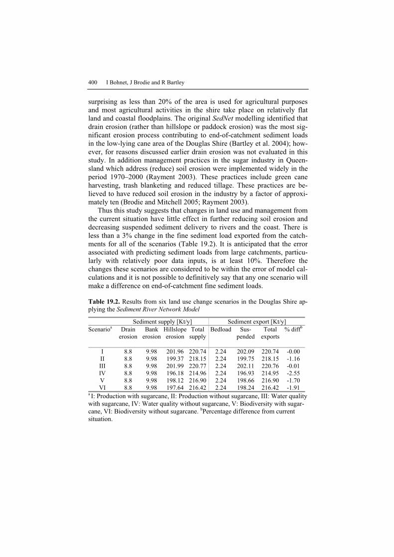
400 I Bohnet, J Brodie and R Bartley
surprising as less than 20% of the area is used for agricultural purposes and most agricultural activities in the shire take place on relatively flat land and coastal floodplains. The original Sed�et modelling identified that drain erosion (rather than hillslope or paddock erosion) was the most sig-nificant erosion process contributing to end-of-catchment sediment loads in the low-lying cane area of the Douglas Shire (Bartley et al. 2004); how-ever, for reasons discussed earlier drain erosion was not evaluated in this study. In addition management practices in the sugar industry in Queen-sland which address (reduce) soil erosion were implemented widely in the period 1970–2000 (Rayment 2003). These practices include green cane harvesting, trash blanketing and reduced tillage. These practices are be-lieved to have reduced soil erosion in the industry by a factor of approxi-mately ten (Brodie and Mitchell 2005; Rayment 2003).
Thus this study suggests that changes in land use and management from the current situation have little effect in further reducing soil erosion and decreasing suspended sediment delivery to rivers and the coast. There is less than a 3% change in the fine sediment load exported from the catch-ments for all of the scenarios (Table 19.2). It is anticipated that the error associated with predicting sediment loads from large catchments, particu-larly with relatively poor data inputs, is at least 10%. Therefore the changes these scenarios are considered to be within the error of model cal-culations and it is not possible to definitively say that any one scenario will make a difference on end-of-catchment fine sediment loads.
Table 19.2. Results from six land use change scenarios in the Douglas Shire ap-plying the Sediment River �etwork Model
Sediment supply [Kt/y] Sediment export [Kt/y] Scenarioa Drain
erosion Bank
erosion Hillslope erosion
Total supply
Bedload Sus-pended
Total exports
% diffb
I 8.8 9.98 201.96 220.74 2.24 202.09 220.74 -0.00 II 8.8 9.98 199.37 218.15 2.24 199.75 218.15 -1.16 III 8.8 9.98 201.99 220.77 2.24 202.11 220.76 -0.01 IV 8.8 9.98 196.18 214.96 2.24 196.93 214.95 -2.55 V 8.8 9.98 198.12 216.90 2.24 198.66 216.90 -1.70 VI 8.8 9.98 197.64 216.42 2.24 198.24 216.42 -1.91
a I: Production with sugarcane, II: Production without sugarcane, III: Water quality with sugarcane, IV: Water quality without sugarcane, V: Biodiversity with sugar-cane, VI: Biodiversity without sugarcane. bPercentage difference from current situation.

Assessing Impacts of Community Defined Land Use Change Scenarios 401
19.5 Conclusion
Development of future visions with the Douglas Shire community enabled social, economic and environmental issues to be discussed and integrated in six spatially explicit land use change scenarios for 2025. The future sce-narios illustrate participants’ wide ranging views and preferences related to landscape character and future development of the Douglas Shire land-scape. There was broad agreement on the need for environmental, social and economic sustainability; however, contrast among the scenarios high-lighted the differences in participants’ perceptions and values. Working through the social–ecological framework and formulating landscape vi-sions and spatially explicit land use change scenarios facilitated communi-cation among different social groups, and therefore was an important mechanism for social learning in relation to planning, local development, and the need to think beyond their own property and the shire boundaries.
The small relative difference in sediment delivery to rivers and the coast from the six scenarios reflects the low topography in the Douglas Shire agricultural area. The modelling results did not deliver significant differences between potential future developments as expected by the community, indicating that the Sed�et model, which was applied to the whole of the catchment, is insensitive to land use changes in the floodplain part of the landscape. This was not realised at the start of the project — the Sed�et model showed significant differences between scenarios in larger catchments where agriculture is located on steeper slopes (e.g. Bartley et al. 2003).
Despite the fact that the Sed�et results did not support community dis-cussion about potential actions to achieve improvements in water quality, the application of the social–ecological framework proved to be an impor-tant mechanism to develop a set of scenarios and to discuss not only water quality but also biodiversity and economic impacts (Roebeling et al. 2005). Biodiversity values of different land use types have been addressed in a separate study (Metcalfe and Westcott in prep), and suggest that increased connectivity of fragments of remnant native vegetation would be benefi-cial for a number of floral and faunal groups. Enhanced connectivity could be achieved through:
� revegetation of drainage channels � land abandonment and secondary forest development (e.g. on steep
slopes) � active revegetation of key areas deliberately for targeted biodiversity
benefits or aesthetic reasons

402 I Bohnet, J Brodie and R Bartley
� tree-based agricultural land use options which involve less intensive land management and habitat of greater structural complexity than sug-arcane.
However, the magnitude of biodiversity benefits and the particular groups to benefit would vary between land use options and extent (Westcott and Metcalfe pers. comm.1). Biodiversity enhancements achieved through re-establishment of riparian buffer zones and coastal wetlands are also likely to improve water quality, however this was not modelled in Sed�et.
The Sed�et results also show that it is important to assess the risk from key pollutants (i.e. those of highest environmental risk), before complex scenarios, such as the ones developed in this study, are modelled. In the case of the Douglas Shire it seems now obvious that the key pollutants are nitrate (from fertilizer residues) and possibly a number of herbicide resi-dues (particularly diuron and atrazine), which was not known when this study was carried out. Sed�et, and its associated nutrient model A��EX, are able to model nutrient transport, which has been done for other parts of the Great Barrier Reef (McKergow et al. 2005); however, neither model can deal with herbicides. The main reason that the A��EX model was not implemented in this study was the lack of nutrient data available for this region with which to populate the model, as well as redevelopment of the A��EX model at the time of this study. However there is a lack of detailed knowledge of the effects of these land uses, and it is accurate to conclude that the land use scenarios analysed in the current study may not have large effects on nutrient and pesticide loads and hence water quality. A number of research needs with respect to water quality modelling have been identified by this study. To ensure adequate calibration of models, the following is required: (a) development of models that can deal with herbi-cide residue transfer from catchments to marine waters; and (b) more data on the rates and amounts of nutrient movement from different land use types in coastal floodplain environments.
It is important to note that the water quality models currently available for assessing catchment-scale sediment (and nutrient) loads are continually under development. As more monitoring data becomes available, we will be able to improve our understanding of how sediment (and nutrient) loads change with different land use and management configurations, in both time and space, so we can make more reliable assessments. At present, there are a range of different approaches being discussed to help improve this process, including: (a) augmenting the results from annual load mod-
1 DA Westcott and DJ Metcalfe (Research Scientists, CSIRO Sustainable Ecosys-
tems, Atherton, Queensland) 23 November 2007

Assessing Impacts of Community Defined Land Use Change Scenarios 403
els (such as Sed�et) with runoff event-based models that may be more ap-propriate for identifying subtle changes in land use, and (b) combining wa-ter quality targets with land use change targets, as there is an increased ac-knowledgement that detecting changes in end-of-catchment loads as a result of land use change are difficult to evaluate, particularly for catch-ments that are not highly modified from their pre-European condition (e.g. Douglas Shire). This continual improvement of water quality models and approaches is important so we can assess the effects of changing from ‘traditional’ agricultural activities (such as sugarcane cultivation in the Douglas Shire, for which adequate research information exists) to new ag-ricultural mixes, as suggested by the community in the present study, for which little or no research information exists.
Finally, the process followed in the social–ecological framework makes planning for sustainable future landscapes and seascapes socially relevant as the framework links social and biophysical data with local and scientific knowledge to inform landscape visualisation and analysis of a wide range of potential impacts. Analysing community defined land use change sce-narios for a multitude of impacts — such as water quality, biodiversity, farm financial performance — allows development of community sup-ported actions to achieve multiple benefits. This makes the framework and process a powerful planning tool that contributes to the development of sustainable landscapes and seascapes and hence meets the goals of the Reefplan.
Acknowledgements
We would like to thank the community members who participated in the project for their time, stimulating discussions and enthusiasm; and the members of the Douglas Shire Joint Venture Partnership for their ongoing support and feedback to the project. We would also like to thank Karl Haug for fieldwork assistance, Jana Kaeppler, Petina Pert and Mick Hart-cher for GIS and modelling support, and David Westcott and Dan Metcalfe for valuable scientific discussions on biodiversity. Finally, we would like to thank CSIRO Sustainable Ecosystems for funding this research and Pe-ter Stone and two anonymous reviewers for valuable comments on an ear-lier draft of this chapter.
404 I Bohnet, J Brodie and R Bartley
References
Al-Kodmany K (1999) Using visualisation techniques for enhancing public par-ticipation in planning and design: process, implementation, and evaluation. Landscape Urban Planning 45:37–45
Barker A (2005) Capacity building for sustainability: towards community devel-opment in coastal Scotland. Journal of Environmental Management 75:11–19
Bartley R, Henderson A, Prosser IP, Hughes AO, McKergow L, Lu H, Brodie J, Bainbridge Z, Roth CH (2003) Patterns of erosion and sediment and nutrient transport in the Herbert River catchment, Queensland. CSIRO, Canberra, available at http://www.clw.csiro.au/publications/consultancy/2004
Bartley R, Henderson A, Baker G, Bormans M, Wilkinson S (2004) Patterns of erosion and sediment and nutrient transport in the Douglas Shire catchments. CSIRO Land and Water, Atherton, pp 61
Bohnet I (2004) Sustainable landscape planning in the Wet Tropics. Retrieved 25 July 2007, from http://www.cse.csiro.au/research/landscapescenarios/
Bohnet I, Smith DM (2007) Planning future landscapes in the Wet Tropics of Australia: A social-ecological framework. Landscape Urban Planning 80:137–152
Brodie J, Mitchell AW (2005) Nutrients in Australian tropical rivers: changes with agricultural development and implications for receiving environments. Marine and Freshwater Research 56(3):279–302
Brodie JE, Christie C, Devlin M, Haynes D, Morris S, Ramsay M, Waterhouse J, Yorkston H (2001) Catchment management and the Great Barrier Reef. Water Science and Technology 43:203–211
Commonwealth and Queensland Governments (2003) Reef water quality protec-tion plan: for catchments adjacent to the Great Barrier Reef World Heritage Area. Australian Government and Queensland Government
Countryside Commission (1993) Landscape assessment guidance. Countryside Commission, Cheltenham
Douglas Shire Council (2006) Douglas Shire local area planning scheme. Douglas Shire Council, Queensland
FNQNRM (2004) Sustaining the Wet Tropics: a regional plan for natural resource management. Far North Queensland Natural Resource Management Ltd, and Rainforest Corporate Research Centre, Cairns
Furnas M (2003) Catchments and corals, terrestrial runoff to the Great Barrier Reef. Australian Institute of Marine Science, CRC Reef Research Centre, Townsville
Hulse DW, Branscomb A, Payne SG (2004) Envisioning alternatives: using citi-zen guidance to map future land and water use. Ecological Applications. 14:325–341
Hulse DW, Gregory S, Baker J (2002) Willamette River Basin planning atlas. Oregon State University Press, Corvallis, Oregon

Assessing Impacts of Community Defined Land Use Change Scenarios 405
Jessel B, Jacobs J (2005) Land use scenarios development and stakeholder in-volvement as tools for watershed management within the Havel River Basin. Limnologica 35:220–233
Kasemir B, Jaeger J, Jaeger CC, Gardner MT (2003) Public participation in sus-tainability science – a handbook. Cambridge, University Press, Cambridge
Lange E (1999) Realität und computergestützte visuele Simulation. Eine em-pirische Untersuching über den Realitätsgrad virtueller Landschaften am Beispiel des Talraums Bunnen-Schwyz. ORL-Berichte Nr. 106, VDF, Zürich
Luz F (2000) Participatory landscape ecology – A basis for acceptance and im-plementation. Landscape Urban Planning 50:157–166
Luz F, Weiland U (2001) Wessen Landschaft planen wir? Kommunikation in Landschafts- und Umweltplanung. Naturschutz und Landschaftsplanung 33:69–76
McDonald G, Weston N (2004) Sustaining the Wet Tropics: a regional plan for natural resource management, Vol. 1: Background to the plan. Rainforest Corporate Research Centre and Far North Queensland Natural Resource Man-agement Ltd, Cairns
McKergow LA, Prosser IP, Hughes AO, Brodie J (2005). Regional scale nutrient modelling: exports to the Great Barrier Reef World Heritage Area. Marine Pollution Bulletin 51(1–4):186–199
Merritt WS (2002). Biophysical considerations in integrated catchment manage-ment: a modelling system for northern Thailand. Unpublished PhD thesis, Australian National University, Canberra
Metcalfe DJ, Westcott DA (in prep) Distribution of biodiversity and ecosystem processes in a fragmented tropical floodplain
Nassauer JI, Corry RC (2004) Using normative scenarios in landscape ecology. Landscape Ecology 19:343–356
Palang H, Alumäe H, Mander Ü (2000) Holistic aspects in landscape develop-ment: a scenario approach. Landscape Urban Planning 50:85–94
Rayment G (2003) Water quality in sugar catchments of Queensland. Water Sci-ence and Technology 48:35–47
Roebeling PC, Bohnet IM, Smith DM, Westcott D, Kroon F, Hartcher M, Hodgen M, Vleeshouwer J (2005) Landscapes toolkit for triple-bottom-line assess-ment of land-use scenarios in Great Barrier Reef catchments. In: Proceedings of MODSIM 2005 Conference, 12–15 December 2007, Melbourne, Australia
Schmid W (2001) The emerging role of visual resource assessment and visualisa-tion in landscape planning in Switzerland. Landscape Urban Planning 54:213–221
Silverman D (2000) Doing qualitative research — a practical handbook. Sage, London
Swanwick C (2002) Landscape character assessment – guidance for England and Scotland. A report by Land Use Consultants for The Countryside Agency and Scottish Natural Heritage, Wetherby, West Yorkshire and Edinburgh
Tress B, Tress G (2003) Scenario visualisation for participatory landscape plan-ning – a study from Denmark. Landscape Urban Planning 64:161–178

406 I Bohnet, J Brodie and R Bartley
Wilkinson SN, Henderson A, Chen Y, Sherman BS (2004) Sed�et: user guide Version 2.0.0. CSIRO, Canberra
Williams J, Read C, Norton A, Dovers S, Burgman M, Proctor W, Anderson H. (2001) Biodiversity, Australia State of the Environment Report 2001 (Theme Report), CSIRO Publishing on behalf of the Department of the Environment and Heritage, Canberra
Wilson PR (1991) Agricultural land suitability of the wet tropical coast, Mossman and Julatten area. Queensland Department of Primary Industries, Brisbane