Archaeological Survey in Catalina State Park with a Focus on the Romero Ruin
150
ARCHAEOLOGICAL SURVEY IN CATALINA STATE PARK WITH A FOCUS ON THE ROMERO RUIN By Mark D. Elson and William H. Docile Contributions by Lisa G. Eppley James P. Holmlund Henry D. Wallace This survey has been funded with the assistance of a matching grant-in-aid from the Department of the Interior, National Park Service, under provisions of the National Historic Preservation Act of 1966 as amended and as administered in Arizona by the Arizona State Parks Board through the State Historic Preservation Officer. INSTITUTE FOR AMERICAN RESEARCH TECHNICAL REPORT NO. 87-4 1987
Transcript of Archaeological Survey in Catalina State Park with a Focus on the Romero Ruin
ARCHAEOLOGICAL SURVEY IN CATALINA STATE PARK
WITH A FOCUS ON THE ROMERO RUIN
By
Mark D. Elson
and
William H. Docile
Contributions by
Lisa G. EppleyJames P. HolmlundHenry D. Wallace
This survey has been funded with the assistance of a matching grant-in-aid from theDepartment of the Interior, National Park Service, under provisions of the National HistoricPreservation Act of 1966 as amended and as administered in Arizona by the Arizona StateParks Board through the State Historic Preservation Officer.
INSTITUTE FOR AMERICAN RESEARCH
TECHNICAL REPORT NO. 87-4
1987

ACKNOWLEDGMENTS
Thanks are due to many individuals and organizations that have contributed to the successof this project. The State Historic Preservation Office (SHPO) awarded us a $10,000matching grant almost two years ago. When the planned funding for the matching portionof the grant fell through, the ANL Foundation awarded us a $5000 grant and the Institutefor American Research and Geo-Map, Inc. made up the final $5000 through in-kindcontributions. In fact, the in-kind contribution was probably met two or three times overthat sum. Our thanks to all of these funding sources.
There were a number of individuals who provided special assistance on this project. TeresaHoffman of the SHPO’s office was particularly helpful in commenting in a timely fashion onthe drafts of the National Register nomination and this report. Neil Donkersley of theCatalina State Park extended us numerous courtesies throughout the duration of thisproject. He and his staff are to be commended on the degree to which they have reducedpothunting activities within the Park and for their longer term interests in an interpretiveprogram for these important archaeological resources.
Dr. Emil Haury and Mrs. Agnese Lindley are thanked for taking a special interest in ourproject. It was Emil Haury who first recorded the Romero Ruin for the Arizona StateMuseum site files nearly 50 years ago, soon after he became Director of the Museum in1938.
The field mapping of the Romero Ruin was a major accomplishment of this project. JimHolmlund has taken the latest computer and laser technology and applied them in such amanner as to reveal a level of detail of the Romero Ruin that was only hinted at in thefield. Henry Wallace assisted Jim as the rod man in the field. Henry’s knowledge of thesite and his attention to detail contributed substantially to the quality of the final maps.
The field survey was directed by Mark Elson with assistance from Meg Burns, KurtDongoske, James Heidke, Annick Kaler, and Penny Wamboldt. Volunteer field assistancewas provided by Allen Dart, Caroline Davis, William Doelle, Mark Elson, Bill Grimes, AnnickKaler, Joan Lloyd, Woody McGinnis, Vince O’Callaghan, Donald Reser, Mary Bernard Shaw,Deborah Swartz, and Cathy Wasmann. The enthusiasm of these volunteers turned ourSaturday work sessions into recreation.
Laboratory processing was carried out by Lisa Eppley and Sarah Tuttle, and Lisa alsoconducted the analysis of the chipped and ground stone. Henry Wallace analyzed theceramics and Linda Mayro examined the shell collection from the Romero Ruin. JenniferBallard carried out the data entry, data management was performed by Michael Barton, andVarrie Edwards entered many of the tables. Tom Kolaz located the valuable notes ofDonald Page, who conducted his own investigation of the Romero Ruin in the late 1920s.The Arizona Historical Society was the source of a microfilm copy of Page’s notes.Finally, Linda Gregonis patiently worked with the junior author to assemble the finalreport for publication.

TABLE OF CONTENTS
ACKNOWLEDGMENTS ii
LIST OF FIGURES vi
LIST OF TABLES viii
1. INTRODUCTION 1
Environment 1Previous Research 6
Early Research 6Recent Research 9
Organization of Report 12
2. FIELD AND ANALYSIS METHODS 14
Field Methods 14Archaeological Survey 14Surface Collection 15Assessment of the Collection Strategy 16Additional Survey 17
Analysis Methods 17Chronology 18Decorated Ceramics 19Plainware Ceramics 20Lithic Materials 20Shell 21
3. THE PREHISTORIC OCCUPATION OF ROMERO RUIN 21
Site Structure 25Decorated and Plainware Ceramics 27Chipped Stone 29Ground Stone 29Shell 31Other Artifacts 31Cremated Bone 3 1Protohistoric Artifacts 3 1Historic Artifacts 32

Table of Contents
3. ContinuedTemporal Patterns 32
Analysis Methods 32Initial Occupation 37Snaketown PhaseCaftada del Oro Phase 38Rillito Phase 40Early Rincon Subphase 40Early or Middle Rincon Subphase 42Middle Rincon Subphase 44Late Rincon Subphase 44Tanque Verde Phase 44Tucson Phase 48
Summary 48
4. SITE DESCRIPTIONS 48
Site Type Classification 48Large Village 49Hamlet 52Temporary Habitation Sites and Sherd and Lithic Scatters 52Agricultural Sites 52
Site Descriptions 52AZ BB:9:60--A Large Preclassic Period Hamlet 72
Rillito Phase 73Early Rincon Subphase 75Middle Rincon Subphase 75Late Rincon Subphase and Tanque Verde Phase 75Protohistoric Period (A.D. 1450-1692) 76Site Structure 76
5. SETTLEMENT PATTERNS 76
Limitations of Survey Interpretation 76Surface and Subsurface Relationships 76Representativeness of Surface Collections 77
Results of the Survey 77Habitation Sites 78Sherd and Lithic Scatters 82Temporary Habitations 82Agricultural Sites 82Historic Sites 82
Temporal Patterns 82Archaic Period 83Estrella and Sweetwater Phases 83Snaketown Phase 83Cad’ada del Oro Phase 83Rillito Phase 83Early Rincon Subphase 86
Table of Contents
5. ContinuedMiddle Rincon Subphase 86Late Rincon Subphase 86Tanque Verde Phase 86Tucson Phase 91Protohistoric Period 9 1Historic Occupation 91Summary of the Settlement Data 92
The Sutherland Wash Archaeological District 93
APPENDIX A ABORIGINAL CERAMICS: CODING KEY AND DATAHenry D. Wallace 97
APPENDIX B CHIPPED STONE: CODING KEY AND DATA Lisa G. Eppley 110
APPENDIX C GROUND STONE: CODING KEY AND DATA Lisa G. Eppley 112
APPENDIX D FEATURE LIST FOR THE ROMERO RUIN 115
APPENDIX E MAPPING OF THE ROMERO RUIN AND A DISCUSSION OF THEMAJOR SURFACE FEATURES James P. Holmiund 116Datum and Gridding 116Topographic Mapping ii 7Feature Mapping ii 8Results 119Discussion 122
Mounds 122Balicourts 126The Compound 134
REFERENCES CITED 136
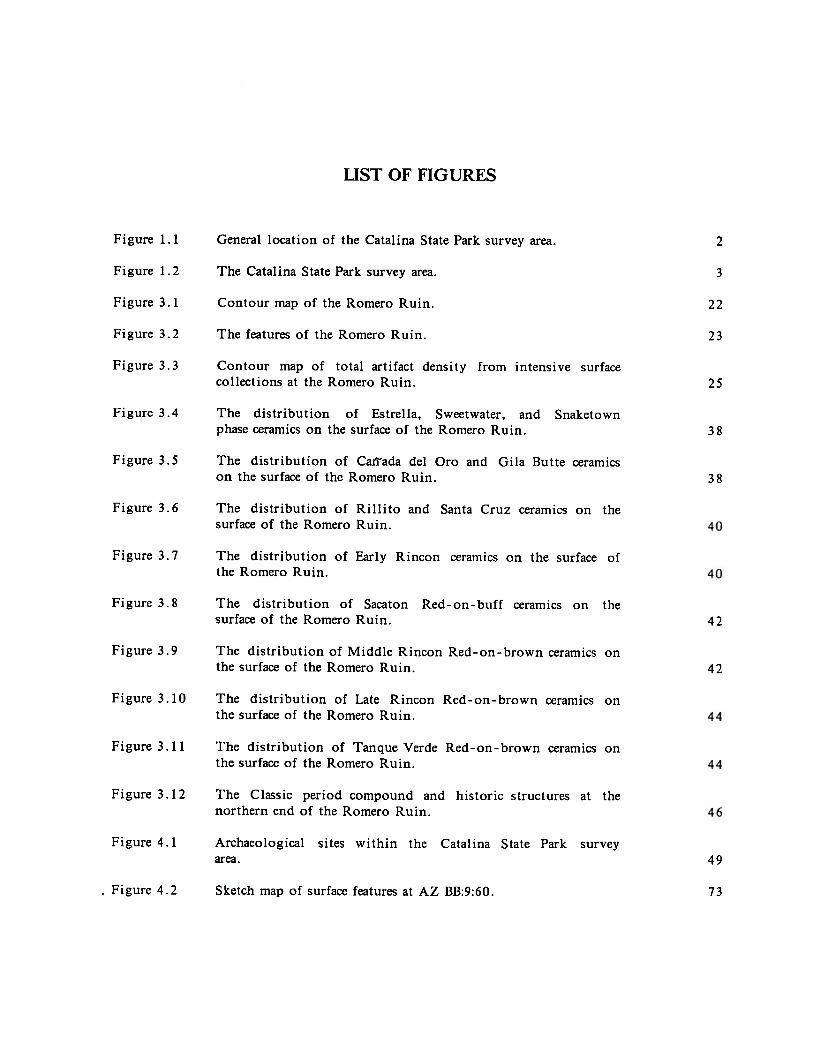
LIST OF FIGURES
Figure 1. 1 General location of the Catalina State Park survey area. 2
Figure 1.2 The Catalina State Park survey area. 3
Figure 3.1 Contour map of the Romero Ruin. 22
Figure 3.2 The features of the Romero Ruin. 23
Figure 3.3 Contour map of total artifact density from intensive surfacecollections at the Romero Ruin. 25
Figure 3.4 The distribution of Estrella, Sweetwater, and Snaketownphase ceramics on the surface of the Romero Ruin. 38
Figure 3.5 The distribution of Caftada del Oro and Gila Butte ceramicson the surface of the Romero Ruin. 38
Figure 3.6 The distribution of Rillito and Santa Cruz ceramics on thesurface of the Romero Ruin.
Figure 3.7 The distribution of Early Rincon ceramics on the surface ofthe Romero Ruin.
Figure 3.8 The distribution of Sacaton Red-on-buff ceramics on thesurface of the Romero Ruin. 42
Figure 3.9 The distribution of Middle Rincon Red-on-brown ceramics onthe surface of the Romero Ruin. 42
Figure 3.10 The distribution of Late Rincon Red-on-brown ceramics onthe surface of the Romero Ruin.
Figure 3.11 The distribution of Tanque Verde Red-on-brown ceramics onthe surface of the Romero Ruin.
Figure 3. 12 The Classic period compound and historic structures at thenorthern end of the Romero Ruin.
Figure 4.1 Archaeological sites within the Catalina State Park surveyarea. 49
Figure 4.2 Sketch map of surface features at AZ BB:9:60. 73

List of Figures
The distribution of sites by type in the Catalina State Parkstudy area.
Snaketown phase sites within the Catalina State Park surveyarea.
CaiTada del Oro phase sites within the Catalina State Parksurvey area.
Rillito phase sites within the Catalina State Park survey area.
Early Rincon subphase sites within the Catalina State Parksurvey area.
Middle Rincon subphase sites within the Catalina State Parksurvey area.
Late Rincon subphase sites within the Catalina State Parksurvey area.
Tanque Verde phase sites within the Catalina State Parksurvey area.
The boundaries of the Sutherland Wash ArchaeologicalDistrict that has been nominated to the National Register ofHistoric Places.
Map showing the distribution of large and small mounds atthe Romero Ruin.
Map of a possible plaza and surrounding group of mounds atthe Romero Ruin.
Contour map of the small bailcourt at the northwest marginof the Romero Ruin.
Topographic profiles of the small balicourt at the RomeroRuin.
Contour map of the large bailcourt at the southeast marginof the Romero Ruin.
Topographic profiles of the large bailcourt at the RomeroRuin.
Figure 5.1
Figure 5.2
Figure 5.3
Figure 5.4
Figure 5.5
Figure 5.6
Figure 5.7
Figure 5.8
Figure 5.9
Figure E. 1
Figure E.2
Figure E.3
Figure E.4
Figure E.5
Figure E.6
80
84
85
86
88
89
90
96
121
123
128
129
131
132

LIST OF TABLES
1 . 1 Plant species present in Catalina State Park area 5
1 .2 Mammals present in Catalina State Park 5
2.1 Revised chronology for the Tucson Basin 18
3.1 Diagnostic decorated ceramics recovered from surface collections at theRomero Ruin 27
3.2 Frequency of chipped stone types by raw material from the Romero Ruinsurface collections 29
3.3 Frequency of ground stone types by raw material from the Romero Ruinsurfaace collections 29
5.1 Characteristics of sites within the Catalina State Park survey area 78
A. 1 Analysis codes for aboriginal ceramics from the Catalina State Park survey 97
A.2 Ceramic types by grid unit for the Romero Ruin surface collections 99
A.3 The distribution of Size 1 sherds (intermediate between dime-sized andquarter-sized) from the Romero Ruin surface collections 105
A.4 The distribution of Size 2 decorated sherds (dime-sized or smaller) from thethe surface of the Romero Ruin 107
A.5 The distribution of decorated and diagnostic plainware ceramic types at siteswithin the Catalina State Park survey area 108
B.1 Chipped stone analysis codes 109
B.2 The distribution of chipped stone by type from the Romero Ruin surfacecollections 110
C.1 Ground stone coding key for the Catalina State Park survey 112
C.2 The distribution of ground stone by type from the Romero Ruin surfacecollections 113

CHAPTER 1
INTRODUCTION
Catalina State Park is situated approximately 22 km (14 miles) north of Tucson, Arizona(Figure 1.1). Within this beautiful and pristine desert area lie a large number of relativelyundisturbed archaeological sites. The park has witnessed a long and varied history.Sometime after 5000 B.C. Archaic period hunters and gatherers first roamed through thepark area in their search for game and edible plants. During the following Hohokam periodthe park area was intensively occupied. A wide range of sites are present, includingisolated bedrock mortars, rockshelters, and small sherd and lithic scatters, as well as majorhabitation and village sites with well-developed agricultural field systems. The RomeroRuin (AZ BB:9:1), which was settled early in the Hohokam Pioneer period, is the largestand most significant village site within the park, and one of the most significant siteswithin the Tucson Basin in general. The site contains two balicourts, a large Classicperiod compound, and at least 17 trash mounds, some of which reach a height of more thantwo meters above the ground surface. Finally, during the historic period Francisco Romerobuilt his ranch house on top of the remains of the Romero Ruin sometime around 1844,when Tucson and much of Arizona were still a part of Mexico, and raids by roving bandsof Apaches were commonplace.
This report describes the results of an archaeological survey of Catalina State Parkconducted by archaeologists from the Institute for American Research between February 1 6and March 11, 1987. The survey intensively covered roughly 2.65 square miles, centeringaround the Romero Ruin. Twenty-nine previously unrecorded archaeological sites werediscovered, while additional information was collected from thirteen known sites. Thesedata were used in conjunction with the mapping and intensive surface collection of theRomero Ruin to reconstruct the settlement patterns within the park area.
ENVIRONMENT
Catalina State Park encompasses slightly more than 8.25 square miles (5280 acres) (Figure1.2). The park is situated at the base of the Santa Catalina Mountains within the ruggedfoothills and lower bajadas of this north-south trending range. The Santa Catalinas aretypical of block-faulted linear mountain chains in the Basin and Range province of southernArizona. They are predominantly composed of granite, gneiss, and quartzite, althoughlimited amounts of intrusive igneous material are also present (Wilson, Moore, and O’Haire1960; Pashley 1966). The Catalinas exceed 9000 feet in elevation and contain climaxPonderosa pine and Douglas fir forests at the higher summits. Other mountain resources,such as juniper, pinyon pine, oak, manzanita, and agave, are found as low as 4000 to 5000feet. Within the park itself, elevation ranges from approximately 2600 feet within thefloodplains of the major drainages, to more than 4000 feet along the steep foothills of thesoutheastern boundary. The majority of the park is within the 2640 to 3000 foot elevationzone.

Chapter 1
TUCSON
5
Kilometers
5
Miles
Figure 1.1 General location of the Catalina State Park survey area.

Chapter 1
Area surveyed
Figure 1.2 The Catalina State Park survey area.

Chapter 1
The park is characterized by a wide range of environmental diversity. This is due both totopographic and elevational factors, as well as the presence of several major watercourses,some with nearly perennial flow. Two major drainages are present within the parkboundaries. The largest is Caflada del Oro Wash, which flows to the south and southwestthrough the western portion of the park (Figure 1.2). CaIfada del Oro Wash, which is oneof the largest drainages within the northern Tucson Basin, contains a large, grass andmesquite dominated floodplain, ranging from 300 meters to more than 600 meters in width.
Several tributaries which originate in the well-watered higher elevations of the CatalinaMountains feed Carrada del Oro Wash, the largest and most significant being SutherlandWash (Figure 1.2). Sutherland Wash flows south through the eastern section of the park.Although the upper reaches of Sutherland Wash cut through steep mountain canyons, thefloodplain expands dramatically as the wash approaches the valley floor and joins withCaffada del Oro Wash. At this point the floodplain is approximately 400 to 500 meterswide. A third major drainage, Alamo Canyon Wash also joins the CaiTada del Oro at thislocation, further increasing both the floodplain area and the water supply (Figure 1.2).
Sutherland Wash is in turn fed by a number of smaller tributaries, the most significantbeing Romero Canyon Wash and Montrose Canyon Wash (Figure 1.2). Most importantly, dueto their origins in the rain and snow-fed high elevation catchments, Sutherland, Romero,Montrose, and Alamo canyon washes contain water on or near the surface for most of theyear. Although Carrada del Oro Wash currently contains only a seasonal flow, due primarilyto the historically documented lowering of the water table through downcutting andovergrazing, it is likely that a year-round flow was present during the prehistoricoccupation of the area.
The flora and fauna of the Catalina State Park area are both rich and diverse. Thefollowing discussion is based largely upon the work of Lisa Huckell (1980:6-9) who compileda list of species present within the park during the COurs~ of a survey within the proposedpark area prior to its designation as a state park. According to Huckell (1980:7), the parkis dominated by two vegetation communities: the paloverde-saguaro community within thecoarse rocky soils of the foothills and lower bajadas, and the riparian community along thenumerous drainages and washes. A listing of the plant species associated with these areasis presented in Table 1. 1. As the table indicates both communities contain a rich plantassemblage of considerable economic utility. Ethnographically, mesquite, saguaro, cholla,and prickly pear, were of paramount importance in the subsistence of the local O’odhamIndians, while many of the other plant species were also used (Russell 1975; Underhill 1979:Castetter and Underhill 1935). Almost all of these species have been recovered fromarchaeological contexts (Miksicek l986a, 1986b; Miksicek and Gasser 1985).
The fauna within the park is equally diverse as can be seen from Table 1.2, which lists thecommon mammals. Many of these species, such as jackrabbit, cottontail, deer, andoccasional bighorn sheep, were also important in the prehistoric diet (Szuter 1986a, 1986b).Jackrabbit and cottontail, in particular, are present in large numbers throughout the parkarea. These two species generally account for the majority of animal remains recovered atHohokam sites (Szuter 1984; Bayham and Hatch 1984).
In summary, Catalina State Park contains a rich and varied resource base. Along with theobvious agricultural potential of the well-watered floodplains, other resources within easyrange include saguaro, prickly pear, cholla cactus, mesquite, small game, and deer in thelower elevations; and pine, juniper, agave, and large game in the higher elevations of thesurrounding foothills and peaks of the Santa Catalina Mountains.

Chapter 1
Table 1.1. Plant species present in Catalina State park area (after Huckell 1980:7).
PALOVERDE- SAGUARO COMMUNITY
Common Name Scientific Name
Saguaro Carnegiea giganteaPaloverde Cercidium sp.Mesquite Prosopis sp.Ocotillo Fouquieria splendensMormon tea Ephedra sp.Hedgehog cactus Echinocereus sp.Sotol Dasylirion IVheeleriCatciaw acacia Acacia GreggiiPrickly pear cactus Opuntia sp.Cholla Opuntia sp.Barrel cactus Ferocactus sp.Hackberry Celtis sp.
RIPARIAN COMMUNITY
Common Name Scientific Name
Mesquite Prosopis sp.Arizona Ash Fraxin ilis V elutinaSycamore Platanus WrightiiWalnut Juglans majorHackberry Celtis sp.Oak Quercus sp.Cypress Cupressus arizonicaDesert willow Chilopsis linearisGourds Cucurbita sp.
Table 1.2. Mammals present in Catalina State Park (after Huckell 1980:8-9).
Common Name Scientific Name
Deer Odocoileus sp.Javelina Pecan tajacuJackrabbit Lepus sp.Cottontail Sylvilagus audoboniiGround squirrel Citellus sp.Packrat Neotoma sp.Coyote Can is latransRaccoon Procyon lotorBighorn sheep Ovis canadensisMountain lion Felis concolorBobcat Lynx ru/usB lack bear Euarc t os americanus

Chapter 1
PREVIOUS RESEARCH
Archaeological research within the Catalina State Park area has been ongoing since aroundthe turn of the century, due primarily to the interest generated by the large, and to some,mysterious, Romero Ruin. This early research consisted primarily of visits to the ruin andspeculations upon its origins. The Arizona State Museum recorded a number of sites withinthe park area over the years, and two surveys and an overview were completed between1973 and 1980. During the last decade, a great deal of the land in the northern TucsonBasin has been intensively surveyed (Fish, Fish, and Madsen 1985; Craig and Stephen 1985;Hewitt and Stephen 1981; Craig and Wallace 1987), thus there is a very good regionalcontext in which to place the present study. Previous research in the park area isdiscussed chronologically below.
Early Research
The Romero Ruin has been known to the inhabitants of Tucson for more than 100 years.In his notes dated June 20, 1915, Dr. Robert H. Forbes writes that Sam Hughes, an earlyTucson pioneer, said that he first saw Romero Ruin in 1858 and at that time no oneseemed to know how old it was (Page n.d.). Forbes, who was an amateur photographer,took some of the earliest photos of the site around 1910. The photos clearly show theremains of two standing masonry structures which, judging from the two people standingnext to them, appear to be between 10 and 12 feet high and 20 feet apart (see Huckell1980:34, Figure 5). The structures are in relatively good condition, although no longerroofed, and appear to be constructed out of large, unshaped, flat cobbles, some of whichare one to two feet in length. Undocumented and anonymous notes located with thephotograph state that the structures are part of the old Romero ranch house (Huckell1980:33).
Early researchers who investigated Romero Ruin, then called Pueblo Viejo, in the first twodecades of the century were primarily concerned with the origin of what was believed tobe the Spanish component of the site. The presence of a Spanish occupation was basedupon the masonry architectural style of the ruins of the Classic period compound, whichwas often contrasted with the Mexican architecture of the Romero ranch house, and byseveral popular folktales being circulated in the Tucson area at that time. These folktalesvariously identified the site as an early Spanish mission (the fabled Mission of Ciru) thatwas attacked and destroyed by Apaches who left no survivors, or a Spanish gold miningtown with a large church where immense quantities of gold ore were processed. By someaccounts the Mission of Ciru and the gold mining town were one and the same. Thelocation of the church is important since according to the legends, as recorded by GeorgeHand in his diary of 1927, the Spaniards “left a fortune in gold bullion valued as high ashalf a million dollars buried under this edifice [the church] when they were forced to leavethe country in 1823.” The rumor of buried treasure was a powerful incentive for localresidents and digging at the ruin evidently became a popular pastime.
The earliest scientific investigation of the Romero Ruin comes from Ellsworth Huntington(1910), a geographer and climatologist who was interested in Hohokam archaeology as ameans to understand prehistoric adaptations to arid climates. Huntington was a trainedobserver who visited many of the large sites in and around the Tucson area. He wastherefore able to view the site in a more objective fashion than the gold-seeking locals.His journal entry for Wednesday, March 16, 1910, reads:

Chapter 1
Stayed at dry camp at Pueblo Viejo [Romero Ruin] till 10 A.M. Then rode toPima Canyon.
The ruins of Pueblo Viejo consist of three ages. The youngest are two smallstone buildings ... which are made of cobbles and boulders plastered with mud.Part of the wooden beams of the roof still remain inside and the wallsthemselves have only begun to fall. The age of these, or the time since theywere abandoned does not seem as if it could be over 100 years and perhaps notso much.
The next set of ruins consists of about 10 houses, or possibly more if thesmaller less distinct heaps are counted. These have fallen completely so that notrace of real walls is to be seen. They cover a space some 200 or more yardslong from SE to NW on a spur of terrace between two gullies. Around themthere is a wall perhaps 150 feet square, more ruined than the new houses, butnot so much as the older ones. Just W. of this there is a hollow about 30 feetx 50 feet in size and 3 feet deep. It looks like a reservoir. At the S.E. end ofthe ruins there is another hollow about 180 x 70 feet, which also appears tohave been a reservoir. It is 3-4 feet deep now, but may have been deeper.Apparently it was filled merely by surface water.
The oldest ruins consist of fragments of old pottery with brown ornaments, oflava mealing stones, and of roughly chipped arrow heads, leather scrapers andother tools chipped from quartz and other materials. This covers an area muchlarger than that covered by the other ruins. It extends from Martinez[Montrose] Canyon westward 2000 feet along the edge of the terrace which rises50 feet above the level lower terrace close to the dry stream bed of RomeroCanyon [Sutherland Wash] (Huntington 1910).
The two reservoirs noted by Huntington are Hohokam ballcourts, while the middle set ofruins within the wall is the Classic period compound. Interestingly, with very little data togo on except for the relative states of architectural collapse, Huntington correctlyidentified the sequence of the Romero occupation. After talking with some of the localpeople, Huntington (1910) summarized their views along with his own observations on thehistory of the ruin as follows:
1) The modern ruins, two houses, were built by a cattle man in recent times.
2) The ruins of middle age are those of a Spanish Mission of unknown date.Records of it, however, are found in Mexico. According to the common (butscarcely credible) story, gold ore was crushed here in large quantities, beingbrought from the mountains. This is possible for there is some ore in thesemountains. The small hollow which I took at first for a little reservoir, maypossibly be an arrastra, or Spanish mill for crushing ore by turning a bigstone like an olive press and catching the gold in mercury filling the cracks.Of course there is a story of treasure buried by the priest when the placewas abandoned. One surmises that the mission must be old, and that it wasabandoned when the Apaches came into the country.
3) The pottery is of the ordinary old type. It indicates that a considerablevillage existed here. It must have existed for a considerable period for wesaw it down to a depth of three feet in one of the deeper gold diggings,and it is thickly spread over the surface in the center of the village. Thehouses were evidently spread out in a long narrow line on the edge of the
Chapter 1
high terrace overlooking the Romero [Sutherland] valley plain. Today thehouses of the Indian Reservation at San Xavier, S. of Tucson, are spread outin a line on the edge of the irrigated plain of the Santa Cruz in just thesame way. The modern Indian village contains 600-700 people. Probably theold village contained less, for it is not so long.
Huntington then goes on to state several hypotheses concerning the function of the village,some of which show considerable insight, and tests these through listing pro and conarguments for each. Although it appears that at first Huntington embraced the popularnotion of a Spanish origin for the site, notes in the margins of his field notebook indicatethat at some later date he decided that it was unlikely that the village was constructed byearly Spanish settlers or missionaries. In fact, based upon a reappraisal of the data,Huntington suggests that “The ruins certainly antedate the Spanish and may be much older”(Huntington 1910).
Archaeological research within the Tucson area began in earnest in the late 1920s andearly 1930s with the controlled excavations of the Tanque Verde Ruin (Haury 1928),Martinez Hill site (Gabel 1931), and the preliminary work at the University Indian Ruin(Kelly 1936). Martinez Hill and University Indian Ruin in particular were large Classicperiod sites with platform mounds, compound walls, and masonry architecture, similar inkind to the compound at the Romero Ruin although on a more massive scale. Even withthe accumulating evidence, however, the belief that the Romero Ruin was the fabledMission of Ciru or a Spanish “real de minas” persisted, and various attempts were made toauthenticate the Spanish origins. In fact, as late as the 1950s after 20 years ofarchaeological research within the Tucson area, Emil Haury of the Arizona State Museumwas still responding to inquiries concerning the “known” Spanish architecture at theRomero Ruin.
An interesting account of research undertaken in the late 1920s on the Spanish origin ofthe ruins is found in the diary of Captain Donald Page. The notes begin in September1927 when Page was taken out to the ruin for the first time. He documented fivearchitectural styles, including round and rectangular stone-lined pithouses, a multiple roomadobe walled type of “communal house,” built around a central court, the early Spanishtype of stone-walled building (“the stones being layed in mud mortar”), and the Mexicanstone-walled building (presumably without mud mortar). The walls of the Mexican buildingswere still standing to a height of 2.5 meters, while only 30 cm of the walls of the Spanishbuildings remained. The buildings were all within an enclosing wall that, according toPage, “seems to either have been layed up with mud mortar or to have been built on theremains of an adobe wall.” The architectural styles suggested to Page six periods ofcivilization: 1) The pithouse Indians; 2) the Hohokam; 3) the Pimas and Papagos of Spanishtimes; 4) the Spanish; 5) the Apache, which he suggests to be post-Spanish; and 6) Mexicanor American
Page reported his findings back to Dean Cummings who was Director of the Arizona StateMuseum and Chairman of the Anthropology Department of the University of Arizona.Cummings told him that a Mexican had once shown him a palm-sized piece of lead-silveralloy which he claimed to have dug up from under one of the buildings. According to theMexican the ruin had been a Spanish mining camp and much treasure was buried there.Cummings went with the Mexican and did some excavating but found only evidence for anearly Indian village. Even so, according to Page, Cummings believed the ruins to be ofSpanish origin although he had not been able to find any historical documentation for thesite.
Chapter 1
Page’s notes then document his attempts to track down the legends surrounding the Missionof Ciru, primarily through conversations with older Tucson residents. Although he couldnot substantiate the claim, several informants swore that the ruin was indeed the remainsof a Spanish mission. As his entry for January 29, 1928 states:
Agustin Tome [an early Tucson settler living in the Tucson area by at least1865] ... tells me that the late Bishop Salpointe claims that the ruins were thoseof the Mission of Ciru, and that the place was attacked by Indians and burned,the padres and other Spaniards being killed. The flames were seen by travelerson the old CaIfada del Oro road and the fact reported at the Presidio of SanAgustin de Tucson. A relief party was sent out but arrived too late, finding theplace a smoke blackened ruin and the inhabitants massacred.
Other people, however, pointed out to Page that the Mission of Ciru was not mentioned inthe book Soldiers of the Cross authored by Bishop Salpointe, concerning the early Spanishsettlement of the northern Mexican frontier. Page duly notes this, but speculates that theomission may have been due to the fact that Salpointe could not authenticate the rumoreven though he believed it. Although Page believed the ruins to be of Spanish origin, hewavered over the validity of its identification as the Mission of Ciru, stating at one pointin his entry for February 1, 1928, “... all of the priests killed by the Indians during theirseveral uprisings have been accounted for, and it seems somewhat unreasonable to believethat such a massacre could have been perpetrated so close to Tucson and have left norecord.”
Perhaps the most interesting section of the diary is Page’s conversations with FabianRomero, the grandson of Francisco Romero. According to Page in his entry for February12, 1928, Romero told him that his grandfather first settled at the site sometime between1828 and 1838. As he states:
At that time, the ruins of the Spanish buildings were about 1 m high and hisgrandfather rebuilt three of these, also building the enclosing wall as aprotection against the Apaches. Romero says that he understands that hisgrandfather’s enclosing wall as the original wall but I think that the evidence isstrongly in favor of his having rebuilt this, as he did the houses. He lived therealone with his wife and was apparently in a more or less constant state ofwarfare with the Apaches, as young Romero says that he generally began the dayby riding after the Indians and, after a long range rifle duel, getting back a fewhead of his herd of 30 cattle that the Apaches had managed to run off duringthe night. His armament consisted of a brace of cap and ball pistols and a rimfire .44 carbine that he had managed to secure from the States. This weapongave him an immense advantage over the Apaches who were armed with bowsand arrows and flint-locks, as the elder Romero craftily stayed out of range oftheir arms and generally managed to pick off one or two of their number, and intime the Indians came to entertain a great fear of him and his rifle. However,he did not escape unscathed as his nephew tells me that the old man’s body wasseamed by scars left by arrow and lance wounds.
Recent Research
Within the past 15 years three small archaeological projects have been conducted withinthe boundaries of the park. These consist of a brief reconnaissance and assessment of thepark area, then known as Rancho Romero, for a planned housing development in 1973(Roubicek, Cummings, and Hartmann 1973); a literature search and overview of the general

Chapter 1
Caflada del Oro region including the park area in 1975 for several wastewater treatmentsites (Brew 1975); and a limited archaeological survey of the proposed state park in 1980(Huckell 1980). These are discussed in chronological order below.
In addition, two major projects have been recently conducted in land adjacent to the parkto the west and southwest. These are the ongoing Northern Tucson Basin survey conductedby archaeologists from the State Land Division of the Arizona State Museum (Fish, Fish,and Madsen 1985), the survey of the eastern bajada of the Tortolita Mountains by PimaCommunity College (Craig and Stephen 1985, Hewitt and Stephen 1981), and the survey ofthe planned Rancho Vistoso housing development by archaeologists from the Institute forAmerican Research (Craig and Wallace 1987). These projects are larger in scope than theprevious research within the park itself and provide a basis by which to compare andcontrast the data from the present survey.
Roubicek, Cummings, and Hartmann (1973)
In 1973 Ratliff-Miller Development Company contracted with the Arizona State Museum toprovide a preliminary assessment of the archaeological resources within a seven sectionarea of what was then known as Rancho Romero. A literature search of the State Museumsite files revealed that five sites had been previously recorded within the area. These siteswere relocated in the field and re-recorded. A sample of three out of the seven sectionswere selected for additional survey and six previously unrecorded sites were located.Although the time spent on the survey and the intensity of the coverage is unknown, itappears to have been quite limited; additional survey within these areas in 1980 and duringthe present project revealed a large number of unrecorded sites.
Based on the survey data, the authors concluded that the area was occupied from at leastthe Caltada del Oro phase (A.D. 750-850) through the Classic period (A.D. 1150-1450), andthat the majority of the sites were located on terraces just above the major washes. Thesignificance of the Romero Ruin as a major village in the Tucson Basin was noted. Bothhabitation sites, including the Romero Ruin and several other large villages, and special usesites, which were found along the ridges or within the floodplains, were present within thearea. Due to the lack of data from the area and the low intensity of their surveycoverage, the authors recommended that an intensive survey be conducted prior to theplanned development.
Brew (1975)
In 1975 Brown and Caldwell Consultant Engineers contracted with the Arizona StateMuseum to provide an archaeological assessment of the Caftada del Oro region prior tobuilding several wastewater treatment plants and a gravity sewer line. The study area,which encompassed more than 100 square miles, included both the park and extensive areasoutside of the park to the north, south, and west. Data on the area were compiled fromthe Arizona State Museum site files, the deed records at the Pima County Assessor’s office,and Arizona Historical Society’s biographical files and newspaper collections; no actualfieldwork within the study area was undertaken.
Brew (1975:1) noted that much of the area under consideration had never been intensivelysurveyed and as a result any conclusions reached were necessarily tentative. Forty-fiveprehistoric and historic sites had been previously recorded within the project area whichwere subdivided into several site types. Although no Archaic or Pioneer period sites wereknown to be present, prehistoric occupation within the region extended from the Canada

Chapter 1
del Oro phase through the Classic period. Brew (1975:26) placed particular importance onthe historic settlement of the area, which she believed to be significant and oftenoverlooked by archaeologists in favor of the prehistoric settlement.
Huckell (1980)
In 1980 the Arizona State Parks Department contracted with the Arizona State Museum toprovide an archaeological assessment of the proposed Catalina State Park area. Thisproject represents the most complete work within the park to date. The methodologyconsisted of a literature search and archaeological survey. Huckell (19 80:19) cites threeobjectives of the survey. The first was to intensively examine areas that would be directlyimpacted by park development; the second was to quickly examine as much of the outlyingarea as possible; and the third was to relocate and assess all previously known sites inorder to clear up discrepancies in the Arizona State Museum site files. The survey, whichcovered 9.7 square km (3.75 square miles) (Huckell 1980:v), was undertaken in a four dayperiod and expended 23 person-days of labor. The surveyors were spaced between 50 and150 feet apart depending upon the area covered.
Huckell (1980:23,31) recorded four new sites (AZ BB:9:96, AZ BB:9:97, AZ BB:9:98, and AZBB:9:99) and relocated seven previously known sites (AZ BB:9:1, AZ BB:9:45, AZ BB:9:52, AZBB:9:60, AZ BB:6:61, AZ BB:9:62, AZ BB:9:63). Two “archaeological zones” containing largeareas of dispersed cultural material were also identified. These zones were not intensivelyinvestigated and Huckell (1980:38) suggests that discrete sites would probably be foundthrough additional research within the two areas.
The sites ranged in age from the Snaketown phase (A.D. 650-750) through the Classicperiod (A.D. 1150-1350). A Chiricahua stage Cochise obsidian projectile point was alsofound at AZ BB:9:97, indicating that at least a component of the site may date as early as5000 B.C. The sites were variously classified as campsites or limited-use sites, resourceprocessing sites, or habitations. Evidence for extensive agricultural systems was also foundat the Romero Ruin (AZ BB:9:1) and AZ BB:9:97. Two historic sites (AZ BB:9:52 and 63)were recorded, and historic components were present on two prehistoric sites (AZ BB:9:1and 62).
Based on the site distribution, Huckell (1980:40) suggests that the major sites were locatedon the terraces flanking the larger washes, while the smaller sites, which were probablyresource procurement or processing loci, were located on the pediment and along the basesof the terraces. In addition, Huckell feels that the numerous bedrock mortars situatedalong the terrace base indicate extensive use of wild resources, while the agriculturalsystems at Romero and AZ BB:9:97 suggest that domesticated crops were also a significantpart of the prehistoric subsistence. Finally, noting that large numbers of isolated artifactswere scattered throughout the entire survey area, Huckell (1980:40) concludes that the data“certainly suggest a highly mobile population.”
Huckell (1980:41-42) felt that four sites, AZ BB:9:1 (Romero Ruin), AZ BB:9:45, AZ BB:9:60,and AZ BB:9:97, contained the requisite research potential and integrity for nomination tothe National Register of Historic Places, and recommended that they be nominated. Sheadditionally felt that with additional research the entire Catalina State Park area may beeligible. Given the time and areal limitations of the survey she recommended thatarchaeological investigations continue at a more intensive level.

Chapter 1
Fish, Fish, and Madsen (1985)
The Northern Tucson Basin survey was initiated in the Fall of 1981 and is still in progress.As of 1985, 275 square km had been surveyed, covering areas north of CaItada del Oro,south of the Tortolita Mountains, and east of the Santa Cruz River. Although the parkarea itself was not included within the survey, coverage included substantial areas to thenorth, south, and west. A total of 418 sites have been recorded, including majorhabitations, smaller villages or hamlets, resource processing and procurement sites, andextensive agricultural field systems. The survey documented a multitude of agriculturaltechniques, including floodwater, irrigation, and dry farming. Several field areas containedlarge numbers of rock piles, terraces, and roasting pits, and are believed to have been usedfor the cultivation of agave. Diagnostic ceramics recovered from the sites ranged from thePioneer through the Classic periods, while several diagnostic Late Archaic projectile pointswere recovered as well. These data are still preliminary and at present only several briefarticles have been published on the results of the survey.
Surveys by Pima College
Pima Community College has received several Survey and Planning Grants from the ArizonaSHPO over the past decade, and their inventory program has focused on the eastern bajadaof the Tortolita Mountains (Craig and Stephen 1985, Hewitt and Stephen 1981). This workhas documented two large preclassic Hohokam villages, Honey Bee and Sleeping Snake sites,and numerous smaller sites. A particularly interesting locational pattern whereby habitationsites appear to be located in proximity to Holocene inset terraces, which would have beenproductive agricultural settings in the past, was noted in their most recent report (Craigand Stephen 1985).
Craig and Wallace (1987)
The Rancho Vistoso survey area covered approximately 7700 acres immediately to the westof Catalina State Park. This area is within the southern Cattada del Oro Valley and thesoutheastern flanks of the Tortolita Mountains. On average, it is at a slightly higherelevation than the park, and not as well watered; the dominant drainage is Big Washalthough a small portion of the Caflada del Oro floodplain is also present.
The survey identified 54 archaeological sites, 43 of which had been previously unknown.The sites were grouped into six descriptive site classes, including: artifact scatters with nosurface features (16 sites); artifact scatters with bedrock mortars, slicks, or petroglyphs (13sites); artifact scatters with roasting pits and/or rock piles (18 sites); habitation sites (3sites); lithic quarries (1 site); and historic sites (3 sites). Two of the habitation sites,Honey Bee Village (AZ BB:9:88) and Sleeping Snake Village (AZ BB:9:104), are extremelylarge and significant villages that are similar in size and artifact density to the RomeroRuin. Each village contains numerous trash mounds and a ballcourt, and a small Classicperiod compound was found at Honeybee. Sites within the project area ranged from theRillito phase (A.D. 850-950) through the Classic period (A.D. 1150-1450).
ORGANIZATION OF REPORT
The report is divided into five chapters. The first chapter presents the project backgroundand brief assessments of the environment and previous research conducted within the area.Chapter 2 discusses the methods used in the field and analysis portions of the research.
Chapter 1
Chapter 3 presents the results of the surface collection of the Romero Ruin. In thischapter, the ceramic, lithic, ground stone, and miscellaneous artifact assemblages recoveredfrom the Romero Ruin are examined and patterns in feature and artifact distribution arediscussed. The artifact, feature, and temporal data from the Romero Ruin are integrated inthe examination of the site structure. Chapter 4 presents the results of the archaeologicalsurvey conducted around the Romero Ruin. Site descriptions for the recorded sites areprovided in this chapter. Chapter 5 examines the settlement patterns within the park areaand defines the Romero community system. The historic occupation of the park is alsodiscussed. As part of this project, the Sutherland Wash Archaeological District wasnominated to the National Register of Historic Places. The nomination form for theDistrict contains a summary of the descriptive material that is in this report, as well as aconsideration of the significance of the prehistoric and historic resources that are presentin the District.
A series of Appendixes provide detailed data on artifact types recovered during this projectand their spatial distribution. Appendix E deserves special mention, for it was prepared byJames Holmlund who carried out the mapping of the Romero Ruin. It contains not only thetechnical information on the gridding and mapping, but also provides detailed informationon the interpretation of the major surface features at the site.

CHAPTER 2
FIELD AND ANALYSIS METHODS
Archaeological fieldwork for the project was undertaken between February 16 and March11, 1987, with additional work on alternate Saturdays through the month of April. In all,approximately 100 person-days were spent on the field portion of the project. This wasfollowed by an analysis phase. Methods used in both the field and analysis are discussedbelow.
FIELD METHODS
The field phase of the project can be broken down into three stages. The first stage wasthe archaeological survey of portions of the park by a crew of professional archaeologists.This was followed by the mapping, gridding, and surface collection of the Romero Ruin.Finally, additional survey was undertaken by a volunteer crew of both professionalarchaeologists and non-professionals. The area of the park surveyed during all threephases is shown in Figure 1.2.
Archaeological Survey
The first stage in the fieldwork was the archaeological survey of selected areas of thepark centering around the Romero Ruin. Although some of these areas had been surveyedduring the course of earlier projects (Roubicek, Cummings, and Hartmann 1973; Huckell1980), it was felt that a resurvey was necessary due to the low intensity of the previouswork. This was borne out by the fact that almost 30 new sites were recorded. This stageof the survey covered all of the park area south of Cafiada del Oro, Sutherland, andRomero Canyon washes, and a total of 36 person-days was expended.
The survey methodology consisted of the inspection of defined topographic areas by fourarchaeologists spaced at 25 meter intervals. Areas with slopes greater than 40 degrees andheavily vegetated floodplains were spot-checked but not intensively examined. A site wasdefined as any locus of 30 or more artifacts concentrated within an area less than 100square meters. Two types of artifacts or several different vessels had to be present torule out the recording of a single pot-break as a site. Once a site was found, it wasmapped, photographed, plotted on both aerial and topographic maps, and a site form wasfilled out. A grab sample of diagnostic decorated ceramics, plainware rims, and lithic tools,was collected. Isolated artifacts, groups of less than 30 artifacts, or isolated featureswithout artifacts, such as bedrock mortars or grinding slicks, were given a sequential fielddesignation (FD) number and plotted on the aerial and topographic maps. The FD’s werenot recorded or given a site number, although mortars and slicks were measured anddiagnostic ceramics were sometimes collected.

Chapter 2
Surface Collection
The second stage of the fieldwork consisted of the surface collection of a sample of theartifacts from the Romero Ruin. Prior to the actual collection, the site was gridded andmapped with an Omni Mk-III total station by James Holmlund of Geo-Map, Inc. and HenryWallace of the Institute. As well as constructing a high quality topographic map of thesite at 50 cm contour intervals, Holmlund and Wallace established a permanent grid systemthroughout the site area. This consisted of placing rebar stakes with appropriate gridcoordinates stamped on aluminum tags every 25 meters. Ninety-seven 25 m by 25 m unitswere established; units were designated by their southwest corner grid coordinates. Apermanent site datum consisting of a brass cap cemented onto a granite bedrock boulderwas placed on a ridge west of the site at grid coordinates N500/E500. Approximately 10person-days were spent on the gridding and mapping.
The surface collection of the 97 25 m by 25 m units was conducted in the followingmanner:
1. Field personnel walked straight north to south lines across each unit and were spacedat 5.0 m intervals so that five transects per unit were collected. Artifacts werecollected within a 2.0 m wide transect; that is, 1.0 m on either side of the linewalked by each crew person. Compasses were used for orientation, and the south sideof the unit was flagged every 5.0 m so that crew members could see their destinationpoint and stay on-line.
2. Each crew member collected all decorated sherds greater than 2.5 cm in diameter(roughly the size of a quarter), all plainware rims, all lithic tools, all ground stone,all shell, and any other rare artifacts encountered such as figurines, spindle whorls,palettes, and tabular knives. Crew members did not collect lithic debitage andplainware body sherds. Human bone was noted and recorded but not collected.Material recovered from the crew collections was bagged together by unit.
3. The crew supervisor conducted a complete surface collection within a single 2.0 mwide transect. This transect served as the control transect and was without exceptionthe central transect within each unit. The collection included the same artifactscollected or recorded by the crew members, plus all plainware sherds greater than 2.5cm in diameter and all lithic debitage. Material from the control transect was baggedseparately from the artifacts collected by the crew members.
4. The majority of the cultural features, such as the trash mounds, ballcourts, and thecompound, were defined, numbered, and flagged during the mapping of the site. Twotrash mounds and a possible cremation area were defined and given feature numbersduring the surface collection. A site map was carried by the collection crew andfeatures were collected separately within each individual unit. A large number oftrash concentrations were also defined during the surface collection. These were notassigned feature numbers and were not collected separately. The methodology used tocollect the features was identical to that used in collecting the units. When withinthe unit the transect reached a feature boundary, bags were changed and materialwithin the feature was separated from the non-feature portion of the unit. Thissometimes involved two or three bag changes per unit depending upon how manyfeatures were within the unit.
A form characterizing each 25 m by 25 m unit was filled out by the supervisor. The formdescribed the vegetation cover, presence or absence of disturbance factors, whether any

Chapter 2
pot holes or cremated human bone was present, the number and types of cultural features,and whether the control transect was representative of the unit as a whole. The relativeproportion of the unit surface that was obscured by vegetation, sheetwash, arroyos,deposition, and modern debris, was ranked in five stages from 0 to 100 percent, andartifact density and sherd to lithic ratios were subjectively determined. Finally, a sketchmap of the unit was drawn showing the locations of pot holes, features, cremated bone,and erosional/deposit ional areas.
The surface collection of the Romero Ruin resulted in the recovery of 11,499 artifacts.Approximately 24 person-days were spent on the surface collection.
Assessment of the Collection Strategy
The collection strategy provided a systematic sample of the site artifact assemblage thatranged from 40 percent for items of high information value, such as decorated sherds,lithic tools, and plainware rims, to as low as 8 percent for items of lower informationvalue such as plainware body sherds and lithic debitage. The 40 percent figure is derivedfrom the fact that within each 625 square meter unit (25 m by 25 m), artifacts werecollected from two meter swaths along five 25 m long transects (a total of 250 squaremeters). The 8 percent figure is due to the collection of only a single two meter swath(the control transect) along a 25 meter transect (a total of 50 square meters). Thiscollection method was tested by the Institute on sites found on the Papago Water Supplysurvey project (Dart, Doelle, and McGuire 1985; Dart 1987) and the Valencia site testingproject (Elson and Doelle 1986) and found to be a highly efficient collection strategy.
A statistical evaluation of the collection strategy was also undertaken at the Valencia site(Altschul 1986:25-30). Since the collection strategy used there was almost identical to thatused at the Romero Ruin, the results of that assessment should be generally applicable tothe present project. Two potential sources of error were investigated. The first had to dowith whether a 40 percent collection sample was large enough to produce reliable estimateson the site and feature levels. This was investigated at Valencia through the re-collectionof eight units using transects offset from the original collection transects. The eight unitswere re-collected by a different crew than the initial collection. The analysis examinedthe comparability of the collected decorated ceramics, lithic tools, and ground stonebetween the two collections. A two-tailed t test indicated that there was no significantdifference between the two crews for any of the three artifact categories. As Altschul(1986:27) states.
members of the two crews were picking up these artifacts in approximatelythe same numbers. The fact that the two collections resulted in about an 80percent sample of these units and that the second 40 percent seems to have beenredundant, gives us confidence that the original sampling category is yieldingaccurate estimates on these categories...
The second concern involved the possibility of differential collecting by different crewmembers. Because the crew supervisor made a complete collection, the control transectwas collected and inspected more intensively than the non-control transects in which onlydiagnostic ceramics, plainware rims, and lithic tools were collected. The possibility arosethat these artifact classes were underrepresented in the non-control transects. This wastested by comparing the control transect with the entire unit collection of decoratedceramics, plainware rims, lithic tools, and ground stone (the ratio of the control transectto the other four transects should approach 0.20 if all types were being collected equally).

Chapter 2
The results of the test demonstrated that some of these artifacts were indeedunderrepresented in the non-control transects (Altschul 1986:29). While the frequency ofthe collected ground stone was comparable between transects, the control transect collected1.5 times more than expected plainware rims, twice as many decorated sherds, and nearly2.5 times as many lithic tools. The results indicate that the total number of artifactscannot accurately be estimated from the 40 percent sample, since the estimates wouldinvariably be low. In addition, artifact ratios would similarly be biased since differentartifact classes were being collected in varying frequencies. The data are not surprising,however, since sherds with very little decoration, dirty sherds, or slightly modified lithictools, would be easily missed on the less intensively examined non-control transects. Thelarger and more obvious ground stone, on the other hand, is less likely to be overlooked.However, Altschul notes that the standard errors for all four artifact categories areextremely small. He states (Altschul 1986:30):
while the collection strategy introduced a source of error into the results,this error appears to be more-or-less constant across the site. Within artifactcategories, therefore, grid squares are comparable. Density maps and spatialstatistics should not be greatly affected.
Additional Survey
The third stage of the fieldwork consisted of additional survey by two to three volunteercrews led by professional archaeologists. These surveys were conducted on four alternateSaturdays from the end of March through the beginning of May. The survey was designedto cover selected areas north of Carrada del Oro and Sutherland washes, again centeringaround the Romero Ruin. The methodology used during the volunteer survey was identicalto that used during the initial survey described above. Approximately 40 person-days wereexpended during this stage.
ANALYSIS METHODS
The surface collection of the Romero Ruin resulted in the recovery of 11,499 artifacts. Anadditional 1,138 artifacts were collected from the other 40 recorded sites. The methodsused in the analysis of this material are described below. Since the decorated ceramicassemblage provides the most significant information regarding site structure andchronology it is presented in the greatest detail. Prior to a discussion of the analysismethods by specific artifact type, however, it is necessary to present a brief discussion ofthe Tucson Basin chronology.
Chronology
The Tucson Basin chronology has undergone considerable revision in the past several yearsdue to the recovery of new and better controlled temporal data sets (Doelle 1985;Huntington 1986; Craig 1987; Wallace and Craig 1987). This is true for the Hohokamchronology in general, where the 200 year phases established by Haury (1965, 1976) havebeen seriously questioned (Schiffer 1982; Cable and Doyel 1985; Henderson 1986). Thesephases were basically transferred intact to the Tucson Basin with local phase names byKelly (1978) in her excavation of the Hodges site in the 1930s. Although the data will notbe discussed here in detail, it should be noted that recent radiocarbon dates suggest that
Chapter 2
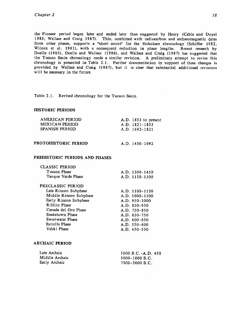
the Pioneer period began later and ended later than suggested by Haury (Cable and Doyel1985; Wallace and Craig 1987). This, combined with radiocarbon and archaeomagnetic datesfrom other phases, supports a “short count” for the Hohokam chronology (Schiffer 1982,Wilcox et al. 1981), with a consequent reduction in phase lengths. Recent research byDoelle (1985), Doelle and Wallace (1986), and Wallace and Craig (1987) has suggested thatthe Tucson Basin chronology needs a similar revision. A preliminary attempt to revise thischronology is presented in Table 2.1. Further documentation in support of these changes isprovided by Wallace and Craig (1987), but it is clear that substantial additional revisionswill be necessary in the future.
Table 2.1. Revised chronology for the Tucson Basin.
HISTORIC PERIODS
AMERICAN PERIOD A.D. 1853 to presentMEXICAN PERIOD A.D. 1821-1853SPANISH PERIOD A.D. 1692-1821
PROTOHISTORIC PERIOD A.D. 1450-1692
PREHISTORIC PERIODS AND PHASES
CLASSIC PERIODTucson Phase A.D. 1300-1450Tanque Verde Phase A.D. 1150-1300
PRECLASSIC PERIODLate Rincon Subphase A.D. 1100-1150Middle Rincon Subphase A.D. 1000-1100Early Rincon Subphase A.D. 950-1000Rillito Phase A.D. 850-950Canada del Oro Phase A.D. 750-850Snaketown Phase A.D. 650-750Sweetwater Phase A.D. 600-650Estrella Phase A.D. 550-600Vahki Phase A.D. 450-550
ARCHAIC PERIOD
Late Archaic 1000 B.C.-A.D. 450Middle Archaic 5000-1000 B.C.Early Archaic 7500-5000 B.C.

Chapter 2
Decorated Ceramics
The collection of decorated ceramics for chronological purposes was the primary focus ofthe surface collection. A secondary goal was the determination of possible trade relationsthrough the presence of intrusive ceramics. A total of 1,659 decorated ceramics wasrecovered from the surface collection of the Romero Ruin. Four hundred eighty-threedecorated ceramics were recovered from the 40 other sites. The relatively large number ofdecorated ceramics recovered has allowed for a better understanding of the Romero Ruinand the surrounding area.
The decorated ceramic assemblage was analyzed by Henry Wallace of the Institute. Wallacehas been intensively investigating Tucson Basin decorated ceramics since 1983, and hisresearch has allowed for a considerable refinement of the local ceramic phase chronology(Wallace 1985, 1986a, 1986b, 1986c). This has resulted in an increase in ceramic temporalcontrol. For example, following the pioneering work of Greenleaf (1975), Wallace hassubdivided the Rincon phase into Early, Middle, and Late Rincon subphases. Thisbreakdown is significant since recent research in the Tucson Basin has demonstrated thatthe Rincon phase is a time of major change in both site structure and settlement patterns(Doelle and Wallace 1986; Doelle, et al. 1985; Elson 1986).
A detailed discussion of the methods used by Wallace and definitions of the Tucson Basinceramic types are presented in the San Xavier survey report (Doelle and Wallace 1986),while Wallace’s (1986c) study of Rincon phase ceramics provides updated information forthat time period. Recovered diagnostic ceramics from both the San Xavier area and theRomero Ruin included ceramics from the Snaketown phase, Caflada del Oro phase, Rillitophase, Early Rincon subphase, Middle Rincon subphase, Late Rincon subphase, Tanque Verdephase, and Tucson phase. The Romero Ruin also contained a few earlier Estrella andSweetwater phase ceramics.
Table A. 1 lists the types and subtypes that Wallace distinguishes in his analyses of TucsonBasin collections. Because not all sherds are assignable to a single type or subtype,Wallace employs a variety of less specific categories, such as Early or Middle Rincon.These should not be interpreted as typologically transitional sherds, rather it is a reflectionof difficulties with the individual sherd, such as small size or non-diagnostic designelements. If the sherd were larger or better preserved, Wallace’s typological placementwould be more specific. For truly transitional cases Wallace uses designations such asEarly/Middle Rincon. Very few transitional sherds were recovered. Due to the largeceramic sample available from the Romero Ruin, only those ceramics that were typed to asingle phase were used in the analysis of site structure.
The virtual explosion in the number of excavated and surveyed Tucson Basin sites withinthe past five years has enabled the compilation of a large comparative data base.However, the majority of this research has involved sites within the Rillito, Rincon, andTanque Verde phases. As a result, while such projects as the West Branch site excavations(Huntington 1986), the Tanque Verde Wash site excavations (Elson 1986), the Valencia sitesurvey, testing, and excavations (Doelle 1985; Elson and Doelle 1986), and the Anamaxproject survey and excavations (Ferg et al. 1984; Ferg and Huckell 1985), have allowed fora better understanding of primarily Rillito and Rincon phase ceramics, earlier phases suchas Estrella, Sweetwater, Snaketown, and Cairada del Oro, are still less well understood.Due to this, and to the conservatism with which Wallace types ceramics, it is important tonote that Wallace believes that sherds from these earlier phases were not as readilyrecognized and are probably underrepresented in the ceramic assemblage This is
Chapter 2 20
particularly true for the early redwares, which have been recovered in only limitedquantities from the Tucson Basin prior to this project.
As a final comment, it is important to note that Wallace differentiated several differentsherd size classes during his analysis. Although the surface collection was geared tocollect only ceramics that were larger than a quarter, some variation in sherd size wasexpected. As a result 490 decorated ceramics were collected that were smaller than theideal size class. These were analyzed and typed by Wallace but were separated by size;Size 0 sherds were quarter-sized or larger, Size 1 sherds were between a dime and aquarter, and Size 2 sherds, of which there were very few, were smaller than a dime.Although all diagnostic ceramics regardless of size class were used in the analysis of thespatial and temporal distributional patterns, only those sherds of Size class 0 (larger than aquarter) can be used for comparative purposes between the Romero Ruin and other sitescollected in this manner, such as the Valencia site and the San Xavier survey sites. Inorder to facilitate comparison with other projects, Table A.2 presents the ceramic data byceramic type for sherd size class 0 only. Diagnostics of other size classes are presented inTables A.3 and A.4.
Plainware Ceramics
In addition to the 40 percent sample of plainware rims, an 8 percent sample of theplainware body sherds was collected from the Romero Ruin, resulting in a total plainwarecount of 6,141 sherds. From other sites, 969 plainware sherds were collected. Recentresearch by Lombard (1986a, 1986b), Heidke (1986, 1987), and Wallace and Heidke (1986),has shown that petrographic analysis of the temper sources of plainware ceramics that werederived from tightly controlled excavated contexts can yield significant information. Thesestudies indicate that plainwares were widely traded throughout the Tucson Basin,particularly from the Santa Cruz River area of the western Tucson Basin into the easternTucson Basin (Elson 1986; Wallace and Heidke 1986). However, the lack of controlledtemporal contexts and the chronological mixing at the Romero Ruin preclude a detailedplainware study at the present time.
Lithic Materials
The recovered lithic assemblage includes lithic tools, debitage, and ground stone tools. Atthe Romero Ruin a 40 percent sample of the lithic tools and ground stone and an 8 percentsample of the debitage was recovered. Less than 10 lithic tools were recovered at sitesoutside of the Romero Ruin. The Romero Ruin samples include 339 lithic tools, 126 piecesof ground stone, and 3,453 pieces of debitage. Only the tools and ground stone wereintensively analyzed. Tables B.1 (chipped stone) and C.1 (ground stone), list the attributesused in the lithic analysis.
Shell
A total of 21 pieces of shell was recovered. The shell assemblage consists primarily ofLaevicardium and Glycymeris fragments; with the exception of a single bead, no wholepieces were recovered.
CHAPTER 3
THE PREHISTORIC OCCUPATION OF ROMERO RUIN
The Romero Ruin (AZ BB:9:1) is the largest and most significant site within the projectarea, and one of the most important sites within the Tucson Basin in general. Due to itsdominance within the surrounding settlement system it is discussed here prior to presentingthe results of the overall survey. The survey and surface collection of the Romero Ruinwere undertaken with two major goals in mind. The first was to record the distribution ofsurface features at the site through the systematic inspection of the complete site area.The second was to collect representative artifact samples from controlled grid units tobetter characterize the site.
A total of 97 25 m by 25 m units was collected during the surface collection. Includingboth the control and the non-control transects within each unit, 11,760 artifacts wererecovered. The artifact assemblage includes 1659 decorated ceramics, 6141 plainwareceramics, 339 lithic tools, 3453 pieces of lithic debitage, 126 pieces of ground stone, and 21pieces of shell. Due to the importance of the decorated ceramics in establishing temporalpatterns these artifacts are considered in the greatest detail.
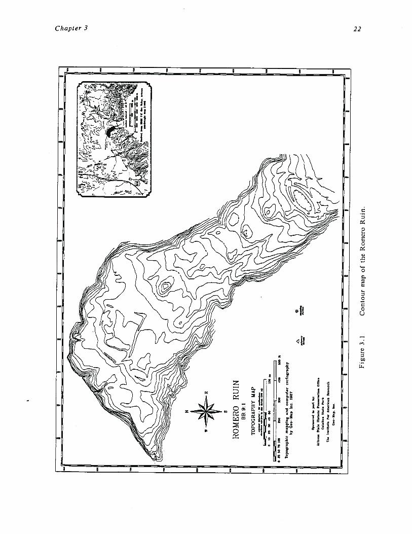
The systematic inspection of the surface of the site resulted in the designation of 34 majorcultural features. Recorded feature types include 17 trash mounds, 12 trash concentrations,two ballcourts, a masonry compound, a plaza area, and three possible cremation areas. Thefactor used to distinguish trash mounds from trash concentrations is that trash mounds arehigh density artifact concentrations at least 50 cm high and, thus, would show up on thesite map where a 50 cm contour interval was employed. Trash concentrations, while alsohigh density, are less than 50 cm high. Functionally the two feature types served similarpurposes and several of the trash concentrations may in fact be low trash mounds. Theimportant point is not so much whether a particular artifact cluster is either a mound or aconcentration, but that they both served as spatially defined repositories for discardedcultural trash. In fact, most of the trash concentrations contained a higher artifactdensity than the trash mounds. It is important to note, however, that the designation of afeature as a trash concentration was based upon a subjective determination in the field ofartifact density. In addition, a size cutoff of approximately 25 square meters was used;areas smaller than this were not recorded as concentrations. As a result, it is possiblethat other archaeologists, using a lower density standard or a smaller size area, would haverecorded a larger number of concentrations. It is believed, however, that all majorfeatures were recorded.
In addition, twelve small rock alignments and cobble piles were assigned feature numbersand recorded, and thirteen additional features, consisting of masonry rooms and rockalignments, were recorded within the compound (Feature 1). Numerous other small featuresare present but were not recorded due to time constraints. A topographic map with thesite grid system is presented in Figure 3.1, and in Figure 3.2 identified surface features areshown on the same base map.
II
I
S
RO
ME
RO
RU
INBB
:9:1
TOP
OG
RA
PhY
MAP
__
——
b—
b~
On
—
!pcO
n..
d(a
p..
4b
r
(alO
on.
!t.t
.H
bte
rle
P,.
n,,
.iIn
.0
(0..
C.I
.IIn
.S
Lat.
Per
k
The
milL
et.
F..
An
,erk
.nR
m..
r.h
C~
Nep
.In
.
w
010
0020
4000
(O0
n
025
5075
IOU
000
250
400
500
ft
To
po
gra
ph
icm
ap
pin
ga
nd
co
mp
ute
rca
rto
gra
ph
yb
yC
eo
Ma
pIn
c1
96
7
*I
II
II
I
Fig
ure
3.1
Co
nto
ur
map
of
the
Rom
ero
Ru
in.

650
600
550
SOC
S
ROMERO RUINBB: 9: 1
FEATURE MAP
0 25 50 75 100 200 300 400
0
a
0CC
aC1~
650
600
55C
500
0
fl
00 C
0C
0
C
0C
B50
BOO
750
700
0 t0
Figure 3.2
0 0 00 C 0a a
The features of the Romero Ruin.
EXPLkNATION
(I Baflcourt
Compound wall
Plaza
Mound (containing rock and trash fill)
Trash concentration
Possible prehistoric cemetery
Rock work feature (refer to report appendix for description)
B5(
800
750
700
57
MO
Historic road
Boulder metate
Boulder mortar
Grid point (rebar with stamped aluminum tag)
Grid point (temporary)
ebtotarto f.at~ I~d1aat.d by dar~e~d rvc~
N
contour totar,ol — 60 ccnllmetar..tov~Uon. relaU,, to lt. datom (100 m)
100 in
500 ft
epr~mary maPPingdatum UtO.t~DX1
(54
0 10 20 30 40 50
e
Topographic mapping and computer cartographyby Ceo—Map Inc. 1987
e
450
Sponsored in part by.
Arizona State Historic Preservation OfficeCatalina State Park
The Institute For American Research
Gec—)Lap. Inc.
0•0C,
0aC
00C
450
o ao C•
0
C
00I-
0 0 00a

Chapter 3
As can be seen from the topographic map, the Romero Ruin is situated on a long, southeastto northwest trending ridge finger. The large fertile floodplain of Sutherland Wash is duenorth of the site while two smaller unnamed washes run down the east and west sides.Montrose Canyon Wash joins Sutherland Wash at the northeast corner of the site. Both ofthese washes currently flow for much of the year, and they may have contained apermanent water supply on or near the surface during the prehistoric occupation of thesite. Although there is a gentle south to north slope, the site area itself is relativelylevel, with several large expanses of flat, open, land. The largest area of level land is atthe northern end of the site overlooking Sutherland Wash.
South of the site the south to north slope gradually increases, although again there arelarge areas of relatively flat land (Figure 1 .2). This area receives runoff from the high,well-watered ridges southeast and south of the site, and it contains an extensiveagricultural field system with numerous linear borders, check dams, terraces, and rock piles.The system begins approximately 50 m south of the Romero Ruin and was too large to mapwithout a large time investment; a rough estimate of the number of agricultural features is200. Two small cobble field houses are present as are a number of isolated artifacts andsmall artifact scatters. The field system measures approximately 800 m north-south andvaries in width between 200 and 400 m (roughly 80 acres). Additional agricultural systemsare situated on the west side of Alamo Wash approximately 600 m west of the site.
SITE STRUCTURE
The artifact distribution at the site revealed several general patterns. Figure 3.3 is adensity contour map of the raw counts for the total number of ceramics, lithics, groundstone, and shell artifacts collected from the control transect. These data include onlythose sherds larger than a quarter. The control transect is used for comparative purposesbecause it was the only transect within each unit where all artifacts were collected. Thisis a more statistically valid basis of comparison than the total number of artifacts collectedper unit, since the latter was shown in Chapter 2 to include artifact types collected indiffering frequencies by various crew members (see also Altschul 1986). The contours onthis map represent increments of 50 artifacts; units with less than 50 artifacts are shownas blank units. The two ballcourts and the compound are shown on this and other artifactdistribution maps as reference points.
The contour map shows several significant aspects of the overall site structure. For one,the areas of highest artifact density are clustered around the edges of the site. Whilesome of this corresponds to down slope areas off of the sides of the ridge top, several ofthe major trash mounds and trash concentrations are apparent. Most significantly, severallarge areas of low artifact density are present. These are all generally surrounded byareas of higher artifact density. If Figure 3.2 is examined, it is apparent that the lowdensity areas are surrounded by trash mounds and trash concentrations. The largest areais in the north-central portion of the site, although smaller areas are present in thenortheast and southeast. These areas are similar to what Craig (1987) has defined as“mound groups.” According to Craig, mound groups can be defined as a set of spatiallyand temporally associated trash mounds oriented around a common plaza or set of houseclusters (Craig 1987:84). An example of an excavated mound group is the single componentTanque Verde Wash site, a small Middle Rincon subphase hamlet in the eastern TucsonBasin (Elson 1986). The Tanque Verde Wash site contained three trash mounds surroundingan open area with 17 pithouses and numerous extramural features. It is estimated thatbetween five and eight pithouses were occupied at any one time.
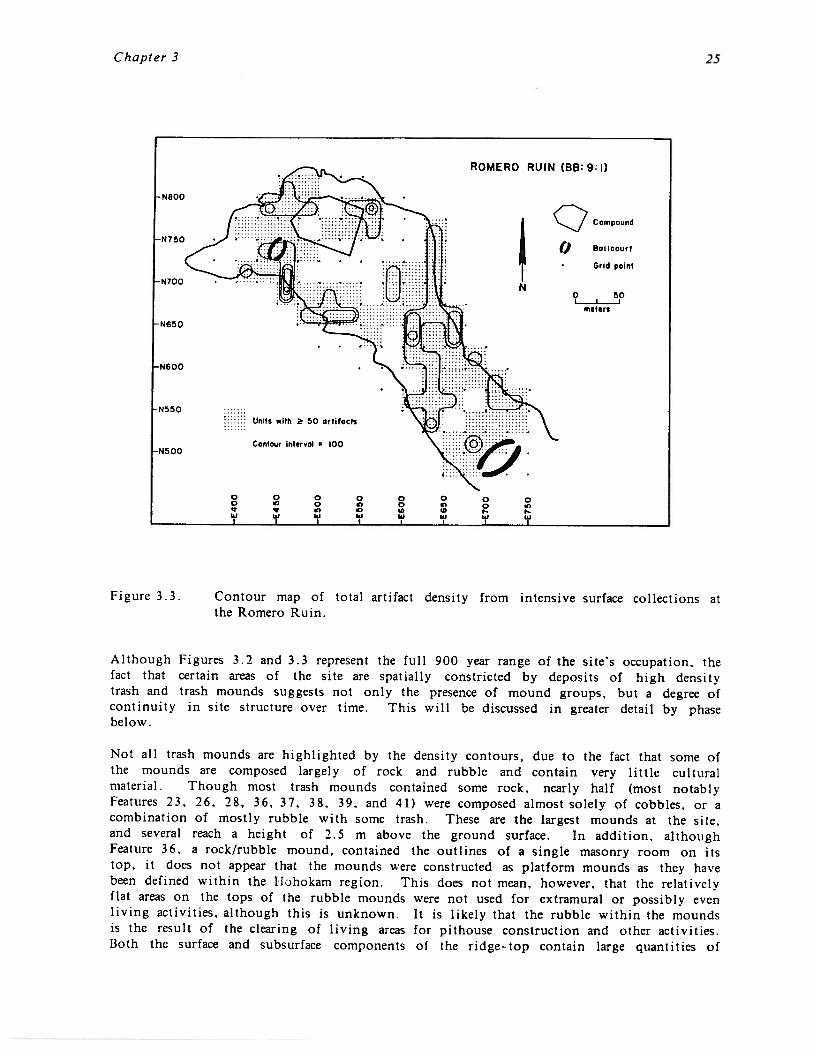
Chapter 3
Figure 3.3. Contour map of total artifact density from intensive surface collections atthe Romero Ruin.
Although Figures 3.2 and 3.3 represent the full 900 year range of the site’s occupation, thefact that certain areas of the site are spatially constricted by deposits of high densitytrash and trash mounds suggests not only the presence of mound groups, but a degree ofcontinuity in site structure over time. This will be discussed in greater detail by phasebelow.
Not all trash mounds are highlighted by the density contours, due to the fact that some ofthe mounds are composed largely of rock and rubble and contain very little culturalmaterial. Though most trash mounds contained some rock, nearly half (most notabl~Features 23, 26, 28, 36, 37, 38, 39, and 41) were composed almost solely of cobbles, or acombination of mostly rubble with some trash. These are the largest mounds at the site,and several reach a height of 2.5 m above the ground surface. In addition, althoughFeature 36. a rock/rubble mound, contained the outlines of a single masonry room on itstop, it does not appear that the mounds were constructed as platform mounds as they havebeen defined within the Hühokam region. This does not mean, however, that the relativelyflat areas on the tops of the rubble mounds were not used for extramural or possibly evenliving activities, although this is unknown. It is likely that the rubble within the moundsis the result of the clearing of living areas for pithouse construction and other activities.Both the surface and subsurface components of the ridge-top contain large quantities of
Chapter 3
these cobbles, which were used to construct the Classic period compound and later theRomero ranch house.
That the rock/rubble mounds at Romero are not platform mounds is additionally suggestedby the data from site AZ BB:9:60, a large Preclassic site situated just across SutherlandWash from the Romero Ruin. AZ BB:9:60 contains at least 14 trash mounds, some of whichreach a height of 0.75 to 1.0 m above the ground surface. At least half of these moundsare composed of rocks and cobbles similar to the rock/cobble mounds at the Romero Ruin.The small height and area of most of the mounds, and the fact that the largest moundsreach a relatively sharp peak, suggest that they were not used for extramural activities oradditional living space. Since the natural surface and subsurface layers of the site aresimilar to Romero in that they are composed of large cobbles, it is again likely that themounds were constructed through the clearing of living areas for pithouse construction andother activities.
Decorated and Plainware Ceramics
Table 3. 1 lists the frequencies of the diagnostic ceramics from the surface of the RomeroRuin. This table includes all of the recovered diagnostics, not just those from the controltransect or ceramics that were larger than a quarter. Although these data may be slightlybiased, it was felt that all chronological information was important in understanding thespatial and temporal structure of the site. Data on all ceramics recovered from the surfaceof the Romero Ruin are contained in Appendix A.
From Table 3. 1 it is apparent that the site was settled at least by the Estrella phase ofthe Hohokam Pioneer period and continued through the Tucson phase of the Classic period.The presence of a sherd of Vahki Red and of “Pioneer or Colonial” redware raises thepossibility that the initial occupation even predates the Estrella phase. The largest numberof diagnostic ceramics was recovered from the Rillito (87) phase followed by the EarlyRincon subphase (44). Similarly, a greater number of Santa Cruz Red-on-buff ceramics (73)were recovered than any other buffware. Santa Cruz Red-on-buff is for the most partbelieved to be contemporaneous with Rillito Red-on-brown in the Tucson Basin. Whilethere are a number of problems with inferring the relative intensity of occupation betweentime periods with simple frequency data such as these, it does appear reasonable toconclude that the greatest intensity of occupation was during Rillito and Early Rincontimes. The spatial distribution of decorated ceramics by phase that is discussed later inthis chapter further supports this statement.
Interestingly, very few intrusive ceramics outside of the Phoenix Basin buffwares wererecovered. While buffwares account for a little more than 40 percent of the totaldecorated assemblage, other intrusive ceramics included only two San Simon series red-on-browns, an unidentified whiteware, an unidentified brownware, a single Pinto Polychrome,and an Aravaipa Variety buffware. The high frequency of Phoenix Basin buffwares is notunusual for the northern Tucson Basin. Wallace (1987) has recently conducted a detailed ofexisting data on buffware frequencies at Tucson Basin sites and has shown that sites northof an east-west line that can roughly be placed a few kilometers south of the Rillito Riverhave Rillito phase buffware frequencies between 25 and 60 percent (average 50.1 percent).Sites within the Tucson Basin south of this line have buffware frequencies between 5 and20 percent (average 11 .3 percent). These frequencies do not include sites within theMiddle Santa Cruz Valley or the San Pedro Valley which are considered to be outside ofthe Tucson Basin.
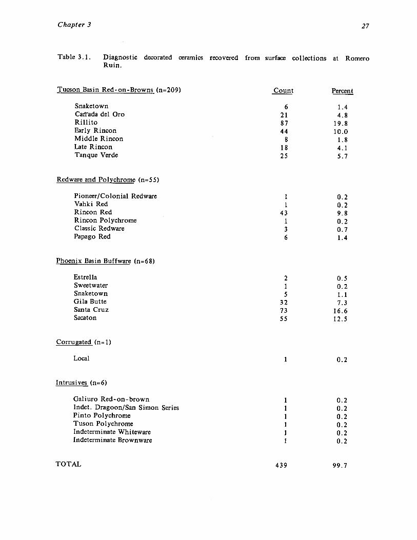
Chapter 3
Table 3. 1. Diagnostic decorated ceramics recovered from surface collections at RomeroRuin.
Tucson Basin Red-on-Browns (n=209) Count Percent
Snaketown 6 1.4Catrada del Oro 21 4. 8Rillito 87 19.8Early Rincon 44 10.0Middle Rincon 8 1.8Late Rincon 18 4.1Tanque Verde 25 5.7
Redware and Polychrome (n=55)
Pioneer/Colonial Redware 1 0.2Vahki Red 1 0.2Rincon Red 43 9.8RinconPolychrome 1 0.2Classic Redware 3 0.7Papago Red 6 1.4
Phoenix Basin Buffware (n=68)
Estrella 2 0.5Sweetwater 1 0.2Snaketown 1.1Gila Butte 32 7.3Santa Cruz 73 16.6Sacaton 55 12.5
Corrugated (n=1)
Local 1 0.2
Intrusives (n=6)
Galiuro Red-on-brown 1 0.2Indet. Dragoon/San Simon Series 1 0.2Pinto Polychrome 1 0.2TusonPolychrome 1 0.2Indeterminate Whiteware 1 0.2Indeterminate Brownware 1 0.2
TOTAL 439 99.7

Chapter 3 28
An additional 5930 plainware ceramics were recovered, consisting for the most part ofplainware body sherds from the control transect. Although the plainwares weresystematically collected and are available for future analysis, they were not analyzed indetail for this project. A contour density map of the plainware and decorated ceramicdistribution is essentially the same as that for the distribution of the total artifactassemblage shown in Figure 3.3 and is not reproduced here.
Chipped Stone
A total of 3792 pieces of chipped stone was recovered. Of these, 8.9 percent (339) wereclassed as lithic tools. Table 3.2 lists the tools and their respective material typesrecovered from the entire site. As can be seen from this table, informal tools, consistingprimarily of retouched flakes, comprise the majority of the tool types, making up nearlyhalf (42.6 percent) of the assemblage. This category is followed by scrapers (21.0 percent)and miscellaneous formal tools (7.1 percent). The miscellaneous formal tool categoryincludes such tool types as perforators, unifaces, notches, drills, knives, and burins. Onlythree projectile points were recovered through the surface collection; one wasnondiagnostic and the other two were classified as Hohokam points. This is probablyrelated to the activities of collectors over the years rather than a true reflection ofprojectile point density.
Table 3.2 also shows that the predominant material type for lithic tool manufacture wasrhyolite/andesite (38.8 percent), followed by miscellaneous sedimentary rocks (18.0 percent),miscellaneous igneous (15.4 percent), and quartzite (12.1 percent). All of these materialtypes could be procured locally within the Park area and the foothills of the SantaCatalina Mountains; rhyolite/andesite and quartzite cobbles are plentiful on the site and inthe surrounding washes. The only chipped stone material types that are definitely nonlocalare the 8 pieces of chert (2.4 percent) from site AZ AA:16:187, a known prehistoric quarrysite in the southern Tucson Basin, and a single piece of obsidian debitage.
A plot of the lithic density distribution is essentially identical to the total artifactdistribution plot shown in Figure 3.3. No lithic activity areas or tool manufacturing areascould be defined through this cursory examination of the surface data.
Ground Stone
The surface collection recovered 126 pieces of ground stone, most of it fragmentary (Table3.3). Of these, 37.2 percent were classified as manos, 15.9 percent as metates, 8.4 percentas tabular knives, and 29.4 as indeterminate. The remaining 9.1 percent consisted of asingle pestle, a single faceted polishing stone, several polished stones, and unworkedtabular knife raw material. All of the metates and most of the manos were indeterminateas to specific type. Vesicular basalt was by far the preferred ground stone raw material,comprising 3 1.0 percent of the recovered ground stone. This was followed by miscellaneousigneous (15.9 percent), quartzite (10.3 percent), and rhyolite/andesite (10.3 percent).Although the miscellaneous igneous, quartzite, and rhyolite/andesite could all be procuredlocally, the closest known source areas for vesicular basalt are found in the TucsonMountains some 20 km south and west of the site. The fact that nearly one-third of theground stone assemblage is of vesicular basalt suggests either and unknown local source oran active exchange system in the past. Similar quantities of vesicular basalt ground stonetools have been found at other sites away from the Tucson Mountains (Elson 1986:307-308),indicating the desirability of vesicular basalt as a commodity for exchange.

Chapter 3
Table 3.2. Frequency of chipped stone types by raw material from the Romero Ruinsurface collections.
LTHTYPE*MATERIAL 20 21 22 23 24 26 30 31 32 33 Total Percent
Basalt 3 1 4 1 1 10 2.9
Rhyolite/Andesite 64 54 7 4 11 1 6 5 132 38.9Misc Sedimentary 23 8 2 2 1 7 15 3 61 18.0
GranIte 13 8 1 1 5 3 1 8 1 41 12.1
Quartz 3 1 1 5 1.5Chert 2 1 2 5 1.5Chert—AA:16:187 4 3 1 8 2.4
Silicified Limestone 5 3 2 2 1 2 15 4.4
Misc Igneous 25 11 1 1 1 1 10 2 52 15.3
Jasper 3 2 1 2 1 9 2.7
1 1 0.3
Total 19 3 7 24 12 5 42 11 339
* 20=Informal Tool. 21=Scraper. 22=Biface. 23=Projectile Point. 24=Plano Scraper. 26=Misc Formal Tool, 30=Core.
31~Exhausted Core. 32=Core Hamerstone. 35=Core Tool
Table 3.3. Frequency of ground stone types by raw material from the Romero Ruinsurface collections..
RAW MATERIAL TVPES*GROLt~D
STONE TYPES 1 2 3 5 7 8 14 18 TOTAL
Shaped Flat Mano 0 0 0 2 0 0 0 0 2
Unshaped Flat Mano 0 0 0 0 1 0 0 0 1
Rect. Trgh/Basn Mano 0 1 1 2 0 0 0 0 4
Indet/Other Mano 3 8 5 4 5 6 9 0 40
Indet Metate 1 14 2 1 1 0 1 0 20
Pestle 0 0 0 1 0 0 0 0 1
Tabular Knife 0 0 4 6 1 0 0 0 11
Tab Knife Material 0 0 0 3 0 0 0 1 4
Polishing Stone 0 0 0 0 1 0 0 0 1
Polished Stone 0 0 0 0 0 3 0 0 3
Medicine Stone 0 0 0 0 1 0 0 0 1
Other/Unknown 0 1 0 0 0 0 0 0 1
Indeterminate 4 15 1 1 3 2 10 1 37
TOTAL 8 39 13 20 13 11 20 2 126
*1=Basalt, 2=Vesicular Basalt/Rhyolite, 3=Rhyoliste/Andesite, 5=Schist/Gneiss. 7=Misc Sedimentary. 8=Quartzite.
14=Misc Igneous. 18=Tabular Knife Material
Chapter 3 30
The distribution of ground stone tools across the site is slightly different than the otherartifact categories. Although most of the ground stone follows the general distribution oftrash, the low density open areas are not nearly as well defined. This is particularly truefor the large north-central area which shows a concentration of ground stone within unitsN725/E500 and N775/E500. Why this is so is unclear, although it may be related to foodprocessing activities occurring within the living areas rather than within the trash areas.Interestingly, at the Valencia site the ground stone distribution was almost the opposite ofthat seen here. At Valencia very little ground stone was found within the open plazaareas; most was concentrated in the surrounding trash deposits (Elson and Doelle 19 86:41).
Shell
Only 21 pieces of shell were recovered at the site. Approximately half of the shell wasworked and the other half was unworked. The worked pieces include six Glycymerisbracelet fragments, a single Chama whole bead, and several indeterminate pieces. Shellspecies represented included 11 Laevicardjum (52.4 percent), 7 Glycymeris (33.3 percent), 2Chama (9.5 percent), and a single fragment of Pteria sterna (4.8 percent). Although forthe most part the shell distribution is similar to the general trash distribution, a smallconcentration of shell in the southern portion of the site, including four unworked pieces,may suggest that this area was used more intensively than other areas for shellmanufacture.
Other Artifacts
Other recovered artifacts included two figurine fragments, two indeterminate ceramicfragments, a single unworked piece of azurite/malachite, and a quartz crystal.
Cremated Bone
Seventy-four occurrences of human cremated bone were recorded at the site. This materialwas mapped and counted but was not collected. Cremated bone was found over the entiresite, particularly in high density trash areas and trash mounds. Three more or lessdiscrete areas of concentrated bone were defined which may represent separate cemeteryplots. The best defined area is in the northeast corner of the site just east of thecompound and within and surrounding Feature 51, a small trash mound (see Figure 3.2).The others occur within units N675/E450 and N800/E450. Whether these areas trulyrepresent cemeteries cannot be determined without subsurface excavation, and it is likelythat other cemetery areas are present but not discernible through the surface remains.Discrete cemetery plots have been reported at a number of excavated Hohokam sites, suchas the Hodges site (Kelly 1978; Craig 1986) and La Ciudad (Rice 1987), and would beexpected at a site the size of the Romero Ruin.
Protohistoric Artifacts
Eight sherds from Romero were identified as protohistoric (n=3) or possible protohistoric(n=5) due to their resemblance to Whetstone Plain, a protohistoric ware (DiPeso 1953).Several other sites within the survey area also contained several protohistoric sherds, andat least one site (AZ BB:9:207) appears to be a small sherd and lithic scatter or resource

Chapter 3
procurement site dating to this period. The Protohistoric period is currently not wellunderstood, due primarily to the ephemeral nature of the sites and the lack of excavationdata. As a result, the significance of these eight sherds is not clear outside of the factthat the site was at least visited and probably temporarily used during this time.
Historic Artifacts
Given the known historic occupation of the site and the substantial remains of the masonryrooms and walls, the lack of historic artifacts on the surface of the site is surprising.Four pieces of rusted metal, two historic plainware sherds, a sherd of ceramic glaze ware,and a single piece of nondiagnostic glass, were the only artifacts of Anglo or Mexicanmanufacture recovered. Several additional pieces of metal were observed on the sitesurface but were not collected. The most telling indication of the historic occupation wasthe recovery of seven Papago sherds. All of these artifacts were found in close proximityto the remains of the Romero ranch house. Why the site lacks historic material isunknown. It may be related to the nearly 100 years of treasure searching, collecting, andpotting, that has occurred within the homestead, or it may be related to the nature orintensity of the occupation.
TEMPORAL PATTERNS
The structure of the Romero Ruin can best be examined through the analysis of thetemporal data. In the beginning of this chapter the site structure was examined using thesurface features and surface artifact density without taking into account chronologicalfactors. Based on the map of the surface features presented in Figure 3.2, it can besuggested that the site was made up of a series of mound groups surrounding open livingareas. Each living area probably contained a number of pithouse clusters or householdgroups (Wilcox et al. 1981; Huntington 1986; Elson 1986), and trash was deposited aroundthe fringes of this area. The formation of trash areas and trash mounds, particularly thelarge rock/rubble mounds, would have constrained subsequent settlement of the site.Although it has been suggested that the rock/rubble mounds resulted from the clearing ofliving space, it is possible that the placement of the mounds was not a haphazard process,rather it may represent a deliberate modification of the site landscape to define socialspace. In either case, it is clear that the mounds, combined with the topography of thesite along a narrow ridge finger, must have played a significant role in structuring the pastactivity and facility locations at the site.
Analysis Methods
A major goal of the analysis of the surface material from the Romero Ruin is to gain abetter understanding of the changes in site structure through time. This involves somemeasure of the intensity of occupation for each phase or subphase. Measuring intensityinvolves three behavioral aspects First is the number of persons resident at a site, secondis the amount of space occupied by those residents, and third is the amount of time spentper year at the site. These factors must be inferred from the temporally diagnosticmaterial remains recovered from the Romero site. Unfortunately, due to the nature ofsurface data and to our presently incomplete knowledge of Hohokam settlement in theTucson Basin, much of the information needed to measure intensity of occupation, such aspopulation estimates or permanency of occupation, is either unavailable or unknown. As a
Chapter 3
result, the spatial parameters of the occupation are the most accessible data to use as ameasure of intensity.
Unfortunately, there are a variety of other factors that affect the archaeologist’s ability tomeasure intensity through the study of spatial distributions. These problems have beenpreviously addressed in the analysis of the surface material from the Valencia site (Elsonand Doelle 1986:55-59) and are briefly summarized here with additional data from morerecent studies.
Problem #1: Plain to Decorated Ware Ratios are Poorly Known
If the rate of production of decorated pottery were the same for all time periods, then thefrequency of decorated ceramics could be used as a direct comparative measure of theintensity of the occupation. Unfortunately, this is not the case. It is known that certaindecorated wares were produced in much greater numbers than others, but the nature ofthis variation is very poorly known for most time periods. For example, Haury(1976:217,220) found that Estrella Red-on-gray, the earliest Hohokam painted ware,constituted only 2-3 percent of the total ceramic assemblage at Snaketown. He notes thatthe decorated frequency had increased to roughly 5 percent by the Sweetwater phase, andthat it may have been as high as 40 percent by the Sacaton phase, the final phase in theSnaketown occupation (Haury 1976:203,217).
Unfortunately, there is no comparable data source for the Tucson Basin. The Hodges site(Kelly 1978; Layhe 1986) is the only excavated site in the Tucson Basin that has anoccupation span even approaching that of Snaketown. Hodges was apparently occupiedfrom at least the Sweetwater phase through the Tanque Verde phase, but there are no dataavailable regarding the relative frequency of decorated wares over that time span. Becausethe Hodges site does represent a large-scale excavation of a major Tucson Basin village,the data may still be instructive. For example, Kelly (1978:18,21) reports only 24 sherdsand four reconstructible vessels of Sweetwater Red-on-gray, and 158 sherds and 12reconstructjble vessels of Snaketown Red-on-buff. From these data, and from similar datafrom the Hardy site (Gregonis 1981), there is good reason to believe that, like the PhoenixBasin, the Tucson Basin will be characterized by a very low frequency of decoratedceramics during the Pioneer period and that the decorated frequency will increase overtime.
Research by Dart (1984:65) on Rillito, Rincon, and Tanque Verde phase decorated frequencyin the southern Tucson Basin tends to support the trend suggested above. Dart reviewedpublished information on 11 sites along the Santa Cruz River and found a general temporaltrend toward increasing decorated ware frequency from the Rillito through Tanque Verdephases. Dart did not control for site type, nor did he control for geographic area, sincesites within and south of the Tucson Basin are included in his sample, and his sample sizesfrom two sites are as low as 200 sherds. Nevertheless, the trend appears to be relativelywell supported. Dart found that the Rillito and Early Rincon decorated frequencies wereroughly 7 to 8 percent, while the Rincon phase frequencies range from 11.7 to 21.5percent, and the Tanque Verde phase frequencies range from 25.9 to 27.1 percent. Thesedata are specific to the southern Tucson Basin, however, and as discussed below underProblem #2, they may not be directly applicable to the northern Tucson Basin andspecifically the Romero Ruin.
To summarize, the lack of control over variation in the rate of decorated ceramicproduction over time presents a serious problem for interpreting the significance of the

Chapter 3
various frequencies of diagnostic decorated ceramics recovered from the surface of theRomero Ruin. It is clear that the rate of production of decorated wares was very lowduring the early phases of the Hohokam sequence. For the Ca1~ada del Oro phase there areno comparative data, and for the Rillito phase there is some suggestion, at least from thesouthern Tucson Basin, that the production of decorated wares was roughly half of what itwas in the succeeding Rincon phase. Most importantly, however, is the fact that itappears that early Snaketown and Estrella phase ceramics were produced in such lownumbers that comparing the frequency of ceramics from these phases to the later phases isproblematic.
Problem #2: Boundaries, Interaction, and the Northern Tucson Basin
A recent study by Wallace (1987) showed that there is significant spatial variability in thefrequencies of Phoenix Basin buffwares and Tucson Basin red-on-browns during the Rillitophase in the Tucson Basin. Such variation had been noted for single sites by previousresearchers, and it was generally hypothesized that a particular site had maintained ahigher degree of interaction and exchange with the Phoenix Basin. What Wallacedocumented, however, was that this is an areal pattern, not one confined to a single site.Sites north of the Hodges site, which was located just south of the junction of the RillitoRiver with the Santa Cruz, were found to have buffware frequencies in the 40 to 60percent range, whereas sites south of the Hodges site had buffware frequencies from 8 to17 percent. Wallace suggests that economic factors related to more intensive potteryproduction in the southern Tucson Basin are likely to be key elements in accounting forthis ceramic distribution. Regardless of the ultimate causes of this phenomenon, Wallacehas shown that there is substantial spatial variation in ceramic frequencies even within theboundaries of the Tucson Basin. Thus, on this project comparisons with sites from thesouthern Tucson Basin must be carried out with caution.
The high frequencies of buffware that occur in the northern Tucson Basin create a secondproblem in that the temporal framework for Phoenix Basin buffwares is not as fine-scaledas that for the Rincon phase ceramics of the Tucson Basin. Furthermore, the temporalcorrespondence between the Tucson and Phoenix Basin ceramic sequences has not beenadequately established. This problem is particularly important for Sacaton Red-on-buff,which is dealt with separately in a later section.
Variability in the Classic period ceramic assemblages of the northern Tucson Basin is alsoan important unresolved issue. Recent excavations by the Institute for American Researchat AA.12.120, for example, yielded a ceramic assemblage of redwares and no red-on-brownsherds. This site definitely post-dates the Late Rincon subphase, and it may date to theTanque Verde phase (analysis has not yet begun at the time of this writing). AA:12:120 islocated very near Los Morteros, a site where Tanque Verde Red-on-brown was abundantduring the Tanque Verde phase. There are too many unresolved issues at present to meritthe presentation of hypotheses here, rather the goal is to raise the point that the degreeof variability in northern Tucson Basin ceramic assemblages may be very great. Caution isthus merited in interpretations of the Romero data.
Problem #3: Variable Identification Rates for Diagnostics
Unfortunately, some ceramic types are easier to identify than others. To some extent thisis due to the condition of the ceramics. For example, early types have been exposed tofactors such as erosion and trampling for longer periods of time, and as a result they are
Chapter 3
likely to be in poorer condition than are more recent types. Furthermore, a type likeRillito Red-on-brown tends to be thinner than most Rincon phase red-on-browns, whichmay well lead to the preservation of larger, more easily identifiable sherds from the Rinconphase.
A particular problem is presented by Caftada del Oro Red-on-brown. Wallace (Doelle andWallace 1986:10) has reviewed the problems with this type, noting that “... the descriptionof CalIada del Oro Red-on-brown in [Kelly’s (1978)) Hodges report is based on a mixture oflocal and imported ceramics and must therefore be considered invalid.” Wallace was able tooutline a set of criteria that he used to identify Caufada del Oro Red-on-brown for the SanXavier project area and subsequently the Valencia site. These criteria were used in thepresent analysis but because the type is still only poorly documented it is particularlydifficult to identify. Wallace believes that there are more Caflada del Oro sherds in theRomero collections than were identified as such. Similar problems are also present withthe earlier Pioneer period sherds, although not on as large a scale due to their lowerfrequency and more distinctive nature.
Another problem in sherd identification involves the redware assemblage. In particular alarge number of redware sherds were recovered that could not be identified.Unfortunately, these 116 unidentifiable sherds, a relatively large number given the numberof recovered diagnostics, do not represent a homogeneous but unknown type; rather theyare believed to be a mixture of Pioneer, Sedentary, and Classic period redwares. AlthoughRincon Red is relatively common and readily identifiable, due primarily to the large numberof Middle Rincon sites that have now been excavated within the Tucson Basin, very fewPioneer and Classic period sites have been excavated, or even intensively surface collected,particularly within the northern Tucson Basin. As a result, a large number of potentiallydiagnostic sherds could not be typed due to their unfamiliarity. The lack of these datamost likely affects the spatial distribution and sherd density data for the Pioneer andClassic periods.
Fortunately, these kinds of problems can be addressed in the future when Cairada del Oro,Pioneer, and Classic period material is available from well-controlled excavated contexts.The Institute has just completed excavations at the Redtail site (AZ AA:12:149), a largePioneer and Colonial period village, and analysis of this material should help resolve someof the identification problems noted above.
Problem #4. Variable Lengths of Phases and Subphases
There has long been difficulty in working out a chronology for the Hohokam (see Schiffer1982, 1986), but a key assumption of the major Hohokam chronology and many of thesubsequent revisions was that the phases were of roughly equal lengths that spanned 200years. Current revisions of the chronology all point toward a much more compressed timeframe (see Chapter 2), and there is now evidence that some of the recognizable timeperiods may be of variable lengths. For example, Doelle (1985) suggests that both theEarly and Late Rincon subphases were brief periods of transition lasting approximately 50years that were marked by rapid changes in ceramic styles. He also argues that the MiddleRincon subphase represents a longer period of time estimated to span 100 years. Absolutedates from the West Branch site (Huntington 1986), the Tanque Verde Wash site (Elson1986), and subsequent ceramic studies by Wallace (1986a, 1986b), add support to thisconclusion regarding the Middle Rincon subphase. These data directly affect any measureof intensity since the density of the ceramics and other artifacts is at least partiallydependent upon the length of the phase in question.
Chapter 3
Unfortunately, the Tucson Basin chronology prior to the Rincon phase is in very poorshape, and the relative length of any phase is only guesswork. This is also true for thelater Classic period phases, particularly the Tucson phase of which very little is known.The poor resolution of the early chronology is due primarily to the lack of excavated sitesand absolute dates from these periods, although recent work at AZ AA:12:120 and AZAA:12:149 by the Institute, and the Fasttimes and Water World sites by the Arizona StateMuseum, should help to resolve some of these problems. However, at present while thelength and time involved in the subphases of the Rincon phase can be controlled at leastreasonably well, it must be recognized that there ~y be significantly different lengths oftime involved in the other ceramic phases.
Problem #5: Variable Surface Conditions
Differential conditions of erosion, deposition, and disturbance can lead to differentialrepresentation of artifacts from particular time periods on the surface of a site. Whiledata on erosion and deposition were recorded in the field, these data have not beenutilized on a site wide basis. However this information is available and it has been takeninto consideration wherever it was suspected to be a significant factor.
In summary, the problem of variable surface conditions is not believed to constitute asignificant source of variation in the data set for the kinds of data analysis that arecarried out in this volume. In the future, when variations between artifact classes isexplored and when finer scaled temporal patterning is considered, it will almost certainlybe necessary to make use of the control data that are available.
Conclusions
Potential problems with assessing intensity of occupation with the Romero data set havebeen identified, and in this section some of the ways in which these factors are taken intoconsideration during the examination of site structure are presented. It should be kept inmind, however, that not all of the problems mentioned above are currently resolvable, andthat additional data need to be gathered and evaluated before some of these can be morethan superficially addressed.
The most significant impact of the above problem relates to both the earliest and thelatest time periods, for several factors select against the representation of the Pioneerperiod, Cairada del Oro, and Tanque Verde phase in this data set. Whether similar factorsare in operation for the Middle Rincon subphase as suggested above are still too tentativeto estimate. To offset these negative factors, the presence of Pioneer, Cafiada del Oro,and Tanque Verde phase materials in the sample will be given heavier weighting than isgiven the other time periods. This is not weighting in the mathematical sense, for there iscurrently insufficient information for proposing a precise weighting scheme. Rather, it isqualitative weighting, in that very close attention is given to the distribution and possiblesignificance of this material. To some extent, the field collection strategy used on thisproject helps alleviate these problems. Only through large sampling fractions can relativelyrare or low frequency items such as these be expected to be collected in meaningfulnumbers. Obtaining large collections of diagnostics also increases the likelihood that clearspatial patterns will be evident in the data set.
Chapter 3
In a previous study that employed the concept of intensity of occupation (Doelle andWallace 1986), it was necessary to place substantial significance on the actual frequenciesof diagnostics at a particular site for a particular time period. In the present study,however, only limited attention is given to these frequencies at the site level. Rather,much more attention is given to examining and interpreting the spatial distribution ofdiagnostics. By incorporating the spatial factor many of the difficulties identified abovecan be addressed or avoided. Once the pattern and intensity of occupation are establishedfor a particular time period through such study of spatial distributions, comparison betweentime periods is possible.
Finally, although it cannot be conclusively established without excavation data, it seemslikely that the site was occupied permanently, rather than seasonally, during most Hohokamtimes periods. This is based upon the large size of the site, the presence of twobailcourts, a masonry compound, and extensive trash deposits and large trash mounds.However, the issue of the degree of seasonality or permanence of Hohokam large villagesrequires detailed testing (see also Wallace 1987).
Initial Occupation
Two sherds of Estrella incised (one a redware) and one sherd of Sweetwater Red-on-graywere recovered from the site. Other early ceramics recovered include a single sherd ofVahki Red and an unnamed Pioneer period redware, though these sherds cannot be assignedto a specific phase. These ceramics indicate that the site was first occupied no later thanthe Estrella phase (A.D. 550-600), making the Romero Ruin one of the earliest Hohokamsites in the Tucson Basin. No Archaic period projectile points were recovered.
The extent of this early Hohokam occupation at the Romero Ruin is unknown. It appearslikely, given the problems in early ceramic production mentioned above and the difficulty inrecognizing Estrella and Sweetwater (A.D. 600-650) phase sherds unless they are large orincised, that occupation during these early periods was more intensive than the five sherdsindicate. This is particularly true if, as suspected, even a fraction of the 116 unidentifiedredwares are from the Pioneer period. Excavations by the Arizona State Museum (Fish etal. 1987) at the Pioneer period Dairy site (AA:12:285), as well as the recently completedexcavations by the Institute at the Redtail site (AZ AA:12:149), suggest that redwares arepresent at low frequencies in Tucson Basin Pioneer period assemblages that are largelyplainwares.
Snaket own Phase
The surface collection yielded six Snaketown Red-on-brown and five Snaketown Red-on-buff sherds. This is approximately 2.5 percent of the total number of diagnostic sherdscollected from the site (Table 3.1). An additional three sherds were typed as Snaketown orCanada del Oro, while seven sherds were typed as Snaketown or Gila Butte. Thedistribution of those sherds typed as Estrella, Sweetwater, and Snaketown phase material ispresented in Figure 3.4.
The Snaketown ceramics form two clusters, one in the northwest corner of the site, and asecond in the east-central site area. A single trash mound, Feature 28, contained aSnaketown sherd and it is likely to have originated at this time, while parts of two definedtrash concentrations also contained Snaketown material. Although it is tenuous to inferspatial patterning from the Snaketown phase data, the distribution of the ceramics is
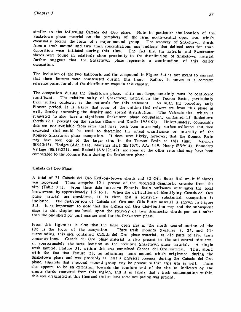
Chapter 3
similar to the following Cairada del Oro phase. Note in particular the location of theSnaketown phase material on the periphery of the large north-central open area, whicheventually became the focus of a major mound group. The recovery of Snaketown sherdsfrom a trash mound and two trash concentrations may indicate that defined areas for trashdeposition were initiated during this time. The fact that the Estrella and Sweetwatersherds were found in relatively close proximity to the distribution of Snaketown materialfurther suggests that the Snaketown phase represents a continuation of this earlieroccupation.
The inclusion of the two ballcourts and the compound in Figure 3.4 is not meant to suggestthat these features were constructed during this time. Rather, it serves as a commonreference point for all of the distribution maps in this chapter.
The occupation during the Snaketown phase, while not large, certainly must be consideredsignificant. The relative rarity of Snaketown material in the Tucson Basin, particularlyfrom surface contexts, is the rationale for this statement. As with the preceding earlyPioneer period, it is likely that some of the unidentified redware are from this phase aswell, thereby increasing the density and spatial distribution. The Valencia site, which issuggested to also have a significant Snaketown phase occupation, contained 13 Snaketownsherds (2.1 percent) on the surface (Elson and Doelle 1986:61). Unfortunately, comparabledata are not available from sites that have both been intensively surface collected and thenexcavated that could be used to determine the actual significance or intensity of theRomero Snaketown phase occupation. It does seem likely, however, that the Romero Ruinmay have been one of the larger sites in the Tucson Basin at this time. Valencia(BB:13:15), Hodges (AA:12:18), Martinez Hill (BB:13:7), AA:16:49, Hardy (BB:9:14), BoundaryVillage (BB:13:221), and Redtail (AA:12:149), are some of the other sites that may have beencomparable to the Romero Ruin during the Snaketown phase.
Calfada dcl Oro Phase
A total of 21 Ca~fada del Oro Red-on-brown sherds and 32 Gila Butte Red-on-buff sherdswas recovered. These comprise 12.1 percent of the decorated diagnostic ceramics from thesite (Table 3.1). From these data intrusive Phoenix Basin buffwares outnumber the localbrownwares by approximately 1.5 to 1. When the difficulties of identifying Calfada del Orophase material are considered, it is clear that a relatively substantial occupation isindicated. The distribution of Caltada del Oro and Gila Butte material is shown in Figure3.5. It is important to note that the Caffada del Oro distribution map and the subsequentmaps in this chapter are based upon the recovery of two diagnostic sherds per unit ratherthan the one sherd per unit measure used for the Snaketown phase.
From this figure it is clear that the large open area in the north central section of thesite is the focus of the occupation. Three trash mounds (Features 7, 24, and 51)surrounding this area contained Caflada del Oro phase material, as did parts of five trashconcentrations. Caflada del Oro phase material is also present in the east-central site area,in approximately the same location as the previous Snaketown phase material. A singletrash mound, Feature 31, within this area contained Caflada del Oro material. This, alongwith the fact that Feature 28, an adjoining trash mound which originated during theSnaketown phase and was probably at least a physical presence during the Caflada del Orophase, suggests that a second mound group may be present within this area as well. Therealso appears to be an extension towards the southern end of the site, as indicated by thesingle sherds recovered from this region, and it is likely that a trash concentration withinthis area originated at this time and that at least some occupation was present.
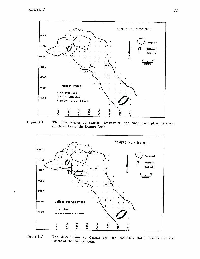
Chapter 3 38
ROMERO RUIN (BB:9:I)
-N800 • •
~N75O E : : Compound
() Bailcourt
Grid poiniN700 N
I? 5pmeter,oN650
0-N600
Pioneer PeriodN550 . . .
E Estrello eherd
•N500S Sweeleoter sherd
SnQke~own contours I Sherd
o 0 0 0 0 0 0 0o s, ~ 0 5)eU i1j uj U U U U U
I I I
Figure 3.4 The distribution of Estrella. Sweetwater. and Snaketown phase ceramicson the surrace of the Romero Ruin
ROMERO RUIN (88:9:1)
N800 +
Compound
-N750() Bollcourt
Grid point-N700 N
?I~Pmeters
-N650
+
N600
+ + +N5~O Ca~ado del Oro Phase
+ I Sherd-N500
Contour intervol ~ 2 Shirds
o 0 0 0 0 0 0 0o ~) 0 0 0 5)
~ in inU 11j w si ~ w w
I I I I
Figure 3.5 The distribution of Caftada del Oro and Gila Butte ceramics on thesurface of the Romero Ruin.
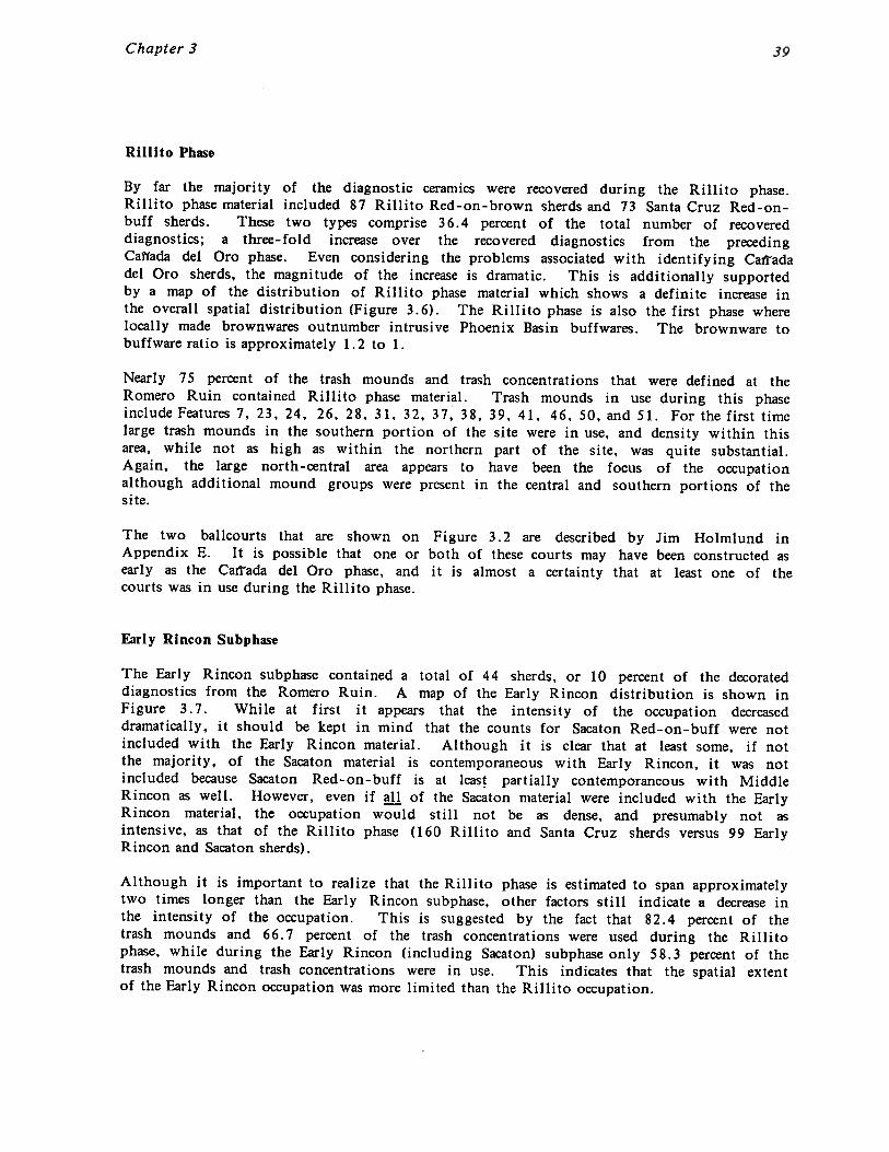
Chapter 3
Rillito Phase
By far the majority of the diagnostic ceramics were recovered during the Rillito phase.Rillito phase material included 87 Rillito Red-on-brown sherds and 73 Santa Cruz Red-on-buff sherds. These two types comprise 36.4 percent of the total number of recovereddiagnostics; a three-fold increase over the recovered diagnostics from the precedingCalfada del Oro phase. Even considering the problems associated with identifying Caftadadel Oro sherds, the magnitude of the increase is dramatic. This is additionally supportedby a map of the distribution of Rillito phase material which shows a definite increase inthe overall spatial distribution (Figure 3.6). The Rillito phase is also the first phase wherelocally made brownwares outnumber intrusive Phoenix Basin buffwares. The brownware tobuffware ratio is approximately 1.2 to 1.
Nearly 75 percent of the trash mounds and trash concentrations that were defined at theRomero Ruin contained Rillito phase material. Trash mounds in use during this phaseinclude Features 7, 23, 24, 26, 28, 31, 32, 37, 38, 39, 41, 46, 50, and 51. For the first timelarge trash mounds in the southern portion of the site were in use, and density within thisarea, while not as high as within the northern part of the site, was quite substantial.Again, the large north-central area appears to have been the focus of the occupationalthough additional mound groups were present in the central and southern portions of thesite.
The two bailcourts that are shown on Figure 3.2 are described by Jim Holmiund inAppendix E. It is possible that one or both of these courts may have been constructed asearly as the Caitada del Oro phase, and it is almost a certainty that at least one of thecourts was in use during the Rillito phase.
Early Rincon Subphase
The Early Rincon subphase contained a total of 44 sherds, or 10 percent of the decorateddiagnostics from the Romero Ruin. A map of the Early Rincon distribution is shown inFigure 3.7. While at first it appears that the intensity of the occupation decreaseddramatically, it should be kept in mind that the counts for Sacaton Red-on-buff were notincluded with the Early Rincon material. Although it is clear that at least some, if notthe majority, of the Sacaton material is contemporaneous with Early Rincon, it was notincluded because Sacaton Red-on-buff is at least partially contemporaneous with MiddleRincon as well. However, even if all of the Sacaton material were included with the EarlyRincon material, the occupation would still not be as dense, and presumably not asintensive, as that of the Rillito phase (160 Rillito and Santa Cruz sherds versus 99 EarlyRincon and Sacaton sherds).
Although it is important to realize that the Rillito phase is estimated to span approximatelytwo times longer than the Early Rincon subphase, other factors still indicate a decrease inthe intensity of the occupation. This is suggested by the fact that 82.4 percent of thetrash mounds and 66.7 percent of the trash concentrations were used during the Rillitophase, while during the Early Rincon (including Sacaton) subphase only 58.3 percent of thetrash mounds and trash concentrations were in use. This indicates that the spatial extentof the Early Rincon occupation was more limited than the Rillito occupation.
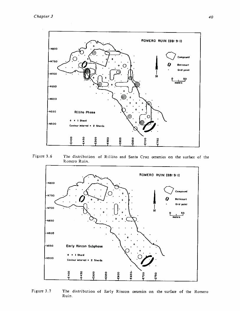
Chapter 3
Figure 3.6 The distribution of Rillito and SantaRornero Ruin.
Cruz ceramics on the surface of the
Figure 3.7 The distribution of Early Rincon ceramics on the surface of the RomeroRuin.
~N800
•N?50
N700
-N650
N600
N5 50
-N500
ROMERO RUIN (88:9:1)
Compound
(J Batteourt
Grid point
N
meters
Rillito Phase
+ I Sherd
Contour Interval ~ 2 Sherds
o 0 0o 5) 0e ~ii’ iii Ii’
0 0 05) 0 5)5) ID
‘9 I~iI I I
-N800
•N750
N700
N650
-N600
N550
•N500
ROMERO RUIN (88:9:1)
Compound
() Bolleourt
Grid point
N
meters
Early Rincon Subphase
4 I Sherd
Contour interval v 2 Sherds
o 0 0o ~ 0
5)uJ It’ ‘9
0 0 0 0 05) 0 0 5)
ID ID‘Ii w it’
I I

Chapter 3
The trash mound and trash concentration frequencies for Early Rincon are probably inflatedsince they include mounds containing Sacaton sherds. If only Early Rincon sherds areconsidered the frequency of trash mounds in use drops to 35.3 percent, while trashconcentrations drop to 50.0 percent. Therefore, while it is clear that the intensitydecreased to a certain degree, the magnitude of the reduction is unknown. Given the twoto one phase length difference, however, which is quite extreme, the reduction in theintensity of the occupation may have been relatively minor.
Even with the differences in the trash mounds and concentrations, the Early Rincondistribution was similar, although slightly smaller in area, to that of the Rillito phase. Thenorth-central open area is still occupied as indicated by the high density trash depositssurrounding it. However, these deposits only include three trash concentrations and asingle trash mound (Feature 23) in contrast to the preceding Rillito and Caflada del Orophases. Although the density plot does not indicate it clearly, there may be a shifttowards increased occupation in the southern portion of the site as compared to the north-central area. This is suggested by the fact that four of the largest southern trash mounds(Features 37, 38, 39, and 41), and three southern trash concentrations, contain EarlyRincon material. It is assumed, however, that mound groups are present in both the north-central and southern areas, with possibly another group present in the east-central sitearea.
Early or Middle Rincon Subphase
Because it is not feasible to break Sacaton Red-on-buff ceramics into subtypes as has beenaccomplished with the Tucson Basin red-on-brown wares for the Rincon phase, it isnecessary to consider the Sacaton phase buffwares in this separate section. A total of 55Sacaton Red-on-buff sherds was recovered from the Romero Ruin, which represents 12.6percent of the decorated diagnostics from the site (Table 3.1). This is a larger amountthan the diagnostic red-on-brown sherds recovered from either the Early or Middle Rinconsubphases.
The distribution of the Sacaton phase material (Figure 3.8) is similar to both the Early andMiddle Rincon distributions. The north-central area is the main focus of the occupation.This focus is even clearer for Sacaton than for either Early or Middle Rincon since fourtrash mounds (Features 23, 24, 46, and 51) and four trash concentrations completelysurround this area forming a well-defined mound group. Again, as with the other twoRincon subphases, while the ceramic density in the southern component is light, four trashmounds (Features 36, 37, 39, and 41) and a single trash concentration contain Sacatonceramics.
At the Tanque Verde Wash site Sacaton Red-on-buff was found to drop out of the ceramicassemblage by the middle of the Middle Rincon subphase (TVW2--see Wallace 1986b). Inthe northern Tucson Basin buffwares show a trend of decrease over time, but they mayoccur later into the Middle Rincon subphase than appears to have been the case farther tothe south. These unresolved issues make it impossible to use the buffware data to gainadditional insight into the relative intensity of occupation between Early and Middle Rincontimes.
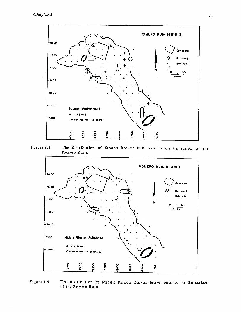
Chapter 3
Figure 3.8 The distribution of Sacaton Red-on-buffRomero Ruin.
Figure 3.9
ceramics on the surface of the
The distribution of Middle Rincon Red-on-brown ceramics on the surfaceof the Romero Ruin.
42
ROMERO RUIN (BB:9:I)
-P4800
-N750 : : : : :::P4700
• • • +• •o.+ +
-N650
+-P4600
P4350
Compound
() Boilcourt
Grid point
N 9~~5pn•ters
P4500
Sacaton Red-on-Buff
+ • I Sherd
Contour int•rvol • 2 Sherds
o 0 0 0 0 0 0 0o g, 0 e~ 0 oe e m ~.iii UI UI UI UI Iii (U UI
I — I I I I
ROMERO RUIN (BB:9:l)
Compound
() Bolicourt
• Grid point
meters
Middle Rincon Subphase
+ • I Shird
Contour intirval • 2 Sherds
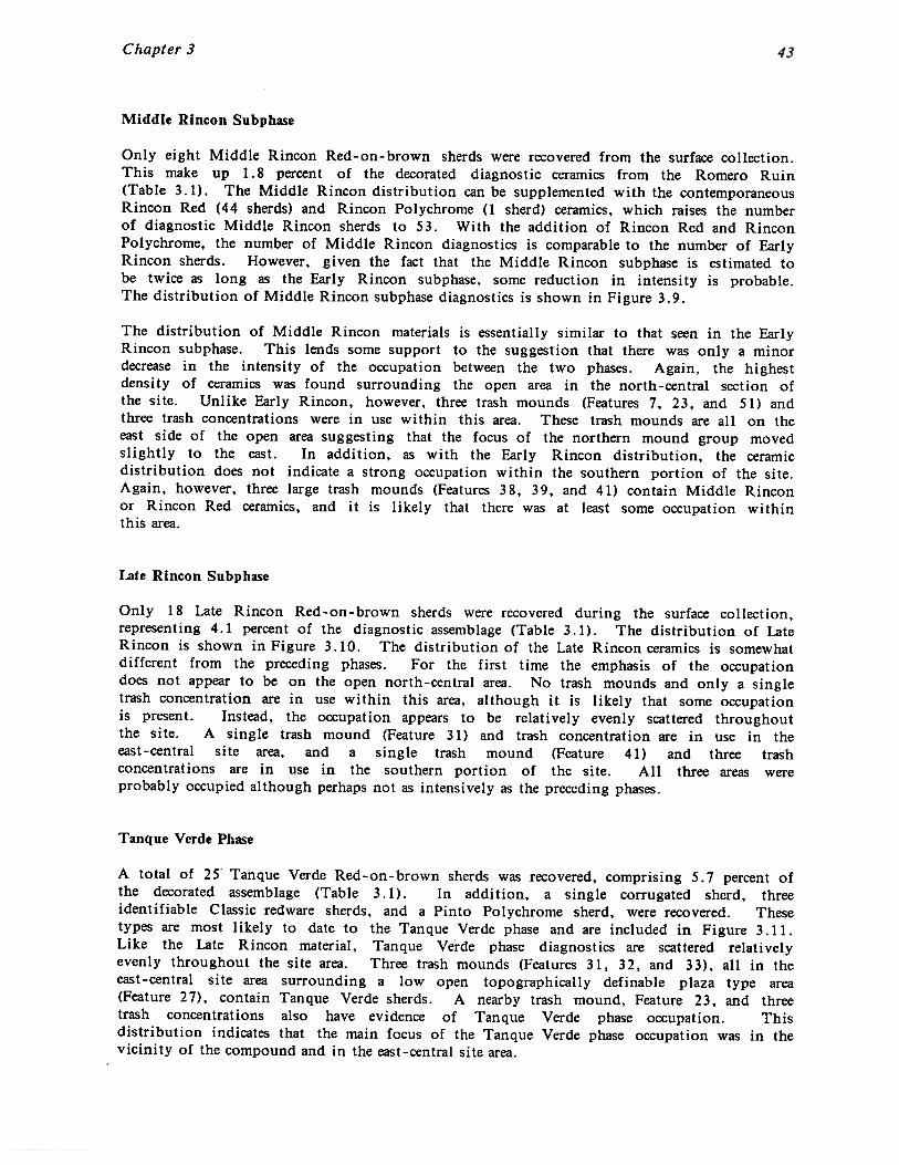
Chapter 3
Middle Rincon Subphase
Only eight Middle Rincon Red-on-brown sherds were recovered from the surface collection.This make up 1.8 percent of the decorated diagnostic ceramics from the Romero Ruin(Table 3.1). The Middle Rincon distribution can be supplemented with the contemporaneousRincon Red (44 sherds) and Rincon Polychrome (1 sherd) ceramics, which raises the numberof diagnostic Middle Rincon sherds to 53. With the addition of Rincon Red and RinconPolychrome, the number of Middle Rincon diagnostics is comparable to the number of EarlyRincon sherds. However, given the fact that the Middle Rincon subphase is estimated tobe twice as long as the Early Rincon subphase, some reduction in intensity is probable.The distribution of Middle Rincon subphase diagnostics is shown in Figure 3.9.
The distribution of Middle Rincon materials is essentially similar to that seen in the EarlyRincon subphase. This lends some support to the suggestion that there was only a minordecrease in the intensity of the occupation between the two phases. Again, the highestdensity of ceramics was found surrounding the open area in the north-central section ofthe site. Unlike Early Rincon, however, three trash mounds (Features 7, 23, and 51) andthree trash concentrations were in use within this area. These trash mounds are all on theeast side of the open area suggesting that the focus of the northern mound group movedslightly to the east. In addition, as with the Early Rincon distribution, the ceramicdistribution does not indicate a strong occupation within the southern portion of the site.Again, however, three large trash mounds (Features 38, 39, and 41) contain Middle Rinconor Rincon Red ceramics, and it is likely that there was at least some occupation withinthis area.
bite Rincon Subphase
Only 18 Late Rincon Red-on-brown sherds were recovered during the surface collection,representing 4.1 percent of the diagnostic assemblage (Table 3.1). The distribution of LateRincon is shown in Figure 3.10. The distribution of the Late Rincon ceramics is somewhatdifferent from the preceding phases. For the first time the emphasis of the occupationdoes not appear to be on the open north-central area. No trash mounds and only a singletrash concentration are in use within this area, although it is likely that some occupationis present. Instead, the occupation appears to be relatively evenly scattered throughoutthe site. A single trash mound (Feature 31) and trash concentration are in use in theeast-central site area, and a single trash mound (Feature 41) and three trashconcentrations are in use in the southern portion of the site. All three areas wereprobably occupied although perhaps not as intensively as the preceding phases.
Tanque Verde Phase
A total of 25 Tanque Verde Red-on-brown sherds was recovered, comprising 5.7 percent ofthe decorated assemblage (Table 3.1). In addition, a single corrugated sherd, threeidentifiable Classic redware sherds, and a Pinto Polychrome sherd, were recovered. Thesetypes are most likely to date to the Tanque Verde phase and are included in Figure 3. 11.Like the Late Rincon material, Tanque Verde phase diagnostics are scattered relativelyevenly throughout the site area. Three trash mounds (Features 31, 32, and 33), all in theeast-central site area surrounding a low open topographically definable plaza type area(Feature 27), contain Tanque Verde sherds. A nearby trash mound, Feature 23, and threetrash concentrations also have evidence of Tanque Verde phase occupation. Thisdistribution indicates that the main focus of the Tanque Verde phase occupation was in thevicinity of the compound and in the east-central site area.
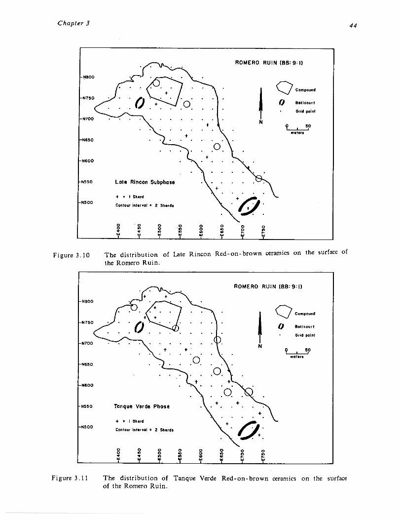
Chapter 3
Figure 3.10 The distribution of Late Rincon Red-on-brown ceramics on the surface ofthe Romero Ruin.
Figure 3.11 The distribution of Tanque Verde Red-on brown ceramics on the surfaceof the Romero Ruin.
•N800
ROMERO RUIN (BB:9:I)
Compound
() Soilcourt
Grid point
N
meters
-N650
-N600
N5 50
•N500
Late Rincon Subphas
+ ~ I Shard
Contour inhirvol • 2 Sherd.
o o oa a, oe a,
w i.J
o o 0 0 00 a, 0 a,
I) a, rI~J 19 19 I~I I~l
ROMERO RUIN (BB:9:I)
Compound
()Grid point
N9 . 5P
meters
4.
0
N800
-N 750
-N700
-N650
N600
N550 Tanque Verde Phose
4 • I Shard•N500 Contour intervol • 2 Shard.
o 0 0o ~ oqI~j 19 I
0 0 0 0 0a, 0 0 a’a, a’ r19 19 19 19 19

Chapter 3
Intensity of occupation could be greater than the available ceramic data indicate if, assuspected, at least some of the large number of unidentified redwares recovered at the siteare in fact from the Tanque Verde phase. These redwares are distributed throughout theentire site area and closely resemble the artifact distribution map shown in Figure 3.3. Infact, nearly every trash mound and trash concentration contained some of these sherds.Another possibility is that during the Tanque Verde phase the Romero Ruin residents maynot have had access to large quantities of decorated ceramics. Thus plainwares may be themajor ceramic type. Except for a few rare vessel forms, plainwares have very limitedtemporal value. Thus there are several possibilities whereby the diagnostic ceramics mayunderrepresent the intensity of occupation at the Romero Ruin during the Tanque Verdephase. The Tanque Verde phase architectural remains at the site that are described beloware another basis for considering intensity of occupation.
The masonry compound is assumed to have been constructed during the Tanque Verdephase, as suggested by data recovered from other Tanque Verde phase sites, such asUniversity Indian Ruin (Hayden 1957), Whiptail (Wallace and Holmlund 1984), and MartinezHill (Gabel 1931). This is supported by the distribution of Tanque Verde Red-on-brown,which is scattered lightly around and within the compound. A corrugated sherd and aPinto Polychrome sherd were also recovered from within the compound. Although recentsettlement pattern data suggest that the Late Rincon subphase was the beginning of thechanges associated with the Classic period (e.g. Doelle et al. 1985), to date there is noevidence for Late Rincon construction of compounds.
The compound is somewhat irregularly shaped and measures approximately 55 m north-southby 75 m east-west (4125 square meters) (Figure 3.12). The exterior walls are composed oflarge rounded cobbles that are between one and four courses thick and 0.20 to 0.75 m high.The walls appear to have contained two exterior stacked courses with an interior rubblecore. From the extent of the wall fall it appears likely that the walls were full standing,although how much of this is due to the rebuilding of the walls by Francisco Romero inthe mid 1 800s is unknown. Within the compound are the remains of 10 well-defined rooms,three room segments, and several alignments. Six of these rooms, the ones in the westside of the compound, are the historic remains of the Romero ranch house. These roomsall contain partially standing walls, some to a height of 0.50 m or so, and are badly pittedwith potholes. Some of these holes measure 3.0 m by 3.0 m and are excavated to a depthof 1.0 m or more. It is likely that Romero robbed the prehistoric rooms of cobbles tobuild his ranch house and the surrounding wall. Although it is not entirely clear, itappears that Romero reconstructed the compound wall and may have built his house on thefoundations of prehistoric rooms.
The remains of unexcavated prehistoric rooms and room segments are visible on the eastside of the compound. Four rooms are relatively well-defined, and there are three wallsegments with corners and two alignments. Other alignments are present but were notmapped due to their ill-defined nature. It is highly likely that other rooms are presentwithin the compound but are either buried or disturbed through pothunting or Romero’sconstruction.
Surface architecture outside of the compound is indicated by several features (Figure 3.2).The best-defined example is Feature 48, a rectangular arrangement of cobbles located atopFeature 36, a low mound. Several other rock alignments may be portions surface rooms(e.g. Features 6, 9, 34). Similar features have been excavated at the Whiptail site, forexample (see Wallace and Holmlund 1982), and they were found to date to the TanqueVerde phase. There is no direct basis for assessing whether Tanque Verde phase pithousesare present at the Romero Ruin, though this is viewed as a likelihood.

Chapter 3
Compound wall
Li Prehistoric structure or rock alignment
~‘ Historic structure
Possible prehistoric cemetery
1 Small mound (containing rock and trash fill)
E~~1 Trash concentration
L_~ Probable mound (disturbed by historic period activity)
Figure 3. 1 2 The Classic period compound and historic structures at the northern endof the Romero Ruin.
EXPLANATION
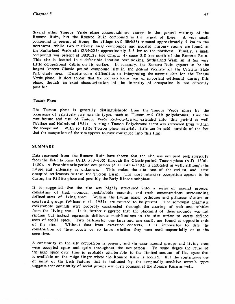
Chapter 3
Several other Tanque Verde phase compounds are known in the general vicinity of theRomero Ruin, but the Romero Ruin compound is the largest of these. A very smallcompound is present at Honey Bee village (AZ BB:9:88) situated approximately 5 km to thenorthwest, while two relatively large compounds and isolated masonry rooms are found atthe Sutherland Wash site (BB:9:223) approximately 8.5 km to the northeast. Finally, a smallcompound was present at BB:9:122 (see Chapter 4) some 3.8 km north of the Romero Ruin.This site is located in a defensible location overlooking Sutherland Wash an it has verylittle occupational debris on its surface. In summary, the Romero Ruin appears to be thelargest known Classic period compound site in the general vicinity of the Catalina StatePark study area. Despite some difficulties in interpreting the ceramic data for the TanqueVerde phase, it does appear that the Romero Ruin was an important settlement during thisphase, though an exact characterization of the intensity of occupation is not currentlypossible.
Tucson Phase
The Tucson phase is generally distinguishable from the Tanque Verde phase by theoccurrence of relatively rare ceramic types, such as Tucson and Gila polychromes, since themanufacture and use of Tanque Verde Red-on-brown extended into this period as well(Wallace and Hoimlund 1984). A single Tucson Polychrome sherd was recovered from withinthe compound. With so little Tucson phase material, little can be said outside of the factthat the occupation of the site appears to have continued into this time.
SUMMARY
Data recovered from the Romero Ruin have shown that the site was occupied prehistoricallyfrom the Estrella phase (A.D. 5 50-600) through the Classic period Tucson phase (A.D. 1300-1450). A Protohistoric period occupation (A.D. 1450-1692) is indicated as well, although thenature and intensity is unknown. This makes the site one of the earliest and latestoccupied settlements within the Tucson Basin. The most intensive occupation appears to beduring the Rillito phase and possibly the Early Rincon subphase.
It is suggested that the site was highly structured into a series of mound groups,consisting of trash mounds, rock/rubble mounds, and trash concentrations surroundingdefined areas of living space. Within the living space, pithouses and pithouse clusters orcourtyard groups (Wilcox et al. 1981), are assumed to be present. The somewhat enigmaticrock/rubble mounds were probably constructed through the clearing of rock and cobblesfrom the living area. It is further suggested that the placement of these mounds was notrandom but instead represents deliberate modifications to the site surface to create definedareas of social space. Two ballcourts, one large and one small, are found at opposite endsof the site. Without data from excavated contexts, it is impossible to date theconstruction of these courts or to know whether they were used sequentially or at thesame time.
A continuity in the site occupation is present, and the same mound groups and living areaswere occupied again and again throughout the occupation. To some degree the reuse ofthe same space over time is probably attributable to the limited amount of flat space thatis available on the ridge finger where the Romero Ruin is located. But the continuous useof many of the trash features that is indicated by the temporally sensitive ceramic typessuggests that continuity of social groups was quite common at the Romero Ruin as well.

CHAPTER 4
SITE DESCRIPTIONS
The archaeological survey of Catalina State Park was designed to record information on thesites within relative proximity of the Romero Ruin. This was accomplished through the 100percent coverage of a nearly three square mile area surrounding the site (Figures 2.1 and4.1). Particular emphasis was placed on areas surrounding the major drainages, such asCaIfada del Oro, Sutherland Alamo Canyon and Montrose Canyon washes. Due to timeconstraints, the upland areas of Caftada del Oro, Sutherland and Romero Canyon washes,were not surveyed. These areas have been spot-checked in the past and are not believedto contain major habitation sites, although small habitations, resource procurement andprocessing sites, and possibly agricultural sites, are likely. A total of 29 sites wasrecorded by the survey. An additional 12 previously recorded sites, including Romero and asingle historic site, were revisited and rerecorded.
Following a discussion of the site type classification used for this project, site descriptionsfor the recorded sites are given. Both functional and chronological perspectives are usedin the analysis. An examination of the settlement patterns within the Catalina State Parkarea is presented in the following chapter.
SITE TYPE CLASSIFICATION
Several site type typologies are currently in use in the Tucson Basin and elsewhere (seeWard 1978; Doelle and Wallace 1986; Elson 1986; Craig and Wallace 1987). One such systemwas defined by Elson (1986:17-19), and it employs a hierarchically arranged continuum ofsite types, ranging from large primary villages to small resource procurement sites.Hamlets, farmsteads, and field houses fall between the two extremes.
Wallace (Craig and Wallace 1987:117-124) has recently criticized this system for employingterms that have functional assumptions implicit within them. This problem is compoundedby the fact that surface data are often ambiguous, and establishing the subtle differencesbetween some of the site types, such as field houses and farmsteads, or large farmsteadsand hamlets, can be difficult if not impossible. As a result, Wallace (1987:123) hasdeveloped a system that is more descriptive and is more easily applicable to surface data.This system is also simpler, in that it is based upon a four part division of sites into largevillages, hamlets, seasonal or limited habitations, and non-habitations. This system will beused in the following settlement analysis and is described below.
Large Village
According to Wallace, villages are characterized by large numbers of trash mounds, a largesite size, presence of public architecture, and high density and diversity of artifacts. Ashe states:
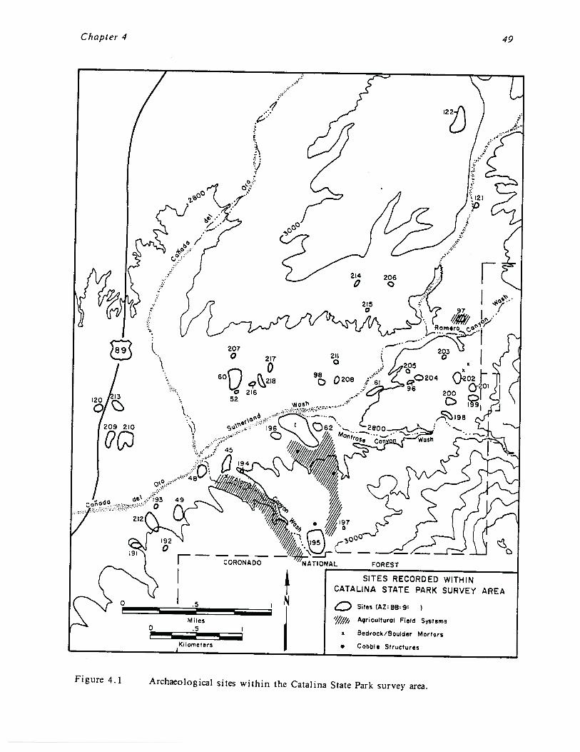
Chapter 4 49
V
CORONADO
SITES RECORDED WITHINCATALINA STATE PARK SURVEY AREA
Sites (AZ: BB~ 9:
Agricultural Field Systems
Bedrock/8oulder Mortars
Cobble Structures
Miles.5
Ki lorn~ters
Figure 4.1 ArchaeoJogj~1 sites within the Catalina State Park survey area.

Chapter 4 50
a large village as defined here is conceptualized as containing multiplehouseholds, courtyard groups, and mound groups at any given point in time(Wallace 1987:123).
Evidently, the distinguishing factor between a large village and a primary village as definedby Docile (1985) and Elson (1986:17), is that the term large village does not necessarilyimply that these sites are dominant centers for trade and interaction with the surroundingsettlement system, nor are they necessarily hierarchically organized.
Wallace leaves open the question of whether large villages were seasonally or permanentlyoccupied, based partly on ethnographic data from the O’odham Indians of southern Arizona.Wallace (1987:119) argues that the ethnographic record shows a wide range of adaptivevariability in settlement patterns. More specifically, although permanently occupied riverinesettlements were present in the best-watered settings, elsewhere a “two—village” system wasin use. The “two-village” system involved seasonal movements of entire villages fromwinter settlements in mountain foothills with available springs, to summer settlements inthe valleys and plains where summer rains made floodwater farming feasible.
Wallace discusses this ethnographically documented two-village model in the context oftrying to account for the location of the Sleeping Snake site (AZ BB:9:104), a largebailcourt village in the Rancho Vistoso survey area, situated away from known areas ofpermanent water. The Rancho Vistoso survey area is located less than 5 km northwest ofthe Catalina State Park survey area. Sleeping Snake is situated relatively close(approximately 2.0 km) to Honey Bee Village (AZ BB:9:88), another large ballcourt villagelocated within a good floodwater farming zone formed by the confluence of Honey Bee andBig washes. As Wallace (19 87:105) states concerning the relationship of these two sites:
One or both villages may be seasonally occupied, with Sleeping Snakerepresenting a village location suitable for exploitation of the upper bajadacactus forest zone and lower slopes of the Tortolita Mountains. Honeybee couldbe permanently settled or possibly seasonally occupied during the summergrowing season...
It is important to note, however, that the term seasonality as used by Wallace (personalcommunication, 1987) does not necessarily mean the abandonment of the entire village. Asmall residual population may have stayed at the village after the others had gone toperform seasonally scheduled tasks, for example.
It seems likely that the Romero Ruin was a permanent settlement. The large size of thesite, the artifact density and diversity, the two ballcourts and the compound, the numerouslarge trash and rubble mounds, and the continuity seen in the site structure, all aresuggestive of a permanent occupation. Unlike Sleeping Snake or even Honey Bee Village,the Romero Ruin is located in a very well-watered area. Water would have been availableyear-round within Sutherland Wash, and Alamo and Montrose Canyon washes. Furthermore,a large agricultural field system is present just beyond the southeastern boundary of thesite, and floodwater farming was probably feasible along Sutherland Wash just north of thesite. As a result, it should not have been necessary for the Romero inhabitants to moveseasonally within a “two village” settlement.
Chapter 4
Hamlet
Hamlets are defined essentially as they were by Elson (19 86:18). According to Wallace(1987:118), hamlets are small villages that are distinguished from large villages by the lackof public architecture, smaller size, and lower artifact density and diversity. Hamletsgenerally have fewer and not as well defined trash mounds, and are assumed to have lowerpopulation densities than large villages. A good example of an excavated hamlet is theTanque Verde Wash site, which contained 19 pithouses, three trash mounds, and three trashconcentrations. As with large villages, Wallace again leaves open the question of whetherhamlets were seasonally or permanently occupied.
Temporary Habitation Sites and Sherd and Lithic Scatters
Wallace (1987:123) uses the terms “seasonal or limited habitation” and “non-habitation” sitesto designate the site types under discussion here. For this project three descriptive termsare used for these sites, the majority of which are relatively small, low-density sherd andlithic scatters. The nature of these sites is ambiguous, and they may represent smallhabitations containing several pithouses or they may simply be limited use resourceprocurement sites. The term “temporary habitation,” refers to small sites with one or twomasonry cobble rooms. These sites generally contain very low density artifact scatters andare usually located on ridge-tops with low agricultural potential. Two kinds of sherd andlithic scatter are distinguished. First, the term “sherd and lithic scatter/resource use” isused for sites that consist primarily of boulder or bedrock mortars with very few artifacts.It is assumed that the main function of the mortar sites was the processing of nearbynative resources. Sites that are larger and have slightly denser artifact concentrations arecalled “sherd and lithic scatters” if there is not definite evidence of habitation such as apithouse depression. It is suspected that many of the sherd and lithic scatters wereactually temporary habitation sites or even hamlets.
Agricultural Sites
A fourth site type is present along Sutherland Wash that was not found within the RanchoVistoso survey area. These consist of large agricultural sites containing well-definedagricultural field systems. Several of these sites also contain cobble structures within thefield systems that probably functioned as field houses. Although these sites areundoubtedly associated with nearby habitations, such as the Romero field system whichextends for a distance of approximately 800 m south of the site, some are in areas wherethe primary habitation is unknown or unclear. In fact, many are between severalhabitations and possibly were used at different times by different villages. Although mostof the agricultural sites did not receive separate site numbers, they were an integral partof the settlement system and are discussed as such.
SITE DESCRIPTIONS
A map showing the location of the recorded sites is shown in Figure 4.1. With theexception of site AZ BB:9:60, the sites are described in numerical order below. AZ BB:9:60is a large hamlet that was more intensively mapped and collected than the other surveysites and is discussed separately in the following section. For those sites that werepreviously recorded, the year that the site was originally recorded is given. In almost allcases the descriptions of these sites have been supplemented by additional information from
Chapter 4
this survey except where noted. In addition, only those ceramics assigned to a singlephase are included in the site descriptions below. “Transitional” ceramics or those assignedto an “either/or” category are given if that is the only temporal information available forthe site, or if that information is considered to be significant in interpreting the site’soccupation span. A table giving the full range of the ceramics recovered from each site ispresented in Appendix A.
In addition, ceramic information from a reanalysis of the Arizona State Museum surveycollections in the late 1970s by Karl Reinhard is presented for several of the sites thatwere previously recorded. Excluding the Romero Ruin, there are three sites within thesurvey area where a grab sample of ceramics was collected in the past and curated at theArizona State Museum. A fourth site was recorded and collected by Arizona State LandDepartment archaeologist John Madsen. Reinhard’s and Madsen’s ceramic identificationsare believed to be accurate and they are used as additional chronological data tocharacterize the sites in question.
AZ BB:9:45
Site Description. AZ BB:9:45 is a moderate sized habitation site located on a low ridgefinger just south of and overlooking the confluence of Carrada del Oro, Sutherland Wash,and Alamo Canyon Wash. The site is situated approximately 800 m southwest of theRomero Ruin (Figure 4.1). The site measures approximately 110 m by 100 m (11,000 squaremeters). Features present on the site include three or four low trash mounds, several rockalignments, four boulder mortars, and several boulder grinding slicks. The artifact densityis moderate overall but very high within the trash mounds.
Artifact Assemblage: Lithic debitage, ground stone tools, plainwares, one possible CauIadadel Oro Red-on-brown, one Rillito Red-on-brown, one Middle Rincon Red-on-brown, oneLate Rincon Red-on-brown, one Sacaton Red-on-buff.
Site Date: It is likely that the site was occupied from possibly the Caffada del Oro phase(A.D. 750-850) through the Late Rincon subphase (A.D. 1000-1150). Tanque Verde Red-on-brown (A.D. 1150-1300) was reported through the reanalysis of the ceramic assemblage byKarl Reinhard. It is difficult to determine from the ceramic assemblage what the mostintensive period of occupation was. Given the “transitional” or “either/or” ceramics thesite may have been the most intensively occupied during the Middle Rincon subphase.
Site Type: Hamlet
Comments: Site is one of a series of habitation sites on the first terrace south of Caliadadel Oro and Sutherland Wash. More trash mounds may be present but unrecorded due tothe deflated nature of the site. The site was originally recorded in 1964. The reanalysisof the recovered ceramics at the Arizona State Museum indicate the presence of RinconRed-on-brown, Tanque Verde Red-on-brown, and Sacaton Red-on-buff. Mano and metatefragments, and a slate polishing stone, are reported to be present on the original site card.
AZ BB:9:48
Site Description: AZ BB:9:48 is a small habitation site located on the first terrace south ofthe confluence of Cauiada del Oro, Sutherland Wash, and Alamo Canyon Wash (figure 4.1).The site is on the west side of Alamo Canyon Wash just across the wash from AZ BB:9:45

Chapter 4
described above. The site is situated approximately 1.1 km west of the Romero Ruin andmeasures 100 m by 60 m (6000 square meters). The site contains extensive high densitytrash deposits including more than five trash mounds. Several rock alignments, a bouldermortar and a petroglyph of a radiating sun design were present on the site. A largeextensive agricultural field system is situated south of the site, extending up the ridgealong the west side of Alamo Canyon Wash for a distance of approximately 1.2 km. Thefield system varies in width between 100 and 200 meters (a total of approximately 45 acres)and contains numerous linear alignments, terraces, rock piles, and at least one cobble fieldhouse.
Artifact Assemblage: The artifact assemblage includes lithic tools, lithic debitage, groundstone, plainwares, two Middle Rincon Red-on-brown, and two Rincon Red.
Site Date: The site definitely dates to the Middle Rincon subphase (A.D. 1000-1100). Fromthe other recovered ceramics, including two sherds that were classified as either Rillito orEarly Rincon, and four sherds that were classified as either Early Rincon or Middle Rincon,it is reasonable to suggest that the site contains an Early Rincon subphase (A.D. 950-1000)component as well. In addition, the ceramic collections at the Arizona State Museumsuggest that Rillito (A.D. 850-950) and Tanque Verde (A.D. 1150-1300) phase componentsare also present.
Site Type: Hamlet
Comments: Like AZ BB:9:45, the site is one of a series of habitation sites situated on thefirst terrace south of Caf~ada del Oro. AZ BB:9:48 is located just across Alamo CanyonWash (approximately 150 meters) from AZ BB:9:45, and it is likely the two sites are relatedsince they are contemporaneous; AZ BB:9:48 appears to be slightly later and somewhatsmaller than AZ BB:9:45. Both sites appear to exhibit a strong Middle Rincon subphasecomponent. The agricultural field system south of AZ BB:9:45 could have been used by theinhabitants of both sites. The site was originally recorded in 1965. The reanalysis of theceramic collection by Karl Reinhard indicates that Rillito Red-on-brown, Rincon Red-onbrown, Tanque Verde Red-on-brown, Santa Cruz Red-on-buff, and Sacaton Red-on-buff arepresent at the site. The original site card indicates the presence of boulder mortars andmanos. The site is additionally reported to be a favorite collecting ground for localcollectors and it is likely that it is very picked over (Anick Kaler, personal communication,1987). This may have resulted in the obvious discrepancy between present and pastceramic collections.
AZ BB:9:49
Site Description: AZ BB:9:49 is a moderate sized artifact scatter situated on the firstterrace or ridge finger south of Canada del Oro (Figure 4.1). A major tributary of Caftadadel Oro is situated just west of the site. The site is located approximately 1.5 kmsouthwest of the Romero Ruin and measures 100 m by 70 m (7000 square meters). The sitecontains a partial enclosing wall on the southwest side of the ridge, measuringapproximately 25 m long, and several isolated alignments which may be wall segments orparts of structures. It could not be determined whether the site originally contained awall all the way around its borders. At least five cobble structures are present andprobably more. Although no trash mounds were noted, a very high density artifactconcentration is present just south of and within the enclosing wall.
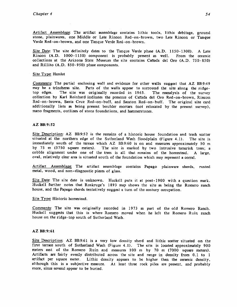
Chapter 4
Artifact Assemblage: The artifact assemblage contains lithic tools, lithic debitage, groundstone, plainwares, one Middle or Late Rincon Red-on-brown, two Late Rincon or TanqueVerde Red-on-brown, and one Tanque Verde Red-on-brown.
Site Date: The site definitely dates to the Tanque Verde phase (A.D. 1150- 1300). A LateRincon (A.D. 1000-1150) component is probably present as well. From the ceramiccollections at the Arizona State Museum the site contains Canada del Oro (A.D. 750-850)and Rillito (A.D. 850-950) phase components.
Site Type: Hamlet
Comments: The partial enclosing wall and evidence for other walls suggest that AZ BB:9:49may be a trincheras site. Parts of the walls appear to surround the site along the ridge-top edges. The site was originally recorded in 1965. The reanalysis of the surveycollection by Karl Reinhard indicates the presence of Caflada del Oro Red-on-brown, RinconRed-on-brown, Santa Cruz Red-on-buff, and Sacaton Red-on-buff. The original site cardadditionally lists as being present boulder mortars (not relocated by the present survey),mano fragments, outlines of stone foundations, and hammerstones.
AZ BB:9:52
Site Description: AZ BB:9:52 is the remains of a historic house foundation and trash scattersituated at the northern edge of the Sutherland Wash floodplain (Figure 4.1). The site isimmediately south of the terrace which AZ BB:9:60 is on and measures approximately 50 mby 75 m (3750 square meters). The site is marked by two intrusive tamarisk trees; acobble alignment under one of the trees is all that remains of the homestead. A large,oval, relatively clear area is situated south of the foundation which may represent a corral.
Artifact Assemblage: The artifact assemblage contains Papago plainware sherds, rustedmetal, wood, and non-diagnostic pieces of glass.
Site Date: The site date is unknown. Huckell puts it at post-1900 with a question mark.Huckell further notes that Roskruge’s 1893 map shows the site as being the Romero ranchhouse, and the Papago sherds tentatively suggest a turn of the century occupation.
Site Type: Historic homestead.
Comments: The site was originally recorded in 1973 as part of the old Romero Ranch.Huckell suggests that this is where Romero moved when he left the Romero Ruin ranchhouse on the ridge-top south of Sutherland Wash.
AZ BB:9:61
Site Description: AZ BB:9:61 is a very low density sherd and lithic scatter situated on thefirst terrace south of Sutherland Wash (Figure 4.1). The site is located approximately 900meters east of the Romero Ruin and measures 100 m by 70 m (7000 square meters).Artifacts are fairly evenly distributed across the site and range in density from 0.1 to 1artifact per square meter. Lithic density appears to be higher than the ceramic density,although this is a subjective measure. At least three rock piles are present, and probablymore, since several appear to be buried.

Chapter 4
Artifact Assemblage: The artifact assemblage includes lithic debitage, plainwares, andseveral small unidentifiable red - on - browns.
Site Date: Unknown.
Site Type: Sherd and lithic scatter.
Comments: Site was previously recorded in 1973 and characterized as a limited use site.Only unidentified plainwares were recorded.
AZ BB:9:62
Site Description: AZ BB:9:62 is a large, dispersed, low density sherd and lithic scattersituated on the next ridge finger approximately 150 meters east of the Romero Ruin (Figure4.1). Montrose Canyon Wash runs along the north and east sides of the site. The sitemeasures 80 m by 120 m (9600 square meters) and is separated from the Romero Ruin by asmall unnamed drainage. Three small artifact concentrations are present, primarily towardsthe south end of the site. The overall artifact density is low, however, averaging 0.1 to 5artifacts per square meter. The large agricultural field system associated with the RomeroRuin is situated approximately 100 meters south of the site.
Artifact Assemblage: The artifact assemblage includes lithic debitage, hammerstones, cores,ground stone, plainwares, and three Tanque Verde Red-on-brown.
Site Date: The site dates to the Tanque Verde phase (A.D. 1150-1300).
Site Type: Sherd and lithic scatter.
Comments: The site is undoubtedly related to the Romero Ruin and may have served as anassociated activity area or possibly even a small habitation. It may be related to theagricultural activities within the Romero field system located approximately 100 meterssouth of the site. The site was originally recorded in 1973, although no diagnosticceramics were noted. A small, late historic component consisting of rusted pieces of metal,tin cans, and non-diagnostic glass sherds, is present on the site and is probably related tothe post-World War II cattle ranching within the area.
AZ BB:9:96
Site Description: AZ BB:9:96 is a small sherd and lithic scatter with an associated bedrockmortar. The site is situated just north of a tributary of Sutherland Wash approximately 1 .2km east of the Romero Ruin (Figure 4.1). The site measures 50 m by 30 m (1500 squaremeters) in area. The mortar is in the approximate center of the site and measures 15 cmin diameter by 12 cm deep. Several small artifact concentrations are present.
Artifact Assemblage: The artifact assemblage contains lithic tools, lithic debitage, groundstone, and plainwares. No diagnostic ceramics were noted.
Site Date: Unknown.
Site Type: Sherd and lithic scatter.
Chapter 4
Comments: The site was recorded in 1980 during the course of the original survey of theCatalina State Park area. Huckell characterized the site as a campsite. The function ofthe site is unknown; it may be solely for resource procurement or it may be a smallhabitation.
AZ BB:9:97
Site Description: AZ BB:9:97 is a small agricultural field system situated on a large, flatterrace on the north side of Romero Canyon (Figure 4.1). The site is locatedapproximately 2.0 km northeast of the Romero Ruin. The site consists of a series of linearrock alignments, terraces, and check dams, over an area measuring approximately 200 m by200 m (40,000 square meters). Several cobble structures may be present. The 10 acre sitearea could have been supplemented by additional land around the water-control features.
Artifact Assemblage: The artifact assemblage includes plainwares, lithic debitage, lithictools, and a Chiricahua stage Cochise projectile point.
Site Date: The Chiricahua stage Cochise projectile point indicates that the site dates to theMiddle Archaic period (5000-1000 B.C.). This is the only recovered Archaic diagnosticrecovered from the survey area. The plainware sherds indicate that the site was in useduring the Hohokam period although the phase is unknown.
Site Type: Agricultural site with an Archaic period component.
Comments: The site was recorded in 1980 by Lisa Huckell during the course of the originalCatalina State Park survey. The site was only briefly revisited during the course of thepresent survey and much of the site description information is taken from Huckell’s sitecard and report. Huckell additionally recorded an unusual alignment which “resembles thespokes of a wheel that may be as much as 50 m across.” This feature was not noted bythe present survey crew, although when the site was visited the grass was very high andground visibility was obscured.
AZ BB:9:98
Site Description: AZ BB:9:98 is a moderate sized sherd and lithic scatter situated on a flatterrace just north of Sutherland Wash (Figure 4. 1). The Romero Ruin is almost directlyacross the wash from the site at a distance of approximately 500 meters. The sitemeasures 90 m by 40 m (3600 square meters). The artifact density is relatively lowalthough several concentrations and a rock pile are present.
Artifact Assemblage: The artifact assemblage contains lithic debitage, a hammerstone,plainwares, one Snaketown Red-on-brown, two Rillito Red-on-brown, and several Santa Cruzor Sacaton Red-on-buffs.
Site Date: The site dates to the Snaketown phase (A.D. 650-750) and the Rillito phase (A.D.850-950).
Site Type: Sherd and lithic scatter.
Comments: This site contains the only Snaketown phase component outside of the RomeroRuin. The range of ceramic types, including buffwares, suggest that the site may have

Chapter 4
functioned as a small habitation related to the Romero Ruin, although this is unknown.The site was originally recorded in 1980 during the course of the initial Catalina StatePark Survey. However, the component that Huckell recorded is at the base of the site offof the ridge and consists of seven bedrock mortars. Huckell evidently never explored thecomponent on top of the ridge.
AZ BB:9:120 (The Abused Ridge Site)
Site Description: The Abused Ridge Site is a small hamlet situated on a ridge finger justwest of the project area and approximately 2.0 km west of the Romero Ruin (Figure 4.1).The ridge finger is situated between Big Wash to the west, and CaIfada del Oro to the eastand south. Due to this the site is surrounded by large farmable floodplain areas. The sitewas partially excavated in 1983 by archaeologists from the Arizona State Museum (Tagg1983). Although most of the site had already been removed by previous road construction,Tagg uncovered three pithouses and a ground stone cache. An archaeomagnetic samplefrom one of the pithouses produced a date of A.D. 1240-1290. Flotation samples did notrecover any cultigens, although they did show a high frequency of use of exoticconstruction wood such as juniper and pinyon, while the pollen samples recorded thepresence of corn.
Artifact Assemblage: The recovered artifacts include 1101 ceramics, including 793 plainwareand 273 decorated sherds. The decorated assemblage is composed of 128 (77.6 percent)Tanque Verde Red-on-brown, a few Rincon Red-on-brown, 18 redwares, 14 corrugatedsherds, two San Carlos Red-on-brown, and six whitewares, including Tularosa and ReserveBlack-on-white. The lithic assemblage includes a small amount of chipped stone, cores,hammerstones, tools, two tabular knives, 12 manos, and four metate fragments. Only asingle piece of shell was recovered.
Site Date: The site definitely dates to the Tanque Verde phase (A.D. 1150-1300). Thearchaeomagnetic date of A.D. 1240-1290 from a single pithouses suggests that this featuredates late in the phase although its relationship to the rest of the site is unknown.
Site Type: Hamlet
Comments: The size of the original site is unknown due to the removal of part of the sitethrough road construction in the 1930’s. From examining the site and surrounding areas,Wallace (personal communication, 1987) believes that the site represents a small hamlet dueto the limited area on the ridge-top for habitation.
AZ BB:9:121
Site Description: AZ BB:9:121 is a relatively large resource use and procurement site withan historic component. The site contains more than 20 bedrock mortars and four bedrockmetates. Most of the mortars are shallow, measuring less than 12 cm by 6 cm by 4 cmdeep. Artifacts are sparse, consisting primarily of lithics and a single ground stonefragment, although the black, ashy, soil suggests that subsurface deposits may be present.The historic component consists of a small, one room structure with a fireplace. A singlePapago sherd, a brass shotgun shell, and historic glass suggest a late nineteenth-earlytwentieth century occupation. The structure has been severely vandalized. The size of thesite area is unknown.

Chapter 4 58
Artifact Assemblage: Chipped stone debitage, ground stone fragment, Papago sherd, glass,and a shotgun shell.
Site Date: The date of the prehistoric component is unknown. The historic componentmay date to around 1900.
Site Type: Resources use and procurement; Historic homestead.
AZ BB:9:122
Site Description: AZ BB:9:122 is included here due to its significance even though it issubstantially north of the main survey area. The site consists of approximately 20 separatemasonry structures on the top of a ridge west of and overlooking Sutherland Wash (Figure4.1). A large alluvial floodplain formed by the junction of Sutherland Wash with severalsmaller drainages is situated just below the site. The site is situated approximately 3.6 kmnortheast of the Romero Ruin and measures 28,000 square meters. The structures areseparated from each other by several meters and vary in size and shape; round, square,rectangular, and U-shaped structures were noted. The structures are composed of single ordouble courses of local cobbles and the walls probably never reached a height of more than0.50 m. The site contains an extremely low artifact density. Several rock piles, bedrockmortars, and a possible small compound, are also present.
Artifact Assemblage: The artifact assemblage includes lithic tools, lithic debitage,plainwares, three Tanque Verde Red-on-brown, a Late Rincon or Tanque Verde Red-on-brown, and corrugated ceramics.
Site Date: The site dates to the Tanque Verde phase (A.D. 1150-1300).
Site Type: Temporary habitation.
Comments: The site was recorded by Arizona State Lands archaeologist John Madsen in1983 and the site description given above is based on his data. The site is classified as atemporary habitation rather than a hamlet due to the extremely low artifact density. Thisis discussed in greater detail in Chapter 5.
AZ BB:9:191
Site Description: AZ BB:9:191 is a small trincheras site on a high narrow ridge south ofand overlooking the Cairada del Oro floodplain (Figure 4.1). The site is situatedapproximately 2.0 km southwest of the Romero Ruin, and measures 50 m by 25 m (1250square meters). The site contains at least one masonry room and a partial enclosing cobblewall which runs along the north side of the ridge. Another wall segment is present alongthe west side of the ridge. Other rooms and wall segments are probably present but weredifficult to discern due to the presence of natural linear bedding planes. The artifactscatter surrounding the site is extremely low density.
Artifact Assemblage: The artifact assemblage includes a few pieces of lithic debitage,plainwares, and one probable Tanque Verde Red-on-brown.
Site Date: The site probably dates to the Tanque Verde phase (A.D. 1150-1300).
Chapter 4
Site Type: Temporary habitation
Comments: The overall lack of artifacts and trash deposits suggests that the site was usedonly as a temporary habitation.
AZ BB:9:192
Site Description: AZ BB:9:192 consists of two cobble structures and several amorphouscobble piles on a relatively barren southeast-northwest trending ridge-top approximately 400m and 400 feet above Cait~ada del Oro. The site is situated approximately 1.9 km southwestof the Romero Ruin and measures 50 m by 20 m (1000 square meters). The two structuresare separated by 40 meters; the southern structure is rectangular and measuresapproximately 2.0 m by 4.0 m, while the northern structure is round to oval and measuresapproximately 3.0 m in diameter. Both structures are in good condition and containstanding walls three course (0.50 m) high. The two amorphous cobble piles are probablystructures that could not be defined due to their collapsed condition. Only a singleplainware sherd was found at the site within the southernmost structure; no other artifactswere noted.
Artifact Assemblage: The artifact assemblage consists of a single plainware sherd.
Site Date: Unknown.
Site Type: Temporary habitation.
Comments: The ridge and surrounding area that the site is situated on are too rocky foragriculture. The function of the site is unknown although it is undoubtedly related toresource procurement of some sort.
AZ BB:9:193
Site Description: AZ BB:9:193 is a small sherd and lithic scatter situated on the firstterrace south of Calfada del Oro (Figure 4.1). The site is located approximately 1.7 kmsouthwest of the Romero Ruin and measures 40 m by 45 m (1800 square meters). Artifactdensity is low to moderate; several artifact concentrations are present. The site is situatedon the same terrace and within 100 meters of AZ BB:9:212, a large habitation site, and isprobably related. Site features include two boulder mortars and several small rockalignments.
Artifact Assemblage: The artifact assemblage includes lithic debitage, ground stone,plainwares, an obliterated corrugated sherd, an Early or Middle Rincon Red-on-brown sherd,and a Santa Cruz or Sacaton sherd.
Site Date: The site dates to the Rincon (A.D. 950-1150) and Tanque Verde (A.D. 1150-1300)phases.
Site Type: Sherd and lithic scatter.
Comments: The site may represent a small habitation or it may have functioned as aresource procurement and processing area related to the occupation of AZ BB:9:212.

Chapter 4 60
AZ BB:9:194
Site Description: AZ BB:9:194 consists of a single cobble masonry structure situated on thetop of a ridge 200 m southeast of AZ BB:9:45 (Figure 4.1). The ridge overlooks AlamoCanyon Wash to the west. The site is located approximately 700 meters southwest of theRomero Ruin. The structure appears to be of expedient (and somewhat sloppy) constructionand measures 3.5 m by 4.0 m (14 square meters). The walls are composed of unshapedsurface cobbles that stand a maximum of two to three courses high (0.50 m); bedrockboulders are incorporated into the structural walls. The interior of the structure appearsto be depressed approximately 5 to 10 cm suggesting that it was partially excavated outduring construction. No artifacts were noted from the site area.
Artifact Assemblage: No artifacts noted.
Site Date: Unknown.
Site Type: Temporary habitation.
Comments: The structure is assumed to be Hohokam due to its proximity to AZ BB:9:45.The cobble structure in fact overlooks both the AZ BB:9:45 site area and its associatedagricultural field system. The field system is approximately 100 meters west of the site onthe other side of Alamo Canyon Wash and it is possible that the site functioned as atemporarily occupied field house.
AZ BB:9:195
Site Description: AZ BB:9:195 is a large habitation site situated on the east side of AlamoCanyon Wash at the head of the Romero agricultural field system (Figure 4.1). The site islocated approximately 1.1 km south of Romero, and measures 150 m by 275 m (41,250 squaremeters). Artifact density within the site area is variable, ranging from low density to veryhigh density within the four defined trash mounds. More trash mounds are probablypresent but unrecorded. Other features noted at the site include approximately 10 boulderand bedrock mortars, metates, and grinding slicks, and numerous cobble terraces and checkdams. A cobble field house is present within the site area while another cobble field houseis situated on top of the ridge overlooking the site to the south.
Artifact Assemblage: The artifact assemblage contains lithic debitage, lithic tools, groundstone, plainwares, and four Tanque Verde Red-on-brown.
Site Date: The site dates to the Tanque Verde phase (A.D. 1150-1300).
Site Type: Hamlet
Comments: The site is at the very beginning of the Romero Ruin field system and it islikely that the two sites are closely related. The site is also at the beginning of anotherfield system, which extends up the west side of Alamo Canyon Wash from AZ BB:9:45 tothe site. Although the site is undoubtedly a small habitation, it is possible that itsoccupants specialized in agricultural practices. It is important to note that the size of thissite is misleading since it incorporates agricultural field areas. The actual habitation areais estimated to be between 10,000 and 20,000 square meters.

Chapter 4
AZ BB:9:196
Site Description: AZ BB:9:196 is a sherd and lithic scatter on the small ridge finger duewest of the Romero Ruin (Figure 4.1). The site is separated from the Romero Ruin by amoderate sized drainage and approximately 30 to 50 meters. The site measures 100 m by60 m (6000 square meters). Artifact density is low overall although it is moderate in thecenter of the site (approximately 5 artifacts per square meter) and high within erosionalareas down the western ridge sides. Site features include several rock piles, a rockalignment, and two bedrock mortars.
Artifact Assemblage: The artifact assemblage includes lithic debitage, cores, hammerstones,ground stone, plainwares, one Late Rincon or Tanque Verde Red-on-brown, and one Rinconor Tanque Verde Red-on-brown.
Site Date: The site cannot be precisely dated except to the Rincon (A.D. 950-1150) andTanque Verde (A.D. 1150-1300) phases.
Site Type: Sherd and lithic scatter.
Comments: Given the nature of the ridge-top, consisting of bedrock outcrops with poor soildevelopment, it does not seem likely that subsurface structures are present. The siteappears to represent an activity area associated with the occupation of the Romero Ruin.
AZ BB:9:197
Site Description: AZ BB:9:197 is a small boulder rockshelter and associated artifact scattersituated at the head of the Romero Ruin agricultural system (Figure 4.1). The site islocated approximately 1.0 km south of the Romero Ruin and 250 m east of site AZ BB:9:197.The rockshelter is underneath a large (approximately 6.0 meters high), irregularly shaped,granite boulder, and opens towards the northeast. The shelter has a height of 1.4 metersat its opening and is approximately 3.0 meters wide and 2.0 meters deep. A low tomoderate density artifact scatter extends from the rockshelter for a distance of 12 squaremeters.
Artifact Assemblage: The artifact assemblage includes lithic debitage, cores, hammerstones,ground stone, and plainwares. No decorated ceramics noted.
Site Date: Unknown.
Site Type: Temporary habitation.
Comments: The rock shelter is probably related to activities occurring within the Romeroagricultural field system, and may have functioned as a temporary habitation similar to afield house. The small size of the shelter would preclude an extended occupation.
AZ BB:9:198
Site Description: AZ BB:9:198 is a dispersed, low density, sherd and lithic scatter with alarge number of associated bedrock and boulder mortars, metates, and grinding slicks. The

Chapter 4 62
site is situated on the first terrace north of Montrose Canyon overlooking several largepools; the Romero Ruin is approximately 1.5 km west of the site (Figure 4.1). The sitemeasures 120 m by 70 m (8400 square meters) and contains at least 23 bedrock/bouldermortars, metates, and grinding slicks. More are probably present but unrecorded. Theartifact density is very low (0.1 to 1 artifact per square meter) and is primarily composedof lithic debitage. There are several patches of very dark black soil (although no f ire-cracked rock or other trash) which may indicate roasting areas.
Artifact Assemblage: The artifact assemblage contains lithic debitage and plainware sherds.No decorated ceramics were noted.
Site Date: Unknown.
Site Type: Sherd and lithic scatter/Resource use.
Comments: The site almost certainly functioned as a resource procurement and processingsite. The high terrace area between Montrose Canyon Wash and Romero Canyon Washcontains an extremely thick mesquite bosque and it is possible that the site was used toprocure and process mesquite pods.
AZ BB:9:199
Site Description: AZ BB:9:199 is a moderate sized habitation site situated within themesquite bosque on the high terrace between Montrose and Romero canyon washes (Figure4.1). The site is located approximately 1.8 km east of the Romero Ruin and measures 100m by 55 m (5500 square meters). The artifact density is variable, ranging from low densityaround the site edges to high density within four low trash mounds. More trash moundsare probably present but unrecorded due to the deflated nature of the site.
Artifact Assemblage: The artifact assemblage includes lithic debitage, ground stone,plainwares, one Late Rincon Red-on-brown, and one Tanque Verde Red-on-brown.
Site Date: The site dates to the Late Rincon subphase (A.D. 1100-1150) and the TanqueVerde phase (A.D. 1150-1300).
Site Type: Hamlet.
Comments: The site was divided into and collected as two loci separated by approximately20 meters of non-site. There is no temporal difference between the two loci.
AZ BB:9:200
Site Description: AZ BB:9:200 is a low to moderate density sherd and lithic scatter situatedin a mesquite bosque within the high terrace bounded by Montrose and Romero canyonwashes (Figure 4.1). The site is located approximately 1.5 km east of the Romero Ruin andmeasures 85 m by 60 m (5100 square meters). Artifact density is variable, and rangesbetween 0.1 to 10 artifacts per square meter; highest densities are found within severalsmall drainages and low areas.
Artifact Assemblage: The artifact assemblage includes lithic debitage, plainwares, one MiddleRincon Red-on-brown, one Late Rincon red-on-brown, and two Tanque Verde Red-on-brown.
Chapter 4 63
Site Date: The site dates to the Middle Rincon subphase (A.D. 1000-1100), Late Rinconsubphase (A.D. 1100-1150), and Tanque Verde phase (A.D. 1150-1300).
Site Type: Sherd and lithic scatter.
Comments: A very low density scatter connects the site with AZ BB:9:199 indicatingintensive use of this area.
AZ BB:9:201
Site Description: AZ BB:9:201 is a relatively small discrete sherd and lithic scatter situatedin the mesquite bosque on the high terrace between Montrose and Romero canyon washes(Figure 4.1). A small steep knoll which contains several boulder mortars and grindingslicks at its base is due east of the site. The site is located approximately 1.8 km east ofthe Romero Ruin and measures 60 m by 60 m (3600 square meters). The artifact density isvariable, and ranges between 1 and 20 artifacts per square meter. The artifact density ishighest within several small drainages that cut through the site and possibly throughseveral trash mounds, although whether the site actually contains true trash mounds couldnot be determined with certainty. No other surface features were noted.
Artifact Assemblage: The artifact assemblage includes lithic debitage, hammerstones, groundstone, plainwares, one Late Rincon Red-on-brown, one Middle or Late Rincon Red-on-brown, and one Santa Cruz Red-on-buff.
Site Date: The site dates to the Rillito phase (A.D. 850-950) and the Late Rincon subphase(A.D. 1100-1150). Whether the site contains a Middle Rincon component is unknown.
Site Type: Hamlet.
Comments: Although the site is relatively small, the presence of a possible trash mound,the high artifact density, and the range of decorated ceramics including buffwares, suggestthat it is a small habitation.
AZ BB:9:202
Site Description: AZ BB:9:202 is a relatively dispersed sherd and lithic scatter situatedwithin the mesquite bosque on the high terrace bounded by Romero and Montrose canyonwashes (Figure 4.1). The site is located approximately 1.6 km east of the Romero Ruin andmeasures 100 m by 60 m (6000 square meters). The artifact density is extremely variable,and ranges between 0.1 to 5 artifacts per square meter over most of the site, to 10 to 20artifacts per square meter within the two defined low trash mounds. Other trash moundsmay be present but undefined due to the dissected nature of the site surface.
Artifact Assemblage: The artifact assemblage includes lithic debitage, a tabular knifefragment, ground stone, plainwares, one Rillito Red-on-brown, one Early Rincon Red-onbrown, one Rincon Red, and two Late Rincon Red-on-brown.
Site Date: The site dates to the Rillito phase (A.D. 850-950), the Early Rincon subphase(AD. 950-1000), the Middle Rincon subphase (A.D. 1000-1100), and the Late Rinconsubphase (A.D. 1100-1150).

Chapter 4 64
Site Type: Hamlet
Comments: Site is larger and probably more intensively inhabited than AZ BB:9:201. Alongwith AZ BB:9:199, the site is the largest habitation within the high terrace mesquitebosque.
AZ BB:9:203
Site Description: AZ BB:9:203 is a relatively small discrete sherd and lithic scatter situatedon the high flat terrace area bounded by Romero and Montrose Canyon washes (Figure 4.1).Unlike the other sites on this terrace, however, the site is not within a mesquite bosquebut instead is situated on a relatively barren, open, bedrock terrace approximately 150meters south of Romero Canyon. The site area is dissected by many small arroyos andrivulets. The site is located approximately 1.6 km northeast of the Romero Ruin andmeasures 55 m by 60 m (3300 square meters). The artifact density is variable, and rangesbetween 1 and 10 artifacts per square meter. Four small concentrations were defined,primarily within drainage areas. Several of these may be small trash mounds but the areais too dissected to definitely determine.
Artifact Assemblage: The artifact assemblage includes lithic debitage, ground stone,plainwares, and two Middle or Late Rincon Red-on-brown.
Site Date: The site dates to either the Middle (A.D. 1000-1100) or Late (A.D. 1100-1150)Rincon subphases, or possibly both.
Site Type: Hamlet.
Comments: The site is considered to represent a small habitation due to the relatively highartifact density and the presence of discrete artifact concentrations. This is not certain,however, and the site could be a sherd and lithic scatter of unknown function.
AZ BB:9:204
Site Description: AZ BB:9:204 is a relatively large sherd and lithic scatter situated within ahighly abraded area within the mesquite bosque on the high, flat, terrace bounded byMontrose and Sutherland canyon washes (Figure 4.1). The site is west of the point whereRomero Canyon joins with Sutherland Canyon. The Romero Ruin is located approximately1.3 km west of the site. The site measures 110 m by 60 m (6600 square meters). Theartifact density is variable, and ranges between 1 and 20 artifacts per square meter. Thedensity is highest within several concentrations. These may be small, low, trash mounds,but the site area is too dissected to accurately determine. A single small rock alignmentand a rock pile were also present on the site.
Artifact Assemblage: The artifact assemblage includes lithic tools, lithic debitage, groundstone, plainwares, and one Middle or Late Rincon Red-on-brown.
Site Date: The site dates to either the Middle (A.D. 1000-1100) or Late (A.D. 1100-1150)Rincon subphases, or possibly both.
Site Type: Hamlet.
Chapter 4 65
Comments: As with AZ BB:9:203, the site is considered to represent a small habitation dueto the relatively high artifact density and the presence of possible trash mounds. This isnot certain, however.
AZ BB:9:205
Site Description: AZ BB:9:205 consists of several small cobble structures and an associatedartifact scatter situated on a small flat area between a large ridge to the south andSutherland Canyon Wash to the north (Figure 4.1). The site is located approximately 1.3km northeast of the Romero Ruin and measures 55 m by 40 m (2200 square meters). Thesite contains a small structure, a linear alignment, and a collapsed rock pile which probablyrepresents the remains of another structure. The structure consists of a rock wallextending out approximately 10 meters west from three or four large north-south bedrockboulders. Wall fall to the north of the wall suggests that the wall may have been two orthree courses high (0.50 m). Open areas between the bedrock boulders may have beenfilled in as well. A small, low density, artifact scatter is situated approximately 30 msoutheast of the structure. The scatter measures 1 2 meters in diameter and is composedprimarily of plainware sherds.
Artifact Assemblage: The artifact assemblage includes lithic debitage and plainware sherds.No decorated ceramics were noted.
Site Date: Unknown.
Site Type: Temporary habitation.
Comments: The surrounding area where the site is located is not very good for agriculturedue to poor soil development and bedrock outcrops. The site may have functioned as atemporary habitation for resource procurement, or as a hunting blind or windbreak.
AZ BB:9:206
Site Description: AZ BB:9:206 is a relatively small sherd and lithic scatter situated 100meters east of a moderate sized unnamed drainage that drains the ridges on the west sideof Sutherland Wash (Figure 4.1). The site is located approximately 1.8 km north of theRomero Ruin and measures 60 m by 40 m (2400 square meters). The artifact density rangesfrom 0.1 to 10 artifacts per square meter and consists primarily of plainware sherds andlithic debitage.
Artifact Assemblage: The artifact assemblage includes lithic debitage, cores, plainwares, oneEarly or Middle Rincon, and one Rincon Red.
Site Date: The site dates to the Middle Rincon subphase (A.D. 1000-1100).
Site Type: Sherd and lithic scatter.
Chapter 4 66
AZ BB:9:207
Site Description: AZ BB:9:207 is a very low density Protohistoric sherd and lithic scatter ona flat ridge-top just east of Caitada del Oro (Figure 4.1). The site is located approximately1.0 km northwest of the Romero Ruin, and measures 70 m by 20 m (1400 square meters).A small hearth or roasting pit is present on the site.
Artifact Assemblage: The artifact assemblage includes lithic tools, lithic debitage, groundstone, and eight protohistoric plainwares. Several different vessels are represented in theplainware assemblage.
Site Date: The site dates to the Protohistoric period (A.D. 1450-1692).
Site Type: Sherd and lithic scatter/possible limited habitation.
Comments: Due to the lack of data on Protohistoric sites it is unclear what the surfacesignatures of a small habitation would look like. The fact that the site contains groundstone, lithic tools, lithic debitage, and at least several vessels, suggests that limited ortemporary habitation is a possibility. This is the only site within the project area tocontain just a Protohistoric occupation. Other sites with Protohistoric material alsocontain underlying Hohokam components.
AZ BB:9:208
Site Description: AZ BB:9:208 is a moderate sized low density sherd and lithic scattersituated on a flat ridge-top north of and overlooking Sutherland Wash (Figure 4.1). Thesite is located approximately 600 meters northeast of the Romero Ruin and measures 100 mby 45 m (4500 square meters). Thick caliche coating on one sherd suggests that the sitemay contain buried cultural material.
Artifact Assemblage: The artifact assemblage includes lithic debitage, lithic tools, groundstone, a shell pendant, plainwares, one Middle Rincon Red-on-brown, and one Rincon Red.
Site Date: The site dates to the Middle Rincon subphase (A.D. 1000-1100).
Site Type: Sherd and lithic scatter.
Comments: The site may in fact represent a small habitation or hamlet although this cannotbe determined from the surface material.
AZ BB:9:209
Site Description: AZ BB:9:209 is a large, diffuse, low to moderate density habitation sitesituated on a narrow north-south trending ridge finger just north of the Caftada del Orofloodplain and east of the Big Wash floodplain (Figure 4.1). The site is locatedapproximately 2.0 km due west of the Romero Ruin. The site was mapped and collected astwo loci separated by 30 meters of non-site. Locus A, the southern locus, measures 75 mby 50 m (3750 square meters), while Locus B, 30 meters to the north, measures 80 m by 90m (7200 square meters). Locus A has a lower artifact density than Locus B. Artifact
Chapter 4
density is variable within both loci, and ranges from 0.1 to 20 artifacts per square meter.Although no trash mounds were noted, it is probable that some are present in Locus B butunrecorded due to the dissected nature of the site area. Most of the artifacts wereconcentrated within small drainages and down the sides of the ridge, very few artifactswere found on the ridge-top itself. At the base of Locus A on the western side of theridge were three mortar cupules in a large granite boulder. Several concentrations ofcremated bone were also noted in Locus B.
Artifact Assemblage: The artifact assemblage includes lithic debitage, lithic tools, a tabularknife fragment, shell, ground stone, and plainwares. The diagnostic ceramic assemblagefrom Locus A includes one Late Rincon Red-on-brown, two Tanque Verde Red-on-brown,and two corrugated ceramics. The diagnostic assemblage from Locus B includes one EarlyRincon Red-on-brown, one Early or Middle Rincon Red-on-brown, one Middle or LateRincon Red-on-brown, one Late Rincon or Tanque Verde Red-on-brown, ten Tanque VerdeRed-on-brown, two San Carlos Red, and a corrugated sherd. A single Protohistoricplainware sherd was also recovered.
Site Date: Locus A dates to the Late Rincon subphase (A.D. 1100-1150) and the TanqueVerde phase (A.D. 1150-1300). Locus B dates to the Early Rincon subphase (A.D. 950-1000),the Tanque Verde phase (A.D. 1150-1300), and the Protohistoric period (A.D. 1450-1692).Although it is not conclusive, from the “either/or” ceramics and the nature of the site it islikely that Locus B also contains Middle (A.D. 1000-1100) and Late Rincon (A.D. 1100-1150)subphase components.
Site Type: Hamlet.
Comments: It appears that Locus A represents a slightly later expansion of the site areafrom Locus B. From the large quantity of Tanque Verde Red-on-brown recovered theClassic period occupation is by far the most intensive. In addition, the sites are on thesame north-south trending ridge system as the Abused Ridge site (AZ BB:9:120).
AZ BB:9:210
Site Description: AZ BB:9:210 is a large, major habitation site extending down two adjacentridge fingers just north of the Calfada del Oro floodplain. AZ BB:9:209 is on an adjacentridge finger to the west, while the Romero Ruin is situated approximately 1.65 km to theeast. The site was mapped and collected as two loci corresponding with each ridge finger.However, since there was found to be absolutely no temporal difference between the locithey are not discussed separately. The site area measures 110 m by 175 m (19,250 squaremeters). The artifact density is moderate to extremely high, particularly off of the sidesof the ridge. Although no trash mounds could be defined, they are almost certainlypresent. Large areas of black, ashy soil, and several possible pithouse depressions, werefound down both ridge fingers. A large house, swimming pool, and yard, on the very topof the ridge where the ridge fingers join has greatly disturbed what would have been themain occupation area. This area was not available for inspection but it is suspected thattrash mounds and other features are probably present.
Artifact Assemblage: The artifact assemblage includes lithic debitage, lithic tools, a pestlefragment, ground stone, shell, plainwares, two Early Rincon Red-on-brown, three MiddleRincon Red-on-brown, six Rincon Red, one Late Rincon Red-on-brown, 12 Tanque VerdeRed-on-brown, three Sacaton Red-on-buff, and four corrugated sherds.
Chapter 4 68
Site Date: The site dates to the Early Rincon subphase (A.D. 950-1000), Middle Rinconsubphase (A.D. 1000-1100), Late Rincon subphase (A.D. 1100-1150), and Tanque Verde phase(A.D. 1150-1300).
Site Type: Hamlet.
Comments. The site was more intensively collected than the other survey sites due to thesignificance of the occupation. All ceramics from five 2 meter wide transects within two25 m by 25 m units were collected. The larger number of recovered Tanque Verde Red-on-brown in contrast to the other phases suggests that this was the most intensive period ofuse. As with AZ BB:9:209, the site is on the same north-south ridge system as the TanqueVerde phase Abused Ridge site (AZ BB:9:120), and it appears that this entire ridge wasintensively occupied during the Classic period.
AZ BB:9:211
Site Description: AZ BB:9:211 is a small, low density, sherd and lithic scatter with twoassociated boulder mortars. The site is situated along the base of a southeast bynorthwest trending ridge approximately 400 meters north of Sutherland Wash and 800meters northeast of the Romero Ruin. The site measures 30 meters in diameter (900 squaremeters). The two mortar boulders are four meters apart; the eastern mortar is 20 cm indiameter and 13 cm deep, the western mortar is 22 cm in diameter and 7 cm deep. Apestle was found on a separate boulder approximately 11 m west of the mortars.
Artifact Assemblage: The artifact assemblage includes lithic debitage, a pestle, plainwares,indeterminate red-on-brown sherds and an unidentifiable redware.
Site Date: Unknown.
Site Type: Sherd and lithic scatter/Resource use.
AZ BB:9:212
Site Description: AZ BB:9:212 is a moderate sized habitation situated on the first terracesouth of Cauiada del Oro (Figure 4.1). The site is located approximately 1.8 km southwestof the Romero Ruin and measures 110 m by 90 m (9900 square •meters). The artifactdensity is moderate to high, and very high (20 to 30 artifacts per square meter) withinseveral concentrations. The site probably contains several trash mounds although thesecould not be defined due to the heavy erosion and deflation within the site area. Severallarge areas of concentrated trash and black soil are present, however. Site featuresinclude several possible pithouse depressions, rock piles, rock alignments, and a bouldermortar. A cobble structure is present approximately 40 meters south of the main site area.The structure measures 3 m by 2 m and is composed of stacked cobbles, some to a heightof 0.75 m or five courses. A possible agricultural field system is present within this areaalthough this could not be conclusively determined due to the presence of natural linearbedding planes.
Artifact Assemblage: The artifact assemblage includes lithic tools, lithic debitage, groundstone, shell, two Rillito Red-on-brown, two Rillito or Early Rincon Red-on-brown, oneEarly or Middle Rincon Red-on-brown, five Middle Rincon Red-on-brown, six Late RinconRed-on-brown, and six Tanque Verde Red-on-brown.
Chapter 4 69
Site Date: The site dates to the Rillito phase (A.D. 850-950), Middle Rincon subphase (A.D.1000-1150), Late Rincon subphase (A.D. 1100-1150), and Tanque Verde phase (A.D. 1150-1300). Given the site’s occupation span and “either/org ceramics, it is likely that an EarlyRincon subphase (A.D. 950-1000) occupation is present as well.
Site Type: Hamlet.
Comments: The site is one of a series of habitation sites situated along the southernterrace of Caflada del Oro.
AZ BB:9:213
Site Description: AZ BB:9:213 is a moderate to high density sherd and lithic scatter erodingout of the top and sides of the ridge system between the Big Wash and Caffada del Orofloodplains (Figure 4.1). The site is located approximately 1.8 km west of the Romero Ruinand measures 90 m by 135 m (12,150 square meters). The artifact density is relatively highthroughout the site area, and extremely high down the north and south slopes of the ridgefinger. No trash mounds were noted but they are probably present but unrecorded due tothe deflated nature of the ridge-top. Several concentrations of cremated human bone werenoted.
Artifact Assemblage: The artifact assemblage includes lithic tools, lithic debitage, groundstone, shell, plainwares, one Rillito or Early Rincon Red-on-brown, six Middle Rincon Red-on-brown, three Late Rincon Red-on-brown, three Tanque Verde Red-on-brown, oneSacaton Red-on-buff, and two corrugated sherds.
Site Date: The site dates to the Middle Rincon subphase (A.D. 1000-1100), the Late Rinconsubphase (A.D. 1100-1150), the Tanque Verde phase (A.D. 1150-1300). The one Rillito orEarly Rincon sherd suggests a possible earlier occupation although this is uncertain.
Site Type: Hamlet.
Comments: The site is within 100 meters east of where the Abused Ridge site (AZ BB:9:120)was excavated. Although the original boundaries of the Abused Ridge site are unknown,AZ BB:9:213 appears to be discrete and confined to the top and sides of this ridge finger.
AZ BB:9:214
Site Description: AZ BB:9:214 is a moderate sized, dispersed, low density, sherd and lithicscatter with an associated boulder mortar situated on a flat ridge-top east of a small,unnamed wash, and west of a larger drainage (Figure 4.1). The larger drainage is a majortributary of Sutherland Wash. The site is located approximately 1.7 km north of theRomero Ruin and measures 110 m by 40 m (4400 square meters). No artifact concentrationswere noted. The mortar measures 20 cm in diameter by 10 cm deep.
Artifact Assemblage: The artifact assemblage includes lithic debitage, and plainwareceramics. No decorated ceramics were noted.
Chapter 4
Site Date: Unknown.
Site Type: Sherd and lithic scatter/Resource use.
AZ BB:9:215
Site Description: AZ BB:9:215 is a small, low density, sherd and lithic scatter situated justwest of a major tributary of Sutherland Wash (Figure 4.1). The site is situatedapproximately 1.5 km northeast of the Romero Ruin and measures 45 m x 35 m (1575 squaremeters). The artifact density is relatively low and dispersed, and no artifactconcentrations were noted.
Artifact Assemblage: The artifact assemblage includes lithic debitage, a core, ground stone,plainwares, and unidentifiable redwares.
Site Date: Unknown.
Site Type: Sherd and lithic scatter.
AZ BB:9:216
Site Description: AZ BB:9:216 is a small sherd and lithic scatter situated on a gentlysloping ridge-top just north of Canada del Oro Wash. The site is located approximately500 meters northwest of the Romero Ruin and measures 28 m by 60 m (1680 square meters).Artifact density is moderate to high and cultural material is most concentrated near theedges of the site where it drops off into the floodplain. Several concentrations arepresent in the southwest and northeast portions of the site, and a 25 m diameter area atthe west end of the site appears to be the densest occupation. An “L” shaped cobblealignment is present which may represent a Classic period room; it could be modernhowever.
Artifact Assemblage: The artifact assemblage includes lithic debitage, a projectile point,possible polishing stones, ground stone, plainwares, one Gila Butte Red-on-buff, one RillitoRed-on-brown, one Tanque Verde Red-on-brown, and one Gila Polychrome.
Site Date: The site dates to the Cafiada del Oro phase (A.D. 750-850), Rillito phase (A.D.850-950), Tanque Verde Phase (A.D. 1150-1300), and the Tucson phase (A.D. 1300-1450).
Site Type: Hamlet.
Comments: Although the site is relatively small in size, the presence of artifactconcentrations and a wide range of ceramic types suggest that the site represents a smallhabitation. This site is the only site outside of the Romero Ruin to definitely contain aTucson phase component.
AZ BB:9:217
Site Description: AZ BB:9:217 consists of three boulder mortars with an associated lowdensity scatter of plainware sherds situated on top of a narrow north-south trending ridgefinger just above a major tributary of Sutherland Wash (Figure 4.1). The site is located

Chapter 4
approximately 600 meters north of the Romero Ruin and measures 50 m by 25 m (1250square meters). The northernmost mortar measures 17 cm in diameter by 10 cm deep; thesoutheastern mortar measures 23 cm by 26 cm by 22 cm deep; and the southwestern mortarmeasures 20 cm in diameter by 17 cm deep. The low density sherd scatter extends for adistance of approximately 20 meters south of the northernmost mortar.
Artifact Assemblage: The artifact assemblage includes only very small plainware sherds.
Site Date: Unknown.
Site Type: Sherd scatter/Resource use.
AZ BB:9:218
Site Description: AZ BB:9:2 18 is a low to moderate density sherd and lithic scatter situatedon a very flat terrace just north of the Sutherland Wash floodplain (Figure 4.1). The siteis located approximately 600 meters northwest of the Romero Ruin and measures 105 m by40 m (4200 square meters). The site was divided into two loci. Locus A, the northerncomponent, contains a moderately dense artifact scatter with several trash concentrationsand a possible pithouse depression. The locus is situated on a very flat ridge-top thatslopes steeply on all but the south side which has a gradual slope down to Locus B. LocusB consists of a single boulder mortar and a very low density sherd and lithic scatter. Onlyplainware ceramics and a very few lithics were noted in Locus B.
Artifact Assemblage: The artifact assemblage includes lithic debitage, a donut stone, groundstone, plainwares, one Late Rincon Red-on-brown, and several unidentified redwares.
Site Date: The site dates to the Late Rincon subphase (A.D. 1100-1150).
Site Type: Hamlet.
Comments: The artifact density and diversity suggests that the site represents a smallhabitation.
AZ BB:9:60- - A LARGE PRECLASSIC PERIOD HAMLET
AZ BB:9:60 is a major Preclassic period hamlet situated on the first terrace above theconfluence of Sutherland Wash with Calfada del Oro Wash (Figure 4.1). AZ BB:9:60 is thelargest and most intensively occupied habitation site outside of the Romero Ruin within theproject area. This site consists of two components. Component 1 was mapped to scalewith a Brunton compass and pacing, and controlled collections were made from several ofthe features. Component 2 was plotted on the field map and was examined in the field,but no collections were made from Component 2. Component 2 is located immediately tothe north of Component 1. Component 2 is approximately 2 to 3 m higher in elevationthan Component 1, and it shows a very low density of features and cultural remains.Several small cobble clusters that resemble the small mounds at the south edge ofComponent 1 were observed, and toward the northwest margin of Component 2 several rockalignments were noted that may indicate some kind of structure. Because of the greaterintensity of occupation at Component 1, the limited available time was devoted to thatcomponent rather than Component 2. The remainder of this discussion addresses onlyComponent 1.
Chapter 4
Component 1 covers an area of approximately 19,950 square meters (210 meters north-southby 95 meters east-west), as shown in the accompanying sketch map (Figure 4.2). Withinthis component, at least 16 features are present. While some of these are low mounds witha high artifact density, which most likely would have been labelled as trash concentrationsat the Romero Ruin, others are composed solely of rubble, or a combination of rubble andtrash, and reach a height of 0.50 to 0.75 m above the ground surface. The rubble moundsare similar in kind to the rubble mounds at the Romero Ruin, although not nearly as largenor as extensive. Like the Romero mounds, they appear to have resulted from clearing thesite area of rocks and cobbles for pithouse construction and other activities. However,none of the mounds at AZ BB:9:60 were large enough or flat enough to have been used asextramural activity areas or living space. In addition, at least two features, Features 16and 17, appear to have been used primarily for roasting activities, while Feature 11contained a large quantity of cremated human bone and may have served as a cemetery.
Component 1 of this site was collected more intensively than the other survey sites withinthe project area. Instead of a grab sample, systematic collections were made from thesurface of the six largest trash mounds with the highest artifact density (Features 1, 2, 3,8, 10, and 11). The trash mounds were sampled for several reasons. For one, time andmoney constraints precluded the gridding and sampling of the entire site as was done atthe Romero Ruin. For another, and perhaps most importantly, an inspection of the sitesurface indicated that the majority of the surface artifacts were within the trash moundsand not scattered over the general surface of the site. The site actually contained arelatively low artifact density in the areas between the mounds. Due to this, samplingthose mounds with a high artifact density was felt to be the most efficient and cost-effective method for recovering chronologically sensitive data. This involved laying a gridunit out over the trash mounds and collecting them in two meter wide transects spacedfive meters apart. Within these transects only decorated and plainware ceramics, lithictools, and shell, were collected. Ground stone and cremated human bone was noted andrecorded but not picked up. Although the artifact sample is far from complete, it doesallow for the preliminary reconstruction of the occupation of Component 1.
A total of 709 artifacts was collected. These include 121 decorated ceramics, 18 redwares,and four Protohistoric plainwares. Of the decorated ceramics, 35 were diagnostic to asingle phase or subphase. The redwares include nine Rincon Redwares and nineunidentifiable redwares. A listing of the ceramics recovered from the site is presented inAppendix A. The occupation of the site is discussed by phase below and then a generaloverview of the site structure is presented.
Rillito Phase
The Rillito phase appears to represent the earliest occupation of the site. A single RillitoRed-on-brown and six Santa Cruz Red-on-buff sherds were recovered. These comprise 20percent of the recovered diagnostics that could be assigned to a single phase. The fourlargest trash mounds, Features 1, 2, 3, and 11, were used during this phase, and it is likelythat these four mounds formed a mound group surrounding an open living area in thecenter. This living area is topographically level and is not abraded or cut by drainages.Due to the organized site structure and the relatively large number of Rillito phaseceramics, it is possible that this initial occupation of the site resulted from an organizedmovement of a single group of people who settled at this site. Whether this migrationcame from the Romero Ruin, which was intensively occupied at this time, or elsewhere, isunknown.
Chapter 4 73
AZ BB:9:60
Trash Mounds
C Cremated Bone
~ Projectile Point
0 Grinding Slick~ Rubble Piles
Rock Alignment
0 10 20I I
Meters
~I0Q
Figure 4.2 Sketch map of surface features at AZ BB:9:60.

Chapter 4
Early Rincon Subphase
Seven Early Rincon subphase sherds were recovered from the site. These comprise 20percent of the recovered single phase diagnostics. The Early Rincon occupation is similarto the Rillito occupation, although it appears to be slightly more spread out and may bemore intensive. This is suggested by the fact that the Early Rincon subphase is consideredto be half as long as the Rillito phase and yet the number of recovered ceramics is thesame. As with the data from the Romero Ruin it is not clear how the three recoveredSacaton Red-on-buff sherds relate to the Early Rincon settlement, although they are onlyfound within trash mounds that also contain Early Rincon material. Like the Rillito phase,four of the six collected trash mounds contain Early Rincon material. The pattern differsin that instead of Features 1 and 3 being used, the settlement has spread slightly to thesouth and incorporates Features 8 and 10 as well as the previously utilized Features 2 and11.
Middle Rincon Subphase
Seven Middle Rincon Red-on-brown sherds were recovered, comprising 20 percent of thesingle phase diagnostic assemblage. Nine Rincon Red sherds were recovered as well. Giventhe overall number of Middle Rincon and Rincon Red ceramics it appears that the MiddleRincon subphase may be the most intensively occupied period of the site. Caution shouldbe taken with this interpretation, however, given the problems in estimating intensity ofoccupation that were discussed in Chapter 3. In addition, the spatial data neither supportnor negate this interpretation. Like the two preceding phases, Middle Rincon material wasfound within four of the six collected trash mounds, Features 1, 2, 8, and 10.
Unlike the Romero Ruin, where Rincon Red exhibited a substantially higher frequency thanMiddle Rincon Red-on-brown, the Rincon Red sherds were found only within those trashmounds that contained Middle Rincon ceramics. In addition, the ratio of Rincon Red toMiddle Rincon Red-on-brown at the Romero Ruin was 5.4 to 1, while at AZ BB:9:60 theratio is 1.3 to 1. Why there are more than three and a half times as many Rinconredwares at the Romero Ruin is unclear. However, the fact that only eight Middle RinconRed-on-brown sherds were collected at the Romero Ruin while the much less intensivecollections at AZ BB:9:60 yielded seven Middle Rincon sherds, suggests that the MiddleRincon occupation at AZ BB:9:60 was more intensive than the contemporaneous occupationat the Romero Ruin. It is possible that the focus of occupation within the Romerocommunity at least partially shifted to AZ BB:9:60 at this time, although this cannot bedetermined without additional data.
Late Rincon Subphase and Tanque Verde Phase
No diagnostic Late Rincon ceramics and only two Tanque Verde Red-on-brown sherds wererecovered from AZ BB:9:60. The two Tanque Verde sherds were from Features 1 and 10.A single sherd was identified as Late Rincon or Tanque Verde (also from Feature 1), whiletwo sherds were identified as Middle or Late Rincon (from Feature 11). These data suggestthat the occupation of the site essentially ended after the Middle Rincon subphase, withperhaps a small residual population remaining at the site through the Late Rincon andTanque Verde phases. This is probably true even if the eight unidentifiable redwares areconsidered, some of which may be Late Rincon or Tanque Verde, and some of whichundoubtedly stem from other phases.
Chapter 4
Protohistoric Period (A.D. 1450-1692)
The site was reoccupied during the Protohistoric period, as indicated by the recovery offour plainware sherds dating to this time. Although the Protohistoric period is not wellunderstood, it does appear that the surface artifact density of diagnostic material fromsites of this period is relatively low. This is particularly true since non-diagnosticProtohistoric plainwares can easily be identified as Hohokam plainwares on multicomponentsites such as this. As a result, the recovery of even four sherds may indicate a significantoccupation. The nature of this occupation, however, is unknown.
Site Structure
AZ BB:9:60, while a major habitation, is still substantially smaller than the Romero Ruin.The site area of AZ BB:9:60 covers approximately 19,950 square meters, while the RomeroRuin is more than three times this size, covering an area of 63,750 square meters. Thedifferences in magnitude are further demonstrated by a comparison of the number of trashmounds between the two sites; Romero has 17 mounds and at least 12 trash concentrations,while AZ BB:9:60 has 16 trash mounds and trash concentrations. This supports the sitetype designation of AZ BB:9:60 as a large hamlet and not a large village.
Like Romero, AZ BB:9:60 appears to have been structured into a series of mound groupssurrounding open living areas, although the arrangement of these areas is not clear. Thesite was initially occupied during the Rillito phase; no indications of an earlier occupationwere noted. The close proximity of AZ BB:9:60 to the Romero Ruin - - the distanceseparating the two sites is less than 600 meters or a ten minute walk -- indicates that thetwo sites were probably related and in close interaction. In addition, although there aresites with bailcourts within the Tucson Basin that are the same size, or even smaller, thanAZ BB:9:60, the fact that the site does not contain a bailcourt again suggests a closeinteraction with the Romero Ruin since it would have been necessary for the site’sinhabitants to travel to Romero to partake in balicourt activities.
This is supported by the fact that unlike many sites, where there is a gradual in situincrease in population through both internal growth and in-migration, AZ BB:9:60 appearsto have originated with a relatively substantial population. Craig (1987:96) has suggested asimilar pattern for the founding of Sleeping Snake Village (AZ BB:9:104), a large balicourtvillage in the Rancho Vistoso survey area just west of Catalina State Park. During theRillito phase the Romero Ruin was intensively occupied, and it is possible, given thelimitations to the Romero settlement imposed by the narrow ridge and the large trashmounds, that the Romero population was reaching a maximum level during this time andthat population pressure necessitated the founding of another nearby site. Alternatively,AZ BB:9:60 may have been founded to better exploit the agricultural potential of thebottom lands of Cafiada del Oro and Sutherland Wash.
Unlike Romero, however, not all of the available living space was occupied at BB:9:60.Additional areas for settlement are situated to the south and east, and the site never grewlarge enough to necessitate the use of these areas. This site appears to have maintainedan occupational intensity that can be characterized as stable or slowly increasing overtime. During the Middle Rincon subphase, there are some indications that a populationmaximum was reached, which may be related to the suggested decrease in population at theRomero Ruin during this time. The occupation at AZ BB:9:60 essentially ended after theMiddle Rincon subphase, for all subsequent occupation was of very low intensity.
CHAPTER 5
SETTLEMENT PATTERNS
This chapter examines the settlement pattern changes that occurred within the project areaduring the past two thousand years. There is first a brief consideration of some of thefactors that limit the interpretive potential of the present survey data, and then thetemporal changes in settlement pattern are reviewed. In the final section, the SutherlandWash Archaeological District is briefly discussed.
LIMITATIONS OF SURVEY INTERPRETATION
There are several classes of data that Hohokam archaeologists use from surface survey toaid in the interpretation of archaeological sites. These most commonly include site size,artifact density and diversity, and the presence or absence of surface features.Unfortunately, two problems with these data hinder the making of interpretive statements.
Surface and Subsurface Relationships
The first problem involves the subsurface nature of the majority of Hohokam sites and thecorresponding lack of surface architecture. The relationship between surface remains andsubsurface features is poorly understood in Hohokam archaeology. As a result, it is oftendifficult to determine the nature of a site from surface data alone. Within the Hohokamregion this problem is compounded by the lack of surface features that relate to thesubsurface component; while some sites contain balicourts, compounds, trash mounds,pithouse depressions, and other features by which estimates of site type and site size canbe made, the majority of Hohokam sites lack surface features. Furthermore, the surfacefeatures that are present do not necessarily directly indicate the nature and extent of thesubsurface remains. Thus, for example, habitation sites that contain buried pithouses mayresemble surface sherd and lithic scatters that do not contain buried pithouses.
This lack of research into surface/subsurface relationships, which is certainly not confinedto the Hohokam region, has resulted in the use of what can be termed a “qualitative”approach to the interpretation of surface remains. This is particularly true for survey datawhich is not systematically recorded and collected as was done at the Romero Ruin. Themethodology employed for recording and collecting the sites within the survey areaconsisted of first defining the site boundaries and site features through walking over thesite area; second, making a site map through the use of a compass and pacing of distances;and third, collecting a grab sample of diagnostic ceramics. The collection of data in thismanner necessarily involves the making of subjective field interpretations of such dataclasses as overall site artifact density and diversity, the presence or absence of certainfeatures, and even site size, since the determination of site boundaries can be directlydependent upon the nature of the site and the archaeologist making the determination.

Chapter 5
Representat iveness of Surface Collections
The second problem in interpreting the survey data lies in the nature of the surfacecollections. With the exception of the Romero Ruin and AZ BB:9:60, which weresystematically collected, the surface collections from the remainder of the sites grabsamples. This involved the collection of diagnostic decorated ceramics, plainware rims,lithic tools, and exotic artifacts such as shell and figurines. As a result of the collectionmethods, the intensity of the occupation, particularly from a chronological perspective, isdifficult to determine; it is unknown whether the recovered collections are trulyrepresentative of the site. Additionally, since these sites were not systematically collected,diagnostic ceramics were not recovered from more than 25 percent of the recorded sites.This is particularly true for the smaller, less intensively occupied, sites. Furthermore,while every attempt was made to spend a reasonable amount of time at each site searchingfor diagnostic artifacts, more time was spent on some sites than on others. Diagnosticceramics were usually collected during the initial inspection of the site and while the sitewas mapped. Due to this, larger and more complex sites were usually collected at a higherintensity. Differential collecting time could bias the site interpretation since sites wheremore time was spent collecting could, perhaps falsely, appear to have a more intensiveoccupation and greater time depth than other sites in the survey area.
RESULTS OF THE SURVEY
Information on 38 prehistoric sites, three sites that contain both prehistoric and historiccomponents, and a single historic site, are available from the Catalina State Park surveyarea (Figure 4.1). The sites were assigned to six site type categories that were defined inchapter 4: large villages; hamlets (or small villages); sherd and lithic scatters; temporaryhabitations; prehistoric agricultural sites; and historic sites. Table 5. 1 summarizesdescriptive information recorded for the sites within the project area.
As can be seen in Table 5. 1, of the 41 prehistoric sites, 17 sites (41.5 percent) have beeninterpreted as hamlets; 16 sites (39.0 percent) as sherd and lithic scatters; and six sites(14.6 percent) as temporary habitations. A single site has been interpreted as beingprimarily an isolated agricultural site, while the Romero Ruin is the only site within theproject area assigned to the large village category. The distribution of sites by site typeis shown in Figure 5.1.
Habitation Sites
Habitation sites make up the clear majority of sites. This is due in part to the decision tofocus survey coverage on areas around the major drainages. All of the habitation sites,which includes the hamlet and large village categories, are situated on terraces above amajor drainage. This includes sites AZ BB:9:199, 201, 202, 203, and 204, which are locatedon the terrace between Montrose and Romero canyons, and sites AZ BB:9:120, 209, 210, and213, located on the ridge between Caufada del Oro and Big washes. The other habitationsites are situated on the first terrace above CaiTada del Oro or Sutherland Wash. Thefloodplains of these drainages would have a high agricultural potential, and the sites appearto be located to maximize access to this resource.
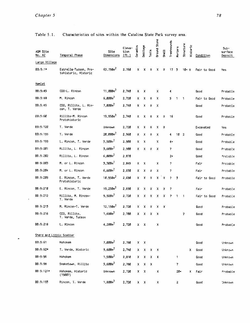
Chapter 5
Table 5.1 Characteristics of sites within the Catalina State Park survey area.
Eleva—Site tion ~
Temporal Phase Dimensions ff~J C.,
V
oC V
V I._ C)0~ 0 ~ ~ —
0 V L ) LV C — .C V C) 0
— — Z — U) *) D a.).0 0 0 V V L L. U)V 0 L .C L 0 a.’ —~ I— CD U) i- ~ U)
Large Village
88: 9: 1*
Hamlet
Estrella—Tucson • Pro—tohistoric, Historic
63,750m2 2,760 X X X X X 17 3 10+ x Fair to Good Yes
Sherd and Lithic Scatter
ASM SiteNo. AZ Condition
SubsurfaceDeposit
88:9:45 CDO—L. Rincon 11,000m2 2,740 X X X 4 Good Probable
88:9:48 M. Rincon 6,000m2 2.720 X X X X 5 1 1 Fair to Good Probable
B8:9:49 COO, Rillito, L. Rin— 7,000m2 2,740 X X X X Good Probablecon, T. Verde
88:9:60 Rillito-M. Rincon 19,950m2 2,740 X X X X X 16 Good ProbableProtohistoric
BB:9:120 T. Verde Unknown 2,720 X X X X X Excavated Yes
BB:9:195 T. Verde 20,000m2 2,960 X X X X 4 10 2 Good Probable
88:9:199 L. Rincon, T. Verde 5,500m2 2,900 X X X 4+ Good Probable
BB:9:201 Rillito, L. Rincon 3,600m2 2,900 X X X X ? Good Probable
88:9:202 Rillito, L. Rincon 6,000m2 2,870 2+ Good Probable
88:9:203 M. or L. Rincon 3,300m2 2,845 X X X ? Fair Probable
88:9:204 M. or L. Rincon 6,600m2 2,830 X X X X ? Fair Probable
88:9:209 E. Rincon, T. Verde 10,950m2 2,690 X X X X X ? 3 Fair to Good ProbableProtohistoric
B8:9:210 E. Rincon, T. Verde 19,250m2 2,690 X X X X X P Fair Probable
88:9:212 Rillito, M. Rincon— 900m2 2,720 X X X X X P 1 1 Fair to Good ProbableT. Verde
88:9:213 M. Rincon—T. Verde 12,150m2 2,720 X X X X X Good Probable
88:9:216 CDO, Rillito, 1,680m2 2,700 X X X X P Good ProbableT. Verde, Tucson
BB:9:218 L. Rincon 4,200m2 2,720 X X X Good Probable
88:9:61 Hohokam 7,000m2 2,780 X X Good Unknown
88:9:62* T. Verde, Historic 9,600m2 2,740 X X X X X Good Unknown
B8:9:96 Hohokam 1,500m2 2,810 X X X X 1 Good Unknown
88:9:98 Snaketown, Rillito 3,600m2 2,780 X X X 7 Good Unknown
BB:9:121* Hohokam, Historic Unknown 2,720 X X X 20+ X Fair Probable(1900?)
88:9:193 Rincon, T. Verde 1,800m2 2,720 X X X 2 Good Unknown
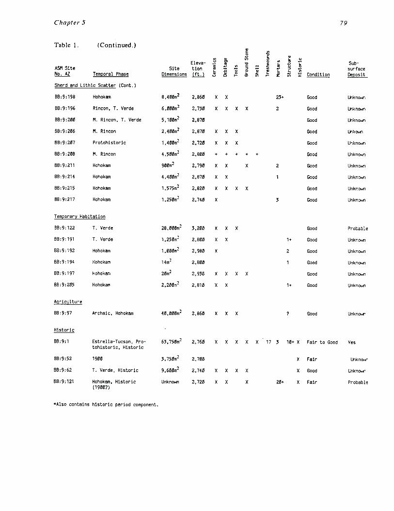
Chapter 5
BB:9:97 Archaic, Hohokam 40,000m2 2,860 X X X Good Unknown
88:9:52
88:9:62
SB:9: 121
T. Verde, Historic
Hohokam, Historic(1900?)
2,700
2,740
2,720
X Fair
X Good
20+ X Fair
Yes
Unknown
Unknown
Probable
Table 1. (Continued.)a~0., a
0, 0) (~) Z Uu o, 0 0, = —Eleva— — a E SubE ...) U) C — .c a C.) 0ASM Site Site tion ~ ~ ‘~ ~ ‘~ ~ ~ ~ surface
No. AZ Temporal Phase Dimensions j~J ~ ~ Condition Deposit
Sherd and Lithic Scatter (Corit.)
88:9:198 Hohokam 8,400m2 2,860 X X 23+ Good Unknown
88:9:196 Rincon, T. Verde 6,000m2 2,730 X X X X 2 Good Unknown
88:9:200 M. Rincon, T. Verde 5,100m2 2,870 Good Unknown
88:9:206 M. Rincon 2,400m2 2,870 X X X Good Unkown
88:9:207 Protohistoric 1,400m2 2.720 X X X Good Unknown
88:9:208 N. Rincon 4,500m2 2.800 + + + + + Good Unknown
BB:9:211 Hohokam 900m2 2,790 X X X 2 Good Unknown
88:9:214 Hohokam 4,400m2 2,870 X X 1 Good Unknown
BB:9:215 Hohokam 1,575m2 2,820 X X X X Good Unknown
88:9:217 Hohokam 1,250m2 2.740 X 3 Good Unknown
Temporary Habitation
88:9:122 T. Verde 28,000m2 3,200 X X X Good Probable
88:9:191 T. Verde 1,250m2 2,800 X X 1+ Good Unknown
88:9:192 Hohokam 1,000m2 2,980 X 2 Good Unknown
88:9:194 Hohokam 14m2 2,800 1 Good Unknown
88:9:197 Hohokam 20m2 2,930 X X X X Good Unknown
B8:9:205 Hohokam 2,200m2 2,810 X X 1+ Good Unknown
Agriculture
Historic
88:9:1 Estrella—Tucson, Protohistoric, Historic
1900
63.750m2 2,760 X X X X X 17 3
3,750m2
9,600m2
Unknown
10+ X Fair to Good
xx
xx
xx
x
*Also contains historic period component.

Chapter 5
207• 217
60A52 216
80
F — OR
.5
Miles.5
Kilometers
FOREST
SITE TYPES RECORDED WITHINCATALINA STATE PARK SURVEY AREA
All Sites Preceded by AZ RB: 9~
Large Village • Sherd + Lithic ScatterX Historic
A Hamlet • Temporary Hobit’on
Agricultural Field Systems
Figure 5.1 The distribution of sites by type in the Catalina State Park study area.
Chapter 5
Sherd and Lithic Scatters
The locations of sites assigned to the sherd and lithic scatter site type are more variable.The majority (60 percent), such as AZ BB:9:61, 62, 96, 98, 193, 196, 198, 200, and 208, arealso situated on the first terrace above the major drainages. Although the functions ofthese sites are unknown, it is suspected that at least some of these sites containsubsurface pithouses and may have served as seasonal habitations. The other sherd andlithic scatter sites, such as AZ BB:9:206, 207, 211, 214, 215, and 217, are situated awayfrom the major drainages in the higher country of the surrounding ridges. Although mostof these sites are located near secondary drainages that may have contained water for partof the year, it is probable that these sites were occupied only briefly. The difference inpossible function within this site type is supported by the fact that the sherd and lithicscatters situated above the major drainages are substantially larger, averaging 5278 squaremeters in area, whereas the sherd and lithic scatters away from the drainages average only1988 square meters in area.
Temporary Habitations
Temporary habitation sites are also variable in their locations. The great majority of thesesites (66.7 percent) are situated away from the major drainages up on the high ridges andterraces south of Cait’ada del Oro Wash. These sites for the most part consist of isolatedone or two room cobble structures situated in good defensive locations on high ridgefingers with excellent views of the surrounding area. Very few artifacts were found inassociation with these sites, and some did not have any artifacts. They are not locatednear any permanent water supply, and are generally away from even small, temporarydrainages. Like the sherd and lithic scatters, the function of these sites is unclear andprobably diverse; some may have functioned as small agricultural field houses while othersappear to have been defensive in nature.
AZ BB:9:122 is unlike any other site assigned to the temporary habitation category withinthe project area. It consists of around 20 dispersed cobble structures spread out along ahigh ridge top over an area of approximately 28,000 square meters. The surface cobblestructures are all relatively ephemeral, consisting of low walls, one or two courses high.Shapes are variable, and square, rectangular, round, and oval rooms with little subsurfacedepth were noted. The site has a very low artifact density given the relatively largenumber of rooms. No artifact concentrations or trash mounds were noted and most of thesite, including areas surrounding the structures, did not contain any artifacts at all. Whenartifacts were present they usually consisted of lithic debitage. Very few sherds werenoted, and only a few pieces of ground stone.
The function of the site is unclear. When the site card for the site was first examinedthe site was assumed to represent a hamlet given the relatively large number of structures.However, after inspecting the site it was reclassified to a temporary habitation. This wasdue to the overall paucity of artifacts and trash concentrations, which suggest a limitedoccupation. The site is in a good defensive location, high on a ridge-top with commandingviews of the surrounding area. The site is also situated just above the Sutherland Washfloodplain, which would have afforded a permanent water supply as well as areas of arableland. It is possible that the site served as a seasonal farming village or a refuge duringunsettled periods of stress and warfare.

Chapter 5 82
Agricultural Sites
The project area contains two large agricultural field areas associated with habitation sites(south of AZ BB:9:48 and the Romero Ruin), and a small isolated agricultural field area (AZBB:9:97). These areas, which total approximately 140 acres, are all on terraces above thefloodplain and consist of agricultural field systems containing linear borders, terraces,check dams, and rock piles, designed to trap and control runoff from the surroundingridges. Several cobble field houses are also present. The project area also containsnumerous potential field areas where floodwater agriculture could have been practiced.Although it is assumed that most of the floodplain areas of Sutherland Wash and Calfadadel Oro Wash, as well as the minor floodplains of Romero, Montrose and Alamo canyonwashes, were probably farmed, this cannot be demonstrated because floodwater farmingleaves little if any indication of the past use of the area. Ethnographically, floodplainagriculture was the preferred practice of the O’Odham Indians of southern Arizona (Russell1975; Castetter and Bell 1942), and it is reasonable to assume that it was the commonpractice of the prehistoric inhabitants of the Catalina State Park area. It is likely thatdry farming was used to supplement the floodwater areas.
Historic Sites
The historic sites are all situated along either Caftada del Oro or Sutherland Wash. Theseinclude three sites that contain both prehistoric and historic components (the Romero Ruin,AZ BB:9:62, and AZ BB:9:121) and a single site that is solely historic (AZ BB:9:52). Two ofthe sites (the Romero Ruin and AZ BB:9:52) appear to be related to the occupation of thepark area by Francisco Romero, while the nature of the occupation of AZ BB:9:62 and 121is unclear.
TEMPORAL PATTERNS
Of the 42 recorded sites, 30 could be assigned to one or more temporal phases through therecovery of diagnostic ceramics or other artifacts. It is important to note, however, thatthe temporal distribution is biased by site type. This is due to the fact that while all ofthe sites classified as habitations contained diagnostic ceramics, only eight (53.3 percent) ofthe sherd and lithic scatters, and two (33.3 percent) of the temporary habitations,contained datable material. As a result, the settlement patterns through time are somewhatincomplete, since it is unknown how these smaller sites fit into the temporal pattern.
Archaic Period
The earliest datable material recovered from the project area was a single Archaic periodprojectile point found in association with a small lithic scatter at site AZ BB:9:97 (Figure5.1). This was identified by Huckell (1980:36) as a Chiricahua stage Cochise projectilepoint dating to the Middle Archaic period (5000-1000 B.C.). AZ BB:9:97 is amulticomponent site, containing both a small Archaic occupation and a later Hohokamagricultural field system. It is likely that additional Archaic occupation is present withinthe project area but is currently unrecognized due to the lack of recovered diagnosticmaterial. In fact, less than five projectile points were recovered from the entire survey, avery small quantity given the number of sites and the intensity of occupation. Thissuggests that removal of projectile points by collectors may be a factor in the apparentlow density of the Archaic occupation.
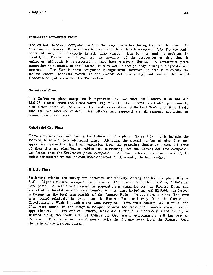
Chapter 5 83
Estrella and Sweetwater Phases
The earliest Hohokam occupation within the project area has during the Estrella phase. Atthis time the Romero Ruin appears to have been the only site occupied. The Romero Ruincontained only two diagnostic Estrella phase sherds. Due to this, and the problems inidentifying Pioneer period ceramics, the intensity of the occupation at this time isunknown, although it is suspected to have been relatively limited. A Sweetwater phaseoccupation is suspected at the Romero Ruin as well, although only a single diagnostic wasrecovered. The Estrella phase occupation is significant, however, in that it represents theearliest known Hohokam material in the Caxrada del Oro Valley, and one of the earliestHohokam occupations within the Tucson Basin.
Snaketown Phase
The Snaketown phase occupation is represented by two sites, the Romero Ruin and AZBB:9:98, a small sherd and lithic scatter (Figure 5.2). AZ BB:9:98 is situated approximately500 meters north of Romero on the first terrace above Sutherland Wash and it is likelythat the two sites are related. AZ BB:9:98 may represent a small seasonal habitation orresource procurement area.
Cal’fada dcl Oro Phase
Three sites were occupied during the Canada del Oro phase (Figure 5.3). This includes theRomero Ruin and two additional sites. Although the overall number of sites does notappear to represent a significant expansion from the preceding Snaketown phase, all threeof these sites are classified as habitations, suggesting that the CaiTada del Oro occupationwas larger than the Snaketown phase occupation. All three sites are in close proximity toeach other centered around the confluence of Caftada del Oro and Sutherland washes.
Rillito Phase
Settlement within the survey area increased substantially during the Rillito phase (Figure5.4). Eight sites were occupied, an increase of 167 percent from the preceding Caffada delOro phase. A significant increase in population is suggested for the Romero Ruin, andseveral other habitation sites were founded at this time, including AZ BB:9:60, the largestsettlement in the local area outside of the Romero Ruin. In addition, for the first timesites located relatively far away from the Romero Ruin and away from the Canada delOro/Sutherland Wash floodplain area were occupied. Two small hamlets, AZ BB:9:201 and202, were found in the mesquite bosque between Montrose and Romero canyon washesapproximately 2.0 km east of Romero, while AZ BB:9:212, a moderately sized hamlet, issituated along the south side of Canada del Oro Wash, approximately 2.0 km west ofRomero. These sites are located nearly twice the distance away from the Romero Ruinthan sites of the previous phases.
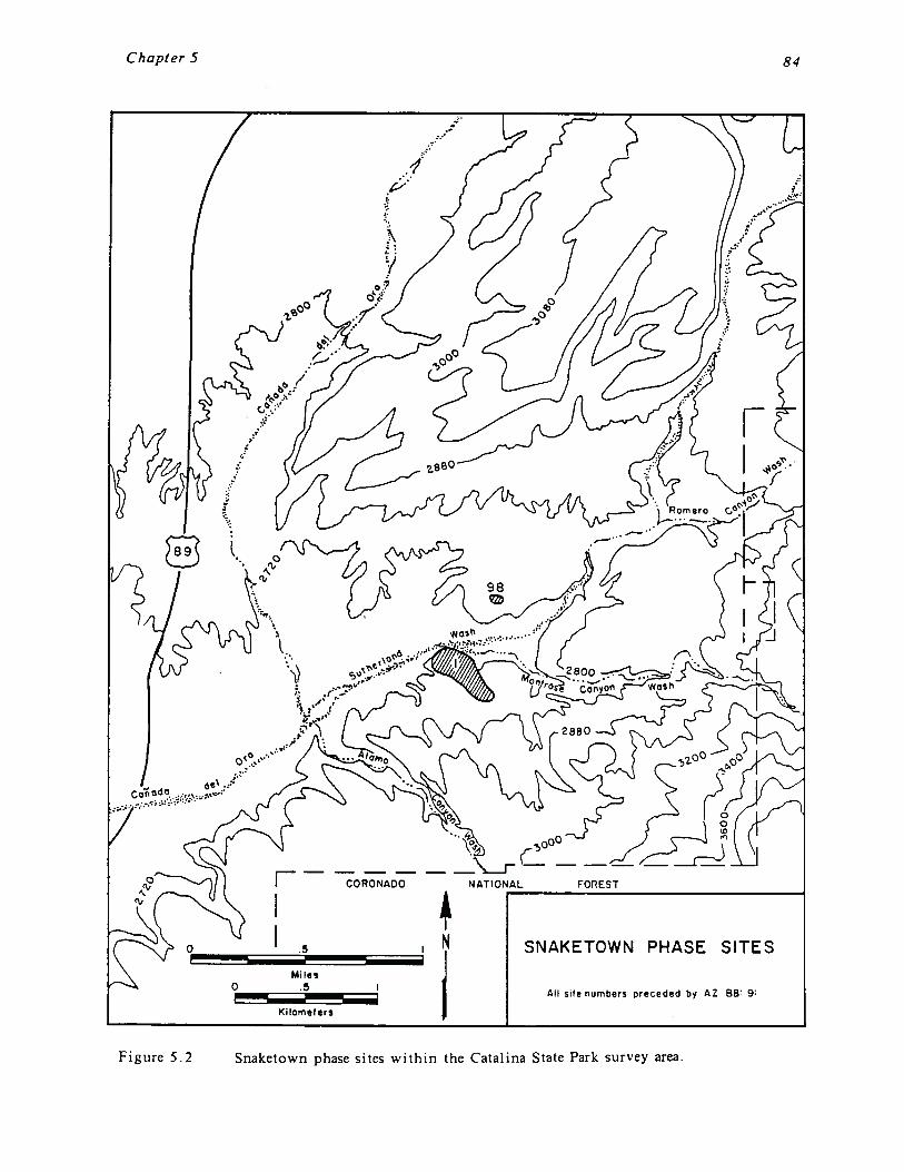
Chapter 5 84
CORONADO
SNAKETOWN PHASE SITES
All site numbers preceded by AZ SB’ 9
Figure 5.2 Snaketown phase sites within the Catalina State Park survey area.
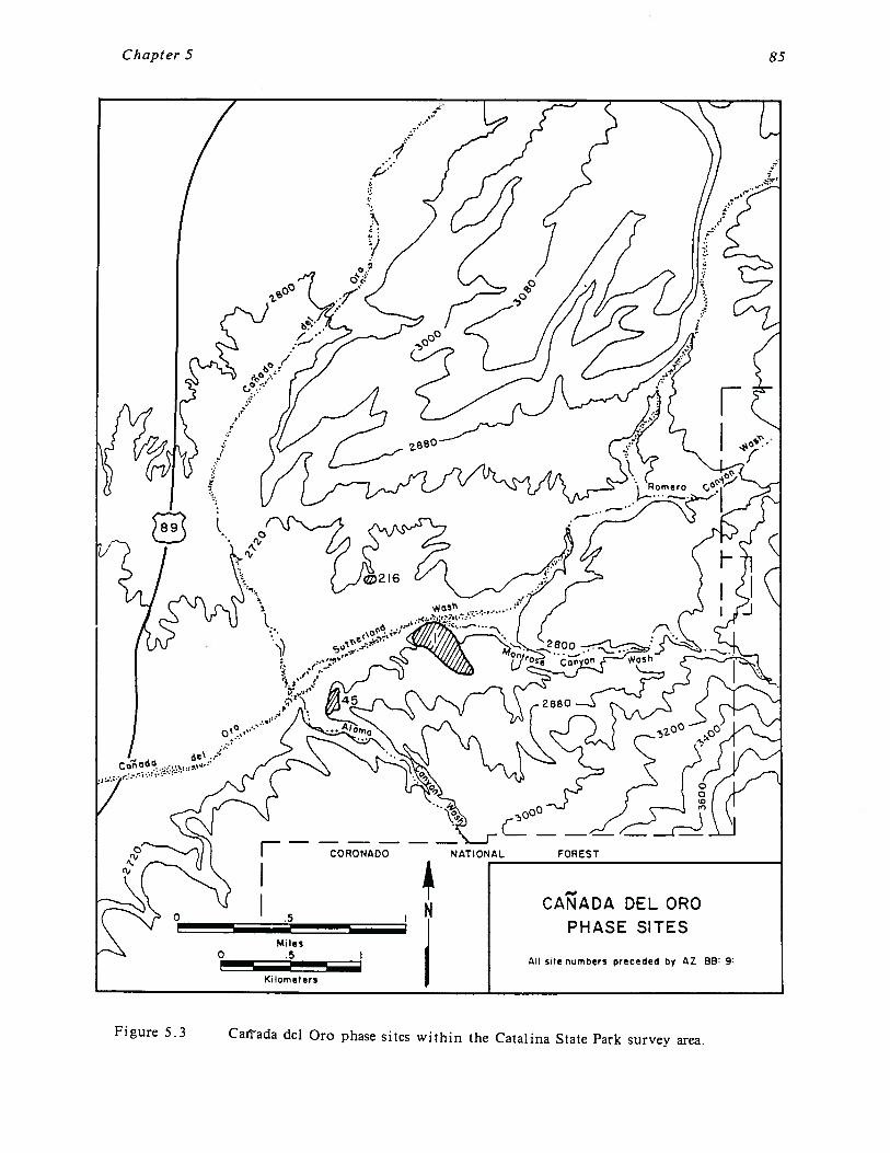
Chapter 5 85
Kilometers
CORONADO
CANADA DEL CR0PHASE SITES
A site numbers preceded by AZ 88 9
Figure 5.3 Caffada del Oro phase sites within the Catalina State Park survey area.

Chapter 5
F — CORONAD
RILLITO PHASE SITES
All site numbers preceded by AZ BB 9:
86
Figure 5.4 Rjlljto phase sites within the Catalina State Park survey area.

Chapter 5 87
Early Rincon Subphase
The Early Rincon occupation of the survey area is similar to the Rillito occupation (Figure5.5). However, unlike the Romero Ruin, where a decrease in population is suggested, therewas a slight increase in the number of Early Rincon sites. The only change from theRillito site distribution is that the occupation expanded even farther west of the RomeroRuin to the ridge between the Big Wash and Caliada del Oro floodplains (sites AZ BB:9:209,210, and 213). This area became a major locus of habitation from this time through theTanque Verde phase. In addition, the occupation at AZ BB:9:60 appears to have increasedsubstantially, as did the occupation of several other previously inhabited sites.
Middle Rincon Subphase
The number of sites occupied during the Middle Rincon subphase increased substantiallyfrom ten to 15 sites (Figure 5.6). The increase in the number of sites may be related tothe postulated decrease in population at the Romero Ruin. It appears that at this time thefocus of occupation was shifting from the Romero Ruin to other sites and areas within theproject area. This is particularly true for site AZ BB:9:60 and the area between Montroseand Romero canyon washes east of the Romero Ruin, both of which contain a relativelysubstantial population at this time. The area between Caufada del Oro and Big Washcontinued to be occupied, and there are indications that the occupation here increased inintensity as well. AZ BB:9:60 may have been the central focus of the Middle Rinconsettlement. The decrease in the Romero Ruin population and the larger number of occupiedsites suggests a trend toward a more dispersed population.
Late Rincon Subphase
The number of sites continued to increase during the Late Rincon subphase, when 16 siteswere occupied (Figure 5.7). Given the relatively sharp decline in population at both theRomero Ruin and AZ BB:9:60 at this time, an increase of three habitation sites from thepreceding Middle Rincon subphase is significant. As with the Middle Rincon subphase, thedata strongly suggest that population was distributed over multiple small settlements.Furthermore, for the first time the focus of occupation appears to have shifted away fromthe area around the confluence of Sutherland and Cafiada del Oro washes, which had beenthe primary habitation area for the preceding 600 years. During Late Rincon, thepopulation was focused on the area between CaiThda del Oro and Big Wash and the areabetween Montrose and Romero canyon washes. These two areas are separated by nearlyfour kilometers.
Tanque Verde Phase
Seventeen sites were occupied during the Tanque Verde phase, the highest site density forthe survey area (Figure 5.8). The area between Caffada del Oro and Big washes continuedto be the major focus of settlement. However, the Romero Ruin area was again inhabitedmore intensively than during the Middle and Late Rincon subphases. This is suggested bythe construction of a compound at Romero, and by the settlement of AZ BB:9:195, a largehamlet on Alamo Canyon Wash at the head of the Romero agricultural system. These twosites were probably related components of a single settlement.
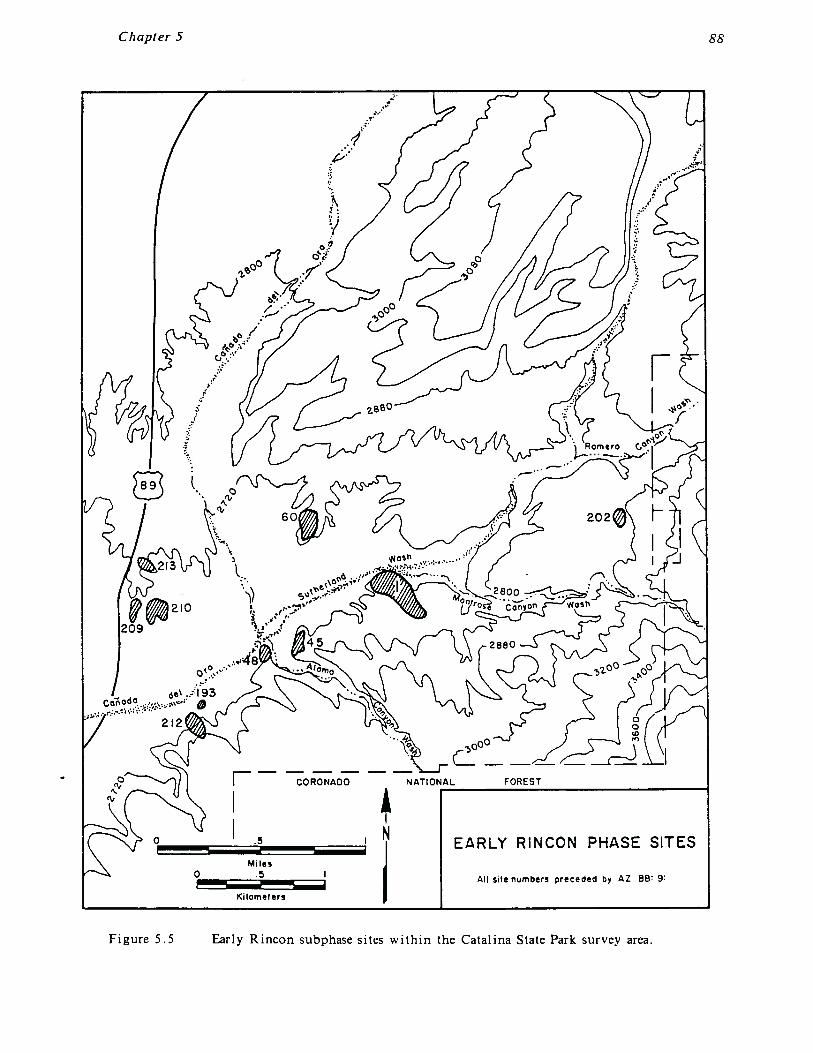
Chapter 5 88
CORONADO
EARLY RINCON PHASE SITES
All site numbers preceded by AZ 0B 9:
Figure 5.5 Early Rincon subphase sites within the Catalina State Park survey area.

Chapter 5 89
CORONADO
MIDDLE RINCONPHASE SITES
All site numbers preceded by AZ B9 9:
Kilometers
Figure 5.6 Middle Rincon subphase sites within the Catalina State Park survey area.
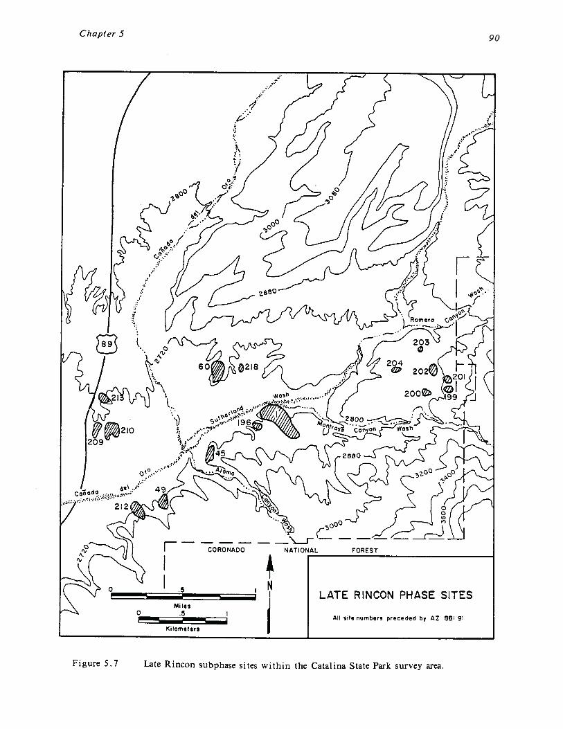
Chapter 5
CORONADO
LATE RINCON PHASE SITES
All STtC numbers preceded by AZ 66: 9:
Kilometers
Figure 5.7 Late Rincon subphase sites within the Catalina State Park survey area.
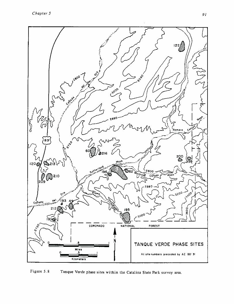
Chapter 5 91
CORONADO
TANQUE VERDE PHASE SITES
All site numbers preceded by AZ B8 9:
Kilometers
Figure 5.8 Tanque Verde phase sites within the Catalina State Park survey area.
Chapter 5
The area between Montrose and Romero Canyon washes, intensively settled since theMiddle Rincon subphase, was largely abandoned, as was AZ BB:9:60 and most of the area tothe east of the Romero Ruin. This suggests that during the Tanque Verde phase the focusof settlement shifted westward.
The only two temporary habitation sites that could be temporally placed date to the TanqueVerde phase. These include sites AZ BB:9:122 and AZ BB:9.191. Both of these sites arelocated on ridgetops with commanding views of the surrounding area. Although the truenature of these sites is unclear and probably complex, their defensive potential cannot beignored. Trincheras sites and sites in defensive locations appear elsewhere in the TucsonBasin at this time, suggesting that raiding or warfare during the Tanque Verde phase mayhave been a problem within the project area and throughout the Tucson Basin.
Tucson Phase
Only two sites within the project area yielded Tucson phase ceramics. These are theRomero Ruin, where a single Tucson Polychrome sherd was recovered, and site AZ BB:9:216,which contained a Gila Polychrome sherd (Figure 5.1). The Tucson phase is generallydistinguished from the Tanque Verde phase solely through the occurrence of relatively rareceramic types such as Tucson and Gila polychromes. Since these ceramic types are notwidespread, and Tanque Verde Red-on-brown is known to continue into the Tucson phase,it is possible that other sites within the project area also contain a Tucson phasecomponent.
Protohistoric Period
The Protohistoric period is not well understood in the Tucson Basin. This is due both tothe generally small and ephemeral nature of Protohistoric sites and structures, and to thelack of excavation and research into this period (Wilcox and Masse 1981). Four sites werefound to contain Protohistoric period material, consisting of thin, well-fired, plainwaresherds. These are the Romero Ruin, AZ BB:9:60, AZ BB:9:209, and AZ BB:9:207. AZBB:9:207 is a small sherd and lithic scatter and the only one of the three sites thatappears to represent a single component occupation. Like the earlier Pioneer and Colonialperiod Hohokam sites, the Protohistoric sites were centered around the confluence ofCallada del Oro and Sutherland washes, although AZ BB:9:209 is located between CaiTada delOro and Big Wash. In addition, since the majority of ceramics on Protohistoric sites areplainware sherds identical in appearance to Hohokam plainware sherds, it is possible thatother sites within the project area contain a protohistoric component that is unrecognized.
Historic Occupation
Although it is likely that Apache and Tohono O’odham Indians made sporadic and seasonaluse of the Catalina State Park area, perhaps to procure agave and other wild resources, noarchaeological evidence for these temporary occupations has been found to date. Similarly,early Spanish explorers, priests, and conquistadors, may have travelled through and exploredthe park area, although again no archaeological remains are present, and the historicdocuments are ambiguous on this matter as well. Therefore, it was not until FranciscoRomero moved into the area in the mid-nineteenth century that the Catalina State Parkarea was again occupied on a permanent basis.

Chapter 5 93
Francisco Romero was born in Tucson sometime between 1810 and 1831 (Huckell 1980:14-18;Romero File: Arizona Historical Society). He was the grandson of a Spanish soldier whoarrived in the Tucson area in the 1770s. Nothing is known concerning Romero’s childhood,and he is next mentioned in the historic documents in 1844, where he is listed asestablishing a 160 acre ranch at a place called Pueblo Viejo. Pueblo Viejo is recorded asbeing situated along CaI~ada del Oro Wash (both Sutherland Wash and C~da del Oro Washwere commonly referred to as the Cazrada del Oro through the 1930s or so) approximately18 miles north of Tucson. The records indicate that Romero ranched 60 head of cattle.Romero eventually acquired 320 acres of farmland along the Santa Cruz River near FlowingWells and 30 acres along Main Street in downtown Tucson. He is reported to have raisedwheat on his 320 acres and listed his occupation in the 1860 and 1870 censuses as farming.
Romero died in 1905 and the ranch passed onto his son, Fabian, who continued to raisecattle in the park area and farm along the Santa Cruz River. It is unknown whetherFabian Romero passed the ranch down to his son, also named Fabian. An interestingaccount of life in the park area in the mid-nineteenth century is found in a 1928 interviewwith Fabian Romero, Jr., Francisco’s grandson. The account was recorded by Donald Page,a local historian doing research on the Spanish origins of the Romero Ruin. According toPage in his entry for February 12, 1928, Romero told him that his grandfather first settledat the site sometime between 1828 and 1838. As Page (n.d.) states:
At that time, the ruins of the Spanish [Classic period Hohokam] buildings wereabout 1 m high and his grandfather rebuilt three of these, also building theenclosing wall was a protection against the Apaches. Romero says that heunderstands that his grandfather’s enclosing wall as the original wall but I thinkthat the evidence is strongly in favor of his having rebuilt this, as he did thehouses. He lived there alone with his wife and was apparently in a more or lessconstant state of warfare with the Apaches, as young Romero says that hegenerally began the day by riding after the Indians and, after a long range rifleduel, getting back a few head of his herd of 30 cattle that the Apaches hadmanaged to run off during the night. His armament consisted of a brace of capand ball pistols and a rim fire .44 carbine that he had managed to secure fromthe States. This weapon gave him an immense advantage over the Apaches whowere armed with bows and arrows and flint-locks, as the elder Romero craftilystayed out of range of their arms and generally managed to pick off one or twoof their number, and in time the Indians came to entertain a great fear of himand his rifle. However, he did not escape unscathed as his nephew tells me thatthe old man’s body was seamed by scars left by arrow and lance wounds.
It is generally agreed that the historic structures at the Romero Ruin are the remains ofFrancisco Romero’s original home site. At present, four, or possibly five, structuresremain; all are composed of local river cobbles with standing walls between 1.0 and 1.5meters high (Figure 3. 12). Almost all of the rooms are in poor to fair condition due topothunting. Due to the massive disturbance it is difficult to determine what the ranchhouse originally looked like, although it appears to consist of a larger structure surroundedby a series of small, separate, structures. The larger structure contains at least tworooms, and there are indications that this was joined to a third large room north of it.Although Fabian Romero Jr. reported that his grandfather built the wall enclosing thestructures as a protection against Apache raiders, it is likely that Romero just improvedupon the already existing Classic period Hohokam compound wall. Similarly, Romero alsoprobably robbed cobbles from the Hohokam structures to build his house.

Chapter 5
The length of time Romero lived on this ridge above Sutherland Wash is unknown. It isreported that Romero moved down to the floodplain after Apache raiding had ceased(Huckell 1980:33), which would be sometime in the 1870s or 1880s. This is supported byRoskruge’s 1893 map of Pima county which has the Romero ranch house located acrossSutherland Wash at the confluence of Sutherland and Caffada del Oro washes (site AZBB:9:52). It is also unknown how intensive the occupation was. Very few historic artifactswere recovered from the intensive surface collection, consisting of a few pieces of non-diagnostic metal and historic ceramics, a single piece of American Gray Salt-glazedStoneware with an Albany slip on the interior (ca. 1800-1910), and several Papagoplainwares. Huckell (1980:33) reported a similar lack of artifacts, although she did recoverpurple glass (ca. 1850-1920), dark-green glass (non-diagnostic) and soldered tin cans.
The datable artifacts are consistent with the suggested occupation between 1844 and 1880or so. However, the overall lack of historic material suggests that the ranch house mayhave only been sporadically used during this period, perhaps as a fortification duringunusually high periods of Apache raiding or as a seasonal winter habitation when shelterwas necessary. It is also possible that the ranch house was used for a much shorter periodthan the historic records indicate. If the structure was constructed later than the 1844date (and some accounts date it to the 1860s or 1870s), or if it was abandoned prior to the1870s or 1880s when the Apaches were finally subjugated, a shorter occupation couldaccount for the relative lack of trash.
Based on Roskruge’s 1893 map, it is likely that Romero moved off of the ridgetop to thesite of AZ BB:9:52 (Figure 5.1). The location of this site is labelled “Romero Ranch” onthe 1893 map. AZ BB:9:52 is situated within the Sutherland Wash floodplain at the base ofthe large prehistoric village of AZ BB:9:60. All that remains of the site are two largetamarisk trees, the remains of a single stone wall which may have been a house foundation,and two relatively large, ashy, trash deposits that appear to contain subsurface depth.Artifacts within the trash deposits include Papago sherds, burned bone, and non-diagnostichistoric ceramics. The Papago sherds are consistent with a late 1800s/early 1900s date forthe site.
It is difficult to determine the functions of the other two historic sites, AZ BB:9:62 andAZ BB:9:121, both of which contain prehistoric components as well. AZ BB:9:62 is a small,low density scatter of pieces of metal and glass. No diagnostic artifacts were recovered toconclusively date the site, although it appears to be early to mid-twentieth century, andmay be related to ranching activities. AZ BB:9:121 consists of the remains of a smallcobble house foundation situated at the junction of Cargodera Canyon and Sutherland Wash.A single Papago plainware sherd was recovered from the site, which suggests a possibleturn of the century date.
Summary of the Settlement Data
In summary, the survey area was occupied from at least the Middle Archaic period (5000-1000 B.C.) up through the early twentieth century. The Archaic occupation was confinedto a single small component of a larger Hohokam agricultural site, although other Archaicperiod sites are suspected to be present. Hohokam occupation of the park area began atthe Romero Ruin during the Pioneer period Estrella phase. During the Snaketown andCaliada del Oro phases the population gradually increased, most likely due to both internalgrowth and movement into the park from outlying areas. The Snaketown and Canada delOro populations were centered around the Romero Ruin. The population continued toincrease during the Rillito phase and Early Rincon subphase, when the Romero Ruin was

Chapter 5 95
intensively occupied. Although the Romero Ruin appears to have remained the centralfocus of the Hohokam occupation, for the first time, small habitation sites were establishedaway from the site to the east and west. During the Middle Rincon subphase andsubsequent phases, the number of occupied sites continued to increase. This is believed tobe due to a reduction in the population of the Romero Ruin. AZ BB:9:60, a majorhabitation site situated across Sutherland Wash from Romero, was intensively occupied atthis time and probably was the focus of the Hohokam occupation. During the Late Rinconsubphase both the Romero Ruin and AZ BB:9:60 were depopulated, and the focus ofoccupation shifted to the east to the area between Montrose and Romero canyon washesand to the west to the area between the Caffada del Oro and Big Wash.
The Tanque Verde phase represents a change in the patterns of continued growth anddecentralization seen from at least the Middle Rincon subphase and foreshadowed in theEarly Rincon subphase. During Tanque Verde times, the Romero Ruin was reoccupied on amore intensive level, and a compound was constructed. Not enough is known about thesettlement during the subsequent Tucson phase and Protohistoric period to generalize. Theoccupation of the area during both of these periods is intriguing and deserving of furtherwork. The park area was not permanently inhabited again until the middle of thenineteenth century, when Francisco Romero constructed his ranch house on the remains ofthe Hohokam compound.
In conclusion, during the prehistoric occupation of the park two major settlement shiftsappear to have occurred. The first was during the transition from the Early to MiddleRincon subphase, although this change was foreshadowed by the Early Rincon subphasesettlement. Up until this time the Romero Ruin and the park area appear to haveundergone steady growth. However, during the Middle Rincon subphase the Romero Ruinlost population and apparently that population was dispersed to a number of smaller sites.A population center appears to have been present at AZ BB:9:60, although it was not aslarge nor as intensively inhabited as the Romero Ruin was during the preceding phases.This trend continued into the Late Rincon subphase, a time when no single populationcenter was present, though a large number of small habitation sites were occupied. Thesecond major change was the transition from the Late Rincon subphase to the TanqueVerde phase. At this time a new population center was established west of the RomeroRuin between Big Wash and the Caflada del Oro. Furthermore, the Romero Ruin wasoccupied and a compound was constructed, though it is difficult at present to assess theintensity of the occupation at Romero.
THE SUTHERLAND WASH ARCHAEOLOGICAL DISTRICT
As part of this project, a nomination form was completed in order to place the SutherlandWash Archaeological District on the National Register of Historic Places. The proposedboundaries of that District are shown in Figure 5.9. National Register status is not aguarantee that these sites will be preserved, however. The Catalina State Park has a highvisitorship, and intensity of use of the park is likely to increase as the population of theTucson area continues to grow. It is important that the information contained in this andprevious reports on the archaeology of the Catalina State Park area be used to plan forthe long term preservation of these important sites. The Romero Ruin, in particular, hastremendous potential for future research. The Romero Ruin and nearby sites also have ahigh potential for development for public interpretation programs. This developmentprocess will require careful planning as well as perseverance in these times of dwindlingpublic funding sources. These sites clearly deserve our stewardship.
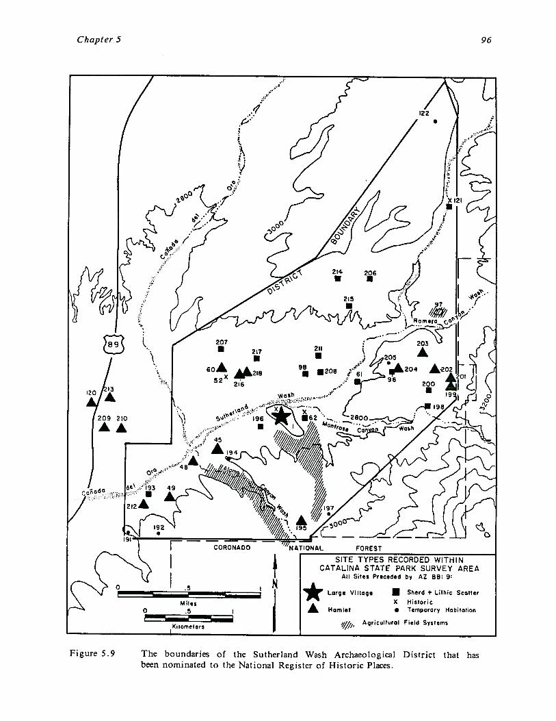
Chapter 5 96
~ATlONAL FOREST
SITE TYPES RECORDED WITH IICATALINA STATE PARK SURVEY AREA
All Sites Pr.ceded by AZ BB: 9:
Figure 5.9 The boundaries of the Sutherland Wash Archaeological District that hasbeen nominated to the National Register of Historic Places.
207• 217
6OA52 216
I(ilomelers
Large Viltag
A Hamlet
• Sherd + Lithic ScatterX Historic• Temporary Habitation
Agricultural Field Systems
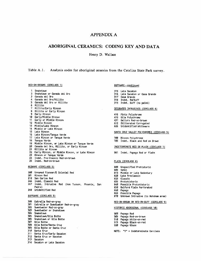
APPENDIX A
ABORIGINAL CERAMICS: CODING KEY AND DATA
Henry D. Wallace
Table A. 1. Analysis codes for aboriginal ceramics from the Catalina State Park survey.
RED—ON—BROWNS (CERCLASS 1) BUFFWARE——continued
1 Snaketown2 Snaketown or Canada del Cr03 Canada del Oro4 Canada del Oro/Rillito5 Canada del Cr0 or Rillito6 Rillito7 Rillito/Early Rincon8 Rillito or Early Rincori9 Early Rincon
10 Early/Middle Rincon11 Early or Middle Rincon12 Middle Rincon13 Middle/Late Rincon14 Middle or Late Rincon15 Late Rincon16 Late Rincon/Tanque Verde17 Late Rincon or Tanque Verde18 Tanque Verde19 Middle Rincon, or Late Rincon or Tanque Verde20 Canada del Cr0, Rillito, or Early Rincon21 Rillito or Rincon22 Early Rincon, or Middle Rincon, or Late Rincon23 Rincon or Tanque Verde24 Indet. Pre—Classic Red—on—brown25 Indet. Red—on—brown
315 Late Sacaton316 Late Sacaton or Casa Grande317 Casa Grande318 Indet. Rd/Buff319 Indet. Buff (no paint)
DECORATED INTRUSIVES (CERCLASS 4)
416 Pinto Polychrome419 Gila Polychrome437 Galiuro Red—on—brown612 Obliterated Corrugated626 Unidentified White~re
SANTA CRUZ VALLEY POLVCHROMES (CERCLASS 5)
700 Rincon Polychrome705 Indet. Black and Red on Brown
INDETERMINATE RED OR PLAIN (CERCLASS 7)
981 Indet. Papago Red or Plain
PLAIN (CERCLASS 8)
REDWARE (CERCLASS 2)
200 Unnamed Pioneer/E Colonial Red201 Rincon Red218 San Carlos Red246 Indet. Classic Red247 Indet. Intrusive Red (non Tucson, Phoenix, San
Pedro)248 Unidentified Red
BUFFWARE (CERCLASS 3)
800 Unspecified Prehistoric805 Vahki819 Middle or Late Sedentary820 Late Preclassic825 Classic835 Protohistoric840 Possible Protohistoric850 Belford Plain Perforated860 Papago865 Possible Papago870 Unknown Intrusive (to Hohokam area)
300 Estrella Red—on—gray301 Estrella or Sweet~.ater Red—on—gray302 Sweeti~ter Red—on—gray303 Sweet.ater or Snaketown304 Snaketown305 Snaketown/Gila Butte306 Snaketown or Gila Butte307 Gila Butte308 Gila Butte/Santa Cruz309 Gila Butte or Santa Cruz310 Santa Cruz311 Santa Cruz/Early Sacaton312 Santa Cruz or Sacaton313 Sacaton314 Sacaton or Late Sacaton
RED—ON—BROWN OR RED—ON—BUFF (CERCLASS 9)
HISTORIC ABORIGINAL (CERCLASS 10)
900 Papago Red905 Papago Red—on—brown910 Papago White—on—red915 Papago Black—on—red920 Papago Glaze
NOTE: “?“ Indeterminate Cerclass
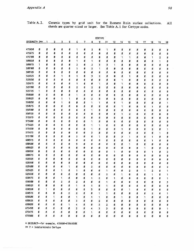
UUUUUUUUUULUUUUUUUUUUUUUUUUULUIU3UUUUUUUUU00U
UU00LUUUULU10ULU31U3000UU0U0UUU000UUUUU30LUUUUU1UUUUUUUUIUUUU100UIUUULU3UUUUUU00UUU0UUUU0UUUU0UUUUUUULUULUUUUUUUUUUUUUUUUUUU0UUUUUUUUUUUUUUUUUUUUUUUUUUUUUUUUUUULUUUU3LUUUUUUUUUUUU
UUUUUUUUUUULUULUUUUUUUUL3UOUUUUUOUUUUULUUUI≤UUUIUUUUUU3LUUUIUIUUUUUUUUULUILUUUUUUU0ULLUUUU
~dA;Ja3~=~,*)~
3U≤9/N≤Lt’=U≤9≤Lt’‘aidw~xaJo~—-j~Q~~*
036L81LI91≤L~‘I31LL6]dkLN33
8L9≤~3L**~.*IIM1OINO
•s~po3~.iojiv~~.iopDzTs-1~.I~nbD.Iesp.I~qs
ITVSUO!~3JJO3~D~J1flSU!fl’~JO.J~1UO~J~fl.IOJ~!UflpTi~Aqs3dA~~!w~1~D~v~jquj
UU0UUUUUUUUOU≤≤L9
UU0IUUUUUUU≤Lt’≤L9
U~≤~‘U3UUUUUU≤t’≤L9
O33UU~IUUUUU≤9U≤9OU3UU~UU0UU≤39U≤9UUILU1$UIUUUU9U≤9U11UU33UUUU≤L≤U≤9UUU≤UUUUU10U≤≤U≤9UIUIUIUUUUU≤3≤U≤9UIUUU3U3UUUUU≤U≤9LU3LUUULUUU≤Lt’U≤9
U3UUUUUU00UU≤9≤39UIUUULUIUUU≤39≤39UUU3UU10UUUUU9≤39
UUUUUUUUUUUU≤≤≤39U00UUUUU0UUS3≤≤29UUUUUUUUUUU≤L9UU9LUUUUUUU0UUU≤9009UUUUUUUUUUU≤39UU9UUUUU≤UUUUUUU9UU9UUUUUUUUUUU≤L≤UU9
UUIUU3UUUUUUUL≤L≤
UUU~UUUUUUU≤L9≤L≤
UU01UUUUUUUU≤9≤L≤
U011UUU0UUU≤39≤L≤UUUIUUU0UUUUU9≤L≤UUUUUUUUUUU≤Lc≤L≤UUUUUUUUUU0≤ELU≤≤UUUIUUUUUUUUULU≤≤UUUUUUUUUUU≤L9U≤≤
UUL10UUIUUU0≤90≤≤UUU3UUIIU0U≤39U≤≤UUUUUIUUUUU0090≤≤UUUUUUUUUUI≤EL≤z≤
U003U2UUUUUUUL≤3≤
UULUUIUUUUU≤L9≤3≤
O0U0UUUUUUUU≤9≤3≤UU3≤UIUIUUU≤39≤3≤UUUUUUUU0UU≤ELUU≤
UU13ULUUUUUUULUU≤I~≤3U3U0UUI≤L900≤UUULUIUUUUUU≤9UU≤UUUUUUUUUUUUUL≤L1’
UU0UUUUUUUU≤L9≤LIT01U3UIUUUUUU≤9≤L~
86VX!pUaddV
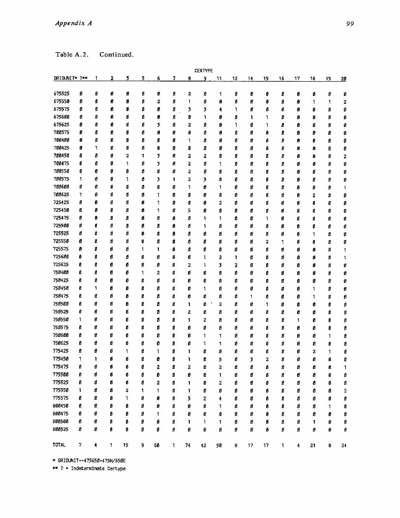
Appendix A
Table A.2. Continued.
CERTYPEGRID1J~1IT* 7** 1 2 3 5 6 7 8 9 11 12 14 15 16 17 18 19 20
675525 0675550 0675575 0675600 0675625 0700375 0700400 0700425 0700450 0700475 0700550 0700575 1700600 0700625 1725425 0725450 0725475 0725500 0725525 0725550 0725575 0725600 0725625 0750400 0750425 0750450 0750475 0750500 0750525 0750550 1750575 0750600 0750625 0775425 0775450 1775475 0775500 0775525 0775550 1775575 0800450 0800475 0800500 0800525 0
0 0 0 0 0 0 20 0 0 0 2 0 10 0 0 0 0 0 30 0 0 0 0 0 00 0 0 0 3 0 20 0 0 0 0 0 00 0 0 0 0 0 11 0 0 0 0 0 00 0 2 1 3 0 20 0 1 0 3 0 20 0 0 0 0 0 20 0 1 0 3 1 20 0 0 0 0 0 10 0 0 0 1 0 00 0 0 0 1 0 00 0 0 0 1 0 50 0 0 0 0 0 00 0 0 0 0 0 00 0 0 0 0 0 00 0 0 0 0 0 00 0 0 1 1 0 00 0 0 0 0 0 00 0 0 0 0 0 20 0 0 1 2 0 00 0 0 0 0 0 01 0 0 0 0 0 00 0 0 0 0 0 00 0 0 0 0 0 10 0 0 0 0 0 20 0 0 0 0 0 10 0 0 0 0 0 00 0 0 0 0 0 00 0 0 0 0 0 00 0 1 0 1 0 11 0 0 0 0 0 10 0 0 0 2 0 20 0 0 0 0 0 00 0 0 0 2 0 10 0 2 1 1 0 10 0 1 0 0 0 30 0 0 0 0 0 00 0 0 0 1 0 00 0 0 0 0 0 10 0 0 0 0 0 0
0 1 0 0 00 0 0 0 03 4 1 0 01 0 0 1 10 0 1 0 10 0 0 0 00 0 0 0 00 0 0 0 02 0 0 0 00 1 0 0 00 0 0 0 03 0 0 0 00 1 0 0 00 0 0 0 00 2 0 0 00 0 0 0 01 1 0 0 11 0 0 0 00 0 0 0 00 0 0 0 20 0 0 0 01 2 1 0 01 3 2 0 00 0 0 0 00 0 0 0 01 0 0 0 00 0 0 1 002 0 0 10 0 0 0 02 0 0 0 00 0 0 0 01 1 0 0 01 1 0 0 00 0 0 0 00 5 0 3 20 2 0 0 00 1 0 0 00 2 0 0 00 0 0 0 02 4 0 0 00 1 0 0 00 0 0 0 01 1 0 0 00 0 0 0 0
0 0 0 0 00 0 1 1 2O 0 0 0 00 0 0 0 0O 0 0 0 00 0 0 0 00 0 0 0 00 0 0 0 00 0 0 0 20 0 0 0 00 0 0 0 00 0 0 0 00 0 0 0 10 0 2 0 00 0 0 0 00 0 0 0 00 0 0 0 00 0 0 0 00 0 1 0 01 0 0 0 00 0 0 0 10 0 0 0 10 0 0 0 00 0 0 0 00 0 0 0 00 0 1 0 00 0 1 0 00 0 0 0 00 0 0 0 00 1 0 0 00 0 0 0 00 0 0 1 00 0 0 0 00 0 2 1 00 0 0 0 00 0 0 0 10 0 0 0 00 0 0 0 00 0 0 0 20 0 0 0 00 0 0 1 00 0 0 0 00 0 1 0 00 0 0 0 0
TOTAL 7 4 1 15 9 60 1 74 42 50 8 17 17 1 4 21 8 24
* GRIOl.R~IT——475650=475N/650E** ? Indeterminate Certype

Appendix A 100
Table A.2. Continued.
CERTVPEGRIDL1~lIT* 21 22 23 24 25 200 201 246 247 248 300 302 304 305 306 307 308
475650 0 0 0 1 2475675 0 0 0 1 0475700 0 0 0 1 0500650 0 0 0 0 1500675 0 0 0 3 3500700 0 0 0 0 1500725 0 0 0 0 0525625 0 0 0 1 4525650 0 0 0 1 0525675 1 0 0 0 0525700 0 0 0 1 2525725 0 0 0 0 0550600 0 0 0 0 0550625 0 0 0 1 1550650 0 1 0 1 2550675 0 0 0 2 0550700 0 0 0 1 2550725 0 0 0 0 0575575 0 0 0 1 0575600 0 0 0 0 0575625 0 0 0 0 0575650 0 1 0 1 0575675 0 1 0 1 0575700 0 1 0 1 0600575 0 0 0 0 0600600 0 0 0 0 2600625 0 0 0 0 1600650 0 0 0 1 0600675 0 0 0 0 1625525 0 0 0 0 0625550 0 0 0 1 0625600 0 0 0 4 3625625 0 0 0 0 0625650 0 0 0 3 2650475 0 0 0 1 0650500 0 0 0 5 3650525 0 0 0 3 0650550 0 0 0 2 0650575 0 1 0 2 0650600 1 0 0 1 2650625 0 0 0 3 1650650 0 0 0 3 1675450 0 0 0 3 3675475 0 0 0 4 0675500 0 0 0 1 0
0 0 0 0 2 0 0 0 0 0 0 00 0 0 0 0 0 0 0 0 0 0 00 0 0 0 0 0 0 0 0 0 0 00 0 0 0 0 0 0 0 0 0 0 00 0 0 0 0 0 0 0 0 1 0 00 0 0 0 0 0 0 0 1 0 1 0O 0 0 0 1 0 0 0 0 0 0 00 2 0 0 1 0 0 0 0 0 0 00 0 0 0 1 0 0 0 0 0 0 00 0 0 0 2 0 0 0 0 0 0 00 0 0 0 1 0 0 0 0 0 0 00 0 0 0 0 0 0 0 0 0 0 00 0 0 0 1 0 0 0 0 0 0 00 0 0 0 0 0 0 0 0 0 0 00 1 0 0 1 0 0 0 0 0 0 00 0 0 0 1 0 0 0 0 0 0 00 1 0 0 0 0 0 0 0 0 0 00 0 0 0 0 0 0 1 0 0 0 00 0 0 0 0 0 0 0 0 0 0 00 0 0 0 1 0 0 0 0 0 0 00 0 0 0 0 0 0 0 0 0 0 00 0 0 0 0 0 0 0 0 0 0 00 0 0 0 0 0 0 0 0 0 0 00 0 1 0 1 0 0 0 0 0 0 00 0 0 0 0 0 0 0 0 0 0 00 0 0 0 0 0 0 0 0 0 0 00 0 0 0 2 0 0 0 0 0 0 00 0 0 0 0 0 0 0 0 0 0 00 0 0 0 1 0 0 0 0 0 0 00 0 0 0 0 0 0 1 0 0 0 00 0 0 0 0 0 0 0 0 0 0 00 0 0 0 3 0 0 0 0 0 0 00 0 0 0 0 0 0 0 0 0 0 00 0 0 0 1 1 0 0 0 0 0 00 1 0 0 2 0 0 0 0 0 5 00 3 0 0 4 0 0 0 0 0 1 00 1 0 0 3 0 0 0 0 0 2 00 1 0 0 1 0 0 0 0 1 0 00 0 0 0 0 0 0 0 0 0 0 00 0 0 1 0 0 0 0 0 0 0 00 0 0 0 2 0 0 0 0 0 0 00 0 0 0 0 0 0 0 0 1 0 00 0 0 0 3 0 0 0 0 0 3 10 0 0 0 2 0 0 0 0 0 0 00 0 1 0 0 0 0 0 0 0 0 0
* GRIDIX’AIT——for example. 475650=475N/650E

Appendix A 101
Table A.2. Continued.
CERTVPEGRIDII’iIT* 21 22 23 24 25 200 201 246 247 248 300 302 304 305 306 387 38R
675525 0 0 0 1 0675550 0 0 0 2 1675575 0 0 0 1 1675600 0 0 0 0 3675625 0 1 0 0 2700375 0 0 0 1 0700400 0 0 0 0 0700425 0 0 0 0 1700450 0 0 0 4 1700475 0 0 0 0 0700550 0 0 0 0 0700575 0 0 0 1 2700600 0 0 0 0 0700625 0 0 0 3 5725425 0 0 0 1 1725450 0 0 0 0 2725475 0 0 0 0 0725500 0 0 0 1 1725525 0 0 0 0 0725550 0 0 0 0 0725575 0 0 0 1 0725600 0 0 0 0 0725625 0 0 0 2 3750400 0 0 0 1 0750425 0 0 0 0 0750450 0 0 0 5 1
750475 0 0 0 0 0750500 0 0 0 0 0750525 0 0 0 0 0750550 0 0 0 1 1750575 0 3 0 0 0750600 0 1 0 0 1750625 0 0 0 0 2775425 0 0 0 1 2775450 0 0 1 5 3775475 0 1 0 3 0775500 0 0 0 3 1
775525 0 0 0 2 0775550 0 0 0 2 4775575 0 0 0 0 0800450 0 0 0 1 1800475 0 0 0 0 1800500 0 0 0 2 5800525 0 0 0 0 0
0 1 0 0 0 0 0 0 0 0 0 00 0 0 0 1 0 0 0 0 0 0 00 0 0 0 1 0 0 0 0 0 0 00 0 0 0 2 0 0 1 0 0 0 00 0 0 0 2 0 0 0 0 0 0 00 0 0 0 0 0 0 0 0 0 0 00 0 0 0 0 0 0 0 0 0 1 00 0 0 0 0 0 0 0 0 0 1 00 1 0 0 3 0 0 0 0 0 0 00 0 0 0 1 0 0 0 0 0 0 00 0 0 0 0 0 0 0 0 0 0 00 3 0 0 1 0 0 0 0 0 0 00 0 0 0 0 0 0 0 0 0 0 00 1 0 0 4 0 0 0 0 0 0 00 0 0 0 0 0 1 0 0 0 0 00 1 0 0 0 0 0 0 0 0 0 00 2 0 1 1 0 0 0 0 0 0 00 0 0 0 0 0 0 0 0 0 0 01 0 0 0 0 0 0 0 0 0 0 00 0 0 0 0 0 0 0 0 0 0 00 1 0 0 0 0 0 0 0 0 0 00 1 0 0 0 0 0 0 0 0 0 00 3 0 0 1 0 0 0 0 0 0 00 0 0 0 0 0 0 0 0 0 1 00 1 0 0 0 0 0 0 0 0 0 00 0 0 0 1 0 0 0 0 0 0 00 0 0 0 0 0 0 0 0 0 0 00 0 0 0 0 0 0 0 0 0 0 00 0 0 0 0 0 0 0 0 0 0 00 0 0 0 4 0 0 0 0 0 0 00 1 0 0 0 0 0 0 0 0 0 00 0 0 0 0 0 0 0 0 0 0 00 1 0 0 3 0 0 0 0 0 0 00 1 0 0 0 0 0 0 0 0 1 00 2 0 0 2 0 0 0 0 0 0 00 0 0 0 0 0 0 0 1 0 1 00 0 0 0 2 0 0 0 0 0 1 00 0 0 0 2 8 0 0 0 0 1 00 3 0 0 6 0 0 0 0 0 4 00 1 0 1 0 0 0 0 0 0 0 00 0 1 0 0 0 0 0 0 0 0 00 0 0 0 0 0 0 0 0 0 1 00 0 0 0 0 0 0 0 0 0 0 00 0 0 0 0 0 0 0 0 0 0 0
3 2 3 24 1TOTAL 2 11 1 99 78 1 34 3 3 74 1
* GRID1R~IT——for example, 475650=475N/650E
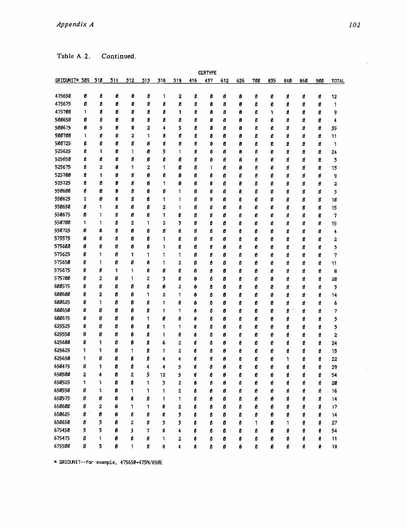
Appendix A 102
Table A.2. Continued.
CERTVPEGRIDIJ~IT* 309 310 311 312 313 318 319 416 437 612 626 700 835 840 860 900 TOTAL
475650 0 0 0 0 0 1 2 0 0 0 0 0 0 0 0 0 12
475675 0 0 0 0 0 0 0 0 0 0 0 0 0 0 0 0 1
475700 1 0 0 0 0 0 1 0 0 0 0 0 1 0 0 0 9
500650 0 0 0 0 0 0 0 0 0 0 0 0 0 0 0 0 4
500675 0 5 0 0 2 4 5 0 0 0 0 0 0 0 0 0 35500700 1 0 0 2 1 0 0 0 0 0 0 0 0 0 0 0 11
500725 0 0 0 0 0 0 0 0 0 0 0 0 0 0 0 0 1
525625 0 1 0 1 0 5 1 0 0 0 0 0 0 0 0 0 24
525650 0 0 0 0 0 0 0 0 0 0 0 0 0 0 0 0 3
525675 0 2 0 1 2 1 0 0 1 0 0 0 0 0 0 0 13
525700 0 1 0 0 0 0 0 0 0 0 0 0 0 0 0 0 9
525725 0 0 0 0 0 1 0 0 0 0 0 0 0 0 0 0 2
550600 0 0 0 0 0 0 1 0 0 0 0 0 0 0 0 0 3550625 2 0 0 0 0 1 1 0 0 0 0 0 0 0 0 0 10
550630 0 1 0 0 0 2 1 0 0 0 0 0 0 0 0 0 15550675 0 1 0 0 0 1 0 0 0 0 0 0 0 0 0 0 7550700 1 1 0 2 1 2 3 0 0 0 0 0 0 0 0 0 15550725 0 0 0 0 0 0 0 0 0 0 0 0 0 0 0 0 4
575575 0 0 0 0 0 1 0 0 0 0 0 0 0 0 0 0 2
575600 0 0 0 0 0 1 0 0 0 0 0 0 0 0 0 0 3
575625 0 1 0 1 1 1 1 0 0 0 0 0 0 0 0 0 7
575650 0 1 0 0 0 1 2 0 0 0 0 0 0 0 0 0 11
575675 0 0 1 1 0 0 0 0 0 0 0 0 0 0 0 0 8
575700 0 2 0 1 2 3 0 0 0 0 0 0 0 0 0 0 20600575 0 0 0 0 0 0 2 0 0 0 0 0 0 0 0 0 3600600 0 2 0 0 1 2 1 0 0 0 0 0 0 0 0 0 14
600625 0 1 0 0 0 1 0 0 0 0 0 0 0 0 0 0 6600650 0 0 0 0 0 1 1 0 0 0 0 0 0 0 0 0 7
600675 0 0 0 0 1 0 0 0 0 0 0 0 0 0 0 0 3
625525 0 0 0 0 0 1 1 0 0 0 0 0 0 0 0 0 3
625550 0 0 0 0 0 1 0 0 0 0 0 0 0 0 0 0 2
625600 0 1 0 0 0 6 2 0 0 0 0 0 0 0 0 0 24
625625 1 1 0 1 0 1 2 0 0 0 0 0 0 0 0 0 15625650 1 0 0 0 0 4 4 0 0 0 0 0 0 1 0 0 22
650475 0 1 0 0 4 4 5 0 0 0 0 0 0 0 0 0 29
650500 2 4 0 2 5 12 5 0 0 0 0 0 0 0 0 0 54650525 1 1 0 0 1 3 2 0 0 0 0 0 0 0 0 0 20650550 0 1 0 1 1 1 2 0 0 0 0 0 0 0 0 0 16
650575 0 0 0 0 0 1 1 0 0 0 0 0 0 0 0 0 14
650600 0 2 0 1 1 0 2 0 0 0 0 0 0 0 0 0 17
650625 0 0 0 0 0 0 3 0 0 0 0 0 0 0 0 0 14
650650 0 3 0 2 0 3 3 0 0 0 0 1 0 1 0 0 27
675450 3 3 0 3 7 8 4 0 0 0 0 0 0 0 0 0 54675475 0 1 0 0 0 1 2 0 0 0 0 0 0 0 0 0 11
675500 0 3 0 1 0 8 4 0 0 0 0 0 0 0 0 0 18
* GRIDLI’41T——for example, 475650=475N/650E

Appendix A 103
Table A.2. Continued.
GRID1I~IT~ 309 310 311CERTYPE
312 313 318 319 416 437 612 626 700 835 840 860 900 TOTAL
675525675550675575675600675625700375700400700425700450700475700550700575700600700625725425725450725475725500725525725550725575725600725625750400750425750450750475750500750525750550750575750600750625775425775450775475775500775525775550775575800450800475800500800525
0 1 0 0 1 1 3 0 0 00 0 0 1 0 3 2 0 0 00 0 0 1 2 2 5 0 0 00 0 0 0 0 0 0 0 0 01 2 0 1 1 4 0 0 0 00 0 0 0 0 0 0 0 0 00 1 0 0 0 0 0 0 0 01 0 0 0 0 1 1 0 0 02 7 0 7 0 3 8 0 0 02 0 0 0 0 1 2 0 0 00 1 0 0 0 0 2 0 0 00 2 0 1 1 3 1 0 0 01 0 0 0 1 1 1 0 0 00 0 0 2 0 2 2 0 0 00 0 0 0 0 2 0 0 0 00 1 0 2 2 2 7 0 0 01 1 0 3 2 1 1 0 0 00 0 0 0 0 0 0 0 0 00 0 0 0 0 1 0 1 0 00 0 0 0 0 1 0 0 0 00 0 0 0 0 0 1 0 0 00 0 0 1 1 1 3 0 0 00 2 0 1 1 4 2 0 0 00 0 0 0 0 0 1 0 0 00 0 0 1 0 0 0 0 0 00 0 0 0 0 2 1 0 0 00 0 0 0 0 0 0 0 0 00 0 0 0 0 2 0 0 0 00 1 0 1 0 2 1 0 0 00 1 0 0 0 0 0 0 0 00 0 0 0 0 0 0 0 0 00 0 0 0 0 1 0 0 0 01 0 0 0 0 1 0 0 0 00 1 0 0 0 2 0 0 0 00 0 0 0 3 0 2 0 0 00 0 0 0 1 3 1 0 0 10 0 0 1 0 4 1 0 0 01 1 0 0 0 9 2 0 0 01 0 0 1 5 5 3 0 0 00 1 0 0 0 4 2 0 0 00 0 0 0 0 3 0 0 0 01 0 0 0 0 0 1 0 0 00 0 0 0 0 1 0 0 0 00 0 0 0 0 1 0 0 0 0
0 0 0 0 0 0 110 0 0 0 0 0 171 0 0 0 0 0 250 0 0 0 0 0 90 0 0 0 0 0 210 0 0 0 0 0 10 0 0 0 0 0 30 0 0 0 0 0 60 0 0 0 0 0 480 0 0 0 0 0 130 0 0 0 0 0 50 0 0 0 0 0 260 0 0 0 0 0 70 0 0 0 0 0 210 0 0 0 0 0 70 0 0 0 0 0 230 0 0 0 0 0 160 0 0 0 0 0 30 0 0 0 0 0 40 0 0 0 0 0 40 0 0 0 0 0 60 0 0 0 0 0 120 0 0 0 0 0 270 0 0 0 0 0 60 0 0 0 0 0 20 0 0 0 0 0 130 0 0 0 0 0 20 0 0 0 0 1 70 0 0 0 0 1 80 0 0 0 0 0 120 0 0 0 0 0 40 0 0 0 0 0 60 0 0 0 0 0 100 0 0 0 0 0 140 0 0 0 0 0 310 0 0 0 0 0 190 0 0 0 0 0 140 0 0 0 0 0 230 0 0 1 1 0 440 0 0 2 0 0 210 0 0 0 0 0 80 0 0 0 0 0 50 0 0 0 0 1 110 0 0 0 0 0 1
3 1179TOTAL 25 63 1 44 51 156 120 1 1 1 1 1 1 5
* GRIDUNIT-—for example. 475650=475N/650E
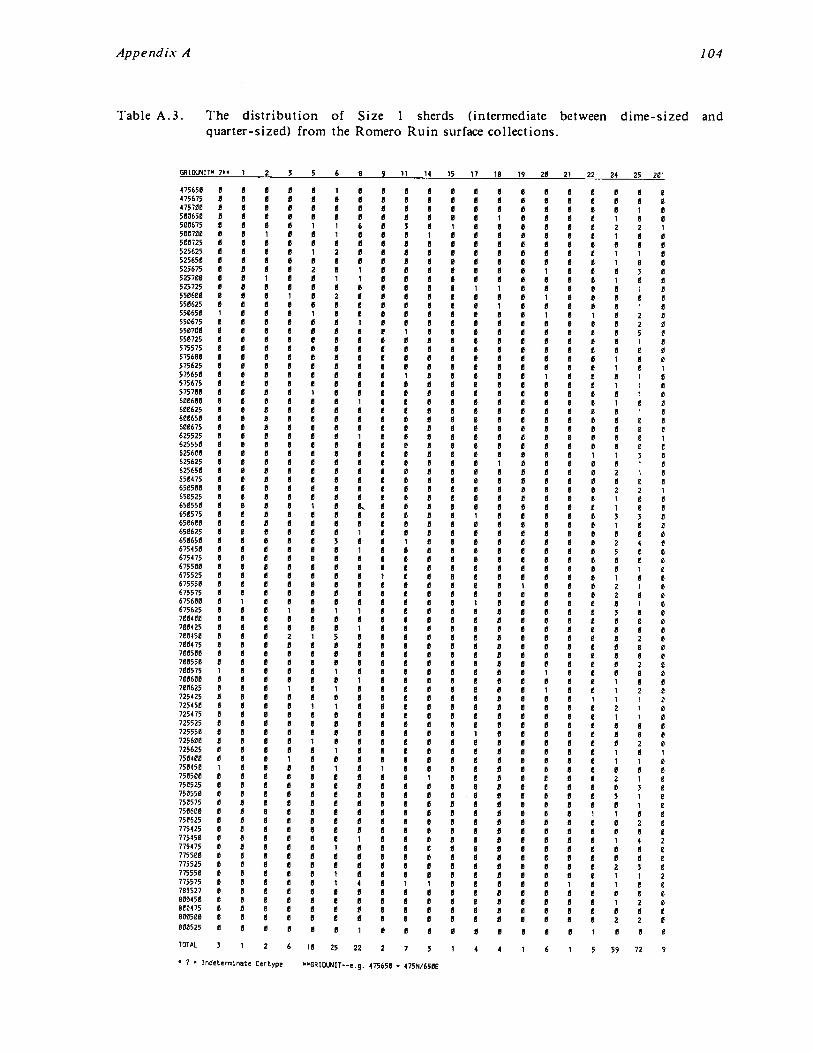
I..
aa
aa
aa
aa
sa
aa
as
aa
aa
—5
55
55
55
aa
a—
as
aa
aa
aa
aa
aa
aa
aa
aa
a5
55
5_
ass
aa
SS
S5
55
55
55
5—
s5
55
aa
aa
aa
aa
aa
0-.
asa
sssssa
asa
aa
aa
sssssa
sa
aa
sa
aa
aa
asa
aa
.ssssa
ssa
aa
aa
sa
aa
aa
aa
ssa
assa
sa
ssa
assa
aa
asssa
aa
aa
asssssssa
aa
sa
aa
sa
ssa
aa
asa
asa
aa
sa
aa
assa
ssa
sa
asa
sa
aa
sa
aa
ssa
aa
asa
sa
sssa
sssssa
.a
asa
.sssa
a
~a
sa
ssa
sa
ssa
ssa
sa
ss
aS
asa
sa
ssa
ss
ab~
55
ssa
SS
ssS
SS
Sa
aa
SS
aS
as
as
aS
SS
sS
sS
aS
SS
aa
sa
aS
aS
Sa
SS
a
-I-.
-I-Ic
oa
asa
ssa
sa
sssssa
aa
aa
asa
—sss—
sssssss—
ssa
ssa
aa
ssssa
s—
ssa
sssssssss~
sssssa
sa
—sssa
,.js
...sa
.ssa
s0
~ I l~fl
Q.
—a
ssssa
sssa
sssa
asssssssssssssssssa
sssa
ssssa
sssa
asa
assa
sa
sa
aa
aa
assa
sa
aa
assssssssss~
5sss
0-I -I
aa
ssa
ssa
aa
aa
assa
sa
aa
sss—
sssssssssa
asss-ssa
ssa
aa
a--a
aa
asa
aa
aa
sa
ssa
ssa
asa
ssa
a.-a
assssa
sa
sa
aa
asa
sa
assssssa
ssa
aa
sa
aa
aa
aa
sssa
aa
aa
aa
sssS
sssssa
aa
sa
aa
—a
ssssa
sssssa
ssa
ss—
s-~
sssssa
a—
ass
01
00
-.a
aa
asa
asa
sssa
aa
aa
sa
sa
sa
aa
aa
assa
sa
ssa
ass—
sa
ssssssa
aa
aa
assssssa
sssa
sssssssa
assa
sssa
ssss
grz.
~
0’
assa
sssssa
ssa
ssa
sa
sssa
sssa
s—
s-ssssa
ssa
ssssa
ssa
assa
ssa
ssa
sa
sa
sss-sa
asa
s—
s—
sa
--sa
sa
aa
sss
C’,
—a
ssa
a—
sa
ssa
ssa
ssa
sa
aa
sssa
sssssssa
sa
sa
ssssa
aa
ssa
sa
sa
aa
sa
asa
asssa
ssssssa
aa
sa
sssa
sa
asa
ss
0
——
Sa
ssa
aa
as
a—
asa
asa
sn
a—
aa
aa
aa
ssa
sa
sss
Ct
—C
l 0.
al.a
a1
05
-S~
55
asl.a
5~
~sII
~5
~a
l.J
5S
~~
~IM
SS
l.a5
5l.a
55ss-s-a
fla
ass,.
55
ls3
5-I-
sA
t~a
aa
~s—
——
aa
s—
v,l.a
h,-
-s—
ss,.
s—
aa
,.aS
—5
5
ass
aa
l.aa
aa
I.,a
aa
sa
ss,
aa
—a
sa
as
aa
aa
t,a
asa
ss
aa
ss
aa
sa
aa
ass
sS
flS
fl~
sS
aa
ss—
aa
aa
aa
asa
ss
ass
a—
as
aa
N Cl 0.
0.
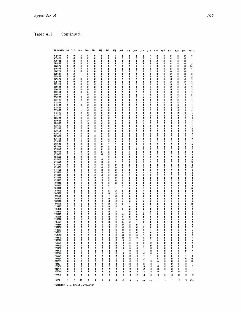
I; -~~
_
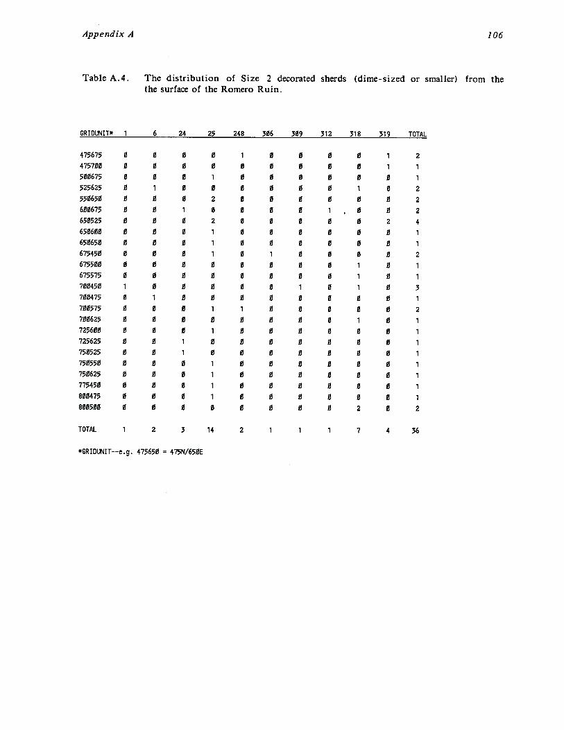
Appendix A 106
Table A.4. The distribution of Size 2 decorated sherds (dime-sized or smaller) from thethe surface of the Romero Ruin.
GRIOUNIT* 1 6 24 25 248 306 309 312 318 319 TOTAL
475675 0 0 0 0 1 0 0 0 0 1 2
475700 0 0 0 0 0 0 0 0 0 1 1
500675 0 0 0 1 0 0 0 0 0 0 1
525625 0 1 0 0 0 0 0 0 1 0 2
550658 0 0 0 2 0 0 0 0 0 0 2
600675 0 0 1 0 0 0 0 1~ 0 0 2
650525 0 0 0 2 0 0 0 0 0 2 4
650600 0 0 0 1 0 0 8 0 0 0 1
650650 0 0 0 1 0 0 0 0 0 0 1
675450 8 0 0 1 0 1 0 0 0 0 2
675500 0 0 0 0 0 8 0 0 1 0 1
675575 0 0 0 0 0 0 0 0 1 0 1
700450 1 0 0 0 0 0 1 0 1 0 3708475 0 1 0 0 0 0 0 0 0 0 1
700575 0 0 0 1 1 0 0 0 0 0 2
700625 0 0 0 0 0 0 0 0 1 0 1
725600 0 0 0 1 0 0 0 0 0 0 1
725625 0 0 1 0 0 0 0 0 0 0 1
750525 0 0 1 0 0 0 0 0 0 0 1
750550 0 0 0 1 0 0 0 0 0 0 1
750625 0 0 0 1 0 0 0 0 0 0 1
775450 0 0 0 1 0 0 0 0 0 0 1
800475 0 0 0 1 0 0 0 0 0 0 1
800500 0 0 0 0 0 0 0 0 2 0 2
TOTAL 1 2 3 14 2 1 1 1 7 4 36
*GRIDLJ%41T__e.g. 475650 = 475N/650E

Tab
leA
.5.
The
dis
trib
utio
no
fde
cora
ted
and
diag
nost
icpl
ainw
are
ccra
mic
type
sat
site
sw
ith
inth
eC
atal
ina
Sta
teP
ark
surv
eyar
ea.
All
sher
dsar
equ
arte
rsi
7ed
orla
rger
.Se
eT
able
A.1
for
list
of
Cer
type
s.
ASNS
ITE
?~3
68
911
BB~9
~45
BBg9
g48
8809
049
B809
060
BB09
061
8809
062
8809
098
8809
191
8809
193
B809
195
8809
196
8809
199
BB09
200
8809
201
BB09
202
B809
203
8809
204
8809
206
B809
207
8B09
208
8809
209
8809
210
BB09
211
BB09
212
8809
213
8809
215
8B09
216
8B09
218
BB09
I~L.J
1415
1718
2021
2223
2425
201
218
TOTA
L3
18
811
2626
3721
1236
72
214
226
3716
1
01
10
01
31
00
00
00
01
00
00
02
04
25
20
01
10
10
10
10
00
00
00
01
02
10
00
00
00
00
20
13
615
73
01
21
10
50
128
70
o0
o0
00
0o
oo
oo
oo
oo
oo
oo
oe
oo
o1
1o
oo
oo
oo
o0
02
00
00
00
00
00
00
00
00
0
00
00
00
00
00
o1
00
oo
eo
eo
00
00
12
00
00
00
00
10
12
00
0o
oe
e0
00
00
30
00
01
01
00
oo
oo
oo
oo
o1
o1
oo
01
oe
0o
00
00
00
02
11
11
00
00
22
00
00
00
00
10
12
20
01
00
10
00
00
00
00
01
20
00
00
00
01
00
10
10
01
01
20
01
00
00
01
10
00
00
00
02
00
00
00
30
20
00
oo
oo
o0
01
oo
01
oo
oo
oo
o0
00
00
00
00
00
00
01
00
01
00
00
00
00
00
00
00
00
00
00
oo
oo
o0
1o
øo
oo
oo
o0
o0
10
o0
00
11
01
22
66
00
00
13
01
00
00
21
38
10
ii2
00
00
48
50
oa
aa
øø
ao
aa
ao
oo
øø
10
0
00
22
11
56
62
41
01
00
26
00
00
01
00
62
30
30
00
30
00
00
00
00
00
00
00
00
00
00
00
00
00
10
00
00
00
10
00
00
00
00
00
00
00
01
00
00
00
00
00
00
00
00
00
00
00
10
00
00
03
00
*7
Inde
term
inat
ece
ram
icty
pe
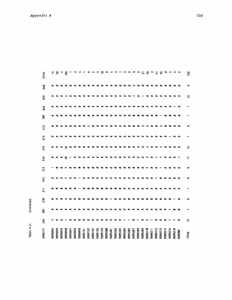
Tab
leA
.5.
Con
tinue
d.
ASM
SITE
248
307
310
311
312
313
318
319
419
612
705
825
835
840
TOTA
L
8809
045
3
8B09
048
0
8809
049
0
8809
060
1
8809
061
0
8809
062
0
8809
098
0
8809
191
0
8809
193
0
8B09
195
0
8809
196
0
8809
199
0
8809
200
0
8809
201
0
8809
202
0
8809
203
0
8809
204
1
8809
206
1
8809
207
8809
208
1
8809
209
0
8809
210
2
8809
211
1
8809
212
0
8809
213
0
BB09
215
0
8809
216
1
8809
218
1
8809
N4
0
00
00
10
00
00
00
00
00
00
00
00
00
00
00
00
00
0
04
03
310
100
00
0
00
00
01
00
00
0
00
00
00
00
00
0
00
11
00
00
00
0
00
00
00
00
00
0
00
00
00
00
10
0
00
00
00
00
00
0
00
00
00
00
00
0
00
00
00
00
00
0
00
00
00
00
00
0
01
00
00
00
00
0
00
00
00
00
00
0
00
00
00
00
00
0
O0
00
00
00
00
0
00
00
00
00
00
0
00
00
00
00
00
0
00
00
00
00
00
0
00
00
00
00
20
0
00
00
33
20
30
0
00
00
00
00
00
0
O0
01
01
00
00
0
00
00
11
20
21
0
00
00
00
00
00
0
10
00
00
01
00
0
01
00
00
00
00
1
00
00
01
00
00
0
00
14
00
20
00
4
40
109
00
1
00
2
00
4
00
1
00
8
00
5
00
3
00
10
00
8
00
5
00
9
00
7
00
3
00
3
72
9
00
3
10
27
00
58
00
2
00
41
00
35
00
0
00
5
O0
4
00
5
TOTA
L12
16
15
817
1412
239
5
c~z
APPENDIX B
CHIPPED STONE: CODING KEY AND DATA
Table B. 1. Chipped stone analysis codes.
Lisa G. Eppley
LTHCLASS1 = Debitage (Use LTHTVPE 10 — 13. 99)2 = Retouched Pieces (Use LTHTYPE 20 — 26, 99)3 = Cores/Core Tools (Use LTHTVPE 30 — 34, 99)99 = Unsorted Chipped Stone (Use LTHTYPE 99)
LTHTVPE10 = Complete Flake11 = Broken Flake12 = Flake Fragment13 = Shatter
20 = Informal Tool21 = Scraper22 = Biface23 = Projectile Point24 = Plano Scraper25 = Chopper26 = Miscellaneous Formal Tool
(Specify in Comments)
30 = Core31 = Exhausted Core32 = Core Hamerstone33 = Core Tool34 = Cobble Hammerstone
99 = Unsorted
MATERIAL1 = Basalt2 = Vesicular Basalt/rhyolite3 = Rhyolite/Andesite4 = Granite5 = Schist/Gneiss6 = Welded Tuff7 = Miscellaneous Sedimentary8 Quartzite9 = Quartz10 = Chert (unspecified)11 = Chert (from quarry AZ AA:16:187)12 = Indurated/Silicified Limestone13 = Limestone14 = Miscellaneous Igneous15 = Chalcedony16 = Jasper17 = Obsidian18 = Tabular Knife Material (unspecified)19 = Unknown or Other99 = Unsorted
CORTEX0 = Not Coded1 = Absent2 = Present
PCTCORT0 = Not Coded1 = 0 — 25%2 = 25 — 50%3 = 50 — 75%4 = 75 — 100%
RETOUCH0 = Not Coded1 = Unifacial2 = Bifacial
PRJPOINT0 = Not Coded1 = Paleo2 = Archaic (unspecified)3 = Early Archaic4 = Middle Archaic5 = Late Archaic6 = Archaic/Hohokom7 = Hohokom (unspecified)8 = Pioneer Period9 = Colonial Period10 = Sedentary Period11 = Classic Period12 = Unknown13 = Nondiagnostic
Appendix B 110
Table B.2. The distribution of chipped stone by type from the Romero Ruin surfacecollections.
LTHTVPEGRIDUNIT* 20 21 22 23 24 26 30 31 32 33 34 99 TOTAL
475650 0 0 1 0 0 0 0 0 1 0 0 20 22475675 2 2 0 0 0 0 0 0 1 0 0 25 30475700 0 0 0 0 0 0 1 0 0 0 0 5 6475725 0 0 0 0 0 0 0 0 0 1 0 2 3500650 2 3 1 0 0 1 0 0 0 0 0 21 28500675 2 0 0 0 0 0 1 0 0 0 0 69 72500700 0 0 0 0 0 0 0 0 0 0 0 41 41500725 0 0 0 0 0 0 0 0 0 0 0 6 6525625 2 1 0 0 0 0 0 0 0 1 0 51 55525650 1 0 0 0 0 0 0 0 1 0 0 17 19525675 0 1 0 0 0 0 0 0 0 0 0 21 22525700 1 1 1 0 0 0 0 0 0 0 0 34 37525725 3 0 0 0 0 0 0 0 0 0 0 15 18550600 2 2 0 0 0 2 0 0 1 1 0 75 83550625 1 1 0 0 0 0 0 0 1 0 0 58 61550650 1 2 0 0 0 0 0 0 0 0 0 26 29550675 1 2 0 0 0 0 0 0 0 0 0 23 26550700 0 0 0 0 0 0 0 0 0 0 0 38 38550725 2 2 0 0 0 0 0 0 0 0 0 31 35575575 2 0 0 0 0 0 0 0 0 0 0 20 22575600 1 1 0 0 0 0 0 0 1 0 0 29 32575625 2 2 0 0 0 0 0 0 0 0 0 44 48575650 3 0 0 0 0 0 0 0 0 0 0 29 32575675 1 0 0 0 0 0 0 0 0 0 0 26 27575700 1 0 0 0 0 1 0 0 0 0 1 47 50600550 0 0 0 0 0 0 1 0 0 0 0 11 12600575 0 0 0 0 0 0 0 0 0 0 0 26 26600600 3 1 0 0 0 0 0 0 3 0 0 31 38600625 1 1 0 0 0 2 0 0 0 0 0 56 60600650 1 2 0 0 0 0 0 0 1 1 0 26 31600675 4 0 0 0 0 0 0 1 3 0 0 36 44625500 0 0 0 0 0 0 0 0 0 0 0 2 2625525 0 1 0 0 0 1 0 0 0 0 0 33 35625550 0 0 1 0 0 0 0 0 0 0 0 41 42625575 1 0 0 0 0 0 0 0 0 0 0 15 16625600 6 1 2 0 0 0 0 0 3 0 0 165 177625625 0 1 0 1 0 1 0 0 1 0 0 32 36625650 2 2 0 0 0 0 0 0 1 0 0 136 141650475 4 0 0 0 0 0 0 0 1 0 1 58 64650500 6 4 0 0 0 0 1 0 2 0 0 88 101650525 3 1 1 0 0 0 0 0 3 0 0 85 93650550 2 1 0 0 0 0 0 0 0 0 0 19 22650575 3 1 1 0 1 0 0 0 0 0 0 35 41650600 1 2 0 0 0 0 0 0 1 1 0 86 91650625 0 0 0 0 0 0 0 0 0 0 0 8 8650650 6 1 0 0 1 1 0 0 0 0 0 50 59675450 2 1 4 0 0 0 1 1 0 1 0 99 109675475 2 0 0 0 0 0 0 0 0 0 0 30 32675500 3 1 0 0 0 0 0 0 0 0 0 40 44675525 1 2 0 0 0 0 0 0 0 0 0 42 45675550 0 0 0 0 0 0 0 0 1 0 0 3 4675575 2 1 0 0 0 2 0 0 1 0 0 61 67675600 1 0 0 0 0 0 0 0 2 0 0 26 29675625 1 1 0 0 0 0 0 0 0 0 0 46 48700375 1 1 0 0 0 2 0 0 0 0 0 9 13700400 6 1 0 0 0 2 0 0 0 0 0 81 90700425 2 4 0 0 0 1 2 0 1 0 1 26 37700450 3 4 0 0 0 1 0 0 0 0 0 116 124
*GRIDLR~IT——e.g. 475650 475N/650E
Appendix B
Table B.2. Continued.
LTHTVPEGRID11~IT* 20 21 22 23 24 26 30 31 32 33 34 99 TOTAL
700475 0 0 0 0 0 0 0 0 0 0 0 7 7700500 1 0 0 0 0 0 0 0 0 0 0 8 9700525 0 0 0 0 0 0 0 0 0 0 0 3 3700550 1 0 0 0 0 0 2 0 0 0 0 10 13700575 4 0 1 1 0 0 0 0 1 0 0 67 74700600 0 1 0 0 0 0 0 1 0 0 0 27 29700625 5 2 2 0 0 0 0 0 1 0 0 58 68725375 0 0 0 0 0 0 0 0 0 0 0 23 23725400 1 0 0 0 0 0 0 0 0 0 0 12 13725425 2 0 0 0 0 1 0 0 0 0 0 70 73725450 1 2 0 0 1 1 1 0 0 1 0 62 69725475 0 0 0 0 0 0 0 0 0 0 0 22 22725500 2 0 0 0 0 0 0 0 0 0 0 6 8725525 1 0 0 0 0 0 0 0 1 1 0 10 13725550 0 0 0 0 0 0 0 0 0 0 0 9 9725575 1 1 0 0 2 0 0 0 0 0 0 10 14725600 1 1 0 0 0 0 0 0 0 0 0 14 16725625 4 1 0 1 0 0 1 0 0 0 0 53 60750400 1 1 0 0 0 0 0 0 0 0 0 32 34750425 1 0 0 0 0 0 0 0 0 0 0 56 57750450 0 0 0 0 0 0 0 0 0 0 0 47 47750475 0 0 0 0 0 0 0 1 0 0 0 8 9750500 1 1 0 0 0 0 0 0 0 0 0 17 19750525 2 0 0 0 0 0 0 0 0 0 0 27 29750550 1 0 0 0 0 0 0 0 1 0 0 32 34750575 0 0 0 0 0 0 0 0 0 0 0 8 8750600 0 0 0 0 0 0 0 0 1 0 0 15 16750625 1 0 1 0 0 1 1 0 1 0 0 44 49775425 1 2 0 0 0 0 0 0 2 0 0 110 115775450 1 1 0 0 0 1 0 0 1 0 0 87 91775475 2 0 0 0 0 1 0 0 1 0 0 32 36775500 1 0 0 0 0 0 0 0 0 0 0 17 18775525 1 1 1 0 1 1 0 0 0 0 0 16 21775550 2 0 2 0 0 1 0 0 2 1 0 35 43775575 4 2 0 0 1 0 0 0 0 1 0 35 43800450 3 0 0 0 0 0 0 0 0 0 0 64 67800475 1 0 0 0 0 0 0 0 0 1 0 17 19800500 1 0 0 0 0 0 0 1 0 0 0 14 16800525 0 0 0 0 0 0 0 0 0 0 0 20 20
TOTAL 145 71 19 3 7 24 12 5 42 11 3 3595 3937
*GRIDtj.~IT——eg 475650 = 475N/650E
APPENDIX C
GROUND STONE:CODING KEY AND DATA
Lisa G. Eppley
Table C. 1. Ground stone coding key for the Catalina State Park survey..
GNDCLASS1 =Manos2 = Metates3 = Mortar/Pestle4 = Tabular Knife/Tabular Knife Material5 = Polishing Stone/Polished Stone6 Donut Stone/Nutting Stone/Stone Bowl7 = Rarefind8 = Material Sample9 = Indeterminate Ground Stone99 = Unsorted Ground Stone
GNDTVPE10 = Shaped Rocker Handstone11 = Unshaped Rocker Handstone12 = Shaped Flat—faced Mano13 = Unshaped Flat—faced Mano14 = Rectangular Trough/Basin Mano15 = Indeterminate or Other Mano
20 = Slab Metate21 = Basin Metate22 = Trough Metate23 = Indeterminate Slab24 = Indeterminate Metate
30 = Mortar31 = Pestle
CONDITN0 = Not appropriate1 = Less than 1/22 = More than 1/2. but not whole3 = Complete4 = Indeterminate
40 = Tabular Knife41 = Tabular Knife Material
50 = Polishing Stone51 = Polished Stone52 = Indeterminate
60 = Donut Stone61 = Nutting Stone62 = Stone Bowl63 = Indeterminate
70 = Palette71 = Axe72 = Medicine Stone73 = Stone Jewelry74 = Other/Unknown
80 = Indeterminate
99 = Unsorted
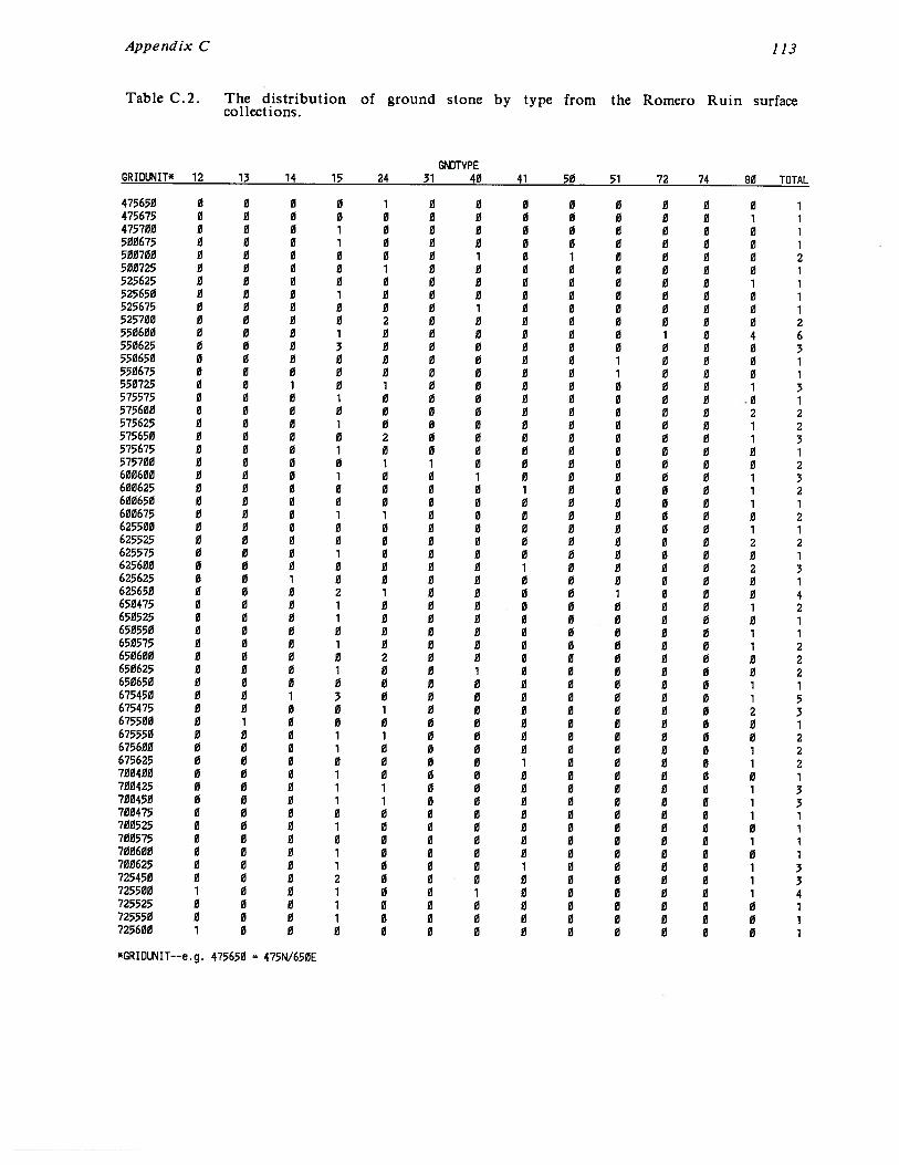
Appendix C 113
Table C.2. The distribution of ground stone by type from the Romero Ruin surfacecollections.
~DWPEGRIDLx~IT* 12 13 14 15 24 31 40 41 50 51 72 74 80 TOTAL
475650 0 0 0 0 1 0 0 0 0 0 0 0 0 1473675 0 0 0 0 0 0 0 0 0 0 0 0 1 1475700 0 0 0 1 0 0 0 0 0 0 0 0 0 1500675 0 0 0 1 0 0 0 0 0 0 0 0 0 1500700 0 0 0 0 0 0 1 0 1 0 0 0 0 2500725 0 0 0 0 1 0 0 0 0 0 0 0 0 1525625 0 0 0 0 0 0 0 0 0 0 0 0 1 1525650 0 0 0 1 0 0 0 0 0 0 0 0 0 1525675 0 0 0 0 0 0 1 0 0 0 0 0 0 1525700 0 0 0 0 2 0 0 0 0 0 0 0 0 2550600 0 0 0 1 0 0 0 0 0 0 1 0 4 6550625 0 0 0 3 0 0 0 0 0 0 0 0 0 3550650 0 0 0 0 0 0 0 0 0 1 0 0 0 1550675 0 0 0 0 0 0 0 0 0 1 0 0 0 1550725 0 0 1 0 1 0 0 0 0 0 0 0 1 3575575 0 0 0 1 0 0 0 0 0 0 0 0 0 1575600 0 0 0 0 0 0 0 0 0 0 0 0 2 2575625 0 0 0 1 0 0 0 0 0 0 0 0 1 2575650 0 0 0 0 2 0 0 0 0 0 0 0 1 3575675 0 0 0 1 0 0 0 0 0 0 0 0 0 1575700 0 0 0 0 1 1 0 0 0 0 0 0 0 2600600 0 0 0 1 0 0 1 0 0 0 0 0 1 3600625 0 0 0 0 0 0 0 1 0 0 0 0 1 2600650 0 0 0 0 0 0 0 0 0 0 0 0 1 1600675 0 0 0 1 1 0 0 0 0 0 0 0 0 2625500 0 0 0 0 0 0 0 0 0 0 0 0 1 1625525 0 0 0 0 0 0 0 0 0 0 0 0 2 2623575 0 0 0 1 0 0 0 0 0 0 0 0 0 1625600 0 0 0 0 0 0 0 1 0 0 0 0 2 3625625 0 0 1 0 0 0 0 0 0 0 0 0 0 1625650 0 0 0 2 1 0 0 0 0 1 0 0 0 4650475 0 0 0 1 0 0 0 0 0 0 0 0 1 2650525 0 0 0 1 0 0 0 0 0 0 0 0 0 1650550 0 0 0 0 0 0 0 0 0 0 0 0 1 1650575 0 0 0 1 0 0 0 0 0 0 0 0 1 2650600 0 0 0 0 2 0 0 0 0 0 0 0 0 2650625 0 0 0 1 0 0 1 0 0 0 0 0 0 2650650 0 0 0 0 0 0 0 0 0 0 0 0 1 1675450 0 0 1 3 0 0 0 0 0 0 0 0 1 5675475 0 0 0 0 1 0 0 0 0 0 0 0 2 3675500 0 1 0 0 0 0 0 0 0 0 0 0 0 1675550 0 0 0 1 1 0 0 0 0 0 0 0 0 2675600 0 0 0 1 0 0 0 0 0 0 0 0 1 2675625 0 0 0 0 0 0 0 1 0 0 0 0 1 2700400 0 0 0 1 0 0 0 0 0 0 0 0 0 1700425 0 0 0 1 1 0 0 0 0 0 0 0 1 3700450 0 0 0 1 1 0 0 0 0 0 0 0 1 3700475 0 0 0 0 0 0 0 0 0 0 0 0 1 1700525 0 0 0 1 0 0 0 0 0 0 0 0 0 1700575 0 0 0 0 0 0 0 0 0 0 0 0 1 1700600 0 0 0 1 0 0 0 0 0 0 0 0 0 1700625 0 0 0 1 0 0 0 1 0 0 0 0 1 3725450 0 0 0 2 0 0 0 0 0 0 0 0 1 3725500 1 0 0 1 0 0 1 0 0 0 0 0 1 4725525 0 0 0 1 0 0 0 0 0 0 0 0 0 1725550 0 0 0 1 0 0 0 0 0 0 0 0 0 1725600 1 0 0 0 0 0 0 0 0 0 0 0 0 1
*GRIDIR.IIT__e.g. 475650 = 475N/650E
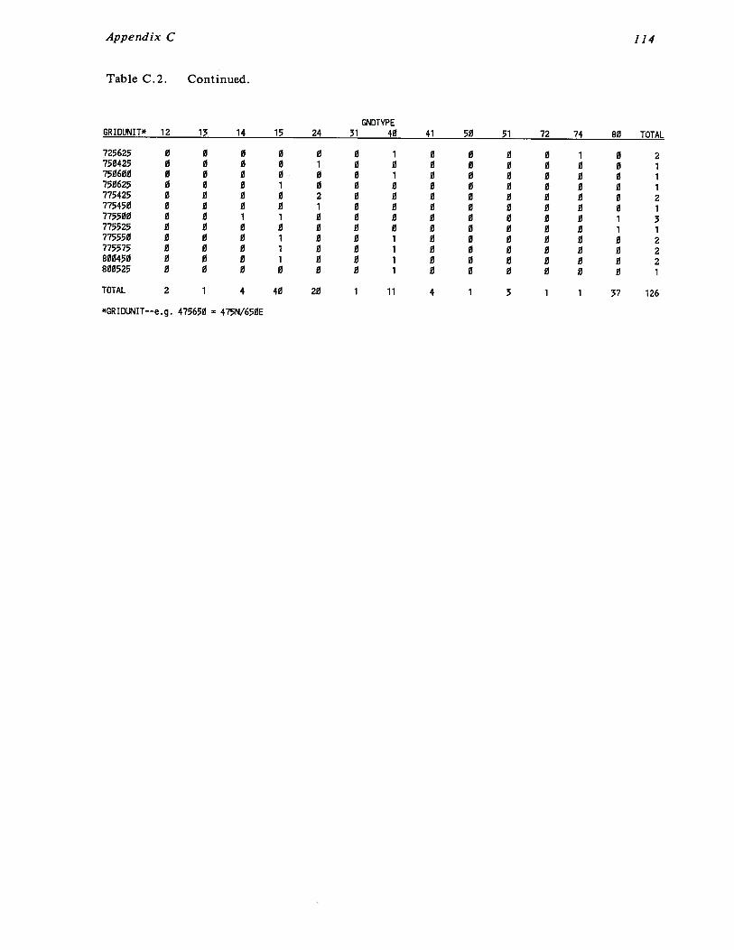
Appendix C 114
Table C.2. Continued.
GNDTVPEGRIDIR.IIT* 12 13 14 15 24 31 40 41 50 51 72 74 80 TOTAL
725625 0 0 0 0 0 0 1 0 0 0 0 1 0 2750425 0 0 0 0 1 0 0 0 0 0 0 0 0 1750600 0 0 0 0 0 0 1 0 0 0 0 0 0 1750625 0 0 0 1 0 0 0 0 0 0 0 0 0 1775425 0 0 0 0 2 0 0 0 0 0 0 0 0 2775450 0 0 0 0 1 0 0 0 0 0 0 0 0 1775500 0 0 1 1 0 0 0 0 0 0 0 0 1 3775525 0 0 0 0 0 0 0 0 0 0 0 0 1 1775550 0 0 0 1 0 0 1 0 0 0 0 0 0 2775575 0 0 0 1 0 0 1 0 0 0 0 0 0 2800450 0 0 0 1 0 0 1 0 0 0 0 0 0 2800525 0 0 0 0 0 0 1 0 0 0 0 0 0 1
TOTAL 2 1 4 40 20 1 11 4 1 3 1 1 37 126
*CRIDLJ’~1IT—-e.g. 475650 = 475N/650E

Feature
APPENDIX D
FEATURE LIST FOR THE ROMERO RUIN
Feature
1 compound wall
2 rock alignment
3 concentration of rock (1.2 meter dia.)
4 concentration of rock (wall?)
5 concentration of rock6 rock alignment
7 trash mound with small amount of rock
8 concentration of rock
9 rock alignmentiO prehistoric room — Page’s room “K” (pothunted —
corners approximate)
11 Prehistoric room — Page’s room “J”? (pothunted — 2
walls evident)
12 rock alignment (room?)
13 prehistoric room — Page’s room “I” (pothunted —
corners approximate)
14 prehistoric room— Page’s building “H”: eastern room
(pothunted — double course masonry with rubble
core)
15 prehistoric room (heavily pothunted — corners
approximate)
16 rock alignment
17 prehistoric room — Page’s room “D” (pothunted)
18 historic room of Page’s building “A” (pothunted)
19 historic room (N) of Page’s building “B”
(pothunted)
20 historic room (S) of Page’s building “B”
(pothunted)
21 historic room — Page’s room “E” (pothunted) note
that Page’s rooms F and G which are part of the
same building, were so badly disturbed that they
could not be mapped
22 historic room — Page’s room “C” (heavily pothunted)
corners approximate
23 large mound — trash and rock fill
24 mound — trash with some rock (heavily pothunted —
center gone)
concentration of rock (1.5 meters dim.)
mound — rock and trash fill
“Plaza” floor
mound — rock and trash fill
concentration of rock (2 meters dia.)
30 concentration of rock (2 meters dia.)
31 concentration of rock (structure? — heavily
pothunted)
32 mound — rock and trash fill
33 mound — rock and trash fill
34 rock alignment
35 concentration of rock ( 4 m M~J—SE x 3 m NE—SN)
36 mound — mostly rock fill (structure — feature 48
located on top of this mound)
37 mound — rock and trash fill
38 large mound — rock and trash fill
39 large mound — rock and trash fill
40 terrace
41 large mound — rock and trash fill
42 rock alignment? (this may be the result of
clearing)
43 large (Snaketown type) ballcourt with rock —
outlined end units — may have rock walls or
rock—core berms
44 checkdam
45 small bailcourt — may have rock walls or rock—coreberms
46 mound — mostly trash
47 prehistoric room — Page’s building “H”: western
room
48 prehistoric structure — on top of mound feature 36
(pothunted)
49 rock alignment (may be partly a modern or historic
reconstruction) mapped in by James Hoimlund
50 small mound — mapped in by Mark Elson
51 mound — mapped in by Mark Elson
52 possible prehistoric cemetery — mapped in by Mark
Elson
53 historic road and/or wagon trail segment
54 historic road and/or wagon trail segment
55 rock alignment — mapped in by James Holmiund
56 prehistoric room (?) poorly defined — possibly
others adjacent to this room — mapped in by James
Holmlund
2526
27
28
29
APPENDIX E
MAPPING OF THE ROMERO RUINAND A DISCUSSION OF THE MAJOR SURFACE FEATURES
James P. Holmiund
All mapping and grid layout at Romero Ruin was accomplished by Geo-Map, Inc., using atotal station. Coordinate information stored in the total station data collector was dumpedto an HP-71b using proprietary software. These files were stored on Hewlitt Packard3-1/4” disks and hard copies produced of each file. Coordinate information was thentransferred to computer graphics drawing files on an IBM AT microcomputer. Sevenpermanent drawing files were created for field mapped information from Romero Ruin.
To assist in the mapping of Romero Ruin, Henry Wallace of the Institute for AmericanResearch assumed the task of rod man - - the most important duty of a mapping project.It is the rod man who defines the ultimate accuracy and detail of a map produced by thismethod. When cost constraints are factored into the mapping process, efficiency is a mustand a balanced tradeoff between detailed coverage and limited time is difficult to achieve.Henry did a commendable job of balancing these two factors.
DATUM AND GRIDDING
The first task of the field mapping operation was to establish a datum. The criteria forlocation of the primary site datum was that it be situated at the highest accessible pointwithin reasonable distance of the site. A small granite gneiss outcrop to the south of thesite was selected.
The datum was located down off the top of the knob to help insure that it would not belocated by casual park users and removed or destroyed. Although most of the northernend of the site can be seen from the datum, the top of the knob provided a much moresuitable mapping location and a mapping station was established there.
After locating and establishing the datum and mapping station, an azimuth was establishedusing a Brunton compass. The azimuth, corrected for the 12.5 degree difference betweenmagnetic north and true north, was determined to a stake set about 100 m distant from thedatum. It is estimated that the error associated with a Brunton measurement is within 3degrees (90%). All position determinations were based on this azimuth determination andthus, in the future, should the need arise, all positions can be rotated about the datumafter a more accurate azimuth determination is made.
The site datum was given an arbitrary position of 500 meters North, 500 meters South and100 meters elevation. The position determined for the mapping station was N501.51,E545.80, 103.20 m elevation. The azimuth from the mapping station to the site datum is268° 06’ 59” and the horizontal distance, 45.82 m.

AppendixE 117
The site grid was established by computing inverses from the instrument location (mappingstation) to each grid mark location and positioning the rod man. The stamped tags wereplaced on the grid marks by Institute personnel prior to their field collecting phase atRomero.
TOPOGRAPHIC MAPPING
Topographic mapping needs were prioritized at the onset of the project. It was decidedthat the terrace top, on which Romero Ruin is located, should receive more consistentcoverage than the steeply sloping flanks that bound the site on three sides.
General topographic mapping of the site was systematically carried out by working alongand between east-west grid lines. Where mounds or other topographic anomalies wereencountered, more points were taken to fully define the feature. Elevation information onindividually mapped rocks protruding more than 10 cm above the ground surface was notused in the production of any topographic contour maps.
Mapping of the steep face and sides of the terrace was accomplished by taking two orthree point measurements in a linear arrangement parallel to the local slope at widelyspaced intervals. Although this produced accurate indications of slope and generalmorphology, some loss of detail was inevitable.
Numerous pothunting holes were noted throughout the site during the initial site inspection.These ranged from shallow, barely perceptible depressions to deep holes surrounded byrock. Many were obviously very old, others more recent, but most presented localtopographic anomalies that disturbed or masked the anomalies created by prehistoricfeatures. Because the recording of disturbance was not a project goal, and becausecontours reflecting the anomalies caused by the pothunting holes might be misinterpreted,these areas were avoided during mapping. Thus, to the greatest degree possible, the mapsreflect the characteristics of the prehistoric features as they were before being disturbed.
Finer scale topographic mapping was desired at the two bailcourts and a plaza-like areathat was identified on the site surface prior to the initiation of this project. Toaccomplish this, areas were selected that included these features, and those areas weresystematically mapped at much smaller intervals than the spacing used for general sitetopography. At the large bailcourt, individual rocks were mapped in the rock alignmentsthat define the end units.
Prior to this mapping project, Wilcox and Sternberg (1983), working on a National ParkService funded research project to collect, analyze and interpret all known balicourtinformation pertinent to the understanding of Hohokam courts, produced a 20 cmtopographic contour map of the small balicourt at Romero Ruin. Although theWilcox-Sternberg map is accurate, integration into the overall site topography map wouldhave been difficult as well as inconsistent. Therefore, both ballcourts were mapped indetail during this project.
A detailed map of the plaza-like area was the lowest priority of the topographic mappingaspect of this project. Consequently, a 20 cm contour map was produced rather than the10 cm maps produced for the bailcourts.

Appendix E 118
No special attention was given to the topographic mapping of the compound as this areahad been extensively disturbed by historic period activities and modern treasure huntingwithin both prehistoric and historic structures. However, there was an attempt todetermine if the Romero ranch structures had been placed on prehistoric mounds bydetermining the elevation of ranch structure floors and comparing this to elevations onundisturbed surfaces nearby.
FEATURE MAPPING
The interpretation and mapping of some of the features (such as mortars and metates andsome structure outlines) was very straight forward. However, many features or possiblefeatures were problematic or ambiguous. A particular problem was presented by the manyambiguous rock alignment features noted throughout the site. The few shown on thepresent map represent a small number of such features.
During the mapping of the two balicourts, it was noted that the berms contained a largequantity of rock that appeared to form walls. The Wilcox - Sternberg map of the smallballcourt does show inferred rock walls within the berms. However, we saw several areasof discontinuity and decided that we would offer this as a potential research questionrather than infer that these were rock walls or rock core berms, rather than simply thenatural result of digging in a rocky substrate.
Another subjective aspect of the feature mapping was the identification of mounds and thedetermination of mound limits. To most efficiently utilize the time and resources of thisproject, two methods were used to map mounds.
The first was to identify and explicitly map the limits of any mound over 50 cm in heightfrom the top of the mound to a point of inflection between the steep slope of the mainmass of the mound and the more gentle slope of the base of the mound. Since the 50 cmcontour map of the site had not yet been produced, the identification of 50 cm highmounds was a subjective field estimate. Limits were also estimated in the field, althoughthey were explicitly shot in. No subjective division of mound types (ie. large/small,trash/rock-filled etc.) was used.
The second method was to return to the site with the topographic contour map in hand,and sketch in all other mounds. This would provide more complete information and allowmore accurate and detailed archaeological interpretation. This mapping was performed bythe author and later field checked with Henry Wallace.
Mounds were separated into two classes for this method: those less than 50 cm in height(minor mounds), and those larger than 50 cm. (major mounds). The majority of largemounds had an abundance of apparently random rock fill as well as moderate to denseamounts of trash. Minor mounds, with few exceptions, seemed to be largely trash withmoderate to small amounts of rock. Generally, two 50 cm contours had to be anomalouslyaffected by a mound before it was classed as a major mound. A major trash mound wouldalso have at least one closed contour within its limits.
There were two exceptions to these criteria. The major mound adjacent to the northeastside of the large ballcourt has no enclosed contours on the 50 cm map. This is probablydue to its close proximity to the large ballcourt and the fact that several large holes havebeen dug into the top of the mound reducing its true height. The second exception is aminor mound found about 40 meters WNW of the west end of the compound. This mound

AppendixE 119
has a closed contour line but was not classed as a major mound because the height hasbeen amplified by nearby erosion.
Locations and limits of the major and minor mounds were mapped using brunton and pacemethods. Accuracy was further enhanced by referral to grid marks in the field and theuse of the topographic map itself.
The mapping of “trash concentrations” was accomplished by Mark Elson of the Institute forAmerican Research during the process of systematic artifact collection. These areas werethen digitized into the file containing general site information. The author enlarged andadded several small trash concentrations to those mapped by Mark Elson, however these areincluded only in Figures 3.12 and E.3.
RESULTS
One site datum and a single mapping station were established at Romero Ruin. The datumcoordinates are:
Datum Northin~ Easting Rel Elev
Primary Datum 500.000 500.000 100.00Mapping Station 501.506 545.795 103.20
The primary datum is located on a small granite gneiss outcrop adjacent and to the southof the site. Specifically, it is located on the western slope of a rocky knob approximately232 meters SSW of the southernmost corner of the compound and about 196 meters WNW ofthe west end of the large balicourt at Romero Ruin. It is a brass cap set in cement thatis set in a chiselled out hole in a natural depression in a relatively flat topped graniterock. The top of this rock is only a few centimeters above ground level. The cap isstamped (from top to bottom) “BB:9:1 ASM, 1987, JAR”. About three meters south of thisrock is a large (2m x 2m x .8m high) rounded granitic boulder.
The mapping station is located on top of the outcrop on which the datum is located.Specifically, the mapping station is an 80 cm long, 1 cm diameter steel rebar driven intothe northeastern berm of the easternmost large mineral exploration hole found on top ofthe knob. It extends about 12 cm above the ground level. The mapping station receivedtags bearing the horizontal coordinates and the relative elevation of the top of the rebar.
The suggested possible error of plus or minus 3 degrees for a Brunton compassdetermination would translate into a potential radial error of about 2.1 meters for themapping station. If a more accurate determination of true north is made in the future, themap and all points produced during the mapping operation can be rotated by the differencein azimuths.
The gridding of the site resulted in the placement of 95 grid marks of 5 cm diameter, 35cm long rebar with stamped aluminum tags. These rebar were generally driven to within 10cm of the ground surface. Vertical coordinates were not determined for the grid marks.
The locations of the grid marks are shown on Figures 3. 1 and 3.2. During the gridding ofthe site one position fell where a mesquite tree was growing. No stake set at this grid
Appendix E 120
location and it is denoted on the maps by a different symbol. The same symbol denotes 33other grid locations determined by the Institute’s field crew during the surface collectionsconducted at the site after mapping was complete. No grid stakes were set at theselocations.
For location in the computer graphics file, the grid marks were assumed to be at theirrespective required position in the grid (for example, N525.003 E600.013 was entered atN525 E600). Gridding inaccuracy based on several repeatability tests and the statedaccuracy of the total station, was between 3.0 and 7.0 cm standard error (90% confidencelimit) for the horizontal coordinates. Several grid marks were intentionally set off of theirtrue position because of subsurface rocks. In all cases they were less than 10.0 cm fromtheir required position.
The topographic mapping (see Figure 3.1) included an area of approximately 77,300 m2resulting in 1128 measurements to define the general topography and 540 more points forthe topographic mapping of the two balicourts and plaza.
The accuracy of the topography points is similar to the gridding accuracy. Verticalinaccuracy should be less than 5 cm for the topography points given the stated accuracy ofthe instrument and the distances involved.
The feature mapping operation resulted in 280 points being measured. A total of 50features, 4 metates, and 3 mortars were mapped by Henry Wallace. Additionally, 47features were mapped by the author, and 3 features and 12 trash concentrations mapped byMark Elson. Note that two maps have been prepared displaying 1) the feature informationobtained by Wallace and Elson along with three rock alignment features mapped by theauthor (Figure 3.2), and 2) the mounds mapped by the author, which includes all moundsnoted by Wallace and Elson (Figure E.1). A listing of feature numbers and featuredescriptions is found in Appendix D. This listing includes all features located by Wallaceand Elson, and the non-mound features located by the author. Feature numbers were notassigned to the mounds mapped by the author.
After combination and reclassification of the redundant mounds, 85 unique features werelocated at Romero Ruin. These are: 37 minor mounds; 10 major mounds; 4 historicstructures (5 rooms) presumably related to the Romero ranch; 9 probable or definiteprehistoric structures (10 rooms); 6 ambiguous, unclassified rock alignments or possiblestructures; 9 concentrations of rock or rock piles; 1 checkdam; 1 terrace; 2 historic road orwagon trail segments; 2 ballcourts; 1 possible prehistoric cemetery; 1 plaza—like area; and 1compound wall. Two possible mounds are located beneath historic structures. Other plaza-like areas, or mound groups (see Chapter 3) are present, though they have not been givenfeature designations.
It is estimated that 100% of the major mounds and 75% to 80% of the minor mounds werelocated within the mapped portion of the site. Numerous small rock concentrations andpossible rock alignments remain unmapped throughout the site. No special effort was madeto locate boulder metates and mortars during the mapping project but all were mappedwhen found. No modern features were noted in the field other than the numerouspotholes.
The accuracy of feature mapping point locations is the same as that of the topographicmapping except for those features mapped by the author and Mark Elson, which weresketched onto topography maps. Their positions and limits should be consideredapproximate.
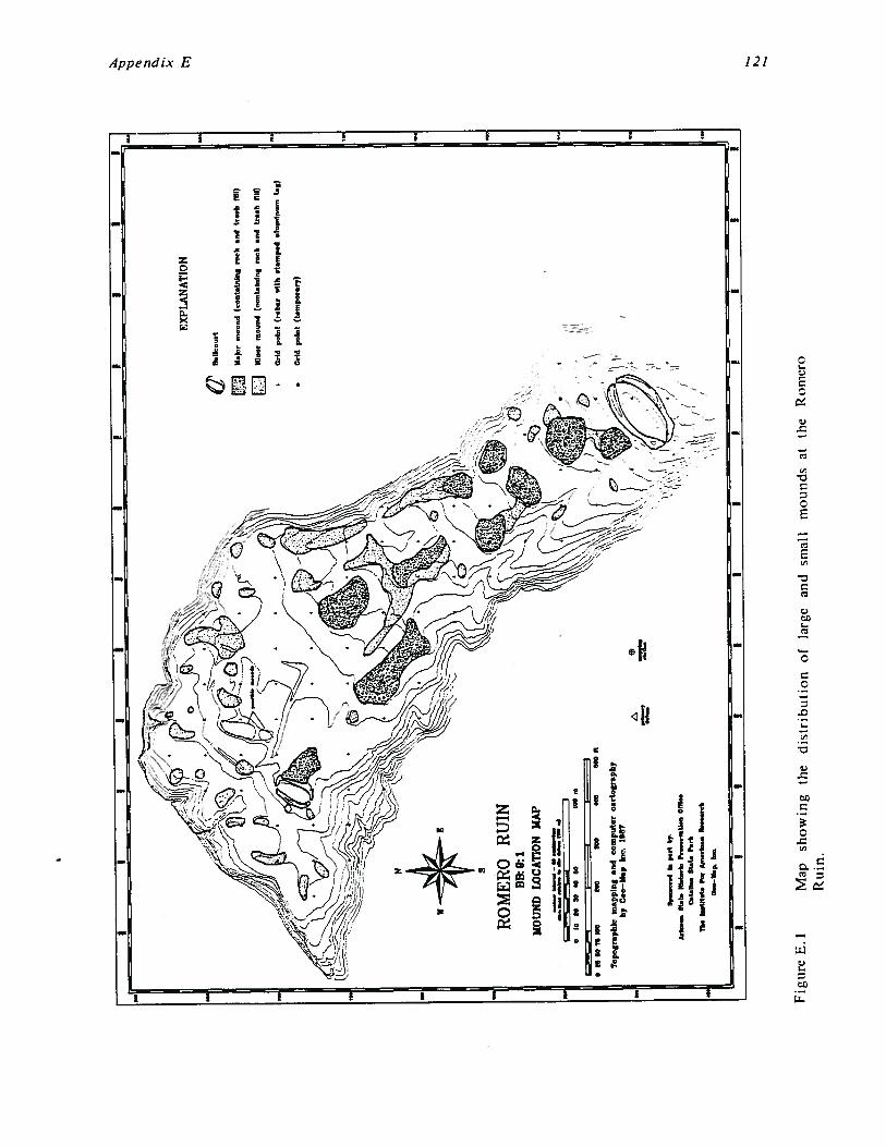
EX
PLA
NA
TIO
N
9.&
ou
rt
W.)
or
mm
md
(oo
nt.
bn
lng
roo
ka
nd
bo
ok
flit)
Min
orm
ound
(con
tain
ing
rock
and
bank
nil)
•G
ridp
oin
t(r
ob
.,.1
1k.t
mn
p.d
.inm
iou
mta
g)
•C
old
po
int
(t.m
po
rory
)
S
RO
MER
OR
UIN
BH0:
1M
OUN
DLO
CA
TIO
NM
AP
——
-——
——
b—
—ii”
md-~
-~
-
aio
tata
anto
loom
II~
ate
tOfl
tea
too
tao
ata
eta
it
Top
ogra
phic
map
ping
and
com
pu
ter
cart
og
rap
hy
byC
on—
Mop
Inc.
t9~
7
~A
cho
et
11
.1.
i~ta
do
Pm
mco
oUna
00
1..
~t.
H.i
Sta
inP
ock
lb.
1U
I.t.
ForA
..l...
b..
.ccb
Fig
ure
E.1
Map
sho
win
gth
ed
istr
ibu
tio
no
fla
rge
and
smal
lm
ound
sat
the
Rom
ero
Ru
in.
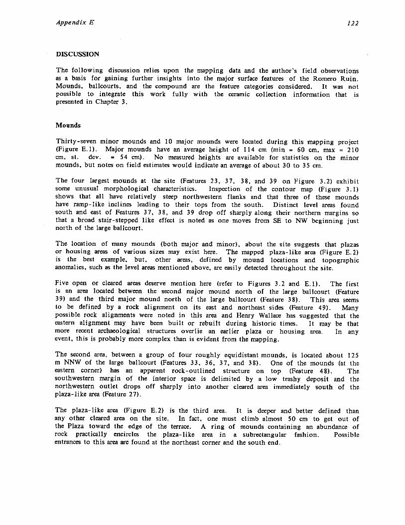
Appendix E 122
DISCUSSION
The following discussion relies upon the mapping data and the author’s field observationsas a basis for gaining further insights into the major surface features of the Romero Ruin.Mounds, balicourts, and the compound are the feature categories considered. It was notpossible to integrate this work fully with the ceramic collection information that ispresented in Chapter 3.
Mounds
Thirty-seven minor mounds and 10 major mounds were located during this mapping project(Figure E. 1). Major mounds have an average height of 114 cm (mm = 60 cm, max = 210cm, St. dev. = 54 cm). No measured heights are available for statistics on the minormounds, but notes on field estimates would indicate an average of about 30 to 35 cm.
The four largest mounds at the site (Features 23, 37, 38, and 39 on Figure 3.2) exhibitsome unusual morphological characteristics. Inspection of the contour map (Figure 3.1)shows that all have relatively steep northwestern flanks and that three of these moundshave ramp-like inclines leading to their tops from the south. Distinct level areas foundsouth and east of Features 37, 38, and 39 drop off sharply along their northern margins sothat a broad stair-stepped like effect is noted as one moves from SE to NW beginning justnorth of the large ballcourt.
The location of many mounds (both major and minor), about the site suggests that plazasor housing areas of various sizes may exist here. The mapped plaza-like area (Figure E.2)is the best example, but, other areas, defined by mound locations and topographicanomalies, such as the level areas mentioned above, are easily detected throughout the site.
Five open or cleared areas deserve mention here (refer to Figures 3.2 and E.1). The firstis an area located between the second major mound north of the large balicourt (Feature39) and the third major mound north of the large ballcourt (Feature 38). This area seemsto be defined by a rock alignment on its east and northeast sides (Feature 49). Manypossible rock alignments were noted in this area and Henry Wallace has suggested that theeastern alignment may have been built or rebuilt during historic times. It may be thatmore recent archaeological structures overlie an earlier plaza or housing area. In anyevent, this is probably more complex than is evident from the mapping.
The second area, between a group of four roughly equidistant mounds, is located about 125m NNW of the large balicourt (Features 33, 36, 37, and 38). One of the mounds (at theeastern corner) has an apparent rock-outlined structure on top (Feature 48). Thesouthwestern margin of the interior space is delimited by a low trashy deposit and thenorthwestern outlet drops off sharply into another cleared area immediately south of theplaza-like area (Feature 27).
The plaza-like area (Figure E.2) is the third area. It is deeper and better defined thanany other cleared area on the site. In fact, one must climb almost 50 cm to get out ofthe Plaza toward the edge of the terrace. A ring of mounds containing an abundance ofrock practically encircles the plaza-like area in a subrectangular fashion. Possibleentrances to this area are found at the northeast corner and the south end.
Appendix E 123
NOTESLanjth of c1.~ied .re~ (NW—SE) — 37 6 meter,WIdth of cleared area (NE—SW) — 27.4 mater.Area of cl.armg — 985 m.tar,’
EXPLANATION
L Large mound (containing rock and trash fill)
SmaU mound (con aining rock and trash till)
Cleared area or Plaza floor’
Figure E.2 Map of a possible plaza and surrounding group of mounds at the RomeroRuin.

Appendix E 124
The southern end of the plaza-like area seems to lack an outside mound, instead, a narrowshelf is encountered as one gradually ascends out to the south. The northern edge ofa narrow level area is encountered at the upper level of the south end.
Immediately north of the mound defining the northern edge of the plaza-like area is alarge area covered by several linear shaped mounds and a large central mound (Feature 23).This fourth area stretches from the eastern to the western terrace edge; generally south ofthe 93.5 m elevation contour. The unusual aspect of this area is the long narrow openareas between the small linear mounds and the large central mound, and, between the smalllinear mounds and the outside, larger linear mounds.
One possible explanation for this odd mound arrangement is that an open (cleared) areainitially existed between the outside linear mounds and the large central mound. Later, theintervening small linear mounds were created producing narrow corridor-like areas.Whatever the sequence of events, the cumulative effect was to generally restrict movementand other activities to the narrow areas between the mounds or the flat areas on top ofthe mounds. Note that mounds encompass the large central mound on three sides with theNW side missing. The NW side faces (and defines the southern limits of) a large, open,relatively level area (discussed below), which may have served as a plaza before theconstruction of the compound. Although there is little indication that Feature 23 mighthave been a platform mound, inspection of the location and shape of nearby mounds doessuggest that it had special significance within the community, at one time or another.
The fifth and final area to be discussed is located between the large major mound (Feature23) and the historic buildings of the Romero ranch on the north. On the west it isbounded by a small minor mound near the N700 E500 grid mark and on the east by a smallminor mound near N770 E585.
In Preclassic times, the area under discussion presumably did not have a compound or theattendant rock-outlined structures. Instead, the area was probably bounded on the northby two mounds now found beneath the historic period structures of the Romero ranch.Assuming that most of the mounds to the south existed, it would have been the largestmound free area of the site - - by a factor of ten. The size and location suggest the areamay have served as the site plaza during Preclassic times and later, the northern half wasoverlain by the compound.
Aerial photographs of the site show a pronounced vegetation anomaly in the westernportion of the fifth area Henry Wallace verified this during a fly-over of the site andsuggested that it may be due to a cattle holding pen related to the Romero ranchingactivities. There is no evidence of this suggestion on the ground, but historical documentsdo note that Francisco Romero had a wooden corral somewhere near his ranch houses (seeChapter 3).
Two notable mound/feature associations at Romero deserve mention. The first is thelocation of two major mounds beside each of the bailcourts (Figures 3.2 and E.1). Theonly major mound found in the northern section of the site is situated immediatelyadjacent to (and partly on top of) the eastern berm of the small balicourt. Cross sectionsindicate that the mound, or a portion of it, may have existed before the construction ofthe small bailcourt and that the balicourt was dug down into these deposits.
The mound found near the large balicourt is approximately centered along the long axis ofthe court and is located a short distance from the outside edge of the northern berm. Themound is connected to the berm by a low saddle. From atop either of these mounds, a

Appendix E 125
good view is afforded of the balicourt interiors. The mound/ballcourt associations may befortuitous, but the possibility of a functional relationship should be explored.
The apparent superimposition of the compound wall over two minor mounds found at theeast and west corners of the compound is the other noteworthy mound/feature association.Topographic anomalies as well as physical inspection suggest the stratigraphically higher(younger) position of the compound wall relative to the mounds. Trash may have beenadded to these mounds, particularly the western mound, after completion of the compoundwall. Observations by Mark Elson suggest that the southern portion of the eastern mound(beneath the eastern corner of the compound wall), may have served as a prehistoriccemetery.
At the southern end of the mapped portion of the site, there is a significant change inprehistoric site utilization. From the large bailcourt on to the southeast the features aremostly agricultural in nature - - checkdams, terraces and rock piles with few, if any, trashmounds or other features. The large balicourt seems to be located at a boundary betweenthe habitation and agricultural areas of the site. A few terraces were noted immediatelyto the northeast of the balicourt, but none were observed farther downslope.
The location of agricultural terraces coincides with relatively abrupt steepening of thetopographic slope just to the north of the large bailcourt. Slope values cannot beaccurately measured due to the intense cultural disturbance but a change on the order of1% to 3% is indicated between areas north of the N550 line and the area immediately southof the N525 line.
The mounds at Romero, by nature of their content and morphological characteristics, canbe physically and spatially separated into two distinct groups. Mounds northwest of a lineextending from grid mark N700 E525 to grid mark N750 E600 tend to be smaller, morescattered and seem to contain more pure trash relative to the quantity of rock than themounds found southeast of this line. Nine of the ten major mounds are found in thesouthern portion of the area defined above.
Measurements indicate that about 10% of the potentially habitable area of the site foundnorth of the line defined above is occupied by mounds (2230 m2 of 21,500 m2), whereasnearly 29% (8390 m2 of 29,000 m2) of the area south of this line is occupied by mounds.After correction for differences in total areas, mounds in the northern portion occupyabout 36% of that found in the southern section. Major mounds take up 4960 m2 (17%) ofthe southern section and 379 m2 (2%) of the northern portion. Estimates of mound volumeswould further the apparent contrast between these two areas.
Why is there such a contrast in mound development between these areas? Looking at theshape of the terrace top, it’s evident that there is a significant constriction in theeast-west (NE-SW) dimension beginning just southeast of the defined line. A correlationbetween the constriction of the terrace and the much greater mound development is quiteapparent from inspection of Figure 3.1. Why, then, does the constriction of the terraceresult in the construction of larger mounds and the development of what appear to bemound systems or interrelated mound groups?
One possibility is that the terrace, southeast of the defined line, is underlain by asubstrate that contains more rock. This is not strongly supported by observations. Thereappears to be only slightly more rock on the eroded flanks of the terrace south of the linethan to the north. Unless the substrate in the center of the terrace contains significantly
Appendix E 126
more rock than that eroded away at the edges, then this is probably not a tenableargument.
Even if much more rock was encountered during prehistoric excavations, most of this couldeasily have been deposited over the side of the terrace. Instead, mounds were constructedor developed over time to the point where they decreased the available living surface by atleast a third. The structure (Feature 48) located on top of one of these mounds (Feature36) is evidence that, at least later in the prehistoric period of occupation, some of thisarea was utilized for living space.
The discussions above suggest that mounds - particularly the larger ones - wereintentionally constructed. Some relationships noted between mounds or mound groups mayalso infer explicit planning of relative sizes and/or locations. The mound buildup in theconstricted portion of the terrace was apparently one of conscious choice. Perhapsphysical restriction of passage along the top of the terrace was important. This wouldhave been particularly effective once the mounds had been constructed. If existence of themajor mounds were related to hierarchical social structures and/or ceremonialism, restrictedor controlled formal access could be more easily achieved in the constricted portion of theterrace.
Many of the potential interpretations of site structure at Romero are tied to the knowledgeof ages and functions of mounds. A limited testing program to determine these factorswould go a long way toward explaining this puzzling site.
As discussed above, the mapped portion of the site can be divided into two sections basedon the location and morphology of mounds at the site. This may be a real division due todifferences in contemporaneous spatial utilization of the site, or an apparent divisionresulting from temporal variability in intrasite occupation foci. There are indications froma mapping/ceramic distribution standpoint that both occurred with different emphasis anddifferent resultant manifestations through time. The map is a cumulative composite ofvarious cultural features and terrain modifications and should, therefore, be viewed with apotentially dynamic fourth dimension in mind -- time.
Ballcourts
One of the reasons to produce a detailed topographic map of a ballcourt or reservoir is todefine, from its topographic signature, the morphological characteristics of the feature.This has both short and long term benefits to the archaeologist. Short term benefitsinclude accurate knowledge of size and shape, and, when combined with section analysis,the ability to optimize locations for excavations to obtain construction details. Long termbenefits are: 1) inclusion into a current data base that, by analysis of detailed physicalcharacteristics, may provide further insights into various cultural aspects of the Hohokam,2) the ability to more accurately model subsurface structures using topographic mapping,and 3) accurate archival information for future research.
The Romero Ruin has two bailcourts that are clearly visible on the surface. The detailedmapping of these features that is reported here, has served to reveal attributes of thesefeatures that were not obvious during field inspection. Furthermore, the fact that theRomero maps document similarities between construction techniques previously noted forthe Valencia site ballcourt, which was mapped by the author previously (see Elson andDoelle 1986), also illustrates the value in building a data base of detailed topographic mapsof Hohokam sites.

Appendix E 127
The Small Balicourt
The small size, the more rounded arc of the eastern berm, and the roughly north—southorientation indicate that this balicourt is of the Casa Grande type. The bailcourt, asindicated in Figure E.3, is approximately 25.3 m long, 14.2 m wide, and is oriented at N 23°47’. It is located in an area of numerous, scattered minor mounds and adjacent to a majormound. The south end of the bailcourt overlooks a relatively steep slope that marks thewestern limit of habitable terrace top. Otherwise this bailcourt is surrounded by what arethought to be habitation areas. A rock-walled compound (presumably built much later thanthe balicourt) is located about 20 m northeast of the northeast end of the court and apossible plaza area (discussed earlier) is located about 50 m to the southeast of the court.
Inspection of the contour map of the balicourt (Figure E.3) shows the asymmetric shape ofthe feature. A relatively short, almost linear berm defines the west (downslope) side ofthe bailcourt while an almost U-shaped berm encompasses the eastern half. There is noindication of end units and the entrances seem to be restricted to narrow openings aboutone meter wide. This shape is remarkably similar to that of a ballcourt excavated by theArizona State Museum at the Waterworld site (AA:16:94 ASM) in Avra Valley.
Adjacent to the central portion of the eastern berm is found a major mound. So close isthis mound to the edge of the bailcourt depression that no morphological trace of a bermcould be detected here. From inspection of the contour map and cross section of thecourt (B - B’in Figure E.4), it would appear that the mound has been truncated by theexcavation of the bailcourt into the mound’s northwestern side. The suggestion that themound was in place before the ballcourt was excavated into it is further supported by thelocation of trash concentrations on the opposite berm. The inference is that the materialmaking up the western berm was derived from the excavation of the eastern side of thebailcourt into the northwestern side of the mound. A similar technique of cutting intoupsiope deposits was used to construct the Valencia site bailcourt and the large bailcourthere at Romero (discussed below). This is an efficient method of construction and mayaccount for the specific orientations of many balicourts.
Another (albeit equivocal) aspect that supports the hypothesis that the bailcourt wasconstructed into the mound is the lack of any appreciable amount of trash in the courtitself. The berms contain significant quantities of trash, yet the interior of the court wasnot used as a trash dumping area.
This argument is complicated by the existence of what may be a rock wall or rock-coreberm. The map produced by Wilcox and Sternberg shows mapped rocks and a possible rockwall encircling the ballcourt. Based largely on observations made near the southernentrance to the court, it is my belief that a rock wall or rock-core berm does exist here.However, it is conjectural, from surface indications, whether it is continuous or not. If itis continuous, it lies buried beneath the northwestern edge of the mound; if it is buried,then at least a portion of the mound’s height may have been added after construction ofthe court. Finally, if the mound was heightened, the apex was purposely, or coincidentallylocated where an optimum view of the bailcourt interior was afforded, yet material fromthe mound would not cascade into the court. In this case, the rock wall or rock-coreberm would have acted as a retaining wall. This would satisfactorily explain the currenttruncated shape of the northwest side of the mound.

Appendix E 128
EXPLANATION
cc,00
ElCompound waU
Balicourt berm
Small mound (containln~ rock and traib till)
‘Irash concentraUon
Figure E.3
Larg. mound (contatn1~g rock and tra,h till)
NOTESBallcourt ori.nt.tlon (A — A’) — N 23 47’ ELangth of Bailcourt (A — A’) — 25 3 meter,Width of Ballcourt (B — B’) — j4 2 meter,Area on LnterloT of Ballcourt berms (aa.um.d flat) — 210 meter,2
Contour map of the small balicourt at the northwest margin of the
C
coN’rotm ~Pof Lii.
MALL BALLCOURT
C C C C C 0* * *
* 1’ *
Romero Ruin.

Appendix E
Topographic Profiles
SMALL BALLCOURT
20 ::zZ0~meters
129
Comput~ cartography by Geo—Map. Inc 1867
A
8
PE ~lN~
A’
ESE
B’
Figure E.4 Topographic profiles of the small bailcourt at the Romero Ruin.
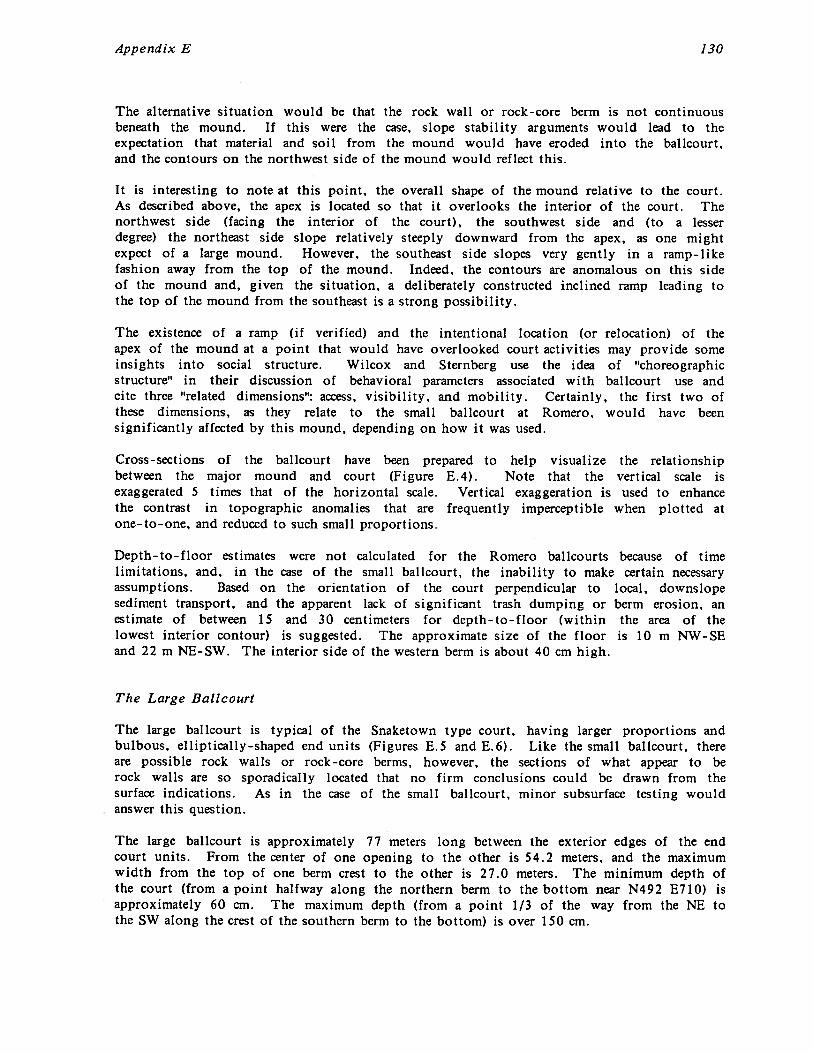
Appendix E 130
The alternative situation would be that the rock wall or rock-core berm is not continuousbeneath the mound. If this were the case, slope stability arguments would lead to theexpectation that material and soil from the mound would have eroded into the balicourt,and the contours on the northwest side of the mound would reflect this.
It is interesting to note at this point, the overall shape of the mound relative to the court.As described above, the apex is located so that it overlooks the interior of the court. Thenorthwest side (facing the interior of the court), the southwest side and (to a lesserdegree) the northeast side slope relatively steeply downward from the apex, as one mightexpect of a large mound. However, the southeast side slopes very gently in a ramp-likefashion away from the top of the mound. Indeed, the contours are anomalous on this sideof the mound and, given the situation, a deliberately constructed inclined ramp leading tothe top of the mound from the southeast is a strong possibility.
The existence of a ramp (if verified) and the intentional location (or relocation) of theapex of the mound at a point that would have overlooked court activities may provide someinsights into social structure. Wilcox and Sternberg use the idea of “choreographicstructure” in their discussion of behavioral parameters associated with balicourt use andcite three “related dimensions”: access, visibility, and mobility. Certainly, the first two ofthese dimensions, as they relate to the small bailcourt at Romero, would have beensignificantly affected by this mound, depending on how it was used.
Cross-sections of the ballcourt have been prepared to help visualize the relationshipbetween the major mound and court (Figure E.4). Note that the vertical scale isexaggerated 5 times that of the horizontal scale. Vertical exaggeration is used to enhancethe contrast in topographic anomalies that are frequently imperceptible when plotted atone-to-one, and reduced to such small proportions
Depth-to-floor estimates were not calculated for the Romero bailcourts because of timelimitations, and, in the case of the small balicourt, the inability to make certain necessaryassumptions. Based on the orientation of the court perpendicular to local, downslopesediment transport, and the apparent lack of significant trash dumping or berm erosion, anestimate of between 15 and 30 centimeters for depth-to-floor (within the area of thelowest interior contour) is suggested. The approximate size of the floor is 10 m NW-SEand 22 m NE-SW. The interior side of the western berm is about 40 cm high.
The Large Balicourt
The large balicourt is typical of the Snaketown type court, having larger proportions andbulbous, elliptically-shaped end units (Figures E.5 and E.6). Like the small bailcourt, thereare possible rock walls or rock-core berms, however, the sections of what appear to berock walls are so sporadically located that no firm conclusions could be drawn from thesurface indications. As in the case of the small bailcourt, minor subsurface testing wouldanswer this question.
The large balicourt is approximately 77 meters long between the exterior edges of the endcourt units. From the center of one opening to the other is 54.2 meters, and the maximumwidth from the top of one berm crest to the other is 27.0 meters. The minimum depth ofthe court (from a point halfway along the northern berm to the bottom near N492 E710) isapproximately 60 cm. The maximum depth (from a point 1/3 of the way from the NE tothe SW along the crest of the southern berm to the bottom) is over 150 cm.
Appendix E 131
EXPLANATION
Bailcourt
Roclr, d.nxung ballcourt end unit
Larg. mound (cont.inin1 rock and tre~h fill)
NOTESB.Jlcourt oñentatjo~ (A — A’) - N 49 48’ ELength of ballcourt (A — A’) — 54.2 mater,Width of b..llc,nirt (8 — 9’) — 27.0 meter.Ar.. interior of b.Ucourt berm, (aerumed flat) — 840 mater,’Are. on interim’ of b.Ucourt end unit, (aum.d flat) — 218 meter,t
Figure E.5 Contour map of the large bailcourlRomero Ruin.
the southeast margin of the

Appendix E 132
Topographic Profiles
LARGE BALLCOURT
Figure E.6 Topographic profiles of the large bailcourt at the Romero Ruin.
Appendix E 133
The long axis of the bailcourt is oriented at an azimuth of 49° 48’ with respect to gridnorth. The area found on the interior of the crest of the berms is about 840 m2 and thecombined area of the two end units is nearly 220 m2. The floor would measureapproximately 46 m by 18 m.
Three interesting morphological characteristics of this balicourt are discussed in more detailbelow. A general comparison of this bailcourt to others in the Tucson Basin, shows that itis the smallest of the six existing Snaketown type courts and one of two with such well-defined end court units. The two ballcourts at Romero are the only bailcourts in theTucson Basin with a high likelihood of having rock walls or rock-core berms.
One characteristic of this balicourt, which has been noted for other bailcourts, recently, isthe fact that it was built perpendicular to the local slope. This seems to serve a dualpurpose: 1) it significantly reduces the amount of excavation necessary to actually build abalicourt, and 2) it deflects downslope water and sediment movement if a small upsiopeberm is maintained. The north-south cross-sections (Figure E.6) show that the upsiope(south) bank of the balicourt is about 2.0 to 2.5 times higher than the northern bermexcept near the ends, or entrances to the court. Unlike the balicourt mapped at Valencia,the large court at Romero has a small, but definite, upsiope berm that is further enhancedby local erosion patterns developed as a result of the balicourt construction.
Another interesting characteristic of this court is the apparently intentional enlargement ofthe ends of the berms (near the court entrances). This is most clearly indicated in thenorthern berm, probably because of the erosion patterns and the less anomalous nature ofthe southern berm. The intent of these enlarged areas is unknown, but one result could bethe effective segregation of viewers into larger groups located on either side of theentrances into the court from the end units. A very similar construction is found at thelarge balicourt at Snaketown.
The bailcourt end units are the third morphological characteristic to be discussed (FigureE.5). Inspection of the contour map of the large bailcourt shows that the western end unitis much more clearly defined than the eastern unit. The western unit was built on arelatively steep (southwesterly) slope presumably requiring a more substantial base. Anincreased need for maintenance may be the reason that the western end unit is more fullydefined by rocks.
The end units are roughly the same size and shape (ellipsoidal) and can be entered intofrom the ballcourt by a relatively narrow, one to two meter wide opening. The westernend unit may also have an entrance near its northwestern corner. The mapped rocksindicate that a 4 m long segment of wall exists that is parallel to the end unit wall andabout 1.5 meters west of the northwest corner of the (interior) end unit wall. Thedirection to which this corridor opens is unclear because of the scattered nature of therocks at either end. However, the interior wall of the end unit has a break near thenorthern end of the exterior wall.
Rather than another entrance, this may be a retaining wall built to stop erosion andincrease slope stability. Other alternatives are that the opening in the end unit wall couldbe a fortuitous break, of which there are several others, or it may be the result of an oldcattle or wildlife trail that does pass through this end unit.
Earlier discussions mentioned that a major mound is located off the side of the northernberm of the large bailcourt. Unlike the mound adjacent to the small balicourt, the moundfound near the large balicourt is not attached to the berm of the court, being about 10 to
Appendix E 134
12 meters northwest of the outside edge of the balicourt berm. An inspection ofcross-section D - D’ in Figure E.6 shows that the saddle connecting the mound to the bermmay, in large part, be the natural ground surface. This mound did not provide theoptimum viewing location that the mound adjacent to the small balicourt did and wasprobably not specifically located here to provide additional viewing space for ballcourtactivities.
The Compound
The compound is surrounded by a wall 248 meters in length, encompassing 3990 m2. Thewall encloses at least seven prehistoric structures containing eight recognizable rooms, andfour historic structures having at least seven rooms (Figure 3. 12). Attached to the outsideof the compound wall are one or more rock-walled structures. Within the compound, manysmall rock alignments and clusters of rock are found indicating the possible existence ofother structures or features. Also within the compound are the remains of what were oncethree or four small mounds all of which have been severely disturbed by the building ofprehistoric or historic structures. There are minor mounds found under the east and westcorners of the compound and notable trash concentrations along the outside of the westand northwest walls. Based on the increased incidence of calcined bone, Mark Elson hasidentified a possible prehistoric cemetery located in the mound beneath the eastern cornerof the compound wall.
There are varying interpretations as to which structures are of the historic period andwhich are prehistoric. This is complicated by the high probability that Francisco Romerorebuilt prehistoric rooms. Ellsworth Huntington and Donald Page report that two structureswere standing at the time of their visits (1910 and 1927 respectively). Each stated thatthe standing structures were the most recent on the site (apparently Features 1 8 and 20).Donald Page also described two other buildings of similar construction to the two standingstructures with walls about 30 cm high. One is definitely identified as Feature 21. Onlyone room of this building could be confidently mapped because of the great amount ofdisturbance. The other is probably Feature 22, although it was not explicitly identified byPage. Henry Wallace believes that all four structures (five rooms -- Features 18 through22) are of historic vintage. One structure (Feature 17), although identified by Romero’sgrandson as having been rebuilt by Romero, is probably a prehistoric structure as identifiedby both Wallace and Page. Romero’s grandson was also quoted as saying that all of theRomero ranch structures were rebuilt from existing structure foundations - - indicating thateach historic structure had a prehistoric counterpart. This would increase the number ofprehistoric structures accordingly. There was no conclusive evidence of the compound wallhaving been rebuilt.
The compound wall itself has seven identifiable corners, although the corner that forms anindentation at the north end of the compound seems to be more of a curve. At theeastern corner, the southern wall seems to continue in a northeasterly direction beyond theintersection of walls forming the corner. This may be the wall of another exterior room.
The compound wall is made up of small to moderate-sized gneissic rocks in courses 4 or 5rocks deep forming a wall that averages between 50 and 70 cm thick. The wall is also 50to 70 cm high and has what appears to be a 2 m wide opening about 36.2 m NNE of thesouthern corner of the compound wall (just NE of a 3 m high saguaro growing next to thecompound wall).
Appendix E 135
The amount of earth found on either side of the wall, which adds another 1.5 to 2 metersto the apparent thickness, may be derived from an exterior adobe facing that covered therock-core walls and has since melted down, or to a solid adobe wall built on top of therock wall base. Some rock is found laying about the surface near the compound wall, butnot enough to substantially increase the height of the wall.
One probable structure and several rock concentrations were located along the exteriornortheastern wall of the compound indicating that a row of structures may have existedalong this wall. Rock concentrations and scattered rock along other portions of thecompound wall may also be related to exterior structures, but none could be confidentlyidentified.
Elevations of wall bottoms in Features 18 and 20 indicate that they are about 12 to 15 cmabove the relatively level areas to the south and southeast, supporting the inference thatthese, and other, buildings were placed on top of existing mounds. Unfortunately, thebottoms of Features 21 and 22 were too disturbed to identify. One elevation taken inFeature 21, near what is thought to be the base of the wall, indicates that the floor ofthis building may be as much as 35 cm above the low areas to the east and west.
REFERENCES CITED
Altschul, Jeffrey H.1986 Statistical Evaluation of the Collection Procedure. In The Valencia Site Testing
Project: Mapping, Intensive Surface Collecting, and Limited Trenching of aHohokam Ballcourt Village in the Southern Tucson Basin, by Mark D. Elson andWilliam H. Doelle, pp. 25-30. Technical Report No. 86-6. Institute for AmericanResearch, Tucson.
Bayham, Frank, and Pamela Hatch1984 Archaeofaunal Remains from the New River Area. In Hohokam Settlement and
Economic Systems in the New River Drainage, Central Arizona, edited by DavidDoyel and Mark Elson, pp. 405-432. Publications in Archaeology No. 4. SoilSystems, Phoenix.
Brew, Susan A.1975 Archaeological Assessment of Ca?lada del Oro. Archaeological Series No. 87.
Arizona State Museum, University of Arizona, Tucson.
Cable, John S., and David E. Doyel1985 The Pueblo Patricio Sequence: Its Implications for the Study of Hohokam
Origins, Pioneer Period Site Structure and Processes of Sedentism. In City ofPhoenix, Archaeology of the Original Townsite, Block 24-East, edited by John S.Cable, Kathleen S. Hoffman, David E. Doyel, and Frank Ritz, pp. 211-270.Publications in Archaeology No. 8. Soil Systems, Phoenix.
Castetter, Edward F., and Willis H. Bell1942 Pima and Papago Indian Agriculture. University of New Mexico Press,
Albuquerque.
Castetter, Edward F., and Ruth M. Underhill1935 The Ethnobiology of the Papago Indians. Biological Series No. 4(3). University
of New Mexico, Albuquerque.
Craig, Douglas B.1986 The Hodges Site Archival Research. In The 1985 Excavations at the Hodges Site,
Pinia County, Arizona edited by Robert W. Layhe, pp.13-42. ArchaeologicalSeries No. 170, Arizona State Museum, University of Arizona, Tucson.
1987 Intrasite Settlement Patterns. In Prehistoric Settlement in the Caftada del OroValley, Arizona: The Rancho Vistoso Survey Project. Anthropological PapersNo. 8. Institute for American Research, Tucson.
Craig, Douglas B., and David V. M. Stephen1985 Archaeological Investigations in the Eastern Tortolitas: Results of Phase III of
Tortolita Mountains Archaeological Project. Ms. on file, Pima Community CollegeCenter for Archaeological Field Training, Tucson.
References Cited 137
Dart, Allen1984 Archaeological Site Significance Evaluations for Cienega Ventana Project.
Technical Report No. 84-8. Institute for American Research, Tucson.
1987 The Papago Water Supply Project. Archaeological Survey on the San Xavier andSchuk Toak Districts of the Tohono O’odham Nation. Anthropological Papers No.9. Institute for American Research, Tucson.
Dart, Allen, William H. Doelle, and Thomas R. McGuire1985 Research Design: Papago Water Supply Project Class III Archaeological Survey
for Schuk Toak and San Xavier Districts. Technical Report No. 85-6. Institutefor American Research, Tucson.
DiPeso, Charles C.1953 The Sobaipuri Indians of the Upper San Pedro River Valley, Southeastern
Arizona. The Amerind Foundation Publication No. 6. Dragoon, Arizona.
Doelle, William H.1985 Excavations at the Valencia Site, a Preclassic Hohokam Village in the Southern
Tucson Basin. Anthropological Papers No. 3. Institute for American Research,Tucson.
Doelle, William H., Allen Dart, and Henry D. Wallace1985 The Southern Tucson Basin Survey: Intensive Survey Along the Santa Cruz
River. Technical Report No. 85-3. Institute for American Research, Tucson.
Doelle, William H., and Henry D. Wallace1986 Hohokam Settlement Patterns in the San Xavier Project Area, Southern Tucson
Basin. Technical Report No. 84-6. Institute for American Research, Tucson.
Doyel, David E.1977 Rillito and Rincon Period Settlement Systems in the Middle Santa Cruz River
Valley: Alternative Models. The Kiva 43:93-110.
Doyel, David E., and Mark D. Elson1985 Hohokam Settlement and Economic Systems in the Central New River Drainage,
Arizona. Publications in Archaeology No. 4. Soil Systems, Phoenix
Elson, Mark D.1986 Archaeological Investigations at the Tanque Verde Wash Site, a Middle Rincon
Settlement in the Eastern Tucson Basin. Anthropological Papers No. 7. Institutefor American Research, Tucson.
Elson, Mark D., and William H. Doelle1986 The Valencia Site Testing Project: Mapping, Intensive Surface Collecting, and
Limited Trenching of a Hohokam Balicourt Village in the Southern Tucson Basin.Technical Report No. 86-6. Institute for American Research, Tucson.
References Cited 138
Ferg, Alan, and Bruce B. Huckell1985 The Tucson Basin Hohokam Occupation of the Rosemont Area, Northern Santa
Rita Mountains. In Proceedings of the 1983 Hohokam Symposium, edited byAlfred E. Dittert and Donald E. Dove, pp. 199-222. Occasional Paper No. 2.Arizona Archaeological Society, Phoenix.
Ferg, Alan, Kenneth C. Rozen, William L. Deaver, Martyn D. Tagg, David A. Phillips Jr.,and David A. Gregory
1984 Hohokam Habitation Sites in the Northern Santa Rita Mountains. ArchaeologicalSeries No. 14 7(2). Arizona State Museum, University of Arizona, Tucson.
Fish, Paul R., Suzanne K. Fish, John Madsen, Charles Miksicek, Christine Szuter, and JohnField
1987 A Longterm Pioneer Adaptation in the Northern Tucson Basin. Paper presentedat the 1987 Hohokam Conference, Phoenix.
Fish, Suzanne K., Paul R. Fish, and John Madsen1985 A Preliminary Analysis of Hohokam Settlement and Agriculture in the Northern
Tucson Basin. In Proceedings of the 1983 Hohokam Symposium, edited by AlfredE. Dittert Jr., and Donald E. Dove, pp. 75-100. Occasional Papers No. 2.Arizona Archaeological Society, Phoenix.
Gabel, Norman1931 Martinez Hill Ruins: An Example of Prehistoric Culture of the Middle Gila.
Unpublished Master’s thesis, Department of Anthropology, University of Arizona,Tucson.
Gasser, Robert, and Charles Miksicek1985 The Specialists: A Reappraisal of Hohokam Exchange and the Archaeobotanical
Record. In Proceedings of the 1983 Hohokam Symposium, edited by Alfred E.Dittert, Jr. and Donald E. Dove, pp. 483-498. Occasional Paper No. 2. ArizonaArchaeological Society, Phoenix.
Greenleaf, J. Cameron1975 Excavations at Punta de Agua in the Santa Cruz River Basin, Southeastern
Arizona. Anthropological Papers No. 26. University of Arizona Press, Tucson.
Gregonis, Linda M.1987 The Hardy Site at Fort Lowell Park. Archaeological Series No. 175. Arizona
State Museum, University of Arizona, Tucson. In preparation.
Haury, Emil W.1928 The Succession of House Types in the Pueblo Area. Unpublished Master’s thesis,
Department of Anthropology, University of Arizona, Tucson.
1976 The Hohokam: Desert Farmers and Craftsmen. Excavations at Snaketown,1964-1965. University of Arizona Press, Tucson.
Hayden, Julian D.1957 Excavations, 1940, at the University Indian Ruin, Tucson, Arizona. Technical
Series No. 5. Southwestern Monuments Association, Globe, Arizona.

References Cited 139
Heidke, James1986 Plainware Ceramics. In Archaeological Investigations at the Tanque Verde Wash
Site: A Middle Rincon Settlement in the Eastern Tucson Basin, by Mark D.Elson, pp. 181-232. Anthropological Papers No. 7. Institute for AmericanResearch, Tucson.
1987 Ceramics. In Rincon Phase Seasonal Occupation in the Northeastern TucsonBasin, by Frederick W. Huntington and Mary Bernard-Shaw. AnthropologicalPapers. Institute for American Research, Tucson. In preparation.
Henderson, T. Kathleen1986 Structure and Organization at La Ciudad. Office of Cultural Resource
Management, Department of Anthropology, Arizona State University, Tempe.Draft Report.
Hewitt, James M., and David Stephen1981 Archaeological Investigations in the Tortolita Mountains Region, Southern
Arizona. Archaeological Field Report No. 10. Pima Community College, Tucson.
Huckell, Lisa W.1980 An Archaeological Assessment of the Proposed Catalina State Park.
Archaeological Series No. 141. Arizona State Museum, University of Arizona,Tucson.
Huntington, Ellsworth1910 Field Diary from 1910. Copy on file, Arizona State Museum Library, University
of Arizona, Tucson.
Kelly, Isabel T.1978 The Hodges Ruin: A Hohokam Community in the Tucson Basin. Anthropological
Papers No. 30. University of Arizona Press, Tucson.
Kelly, William H.1936 University Ruin. The Kiva 1(8):1-4.
Layhe, Robert W. (editor)1986 The 1985 Excavations at the Hodges Site Pima County, Arizona. Archaeological
Series No. 170. Arizona State Museum, University of Arizona, Tucson.
Lombard, James P.1986a A Petrographic Analysis of West Branch Site Ceramics. In Archaeological
Investigations at the West Branch Site: Early and Middle Rincon Occupation inthe Southern Tucson Basin, by Frederick W. Huntington, pp. 429-444.Anthropological Papers No. 5. Institute for American Research, Tucson.
1986b Petrographic Results of Point Counts on 40 Ceramic Sherds from AZ BB:13:68.In Archaeological Investigations at the Tanque Verde Wash Site: A MiddleRincon Settlement in the Eastern Tucson Basin, by Mark D. Elson, pp. 473-484.Anthropological Papers No. 7. Institute for American Research, Tucson.
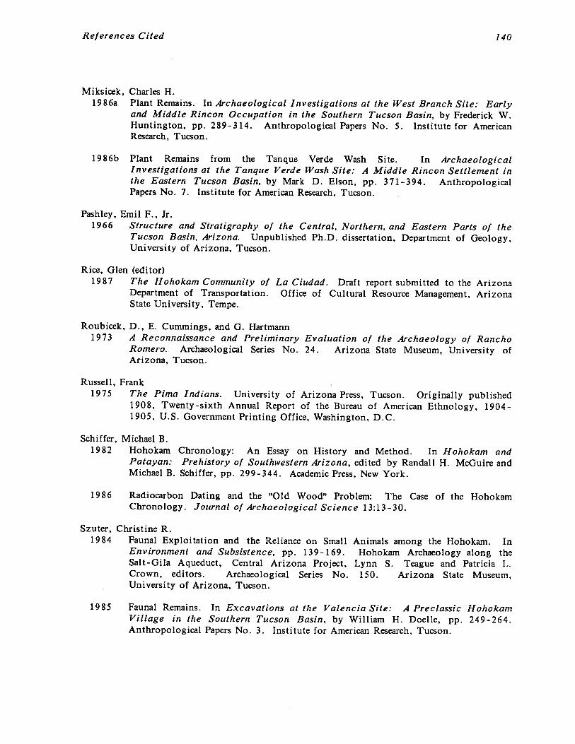
References Cited 140
Miksicek, Charles H.1986a Plant Remains. In Archaeological Investigations at the West Branch Site: Early
and Middle Rincon Occupation in the Southern Tucson Basin, by Frederick W.Huntington, pp. 289-314. Anthropological Papers No. 5. Institute for AmericanResearch, Tucson.
1986b Plant Remains from the Tanque Verde Wash Site. In ArchaeologicalInvestigations at the Tanque Verde Wash Site: A Middle Rincon Settlement inthe Eastern Tucson Basin, by Mark D. Elson, pp. 371-394. AnthropologicalPapers No. 7. Institute for American Research, Tucson.
Pashley, Emil F., Jr.1966 Structure and Stratigraphy of the Central, Northern, and Eastern Parts of the
Tucson Basin, Arizona. Unpublished Ph.D. dissertation, Department of Geology,University of Arizona, Tucson.
Rice, Glen (editor)1987 The Hohokam Community of La Ciudad. Draft report submitted to the Arizona
Department of Transportation. Office of Cultural Resource Management, ArizonaState University, Tempe.
Roubicek, D., E. Cummings, and G. Hartmann1973 A Reconnaissance and Preliminary Evaluation of the Archaeology of Rancho
Romero. Archaeological Series No. 24. Arizona State Museum, University ofArizona, Tucson.
Russell, Frank1975 The Pima Indians. University of Arizona Press, Tucson. Originally published
1908, Twenty-sixth Annual Report of the Bureau of American Ethnology, 1904-1905, U.S. Government Printing Office, Washington, D.C.
Schiffer, Michael B.1982 Hohokam Chronology: An Essay on History and Method. In Hohokam and
Patayan: Prehistory of Southwestern Arizona, edited by Randall H. McGuire andMichael B. Schiffer, pp. 299-344. Academic Press, New York.
1986 Radiocarbon Dating and the “Old Wood” Problem:Chronology. Journal of Archaeological Science 13:13-30.
Szuter, Christine R.1984 Faunal Exploitation and the Reliance on Small
Environment and Subsistence, pp. 139-169.Salt-Gila Aqueduct, Central Arizona Project,Crown, editors. Archaeological Series No.University of Arizona, Tucson.
1985 Faunal Remains. In Excavations at the Valencia Site: A Preclassic HohokamVillage in the Southern Tucson Basin, by William H. Doelle, pp. 249-264.Anthropological Papers No. 3. Institute for American Research, Tucson.
The Case of the Hohokam
Animals among the Hohokam. InHohokam Archaeology along the
Lynn S. Teague and Patricia L.150. Arizona State Museum,

References Cited 141
Szuter, Christine R.1986 Lagomorph and Artiodactyl Exploitation among the Inhabitants of the West
Branch Site. In Archaeological Investigations at the West Branch Site: Earlyand Middle Rincon Occupation in the Southern Tucson Basin, by Frederick W.Huntington, pp. 273-288. Anthropological Papers No. 5. Institute for AmericanResearch, Tucson.
Tagg, Martyn D.1983 Archaeological Testing at the Abused Ridge Site (AZ BB:9:120), an Early Tanque
Verde Site in the Tucson Basin. Submitted to Arizona Department ofTransportation. Ms. on file, Arizona State Museum Library, University ofArizona, Tucson.
Underhill, Ruth M.1979 Papago Woman. Holt Rinehart and Winston, New York.
Wallace, Henry D.1985 Decorated Ceramics. In Excavations at the Valencia Site: A Preclassic Hohokam
Village in the Southern Tucson Basin, by William H. Doelle, pp. 81-135.Anthropological Papers No. 3. Institute for American Research, Tucson.
1986a Decorated Ceramics. In Archaeological Investigations at the Tanque Verde WashSite: A Middle Rincon Settlement in the Eastern Tucson Basin, by Mark D.Elson. Anthropological Papers No. 7. Institute for American Research, Tucson.
1986b Decorated Ceramics. In Archaeological Investigations at the West Branch Site:Early and Middle Rincon Occupation in the Southern Tucson Basin, by FrederickW. Huntington. Anthropological Papers No. 5, Institute for American Research,Tucson.
1986c Rincon Phase Decorated Ceramics in the Tucson Basin: A Focus on the WestBranch Site. Anthropological Papers No. 1. Institute for American Research,Tucson.
1987 Regional Context of the Prehistoric Rancho Vistoso Sites: Settlement Patternsand Socioeconomic Structure. In Settlement in the Car’rada del Oro Valley,Arizona. The Rancho Vistoso Survey Project, by Douglas B. Craig and Henry D.Wallace, pp. 117-166. Anthropological Papers No. 8. Institute for AmericanResearch, Tucson.
Wallace, Henry D., and Douglas B. Craig1986 The Tucson Basin Hohokam: Chronological Considerations. Paper presented at
the 2d Tucson Basin Conference, Tucson.
Wallace, Henry D., and James Heidke1986 Ceramic Production and Exchange. In Archaeological Investigations at the
Tanque Verde Wash Site: A Middle Rincon Settlement in the Eastern TucsonBasin, by Mark D. Elson, pp. 233-270. Anthropological Papers No. 7. Institutefor American Research, Tucson.
References Cited 142
Wallace, Henry D., and James P. Holmlund1982 The Classic Period in the Tucson Basin. Ms. on file, Arizona State Museum
Library, University of Arizona, Tucson.
1984 The Classic Period in the Tucson Basin. The Kiva 49:167-194.
Ward, Albert E. (editor)1978 Limited Activity and Occupation Sites: A Collection of Conference Papers.
Contributions to Anthropological Studies No. 1. Center for AnthropologicalStudies, Albuquerque.
Wilcox, David R., Thomas R. McGuire, and Charles Sternberg1981 Snaketown Revisited. Archaeological Series No. 155. Arizona State Museum,
University of Arizona, Tucson.
Wilcox, David R., and Charles Sternberg1983 Hohokam Balicourts and Their Interpretation. Archaeological Series No. 160.
Arizona State Museum, University of Arizona, Tucson.
Wilson, Eldred D., Richard T. Moore, and Robert T. O’Haire1960 Geological Map of Pima and Santa Cruz Counties, Arizona. Arizona Bureau of
Mines, University of Arizona, Tucson.