ArcCadastre Implementations within the Middle East
16
TS 11 – Cadastral Modelling Kholoud Saad Salama TS11.3 ArcCadastre Implementations within the Middle East From Pharaohs to Geoinformatics FIG Working Week 2005 and GSDI-8 Cairo, Egypt April 16-21, 2005 1/16 ArcCadastre Implementations within the Middle East Kholoud Saad SALAMA, Egypt Key words: Cadastre, GIS, Survey, Data Conversion, Workflow SUMMARY In recent years, cadastre systems have developed from manual inconsistent systems into automated systems that highly benefit from the advancements in the Geo-Information and Communication Technology (Geo-ICT). Such advancements led to the emergence of ArcCadastre, which is internationally unique software for collecting, maintaining, processing and presenting geographic and cadastral information. Since ArcCadastre was launched in December 2002, it was implemented in both Egypt and Qatar, which represent the fist ArcCadastre implementations in the Middle East, with a fully Arabic localized interface. In Egypt, ArcCadastre was used to establish the Egyptian Cadastral Information Management System (ECIM) at the Egyptian Survey Authority (ESA), with the aim to improve security in land ownership and transaction and provide a more sustainable management of the national land resources. Qatar General Surveying Section had an automated system based on in-house developed applications since the eighties. The newly implemented cadastral information system at GSS-Qatar aims at upgrading GSS technological capabilities to the state of the art technology by providing an integrated solution through out GSS different units and establishing an enterprise country wide multi-purpose cadastral information system.
-
Upload
khangminh22 -
Category
Documents
-
view
5 -
download
0
Transcript of ArcCadastre Implementations within the Middle East
TS 11 – Cadastral Modelling Kholoud Saad Salama TS11.3 ArcCadastre Implementations within the Middle East From Pharaohs to Geoinformatics FIG Working Week 2005 and GSDI-8 Cairo, Egypt April 16-21, 2005
1/16
ArcCadastre Implementations within the Middle East
Kholoud Saad SALAMA, Egypt
Key words: Cadastre, GIS, Survey, Data Conversion, Workflow SUMMARY In recent years, cadastre systems have developed from manual inconsistent systems into automated systems that highly benefit from the advancements in the Geo-Information and Communication Technology (Geo-ICT). Such advancements led to the emergence of ArcCadastre, which is internationally unique software for collecting, maintaining, processing and presenting geographic and cadastral information. Since ArcCadastre was launched in December 2002, it was implemented in both Egypt and Qatar, which represent the fist ArcCadastre implementations in the Middle East, with a fully Arabic localized interface. In Egypt, ArcCadastre was used to establish the Egyptian Cadastral Information Management System (ECIM) at the Egyptian Survey Authority (ESA), with the aim to improve security in land ownership and transaction and provide a more sustainable management of the national land resources. Qatar General Surveying Section had an automated system based on in-house developed applications since the eighties. The newly implemented cadastral information system at GSS-Qatar aims at upgrading GSS technological capabilities to the state of the art technology by providing an integrated solution through out GSS different units and establishing an enterprise country wide multi-purpose cadastral information system.
TS 11 – Cadastral Modelling Kholoud Saad Salama TS11.3 ArcCadastre Implementations within the Middle East From Pharaohs to Geoinformatics FIG Working Week 2005 and GSDI-8 Cairo, Egypt April 16-21, 2005
2/16
ArcCadastre Implementations within the Middle East
Kholoud Saad SALAMA, Egypt
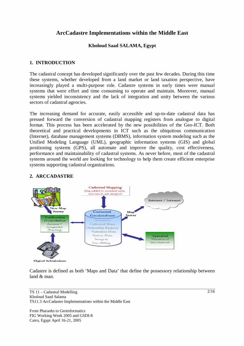
1. INTRODUCTION The cadastral concept has developed significantly over the past few decades. During this time these systems, whether developed from a land market or land taxation perspective, have increasingly played a multi-purpose role. Cadastre systems in early times were manual systems that were effort and time consuming to operate and maintain. Moreover, manual systems yielded inconsistency and the lack of integration and unity between the various sectors of cadastral agencies. The increasing demand for accurate, easily accessible and up-to-date cadastral data has pressed forward the conversion of cadastral mapping registers from analogue to digital format. This process has been accelerated by the new possibilities of the Geo-ICT. Both theoretical and practical developments in ICT such as the ubiquitous communication (Internet), database management systems (DBMS), information system modeling such as the Unified Modeling Language (UML), geographic information systems (GIS) and global positioning systems (GPS), all automate and improve the quality, cost effectiveness, performance and maintainability of cadastral systems. As never before, most of the cadastral systems around the world are looking for technology to help them create efficient enterprise systems supporting cadastral organizations. 2. ARCCADASTRE
Cadastre is defined as both ‘Maps and Data’ that define the possessory relationship between land & man.
TS 11 – Cadastral Modelling Kholoud Saad Salama TS11.3 ArcCadastre Implementations within the Middle East From Pharaohs to Geoinformatics FIG Working Week 2005 and GSDI-8 Cairo, Egypt April 16-21, 2005
3/16
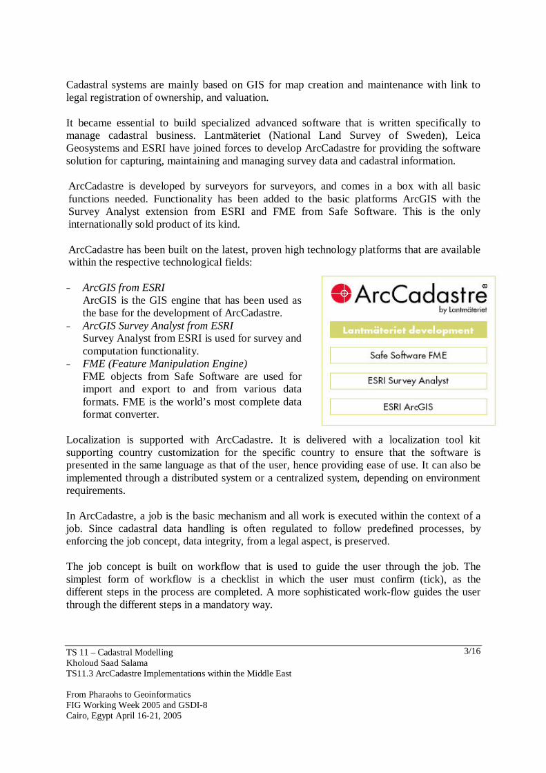
Cadastral systems are mainly based on GIS for map creation and maintenance with link to legal registration of ownership, and valuation. It became essential to build specialized advanced software that is written specifically to manage cadastral business. Lantmäteriet (National Land Survey of Sweden), Leica Geosystems and ESRI have joined forces to develop ArcCadastre for providing the software solution for capturing, maintaining and managing survey data and cadastral information. ArcCadastre is developed by surveyors for surveyors, and comes in a box with all basic functions needed. Functionality has been added to the basic platforms ArcGIS with the Survey Analyst extension from ESRI and FME from Safe Software. This is the only internationally sold product of its kind. ArcCadastre has been built on the latest, proven high technology platforms that are available within the respective technological fields:
− ArcGIS from ESRI ArcGIS is the GIS engine that has been used as the base for the development of ArcCadastre.
− ArcGIS Survey Analyst from ESRI Survey Analyst from ESRI is used for survey and computation functionality.
− FME (Feature Manipulation Engine) FME objects from Safe Software are used for import and export to and from various data formats. FME is the world’s most complete data format converter.
Localization is supported with ArcCadastre. It is delivered with a localization tool kit supporting country customization for the specific country to ensure that the software is presented in the same language as that of the user, hence providing ease of use. It can also be implemented through a distributed system or a centralized system, depending on environment requirements. In ArcCadastre, a job is the basic mechanism and all work is executed within the context of a job. Since cadastral data handling is often regulated to follow predefined processes, by enforcing the job concept, data integrity, from a legal aspect, is preserved. The job concept is built on workflow that is used to guide the user through the job. The simplest form of workflow is a checklist in which the user must confirm (tick), as the different steps in the process are completed. A more sophisticated work-flow guides the user through the different steps in a mandatory way.
TS 11 – Cadastral Modelling Kholoud Saad Salama TS11.3 ArcCadastre Implementations within the Middle East From Pharaohs to Geoinformatics FIG Working Week 2005 and GSDI-8 Cairo, Egypt April 16-21, 2005
4/16
3. ARCCADASTRE IMPLEMENTATIONS WITHIN THE MIDDLE EAST Cadastral industry is one of the key factors in achieving sustainable development. Accordingly, building and maintaining robust Cadastral Information Systems is an essential issue for countries within the Middle East for paving their way towards sustainability. Enterprise Cadastral Information Systems based on ArcCadastre have been implemented successfully in different countries in the Middle East. The following illustrates the cadastre implementations in both Egypt and Qatar through a summary of the project objectives, scope, system architecture and modules as well as system benefits. 3.1 ArcCadastre Implementation In Egypt Egypt in its struggle to move its position from a developing country to its rightful belonging as a leading country has given all attention to developing a national cadastral system. The Egyptian Survey Authority (ESA) as the sole agency responsible for cadastre registration survey activities has in terms followed the national planning and doubled the efforts to make the dream of a robust national cadastre come true. 3.1.1 ECIM Project Overview The Egyptian Cadastral Information Management (ECIM) project is a joint Egyptian-Finnish project owned by the Egyptian Survey Authority (ESA). The project started in March 2002 and its first phase ended in February 2005. The aim of ESA/ECIM is to have an efficient integrated distributed state of the art digital Land Information System (LIS) based on cadastral data. ESA will implement the LIS within a robust nationwide solution for national land registration management. Main concerns of the project were: − Establishing an automated cadastral system − Integrating existing separate islands of data by unifying the existing data formats − Achieving synchronization between different offices nationwide − Establishing an integrated scalable system − Establishing a system that enables the monitoring of various day-to-day activities
3.1.2 ECIM Project Objectives The objectives of ECIM are better security in land ownership and transaction and a more sustainable management of the nation’s land resources. The project purpose is improvement of land information system for cadastral services and its link to land registration and land taxation. Main project objectives were: − Automating office works in the cadastral sector with focus on land registration
processes − Designing and implementing a Unified Cadastral Database (UCD) to store both tabular
and geographic data for urban and rural areas, integrated with GIS System for cadastral management
− Survey data management
TS 11 – Cadastral Modelling Kholoud Saad Salama TS11.3 ArcCadastre Implementations within the Middle East From Pharaohs to Geoinformatics FIG Working Week 2005 and GSDI-8 Cairo, Egypt April 16-21, 2005
5/16
− Data conversion of existing data formats into Unified Cadastral Database (UCD) − A mechanism for sending and receiving tabular and geographic data between province
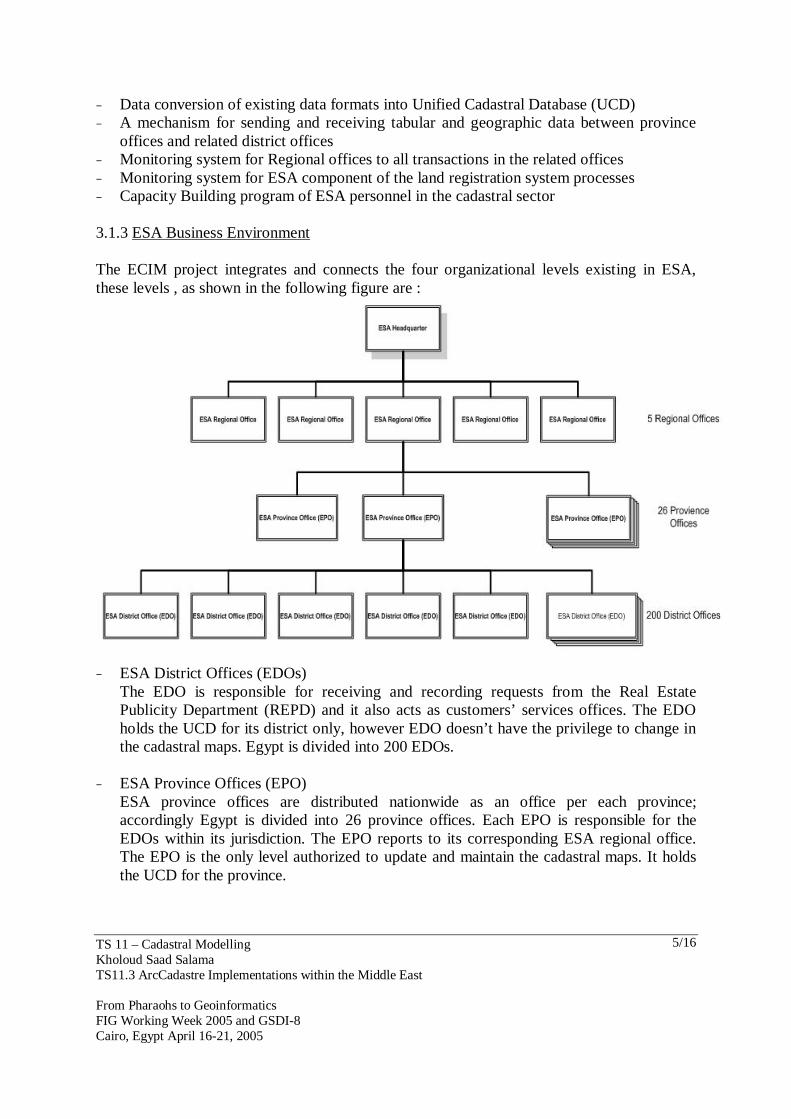
offices and related district offices − Monitoring system for Regional offices to all transactions in the related offices − Monitoring system for ESA component of the land registration system processes − Capacity Building program of ESA personnel in the cadastral sector 3.1.3 ESA Business Environment The ECIM project integrates and connects the four organizational levels existing in ESA, these levels , as shown in the following figure are :
− ESA District Offices (EDOs) The EDO is responsible for receiving and recording requests from the Real Estate Publicity Department (REPD) and it also acts as customers’ services offices. The EDO holds the UCD for its district only, however EDO doesn’t have the privilege to change in the cadastral maps. Egypt is divided into 200 EDOs.
− ESA Province Offices (EPO)
ESA province offices are distributed nationwide as an office per each province; accordingly Egypt is divided into 26 province offices. Each EPO is responsible for the EDOs within its jurisdiction. The EPO reports to its corresponding ESA regional office. The EPO is the only level authorized to update and maintain the cadastral maps. It holds the UCD for the province.
TS 11 – Cadastral Modelling Kholoud Saad Salama TS11.3 ArcCadastre Implementations within the Middle East From Pharaohs to Geoinformatics FIG Working Week 2005 and GSDI-8 Cairo, Egypt April 16-21, 2005
6/16
- ESA Regional Offices Egypt is divided into 5 regions; ESA regions represent an administrative level for monitoring and tracking the performance and activities of the EPOs and their corresponding EDOs within the region jurisdiction. The regional offices report to ESA headquarters.
− ESA Central Office in Cairo
ESA headquarter is the central office that manages all the previously mentioned offices. The central office monitors performance and prepares different kinds of reports and statistics. ESA headquarter represents the highest administrative level in ESA.
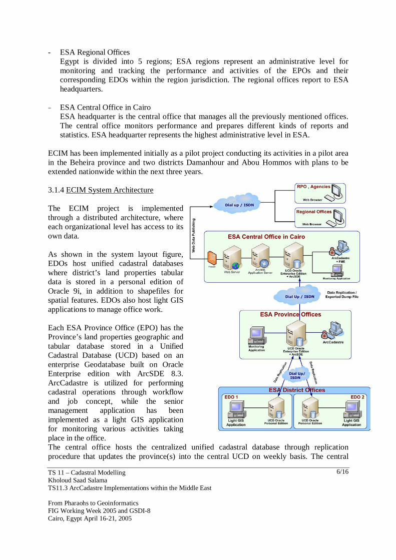
ECIM has been implemented initially as a pilot project conducting its activities in a pilot area in the Beheira province and two districts Damanhour and Abou Hommos with plans to be extended nationwide within the next three years. 3.1.4 ECIM System Architecture The ECIM project is implemented through a distributed architecture, where each organizational level has access to its own data. As shown in the system layout figure, EDOs host unified cadastral databases where district’s land properties tabular data is stored in a personal edition of Oracle 9i, in addition to shapefiles for spatial features. EDOs also host light GIS applications to manage office work. Each ESA Province Office (EPO) has the Province’s land properties geographic and tabular database stored in a Unified Cadastral Database (UCD) based on an enterprise Geodatabase built on Oracle Enterprise edition with ArcSDE 8.3. ArcCadastre is utilized for performing cadastral operations through workflow and job concept, while the senior management application has been implemented as a light GIS application for monitoring various activities taking place in the office. The central office hosts the centralized unified cadastral database through replication procedure that updates the province(s) into the central UCD on weekly basis. The central

TS 11 – Cadastral Modelling Kholoud Saad Salama TS11.3 ArcCadastre Implementations within the Middle East From Pharaohs to Geoinformatics FIG Working Week 2005 and GSDI-8 Cairo, Egypt April 16-21, 2005
7/16
office is also responsible for publishing geographic and tabular data on the Internet. The regional offices as administrative and monitoring office access the published data of the provinces under its jurisdiction. 3.1.5 Data Conversion Geographic data at ESA existed in AutoCAD format with their tabular data stored in Access database format. Data conversion was required to migrate the existing data volumes into a unified cadastral database. Data conversion toke place in the central office in Cairo using FME (Feature Manipulation Engine) professional suite 2004. In the occasional occurrence of province offices requiring data conversion, the central office prepares the needed ‘pipeline file’. The province office then uses the pipeline file to perform the required conversion operation making use of ArcCadastre's built in simplified FME engine. 3.1.6 ECIM Modules Throughout the ECIM project various modules were developed to serve the different needs of ESA offices. The main modules developed were as follows: 3.1.7 EDO Modules
A light application was developed using Visual Basic 6 and Map Objects 2.1 to ensure supporting ESA's various request types. The application is divided into the following sub-modules:
TS 11 – Cadastral Modelling Kholoud Saad Salama TS11.3 ArcCadastre Implementations within the Middle East From Pharaohs to Geoinformatics FIG Working Week 2005 and GSDI-8 Cairo, Egypt April 16-21, 2005
8/16
− Request handling module, which is responsible for handling request by: recording request details "parcels, applicants, and transactions" as well as payments.
− GIS module, which provides GIS functionalities, such as spatial overlay, displaying
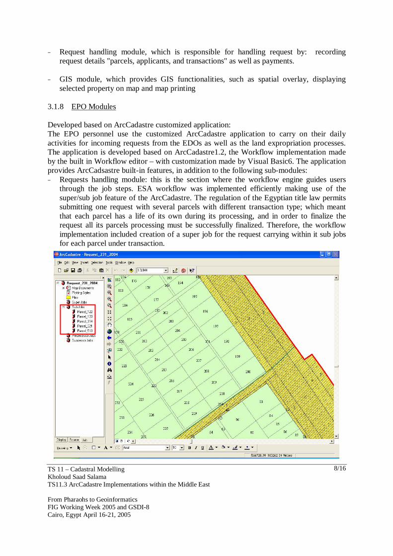
selected property on map and map printing 3.1.8 EPO Modules Developed based on ArcCadastre customized application: The EPO personnel use the customized ArcCadastre application to carry on their daily activities for incoming requests from the EDOs as well as the land expropriation processes. The application is developed based on ArcCadastre1.2, the Workflow implementation made by the built in Workflow editor – with customization made by Visual Basic6. The application provides ArcCadsastre built-in features, in addition to the following sub-modules: − Requests handling module: this is the section where the workflow engine guides users
through the job steps. ESA workflow was implemented efficiently making use of the super/sub job feature of the ArcCadastre. The regulation of the Egyptian title law permits submitting one request with several parcels with different transaction type; which meant that each parcel has a life of its own during its processing, and in order to finalize the request all its parcels processing must be successfully finalized. Therefore, the workflow implementation included creation of a super job for the request carrying within it sub jobs for each parcel under transaction.
TS 11 – Cadastral Modelling Kholoud Saad Salama TS11.3 ArcCadastre Implementations within the Middle East From Pharaohs to Geoinformatics FIG Working Week 2005 and GSDI-8 Cairo, Egypt April 16-21, 2005
9/16
− Digital surveying processing functionality (based on embedded survey analyst ) − Temporary/Live/History parcels maintenance procedure − Spatial data synchronization procedure, for extracting the delta updates from the SDE
layers (according to the different versions) and exporting these updates into delta shapefiles to be sent on daily basis to the corresponding EDO. The EDO application in return has an importing data synchronization procedure that uploads these delta shapefiles content into the EDO spatial shapefiles.
Senior management application − Daily activity monitoring module , which provides monitoring on going activities in the
province office, the application automatically displays to the manager the current users logged on to the Cadastral mapping system and the opened requests
− Reporting module that enables extracting a wide variety of modules based on the data stored in the Unified Cadastral Database. Examples of reports include request report , correspondence report , daily request report , the annual report of request types , request of a certain period report……….etc
ESA Web publishing application The web publishing application handles the publishing of geographic and tabular information via the Internet using ESRI's ArcIMS (Internet Mapping Server). Published information could be accessed by ESA's regional offices or other stakeholders (REPD). 3.1.9 ECIM Project Benefits Upon achieving the ECIM project objectives a number of benefits are expected to influence not only ESA, but also the society. Benefits to the society are based on the contribution to the economic development of Egypt through a more effective decision making processes at all levels ensuring sustainable land management. ECIM will also benefit the society by providing increased security. Benefits that directly affect ESA include: − Profits: A digital database makes it possible to create required specific and
standardized products in a more efficient way to a lower cost, which could attract more customers and hence increase the income.
− Customer Satisfaction: Faster delivery measured by the reduction of the time of delivery of cadastral services and products via a digital environment. The new system will be capable to speed up data processing, data analysis and data output to increase the quality of the products.
− Improved Office Environment: The digital storing media takes less space than the analogue environment of storing. This can enable the improvement of office environment and working conditions, as well as reduce the need for office space.
− Getting More Support from the Government: The proposed nation wide cadastral system provides transparency on information and quick access to it, which can have an economic effect and motivate the land market. It is expected that ESA could play a more important role as the government institution responsible of land information.
TS 11 – Cadastral Modelling Kholoud Saad Salama TS11.3 ArcCadastre Implementations within the Middle East From Pharaohs to Geoinformatics FIG Working Week 2005 and GSDI-8 Cairo, Egypt April 16-21, 2005
10/16
3.2 ArcCadastre Implementation In Qatar Following the urge to develop an automated enterprise cadastral systems and the growing realization of the importance of integrated consistent systems, ArcCadastre was implemented in Qatar to upgrade their existing legacy system with an enterprise cadastral system that would efficiently support the operations of the General Survey Section (GSS) and employ a centralized cadastral and survey database. 3.2.1 GSS Project Overview Given the significance of GSS processes and the success of GIS in commercial and other government applications, GSS seeked productivity gains and means to improve accessibility to the GIS maps linked to their cadastral data, through the implementation of a centralized Cadastral Information Management System that could assists GSS with its responsibilities that include: − Demarcation of land properties. − Maintaining a land cadastre for the country. − Filing of technical documents related to accurate land survey. − Maintaining the most accurate digital source of survey data on the parcel level. 3.2.2 GSS Project Objectives The main objective of the GSS project is the development of a GIS based enterprise surveying and cadastral information system. The project aims at upgrading GSS technological capabilities and adding new functionalities to allow for richer, faster and more accurate operations for handling the national survey measurements, computations and parcel management. Main goals of the project included: − Building Centralized Cadastral & Surveying Database − Migrating existing Data volumes to a unified cadastral Geodatabase − Workflow Implementation − Application Customization − Integrate the scattered DOS based legacy systems − Establish adequate progress reporting
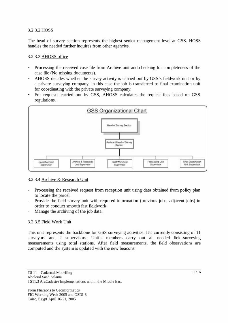
3.2.3 GSS Business Environment The GSS project integrates the seven units that exist within the GSS. The GSS organizational structure is as follows: 3.2.3.1 Reception Unit − Receiving and verifying case file documents. − Assigning a job number for referencing hard-copied case files. − Collecting records and releasing fees receipt.
TS 11 – Cadastral Modelling Kholoud Saad Salama TS11.3 ArcCadastre Implementations within the Middle East From Pharaohs to Geoinformatics FIG Working Week 2005 and GSDI-8 Cairo, Egypt April 16-21, 2005
11/16
3.2.3.2 HOSS The head of survey section represents the highest senior management level at GSS. HOSS handles the needed further inquires from other agencies. 3.2.3.3 AHOSS office - Processing the received case file from Archive unit and checking for completeness of the
case file (No missing documents). - AHOSS decides whether the survey activity is carried out by GSS’s fieldwork unit or by
a private surveying company; in this case the job is transferred to final examination unit for coordinating with the private surveying company.
- For requests carried out by GSS, AHOSS calculates the request fees based on GSS regulations.
3.2.3.4 Archive & Research Unit − Processing the received request from reception unit using data obtained from policy plan
to locate the parcel − Provide the field survey unit with required information (previous jobs, adjacent jobs) in
order to conduct smooth fast fieldwork. − Manage the archiving of the job data. 3.2.3.5 Field Work Unit This unit represents the backbone for GSS surveying activities. It’s currently consisting of 11 surveyors and 2 supervisors. Unit’s members carry out all needed field-surveying measurements using total stations. After field measurements, the field observations are computed and the system is updated with the new beacons.
TS 11 – Cadastral Modelling Kholoud Saad Salama TS11.3 ArcCadastre Implementations within the Middle East From Pharaohs to Geoinformatics FIG Working Week 2005 and GSDI-8 Cairo, Egypt April 16-21, 2005
12/16
3.2.3.6 Processing and Drafting Unit Unit personnel are responsible of validating the data released from fieldwork unit, logging the surveyed parcel(s) and beacons into the database then issuing the Property Document (PD). In case of any missing data the case is returned back to the field work unit to redo the survey procedure. 3.2.3.7 Final Examination & Approval Unit The unit mainly handles the final approval of survey activities for both internal and private surveying companies. 3.2.4 GSS Project Activities The GSS cadastral project involved three main activities as follows: − Replace the current obsolete system with an enterprise cadastral system through building
a cadastral model, customizing interfaces for different departments and automating the workflow.
− Data conversion , which enabled converting existing survey and parcels records into the new Geodatabase using data conversion routines mandating data consistency and integrity.
− Capacity building through conducting proper training for GSS personnel on the developed applications
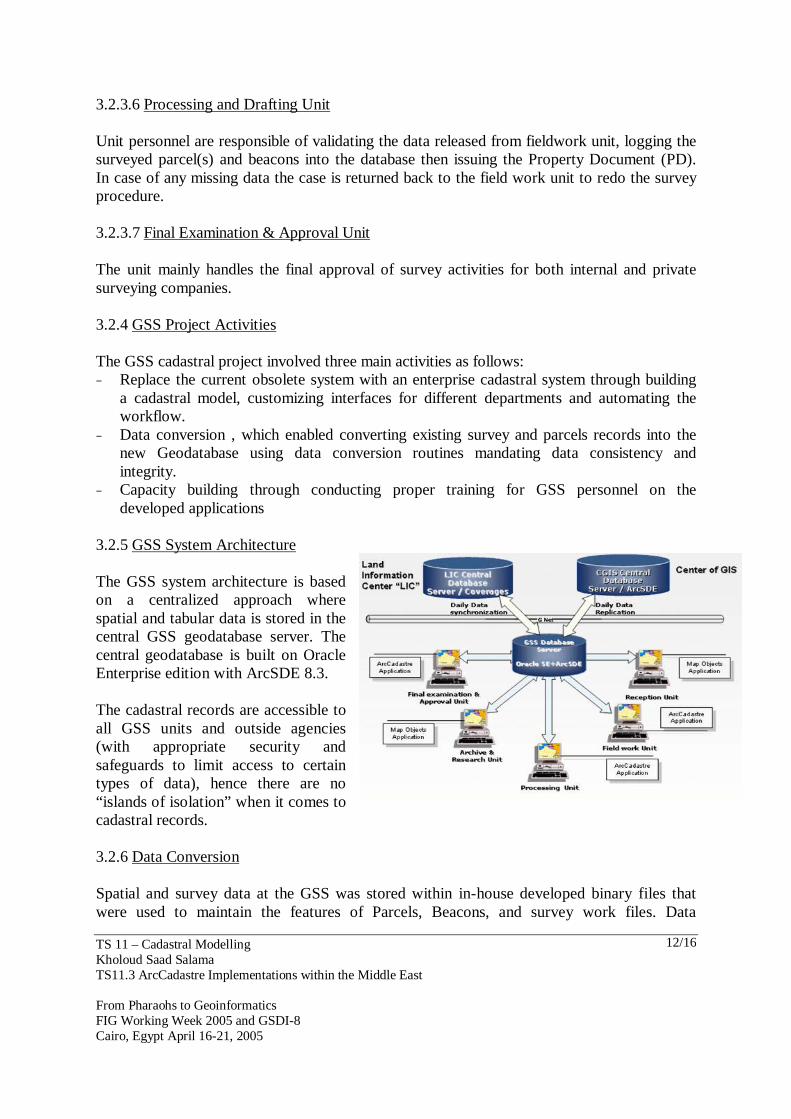
3.2.5 GSS System Architecture The GSS system architecture is based on a centralized approach where spatial and tabular data is stored in the central GSS geodatabase server. The central geodatabase is built on Oracle Enterprise edition with ArcSDE 8.3. The cadastral records are accessible to all GSS units and outside agencies (with appropriate security and safeguards to limit access to certain types of data), hence there are no “islands of isolation” when it comes to cadastral records. 3.2.6 Data Conversion Spatial and survey data at the GSS was stored within in-house developed binary files that were used to maintain the features of Parcels, Beacons, and survey work files. Data
TS 11 – Cadastral Modelling Kholoud Saad Salama TS11.3 ArcCadastre Implementations within the Middle East From Pharaohs to Geoinformatics FIG Working Week 2005 and GSDI-8 Cairo, Egypt April 16-21, 2005
13/16
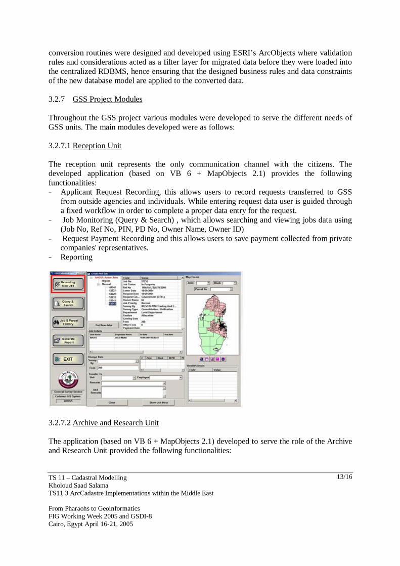
conversion routines were designed and developed using ESRI’s ArcObjects where validation rules and considerations acted as a filter layer for migrated data before they were loaded into the centralized RDBMS, hence ensuring that the designed business rules and data constraints of the new database model are applied to the converted data. 3.2.7 GSS Project Modules Throughout the GSS project various modules were developed to serve the different needs of GSS units. The main modules developed were as follows: 3.2.7.1 Reception Unit The reception unit represents the only communication channel with the citizens. The developed application (based on VB 6 + MapObjects 2.1) provides the following functionalities: − Applicant Request Recording, this allows users to record requests transferred to GSS
from outside agencies and individuals. While entering request data user is guided through a fixed workflow in order to complete a proper data entry for the request.
− Job Monitoring (Query & Search) , which allows searching and viewing jobs data using (Job No, Ref No, PIN, PD No, Owner Name, Owner ID)
− Request Payment Recording and this allows users to save payment collected from private companies' representatives.
− Reporting
3.2.7.2 Archive and Research Unit The application (based on VB 6 + MapObjects 2.1) developed to serve the role of the Archive and Research Unit provided the following functionalities:
TS 11 – Cadastral Modelling Kholoud Saad Salama TS11.3 ArcCadastre Implementations within the Middle East From Pharaohs to Geoinformatics FIG Working Week 2005 and GSDI-8 Cairo, Egypt April 16-21, 2005
14/16
− Request Parcel(s) Locating, which allows locating parcels using one of these 3 options (PIN, Urban, and North & East) according to the given or available data.
− Draft Layout for Parcel Locations − Check Parcels Overlap − Reporting − Transferring to Next Unit 3.2.7.3 Assistant Head of Survey Section (AHOSS) Main functionalities of the AHOSS module included: − Recording New Jobs (requests): viewing transferred cases, and handling each case
depending on the user decision. − Transfer: In case of normal transfer to any unit inside GSS. − Handle Locked Job: Either to cancel both or proceed in both jobs or to cancel one job
and proceed in the other − Change Survey Agency: Change the surveyed agency of the running job. − Change the Survey Fees: Depending on the survey agency and the owner. − Query & Search: searching and viewing jobs data using (Job No, Ref No, PIN, PD No,
Owner Name, Owner ID) − Job & Parcel History: Viewing the History of any parcel knowing its PIN or Job
number − Generate Report: generating reports 3.2.7.4 Field Survey Unit Main functionalities of the Field Work application (developed by customization of ArcCadastre) included: − Preparing needed data for surveyors before going to the field − Helping Surveyors to make all their needed computations to their work files after
surveying − Generating the final coordinates of the case according the final computations − Generating a final sketch for illustrating all the conditions and data of the case to be
delivered to the processing unit and to be a reference for the case if needed in the future 3.2.7.5 Processing and Drafting Unit The processing and drafting unit application (developed by customization of ArcCadastre) functions included: − Checking the final data of the field work unit through the different computations − Generating provisional beacons for the job − Generating Provisional parcel(s) from the generated beacons − Generating Property document (PD) for the job
TS 11 – Cadastral Modelling Kholoud Saad Salama TS11.3 ArcCadastre Implementations within the Middle East From Pharaohs to Geoinformatics FIG Working Week 2005 and GSDI-8 Cairo, Egypt April 16-21, 2005
15/16
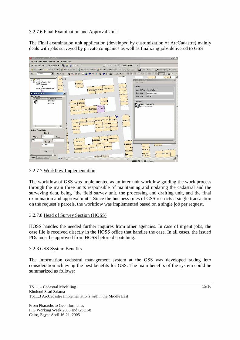
3.2.7.6 Final Examination and Approval Unit The Final examination unit application (developed by customization of ArcCadastre) mainly deals with jobs surveyed by private companies as well as finalizing jobs delivered to GSS
3.2.7.7 Workflow Implementation The workflow of GSS was implemented as an inter-unit workflow guiding the work process through the main three units responsible of maintaining and updating the cadastral and the surveying data, being “the field survey unit, the processing and drafting unit, and the final examination and approval unit”. Since the business rules of GSS restricts a single transaction on the request’s parcels, the workflow was implemented based on a single job per request. 3.2.7.8 Head of Survey Section (HOSS) HOSS handles the needed further inquires from other agencies. In case of urgent jobs, the case file is received directly in the HOSS office that handles the case. In all cases, the issued PDs must be approved from HOSS before dispatching. 3.2.8 GSS System Benefits The information cadastral management system at the GSS was developed taking into consideration achieving the best benefits for GSS. The main benefits of the system could be summarized as follows:
TS 11 – Cadastral Modelling Kholoud Saad Salama TS11.3 ArcCadastre Implementations within the Middle East From Pharaohs to Geoinformatics FIG Working Week 2005 and GSDI-8 Cairo, Egypt April 16-21, 2005
16/16
− Automating the processing of the job. − Centralized Cadastral Geodatabase − Applications Integration − Surveying GIS Integration − Formal workflow − Defining the users’ group and the users’ privileges. − Adequate progress reporting. − Validation rules for the data entry
4. CONCLUSION Although ArcCadastre is yet in its early phases of implementation, the success of both ECIM and GSS projects present it as a promising package for a new era of automated cadastral systems. The flexibility presented in the modules and features of ArcCadastre makes it an elastic tool for the GIS and cadastral developers to use for implementing specific country workflows and business rules through basic customization o ArcCadastre without the need to create an entire workflow/job based application from scratch. This flexibility is clearly presented in the smooth implementation of the two systems based on ArcCadastre despite their fundamental differences: − ESA as a distributed system: with multiple distributed databases with data
synchronization procedure as well as an interlinked workflows operating on super job/sub job per request
− GSS as a centralized system: with basic workflow operating on single job per request. Also being part of the ESRI family completes the strength of ArcCadastre, as this offer a complete set of applications directly integrated with ArcCadastre such as: ArcIMS for cadastral maps publishing, all ArcGIS packages for the agency other units desktop applications, MapObjects for light GIS applications, with all these applications operating smoothly on centralized ArcSDE multi-user cadastral/surveying geodatabase. CONTACTS Ms. Kholoud Saad Salama Quality Standards Information Technology, ESRI Distributor Egypt 2 El Misaha Sq. – Dokki Giza EGYPT Tel. + 20 2 7612344, ext. 134 Fax + 20 2 7485288 Email: [email protected] Web site: www.qs4it.com