Ar–Ar muscovite dating as a constraint on sediment provenance and erosion processes in the Red and...
11
Ar–Ar muscovite dating as a constraint on sediment provenance and erosion processes in the Red and Yangtze River systems, SE Asia Long van Hoang a, ⁎, Peter D. Clift a , Darren Mark b , Hongbo Zheng c , Mai Thanh Tan d a School of Geosciences, University of Aberdeen, Meston Building, Aberdeen, AB24 3UE, UK b Scottish Universities Environmental Research Centre, Rankine Avenue, East Kilbride, G75 0QF, UK c Institute of Surficial Geochemistry, School of Earth Science and Engineering, Nanjing University, 22 Hankou Road, Nanjing, People's Republic of China d Hanoi University of Mining and Geology, Dong Ngac, Tu Liem, Hanoi, Viet Nam abstract article info Article history: Received 10 December 2009 Received in revised form 6 April 2010 Accepted 7 April 2010 Available online 13 May 2010 Editor: T.M. Harrison Keywords: Red River Yangtze River Ar–Ar muscovite dating provenance In this study we applied 40 Ar/ 39 Ar dating methods to muscovite grains in sands from the modern Red and Yangtze Rivers in order to constrain palaeo and modern erosion patterns and sediment transport processes. Micas in the headwaters of the Red River and its southern Da River tributary are dominantly Cenozoic, while the northern Lo River tributary shows a typical 160–220 Ma population. The lower reaches of the Red River comprise 53% of such Triassic grains, indicating that the Lo River is the most important net contributor to the modern delta. However, this contrasts with zircon U–Pb data indicating that the upper reaches of the Red River dominate that mineral group. We suggest that the mismatch reflects the rapid transport of mica relative to zircon in the river and the fact that the Red River is not in equilibrium. We hypothesize that the zircons were eroded N 8 ka under a regime of stronger monsoon that enhanced erosion in the northern drainage basin, while modern erosion is focused in the south, especially in the Song Chay Massif. Micas from the upper Yangtze River are resolvably older than those in the Red River (230–250 Ma), so that this method could be used to test for drainage capture in palaeo-delta sediments. Micas in the modern Yangtze delta are generally much younger than those in the upper reaches and indicate that erosion in the Longmen Shan (Sichuan) and neighbouring regions is more important than the upper Yangtze in supplying sediment, reflecting the stronger monsoon rains in those areas. © 2010 Elsevier B.V. All rights reserved. 1. Introduction Understanding the processes that form the stratigraphic record on continental margins is central to our ability to use those sediments to reconstruct sea level, tectonic and climatic evolution. In particular, it is important to know where and why sediment is formed in drainage basins and how is it transported to the oceans. In this study we address this problem via an investigation of the nature of erosion and sediment transport in the Red and Yangtze Rivers of SE Asia. The Red River provides a useful natural laboratory for studying sediment transport because the region is strongly affected by summer monsoon rains, especially in the southern parts of the basin, while in its northern reaches the bedrock of the river basin is experiencing active tectonic deformation (Meade, 2007; Qiao et al., 2007). This is important because debate continues regarding whether solid Earth tectonic processes or climatic influences are dominant in controlling continental erosion (Burbank et al., 2003; Dadson et al., 2003; Wobus et al., 2003). The Red River moreover, has a very limited modern flood plain, meaning that sediment storage prior to deposition offshore is necessarily limited. That is not to say that the transport time between erosion and marine sedimentation is close to being zero. Radiometric methods have recently suggested that transport times in the Ganges River may be on the order of 100 k.y. (Granet et al., 2007), which if true would introduce a major lag in the transport process and make direct comparison of marine sediment records and climatic or erosional reconstructions difficult. We here try to constrain transport times in the Red River, which although smaller than the Ganges is nonetheless a major drainage basin. The Red River is a relatively simple system to examine because the only significant Quaternary basin is the delta plain itself at the coast of the Gulf of Tonkin. Upstream the river is effectively cutting bedrock canyons along much of its course. The Red River has also been a special focus of research because of suggestions that this drainage was much larger in the past than it is at present. It has been noted that there is almost twice as much sediment in the offshore Song Hong-Yinggehai Basin as has been eroded from the present river basin during the Cenozoic (Clift et al., 2006a). This observation supported a proposal that the Red River had formerly been one of the largest systems in Asia, but that it had progressively lost its headwaters, as a result of drainage capture, especially in the SE of the Earth and Planetary Science Letters 295 (2010) 379–389 ⁎ Corresponding author. E-mail address: [email protected] (L. van Hoang). 0012-821X/$ – see front matter © 2010 Elsevier B.V. All rights reserved. doi:10.1016/j.epsl.2010.04.012 Contents lists available at ScienceDirect Earth and Planetary Science Letters journal homepage: www.elsevier.com/locate/epsl
-
Upload
independent -
Category
Documents
-
view
2 -
download
0
Transcript of Ar–Ar muscovite dating as a constraint on sediment provenance and erosion processes in the Red and...
Earth and Planetary Science Letters 295 (2010) 379–389
Contents lists available at ScienceDirect
Earth and Planetary Science Letters
j ourna l homepage: www.e lsev ie r.com/ locate /eps l
Ar–Ar muscovite dating as a constraint on sediment provenance and erosionprocesses in the Red and Yangtze River systems, SE Asia
Long van Hoang a,⁎, Peter D. Clift a, Darren Mark b, Hongbo Zheng c, Mai Thanh Tan d
a School of Geosciences, University of Aberdeen, Meston Building, Aberdeen, AB24 3UE, UKb Scottish Universities Environmental Research Centre, Rankine Avenue, East Kilbride, G75 0QF, UKc Institute of Surficial Geochemistry, School of Earth Science and Engineering, Nanjing University, 22 Hankou Road, Nanjing, People's Republic of Chinad Hanoi University of Mining and Geology, Dong Ngac, Tu Liem, Hanoi, Viet Nam
⁎ Corresponding author.E-mail address: [email protected] (L. van Hoang
0012-821X/$ – see front matter © 2010 Elsevier B.V. Adoi:10.1016/j.epsl.2010.04.012
a b s t r a c t
a r t i c l e i n f oArticle history:Received 10 December 2009Received in revised form 6 April 2010Accepted 7 April 2010Available online 13 May 2010
Editor: T.M. Harrison
Keywords:Red RiverYangtze RiverAr–Ar muscovite datingprovenance
In this study we applied 40Ar/39Ar dating methods to muscovite grains in sands from the modern Red andYangtze Rivers in order to constrain palaeo and modern erosion patterns and sediment transport processes.Micas in the headwaters of the Red River and its southern Da River tributary are dominantly Cenozoic, whilethe northern Lo River tributary shows a typical 160–220 Ma population. The lower reaches of the Red Rivercomprise 53% of such Triassic grains, indicating that the Lo River is the most important net contributor to themodern delta. However, this contrasts with zircon U–Pb data indicating that the upper reaches of the RedRiver dominate that mineral group. We suggest that the mismatch reflects the rapid transport of micarelative to zircon in the river and the fact that the Red River is not in equilibrium. We hypothesize that thezircons were eroded N8 ka under a regime of stronger monsoon that enhanced erosion in the northerndrainage basin, while modern erosion is focused in the south, especially in the Song Chay Massif. Micas fromthe upper Yangtze River are resolvably older than those in the Red River (230–250 Ma), so that this methodcould be used to test for drainage capture in palaeo-delta sediments. Micas in the modern Yangtze delta aregenerally much younger than those in the upper reaches and indicate that erosion in the Longmen Shan(Sichuan) and neighbouring regions is more important than the upper Yangtze in supplying sediment,reflecting the stronger monsoon rains in those areas.
).
ll rights reserved.
© 2010 Elsevier B.V. All rights reserved.
1. Introduction
Understanding the processes that form the stratigraphic record oncontinental margins is central to our ability to use those sediments toreconstruct sea level, tectonic and climatic evolution. In particular, it isimportant to know where and why sediment is formed in drainagebasins and how is it transported to the oceans. In this study weaddress this problem via an investigation of the nature of erosion andsediment transport in the Red and Yangtze Rivers of SE Asia. The RedRiver provides a useful natural laboratory for studying sedimenttransport because the region is strongly affected by summermonsoonrains, especially in the southern parts of the basin, while in itsnorthern reaches the bedrock of the river basin is experiencing activetectonic deformation (Meade, 2007; Qiao et al., 2007). This isimportant because debate continues regarding whether solid Earthtectonic processes or climatic influences are dominant in controllingcontinental erosion (Burbank et al., 2003; Dadson et al., 2003; Wobuset al., 2003). The Red River moreover, has a very limited modern flood
plain, meaning that sediment storage prior to deposition offshore isnecessarily limited. That is not to say that the transport time betweenerosion and marine sedimentation is close to being zero. Radiometricmethods have recently suggested that transport times in the GangesRiver may be on the order of 100 k.y. (Granet et al., 2007), which iftrue would introduce a major lag in the transport process and makedirect comparison of marine sediment records and climatic orerosional reconstructions difficult. We here try to constrain transporttimes in the Red River, which although smaller than the Ganges isnonetheless a major drainage basin. The Red River is a relativelysimple system to examine because the only significant Quaternarybasin is the delta plain itself at the coast of the Gulf of Tonkin.Upstream the river is effectively cutting bedrock canyons along muchof its course.
The Red River has also been a special focus of research because ofsuggestions that this drainage was much larger in the past than it is atpresent. It has beennoted that there is almost twiceasmuchsediment inthe offshore Song Hong-Yinggehai Basin as has been eroded from thepresent river basin during the Cenozoic (Clift et al., 2006a). Thisobservation supported a proposal that the Red River had formerly beenone of the largest systems in Asia, but that it had progressively lost itsheadwaters, as a result of drainage capture, especially in the SE of the

380 V.L. Hoang et al. / Earth and Planetary Science Letters 295 (2010) 379–389
Tibetan Plateau, extending into Yunnan (SW China) (Brookfield, 1998;Clark et al., 2004). In thismodel the upper reaches of the Yangtze (calledJinsha in China), Mekong, Salween, Irrawaddy and upper Brahmaputra(known as Yarlung in Tibet) Rivers may have formerly flowed into thehead of the modern Red River, but were diverted as the regionaltopography of eastern Asia changed during uplift of the Tibetan Plateau.If the capturehypothesis is true then itmaybepossible todatewhen thisoccurred using sediments in the delta of the Red River, provided it couldbe shown that the different headwater rivers havedistinct compositionsor mineral ages. Assessing whether 40Ar/39Ar dating of muscovitesmight be a good method to date these capture events is a major goal ofthis study. Attempts to use U–Pb dating of zircons and Pb isotopecompositions of K-feldspar grains indicate that if the Red River formerlyhad a much wider extent then this was likely somewhat less than hasbeen originally proposed and that large-scale capture involving theYangtze probably occurred during the Oligocene or earlier (Clift et al.,2008; Hoang et al., 2009).
In this study we employ the 40Ar/39Ar dating method as applied todetrital muscovite grains to constrain the source of sediment in theRed River system. This method, which has been applied in severalAsian provenance studies (Najman et al., 1997; White et al., 2002;Szulc et al., 2006), allows us to date when a single mica cooledthrough an isotherm of around 300 °C (Hodges, 2003). In SE Asia this
Fig. 1. Schematic tectonic map of SE Asia showing the positions of the major river systems inMetcalfe (1996)). River names in italic text. It has been suggested that the Red River once con1998; Clark et al., 2004).
is a useful measurement because the region is composed of a series ofterranes, each with its own unique geological and tectonic history,and thus with potentially different 40Ar/39Ar cooling ages (Fig. 1). Wechoose to use muscovite because this mineral is often favoured bytectonic geologists who have attempted to constrain exhumation andtectonic activity in SE Asia by using this method (Leloup et al., 1993;Harrison et al., 1996; Wang et al., 2000; Leloup et al., 2001; Gilley etal., 2003), although biotites and K-feldspars have also be measured inthis region. This means we have a database of bedrock muscovite agesto compare with our detrital ages (Fig. 2). Difference between plateauand total Ar–Ar muscovite ages in the bedrocks are minor and far lessthan the differences between the various ranges considered here(Leloup et al., 2001). In an ideal case dating of the mica grains in theriver sands could be directly compared with bedrock ages and thesource of the sediments accurately defined. However, in practice thedating of the bedrock is poorly known and existing data are oftenfocused in areas of special scientific interest. In particular, this regionhas become a classic case for the study of large-scale strike-slip faultsand consequently much of the existing data is derived only from thevicinity of the Red River Fault Zone (RRFZ), leaving much of the rest ofthe river basin unknown. In this work we attempt to characterize theexhumation of the basin more widely by dating of the grains in themajor river systems, which sampled over a wide area (Table 1).
relation to the different tectonic blocks that comprise their source regions (altered fromnected with the Yangtze and has since been separated due to surface uplift (Brookfield,

Fig. 2. Regional geological map of the eastern Tibetan Plateau, SW China and northern Indochina, showing the river courses overlain and the extent of the drainage basins. Mapredrawn from original provided by B.C. Burchfiel (unpublished data). Black circles show sampling points. White square shows dams and Hoa Binh and Thac Ba. Boxes with datesshow known Ar–Ar muscovite total ages from Leloup et al. (2001), Wang et al. (1998; 2000) and Harrison et al. (1996). DCS = Dian Cang Shan.
381V.L. Hoang et al. / Earth and Planetary Science Letters 295 (2010) 379–389
2. Sampling and analytical methods
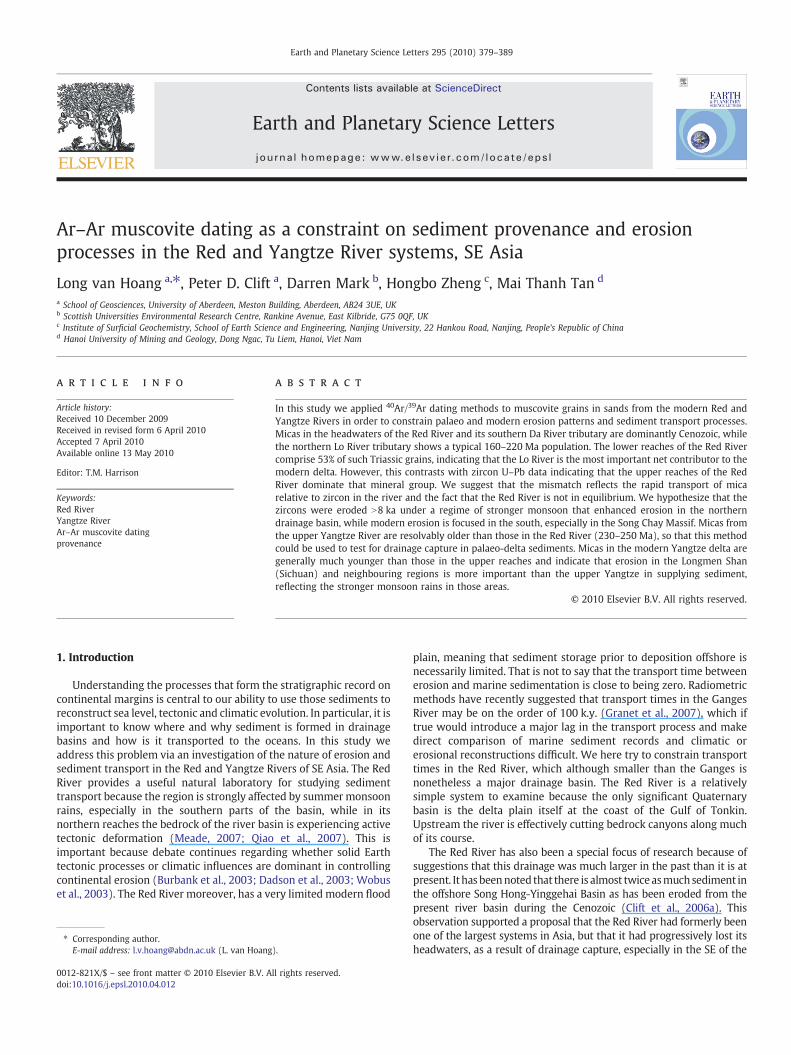
We sampled sediments from the main Red River and its majortributaries, the Lo and Da Rivers, which join the main Red River justnorth of Hanoi, relatively close to the delta (Fig. 3). In addition, we tookone sample from the “first bend”of theYangtzeRiver, at thepointwherethe river reverses its flow to the SSE and starts to flow to theNNE. This isa point of particular interest because this is the proposed capture pointof the upper Yangtze away from the Red River. Furthermore, sedimentcollected here provides an image of what is being eroded in the upperYangtze (Jinsha) north of this point. Finally we sampled sediment fromthe mouth of the Yangtze River, north of Shanghai in order to assesswhether the sediment reaching the ocean is dominated by erosion fromhigh in the catchment or from closer to the delta. Locations and samplenumbers are shown in Figs. 2 and 3. Samples were taken in order tocapture a representative sample of the modern river's clastic load.
Table 1Locations of sampling points and rivers considered in this study.
Sample River sampled Place name Latitude Longitude
XING-1 Yangtze Delta 31°19.35′N 121°30.08′E40529YU03 Yangtze First Bend 26°52.14′N 99°57.87′EVN05060701 Da River Hoa Binh 21°14.17′N 105°20.82′EVN05060801 Red River Lao Cai 22°30.18′N 103°58.19′EVN05060805 Chay River Phorang 22°14.13′N 104°28.78′EVN05060809 Lo River Bach Hac 21°17.25′N 105°26.30′E16-5 Red/River Red River Yuxi 23°46.98′N 101°53.83′EHanoi Red River Hanoi 21°3.46′N 105°50.42′E
Samples were taken prior to the summer monsoon flooding from wetsediments at the edge of the active channel in order to samplematerialsthat had been carried by the river very recently, rather than beingreworked for the local banks. Sandy samples were taken because of theanalytical limitation of not being able to date grains smaller than150 µm. White mica-bearing sediments were selected for 40Ar/39Ardating. Each sample was sieved into 250–500 µm aliquots from whichwhite micas were handpicked. They were subsequently cleanedultrasonically in deionised water. Mica grains were then placed intoCu-foil packages and stacked in quartz tubes. Inter-dispersed amongstthe Cu packets were Al-foil packets containing the International 40Ar/39Ar Age Standard, Fish Canyon Tuff sanidine (FCs; 28.02±0.16 Ma, 1σ)(Renne et al., 1998),whichallows characterization of the irradiationfluxto the samples of unknown age. Samples were irradiated for 12 h in theMcMaster reactor, Ontario, Canada.
A 25 W Merchantek CO2 laser was used for argon extraction. A 3%power stepwas used to degas surface contaminants (e.g., atmospheric40Ar) and subsequently a 15% step was used for complete fusion. Thesample gas was cleaned in a fully automated all-metal extraction lineby two GP50 getters (one operated at 450 °C and the other at roomtemperature). A slush trap was maintained at −95 °C by a mixture ofCO2(s) and acetone. Data were collected using an ARGUS multi-collector mass spectrometer at the Natural Environment ResearchCouncil (NERC) Argon Isotope Laboratory, which is housed by theScottish Universities Environmental Research Centre, United Kingdom(Mark et al., 2009).
ArArCalc was used for off-line data reduction and age calculation(Koppers, 2002). Data were corrected for interference reactions, mass

Fig. 3. Satellite image of the region around the modern Red River basin showing the distribution of major river courses and the sampled locations used in this study. Sample fromHanoi (lowermost) is from Clift et al. (2006b). DCS = Dian Cang Shan.
382 V.L. Hoang et al. / Earth and Planetary Science Letters 295 (2010) 379–389
discrimination, blanks and radiogenic decay. 40Ar/39Ar data arepresented with 1σ uncertainties (n=355) as probability densityplots (Figs. 4 and 5). Full analytical results are provided in online datasupplement Table S1. Data quality is highly-dependant on crystal size,the smallest crystals yielding the largest uncertainties (i.e., lessradiogenic 40Ar to measure). J-parameters and interference correctionfactors are also presented in the online auxiliary material.
Provenance analysis of sediments from large, complicated riverbasins normally requires at least 100 grain analyses for the result to beconsidered statistically robust (Ruhl and Hodges, 2005). Unfortunatelyonly in Sample 16-5 fromYunnandowehavenumbers approaching thisfor a single sand sample. Most of our sands have only 40–50 grainsanalyzed in each case. This means that we may not be successful inidentifying all the smaller sedimentpopulations, but ourdatadoprovidesufficient grains to define twomajor grain populations that aremixed inthe Red River. The composition of rivers and dating of bedrock outsidethe RRFZ and the Song Chay Massif has been largely unknown beforethis work our data do provide an important initial image of theapproximate age contrasts across this river system and some control onthe origin of sediment in the modern Red River.
3. Results
Fig. 4 shows the range of ages in the detrital muscovite grains foreach sample taken within the Red River system, together with theresults of an earlier analysis of micas from sand sampled at Hanoi (Cliftet al., 2006b) (Fig. 4F). This latter sample represents the bestcharacterized material from the lower reaches of the river and is likelyclose to the composition of the sediments now being delivered to theSouth China Sea. The ages are shown as probability density plots anddemonstrate significantvariationwithin theRedRiver. It is clear that themica age populations in the Red River in Yunnan and at Lao Cai are verysimilar (Fig. 4A and B), being dominated by grains younger than 50 Ma.
The same is also true of the micas found in the Da River, the southerntributary of the Red River, although this also contains a minoritypopulation of older Cretaceous and Triassic grains (Fig. 4C).
In contrast, the micas in the Chay and Lo Rivers show very differentpopulations. The Chay River sample (Fig. 4D) does show some influx fromCenozoic sources, but is dominated by grains dated as older than 100 Ma(mid Cretaceous), and mostly younger than 250 Ma (end Permian). TheLo River age population shows some overlapwith the Chay River sample,but has a much better defined peak around 210Ma (Fig. 4E). The vastmajority of mica ages in the Lo River lie between 160 and 220Ma.
The Yangtze River samples show quite different age spectracompared to those from the Red River system (Fig. 5). The “first bend”sample from the upper Yangtze River has a well-defined peak of grainscentred around 240 Ma (Fig. 5A), a little older than most grains seen inthe Red River system, although it has a minority population of micasbetween 100 and 150 Ma, similar to those seen in the Chay and LoRivers, but completely absent from other parts of the Red River basin.The upper Yangtze River also contains a significantminority populationof older Early Palaeozoic grains (340–471 Ma), comprising ∼35% of thetotal grains in that sample. What is very clear is that the micas in themodern Yangtze delta show very little overlap in age with those fromthe upper Yangtze River. These sediments are dominated by grains,mostly younger than 170 Ma, but with a small group of Triassic grainsolder than 200 Ma, comprising around 10% of the total.
4. Discussion
4.1. Provenance of the Yangtze River
Althoughwe here have only two samples from the Yangtze Riverweare able to use them tomake a very simple analysis of where sedimentsin the Yangtze delta are now being derived from. It is very clear that theAr–Ar age spectra of micas in the delta have very little in commonwith

Fig. 4. Probability density plots for Ar–Ar ages of muscovite grains from the modern Red River and its tributaries. See Fig. 3 for sample locations.
383V.L. Hoang et al. / Earth and Planetary Science Letters 295 (2010) 379–389
the sand sampled at the first bend in Yunnan. We therefore concludethat the upper Yangtze (Jinsha) is not a major contributor to thesediment flux now entering the East China Sea. In some ways this mayseemunusual because the rapid topographic fall on edges of the TibetanPlateaumightbeexpected todrive fast erosion in that area. This region isalso experiencing rapid deformation as measured by GPS methods(Chen et al., 1999; England and Molnar, 2005; Qiao et al., 2007), whichmight also be expected to enhance bedrock erosion. We do not suggestthat the upper Yangtze is not supplying significant sediment, but it is
clear that the Ar–Ar data require greater sediment supply from rangesthat have cooled during the Cretaceous and Cenozoic. The tributaries ofthe Yangtze that drain the eastern flank of the plateau and join themainriver in Sichuan are inferred to be the dominant sediment suppliers. The10Be budget of Chappell et al. (2006) shows that while the upperYangtze is a sediment productive region it is nomore so than the Dadu,Min and Jialing Rivers that drain the Longmen Shan to the northwest ofthe Sichuan Basin. That region is not only tectonically active (Burchfielet al., 1995; Kirby et al., 2003; Zhang et al., 2009), but also experiences

Fig. 5. Probability density plots for Ar–Ar ages of muscovite grains from the Yangtze at its first bend (Jinsha) and from the mouth at the East China Sea coast.
384 V.L. Hoang et al. / Earth and Planetary Science Letters 295 (2010) 379–389
heavy summer monsoon rains, which might be expected to facilitateland sliding, erosion and thus sediment supply.
In contrast, much of the upper Yangtze lies in the relatively drierregions of the eastern, central Tibetan Plateau and is not experiencingrapid erosion. 40Ar/39Ar dating of bedrock in the SE Tibetan Plateaushows that magmatism and cooling continued in this region after thedominant Indosinian Orogeny that characterized the thermal evolutionof the area during the Triassic (Roger et al., 1995; Roger et al., 2008).Furthermore, the Longmen Shan region has been affected by deforma-tion spanning from the Triassic to Recent (Chen and Wilson, 1996),providing opportunities for exhumation and cooling, such as documen-ted in the river sands. Most notably, Roger et al. (2004) have reportedthat a number of granites exposed along the Xianshui He Fault Zone,which forms the southwestern boundary of the Sichuan Basin, arerelated to the Tertiary intracontinental strike-slip deformation. Thesegranites and their country rocks may provide suitable sources of theCenozoic grainswemeasured in the Yangtze delta. In contrast, themoreeastern, lower reaches of the Yangtze cannot be the dominant source ofthe Cenozoic–Cretaceous grains because 10Be data shows low sedimentyields in this region (Chappell et al., 2006) and because the potentialsources ineasternChina,within theYangtzeBasin, especially theQiling–Dabie Shan show a dominant Triassic cooling history (Grimmer et al.,2002; Reiners et al., 2003), albeitwith a Cretaceous doming, extensionaloverprint (Ernst and Liou, 1995; Chen et al., 2006).
It isworth consideringwhether dammingof the Yangtze Rivermightalso have affected the flux of sediment from the upper reaches to theocean. The Yangtze is presently affected by two major structures, theGezhoubaDamand the ThreeGorgesDam,finished respectively in 1988and 2006. Although dams are certainly serious impediments to denseminerals such as zircons it is less clear whether they are significant inpreventing the flow of less dense phases, like muscovite, which arecarried in suspension. In any case both these dams are located betweenthe Sichuan Basin and the delta and would have just as equally affectedthe flux of sediment from the Dadu, Min and Jialing Rivers as from theupper Yangtze. Sources downstream from thedamsdonot expose rocksrapidly cooled in the Cretaceous andwe conclude that our conclusion ofadominant source in theLongmenShan isnot simply aproduct of recentdamming.
4.2. Provenance of the palaeo-Red River
In order to reconstruct the palaeo-drainage patterns of the Red Riverand see whether the system used to connect to other regional rivers inthe geological past it is important that the different potential tributaries
are characterized by different Ar–Ar age populations. Within themodern Red River it is therefore a little disappointing to note that theage spectra observed in the Da River is essentially the same as that seenin theRedRiver inYunnan, and at least as far southon the river as LaoCai(Fig. 4A, B and C). The influence of the Da River to themodern Red Riverflux is strongly reduced because of damming close to its confluence atHoa Binh (Fig. 3).
In contrast, the Lo River shows a unique and much older micapopulation, meaning that its gain or loss from the Red River systemwould be readily identified in the marine stratigraphic record by Ar–Ardatingpalaeo-RedRiver sands.Wenote that the 170–220 Ma range seenin the Lo River micas compares closely with those recorded from theSong Chay Massif (Maluski et al., 2001), whose geology dominates theheadwaters of this stream.
Fig. 6 shows graphically the Ar–Ar muscovite age spectra forpotential former contributors to the palaeo-Red River. It is noteworthythat although Triassic ages dominate theMekong, upper Yangtze and LoRivers these are all slightly distinct from one another. Unfortunately theMekong sample was taken from the delta and thus some of the micasmay have been eroded from Indosinian terranes in central Indochinarather than the headwaters we are interested in here. However, Cliftet al. (2006b) used mica Ar–Ar and associated fission track and U–Pbzircon ages to argue that the bulk of the Mekong's bedload is beingderived from erosion in its upper reaches on the edge of the TibetanPlateau.Wenote thatwhile themost commonmica age in the LoRiver is∼210 Ma the Mekong micas show peaks around 220 and 250 Ma,resolvably older than the Lo River (Fig. 6B), as well as a distinct olderpopulation of 410–480 Ma. Thus loss of the Mekong from a palaeo-RedRiver would be readily identifiable in the sedimentary archives.
Fig. 6C shows that the upper Yangtze (Jinsha) is harder to resolvefrom other tributaries because its micas overlap in age with those fromthe upper Mekong River. The most common muscovite ages in theYangtze are around 240 Ma and coincidewith theMekong populations.The Yangtze also has a significant Early Palaeozoic grain population(Fig. 6C), although it does not have the significant number of grainsdated between 160 and 220 Ma, which are common in the Mekong. Itthus appears that Ar–Ar dating may be an effective tool for looking atdrainage capture in the Red River should appropriate older sedimentsamples become available.
4.3. Provenance of the Modern Red River
Comparison of the sediment analyzed from the Red River at Hanoiwith the samples from the various tributaries upstream allows us to

Fig. 6. Probability density plots for Ar–Ar ages of muscovite grains in the Red River in Yunnan, in the Mekong delta (Clift et al., 2006b), from the Upper Yangtze and from the Lo River.
385V.L. Hoang et al. / Earth and Planetary Science Letters 295 (2010) 379–389
constrainwhere themicas in themodern river are being derived from. Itis clear that the ChayRiver cannot be amajor sediment supplier becauseits dominant age range of 130–200 Ma is not well represented in theHanoi sample. This is perhaps no surprise because the Chay River is notespecially large and is moreover now constrained behind a moderndam. However, because the Chay River is eroding the mountains lyingNE of the Red River we can also say that smaller tributaries flowing SWfrom these ranges directly into the Red River area are also not majorsediment sources. Similarly, because of damming we cannot make anyestimate of how much of the total sediment flux would formerly havebeen derived from the Da River. In any case this may have been hard todo because the Da Rivermicas have the same ages as those found in themain Red River upstream of Lao Cai.
The simplest constraint that we can make on the source of the RedRivermicas is through comparisonwith the Lo River, because it has a verydifferent age spectrum compared to the upper Red River (Fig. 4B and E).Datingof themicas found in the river atHanoi shows thatonly∼25%of thetotal are of Cenozoic age (Clift et al., 2006b) and could be derived from theupper reaches. The Hanoi sample is dominated instead by Triassic,Indosinian grains, comprising ∼53% of the total (Fig. 4F). These comparebest with the ages measured in the Lo River, where 82% of the grains aredated between 160 and 230Ma, compared to none of that age in the RedRiver at Lao Cai.We do however note that the Hanoimicas are generally alittle older than those found in the Lo River, although as the only supplierof significant Triassic grains to the river the Lo appears to be the onlypossible source for these grains at the present time and the overlap isgenerallywithinanalytical error. Because theHanoi samplewasmeasuredduring an earlier study it is possible that the minor offset is an analytical
artifact. In addition, newdata presented in this study identified aminoritypopulation of grains (∼10%) at Hanoi dated at 85–90Ma, which are alsouniquely found in the Lo River upstream, confirming that this is thedominant source ofmicas into themodern lower reaches of the combinedriver. We can rule out the upper Red River as being the primary source ofmicas to the delta. Existing data from the bedrock and from theChayRiverargue against a major flux of Triassic grains into the main Red Riverbetween Lao Cai and Hanoi. Dating from the Day Nui Con Voi shows thatmica ages in this range are almost entirely Cenozoic (Harrison et al., 1996;Leloup et al., 2001; Gilley et al., 2003). Smaller streams flowing from theDay Nui Con Voi therefore cannot be the supplier of Triassic micas to thelower reaches.
It is noteworthy that the mica ages in the upper reaches of the RedRiver are all Cenozoic in age, yet the outcrop in that part of the basin isdominated by Triassic–Jurassic red sandstones (Fig. 2). These rocks areIndosinian post-orogenic continental deposits, and presumably containabundant Triassic-aged micas eroded from the basement, althoughthese have yet to be dated. Thus, the lack of grains of that age in theupper reaches of the modern river suggests that these strata are notimportant sources of sediment. Instead erosion is dominated by theCenozoic metamorphic rocks in the Red River Fault Zone, which weredeformed in theMiocene and exhumed from that timeuntil thepresent.
Before drawing a conclusion about the sediment budget of the RedRiver from the mica dating it is important to consider the possibleeffects of grain abrasion during sediment transport, and whether thismight affect the result. Technological limitations mean that we canonly analyze grains larger than 150 µm, i.e. our study could bemissinga population of micas that have crystal diameter sub-150 µm. While it

Fig. 7. Pie diagrams showing the proportion of sediment contributing to the Red River atHanoi from the Lo River and from the Da River and upper Red River in China (Yunnan),based on (A) bulk sediment Nd isotopes (Clift et al., 2008), (B) U–Pb ages in zircongrains (Hoang et al., 2009) and (C) Ar–Ar ages frommuscovites (Clift et al., 2006b). Thezircon budget is particularly anomalous in suggesting weak flux from the Lo River.
386 V.L. Hoang et al. / Earth and Planetary Science Letters 295 (2010) 379–389
is possible that older Triassic grains from the upper Red River could bereduced to an unanalyzable size between Lao Cai and Hanoi it isnoteworthy that this does not affect the Cenozoic micas transportedbetween Sample 16-5 near the headwaters and Lao Cai, which is agreater distance than that travelled in the middle reaches below LaoCai. Moreover, addition of grains eroded between Lao Cai and Hanoiwould presumably add more grains that would be less liable toabrasion, having travelled a shorter distance from source to thesampling point, yet these also do not seem to dominate at Hanoi. It isalso worth remembering that the muscovites transported from theSong Chai Massif by the Lo River into the Red River have travelledfurther than those in the trunk Red River by the time they reach Hanoiand would have been just as abraded yet they are stronglyrepresented in the age spectrum there. We therefore conclude thatpreferential abrasion of muscovites in the Red River is not the cause ofthe bias towards Triassic micas in the Red River at Hanoi.
In a similar fashion, we do not consider grain abrasion to be thecause of the disappearance of grains dated as being younger than30 Ma or older than 300 Ma seen in the Chay River (Fig. 4D) from thecombined Lo-Chay River discharge. Instead this likely reflects both thedamming of the Chay above the Lo-Clay confluence, and moreimportantly the much greater discharge of the Lo River, diluting theinfluence of the Chay River in the combined flow.
Our conclusion that the Lo River is the dominant source of mica,accounting for ∼53%, is moreover consistent with bulk sediment Srand Nd data from the Lo and Red Rivers (Clift et al., 2008). These datasets indicated that at least 40% of the fine sediments in the Red River atHanoi were derived from the Lo River (Fig. 7A). While the new Ar–Armuscovite ages appear consistent with this bulk sediment data, wenote that they are strongly in opposition to sediment budgets madeusing U–Pb zircon ages (Hoang et al., 2009). Using that approach itappeared that only 12% of the total sediment flux reaching Hanoi isbeing supplied from the Lo River (Fig. 7B). This figure is calculatedusing zircon grains dated in the range 340–480 Ma as a proxy for LoRiver influx because these ages are typical of that river (comprising82% of total population in the Lo River (Fig. 4E)), but which are rare inthe upper reaches of the Red River (accounting for 5% of the river atLao Cai (Fig. 4B)). Why should thesemethods yield such very differentresults and implications for erosion patterns? One possibility is thatour samples did not analyze sufficient numbers of micas to yieldstatistically robust characterization of their composition. While this ispossible, the signals we highlight here are rather well defined andclear and thus unlikely to completely disappear if twice as manygrains had been dated.
Alternatively, it is possible that there are really many moreCenozoic micas in the river at Hanoi, but that these were generallymuch smaller than the Triassic grains and have been systematicallyoverlooked when we were picking grains for analysis. Again, this ispossible but if Cenozoic grains tend to be smaller then this would notexplain why we measured so many in the Da, Chay and upper RedRiver samples. There is no reason to believe that the Cenozoic micasare particularly small compared to the Triassic grains.
Another possible solution to the budgetary mismatch is that thecompositions of the bedrocks in the Lo River Basin are such that theyyield particularly small numbers of zircons compared to other parts ofthe basin. As a result the zircon budget in the river sand wouldunderestimate the total sediment flux from this tributary compared tousing other methods. While it is true that much of the Lo Riverdrainage is covered by Palaeozoic carbonate rocks, the Song ChayMassif, which we inferred to be the dominant source of mica isgranitic and metamorphic and is known to contain abundant zircon-bearing rocks (Roger et al., 2000;Maluski et al., 2001; Yan et al., 2006).We consequently do not consider this explanation to be very likely.
If the Lo River does contain a normal proportion of zirconscompared to the other tributaries then we might wonder if the sandsample was truly representative of the river flux. Perhaps for example,
it was taken during or after an anomalous flood, or was derived verylocally. However, this sample was taken in the same fashion and at thesame time as the other samples considered by Hoang et al. (2009) andthere is no particular reason to believe that this sample was flawed inthis respect, not least because the ages of the zircons and micas matchwell to the known ages in the Song Chay Massif (Roger et al., 2000;Carter et al., 2001; Maluski et al., 2001; Yan et al., 2006), that rangerespectively from 318 to 427 and from 163 to 230 Ma, and which isthe presumed source.
If the Ar–Ar mica and U–Pb zircon ages are both considered to begood and representative of erosion in the Red River, as we assumehere, then the mismatch between them can be used to constrainsediment transport processes in the river. The density of muscovite istypically around 2.82 g/cm3, compared with 4.65 g/cm3 for zirconsand 2.77 g/cm3 for illite. This means that muscovite and clays aremuch more likely to be carried as suspended sediment, because theyhave similar densities and could be transported rapidly through thedrainage. In contrast, the dense zircons are likely carried as bedloadand would require more time to travel from source to sink.
Consequently, the mismatch in sediment budgets based ondifferent minerals can be interpreted to reflect a river that is not insteady state with itself, i.e., that patterns and rates of erosion withinthe basin are not stable in time so that sediment in different parts ofthe river does not necessarily reflect the modern erosion. The sandsampled at Hanoi is rich in zircons eroded from the upper Red and/orDa Rivers, but it is poor in Lo River zircons. In contrast, the Hanoi sandis rich in Lo River clays andmicas, but is poor in Red/Da River clays andmicas. We suggest that the mica and bulk sediment (clay-dominated)data indicate preferential erosion within the Lo River basin in recenttimes. Although the Lo Basin covers only ∼22% of the total drainagearea it is now producing 40% or more of the sediment found at Hanoi,based on the bulk sediment Nd isotope character (or 53% based on themicas). However, we suggest that in the past sediment flux was more

387V.L. Hoang et al. / Earth and Planetary Science Letters 295 (2010) 379–389
from the northern headwaters of the Red River in Yunnan and fromthe Da River. This may in part be due to the dam at Hoa Binh, whichwould have impeded mica flux from that tributary since 1988,although in the Yangtze damming does not seem to have influencedthe light minerals greatly.
If the zircons now in Hanoi represent erosion in the past because ofthe relatively long duration of their transport compared to the clayand mica then they may be imaging erosion patterns at a differenttime and under different climatic conditions. The tectonics of theregion change slowly, usually over millions of years, while even longAsian rivers, such as the Ganges, show much shorter transport timesof around 105 yr (Granet et al., 2007). We therefore suggest that achange in erosion patterns over short time scales would be driven byclimate variations rather than tectonics.
A number of proxies have been used to examine variations inclimate in SE Asia during the Pleistocene. Cave records from SW Chinashow that at the Last Glacial Maximum (LGM, ∼20 ka) the summermonsoon was much reduced compared to the present intensity, andespecially compared to the maximum during the Early Holocene(∼8 ka), as measured at Dongge Cave (Dykoski et al., 2005) (Fig. 3).The present climate of the Red River Basin showsmuch higher rainfallin the south compared to the north (Fig. 8) andwe suggest that strongsummer monsoons, focused in the south would tend to concentrateerosion in that area, including the Lo River Basin around the Song ChayMassif. Rainfall also appears to be strong west of Lao Cai in the Fan SiPan area, although this region drains into the Da River is thus nowisolated by damming.
At the LGM, ∼20 ka, the monsoon precipitation, and thus erosion,would be expected have been much less, but this would have affectedboth northern and southern parts of the region. The Red River basin istoo low-lying to have supported glaciers even at the LGM (Owen,2009), so we know that at that time erosion in the north was notenhanced directly by glacial scouring. The regionwould have been drywhen the summer monsoon was weak. However, during the Early
Fig. 8. Rainfall map of the region around the Red River basin derived from Tropical Rainf(unpublished data, 2009), showing the annual rainfall and that is it much wetter in the sou
Holocene the monsoon reached its maximum around 8 ka (Wanget al., 2001; Dykoski et al., 2005). At this time the intense rain frontwould have penetrated further north than it does now, bringing heavyprecipitation into Yunnan, as well as Vietnam. During this wet periodmass wasting in the northern parts of the drainage would have beenexpected to increase, much as seen in Himalayan river systems at thesame time (Bookhagen et al., 2005). When the monsoon weakenedafter 8 ka the south remained relatively wet because of its lowerelevation and proximity to the ocean, while the north was morestrongly influenced, resulting in slower erosion and sediment supplyfrom that area. If correct, this model implies that zircon grains havetaken ∼8 k.y. to travel from Yunnan to Hanoi, while the clays andmicas are effectively transported instantaneously.
5. Conclusions
In this study we present the results of an 40Ar/39Ar dating analysisof muscovite grains extracted from sands taken from the Red andYangtze River systems. We show that the micas have quite differentage distributions in each river and therefore that if the upper Yangtzehad formerly been part of a greater palaeo-Red River system, as hasbeen proposed (Brookfield, 1998; Clark et al., 2004), then the micas inthe delta sediments of this former river should contain evidence of thenow severed connection. The mica age spectrum of the upper Yangtze(Jinsha) (Fig. 5A) shows significant differences from any micas foundin themodern Red River (Fig. 4), suggesting that this method is a goodproxy for reconstructing sediment provenance of the palaeo-RedRiver system. The mica ages in the upper Yangtze are however quitesimilar to those in the Mekong River, raising the possibility of anambiguous erosional signal, although the Mekong also contains asignificant 200–220 Ma population that is unknown in the Yangtze.
The sample taken from the Da River demonstrates a dominantlyCenozoic age spectrum, which is very similar to that seen in the upperRed River at Lao Cai and in Yunnan. Therefore, Ar–Ar data are not
all Measuring Mission (TRMM) NASA satellite data, as processed by Bodo Bookhagenthern Red River basin than in the north in Yunnan.

388 V.L. Hoang et al. / Earth and Planetary Science Letters 295 (2010) 379–389
useful for distinguishing sediments fed by the Da River compared tothose supplied from the upper Red River. Age data from the Chay Riverare significantly mismatched with the Red River at Hanoi and we inferthat it is not an important contributor to the total sediment flux, beingheavily diluted by flux from the Lo River at their confluence. We notethat the Da and Chay Rivers are affected by hydraulic dams above theirsampling locations, which thus now affect our ability to understandsediment transport in the pre-modern river.
The Lo River in contrast is characterized by awell-defined Jurassic–Triassic (160–230 Ma) mica population, which overlaps with thelargest population of grains found in the Red River at Hanoi. Weestimate that ∼53% of the total mica flux may be coming from the LoRiver, even though this represents just 22% of the total drainage area.This estimate is slightly more than the 40% estimate derived from Ndisotope analysis (Clift et al., 2008), but is much more than the 12%derived by consideration of the zircon U–Pb ages in these samemodern streams (Hoang et al., 2009). We suggest that this mismatchrepresents the fact that erosion in the Red River drainage is notuniform in time and is adjusting to a change in erosion patternstriggered by monsoon weakening since the Early Holocene (∼8 ka).The slower passage of zircon to the lower reachesmeans that this typeof data represents erosion patterns from the Early Holocene, whenstrong monsoons caused rapid erosion in Yunnan and the upperreaches. In contrast, micas and clays are transported rapidly insuspension and reflect higher erosion in the southern river basin,especially in the Song Chay Massif, in recent times. We therefore,propose that changes in erosion patterns in the recent geological pasthave largely been controlled by changes in the regional monsoonclimate.
Acknowledgements
We thank the College of Physical Sciences at University ofAberdeen and the Natural Environment Research Council (UK) forsupport to undertake this study. PC thanks the Hanse Wissenschaft-kolleg, Germany for the time to think about the problems of Asianriver systems. Bodo Bookhagen is thanked for his help in defining themodern precipitation patterns in the Red River Basin. HZ thanks grantNSFC-40830107 for partial support of this work. This paper representsa contribution to IGCP 581.
Appendix A. Supplementary data
Supplementary data associated with this article can be found, inthe online version, at doi:10.1016/j.epsl.2010.04.012.
References
Bookhagen, B., Thiede, R.C., Strecker, M.R., 2005. Abnormal monsoon years and theircontrol on erosion and sediment flux in the high, arid Northwest Himalaya. EarthPlanet. Sci. Lett. 231 (1–2), 131–146.
Brookfield, M.E., 1998. The evolution of the great river systems of southern Asia duringthe Cenozoic India–Asia collision; rivers draining southwards. Geomorphology 22(3–4), 285–312.
Burbank, D.W., Blythe, A.E., Putkonen, J., Pratt-Sitaula, B., Gabet, E., Oskins, M., Barros, A.,Ojha, T.P., 2003. Decoupling of erosion and precipitation in the Himalayas. Nature426, 652–655.
Burchfiel, B., Zhiliang, C., Yupinc, L., Royden, L., 1995. Tectonics of the Longmen Shanand adjacent regions, central China. Int. Geol. Rev. 37 (8), 661–735. doi:10.1080/00206819509465424.
Carter, A., Roques, D., Bristow, C., Kinny, P.D., 2001. Understanding Mesozoic accretionin Southeast Asia: significance of Triassic thermotectonism (Indosinian orogeny) inVietnam. Geology 29, 211–214.
Chappell, J., Zheng, H., Fifield, K., 2006. Yangtse River sediments and erosion rates fromsource to sink traced with cosmogenic 10Be: sediments from major rivers.Palaeogeog. Palaeoclim. Palaeoeco 241, 79–94. doi:10.1016/j.palaeo.2006.06.010.
Chen, S.F., Wilson, C.J.L., 1996. Emplacement of the Longmen Shan Thrust-Nappe Beltalong the eastern margin of the Tibetan Plateau. J. Struct. Geol. 18, 413–440.
Chen, Z., Zhang, X., Shen, F., Zhao, J., Liu, Y., Tang, W., Burchfiel, B.C., King, R.W., Royden,L.H., 1999. GPS monitoring of the crustal motion in southwestern China. Chin. Sci.Bull. 44 (19), 1804–1807.
Chen, Y., Ye, K., Liu, J.-B., Sun, M., 2006. Multistage metamorphism of the Huangtulinggranulite, Northern Dabie Orogen, eastern China: implications for the tectonome-tamorphic evolution of subducted lower continental crust. J. Metamorph. Geol. 24(7), 633–654.
Clark, M.K., Schoenbohm, L.M., Royden, L.H., Whipple, K.X., Burchfiel, B.C., Zhang, X.,Tang, W., Wang, E., Chen, L., 2004. Surface uplift, tectonics, and erosion of easternTibet from large-scale drainage patterns. Tectonics 23. doi:10.1029/2002TC001402TC1006.
Clift, P.D., Blusztajn, J., Nguyen, D.A., 2006a. Large-scale drainage capture and surfaceuplift in eastern Tibet–SW China before 24 Ma inferred from sediments of theHanoi Basin, Vietnam. Geophys. Res. Lett. 33, L19403. doi:10.1029/2006GL027772.
Clift, P.D., Carter, A., Campbell, I.H., Pringle, M., Hodges, K.V., Lap, N.V., Allen, C.M.,2006b. Thermochronology of mineral grains in the Song Hong and Mekong Rivers,Vietnam. Geochem. Geophys. Geosyst. 7 (Q10005). doi:10.1029/2006GC001336.
Clift, P.D., Hoang, V.L., Hinton, R., Ellam, R., Hannigan, R., Tan, M.T., Nguyen, D.A., 2008.Evolving East Asian river systems reconstructed by trace element and Pb and Ndisotope variations in modern and ancient Red River-Song Hong sediments.Geochem. Geophys. Geosyst. 9 (Q04039). doi:10.1029/2007GC001867.
Dadson, S., Hovius, N., Chen, H., et al., 2003. Links between erosion, runoff variabilityand seismicity in the Taiwan orogen. Nature 426, 648–651.
Dykoski, C.A., Edwards, R.L., Cheng, H., et al., 2005. A high-resolution, absolute-datedHolocene and deglacial Asian monsoon record from Dongge Cave, China. EarthPlanet. Sci. Lett. 233 (1–2), 71–86.
England, P., Molnar, P., 2005. Late Quaternary to decadal velocity fields in Asia. J.Geophys. Res. 110 (B12401). doi:10.1029/2004JB003541.
Ernst, W.G., Liou, J.G., 1995. Contrasting plate-tectonic styles of the Qinling–Dabie–Suluand Franciscan metamorphic belts. Geology 23, 353–356.
Gilley, L.D., Harrison, T.M., Leloup, P.H., Ryerson, F.J., Lovera, O.M., Wang, J.H., 2003.Direct dating of left-lateral deformation along the Red River shear zone, China andVietnam. J. Geophys. Res. 108 (2127). doi:10.1029/2001JB001726.
Granet, M., Chabaux, F., Stille, P., France-Lanord, C., Pelt, E., 2007. Time-scales ofsedimentary transfer and weathering processes from U-series nuclides: clues fromthe Himalayan rivers. Earth Planet. Sci. Lett. 261 (3–4), 389–406.
Grimmer, J.C., Jonckheere, R., Enkelmann, E., et al., 2002. Cretaceous–Cenozoic historyof the southern Tan-Lu fault zone: apatite fission-track and structural constraintsfrom the Dabie Shan (eastern China). Tectonophysics 359, 225–253.
Harrison, T.M., Leloup, P.H., Ryerson, F.J., Tapponnier, P., Lacassin, R., Wenji, C., 1996.Diachronous initiation of transtension along the Ailao Shan–Red River shear zone,Yunnan and Vietnam. In: Yin, A., Harrison, T.M. (Eds.), The Tectonic Evolution ofAsia. Cambridge University Press, pp. 110–137.
Hoang, L.V., Wu, F.Y., Clift, P.D., Wysocka, A., Swierczewska, A., 2009. Evaluating theevolution of the RedRiver systembasedon in-situ U–Pb dating andHf isotope analysisof zircons. Geochem. Geophys. Geosyst. 10 (Q11008). doi:10.1029/2009GC002819.
Hodges, K., 2003. Geochronology and thermochronology in orogenic systems. In:Rudnick, R. (Ed.), The Crust. Elsevier-Science, Amsterdam, pp. 263–292.
Kirby, E., Whipple, K.X., Tang, W., Chen, Z., 2003. Distribution of active rock uplift alongthe eastern margin of the Tibetan Plateau: inferences from bedrock river profiles. J.Geophys. Res. 2217 (108). doi:10.1029/2001JB000861.
Koppers, A.A.P., 2002. ArArCALC — software for Ar-40/Ar-39 age calculations. Comput.Geosci. 28 (5), 605–619.
Leloup, P.H., Harrison, T.M., Ryerson, F.J., Chen, W.J., Li, Q., Tapponnier, P., Lacassin, R.,1993. Structural, petrological and thermal evolution of a Tertiary Ductile strike-slipshear zone, Diancang Shan, Yunnan. J. Geophys. Res. 98 (B4), 6715–6743.
Roger, F., Calassou, S., Lancelot, J., Malavieille, J., Mattauer, M., Xu, Z., Hao, Z., Hou, L.W.,1995. Miocene emplacement and deformation of the Konga Shan granite (XianshuiHe fault zone, West Sichuan, China); geodynamic implications. Earth Planet. Sci.Lett. 130, 201–216.
Leloup, P.H., Arnaud, N., Lacassin, R., Kienast, J.R., Harrison, T.M., Phan Trong, T.,Replumaz, A., Tapponnier, P., 2001. New constraints on the structure, thermo-chronology, and timing of the Ailao Shan-Red River shear zone, SE Asia. J. Geophys.Res. 106 (B4), 6657–6671.
Maluski, H., Lepvrier, C., Jolivet, L., Carter, A., Roques, D., Beyssac, O., Tang, T.T., Nguyen,D.T., Avigad, D., 2001. Ar–Ar and fission-track ages in the Song Chay Massif: EarlyTriassic and Cenozoic tectonics in northern Vietnam. J. Asian Earth Sci. 19, 233–248.
Mark, D.F., Barfod, D., Stuart, F.M., Imlach, J., 2009. The ARGUS multi-collector noble gasmass spectrometer: performance for 40Ar/39Ar geochronology. Geophys. Geo-chem. Geosyst. 10 (Q0AA02). doi:10.1029/2009GC002643.
Meade, B.J., 2007. Present-day kinematics at the India-Asia collision zone. Geology 35(1), 81–84. doi:10.1130/G22924A.1.
Metcalfe, I., 1996. Pre-Cretaceous evolution of SE Asian terranes. In: Hall, R., Blundell, D.J.(Eds.), Tectonic Evolution of SE Asia. : Special Publication, 106. Geological SocietyLondon, pp. 97–122.
Najman, Y.M.R., Pringle, M.S., Johnson, M.R.W., Robertson, A.H.F., Wijbrans, J.R., 1997.Laser 40Ar/39Ar dating of single detrital muscovite grains from early foreland-basin sedimentary deposits in India; implications for early Himalayan evolution.Geology 25 (6), 535–538.
Owen, L.A., 2009. Latest Pleistocene and Holocene glacier fluctuations in the Himalayaand Tibet. Quat. Sci. Rev. 28 (21–22), 2150–2164.
Qiao, X., Yang, S., Du, R.,Wang, Q., Tan, K., Guo, L.L., 2007. GPS-derived crustal deformationin southwestern China. Austr. J. Earth Sci. 54 (4), 521–529.
Reiners, P.W., Zhou, Z., Ehlers, T.A., Xu, C., Brandon, M.T., Donelick, R.A., Nicolescu, S.,2003. Post-orogenic evolution of the Dabie Shan, eastern China, from (U–Th)/Heand fission-track thermochronology. Amer. J. Sci. 303 (6), 489–518.
Renne, P.R., Swisher, C.C., Deino, A.L., Karner, D.B., Owens, T.L., DePaolo, D.J., 1998.Intercalibration of standards, absolute ages and uncertainties in Ar-40/Ar-39dating. Chem. Geol. 145 (1–2), 117–152.

389V.L. Hoang et al. / Earth and Planetary Science Letters 295 (2010) 379–389
Roger, F., Leloup, P.H., Jolivet, M., Lacassin, R., Trinh, P.T., Brunel, M., Seward, D., 2000.Long and complex thermal history of the Song Chay metamorphic dome (NorthernVietnam) by multi-system geochronology. Tectonophysics 321, 449–466.
Roger, F., Malavieille, J., Leloup, P.H., Calassou, S., Xu, Z., 2004. Timing of graniteemplacement and cooling in the Songpan–Garzê Fold Belt (eastern TibetanPlateau) with tectonic implications. J. Asian Earth Sci. 22 (5), 465–481.
Roger, F., Jolivet, M., Malavieille, J., 2008. Tectonic evolution of the Triassic fold belts ofTibet. Comp. Rend. — Acad. Sci. Geosci. 340 (2–3), 180–189.
Ruhl, K.W., Hodges, K.V., 2005. The use of detrital mineral cooling ages to evaluatesteady state assumptions in active orogens: an example from the central NepaleseHimalaya. Tectonics 24 (4), TC4015. doi:10.1029/2004TC001712.
Szulc, A.G., Najman, Y., Sinclair, H.D., et al., 2006. Tectonic evolution of the Himalayaconstrained by detrital 40Ar/39Ar, Sm/Nd and petrographic data from the Siwalikforeland basin succession, SW Nepal. Basin Res. 18 (4), 375–391.
Wang, P.L., Lo, C.H., Lee, T.Y., Chung, S.L., Yem, N.T., 1998. Thermochronologicalevidence for the movement of the Ailao Shan-Red River shear zone: a perspectivefrom Vietnam. Geology 26, 887–890.
Wang, P.L., Lo, C.H., Chung, S.L., Lee, T.Y., Lan, C.Y., Trang, V.T., 2000. Onset timing of left-lateralmovement along theAilao Shan-RedRiver shear zone; 40Ar/39Ar dating constraint fromthe Nam Dinh area, northeastern Vietnam. J. Asian Earth Sci. 18, 281–292.
Wang, Y.J., Cheng, H., Edwards, R.L., An, Z.S., Wu, J.Y., Shen, C.-C., Dorale, J.A., 2001. Ahigh-resolution absolute-dated late Pleistocene Monsoon record from Hulu Cave,China. Science 294, 2345–2348.
White, N.M., Pringle, M., Garzanti, E., Bickle, M., Najman, Y., Chapman, H., Friend, P.,2002. Constraints on the exhumation and erosion of the High Himalayan Slab, NWIndia, from foreland basin deposits. Earth Planet. Sci. Lett. 195, 29–44.
Wobus, C.W., Hodges, K.V., Whipple, K.X., 2003. Has focused denudation sustainedactive thrusting at the Himalayan topographic front? Geology 31 (10), 861–864.
Yan, D., Zhou, M., Wang, C.Y., Xia, B., 2006. Structural and geochronological constraintson the tectonic evolution of the Dulong–Song Chay tectonic dome in Yunnanprovince, SW China. J. Asian Earth Sci. 28 (4–6), 332–353.
Zhang, Z., Cheng, W., Ruan, X., Wu, P., 2009. The seismicity and tectonic stress fieldcharacteristics of the Longmenshan fault zone before the Wenchuan MS8.0earthquake. Earthquake Sci. 22 (2), 119–128. doi:10.1007/s11589-009-0119-x.