AQUEDUCTS AND URBANISM IN POST-ROMAN HISPANIA ...
219
Martínez Jiménez, J. 2019. Aqueducts and Urbanism in Post-Roman Hispania. Gorgias Studies in Classical and Late Antiquity 26. Gorgias Press: Piscataway NJ. https://doi.org/10.31826/9781463240707 AQUEDUCTS AND URBANISM IN POST-ROMAN HISPANIA (with an appendix on Mauritania Tingitana) JAVIER MARTÍNEZ JIMÉNEZ
-
Upload
khangminh22 -
Category
Documents
-
view
0 -
download
0
Transcript of AQUEDUCTS AND URBANISM IN POST-ROMAN HISPANIA ...

Martínez Jiménez, J. 2019. Aqueducts and Urbanism in Post-Roman Hispania. Gorgias Studies in Classical and Late Antiquity 26. Gorgias Press: Piscataway NJ. https://doi.org/10.31826/9781463240707
AQUEDUCTS AND URBANISM IN POST-ROMAN HISPANIA
(with an appendix on Mauritania Tingitana)
JAVIER MARTÍNEZ JIMÉNEZ

ii
Matri carae (†2012):
Mente igitur tali tamque alta praedita, inter
maritum, gratos filios interque cognatos,
omnibus illaesis morienti sensibus, altum
obtulit illi animum dederat qui caelitus, ea nunc
addat cum coelo gaudiisque repleat almis;
nempe sui memores reficit nos mortua heroina.
Adapted from Juan Hurtado de Mendoza (attrib.) 1540 ‘Hyspana Georgii
Manrrici Carmina’, versio Latina of the ‘Coplas’ by Jorge Manrique.
Martínez Jiménez, J. 2019. Aqueducts and Urbanism in Post-Roman Hispania. Gorgias Studies in Classical and Late Antiquity 26. Gorgias Press: Piscataway NJ. https://doi.org/10.31826/9781463240707
1
ACKNOWLEDGEMENTS
Arduum videtur res gestas scribere, Gregory of Tours, DLH, VII.1
This publication written in The Other Place is the updated, improved, extended, and
yet more concise version of the thesis I defended in 2014 at Oxford. It had in its original
acknowledgement section two whole pages: I feel now that an updated, improved, and more
concise version would be more fitting.
First and foremost, I have to thank my supervisor, Bryan Ward-Perkins, who has been
a constant support and has suffered many early versions of this text. I am still very surprised
that he decided to read through all those paragraphs of rather ‘inventive’ English without
sending them back. The great interest he has always shown for my work certainly kept me
going chapter after chapter. Similarly, Lukas Schachner, who co-supervised this thesis in its
early stages, was always very supportive. Added to them, my two examiners, Chris Wickham
and Jim Crow, are also responsible for the final publication of this thesis. Their comments
and suggestions have proved essential in giving the book its final form. Alongside these
thanks, I should add an apology, for this manuscript was only completed and handed four
years after the thesis was defended, although the muddy circumstances in which I was may
excuse this delay.
Most of my research was carried out in Oxford, where I had the opportunity to discuss
my research (and have it amended and corrected) by experts in the subject, both resident
Oxonians and visiting academics. Special praise deserve Elena Sánchez, Isaac Sastre, Patricia
González and Carlos Tejerizo, with whom I have embarked in many a wild project which
have helped consolidating the results of my thesis.
I greatly benefitted from the field work campaigns I carried out at Reccopolis with the
help of Lauro Olmo and Joaquín Checa from the University of Alcalá, and at Casa Herrera in
Mérida, supported by the Consorcio de Mérida and archaeologist extraordinaire Miguel
Alba. I had also chances to go to Madrid (at the Instituto Valencia de Don Juan), Valencia,
Córdoba, Seville, Barcelona, Princeton, and Vienna, not just to compile data, but also to
discuss my interpretations with friends, colleagues and local archaeologists. In the later
stages, Andrew Wallace-Hadrill and the rest of the Cambridge ‘Impact of the Ancient City’

Martínez Jiménez, J. 2019. Aqueducts and Urbanism in Post-Roman Hispania. Gorgias Studies in Classical and Late Antiquity 26. Gorgias Press: Piscataway NJ. https://doi.org/10.31826/9781463240707
2
ERC Project1 have also been very supportive. Despite all of their help, all mistakes and
shortcomings are solely my own.
Finally, all my friends in Madrid, Oxford and further beyond have made my long years
in Oxford much better. I know they will excuse me if I do not list them all. They deserve most
of my non-scientific acknowledgements, but not all; to conclude, and yet even more
important, my brothers Arturo and David, my father and my late mother are the ones I really
want to thank, because it is because of them that I wrote this.
Oxford/Cambridge, April 2018
1 This project has received funding from the European Research Council (ERC) under the
European Union's Horizon 2020 research and innovation programme (grant agreement n° 693418).

Martínez Jiménez, J. 2019. Aqueducts and Urbanism in Post-Roman Hispania. Gorgias Studies in Classical and Late Antiquity 26. Gorgias Press: Piscataway NJ. https://doi.org/10.31826/9781463240707
3
PRELIMINARY NOTES
Sites, towns and cities will be referred to in their name Spanish for quicker reference,
excepting sites such as Lisbon or Seville, or geographical elements like the Tagus or the
Pyrenees with overwhelmingly accepted English names. Latin terms and texts will be
italicised, as well as texts inserted in other languages (translations provided in inverted
commas). Whenever the Peninsula (with a capital P) is referred to, the Iberian Peninsula
will be implied.
Unless specified, all figures and translations are the author’s own work. All aqueduct
maps have been drawn with QGIS on geographic data provided by the Geographical Institute
of Spain (IGN); ancient coastlines and roads are based on and modified from the Barrington
Atlas, and aqueduct courses derive from my previous research (Sánchez López and Martínez
Jiménez 2016).
GLOSSARY
Acequia Irrigation channel
Alcázar, alcazaba Castle or palace of Arabic origin
Balneum/balineum, -i Private/domestic baths
Caput, -itis [aquae] Source of the aqueduct
Castellum divisorium/aquarum Terminal/distribution tank
Cuniculus, -i Tunnel
Domus, -ūs Urban house
Fons, -tis Fountain, spring
Hammam Baths
Nymphaeum, -i Monumental fountain
Opus, -eris
caementicium Mortared rubble
quadratum Ashlar masonry
testaceum Brick-faced mortar
sectile Cut-marble inlaid floor
signinum Water-proof mortar
Piscina limaria Settling tank
Saqiya (= acequia) Conduit or channel

Martínez Jiménez, J. 2019. Aqueducts and Urbanism in Post-Roman Hispania. Gorgias Studies in Classical and Late Antiquity 26. Gorgias Press: Piscataway NJ. https://doi.org/10.31826/9781463240707
4
Spiramen, -inis Manhole
Specus, -ūs Conduit, usually inside the aqueduct

Martínez Jiménez, J. 2019. Aqueducts and Urbanism in Post-Roman Hispania. Gorgias Studies in Classical and Late Antiquity 26. Gorgias Press: Piscataway NJ. https://doi.org/10.31826/9781463240707
5
INTRODUCTION
Aqueducts are, perhaps, the most monumental of the utilitarian works of the Romans,
especially when they run on lofty arches. Strabo at the time of Augustus in his Geographiká
(V.3) praised the conduits of Rome, through which it seemed as if rivers were flowing into
the city. This awe at their construction and inherent usefulness is seen later in Cassiodorus
(Var., VII.6.3), again when describing the city of Rome. The most famour praise they received
was that of Frontinus, who said ‘with such an array of indispensable structures carrying so
many waters, compare [the aqueducts], if you will, [to] the idle Pyramids or the useless,
though famous, works of the Greeks!’ (Aq., I.16). Part of this awe towards these structures
is preserved in current aqueduct studies. And yet, this aura which surroundes aqueducts as
eminently Roman is usually linked to a presupposition that they come to an end with Rome.
The following book may change this perception.
Despite the increasing interest on late antique urbanism and the ‘transformation’ or
‘decline’ of the Ancient city, the issue of abandonment and reuse of aqueducts has, generally,
been left unaddressed. Thirty years ago, Michael Greenhalgh (1989, 110) could claim that
there were no archaeological data for the evolution of aqueducts in the post-Roman period,
a view which seems to have endured in time.2 A more recent publication on the archaeology
of the West in the late Roman period (Esmonde Cleary 2013) has a very complete index, but
lacks any entries for ‘aqueduct’ or ‘water supply’. Overall, there is a lack of general studies
of both aqueducts in the late antique world and comprehensive overviews of archaeological
material related to aqueducts and water-related structures. This situation is luckily
changing and, slowly, individual aqueducts and regions seem to receive some more
attention; a trend which started first for Rome and Italy (Squatriti 1998), and that has now
been the Eastern provinces (Pickett 2017). For the Iberian Peninsula or Gaul there has been,
to this date, no general approach for the topic.3 The study of aqueducts and water supply
systems may shed new light, and new thoughts, on our understanding of the evolution of
Roman urbanism, Roman society, construction techniques, elite culture, and regional
economics. Aqueducts are not only an indicator of Roman urbanism, but also symbols of
Roman culture, and thus they played an important role in the post-Roman period.
2 Although he also seems to have largely ignored Spain in his study.
3 There is, however, and up-to-date catalogue of aqueducts in Spain and Portugal (Sánchez
López and Martínez Jiménez 2016).

Martínez Jiménez, J. 2019. Aqueducts and Urbanism in Post-Roman Hispania. Gorgias Studies in Classical and Late Antiquity 26. Gorgias Press: Piscataway NJ. https://doi.org/10.31826/9781463240707
6
This book is not simply a catalogue of aqueducts and the chronology of their
abandonment, although it does include an updated and detailed description of the dating
(putting together various types of evidence) of all the sites for which late antique continuity
in aqueducts can be inferred. It will be become clear throughout the book that there is
indeed much more evidence than what was originally supposed.
The book will be organised into seven chapters, beginning with a chapter describing
the methodology used in this study (Ch. 2), and followed by a section on the various systems
of water supply available in towns in the period of study (Ch. 3). With this settled, it will be
possible to approach the two main interpretative questions that can be addressed by the
study of aqueducts (considering both those that continued in use and those that did not),
which are the impact they had on urbanism (Ch. 4) and their social and political relevance
(Ch. 5). This will be followed by some general conclusions (Ch. 6) and a catalogue with
detailed descriptions of the functioning these water conduits in late antique Iberia (Ch. 7).
The final appendix gives a study of the aqueducts and urbanism of Mauritania Tingitana
(modern Morocco) which, because of the limited amount of information, it was easier to
include separately than in the main body of the text as part of a wider discussion.
But before tackling the main issue of aqueducts, it is necessary to address some
general concepts as a way of introduction, especially to the chronological and geographical
framework, but also to Roman water culture and the transformations of Late Antiquity.
These introductions will serve as a basis for the arguments that will be expanded later and,
more generally, to give a broad view on the situation of towns and aqueducts at the end of
the Roman period in Iberia.
CHRONOLOGICAL AND GEOGRAPHICAL SETTING
Even if most of the sites mentioned in the text will be well known to readers familiar
with Roman archaeology or the Iberian Peninsula, for a broader or less specialised audience
it will be necessary to briefly explain the geomorphology and climatology of Spain and
Portugal. Similarly, the peninsular periodisation and chronology need some clarification, as
the terms used to label periods in Iberian history may not correspond with the general
chronology usually linked to them elsewhere in the Mediterranean.
Located in south-western Europe, the Iberian Peninsula is large and square, roughly
750km on each side, linked to the mainland by the stretch of land formed by the Pyrenees.
It was formed out of extremely old geological shields, continuously eroded and deeply
affected by the Hercinian and Alpine orogenies, which has resulted in its very particular

Martínez Jiménez, J. 2019. Aqueducts and Urbanism in Post-Roman Hispania. Gorgias Studies in Classical and Late Antiquity 26. Gorgias Press: Piscataway NJ. https://doi.org/10.31826/9781463240707
7
topography (figure 1). As a consequence, the Peninsula is divided into various clearly-
defined geographic regions.
Figure 1: Geographic map of the Iberian Peninsula
The central plateau, or Meseta, occupies most of central Spain and it is, on average,
700m a.s.l. It is surrounded on three sides by high Alpine mountains and it gently slopes
towards the open west. It is divided into two halves by a mountain range (the Central Range)
in a SW-NE axis. Three main rivers cross this plateau from the mountains in the east into
Portugal and the ocean: The Tagus, the Duero, and the Guadiana. On the Cantabric (north)
coast, the mountains descend very rapidly into the sea and it is heavily truncated by
numerous, deep, parallel valleys. This area is also characterised by its abundant vegetation
and high rainfalls (figure 2). To the north-east and the south of the Meseta, beyond the
mountains, there are two main river valleys: those of the Ebro (north-east) and the
Guadalquivir (south). The Meseta, the Ebro and Guadalquivir valleys, as well as the
Mediterranean coast form a macro-region which receives very little rainfall, although the
abundance of mountains produces a considerable number of rivers. These are not
comparable in size or length to the main European rivers, but they play very important roles
on a local scale. Despite this, the great climatic variation between summer and winter
usually generates long dry summers, in which droughts are not uncommon.
Figure 2: Pluviometric map of the Iberian Peninsula (based on the IM-AEMET 2011 Iberian Climate Atlas 1971-2000).
In Late Antiquity, the Peninsula (Hispania) was divided into six provinces: Baetica
was roughly the Guadalquivir valley; Tarraconensis stretched from Tarragona up to the
Cantabrian Range across the Ebro; Gallaecia was the mountainous north-west corner;
Lusitania included the Portuguese lowlands and the western half of the meseta, between the
Duero and the Guadiana; Carthaginensis formed an odd wedge from the south-eastern
Mediterranean coast around Cartagena to the eastern half of the meseta.
Regarding the chronological terminology, post-Roman periodisation is slightly
different from that of the broader Mediterranean (for instance, the Umayyad phase finishes
in 1031), but for the purposes of this book we will be using the following labels (figure 3):
• Late Roman, post-Roman, and both early Medieval and Islamic will be used as
broad phases, characterised by the material culture of the fourth-fifth, fifth to
eighth, and eighth to tenth centuries respectively.
• Visigothic (418-711), Suevic (411-580s), Byzantine (550-630), Asturian
(from 720), and Umayyad (from 711) may be used as chrono-political labels

Martínez Jiménez, J. 2019. Aqueducts and Urbanism in Post-Roman Hispania. Gorgias Studies in Classical and Late Antiquity 26. Gorgias Press: Piscataway NJ. https://doi.org/10.31826/9781463240707
8
(and not with an ethnic meaning) within their specific geographic
demarcations.
• In a few cases there will be mentions to specific processes of state formation,
the most relevant being the Visigothic (570s-630s) and the Umayyad (750s-
850s) ones.
Figure 3: Graph showing the different labels applied to the different political, geographical, and chronological periods for the Iberian Peninsula after the year 300 CE.
The chronological limits of this book are easily described, but defined only with
difficulty. The starting date will be 400 CE, just before the arrival of the Germanic invaders.
This is a deliberate arbitrary choice: to start with, even if most of the late antique
transformations begin already in the fourth century, they are much clearer in the fifth.
Furthermore, the changes of the fourth century would require a whole different
publication.4 The abandonment of aqueducts during the fourth century usually happened in
small secondary settlements, where it is not possible to identify any of the main long-lasting
transformations that characterised the post-Roman period, which further explains why this
period has been left out. The arrival of the Germanic invaders in the Peninsula (409) marked
the beginning of a period in which Roman cities (which had been going through a long
process of evolution already) went under extra social, political and economic stress. This
greatly affected urban populations and traditional Roman urbanism.
The closing date is less clear. Ideally, it could be defined as the time when aqueducts
finally go out of use. This should be understood as uninterrupted use, although the very
interesting transformations of the Umayyad period mean that this period is slightly
expanded into the tenth and eleventh centuries. Later medieval reuses and reconstructions,
after long periods of abandonment will be mentioned, but not taken into full account. These
repairs add an extra layer of problems to our understanding of the process of abandonment,
because they not only destroyed any trace of late antique use or neglect (especially if these
layers were removed to unblock the conduit), but they also make it difficult to distinguish
between aqueducts which were in constant use and those that were once out of use in
Antiquity and then put back to use.
As far as the geographical limits are concerned, this thesis considers the Iberian
Peninsula as a whole, as well as the Balearic Islands. Where possible, other examples from
the Languedoc in southern France (Septimania) have been considered as well as
4 A more general and updated overview on these changes has recently come out (Martínez
Jiménez, Sastre de Diego and Tejerizo García 2018).

Martínez Jiménez, J. 2019. Aqueducts and Urbanism in Post-Roman Hispania. Gorgias Studies in Classical and Late Antiquity 26. Gorgias Press: Piscataway NJ. https://doi.org/10.31826/9781463240707
9
comparisons, because of the very close political links these regions had in this period.
Comparisons and case studies from Morocco (Tingitania) have been compiled in the
appendix.
WATER AND CITIES IN THE ROMAN WORLD
While aqueducts are the most easily recognisable elements of Roman water supply
systems, they were not simply supplying drinking water, as it can be assumed from a
modern perspective, nor were they the only ways in which cities and towns obtained water.
The first water supply systems
The dense habitation that characterises urban settlements has always made water
supply a matter of concern for town dwellers – water is essential for life and, the more
concentrated the population, the higher the stress on local hydric resources.
Despite some badly founded claims that Sagunto had an aqueduct built by the Iberians
before the Second Punic War (Civera Gómez 2004, 2008), and the existence of pre-Roman
irrigation channels in Marroquíes Bajos and Martos (Sánchez López and Gozalbes Cravioto
2012), long distance urban water supplies arrived in the Peninsula with the Romans.
Springs, wells, rainwater cisterns, and rivers were the only pre-aqueduct sources of water
in towns; they continued to be so while aqueducts functioned, and after the aqueducts fell
out of use. This is a common feature of all the urban or proto-urban settlements of pre-
Roman Spain, as well as of the first Roman republican settlements.
Springs are places where water flows naturally out of the ground, and Frontinus
mentions them as one of the main sources of water in the city of Rome, especially because
they were healthy and even curative (Aq., I.4). These springs also supplied the inhabitants
of Rome after the aqueducts were cut during the Ostrogothic siege of 537 (Lib. Pont., LX.4.5).
Intra-mural and peri-urban springs seem also to have been very common in Spanish towns,
and even though there is little positive evidence for their use in Late Antiquity, it is very
probable that they were used alongside aqueducts, and even more once these ceased to
function.
Wells (Hodge 1992, 50-3) are pits dug into the soil that reach the water table, and
despite the procedures mentioned by Vitruvius (Arch., VIII.1.1-7) on how to find a good spot,
it seems that well-digging was highly speculative. Because of their nature, in which water
needs to be pulled out of the well, well-shafts need to be lined (with masonry, brickwork
and even old barrels), lest they collapsed, and must have some sort of support to allow the

Martínez Jiménez, J. 2019. Aqueducts and Urbanism in Post-Roman Hispania. Gorgias Studies in Classical and Late Antiquity 26. Gorgias Press: Piscataway NJ. https://doi.org/10.31826/9781463240707
10
rope to be pulled; all of which should make wells clearly visible in the archaeological record.
In purely archaeological terms, wells are negative structures, so they can easily be given
relative chronologies based on the contexts they are cut into, and their abandonment is
dated by the infill.
Regarding rainwater cisterns, they appear usually (but not exclusively) in dwelling
contexts, so each domestic unit would have had one to suffice its water needs – or to
complement the water obtained from wells and springs. In fact, because they can be refilled
on a regular basis, offer a large reservoir, and are easily built, cisterns could be seen as the
main type of water supply system until aqueducts developed (Castro García 2017).
Furthermore, once aqueducts were built, cisterns could be used to store aqueduct water as
well. Pre-Roman cities such as Lucentum (figure 4), Bilbilis or Ampurias relied on cistern
supply all throughout their history, and even Roman foundations like Medina Sidonia had
extensive cistern networks. The most complicated of these even tapped water into the
cisterns directly from the water table, and from this it could be used elsewhere in the city.
Figure 4: Roman urban cistern lined in opus signinum from the site of Lucentum, near Alicante.
Aqueducts
Aqueducts (aquae ductus, ‘water conduit’) are long-distance water supply systems,
developed in Antiquity in various urban cultures, wherever water supply became an issue
(Wilson 2012, Hodge 1989), although the Romans were responsible for their expansion
across the Mediterranean.
The Romans mastered their construction and spread their use at the pace of the
Romanisation, especially after the development of vaulted structures and pozzolanic
mortars in the last centuries BCE. The principles of aqueduct functioning are very simple:
Aqueducts tap water from a source (a dam, a spring, a river), which is usually referred to as
the caput aquae. From there, a conduit (the specus) is built in masonry walls (substructio),
cut in the rock, or dug into the soil, leading the water to its final destination, the castellum
aquae or castellum divisorium, from where the water was redistributed throughout the city.
Because the conduit has a constant slope with a pre-calculated gentle gradient (an
element which required very precise calculations and engineering), most conduits are built
following terrain contour lines, but when it becomes necessary to keep the gradient over
the ground for a long distance, normally sections elevated on arches (arcuationes) would be
built. Even if these are the most famous ‘aqueducts’ (like the Pont du Gard), they correspond
to a minimal percentage of an aqueduct’s course. Along the way there may be settling tanks

Martínez Jiménez, J. 2019. Aqueducts and Urbanism in Post-Roman Hispania. Gorgias Studies in Classical and Late Antiquity 26. Gorgias Press: Piscataway NJ. https://doi.org/10.31826/9781463240707
11
(piscinae limariae) that would be cleaned regularly from any debris that might have been
carried by the water. The conduit is almost always covered (with slabs, tiles or vaults), to
protect water from the light and the elements, whereas the conduit itself is lined so to make
it water-tight either with clay or opus signinum.
Aqueducts usually run on gravity flow but, whenever necessary, the Romans could
build pressurised conduits in lead, stone or clay pipes. This usually was done in order to
cross deep valleys without building high bridges. This solution is called an inverted siphon,
because it functions with the basic hydrostatic principles by which gravity pushes water
into the pressurised conduit, and by atmospheric pressure, it emerges on the exit side at the
same height as the intake.
The uses of water and the why of aqueducts
With the development of a more complex urbanism in the Roman period, the demand
for water in urban contexts increased. While in cities there is always a need for clean
drinking water (and the greater the population, the bigger the stress on the available water
resources), in urban contexts it was not the only demand. The high population density and
the intense economic activity inside the city and its surroundings meant that what cities
demanded was primarily quantity and, ideally, quality (but not exclusively). Whereas
domestic drinking and cooking water could be easily supplied from springs or cisterns (the
most desirable water: Arch., VIII.2-3), it would seem a waste to use this water for
workshops, construction, washing, cleaning, irrigation, gardening, flushing sewers or
bathing.5 That is why water supply needed to maximise its resources, and an integrated
supply system with aqueducts, cisterns, wells and rivers provided with all the necessities
(Laurence, Esmonde Cleary and Sears 2011, 23-30).
Furthermore, in Roman contexts public water supply was also politically and
culturally important, because public baths and fountains, copying Italic models, were
symbols of Romanitas (Hodge 2000a, Yegül 1991). Aqueducts played a major role in this
context of underlining the Romanness of its citizens and multiplying the available volume
of water available for public and private use. The first aqueducts are to be found in Augustan
foundations or re-foundations such as Mérida (Emerita Augusta), Zaragoza (Caesaraugusta)
or Tarragona (Tarraco), or cities granted special privileges during the Republic, like
Cartagena (Carthago Nova). These cities were not only administrative and economic
centres, but also local models of the new Roman urbanism spreading across the
5 As modern society does nowadays, where we use drinking water to flush the toilet.
Martínez Jiménez, J. 2019. Aqueducts and Urbanism in Post-Roman Hispania. Gorgias Studies in Classical and Late Antiquity 26. Gorgias Press: Piscataway NJ. https://doi.org/10.31826/9781463240707
12
Mediterranean. These new foundations were sometimes equipped with aqueducts from
their very beginnings, which removed immediate water availability as a constraint when
choosing the location for a new settlement (Hodge 1989, 128-9, J. B. Ward-Perkins 1974, 3-
4).
An element of this Roman urban culture was public baths, which required large
quantities of water (Laurence, Esmonde Cleary and Sears 2011, 203-4, 215). In Spain, the
earliest baths known are the forum baths of Valencia, which are Republican in date (Marín
Jordá and Ribera Lacomba 2000). Many other Roman baths are known from the second
century BCE to the sixth CE, mostly private, but also various public ones, both rural and urban
(García-Entero 2005), although in Spain there are no large public baths of imperial scale, as
those of Rome, Carthage, Arles, or Constantinople.
During the second half of the first century CE, the Iberian Peninsula was fully
integrated in the Roman imperial political system (Houten 2018) and Mediterranean
urbanism and Italic bathing culture were firmly established. Furthermore, by means of the
Edict of Vespasian, towns in Hispania acquired Latin rights, thus blurring the juridical status
between native settlements and Roman towns. This led to an increasing interest in the
urban elites to demonstrate their Romanitas and it is in this period when most of the
monumental city centres of Roman towns in Spain were erected. Inter-town competition,
and peer-polity interaction prompted the development of large forums, basilicas, baths, and
aqueducts – although the chronological correlation is not enough to claim direct causality
links (Martínez Jiménez i.p.).
THE TRANSFORMATIONS OF LATE ANTIQUITY
After the first centuries of Roman urbanisation, towns in Hispania and Tingitania
were not only heavily monumentalised, but most of them were equipped with aqueducts,
and it is safe to say that all of them had a set of baths. This would cease to be the norm after
the fourth century, after which there were a series of transformations which define the end
of the Roman world. These changes can be, very broadly, simplified into political and
administrative, economic, and cultural and social (Martínez Jiménez, Sastre de Diego and
Tejerizo García 2018).
From a political and administrative point of view, the early Roman curial
administration, which had been responsible for the construction of aqueducts in the first
place, was thoroughly transformed. The early Roman model was at first substituted by the
late Roman one, as a result from the Diocletianic-Constantinian reforms of the early fourth

Martínez Jiménez, J. 2019. Aqueducts and Urbanism in Post-Roman Hispania. Gorgias Studies in Classical and Late Antiquity 26. Gorgias Press: Piscataway NJ. https://doi.org/10.31826/9781463240707
13
century (Liebeschuetz 1992, Esmonde Cleary 2013, Curchin 2014). This evolved durint the
late antique centuries with only minor modifications in the Visigothic period, which was
then substituted by an Islamic, Umayyad one. These political transitions had a direct effect
on townscapes and urbanism, because each administration developed a new architecture of
power (with changing monumental priorities), and (at a higher level) new hierarchies of
cities, promoting some while relegating others. These changes do not reflect long-lasting
periods of political instability, but rather short moments of ‘state formation’ followed by
decades of application, development of preservation of the new model. The former can
usually be seen through the dismantling of the monuments of the old regime, and the
construction of the new ones that represent and identify the new administration. There are
also moments of power vacuum and lack of political activity, but these were, largely, times
of stagnation in terms of urban construction (Martínez Jiménez 2013).
Economically, there are two main transformations. The first one is, in those areas still
under imperial control, the reorganisation of centralised taxation as a result of the fourth
century administrative reform. The new tax regime affected the amount of funds available
for monument upkeep, as more money had to be diverted to maintain the imperial army
and the centralised bureaucracy. The changing political incentives and taxes also limited the
amount of private funds which were devoted to public munificence. The second one was the
end of the unified imperial system articulated around Mediterranean and Atlantic trade,
which shifted to stronger regional and local patterns after the fifth century (Wickham
2005). These economic circumstances, together with the changing political situation(s)
mentioned earlier can help to explain why Roman townscapes (and their water supplies)
changed. But there were also very important cultural changes to take into account.
The evolution of Roman society after the third century has to consider, first of all, the
Christianisation of the elites and of the Roman state as a whole. The Church became a main
force with its own monumental schemes and ideas on some old Roman buildings. The elites
were not only Christianised, but also militarised, especially after the integration of the
Germanic peoples into the Roman provincial system. The approach the changing elites had
to Roman water supplies in particular and urban monuments as a whole was as much a
result of the political-economical framework as of the new cultural priorities. Similarly, the
arrival in the Peninsula of the Umayyads added an extra layer of cultural and religious
complexity. Furthermore, this new cultural component was a new ruling elite which did not
link itself with the Roman past and had, at best, a neutral approach towards past
monuments. This contrasts sharply with the Christian, militarised elites of the immediate
post-Roman centuries, which still saw Rome as a cultural idea to which they could belong.

Martínez Jiménez, J. 2019. Aqueducts and Urbanism in Post-Roman Hispania. Gorgias Studies in Classical and Late Antiquity 26. Gorgias Press: Piscataway NJ. https://doi.org/10.31826/9781463240707
14
***
Overall, aqueducts were too massive and too useful to be consciously pulled down
without a specific reason, but their functional continuity is quite a different story. As with
many other Roman buildings, they went through a process of slow decline, which is roughly
covered by the chronological framework of this book. Still, the reasons for this slow decline
are intriguing.
In order to identify these reasons, it is necessary to look at the archaeological evidence
for aqueducts and their urban contexts, not only in chronological sequence, but also from a
diachronic perspective. The social and political context will be equally important, because
the transformation of Roman society is deeply interdependent with the evolution of urban
townscapes and infrastructure. Aqueducts were elements of the Roman city, built with a
specific purpose, in a specific context and for a specific audience, and their continuity is the
result of various local responses to systemic changes. Late Antiquity was, after all, a period
of transformation away from the Roman period, a transformation of the Roman world, and
the role of aqueducts in this new context had to be renegotiated.

Martínez Jiménez, J. 2019. Aqueducts and Urbanism in Post-Roman Hispania. Gorgias Studies in Classical and Late Antiquity 26. Gorgias Press: Piscataway NJ. https://doi.org/10.31826/9781463240707
15
METHODOLOGY
A necessary step before commencing the analysis of the archaeological evidence is to
explain the methodology followed and the different approaches taken. This is also the best
way to explain the questions that may arise, and how they can be answered, especially for
those cases when the evidence is not as solid as one could hope for and when cautious
extrapolations need to be made. This chapter will first address the information that can be
obtained from contemporary and secondary sources, followed by an account on the various
useful archaeological approaches and their methodological shortcomings.
WRITTEN SOURCES AND EARLIER RESEARCH
From our modern perspective, aqueducts are seen great monuments, but outside
Rome (where they were constantly praised by ancient authors) their monumentality seems
to have been eclipsed by their tremendous functionality. They hardly appear in texts from
the provinces, just as modern literature only mentions water pipes if necessary and
incidentally.6
In the late Roman and Visigothic period at least, none of the written sources mention
or describe aqueducts. They sometimes mention elements of urbanism or the construction
of churches, but not much else. Chronicles (Hydatius’ and John of Biclar’s chronicles, the
anonymous Chronica Caesaraugustana, and Isidore’s Chronica and the Historia Gothorum)
tend to be quite schematic. Hagiographies give only circumstantial evidence, although the
Vitae Sanctorum Patrum Emeritensium give a very good picture of sixth-century Mérida. The
Historia Wambae Regis by Julian of Toledo is a short account of a military campaign.
Visigothic laws, most of which collected older Roman legislation still in use, do not mention
aqueducts; They only regulate the use of irrigation channels in rural areas (LV VIII.4.31: De
furantibus aquas ex decursibus alienis). National church councils are not helpful either, and
Isidore’s magnum opus, his Etymologies, only mentions baths as urban buildings, and water
pipes as parts of the house.7 Isidore’s mention of pipes as part of the house shows that he
6 Those ancient writers who wrote about aqueducts had a clear agenda behind them: Strabo
was dedicating his work to Augustus, Frontinus (Aq., I.16) was the curator aquarum, and Cassiodorus
(Var., VII.6.2) praises them in the formula in which the ‘count of the aqueducts’ is instituted.
7 Balnea and thermae: XV.2.39-40. Pipes: XV.8.17; although the mention of pipes seems to refer
back to the works of Frontinus, mentioning how pipes are classified according to their capacity:
Martínez Jiménez, J. 2019. Aqueducts and Urbanism in Post-Roman Hispania. Gorgias Studies in Classical and Late Antiquity 26. Gorgias Press: Piscataway NJ. https://doi.org/10.31826/9781463240707
16
was familiar with piped water in urban domestic contexts, although how much his
knowledge derives from the writings of Vitruvius or Frontinus (such as the fact that pipes
are classified according to their capacity) and how much from his own personal experience
is not known.
In the Islamic period, however, we are luckier, as emirs and caliphs recorded their
works on aqueducts in public inscriptions. These are also recorded in the chronicles, such
as the Chronicle of al-Nasir, the Akhbar Maymu ca or the Bayan by Ibn cIdari. Islamic
geographers such as al-Idrisi, al-Bakri and al-Himyari were very interested in Roman
monuments, including aqueducts, although by this time most of them were certainly out of
use, as they are described as abandoned ruins. The tradition of Arabic geographies and
description of monuments continued well into the early Modern period. Latin and Romance
writers of the medieval period mention the aqueduct of Segovia (as Rodrigo Ximénez de
Rada, in his De Rebus Hispaniae) and that of Barcelona, which must have been a preeminent
monument in the landscape, as it is used constantly as a reference in charters (Mayer Olivé
and Rodà de Llanza 1977), but these mentions are often incidental.
The first modern enquiries about Roman aqueducts seem to have been carried out by
order of Queen Isabella I (r. 1474-1504), who commissioned the restoration of the aqueduct
of Segovia (Fernández Casado 2008 [1972], 65).8 From the Modern period, there are several
studies of the Roman monuments of Spain, like Pons D’Icart’s Grandezas de Tarragona
(1572). The most extensive study of an aqueduct was made by Andrés Gómez de
Somorrostro, who wrote his El acueducto y otras antigüedades de Segovia in 1820, which
included a complete study of its course, its architecture and its design (until then all
previous studies were largely descriptive). In a similar fashion, Pascual Madoz published
his Diccionario Geográfico in 1849, in which he described most of the aqueducts still
standing in his day. This tradition of architectural description of the aqueducts continued
well into the twentieth century.
The first true archaeological studies of the aqueducts in Spain were carried out not by
an archaeologist, but by a civil engineer, Dr Carlos Fernández Casado, who was the
provincial engineer of Granada. In the early 1930s he began to record and to study Roman
Fistulae aquarum sunt dictae quod aquas fundant et mittant; nam στολα Graece ‘mittere’ est. Formae
earum pro magnitudine aquae et capacitatis modo fiunt = Water pipes are called this because they
carry water, for ‘stola’ is ‘carry’ in Greek. Their different types are classified according to the amount
of water [that flows in them].
8 Although previous medieval repairs are possible – see below.
Martínez Jiménez, J. 2019. Aqueducts and Urbanism in Post-Roman Hispania. Gorgias Studies in Classical and Late Antiquity 26. Gorgias Press: Piscataway NJ. https://doi.org/10.31826/9781463240707
17
infrastructures, not only aqueducts, but also roads and bridges.9 His survey of the aqueduct
of Almuñécar was so precise that recent archaeological surveys confirm his proposed
course with only a very small margin of error (Sánchez López and Moreno Pérez 2012).
After the Civil War (1936-39) he was deprived of his title of engineer and his right to teach,
so he began to study history, law, and geography. After obtaining his second degree he was
given back his title of engineer and was teaching in the University in Madrid while he
obtained his doctorate in civil engineering. Carlos Fernández Casado is responsible for the
first extensive publication on Roman aqueducts in Spain, in which he put together all the
information he had compiled in his early years as an engineer (Fernández Casado 2008
[1972]). The fully-illustrated publication gives a detailed account of the engineering, the
architecture and (to an extent) the archaeology of the monumental aqueducts of Spain,
including written references to the structures. The main shortcoming with his work is that,
because of the nature of his publication (a study of Roman engineering), he only considered
aqueducts to be the arched structures, leaving aside or barely mentioning underground
conduits. This explains why he did not include in his publication the works on the aqueduct
of Valencia (Fletcher Valls 1958). Maybe by coincidence, but all the archaeological
publications of the main aqueducts of the Peninsula post-date 1972, when Fernández
Casado published his work.10 In the early twenty-first century, aqueducts have been studied
again, revising old publications and introducing the contributions of urban rescue
archaeology and GIS modelling, greatly improving our knowledge of those aqueducts
belonging to continuously-occupied cities. This led to the 2002 monographic edition of the
journal Empúries, two congresss in 2009 on ancient hydraulic technology (Aquam
perducendam curavit held in Cádiz and published in 2010, and Wasserversorgung in Toledo
und Wissensvermittlung von der Antike ins Mittelalter, published in 2017), and the 2011
publication on Roman sewers edited by Josep Anton Remolà and Jesús Acero. Lastly, it
should be noted that there has been in the recent years a number of doctoral theses
specifically focused on water, including those of Elena Sánchez about Almuñécar, Mário
9 I have to thank Carlos Fernández Casado’s grandson, Javier Muñoz-Rojas Fernández, for his
help in compiling the information published by Fernández Casado, and for facilitating my access to
his archive.
10 Segovia (Almagro Gorbea and Caballero Zoreda 1977, Ramírez Gallardo 1975); Mérida
(Álvarez Martínez 1977); Tiermes (Argente Oliver and Díaz Díaz 1980); Italica (Canto 1978);
Conimbriga (Étienne and Alarcão 1974); Baelo Claudia (Jiménez 1974); Barcelona (Mayer Olivé and
Rodà de Llanza 1977); Tarragona (Sáenz Ridruejo 1977, Cortés, Benet and Bermúdez 1989).

Martínez Jiménez, J. 2019. Aqueducts and Urbanism in Post-Roman Hispania. Gorgias Studies in Classical and Late Antiquity 26. Gorgias Press: Piscataway NJ. https://doi.org/10.31826/9781463240707
18
Soares Fortes on Portugal, and of Jenny Pérez and Macarena Lara Medina about Cádiz,
besides my own.
DIRECT INFORMATION
The direct archaeological excavation of aqueducts is rare, and most of the early
studies carried out were done on the over-ground arched sections, which only constitute a
small portion of their total length. This means that there is little direct archaeological
information obtained from aqueducts, which is key in order to get a correct idea of the
chronology of use and abandonment.
A precise assessment of the available chronological evidence is extremely essential in
this current discussion, not only because vague terms such as ‘late antique’ or ‘early
medieval’ could mean anything between the fourth and the seventh centuries, but also
because there is a great difference between terms usually found such as ‘fourth to fifth
century’, ‘late fourth’ and ‘early fifth’. Nevertheless, it has to be acknowledged that the use
of these concepts is sometimes unavoidable, due to the nature of the evidence, but the
objective of this research is to obtain a result as accurate as possible.11 This is obtained
through a careful examination of the archaeological material, as the written sources of this
period are hardly of any help. Besides that, there is the added problem of dating (and
identifying) abandonment contexts which is, in archaeological terms, a difficult task.
This is always complicated, as these need to be carefully registered and excavated,
which sadly in Spain and Portugal has only been the case in the past thirty years. On the plus
side, in those thirty years there has been an explosion in late antique archaeology, and with
its increasing popularity, ceramic typologies (which are the essential key to date most
archaeological contexts) have become more accurate and precise (Wood and Martínez
Jiménez 2016). This does not only apply to imported materials, but also to local productions,
especially thanks to the excavations of sites like Reccopolis, the theatre of Cartagena or El
Tolmo de Minateda (Martínez Jiménez, Sastre de Diego and Tejerizo García 2018).
11 Canto 1978: 336, for instance. This happens in Gaulish examples as well: Didier Rigal (1997,
313) mentions for the aqueduct of Cahors: ‘la date d’abandon est très envisageable au vu d’autres
aqueducs gallo-romains (…)’ = ‘the abandonment date is very predictable based on [those of] other
Gallo-Roman aqueducts’.

Martínez Jiménez, J. 2019. Aqueducts and Urbanism in Post-Roman Hispania. Gorgias Studies in Classical and Late Antiquity 26. Gorgias Press: Piscataway NJ. https://doi.org/10.31826/9781463240707
19
Obviously, chronological data obtained directly from the aqueducts would be in all
cases preferable, because it provides primary dating information on repairs, maintenance,
destruction, abandonment or continuity of the conduit. Alas, because of the nature of the
conduits (closed and usually vaulted), dating material (mostly pottery) made its way into
aqueducts only with great difficulty, so indirect information about water-consuming
structures will also be taken into consideration, because this will be the largest part of the
available corpus of data.
Relative chronology
Well-dated contexts excavated from aqueducts are the most useful way to create a
relative chronology, as they provide either a terminus ante quem or a terminus post quem for
the abandonment. Other factors, such as the nature of the context (if it was sealed, or closed,
or if it is an abandonment layer, or deliberate backfill) also have much to say about the
reliability of the relative dating. In this way, the coin of Trajan found inside the bottom opus
signinum layer of the specus of the aqueduct of Segovia gives a t.p.q for the lining of the
specus, for instance (Zamora Canellada 2007). And the presence of a dump in a terminal
cistern of one of the aqueducts of Córdoba provides a t.a.q. for the abandonment of the
aqueduct (Carmona Berenguer, Moreno Almenara and González Viseda 2008).
Other elements providing relative chronologies are restorations, repairs, and other
elements that may indicate continued (or secondary) use. Some Iberian aqueducts present
restorations even if this is more widely known for examples outside Spain, like the brick
reinforcements of the aqueducts of Rome (Martínez Jiménez 2010) or the reconstructions
of Arles and Nîmes (Fabre, Fiches and Paillet 1991a, 1991b, Raffard, et al. 2000). The only
way to date these restorations is normally by means of their construction technique, which
is not necessarily a good indicator, as the dates are usually estimates. For example, the
buttresses placed on the sides of the pillars of one of the aqueducts of Mérida were built in
a different construction technique, which would only indicate that the aqueducts were
repaired at a later date (figure 5). Generally, for this period it is assumed that the coarser
the technique, the later its date. Despite being very ‘catastrophist’, this assumes a decline
and loss of technical abilities (or simply of skilled labour).12 This still has some truth behind
it at least as far as hydraulics are concerned: the increasing size of caementa in the opus
signinum is a constant from the second into the fourth centuries (Lamprecht 1987), and the
Visigothic opus signinum from Reccopolis, Mérida and Toledo seems to have been made with
12 As discussed by Ward-Perkins (1997, 2005, 104-10).

Martínez Jiménez, J. 2019. Aqueducts and Urbanism in Post-Roman Hispania. Gorgias Studies in Classical and Late Antiquity 26. Gorgias Press: Piscataway NJ. https://doi.org/10.31826/9781463240707
20
chunks of tiles and pots that were not even properly crushed.13 Such arguments about the
date of different construction techniques has led to intense debates about the date of the
dams of Proserpina and Cornalvo outside Mérida, traditionally considered to be Roman, and
the problem is still unresolved (Feijoo Martínez 2005). In a few cases the use of earlier
material or spolia in later constructions provides a post quem for these, as with the Roman
column drums moved from the curia of the forum of Valencia (which was still standing in
the late Visigothic period) and used to build a new Islamic water conduit (Martí and Pascual
2000).
Figure 5: Butress reinforcing the pillars of the bridge over the Albarregas river, part of the Proserpina (also known as Los Milagros) aqueduct in Mérida
In some cases, it is possible to give relative dates on the basis of the new technological
developments or the abandonment of old Roman practices in the Islamic period. The
clearest examples are the abandonment of opus signinum as lining for conduits and cisterns
in favour of water-tight red stucco (Ventura Villanueva 1993, 33-4). The introduction of this
technique can be dated to the late emirate and the early caliphate, in the early tenth
century.14 Despite this, the Islamic wide knowledge of hydraulic engineering meant that
many aqueducts were reused and, as mentioned above, this was often done after removing
all archaeological traces of late antique evidence (abandonment layers, sinter deposits,
repairs, etc.).
Finally, pipes should be mentioned, even if they hardly survive in the archaeological
record. The fact that they were usually made out of lead means that they were an easy target
for theft and recycling, and the material obtained from the spoliation trench indicates a
probable terminus ante quem for the abandonment of the aqueduct, because that should
predate the removal of the pipes.
Scientific dating
Only in few cases it is possible to obtain an absolute chronology to date the
construction/abandonment/destruction of an aqueduct, largely because of the nature of the
dating methods. Radiocarbon, thermoluminiscence (TL) or electron spin resonance (ESR)
may be used to date abandonment of aqueducts in an absolute sense with various degrees
13 Cf. the typologies in Palestine made by Porath (2002).
14 However, Umayyad aqueducts in the Levant in the seventh and early eighth century are built
with opus signinum linings (Porath 2002, 35), indicating that the stucco lining may be in fact a new
development.

Martínez Jiménez, J. 2019. Aqueducts and Urbanism in Post-Roman Hispania. Gorgias Studies in Classical and Late Antiquity 26. Gorgias Press: Piscataway NJ. https://doi.org/10.31826/9781463240707
21
of accuracy. Although hardly any organic remains to be found in aqueducts, AMS-
radiocarbon can still be used to date lime mortars (Alejandre Sánchez 2018), which could
be used to calculate the dates of construction and of later building phases, which could be
extremely useful (even if not applied to aqueducts yet).
Sinter is a precipitation of the calcium carbonates (CaCO3) dissolved in the water
(Sürmelihindi, et al. 2013). Its precipitation rate is not universal or constant, because it
depends on the type of water, the gradient of the conduit, seasonal flows and the action of
microorganisms (stromatolites), which accelerate the deposition rate (Fabre, Fiches and
Paillet 1991a, 172-9). For this reason, the precipitation rate varies between 0.0123 to 44
mm/year, although the average seems to be 1mm/year (Fabre, Fiches and Paillet 1991a,
191, Hodge 2000a, 60-1, Keenan-Jones, Hellstrom and Drysdale 2008, 331, Sürmelihindi, et
al. 2013), and deposition could also be microscopical (Passchier, et al. 2016). For
approximate estimates, the average rate can be used as a rough guide to date sinter deposits.
In this way, the thickness of the concretion indicates for how long water was flowing
through the conduit since it was last cleaned.
However, the formation of sinter can also be dated scientifically with the combined
application of ESR and Uranium/Thorium series which can, potentially, give a date with a
precision range of 2-10% (Blackwell 2006). With proper sampling method, ESR could date
the formation of the last layer of sinter, giving a date range for the last flow of water inside
the conduit. This is, however, only a theoretical proposal which has not carried out yet for
aqueducts (M. Duval, et al. 2012, Keenan-Jones, Hellstrom and Drysdale 2008, Sürmelihindi,
et al. 2013).
INDIRECT INFORMATION AND COMPARANDA
Whereas the dating obtained directly from an aqueduct is the most desirable and the
most specific, we often have to rely on water-related structures to infer the continuity of the
aqueduct. The problem with this approach is that the link between aqueducts and water
consuming structures cannot be taken for granted, when it is perfectly possible that the
water consuming buildings (baths, fountains) functioned without an aqueduct supply
system. The real difference between the direct information mentioned above and the
indirect information below is that the latter cannot be used independently to date the
continuity/end of the aqueduct (whilst the former certainly can). Thus it is necessary to use
the different pieces of indirect information together in order to make a coherent statement

Martínez Jiménez, J. 2019. Aqueducts and Urbanism in Post-Roman Hispania. Gorgias Studies in Classical and Late Antiquity 26. Gorgias Press: Piscataway NJ. https://doi.org/10.31826/9781463240707
22
of continuity, although ideally the combination of both types of evidence will give the most
accurate answer to the question of dating the use of the aqueduct.
Water consuming structures
The most evident water consuming structures, and those most visible in the
archaeological record, are baths, baptisteries, and (to a lesser extent) fountains.
Furthermore, as these structures are notable features of Roman and late Roman urbanism,
they not only provide dating evidence for the aqueduct, but also for distribution patterns
and social use of water.
Baths were a key element in Roman towns – and they continued to be so in Late
Antiquity. In the sixth century for instance, during the Gothic wars, the main concern of the
citizens of Rome once the aqueducts were cut was that they could not take baths anymore,
because these were fed by the aqueducts (Bell. Goth., I.19.28 and I.20.5).15 Even if during the
late antique period bathing had to face the partial opposition of the Church (which opposed
the pagan connotations of bathing and imposed new concepts on what was luxurious and
what was needed, further discussed below) many baths survived the fourth century, and
continued well into the fifth. This is evident because baths are almost constantly in need of
repair and maintenance. Baths, in fact, required extensive resources for their functioning
and repair, and not just water, but especially fuel (Blyth 1999, 90-1, Meiggs 1982, 258) (cf.
CTheod 13.5.10 and 14.5.1). These were difficult to achieve in Late Antiquity, but still was
done because baths were elements of civic pride (Yegül 1991, 321-3). Whenever a bath
continues to function into the fifth century or later, it is probable that it was supplied water
by an aqueduct. With new baths built in this period, it is also possible to assume a similar
situation. Overall, unless a clear alternative water-supply system is identifiable, as it
happens with the sixth-century baths of Tarragona which were supplied by a well (Remolà
Vallverdú and Ruiz de Arbulo 2002, 63), baths are good indicators of continuing aqueducts.
Likewise, any modification to the bath design or infrastructure gives further information
about the use and availability of water: baths seem to have reduced or abandoned their hot
rooms in Late Antiquity (DeLaine 1997, 39-40, Nielsen 1990, 57), which can respond both
to fuel shortage and/or water scarcity.
Baptisteries are a different issue, because they certainly require water but not a
permanent supply, especially because in this period baptism was only done once a year at
15 The authorities were, however, ore cocncerned with the powering of the flour mills, which
had to be relocated to the Tiber (Bell. Goth., I.19.20-6).

Martínez Jiménez, J. 2019. Aqueducts and Urbanism in Post-Roman Hispania. Gorgias Studies in Classical and Late Antiquity 26. Gorgias Press: Piscataway NJ. https://doi.org/10.31826/9781463240707
23
Easter. In theory these structures do not need piped water, even though there are examples
in Gaul where this was the case, like in Lyon, Poitiers, Aix-en-Provence and Venasque
(Benoit and Rouillard 2000, 168, Grewe 1991, 19-25). In the Spanish examples there is no
direct evidence to link piped water with baptisteries, but their presence close to other
water-consuming structures, like a fountain in Valencia (Ribera Lacomba 2005) or a bath
complex in Barcelona (Bonnet and Beltrán de Heredia 2002), can be considered as a
possible indicator of a functioning aqueduct.
Fountains can only work if there is running water. Sometimes fountains are dedicated
with an inscription, which tends to date their construction and indicates a time in which the
aqueduct was still in use, even though late fountains are rare (only one inscription possibly
referring to a fountain is known in Spain for this period: CIL II 4109 from Tarragona).
Archaeological dating for repairs/maintenance of fountains can be linked to a functioning
aqueduct with a high degree of certainty.
Lastly, workshops such as fulleries, potteries, salteries, dyers, glass and metal
workshops many times required running water for either cleaning the facilities, powering
machinery or even actually in the final product. Even if Roman legislation prohibited the
presence of workshops inside cities, these may have been located in the suburbs, and could
have benefitted from the presence of aqueducts.16
The most common type of workshop complex in coastal towns were fish processing
factories, the cetariae where garum, salted fish, and other fish-derived products were
prepared.17 In these, water was needed for the elaboration of some products, and also for
boiling the guts, cleaning the fish, the vats, and the employees (Wilson 1997: 180). The
abandonment of a factory gives a rather unreliable terminus ante quem for the abandonment
of the aqueduct: the end of the aqueduct could cause the end of the fish factory although
alternative water supplies, like cisterns, might have been more common (Sánchez López
2018). This may have been the case with the aqueduct of Baelo Claudia, which was
destroyed by an earthquake, soon followed by the abandonment of the fish factories
(Jiménez 1974, 293, Lagóstena Barrios 2001, 124-5). This, however, is not necessarily a
sequitur, as the aqueduct could potentially have continued functioning after the end of the
fish processing workshops, supplying the city.
16 Miko Flohr (2006) and Elena Sánchez (2018) have been working on these issues in the last
years, but much still needs to be done.
17 Particularly in the late period, as only those fish factories that were located in urban or
suburban areas survived in the fifth century (Lagóstena Barrios 2001, 355-6).

Martínez Jiménez, J. 2019. Aqueducts and Urbanism in Post-Roman Hispania. Gorgias Studies in Classical and Late Antiquity 26. Gorgias Press: Piscataway NJ. https://doi.org/10.31826/9781463240707
24
There are not many other known industrial trades inside Spanish Roman towns, or at
least not through their archaeological remains. Some olive and wine presses are known in
Valencia (Álvarez García, Ballester Martínez, et al. 2005) and Barcelona (Beltrán de Heredia
2002b) for the earliest part of the period considered in this work, but these do not directly
need a constant source of water, like tanners, potters, dyers or fullers. The only other main
complexes intra-muros from the Visigothic period are the glass and gold workshops of
Reccopolis, located outside the palace complex (Castro Priego and Gómez de la Torre-
Verdejo 2008), but these do not provide any concrete dating evidence linked to its aqueduct.
Drains, sewers and latrines
Because of the nature of Roman hydraulics, water was constantly flowing through
pipes and conduits, as if the aqueduct flow were to be stopped, the water would overflow in
the conduits, damaging the structure (Hodge 2000a, 48). That is why drains and sewers
were essential in cities with aqueducts, so water could be evacuated away from the streets.
Therefore, and in theory, non-functional or collapsed sewers would indicate that the
aqueduct was out of use about the time in which the sewers were not in use. However, it
would be too risky to assign a direct causal relationship between the end of functional
sewers and the end of functional aqueducts, especially because drains can survive after the
end of the aqueduct, and alternatives (over-ground gutters) are possible.
Aqueduct overflow is not the only source of water for sewers, and in fact sewers may
have originated as ways to prevent flooding or to limit the risk of damage caused by rain-
water, so the construction of new drains, like those of Cartagena cannot be linked to a
functional aqueduct (Egea Vivancos 2002, Egea Vivancos, Ruiz Valderas and Vizcaíno
Sánchez 2011).
The knowledge of drains in Roman cities in Spain is, alas, limited to a few sites, and
even amongst these the degree of knowledge is very uneven.18 The evidence for continuity
of sewer systems is not plentiful, and only in a few cases late antique levels are known. Even
if many sewer systems seem to be abandoned or appear to have collapsed at some point in
Late Antiquity, it is equally true that many Roman drains were constantly maintained and
in use – especially in the Umayyad period, but some even into our day. These long-lasting
sewers are, mostly, those which were so big that could only be clogged by a major collapse
18 Remolà Vallverdú and Acero Pérez (eds.) 2011 contains papers on fourteen different sites,
including Córdoba, Barcelona, Valencia, Seville, Lisbon, Zaragoza, Valencia and Cartagena. Two
updates have been recently published (Ruiz Bueno 2018a, Acero Pérez 2018).

Martínez Jiménez, J. 2019. Aqueducts and Urbanism in Post-Roman Hispania. Gorgias Studies in Classical and Late Antiquity 26. Gorgias Press: Piscataway NJ. https://doi.org/10.31826/9781463240707
25
of the vault, rather than as a result of poor maintenance. These were usually kept clean by
rainwater flow (Ruiz Bueno 2018a, 147). This constant cleaning has probably destroyed any
stratigraphic information about late antique use or abandonment. Likewise, it is possible to
identify several new drains built after the fifth century in Barcelona, Seville and Cartagena.19
Cisterns
Cisterns have been presented already as examples of (potentially) alternative
supplies to aqueduct water. However, in some circumstances these can be seen as elements
used in combination with aqueduct supply. Their presence in late antique contexts has
normally been taken as a sign of an abandoned aqueduct, as it is assumed that this system
is linked to the collection of rainwater and substituted the lack of piped water (Bosch Puche,
et al. 2005). However, I believe that, in some cases, cisterns could indicate a functioning
aqueduct, and it is clear that cisterns and aqueduct coexisted in the Roman period (Castro
García 2017, El Khatib-Boujibar 1992). They would indicate the need to create a domestic
water reservoir, perhaps linked to a seasonal flow or to a limited or unreliable conduit.
Alternatively, cisterns could have been used as ways of storing water and of maintaining the
hydraulic pressure inside pipes. Cisterns also stored water during the night, when water
consumption is virtually none, thus collecting the constantly flowing water so it could be
used during the day. This is essential in sites where the flow was seasonal or reduced (Brunn
2002b, 219-20). They thus fulfil the function of terminal tanks, but on a smaller scale, and
there are various examples in the Roman world that support this idea. In Rome, huge
cisterns were added at the terminal deposit of the Aqua Antoniniana, which supplied the
Baths of Caracalla. In Leptiminus, the strontium analyses applied to the sinter deposits of
domestic cisterns indicate that they were partially filled with aqueduct water, not only with
rain water (Bagust, Fletcher and Morgan 2011, 459, Yegül 1991, 393). This is comparable
to later Islamic practices in Spain, by which the rural irrigation systems were diverted once
a week to the city conduit in order to fill the private domestic cisterns (Glick and Kirchner
2000, 305). Lastly, the large cisterns of Constantinople (Crow, Bardill and Bayliss 2008, 15),
built at least 30 years after the construction of the aqueduct, could, in fact, be related to the
need for a larger water storage capacity prior to the expansion of the aqueduct to sources
further away.
19 These are issues which have been addressed in general (Acero Pérez 2011, 163) and
specifically for Barcelona (Beltrán de Heredia and Carreras Monfort 2011), Cartagena (Egea Vivancos
2002), and Seville (Jiménez Sancho 2011).

Martínez Jiménez, J. 2019. Aqueducts and Urbanism in Post-Roman Hispania. Gorgias Studies in Classical and Late Antiquity 26. Gorgias Press: Piscataway NJ. https://doi.org/10.31826/9781463240707
26
Of course, cisterns on their own (unless they have been analysed for strontium
isotopes as in Leptiminus) cannot demonstrate the functioning of an aqueduct, so they have
to be considered in their own context. In Tarragona, for instance, cisterns only appear in the
upper town, next to the terminal tank of the aqueduct and far from the water table, whereas
in the lower city, wells (and not cisterns) are more numerous.
Late Roman water legislation
Roman law included various provisions on aqueducts, regulations on who was
responsible for their maintenance, and who actually owned the infrastructure (Brunn
2002a, 2012). The transition into the post-Roman period of the maintenance systems and
the ownership of the aqueducts may shed some light on the evolution and abandonment of
water supply systems.
Roman water law is based on the private (individual) ownership of springs and small
rivers, and the communal nature of big (navigable) rivers, although water could be diverted
from them if a permit was issued.20 This means that aqueducts were, in fact, private
property and responsibility of the city councils (‘public’ as opposed to ‘communal’), who
had the rights over the springs and rivers.
Whereas Frontinus gives a detailed account of how the water system of Rome worked
in the early second century CE, comparable to what we know from other, provincial sources
like the Lex Ursonensis and the Lex Irnitana (González Román 2011, 59), it is necessary to
look at the Theodosian and Justinianic law codes to see how aqueduct legislation worked in
Late Antiquity. The end of the early Roman municipal magistracies (but not of the curiales
themselves; Curchin 2014, Fernández 2017, 165-70) blurs our view of late Roman control
over municipal water resources, but it is evident that they remained under public control.
However, in Late Antiquity the lack of public funds changed this situation, and landowners
whose lands were crossed by a public aqueduct were freed from certain taxes, but had to be
responsible for the cleaning and maintenance of those conduits:
Possesores, per quorum fines formarum meatus transeunt ab extraordinariis oneribus
volemus esse immunes, ut eorum opera aquarum ductus sordibus oppleti mundentur
nec ad aliud superindictae rei onus isdem possesoribus attinendis, ne circa res alias
occupati repurgim formarum facere non occurrant. (CTheod XV.2.1=CIust XI.43.1.1)
20 Springs: Dig. XLIII 20.3.3 (aqua, quae in rivo nascitur, tacite lucri fit ab eo qui dicitur); Rivers:
Dig. XLIII 12.2 (quominus ex publico flumine ducatur aqua, nihil impedit nisi imperator aut senatus
vetet) and XXXIX 3.10.2.

Martínez Jiménez, J. 2019. Aqueducts and Urbanism in Post-Roman Hispania. Gorgias Studies in Classical and Late Antiquity 26. Gorgias Press: Piscataway NJ. https://doi.org/10.31826/9781463240707
27
‘We wish landowners whose lands are crossed by the course of aqueducts
(formarum) to be exempt from extraordinary burdens (oneribus extraordinariis) so
instead they may keep the aqueducts free from filth (sordibus), nor are there other
requirements to be made from such owners, lest being occupied with other things
they fail to clean the aqueducts’.
This transfer of responsibilities contrasts with the one provincial example of a
municipal aqueduct expert, in fifth-century Vienne (DLH II.33). All this evidence gives an
impression of a very fragmented system, where aqueduct control really varied from case to
case, although until the sixth century all the evidence suggests varying degrees of
continuous municipal ownership.
Comparanda
The fragmentation of the Roman world during Late Antiquity is evident not only in
the political sphere, but also in the economic and social ones, as Chris Wickham has
explained in his magnum opus, Framing the Early Middle Ages (2005) and this affected the
way towns and urbanism developed in each different region. Thus, the way aqueducts fared
in each region varied greatly, even within the Iberian Peninsula. Taking this into account,
the use of comparanda from other regions of the Mediterranean will not be a precise way to
analyse Spanish aqueducts. However, an overall picture of continuity or abandonment may
serve as a good basis from which to develop arguments and theories about the Iberian
aqueducts.
Firstly, it is clear that in those areas where strong local elites (especially bishops in
later centuries) were present, or where state intervention is known, aqueducts seem to have
continued in use during Late Antiquity: the elites and the state have the resources to invest
in and the manpower to carry out these large works. Secondly, there is a visible gap between
the seventh century, when it seems that the last Roman aqueducts ceased to function, and
the eleventh, when old abandoned structures are put back in use.
Italy is, most certainly, the best-studied area. Not only the volume of the
archaeological material favours Italy; the amount of available written evidence is also more
abundant than that of any other region. Most of the aqueducts of the individual cities have
been studied, although the later phases have been the subject of various specific works
mostly by Paolo Squatriti (Squatriti 1998, Magnusson and Squatriti 2000) based on the
earlier work of Bryan Ward-Perkins (1984) and, more recently, by Yuri Marano (2015).
Rome has, as usual, drawn most of the attention both in ancient texts and modern studies
(Coates-Stephens 1998, 2003a, 2003b, 2004), but Ravenna, the other main late antique

Martínez Jiménez, J. 2019. Aqueducts and Urbanism in Post-Roman Hispania. Gorgias Studies in Classical and Late Antiquity 26. Gorgias Press: Piscataway NJ. https://doi.org/10.31826/9781463240707
28
centre has been taken into close consideration. In both cases it is not only aqueducts, but
also baths and sewers that are restored, repaired and built. In Italy both the state and the
Church (not only the Pope in Rome, but also other bishops like those of Naples and Nola)
seem to have been actively involved in water-related constructions, although it is evident
from the seventh century onwards that the general situation is one of decline, even in Rome
itself, and new urban water systems would not appear until the thirteenth century
(Magnusson and Squatriti 2000, 246-50).
The most obvious point of comparison for Spain would be, however, South Gaul. Even
if it is home to some of the most impressive Roman aqueducts, including the Pont du Gard,
little is known in general about the late phases, and there is no general work that addresses
this issue.21 Most of the cities of Southern Gaul, like Lyons, Nîmes, Arles, Toulouse, Bordeaux
or Marseilles seem to have preserved their aqueduct supply during the fifth and into the
sixth centuries. This was the result, as in Italy, of direct state involvement during the last
century of Roman rule (as in Narbonne – CIL XII 4355)22 and of episcopal intervention.
Besides, in Southern Gaul there are later medieval examples of hydraulic architecture,
especially in the ninth century, like the conduit of the fons Sancti Remigii, although it seems
to be largely unrelated to the Roman methods of aqueduct construction, for no levelling of
the slope is noticeable, and it seems to be a crude ashlar conduit built in order to divert a
stream (Wyss 1996, 188-9, 303). Later in the Carolingian period, just as in Italy, bishops can
be linked to the construction of water-supply systems reusing the old abandoned Roman
conduits, such as those of Beziers or that of Le Mans, repaired by Bishop Aldric (Benoit and
Rouillard 2000). North Africa, in particular Morocco (Tingitania) is also a good point of
comparison, which is in fact discussed at length in the appendix.
Lastly, the Eastern Mediterranean offers more examples of aqueduct continuity, and
new late antique aqueduct and cistern construction, most famously in Constantinople
(Crow, Bardill and Bayliss 2008). The Eastern Empire preserved its earlier functional and
symbolic interest in aqueducts (Pickett 2017), which may explain the long-lasting
continuity of hydraulic engineering absent in the West (Martínez Jiménez and González
21 I necessarily need to refer to various different publications (Bedon 1997, Bouet 2003, Fabre,
Fiches and Paillet 1991a, 86-7), which summarise our current knowledge.
22 Pontem portas aqueduct(um) quaru(m) r[erum] usus longa incuria et vetustate co[…]rat
civitati restauravit ac redd[idit] et ad Praeturianam Gall(iae) Pr(a)efect[uram] iudicio a(u)gust(a)e
remuneration[nis causa] = ‘…] restored and repaired the bridge, the gates and the aqueduct, whose
use due to long neglect and old age […], for the city [of Narbonne] and for the Praetorian Prefecture
of Gaul for the sake of a venerable reward’

Martínez Jiménez, J. 2019. Aqueducts and Urbanism in Post-Roman Hispania. Gorgias Studies in Classical and Late Antiquity 26. Gorgias Press: Piscataway NJ. https://doi.org/10.31826/9781463240707
29
Gutiérrez 2017). There we also find numerous examples of episcopal water-related
constructions, many attested through inscriptions (DiSegni 2002), and works such as those
of Choricius of Gaza (Mayerson 1986). The Levant, despite the extended continuity of
Roman domain offers more points of comparison with the Iberian Peninsula because of the
overlap between Roman and Umayyad phases and construction techniques (Porath 2002),
who showed in the East a similar contempt towards Roman aqueducts as in the West.

Martínez Jiménez, J. 2019. Aqueducts and Urbanism in Post-Roman Hispania. Gorgias Studies in Classical and Late Antiquity 26. Gorgias Press: Piscataway NJ. https://doi.org/10.31826/9781463240707
30
URBAN WATER SUPPLY: AQUEDUCTS AND MORE BEYOND THE ROMAN
PERIOD
As explained above, the fifth century, with the collapse of the Roman administration
and the emergence of local powers and Germanic kingdoms, clearly marked a point of no
return for towns in Spain, deeply affecting their urbanism and infrastructure – and their
aqueducts. Despite this, aqueducts were not the only source of water in urban sites, neither
in Roman or post-Roman contexts. In this chapter we will look at the various urban water
supply systems, paying particular attention to the fate of the aqueducts of the Iberian
Peninsula, distinguishing between those which continued into the post 400 period and
those that did not.
QUANTIFYING AQUEDUCTS IN THE POST-ROMAN PERIOD
In Roman Hispania a grand total of 69 urban aqueducts were built, unevenly
distributed amongst 41 cities.23 The ratio for Hispania roughly coincides with the data
published for the 49 urban aqueducts of Byzacena, although over a much larger territory
(Casagrande 2011). The majority of these aqueducts were built in secondary towns, and
most were built during the last decades of the first century CE (Martínez Jiménez i.p.). Their
chronological evolution into Late Antiquity is marked by a steep decline during the third
and fourth centuries, with this trend continuing into the fifth. During this period, most
secondary nuclei (which had acquired aqueducts in the early Roman period) ceased to
function as central places and saw their aqueducts going out of use (Houten 2018). After the
late fifth and the sixth centuries, a small but consistent number of aqueducts remained in
use into the Middle Ages (figure 6).
Figure 6: Graph depicting the number of functional aqueducts in the Iberian Peninsula (modified from the original in Sánchez López and Martínez Jiménez 2016)
23 These include 65 known Roman aqueducts (Sánchez López and Martínez Jiménez 2016,
270), plus the new conduits discovered and brought to our attention since that publication, including
one certain conduit from Tarazona (Bonilla Santander and Serrano Arnáez 2012, J. F. Casabona
Sebastián 2014), one in Caraca (Gamo Pazos, Fernández Ortea and Sánchez Velasco 2017), the
unpublished aqueduct of Valeria (López, Domínguez-Solera and Muñoz 2014), and the possible
conduit of Salionca (Martínez Santa-Olalla 1931-1932).

Martínez Jiménez, J. 2019. Aqueducts and Urbanism in Post-Roman Hispania. Gorgias Studies in Classical and Late Antiquity 26. Gorgias Press: Piscataway NJ. https://doi.org/10.31826/9781463240707
31
Aqueducts dated to 400 CE
Before addressing those aqueducts which did continue into Late Antiquity, it is
necessary, however, to focus on those which have been left out of this study, including both
those that can definitely be dated as abandoned by the end of the fourth century and those
for which there is not enough or conclusive evidence.
There are several Roman aqueducts where abandonment cannot be dated with
certainty, due to the lack of available material, either from the aqueduct itself, or from the
city that was supplied by it, many times because these are places which have been
continuously occupied. The only datable evidence we have for these is that they are Roman,
and that they were probably built during the first or second centuries CE. There are various
aqueducts which we know only from inscriptions and for which we have no remains at all,
like those of Cáparra, Castulo or Egabrum.
In some other cases we have partial evidence, either from the aqueduct or from the
city itself that suggest an abandonment date during the fourth century or earlier. Amongst
these we find several remarkable examples.
One of them is the aqueduct of Cádiz, the longest in the Peninsula (almost 75km),
which crossed the bay into the island-city by means of several inverted siphons made of
stone pipes that ran on the bottom of the lagoon, and the remains of which impressed even
Islamic chroniclers (al-Makkari, I.6). Its course is roughly known thanks to recent surveys
and excavations (Lara Medina 2018, Pérez Marrero 2011), and the evidence for hydraulic
infrastructure within the city (sewers, cisterns) seems to suggest a second century
abandonment date. Besides that, the whole city seems to have been greatly affected by
events in the course of the third and fourth centuries, including the silting of the harbour,
which had been in use since Phoenician times, and already the fourth century poet Avienus
(267-8) mentions the city as: nunc egena, nunc brevis, nunc destituta, nunc ruinarum ager est
= ‘[Cádiz] is now poor, now small, now abandoned, now a field of ruins’. The loss of
importance and of rank, taking Avienus with caution, and the length and complexity of the
aqueduct make us wonder about its continuity into Late Antiquity (Bernal Casasola 2018).
Another striking example is that of Italica, the first Roman colony in Spain. Even if
much is known about the early town, the later phases are very obscure. The original
foundation is currently under an early modern village, Santiponce, so very little is known of
it. The large Hadrianic expansion of the city, however, is better known. During the fourth
century most of this new urban area was not inhabited, and at some point in Late Antiquity
the inhabitants built a new, smaller defensive wall that left outside most of the Hadrianic
urbs nova (Rodríguez Hidalgo 1997). It is generally assumed that the area outside these new

Martínez Jiménez, J. 2019. Aqueducts and Urbanism in Post-Roman Hispania. Gorgias Studies in Classical and Late Antiquity 26. Gorgias Press: Piscataway NJ. https://doi.org/10.31826/9781463240707
32
walls was largely abandoned, and that the population shifted to the fortified area. These
were later restored by Liuvigild (or perhaps built then) during Hermengild’s rebellion (Bicl.,
584.1).24 The city had become a bishopric at some point earlier in the fifth century, and a
very active sixth-century mint (Caballos Rufino, Rodríguez Hidalgo and Marín Fatuarte
1999). The first-century aqueduct of Italica is relatively well known, and it is possible to
distinguish two different phases: a first one related to the urbs vetus and a new expansion
linked to the Hadrianic urban development (Canto 1978, Sánchez López and Martínez
Jiménez 2016, 225-8). But as the aqueduct has not been excavated, and the baths were badly
excavated in the early twentieth century, there is no direct dating evidence available from
either (Caballos Rufino, Rodríguez Hidalgo and Marín Fatuarte 1999, García-Entero 2005,
709-17).
However, in most cases those without adequate dating evidence belong to secondary
nuclei such as Consuegra, Chaves, Uxama, Arucci, Ronda, Jaén, Ilipla, Egabrum, Lacipo, Ucubi,
Fuente Obejuna, or Ocuri, which appear to lose all urban functions in Late Antiquity.
Those aqueducts which, on the other hand, can be securely dated as abandoned by
the end of the fourth century are fewer in number. Some of these can be linked to sites which
ceased to exist by then, as for instance the sites of Los Bañales, Begastri, or Caraca. In some
other cases, like Ebusus, Andelos or Tiermes, the terminal cisterns or the conduits of the
aqueducts appear abandoned with plenty of fourth-century material retrieved from
excavations, while the town preserves some degree of urban nature. In a couple of cases, we
know of aqueducts damaged and abandoned as a consequence of earthquakes and never
repaired, as the three aqueducts of Baelo Claudia or the Aqua Augusta of Córdoba. Lastly
some single-purpose aqueducts linked to more or less still vibrant settlements in Late
Antiquity fall into this category, such as that of León, built in order to supply the baths of the
legionary camp, and that must have been in use only during the lifetime of these baths (in
this case, up to the third century).
In all these cases it appears that political importance and hierarchical centrality are
essential for the continuity of urban life and the Roman water supply systems linked to it.
And yet, we find two main late antique urban centres which had their aqueduct supply
interrupted by the fourth century. These are Cartagena and Toledo. The truth is that both
settlements, even if they had been important in the Republican period, had become
secondary nuclei by the third century, which may account for the end of their aqueduct
24 The chronology for these walls is undetermined beyond their late antique adscription (Ruiz
Prieto 2013).

Martínez Jiménez, J. 2019. Aqueducts and Urbanism in Post-Roman Hispania. Gorgias Studies in Classical and Late Antiquity 26. Gorgias Press: Piscataway NJ. https://doi.org/10.31826/9781463240707
33
supplies, as the local elites perhaps could not maintain the water infrastructure. Only in the
late sixth century did they become increasingly important, as Cartagena was turned into the
capital of the Byzantine province of Spania and Toledo became the Visigothic royal capital.
In the case of Cartagena, the aqueduct was already in disuse by the third century, as the
materials retrieved from the distribution cistern and the Cerro del Molinillo indicate (Egea
Vivancos 2002). Something similar can be said about Toledo, where the abandonment
layers of the castellum aquae (the so-called ‘caves of Hercules’) are consistently fourth-
century in date (Aranda Gutiérrez, Carrobles Santos and Isabel Sánchez 1997, 334-6). As
will be discussed later, the new late antique relevance of these two sites did not lead to the
revival of the old aqueduct systems; these were left abandoned and unused, even in the
Islamic period.
Aqueducts continuing into the post-Roman period
In total, those aqueducts in the Iberian Peninsula which we cannot confirm to have
been in use after 400 CE sum a total of 52, which is a 75.4%. For Tingitania (discussed in the
appendix) the total is seven out of eight (87.5%), although with a sample much smaller and
a worse archaeological knowledge, which make the figures not statistically relevant. In
Hispania, the remaining 24.6% (17 aqueducts in 13 cities) have provided with some degree
of evidence for continuity into the fifth century and beyond. These are the aqueducts of
Almuñécar, Barcelona, Braga, Conimbriga, Córdoba, Lisbon, Lugo, Mérida, Segovia, Seville,
Tarragona, Valencia, and Zaragoza (figure 7). To this list we need to add the newly built late
antique aqueducts of Reccopolis and the Qanat Amir of Córdoba, which have not been taken
into account for the figures on continuity. While all of these case studies will be explored in
detail in the catalogue, it is necessary at this point to briefly introduce them, fur further
reference later in following chapters.
Figure 7: Map of the aqueducts discussed in the book, indicating those that were out of use in Late Antiquity, those for which we have evidence of continuity, and the newly built late
antique aqueducts.
Almuñécar, a small coastal town in southern Spain originally founded by the
Phoenicians, was a main trading harbour for the mountain inland areas of Baetica and also
a main producer and export centre of garum and other fish products. Its aqueduct was
probably built in the Flavian period, bringing water from some 7km away, and used to feed
the city and the fish processing factories. While the city seems to have become largely
abandoned by the time of the Byzantine invasion of the mid-sixth century, the factories
seem to have been active into the late fifth. The abandonment date of these complexes is
what suggests a possible late fifth century abandonment date for the aqueduct.

Martínez Jiménez, J. 2019. Aqueducts and Urbanism in Post-Roman Hispania. Gorgias Studies in Classical and Late Antiquity 26. Gorgias Press: Piscataway NJ. https://doi.org/10.31826/9781463240707
34
Barcelona was a Roman colony, which despite its secondary role in the early period,
it became the main centre of north-eastern Tarraconensis during the Visigothic period,
partly because of its strong fortifications, partly because of its powerful bishops. The latter
were responsible for the construction of one of the best-known episcopal complexes of the
Iberian Peninsula, although during the last decades, commercial archaeology has unearthed
many other sites indicating an active urban centre in the sixth and seventh centuries. Its
aqueduct tapped water from the mountains and flowed in two parallel conduits into the city,
where various standing remains are still visible today. The chronology of the last pipe-fed
baths and the abandonment layers from inside one of the conduits both point towards an
abandonment date of the mid-seventh century.
Braga, the capital of the late province of Gallaecia, was an Augustan foundation. It
became the capital of the kingdom of the Sueves, although they focused their construction
efforts in the separate acropolis of Falperra rather than with monuments in the city. Most
of the information about the city comes from the excavation at the insula ‘das Carvalheiras’,
which has a bath complex abandoned between the late fourth and the early fifth centuries.
The aqueduct tapped a series of small underground water mines, and while its construction
must predate the second century, its abandonment can only be linked tentatively to that of
the bath of the Carvalheiras dig.
Conimbriga was one of the first cities to build an aqueduct in the Iberian Peninsula,
which is more remarkable considering that it was a native settlement and not a Roman
foundation. The city was a main regional centre throughout the Roman period, but became
a fortified frontier town in between the Suevic and the Visigothic kingdoms during the sixth
century. There are various water consuming structures inside the late antique walls which
were still in use between the mid fifth century and the alleged abandonment of the city,
which are strong indicators for an end date for the aqueduct.
Córdoba was a Republican foundation, later expanded in the Augustan period, when
it was promoted to capital of Baetica. Córdoba was a main city in the Visigothic period, and
it became also the capital of the Umayyad state founded in the eighth century. Each of these
phases has left its mark on the archaeology and monumentality of the city. In the Roman
period, it was fed by four aqueducts: two leading into the city centre (and both out of use by
the fourth century), one feeding the western suburb and another built to supply the
tetrarchic palace complex of Cercadilla. The Cercadilla conduit seems to have been in use
into the early eighth century, when it was put out of use Umayyad conquest of the city – as
hinted by the sources and suggested by the archaeology of its caput. The Western aqueduct
is one of the longest functioning aqueducts, as it is still in use today, even if during the tenth

Martínez Jiménez, J. 2019. Aqueducts and Urbanism in Post-Roman Hispania. Gorgias Studies in Classical and Late Antiquity 26. Gorgias Press: Piscataway NJ. https://doi.org/10.31826/9781463240707
35
century it was diverted away from its Roman terminal point by the caliph in order to feed
the Great Mosque.
Lisbon was the main harbour town of the western coast of Iberia and with links to
Mérida. The Roman city itself is well known, and it seems to have had a flourishing late
Roman phase, although little is known about it afterwards. The aqueduct is known only in
its upper course, some 10km away from the city, but the presence of garum factories, public
baths, and a new fountain, all in use in the fifth century, suggest a late fifth (if not early sixth)
abandonment date.
Lugo was another Augustan foundation in northern Spain, established as a central
place from where to control the local disperse populations and linked to the state mines. It
was heavily fortified in Late Antiquity, but these reinforced walls preserved and respected
the aqueduct, which had been built in the Flavian period. Even if the conduit has been
excavated, these digs have not provided with any datable material for the abandonment.
The archaeology of post-Roman Lugo is the great unknown, but it is clear that in the late
fourth century Lugo had a strong elite and functioning baths, which may suggest that by the
fifth century, when the city was taken by the Sueves, this was still the case.
Mérida was the religious and political capital of the Diocese of Spain, which included
Tingitania, and it preserved its political importance during the Visigothic period and it
showed this long-lasting power in the Umayyad period in the form of constant rebellions.
Mérida has plenty of standing monuments and many excavated sites which provide us with
a clear general view of the evolution of its urbanism from its Augustan foundation into the
tenth century. It was originally supplied by four aqueducts, an early, foundational one (Las
Abadías conduit) abandoned soon after, while the main three (Proserpina, Cornalvo and San
Lázaro aqueducts) seem to have been in use into the fifth century according to their
excavations. One of them might have been working into the sixth. This is further confirmed
by the lack of water-consuming structures inside the walls and the collapse of sewers during
the later Visigothic period. Furthermore, in Mérida we also have the remains of what seem
to be a failed attempt to rebuild and repair one of the pillars of the aqueduct during the late
sixth century.
Reccopolis was a new urban foundation of King Liuvigild in 578. The city, which
represented the ideal of a late antique city, was built with walls, a basilica, suburbs, a palace,
and also with an aqueduct, the first built in Iberia in many centuries, and the last one that
would be built in the Roman technique. The course is roughly identified, but the lack of
known water-consuming structures inside the city prevent from any hint towards an

Martínez Jiménez, J. 2019. Aqueducts and Urbanism in Post-Roman Hispania. Gorgias Studies in Classical and Late Antiquity 26. Gorgias Press: Piscataway NJ. https://doi.org/10.31826/9781463240707
36
abandonment date, although it must predate the overall abandonment of the site in the mid-
ninth century.
Segovia has the most iconic aqueduct in Spain, with its lofty arches of mortarless
granite ashlars, and it was only put out of use in 1972. Even if very little is known about the
city itself before the twelfth century, the characteristics of the water, the reduced volume of
the flow, and the structural stability of the construction point towards a long-lasting
aqueduct. The presence of medieval repairs prevents us from confirming a non-interrupted
use until our days, but it is perfectly possible that it was in use during Late Antiquity despite
its secondary rank within the Visigothic kingdom.
Seville was in Antiquity an ocean and river harbour, which can explain why it soon
substituted Italica as the main city in western Baetica. Only recent excavations have
unearthed late antique remains in context, like at the Patio de Banderas and the Plaza de la
Encarnación digs. More importantly, various large structures connected to the water supply,
including baths, sewers, and a terminal cistern have been excavated, and all their
abandonment dates point towards an early sixth century date for the end of the aqueduct.
The conduit itself is still standing in a few sections across the city, although in the nineteenth
century over 400 arches were still visible. There is some controversy related to its current
state, as it may reflect a later, Islamic phase of the aqueduct, but the abandonment dates, as
given by the structures excavated inside the city, are unequivocal.
Tarragona, the city of the Scipios, was the first and the last city held by the Romans in
the Iberian Peninsula. Built on a high rocky dome overlooking the coast by the main road to
Italy, it was greatly expanded and heavily monumentalised by Augustus. This phase
included two aqueducts tapping two different rivers (the Francolí aqueduct and the Gayá
aqueduct), with a possible third (the suburb aqueduct) and an underground water mine
linked directly to a monumental fountain (known as the cuniculus or ‘tunnel’). The aqueduct
feeding the suburb seem to have stopped running in the late Roman period, but the upper
town conduits might have been functioning into the sixth. The complete redistribution of
the settled area (shifting to two poles at the upper town and the harbour district) could be
partially linked to a change in water accessibility. Added to this, there is a change in the
functioning of various baths, an increasing number of cisterns (which could be linked to an
aqueduct supply), and a possible late-fifth century fountain dedication, which support this
chronology.
Valencia, located at the mouth of the Turia, and half way through between Cartagena
and Tarragona, was a main commercial node on the Mediterranean coast. During Late
Antiquity its bishops were responsible for the development of a Christian complex on the

Martínez Jiménez, J. 2019. Aqueducts and Urbanism in Post-Roman Hispania. Gorgias Studies in Classical and Late Antiquity 26. Gorgias Press: Piscataway NJ. https://doi.org/10.31826/9781463240707
37
old forum area, the Almoina excavations, where a nymphaeum, a monumental fountain
linked to the aqueduct was in use into the seventh century. The rest of the conduit is only
partially known, and because it was extensively repaired during the Islamic period it is
difficult to say if these works simply repaired and maintained an aqueduct which had been
flowing in Late Antiquity or if they removed the Visigothic abandonment layers.
Lastly, Zaragoza is the main city of the Ebro valley, a city located at the crossing of the
roads going from the Pyrenees into the meseta and between the Mediterranean and the Bay
of Biscay. It was also an important river harbour and it was heavily fortified. This
importance was retained during the Visigothic and Umayyad periods, although our
archaeological knowledge for these phases is quite limited. Considering this, the aqueduct,
which was certainly in use in the third century (but which was probably earlier), can only
be said to have been working into the fifth century, when the last baths and drains were still
in use.
WHY DID AQUEDUCTS CEASE TO FUNCTION?
No matter how, all Roman aqueducts at some point ceased to function. The immediate
physical reasons behind this vary from active disruption to passive abandonment, but it
may be possible to go a step further and look at the wider context searching for social,
economic or political motivations.
Maintenance costs and expenses
There is nothing innovative or remarkable about the points which have just been
made, as these are standard facts common to aqueducts across the Empire. A simple
conclusion which can be drawn from them is that in Late Antiquity, for some reason, less
care was taken in aqueduct maintenance and major repair.
We know from the sources that aqueducts were very expensive to build, but the
maintenance they required in the long term also constituted a large expenditure (Martínez
Jiménez i.p.). It is difficult however to assess how much the maintenance of an aqueduct cost
in Late Antiquity, although we know from several Gaulish examples that emperors and
other high officials (such as the Prefect of Gaul) were responsible for the repairs of
aqueducts in Metz (Halsall 1996, 239) and Narbonne (Solier 1991). Similarly, in Italy we
have already mentioned that King Theoderic restored the aqueducts of Rome and Ravenna,
amongst others. In the East, municipal authorities could not face large expenditure without
seeking help from the central administration either (Saradi 2006, 345, Whittow 1990), and

Martínez Jiménez, J. 2019. Aqueducts and Urbanism in Post-Roman Hispania. Gorgias Studies in Classical and Late Antiquity 26. Gorgias Press: Piscataway NJ. https://doi.org/10.31826/9781463240707
38
this certainly also included the maintenance of aqueducts, as we have seen for Caesarea
Maritima.
If in the late period mayor repairs always appear related to munificence by the highest
and richest members of the administration, it could be the case that these were too
substantial to be covered by municipal funding (Curchin 2014). In the early Roman period
we know of many various sources of municipal funding, including for aqueduct
maintenance, specified in some cases as in the laws of Dyrrachium (Deniaux 2011) or Irni
(González Román 2011). These expenses were probably covered by urban taxation, the ex
officio payments of magistrates (munera), but also perhaps by means of the free labour
offered by criminal convicts (suffering damnatio ad opus publicum) and public slaves
(Duncan-Jones 1985, J. B. Ward-Perkins 1974, 14-7, 36-7). Some of this must have been
preserved in Late Antiquity, as suggested by the mentions to hydrophilakai and the servitudo
aquarum (Var., III.31), although by the time of Constantine this may not have been enough.
Later laws in the East (Saradi 2006: 344; cf. Nov. XVII.4, XXIV.3, XXV.4, XXVI.4 and XXX.8)
specify that maintenance is responsibility of appointed office holders and not of civic
councils may reflect this as well. Something which could have happened in the West too,
where we have the consulares aquarum of Rome (Var., V.38, VII.6), although other laws seem
to suggest that the maintenance responsibility was passed on to those landowners whose
lands were crossed by the aqueduct (CTheod XV.2.1 = CIust XI.43.1.1; Brunn 2000a, 2012).
Considering this, there is a pattern amongst those aqueducts which continued in use.
Of the aqueducts which continued working (Almuñécar, Barcelona, Conimbriga, Córdoba,
Lisbon, Lugo, Mérida, Segovia, Seville, Tarazona, Tarragona, Valencia, and Zaragoza), none
seems to have undergone any major repairs after the fourth century – the aqueducts seem
to have been kept in use through basic maintenance and simple cleaning duties. In late fifth-
century Gaul Gregory of Tours (DLH II.33) mentions that in Vienne there was still a (public?)
workman in charge of the maintenance of the aqueduct: expulsus est inter citeros artifex ille
cui de aqueducto cura manebat = ‘amongst those who were expelled [from Vienne, by the
Burgundians] was the workman in charge of the aqueduct’. This could suggest similar
people still existed in the Iberian Peninsula as well. This lack of major maintenance works
and repairs, however suggests that, even if there was overall an intention to keep aqueducts
functioning, when faced by serious structural problems there was little that could be done.
From what we know from construction and maintenance of public infrastructure in
this period, there were skilled builders around. The work on the walls and the bridge of
Mérida, the episcopal complexes of Barcelona and Valencia, the new suburb of Toledo,
fortifications in Cartagena, and a long et cetera, all indicate this (Martínez Jiménez, Sastre de

Martínez Jiménez, J. 2019. Aqueducts and Urbanism in Post-Roman Hispania. Gorgias Studies in Classical and Late Antiquity 26. Gorgias Press: Piscataway NJ. https://doi.org/10.31826/9781463240707
39
Diego and Tejerizo García 2018, ch. 5). Nevertheless, specialised builders do not necessarily
mean specialised engineers. Perhaps it was not a lack of interest or a lack of funds that lay
behind these abandonments, but rather simply a lack of skilled engineers capable of
repairing and reconstructing these structures. The exceptional example of Reccopolis could
indicate, nevertheless, that there was a demand for such skilled workers.
The most usual damage caused to aqueducts is the formation of calcareous crystals:
the so-called sinter, which, as already explained, forms on the interior of the specus in areas
of hard water. Sinter crusts inside conduits cause damage in various ways; increasing the
pressure, the speed of the flow, and reducing the quality of the water (Dessales 2011). The
escalating speed and pressure is particularly dangerous for an over-ground conduit,
because an increase in the pressure in a bend or corner could cause the aqueduct to tilt
slowly outwards, causing its final collapse. In extreme cases, sinter could totally choke a
conduit blocking the channel, forcing it to burst.
Sinter was frequently chiselled out of conduits, in order to keep them clean, as
evidenced by the heaps of chiselled sinter found around some aqueducts, as in Nîmes
(Fabre, Fiches and Paillet 1991b), It has also been suggested that boiling acids (like vinegar)
may have been used to dissolve it inside pipes (Fahlbusch 1991, 7, 9-11). This must have
been done on a regular basis, but at some point during the late Roman period it became a
rare practice. For example, in Córdoba a sinter crust of over 12cm formed in the specus of
the aqueduct of Valdepuentes (Aqua Augusta) during the third century (figure 8) (Ventura
Villanueva and Pizarro Berengena 2010, 193-9). This is chronologically parallel to what
happens at the aqueduct of Nîmes, although in the Spanish example the aqueduct was finally
abandoned, whereas the French one was (badly) repaired and put back to use with a new
lining of opus signinum on top of the sinter crust.
Figure 8: Sample sinter crust from the Valdepuentes aqueduct, Córdoba (Ventura Villanueva and Pizarro Berengena 2010: fig. 25).
Other problems derived from a lack of proper maintenance include leaks and fissures,
plant growths, and water pollution caused by an inadequate sediment decantation,
mentioned in late Roman laws as sordes, which may seem minor complications, but which
could develop into major problems (Dessales 2011). Seemingly, these kinds of minor
problems were left unrepaired or unattended in minor towns in the third and fourth
centuries, which led to the final abandonment of several aqueducts. This could be behind
the abandonment of the cuniculus of Tarragona (Remolà Vallverdú and Ruiz de Arbulo 2002,
41-63), the aqueduct of Toledo (Aranda Gutiérrez, Carrobles Santos and Isabel Sánchez
1997), and that of Tiermes (Argente Oliver and Díaz Díaz 1980) amongst others.

Martínez Jiménez, J. 2019. Aqueducts and Urbanism in Post-Roman Hispania. Gorgias Studies in Classical and Late Antiquity 26. Gorgias Press: Piscataway NJ. https://doi.org/10.31826/9781463240707
40
In the case of sewers, it seems that the increasing accumulation of sediment
(sometimes the result of conscious resurfacing of roads) made access to the drains
increasingly difficult. These later phases also tended to block the gutters that flowed into
the main sewers (Ruiz Bueno 2018a).
Vis maior and unavoidable damage
Of course, there were other events, unpredictable in nature, which could render
aqueducts useless. Earthquakes were a major cause of damage to aqueducts, which are very
susceptible to them. This is not only on the sections of the conduit carried on arches,25 but
also ground-level substructiones could be damaged by shifting terrain. This is especially true
for the southern part of the Iberian Peninsula due to its high seismological activity, as the
collapse of the aqueducts of Valdepuentes in Córdoba and the aqueducts of Baelo Claudia
reflect. In fact, Cartagena is in a very seismically active area, and it is possible that
earthquakes were the cause of the collapse of its aqueduct. Related to earthquakes, but not
necessarily, is the alteration of the water table at the capita aquarum. If an aqueduct was
fed by a spring and this spring’s level was modified by seismic activity, then the supply
would be disrupted. If the spring began to flow at a lower level, then the whole aqueduct
was rendered useless. This has been proposed for the case of Metz, although not for any
Spanish example as yet (Lefevbre 1997).
War and sieges have been seen usually as a source of unavoidable damage to
aqueducts, but a brief caveat should be made. It is too easy to link the end of aqueducts to
violent destruction during the course of a war or invasion, especially in this period in which
Spain was sequentially invaded by the Germanic peoples, the Byzantines, the Franks and
the Arabs, and was also deeply affected by civil wars. When a city is under siege, the
besiegers intend to take the town, so radically damaging its aqueduct would seem to be
counter-productive, although it is true that cutting the supply was a way to accelerate the
fall of a city. The clearest example from this period is Rome: in the course of the Gothic wars
Totila marched towards Rome and besieged Belisarius, who would not surrender, and then
Totila cut the aqueducts that fed the city, in an attempt to force the population to hand over
the city. This stratagem, however, did not work, because Rome had several springs inside
its walls, and cisterns were plentiful. Actually, the main concern of the Romans was that they
25 Vertical uprights in general are very weak against side movements, such as earthquakes; Cf.
the identification of earthquake damage to columns at the site of El Tolmo de Minateda (Rodríguez
Pascua, et al. 2013).

Martínez Jiménez, J. 2019. Aqueducts and Urbanism in Post-Roman Hispania. Gorgias Studies in Classical and Late Antiquity 26. Gorgias Press: Piscataway NJ. https://doi.org/10.31826/9781463240707
41
could not go to the baths anymore, because there was no water to supply them, as stated
above (Bell. Goth., I.19.28 and I.20.5). The overall damage to the aqueducts will not have
been extensive or permanent, but will have consisted of selective blockings or piercings that
could be easily repaired, as it happened in the year 554, when the imperial authorities
issued the Pragmatic Sanction which included a clause that covered the restoration the
aqueducts of Rome after the Ostrogothic siege.
Besides, none of the sources which mention the sieges of cities refer to damages done
to aqueducts. Contemporary texts mention the sieges of Barcelona (673 CE: HWR 11; 801
CE: VHI 13), Braga (Hydat., 167 [174]), Conimbriga (Hydat., 237 [241]), Córdoba (Hist. Goth.,
45), Lisbon (Hydat., 181 [188], 240 [246]), Lugo (Hydat., 199 [204], 201 [206]), Mérida
(Hydat., 111 [119], 240 [246]), Seville (Bicl., 583.1, 584.3), and Zaragoza (DLH III.29) and in
any case are aqueducts even mentioned – regardless of the degree of destruction of the city.
It is only in the case of the 711 Umayyad siege of Córdoba that we find a conduit mentioned
and being blocked, although the sources for this are highly problematic and much later (as
will be discussed below)
Just as mentioned above with the minor maintenance problems, if by any chance in
the early Roman period an aqueduct collapsed or suffered major damage as happened in
Arles, Cahors or Baelo Claudia (Raffard, et al. 2000, 125-7, Rigal 1997), there was the will
(and resources, manpower and skilled labour) to put it back into use again, but this does not
seem to have happened in Spain during Late Antiquity. It is therefore not so much the source
of damage as the failure to repair it that needs further discussion.
Specialised workmen (or the lack thereof)
The end of highly specialised craftsmen in the west during Late Antiquity is not a new
issue (B. Ward-Perkins 2005). The end of many of these aqueduct case-studies can be linked
to major damage caused by the lack of proper repairs, even if they derive from long-lasting
minor problems. Disregarding the regular maintenance that Spanish aqueducts may have
been going through in their last centuries of existence (perhaps through artifices as that
from Vienne), most of these structures were over three centuries old by Late Antiquity, and
the cumulative effect of age, decay and minor problems could readily have caused their end.
Despite our fragmented knowledge of most Hispanic aqueducts, there is a lack of
evidence for the late antique repairs or reconstructions evident in examples from Gaul
(Cahors, Narbonne) or Italy (Rome, Ravenna). This means that by the sixth century, when
we find again new attempts to repair old aqueducts and construct new ones (at Mérida and
Reccopolis), over a hundred years had passed from the last major repair, which could be

Martínez Jiménez, J. 2019. Aqueducts and Urbanism in Post-Roman Hispania. Gorgias Studies in Classical and Late Antiquity 26. Gorgias Press: Piscataway NJ. https://doi.org/10.31826/9781463240707
42
linked to the total loss of the technological skills necessary to maintain or repair an
aqueduct. In Mérida we have new buttresses and reinforcement arches added at the
Proserpina (Los Milagros) aqueduct during the mid-Empire (figure 5). These works were
large scale structural repairs, carried out to reinforce the aqueduct pillars. This Roman work
contrasts greatly with the Visigothic (sixth-century?) repairs that have been identified on
the same aqueduct, built in a completely different construction technique (reusing
different-sized ashlars and bricks whenever gaps could not be filled), which, according to
Miguel Alba (Alba Calzado 2004, 255, Alba Calzado and Mateos Cruz 2008, 268),
corresponds to other Visigothic constructions of Mérida.
The Visigothic repairs consisted of the reconstruction of one of the pillars that had
collapsed, but there is no evidence to suggest that the arches or the conduit were ever
finished (figure 9). The aqueduct’s failure can be inferred from the lack of water-consuming
buildings datable to the sixth or seventh centuries inside the walls of Mérida. Furthermore,
the reconstructed pillar, located close to the surviving section of Roman arches, is separated
by a gap from the settling tank. In this gap there are no traces of pillars or arches, so it is
possible that these were never built. As Miguel Alba points out, this failed attempt at
restoration, that there was the will and intention to preserve and (hopefully) restore the
aqueducts one day, but there was a lack of knowledge and skill, or perhaps resources to
complete the job (Martínez Jiménez 2012, 35-6). Re-erecting the pillars may have been a
great achievement, but we cannot confirm that a successful restoration of the conduit took
place. Levelling and creating a conduit that would fit into the old Roman one without
altering the gradient required a knowledge of engineering and highly specialised tools and
levelling equipment which I doubt were available in Visigothic Mérida.
Figure 9: Possible Visigothic pillar of the aqueduct of Los Milagros, in Mérida. Note how it tries to imitate the Roman technique, alternating ashlars with bricks, but also how
even if starting as a solid prism, it begins to rotate on its axis and tilt to one side.
Similarly, the re-lining with opus signinum of the specus of the aqueduct of Segovia or
of the pool of the nymphaeum in Valencia in the late Roman period were feasible repairs
which were successfully achieved, but this does not mean that their builders could have
built an aqueduct – especially in the late sixth century. Opus signinum was a very common
technique still in this late period, even if it was less refined than it had been in the Roman
past, and despite its increasingly popular use as a luxury pavement in churches and palaces,
it was still used to line hydraulic infrastructures. And still, mortar mixing is not the same as
calculating loads or levelling a conduit.
At first sight the aqueduct of Reccopolis, which was built ex novo, might suggest the
survival in Iberia of considerable technical expertise. The context, however, is unique –

Martínez Jiménez, J. 2019. Aqueducts and Urbanism in Post-Roman Hispania. Gorgias Studies in Classical and Late Antiquity 26. Gorgias Press: Piscataway NJ. https://doi.org/10.31826/9781463240707
43
Reccopolis, as a royal foundation, could have access to a proper engineer (Martínez Jiménez
2015). The whole construction of the city of Reccopolis is a feat of Visigothic building
enterprise, but the presence of the aqueduct raises the issue of who built and designed it.
The construction techniques and the materials are clearly local in nature but, in the
complete absence of similar works elsewhere in Iberia, the persons responsible for the
design and construction are unlikely to have been local – they may rather have been
Byzantine. After all, Liuvigild was building his city in the year of his decennalia, and at a time
in which hostilities against the Byzantine province had ceased (Bicl. 570.2, 571.3; Hist. Goth.
49). This would mean that Roman engineers could have collaborated or even been sent to
Liuvigild by the imperial administration.
Engineers and architects are known to have been sent at request to foreign rulers
(including potential enemies) by the emperors. Even itinerant specialised masons are
known for Merovingian Gaul (Lebecq 1996, 298-9), but the prestige associated to complex
architecture, as preserved in Byzantium (Cuomo 2007, 131-45), made them a rare and
prized set of skilled workmen. In the late sixth century, Bayan I, the Avar khagan (king),
requested builders from Constantinople who would build him a palace and a bath (which
they did), although he then forced them to build a bridge over the Danube (John Eph., VI.24;
Menand., XXV.1).26 Similarly, and perhaps more closely related to the Reccopolis example, is
the early-seventh century request of Pope Gregory to the imperial authorities for the vir
clarissimus Augustus (presumably with his team of workers) to be appointed as manager of
the aqueducts, as he was the most capable man available in Ravenna (Gregory, Epist., IX.4).
This perhaps indicates that in Rome able men who could manage water supply were rare,
for the aqueducts were then almost collapsing:
Praeterea ante aliquantum temporis experientiae tuae praeceperamus ut
apud filium eminentissimum nostrum praefectum [paraetorium] ageret,
quatenus cura formarum committi Augusto viro clarissimo debuisset, pro eo
quod omnino sollicitus atque strenuus est. (...) Nam sic despiciuntur atque
negleguntur formae ipsae, ut, nisi maior sollicitudo fuerit intra paucum
tempus omnino depereant. (Gregory, Epist., XII.6.71-81)
Furthermore, some time ago we ordered your Experience to take action
before our most eminent son the [Praetorian] Prefect, so that care of the
aqueducts (cura formarum) might be entrusted to the vir clarissimus
Augustus, since he is a man of real concern and energy. (...) For the aqueducts
26 Cf. footnotes 174, 296 and 316 in the Blockley edition of Menander.

Martínez Jiménez, J. 2019. Aqueducts and Urbanism in Post-Roman Hispania. Gorgias Studies in Classical and Late Antiquity 26. Gorgias Press: Piscataway NJ. https://doi.org/10.31826/9781463240707
44
themselves are so despised and neglected that, unless great concern is
shown over them, they may shortly be totally destroyed
A century earlier, Theoderic could still muster enough resources and skilled men to
preserve and repair the aqueducts of Rome and Ravenna; but even then, as evidenced from
one of Cassiodorus’ letters, a water expert had to come from North Africa at one point.27
These examples do not demonstrate that Byzantine engineers were sent to Liuvigild, but
they show that these skilled builders moved around the Mediterranean with some ease
within established diplomatic networks, especially towards those areas where they were
difficult to find, not skilled enough, or completely absent. They making their way to
Reccopolis would not have been that difficult or unheard of.
The plausible presence of foreign engineers in Spain would have only affected the
construction of the Reccopolis aqueduct (unless they were also responsible for the failed
attempts in Mérida), so it should be considered as an exception rather than as the norm.
These highly skilled craftsmen, even if they were common and abundant in the provinces in
the first century CE (Nulla provincia est, quae non peritos et ingeniosos homines habeat =
‘There is no province which lacks skilled and clever men’ Pliny, Epist., X.40), were too
specialised and too focused on their own trade to adapt and survive into the fifth and sixth
centuries. This can be explained as a result of the end of the training of military engineers
through the army and the lack of demand for large public buildings, which probably put
apprenticeships through civilian training to an end especially after the gap in the demand
between the mid-fifth and late-sixth centuries (Martínez Jiménez and González Gutiérrez
2017). This, in turn, had a negative effect on aqueducts, which very occasionally needed a
thorough repair, because even if there were funds and the desire to carry these repairs out,
there was nobody around who could fix them.28
It would appear that only after the arrival of the Umayyads in the West (who tapped
directly into the East Roman traditions of construction) we see major engineering ventures.
They appear in the late eitght and certainly in the ninth centuries. This is clearly the case in
Islamic contexts, such as the Qanat Amir and the other Umayyad aqueducts built in Córdoba
(see below), but also in the Christian north. In Oviedo, around the 840s, Ramiro I built a
large vaulted structure, Santa María del Naranco (Martínez Jiménez, Sastre de Diego and
Tejerizo García 2018, 288), which the Chronica Rotensis (24) records as the first building of
27 Var., III.53, although this was not an aqueduct expert.
28 Here my conclusion is directly opposite to that of Fernando Aranda et al. (2017, 171).

Martínez Jiménez, J. 2019. Aqueducts and Urbanism in Post-Roman Hispania. Gorgias Studies in Classical and Late Antiquity 26. Gorgias Press: Piscataway NJ. https://doi.org/10.31826/9781463240707
45
its kind: both vaulted and built without timbers (ex murice et marmore sine lignis opere
forniceo … edificavit). At roughly the same chronology, Charlemagne was carrying out large
engineering projects, including the vaulted and arched palatine chapel in Aachen and the
Danube-Rhine attempted canal, the fossa Carolina (Werther, et al. 2017).
LATE ANTIQUE ALTERNATIVES
During Late Antiquity and the slow decline in the number of functional aqueducts,
‘traditional’ supply systems, like wells and cisterns, became commonplace again. Not that
they had ever been out of use, but they became, in those cities which lost their aqueducts,
more necessary than they had been.
Ground water: Springs and wells
Springs continued to act as main sources of drinking water. The one with a known late
antique chronology is the harbour spring Tarragona which was in use into the seventh
century, and was fed by the karst aquifer of the city (the cuniculus). Here, even if the access
points to the cuniculus in the lower city itself had been blocked during the fourth century,
the overflow still reached the fountain, although by the Visigothic period the basin had been
modified, and during the seventh century the lack of maintenance can probably explain why
it silted up completely and was abandoned (Burès, García and Macias Solé 1998). We know
of other naturally occurring springs inside cities, like those in Mérida found at Calle Arquitas
and Plaza de Pizarro (Feijoo Martínez 2006), or in Málaga (Peral Bejarano 1995, 121).
Similarly, Córdoba had, according to the Islamic sources, many springs, at least one per
neighbourhood (a total of 21, as per al-Makkari, III.1).
In Cartagena, which is built on a hilly peninsula surrounded by marshes (figure 10),
the water table is very high, and water is easily accessible with wells, but this water is not
good for drinking as it is very brackish. The inhabitants of Cartagena, therefore, had to rely
on natural springs for their drinking water. There are three springs in Cartagena which
provide enough water all year round. One of them is conveniently located inside the city
walls, at the Cerro de San José; two others are located outside the walled enclosure, the
Fuente de Cubas (the source of the aqueduct) and the Fuente Santa, located two and three
kilometres away respectively. It is known from written evidence of the Islamic and the
Christian periods (in fact, well into the Modern period) that people walked to these springs
to get their drinking water (Ramallo Asensio, Murcia Muñoz and Vizcaíno Sánchez 2010,
217).

Martínez Jiménez, J. 2019. Aqueducts and Urbanism in Post-Roman Hispania. Gorgias Studies in Classical and Late Antiquity 26. Gorgias Press: Piscataway NJ. https://doi.org/10.31826/9781463240707
46
Figure 10: Map of Cartagena and its surroundings in Late Antiquity, highlighting the location of the springs and the course of the aqueduct.
In Málaga, a spring existed next to the theatre, which was monumentalised into a
fountain, but once the theatre was abandoned, the water from this spring was piped to feed
the garum factories (Peral Bejarano 1995, 121). It is conceivable that once the garum
factories were abandoned (in this case, between the fourth and fifth centuries, certainly
before the Byzantine invasion) the spring was again accessible for public use.
There is little evidence to suggest that these springs were diverted or used for any
other purpose in Late Antiquity, but we have some examples of monumentalisation of
springs, which can be seen perhaps as a continuation of the tradition of Roman nymphaea.
One clear example of this could be the Foncalda spring at Oviedo, the ninth-century
foundation capital of the Asturian kingdom, which was monumentalised with an ashlar
aedicule and an opus signinum lined basin (figure 11) (Ríos González 1997). A similar
example could be the spring near the church of Saint John in Baños, in Valladolid, which was
originally built by King Recceswinth in 661, and around which a small aedicule was also
built although this is not linked to any major settlement (Escorza 1997, Pérex Agorreta and
Miró Alaix 2018, 285).29
Figure 11: Picture of the ninth-century monumental fountain of Foncalda, in Oviedo (Photograph by Isaac Sastre).
Hot springs still remained as ideal sources for bathing complexes, and minero-
medicinal waters preserved their importance into the early Middle Ages (Pérex Agorreta
and Miró Alaix 2018). Lugo and Braga had baths with thermal springs, for instance, which
had an extra aqueduct supply to bring cold water either to mix it with the hot water or to
fill the frigidaria (García-Entero 2005, 292-3, López Quiroga 2004, 75, Morais 2011).
However, once the aqueducts were out of use, and in order to keep the baths running, wells
were dug, which enabled the baths to continue in use up to the fifth century. Similarly, at
Orense, which was originally a small road-side mansio that in the sixth century was
promoted to a bishopric, the hot springs were still in use in this period (López Quiroga 2004,
87-90).
In other sites, baths not linked to aqueducts seem to have continued to function into
the fifth and sixth centuries. For example, Pamplona, founded by Pompey the Great in
Navarre, was an important town during late Roman times, and became increasingly
29 The church, as it stands now, is certainly not Visigothic as traditionally thought (Utrero
Agudo 2006, 493), although it is built reusing materials from an earlier church.

Martínez Jiménez, J. 2019. Aqueducts and Urbanism in Post-Roman Hispania. Gorgias Studies in Classical and Late Antiquity 26. Gorgias Press: Piscataway NJ. https://doi.org/10.31826/9781463240707
47
important during the Visigothic period as the centre of the local nobility and an episcopal
see. It became of key importance for the Visigothic kings in their campaigns against the
Basques and, later, an Umayyad garrison seems also to have been established there (Faro
Carballa, García-Barberena Unzu and Unzu Urmeneta 2008). Excavations in Pamplona have
revealed that the town was largely supplied by wells, which were kept in use into the
Medieval period. Its public baths, which have been excavated, also benefitted from the high
water table, so into the fifth century the baths were fed by a well (figure 12) (Unzu
Urmeneta, et al. 2006, 432-5). A similar situation can be described for Complutum (Alcalá
de Henares), a vibrant and dynamic secondary town in the late Roman period. The various
bathing complexes known all seem to have taken advantage of ground water for their
functioning. In the case of the site of the so-called domus of Hypolitus, a medicinal well
seems to have been used to feed a set of baths and a nymphaeum before the complex was
built in the third or fourth century. The later building itself also had a bathing complex which
reused the pre-existing structure. The large forum baths were similarly fed by underground
water, although the complex system of specūs could suggest a more complex system. A
similar system existed at the new set of Visigothic baths of Mérida.
Figure 12: Plan of the Roman baths excavated in Pamplona (from Unzu Urmeneta, et al. 2006: fig. 1).
Large wells were also built in public areas linked to commercial activities in order to
substitute the non-functioning, aqueduct-fed fountains. The two best examples of these are
the fifth-century well of the late Roman market of Cartagena (Egea Vivancos 2002) and the
‘great well’ located in the forum of Valencia, built in the seventh century (Ribera Lacomba
2005, 228-33).
For domestic purposes, wells may have been the obvious ongoing solution. From the
evidence available for the Islamic period of Málaga, it seems that the water table was high
enough in the later medieval period (after the thirteenth century) so that neither cisterns
nor conduits were necessary to supply the population (Peral Bejarano 1995, 123), which
may reflect the nature of the earlier water supply (combined with springs). In Tarragona
we know of an increasing number of wells in the harbour suburb, which is where the
aqueducts had ceased to flow during Late Antiquity. At least two of them can be securely
dated between the fifth and eighth centuries, and they are related to dwelling areas and not
to workshops, which were the common structures of that area in the previous period
(Macias Solé, Fiz Fernández, et al. 2007, #507). Another one was in use beyond the fifth
century (Macias Solé, Fiz Fernández, et al. 2007, #403), and there are many others which
cannot be securely dated. In Mérida the situation is very similar, and wells are present in

Martínez Jiménez, J. 2019. Aqueducts and Urbanism in Post-Roman Hispania. Gorgias Studies in Classical and Late Antiquity 26. Gorgias Press: Piscataway NJ. https://doi.org/10.31826/9781463240707
48
the courtyards of many houses where the water table is easily reached (Gómez de Segura,
et al. 2011, 130), as the excavations at the Calle Morería have shown. In this site, the old
aristocratic domus were subdivided into several family dwellings. This reorganisation
included the transformation of the old peristyle into a communal courtyard, in which a well
was always built to supply the neighbours once the aqueducts had ceased to function (figure
13) (Alba Calzado 2005).
Figure 13: Late antique phase of the domus of the Marbles at the site of Morería, in Mérida. Note that the well in the central courtyard had become a focal communal element in
the new layout of the house (Perich Roca and Gris Jeremías 2015, fig. 13).
Rainwater cisterns
Beyond these wells, there were other new water structures built in this period in
cities which had lost their aqueducts. In Tarragona, for instance, the episcopal suburb of the
Francolí river (built in the fifth century) was surrounded by some rural establishment with
two new water supply systems (López Vilar 2006, 171-82). The first (in the excavation
known as Sector VA) is a fifth-century cistern fed by a series of ceramic pipes, which
probably collected rainwater from the rooftops. The second (in sector VB) is also a fifth-
century large cistern, built not far away from the well; it is a rectangular structure (16 x 6m)
built in opus caementicium with various buttresses, and lined in opus signinum. The
presence of sinter may indicate that it was originally fed by the aqueduct (and not by
rainwater) and, as it was an open-air structure, it has been suggested that it had a
rural/irrigation function. The presence of a large well (1.3m in diameter and more than 4m
deep) next to this structure has not been satisfactorily explained, because no water-lifting
devices that could explain how the cistern could be fed from the well have been located (as
has been suggested).
Cisterns also appear as the main source of water in new urban foundations. The site
of El Tolmo de Minateda (near Hellín, in the province of Albacete), is a hill-top settlement,
which has been excavated for the last 20 years by prof. Sonia Gutiérrez, from the University
of Alicante, and has provided much evidence for the late Visigothic and early Islamic
periods. The site was an old Roman oppidum, abandoned in the imperial period and then
built again in the course of the late sixth century. The site has been correctly identified with
the old Visigothic episcopal see of Eio or Elo, created to counter the imperial presence in the
area, introducing a Visigothic centre of power very close to the frontier in a period (the reign
of Reccared), when conflict was constant (Gutiérrez Lloret, Abad Casal and Gamo Parras
2005).

Martínez Jiménez, J. 2019. Aqueducts and Urbanism in Post-Roman Hispania. Gorgias Studies in Classical and Late Antiquity 26. Gorgias Press: Piscataway NJ. https://doi.org/10.31826/9781463240707
49
The late antique phase includes, as far as the excavations can tell, the re-erection of
the city fortifications, and the construction of an episcopal complex (basilica, baptistery, and
palace; figure 14), and of several houses. All of the constructions seem to have been built
following a pre-conceived plan, and the architects chiselled the outline of the buildings on
the bare rock, on top of which the buildings were erected (Abad Casal, et al. 2008, 329-30).
The site itself is built on a rocky hill, and without a known aqueduct, so the new settlement
had to rely on rainwater collected in cisterns, and the best known are those from the
episcopal complex and those of the acropolis.
Figure 14: Plan of the excavations at El Tolmo de Minateda (Martínez Jiménez 2017: fig. 3.
The acropolis is a fortified area on a spur of the hill, built on the opposite end from
the entrance, and there two large rainwater cisterns have been identified. The other group
of cisterns known are the pair located at the episcopium. These two were located on opposite
sides of the basilica: north and south of the main building, and were fed by the rain water
collected from the roofs, which was then led into the cisterns through rock-cut drains (one
of which crosses the floor of the basilica; figure 15) and through natural cracks in the rock
which may have acted as filters. These cisterns are relatively big (the north cistern measures
2.7 x 2.1 x 1.9m and the south one 3.9 x 2.5 x 2.5m), holding 10m3 and 24m3 respectively,
and were lined in opus signinum. Calculations for the northern cistern show that it would
have collected over 177m3 per year, so it could have been filled completely ten times every
year, especially during the rainier months, perhaps enough to supply the clergy, but
certainly not to be considered a viable public source of water (Martínez Jiménez 2017).
Figure 15: Cistern of El Tolmo (Martínez Jiménez 2017: fig. 6).
In the Islamic period, before the site was forcefully abandoned, the domestic
structures that were built on top of the basilica and the episcopium do not have any cisterns
or wells, although it is possible that the episcopal cisterns were still in use. Beyond this,
there is evidence to suggest that liquid was stored inside houses in large ceramic containers
(tinajas) which in rural Spain are traditionally used to hold water or wine (Gutiérrez Lloret
and Cañavate Castejón 2010). It may be that these domestic water storage systems existed
also in the pre-Islamic phases of Eio and elsewhere in the Peninsula.
***
From the available evidence, and with what can be obtained from parallel examples,
it is clear that urban water supply became a priority for civic councils, and aqueducts played
a very important role in providing water in quantity. This did not mean, however, that other

Martínez Jiménez, J. 2019. Aqueducts and Urbanism in Post-Roman Hispania. Gorgias Studies in Classical and Late Antiquity 26. Gorgias Press: Piscataway NJ. https://doi.org/10.31826/9781463240707
50
ways of obtaining water, either private or public, ground or rain water, were dismissed. In
fact, these alternative systems appear to come back as aqueducts disappear.
The end of aqueducts has to be related to the end of the administrative system that
favoured their construction in the first place. Furthermore, involved and powerful urban
elites have to be seen responsible for the preservation of aqueducts into Late Antiquity. This
continuity was, nevertheless, limited in as much as the locally available municipal resources
indicate that only basic maintenance was carried out. Any mayor construction works may
have been too expensive at first and too technically challenging at later stages. In fact,
trained engineers and specialised levelling tools were essential at this stage, but were most
probably not available at all. In this context, the construction of the new aqueduct of
Reccopolis should be seen as a unicum and not as a characteristic example.
Lastly, it should be kept in mind that aqueducts were part of a larger urban
environment. Their continued presence made Roman town life possible in many cases, but
they were not essential. The interaction between urbanism, aqueducts, and city life (and
how they evolved through time) will be the main focus of the next chapter.

Martínez Jiménez, J. 2019. Aqueducts and Urbanism in Post-Roman Hispania. Gorgias Studies in Classical and Late Antiquity 26. Gorgias Press: Piscataway NJ. https://doi.org/10.31826/9781463240707
51
AQUEDUCTS, INFRASTRUCTURE AND URBANISM
Even if aqueducts were, in most cases, added at later stages in the development of
cities, their construction caused in many cases a long-term transformation of the urban
tissue and the inhabitants’ way of life. Exceptions can include the aqueduct of Las Abadías
in Mérida or the case of Reccopolis. By making life in the urban core easier and, generally,
nicer, aqueducts became deeply integrated in city life. As a result, the slow decline affected
towns in many ways.
THE PERSISTENCE OF A PUBLIC WATER SUPPLY
The public character of Roman aqueducts is best exemplified through street
fountains, which made water readily available for many town dwellers, facilitating a denser
population and a more comfortable urban life. While they are prominent in early Roman
contexts, they are scarce in late antique ones. In fact, there is very limited evidence for the
continued presence of public fountains fed by piped water in late antique Iberia.
In Mérida, for instance, we find that during Late Antiquity fountains were respected
as far as they were still functional. During the late fourth and early fifth centuries there is
evidence for their marble decorations being stripped out, but leaving the fountain otherwise
intact – only when the water ceased to flow (or perhaps when it was evident that it would
not flow again), were they fully dismantled (Alba Calzado 2007, 163, Mateos Cruz, et al.
2002, 77). A similar situation can be seen in Valencia. There, the pools of the forum
nymphaeum were kept accessible throughout the Visigothic period, even if the fine marble
fittings (which had been set up during a fifth-century redecoration) were taken down
during the sixth century. The pools and fountains, which were linked to the aqueduct, were
left untouoched (Albiach Descal, Ballester Martínez and Rosselló Mesquida 1999, 418-24).
In both cases we see city dwellers acknowledging and appreciating water sources and, more
probably, local authorities preventing any damage to functional public infrastructure.
Besides these examples of maintenance and continuity, there are also some examples
for new fountains built in the late antique period, equally underlining the resilience of
municipal concerns. The best example is the fountain identified at the site of Sommer, in
Lisbon (Silva and De Man 2013, 397, Ribeiro, et al. 2017). This fountain is itself a small
vaulted structure covering a pool built with reused material and lined with opus signinum,
fed by a pipe, and located on a street corner – much in the style of a Pompeian lacus (figure
16), which appears to have been built during the fifth century and abandoned during the

Martínez Jiménez, J. 2019. Aqueducts and Urbanism in Post-Roman Hispania. Gorgias Studies in Classical and Late Antiquity 26. Gorgias Press: Piscataway NJ. https://doi.org/10.31826/9781463240707
52
sixth century. Another (possible) late Roman fountain might have existed in Tarragona, as
suggested by one single find. The inscription in question (figure 17), CIL II 4109, is a small
plaque (40 x 45cm) with a small hole in its centre which is certainly contemporary with the
inscription (since the letters avoid the hole), and it was found at Camino del Cementerio n.
7. As the inscription was discovered in the nineteenth century in the wall of a house, it is
difficult to identify where it came from, but if it was originally found nearby, it would come
from La Oliva hill, where the Gayá aqueducts passed. The inscription of the plaque reads:
BF.S DD[omini] NN[ostri] Leonis et Anthemi Augg[ustorum], which translates as ‘BFS (?) of
our lords emperors Leo and Anthemius’, and has thus been dated to 468-473 CE (Pérez
Martínez 2014). The letters BFS have no straight forward translation, although several
interpretations have been proposed,30 which include B(onum) F(actum) S(aluti), ‘A good
thing, made for the salvation...’ and B(eatissimo) F(elicissimo) S(aeculo), ‘In the most blessed
and happy times...’. It would be tempting to see the F being the abbreviation of fons (for
example bonae fons saluti, ‘the fountain to the good health...’?), although other public
fountains with inscriptions of Spain (like those in Córdoba; CIL II2 7.217-8) use lacus instead
to refer to the fountain basin. If this inscription were linked to a fountain, the hole through
the plaque may have been for the spout or the pipe, now gone. It measures roughly 10cm in
diameter, which is the equivalent diametre to an octonaria (8-digit pipe; Aq., I.42), which is
just only slightly bigger in diameter than the standard pipe (the quinaria or 5-digit pipe),
but contained just over twice the amount of water than the quinaria.
Figure 16: The late Roman fountain excavated at the Sommer site (Lisbon), currently displayed inside a hotel, consists of a large pool, fed by a pipe and covered by a concrete
vault.
Figure 17: CIL II 4109, inscription that may relate to a fountain head dated to the late fifth century, in Tarragona.
In the post-Roman period, especially in contexts directly connected to new political
powers, we find the construction of new public fountains. In the Visigothic period we have
Reccopolis, where a structure built by the side of the main road leading to the palace has
many similarities with Roman public laci, like the abovementioned example from Lisbon.
The large covered vat is considered to have been a public cistern (figure 18), although no
indication on how it was filled is given in the literature (Olmo Enciso 2006, 94). Considering
its position (at a lower level than the palace complex), it is possible that the cistern was filled
by aqueduct water, especially because it is not adjacent to any roofed surface big enough to
30 Cf. http://laststatues.classics.ox.ac.uk, LSA-81986 (Ch. Witschel)

Martínez Jiménez, J. 2019. Aqueducts and Urbanism in Post-Roman Hispania. Gorgias Studies in Classical and Late Antiquity 26. Gorgias Press: Piscataway NJ. https://doi.org/10.31826/9781463240707
53
have secured some water (figure 19) and it does not go deep enough to encounter the water
table (Martínez Jiménez 2015). No pipes have been found, however, to support this
hypothesis. In the Islamic period, and especially in Córdoba, new fountains were built: one
of them at the Mosque and another outside the alcázar. The alcázar fountain (the so-called
‘fountain of the pipe’) was fed by the new, eighth-century Alcázar conduit, and is mentioned
as still existing in the tenth century, though we do not know when it was built. It seems to
have been fed by the overflow (the unused) water of the alcázar itself as a sign of the piety
of the caliph Abd al-Rahman III (Ventura Villanueva 2002, 126). The mosque fountains built
in the 960s were (and are still) fed by the Umayyad diversion which tapped the water away
from the Western aqueduct of Córdoba, rendering the former useless. Despite their obvious
public nature, the mosque fountains have an essential ritual and sacred meaning, and it is
doubtful that these were used as public sources of drinking or domestic water (like the
alcázar fountain).
Figure 18: Public fountain basin/cistern of Reccopolis.
Figure 19: Plan of the excavations of Reccopolis (based on Olmo Enciso 2008: fig. 3).
The evidently public nature of aqueducts is exemplified in the maintenance and
construction of fountains throughout late Antiquity. In the fifth century we still find
municipal interest in preserving and constructing new fountains. By the end of the sixth
century it is clear that the administrative involvement is limited to preserve what exists,
even when the ornamental elements are taken down, which echoes similar contexts in
Nîmes (Fabre, Fiches and Paillet 1991b) and Italy (Var., II.7). As in many other aspects,
Reccopolis appears as aunique example of post-Roman hydraulic munificence, with a
possible public fountain. By the Islamic period, in the eighth and ninth centuries, this
concept has been abandoned. The fountains that we know of do not form part of an
integrated, long-distance, public supply system; they exist as either pious donations to a
dynastic monument (which deprived a suburb from its Roman public water supply) or as
run-offs of the private supply to the royal castle.
PRIVATE CONSUMPTION AND DOMESTIC ARCHITECTURE
The evidence for the continuity of private water supply is even scantier than that for
public supply, and does not persist beyond the sixth century. In fact, only Mérida, Seville,
and Barcelona offer documented excavated examples of private houses with hydraulic
infrastructure.

Martínez Jiménez, J. 2019. Aqueducts and Urbanism in Post-Roman Hispania. Gorgias Studies in Classical and Late Antiquity 26. Gorgias Press: Piscataway NJ. https://doi.org/10.31826/9781463240707
54
On the one hand, we know of the continuity of various baths in urban domūs of
Barcelona, including those of Bisbe Caçador and of Pati Llimona, in use into the sixth
century, and seemingly part of large single-family houses (García-Entero 2005, 207-11). On
the other, we have the houses of Mérida, like those excavated at the site of Morería, which
in their fifth-century phase lacked piped water and were fed by a single well, and ended up
being subdivided into several dwellings (Alba Calzado 2005). The domus of Cantaber, in
Conimbriga, was a large urban domus supplied by pipes, and up to the very last moments of
its life (early in the fifth century), the pipes were running. In fact, it is possible to tell that
the house was abandoned because the hydraulic system failed and flooded the house at one
point, never to be repaired (García-Entero 2005, 567). In Seville the houses at the Plaza de
la Encarnación site had a lead pipe still in fifth-century contexts, although this is not
evidence enough to suggest that Isidore’s aforementioned knowledge of pipes as part of the
house was first hand (González Acuña 2011, 380-1).
However, the very same elite domus of Barcelona which preserved their baths and
their status during the sixth century, and that were building their own private sewers in the
fifth, eventually went through a process parallel to those houses of Morería in Mérida. The
sixth century phases of the domūs of Bisbe Caçador and San Honorat show not only an
abandonment of the bathing structures, but also a subdivision of the house into multi-family
dwellings (Beltrán de Heredia 2008, 282-3). This chronological coincidence implies a direct
causal relationship between the existence of private luxury domūs and private baths. This is
a wider phenomenon, as evidenced in the towns of the Byzantine province, which show no
traces of elite urban housing whatsoever for the Byzantine period (Vizcaíno Sánchez 2009,
387-92). In fact, just as the houses of Morería in Mérida focus around the communal well, in
the theatre of Cartagena, which had been turned into a dwelling area in the course of the
sixth century, a communal well also appears (Vizcaíno Sánchez 2009, 400). There is no
information about the domūs of Barcelona, because the houses could not be excavated in
open area, but the hydraulic infrastructure of the baths may have turned into a communal
fountain, parallel to Mérida or Cartagena, taking advantage of the pipe. Of Seville not much
else is known.
Lastly, the end of public water supply to private individuals may also be behind the
appearance of domestic cesspits, a development which is parallel to the decline of public
sewer systems. Cesspits are known in dwelling areas in Cartagena (at the theatre) and in
Mérida already in the fifth, but mostly during the sixth century. In Reccopolis cesspits appear
in the Islamic period, although before that there does not seem to have been any proper
covered sewer system (Sanz Paratcha 2008).

Martínez Jiménez, J. 2019. Aqueducts and Urbanism in Post-Roman Hispania. Gorgias Studies in Classical and Late Antiquity 26. Gorgias Press: Piscataway NJ. https://doi.org/10.31826/9781463240707
55
SETTLEMENT REORGANISATION
The availability of drinking water has always been one of the key factors which
determined the creation of settlements. The presence of springs, or of a river and a high
water table, was normally required from an area on which a settlement could be established,
although this was not an imperative.31 Aqueducts were normally built long after a city had
been founded but, when built, enabled its further development and growth (Hodge 1989,
128-9) and, as mentioned earlier, aqueducts could actually remove the necessity of having
a ready in situ water source (although this would be a risky strategy). This is especially true
for Rome, which built its first aqueducts in the Republican period in order to bring drinking
water for the population, though later aqueducts can be linked to the construction of large
bath complexes or the naumachia (Hodge 2000a, 46-7, Stambaugh 1988, 130-1). Similarly,
Constantinople needed its aqueducts because local sources could not sustain such a large
population.
But are the large cities of Rome and Constantinople fair comparisons? How much did
small provincial towns, like the Iberian and Moroccan case studies, really need piped water?
Recent studies on the evolution of settlement patterns in Crete indicate that in at least three
cases (Polyrhennia, Cnossus, and the provincial capital, Gortyna) the main settlement
shifted to a lower location once they got an aqueduct, indicating that piped water became
essential for the new urban development (Kelly 2006). This strong link between aqueduct
supply and urban settlement pattern can partly explain the different transformations that
can be seen in the cities of late antique Hispania and Tingitania. These changes are two:
concentration of settlement around those areas still supplied by aqueducts and the shift
away from areas where the aqueduct has ceased to function.
Clustering settlements around aqueducts
The aqueducts, providing an abundant flow of water allowed settlements to preserve
their original density, although in cases with a malfunctioning supply, this led to a
concentration of population around the sources of water if other alternatives were not
evident or accessible.
31 Especially because the Romans’ mastery over aqueduct construction enabled them to settle
wherever they thought it suitable, without the imperative need of an immediate water source (J. B.
Ward-Perkins 1974, 30-4).

Martínez Jiménez, J. 2019. Aqueducts and Urbanism in Post-Roman Hispania. Gorgias Studies in Classical and Late Antiquity 26. Gorgias Press: Piscataway NJ. https://doi.org/10.31826/9781463240707
56
An example of the former case could be Barcelona, Seville or Lugo, where aqueducts
working into the post-Roman period, together with a combination of accessible water table
and a network of domestic cisterns ensured that the settlement pattern remained largely
unchanged. Eventually, however, it appears that the as the population dropped, the settled
area of Barcelona slowly gravitated towards the episcopal complex, which was built at the
entrance point of the aqueduct. In some other cases, however, the evident decline in
population and subsequent re-configuration of the occupied area points towards aqueducts
as elements attracting the population.
This is clear in the evolution of the Roman suburbs of Córdoba. Despite knowing
through archaeology of the presence of suburbs (vici) in Córdoba, the Latin sources are
silent on them, except for the one mentioned in a Roman inscription.32 Only very late, in the
Islamic period, do we see new ones mentioned: the suburb of Šaqunda (from its Latin local
name, Corduba Secunda) was perhaps one of the most important, located south of the river,
which is where the Muslim troops first settled (Casal García 2008). The old Roman western
vicus was largely abandoned in the fourth century, and the Latin chronicles, in their brief
mentions of this area of Córdoba, only talk about the church of Saint Acisclus, around which
King Agila stationed his troops during the siege of 550 (Hist. Goth. 45), and where the last
Visigothic soldiers held their ground during the siege of 711 (Arjona Castro 2001, 21-7). The
Islamic sources also mention that this area was still inhabited as a Christian suburb into the
ninth century (Sánchez Ramos 2010, 37). In this area we know the Western suburb
aqueduct and the Cercadilla conduit; archaeology shows that the former was still in use in
the tenth century, when it was diverted to feed the Mosque, and the latter went out of use
in the early eighth. This contrasts with the decline of the eastern vicus, which was clearly
out of use by the fourth century, perhaps because of the end of the Arroyo Pedroche
aqueduct which supplied this area. Here no pre-existing suburb is mentioned in the Arabic
sources.33
In Tarragona this concentration is clearer. Tarragona, which had a very particular
urban tripartite distribution (upper city, lower city and harbour suburb; figure 20) in the
Classical period, shows a dramatic transformation in Late Antiquity (Macias Solé 2008,
296). The archaeological record shows population decline and the abandonment of large
32 CIL II2 7.274 mentions the vicus forensis, the ‘vicus of the forum’, although this seems to have
been an intramuros neighbourhood.
33 This is also reflected in excavations, as it was all turned into a necropolis (Sánchez Ramos
2010, 33-4).

Martínez Jiménez, J. 2019. Aqueducts and Urbanism in Post-Roman Hispania. Gorgias Studies in Classical and Late Antiquity 26. Gorgias Press: Piscataway NJ. https://doi.org/10.31826/9781463240707
57
areas of the city during the Visigothic centuries. These changes were largely the result of
underlying political and economic decline, but the details of how they affected the
topography of Tarragona were probably influenced by the survival of one of its aqueducts.
The upper town had been the centre of provincial administration and the focus of political
life in Roman times, with a large forum and a temple complex for the imperial cult. This
forum area seems to have kept its public function throughout the fifth century (Tarragona
was the last Roman town to be lost to the Visigoths in 475 CE), but soon thereafter it was
encroached upon, losing its public function. However, during the sixth century there is
evidence to suggest that the episcopal complex was moved from the Francolí suburb to this
area; the principal reasons for this move were probably because the new site was located
inside the walled enclosure, because it was built into the old centre of Roman power
(claiming continuity of authority), and because it was close to several large walls and other
impressive structures (including large cisterns) that have been excavated close-by (Bosch
Puche, et al. 2005).
Figure 20: Plan of Tarragona in Late Antiquity, highlighting the course of the aqueducts and the tri-partite division of the old Roman city (based on Macias Solé, Fiz
Fernández et al. 2007: fase V).
A similar case can be made for Valencia and Braga. In Valencia the settled area appears
to have concentrated around the episcopal complex, which was in the direct proximity of
the functioning aqueduct supply: on the forum, adjacent to the nymphaeum and by the
castellum aquae (Martínez Jiménez 2011, Ribera Lacomba 2008). In Braga, the correlation
between settlement and aqueduct is less tenuous but, just as in Barcelona and Valencia, the
cathedral complex was the attracting focus of the settlement, and the aqueduct terminal
point is thought to be in the same area of the Carvalheiras site (Martins 2005, Martins,
Magalhães, et al. 2016). Lastly, a comparable case can be put forward for the site of Casa
Herrera outside Mérida, which even if it is not urban in nature, a settlement developed there
in the sixth century, at a point where the water still flowed even if, at that time, it did not
reach the city any more (Sastre de Diego and Martínez Jiménez 2013).
In all of these cases, the settled area and the post-Roman monumentality seems to
have been a direct consequence of the intervention of bishops and the Church elites. This is
a situation common across the West, especially where new suburbs emerge surrounding
martyrial shrines that, with time, develop into basilicas or monastic complexes (Esmonde
Cleary 2013, Loseby 2006). However, the availability of water cannot be underestimated as
a factor. Firstly, in a world where aqueducts were increasingly fewer, functioning ones
became more precious sources of civic pride. But secondly, they also offered a more
functional purpose, which is to preserve old Roman city living, with running fountains and

Martínez Jiménez, J. 2019. Aqueducts and Urbanism in Post-Roman Hispania. Gorgias Studies in Classical and Late Antiquity 26. Gorgias Press: Piscataway NJ. https://doi.org/10.31826/9781463240707
58
baths. In Tarragona at least, the aqueduct in the upper town was to a large extent enabling
settlement there until the network of cisterns was built. The upper town is too high above
the water table to enable wells to be dug, so only aqueducts and rain water cisterns could
supply this area. In fact, the aqueduct and some of the cisterns worked perfectly together as
part of a single water supply system, rather than two independent ones, although inevitably
cisterns ended up being the main water source beyond the late Visigothic period. The
superimposition of cathedral complexes over Roman civic centres (directly connected to
water display and distribution) is clear in Tarragona and Valencia, while in Barcelona and
Braga the episcopal constructions are located in the immediate vicinity of the castellum
aquae, when not directly at it, as in the Western suburb of Córdoba.
A last example, which does not follow the previous patterns, but still shows
population clustering around a functional aqueduct, should be mentioned. In Segovia,
whose aqueduct seems to have been in use throughout the Middle Ages, suburban
settlements appear to have emerged on the sides of the aqueduct where the specus could be
(illegally) tapped. When describing the city in the thirteenth century, Archbishop Ximénez
de Rada still mentions it as a high-ground settlement, indicating where the main settlement
focus was, despite the already existing suburbs originated around the new Romanesque
churches of Saint Martin, Saint Michael and Saint Andrew. These are all located along the
lower reaches of the aqueduct from which they could tap water out of the conduit. This is
still reflected in modern street names adjacent to the aqueduct: Calle de [los] Cañuelos
(‘Water-pipe Street’) and Calle de los Batanes (‘Fullers’ Street’), which date at least from the
late Medieval period.34 This later medieval ‘theft’ of water can also be seen in some of the
almunias (Umayyad rural estates, al-muniya) of Córdoba, the clearest example being that of
Al Rusafa. The site (currently known as Arruzafa, but originally deriving from the Arabic for
‘garden’, رصافة) was built by Abd al-Rahman I in the eighth century, and in order to supply
his estate he diverted the Cercadilla aqueduct at its source (J. F. Murillo Redondo 2009). In
this case, however, the water-reuse did not develop into a new settlement.
Spreading for new sources
In most other cases we find that aqueducts ceased to function, and it is this lack of
aqueduct supply which causes the shift of the settled areas. Those sites which had relied on
34 This practice of stealing water is recorded even in the 1860s (Fernández Casado 2008
[1972], 114).
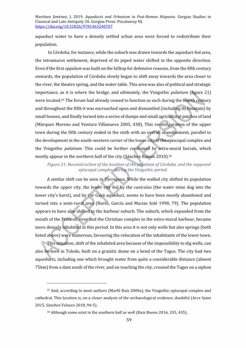
Martínez Jiménez, J. 2019. Aqueducts and Urbanism in Post-Roman Hispania. Gorgias Studies in Classical and Late Antiquity 26. Gorgias Press: Piscataway NJ. https://doi.org/10.31826/9781463240707
59
aqueduct water to have a densely settled urban area were forced to redistribute their
population.
In Córdoba, for instance, while the suburb was drawn towards the aqueduct-fed area,
the intramuros settlement, deprived of its piped water shifted in the opposite direction.
Even if the first oppidum was built on the hilltop for defensive reasons, from the fifth century
onwards, the population of Córdoba slowly began to shift away towards the area closer to
the river, the theatre spring, and the water table. This area was also of political and strategic
importance, as it is where the bridge, and ultimately, the Visigothic palatium (figure 21)
were located.35 The forum had already ceased to function as such during the fourth century
and throughout the fifth it was encroached upon and dismantled (including its fountain) by
small houses, and finally turned into a series of dumps and small agricultural patches of land
(Márquez Moreno and Ventura Villanueva 2005, 438). This reconfiguration of the upper
town during the fifth century ended in the sixth with an overall abandonment, parallel to
the development in the south-western corner of the lower city of the episcopal complex and
the Visigothic palatium. This could be further confirmed by intra-mural burials, which
mostly appear in the northern half of the city (Sánchez Ramos 2010).36
Figure 21: Reconstruction of the location of the palatium of Córdoba, and the supposed episcopal complex during the Visigothic period.
A similar shift can be seen in Tarragona. While the walled city shifted its population
towards the upper city, the lower city fed by the cuniculus (the water mine dug into the
lower city’s karst), and by the Gayá aqueduct, seems to have been mostly abandoned and
turned into a semi-rural area (Burès, García and Macias Solé 1998, 79). The population
appears to have also shifted to the harbour suburb. The suburb, which expanded from the
mouth of the Francolí river and the Christian complex to the extra-mural harbour, became
more densely inhabited in this period. In this area it is not only wells but also springs (both
listed above) were numerous, favouring the relocation of the inhabitants of the lower town.
This situation, shift of the inhabited area because of the impossibility to dig wells, can
also be seen in Toledo, built on a granitic dome on a bend of the Tagus. The city had two
aqueducts, including one which brought water from quite a considerable distance (almost
75km) from a dam south of the river, and on reaching the city, crossed the Tagus on a siphon
35 And, according to most authors (Marfil Ruíz 2000a), the Visigothic episcopal complex and
cathedral. This location is, on a closer analysis of the archaeological evidence, doubtful (Arce Sainz
2015, Sánchez Velasco 2018, 94-5).
36 Although some exist in the southern half as well (Ruiz Bueno 2016, 335, 435).

Martínez Jiménez, J. 2019. Aqueducts and Urbanism in Post-Roman Hispania. Gorgias Studies in Classical and Late Antiquity 26. Gorgias Press: Piscataway NJ. https://doi.org/10.31826/9781463240707
60
bridge, a considerable feat of engineering (Arenillas Parra and Barahona Oviedo 2008,
Aranda Gutiérrez, Carrobles Santos and Isabel Sánchez 1997). It became the capital of the
Visigothic kingdom during the mid-sixth century, but by this stage, the old aqueduct had
ceased to function, as the fourth-century abandonment layers of the terminal cisterns,
known as the ‘caves of Hercules’ (including the minor ones at Delegación de Hacienda and
Calle Tornerías), and one of the upper town baths seem to indicate. This means that by this
stage the upper city could only rely on rain water cisterns for its supply, although we know
from the Islamic period onwards of the existence of the assaqqá (‘azacán’ in modern
Spanish) – watermen who carried jars of water from the river up to the city on donkeys
(Fernández Casado 2008 [1972], 210) - and of wells which did not provide drinking water.37
Having said this, the archaeology of the old upper city of Toledo is largely unknown,
as it has been constantly inhabited ever since it was first settled, but the area immediately
outside the city, the Vega Baja (‘lower meadow’) has not been touched by modern building.
In fact, it has been a field ever since the ninth century, and despite being so close to the
monumental centre of Toledo, the construction in the eighteenth century of the Royal
Weapons Factory protected the area from any urban development until 2006. It was then
that the emergency excavations prior to the construction of an important department store
uncovered the remains of a large suburb dated to the Visigothic period (Olmo Enciso 2009).
This suburb, which not only has an organised street grid, but residential and workshop
quarters as well, is over 70ha in extension, and located near the Roman circus. There, recent
excavations have revealed that there were also some very important buildings built in
ashlar blocks, floors paved in opus signinum, and other elements which have linked this site
with the praetorium suburbanum, the Visigothic palace complex and its churches mentioned
in the sources (Olmo Enciso 2009, 74-83, Gurt Esparraguera and Diarte Blasco 2012, Teja
Casuso and Acerbi 2010). This suburban development can be archaeologically dated to the
second half of the sixth century, and was built on top of a series of loosely connected Roman
suburban villas; it was finally abandoned in the ninth century, after the conquest of the city
by Abd al-Rahman II during the muwallad revolts.
The choice of the Tagus meadow to establish the new centre of Visigothic power has
been explained on various grounds, including its vicinity to the old circus, imitating palace-
circus complexes from other late antique capitals (although this layout does not perfectly
37 In 1605 three public wells are recorded in Toledo, at Barrionuevo, San Salvador and Pozo
Amargo (literally, ‘bitter well’), and all of them are mentioned to have aguas salobres (‘salty waters’);
Francisco de Pisa 1605, book I, chap. VI, fol 15, vto. (Porres Martín-Cleto 1970, 113).

Martínez Jiménez, J. 2019. Aqueducts and Urbanism in Post-Roman Hispania. Gorgias Studies in Classical and Late Antiquity 26. Gorgias Press: Piscataway NJ. https://doi.org/10.31826/9781463240707
61
apply to Toledo). This opened the possibility of displaying the power of the new regime in
the open fields (as opposed to the allegedly crowded upper city). The presence of the
suburban churches further supports this identification. Nobody has as yet considered the
possibility of direct access to water, something impossible in the upper city. Several wells
and cisterns are known from the excavations, which are located very close to the river
(figure 22). If there was an imitation of the imperial court ritual and display in the court of
Toledo, then water surely must have played an important role in this palatine complex
(baths?); something which could not be easily done in the upper city. The choice of the lower
city and the availability of water can be further linked by the events which followed the
Islamic conquest. The Umayyads established a fortress in the upper city, and later they built
a complicated system of concatenated lifting wheels which fed water from the Tagus
directly into the alcázar. This system was later preserved and maintained in the Castilian
and Habsburg periods but it only fed the fortress, and not the city.38 It is not possible to
claim that the upper town was abandoned or completely rejected by the royal authority. In
fact, King Wamba restored the gates of the city, as commemorated in an inscription (Cont.
Hisp., 35), the cathedral was located up there, and it is on the upper town where the
Umayyads established their fortification, perhaps superimposed on some earlier Visigothic
structure (Martínez Jiménez, Sastre de Diego and Tejerizo García 2018, 175-7), but the great
investment in the suburb clearly make Toledo a two-foci city.
Figure 22: Reconstructed plan of Visigothic Toledo, based on the most recent interpretations of the remains at the Vega Baja.
Lastly, the case could be made, although without any evidence, that the reorganisation
of Italica in Late Antiquity back to its original core (as defined by the Visigothic wall) could
be a response to the end of the aqueduct. After all, the new Hadrianic expansion was
developed with new branch of the aqueduct (Canto 1978), while the old colony had a pre-
existing well-and-cistern supply system. The urbs nova is, furthermore, up on the hill,
perhaps further away from the water table, repeating a situation like that of Tarragona,
Toledo or Córdoba.
38 These water wheels are already mentioned by Idrisi in the twelfth century (Aranda
Gutiérrez, Carrobles Santos and Isabel Sánchez 1997, 138-9), and were later expanded (or repaired,
or substituted) in the sixteenth century by the famous Artificio de Juanelo, named after Philip II’s
engineer Gianello Turriano. They were finally abandoned partially because the town council refused
to pay for the maintenance of a water supply which only benefited the Royal palace.

Martínez Jiménez, J. 2019. Aqueducts and Urbanism in Post-Roman Hispania. Gorgias Studies in Classical and Late Antiquity 26. Gorgias Press: Piscataway NJ. https://doi.org/10.31826/9781463240707
62
TRANSFORMATIONS OF THE HYDRAULIC INFRASTRUCTURE
Beyond these general considerations in the transformation of post-Roman
townscapes according to the availability of aqueduct water, it is useful to have briefly a
closer look at the evolution of the hydraulic infrastructures themselves inside towns. Baths,
aqueducts, and conduits were reused for secondary purposes not at all related with water
supply once they were abandoned, as it happened with most public buildings that lost their
main function in the post-Roman period.
Baths and cisterns
As baths and cisterns went out of use, they became large empty buildings, which were
reused in various different fashions. Even if most ended up being the site of dumps, some
saw a secondary use as dwellings or cult buildings. However, it is important to stress that,
in no case was there a conscious Christianisation of baths, or exorcisms as mentioned in
eastern sources (Jiménez Sánchez and Sales Carbonell 2004, Saradi 2006, 326-7, 336, Diarte
Blasco 2011, 757).
In the Iberian Peninsula there are very few examples of such Christian reuse of
hydraulic infrastructure (baths or cisterns), and in most cases, there is no hint to indicate a
conscious Christianisation of a bathing space as opposed to the construction of a new
building (which happens to be a Christian one) on an abandoned, formerly public, structure.
The first example would be the conversion of a private cistern into a domus-ecclesiae in
Mérida during the third or fourth century, but this is both very early for our study and
limited to a domestic structure. The construction of the church of Saint Genesius in Toledo
on top of the aqueduct’s terminal cistern mentioned above, cannot be seen as a deliberate
act of Christianisation, and the cistern was surely already out of use when the church was
built on top of it (Aranda Gutiérrez, Carrobles Santos and Isabel Sánchez 1997). Similarly,
the conversion of one of the baths of Ampurias into a church during the Visigothic period
seems to respond to this pattern of construction on an abandoned building (García-Entero
2005, 226-9) – similar to the construction of a basilica on top of a set of baths at Clos de la
Lombarde in Narbonne (Solier 1991).
In Seville, for instance, we have seen how the terminal cistern (or one of them),
excavated at the Plaza de la Pescadería was turned during the Visigothic period into a
dwelling area. The presence of various hearths and dividing walls indicate this (figure 23)
(García García 2007). There is some evidence to suggest a possible fifth-century phase
(repairs? reconstruction?) in the castellum and the baths of Cartagena, but the suggestion

Martínez Jiménez, J. 2019. Aqueducts and Urbanism in Post-Roman Hispania. Gorgias Studies in Classical and Late Antiquity 26. Gorgias Press: Piscataway NJ. https://doi.org/10.31826/9781463240707
63
that this had to do with a restoration of the water supply is unconvincing (Vizcaíno Sánchez
2009, 351-63). The baths of Braga were also turned into dwellings during this period (López
Quiroga 2004, 75).
Figure 23: Photo of the cistern at the Plaza de la Pescadería in Seville, which was turned into a dwelling in the Visigothic period (García García 2007: fig. 9).
As far as dumps are concerned, Roman monuments would appear to have been turned
into dumps during Late Antiquity. For hydraulic infrastructure this is very commonly the
case, as they were large empty rooms, usually underground, which were easy of fill, and
usually very conveniently located next to domestic spaces, although it is also possible that
these structures were filled on purpose in order to build something on top (which could be
cone with rubbish anyway). The cases of Cartagena or Toledo have just been mentioned, but
the cuniculus of Tarragona is another good example. The cisterns and conduits of several
aqueducts such as those of Ebusus or Tiermes are filled with plenty of fourth century
material, which is very useful for dating purposes (Argente Oliver and Díaz Díaz 1980,
Castro Orellana and Roig Ribas 2009, Díaz Díaz and Argente Oliver 1984). Some were used
for very specific purposes, as the distribution tank of the Western aqueduct of Córdoba,
which was used by a glass workshop as a dump for its refuse (Carmona Berenguer, Moreno
Almenara and González Viseda 2008).
Lastly, the transformation of baths into burial areas can be mentioned. Baths were
large public structures, which once they were out of use and collapsed, became relatively
large areas of public land, which technically could be used by anyone. This may be the legal
basis for the encroachment onto baths by private dwellings, as already mentioned. But this
also meant that they could be turned into a burial area if no structure was built on top, as it
was the case in Pamplona, where the baths, abandoned during the fifth century, were turned
into an Islamic maqbara during the eighth (Faro Carballa, García-Barberena Unzu and Unzu
Urmeneta 2008, 238-40, Unzu Urmeneta, et al. 2006, 432-3).
Secondary use of conduits
Conduits themselves were perhaps more difficult to reuse, due to their very specific
elongated shape. However, because of their almost identical proportions in terms of height
and width, it is very common to see conduits reused for burial purposes, as a human body
could be easily fitted without much difficulty in a specus. In Rome, at the Crypta Balbi, the
conduit was used for burials during the Gothic Wars (Manacorda 2001, 42-9), and in Spain
we see late antique burials in the conduit of Tiermes and early Islamic burials inside the

Martínez Jiménez, J. 2019. Aqueducts and Urbanism in Post-Roman Hispania. Gorgias Studies in Classical and Late Antiquity 26. Gorgias Press: Piscataway NJ. https://doi.org/10.31826/9781463240707
64
conduits in Mérida, at the site of Los Bodegones on the Cornalvo Aqueduct (Delgado Molina
2006).
The usurpation of the aqueducts in the countryside may be the most famous
secondary use of aqueducts. Water stealing for private consumption was common in
Antiquity, and as it has been already pointed out, there was a large corpus of legislation
against this. Despite these laws, aqueducts have been in constant use in many places as rural
irrigation channels long after they ceased to supply towns. The aqueducts of Almuñécar,
Valencia, Sagunto and Reccopolis are known to have been in use into the twentieth century
as rural irrigation channels.39 The aqueduct of Valdepuentes however, as it passed
underneath Madinat al-Zahra, was used as the main sewer because it was five metres below
the street and therefore could not supply water with pressure at ground level. Similarly, it
is likely that the aqueduct of Casa Herrera in Mérida may have been used to supply the rural
settlement which grew up around the basilica (Sastre de Diego and Martínez Jiménez 2012,
2013).
THE END OF AQUEDUCTS: THE END OF CLASSICAL URBANISM?
Even if the towns of Antiquity had no aqueducts at their origin, and existed for
centuries before acquiring one, it is evident that after the aqueduct building ‘madness’ of
the first and second centuries CE, towns and city-dwellers grew used to having them. We
should keep in mind that by the year 400 the citizens of Córdoba, Mérida, Tarragona or
Barcelona have had aqueducts and domestic piped water for almost four centuries – most
of Western Europe nowadays cannot even claim two. The profound social, political and
economic transformations of Late Antiquity were reflected in a constant transformation of
urban layouts and townscapes. Aqueducts, as an integral aspect of urbanism, were affected
by these changes.
The emergence of new urban patterns
Roman urbanism cannot be seen as something static, as it was in constant change, just
as our own modern cities are. However, the image of first- and second-century Roman
towns is so powerful that it is difficult to see a Roman town in any other way. The fact is that
39 Those of Almuñécar or Sagunto are in fact still functioning in sections as irrigation channels,
and they still belong to the comunidad de regantes (‘irrigators’ community’) rather than to any sort
of heritage bureau or department.

Martínez Jiménez, J. 2019. Aqueducts and Urbanism in Post-Roman Hispania. Gorgias Studies in Classical and Late Antiquity 26. Gorgias Press: Piscataway NJ. https://doi.org/10.31826/9781463240707
65
from the fourth century onwards, towns entered a different dynamic and, from then on,
their evolution responded to patterns unlike those which framed the early Roman town.
Perhaps one of the most important transformations, which actually can be used to
explain some of the issues proposed above, is the political reorganisation of town
administration during Late Antiquity (Liebeschuetz 1992, with caveats). This readjustment
substituted the old traditional magistracies by the comes (count), appointed by the central
administration, and the bishop. Town councils and local magistracies continued to exist
(like the numerarius, or the defensor civitatis), but with limited powers and funds
(Fernández 2017, 165-70). This meant that traditional spaces of public politics, like forums,
basilicas or curias, ceased to fulfil an active function, and became mostly redundant (which
can explain why they were dismantled and encroached upon). The new political situation
required new forms of public architecture, and this became increasingly true in the
Visigothic state formation period. This is reflected in the renovation of walls, the
construction of new palaces, and the foundation of new towns, like Reccopolis, El Tolmo, the
Suevic acropolis of Falperra outside Braga, or the obscure and unknown Visigothic
foundations of Victoriacum and Ologicus. These constructions not only benefited from the
direct involvement of the monarchy, but also prompted the development of a new service
elite which further developed a post-Roman architecture of power. This process of
transformation continued during the Umayyad period, when a yet further political
reorganisation prompted the creation of an utterly new architecture of power (Martínez
Jiménez, Sastre de Diego and Tejerizo García 2018, 276-85).
Besides these political transformations, which affected the evolution of public
architecture, a key factor to consider are religious transformations: from pagan to Christian
and then to Islamic. The transformation of religious space did not only affect cult buildings,
but also their environments. This is especially true for the evolution of Christian cult
centres, which in the early stages of urban Christianisation were located outside the city
walls, in the burial areas linked to a martyr’s grave. These could, in the end, develop into a
suburb, as in Tarragona, Córdoba, Metz and Tours. Linked to the development of new
architectures of power, the construction of episcopal complexes is one of the key
developments in public monumentality, because these became the new, visible centres of
political and religious power (Miller 2000). They appear in Barcelona (Bonnet and Beltrán
de Heredia 2002), Tarragona (López Vilar 2006), and Egara,40 and can be inferred in
Valencia, Córdoba and Mérida (Sastre de Diego 2015). Furthermore, Christian constructions
40 Even if there was no urban centre in Egara (Oller Guzmán 2014).

Martínez Jiménez, J. 2019. Aqueducts and Urbanism in Post-Roman Hispania. Gorgias Studies in Classical and Late Antiquity 26. Gorgias Press: Piscataway NJ. https://doi.org/10.31826/9781463240707
66
and other pious acts were the only possible niche in which old euergetic practices could be
displayed,41 something which has been much more thoroughly studied for Italy and
Merovingian Francia (Beaujard 1996, Guyon 2006, B. Ward-Perkins 1984, Loseby 2006).
Lastly, and imposed by the historical context, the economic changes of Late Antiquity
and the early Middle Ages should not be underestimated. As the Roman political world
disintegrated, so did its economic sphere of influence. The interconnections between
regions dramatically decreased in volume, and the highly specialised systems of production
which relied on long distance exchange collapsed to regional or local patterns (B. Ward-
Perkins 2005, Wickham 2005). This meant that gradually the different regions became
increasingly isolated from each other. Of course, trade continued, and exceptional sites such
as Toledo, Reccopolis or Mérida show signs of continuing long distance trade and production
of goods. Coastal towns from Sala in Morocco to Vigo and (of course) the Mediterranean
coast kept close trading links between them and, during the period of Byzantine occupation,
well connected with the East, although this never translated into a wide distribution to their
hinterlands (Bernal Casasola 2008, Fernández Fernández 2014). But this slowly faded
through the sixth and seventh centuries. The final disintegration of the late Roman models,
as continued by the Visigothic kingdom, occurred during the eighth century and under the
Umayyad regime; the Umayyads reactivated trade and production, but on completely
different grounds. These may have included Mediterranean links, but with different goods,
routes and main trading nodes.
In this context, slow transformations of the late Roman world, which lasted for several
centuries, the Roman townscape changed, attracted by the new foci: the new centres of
power and religious complexes which developed mostly during the sixth century. However,
from the fifth century onwards there had been a trend to reduced wall enclosures, resulting
in smaller towns , parallel to the development of suburbs around the functioning harbours
or emerging religious centres. Paradoxically, towns were becoming smaller, but yet
spreading over larger areas. These are processes which took place all over the West
(Esmonde Cleary 2013). Perhaps spreading the population in this fashion was another way
of maximising the water resources.
Public spectacle monuments such as theatres, circuses, and amphitheatres (despite
some dubious sixth-century mentions) ceased to function in this period. Many had already
been quarried away in the fourth century, as in Córdoba, or else turned to areas of Christian
41 One particularly late euergete is the vir inlustris Gudiliuva, who dedicated three churches in
the early seventh century: ICERV 303.
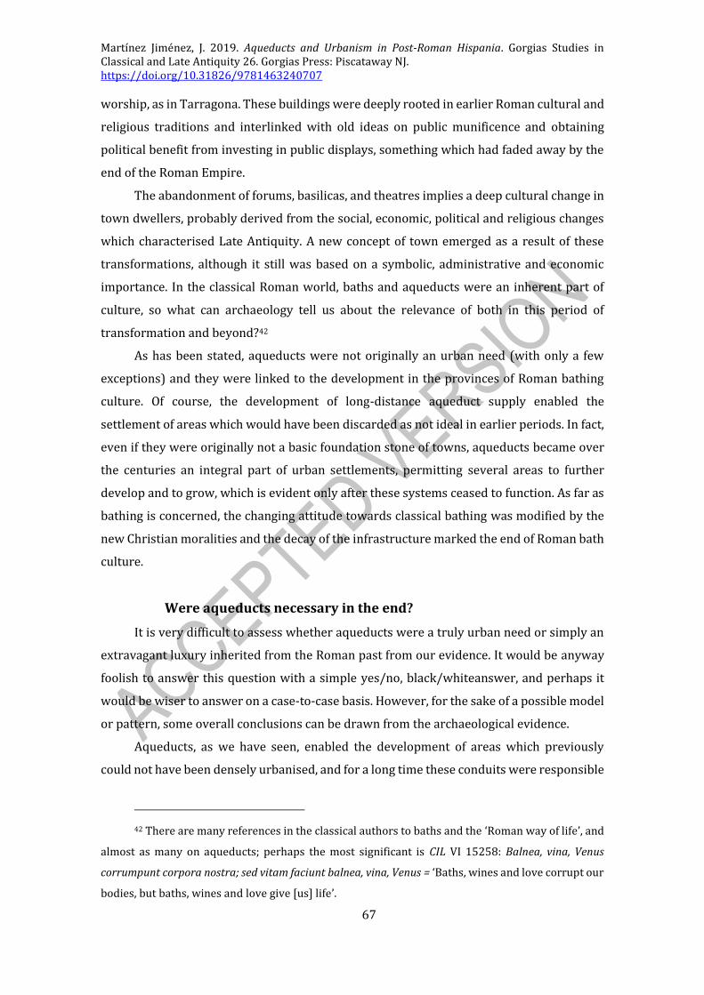
Martínez Jiménez, J. 2019. Aqueducts and Urbanism in Post-Roman Hispania. Gorgias Studies in Classical and Late Antiquity 26. Gorgias Press: Piscataway NJ. https://doi.org/10.31826/9781463240707
67
worship, as in Tarragona. These buildings were deeply rooted in earlier Roman cultural and
religious traditions and interlinked with old ideas on public munificence and obtaining
political benefit from investing in public displays, something which had faded away by the
end of the Roman Empire.
The abandonment of forums, basilicas, and theatres implies a deep cultural change in
town dwellers, probably derived from the social, economic, political and religious changes
which characterised Late Antiquity. A new concept of town emerged as a result of these
transformations, although it still was based on a symbolic, administrative and economic
importance. In the classical Roman world, baths and aqueducts were an inherent part of
culture, so what can archaeology tell us about the relevance of both in this period of
transformation and beyond?42
As has been stated, aqueducts were not originally an urban need (with only a few
exceptions) and they were linked to the development in the provinces of Roman bathing
culture. Of course, the development of long-distance aqueduct supply enabled the
settlement of areas which would have been discarded as not ideal in earlier periods. In fact,
even if they were originally not a basic foundation stone of towns, aqueducts became over
the centuries an integral part of urban settlements, permitting several areas to further
develop and to grow, which is evident only after these systems ceased to function. As far as
bathing is concerned, the changing attitude towards classical bathing was modified by the
new Christian moralities and the decay of the infrastructure marked the end of Roman bath
culture.
Were aqueducts necessary in the end?
It is very difficult to assess whether aqueducts were a truly urban need or simply an
extravagant luxury inherited from the Roman past from our evidence. It would be anyway
foolish to answer this question with a simple yes/no, black/whiteanswer, and perhaps it
would be wiser to answer on a case-to-case basis. However, for the sake of a possible model
or pattern, some overall conclusions can be drawn from the archaeological evidence.
Aqueducts, as we have seen, enabled the development of areas which previously
could not have been densely urbanised, and for a long time these conduits were responsible
42 There are many references in the classical authors to baths and the ‘Roman way of life’, and
almost as many on aqueducts; perhaps the most significant is CIL VI 15258: Balnea, vina, Venus
corrumpunt corpora nostra; sed vitam faciunt balnea, vina, Venus = ‘Baths, wines and love corrupt our
bodies, but baths, wines and love give [us] life’.

Martínez Jiménez, J. 2019. Aqueducts and Urbanism in Post-Roman Hispania. Gorgias Studies in Classical and Late Antiquity 26. Gorgias Press: Piscataway NJ. https://doi.org/10.31826/9781463240707
68
for the cohesive nature of many urban nuclei. Aqueducts therefore acted as a key element
in town planning and urban development, especially in the early imperial period.
Furthermore, they prompted the construction of public bath complexes, and public
fountains, and greatly contributed to the development of Roman domus in the provinces.
The very close relationships between these developments, which are all roughly
contemporary in their origins, and long-distance water supply systems, are really
noticeable, paradoxically, once the latter ceased to function. After the end of aqueduct
supplies we see a return to pre-Roman urban patterns, not only in terms of water supply
(wells and cisterns), but also in terms of settlement location. The reorganisation of urban
settlements according to the availability of water is one of the aspects which characterises
later medieval urbanism into smaller more concentrated areas (even leading to poli-
nucleated settlements). It can also be argued that the decline of public water supply systems
went hand in hand with a decline in the number of inhabitants which could live in a given
town.
In this way, aqueducts were an active component of the ‘Roman way of life’ in the
provinces, especially with regards to public amenities. Ongoing aqueducts in Late Antiquity
were then monuments which promoted or sustained traditional Roman urban life,
especially at a privileged level. After all, the old municipal elites had been responsible for
the construction of this infrastructure, and were the ones that benefited most from it
(Fuentes Domínguez 2000, 138). Aqueducts were, therefore, not only a vehicle for urban
concentration in the Roman period, but also a means of expressing urban elite behaviour.
In Late Antiquity, it was necessary for these elites to adapt to the new circumstances and to
come up with alternative ways of displaying their status.
There is a symbolic meaning attached to aqueducts, beyond the purely materialistic
and tangible benefits for urban development. This perhaps can further explain the
continuity of some aqueducts, and the development of new urban patterns, and will be
explored in the next chapter.

Martínez Jiménez, J. 2019. Aqueducts and Urbanism in Post-Roman Hispania. Gorgias Studies in Classical and Late Antiquity 26. Gorgias Press: Piscataway NJ. https://doi.org/10.31826/9781463240707
69
AQUEDUCTS AND THEIR SOCIO-POLITICAL IMPORTANCE IN LATE
ANTIQUITY
Beyond the architectural and archaeological impact aqueducts had, it is important to
remember that they were built by and for town dwellers; throughout the Roman period the
people co-inhabited with aqueducts and benefitted from their water. This was, in many
cases, a very long-lasting relationship from a functional point of view, which greatly
modified urban life. Nevertheless, aqueducts also had a very important symbolic meaning,
as they were not only a source of pride for those who built them, but also for those
benefitting from them many years later. Aqueducts were part of Roman urban pride, and
this feeling went beyond the urban elites to the higher echelons of the state and the Church.
It has already been discussed how the continuity of aqueducts affected the urban
landscape, and now we will focus on another main aspect: the relation between town
dwellers, urban elites and the state (both the Visigothic and the Umayyad) with aqueducts.
AQUEDUCTS AND THE URBAN ELITES
For fourth-century urban dwellers, aqueducts may have seemed eternal. As opposed
to walls (which were in many cases being built or remodelled in this period) or old forums
(which were slowly but constantly going out of use and dismantled), aqueducts stood, had
been standing seemingly for ever and were still functioning. As has become obvious from
previous chapters, soon this situation would change. The previous chapter has explored
how this affected the development and evolution of urban areas in terms of settlement
location and spaces of power, but it is important to keep in mind that urban dwellers (and
especially, the urban elite) were directly involved in the evolution of aqueduct supply
systems.
An elite water supply system?
Aqueducts were elite buildings, built by the elite as part of early Roman euergetic
practices, and were closely linked to curial administration, so the fate of urban elites and
urban aqueducts would appear to go hand in hand (Martínez Jiménez i.p.). In fact, their
evolution is so closely related that the origins and decline of one of them could be used as a
perfect analogy to explain the transformations of the other. This comparison is most clearly
exemplified by the chronological correlation between the decline of the power of curial
municipal administration and the beginning of the end of aqueducts (from the fourth to the

Martínez Jiménez, J. 2019. Aqueducts and Urbanism in Post-Roman Hispania. Gorgias Studies in Classical and Late Antiquity 26. Gorgias Press: Piscataway NJ. https://doi.org/10.31826/9781463240707
70
sixth and seventh centuries), and firmly based on the nature of aqueduct maintenance and
repairs.43
This close correlation may also be the reason behind the continuity of certain
aqueducts, and it is clear from the evidence put forward that aqueducts continued mostly
in those towns which preserved some degree of administrative and political importance and
of commitment towards the communinty. It would not be fair to claim that Roman water
culture was exclusively an elite culture, but it was elite-led, as the members of the elite,
following Vitruvian canons, received in terms of private domestic supply a third of the
town’s aqueduct water.44 Most of this water was used for private baths and fountains.
Urban aristocrats enjoyed bathing as much as the urban plebs, and many members of
the elite had their own private baths. This was only possible after the development of
aqueducts, and became an essential part of Roman water culture. In fact, the fourth century
saw an increase in the number of private baths. However, in Late Antiquity the failing
aqueducts threatened to put this practice to an end. In some instances, such as in Barcelona,
the continuity of private baths into the fifth and sixth centuries (those of Pati Llimona or
Bisbe Caçador) was possible due to the continuity of the aqueduct. The private baths of
Seville dated up to the fifth/sixth centuries at Cuesta del Rosario and the Palacio Arzobispal
excavations are further examples of this (González Acuña 2011, 487, 492). Seville and
Barcelona are two good examples of towns with administrative or commercial importance
and a strong elite, in which aqueducts and private baths continue into this period.
However, there are instances of similarly important towns where aqueduct supply
was not reliable (or completely gone) in the sixth century, as in Tarragona and Mérida.
There, the members of the elite looked for alternatives that would allow them to preserve
their aristocratic domestic baths, despite the end of aqueduct supply. The end of aqueducts
43 Referring to Roman culture in general, J. Matthews (1990 [1975], 328) mentions how ‘[y]et
it was in the hands of such men [i.e., the elites], in their enterprise and willingness to play their part
in the new conditions of the fifth century that the survival of Roman culture in the west resided ’,
which can perfectly be applied to aqueducts.
44 Arch. VIII.6.2: Ita in medio ponentur fistulae in omnes lacus et salientes, ex altero in balneas
vectigal quotannis populo praestent, ex quibus tertio in domus privatas, ne desit in publico = ‘[In the
castellum] from the middle receptacle pipes will be taken to all pools and fountains; from the second
receptacle to the baths, in order to furnish a public revenue; to avoid a deficiency in the public supply,
private houses are to be supplied from the third’. Vitruvius’ description of a physical tripartite
division is misleading, but the truth behind this is that private consumers, after paying a fee, were
entitled to a private connection to the main water distribution network (Brunn 2002b).

Martínez Jiménez, J. 2019. Aqueducts and Urbanism in Post-Roman Hispania. Gorgias Studies in Classical and Late Antiquity 26. Gorgias Press: Piscataway NJ. https://doi.org/10.31826/9781463240707
71
meant that wells became the main source of water: the various late baths of the harbour and
Christian suburbs in Tarragona (the fifth-century baths at the Parque Central and the
fourth-to-seventh century houses of PERI-2) were all supplied by underground water. The
late suburban private baths of Mérida (Calle Nerja excavations, and Resti suburb) were also
fed by water from wells, sometimes linked to water-wheels. Note that baths fed by wells
were not late antique innovations, as pre-aqueduct baths at Pompeii were fed by similar
mechanisms. Neither were they particular to Spain. However, this extra effort and search
for water was not always possible, and Mérida offers further examples of this process of
adaptation. For instance, at the site of Morería the subdivision of the domus into various
tenant houses meant that the old balneum was also turned into a dwelling area. Similarly, in
fifth-century Gaul, Sidonius Apollinaris mentions that ‘both of his guests had baths being
built, but none in use’,45 showing how private bath-building initiative (even if not always
successful) continued.
The large corpus of evidence for private late antique baths available for the Iberian
Peninsula compiled by Virginia García-Entero in her PhD thesis (García-Entero 2005)
confirms that this latter process (abandonment rather than adaptation) is far more common
than the continuity outlined above.
Civic duties
Aqueducts were perhaps elements of the elite Roman culture, but they were also
fulfilling a public service, although in Late Antiquity it is difficult to assess the extent to
which elites were willing to preserve them.
The transformation of the urban administration in Hispania (Curchin 2014,
Fernández 2017) despite the late antique links between the large landowning aristocracy
(the urban elites) and the central government meant that traditional euergetic practices
were increasingly abandoned from the fourth century onwards. Especially after the fifth
century. The members of the civic councils, the curiales, had lost most political incentives to
invest in public munificence and, in many cases, lacked the resources to carry out these
constructions. Baths, fountains, circuses, and aqueducts, were repaired during the late
Roman period by governors and other members of the higher echelons of the
administration, linked to the imperial networks of patronage. These were the persons who
had both funds and civic duties to fulfil (as we see in the baths and fountains of Tarragona
and Lisbon or the theatre and amphitheatres of Mérida). During the sixth century, Visigothic
45 Sid. Ap., Epist., II.2.8: Balneas [sic] habebat in opere uterque hospes, in usu neuter.

Martínez Jiménez, J. 2019. Aqueducts and Urbanism in Post-Roman Hispania. Gorgias Studies in Classical and Late Antiquity 26. Gorgias Press: Piscataway NJ. https://doi.org/10.31826/9781463240707
72
laws highlighted the importance of preserving civilia munera, continuing late Roman
legislation. This was most certainly linked to the role of the curiales as tax collectors,
although the maintenance of buildings and supervision of repairs might also have been
implied.
The preservation of Roman town life by urban elites in a few chosen sites is evident,
and the preservation of aqueducts, or the attempts to keep them running, is one sign of this.
There is some evidence to suggest that these attempts were not simply done for the sake of
the elite’s own private balnea, but with a public purpose in mind, which would indicate a
late continuity of munificence or, at least, concern for the community. In this context, the
implied mention to curial offices, secondary to the count (the royal figure of authority and
representative of the central administration), in sixth-century addenda to some Roman laws
(Curchin 2014) could be related to this post-Roman administrative structure. The
construction of a new set of public baths behind the theatre in Mérida (García-Entero 2005,
527-9)46 is very interesting in this respect, which could be paralleled to the obscure mention
to ‘circus’ games in Zaragoza in the sixth century (Chr. Caesaraug., 504), but on a much more
solid archaeological basis. These baths (figure 24) were fed by a well, but their size and
location do not suggest a private structure. This could perhaps indicate an attempt to
continue with traditional euergetic practices, despite the lack of an aqueduct. Anyways, this
seems to be a rather isolated example: traditional Roman munificence practices had
declined amongst urban aristocrats, who now chose to show their power and wealth by
building churches or private houses, a clear reflection of the rupture between Classical and
late antique practices (Kulikowski 2004, 70). Besides those of Mérida and those of
Barcelona (further discussed below), there are no other known public baths functioning in
this period, not to mention newly-built ones. Even so, by the seventh century, church
donations by a layman, such as those of vir inlustris Gudiliuva, were already equally rare.47
46 Although not all the results have been published. See further discussion below.
47 ICERV 303 commemorates the construction of three churches, allegedly in rural
contexts: [In nomin]e d(e)i n(o)s(tr)i Ih(e)s(u) Chr(ist)i consecrata est [ec]clesia S(an)c(t)i
Stefani primi martyris in locum Nativola … ab inl(ustre) Gudiliu[va] cum operarios vernolos et
sumptu proprio = ‘In the name of God our Lord Jesus Christ, this church was consecrated at
the site of Nativola to Saint Stephen, first martyr … by [vir] inlustris Gudiliuva with his own
slave-workers and money’. Of course this may just be a decline in the epigraphic habit, and
the lack of charters for this period prevents any further guesses on private church donation
(B. Ward-Perkins 1984, ch. 2).

Martínez Jiménez, J. 2019. Aqueducts and Urbanism in Post-Roman Hispania. Gorgias Studies in Classical and Late Antiquity 26. Gorgias Press: Piscataway NJ. https://doi.org/10.31826/9781463240707
73
Figure 24: Sixth-century new set of baths built behind the theatre peristyle, in Mérida. Note how high the baths are built in comparison to the original Roman street level. These baths were supplied by wells and had small individual tubs rather than communal pools.
As far as aqueducts and water supply are concerned, if imperial law (in particular
CTheod XV.2.1 = CIust XI.43.1.1) is a reflection of provincial practices, then we have to
assume that it was in the hands of private landowners to repair aqueducts once the
municipal administrations had given up their maintenance. Again, it is difficult to say up to
what point landowners were willing to take over this responsibility in exchange for tax
deductions, especially after the fifth, century when the collection of taxes was certainly in
radical decline, and by the Visigothic period of state formation, when taxation was partially
reintroduced (Martín Viso 2013). It was really up to their euergetic disposition (or their
private interest) to preserve aqueducts running.
Social and cultural redefinitions?
From our modern perspective, it seems inconceivable that the municipal authorities
or the urban elites would be ready to let aqueducts fall to ruin, but considering the evidence
presented, this could have been the case. Despite some very late and exceptional cases of
public euergetism, by the fifth and sixth centuries urban elites lacked any incentive to
continue with these anachronistic practices, and they rather invest in the construction of
churches. The lack of technical capabilities greatly limited their ability to repair aqueducts,
but also the decreasing power and impoverishment of municipal infrastructures meant that
town councils had to rely on other patrons to preserve them. Normally these would have
been provincial governors (cf. DLH II.20) or the emperor himself, but after the fifth century
this was no longer an option. Despite any urban pride and interest the elites may have had,
some things were simply beyond their control (Greenhalgh 1989, 110).
Important towns enjoyed a longer period of aqueduct supply, although in most cases
(Barcelona, Valencia, Tarragona, Reccopolis, and perhaps Córdoba) either the state or the
Church took over the aqueducts.
But overall, it can be said that direct access to water was becoming increasingly a sign
of higher and higher status, even more than in previous periods, due to its scarcity. The
declining number of functioning aqueducts also prompted changes in more general (non-
elite) water culture, even if it was simply because large public baths were no longer
available, excepting clerical baths, which may have been of public access, as known for Italy
(B. Ward-Perkins 1984, 135-41). Bathing was reduced to the domestic space, if preserved
at all, or focused on the new Christian centres. The expansion of new Christian morals, which

Martínez Jiménez, J. 2019. Aqueducts and Urbanism in Post-Roman Hispania. Gorgias Studies in Classical and Late Antiquity 26. Gorgias Press: Piscataway NJ. https://doi.org/10.31826/9781463240707
74
had a lot to say on Roman bathing,48 may be one of the reasons behind this, but we should
not take the texts of Christian moralists at face value, as bathing habits may have still been
desirable (Miller 2000, 32).
It was not simply that the infrastructure was declining, that the new Christian
ambience seemed opposed to traditional bathing, or that the elites could not take care of the
old baths (Osland 2011, 361); one of the key issues is that one of the results of the
transformations of Late Antiquity is the transformation of the elites. From the fifth century
onwards, they lacked any incentive to preserve traditional public munificence, as they were
further and further away from the public municipal administration and the Roman state
that had created it. During the period of a power vacuum of the fifth century, but especially
through the process of state formation of the Visigothic kingdom, the elites had to
accommodate to the new situation. As has been said already, there was an almost total
rupture between urban/local affairs and the state (excepting in those areas of direct control,
such as El Tolmo, Reccopolis, or Toledo), and the only way the local elites had to achieve
rank and position was to turn into a service aristocracy. Serving in the public administration
(regardless of ethnicity or religion) was the way to obtain power, but this new
administration was far removed from municipal issues: it had been the new way forward in
the fourth century, and by the sixth century it became a must (Fernández Delgado, Martínez
Jiménez and Tejerizo García 2013).
This in turn gives another reason for the decreasing interest in preserving the
aqueducts: The Visigothic state (the elites’ model to follow?) itself did not take much care in
aqueducts.
THE RELEVANCE OF AQUEDUCTS FOR THE VISIGOTHIC MONARCHY
As far as the Visigothic monarchy was concerned, public monuments were largely a
responsibility of the local administration. As opposed to what the Ostrogoths (Theoderic in
particular) did in Rome, the Visigothic kings hardly cared for public services or monuments.
This is perhaps not simply a matter of lack of interest, but rather a consequence of the
differences between early sixth-century Italy and late sixth-century Hispania. Yet, in this
context, we see the construction of a new aqueduct at Reccopolis.
48 Especially regarding mixed bathing, the pagan connotations of the statues in baths, the
perception of bathing as a decadent luxury, and the relationship between bathhouses and
prostitution.

Martínez Jiménez, J. 2019. Aqueducts and Urbanism in Post-Roman Hispania. Gorgias Studies in Classical and Late Antiquity 26. Gorgias Press: Piscataway NJ. https://doi.org/10.31826/9781463240707
75
Germanic monarchies and public works
Cassiodorus in his Variae mentions how the old public monuments were an element
of pride for the state, and how the pride of the Goths was to preserve the Roman way of life
(Var., IX.14.18: laus Gothorum est civilitas custodita). The concept of preserving the past, the
Roman order, and the repair of old buildings served Theoderic as a way of presenting
himself as a legitimate ruler of Italy, which in turn was sanctioned by the Ostrogothic
legislation on this topic, also compiled in the Variae.49 The corpus of repairs on monuments,
especially in (but not limited to) Rome and Ravenna, and new constructions is vast. This
attempt to promote the image of the Ostrogothic monarchs as continuators of the Roman
order was closely linked to the preservation of monuments, because in Italy the emperor
had been much closer and much more involved in this type of works than in the provinces.
The clearest way to show continuity and the lack of interruption between the imperial
administration and the Ostrogothic kingdom was maintenance and constructions.
Furthermore, in Italy all the imperial administrative infrastructure was still very present,
so the transition did not imply great changes, as the formulae preserved in the Variae would
indicate.
In this aspect, Hispania was very dissimilar to Italy, and not only because there is no
corpus of letters comparable to the Variae. By the time the Visigoths had firmly established
and reorganised the kingdom (especially under Liuvigild and Reccared, in the last quarter
of the sixth century) most of the Roman infrastructure had long disappeared. In fact, even if
the Visigothic administration imitates late Roman practices, it had to be mostly reinvented
and restored. Looking back at the Roman past was a very useful legitimising argument used
by the Visigoths, but the scope of their public constructions was much reduced, so the
49 Many passages of Cassiodorus refer to Theoderic’s policy as a righteous cause: Var., I.25.1:
Nil prodest initia rei solidare, si valebit praesumptio ordinata destruere, ... de custoditis adquiritur
laudata perfectio = ‘It is not useful to build firmly from the beginning if lawlessness has the power to
ruin what has been designed, ... from the things preserved the glory of completion is acquired’;
III.30.1: quid est enim dignius, quod tractare debeamus, quam eius reparationem exigere, quae ornatum
constat nostrae rei publicae continere? = ‘What indeed is worthier, than to maintain the repairs of that
place [Rome] which clearly preserves the glory for our government?’.

Martínez Jiménez, J. 2019. Aqueducts and Urbanism in Post-Roman Hispania. Gorgias Studies in Classical and Late Antiquity 26. Gorgias Press: Piscataway NJ. https://doi.org/10.31826/9781463240707
76
process of state formation was based overall in less tangible things, like court ceremonial,
law giving, and tax reorganisation.50
When it comes to aqueducts, the Ostrogoths again were much more involved in their
maintenance. As we have seen for Rome and Ravenna. The Visigoths, on the other hand,
were only responsible for the construction of the aqueduct of Reccopolis. Perhaps the failed
restorations of the aqueduct of Mérida (figure 9) could be related to a royal project; after
all, Mérida was for many years not only the capital of the kingdom (Ripoll López 2000), but
also the most important city, and the Ostrogoths, who were keen on repairing aqueducts,
must have been a model to follow. Furthermore, we know of other royal constructions
through inscriptions found in Mérida, even if of dubious nature.51 However, this is only a
supposition, as it is equally possible that the local elites or the bishops were responsible for
this attempt.
Restoration of public works
The repairs carried out by the Visigothic monarchy are very few. In fact, they are so
few that the examples should be considered exceptions for various reasons. Perhaps the
reconstruction of the bridge and walls of Mérida in the late fifth century (ICERV 363) could
be considered the first example, and even here, the intervention of King Euric is a pure
formality, as the initiative derived from the bishop and the dux (Arce Martínez 2008). After
these, the restorations of the walls of Italica by Liuvigild (Bicl., 584.1), together with the
repairs of the walls of Toledo later in the seventh century by Wamba, are perhaps the best
known royally-sponsored reconstructions (Cont. Hisp., 35).52 However, these are not
restored public services but walls, which are very different in their nature, and it should be
50 Cf. Hist. Goth., 51. In fact, all of this may be an imitation of the contemporaneous Eastern
Empire rather than a revitalization of the old, long-gone, Western Empire. This is further discussed
by M. R. Valverde Castro (2000, passim, esp. pp. 141-76, 182-94).
51 The mysterious inscription by King Chindaswinth (ICERV 366: [Chi]ndasvintus rex
pi[issi/mu]s in <i>mperio/ [Ch]indasvintus [...), preserved with no context, is generally considered to
have been linked to a building.
52 Known because of a commemorative inscription, now lost, about the repairs of the walls of
Toledo: Erexit, fautore Deo, rex inclytus urbem/ Wamba, suae celebrem protendens gentis
honorem.//Vos, sancti Domini, quorum hic praesentia fulget/ hanc urbem et plebem solito servate
favore = ‘With God as patron, the famous King Wamba erected the city to increase the honour (and)
fame of his people. You, holy Masters, whose presence shines here serve this city and (its) people
with your customary favour’.

Martínez Jiménez, J. 2019. Aqueducts and Urbanism in Post-Roman Hispania. Gorgias Studies in Classical and Late Antiquity 26. Gorgias Press: Piscataway NJ. https://doi.org/10.31826/9781463240707
77
taken into account that the former were carried out during the rebellion of Hermengild, who
was stationed in Seville, and the latter belong to the capital city. The inscription of
Chindaswinth in Mérida mentioned above and the inscription of Hermengild in Seville could
also be related to (re)construction of buildings, but nothing is known about them
(Fernández Martínez and Gómez Pallarés 2001).53 Restoration of walls was a very
important and symbolic thing to do, not only because city walls had become one of the most
important urban symbols (in words of Isidore: urbs ipsa moenia sunt = ‘a city itself is its
walls’, Etym., XV.2.1), but also because they are very visible, and practical. It was a way to
make strong statements about protecting a city.
This is how far the Visigothic monarchy went with regards to public services. There
were other public buildings and civic constructions built in the Roman fashion by the
monarchy (new palaces in Córdoba and Toledo; new urban foundations such as El Tolmo,
Reccopolis, and Victoriacum) linked to the public administration, but these can hardly be
considered to have provided public services; even if they were still necessary buildings for
the new government (Ripoll López 2000, 374, Valverde Castro 2000, 182-3). This contrasts
greatly with Ostrogothic Italy, but is perhaps close to what is known in Merovingian Francia.
In Vandal Africa baths seem to have been repaired too, alongside other public buildings, but
just as it is the case with Ostrogothic Italy, the transition between the late Roman and the
post-Roman administration was very short, and hardly suffered any disruption. Gaul and
Spain, however, suffered periods of power vacuum which badly damaged the
administration and its reach.54
Besides this, and as it has been already highlighted earlier, the lack of skilled
engineers and the loss of vaulting techniques probably meant that by the late sixth century
it was technologically impossible to repair most public buildings, regardless of the interest
shown by the administration (Utrero Agudo 2006, Martínez Jiménez and González Gutiérrez
2017). The reconstruction of walls requires only a basic knowledge of engineering and
construction; repairing a set of vaulted baths or creating a levelled conduit for an aqueduct
was not that easy. As for the construction of the large new royal projects (Reccopolis, the
53 ICERV 364: (Chrism) In nomine Domini ann[o f]eliciter secundo regni Dom(i)/ni nostri
<H>erminigildi regis quem persequitur genetor/ su(u)s Dom(inus) Liuvigildus rex(.) in cibitate(m)
<H>ispa(lim) ducti aione = ‘In the name of the Lord, in the second year of the happy reign of our lord
King Hermengild, whom his father our lord King Liuvigild persecutes. Brought (=Hermengild) into
the city of Seville for ever (aione)’.
54 For the Vandal examples, see the poem De Thermis Alianarum by Felix (vir clarissimus),
which praises a reconstruction in particular by King Thrasamund (Chalon, et al. 1985).

Martínez Jiménez, J. 2019. Aqueducts and Urbanism in Post-Roman Hispania. Gorgias Studies in Classical and Late Antiquity 26. Gorgias Press: Piscataway NJ. https://doi.org/10.31826/9781463240707
78
praetorium suburbanum of Toledo, etc.), specialised builders and engineers could have been
mustered from abroad, as suggested earlier.
Overall, it would be misleading to take Ostrogothic Italy or Vandal Africa as a
comparison with Visigothic Spain when it comes to the maintenance of public buildings and
the importance given to aqueducts. It is perfectly understandable why the Visigoths might
have wanted to promote hydraulic architecture and to preserve aqueduct supply systems,
but various circumstances prevented this from happening.
The aqueduct of Reccopolis
In this context, the aqueduct of Reccopolis stands out as a unique exception. It is my
opinion that it was the work of foreign engineers, brought with the purpose of building
Reccopolis. Its importance as an element of prestige has been discussed in print already, but
the fact that this is an aqueduct built in the late sixth century in the West deserves more
than the usual four lines (Ripoll López 2000, 393, Ripoll López and Velázquez Soriano 2008,
217).
The aqueduct was, from a landscape analysis, a very visible monumental building, and
it was also a statement of the control the town exercised over its territory and the
confidence of the builder that the surroundings were safe. It was a display of power over
nature and a way of showing off the resources available to the monarchy, especially in a
context where such monuments could not normally be built any more. But perhaps, above
all, to build an aqueduct was a way to refer back to Roman urban foundations imitating
Roman imperial practices of public munificence; an aqueduct in Reccopolis, as part of the
ideal town, was a must. The foundation of Justiniana Prima by Justinian in the Balkans is a
good comparison, because just as Reccopolis, it has a new aqueduct (Ivanišević 2012, 2017).
The aqueduct of Justiniana Prima brought water from over 20km to the lower town
(compare it to the 5km of the Reccopolis aqueduct), where the baths are located, whereas
the upper town and the acropolis seem to have been supplied by cisterns. A new urban
imperial foundation, despite its small size, required an aqueduct to be fully considered a
city.
Furthermore, aqueducts (as well as walls, which Reccopolis also had), still had a
functional public purpose in late antique towns. It is perhaps because of this that the
Ostrogoths and the Vandals took care of the maintenance of aqueducts: they were clearly
visible, easily recognisable, and evidently useful – and not simply because it was another
imperial practice they could imitate. Linking the ruler’s name to one of these structures was
a great act of propaganda while still providing a public service (and one which was still in

Martínez Jiménez, J. 2019. Aqueducts and Urbanism in Post-Roman Hispania. Gorgias Studies in Classical and Late Antiquity 26. Gorgias Press: Piscataway NJ. https://doi.org/10.31826/9781463240707
79
demand), so it was a perfect investment. Aqueducts were, after all, standing wonders of
engineering.55
The aqueduct of Reccopolis has to be considered in the context of the new urban
foundation, a personal project of King Liuvigild, which drew large amounts of effort and
resources. Even if preserving and restoring aqueducts in other towns (maybe in Toledo, the
capital) might have given Liuvigild popular recognition, the truth is that by this period
Visigothic kings did not need popular support to legitimise their rule. By the late sixth
century, Visigothic power was based on the emerging service elite, the mix of ecclesiastical,
aristocratic landowning, and military elites, who earned their status by rank and not
necessarily by birth or ethnicity (Buchberger 2013, Fernández Delgado, Martínez Jiménez
and Tejerizo García 2013).
Even if it might have been possible for the monarchy to spend resources in restoring
other aqueducts in the Peninsula, to further legitimise its position, there was no demand for
these repairs to be carried out. The resources and skilled workmen might have been
temporarily available, but, all their efforts were focused on the two main royal projects
(Reccopolis and the Vega Baja suburb in Toledo). This is parallel to the works of the
Ostrogoths, who focused most of their efforts on aqueducts linked to their own royal
residences, rather than on new projects. By the time of the Visigothic state formation, the
dissociation between central administration and local monuments had reached a point of
no return, and only when royal power had to be displayed was a new administrative
building set up.
Water euergetism?
Considering the repairs and constructions commissioned by the Visigothic monarchy
(which are few) and the exceptional example of the aqueduct of Reccopolis (which should
not be considered as water euergetism on its own, but rather part of an overall scheme),
Visigothic water euergetism is noteworthy for its absence. As I have tried to put forward, it
was impossible for the Visigothic central administration to carry on with traditional
euergetic practices beyond walls and churches.56 In fact, the only other water-related
55 Cf. Frontinus (Aq., I.16), quoted above.
56 And, furthermore, the Visigothic monarchy had other immediate priorities linked to its
process of state formation and the object of its investment of resources and capital (cities, walls,
diplomatic exchanges, gift giving). The munificence strategy was different to that of the Roman
period.

Martínez Jiménez, J. 2019. Aqueducts and Urbanism in Post-Roman Hispania. Gorgias Studies in Classical and Late Antiquity 26. Gorgias Press: Piscataway NJ. https://doi.org/10.31826/9781463240707
80
dedications by the monarchy are also church-related: the medicinal water springs close to
the church of Saint John in Baños mentioned earlier and the monastic complex built next to
the new royally-sponsored monastic complex of Guarrazar (Pérex Agorreta and Miró Alaix
2018, 285, 365). Similarly, later on, in the ninth century the kings of Asturias would build
an aedicule to hold a spring, a sort of public water supply in their newly-built capital of
Oviedo (figure 11), but this was far removed from Roman traditional practices, and perhaps
it is not until the fifteenth century when the kings of Castile make laws to preserve the
aqueduct of Segovia that we will see the state intervening again in a major way with urban
water supply systems.
THE CHURCH AND URBAN WATER SUPPLY SYSTEMS
The Church was one of the most important institutions in Late Antiquity, and its
influence in towns and urban matters increased throughout the period: the importance of
the Church in towns, channelled through the actions of bishops, grew from the fourth
century onwards, so that by the sixth century, these men were largely in control of
municipal issues. Similarly, Christianity and the Church had a very deep impact in the
transformation of traditional Roman social values and attitudes to old Roman ways. Baths,
as major consumers of aqueduct water, are key to understanding the transformations of
urban water supplies. These two things put together are important for this study, because
the new Christian setting did not favour traditional Roman bathing habits or bath buildings,
and bishops had the means and power to reformulate the priorities of water supply.
The new urban leaders
The evolution of the bishops’ power in the late antique town was a long process, which
started with Constantine’s concessions in the early fourth century (Matthews 1990 [1975],
307). Their growth in relevance and importance was parallel to the decline of the power of
the urban elites, so that by the sixth century, they had become the dominant leaders of local
urban communities, and ecclesiastical sources such as the works of Gregory of Tours and
the Lives of the Fathers of Mérida present this. Similarly, the virtual disintegration of urban
magistracies (not of the curiales themselves) left aqueducts and other public buildings
apparently unprotected. Imperial legislation had these monuments preserved as public
property, but at a town level, bishops, who were the only acting local power, might have put
themselves forward as keepers of these monuments.

Martínez Jiménez, J. 2019. Aqueducts and Urbanism in Post-Roman Hispania. Gorgias Studies in Classical and Late Antiquity 26. Gorgias Press: Piscataway NJ. https://doi.org/10.31826/9781463240707
81
Archaeology reflects this transition, and the episcopal complexes of Barcelona,
Valencia, Tarragona and Mérida have already been mentioned as examples of the new urban
order. Episcopal complexes, usually referred to as episcopia, were the monumental
reflection of the bishops’ power in their cities. Originally an evolution of aristocratic houses,
the episcopium was in itself by the sixth century a set of buildings, which included the
cathedral basilica, a baptistery and residential quarters, which were also used for
administrative and business purposes (Miller 2000, 13-20).
When it comes to aqueducts, it seems clear from Italian examples that bishops became
highly involved in the maintenance and preservation of aqueducts: in Nola (Paul. Nol., Carm.,
XXI.704-53), the local elites allowed the bishop early in the fifth century to build an
aqueduct, which they later regretted, as the bishops ultimately monopolised the use and
maintenance of this supply.57 In Naples (B. Ward-Perkins 1984, 131-2), the bishop had also
monopolised the aqueduct, taking away the responsibility from the municipal authorities,
as shown in a letter by Pope Gregory (Epist., IX.76).58 Water still used to show high standards
of living, a sign of luxury, and a display of the power of the Church, much in the way old
urban aristocrats had done with their private baths. Episcopal patronage over the water
supply was usually linked to a new Christian charity, bringing water for the Church baths,
fountains, and to ecclesiastical complexes.
In the Iberian Peninsula there is no direct evidence to suggest this, apart from the
episcopal baths of Barcelona. Similarly, the conduit at Casa Herrera may have been for the
general use of the (ecclesiastical) settlement (Sastre de Diego and Martínez Jiménez 2013).
Besides this, what we find is that aqueduct supply was preserved in the immediate
environments of episcopal complexes, as in Tarragona, Valencia, Barcelona, Seville
(Martínez Jiménez 2012),59 although this cannot be positively linked to ecclesiastical
maintenance due to the lack of written or epigraphic sources. Nonetheless, it would not be
wise to assume that even after these consciously-located constructions bishops did not
become much more actively involved with water supply systems (with some degree of
agreement with the municipal administration). Christian charity and old traditional
57 ‘[B]ishops subordinated the requirements of their communities to those of their churches’;
Squatriti 1998: 12-7 (quoted, p. 13).
58 We know that it was out of use during the Gothic Wars (Bell. Goth., I.9.10-8), so either it was
repaired or the letter refers to a new conduit.
59 I originally proposed that Córdoba was another example. But this has been since disproven
(Ruiz Bueno 2018b, 58-60).

Martínez Jiménez, J. 2019. Aqueducts and Urbanism in Post-Roman Hispania. Gorgias Studies in Classical and Late Antiquity 26. Gorgias Press: Piscataway NJ. https://doi.org/10.31826/9781463240707
82
munificence did slightly overlap, and there may be some political intention behind the
construction of episcopal complexes in the immediate environments of sources of water.
Especially if, as shown, public water supplies were becoming less and less frequent. This
would have helped bishops to reinforce their position within the community by controlling
the distribution of water, and ideally, controlling its basic maintenance as well.
Baths and bishops
The decline of Roman traditional bathing throughout this period may be one of the
reasons behind the declining interest in preserving aqueducts. Baths were the main
consumers of aqueduct water, and many conduits were built simply to supply sets of baths.
With the spread of Christian morality traditional baths faded away and aqueducts lost one
of their main consumers.
The position of the Church towards bathing was ambivalent, to say the least. While
therapeutic bathing was certainly accepted by the Church Fathers, Roman social and
luxurious bathing was against the ecclesiastical position regarding Christian spirituality and
the negation of luxury. It should be noted too that despite this, the Church never forbade or
publicly rejected bathing (Yegül 1991, 314-8). Even if the Church cannot be responsible for
the closure of public baths, it is true that Christian moralists promoted a new type of bathing
which eventually led to the disappearance of Roman public baths. For these moralists,
bathing was to be encouraged mostly as a healing remedy, and always in individual tubs,
something which could be done in small baths without large pools, and which could even be
filled from wells or cisterns with buckets. Although no examples are known for Spain, this
was commonplace in eighth and ninth century monasteries in Italy (Magnusson and
Squatriti 2000, 246). In Gaul this was the case as well, although in Saint Denis a new water
conduit was built from the ‘holy spring’ to bring water to the bathing area (Benoit and
Rouillard 2000, 167-8, Wyss 1996, 188-9). It is difficult, however, to assert whether the new
Christian bathing culture was a result of the decreasing number of available public baths, or
if the newly imposed morality was a trigger for the further abandonment of buildings which
were already suffering from the lack of repairs.
Bishops themselves, however, were not necessarily moralists, and were in fact urban
aristocrats, so baths were still appealing. The promotion and preservation of some baths by
bishops could be behind this. It has even been suggested that bishops set up baths for public
access, perhaps charging a fee, at least into the sixth century (Miller 2000, 31-2). The scope
of these baths was, however, limited, and not as wide-ranging as traditional Roman baths:

Martínez Jiménez, J. 2019. Aqueducts and Urbanism in Post-Roman Hispania. Gorgias Studies in Classical and Late Antiquity 26. Gorgias Press: Piscataway NJ. https://doi.org/10.31826/9781463240707
83
the aim of these constructions was the urban poor and the needy, not the average citizen (B.
Ward-Perkins 1984, 140). Here is where the rupture with traditional munificence begins.
This rupture, even if slight, marked a point of no return, which would be widened
marked in the Islamic period.
THE UMAYYAD STATE AND THE ROMAN AQUEDUCTS
Whereas the Roman elites, the Gothic administration, and the Church all had reasons
to look back at the Roman past, and saw in aqueducts elements to bridge back to it, the
Umayyad emirate did not have to do this. While those aqueducts still functioning offered an
indubitable public benefit, the Umayyad emirs had their own agenda, which led them to use
and maintain these monuments in a parallel but yet different fashion. Despite the fact that
the emirs and caliphs were in charge of preserving public services for the umma(h) (the
Islamic community), this responsibility was not something which was required from their
title or office. Furthermore, the concept of a ‘public service’ does not seem to have existed
in the Islamic world, beyond charitable endowments and pious donations, which were only
formally established (like the wafk) much later in the Middle Ages. This different attitude
requires further explanation, and together with the lack of interest in the Roman past shown
by the Umayyads (which offered them no legitimisation), helps explain the relationship
between the Umayyad state and the Roman aqueducts, ultimately leading to the end of this
public water supply system.
However, the vast majority of the positive evidence available comes from Córdoba,
the capital of the Umayyad state, which may not be representative of the overall situation of
the post-Visigothic period.
The new legal status of the old water supply
Perhaps one of the most important changes that occurred in this period was the
transition from the Visigothic state, with its late Roman infrastructure, to the Umayyad
emirate (and, from 929 CE, the Caliphate), which worked on completely different legal and
administrative bases. This can be used to explain the full privatisation of Roman long-
distance water supplies in the early Umayyad period and the construction of new, private
ones.
The two examples we have for privatisation of public supplies come from the
suburban aqueducts of Córdoba. During the late eighth century Abd al-Rahman I cut and
diverted the Cercadilla aqueduct, which used to bring water to the Christian complex, in
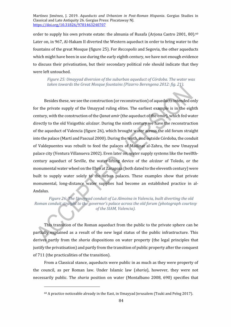
Martínez Jiménez, J. 2019. Aqueducts and Urbanism in Post-Roman Hispania. Gorgias Studies in Classical and Late Antiquity 26. Gorgias Press: Piscataway NJ. https://doi.org/10.31826/9781463240707
84
order to supply his own private estate: the almunia of Rusafa (Arjona Castro 2001, 80).60
Later on, in 967, Al-Hakam II diverted the Western aqueduct in order to bring water to the
fountains of the great Mosque (figure 25). For Reccopolis and Segovia, the other aqueducts
which might have been in use during the early eighth century, we have not enough evidence
to discuss their privatisation, but their secondary political role should indicate that they
were left untouched.
Figure 25: Umayyad diversion of the suburban aqueduct of Córdoba. The water was taken towards the Great Mosque fountains (Pizarro Berengena 2012: fig. 21).
Besides these, we see the construction (or reconstruction) of aqueducts intended only
for the private supply of the Umayyad ruling elites. The earliest example is in the eighth
century, with the construction of the Qanat amir (the aqueduct of the emir), which fed water
directly to the old Visigothic alcázar. During the ninth century we have the reconstruction
of the aqueduct of Valencia (figure 26), which brought water across the old forum straight
into the palace (Martí and Pascual 2000). During the tenth, and outside Córdoba, the conduit
of Valdepuentes was rebuilt to feed the palaces of Madinat al-Zahra, the new Umayyad
palace city (Ventura Villanueva 2002). Even later on, water supply systems like the twelfth-
century aqueduct of Seville, the water-lifting device of the alcázar of Toledo, or the
monumental water wheel on the Ebro at Zaragoza (both dated to the eleventh century) were
built to supply water solely to the urban palaces. These examples show that private
monumental, long-distance water supplies had become an established practice in al-
Andalus.
Figure 26: The Umayyad conduit of La Almoina in Valencia, built diverting the old Roman conduit straight to the governor’s palace across the old forum (photograph courtesy
of the SIAM, Valencia).
This transition of the Roman aqueduct from the public to the private sphere can be
partially explained as a result of the new legal status of the public infrastructure. This
derives partly from the sharia dispositions on water property (the legal principles that
justify the privatisation) and partly from the transition of public property after the conquest
of 711 (the practicalities of the transition).
From a Classical stance, aqueducts were public in as much as they were property of
the council, as per Roman law. Under Islamic law (sharia), however, they were not
necessarily public. The sharia position on water (Montalbano 2008, 690) specifies that
60 A practice noticeable already in the East, in Umayyad Jerusalem (Tsuki and Peleg 2017).

Martínez Jiménez, J. 2019. Aqueducts and Urbanism in Post-Roman Hispania. Gorgias Studies in Classical and Late Antiquity 26. Gorgias Press: Piscataway NJ. https://doi.org/10.31826/9781463240707
85
naturally occurring springs are communal (even if the most important member of the local
community has first rights to access it), but that water sources which are artificially found
or channelled are private, of an individual; which seems to exclude the possibility of public
ownership. Sharia also specifies that small rivers and their deviations are to be communally
managed, but this provisions appears to have rural irrigation in mind. Thus, it would seem
understandable that the emirs could privatise the aqueducts, as it could be argued both that
they were artificial conduits and that in any case the Umayyads had first-serve rights on
them. Methodologically, however, this is a problematic interpretation. These legal
dispositions of the sharia had not been firmly established in the early Umayyad period, and
would only become normative in the ninth and, especially, the tenth century. They were
established post factum as a way of legitimising what had already been done. The question
is how far they reflect pre-existing norms, and how much they were means of legalising
opportunistic usurpation.
Focusing on the actual practicalities of the eighth and ninth centuries, what can be
seen is a transfer of property after the 711 invasion. The aqueducts were, as we have seen,
public property controlled by city councils. During the Umayyad conquest most cities
surrendered through treaties known as sulh, by which the locals were allowed to preserve
their possessions and status in exchange for extra taxes (Chalmeta Gendrón 1994, 213-
20).61 This would assume that in the first decades of Damascus control municipal affairs
were left to their own. During the process of state formation of the independent Umayyad
emirate, the narratives and accounts of the conquest were modified (Clarke 2012), so to
justify more conquests by force that would render cities unprotected by the sulh, and thus
would have the public properties transferred to umma (communal) ownership (Manzano
Moreno 2006, 39-40). The umma was the community of believers and the emirs and caliphs
were, by definition, their leaders both in a religious and political sense (Crone 2005 [2004],
3, Santillana 1926, 2). This means that as leaders they had a degree of control over
communal properties. Perhaps in order to further justify the overall privatisation, it could
be the case that the aqueducts were considered part of the ruler’s share after the conquest
(mirroring the transfer of other Visigothic royal properties), and that the town council (in
whatever form it still existed, if at all) could or did not contest this (Santillana 1926, 134-6).
But again, all our texts date to a later period, and are part of an Umayyad effort to justify
retroactively their rule and decisions. The nature of the sources blurs our approach to the
actual events and transformations.
61 Only one treaty has been preserved, that of duke Theudimer.

Martínez Jiménez, J. 2019. Aqueducts and Urbanism in Post-Roman Hispania. Gorgias Studies in Classical and Late Antiquity 26. Gorgias Press: Piscataway NJ. https://doi.org/10.31826/9781463240707
86
Despite these privatisations and the lack of investment in large-scale public water
supply in the Roman way, the Umayyads were responsible for some water-related
munificence. After all, the fountains of the Great Mosque may not have been a main watering
point for the local inhabitants (their ritual role was surely paramount), but it was a pious
donation of water. Similarly, the creation of a fountain outside the alcázar by Abd al-
Rahman III with the overflow of the qanat amir (Chronicle of al-Nasir, 28), was a way of
giving to the people part of the water which the palace had not consumed (thus sticking to
the principle that the Umayyads had first-serve on that source, but were still expected to
share it). However, these actions were done as pious goodwill and charity, and not out of
civic duty as it was the case in the Roman period.
While there are many gaps in this legal proposal, especially considering the role or
existence of city councils, and the relevance of later Islamic law for the early period, it can
be said with some certainty that the Umayyad attitude towards the Roman water supply
shows a clear rupture with the late antique model. The lack of a clear definition of public or
municipal property and the new Islamic precepts on water law favoured this transfer of
ownership to the Umayyad elite. Water munificence as it had developed in the Roman and
late antique periods disappeared fulfilled no political or legal role in al-Andalus.
Looking back, looking East: Syria and al-Andalus
The development in al-Andalus of a new Umayyad state in two phases, the Emirate
(754-929) and the Caliphate (929-1031), is linked to two periods of urban renewal, as the
emerging power developed a new public architecture to make itself visible. This is very
similar to the process which the Suevic and Visigothic kingdoms went through earlier, in
the late sixth century. However, and different from what we have seen for the Visigothic
period, where the Roman past was an element of legitimisation, the Umayyads did not need
to look back to the Romans or their monuments to justify their rule. In fact, the Umayyads
looked back at their own past as Caliphs in Damascus (Clarke 2012, 40-1, Fierro 2007).
Even if from a strategic point of view the Umayyads favoured as their principal nuclei
those centres which had been major towns during the Visigothic and Roman periods
(Zaragoza, Mérida, Toledo, Córdoba and Seville), they translated the infrastructure and
administration from the East, from the Umayyad and Abbasid caliphates (Chalmeta
Gendrón 1994, 26-8, Lévi-Provençal 1957, Souto Lasala 2001, 29). For them, the Roman
towns and their monuments were not something to look at for inspiration or prestige.
The Great Mosque of Córdoba is the best example of this. Built late in the eighth
century by Abd al-Rahman I, it became not only the main mosque of al-Andalus, but also a
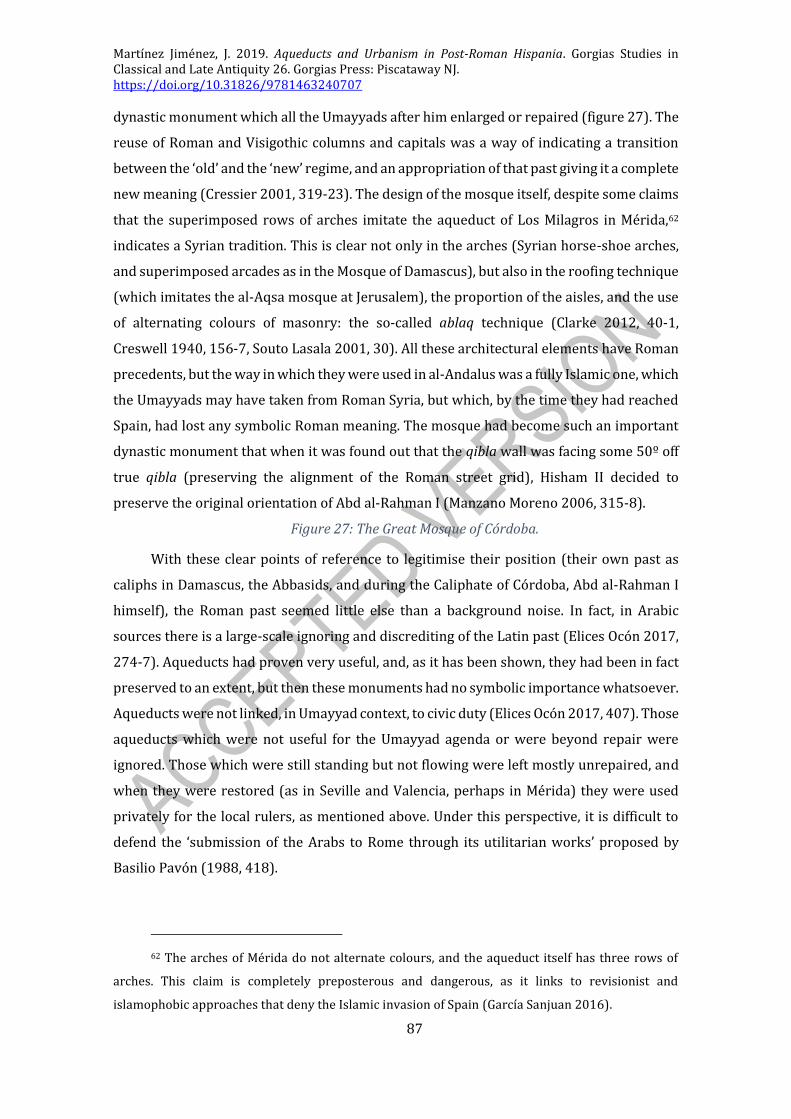
Martínez Jiménez, J. 2019. Aqueducts and Urbanism in Post-Roman Hispania. Gorgias Studies in Classical and Late Antiquity 26. Gorgias Press: Piscataway NJ. https://doi.org/10.31826/9781463240707
87
dynastic monument which all the Umayyads after him enlarged or repaired (figure 27). The
reuse of Roman and Visigothic columns and capitals was a way of indicating a transition
between the ‘old’ and the ‘new’ regime, and an appropriation of that past giving it a complete
new meaning (Cressier 2001, 319-23). The design of the mosque itself, despite some claims
that the superimposed rows of arches imitate the aqueduct of Los Milagros in Mérida,62
indicates a Syrian tradition. This is clear not only in the arches (Syrian horse-shoe arches,
and superimposed arcades as in the Mosque of Damascus), but also in the roofing technique
(which imitates the al-Aqsa mosque at Jerusalem), the proportion of the aisles, and the use
of alternating colours of masonry: the so-called ablaq technique (Clarke 2012, 40-1,
Creswell 1940, 156-7, Souto Lasala 2001, 30). All these architectural elements have Roman
precedents, but the way in which they were used in al-Andalus was a fully Islamic one, which
the Umayyads may have taken from Roman Syria, but which, by the time they had reached
Spain, had lost any symbolic Roman meaning. The mosque had become such an important
dynastic monument that when it was found out that the qibla wall was facing some 50º off
true qibla (preserving the alignment of the Roman street grid), Hisham II decided to
preserve the original orientation of Abd al-Rahman I (Manzano Moreno 2006, 315-8).
Figure 27: The Great Mosque of Córdoba.
With these clear points of reference to legitimise their position (their own past as
caliphs in Damascus, the Abbasids, and during the Caliphate of Córdoba, Abd al-Rahman I
himself), the Roman past seemed little else than a background noise. In fact, in Arabic
sources there is a large-scale ignoring and discrediting of the Latin past (Elices Ocón 2017,
274-7). Aqueducts had proven very useful, and, as it has been shown, they had been in fact
preserved to an extent, but then these monuments had no symbolic importance whatsoever.
Aqueducts were not linked, in Umayyad context, to civic duty (Elices Ocón 2017, 407). Those
aqueducts which were not useful for the Umayyad agenda or were beyond repair were
ignored. Those which were still standing but not flowing were left mostly unrepaired, and
when they were restored (as in Seville and Valencia, perhaps in Mérida) they were used
privately for the local rulers, as mentioned above. Under this perspective, it is difficult to
defend the ‘submission of the Arabs to Rome through its utilitarian works’ proposed by
Basilio Pavón (1988, 418).
62 The arches of Mérida do not alternate colours, and the aqueduct itself has three rows of
arches. This claim is completely preposterous and dangerous, as it links to revisionist and
islamophobic approaches that deny the Islamic invasion of Spain (García Sanjuan 2016).

Martínez Jiménez, J. 2019. Aqueducts and Urbanism in Post-Roman Hispania. Gorgias Studies in Classical and Late Antiquity 26. Gorgias Press: Piscataway NJ. https://doi.org/10.31826/9781463240707
88
The importance of Roman aqueducts in Umayyad urbanism and town planning was
very limited. It is certain that the means and knowledge to preserve and repair aqueducts
were available in the Umayyad period, but with hardly any political interest in actively doing
so, aqueducts had become purely functional structures. Furthermore, whereas bridges
could rank together with aqueducts in terms of urban importance, the former (especially
that of Córdoba) were thoroughly repaired, as they were much more useful in Umayyad
schemes and ideas of urbanism than aqueducts (Zozaya 2001, 55).
Umayyad urbanism and water supply systems up to the end of the
Caliphate
Overall, the development of the Umayyad state(s) was linked to the emergence of its
own new public architecture and its new urbanism. This new urbanism broke with the
previous (late Roman and Visigothic) trajectories of urban development and, either because
of the long period of disrepair of the infrastructure or the attitude of the Umayyads towards
the old aqueducts, Roman water supply systems did not play a major role in these new
urban developments. In fact, public cisterns (jubbs or aljibes in modern Spanish) seem to
have been far more common, together with professional water-carriers who delivered
water from these sources door-to-door (Glick and Kirchner 2000, 303, Navarro Palazón and
Jiménez Castillo 1995).
The general consensus is that throughout the Umayyad period towns grew and
developed around mosques and the main palaces, which were mostly built in the core of the
previously existing towns, and were increasingly fortified. The street hierarchy was
preserved, although the hierarchy was not reflected in width or straightness (A. Almagro
Gorbea 1987, Canto 2001, 13, Gutiérrez Lloret 2012, 197, Lévi-Provençal 1957, 198-200).
Therefore, there is a continuity of the principal foci of urban development in the main towns
of the al-Andalus. What seems clear from the evolution of walled enclosures is that towns
in the Umayyad period (especially after the ninth century) grew and expanded – not only
the main settlement, but also its immediate suburbs. This growth and these developments
took place without a regular water supply in the Roman fashion. In fact, and looking back at
the patterns of urban settlement outlined for the Visigothic period above, it is not surprising
to see that the location of the Umayyad urban centres coincides with those of the Visigothic
period, and not necessarily with those of the Roman one.
The clearest example of this would be Córdoba, as the mosque and the alcázar are
built on top of the Visigothic palatium, located by the bridge and where the water table is
available (Ruiz Bueno 2017). The same happened in Zaragoza, in Tarragona with the upper

Martínez Jiménez, J. 2019. Aqueducts and Urbanism in Post-Roman Hispania. Gorgias Studies in Classical and Late Antiquity 26. Gorgias Press: Piscataway NJ. https://doi.org/10.31826/9781463240707
89
town, and in Valencia with the alcázar built on the episcopal area. Even perhaps in
Barcelona, where it has been suggested by the team of Luis Caballero that the ‘episcopal
palace’ could in fact be an early Umayyad building, if compared in size and plan to the
Umayyad palaces excavated at Morería and the temple of Diana in Mérida (Martínez
Jiménez, Sastre de Diego and Tejerizo García 2018, 279). In these examples there was
continuity in the role and importance of given areas from the Visigothic into the Umayyad
periods, and only in Tarragona (and maybe too in Valencia) these coincide with the centres
of Roman urban power.63 This is not only an indicator of the high degree of continuity
between the Visigothic and Islamic periods, which accounts for the early settlement and
administrative patterns of the Umayyads (Gutiérrez Lloret 2012, 197, Manzano Moreno
2006, 248-60), but also of the importance artificial water supply systems had in modifying
the urban layout. Only in very limited examples did the Umayyads develop a brand new area
during the ninth century, consciously trying to break the links with the Visigothic past: in
Mérida and Toledo the Umayyad fortifications included a new fortress in a strategically
located area to control the unruly populations of these towns, as their strong local
aristocracies were responsible for continued rebellions. In the former, the alcazaba was
built after the destruction of the walls on top of the Gate of the Bridge (figure 28), which had
been the symbol of the Roman colony since its foundation (Alba Calzado 2001, Creswell
1940, 198); in the latter, the alcázar was built on the highest point of the granitic dome of
the old Roman town after the destruction of the suburban praetorium (Izquierdo Benito
2009). Curiously enough, in both instances, the deliberate location of the fortifications
required the construction of new water supply systems, as they were located in areas
without an obvious one. In Toledo, a set of water-lifting wheels was eventually installed. In
Mérida a new aljibe or filtration cistern was built in the central area of the fortress, reusing
Visigothic pilasters in its decoration (showing the power of the new rulers over the past)
and conveniently orientated towards Mecca, so a mosque could be installed on top (figures
29, 30) (Cressier 2001, 319, Creswell 1940, 202-3).
Figure 28: The Alcazaba of Mérida (photograph by Isaac Sastre).
Figure 29: Aljibe of the Alcazaba.
Figure 30: Decorated pilasters from a Visigothic building reused as part of the aljibe.
63 The case of Valencia is perhaps debatable, as the alcázar is already outside the old forum
complex, adjacent to the old episcopal complex; but as this is now underneath the Gothic cathedral,
it is very doubtful that any excavations will be carried out there.

Martínez Jiménez, J. 2019. Aqueducts and Urbanism in Post-Roman Hispania. Gorgias Studies in Classical and Late Antiquity 26. Gorgias Press: Piscataway NJ. https://doi.org/10.31826/9781463240707
90
In terms of domestic architecture, communal and private wells and cisterns were
abundant in residential areas. Fountains were mostly found in mosques, and even these
seem to have been linked to cisterns and wells. There were no more links with aqueduct
water supplies, and towns fell back to pre-Roman patterns without much problem. In terms
of sanitation, however, this caused some alterations: while conduits to evacuate domestic
sewage were not common in al-Andalus, cesspits are far more abundant. The only concerns
Islamic law-givers seem to have had, which may be a reflection of the simple drainage
system, was that sewage and rain water should not flow on the same drains. That may be
why open-air gutters to drain rainwater seem to have been the basic and most common type
of sewer – and these did not rely on constantly-flowing water from an aqueduct (Rėklaitytė
2012, Vidal Castro 2000).64
Considering the previous points, it is also noticeable in new urban foundations that
there was a lack of overall public water supply systems. In Madinat al-Zahra the aqueduct
was used to feed the palatine complex, despite the fact that the residential areas were
densely occupied (Acién Almansa 1987, 12-8). The town of Jaén, re-founded in the Umayyad
period, obtained its water from springs, which had been monumentalised in the Roman
period, but the distribution conduits had long been abandoned, and were not restored in
the Islamic period (Salvatierra Cuenca, Serrano Peña and Pérez Martínez 1998). Similarly,
Anjar in Lebanon was a new Umayyad urban foundation, settled in an area where the water
table was easily accessible, but without a public infrastructure to distribute or administer it
(Carver 1996, 189-90, Haase 1996, 167).
Lastly, Islamic baths or hammams were very numerous in al-Andalus. Three hundred
are mentioned in the sources in Córdoba alone, although archaeologically we only know a
handful (Clapés Salmoral 2013). There are still standing baths in Palma de Mallorca,
Granada, Ronda, Málaga, and many other places. In recent years, a set of baths in Toledo has
been identified, next to the mosque of Bab al-Mardum (now chapel of the Holy Cross). These
baths all functioned with small quantities of water, as they lacked the large pools which
characterised Roman baths. Cisterns or water wheels were the main water supply system
for these baths, although the hammam of La Almoina in Valencia might have been fed by the
aqueduct, and the baths of Bab al-Mardum in Toledo were linked to an underground water
filtration gallery (Passini 2010).
64 There are a few notable exceptions, as Córdoba, Zaragoza or Mérida, where some Roman
sewers were preserved or repaired, or Lérida and Murcia, two new urban foundations (Remolà
Vallverdú and Acero Pérez 2011).

Martínez Jiménez, J. 2019. Aqueducts and Urbanism in Post-Roman Hispania. Gorgias Studies in Classical and Late Antiquity 26. Gorgias Press: Piscataway NJ. https://doi.org/10.31826/9781463240707
91
An aqueduct-less society
Despite the fact that the techniques and the knowledge to build and maintain
aqueducts were available in the Islamic world, these were never as common in the towns of
al-Andalus as they were in the Roman period (Hill 1993, 183-5). Water was still an urban
need, and judges especially were very concerned with the availability of water in urban
contexts, but this was rarely supplied by Roman aqueducts (Navarro Palazón and Jiménez
Castillo 1995, 402). Old Roman aqueducts had been through a long period of disrepair after
the fourth and especially the fifth century, so in many instances it would have been
necessary to re-establish the aqueduct supply at a high cost, which the new Islamic
authorities could not afford, and which they did not care that much about. There was
probably also no popular urge to put them back in service.
This fits the general trends of urban development in the early Islamic world, where
the only true necessary and common elements in towns were fortifications, the mosque, and
the palace (Kennedy 1998). All of these are known to have been quickly built in Spanish
towns soon after the conquest (Zozaya 2001, 54-5). Hammams and suqs or market areas
would later develop through private initiative. The presence of other public infrastructure
was mostly up to the interest of the ruling elite, as the lack of a municipal authority that
encompassed most of the urban aristocrats prevented the construction of large public
buildings, for which there was no real demand as it existed in the Roman period (Salvatierra
Cuenca, Serrano Peña and Pérez Martínez 1998). This return to pre-Roman modes of water
supply should not be seen as a step back in urban development; after all, most Islamic towns
grew far beyond the limits of their old Roman wall enclosures.
Later in the Medieval period new long-distance water supply systems were built in
Islamic towns in Spain,65 as in Palma de Mallorca (Riera Frau 1993), Madrid (Retuerce
Velasco 2004, 101-4, Valdés Fernández 1992, 158-61) or Huelva (Pavón Maldonado 1990,
205). In other instances, rural irrigation conduits were diverted on a regular basis to fill
domestic and public cisterns and baths. But these two models are usually much later in date
(late tenth century at the earliest) and cannot be linked to Roman attitudes to public water
supply.
65 Usually called ‘qanats’ in Spanish publications, using the old Arabic word, although they did
not function in the same way modern scholars understand it, where a qanat is understood as a
foggara (Hodge 2002).

Martínez Jiménez, J. 2019. Aqueducts and Urbanism in Post-Roman Hispania. Gorgias Studies in Classical and Late Antiquity 26. Gorgias Press: Piscataway NJ. https://doi.org/10.31826/9781463240707
92

Martínez Jiménez, J. 2019. Aqueducts and Urbanism in Post-Roman Hispania. Gorgias Studies in Classical and Late Antiquity 26. Gorgias Press: Piscataway NJ. https://doi.org/10.31826/9781463240707
93
CONCLUSIONS
Aqueducts evolved from being ever-present monuments that each Roman city worthy
of the name wanted to have, to an established part of the urban infrastructure, and, finally,
a derelict reminder of a past era. This was a general trend all over the Empire, but perhaps
it is in the West that these changes were most notable. The examples put together for the
Iberian Peninsula reflect these trends, while casting some light on the actual evidence. The
most important conclusions that have been put forward are three. One, that aqueducts had
a surprising degree of continuity into the early Middle Ages. Two, that this degree of
continuity was the result of an equilibrium between the inherent usefulness and
legitimising Roman appeal of aqueducts and the incapability (due to lack of resources,
knowledge or skill) to keep them working. And three, that even if originally aqueducts had
not been essential parts of towns, by this period they had an immense influence on urban
layouts, so their abandonment was one key factor in the shaping of urban settlements.
A SURPRISING DEGREE OF CONTINUITY?
One of the big questions that this book has tackled is the degree of continuity
aqueducts had, a question that had not previously been addressed or answered, and was
most usually just ignored. It is possible now to put forward figures on this continuity (figure
6), and to claim that of the 69 aqueducts of the Iberian Peninsula, one in four (24.6%) were
still in use by 400 CE and into the fifth century (Almuñécar, Barcelona, Conimbriga, Córdoba,
Lisbon, Lugo, Mérida, Segovia, Seville, Tarragona, Valencia and Zaragoza). In some cases, as
mentioned, the dating is quite secure, as in Mérida, Seville or Córdoba, whereas in others
the certainty is lesser (Almuñécar, Valencia), but they form a cohesive group of datable
aqueducts. The number of functioning aqueducts declines steadily, but gradually, through
the fifth and sixth centuries, with a steep fall into the seventh. This means that by the
Umayyad invasion only four of the old Roman aqueducts are in use, plus two other doubtful
ones, and the new sixth-century aqueduct of Reccopolis.
Unsurprisingly, those aqueducts that show continuity are linked to the most
important towns of the Peninsula, those in which a powerful elite that could take care (or
try to maintain) their water supply system was still present.
It would be very difficult to compare Spain to other regions, such as Gaul or Italy so
as to assess if this ratio is a good indicator for the post-Roman West – although such a study
would be extremely interesting. This is not only because there is no comparable corpus of
data for either of these regions, but also because the local dynamics that ruled the years

Martínez Jiménez, J. 2019. Aqueducts and Urbanism in Post-Roman Hispania. Gorgias Studies in Classical and Late Antiquity 26. Gorgias Press: Piscataway NJ. https://doi.org/10.31826/9781463240707
94
between 400 and 700 are very different. Italy had a much large number of urban aqueducts,
and for the fifth and early sixth centuries, there was a much greater degree of Roman
continuity in all aspects. But this all changed after the devastating wars of the mid-sixth
century. As for Gaul, it is similar to Spain as it had a Mediterranean core which long
preserved Romanitas (in fact, most of Mediterranean Gaul was ruled by the Visigoths) and
a wide strip of northern and eastern territories which became increasingly de-urbanised.
However, the geomorphology and climate of Gaul do not really make aqueducts essential
parts of urban development, as water was much more easily accessed than in Spain.
One last key thing that can be inferred from the chronology and the data presented in
this book, is that the approach to aqueducts was very different in the Roman period than its
later Umayyad (and subsequent) equivalent. Aqueducts had been key in early Roman urban
culture, and were still present in the late Roman period, lingering through Late Antiquity,
but after a period of abandonment, the reuse and reconstructions of the Islamic period did
not follow the path marked by the Romans.
THE LONG SHADOW OF THE PAST
From the written sources of late antique Gaul and Italy we get the impression that
preserving the Roman past was something very important for the local elites and the late
imperial administration. The old Roman monuments represented a legitimising link, which
they wanted to take over. In Hispania the lack of written sources prevents us from making
strong claims on this aspect, but the attitude towards aqueducts may shed some light on it.
It is mostly the urban elites in the important towns listed above that seemed to have enjoyed
aqueduct supply, and in theory the ones who were responsible for its upkeep. Bishops seem
to have also been involved up to a certain extent in these affairs, as they represented the
new urban elites, as the possible episcopal baths of Barcelona or the episcopal buildings at
the forums of Valencia and Tarragona suggest. The use given to the public water supply
system had, however, started to shift into a more private sphere, and although some public
fountains are still present and in use (like Tarragona, Valencia), the aqueduct supply seems
to have been preserved primarily as a private elite supply. This itself is not that different
from the early Roman period, but the lack of public baths made aqueduct supply much more
restricted, and therefore, much more elitist.
Despite this, aqueducts were still very useful and powerful symbols of Romanitas, so
it is not surprising to see that a new royal urban foundation such as Reccopolis was equipped
with a new aqueduct. This major construction has to be put in context, as an aqueduct was

Martínez Jiménez, J. 2019. Aqueducts and Urbanism in Post-Roman Hispania. Gorgias Studies in Classical and Late Antiquity 26. Gorgias Press: Piscataway NJ. https://doi.org/10.31826/9781463240707
95
part of the ‘ideal town’, it was one of the things that any important capital (especially in the
context of Rome, Ravenna or Constantinople) should have, together with a church, a palace,
and walls. The lack of any other major royal constructions in Visigothic Spain (beyond wall
repairs) may account for why there were no other aqueducts built by the monarchy, but it
does not explain why the monarchy was not responsible for the repair or maintenance of
other urban aqueducts. Perhaps, and following late antique traditions, municipal
infrastructure was increasingly left aside by the patronage of the central administration.
This approach towards aqueducts from the local elites and the local Church (or from
the central administration) came to an end with the fall of the Visigothic kingdom, as in the
Umayyad period and beyond aqueducts became completely privatised. This privatisation
included the rebuilding of aqueducts to supply private estates and palaces of the Umayyad
ruler, even if this involved cutting the public supply. During the tenth century the Umayyad
caliphs used aqueducts to supply water at the mosque of Córdoba, as a sign of the caliph’s
piety and goodwill. But this was a gift to the mosque (which was an Umayyad dynastic
monument), rather than a large-scale fountain distribution commissioned by the city
council which had characterised the Roman period.
THE DECLINE AND FALL OF URBAN AQUEDUCTS
The demise and ultimate abandonment and collapse of aqueduct is the main
questions addressed in this work, and various answers have been put forward. The
transformations of the urban administration in the fourth century caused many of the
transformations that are noticeable in the fifth century, including the lack of investment in
aqueduct maintenance. The lack of municipal funds and the lack of political incentives
during the late fourth and fifth centuries are perhaps the main cause for aqueduct disrepair.
Only basic maintenance was carried out in these centuries, if at all, so it is possible that as
the demand for specialised and skilled engineers during this period declined, by the period
of urban renewal of the late sixth century there were hardly any (if any at all) engineers who
could repair major damage on aqueducts. This meant that these structures, which were
mostly over four hundred years old, were impossible to repair and , wherever they tried to
repair aqueducts, they failed (as can perhaps be seen in Mérida). In this context, the
aqueduct of Reccopolis is even more striking, as it is built ex novo in a context in which this
did not seem possible.
This abandonment of the water supply infrastructure did not, however, imply that
towns were left without water. Some areas of towns were without running water, but water

Martínez Jiménez, J. 2019. Aqueducts and Urbanism in Post-Roman Hispania. Gorgias Studies in Classical and Late Antiquity 26. Gorgias Press: Piscataway NJ. https://doi.org/10.31826/9781463240707
96
was still available (as it had been in the previous periods) from wells and cisterns. In some
cases, these become more numerous as the aqueducts cease to function, and in some other
cases, due to the lack of aqueducts, large public cisterns had to be built (as in the new urban
foundation of El Tolmo).
Aqueducts had not originally been an urban need, but rather a way of showing
allegiance to Rome and of presenting the locals as fully Romanised (the famous Monty
Python’s ‘−And what have they [the Romans] ever given us in return?!’66). But as time passed
and the benefits of piped water became more evident, urban populations grew more and
more dependent on aqueduct supply, up to the point that in the late antique and post-Roman
period the end of aqueducts prompted changes in urban layouts. We have seen through
various examples of the main towns of the Peninsula that townscapes and settlement
location changed through this period, and even if there may be other reasons for this (the
relocation of the centres of power, new economic foci, etc.), water availability was certainly
one of the most important. This is especially true in upper towns which were once fed by
aqueducts, which may have become less welcoming without public fountains or domestic
piped water.
This statement must be kept within perspective, as towns flourished before and after
aqueducts were available: towns in the Islamic period and in the later Middle Ages grew
beyond the Roman or late antique enclosures. Only in a very few cases were aqueducts a
real urban need. The important thing to keep in mind is that in the post-Roman period town
dwellers had to adapt to a situation they were not prepared for, in which water ceased to be
a commodity and had to be acquired from wells or cisterns.
FURTHER AFIELD?
In conclusion, this book has provided not only innovative results but also a clear
general overview of a few chosen late antique cities in Hispania. And even if this may be a
useful contribution, there are still things that can be investigated and blurry areas that need
further research. The most obvious thing, as already mentioned above, would be a similar
study to assess the evidence for Gaul, Italy and North Africa: a general overview of the end
of aqueducts in the west would be very useful to improve our understanding of the
evolution of towns in the post imperial period. Similarly, with a larger body of comparanda,
it will be possible to improve the results and refine the models proposed in this book. Jordan
66 It should be noted that the first thing mentioned in the film out of the long list of Romans
did actually do for the Jews in Jerusalem was, in fact, the aqueduct.

Martínez Jiménez, J. 2019. Aqueducts and Urbanism in Post-Roman Hispania. Gorgias Studies in Classical and Late Antiquity 26. Gorgias Press: Piscataway NJ. https://doi.org/10.31826/9781463240707
97
Pickett is currently (expected 2020, Oxford University Press) preparing a volume on
aqueducts in Late Antiquity which may make these issues clearer.
Further research in absolute dating of aqueducts would also be extremely useful. ESR
(electron spin resonance) and OSL (optical stimulated luminescence) dating can date the
crystallisation of carbonate, and therefore, of sinter. With proper sampling in situ, it is
possible to micro-sample crystals from the bottom and the top of the sinter concretions, and
together with a Bayesian model, it could give thus dates for the first and last flow of water
in the conduit. This type of sampling and dating has not yet been applied to aqueducts, but
it has been used to date enamel formation in Palaeolithic teeth (Duval, Grün, et al. 2009, M.
Duval, C. Falguères, et al. 2012). Modern developments of micro-sampling would further
allow us to date the formation of crystals from the top and the bottom of the sinter crust,
giving us an absolute date between the last time sinter was removed and the date in which
water ceased to flow.67
From a more local point of view, a closer analysis of water-related material culture in
post-Roman urban contexts (such as the analysis and volume of water vessels and jugs, or
plotting well distribution in a single site) could provide a much more detailed account of the
dairy uses of water. This could be compared across various sites of Roman, late antique and
Islamic date. Much is yet to be learned from the many boxes of fine and common-wares
excavated in recent years and stored in museums, which have not yet been studied.
Lastly, in the period between me finishing my thesis (2013) and its final publication
(2019) nine more aqueducts have been identified or published in the Iberian Peninsula,
which means that more raw data may still emerge.
***
Overall, aqueducts in the towns of post-Roman Spain and Portugal were mostly
standing, but not necessarily in use, as silent reminders of a previous era. A considerable
number of them were still functioning, especially in the most vibrant towns where urban
elites still had enough resources and power, which is one of the most important conclusions
for this book. But as generations passed and Roman rule became more of old men’s
memories, the local capability of preserving and repairing their water supply systems
67 An interdisciplinary team lead by Chloe Duckworth (University of Newcastle) with
collaborating geologists from the University of Calgary (Canada) are preparing a large project that
will include the development and testing of this new method.

Martínez Jiménez, J. 2019. Aqueducts and Urbanism in Post-Roman Hispania. Gorgias Studies in Classical and Late Antiquity 26. Gorgias Press: Piscataway NJ. https://doi.org/10.31826/9781463240707
98
diminished. It is doubtful that aqueducts ceased to function overnight, and may have taken
various years for an aqueduct to finally cease to function – but in that time the inhabitants
may well have come to realise that they were living under new circumstances. The spell of
aqueducts was so appealing that the Visigothic king’s new town was equipped with one, and
again – one just can wonder about what the reaction of those newly settled inhabitants was
when they saw it. It would have to be the newly-arrived Umayyads, with their different
attitude towards the Roman past, and their inherited and preserved knowledge of hydraulic
engineering that brought many aqueducts back to use – but by then the population did not
benefit from them, and probably they did not expect to either. But still, and as many of
tourists these days, they would have looked at the centuries-old aqueducts which were still
standing and wondered about these most impressive monuments.

Martínez Jiménez, J. 2019. Aqueducts and Urbanism in Post-Roman Hispania. Gorgias Studies in Classical and Late Antiquity 26. Gorgias Press: Piscataway NJ. https://doi.org/10.31826/9781463240707
99
CATALOGUE: FUNCTIONING AQUEDUCTS IN THE LATE ANTIQUE IBERIAN
PENINSULA
ALMUÑÉCAR
Almuñécar (the ancient Sexi) was a Phoenician colony in southern Spain, which
became a municipium in the early Empire, and this promotion prompted a period of urban
development which included the construction of an aqueduct and a set of baths linked to it
(Sánchez López and Moreno Pérez 2012). The city itself was built on top of a hill,
overlooking a harbour, and it seems to have been primarily a centre of garum production,
like many other coastal towns of this region.
Very little is known of the archaeology of Almuñécar in Late Antiquity, but it seems
that by the time of the Byzantine invasion (550s) the city was largely abandoned, including
the large garum factories at the site of El Majuelo. The city had already ceased to mint coin
in the fifth century, and even if it might have still preserved some minor importance as a
harbour, by the seventh and eighth centuries the site may well have been deserted, as no
material is known from the site or its environs datable to that period (Gómez Becerra 1995).
The site still functioned as a harbour during this period, even if the archaeology
indicates that it was a rather small one, because in 750 CE Abd al-Rahman I landed here after
fleeing from the Abbasid Revolution there. The site shows signs of commercial and urban
activity again in the ninth century.
The remains and course of the aqueduct
The aqueduct of Almuñécar (Sánchez López and Moreno Pérez 2012) is fairly well
known all along its 7km, and its impressive remains are still standing and, in some sections,
still carrying water for the neighbouring fields (figure 31). It draws water from an aquifer
up in the mountains around Almuñécar (the site of La Angostura), and by means of a
partially subterranean conduit takes the water along the valley of the Verde river, visible at
Barranco de Antequera and Barranco del Olivillo. In this part, the aqueduct goes over the
Torrecuevas creek on an impressive seventeen-arch structure. A few metres away, the
aqueduct goes into a tunnel to the valley of the Seco river, on the other side of the mountain.
There, the creeks and ravines are deeper (figure 32), and up to three bridges were built
(numbered aqueducts I, II and III), which vary between 43m with four arches (I) and 72m
with nine arches (III).

Martínez Jiménez, J. 2019. Aqueducts and Urbanism in Post-Roman Hispania. Gorgias Studies in Classical and Late Antiquity 26. Gorgias Press: Piscataway NJ. https://doi.org/10.31826/9781463240707
100
Figure 31: Map showing the course of the aqueduct of Almuñécar.
Figure 32: Arcaded section of the aqueduct (photograph by Elena Sánchez).
After aqueduct III, the conduit reaches a settling tank which is the head of an inverted
siphon that takes the water up to the hill where Almuñécar is, crossing the valley in between.
The venter (low point) of the siphon has been located recently; it ran on clay pipes over the
deck of an arched structure (figure 33).68 The final tank of the aqueduct was for a long time
believed to have been the ‘cave of the seven palaces’, a Roman vaulted structure, but this
lacked any water-tight lining (according to the recent excavations), and it seems more
plausible that the current bell tower of the Encarnación church (which is a reused Roman
tower) was the aqueduct’s final destination. The tower would allow the de-pressurisation
of the water, which would match the description given by al-Idrisi in the twelfth century,
who mentions:
‘... [in Almuñécar] there is a square construction, similar to a column, wide in
its base, narrow in its top. On two of its sides there are carvings [imprints of
pipes?] that merge together on the top. At the angle formed by the side there
is a sunken vat in the floor, which received the waters brought from a mile
away by an aqueduct of many arches built in hard stone [at this distance, it
must have been the venter of the siphon]. The learned men of Almuñécar say
that in former times the water went up to the top of the obelisk and went
down the opposite side, towards a small mill...’69
Figure 33: Venter of the aqueduct’s siphon (photograph by Elena Sánchez).
A branch of this aqueduct may have been identified at the El Majuelo garum factory,
at the foot of the hill of Almuñécar, which brought the water needed to clean the fish and
vats. Although the connection is not confirmed, the presence of a vaulted conduit lined in
opus signinum could only point towards an aqueduct; if it was not coming from the main
aqueduct of Almuñécar, it must have been a new conduit that brought water from elsewhere
(Sánchez López, Pérez Marrero, et al. 2011).
Chronology and dating evidence
Various Arabic sources (al-Idrisi, al-Himyari, ibn al-Khatib) mention the aqueduct of
Almuñécar or its terminal deposit, copying the text of Idrisi quoted above. But all of them
68 Such venter was predicted by Fernández Casado (1949), and documented in the 1990s
(Bestué Cardiel and González Tascón 2006).
69 Quoted in Fernández Casado (2008 [1972], 205). My translation of his Spanish.

Martínez Jiménez, J. 2019. Aqueducts and Urbanism in Post-Roman Hispania. Gorgias Studies in Classical and Late Antiquity 26. Gorgias Press: Piscataway NJ. https://doi.org/10.31826/9781463240707
101
mention it as a ruin which no longer functioned, although it was obvious to them that it was
a water conduit. Al-Idrisi, the earliest of these writers, wrote in the early twelfth, giving us
a rather vague and unhelpful terminus ante quem.
For an earlier ante quem we have to look at the lack of datable pottery for the seventh
century from the town itself, which would indicate a decrease in the activity of the site
parallel to other similar nuclei in the Byzantine province, like Málaga, Carteia or Traducta
(Martínez Jiménez and Moreno Narganes 2015). Presumably by then the aqueduct had
already ceased to function.
The only other dating evidence is the abandonment of the fish factories at El Majuelo,
dated to the late fourth or early fifth, although the pottery has been recently reassessed as
late fifth (Gómez Becerra 1995, 185, Lagóstena Barrios 2001, 154), giving a possible t.a.q.
for the end of the aqueduct. The end of the fish factories of Almuñécar could in fact be
directly related to the end of the conduit, although this is not terribly useful dating evidence.
The baths located at the venter of the siphon were very badly damaged by ploughing, and
have not provided any dating material for its late and abandonment phases.
In the best of cases, the aqueduct may have been working into the fifth century, and
most certainly not into the sixth, although there is no hard evidence.
BARCELONA
Barcelona (Barcino) was during Late Antiquity one of the most important towns of
the north-eastern Iberian Peninsula. The old Roman colony had been founded on two hills
between two small rivers overlooking the Mediterranean coast, and it was back then a
secondary regional town within the area of influence of Tarragona, the provincial capital.
Its political importance grew during Late Antiquity, and during the Visigothic period it
replaced Tarragona as the regional capital.
The increasing political importance of late antique Barcino
Barcelona began to develop as a political centre during the early fifth century (Ripoll
López 2002, 34), when it became the seat of power of Athaulf and Galla Placidia (410-15),
probably because of its location close to Gaul, its good harbour, and its walls reinforced
during the course of the fourth century (Pallarés Salvador 1969, Puig Verdaguer and Rodá
de Llanza 2007). It became part of the Visigothic kingdom in the 470s (Perich Roca 2014),
and it seems that there was a palace-like structure used by the Goths as a royal seat there

Martínez Jiménez, J. 2019. Aqueducts and Urbanism in Post-Roman Hispania. Gorgias Studies in Classical and Late Antiquity 26. Gorgias Press: Piscataway NJ. https://doi.org/10.31826/9781463240707
102
(Chr. Caesaraug., 510; Hist. Goth., 38). However, it was because of the presence of a bishop
that Barcelona became the key city in the province of Tarraconensis.
The city had been an episcopal see at least since the fourth century, and it was both a
Catholic and an Arian bishopric until the third Council of Toledo in 589 CE. In the year 592,
King Reccared invested the bishop of Barcelona with the power to collect the taxes in the
territory of three other adjacent bishoprics, including the metropolitan see of Tarragona, in
a document called De fisco Barcinonensi.70 The power of the bishop was thus increased,
which seems to be reflected in an enlarged episcopal complex, located in the north-eastern
quarter of the town.
The episcopal complex of Barcelona (figure 34) is a very good example of well-
researched urban archaeology. The excavations below the Plaza del Rey, the cathedral, and
the City History Museum have revealed a large site which was most probably the political
centre of Barcelona. This has been identified as the episcopal complex, which can be dated
to the fifth century, with an important expansion in the sixth. The complex and the cathedral
were originally (4th c.) located on a workshop area which included a fullonica and tinctoria,
and a fish sauce factory (Beltrán de Heredia 2002b, 2002a). The episcopium back then
consisted of a large residence constructed over a previous domus, the cathedral basilica
itself, and an audience hall, all of which were contained into a single street-block (Bonnet
and Beltrán de Heredia 2002). At a later date, probably during the late sixth century
(perhaps related to the powers granted to the bishop by the De fisco Barcinonensi), the
whole area underwent a major reconfiguration: the buildings were finally abandoned and
substituted by new structures belonging to the episcopal complex: the cathedral was
enlarged, the baptistery was remodelled, a new cross-shape building (identified as a
church) was erected, and a new U-shaped building (suggested to have been the count’s
palace) was built. In order to build this large complex several transverse streets were
blocked and included inside the complex. A new bath complex was built in the sixth century
too, as will be set out below.
Figure 34: Reconstruction of the episcopal complex of Barcelona, based on the excavations under the Plaza del Rey (Bonnet and Beltrán de Heredia 2002: fig. 9).
The rest of the town remains largely unknown for this period, but it seems, from the
evidence of extensive reuse of materials in the episcopal complex, that whatever traditional
public structures still survived were pulled down in order to obtain new building material
70 Discussed by Chris Wickham (2005, 96-7). Cf. (Fernández 2006).

Martínez Jiménez, J. 2019. Aqueducts and Urbanism in Post-Roman Hispania. Gorgias Studies in Classical and Late Antiquity 26. Gorgias Press: Piscataway NJ. https://doi.org/10.31826/9781463240707
103
(Beltrán de Heredia 2002c). Outside the walled town, a new sixth-century suburb developed
towards the north-west.
Late antique baths
Of the few structures known from late antique Barcelona outside the episcopal
complex, baths are the most abundant. Some new large baths were constructed during the
course of the fourth century, which might have been public, but it is not known when they
ceased to function. Two other late baths belonging to aristocratic domūs are known: those
of Bisbe Caçador (belonging to a fourth-century domus) and Pati Llimona (5th c.). Both seem
to have continued until the sixth century at least, parallel to the abandonment or re-
conversion of the domus, although the dates of these baths are not certain.
The balneum of the domus of Bisbe Caçador is a large set of baths, with five rooms
which include an apoditerium [changing room], two frigidaria [cold rooms], a tepidarium
[warm room] and a caldarium [hot room], paved in opus sectile (García-Entero 2005, 207).
It was built on top of the intervallum, so it has been dated to the fourth or fifth centuries.
The bath furnace was shut by the end of the fifth century, but this does not prove that the
bath cease to function; it rather indicates that the baths may have continued to function
simply with cold water. The domus itself transformed in the sixth century into a multi-family
dwelling and the bath turned into a workshop (Perich Roca 2014). The baths of the Pati
Llimona domus are smaller than those of Bisbe Caçador, but are very well preserved. They
are also linked to a private house, which was also built on the intervallum. The bath with its
hypocaust floor was in use until the sixth century, according to the abandonment layers
(García-Entero 2005, 211).
The aqueduct
Sources, course and distribution
The aqueduct of Barcelona is partially still standing in the northern part of the old
Roman city, exactly where they cross the walls next to the north gate, at the Plaza Nueva. It
was thought to have disappeared long ago, and 19th and 20th century scholars argued about
the location of the aqueduct, which was known from written medieval sources and from a
Roman inscription:
L(ucius) Min[ucius L(uci) f(ilius) Galeria Na]talis (…) et L(ucius) Minicius
L(uci) f(ilius) [Natalis Quadro]nius Verus f(ilius) (…) balineum c[um
port]icibus solo suo et/ du[ctus aquae] fecerunt.

Martínez Jiménez, J. 2019. Aqueducts and Urbanism in Post-Roman Hispania. Gorgias Studies in Classical and Late Antiquity 26. Gorgias Press: Piscataway NJ. https://doi.org/10.31826/9781463240707
104
‘Lucius Minucius Natalis, son of Lucius, of the Galerian tribe (…) and [his] son
Lucius Minicius Natalis Quadronius Verus, son of Lucius (…) built a bath with
porticoes and an aqueduct on his own land.’ (abridged, CIL II 4509)
Then, during the construction of a new public square at Barcelona (the Plaza Nueva)
in the 1950s, the remains of the arches for two conduits appeared again inside the Casa del
Arcediano (a Renaissance palace built adjacent to the town gate), projecting outside the
walls (figure 35). It was evident then that the aqueduct had been included in the Roman and
medieval fortifications (Fernández Casado 2008 [1972], 219, Mayer Olivé and Rodà de
Llanza 1977, 271). In this site, two different water conduits are now standing, built in
parallel and following the same construction technique.
Figure 35: Reconstructed remains of the aqueducts at the Plaza Nueva.
They are built in opus vittatum with regular ashlar blocks quarried from the nearby
hill of Montjüic. The pillars, which are 5 x 5 Roman feet (1.55 x 1.55m), are built on top of
solid bases which rest on the soil. The pillars culminate in imposts which are 1.5Rf thick, on
top of which rest the arches. The arches are round or voussoir arches, 5Rf in radius at the
intrados (3.10m total width), and the voussoirs themselves are 1.75Rf high. The specus is
built on a box lying just above the horizontal formed by the extrados, 5Rf wide and 3.5Rf
tall, 7 metres above the ground. The western aqueduct, known as the Collserola aqueduct,
has the biggest specus, is box-shaped, measures 0.6 x 0.6m and is lined in opus signinum. The
eastern aqueduct, known as the Moncada aqueduct, is built with slightly smaller stones. Its
specus is U-shaped, measuring 0.6 x 0.7m, and is also covered in opus signinum, but its level
is 0.15m higher than that of the Collserola aqueduct (Miró Alaix and Orengo 2010).
The existence of two different conduits entering the town has generally been taken as
proof for the existence of two different aqueducts, but according to recent research both
conduits are part of a single aqueduct which branched at some point between the source
and the city (Orengo and Miró Alaix 2011).
The course of the main branch (Miró Alaix and Orengo 2010, Sánchez López and
Martínez Jiménez 2016, 149-54) can be traced fairly accurately beyond the Plaza Nueva
thanks both to archaeological data and written references, as is repeatedly mentioned in
medieval documents (archos antiquos, arcos, aquaria, etc.) in the surroundings of Barcelona
(Mayer Olivé and Rodà de Llanza 1977). The aqueduct turns north from the Plaza Nueva
and is found again at the Plaza de Durán y Bas: when a house was demolished there in 2010,
and once the debris was removed, a section of the aqueduct was uncovered inside the wall
of the adjacent house. This section perfectly preserves four more arches (five pillars) and

Martínez Jiménez, J. 2019. Aqueducts and Urbanism in Post-Roman Hispania. Gorgias Studies in Classical and Late Antiquity 26. Gorgias Press: Piscataway NJ. https://doi.org/10.31826/9781463240707
105
its specus. It is also built in the same 5Rf-moduled opus vittatum. Because it is still imbedded
in the house’s wall, and holding its weight, it is not possible to clear the in-filled masonry in
order to render it free standing. The next known section is located at the site of Calle
Magdalenas 25, by an old nunnery. These remains were identified in 2005, and were part of
the specus and its surrounding opus vittatum, which had been reused after Antiquity and
were all covered in lime mortar. The next location of the aqueduct is known from three
written sources in the current urban area of Barcelona: These indicate that the aqueduct
was standing in 1763 inside a house at the area known as the Archs de Jonqueres, next to the
Lesser Count’s Palace in 1116, and by the De las Puel·las (formerly, St. Peter’s) monastery
in 1044. Six kilometres away from the last attested location, at the site of Sant Andreu (Calle
Palomares and Calle Coronel Monasterio), excavations have revealed more sections of the
aqueduct. The remains were located in 2006 (Giner Iranzo 2007), and stretch over 90
metres, and were identified in several survey trenches and excavated in depth in three
different sondages. They are built in opus caementicium, with a total width of 1.30m, the
specus being about 0.6m wide. This is lined in opus signinum, on top of which sinter crusts
between 2 and 14cm formed (this may indicate a very long period of flowing water, because
the source of the aqueduct is naturally poor in calcium). Several cippi (markers) and
spiramina have also been identified there. The source of the aqueduct is identified thanks to
a final reference, dated to 987, which mentions the aqueduct next to a Roman road (ipsa
Aquaria Antiqua vel in via), which from the context of the manuscript is identified as the
road next to the Tapioles river and the Moncada mine. This mine was a source of drinking
water in the Middle Ages, and can therefore be associated with the original Roman source
for the aqueduct. Thus the aqueduct had an approximate length of 11.3km, and a drop of
18.12m.
The course (figure 36) given by the evidence for the Moncada aqueduct fits perfectly
with the route of the main Roman road, running parallel to it for the most of its course,
which would further confirm that it is a correct route. Furthermore, the aqueduct itself
seems to be running parallel to a later medieval (11th c.) water conduit, the Rec Comtal,
which fed water to the many feudal mills of the counts of Barcelona before arriving at the
Count’s Palace (built during the 11th c. on top of the old sixth-century episcopal complex)
(Mayer Olivé and Rodà de Llanza 1977).
Figure 36: Reconstructed course of the aqueduct of Barcelona.
The other branch (which was thought to have been a different conduit) has been
located archaeologically only in the area around the Plaza Nueva. From the standing
remains, and heading north-west, several pillars were excavated at the Plaza itself, at the

Martínez Jiménez, J. 2019. Aqueducts and Urbanism in Post-Roman Hispania. Gorgias Studies in Classical and Late Antiquity 26. Gorgias Press: Piscataway NJ. https://doi.org/10.31826/9781463240707
106
Colegio de Arquitectos, and then only identified later at Calle Arcos, whose name makes
reference to the aqueduct itself (Sol Vallés 1977). All of these locations are only 200m away
from the Plaza Nueva, so it is not easy to reconstruct the rest of the aqueduct’s course.
Distribution and disposal of water
Inside the walls, the water seems to have been distributed from the castellum, which
is thought to have been underground, by the forum, at the highest part of town. From there,
water would have been supplied through pressurised pipes and open conduits to other
parts of the town. One of these distribution conduits has been located at the Calle Palma de
Sant Just, which at the time of its discovery (1904) was considered to have been the cloaca
maxima or main drain (Fernández Casado 2008 [1972], Miró Alaix and Orengo 2010, Sol
Vallés 1977). Another one has been identified leading towards the south late Roman
fortified enclosure, misleadingly called castellum, where there was a set of baths (Ruiz
Bueno 2018b, 59).
This conduit is a mortared-rubble, vaulted structure known for approximately 21
metres. It ran underground in Roman times, but recent studies suggest that this was not a
drain, but a conduit of clean water. The arguments for this are its orientation along the
decumanus maximus (from the forum terminal deposits towards the southern baths) and
that it does not match other sewers of the city either in orientation or construction
technique. Even if it is not lined with opus signinum, there are examples in Spain of
aqueducts carrying clean water for baths (not necessarily drinking water) in clay-lined
conduits, as in Pamplona (Unzu Urmeneta, et al. 2006), Valencia (see below) and León
(Campomanes Alvaredo 2006).
As far as sewers are concerned, there are not that many known from Barcelona, but
the most important for our study are those located at the episcopal complex. The old Roman
sewers were completely reformed in the fourth century, but then seem to have been
neglected and probably abandoned by the sixth century, but when the episcopal complex
was developed, new drains were constructed. It is not clear if the drainage linked to the
episcopal bath led to the main sewer or to a sewage-pit, but this drain was clearly built
reusing the hydraulic systems of the pre-existing structures (Beltrán de Heredia and
Carreras Monfort 2011).
Chronology and dating evidence
The aqueduct was built during the Flavian period, according to the material obtained
from the foundation trench (Dragendorff forms 27b, 29) at the site of Sant Andreu, but what
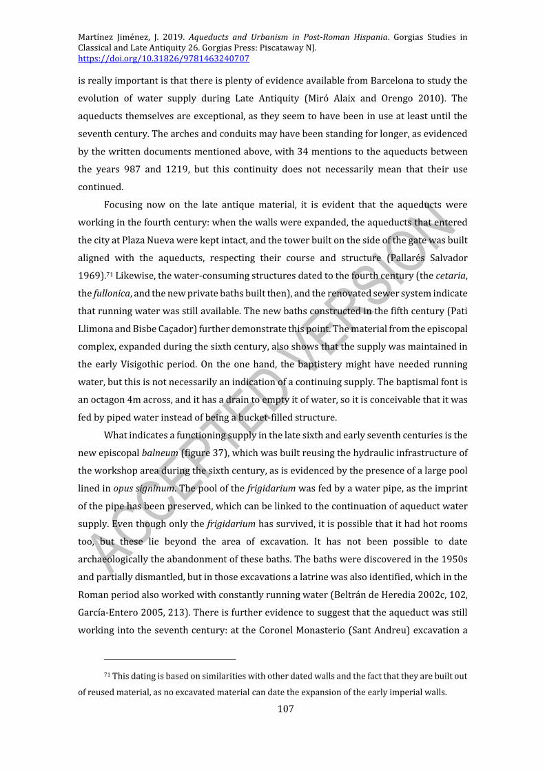
Martínez Jiménez, J. 2019. Aqueducts and Urbanism in Post-Roman Hispania. Gorgias Studies in Classical and Late Antiquity 26. Gorgias Press: Piscataway NJ. https://doi.org/10.31826/9781463240707
107
is really important is that there is plenty of evidence available from Barcelona to study the
evolution of water supply during Late Antiquity (Miró Alaix and Orengo 2010). The
aqueducts themselves are exceptional, as they seem to have been in use at least until the
seventh century. The arches and conduits may have been standing for longer, as evidenced
by the written documents mentioned above, with 34 mentions to the aqueducts between
the years 987 and 1219, but this continuity does not necessarily mean that their use
continued.
Focusing now on the late antique material, it is evident that the aqueducts were
working in the fourth century: when the walls were expanded, the aqueducts that entered
the city at Plaza Nueva were kept intact, and the tower built on the side of the gate was built
aligned with the aqueducts, respecting their course and structure (Pallarés Salvador
1969).71 Likewise, the water-consuming structures dated to the fourth century (the cetaria,
the fullonica, and the new private baths built then), and the renovated sewer system indicate
that running water was still available. The new baths constructed in the fifth century (Pati
Llimona and Bisbe Caçador) further demonstrate this point. The material from the episcopal
complex, expanded during the sixth century, also shows that the supply was maintained in
the early Visigothic period. On the one hand, the baptistery might have needed running
water, but this is not necessarily an indication of a continuing supply. The baptismal font is
an octagon 4m across, and it has a drain to empty it of water, so it is conceivable that it was
fed by piped water instead of being a bucket-filled structure.
What indicates a functioning supply in the late sixth and early seventh centuries is the
new episcopal balneum (figure 37), which was built reusing the hydraulic infrastructure of
the workshop area during the sixth century, as is evidenced by the presence of a large pool
lined in opus signinum. The pool of the frigidarium was fed by a water pipe, as the imprint
of the pipe has been preserved, which can be linked to the continuation of aqueduct water
supply. Even though only the frigidarium has survived, it is possible that it had hot rooms
too, but these lie beyond the area of excavation. It has not been possible to date
archaeologically the abandonment of these baths. The baths were discovered in the 1950s
and partially dismantled, but in those excavations a latrine was also identified, which in the
Roman period also worked with constantly running water (Beltrán de Heredia 2002c, 102,
García-Entero 2005, 213). There is further evidence to suggest that the aqueduct was still
working into the seventh century: at the Coronel Monasterio (Sant Andreu) excavation a
71 This dating is based on similarities with other dated walls and the fact that they are built out
of reused material, as no excavated material can date the expansion of the early imperial walls.

Martínez Jiménez, J. 2019. Aqueducts and Urbanism in Post-Roman Hispania. Gorgias Studies in Classical and Late Antiquity 26. Gorgias Press: Piscataway NJ. https://doi.org/10.31826/9781463240707
108
fragment of an African-imitation Hispanic amphora (dated to the late-sixth/early-seventh
centuries) was found mixed with other Roman material in the abandonment layers (context
120) of the specus of sector 100B, giving a post quem date for the context. There was another
abandonment layer at this site, context 108, on top of the one with the late material, which
contained largely Roman remains. From this very site, sinter deposits were obtained, which
could provide further dating evidence through microscopic and isotopic analyses (Giner
Iranzo 2007). The data from the second branch to the south ‘castellum’ further reinforces
this chronology, as it was clogged between the end of the sixth and the beginning of the
seventh century.
Figure 37: The episcopal balneum of Barcelona.
There is no datable evidence for the use of the aqueducts beyond the seventh century.
Afterwards, the available information relates to the actual abandonment and destruction of
the aqueducts. The most important piece of evidence is a document dated to CE 1017, which
reads as follows:
intus in civitate barchinona iusta ipsos archos priscos … in praenominatis
archis priscis unde olim aqua consuerit decurrere.
(...) inside in the city of Barcelona next to those old arches (...) in the
aforementioned old arches from which water once used to flow (Mayer
Olivé and Rodà de Llanza 1977, quoting LAntiq. I 599, f. 222v)
This indicates that the aqueducts were out of use in the early eleventh century. The
aqueducts had probably been pulled down during the course of the late ninth or the tenth
century, which is when the new cathedral and the Count’s palace were built after the
Frankish conquest, but it is impossible to tell if the aqueducts were carrying water then or
if they were already out of use.
Discussion
There is certainly enough datable evidence to suggest that the aqueducts of Barcelona
were in use, maintained, and preserved as late as the seventh century. The presence of this
working water supply allowed the construction of a new set of baths in the sixth century,
which must have been a source of great prestige for the bishop who built them. The repairs
and the baths underline the position of the bishop of Barcelona as an urban leader in the
Classical sense. This may also in turn reflect the political power hinted in the De fisco
Barcinonensi, and displayed in the development of the episcopal complex.

Martínez Jiménez, J. 2019. Aqueducts and Urbanism in Post-Roman Hispania. Gorgias Studies in Classical and Late Antiquity 26. Gorgias Press: Piscataway NJ. https://doi.org/10.31826/9781463240707
109
It is not possible to tell if this aqueduct was properly working at full capacity at such
a late date, or if they were only partially working. It is not possible to tell either when exactly
the aqueduct ceased to function. The seventh-century amphora terminus post quem date for
the abandonment layers at Coronel Monasterio, and the construction of the Romanesque
cathedral in the late ninth, a terminus ante quem, leaving us with a two century gap in which
the aqueduct presumably ceased to function.
The two main historical mentions of Barcelona in this period, the sieges by Wamba
(HWR 11: Prima enim ex rebellione omnium civitatum Barcinona in potestate principis
religiosi adducitur = ‘Barcelona was the first out of all the cities of the rebellion which was
put under the power of the pious prince’) and by Louis the Pious (VHI 13), do not mention
the aqueducts at all, or if they were damaged as a result of the sieges, but it is very doubtful
that these events had any direct impact on the aqueduct.
BRAGA
Located at the northmost corner of Portugal, Braga was established as an Augustan
foundation (Bracara Augusta) after the pacification of the Peninsula, and it served as a main
centre of Roman power for this far corner of the Tarraconensis. As many other Augustan
foundations, it was equipped with a large forum, baths, porticated streets, and a theatre.
In the late Empire it was promoted to provincial capital of Gallaecia, and this new
status can be seen in the fourth-century monumental phase of the city. New colonnaded
streets and further developments of the forum are a cleat example of this (Fontes, Martins,
et al. 2010), as are the new lavish aristocratic domūs dated to this period (Martins,
Magalhães, et al. 2016). Probably at this same time is when the new set of walls was built,
partially over previous Roman structures, suggesting perhaps that, as it happens in other
cities across the West, the new, late enclosure was walling an area smaller than the original
Augustan foundation (Lemos, et al. 1998, Ribeiro 2008). This regional importance made
Braga an attractive prize for the Sueves, who took over Gallaecia in the early fifth century
and established Braga as the capital of their kingdom (Díaz Martínez 2011). Despite the fact
that Braga was the royal seat for over 150 years, all the evidence for royal Suevic
monumentality seems to have been outside the city, at the acropolis of Falperra (López
Quiroga 2004, 532-3) and the monastery of Dume (Fontes 1995), which sharply contrasts
with Toledo and the Vega Baja suburban praetorium. The city was conquered by the
Visigoths in the 580s and remained a provincial capital although, again, without any known
or visible monumental input. This situation seems to have remained the same until the time

Martínez Jiménez, J. 2019. Aqueducts and Urbanism in Post-Roman Hispania. Gorgias Studies in Classical and Late Antiquity 26. Gorgias Press: Piscataway NJ. https://doi.org/10.31826/9781463240707
110
of the Umayyad invasion, after which the archaeology has little to say. All throughout this
period, the population seems to have shifted away from the forum, towards the corner of
the walled city where the cathedral was located (Fontes, Martins, et al. 2010).
Most of our knowledge of Braga derives from the excavations of the sites known as
the insula das Carvalheiras (a domestic context dated between the Flavian and the Suevic
period) and the Alto da Cividade (a set of baths and a theatre), although the aqueduct has
been identified and excavated at various different points (figure 38).
Figure 38: Reconstructed course of the aqueduct of Braga.
The aqueduct
The aqueduct has only been identified in urban excavations, whereas elsewhere
outside the city the knowledge about the course is derived from name-place studies and
other historical notes.
The exact location of the caput of is not known (Martins and Ribeiro 2012), but it is
reckoned that the aqueduct obtained its water from the aquifer that springs towards the
north-east of the city, because of its location, height and historical parallels. In fact, the 18th
century archiepiscopal aqueduct obtains its water from various water mines, which may be
Roman in origin. From there it might have run along the area known as the Sete Fontes
(‘seven fountains’ or ‘springs’), parallel to the Roman road and the Rua dos Chãos (the ‘street
of the pipes’), and in the area of the eleventh-century monastery of the Fontarcada (literally,
‘arched fountain’).
The castellum has been identified at the Alto da Cividade site, the highest point of the
city (Martins 2005). From there a small branch went to feed the baths and another went to
a secondary castellum by the forum. At the Alto da Cividade, a section of the aqueduct was
excavated, built in mortared opus vittatum, with small blocks of granite rubble. The
substructio seems to have been 1m wide, with a specus 0.6m tall and 0.45m wide, lined in
opus signinum. On the opposite side of the city from the castellum, remains of hollow ashlar
blocks, which if correctly identified, would relate to a suburban branch, fed by a siphon
(Morais 2011).
Further suburban remains, at the Law School, have been unearthed (Morais 2011).
These, however, do not seem to belong to the main distribution network, and most likely
relate to a suburban villa branch (Martins and Ribeiro 2012)
The dating evidence

Martínez Jiménez, J. 2019. Aqueducts and Urbanism in Post-Roman Hispania. Gorgias Studies in Classical and Late Antiquity 26. Gorgias Press: Piscataway NJ. https://doi.org/10.31826/9781463240707
111
The overall chronology of the aqueduct is difficult to determine, due to the nature of
the evidence, as no datable materials were obtained from the excavated sections of the
conduit. The Alto da Cividade excavations have unearthed a second-century pipe-fed
fountain, so the aqueduct must be contemporary if not earlier (Morais 2011), which is
consistent with the construction of the baths and the theatre (Martins, Mar, et al. 2013). For
the abandonment we have further leads. These public baths were later modified and
enlarged during the second and third centuries, confirming that the aqueduct continued into
this period
Furthermore, both the Alto da Cividade bath building (figure 39) and the private
balneum of the Insula das Carvalheiras were remodelled during the fourth century and in
use into the fifth. The public complex was only dismantled and reconverted into a burial
area after the fifth century (García-Entero 2005, 293, Martins 2005, 84-5). This fourth
century functioning chronology for both baths is further supported by the hints towards
other private bathing structures, such as those of the domus of Santiago (Martins and Fontes
2010, 118). Between the fourth and fifth century (again), new houses built around the
theatre seem to respect the course of the aqueduct (Martins, Magalhães, et al. 2016, 40-50),
while the theatre was itself already partly dismantled. All of this evidence confirms that the
aqueduct was in use and in demand during the fourth century and probably into the fifth.
Overall, it is clear that the aqueduct was in use during the fourth century. It is equally
clear that the local elites responsible for these baths and for the re-furbishing of the city and
building of the walls was still very much present and active at the time of the Suevic
invasion. Furthermore, the only positive evidence for abandonment and change of use for
the Alto da Cividade baths are the post-fifth century burials. According to Hydatius (167),
Theoderic II of the Visigoths sacked Braga in 456, but despite the many captives and sack, it
was taken ‘without bloodshed’ (incruenta…direptio). As with other similar cases, the
Visigothic conquest cannot be used as a terminal point for the aqueduct. All in all, it can be
concluded, although without conclusive evidence, that the aqueduct of Braga was probably
abandoned during the course of the fifth century, being impossible to refine the chronology
further for the time being.
Figure 39: The baths of the Alto da Cividade in Braga (Martins 2005: fig. 16).
CONIMBRIGA
Located high on the Mondego valley, the site of Conimbriga is currently abandoned
(figure 40), and it does not correspond to the current city of Coimbra, which is built on the
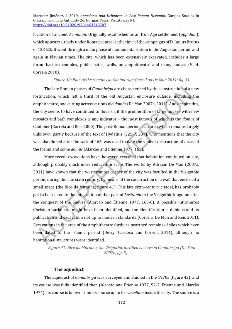
Martínez Jiménez, J. 2019. Aqueducts and Urbanism in Post-Roman Hispania. Gorgias Studies in Classical and Late Antiquity 26. Gorgias Press: Piscataway NJ. https://doi.org/10.31826/9781463240707
112
location of ancient Aeminiun. Originally established as an Iron Age settlement (oppidum),
which appears already under Roman control at the time of the campaigns of D. Junius Brutus
of 138 BCE. It went through a main phase of monumentalisation in the Augustan period, and
again in Flavian times. The site, which has been extensively excavated, includes a large
forum-basilica complex, public baths, walls, an amphitheatre and many houses (V. H.
Correia 2010).
Figure 40: Plan of the remains at Conimbriga (based on De Man 2011: fig. 1).
The late Roman phases of Conimbriga are characterised by the construction of a new
fortification, which left a third of the old Augustan enclosure outside, including the
amphitheatre, and cutting across various old domūs (De Man 2007a, 2011). And despite this,
the city seems to have continued to flourish, if the proliferation of large houses with new
mosaics and bath complexes is any indicator – the most famous of which is the domus of
Cantaber (Correia and Reis 2000). The post-Roman period is an area which remains largely
unknown, partly because of the text of Hydatius (225-7, 237), who mentions that the city
was abandoned after the sack of 465, was used to date the violent destruction of areas of
the forum and some domūs (Alarcão and Étienne 1977, 165).
More recent excavations have, however, revealed that habitation continued on site,
although probably much more reduced in scale. The works by Adriaan De Man (2007a,
2011) have shown that the westernmost corner of the city was fortified in the Visigothic
period, during the late sixth century, by means of the construction of a wall that enclosed a
small space (the Bico da Muralha; figure 41). This late sixth-century citadel, has probably
got to be related to the integration of that part of Lusitania in the Visigothic kingdom after
the conquest of the Sueves (Alarcão and Étienne 1977, 165-8). A possible intramuros
Christian burial site might have been identified, but the identification is dubious and its
publication and excavation not up to modern standards (Correia, De Man and Reis 2011).
Excavations in the area of the amphitheatre further unearthed remains of silos which have
been dated to the Islamic period (Detry, Cardoso and Correia 2014), although no
habitational structures were identified.
Figure 41: Bico da Muralha, the Visigothic fortified enclave in Conimbriga (De Man 2007b, fig. 5).
The aqueduct
The aqueduct of Conimbriga was surveyed and studied in the 1970s (figure 42), and
its course was fully identified then (Alarcão and Étienne 1977, 52-7, Étienne and Alarcão
1974). Its course is known from its source up to its castellum inside the city. The source is a

Martínez Jiménez, J. 2019. Aqueducts and Urbanism in Post-Roman Hispania. Gorgias Studies in Classical and Late Antiquity 26. Gorgias Press: Piscataway NJ. https://doi.org/10.31826/9781463240707
113
spring, which is dammed with a low (1.2m) wall and its overflow collected into a basin at
the bottom of a tower. The specus, some 0.5m wide, is lined in opus signinum, runs inside a
1.5m-wide opus caementicium box, which is vaulted. From the castellum the aqueduct went
to a system of twin piscinae limariae or settling tanks, which may have served to purify the
water (Ohlig 2004). The distribution is done by means of lead pipes, which follow a
geographical distribution, rather than a Vitruvian-style tripartite system. From there the
aqueduct runs alternating underground sections and surface structures, so it is visible in 25
different locations. Just before Conimbriga the aqueduct had to go over arches for 108
metres, although sadly most of these are now gone. The specus was lined in opus signinum
and the conduit had an average slope of 2.6m/km, the total length of the aqueduct being
3,443m.
Figure 42: Map with the course of the aqueduct of Conimbriga.
The aqueduct was not excavated, only surveyed, so all the dating information
available comes from indirect evidence, mostly the excavated baths of Conimbriga, although
there is also the notice of a possible baptistery located beyond the east gate, which is the
access point of the aqueduct to the city (Palol Solelles 1967, 169). The three public baths
were excavated in the 1970s, and no abandonment layer could be identified or dated,
although the Baths of the Aqueduct seem to have been used into the fifth century. Only one
of the private balnea, that of the House of Cantaber (figure 43), has produced late antique
material (Correia and Reis 2000).
Figure 43: View of the baths of the House of Cantaber (photograph by Filipe Portas, Wikimedia Commons).
The balneum of this domus seems to have been abandoned at some point early in the
fifth century, because the hydraulic infrastructure of the baths appears to have broken and
flooded the installation, which was then abandoned. This at least indicated that the
aqueduct was working early in the fifth century. The house as a whole, together with its bath
seems to have been destroyed in the Suevic attack, and it was not inhabited again afterwards
(García-Entero 2005, 567).
If the city was largely abandoned after the Suevic attack, as it is assumed from
Hydatius’ text, then the aqueduct may have been out of use only because nobody was there
to use it. The Visigothic occupation in the far west section, 120 years after the alleged
abandonment, may have been supplied with water from the aqueduct if it still functioned,
but probably (this is not certain, as it has not been excavated) it relied on cisterns.
CÓRDOBA

Martínez Jiménez, J. 2019. Aqueducts and Urbanism in Post-Roman Hispania. Gorgias Studies in Classical and Late Antiquity 26. Gorgias Press: Piscataway NJ. https://doi.org/10.31826/9781463240707
114
Córdoba was one of the key cities in Roman Spain.72 It was the capital of the province
of Baetica, the richest and most Romanised of all the provinces, with important contacts
with the imperial family and a very strong and influential landed aristocracy linked to the
production of olive oil. In Late Antiquity it lost some of its importance, as the provincial
capital was moved to Seville, where the archbishopric was established.
Córdoba was, nonetheless, still a very important city in the early fourth century. The
most important building of fourth-century Córdoba was the suburban palace-complex of
Cercadilla, identified in 1991 when the train station was expanded.73 This site includes not
only a large residence, which has been linked to the Tetrarch Maximian’s (r. 290-305) family
(Vaquerizo Gil and Murillo Redondo 2016), but was later expanded with a basilica, and may
have come to serve as the early episcopal complex – although this is dubious and hotly
contested. The complex included a set of baths too (the only known set of baths of late
antique Córdoba), which may have been working up to the fifth or sixth century, which is
the moment at which the palace as a whole seems to have declined (García-Entero 2005,
702). The entire complex was equipped from its beginnings with a new aqueduct.
During the fifth century, the city went through similar processes to other towns of
Hispania: the streets and the forum were encroached upon by private buildings, the marble
decorations of the theatre were dismantled and turned into lime in kilns, and it seems that
it was sacked by the Rhine invaders during the early decades of the century (Hidalgo Prieto
2005, Ruiz Bueno 2015). The main sewers inside the walls seem to have collapsed and no
longer been maintained properly, although again, the evidence for this is quite thin (Marfil
Ruíz 2000b, 119).
Córdoba became during the mid-sixth-century a major source of problems for the
Visigothic kings, because following the Byzantine invasion, the city refused to side with
either Goths or Romans, and remained largely autonomous, especially after the rebellion
against the Gothic king Agila (r. 549-554; Hist. Goth., 45). This caused several sieges and
attacks on the city, commemorated in coins (Corduba[m] bis optinuit - CNV #30). These
appear to have resulted in great disruption in the urban layout: the destruction layers
observed in the excavation of Cercadilla have been linked (without any real evidence) to
Agila’s attack on the city (Marfil Ruíz 2000b, 121-3). In this period, the episcopal complex is
72 A recent summary en English has been published by Desiderio Vaquerizo and Juan Francisco
Murillo (2016).
73 Causing the complete destruction of the site (Marfil Ruíz 2000a).

Martínez Jiménez, J. 2019. Aqueducts and Urbanism in Post-Roman Hispania. Gorgias Studies in Classical and Late Antiquity 26. Gorgias Press: Piscataway NJ. https://doi.org/10.31826/9781463240707
115
usually considered to have been moved inside the walled enclosure, as suggested by various
inscriptions (CIL II2 7.644, 7.693). However, its traditional location next to the Visigothic
palatium (Marfil Ruíz 2000a), has recently been put in doubt with serious archaeological
arguments (Arce Sainz 2015, Ruiz Bueno 2018b). This intra-mural palace was later turned
into the Islamic palace, known in the early period as the Ballat Ludhriq, or the palace of
Roderic (last of the Visigothic kings). The population of Córdoba decreased during this
period, as the north part of the walled perimeter was abandoned, or at least became far less
densely occupied, from then on clustering around the new cathedral-palace complex, as
evidenced by the distribution of intramural burials (Hidalgo Prieto 2005, Ruiz Bueno 2017).
It is during the early Islamic period that Córdoba got completely rebuilt, when it
became the capital of the new state, especially after 750. The status as capital meant many
things, amongst them that the population grew, and newcomers were settled in newly built
suburbs, like Šaqunda (Casal García 2008, Manzano Moreno 2006, 250-4). The new emirs
were responsible for great construction works, which include the renovations of the
Visigothic palace and the new Great Mosque with its forest of columns with superimposed
double arches (Arjona Castro 2001, 69-81, Salcedo Hierro 2000, 16-8). Emirs Abd al-
Rahman I (754-788) and his son Hisham (788-796) also repaired the city walls and the
Roman bridge (Arjona Castro 2001, 67, 80). The palace and the mosque were further
expanded during the ninth century, but the height of Córdoba’s Islamic power was during
the mid-tenth century, when Abd al-Rahman III proclaimed himself Caliph (AD 929).
Córdoba was by then so packed and crowded that he even decided to build a new city 8km
away from Córdoba, Madinat al-Zahra (Vallejo Triano 2010). The Umayyad rulers of
Córdoba were very keen on reusing and maintaining Roman water conduits, and at least
four major repairs/adaptations are known (Ventura Villanueva 2002).
The early Roman aqueducts
The proximity to Córdoba of mountains with many water springs prompted the
construction of aqueducts by the Romans. Up to five different conduits can be identified of
Roman or post-Roman date.
The aqueduct of Valdepuentes
The first aqueduct Córdoba had is still standing in several sections in the mountains
west of the city, the most prominent remains being those located at Valdepuentes (literally,
‘the valley of the bridges’), which has given its name to the whole of the aqueduct. Its course
is very well known (figure 44) thanks to the surveys carried out by Ángel Ventura Villanueva
in the 1980s and early 1990s, although these only showed the course of the aqueduct before

Martínez Jiménez, J. 2019. Aqueducts and Urbanism in Post-Roman Hispania. Gorgias Studies in Classical and Late Antiquity 26. Gorgias Press: Piscataway NJ. https://doi.org/10.31826/9781463240707
116
it approached the city (Ventura Villanueva 1993). The aqueduct has been linked to the
Augustan conduit known from fountain inscriptions:
Aqua Augusta. L(ucius) Cornelius Serg(ia) aed(ilis) IIvir lacus siliceos, effigies
aheneas de sua pecunia fecit. (CIL II2 7.217-8)
‘The aqueduct of Augustus. Lucius Cornelius, of the Sergia tribe, aedile, and
duumvir built with his own money the stone fountains and the bronze
statues’
Figure 44: Map showing the Roman and late antique aqueducts of Córdoba (and, in red, the Islamic conduits).
In his first study, Ventura described in detail the aqueduct’s course in five main
sectors from its caput at the Bejarano river dam as far as Madinat al-Zahra and the Granja
Agrícola. It runs mostly underground in its upper course (although some parts of it are built
on solid walls), in a vaulted opus caementicium structure lined with opus signinum, and up
to 0.64m across in the specus. Only when it had to go over a creek did the aqueduct go on
arches. One of the most interesting features of this aqueduct is that, in order to bring the
water down from the mountains to the plain in a short distance, 40 consecutive vertical
drops (up to 25m apart) were constructed, allowing the aqueduct to descend 200m in just
under 2km of its course (figure 45) (Ventura Villanueva 1993, 73-83).
Figure 45: Aqueduct shafts designed to bring down water to a lower level without the need for an extremely steep-gradient conduit.
Since this work was published many other remains of this aqueduct have been
discovered archaeologically. In total up to 60 new sections, which ran on the surface at
ground level until it approached the city, have been identified so far (Pizarro Berengena
2012, Ventura Villanueva and Pizarro Berengena 2010). The aqueduct seems to have
entered the city over a long bridge of lofty arches, measuring up to 4.5m in height. The name
‘Augusta’ suggests that the construction of the aqueduct must have been Augustan, but not
necessarily (Sánchez López and Martínez Jiménez 2016, 193). Later on (3rd c.?), a secondary
aqueduct bringing water from the snow springs of Vallehermoso was added to this conduit
to increase the volume of water.
The aqueduct itself appears to have collapsed during an earthquake in the third
century: fallen remains have been found on top of late Roman floors. This is further
reinforced by the ruptures of the conduit in sections 12 and 13, where the conduit was
Martínez Jiménez, J. 2019. Aqueducts and Urbanism in Post-Roman Hispania. Gorgias Studies in Classical and Late Antiquity 26. Gorgias Press: Piscataway NJ. https://doi.org/10.31826/9781463240707
117
broken in different places and shifted from its original location.74 Until this earthquake the
aqueduct had been properly maintained, as there are no signs of sinter deposits inside these
broken conduits. However, the presence of calcareous concretions in some sectors of the
upper course shows that the water was still flowing, even if it did not reach the city. The
analysis of these deposits has demonstrated that the sinter had formed 39 annual-layers
(figure 8), indicating that water was running through the collapsed aqueduct for 39 years
before the caput blocked. Furthermore, the Cercadilla conduit, which was built to feed the
tetrarchic complex, was built cutting through the Valdepuentes specus, rendering it
completely useless thus dating the collapse and of the Valdepuentes conduit to some 39
years before that, in the 250’s or 260’s if we accept the chronology for Cercadilla (Pizarro
Berengena 2012, 112-3, Ventura Villanueva and Pizarro Berengena 2010, 193-9).
The aqueduct was abandoned until the early medieval period when Abd al-Rahman
III repaired and restored it in order to supply water to his new city of Madinat al-Zahra, as
commemorated by this inscription now in at the Museum of Córdoba:
‘…] (…) The beginning of the works on this water conduit, from its very
source, [was] in Shawwal of the year 328 (10th July until 7th August, 940).
These works were carried out under the supervision of his (Abd al-
Rahman’s) client (mawlà), his vizier and City magistrate (sahib al-Madina)
‘Abd [Allāh] ben Ba[d]r[…’75
The Umayyads reused the course of the aqueduct from its source as far as Madinat al-
Zahra, including the shafts and wells mentioned above. New bridges were built when
necessary, such as the bridge of Valdepuentes itself, but the new Islamic conduits were not
lined in opus signinum, but in water-proof stucco (Ventura Villanueva 1996, 33-5). The
bridge at Valdepuentes was actually built ex novo, after the old damaged bridge was pulled
down. It is lavishly decorated on the side facing the valley (and it is not decorated at all on
the side facing the mountain), and it is argued that it was the central decorative element of
the landscape, as all the mountain was a private hunting ground for the Caliph. The old
Roman conduit was diverted into a new conduit outside the walls of Madinat al-Zahra, built
in ashlar blocks and lined with red stucco (because the Roman conduit flowed too low to
74 Numeration according to Ventura and Pizarro’s 2010 study.
75 Translated in Ventura Villanueva 2002 – This inscription has been linked to Madinat al-
Zahra, although it has been suggested that it may have related to an aqueduct built to supply a private
estate of the Caliph. This could also be the conduit mentioned by al-Makkari (III.4).
Martínez Jiménez, J. 2019. Aqueducts and Urbanism in Post-Roman Hispania. Gorgias Studies in Classical and Late Antiquity 26. Gorgias Press: Piscataway NJ. https://doi.org/10.31826/9781463240707
118
supply the Caliph’s palace. The old conduit, however, was not fully abandoned, as it was
reused at the same time as a sewer (Vallejo Triano 2010, 95-101).76
The Arroyo Pedroche aqueducts
The second aqueduct that fed the city is known as the Arroyo Pedroche aqueduct
because of the place where it was first identified. It seems, however, that its ancient name
was Aqua Nova Domitiana, as shown by an inscription mentioning the name: Aqua nova
[[Domitiana]] Aug(usta) (CIL II2 7.219) the name of Domitian having been erased after his
damnatio memoriae. This aqueduct has only been studied in detail by Ángel Ventura, in his
1996 work.
In it, he describes how the aqueduct did not have a caput aquae, but four. Water was
collected from four different springs to the north-east of the city (figure 44), and was taken
into Córdoba in four different conduits that merged into a single one. This unified aqueduct
approached the city at ground level, and at some point was diverted by means of an inverted
siphon, after which its course cannot be traced. The individual feeding aqueducts range
between 3.4 and 0.9km in length, whereas the unified conduit is known for 2.9km, only 5m
of which are actually on arches. The aqueduct is built in opus caementicium, but curiously,
it is not lined with opus signinum, although the walls of the specus were lined with lime and
clay (Pizarro Berengena 2012, 104-8).
Early imperial water consumption
These two aqueducts supplied water to the early imperial city (1st-3rd c. CE), and many
water-consuming structures dated to this period have been identified. Unsurprisingly, most
of these structures are generally not considered to have been working in the late Roman
period (largely because many are old discoveries that cannot now be properly dated). These
structures include seveb lacus (public fountains), two baths, and up to fourteen private
(domestic) fountains (Ventura Villanueva 1996, 94-125).
Two of these public fountains, located at Calle Ramírez de las Casas 13 and Calle
Ambrosio Morales 4, were built in the early imperial period, dated by the inscriptions they
bore (CIL II2 7, 217 and 7, 218) and were out of use in Late Antiquity (6th c. t.a.q.). The first
one seems to have been dismantled then, according to the stratigraphy of the site, and the
pilaster that held the spout was reused in a tenth-century nearby wall. The second lacus was
76 A new project proposal, directed by Chloe Duckworth (University of Newcastle) is currently
being prepared, which will include a study of the Umayyad diversion of the Roman aqueduct.

Martínez Jiménez, J. 2019. Aqueducts and Urbanism in Post-Roman Hispania. Gorgias Studies in Classical and Late Antiquity 26. Gorgias Press: Piscataway NJ. https://doi.org/10.31826/9781463240707
119
also out of use by the Islamic period, as its inscription too was used in a wall dated to this
period (Ventura Villanueva 1996, 95-8). A third fountain, located at Calle Maese Luis 20
(eastern suburb, fed by the Pedroche aqueduct), was excavated in 1993; it seems that the
entire vicus surrounding the fountain was out of use by the fourth century (Ventura
Villanueva 1996, 99).
Late antique water conduits
Besides the early imperial urban aqueducts, in Córdoba there were three later water
conduits.
The Western aqueduct: Fontis Aureae aquaeductus?
The first of the late antique aqueducts is a suburban conduit, the Western aqueduct,
discovered on the site of the modern Bus Station (hence its alternative name, the ‘Bus
Station aqueduct’). Excavations in the early 1990s revealed at this spot a 100m long section
of a Roman aqueduct, built in opus caementicium, but surprisingly its inside lacks an opus
signinum lining. The excavation also revealed the castellum divisorium, the distribution tank,
where two different conduits met (figure 46) (Pizarro Berengena 2012, 102). This castellum
is a small rectangular structure, lined in lead (in fact, re-using a lead sarcophagus), into
which the water fell from the aqueduct. The castellum has two outlets that through two
bronze pieces led the water into lead pipes, either for immediate distribution (for the
suburban vicus and for the near-by circus), or to take the water elsewhere through long-
distance pipes (Ventura Villanueva 1996, 118-20).77 It seems, nonetheless, that this
aqueduct supplied the suburban vicus west of Córdoba, as the walled city was already
supplied by two other aqueducts.
Figure 46: Outlet of the Western aqueduct, identified at the bus station.
Its source may have been located at the springs of La Albaida (figure 44), some eight
kilometres west of the city, and though the original Roman structure has not been identified,
it is very probable that it is located below a late tenth-century structure (Moreno Rosa and
Pizarro Berengena 2011). The route between the caput and the castellum, however, is
completely unknown.
The construction of the aqueduct can be dated to the early imperial period by its
construction technique; it is similar to other aqueducts of Flavian/Trajanic date, although
the most recent theories suggest it is Neronian (Pizarro Berengena 2012, 99). It is also
77 Compare this distribution with that of the aqueduct of Metz (Lefevbre 1997).

Martínez Jiménez, J. 2019. Aqueducts and Urbanism in Post-Roman Hispania. Gorgias Studies in Classical and Late Antiquity 26. Gorgias Press: Piscataway NJ. https://doi.org/10.31826/9781463240707
120
known that probably during the third century the aqueduct may have fed piped water to a
nymphaeum built next to the Puerta de Gallegos, although it is not known for how long it
was in use (Murillo Redondo, et al. 2002, 265). While there is no evidence to confirm that it
continued working during Late Antiquity, we know it was working during the Islamic
period.
The Islamic sources of the eighth and tenth centuries mention the existence of a
fountain (cayn) called funt awrya, which, according to Ángel Ventura, is not an Arabic name,
but the preservation of a Latin one (fons aurea) referring to the bronze outlets of the
terminal tank found at the bus station (Pizarro Berengena 2012, 104, Ventura Villanueva
1996, 2002). This led him, rather fancifully, to reconstruct the ancient name as the
aquaeductus fontis aureae. More important than its name is the fact that a fountain was
working in the north-western suburb in the early Islamic period (according to the sources),
which may have been supplied by the aqueduct located at the bus station. This was then put
out of use in 967 by Caliph Al-Hakam II, who redirected the Roman water source in order to
feed the fountains and pools of the Great Mosque, which was until then supplied by a wheel:
‘In this year of 356, water began to fill the tanks and the eastern and western
ablution pools [of the Mosque]. It was pure water that came from a spring in
the mountains of Córdoba, and looking for it the soil was excavated. It was
brought [to the city] in a stone conduit, built solid and artistically, in which
lead tubes were placed, so the water would not be polluted. Water first ran
on Friday, ten days having elapsed in the month of Safar [25th January 967]
(...)’ (Ibn cIdari, Bayan, II)
At the Bus Station, archaeologists have unearthed the tenth-century diversion tower
which blocks the Roman conduit and the new Islamic aqueduct (figure 25). This is further
confirmed by the presence of tenth-century glass vessels in the abandonment layers inside
the Roman conduit and the lead-lined distribution tank (Carmona Berenguer, Moreno
Almenara and González Viseda 2008). The text mentions that the water source was buried
underground and that it was opened up and built again. This probably is the tenth century
structure found at La Albaida. This Islamic conduit is still in use and supplying water to the
fountains of the Cathedral (Ventura Villanueva and Pizarro Berengena 2010, 155-6).78
78 Indeed, a small manhole close to the archaeological remains of the bus station still marks
where the water flows now, as indicated not only by the sign which reads “aguas de la catedral”
(Cathedral’s waters) but also by the constant sound of flowing water.

Martínez Jiménez, J. 2019. Aqueducts and Urbanism in Post-Roman Hispania. Gorgias Studies in Classical and Late Antiquity 26. Gorgias Press: Piscataway NJ. https://doi.org/10.31826/9781463240707
121
The Cercadilla aqueduct
Another suburban aqueduct was identified in a handful of excavations north-west of
Córdoba (Ventura Villanueva and Pizarro Berengena 2010, 196-9), which has been linked
to the fourth-century tetrarchic complex of Cercadilla, north-west of Córdoba.
Its source seems to have been at the snow springs of Arruzafa, where an opus
caementicium conduit of Roman date has been identified, linked to a large water cistern
(figure 47), which measures 77 x 5m and is lined with opus signinum. It has two construction
phases, the earliest of which can be dated, according to the material from the foundation
trench, to the fourth century (J. F. Murillo Redondo 2009, 463-71). This cistern is not the
actual source of the conduit, which is located at some distance, but it may have served as a
settling tank or a reservoir. Further remains were located at the Huerta de Santa Isabel,
where a section 450m long was identified breaking through the old Aqua Augusta, which
had collapsed in an earthquake during the third century. These remains where
characterised by a lack of opus signinum lining, a narrow specus, and its brick and tile
covering, all of which point towards a masonry case for a pipe conduit, the venter of a siphon
(Pizarro Berengena 2012, 114-8). These remains follow a straight line heading towards
Cercadilla, and used to feed the nymphaeum and the baths located at the complex –
especially considering that the Valdepuentes conduit was already out of use by the time the
palace was built. In the environs of Cercadilla, the remains of an arcuatio with at least 28
pillars has been found, also heading towards the palatial complex, although nothing is
known about it regarding where it came from, where it headed to, or its chronology (Pizarro
Berengena 2012, 118-22).
Figure 47: Arruzafa cistern, caput of the Cercadilla aqueduct (Murillo Redondo 2009, fig. 2a).
At some point after the fourth century, the complex appears to have been turned into
a religious centre, perhaps an early episcopal complex or a martyrial shrine probably
dedicated to St. Acisclus (Hidalgo Prieto 2002, 359-9).79 By the sixth century, the baths of
the palace ceased to function, as the rooms were reused as burial spaces, and all marble
decorations and lead pipes were stripped off. This dating is further confirmed by the
presence of African red-slip wares in some of the tombs, in particular form Hayes 104a,
dated between 530 and 580 (Hidalgo Prieto 1996, 81, Fuertes Santos, Carrasco Gómez and
Hidalgo Prieto 2013). During the mid-sixth century the Cercadilla/Saint Acisclus complex
79 This identification is, however, contested (Marfil Ruíz 2000a, 157).

Martínez Jiménez, J. 2019. Aqueducts and Urbanism in Post-Roman Hispania. Gorgias Studies in Classical and Late Antiquity 26. Gorgias Press: Piscataway NJ. https://doi.org/10.31826/9781463240707
122
was used during the Visigothic civil wars as a military camp (Hist. Goth., 45), so it is
conceivable that this was done because there was available water for troops and soldiers
(either through the Cercadilla or the Western aqueducts). The castellum of the aqueduct,
however, seems to have been in use into the late-eighth century, when the large cistern was
abandoned and its input source tapped to feed a private estate Abd al-Rahman I (J. F. Murillo
Redondo 2009).
These two different abandonment dates may not necessarily have to be in conflict, as
it is conceivable that the baths were out of use but the fountains and nymphaeum were not.
This is a very tenuous suggestion and is only backed by an event which the Islamic sources
record as taking place during the siege of 711. Various sources (Arjona Castro 2001, 21-7)
mention how some Visigothic soldiers managed to survive entrenched at the basilica of
Saint Acisclus because they had access to a conduit (referred to as qanat and saqiya).80 None
of the sources that describe this event are contemporary, and were compiled much later,
which undermine the credibility of this episode. Furthermore, Guadalupe Pizarro (2012)
has this episode taking place at Cercadilla but related to the Western aqueduct which was
certainly in use and also in the vicinity of the remains of the palace complex.
Overall, it appears that the Cercadilla conduit was in use until the sixth century, if not
straight up to the late eighth century.
The Alcázar conduit
The last conduit that should be mentioned is the Alcázar conduit, of which very little
is known, except that it was built in the emiral period.
This conduit has been identified at two different locations next to the western wall of
Roman Córdoba, at the Puerta de Gallegos (figure 48) and at the Vial Norte excavation, both
sections follow the same route north-south. It thus comes from the north, and it has been
suggested that it went directly to the Alcázar, the citadel located on top of the old Visigothic
palatium. This links this conduit with that known in the sources as the qanat amir (the
aqueduct of the emir), built during the eighth century to supply water to the old Visigothic
palace, by then turned into the alcázar (Pizarro Berengena 2012, 137-40).
80 The whole story includes a black slave being sent by the Umayyad troops to investigate why
the Goths will not surrender, who then gets captured by the Goths who believe him to be a painted
soldier, so they throw him into the fountain and ‘scrub him with water and a hard brush until he
bled’. Upon escaping the slave told about the aqueduct, which the Umayyad soldiers then proceeded
to block.

Martínez Jiménez, J. 2019. Aqueducts and Urbanism in Post-Roman Hispania. Gorgias Studies in Classical and Late Antiquity 26. Gorgias Press: Piscataway NJ. https://doi.org/10.31826/9781463240707
123
Figure 48: Remains of the Qanat Amir at the Puerta Gallegos site, in Córdoba (Murillo Redondo, et al. 1996: fig. 2).
Archaeologically, the chronology that can be given is post-Roman because it is sitting
on top of late Roman (3rd/4th c.?) mosaics, and pre-Caliphate because it lies below tenth-
century levels (Ventura Villanueva 2002, 125). No other datable material has been obtained
from the excavations. The conduit itself is built using new (not reused) material, put
together in mortared rubble, and its 45cm wide specus is lined in opus signinum.
This conduit was still working in the early tenth century, as its fountain of piped water
was still functioning, according to this fragment of the Chronicle of al-Nasir 28, which
discusses how the water overflow from his private supply was used for a public fountain:
‘In the year 306 [14th June 918 – 2nd June 919], al-Nasir li-din Allah [future
Caliph Abd al-Rahman III] gave order to (...) build a pool next to the Fountain
of the Pipe, located at the entrance of the palace, next to its gate, known as
the Transenne Gate. The work was done with much care, and three water
mugs were added to it, for the comfort of those who sought it. It was finished
within a year (...)’
Discussion
With five main water conduits (two them working in Late Antiquity and a new one
built in the eighth century), the city of Córdoba is certainly one of the clearest examples of
continuity of water supply systems, and the dating for these structures is consistent.
However, whereas the dating for the Roman period is clear, the dates for the Visigothic
period are not that certain. As has been said: ‘for sixth-century Córdoba, we deal with a field
full of hypotheses which are difficult to confirm’.81
It can be claimed that, overall, public water supply ceased to function in intra-mural
Córdoba by the fourth and fifth century, as the collapsed fountains and sewers indicate, even
if they were later reused in the Islamic period (Sánchez Velasco 2011, Ruiz Bueno 2018a).
This can be linked to the collapse of the Aqua Augusta after the 250’s earthquake, although
it is not possible to date the end of the Aqua Nova. Water supply inside the walls must have
thus relied on wells or cisterns, even for the new late antique intramural baths (Ruiz Bueno
2017), as seems to have been the case during the Islamic period (Ventura Villanueva 2002,
81 ‘Para la Córdoba del s. VI nos movemos en un campo lleno de hipótesis difíciles de confirmar’
(Pizarro Berengena 2012, 127).

Martínez Jiménez, J. 2019. Aqueducts and Urbanism in Post-Roman Hispania. Gorgias Studies in Classical and Late Antiquity 26. Gorgias Press: Piscataway NJ. https://doi.org/10.31826/9781463240707
124
123). The only structures supplied with water inside the wall enclosure were the Visigothic
(later Umayyad) palace and the Great Mosque.
It is only in the Western suburb that running water continued to function during Late
Antiquity, and this was supplied into the Islamic period by both the Western aqueduct and
the Cercadilla conduit, even if the Visigothic continuity of the latter is arguable. These are
dates supported by the archaeology and the information given in the sources.
The Umayyads inherited the urban water supply system, which they repaired and re-
adapted to suit their own agendas. The re-use, repair, and maintenance of these structures
took place largely during the early Emirate (second half of the eighth century) and in the
early Caliphate (mid-tenth century), which were the moments of greatest urban
construction (the Great Mosque, the palace, Madinat al-Zahra, etc.). The attitude of the new
Islamic governors towards public water supply, however, was the opposite to that of the
original Roman builders, as the water system was intended for the private use of the
Umayyads (reuse of Valdepuentes for Madinat al-Zahra, Alcázar conduit) or for public
buildings closely linked to the rulers (like the fountains of the Mosque).
LISBON
The city of Olisipo was an Iron Age settlement, which allied with the Romans during
the second century BCE wars against the Gallaeci. It was promoted during the Augustan
period to a municipium civium Romanorum (CIL II 175), with the title of Felicitas Iulia, and
it remained a main commercial harbour for Lusitania and Mérida throughout the Roman
and late antique periods. This commercial prosperity and wealth can explain the various
raids and sieges during the fifth century, as the Roman authorities, the Sueves and the
Visigoths fought over its control. Conquered by the Umayyads in 714, it still remained a rich
and important city, being sacked by the Asturians as early as 796 and, during the ninth
century, by the Vikings. Even if the archaeology cannot provide us with a detailed view of
Ancient Lisbon, the mentions in the sources, together with a series of significant key rescue
excavations allow us to get a general idea of its evolution during Late Antiquity. Its aqueduct
can be dated to the third century, but it seems to have continued into the Visigothic period.
Late antique Lisbon
The Roman city, of which little is known (Fernandes 2013), seems to have been
structured in three areas: an upper city with an acropolis, a lower city surrounding the
forum, facing the sea, and a harbour town between the walled enclosure on the hill and the

Martínez Jiménez, J. 2019. Aqueducts and Urbanism in Post-Roman Hispania. Gorgias Studies in Classical and Late Antiquity 26. Gorgias Press: Piscataway NJ. https://doi.org/10.31826/9781463240707
125
natural harbour (figure 49). It is suggested that the forum was under the cathedral although
there is no solid evidence for this. The city also had a theatre, which has been thoroughly
excavated. Lisbon also had an amphitheatre and a circus outside the city walls, which are
only partially known. The circus at least seems to have been abandoned and reused for
dwellings in the late third or early fourth century (de Sepúlveda, et al. 2002). There was,
furthermore, a large set of public baths, the Thermae Cassiorum, which were renovated in
the fourth century as commemorated in an inscription by the governor, Numerius Albanus
(CIL II.191). Most of the lower city near the harbour was devoted, however, to the
production of garum.
Figure 49: Main sites from Roman Lisbon.
During Late Antiquity the city shows similar patterns of transformation as other
Hispanic cities. The wall enclosure, for instance, seems to have been reduced from its
original Augustan layout: the V-shaped ditch excavated at the site of the palace of the counts
of Penafiel suggest that the Islamic walls follow a reduced late enclosure (Silva and De Man
2013, Burgalhão 2009). These excavations have also provided with large amounts of pottery
that underline Lisbon’s commercial activity into the late sixth century connecting the
Atlantic and Mediterranean routes (Fernández Fernández 2014), further confirmed by the
presence of Byzantine coins. The cetariae and fish processing factories, which had been a
very important part of the economy of the city in the Roman period (Filipe and Fabião
2006/2007), seem to have been out of use during the fifth century, as by the sixth some of
them had been transformed into a necropolis (Casimiro and Silva 2013).82 One of these
complexes, at the site of Rua dos Correeiros, has a late Roman bathing complex, fed by a
pipe, which shows continuity into the fourth century.
The Christianisation of the urban fabric again mirror similar developments in
Hispania. The presence of funerary fragments with Christian epigraphy in the sixth-century
ditch of the Penafiel palace site points towards a possible Christian suburban funerary
basilica. Similarly, it is guessed that the late antique cathedral was located under the
eleventh-century mosque (Burgalhão 2009).
From a historical perspective, Lisbon was one of the main objectives of the Sueves,
who in two occasions took and sacked the city, in 457 and 467 (both by treachery; Hydat.,
181 [188], 240 [246]). Its wealth was also reflected in its political importance during the
Visigothic period, when it was an active mint and the seat of a bishop.
82 Although other cetariae in the immediate surroundings (but not in the actual suburb) of
Lisbon, appear to have continued into the mid-sixth century (Bernal Casasola 2018, 112).

Martínez Jiménez, J. 2019. Aqueducts and Urbanism in Post-Roman Hispania. Gorgias Studies in Classical and Late Antiquity 26. Gorgias Press: Piscataway NJ. https://doi.org/10.31826/9781463240707
126
The aqueduct and its chronology
The Roman water supply to Lisbon is very unevenly known. While the location of the
caput is clear, and the upper sections of the course are visible still, there are no remains
identifiable within the city. It was first noted on the 1960s (figure 50), when a large dam
was identified 10km away from the city (Sánchez López and Martínez Jiménez 2016, 238-
40).
Figure 50: Roman dam, possible caput of the Lisbon aqueduct (Mascarenhas, Bilous and Neves 2012: fig. 2).
The dam of Belas is some 15m long, 8m high and 7m thick, and it is built in opus
incertum with various buttresses against it, across a river gorge. Calculations suggest that it
could contain up to 125,000m3 of water. From here the conduit went on an over ground
specus, lined in opus signinum and 0.4m across, following the contour line and gently
heading towards Lisbon. The aqueduct has been identified at various points in the area of
Amadora between the dam and the villa of Quinta da Bolacha (Mascarenhas, Bilous and
Neves 2012, Fortes 2009). From there on the aqueduct’s course is reconstructed with GIS
analysis and following the known course of the Early Modern conduit. It has been proposed
that the aqueduct had two branches, one leading towards the upper town (where the
medieval castle of Saint George is located) while the other forked out and went towards the
opposite hillock (figure 51).
Figure 51: Reconstructed course of the Lisbon aqueduct.
The excavations and surveys of the few known remains have not provided with any
clear dating evidence. Only a suggestion that it may originally have been third-century in
date has been put forward. For the abandonment, however, we have further hints, although
none of them independently conclusive (Sánchez López and Martínez Jiménez 2016, 239).
First we know that the large public baths, the Thermae Cassiorum, were still functioning and
extensively repaired in the fourth century. Similarly, we have seen that the fish processing
factories only go out of use during the fifth century (Lagóstena Barrios 2001, 44-6), although
it is also at this time when a new public fountain was built at the site of Sommer (figure 16),
which appears to have been abandoned during the sixth century (Mascarenhas, Bilous and
Neves 2012, Silva and De Man 2013). In the same site, there was a large cistern existed
(figure 52), built reusing architectural material, which co-existed alongside the aqueduct-
fed fountain (Ribeiro, et al. 2017). These two water structures were set up after the
reorganisation of the area after the construction of the late antique wall. This overall
suggests an aqueduct in use into the fifth century, and probably into the sixth (especially

Martínez Jiménez, J. 2019. Aqueducts and Urbanism in Post-Roman Hispania. Gorgias Studies in Classical and Late Antiquity 26. Gorgias Press: Piscataway NJ. https://doi.org/10.31826/9781463240707
127
because of the Sommer fountain). Anyways, besides this late chronology, it is perhaps more
important that until the (last?) moments the local council and the elites were engaged in
preserving public access to piped water.
Figure 52: Large late antique water cister, built with reused material, and potentially linked to the abandonment of the near-by fountain.
LUGO
The city of Lugo was an Augustan foundation (Lucus Augusti), which controlled a
mountainous territory rich in minerals, one of the reasons why it played an important role
in the late Roman period. Its strategic importance during the fourth century was further
highlighted with the construction of an impressive set of new walls (figure 53), with 84
towers, enclosing 28ha of the Roman city (Fernández Colmenero and Rodríguez Cao 2012,
Rodríguez Colmenero and Rodà de Llanza 2007). During the fourth century the city also
reorganised and enlarged its sewer system (González Fernández and Carreño Gascón 2007,
259-60), and was an active pottery production site (Rodríguez Colmenero 2011, 87).
Figure 53: Roman walls of Lugo (photograph by Isaac Sastre).
Not much else is known about Lugo during Late Antiquity. Its strategic importance
suggests that it was still an important city during the fifth century. The (manned?) walls
appear to have kept the Sueves at bay, until they took the city by subterfuge in 460 – only to
be sacked by the Visigoths later that year (Hydat., 199, 201). During the sixth century, and
after the ecclesiastical reorganisation of the kingdom by Martin of Braga, Lugo was
promoted to archbishopric, and we also know, from the sources, that at this period two large
new churches were built, further highlighting its political importance (Fernández Ochoa,
Morillo Cerdán and López Quiroga 2005, 99, López Quiroga 2004, 47).
The aqueduct of Lugo
The aqueduct of Lugo has been only very recently identified with certainty and
excavated. There were seventeenth-century notices of a Roman water conduit, and in 1975
only two sections were known: the underground specūs of Rua das Norenas and Plaza de
Santa Maria (figure 54) (Abel Vilela and Arias Vilas 1975). It was not until the late 1990s

Martínez Jiménez, J. 2019. Aqueducts and Urbanism in Post-Roman Hispania. Gorgias Studies in Classical and Late Antiquity 26. Gorgias Press: Piscataway NJ. https://doi.org/10.31826/9781463240707
128
that new sections were identified, and the most recent discoveries date to March 2011,83
which confirmed the course of the aqueduct proposed in the first publication of the
aqueduct, in 2003 (Álvarez Asorey, Carreño Cascón and González Fernández 2003, 20).
Figure 54: Map with the course of the aqueduct of Lugo.
Considering this information, it is possible to claim that the aqueduct had its caput at
the spring of O Castiñeiro, at the site of As Pias, 2.1km away from the distribution tank. The
aqueduct is identified at some distance from the spring, at the site known as Lamas de
Prado, where 8.7m of the aqueduct were identified in 2001, wholly built in opus
caementicium and without any remaining hint of opus signinum lining (figure 55). In fact,
the base of the conduit was tiled with bricks, which has lead archaeologist to argue for a
piped conduit. Continuing downhill, two different opus caementicium walls have been
recently linked to the aqueduct, although it is impossible to confirm this, as these sections
(at Rua Juana la Loca and Rua Mazaria, where 200m are visible) are covered in thick
vegetation. A small sondage at Camiño Real, not far away from the Rua Mazaria revealed an
underground channel with the same orientation as the walls mentioned above; and not far
away, at Praza da Milagrosa, a 26m opus caementicium structure revealed the existence of
the foundations for several pillars which would have supported the arcuatio of the
aqueduct. The specus then ran underground, as identified in the 2011 excavations in front
of the palace of San Marcos. The aqueduct would have finished at the distribution tank
identified next to the old forum, at Plaza Santo Domingo, where a rectangular pool lined
with opus signinum and linked to several lead pipes has been excavated (Álvarez Asorey,
Carreño Cascón and González Fernández 2003, 23-40).
Figure 55: Archaeological remains of the aqueduct (Rodríguez Colmenero 2011: fig. 36).
None of the excavated sections has provided any dating material that could date the
abandonment of the aqueduct, so again, only through indirect information is it possible to
roughly date the abandonment. It is important to avoid the Suevic conquest as an easy
solution for this problem, not only because this is not accurate, but also because modern
83 Xornal de Galicia (xornal.com) “Aparecen restos de un acueducto romano en unas obras en
Lugo” and “Unas obras frente a la Diputación descubren un acueducto en Lugo”, 8th March 2011; El
País Galicia edition (elpais.es) “Los restos del acueducto de Lugo se abrirán al público en verano”,
12th April 2011; ABC (abc.es) “Lugo mostrará en San Marcos el acueducto que traía agua a la ciudad
romana”, 6th June 2011. Compiled and briefly mentioned in Rodríguez Colmenero 2011.

Martínez Jiménez, J. 2019. Aqueducts and Urbanism in Post-Roman Hispania. Gorgias Studies in Classical and Late Antiquity 26. Gorgias Press: Piscataway NJ. https://doi.org/10.31826/9781463240707
129
scholars consider that Lugo was destroyed (Abel Vilela and Arias Vilas 1975, García-Entero
2005), when Hydatius does not say so.84
The chronology
The baths of the city of Lugo provide very thin evidence, because two of them are
known to have been built ex novo in the fourth century (as the baths of Plaza de Santa Maria,
dated because of a mosaic excavated in the 1960s) or remodelled in the same period (as the
baths of Rua de Armanyá) (Arias Vilas and de Vega Rodríguez 1997, García-Entero 2005,
250-1). It was also in the fourth century that the sewers were re-built, as mentioned above,
and when the pottery workshops were still in use. The Bridge baths, however, seem to have
been in use during the fifth century, when the pagan altars to the nymphs were destroyed
and thrown into the pool, according to the pottery found in it. These baths, however, were
built using the natural thermal water that sprung from the ground, rather than the water
brought by the aqueduct (Meijide Cameselle and Herves Raigoso 2000). There is nothing
more that can be said, as expressed in a recent publication by Antonio Rodríguez (2011,
228) ‘considering our current knowledge, if we were asked if we would be able to tell the
differences between the Suevic-Visigothic urbanism of Lucus Augusti and the original
Roman one we would have to answer “no way”, because the textual and epigraphic sources
are virtually none and the archaeological evidence is as yet unexplored’.85
The water supply was certainly working in the mid/late fourth century, and it is
conceivable that it was still working in the fifth, when we know, as mentioned by Hydatius,
that there was still a strong elite in the city that could possibly have taken care of it. Without
any hard evidence, however, it is not possible to make any claims on the date of the
abandonment, despite recent unfounded claims which propose that the aqueduct may well
have been in use until the Islamic invasion of 711 (Rodríguez Colmenero 2011, 229).
84 Per Suevos Luco habitantes, in diebus paschae, Romani aliquanti cum rectore suo honesto natu
repentino securi de reverentia dierum occiduntur incursu = ‘In the days of Easter in Lugo, a good
number of inhabitants together with their leader of noble birth, feeling safe [because of] the holiness
of the days, were killed in an attack by the Suevi’.
85 ‘En el estado actual de nuestros conocimientos. Si se nos demandase diferenciar el
urbanismo suevo-visigodo de Lucus Augusti del romano originario ¿podríamos hacerlo? De ninguna
manera, tendríamos que responder, por cuanto las fuentes textuales y epigráficas son casi nulas y las
arqueológicas inexploradas todavía’.

Martínez Jiménez, J. 2019. Aqueducts and Urbanism in Post-Roman Hispania. Gorgias Studies in Classical and Late Antiquity 26. Gorgias Press: Piscataway NJ. https://doi.org/10.31826/9781463240707
130
MÉRIDA
Mérida (Emerita Augusta) was founded as a veteran colony by Augustus early in the
Principate. It was built with a pre-designed street-grid, walls, two monumental forums, and
a north-east spectacula complex which included a circus, an amphitheatre and a theatre
(Figure 56). The city is located between two rivers, the Guadiana (Anas) and the Albarregas
(Barraeca), with a fertile land and a rich hinterland.
Figure 56: The Roman theatre of Mérida.
The city became the capital of the province of Lusitania, and during the late Empire it
was also the capital of the Dioecesis Hispaniarum. During the fourth century the city
prospered (Osland 2011, Alba Calzado 2018), as new large houses were being built
(allegedly, partially encroaching upon the minor back streets). Only the suburbs west and
east seem to have been in recession at this point. However, things changed abruptly in the
fifth century. Archaeologically, it is possible to identify the dismantling of the forum and the
street porticoes, the abandonment of the spectacula and a change in the housing patterns,
where many of the old luxurious domus were subdivided into multi-family dwellings (Alba
Calzado and Mateos Cruz 2008).
This sudden transformation is normally related to the attacks the city suffered early
in the fifth century, it was first besieged by the Sueves in 429 and later captured in 439.
Then Theoderic II of the Visigoths besieged it in 456 unsuccessfully, and it was finally
captured by the Goths a couple of years later, after the battle of the Urbicus river (Hydat.,
80, 106, 111, 126, 161, 163-8, 175). The city thus came under the control of the Visigoths,
and during the reign of Euric, in 483, Duke Salla and Archbishop Zeno were responsible for
the restoration of the walls and the bridge (ICERV 363). At some point during the sixth
century, a large public building (a civic palace?) was built next to the forum (Ruiz Bueno
2018b, 100-1).
According to the Lives of the Fathers of Mérida, there was an archiepiscopal palace and
a cathedral in the old forum, two other intra-muros churches and a large cult complex in the
suburb dedicated to the martyr Eulalia. This suburban basilica has been excavated recently,
confirming the data provided by the sources. Powerful archbishops such as Massona were
responsible for several new buildings, like a xenodochium or pilgrims’ hospital. This
splendour visible in the written text is not yet matched archaeologically, where it is evident
that during the seventh century the city’s Roman infrastructure was in clear decline, as
evidenced by the increasing amount of arable plots and animal pens inside the walls. There

Martínez Jiménez, J. 2019. Aqueducts and Urbanism in Post-Roman Hispania. Gorgias Studies in Classical and Late Antiquity 26. Gorgias Press: Piscataway NJ. https://doi.org/10.31826/9781463240707
131
is one seventh century inscription, dated to the reign of Chindaswinth (r. 642-653) which
may relate to a new building (ICERV 366, mentioned above).
On the eve of the Umayyad conquest the city still had a strong local aristocracy, which
fought against the invaders after the battle of Guadalete. Even if the city finally surrendered,
the locals kept rebelling against the emirs, so to prevent further uprisings, a citadel
(alcazaba) was built inside the walled enclosure early in the ninth century.
The water supply
Mérida, located several kilometres inland in the flat valley of the Guadiana river,
suffers from recurrent droughts, unpredictable rains and very hot summers, which made
water supply a serious issue even back in Roman times.86 That is why the city had to rely on
various sources of water for its inhabitants: wells and cisterns are very common in the early
Roman period and in Late Antiquity, but in order to supply water en masse, four aqueducts
were built in the early years of the colony.
Los Milagros or Proserpina aqueduct
Of the four aqueducts of Mérida, that known as de los Milagros (‘of the miracles’) is
probably the most famous. Its present name was given in the sixteenth century because
most of the arches had gone, but the pillars were still standing, which seemed to be a
miracle.
The aqueduct itself is only about 6km long, and has its caput at the Proserpina Dam
(a name only given it in the nineteenth century), running on its upper course in a rock-cut
conduit. Very early on, however, it approaches the city mostly above ground, and sections
are known to have existed (or are still standing) at the site of Canja, El Sapo and the
Carretera de Montijo (sections which measure between 20 and 130m), so its course is very
well known (figure 57). In these sites, the size of the aqueduct and the specus seems
consistent: 1.40m total width and 0.56m specus width, lined in opus signinum (Álvarez
Martínez 2007, 198). Its specus was thought to have been open, but in the year 2000
excavations it was demonstrated that it was covered with a barrel vault for most of its
course (Feijoo Martínez 2005).
86 Not only because of its scarcity, but also because of the suddenness and stormy nature of
floods, which were periodical and very harmful, as narrated for the Visigothic period in the Lives of
the Fathers of Mérida (VSPE II.21): ‘... the Guadiana flooded and having broken its banks, spread its
waters far and wide, laying in ruins many buildings in the little villages by its stream...’.

Martínez Jiménez, J. 2019. Aqueducts and Urbanism in Post-Roman Hispania. Gorgias Studies in Classical and Late Antiquity 26. Gorgias Press: Piscataway NJ. https://doi.org/10.31826/9781463240707
132
Figure 57: Map showing the aqueducts of Mérida, not including the new sections identified in 2017.
The aqueduct enters Mérida by means of a 285 metre-long, 35 metre-high bridge
(Fernández Casado 2008 [1972], 126-34). The pillars of this bridge are built with a core of
opus caementicium and an ashlar facing. These are on average 7m apart, and their height
varies between 35 and 15m. These pillars were originally 2.9 x 2.9m (10 x 10Rf) in section,
but 2.1m (7Rf) reinforcement buttresses were added on the sides. The pillars are sustained
by three rows of super-imposed arches, which alternate granite ashlar blocks with red brick,
thus increasing the stability of the pillars (figures 5, 58). The bridge crosses over the
Albarregas river, and the two pillars inside the river are reinforced with strong granite
sterlings.
Figure 58: View of Los Milagros (Proserpina) aqueduct.
This section of the aqueduct begins at a settling tank and ends in a supposed
distribution castellum, which nowadays is considered to also have been a nymphaeum, and
just before crossing the walls it divided into two branches, one of which went to the north-
west suburb, whereas the main branch supplied the low-lying western city (Mateos Cruz, et
al. 2002, 74).
San Lázaro aqueduct
The San Lázaro aqueduct (also known as Las Tomas or Rabo de buey) is the second
aqueduct of Mérida. Its course is the best known, because even if it was largely destroyed,
its course was repaired in the sixteenth century (and still carries water) and because of the
nineteenth century careful topographic study it received.
The aqueduct has three main feeding branches (comparable with the Arroyo
Pedroche aqueduct of Córdoba) which obtain water from underground streams and from
springs, known by the names of the springs they tap: Valhondo, Las Lomas, and Casa Herrera
(figure 57). The three feeding conduits met outside Mérida and continue for 4km in an
underground masonry channel, for which 99 spiramina have been located. When it comes
to the surface, the conduit is carried on several arches built in opus quadratum, on top of
which brick-and-rubble pillars were erected (figure 59), although sadly now most of the
Roman arches have been substituted or destroyed by the sixteenth-century aqueduct
(Álvarez Martínez 2007, 196, Fernández Casado 2008 [1972], 124-7, Gómez de Segura, et
al. 2011, 134-5, Mateos Cruz, et al. 2002, 73).
Figure 59: Remains of the San Lázaro aqueduct.

Martínez Jiménez, J. 2019. Aqueducts and Urbanism in Post-Roman Hispania. Gorgias Studies in Classical and Late Antiquity 26. Gorgias Press: Piscataway NJ. https://doi.org/10.31826/9781463240707
133
This aqueduct entered Mérida crossing the Albarregas, close by the circus, the theatre
and the amphitheatre, which may have been supplied by it, although the aqueduct must
have also fed water to the eastern part of the city.
Cornalvo aqueduct
The Cornalvo aqueduct, or Aqua Augusta (according to an inscription located in recent
excavations at the conduit), was the longest of the aqueducts of Mérida (Hiernard and
Álvarez Martínez 1982).
Its source was considered to have been at the Cornalvo dam (Fernández Casado 2008
[1972], 117), but it is now known that the conduit begins 5km beyond the dam, and it seems
that an extra feeding branch was added to the aqueduct, diverting the spring of El Borbollón
(Gómez de Segura, et al. 2011, 133). On top of this, in 2017 over 30 kilometres of supposed
aqueduct were identified from a LIDAR survey, yet to be published.87 Its 25km course is very
well known, because most of it (16km) runs in a semi-subterranean conduit parallel to the
Albarregas river (figure 57).88 Along the valley, there are several points at which the
aqueduct needs to go above ground: at Caño Quebrado (‘broken conduit’) one arch remains
of what must have been a 30-arched structure and 30m of a wall have been located at Cerro
Gordo.
The aqueduct entered the city from the east, next to the spectacula complex, and from
there it went towards the southern part of the city, parallel to the wall, as evidenced by the
excavations at the headquarters of the Guardia Civil, Villaemerita, Bodegones, and at Via
Ensanche, where 85.7m of the conduit are still visible (figure 60). It seems as if the aqueduct
fed the theatre and amphitheatre, although because it is the one which arrives at the highest
point, this aqueduct may well have originally fed the whole city. Its name also would indicate
that it might have been the first aqueduct to have been built (Álvarez Martínez 2007, 154-
5, Hernández Carretero 2003, Mateos Cruz, et al. 2002, 72, Pérez Maestro 2005).
Figure 60: Overground remains of the Cornalvo aqueduct.
Las Abadías aqueduct
The fourth and least-known aqueduct of Mérida (figures 57, 61), that of Las Abadías,
was only identified in 2005, when the first remains were excavated (Sánchez López and
87 Hoy (hoy.es) “El Consorcio localiza más de cincuenta kilómetros nuevos de acueductos
romanos”, 10th October 2017.
88 Mateos et al. 2002: 72-3.

Martínez Jiménez, J. 2019. Aqueducts and Urbanism in Post-Roman Hispania. Gorgias Studies in Classical and Late Antiquity 26. Gorgias Press: Piscataway NJ. https://doi.org/10.31826/9781463240707
134
Martínez Jiménez 2016, 244-5). The aqueduct is built following the same construction
technique of the other aqueducts of Mérida, but its dimensions are different. The aqueduct
has been identified in two different locations. The first one is at the site of Las Abadías,
where 115.3m of the conduit have been excavated. Even if the conduit runs mostly
underground, at some point it went over the surface, and four collapsed pillars were
excavated at the site. The second location is Calle Medea, where a single pillar was later
found.
Although it was originally thought that the aqueduct probably tapped water from
Arroyo del Sapo, the recent LIDAR survey mentioned above has linked other set of remains
to this aqueduct.
Figure 61: One of the pillars which has been identified as a foundation for the aqueduct of Las Abadías, at the site of the Miguel de Cervantes School (photograph courtesy of the
Consorcio de Mérida).
Dating evidence
Feijoo’s thesis and the chronology of the dams
In 2005 and 2006, archaeologist Santiago Feijoo Martínez published in two articles
his thesis which proposed that Roman aqueducts could not have been supplied by reservoir
dams, and citing various authorities (Pliny, Vitruvius, Palladius, Frontinus) argued that
water from reservoirs is not and was not drinkable. He draws a distinction between
reservoir dams (that make a reservoir by blocking a river) and diversion dams, which
simply took water from a flowing river, diverting it into the aqueduct conduit. The former
were not suitable for human use, but the latter were, although their water may not have
been the most ideal for drinking (as opposed to rain water and spring water).
Feijoo further argues that opus signinum was used in cisterns not only as a way of
insulating the structure, but also because its pinkish-reddish colour countered the growth
of algae and other microbes, which are greatly affected by that wavelength (their optimal
wavelength being green-blue). However, recent studies on the quality of the water of these
dams demonstrates that, despite slight pollution caused by animal faecal bacteria (which
may not have existed in the Roman period, as that area was not used for extensive animal
husbandry), the water is drinkable according to moderns standards, without the need for
fluoridation, only needing filtering and decantation – purification techniques available to
the Romans (Aranda Gutiérrez, Sánchez Carcaboso, et al. 2006).
This ground-breaking proposition directly affects our knowledge of the aqueducts of
Mérida, in particular for two of them are generally believed to have been supplied by
dammed reservoir water: those of Cornalvo and Proserpina (Los Milagros). Feijoo’s

Martínez Jiménez, J. 2019. Aqueducts and Urbanism in Post-Roman Hispania. Gorgias Studies in Classical and Late Antiquity 26. Gorgias Press: Piscataway NJ. https://doi.org/10.31826/9781463240707
135
arguments state that the dams could not have been the source of the aqueducts, because
they would have carried non-drinkable water to a city located next to two rivers with easy
access to abundant water for other purposes. This proposal is problematic, above all
because it assumes that aqueducts were built to bring exclusively drinking water.
Furthermore, his analysis of the text of Vitruvius is simplistic and acritical, as Vitruvius’ text
ought not to be taken as an accurate description of how things were meant to be. For
instance, Feijoo argues that (2006, 146-7), according to Vitruvius, the castella divisoria gave
maximum priority to public fountain supply and less priority to private individuals and
workshop complexes, so aqueducts are necessarily supplying the same water to both
drinking fountains and productive areas, which would make little sense if the water that ran
in the conduit was not drinkable. However, Vitruvius’ description of the castellum
divisorium does not match those which are known nowadays, like those of Pompeii, Metz or
Nîmes, which distributed water ‘according to the geography of the areas served: pipes from
the castellum carried water along main streets to designated neighbourhoods, and the same
branch lines supplied both public basins and private homes’ (Evan 1994, 8).89 In fact, several
aqueducts supplied the same water for workshop complexes and for dwelling areas, as the
Aqua Traiana in Rome (Wilson 2000).
Then, Feijoo’s study of the construction technique of both dams argues that the
Proserpina Dam was built at some point in the early Middle Ages (7th-9th c.) and later
expanded (figure 62), using other Visigothic and emiral buildings of Mérida as comparisons.
He therefore proposes that the dams were built for agricultural or animal herding purposes
once the aqueducts had ceased to function (2006, 157). Feijoo further criticises the scientific
dating methods (radiocarbon date of a wooden plug at the base of the dam) which have been
used to date the dam, disregarding them as unreliable because of the sampling methods and
the way the data are interpreted partially without considering other datable materials from
the same context. The archaeology of the building phases of the dam do clearly point to
different construction phases.
Figure 62: Excavated remains of the Proserpina dam (photograph by Ángel Felicísimo, Wikimedia Commons).
On the light of recent discoveries using LIDAR surveying, it seems more likely that the
dams were not part of the first Roman construction phase. But still, the medieval chronology
cannot be defended on the grounds of water quality alone. Dams could have been built in
89 When it comes to aqueducts, there does not seem to be much trust in Vitruvius’ descriptions
(Fabre, Fiches and Paillet 1991a, 119-32, Lefevbre 1997, Brunn 2002b, 219).

Martínez Jiménez, J. 2019. Aqueducts and Urbanism in Post-Roman Hispania. Gorgias Studies in Classical and Late Antiquity 26. Gorgias Press: Piscataway NJ. https://doi.org/10.31826/9781463240707
136
the Roman period at a later stage for multiple reasons, including problems with the original
water source or an increasing urban demand (anything from new baths to a nymphaeum,
the flooding of the amphitheatre arena, or the development of a new area industrial
workshops). The construction of a dam to feed into the aqueduct would have ensured a
constant and reliable water supply even in the summer months; a city like Mérida required
water in quantity, and quality water could be obtained from cisterns and springs (both of
which we know from the city itself). Urban aqueducts and low-quality water are not
incompatible.
Further dating evidence
Independently from Feijoo’s problem, in the past few years, there has been an
increasing amount of available data from the excavated sections of the aqueducts in Mérida
to propose a late antique abandonment. This contrasts with earlier publications, most of
which argued for a fourth or fifth century abandonment (Osland 2011, 121, 128). The
abandonment of the aqueducts has even been linked to the sieges and attacks on the city by
Sueves and Visigoths during the first decades of the fifth century which, as it has been
argued already, is too simplistic.
There is much debate about the phases and dates of the repairs of the Proserpina
aqueduct, repairs which are clearly seen in some places where the construction technique
changes. The interpretations of authors differ considerably: from Claudian, to Trajanic,
Hadrianic, Severan and Constantinian, without a general consensus (Fernández Casado
2008 [1972], 137). Thermoluminiscence analyses of the bricks have revealed that those that
were sampled can be dated to CE 288±85 [cal. 98%], which is not very helpful, but indicates
a third-fourth century date for some of the repairs (Blasco, et al. 1993). After this, there is
evidence for a late antique abandonment for this aqueduct: a bronze coin of Constantine
was found inside the remains of a collapsed vault of the specus during the 2000 excavations
outside Mérida, giving only a loose terminus post quem, considering the extended use of
these coins through the following centuries, both for the collapse of this vault and the
abandonment of the conduit (Silva Cordero 2003). Besides this, there is a possible Visigothic
repaired pillar at the Los Milagros aqueduct, identifiable due to its different construction
technique, reusing material from the original fallen pillars but in a completely different way.
This pillar is built out of the building material of other collapsed pillars but in a completely
different technique (figure 9), perhaps indicating an attempt to restore the arcades which
must have collapsed earlier before (Alba Calzado and Mateos Cruz 2008, 267).

Martínez Jiménez, J. 2019. Aqueducts and Urbanism in Post-Roman Hispania. Gorgias Studies in Classical and Late Antiquity 26. Gorgias Press: Piscataway NJ. https://doi.org/10.31826/9781463240707
137
The Cornalvo aqueduct offers more precise dating evidence, as ten burials excavated
inside the conduit at the site of Los Bodegones can be dated to the early Islamic period
(Delgado Molina 2006). The necropolis was in use from the sixth century into the Islamic
period, as indicated by an inscription in Greek, which has ‘S[ub] ΕΡΑ ΧΙΔ’, which should be
read ‘era 614’, which equals to 576 CE (and not to 476 as the author claims). This, together
with the construction of a large public bath complex behind it in the sixth century (figure
24) which was fed by a well rather than by the near-by conduit, may indicate a fifth-to-sixth
century abandonment date.90
One of the feeding branches of the San Lázaro aqueduct, that of Casa Herrera, has been
partially excavated, next to the site of the sixth-century rural church (figure 63).91 The
aqueduct was cut into the soil and covered by a masonry barrel vault. This section seems to
have been working until the specus (lined in opus signinum, and measuring 40 x 45cm) was
finally blocked with water-borne sediment (suggesting that the conduit slowly clogged up).
Inside this sediment, fifth-to-sixth century material has been located, which matches the
date of the construction of the basilica (c. 500), suggesting that the vault was opened in
order to reuse the voissoirs in the foundations and get access to the still-running water.
After the conduit finally stopped flowing, the spoliation trench was backfilled with soil. In
this context a potsherd of the Mérida typology S-shaped rim (eighth-century in date)
together with various other sixth and seventh century shards have been located (Cordero
Ruiz and Sastre de Diego 2010, Gómez de Segura, et al. 2011, 139-41, Sastre de Diego and
Martínez Jiménez 2012, 2013).
Figure 63: Excavated remains from the Casa Herrera branch of the San Lázaro aqueduct.
Besides the evidence from the aqueducts, there is plenty of information on water
consuming structures in Mérida. The abandonment of the public fountains, for instance, is
generally dated to the fifth century because supposedly it is then that the lead pipes were
stolen (Alba Calzado 2007, 163). However, no dating material is presented from the robber
trenches, and in reality only the assumption that this happened in the fifth century dates the
90 The date of this bath remains unpublished, even if it was excavated recently. I thank Miguel
Alba Calzado, director of the Consorcio de Mérida for pointing this out to me during my fieldwork in
Mérida. For earlier publications on the bath, see García-Entero 2005: 527-9.
91 The excavation of this site was carried out in 2012 and 2013 thanks to the support of Lincoln
College, the Craven Committee, the FECYT, and the Consocrcio de Mérida. The excavation was co-
directed by Dr Isaac Sastre and myself, with the help of Valentín Mateos, Miguel Alba, Gilberto
Sánchez, Pedro Dámaso Sánchez and Sara Rodríguez.

Martínez Jiménez, J. 2019. Aqueducts and Urbanism in Post-Roman Hispania. Gorgias Studies in Classical and Late Antiquity 26. Gorgias Press: Piscataway NJ. https://doi.org/10.31826/9781463240707
138
recovery of the pipes. The abandonment of the only three structures which have been
excavated that could be considered to be public fountains has been dated in this fashion, but
no dating material has been provided (Mateos Cruz, et al. 2002, 77).
It is curious that the Lives of the Fathers of Mérida (IV.9.5) mention the city baptistery
in the late sixth century, located separated from the cathedral in a ‘little basilica’ of St. John
the Baptist (basilicula), which may have been a baptismal church, but still in the same
episcopal complex, although we know nothing about where it obtained its water from.
Concerning baths, there are several private and public bathing complexes known
from Mérida whose life can be dated into the fifth century and beyond. Of the private baths,
the first example is the balneum of Calle General Aranda 15, which was excavated in the
1920s and was dated to the fourth and fifth centuries on the basis of the decorative motifs
of its wall paintings and floor mosaics (García-Entero 2005, 558-9). The second example is
the balneum of the Casa de los Mármoles, in the site of Morería, which was a private bath
linked to a wealthy domus. It had two main phases, the last one spanning between the third
and fifth centuries, when the site as a whole was destroyed by fire, being reoccupied in the
late fifth century, according to the pottery, as a simple domestic structure (García-Entero
2005, 540-1). The last bath is the one excavated at Calle Nerja, which was located in the
suburbs. It is a bath belonging to a late suburban domus, built in the sixth century and
abandoned in the ninth. The bath itself is built using early imperial reused material. Its
furnace has been dated through radiocarbon dating (from ash samples) to CE 607-694 [cal
98%], and in the foundation trench of the drain a potsherd with an S-shaped rim (dated to
the eighth century) was uncovered. However, the bath seems to have been fed by a water
wheel from the Albarregas river, rather than by piped water (García-Entero 2005, 560-1).
Some other minor baths are known at the Train Station and in the Resti suburb, which
during the Visigothic period (6th/7th c.) were turned into houses according to the material
retrieved from the fills of the vats. Of the various public baths known from Mérida (Osland
2011, 189-207), most appear to have gone out of use during the fifth century, partly
dismantled and partly reoccupied. The bathing complex excavated at Calle John Lennon
appears to have been re-built at some point after the fourth century, reusing the previously
existing water supply, but there is not enough chronological evidence to refine the dating.
The sewers are also generally considered to have collapsed and been out of use by the
fifth century, despite some minor and extraordinary examples of continuity into the Islamic
period (Acero Pérez 2011, 2018).
A possible Umayyad reuse?

Martínez Jiménez, J. 2019. Aqueducts and Urbanism in Post-Roman Hispania. Gorgias Studies in Classical and Late Antiquity 26. Gorgias Press: Piscataway NJ. https://doi.org/10.31826/9781463240707
139
Al-Idrisi (1100-1165), in his work The Description of Spain mentions an aqueduct of
Mérida. This was possibly the aqueduct of Los Milagros, on the grounds that this was the
most impressive one and its location west of the city fits his description, although
considering the orientation of Islamic cartography (where north is south), we may
understand ‘east’ for ‘west’, which would rather point to the San Lázaro aqueduct. His
description, written in 1154, may indicate that the aqueduct was in use:
‘Amongst these constructions we will mention west of the city a great bridge with
a great number of tall arches, whose top offers a wide passage. In the top fabric
that overlies the arches there is a vaulted corridor which links the inner city with
the far end of the bridge: it is possible to go through this without being seen. Inside
this vaulted corridor there is a pipe which reaches the city. Men and beasts walk
over [under?] these arches, which are of solid construction and notable quality’.92
While the description of the aqueduct and its arced structure sounds perfectly
plausible, the mention of the pipe should be addressed with caution. The conduit is
described as a secret passage into the city, and as enclosing a pipe, which may have carried
water. The mention of it being used as a passageway is already suspicious, as the conduit is
not wide enough to walk through, suggesting this is either a literary topos or a confusion
between the aqueduct and the bridge. The pipe must be, in any case, a later addition,
because in Roman times the aqueduct carried the water in the specus, not by means of a
pipe. This pipe may suggest that the aqueduct was put back into use at some point during
the Umayyad period, just as the aqueducts of Valencia and Córdoba, although before the
destruction and relocation of the rebellious population from Mérida to the new Umayyad
foundation of Badajoz in 875. This has been taken as proof for an early medieval date of the
Proserpina dam, which has two large pipe outlets at its base (Feijoo Martínez 2006, 151).
With all this considered, nevertheless, the most recent approach to the sources (Elices Ocón
2017, 254-8) shows clearly that there is an overall confusion between bridge, aqueduct,
legend, and topoi. The reference to the pipe is taken to be a description of the distant past,
not of the twelfth century (when Mérida was largely abandoned) and no solid indicator for
an Islamic phase.
Discussion
92 Al-Idrisi, Description of Spain, as cited in Fernández Casado 2008 (1972): 152 [my
translation from his Spanish].

Martínez Jiménez, J. 2019. Aqueducts and Urbanism in Post-Roman Hispania. Gorgias Studies in Classical and Late Antiquity 26. Gorgias Press: Piscataway NJ. https://doi.org/10.31826/9781463240707
140
The dating evidence is very inconclusive. The overall picture seems to indicate that at
some point during the early Visigothic period most water-consuming structures fell out of
use, although this is a circular argument in which the aqueducts cease to function because
there are no more water consuming structures, which are not working because the
aqueducts are out of use. All this is based on the assumption that the fifth century attacks
caused great damage to all four aqueducts.
However, considering the increasing number of private baths in the fourth century
(Alba Calzado 2005, 128, 135), all of which suddenly seem to end in the fifth century, is this
really a circular argument? Or is there some reasoning behind it? The city appears to have
suffered greatly from the Suevic attack, when a whole section of the city seems to have been
burned. I do not believe that the Sueves consciously pulled down the aqueducts; but it may
be simply that after this the water-consuming infrastructure had been too damaged to be
useful.
The Proserpina aqueduct was clearly abandoned by the Visigothic period (late
antique coin in the abandonment layers, Visigothic pillar), and the Cornalvo aqueduct was
most probably out of use during the sixth century (theatre baths, Islamic burials). A similar
date can be proposed for the San Lázaro aqueduct, as the results of the excavation at Casa
Herrera point out – even if the sixth century date would apply only to its suburban section,
and cannot be confirmed for the city proper.
The fact that nothing is mentioned in the Lives of the Fathers of Mérida about water
euergetism would clearly indicate that the aqueducts were out of use in the seventh century,
although we still have to consider the possibility that there was an attempt to repair the
Proserpina aqueduct. Perhaps it was easier to substitute the whole conduit for a piped
supply, as it is inferred for the Umayyad period in Idrisi’s text – if it really related a historical
event.
RECCOPOLIS
Reccopolis was founded in the year 578 by King Liuvigild (r. 568-586), the foundation
being best described in the words of John of Biclar:
Liuvigildus rex extintis undique tyrannis et pervasoribus Hispaniae superatis
sortitus requiem propriam cum plebe resedit. Civitatem in Celtiberia ex nomine
filii condidit, quae Reccopolis nuncupatur: quam miro opere et in moenibus et
suburbanis adornans privilegia populo novae Urbis instituit. (Bicl. 578.4)

Martínez Jiménez, J. 2019. Aqueducts and Urbanism in Post-Roman Hispania. Gorgias Studies in Classical and Late Antiquity 26. Gorgias Press: Piscataway NJ. https://doi.org/10.31826/9781463240707
141
King Liuvigild, once the tyrants were destroyed on all sides and the invaders
of Spain overcome, had his own peace to settle with the people. He founded
a city in Celtiberia, which he named Reccopolis after his son [Reccared]. He
endowed it with splendid buildings, both within the walls and in the suburbs,
and he established privileges for the people of the new city.
The date is clearly given in the chronicle, and the reasons behind the foundation are
clear: the city was founded as a celebration of the newly established peace in the kingdom,
shortly before the rebellion of Hermengild. It is not clear, however, if this date relates to the
inauguration of the city or the beginning of the works, as the city certainly took several years
to build. It may have been also a way to celebrate the decennalia of his reign. Beyond the
statement given by the chronicle, the foundation of the city was yet another step forward
by Liuvigild to strengthen the Visigothic kingdom, by which the Visigothic king took over
powers which de iure belonged to the emperor (like minting coins with his own name, fixing
taxes, wearing purple robes, and founding cities). The city should not be seen as an empty
act of propaganda, because it soon became a centre of glass and gold production, as well as
a mint, so it is sensible to assume that it functioned as a major economic centre in the region
(Castro Priego and Gómez de la Torre-Verdejo 2008, Olmo Enciso 2008, 43).
The city of Reccopolis
The excavations at Reccopolis have revealed two main areas (figure 19): an upper
town, which consisted of a public enclosure, linked to the palace, and a lower town where
houses and shops were located. The city wall with its towers have also been partially
excavated, and encircle an area of 15ha (Gómez de la Torre-Verdejo 2008). The upper city,
the so-called palace complex, consists of several buildings located at the north end of the
city. Two long (120m), aisled, parallel buildings, built in mortared masonry, with tiled roofs
and paved in opus signinum are the main structures, located at the north and south sides of
the upper terrace. Both structures were double-storied and were separated by an open
courtyard. The east end of the courtyard was closed by a small porticoed structure of similar
characteristics as the two mentioned above and by a three-aisled cruciform basilica with an
attached baptistery. The basilica is linked to the south main building by a monumental
archway, which led to the main street going southwards, linking the palace courtyard with
the rest of the city (Olmo Enciso 2008).
The lower city, south of this arch, has only been partially excavated. The main street
is flanked on both sides by workshops where glass furnaces and traces of gold-smithing

Martínez Jiménez, J. 2019. Aqueducts and Urbanism in Post-Roman Hispania. Gorgias Studies in Classical and Late Antiquity 26. Gorgias Press: Piscataway NJ. https://doi.org/10.31826/9781463240707
142
have been identified, in what seems to have been the commercial centre of the city. It has
been claimed that this pattern imitates that of Constantinople (palace complex –
monumental archway – main street – city gate), and despite the huge distances that separate
the two and the massive difference in scale, there may actually be some truth in where the
inspiration came for the layout (Olmo Enciso 2008, 50-1). Behind these workshops several
houses built around courtyards have been identified.
There are some water-related structures at Reccopolis, but none can be directly linked
to the aqueduct. There is the baptistery mentioned above, built by the basilica, and there is
also a big public cistern (figure 18), built on the main street and accessible through a paved
porch, but it is not possible to tell where the water came from. Some drains are known as
well. If Reccopolis was a royal foundation and a royal seat,93 it would not be surprising to
find a bath complex, as the Germanic kings seem to have been very fond of them, as testified
by those of Ravenna (Var., V.38), Pavia (Hist. Lang., VI.20), Rome, or Alianae in Africa
(Chalon, et al. 1985). Only 1.3ha of the site have actually been excavated, so there is always
the possibility of still finding a set.
The chronology of the site is largely based on the archaeological record. Besides the
mention by John of Biclar about the foundation (confirmed by the chronology of the coins
deposited in the foundation trench of the basilica), nothing else is known of Reccopolis in
the sources. There seem to be four main phases, including an early Umayyad one. The city
was in decline from the mid-seventh century onwards, when its planned urbanism was
abandoned and new structures were built encroaching onto the streets. In this moment,
imported materials cease to be present on the site. By the end of the eighth century the city
was largely substituted as a regional centre of power by the nearby Umayyad settlement
(jund) of Zorita (which is where the modern village is). Reccopolis and Zorita struggled for
control over the territory for some time, when the palace-complex seems to have been
turned into a citadel, while the houses below were largely abandoned. This situation came
to an end in the 850s, when the site of Reccopolis was finally destroyed by fire, and
abandoned until the Christian reoccupation of the area in the twelfth century (Olmo Enciso,
Castro Priego, et al. 2008, Sanz Paratcha 2008).
The aqueduct
93 Arguments for and against this supposition are plenty in favour (Ripoll López and Velázquez
Soriano 2008) and few against (Arce Martínez 2010).

Martínez Jiménez, J. 2019. Aqueducts and Urbanism in Post-Roman Hispania. Gorgias Studies in Classical and Late Antiquity 26. Gorgias Press: Piscataway NJ. https://doi.org/10.31826/9781463240707
143
The aqueduct of Reccopolis has been known for several years, and mentions to it can
be found in publications about the city, but no study of the remains had been published
(Martínez Jiménez 2015, 2017). In 2010 and 2011, I carried out two field surveys in the
territory of the site, and in the course of these two campaigns the aqueduct’s course has
been identified for over 2km in the hinterland (figure 64). These remains have been
identified in the areas where the hill's slopes are the steepest, because in the other areas the
whole of the mountain has been levelled by agricultural terraces after the Spanish Civil War
(1936-1939), which destroyed all remains of the aqueduct. The remains which have been
discovered are at some points badly damaged by pine trees planted in the early 2000s.
Figure 64: Map of the known and reconstructed course of the Reccopolis aqueduct.
The source of the aqueduct has not been located, despite attempts in 2010 to locate it
around the many springs that can be found in the proximity of Reccopolis. Topographical
observations in the area indicate that the source must be close to the Madre Vieja creek, a
small river which carries water all year long and which is extensively used for agricultural
purposes.
From the creek a modern irrigation channel flows towards the north slopes of the
Loberón hill, where four different sections of the aqueduct have been identified. After
turning around the hill towards the south and then to the west, the aqueduct is next
identified at the Boneta hill (figures 65, 66). The remains at the Boneta hill include a section
excavated in the 1980s and the best-preserved standing remains, including a 2m tall wall,
the remains of arch foundations and other ground-level specūs. From here, sporadic remains
of opus signinum point towards the route of the conduit, following the contour lines, until a
next section is identified at the Camino del Noguerón. This section is buried underground
but was clipped by the bulldozer when the new road was excavated. A final wall is identified
at La Paeriza, after which it has been impossible to identify any other remains.
Figure 65: Remains of the aqueduct at the Boneta Hill.
Figure 66: Further remains of the aqueduct.
The aqueduct is built in mortared rubble, with a specus lined in opus signinum of poor
quality, using large chunks of tile and pottery. The conduit is 1.4m wide, and the specus some
45cm wide. The gradient of the conduit, as calculated at individual sections, varies between
22.7 and 21.3m/km. These gradients are much larger than those suggested by classical
authors and very different to those found in other Spanish aqueducts, like those of Valencia
(2.44m/km), Segovia (1.2m/km), or the Francolí aqueduct of Tarragona (4m/km) (Sánchez
López and Martínez Jiménez 2016), although the overall gradient seems to have been much
gentler, on average 1.45 m/km.

Martínez Jiménez, J. 2019. Aqueducts and Urbanism in Post-Roman Hispania. Gorgias Studies in Classical and Late Antiquity 26. Gorgias Press: Piscataway NJ. https://doi.org/10.31826/9781463240707
144
Chronology and dating evidence
At first, there were doubts over whether the aqueduct was in fact supplying Reccopolis
or if it was Visigothic at all (Arce Martínez 2010), but the results of the survey confirm both
its function and dating.
On the chronology of the aqueduct, the fragments of pottery retrieved from the opus
signinum are of Visigothic date, according to their decoration and typology. Plus, much of
the other material found in the environs of the structure also matches this chronology. The
construction technique is also an indicator of Visigothic construction, in particular the use
of mortared rubble and the coarse opus signinum, in which the fragments of pot have hardly
been crushed and most of the material consists of tile. This, together with the fact that there
is no other Visigothic site known in the environs, further links Reccopolis with the conduit,
which allows us to propose a broad chronology ranging from 578 (foundation of Reccopolis)
to c. 850 (abandonment of the site). It is not possible to give a more precise dating because
it has not been possible to excavate the remains of the aqueduct and because the water
consuming structures of the site (namely the baptistery and the great cistern) were either
excavated in the 1940s without any right indicator of date being identified, or have not
provided any dating material. However, the most likely date for such an unusual structure
is the time of the royal foundation of the city. In fact, it could be the case that the aqueduct
was built in order to ensure a constant supply of water for the construction site.
The sections of the aqueduct close to the source may have carried water for a longer
period of time, and it seems that parts of the aqueduct were reused recently as irrigation
channels. Locals mention stories told by the parents of the elders of the nearby villages
(Albalate de Zorita and Almonacid de Zorita) in which the aqueduct (the ‘wall of the Moors’)
still carried water, which may confirm that large sections of the aqueduct were only
destroyed after the war, when intensive agriculture led to the construction of cultivation
terraces.
SEGOVIA
Segovia is built on a granitic plateau in the Duero basin, 50ha in extension and situated
1000m a.s.l., between two rivers (which are at points 70m below the cliffs of the north-
western end), making it only accessible from the south-east.
Our knowledge of pre-medieval Segovia is almost non-existent, even if paradoxically
it has the most famous Roman structure of the Iberian Peninsula: its aqueduct. The

Martínez Jiménez, J. 2019. Aqueducts and Urbanism in Post-Roman Hispania. Gorgias Studies in Classical and Late Antiquity 26. Gorgias Press: Piscataway NJ. https://doi.org/10.31826/9781463240707
145
historical centre is in its entirety covered by medieval buildings, and there have been very
few excavations inside the upper town, although it is supposed that the original pre-Roman
and the Roman settlements were both there, thus the need for an aqueduct. The
archaeological information for late antique Segovia is, needless to say, nearly non-existent.
Various villages and other rural sites and necropoleis are known (Tejerizo García 2017), but
for the city itself the evidence is limited to one church. The church of Saint John of the
Knights, currently a Romanesque building, appears to have been built on top of (at least)
two late antique basilical structures, which can be linked, perhaps, to the promotion of the
city to bishopric and mint during the sixth century (Sastre de Diego 2013).
The aqueduct
The course of the aqueduct is considered to be well-known, because the fifteenth-
century reconstruction is still clearly visible from the source up to the beginning of the
Roman arcuatio. However, excavations in the 1970’s at one of the settling tanks have
revealed that the 15th century and the Roman conduits did not, in fact, follow exactly the
same route (Almagro Gorbea and Caballero Zoreda 1977). Despite this, this difference
between courses at this specific spot may not have been typical, and it is safe to assume that
the late medieval aqueduct followed roughly the original course, since this is the easiest one
in practical terms.
Thus, the aqueduct begins at the Río Frío dam, and then continues for 9km at ground
level through an open channel up to the forest of Valsaín, at which point the aqueduct goes
underground, only to emerge close to the first settling tank, over 8km away from Valsaín. It
then continues above ground on a solid wall until the second settling tank, from which the
arcuatio begins (figure 67). The work on arches runs for 958m, in three different
consecutive sections, with a total of 75 single and 44 double arches (Fernández Casado 2008
[1972], 56-87). From here, the Roman course is not known archaeologically, but if it were
to follow the fifteenth-century route, it would continue underground up to the Alcázar, at
the north-western end of the plateau (Zamora Canellada 2007).
Figure 67: The arcade of the aqueduct of Segovia.
The construction of the aqueduct can be securely dated to the late first century CE,
thanks to several inscriptions. Some of them (CIL II 2739, 2746, 2751) are simply reused
tombstones, which according to the type of lettering can be dated to the early first century
CE. The most important of all, however, has not been preserved, which is the one situated
on the aqueduct itself, just before it enters the city. It has been reconstructed several times
based on the position of the clamps that once held the bronze letters, the most accepted

Martínez Jiménez, J. 2019. Aqueducts and Urbanism in Post-Roman Hispania. Gorgias Studies in Classical and Late Antiquity 26. Gorgias Press: Piscataway NJ. https://doi.org/10.31826/9781463240707
146
reconstruction being that of late G. Alfőldy (1992). The inscription, according to this
optimistic reconstruction, is dated to Trajan’s second consulate, in 98 CE, and
commemorates a restoration of the aqueduct.94 This is further suggested by the presence of
a coin of Trajan in the mortar of the specus (Almagro Gorbea and Caballero Zoreda 1977,
Zamora Canellada 2007). This interpretation, however, is not widely accepted, and there
are various other alternative readings (Fernández Casado 2008 [1972], 89-94).
There is further evidence to suggest that the aqueduct was working and repaired
throughout Antiquity, as up to three layers of opus signinum are visible inside the specus
(figure 68). They are below the fifteenth-century repairs made in stone, which they must
pre-date; the upper layers are made in an opus signinum coarser than that of the original
work, which may indicate late imperial or even post-imperial repairs of the conduit (Jurado
Jiménez 2001).
Figure 68: Section across the successive specūs of the aqueduct (Jurado Jiménez 2001).
The important question is whether the aqueduct continued to function after
Antiquity, for which there is no clear evidence, but which is an intriguing possibility.
Tradition has it (as per sixteenth-century chronicles) that the aqueduct was first damaged
in 1071, after a raid (Gómez de Somorrostro 1820). Regardless of the veracity of this late
source, it is still claimed by scholars that this attack caused the destruction of 36 arches, as
the twelfth-century city walls include some cornice-stones from the aqueduct, allegedly
from the destroyed arches (Fernández Casado 2008 [1972], 65). This is taken as a fact
because in the later Middle Ages (in 1484 and 1505) the aqueduct was heavily repaired, as
evident from the presence of Gothic arches (figure 69). Nevertheless, the supposed
destruction of 1071 until repairs in the late fifteenth century is contradicted by the evidence
of the historian and Archbishop of Toledo Rodrigo Ximénez de Rada who wrote in his
Historia de Rebus Hispaniae (I.8), that the aqueduct that supplied water to the city had been
built by King Hispan, a friend of Hercules, and that it still carried water in his day (AD 1243),
as the use of the present of the deponent verb famulor indicates:
Hyspan autem vir industrius, strenuus (...) civitatem etiam iuxta iugum Dorii
h(a)edificavit (...) Secobia nuncuptur, ubi aqu(a)eductum construxit, qui miro
opera civitati aquarum iniectionibus famulatur.
94 [Imp(eratoris) Nervae Traiani Caes(aris) Aug(usti) Germ(anici) P(ontificis) M(aximi)
trib(unicia) pot(estate) II co(n)s(ulis) II patris patriae iussu P(ublius) Mummius Mummianus et
P(ublius) Fabius Taurus IIviri muni(cipii) Fl(avii) Segoviensium aquam restituerunt].

Martínez Jiménez, J. 2019. Aqueducts and Urbanism in Post-Roman Hispania. Gorgias Studies in Classical and Late Antiquity 26. Gorgias Press: Piscataway NJ. https://doi.org/10.31826/9781463240707
147
‘Hispan [was] also a hard-working, strong man (...) [who] also built a city
next to the Duero mountain range, which is called Segovia, where he built an
aqueduct which with wonder serves the city with the inflow of waters’
Figure 69: Pointed arches in the aqueduct.
This would hint at some repairs of the aqueduct in the twelfth or thirteenth centuries
or no great damage caused in 1071. The aqueduct was certainly extensively repaired in the
fifteenth century, by command of Kings John II, Henry IV and Isabella of Castile, and was last
repaired in 1868. In 1925 a water pipe was put on top of the fifteenth-century specus, and
this was only removed during the restoration works of 1973, effectively putting to an end
the working life of the aqueduct of Segovia.
Discussion
There is a big gap between the last un-datable, but still Roman, layers of opus signinum
from the specus and the late eleventh century, when the arcuatio of the aqueduct is allegedly
destroyed first (1071 attack) and repaired later (pointed arches). In between those dates
(we do not know exactly for how long) the arches were still standing, which together with
the qualities of the water and the information from Ximenez de Rada means that aqueduct
was probably still functioning: First of all, because the conduit carried very little water in
volume and that water has a near-null content of carbonates (granitic springs), which
means that the conduit was not affected by sinter. Secondly, because the structure is very
solid and strong: the arches and pillars are still standing. The use of blocks of granite without
mortar means that the structure is more robust, and is not as badly damaged by frost or ice
(typical in winter in this region) as if it had had mortar joints. Finally, recent surveys carried
out by engineers demonstrate that only in recent years (due to increasing air pollution) is
the stone suffering, though the structure is still robust (Jurado Jiménez 2001). The fact that
we know nothing about the archaeology of Segovia further obscures the picture we have,
but what we know indicates that the aqueduct was certainly standing, and probably
working, all throughout the early medieval period.
SEVILLE
The city of Seville (Hispalis) was in Late Antiquity one of the most important ones of
the Peninsula, as the main harbour that linked the Guadalquivir valley with the Atlantic and
Mediterranean, and one of the most active mints of the period (Tarradellas Corominas 2000,
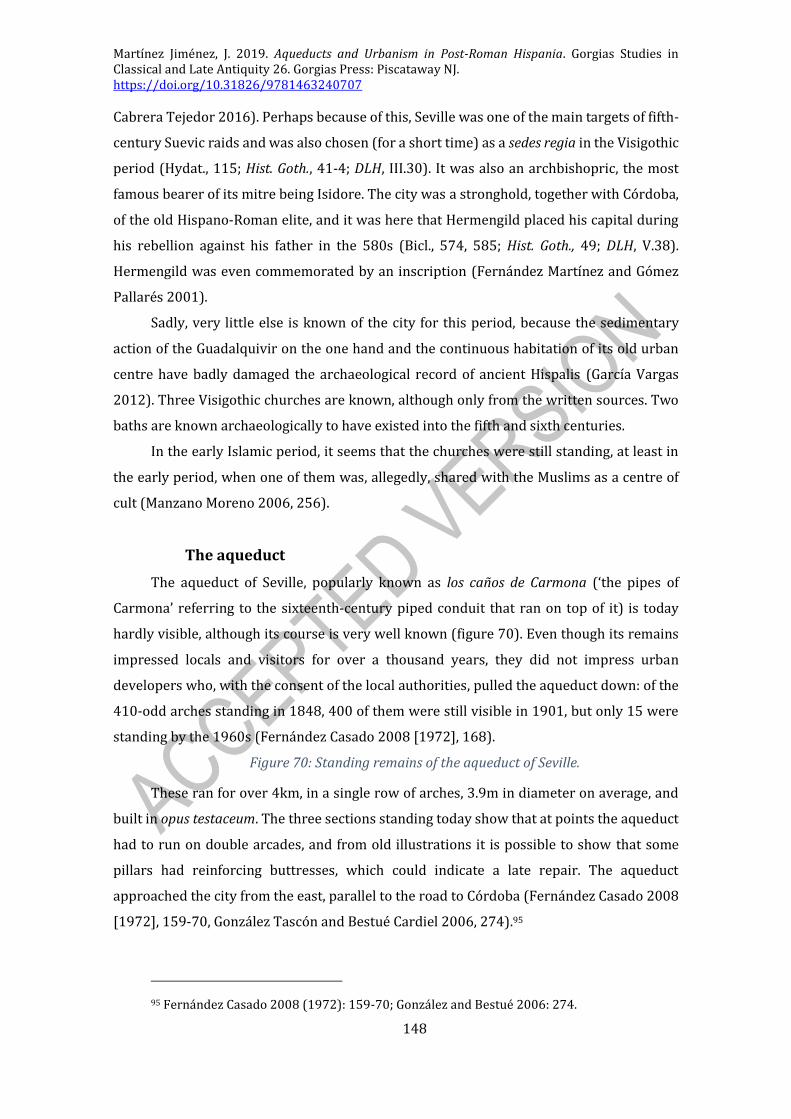
Martínez Jiménez, J. 2019. Aqueducts and Urbanism in Post-Roman Hispania. Gorgias Studies in Classical and Late Antiquity 26. Gorgias Press: Piscataway NJ. https://doi.org/10.31826/9781463240707
148
Cabrera Tejedor 2016). Perhaps because of this, Seville was one of the main targets of fifth-
century Suevic raids and was also chosen (for a short time) as a sedes regia in the Visigothic
period (Hydat., 115; Hist. Goth., 41-4; DLH, III.30). It was also an archbishopric, the most
famous bearer of its mitre being Isidore. The city was a stronghold, together with Córdoba,
of the old Hispano-Roman elite, and it was here that Hermengild placed his capital during
his rebellion against his father in the 580s (Bicl., 574, 585; Hist. Goth., 49; DLH, V.38).
Hermengild was even commemorated by an inscription (Fernández Martínez and Gómez
Pallarés 2001).
Sadly, very little else is known of the city for this period, because the sedimentary
action of the Guadalquivir on the one hand and the continuous habitation of its old urban
centre have badly damaged the archaeological record of ancient Hispalis (García Vargas
2012). Three Visigothic churches are known, although only from the written sources. Two
baths are known archaeologically to have existed into the fifth and sixth centuries.
In the early Islamic period, it seems that the churches were still standing, at least in
the early period, when one of them was, allegedly, shared with the Muslims as a centre of
cult (Manzano Moreno 2006, 256).
The aqueduct
The aqueduct of Seville, popularly known as los caños de Carmona (‘the pipes of
Carmona’ referring to the sixteenth-century piped conduit that ran on top of it) is today
hardly visible, although its course is very well known (figure 70). Even though its remains
impressed locals and visitors for over a thousand years, they did not impress urban
developers who, with the consent of the local authorities, pulled the aqueduct down: of the
410-odd arches standing in 1848, 400 of them were still visible in 1901, but only 15 were
standing by the 1960s (Fernández Casado 2008 [1972], 168).
Figure 70: Standing remains of the aqueduct of Seville.
These ran for over 4km, in a single row of arches, 3.9m in diameter on average, and
built in opus testaceum. The three sections standing today show that at points the aqueduct
had to run on double arcades, and from old illustrations it is possible to show that some
pillars had reinforcing buttresses, which could indicate a late repair. The aqueduct
approached the city from the east, parallel to the road to Córdoba (Fernández Casado 2008
[1972], 159-70, González Tascón and Bestué Cardiel 2006, 274).95
95 Fernández Casado 2008 (1972): 159-70; González and Bestué 2006: 274.
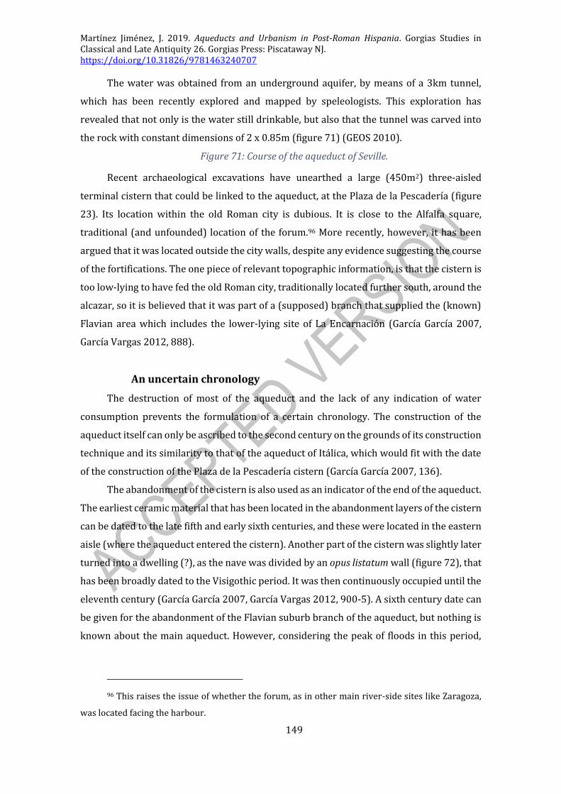
Martínez Jiménez, J. 2019. Aqueducts and Urbanism in Post-Roman Hispania. Gorgias Studies in Classical and Late Antiquity 26. Gorgias Press: Piscataway NJ. https://doi.org/10.31826/9781463240707
149
The water was obtained from an underground aquifer, by means of a 3km tunnel,
which has been recently explored and mapped by speleologists. This exploration has
revealed that not only is the water still drinkable, but also that the tunnel was carved into
the rock with constant dimensions of 2 x 0.85m (figure 71) (GEOS 2010).
Figure 71: Course of the aqueduct of Seville.
Recent archaeological excavations have unearthed a large (450m2) three-aisled
terminal cistern that could be linked to the aqueduct, at the Plaza de la Pescadería (figure
23). Its location within the old Roman city is dubious. It is close to the Alfalfa square,
traditional (and unfounded) location of the forum.96 More recently, however, it has been
argued that it was located outside the city walls, despite any evidence suggesting the course
of the fortifications. The one piece of relevant topographic information, is that the cistern is
too low-lying to have fed the old Roman city, traditionally located further south, around the
alcazar, so it is believed that it was part of a (supposed) branch that supplied the (known)
Flavian area which includes the lower-lying site of La Encarnación (García García 2007,
García Vargas 2012, 888).
An uncertain chronology
The destruction of most of the aqueduct and the lack of any indication of water
consumption prevents the formulation of a certain chronology. The construction of the
aqueduct itself can only be ascribed to the second century on the grounds of its construction
technique and its similarity to that of the aqueduct of Itálica, which would fit with the date
of the construction of the Plaza de la Pescadería cistern (García García 2007, 136).
The abandonment of the cistern is also used as an indicator of the end of the aqueduct.
The earliest ceramic material that has been located in the abandonment layers of the cistern
can be dated to the late fifth and early sixth centuries, and these were located in the eastern
aisle (where the aqueduct entered the cistern). Another part of the cistern was slightly later
turned into a dwelling (?), as the nave was divided by an opus listatum wall (figure 72), that
has been broadly dated to the Visigothic period. It was then continuously occupied until the
eleventh century (García García 2007, García Vargas 2012, 900-5). A sixth century date can
be given for the abandonment of the Flavian suburb branch of the aqueduct, but nothing is
known about the main aqueduct. However, considering the peak of floods in this period,
96 This raises the issue of whether the forum, as in other main river-side sites like Zaragoza,
was located facing the harbour.

Martínez Jiménez, J. 2019. Aqueducts and Urbanism in Post-Roman Hispania. Gorgias Studies in Classical and Late Antiquity 26. Gorgias Press: Piscataway NJ. https://doi.org/10.31826/9781463240707
150
especially after the fourth century, it would not be surprising to see the aqueduct being
badly damaged by the river, which was crossed by an aqueduct bridge.
Figure 72: Visigothic wall, linked to a dwelling structure, inside the Plaza de la Pescadería cistern (García García 2007: fig. 9).
Close to the potential location of the Visigothic cathedral, a possible baptistery has
been identified at the site of Patio de Banderas, which has been dated after the fifth century,
on the basis of the pottery located in the preparation level of the opus signinum floor (Hayes
93A and Keay LIV) (García Vargas 2012, 893, Tarradellas Corominas 2000, 287-7). Despite
it having a large opus signinum pool, the baptistery did not necessarily require piped water.
However, considering the examples of Valencia, Tarragona and Barcelona (where the
episcopal complex is closely linked to the Roman water distribution network), a
requirement of piped water is possible.
There are two baths known archaeologically which can be dated, according to the
material finds, to the fifth and even the sixth centuries: the Cuesta del Rosario baths and the
Palacio Arzobispal baths (González Acuña 2011, 487, 492). Apart from these baths, which
do not provide any further dating evidence to contradict the dating suggested by the cistern,
the excavations at the Plaza de la Encarnación have revealed very interesting domestic fifth-
century contexts: in the domus known as the Casa de la Columna, a new lead pipe was built
into a floor securely-dated to the fifth century (figure 73), and the whole area seems to have
maintained the second-century sewers in use (González Acuña 2011, 380-1, Ruiz Bueno
2018b, 155-6).
Figure 73: Pipe in the domus of the excavations at La Encarnación (González Acuña 2011: fig. VII 201).
It is clear that the aqueduct was out of use in the late Islamic period, because
according to the Almohad chronicle of Ibn Sahibsala, it was then rebuilt. The chronicle
mentions that Abu Jacub Yusuf inaugurated the aqueduct to supply the Alcázar on the 13th
of February of 1172. This new conduit was working until the seventeenth century.
‘He [Abu Jacub Yusuf] is responsible for the water conduction by means
of a conduit (saqiya) for the supply of the inhabitants of Seville and for its
alcázar ... on the old road that leads to this city [Seville] there was an old
conduit (saqiya) that the soil had covered, so it had been turned into a
row of stones by the road, but without anyone knowing what it was... [so
the engineer then excavated it, revealing] the remains of a pipe or a
conduit which used to supply water to Seville, a work of the first kings of

Martínez Jiménez, J. 2019. Aqueducts and Urbanism in Post-Roman Hispania. Gorgias Studies in Classical and Late Antiquity 26. Gorgias Press: Piscataway NJ. https://doi.org/10.31826/9781463240707
151
the old Romans [the text continues, to say how the engineer excavated a
fountain and later found the source of the aqueduct]’ 97
Furthermore, A. Canto (1978, 329) suggests that all the standing remains of the
aqueduct have to be dated to this Islamic phase, accounting for inconsistencies in Fernández
Casado’s description, who based his work on the few standing remains and on old pictures.
However this may be, the standing remains do not provide us with any dating evidence, so
this whole issue can be mentioned, but not resolved.
Overall, the aqueduct of Seville may well have been in use into the fifth century, and
probably ceased to function at some point in the sixth century, when the terminal cistern is
definitely out of use, perhaps as a consequence of a flood.
TARRAGONA
Tarragona (figure 20) is a Mediterranean city, located on the north-eastern coast of
Spain. It was one of the first cities founded by the Romans outside Italy and it was, from its
very early beginnings, the provincial capital of Hispania Citerior (later Hispania
Tarraconensis). The city’s layout was greatly modified by Augustus, who spent a year there
while he organised the Cantabrian wars (26-25 BCE). After this remodelling, Tarragona was
divided into three main areas: an upper city around the temple of the imperial cult and the
concilium provinciae (a great public space linked to the provincial administration), a lower
city, south of the circus which included the old colony’s forum and a theatre, and lastly an
extra-muros, sea-front harbour suburb – much like Lisbon.
During Late Antiquity, the city remained as the last bastion of imperial power, as it
was the de facto capital of the Dioecesis Hispaniarum after Mérida was lost to the Sueves
early in the 420s, and it was the last city to fall to the Goths in 475. Throughout the fifth and
into the sixth century, Tarragona maintained its ecclesiastical importance as an
archiepiscopal see, but it lost most of its political importance to sites like Zaragoza or
Barcelona, especially after 592 when Barcelona took over the taxt responsibility of this
region.98 The city entered into a period of steep decline which continued up to the eighth
century, as evidenced by the increasing number of abandoned structures in the lower city
97 Fernández Casado 2008 (1972): 181 [my translation of his Spanish].
98 According to the De fisco Barconinensi mentioned above. An extensive and up-to-date study
on Tarragona has been carried out by Meritxell Pérez Martínez (2012).

Martínez Jiménez, J. 2019. Aqueducts and Urbanism in Post-Roman Hispania. Gorgias Studies in Classical and Late Antiquity 26. Gorgias Press: Piscataway NJ. https://doi.org/10.31826/9781463240707
152
and the decline of imports identified from the harbour. Soon after, the city was abandoned
by the Muslim garrison and only became again a centre of political relevance in the twelfth
century, when it was conquered by the counts of Barcelona (Panzram 2002, 111-20).
The archaeology of the city reflects the history of this waning provincial capital. Only
the forum appears to have been maintained functional throughout the fifth century, as
evidenced by the lack of encroaching structures in it (Bosch Puche, et al. 2005, 168-71). But
beyond that, there is enough evidence to suggest that the city was polarising into two foci,
as the population abandoned the lower city and moved either up to the upper one (where
the Visigothic episcopal complex was built) or to the harbour suburb, which had been
expanding towards the mouth of the Francolí river, around the Christian martyrial complex
built in the late Roman period.
Most of the old houses and other buildings were abandoned during the course of the
sixth century, and those that were built anew are to be found outside the walls. The circus
was then quarried, and the amphitheatre was turned into a centre of Christian cult in 555
with the construction of a church in the arena. Similarly, the finds of the new fifth-century
harbour indicate that Tarragona was slowly losing importance in broader commercial
networks, and imports cease to appear in the archaeological record by the end of the
seventh century, when the few identifiable finds seem to have been of local or regional
origin (Macias Solé 2008, Macias Solé and Remolà Vallverdú 2005).
The multiple water supply systems
Tarragona is located both next to a river (the Francolí) and on a karst platform in
which the water table is readily accessible, which benefitted supply in the early years of the
colony. Despite this, during the early Empire, in the period of urban reorganisation, the city
built three new aqueducts.
In the Early Modern period however, when Pons d’Icart (1572) undertook the first
studies on the aqueducts of Tarragona, only one conduit was known, the so-called ‘bridge
of the devil’ or Pont del Diable (figure 74), which was linked to the few and fragmentary
remains known from the city. This first study linked the bridge with two possible sources
(the Gayá and the Francolí rivers), although over time the source of the Ferreras aqueduct

Martínez Jiménez, J. 2019. Aqueducts and Urbanism in Post-Roman Hispania. Gorgias Studies in Classical and Late Antiquity 26. Gorgias Press: Piscataway NJ. https://doi.org/10.31826/9781463240707
153
(its current name) was considered to be the Gayá river alone (an opinion followed by
Fernández Casado).99
Figure 74: View of the standing remains of the aqueduct of Tarragona.
However, later in the last century this was proved wrong, because the 1972 survey
put together the information obtained from field work with a new study of eighteenth-
century maps. It was then clear that there were two aqueducts, one obtaining water from
the Francolí and another obtaining it from the Gayá river.
Nowadays, we know of the existence of three different aqueducts.
The Francolí aqueduct
The water conduit to which the Ferreras aqueduct belongs, as we have said, is now
linked to the Francolí river (Sánchez López and Martínez Jiménez 2016, 164-6). Its course
is now relatively well known, especially due to the early topographical surveys and maps
done in the 1740’s as well as to the aforementioned 1972 survey. Its total length is 15km.
Its source, at the Hill of Rovel was finally identified in 1989, as previously it was thought to
be further down river at Puigdelfí (Remolà Vallverdú and Ruiz de Arbulo 2002, 33).
From this area in the hills, the aqueduct continued towards the sea partially excavated
in the rock. Remains are known at the sites of Mas Blanquet and visible at the creek of
Castellot (Sáenz Ridruejo 1977). From here the aqueduct continued to the area of the
Ferreras creek. There we find the arcaded aqueduct: it measures 200m in length and up to
26m in height. It is organised in two rows of voussoir arches (25 arches on the top row and
11 on the bottom one) which measure 5.90m in diameter (20Rf), and are built in ashlar
blocks (Fernández Casado 2008 [1972], 31-40). From this point, the aqueduct followed the
contour lines until it approached the city from the north, by the slopes of the hill of La Oliva,
where it is still visible in Camino del Ángel (figures 75, 76) and the Avenida de Cataluña (and
where it used to be visible at Quatre Garrofers), supplying water to the lower city (figure
20) (Macias Solé, Fiz Fernández, et al. 2007, Sánchez Real, Pujante Izquierdo and Pau Bages
1994).
Figure 75: Remains excavated at the Camino del Ángel (Sánchez Real, Pujante Izquierdo and Pau Bages 1994: lam. Via).
Figure 76: Remains of the aqueduct built adjacent to the walls of the upper city.
99 Fernández Casado 2008 [1972]: 29. Fernández Casado’s description of the course is
completely outdated, but his notes on the remains which were standing when he did his research in
the 1940’s and 1950’s are still important and unparalleled.

Martínez Jiménez, J. 2019. Aqueducts and Urbanism in Post-Roman Hispania. Gorgias Studies in Classical and Late Antiquity 26. Gorgias Press: Piscataway NJ. https://doi.org/10.31826/9781463240707
154
The Gayá aqueduct
A second aqueduct reached Tarragona from the Gayá river (figure 77). The course of
this aqueduct is not well known outside the city, although its source at Puente de Armentera
and its approximate length (45km) are widely accepted (Sánchez López and Martínez
Jiménez 2016, 160-3), making it one of the longest aqueducts in Spain. There are few
remains known from there down to the city itself, but some remains were excavated at the
site of La Secuita, which were partially vaulted (figure 78) (Cortés, Benet and Bermúdez
1989).
Figure 77: Map with the aqueducts of Tarragona.
Figure 78: Section across the conduit located at La Secuita (Cortes et al. 1989: fig. 2).
Inside Tarragona it is better known, and it seems clear that it fed the upper city. Ten
sections of it have been recently excavated, which show that it divided into two conduits
just before entering Tarragona at La Oliva hill. The first conduit, is a vaulted conduit, lined
in opus signinum and built in mortared rubble, and has been identified in several places of
Calle Rovira i Virgili, and went straight towards the circus area. The second branch went
towards the upper city, and according to the pillars found at Calle Sant Auguri, it reached
this part by means of an inverted siphon. There are some remains still standing at the Campo
de Marte at the point where the aqueduct crossed the walls. From this point it seems,
according to the distribution of the finds, that most of the water was carried up to the
castellum located in the archiepiscopal palace, whereas another section of the aqueduct
went parallel to the walls, in the via del Imperio Romano (Macias Solé, Fiz Fernández, et al.
2007, items #24, 69, 86, 166, 181, 719, 726, 728, 729, 733). The late inscription that may
relate to a fountain can be topographically linked to this aqueduct.
The suburb aqueduct
A third and much debated aqueduct, which in 2003 was still unknown
archaeologically, although it was inferred, supposedly fed the harbour suburb and the sea
front residential area (Macias Solé and Remolà Vallverdú 2005, 186). Now there are
archaeological remains that may indicate that this aqueduct existed: a section was
excavated at Calle Dr. Mallafré which because of its altitude (30m a.s.l.) cannot be
considered as a suburban branch of the two other aqueducts (which in this area are located
50/60 m a.s.l.).
This suburban aqueduct is thought to come from the Francolí river, diverting water
at some point down river from the Francolí aqueduct, in the place known as Sant Pere
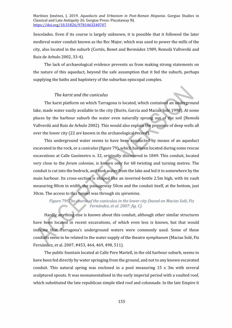
Martínez Jiménez, J. 2019. Aqueducts and Urbanism in Post-Roman Hispania. Gorgias Studies in Classical and Late Antiquity 26. Gorgias Press: Piscataway NJ. https://doi.org/10.31826/9781463240707
155
Sescelades. Even if its course is largely unknown, it is possible that it followed the later
medieval water conduit known as the Rec Major, which was used to power the mills of the
city, also located in the suburb (Cortés, Benet and Bermúdez 1989, Remolà Vallverdú and
Ruiz de Arbulo 2002, 33-4).
The lack of archaeological evidence prevents us from making strong statements on
the nature of this aqueduct, beyond the safe assumption that it fed the suburb, perhaps
supplying the baths and baptistery of the suburban episcopal complex.
The karst and the cuniculus
The karst platform on which Tarragona is located, which contained an underground
lake, made water easily available to the city (Burès, García and Macias Solé 1998). At some
places by the harbour suburb the water even naturally sprung out of the soil (Remolà
Vallverdú and Ruiz de Arbulo 2002). This would also explain the presence of deep wells all
over the lower city (22 are known in the archaeological record).
This underground water seems to have been conducted by means of an aqueduct
excavated in the rock, or a cuniculus (figure 79), which has been located during some rescue
excavations at Calle Gasómetro n. 32, originally discovered in 1849. This conduit, located
very close to the forum coloniae, is known only for 68 twisting and turning metres. The
conduit is cut into the bedrock, and took water from the lake and led it to somewhere by the
main harbour. Its cross-section is shaped like an inverted-bottle 2.5m high, with its vault
measuring 80cm in width, the passageway 50cm and the conduit itself, at the bottom, just
30cm. The access to this tunnel was through six spiramina.
Figure 79: The course of the cuniculus in the lower city (based on Macias Solé, Fiz Fernández, et al. 2007: fig. C).
Hardly anything else is known about this conduit, although other similar structures
have been located in recent excavations, of which even less is known, but that would
indicate that Tarragona’s underground waters were commonly used. Some of these
conduits seem to be related to the water supply of the theatre nymphaeum (Macias Solé, Fiz
Fernández, et al. 2007, #453, 464, 469, 498, 511).
The public fountain located at Calle Pere Martell, in the old harbour suburb, seems to
have been fed directly by water springing from the ground, and not to any known excavated
conduit. This natural spring was enclosed in a pool measuring 15 x 3m with several
sculptured spouts. It was monumentalised in the early imperial period with a vaulted roof,
which substituted the late republican simple tiled roof and colonnade. In the late Empire it

Martínez Jiménez, J. 2019. Aqueducts and Urbanism in Post-Roman Hispania. Gorgias Studies in Classical and Late Antiquity 26. Gorgias Press: Piscataway NJ. https://doi.org/10.31826/9781463240707
156
was almost abandoned after its partial collapse, although the pool of the spring was kept
accessible and in use (Remolà Vallverdú and Ruiz de Arbulo 2002, 41-63).
The chronology of the water supply
Our uneven knowledge of the aqueducts prevents us from making any clear
statements on their chronology. The construction of the Francolí aqueduct has been dated
to the Augustan period, on the sole basis of its ashlar construction technique and because
Augustus himself was in Tarraco in 26-25 BCE, and was responsible for the great urban
development of the city. Out of the excavated sections, no conclusive datable material has
been obtained, so all the information necessarily has to come from indirect evidence.
Only the underground conduit, the cuniculus, has provided datable material. It seems
that the tunnel was partially out of use by the fourth century, because a section of it had by
then been turned into a rubbish pit (Burès, García and Macias Solé 1998).
The fifth-century inscription listed above (CIL II 4109), as mentioned, might have
been linked to a fountain. Because of the location where it was found, at Camino del
Cementerio n.7, it could be linked to a fountain of the Gayá aqueduct.
The presence of many late antique cisterns has been used to suggest an end of the
piped water supply, and a return to previous systems of water supply. However, this could
be an indicator of an unreliable and seasonally variable aqueduct, as explained above. In the
case of Tarragona, the large cisterns located at the cathedral could be considered to be one
of these terminal cisterns (Bosch Puche, et al. 2005). This cistern has been dated to the
Visigothic period according to its construction technique and its location, re-using a wall of
the cryptoporticus of the imperial cult temenos (which is considered to have been
abandoned by the late fifth century). All this fits with the sixth-century transformation of
the precinct into the newly-built episcopal complex. The cistern measures 45.83m2 and it is
covered with a 25cm thick opus signinum lining.100 It is a barrel-vaulted structure, with an
overall capacity of 147m3, which is very big. This cistern, furthermore, is very close to the
archiepiscopal palace (figure 80), where the castellum of the Gayá aqueduct has been
identified, and it is very possible that it fed the cistern although this is not certain. Other
cisterns in the same area of the city may have also been built to store water coming from
the Gayá aqueduct. The cryptoporticus cisterns, for instance, were built in the late Empire,
after lining in opus signinum three rooms, one of which preserves an access stair. It is
possible that the specus which has been identified in this excavation (which came from the
100 Perhaps a sequence of superimposed linings (?).
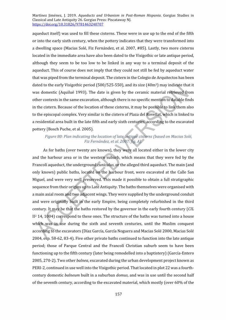
Martínez Jiménez, J. 2019. Aqueducts and Urbanism in Post-Roman Hispania. Gorgias Studies in Classical and Late Antiquity 26. Gorgias Press: Piscataway NJ. https://doi.org/10.31826/9781463240707
157
aqueduct itself) was used to fill these cisterns. These were in use up to the end of the fifth
or into the early sixth century, when the pottery indicates that they were transformed into
a dwelling space (Macias Solé, Fiz Fernández, et al. 2007, #85). Lastly, two more cisterns
located in the immediate area have also been dated to the Visigothic or late antique period,
although they seem to be too low to be linked in any way to a terminal deposit of the
aqueduct. This of course does not imply that they could not still be fed by aqueduct water
that was piped from the terminal deposit. The cistern in the Colegio de Arquitectos has been
dated to the early Visigothic period (500/525-550), and its size (40m3) may indicate that it
was domestic (Aquilué 1993). The date is given by the ceramic material retrieved from
other contexts in the same excavation, although there is no specific mention to datable finds
in the cistern. Because of the location of these cisterns, it may be possible to link them also
to the episcopal complex. Very similar is the cistern of Plaza del Rovellat, which is linked to
a residential area built in the late fifth and early sixth centuries, according to the excavated
pottery (Bosch Puche, et al. 2005).
Figure 80: Plan indicating the location of late antique cisterns (based on Macias Solé, Fiz Fernández, et al. 2007: fig. A).
As for baths (over twenty are known), they were all located either in the lower city
and the harbour area or in the western suburb, which means that they were fed by the
Francolí aqueduct, the underground cuniculus, or the alleged third aqueduct. The main (and
only known) public baths, located on the harbour front, were excavated at the Calle San
Miguel, and were very well preserved. This made it possible to obtain a full stratigraphic
sequence from their origins up to Late Antiquity. The baths themselves were organised with
a main axial room and two adjacent wings. They were supplied by the underground conduit
and were originally built in the early Empire, being completely refurbished in the third
century. It may be that the baths restored by the governor in the early fourth century (CIL
II2 14, 1004) correspond to these ones. The structure of the baths was turned into a house
which was in use during the sixth and seventh centuries, until the Muslim conquest
according to the excavators (Díaz García, García Noguera and Macias Solé 2000, Macias Solé
2004, esp. 58-62, 83-4). Five other private baths continued to function into the late antique
period; those of Parque Central and the Francolí Christian suburb seem to have been
functioning up to the fifth century (later being remodelled into a baptistery) (García-Entero
2005, 270-2). Two other balnea, excavated during the urban development project known as
PERI-2, continued in use well into the Visigothic period. That located in plot 22 was a fourth-
century domestic balneum built in a suburban domus, and was in use until the second half
of the seventh century, according to the excavated material, which mostly (over 60% of the

Martínez Jiménez, J. 2019. Aqueducts and Urbanism in Post-Roman Hispania. Gorgias Studies in Classical and Late Antiquity 26. Gorgias Press: Piscataway NJ. https://doi.org/10.31826/9781463240707
158
datable material) consisted of seventh-century coarse wares. The other bath, located in plot
31, was built at the same time as the previous example, but this bath was by the mid-sixth
century a burial area. These two baths seem to have been supplied by underground water
(Adserías Sans, Pociña López and Remolà Valverdú 2000). The last example is the balneum
of the domus at Calle Apodaca, in the lower city, inside the wall precinct. This bath was built
in a house located on top of the main sewer, and was in use until the beginning of the sixth
century, according to the excavated material (Macias Solé, Fiz Fernández, et al. 2007, #355).
The Islamic period
The aqueducts of Tarragona, like many others in the Peninsula, were not commented
on at all by Classical authors, and it is only in the Islamic period when geographers paid
attention to these huge structures. In the case of Tarragona, the aqueduct is mentioned by
Ibn Ghálib, a twelfth-century scholar, whose text is lost but has been preserved by the
seventeenth-century compiler, al-Makkari.
‘[Ibn Ghálib mentions that the aqueduct] conveyed the water from the sea
[sic] to the city by a gentle level, and in the most admirable order, and
served to put in motion all the mill-stones in the town, the whole being
one of the most solid, magnificent, and best contrived buildings that ever
were erected’ (Al-Makkari, I.6)
The text must certainly refer to the Ferreras bridge, the Francolí aqueduct, as the
other aqueducts have not left remains that could deserve such praise, and it implies that a
water conduit in Tarragona was still functioning at the time of the Christian conquest (1116
CE). This text is however very late and problematic, and should not be taken face value, as it
may be confusing the Rec Major conduit feeding the mills with Roman remains (Guidi
Sánchez 2016, 47). It is f¡difficult to explain also how it uses sea water.
Several modern authors, however, mention that the aqueduct of Tarragona was
repaired in the tenth century by caliph Abd al-Rahman III, and even mention that these
repairs are ‘clearly visible in the current monument’.101 Yet I have not been able to find a
picture of these repairs, a reference to excavated material or a primary Arabic source
mentioning them. However, these alleged repairs are not impossible, as we know of Islamic
repairs in Córdoba and Valencia, and they would explain the confusing comment of Ibn
Ghálib. It seems unlikely it was designed to supply of the city, of which we know very little
101 Most prominently, Fernández Casado 2008 [1972]): 29, whom the quote belongs to.

Martínez Jiménez, J. 2019. Aqueducts and Urbanism in Post-Roman Hispania. Gorgias Studies in Classical and Late Antiquity 26. Gorgias Press: Piscataway NJ. https://doi.org/10.31826/9781463240707
159
for the tenth century – or indeed for the entire the Islamic period of Tarragona (Elices Ocón
2017, Guidi Sánchez 2016).
Discussion
Even if there is not enough direct evidence from the aqueducts to determine when
they ceased to function, there is sufficient indirect evidence, which may point towards the
sixth century as the end point of these structures, or at least one of them. It seems that one
might have been in use and repaired again in the Islamic period, although there is no solid
evidence to confirm this.
A possible post quem date for the abandonment of the Gayá aqueduct is 468 CE, if the
inscription dated to the reign of Anthemius and Leo was really related to a fountain head,
which is unclear. The proliferation of sixth century cisterns in the upper city (some of them
linked to in-flowing specūs) would give another, rather later, post quem date. This argument,
however, relies on the assumption that the huge cisterns located in the area of the cathedral
can be linked to a partially functioning aqueduct and to a means of maintaining a regular
water supply, as happened with the terminal cisterns of the Aqua Antoniniana of Rome. This
suggests parallels with the continuing aqueducts in the episcopal complexes of Barcelona
and Valencia, and may hint at a direct involvement in the water supply systems by the
Church.
It should be remembered that one of the branches of the Gayá aqueduct fed the lower
city, just like the Francolí aqueduct. Furthermore, in this area we know the baths of Calle
Apodaca, which as we have mentioned, were in use until the beginning of the sixth century.
This could support the dating proposed for the Gayá aqueduct, unless the baths were linked
to the Francolí aqueduct.
As for the two Francolí aqueducts, the main one cannot be certainly linked to any
water-consuming structure, and the existence of the secondary one is in doubt, so there is
very little that can be said about them. It would seem that the harbour area and the lower
city relied on underground water for their supply (as evidenced by the many wells in
houses). This can be further confirmed by the fountain located at Calle Pere Martell, which
seems to have been in use until the seventh century, when the pool was finally filled with
sediment and datable ceramic material. The presence of four private balnea in this area,
dated up to the fifth and even the seventh century, could indicate that the water supply
continued to function, but it seems that water was obtained from the subsoil rather than
from pipes.

Martínez Jiménez, J. 2019. Aqueducts and Urbanism in Post-Roman Hispania. Gorgias Studies in Classical and Late Antiquity 26. Gorgias Press: Piscataway NJ. https://doi.org/10.31826/9781463240707
160
However, the public baths from Calle San Miguel were in use until the mid-fifth
century, whereas the conduit that fed them water (the cuniculus) was out of use by the
fourth. If these baths were functioning until then, they must have been fed by the Francolí
aqueduct, because it fed that area. There is the chance, though, that in that period the baths
were supplied from another subterranean source of water of which we know nothing.
Overall, the aqueducts of Tarragona do not seem to have survived beyond the
Visigothic period, and the only solid evidence points towards an end during the sixth
century for the Gayá aqueduct. Regarding the two other aqueducts, only suppositions based
on little solid evidence, point towards a late-fifth abandonment date.
VALENCIA
Valencia was a small coastal town in the province of Carthaginensis, located on the
south bank of the Turia River. It was a Republican veteran colony, and an important harbour
on the route between Tarragona, the Balearics, and Cartagena. It had an early Roman phase
of monumentalisation, but apparently destroyed during the course of the third century, and
later rebuilt (Ribera Lacomba 2008, 303, Löx 2017). When it was rebuilt, it was fully
furnished with new buildings, including a curia and a lavish nymphaeum in the forum, which
was in turn enclosed by a wall. Later on, in the area of the forum where the kardo maximus
and the decumanus maximus met, a new sewer was built during the fourth century to
substitute the old decumanus sewer that had collapsed (Ribera Lacomba 2005, 210-2). The
town had a circus too, which was in use until the fifth century. At this point the whole city
seems to go through a period of stagnation until the mid-sixth century, thanks to the new
commercial dynamics favoured by the Byzantine invasion and especially thanks to the
works of Bishop Justinian (Linage Conde 1972).
The presence of a bishopric in Valencia has been dated back to the time of Saint
Vincent, who preached and was martyred there. The presence of a local martyr allowed
Valencia to generate a local cult. By the time Justinian was bishop there were several
churches in Valencia, as known from two fragmentary inscriptions ICERV 279102 and CIL II2
14. 90 = ICERV 356103. Amongst these, the excavated suburban martyrial centre and
102 …]Iustinianus caelebs pontifex sacerd[os]/no<v>a te(m)pla co(n)struens vetustaq(ue)
rest[aurans]/…
103 constructu(m) r[…cu]urrunt/, fastigium quis[…a]ula/ nempe nam im[…a]nnos/ hoc
pro<v>idens […]ntis/ tertio antist[es…] anno/ robore contri[…]rimbi/ aptantur hi mir[…]sius idem/

Martínez Jiménez, J. 2019. Aqueducts and Urbanism in Post-Roman Hispania. Gorgias Studies in Classical and Late Antiquity 26. Gorgias Press: Piscataway NJ. https://doi.org/10.31826/9781463240707
161
monastery are likely candidates. He was also probably responsible for the construction of
the cathedral which has been excavated at the site of La Almoina, (figure 81).104 Though only
the apse and part of its outer walls have been excavated, it is possible to tell that the
cathedral, even if built by the forum, maintained the orientation of the urban grid, and did
not block any existing streets. As time passed, this original complex was expanded, and two
cross-shaped structures were built in the late sixth century at either side of the apse, this
time directly on top of the kardo maximus. These two structures have been identified as a
mausoleum or funerary chapel for the bishops of Valencia (known as the ‘Prison of Saint
Vincent’) and as a baptistery with a drain leading to the main sewer (Ribera Lacomba 2005,
214-9, Soriano Sánchez 2000).
Figure 81: Plan of the Visigothic phases of the excavations at the site of La Almoina (Ribera Lacomba 2008: Fig 8).
Still in the forum area, north of the cathedral, during the seventh century new
buildings were erected on top of the previously public spaces, which include an apsidal
structure (probably a martyrial shrine), a large monumental well (the ‘great well’) and a
polygonal building (called macellum by the excavators). These buildings, however,
respected the still-standing and still-functioning Roman structures that occupied that part
of the forum: the curia and the nymphaeum (Ribera Lacomba 2005, 228-33, Ribera Lacomba
and Rosselló Mesquida 200, 179-80).
Besides the excavations at La Almoina showing the Christian monumentalisation of
the forum, little is known from the rest of Valencia. We know, for instance, that the circus
was partially reconstructed as a fortification during the last decades of the sixth century,
and this has been explained as the result of the full incorporation of Valencia into the
Visigothic kingdom during the reign of Liuvigild (Ribera Lacomba 2008, 313). As Valencia
was very close to the imperial territories on the south-eastern coast, it became important
to take control of Valencia to create a definite border against the Romans. This is further
supported by the construction in the late sixth century (according to the excavation
material) of the fortification of València la Vella, a 4ha castrum ten miles away from the city
(Rosselló Mesquida 1996), which further indicates the military presence of the Visigoths in
the region. It is certain that by 546 (when a synod was celebrated) Valencia was only loosely
ful<v>ida pr(a)etera […]a prossus/ lammina sub lato […]mine aur i/ [cu]lmine cu(m) solid[…] quinque
[columnis?]
104 Here I stand corrected from what I originally said (Martínez Jiménez 2011) by Markus Löx
(2017), as the basilica is not built in the forum, but next to it.

Martínez Jiménez, J. 2019. Aqueducts and Urbanism in Post-Roman Hispania. Gorgias Studies in Classical and Late Antiquity 26. Gorgias Press: Piscataway NJ. https://doi.org/10.31826/9781463240707
162
controlled by the Visigoths, but during the last part of the sixth century the city was finally
included in the Gothic kingdom. Beyond the evidence for this given by the fortifications, new
burials have been identified in the forum area.
From the later Visigothic to the early Islamic period, the site of La Almoina hardly
changed and was only slightly transformed. During the course of the late seventh century a
workshop area developed in the northern sector of the old forum. The eighth century is
described as the darkest century of the archaeology of Valencia, because very little is known,
and what is known can only be ascribed to this century with great difficulty. According to
the written sources, the city was destroyed in the year 778 by the troops of emir Abd al-
Rahman I, although this destruction has not been identified yet archaeologically. It is not
until the ninth century when real changes in the layout can be seen, with the construction
of a hamman (Islamic bath) in the cross-shaped mausoleum, the erection of new great
cisterns and the construction of a new water supply conduit, which is thought to have
supplied the emiral citadel (Martí and Pascual 2000).
The aqueduct
The aqueduct of Valencia is not very well known, for two main reasons: the course
inside the city is documented in only three sites (one unpublished), and outside the town all
the Roman water conduits are considered to be rural watering channels (Martínez Jiménez
2011).
The rural aqueducts have been surveyed on both sides of the river Turia, and four are
known on the north side while five are known on the south side. The north ones cannot be
linked to Valencia because their courses go deep into the agricultural region north of the
city (Pérez Mínguez 2006).
The five conduits known from the south bank had only been partially studied until
very recently. The only major study until 2008 was a short work which dealt only with the
sections standing in the municipality of Ribarroja, published by Domingo Fletcher Valls
based on an 1849 unpublished survey and his own field work. In his work, Fletcher
mentions two different conduits: he identifies one of them as an irrigation channel
branching away from the other, the urban aqueduct, which in turn can be identified in nine
different sections. The main problem with Fletcher’s work is that his chronology is not
reliable (he describes the site of València la Vella as a Roman camp), and most if not all of
the sections he mentions as existing in 1964 have certainly now disappeared under new
urban developments, so it may be impossible to compare the date of these standing sections.

Martínez Jiménez, J. 2019. Aqueducts and Urbanism in Post-Roman Hispania. Gorgias Studies in Classical and Late Antiquity 26. Gorgias Press: Piscataway NJ. https://doi.org/10.31826/9781463240707
163
Fletcher proposed a hypothesis for the urban aqueduct: its source may have been a
diversion dam located at the Turia river in the village of Villamarchante, located on the right
bank (Martí Macias 2001, 24). The aqueduct would then continue its course parallel to the
river on its south bank until it appears again at the site of València la Vella, in the village of
Ribarroja (16km from Valencia). Fletcher mentions sections standing at the sites of
Perpinyanet, Muncholina and Porxinos (all between Villamarchante and València la Vella),
and Barranc del Pou, these are the names of creeks (barrancs) that flow into the River Turia,
and are therefore the logical places to find an aqueduct bridge. It would then continue
towards Valencia, appearing again at Manises, assuming that the Islamic bridge located
there (and popularly known as els arquets, or ‘the little arches’) is a reconstruction of an
original Roman structure (Fletcher Valls 1958).
However, Ignacio Hortelano Uceda published in 2008 an up-to-date study of the
aqueducts of the south bank. He identified five different aqueducts, which he classifies as
rural watering systems, on the grounds that they are not covered (following Vitruvius’
advice), and that they are cut into the soil rather than built out of masonry (Hortelano Uceda
2008). The only parts of these aqueducts which are built on masonry structures and lined
with opus signinum are those parts when bridges needed to be built. The conduits
themselves are very wide (over 1.5m on average) which is also unusual for urban aqueducts
in Spain. All of these aqueducts are fed from river diversion dams (which have been
preserved), which Hortelano also points to as a sign that they were not intended for urban
supply.105 He argues that they ceased to function in the fifth century.
According to him, these conduits can only be linked to Roman rural settlements, and
that they cannot be linked to the one Visigothic settlement known for this period, the palace
of Pla de Nadal. However, the Visigoths mention very specifically rural water conduits in
their laws (LV VIII.4.31: De furantibus aquas ex decursibus alienis), and it is evident that there
was a pre-existing irrigation network around Valencia before the Muslim invasion (Glick
1970, 190-2). The assumption that river water was not apt for urban supply is, nevertheless,
not valid, as there are many examples of uses of river water (from the upper course) for
urban supply, including Sagunto, only 30km away from Valencia (Civera Gómez 2008).
Furthermore, Hortelano claims that none of these aqueducts could have possibly
continued towards Valencia. Hortelano presents in his paper a model for each of the five
aqueducts, in order to estimate their course beyond the point where they are last attested
but without any archaeological evidence to support it, and his model predicts that all
105 This is probably influenced by Feijoo’s thesis.

Martínez Jiménez, J. 2019. Aqueducts and Urbanism in Post-Roman Hispania. Gorgias Studies in Classical and Late Antiquity 26. Gorgias Press: Piscataway NJ. https://doi.org/10.31826/9781463240707
164
aqueducts would have turned south, towards the agricultural hinterland of Valencia (known
as the Pla de Quart), where he identifies a great number of rural settlements. Aqueduct
number 5, which is the one proposed by Fletcher as the one continuing towards the city,
also turns south in Hortelano’s model, so according to him it could not have fed the city.
Certainly, if any of these canals continued as far as the city, its course is unknown until
it reaches Valencia itself, as the whole bank of the river between Manises and Valencia is
heavily built over. The aqueduct has been located in three different excavations along the
ancient road leading west, a continuation of the decumanus maximus (figure 82). In the
1930s a section was located outside the provincial gaol, but was later destroyed, although
nearby on January 2013 a new section was identified (Machancoses López 2015). Down the
road, the excavations at Calle Caballeros and Calle de Quart that took place in the 1990’s
confirm that the aqueduct continued in a straight line towards the centre of the town,
although at some point it turned south, towards the Porta Sucronensis (southern gate)
(Guillén Fernández 2003, Herreros Hernández 1996, Viñes Pérez 1997), where the
castellum aquarum is supposedly located according to a fragmentary inscription recorded
by Schulten (Martí Macias 2001, 51), which reads:
...]um qui aquam trahi[t... / ...]m a Porta Sucronens[i… / …] empturum V
kal(endas) maias.
‘… who brought the aqueduct… / … from the Sucronensis gate… / … he will
buy (?). [Given] on the fifth day before the calends of May [26th of April]’
Figure 82: Plan of the reconstructed course of the aqueduct.
It would then be distributed from there to the rest of the town. This included the
supply to the monumental forum, with its nymphaeum and, later on, its baptistery. Close to
the southern gate, the Porta Sucronensis, the 1993 excavations at Calle Avellanas unearthed
a couple of square bases, which have been identified as two possible aqueduct pillars
(Algarra Pardo, Matamoros and Viñes Pérez 1993, 14), which could confirm the text of the
inscription although their dating is doubtful.
The aqueduct identified at these sites (Castán Tobeñas, Caballeros and Quart) forms
a straight line which runs parallel to the main road that linked Valencia with Segóbriga and
Toledo, and as Roman aqueducts normally ran parallel to main roads (which made repairs
and maintenance easier) this adds value to the argument that links the urban aqueduct with
a source on the right (south) bank of the Turia, even if this may not be one those identified
by Hortelano.

Martínez Jiménez, J. 2019. Aqueducts and Urbanism in Post-Roman Hispania. Gorgias Studies in Classical and Late Antiquity 26. Gorgias Press: Piscataway NJ. https://doi.org/10.31826/9781463240707
165
Chronology and dating evidence
There is very little evidence to date the aqueduct of Valencia per se, and the available
evidence is difficult to interpret. It is clear that it had stopped functioning between the
seventh and the eleventh centuries, but the continuity between the fourth and fifth
centuries is doubtful (Martínez Jiménez 2011).
On the one hand, it is possible to say that the construction in the late sixth century of
a large fort outside of Valencia (the site of València la Vella) in order to control the town and
its territory, would make more sense if Hortelano’s aqueduct number 5 was still functioning,
so it could supply water to the garrison there (Martí Macias 2001). The source of this
aqueduct is about a kilometre away from the site, so it could have been easily maintained, if
at all needed.
On the other hand, there is excavated material, obtained from the inside of the specus
of the Roman aqueduct located at Calle de Quart, which ranges from the Roman period to
the eleventh century (Martí and Pascual 2000, 513). The specus located there was totally
filled with clay sediments (figure 83). There was plenty of material in these sediments,
securely dated between the Roman and the Islamic periods (Herreros Hernández 1996, 15-
6). The bottom-most context sitting on top of the clay specus had two heavily eroded shards
of Hayes 32B and 196, which are generally dated to the third century CE. The layers above it
(1144-1146) were all much thinner and all contained eleventh-century pottery and debris.
This means that at least until the eleventh century the aqueduct was still carrying water,
when it was completely packed with clay, becoming useless.
Figure 83: Section drawing of the aqueduct identified at the Calle Caballeros (Herreros Hernández 1996: plan 10a).
The nature of these sediments in context 1147 suggest an alluvial formation of the
layer. However, the chronological issues are more intriguing. Context 1147 must have
formed after the third century due to the t.p.q. given by the two ARS forms. This would
seemingly match the third-century destruction of Valencia. However, the layer is very thick,
which implies that it carried water for a long period of time, perhaps malfunctioning: the
presence of post-third century water-consuming infrastructure in the forum may imply that
the aqueduct was still in use then. The presence of Islamic material in the contexts
immediately on top of 1147, together with the fact that 1147 was then compacted by a
gravel layer, 1146 (which served as the base for the new Islamic phase of the aqueduct),
may indicate that in the Islamic period the conduit was cleaned and put back into use. This
would mean that the contexts between the third and the eleventh century had been
removed.

Martínez Jiménez, J. 2019. Aqueducts and Urbanism in Post-Roman Hispania. Gorgias Studies in Classical and Late Antiquity 26. Gorgias Press: Piscataway NJ. https://doi.org/10.31826/9781463240707
166
Beyond the data obtained from the aqueduct itself, it is possible to obtain information
on the continuity of the water-supply from water-related structures of Valencia, namely the
baptistery, the nymphaeum, the old basilica, the sewers, the great well, and the new Islamic
conduit.
The baptistery, as discussed above, was first built during the sixth century, added to
the west end of the cathedral, north of the apse. It was first identified in the 2002 excavation,
but it has not been fully excavated due to the nature of the site.106 Nevertheless, the
excavation has shown that it had a pool with a drain, which could have led the blessed water
out of the baptistery into a basin on the street, where the faithful could collect it (Ribera
Lacomba 2008, 306). It is not clear where the water for the baptistery came from, but it is
not impossible that being so close to the castellum, it was fed with water from the aqueduct.
The so-called nymphaeum was built during the early years of the colony, although
back then it seems to have been simply a sacred pool, linked to some water cults (Albiach
Delscals, Espí Pérez and Ribera Lacomba 2009, Álvarez García and Ribera Lacomba 2003).
The imperial-phase nymphaeum is divided into two areas, although only half of the front
one has been excavated. It is all enclosed in an opus vittatum precinct measuring 20 x 11m.
The front part, which faces north, includes two twin pools and two water fountains fed by
pipes; the pools are lined with a layer of opus signinum 30cm thick. Although it was
originally a sacred well, the presence of lead pipes underneath the first-to-third century
pavements suggests that it was fed by the aqueduct, especially as the Porta Sucronensis is
only 100m away. The main pool is now below an Islamic phase, so it is not possible to know
when the original pool went out of use, although preliminary material suggests an eleventh-
century abandonment (figure 84). The nymphaeum was monumentalised in the fourth or
fifth century, refurbished and repaved with new tiles, although some of the walls were
pulled down in the fifth century according to the pottery retrieved from the trenches. This,
though, did not mean that the nymphaeum went out of use, as the fountain was still standing
and accessible during the sixth and seventh centuries, as a new marble slab pavement
indicates. During the sixth century some obscure, and very difficult to interpret, timber
106 This has made the identification of this structure as a baptistery quite dubious, but it is a
structure with hydraulic infrastructure (opus signinum floor with a sewer) located by the apse of a
cathedral. A baptistery is the most sensible guess. Of course it could be something else (a bath?), but
the point is that: (a) it is a water-related structure, and (b), it can be securely dated to the late sixth-
century.

Martínez Jiménez, J. 2019. Aqueducts and Urbanism in Post-Roman Hispania. Gorgias Studies in Classical and Late Antiquity 26. Gorgias Press: Piscataway NJ. https://doi.org/10.31826/9781463240707
167
structure (evidenced by the presence of postholes) was erected in the precinct of the
nymphaeum, but it did not block access to the pool.
Figure 84: Photograph of the various pools of the nymphaeum of La Almoina (photograph courtesy of the SIAM, Valencia).
In the area between the curia and the cathedral, facing the kardo maximus, once stood
the old Roman basilica, which in the fourth century was re-modelled to serve a different
purpose (Álvarez García, Ballester Martínez, et al. 2005). The old building was divided into
several rooms around a courtyard with a drain and a large water basin (4.4 x 9m) lined in
opus signinum. One of the rooms had a press, and together with the material retrieved from
the building (including fish bones, grape seeds, charred plants and fish and oil amphorae)
indicates that the basilica had been turned into a food-processing building. The basin, the
drains and the vat indicate that the building was consuming water until its final
abandonment in the second half of the fifth century. The date is given by the amphorae
(which include Keay IV, XXXV, XIII, XXIII and XIX) and the coins found in the abandonment
layers.
The ‘great well’ was built in the north area of the forum, in front of the apsidal
structure thought to be a martyrial shrine, and both were probably part of the same
construction effort, which would point towards a liturgical function (Vizcaíno Sánchez
2009, 365). The well was lined with reused slabs and ashlar blocks during the seventh
century, according to the stratigraphy. The foundation trench includes Hayes 58 and 59
(dated to the fourth century), as well as 91, 99 and 104 (dated 6th-7th c.), together with
amphorae Keay LXI, LXII and LXV, which give a similar date (Álvarez García and Ribera
Lacomba 2003, 108-9). The presence of this well could be an indicator of a non-functioning
aqueduct by the seventh century, built in order to provide water to the core of the episcopal
complex and the hub of the city. It was finally abandoned in the eleventh century, according
to the material obtained from inside the well, which includes Andalusian large globular
pithoi, with weathered walls and remains of leather around the neck (showing how water
was drawn from the inside) (Martí and Pascual 2000). The well must have supplied water
at this stage to the workshops that had been built in the north Almoina sector during the
course of the tenth century.
Lastly, the new Islamic water conduit provides us with further evidence to suggest
that the aqueduct was operational during the middle Islamic period. This new underground
water conduit was constructed in the tenth century (according to the material retrieved
from the foundation trench) most probably to supply water to the Islamic citadel, and
maybe indirectly from there to the hammam (Albiach Descal, Ballester Martínez and

Martínez Jiménez, J. 2019. Aqueducts and Urbanism in Post-Roman Hispania. Gorgias Studies in Classical and Late Antiquity 26. Gorgias Press: Piscataway NJ. https://doi.org/10.31826/9781463240707
168
Rosselló Mesquida 1999, 46-8). Even if it is impossible to indicate with certainty where it
came from or where it went to (because it is only known from this excavation), it probably
was a branch diverting from the original Roman aqueduct (figure 26) heading towards the
palace mentioned earlier, located to the east of the site of La Almoina, because it crosses the
whole of the excavated site from west to east. What seems clear is that the conduit was built
out of reused material (ashlar blocks, column drums, millstones) and mortared rubble, and
that it crossed the old forum without supplying water to the workshops that had been
constructed there. This suggests that the water supply system in this period was not openly
public and was limited to the palace supply, and maybe perhaps the hammam (which it is
not clear if it was private or public).
The hammam was built in the mausoleum at some point after the construction of the
Almoina conduit (9th c.), which allegedly fed the baths, and was in use until the eleventh
century. This date is given by the presence of green-and-brown Andalusian pottery in the
abandonment layers. The old mausoleum was subdivided with walls, and its floor was
raised, in order to warm the rooms. A furnace was added outside the apse, where the hot
room was built (Martí and Pascual 2000).
Islamic repairs or evidence for Gothic continuity?
With the available archaeological evidence, it seems clear that the aqueduct was
functioning until the eleventh century, with a gap in the evidence between the seventh and
the ninth, and a degree of uncertainty between the fourth and the seventh. This chronology
is built by the several t.p.q.’s and t.a.q.’s given by the dated material.
The post quem dates include the reconstruction of the nymphaeum (3rd-4th c.), the
food-processing building of the forum (4th-early 5th c.), the probable use of running water in
the baptistery (late 6th c.) and the public accessibility to the pool of the nymphaeum, and its
late repairs (6th c.). The ante quem dates (excluding the great well) all turn around the
eleventh century: the destruction of the nymphaeum, the final blocking of the Roman
aqueduct at Quart, and the end of the Islamic water conduit. It is the evidence for the ninth
century (the nymphaeum cisterns and the construction of the Almoina conduit) that
generates most doubts.
The new constructions of the ninth century clearly point towards a renewal in
hydraulic engineering, probably linked to a new urban period of revival, which could
indicate a reconstruction of the aqueduct, which had been out of use probably since the
sixth/seventh century. However, the evidence can also be interpreted in a different way, as

Martínez Jiménez, J. 2019. Aqueducts and Urbanism in Post-Roman Hispania. Gorgias Studies in Classical and Late Antiquity 26. Gorgias Press: Piscataway NJ. https://doi.org/10.31826/9781463240707
169
the repairs of the ninth century removed all late antique layers from the conduit, so it could
have been the case that water flowed into and beyond the Visigothic period.
ZARAGOZA
The city of Zaragoza was one of the most important cities in the Visigothic kingdom,
as it was strategically located between Toledo and Gaul. Founded as an Augustan colony (its
Roman name is Caesaraugusta) on top of a previous Iron-age settlement, the city is located
at the right (south) bank of the Ebro, which was crossed by a now disappeared stone bridge
(figure 85). The city still preserves today most of its Roman street-grid, as well as its
impressive third-century walls.
Figure 85: Bridge of Zaragoza.
In the early seventh century the city was a centre of learning, as the letters of Bishop
Braulio (who kept a long correspondence with Isidore of Seville, and mentions the exchange
and writing of many books) indicate. It was also one of the main mints, and its territory
included the fertile valley of the Ebro river. Its prosperity and importance is also reflected
in the several attacks known on the city during the fifth, sixth and seventh centuries, the
most important being those of the bagaudae (Hydat., 133-4), those of the Frankish kings in
541 (who besieged the city for 49 days until, impressed by the power of St. Vincent, the
Franks left; DLH III.29), and then in the 620s by the Basques (Hist. Goth., 63).
The little known aqueduct
Zaragoza is the first city in Spain which we know had a water supply system (ignoring
the ‘Iberian’ aqueduct of Sagunto), as mentioned in a law of the first century BCE, known as
the tabula Contrebiensis. In this inscription Rome acts as a mediator between the local
Celtiberian towns of Salduie (the pre-Augustan name of Zaragoza) and Contrebia, because
both claimed the use of an irrigation channel. This may also have been a water supply
system to Salduie itself, if this channel can be identified with a later medieval one which ran
into the city (Abadía Doñaque 1995). Despite the inscription, which is very important
because it shows the imposition of Roman water law in the Iberian Peninsula, the conduit
referred to is hardly known, and it does not seem to have been a proper aqueduct,
monumental or otherwise.
It has been traditionally held that the aqueduct was built in the Claudian period, and
that it brought water from the Gállego river, a main tributary of the Ebro on its left (north)
side. This is, however, only based on the existence of two pieces of evidence. The first one is

Martínez Jiménez, J. 2019. Aqueducts and Urbanism in Post-Roman Hispania. Gorgias Studies in Classical and Late Antiquity 26. Gorgias Press: Piscataway NJ. https://doi.org/10.31826/9781463240707
170
the conduit known as the acequia de Urdán, a 500m long rock-cut conduit coming from the
north of Zaragoza. The second are the lead pipes located at the bed of the Ebro river in 1804
and 1805 (González Tascón, Vázquez de la Cueva and Ramírez Sádaba 1994). They were
recorded and published then, but during the Peninsular War (1808-1814), during which
Zaragoza was besieged on three occasions, the pipes seem to have been used to make bullets
to fight the French. The importance of these pipes resides not only in the inscriptions they
bore (CIL II 2992), but also in the fact that they indicate that the aqueduct crossed the river
by means of an inverted siphon along the bridge, that it entered the city through its north
gate, and that its castellum may well have been in the forum area, which is just adjacent to
the north gate that faced the bridge (Abadía Doñaque 1995, Bestué Cardiel and González
Tascón 2006).
This course of the aqueduct is highly hypothetical, because it is only sustained by the
existence of the water-pipes, and it would imply perhaps an unnecessarily long aqueduct if
water dams existed on the south banks of the Ebro. Another much more plausible (and more
recent) hypothesis is that the aqueduct was diverted from the Huerva river (a tributary to
the Ebro on its right side, where Zaragoza stands), and that the pipes actually fed the suburb
on the other side of the river. This hypothesis is not only based on various facts, which
include the large terminal (?) cisterns located east of the city and the presence of several
Roman dams on the Huerva, especially at the site of Las Adulas, which has been suggested
as the caput of the aqueduct (Escudero Escudero and Galve Izquierdo 2011).
Dating evidence
Given the lack of information about the aqueduct, all the dating evidence has to be
obtained from indirect sources. The one certain piece of chronological information is that
in the Islamic period there is no mention to any water-conduit, and the palace seems to have
been fed by a huge water wheel.
Concerning the continuity of Roman baths, there seem to be two phases of
abandonment of baths: one in the third century (when the private baths of Calle Ossau and
those of Calle Gavín y Sepulcro were abandoned) and another in the fifth (García-Entero
2005, 283-4), like those at Calle Carrillo, the baths at Calle Universidad, and the suburban
baths of Calle Alfonso V (Beltrán Llorís 2007, Casabona Sebastián and Delgado Ceamanos
1991). The two public baths of Zaragoza were abandoned in the fifth century: those opposite
to the bridge earlier in the century than those at Calle Santa Marta, which were in use until
the mid-fifth (García-Entero 2005, 281). However, of the latter only the hot rooms are
known to have been abandoned for certain, since the cold ones could not be properly

Martínez Jiménez, J. 2019. Aqueducts and Urbanism in Post-Roman Hispania. Gorgias Studies in Classical and Late Antiquity 26. Gorgias Press: Piscataway NJ. https://doi.org/10.31826/9781463240707
171
excavated (as they were beyond the excavation limits): considering that hot rooms were
generally the first ones to be abandoned, there is a small possibility that the baths continued
to function during the second half of the fifth century.
Finally, most of the evidence points towards a functioning aqueduct into the early fifth
century, probably up to the first decades of the second half (Santa Marta baths), as after this
there is no evidence to prove that the aqueduct was functioning. Any standing remains of
the aqueduct were destroyed with the bridge in the ninth century, or unknown to
contemporaries in the Islamic period, who used water from the Ebro river for their needs.

Martínez Jiménez, J. 2019. Aqueducts and Urbanism in Post-Roman Hispania. Gorgias Studies in Classical and Late Antiquity 26. Gorgias Press: Piscataway NJ. https://doi.org/10.31826/9781463240707
172
APPENDIX: AQUEDUCTS AND URBANISM IN POST-ROMAN TINGITANIA
Tingitania, the westernmost Roman province of Africa was included in the Empire
during the reign of Claudius, even if many cities were granted civic privileges already in the
time of Augustus. The province was an underdeveloped corner of the Empire, largely
disconnected from mainland Africa, and with much closer maritime links with Hispania. The
number of cities with aqueducts in Tingitania is much lower than in Hispania,
archaeologically we know very little about them. Trying to include Tingitania and Hispania
in the same parallel discussion on aqueduct and urbanism continuity would prove an unfair
comparison, simply because of the proportional volume of data. For this reason, I have
decided to apply the same methodology and approach to the cities of Tingitania and to add
the conclusions as this appendix in which to develop its own narrative separately.
Geographically, Tingitania’s main features are the Gharb, a fertile coastal plain, and
the mountains that border it: The Atlas Mountains at the SE and the Rif at the NE. It is
crossed by three main rivers, from south to north the Wadi Sala, the Sebu (which in
Antiquity was navigable), and the Lucus. The mountainous areas of the Atlas and the Rif
towards the east were not heavily populated, and remained largely as tribal territories into
the Islamic period. This eminently Atlantic position gives the area a milder Mediterranean
climate, with rains concentrated during the autumn.107
Chronologically, in Late Antiquity the province was divided into a coastal area
between Ceuta and Larache, which remained under Imperial control, and the broader
hinterland, which was abandoned by the administration and the army. The late antique
period thus is a contrast between the late Roman phases of Zilil, Lixus, Tangiers and Ceuta,
and the sub-Roman or post-Roman phases of the cities beyond. In 429 the Vandals passed
through the region on their way to Carthage, but never seem to have had any strong claims
on Tingitania. Nor did the Byzantines after Justinian’s campaign, although the coastal cities
appear to have been included in the larger Mediterranean trading links. The region was
conquered in the decade of 700 by the Umayyad armies, but until then the cities acted
largely as independent polities, which could be termed Berber, or Mauri. With the Umayyad
invasion the area was included in the Islamic sphere of influence, and in the period of the
780s-820s, a local Idrisid dynasty established its own independent kingdom.
THE AQUEDUCTS
107 Rabat, located in the Gharb coastal plain, is actually wetter than Cambridge.

Martínez Jiménez, J. 2019. Aqueducts and Urbanism in Post-Roman Hispania. Gorgias Studies in Classical and Late Antiquity 26. Gorgias Press: Piscataway NJ. https://doi.org/10.31826/9781463240707
173
There were various attempts at identifying water supply conduits during the colonial
period, both in the French and Spanish protectorates. These studies never went beyond
mere identifications or suggestions based on inscriptions. Most of the aqueducts in
Tingitania remain to this day hardly known or identified (Pons Pujol and Lagóstena Barrios
2011, Mueden 2010).
Of the known aqueducts, six were certainly urban (figure 86; Banasa, Ceuta, Lixus,
Sala, Volubilis and Zilil), while two others are very doubtful (Tangiers and Thamusida).
Besides these urban ones, there were military camps with baths complexes (Tamuda,
Tocolosida, Aïn-el-Hammam) fed by aqueduct supplies.
• Of the conduits of the forts, we can only claim that they were in use during
their active occupation, which does not go into the fifth century (Bernal
Casasola, Raissouni, et al. 2012, Bernal Casasola 2018).108
• At Lixus, the aqueduct has been identified in surveys outside the city (El
Khatib-Boujibar 1992). While the local geology does not favour the digging of
wells, cisterns appear to have been the most common way of water supply,
with and without the aqueduct. It could appear at first that the aqueduct might
have continued into the sixth century, based on the continuity to this date of
the J baths and some of the cetariae, but the late chronology of these baths is
very debatable (Lenoir 1992) and the factories were fed by rainwater cisterns
(Sánchez López 2018).
• The aqueduct of Tangiers is mentioned in later Islamic sources, but there are
no known remains in the city or its surroundings of a conduit, baths, sewers,
or garum factories which could give us any indication (Elbl 2013, 159, Mueden
2010, 38, Pons Pujol and Lagóstena Barrios 2011). It may not have existed for
all we know.
• At the sites of Banasa (Arharbi and Lenoir 2006) and Thamusida (Mueden
2010, 182) we have baths and workshops, and hints towards aqueducts, but
the early abandonment of the city, prevents us from making further claims.
• At Sala, there is evidence for an aqueduct. The forum nymphaeum is, in my
opinion, misleading, because is still full of water today and suggests that it taps
directly to the water table without a conduit (Ammar 2008). The presence of
108 Although in the case of Tamuda it might have gone into the 420s, although it is impossible
to be more precise in the dating.

Martínez Jiménez, J. 2019. Aqueducts and Urbanism in Post-Roman Hispania. Gorgias Studies in Classical and Late Antiquity 26. Gorgias Press: Piscataway NJ. https://doi.org/10.31826/9781463240707
174
large lead main along the main street and the presence of baths make its
existence more likely (Mueden 2010, 211). Considering the main phase of
monumentalisation of the city, we know the aqueduct was in use during the
second century, but after the withdrawal of 284 we know nothing about the
site, or its aqueduct.
• The aqueduct of Volubilis is securely dated as out of use to the fourth century
(Étienne 1960), although for the city itself we have more data about its post-
Roman evolution (Fentress and Limane 2010, Fentress 2017) .
• The abandonment of the aqueduct of Zilil can be dated to the fourth century,
while the city appears to have been destroyed by a fire (and then largely
abandoned) in the early decades of the fifth century (Lenoir 2005).
Figure 86: Map showing the location of the urban aqueducts of Tingitania. Note that the Roman frontier was pulled back from Sala to Lixus in the late third century
Regarding the chronologies, only one, the aqueduct of Ceuta, appears to continue into
Late Antiquity with any degree of certainty.
Ceuta
The city of Ceuta is located on a small peninsula linked by an isthmus to the mainland.
Its connection with the Iberian Peninsula has always been very strong, stronger even than
with the rest of North Africa. Furthermore, Tangiers, the closest episcopal see (which
probably Ceuta belonged to) was included in the Hispanic Church still in the seventh century
(Gozalbes Cravioto 2000). The site does not seem to have been a Roman city of importance,
although there was a strong fortified settlement (oppidum) on the isthmus and the slopes of
the peninsula, which lived, as many other settlements of the region, off the production of
fish products, taking advantage of the migratory movements of fish (tuna, mackerel) from
the Mediterranean into the Atlantic and vice versa.
The settlement seems to have been deeply affected by the crossing of the Vandals in
the late 420s, when one of the necropoleis and some domestic structures were finally
abandoned. Or at least this is what the little known excavated remains of the isthmus
indicate (Bernal Casasola 2008). The Vandals do not seem to have settled there, as told by
Procopius in his account of the Byzantine conquest of 534 CE (Ktis., VI.7.14; Cf. CIust I.27).
Justinian’s planned invasion of Ceuta was a way to control events in the Visigothic and
Frankish kingdoms, but the city indubitably was also an important landmark (the Pillars of
Hercules) and a stronghold for the later invasion of Spain in the 550s (Vizcaíno Sánchez

Martínez Jiménez, J. 2019. Aqueducts and Urbanism in Post-Roman Hispania. Gorgias Studies in Classical and Late Antiquity 26. Gorgias Press: Piscataway NJ. https://doi.org/10.31826/9781463240707
175
2009, 130-2). The imperial occupation of Ceuta meant a new period of urban development,
partially planned by the central government (Procopius mentions the restoration of the
basilica of the Theotokos and of the walls: Ktis., VI.7.14), but also by the local authorities
(the construction of a new street leading to the harbour may be related to this) and private
initiative (as indicated by the construction of new houses). Ceuta remained in imperial
hands until the 680s (despite Visigothic attacks on the city; Hist. Goth., 42), and was then
taken over by the Visigoths. According to legend, Julian, the Visigothic count in 711 was
responsible for the crossing of the Umayyad troops into Spain, causing the end of the
kingdom (Ibn Abd al-Hakam 42; Cont. Hisp., 68; Hist. Lang., VI.46).
The archaeology of the city is fairly well known, especially thanks to the many
archaeological interventions carried out in the last years (Vizcaíno Sánchez 2009, 130-3,
Bernal Casasola 2018, 114). The most impressive monuments for the late antique period
include a funerary enclosure (the so-called ‘Byzantine basilica’) (Bernal Casasola and Pérez
Rivera 2000, 123-31), a new street with new housing (Bernal Casasola, Pérez Rivera and
Carvajal Montero, et al. 2005, 438-41), all linked to an abandoned set of cetariae at the Paseo
de las Palmeras site.
Two factors favoured the construction of an aqueduct in Ceuta: firstly, the lack of
easily accessible water in the settled area and, secondly, the production of fish products.
The aqueduct is today completely lost, and its course has to be reconstructed from the
evidence noted down earlier in the twentieth century and in the description of the city of
Ceuta by Abu Abdullah al-Bakri (1014-1094), who also recorded the Roman aqueduct of
Tangiers.
The aqueduct is described in full by Carlos Posac Mon (1977). The source of the
conduit is located at the Arroyo de las Colmenas, known in al-Bakri’s text as the Awiyāt river,
from which it went, following the contour lines for 3km up to the southern bay of Ceuta,
where the Roman settlement was located (figure 87). The source says that this conduit fed
the Main Mosque, near where the Cathedral is located today. Archaeologically, two sections
are known, although they have now disappeared. Soon after the aqueduct left the Arroyo de
las Colmenas, the aqueduct had to cross over a valley, which was done by means of a 15m-
tall, triple-ached bridge (figure 88), and further downstream, a section was located in 1901,
known as the specus of La Almadraba. The latter remains were destroyed at the time of the
Spanish Protectorate (1913-1956), when a new road was built between Ceuta and Tétouan,
which followed the same contour line as the aqueduct.
Figure 87: Reconstructed course of the aqueduct of Ceuta (Posac Mon 1977: fig. 1).
Figure 88: Last standing remains of the aqueduct of Ceuta (Posac Mon 1977: lám I).

Martínez Jiménez, J. 2019. Aqueducts and Urbanism in Post-Roman Hispania. Gorgias Studies in Classical and Late Antiquity 26. Gorgias Press: Piscataway NJ. https://doi.org/10.31826/9781463240707
176
With the aqueduct largely gone, and without any extensive archaeological study, all
the dates are hypothetical. The aqueduct is supposed to be Roman in origin and the
construction technique suggests this is so. It has to pre-date the eleventh century, when al-
Bakri describes it, and possibly has to be dated before the second century, when the fish
factories at Calle Gómez Marcelo were established (Bernal Casasola, Pérez Rivera and
Carvajal Montero, et al. 2005, 436, Pons Pujol and Lagóstena Barrios 2011, 535), even if al-
Bakri indicates that it was built in the 710s by Count Julian, who is a figure deeply shrouded
by mystery.
The date of the fish factories is key, as I would suggest that the settlement, not being
an important town in the Roman period, built the aqueduct for this only purpose. Thus, the
second century CE could be an acceptable date for its construction. As far as the
abandonment is concerned, the evidence is increasingly better (Bernal Casasola 2018, 108).
The fish factories known from Ceuta (Paseo de las Palmeras, Gómez Marcelo, and Queipo de
Llano sites) were in use until mid-fifth century, perhaps ito the early sixth. A similar
sequence is known from the purple dye factory recently dug at the site of Plaza de África.
Furthermore, the production of amphorae in Ceuta (types Keay XIX A and B) has been
confirmed by means of petrological and chemical analyses, and these typologies are dated
between the third and the mid fifth century (Bernal Casasola 1996). This type of amphora,
furthermore, is linked to the transport of fish products (remains of mackerel have been
identified in several amphorae of this type in Ceuta), so it is reasonable to assume that the
production of fish products continued beyond the abandonment of our only excavated
factory. Both fish factories as well as pottery productions require large amounts of fresh
water, which are not easily available in Ceuta, unless water was brought by means of an
aqueduct. This would make a fifth-century continuity of the aqueduct much probable.
After the end of amphora productions, there is no known element of the urbanism of
Ceuta that would have required a supply of aqueduct water. Once Ceuta became a Byzantine
fortified enclave and a main harbour (with an increase in the number of imported eastern
materials, indicating an active trade), it could be argued that a supply of water was needed
for the garrison or for the navy, but this is highly hypothetical. Besides, it would be
surprising if Procopius failed to mention any repair of the aqueduct in a city with such a
symbolic importance, which was considered the ‘threshold of the Empire’, so it is doubtful
that the aqueduct was repaired by the imperial administration, although this does not
exclude the tiny possibility that it was still working.
One last thing should be noted, and it is that in al-Bakri’s story the aqueduct reached
the mosque, which may indicate that, just as happened in Córdoba, an old water conduit was

Martínez Jiménez, J. 2019. Aqueducts and Urbanism in Post-Roman Hispania. Gorgias Studies in Classical and Late Antiquity 26. Gorgias Press: Piscataway NJ. https://doi.org/10.31826/9781463240707
177
repaired or diverted to feed the fountains of the mosque at some point before the eleventh
century (probably, as in the case of Córdoba, in the ninth or tenth centuries). This is again
parallel to his description of the alleged aqueduct of Tangiers (Gozalbes Cravioto 2000).
LATE ANTIQUE URBAN PATTERNS AND WATER SUPPLY
While it is possible to draw some general patterns for the evolution of the Roman
cities in Hispania, the low number of examples for Tingitania makes this a more difficult
task, and in fact it is easier to assess each case individually.
For some sites (Banasa, Sala, Thamusida), as mentioned, we have no evidence for
urban continuity after the withdrawal of the frontier to the nortmost coastal strip. For a
couple (Zilil and Tamuda) we have evidence of destruction followed by lack of urban activity
at the time of the Vandal invasion. This leaves four case studies: Ceuta, Lixus, Tangiers, and
Volubilis.
Ceuta evolved from a small settlement to a full urban nucleus during Late Antiquity,
especially with the establishment of the Byzantine base. For Ceuta, water availability did
not dictate the layout of the settlement, as other this was secondary to its importance as a
military harbour within the greater Byzantine strategy for the West. In this sense, it may
have not been a pure coincidence that the aqueduct led directly to the harbour area, where
the garum factories were located. In the case of Tangiers, it would appear that after the
fourth century the settlement clustered in the upper fortified area, under the current
alcazaba, although there is no archaeological proof whatsoever. There might have been a
Christian suburb, linked to a funerary basilica, and it might have been the seat of a bishop,
but it seems that Tangiers did not have a set of walls (which might have favoured the
development of Ceuta). During the Idrisid period, a new fortified settlement (Tandja al-
Baliya) was built one kilometre away, although the core of the city shifted bach to its Roman
location during the later Umayyad occupation (Siraj 1994a, 1994b). Water must have been
secured from springs or cisterns, and not from the water table in both cases, and while in
Ceuta the aqueduct had a primary role in the original selection of the site, in Tangiers it
became (if it ever was) irrelevant.
Volubilis had an aqueduct which is generally assumed to have been out of use by the
end of the fourth century. By this time the site had already began to shrink in size, and its
core slowly shifted away from the plateau, abandoning the north-east quarter and the forum
area, in favour of the slope of the hill towards the river and the water table, where it was
possible to dig wells. This shift was further confirmed by the construction of a new wall

Martínez Jiménez, J. 2019. Aqueducts and Urbanism in Post-Roman Hispania. Gorgias Studies in Classical and Late Antiquity 26. Gorgias Press: Piscataway NJ. https://doi.org/10.31826/9781463240707
178
across the old settlement (figure 89), leaving the area previously fed by the aqueduct
outside and largely quarried. At the foot of the hill and during the Idrisid period a new set
of elite buildings was established, including a set of baths, a reception room and a mosque,
so the whole power balance of the settlement shifted towards it (Fentress and Limane 2010,
Fentress 2017, Étienne 1960). With much more limited evidence, a similar development of
shrinking of the fortifications and shift from the plateau towards the slope and the river is
visible in Lixus, with a (late?) wall across the old site, and an active harbour suburb which
continued active as a trading hub into the sixth century (Bernal Casasola 2008, 378, Mueden
2010, 116). In this case, however, the chronology of the aqueduct and of the shift cannot be
correlated with certainty (Lenoir 1992).
Figure 89: Plan of Volubilis (Euzennat 1989, fig. 134).
STATE FORMATION AND WATER SUPPLY
Tingitania did not develop, as Hispania did, a unified polity that exercised its control
over its territory in the immediate aftermath of the fall of Rome. In fact, it appears that the
situation of power vacuum that ensued the withdrawal of the troops (and later the Vandal
invasion) was the norm largely until the Islamic invasion. But it appears that there was
division between the littoral cities and those of the highlands. The areas closer to the
mountains seem to have been brought into the area of influence of the Berber kingdom of
Masuna of Altava, which might have reached into Volubilis. Coastal towns like Tangiers and
Lixus would have preserved closer links with the wider Mediterranean trade links, but
without an evident centralising polity that could carry out large building projects (or, at
least, of fortifications).109 In any case, neither the highland kingdoms nor the coastal civitates
appear to have acted in anyway on the old Roman aqueducts. In the Iberian Peninsula the
Justinianic conquest resulted in the establishment of a new province subordinate to
Carthage, but none of the African cities other than Ceuta appear to have been under direct
control, even if they were still within the Empire’s sphere of commercial influence (Bernal
Casasola 2008). In Ceuta we have seen already either a lack of interest in repairing or an
untraceable maintaining of the aqueduct.
109 Pro sal(ute) et incol(umitate) reg(is) Masunae gent(ium) Maur(orum) et Romanor(um)
castrum edific(atum) a Masgivini pref(ecto) de Safar. Iidir proc(urator) castra Severian(a) quem
Masuna Altava posuit, et Maxim(us) pr(ocurator) Alt(ava) prefec(it). P(ositum) p(rovinciae)
CCCLXVIIII.

Martínez Jiménez, J. 2019. Aqueducts and Urbanism in Post-Roman Hispania. Gorgias Studies in Classical and Late Antiquity 26. Gorgias Press: Piscataway NJ. https://doi.org/10.31826/9781463240707
179
After the Islamic conquest, the Umayyad administration of Tingitania was focused
around towns, despite the large semi-nomad Berber population beyond the coastal strip.
Tangiers, Ceuta and Volubilis were important central places and active mints (Fentress
2017) from which to control the agricultural resources (Boone, et al. 1990). But beyond
these facts, there is virtually nothing that can be said about the urbanism of Tingitania for
the Umayyad period (Fenwick 2013), and it is likely that, much as it happened in Iberia until
the late eighth century, the same urban patterns which had developed in Late Antiquity
continued to develop.
From the moment of the conquest, around 700, up to the Berber revolt (740s) we find
no significant investment by the state in any of these sites, nor any monumental attempts
by the local elites. Furthermore, not even with the Idrisid period of state formation we see
any investment in urban water supplies. In secondary sites like Lixus the evidence is limited;
we know it was an important Idrisid centre as well (praised by for its walls), but
archaeology shows a gap between the fifth/sixth centuries and the eleventh (Brouquier-
Reddé, El Khayari and Ichkhakh 2006). We only know of a building which could have been
a basilica turned into a mosque, or an early mosque with later phases; the jury is still out
(Aranegui Gascó 2001, 115). Here we can only assume that the cisterns continued to be the
main source (El Khatib-Boujibar 1992). In Volubilis (renamed then Walili), which became
the early capital when Idris I established an alliance with the local Berbers, there is the new
elite complex which includes a hammam mentioned above, but it was not linked to any sort
of wither long-distance or public water supply system.
The Idrisid’s approach to the old Roman urban water supplies is the same as that of
the Umayyads in al-Andalus, passive lack of interest, although in the Idrisid case we do not
see a diversion or repair of old conduits for private purposes. This is, however, probably
due to the lack of aqueducts in a reasonable state in the early ninth century. Even in their
new foundations of the ninth century, Fez and Basra, there is a lack or organised public
water supply systems. In the case of Fez, which substituted Volubilis as the Idrisid capital,
the city is located near a river and in an area where the water table is easily reached and
wells can be dug (Madani 2003 ). Conduits (qanats) and fountains would come later, in the
eleventh century and introduced from al-Andalus by the Almoravids (Denoix 2008, 135-7).
CONCLUSIONS
Despite their geographical proximity and administrative links during the Roman
period (and beyond), the degree of development of Hispania (as a whole) is not comparable

Martínez Jiménez, J. 2019. Aqueducts and Urbanism in Post-Roman Hispania. Gorgias Studies in Classical and Late Antiquity 26. Gorgias Press: Piscataway NJ. https://doi.org/10.31826/9781463240707
180
to that of Tingitania. At a regional level it may be possible to make fair comparative studies
between the north and south coasts of the straits of Gibraltar, but in terms of post-Roman
urbanism and aqueducts there is no point of comparison. The underdeveloped urbanism,
the prolonged period of political vacuum, the lack of centralising political attempts until the
Islamic conquest and the overall volume of archaeological data clearly place both regions
apart.
It is clear that aqueducts defined a Roman lifestyle in the province of Tingitania which
did not continue into Late Antiquity. From the fourth century onwards we only have
evidence for one functional aqueduct, that of Ceuta which was, furthermore, not fully
developed as an urban centre until the Byzantine invasion. The one point of comparison
between Iberia and Morocco is the lack of interest of the Islamic polities towards Roman
public aqueducts or of water munificence in the Classical sense. In both cases it would only
be much later in the Middle Ages when we see the development of integrated water supply
systems. In terms of urbanism, Lixus and Volubilis show patterns of relocation away from
areas which used to be supplied by aqueducts and heavy reliance on alternative systems
such as wells, springs, or cisterns.
The increasing number of archaeological excavations and surveys currently being
done in Morocco may, in the immediate future, cast more light on the evolution of the
aqueducts and of the urbanism of its Roman sites. Banasa and Thamusida could still provide
with more data about the course, origins and chronology of their aqueducts. Further
research on Sala and Lixus, which show commercial activity into the Visigothic period, may
lead to clearer views on the overall urbanism of these sites. The elephant in the room still is
Tangiers the one city which could have the most interesting history and the one of which
we know the least.

Martínez Jiménez, J. 2019. Aqueducts and Urbanism in Post-Roman Hispania. Gorgias Studies in Classical and Late Antiquity 26. Gorgias Press: Piscataway NJ. https://doi.org/10.31826/9781463240707
181
ABBREVIATIONS AND PRIMARY SOURCES
Al-Makkari: Al-Makkari, The History of the Mohammedan Dynasties in Spain. Ed. and transl.
Pascual de Gayangos, 1840. London: Oriental Translation Fund.
Arch.: Vitruvius, De Architectura. Ed. and transl. Frank Granger, 1933. Loeb Classical Library.
Cambridge, MA: Harvard University Press.
Aq.: Frontinus, De Aquis. Ed. and transl. Jeffrey Henderson, 1925. Loeb Classical Library.
Cambridge, MA: Harvard University Press.
Avienus: Avienus, Ora Maritima. Ed. Adolf Schulten, 1955. Fontes Hispaniae Antiquae 1.
Barcelona: University of Barcelona.
Bell. Goth.: Procopius, De Bello Gothico. Ed. and transl. Henry Dewing, 1914. Loeb Classical
Library. Cambridge, MA: Harvard University Press.
Bicl.: John of Biclar, Chronica. Ed. Theodor Mommsen, 1894. Monumenta Germaniae
Historica, Auctores Antiquissimi 11. Berlin: Weidmann.
Chr. Caesaraug.: Chronica Caesaraugustana. Ed. Theodor Mommsen, 1894. Monumenta
Germaniae Historica, Auctores Antiquissimi 11. Berlin: Weidmann.
Chronica Rotensis. Ed. Gil Jiménez, 1985. Crónicas asturianas. Oviedo: University of Oviedo.
CIL: Corpus Inscriptionum Latinarum. Berlin: Prussian Academy of Sciences.
CIust: Codex Iustinianus. Ed. Paul Krueger, 1915. Corpus Iuris Civilis, v. 2. Berlin: Weidmann.
CNV: Vico Monteolivo, Jesús, Mari Cruz Cores Gomendio, and Gonzalo Cores Uria. 2006.
Corpus Nummorum Visigothorum ca. 575-714. Leovigildus – Achila. Madrid.
Cont. Hisp.: Continuatio Hispana. Ed. Theodor Mommsen, 1894. Monumenta Germaniae
Historica, Auctores Antiquissimi 11. Berlin: Weidmann.
CTheod: Codex Theodosianus. Ed. and transl. Clyde Pharr, 1952. The Theodosian Code and
Novels and the Sirmondian Constitutions. Princeton: Princeton University Press.
Dig.: Digestae Iustiniani. Ed. Paul Krueger, 1915. Corpus Iuris Civilis, v. 1. Berlin: Weidmann.
DLH: Gregory of Tours, Decem Libri Historiarum. Ed. Bruno Krusch and Wilhelm Levison,
1951. Monumenta Germaniae Historica Scriptores Rerum Merovingicarum 1.
Hannover: Hahnsche.
Etym.: Isidore of Seville, Etymologiarum libri viginti sive origines. Ed. Wallace Lindsay, 1911.
Oxford: Clarendon.
Gregory, Epist.: Gregory the Great, Epistulae. Transl. John Martyn, 2004. The Letters of
Gregory the Great. Medieval Sources in Translation 40. Toronto: Pontifical Institute of
Mediaeval Studies.
Hist. Goth.: Isidore of Seville, Historia de regibus Gothorum. Ed. Theodor Mommsen, 1894.
Monumenta Germaniae Historica, Auctores Antiquissimi 11. Berlin: Weidmann.

Martínez Jiménez, J. 2019. Aqueducts and Urbanism in Post-Roman Hispania. Gorgias Studies in Classical and Late Antiquity 26. Gorgias Press: Piscataway NJ. https://doi.org/10.31826/9781463240707
182
Hist. Lang.: Paul the Deacon, Historia Langobardorum. Ed. Ludwig Bethmann and Georg
Weitz, 1878. Monumenta Germaniae Historica Scriptores Rerum Langobardicarum et
Italicarum. Hannover: Hahnsche.
HWR: Julian of Toledo, Historia Wambae Regis. Ed. Jocelyn Hillgarth, 1976. Corpus
Christianorum: Series Latina, 115. Turnhout: Brepols.
Hydat.: Hydatius, Chronica subita. Ed. and transl. Richard Burgess, 1993. The Chronicle of
Hydatius and the Consularia Constantinopolitana: Two Contemporary Accounts of the
Final Years of the Roman Empire. Oxford: Oxford University Press.
Ibn Abd al-Hakam: History of the Conquest of Spain. Transl. John Harris Jones, 1858. Ibn Abd
el-Hakem, History of the Conquest of Spain, Gottingen.
ICERV: Vives, José. 1942. Inscripciones cristianas de la España romana y visigoda. Barcelona:
CSIC.
John Eph.: John of Ephesus: Historia Ecclesiastica. Ed. Ernest Brooks, 1935. Corpus
Christianorum Orientalium 105. Leuven: Peeters.
Ktis.: Procopius, Peri Ktismáton (Buildings). Ed. and transl. Henry Dewig, 1914. Loeb
Classical Library. Cambridge, MA: Harvard University Press.
Lib. Pont.: Liber Pontificalis. Transl. Raymond Davies, 2009. The Book of the Pontiffs.
Liverpool Translated Texts for Historians. Liverpool: University of Liverpool.
LV: Lex Visigothorum. Ed. Karl Zeumer, 1902. Monumenta Germaniae Historica Leges
Nationum Germanicarum 1. Hannover: Hahnsche.
Menand.: Menander Protector, Historiae Fragmenta. Transl. Roger Brockley, 1985, The
History of Menander the Guardsman. Liverpool; Francis Cairns.
Nov.: Novellae Iustiniani. Ed. Paul Krueger, 1915. Corpus Iuris Civilis, v. 3. Berlin: Weidmann.
Paul. Nol., Carm.: Paulinus of Nola, Carmina.
Pliny, Epist.: Pliny the Younger, Epistulae. Ed. and transl. Betty Radice, 1969. Loeb Classical
Library. Cambridge, MA: Harvard University Press.
Sid. Ap., Epist.: Sidonius Apollinaris, Epistulae. Ed. and transl. Williamm Anderson, 1936.
Loeb Classical Library. Cambridge, MA: Harvard University Press.
Strabo: Strabo, Geographica. Ed. and transl. Horace Jones, 1924. Loeb Classical Library.
Cambridge, MA: Harvard University Press.
Var.: Cassiodorus, Epistulae Theodoricanae Variae. Ed. Theodor Mommsen, 1894.
Monumenta Germaniae Historica Auctores Antiquissimi 12. Berlin: Weidmann.
VHI: Astronomer, Vita Hludowici Imperatoris. Ed. Ernst Tremp, 1995. Monumenta
Germaniae Historica Scriptores Rerum Germanicarum 64. Hannover: Hahnsche.

Martínez Jiménez, J. 2019. Aqueducts and Urbanism in Post-Roman Hispania. Gorgias Studies in Classical and Late Antiquity 26. Gorgias Press: Piscataway NJ. https://doi.org/10.31826/9781463240707
183
VSPE: Vitae Sancotrum Patrum Emeritensium. Transl. A. Fear, 1997. Lives of the Visigothic
Fathers. Liverpool Translated Texts for Historians. Liverpool: Liverpool University
Press.
Ximénez de Rada: Rodrigo Ximénez de Rada, Historia de Rebus Hispaniae. Ed. Juan
Fernández Valverde and Juan Antonio Estévez Sola, 1999. Corpus Christianorum
Continuatio Mediaevalis 72. Turnhout: Brepols.
REFERENCES
Abad Casal, Lorenzo, Sonia Guitiérrez Lloret, Blanca Gamo Parras, and Pablo Cánovas
Guillén. 2008. “Una ciudad en el camino: pasado y futuro de El Tolmo de Minateda
(Hellín, Albacete).” In Recópolis y la ciudad en la época visigoda. Zona Arqueológica
9, edited by Lauro Olmo Enciso, 323-36. Alcalá de Henares: Museo Arqueológico
Regional.
Abadía Doñaque, José Carlos. 1995. “Algunos comentarios sobre el abastecimiento de agua
a Caesar Augusta.” Cuadernos de Aragón 23: 5-32.
Abel Vilela, Adolfo, and Felipe Arias Vilas. 1975. Guía arqueológica romana de Lugo y su
provincia. Lugo: Diputación de Lugo.
Acero Pérez, Jesús. 2011. “Augusta Emerita.” In La gestión de los residuos urbanos en
Hispania. Anejos de Archivo Español de Arqueología 60, edited by Josep Anton
Remolà Vallverdú and Jesús Acero Pérez, 157-80. Mérida: CSIC.
—. 2018. La gestión de los residuos en Augusta Emerita. Siglos I a.C. - VII d.C. Anejos de
Archivo Español de Arqueología 82. Mérida: CSIC.
Acién Almansa, Manuel. 1987. “Madinat al-Zahra en el urbanismo musulmán.” Cuadernos de
Madinat al-Zahra 1: 11-26.
Adserías Sans, María, César Augusto Pociña López, and Josep Anton Remolà Valverdú. 2000.
“L’habitat suburbà portuari de l’antiga Tàrraco. Excavacions al sector afectat per el
PERI 2 (Jaume I – Tabacalera).” In Tàrraco 99. Arqueologia d’una capital provincial
romana, edited by Joaquín Ruiz de Arbulo, 137-54. Tarragona: ICAC.
Alarcão, Jorge de, and Robert Étienne. 1977. Fouilles de Conimbriga. Vol. I. Paris.
Alba Calzado, Miguel. 2001. “Mérida entre la tardoantigüedad y el Islam: datos
documentados en el Área Arqueológica de Morería.” In La islamización de la
Extremadura romana. Cuadernos Emeritenses 17, edited by Fernando Valdés and
Agustín Velázquez, 265-308. Mérida: MNAR.

Martínez Jiménez, J. 2019. Aqueducts and Urbanism in Post-Roman Hispania. Gorgias Studies in Classical and Late Antiquity 26. Gorgias Press: Piscataway NJ. https://doi.org/10.31826/9781463240707
184
—. 2004. “Evolución y final de los espacios romanos emeritenses a la luz de los datos
arqueológicos (pautas de transformación de la ciudad Tardoantigua y
Altomedieval).” In Augusta Emerita. Territorios, espacios, imágenes y gentes en
Lusitania romana, edited by Trinidad Nogales, 209-55. Mérida: MNAR.
—. 2005. “La vivienda en Emerita durante la antigüedad tardía: propuesta de un modelo
para Hispania.” In VI Reunió d’arqueologia cristiana hispànica. Les ciutats
tardoantigues d’Hispania: Cristianització i topografia, edited by Josep María Gurt
Esparraguera and Albert Ribera Lacomba, 121-50. Barcelona: Institut d’Estudis
Catalans.
—. 2007. “Contribuciones al estudio de las infraestructuras hidráulicas de Augusta
Emerita.” In El agua y las ciudades romanas, edited by Julio Mangas and Martínez
Santiago, 147-82. Madrid: Ediciones 2007.
—. 2018. “Secuencias en la transformación de Augusta Emerita (Siglos I-IX): tres
concepciones distintas de ser ciudad.” In Entre civitas y madina. El mundo de las
ciudades en la Península Ibérica y en el norte de África (siglos IV-IX). Collection de la
Casa de Velázquez 167, edited by Sabine Panzram, 51-74. Madrid: Casa de
Velázquez.
—, and Pedro Mateos Cruz. 2008. “El paisaje urbano de Emerita en época visigoda.” In
Recópolis y la ciudad en la época visigoda. Zona Arqueológica 9, edited by Lauro Olmo
Enciso, 261-73. Alcalá de Henares: Museo Arqueológico Regional.
Albiach Delscals, Rosa, Israel Espí Pérez, and Albert Ribera Lacomba. 2009. “El agua sacra y
su vinculación con el origen y el desarrollo urbano de una fundación romana. El
santuario (¿asklepeion?) de Valentia (Hispania).” In Santuarios, oppida y ciudades:
arquitectura sacra en el origen y desarrollo urbano del Mediterráneo occidental.
Anejos de Archivo Español de Arqueología 45, edited by Pedro Mateos Cruz,
Sebastián Celestino Pérez, Antonio Pizzo and Trinidad Tortosa Rocamora, 417-48.
Mérida: CSIC.
—, Carles Ballester Martínez, and Miquel Rosselló Mesquida. 1999. Memòria de les
excavacions arqueològiques de la campanya de desmuntatge d’estructures en el solar
de l’Almoina (València). 9ª campanya (Maig-Octubre 1998). Excavation report,
Valencia: SIAM.
Alejandre Sánchez, Francisco Javier. 2018. “Consideraciones sobre la datación de morteros
de cal mediante 14C.” PH: Boletín del Instituto Andaluz del Patrimonio Histórico 93:
122-40.

Martínez Jiménez, J. 2019. Aqueducts and Urbanism in Post-Roman Hispania. Gorgias Studies in Classical and Late Antiquity 26. Gorgias Press: Piscataway NJ. https://doi.org/10.31826/9781463240707
185
Alfőldy, Geza. 1992. “Die Inschrift des Aquäduktes von Segovia. Ein Vorbericht.” Zeitschrift
für Papyrologie und Epigraphik 94: 231-48.
Algarra Pardo, Víctor Manuel, Consuelo Matamoros, and Asunción Viñes Pérez. 1993.
Informe de la intervención arqueológica realizada en la calle Avellanas 11-13 de
Valencia. Excavation report, Valencia: SIAM.
Almagro Gorbea, Antonio. 1987. “Planimetría de ciudades hispanomusulmanas.” Al-Qantara
8: 421-8.
Almagro Gorbea, Martín, and Luis Caballero Zoreda. 1977. “Las excavaciones realizadas a lo
largo del acueducto de Segovia.” In Segovia. Symposium de arqueología romana, 33-
42. Barcelona: University of Barcelona.
Álvarez Asorey, Rubén, María Covadonga Carreño Cascón, and Enrique González Fernández.
2003. Aqva Vrbi. Historia do abastecemento de auga á cidade de Lugo (época romana-
século XX). Trabaxos de arqueoloxía 1. Lugo: Concello de Lugo.
Álvarez García, Nuria, and Albert Ribera Lacomba. 2003. Informe arqueológico de la
excavación de l’Almoina (Valencia). Excavation report, Valencia: SIAM.
—, Carmina Ballester Martínez, Yolanda Carrión Marco, Elena Grau Almero, Guillermo
Pascual Berlanga, Guillem Pérez Jordà, Albert Ribera Lacomba, and Carmen
Rodríguez Santana. 2005. “L’area productiva d’un edifici del fórum de Valentia al
baix imperi.” In VI Reunció d’arqueologia cristiana hispànica. Les ciutats
tardoantigues d’Hispania: Cristianització i topografía, edited by Josep Maria Gurt
Esparraguera and Albert Ribera Lacomba, 251-60. Barcelona: Institut d’Estudis
Catalans.
Álvarez Martínez, José María. 1977. “En torno al acueducto de Los Milagros (Mérida).” In
Segovia. symposium de arqueología romana, 49-60. Barcelona: University of
Barcelona.
—. 2007. “El agua de Augusta Emerita.” In El agua y las ciudades romanas, edited by Julio
Mangas and Santiago Martínez, 183-212. Madrid: Ediciones 2007.
Ammar, Hakim. 2008. “À propos du nymphée de Sala.” L’Africa Romana 17.1: 559-70.
Aquilué, Xavier. 1993. La sede del Col·legi d’arquitectes. Una intervención arqueológica en el
centro histórico de Tarragona. Tarragona: Colegio de Arquitectos de Cataluña.
Aranda Gutiérrez, Fernando, Jesús Carrobles Santos, and José Luis Isabel Sánchez. 1997. El
sistema hidráulico romano de abastecimiento a Toledo. toledo: Instituto de Estudios
Toledanos.
—, José Luis Sánchez Carcaboso, Esperanza Andrés Díaz, Francisco Rodríguez Martín, María
Eugenia Polo García, Rafael Sánchez Crespo, and José Antonio Gutiérrez Gallego.

Martínez Jiménez, J. 2019. Aqueducts and Urbanism in Post-Roman Hispania. Gorgias Studies in Classical and Late Antiquity 26. Gorgias Press: Piscataway NJ. https://doi.org/10.31826/9781463240707
186
2006. “Las presas de abastecimiento en el marco de la ingeniería romana. Los casos
de Proserpina y Cornalbo.” Mérida, excavaciones arqueológicas 9: 471-536.
—, María Eugenia Polo García, José Luis Sánchez Carcaboso, and Esperanza Andrés Díaz.
2017. “El abastecimiento de agua a las ciudades en Hispania, de época romana a la
medieval.” In Wasserversorgung in Toledo un Wissenvermittlung von der Antike ins
Mittelalter. Iberia Archaeologica 19, edited by Thomas Schattner and Fernando
Valdés, 185-202. Berlin: DAI.
Aranegui Gascó, Carmen. 2001. Lixus. Colonia fenicia y ciudad púnico-mauritana.
Anotaciones sobre su ocupación medieval. Valencia: University of Valencia.
Arce Martínez, Javier. 2008. “La inscripción del puente de Mérida de época del rey Eurico
(483 d.C.).” Pyrenae 39.2: 121-26.
—. 2010. “Recópolis, la ciudad fantasma.” In Doctrina a magistro discipulis tradita. Estudios
en homenaje al profesor Dr. Luis García Iglesias, edited by Adolfo Domínguez and
Gloria Mora Rodríguez, 373-94. Madrid: Autonomous University.
Arce Sainz, Fernando. 2015. “La supuesta basílica de San Vicente en Córdoba: de mito
histórico a obsesión historiográfica.” Al-Qantara 36.1: 11-44.
Arenillas Parra, Miguel, and Marisa Barahona Oviedo. 2008. “Una revisión general del
suministro de agua a Toledo en época romana.” In IV Congreso de las Obras Públicas
en la Ciudad Romana, 211-34. Madrid: Colegio de Ingenieros Técnicos de Obras
Públicas.
Argente Oliver, José Luis, and Adelia Díaz Díaz. 1980. “Campaña 1977-78: el acueducto
romano.” In Tiermes I. Excavaciones Arqueológicas de España vol. 111, edited by
José Luis Argente Oliver, 193-236. Madrid: Ministry of Culture.
Arharbi, Rachid, and Eliane Lenoir. 2006. “Recherches sur le quartier méridional de
Banasa.” L’Africa Romana 16.4: 2141-56.
Arias Vilas, Felipe, and Antonio de Vega Rodríguez. 1997. “Las termas Romanas de Lugo.” In
Termalismo Antiguo, edited by María Jesús Pérex Agorreta, 345-52. Madrid: UNED.
Arjona Castro, Antonio. 2001. Córdoba en la historia de a-Ándalus. Desarrollo, apogeo y ruina
de la Córdoba Omeya. Córdoba: Royal Academy of Córdoba.
Bagust, J., J. Fletcher, and G. Morgan. 2011. “Mortars and plasters.” In Leptiminus (Lamta)
Report no. 3. The Field Survey. JRA Supplement Series 87, edited by David Stone,
David Mattingly and Nejib Ben Lazreg, 454-62. Portsmouth: JRA.
Beaujard, Briguitte. 1996. “L’évêque dans la cité en Gaul aux Ve et VIIe siècles.” In La fin de
la cité antique et le début de la cité médiévale, edited by Claude Lepelly, 127-46. Bari:
Edipuglia.

Martínez Jiménez, J. 2019. Aqueducts and Urbanism in Post-Roman Hispania. Gorgias Studies in Classical and Late Antiquity 26. Gorgias Press: Piscataway NJ. https://doi.org/10.31826/9781463240707
187
Bedon, Robert. 1997. Les aqueducs de la Gaulle romaine et des les regions voisines.
Caesarodunum 31. Limoges: Presses Universitaires de Limoges.
Beltrán de Heredia, Julia. 2002a. “Fullonica and tinctoria. Fabrics, dyes and laundry in the
ancient Roman colony.” In From Barcino to Barchinona (1st to 7th centuries). The
Archaeological Remains of the Plaça del Rei in Barcelona, edited by Julia Beltrán de
Heredia, 48-57. Barcelona: Museo de Historia de la Ciudad.
—. 2002b. “A garum and salt fish factory in Barcino.” In From Barcino to Barchinona (1st to
7th centuries). The Archaeological Remains of the Plaça del Rei in Barcelona, edited
by Julia Beltrán de Heredia, 58-65. Barcelona: Museo de Historia de la Ciudad.
—. 2002c. “Continuity and change in the urban topography. Archaeological evidence of the
north-east quadrant of the city.” In From Barcino to Barchinona (1st to 7th centuries).
The Archaeological Remains of the Plaça del Rei in Barcelona, edited by Julia Beltrán
de Heredia, 96-111. Barcelona: Museo de Historia de la Ciudad.
—. 2008. “Barcino durante la antigüedad tardía.” In Recópolis y la ciudad en la época
visigoda. Zona Arqueológica 9, edited by Lauro Olmo Enciso, 274-291. Alcalá de
Henares: Museo Arqueológico Regional.
—, and César Carreras Monfort. 2011. “Barcino.” In La gestión de los residuos urbanos en
Hispania. Anejos de Archivo Español de Arqueología 60, edited by Josep Anton
Remolà Vallverdú and Jesús Acero Pérez, 233-54. Mérida: CSIC.
Beltrán Llorís, Miguel. 2007. “Introducción histórica.” In Zaragoza. Colonia Caesar Augusta,
edited by Francisco Beltrán Llorís, 3-14. Rome: L’Erma di Bretschneider.
Benoit, Paul, and Josephine Rouillard. 2000. “Medieval hydraulics in France.” In Working
with Water in Medieval Europe. Technology and Resource-use, edited by Paolo
Squatriti, 161-216. Leiden: Brill.
Bernal Casasola, Darío. 1996. “Le anfore tardo-romane attestate a Ceuta (Septem Fratres,
Mauretania Tingitana).” L’Africa Romana 11.3: 1191-1233.
—. 2008. “Las ciudades del Fretum Gaditanum tardoantiguo. Pesquerías y comercio
transmediterráneo en época bizantina.” In Recópolis y la ciudad en la época visigoda.
Zona Arqueológica 9, edited by Lauro Olmo Enciso, 362-83. Alcalá de Henares:
Museo Arqueológico Regional.
—. 2018. “Continuidad y cesura en las ciudades tardorromanas del Estrecho de Gibraltar.”
In Entre civitas y madina. El mundo de las ciudades en la Península Ibérica y en el norte
de África (ss. IV-IX). Colección de la Casa de Velázquez 167, edited by Sabine Panzram
and Lauent Callegarin, 105-18. Madrid: Casa de Velázquez.

Martínez Jiménez, J. 2019. Aqueducts and Urbanism in Post-Roman Hispania. Gorgias Studies in Classical and Late Antiquity 26. Gorgias Press: Piscataway NJ. https://doi.org/10.31826/9781463240707
188
—, and José Manuel Pérez Rivera. 2000. “La ocupación bizantina de Septem. Análisis del
registro arqueológico y propuestas de interpretación.” In V Reunió d’arqueologia
cristiana hispànica, edited by Josep Maria Gurt Esparraguera and Núria Tena, 121-
34. Barcelona: Institut d'Estudis Catalans.
—, José Manuel Pérez Rivera, Santos Carvajal Montero, José Angel Expósito Alvarez, and
Lourdes Lorenzo Martínez. 2005. “El urbanismo de "Septem" en la antigüedad
tardía: novedades de las actuaciones arqueológicas en el paseo de las Palmeras.” In
VI Reunió d'arqueologia cristiana hispànica: les ciutats tardoantigues d'Hispania:
cristianització i topografia, edited by Josep Maria Gurt Esparraguera and Albert
Ribera Lacomba, 435-448. Barcelona: Institut d'Estudis Catalans.
—, Baraka Raissouni, Macarena Bustamante, Antonio Sáez, José Juan Díaz, Joé Lagóstena,
and Macarena Lara. 2012. “La datación de Tamuda. Asentamiento púnico, ciudad
mauritana y castellum romano: novedades estratigráficas.” L’Africa Romana 19.3:
2443-78.
Bestué Cardiel, Isabel, and Ignacio González Tascón. 2006. “Roman siphons in Spain.” In
Cura Aquarum in Ephesus, edited by Gemma Wiplinger, 311-8. Leuven: Peeters.
Blackwell, Bonnie. 2006. “Electron Spin Resonance (ESR) dating in karst environments.”
Acta Carsologica 35.2-3: 123-53.
Blasco, Concepción, Raúl Durán, Asunción Millán, Tomás Calderón, Pedro Benéitez, José
Arribas, and Manuel Bendala. 1993. “Datación por termoluminiscencia de la
arquitectura de ladrillo: el caso de Mérida, resultados y problemática.” Cuadernos de
prehistoria y arqueología 20: 239-54.
Blyth, P. H. 1999. “The consumption and cost of fuel in hypocaust baths.” In Roman Baths
and Bathing. JRA supplement series number 37, edited by Janet DeLaine and David
Johnson, 87-93. Portsmouth: JRA.
Bonilla Santander, Óscar, and Begoña Serrano Arnáez. 2012. “El paisaje rural romano en
torno al Municipium Turiaso (España).” In Arqueologia de un paisaje en transición.
Antigüedad Tardía y Alta Edad Media, edited by Pilar Diarte Blasco and Alejandro
Martín López, 95-100. Zaragoza: University of Zaragoza.
Bonnet, Charles, and Julia Beltrán de Heredia. 2002. “The origins and evolution of the
episcopal buildings in Barcino: from the early Christian period to the Visigothic era.”
In From Barcino to Barchinona (1st to 7th centuries). The Archaeological Remains of
the Plaça del Rei in Barcelona, edited by Julia Beltrán de Heredia, 74-95. Barcelona:
Museo de Historia de la Ciudad.

Martínez Jiménez, J. 2019. Aqueducts and Urbanism in Post-Roman Hispania. Gorgias Studies in Classical and Late Antiquity 26. Gorgias Press: Piscataway NJ. https://doi.org/10.31826/9781463240707
189
Boone, James, Emlen Myers, Redman, and Charles. 1990. “Archeological and historical
approaches to complex societies: the Islamic states of Medieval Morocco.” American
Anthropologist 92.3: 630-46.
Bosch Puche, Francisco, Josep Maria Macias Solé, Joan Menchon Bes, Andreu Muñoz Melgar,
and Immaculada Teixell Navarro. 2005. “La transformació urbanística de l'acròpolis
de Tarracona: avanç de les excavacions del Pla director de la Catedral de Tarragona
(2000-2002).” In VI Reunió d'arqueologia cristiana hispànica. Les ciutats
tardoantigues d'Hispania: cristianització i topografia, edited by Josep Maria Gurt
Esparraguera and Albert Ribera Lacomba, 167-74. Barcelona: Institut d'Estudis
Catalans.
Bouet, Alain. 2003. Les thermes privés et publics en Gaul Narbonnaise. 2 vols. Rome: École
Française de Rome.
Brouquier-Reddé, Véronique, Abdelaziz El Khayari, and Abdelfattah Ichkhakh. 2006. “Lixus,
de l'époque phénicienne à la période médiévale: le quartier dit des temples.” L’Africa
Romana 16.4: 2157-74.
Brunn, Christer. 2002a. “Water legislation in the ancient world (c. 2200 BC – c. AD 500).” In
Handbook of Ancient Water Technology, edited by Örjan Wikander, 539-606. Leiden:
Brill.
—. 2002b. “Water shortage and surplus in the ancient world.” In Cura Aquarum in Sicilia,
edited by Gemma Jansen, 215-34. Leuven: Peteers.
—. 2012. “Roman emperors and legislation on public water in the Roman Empire:
clarifications and problems.” Water History 4.1: 11-34.
Buchberger, Erica. 2013. From Romans to Goths and Franks: Ethnic Identities in Sixth- and
Seventh-Century Spain and Gaul. DPhil thesis, Oxford: Oxford University.
Burès, Lurdes, Montse García, and Josep Maria Macias Solé. 1998. “Un aqüeducte soterrani
a Tàrraco.” Empùries 51: 183-96.
Burgalhão, Jacinta. 2009. “Lisboa Islâmica: uma realidade em construção.” Xelb 9: 379-93.
Caballos Rufino, Antonio, José Manuel Rodríguez Hidalgo, and Juan Marín Fatuarte. 1999.
Itálica arquelógica. Seville: University of Seville.
Cabrera Tejedor, Carlos. 2016. From Hispalis to Ishbiliyya: the ancient port of Seville, from
the Roman Empire to the end of the Islamic period (45 BC - AD 1248). DPhil thesis,
Oxford: Oxford University.
Campomanes Alvaredo, Emilio. 2006. “El acueducto de la Legio VII Gemina y sus
producciones latericias.” In Arqueología militar romana en España II: producción y

Martínez Jiménez, J. 2019. Aqueducts and Urbanism in Post-Roman Hispania. Gorgias Studies in Classical and Late Antiquity 26. Gorgias Press: Piscataway NJ. https://doi.org/10.31826/9781463240707
190
abastecimiento en el ámbito militar, edited by Ángel Morillo Cerdán, 439-54. León:
University of León.
Canto, Alicia. 1978. “El acueducto romano de Itálica.” Madrider Mitteilungen 20: 282-338.
—. 2001. “Fuentes árabes para la Mérida Romana.” In La islamización de la Extremadura
romana. Cuadernos Emeritenses 17, edited by Fernando Valdés and Agustín
Velázquez, 9-86. Mérida: MNAR.
Carmona Berenguer, Silvia, Maudilio Moreno Almenara, and Marina González Viseda. 2008.
“Un basurero califal con piezas de vidrio procedente del acueducto de la estación de
autobuses de Córdoba.” Anejos de Anales de Arqueología Cordobesa 1: 233-46.
Carver, Martin. 1996. “Transitions to Islam: Urban rôles in the east and south
Mediterranean, fifth to tenth centuries AD.” In Towns in Transition: Urban Evolution
in Late Antiquity and the Early Middle Ages, edited by Neil Christie and Simon Loseby,
184-212. Aldershot: Scholar Press.
Casabona Sebastián, Juan Francisco. 2014. Los orígenes romanos de la catedral de Tarazona
(España). Vol. 2, in XVIII CIAC: Centro y periferia en el mundo clásico, edited by José
María Álvarez, Trinidad Nogales and Isabel Rodà, 1861-4. Mérida: MNAR.
—, and Javier Delgado Ceamanos. 1991. “Informe de la excavación del solar c/ M. Carrillo,
c/ Universidad y c/ Órgano (Zaragoza).” In Arqueología Aragonesa 1988-1989, 337-
9. Zaragoza: Departamento de Cultura y Educación.
Casagrande, Massimo. 2011. “Leggi prediali e regolamenti cittadini: realizzazione e gestione
degli acquedotti africani.” In Aquam perducendam curavit. Captación, uso y
administración del agua en las ciudades de la Bética y el occidente romano, edited by
Lázaro Lagóstena Barrios, José Luis Cañizar Palacios and Lluís Pons Pujol, 461-72.
Cádiz: University of Cádiz.
Casal García, María Teresa. 2008. “Características generales del urbanismo cordobés de la
primera etapa emiral: el arrabal de Saqunda.” Anales de Arqueología Cordobesa 1:
109-34.
Casimiro, Sílvia, and Rodrigo Banha da Silva. 2013. “Enterramentos infantis tardoantigos na
rua de San Nicolau (Lisboa).” In Arqueologia em Portugal. 150 anos, edited by José
Morais Arnaud, Andrea Martins and César Neves, 859-63. Lisboa: Associação de
Arqueólogos Portugueses.
Castro García, Mari Mar. 2017. “Modelos de abastecimiento urbano de aguas en la Bética
romana: las cisternas.” Espacio, Tiempo y Forma, Serie II 30: 97-124.

Martínez Jiménez, J. 2019. Aqueducts and Urbanism in Post-Roman Hispania. Gorgias Studies in Classical and Late Antiquity 26. Gorgias Press: Piscataway NJ. https://doi.org/10.31826/9781463240707
191
Castro Orellana, Jonathan, and Joan Roig Ribas. 2009. “Nuevas evidencias sobre el
abastecimiento de agua a la ciudad romana de Ebusus. El conjunto hiráulico del
Camí de Cas Ferró.” Fites 9: 19-31.
Castro Priego, Manuel, and Amaya Gómez de la Torre-Verdejo. 2008. “La actividad artesanal
en Recópolis: la producción de vidrio.” In Recópolis y la ciudad en la época visigoda.
Zona Arqueológica 9, edited by Lauro Olmo Enciso, 117-28. Alcalá de Henares:
Museo Arqueológico Regional.
Chalmeta Gendrón, Pedro. 1994. Invasión e islamización. La sumisión de Hispania y la
formación de al-Andalus. Colección al-Andalus 10. Madrid: Mapfre.
Chalon, Michel, Georges Devallet, Paul Force, Michel Griffe, Jean-Marie Lassère, and Jean-
Noël Michaud. 1985. “Memorabile factum. Une célébration de l’évergétisme des rois
vandales dans l’Anthologie latine.” Antiquités africaines 21: 207-262.
Civera Gómez, Manuel. 2004. “Aproximació a l’evolució urbana del Sagunt antic.” Arse 38:
81-105.
—. 2008. “Els aqüeductes de la ciutat de Saguntum.” Arse 42: 193-225.
Clapés Salmoral, Rafael. 2013. “Un baño privado en el arrabal occidental de Madinat
Qurtuba.” Arqueología y Territorio Medieval 20: 97-128.
Clarke, Nicola. 2012. The Muslim Conquest of Iberia. Medieval Arabic Narratives. London:
Routledge.
Coates-Stephens, Robert. 1998. “The walls and aqueducts of Rome in the Early Middle Ages,
AD 500-1000.” Journal of Roman Studies 88: 166-89.
—. 2003a. “Gli acquedotti in epoca tardoantica nel suburbio.” In Suburbium. Il suburbia di
Roma dalla crisi del sistema delle ville a Gregorio Magno, edited by Philippe Pergola,
Riccardo Santangeli Valenzani and Rita Volpe, 415-36. Rome: École Française de
Rome.
—. 2003b. “The water-supply of early medieval Rome.” In Technology, Ideology, Water: From
Frontinus to the Renaissance and Beyond, edited by Christer Brunn and Ari
Saastamoinen, 81-114. Rome: Finnish Institute at Rome.
—. 2004. Porta Maggiore: Monument and Landscape. Archaeology and Topography of the
Southern Esquiline from the Late Republican period to the Present. Rome: British
School at Rome.
Cordero Ruiz, Tomás, and Isaac Sastre de Diego. 2010. “El yacimiento de Casa Herrera en el
contexto del territorio emeritense (siglos IV-VIII).” In Espacios urbanos en el
occidente mediterráneo, ss. VI-VIII, edited by Alfonso García, 211-8. Toledo: Toletum
Visigodo.

Martínez Jiménez, J. 2019. Aqueducts and Urbanism in Post-Roman Hispania. Gorgias Studies in Classical and Late Antiquity 26. Gorgias Press: Piscataway NJ. https://doi.org/10.31826/9781463240707
192
Correia, Virgílio Hipólito. 2010. “O forum de Conimbriga e a evoluçao do centro urbano.” In
Ciudad y foro en Lusitania Romana, edited by Trinidad Nogales Basarrate, 89-106.
Badajoz.
—, Adriaan De Man, and Maria Pilar Reis. 2011. “A Propósito De Uma Obra Recente Sobre o
Período Tardo-Antigo e Medieval Em Conímbriga.” Conimbriga: Revista De
Arqueologia 50: 127–46.
—, and Maria Pilar Reis. 2000. “As termas de Conimbriga: tipologías arquitectónicas e
integração urbana.” In Termas romanas en el occidente del imperio. II Coloquio
internacional de arqueología en Gijón, edited by Carmen Fernández Ochoa and
Virginia García-Entero, 271-80. Gijón: Ayuntamiento de Gijón.
Cortés, Rodolfo, Cristina Benet, and Alejandro Bermúdez. 1989. Sobre los acueductos de
Tarraco. Vol. 1, in XIX Congreso Nacional de Arqueología, 1091-1100. Zaragoza.
Cressier, Patrice. 2001. “El acarreo de obras antiguas en la arquitectura islámica de primera
época.” In La islamización de la Extremadura romana. Cuadernos Emeritenses 17,
edited by Fernando Valdés and Agustín Velázquez, 309-34. Mérida: MNAR.
Creswell, Keppel Archibald. 1940. Early Islamic Architecture. Umayyads, Early Abbasids and
Tulumds. Part two: Early Abbasids, Umayyads of Cordova, Aghlabids, Tulunids and
Samanids AD 751-905. Oxford: Clarendon.
Crone, Patricia. 2005 [2004]. Medieval Islamic Political Thought. 2nd. Edinburgh: Edinburgh
University Press.
Crow, Jim, Jonathan Bardill, and Richard Bayliss. 2008. The Water Supply of Byzantine
Constantinople. JRS Monograph 11. London: The Roman Society.
Cuomo, Serafina. 2007. Technology and Culture in Greek and Roman Antiquity. Cambridge:
Cambridge University Press.
Curchin, Leonard. 2014. “The role of civic leaders in late antique Hispania.” Studia Historica.
Historia Antigua 32: 281-304.
De Man, Adriaan. 2007a. “A muralha tardia de Conimbriga.” In Murallas de ciudades romanas
en el occidente del imperio. Lucus Augusti como paradigm, edited by Antonio
Rodríguez Colmenero and Isabel Rodá de Llanza, 699-714. Lugo: Diputación de
Lugo.
—. 2007b. “The late urban fort of the Bico da Muralha, Conimbriga (Portugal).”
Mediterranean Archaeology and Archaoometry 7.1: 3-14.
—. 2011. Defesas Urbanas Tardias da Lusitânia. Stvdia Lusitania 6. Mérida: MNAR.

Martínez Jiménez, J. 2019. Aqueducts and Urbanism in Post-Roman Hispania. Gorgias Studies in Classical and Late Antiquity 26. Gorgias Press: Piscataway NJ. https://doi.org/10.31826/9781463240707
193
de Sepúlveda, Eurico, Ana Vale, Vítor Sousa, Natalina Guerreiro, and Vitor Santos. 2002. “A
cronologia do circo de Olisipo: a Terra Sigillata.” Revista portuguesa de arqueologia
5.2: 245-275.
DeLaine, Janet. 1997. The Baths of Caracalla: a Study in the Design, Construction and
Economics of Large-Scale Building Projects in Imperial Rome. JRA supplement series
25. Portsmouth: JRA.
Delgado Molina, Pedro Ángel. 2006. “Excavación de un área cristiana en época andalusí.
Intervención arqueológica llevada a cabo en la calle B. Arias Montano c.v. a Avda.
Reina Sofía (Mérida).” Mérida: Excavaciones arqueológicas 9: 285-312.
Deniaux, Élizabeth. 2011. “L’aqueduc de Dyrrachium, construction et restauration.” In Le
réseaux d’eau courante dans l’antiquité. Réparations, modifications, réutilisations,
abandon, récupération, edited by Catherine Abadie-Reynal, Samuel Provost and
Pascal Vipard. Rennes: Presses universitaires de Rennes.
Denoix, Sylvie. 2008. “Founded cities of the Arab world from the seventh to the eleventh
centuries.” In The City in the Islamic World, edited by Salma Jayyusi, 115-41. Leiden:
Brill.
Dessales, Henri. 2011. “Entretien et restauration des aqueducs à Rome, au regard du traité
du Frontin.” In Le réseaux d’eau courante dans l’antiquité. Réparations, modifications,
réutilisations, abandon, récupération, edited by Catherine Abadie-Reynal, Samuel
Provost and Pascal Vipard, 13-26. Rennes: Presses universitaires de Rennes.
Detry, Cleia, João Cardoso, and Virgílio Hipólito Correia. 2014. “What did the Romans and
Moslems eat in Conimbriga (Portugal)? The animal bones from the 1990's
excavations.” In Proceedings of the First Zooarchaeology Conference in Portugal, At
Faculty of Letters, University of Lisbon. BAR IS 2662, edited by Cleia Detry and Rita
Dias, 97-110. Oxford: Archaeopress.
Diarte Blasco, Pilar. 2011. Morfología del cambio urbano en Hispania: La adaptación de los
espacios públicos romanos a la nueva realidad tardoantigua. PhD Thesis, Zaragoza:
University of Zaragoza.
Díaz Díaz, Adelia, and Inmaculada Argente Oliver. 1984. “Edificio público número 19:
castellum aquae.” In Tiermes II (Campañas de 1979 y 1980). Excavaciones
Arqueológicas de España 128, edited by Inmaculada Argente Oliver, Carlos Casa
Martínez, Adelia Díaz Díaz, Victor Férnandez Martínez, Alfonso González Uceda and
Elías Terés Navarro, 15-52. Madrid: Ministerio de Cultura.
Díaz García, Moises, Montserrat García Noguera, and Josep Maria Macias Solé. 2000. “Les
termes publiques de Tarragona: excavacions en el carrer de Sant Miquel, núm. 33.”

Martínez Jiménez, J. 2019. Aqueducts and Urbanism in Post-Roman Hispania. Gorgias Studies in Classical and Late Antiquity 26. Gorgias Press: Piscataway NJ. https://doi.org/10.31826/9781463240707
194
In Tàrraco 99. Arqueologia d’una capital provincial romana, edited by Joaquín Ruíz
de Arbulo, 111-33. Tarragona: ICAC.
Díaz Martínez, Pablo. 2011. El Reino Suevo (411-585) . Madrid: Akal.
DiSegni, Leah. 2002. “The water supply of Roman and Byzantine Palestine in literary and
epigraphical sources.” In The Aqueducts of Israel. JRA Supplement Series 46, edited
by David Amit, Joseph Patrich and Yizhar Hirschfeld, 37-67. Portsmouth: JRA.
Duncan-Jones, Richard. 1985. “Who paid for public buildings in Roman cities.” In Roman
Urban Topography in Britain and the Western Empire, edited by Francis Grew and
Brian Hobley, 28-33. London: Council for British Archaeology.
Duval, Mathieu, Christophe Falguères, Rainer Grün, Qingfeng Shao, Maxime Aubert, Dolo,
Jean-Michel Jean-Jacques Bahain, Jordi Agustí, Bienvenido Martínez-Navarro, Paul
Palmqvist, and Isidro Toro-Moyano. 2012. “On the limits of using combined U-
series/ESR method to date fossil teeth from two Early Pleistocene archaeological
sites of the Orce area (Guadix-Baza basin, Spain).” Quaternary Research 77.3: 482-
91.
—, Rainer Grün, Christophe Falguères, Jean-Jacques Bahain, and Jean-Michel Dolo. 2009.
“ESR dating of Lower Pleistocene fossil teeth: Limits of the single saturating
exponential (SSE) function for the equivalent dose determination.” Radiation
Measurements 44 44: 477–482.
Egea Vivancos, Alejandro. 2002. “Características principales del sistema de captación,
abastecimiento, distribución y evacuación de aguas de Carthago Nova.” Émpuries 53:
13-28.
—, Enrique Ruiz Valderas, and Jaime Vizcaíno Sánchez. 2011. “Carthago Nova.” In La gestión
de los residuos urbanos en Hispania. Anejos de Archivo Español de Arqueología 60,
edited by Josep Anton Remolà Vallverdú and Jesús Acero Pérez, 281-9. Mérida: CSIC.
El Khatib-Boujibar, Naïma. 1992. “Le problème de l'alimentation en eau à Lixus.” In Lixus:
Actes du colloque de Larache (8-11 novembre 1989). Collection de l’École Française
de Rome 166, 305-23. Rome: École Française de Rome.
Elbl, Martin. 2013. Portuguese Tangier (1471-1662). Colonial Urban Fabric as a Cross-
Cultural Skeleton. Toronto: Baywolf Press.
Elices Ocón, Jorge. 2017. El pasado pre-islámico en al-Andalus: fuentes árabes, recepción de
la antigüedad y legitimación en época omeya (ss. VIII-X). PhD thesis, Madrid:
Autonomous University.

Martínez Jiménez, J. 2019. Aqueducts and Urbanism in Post-Roman Hispania. Gorgias Studies in Classical and Late Antiquity 26. Gorgias Press: Piscataway NJ. https://doi.org/10.31826/9781463240707
195
Escorza, Carlos. 1997. “El agua de la fuente de San Juan de Baños (Palencia): Carácter y
variación estacional.” In Termalismo antiguo, edited by María Jesús Pérex Agorreta,
67-76. Madrid: UNED.
Escudero Escudero, Francisco, and María Pilar Galve Izquierdo. 2011. “Caesaraugusta.” In
La gestión de los residuos urbanos en Hispania. Anejos de Archivo Español de
Arqueología 60, edited by Josep Anton Remolà Vallverdú and Jesús Acero Pérez,
255-80. Mérida: CSIC.
Esmonde Cleary, Simon. 2013. The Roman West, AD 200-500. An Archaeological Study.
Cambridge: Cambridge University Press.
Étienne, Robert. 1960. Le quartier nord-est du Volubilis. Paris : Baccard.
—, and Jorge de Alarcão. 1974. O aqueduto romano de Conímbriga. Vol. 1, in Actas do III
Congreso Nacional de Arqueologia, 283-92. Oporto.
Euzennat, Maurice. 1989. Le limes de Tingitane. La frontière méridionale. Paris: CNRS.
Evan, Harry. 1994. Water Distribution in Ancient Rome. The Evidence of Frontinus. Ann
Harbour: University of Michican Press.
Fabre, Guilhem, Jean-Luc Fiches, and Jean-Luc Paillet. 1991a. L’aqueduct de Nîmes et le Pont
du Gard. Nîmes: CNRS.
—, Jean-Luc Fiches, and Jean-Luc Paillet. 1991b. “The aqueduct of Nîmes and the Pont du
Gard.” Journal of Roman Archaeology 4: 63-88.
Fahlbusch, Henning. 1991. “Maintenance problems in ancient aqueducts.” In Future
Currents in Aqueduct Studies, edited by Trevor Hodge, 7-14. Leeds: Francis Cairns.
Faro Carballa, José Antonio, María García-Barberena Unzu, and Mercedes Unzu Urmeneta.
2008. “Pamplona y el Islam: nuevos testimonios arqueológicos.” Trabajos de
Arqueología de Navarra 20: 229-284.
Feijoo Martínez, Santiago. 2005. “Las presas y los acueductos de agua potable. Una
asociación incompatible en la antigüedad. El abastecimiento a Augusta Emerita.” In
Augusta Emerita. Territorios, espacios, imágenes y gentes en Lusitania Romana,
edited by Trinidad Nogales Basarrate, 171-205. Mérida: MNAR.
—. 2006. “Las presas y el agua potable en época romana: dudas y certezas.” In Nuevos
elementos de ingeniería romana. III congreso de las obras públicas romanas, edited
by Isaac Moreno Gallo, 145-60. Madrid: Junta de Castilla y León.
Fentress, Elizabeth. 2017. “Idris I and the Berbers.” In The Aghlabis and their Neighbours,
edited by Glaire Anderson, Corisande Fenwick and Mariam Rosser-Owen, 514-30.
Leiden: Brill.

Martínez Jiménez, J. 2019. Aqueducts and Urbanism in Post-Roman Hispania. Gorgias Studies in Classical and Late Antiquity 26. Gorgias Press: Piscataway NJ. https://doi.org/10.31826/9781463240707
196
—, and Hassan Limane. 2010. “Excavations in medieval settlements at Volubilis. 2000-
2004.” Cuadernos de Madinat al-Zahra 7: 105-22.
Fenwick, Corisande. 2013. “From Africa to Ifriqiya: settlement and society in early Medieval
North Africa (650–800).” Al-Masaq 25.1: 9–33.
Fernandes, Lídia. 2013. “Teatro Romano de Olisipo: a marca do novo poder romano.” In
Arqueologia em Portugal. 150 anos, edited by José Morais Arnaud, Andrea Martins
and César Neves, 765-73. Lisbon: Associação de Arqueólogos Portugueses.
Fernández Casado, Carlos. 1949. “La conducción romana de aguas a Almuñécar.” Archivo
Español de Arqueología 77: 313-33.
—. 2008 [1972]. Acueductos romanos en España. 2nd. Madrid: Colegio de Ingenieros de
Caminos.
Fernández Colmenero, Alicia, and Celso Rodríguez Cao. 2012. “Anastilosis virtual de A
domus do Mitreo do Lvcvs Avgvsti.” Virtual Archaeology Review 3.5: 104-08.
Fernández Delgado, Aitor, Javier Martínez Jiménez, and Carlos Tejerizo García. 2013. “Old
and new elites in the Visigothic kingdom (550-650 AD).” In Tough Times: The
Archaeology of Crisis and Recovery. Proceedings of the GAO Annual Conferences 2010
and 2011. BAR IS 2478, edited by Elsbeth Van der Wilt and Javier Martínez Jiménez,
161-70. Oxford: Archaeporess.
Fernández Fernández, Adolfo. 2014. El comercio tardoantiguo (ss. IV-VII) en el Noroeste
peninsular a través del registro cerámico de la ría de Vigo. Roman and Late Antique
Mediterranean Pottery 5. Oxford: Archaeopress.
Fernández Martínez, Concepción, and Joan Gómez Pallarés. 2001. “Hermenegildo, ¿para
siempre en Sevilla? Una nueva interpretación de IHC n. 76 = ILCV n.50.” Gerión 19:
629-58.
Fernández Ochoa, Carmen, Ángel Morillo Cerdán, and Jorge López Quiroga. 2005. “La
dinámica urbana en las ciudades de la fachada noratlántica y del cuadrante noroeste
de Hispania durante el Bajo Imperio y la Antigüedad Tardía (siglos III-VII d.C.).” In
VI Reunió d'arqueologia cristiana hispànica. Les ciutats tardoantigues d'Hispania:
cristianització i topografía, edited by Josep Maria Gurt Esparraguera and Albert
Ribera Lacomba, 91-119. Barcelona: Institut d'Estudis Catalans.
Fernández, Damián. 2006. “What is the De fisco Barcinonensi about?” Antiquité Tardive 14:
217-24.
—. 2017. Aristocrats and Statehood in Western Iberia, 300-600 CE. Philadelphia: University
of Pennsylvania Press.

Martínez Jiménez, J. 2019. Aqueducts and Urbanism in Post-Roman Hispania. Gorgias Studies in Classical and Late Antiquity 26. Gorgias Press: Piscataway NJ. https://doi.org/10.31826/9781463240707
197
Fierro, María Isabel. 2007. “The mobile minbar in Cordoba: how the Umayyads of al-Andalus
claimed inheritance from the Profet.” Jerusalem Studies in Arabic and Islam 33: 149-
68.
Filipe, Iola, and Carlos Fabião. 2006/2007. “Uma undade de produção de preparados de
peixe de época romana na Casa do Governador da Torre de Bélem (Lisboa): uma
primeira apesentação.” Arqueologia & História 58/59: 103-18.
Fletcher Valls, Domingo. 1958. Acueductos romanos en el término de Ribarroja del Turia
(Valencia). Valencia: Diputación de Valencia.
Flohr, Miko. 2006. “Organizing the Workshop. Water Management in Roman Fullonicae.” In
Cura Aquarum in Ephesus, edited by Gemma Wiplinger, 193-9. Leuven: Peeters.
Fontes, Luis. 1995. “A igreja sueva de Dume (Braga).” In IV Reunió d'arqueologia cristiana
hispànica, edited by Josep Maria Gurt Esparraguera and Núria Tena, 415-28.
Barcelona: Institut d'Estudis Catalans.
—, Manuela Martins, Maria do Carmo Ribeiro, and Helena Paula Carvalho. 2010. “A cidade
de Braga o seu território nos séculos V-VIII.” In Espacios urbanos en el occidente
mediterráneo, ss. VI-VIII, edited by Alfonso García, 255-62. Toledo: Toletum
Visigodo.
Fortes, Mário Luis Soares. 2009. A xestión da auga na paisaxe romana do occidente
peninsular. PhD thesis, Santiago de Compostela: University of Santiago.
Fuentes Domínguez, Ángel. 2000. “Las termas en la Antigüedad Tardía: reconversión,
amortización, desaparición. El caso hispano.” In Termas romanas en el occidente del
imperio. II Coloquio internacional de arqueología en Gijón, edited by Carmen
Fernández Ochoa and Virginia García-Entero, 135-46. Gijón: Gijón City Council.
Fuertes Santos, María del Camino, Inmaculada Carrasco Gómez, and Rafael Hidalgo Prieto.
2013. “Una nueva campaña de excavación arqueológica en el palacio de Cercadilla,
Córdoba. La secuencia estratigráfica del conjunto termal.” Antiquitas 25: 137-64.
Gamo Pazos, Emilio, Javier Fernández Ortea, and Jerónimo Sánchez Velasco. 2017. “El
abastecimiento de agua a la ciudad ibero-romana del cerro de la Virgen de la Muela
(Driebes, Guadalajara).” Veleia 34: 237-247.
García García, Miguel Ángel. 2007. “Aqua Hispalensis. Primer avance sobre la excavación de
la cisterna romana de Plaza de la Pescadería (Sevilla).” Romula 6: 125-42.
García Sanjuan, Alejandro. 2016. “La persistencia del discurso nacionalcatólico sobre el
Medievo peninsular en la historiografía española actual.” Historiografías: revista de
historia y teoría 12: 132-153.

Martínez Jiménez, J. 2019. Aqueducts and Urbanism in Post-Roman Hispania. Gorgias Studies in Classical and Late Antiquity 26. Gorgias Press: Piscataway NJ. https://doi.org/10.31826/9781463240707
198
García Vargas, Enrique. 2012. “La Sevilla tardoantigua. Diez años después (2000-2010).” In
Hispaniae urbes. Investigaciones arqueológicas en ciudades históricas, edited by José
Beltrán Fortes and Oliva Rodríguez Gutiérrez, 881-926. Seville: Universidad de
Sevilla.
García-Entero, Virginia. 2005. Los balnea domésticos –ámbito rural y urbano- en la Hispania
romana. Anejos de Archivo Español de Arqueología 37. Madrid: CSIC.
GEOS. 2010. “El acueducto de Sevilla desde Alcalá de Guadaira.” In Las técnicas y las
construcciones en la ingeniería romana, 205-24. Madrid: Fundación de la Ingeniería
Técnica de Obras Públicas.
Giner Iranzo, Daniel. 2007. Memòria de la intervenció arqueologica preventiva al c/ Coronel
Monasterio 6-16 (Barcelona, el Barcelonès). Març-agost de 2004. Excavation report,
Barcelona: MuHBa.
Glick, Thomas. 1970. Irrigation and society in medieval Valencia. Cambridge, Mass.: Harvard
University Press.
—., and Helena Kirchner. 2000. “Hydraulic systems and technologies in Islamic Spain:
History and archaeology.” In Working with Water in Medieval Europe. Technology
and Resource-use, edited by Paolo Squatriti, 267-330. Leiden: Brill.
Gómez Becerra, Antonio. 1995. “Almuñécar en el tránsito de la Antigüedad a la Edad Media.”
Florentia Iliberritana 6: 175-201.
Gómez de la Torre-Verdejo, Amaya. 2008. “La muralla de Recópolis.” In Recópolis y la ciudad
en la época visigoda. Zona Arqueológica 9, edited by Lauro Olmo Enciso, 77-86.
Alcalá de Henares: Museo Arqueológico Regional.
Gómez de Segura, Mercedes, Pedro Dámaso Sánchez Barrero, Nuria Sánchez Capote, and
Isaac Sastre de Diego. 2011. “Las conducciones romanas de Mérida. Nuevos datos
para su conocimiento.” In Aquam perducendam curavit. Captación, uso y
administración del agua en las ciudades de la Bética y el occidente romano, edited by
Lázaro Lagóstena Barrios, José Luis Cañizar Palacios and Lluís Pons Pujol, 129-46.
Cádiz: University of Cádiz.
Gómez de Somorrostro, Andrés. 1820. El acueducto y otras antigüedades de Segovia. Madrid:
Miguel de Burgos.
González Acuña, Daniel. 2011. Forma Urbis Hispalensis. El urbanismo de la ciudad romana de
Hispalis a través de los testimonios arqueológicos. Seville: University of Seville.
González Fernández, Enrique, and María Covadonga Carreño Gascón. 2007. “Las puertas
romanas de la muralla de Lugo.” In Murallas de ciudades romanas en el occidente del

Martínez Jiménez, J. 2019. Aqueducts and Urbanism in Post-Roman Hispania. Gorgias Studies in Classical and Late Antiquity 26. Gorgias Press: Piscataway NJ. https://doi.org/10.31826/9781463240707
199
imperio. Lucus Augusti como paradigma, edited by Antonio Rodríguez Colmenero
and Isabel Rodá de Llanza, 283-312. Lugo: Diputación Provincial de Lugo.
González Román, Cristobal. 2011. “El agua en las ciudades de la Bética: organización y
funciones.” In Aquam perducendam curavit. Captación, uso y administración del agua
en las ciudades de la Bética y el occidente romano, edited by Lázaro Lagóstena
Barrios, José Luis Cañizar Palacios and Lluís Lluís Pons Pujol, 41-66. Cádiz:
University of Cádiz.
González Tascón, Ignacio, Ana Vázquez de la Cueva, and Antonio Ramírez Sádaba. 1994. El
acueducto romano de Caesaraugusta: según el manuscrito de Juan Antonio Fernández
(1752-1814). Madrid: CEHOPU.
—, and Isabel Bestué Cardiel. 2006. Breve guía del patrimonio hidráulico de Andalucía.
Seville: Junta de Andalucía.
Gozalbes Cravioto, Enrique. 2000. “Descubrimientos arqueológicos de Tingi (Tánger) en los
siglos X al XVII.” L’Africa Romana 13.1: 835-52.
Greenhalgh, Michael. 1989. The Survival of Roman Antiquities in the Middle Ages. London:
Duckworth.
Grewe, Klaus. 1991. “Wasserversorgung und –entsorgung im Mittelalter, ein
technikgeschichtlicher Überblick.” In Der Wasserversorgung im Mittelalter, 11-88.
Mainz: Philip von Zabern.
Guidi Sánchez, José Javier. 2016. De Tàrraco a Terrachona. De la Tarragoba visigoda a la
medieval (segles VII-XII): Els condicionants clàssics en la nova arquitectura feudal.
Documentació arqueològica i fonts històriques d'un patrimoni monumental. PhD
thesis, Tarragona: Rovira i Virgili University.
Guillén Fernández, Celia. 2003. Intervención arqueológica en el solar situado en calle
Caballeros esquina calle Landerer de Valencia. Excavation report, Valencia: SIAM.
Gurt Esparraguera, Josep Maria, and Pilar Diarte Blasco. 2012. “La basílica de santa Leocadia
y el final de uso del circo romano de Toledo: Una nueva interpretación.” Zephyrus
69: 149-63.
Gutiérrez Lloret, Sonia. 2012. El reconocimiento arqueológico de la islamización. Una mirada
desde al-Andalus. Vol. I, in 711. Arqueología e Historia entre dos mundos. Zona
Arqueológica 15, 191-212. Alcalá de Henares: Museo Arqueológico Regional.
—, Lorenzo Abad Casal, and Blanca Gamo Parras. 2005. “Eio, Iyyuh y el Tolmo de Minateda
(Hellín, Albacete): de sede episcopal a madîna islámica.” In VI reunió d’arqueologia
cristiana hispànica. Les ciutats tardoantigues d’Hispania: Cristianització i topografia,

Martínez Jiménez, J. 2019. Aqueducts and Urbanism in Post-Roman Hispania. Gorgias Studies in Classical and Late Antiquity 26. Gorgias Press: Piscataway NJ. https://doi.org/10.31826/9781463240707
200
edited by Josep Maria Gurt Esparraguera and Albert Ribera Lacomba, 345-70.
Barcelona: Institut d'Estudis Catalans.
—, and Víctor Cañavate Castejón. 2010. “Casas y cosas: espacios y funcionalidad en las
viviendas emirales del Tolmo de Minateda (Hellín, Albacete).” Cuadernos de Madīnat
al-Zahrā 7: 123-48.
Guyon, Jean. 2006. “La topographie chrétienne des villes de la Gaulle.” In Die Stadt in der
Spätantike – Niedergang oder Wandel?, edited by Jens-Uwe Krause and Christian
Witschel, 106-28. Stuttgart: Steiner.
Haase, Claus-Peter. 1996. “Madinat al-Far: the Regional Late Antique Tradition of an Early
Islamic Foundation.” In Continuity and Change in Northern Mesopotamia From the
Hellenistic to the Early Islamic Period, edited by Karin Bartl and Stefan Hauser, 165-
72. Berlin: DRV.
Halsall, Guy. 1996. “Towns, societies and ideas: The not-so-strange case of Late Roman and
Early Merovingian Metz.” In Towns in Transition: Urban Evolution in Late Antiquity
and the Early Middle Ages, edited by Neil Christie and Simon. Loseby, 235-61.
Aldershot: Scholar Press.
Hernández Carretero, Ana María. 2003. “Excavación de un tramo de la conducción
hidráulica de Cornalvo y nuevas aportaciones al conocimiento de la secuencia
ocupacional en la zona de Bodegones.” Mérida, excavaciones arqueológicas 6: 37-56.
Herreros Hernández, Agustina. 1996. Intervención arqueológica c/ Quart, 4 y 6. Excavation
report, Valencia: SIAM.
Hidalgo Prieto, Rafael. 1996. “Sobre la interpretación de las termas de Cercadilla
(Córdoba).” Habis 27: 189-204.
—. 2002. De edificio imperial a complejo de culto: la ocupación cristiana del palacio de
Cercadilla. In Espacio y usos funerarios en el occidente romano, edited by Desiderio
Vaquerizo Gil, 343-72. Córdoba: University of Córdoba.
—. 2005. “Algunas cuestiones sobre la Corduba de la antigüedad tardía.” In VI Reunió
d’arqueologia cristiana hispànica. Les ciutats tardoantigues d’Hispania:
Cristianització i topografia, edited by Josep Maria Gurt Esparraguera and Albert
Ribera Lacomba, 401-14. Barcelona: Institut d'Estudis Catalans.
Hiernard, Jean, and José María Álvarez Martínez. 1982. “Aqua Augusta, una inscripción de
letras de bronce en Mérida.” Sautola 3: 221-9.
Hill, Donald. 1993. Islamic Science and Engineering. Edinburgh: Edinburgh University Press.
Hodge, Trevor. 1989. “Aqueducts.” In Roman Public Buildings. Exeter Studies in History 20,
edited by Ian Barton, 127-50. Exeter: Exeter University Press.

Martínez Jiménez, J. 2019. Aqueducts and Urbanism in Post-Roman Hispania. Gorgias Studies in Classical and Late Antiquity 26. Gorgias Press: Piscataway NJ. https://doi.org/10.31826/9781463240707
201
—. 1992. Roman Aqueducts and Water Supply. London: Duckworth.
—. 2000a. “Aqueducts.” In Handbook of Ancient Water Technology, edited by Örjan
Wikander, 39-66. Leiden: Brill.
—. 2002b. “Qanats.” In Handbook of Ancient Water Technology, edited by Örjan Wikander,
35-8. Leiden: Brill.
Hortelano Uceda, Ignacio. 2008. “La red de acueductos de la Valentia romana. Canales de
abastecimiento rural al sur del Turia.” Lucentum 27: 69-85.
Houten, Pieter. 2018. Civitates Hispaniae. Urbanisation on the Iberian Peninsula during the
High Empire. PhD thesis, Leiden: University of Leiden.
Ivanišević, Vujadin. 2012. “Akveduct Caričinog Grada – Justinujane Prime.” Saopštenja 44:
13-31.
—. 2017. “Main patterns of urbanism in Caričin Grad (Justiniana Prima).” In New Cities in
Late Antiquity. Documents and Archaeology. Bibliothèque de l’Antiquité Tardive 35,
edited by Efthymios Rizos, 221-32. Turnhout: Brepols.
Izquierdo Benito, Ricardo. 2009. “¿De complejo palatino visigodo a arrabal islámico?” In La
Vega Baja de Toledo, edited by Mari Mar Gallego García, Javier García González,
Ricardo Izquierdo Benito, Jorge de Juan Ares, Lauro Olmo Enciso, Diego Peris
Sánchez and Ramón Villa, 95-113. Toledo: Toletum Visigodo.
Jiménez Sánchez, Juan Antonio, and Jordina Sales Carbonell. 2004. “Termas e iglesias
durante la Antigüedad Tardía: ¿reutilización arquitectónica o conflicto religioso?
Algunos ejemplos hispanos.” In Sacralidad y arqueología. Antigüedad y Cristianismo
21, edited by José María Blázquez Martínez and Antonio González Blanco, 185-202.
Murcia: University of Murcia.
Jiménez Sancho, Álvaro. 2011. “Itálica. La red de alcantarillado.” In La gestión de los residuos
urbanos en Hispania. Anejos de Archivo Español de Arqueología 60, edited by Josep
Anton Remolà Vallverdú and Jesús Acero Pérez, 145-56. Mérida: CSIC.
Jiménez, Alfonso. 1974. “Los acueductos de Bellone Claudia (Bolonia, Cádiz).” Habis 5: 273-
93.
Jurado Jiménez, Francisco. 2001. “El acueducto romano de Segovia.” Obra pública, ingeniería
y territorio 57.
Keenan-Jones, Duncan, John Hellstrom, and Russell Drysdale. 2008. “Trace element and
other analyses of tufa from ancient water systems in Campania and Petra.” In
Proceedings of the 13th International Conference on the History of Water
Management and Hydraulic Engineering in the Mediterranean Region Petra/Amman
31 March-09 April 2007, edited by Christoph Ohlig, 329-39. Siegburg: DWhG.

Martínez Jiménez, J. 2019. Aqueducts and Urbanism in Post-Roman Hispania. Gorgias Studies in Classical and Late Antiquity 26. Gorgias Press: Piscataway NJ. https://doi.org/10.31826/9781463240707
202
Kelly, Amanda. 2006. “The impact of constructing aqueducts on the settlement patterns of
Roman Crete.” In Cura Aquarum in Ephesus, edited by Gemma Wiplinge, 303-11.
Leuven: Peeters.
Kennedy, Hugh. 1998. “From Antiquity to Islam in the cities of al-Andalus and al-Mashriq.”
In Genèse de la ville islamique en al-Andalus et au Maghreb occidental, edited by
Patrice Cressier and Mercedes García Arenal, 53-64. Madrid: Casa de Velázquez.
Kulikowski, Michael. 2004. Late Roman Spain and its Cities. London: Johns Hopkins
University Press.
Lagóstena Barrios, Lázaro. 2001. La producción de salsas y conservas de pescado en la
Hispania Romana (II a.C. – VI d.C.). Barcelona: University of Barcelona.
Lamprecht, Heinz. 1987. Opus Caementitium. Bautechnik der Römer. Düsseldorf: Beton-
Verlag.
Lara Medina, Macarena. 2018. “Sobre el abastecimiento, la distribución y la evaciación
hídrica de Gades.” Zephyrus 81: 141-63.
Laurence, Ray, Simon Esmonde Cleary, and Gareth Sears. 2011. The City in the Roman West
c. 250 BC – c. AD 250. Cambridge: Cambridge University Press.
Lebecq, Stephane. 1996. “Le devenir économique de la cité dans la Gaule des Ve-IXe siècles.”
In La fin de la cité antique et le début de la cité médiévale, edited by Claude Lepelly,
287-310. Bari: Edipuglia.
Lefevbre, Claude. 1997. “L’aqueduc de Gorz à Metz.” In Les aqueducs de la Gaulle romaine et
des les regions voisines. Caesarodunum 31, edited by Robert Bedon, 405-42. Limoges:
Presses universitaires de Limoges.
Lemos, Francisco, Manuela Martins, Luis Fontes, Jose Manuel Leite, and Armandinho Cunha.
1998. “A redescoberta da muralha romana e suevica-visigotica de Braga.” Forum 24:
11-26.
Lenoir, Eliane. 1992. “Enceintes urbaines et thermes de Lixus.” In Lixus. Actes du colloque de
Larache (8-11 novembre 1989). Collection de l’École Française de Rome 166, 289-
98. Rome : École Française de Rome.
—. 2005. “La ville romain de Zilil du Ier siècle av. J.-C. au IVe siècle ap. J.-C.” Pallas 68: 65-76.
Lévi-Provençal, Évariste. 1957. España musulmana hasta la caída del califato de Córdoba
(711-1031 de J. C.). Instituciones y vida social e intelectual. Historia de España de
Ramón Menéndez Pidal. Vol. V. Madrid: Espasa-Calpe.
Liebeschuetz, Wolfgang. 1992. “The end of the ancient city.” In The City in Late Antiquity,
edited by John Rich, 1-50. London: Routledge.

Martínez Jiménez, J. 2019. Aqueducts and Urbanism in Post-Roman Hispania. Gorgias Studies in Classical and Late Antiquity 26. Gorgias Press: Piscataway NJ. https://doi.org/10.31826/9781463240707
203
Linage Conde, Antonio. 1972. “Tras las huellas de Justiniano de Valencia.” Hispania Antiqua
2: 203-16.
López Quiroga, Jorge. 2004. El final de la antigüedad tardía en Gallaecia. La transformación
de las estructuras de poblamiento entre Miño y Duero (siglos V al X). Santiago de
Compostela: Fundación Pedro Barrié de la Maza.
López Vilar, Jordi. 2006. Les basiliques paleocristiànes del suburbi occidental de Tàrraco. El
temple septentrional i el complex martirial de Sant Fructuós. Tarragona: ICAC.
López, Adrián, Santiago Domínguez-Solera, and Míchel Muñoz. 2014. “El puente y el
acueducto de Valeria.” Ricoti 19: 81-5.
Loseby, Simon. 2006. “Decline and change in the cities of late antique Gaul.” In Die Stadt in
der Spätantike – Niedergang oder Wandel?, edited by Jens-Uwe Krause and Christian
Witschel, 96-104. Stuttgart: Steiner.
Löx, Markus. 2017. “The urban centre of Valencia in late Roman and Visigothic times.”
Journal of Late Antiquity 10.1: 131-65.
Machancoses López, Mirella. 2015. Topografía Urbana de la Valentia romana altoimperial:
Ciudad y Suburbio. thesis, Valencia: University of Valencia.
Macias Solé, Josep Maria. 2004. Les termes publiques de l’area portuaria de Tàrraco. Carrer
de Sant Miquel de Tarragona. Tarragona: ICAC.
—. 2008. “Tarracona visigoda ¿una ciudad en declive?” In Recópolis y la ciudad en la época
visigoda. Zona arqueológica 9, edited by Lauro Olmo Enciso, 293-301. Alcalá de
Henares: Museo Arqueológico Regional.
—, and Josep Antón Remolà Vallverdú. 2005. “El port de Tarraco a l’antiguitat tardana.” In
VI reunió d’arqueologia cristiana hispànica. Les ciutats tardoantigues d’Hispania:
Cristianització i topografia, edited by Josep Maria Gurt Esparraguera and Albert
Ribera Lacomba, 175-87. Barcelona: Institut d'Estudis Catalans.
—, Ignasi Fiz Fernández, Lluís Piñol Masgoret, María Teresa Miró Alaix, and Josep Guitart.
2007. Planimetria arqueològica de Tàrraco. Tarragona: ICAC.
Madani, Tariq. 2003 . L’eau dans le monde musulman médiéval. L’exemple de Fès (Maroc) et
de sa région. PhD thesis, Lyons: Université Lumière Lyon 2.
Magnusson, Roberta, and Paolo Squatriti. 2000. “Technologies of Water Use in Medieval
Italy.” In Working With Water in Medieval Europe, edited by Paolo Squatriti, 217-
265. Leiden: Brill.
Manacorda, Danielle. 2001. Crypta Balbi: Archeologia e storia di un paesaggio urbano. Rome:
Archaeological Superintendency of Rome.

Martínez Jiménez, J. 2019. Aqueducts and Urbanism in Post-Roman Hispania. Gorgias Studies in Classical and Late Antiquity 26. Gorgias Press: Piscataway NJ. https://doi.org/10.31826/9781463240707
204
Manzano Moreno, Eduardo. 2006. Conquistadores, emires y califas. Los Omeyas y la
formación de Al-Ándalus. Barcelona: Crítica.
Marano, Yuri. 2015. “Watered... with the Life-Giving Wave’. Aqueducts and Water
Management in Ostrogothic Italy.” In Ownership and Exploitation of Land and
Natural Resources in the Roman World, edited by Paul Erdkamp, Koenraad Verboven
and Arjan Zuiderhoek, 150-69. Oxford: Oxford University Press.
Marfil Ruíz, Pedro. 2000a. “La sede episcopal cordobesa en época bizantina: evidencia
arqueológica.” In V Reunió d’arqueologia cristiana hispànica, edited by Josep Maria
Gurt Esparraguera and Núria Tena, 157-75. Barcelona: Institut d'Estudis Catalans.
—. 2000b. “Córdoba de Teodosio a Abd al-Rahmán III.” In Visigodos y Omeyas. Un debate
entre la Antigüedad tardía y la alta Edad Media (Mérida, abril de 1999). Anejos de
Archivo Español de Arqueología 23, edited by Luis Caballero Zoreda and Pedro
Mateos Cruz, 117-42. Madrid: CSIC.
Marín Jordá, Carmen, and Albert Ribera Lacomba. 2000. “Un caso precoz de edificio termal:
los baños republicanos de Valentia.” In Termas romanas en el occidente del imperio.
II Coloquio internacional de arqueología en Gijón, edited by Carmen Fernandez
Ochoa and Virginia García-Entero, 151-6. Gijón: Gijón City Council.
Márquez Moreno, Carlos, and Ángel Ventura Villanueva. 2005. “Corduba tras las guerras
civiles.” In Julio César y Corduba: tiempo y espacio en la campaña de Munda (49-45
a.C.), edited by Enrique Melchor Gil, Joaquín Mellado Rodríguez and Juan Francisco
Rodríguez-Neila, 429-66. Córdoba: University of Córdoba.
Martí Macias, Miquel. 2001. Visigodos, hispano-romanos y bizantinos en la zona valenciana
en el siglo VI (España). BAR IS 943. Oxford: Archaeopress.
Martí, Javier, and Josefa Pascual. 2000. “El desarrollo urbano de Madina Balansiya hasta el
final del califato.” In Ciudad y territorio en al-Ándalus, edited by Lorenzo Cara
Barrionuevo, 500-38. Granada: Athos-Pregamos.
Martín Viso, Iñaki. 2013. “Prácticas locales de la fiscalidad en el Reino de Toledo.” In Lo que
vino de Oriente. Horizontes, praxis y dimensión material de los sistemas de dominación
fiscal en Al-Andalus (ss. VII-IX). BAR IS 2525, edited by Xavier Ballestín Navarro and
Ernesto Pastor Díaz, 72-85. Oxford: Archaeopress.
Martínez Jiménez, Javier. 2010. “Uso y suministro de agua a la ciudad de Roma en el periodo
Ostrogodo: 476-552 dC.” In Espacios urbanos en el occidente mediterráneo, ss. VI-VIII,
edited by Alfonso García, 267-76. Toledo: Toletum Visigodo.
—. 2011. “The continuity of Roman water supply systems in post-Roman Spain: the case of
Valentia, a reliable example?” Arkeogazte 1: 125-44.

Martínez Jiménez, J. 2019. Aqueducts and Urbanism in Post-Roman Hispania. Gorgias Studies in Classical and Late Antiquity 26. Gorgias Press: Piscataway NJ. https://doi.org/10.31826/9781463240707
205
—. 2012. “Reuse, repair and reconstruction: Functioning aqueducts in post-Roman Spain.”
In Make-do and Mend: the Archaeologies of Compromise. BAR IS 2408, edited by Ben
Jervis and Alisn Kyle, 26-44. Oxford: Archaeopress.
—. 2013. “Crisis or crises? The end of Roman towns in Iberia between the late Roman and
the early Umayyad periods.” In Tough Times: The Archaeology of Crisis and Recovery.
Proceedings of the GAO annual conferences 2010 and 2011, BAR IS 2478, edited by
Elsbeth van der Wilt and Javier Martínez Jiménez, 77-90. Oxford: Archaeopress.
—. 2015. “A preliminary study on the aqueduct of Reccopolis.” Oxford Journal of Archaeology
34.3: 301-20.
—. 2017. “Water supply in the Visigothic urban foundations of Eio (El Tolmo de Minateda)
and Reccopolis.” In New Cities in Late Antiquity. Documents and Archaeology.
Bibliothèque de l’Antiquité Tardive 35, edited by Efthymios Rizos, 233-45.
Turnhout: Brepols.
—. i.p. “Tantam pecuniam male perdiderunt: aqueducts and municipal investment in
Hispania.” In Signs of Weakness and Crisis in the Western Cities of the Roman Empire
(2nd-3rd c. AD), edited by Javier Andreu Pintado and Aitor Blanco Pérez. Pamplona:
University of Navarre.
—, and José María Moreno Narganes. 2015. “Nunc autem a Gothis subversa: The province of
Alicante and the Spanish Mediterranean towns between the Byzantine and
Visigothic periods,.” Early Medieval Europe 23.3: 263-89.
—, and Patricia González Gutiérrez. 2017. “Knowledge and specialised trades in the late
antique West: Medicine vs. Engineering.” Journal for Late Antique Religion and
Culture 11: 38-58.
—, Isaac Sastre de Diego, and Carlos Tejerizo García. 2018. The Iberian Peninsula 300-850:
An Archaeological Perspective. Late Antique and Early Medieval Iberia 6.
Amsterdam: Amsterdam University Press.
Martínez Santa-Olalla, Julio. 1931-1932. “Antigüedades romanas de Poza de la Sal (Burgos).”
Anuario de Prehistoria Madrileña 2-3: 125-75.
Martins, Manuela. 2005. As termas romanas do Alto da Cividade. Um exemplo de arquitectura
pública em Bracara Augusta. Bracara Auguta - excavações arqueológicas 1. Braga:
University of Braga.
—, and Luís Fontes. 2010. “Bracara Augusta. Balanço de 30 anos de investigaçâo
arqueológica na capital da Galécia Romana.” In Simulacra Romae II: Rome, les
capitales de province (capita prouinciarum) et la création d'un espace commun

Martínez Jiménez, J. 2019. Aqueducts and Urbanism in Post-Roman Hispania. Gorgias Studies in Classical and Late Antiquity 26. Gorgias Press: Piscataway NJ. https://doi.org/10.31826/9781463240707
206
européen. Une approche archéologique, edited by Ricardo González Villaescusa and
Joaquín Ruíz de Arbulo, 111-24. Reims: Société archéologique champenoise.
—, and Maria do Carmo Franco Ribeiro. 2012. “Gestão e uso da água em Bracara Augusta.
Uma abordagem preliminar.” In Caminhos da agua. Paisagens e usos na longa
duração, edited by Manuela Martins, Isabel Vaz de Freitas and María Isabel del Val
Valdivieso, 9-52. Braga: Centro de Investigação Transdisciplinar «Cultura, Espaço e
Memória».
—, Fernanda Magalhães, Raquel Peñin, and Jorge Ribeiro. 2016. “The housing evolution of
Braga between Late Antiquity and the Early Middle Ages.” In Arqueologia Medieval:
Hàbitats Medievals, edited by Flocel Sabaté and Jesús Brufal, 35-52. Lérida: Pages.
—, Ricardo Mar, Jorge Ribeiro, and Fernanda Magalhães. 2013. “A construção do teatro
romano de Bracara Augusta.” In Historia da construção. Arquitetura e tecnicas
construtivas, edited by Arnaldo Sousa Melo and Maria do Carmo Franco Ribero, 41-
74. Braga: Centro de Investigação Transdisciplinar «Cultura, Espaço e Memória».
Mascarenhas, Jose Manuel, Francisco Bilous, and Nuno Sousa Neves. 2012. “O aqueduto
romano de Olisipo: viabilidade ou utopia? Ensaio de traçado apoiado em modelação
geográfica.” Revista Portuguesa de História 43: 239-64.
Mateos Cruz, Pedro, Rocío Ayerbe, Tomás Barrientos, and Santiago Feijoo Martínez. 2002.
“La gestión del agua en Augusta Emerita.” Empúries 53: 67-88.
Matthews, John. 1990 [1975]. Western Aristocracies and Imperial Court, AD 364-425. Oxford:
Oxford University Press.
Mayer Olivé, Marc, and Isabel Rodà de Llanza. 1977. “El abastecimiento de aguas a la
Barcelona romana. Reconstrucción de su trazado.” In Segovia. Symposium de
arqueología romana, 265-78. Barcelona: University of Barcelona.
Mayerson, Philip. 1986. “Choricius of Gaza and the water supply system of Caesarea.” Israel
Exploration Journal 36.4: 269-72.
Meiggs, Russell. 1982. Trees and Timber in the Ancient Mediterranean World. Oxford:
Clarendon.
Meijide Cameselle, Gonzalo, and Francisco Herves Raigoso. 2000. “Un nuevo espacio en las
termas de Lugo.” In Termas romanas en el occidente del imperio. II Coloquio
internacional de arqueología en Gijón, edited by Carmen Fernández Ochoa and
Virginia García-Entero, 215-20. Gijón: Ayuntamiento de Gijón.
Miller, Maureen. 2000. The Bishop’s Palace. Architecture and Authority in Medieval Italy.
London: Cornell University Press.
Martínez Jiménez, J. 2019. Aqueducts and Urbanism in Post-Roman Hispania. Gorgias Studies in Classical and Late Antiquity 26. Gorgias Press: Piscataway NJ. https://doi.org/10.31826/9781463240707
207
Miró Alaix, Carme, and Héctor Orengo. 2010. “El cicle de l’aigua a Barcino. Una reflexió en
torn de les noves dades arqueològiques.” Quaderns d’Arqueologia i Historia de la
Ciutat de Barcelona 6: 109-33.
Montalbano, Calogero. 2008. “Dar-al ma: the architecture of water in the Islamic countries.”
In The City in the Islamic World, edited by Salma Jayyusi, 679-730. Leiden: Brill.
Morais, Rui. 2011. “A captação e o uso da água em Bracara Augusta.” In Aquam perducendam
curavit. Captación, uso y administración del agua en las ciudades de la Bética y el
occidente romano, edited by Lázaro Lagóstena Barrios, José Luis Cañizar Palacios
and Lluís Pons Pujol, 225-43. Cádiz: University of Cádiz.
Moreno Rosa, Antonio, and Guadalupe Pizarro Berengena. 2011. “La continuidad de los
sistemas hidráulicos. Nuevos testimonios en Córdoba.” In Aquam perducendam
curavit. Captación, uso y administración del agua en las ciudades de la Bética y el
occidente romano, edited by Lázaro Lagóstena Barrios, José Luis Cañizar Palacios
and Lluís Pons Pujo, 165-82. Cádiz: University of Cádiz.
Mueden, Rachid. 2010. Las colonias y municipios de la Mauretania Tingitana. PhD thesis,
Granada: University of Granada.
Murillo Redondo, Juan Francisco. 2009. “La almunia de al-Rusafa en Córdoba.” Madrider
Mitteliungen 50.2: 449-82.
—, José Ramón Carrillo, Maudilio Moreno, Dolores Ruíz, and Sonia Vargas. 2002. Los
monumentos funerarios de Puerta de Gallegos- Colonia Patricia Corduba. Vol. II, in
Espacio y usos funerarios en el occidente romano, edited by Desiderio Vaquerizo Gil.
Córdoba: Universty of Córdoba.
Navarro Palazón, Julio, and Pedro Jiménez Castillo. 1995. “El agua en la vivienda andalusí.
Abastecimiento, almacenamiento y evacuación.” Verdelay 7: 401-12.
Nielsen, Inge. 1990. Thermae et Balnea. The Architecture and Cultural History of Roman
Public Baths. Aarhus: Aarhus University Press.
Ohlig, Christoph. 2004. “'Ein castellum aquae ist wie jedes andere, und alle sind gebaut nach
den Prinzipien des Vitruv’ – Zwei offensichtlich nur schwer auszurottende
Irrtümer.” In Wasserbauten im Köningreich Urartu und weitere Beiträge zur
Hydrotechnik in der Antike, edited by Christoph Ohlig, 133-81. Siegburg: DWhG.
Oller Guzmán, Joan. 2014. “La civitas sine urbe y su funciónalidad de vertebración en el
territorio provincial hispano: los casos de Egara y de Caldes de Montbui.” Pyrenae
45.1: 89-110.
Olmo Enciso, Lauro. 2006. Recópolis: un paseo por la ciudad visigoda. Alcalá de Henares:
Museo Arqueológico Regional.

Martínez Jiménez, J. 2019. Aqueducts and Urbanism in Post-Roman Hispania. Gorgias Studies in Classical and Late Antiquity 26. Gorgias Press: Piscataway NJ. https://doi.org/10.31826/9781463240707
208
—. 2008. “Recópolis: una ciudad en época de transformaciones.” In Recópolis y la ciudad en
la época visigoda. Zona Arqueológica 9, edited by Lauro Olmo Enciso, 40-63. Alcalá
de Henares: Museo Arqueológico Regional.
—. 2009. “La Vega Baja en época visigoda: una investigación arqueológica en construcción.”
In La Vega Baja de Toledo, edited by Mari Mar Gallego García, Javier García González,
Ricardo Izquierdo Benito, Jorge de Juan Ares, Lauro Olmo Enciso, Diego Peris
Sánchez and Ramón Villa, 69-94. Toledo: Toletum Visigodo.
—, Manuel Castro Priego, Amaya Gómez de la Torre-Verdejo, and Álvaro Sanz Paratcha.
2008. “Recópolis y su justificación científica: la secuencia estratigráfica.” In
Recópolis y la ciudad en la época visigoda. Zona Arqueológica 9, edited by Lauro Olmo
Enciso, 64-75. Alcalá de Henares: Museo Arqueológico Regional.
Orengo, Héctor, and Carme Miró Alaix. 2011. “Following Roman waterways from a
computer screen. GIS-based approaches to the analysis of Barcino’s aqueducts.” In
Go Your Own Least Cost Path. Proceedings of the GIS session at EAA 2009. Riva del
Garda. BAR IS 2284, edited by Axel Posluschny, Alžběta Danielisová Philip Verhagen,
47-53. Oxford: Archaeopress.
Osland, Daniel. 2011. Urban Change in Late Antique Hispania: The Case of Augusta Emerita.
PhD Thesis, Cincinnati: University of Cincinnati.
Pallarés Salvador, Francisco. 1969. “Las excavaciones en la plaza de San Miguel y la
topografía romana de Barcino.” Cuadernos de Arqueología e Historia 13: 5-42.
Palol Solelles, Pedro. 1967. Arqueología cristiana de la España romana. Madrid: CSIC.
Panzram, Sabine. 2002. Stadtbild und Elite: Tarraco, Corduba und Augusta Emerita zwischen
Republik und spätantike. Stuttgart: Franz Steiner Verlag.
Passchier, Cees, Gür Sürmelihindi, Christoph Spötl, Regina Mertz-Kraus, and Denis Scholz.
2016. “Carbonate deposits from the ancient aqueduct of Béziers, France — A high-
resolution palaeoenvironmental archive for the Roman Empire.” Palaeogeography,
Palaeoclimatology, Palaeoecology 461: 328-40.
Passini, Jean. 2010. “El baño de Bab al-Mardun (o de la Cruz): localización e identificación.”
Al-Qantara 31.1: 211-23.
Pavón Maldonado, Basilio. 1988. “Entre la historia y la arqueología. El enigma de la Córdoba
califal desaparecida (II).” Al-Qantara 9.2: 403-25.
—. 1990. Tratado de arquitectura hispano-musulmana I. Agua. Madrid: CSIC.
Peral Bejarano, Carmen. 1995. “La infraestructura de aguas urbanas en la Málaga andalusí.”
In Agricultura y regadío en al-Andalus. II Coloquio de Historia y Medio Físico, edited

Martínez Jiménez, J. 2019. Aqueducts and Urbanism in Post-Roman Hispania. Gorgias Studies in Classical and Late Antiquity 26. Gorgias Press: Piscataway NJ. https://doi.org/10.31826/9781463240707
209
by Antonio Cara Barrionuevo and Antonio Malpica Cuello, 117-32. Almería: Instituto
de Estudios Almerienses.
Pérex Agorreta, María Jesús, and Carme Miró Alaix. 2018. Ubi aquae ibi salus. Aguas
mineromedicinales, termas curativas y culto a las aguas en la Península Ibérica (desde
la Protohistoria a la Tardoantigüedad). Madrid: UNED.
Pérez Maestro, Carmen. 2005. “Nuevos datos acerca de la conducción hidráulica de
Cornalvo.” Mérida, excavaciones arqueológicas 8: 269-79.
Pérez Marrero, Jenny. 2011. “Nuevas aportaciones al estudio hidráulico del acueducto
romano de Tempul.” In Aquam perducendam curavit. Captación, uso y administración
del agua en las ciudades de la Bética y el occidente romano, edited by Lázaro
Lagóstena Barrios, José Luis Cañizar Palacios and Lluís Pons Pujol, 183-95. Cádiz:
University of Cádiz.
Pérez Martínez, Meritxell. 2012. Tarraco en la Antigüedad Tardía. Cristianización y
organización eclesiástica (siglos III a VIII). Tarragona: Arola Editors.
—. 2014. “El final del Imperio romano de Occidente en Tarraco. La inscripción de los
emperadores León I y Anthemio (467-472 d.C.).” Pyrenae 45.2: 117-38.
Pérez Mínguez, Rafael. 2006. Aspectos del mundo rural romano en el territorio comprendido
entre los ríos Turia y Palancia. Valencia: Diputación de Valencia.
Perich Roca, Arnau. 2014. “Barcino entre los siglos IV y VI dC: transformaciones y ascenso
de una ciudad mediterránea durante la antigüedad tardía.” Espacio, Tiempo y Forma,
Serie I 7: 61-96.
—, and Ferran Gris Jeremías. 2015. “Las fases tardorromana y visigoda de al "Casa de los
Mármoles" (Mérida, España). Análisis arquitectónico y nuevas propuestas de
restitución.” Oppidum. Cuadernos de investigación 11: 171-98.
Pickett, Jordan. 2017. “Water and Empire in the de Aedificiis of Procopius.” Dumbarton Oaks
Papers 71: 95-125.
Pizarro Berengena, Guadalupe. 2012. El abastecimiento de agua a Córdoba. Arqueología e
historia. PhD thesis, University of Córdoba.
Pons Pujol, Lluis, and Lázaro Lagóstena Barrios. 2011. “Los acueductos de Mauretania
Tingitana. Estado de la cuestión.” In Aqvam perdvcendvm cvravit. Captación, uso y
administración del agua en las ciudades de la Bética y el occidente romano, edited by
Lázaro Lagóstena Barrios, Cañizar Palacios, José Luis and Lluis Pons Pujol, 533-42.
Cádiz: University of Cádiz.

Martínez Jiménez, J. 2019. Aqueducts and Urbanism in Post-Roman Hispania. Gorgias Studies in Classical and Late Antiquity 26. Gorgias Press: Piscataway NJ. https://doi.org/10.31826/9781463240707
210
Porath, Yosi. 2002. “Hydraulic plaster in aqueduts as a chronological indicator.” In The
Aqueducts of Israel. JRA Supplement Series 46, edited by Davis Amit, Patrich, Joseph
and Yizhar Hirschfeld, 25-36. Portsmouth: JRA.
Porres Martín-Cleto, Julio. 1970. “El abastecimiento romano de aguas a Toledo.” In IV
asamblea de instituciones de cultura de las diputaciones. Toledo: Diputación de
Toledo.
Posac Mon, Carlos. 1977. “El acueducto de Los Arcos Quebrados (Ceuta).” In Segovia.
Symposium de arqueología romana, 325-8. Barcelona: University of Barcelona.
Puig Verdaguer, Ferrán, and Isabel Rodá de Llanza. 2007. “Las murallas de Barcino. Nuevas
aportaciones al conocimiento de la evolución de sus sistemas de fortificación.” In
Murallas de ciudades romanas en el occidente del imperio. Lucus Augusti como
paradigma, edited by Antonio Rodrígez Colmenero and Isabel Rodá de Llanza, 595-
632. Lugo: Diputación de Lugo.
Raffard, Delphine, Marc Vinches, Jean-Pierre Henry, Philippe Leveau, Mireille Goutouch, and
Robert Thernot. 2000. “The building of the Roman aqueducts: financial and
technological problems. The case of the Arles aqueduct.” In Cura Aquarum in Sicilia,
edited by Gemma Jansen. Leuven: Peeters.
Ramallo Asensio, Sebastián, Antonio Murcia Muñoz, and Jaime Vizcaíno Sánchez. 2010.
“Carthago Nova y su espacio suburbano. Dinámicas de ocupación en la periferia de
la urbs.” In Las áreas suburbanas en la ciudad histórica. Topografía, usos y función,
edited by Desiderio Vaquerizo Gil, 211-54. Córdoba: University of Córdoba.
Ramírez Gallardo, Aurelio. 1975. Supervivencia de una obra hidráulica. El acueducto de
Segovia. Segovia: Colegio de Ingenieros de Caminos Canales y Puertos.
Rėklaitytė, Ieva. 2012. Vivir en una ciudad de al-Ándalus. Hidráulica, saneamiento y
condiciones de vida. Monografías arqueológicas 47. Zaragoza: University of
Zaragoza.
Remolà Vallverdú, Josep Anton, and Jesús Acero Pérez, . 2011. La gestión de los residuos
urbanos en Hispania. Anejos de Archivo Español de Arqueología 60. Mérida: CSIC.
—, and Joaquín Ruiz de Arbulo. 2002. “L’aigua a la colònia Tarraco.” Empúries 53: 29-65.
Retuerce Velasco, Manuel. 2004. “Testimonios materiales del Madrid andalusí.” In
Testimonios del Madrid medieval. El Madrid musulmán, edited by Araceli Turina
Gómez, Amalia Pérez Navarro and Salvador Quero Castro, 81-116. Madrid: Museo
de San Isidro.

Martínez Jiménez, J. 2019. Aqueducts and Urbanism in Post-Roman Hispania. Gorgias Studies in Classical and Late Antiquity 26. Gorgias Press: Piscataway NJ. https://doi.org/10.31826/9781463240707
211
Ribeiro, Maria do Carmo Franco. 2008. Braga entre a época romana e a Idade Moderna. Uma
metodologia de análise para a leitura da evolução da paisagem urbana. PhD thesis,
Braga: University of Minho.
Ribeiro, Ricardo, Nuno Neto, Paulo Rebelo, and Rocha Miguel. 2017. Dados preliminares de
uma intervenção arqueológica nos antigos armazéns Sommer (2014-2015). Três mil
anos de história da cidade de Lisboa. Vol. 10, in I encontro de arqueologia de Lisboa:
Uma cidade em escavação, edited by Ana Caessa, Cristina Nozes, Isabel Cameira and
Rodrigo Banha da Silva, 223-45. Lisboa: Câmara Municipal de Lisboa.
Ribera Lacomba, Albert. 2005. “Origen i desevolupament del nucli episcopal de València.”
In VI Reunió d’arqueologia cristiana hispànica. Les ciutats tardoantigues d’Hispania:
Cristianització i topografia, edited by Josep Maria Gurt Esparraguera and Albert
Ribera Lacomba, 207- 43. Barcelona: Institut d'Estudis Catalans.
—. 2008. “La ciudad de Valencia durante el periodo visigodo.” In Recópolis y la ciudad en la
época visigoda. Zona Arqueológica 9, edited by Lauro Olmo Enciso, 303-20. Alcalá de
Henares: Museo Arqueológico Regional.
—, and Miquel Rosselló Mesquida. 200. “El primer grupo Episcopal de Valencia.” In Los
orígenes del cristianismo en Valencia y su entorno, edited by Albert Ribera Lacomba
and Lorenzo Abad Casal, 165-85. Valencia: Ayuntamiento de Valencia.
Riera Frau, M. Magdalena. 1993. Evolució urbana i topografia de Madîna Mayûrqa. Palma de
Mallorca: Ajuntament de Palma.
Rigal, Didier. 1997. “L’aqueduc de Cahors.” In Les aqueducs de la Gaulle romaine et des les
regions voisine, edited by Robert Bedon, 311-32. Limoges: Presses Universitaires de
Limoges.
Ríos González, Sergio. 1997. “Arquitectura del agua en la Alta Edad Media. El ejemplo de
Foncalada (Oviedo).” In Termalismo Antiguo, edited by María Jesús Peréx Agorreta,
493-501. Madrid: UNED.
Ripoll López, Gisela. 2000. “Sedes regiae en la Hispania de la Antigüedad Tardía.” In Sedes
Regiae (ann. 400-800), edited by Gisela Ripoll López and Josep Maria Gurt
Esparraguera, 371-404. Barcelona: Real Academia de Buenas Letras de Barcelona.
—. 2002. “The transformation of the city of Barcino during Late Antiquity.” In From Barcino
to Barchinona (1st to 7th centuries). The Archaeological Remains of the Plaça del Rei
in Barcelona, edited by Julia Beltrán de Heredia, 34-47. Barcelona: Museo de Historia
de la Ciudad.

Martínez Jiménez, J. 2019. Aqueducts and Urbanism in Post-Roman Hispania. Gorgias Studies in Classical and Late Antiquity 26. Gorgias Press: Piscataway NJ. https://doi.org/10.31826/9781463240707
212
—, and Isabel Velázquez Soriano. 2008. “Toletum vs. Recópolis. ¿Dos sedes para dos reyes?”
In Recópolis y la ciudad en la época visigoda. Zona Arqueológica 9, edited by Lauro
Olmo Enciso, 204-219. Alcalá de Henares: Museo Arqueológico Regional.
Rodríguez Colmenero, Antonio. 2011. Lucus Augusti. La ciudad romano-germánica del
Finisterre ibérico. Génesis y evolución histórica (14 a.C. – 711 d.C.). Lugo: Concello de
Lugo.
—, and Isabel Rodà de Llanza. 2007. Murallas de ciudades romanas en el occidente del
Imperio. Lugo: Museo Provincial de Lugo.
Rodríguez Hidalgo, José Manuel. 1997. “La nueva imagen de la Itálica de Adriano.” In Itálica
MMCC, edited by María Pilar León Alonso and Antonio Caballos Rufino, 87-114.
Seville: Junta de Andalucía.
Rodríguez Pascua, M. Ángel, Lorenzo Abad Casal, Raúl Pérez López, Blanca Gamo Parras,
Pablo Gabriel Silva Barroso, Víctor Hugo Garduño Monroy, Jorge Giner Robles, et al.
2013. “Roman, Visigothic and Islamic evidence of earthquakes recorded in the
archaeological site of “El Tolmo de Minateda” (Prebetic Zone, southeast of Spain).”
Cuaternario y Geomorfología 27.4: 83-90.
Rosselló Mesquida, Miquel. 1996. “El yacimiento de València la Vella (Riba-roja de Túria,
Valencia). Algunas consideraciones para su atribución cronológica y cultural.”
Quaderns de Prehistória i Arqueologia de Castelló 17: 435-55.
Ruiz Bueno, Manuel. 2015. “El kardo maximus de Córdoba en la antigüedad tardía.” Anales
de Arqueología Cordobesa 25-26: 83-114.
—. 2016. Topografía, imagen y evolución urbanística de la Córdoba clásica a la tardoantigua
(ss. II-VII d.C.). PhD Thesis, Córdoba: University of Córdoba.
—. 2017. “Captación y almacenamiento de agua en el espacio intramuros de Córdoba (siglos
III-VII): nuevas reflexiones.” Antesteria 9: 149-63.
—. 2018a. “La desarticulación del callejero hispanorromano: cambios en la infraestructura
viaria y de saneamiento entre los siglos II y VII d. C.” Archivo Español de Arqueología
91: 143-162.
—. 2018b. Dinámicas topográficas urbanas en Hispania: el espacio intramuros entre los siglos
II y VII dC. Bari: Edipuglia.
Ruiz Prieto, Enrique. 2013. “Itálica tardoantigua: reflexiones y asignaturas pendientes.”
Ligustinus 1: 81-117.
Sáenz Ridruejo, Fernando. 1977. “Observaciones técnicas sobre el abastecimiento romano
de aguas a Tarragona.” In Segovia. Symposium de arqueología romana, 351-8.
Barcelona: University of Barcelona.
Martínez Jiménez, J. 2019. Aqueducts and Urbanism in Post-Roman Hispania. Gorgias Studies in Classical and Late Antiquity 26. Gorgias Press: Piscataway NJ. https://doi.org/10.31826/9781463240707
213
Salcedo Hierro, Miguel. 2000. La mezquita, catedral de Córdoba. Córdoba: Ayuntamiento de
Córdoba.
Salvatierra Cuenca, Vicente, José Luis Serrano Peña, and Carmen Pérez Martínez. 1998. “La
formación de la ciuclad en al-Andalus. Elementos para una nueva propuesta.” In
Genèse de la ville islamique en al-Andalus et au Maghreb occidental, edited by Patrice
Cressier and Mercedes García Arenal. Madrid: Casa de Velázquez.
Sánchez López, Elena. 2018. “The role of fresh water in fish processing in Antiquity.” Journal
of Maritime Archaeology 13.1: 83-96.
—, and Enrique Gozalbes Cravioto. 2012. “Los usos del agua en la Hispania romana.”
Vínculos de Historia 1: 11-29.
—, and Javier Martínez Jiménez. 2016. Los acueductos de Hispania. Construcción y abandono.
Madrid: Fundación Juanelo Turriano.
—, and Santiago Moreno Pérez. 2012. “El acueducto de Almuñécar. Revisión de su trazado
y contextualización.” Pyrenae 43.1: 83-106.
—, Jeny Pérez Marrero, Margarita Orfila Pons, and Ignacio Bestué Cardiel. 2011. “El
municipium Sexi Firmum Iulium y el agua. El acueducto y la producción de
salazones.” In Aquam perducendam curavit. Captación, uso y administración del agua
en las ciudades de la Betica, edited by Lázaro Lagóstena Barrios, José Luis Cañizar
Palacios and Lluis Pons Pujol, 197-216. Cádiz: University of Cádiz.
Sánchez Ramos, Isabel. 2010. Corduba durante la Antigüedad Tardía. Las Necrópolis urbanas.
BAR IS 2126. Oxford: Archaeopress.
Sánchez Real, José, Pau Pujante Izquierdo, and Ramón Pau Bages. 1994. “Datos para el
estudio de los acueductos romanos de Tarragona.” Quaderns d’Historia
Tarraconense 13: 107-15.
Sánchez Velasco, Jerónimo. 2011. “Corduba.” In La gestión de los residuos urbanos en
Hispania. Anejos de Archivo Español de Arqueología 60, edited by Josep Antón
Remolà Vallverdú and Jesús Acero Pérez, 123-44. Mérida: CSIC.
—. 2018. The Christianization of Western Baetica. Architecture, Power and Religion in a Late
Antiqur Landscape. Late Antique and Early Medieval Iberia 5. Amsterdam:
Amsterdam University Press.
Santillana, Davide. 1926. Istituzioni di diritto musulmano malichita con riguardo anche al
sistema sciafiita. Rome: ARE.
Sanz Paratcha, Álvaro. 2008. “Vida después de la muerte: los contextos cerámicos de
Recópolis en época emiral.” In Recópolis y la ciudad en la época visigoda. Zona

Martínez Jiménez, J. 2019. Aqueducts and Urbanism in Post-Roman Hispania. Gorgias Studies in Classical and Late Antiquity 26. Gorgias Press: Piscataway NJ. https://doi.org/10.31826/9781463240707
214
Arqueológica 9, edited by Lauro Olmo Enciso, 165-79. Alcalá de Henares: Museo
Arqueológico Regional.
Saradi, Hélène. 2006. The Byzantine City in the Sixth Century. Literary Images and Historical
Reality. Athens: Society of Messenian Archaeological Studies.
Sastre de Diego, Isaac. 2013. Los altares de las iglesias hispanas tardoantiguas y
altomedievales. BAR IS 2503. Oxford: Archaeopress.
—. 2015. Mérida capital cristiana. De Roma a al-Andalus. Cuadernos Emeritenses 41. Mérida:
MNAR.
—, and Javier Martínez Jiménez. 2012. Informe de las excavaciones en Casa Herrera.
Campaña del XVI Curso Internacional de Arqueología de Mérida (2012). Excavation
report, Mérida: Consorcio de Mérida.
—, and Javier Martínez Jiménez. 2013. Informe de las excavaciones en Casa Herrera.
Campaña del XVII Curso Internacional de Arqueología de Mérida (2013). Excavation
report, Mérida: Consorcio de Mérida.
Silva Cordero, Andrés. 2003. “Un nuevo tramo de la conducción hidráulica Proserpina-Los
Milagros.” Mérida, excavaciones arqueológicas 6: 289-95.
Silva, Rodrigo Banha da, and Adriaan De Man. 2013. “Palácio dos Condes de Penafiel: A
significant late antique context from Lisbon.” In Actas do X Congresso Internacional
A Cerâmica Medieval no Mediterrâneo, 397-402. Mértola : Campo Arqueológico de
Mértola.
Siraj, Ahmed. 1994a. “Antiquités africaines.” De Tingi à Tandja : le mystère d'une capitale
déchue 30: 281-302.
—. 1994b. “Tanger à l’époque romaine et arabe.” L’Africa Romana 10.1: 221-9.
Sol Vallés, Joan. 1977. “Notas sobre unas catas efectuadas en el solar de la casa nº3 de la
calle Arcs de Barcelona, intentando situar el acueducto romano.” In Segovia.
Symposium de arqueología romana, 377-82. Barcelona: University of Barcelona.
Solier, Yves. 1991. La basilique paléochretienne du Clos de la Lombarde a Narbonne. Cadre
archéologique, vestiges et mobilier. Revue Archéologique du Narbonnaise 23.
Narbonne: CNRS.
Soriano Sánchez, Rafaela. 2000. “El monumento funerario de la cárcel de San Vicente y las
tumbas privilegiadas.” In Los orígenes del cristianismo en Valencia y su entorno,
edited by Albert Ribera Lacomba and Lorenzo Abad Casal, 187-92. Valencia:
Ayuntamiento de Valencia.
Souto Lasala, Juan Antonio. 2001. “Arquitectura y estado omeya.” In El esplendor de los
Omeyas cordobeses, edited by Antonio Rodríguez Jiménez, 29-31. Córdoba.

Martínez Jiménez, J. 2019. Aqueducts and Urbanism in Post-Roman Hispania. Gorgias Studies in Classical and Late Antiquity 26. Gorgias Press: Piscataway NJ. https://doi.org/10.31826/9781463240707
215
Squatriti, Paolo. 1998. Water and Society in Early Medieval Italy, AD 400-1000. Cambridge:
Cambridge University Press.
Stambaugh, John. 1988. The Ancient Roman City. London: John Hopkins University Press.
Sürmelihindi, Gür, Cees Passchier, Christoph Spötl, Paul Kessener, Michel Bestmann, Borrit
Jacob, and Orhan Baykan. 2013. “Laminated carbonate deposits in Roman
aqueducts: Origin, Processes and implications.” Sedimentology 60: 961-82.
Tarradellas Corominas, Cristina. 2000. “Topografía urbana de Sevilla durante la Antigüedad
Tardía.” In V Reunió d’arqueologia cristiana hispànica, edited by Josep Maria Gurt
and Nuria Tena, 279-90. Barcelona: Institut d'Estudis Catalans.
Teja Casuso, Ramón, and Silvia Acerbi. 2010. “El palacio visigodo y el circo de Toledo:
hipótesis de localización.” Reti Medievali 11: 81-6.
Tejerizo García, Carlos. 2017. Arqueología de las sociedades campesinas en la cuenca del
Duero durante la Primera Alta Edad Media. Bilbao: University of the Basque Country.
Tsuki, Tsvika, and Yehuda Peleg. 2017. “The development of water supply systems until the
Middle Ages.” In Wasserversorgung in Toledo und Wissenvermittlung von der Antike
ins Mittelalter. Iberia Archaeologica 19, edited by Thomas Schattner and Fernando
Valdés, 59-82. Berlin: DAI.
Unzu Urmeneta, Mercedes, Paz Prieto, María Jesús Pérex Agorreta, and Amparo and
Hernando Grande. 2006. “Roman Baths in Pamplona (Navarra, Spain)”. In Cura
aquarum in Ephesus, edited by Gilbert Wiplinger, 431-36. Leuven: Peeters.
Utrero Agudo, María Ángeles. 2006. Iglesias tardoantiguas y altomedievales en la Península
Ibérica. Análisis arqueológico y sistemas de abovedamiento. Anejos de Archivo
Español de Arqueología 40. Madrid: CSIC.
Valdés Fernández, Fernando. 1992. “El Madrid islámico: notas para una división
arqueológica.” In Mayrit. Estudios de arqueología medieval madrileña, edited by
Fernando Valdés Fernández, 141-80. Madrid: Polifemo.
Vallejo Triano, Antonio. 2010. La ciudad califal de Medinat al-Zahra. Arqueología de su
arquitectura. Córdoba: Almuzara.
Valverde Castro, María Rosario. 2000. Ideología, simbolismo y ejercicio del poder real en la
monarquía visigoda: un proceso de cambio. Salamanca: Ediciones Universidad de
Salamanca.
Vaquerizo Gil, Desiderio, and Juan Francisco Murillo Redondo. 2016. “The suburbs of
Córdoba.” Estoa 5.9: 37-60.
Ventura Villanueva, Ángel. 1993. El abastecimiento de agua a la Córdoba romana I: el
acueducto de Valdepuentes. Córdoba: University of Córdoba.

Martínez Jiménez, J. 2019. Aqueducts and Urbanism in Post-Roman Hispania. Gorgias Studies in Classical and Late Antiquity 26. Gorgias Press: Piscataway NJ. https://doi.org/10.31826/9781463240707
216
—. 1996. El abastecimiento de agua a la Córdoba romana II: acueductos, ciclos de distribución
y urbanismo. Córdoba: University of Córdoba.
—. 2002. “Los acueductos romanos de Córdoba y su rehabilitación omeya.” Empúries 53:
113-30.
—, and Guadalupe Pizarro Berengena. 2010. “El Aqua Augusta (acueducto de Valdepuentes)
y el abastecimiento de agua a la Colonia Patricia Corduba: investigaciones recientes
(2000-2010).” In Las técnicas y las construcciones en la ingeniería romana, 175-204.
Madrid: Fundación de la Ingeniería Técnica de Obras Públicas.
Vidal Castro, Francisco. 2000. “Agua y urbanismo: evacuación de aguas en fatwà-s de al-
Andalus y el Norte de África.” In L’urbanisme dans l’occident musulmana u Moyen
Âge. Aspects juridiques, edited by Patrice Cressier, María Isabel Fierro and Jan-Peeter
van Staëuel, 101-23. Madrid: CSIC.
Viñes Pérez, Asunción. 1997. Informe arqueológico de la intervención realizada en la calle
Caballeros nº 26 de Valencia. Excavation report, Valencia: SIAM.
Vizcaíno Sánchez, Jaime. 2009. La presencia bizantina en Hispania (siglos VII-VIII). La
documentación arqueológica. Antigüedad y Cristianismo 24. 2nd. Murcia: University
of Murcia.
Ward-Perkins, Bryan. 1984. From Classical Antiquity to the Middle Ages. Urban Public
Building in Northern and Central Italy AD 300-850. Oxford: Oxford University Press.
—. 1997. “Continuists, catastrophists and the towns of post-Roman northern Italy.” Papers
of the British School at Rome 65: 137-76.
—. 2005. The Fall of Rome and the End of Civilization. Oxford: Oxford University Press.
Ward-Perkins, John Bryan. 1974. Cities in Ancient Greece and Italy: Planning in Classical
Antiquity. New York: George Bazillier.
Werther, Lukas, Peter Dietrich, Stefanie Berg-Hobohm, and Peter Ettel. 2017. “Der Kanal
Karls des Großen Ein frühmittelalterliches Projekt europäischer Dimension.”
Geographische Rundschau 9: 12-18.
Whittow, Mark. 1990. “Ruling the late Roman and early Byzantine city: a continuous
history.” Past and Present 129: 3-29.
Wickham, Chris. 2005. Framing the Early Middle Ages. Europe and the Mediterranean 400-
800. Oxford: Oxford University Press.
Wilson, Andrew. 2000. “The water-mills on the Janiculum.” Memoires of the American
Academy in Rome 45: 219-46.
—. 2012. “Water, power and culture in the Roman and Byzantine worlds: an introduction.”
Water History 4.1: 1-10.

Martínez Jiménez, J. 2019. Aqueducts and Urbanism in Post-Roman Hispania. Gorgias Studies in Classical and Late Antiquity 26. Gorgias Press: Piscataway NJ. https://doi.org/10.31826/9781463240707
217
Wood, Jamie, and Javier Martínez Jiménez. 2016. “New directions in the study of Visigothic
Spain.” History Compass 14.1: 29-38.
Wyss, Michel. 1996. Atlas historique de Saint-Denis. Des origines au XVIIIe siècle. Paris:
Editions de la maison des sciences de l’homme.
Yegül, Fikret. 1991. Baths and Bathing in Classical Antiquity. Cambridge, Mass.: MIT Press.
Zamora Canellada, Alonso. 2007. “Notas sobre el estado actual de las investigaciones
arqueológicas del acueducto de Segovia.” In El agua y las ciudades romanas, edited
by Julio Mangas and Santiago Martínez, 133-46. Madrid: Ediciones 2007.
Zozaya, Juan. 2001. “Fortificaciones tempranas en al-Andalus, ss. VIII-X.” In Mil Anos de
Fortificações na Península Ibérica e no Magreb (500-1500): Actas do Simpósio
Internacional sobre Castelos, 45-58. Lisbon: Colibri.