applying the analytical hierarchy process to small dam - Jesse ...
57
APPLYING THE ANALYTICAL HIERARCHY PROCESS TO SMALL DAM MANAGEMENT: A CASE STUDY OF THE AMES MILL DAM, NORTHFIELD, MN Jesse Gourevitch, Maddie Halloran, Henry Peyronnin, Maggie Sullivan Senior Comprehensive Exercise Advised by Dan Hernandez and Aaron Swoboda Environmental Studies Carleton College March 12, 2014 We hereby give permission for the Carleton College Environmental Studies program to use and reproduce this paper for educational purposes, citing us as the author. (The authors do not forego copyright protection.)
-
Upload
khangminh22 -
Category
Documents
-
view
4 -
download
0
Transcript of applying the analytical hierarchy process to small dam - Jesse ...
APPLYING THE ANALYTICAL HIERARCHY PROCESS TO SMALL DAM MANAGEMENT: A CASE STUDY OF THE AMES MILL DAM, NORTHFIELD, MN
Jesse Gourevitch, Maddie Halloran, Henry Peyronnin, Maggie Sullivan
Senior Comprehensive Exercise
Advised by Dan Hernandez and Aaron Swoboda Environmental Studies
Carleton College March 12, 2014
We hereby give permission for the Carleton College Environmental Studies program to use and reproduce this paper for educational purposes, citing us as the author. (The authors do not forego copyright protection.)
2
ACKNOWLEDGEMENTS We would like to thank many people who helped our group during the senior comprehensive exercise. In particular, our advisors, Dan Hernandez and Aaron Swoboda, were invaluable in supporting and assisting us throughout the process. We would also like to thank Mary Savina, Kim Smith, Tsegaye Nega, Nancy Braker, Cherry Danielson, Gary Wagenbach, Ross Currier, Beth Kallestad, and Dave Hvstindahl for offering their expertise in structuring, conducting, and analyzing our research. Thank you to the participants of the survey and focus groups and to the US Army Corps of Engineering, without whom we would not have results for our study. We would like to thank The Contented Cow for providing a space in which to collaborate and bond as a group. Finally we would like to thank our friends and family for providing emotional support and assistance.
3
ABSTRACT As hundreds of small dams across the United States exceed their functional life spans, decision-makers must confront the question of how to manage them. However, due to the multitude of stakeholders and the uncertainty of outcomes, decisions about managing these aging dams are highly complex. For decades, these dams have transformed their surrounding communities and ecosystems. In order to manage aging dams, it is necessary to recognize and predict the social and biophysical impacts of decisions. The Analytical Hierarchy Process (AHP) provides a framework for dividing the impacts and criteria of a complex decision into categories and weighing them against each other relative to an overall goal. We applied the AHP to the a case study of how to best manage the Ames Mill Dam, a small relic mill dam located on the Cannon River in Northfield, Minnesota. To implement the AHP, we determined the potential economic, social, hydrological, and ecological effects of two dam management options, dam retention and dam removal, by distributing surveys to Northfield businesses, conducting community focus groups, and running a hydraulic sediment transport model. We found that removing the dam would provide opportunities for economic growth and that local residents would support restoring the river to a more “natural” state. Based on model results, we predicted that increased downstream sediment deposition caused by removing the dam could have negative short-term effects on freshwater mussel communities, but would likely increase connectivity between fish populations in the Cannon River. We concluded that although the AHP is better suited for a publically owned dam rather than a privately owned structure, the comprehensive evaluation of decision criteria of the AHP provides decision-makers with the information necessary to select a dam management option that will have an overall positive impact on stakeholders and the watershed ecosystem.
4
TABLE OF CONTENTS BACKGROUND AND RATIONALE ........................................................................................ 5 LITERATURE REVIEW ............................................................................................................ 6 Decision-Making under Complexity and Uncertainty .................................................................... 6 American History and Culture of Dams ......................................................................................... 9 Physical and Ecological Effects of Dams and Their Removal ..................................................... 10 AMES MILL DAM: A CASE STUDY ..................................................................................... 14 Case Selection ............................................................................................................................... 14 Previous Research on the Ames Mill Dam ................................................................................... 14 METHODOLOGY ..................................................................................................................... 17 Decision-Making Framework ....................................................................................................... 17 Downtown Northfield Business Survey ........................................................................................ 19 Community Focus Groups ............................................................................................................ 20 Hydraulic Modeling ...................................................................................................................... 21 Potential Ecological Impacts ......................................................................................................... 22 RESULTS .................................................................................................................................... 24 Downtown Northfield Business Survey ........................................................................................ 24 Community Focus Groups ............................................................................................................ 27 Hydraulic Modeling ...................................................................................................................... 29 DISCUSSION .............................................................................................................................. 33 Applying the Analytical Hierarchy Process to Dam Management ............................................... 33 Limitations and Future Research for Applying the Analytical Hierarchy Process to Dam Management Decisions ................................................................................................................. 33 Advantages of Applying the Analytical Hierarchy Process to Dam Management Decisions ...... 34 Economic Criteria ......................................................................................................................... 34 Community Sentiment Criteria ..................................................................................................... 35 Physical and Ecological Criteria ................................................................................................... 36 Moving Forward ........................................................................................................................... 42 LITERATURE CITED .............................................................................................................. 43 APPENDIX A: HEC-RAS Data Inputs .................................................................................... 49 APPENDIX B: Glossary ............................................................................................................. 52 APPENDIX C: Northfield Downtown Business Survey .......................................................... 53 APPENDIX D: Focus Group Information Sheet ..................................................................... 56
5
BACKGROUND AND RATIONALE
Along the Mississippi River basin, thousands of small dams have been constructed to provide social and economic benefits, such as hydroelectric power, flood control, and supply water for drinking and irrigation (Baish et al. 2002). Small dams alter their surrounding ecosystems and communities, and despite their benefits, they are costly to maintain and present safety concerns to surrounding communities (Doyle et al. 2003c). Dams gradually deteriorate over time, and their functional lifespan is between 60-120 years. By the year 2020, over 85% of small dams in the United States will have exceeded their functional lifespan (FEMA 1999). This leaves dam owners and stakeholders with the decision of how to best manage aging dams. Common strategies for management are dam repair, which retains the structure but fixes structural problems, and dam removal, which eliminates the dam entirely.
Decision-making frameworks for small dam removal are scarce because of the complexity and uncertainty involved in predicting the effects of dam removal (American Rivers 2002). Many small dams are located within agricultural watersheds and any decisions regarding their management involve a multitude of stakeholders who value the river in different ways. The lack of long-term studies on the impacts of dam removal makes it difficult for hydrologists and ecologists to predict biophysical changes across a watershed after dam removal. In this study, we adapted the Analytical Hierarchy Process model to create a decision-making framework for communities considering small dam management. The AHP provides a multidisciplinary framework for decision-makers to understand the social, ecological, and economic implications of various options for a decision. We applied the AHP to a case study of the Ames Mill Dam in Northfield, MN to answer the following question: Research Question: How can the Analytical Hierarchy Process be applied to help decision-makers evaluate options for dam management given their complexity and uncertainty?
We addressed this question by identifying the potential impacts of dam removal and dam retention on various stakeholders in the community. Although the stakeholder criteria most relevant dam management decisions can vary, we selected the four criteria that experts in Northfield identified to be most important to stakeholders in the community: economic effects on downtown businesses, ecological impacts of sediment transport on fish and mussel populations, potential for recreational activities, and community sentiment towards the dam and the river. To evaluate and provide scenarios for decision-makers of how Northfield stakeholders and the Cannon River Watershed would be affected by of retaining or removing the Ames Mill Dam, we surveyed Northfield’s downtown businesses, conducted community focus groups, and used a numerical hydraulic model to predict sediment transport. Our study provides an example of how the holistic nature of the AHP can be used to address problems in dam management, and highlights the advantages and limitations of using such a system to make dam management decisions.
6
LITERATURE REVIEW Decision-Making under Complexity and Uncertainty Decision-Making Theories
Land management decisions can have lasting impacts on both the ecosystem and the current and future residents of an area. Yet, these decisions are frequently complex and their outcomes are uncertain (Regan et al. 2005, Groves and Lempert 2007, Polasky et al. 2011). Without reliable information on how current decisions may affect ecosystems and humans, it is difficult to provide decision-makers with the best advice (Morgan and Small 1992). Decision-making under uncertainty requires being able to assess the likelihood of possible outcomes, and the costs and benefits of such outcomes (Polasky et al. 2011). Predicting the range of impacts of these decisions on ecosystem and human well being thus requires the integration of socioeconomic and biophysical analyses. A major challenge in making land management decisions is that they affect numerous stakeholders, many of whom do not share the same views or values. It is essential that the diversity of views and values be recognized in order to make equitable land management decisions (Regan et al. 2005). In this section, we outline several interdisciplinary theories and approaches that can be used to make decisions when outcomes are uncertain.
In decision theory, the decision-maker chooses from a set of possible actions; each action is associated with a probable outcome, in which there are known costs and benefits (Morgan and Small 1992, Polasky et al. 2011). The objective of decision theory is to select the action that maximizes net benefits. Typical cost-benefit analyses, however, focus on just the economic goods and services and easily quantified costs attached to a decision, while overlooking less easily monetized environmental externalities. Indeed, the problem of attaching a value to non-monetary goods and services is one of the major challenges to performing effective cost-benefit analyses. Land use decisions, therefore, must take a broad range of costs and benefits into account, even if they are not always easily quantifiable. Although decision theory provides a clear methodology for selecting actions, it also requires more information to select actions than is often available (Hoegh-Guldberg et al. 2008). Scenario planning is a decision-making methodology that is better suited to decisions where there is lack of information about the probability of possible outcomes (Polasky et al. 2011). While allowing for uncertainty, developing scenarios for outcomes can help stakeholders and decision-makers conceptualize the future by illustrating a range of possible social, economic, and biophysical effects of decisions (Carpenter et al. 2006). Although scenarios do not explicitly define the costs and benefits of a decision, they can show tradeoffs and consequences of possible decisions, and are useful for identifying gaps in current understanding of potential outcomes. The primary limitation of scenario planning is the inability to assess the probability of future outcomes, often due to lack of information (Schneider 2006).
The Analytical Hierarchy Process (AHP) is another technique used for analyzing complex decisions. Unlike decision theory and scenario planning, it does not prescribe a particular choice, but rather allows decision-makers to clarify their goals and evaluate their options from a map of possible outcomes (Saaty 1990). In this sense, scenario planning can be an important part of the developing an AHP framework. The AHP provides decision-makers with a method to classify components of a decision in hierarchical categories. The hierarchy is typically broken into several levels: the decision goal, the criteria and the sub-criteria for evaluating the
7
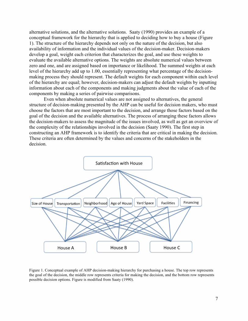
alternative solutions, and the alternative solutions. Saaty (1990) provides an example of a conceptual framework for the hierarchy that is applied to deciding how to buy a house (Figure 1). The structure of the hierarchy depends not only on the nature of the decision, but also availability of information and the individual values of the decision-maker. Decision-makers develop a goal, weight each criterion that characterizes the goal, and use these weights to evaluate the available alternative options. The weights are absolute numerical values between zero and one, and are assigned based on importance or likelihood. The summed weights at each level of the hierarchy add up to 1.00, essentially representing what percentage of the decision-making process they should represent. The default weights for each component within each level of the hierarchy are equal; however, decision-makers can adjust the default weights by inputting information about each of the components and making judgments about the value of each of the components by making a series of pairwise comparisons. Even when absolute numerical values are not assigned to alternatives, the general structure of decision-making presented by the AHP can be useful for decision makers, who must choose the factors that are most important to the decision, and arrange those factors based on the goal of the decision and the available alternatives. The process of arranging these factors allows the decision-makers to assess the magnitude of the issues involved, as well as get an overview of the complexity of the relationships involved in the decision (Saaty 1990). The first step in constructing an AHP framework is to identify the criteria that are critical in making the decision. These criteria are often determined by the values and concerns of the stakeholders in the decision.
Figure 1. Conceptual example of AHP decision-making hierarchy for purchasing a house. The top row represents the goal of the decision, the middle row represents criteria for making the decision, and the bottom row represents possible decision options. Figure is modified from Saaty (1990).
8
Factors in Dam Management Decision-Making A balanced decision to remove a dam requires the analysis of many different interacting
factors. Much of the current literature on dam removal only studies singular effects, such as impacts on a particular ecosystem function or group of species (Bednarek 2001, Whitelaw and Macmullan 2002), cost-benefit analysis to assess tradeoffs, or contingent valuation to estimate willingness to pay (Loomis 1996, Heinz Center 2001). Few studies, have conducted comprehensive analyses that allow for comparison among multiple effects of dam removal. Because no prior studies have applied the AHP to dam management, it is necessary to identify the criteria that should be evaluated in relation to goals and options for management.
Several studies have identified important factors to consider when deciding whether to remove a dam. Baish et al. (2002) and American Rivers (2002) suggested several possible reasons for dam removal, including water supply, irrigation, flood control, hydroelectric power, navigation, recreation, and waste disposal. Both studies also identified stakeholders and their concerns, which included safety, environmental impact, legality and liability, historical and cultural value, and economic costs. Doyle and Stanley (2003) suggested that the impact on endangered species and the chemical composition of reservoir sediment should be of particular concern to decision-makers. After assessing biophysical impacts and community values, policy makers can decide whether removing or retaining a dam will best balance safety, economic costs, ecological functioning, and public support and concerns (American Rivers 2002, Baish et al. 2002).
Much of the current literature on dam removal deals with singular effects. Fewer studies, however, have conducted comprehensive analyses that allow for comparison among multiple effects of dam removal. Wyrick et al. (2009) completed a pre-removal assessment that integrated both the social and hydrological impacts of removing a small dam by using community surveys and hydraulic modeling. Although the model indicated that dam removal would have limited effects on the hydrological and biological characteristics of the stream, a questionnaire used to evaluate community perceptions of dam removal showed that there were strong sentiments both for and against dam removal. Corsair et al. (2009) used a multicriteria decision analysis (MCDA) to assess dam removal, which involves two main steps: a) systematic description of tradeoffs among incommensurate criteria (ecological, social, economic), and b) quantitative elicitation of value judgments from users (e.g., managers, stakeholders, members of the public). They recommend MCDA as a way of making more informed decisions and effective negotiations among stakeholders. Zheng and Hobbs (2012) used a similar technique, called multiobjective portfolio analysis (MPA), which employs formal decision analysis methods to consider a range of dam removal objectives: habitat recovery, fish population, cost, and risk. They developed a model for dam removal assessment that combines optimization, ecological models, removal costs, a survey of dam safety officials, and data on dam age, condition, and nearby populations to analyze the benefits and costs of removing dams on tributaries to downstream lake ecosystems. These techniques, however, have not been widely utilized and there is a need for more interdisciplinary research on the myriad effects of dam removal.
We address this gap by applying the AHP decision-making framework to managing small aging dams by drawing on the goals and criteria identified by American Rivers (2002), Baish et al. (2002), and Doyle and Stanley (2003). In order to define hypotheses on how dam removal and dam retention would affect stakeholders and ecosystems, we explored literature on the impacts of dams their removal on various criteria. We first analyze how American perceptions and values of
9
dam have changed in the last two centuries, and then draw on case studies and theoretical models for how dams change river geomorphology and watershed ecosystems. American History and Culture of Dams History of Dam Construction Community perceptions of a dam are critical in the decision-making process (Baish et al. 2002). The relationships that communities have with dams are rooted in the rise of dam construction in the United States (Graf 2003). The prime dam-building era in the United States began during the industrial revolution and continued into the mid-1960s. By improving irrigation and providing hydroelectric power, the construction of dams has promoted economic development in the U.S. (Graf 2003). Since dam construction was initially stimulated by the desire for economic development, dam construction is also associated with the commodification of water resources (Crane 2011). The cultural commodification of water began during the industrial revolution when it became common belief that Americans should control, and dominate water in the name of progress (Billington et al. 2005). Most Americans believed that in order to achieve economic and social advancement, humans needed to tame nature and use it to their advantage (Postel and Richter 2003). Not only were people seeking to control natural processes for the benefit of human welfare, the general public begun to assume that the value of rivers intrinsically increased under human development. Many believed that the channel of a river could oftentimes be much improved from the one it has carved for itself (Billington et. al. 2005). Such attitudes encouraged the public to believe that manipulating the natural flow of river actually improved ecological functioning (Billington et al. 2005). Given that American culture seemed to derive satisfaction from building these structures in the face of adversity, local communities often supported dam construction. This trend in cultural perceptions of dam construction is evident in early 1900s legislation (Billington et al. 2005). Roosevelt’s inaugural address in 1901 strongly supported dam construction, as did the National Reclamation Act of 1902, which established irrigation projects for twenty states. These events began the century of transformation of the earth’s rivers (Postel and Richter 2003). Shifts in Perceptions of Dams In the last forty years, public perception has shifted from viewing dams strictly as commodities to structures that affect the functioning of ecosystems (Graf 2003). This has led to increased recognition that the value of rivers exceeds their economic utility (Lowry 2003). This shift in perception of rivers first manifested itself during the 1923 debate over damming the Hetch Hetchy River in Yosemite National Park (Babbitt 2001). The proposition to dam Hetch Hetchy in order to provide water to the city of San Francisco sparked the first nation-wide land-use debate in American history. The strong opposition to this damming project highlighted society’s changing cultural values (Righter 2005). Instead of valuing development over all else, the opposition argued on the grounds of the river’s spiritual and aesthetic value (Righter 2005, Nash 2014). The damming of Glen Canyon on the Colorado River caused a strikingly similar debate in the 1950s (Babbitt 2001). Americans mourned the loss of a beautiful river, and viewed the Glen Canyon dam as the antithesis of the environmental movement (Farmer 1999). Conservationists claimed passionately that the dam was evil, and went so far as to compare the damming process to the equivalent of hell on earth (Farmer 1999). Whereas many Americans
10
considered the economic and cultural aspects of these historical landmarks, naturalist John Muir spoke to their ecological value. He brought attention to the importance of rivers as undisrupted natural ecosystems, whose processes would be upset by the domination of humans over nature (Righter 2005). These debates exemplify the Americans’ value of non-economic benefits of rivers. Although contemporary ecologists seem to agree that removing dam improves ecosystem functioning, the impact of removing dams on human stakeholders is less clear. Dam and River Aesthetics
The aesthetic value of rivers is another factor that influences community perceptions, and thus decisions, regarding dam management. Junker and Burchecker (2008) demonstrated that the perceived “naturalness” of a river ecosystem is strongly linked with its aesthetic appeal. This indicated a gap between public perceptions of “naturalness” versus the scientific definition of a “natural” ecosystem. This divide is exemplified when semi-managed river ecosystems are found to be more aesthetically pleasing than “natural” ecosystems (Gregory and Davis 1993). A study of the effects of increased sedimentation in rivers concluded that high levels of suspended sediment in streams, which can occur after dam removal, might lower the river’s aesthetic value (Ryan 1991). The concept of “naturalness,” clearly affects a community’s valuation of a river, despite the difference in the meaning of “naturalness” between community members and ecologists. Physical and Ecological Effects of Dams and Their Removal Changes in River Morphology and Their Effects on Species Habitat and Composition
The modification of flow during the installation and removal of a dam alters the structure and function of any river ecosystem (Bunn et al. 2002, Hart et al. 2002, Nilsson et al. 2000, Strayer et al. 2010). Because there will often be a loss of certain species and an increase in others when such a large morphological change is inflicted on an ecosystem (Dudgeon 2000, Thomson et al. 2005, Catalano et al. 2007), any evaluation of the effects of dam removal on living organisms depends largely on the goals of the specific project. Some studies cite dam removal as an opportunity for river restoration (Schmidt et al. 1998, Hart et. al 2002). Although dam removal can enhance particular river ecosystem functions, a complete return to pre-dam conditions is not realistic. In order to understand the changes that take place when a dam is removed, we have to also consider the impact of dam construction. Although there are many hydrological and geomorphological changes that occur when dams are removed, we chose to focus on sediment release from the reservoir behind the Ames Mill Dam. Even for small dam removals, the management of reservoir sediment is of critical concern (Graber et al. 2001). Release of sediment stored in a reservoir behind a dam can reduce water quality, bury ecologically sensitive habitats, impact fish and mussel spawning, increase flooding risks, and release nutrients and contaminants (Downs et al. 2009). Thus, in this section, we review some of the morphological and ecological changes that occur due sediment transport when dams are installed and removed.
Channel Evolution After Dam Removal
Dams alter river flow by blocking the river, storing excess runoff, and releasing water according to human needs (Graf 1999, Bednarek 2001, Richter et al. 2007). As a result of this process, a reservoir of slow-moving water upstream of the dam is often created. Dams alter sediment transport by creating a buildup of sediment behind the dam and an increasing water
11
surface level (Guillen et al. 1992, Palmieri et al. 2001, Doyle et al. 2003b). Fine sediment particles, such as sand and silt, typically settle close to the dam, while larger particles, such as gravel, settle farther upstream of the dam (Pizzuto 2002).
The removal of dams can restore sediment transport and river flow (Stanford 1996). In the initial stages after dam removal, the upstream channel is incised by higher flow velocities and erodes sediment, while sediment is deposited downstream (Bednarek 2001, Doyle et al. 2002, Poff et al. 2002, Stanley et al. 2002) (See Appendix B for glossary). Over time, channel incision follows an established pattern of adjustments, where the channel initially narrows before it expands in width over time—this process is termed “channel evolution” (Chang 2008). Conceptual models of channel evolution following dam removal have shown that water surface levels lower immediately after dam removal. Variations in distance and rate of sediment transport depend on stream geometries, flow rates, and sediment particle sizes (Doyle et al. 2002, Doyle et al. 2003b). Because some of the major factors regulating sediment transport are discharge rate and sediment size, there is high temporal and spatial variation in sediment transport after dam removal (Cheng and Granata 2007).
Using flow rates and sediment cores analyzed for particle size and nutrient content, Ahearn and Dahlgren (2005) determined that sediment and nutrient export was an order of magnitude greater than the previous two year mean after the removal of a three meter dam. However, the deposition of sediments decreased as downstream distance from the dam increased (Kibler et al. 2011). Many of these small dams (>5 m) do not have much sediment filled in the reservoir, so their removal causes only small amounts of sediment to be transported downstream (Cheng and Granata 2007). For example, the removal of a 2.2 m dam in Sandusky, Ohio did not cause significant changes in sediment discharge, suspended sediment levels, or turbidity as compared with pre-removal levels (Granata et al. 2008). Although sediment was eroded upstream and deposited downstream, less than 1% of the in sediment stored in reservoir was transported downstream. Effects of Sediment Release on Water Quality
The sediment stored behind dams often contains phosphorus and toxic materials that can be detrimental to ecosystems when released. Agriculture activities, such as fertilizer application, increased upland erosion, tile draining, and straightening of channel ways, have increased nutrient levels in surrounding bodies of water (Castillo et al. 2000, Randall and Mulla 2001, Dinnes et al. 2002). Because dams in these areas have been trapping sediment in their reservoirs for years, sediment deposited in dam reservoirs often contains phosphorus (P) from agricultural runoff (Stanley and Doyle 2002, Fonseca et al. 2003). Phosphorus cycling is often examined in dam removal studies, as sediment storage and movement typically govern P dynamics (Stanley and Doyle 2002). Sediment stored behind the dam may benefit river ecosystems through nutrient storage (Teodoru and Wehrli 2005, Harrison et al. 2009). If a dam is removed and sediment is released, P can increase stream net primary productivity (NPP) through nutrient loading (Stanley and Doyle 2002).
Because sediments may be contaminated with toxins released upstream, dam removal could result in the suspension and transport of toxic sediments, such as heavy metals, polychlorinated biphenyls (PCB), and polycyclic aromatic hydrocarbons (PAH) (Bednarek 2001, Ahearn and Dahlgren 2005). Because contaminants bound to sediments may be transported following dam removal, dam reservoirs can shift from acting as a sink for contaminants to a source. Ashley et al. (2006) analyzed pre and post-dam removal concentrations of sedimentary
12
metals, PCBs, and PAHs by taking sediment cores and testing particle size, organic carbon, and sedimentary contaminants. Although concentrations of PCBs were lower in the reservoir and higher downstream following dam removal, overall the distribution of contaminants was not statistically significantly different. Since few studies have addressed the effects of small dam removal on contaminant distribution, dam removal should be analyzed on a case-by-case basis (Ashley et al. 2006). Impacts of Sediment Deposition on Freshwater Mussels
Whether deposited or suspended, increased levels of sediment in riverine ecosystems can affect mussels in several ways. Excess silt and clay particles can clog gill filaments and interfere with filter feeding. Sediment deposition can increase mortality among certain mussel species, including Fusconaia flava and Margaritifera falcata, although not all species are equally vulnerable to the effects of increased sedimentation (Ellis 1936, Marking and Bills 1980, Vannote and Minshall 1982). Since most studies have focused on mortality after exposure to sediment rather than the cause of mortality, it is not clear why some species respond differently to sediment than others (Henley et al. 2000). However, species that are able to move vertically through deposited silt tend to experience lower mortality than more sedentary species (Box and Mossa 1998). Overall, the detrimental effects of excessive sedimentation are not always immediately apparent, and changes in unionid fauna can take years to become obvious (Houp 1993).
Sethi et al. (2004) studied the effect of small dam removal on unionid mussels in Koshkonong Creek, Wisconsin, finding that upstream of the dam, 95% of mussels in the former reservoir died as a result of desiccation and exposure. Downstream, there was a significant difference in mussel density just after removal and three years later, and one rare unionid species disappeared altogether. The decline in downstream populations was likely due to habitat loss and prolonged stress on the mussel community as a result of significantly higher levels of suspended sediment and sediment deposition in the three years following the dam removal. Impacts of Dam Removal on Aquatic Species
Changes in river morphology affect the habitat suitability for aquatic species, with different ramifications for individual organisms, populations, and communities. Similar morphological changes can affect different systems in completely different ways. The damming of Waitaki River in New Zealand, for example, created a more stable main channel by reducing peak floods, thus providing more fish habitat during vulnerable life stages (Young et al. 2004).
Changes in habitat suitability due to drastic morphological alterations caused by installing or removing a dam, affect species composition, richness, and abundance (Hart et al. 2002). Not only can inundation from dam building cause mass reductions in species’ abundance, it can cause some species to disappear completely (Bednarak 2001). Immediately after construction, dam reservoirs typically experience low species richness. This is followed by a "recovery phase" during which richness increases, but never achieves the pre-dam species composition. This increase is followed by yet another decline in reservoir species richness over time. This cycle takes place over the course of 100 years following dam construction (Nilsson and Berggren 2000). A study in Denmark saw dramatic loss in species richness on the Arna River after dam establishment, in which 24 invertebrate species disappeared and many decreased in abundance. Only seven invertebrate species in this ecosystem remained at pre-dam levels (Iversen et al. 1993).
13
Although habitat changes affect entire aquatic communities, dam removal studies usually focus on a few particular species, most commonly fish. At the Tallapoosa River in Alabama, only eight fish species were found in the area before a structural change to the dam that introduced a flow regime to mimic a more "natural" riverine flow. After this change to the dam, species richness 3 km below the dam more than doubled, and the abundance of fluvial specialist increased by 40% (Travnichek et al. 1995). While not a complete removal of the dam, this demonstrates that physical changes to the river alter habitat in ways that will change the composition of species able to live there. Before the removal of the Woolen Mills Dam in Wisconsin, dam removal stations had “fair” habitat quality, yet after the removal, stations showed “good to excellent” habitat quality for two particular species of fish. Overall, the removal of this particular dam was shown to benefit fish habitat and fisheries through an increase in suitable habitat for the two species examined, but the study did not include any other riverine or riparian species (Kanehl et al. 1997). The Pangue and Ralco dams in the Biobío river watershed of Chile have been found cause critical flow events that disturb feeding patterns and fish habitat availability during particular life cycle stages. While a study of this watershed did not find a difference between average monthly flows in pre and post dam eras, it cautions that drastic hourly changes in flow still occur, and can create strong disturbances for these species (Garcia 2011). The study emphasized the importance of the detrimental short and long-term effects of dams on river populations.
Although most studies have focused on the effect of dam removal on aquatic species, a review of 21 dams across the United States found that many riparian species are affected as well. Dams also decrease species richness by decreasing the frequency and severity of flooding (Bednarak 2001). Magilligan (2005) found that after dam removal, there was erosion of sand and gravel bars, riparian habitat loss, loss of tree saplings, and enhanced opportunity for predation. These types of changes obviously reduce abundance of riparian vegetation, which in turn can lead to reduced habitat availability for bird species. The dams also changed the flood regime, which could lead to either a reduction or an increase in the number and intensity of flood events. Such flood events still occurred under “normal functioning” of the rivers after dam removal, but they were much more normalized (Magilligan 2005). Ligon et al. (1995) suggested that instead of evaluating dam removal based on the habitat requirements of individual species, researchers should focus on geomorphologic changes caused by dams and their removal.
14
AMES MILL DAM: A CASE STUDY Case Selection
This study examines the Ames Mill Dam and the surrounding community of Northfield, MN. Northfield is located on the Cannon River in Rice County, about 40 miles south of Minneapolis-St. Paul area. Its population was 20,007 at the 2010 census. The Ames Mill Dam was built in 1855, two years before the founding of Northfield, and was originally a wooden structure (Vang 2011). In 1919, the original dam was replaced with a more permanent concrete structure, which remains in place today. The historical use of the dam was to generate hydroelectric power for the Ames Flour Mill, but it currently does not serve a functional purpose. It is owned by MoM Brands.
The Ames Mill Dam and surrounding community of Northfield, MN provided an important case for studying small dam removal for several reasons. Although previous research has assessed the potential removal of the Ames Mill Dam in terms of dam safety, fish and mussel response, and downstream sediment removal (Vang 2011, Doucett et al. 2012), no attempt had yet been made to examine the social and historical elements of the dam. The hydrological changes that result from dam removal, such as changes in water level upstream of the dam, could have drastic aesthetic implications for downtown Northfield. Second, the removal of the Ames Mill Dam, which is nearing the end of its functional lifespan, has been a subject of debate in the Northfield community for several years. This study provided information for decision-makers in Northfield and will contribute to the overall community discussion. The Ames Mill Dam is also a typical example of an aging small dam located at the epicenter of a community, so the findings of this study could be applicable to other small towns in the United States that are contemplating the removal of a dam. The Ames Mill Dam and Cannon River hold significance for many groups in Northfield, MN. Canoeists and kayakers value the river for the recreational opportunities that it affords. For these groups, the dam is actually interferes with how they use the river (canoeists and kayakers must portage around the town to avoid the dam). The area downstream of the dam has been described as a great fishing spot, and while many people fish recreationally, Hmong community members in particular drive from the Minneapolis/St. Paul area to fish for food. Other stakeholders who interact with the river and dam less directly include business owners along the riverfront and people in town who frequent these businesses. There are ecological concerns specific to the Cannon River that are related to the dam, such as reduced connectivity of upstream and downstream areas, and there are also more general ecological concerns, such as pollution. Some of these concerns and stakeholders have been addressed in previous research on the dam, but never in a cohesive study. Previous Research on the Ames Mill Dam Barr Engineering Report 2007
In 2007, MoM Brands commissioned Barr Engineering to produce a report on modification options for the Ames Mill Dam. It estimated costs of dam modification under four scenarios: repair of the dam, the retaining wall, and bypass (est. cost: $1,167,300); installation of short rock rapids which eliminate the submerged hydraulic jump but do not allow for fish passage (est. cost: $1,120,438); installation of long rock rapids which eliminate the submerged hydraulic jump and allow for some fish passage (est. cost: $1,331,693); and installation of long
15
traversing rock rapids which eliminate the submerged hydraulic jump and allow for fish passage (est. cost: $1,384,593). The report gave three recommendations depending on the direction MoM wanted to follow. To address just safety issues, it could simply repair the structure. To address safety and eliminate the submerged hydraulic jump in the dam, it could install rock rapids at a 20% slope. To address both of these issues and allow for fish passage, it could install rock rapids at 8.4% slope or install traversing rock rapids. The report also noted that a separate cultural resource study would be necessary because the Ames Mill Dam is located in Northfield’s downtown “historical district.” Vang 2011
In 2011, a pre-removal assessment of the Ames Mill Dam in Northfield, MN analyzed three management options for the Ames Mill Dam: continued maintenance, full dam removal, and removal with grading. Vang concluded that full removal with grading would be the best option, based on the criteria of safety, fish and mussel populations, and downstream sedimentation effects. Preemptive removal of the dam would change the water temperature up- and downstream of the dam, and increase the speed of the water upstream. This usually increases the distribution and migration of fish populations, depending on the species present. However, other effects of the dam removal, such as sedimentation, could release toxic chemicals and a large sink of nutrients from the sediment currently impounded. Mussel habitat could be damaged if sedimentation is not managed, as Vang estimated that the reservoir behind the dam currently holds 4.59 million cubic feet of sediment. Dam removal with grading would help reduce these effects. Doucett et al. 2012
In 2012, a St. Olaf Mathematics Practicum used HEC-RAS software to model the hydraulics of Cannon River in Northfield, MN (Doucett et al. 2012). They determined that HEC-RAS was a suitable program because the Cannon River met the model’s assumptions and because it is capable of predicting several sediment transport scenarios. By using cross-sections of the Cannon River from Barr Engineering and the Minnesota DNR, the St. Olaf group first modeled the present conditions of the Cannon River and mapped the 10, 100, and 500-year floodplains in the Northfield area. The 10-year floodplain extends both north and south of Northfield’s downtown area, however, the steep banks within the downtown area contain the flooding. While the 100- year floodplain model predicts a 52% percent increase in discharge as compared with the 10-year model, the extent of the flooding did not increase dramatically. The St. Olaf group also modeled sediment transport scenarios if the Ames Mill Dam was removed. The model showed that flooding would occur in the Carleton Arboretum if the dam was removed, but within a month the water retreated to pre-removal conditions. They also found that the HEC-RAS model predicted that the majority of sediment transport occurred within the first five years after removal and that the amount of sediment deposited downstream decreases as distance from the dam increases. More importantly, there is never a significant build-up of sediment directly downstream from the location of the dam. In a scenario where sediment was dredged immediately prior to dam removal, the model showed that the water levels decreased upstream and remained constant downstream. In a long-term dam removal model, surface water elevation is predicted to decrease by three meters during low flow and by 1.5 meters during high flow.
16
Gruber et al. 2013
As a continuation of the St. Olaf Mathematics Practicum, a Carleton College Mathematics Comprehensive Exercise group modeled the hydraulics of the Cannon River with and without the Ames Mill Dam using HEC-RAS. They re-ran the St. Olaf models and studied the mathematics behind the theory of river modeling software. In order to determine which data inputs were necessary for the HEC-RAS model, Gruber et al. (2013) first conducted a sensitivity analysis that evaluated how water elevation, velocity of flow, discharge rate, and shear stress responded to changes in inputs at ten equally spaced cross-sections along the Cannon River. They found that the model is sensitive to Manning’s n value, but not sensitive to changes in flow data input. Also, the model is sensitive to changes in sediment size. Because the data used was obtained from an average of only two sediment cores taken by St. Olaf, they recommend that more cores should be taken to get a more accurate profile. Lastly, the sensitivity analysis showed that the model outputs are highly sensitive to the time scale at which the model is run. Although the Carleton group was supposedly building off of the findings of the St. Olaf team, their findings are more vague and less conclusive (as evidenced by the lack of Discussion or Conclusion section in the paper) in terms of the impacts of removing the Ames Mill Dam. This is likely due to the group’s inability to use ArcGIS for their analyses. Aguilar et al. 2012
In 2012, a group of Carleton students in Professor Kim Smith’s Environmental Law and Policy class analyzed four management options for the Ames Mill Dam: complete removal, no removal, removal with grading, and replacing the dam with a kayak park. Based on interviews stakeholders, they recommended installing a kayak park. This option would maintain water levels at roughly their current state, resulting in minimal impacts on surrounding buildings and the Cannon’s downstream appearance. It would also preserve some of the aesthetic qualities that Northfield residents value in the dam and provide more opportunities for recreation. The students cautioned, however, that their results were not representative of the broader Northfield population, but rather of selected citizens with a prior interest in the issue. They emphasized that their conclusion was preliminary and recommended that further research incorporate a systematic survey of Northfield residents and more rigorous engineering and economic analyses.
17
METHODOLOGY Decision-Making Framework Theoretical Framework
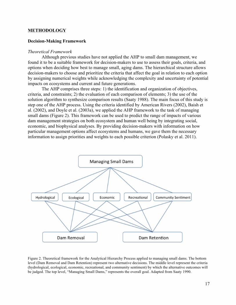
Although previous studies have not applied the AHP to small dam management, we found it to be a suitable framework for decision-makers to use to assess their goals, criteria, and options when deciding how best to manage small, aging dams. The hierarchical structure allows decision-makers to choose and prioritize the criteria that affect the goal in relation to each option by assigning numerical weights while acknowledging the complexity and uncertainty of potential impacts on ecosystems and current and future generations.
The AHP comprises three steps: 1) the identification and organization of objectives, criteria, and constraints; 2) the evaluation of each comparison of elements; 3) the use of the solution algorithm to synthesize comparison results (Saaty 1988). The main focus of this study is step one of the AHP process. Using the criteria identified by American Rivers (2002), Baish et al. (2002), and Doyle et al. (2003a), we applied the AHP framework to the task of managing small dams (Figure 2). This framework can be used to predict the range of impacts of various dam management strategies on both ecosystem and human well being by integrating social, economic, and biophysical analyses. By providing decision-makers with information on how particular management options affect ecosystems and humans, we gave them the necessary information to assign priorities and weights to each possible criterion (Polasky et al. 2011).
Figure 2. Theoretical framework for the Analytical Hierarchy Process applied to managing small dams. The bottom level (Dam Removal and Dam Retention) represent two alternative decisions. The middle level represent the criteria (hydrological, ecological, economic, recreational, and community sentiment) by which the alternative outcomes will be judged. The top level, “Managing Small Dams,” represents the overall goal. Adapted from Saaty 1990.
18
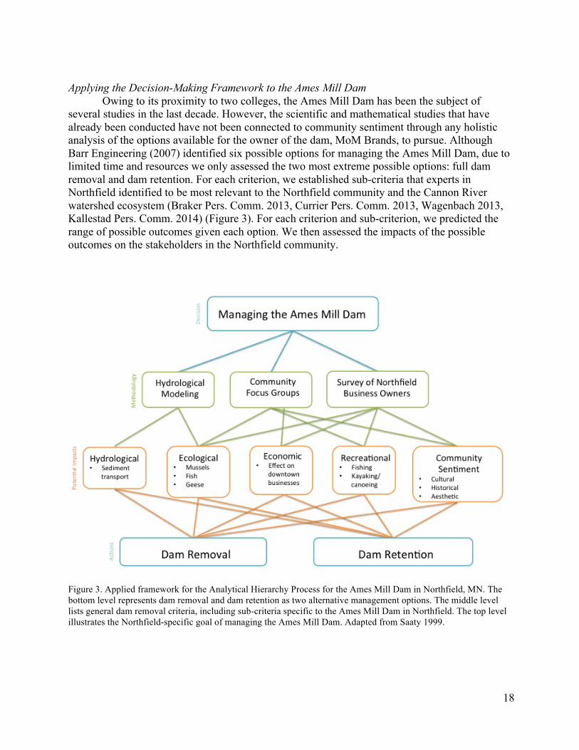
Applying the Decision-Making Framework to the Ames Mill Dam Owing to its proximity to two colleges, the Ames Mill Dam has been the subject of several studies in the last decade. However, the scientific and mathematical studies that have already been conducted have not been connected to community sentiment through any holistic analysis of the options available for the owner of the dam, MoM Brands, to pursue. Although Barr Engineering (2007) identified six possible options for managing the Ames Mill Dam, due to limited time and resources we only assessed the two most extreme possible options: full dam removal and dam retention. For each criterion, we established sub-criteria that experts in Northfield identified to be most relevant to the Northfield community and the Cannon River watershed ecosystem (Braker Pers. Comm. 2013, Currier Pers. Comm. 2013, Wagenbach 2013, Kallestad Pers. Comm. 2014) (Figure 3). For each criterion and sub-criterion, we predicted the range of possible outcomes given each option. We then assessed the impacts of the possible outcomes on the stakeholders in the Northfield community.
Figure 3. Applied framework for the Analytical Hierarchy Process for the Ames Mill Dam in Northfield, MN. The bottom level represents dam removal and dam retention as two alternative management options. The middle level lists general dam removal criteria, including sub-criteria specific to the Ames Mill Dam in Northfield. The top level illustrates the Northfield-specific goal of managing the Ames Mill Dam. Adapted from Saaty 1999.
19
Downtown Northfield Business Survey
While the Ames Mill Dam clearly has costs associated with it in terms of the price of maintenance versus removal, it is difficult to quantify less tangible costs and benefits to the community (Knetsch and Sinden 1984). In order to assess the economic value of ambiguous attributes of the dam, such as aesthetic value to the community, we decided to survey the owners of businesses in the immediate vicinity of the dam, Downtown Northfield. Creating and Distributing the Survey The objective of the Northfield business survey was to determine how business owners along the Cannon River value the current state of the river and the Ames Mill Dam. We were interested to see if business owners believe that the presence or absence of the Ames Mill Dam would affect their profits and to what extent. We used the business owners’ opinions as a proxy to assess the economic value of the dam without using a direct cost-benefit analysis, assuming that business owners know how different management options would affect their customers and business. Prior to the survey, we conducted interviews with Northfield leaders with some knowledge on the topic. These interviews indicated that business owners would be concerned with changes in the river resulting in threats to the structural integrity of downtown Northfield buildings (Currier Pers. Comm. 2013). It is important to note that survey respondents were primed to voice any and all concerns they had about negative consequences of potential dam removal.
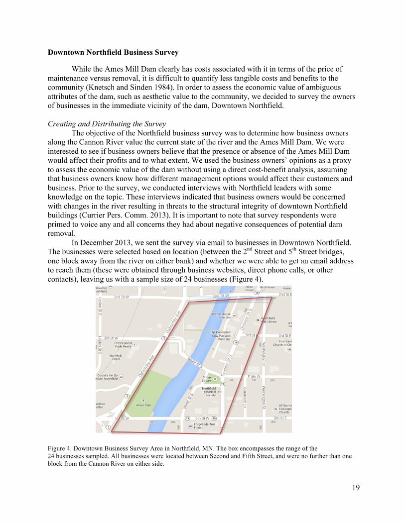
In December 2013, we sent the survey via email to businesses in Downtown Northfield. The businesses were selected based on location (between the 2nd Street and 5th Street bridges, one block away from the river on either bank) and whether we were able to get an email address to reach them (these were obtained through business websites, direct phone calls, or other contacts), leaving us with a sample size of 24 businesses (Figure 4).
Figure 4. Downtown Business Survey Area in Northfield, MN. The box encompasses the range of the 24 businesses sampled. All businesses were located between Second and Fifth Street, and were no further than one block from the Cannon River on either side.
20
After sending the initial email at the end of December, we left the survey open for
approximately one month. We sent follow-up emails to the businesses that had not yet responded during the 2nd and 4th weeks that the survey was open. Analysis of Survey
Two people analyzed the survey results to ensure intercoder reliability, proving that different researchers would interpret the data the same way. This method required multiple investigators to read the data and code for common themes, and then compare analyses. This improved the strength of our individual observations and the reliability of our final interpretation. Although we are unable to draw statistical conclusions from such a small sample size, we were able to gain a general sense community opinion through inference. Community Focus Groups Organization and Implementation
We selected focus group participants by first identifying community members with some knowledge of the issue, and asking for the names of other community members who might have an interest in the Ames Mill Dam. Our sample is random, and thus does not represent the entire Northfield community. Nonetheless, our sampling method accomplishes our objective of obtaining a diverse collection of opinions (Smith 2013). To ensure a cross-section of interests, we recruited focus group participants at various public places of gathering throughout Northfield, including Carleton and St. Olaf Colleges, numerous coffee shops downtown, churches, and the Northfield Senior Center. We limited our sample participants to those who had expressed an interest in the Ames Mill Dam. Although this sampling technique does have limitations, our effort to target a particular subset of the population was necessary given the inductive nature of our research. We held two focus group discussions on the campus of Carleton College. The objective of these focus groups was threefold:
1) To determine the extent of active citizens’ knowledge of the Cannon River and the Ames Mill Dam
2) To identify their range of concerns about the potential removal of the dam 3) To gain an understanding of how (and in what ways) the Northfield community values
the Ames Mill Dam and the Cannon River Because we chose to hold focus groups specifically to foster discussion among
community members, we intervened in the discussion as little as possible. We posed three discussion topics to each group:
1) Are you satisfied with the current state of the Cannon River, with the Ames Mill Dam in
place? 2) Do you make use of the Cannon River recreationally, or any other way? Does it hold
aesthetic value for you? Does it hold historical value for you? 3) If you are not satisfied with the way the Ames Mill Dam affects the Cannon River, what
would you change? What is your ideal vision for the river? What would it look like?
21
In addition to these questions, we showed the participants images of potential dam
removal strategies for the Ames Mill Dam (Appendix C). Participants were asked to describe their reactions to each picture, and to explain why or why not certain images appealed to them. Data analysis Our unit of analysis was the group discussion as a whole, which “reflects the social and cultural processes through which meaning, opinions, and attitudes are shaped” (Tonkiss 2012). The inductive nature of our data collection required the use of the Thematic Content Analysis, known as the Pragmatic Method of Analysis (Burnard et al. 2008). There are three components to this data analysis process. First, each focus group discussion was recorded both on film and on paper. The second stage is called “Open Coding.” After we thoroughly reviewed the transcripts, we recorded key words/phrases of everything that had been said, with the small exception of extremely irrelevant deviations from the topic. During the third stage, we re-examined the initial list of topics, and compiled a shorter, more succinct list of discussion categories. To address the issue of data verification, two individuals completed the thematic content analysis separately, before comparing outputs to obtain final results. Hydraulic Modeling Selecting HEC-RAS: Features, Assumptions, and Limitations
Numerical models are increasingly being used as tools for simulating and predicting hydraulic processes given various river management practices. There are several hydraulic modeling software packages, such as HEC-6, DREAM, FLUVIAL-12, Mike-11, and SWAT. This study used the Hydrologic Engineering Centers River Analysis System (HEC-RAS), an Army Corps of Engineers numerical hydraulic model. HEC-RAS is capable of performing one-dimensional (1D) steady flow, unsteady flow, sediment transport, and water quality calculations. We used HEC-RAS to simulate pre and post dam removal sediment transport scenarios.
The HEC-RAS model was primarily selected because it is capable of computing dam removal sediment transport scenarios (Tullos et al. 2010), and both Doucett et al. (2012) and Gruber et al. (2013) have determined that it is suitable to apply to the Cannon River in Northfield, MN. While there are many programs capable of 2D calculations, we determined that because the Cannon River has few side channels or braided flow sections, the 1D analysis capabilities of HEC-RAS were sufficient. ArcGIS can be used to extract geospatial data inputs necessary for HEC-RAS through HEC-GeoRAS, a GIS extension that provides a set of tools for preparing GIS data for import into HEC-RAS and generation of GIS data from HEC-RAS output. HEC-RAS was also chosen, in part, because it is a free software package that only requires the computing power of a standard desktop computer. With the accompaniment of four PDFs, the User’s Manual, Hydrological Reference Guide, Applications Guides, and HEC-GeoRAS User’s Manual, the HEC-RAS software can be self-taught and require no professional training.
HEC-RAS has two major limitations in regards to our study’s objectives. First, HEC-RAS is unable to analyze stream bank stability, a question that is likely to be of interest for many residents and business owners along the Cannon River. Second, in Barr Engineering’s “Dam Modification Options Study” (2007), several of the options suggest dam removal with varying
22
degrees of grading. Unfortunately, HEC-RAS is not capable of performing analyses under such scenarios. Because full removal is the most extreme option, and the only option that HEC-RAS is a capable of performing, our results yield the most extreme possible outcomes. Running Sediment Transport Scenarios
The Ames Mill Dam was represented as an inline structure on the Cannon River. Under quasi-unsteady state conditions, we modeled the removal of the dam by deleting the inline structure from the geometry file. While it is possible to simulate dam breach scenarios with HEC-RAS, these simulations are only suitable for unsteady flow analyses. Sediment transport analyses were run for a duration of 10 years with and without the dam present, with a computational increment of one week. Thus, changes in stream bathymetry can be detected at increments of one week, and flow depths and velocities are recalculated (Tullos et al. 2010). The model adjusts its analyses based on the new cross-sectional profiles, but it still uses the water surface elevation that was determined from the prior hydrodynamics. For more detail on HEC-RAS data inputs and parameters used, see Appendix A. Data Analysis
We compared scenarios for sediment transport with and without the dam by analyzing changes in 1D channel invert elevations from the most upstream cross-section to the most downstream cross-section over a 10-year period. For each cross-section, at a given time after dam removal, we subtracted the initial channel elevation from channel elevation at a given time. We used multiple linear regression analysis to model to detect if there is a difference between the “with dam” and “without dam” model” in the change of channel elevation at each cross-section over time using R Studio statistical software.
(ΔElevation | X) = β0 + β1(Time) + β2(XS) + β3(Dam) + β4(XS)(Dam) Time was used as a continuous explanatory variable, and cross-sections and the presence of the dam were factor variables. Although the “with dam” dummy variable was of primary interest, we included time and cross-sections variables in the model to account for their independent effects on change in channel elevation. We also assumed that the presence of the dam in the model and cross-section location had interactive effects. Potential Ecological Impacts Sediment Deposition on Mussel Populations Using the surface gradient of sediment transport, we intersected the coordinate locations of mussel species in the Cannon River. Mussel data were obtained from a 2007 survey conducted by Gary Wagenbach, an Emeritus Professor of Biology at Carleton College. We determined which species of mussels would likely be most affected by sediment deposition as a result of retaining or removing the Ames Mill Dam. Extrapolating from Prior Studies Although HEC-RAS is not capable of showing any ecological changes due to dam removal, several studies have created eco-hydraulic models by linking the outputs from the HEC-RAS model with habitat suitability indices and/or population dynamics models (Bockelmann et al. 2004, Cianfrani et al. 2004, Tomsic et al. 2007, Wu and Mao 2007, Jahnig et

23
al. 2012). Due to time limitations, this was beyond the scope of our study. Instead, we used dam removal case studies in similar ecosystems and communities as Northfield, MN to speculate how fish and mussel populations would be affected by the removal of the Ames Mill Dam given the predicted range of hydro-morphological changes (Bednarak 2001, Stanley and Doyle 2002, Stanley et al. 2002, Doyle et al. 2003a).
24
RESULTS Downtown Northfield Business Survey
We conducted this survey under the hypothesis that business owners would be opposed to
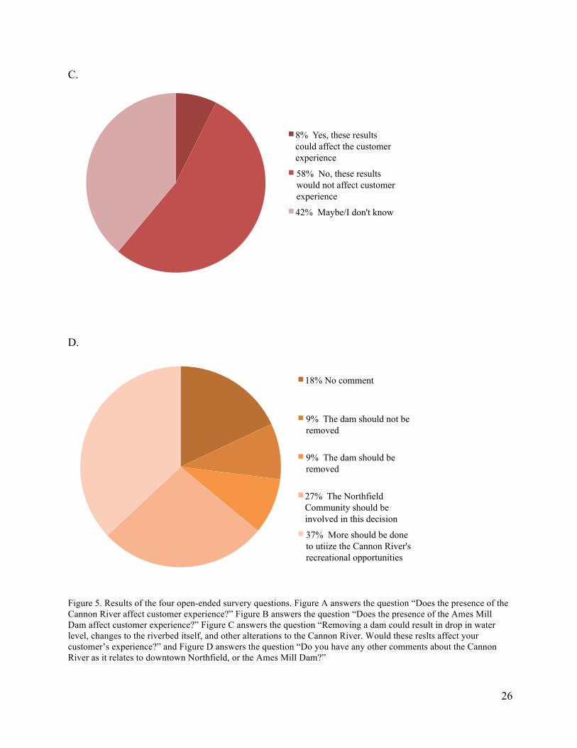
dam removal, mostly due to the concern previously expressed by riverfront property owners. In fact, at a Northfield town hall meeting to discuss the removal of the dam, these business owners were some of the most outspoken against dam removal (Currier Pers. Comm. 2013). However our results showed that few of our surveyed businesses express these concerns (Figure 5c). Almost all businesses were in favor of removing the dam, or were ambivalent to the decision, their main objective being how to make downtown more desirable to visitors.
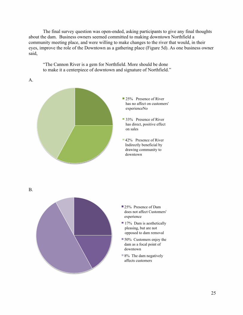
Half of the survey respondents’ businesses were located directly on the riverfront, and almost all reported that their customers could both hear and see the river. Seventy-five percent reported that the presence of the river was beneficial to the customer experience, whether it be a direct benefit for the business, or an indirect asset the downtown ambiance (Figure 5a). When asked whether or not having the Ames Mill Dam affected customer experience, 25% said the dam has no effect, one company was strongly in favor of removing the dam, and 50% said that the dam had a positive effect, as it is a focal point of the downtown (Figure 5b). All businesses but one were in favor of some mitigation/removal strategy, responding with comments such as:
“If done ‘right’ it will be a plus, not a negative, to the community.”
“It will allow for “a healthier river, more natural waterway, and safer environment.”
Fifty percent were in favor of only the kayak park option, while the other 50% supported either a kayak park or a graded option (see Appendix D). Only one business owner expressed that any possible changes to the river (specifically drop in water level, changes to the riverbed, and other alterations) would be detrimental to customer experience, saying,
“Water levels too low would be devastating.” This same business owner also reported that the current state of the dam is
“Not an asset to us or our clients.”
When asked for further comments, several respondents expressed the desire to utilize the Cannon River to its full recreational potential. Another common theme found in this free response answer was the role the Cannon River and the dam plays in the Northfield community’s culture. We received responses such as,
“I think it is more an issue of community experience and the aesthetic for the downtown.”
“[The dam] is a factor in our location being central to community activity, which benefits our business.”
25
The final survey question was open-ended, asking participants to give any final thoughts about the dam. Business owners seemed committed to making downtown Northfield a community meeting place, and were willing to make changes to the river that would, in their eyes, improve the role of the Downtown as a gathering place (Figure 5d). As one business owner said,
“The Cannon River is a gem for Northfield. More should be done to make it a centerpiece of downtown and signature of Northfield.”
A.
B.
25% Presence of River has no affect on customers' experienceNo
33% Presence of River has direct, positive effect on sales
42% Presence of River Indirectly beneficial by drawing community to downtown
25% Presence of Dam does not affect Customers' experience
17% Dam is aesthetically pleasing, but are not opposed to dam removal
50% Customers enjoy the dam as a focal point of downtown
8% The dam negatively affects customers
26
C.
D.
Figure 5. Results of the four open-ended survery questions. Figure A answers the question “Does the presence of the Cannon River affect customer experience?” Figure B answers the question “Does the presence of the Ames Mill Dam affect customer experience?” Figure C answers the question “Removing a dam could result in drop in water level, changes to the riverbed itself, and other alterations to the Cannon River. Would these reslts affect your customer’s experience?” and Figure D answers the question “Do you have any other comments about the Cannon River as it relates to downtown Northfield, or the Ames Mill Dam?”
8% Yes, these results could affect the customer experience
58% No, these results would not affect customer experience
42% Maybe/I don't know
18% No comment
9% The dam should not be removed
9% The dam should be removed
27% The Northfield Community should be involved in this decision
37% More should be done to utiize the Cannon River's recreational opportunities
27
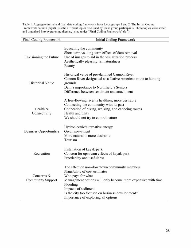
Community Focus Groups We facilitated two focus group sessions with members of the Northfield community, totaling eight people. Twenty-five percent of the participants were male, (75% were female) and 25% were under thirty years of age (75% of the participants being 30 or older). We combined the data from each, and coded the transcripts to identify six main points of discussion (Table 2). These topics include: How to go about envisioning the Cannon River without the dam, how the dam/river is valued historically, the notion of “connectivity,” possible business ventures, recreational benefits, and speculation of community concerns.
The focus group discussions were instrumental for understanding the community’s opinion on the Ames Mill Dam. Our application of a multi-step coding process highlighted the six factors that the community was most interested in, the first of these being the historical value of the dam. The most surprising aspect of this discussion was that participants did value the river historically, but not in the way we anticipated. Rather than expressing historical sentiment for the dam itself, participants expressed historical value for the pre-dammed Cannon River. The focus groups told stories about the Northfield stretch of the Cannon River being a route to Native American hunting grounds, and expressed interest in river usage before the dam was built. From this portion of the discussion, we observed that community members are starting to value “older” history over more “modern” history.
Although some aspects of the discussions revolved around ideological terms, there was also a great deal of practical discussion about recreational opportunities. Participants were very excited to discuss recreation on the Cannon River, and were especially keen on the idea of installing a kayaking course—or at the very least, being able to pass through the river where kayakers and canoeists currently cannot. The community expressed interest not only in recreational opportunities, but in business opportunities as well. participants also addressed the difficulty in envisioning the Cannon River without a dam present. They expressed that images were very helpful in the process of visualizing different management strategies. When presented with pictures of multiple dam management strategies from previous dam-management projects, participants could easily point out which was more “natural,” or “aesthetically pleasing” to them. Perhaps the most valuable insights we obtained fall under our category of Concerns and Community Support. One participant highlighted an interesting concern: that social tension exists between Northfield residents who live and/or work downtown, and those who reside in the more rural areas. The entire group considered this comment, and agreed upon the importance of considering who benefits from changes to the downtown area. This reminded us, as researchers, to be thinking about community dynamics, and the issue of unequally distributed benefits. Focus group discussions foster the exchange of ideas, and enable the opportunity for community members to share and respond to different ideas. The sharing of memories, asking and answering of questions, and the challenging of opinions were the mechanisms by which we gathered this data. Despite our limitations of low turnout rates and the possibility that certain demographic constituencies of Northfield were under-represented in the discussions, we obtained useful information, and a valuable base-line assessment of community opinion on the Cannon River.
28
Table 1. Aggregate initial and final data coding framework from focus groups 1 and 2. The Initial Coding Framework column (right) lists the different topics discussed by focus group participants. These topics were sorted and organized into overarching themes, listed under “Final Coding Framework” (left). Final Coding Framework Initial Coding Framework
Envisioning the Future
Educating the community Short-term vs. long-term effects of dam removal Use of images to aid in the visualization process Aesthetically pleasing vs. naturalness Beauty
Historical Value
Historical value of pre-dammed Cannon River Cannon River designated as a Native American route to hunting grounds Dam’s importance to Northfield’s Seniors Difference between sentiment and attachment
Health & Connectivity
A free-flowing river is healthier, more desirable Connecting the community with its past Connection of biking, walking, and canoeing routes Health and unity We should not try to control nature
Business Opportunities
Hydroelectric/alternative energy Green movement More natural is more desirable Tourism
Recreation
Installation of kayak park Concern for upstream effects of kayak park Practicality and usefulness
Concerns & Community Support
The effect on non-downtown community members Plausibility of cost estimates Who pays for what Management options will only become more expensive with time Flooding Impacts of sediment Is the city too focused on business development? Importance of exploring all options
29
Hydraulic Modeling Temporal and Spatial Variations in Sediment Transport The association between sediment transport and time since dam removal is best characterized as an inverse function, where change in invert channel elevation decreases over time. Most of the sediment erosion and deposition after the dam is removed occurs within one month after the time of removal (Figure 6). There are some changes in channel elevation between one month and five years after removal, but they are less than the changes that occur within the first month. There are almost no changes in channel elevation between five and ten years after dam removal.
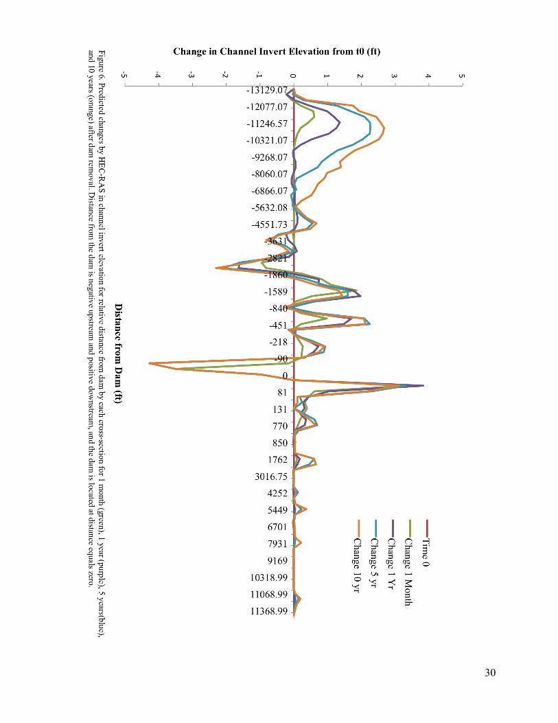
Most sediment erosion occurs within 100 ft upstream of the dam and most deposition occurs within 100 ft downstream of the dam (Figure 6). There are areas of both high sediment deposition and erosion, however, extending several miles upstream from the dam. There is some sediment deposition more than 100 ft. downstream from the dam, but it is less than the deposition that occurs within the first 100 ft of the dam. Comparing Dam Removal and Dam Retention Models The model that simulated dam removal was different than the model that simulated dam retention (t = -3.550, d.f. = 10732, p = 0.00039, Figure 7). The sediment erosion and deposition that occurred 100 feet upstream and downstream of the dam, respectively, were unique to the dam removal model. The smaller changes in sediment deposition downstream of the dam are also associated with only the dam removal model. In contrast, much of the variation in sediment transport that was further upstream of the dam occurred in the dam retention model, and is not solely associated with dam removal.
30

31
32
33
DISCUSSION Applying the Analytical Hierarchy Process to Dam Management
We implemented the AHP by determining the impacts of different dam management
options on stakeholders across several criteria. The AHP has not been used before to evaluate dam management decisions, since prior research has primarily focused singular effects of dam removal. By applying the AHP, we showed the advantages and limitations of this framework in making dam removal decisions. The AHP allows decision makers to get a more complete picture of the potential effects of alternative dam management scenarios, but it fails to account for the interactions and relatedness of separate criteria. The next step in the Analytical Hierarchy Process would be for decision-makers to use our findings to assign numerical values based on their priorities. Limitations and Future Research for Applying the Analytical Hierarchy Process to Dam Management Decisions Interactions Between Criteria
Most studies focus on singular effects of dam management options, and few analyze both socioeconomic impacts biophysical properties. Our study’s use of the AHP, however, allowed us to examine a range of criteria independently. In conducting our analysis though, we found that there are several interactions between separate criteria. In many dam removal scenarios, the ecological effects are relatively well-known (Bednarek 2001), however, there is uncertainty regarding whether these effects align with the community restoration goals. In particular, the impact of management options on fish assemblages is closely related with how the community values the Cannon River historically and aesthetically. Removing the Ames Mill Dam would likely increases gene flow between upstream and downstream fish populations. It is unclear how increasing genetic connectivity would relate to the communities desire for river connectivity or the restoration of river “naturalness.” While the AHP can assess both community sentiment and ecological impacts separately, for example, it does not allow for decision-makers to explicitly account for the interactions between multiple criteria. Weighting Criteria
By determining the probability of outcomes or the priorities, decision-makers can weight criteria in the AHP framework. In the case of dam management decisions, it is difficult for decision-makers to assign weights based on probabilities of outcomes due to the uncertainty of their outcomes. This is also compounded by interactions between criteria. Nonetheless, we believe the AHP allows decision-makers to systematically organize criteria in terms of their impacts on stakeholders and consider the full range of effects of a particular course of action. Public vs. Private Decision-Makers We chose our criteria for dam management under the assumption that a decision-maker would consider the public interest when managing this dam. MoM Brands is a private enterprise that will likely consider primarily legal and economic factors when deciding how to manage its dam. Public entities are more likely to consider the values of a more diverse range of stakeholders than a for-profit business whose primary concern is to satisfy shareholders. In this sense, because private entities are less likely to consider a multitude of criteria, we anticipate that the AHP
34
would be more effective for dam management decisions when the decision-maker is a public, rather than private, entity. Advantages of Applying the Analytical Hierarchy Process to Dam Management Decisions Identifying Impacts of Criteria on Stakeholders
Because the Analytical Hierarchy Process breaks down the decision-making factors into separate criteria, it becomes much easier to systematically determine each criterion’s impact on different stakeholders. Our business-owner surveys seek to address the economic criteria of dam removal. Results suggest that the river is a crucial draw of civilians to the center of town, regardless of whether or not the dam exists. However, there is the potential for economic growth within the tourism industry if the dam were removed and kayakers could continue their passage along the cannon. That being the case, we speculate that business-owners along the river would not be noticeably affected if the dam remains, but would be affected positively by removal of the Ames Mill Dam.
Based on our community sentiment data, gathered via interviews and focus groups, Northfield residents are in favor of a more “natural,” healthy river. Community members passionately discussed their vision of “connectivity” of Northfield to its neighboring towns, and connectivity of the Cannon River to itself. Thus, removing the dam would most likely affect community residents positively, and be perceived as a step toward creating the community’s vision. By contrast, a decision to keep the dam would fall somewhere between no effect, and some level of negative effect on community stakeholders.
Hydrological and ecological criteria of dam removal are complex, as they affect a wide array of stakeholders and are subject to varying degrees of uncertainty. Given the results of our model, if the dam is removed, the changes solely in the river’s hydrology and geomorphology are likely to be short-term and isolated to only a small section of the Cannon River immediately upstream and downstream of the dam. Thus, there is a chance that stakeholders concerned with structural integrity, flooding, or sediment deposition (this could include riverside property owners, pollution control agencies, etc.) may be negatively affected by dam removal for a short time, despite no long tem effects. Ecological criteria affect a wide range of stakeholders, including special interest groups (for example, the Cannon River Watershed Partnership), environmental advocates, recreational users of the river, and Northfield residents who otherwise interact with the river. We have compiled our HEC-RAS results with research of many previous dam-removal case studies to speculate that removal of the Ames Mill Dam would cause for the most part, minor ecological changes. However one area of concern is the effect of sediment deposition on the Cannon River’s mussel population. A decision-maker’s valuation process, in this case, would involve weighting possible damage to mussel populations against the benefit of fish passage and a more natural river system. By connecting impacts to effects on stakeholders, decision-makers can more clearly analyze the extent of different management alternatives. Economic Criteria
Downtown business owners who responded to the survey placed more value on the
Cannon River than the Ames Mill Dam itself as a draw for potential customers. Almost all respondents agreed that the river provides an appealing atmosphere that draws people to the town center. Many respondents expressed support for the idea of removing the dam and replacing it
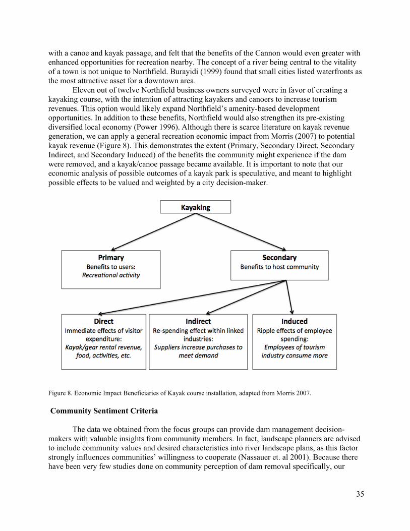
35
with a canoe and kayak passage, and felt that the benefits of the Cannon would even greater with enhanced opportunities for recreation nearby. The concept of a river being central to the vitality of a town is not unique to Northfield. Burayidi (1999) found that small cities listed waterfronts as the most attractive asset for a downtown area.
Eleven out of twelve Northfield business owners surveyed were in favor of creating a kayaking course, with the intention of attracting kayakers and canoers to increase tourism revenues. This option would likely expand Northfield’s amenity-based development opportunities. In addition to these benefits, Northfield would also strengthen its pre-existing diversified local economy (Power 1996). Although there is scarce literature on kayak revenue generation, we can apply a general recreation economic impact from Morris (2007) to potential kayak revenue (Figure 8). This demonstrates the extent (Primary, Secondary Direct, Secondary Indirect, and Secondary Induced) of the benefits the community might experience if the dam were removed, and a kayak/canoe passage became available. It is important to note that our economic analysis of possible outcomes of a kayak park is speculative, and meant to highlight possible effects to be valued and weighted by a city decision-maker.
Figure 8. Economic Impact Beneficiaries of Kayak course installation, adapted from Morris 2007.
Community Sentiment Criteria
The data we obtained from the focus groups can provide dam management decision-makers with valuable insights from community members. In fact, landscape planners are advised to include community values and desired characteristics into river landscape plans, as this factor strongly influences communities’ willingness to cooperate (Nassauer et. al 2001). Because there have been very few studies done on community perception of dam removal specifically, our
36
analysis is contextualized in the broader realm of community perception of landscapes in general.
One main finding of our focus groups was that residents are passionate about the “naturalness” and overall health of the river, along with its functional potential as a recreation site. This is consistent with another focus group study on residents’ perceptions of rivers (Gobster and Westphal 1998), which found that the river’s natural characteristics, and the functional benefits of those characteristics, were most significant to community members. In addition to the seemingly clear-cut values of focus group participants in our focus group, we identified some internal conflicts within individuals. These dilemmas were expressed in our focus group during a time of story exchanges—A woman was talking about her fond memories of the Ames Mill Dam, hanging out by the wall, and fishing. After a short pause, she continued “But I remember my dad always told me, ‘you can’t eat those fish!’” These personal anecdotes help to tease out conflicting perceptions river communities. There is certainly tension between the perception of beauty, and health. Is a polluted river still a beautiful river? Can a river be beautiful if it is not healthy? Similar dilemmas were also identified in Gobster and Westphal’s river perception study. Even though a of the 1998 study saw a river as “beautiful,” it was difficult for a resident to reconcile this apparent beauty with his knowledge of the river pollution.
The concept of “continuity” was another strong area of focus in our discussions. Participants were very excited to discuss recreation on the Cannon, and were especially keen on the idea of connecting the river in a way that would allow kayaks and canoes to pass through the Ames Mill Dam area, which is currently an obstacle to boaters. These findings are consistent with previous community-landscape perception studies, in fact, community members in another similar studies tend to express a strong appreciation for their town’s sense of history, and value being connected to the past—both in the natural sense, and the historic sense (Janet 2008).
Both our results, and the existing literature agree that residents’ opinions and values are very important for this type of decision-making. The process of conducting focus groups—and all community engagement on the issue of dam management—is beneficial in itself. As Stewart and Grant (2005) explain, most communities have the committees that are necessary to evoke change. What prevents action is that the citizen-stakeholders may lack an understanding or vision of the landscape change. Through communication within communities, residents’ ideas and values can be legitimized, thus enhancing the community environment (Stewart and Grant 2005). Physical and Ecological Criteria Comparing HEC-RAS Results with Past Studies
One-dimensional numerical models, such as HEC-RAS, are most appropriate for modeling erosion and deposition following dam removal in systems where large net changes occur and average bathymetric and sediment changes are adequate (Cui and Wilcox 2008). Our results are therefore most applicable on a reach-scale and time-averaged basis. The HEC-RAS model used in this study predicted that changes in invert channel elevation are an inverse function of time since dam removal, where most changes occur within the first year after removal, and that most sediment erosion occurs 100 ft upstream of the location of the dam and most sediment deposition occurs 100 ft downstream of the dam. Several studies have found similar results that small dam removal results in minimal impacts on sediment transport and that most sediment erosion and deposition occurs immediately after removal (Ahern and Dahlgren 2005, Roberts et al. 2007, Downs et al. 2009). Kibler et al. (2011) showed that sediment
37
deposition decreases as downstream distance from the dam increases. However, previous studies that used HEC-RAS for the Cannon River in Northfield, MN found that there was never a large build-up of sediment immediately downstream of the Ames Mill Dam and that the majority of sediment changes occurred in the first five years (Doucett et al. 2012, Gruber et al. 2013). Instead they found that, after five years, larger particles remained in the Ames Mill Dam reservoir, while smaller particles, such as sand and silt, would be washed downstream to Lake Byllesby, MN. Although Doucett et al. (2012) and Gruber et al. (2013) omitted significant information and details from their methodologies, it is surprising that our results are so different given that we used similar data for the Cannon River. While our elevation and aerial imagery data have higher spatial resolution, it is unclear which and how many bathymetric cross-sections were input in previous studies, which computational increment and sediment transport function they used, and most importantly how they modeled the removal of the Ames Mill Dam. Uncertainty in Sediment Transport Modeling While it is useful for Malt-O-Meal and other decision-makers to gain a general understanding sedimentation impacts after dam removal (Downs et al. 2009), predictions for sediment erosion and deposition over time are uncertain and can vary based on the data and model parameters used (Tullos et al. 2010). We used HEC-RAS to reduce uncertainty regarding sediment management after dam removal, however it is difficult to assess the accuracy of model predictions post-dam removal, due to lack of available observed historical data to validate or calibrate the model. Tullos et al. (2010) compared HEC-RAS predictions with observed sediment erosion and deposition in the reservoir and downstream after dam removal. They found that HEC-RAS model simulations overestimated sediment erosion and deposition relative to observed bathymetric changes, which they attribute to model instability when there are abrupt changes in channel slope that create near-critical flows. If our model functioned similar to that of Tullos et al. (2010), then it is possible that our HEC-RAS predictions are also overestimated. HEC-RAS is also not suitable for accurately predicting and explaining detailed geomorphic patterns, such as channel incision and widening at specific cross-sections. The artificial viscosity parameter in our model causes high-frequency oscillations in water depth and flow that manifest in high frequency oscillations in changes in channel invert elevation over time (Cui and Wilcox 2008). This results in unstable predictions for channel invert elevation at particular cross-sections 100 to 3000 ft upstream of the dam (Figure 6). Sensitivity analyses conducted by Tullos et al. (2010) and Gruber et al. (2013) concluded that HEC-RAS predictions are sensitive to Manning’s N coefficients, boundary conditions, interpolated cross-sections, and computational increments, indicating that important explanatory variables may be missing from our model and/or the stability of the model is of concern. While it is unclear how accurate the Manning’s N coefficients, interpolated cross-sections, and boundary conditions are in the data we used, Tullos et al. (2010) suggests that decreasing the computational increment can improve model stability and accuracy. Because stream flow and bathymetry are updated at varying time increments, decreasing computational increments can increase model stability, but can greatly increase simulation run times. Also, for 1D hydraulic models, the estimation of the composition, depth, and extent of sediment in the reservoir can impact model predictions (Tullos et al. 2010). Since sediment transport analyses are sensitive to the minimum erodible elevation of the stream channel, our rough estimation of minimum elevation of the Cannon River may be a possible source of model instability.
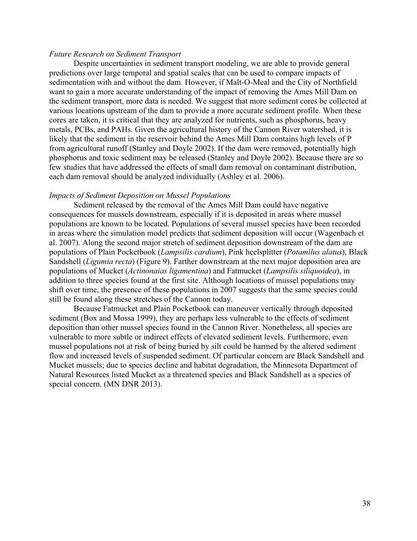
38
Future Research on Sediment Transport Despite uncertainties in sediment transport modeling, we are able to provide general
predictions over large temporal and spatial scales that can be used to compare impacts of sedimentation with and without the dam. However, if Malt-O-Meal and the City of Northfield want to gain a more accurate understanding of the impact of removing the Ames Mill Dam on the sediment transport, more data is needed. We suggest that more sediment cores be collected at various locations upstream of the dam to provide a more accurate sediment profile. When these cores are taken, it is critical that they are analyzed for nutrients, such as phosphorus, heavy metals, PCBs, and PAHs. Given the agricultural history of the Cannon River watershed, it is likely that the sediment in the reservoir behind the Ames Mill Dam contains high levels of P from agricultural runoff (Stanley and Doyle 2002). If the dam were removed, potentially high phosphorus and toxic sediment may be released (Stanley and Doyle 2002). Because there are so few studies that have addressed the effects of small dam removal on contaminant distribution, each dam removal should be analyzed individually (Ashley et al. 2006). Impacts of Sediment Deposition on Mussel Populations
Sediment released by the removal of the Ames Mill Dam could have negative consequences for mussels downstream, especially if it is deposited in areas where mussel populations are known to be located. Populations of several mussel species have been recorded in areas where the simulation model predicts that sediment deposition will occur (Wagenbach et al. 2007). Along the second major stretch of sediment deposition downstream of the dam are populations of Plain Pocketbook (Lampsilis cardium), Pink heelsplitter (Potamilus alatus), Black Sandshell (Ligumia recta) (Figure 9). Farther downstream at the next major deposition area are populations of Mucket (Actinonaias ligamentina) and Fatmucket (Lampsilis siliquoidea), in addition to three species found at the first site. Although locations of mussel populations may shift over time, the presence of these populations in 2007 suggests that the same species could still be found along these stretches of the Cannon today.
Because Fatmucket and Plain Pocketbook can maneuver vertically through deposited sediment (Box and Mossa 1999), they are perhaps less vulnerable to the effects of sediment deposition than other mussel species found in the Cannon River. Nonetheless, all species are vulnerable to more subtle or indirect effects of elevated sediment levels. Furthermore, even mussel populations not at risk of being buried by silt could be harmed by the altered sediment flow and increased levels of suspended sediment. Of particular concern are Black Sandshell and Mucket mussels; due to species decline and habitat degradation, the Minnesota Department of Natural Resources listed Mucket as a threatened species and Black Sandshell as a species of special concern. (MN DNR 2013).
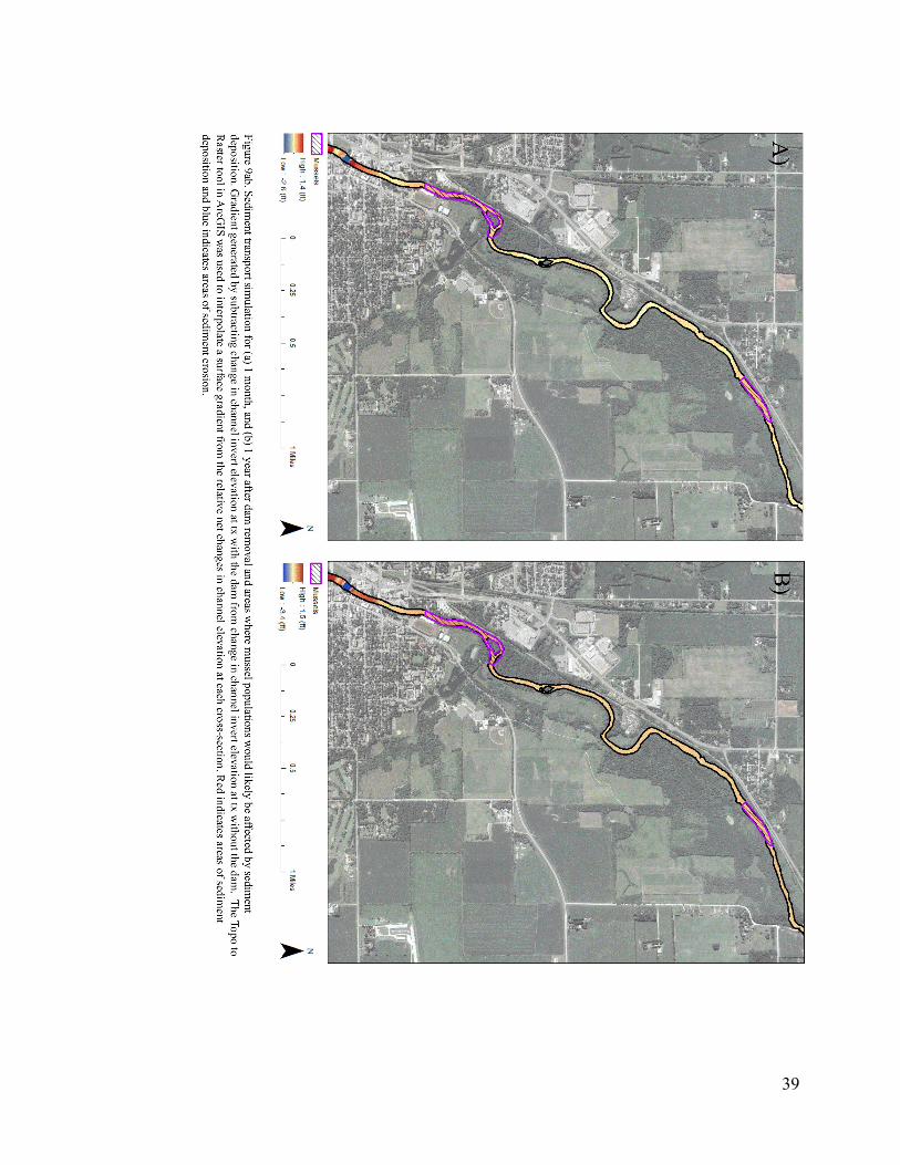
39
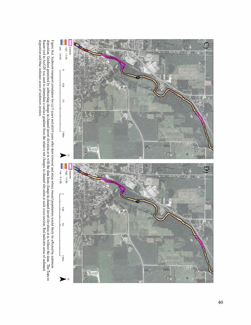
40
41
Impacts on Aquatic Species Despite the risk that increased sediment deposition poses to mussels downstream of the
Ames Mill Dam, it is unlikely that the negative effects would be long-term, as the downstream habitat (Sethi 2004). Because the HEC-RAS model cannot account for changes in suspended sediment, it is difficult to speculate on the full extent of damage that dam removal could deal to downstream mussel communities. It is also unclear what effect the 2010 flood had on mussel populations: the habitat and community composition may have changed dramatically since 2007. Moreover, the effects of dam removal on a few mussel populations must be weighed against other ecological benefits of dam removal, such as greater fish passage connectivity.
River habitat fragmentation due to dams often result in changes in community river community composition. The Ames Mill Dam creates a barrier for many species, particularly fish and mussels in this area (Vang 2011). Increased habitat connectivity by through dam removal will increase fish passage, which will also enable the transfer of mussel larvae that spend a period of development attached to the gills of fish. Although some native species are often able to make a comeback, it is unlikely that pre-dam and post-dam removal communities will be the same (Iversen et al. 1993, Nilsson and Berggren 2000).
Changes in flow regimes may also impact the Cannon River ecosystem in ways that affect the Northfield community. Dams alter flood regimes in a way that often disturbs feeding patterns and fish habitat availability during critical life cycle stages. Flooding is an important topic to Northfield because of the impact it has on community infrastructure. By restoring flood regimes, it is possible that fish assemblages may become more similar to those before the dam was installed. The Ames Mill Dam also slows flow rates, which creates a more desirable habitat for ducks and geese to rest. If the dam were to be removed, there may be a decrease in the amount of ducks and geese in this area. Although no literature exists on this topic, it was a concern expressed by community members, presenting it as a relatively important community sentiment issue to overcome in dam removal. Ecological Impacts on Stakeholders
It is unlikely that the ecological changes from dam removal will create many lasting impacts for Northfield stakeholders. While there will be some changes in the organisms living within and next to the river, these will likely be minimal and short term. It is unlikely that the negative effects, such as sediment deposition, would have any long-term impact on crucial river species. The one exception to this is the effect of changes to river connectivity. It is clear that dam removal or structure replacement would allow for greater river connectivity, including improved fish passage, but this may not be considered a benefit by all stakeholders. Although the DNR “hates dams” (Currier 2013) and the Northfield residents from our focus groups would like to see a more “natural river”, greater river connectivity may decrease the amount of fish that currently congregate downstream of the dam, upsetting the people who frequently fish in the river. While many of these are recreational fishermen, a DNR representative has reported, “large groups of Hmong have been fishing in Minnesota” (Vang 2014). While we were unable to get in contact with any of these fishermen directly, expert interviews have informed us that the Hmong groups live outside of the Northfield community, usually in the Twin Cities and are thus driving some distance to get here to fish for food (Lee 2014). Approximately 10% of the Hmong community is currently using subsistence fishing to supplement their diet, and if fishing was reduced in Northfield, they could “go down to Iowa or North Dakota, and lakes in some other part of the states” (Lee 2014). Because they are not Northfield residents, the voice of these
42
people who are using this public waterway may not be heard in this issue, but is nevertheless an important factor to consider. Moving Forward
We suggest that the AHP framework be presented to MoM Brands, the owner of the Ames Mill Dam, and the City of Northfield. Even though MoM Brands will ultimately make the decision and they do not have appear to be interested in evaluating this decision, the Northfield community can exercise power by formulating a plan for dam management and presenting its recommendations. MoM Brands has listened to community member and business owners in the past (Currier 2013), and would be more likely to accept a community recommendation rather than investing resources in formulating a plan themselves.
If the community leaders conclude that the dam should be removed or modified, the next step involves the acquisition of funding. According to David Hvistendahl (Pers. Comm. 2014), the greater the scale of a project, the more likely it is to receive funding. If Northfield chooses to pursue dam removal, community leaders should contact key players in neighboring towns, such as Fairbault and Dundas, who may be interested in river improvement projects. This means contacting city councils, county boards, and parks departments of neighboring cities about the issue of dam removal. Once multiple cities are involved, Northfield can present a much more appealing application for a Legacy fund. In fact, The DNR has awarded $50,000 for flood mitigation in response to a study of the Spring Creek Watershed. The application was a collaborative effort involving both the Bridgewater Township and the NDDC (Northfield City Council Minutes 2013). This suggests that similar inter-township funding strategy could be applied to the Ames Mill Dam.
43
LITERATURE CITED Ackerman, C. and G. Brunner. Dam Failure Analysis Using HEC-RAS and HEC-GeoRAS. Aguilar, R., E. Anderson, E. Cousins, B. Grant, and K. Ross. 2012. Policy Analysis of Ames
Mill Dam Options. Unpublished manuscript. Ahearn, D. S. and R. A. Dahlgren. 2005. Sediment and nutrient dynamics following a low-head
dam removal at Murphy Creek, California. Limnology and Oceanography 50:1752-1762. American Rivers. 2002. Exploring Dam Removal: A Decision Maker's Guide. Ashley, J. T., K. Bushaw-Newton, M. Wilhelm, A. Boettner, G. Drames, and D. J. Velinsky.
2006. The effects of small dam removal on the distribution of sedimentary contaminants. Environmental Monitoring and Assessment 114:287-312.
Babbitt, B. 2002. What Goes Up, May Come Down Learning from our experiences with dam
construction in the past can guide and improve dam removal in the future. Bioscience 52:656-658.
Baish, S. K., S. D. David, and W. L. Graf. 2002. The complex decisionmaking process for
removing dams. Environment: Science and Policy for Sustainable Development 44:20-31. Barr Engineering. 2007. Cannon River Dam Modifications Study. Unpublished manuscript. Bednarek, A. T. 2001. Undamming rivers: a review of the ecological impacts of dam removal.
Environmental Management 27:803-814. Billington Jr, D. P., D. C. Jackson, and M. V. Melosi. 2005. The history of large federal dams:
Planning, design, and construction. Reclamation Bureau. Bockelmann, B., E. K. Fenrich, B. Lin, and R. A. Falconer. 2004. Development of an
ecohydraulics model for stream and river restoration. Ecological Engineering 22:227-235. Box, J. B. and J. Mossa. 1999. Sediment, land use, and freshwater mussels: prospects and
problems. Journal of the North American Benthological Society:99-117. Braker, N. November 11, 2013. Personal Communication. Burnard, P., P. Gill, K. Stewart, E. Treasure, and B. Chadwick. 2008. Analysing and presenting
qualitative data. British dental journal 204:429-432. Carpenter, S. R., E. M. Bennett, and G. D. Peterson. 2006. Scenarios for ecosystem services: an
overview. Ecology and Society 11:29.

44
Heinz Center. 2002. Dam removal: science and decision making. Heinz Center for Science, Economics, and the Environment, Washington, DC:236.
Chang, H. H. 2008. Case study of fluvial modeling of river responses to dam removal. Journal of
Hydraulic Engineering 134:295-302. Cheng, F. and T. Granata. 2007. Sediment transport and channel adjustments associated with
dam removal: Field observations. Water Resources Research 43. Cianfrani, C., W. Hession, and M. Watzin. 2004. Evaluating Aquatic Habitat Quality Using
Channel Morphology and Multiscale-Scale Modeling Techniques. American Society of Civil Engineers. Unpublished manuscript.
Corsair, H., J. B. Ruch, P. Q. Zheng, B. F. Hobbs, and J. F. Koonce. 2009. Multicriteria decision
analysis of stream restoration: potential and examples. Group decision and negotiation 18:387-417.
Crane, J. 2011. A Grand Destiny is Ours: The Damming and Restoration of the Elwha River.
Journal of the West 50:42-50. Cui, Y. and A. Wilcox. 2008. Development and application of numerical models of sediment
transport associated with dam removal. American Society of Civil Engineers. 23:995-1020.
Currier, R. November 22, 2013. Personal Communication. Doucett, E., Kamrath, M., Ohm, L., Simmons, B., Snyder, L. 2012. St. Olaf Mathematics
Practicum: Modeling the Cannon River. Unpublished manuscript. Downs, P. W., Y. Cui, J. K. Wooster, S. R. Dusterhoff, D. B. Booth, W. E. Dietrich, and L. S.
Sklar. 2009. Managing reservoir sediment release in dam removal projects: An approach informed by physical and numerical modelling of non‐cohesive sediment. International Journal of River Basin Management 7:433-452.
Doyle, M. W., J. M. Harbor, and E. H. Stanley. 2003a. Toward policies and decision-making for
dam removal. Environmental Management 31:0453-0465. Doyle, M. W., E. H. Stanley, and J. M. Harbor. 2002. Geomorphic Analogies For Assessing
Probable Channel Response to Dam Removal. Journal of the American Water Resources Association 38:1567-1579.
Doyle, M. W., E. H. Stanley, and J. M. Harbor. 2003b. Channel adjustments following two dam
removals in Wisconsin. Water Resources Research 39:1011. Doyle, M. W., E. H. Stanley, J. M. Harbor, and G. S. Grant. 2003c. Dam removal in the United
States: emerging needs for science and policy. American Geophysical Union 84:29-33.
45
Ellis, M. 1936. Erosion silt as a factor in aquatic environments. Ecology 17:29-42. Federal Emergency Management Agency. 1999. National dam safety program. García, A., K. Jorde, E. Habit, D. Caamaño, and O. Parra. 2011. Downstream environmental
effects of dam operations: changes in habitat quality for native fish species. River Research and Applications 27:312-327.
Graber, B. E., M. Bowman, R. S. Carney, M. W. Doyle, M. Fisher, S. D. Mackey, and L.
Wildman. 2001. Technical issues in small dam removal engineering. Unpublished. Graf, W. L. 2003. The Changing role of dams in water resources management. Water
Resources:54-59. Granata, T., F. Cheng, and M. Nechvatal. 2008. Discharge and suspended sediment transport
during deconstruction of a low-head dam. Journal of Hydraulic Engineering 134:652-657. Gregory, K. and R. Davis. 1993. The perception of riverscape aesthetics: an example from two
Hampshire rivers. Journal of Environmental Management 39:171-185. Groves, D. G. and R. J. Lempert. 2007. A new analytic method for finding policy-relevant
scenarios. Global Environmental Change 17:73-85. Gruber, E., Hall, A., Keller, T., Newman, G. 2013. Mathematically Modeling the Ames Mill
Dam. Unpublished manuscript. Hart, D. D., T. E. Johnson, K. L. Bushaw-Newton, R. J. Horwitz, A. T. Bednarek, D. F. Charles,
D. A. Kreeger, and D. J. Velinsky. 2002. Dam Removal: Challenges and Opportunities for Ecological Research and River Restoration. Bioscience 52:669-682.
Hart, D. D. and N. L. Poff. 2002. A special section on dam removal and river restoration.
Bioscience 52:653-655. Henley, W., M. Patterson, R. Neves, and A. D. Lemly. 2000. Effects of sedimentation and
turbidity on lotic food webs: a concise review for natural resource managers. Reviews in Fisheries Science 8:125-139.
Hoegh-Guldberg, O., L. Hughes, S. McIntyre, D. Lindenmayer, C. Parmesan, H. Possingham,
and C. Thomas. 2008. Assisted colonization and rapid climate change. Science 321:345-346.
Houp, R. E. 1993. Observations of long-term effects of sedimentation on freshwater mussels
(Mollusca Unionidae) in the North Fork of the Red River, Kentucky. Transactions of the Kentucky Academy of Science 54:93-97.
46
Iversen, T. M., B. Kronvang, B. L. Madsen, P. Markmann, and M. B. Nielsen. 1993. Re-establishment of Danish streams: Restoration and maintenance measures. Aquatic Conservation: Marine and Freshwater Ecosystems 3:73-92.
Jahnig, S. C., M. Kuemmerlen, J. Kiesel, S. Domisch, Q. H. Cai, B. Schmalz, and N. Fohrer.
2012. Modelling of riverine ecosystems by integrating models: conceptual approach, a case study and research agenda. Journal of Biogeography 39:2253-2263.
Junker, B. and M. Buchecker. 2008. Aesthetic preferences versus ecological objectives in river
restorations. Landscape and Urban Planning 85:141-154. Kallestad, B. February 12, 2014. Personal Communication. Kanehl, P. D., J. Lyons, and J. E. Nelson. 1997. Changes in the habitat and fish community of
the Milwaukee River, Wisconsin, following removal of the Woolen Mills Dam. North American Journal of Fisheries Management 17:387-400.
Kibler, K., D. Tullos, and M. Kondolf. 2011. Evolving Expectations of Dam Removal Outcomes:
Downstream Geomorphic Effects Following Removal of a Small, Gravel‐Filled Dam. Journal of the American Water Resources Association 47:408-423.
Knetsch, J. L. and J. A. Sinden. 1984. Willingness to pay and compensation demanded:
Experimental evidence of an unexpected disparity in measures of value. The Quarterly Journal of Economics 99:507-521.
Ligon, F. K., W. E. Dietrich, and W. J. Trush. 1995. Downstream ecological effects of dams.
Bioscience:183-192. Loomis, J. B. 1996. Measuring the economic benefits of removing dams and restoring the Elwha
River: results of a contingent valuation survey. Water Resources Research 32:441-447. Lowry, W. R. 2003. Dam politics: restoring America's rivers. Georgetown University Press. Magilligan, F. J. and K. H. Nislow. 2005. Changes in hydrologic regime by dams.
Geomorphology 71:61-78. Marking, L. L. and T. D. Bills. 1980. Acute effects of silt and sand sedimentation on freshwater
mussels. Proceedings of the Symposium on Upper Mississippi Bivalve Mollusks. Minnesota Department of Natural Resources, Division of Ecological Resources. 2013. Rare
Species Guide: An online encyclopedia of Minnesota's rare native plants and animals. Unpublished manuscript.
Morgan, M. G. and M. Small. 1992. Uncertainty: a guide to dealing with uncertainty in
quantitative risk and policy analysis. Cambridge University Press.
47
Nilsson, C. and K. Berggren. 2000. Alterations of Riparian Ecosystems Caused by River Regulation: Dam operations have caused global-scale ecological changes in riparian ecosystems. Bioscience 50:783-792.
Pizzuto, J. 2002. Effects of dam removal on river form and process. Bioscience 52:683-691. Polasky, S., S. R. Carpenter, C. Folke, and B. Keeler. 2011. Decision-making under great
uncertainty: environmental management in an era of global change. Trends in Ecology & Evolution 26:398-404.
Postel, S. and B. Richter. 2003. Rivers for life: managing water for people and nature. Island
Press. Regan, H. M., Y. Ben-Haim, B. Langford, W. G. Wilson, P. Lundberg, S. J. Andelman, and M.
A. Burgman. 2005. Robust decision-making under severe uncertainty for conservation management. Ecological Applications 15:1471-1477.
Riggsbee, J. A., R. Wetzel, and M. Doyle. 2012. Physical and plant community controls on
nitrogen and phosphorus leaching from impounded riverine wetlands following dam removal. River Research and Applications 28:1439-1450.
Ryan, P. A. 1991. Environmental effects of sediment on New Zealand streams: a review. New
Zealand journal of marine and freshwater research 25:207-221. Saaty, T. L. 1990. How to make a decision: the analytic hierarchy process. European journal of
operational research 48:9-26. Schmidt, J. C., R. H. Webb, R. A. Valdez, G. R. Marzolf, and L. E. Stevens. 1998. Science and
values in river restoration in the Grand Canyon. Bioscience 48:735-747. Schneider, S. H. 2006. Climate change: Do we know enough for policy action? Science and
engineering ethics 12:607-636. Sethi, S. A., A. R. Selle, M. W. Doyle, E. H. Stanley, and H. E. Kitchel. 2004. Response of
unionid mussels to dam removal in Koshkonong Creek, Wisconsin (USA). Hydrobiologia 525:157-165.
Smith, K. 2013. Social Research Methods for Interdisciplinary Environmental Studies.
Unpublished Manuscript. Stanley, E. H. and M. W. Doyle. 2002. A geomorphic perspective on nutrient retention following
dam removal. Bioscience 52:693-701. Stanley, E. H., M. A. Luebke, M. W. Doyle, and D. W. Marshall. 2002. Short-term changes in
channel form and macroinvertebrate communities following low-head dam removal. Journal of the North American Benthological Society 21:172-187.
48
Stewart, G. and G. Grant. 2005. What can we learn from the removal of little dinky dams.
Managing Watersheds for Human and Natural Impacts. American Society of Civil Engineers. Unpublished manuscript.
Tomsic, C. A., T. C. Granata, R. P. Murphy, and C. Liuchak. 2007. Using a coupled eco-
hydrodynamic model to predict habitat for target species following dam removal. Ecological Engineering 30:215-230.
Travnichek, V. H., M. B. Bain, and M. J. Maceina. 1995. Recovery of a warmwater fish
assemblage after the initiation of a minimum-flow release downstream from a hydroelectric dam. Transactions of the American Fisheries Society 124:836-844.
Tullos, D., M. Cox, and C. Walter. 2010. Simulating dam removal with a 1D hydraulic model:
Accuracy and techniques for reservoir erosion and downstream deposition at the Chiloquin Dam removal. World Environmental and Water Resources. Unpublished manuscipt.
Vang, A. 2011. A Pre-Dam Removal Assessment: The Ames Mill Dam, Northfield, MN.
Carleton College: Senior Integrative Exercise. Unpublished manuscript. Vannote, R. L. and G. W. Minshall. 1982. Fluvial processes and local lithology controlling
abundance, structure, and composition of mussel beds. Proceedings of the National Academy of Sciences 79:4103-4107.
Whitelaw, E. and E. MacMullan. 2002. A framework for estimating the costs and benefits of
dam removal. Bioscience 52:724-730. Wilcock, P. R. 2001. Toward a practical method for estimating sediment‐transport rates in
gravel‐bed rivers. Earth Surface Processes and Landforms 26:1395-1408. Wu, R. and C. Mao. 2007. The assessment of river ecology and habitat using a two-dimensional
hydrodynamic and habitat model. Journal of Marine Science and Technology 15:322-330. Wyrick, J. R., B. A. Rischman, C. A. Burke, C. McGee, and C. Williams. 2009. Using hydraulic
modeling to address social impacts of small dam removals in southern New Jersey. Journal of Environmental Management 90:S270-S278.
Young, R., G. Smart, and J. Harding. 2004. Impacts of hydro-dams, irrigation schemes and river
control works. Freshwaters of New Zealand:37.31-37.15. Zheng, P. Q. and B. F. Hobbs. 2012. Multiobjective Portfolio Analysis of Dam Removals
Addressing Dam Safety, Fish Populations, and Cost. Journal of Water Resources Planning and Management 139:65-75.
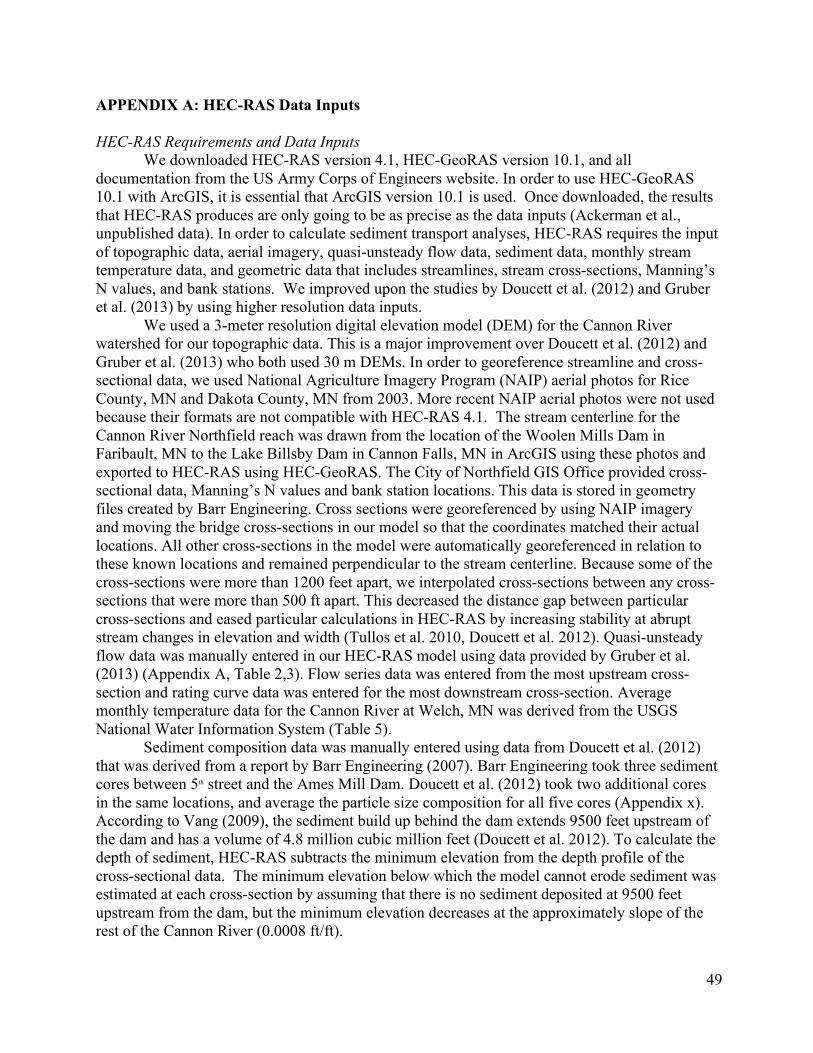
49
APPENDIX A: HEC-RAS Data Inputs HEC-RAS Requirements and Data Inputs
We downloaded HEC-RAS version 4.1, HEC-GeoRAS version 10.1, and all documentation from the US Army Corps of Engineers website. In order to use HEC-GeoRAS 10.1 with ArcGIS, it is essential that ArcGIS version 10.1 is used. Once downloaded, the results that HEC-RAS produces are only going to be as precise as the data inputs (Ackerman et al., unpublished data). In order to calculate sediment transport analyses, HEC-RAS requires the input of topographic data, aerial imagery, quasi-unsteady flow data, sediment data, monthly stream temperature data, and geometric data that includes streamlines, stream cross-sections, Manning’s N values, and bank stations. We improved upon the studies by Doucett et al. (2012) and Gruber et al. (2013) by using higher resolution data inputs.
We used a 3-meter resolution digital elevation model (DEM) for the Cannon River watershed for our topographic data. This is a major improvement over Doucett et al. (2012) and Gruber et al. (2013) who both used 30 m DEMs. In order to georeference streamline and cross-sectional data, we used National Agriculture Imagery Program (NAIP) aerial photos for Rice County, MN and Dakota County, MN from 2003. More recent NAIP aerial photos were not used because their formats are not compatible with HEC-RAS 4.1. The stream centerline for the Cannon River Northfield reach was drawn from the location of the Woolen Mills Dam in Faribault, MN to the Lake Billsby Dam in Cannon Falls, MN in ArcGIS using these photos and exported to HEC-RAS using HEC-GeoRAS. The City of Northfield GIS Office provided cross-sectional data, Manning’s N values and bank station locations. This data is stored in geometry files created by Barr Engineering. Cross sections were georeferenced by using NAIP imagery and moving the bridge cross-sections in our model so that the coordinates matched their actual locations. All other cross-sections in the model were automatically georeferenced in relation to these known locations and remained perpendicular to the stream centerline. Because some of the cross-sections were more than 1200 feet apart, we interpolated cross-sections between any cross-sections that were more than 500 ft apart. This decreased the distance gap between particular cross-sections and eased particular calculations in HEC-RAS by increasing stability at abrupt stream changes in elevation and width (Tullos et al. 2010, Doucett et al. 2012). Quasi-unsteady flow data was manually entered in our HEC-RAS model using data provided by Gruber et al. (2013) (Appendix A, Table 2,3). Flow series data was entered from the most upstream cross-section and rating curve data was entered for the most downstream cross-section. Average monthly temperature data for the Cannon River at Welch, MN was derived from the USGS National Water Information System (Table 5).
Sediment composition data was manually entered using data from Doucett et al. (2012) that was derived from a report by Barr Engineering (2007). Barr Engineering took three sediment cores between 5th street and the Ames Mill Dam. Doucett et al. (2012) took two additional cores in the same locations, and average the particle size composition for all five cores (Appendix x). According to Vang (2009), the sediment build up behind the dam extends 9500 feet upstream of the dam and has a volume of 4.8 million cubic million feet (Doucett et al. 2012). To calculate the depth of sediment, HEC-RAS subtracts the minimum elevation from the depth profile of the cross-sectional data. The minimum elevation below which the model cannot erode sediment was estimated at each cross-section by assuming that there is no sediment deposited at 9500 feet upstream from the dam, but the minimum elevation decreases at the approximately slope of the rest of the Cannon River (0.0008 ft/ft).
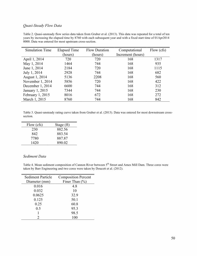
50
Quasi-Steady Flow Data Table 2. Quasi-unsteady flow series data taken from Gruber et al. (2013). This data was repeated for a total of ten years by increasing the elapsed time by 8760 with each subsequent year and with a fixed start time of 01Apr2014 0000. Data was entered for most upstream cross-section.
Simulation Time Elapsed Time (hours)
Flow Duration (hours)
Computational Increment (hours)
Flow (cfs)
April 1, 2014 720 720 168 1317 May 1, 2014 1464 744 168 935 June 1, 2014 2184 720 168 1115 July 1, 2014 2928 744 168 682 August 1, 2014 5136 2208 168 560 November 1, 2014 5856 720 168 422 December 1, 2014 6600 744 168 312 January 1, 2015 7344 744 168 230 February 1, 2015 8016 672 168 272 March 1, 2015 8760 744 168 842 Table 3. Quasi-unsteady rating curve taken from Gruber et al. (2013). Data was entered for most downstream cross-section.
Flow (cfs) Stage (ft) 230 882.56 842 883.54 7780 887.87 1420 890.02
Sediment Data Table 4. Mean sediment composition of Cannon River between 5th Street and Ames Mill Dam. Three cores were taken by Barr Engineering and two cores were taken by Doucett et al. (2012). Sediment Particle Diameter (mm)
Composition Percent Finer Than (%)
0.016 4.8 0.032 10 0.0625 32.9 0.125 50.1 0.25 60.8 0.5 95.3 1 98.5 2 100
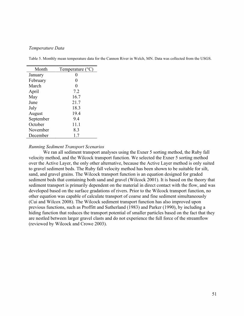
51
Temperature Data Table 5. Monthly mean temperature data for the Cannon River in Welch, MN. Data was collected from the USGS.
Month Temperature (°C) January 0 February 0 March 0 April 7.2 May 16.7 June 21.7 July 18.3 August 19.4 September 9.4 October 11.1 November 8.3 December 1.7 Running Sediment Transport Scenarios
We ran all sediment transport analyses using the Exner 5 sorting method, the Ruby fall velocity method, and the Wilcock transport function. We selected the Exner 5 sorting method over the Active Layer, the only other alternative, because the Active Layer method is only suited to gravel sediment beds. The Ruby fall velocity method has been shown to be suitable for silt, sand, and gravel grains. The Wilcock transport function is an equation designed for graded sediment beds that containing both sand and gravel (Wilcock 2001). It is based on the theory that sediment transport is primarily dependent on the material in direct contact with the flow, and was developed based on the surface gradations of rivers. Prior to the Wilcock transport function, no other equation was capable of calculate transport of coarse and fine sediment simultaneously (Cui and Wilcox 2008). The Wilcock sediment transport function has also improved upon previous functions, such as Proffitt and Sutherland (1983) and Parker (1990), by including a hiding function that reduces the transport potential of smaller particles based on the fact that they are nestled between larger gravel clasts and do not experience the full force of the streamflow (reviewed by Wilcock and Crowe 2003).
52
APPENDIX B: Glossary Aggradation: Increase in land elevation due to the deposition of sediment Bank stability: Potential for riverbank to erode Bank station: Location where stream cross-sections are recorded Bathymetric: of or relating to measurements of the depths of oceans or lakes Boundary condition: Flow data for a location where flow changes Braided flow: Channel that consists of a network of small channels separated by small and often temporary islands called braid bars Computational Increment: The time period for which HEC-RAS updates stream geometry and hydrodynamics while running sediment transport analyses Cross-section: Two-dimensional bathymetric elevation profiles of the stream channel Cross-Section Interpolation: Using data from two adjacent cross-sections to estimate the values for locations in between existing cross-sections Flow series: A series of varying flow data that have specified time durations Grading: The sloping of a stream bed Hydraulic Jump: A rise in the liquid’s surface when high velocity water meets low velocity water. Inline Structure: Dams, weirs, gated structures, vertical lift gates, and overflow gates Manning’s n: The roughness coefficient for a surface that water flows over Minimum elevation: The elevation below which the model cannot erode. This elevation is often used to specify the elevation bedrock One-dimensional flow: A model for streamflow that exists in one-dimension Quasi-Unsteady flow: A series of varying steady flow profiles Rating Curve: Stream discharge as a function of distance along a stream Reach: A length of stream between two points Steady flow: A model for streamflow when hydraulic properties do not change over time Unsteady flow: A model for streamflow when hydraulic properties change over time

53
APPENDIX C: Northfield Downtown Business Survey Dear owner of ____________, You are invited to participate in a senior project focused on exploring the social and ecological implications of the Ames Mill Dam on the Cannon River in Northfield, MN. One aspect of this study is to understand how river-front business owners regard the dam. You were selected as a participant because you own a business in downtown Northfield. This questionnaire asks business owners along the Cannon River to reflect on their value the water front and comment on their perception of the Ames Mill Dam. Participation in this study simply involves responding to the eight survey questions on the following page. No further participation will be asked of you. Please know that your responses will be kept confidential. Your name and other information that might point to you will not appear when we present this study or write up the results. Your decision to participate or not will not affect your current or future relations with Carleton College. If you decide to participate, you are free to skip any question without affecting those relationships. Click here to enter the questionnaire: https://www.surveymonkey.com/s/3JTL78S This study is being conducted by four seniors in the Environmental Studies department at Carleton College: Jesse Gourevitch, Maddie Halloran, Henry Peyronnin, and Maggie Sullivan. If you have any question or comments on this survey, please contact Maddie at [email protected] or (907) 952-9774. If you have any questions or concerns regarding this study and would like to talk to someone other than the researchers, contact Annette Nierobisz, Chair of the Institutional Review Board at Carleton College(507)-222-4114. Thank you for your time, we really appreciate your contribution to this study. Jesse Gourevitch Maddie Halloran Henry Peyronnin Maggie Sullivan
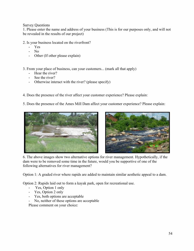
54
Survey Questions 1. Please enter the name and address of your business (This is for our purposes only, and will not be revealed in the results of our project) 2. Is your business located on the riverfront?
- Yes - No - Other (If other please explain)
3. From your place of business, can your customers... (mark all that apply) - Hear the river? - See the river? - Otherwise interact with the river? (please specify)
4. Does the presence of the river affect your customer experience? Please explain: 5. Does the presence of the Ames Mill Dam affect your customer experience? Please explain:
6. The above images show two alternative options for river management. Hypothetically, if the dam were to be removed some time in the future, would you be supportive of one of the following alternatives for river management? Option 1: A graded river where rapids are added to maintain similar aesthetic appeal to a dam. Option 2: Rapids laid out to form a kayak park, open for recreational use.
- Yes, Option 1 only - Yes, Option 2 only - Yes, both options are acceptable - No, neither of these options are acceptable Please comment on your choice:

55
7. Additionally, removing a dam could result in a drop in water level, changes to the riverbed itself, and other alterations to the Cannon River. Would these results affect your customers' experience?
- Yes - No - Maybe - I don’t know Please comment on your choice:
8. Do you have any other comments about the Cannon River as it relates to downtown Northfield, or the Ames Mill Dam?
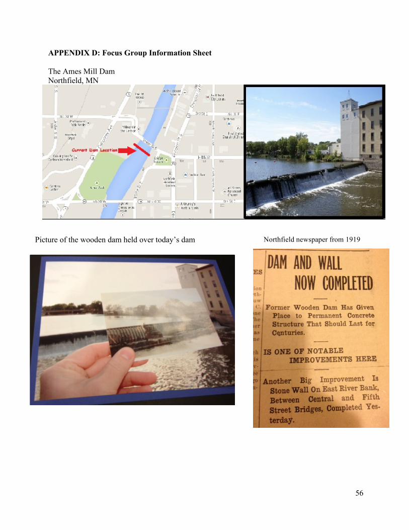
56
APPENDIX D: Focus Group Information Sheet The Ames Mill Dam Northfield, MN Quick Facts
• Original wooden dam was built in 1855 • Current concrete structure built in 1919
o Owned by MoM Brands (Malt-O-Meal)
Picture of the wooden dam held over today’s dam Northfield newspaper from 1919
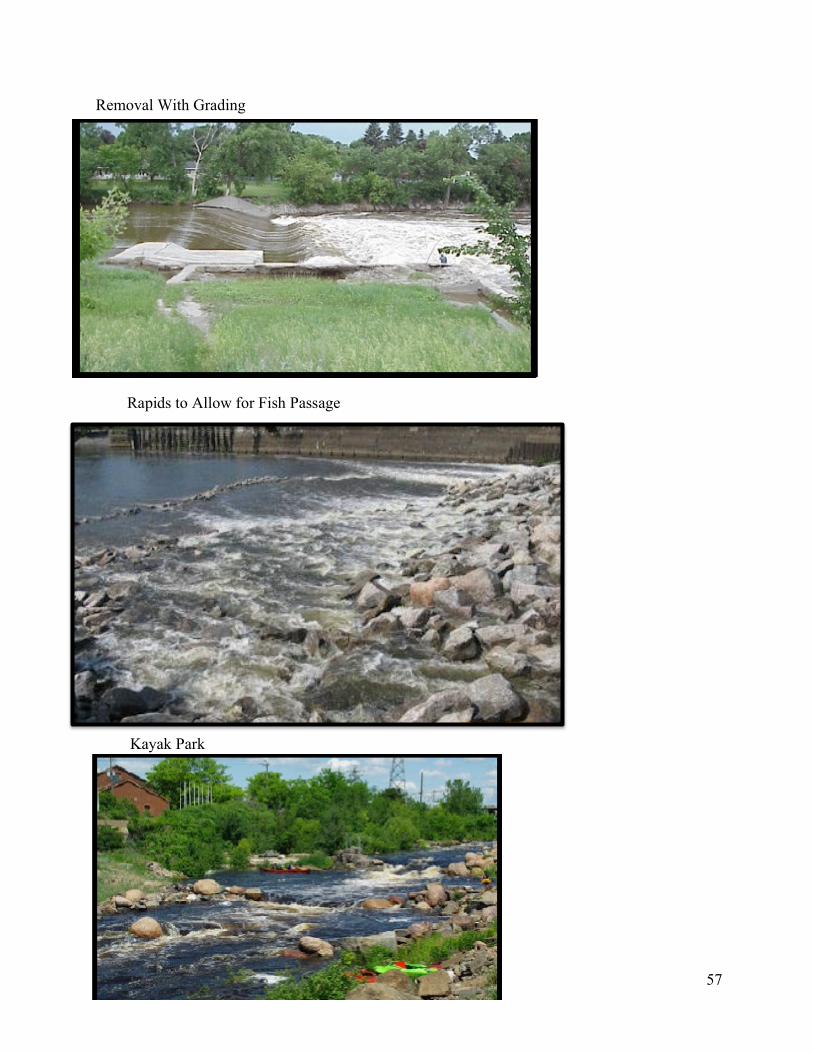
57
Removal With Grading
Rapids to Allow for Fish Passage
Kayak Park