APN Science Bulletin - Asia-Pacific Network for Global ...
84
APN Science Bulletin Asia-Pacific Network for Global Change Research Issue 1 | March 2011 Applicability of Satellite-based Rainfall Product to Flood Runoff Analysis with Integrated Flood Analysis System (IFAS) in Asia Good Water Governance: Could Stakeholder Participation Reduce Water Insecurities in River Basins in Asia-Pacific? Global Change and Capacity Building in Coral Reef Management in the Pacific: Engaging Scientists and Policy-makers in Fiji, Tonga, Samoa and Tuvalu Global Environmental Change and Food Security in the Indo-Gangetic Plain Development of a Co-evolutionary Decision Support System-Food and Water Security Integrated Model System (FAWSIM) Assessing Impacts of ECHAM4 GCM Climate Change Data on Main Season Rice Production Systems in Thailand Climate Change Risk Assessment in Asian Coastal Megacities: Knowledge Gaps and Research Needs for Urban Development Planning Future Climate Projection for Mainland Southeast Asia Countries: Climate Change Scenario of 21 st Century Global Environmental Change http://www.apn-gcr.org
-
Upload
khangminh22 -
Category
Documents
-
view
2 -
download
0
Transcript of APN Science Bulletin - Asia-Pacific Network for Global ...

ISSN 2185-6907APN Science BulletinAsia-Pacific Network for Global Change Research Issue 1 | March 2011
Applicability of Satellite-basedRainfall Product to Flood RunoffAnalysis with Integrated FloodAnalysis System (IFAS) in Asia
Good Water Governance:Could Stakeholder ParticipationReduce Water Insecurities in RiverBasins in Asia-Pacific?
Global Change and Capacity Buildingin Coral Reef Management in thePacific: Engaging Scientists andPolicy-makers in Fiji, Tonga, Samoaand Tuvalu
Global Environmental Change andFood Security in the Indo-GangeticPlain
Development of a Co-evolutionaryDecision Support System-Food and
Water Security Integrated ModelSystem (FAWSIM)
Assessing Impacts of ECHAM4GCM Climate Change Data onMain Season Rice Production
Systems in Thailand
Climate Change Risk Assessmentin Asian Coastal Megacities:
Knowledge Gaps and ResearchNeeds for Urban Development
Planning
Future Climate Projection forMainland Southeast Asia
Countries: Climate ChangeScenario of 21st Century
Glo
bal
Env
iron
men
tal
Cha
nge
http://www.apn-gcr.org

APN Science Bulletin Issue 1 March 20112
ARCP2009-01CMY-Fukami: Applicability of Satellite-Based Rainfall Product to Flood Runoff Analysis withIntegrated Flood Analysis System (IFAS) in Asia
ARCP2009-03CMY-Nikitina: Good Water Governance:Could Stakeholder Participation Reduce WaterInsecurities in River Basins in Asia-Pacific?
CBA2010-15NMY-South: Global Change and CapacityBuilding in Coral Reef Management in the Pacific:Engaging Scientists and Policy-Makers in Fiji, Tonga,Samoa and Tuvalu
CRP2008-01CMY-Dixit: Global Environmental Changeand Food Security in the Indo-Gangetic Plain
CRP2008-02CMY-Yan: Development of aCo-evolutionary Decision Support System - Food andWater Security Integrated Model System (FAWSIM)
CRP2008-03CMY-Jintrawet: Assessing Impacts ofECHAM4 GCM Climate Change Data on Main SeasonRice Production Systems in Thailand
CRP2008-03CMY-Jintrawet: Future Climate Projectionfor Mainland Southeast Asia Countries: Climate ChangeScenario of 21st Century
CIA2009-01-Snidvongs: Climate Change RiskAssessment in Asian Coastal Megacities: KnowledgeGaps and Research Needs for Urban DevelopmentPlanning
Contents
ARCP2010-01CMY-Sthiannopkao: CollaborativeResearch on Sustainable Urban Water QualityManagement in Southeast Asian Countries: Analysis ofCurrent Status (comparative study) and Development ofa Strategic Plan for Sustainable Development
ARCP2010-02CMY-Phua: Integrated Prediction ofDipterocarp Species Distribution in Borneo forSupporting Sustainable Use and Conservation PolicyAdaptation
ARCP2010-03CMY-Marambe: Vulnerability of HomeGarden Systems to Climate Change and its Impacts onFood Security in South Asia
Regional Research Projectsfunded under the AnnualRegional Call for ResearchProposals (ARCP)2
Featured Articles1Preface
Editorial ARCP2010-04CMY-Wang: Building Asian Climate ChangeScenarios by Multi-Regional Climate Models Ensemble
ARCP2010-05CMY-Luck: The Effects of Climate Changeon Pests and Diseases of Major Food Crops in the Asia-Pacific Region
ARCP2010-06CMY-Schaefer: Quantifying the Role ofDead Wood in Carbon Sequestration
ARCP2010-07CMY-Bai: Asian Coastal Ecosystems: AnIntegrated Database and Information Management System(DIMS) for Assessing Impact of Climate Change and itsAppraisal
ARCP2010-08NSY-Freeman: Impact of Climate Changeon Food Security and Biosecurity of Crop ProductionSystems in Small Pacific Nations
ARCP2010-09NSY-Patankar: Enhancing Adaptation toClimate Change by Integrating Climate Risk into Long-Term Development Plans and Disaster Management
ARCP2010-10NMY-Koike: River Management SystemDevelopment in Asia Based on Data Integration andAnalysis System (DIAS) under GEOSS
ARCP2010-11NMY-Asanuma: Intercomparison ofLandsurface Process Modelling in Asian Drylands
ARCP2010-12NMY-Uprety: Community Based Forestryand Livelihoods in the Context of Climate ChangeAdaptation
ARCP2010-13NMY-Bae: Climate Change ImpactAssessment on the Asia-Pacific Water Resources underAWCI/GEOSS
ARCP2010-14NMY-Li: Analysis on Urban Land-UseChanges and its Impacts on Food Security in DifferentAsian Cities of four Developing Countries using ModifiedCellular Automata (CA)
ARCP2010-15NMY-Han: The Impact of SpatialParameters on Greenhouse Gas Emissions: AComparative Study between Cities in China and India
ARCP2010-16NMY-Huda: Food Security and ClimateChange in the Asia-Pacific Region: Evaluating Mismatchbetween Crop Development and Water Availability
ARCP2010-17NMY-Towprayoon: Strategic RiceCultivation for Sustainable Low Carbon SocietyDevelopment in Southeast Asia
ARCP2010-18NMY-Lutaenko: Coastal MarineBiodiversity of Viet Nam: Regional and Local Challengesand Coastal Zone Management for SustainableDevelopment
4
5
7
11
15
19
23
29
35
39
44
45
46
47
47
48
49
50
50
51
52
53
54
55
56
54
57
57

3APN Science Bulletin Issue 1 March 2011
3Scientific CapacityDevelopment Projectsfunded under theCAPaBLE Programme
4 Projects funded under theSpecial Call for FocussedActivities: Climate ChangeImpact and VulnerabilityAssessments
59
60
62
63
64
65
66
67
67
68
69
70
71
72
73
74
75
77
78
79
79
80
81
82
CRP2010-01CMY-Weber: Vulnerability Mapping as aPolicy Tool in Developing Countries
CRP2010-02CMY-Pereira: Strengthening Capacity forPolicy Research on Mainstreaming Adaptation to ClimateChange in Agriculture and Water Sectors
CBA2010-01CMY-Sang-arun: Promoting Sustainable Useof Waste Biomass in Cambodia, Lao People’s DemocraticRepublic and Thailand: Combining Food Security, Bio-energy and Climate Protection Benefits
CBA2010-02CMY-Togtohyn: Dryland DevelopmentParadigm (DDP) Application for the Most Vulnerable toClimate and Land Use Change of Pastoral Systems in theSouthern Khangai Mountains of Mongolia (DDPPaS)
CBA2010-03NSY-Indrawan: Developing the Capacity forTeaching Biodiversity and Conservation in the Asia-PacificRegion
CBA2010-04NSY-Dhakal: Carbon Governance in Asia:Bridging Scales and Disciplines
CBA2010-05NSY-Lorrey: Improving Pacific IslandMeteorological Data Rescue and Data VisualisationCapabilities through Involvement in Emerging ClimateResearch Programmes
CBA2010-06NSY-Kench: Improving Understanding ofLocal-Scale Vulnerability in Atoll Island Countries:Developing Capacity to Improve In-Country Approachesand Research
CBA2010-07NSY-Stone: Web-based ‘Discussion-support’Agricultural-Climate Information for Regional India
CBA2010-08NSY-Salinger: Addressing the LivelihoodCrisis for Farmers: Weather and Climate Services forSustainable Agriculture – Development of Tools
CBA2010-09NSY-Okayama: Scientific CapacityDevelopment of Trainers and Policy-Makers for ClimateChange Adaptation Planning in Asia and the Pacific
CBA2010-10NSY-Chen: Promoting a Data SharingEnvironment within the Earth Observation System ofSystems: The Asia-Pacific Perspective
CBA2010-11NSY-De Guzman: Capacity Building forResearch and Monitoring of Marine Protected Areas(MPA): An Adaptive Mechanism for Climate Change inthe Asia-Pacific Region
CBA2010-12NSY-Pradhananga: Graduate Conference onClimate Change and People
CBA2010-13NMY-Kawai: Capacity Building ofBiodiversity Research in the Coastal Zones of the AsiaPacific Region: Phycology Taxonomy Analysis TrainingUsing Genetic Marker
CBA2010-14NMY-Kaihotsu: Drought Monitoring SystemDevelopment by Integrating In-situ Data, Satellite Dataand Numerical Model Output
CBA2010-15NSY-South: Global Change and Coral ReefManagement Capacity in the Pacific: Engaging Scientistsand Policy-Makers in Fiji, Samoa, Tuvalu and Tonga
CIA2009-01-Snidvongs: Climate Change VulnerabilityAssessment of Floods and Urban Development Planningfor Asian Coastal Cities
CIA2009-02-Pulhin: Capacity Development onIntegration of Science and Local Knowledge for ClimateChange Impacts and Vulnerability Assessments
CIA2009-03-Lun: Climate Change in Eastern Himalayas:Advancing Community-Based Scientific Capacity toSupport Climate Change Adaptation
CIA2009-04-Gaol: Increasing Capacity of Local Scientistsfor Climate Change Impact and Vulnerability Assessmentsin Indonesia Archipelagos: Training in In-Situ/SatelliteSea Level Measurements
CIA2009-05-Jitpraphai: Building Research Capacity onAssessing Community Livelihood Vulnerability to ClimateChange Impacts in Central Viet Nam and the MekongRiver Delta
CIA2009-06-Duc: Capacity Development for Adaptationto Climate Change in the Rural Coastal Zone of Viet Nam
CIA2009-07-Lotia: Capacity Development of theScientific Community for Assessing the Health Impacts ofClimate Change

APN Science Bulletin Issue 1 March 20114
EditorialIn the past decade, APN has published yearly project reports containing abstracts of APN-
funded activities that have been useful for the APN members and other interestedparties. However, with the implementation of the APN third strategic phase (2010-2015)
and the need to ensure that the work of the APN reaches all stakeholders, including science,policy and civil-society communities, the APN has launched a new publication series: APNScience Bulletin.
The APN Science Bulletin is an annual publication that highlights all of the projects funded andcompleted by the APN in the year of publication (the present year running from April 2010 –March 2011). The Science Bulletin has four main sections: 1) Featured Articles; 2) RegionalResearch Projects funded under the Annual Regional Call for Research Proposals (ARCP)Programme; 3) Scientific Capacity Development Projects funded under the CAPaBLEProgramme; and 4) Projects funded under the APN’s Focussed Activities Programme.
In this first issue of the APN Science Bulletin, March 2011; all activities that were funded andundertaken since April 2010 have been included. Under featured articles, full scientific researchpapers have been written and cover a number of major themes in the APN’s science agendafrom looking at high-resolution regional climate models for food security in Southeast Asia todeveloping scientific capacity for Coral Reef Management in the South Pacific. Sections 2 and3 look at the work conducted under the APN’s two main pillars of activities - the ARCP andCAPaBLE programmes, respectively. Section 4 highlights projects funded through a specialfocussed activity undertaken from 2009-2010 on Climate Impact and Vulnerability Assessments.
On behalf of the Scientific Planning Group (SPG), who advises the scientific programme ofthe APN to the APN’s governing body, the Inter-Governmental Meeting, we, as the SPG Co-Chairs are delighted to present the first issue of the APN Science Bulletin to you and hope thatyou find the contents both interesting and useful for your activities in global environmentalchange.
Scientific Planning Group Executive Editors:Dr. Luis Tupas, SPG Member for U.S.A. and SPG Co-ChairDr. Erna Sri Adiningsih, SPG Member for Indonesia and SPG Co-Chair
Managing Editor:Dr. Linda Anne Stevenson, Executive Science Officer, APN Secretariat
CitationTupas, L., Adiningsih, E.S., Stevenson, L.A., (2011) APN Science Bulletin: Issue 1; pp84; Asia-PacificNetwork for Global Change Research; ISSN 2185-761X
©2011 Asia-Pacific Network for Global Change Research (APN). All rights reserved.
Dr. Tupas Dr. Adiningsih Dr. Stevenson

5APN Science Bulletin Issue 1 March 2011
PrefaceCountries within the Asia-Pacific region support more than half of the world’s population, and changes in
the Earth’s bio-geophysical system are clearly impacting the societies and economies of these countries.Recent research and supporting observations have provided new insights into some of these changes and
their impacts but have, at the same time, opened a number of new and challenging scientific issues and questions.APN seeks to identify these scientific issues to promote, as well as encourage, regional cooperative global changeresearch.
The Asia-Pacific Network for Global Change Research (APN) is an inter-governmental network whose mission is toenable investigations of changes in the Earth’s life support systems and their implications for sustainabledevelopment in the Asia-Pacific region. The APN, therefore, supports investigations that will:
1. Identify, explain and predict changes in the context of both natural and anthropogenic (human-induced)forcing;
2. Assess potential regional and global vulnerability of natural and human systems; and3. Contribute, from the science perspective, to the development of policy options for appropriate responses to
global change that will also contribute to sustainable development.
The core strategies of the APN are to:1. Promote and encourage research that can improve the understanding of global change and its implications
for the region and contribute to sound scientific basis for policy-formulation and decision-making; and2. Identify and help address, in consultation with policy-makers and other end-users, present and future needs
and emerging challenges.
APN’s activities promote Global Change Research (GCR)1 that improves understanding of the physical, biologicaland human dimensions of change in the Earth system and science that informs adaptation and mitigation decision-making in four thematic areas: Climate Change and Climate Variability; Ecosystems, Biodiversity and Land Use;Changes in the Atmospheric, Terrestrial and Marine Domains; and Resources Utilisation and Pathways forSustainable Development. These themes are interrelated and involve the interface of natural, social and politicalsciences. Thus, APN also supports research on crosscutting issues, science-policy linkages and the humandimensions of global change.
As part of its dissemination activities, the present publication features selected scientific articles from recently completed and ongoingAPN-funded projects; abstracts of currently-funded activities under the APN’s Annual Regional Call for Research Proposals(ARCP) Programme, its Capacity Development Programme (CAPaBLE), and its Special Focussed Activities Programme onScientific Capacity Building for Climate Change Impacts and Vulnerability Assessments (SCBCIA).
The APN supports and encourages the dissemination of the information contained in this publication andspecifically notes that the potential results of the present research and capacity development activities can facilitatepolicy development relating to Global Change in the Asia-Pacific Region.
The present publication is also available on the APN website at www.apn-gcr.org
SecretariatAsia-Pacific Network for Global Change Research (APN)
1 The APN defines Global Change Research as “research regarding global change (the set of natural and human-inducedprocesses in the Earth’s physical, biological, and social systems that, when aggregated, are significant at a global scale) and itsimplications for sustainable development in the Asia-Pacific region.”

APN Science Bulletin Issue 1 March 20116
Featured Articles1

7APN Science Bulletin Issue 1 March 2011
Applicability of Satellite-Based RainfallProduct to Flood Runoff Analysis withIntegrated Flood Analysis System (IFAS)in Asia
Figure 1. Concept of Integrated Flood Analysis System (IFAS)
AbstractMonsoon Asia suffers from flood disasters every year.Flood forecasting and warnings are key measuresimplemented to reduce casualties and damage caused byfloods. However, the implementation of floodforecasting and warning systems has not really progressedin developing countries despite the availability ofrecommendations in documents such as the HyogoFramework for Action (2005-2015). Therefore, theInternational Centre for Water Hazard and RiskManagement (ICHARM) under the auspices of theUnited Nations Educational, Scientific and CulturalOrganisation (UNESCO) has been promoting theapplication of the Integrated Flood Analysis System(IFAS) as the basis for a flood forecasting system forpoorly-gauged rivers in developing countries through theGlobal Earth Observation System of Systems-AsianWater Cycle Initiative (GEOSS-AWCI) and otherinternational frameworks. One of the key technologiesof IFAS is to utilise satellite-based rainfall data for floodrunoff analyses in poorly gauged rivers. IFASimplemented a self-correction system for satellite-baseddata, without any ground-based in-situ rain gauge data, tomodify under-estimated satellite-based rainfall data inpoorly gauged river basins. The verification studiesrevealed the high potential of IFAS, coupled with satellite-based rainfall data with a self-correctionalgorithm, to identify extreme flood events.Further areas to improve IFAS-basedflood runoff analyses and forecasting arealso discussed.
Keywords: satellite-based rainfall data,GSMaP_NRT, self-correction algorithm,Integrated Flood Analysis System (IFAS),Global Precipitation Measurement Mission(GPM), flood forecasting
IntroductionMonsoon Asia experiences flood disastersevery year during the monsoon season.Typical examples observed in the past twoyears have included flood disasters caused
Kazuhiko Fukami1, G. Ozawa, M. Miyamoto, H. Inomata
Corresponding author1
International Centre for Water Hazard and Risk Management (ICHARM) under the auspices of the United Nations Educational,Scientific and Cultural Organisation (UNESCO), Public Works Research Institute (PWRI), Ibaraki, Japan.Email: [email protected]
by Typhoon Morakot and Typhoon Ketsana (2009),floods in Southern China and the Indus River floods inPakistan (2010). The implementation of floodforecasting and warning systems is a key strategy toreduce casualties and damage caused by large-scale floodevents such as these. However, implementation indeveloping countries has not made sufficient progressand, for that reason, UNESCO/ICHARM developed theIntegrated Flood Analysis System (IFAS) as a base floodforecasting system for poorly gauged rivers in developingcountries. The present paper describes the concept topromote the implementation of a flood forecasting/warning system using IFAS coupled with satellite-basedrainfall data in poorly gauged rivers. The significance ofsatellite-based rainfall data and IFAS were alsoinvestigated and discussed in the context of flood disastermitigation through flood early warning in developingcountries.
Concept of Integrated Flood Analysis System (IFAS)The design concept of IFAS as a common fundamentaltool for flood forecasting/warning systems in poorlygauged rivers was developed in a joint research endeavour(2005-2007) with the Infrastructure DevelopmentInstitute (IDI) and nine private consultancy companies(Figure 1) with the following objectives:

APN Science Bulletin Issue 1 March 20118
ARCP2009-01CMY-FukamiFlood Risk Management Demonstration Projectunder the Asian Water Cycle Initiative for the GlobalEarth Observation System of Systems (FRM/AWCI/GEOSS)
Project Leader:Mr. Kazuhiko FukamiInternational Centre for Water Hazard and RiskManagement (ICHARM) under the auspices ofUnited Nations Educational, Scientific and CulturalOrganisation (UNESCO)Public Works Research Institute (PWRI)JAPANTel: +81 29 879 6779Fax: +81 29 879 6809Email: [email protected]
APN Funding:US$84,000 (For 2 Years)
Research Highlights• The authors (UNESCO-ICHARM) developed a
free toolkit: the Integrated Flood AnalysisSystem (IFAS), as the basis for a floodforecasting system for poorly-gauged rivers indeveloping countries. IFAS can incorporate notonly ground-based rain gauge data but alsosatellite-based rainfall products and can buildtwo types of distributed-parameter flood-runoffmodels based on global GIS data without theneed for GIS analytical software.
• A typical satellite-based rainfall product, JAXA-GSMaP_NRT, underestimated heavy rainfallintensity. Therefore, ICHARM developed anoriginal algorithm to make self-corrections forGSMaP_NRT data without using ground-basedrainfall data. This empirical algorithm hasworked well as a whole to modify such asystematic underestimation.
• The combination of the self-corrected satellite-based rainfall data, global GIS data and IFAShas very high potential to promptly andefficiently implement a flood analysis andforecasting system even in poorly-gauged rivers,in the sense that major extreme floodphenomena can be identified even if thecoincidence of hydrographs are not sufficientfrom low to high flow.
• To improve the reliability and accuracy of IFAS-based flood runoff analyses with satellite-basedrainfall data, we need more frequent directobservation from space (i.e. GPM mission) andthe coupling of satellite-based rainfall data withground-based in-situ rain gauge data.
i. Develop interfaces to obtain satellite-based rainfalldata and ground-based rainfall data to secureworldwide availability of data for flood forecasting/analysis;
ii. Adopt two types of distributed-parameterhydrological models, PWRI Distributed HydrologicModel (PDHM) Ver.2 and Block-wise TOP (BTOP)model, the parameters of which can be estimated asthe first approximation based on globally-availableGIS databases to secure worldwide availability ofhydrological models for flood forecasting/analysis;
iii. Implement GIS analysis modules in the system to setup the parameters for the flood forecasting/analysismodel, therefore no need to depend on external GISsoftware;
iv. Prepare a series of easy-to-understand graphical userinterfaces for data input, modelling, runoff-analysisand output display; and
v. Distribute the executable program, free of charge,from the ICHARM/PWRI website.
ICHARM also offers technical training seminars so thatdeveloping countries can utilise provided information andtechnologies as easily as possible. Such packaged activitieshave been regarded as one of the core activities of theFlood Working Group of GEOSS-AWCI to buildcapacities for flood runoff analysis and management indeveloping countries. The overall structures, features andinterfaces of IFAS have already been introduced (Sugiuraet al., 2009). In the present paper the authors focus onthe applicability of satellite-based rainfall data to floodrunoff analysis in terms of accuracies of areal rainfall &flood runoff estimation.
Accuracy of Satellite-based Rainfall Dataand the Effect of its Self-correction MethodAccording to the concept of IFAS, IFAS has a function toincorporate not only ground-based rainfall data (csv data)but also satellite-based near-real-time rainfall productssuch as NASA-3B42RT, NOAA-CMORPH, JAXA-GSMaP_NRT, etc. (Table 1) for flood runoffsimulations.
From the table, GSMaP_NRT seems more promising forthe purpose of flood forecasting due to its high temporaland spatial resolution and its quick delivery. According tothe validation study for a few river basins of Japan andUSA (black plots, Figure 2), however, it was clarified thatGSMaP_NRT (3hr-cumulative catchment-area-averagedrainfall amount) tended to underestimate rainfall intensity,in particular, in cases of heavy rainfall. Then Shiraishi etal., 2009 disovered an empirical relationship betweenspatial correlation factor (presumably corresponding tothe movement speed of precipitation cells, Figure 3) andthe degree of underestimation. Based on this empiricalrelationship, they developed a self-correction method forGSMaP_NRT without ground-based rainfall data (redplots, Figure 2). This method is expected to be very

9APN Science Bulletin Issue 1 March 2011
practical and useful for poorly gauged river basins to usesatellite-based rainfall data for flood forecasting purposessince it is difficult to prepare a fully designed network oftelemeter rain gauges when starting the implementationof a flood forecasting system.
According to another study for the case of TyphoonMorakot in Taiwan in 2009, this method seemedeffective to get the first-order approximated areal rainfalldistribution in poorly-gauged river basins. Figure 4 clearlyshows the effect of the self-correction method on 3hr-cumulative rainfall amount (mm) of JAXA-GSMaP_NRT.
Table 1. Major satellite-based rainfall products freelyavailable on the Internet
Figure 3. Empirical relationshipbetween spatial correlation (rainfall-
field movement speed) and the degreeof underestimation of JAXA-
GSMaP_NRT
Figure 4. Comparison of temporal & spatial distributionof ground-based (upper) and satellite-based (self-
corrected GSMaP_NRT, below) 3-hr cumulative rainfall,August 8, 2009 (Typhoon Morakot, Taiwan)
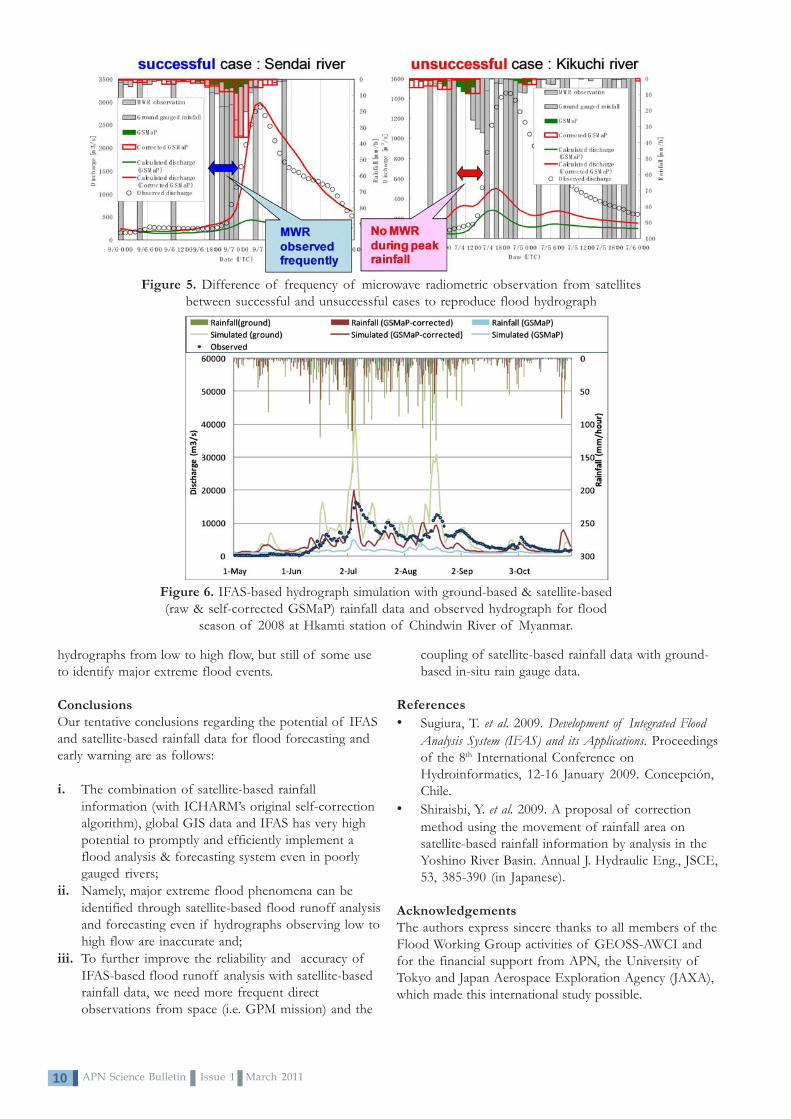
However, we also discovered some cases in which self-corrected satellite-based rainfall data cannot reproduceflood hydrographs properly (Figure 5). It was clarifiedthat such poor results could be obtained if the frequencyof real observation of rainfall from space wasinsufficient during the rainfall increasing period.Therefore, it is almost apparent that we need the realimplementation of Global Precipitation Measurement(GPM) mission, which has been planned by JAXA, NASAand other space agencies making it possible to observeany area in the world once every three hours (in 5-6hours at present). Figure 6 shows another application ofIFAS with self-corrected GSMaP_NRT rainfall data forhydrograph simulation at the Hkamti streamflow gaugingstation of the Chindwin River in Myanmar (27,420 km2).There is only one rain gauge at Hkamti and no rain gaugein the upstream area. Therefore, it is not surprising thatrunoff simulation with self-corrected satellite-basedrainfall data was better than that with one rain gauge data,in the sense that the former hydrograph was not socoincident under low flow conditions but very successfulin identifying three of the biggest flood peaks of 2008.This suggests that self-corrected satellite-based rainfalldata without any ground-based rain gauge data areinsufficient not enough to precisely reproduce
Figure 2. Comparison between satellite-based (JAXA-GSMaP_NRT) and ground-based areally averaged
rainfall data for a few river basins in Japan and USA.(Black plots: raw GSMaP_NRT; red plots: self-corrected
GSMaP_NRT)
APN Science Bulletin Issue 1 March 201110
hydrographs from low to high flow, but still of some useto identify major extreme flood events.
ConclusionsOur tentative conclusions regarding the potential of IFASand satellite-based rainfall data for flood forecasting andearly warning are as follows:
i. The combination of satellite-based rainfallinformation (with ICHARM’s original self-correctionalgorithm), global GIS data and IFAS has very highpotential to promptly and efficiently implement aflood analysis & forecasting system even in poorlygauged rivers;
ii. Namely, major extreme flood phenomena can beidentified through satellite-based flood runoff analysisand forecasting even if hydrographs observing low tohigh flow are inaccurate and;
iii. To further improve the reliability and accuracy ofIFAS-based flood runoff analysis with satellite-basedrainfall data, we need more frequent directobservations from space (i.e. GPM mission) and the
Figure 5. Difference of frequency of microwave radiometric observation from satellitesbetween successful and unsuccessful cases to reproduce flood hydrograph
Figure 6. IFAS-based hydrograph simulation with ground-based & satellite-based(raw & self-corrected GSMaP) rainfall data and observed hydrograph for flood
season of 2008 at Hkamti station of Chindwin River of Myanmar.
coupling of satellite-based rainfall data with ground-based in-situ rain gauge data.
References• Sugiura, T. et al. 2009. Development of Integrated Flood
Analysis System (IFAS) and its Applications. Proceedingsof the 8th International Conference onHydroinformatics, 12-16 January 2009. Concepción,Chile.
• Shiraishi, Y. et al. 2009. A proposal of correctionmethod using the movement of rainfall area onsatellite-based rainfall information by analysis in theYoshino River Basin. Annual J. Hydraulic Eng., JSCE,53, 385-390 (in Japanese).
AcknowledgementsThe authors express sincere thanks to all members of theFlood Working Group activities of GEOSS-AWCI andfor the financial support from APN, the University ofTokyo and Japan Aerospace Exploration Agency (JAXA),which made this international study possible.

11APN Science Bulletin Issue 1 March 2011
Good Water Governance:Could Stakeholder Participation Reduce WaterInsecurities in River Basins in Asia-Pacific?
AbstractThis article focusses on water governance at a river basinlevel and the role of coordination, participation andpartnerships between multiple stakeholders to reducewater insecurities they are facing. Water-related risks areattributed not only to escalating global and local changes,but to a high extent to failures in good water governancein river basins or their sub-basins. The key finding is thatriver basins in the Asia-Pacific region vividly demonstratethe emerging trend of state-centric governance evolvingtowards encompassing multi-stakeholder approaches.Broadening engagement, interaction and consolidatingpartnerships between public, private and civil societyactors appears to be among the effective tools in goodwater governance. One of the messages is thatstakeholder participation, related opportunities andbarriers is a very ‘context’ oriented issue being dependenton existing specific national and local socio-economic,cultural, political and sustainability priorities. The articleexplores and compares stakeholder involvement andpartnerships in water management in river basins inAustralia, China, Russia, Thailand and Viet Nam. Findingsare aggregated and contrasted to worldwide trends.
Keywords: stakeholder participation, partnerships, watergovernance, river basins
Elena Nikitina1, L. Lebel, B.T. Sinh
Corresponding author1
EcoPolicy Research and Consulting, Moscow, Russia. Email: [email protected]
IntroductionPervasive land-use and water-use changes are beingcompounded by changes in global climate tofundamentally alter water insecurity in all river basinsacross the Asia-Pacific region – in developed anddeveloping countries, and in transition economies. Waterrisks include common challenges of shifting floodregimes, seasonal water shortages and multi-year droughts,deteriorating water quality, and problems of access to safedrinking water and sanitation. There is a growingrecognition worldwide that poor water governance isamong the major factors underlying aggravated waterproblems and risks. Inadequacies of existing watergovernance systems and mechanisms through which theycurrently perform in river basins, explain to a high extentthe vulnerabilities of societies to water insecurities.
Today, new trends and patterns in water governance areemerging in Asia-Pacific countries. In many places, watergovernance begins to shift from strongly state-centricapproaches towards more inclusive and participatorymodes with greater opportunities for interactions betweenstakeholders. It becomes clear that success depends onmulti-scale efforts not only by governments, who remaincritical players, but also on the roles of other actorshaving an interest, or capacity, to act.

APN Science Bulletin Issue 1 March 201112
ARCP2009-03CMY-NikitinaReducing Water Insecurity through StakeholderParticipation in River Basin Management in the Asia-Pacific
Project Leader:Dr. Elena NikitinaEcoPolicy Research and ConsultingRUSSIAN FEDERATIONTel: +7 985 773 3687Fax: +7 985 773 3687Email: [email protected]
APN Funding:US$95,000 (For 2 Years)
Research Highlights• Diversified water governance systems are in
place in many Asia-Pacific countries: potentiallyproviding substantial capacity to address waterinsecurities and to adapt to global change.
• Water governance in the region is graduallyshifting from strongly state-centric approachestowards more inclusive and participatory modeswith greater opportunities for interactionsbetween stakeholders.
• Success in water-related risk reduction dependson multi-scale efforts not only by governments,who remain critical players, but also on the rolesof other actors having an interest, or capacity, toact.
• Stakeholder participation and partnershipsbetween state and non-state actors is a good toolin dealing with water-related insecurities.
• Stakeholder engagement is a very ‘context’oriented issue that is dependent on existingspecific national and local socio-economic,cultural, political and sustainability priorities.
The present article presents the findings of a comparativeand synthetic study based on gathering of new empiricaldata and new analyses of responses to reduce water-related risks with a particular focus on how stakeholdersare engaged in water governance in river basins. It looksat the new trends and lessons learned about stakeholderparticipation in basin water management in five Asia-Pacific countries: Red and Mekong in Viet Nam; Amur inRussia, Salween in China, Ping-Chao Phraya in Thailand,and Latrobe in Australia. Opportunities and constraintsfor stakeholder participation and lessons learned aboutsuccess and failures are discussed.
Material and MethodsThe research method was based on a comparison andsynthesis of results from river basins in five Asia-Pacificcountries, including findings related to (i) responses towater insecurities and their impacts1, (ii) roles andengagement of multiple stakeholders, and (iii)opportunities and limitations for stakeholderparticipation/partnerships in water governance. Threemajor clusters of stakeholders were compared within thecountry studies: government authorities at various levels,business, and civil society.
This was a country-based and river basin/sub-basin-basedanalysis and empirical data collection. The studies wereundertaken in sub-basins of Latrobe in the Gippslandregion of Australia, in northern sub-basins of the Nu-Salween and northern Mekong in China, Ping-ChaoPhraya in northern Thailand, Red and Mekong in VietNam and in the Russian provinces of the Amur.Analytical exploration and data compilation aboutstakeholders’ participation in river basins were organisedaccording to a common format applied by each countrycase study. Aggregation of results from case-studies andcomparing them with worldwide trends was also part ofthe research methodology applied.
ResultsOur research shows that states in the Asia-Pacific riverbasins tend to respond to water-related insecurities withincreasingly sophisticated institutional frameworks. This isa worldwide trend. A variety of water governancearrangements2 are in place in all five countries understudy and, taken together, they potentially providesubstantial capacity to address water insecurities and toadapt to global change. But practices and their actualperformance demonstrate many limitations, weaknessesand gaps (Kotov, 2009). There are a number of prioritiesfor reforms and innovation, including, for example,application of integrated water resources management(IWRM) and basin-level planning and coordination, andadaptation to global change.
Today, water governance begins to gradually shift towardsmore inclusive and participatory modes with greateropportunities for interactions between stakeholders. Theyinclude state and non-state actors. The synthesis showsthat a variety of different stakeholders are involved inwater management in river basins. Interests, capacities,influence and power of stakeholders vary widely acrossproblem domains and scales (Nikitina et al., 2010).
1 The set of risks analysed includes (1) water quality, especially the quality of drinking water, (2) water supply and wateravailability for agriculture; (3) floods, (4) water in urban areas. Exploring possible insecurities associated with global climatechange is emphasised.
2 Existing arrangements include, for example, legislation, programs, water administrations and river basin organisations, pollutionand flood control institutions, water services, management of hydro technical facilities, as well as bilateral and multilateralarrangements in shared rivers.

13APN Science Bulletin Issue 1 March 2011
While discussing the issues of stakeholder participation itis often perceived that stakeholders mainly include actorgroups representing the public. But, we suggest a widerapproach that encompasses the multiplicity ofstakeholders, including, for example, governmentauthorities, river basin organisations (RBO) andintergovernmental international bodies and the privatesector. Close interactions between them is a key to goodwater governance. Aggregated findings from river basinsindicate that stakeholders can be classified into three mainactor groups- government authorities, business andpeople- at different levels (Figure 1). The stakeholdermeta-class ‘people’ in this framework is also described as‘civil society’ or ‘non-profit’ or ‘the public’ by others.
There is a number of common features of stakeholderinvolvement in river basins in the Asia-Pacific: (i) in allcountries and river basins stakeholder engagement is anunderlying trend during the last decade; (ii) althoughforms of public engagement vary significantly - fromdialogues and discussions on water planning, or betterflood protection, to regular participation in activities, riverbasin councils their set is typical for major river basins;(iii) the role of the government, river basin authorities inwater management remains high in all countries; (iv) theincreased role of various businesses is a new trend; (v)public participation is widely touted as critical to gainingpublic acceptance for policies and projects; (vi) indeveloping countries and transition economies the role ofinternational agencies and organisations in mobilisingstakeholder involvement is high; and (vii) relationshipsbetween actors are critical and success depends on theability to develop mutual trust between actors: whengovernment agencies are committed and play active rolesto promote increased partnerships, it increases thechances for successful outcomes (Lebel and Sinh, 2009)
DiscussionIntegrated approaches to river basin water managementimply more frequent engagement with a broader diversityof stakeholders from within government, business andpublic spheres. One of the messages from our studies isthat stakeholder participation needs to be furthersupported and promoted through various incentivemechanisms and capacity building, through enhancingawareness-based approaches, information sharing,dialogues, consultations, constructing state-privatepartnerships, organising campaigns for rehabilitation ofriver sites and joint actions in flood risk reduction at thelocales.
Cross-country comparisons indicate that the extent ofpublic awareness and participation in water managementvaries significantly across cases and river basins. Publicparticipation as a social norm is more extensive inThailand than in either Russia or Viet Nam. Here, thedomestic non-governmental organisations and variousadvocacy networks regularly challenge state policies anddecisions on water-related infrastructure with critiques inmass media and well-organised protests and campaigns. InRussia, environmental awareness of the public andresponsibility to take water-related actions are low, and thepublic still heavily relies on ‘paternalism’ of governmentauthorities; environmental awareness had been subduedduring the communist regime (Nikitina et al., 2009). InAustralia, with its well developed democratic traditions,civil society involvement is much higher.
Detailed pathways and mechanisms through whichstakeholder participation and coordination reduce waterinsecurities deserve further investigation. Potentiallyimportant mechanisms include: (i) making interests,capacities and risks of the most vulnerable groups,
Figure 1. Conceptual framework for thinking about different types of stakeholders at different levels

APN Science Bulletin Issue 1 March 201114
otherwise marginalised from assessment and planningprocedures, more visible within and across nationalboundaries; (ii) wider sharing and better understanding ofknowledge and practices, critical for the reduction ofdisaster risks; (iii) social learning around risks andvulnerabilities leading to new management goals and moreopportunities for collective responses, linking whereappropriate domestic and international efforts; and (iv)higher public acceptance of policies and measuresproposed by governments or under internationalagreements (Lebel et al., 2009).
The study provides a great deal of evidence about goodpractices and useful lessons learned from experiences instakeholder participation and partnerships in the countriesof Asia-Pacific on how to deal with water-relatedinsecurities (Lebel et al., 2010). More attention should begiven in the future to selecting mechanisms and tools forexchange of good practices across countries. At the sametime, in many cases direct automatic transfer of nationalexperiences without their prior adaptation to natural,socio-economic, cultural and political specifics of therecipient river basins of the Asia-Pacific region does notalways provide for expected results. Thus, ‘transfer andadaptation’ of good practices and experiences should gohand in hand; analysis and assessment of relatedproblems and challenges is among one of the importantavenues for future action.
More theoretical and practical thinking needs to be givento assessing particular roles and influences of eachstakeholder group in the river basins under study, and tounderstanding how stakeholder participation-partnershipsare, or will be, embedded into water governance regimesand in future institutional innovations.
ConclusionsInstitutional reforms undertaken in the water sector arefrequently unsuccessful in meeting mandates and targets.Constraints and limitations for good water governanceinclude: (i) shortages in public policies and theirperformance, (ii) weaknesses in identifying clearly water-related risks and respective response options, (iii)inadequate coordination (horizontal and vertical) betweenactors, (iv) poor support and incentives for stakeholderengagement, (v) weak respect of the rights of indigenousgroups and those actors who have ‘long-standing relationswith a river,’ (vi) limited use of scientific and traditionalknowledge, and (vii) fragmented adaptation bystakeholders to climate change. These are regarded ascommon gaps in addressing water insecurities throughexisting water management systems in river basins understudy. They are compounded by specific problems and‘situational factors’ in particular places.
Stakeholder participation is expanding in all river basinsunder study, although the scales and forms vary acrossbasins. More intensive and diversified lies in thosecountries with developed economies and democracies
(Australia), while in transition societies (Viet Nam, China,Russia) it is more limited for various reasons, includingthe heritage of the centrally planned systems and lowerpublic awareness. The importance of non-state actorsacross all river basins is growing. Multiple localstakeholders such as business, indigenous peopleorganisations, households, non-governmentalorganisations, river councils and sub-national units ofgovernment, are starting to play increasing roles inreducing water-related insecurities. The role of thegovernment and river basin authorities in watermanagement remains high in all countries.
References• Kotov, V. 2009. Russia: Changes in water
management and the water law, in: Dellapenna, J.,Gupta, J. (Eds.), The Evolution of the Law andPolitics of Water. Springer Science–Business MediaBV.
• Lebel, L. and Sinh, B.T. 2009. Risk reduction orredistribution? Flood management in the Mekongregion. Asian Journal of Environment and DisasterManagement. 1, 23-39.
• Lebel, L., Foran, T., Garden, P., and Manuta, B.J.2009. Adaptation to climate change and social justice:challenges for flood and disaster management inThailand, in: Ludwig, F., Kabat, P., Van Schaik, H.,Van der Valk, M. (Eds.). Climate change adaptation inthe water sector. Earthscan, London.
• Lebel, L., Sinh, B. T., Nikitina, E., 2010. Governingrisks: climate change, water insecurities, and disastermanagement, in: Shaw, R. (Ed.), Climate ChangeAdaptation and Disaster Risk Reduction, EmeraldPublishers.
• Nikitina, E., Ostrovskaya, E., and Fomenko M. 2009.Towards better water governance in river basins:Some lessons learned from the Volga. RegionalEnvironmental Change, Springer. 9,2, 1-13.
• Nikitina, E., Lebel, L., Kotov, V., and Sinh, B.T. 2010.How stakeholder participation and partnerships couldreduce water insecurities in shared river basins, in:Ganoulis, J. (Ed.). Water Resources Across Borders: AMultidisciplinary Approach to Transboundary WaterManagement. Wiley VCH, Germany.
AcknowledgmentsThis article is based on results of a two-year closecollaboration of all APN project partners and their teams.We thank external experts for their advice andcontributions. We thank national organisations for supportof our activities, including Unit for Social andEnvironmental Research, National Institute for Scienceand Technology Policy and Strategy Studies, EcoPolicy,Russian Scientific Fund on Humanities, and collaboratinginternational projects, including Twin2Go, M-Power,CABRI, ASEMWaterNet. We would like to extend oursincere appreciation for the APN support.

15APN Science Bulletin Issue 1 March 2011
AbstractFour successful workshops on Climate Change Adaptationwere held for 130 senior officials from Fiji, Samoa, Tongaand Tuvalu between June and August 2010. Theseworkshops, organised by the University of the SouthPacific, featured briefings on likely impacts of climatechange on Pacific Islands and sought suggestions forpolicy changes for island adaptation. Climate change willincrease existing threats to coral reefs due to unsustainablefishing, pollution from the land and habitat destruction viasea level rise, sea temperature rise, ocean acidification andincreased strengths of cyclones. Rapid population growthwill exacerbate these. All countries recognise the threatsposed by climate change and have signed relevant UnitedNations (UN) Conventions and Agreements. They all havepolicies to tackle climate change threats. However, thegovernments have a lack of capacity to seriously addressclimate change threats and these are yet to beincorporated as a cross-cutting theme among the relevantgovernment departments. The countries recognise a needto raise awareness of the issues and include these inschool curricula, which are often based on developedcountry models. Tonga recognises that existinggovernment departments will need to improvecommunication and coordination to develop an integratedapproach. Fiji questions whether a national ocean policycould serve the purpose of addressing issues such as
G. Robin South1, S. Bala, P. Chand, L. Limalevu, C. Morris, J. Veitayaki, C. Wilkinson
Corresponding author1
The University of the South Pacific, Institute of Marine Resources, Alafua Campus, Samoa. Email: [email protected]
sustainable fisheries management (including ecosystem-based management), cross-sectoral corporation, linkingscientists with policy makers, education and awareness.Samoa recognises the challenges presented by developingan integrated approach, which involves cutting acrossministries. Tuvalu has several existing social and economicthreats despite their traditional leadership system. Thegovernments recognise that an expansion of MarineProtected Areas (MPAs) offers a potential mechanism,however only Fiji and Samoa have active MPAprogrammes in association with user communities. Thecountries recognised that building on the Regional OceansPolicy template approved by the Forum Leaders in 2002was an essential first step in improving policy and allrecognise the important role of climate change in thelong-term sustainability of their marine resources andfood security.
IntroductionHealthy coral reefs are vital to the sustainability of thepeoples’ livelihoods in the Pacific Islands. However, globalchange including sea level rise, increased sea surfacetemperature, ocean acidification, and numerous naturalphenomena like cyclones coupled with the effects ofhigher population, have increasing and often worseningimpacts on Pacific coral reefs, leading to increasedvulnerability of coastal communities. Integrating the
knowledge of global changeacross various nationalgovernment sectors, thentranslating this into policiesthat lead to sustainablemanagement of coastalecosystems is the challengethat the present project isultimately aimed at addressing.The project brought seniorPacific Leaders in Fiji, Tonga,Samoa and Tuvalu togetherwith scientists and experts onthe sustainable managementof coral reefs, so that theycould be apprised of theimpacts of global changes and
Global Change and Capacity Buildingin Coral Reef Management in the Pacific:Engaging Scientists and Policy-Makers in Fiji,Tonga, Samoa and Tuvalu

APN Science Bulletin Issue 1 March 201116
CBA2010-15NMY-SouthGlobal Change and Coral Reef ManagementCapacity in the Pacific: Engaging Scientists and Policy-Makers in Fiji, Samoa, Tuvalu and Tonga
Project Leader:Prof G. Robin SouthInstitute of Marine ResourcesUniversity of the South PacificFIJITel: +67 9 323 2151Fax: + 67 9 323 2158Email: [email protected]; [email protected]
APN Funding:US$ 40,000 (15-month period)
of those factors that are affecting the health of theircoral reefs. This engagement process was conductedthrough face-to-face dialogue between reef expertsfamiliar with the science of climate change, andgovernment, non-governmental organisations and civilsociety personnel responsible for the development ofappropriate policies focussing on the sustainablemanagement of coral reefs in the four target countries.
MethodologyWorkshops were held between June and August 2010, atwhich some 130 senior officials from the four countriesattended. Prior to the workshop, detailed country dossierswere prepared by the project team in consultation withthe countries. The workshop format comprisedpresentations on the current status of coral reef andclimate change issues and policies and some existinginitiatives given by the project team leaders, governmentofficials, NGOs and civil society representatives.Following open discussions, break-out groups reviewedand analysed the needs and gaps (as per country dossier)and recommended modifications, additions andcomments. The resulting conclusions were then discussedin Plenary, where a national coral reef action plan wasformulated using the suggestions from the breakoutgroups.
Results and DiscussionMost people heavily depend on coral reefs and theirresources for their livelihood especially in the PacificIslands. This over dependence on coral reef ecosystemscan have adverse effects to the continuance of abalanced ecosystem. Some of the major threats thataffect the reef ecosystem are: global climate change,overfishing, pollution, coastal development and biologicalthreats. Exacerbating all of these is rapid populationgrowth. All of these threats are evident to greater orlesser extents in the target countries. However, monitoringresults in the South West Pacific have indicated that reefsin this region appear to be resilient in the face ofcontinuing acute threats from increased sea surfacetemperatures, cyclones, tsunamis and crown of thorns,although there are suggestions that reefs are experiencingan increase in exposure to chronic stresses such ashuman-induced impacts, which are difficult to measure(Whippy-Morris, 2009). As suggested by Veitayaki et al.,(2007), the challenge for the Pacific Islands is to designand institute a disaster management plan at the regional,national and district local levels.
ConclusionsAlthough there are great differences among the fourtarget countries in terms of size, environment, cultureand population, the workshops agreed on a number ofcommon and recurrent themes. All of the countries aresignatory to the relevant UN Conventions andAgreements relevant to global change and theenvironment, although for some, reporting presents
challenges. All countries have in place and are currentlyreviewing or updating necessary policies regarding theconservation and sustainable use of their coral reefs andmarine resources, and all recognise the important role ofclimate change in the long-term sustainability of theirmarine resources and food security, but climate changeissues have not yet been incorporated as a cross-cuttingtheme among the relevant government departments. InTonga, for example, the Ministry of Environment andClimate Change seeks to put things in perspective underone umbrella, but it was evident that there are difficultiesbetween them and Fisheries regarding allocation offunding and responsibilities.
In general, the governments recognise the need forintegrated planning, but there is a need to improvecommunications among those line departmentsresponsible for the management of coral reefs: for somethis will require a significant change in mind-set andmodus operandi. There was a universal lack of knowledgeof the 2002 Pacific Islands Regional Oceans Policy(PIROP), developed and approved by the ForumLeaders and presented at the World Summit onSustainable Development (WSSD) held in Johannesburg,South Africa. In discussions, two countries (Tonga andTuvalu) resolved to examine the possibility of using thePIROP as a template for the development of NationalOceans Policies.
The need to raise public awareness about global changeand coral reef issues were recognised by all, as was theneed to find ways to incorporate marine issues in theschool curriculum. Much of the curriculum is currentlybased on developed country principles. This wouldrequire the necessary teacher education. Common threatsto coral reefs throughout the region include unsustainablefishing causing stock depletion, pollution from land-basedsources, habitat destruction and global climate change. Allof these threats are evident to greater or lesser extents inthe targeted countries.

17APN Science Bulletin Issue 1 March 2011
All four countries recognise over-fishing and depletion ofreef fish stocks as a major problem and this, coupled withever-increasing population growth rates indicate that therewill be serious fish shortages within the next twenty years,unless some strong conservation and managementmeasures are put in place. The importance of monitoringin support of management and policy is considered a highpriority in all countries, although the lack of monitoringcapacity is a limiting factor. The difficulty in enforcementof fishery regulations is a serious problem throughout,largely because of a lack of capacity and the logisticalchallenge posed by the scattered nature of islands.Alternative livelihoods will need to be developed fordisenfranchised fishers. The expansion of aquaculture isseen as a possible replacement source for reduced proteinsupplies; however, the scope for this is limited in Samoaand Tuvalu. With the exception of Fiji, NationalBiodiversity inventories are seriously inadequate andmuch of the marine biodiversity, with the exception ofcommercially important species, is unrecorded. Allcountries recognised the need for much more work onthe development of their National Marine BiodiversityInventories (NMBIs). The scarcity of national or regionalexperts in taxonomy is a hindrance and training in thisarea is urgently needed.
The establishment and management of MPAs (orsimilarly designated areas) is of high priority in all thecountries, as well as the recognition of the important rolethey play in conservation; but only in Fiji and Samoa hasthis reached a high level of community engagementthrough the Fiji Locally Managed Marine Areasprogramme, and the Village Fish Reserves, accompaniedby Village By-Laws in Samoa. Community engagementwas seen as crucial to the long-term effectiveness ofprotected areas. Tonga has a variety of reserves andparks, with policies and community engagement stillevolving, whereas in Tuvalu there is only one significantMPA (involving strong community participation), whilethe Falekaupule (traditional assembly) in the outer islandsare exercising control in the use of their fisheriesresources.
The project team will re-visit the target countries in 2011in order to measure progress in the implementation oftheir workshop actions and/or respective coral reefaction plans.
References• Foale, S. 2008. Conserving Melanesia’s coral reef
heritage in the face of climate change. HistoricEnvironment. Vol 21. No.1.
• Gillie, R. 1994. Distinctive physical features ofPacific Island coastal zones. In: Coastal protection inthe Pacific Islands: current trends and futureprospects. Proceedings of the first and secondregional coastal protection meetings held 21-23February 1994 in Apia, Western Samoa and on 16-20
The workshopsidentified thefollowing action forfollow up:
- Need to upgrade NMBIs, and forsurveys in Tonga, Samoa and Tuvalu.
- Introduction of the Seagrass Watchprogramme recommended for Tongaand Samoa.
- Development of a regional climatechange clearing house proposed,preferably at USP.
- Need for capacity building in allcountries.
- Need to address the disconnectionbetween communities, government andother players.
- Need to harmonise projects so as tohave better coordination amongagencies.
- Need to assist with the marine scienceprogramme at the National Universityof Samoa.
- Need to raise public awareness of coralreef issues, and to find ways ofintroducing relevant curriculum inschools.
- Support the Two Samoas initiatve.- Facilitate attachments of USP students
with their home governments.- Introduce coral identification training in
Tonga, Samoa and Tuvalu.- Encourage closer cooperation with
SPREP on coral reef and coral reefmanagement issues.
- Need for good governance at thecommunity level.
- Need for continuous monitoring insupport of government policies, andcreate relevant statistics on stock andfishing in order to understand trends.
- Need for more MPAs

APN Science Bulletin Issue 1 March 201118
May 1994 in Suva, Fiji. Secretariat of the PacificRegional Environment Programme and South PacificGeoscience Commission.
• Lovell, E. 2004. Baseline biological survey ofTu’atuga reef (5 mile reef), Samoa. Unpublished report.
• Lovell, E., Sykes, H., Deiye, M., Wantiez, L.,Garrigue, C., Virly, S., Samuelu, J., Solofa, A., Poulasi,T., Pakoa, K., Sabetian, A., Afzal, D., Hughes, A.,and Sulu, R. 2004. Status of Coral Reefs in TheSouth West Pacific: Fiji, Nauru, New Caledonia,Samoa, Solomon Islands, Tuvalu and Vanuatu. In:Status of Coral Reefs of the World: 2004. Vol. 2. pp.337-361. C. Wilkinson. Global Coral ReefMonitoring Network. c/- Reefs and RainforestResearch Centre, Townsville, Australia.
• Lovell, E. 2005. Coral Bleaching In Fiji and the SouthPacific. PIMRIS Newsletter.Vol. 17. No. 4. PIMRISCoordination Unit. Marine Studies Programme,University of the South Pacific.
• Lovell, E., Samuelu Ah Leong, J., Bell, L., Ifopo, P.,McAdoo, B., Skelton, P., and Ward, J. 2009.Inspection of selected coral reefs on Upolu Samoafollowing the 30 September 2009 Tsunami.Unpublished report.
• Mosley, L. and Aalbersberg, B. 2005. Nutrient levelsand macro-algal out-breaks in Fiji’s coastal waters. IASTechnical report No. 2005/01. University of theSouth Pacific.
• Newton, K., Cote, I.M., Pilling, G.M., Jennings, S.,and Dulvy, N.K. 2007. ‘Current and futuresustainability of island coral reefs fisheries’ CurrentBiology 17, 655-658, April 3.
• Palaki, A., Samani, T. and Masi, M. 2005. Soilsedimentation effect on the coastal marineenvironment, Tefisi Village, Vava’u. Department ofEnvironment, Tonga. Unpublished report.
• Pippard, H. 2009. The Pacific islands: an analysis ofthe status of species as listed on the 2008 IUCN RedList of Threatened Species™. International Unionfor Nature Conservation.
• Pomeroy, R.S., Parks, J.E., and Balboa, C.M. 2004.‘Farming the reef: is aquaculture a solution forreducing pressure on coral reefs?’. Marine Policy. 20p.
• Roberts, C.M. 1995. ‘Effects of fishing on theecosystem structure of coral reefs,’ ConservationBiology, 9 (5): 988-995pp.
• Sadovy, Y. and Domeier. 2005. Are aggregation-fisheries sustainable? Reef fish fisheries as a case study.Coral Reefs (2005) 24: 254–262.
• Samuelu, J.I. and Sapatu, M. 2007. ‘Status of CoralReefs in Samoa,’ In: Status of Coral Reefs in theSouth-West Pacific: 2007,’ Cherie Whippy-Morris (Ed),CRISP publication.
• Scales, H., Balmford, A., and Manica, A. 2007.‘Impacts of the live reef fish trade on populations ofcoral reef off northern Borneo,’ Proceedings of the RoyalSociety B 274: 989-994.
• Solomon, S., Qin, D., Manning, M., Alley, R.B.,Berntsen, T., Bindoff, N.L., Chen, Z., Chidthaisong, A.,Gregory, J.M., Hegerl, G.C., Heimann, M., Hewitson,B., Hoskins, B.J., Joos, F., Jouzel, J., Kattsov, V.,Lohmann, U., Matsuno, T., Molina, M., Nicholls, N.,Overpeck, J., Raga, G., Ramaswamy, V., Ren, J.,Rusticucci, M., Somerville, R., Stocker, T.F., Whetton,P., Wood, R.A., and Wratt, D. 2007: TechnicalSummary. In: Climate Change 2007: The Physical ScienceBasis. Contribution of Working Group I to the FourthAssessment Report of the Intergovernmental Panel on ClimateChange [Solomon, S., Qin, D., Manning, M., Chen, Z.,Marquis, M., Averyt, K.B., Tignor M., and Miller, H.L.,(Eds.)]. Cambridge University Press, Cambridge, UnitedKingdom and New York, NY, USA.
• Veitayaki, J., Manoa, P., and Resture, A. 2007.Addressing climate change and sea level rise in thePacific Islands.
• Whippy-Morris, C. (Ed.) 2009. South-West Pacificstatus of coral reefs report 2007. CRISP.
AcknowledgementsThe Global Change and Capacity Management in thePacific Project (CBA2010-15NMY-South) would not havebeen possible without the financial support provided by theAsia-Pacific Network for Global Change Research (APN).The Institute of Marine Resources is appreciative of thisopportunity. The Institute of Marine Resources gratefullyacknowledges our partners, the Pacific Centre forEnvironment and Sustainable Development and STARTOceania at the University of the South Pacific (USP).
In addition, our gratitude to the Governments of Fiji,Tonga, Samoa and Tuvalu, the USP centres in Tonga andSamoa and the Secretariat of the Pacific RegionalEnvironment Programme for their logistical support andencouragement.
http://www.msnbc.msn.com/id/33358072/http://www.tellusconsultants.com/Thread/ACANTH.HTMhttp://www.sprep.org/topic/marine.htmhttp://www.noaa.govhttp://www.coris.noaa.gov
websiteswebsiteswebsiteswebsiteswebsites

19APN Science Bulletin Issue 1 March 2011
Global Environmental Change and FoodSecurity in the Indo-Gangetic PlainAjaya Dixit1, Kanchan Mani Dixit
Corresponding author1
Nepal Water Conservation Foundation, Nepal. Email: [email protected]; [email protected]
AbstractThe intensification of technological and economicglobalisation escalating the emission of greenhouse gases(GHGs) into the atmosphere has contributed to globalclimate change. The result is more erratic rainfall,frequent and intense floods and increasing water scarcity(NCVST, 2009). Both flood and drought affect foodsecurity in many developing countries. Because they ownfew assets, are uneducated, have no skills, and are, ingeneral, deprived, many poor people do not possess theability or the resources to recover when extreme floodsand droughts disrupt their livelihoods. Since conditions onwhich their livelihoods depend are increasingly stressed,their lack of capacity to respond to these impacts impliesthat poor people will continue to live in an impoverishedcondition. The consequences of these changes in foodsecurity on the poor are serious and varied, depending onthe food production systems involved. This challenge inthe Indo-Gangetic Plain (IGP) is serious. The presentcollaborative study attempts to understand food systemvulnerabilities and identify its challenges in IGP.
Keywords: food system, vulnerability, IGP, food systemdeterminants, adaptation, GEC
IntroductionClimate change is only one of the processestransforming societies in the IGP. Other drivers areurbanisation and the penetration of communicationsystems. As both proceed, populations, particularlythose in urban regions and nearby towns, are growingincreasingly dependent on ecosystems outside theirimmediate environments for meeting their water andfood needs. Even rural populations import food,opening them up to new sources of vulnerabilities. Asurbanisation and developments in communicationcontinue apace and ecosystems degrade, thedependence of local populations on globalised labour,products and markets increases. Indeed, while theimpacts of climate change differ according to localconditions, many of these impacts are transmitted tolocal regions through interactions with globalisedsystems to create second-order impacts.
Food systems contribute to environmental and otherinsecurities as interactions between and within bio-geophysical and human environments influence bothfood system activities and their outcomes (Ericksen,2007). The over-extraction of groundwater to
Figure 1. Study sites in IGPSource: Modified from GECAFS (2008)

APN Science Bulletin Issue 1 March 201120
CRP2008-01CMY-DixitImproving Policy Responses to Interactions betweenGlobal Environmental Change and Food Securityacross the Indo-Gangetic Plain (IGP)
Project Leader:Dr. Ajaya DixitNepal Water Conservation Foundation (NWCF)Post Box 2221, Patan Dhoka, LalitpurNEPALTel: +977 1 554 2354Fax: +977 1 552 4806Email: [email protected];[email protected]
APN Funding:US$ 180,000 (For 3 Years)
overcome drought and the rising demand associatedwith population growth and development, and thedeterioration of surface water sources throughpollution have placed additional stress on food systems.
Food system vulnerability can be conceived as both afunction and the outcome of the intersection ofmarginality and the exposure of systems to climateshocks. No matter what the climate change scenario ofthe future is, local food security will be affected andaddressing this issue will require the consideration ofmultiple expressions of vulnerability. FAO (2009) haspredicted that food production will have to increase by70% by 2050 in order to feed an additional 2.3 billionpeople and there will have to be much more effort toimprove the distribution of and access to food.
The Nepal Water Conservation Foundation (NWCF)with support from the Asia-Pacific Network for GlobalChange Research (APN) conducted a collaborativestudy in the IGP to understand food systemvulnerabilities, examined from the systemic perspectiveof food security dimensions: food availability, foodaccessibility, and food utilisation (Figure1).
The collaborating partners of the study were:Gorakhpur Environment Action Group (GEAG),Global Change Impact Studies Centre (GCISC),Pakistan and Punjab Agricultural University (PAU),Centre for Global Change (CGC), Bangladesh. Inaddition, the Global Environmental Change and FoodSystems (GECAFS), London officers and theAustralian National University faculties supported thestudy.
Agricultural and food systems are influenced bysocioeconomic conditions, which themselves areaffected by macro-level policies and the spread ofinfectious diseases. These systems, along with changesin climate and demographics and poor agriculture-related infrastructure and widespread povertycontribute to food insecurity in the IGP. The predictedrise in food insecurity and its negative outcomes lowerthe potential of the IGP, which is characterised byfertile soil, a favourable climate and an abundantsupply of water (Agrawal et al., 2004). Its peopledepend on small-scale and rain-fed agriculture and areamong the poorest in the world. Their poverty is oftenattributed to the regular floods and drought that prevailafterwards (Bandhyopadhyaya, 1999). One of the
Local food collectionpoint: How will climate
change and otherstressors affect
these decentralisedsystems and contribute
to local foodinsecurity?
21APN Science Bulletin Issue 1 March 2011
security issues across selected sites of the IGP, thepresent study brought to light the following insights:
i. Efforts need to be made to document the utilityof different types of decision support tools,including cost-benefit analysis, vulnerabilityassessments, climate risk assessments, planningfor uncertainty and resilience planning, genderand social dimensions, multi-stakeholderconsultations and SLDs. Decision support systemscan help translate research evidence into policyaction.
ii. Communication among locals, policy-makers andresearchers needs creative approaches to developdecision support systems. In developing suchsystems we must recognise that policy activitiesneed to involve plural actors, and that suchactivities occur at various scales from local tonational to global.
iii. Scenario development is a useful tool fordisplaying various options for addressing issuesunder different sets of conditions. Irrespective ofthe climate change scenario used, food securitywill be affected and will hamper the ability oflocal populations to adapt.
iv. Food systems are vulnerable to disruptions causedby the impacts of climate change and can beimproved by increasing productivity through
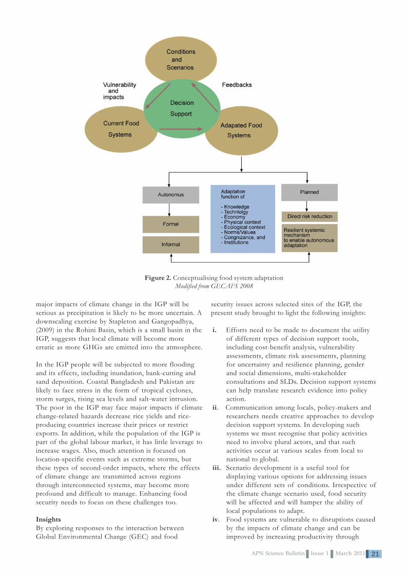
Figure 2. Conceptualising food system adaptationModified from GECAFS 2008
major impacts of climate change in the IGP will beserious as precipitation is likely to be more uncertain. Adownscaling exercise by Stapleton and Gangopadhya,(2009) in the Rohini Basin, which is a small basin in theIGP, suggests that local climate will become moreerratic as more GHGs are emitted into the atmosphere.
In the IGP people will be subjected to more floodingand its effects, including inundation, bank-cutting andsand deposition. Coastal Bangladesh and Pakistan arelikely to face stress in the form of tropical cyclones,storm surges, rising sea levels and salt-water intrusion.The poor in the IGP may face major impacts if climatechange-related hazards decrease rice yields and rice-producing countries increase their prices or restrictexports. In addition, while the population of the IGP ispart of the global labour market, it has little leverage toincrease wages. Also, much attention is focused onlocation-specific events such as extreme storms, butthese types of second-order impacts, where the effectsof climate change are transmitted across regionsthrough interconnected systems, may become moreprofound and difficult to manage. Enhancing foodsecurity needs to focus on these challenges too.
InsightsBy exploring responses to the interaction betweenGlobal Environmental Change (GEC) and food
APN Science Bulletin Issue 1 March 201122
promoting different farming systems or off-farmactivities. Improving the preservation of foodimproves the utility and productivity of farmproduce. Food-processing activities help makefood available during the lean season. Crop-processing could provide employment for womenand the poor.
v. The links and interdependence between basicenergy, water, food, finance, health,communication and other infrastructures, thediversification of livelihoods, and the ability toshift strategies as conditions change contribute toovercome household food insecurity.Diversification away from climate-sensitivelivelihoods like rain-fed agriculture will increaseadaptive capacity because diversification increasesthe number of independent income flow options ahousehold has.
vi. Households with the ability to anticipate andrespond to climatic-related hazards and to recoverfrom them can adapt better than others whocannot. The impact of climate change-relatedhazards is worsened when geophysicalvulnerability interacts with the vulnerabilitiescreated by social, economic and politicalprocesses. Existing forms of marginalisationcreated by gender and social exclusion lower anindividual’s capacity to adapt to hazards createdby the changing climate and multiply existingthreats.
vii. Adaptation occurs at two levels: planned andautonomous. Autonomous adaptation is defined asthose decisions made independently of the directinvolvement of the state or its organisations.Attributing impacts to climate change will benecessary for implementing targeted activities asplanned adaptation. Adaptation is a function ofknowledge, technology, economy, physical andecological contexts, norms/values, cognisance andinstitutions (Figure 2).
viii. Multi-stakeholder partnerships and socialnetworks serve as important foundations thatenable adaptation to occur. Resilient communitiesshould be prepared for any eventuality and learnfrom the unexpected in order to strengthen theiranticipation, response and recovery strategies.
ix. The formulation of appropriate policies toaddress food insecurity requires integrating skilland knowledge of governments, markets andsociety. Interaction among researchers and policy-makers is important in generating, transferringand using knowledge that combine modern andlocally-based mechanisms.
ConclusionsIn the IGP the vulnerability of food systems to GEC isincreasing. Food determinants like production levels,land quality and infrastructure will all be negativelyimpacted by GEC stresses, with the result being anincrease in food prices, deterioration in food storageand handling, and a decline in household income. GECis likely to increase the vulnerability of the populationwhich already has a low adaptive capacity. Buildingresilience requires ensuring access to food, drinkingwater, sanitation, education and reliable energy.
References• Agrawal, P. K, Joshi, P. K., Ingram, J. S. I. and
Gupta, R. K. 2004: Adapting Food Systems of theIndo-Gangetic Plain to Global EnvironmentalChange: Key Information Needs to Improve PolicyFormulation, Environmental Science and Policy 7,pp. 487-498, www.elsevier.com/locate/envsci.
• Bandhyopadhyay, J. 1999: Need for a RealisticView, Seminar, pp. 52-55, Malvika Singh, NewDelhi.
• Ericksen, P. J. 2007. Conceptualising Food Systemsfor Global Environmental Change Research,Available online 25 October, Global EnvironmentalChange.
• FAO. 2009: http://www.fao.org/spfs/spfs-home/en/.
• GECAFS. 2008. GECAFS Indo-Gangetic PlainScience Plan and Implementation Strategy,GECAFS Report No. 5; Oxford.
• NCVST. 2009. Vulnerability Through the Eyes ofthe Vulnerable: Climate Change-InducedUncertainties and Nepal’s DevelopmentPredicaments, Institute for Social andEnvironmental Transition-Nepal (ISET-N),Kathmandu and Institute for Social andEnvironmental Transition (ISET) Boulder,Colorado for Nepal Climate Vulnerability StudyTeam (NCVST), Kathmandu.
• Optiz-Stapleton, S., and Gangopadhyay, S. 2009.Downscaling Climate Information in Data LimitedContexts: Potential Changes in the Rohini Basin,Nepal and India, in Catalysing Climate and DisasterResilience, Processes for Identifying Tangible andEconomically Robust Strategies, March.
AcknowledgementsSeveral people deserve our appreciation. We speciallythank Polly Erickson of GECAFs, Dr. Linda AnneStevenson, Ms. Maricel Tapia, Mr. Yukihiro Imanari,and Ms. Kristine Garcia of APN for their support inimplementing this project. We also thank our projectpartners for the time and effort they provided to
implement the project.

23APN Science Bulletin Issue 1 March 2011
Development of a Co-evolutionary DecisionSupport System - Food and Water SecurityIntegrated Model System (FAWSIM)
AbstractThis study presents FAWSIM – Food and Water SecurityIntegrated Model System, which is a co-evolutionarydecision support system for climate change impactassessments. The objective of the system is to assist withthe assessment of adaptation options and sustainabledevelopment opportunities in relation to water and foodsecurity at global, regional and local scales. This isachieved through the effective transfer of climate changeand impact information to planners, policy-makers andthe wider scientific community. Case studies in Jilinprovince, China and Mongolia verifies and validates thefeasibility of the system. The application of the FAWSIMsystem extends our understanding of the local food andwater security issues in the context of climate change.
Keywords: FAWSIM, SimCLIM, food and water security,climate change, Integrated Assessment Model, Decision SupportSystem
Yinpeng Li1, W. Ye, X. Yan
Corresponding author1
START Regional Centre for Temperate East Asia (TEACOM), Institute of Atmospheric Physics, Chinese Academy ofSciences, China. Email: [email protected]
IntroductionAdapting to climate change while sustaining and/orimproving food and water security has become astrategically important question for scientists andpolicy-makers at various levels (United Nations, 2010).This challenge has been identified as one of the majorknowledge gaps. In an attempt to close the gap, wedetail the development of a Decision Support System,FAWSIM – Food and Water Security Integrated ModelSystem, developed through an APN-funded project andconducted by researchers from China, New Zealand,Mongolia and Russia (Li et al., 2010).
MethodologyA multi-disciplinary approach was required to developthe food and water assessment system as a singlemodel cannot cover concerns of all stakeholdersespecially as each has different interests with regard tohow climate change may impact food and water
Figure 1. FAWSIM schematic illustration
APN Science Bulletin Issue 1 March 201124
CRP2008-02CMY-YanIntegrated Model Development for Water and FoodSecurity Assessments and Analysis of the Potential ofMitigation Options and Sustainable DevelopmentOpportunities in Temperate Northeast Asia
Project Leader:Prof. Xiaodong YanSTART Regional Centre for Temperate East Asia(TEACOM), Institute of Atmospheric Physics,Chinese Academy of SciencesDeshengmenwai, Qijiahuozi 100029, BeijingCHINATel: +86 10 6238 3015Fax: +86 10 6204 5230Email: [email protected]
APN Funding:US$180,000 (For 3 Years)
Research Highlights• Development of a co-evolutionary decision
support system -Food and Water SecurityIntegrated Model System (FAWSIM): Asoftware package
• Climate change and drought: a risk assessmentof crop-yield impacts. (Published in ClimateResearch, Li et al., 2009)
• Statistical downscaling of regional dailyprecipitation over Southeast Australia based onself-organising maps. (Published in Applied andTheoretical Climatology, Yin et al., 2010)
• Climate change and maize production: Impactsand potential adaptation measures: A case studyin Jilin Province, China. (publishing in ClimateResearch, Wang et al., 2011)
security at different spatial/temporal scales. Paramountto system development is interaction and informationexchange among stakeholders, experts and modeldevelopers. In the present study, such informationexchange was carried out through a participatoryassessment approach, with stakeholders’ concerns andideas of potential solutions being collected by theresearch team for the target area. SimCLIM, a state-of-the-art climate change impact assessment softwaresystem, was used to integrate the information and datacollected, and to generate climate change scenarios.SimCLIM’s open framework structure and user-friendly interface provided the foundation for thisstudy. Figure 1 shows the flowchart of the FAWSIMsystem.
FAWSIM DescriptionFAWSIM consists of three major components: a databasethat supports climate change scenario generation; a set ofimpact models; and an interface for end-users.
1. Database
Climate change scenariosClimate change scenarios drive the system. AllFAWSIM functions, data and models are linked to thescenarios. FAWSIM provides scenarios at the globallevel, as well as customised local scenarios at the scaleof the case study.
The ensemble pattern scaling method made use of sixIPCC illustrative emission scenarios and all 21 IPCCFourth Assessment Report (IPCC AR4) Global ClimateModels (GCMs) results. All data was pre-processed andstored in the system. The inclusion of a wide range ofemission scenarios and GCM simulation results makesclimate sensitivity analysis easier within the FAWSIMsystem.
To support impact assessments at the local scale, astatistical downscaling method was applied to the GCMdata. The Self Organising Maps Statistical Downscaling(SOM-SD) approach embraces the advantage of asynoptic classification method and a stochastic re-sampling technique. The SOM-SD output allowsprobability and risk analysis, which is important,especially given uncertainties in climate changeprojections (Yin et al., 2010).
Baseline climate dataFAWSIM integrated various historical data, fromgridded spatial data to time series data of sub-daily,daily and monthly climate data at global, regional andlocal (for the case study area) levels, to meet the site-specific impact assessment requirement.
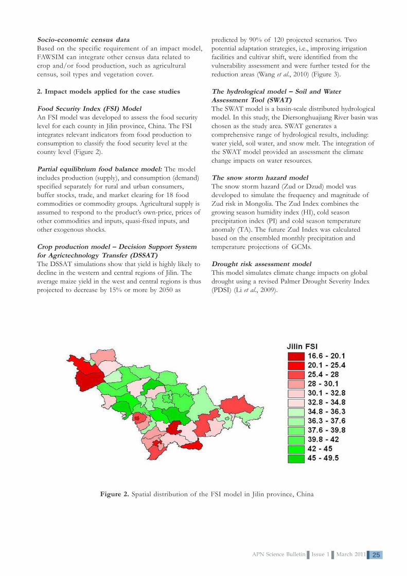
25APN Science Bulletin Issue 1 March 2011
predicted by 90% of 120 projected scenarios. Twopotential adaptation strategies, i.e., improving irrigationfacilities and cultivar shift, were identified from thevulnerability assessment and were further tested for thereduction areas (Wang et al., 2010) (Figure 3).
The hydrological model – Soil and WaterAssessment Tool (SWAT)The SWAT model is a basin-scale distributed hydrologicalmodel. In this study, the Diersonghuajiang River basin waschosen as the study area. SWAT generates acomprehensive range of hydrological results, including:water yield, soil water, and snow melt. The integration ofthe SWAT model provided an assessment the climatechange impacts on water resources.
The snow storm hazard modelThe snow storm hazard (Zud or Dzud) model wasdeveloped to simulate the frequency and magnitude ofZud risk in Mongolia. The Zud Index combines thegrowing season humidity index (HI), cold seasonprecipitation index (PI) and cold season temperatureanomaly (TA). The future Zud Index was calculatedbased on the ensembled monthly precipitation andtemperature projections of GCMs.
Drought risk assessment modelThis model simulates climate change impacts on globaldrought using a revised Palmer Drought Severity Index(PDSI) (Li et al., 2009).
Figure 2. Spatial distribution of the FSI model in Jilin province, China
Socio-economic census dataBased on the specific requirement of an impact model,FAWSIM can integrate other census data related tocrop and/or food production, such as agriculturalcensus, soil types and vegetation cover.
2. Impact models applied for the case studies
Food Security Index (FSI) ModelAn FSI model was developed to assess the food securitylevel for each county in Jilin province, China. The FSIintegrates relevant indicators from food production toconsumption to classify the food security level at thecounty level (Figure 2).
Partial equilibrium food balance model: The modelincludes production (supply), and consumption (demand)specified separately for rural and urban consumers,buffer stocks, trade, and market clearing for 18 foodcommodities or commodity groups. Agricultural supply isassumed to respond to the product’s own-price, prices ofother commodities and inputs, quasi-fixed inputs, andother exogenous shocks.
Crop production model – Decision Support Systemfor Agrictechnology Transfer (DSSAT)The DSSAT simulations show that yield is highly likely todecline in the western and central regions of Jilin. Theaverage maize yield in the west and central regions is thusprojected to decrease by 15% or more by 2050 as

APN Science Bulletin Issue 1 March 201126
Figure 3. Climate change impact on maize production in Jilin province, the simulated maizeyield (t ha-1) at baseline and the changes in 2020, 2050, and 2070
3. User Interface
The Graphic User Interface (GUI) of FAWSIMemployed and enhanced SimCLIM’s open frameworkstructure developed by the SimCLIM team (Warrick,2009). SimCLIM essentially facilitates a series oftoolboxes:
Climate change scenario generator tools enableusers to generate climate change projections for anyyear in the 21st century. The scenario generator’sfunctionality, including global projection, ensemble,pattern viewer tools, facilitates the effective transfer ofclimate change projections to users’ for applications inimpact and risk assessments (Figure 4).
Figure 4. Annual mean temperature of East Asia: baseline (top) and 2080 projection (bottom)

27APN Science Bulletin Issue 1 March 2011
Data management tools enable users to import andexport climate, land and socio-economic data, in timeseries (monthly, daily, hourly, sub-hourly) or spatialpatterns (ARC-GIS grids and polygon layers, forexample) (Figure 5).
Model management tools enable users to incorporateimpact models using FAWSIM compatible DLL andBPLs. Simple models, such as the Zud model and FSIwere written in Delphi and incorporated intoSimCLIM. More sophisticated models such as DSSATand SWAT were built as Fortran DLLs, and linked withSimCLIM.
ConclusionsFAWSIM provides an efficient tool for stakeholders byintegrating baseline climate, climate change scenariosand relevant environment, and socio-economic datawith a series of impact models and a graphic userinterface. FAWSIM currently includes in its systemmodels of DSSAT, SWAT, PDSI, FSI, ZUD; as well asthe land cover and socio-economic data of China andMongolia.
FAWSIM allows for multi-scale, multi-disciplinaryimpact assessments; climate change scenariouncertainty analysis; and, with a built-in GIS tool, the
Figure 5. FAWSIM data management tools interface
assessment results can be visualised and furtheranalysed thus facilitating training and capacity building.
The open framework makes FAWSIM a co-evolutionary Decision Support System that can beregularly upgraded and improved through interactionbetween end-users and the developers.
References• Li, Y., Ye, W., Wang, M., Yan, X. 2009. Climate
change and drought: A risk assessment of crop-yield impacts. Climate Research, 39: pp31–46.
• Li, Y., Ye, W., Yan, X., Togtohyn, C., Karakin, V.P.,Wang, M., Yin, C. 2010. Integrated modeldevelopment for water and food securityassessments and analysis of the potential ofmitigation options and sustainable developmentopportunities in temperate northeast Asia: APNCAPaBLE project (CRP2008-02CMY-Yan) Finalreport.
• United Nations. 2010. High-level task force on theglobal food security crisis: Updated comprehensiveframework for action.
• Wang, M., Li, Y., Ye, W., Bornman, J., Yan, X.2011. Climate change and maize production:Impacts and potential adaptation measures: A casestudy in Jilin Province, China. Climate Research (inpress).

APN Science Bulletin Issue 1 March 201128
• Warrick, R. 2009. From CLIMPACTS toSimCLIM: Development of an integratedassessment system. in: Integrated RegionalAssessment of Global Climate Change, Knight,C.G., Jager, J. (Eds.) Cambridge University PressUK, pp. 280-311.
• Yin, C., Li, Y., Ye, W., Bornman, J., Yan, X., 2010.Statistical downscaling of regional dailyprecipitation over southeast Australia based onself-organising maps. Applied and TheoreticalClimatology (DOI: 10.1007/s00704-010-0371-y).
wwwwworororororkshop photoskshop photoskshop photoskshop photoskshop photos
AcknowledgementsWe greatly appreciate all institutions for providing theessential support of their staff working on this projectand faci l i tat ing workshops. The local exper ts andcommunities in Jilin province, China and Mongolia kindlysupported the project activities. Great appreciation is alsoextended to the generous support from CLIMsystems Ltd,New Zealand. CLIMsystems provided the SimCLIMsoftware and worked with the project team for the
development of the FAWSIM system.
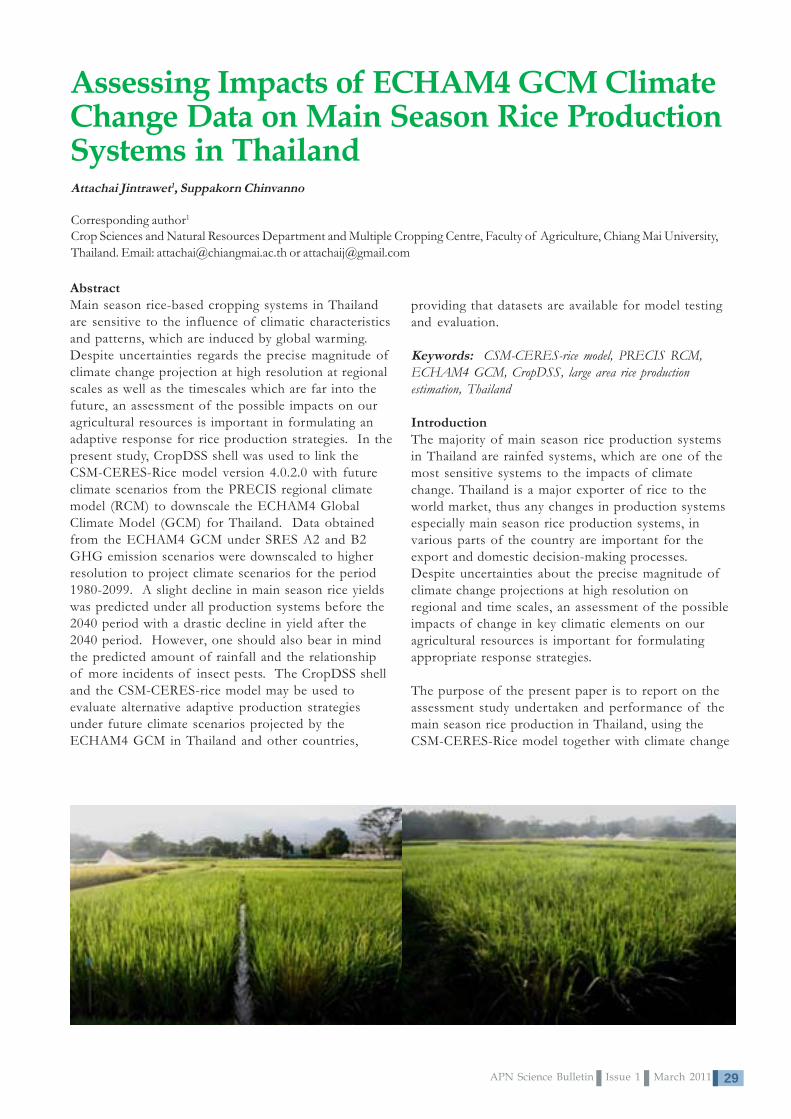
29APN Science Bulletin Issue 1 March 2011
Assessing Impacts of ECHAM4 GCM ClimateChange Data on Main Season Rice ProductionSystems in Thailand
AbstractMain season rice-based cropping systems in Thailandare sensitive to the influence of climatic characteristicsand patterns, which are induced by global warming.Despite uncertainties regards the precise magnitude ofclimate change projection at high resolution at regionalscales as well as the timescales which are far into thefuture, an assessment of the possible impacts on ouragricultural resources is important in formulating anadaptive response for rice production strategies. In thepresent study, CropDSS shell was used to link theCSM-CERES-Rice model version 4.0.2.0 with futureclimate scenarios from the PRECIS regional climatemodel (RCM) to downscale the ECHAM4 GlobalClimate Model (GCM) for Thailand. Data obtainedfrom the ECHAM4 GCM under SRES A2 and B2GHG emission scenarios were downscaled to higherresolution to project climate scenarios for the period1980-2099. A slight decline in main season rice yieldswas predicted under all production systems before the2040 period with a drastic decline in yield after the2040 period. However, one should also bear in mindthe predicted amount of rainfall and the relationshipof more incidents of insect pests. The CropDSS shelland the CSM-CERES-rice model may be used toevaluate alternative adaptive production strategiesunder future climate scenarios projected by theECHAM4 GCM in Thailand and other countries,
Attachai Jintrawet1, Suppakorn Chinvanno
Corresponding author1
Crop Sciences and Natural Resources Department and Multiple Cropping Centre, Faculty of Agriculture, Chiang Mai University,Thailand. Email: [email protected] or [email protected]
providing that datasets are available for model testingand evaluation.
Keywords: CSM-CERES-rice model, PRECIS RCM,ECHAM4 GCM, CropDSS, large area rice productionestimation, Thailand
IntroductionThe majority of main season rice production systemsin Thailand are rainfed systems, which are one of themost sensitive systems to the impacts of climatechange. Thailand is a major exporter of rice to theworld market, thus any changes in production systemsespecially main season rice production systems, invarious parts of the country are important for theexport and domestic decision-making processes.Despite uncertainties about the precise magnitude ofclimate change projections at high resolution onregional and time scales, an assessment of the possibleimpacts of change in key climatic elements on ouragricultural resources is important for formulatingappropriate response strategies.
The purpose of the present paper is to report on theassessment study undertaken and performance of themain season rice production in Thailand, using theCSM-CERES-Rice model together with climate change

APN Science Bulletin Issue 1 March 201130
CRP2008-03CMY-JintrawetClimate Change in Southeast Asia and Assessmenton Impacts, Vulnerability and Adaptation on RiceProduction and Water Resources
Project Leader:Dr. Attachai JintrawetMultiple Cropping Centre, Faculty of AgricultureChiang Mai University, Chiang Mai 50200THAILANDTel: +66 53 221 275Fax: +94 53 210 000Email: [email protected]
APN Funding:US$180,000 (For 3 Years)
Research Highlights• The present paper details an assessment
study of the performance of main seasonrice production in Thailand, using the CSM-CERES-Rice model together with climatechange A2 and B2 scenarios as predicted bythe PRECIS RCM, using ECHAM4 GCMdataset.
• Impact of climate change during the period1980-2099 on rice production in Thailandwas studied and a slight decline in mainseason rice yields is predicted for allproduction systems before 2040 and a drasticdecrease predicted after the 2040 period.
• Simulation of adaptive production optionsshow that, during the period 2010-2019, anapplication of 60 kg of urea per ha canproduce 15% and 36% higher simulated riceyield than an application of 200g of greenmanure per m2 or no nitrogen applicationproduction option, respectively.
A2 and B2 scenarios as predicted by the PRECISRCM, using ECHAM4 GCM dataset as initial data forfuture climate simulation.
Materials and Methods
The CSM-CERES-Rice modelThe CSM-CERES-Rice model (Cropping SystemModel-Crop Environment Resource Synthesis) wasdeveloped along the lines of the CERES-Maize and theCERES-Wheat models (Jones and Kiniry, 1986). It wasmodified for transplanted rice by researchers at theInternational Fertiliser Development Centre (Godwinand Singh, 1989) and tested in various productionsystems in Thailand (Jintrawet, 1991). It is stillundergoing testing and refinement by scientists of theInternational Consortium of Application of SystemApproaches (ICASA).
The model requires daily weather data including solarradiation, maximum and minimum air temperature, andrainfall. Initial soil conditions required by the modelinclude drainage and runoff coefficients, evaporationand radiation reflection coefficients, rooting preferencefactors, and initial soil water, mineral nitrogen andorganic matter content for each horizon. Day-length iscalculated from latitude and day of the year. Grainyield is determined by the rate and duration of paniclegrowth as influenced by genotype and environmentalconditions. The model, as yet, does not incorporategenetic coefficients for resistance to insects andpathogens.
The PRECIS RCM and ECHAM4 climate datasetWe used the PRECIS regional climate model (RCM) todownscale the ECHAM4 GCM data, based on SRESA2 and B2 GHG emission scenarios, which representthe high and low atmospheric concentration of GHGsin the future (SRES, 2000). The downscalingresolution was 20x20 km. The model was designed tocover the domain between 0-30o North Latitude and90-112o East Longitude. A detailed description of theECHAM4 climate model can be found in Roeckner etal. (1996). Daily weather data generated fromECHAM4 GCM was formatted for CSM-CERES ricemodel for the period 1980-2099 for Thailand(Chinvanno et al., 2009).

31APN Science Bulletin Issue 1 March 2011
CropDSS shell frameworkCropDSS shell (Jintrawet, 2009) includes SDBMS(Spatial Database Management System), MBMS(ModelBase Management System), the analysis module,and the visualisation module for map display. TheCropDSS shell requires two kinds of minimum dataset(MDS) for crop yield and production estimation at thevarious administrative levels, which are the spatial andattributes datasets. These datasets have the smallestpossible number of spatial and attributes for apractical assessment.
Rice production systems simulation settingsTo assess the impacts of future climate pattern underA2 and B2 SRES scenarios on rice production inThailand, we used the CropDSS shell to simulate riceyields under three production practices; namely;potential production practices, well-irrigated and well-fertilised production practices, and rainfed andnitrogen-limited production practices (Penning de Vries,1982). We used one planting date, August 15, for mainseason rice, with three 25 day-old seedlings per hill, at16 hills per square meter plant density. The ricevariety was a non-photoperiod sensitive variety, RiceDepartment #7, thus RD7.
ResultsTable 1 presents simulated rice yields of RD7 in themain season cropping systems for Thailand based onthree production scenarios, namely; potentialproduction scenarios, well-irrigated and well-suppliednitrogen fertiliser, and rainfed with no nitrogenfertiliser application. Potential rice production scenarioyields ranged from 4,100-6,400 and 4,900-6,000 kg/hafor A2 and B2 SRES scenarios, respectively. Well-irrigated and well-supplied nitrogen fertiliser riceproduction scenario yields ranged from 3,700-6,000and 4,000-5,700 kg/ha for A2 and B2 SRES scenarios,respectively. Rainfed with no nitrogen fertiliserapplication rice production scenario yields ranged from2,100-2,200 and 2,000-2,100 kg/ha for A2 and B2SRES scenarios, respectively.
Table 1. Mean and standard deviatioin of simulatedrice yields in Thailand under ECHAM4 A2 and B2SRES scenarios for three production options
Potential productionA2 B2
Year Mean SD Mean SD1980-1989 6,190 6601990-1999 6,030 6632000-2009 5,901 6242010-2019 5,881 620 5,963 9452020-2029 5,829 665 5,956 6812030-2039 5,797 676 5,815 7582040-2049 5,522 691 5,718 6892050-2059 5,191 644 5,568 7632060-2069 4,919 714 5,381 7402070-2079 4,692 723 5,240 7382080-2089 4,387 762 5,146 6922090-2099 4,060 710 4,857 708
Well-irrigated and well-supplied nitrogenfertiliser production
A2 B2Year Mean SD Mean SD1980-1989 6,023 6921990-1999 5,841 7152000-2009 5,719 6792010-2019 5,684 673 5,714 9962020-2029 5,629 713 5,695 7722030-2039 5,585 742 5,542 8652040-2049 5,276 760 5,403 8172050-2059 4,947 732 5,282 9122060-2069 4,622 812 5,004 9272070-2079 4,373 831 4,886 9382080-2089 4,026 923 4,781 8792090-2099 3,706 869 4,427 955
Rainfed and no nitrogen application productionA2 B2
Year Mean SD Mean SD1980-1989 2,215 7951990-1999 2,231 7852000-2009 2,226 7732010-2019 2,234 773 2,026 6932020-2029 2,221 772 2,045 6962030-2039 2,252 766 2,049 7012040-2049 2,239 749 2,050 6832050-2059 2,230 732 2,054 6812060-2069 2,217 712 2,048 6852070-2079 2,200 699 2,050 6842080-2089 2,158 687 2,044 6752090-2099 2,125 664 2,029 672

APN Science Bulletin Issue 1 March 201132
Impacts of future climate pattern under A2 and B2SRES scenarios on potential rice productionSimulated potential rice yields governed by airtemperature, solar radiation, and crop characteristics,averaged yields using simulated climate data for thebaseline period of 1980-89 was 6,190 kg/ha. Ascompared to the 1980-89 period, rice yields during1990-2049 period decreased by 2.6-6.4 and 3.7-6.1percent from change in climate pattern based on A2and B2 SRES scenarios, respectively. However, riceyield reduction was more pronounced after the 2040period towards the 2090 period. Simulated rice yieldsreduction ranged from 10.8-34.4 and 7.6-21.5 percentunder future climate pattern based on A2 and B2scenarios, respectively, as compared to simulated yieldsduring 1980s.
Impacts of future climate pattern under A2 and B2SRES scenarios on well-irrigated rice productionIn addition to air temperature, solar radiation, andcrop characteristics, water in the soil and plant systemsis the key factor influencing simulated rice yields underwell-irrigated and well-supplied nitrogen fertiliserproduction practice. An averaged simulated yield usingsimulated climate data for the baseline period of 1980-89 was 6,023 kg/ha. As compared to the 1980-89period, rice yields during 1990-2049 decreased by 3.0-
Figure 1. Distribution of simulated rice yields (kg/ha) in Thailand, under ECHAM4 A2 SRES scenarioduring 2010s, for three production options

33APN Science Bulletin Issue 1 March 2011
and maintaining rice production under rainfedconditions can be achieved by introducing greenmanure crop or adding chemical fertiliser.
Simulated rice yields decreased drastically after 2040due mainly to increases in air temperature that result inslower crop growth rate. Future research needs to beconducted to fully develop and disseminate such newrice varieties for higher temperature environmentsduring the reproductive phase of the crop, which isparticularly prone to male sterile phenomenon and thusreduced yields. The other aspect of climate change isthe increase of surface air temperature, which willreduce the total duration of the crop by inducing earlyflowering and maturity, thus causing shortening of thegrain filling period. The shorter the crop duration, thelower the yield per unit area. A warmer atmospherecould therefore lead to reduced agriculturalproductivity.
Both climate and rice models were based on certainassumptions. The PRECIS-ECHAM4 climate modelresolution is 20x20 km and needs a great deal of workon its prediction as influenced by increased CO
2
concentration and the tropical monsoon system. TheCSM-CERES rice model assumed that weeds, insects,and disease are fully controlled by farmers during thegrowing season. Crop losses, which may accrue due tothe occurrence of extreme events such as floods, arealso not accounted for. Currently, the model does notallow for a gradual increase of gas. The current versionof the DSSAT-CERES rice simulation model handlesonly plant and soil processes at the field level, withuniform management practices.
ConclusionsAssessing impacts of climate change scenarios bylinking crop simulation models to geographicinformation system (GIS) databases, with its datahandling capabilities and its spatial manipulationfunctions, makes it practical to apply the CSM-CERES-Rice model together with the PRECIS RCM-ECHAM4GCM climate models over a large area for yieldestimation of rice and other crop production systems.Climate change under SRES A2 and B2 scenarios,produced by PRECIS RCM-ECHAM4 GCM climatemodels, impacted rice production scenarios in Thailandin similar trends, i.e., simulated rice yields decreasewith a more pronounced decrease observed after the2040 period, assuming no policy and implementationdecisions are taken to adapt to these changes.
7.3 and 5.1-8.0 percent from changes in climate patternbased on A2 and B2 SRES scenarios, respectively.However, rice yield reduction is seriously affectedbetween the 2040 and 2090 period. Simulated riceyields reduction ranged from 12.4-38.5 and 10.3-26.5percent under future climate patterns based on A2 andB2 GHG scenarios, respectively, as compared tosimulated yields during 1980s.
Impacts of future climate pattern under A2 and B2SRES scenarios on rain fed rice productionSimulated rice yields in this production scenario arefurther constrained by nitrogen in the soil and plantsystems. An averaged simulated yield using simulatedclimate data for the baseline period of 1980-89 was2,215 kg/ha. As compared to the 1980-89 period, riceyields during the 1990-2039 period under futureclimate pattern based on A2 SRES GHG scenariowould increase by 0.8-1.7 percent and decrease by 7.5-8.5 percent under future climate pattern during 2010-2049 based on B2 SRES GHG emission scenario.However, rice yield reduction is more pronounced inthe 2040-2090 period. Simulated rice yields reductionranged from 1.1-4.0 and 7.4-8.4 percent under futureclimate patterns based on both A2 and B2 scenarios,respectively, as compared to simulated yields during1980s.
In addition, we used the CropDSS shell to simulatemain season rice yields during the 2010-19 periodunder two soil nutrient management options, namely; a)Application of 200 g of green manure per m2
(200GM), and b) Application of 60 kg of urea per ha(60UREA) and compared with the averaged simulatedrice yield (0N) of the same period to illustrate adaptiveproduction strategies. The 60UREA productionstrategy produced 15% and 36% higher simulated riceyield than 200GM and 0N, respectively (Figure 1).
DiscussionThe potential and well-irrigated scenarios gave averagedyields of 6,040 and 5,861 kg/ha, respectively, and wererelatively higher than reported averaged national riceyields during the period 1980-2009 by the Office ofAgricultural Economics (OAE, 2010) of Thailand. Theaveraged and standard deviation of reported rice yieldsduring the periods 1980-89, 1990-99, and 2000-2008were 2,024±66, 2,335±166, and 2,690±313 kg/ha,respectively. The rainfed with no nitrogen fertiliserapplication production scenarios yielded closer to thereported rice yields by OAE, and averaged 2,224±772kg/ha. This is due mainly to the fact that the majorityof rice fields in Thailand are under rainfed conditionsand low nitrogen fertiliser applications, with theexception of the central plain of Thailand. Improving

APN Science Bulletin Issue 1 March 201134
References• Chinvanno, S., Laung-Aram, V., Sangmanee, C. and
Thanakitmetavut, J. 2009. Future ClimateProjection for Thailand and Mainland SoutheastAsia Using PRECIS and ECHAM4 ClimateModels. Southeast Asia START Regional CentreTechnical Report. Bangkok, Thailand, START SEARC. 18.
• Godwin, D. and Singh, U. 1989. Nitrogen balanceand crop response to nitrogen in upland andlowland cropping systems. Understanding Options forAgricultural Production. G.Y. Tsuji, Hoogenboom G.and Thornton P.K. London, Kluwer AcademicPublishers: 55-78.
• Jintrawet, A. 1991. A Decision Support System forRapid Appraisal of Rice-Based AgriculturalInnovations. Ph.D. Dissertation, University ofHawaii at Manoa, Honolulu, Hawaii, USA, 167.
• Jintrawet, A. 2009. A Decision Support System toStudy the Impact of Climate Change on FoodProduction Systems. Khon Kaen University ResearchJournal 14: 589-600.
• Jones, C.A. and Kiniry, J.R. Eds., 1986. CERES-Maize: A Simulation Model of Maize Growth andDevelopment. College Station, Texas A&M UniversityPress.
• OAE. (2010). “Agricultural Statistics.” 2010, fromhttp://www.oae.go.th/download/article/article_20090417180213.html.
• Penning de Vries, F.W.T. 1982. Systems analysis andmodels of crop growth. Wageningen, the Netherlands,CABO.
AcknowledgementsThe Asia-Pacific Network for Global Change Research(APN) provided funding for our research activities fora 3-year period from 2006-2009, beginning with grantnumber CRP2006-03CMY-Jintrawet. The ThailandResearch Fund (TRF) provided funding for thedevelopment of CropDSS shell under grant numberRDC52O0001. We are grateful to the Southeast AsiaSTART Regional Centre in Bangkok for its kindprovision of the ECHAM4-PRECIS A2 and B2 SRESscenarios and the Land Development Department(LDD) in Bangkok for the kind provision to access thesoil map and soil profile attributes data. Thecorresponding author completed the manuscript whiletaking a sabbatical, from December 2010 to May 2011,as a visiting research fellow at the Centre for SoutheastAsia Studies (CSEAS) at Kyoto University, Japan.

35APN Science Bulletin Issue 1 March 2011
AbstractLong term climate projection at high resolution is afundamental dataset for climate change studies, especiallyfor assessing the impact of climate change at the localscale. This future climate projection, which provides ascenario of climate for Southeast Asia at 20x20 kmresolution up to the end of the 21st century, is a result ofa dynamic downscaling process using a regional climatemodel (RCM) from the Hadley Centre, The Met Officeof United Kingdom, to simulate high-resolution climatedata for the region based on datasets from the GlobalCirculation Model (GCM) ECHAM4 - A2 GHGemission scenario. Results from the RCM show that awide area of Southeast Asia will become warmer and theduration of the warm period will extend substantially inthe future, especially in the latter half of the century.Even though warmer temperatures are detected for bothdaily maximum and daily minimum values, the dailyminimum temperature tends to have a higher trend.Precipitation tends to fluctuate in the first half of thecentury but shows an increasing trend with higherintensity, which will be clearly seen in the latter half ofthe century where higher precipitation will be observedthroughout the region.
Keywords: climate change, Southeast Asia, regional climatemodel (RCM), PRECIS, ECHAM4
IntroductionClimate change has become a global concern as it mayhave many adverse consequences on various systems andsectors that may threaten human wellbeing (IPCC, 2001).Understanding climate change is the foundation forproper planning of adaptation measures to cope withfuture risk. However, climate change is a slow processand requires rather long-term future climate projectionsto be able to accurately predict changes in future climatepatterns (IPCC, 2007). Therefore, long-term futureclimate projection is crucial for the assessment of climatechange impacts on certain sectors in specific areas,particularly at the local scale. GCMs were developed andhave been used to simulate future climate conditions, butmost of the simulations, especially those GCMs that wereused in the IPCC AR4, were conducted at coarse scales
Future Climate Projection for MainlandSoutheast Asia Countries: Climate ChangeScenario of 21st CenturySuppakorn Chinvanno1, V. Luang-aram, C. Sangmanee, J. Thanakitmetavut
Corresponding Author1
Southeast Asia START Regional Centre, Bangkok, Thailand. Email: [email protected]
due to limitations in technology. These GCMs are not aseffective for climate change impact assessments at localscales where high-resolution future climate data isrequired.
Typically, there are three types of techniques forobtaining high-resolution regional climate changeprojections: statistical, dynamical and hybrid (statistical-dynamical) techniques. The use of RCMs falls into thedynamical category. An RCM is a downscaling tool thatadds fine scale (high-resolution) information to large-scaleprojections of GCMs. GCMs are typically run withhorizontal scales of a few hundred kilometers, whilemodels can resolve features down to much smaller scales,e.g. 50 km or less. This makes for a more accuraterepresentation of many surface features, such as complexmountain topographies and coastlines (Jones et al., 2004).The present paper discusses approaches and results ofdynamic downscaling of GCM data using RCMs todevelop high-resolution future climate change scenariosfor mainland Southeast Asia over the 21st century.
MethodologyThe high resolution climate projection for mainlandSoutheast Asia was developed based on a dynamicdownscaling technique using the PRECIS RCM. PRECISwas developed by the Hadley Centre for ClimatePrediction and Research, The Met Office, UK. It can beused as a downscaling tool that adds fine scale (high-resolution) information to the large-scale projections of aGCM. It has been ported to run on a PC (under Linux)with a simple user interface, so that experiments can easilybe set up over any region. PRECIS was developed inorder to help generate high-resolution climate changeinformation for as many regions of the world as possible.These scenarios can be used in impact, vulnerability andadaptation studies (Simson et al., 2006).
The GCM dataset, which was used as the initial datasetfor the simulation was the ECHAM41 model from theMax-Planck-Institute for Meteorology (MPI), Germany.It was based on SRES A2 GHG scenario, whichrepresents the scenario that atmospheric GHGs willincrease at a relatively high rate (IPCC, 2000). The period

APN Science Bulletin Issue 1 March 201136
of simulation covers the years 1970–2100. Thesimulation provides output with daily time-stepthroughout the simulating period. The downscalingprocess was set to a resolution of 0.220 and output wasrescaled to 20x20 km resolution. Domain coverage waslatitude 0-350N and longitude 900-1120E (Figure 1).
The results from PRECIS RCM were verified bycomparing against data from observation stations and theperiod of 1980s was selected as the baseline forverification. The comparison shows that the RCM resultis somewhat different from the observed weather data.The PRECIS model tends to overestimate temperatureand underestimate precipitation in many areas. A“rescaling” technique was developed and applied to thesimulation results from the PRECIS model in order toadjust the simulated data to better match real conditionsbased on the observed data.
Results and DiscussionThe simulation results from the PRECIS RCM, after therescaling process, shows that the average maximumtemperature as well as average minimum temperature inSoutheast Asia in will increase in the future, with increasestending to be more prominent from the middle of thecentury onward. The warming trend is clearly seen in thecentral plain of Thailand and most of Cambodia as wellas the Malaysian peninsular (Figures 2 and 3).
Figure1. Domain of future climate projection
Figure 2. Average daily maximum temperature
1 ECMWF Atmospheric General Circulation Model coupled with University of Hamburg Ocean Circulation Model (http://www.ipcc-data.org/is92/echam4_info.html)
In addition to the changing magnitude aspect, change infuture temperature also occurs in the temporal aspect.Southeast Asia tends to have longer hot periods over theyear. This change in temporal aspect can be seen in thechanges in the number of hot days in a year, or in otherwords the length of summer-time, i.e., the number of ‘hotdays,’ (defined in this study as days where maximumtemperature exceeds 35oC) will increase in the future,which could be longer by a few months in a year (Figure4). On the other hand, PRECIS results also show a slighttrend of change for the ‘cool period,’ (defined in thisstudy as days where minimum temperature is 16oC orbelow). The cool period, or in other words, winter-time, inSoutheast Asia will become shorter than the baselineclimate pattern, even though not as prominent as thetrends in the ‘hot period’ (Figure 5).
Annual total precipitation may fluctuate in the earlydecades of the 21st century, but simulation results show atrend of higher precipitation throughout Southeast Asia inthe future, especially towards the end of the century,which could be around 25-50% in some areas (Figure 6).
This long-term climate projection can be used to assessthe impacts of climate change in various sectors as well as

37APN Science Bulletin Issue 1 March 2011
Figure 4. Length of hot period over the year - numberof days with maximum temperature >35oC
Figure 5. Length of cool period over the year - numberof days with minimum temperature <16oC
Figure 6. Annual precipitation (mm) and future changecompared to 1980s (%)
Figure 3. Average daily minimum temperature

APN Science Bulletin Issue 1 March 201138
support long-term planning. Using long-term climateprojections for strategic planning to cope with climatechange should not only consider change in averageclimate variables but also take various aspects of changesin climate pattern into consideration too; especially,change in the extreme value of any climate parametersand also the temporal aspect of change, e.g., changes inthe length of seasons and shifting season patterns, etc.Moreover, it is important to be aware that this projectionis a scenario of plausible future and cannot be taken as along-term forecast. While there is a certain degree ofuncertainty in the simulation result, however, it can still beused for strategic planning purposes.
One way to cope with uncertainty of long-term climateprojection is the use of multiple scenarios, which aredeveloped using various climate models and/or underdifferent conditions. The use of multiple scenarios instrategic planning or long-term policy planning alsorequires changes in the thought paradigm of policyplanners to become familiar with the use of multipleclimate datasets for policy planning. The use of multiplescenarios is not a matter of placing effort to seek the‘best’ scenario, thus should be selected for the planningexercise; but the planning process should be based on awide range of scenarios and examine whether or notplans for the future are resilient to various futureconditions under climate change.
ConclusionIn brief, future climate in Southeast Asia tends to bewarmer with longer summer-time and higher rainfallintensity during the rainy season with higher annual totalprecipitation. These changes are unlikely to be irreversibleand would have impact on various systems and sectors.However, this future climate projection is just oneplausible future scenario, which was simulated by a singleclimate model and single initial dataset. Additional climatechange scenarios need to be further developed to addressthe uncertainty of long-term climate projection.Moreover, inter-comparison among other climate modelsis required to evaluate the results of the present studythus leading to improvement in future regional climatescenario simulations in the future.
AnnouncementThe dataset of future climate projection for A2 and B2GHG scenarios is available for download at http://cc.start.or.th/.
References• IPCC. 2000. Special Report on Emission Scenarios
(SRES). Cambridge University Press, Cambridge.• IPCC. 2001. Climate Change 2001: Impacts,
Adaptation and Vulnerability. Contribution ofWorking Group II to the Third Assessment Reportof the Intergovernmental Panel on Climate Change(IPCC). Cambridge University Press, Cambridge, UK.
• IPCC. 2007. Climate Change 2007: The PhysicalScience Basis. IPCC Secretariat, Geneva, Switzerland.
• Jones, R.G., M. Noguer, D.C. Hassell, D. Hudson, S.Wilson, G. Jenkins and J.F.B. Mitchell (2004).Generating high resolution climate change scenariosusing PRECIS, Met Office Hadley Centre, Exeter,UK, 40pp, April 2004.
• Simson, W., D. Hassell., D. Hein, R. Jones. and R.Taylor. 2006. Installing using the Hadley Centreregional climate modeling system, PRECIS: version1.4.6. Met Office Hadley Centre, Exeter, UK.
• The IPCC Data Distribution Centre: HadCM3Description [on-line]. Available at: http://cera-www.dkrz.de/IPCC_DDC/IS92a/HadleyCM3/hadcm3.html. Accessed on 20 April 2009.
• The IPCC Data Distribution Centre: ECHAM4/OPYC3 Description [on-line]. Available at http://cera-www.dkrz.de/IPCC_DDC/IS92a/Max-Planck-Institut/echa4opyc3.html. Accessed on 20 April 2009.
AcknowledgementsThe research team at the Southeast Asia START RegionalCentre would like to thank the Asia-Pacific Network forGlobal Change Research (grant number CRP2008-03CMY-Jintrawet) and Thailand Research Fund for theirfinancial support in developing this climate changescenario. Also thanks to the Hadley Centre–The MetOffice, UK for their technical support and provision ofsoftware and initial dataset for the simulation.

39APN Science Bulletin Issue 1 March 2011
Climate Change Risk Assessment inAsian Coastal Megacities:Knowledge Gaps and Research Needs forUrban Development PlanningAnond Snidvongs, Richard Cooper1
Corresponding author1
Southeast Asia START Regional Centre, Chulalongkorn University, Bangkok, Thailand. Email: [email protected]
AbstractThe present paper highlights key issues confronting Asiancoastal megacities in planning for future climate change.Critical gaps in information/knowledge for carrying outrisk and vulnerability assessments to support urbandevelopment planning were highlighted at an APN andIbaraki University-sponsored workshop by expert teamsrepresenting Bangkok, Ho Chi Minh City, Jakarta, Manilaand Mumbai.
The workshop - Climate Change Vulnerability Assessment andUrban Development Planning for Asian Coastal Cities - heldfrom 22-28 August 2010 in Nakhon Pathom, Thailand,brought together over 40 participants including academics,urban planners and officials, and experts in disastermanagement.
The workshop identified current information/knowledgegaps and challenges, and identified future researchopportunities. Key findings distilled from the workshopwere grouped into three categories - ‘assessment ofclimate change related risk,’ ‘information/knowledgemanagement,’ and ‘governance.’ Across these themes,
some 25 specific observations and recommendations forfuture research were identified.
It is anticipated that key findings from this workshop willshape the future research agenda in these cities. Some ofthe key findings and research recommendations includedthe following: Risk assessments were hampered byinadequate information, ranging from the lack of baselineclimate data to the need for developing indicators fordetermining socio-economic vulnerabilities; food andwater security and health assessments demanded greaterattention; access and dissemination of information waslimited, with development of online information/knowledge management systems deficient; future capacitybuilding activities proposed included developing anintegrated course on urban development and climatechange; and, a spectrum of governance-related matterswere raised including issues of institutional coordination,deficiencies in existing city plans, development of buildingcodes, vulnerability of the poor, and challenges offunding.

APN Science Bulletin Issue 1 March 201140
CIA2009-01-SnidvongsClimate Change Vulnerability Assessment of Floodsand Urban Development Planning for Asian CoastalCities
Project Leader:Dr. Anond Snidvongs Southeast Asia START Regional CentreChulalongkorn University 5th Floor, Chulawich 1 Building, Henri DunantRoad, Bangkok 10330THAILANDTel: +66 2 218 9469Fax: +66 2 251 9416Email: [email protected]
APN Funding:US$45,000 (For 1 Year)
Keywords: climate change, risk assessment, adaptation,urban planning , knowledge management, megacities
IntroductionThe workshop built on the first Cities at Risk (CAR)workshop held February 2009 in Bangkok - DevelopingAdaptive Capacity for Climate Change in Asia’s CoastalMegaities - supported by APN and partners (CBA2008-06NSY, 2008). The CAR workshop highlighted the misledperception, particularly on the part of city officials, on thesize of growing risks and vulnerabilities that now confrontcoastal Asian megacities. Moreover, UNESCAP (2009)stated recently that “it is paramount that risk reductionbecomes part and parcel of urban planning,” whichunfortunately is not the case at present; a situation thatthe workshop directly addressed. Climate change risk andvulnerability assessments can play a key role in raisingawareness of climate-related risks, and in leading to moreinformed decision-making. Unfortunately, as noted in theCAR workshop, the capacity to carry out suchassessments is currently lacking in most coastal Asiancities.
The workshop conducted through the present activity(CIA2009-01-SNIDVONGS, 2010) aimed to raiseawareness and improve capacity to assess climate change-related risk and vulnerability in five Asian coastalmegacities – Bangkok, Ho Chi Minh City, Jakarta, Manila,and Mumbai. Workshop objectives included:
i. helping develop capacity on the part of urbanplanners, managers, and researchers in climate changevulnerability assessment and application to urbandevelopment planning and governance;
ii. promoting locally-led vulnerability research in Asiancoastal cities linked to user needs; and
iii. helping develop partnerships between researchers,planners, and policy-makers, and to developcommunities of knowledge for vulnerabilityassessments in each participating city.
The workshop was primarily funded by APN withadditional financial support from Ibaraki University(Japan), hosted by the Southeast Asia START RegionalCentre (SEA START RC) of Chulalongkorn Universityand co-organised with the East-West Centre, Hawaii.
Material and Methods
Pre-workshop Activity: Preparation of City ReportsPrior to the workshop, groups of researchers and urbanplanning practitioners representing each City at theworkshop – Bangkok, Ho Chi Minh City (HCMC),Jakarta, Manila and Mumbai – were invited to prepare a‘City Report’ on climate change risk and vulnerabilityassessments in relation to urban development planning fortheir home City. These reports represented a key sourceof information for better understanding current efforts inintegrating climate risk into development and planning in

41APN Science Bulletin Issue 1 March 2011
each of the five Cities and for better identifying futureresearch and capacity building needs.
Approach to SynthesisPertinent information was extracted from the CityReports (submitted prior to the workshop), City ReportPresentations (workshop day 2), Research Proposalpresentations (workshop day 6) and abstracts (submittedpost-workshop)1. City teams were requested post-workshop to prepare one page abstracts based on the CityReports and presentations under three main categories -‘assessment of climate change related risks,’ ‘information/knowledge management,’ and ‘governance.’
Results and DiscussionThe workshop identified current information/knowledgegaps and future research opportunities for addressingclimate change-related risks and vulnerability in Bangkok,HCMC, Jakarta, Manila and Mumbai. These aresummarised below.
Category 1: Assessment of climate change related risks(hazards and socio-economic vulnerabilities)1. Improve stakeholder perception of risk
• acknowledging the vulnerability of the poor tothe impacts of climate change
2. Better define urban hazard factors3. Assess risk to water and food security, including
• consumption, water quality, sanitation, wastemanagement, agriculture, aquatic systems
4. Address lack of baseline climate data, including• temperature, sea level and social impact (see
item 8 below on socio-economic vulnerabilities)5. Conduct health risk assessments, including
• assessing the link between climate change andhealth impacts
6. Recognise the importance of green space in moderatingair temperature and flood prevention
7. Recognise the potential future impacts of coastal erosion8. Conduct socio-economic vulnerability assessments
• addressing limited information on social aspectsof vulnerability
• integrating existing studies to better understandthe current situation
• refining/identifying measures of risk• developing measures of social vulnerability• mapping vulnerabilities• integrating exposure, places, sectors, activities,
individuals, households, social groups,communities, livelihoods into assessments
• understanding how urban and rural areas arelinked by migration
• assessing the vulnerability of marginal groups/informal sector
Category 2: Information/knowledge management9. Address provision of an information/knowledge
management system, including• lack of a central information system, poor data
collection and storage• the need for an interdisciplinary approach to
development10. Address limited availability of geographic information11. Address integration of geographic information with
socio-economic data12. Address lack of GIS and mapping tools, and
understanding of their application13. Ensure access to information by stakeholders14. Develop materials for information dissemination and
target the most vulnerable communities• make better use of mass media
1 City Reports, City Report Presentations, Research Proposal Presentations, and abstracts are accessible from the workshop report(CIA2009-01-SNIDVONGS, 2010) at http://www.apn-gcr.org/newAPN/resources/list2009capableprojects.htm

APN Science Bulletin Issue 1 March 201142
15. Expand capacity building activities, including• developing a course on urban development and
climate change• integrating climate risk content into other
courses (e.g., engineering)• conducting stakeholder workshops
16. Recognise limitations of existing early warning systems
Category 3: Governance17. Address the need for an institutional linkingmechanism18. Address the lack of coordination betweengovernment agencies, NGOs, and the private sector19. Build capacity of City officials20. Assess the role of civil society groups in urbangovernance21. Address deficiencies in existing planning instrumentsin incorporating climate change risk and vulnerability22. Address development and enforcement of land useregulations and building and sanitation codes23. Address vulnerability of marginal groups, including
• invisibility in plans/assessments• inadequate dissemination of information to the
poor24. Investigate potential for climate-induced migration ofpopulation25. Address challenges to allocating funds for climatechange-related risks and vulnerabilities, including
• availability and commitment• project-based and donor-driven support• raising of funds through fees paid by the local
community• sustainability of initiatives
Future OpportunitiesOpportunities to address these challenges faced by theCities are anticipated through new projects commencing in2011, including an APN-funded project titled - Enhancingadaptation to climate change by integrating climate risk into long-term development plans and disaster management – and anIDRC (of Canada) proposal - Coastal Cities at Risk(CCaR): Building Adaptive Capacity for Managing ClimateChange in Coastal Megacities.
References• CBA2008-06NSY-Fuchs (2009). Cities at Risk:
Developing Adaptive Capacity for Climate Change inAsia’s Coastal Mega Cities, Final Report. URL: http://www.apn-gcr.org/newAPN/resources/list2008capableprojects.htm [last accessed 27 Jan2011].
• CIA2009-01-SNIDVONGS (2010). Climate ChangeVulnerability Assessment and Urban DevelopmentPlanning for Asian Coastal Cities, Final Report. URL:http://www.apn-gcr.org/newAPN/resources/list2009capableprojects.htm [last accessed 25 Jan2011].
• UNESCAP (2009). UN Economic and SocialCommission for Asia and the Pacific, Committee onDisaster Risk Reduction, First Session 25-27 March2009, Bangkok. URL: http://www.unescap.org/idd/events/cdrr-2009/CDR_INF4.pdf [last accessed 28January 2011].
AcknowledgementsWe would like to acknowledge our gratitude toworkshop sponsors (Asia-Pacific Network for GlobalChange Research and Ibaraki University), co-organisers(Southeast Asia START Regional Centre ofChulalongkorn University, and East-West Centre), andall of our collaborators and participants.

43APN Science Bulletin Issue 1 March 2011
Regional Researchfunded under theAnnual RegionalCall for ResearchProposals (ARCP)
2

APN Science Bulletin Issue 1 March 201144
ARCP2010-01CMY-SthiannopkaoCollaborative Research on Sustainable Urban Water Quality Management inSoutheast Asian Countries: Analysis of Current Status (comparative study) andDevelopment of a Strategic Plan for Sustainable Development
Project Leader:Dr. Suthipong SthiannopkaoInternational Environmental ResearchCentre (IERC)Gwangju Institute of Science andTechnology (GIST)REPUBLIC OF KOREATel: +82 62 970 3390Fax: +82 62 970 3394E mail: [email protected],[email protected]
APN Funding:US$80,000 (For 2 Years)
Project Website:www.apn-seawed.com
Focusing on sustainable urban water qualitymanagement in Southeast Asian cities, namelyBangkok (Thailand), Bandung (Indonesia), Ho Chi
Minh City (Viet Nam), and Phnom Penh (Cambodia); theproject team has carried out a range of activities including:i) monitoring of heavy metals, pathogenic E. coli and totalcoliforms in surface waters and sediments; ii) analysing pastwater quality data for a comparative study by applyingCanadian Council of Minister of the Environment-WaterQuality Index (CCME-WQI); and iii) pre-studyingsecondary data using Soil and Water Assessment Tool(SWAT) modelling.
The present Project encompasses capacity building activitiesincluding a four-month internship programme at IERC-GIST and visionary workshops. With additional funding
provided by IERC-GIST since 2009, the programmerecruited four interns; a Cambodian, a Thai and twoVietnamese. Three visionary workshops were organised inBangkok (10-11 November 2009), Ho Chi Minh City (27-28 July 2010) and Manila (15-16 November 2010)involving regional and local scientists and policy-makers.Workshops have facilitated greater dissemination ofknowledge, information and experience on urban waterquality management. Upon fruitful workshop discussions,project members agreed to invite potential partners toparticipate in future Project activities to explore financialsupport and international promotion of Southeast AsianWater Environmental Database (SEAWED). It is worthnoting that this Project has earned an endorsement fromthe International Human Dimensions Programme onGlobal Environmental Change (IHDP).

45APN Science Bulletin Issue 1 March 2011
ARCP2010-02CMY-PhuaIntegrated Prediction ofDipterocarp SpeciesDistribution in Borneo forSupporting Sustainable Useand Conservation PolicyAdaptation
Through an integrated approach thatcombines remote sensing, GeographicInformation System (GIS) and field
data collection, the present Projectinvestigates deforestation, distribution ofdipterocarps and conservation gaps on alandscape scale in Borneo’s rain forest.
The project team has completed the analysisquantifying deforestation in Sarawak, thelargest state in Malaysia, using post-classification of land cover types between 1990 and 2009. Supervised classification onnine Landsat-Thematic Mapper (TM) scenes produced land cover map for 1990 (Figure1) with overall accuracy of 86%. For the land cover map of 2009 (Figure 2), at leastthree images were needed for correcting missing lines in each of nine Landsat-EnhancedThematic Mapper Plus (ETM+) scenes and the overall accuracy of the classification is80%. Of the total loss of 1.2 million ha of forests in the past two decades, analysisshows that more than 90% of the land cover were peat swamp and intact forests. Theoverall deforestation rate of Sarawak is 0.64%.
In order to improve the temporal resolution of the deforestation rate, the project team isalso analysing land cover for 2000. Outcomes indicate that deforestation is most evidentat coastal divisions (e.g. Mukah Division) due to ‘forest-to-oil palm’ conversion.
Similar analysis for East Kalimantan is also making remarkable progress. The results willsoon be available for comparison between the two policy regimes of Sarawak and EastKalimantan. The deforestation information will be integrated with potential distributionof dipterocarps in GIS environment for addressing conservation gaps of existingprotected area networks and supporting policy analysis.
Project Leader:Dr. Phua Mui HowSchool of InternationalTropical ForestryUniversiti Malaysia SabahMALAYSIATel: +60 88 320000Ext. 8773Fax: +60 88 320876Email: [email protected]
APN Funding:US$75,000 (For 2 Years)
Figure 1. Sarawak 1990 land cover map using nine Landsat-TM scenes
Figure 2. Sarawak 2009 land cover map using nine Landsat-ETM+ scenes

APN Science Bulletin Issue 1 March 201146
ARCP2010-03CMY-MarambeVulnerability of Home Garden Systemsto Climate Change and its Impacts onFood Security in South Asia
Projections at the global level indicate strongly thatclimate change could severely affect agriculturalproduction, with cereal production in developing
countries being affected the most. Therefore, ensuringnational and regional level food security for all and at alltimes is needed in the face of projected climate change.Food security in rural South Asia and food production inhome gardens is intrinsically related; hence, climate changemay have significant implications on food security.According to recent studies conducted in Sub SaharanAfrica, home gardens can better cushion shocks arisingfrom climate change compared with monocultures; andfarmers use a variety of adaptation measures to combatthe adverse effects of climate change. The influence ofclimate change on food production and food security hasnot been well established yet. Food production in manydeveloping countries, especially in South Asia, is carried outin home gardens.
The present Project assesses the effects of climate change onhome garden systems, which are the predominant type ofhighland farming in South Asia, under changing climate. ThisProject, which is now in its second phase, is being implementedas a multi-country collaboration among three countries: SriLanka, India and Bangladesh. Using a pre-tested questionnaire,368 home gardens were surveyed in selected villages in thethree countries. The sites were selected based on their extent
Food production in many developing countries,especially in South Asia, is carried out in home gardens.
Home Garden is a complex sustainable land usesystem that combines multiple farming components,
such as annual and perennial crops, livestock andoccasionally fish, of the homestead and provides
environmental services, household needs, andemployment and income generation opportunities to the
households.
Project Leader:Prof. Buddhi MarambeFaculty of AgricultureUniversity of PeradeniyaSRI LANKATel: +94 812 395100Fax: +94 812 395110Email: [email protected]; [email protected]
APN Funding:US$75,000 (For 2 Years)
Home garden in Pethiyagoda, Sri Lanka
Home garden in West Bengal, India
Participatory Rural Appraisal, Keeriyagaswewa, Sri Lanka
(< 0.5 ha), maturity (at least 20 yr), composition, and structure(at least a three-tiered plant structure).
The project team has taken stock of the trees, crops andfarm animals in the home gardens to establish the currentstatus. The extent to which climate shock has influenced thepresent status of home gardens has been assessed. Thedata analysis is in progress to draw conclusions of thesurvey results. Participatory Rural Appraisals (PRAs) andFocus Groups Discussions (FGDs) were carried out toverify information provided during the surveys and also torecall memories of the elderly community in the villagesregarding change in climate over the past 20 years. Therainfall and temperature data obtained from theDepartments of Meteorology in the respective countriesare being analysed to elucidate the relationship to changesin the home gardens.

47APN Science Bulletin Issue 1 March 2011
ARCP2010-04CMY-WangBuilding Asian Climate Change Scenarios byMulti-Regional Climate Models (RCMs) Ensemble
As a long-term regional collaboration to promote Asian climatestudies, the present Project is working to enable multi-RCMsensemble providing high-confidence scenarios for regional climate
change and scientific bases for impact assessments and concerned policy-makers. Along its research methodology, the Project has set up a regionalclimate study network promoting scientific cooperation.
In an effort to develop high-confidence scenarios, the Project organised aninception workshop from 28-29 January 2010, in Tsukuba, Japan. Thirtyparticipants attended the workshop bringing project scientists from 11project groups, invited scientists, and observers from Australia, China,Denmark, Japan, Republic of Korea, Russian Federation, and U.S.A. Theleading scientists presented their latest research results, including modelvalidation over the research domain, investigation of the effects of keyfactors and processes that affect the monsoon system and climateextremes, etc. Upon active discussion, the project team decided to use thesimulation design consisting of two time slices: periods from 1978-2000for control climate, and 2038-2070 for Asian high-resolution climatechange projection. For both time slices, the two-year spin-up time is beingapplied.
To date, the Project has completed studies of model validation anduncertainty analyses, and carried out biases correction to assist in
developing the regional climate changeprojection. The project team identified keyphysical processes that either control ormodulate the Asian-Monsoon-System, andinvestigated their impact mechanisms onregional climate. Currently the projectcontinues to integrate both control andfuture climates. The project team isanalysing the simulation results andbuilding climate change scenarios. With thepreliminary modelling results, the timingand magnitude of climate change inMonsoon Asia and uncertainties in theprojection can be assessed.
Project Leader:Dr. Shuyu Wang
Institute of Atmospheric PhysicsChinese Academy of Sciences, CHINA
Tel: +86 10 8299 5159Fax: +86 10 6202 8604Email: [email protected]
APN Funding:US$79,760 (For 2 Years)
(Year 3 expected funding is US$40,000)
disease, with Potato Virus Y andPotato Leaf-roll Virus as secondarypriorities.
Potato is the world’s third mostimportant staple food crop and itsproduction is increasing at 4.5% perannum. In 2005, for the first time,developing countries were growingmore potatoes than developed nations,with China contributing 20% of theworld’s production.
Consecutively, the Project organised itssecond workshop which was held atDPI Victoria, Knoxfield andUniversity of Western Sydney,Hawkesbury campus in Australia from18-22 October 2010. These meetingsfocussed on Potato Late Blight in Indiaand Bangladesh, which is emerging asa major issue for growers in thesecountries potentially due to increaseddrought and flooding cycles. Indianand Bangladeshi scientists from BCKVUniversity and Bangladesh Agriculture
Project Leader:Dr. Joanne Elizabeth Luck
Department Primary IndustriesVictoria (DPI)
Cooperative Research CentreNational Plant Biosecurity
AUSTRALIATel: +61 3 9210 9248Fax: +61 3 9800 3521
Email: [email protected]
APN Funding:US$78,240 (For 2 Years)
In order to assess the researchbeing done on climate changeand pests and diseases of
important crops in the Asia-PacificRegion, the present Projectsuccessfully convened its firstworkshop at Bidhan Chandra KrishiViswavidyalaya (BCKV) University inKalyani, Kolkata. A consensus wasreached after some discussion thatthe project team would focus onPotato Late Blight for the common
Research Institute (BARI),respectively, described the Late Blightproblem as a constant race against arapidly evolving pathogen. Theapparent futility associated with themultiple fungicide application was alsohighlighted.
The historical datasets (1972-2010)for planting times, late blight initiationand severity were presented for bothcountries with climatic data setsassociated with late blightestablishment presented by projectagrometeorologists for the sameperiod. In addition, downscaledclimate projections to 2100 will beused in conjunction with publishedLate Blight models to determine ifthere will be increased risk in LateBlight incidence under future climatesfor India, Bangladesh and Australia.
ARCP2010-05CMY-LuckThe Effects of Climate Change on Pests and Diseasesof Major Food Crops in the Asia-Pacific Region

APN Science Bulletin Issue 1 March 201148
ARCP2010-06CMY-SchaeferQuantifying the Role of Dead Wood in Carbon Sequestration
Figure 1. For Ailao Mountain wood, there is a weaknegative correlation between wood density and CO
2
production, but individual samples show greater than ten-fold variation for most values of wood density
Figure 2. For Ailao Mountain wood, there is a weak positivecorrelation between wood moisture content and CO
2
production, but individual samples show greater than ten-fold variation at the same moisture content
Figure 3. Wood decomposition patterns at Ailao Mountainin Southwest China
Project Leader:Dr. Douglas A. Schaefer
Associate Professor of Soil EcologyXishuangbanna Tropical
Botanical GardenKunming Branch, CHINA
Tel: +86 871 516 1199Fax: +86 871 516 0916
Email: [email protected]
APN Funding:S$79,000 (For 2 Years)
Approximately 300 wood samples have beenlabelled and are being individually monitored forCO
2 production as part of the activities in the
present Project. These samples were equally distributedamong 3 dominant tree species in the Ailao Mountainforest in South West China; Lithocarpus chintungensis,Lithocarpus xylocarpus and Schima noronhae. They were alsoevenly distributed among 3 qualitative decay classes: 3(knife blade penetrates easily), 2 (intermediate) and 1(knife blade does not penetrate). The project team alsohas measured the weight, dimensions and moisturecontent of each wood sample and CO
2 production rates
can be expressed per unit weight, per gram of woodcarbon contained, per unit wood volume or per unitsurface area.
Previous studies have shown relationships between CO2
production (decomposition rate) and wood density andwood moisture content. This Project observes that, aswell, however, these factors explain very little about thevariability among samples (Figures 1 and 2). This issignificant for this Project, because it implies that otherfactors exert very strong controls on wooddecomposition rates.
Furthermore, initial results in Figure 3 shows that woodsamples that are very ‘fresh’ (decay class 1) decompose atvery similar rates. In contrast, wood that has undergonemore extensive decay (especially decay class 2) show twodistinct peaks in decomposition rates. This could beevidence for the development of distinct wood-decayingfungal communities with different rates of decomposition.Further analysis will be conducted including the use ofslow-decomposing wood to inoculate fresh wood much thesame as mushroom growers inoculate logs with fungalspawn to establish pure communities. The effectiveness ofthis procedure will be examined over time with the samerespiration measurement technique.

49APN Science Bulletin Issue 1 March 2011
ARCP2010-07CMY-BaiAsian Coastal Ecosystems: An Integrated Database and Information ManagementSystem (DIMS) for Assessing Impact of Climate Change and its Appraisal
As more research is being conducted in the region to help understand climate change and the factors attributed toit, it has become crucial to ensure research results, information, and data are accessible to all. The project teamcomposed of researchers from Malaysia, India, Singapore and England has embarked on developing an Integrated
Database and Information Management System (DIMS), an easily accessible information outlet.
Developed initially for the collaborating developing countries, DIMS includes physical, chemical, and biologicalparameters. DIMS is expected to be extended for other countries in the Asia-Pacific region in the future through furtherstudy and maintenance of the project website. A sample snap shot taken of the website is shown below.
As part of the project activities, a conference on “Climate Change and DIMS Technology” was organised from 1-3December 2010 at the University of Nottingham, Malaysia. Reaching out to some 50 individuals from variousdisciplines, this conference held in-depth discussions following several lectures on climate change modelling methodologyand effective prediction of environmental change. Participants learned about and developed their skills in the use of GIStools, maps and relational databases and took part in opportunities for networking.
Publications• Bai, R.V. and Mohan, S. 2009. Groundwater Model for Investigating
Seawater Intrusion Hazards. Proc. of Int. conference on Disaster Mitigation andManagement (ICDMM2009), Dec 1618, 2009, PSNA, Tamil Nadu, India.
• Mohan, S. and Janardhanan, G. 2009. Climate Change: Is it a Disaster?Proc. of Int. conference on Disaster Mitigation and Management (ICDMM2009),Dec 1618, 2009, PSNA, Tamil Nadu, India.
• Bai, R.V. and Gopinath R. 2010. Real Time Water Quality. Workshopon Sustainable Urban Stream Restoration (rehabilitation) byUNIVERSITAS 21, Nov 12-14, 2010, Delhi, India.
• Bai, R.V. and Kabiri, R. 2010. Climate Change Modelling forEnvironmental Wealth. 2nd International Conference & Exhibition onWaste to Wealth, 27-28 July 2010, Putra World Trade Centre, Malaysia.
• Bai, R.V., Mohan S. and Kabiri R. 2011. New Database InformationManagement System for Climate Change – An online resource. In LealFilho, W. (Ed) “ Climate Change and the Sustainable Management ofWater Resources”, Springer Verlag, Berlin (in Press)
Project Leader:Dr. Ramani Bai V.
Department of Civil EngineeringFaculty of Engineering
University of Nottingham Malaysia CampusMALAYSIA
Tel: +6 3 8924 8604/8106Fax: +6 3 8924 8017
Email: [email protected]
APN Funding:US$80,000 (For 2 Years)
Project Website:www.globalclimate-engine.org/index.php

APN Science Bulletin Issue 1 March 201150
ARCP2010-08NSY-FreemanImpact of Climate Change on Food Security andBiosecurity of Crop Production Systems in SmallPacific Nations
Climate change will impact food security and biosecurity in the Pacific regionby degradation of food production areas (due to sea level rise, salinity,drought), devastation caused by extreme weather events (cyclones, flooding)
and impacts of recovery time such as replacement of lost crop germplasm and theneed to import food substitutes. The present Project is identifying the key impactsof climate change on the unique cropping systems in four small Pacific nations andproviding solid data to enable development of strategies/policies to minimise theserisks and identify training and research opportunities. It will examine key issues
Project Leader:Dr. Angela Freeman
Department of PrimaryIndustries (DPI)
Victoria, AUSTRALIATel: +61 3 5362 2111Fax: +61 3 5362 2187
Email:[email protected]
APN Funding:US$55,000 (For 1 Year)
including the maintenance of crop genetic resources and the availability of varieties adapted to future climate and theneed to assess germplasm in collection or initiate breeding efforts; biosecurity impacts of climate change on food crops(including impacts on endemic pests and diseases and likelihood of incursions of exotic pests and diseases) andimplications for international trade; and impacts of recovery rates from natural disasters on both food security andbiosecurity.
Based on Food and Agriculture Organisation (FAO) procedures and accepted biosecurity risk assessment practice, theproject team is developing questionnaires to identify the key impacts of climate change on food crop security andbiosecurity. The team will visit each country to discuss collected data with the country collaborators and other keyscientists. Potential research and training opportunities for regional scientists will be identified and concepts and linkageswill be developed.
ARCP2010-08NSY-Freeman
ARCP2010-09NSY-PatankarEnhancing Adaptation to Climate Change byIntegrating Climate Risk into Long-TermDevelopment Plans and Disaster Management
Undertaking a comparative analysis of secondary dataand the immediate to medium-term post-disasterrecovery scenario in the aftermath of extreme
weather events of flooding faced by vulnerable cities in threeAsian developing countries of Mumbai (India), Bangkok(Thailand) and Manila (Philippines), the present Project plansto fill gaps in research and to develop policy implications forlong term investment and development plans. Secondary datapertaining to the selected extreme events of flooding and theirresultant physical, economic, environmental and social impactsin the case study cities will be analysed. A comparative analysiswill then be carried out to understand the policy implicationsof extreme weather events for disaster management,adaptation strategies, city resilience and development planningin the long term.
Prior to data collection/analyses and furtherformulation of policy recommendations, the Projectorganised its first inception workshop from 17-18December, 2010 in Mumbai. The core teammembers from Mumbai, Bangkok and Manilagathered and finalised the methodology for the case
studies. The workshop was successful inbringing together 27 experts from academia,urban planning, local government andindustry. In addition to research planningand insights, the participants discussedtechnical sessions in the following themes:urban challenges and climate risks; risks andvulnerability assessment; specific aspects ofeconomical and social vulnerability; andmainstreaming adaptation and linkages withdevelopment planning. The inceptionworkshop generated growing interest amongacademia, industry and, most importantly,local government authorities.
Project Leader:Dr. Archana M PatankarK J Somaiya Institute of ManagementStudies and ResearchMumbai, INDIATel: +91 22 6728 3065Fax: +91 98 2050 1438Email: [email protected]
APN Funding:US$65,000 (For 1 Year)
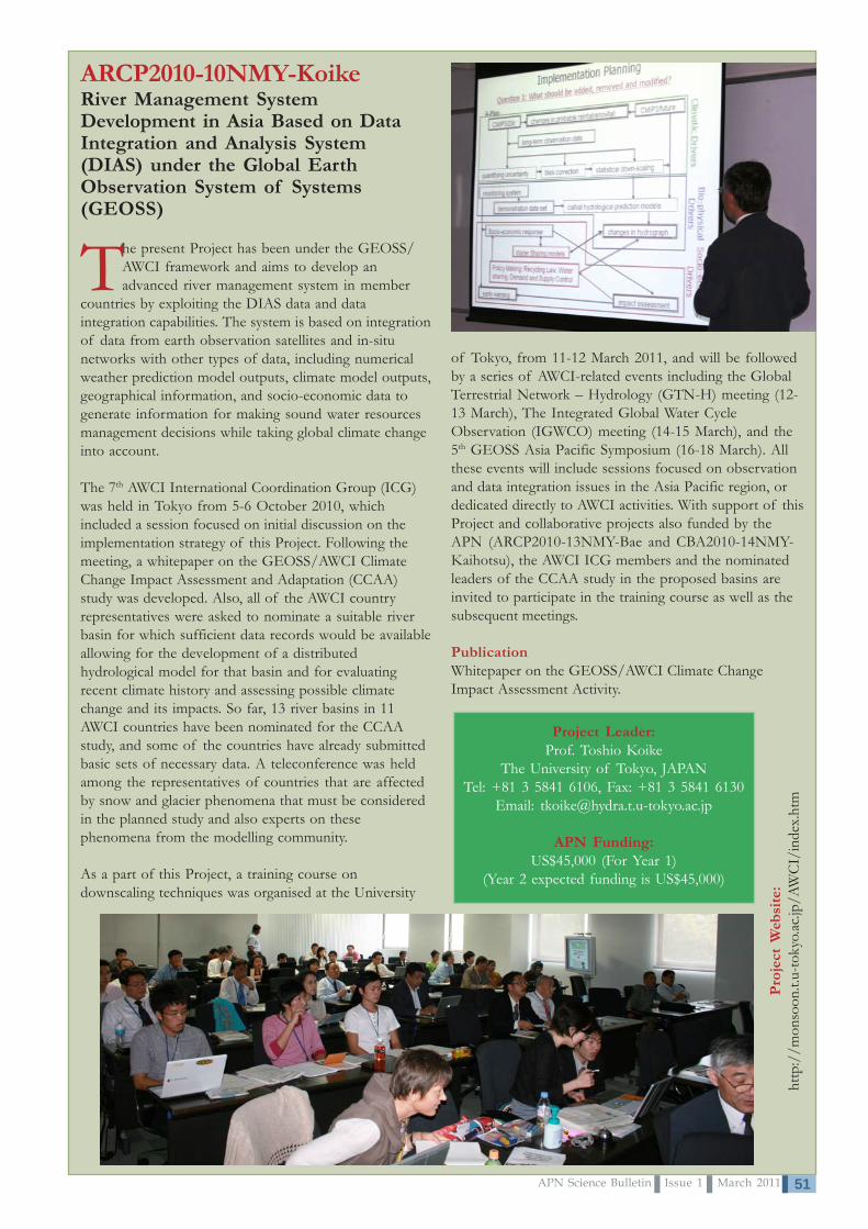
51APN Science Bulletin Issue 1 March 2011
ARCP2010-10NMY-KoikeRiver Management SystemDevelopment in Asia Based on DataIntegration and Analysis System(DIAS) under the Global EarthObservation System of Systems(GEOSS)
The present Project has been under the GEOSS/AWCI framework and aims to develop anadvanced river management system in member
countries by exploiting the DIAS data and dataintegration capabilities. The system is based on integrationof data from earth observation satellites and in-situnetworks with other types of data, including numericalweather prediction model outputs, climate model outputs,geographical information, and socio-economic data togenerate information for making sound water resourcesmanagement decisions while taking global climate changeinto account.
The 7th AWCI International Coordination Group (ICG)was held in Tokyo from 5-6 October 2010, whichincluded a session focused on initial discussion on theimplementation strategy of this Project. Following themeeting, a whitepaper on the GEOSS/AWCI ClimateChange Impact Assessment and Adaptation (CCAA)study was developed. Also, all of the AWCI countryrepresentatives were asked to nominate a suitable riverbasin for which sufficient data records would be availableallowing for the development of a distributedhydrological model for that basin and for evaluatingrecent climate history and assessing possible climatechange and its impacts. So far, 13 river basins in 11AWCI countries have been nominated for the CCAAstudy, and some of the countries have already submittedbasic sets of necessary data. A teleconference was heldamong the representatives of countries that are affectedby snow and glacier phenomena that must be consideredin the planned study and also experts on thesephenomena from the modelling community.
As a part of this Project, a training course ondownscaling techniques was organised at the University
of Tokyo, from 11-12 March 2011, and will be followedby a series of AWCI-related events including the GlobalTerrestrial Network – Hydrology (GTN-H) meeting (12-13 March), The Integrated Global Water CycleObservation (IGWCO) meeting (14-15 March), and the5th GEOSS Asia Pacific Symposium (16-18 March). Allthese events will include sessions focused on observationand data integration issues in the Asia Pacific region, ordedicated directly to AWCI activities. With support of thisProject and collaborative projects also funded by theAPN (ARCP2010-13NMY-Bae and CBA2010-14NMY-Kaihotsu), the AWCI ICG members and the nominatedleaders of the CCAA study in the proposed basins areinvited to participate in the training course as well as thesubsequent meetings.
PublicationWhitepaper on the GEOSS/AWCI Climate ChangeImpact Assessment Activity.
Pro
ject
Web
site
:ht
tp:/
/mon
soon
.t.u-
toky
o.ac
.jp/A
WC
I/in
dex.
htm
Project Leader:Prof. Toshio Koike
The University of Tokyo, JAPANTel: +81 3 5841 6106, Fax: +81 3 5841 6130
Email: [email protected]
APN Funding:US$45,000 (For Year 1)
(Year 2 expected funding is US$45,000)

APN Science Bulletin Issue 1 March 201152
ARCP2010-11NMY-AsanumaIntercomparison of Landsurface Process Modelling in Asian Drylands
Project Leader:Dr. Jun AsanumaTerrestrial Environment ResearchCentreUniversity of Tsukuba, JAPANTel: +81 29 853 6704Fax: +81 28 853 6704Email: [email protected]
APN Funding:US$58,700 (for Year 1)(Year 2 expected funding isUS$47,100)
Drylands account for 40% of the Earth’s landsurface and a similar fraction of Asian landsurface. Characterised by dry climate, low
vegetation cover and low nutrients, its ecosystem and thesociety that depends on drylands are inherentlyvulnerable to external perturbations such as climatechange and land-use change. The present Project - AsianDryland Model Intercomparison Project (ADMIP) isassessing uncertainties in the prediction of landsurfaceenvironments with models and improving predictionaccuracies. With additional support from the ChineseAcademy of Sciences and the Japanese Society forPromotion of Science, this Project is working with 16registered models run by 13 groups worldwide.
In order to predict the landsurface environment ofdrylands, the project teams utilise landsurface models(LSMs) and terrestrial ecosystem models (TEMs).Hence, by addressing the challenges of different processrepresentations and large differences in their predictivecapabilities, the project team is carrying out anintercomparison study with a suite of models and datafrom a selected set of well-documented study sites fromthe Asian dryland region.
A Project inception meeting was held from 11-12 July2010 in Beijing, China and members discussedforthcoming tasks, datasets for the modelintercomparison and a project timeline. At the target sitesof the analysis, three observation stations were identified:two in China and one in Mongolia. To facilitate easierdata exchange and the analysis of model outputs, theproject team collectively avails of the Protocol for theAnalysis of Land Surface models (PALS) from theUniversity of New South Wales. A group from KyotoUniversity plays a major role in collecting key data andhosting the project website. Currently the project teamsare working on data preparation and model runs.
Project Website: http://hywr.kuciv.kyoto-u.ac.jp/admip/index.html
Asian Drylands Process Model IntercomparisonProject (ADMIP) is supported by: Asia-PacificNetwork for Global Change Research (APN),
Monsoon Asia Integrated Regional Study(MAIRS), and Japan Society for the Promotion of
Science (JSPS)
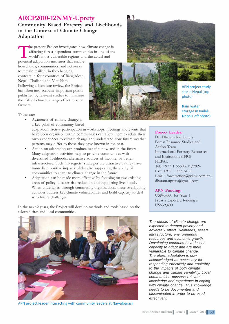
53APN Science Bulletin Issue 1 March 2011
ARCP2010-12NMY-UpretyCommunity Based Forestry and Livelihoodsin the Context of Climate ChangeAdaptation
The present Project investigates how climate change isaffecting forest-dependent communities in one of theworld’s most vulnerable regions and the actual and
potential adaptation measures that enablehouseholds, communities, and networksto remain resilient in the changingcontexts in four countries of Bangladesh,Nepal, Thailand and Viet Nam.Following a literature review, the Projecthas taken into account important pointspublished by relevant studies to minimisethe risk of climate change effect in ruralfarmers.
These are:• Awareness of climate change is
a key pillar of community basedadaptation. Active participation in workshops, meetings and events thathave been organised within communities can allow them to relate theirown experiences to climate change and understand how future weatherpatterns may differ to those they have known in the past.
• Action on adaptation can produce benefits now and in the future.Many adaptation activities help to provide communities withdiversified livelihoods, alternative sources of income, or betterinfrastructure. Such ‘no regrets’ strategies are attractive as they haveimmediate positive impacts whilst also supporting the ability ofcommunities to adapt to climate change in the future.
• Adaptation can be made more effective by focusing on two existingareas of policy: disaster risk reduction and supporting livelihoods.When undertaken through community organisations, these overlappingactivities address key climate vulnerabilities and build capacity to dealwith future challenges.
In the next 2 years, the Project will develop methods and tools based on theselected sites and local communities.
The effects of climate change areexpected to deepen poverty andadversely affect livelihoods, assets,infrastructure, environmentalresources and economic growth.Developing countries have lessercapacity to adapt and are morevulnerable to climate change.Therefore, adaptation is nowacknowledged as necessary forresponding effectively and equitablyto the impacts of both climatechange and climate variability. Localcommunities possess relevantknowledge and experience in copingwith climate change. This knowledgeneeds to be documented anddisseminated in order to be usedeffectively.
APN project leader interacting with community leaders at Nawalparasi
Project Leader:Dr. Dharam Raj UpretyForest Resource Studies andAction TeamInternational Forestry Resourcesand Institutions (IFRI)NEPALTel: +977 1 555 0631/2924Fax: +977 1 553 5190Email: [email protected];[email protected]
APN Funding:US$40,000 for Year 1(Year 2 expected funding isUS$39,400
APN project studysite in Nepal (topphoto)
Rain waterstorage in Kailali,Nepal (left photo)

APN Science Bulletin Issue 1 March 201154
ARCP2010-13NMY-BaeClimate Change ImpactAssessment on Asia-PacificWater Resources underAWCI/GEOSS
In partnership with GEOSS/AWCI topromote necessary capacity building forassessment technology, this project sets
forth two approaches for evaluating climatechange impact assessments on waterresources in the Asia-Pacific region. Theapproaches are described in Figure 1: i) theanalysis of past historical hydrologic andmeteorological observation data to detectclimate change trends; and ii) the use ofGlobal Climate Model (GCM) outputs withdownscaling and hydrologic models underfuture GHG emissions scenarios.
In this Project, Mann-Kendallstatistical test and linear regressionis being used to analyse pasthistorical hydrological data todetermine the significance oftrends in precipitation and runoffdata in more than 18 countries ofGEOSS/AWCI. For future climateand hydrologic projections over theEast Asia monsoon area, thisProject will use GCM simulationswith downscaling schemes andhydrologic models. Climateprojections (the outputs of GCMs obtained by using GHG emission scenarios) will be used for generating Multi ModelEnsemble (MME) scenarios and for evaluating the difference of the hydro-meteorological variables during the periods of2011-2040, 2041-2070 and 2071-2100 relative to the past 30-year reference period (1980-2010). In this study, 13 GCMresults out of 23 GCM simulations provided by the IPCC Data Distribution Centre are being used.
Currently the project is focussing on past historical data collection, quality control and preliminary application of the datain the 18 GEOSS/AWCI countries.
Figure 1. Two approaches for climate change impact assessments on water resources
Project Website: http://monsoon.t.u-tokyo.ac.jp/AWCI/index.htmProject Leader:Prof. Deg-Hyo Bae
Sejong UniversityREPUBLIC OF
KOREATel: +82 2 3408 3814Tel: +82 2 3408 4332
Email:[email protected]
APN Funding:US$42,000 (for Year 1)
(Year 2 expectedfunding is US$42,000)

55APN Science Bulletin Issue 1 March 2011
Project Leader:Prof. Jianlong LiThe Global Change ResearchInstituteNanjing UniversityCHINATel: +86 25 8359 2715Fax: +86 25 8330 2728Email: [email protected];[email protected]
APN Funding:US$22,750 (For Year 1)(Year 2 expected funding isUS$22,750)
ARCP2010-14NMY-LiAnalysis on Urban Land-Use Changes and its Impacts on Food Security in DifferentAsian Cities of Four Developing Countries using Modified Cellular Automata (CA)
The present Project will quantify the level of urbanisation from the aspect of landuse and connecting land use patterns with urbanisation processes in China, Indiaand Viet Nam. It works on building and enhancing scientific capacity in support
of the research with experts from Australia and U.S.A. The Project plans to produce anintegrated technical report of the land-use/land-cover change and urban landscapepatterns, and to disseminate findings to farmers, policy-makers and the internationalcommunity.
An inception workshop and a training meeting wereorganised from 26 July to 3 August 2010 in NanjingUniversity where project members discussed advancedmethods of remote sensing technology and GIS, theCellular Automata (CA) model, and food security decision
system. The CA model is beingapplied to assess changes inurban expansion, land use andfood security in three core citiesin the countries and to analysedifferent urban land use patternsand mechanisms leading to foodshortages.
Country project members arecurrently working on allocatedresponsibilities for collecting,analysing and processing multi-data in the case studies andconducting fieldwork in theirrespective countries. As initialproject outcomes, the Chineseteam has written six scientificpapers, an assessment report andpublished four papers in the2010 3rd InternationalConference on ComputationalIntelligence and IndustrialApplication (PACIIA).
Publications• Yang, Q., Gan, X.,
Li, J., et al. 2010.Cellular Automatafor UrbanisationHotspot Based OnLand UseUrbanisation Level in Medium-sized Cities—ACase Study in Zhangjiagang. International JournalRemote Sensing, 2010, (5): 1212-1225.
• Zou, X., Shang, Z., Li, J., et al. 2010.Comparative Analysis on Spatial-Temporal LandUse and Land Cover (LULC) Characteristics inThree Asian Cities. Proceedings of the 3rd
International Conference on Computational Intelligence and IndustrialApplication(PACIIA),2010 in Wuhan: 461-464.
• Chen, Y., Huang, J., Li, J. 2010. Analysis on Dynamic Landscape Patterns ofUrbanisation in Four Asian Cities Using 3S Technologies and CA Model.Proceedings of the 3rd International Conference on Computational Intelligence and IndustrialApplication (PACIIA), 2010 in Wuhan: 465-468.
• Sun, C., Gan, X., Li, J., et al. 2010. Analysis on Spatial -Temporal LandscapePattern and Ecological Security in Zhangjiagang City Using 3S Technologies andCA Model. Proceedings of the 3rd International Conference on Computational Intelligenceand Industrial Application (PACIIA), 2010 in Wuhan: 469-472.
• Zhang, J. and Li, J. 2010. Establishment of Early Warning System of GrainSecurity in Zhangjiagang, China Using Immune-Based Optimised BP NeuralNetwork Model. Proceedings of the 3rd International Conference on ComputationalIntelligence and Industrial Application (PACIIA), 2010 in Wuhan: 473-476.
• Sun, Z., Sun, C., Li, J., et al. 2010. Efficient Water-saving Irrigation Solution forDirect Seeding Rice under No-Tillage after Cultivating Wheat. Poceedings of the 1st
International Conference on Cellular, Molecular Biology, Biophysics and Bioengineering,2010 in Qiqihr: 553-556.

APN Science Bulletin Issue 1 March 201156
ARCP2010-15NMY-HanThe Impact of Spatial Parameters on GreenhouseGas Emissions: A Comparative Study between Citiesin China and India
The present Project is examining the role ofurban spatial restructuring in reducinggreenhouse gas (GHG) emissions by
assessing the impacts of urban spatial parametersin China and India. The idea of reducing energy
ARCP2010-16NMY-HudaFood Security and Climate Change in the Asia-Pacific Region: Evaluating Mismatch between CropDevelopment and Water Availability
Crop adaptation to environmental stresses is central to sustainable agriculture. In southern Australia, central India, and north China temperature has increased and phenological patterns of major grain
crops have shifted over the past 40 years. Cropping systems and varietiesare designed so that water availability and crop water requirements are wellmatched. Mismatches between crop and environment occur when the
critical period of crop yield determination coincides with stressful conditions.
Possible mismatches arising from realised warming were the subject of the trainingand project-planning workshop held in Beijing in September 2010. The workshopdetermined case studies in China, India and Australia, and realised the significantinput to the project that would be made by young researchers in China and India,based on the training provided at this and a subsequent workshop in India. Strategiesare being developed to enhance capacity building of these researchers during theproject, including training in Australia and their involvement in the internationalproject workshop.
The workshop discussed the relevance of available methods for research studiesplanned in three countries and the scope of the research is focusing on crops of local
importance including rice, wheat, maize and chickpea at key sites. The project identified appropriate models, modellingframework and data needs to incorporate relevant climate risk factors for matching crop development with wateravailability. Part of the workshop focused on training in crop science, climate analysis and modelling to assess themismatch of crop phenology and water availability. The workshop concluded with field trips – the first field visit was fordiscussion with students of the FACE (Free-air carbon dioxide enhancement) experiment in Beijing. Project scientistsprovided input on physiological principles of wheat responses to CO
2 to postgraduate students. The second field trip was
to Harbin Province, which is one of the planned experimental sites in China.
Project Leader:Dr. Sun Sheng HanFaculty of Architecture,Building and PlanningThe University ofMelbourneAUSTRALIATel: +61 3 8344 7055Fax: +61 3 8344 5532Email: [email protected]
APN Funding:US$41,560 (For Year 1)(Year 2 expected funding isUS$38,440)
In May 2010, the project teamgathered in Wuhan to discuss theresearch methodologies. In July, apilot questionnaire survey wasconducted in Xi’an, Chinafollowed by a full scale survey of1200 sample households. The
project team is currently working on geo-coding the surveydata and, at the same time, undertaking preliminary analysisof the data. A part of the project team is completing thequestionnaire for survey in Bangalore, and also preparing aprecinct survey for both Xi’an and Bangalore.
use and household GHG emissions via modifyingland-use mix, transportation arrangements andpopulation density is novel and complementaryto the technology-oriented efforts (e.g.,development of energy-saving products, use ofrenewable energy sources, etc.). This Projectdevelops and implements a conceptual andmethodological innovation using two case studycities that provide distinctive but comparablecontexts to study energy-use behaviour andurban planning policies. By providing findings onthe association between GHG emissions and spatialparameters, the Project will enable a more informed choiceby planning agencies between these different visions and inturn, provide confidence in the articulation of policydesigned to reshape land use patterns.
Project Leader:Prof. Samsul Huda
Centre for Plants and theEnvironment
University of Western SydneyAUSTRALIA
Tel: +61 2 4570 1390Fax: +61 2 4570 1750
Email: [email protected]
APN Funding:US$60,000 (For Year 1)
(Year 2 expected funding isUS$59,700)

57APN Science Bulletin Issue 1 March 2011
ARCP2010-17NMY-TowprayoonStrategic Rice Cultivation for Sustainable Low Carbon SocietyDevelopment in Southeast Asia
The present Project aims at sustainable agriculture in Southeast Asia (SEA) by identifying strategic rice cultivation practices involving rotation with energy crops for mitigating GHGs, while enhancing capacity in energy production and long term soil
carbon storage. In addressing this, project members in the three collaborating countries haveundertaken a literature survey to assess current practicesin the case study sites. They have also developedquestionnaires that will be used to collect information onagricultural practices from farmers and assess thepotential for crop rotation, i.e. with maize and sorghum.
Preliminary assessment of GHG emissions and soil carbon stock looks at the currentpractices of rice cultivation and rotation in Thailand. For this particular investigation,the research team prepared an experimental field site in Thailand (RatchaburiCampus) for cultivating rice under different management conditions and rotating withmaize and sorghum. Then, the team aims to measure the GHG emissions and soilcarbon stock of this experiment. This activity provides the basis to evaluate theinfluence of selected crop rotations with rice in terms of soil carbon dynamics andGHG emissions (carbon cycle) as well as socio-economic implications in order toidentify feasible sustainable cultivation practices under specific conditions ofmanagement.
Project Leader:Assoc. Prof. Dr. SirintornthepTowprayoonKing Mongkut’s University ofTechnologyTHAILANDTel: +6 62 470 8309Fax: +6 62 871 9805Email: [email protected]
APN Funding:US$40,000 (For Year 1)(Year 2 expected funding isUS$40,000)
ARCP2010-18NMY-LutaenkoCoastal Marine Biodiversity of Viet Nam:Regional and Local Challenges and CoastalZone Management for Sustainable Development
The present Project is looking at the marine biological diversity in coastal zones of the South China Sea with emphasis on Viet, Nam its modern status, threats, recent and future modifications
due to global climate changes and human impact, and methods for itsconservation.
As a part of the planned project activities, the International Conferenceof Marine Biodiversity of East Asia Seas: Status, Regional Challenges andSustainable Development was held in the Institute of Oceanography, VietNam Academy of Science and Technology in Nhatrang from 6-7December 2010. Over 30 participants attended the meeting, and amongthem there were scientists from five countries (Germany, Japan, Republicof Korea, Russia and Viet Nam), representatives of some Vietnamese
governmental agencies and international organisations. Forty-seven full-length papers were published in the conferenceproceedings. Among these, a number of scientific papers are being prepared for submission to peer-reviewed journals. Theresearch papers deal with significant scientific aspects of marine biodiversity.
Rare biota of intertidal zone of Vietnamese islands was studied based on previous collections. Belt-forming communitiesof macrobenthos were investigated in five bionomical types of the intertidal zone. The distribution of the taxonomicalcomposition and the density of meiobenthos have been studied in bottom sediments of the northern estuary part of HaLong Bay for the first time. A total of sixty-six species belonging to 17 families and 52 genera were identified. The projectteam regards that these data may serve as a basis for future long-term monitoring of biodiversity changes. Currently theproject team is working to develop a summary book on biodiversity and coastal zone management in Viet Nam.
PublicationT.N., Dautova and Lutaenko, K.A. (Eds.) Proceedings of the International Conference on Marine Biodiversity of East Asian Seas:Status, Challenges and Sustainable Development, Nha Trang, Vietnam, December 6-7, 2010. 202pp.
Project Leader:Dr. Konstantin LutaenkoInstitute of MarineBiology, Far East BranchRUSSIANFEDERATIONTel: +7 4232 317 111Fax: +7 4232 310 9000Email: [email protected];[email protected]
APN Funding:US$40,000 (For Year 1)(Year 2 expected funding is US$40,000)
Project Website:www.imb.dvo.ru/misc/vietnam/
APN Science Bulletin Issue 1 March 201158
Scientific CapacityDevelopmentProjects fundedunder theCAPaBLEProgramme
3

59APN Science Bulletin Issue 1 March 2011
CBA2010-01CMY-Sang-arunPromoting Sustainable Use of Waste Biomass inCambodia, Lao People’s Democratic Republic andThailand: Combining Food Security, Bio-energy andClimate Protection Benefits
The present Project promotes the use of waste biomass for food andenergy production, and identifies viable approaches for utilising biomassconversion technology in Cambodia, Lao PDR and Thailand. In
addressing this, the project to date has conducted review assessments ofregulations and policy in themes of biomass management and carried out fieldsurveys related to technical facilities and other issues with officers-in-charge inthe three countries. Results to date show that the most sustainable uses ofconverting waste biomass to a useful resource are found to be in three viabletechnologies: composting, biogas generation, and gasification. These technologiesare being used for agricultural waste such as rice straw, manure and wood waste;however, their application into urban organic waste is not widely practiced.
Through surveys, the project team has investigated practical examples in Asiancountries. For example, it was found that the conversion of urban organic wasteto compost is practiced in Bangkok and Rayong, Thailand and in Phnom Penh,Battambang and Siem Reap, Cambodia. Biogas generation from urban organicwaste is being implemented in Rayong and Bangkok, Thailand. These caseexamples show that there is high potential for shared learning and technologytransfer between neighbouring countries.
It is important to note that piloting of transferred technology requires effectiveimplementation. For this reason of advocating broad utilisation of urban organicwaste, the project team is currently developing guidelines for decision-makingand implementation, which will be translated into local languages: Khmer,Laotian and Thai.
Household composting
In-vessel composting
Gasification
Windrow composting
Project Leader:Dr. Janya Sang-arunInstitute for GlobalEnvironmental Strategies (IGES)JAPANTel: +81 46 826 9573Fax: +81 46 855 3809Email: [email protected]
APN Funding:US$66,700 (For 2 Years)
Numbers of biogas plants using manure in Cambodia 2009

APN Science Bulletin Issue 1 March 201160
CBA2010-02CMY-TogtohynDryland Development Paradigm (DDP) Applicationfor the Most Vulnerable to Climate and Land-UseChange of Pastoral Systems in the Southern KhangaiMountains of Mongolia (DDPPaS)
In consultation with the local community, decision-makers and researchers,this project has applied the five principles of DDP for identifying changesin human-environmental systems of the Tuin and Baidrag river basins of
Mongolia. Utilising climate data (since 1940) and livestock data (1986-2008),the project team measured the integrated drought-Zud index (extreme winterdisaster), pasture use and ecological vulnerability indexes for rural communities.Findings attributable to the five principles are as follows:
Project Leader:Dr. Chuluun TogtohynInstitute for Dryland Sustainability(IDS), National University ofMongoliaMONGOLIATel: +97 61 1463 089Email: [email protected]
APN Funding:US$60,000 (For 2 Years)
iii) According to a local community survey, the decrease of surface water hasalready crossed the threshold level and is leading to the collapse of manytraditional human-environmental systems in the region.
iv) Global level regulation (with climate change as the main driver) is considered as the most important in the Tuin riverbasin whereas local level regulation (human activities such as mining and climate change) was important in the Baidragriver basin. Placer gold mining activities are harming the riparian ecosystems in the areas as shown in the photos tothe right and on the next page.
v) Mixed use of modern and traditional knowledge is considered as fair by local stakeholders. Analysing long-termclimate and socio-economic data (Figures 2 and 3), the rural Gobi region is more vulnerable in terms of drought-Zud(previous summer followed by severe winter) and socio-economic indicators (GDP, remoteness, inadequateinfrastructure) than in steppe and forest steppe regions.
Figure 1. Annual air temperature in Bayanhongor
i) Natural disasters (drought and Zud) and climaticextreme events, which affect livestock dynamics, aremain drivers of dynamics of the human-environmentalsystems in the region.
ii) Global warming and the decline of surface water havebeen identified as critical slow variables, making thehuman-environmental systems gradually morevulnerable to natural and anthropogenic shocks. Fieldsite data reveals that temperature increased by morethan 2oC since 1940 (Figure 1).
The “Odod Gold co.Ltd” operatesright on the Olziit river bank in
Bombogor sum

61APN Science Bulletin Issue 1 March 2011
Based on the scientific findings and local knowledge in collaboration with the Tuinriver basin consul, the project team has developed a draft management plan forsustainability of human-environmental systems in the Tuin river basin. The team iscurrently working on an adaptation strategic plan for the Baidrag river basin.
Publications• Chuluun, T. 2010. Land degradation and
desertification in Mongolia. Backgroundpaper for the Human Development Report-2010-Mongolia (commissioned paper).
• Altanbagana, M. and Chuluun, T. 2010.Vulnerability assessment of social-ecological system of Mongolia. TheProceedings of the 4th International andNational workshop Applications of Geo-informatics for Natural Resource andEnvironment, June 2010, Ulaanbaatar,Mongolia.
• Altanbagana, M., Chuluun, T. and Ojima,D. 2010. Vulnerability Assessment of theMongolian Rangeland Ecosystems. pp.42-62 In: Chuluun Togtokh andMasataka Watanabe (Eds). 2010.Proceedings for Consultative Meeting onIntegration of Climate Change Adaptationinto Sustainable Development in Mongolia, 17-18 June 2010, Ulaanbaatar, Mongolia.
• Chuluun, T., Tserenchunt, B., Altanbagana, M. and Stafford Smith, M.. 2011. Applying the Dryland Development Paradigmto Pastoral Systems in Mongolia. IXth IRC, April 2-8, 2011, Rosario, Argentina (accepted).
• Chuluun, T. 2011. Vulnerability and Adaptation of Pastoral Human-Environmental Systems to Climate Impact atMultiple Scales in Mongolia. IXth IRC, April 2-8, 2011, Rosario, Argentina (invited paper).
Restored and disturbed sites alongthe Baidrag river
Figure 3. Socio-economic vulnerability assessment inBaidrag river basin
The results of the project were presented at following events:• August 16-20, 2010. Panel on “Climate Change Adaptation and Sustainable
Development of Mongolia”. The Second International Conference onClimate, Sustainability and Development in semiarid regions – ICID,Fortaleza, Brazil.
• October 17-19, 2010. Chuluun, T., Ojima, D., Altanbagana, M., Davaanyam,S., and B. Tserenchunt, B. Vulnerability and Resilience of Pastoral Social-Ecological Systems in Mongolia. Global Land Project (GLP) Open ScienceMeeting, Tempe Campus, Arizona, USA.
• October 21-22, 2010. Chuluun, T., and Tsogoo, B. Vulnerability of pastoralsocial-ecological systems at multiple scales in Mongolia. Asia-Pacific ClimateChange Adaptation Forum: Mainstreaming Adaptation into DevelopmentPlanning, Bangkok, Thailand.
“Climate change hasbecome a critical
slow variable, alreadysurpassing thresholds
in terms of itsnegative impact on
surface water; and isleading to collapse”according to a social
survey in the Tuin rivercommunity.
Figure 2. Integrated Zud Index in the Baidrag and Tuin riverbasins by ecosystem type

APN Science Bulletin Issue 1 March 201162
CBA2010-03NSY-IndrawanDeveloping the Capacity for TeachingBiodiversity and Conservation in the Asia-Pacific Region
Building on previous efforts, particularly those byDIVERSITAS in Western Pacific and Asia (DIWPA),Centre for Tropical Forest Science, and Association
for Tropical Biology and Conservation Asia-Pacific Chapter,this Project is implementing capacity building activities onconservation biology focusing primarily on junior facultymembers and young researchers in developing countries inAsia and the Pacific.
The junior faculty are more likely to incorporate what theylearn into their own research and teaching agendas, thusmaximising the impact by ensuring long-term effectivenessand direct benefits. This project was composed of four maintraining components: i) Experimental design and data analysis
courses (the Bali Botanic Gardens 12-15 July 2010); ii) Science writing courses (the Bali Botanic Gardens 16 July 2010);iii) Field biology training courses; and iv) Symposia, which emanated from thefield course.
A Field Course on Biodiversity, Conservation and Sustainable Developmententailed six weeks of field work in two national parks in East Java, Alas Purwoand Baluran, before crossing Wallace’s Line into Rinjani National Park inLombok. Biologists from around the globe committed their time and expertise asresource staff, offering lectures and hands-on training in their fields of expertise.
The Field Course captured multidisciplinary approaches to biodiversityconservation and global climate change. Throughout the Field Course,participants engaged in their own student research projects, and presented theirresults at a concluding field course symposium. To educate the Indonesian publicabout our activities and to widen the audience’s awareness of educationalactivities, the media were also invited to attend.
The project also allowed for extending scholarship support to scientificand capacity building activities of global change, namely themeeting of the Association for Tropical Biology andConservation (ATBC) 2010 -“Tropical Biodiversity:Surviving the Food, Energy and Climate Crisis,”held in Sanur, Bali, Indonesia from 19-23 July 2010. Project Leader:
Dr. MochamadIndrawan
University ofIndonesia
INDONESIATel: +62 81 199 0151
Fax: +62 251 837 447Email: [email protected]
APN Funding:US$33,190 (For 1 Year)
Project website:http://www.pfs-tropasia.org/
Group projects were deemed a worthwhile experience: “…full ofchallenges and very useful for me,” according to one participant.Another participant described group projects as “the mosteducational experience during this course.”
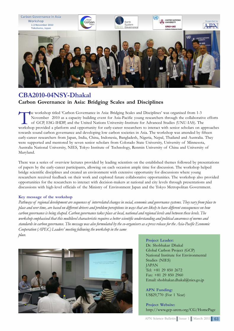
63APN Science Bulletin Issue 1 March 2011
CBA2010-04NSY-DhakalCarbon Governance in Asia: Bridging Scales and Disciplines
The workshop titled ‘Carbon Governance in Asia: Bridging Scales and Disciplines’ was organised from 1-3November 2010 as a capacity building event for Asia-Pacific young researchers through the collaborative effortsof GCP, ESG-IHDP, and the United Nations University-Institute for Advanced Studies (UNU-IAS). The
workshop provided a platform and opportunity for early-career researchers to interact with senior scholars on approachestowards sound carbon governance and developing low carbon societies in Asia. The workshop was attended by fifteenearly-career researchers from Japan, India, China, Indonesia, Bangladesh, Nigeria, Nepal, Thailand and Australia. Theywere supported and mentored by seven senior scholars from Colorado State University, University of Minnesota,Australia National University, NIES, Tokyo Institute of Technology, Renmin University of China and University ofMaryland.
There was a series of overview lectures provided by leading scientists on the established themes followed by presentationsof papers by the early-career participants, allowing on each occasion ample time for discussion. The workshop helpedbridge scientific disciplines and created an environment with extensive opportunity for discussions where youngresearchers received feedback on their work and explored future collaborative opportunities. The workshop also providedopportunities for the researchers to interact with decision-makers at national and city levels through presentations anddiscussions with high-level officials of the Ministry of Environment Japan and the Tokyo Metropolitan Government.
Key message of the workshopPathways of regional development are sequences of interrelated changes in social, economic and governance systems. They vary from place toplace and over time, are based on different drivers and problem perceptions in ways that are likely to have different consequences on howcarbon governance is being shaped. Carbon governance takes place at local, national and regional levels and between these levels. Theworkshop emphasised that this multilevel characteristic requires a better scientific understanding and political awareness of norms andstandards in carbon governance. The message was also formulated by the co-organisers as a press release for the Asia-Pacific EconomicCooperation (APEC) Leaders’ meeting following the workshop in the sameplace.
Project Leader:Dr. Shobhakar DhakalGlobal Carbon Project (GCP)National Institute for EnvironmentalStudies (NIES)JAPANTel: +81 29 850 2672Fax: +81 29 850 2960Email: [email protected]
APN Funding:US$29,770 (For 1 Year)
Project Website:http://www.gcp-urcm.org/CG/HomePage

APN Science Bulletin Issue 1 March 201164
CBA2010-05NSY-LorreyImproving Pacific Island Meteorological DataRescue and Data Visualisation Capabilitiesthrough Involvement in Emerging ClimateResearch Programmes
Project Leader:Dr. Andrew LorreyNational Institute of Water andAtmospheric Research, Ltd. (NIWA)NEW ZEALANDTel: +64 9 375 2055Fax: +64 9 375 2051Email: [email protected]
APN Funding:US$40,000 (For 1 Year)
The workshop on “Improving Pacific IslandMeteorological Data Rescue and Data VisualisationCapabilities through Involvement in Emerging
Climate Research Programmes” was held in Auckland, NewZealand from 27-29 September 2010. The workshop sawparticipants from Australia, Europe, New Zealand, U.S.A.,South America, and the island nations of the southwestPacific in attendance. The attendees engaged on currentissues of data rescue and the use of the data in newvisualisation platforms for climate and weather research.An overarching theme at the workshop was to garnersupport for the Atmospheric Circulation Reconstructionsacross the Earth (ACRE) initiative, which is feeding dailyweather observations into new surface pressure-based re-analysis data sets (the 20th Century Re-analysis [20CR] andSurface Input Reanalysis for Climate Applications[SIRCA]). The ACRE initiative received a unanimousendorsement from the World Meteorological Organisation(WMO) Regional Association V at the 13th RegionalMeteorological Service Directors meeting, and was seen asa critical opportunity to improve climatology analysis andclimate/weather forecasting capabilities for the region. Thegeneral feeling at the workshop indicated that data rescueand data sharing were very important issues forconsideration.
Development of new climate and weather data visualisationtools were demonstrated in Google Earth at the workshop,and illustrated how the 20CR, tropical cyclone tracks, andstation-based rainfall could be used in hands-ondemonstrations. Significant feedback about the use ofGoogle Earth as a tool was provided by all of therepresentatives. This feedback is resulting in improvementsto first-issue releases of several products that are nearingcompletion, such as the South Pacific Rainfall Atlas(SPRAT) and the South Pacific Extended Archive ofTropical Cyclones (SPEAR-TC).
Common interests that were identified at the Aucklandworkshop through break-out sessions highlighted the desire
to increase support for current monitoring and datagathering in the southwest Pacific. When viewed from along-term perspective, the spatial coverage ofenvironmental monitoring on land is on the decline becauseof high costs associated with upkeep of instrumentation.More support for the meteorological services is needed tomaintain and expand current monitoring programmes. Inaddition, many paper data exist in archives, so fosteringcapabilities for Pacific Island meteorological services toconduct data rescue exercises in-house are also required.
A central point of discussion highlighted the importance offostering data base development for the continuedlongevity and support of the Pacific Island meteorologicalservices. To that end, regional assistance from organisationslike NIWA and the Australian Bureau for Meteorology(BOM), through the Pacific Climate Change ScienceProgramme (PCCSP), are expected to reach goals of long-term secure data storage and access, database development,and crafting of new analysis tools connected to thedatabases that are relevant for the services provided to endusers of climate and weather guidance. The meeting alsosaw the development of the ACRE Pacific faction, whichwill seek to foster and continue the region-widecollaboration to address the central issues identified at theAuckland workshop. Thus far, a highlight of the post-workshop collaboration in ACRE Pacific has seen thesignificant contribution of four long daily surface pressureobservations from the Cook Islands Meteorological Serviceto the International Surface Pressure Databank in supportof the extended reanalysis. Similar contributions areexpected from the other Pacific Meteorological Services inthe near future. Directed assistance to the Pacific IslandMeteorological services will occur in the future through theACRE Pacific faction via several pilot projects, includingdevelopment of a data rescue planning and execution
routines specific to thesouthwest Pacific islands.An additional spin-off willsee colleagues fromMeteoFrance becominginvolved in the regionaleffort to rescue surfaceand marine observationsfrom traditionalmeteorological registersand non-traditionalarchives (like ships logs).

65APN Science Bulletin Issue 1 March 2011
CBA2010-06NSY-KenchImproving Understanding of Local-ScaleVulnerability in Atoll Island Countries:Developing Capacity to ImproveIn-Country Approaches and Research
In order to build the skills of scientists in Pacific atollcountries to undertake physical vulnerabilityassessments, this Project has targeted collaboration with two
Pacific atoll countries, The Marshall Islands and Tuvalu.Workshops and field-based case studies have been designed toprovide training on methods to undertake rapid assessment ofvulnerability of reef islands. The use of case studies ofdifferent environments will allow the comparison of local scalevariations in vulnerability.
“The work was valuable in helping usunderstand the vulnerability of our remoteouter-islands to the impacts of climate.The training provided the tools andknowledge for us to apply these techniquesto other islands.”
Deborah Barker-Manase, GeneralManager, Republic of the Marshall Islands
Environmental Protection Authority
Project Leader:Assoc. Prof. Paul KenchThe University of AucklandNEW ZEALANDTel: +64 9 373 7599 ext. 88440Fax: + 64 9 373 7434Email: [email protected]
APN Funding:US$29,760 (For 1 Year)
Since this Project started, the first phase of capacitybuilding was undertaken in the Marshall Islands over athree-week period in September 2010. Collaboratorsincluded members of the Marshall Islands ConservationSociety, the Environmental Protection Authority, College ofthe Marshall Islands and Ailinglaplap Council. The capacitybuilding activities involved: i) a two-day workshop onmethods of vulnerability assessment, held at the LongIsland Hotel, Majuro Atoll; ii) a 10-day field trip to JehIsland, Ailinglalap Atoll and Jabót island. On each island theproject team undertook detailed field surveys of ruralvillages documenting land levels with respect to mean sealevel and community assets; iii) a 2-day closing workshop inwhich field data was analysed, and the vulnerability of ruralvillages to increased sea level was established; and, iv) a
final closing workshop to senior government officials andministers presenting the results of the work. Planning iswell underway for the second major field component inTuvalu in February 2011.
The project team has developed training materials toassess small island vulnerability to sea level changeand written two case study reports of the vulnerabilityof islands to sea level change.
• Kench, P.S., Owen, S.D, Ford, M.R., Trevor D.,Fowler, S., Langrine, J., Lometo, A., 2010. ImprovingUnderstanding of Local-Scale Vulnerability in AtollIsland Countries: Case Study 1: Jeh Island, AilinglaplapAtoll, Republic of Marshall Islands, 12 pages.
• Kench, P.S., Owen, S.D, Ford, M.R., Trevor D.,Fowler, S., Langrine, J., Lometo, A., 2010. ImprovingUnderstanding of Local-Scale Vulnerability in AtollIsland Countries: Case Study 2: Jabót Island, Republic ofMarshall Islands, 10 pages.

APN Science Bulletin Issue 1 March 201166
CBA2010-07NSY-StoneWeb-based ‘Discussion-support’Agricultural-Climate Information forRegional India
Recognising the importance of farmers needing todevelop practical and appropriate managementsystems to help cope with high-impact climate
variability and climate change, this innovative Project isalready developing new processes based on ‘2nd lifeeducation systems and avatars’ to assist decision-supportand what is known as ‘discussion-support’ for farmers in animportant region of Andhra Pradesh, India. To achieve thisresult, a number of targeted workshops and meetings havebeen held and facilitated by core collaborators in theproject: ANGRAU University in Hyderabad. The mainweather and climate inputs and ‘2nd life’ development isbeing undertaken by key personnel at the University ofSouthern Queensland, Toowoomba, Australia, inconjunction with the India Meteorological Department.
An initial major scientific and extension specialist workshopwas also held at ANGRAU University, on 28 September2010, so that key researchers already working in the regionwith leading farmers could provide input andgain ownership of this Project. Followingthis successful workshop and series ofmeetings with key senior staff,meetings and workshops have beenheld in Andhra Pradesh, India atboth the village and farm levelswith leading farmers and at town-centre internet kiosks.
A surprising and heart-warmingaspect of these farmers’ meetingshas been the keen interest shown in theclimate and weather products that wouldbe made available to them in their own language(Telugu). The overall result has been very useful input intothe prototype development of ‘2nd life avatars’ farmer-orientated weather and climate discussion videos by the
farmers direct to the scientists involved in the compilationand production of these videos. As a result, the scientistsinvolved have already gained improved understanding ofthe need to further improve the style and relevance ofweather and climate information so that it directly impactsstraight to the decisions being considered by the farmers.
However, this Project has already also learned that allaspects regarding climate and weather informationdelivered through electronic means must be considered in
these outputs – right through to ensuring that suchaspects as the clothes and ages of the
farmers are properly represented by any‘actors’ in farmer-orientated videos, aswell as ensuring that all the scientificinformation is completely correct andrelevant.
A lesson already learned through thisProject is that ‘scientific information,’
by itself, does not sell a requiredmessage regarding climate information
needed by farmers. This means that allother associated aspects, no matter how
seemingly peripheral, must be included and beproperly represented when delivering climate informationthrough electronic media. Otherwise, the entire purpose ofthe discussion and decision-support process may be lost.
“It’s great to see some topscientists from Australia and India
coming all this way to our village to tell usabout climate and weather – this included
experts from IMD and ANGRAU.”
“It is so good to learn about weather andclimate forecasts that will help our farming.” -
Farmers from Biranpalli,Andhra Pradesh
Project Leader:Prof. Roger StoneUniversity of Southern QueenslandAUSTRALIATel: +61 74 631 2736Fax: +61 74 631 5581 Email: [email protected]
APN Funding:US$34,596 (For 1 Year)
Project Website:www.usq.edu.au/acsc/apnproject
Press Clip on APN project
Local TV interview:Dr. K.K. Singh of IMD during
the Farmers’ Meeting

67APN Science Bulletin Issue 1 March 2011
CBA2010-08NSY-SalingerAddressing the Livelihood Crisis for Farmers:Weather and Climate Services for SustainableAgriculture – Development of Tools
CBA2010-09NSY-OkayamaScientific Capacity Development of Trainers andPolicy-Makers for Climate Change AdaptationPlanning in Asia and the Pacific
The present Project aims at building capacity of key stakeholderssuch as trainers, policy-makers, and development practitioners inthe Asia-Pacific region in order to mainstream climate change
adaptation principles and practices into development planning in some ofthe targeted countries of the Asia-Pacific Adaptation Network (APAN). Italso aims to transfer knowledge and skills on vulnerability assessmentmethodologies and tools, the use of climate information for decision-making, and adaptation planning under uncertainty from developedcountries to developing countries through involving members of the Network. The main objectives of this Project areto undertake an appraisal of training needs in terms of knowledge and skill areas for effective adaptation and to designtraining modules for imparting knowledge and skills for effective adaptation.
Beginning in October 2010, the project team planned detailed activities and a timeframe for its objectives. In order todevelop the capacity of training institutes where policy-makers are trained, the team has also started to undertake atraining needs assessment (TNA) in terms of knowledge and skill areas for effective adaptation. The training institutes infive targeted countries of Cambodia, Lao PDR, Mongolia, Bangladesh and Nepal have been identified and the detailedactivities of the TNA have been designed. The target sectors are kept on track of agriculture and water related toagriculture. Based on forthcoming TNA results, this Project will support the targeted training institutes to developtraining modules, which then will be implemented for key policy-makers in the region. Bringing together representativesfrom five collaborating nations, the project team organised the TNA meeting as the first step for the design anddevelopment of this capacity building activity at the Asian Institute of Technology, Thailand on 31 January 2011.
The present Project was developed to take stock of anumber of important issues facing the agriculturalcommunities around the world including rising populations
with the consequent increase in demand for food; the pressures
Project Leader:Toshinao OkayamaUnited Nations EnvironmentProgramme (UNEP), Regional ResourceCentre for Asia and the PacificTHAILANDTel: +66 2 524 5385Fax: +66 2 5246233Email: [email protected]
APN Funding:US$30,000 (For 1 Year)
Project Leader:Dr. Jim SalingerHonorary Research AssociateSchool of EnvironmentUniversity of AucklandNEW ZEALANDTel: +64 9 373 7599Fax: +64 9 373 7434Email: [email protected]
APN Funding:US$20,000 (For 1 Year)
on the world’s food producers due to climate variability and change, as well as socio-economic conditions; the need to use natural resources productively, but sustainably;and the need within the agriculture communities for increased knowledge and bettertools for risk management and adaptation.
A workshop was held bringing together leading experts in the field who prepared andpresented state-of-the-art discussion papers to address the objectives of the workshop. The programme was designed toengage all participants in discussions on topics of their interest to facilitate interactive dialogue and develop appropriaterecommendations. Through the workshop, a set of key recommendations were developed and adopted at the fifteenth
session of the Commission for Agricultural Meteorology, particularly whileprioritising the future work of the Commission for the upcoming 2011-2013period. Participants from APN countries were encouraged to promote linkagesbetween science and policy discussed during the workshop.
A follow on workshop was held in Luganville, Santo, Vanuatu from 11-13December 2010 where farmers from each province of Vanuatu met with climatechange scientists and agricultural advisers to devise strategies to help cope withclimate variability and climate change. This provided capacity building in the areaof strategies for more targeted weather and climate information and forecastingfor increased preparedness to sustainable agricultural development, especially inthe Asia-Pacific region, and also assisted policy-makers and civil society inresponding effectively to varying weather and climate conditions.
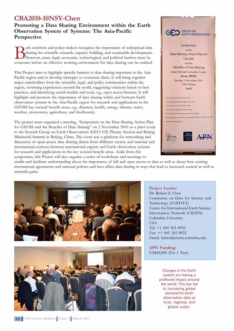
APN Science Bulletin Issue 1 March 201168
CBA2010-10NSY-ChenPromoting a Data Sharing Environment within the EarthObservation System of Systems: The Asia-PacificPerspective
Both scientists and policy-makers recognise the importance of widespread datasharing for scientific research, capacity building, and sustainable development.However, many legal, economic, technological, and political barriers must be
overcome before an effective working environment for data sharing can be realised.
This Project aims to highlight specific barriers to data sharing important in the Asia-Pacific region and to develop strategies to overcome them. It will bring togethermajor stakeholders from the scientific, legal, and policy communities within theregion, reviewing experiences around the world, suggesting solutions based on bestpractices, and identifying useful models and tools, e.g., open access licenses. It willhighlight and promote the importance of data sharing within and between Earthobservation systems in the Asia-Pacific region for research and applications in theGEOSS key societal benefit areas, e.g., disasters, health, energy, climate, water,weather, ecosystems, agriculture, and biodiversity.
The project team organised a meeting, “Symposium on the Data Sharing Action Planfor GEOSS and the Benefits of Data Sharing” on 2 November 2010 as a prior eventto the Seventh Group on Earth Observations (GEO-VII) Plenary Session and BeijingMinisterial Summit in Beijing, China. The event was a platform for networking anddiscussion of open-access data sharing drawn from different sectors and national andinternational contexts between international experts and Earth observation systemsfor research and applications in the key societal benefit areas. Aside from thissymposium, this Project will also organise a series of workshops and meetings toenable and facilitate understanding about the importance of full and open access to data as well as about how existinginternational agreements and national policies and laws affect data sharing in ways that lead to increased societal as well asscientific gains.
Project Leader:Dr. Robert S. ChenCommittee on Data for Science andTechnology (CODATA)Centre for International Earth ScienceInformation Network (CIESIN)Columbia UniversityUSATel: +1 845 365 8952Fax: +1 845 365 8922Email: [email protected]
APN Funding:US$40,000 (For 1 Year)
Changes in the Earthsystem are having a
profound impact aroundthe world. This has led
to increasing globaldemand for Earth
observation data atlocal, regional, and
global scales.

69APN Science Bulletin Issue 1 March 2011
CBA2010-11NSY-De GuzmanCapacity Building for Research and Monitoring of Marine Protected Areas (MPA): AnAdaptive Mechanism for Climate Change in the Asia-Pacific Region
Recognising the need to build local and regional capacityfor marine protected area (MPA) monitoring, thisProject builds the capacity of MPA managers and
technical staff of local government units in selected coralreef-rich countries in the Asia-Pacific region and within theCoral Triangle Initiative. Since its implementation the projecthas produced an MPA Training Manual, conducted twotraining activities, and trained a total of 40 MPA managersand monitoring staff.
A Local Training in MPA Monitoring was held from 23-27August 2010 and attended by 20 participants from variousgovernment agencies, local government units (LGUs),academic institutions, and non-government organisations(NGOs) in Mindanao Island, Philippines, including a municipalmayor of a remote town in the Zamboanga province.Participants were taught standard and emerging techniques inassessment and monitoring of coral reefs (corals, fish, andother benthos), seagrass beds, and mangrove ecosystems.Lectures on monitoring techniques were supplemented by fieldand diving activities in selected MPA sites where actual datawas gathered and used to demonstrate data management andreport preparation.
Regional Training in MPA monitoring was held from 26-30November 2010 in the municipality of Maria in Siquijor Island,
central Visayas, Philippines. The training was attended by 20participants from different countries in the Asia-PacificRegion, namely Indonesia, Thailand, Viet Nam, Timor Leste,and Philippines. The five-day training covered the same topicsas the Local Training and opened with a rich sharing ofexperiences in MPA monitoring and management initiativesamong participants from five countries. Participants were alsotrained in data management and preparation of monitoringreports. Participants from each country drafted an MPAmonitoring plan which they hope will guide them in improvingMPA management in their respective countries.
Training is indeedvery useful inimproving the
management oftheir respectiveMPAs throughmonitoring and
evaluation.
Project Leader:Dr. Asuncion De GuzmanInstitute of Fisheries Research andDevelopmentMindanao State UniversityPHIILIPPINESTel: +63 917 7120171Email: [email protected]
APN Funding:US$35,600 (For 1 Year)
Diving and monitoring activities in selected marineprotected areas as part of the Regional Training
Lectures and sharing of experiences

APN Science Bulletin Issue 1 March 201170
CBA2010-12NSY-PradhanangaGraduate Conference on Climate Change and People
The International Graduate Conference on Climate Changeand People was organised in Nepal from 15-19November 2010. The conference mainly focused on
scientific capacity building of graduate students ofdifferent academic majors/disciplines through theirknowledge- and experience-sharing with experts in climateaffairs. Coupled with climate change knowledge, the focuswas directed on regional climate change-related concerns.Targeting graduate students in Greater South Asia, thisProject successfully contributed to developing the capacityof students in the region to become climate leaders andclimate agents in their respective fields of endeavour.
In the conference, seventeen experts from a variety offields including social science, biodiversity, water resources,climate change science, natural hazards, policy, equity andethics, etc., shared their experiences and opinions among130 delegates representing 17 countries from GreaterSouth Asia and beyond. It was jointly organised by TheSmall Earth Nepal (SEN) and the Consortium for CapacityBuilding (CCB), University of Colorado, U.S.A. with basefunding from the APN.
As a result, an Eco Generation Network was initiated amongthe delegates (and beyond) to share information regardingresearch findings related to climate change and society. Anewsletter, The Eco Generation, was published each day ofthe conference.
The conference concluded with a declaration, which is acollaborative statement from the students who attended theconference. The declaration called on world leadersattending the United Nations Framework Convention onClimate Change Sixteenth Meeting of the Conference ofthe Parties (UNFCCC-COP16) to hear the voices of theEco-Generation, which is the younger generation ofconcerned student-scientists and future policy-makers.
The declaration is divided into seven Themes of Action:Listen, Understand, Act, Engage, Empower,
Embrace and Impart.
It demands that policy-makers listen to the voices of youth, tostakeholders at all scales, and to vulnerable and marginalised
communities; to understand the urgent action needed to createpreventative and mitigation policy; to act to develop and promote
programmes that encourage more sustainable development; toengage with local communities to better address local needs; toempower marginalised communities and indigenous knowledge
systems to help cope with growing change; to embraceintergenerational representation; and, finally, to impart knowledge
to the global community through both informal and formalcommunication channels.
The declaration was brought to and distributed at Cancun,Mexico during the COP16. In Nepal, the declaration washanded over to government representatives and otherappropriate persons organising a policy-relevant programmeto celebrate the Global Day of Action on 4 December2010. The declaration was also sent to concerned ministriesof the Government of Nepal.
As a post activity of the conference and one of theactivities of the Eco-Generation Network, a Virtual COP16,which gathered 122 participants, was conducted fromNovember 29 to December 11, 2010 among the networkmembers with the intention of informing youth aboutCOP16 through online discussions and a media camera. Allmajor concerns were based on the so-called “blame game”between developed and developing nations. A forgottengroup ‘Twenty Something’ was proposed and discussed.Though this Virtual COP16 did not have visible impact, itwas very successful to table the issues of Young People.
Project Leader:Mr. Dhiraj PradhanangaThe Small Earth Nepal (SEN)NEPALTel: +977 1 478 2738Email: [email protected];[email protected]
APN Funding:US$26,000 (For 1 Year)
Project website:http://gradconference.wordpress.com/
Why the Graduate Conference?• Research is too scientific and needs to be transformed into a societal model• The impacts of climate change vary according to age, time and location and so needs to be discussed in a single platform• Climate change should be addressed on a multi-sectoral basis• Youth are ambassadors of information and future decision-makers and so should have their capacity enhanced
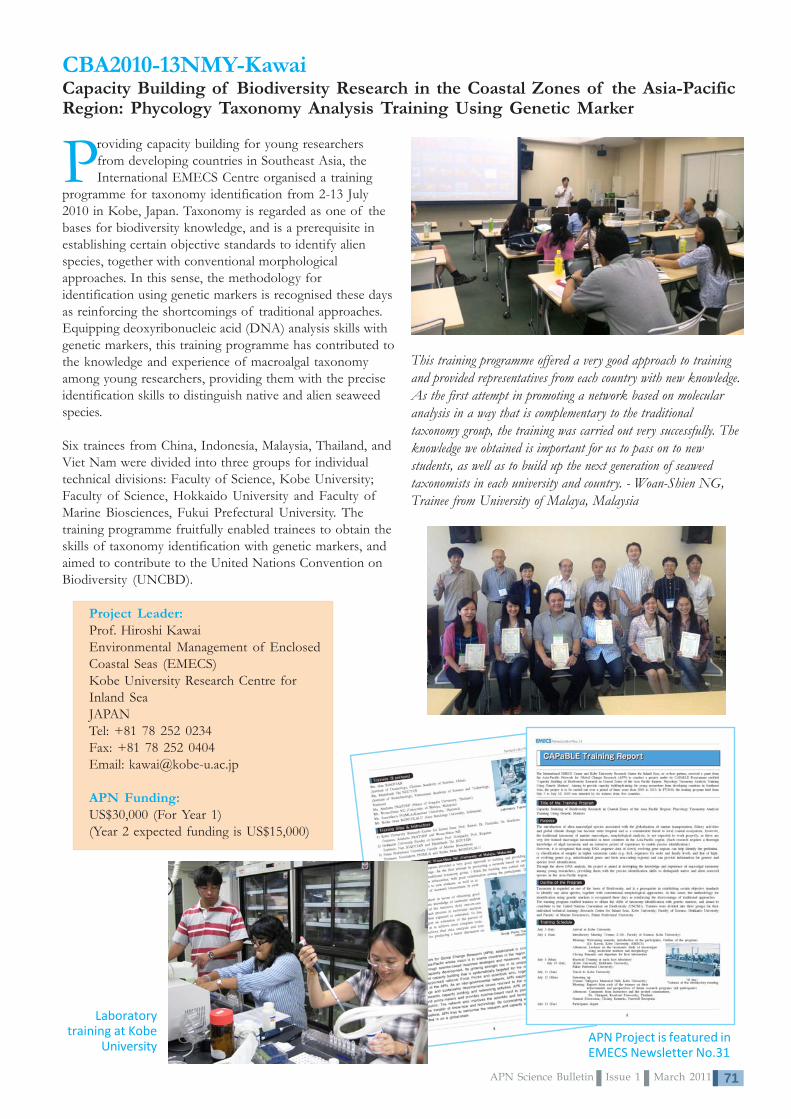
71APN Science Bulletin Issue 1 March 2011
CBA2010-13NMY-KawaiCapacity Building of Biodiversity Research in the Coastal Zones of the Asia-PacificRegion: Phycology Taxonomy Analysis Training Using Genetic Marker
Providing capacity building for young researchersfrom developing countries in Southeast Asia, theInternational EMECS Centre organised a training
programme for taxonomy identification from 2-13 July2010 in Kobe, Japan. Taxonomy is regarded as one of thebases for biodiversity knowledge, and is a prerequisite inestablishing certain objective standards to identify alienspecies, together with conventional morphologicalapproaches. In this sense, the methodology foridentification using genetic markers is recognised these daysas reinforcing the shortcomings of traditional approaches.Equipping deoxyribonucleic acid (DNA) analysis skills withgenetic markers, this training programme has contributed tothe knowledge and experience of macroalgal taxonomyamong young researchers, providing them with the preciseidentification skills to distinguish native and alien seaweedspecies.
Six trainees from China, Indonesia, Malaysia, Thailand, andViet Nam were divided into three groups for individualtechnical divisions: Faculty of Science, Kobe University;Faculty of Science, Hokkaido University and Faculty ofMarine Biosciences, Fukui Prefectural University. Thetraining programme fruitfully enabled trainees to obtain theskills of taxonomy identification with genetic markers, andaimed to contribute to the United Nations Convention onBiodiversity (UNCBD).
This training programme offered a very good approach to trainingand provided representatives from each country with new knowledge.As the first attempt in promoting a network based on molecularanalysis in a way that is complementary to the traditionaltaxonomy group, the training was carried out very successfully. Theknowledge we obtained is important for us to pass on to newstudents, as well as to build up the next generation of seaweedtaxonomists in each university and country. - Woan-Shien NG,Trainee from University of Malaya, Malaysia
Project Leader:Prof. Hiroshi KawaiEnvironmental Management of EnclosedCoastal Seas (EMECS)Kobe University Research Centre forInland SeaJAPANTel: +81 78 252 0234Fax: +81 78 252 0404Email: [email protected]
APN Funding:US$30,000 (For Year 1)(Year 2 expected funding is US$15,000)
Laboratorytraining at Kobe
UniversityAPN Project is featured inEMECS Newsletter No.31
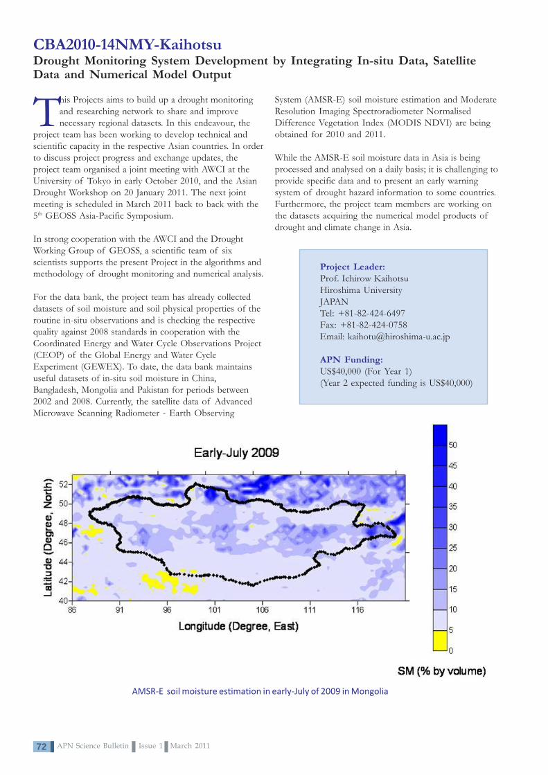
APN Science Bulletin Issue 1 March 201172
CBA2010-14NMY-KaihotsuDrought Monitoring System Development by Integrating In-situ Data, SatelliteData and Numerical Model Output
AMSR-E soil moisture estimation in early-July of 2009 in Mongolia
This Projects aims to build up a drought monitoringand researching network to share and improvenecessary regional datasets. In this endeavour, the
project team has been working to develop technical andscientific capacity in the respective Asian countries. In orderto discuss project progress and exchange updates, theproject team organised a joint meeting with AWCI at theUniversity of Tokyo in early October 2010, and the AsianDrought Workshop on 20 January 2011. The next jointmeeting is scheduled in March 2011 back to back with the5th GEOSS Asia-Pacific Symposium.
In strong cooperation with the AWCI and the DroughtWorking Group of GEOSS, a scientific team of sixscientists supports the present Project in the algorithms andmethodology of drought monitoring and numerical analysis.
For the data bank, the project team has already collecteddatasets of soil moisture and soil physical properties of theroutine in-situ observations and is checking the respectivequality against 2008 standards in cooperation with theCoordinated Energy and Water Cycle Observations Project(CEOP) of the Global Energy and Water CycleExperiment (GEWEX). To date, the data bank maintainsuseful datasets of in-situ soil moisture in China,Bangladesh, Mongolia and Pakistan for periods between2002 and 2008. Currently, the satellite data of AdvancedMicrowave Scanning Radiometer - Earth Observing
System (AMSR-E) soil moisture estimation and ModerateResolution Imaging Spectroradiometer NormalisedDifference Vegetation Index (MODIS NDVI) are beingobtained for 2010 and 2011.
While the AMSR-E soil moisture data in Asia is beingprocessed and analysed on a daily basis; it is challenging toprovide specific data and to present an early warningsystem of drought hazard information to some countries.Furthermore, the project team members are working onthe datasets acquiring the numerical model products ofdrought and climate change in Asia.
Project Leader:Prof. Ichirow KaihotsuHiroshima UniversityJAPANTel: +81-82-424-6497Fax: +81-82-424-0758Email: [email protected]
APN Funding:US$40,000 (For Year 1)(Year 2 expected funding is US$40,000)

73APN Science Bulletin Issue 1 March 2011
CBA2010-15NSY-SouthGlobal Change and Coral Reef Management Capacity in the Pacific: EngagingScientists and Policy-Makers in Fiji, Samoa, Tuvalu and Tonga
Four successful workshops on Climate ChangeAdaptation were held for 130 senior officials fromFiji, Samoa, Tonga and Tuvalu between June and
August 2010. These workshops, organised by the Universityof the South Pacific, featured briefings on likely impacts ofclimate change on Pacific Islands and sought suggestionsfor policy changes for island adaptation. Climate change willincrease existing threats to coral reefs due to unsustainablefishing, pollution from the land and habitat destruction viasea level rise, sea temperature rise, ocean acidification andincreased strengths of cyclones. Rapid population growthwill exacerbate these. All countries recognise the threatsposed by climate change and have signed relevant UnitedNations (UN) Conventions and Agreements.
They all have policies to tackle climate change threats.However, the governments have a lack of capacity toseriously address climate change threats and these are yet tobe incorporated as a cross-cutting theme among therelevant government departments. The countries recognisea need to raise awareness of the issues and include these inschool curricula, which are often based on developedcountry models. Tonga recognises that existing governmentdepartments will need to improve communication andcoordination to develop an integrated approach. Fijiquestions whether a national ocean policy could serve thepurpose of addressing issues such as sustainable fisheriesmanagement (including ecosystem-based management),cross-sectoral corporation, linking scientists with policy
Project Leader:Prof G. Robin SOUTHInstitute of Marine ResourcesUniversity of the South PacificFIJITel: +67 9 323 2151Fax: + 67 9 323 2158Email: [email protected];[email protected]
APN Funding:US$40,000 (For 15 months)
makers, education and awareness. Samoa recognises thechallenges presented by developing an integrated approach,which involves cutting across ministries. Tuvalu has severalexisting social and economic threats despite their traditionalleadership system.
The governments recognise that an expansion of MarineProtected Areas offers a potential mechanism, howeveronly Fiji and Samoa have active MPA programmes inassociation with user communities. The countriesrecognised that building on the Regional Oceans Policytemplate approved by the Forum Leaders in 2002 was anessential first step in improving policy and all recognise theimportant role of climate change in the long-termsustainability of their marine resources and food security.
Participants of the workshop held in Tonga
For more information on the outcomes of this project, please see Special Features Section.
Workshop in Tuvalu
Workshop in Fiji Workshop in Samoa

APN Science Bulletin Issue 1 March 201174
CRP2010-01CMY-WeberVulnerability Mapping as a Policy Tool in Developing Countries
Project Leader:Dr. Eberhard WeberSchool of Geography, Earth Science andEnvironmentThe University of the South PacificFIJITel: +67 9 323 2222Fax: +67 9 323 1558Email: [email protected]
APN Funding:US$100,000 (For 2 Years)(Year 3 expected funding is US$45,000)
A key to better manage risk liesin knowing the spatialdistribution of vulnerable
people as well as how hazards affectspace. Mapping vulnerability looks atwhere the most vulnerable people liveand how hazards impact space. ThisProject investigates the vulnerability ofpeople to climate change impacts,focussing on the ways in which theysustain their livelihoods and how theycope with or adapt to adverse eventsin the Pacific Islands, Southeast Asiaand South Asia.
Vulnerability mapping is regarded as acomprehensive research tool. It isinstrumental to predict where the mostvulnerable people who will need to beevacuated first are living, and bringthem to new homes. With support ofGIS, research on social vulnerabilityand its spatial distribution looks at thefactors that make some people morevulnerable than others; it looks at howspatial aspects play a role. Awarenessand perception of climate change willbe very important when adaptationmeasures become necessary. Anultimate vision of this Project is toestablish an Asia-Pacific SpatialVulnerability Reporting System, whichshould become an easily accessible toolfor communities to report socialaspects of vulnerability.
After a workshop in Bangkok inAugust 2009 where the project teamdeveloped methodology suitable tomeasure people’s vulnerability and itsspatial distribution, the project partnersinitiated research activities at their
respective institutions in their homecountries. In order to do this effectively,one needs to spend much time with thepeople concerned, observe their day-to-day lives, and analyse how they earntheir livelihoods and what exactly placesthem at risk. Activities in Fiji, India andViet Nam address this using differentmethods. Also, partners from othercountries have joined the activitybringing in additional funds and lookingat aspects that are crucial but cannot becovered by the present Project activities.
The India project team has worked onproducing a hazard map for a 30 km-long coastal stretch of the Chennaicoast, and they havelooked at people’svulnerability to erosionand coastal floodingassociated with sea level
rise. In Thailand, the project teamconducted research on Flood Hazardand Vulnerability Assessments at YenBai, Viet Nam. In Fiji, research wasundertaken in Nadi, whereinvestigation on the town’svulnerability to flooding was carriedout. Another research activity wasstarted on Gau Island, wherecommunity vulnerability and resilienceto natural hazards was at the centre ofinterest.
Year 3 of the Project will continue thepresent research and report on themain outcomes of the presentactivities.
Impacts of tropical cyclone in Gau Island, Fiji, participatory research
Slum in Chennai,India, often affectedby flooding
Meeting withfishermen affected
by a tsunami inTamil Nadu, India

75APN Science Bulletin Issue 1 March 2011
CRP2010-02CMY-PereiraStrengthening Capacity for Policy Research on Mainstreaming Adaptation toClimate Change in Agriculture and Water Sectors
Analysis of policies in selectcountries revealed thatimportant decisions in the
agriculture and water sectors areimplemented without consideration ofprojected impacts of climate change.One of the most important barriersidentified was the limited capacity ofresearches in the region to provideadaptation policy-relevant information.Networking and communicationamong researchers and policy-makersfocusing on adaptation is alsoextremely limited.
In order to strengthen researchcapacity on mainstreaming climatechange adaptation concerns intoagricultural and water policies and tocreate a network for adaptation policyresearch in Asia, this Project hasadopted a three-pronged approach.Firstly, identification of practicaloptions for mainstreaming and metricsfor monitoring the effectiveness ofadaptation policies and measures;secondly, exchange of adaptationpolicy-relevant information throughcreation of an adaptation research andpolicy network; and lastly,dissemination of outputs beyond theproject boundaries. This Projectcontributes to the characterisation ofadaptive policies and identifying gapsin existing agricultural and water
policies. A framework for developingadaptive policies and assessing theeffectiveness of adaptationinvestments assists decision-makers byproviding a reference against whichevaluators and stakeholders at alllevels can monitor progress onadaptation.
A meeting was held on 26 June 2010in conjunction with the Workshop onScenarios Concerning Climate ChangeAdaptation in Asia and the Pacific by Year2030, jointly organised by ORBICOM,an international Network ofUNESCO Chairs in Communicationand Universiti Kebangsaan Malaysia(LESTARI and Southeast Asia
Disaster Prevention Research Institute[SEADPRI-UKM]). The projectpartners and affiliates supported theworkshop, in particular for reviewingthe Background Paper for East andSoutheast Asia prepared byLESTARI/SEADPRI-UKM and alsofor providing inputs for the expertssurvey on knowledge drivers forclimate change adaptation in the Asia-Pacific region. The project meetingdiscussed work progress, AdaptationResearch and Policy Network for Asiaand Pacific (ARPNAP) development,publication, financial matters and thefuture plan.
Publications• Climate Change Adaptation:
Perspectives in the AsiaPacific. 2010. Asian Journalon Environment andDisaster ManagementVolume 2 Issue 4.
• Prabhakar, SVRK. 2010/10. Climate Change Impactsin Japan and SoutheastAsia: Implications for CropAdaptation. In CropAdaptation to ClimateChange, edited by S. Yadav,B. Redden, J. L. Hatfield,and H. Lotze-Campen. 30.USA. Wiley-Blackwell. Inprint.
Project Leader:Dr. Joy Jacqueline Pereira
Institute for Environment andDevelopment (LESTARI)
Universiti Kebangsaan Malaysia(UKM)
MALAYSIATel: +6 38 921 4149Fax: +638 925 5104Email: [email protected]
APN Funding:US$140,000 (For 2 Years)
(Year 3 expected funding isUS$70,000)
Project Website:www.ukm.my/apn
APN Science Bulletin Issue 1 March 201176
Projects fundedunder the SpecialCall for FocussedActivities: ClimateChange Impactand VulnerabilityAssessments
4

77APN Science Bulletin Issue 1 March 2011
CIA2009-01-SnidvongsClimate Change Vulnerability Assessment of Floods andUrban Development Planning for Asian Coastal Cities
Project Leader:Dr. Anond SnidvongsSoutheast Asia START RegionalCentre (SEA START RC)Chulalongkorn University THAILANDTel: +66 2 218 9469Fax: +66 2 2519416Email: [email protected]
APN Funding:US$45,000 (For 1 Year)
This ‘Cities at Risk’ workshop,Climate Change VulnerabilityAssessment and Urban Development
Planning for Asian Coastal Cities, wasbuilt on the first workshop held in2009 in Bangkok, and specificallyaddressed the limited capacity to carryout risk and vulnerability assessmentsin coastal Asian cities. It broughttogether over 40 participants includingacademics, urban planners/government representatives, andexperts in disaster management.
The workshop clarified the currentinformation/knowledge gaps andchallenges, and identified futureresearch opportunities for addressingclimate change-related risks andvulnerability assessments in Bangkok,Ho Chi Minh, Jakarta, Manila andMumbai. Key findings distilled fromthe workshop were grouped into threecategories: (i) assessment of climatechange related risk; (ii) information/knowledge management; and (iii)governance. Specific observations andrecommendations for future researchwere identified.
The workshop participants looked atthe best ways to assess/map climaterisks taking into account the possibleeffects of current and future climate
change. City teams were formed andwere asked to share how social/economic vulnerability to climate-related risks have been assessed andmapped, for whom this is targeted,who is doing this type of mappingexercise and details of the assessment.Interesting discussions focussed oninformation/knowledge managementin identifying effective approaches oncommunicating climate risk andvulnerability. The discussion alsotouched on existing urban GeographicInformation System (GIS)information base that may be used forclimate risk and vulnerabilityassessments.
On governance, the city teamsidentified the role of agencies andinstitutions in risk and vulnerabilityassessments as well as the skill leveland capacity needed to perform suchroles. Discussions also ensued thattackled urban master plans, theeffectiveness of current buildingcodes, land use regulations, sanitationcodes and other factors beingenforced, the effectiveness of existingearly warning systems, and problemsencountered in implementingevacuation and/or emergencyresponse plans for various types ofweather and climate-related disasters.
Two major Projects are anticipated tocommence in 2011, one of which isalso funded by the APN (ARCP2010-09NSY-Patankar: EnhancingAdaptation to Climate Change byIntegrating Climate Risk intoLongterm Development Plans andDisaster Management), therebyoffering the opportunity to address theidentified gaps in information/knowledge faced by the cities understudy. These projects demonstrate howthe ‘Cities at Risk’ workshops areencouraging communication andgenerating collaboration andpartnerhips in addressing the impactsof climate change on cities in Asia andbeyond.
A Second International Conference onCities at Risk: Adaptive Capacities forManaging Climate Change Risks inAsian Coastal Cities will be held from11-13 April 2011 in Taipei, Taiwan.

APN Science Bulletin Issue 1 March 201178
CIA2009-02-PulhinCapacity Development on Integration of Scienceand Local Knowledge for Climate Change Impactand Vulnerability Assessments
As a part of this pilot Project, a training programme on the basicconcepts of vulnerability and adaptation assessments and theuse of SimCLIM was held from 26-29 April 2010, in Tabaco
City, Albay, Philippines. This was attendedlargely by the planning development officersand staff from different Local GovernmentUnits (LGUs) of the province. SimCLIM is asoftware package for examining the effects of climatevariability and change over time and space and isdesigned, as well, to support decision-making andclimate proofing.
Through hands-on training on the use of acustomised SimCLIM for Albay -AlbayCLIM - participants generated climatechange and sea-level rise scenarios usingvarious GCMs, and conducted extreme eventsanalyses and water tank modelling. Results ofthe climate and sea-level modelling weredeemed highly useful in the revision of theComprehensive Land Use Plan that theprovince of Albay was undertaking, thusdemonstrating the direct link of the capacitybuilding project to policy and practice.
Project Leader:Dr. Juan Pulhin
Department of Forestry and ForestGovernance
College of Forestry and Natural ResourceUniversity of the Philippines Los Baños
PHILIPPINESTel: +63 49 536 3493Fax: +63 49 536 3206
Email: [email protected]
APN Funding:US$38,000 (For 1 Year)
Following the concepts learned during the training programme, two casestudy sites were chosen at the municipalities of Bacacay and Oas inAlbay. Vulnerability and adaptation strategies of the communities in thestudy sites were assessed using a participatory approach adapted from the
Assessment of Impactsand Adaptation to Climate Change (AIACC) study in the Philippines.Furthermore, sea-level and climate scenarios were generated using theAlbayCLIM and presented to the communities. The community memberswere asked about the potential impacts of the scenarios in their areas, aswell as their potential responses to cope with the projected changes.
Results of the assessment using SimCLIM and knowledge generatedfrom the local people are currently being analysed. These will bepresented to relevant stakeholders at the municipal and provincial levels,as well as at the national level through the Philippine Climate ChangeCommission. Implications of the assessment to relevant policies,programmes and projects will be identified, together withrecommendations for their improved implementation. Lastly, the outputsof, and the processes involved in, the Project are being seen tosignificantly contribute to the Climate Change Academy recently launchedby the Provincial Government of Albay.
Thanks to our partners for the affirmation of our adaptation initiatives. This onefeatures Albay at the Australian National Conference on Climate Change. Wereally need this pat on the back as it spices our routinised practice of climateadaptation. [Dr. Joey Sarte Salceda is the 26th Governor of the Province of Albay.He is known as The Green Economist, for his expertise in the fields ofEconomics and Finance, as well as in the fields of Climate Change Adaptationand Disaster Risk Management.]
SCBCIA poster presented at the 2010International Climate Change AdaptationConference, Queensland, Australia
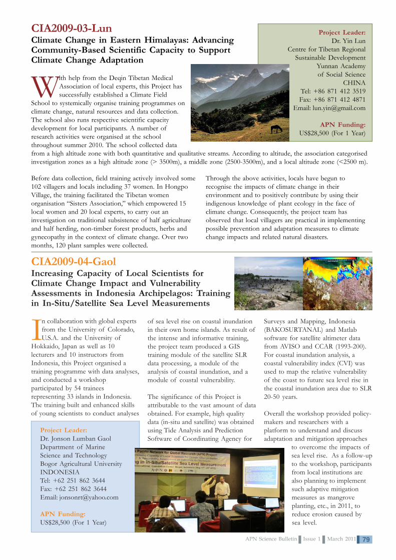
79APN Science Bulletin Issue 1 March 2011
CIA2009-03-LunClimate Change in Eastern Himalayas: AdvancingCommunity-Based Scientific Capacity to SupportClimate Change Adaptation
Project Leader:Dr. Yin Lun
Centre for Tibetan RegionalSustainable Development
Yunnan Academyof Social Science
CHINATel: +86 871 412 3519Fax: +86 871 412 4871
Email: [email protected]
APN Funding:US$28,500 (For 1 Year)
With help from the Deqin Tibetan MedicalAssociation of local experts, this Project hassuccessfully established a Climate Field
School to systemically organise training programmes onclimate change, natural resources and data collection.The school also runs respective scientific capacitydevelopment for local participants. A number ofresearch activities were organised at the schoolthroughout summer 2010. The school collected data
Before data collection, field training actively involved some102 villagers and locals including 37 women. In HongpoVillage, the training facilitated the Tibetan womenorganisation “Sisters Association,” which empowered 15local women and 20 local experts, to carry out aninvestigation on traditional subsistence of half agricultureand half herding, non-timber forest products, herbs andgynecopathy in the context of climate change. Over twomonths, 120 plant samples were collected.
Through the above activities, locals have begun torecognise the impacts of climate change in theirenvironment and to positively contribute by using theirindigenous knowledge of plant ecology in the face ofclimate change. Consequently, the project team hasobserved that local villagers are practical in implementingpossible prevention and adaptation measures to climatechange impacts and related natural disasters.
from a high altitude zone with both quantitative and qualitative streams. According to altitude, the association categorisedinvestigation zones as a high altitude zone (> 3500m), a middle zone (2500-3500m), and a local altitude zone (<2500 m).
CIA2009-04-GaolIncreasing Capacity of Local Scientists forClimate Change Impact and VulnerabilityAssessments in Indonesia Archipelagos: Trainingin In-Situ/Satellite Sea Level Measurements
Project Leader:Dr. Jonson Lumban GaolDepartment of MarineScience and TechnologyBogor Agricultural UniversityINDONESIATel: +62 251 862 3644Fax: +62 251 862 3644Email: [email protected]
APN Funding:US$28,500 (For 1 Year)
In collaboration with global expertsfrom the University of Colorado,U.S.A. and the University of
Hokkaido, Japan as well as 10lecturers and 10 instructors fromIndonesia, this Project organised atraining programme with data analyses,and conducted a workshopparticipated by 54 traineesrepresenting 33 islands in Indonesia.The training built and enhanced skillsof young scientists to conduct analyses
of sea level rise on coastal inundationin their own home islands. As result ofthe intense and informative training,the project team produced a GIStraining module of the satellite SLRdata processing, a module of theanalysis of coastal inundation, and amodule of coastal vulnerability.
The significance of this Project isattributable to the vast amount of dataobtained. For example, high qualitydata (in-situ and satellite) was obtainedusing Tide Analysis and PredictionSoftware of Coordinating Agency for
Surveys and Mapping, Indonesia(BAKOSURTANAL) and Matlabsoftware for satellite altimeter datafrom AVISO and CCAR (1993-200).For coastal inundation analysis, acoastal vulnerability index (CVI) wasused to map the relative vulnerabilityof the coast to future sea level rise inthe coastal inundation area due to SLR20-50 years.
Overall the workshop provided policy-makers and researchers with aplatform to understand and discussadaptation and mitigation approaches
to overcome the impacts ofsea level rise. As a follow-upto the workshop, participantsfrom local institutions arealso planning to implementsuch adaptive mitigationmeasures as mangroveplanting, etc., in 2011, toreduce erosion caused bysea level.

APN Science Bulletin Issue 1 March 201180
CIA2009-05- JitpraphaiBuilding Research Capacity on Assessing Community Livelihood Vulnerability toClimate Change Impacts in Central Viet Nam and the Mekong River Delta
The framework of the climate change vulnerabilityand adaptation (V&A) assessment which wasintroduced in this Project has broadened the frame
of thought on V&A assessments from conventionalapproaches that take climate change as a single issue andassesses impact, risk, vulnerability and adaptation based onsector basis. The pilot assessment under the present Projectexercised the integration of other socio-economicconditions into the vulnerability assessment, which providesa more realistic picture of community livelihoodvulnerability to the impacts of climate change.
Project Leader:Dr. Somrudee JitpraphaiSoutheast Asia START RegionalCentre (SEA START RC)Chulalongkorn UniversityTHAILANDTel: +66 2 218 5394Fax: 66 2 255 0780Email: [email protected]
APN Funding:US$28,500 (For 1 Year)
This Project has undertaken vulnerability assessment case studies in theMekong River Delta and Central Viet Nam and consequently raised awarenessof climate risks among local communities and stakeholders. The assessmentexercises conducted at pilot study sites also raised awareness of localstakeholders as well as local government officials on climate change issues inthe local context. Moreover, the results from the pilot studies in two areas canbe used as a foundation or initial step to trigger policy toward full assessment inthe future.
By applying climate projection data to assess climate change risk in key sectors,this Project has facilitated experts to develop and enhance their researchcapacity at two newly established research centres: the Research Institute forClimate Change of Can Tho University (DRAGON-Institute-Mekong) and theClimate Change and Development Centre (CCDC) of Nong Lam University.

81APN Science Bulletin Issue 1 March 2011
CIA2009-06-DucCapacity Development for Adaptation to ClimateChange in the Rural Coastal Zone of Viet Nam
Climate change is the most serious environmental problem facingthe world today and places more pressure on all socio-economic activities. In terms of climate change-related losses,
one can easily recognise the much larger potential damage in urbanareas compared with rural areas. Therefore, much effort is beingfocussed on urban areas, especially in coastal megacities, and ruralareas are not being properly considered in some cases
Addressing the research focus on ruralareas, this Project has investigated thepotential vulnerability of the ruralcoastal zone in Viet Nam. It has aimedto help local authorities and thecommunity to learn about andunderstand new risks posed by climatechange resulting in the creation of aninitiative to address adaptation optionsto climate change, develop capacityand exchange experiences related torisk assessment and coastal protection.Activities were concentrated onscientific capacity building, a pilotstudy and dissemination of theresearch outputs.
The short training courses on“Reduction of Risks due to Climate Changein the Coastal Zone” and “CoastalEngineering and Vulnerability Assessment”were organised for local managers(commune and district level) andtechnical practitioners, respectively.The pilot study was implemented atthe Hai Hau coast (Nam Dinh
province) - one of the most severelyeroded coasts in Viet Nam. Theresearch contributed to clarifying theintensification of natural hazardsrelated to climate change, reviewingthe capacity for implementing counter-measures, proposing suitableadaptation options, and avoiding mal-adaptation.
Focusing on wise (smart) climatechange adaptation, vulnerability andrisk, two international workshopsentitled, “Capacity Development forAdaptation to Climate Change in the RuralCoastal Zone of Viet Nam” and
“Mitigation of Hazard Risks in Responseto Climate Change” were organised foryoung scientists with participation ofexperts from Japan, Germany andViet Nam. A comparative study oncounter measures coastal protectionbetween Hai Hau (Viet Nam) andJapan confirmed the important roleof natural and socio-economicconditions.
Based on the activities conducted, thisProject identified the following aselements of wise (smart) adaptationmeasures: (i) impact/vulnerabilityassessment at the local level; (ii)monitoring and early warning; (iii)
incorporating renewal cycles forinfrastructure; (iv) co-benefitapproaches for mitigation andadaptation; (v) collaboration ofministries; and (vi) participationof stakeholders and capacitybuilding. The project team alsodeveloped postgraduate (Masters)programme syllabi on “ClimateChange Adaptation” and“Geoenvironment andGeohazards” at the HanoiUniversity of Science.
Project Leader:Assoc. Prof. Dr. Do Minh DucFaculty of GeologyHanoi University of ScienceVIET NAMTel: +84 43 558 8739Fax: +84 43 8583061Email: [email protected]
APN Funding:US$28,500 (For 1 Year)
Publications• Do Minh Duc, 2010. Coastal Protection in the Context of Climate
Change: A Case Study of Hai Hau Coast. Vietnam GeotechnicalJournal (English Series).
• Do Minh Duc, Mai Trong Nhuan, and Chu Van Ngoi, 2010. AnAnalysis of Coastal Erosion in the Tropical Rapid Accretion Delta ofthe Red River, Viet Nam (submitted). Journal of Asian Earth Sciences.
New concrete dike as coastalmanagement practice in the Red
River Coast, Viet Nam
Former APN SPG Member for Japan,Prof. Nobuo Mimura presenting his
research to workshop participants
APN Science Bulletin Issue 1 March 201182
CIA2009-07-LotiaCapacity Development of the Scientific Community forAssessing the Health Impacts of Climate Change
Under this Project a twelve-member cadre of Public Health Professionalsfrom across Pakistan were selected to undertake a series of threetraining workshops. Of these, the first two were held at the national level
and the third and final was held at the international level.
The First National Level Workshop was organised in Islamabad, Pakistan from12-15 June 2010. The four-day workshop entitled, ‘Climate Change and Health –Bridging the Gap,’ was designed using LEAD Pakistan’s training methodology ofexperiential learning and included interactive talks, presentations, group work,panel discussions, screening of documentaries and a field visit to the PakistanMeteorological Department (PMD) to acquaint the members with assessingparticular aspects of the climate change–health relationship.
The Second National Level Workshop, held from 5-6 August 2010, was designedto assist the research groups formed in the first workshop in conducting much-needed vulnerability and impact assessments in the under-explored area ofclimate change and health. During the workshop, each group presented itsresearch synopsis for discussion and deliberation. Feedback received from theother cohort members as well as LEAD’s three-member Panel of Experts enabled the groups to improve and finalise theirresearch plans.
Participation in the International Level Workshop, Port Elizabeth, South Africa from 31 October to 6 November 2010 byLEAD International, provided the members with the opportunity to network with relevant stakeholders from around theworld. Most importantly, it served as a forum to showcase their research work to a much larger audience and share theresults of their endeavours with a number of experts.
Enriched with the feedback received and the insights gained during the finalworkshop, the members upon their return concentrated their efforts on finalisingtheir respective research work.
1st National Training Workshop• This is what a ‘true’ capacity building exercise should be
like. - Dr. Samina Mohsin Khan• I teach undergraduate and graduate students and now I
know what area my students will be concentrating theirresearch on next year – climate change effects onpopulation health. - Dr. Seema Nigah-e-Mumtaz
2nd National Training WorkshopThis workshop was such a great help. As the climate changeinterplay with human health is a new field for me, the inputby fellow cohort members really helped me in fine tuningmy research synopsis. - Dr. Mukhtar Ali Zehri
Project Leader:Ms. Hina LotiaLeadership for Environmentand Development (LEAD)PAKISTANTel: +92 51 265 1511Fax: 92 51 265 1512Email: [email protected]
APN Funding:US$33,000 (For 1 Year)
International Training WorkshopIt was a great experience. An opportunity tomeet such seasoned professionals fromaround the world. Most importantly ourresearch work shared in the Networking Fairattracted so much interest from theparticipants. Everyone who came wanted tolearn how we had undertaken the research,from where we collected data, and what ourforecast was for the future. I could tell thatthis area will generate a lot of research in thecoming years. - Professor Dr. Irfan Ullah Siddiqui
Statements from the Cohort Members

83APN Science Bulletin Issue 1 March 2011
Invited Experts to the APN Scientific Planning GroupCongbin FUDirector, START Regional Committee forTemperate East Asia, CHINAEmail: [email protected]
Kanayathu Chacko KOSHYProfessor, Centre for Global Sustainability Studies,Universiti Sains Malaysia, MALAYSIAEmail: [email protected]
Chao Han LIUChairman, Southeast Asia START Regional CommitteeCHINESE TAIPEIEmail: [email protected]
AUSTRALIAVACANT
BANGLADESHMd. Giashuddin MIAHEmail: [email protected]
BHUTANPeldon TSHERINGEmail: [email protected]
CAMBODIAKhieu HOURTEmail: [email protected]
CHINAWenjie DONGEmail: [email protected]
FIJIVACANT
INDIAB.N. GOSWAMIEmail: [email protected]
INDONESIAErna Sri ADININGSIHEmail: [email protected];[email protected]
JAPANKensuke FUKUSHIEmail: [email protected]
LAO PEOPLE’S DEMOCRATICRREPUBLICOulaphone ONGKEOEmail: [email protected];[email protected]
MALAYSIASubramaniam MOTENEmail: [email protected]
MONGOLIATsogtbaatar JAMSRANEmail: [email protected]
NEPALMadan Lall SHRESTHAEmail: [email protected]
NEW ZEALANDAndrew MATTHEWSEmail: [email protected]
PAKISTANAmir MUHAMMEDEmail: [email protected];[email protected]
PHILIPPINESMarcial AMARO JrEmail: [email protected];
REPUBLIC OF KOREAChang-keun SONGEmail: [email protected]
RUSSIAN FEDERATIONAlexander STERINEmail: [email protected]
SRI LANKAG.B. SAMARASINGHEEmail: [email protected]
THAILANDJariya BOONJAWATEmail: [email protected]
UNITED STATES OF AMERICALuis TUPASEmail: [email protected]
VIET NAMDr. Kim Chi NGOEmail: [email protected];[email protected]
APN Scientific Planning Group (SPG) Representatives
The SPG Members recommend a scientific programme including proposals for priority of funding andallocation of current available funding for consideration by the Inter-Governmental Meeting (IGM); works
with the Steering Committee and the Secretariat in arranging scientific programme activities; and interacts on theAPN’s behalf with other international research programmes on global change. SPG Members also interact with thenational Focal Point of their respective countries, the Secretariat, and the national and global change communities.
The APN SecretariatEast Building 4th Floor1-5-2 Wakinohama Kaigan DoriChuo-ku, Kobe 651-0073, JAPANTel: +81 078 230 8017; Fax: +81 078 230 8018Email: [email protected]; Website: www.apn-gcr.org
Published by:
Executive Editors: Luis Tupas and Erna Sri AdiningsihManaging Editor: Linda Anne StevensonDesign and Layout: Perlyn Pulhin and Lizhier Coralde
APN Scientific Themes
• Climate Change and Climate Variability;
• Ecosystems, Biodiversity and Land Use;
• Changes in the Atmospheric, Terrestrial andMarine Domains; and
• Resources Utilisation and Pathways forSustainable Development
ISSN 2185-761X