ANNEXURE 1 - Greater Hume Council
69
ANNEXURE 1
-
Upload
khangminh22 -
Category
Documents
-
view
1 -
download
0
Transcript of ANNEXURE 1 - Greater Hume Council

ANNEXURE 1

ANNEXURE 1
ANNEXURE 1

Planning Report & Statement of Environmental Effects - 2 Lot Torrens Title Subdivision Lot 15 DP4045 60 Wallace Street HOLBROOK
ANNEXURE 1
Environment Design Management
Town Planning Surveying Engineering Environmental Planning Building Design Project Management
This Report has been prepared for: Paul Spokes
C/- EDM Group PO Box 317
WODONGA 3689
This Report has been prepared by:
EDM Group 99 Hume Street Wodonga VIC 3690
P.O. Box 317 Wodonga 3689 Phone: (02) 6057 8578 www.edmgroup.com.au
EDM Ref No 21004300
Date: 01 July 2021
ANNEXURE 1

Environment Design Management
Town Planning Surveying Engineering Environmental Planning Building Design Project Management
CONTENTS 1. INTRODUCTION ................................................................................................. 1 2. SUBJECT LAND .................................................................................................. 1 3. DEVELOPMENT PROPOSAL ............................................................................. 2 4. STATUTORY ASSESSMENT PROCESS ............................................................ 3
4.1 Environmental Planning and Assessment Act 1979 ...................................... 3 4.2 Town Planning Assessment .......................................................................... 4
5. STATEMENT OF ENVIRONMENTAL EFFECTS ............................................... 11 5.1 Impact Identification .................................................................................... 11 5.2 Impact Minimisation .................................................................................... 12
6. CONCLUDING COMMENTS ............................................................................. 13
APPENDICES
APPENDIX 1 – Subdivision Layout Plan
APPENDIX 2 – Site Context Plan & Design Response
APPENDIX 3 – Title Particulars
APPENDIX 4 – Property Report
ANNEXURE 1

Environment Design Management
SoEE Report - Torrens Title Subdivision, 60 Wallace Street, Holbrook Page 1 of 13
1. INTRODUCTION This Planning Report and Statement of Environmental Effects has been prepared on behalf of the landowner for the Development Application seeking consent for a proposed 2 Lot Torrens Title Subdivision of land located at 60 Wallace Street, Holbrook (Appendix 1 & 2). The subject land currently contains a single storey dwelling with a number of freestanding outbuildings located within the rear yard. As will be outlined within this report it is contended that this proposal represents an example of orderly planning consistent with the strategic intent of the Greater Hume LEP and DCP. The development proposal is a relatively minor matter that on a merits basis represents a good development outcome for the subject land.
2. SUBJECT LAND The subject land is a rectangular shaped parcel that is situated on the south western corner of Wallace Street and Thorpe Street, Holbrook. The property is described as Lot 15 DP4045 and has a total area of 1012m2 approximately. Title Particulars are attached at Appendix 3.
Figure 1: Locality Plan (source Six-view)
The subject land contains an existing single storey dwelling which addresses the northern Wallace Street frontage. In the rear section of the property are a number of sheds and outbuildings. The property is situated within an established part of the township with single storey residential development prevailing. The property is connected to reticulated services and is free of any environmental constraints that might otherwise preclude the subdivision layout as proposed.
ANNEXURE 1

Environment Design Management
SoEE Report - Torrens Title Subdivision, 60 Wallace Street, Holbrook Page 2 of 13
Photo 1 – Looking westerly across Wallace Street frontage (source Google)
Photo 2 – Looking northerly westerly across subject land (source Google)
3. DEVELOPMENT PROPOSAL As noted on the attached Plan of Subdivision the proposal comprises of a Two (2) Lot Torrens Title Subdivision of the subject land. The proposed allotments are denoted as Lot 1 and Lot 2. Proposed Lot 1 will rely upon existing access from Wallace Street. A second crossover is located at the rear of the allotment that provides Lot 2 with access to Thorpe Street (Appendix 1). Subject to final survey, the proposed lot sizes are as follows:
Lot 1: 506m2 Lot 2: 506m2
ANNEXURE 1

Environment Design Management
SoEE Report - Torrens Title Subdivision, 60 Wallace Street, Holbrook Page 3 of 13
4. STATUTORY ASSESSMENT PROCESS
4.1 Environmental Planning and Assessment Act 1979
4.1.1 Section 1.3 Objects
Comment: It is considered that the proposed development is consistent with relevant objects of the Act including:
The objects of this Act are as follows (c) to promote the orderly and economic use and development of land
4.1.2 Section 4.14 Consultation and development consent – Certain bush fire prone land
Comment: The subject land is not identified as being subject to Bush Fire Risk on Council’s Bush Fire Prone Land Map.
4.1.3 Section 4.15 Evaluation
Comment: The Act provides that in determining a development application, the following matters where relevant to the development are to be taken into consideration, namely:
(1) Matters for consideration - general (a) the provisions of: (i) any environmental planning instrument, and (ii) any proposed instrument that is or has been the subject of public consultation under this Act and that has been notified to the consent authority (unless the Secretary has notified the consent authority that the making of the proposed instrument has been deferred indefinitely or has not been approved), and (iii) any development control plan, and (iiia) any planning agreement that has been entered into under section 7.4, or any draft planning agreement that a developer has offered to enter into under section 7.4, and (iv) the regulations (to the extent that they prescribe matters for the purposes of this paragraph), that apply to the land to which the development application relates, (b) the likely impacts of that development, including environmental impacts on both the natural and built environments, and social and economic impacts in the locality, (c) the suitability of the site for the development, (d) any submissions made in accordance with this Act or the regulations, (e) the public interest.
In respect of the consideration of a Development Control Plan the Act provides as follows:
(3A) Development control plans If a development control plan contains provisions that relate to the development that is the subject of a development application, the consent authority: (a) if those provisions set standards with respect to an aspect of the development and the development application complies with those standards—is not to require more onerous standards with respect to that aspect of the development, and (b) if those provisions set standards with respect to an aspect of the development and the development application does not comply with those standards—is to be flexible in applying those provisions and allow reasonable alternative solutions that achieve the objects of those standards for dealing with that aspect of the development, and (c) may consider those provisions only in connection with the assessment of that development application. In this subsection, standards include performance criteria.
ANNEXURE 1

Environment Design Management
SoEE Report - Torrens Title Subdivision, 60 Wallace Street, Holbrook Page 4 of 13
4.1.4 Section 4.46 Integrated Development
Comment: The proposal is not regarded as an Integrated Development as defined by Section 4.46 of the Act requiring approval from any other relevant authority.
4.2 Town Planning Assessment
Assessment of the development proposal has been undertaken in respect to relevant considerations arising from Section 4.15 of the Environmental Planning and Assessment Act 1979 as follows:
4.2.1 (a)(i) Environmental Planning Instruments State Environmental Planning Policies
Comment: There are a range of SEPP’s that generally apply to the subject land. Of those that cover the property the following are considered to be of some relevance requiring more detailed response.
SEPP No 55 - Remediation of Land
Comment: The subject land is not considered to be contaminated or likely to be contaminated and is not listed on Council’s Contaminated Land Register. In accordance with Clause 7 of SEPP 55, the land is considered to be suitable in its current state for the purpose for which the development is proposed to be carried out.
SEPP (Exempt and Complying Development Codes) 2008
Comment: The proposed development cannot be classed as exempt or complying development as it does not meet all of the development requirements.
State Environmental Planning Policy (Vegetation in Non-Rural Areas) 2017
Comment: No vegetation is required to be removed from the property.
Greater Hume Local Environmental Plan 2012 (GHLEP 2012)
Part 1 Preliminary
Clause 1.2 Aims of Plan
Comment: The GHLEP 2012 is the principal environmental planning instrument within the City. The particular aims of this Plan include:
(1) This Plan aims to make local environmental planning provisions for land in Greater Hume in accordance with the relevant standard environmental planning instrument under section 3.20 of the Act.
(2) The particular aims of this Plan are as follows—
(aa) to protect and promote the use and development of land for arts and cultural activity, including music and other performance arts, (a) to encourage sustainable economic growth and development in Greater Hume, (b) to protect and retain productive agricultural land, (c) to protect, conserve and enhance natural assets, (d) to protect built and cultural heritage assets, (e) to provide opportunities for the growth of townships.
The proposal is not inconsistent with these aims.
ANNEXURE 1

Environment Design Management
SoEE Report - Torrens Title Subdivision, 60 Wallace Street, Holbrook Page 5 of 13
Clause 1.9A Suspension of covenants, agreements and instruments
Comment: Noted. The subject land is not affected by a s.88B Instrument.
Part 2 Permitted or prohibited development
Clause 2.3 Zone objectives & Land Use Table (development permissibility) The subject land is zoned RU5 - Village Zone under GHLEP 2012. (Also see Appendix 4).
Objectives of the zone include:
• To provide for a range of land uses, services and facilities that are associated with a rural village.
• To protect the amenity of residents.
Under GHLEP 2012 the proposed Two (2) Lot Torrens Title subdivision is permissible in the zone with consent.
Comment: The proposal is considered to be consistent with relevant zone objectives. There are no matters raised in respect of the proposal that could be considered to be inconsistent with the LEP. In particular it is considered that the proposal complies with the relevant development standards and decision guidelines of the Greater Hume Local Environmental Plan 2012 as follows:
Clause 2.6 Subdivision—consent requirements
Comment: The subject land may be subdivided, but only with development consent.
Clause 2.7 Demolition requires development consent
Comment: Not applicable.
Clause 2.8 Temporary use of land
Comment: Not applicable.
Part 3 Exempt and complying development
Provision Comment
Clause 3.1 Exempt Development Not applicable
Clause 3.2 Complying Development
Refer to previous discussion in relation to subdivision permissible within the RU5 Zone.
Clause 3.3 Environmentally sensitive areas excluded
Not Applicable. Not exempt of complying development.
Part 4 Principal development standards
Provision Comment
Clause 4.1 Minimum subdivision lot size
The minimum lot size within the zone in this location is 600m2. Subject to final survey, the proposal will result in two lots of 506m2 each of which does not comply with the minimum subdivision requirements under the provisions of the GHLEP 2012. Refer to Clause 4.6 and attached application to vary development standard.
Clause 4.1AA Minimum subdivision lot size for community title schemes
Not applicable
ANNEXURE 1

Environment Design Management
SoEE Report - Torrens Title Subdivision, 60 Wallace Street, Holbrook Page 6 of 13
Provision Comment
Clause 4.1A Minimum subdivision lot size for strata plan schemes in certain residential, rural and special purpose zones
Not applicable.
Clause 4.2 Rural Subdivision Not applicable
Clause 4.2AA Exceptions to minimum lot sizes for certain rural subdivisions
Not applicable
Clause 4.2A Erection of dwelling houses and dual occupancies on land in certain rural and residential zones
Not applicable
Clause 4.3 Height of buildings Not adopted
Clause 4.4 Floor Space Ratio Not adopted
Clause 4.5 Calculation of floor space ratio and site area
Not adopted
Clause 4.6 Exceptions to development standards
The proposed subdivision seeks to create allotments that do not satisfy the minimum allotment site area requirement of 600m². See attached Application to Vary a Development Standard.
Part 5 Miscellaneous provisions
Provision Comment
Clause 5.1 Relevant acquisition authority
Noted
Clause 5.2 Classification and reclassification of public land
Noted
Clause 5.3 Development near zone boundaries
Not applicable
Clause 5.4 Controls relating to permissible uses
Not applicable
Clause 5.5 Controls relating to secondary dwellings on land in a rural zone
Not adopted
Clause 5.6 Architectural roof features
Not adopted
Clause 5.7 Development below mean high water mark
Not applicable
Clause 5.8 Conversion of fire alarms
Noted
Clause 5.9 , 5.9AA Repealed
Clause 5.10 Heritage conservation
The site does not contain any known items of Environmental Heritage Significance.
Clause 5.11 Bush fire hazard Noted
ANNEXURE 1
Environment Design Management
SoEE Report - Torrens Title Subdivision, 60 Wallace Street, Holbrook Page 7 of 13
Provision Comment reduction
Clause 5.12 Infrastructure development and use of existing buildings of the Crown
Noted
Clause 5.13 Eco-tourist facilities Not applicable
Clause 5.14 Siding Spring Observatory—maintaining dark sky
Not adopted
Clause 5.15 Defence communications facility
Not adopted
Clause 5.16 Subdivision of, or dwellings on, land in certain rural, residential or environmental protection zones
Not applicable to RU5 – Village Zone
Clause 5.17 Artificial waterbodies in environmentally sensitive areas in areas of operation of irrigation corporations
Not applicable
Clause 5.18 Intensive livestock agriculture
Noted
Clause 5.19 Pond-based, tank-based and oyster aquaculture
Not applicable
Clause 5.20 Standards that cannot be used to refuse consent – playing and performing music
Not applicable
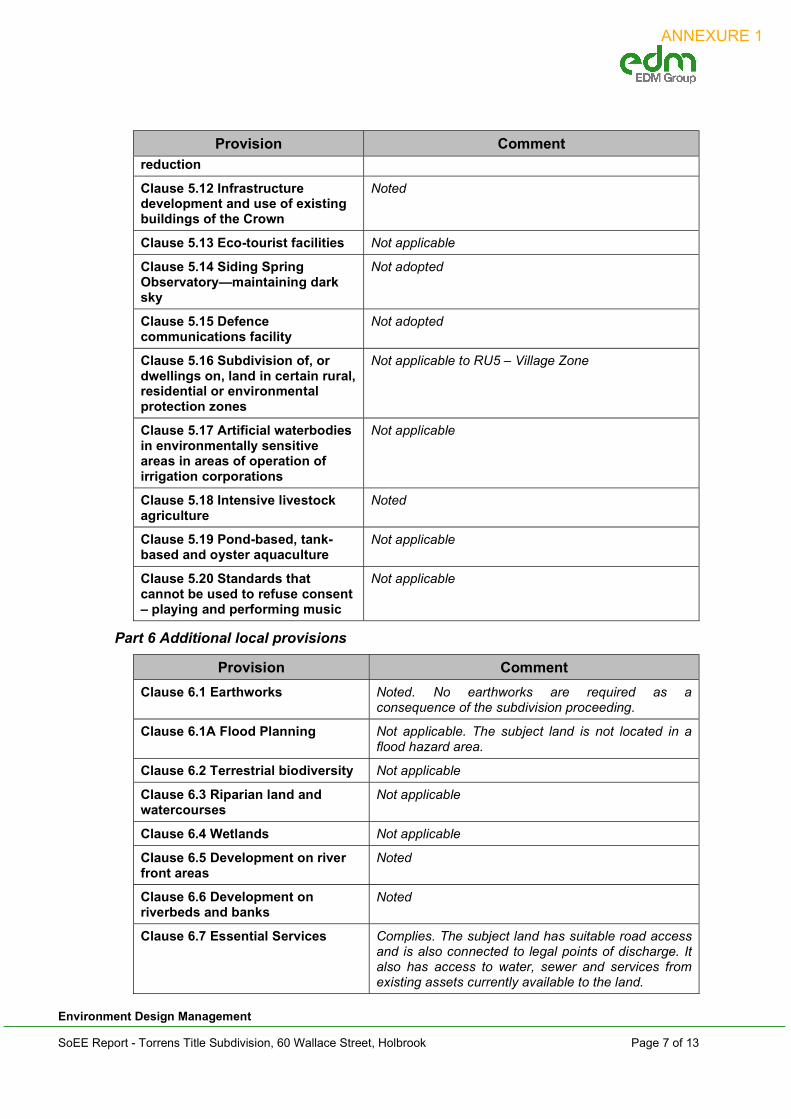
Part 6 Additional local provisions
Provision Comment
Clause 6.1 Earthworks Noted. No earthworks are required as a consequence of the subdivision proceeding.
Clause 6.1A Flood Planning Not applicable. The subject land is not located in a flood hazard area.
Clause 6.2 Terrestrial biodiversity Not applicable
Clause 6.3 Riparian land and watercourses
Not applicable
Clause 6.4 Wetlands Not applicable
Clause 6.5 Development on river front areas
Noted
Clause 6.6 Development on riverbeds and banks
Noted
Clause 6.7 Essential Services Complies. The subject land has suitable road access and is also connected to legal points of discharge. It also has access to water, sewer and services from existing assets currently available to the land.
ANNEXURE 1

Environment Design Management
SoEE Report - Torrens Title Subdivision, 60 Wallace Street, Holbrook Page 8 of 13
Schedules
Provision Comment
Schedule 1 Additional permitted uses
Not applicable
Schedule 2 Exempt development Not applicable
Schedule 3 Complying development
Noted.
Schedule 4 Classification and reclassification of public land
Not applicable.
Schedule 5 Environmental heritage
Noted
Schedule 6 Pond- based and tank based aquaculture
Not applicable
4.2.1 (a)(ii) Proposed instruments
Comment: There are a number of draft amendments to GHLEP 2012 that have been the subject of public consultation under the Act. While these draft amendments apply to land within Greater Hume Shire Council it is noted that none of these Amendments specifically change the provisions affecting the subject land.
4.2.1 (a)(iii) Any development control plan
Comment: The Greater Hume DCP 2012 applies to land within the township of Holbrook. Relevant to this Development Application are the following Parts of the DCP:
Part 6 – Subdivision policy (Greater Hume DCP)
Part 6.0 – Subdivision
Comment: The following Table addresses the various subdivision issues as identified by the DCP.
Section 6 – Subdivision
Provision / Objectives Comment
6.1 - Staging
To ensure the timely and efficient release of urban land making provision for necessary infrastructure and sequencing.
Not Applicable
No staging is required, as an such a staging plan is not provided in this application.
6.2 – Movement Network
To allow easy movement through and between neighbourhoods for all people.
To provide safe and direct movement through and between neighbourhoods by pedestrians and cyclists.
Complies.
The proposal relates to a Torrens Title Subdivision within an existing residential area that can readily rely on an existing local road network with adequate capacity.
The lots do not front to a main road, and each lot is provided with an existing legal access point to a public road.
There are no easements proposed to be installed as part of the subdivision.
ANNEXURE 1

Environment Design Management
SoEE Report - Torrens Title Subdivision, 60 Wallace Street, Holbrook Page 9 of 13
Section 6 – Subdivision
Provision / Objectives Comment
6.3 – Lot Design
To provide lots with areas and dimensions suitable for the proposed use.
To encourage lot design that will facilitate a high standard of subsequent development.
Complies.
The proposed lots will maintain existing legal and practical access to public roads (Wallace Street and Thorpe Street).
The lots proposed will be designed to accommodate the type of development envisioned for the zone. The allotments will be created for the purposes of residential dwellings, and are able to contain a rectangular building envelope measuring 10 metres by 15 metres.
The lots will be designed to maximise solar access.
6.4 – Infrastructure &Services
To provide public utilities to each lot where possible.
To design and implement infrastructure that minimises Council’s ongoing maintenance burden.
To minimise increases in stormwater run-off.
Complies.
The subdivision will achieve compliance with the Greater Hume Shire Engineering Guidelines for Subdivisions and Development Standards.
The subject land is already connected to the full range services with adequate spare capacity to accommodate a second lot, this includes connection to a reticulated potable water supply and reticulated sewer connections.
Adequate network capacities for electricity, natural gas and telephone services already exist.
6.5 - Hazards
To minimise the risk to life and property from bushfire.
To minimise the risk to life and property from flooding.
To minimise the risk to health and property from land containing harmful contaminants.
Complies.
The subject land is not located on land mapped as bushfire prone or on land considered by Council to potentially be subject to flooding. The subject land has been used for residential purposes, and is not land that has been previously used for a contaminating activity.
6.6 – Site Management
To protect drainage infrastructure and receiving waters from sedimentation and contamination.
Complies.
The proposed subdivision complies with the requirements of the Greater Hume Shire Engineering Guidelines for Subdivisions and Development Standards, and can satisfactorily comply with the Soil
ANNEXURE 1

Environment Design Management
SoEE Report - Torrens Title Subdivision, 60 Wallace Street, Holbrook Page 10 of 13
Section 6 – Subdivision
Provision / Objectives Comment
To protect the site and surrounding area from environmental degradation or nuisance prior to and during construction of subdivision works.
To encourage the re-use of materials from the site and recycled materials in the construction of subdivisions where practicable.
and Water Management Guidelines for Subdivisions- Albury, Wodonga & Hume Councils.
The subdivision proposal will not incorporate any building work to facilitate the re-use of materials from the site.
4.2.1 (a)(iiia) Any Planning Agreements
Comment: No planning agreements apply.
4.2.1 (a)(iv) The regulations
Comment: The regulations have been considered in the assessment of this application. It is considered that the application is consistent with the objectives of the regulations.
4.2.2 (b) the likely impacts of that development, including environmental impacts on both the natural and built environments, and social and economic impacts in the locality.
Comment: There will be no adverse impacts on either the natural and built environments as a consequence of approval of this subdivision proposal. The subdivision layout will have little or no consequences on adjoining properties or the immediate neighbourhood. The land is adequately serviced to an appropriate standard.
Refer also to Statement of Environmental Effects. It is submitted that the land does not provide significant habitat that would necessitate a flora and fauna assessment in respect of the proposed subdivision.
From an analysis of relevant sections of the Greater Hume Local Environmental Plan 2012 it is clear that the proposal is not inconsistent with the LEP.
4.2.3 (c) The suitability of the site for the development
Comment: Refer to above discussion. The subject land is suitable for future residential development and represents an appropriate outcome for the site.
4.2.4 (d) any submissions made in accordance with this Act or the regulations, Comment: This matter will be dealt with by Council as a part of the due process.
4.2.5 (e) The public interest.
Comment: It is contended that there is nothing contrary to the public interest that would prevent Council making a favourable determination in this matter. No detrimental issues exist in relation to the public - private land interface, including road frontage to the road network.
ANNEXURE 1

Environment Design Management
SoEE Report - Torrens Title Subdivision, 60 Wallace Street, Holbrook Page 11 of 13
5. STATEMENT OF ENVIRONMENTAL EFFECTS Clause 2(1)(c) of Part 1 of Schedule 1 to the Environmental Planning and Assessment Regulation 2000 provides that a statement of environmental effects must accompany a development application.
Subclause 2(4) specifies the matters to be addressed in a statement of environmental effects as follows:
(a) the environmental impacts of the development,
(b) how the environmental impacts of the development have been identified,
(c) the steps taken to protect the environment or to lesson the expected harm to the environment,
(d) any matters required to be indicated by any guidelines issued by the Director-General for the purpose of this clause.
It is noted that there are no guidelines issued by the Director-General applicable to this proposal.
5.1 Impact Identification
The following assessment of impacts associated with the proposed development, have been identified by way of site analysis and consideration of Council Planning instruments and policy.
The development is considered to have the following environmental effects.
Context and siting – Satisfactory. The proposed two lot Torrens title subdivision is considered to be consistent with the overall residential layout of the immediate locality. Each proposed lot will provide access to Wallace Street and Thorpe Street respectively, and are of an appropriate site area to accommodate any future development. The proposal has been designed to allow for a future dwelling development on current residential land. The design seeks to make the best use of the given road frontages and are unlikely to have any detrimental effects to future development outcomes for the locality.
Design – Satisfactory. The design response of the Torrens Title subdivision is considered to be responsive to the rectangular shape of the allotment and site context.
Environmental Impacts – Satisfactory. It is evident that there are no elements of critical habitat that will be impacted upon nor will the proposal impact upon any threatened species, populations or ecological communities, or their habitats.
Natural Environment – Satisfactory. The development will not adversely impact upon the landscape setting and/or native vegetation.
Built Environment – Satisfactory. As previously noted the proposed subdivision layout is considered to be commensurate with the intended use of the land for future residential purposes.
Social & Economic Impacts – Satisfactory. The proposal will promote ongoing investment and opportunity within the Greater Hume Shire LGA.
Amenity – Satisfactory. It is submitted that there will be no adverse impact upon the amenity of the locality. The subject land is within an existing residential area that contains a variety of residential lot sizes. It is not considered that the proposed
ANNEXURE 1

Environment Design Management
SoEE Report - Torrens Title Subdivision, 60 Wallace Street, Holbrook Page 12 of 13
subdivision will impact the amenity of existing or likely future residences in terms of impingement of views, traffic or loss of privacy. The subdivision of the land will facilitate future residential development and use that will ultimately complement the neighbourhood.
Hazardous Materials – Satisfactory. No issues raised.
Access & Traffic – Satisfactory. It is not anticipated that the subdivision layout will cause undue disruption to traffic and/or movements to the wider road network. The design layout will ensure that access ways front the public realm to ensure safety and security.
Noise – Satisfactory. No additional noise anticipated within the locality over and above existing background levels.
Waste – Satisfactory. Any waste generated by occupation of any future dwellings will be expected to be commensurate with normal household levels and will be removed under Council’s normal kerbside arrangements.
Heritage – Not applicable. The site is not subject to any heritage conservation provisions.
Aboriginal Cultural Heritage – Satisfactory. No known items identified on the subject land.
Bushfire Hazard: - Not applicable. The land is not identified as being bush fire prone.
Water Quality & Stormwater – Satisfactory. The site discharges to a legal point to Council’s satisfaction.
Soils – Satisfactory. No issues raised
Flora & Fauna – Satisfactory. No issues raised.
Utilities – Satisfactory. The site is already connected to all required services.
Safe Design – Satisfactory. The design response will provide for an active street frontage. Lot sizes will facilitate landscaping that allows for view corridors and clear sight lines. The lots will also be of sufficient width to provide opportunity for future dwellings that can readily overlook the public realm, maximising the opportunity for casual surveillance.
5.2 Impact Minimisation
Comment: No adverse impacts are identified that would preclude approval of the application subject to appropriate conditions.
ANNEXURE 1
Environment Design Management
SoEE Report - Torrens Title Subdivision, 60 Wallace Street, Holbrook Page 13 of 13
6. CONCLUDING COMMENTS The proposal is seen as a relatively straight forward planning proposal that is consistent with relevant aspects of the Greater Hume LEP 2012 and DCP 2013 and as further supported by the Application to vary the minimum lots size provision relevant to the subject land. In summary it is submitted that the proposal represents an orderly planning outcome that seeks to create two (2) residential lots by way of a Torrens title subdivision. The proposal will not adversely impact on existing streetscape and/or neighbourhood character and otherwise represents an outcome consistent with site context and land use arrangements within the locality.
AMY MORDEN MPIA SENIOR PLANNER
01 July 2021 EDM Ref: 21004300
ANNEXURE 1

Environment Design Management
SoEE Report - Torrens Title Subdivision, 60 Wallace Street, Holbrook
APPENDIX 1
PROPOSED SUBDIVISION LAYOUT PLAN
ANNEXURE 1

ANNEXURE 1

Environment Design Management
SoEE Report - Torrens Title Subdivision, 60 Wallace Street, Holbrook
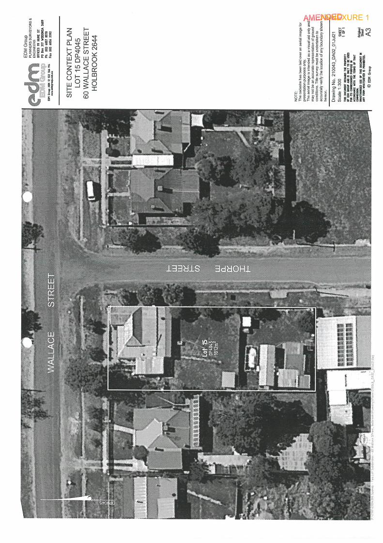
APPENDIX 2
SITE CONTEXT & DESIGN RESPONSE
ANNEXURE 1

WALLACE STREET
THO
RPE
STR
EET
A3
Scale 1:Drawing No.
©
EDM GroupPLANNERS SURVEYORS &ENGINEERS
300
SITE CONTEXT PLANLOT 15 DP4045
60 WALLACE STREETHOLBROOK 2644
210043_DA02_01Jul21
NOTE:The cadastre has been laid over an aerial image forpresentation purposes only.The aerial image is intended as a visual aid only andmay not be an accurate representation of groundconditions. Title survey must be undertaken toaccurately verify the location of any boundary shownhereon.
DP4
045
ANNEXURE 1
AutoCAD SHX Text
Lot 15 DP4045 1012m 2
AutoCAD SHX Text
SHEET
AutoCAD SHX Text
OF
AutoCAD SHX Text
www.edmgroup.com.au
AutoCAD SHX Text
EDM Group ABN 12 532 366 914
AutoCAD SHX Text
Original
AutoCAD SHX Text
Sheet
AutoCAD SHX Text
THIS DOCUMENT REMAINS THE PROPERTY OF EDM GROUP AND IS ONLY TO BE USED FOR ITS COMMISSIONED PURPOSE IN ACCORDANCE WITH THE TERMS OF THAT COMMISSION. UNAUTHORISED USE OF THIS DOCUMENT IN ANY FORM WHATSOEVER IS PROHIBITED.
AutoCAD SHX Text
EDM Group
AutoCAD SHX Text
P:\2100\21004300 Spokes - Two Lot Subdivision - 60 Wallace Street, Holbrook\Planning\Plans\210043_DA02_01Jul21.dwg
AutoCAD SHX Text
OFFICES 99 HUME ST PO Box 317 WODONGA 3689 Ph (02) 6057 8578 Fax (02) 6056 2392
AutoCAD SHX Text
1
AutoCAD SHX Text
1

WALLACE STREET
THO
RPE
STR
EET
A3
Scale 1:Drawing No.
©
EDM GroupPLANNERS SURVEYORS &ENGINEERS
300
DESIGN RESPONSELOT 15 DP4045
60 WALLACE STREETHOLBROOK 2644
210043_DA02_01Jul21
NOTE:The cadastre has been laid over an aerial image forpresentation purposes only.The aerial image is intended as a visual aid only andmay not be an accurate representation of groundconditions. Title survey must be undertaken toaccurately verify the location of any boundary shownhereon.
DP4
045
ANNEXURE 1
AutoCAD SHX Text
2 506m 2
AutoCAD SHX Text
1 506m 2
AutoCAD SHX Text
SHEET
AutoCAD SHX Text
OF
AutoCAD SHX Text
www.edmgroup.com.au
AutoCAD SHX Text
EDM Group ABN 12 532 366 914
AutoCAD SHX Text
Original
AutoCAD SHX Text
Sheet
AutoCAD SHX Text
THIS DOCUMENT REMAINS THE PROPERTY OF EDM GROUP AND IS ONLY TO BE USED FOR ITS COMMISSIONED PURPOSE IN ACCORDANCE WITH THE TERMS OF THAT COMMISSION. UNAUTHORISED USE OF THIS DOCUMENT IN ANY FORM WHATSOEVER IS PROHIBITED.
AutoCAD SHX Text
EDM Group
AutoCAD SHX Text
P:\2100\21004300 Spokes - Two Lot Subdivision - 60 Wallace Street, Holbrook\Planning\Plans\210043_DA02_01Jul21.dwg
AutoCAD SHX Text
OFFICES 99 HUME ST PO Box 317 WODONGA 3689 Ph (02) 6057 8578 Fax (02) 6056 2392
AutoCAD SHX Text
1
AutoCAD SHX Text
1
Environment Design Management
SoEE Report - Torrens Title Subdivision, 60 Wallace Street, Holbrook
APPENDIX 3
TITLE PARTICULARS
ANNEXURE 1

Copyright © Office of the Registrar-General 2021 Received: 21/06/2021 09:58:33
Title SearchInformation Provided Through
AussearchPh. 02 9267 9728 Fax. 02 9267 9226
NEW SOUTH WALES LAND REGISTRY SERVICES - TITLE SEARCH -----------------------------------------------------
FOLIO: 15/4045 ------
SEARCH DATE TIME EDITION NO DATE ----------- ---- ---------- ---- 21/6/2021 9:58 AM 3 9/9/2018
NO CERTIFICATE OF TITLE HAS ISSUED FOR THE CURRENT EDITION OF THIS FOLIO. CONTROL OF THE RIGHT TO DEAL IS HELD BY NATIONAL AUSTRALIA BANK LIMITED.
LAND ---- LOT 15 IN DEPOSITED PLAN 4045 LOCAL GOVERNMENT AREA GREATER HUME SHIRE PARISH OF HOLBROOK COUNTY OF GOULBURN TITLE DIAGRAM DP4045
FIRST SCHEDULE -------------- PAUL KEVIN SPOKES MARGARET ROSE SPOKES AS JOINT TENANTS (T 6457561)
SECOND SCHEDULE (2 NOTIFICATIONS) --------------- 1 RESERVATIONS AND CONDITIONS IN THE CROWN GRANT(S) 2 AD307428 MORTGAGE TO NATIONAL AUSTRALIA BANK LIMITED
NOTATIONS ---------
UNREGISTERED DEALINGS: NIL
*** END OF SEARCH ***
210043 PRINTED ON 21/6/2021
* Any entries preceded by an asterisk do not appear on the current edition of the Certificate of Title. Warning: the information appearing under notations has not beenformally recorded in the Register. InfoTrack an approved NSW Information Broker hereby certifies that the information contained in this document has been providedelectronically by the Registrar General in accordance with Section 96B(2) of the Real Property Act 1900.
ANNEXURE 1

Req:R047167 /Doc:DP 0004045 P /Rev:15-Mar-2019 /NSW LRS /Prt:21-Jun-2021 10:00 /Seq:1 of 2© Office of the Registrar-General /Src:INFOTRACK /Ref:210043
ANNEXURE 1
Environment Design Management
SoEE Report - Torrens Title Subdivision, 60 Wallace Street, Holbrook
APPENDIX 4
PROPERTY REPORT
ANNEXURE 1

Detailed planning informationState Environmental Planning Policies which apply to this property
State Environmental Planning Policies can specify planning controls for certain areas and/or types of development. They can also identify the development assessment system that applies and the type of environmental assessment that is required.
Summary of planning controls
Planning controls held within the Planning Database are summarised below. The property may be affected by additional planning controls not outlined in this report. Please contact your council for more information.
Local Environmental Plans Greater Hume Local Environmental Plan 2012 (pub. 12-10-2012)
Land Zoning RU5 - Village: (pub. 12-10-2012)
Height Of Building NA
Floor Space Ratio NA
Minimum Lot Size 600 m²Heritage NA
Land Reservation Acquisition NA
Foreshore Building Line NA
Property Details
60 WALLACE STREET HOLBROOK 2644
15/-/DP4045
GREATER HUME SHIRE COUNCIL
Address:
Lot/Section/Plan No:
Council:
This report provides general information only and does not replace a Section 10.7 Certificate (formerly Section 149)
24/06/2021 7:59 PM | adb66685-409e-4578-a5cd-0325c5629d69 1 / 3
Property Report60 WALLACE STREET HOLBROOK 2644
ANNEXURE 1

· State Environmental Planning Policy (Affordable Rental Housing) 2009: Land Application (pub. 31-7-2009)
· State Environmental Planning Policy (Building Sustainability Index: BASIX) 2004: Land Application (pub. 25-6-2004)
· State Environmental Planning Policy (Concurrences and Consents) 2018: Land Application (pub. 21-12-2018)
· State Environmental Planning Policy (Educational Establishments and Child Care Facilities) 2017: Land Application (pub. 1-9-2017)
· State Environmental Planning Policy (Exempt and Complying Development Codes) 2008: Land Application (pub. 12-12-2008)
· State Environmental Planning Policy (Housing for Seniors or People with a Disability) 2004: Land Application (pub. 31-3-2004)
· State Environmental Planning Policy (Infrastructure) 2007: Land Application (pub. 21-12-2007)
· State Environmental Planning Policy (Mining, Petroleum Production and Extractive Industries) 2007: Land Application (pub. 16-2-2007)
· State Environmental Planning Policy (Primary Production and Rural Development) 2019: Land Application (pub. 28-2-2019)
· State Environmental Planning Policy (Vegetation in Non-Rural Areas) 2017: Subject Land (pub. 25-8-2017)
· State Environmental Planning Policy No 21—Caravan Parks: Land Application (pub. 24-4-1992)
· State Environmental Planning Policy No 33—Hazardous and Offensive Development: Land Application (pub. 13-3-1992)
· State Environmental Planning Policy No 36—Manufactured Home Estates: Land Application (pub. 16-7-1993)
· State Environmental Planning Policy No 50—Canal Estate Development: Land Application (pub. 10-11-1997)
· State Environmental Planning Policy No 55—Remediation of Land: Land Application (pub. 28-8-1998)
· State Environmental Planning Policy No 64—Advertising and Signage: Land Application (pub. 16-3-2001)
· State Environmental Planning Policy No 65—Design Quality of Residential Apartment Development: Land Application (pub. 26-7-2002)
This report provides general information only and does not replace a Section 10.7 Certificate (formerly Section 149)
24/06/2021 7:59 PM | adb66685-409e-4578-a5cd-0325c5629d69 2 / 3
Property Report60 WALLACE STREET HOLBROOK 2644
ANNEXURE 1
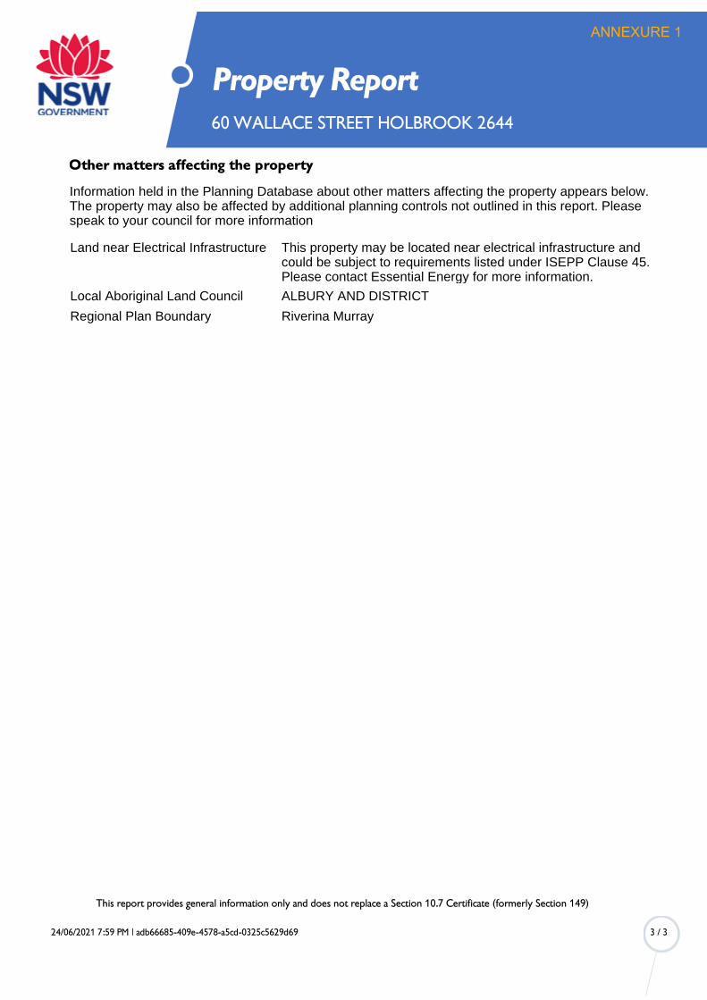
Other matters affecting the property
Information held in the Planning Database about other matters affecting the property appears below. The property may also be affected by additional planning controls not outlined in this report. Please speak to your council for more information
Land near Electrical Infrastructure This property may be located near electrical infrastructure and could be subject to requirements listed under ISEPP Clause 45. Please contact Essential Energy for more information.
Local Aboriginal Land Council ALBURY AND DISTRICT
Regional Plan Boundary Riverina Murray
This report provides general information only and does not replace a Section 10.7 Certificate (formerly Section 149)
24/06/2021 7:59 PM | adb66685-409e-4578-a5cd-0325c5629d69 3 / 3
Property Report60 WALLACE STREET HOLBROOK 2644
ANNEXURE 1
Clause 4.6 Application for Variation to Development Standard 2 Lot Torrens Title Subdivision Lot 15 DP4045 60 Wallace Street HOLBROOK
ANNEXURE 1

Environment Design Management
Town Planning Surveying Engineering Environmental Planning Building Design Project Management
This Report has been prepared for: Paul Spokes
C/- EDM Group PO Box 317
WODONGA 3689
This Report has been prepared by:
EDM Group 99 Hume Street Wodonga VIC 3690
P.O. Box 317 Wodonga 3689 Phone: (02) 6057 8578 www.edmgroup.com.au
EDM Ref No 21004300
Date: 01 July 2021
ANNEXURE 1
Environment Design Management
Town Planning Surveying Engineering Environmental Planning Building Design Project Management
CONTENTS
1. INTRODUCTION ............................................................................................... 1 2. IN WHAT FORM SHOULD A CLAUSE 4.6 VARIATION BE SUBMITTED TO
COUNCIL? ......................................................................................................... 1 2.1 What is the name of the environmental planning instrument that applies to the
land? .................................................................................................................. 1 2.2 What is the zoning of the land and what are the objectives of the zone? ............ 1 2.3 Identify the Development Standard to which this Clause 4.6 Variation applies? . 1 2.4 What are the objectives of the development standard? ...................................... 2 2.5 What is the numeric value of the development standard in the environmental
planning instrument? .......................................................................................... 2 2.6 How do the existing and proposed numeric values relate to the development
standard? What is the percentage variation (between your proposal and the environmental planning instrument)? ................................................................. 2
2.7 How is compliance with the development standard unreasonable or unnecessary in the circumstances of this particular case? ................................. 2
2.8 Are there sufficient environmental planning grounds to justify contravening the development standard?...................................................................................... 3
2.9 Is the proposed development, despite the contravention to the development standard, in the public interest? ......................................................................... 3
3. CONCLUDING COMMENTS ............................................................................. 4
ANNEXURE 1

Environment Design Management
Clause 4.6 Variation to Development Standard - 60 Wallace Street, Holbrook Page 1 of 4
1. INTRODUCTION
This application for a Variation to the Development Standard (Clause 4.6) is prepared on behalf of the landowner for the Development Application seeking consent for a proposed 2 Lot Torrens Title Subdivision of land located at 60 Wallace Street, Holbrook. The development proposal is prepared in reference to the development standard set at Clause 4.1(2) of the Greater Hume LEP and is implemented to ensure appropriate and sensitive development of the Greater Hume Shire.
This Clause 4.6 Variation has been prepared to accompany a development application and seeks to justify why a variation to the relevant development standard should be considered. Compliance with the development standard is required to ensure that the objectives of the LEP are achieved.
2. IN WHAT FORM SHOULD A CLAUSE 4.6 VARIATION BE SUBMITTED TO COUNCIL?
A Clause 4.6 Variation must be in the form of a document accompanying a development application. It must clearly state that it is a variation made under the provisions of Clause 4.6 of the GHLEP2012.
It must demonstrate:
a) that compliance with the development standard is unreasonable or unnecessary in the circumstances of the case; and
b) that there are sufficient environmental planning grounds to justifying contravening the development standard; and
c) that the proposed development will be in the public interest; and
d) whether the contravention of the development standard raises any matter of significance for state or regional planning; and
e) the public benefit of maintaining the development standard.
This is best demonstrated by Clause 4.6 Variations being prepared on the following format:
2.1 What is the name of the environmental planning instrument that applies to the land?
Greater Hume Local Environmental Plan 2012.
2.2 What is the zoning of the land and what are the objectives of the zone?
The proposed subdivision of land is located within the RU5 Village Zone. The objectives of the RU 5 Village Zone are as follows:
To provide for a range of land uses, services and facilities that are associated with a rural village.
To protect the amenity of residents.
2.3 Identify the Development Standard to which this Clause 4.6 Variation applies?
Clause 4.1(2) - Minimum subdivision lot size. The relevant Lot Size Map for the subject land requires a minimum site area of 600m² for each allotment.
ANNEXURE 1
Environment Design Management
Clause 4.6 Variation to Development Standard - 60 Wallace Street, Holbrook Page 2 of 4
2.4 What are the objectives of the development standard?
The objective of the development standard with regard to minimum lot size is:
(a) to ensure land use and development is undertaken on appropriately sized parcels of land consistent with the objectives of the relevant zone.
2.5 What is the numeric value of the development standard in the environmental planning instrument?
RU5 Village Zone requires lots to be a minimum of 600m².
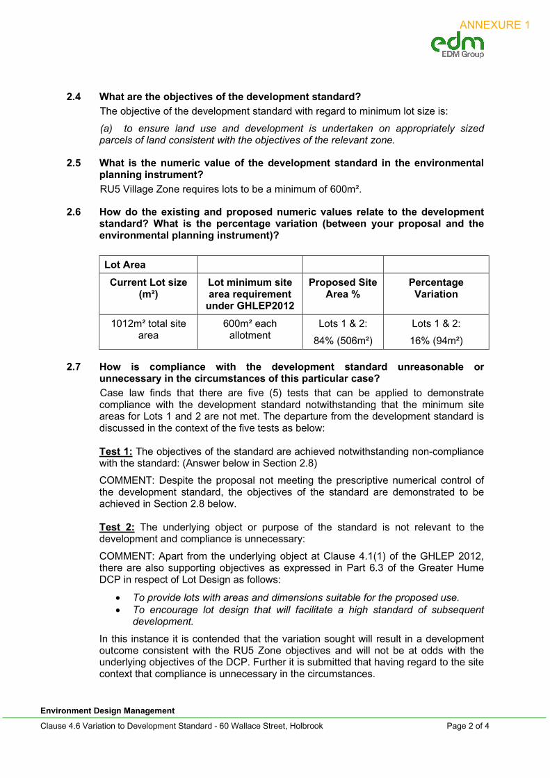
2.6 How do the existing and proposed numeric values relate to the development standard? What is the percentage variation (between your proposal and the environmental planning instrument)?
Lot Area
Current Lot size (m²)
Lot minimum site area requirement
under GHLEP2012
Proposed Site Area %
Percentage Variation
1012m² total site area
600m² each allotment
Lots 1 & 2:
84% (506m²)
Lots 1 & 2:
16% (94m²)
2.7 How is compliance with the development standard unreasonable or unnecessary in the circumstances of this particular case?
Case law finds that there are five (5) tests that can be applied to demonstrate compliance with the development standard notwithstanding that the minimum site areas for Lots 1 and 2 are not met. The departure from the development standard is discussed in the context of the five tests as below:
Test 1: The objectives of the standard are achieved notwithstanding non-compliance with the standard: (Answer below in Section 2.8)
COMMENT: Despite the proposal not meeting the prescriptive numerical control of the development standard, the objectives of the standard are demonstrated to be achieved in Section 2.8 below. Test 2: The underlying object or purpose of the standard is not relevant to the development and compliance is unnecessary:
COMMENT: Apart from the underlying object at Clause 4.1(1) of the GHLEP 2012, there are also supporting objectives as expressed in Part 6.3 of the Greater Hume DCP in respect of Lot Design as follows:
To provide lots with areas and dimensions suitable for the proposed use. To encourage lot design that will facilitate a high standard of subsequent
development.
In this instance it is contended that the variation sought will result in a development outcome consistent with the RU5 Zone objectives and will not be at odds with the underlying objectives of the DCP. Further it is submitted that having regard to the site context that compliance is unnecessary in the circumstances.
ANNEXURE 1

Environment Design Management
Clause 4.6 Variation to Development Standard - 60 Wallace Street, Holbrook Page 3 of 4
Test 3: The underlying object or purpose would be defeated or thwarted if compliance was required and therefore compliance is unreasonable:
COMMENT: The variation sought will not defeat of thwart the underlying purposes of the minimum lot size provisions as discussed above. The subject land is situated within a Village zone where the purposes of the zone include:
To provide for a range of land uses, services and facilities that are associated with a rural village.
To protect the amenity of residents.
The proposal will not result in a development outcome that will set an undesirable precedent within the context of Holbrook. Test 4: The development standard has been virtually abandoned or destroyed by the council’s own actions in granting consents departing from the standard and hence compliance with the standard is unnecessary and unreasonable:
COMMENT: Not applicable in this case Test 5: The compliance with the development standard is unreasonable or inappropriate due to existing use of land and current environmental character of the particular parcel of land. That is, the particular parcel of land should not have been included in the zone:
COMMENT: Not applicable in this case. Council has made the decision to include all of the village area within the Lot Size map under the provisions of the GHLEP 2012.
2.8 Are there sufficient environmental planning grounds to justify contravening the development standard?
COMMENT: Although the proposed Lots 1 and 2 do not satisfy the development standard for minimum 600m² allotments, the creation of two lots at 506m² each is considered to be consistent with that of the prevailing mixed settlement pattern of Holbrook. It is the case that residential allotments in the locality vary in size and shape with much of the existing layout created many years before the introduction of the GHLEP 2012.
The proposed allotments are therefore not considered to be out of character with the pattern of residential allotments surrounding the subject site notwithstanding that it cannot satisfy the relevant development standard with regard to minimum site area. The objectives of the development standard set out in the DCP seek to create lots with areas and dimensions suitable for the proposed use and to encourage lot design that will facilitate a high standard of subsequent development. The proposed allotments of 506m² satisfactorily achieve these objectives.
2.9 Is the proposed development, despite the contravention to the development standard, in the public interest?
COMMENT: The proposed 2 lot subdivision allows for the development of valuable residential land capable of achieving the overarching objectives of the Zone. As previously noted above, these objectives are to provide for a range of land uses, services and facilities that are associated with a rural village, and to protect the amenity of residents. The RU5 Village Zone is designed to facilitate a range of lot sizes that support a variety of dwelling types that contribute to the village ‘amenity’.
ANNEXURE 1

Environment Design Management
Clause 4.6 Variation to Development Standard - 60 Wallace Street, Holbrook Page 4 of 4
The proposed allotment allows for greater infill of the residential streetscape and contributes to the economic vitality of the community.
3. CONCLUDING COMMENTS
Having regard to the above it is submitted that compliance with the minimum lot size provisions in this instance would be both unreasonable and unnecessary in the circumstances. As noted with the accompanying Planning Report and Statement of Environmental Effects the proposal is otherwise seen as a relatively straight forward planning proposal that is consistent with relevant aspects of the Greater Hume LEP 2012 and DCP 2013.
In summary it is submitted that the proposal represents an orderly planning outcome that seeks to create two (2) residential lots by way of a Torrens title subdivision.
The proposal will not adversely impact on existing streetscape and/or neighbourhood character and otherwise represents an outcome consistent with site context and land use arrangements within the locality.
AMY MORDEN MPIA SENIOR PLANNER
01 July 2021 EDM Ref: 21004300
ANNEXURE 1

ANNEXURE 2
ANNEXURE 2 - INTERIM BUDGET REVIEW

Greater Hume Council – Community Engagement Strategy Page 1 of 10
Community Engagement Strategy 2021 Community Strategic Plan
Community Engagement Strategy PROJECT OVERVIEW
Project Name Community Strategic Plan Review 2021 Engagement Plan Author David Smith Date of Engagement Plan 3 August 2021
Project Overview
Under the NSW Local Government Act 1993 every local council must have a Community Strategic Plan (CSP). The CSP must extend for a minimum of 10 years and must be reviewed every four years (in the year of the local government elections). Under the Act, the CSP will be accompanied by a resourcing strategy, a community engagement strategy, a four-year Delivery Program and a one-year Operational Plan. The CSP is a community plan, not a council plan, and therefore achievement of the strategic actions is not the sole responsibility of GHC. A number of external agencies and stakeholders also have carriage of the strategic actions and targets. The current CSP reflects the 2030 vision for Greater Hume Council which was first developed in 2009 by Council and community leaders. It is now time to review this plan to extend its community vision for a minimum of ten year ahead of the Councillors election later this year. Ordinarily this review would have been conducted one year ago, however due to the COVID-19 pandemic the previous plan was extended by one year.
Overarching project goal or objective (s)
• To effectively engage the community to develop a collective vision for the future of Greater Hume. This plan will be developed in consideration of the quadruple bottom line (Social, Environmental, Economic and Civic Leadership) and will identify actions and outcomes to achieve community aspirations.
• To address the following four key questions for the community: o Where are we now? o Where do we want to be in ten years’ time? o How will we get there? o How will we know when we have arrived?
Key Issues (current and historical) that may have an impact on this project
• Shifting the focus of community members away from immediate issues and instead focussing on a broader future vision for the community.
• The impact of the COVID-19 pandemic may have significantly changed community priorities.
Stakeholder Engagement Objective(s) What information is required? How will it be used?
• To effectively engage the community in the development and review of Greater Hume’s Community Strategic Plan based on the social justice principles of equity, access, participation and rights.
ANNEXURE 3

Greater Hume Council – Community Engagement Strategy Page 2 of 10
Community Engagement Strategy 2021 Community Strategic Plan
What outcomes are sought through this engagement?
• To reach as many members of the Greater Hume community, community groups and agencies as possible to consult regarding new priorities for the future of Greater Hume.
• To identify and meet with relevant stakeholders and agencies to identify new strategic actions.
• To engage specific target groups of hard to reach community members.
• To ensure local, regional and state priorities are considered in the development of the CSP.
Key messages These are the core messages you want your target audience to hear and remember
• We are developing a new CSP that reflects a shared vision for the future of Greater Hume.
• This is not a Council plan, it is a community plan, with carriage of the deliverables shared across multiple agencies and the community.
• Focus on thinking long-term to capture big-picture, visionary ideas.
• What do you ‘love’ about living in Greater Hume? What can we do to make it better?
List of all stakeholders:
External Community Stakeholders
Internal Greater Hume Stakeholders
A comprehensive external stakeholder list has been included in Appendix 1.
• Greater Hume Councillors • Greater Hume Executive • Greater Hume Staff from all
Service Departments
Timeline: key dates Refer to implementation schedule
Level of Engagement (IAP2 Spectrum) Describe for each of the levels that apply
INFORM: • Regarding the requirement to develop a new CSP and the
opportunity to have a say. • Regarding the achievements in Live a Greater Life 2030. • Regarding Council adoption and any revision to the CSP. CONSULT: • Regarding new outcomes, strategic actions and targets. COLLABORATE: • Partner with the community to establish priorities and develop a
collective vision for the future of Greater Hume. Likelihood of media interest Unlikely, Possibly, Likely or Very likely, and why?
This is a major review of the strategic direction for Greater Hume with moderate media interest expected throughout the consultation process and in the final draft CSP.
Risk assessment
Key risks identified Mitigations Key stakeholder(s) are not identified in the engagement process
Share community engagement plan and stakeholder list with Service Leaders for feedback to ensure all relevant stakeholders have been considered.
Engagement methods are not accessible to certain cohorts of the community.
Develop and present materials in multiple formats to ensure accessibility. Seek feedback
ANNEXURE 3
Greater Hume Council – Community Engagement Strategy Page 3 of 10
Community Engagement Strategy 2021 Community Strategic Plan
from hard to reach cohorts regarding preferred mode of communication.
Lack of community interest in participating in the engagement process.
Implement diverse and innovative engagement strategies that encourage participation from all stakeholders. Emphasise/case study the importance the CSP plays in shaping council decision making.
Budget and resources Estimated budget for engagement (or indicate if covered under overall Project budget)
$15,000
What internal staff, venues are materials required?
Staff • Subject matter experts from all service areas Venues (may be required) • Customer Service Centres x 5 • Holbrook Library Meeting Room • Culcairn Council Chambers • Public Halls (potentially) Materials • Multimedia equipment • Stationary • Video conferencing facilities for Zoom meetings
Is external staff support required?
• Consultant Karen Legge in relation to IP&R process
Evaluation Criteria List the criteria to use to evaluate success of this engagement activity
• The number of groups, agencies and individuals consulted and the amount of feedback provided.
• The number of survey responses. o An evaluation question will be included in the survey.
• The level of attendance at drop-in sessions and workshops. o Evaluation forms will be distributed during workshops.
• The level of feedback received from hard to reach stakeholder cohorts.
• An internal review between staff involved in the project.
ANNEXURE 3

Greater Hume Council – Community Engagement Strategy Page 4 of 10
Community Engagement Strategy 2021 Community Strategic Plan
ENGAGEMENT TECHNIQUES AND DELIVERABLES
ENGAGEMENT TECHNIQUES AND DELIVERABLES
Techniques/Deliverables Relevant stakeholders
Major project page – GHC website • Page to introduce the project, house resources and an opportunity for
community to subscribe to updates.
General public
Have your Say – GHC website • Consultation page for the community to access information about
community engagement opportunities, access resources and link to survey and ideas wall.
General public
Border Mail – Public Notices • Public notices in the Border Mail to advise the community of engagement
opportunities.
General public
News from GHC (Town newsletters) • Inclusion of information about the development of the CSP and
engagement opportunities throughout the consultation period.
General public
eDM to subscribers • eDM’s to the Community Engagement Group and specific subscriber group
for the Community Strategic Plan updates as it become available.
General public
Listening posts • Pop-up stalls to allow community to provide feedback on the spot to
GHC Council, MANEX and key managers: - Culcairn - Foodworks - Henty - Dales IGA - Holbrook - Newsagency - Jindera – IGA - Walla Walla - Post Office / Coffee Shop/s
• 5 x ½ days, 10am – 1pm / 2pm to 5pm on 14-15, 21-22 October
• Materials required include whiteboard, post it notes, table, 4 x Chairs, GHC table cloth
• Marketing materials specific to each town, highlighting Council achievements over past 3-4 years (A2 size poster); coffee voucher for GHC participating coffee vendors.
General public
Social media • All GHC social media platforms will be used to share information, promote
engagement opportunities and provide updates to the community. • Social media comments/suggestions will be considered as part of the
consultation.
General public
External meetings with key stakeholders • A combination of individual and group stakeholder meetings to ensure a
comprehensive cross-section of society is reached and has an opportunity to contribute to the development of a shared vision.
All
Council workshop • Workshop with councillors to review community feedback, recommended
outcomes and actions and further contribute to the development of the CSP.
Greater Hume Councillors
ANNEXURE 3

Greater Hume Council – Community Engagement Strategy Page 5 of 10
Community Engagement Strategy 2021 Community Strategic Plan
IMPLEMENTATION SCHEDULE Prepare a schedule considering the following points:
• By what date do you need to make a final decision? • Do you have enough time for the stakeholder engagement process? • Are there timeframes stipulated by legislation for the stakeholder engagement? • Consider dates and events such as school holidays, public holidays, community events, etc.
Engagement in December and January can be problematic.
Implementation Schedule
Task Stakeholders When Responsibility Preparation of council report to endorse the Community Engagement Strategy
Greater Hume Councillors
August 2021 David / Steve
Development of GHC website content – Major project and Have your Say pages and establish subscription function
All August 2021 Kerrie
Public notice in Border Mail advising of consultation
General Public September 2021 Steph
Inclusion of consultation information in News from GHC
General public In line with Community newsletter deadlines: September 2021 November 2021
Steph / Kerrie
eDMs to subscription list and Community Engagement Group
General public September 2021 – November 2021
Kerrie / Steph
Development of social media content
General public September 2021 Kerrie / Steph
Listening posts held across the LGA
General public October 2021 Steve / David
Individual stakeholder meetings
All August – November 2021
MANEX
Development of draft strategic actions based on community consultations
All November 2021 David / Steph
Councillor consultation workshop
Greater Hume Councillors
December 2021 Steve / David
Draft CSP to council Greater Hume Councillors
January 2022 Steve / David
Public Exhibition of draft CSP (inc website, social media and community newsletters.)
All January - February 2022
Steph / Kerrie
Public Notice in Border Mail advising of Public Exhibition
General public January 2022 Post council meeting
Steph
ANNEXURE 3

Greater Hume Council – Community Engagement Strategy Page 6 of 10
Community Engagement Strategy 2021 Community Strategic Plan
Implementation Schedule
Task Stakeholders When Responsibility Consideration of submissions
All February 2022 MANEX
Final plan submitted to Council for adoption
Greater Hume Councillors
March 2022 Steve / David
Development of Community Engagement Report
All May 2022 David
EVALUATION OF THE ENGAGEMENT PROCESS At the conclusion of the engagement activity (either internal or external), review the process. Consider the following questions and complete the table below:
Evaluation of the process
Key questions: • Did you identify the correct stakeholders? • Were their needs met? • Were the correct techniques / deliverables used and were
they implemented correctly? • Was the activity responsive and inclusive to the needs of
all participants? • What was most and least effective? Why?
Describe
Evaluation of the outcome
Key questions: • What was the result of the engagement? Did the activity
achieve the desired outcomes? • How many people did it reach? • Were the community / stakeholders satisfied? • What was the stakeholder impact on the decision process
and final decision? • What are the lessons learned and areas of improvement?
Describe
STEP 6. Close the loop. This is important for both internal staff and the external community. Let the people you engaged know the final outcome of your engagement activity. When complete, summarise how you closed the loop in the space provided. For Internal employees:
• Summarise the main findings of your stakeholder engagement • Determine the best method for advising staff and use this to inform of your findings / outcomes. If
required, refer to Greater Hume Council Communications Strategy for methods to best communicate with staff.
For External community and other stakeholders
ANNEXURE 3

Greater Hume Council – Community Engagement Strategy Page 7 of 10
Community Engagement Strategy 2021 Community Strategic Plan
• Summarise the main findings of your stakeholder engagement. • • Liaise with the Communications team to place the summary back on ‘Have a Say’ under ‘past items’.
‘Close the loop’ methods undertaken What did you do to close the loop of your engagement activity?
ANNEXURE 3
Greater Hume Council – Community Engagement Strategy Page 8 of 10
Community Engagement Strategy 2021 Community Strategic Plan
Appendix 1 – External stakeholder list Business Stakeholders
• Greater Hume Business operators • Australian Industry Group • NSW Business Chamber – Riverina Murray Advisory Council
Land/Development
• Regional Development Australia Murray • Regional Development Australia Riverina • Regional Activators Alliance
Environment
• Local Land Services • HalveWaste • Murray Landcare Network • Wirramina • National Parks & Wildlife
Transport
• CountryLink Rail • Australian Rail Track Corporation • Local bus companies • Regional Bus Service • Private transport operators • Trucking companies • Regional Development Committee - TfNSW
Utilities
• NBN Co • Essential Energy • Utility providers • Riverina Water • APA Group
Aboriginal and Torres Strait Islander People
• Albury Local Aboriginal Land Council Culturally and Linguistically Diverse
• Welcoming Cities • Multicultural NSW Regional Advisory Committee
Young people
• Youth Council • LGNSW Youth Action Group • Work Inspiration Day
Aged community
• Aged care facilities and providers (UPA, Lutheran Aged Care re: website)
ANNEXURE 3

Greater Hume Council – Community Engagement Strategy Page 9 of 10
Community Engagement Strategy 2021 Community Strategic Plan
Community services • Employment agencies - Sureway • Holbrook / Henty Meals on Wheels • St Vincent de Paul / Anglicare / Uniting Care • Volunteer Resource Bureau • Intereach • Border Domestic Violence Network
State Government
• Office of Environment and Heritage • Transport for NSW • NSW Department of Planning • NSW Office of Water • NSW Health • NSW Department of Industry • Environmental Protection Authority • NSW Department of Industry – Lands • NSW Department of Primary Industry – Crown Lands • NSW Department of Primary Industry – NSW Agriculture • NSW Department of Education • NSW Police • NSW Department of Communities and Justice • Department of Sport and Recreation • Community Relations Commission • Local Member of Parliament
Federal Government
• Murray Darling Basin Authority • Centrelink • Job Services Australia • Local Member of Parliament
Local Government
• Other regional councils • Regional Joint Organisation of Councils • Riverina and Murray Joint Organisation (RAMJO) • Albury Wodonga Regional Deal
Tourism
• Murray Regional Tourism • Destination NSW • Major Event organisers • Destination Riverina Murray • Tourism businesses
, Arts/Culture
• Cultural industry • Historical Society • Murray Arts • Cultural industry professionals
ANNEXURE 3
Greater Hume Council – Community Engagement Strategy Page 10 of 10
Community Engagement Strategy 2021 Community Strategic Plan
• LGNSW Museum Managers Group • Museums Australia Murray Network
Leisure/Sporting Groups
• Leisure/Social Groups including gyms • Sporting Groups
Health
• Albury Wodonga Health • Murrumbidgee Local Health District • General practitioners • Albury Community Health • Hospitals • Murray Public Health Network
Education
• Early Childhood Educators • Primary Schools • Secondary Schools • NSW Tafe • Charles Sturt / LaTrobe • Preschools
Emergency Services
• Youth Emergency Services • Rural Fire Service & Brigades • State Emergency Services • NSW Ambulance • NSW Fire Brigade • Local Emergency Management Committee • REMO
Community Groups
• Church, spiritual groups and their affiliated organisations • Service clubs • Section 355 Committees
ANNEXURE 3
NOTES
GENERAL
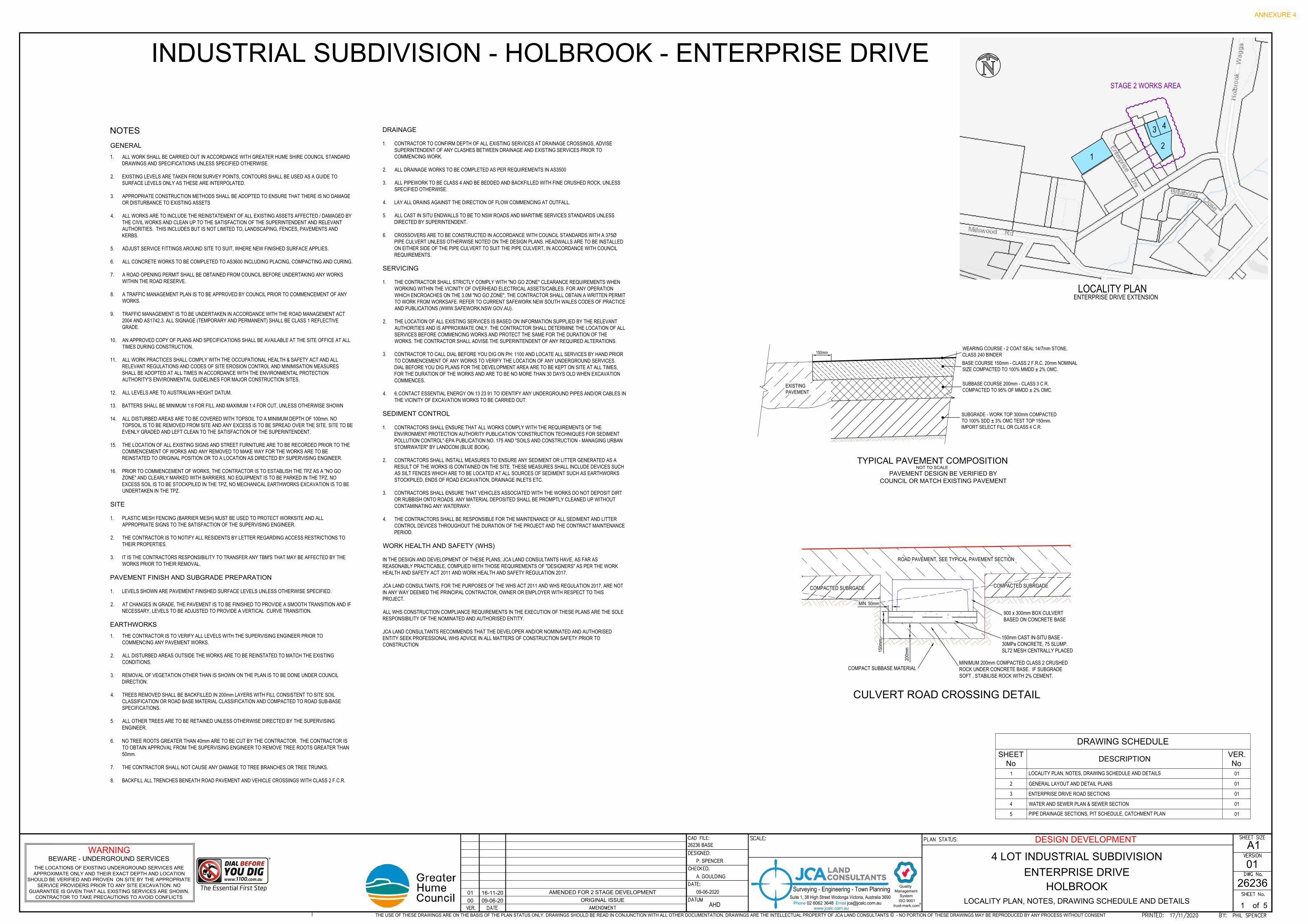
1. ALL WORK SHALL BE CARRIED OUT IN ACCORDANCE WITH GREATER HUME SHIRE COUNCIL STANDARDDRAWINGS AND SPECIFICATIONS UNLESS SPECIFIED OTHERWISE.
2. EXISTING LEVELS ARE TAKEN FROM SURVEY POINTS, CONTOURS SHALL BE USED AS A GUIDE TOSURFACE LEVELS ONLY AS THESE ARE INTERPOLATED.
3. APPROPRIATE CONSTRUCTION METHODS SHALL BE ADOPTED TO ENSURE THAT THERE IS NO DAMAGEOR DISTURBANCE TO EXISTING ASSETS
4. ALL WORKS ARE TO INCLUDE THE REINSTATEMENT OF ALL EXISTING ASSETS AFFECTED / DAMAGED BYTHE CIVIL WORKS AND CLEAN UP TO THE SATISFACTION OF THE SUPERINTENDENT AND RELEVANTAUTHORITIES. THIS INCLUDES BUT IS NOT LIMITED TO, LANDSCAPING, FENCES, PAVEMENTS ANDKERBS.
5. ADJUST SERVICE FITTINGS AROUND SITE TO SUIT, WHERE NEW FINISHED SURFACE APPLIES.
6. ALL CONCRETE WORKS TO BE COMPLETED TO AS3600 INCLUDING PLACING, COMPACTING AND CURING.
7. A ROAD OPENING PERMIT SHALL BE OBTAINED FROM COUNCIL BEFORE UNDERTAKING ANY WORKSWITHIN THE ROAD RESERVE.
8. A TRAFFIC MANAGEMENT PLAN IS TO BE APPROVED BY COUNCIL PRIOR TO COMMENCEMENT OF ANYWORKS.
9. TRAFFIC MANAGEMENT IS TO BE UNDERTAKEN IN ACCORDANCE WITH THE ROAD MANAGEMENT ACT2004 AND AS1742.3. ALL SIGNAGE (TEMPORARY AND PERMANENT) SHALL BE CLASS 1 REFLECTIVEGRADE.
10. AN APPROVED COPY OF PLANS AND SPECIFICATIONS SHALL BE AVAILABLE AT THE SITE OFFICE AT ALLTIMES DURING CONSTRUCTION.
11. ALL WORK PRACTICES SHALL COMPLY WITH THE OCCUPATIONAL HEALTH & SAFETY ACT AND ALLRELEVANT REGULATIONS AND CODES OF SITE EROSION CONTROL AND MINIMISATION MEASURESSHALL BE ADOPTED AT ALL TIMES IN ACCORDANCE WITH THE ENVIRONMENTAL PROTECTIONAUTHORITY'S ENVIRONMENTAL GUIDELINES FOR MAJOR CONSTRUCTION SITES.
12. ALL LEVELS ARE TO AUSTRALIAN HEIGHT DATUM.
13. BATTERS SHALL BE MINIMUM 1:6 FOR FILL AND MAXIMUM 1:4 FOR CUT, UNLESS OTHERWISE SHOWN
14. ALL DISTURBED AREAS ARE TO BE COVERED WITH TOPSOIL TO A MINIMUM DEPTH OF 100mm. NOTOPSOIL IS TO BE REMOVED FROM SITE AND ANY EXCESS IS TO BE SPREAD OVER THE SITE. SITE TO BEEVENLY GRADED AND LEFT CLEAN TO THE SATISFACTION OF THE SUPERINTENDENT.
15. THE LOCATION OF ALL EXISTING SIGNS AND STREET FURNITURE ARE TO BE RECORDED PRIOR TO THECOMMENCEMENT OF WORKS AND ANY REMOVED TO MAKE WAY FOR THE WORKS ARE TO BEREINSTATED TO ORIGINAL POSITION OR TO A LOCATION AS DIRECTED BY SUPERVISING ENGINEER.
16. PRIOR TO COMMENCEMENT OF WORKS, THE CONTRACTOR IS TO ESTABLISH THE TPZ AS A "NO GOZONE" AND CLEARLY MARKED WITH BARRIERS. NO EQUIPMENT IS TO BE PARKED IN THE TPZ, NOEXCESS SOIL IS TO BE STOCKPILED IN THE TPZ, NO MECHANICAL EARTHWORKS EXCAVATION IS TO BEUNDERTAKEN IN THE TPZ.
SITE
1. PLASTIC MESH FENCING (BARRIER MESH) MUST BE USED TO PROTECT WORKSITE AND ALLAPPROPRIATE SIGNS TO THE SATISFACTION OF THE SUPERVISING ENGINEER.
2. THE CONTRACTOR IS TO NOTIFY ALL RESIDENTS BY LETTER REGARDING ACCESS RESTRICTIONS TOTHEIR PROPERTIES.
3. IT IS THE CONTRACTORS RESPONSIBILITY TO TRANSFER ANY TBM'S THAT MAY BE AFFECTED BY THEWORKS PRIOR TO THEIR REMOVAL.
PAVEMENT FINISH AND SUBGRADE PREPARATION
1. LEVELS SHOWN ARE PAVEMENT FINISHED SURFACE LEVELS UNLESS OTHERWISE SPECIFIED.
2. AT CHANGES IN GRADE, THE PAVEMENT IS TO BE FINISHED TO PROVIDE A SMOOTH TRANSITION AND IFNECESSARY, LEVELS TO BE ADJUSTED TO PROVIDE A VERTICAL CURVE TRANSITION.
EARTHWORKS
1. THE CONTRACTOR IS TO VERIFY ALL LEVELS WITH THE SUPERVISING ENGINEER PRIOR TOCOMMENCING ANY PAVEMENT WORKS.
2. ALL DISTURBED AREAS OUTSIDE THE WORKS ARE TO BE REINSTATED TO MATCH THE EXISTINGCONDITIONS.
3. REMOVAL OF VEGETATION OTHER THAN IS SHOWN ON THE PLAN IS TO BE DONE UNDER COUNCILDIRECTION.
4. TREES REMOVED SHALL BE BACKFILLED IN 200mm LAYERS WITH FILL CONSISTENT TO SITE SOILCLASSIFICATION OR ROAD BASE MATERIAL CLASSIFICATION AND COMPACTED TO ROAD SUB-BASESPECIFICATIONS.
5. ALL OTHER TREES ARE TO BE RETAINED UNLESS OTHERWISE DIRECTED BY THE SUPERVISINGENGINEER.
6. NO TREE ROOTS GREATER THAN 40mm ARE TO BE CUT BY THE CONTRACTOR. THE CONTRACTOR ISTO OBTAIN APPROVAL FROM THE SUPERVISING ENGINEER TO REMOVE TREE ROOTS GREATER THAN50mm.
7. THE CONTRACTOR SHALL NOT CAUSE ANY DAMAGE TO TREE BRANCHES OR TREE TRUNKS.
8. BACKFILL ALL TRENCHES BENEATH ROAD PAVEMENT AND VEHICLE CROSSINGS WITH CLASS 2 F.C.R.
DRAINAGE
1. CONTRACTOR TO CONFIRM DEPTH OF ALL EXISTING SERVICES AT DRAINAGE CROSSINGS, ADVISESUPERINTENDENT OF ANY CLASHES BETWEEN DRAINAGE AND EXISTING SERVICES PRIOR TOCOMMENCING WORK.
2. ALL DRAINAGE WORKS TO BE COMPLETED AS PER REQUIREMENTS IN AS3500
3. ALL PIPEWORK TO BE CLASS 4 AND BE BEDDED AND BACKFILLED WITH FINE CRUSHED ROCK, UNLESSSPECIFIED OTHERWISE.
4. LAY ALL DRAINS AGAINST THE DIRECTION OF FLOW COMMENCING AT OUTFALL.
5. ALL CAST IN SITU ENDWALLS TO BE TO NSW ROADS AND MARITIME SERVICES STANDARDS UNLESSDIRECTED BY SUPERINTENDENT.
6. CROSSOVERS ARE TO BE CONSTRUCTED IN ACCORDANCE WITH COUNCIL STANDARDS WITH A 375ØPIPE CULVERT UNLESS OTHERWISE NOTED ON THE DESIGN PLANS. HEADWALLS ARE TO BE INSTALLEDON EITHER SIDE OF THE PIPE CULVERT TO SUIT THE PIPE CULVERT, IN ACCORDANCE WITH COUNCILREQUIREMENTS.
SERVICING
1. THE CONTRACTOR SHALL STRICTLY COMPLY WITH "NO GO ZONE" CLEARANCE REQUIREMENTS WHENWORKING WITHIN THE VICINITY OF OVERHEAD ELECTRICAL ASSETS/CABLES. FOR ANY OPERATIONWHICH ENCROACHES ON THE 3.0M "NO GO ZONE", THE CONTRACTOR SHALL OBTAIN A WRITTEN PERMITTO WORK FROM WORKSAFE. REFER TO CURRENT SAFEWORK NEW SOUTH WALES CODES OF PRACTICEAND PUBLICATIONS (WWW.SAFEWORK.NSW.GOV.AU).
2. THE LOCATION OF ALL EXISTING SERVICES IS BASED ON INFORMATION SUPPLIED BY THE RELEVANTAUTHORITIES AND IS APPROXIMATE ONLY. THE CONTRACTOR SHALL DETERMINE THE LOCATION OF ALLSERVICES BEFORE COMMENCING WORKS AND PROTECT THE SAME FOR THE DURATION OF THEWORKS. THE CONTRACTOR SHALL ADVISE THE SUPERINTENDENT OF ANY REQUIRED ALTERATIONS.
3. CONTRACTOR TO CALL DIAL BEFORE YOU DIG ON PH: 1100 AND LOCATE ALL SERVICES BY HAND PRIORTO COMMENCEMENT OF ANY WORKS TO VERIFY THE LOCATION OF ANY UNDERGROUND SERVICES.DIAL BEFORE YOU DIG PLANS FOR THE DEVELOPMENT AREA ARE TO BE KEPT ON SITE AT ALL TIMES,FOR THE DURATION OF THE WORKS AND ARE TO BE NO MORE THAN 30 DAYS OLD WHEN EXCAVATIONCOMMENCES.
4. 6.CONTACT ESSENTIAL ENERGY ON 13 23 91 TO IDENTIFY ANY UNDERGROUND PIPES AND/OR CABLES INTHE VICINITY OF EXCAVATION WORKS TO BE CARRIED OUT.
SEDIMENT CONTROL
1. CONTRACTORS SHALL ENSURE THAT ALL WORKS COMPLY WITH THE REQUIREMENTS OF THEENVIRONMENT PROTECTION AUTHORITY PUBLICATION "CONSTRUCTION TECHNIQUES FOR SEDIMENTPOLLUTION CONTROL"-EPA PUBLICATION NO. 175 AND "SOILS AND CONSTRUCTION - MANAGING URBANSTOMRWATER" BY LANDCOM (BLUE BOOK).
2. CONTRACTORS SHALL INSTALL MEASURES TO ENSURE ANY SEDIMENT OR LITTER GENERATED AS ARESULT OF THE WORKS IS CONTAINED ON THE SITE. THESE MEASURES SHALL INCLUDE DEVICES SUCHAS SILT FENCES WHICH ARE TO BE LOCATED AT ALL SOURCES OF SEDIMENT SUCH AS EARTHWORKSSTOCKPILED, ENDS OF ROAD EXCAVATION, DRAINAGE INLETS ETC.
3. CONTRACTORS SHALL ENSURE THAT VEHICLES ASSOCIATED WITH THE WORKS DO NOT DEPOSIT DIRTOR RUBBISH ONTO ROADS. ANY MATERIAL DEPOSITED SHALL BE PROMPTLY CLEANED UP WITHOUTCONTAMINATING ANY WATERWAY.
4. THE CONTRACTORS SHALL BE RESPONSIBLE FOR THE MAINTENANCE OF ALL SEDIMENT AND LITTERCONTROL DEVICES THROUGHOUT THE DURATION OF THE PROJECT AND THE CONTRACT MAINTENANCEPERIOD.
WORK HEALTH AND SAFETY (WHS)
IN THE DESIGN AND DEVELOPMENT OF THESE PLANS, JCA LAND CONSULTANTS HAVE, AS FAR ASREASONABLY PRACTICABLE, COMPLIED WITH THOSE REQUIREMENTS OF "DESIGNERS" AS PER THE WORKHEALTH AND SAFETY ACT 2011 AND WORK HEALTH AND SAFETY REGULATION 2017.
JCA LAND CONSULTANTS, FOR THE PURPOSES OF THE WHS ACT 2011 AND WHS REGULATION 2017, ARE NOTIN ANY WAY DEEMED THE PRINCIPAL CONTRACTOR, OWNER OR EMPLOYER WITH RESPECT TO THISPROJECT.
ALL WHS CONSTRUCTION COMPLIANCE REQUIREMENTS IN THE EXECUTION OF THESE PLANS ARE THE SOLERESPONSIBILITY OF THE NOMINATED AND AUTHORISED ENTITY.
JCA LAND CONSULTANTS RECOMMENDS THAT THE DEVELOPER AND/OR NOMINATED AND AUTHORISEDENTITY SEEK PROFESSIONAL WHS ADVICE IN ALL MATTERS OF CONSTRUCTION SAFETY PRIOR TOCONSTRUCTION
SUBBASE COURSE 200mm - CLASS 3 C.R.COMPACTED TO 95% OF MMDD ± 2% OMC.
TYPICAL PAVEMENT COMPOSITION
NOT TO SCALE
BASE COURSE 150mm - CLASS 2 F.R.C. 20mm NOMINALSIZE COMPACTED TO 100% MMDD ± 2% OMC.
WEARING COURSE - 2 COAT SEAL 14/7mm STONE,CLASS 240 BINDER
SUBGRADE - WORK TOP 300mm COMPACTEDTO 100% SDD ± 3% OMC TEST TOP 150mm.IMPORT SELECT FILL OR CLASS 4 C.R.
PAVEMENT DESIGN BE VERIFIED BY
COUNCIL OR MATCH EXISTING PAVEMENT
EXISTINGPAVEMENT
150mm
WARNING
BEWARE - UNDERGROUND SERVICES
THE LOCATIONS OF EXISTING UNDERGROUND SERVICES ARE
APPROXIMATE ONLY AND THEIR EXACT DEPTH AND LOCATION
SHOULD BE VERIFIED AND PROVEN ON SITE BY THE APPROPRIATE
SERVICE PROVIDERS PRIOR TO ANY SITE EXCAVATION. NO
GUARANTEE IS GIVEN THAT ALL EXISTING SERVICES ARE SHOWN.
CONTRACTOR TO TAKE PRECAUTIONS TO AVOID CONFLICTS
LOCALITY PLAN, NOTES, DRAWING SCHEDULE AND DETAILS
1
A1
01
HOLBROOK
4 LOT INDUSTRIAL SUBDIVISION
ENTERPRISE DRIVE
26236
DESIGN DEVELOPMENT
P. SPENCER
A. GOULDING
26236 BASE
09-06-2020
AHDof 5
Surveying - Engineering - Town Planning
www.jcalc.com.au
Quality
Management
System
ISO 9001
trust-mark.com
®
Suite 1, 38 High Street Wodonga Victoria, Australia 3690Phone 02 6062 3648 Email [email protected]
THE USE OF THESE DRAWINGS ARE ON THE BASIS OF THE PLAN STATUS ONLY. DRAWINGS SHOULD BE READ IN CONJUNCTION WITH ALL OTHER DOCUMENTATION. DRAWINGS ARE THE INTELLECTUAL PROPERTY OF JCA LAND CONSULTANTS © - NO PORTION OF THESE DRAWINGS MAY BE REPRODUCED BY ANY PROCESS WITHOUT CONSENT
00 09-06-20
ORIGINAL ISSUE
01 16-11-20
AMENDED FOR 2 STAGE DEVELOPMENT
12
3 4
LOCALITY PLANENTERPRISE DRIVE EXTENSION
900 x 300mm BOX CULVERTBASED ON CONCRETE BASE
150m
m
MIN. 50mm
ROAD PAVEMENT, SEE TYPICAL PAVEMENT SECTION
COMPACTED SUBRGADECOMPACTED SUBRGADE
200m
m
MINIMUM 200mm COMPACTED CLASS 2 CRUSHEDROCK UNDER CONCRETE BASE. IF SUBGRADESOFT , STABILISE ROCK WITH 2% CEMENT.
150mm CAST IN-SITU BASE -30MPa CONCRETE, 75 SLUMP.SL72 MESH CENTRALLY PLACED
CULVERT ROAD CROSSING DETAIL
COMPACT SUBBASE MATERIAL
DRAWING SCHEDULE
SHEET
No
DESCRIPTION
VER.
No
1 LOCALITY PLAN, NOTES, DRAWING SCHEDULE AND DETAILS 01
2 GENERAL LAYOUT AND DETAIL PLANS 01
3 ENTERPRISE DRIVE ROAD SECTIONS 01
4 WATER AND SEWER PLAN & SEWER SECTION 01
5 PIPE DRAINAGE SECTIONS, PIT SCHEDULE, CATCHMENT PLAN 01
INDUSTRIAL SUBDIVISION - HOLBROOK - ENTERPRISE DRIVE
STAGE 2 WORKS AREA
ANNEXURE 4
AutoCAD SHX Text
VER.
AutoCAD SHX Text
DATE
AutoCAD SHX Text
SHEET No.
AutoCAD SHX Text
SHEET SIZE
AutoCAD SHX Text
AMENDMENT
AutoCAD SHX Text
DWG No.
AutoCAD SHX Text
VERSION
AutoCAD SHX Text
PRINTED:
AutoCAD SHX Text
BY:
AutoCAD SHX Text
PLAN STATUS:
AutoCAD SHX Text
SCALE:
AutoCAD SHX Text
DESIGNED:
AutoCAD SHX Text
CHECKED:
AutoCAD SHX Text
CAD FILE:
AutoCAD SHX Text
DATE:
AutoCAD SHX Text
DATUM
AutoCAD SHX Text
17/11/2020
AutoCAD SHX Text
PHIL SPENCER

WS
WS
WS
J
FH
J
J
1
7365m²
2
4672m²
3
1519m²
4
1845m²S01Ex.SMH
S02
J
WS
SMH
D
B
H
1
m
,
B
u
t
t
r
e
s
s
1
.
5
m
M
A
R
K
E
R
P
O
S
T
P
I
T
U
N
C
L
D
B
H
1
m
,
B
u
t
t
r
e
s
s
2
m
S
T
U
M
P
S
T
U
M
P
G
U
M
T
R
E
E
375Ø
EWA1
EWA2 EW
B1 EWB2
EWC1 EW
C2
EWD1
EWD2
375Ø
300x900RCBC
IL 26
9.70
IL 26
9.35
IL 26
9.00IL 26
8.55
IL 26
8.30
IL 26
8.20
IL 26
8.10
IL 26
7.68
IL 26
7.45
26926
8
268
268
269
269
268
267
ELECTRICITY
PROPOSED
WATER
DRAIN - MAIN
LEGEND
EXISTING
PIT
FH(W) SV FH
SEWER
TELCO
WS
FENCE
ELECTRICITY OVERHEAD
BANK TOP
WATERDRAINAGESEWERELECTRICITY UNDER GROUND
BANK TOE
EASEMENT
INVERT OPEN DRAIN
TELSTRA
TREE
SMHJ
CONTOUR MAJORCONTOUR MINOR
CONTOUR MAJORCONTOUR MINOR 150
150
WATER SERVICE / CONDUITWS
DRAIN - OPENBANK TOPBANK TOE
D
B
H
1
m
,
B
u
t
t
r
e
s
s
2
m
2
0
.
0
0
3
0
.
0
0
4
5
.
0
0
5
1
.
4
8
6
0
.
0
0
8
0
.
0
0
9
1
.
3
1
9
8
.
0
0
4
0
.
0
0
26926
8
1
1
0
.
0
0
S
T
U
M
P
WARNING
BEWARE - UNDERGROUND SERVICES
THE LOCATIONS OF EXISTING UNDERGROUND SERVICES ARE
APPROXIMATE ONLY AND THEIR EXACT DEPTH AND LOCATION
SHOULD BE VERIFIED AND PROVEN ON SITE BY THE APPROPRIATE
SERVICE PROVIDERS PRIOR TO ANY SITE EXCAVATION. NO
GUARANTEE IS GIVEN THAT ALL EXISTING SERVICES ARE SHOWN.
CONTRACTOR TO TAKE PRECAUTIONS TO AVOID CONFLICTS
GENERAL LAYOUT AND DETAIL PLANS
2
A1
01
HOLBROOK
4 LOT INDUSTRIAL SUBDIVISION
ENTERPRISE DRIVE
26236
DESIGN DEVELOPMENT
P. SPENCER
A. GOULDING
26236 BASE
09-06-2020
AHDof 5
Surveying - Engineering - Town Planning
www.jcalc.com.au
Quality
Management
System
ISO 9001
trust-mark.com
®
Suite 1, 38 High Street Wodonga Victoria, Australia 3690Phone 02 6062 3648 Email [email protected]
THE USE OF THESE DRAWINGS ARE ON THE BASIS OF THE PLAN STATUS ONLY. DRAWINGS SHOULD BE READ IN CONJUNCTION WITH ALL OTHER DOCUMENTATION. DRAWINGS ARE THE INTELLECTUAL PROPERTY OF JCA LAND CONSULTANTS © - NO PORTION OF THESE DRAWINGS MAY BE REPRODUCED BY ANY PROCESS WITHOUT CONSENT
00 09-06-20
ORIGINAL ISSUE
01 16-11-20
AMENDED FOR 2 STAGE DEVELOPMENT
ENTERPRISE DRIVE
REMOVE EXISTINGTEMPORARY CROSSINGAND MAKE GOOD ROADTABLE DRAIN
REINSTALL PIPE WORK FROMTEMPORARY CROSSING TOMAINTAIN ACCESS TO STOCKPILESTO COUNCIL SATISFACTION
ROAD END CHEVRON SIGN TO COUNCILSTANDARD TO BE INSTALLED INAPPROPRIATE POSITION
GRADE TABLE DRAIN TODAYLIGHT @ MINIMUM0.5% GRADE.
EXISTING DAM
COUNCIL DEPOT
GENERAL LAYOUT PLAN
STAGE 2 DETAIL PLAN
INSTALL BERM, MINIMUM300mm HEIGHT 1:6 BATTERSTO PROTECT LOTS 3 & 4 FROMUPSTREAM OVERLAND FLOWS
EWA1
EWA2
EWC1
EWC2
EWB1
EWB2
3m
3m
1.1m1.7m
8m
WS
FH
J
S01Ex.SMH
S02SMH
J
J
WS
WS
9.4m
7m
1.2m 1.2m
SAWCUT EXISTING PAVEMENTAND BENCH NEW PAVEMENTIN WITH 150mm OVERLAP.
8.4m
9.7m
6m
6m
CONSTRUCT OPEN DRAIN, 900mmBASE, 1:4 BATTERS. GRADE TO DAMFROM OUTLET OF PROPOSED ROADCULVERT @ MIN 1:200
CONSTRUCT CATCH DRAIN, 400mmBASE, 1:4 BATTERS. GRADE AS PERSPOT LEVELS SHOWN. MINIMUMDEPTH TO BE 300mm.
CONSTRUCT CATCH DRAIN,400mm BASE, 1:4 BATTERS.GRADE AS PER SPOTLEVELS SHOWN. MINIMUMDEPTH TO BE 300mm
CONSTRUCT DRIVEWAY TOCOUNCIL STANDARD 2002.010
CONSTRUCT DRIVEWAY TOCOUNCIL STANDARD 2002.010
375Ø
375Ø
300x900RCBC
ENTERPRISE DRIVE
LOT 2 - SEMI TURNING TEMPLATE
LOT 4 - SEMI TURNING TEMPLATE
WARNING OVERHEADELECTRICITY "NO GOZONE" COMPLIES
WARNING OVERHEADELECTRICITY "NO GOZONE" COMPLIES
WARNING OVERHEADELECTRICITY "NO GOZONE" COMPLIES
12.8m
12.8m
CENTRELINE SETOUT
CHAINAGE EASTING NORTHING
20 529020.697 6050815.981
51.48 529050.198 6050826.966
91.31 529087.527 6050840.867
110 529105.039 6050847.389
ANNEXURE 4
AutoCAD SHX Text
POLE & LIGHT
AutoCAD SHX Text
ELECTRIC POLE
AutoCAD SHX Text
FIRE PLUG
AutoCAD SHX Text
FIRE PLUG
AutoCAD SHX Text
WATER METER
AutoCAD SHX Text
POLE & LIGHT
AutoCAD SHX Text
TELSTRA PIT
AutoCAD SHX Text
TELSTRA PIT
AutoCAD SHX Text
TAP
AutoCAD SHX Text
ELECTRIC POLE
AutoCAD SHX Text
ELECTRIC POLE
AutoCAD SHX Text
POLE & LIGHT
AutoCAD SHX Text
HIGH CHAIN MESH FENCE
AutoCAD SHX Text
HIGH CHAIN MESH FENCE
AutoCAD SHX Text
SEWER PUMP STATION
AutoCAD SHX Text
271.39
AutoCAD SHX Text
271.47
AutoCAD SHX Text
271.38
AutoCAD SHX Text
271.24
AutoCAD SHX Text
Group of Trees:
AutoCAD SHX Text
2 x 0.7m trunk
AutoCAD SHX Text
1 x 0.5m trunk
AutoCAD SHX Text
6 x 0.3m trunk
AutoCAD SHX Text
4.15
AutoCAD SHX Text
32.38
AutoCAD SHX Text
32.38
AutoCAD SHX Text
31.09
AutoCAD SHX Text
25.22
AutoCAD SHX Text
29.17
AutoCAD SHX Text
38.46
AutoCAD SHX Text
33
AutoCAD SHX Text
33
AutoCAD SHX Text
120
AutoCAD SHX Text
25
AutoCAD SHX Text
15.225
AutoCAD SHX Text
10
AutoCAD SHX Text
20
AutoCAD SHX Text
10
AutoCAD SHX Text
100.56
AutoCAD SHX Text
18.91
AutoCAD SHX Text
69.416
AutoCAD SHX Text
120
AutoCAD SHX Text
65.26
AutoCAD SHX Text
33
AutoCAD SHX Text
33
AutoCAD SHX Text
49.555
AutoCAD SHX Text
34.46
AutoCAD SHX Text
100
AutoCAD SHX Text
30
AutoCAD SHX Text
30
AutoCAD SHX Text
30
AutoCAD SHX Text
50
AutoCAD SHX Text
50
AutoCAD SHX Text
BITUMEN
AutoCAD SHX Text
EDGE OF CANOPY
AutoCAD SHX Text
100
AutoCAD SHX Text
100
AutoCAD SHX Text
70.83
AutoCAD SHX Text
77.15
AutoCAD SHX Text
38.69
AutoCAD SHX Text
38.46
AutoCAD SHX Text
50
AutoCAD SHX Text
50
AutoCAD SHX Text
25
AutoCAD SHX Text
25
AutoCAD SHX Text
LOT 7 DP11855262
AutoCAD SHX Text
LOT 8 DP11855262
AutoCAD SHX Text
LOT 9 DP11855262
AutoCAD SHX Text
LOT 10 DP11855262
AutoCAD SHX Text
LOT 11 DP11855262
AutoCAD SHX Text
LOT 12 DP11855262
AutoCAD SHX Text
S3 - EASEMENT FOR DRAINAGE OF SEWAGE 3 WIDE (DP1176955)
AutoCAD SHX Text
S3 - EASEMENT FOR DRAINAGE OF SEWAGE 3 WIDE (DP1176955)
AutoCAD SHX Text
Hydrant-(Washout)
AutoCAD SHX Text
SV
AutoCAD SHX Text
FH
AutoCAD SHX Text
LP
AutoCAD SHX Text
(Junction)
AutoCAD SHX Text
(Water Service)
AutoCAD SHX Text
Hydrant
AutoCAD SHX Text
LP
AutoCAD SHX Text
TPZ
AutoCAD SHX Text
SP
AutoCAD SHX Text
SRZ
AutoCAD SHX Text
FIRE PLUG
AutoCAD SHX Text
WATER METER
AutoCAD SHX Text
POLE & LIGHT
AutoCAD SHX Text
TELSTRA PIT
AutoCAD SHX Text
SEWER PUMP STATION
AutoCAD SHX Text
4.15
AutoCAD SHX Text
32.38
AutoCAD SHX Text
25
AutoCAD SHX Text
15.225
AutoCAD SHX Text
10
AutoCAD SHX Text
20
AutoCAD SHX Text
VER.
AutoCAD SHX Text
DATE
AutoCAD SHX Text
SHEET No.
AutoCAD SHX Text
SHEET SIZE
AutoCAD SHX Text
AMENDMENT
AutoCAD SHX Text
DWG No.
AutoCAD SHX Text
VERSION
AutoCAD SHX Text
PRINTED:
AutoCAD SHX Text
BY:
AutoCAD SHX Text
PLAN STATUS:
AutoCAD SHX Text
SCALE:
AutoCAD SHX Text
DESIGNED:
AutoCAD SHX Text
CHECKED:
AutoCAD SHX Text
CAD FILE:
AutoCAD SHX Text
DATE:
AutoCAD SHX Text
DATUM
AutoCAD SHX Text
17/11/2020
AutoCAD SHX Text
PHIL SPENCER
AutoCAD SHX Text
0
AutoCAD SHX Text
10
AutoCAD SHX Text
5
AutoCAD SHX Text
1:500
AutoCAD SHX Text
10
AutoCAD SHX Text
20(m)
AutoCAD SHX Text
5
AutoCAD SHX Text
2.5
AutoCAD SHX Text
10(m)
AutoCAD SHX Text
0
AutoCAD SHX Text
5
AutoCAD SHX Text
1:250

CH 20
0.000
267.9
88
7.985
267.7
62
9.115
267.6
64
10.00
026
7.565
267.5
65
Scale 1:100
OFFSET
EXISTING SURFACE
DESIGN SURFACE
DATUM266.0
CH 30
11.2% 5% 3% 3% 5% 13.4% 1 in 4
-8.48
426
7.667
267.6
67-8
.076
267.6
8026
7.565
-4.70
026
7.665
267.9
42
-3.50
026
7.709
268.0
02
0.000
267.8
2126
8.107
3.887
267.8
1226
7.990
5.087
267.6
6426
7.930
8.128
267.9
0626
7.523
9.598
267.8
9026
7.890
DATUM266.0
CH 40
0.6%
5% 3% 3% 5%1 in 4
-11.0
5226
7.717
267.3
25
-6.05
226
7.713
267.3
54
-4.70
026
7.608
268.0
71
-3.50
026
7.688
268.1
31
0.000
267.6
9526
8.236
3.500
267.8
8226
8.131
4.700
267.8
9726
8.071
7.700
267.9
0926
7.461
8.705
267.9
2226
7.922
DATUM266.0
CH 45
1 in 4.6 11.4%5% 3% 3% 5%
1 in 4.7 1 in 4
-13.5
0026
7.783
267.7
81
-11.7
0126
7.841
267.3
85-1
1.259
267.8
5526
7.388
-4.70
026
7.619
268.1
35
-3.50
026
7.814
268.1
95
0.000
267.8
4026
8.300
3.500
267.8
8126
8.195
4.700
267.8
9126
8.135
7.700
267.9
0726
7.494
9.376
267.9
1326
7.913
DATUM266.0
CH 60
1 in 4 1 in 4.95% 3% 3% 5%
1 in 4.8 1 in 4
-9.48
026
7.772
267.7
76
-8.51
026
7.782
267.5
34-8
.110
267.7
8626
7.534
-4.70
026
7.820
268.2
33
-3.50
026
7.832
268.2
93
0.000
267.8
6726
8.398
3.500
267.8
9126
8.293
4.700
267.8
9626
8.233
7.700
267.9
1526
7.607
8.981
267.9
2726
7.927
DATUM266.0
CH 80
1 in 4 1 in 4.75% 3% 3% 5%
1 in 4.9 1 in 4
-9.27
926
7.925
267.9
26
-8.29
926
7.935
267.6
81-7
.899
267.9
3926
7.681
-4.70
026
7.971
268.3
65
-3.50
026
7.983
268.4
25
0.000
268.0
1926
8.530
3.500
268.0
5726
8.425
4.700
268.0
7026
8.365
7.700
268.0
9826
7.749
9.146
268.1
1126
8.111
DATUM266.0
CH 98
1 in 4.7 1 in 6.4 5% 3% 3% 5% 1 in 6.5 1 in 4
-8.33
126
8.320
268.3
20
-7.42
326
8.327
268.1
27-6
.935
268.3
2926
8.132
-4.70
026
8.339
268.4
83
-3.50
026
8.345
268.5
43
0.000
268.3
6126
8.648
3.500
268.3
8326
8.543
4.700
268.4
0626
8.483
7.700
268.4
5926
8.020
9.607
268.4
9626
8.496
DATUM267.0
1.29% 0.66% 1.23%DESIGN CENTRELINE GRADING
HORIZONTAL GEOMETRY
0.00
267.9
75
5.00
267.9
54
10.00
267.9
42
20.00
267.9
88
23.29
268.0
2126
8.021
30.00
267.8
2126
8.107
40.00
267.6
9526
8.236
45.00
267.8
4026
8.300
47.31
267.8
4226
8.315
51.20
267.8
4526
8.341
60.00
267.8
6726
8.398
80.00
268.0
1926
8.530
90.70
268.1
8626
8.600
98.00
268.3
6126
8.648
98.31
268.3
6826
8.650
100.0
026
8.409
268.6
71
120.0
026
8.997
268.9
17
126.7
626
9.195
269.0
00
CHAINAGE
EXISTING SURFACE
DESIGN CENTRELINE
DATUM 261
ENTERPRISE LONGITUDINAL SECTIONHorizontal 1 : 500Vertical 1 : 100
LIMIT OF ROAD WORKS
150mm CRUSHED ROCKPAVEMENT AND SEAL
150mm CRUSHED ROCKPAVEMENT AND SEAL
7m SEAL
9.4m ROADWAY
25m ROAD RESERVE
1.2mSHOULDER
1.2mSHOULDER
CH 51.48
1 in 4.3 1 in 5.15% 3% 3%
-9.87
626
7.744
267.7
45
-8.70
526
7.767
267.4
70-8
.294
267.7
7626
7.471
-4.70
026
7.809
268.1
78
-3.50
026
7.818
268.2
38
0.000
267.8
4526
8.343
3.500
267.8
6426
8.238
4.700
267.8
6926
8.217
7.700
267.8
8526
8.167
DATUM266.0
CH 91.31
1 in 4 1 in 6.6 5% 3% 3%
-8.85
126
8.138
268.1
38
-8.18
026
8.143
267.9
70-7
.780
268.1
4726
7.970
-4.70
026
8.172
268.4
39
-3.50
026
8.182
268.4
99
0.000
268.2
0126
8.604
3.500
268.2
3326
8.499
4.700
268.2
5626
8.486
7.700
268.3
1426
8.454
DATUM266.0
12.80
268.3
9626
8.550
12.80
267.9
1026
8.060
WARNING
BEWARE - UNDERGROUND SERVICES
THE LOCATIONS OF EXISTING UNDERGROUND SERVICES ARE
APPROXIMATE ONLY AND THEIR EXACT DEPTH AND LOCATION
SHOULD BE VERIFIED AND PROVEN ON SITE BY THE APPROPRIATE
SERVICE PROVIDERS PRIOR TO ANY SITE EXCAVATION. NO
GUARANTEE IS GIVEN THAT ALL EXISTING SERVICES ARE SHOWN.
CONTRACTOR TO TAKE PRECAUTIONS TO AVOID CONFLICTS
ROAD SECTIONS
3
A1
01
HOLBROOK
4 LOT INDUSTRIAL SUBDIVISION
ENTERPRISE DRIVE
26236
DESIGN DEVELOPMENT
P. SPENCER
A. GOULDING
26236 BASE
09-06-2020
AHDof 5
Surveying - Engineering - Town Planning
www.jcalc.com.au
Quality
Management
System
ISO 9001
trust-mark.com
®
Suite 1, 38 High Street Wodonga Victoria, Australia 3690Phone 02 6062 3648 Email [email protected]
THE USE OF THESE DRAWINGS ARE ON THE BASIS OF THE PLAN STATUS ONLY. DRAWINGS SHOULD BE READ IN CONJUNCTION WITH ALL OTHER DOCUMENTATION. DRAWINGS ARE THE INTELLECTUAL PROPERTY OF JCA LAND CONSULTANTS © - NO PORTION OF THESE DRAWINGS MAY BE REPRODUCED BY ANY PROCESS WITHOUT CONSENT
00 09-06-20
ORIGINAL ISSUE
01 16-11-20
AMENDED FOR 2 STAGE DEVELOPMENT
AS SHOWN
ANNEXURE 4
AutoCAD SHX Text
VER.
AutoCAD SHX Text
DATE
AutoCAD SHX Text
SHEET No.
AutoCAD SHX Text
SHEET SIZE
AutoCAD SHX Text
AMENDMENT
AutoCAD SHX Text
DWG No.
AutoCAD SHX Text
VERSION
AutoCAD SHX Text
PRINTED:
AutoCAD SHX Text
BY:
AutoCAD SHX Text
PLAN STATUS:
AutoCAD SHX Text
SCALE:
AutoCAD SHX Text
DESIGNED:
AutoCAD SHX Text
CHECKED:
AutoCAD SHX Text
CAD FILE:
AutoCAD SHX Text
DATE:
AutoCAD SHX Text
DATUM
AutoCAD SHX Text
17/11/2020
AutoCAD SHX Text
PHIL SPENCER
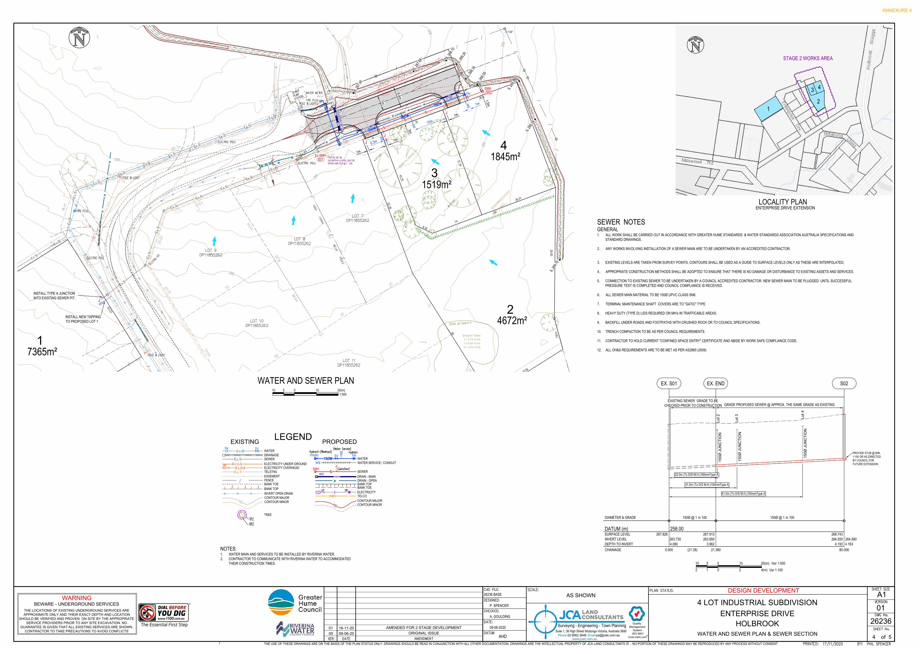
ELECTRICITY
PROPOSED
WATER
DRAIN - MAIN
LEGEND
EXISTING
PIT
FH(W) SV FH
SEWER
TELCO
WS
FENCE
ELECTRICITY OVERHEAD
BANK TOP
WATERDRAINAGESEWERELECTRICITY UNDER GROUND
BANK TOE
EASEMENT
INVERT OPEN DRAIN
TELSTRA
TREE
SMHJ
CONTOUR MAJORCONTOUR MINOR
CONTOUR MAJORCONTOUR MINOR 150
150
WATER SERVICE / CONDUITWS
DRAIN - OPENBANK TOPBANK TOE
WS
WS
WS
J
FH
J
J
1
7365m²
2
4672m²
3
1519m²
4
1845m²S01Ex.SMH
S02
TOP RL 267.95US DEPTH 4.215 RL 263.735SPUR LINE 20.3 @ 1 : 100
J
WS
SMH
M
A
R
K
E
R
P
O
S
T
P
I
T
U
N
C
L
D
B
H
1
m
,
B
u
t
t
r
e
s
s
2
m
S
T
U
M
P
S
T
U
M
P
G
U
M
T
R
E
E
375Ø
375Ø
300x900RCBC
IL 26
9.70
IL 26
9.35
IL 26
9.00IL 26
8.55
IL 26
8.30
IL 26
8.20
IL 26
8.10
IL 26
7.68
IL 26
7.45
26926
8
268
268
269
269
268
258.00
150Ø @ 1 in 100
(21.38)
267.826
0.000
EX. S01
150Ø @ 1 in 100
267.913
21.380
263.9503.962
EX. END
268.743
80.006
264.5504.193
S02
CHAINAGE
SURFACE LEVELINVERT LEVELDEPTH TO INVERT
DIAMETER & GRADE
DATUM (m)
PROVIDE STUB @ MIN.1:100 OR AS DIRECTEDBY COUNCIL FORFUTURE EXTENSION
Lot 2
150Ø JUNCTION
263.7354.090
22.0m (To D/S M.H.)150mmType A
31.0m (To D/S M.H.)150mmType A
61.0m (To D/S M.H.)150mmType A
Lot 3
150Ø JUNCTION
Lot 4
150Ø JUNCTION
EXISTING SEWER GRADE TO BECHECKED PRIOR TO CONSTRUCTION GRADE PROPOSED SEWER @ APPROX. THE SAME GRADE AS EXISTING
264.5804.163
SEWER NOTESGENERAL1. ALL WORK SHALL BE CARRIED OUT IN ACCORDANCE WITH GREATER HUME STANDARDS & WATER STANDARDS ASSOCIATION AUSTRALIA SPECIFICATIONS AND
STANDARD DRAWINGS.
2. ANY WORKS INVOLVING INSTALLATION OF A SEWER MAIN ARE TO BE UNDERTAKEN BY AN ACCREDITED CONTRACTOR.
3. EXISTING LEVELS ARE TAKEN FROM SURVEY POINTS, CONTOURS SHALL BE USED AS A GUIDE TO SURFACE LEVELS ONLY AS THESE ARE INTERPOLATED.
4. APPROPRIATE CONSTRUCTION METHODS SHALL BE ADOPTED TO ENSURE THAT THERE IS NO DAMAGE OR DISTURBANCE TO EXISTING ASSETS AND SERVICES.
5. CONNECTION TO EXISTING SEWER TO BE UNDERTAKEN BY A COUNCIL ACCREDITED CONTRACTOR. NEW SEWER MAIN TO BE PLUGGED UNTIL SUCCESSFULPRESSURE TEST IS COMPLETED AND COUNCIL COMPLIANCE IS RECEIVED.
6. ALL SEWER MAIN MATERIAL TO BE 150Ø UPVC CLASS SN8.
7. TERMINAL MAINTENANCE SHAFT COVERS ARE TO "GATIC" TYPE
8. HEAVY DUTY (TYPE D) LIDS REQUIRED ON MH's IN TRAFFICABLE AREAS.
9. BACKFILL UNDER ROADS AND FOOTPATHS WITH CRUSHED ROCK OR TO COUNCIL SPECIFICATIONS.
10. TRENCH COMPACTION TO BE AS PER COUNCIL REQUIREMENTS.
11. CONTRACTOR TO HOLD CURRENT "CONFINED SPACE ENTRY" CERTIFICATE AND ABIDE BY WORK SAFE COMPLIANCE CODE.
12. ALL OH&S REQUIREMENTS ARE TO BE MET AS PER AS2865 (2009)
WARNING
BEWARE - UNDERGROUND SERVICES
THE LOCATIONS OF EXISTING UNDERGROUND SERVICES ARE
APPROXIMATE ONLY AND THEIR EXACT DEPTH AND LOCATION
SHOULD BE VERIFIED AND PROVEN ON SITE BY THE APPROPRIATE
SERVICE PROVIDERS PRIOR TO ANY SITE EXCAVATION. NO
GUARANTEE IS GIVEN THAT ALL EXISTING SERVICES ARE SHOWN.
CONTRACTOR TO TAKE PRECAUTIONS TO AVOID CONFLICTS
WATER AND SEWER PLAN & SEWER SECTION
4
A1
01
HOLBROOK
4 LOT INDUSTRIAL SUBDIVISION
ENTERPRISE DRIVE
26236
DESIGN DEVELOPMENT
P. SPENCER
A. GOULDING
26236 BASE
09-06-2020
AHDof 5
Surveying - Engineering - Town Planning
www.jcalc.com.au
Quality
Management
System
ISO 9001
trust-mark.com
®
Suite 1, 38 High Street Wodonga Victoria, Australia 3690Phone 02 6062 3648 Email [email protected]
THE USE OF THESE DRAWINGS ARE ON THE BASIS OF THE PLAN STATUS ONLY. DRAWINGS SHOULD BE READ IN CONJUNCTION WITH ALL OTHER DOCUMENTATION. DRAWINGS ARE THE INTELLECTUAL PROPERTY OF JCA LAND CONSULTANTS © - NO PORTION OF THESE DRAWINGS MAY BE REPRODUCED BY ANY PROCESS WITHOUT CONSENT
00 09-06-20
ORIGINAL ISSUE
01 16-11-20
AMENDED FOR 2 STAGE DEVELOPMENT
12
3 4
LOCALITY PLANENTERPRISE DRIVE EXTENSION
INSTALL NEW TAPPINGTO PROPOSED LOT 1
WATER AND SEWER PLAN
7m
9.4m
1m
1m
1m
0.3m
15m
1m
NOTES:1. WATER MAIN AND SERVICES TO BE INSTALLED BY RIVERINA WATER.2. CONTRACTOR TO COMMUNICATE WITH RIVERINA WATER TO ACCOMMODATED
THEIR CONSTRUCTION TIMES.
3m
1.5m
8m
AS SHOWN
010 51:500
10 20(m)
INSTALL TYPE A JUNCTIONINTO EXISTING SEWER PIT.
2 110 5
0 2 4(m) Ver 1:100
Hor 1:5000 10 20(m)
STAGE 2 WORKS AREA
ANNEXURE 4
AutoCAD SHX Text
Hydrant-(Washout)
AutoCAD SHX Text
SV
AutoCAD SHX Text
FH
AutoCAD SHX Text
LP
AutoCAD SHX Text
(Junction)
AutoCAD SHX Text
(Water Service)
AutoCAD SHX Text
Hydrant
AutoCAD SHX Text
LP
AutoCAD SHX Text
TPZ
AutoCAD SHX Text
SP
AutoCAD SHX Text
SRZ
AutoCAD SHX Text
POLE & LIGHT
AutoCAD SHX Text
ELECTRIC POLE
AutoCAD SHX Text
FIRE PLUG
AutoCAD SHX Text
FIRE PLUG
AutoCAD SHX Text
WATER METER
AutoCAD SHX Text
POLE & LIGHT
AutoCAD SHX Text
TELSTRA PIT
AutoCAD SHX Text
TELSTRA PIT
AutoCAD SHX Text
TAP
AutoCAD SHX Text
ELECTRIC POLE
AutoCAD SHX Text
ELECTRIC POLE
AutoCAD SHX Text
POLE & LIGHT
AutoCAD SHX Text
HIGH CHAIN MESH FENCE
AutoCAD SHX Text
SEWER PUMP STATION
AutoCAD SHX Text
Group of Trees:
AutoCAD SHX Text
2 x 0.7m trunk
AutoCAD SHX Text
1 x 0.5m trunk
AutoCAD SHX Text
6 x 0.3m trunk
AutoCAD SHX Text
4.15
AutoCAD SHX Text
32.38
AutoCAD SHX Text
32.38
AutoCAD SHX Text
31.09
AutoCAD SHX Text
25.22
AutoCAD SHX Text
29.17
AutoCAD SHX Text
38.46
AutoCAD SHX Text
25
AutoCAD SHX Text
15.225
AutoCAD SHX Text
10
AutoCAD SHX Text
20
AutoCAD SHX Text
10
AutoCAD SHX Text
100.56
AutoCAD SHX Text
18.91
AutoCAD SHX Text
69.416
AutoCAD SHX Text
65.26
AutoCAD SHX Text
33
AutoCAD SHX Text
33
AutoCAD SHX Text
EDGE OF CANOPY
AutoCAD SHX Text
100
AutoCAD SHX Text
70.83
AutoCAD SHX Text
77.15
AutoCAD SHX Text
38.69
AutoCAD SHX Text
38.46
AutoCAD SHX Text
50
AutoCAD SHX Text
50
AutoCAD SHX Text
25
AutoCAD SHX Text
25
AutoCAD SHX Text
LOT 7 DP11855262
AutoCAD SHX Text
LOT 8 DP11855262
AutoCAD SHX Text
LOT 9 DP11855262
AutoCAD SHX Text
LOT 10 DP11855262
AutoCAD SHX Text
LOT 11 DP11855262
AutoCAD SHX Text
VER.
AutoCAD SHX Text
DATE
AutoCAD SHX Text
SHEET No.
AutoCAD SHX Text
SHEET SIZE
AutoCAD SHX Text
AMENDMENT
AutoCAD SHX Text
DWG No.
AutoCAD SHX Text
VERSION
AutoCAD SHX Text
PRINTED:
AutoCAD SHX Text
BY:
AutoCAD SHX Text
PLAN STATUS:
AutoCAD SHX Text
SCALE:
AutoCAD SHX Text
DESIGNED:
AutoCAD SHX Text
CHECKED:
AutoCAD SHX Text
CAD FILE:
AutoCAD SHX Text
DATE:
AutoCAD SHX Text
DATUM
AutoCAD SHX Text
17/11/2020
AutoCAD SHX Text
PHIL SPENCER

CHAINAGE
EXISTING SURFACE LEVEL
DESIGN SURFACE LEVEL
DESIGN INVERT LEVEL
HYDRAULIC GRADE LINE
DEPTH TO INVERT
GRADE
PIPE DIAMETER (mm)
DESIGN FLOW (m3/s)CAPACITY (m3/s)AT GRADE VELOCITY (m/s)
(Reach Length)
DATUM 263.0
900x300Ø
1 in 120
0.3550.4421.31
(10.804)
267.5
3526
8.200
0.000
267.3
6026
7.360
0.840
0.840
267.5
67
267.9
0126
8.290
10.80
426
7.450
0.840
267.7
0126
7.789
265.0
375Ø
1 in 79.6
0.0000.197
0
(11.947)
268.7
6626
9.790
0.000
268.5
0026
8.500
268.5
00
268.9
8526
9.920
11.94
726
8.650
268.6
50
A1 A2 D1 D2
263.0
375Ø
1 in 140
0.0620.1480.56
(8.400)
267.8
9926
8.210
0.000
267.5
000.7
1026
7.669
B1
267.8
9326
8.270
8.400
267.5
600.7
1026
7.740
267.7
56
B2
263.0
375Ø
1 in 93.4
0.0000.182
0
(8.403)
268.1
9726
8.480
0.000
267.7
8026
7.780
0.700
0.700
267.7
80
C1
268.4
0926
7.919
8.403
267.8
7026
7.870
C2
CRUSHED ROCK BACKFILL
EW EW EW EW EW EW
ENTERPRISEDRIVE
CLASS 4 CLASS 4 EXISTING PIPEWORK
2
4672m²
3
1519m²
4
1845m²
0.722
0.468
0.336
0.404
M
A
R
K
E
R
P
O
S
T
P
I
T
U
N
C
L
S
T
U
M
P
S
T
U
M
P
TOTAL CATCHMENT 2.34Ha
0.276
0.127
26926
8
268
268
269
269
268
267
WARNING
BEWARE - UNDERGROUND SERVICES
THE LOCATIONS OF EXISTING UNDERGROUND SERVICES ARE
APPROXIMATE ONLY AND THEIR EXACT DEPTH AND LOCATION
SHOULD BE VERIFIED AND PROVEN ON SITE BY THE APPROPRIATE
SERVICE PROVIDERS PRIOR TO ANY SITE EXCAVATION. NO
GUARANTEE IS GIVEN THAT ALL EXISTING SERVICES ARE SHOWN.
CONTRACTOR TO TAKE PRECAUTIONS TO AVOID CONFLICTS
PIPE DRAINAGE SECTIONS, PIT SCHEDULE, CATCHMENT PLAN
5
A1
01
HOLBROOK
4 LOT INDUSTRIAL SUBDIVISION
ENTERPRISE DRIVE
26236
DESIGN DEVELOPMENT
P. SPENCER
A. GOULDING
26236 BASE
09-06-2020
AHDof 5
Surveying - Engineering - Town Planning
www.jcalc.com.au
Quality
Management
System
ISO 9001
trust-mark.com
®
Suite 1, 38 High Street Wodonga Victoria, Australia 3690Phone 02 6062 3648 Email [email protected]
THE USE OF THESE DRAWINGS ARE ON THE BASIS OF THE PLAN STATUS ONLY. DRAWINGS SHOULD BE READ IN CONJUNCTION WITH ALL OTHER DOCUMENTATION. DRAWINGS ARE THE INTELLECTUAL PROPERTY OF JCA LAND CONSULTANTS © - NO PORTION OF THESE DRAWINGS MAY BE REPRODUCED BY ANY PROCESS WITHOUT CONSENT
00 09-06-20
ORIGINAL ISSUE
01 16-11-20
AMENDED FOR 2 STAGE DEVELOPMENT
DRAINAGE STRUCTURE SCHEDULEPit INLET OUTLET PIT
REMARKSName TYPE EASTING NORTHING WIDTH x HEIGHT/ DIA (mm) INV LEV WIDTH x HEIGHT
/ DIA (mm) INV LEVENDWALL
RL (Approx.)
A1 EW 529037.711 6050828.096 900 x 300 267.36 268.20 NSW ROADS & MARITIME SERVICES STANDARDS FORCAST INSITUE ENDWALLS.
A2 EW 529040.230 6050817.595 900 x 300 267.45 268.29B1 EW 529048.943 6050818.285 375 267.50 268.20 PRECAST ENDWALLB2 EW 529056.815 6050821.217 375 267.56 268.26 PRECAST ENDWALLC1 EW 529086.283 6050832.172 375 267.78 268.48 PRECAST ENDWALLC2 EW 529094.149 6050835.117 375 267.87 268.57 PRECAST ENDWALLD1 EW 528930.992 6050776.719 375 268.50 NO ENDWALL REQUIRED, USE EXISTING PE PIPWORK
D2 EW 528929.933 6050764.780 375 268.65 NO ENDWALL REQUIRED, USE EXISTING PE PIPWORK
375Ø
EWA1
EWB1
EWB2
EWC1
EWC2
375Ø
300x900RCBC
EWA2LOW POINT IN
ROADWAY
CULVERT AAREA
(Ha)C
(COEFFICIENT)ARI
(YEARS)Tc
(mins)I
(mm/hr)Qa (m³/s)=(CIA/360)
2.34 0.70 10 12 77 0.35
CATCHMENT PLAN
DRAINAGE DESIGN PARAMETERS
· COEFFICIENT OF RUNOFF - ROAD RESERVE = 0.70
· COEFFICIENT OF RUNOFF - INDUSTRIAL LOT = 0.70
· FLOW RATE IN GUTTER / PIPE TO BE 1m/s MINIMUM
· Tc - ROAD RESERVE FOOTPATH - 5min. WETTING TIME & 7min GUTTER / PIPE,
OVERLAND FLOW TRAVEL.
· RAINFALL INTENSITY - FROM ALBURY - WODONGA RAINFALL INTENSITY TABLE
· PIPE DESIGN FOR A 1 IN 10 YEAR STORM
· PIPE MANNINGS - RCP .013
ENTERPRISE DRIVE
AS SHOWN
ANNEXURE 4
AutoCAD SHX Text
HIGH CHAIN MESH FENCE
AutoCAD SHX Text
HIGH CHAIN MESH FENCE
AutoCAD SHX Text
EDGE OF CANOPY
AutoCAD SHX Text
LOT 7 DP11855262
AutoCAD SHX Text
LOT 8 DP11855262
AutoCAD SHX Text
LOT 9 DP11855262
AutoCAD SHX Text
LOT 10 DP11855262
AutoCAD SHX Text
LOT 11 DP11855262
AutoCAD SHX Text
LOT 12 DP11855262
AutoCAD SHX Text
S3 - EASEMENT FOR DRAINAGE OF SEWAGE 3 WIDE (DP1176955)
AutoCAD SHX Text
VER.
AutoCAD SHX Text
DATE
AutoCAD SHX Text
SHEET No.
AutoCAD SHX Text
SHEET SIZE
AutoCAD SHX Text
AMENDMENT
AutoCAD SHX Text
DWG No.
AutoCAD SHX Text
VERSION
AutoCAD SHX Text
PRINTED:
AutoCAD SHX Text
BY:
AutoCAD SHX Text
PLAN STATUS:
AutoCAD SHX Text
SCALE:
AutoCAD SHX Text
DESIGNED:
AutoCAD SHX Text
CHECKED:
AutoCAD SHX Text
CAD FILE:
AutoCAD SHX Text
DATE:
AutoCAD SHX Text
DATUM
AutoCAD SHX Text
17/11/2020
AutoCAD SHX Text
PHIL SPENCER
AutoCAD SHX Text
1:1000
AutoCAD SHX Text
0
AutoCAD SHX Text
20
AutoCAD SHX Text
10
AutoCAD SHX Text
20
AutoCAD SHX Text
40(m)
TOURISM AND PROMOTIONS REPORT - JULY 2021Prepared by: Kerrie Wise, Executive Assistant, Governance, Tourism and Promotions
Page 1 of 4
Greater Hume Council Websites
Delivery Plan - 1.1.2.1 Objective - Engagement by Council to demonstrate Council leadership. (Continued implementation of the GHC Communication Plan.) (Maintain and manage the Greater Hume Council suite of websites which are compliant with accessibility standards. Seamless CMS(OpenCities) is the provider of Council’s websites – Greater Hume Council, Visit Greater Hume, Greater Hume Children Services and Town and Village websites.)Comments
Greater Hume greaterhume.nsw.gov.au
GH Children Servicesghchildren.com.au
Visit Greater Humevisitgreaterhume.com.au
July 2021 21 20 21 20 21Website Traffic
New 4063 3236 591 200 403Returning 1440 1081 342 130 37
Traffic Source
Organic 3396 2952 277 195 221Direct 919 722 220 109 97Referral 573 215 404 19 98Social 165 47 32 7 3
Device PathsDesktop 2508 2062 453 152 222Mobile 2208 1621 461 170 164Tablet 175 189 19 8 27
Bounce Rate % 55.20 58.12 30.01 50.00 70.76
www.greaterhume.nsw.gov.au - top pages:1. Your Greater Hume Council – Building and Development2. Living in Greater Hume – Waste Facilities Opening Times Charges and Accepted Waste3. Your Greater Hume Council – Careers with Us4. Contact Us5. Living in Greater Hume - COVID 19 Information Greater Hume area
www.ghchildren.com.au – top pages:1. Family Day Care2. Featured Content – Children and Families3. Family Day Care – Enrol Your Child/Children4. Holbrook Centre - Enrol Your Child/Children5. Contact Us
www.visitgreaterhume.com.au – top pages:1. Featured Content - Natural Wonders - Morgan’s Lookout2. Featured Content – Planning Trips and Tours3. Featured Content – Be Inspired4. Holbrook5. Featured Content – Natural Wonders
Social Media
Delivery Plan - 1.1.2.1 Objective - Engagement by Council to demonstrate Council leadership. (Continued implementation of the GHC Communication Plan.) Implement and enhance on line communication tools using technologies such as social net-working mechanism. Comments• Instagram, #visitgreaterhume – 828 followers• Individual facebook pages:
• Greater Hume Council – 2590 followers• Greater Hume Visitor Information Centre – 565 followers• Holbrook Submarine Museum – 1118 followers• Greater Hume Children’s Services – 871 followers• Greater Hume Youth Advisory Committee – 426 followers• Buy Local in Greater Hume – 501 followers
ANNEXURE 5

Page 2 of 4 Tourism and Promotions Report - Kerrie Wise
Greater Hume Council Newsletters
Delivery Plan - 1.2.1.1 Objective - Implement the planned community engagement processes using various communication strategies. (Develop two Council newsletters (Autumn and Spring) and a rates notice insert whilst ensuring effective and targeted content.)CommentsThe Greater Hume Council News Rates Insert has been sent out with all Greater Hume Rate Notices. This includes information on 2021-2022 budget highlights, amounts each Council department is receiving from budget, grants and funding obtained from previous financial year, information on constitutional referendum and other information for residents and ratepayers.
Grants and Funding
Delivery Plan - 3.2.1.2, 4.1.1.1Objective - Continue to support and develop sporting faciliteis and other community infrastructure. Identify opportu-nities for external grant funding. CommentsThe following grant applications have been recently submitted:
Name About CurrentAustrade’s Regional Tourism Bushfire Recovery Grant – Stream One - $30,000 – Greater Hume and Henty Machinery Field Days Promotional Production
This project will be developing and promoting the videos, photography, social media posts, advertising and Hume Highway signage in order to attract vis-itors both old and new to Greater Hume and Henty Machinery Field Days.
Development of Hume High-way signage in conjunction.Seeking to extend grant to 2022 in light of recent COVID 19 restrictions.
Create NSW - Regional Cultural Fund - Digitisation Round – $332,745 - In partnership with Albury City (lead agency)) - Murray Region Digitisation Hub
The Project involves the engagement of a Digitisation Project Officer and development of a Digitisation Hub (Thurgoona Collection Store, 2 Hoffman Road, Thurgoona) to implement professional training programs for individual museums and facilitating the digitisation of at least 400 objects. AlburyCity is lead agent.
Hayley Lander, Digitisation Project Officer has commenced work overseeing the development of the Digitisation Hub, training and support to the museums during this project.
Museums & Galleries NSW - $13,000
Greater Hume has engaged Nomad Films to research, develop, film and edit a 6 episode web series focused on the interpretation of objects and stories from each of the community museums, Culcairn Station Masters House Museum, Headlie Taylor Header Museum, Holbrook Submarine Museum, Holbrook Woolpack Inn Museum, Jindera Pioneer Museum and Wymah Schoolhouse Museum.
Artist contracts with Helen Newman and Alyson Evans from Nomad Films (http://www.nomadfilms.com.au/) are finalised. Helen and Aly-son are currently meeting with all the museum volunteers to organise stories. Filming will take place over the next 3 months.
NSW Government - Bushfire Local Economy Recovery Fund - $451,054 – Hanel’s Lookout
This project at Hanel’s Lookout (Woomargama National Park) will create viewing platforms, walk ways, sealed car park, sealed Hanel’s Road, toilet, picnic area and signage.
Submitted, Awaiting Outcome
Stronger Country Communi-ties Fund - Round 4
11 applications were submitted from various com-munity groups and 9 GH Council applications. Totaling $3,224,567.00
Awaiting Outcome
Crown Reserves Grant 4 applications from community groups were submit-ted. Totaling over $800,000.
Awaiting Outcome
ANNEXURE 5

Page 3 of 4 Tourism and Promotions Report - Kerrie Wise
Greater Hume Tourism
Delivery Plan - 3.3.1.1Objective - Implement the Greater Hume Visitor Experience Plan which was endorsed March 2014 by Greater Hume Council.Comments• Monthly newsletters are being sent to all Greater Hume Tourism Operators, providing latest information on
COVID 19, tourism opportunities, marketing, social media and promotional campaigns as well as relevant contacts and statistics.
• Currently managing 154 Greater Hume ATDW Listings. The Australian Tourism Data Warehouse (ATDW) is Australia’s national platform for digital tourism marketing in Australia. Established in 2001, the ATDW is jointly owned and managed by all Australian state and territory government tourism bodies. ATDW distributes this information to over 60 partners’ websites to support local tourism businesses in expanding their on line exposure, bookings and marketing.
• Scheduled a six month social media Welcome to Greater Hume, providing tours and ideas of what people can do in Greater Hume between August 2021 and February 2022.
Visitor Information Centre and Submarine Museum
Delivery Plan - 3.3.1.1.06, 3.3.1.1.05Objective - Offering visitors to Greater Hume information and advice on accommodation, places to eat, attractions, maps, tours, road conditions, events and other general information. Reception and admission to Submarine Museum.CommentsVisitor Information Centre Statistics:July 2021 - Walk In – 355, Phone Calls - 15, Emails – 5.July 2019 - Walk In – 744, Phone Calls - 19, Emails – 0.
Submarine Museum Statistics:July 2021 - Adult - 43, Child - 24, Concession - 19, Family – 27, Group – 0, Total - 113.July 2019 - Adult - 40, Child - 47, Concession - 99, Family – 52, Group –26, Total - 264.
Events
Delivery Plan - 3.3.1.1, 2.1.1.1 Objective - To assist with the promotion of Greater Hume’s many and varied events. Encourage more residents to be involved in Greater Hume and events.
CommentsSupporting the following events - Battle of the Border (Carriage Driving), Henty Machinery Field Days and various library events.
Australia Day
Delivery Plan - 1.1.2.7 and 2.1.1.1 Objective - Recognise community leaders and their efforts and encourage others in the community to take up leadership roles.
CommentsA meeting is planned with Rotary Club of Holbrook to commence planning for Greater Hume Australia Day celebrations at Holbrook.
ANNEXURE 5

Page 4 of 4 Tourism and Promotions Report - Kerrie Wise
Promotions
Delivery Plan - 3.3.1.1Objective - Implement the Greater Hume Visitor Experience Plan which was endorsed March 2014 by Greater Hume Council.CommentsEmailed ‘What’s On in July’ to Visitor Information Centres in NSW and VIC, coach/bus/tour companies, tourism operators within shire and regional, media, visitor information points and to interested residents in shire.Developing and have commenced rolling out of social media tiles on towns and villages, tours and itineraries.Organised a 1/2 page advert and editorial in Regional Lifestyle magazine for Spring edition.Organised adverts in Culcairn and Walbundrie Agricultural Show Schedules.
Signage
Delivery Plan - 3.3.1.1Objective - Implement the Greater Hume Visitor Experience Plan which was endorsed March 2014 by Greater Hume Council.CommentsCurrently organising visit Greater Hume signage on Hume Highway.
Murray Regional Tourism (MRT)
Delivery Plan - 3.3.1.1Objective - Implement the Greater Hume Visitor Experience Plan which was endorsed March 2014 by Greater Hume Council. (MRT is a joint venture between Albury, Balranald, Berrigan, Campaspe, Corowa, Deniliquin, Gannawarra, Greater Hume, Mildura, Moira, Murray, Swan Hill, Wakool, Wodonga, as well as Tourism Vic and Destination NSW.)Comments• Currently attending monthly zoom meetings with MRT and the VIC network group.• Planning to extend the Love The Murray campaign and cooperative marketing initiatives.• Continuous advocacy during the COVID 19 crisis.
Museums and Heritage
Delivery Plan - 3.3.1.1Objective - Implement the Greater Hume Visitor Experience Plan which was endorsed March 2014 by Greater Hume Council. (GHC currently has 11 public or private museums and three historical societies. Museum Advisor (Vanessa Keenan) – In partnership with Albury City Council and Museums and Galleries NSW.)CommentThe Museum Adviser has been engaged again for 2021. During Dec and Jan we have applied for two grants and have been successful in obtaining both, see Grants and Funding for more information.
Murray Arts
Delivery Plan - 3.3.1.1Objective - Implement the Greater Hume Visitor Experience Plan which was endorsed March 2014 by Greater Hume Council. (Murray Arts aim is to actively assist the ongoing development of, and participation in, arts and cul-ture throughout the Border region.)CommentHave been appointed to the Murray Arts Strategic Advisory Council (MASAC), which meets twice a year and sits alongside the Murray Arts Board to guide the direction of the organisation towards achieving its goals.
ANNEXURE 5
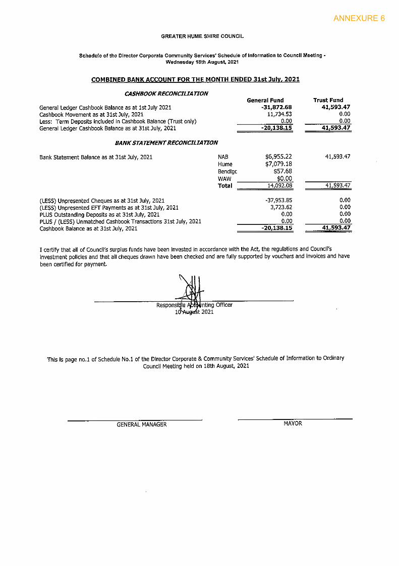
ANNEXURE 6
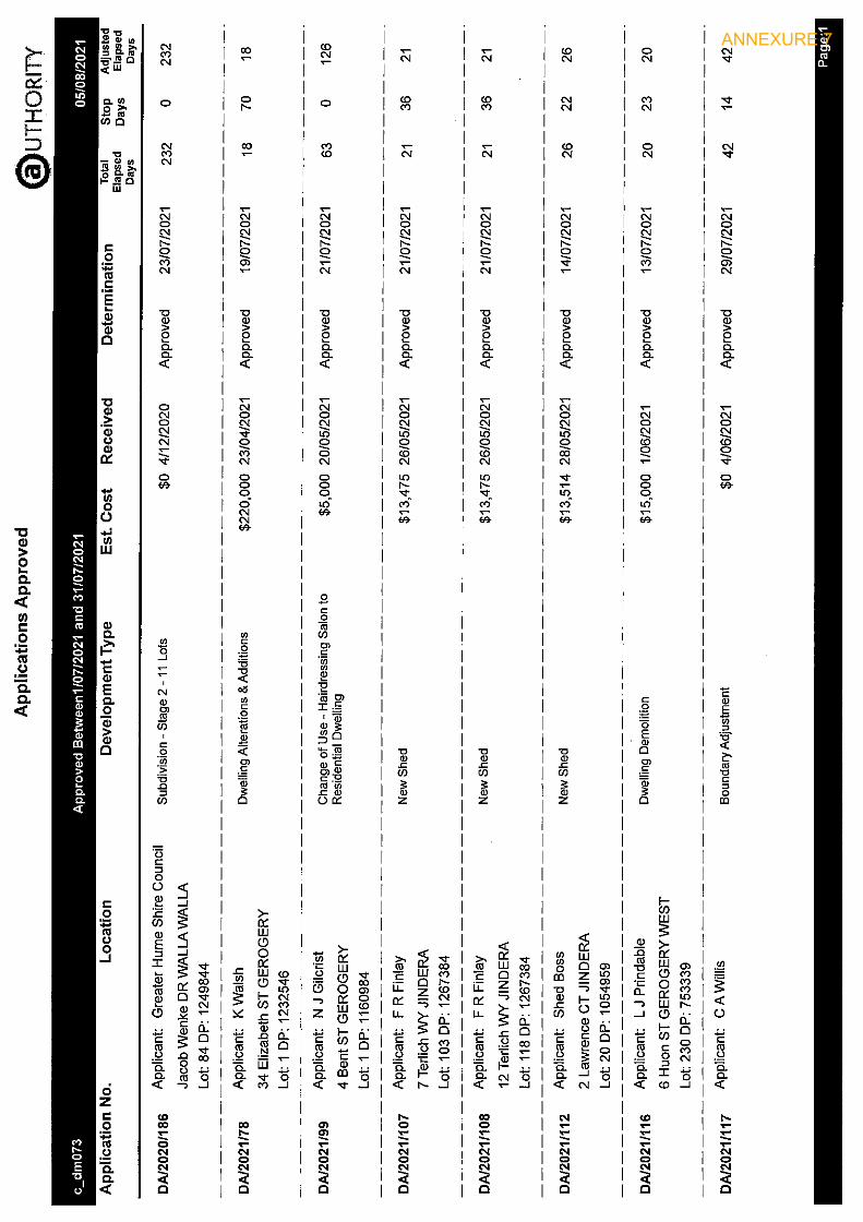
ANNEXURE 7

ANNEXURE 7

ANNEXURE 7

ANNEXURE 7

GREATER HUME COUNCIL
AUDIT, RISK & IMPROVEMENT COMMITTEE
Chairman’s Summary – August 2021
Introduction We welcomed Brad Bohun of Crowe Horwath (external audit contractors, by Zoom), Matthew Knox of National Audits (internal auditor) and Damien Connell of Statewide Mutual to the meeting.
External Audit Brad Bohun summarised the contents of the interim management letter, noting that the few items listed indicated that Council’s basic financial controls were operating well. The Committee noted that the resolution of some items was being delayed by time constraints but he advised that all indications are that Council will complete its Annual Financial Statements well within the required timeframes.
Internal Audit The internal audit report on Plant Operations prompted extensive discussion, more from the point of view of plant operations generally than from the direct results of the assignment. Points raised by members included the following:
• A summary of plant working accounts for all plant items should be considered by Manex at least annually.
• Allocation of funding to Plant Replacement Reserve each year should be based on the forward plant replacement requirements rather than plant operating results.
• Data used by plant managers must align with financial data, and this is enhanced by use of hourmeter / odometer rates rather than composite rates.
• End of year plant working accounts should be balanced as near as practicable to avoid late adjustments to capitalised cost on construction jobs.
• There is a clear distinction between internal hire rates, which are cost price, and grant and private hire rates, which are selling prices.
The Committee was of the view that Council should conduct a strategic review of plant operations, but that given current resource pressures this should be deferred until adequate resources become available.
Other Reports General Manager’s Verbal Report At each meeting the General Manager provides a verbal report principally directed at any protected disclosures, to the extent that the confidentiality provisions of the relevant legislation permits.
Statewide Mutual Continuous Improvement Program Damien Connell provided a comprehensive report on the results of the CIP for building assets, event management, footpaths and motor vehicles. The Committee was particularly pleased to note the results for evets management, described by Damien as the best in the region, following the internal audit assignment completed shortly before, and commended Risk Officer, Jackie Lister.
Being an improvement program, there were many specific improvements (44) listed, many of which were minor or assessed as low risk. The Committee decided to limit its formal follow up, in the first instance, to those items assessed as high risk or above with a targeted completion date within the next 12 months. The remaining items will be reviewed for inclusion in 12 months time.
ANNEXURE 8

Risk / WHS Committee Minutes The Chairman noted that the Committee at present is not taking any specific action to satisfy itself that the risks relating to WHS are being appropriately addressed, and suggested that review of Risk/WHS Committee minutes and the Statecover Self-Audit Report should adequately serve this purpose, and this was agreed to.
Committee Operations Annual Report to Council The Committee’s Annual Report to Council was adopted and I will attend at the next Council meeting both to formally present the report and to answer any questions Councillors may have about the Committee’s operations.
Audit Committee Follow-up Matrix The Committee reviewed progress in giving effect to accepted recommendations, and noted the completion of a number of items.
David G Maxwell ARIC Chairman
ANNEXURE 8

MINUTES GREATER HUME COUNCIL AUDIT, RISK AND IMPROVEMENT COMMITTEE,
HELD ON 3 AUGUST 2021
PRESENT
David Maxwell – Independent Chairperson John Batchelor – Independent Committee Member Cr Tony Quinn – Councillor, Greater Hume Council Matthew Knox – Internal Cr Heather Wilton – Mayor, Greater Hume Council Auditor Provider, Cr Lea Parker – Councillor, Greater Hume Council Steven Pinnuck – General Manager, Greater Hume Council (from 11am) Matthew Knox – Internal Audit Provider, National Audits Group (for Item 6) Jackie Lister – Risk Officer, Greater Hume Council Damian Connell – Regional Risk Manager – Statewide Mutual
APOLOGIES
Dean Hart – Chief Financial Officer, Greater Hume Council
1. WELCOME AND APOLOGIES Apology received from Dean Hart.
RESOLVED [Cr Wilton/John Batchelor] That the apology from Dean Hart be accepted.
2. ACKNOWLEDGEMENT OF COUNTRY
Chairperson offered an Acknowledgement of Country at the commencement of the meeting: “I acknowledge that this meeting is being held on the traditional lands of the Wiradjuri people, and pay my respect to elders both past and present”.
3. DECLARATIONS OF INTEREST
Nil
4. CONFIRMATION OF MINUTES OF THE PREVIOUS MEETING 4 MAY 2021
RESOLVED [Cr Quinn/Cr Wilton] That the Minutes of the Greater Hume Council Audit, Risk and Improvement Committee meeting held on 4 May 2021 as printed and circulated be confirmed as a true and correct record of the proceedings of the meetings.
5. BUSINESS ARISING FROM PREVIOUS MINUTES
Nil
6. EXTERNAL AUDIT
a) Interim Management Letter 2021
Interim Management Letter as issued by NSW Audit Office was tabled. Brad Bohun provided the Committee with an overview of the key matters raised in the report.
ANNEXURE 8
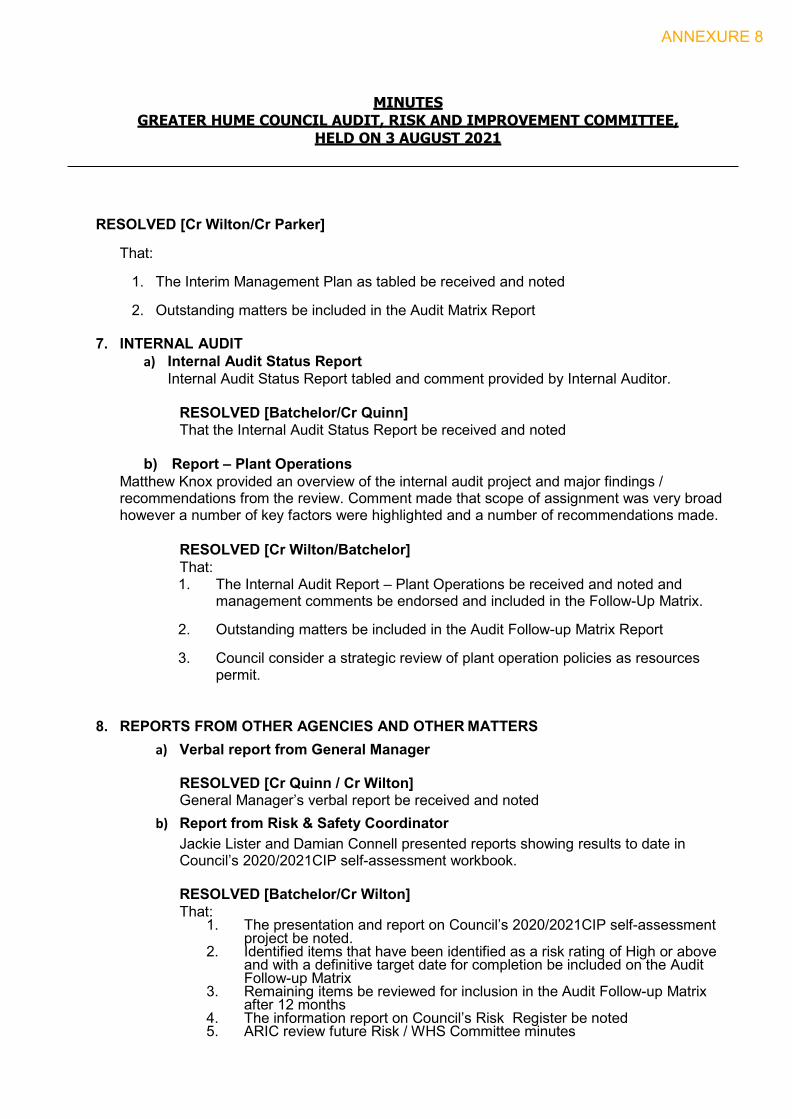
MINUTES GREATER HUME COUNCIL AUDIT, RISK AND IMPROVEMENT COMMITTEE,
HELD ON 3 AUGUST 2021
RESOLVED [Cr Wilton/Cr Parker]
That:
1. The Interim Management Plan as tabled be received and noted
2. Outstanding matters be included in the Audit Matrix Report
7. INTERNAL AUDIT a) Internal Audit Status Report
Internal Audit Status Report tabled and comment provided by Internal Auditor.
RESOLVED [Batchelor/Cr Quinn] That the Internal Audit Status Report be received and noted
b) Report – Plant Operations
Matthew Knox provided an overview of the internal audit project and major findings / recommendations from the review. Comment made that scope of assignment was very broad however a number of key factors were highlighted and a number of recommendations made. RESOLVED [Cr Wilton/Batchelor]
That: 1. The Internal Audit Report – Plant Operations be received and noted and
management comments be endorsed and included in the Follow-Up Matrix.
2. Outstanding matters be included in the Audit Follow-up Matrix Report
3. Council consider a strategic review of plant operation policies as resources permit.
8. REPORTS FROM OTHER AGENCIES AND OTHER MATTERS a) Verbal report from General Manager
RESOLVED [Cr Quinn / Cr Wilton] General Manager’s verbal report be received and noted
b) Report from Risk & Safety Coordinator Jackie Lister and Damian Connell presented reports showing results to date in Council’s 2020/2021CIP self-assessment workbook.
RESOLVED [Batchelor/Cr Wilton] That:
1. The presentation and report on Council’s 2020/2021CIP self-assessment project be noted.
2. Identified items that have been identified as a risk rating of High or above and with a definitive target date for completion be included on the Audit Follow-up Matrix
3. Remaining items be reviewed for inclusion in the Audit Follow-up Matrix after 12 months
4. The information report on Council’s Risk Register be noted 5. ARIC review future Risk / WHS Committee minutes
ANNEXURE 8

MINUTES GREATER HUME COUNCIL AUDIT, RISK AND IMPROVEMENT COMMITTEE,
HELD ON 3 AUGUST 2021
9. COMMITTEE OPERATIONS a) Draft ARIC Report to Council
RESOLVED [Batchelor/Cr Wilton] That the ARIC Report to Council 30 June 2021 be endorsed and presented to the August 2021 meeting of Council.
b) Audit Committee Follow up Matrix RESOLVED [John Batchelor/Cr Parker] That the Audit Follow-Up Matrix be received and noted
10. NEXT MEETING 7 September 2021
There being no further business the meeting closed at 12.07pm (NOTE: All meetings will commence 10am at the Culcairn Chambers)
ANNEXURE 8