Ancient dams, settlement archaeology and Buddhist propagation in central India: the hydrological...
15
Hydrological Sciences–Journal–des Sciences Hydrologiques, 48(2) April 2003 * Based on a paper presented at: OH2—First International Symposium on the Origins and History of Hydrology (Dijon, France, 9–11 May 2001). Open for discussion until 1 October 2003 277 Ancient dams, settlement archaeology and Buddhist propagation in central India: the hydrological background * JULIA SHAW Merton College, Oxford OX1 4JD, UK and Institute of Archaeology, Oxford OX1 2PG, UK [email protected] JOHN SUTCLIFFE Heath Barton, Manor Road, Goring on Thames, near Reading, RG8 9EH, UK [email protected] Abstract A group of ancient dams (c. second–first century BC) was located during an archaeological study of the Sanchi area in central India. Comparison of reservoir volumes with estimated inflows suggests that their design was based on hydrological understanding. Key words ancient dam design; water balance; rice irrigation; Buddhism and social change; urbanization Barrages antiques, archéologie et propagation du Boudhisme en Inde centrale: influence de l’état de l’art hydrologique Résumé Un ensemble de barrages antiques ( c. deuxième–premier siècle av. JC) a été localisé lors d’une étude archéologique de la région de Sanchi en Inde centrale. La comparaison entre les capacités des réservoirs et les débits entrant estimés suggère qu’ils ont été dimensionnés à partir d’un savoir hydrologique. Mots clefs dimensionnement de barrage antique; bilan hydrologique; irrigation rizicole; Bouddhisme et changement social; urbanisation INTRODUCTION Very few ancient dams in India have been studied on the ground; the subject has been dominated by a textual and epigraphic framework of analysis. Notable exceptions include the Chola reservoirs in south India (Venkayya, 1906) and the well-known Junagarh Dam in western India (Mehta, 1968). During an archaeological survey of the Sanchi area in central India, a number of ancient embankments were located and studied. Archaeological evidence suggested that these embankments were contem- porary with the Buddhist monastic sites near which they are situated, and that more than half are dated between about the second and first centuries BC, with others between the first and 10th centuries AD. A joint archaeological and hydrological study revealed that the dams appear to have been designed not only with a sophisticated knowledge of dam engineering but also with an understanding of the principles of basin water balance. This raises important questions about the role of water resources
Transcript of Ancient dams, settlement archaeology and Buddhist propagation in central India: the hydrological...
Hydrological Sciences–Journal–des Sciences Hydrologiques, 48(2) April 2003
* Based on a paper presented at: OH2—First International Symposium on the Origins and History ofHydrology (Dijon, France, 9–11 May 2001).
Open for discussion until 1 October 2003
277
Ancient dams, settlement archaeology andBuddhist propagation in central India: thehydrological background*
JULIA SHAWMerton College, Oxford OX1 4JD, UKandInstitute of Archaeology, Oxford OX1 2PG, UK
JOHN SUTCLIFFEHeath Barton, Manor Road, Goring on Thames, near Reading, RG8 9EH, UK
Abstract A group of ancient dams (c. second–first century BC) was located during anarchaeological study of the Sanchi area in central India. Comparison of reservoirvolumes with estimated inflows suggests that their design was based on hydrologicalunderstanding.
Key words ancient dam design; water balance; rice irrigation; Buddhism and social change;urbanization
Barrages antiques, archéologie et propagation du Boudhisme en Indecentrale: influence de l’état de l’art hydrologiqueRésumé Un ensemble de barrages antiques (c. deuxième–premier siècle av. JC) a étélocalisé lors d’une étude archéologique de la région de Sanchi en Inde centrale. Lacomparaison entre les capacités des réservoirs et les débits entrant estimés suggèrequ’ils ont été dimensionnés à partir d’un savoir hydrologique.
Mots clefs dimensionnement de barrage antique; bilan hydrologique; irrigation rizicole;Bouddhisme et changement social; urbanisation
INTRODUCTION
Very few ancient dams in India have been studied on the ground; the subject has beendominated by a textual and epigraphic framework of analysis. Notable exceptionsinclude the Chola reservoirs in south India (Venkayya, 1906) and the well-knownJunagarh Dam in western India (Mehta, 1968). During an archaeological survey of theSanchi area in central India, a number of ancient embankments were located andstudied. Archaeological evidence suggested that these embankments were contem-porary with the Buddhist monastic sites near which they are situated, and that morethan half are dated between about the second and first centuries BC, with othersbetween the first and 10th centuries AD. A joint archaeological and hydrological studyrevealed that the dams appear to have been designed not only with a sophisticatedknowledge of dam engineering but also with an understanding of the principles ofbasin water balance. This raises important questions about the role of water resources
julia
Typewritten Text
To cite this article: JULIA SHAW & JOHN SUTCLIFFE (2003) Ancient dams, settlement archaeology and Buddhist propagation in central India: the hydrological background, Hydrological Sciences Journal, 48:2, 277-291, DOI: 10.1623/hysj.48.2.277.44695 To link to this article: http://dx.doi.org/10.1623/hysj.48.2.277.44695
Julia Shaw & John Sutcliffe278
management in the spread of institutionalized Buddhism and accelerated urban growthin ancient India.
BACKGROUND TO FIELD WORK
Although the monumental remains of Sanchi and other Buddhist sites in the area havebeen the subject of much attention since their discovery nearly 200 years ago (notablyCunningham, 1854; Marshall, 1940), relatively little attention has been paid to thesurrounding landscape, the rural settlement pattern and the ancient land use of the area.An archaeological survey carried out over two seasons in 1998–2000 covered an areaof about 750 km2 within a radius of about 15 km of Sanchi (Shaw, 2001). These fieldinvestigations had the aim of using settlement archaeology to illuminate Buddhisthistory, and in particular to provide evidence on social and religious change in centralIndia from the third century BC. During this study some 120 settlements and 35previously unrecorded Buddhist monastic sites were noted, together with 16 ancientdams (Shaw & Sutcliffe, 2001) which form the subject of this paper.
The dam below the major monastic site on Sanchi hill (Fig. 1) had been examinedby Marshall (1918, 1940); the embankment runs for about 350 m between Sanchi hilland Nagauri hill to the south, and for over 1000 m from Nagauri hill to the west.Marshall (1940, p.13) noted that “agriculture was not of course an occupation in whichthe monks themselves were allowed to take part”. However, the evidence of a further15 unrecorded embankments within the Sanchi area, a number of which are associatedwith monastic settlements, not only provides empirical evidence for understanding thehistory of ancient Indian irrigation, but also raises questions about the socio-economicand religious infrastructure which supported the construction and management of theSanchi dams. These topics are discussed more fully elsewhere (Shaw, 2001), but ananalysis of the relative positions of ancient dams, contemporary settlements andmonastic sites provides evidence for reconsidering the separation of Buddhist monksfrom the agricultural infrastructure. However, the emphasis of this paper is on thehydrological understanding implicit in the design and construction of the set ofembankments.
PHYSICAL SETTING
The Sanchi area is situated within the Betwa basin in central India, which was thesubject of a comprehensive hydrological and hydrogeological study by Indian andBritish scientists between 1976 and 1980 (Sutcliffe et al., 1981; Sutcliffe & Green,1986; Hodnett & Bell, 1986). Thus the present physical background to the area is wellknown. Underlying the whole Betwa basin are Pre-Cambrian rocks of Bundelkhandgranite, but these are exposed well to the north of Sanchi. Vindhyan Sandstones ofCambrian age overlie the granite, and outcrop to the southwest of Sanchi, where theyform flat-topped or gently dipping hills with deeply incised scarps. Much of the basinis occupied by Deccan Trap basalt, whose flows spread over the land surface to a depthof 300 m; except in the hill areas, the Deccan Trap is covered by a plain of yellow clayand black cotton soil derived from basalt weathering. There is a shallow aquifer withinthe surface weathered zone of the basalt and soils.
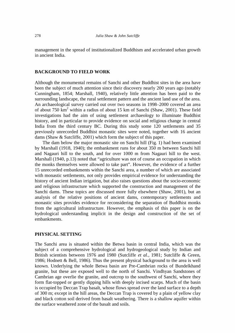
Ancient dams, settlement archaeology and Buddhist propagation in central India 279
Fig. 1 Distribution of ancient dams (after Shaw & Sutcliffe, 2001).
Sanchi hill is an outcrop of Vindhyan Sandstone at the boundary between thesandstone hills to the south and west and the basalt-floored valley of yellow and blackcotton soils to the north and east. The area to the south and west of Sanchi, with itsextensive hill ranges separated by short valleys, is more suited to the construction oflow embankments than the predominantly flat areas to the north and east (Fig. 1). Thehills define basins providing runoff into the dam sites, while the soils of the plains aresuitable for irrigated agriculture. Thus a total of 16 ancient dams were concentrated inan area of about 400 km2 around Sanchi; these embankments would have formedreservoirs fed by runoff from the hillsides and located close to areas which could be
River NionRiverBetwa
RiverBes
Sanchi
10

Julia Shaw & John Sutcliffe280
irrigated. The flat topography is less suitable for reservoirs to the north and east ofSanchi; the only dams east of Sanchi are located among the line of hills around theBuddhist monastic sites at Andher and Morel Khurd.
The soils on the sandstone hills are thin, up to 0.3 m thick, and sandy; the presentvegetation consists of broad-leaved, deciduous forest species such as teak and sal(Shorea robusta) in the wetter areas tending towards acacia in the drier areas. The“black cotton soils” of the plains are now used for agriculture. The depth of the blacksoils and the underlying yellow clay is generally between 2 and 10 m but may bedeeper in the central part of the basin. The clay content gives rise to high soil moisturestorage capacity; the soils have marked swelling and shrinking cycles, and during thedry season they crack to depths of 1.5–2 m under cultivation and up to 6 m underdeeper-rooted perennial grass and scrub. The cracks are up to 75 mm wide at thesurface and the soil therefore recharges rapidly at the onset of the monsoon.
PRESENT CLIMATE
The present climate of the Betwa basin, including the Sanchi area, is highly seasonalwith an annual rainfall ranging from over 1300 mm in the hills to the east of Vidisha toless than 900 mm in the north of the basin near Jhansi, some 250 km north of Vidisha(Fig. 2); the average over the whole Betwa basin is about 1140 mm, with 90% of the
Fig. 2 Average annual rainfall, mm: Betwa basin, 1926–1975 (after Sutcliffe et al.,1981).
Ancient dams, settlement archaeology and Buddhist propagation in central India 281
Table 1 Average rainfall over Betwa basin (1926–1975) and evaporation at Bhopal, mm (after Sutcliffeet al., 1981).
Jan. Feb. Mar. Apr. May Jun. Jul. Aug. Sep. Oct. Nov. Dec. Year
Rainfall 15 7 66 2 5 111 390 351 196 31 15 8 1138Potentialtranspiration 83 102 152 193 241 197 134 115 133 127 90 75 1643Open waterevaporation 113 135 193 241 293 237 164 143 167 165 123 103 2077
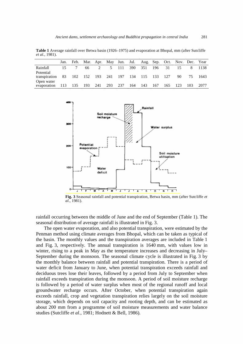
Fig. 3 Seasonal rainfall and potential transpiration, Betwa basin, mm (after Sutcliffe etal., 1981).
rainfall occurring between the middle of June and the end of September (Table 1). Theseasonal distribution of average rainfall is illustrated in Fig. 3.
The open water evaporation, and also potential transpiration, were estimated by thePenman method using climate averages from Bhopal, which can be taken as typical ofthe basin. The monthly values and the transpiration averages are included in Table 1and Fig. 3, respectively. The annual transpiration is 1640 mm, with values low inwinter, rising to a peak in May as the temperature increases and decreasing in July–September during the monsoon. The seasonal climate cycle is illustrated in Fig. 3 bythe monthly balance between rainfall and potential transpiration. There is a period ofwater deficit from January to June, when potential transpiration exceeds rainfall anddeciduous trees lose their leaves, followed by a period from July to September whenrainfall exceeds transpiration during the monsoon. A period of soil moisture rechargeis followed by a period of water surplus when most of the regional runoff and localgroundwater recharge occurs. After October, when potential transpiration againexceeds rainfall, crop and vegetation transpiration relies largely on the soil moisturestorage, which depends on soil capacity and rooting depth, and can be estimated asabout 200 mm from a programme of soil moisture measurements and water balancestudies (Sutcliffe et al., 1981; Hodnett & Bell, 1986).

Julia Shaw & John Sutcliffe282
DRAINAGE PATTERN AND RUNOFF
The River Betwa flows through the Sanchi area from the hilly area in the southwest,and is joined just north of Vidisha by the Bes tributary which drains an area to thewest. To the east of Vidisha the River Nion drains an area of some 1000 km2; thistributary is important as it was studied as a sample basin during the Betwa investiga-tion; river flows were measured in 1978–1980, in addition to rainfall, soil moisturestorage and groundwater levels over a network of sites (Sutcliffe & Green, 1986). Aswell as providing access to water, the high banks of the Bes and the smaller streamsprovide settlement sites which are relatively free from monsoon flooding.
The runoff from the Betwa basin was measured over a period of 50 years, from1926 to 1975, at Dhukwan Reservoir at the lower end of the basin of 20 600 km2; theaverage runoff over this period was 351 mm, compared with the average basin rainfallof 1138 mm. This runoff, like the monsoon rainfall, is concentrated between June andSeptember, though there is some residual baseflow from groundwater reserves after themonsoon. The basin rainfall has varied widely from year to year, from 745 mm in1966 to 1539 mm in 1961; the standard deviation over the 50-year period was 211 mmor 18.5% of the mean. As the residual of the hydrological cycle, the standard deviationof the runoff is relatively high at 157 mm or 44.7% of the average runoff. The relationbetween basin rainfall and runoff, derived from records from the whole Betwa basinand measurements from individual tributaries during the Betwa project (Sutcliffe &Green, 1981), provides a means of estimating runoff from monsoon rainfall.
This can provide an indication of the possible effect on runoff of historical changesof climate and particularly rainfall. Since the present climate and runoff provide thebasis for studying the ancient dams and reservoirs, the evidence for change over thepast 2000 years should be considered. There is little palaeo-ecological evidence for theearly historic period, and the main focus of enquiry has been a major phase ofaridification attributed to the third/second millennium BC (Singh, 1971). However,various studies have indicated the beginning of an arid phase in the second millenniumBC, reaching present levels of aridity about 100 AD (Fuller, 2000). Although it ishoped to obtain evidence during further research in the area, it will be seen later thatthe hydrological discussion focuses on the correlation between reservoir capacities andbasin runoff volumes, which should be affected less by historical changes in localrainfall and thus runoff depths.
The present hydrological behaviour of the smaller streams in the Sanchi area isillustrated by a study of the Nion at Kuakheri (Sutcliffe & Green, 1986), based ondetailed measurement of the major components during 1978 and 1979. The records for1978, which include measurements from a network of soil moisture sites andgroundwater observation wells, show that the reaction of the basin to the monsoon maybe divided into four phases: these may be described as periods of initial soil moisturerecharge when evaporation is negligible; combined soil moisture and groundwaterrecharge with evaporation and some runoff; runoff and evaporation after soil andgroundwater storage has been replenished; and recession when some runoff ismaintained from groundwater storage and evaporation from soil moisture. The 1978rainfall was about average and the measured runoff was 555 mm from the basin of921 km2. The same sequence was observed though the timing was delayed in 1979,when the monsoon rainfall was exceptionally low at 40% of average; soil moisture

Ancient dams, settlement archaeology and Buddhist propagation in central India 283
recharge was little below the 1978 value, but runoff was much reduced at 80 mm.After the monsoon the soil moisture storage declined steadily, but the basinevaporation was maintained by the initial storage of over 200 mm. This hydrologicalregime is reflected in the present land use of the area, and throws light on the role ofthe ancient reservoirs in the historic land use.
CHARACTERISTICS OF SANCHI DAMS
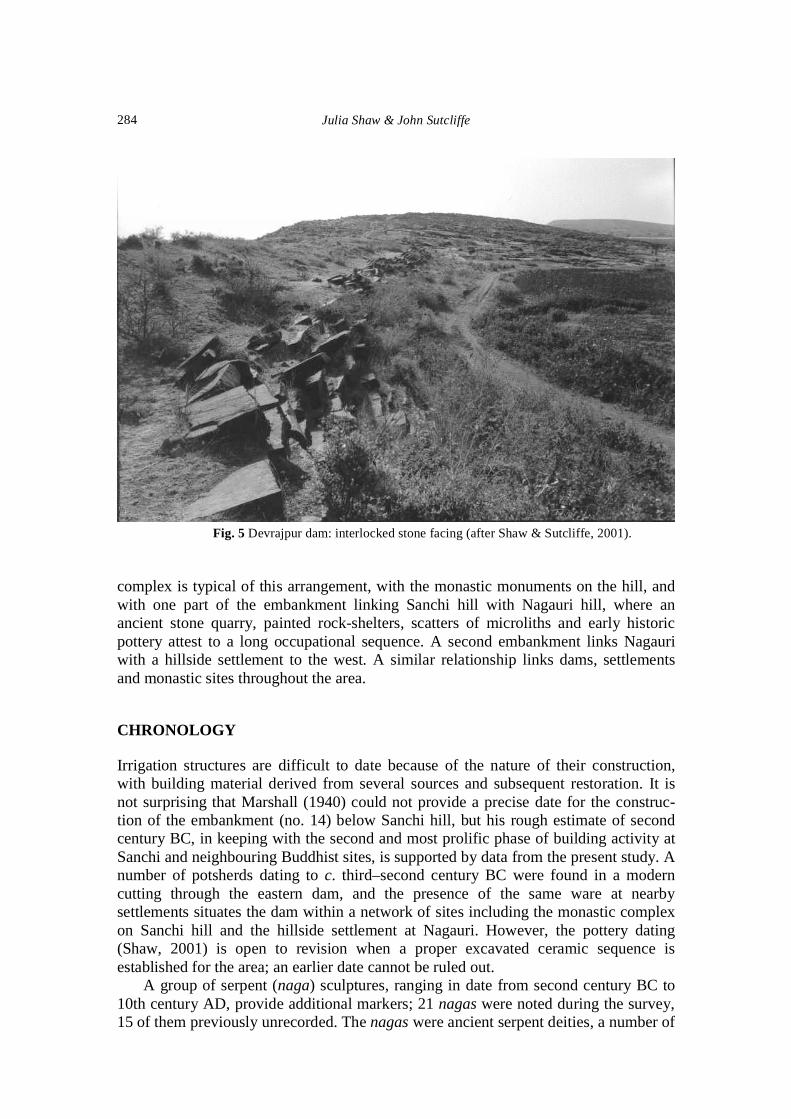
The dams in the Sanchi area are prominent and easily identifiable archaeologicalfeatures of the landscape. However, with the exception of two dams (5 and 10, Fig. 1)which have been restored, they are all in a ruinous state and show signs of breaching atsites where natural drainage channels cross the embankments. The dams have not beenexcavated, but they consist of an earthen core, generally derived from black cottonsoil, reinforced by facing of dressed sandstone masonry, especially on the upstreamface. In some places the facing slabs are laid horizontally; in other places the slabs areinterlocked, with most blocks laid parallel to the face, with head-on slabs slotted inperpendicular to the embankment (Figs 4 and 5). Dam heights range from 1 to 6 m,with flat downstream sections apparently designed to make the dams resistant toovertopping (Parker, 1909); some dam widths are as much as 60 m. At least two of thehigher dams (7 and 12) have spillway channels cut in the rock adjacent to the artificialembankment.
The dams are not isolated features, but form part of a series of “early historiccomplexes”. Typically a Buddhist stupa or monastic site is found on a nearby hilltop,with a village settlement on the lower slopes or on an adjacent mound. The Sanchi
Fig. 4 Devrajpur dam: horizontally laid dam facing (after Shaw & Sutcliffe, 2001).
Julia Shaw & John Sutcliffe284
Fig. 5 Devrajpur dam: interlocked stone facing (after Shaw & Sutcliffe, 2001).
complex is typical of this arrangement, with the monastic monuments on the hill, andwith one part of the embankment linking Sanchi hill with Nagauri hill, where anancient stone quarry, painted rock-shelters, scatters of microliths and early historicpottery attest to a long occupational sequence. A second embankment links Nagauriwith a hillside settlement to the west. A similar relationship links dams, settlementsand monastic sites throughout the area.
CHRONOLOGY
Irrigation structures are difficult to date because of the nature of their construction,with building material derived from several sources and subsequent restoration. It isnot surprising that Marshall (1940) could not provide a precise date for the construc-tion of the embankment (no. 14) below Sanchi hill, but his rough estimate of secondcentury BC, in keeping with the second and most prolific phase of building activity atSanchi and neighbouring Buddhist sites, is supported by data from the present study. Anumber of potsherds dating to c. third–second century BC were found in a moderncutting through the eastern dam, and the presence of the same ware at nearbysettlements situates the dam within a network of sites including the monastic complexon Sanchi hill and the hillside settlement at Nagauri. However, the pottery dating(Shaw, 2001) is open to revision when a proper excavated ceramic sequence isestablished for the area; an earlier date cannot be ruled out.
A group of serpent (naga) sculptures, ranging in date from second century BC to10th century AD, provide additional markers; 21 nagas were noted during the survey,15 of them previously unrecorded. The nagas were ancient serpent deities, a number of

Ancient dams, settlement archaeology and Buddhist propagation in central India 285
which in the Sanchi area appear to have been incorporated into both the Buddhist andHindu “landscape”. However, in most cases their traditional identity as nature spirits isrevealed by their close links to sources of water; of the 16 groups whose originalprovenance is known, seven are associated with reservoirs, five with village tanks, andfour with rivers or streams. A number remain in situ beside ancient water bodies, andprovide terminal dates for the latter. Once these links have been used to build achronological framework for the Sanchi area, gaps can be filled by other indicators likedam morphology, shape and size of stone facing, and positioning within thesurrounding archaeological complex.
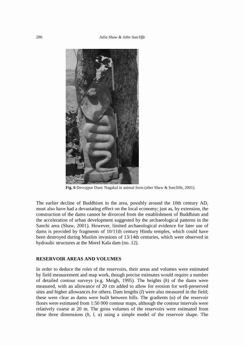
The earliest surviving serpent sculptures in the Sanchi area are a naga and nagini(male and female) couple, which originally stood on the ancient Gulgaon embankment(dam 10). Both sculptures can be assigned to around mid-first century BC (Williams,1976), providing a terminal date for the embankment itself. Another almost identicalcouple, of which only the male is still in its original position on Nagauri hill (Shaw,2000, Fig. 14), would have stood just metres from the water-body of reservoir 14before the breaching of the dam. The close similarities of apparel and ornamentationsuggest a similar date to the Gulgaon couple. This suggests a terminal date of c. 50 BCfor the embankment, though an earlier date cannot be ruled out. A previouslyunrecorded naga, in the form of Balarama, a prototypical form of the Hindu GodVishnu, stands on dam 5 at Chandna (Shaw & Sutcliffe, 2002, Fig. 13); the treatmentis similar to the Vidisha Kubera yaksha, datable to around the end of the first centuryBC (Chandra, 1966), making it the earliest non-Buddhist sculpture in Vidisha’s ruralhinterland. Follow-up field study has shown that the facing is similar to Nagauri andother sites, and the dam is probably as old.
Another previously unrecorded naga from a slightly later period is found at MorelKala (dam 12; Shaw & Sutcliffe, 2001, Fig. 15); though only the lower half remains,similarity with early Kushana sculptures from the Mathura region and in particular tothe Sarnath Bodhisattva (Williams, 1982, pl. 6), suggests a date of c. second centuryAD. This comparatively late date accords with the advanced design and appearance ofthe dam, which at 6 m is the highest in the region. A previously unrecorded three-headed nagakal or snake deity in animal form (Fig. 6) near dam 7 at Devrajpur isassignable to around the fifth century AD, though it is possible that the dam belongs toa somewhat earlier period on the basis of the chronology of the nearby stupa andsettlement. In all, similar evidence was used to establish a tentative chronology forseven of the dams (5, 7, 9, 10, 11, 12, 14). The remaining dams with no link with thenaga cult were positioned within the same framework on the basis of dammorphology, stone-facing type and immediate archaeological context. For example,four of the dams (1, 2, 8, 15) are directly associated with major settlements, clearlydatable to the early centuries BC. Another four (4, 6, 13, 16) are associated with earlymonastic sites, which were established in c. second–first century BC during the secondmajor phase of Buddhist propagation in the area. These dates clearly requirecorroboration through excavation, but the provisional chronology presented in Table 2shows that the majority appear to belong to the c. second century BC time bracket.
The evidence for dating the continued use of the dams is more sparse, and is thesubject of on-going research. It seems that flood damage rather than sedimentation wasthe likely physical cause of disuse. Other reasons are provided by evidence for radicaldepopulation following a series of recorded famines from the 14th century onward.
Julia Shaw & John Sutcliffe286
Fig. 6 Devrajpur Dam: Nagakal in animal form (after Shaw & Sutcliffe, 2001).
The earlier decline of Buddhism in the area, possibly around the 10th century AD,must also have had a devastating effect on the local economy; just as, by extension, theconstruction of the dams cannot be divorced from the establishment of Buddhism andthe acceleration of urban development suggested by the archaeological patterns in theSanchi area (Shaw, 2001). However, limited archaeological evidence for later use ofdams is provided by fragments of 10/11th century Hindu temples, which could havebeen destroyed during Muslim invasions of 13/14th centuries, which were observed inhydraulic structures at the Morel Kala dam (no. 12).
RESERVOIR AREAS AND VOLUMES
In order to deduce the roles of the reservoirs, their areas and volumes were estimatedby field measurement and map work, though precise estimates would require a numberof detailed contour surveys (e.g. Meigh, 1995). The heights (h) of the dams weremeasured, with an allowance of 20 cm added to allow for erosion for well-preservedsites and higher allowances for others. Dam lengths (l) were also measured in the field;these were clear as dams were built between hills. The gradients ( ) of the reservoirfloors were estimated from 1:50 000 contour maps, although the contour intervals wererelatively coarse at 20 m. The gross volumes of the reservoirs were estimated fromthese three dimensions (h, l, ) using a simple model of the reservoir shape. The

Ancient dams, settlement archaeology and Buddhist propagation in central India 287

Julia Shaw & John Sutcliffe288
reservoir outline was assumed to be rectangular, with the width corresponding to l andthe length to h/ ; the area is lh/ and the mean depth is h/2 and the volume lh2/2 .Alternative assumptions include an isosceles triangle with the dam forming the base,with a mean depth of 2h/3 but a smaller area; a triangle with the dam at the apex wouldhave a mean depth of h/3 but a larger area. The rectangular assumption provides aconsistent set of estimates which lies between the two extremes. The dimensions of theembankments are listed in Table 2, and the calculated areas and volumes are includedin the table.
In some cases, the assumptions were adjusted to take account of local conditions.In dams 5 and 13, the reservoirs had been restored and the areas were estimateddirectly from maps. A number of tributaries converge at dam 9, and the estimated areatook account of this. As expected, the relationship is close between reservoir areas andvolumes, expressed by V = 1.81A1.28, with the volume V in m3 106 and the area A inkm2. This is similar to the relationship derived from surveyed small dams in Botswana(Meigh, 1995), which was V = 2.35A1.25.
RESERVOIR INFLOW
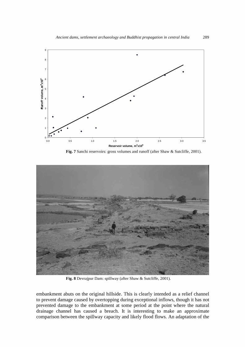
In order to estimate the inflows to the reservoir sites, the areas of the upstream basinswere measured from 1:50 000 maps and are included in Table 2. As the reservoirs areconfined to a small area around Vidisha, where the present 50-year average annualrainfall is 1334 mm, with 1230 mm in the monsoon months June–September, this maybe taken as typical of the area and corresponds to an average runoff depth of 500 mm(Sutcliffe & Green, 1981). The annual inflow volumes have been estimated from themeasured basin areas and this depth and are included in Table 2. These volumes are ofcourse based on modern rainfall and basin conditions, and would have been affectedby climate change. However, it is the correspondence between the two sets of volumeswhich is important. The evidence shows that reservoir capacities are strongly related toaverage inflows; consistent under- or over-estimation of either would not affect thisresult.
Reservoir volumes and estimated runoff volumes are compared in Fig. 7, whichshows that the average runoff is sufficient to fill the reservoirs in nearly all cases. Infact, the equation linking runoff volumes Q to reservoir volume V, both in m3 106, isQ = 2.38V + 0.353, with a highly significant correlation coefficient (R2) of 0.792. Thisimplies that the runoff is sufficient to fill the reservoirs twice in an average year, orthat the average reservoir would be filled in nine out of 10 years if the runoff werenormally distributed with the present basin-wide CV of 45%. It is perhaps moreimportant to note that the reservoir sizes are reasonably well adapted to the drainagebasins and the available runoff. There is no evidence of serial construction of theembankments, which suggests that they were constructed to an appropriate size with anempirical understanding of the principles of water balance.
FLOOD CONTROL AND WATER DISTRIBUTION
Several of the Sanchi dams show evidence of spillways or control structures. Dam 7 atDevrajpur has a spillway channel cut into the rock (Fig. 8) where the artificial
Ancient dams, settlement archaeology and Buddhist propagation in central India 289
0
1
2
3
4
5
6
7
8
9
0.0 0.5 1.0 1.5 2.0 2.5 3.0 3.5
Reservoir volume, m3x106
Fig. 7 Sanchi reservoirs: gross volumes and runoff (after Shaw & Sutcliffe, 2001).
Fig. 8 Devrajpur Dam: spillway (after Shaw & Sutcliffe, 2001).
embankment abuts on the original hillside. This is clearly intended as a relief channelto prevent damage caused by overtopping during exceptional inflows, though it has notprevented damage to the embankment at some period at the point where the naturaldrainage channel has caused a breach. It is interesting to make an approximatecomparison between the spillway capacity and likely flood flows. An adaptation of the

Julia Shaw & John Sutcliffe290
“rational formula” can make use of a map of India showing 24-h rainfall depths of50-year return period (India Meteorological Department, 1972). The depth of 240 mmover a basin of 13.5 km2, with an assumed 70% runoff coefficient and spread over 24 hto allow for reservoir storage, would correspond to a discharge of 26.5 m3 s-1. With aspillway of average width of 8.8 m, treated as a broad-crested weir, this dischargewould require a depth of 1.5 m, which is slightly more than the spillway depth of about1.3 m. Thus the spillway would be likely to pass large but not extreme floods. The sizedesign of the reservoirs, the detailed masonry construction, and the existence ofspillways at the higher dams, indicate a level of sophistication comparable with con-temporary hydraulic expertise on a larger scale in Sri Lanka, whose early Buddhisthistory is closely linked to central India.
LAND USE AND IRRIGATION
If it is accepted that the size of the reservoirs implies that they were designed forirrigation rather than domestic supply, it remains to speculate on the possible land-usesystems with which they were associated. The reservoir volumes suggest that theywere designed for the irrigation of rice, although this needs corroboration by specialistarchaeobotanical research.
The evidence of modern agriculture in the area makes it unlikely that irrigationwould have been required for wheat. This is because the storage in the black cottonsoils provides sufficient moisture for winter wheat to be grown without irrigation. Atthe time of the Betwa project, the land use was largely based on autumn cultivationof wheat, though some pulses and gram were also grown. Field investigation(Hodnett & Bell, 1986) showed that the soil moisture storage, recharged each year bythe monsoon, was adequate, supplemented by winter rains, to provide water to thecrop, which was planted in October and harvested in March. The seasonal range ofsoil moisture under crops was about 200 mm, and it was noted in 1979 that soilmoisture recharge occurred even in a year when monsoon rainfall was less than halfthe average.
Because the yield of irrigated rice would be much greater than wheat or othercrops, it is interesting to consider the impact which the introduction of rice wouldhave had on the local economy. The dams would have played an important role insupporting increased population levels during the early-historic period, which seemto be implied by local settlement patterns and indeed the distribution of largemonastic sites. The relative positioning of dams and Buddhist monastic sitesthroughout the area raises interesting questions. While Marshall (1940) was reluctantto challenge the textual prohibition of monks owning or managing agricultural land,on the basis of a single reservoir, the spatial relationships between the large numberof dams, monasteries and cult-spots throughout the Sanchi area provide an empiricalbasis for considering the possible emergence of interactive support systems betweenmonastic and lay sections of society during the early centuries BC. The dams aretherefore part of a larger body of material for understanding the dynamics of socialand cultural change between c. third century BC and fifth century AD, and forrelating the spread of Buddhism to other key processes such as urbanization andagrarian expansion.

Ancient dams, settlement archaeology and Buddhist propagation in central India 291
CONCLUSIONS
While these suggestions require further investigation, the study has demonstrated thatthe ancient reservoirs in the Sanchi area were designed for irrigation, presumably ofrice. Their size is in harmony with local drainage basins and runoff volumes, whilesome of the larger dams reveal an acquaintance with problems of flood control. Thissuggests that they were built by engineers with experience of reservoir irrigation. Thededuction that they were built for rice irrigation throws light on the history of rice incentral India. Through an integrated study of irrigation works, land use, settlementpatterns and Buddhist monasteries, interesting questions have been raised regardingthe relations between monastic and lay sections of society.
REFERENCES
Chandra, P. (1966) Yaksha and yakshi images from Vidisa. Ars orientalis 6, 157–163.
Cunningham, A. (1854) Bhilsa Topes. Smith, Elder & Co., London, UK.
Fuller, D. Q. (2000) Fifty years of archaeological studies in India, laying a solid foundation. In: Indian Archaeology inRetrospect, vol. III, Archaeology and Interactive Disciplines (ed. by S. Settar & R. Korisettar). Indian Council forHistorical Research, New Delhi, India.
Hodnett, M. G. & Bell, J. B. (1986) Soil moisture investigation of groundwater recharge through black cotton soils inMadhya Pradesh, India. Hydrol. Sci. J. 31(3), 361–381.
India Meteorological Department (1972) Manual of Hydrometeorology. New Delhi, India.
Marshall, J. (1918) A Guide to Sanchi. Superintendent Government Printing, Calcutta, India.
Marshall, J. (1940) The Monuments of Sanchi. Repr., 1982, Swati Publications, London, Delhi.
Mehta, R. N. (1968) Sudarsana lake. J. Oriental Inst. Baroda 18, 20–28.
Meigh, J. R. (1995) The impact of small farm reservoirs on urban water supplies in Botswana. Natural Resources Forum19(1), 71–93.
Parker, H. (1909) Ancient Ceylon. Repr. 1981, Asian Educational Services, New Delhi, India.
Shaw, J. (2000) The sacred landscape. In: Buddhist Reliquaries from Ancient India (ed. by M. Willis), 27–38. BritishMuseum Press, London, UK.
Shaw, J. (2001) The sacred geography of Sanchi hill: the archaeological setting of Buddhist monasteries in Central India.PhD dissertation, University of Cambridge, Cambridge, UK.
Shaw, J. & Sutcliffe, J. V. (2001) Ancient irrigation works in the Sanchi area: an archaeological and hydrologicalinvestigation. South Asian Studies 17, 55–75.
Singh, G. (1971) The Indus valley culture seen in the context of post-glacial climatic and ecological studies in northwestIndia. Arch. Phys. Anthropology in Oceania 6(2), 177–189.
Sutcliffe, J. V. & Green, C. S. (1981) The Surface Hydrology of the Betwa Basin, India. Indo-British Betwa GroundwaterProject, Summary Tech. Report, vol. 2. Institute of Geological Sciences, London, UK.
Sutcliffe, J. V. & Green, C. S. (1986) Water balance investigation of recharge in Madhya Pradesh, India. Hydrol. Sci. J.31(3), 383–394.
Sutcliffe, J. V., Agrawal, R. P. & Tucker, J. M. (1981) The water balance of the Betwa basin, India. Hydrol. Sci. Bull.26(2), 149–158.
Venkayya, V. (1906) Irrigation in South India. Ancient Times, Arch. Survey of India, Annual Report 1903–1904, Calcutta,India.
Williams, J. G. (1976) New naga images from the Sanchi area. Oriental Art 22, 174–179.
Williams, J. G. (1982) The Art of Gupta India: Empire and Province. Princeton University Press, Princeton, New Jersey,USA.
Received 28 March 2002; accepted 11 November 2002