Analysis of the circulation and shelf-slope exchanges in the continental margin of the northwestern...
9
Ocean Sci., 2, 173–181, 2006 www.ocean-sci.net/2/173/2006/ © Author(s) 2006. This work is licensed under a Creative Commons License. Ocean Science Analysis of the circulation and shelf-slope exchanges in the continental margin of the northwestern Mediterranean A. Jordi, G. Basterretxea, A. Orfila, and J. Tintor´ e IMEDEA (CSIC-UIB), Institut Mediterrani d’Estudis Avanc ¸ats, Esporles, Illes Balears, Spain Received: 31 March 2006 – Published in Ocean Sci. Discuss.: 21 June 2006 Revised: 23 August 2006 – Accepted: 19 September 2006 – Published: 17 October 2006 Abstract. In this paper, we present the results from a high horizontal resolution numerical simulation of the northwest- ern Mediterranean using a z-level, non-hydrostatic, primitive equation ocean model (DieCAST). The high resolution al- lows an accurate representation of the submarine canyons that presides in the region. The model is one-way coupled to a large scale model of the Mediterranean Sea through open boundaries and uses the atmospheric forcing fields provided in terms of HIRLAM outputs by the Spanish National Insti- tute of Meteorology. Results show that the model can suc- cessfully reproduce the complex general circulation charac- teristics of the area, including the modifications induced by canyons in their vicinity and other phenomena observed such as instabilities and coastal trapped waves. The sea surface temperature is similar to satellite observations except that simulated temperatures are slightly warmer near the coast than observations and colder near the open boundaries. An important topic of this work is the computation of the shelf- slope exchanges, which are able to renew shelf waters in a few months. 1 Introduction Shelf-ocean interactions are receiving increasing attention because of their enormous importance in aspects such as cli- mate change, global biogeochemical cycles, marine ecosys- tems, resource exploitation and other human related activi- ties. Much of the present understanding about shelf-slope ex- changes derives from processes oriented studies carried out since the late 70s. It is not until recently that the oceano- graphic community has developed reliable tools to provide nowcasts and forecasts of marine environmental conditions, in support of a variety of activities at sea. This endeavor Correspondence to: A. Jordi ([email protected]) has become possible both by the improvement of operational systems able to incorporate and analyze data in real time and by the progress in modeling and computing capabilities. An example of theses efforts in providing operational informa- tion is the European project MFSTEP (Mediterranean Fore- casting System Toward Environmental Predictions) which is focused on the Mediterranean Sea. Observational and modeling based analysis of the Mediter- ranean reveal a complex and variable circulation that is strongly affected by frontal dynamics through mesoscale fea- tures (Millot, 1999; Send et al., 1999; Demirov and Pinardi, 2002). This variability is the result of interactions at basin, sub-basin and local scales that results in intense mesoscale variability. In the Mediterranean Sea, mesoscale and even sub-mesoscale and local processes have profound impact on ocean dynamics and, consequently, in ocean geochemistry and ecosystems (e.g. Levy et al., 2001). The necessity of predictive tools resolving processes at these scales encom- passes an integral view of the ocean system and the use of nested schemes that allow for downscaling from general to local conditions. The northwestern Mediterranean Sea is one of the areas of interest of the European cooperative oceanography project MFSTEP where nested operational models have been imple- mented. This region comprises the shelves and slopes of the Gulf of Lions and the Catalan Sea (Fig. 1). Bottom topogra- phy in the area is rather complex, varying form a broad shelf in the Gulf of Lions to a rather narrow continental margin in the Catalan Sea. The slope is indented by a series of canyons that cut across about 60% of the slope area (between 200 and 1000 m isobaths). Submarine canyons in the Gulf of Lions occur as deep and short indentations of the shelf edge sep- arated by narrow open slopes. Conversely, the Palam´ os and Blanes canyons in the Catalan shelf are more prominent and expand to the proximity of the coast. Published by Copernicus GmbH on behalf of the European Geosciences Union.
Transcript of Analysis of the circulation and shelf-slope exchanges in the continental margin of the northwestern...
Ocean Sci., 2, 173–181, 2006www.ocean-sci.net/2/173/2006/© Author(s) 2006. This work is licensedunder a Creative Commons License.
Ocean Science
Analysis of the circulation and shelf-slope exchanges in thecontinental margin of the northwestern Mediterranean
A. Jordi, G. Basterretxea, A. Orfila, and J. Tintor e
IMEDEA (CSIC-UIB), Institut Mediterrani d’Estudis Avancats, Esporles, Illes Balears, Spain
Received: 31 March 2006 – Published in Ocean Sci. Discuss.: 21 June 2006Revised: 23 August 2006 – Accepted: 19 September 2006 – Published: 17 October 2006
Abstract. In this paper, we present the results from a highhorizontal resolution numerical simulation of the northwest-ern Mediterranean using a z-level, non-hydrostatic, primitiveequation ocean model (DieCAST). The high resolution al-lows an accurate representation of the submarine canyonsthat presides in the region. The model is one-way coupled toa large scale model of the Mediterranean Sea through openboundaries and uses the atmospheric forcing fields providedin terms of HIRLAM outputs by the Spanish National Insti-tute of Meteorology. Results show that the model can suc-cessfully reproduce the complex general circulation charac-teristics of the area, including the modifications induced bycanyons in their vicinity and other phenomena observed suchas instabilities and coastal trapped waves. The sea surfacetemperature is similar to satellite observations except thatsimulated temperatures are slightly warmer near the coastthan observations and colder near the open boundaries. Animportant topic of this work is the computation of the shelf-slope exchanges, which are able to renew shelf waters in afew months.
1 Introduction
Shelf-ocean interactions are receiving increasing attentionbecause of their enormous importance in aspects such as cli-mate change, global biogeochemical cycles, marine ecosys-tems, resource exploitation and other human related activi-ties. Much of the present understanding about shelf-slope ex-changes derives from processes oriented studies carried outsince the late 70s. It is not until recently that the oceano-graphic community has developed reliable tools to providenowcasts and forecasts of marine environmental conditions,in support of a variety of activities at sea. This endeavor
Correspondence to:A. Jordi([email protected])
has become possible both by the improvement of operationalsystems able to incorporate and analyze data in real time andby the progress in modeling and computing capabilities. Anexample of theses efforts in providing operational informa-tion is the European project MFSTEP (Mediterranean Fore-casting System Toward Environmental Predictions) which isfocused on the Mediterranean Sea.
Observational and modeling based analysis of the Mediter-ranean reveal a complex and variable circulation that isstrongly affected by frontal dynamics through mesoscale fea-tures (Millot , 1999; Send et al., 1999; Demirov and Pinardi,2002). This variability is the result of interactions at basin,sub-basin and local scales that results in intense mesoscalevariability. In the Mediterranean Sea, mesoscale and evensub-mesoscale and local processes have profound impact onocean dynamics and, consequently, in ocean geochemistryand ecosystems (e.g.Levy et al., 2001). The necessity ofpredictive tools resolving processes at these scales encom-passes an integral view of the ocean system and the use ofnested schemes that allow for downscaling from general tolocal conditions.
The northwestern Mediterranean Sea is one of the areas ofinterest of the European cooperative oceanography projectMFSTEP where nested operational models have been imple-mented. This region comprises the shelves and slopes of theGulf of Lions and the Catalan Sea (Fig.1). Bottom topogra-phy in the area is rather complex, varying form a broad shelfin the Gulf of Lions to a rather narrow continental margin inthe Catalan Sea. The slope is indented by a series of canyonsthat cut across about 60% of the slope area (between 200 and1000 m isobaths). Submarine canyons in the Gulf of Lionsoccur as deep and short indentations of the shelf edge sep-arated by narrow open slopes. Conversely, the Palamos andBlanes canyons in the Catalan shelf are more prominent andexpand to the proximity of the coast.
Published by Copernicus GmbH on behalf of the European Geosciences Union.

174 A. Jordi et al.: Analysis of NW Mediterranean shelf
Gulf of Lions
Catalan Sea
Fig. 1. Model domain of the northwestern Mediterranean andbathymetry. The 100 and 200 m isobaths are plotted with blacklines, and the 500, 1000, 1500, 2000 and 2500 m isobaths with graylines. Black points represent the location of Argo profiles. Num-bers indicate prominent submarine canyons: Blanes (1), Palamos(2), Cap de Creus (3), Lacaze-Duthiers (4), Pruyot (5), Boucart (6),l’H erault (7), Aiguesmortes (8), la Petite Ronne (9), la Grand Ronne(10), Marseille (11), Planier (12), and Cassidaigne (13).
The major aspects of the water mass structure and flowdynamics of this region are fairly well known and have beenthoroughly described by several authors (e.g.Millot , 1999).The general circulation is dominated by a cyclonic along-slope density front, called the Northern Current, flowingfrom northeast to southwest (Font et al., 1988). Previousstudies have found that this current is characterized by rel-evant spatial and temporal variability, with a large varietyof mesoscale features (such as meanders and instabilities)strongly interacting with the basin-scale circulation (La Vi-olette et al., 1990). These instabilities have been observedto evolve into very energetic filaments and shedding eddy-like structures (Wang et al., 1988; Tintore et al., 1990). Inaddition, very intense ocean-atmosphere interaction mecha-nisms, characterized by strong episodes of northerly winds,have been described in this area (Estournel et al., 2003).
The complex topography and the strong dynamical pro-cesses that characterize the Northwestern Mediterranean pro-vide a good opportunity to analyze the effect of physicaltransport processes on the shelf-slope exchanges of water,solutes and particles. In this context, the objectives of thepresent paper are twofold: (1) to validate the ocean circu-lation model implemented in the continental margin of thenorthwestern Mediterranean in the basis of previous knowl-edge and available data, and (2) to provide estimations of theshelf-slope exchanges resulting from the interaction betweenthe Northern Current and the topographic irregularities underreal forcing conditions.
2 Model description
For the purpose of this study, the Dietrich/Center for Air-SeaTechnology (DieCAST) ocean model was run for the north-western Mediterranean at high horizontal resolution follow-ing a downscaling approach from a basin-scale model of theMediterranean Sea. DieCAST is a z-level, non-hydrostatic,primitive equation ocean model (Dietrich, 1997; Dietrich andLin, 2002), which provides high computational accuracy andlow numerical dissipation and dispersion (Dietrich et al.,2004). The model uses a rigid lid approximation, with a seasurface pressure formulation, and the Boussinesq approxi-mation. The governing equations are solved using a blend ofcollocated and staggered grid structures (Arakawa A and Cgrids) and fourth-order-accurate control volume approxima-tion for the horizontal pressure gradient and advection terms,except in zones adjacent to boundaries where conventionalsecond order accuracy is used (Sanderson, 1998; Sandersonand Brassington, 1998).
The hydrostatic approximation may become inaccurate forfeatures whose horizontal scale is not large compared to theirvertical scale. These features may have significant verticalacceleration compared to the buoyancy force. Rapid changesdue to steep bathymetric features like submarine canyons inthe presence of strong flows may cause vertical acceleration,which violates the hydrostatic approximation, as shown byTseng et al.(2005) in the Monterey Submarine Canyon. Thuswe use a non-hydrostatic model where the solution of thenon-hydrostatic equation is obtained iteratively from the hy-drostatic solution, as described in more detail in (Dietrichand Lin, 2002).
Simulations are run with horizontal viscosity and diffu-sivity coefficients set to a constant value of 10 m2/s. Forthe vertical viscosity and diffusivity, a variable formulationwhich includes the Richardson number is used, as describedand used inStaneva et al.(2001), with background valuesset at near-molecular values (10−6 and 2· 10−7 m2/s respec-tively). The bottom dissipation is represented by a conven-tional nonlinear bottom drag with a coefficient of 2· 10−3.At the lateral walls we assume free-slip boundary condition.The DieCAST model has been recently used to study theregional circulation in the vicinity of the Monterey Subma-rine Canyon (Haney et al., 2001; Tseng et al., 2005) and tostudy the mesoscale, seasonal and interannual variability inthe Mediterranean Sea (Fernandez et al., 2005).
2.1 Model domain
The model domain includes the continental margins of theGulf of Lions and the Catalan Sea (northwestern Mediter-ranean) extending from 41.2◦ N to 43.6◦ N in latitude andfrom 1.5◦ E to 5.6◦ E in longitude (Fig.1). The model hor-izontal resolution is 0.75′, which is equivalent to 1389 min the meridional direction and up to 1036 m in the zonaldirection. Note that the Coriolis parameterf is variable
Ocean Sci., 2, 173–181, 2006 www.ocean-sci.net/2/173/2006/

A. Jordi et al.: Analysis of NW Mediterranean shelf 175
Fig. 2. Time evolution of the volume averaged kinetic energy(108 J)
and, in consequence, the resolution in the zonal direction isnot constant (although the variation is not significant). Thebathymetry on the model grid is derived from the bathy-metric chart of the northwestern Mediterranean (http://www.icm.csic.es/geo/gma/MCB) by a bilinear interpolation with-out filtering or smoothing. In the vertical, the model grid has30 non uniform vertical levels concentrated towards the sur-face with the top layer thickness being 10 m, and increasingsmoothly to 300 m at the bottom.
2.2 Initialization and boundaries
The model is one-way coupled to a large scale globalMediterranean model through the open boundaries of the do-main. The open boundaries allow perturbations generated in-side the computational domain to leave it without deteriora-tion of the inner model solution and allows physically impor-tant external information to advect inward using a pure up-wind advective scheme (Tseng et al., 2005). Results from theglobal Mediterranean model (Tonani et al., 20061) are used toforce the two lateral open boundaries (south and east) and allquantities are interpolated from daily global Mediterraneanmodel output and updated every time step (150 s). The scalerelation between both models is 1/10, taking into account thatthe resolution of global Mediterranean model is 1/8◦.
The model runs for 30 days between 1 December 200500:00:00 UTC and 31 December 2005 00:00:00 UTC. Thisperiod has been selected to demonstrate the feasibility andproduct quality of the model system. In addition, a strongepisode of northerly wind took place during that period asit is shown in next section. Therefore, December 2005 wasan adequate period to study the interaction between the dif-ferent dynamical processes that characterize the area and toestimate the associated shelf-slope exchanges.
The global Mediterranean model outputs of horizontal ve-locity, temperature and salinity on 1 December 2005 are usedto initialize the model by bilinear interpolation in the hor-
1Tonani, M., Pinardi, N., Dobricic, S., and Adani, M.: A HighResolution Free Surface Model on the Mediterranean Sea, OceanSci., to be submitted, 2006.
(a)
2ºE 3ºE 4ºE 5ºE
42ºN
43ºN
5 10 15 20 25 30-0.2
0
0.2(b)
December 2005
Fig. 3. (a)Spatial pattern of the most relevant EOF from the timevariability of wind forcing at 10 m.(b) Corresponding amplitudefunctions. The gray line represent the amplitude function for the u-component of the wind forcing, and the black line is the amplitudefunction for the v-component.
izontal grid and linear interpolation in the vertical levels.These fields represent daily averaged outputs from the globalMediterranean model and, in consequence, they should be al-most in balance. The full dynamical balance is achieved afteran adjustment phase where the flow field is subject to inertialoscillations. The duration of this phase is very short (a fewhours) and does not change the initial mass field (Fig.2).
2.3 Atmospheric forcing
At the sea surface, the model is driven by the wind stressand surface fluxes (heat and water) provided directly bythe Spanish National Institute of Meteorology in terms of3 hourly fields of the High Resolution Limited Area Model(HIRLAM, http://www.hirlam.org). The horizontal resolu-tion of wind forcing at 10 m above the surface and net heatand water fluxes is 0.16◦. There is no relaxation of the sur-face temperature or salinity.
To provide a general picture of the evolution of wind forc-ing at 10 m, temporal variance complex EOF modes and cor-responding amplitude functions are computed. The spatialpattern and its corresponding amplitude functions of the mostrelevant EOF are shown in Fig.3a. This pattern accounts
www.ocean-sci.net/2/173/2006/ Ocean Sci., 2, 173–181, 2006

176 A. Jordi et al.: Analysis of NW Mediterranean shelf
Fig. 4. Time-averaged horizontal velocity and density (σt units) at5 m depth. Vectors are plotted at every eighth grid points.
for 64.4% of the total variance of the data, while the secondmode (not shown) accounts for 11.3%. The spatial distribu-tion is characterized by a northwesterly wind blowing in theentire basin, with maximum speeds offshore.
The amplitude functions describe the dynamics of the spa-tial modes (Fig.3b). During the first days the wind blowsfrom the southwest and it progressively rotates clockwise tothe northeast increasing the intensity. Vector velocities ex-ceeding 12 m/s were registered between 8 and 15 Decem-ber 2005, rotating to the northwest at the end of this period.A secondary peak from the northwest was observed in lastsdays of December.
3 Results and discussion
3.1 General circulation
A temporal average of surface circulation over the integrationperiod based on 6-hourly model outputs reproduces the char-acteristic features of the circulation in northwestern Mediter-ranean Sea. Along the shelf break, the flow is constrained tofollow the topography and strong currents (>40 cm/s) de-velop cyclonically flowing from the Gulf of Lions to theCatalan Sea (Fig.4). This feature is consistent with descrip-tions of the Northern Current although current velocities areabove reported values of 20–30 cm/s (Garcia-Ladona et al.,1996; Send et al., 1999; Lapouyade and Durrieu de Madron,2001). However it should be noted that, as mentioned above,strong northeasterly winds were experienced during a signif-icant part of the analyzed period.
Another conspicuous structure is the presence of an anticy-clonic eddy to the south of the model domain (between 4◦ Eand 5◦ E). Anticyclonic eddy formation appears to be favoredbetween adjacent coastal upwelling cells on the Gulf of Lions
Fig. 5. Time-averaged vertical velocity at a depth of 95 m. The unitsare m/day. The 200 m isobath is plotted with a black line.
under Mistral forcing (Millot , 1990), which was predominantduring the model integration period, and the structure tendsto be rather persistent. Indeed,Pascual et al.(2002) trackeda similar structure in that position from middle September1998 to middle March 1999 using a combination of in situand satellite data. Onken et al. (2005)2 also describe a stronganticyclonic vortex at about 41◦ N exhibiting maximum sur-face flow speeds of up to 65 cm/s, on fall 2002.
Further agreement concerns the impact of topographic ir-regularities on the Northern Current. It is well known thatsubmarine canyons affect the spatial pattern of regional ver-tical motions (Hickey, 1997), particularly in subsurface lay-ers. Figure5 shows the temporal average of vertical veloc-ity at 95 m depth. A close relation between vertical move-ment and canyons is evidenced with downwelling on theupstream walls of the canyons and upward motions on thedownstream edges. This antisymmetrical structure of verti-cal motions was previously observed byPascual et al.(2004)in the Palamos Canyon and simulated byJordi et al.(2005a)in the same canyon and byArdhuin et al.(1999) in the BlanesCanyon.
It is important to comment that the Northern Current antthe anticyclonic eddy to the south of the domain were al-ready present in the initial condition fields from the globalMediterranean model. However, our model allows the gen-eration and propagation of small-scale structures associatedwith the Northern Current as we report in the next section.The anticyclonic eddy is reinforced and moves to the south-west during the model run (not shown), probably by the ac-tion of the northerly winds. Conversely, the vertical motions
2Onken, R., Tintore, J., Fernandez, V., Vizoso, G., Basterretxea,G., and Haley, P.: A forecast system of the Balearic Sea, J. MarineSyst., submitted, 2005.
Ocean Sci., 2, 173–181, 2006 www.ocean-sci.net/2/173/2006/

A. Jordi et al.: Analysis of NW Mediterranean shelf 177
Fig. 6. Surface density (σt units) for 23 December 2005. A filamentwith a mushroom-like structure is indicated with B.
Fig. 7. Evolution of sea level anomaly (SLA, in cm) along the 100 misobath in the Catalan Sea from 15 to 30 December 2005. The zeroalong-shore distance is taken at the southernmost point of the 100 misobath in the model domain. The 200 km along the 100 m isobathcorresponds approximately to Cap de Creus, which separates theCatalan Sea and the Gulf of Lions (see Fig.1).
related to the submarine canyons develops fully during themodel run.
3.2 Frontal structures and coastal trapped waves
The southwestern propagation of meanders and eddies alongthe slope, associated with the Northern Current has been fre-quently observed moving along the slope in the Gulf of Lionsand Catalonia (La Violette et al., 1990; Tintore et al., 1990).Meanders of about 30–40 km propagating at phase speeds of5–15 km/day that grow as filaments and develop into isolatededdies have been reported (Flexas et al., 2002; Rubio et al.,2005). Similar southwestward-propagating frontal structuresare observed in the present simulation. Figure6 reveals sev-eral meanders propagating along the slope. Southward prop-agation at phase speeds of about 9 km/day was estimated
(a)
2ºE 3ºE 4ºE 5ºE
42ºN
43ºN12 14 16
(b)
2ºE 3ºE 4ºE 5ºE
42ºN
43ºN
12 14 16
Fig. 8. (a)Time-averaged model surface temperature (◦C). The an-ticyclonic eddy is indicated with C1.(b) Monthly-averaged satellite(AVHRR) SST (◦C) for December 2005. The anticyclonic eddy isindicated with C2.
from visual analysis of the complete image set (not shown).Off the slope of the Gulf of Lions (3.9◦ E, 42.8◦ N) a filamentwith a mushroom-like structure (B) develops during the ana-lyzed period.
The model is also able to reproduce coastal trapped waveswhich propagate cyclonically along the continental marginsof the Gulf of Lions and the Catalan Sea. The presence ofcoastal trapped waves in the area have been recently identi-fied byJordi et al.(2005b) using alongshore currents and sealevel time series. The time evolution of the sea level anomaly(SLA) predicted by the model along the 100 m isobath in theCatalan Sea is shown in Fig.7. In spite that SLA contoursare disturbed by small scale features, they present a constantslope that evidences the southwestward propagation of dis-turbances. The phase speed of these disturbances is about250 cm/s, which corresponds to the phase speed of the firstcoastal trapped wave mode in the area.
www.ocean-sci.net/2/173/2006/ Ocean Sci., 2, 173–181, 2006

178 A. Jordi et al.: Analysis of NW Mediterranean shelf
Fig. 9. Daily-averaged satellite (AVHRR) SST (◦C) for 23 Decem-ber 2005. A filament with a mushroom-like structure is indicatedwith B and corresponds to that indicated in Fig.6.
3.3 Comparison with observations
Satellite images of sea surface temperature provide a use-ful tool to test the performance of numerical results in theupper ocean. A monthly averaged SST image of the studyarea, for December 2005, was obtained from the GermanAerospace Research Center (DLR). Figure8 shows the com-parison between predicted sea surface temperature and ob-served data. Although this comparison is not direct becausethe first model layer is 10 m depth and the satellite gives askin temperature, the large-scale pattern matches well withobservations with some exceptions (i.e. local warming in thenortheastern edge of the domain). Obviously, satellite tem-perature displays small-scale variability that is not capturedby the model where all the features appear smeared. Themodel’s temperature along the coast is generally warmer thanthe observations probably because of the lack of riverine in-puts in the model. The location of the anticyclonic eddy inthe model (C1) is displaced to the northeast and presents aslightly colder core than satellite values (C2).
Frontal structures developing and propagating with theNorthern Current can be also observed on satellite images ofsea surface temperature since the Northern Current is mainlydriven by salinity differences and temperature represents anexcellent tracer (La Violette et al., 1990). Figure9 shows thedaily-averaged satellite image for 23 December 2005. Thefilament with a mushroom-like structure (B) located off theslope of the Gulf of Lions is contemporaneous to the pre-dicted by the model (see Fig.6).
An alternative tool to check the model performance oftemperature and salinity predictions in the water column isthe set of MedArgo floats (http://www.coriolis.eu.org/cdc/argo.htm). Figure 10 compares the predicted temperature
Salinity
38.2 38.4 38.6
0
200
400
600
80013 14 15
Depth
(m)
38.2 38.4 38.6
0
200
400
600
80013 14 15
38.2 38.4 38.6
0
200
400
600
80013 14 15
Fig. 10. Comparison between model temperature and salinity pro-files (grey line) and those measured by Argo floats (black line). Thedate of each profile is indicated and its location is shown in Fig.1.
and salinity profiles with those measured by Argo floats (seeFig. 1 for the location). At deeper levels, both modeledand observed fields are very similar, as we expected becauseARGO profiles had been already assimilated into the globalMediterranean model, from which the initial condition hasbeen taken. However, discrepancies appear in the mixedlayer with differences of the order of 0.2◦C in temperatureand 0.03 in salinity on 4 December 2005. On 14 and 29December 2005, observed surface temperature and salinityare cooler and saltier, respectively. Although further analysisis required, these discrepancies could be attributed to errorson the atmospheric forcing or to inaccuracies on the model’svertical turbulence formulation.
Ocean Sci., 2, 173–181, 2006 www.ocean-sci.net/2/173/2006/

A. Jordi et al.: Analysis of NW Mediterranean shelf 179
Fig. 11. Transport of volume (Sv) across the shelf break (definedby the 200 m isobath) at each individual grid point along the shelfbreak. Positive values indicate transport from the shelf to openocean. The alongshore distance is the distance (in km) following theshelf-break from the southernmost point in the Catalan Sea (0 km)to the eastern edge of the Gulf of Lions at a distance of 720 km.Horizontal black lines represent the location of the canyons heads,which correspond to the canyons indicated in Fig.1 (the upper blackline is the Cassidaigne Canyon (13) in Fig.1).
3.4 Shelf-slope exchange
To study the shelf-slope exchanges, we compute horizon-tal transports across a vertical plane formed by the shelfbreak (defined by the 200 m isobath) and its projection onthe surface. Horizontal transport is estimated by integratingthe cross-slope velocity across this plane with positive trans-port being directed offshore. According toDinniman et al.(2003), the cross-slope velocity at each individual grid pointalong the shelf break is calculated as
Ucross= U ·
(∇H
| ∇H |
)(1)
where U is the horizontal velocity vector andH is thebathymetry.
Figure11 shows the cross-slope transport, during Decem-ber 2005, through the vertical plane formed by the projectionof the shelf-break. Despite that the cross-slope transport isvery close to zero at several locations, clear enhancementsoccur related to the location of submarine canyons, in partic-ular along the Catalan shelf. Furthermore, onshore and off-shore flows are observed on the upstream and downstreamside of the canyons respectively. This effect of submarine
Fig. 12. (a)Total transport of volume (Sv) across the shelf break(200 m isobath) during December 2005. Positive values indicatetransport from the shelf to open ocean.(b) Amplitude function ofthe most relevant EOF from the time variability of the u-componentof wind forcing at 10 m.
canyons on cross-shelf transports has been previously ob-served and modeled by several authors (Skliris et al., 2002;Jordi et al., 2005a). The maximum cross-shelf transport oc-curs in the vicinity of the Palamos Canyon, which is the mostprominent canyon of the area.
As suggested by Fig.11, the cross-shelf transports aregreater in the period from 8 to 15 December 2005. A budgetof the volume transport across the shelf-break confirms thispoint and shows good correspondence with the amplitudefunction of the most relevant EOF from the u-componentof wind forcing (Fig.12). During this wind enhanced pe-riod, larger transports correspond to winds from the north-east. This is in agreement with the results ofArdhuin et al.(1999) for the Blanes Canyon. In fact, the combined effectsof canyon topography and of the wind forcing during ener-getic storms are responsible for a large increase of both cross-shore and vertical transports (Skliris et al., 2004). Recently,a large increase in downward particle fluxes was measured inthe Palamos Canyon during a severe storm with northeasterlywinds (Palanques et al., 2005).
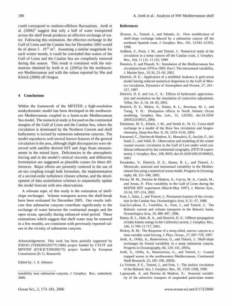
The total volume of water transported from the shelf tothe open ocean during the integration period reached 10.8 ·
1012 m3. Similarly, the volume transport from the open oceanto the shelf is estimated to be 9.2 · 1012 m3 and hence a netoffshore transport is suggested by these values. Nevertheless,not all cross-shelf transported water is effectively exchanged(Jordi et al., 20063), since to a large extent these fluxes
3Jordi, A., Klinck, J. M., Basterretxea, G., Orfila, A., and Tin-tore, J.: Estimation of shelf-slope exchanges induced by frontal
www.ocean-sci.net/2/173/2006/ Ocean Sci., 2, 173–181, 2006
180 A. Jordi et al.: Analysis of NW Mediterranean shelf
could correspond to onshore-offshore fluctuations. Jordi etal. (2006)3 suggest that only a half of water transportedacross the shelf break produces an effective exchange of wa-ter. Following this estimation, the effective exchange in theGulf of Lions and the Catalan Sea for December 2005 wouldbe of about 5· 1012 m3. Assuming a similar magnitude foreach winter month, it could be concluded that waters of theGulf of Lions and the Catalan Sea are completely renewedduring this season. This result is consistent with the esti-mations obtained byJordi et al.(2005a) for the northwest-ern Mediterranean and with the values reported byShe andKlinck (2000) off Oregon.
4 Conclusions
Within the framework of the MFSTEP, a high-resolutionnonhydrostatic model has been developed in the northwest-ern Mediterranean coupled to a basin-scale MediterraneanSea model. The numerical study is focused on the continentalmargins of the Gulf of Lions and the Catalan Sea, where thecirculation is dominated by the Northern Current and shelfbathymetry is incised by numerous submarine canyons. Themodel reproduces well several known features of the generalcirculation in the area, although slight discrepancies were ob-served with satellite derived SST and Argo floats measure-ments in the mixed layer. Deficiencies in the atmosphericforcing and in the model’s vertical viscosity and diffusivityformulation are suggested as plausible causes for these dif-ferences. Major efforts are presently centered in the use ofair-sea coupling trough bulk formulaes, the implementationof a second-order turbulence closure scheme, and the devel-opment of data assimilation schemes to sequentially updatethe model forecast with new observations.
A relevant topic of this study is the estimation of shelf-slope exchanges. Volume transports across the shelf-breakhave been evaluated for December 2005. Our results indi-cate that submarine canyons contribute significantly to theexchange of water between the continental margin and theopen ocean, specially during enhanced wind period. Theseestimations which suggest that shelf water may be renewedin a few months, are consistent with previously reported val-ues in the vicinity of submarine canyons.
Acknowledgements.This work has been partially supported byESEOO (VEM200320577C1408) project funded by CYCIT andMFSTEP (EVK3CT200200175) project funded by EuropeanCommission (D. G. Research).
Edited by: J. A. Johnson
instability near submarine canyons, J. Geophys. Res., submitted,2006.
References
Alvarez, A., Tintore, J., and Sabates, A.: Flow modification ofshelf-slope exchange induced by a submarine canyon off thenortheast Spanish coast, J. Geophys. Res., 101, 12 043–12 055,1996.
Ardhuin, F., Pinot, J. M., and Tintore, J.: Numerical study of thecirculation in a steep canyon off the Catalan coast, J. Geophys.Res., 104, 11 115–11 135, 1999.
Demirov, E. and Pinardi, N.: Simulation of the Mediterranean Seacirculation from 1979 to 1993: Part I. The interannual variability,J. Marine Syst., 33-34, 23–50, 2002.
Dietrich, D. E.: Application of a modified Arakawa A grid oceanmodel having reduced numerical dispersion to the Gulf of Mex-ico circulation, Dynamics of Atmosphere and Oceans, 27, 201–217, 1997.
Dietrich, D. E. and Lin, C. A.: Effects of hydrostatic approxima-tion and resolution on the simulation of convective adjustment,Tellus, Ser. A, 54, 34–43, 2002.
Dietrich, D. E., Mehra, A., Haney, R. L., Bowman, M. J., andTseng, Y. H.: Dissipation effects in North Atlantic Oceanmodeling, Geophys. Res. Lett., 31, L05302, doi:10.1029/2003GL019015, 2004.
Dinniman, M. S., Klinck, J. M., and Smith Jr., W. O.: Cross-shelfexchange in a model of the Ross Sea circulation and biogeo-chemistry, Deep-Sea Res. II, 50, 3103–3120, 2003.
Estournel, C., Durrieu de Madron, X., Marsaleix, P., Auclair, F., Jul-liand, C., and Vehil, R.: Observation and modeling of the wintercoastal oceanic circulation in the Gulf of Lion under wind con-ditions influenced by the continental orography, (FETCH experi-ment), J. Geophys. Res., 108, 8059, doi:10.1029/2001JC000825,2003.
Fernandez, V., Dietrich, D. E., Haney, R. L., and Tintore, J.:Mesoscale, seasonal and interannual variability in the Mediter-ranean Sea using a numerical ocean model, Progress in Oceanog-raphy, 66, 321–340, 2005.
Flexas, M. M., Durrieu de Madron, X., Garcia, M. A., Canals, M.,and Arnau, P.: Flow variability in the Gulf of Lions during theMATER HFF experiment (March-May 1997), J. Marine Syst.,33-34, 197–214, 2002.
Font, J., Salat, J., and Tintore, J.: Permanent features of the circula-tion in the Catalan Sea, Oceanologica Acta, 9, 51–57, 1988.
Garcia-Ladona, E., Castellon, A., Font, J., and Tintore, J.: TheBalearic current and volume transports in the Balearic basin,Oceanologica Acta, 19, 489–497, 1996.
Haney, R. L., Hale, R. A., and Dietrich, D. E.: Offhore propagationof eddy kinetic energy in the California current, J. Geophys. Res.,106, 11 709–11 717, 2001.
Hickey, B. M.: The Response of a steep-sided, narrow canyon to atime-variable wind forcing, J. Phys. Ocean., 27, 697–729, 1997.
Jordi, A., Orfila, A., Basterretxea, G., and Tintore, J.: Shelf-slopeexchanges by frontal variability in a steep submarine canyon,Progress in Oceanography, 66, 120–141, 2005a.
Jordi, A., Orfila, A., Basterretxea, G., and Tintore, J.: Coastaltrapped waves in the northwestern Mediterranean, ContinentalShelf Research, 25, 185–196, 2005b.
La Violette, P. E., Tintore, J., and Font, J.: The surface circulationof the Balearic Sea, J. Geophys. Res., 95, 1559–1568, 1990.
Lapouyade, A. and Durrieu de Madron, X.: Seasonal variabil-ity of the advective transport of suspended particulate matter
Ocean Sci., 2, 173–181, 2006 www.ocean-sci.net/2/173/2006/

A. Jordi et al.: Analysis of NW Mediterranean shelf 181
and organic carbon in the Gulf of Lions (NW Mediterranean),Oceanologica Acta, 24, 295-312, 2001.
Millot, C.: The Gulf of Lions’ hydrodynamics, Continental ShelfResearch, 10, 885–894, 1990.
Levy, M., Klein, P., and Treguier, A. M.: Impact of sub-mesoscalephysics on production and subduction of phytoplankton in anoligotrophic regime, J. Marine Res., 59, 535–565, 2001.
Millot, C.: Circulation in the Western Mediterranean Sea, J. MarineSyst., 100, 423–442, 1999.
Palanques, A., Garcia-Ladona, E., Gomis, D., Martin, J., Marcos,M., Pascual, A., Puig, P., Emelianov, J.-M. G. M., Guillen, S.M. J., Tintore, J., Segura, M., Jordi, A., Ruiz, S., Basterretxea,G., Font, J., Blasco, D., and Pages, F.: A multidisciplinaryprogram to studythe dynamics and the ecology of a northwest-ern Mediterranean submarine canyon: The Palamos Canyon,Progress in Oceanography, 66, 89–119, 2005.
Pascual, A., Nardelli, B. B., Larnicol, G., Emelianov, M., andGomis, D.: A case of an intense anticyclonic eddy in the BalearicSea (western Mediterranean), J. Geophys. Res., 107, 3183, doi:10.1029/2001JC000913, 2002.
Pascual, A., Gomis, D., Haney, R. L., and Ruiz, S.: Quasi-geostrophic Analysis of a Meander in the Palamos Canyon: Ver-tical Velocity, Geopotential Tendency, and a Relocation Tech-nique, J. Phys. Ocean., 34, 2274–2287, 2004.
Rubio, A., Arnau, P. A., Espino, M., Flexas, M. M., Jorda, G.,J. Salat, J. P., and Arcilla, A. S.: A field study of the behaviourof an anticyclonic eddy on the Catalan continental shelf (NWMediterranean), Progress in Oceanography, 66, 142–156, 2005.
Sanderson, B. G.: Order and resolution for computational oceandynamics, J. Phys. Ocean., 28, 1271–1286, 1998.
Sanderson, B. G. and Brassington, G.: Accuracy in the contextof a control-volume model, Atmosphere-Ocean, 36(4), 355–384,1998.
Send, U., Font, J., Krahmann, G., Millot, C., Rhein, M., and Tin-tore, J.: Recent advances in observing the physical oceanographyof the western Mediterranean Sea, Progress in Oceanography, 44,37–64, 1999.
She, J. and Klinck, J. M.: Flow near submarine canyons driven byconstant winds, J. Geophys. Res., 105, 28 671–28 694, 2000.
Skliris, N., Hecq, J. H., and Djenidi, S.: Water fluxes at an oceanmargin in presence of a submarine canyon, J. Marine Syst., 32,239–251, 2002.
Skliris, N., Lacroix, G., and Djenidi, S.: Effects of extreme me-teorological conditions on coastal dynamics near a submarinecanyon, Continental Shelf Research, 24, 1033–1045, 2004.
Staneva, J., Dietrich, D. E., Stanev, E., and Bowman, M.: Rim cur-rent and coastal eddy mechanisms in an eddy-resolving black seageneral circulation model, J. Marine Syst., 31, 137–157, 2001.
Tintore, J., Wang, D.-P., and La Violette, P. E.: Eddies and thermo-haline intrusions of the shelf-slope front off the Northeast Span-ish coast, J. Geophys. Res., 95(C2), 1627–1633, 1990.
Tseng, Y.-H., Dietrich, D. E., and Ferziger, J. H.: Regional circu-lation of the Monterey Bay region: Hydrostatic versus nonhy-drostatic modeling, J. Geophys. Res., 110, C09015, doi:10.1029/2003JC002153, 2005.
Wang, D.-P., Vieira, M. E. C., Salat, J., Tintore, J., and La Violette,P. E.: A shelf-slope filament off the northeast Spanish Coast, J.Geophys. Res., 46, 321–332, 1988.
www.ocean-sci.net/2/173/2006/ Ocean Sci., 2, 173–181, 2006