Analysing Landscape Futures for Dryland Agricultural Areas: a Case Study in the Lower Murray Region...
28
20 Analysing Landscape Futures for Dryland Agricultural Areas: a Case Study in the Lower Murray Region of Southern Australia Brett A Bryan, Neville D Crossman and Darran King CSIRO, Urrbrae, South Australia, Australia Abstract: There is an urgent need to reverse the declining environmental condition of rural landscapes across southern Australia. Current ap- proaches focus on natural resources management planning, policy and de- cision making at the regional level. Regional plans and associated on- ground investment have the potential to have widespread and long-lasting environmental, economic and social impacts. However, rarely are these impacts quantified and clearly understood. In this chapter we describe part of a large integrated project called the Lower Murray Landscape Futures (LMLF) which aimed to assess the im- pact of regional plans for the Lower Murray on selected environmental and socioeconomic indicators under alternative future landscape scenar- ios with input from stakeholders. The dryland component of the LMLF is a large-scale integrated regional planning and landscape futures analysis focussing on issues such as: agricultural production including food, fibre and bioenergy production; soil erosion; loss of terrestrial biodiversity; ris- ing watertables; and the salinisation of the land and waterways. The pro- ject was designed to be inclusive and engender collaboration amongst re- searchers, participation by regional stakeholders, and communication to regional stakeholders and communities. The intention is to provide useful evidence-based natural resource management planning advice to regional agencies. Landscape futures are plausible spatial arrangements of management actions (vegetation man- agement, ecological restoration, conservation farming, deep-rooted per- ennials, biomass, and biofuels) that achieve regional natural resource management targets, assessed under six policy options and five climatic
Transcript of Analysing Landscape Futures for Dryland Agricultural Areas: a Case Study in the Lower Murray Region...
20 Analysing Landscape Futures for Dryland Agricultural Areas: a Case Study in the Lower Murray Region of Southern Australia
Brett A Bryan, Neville D Crossman and Darran King
CSIRO, Urrbrae, South Australia, Australia
Abstract: There is an urgent need to reverse the declining environmental condition of rural landscapes across southern Australia. Current ap-proaches focus on natural resources management planning, policy and de-cision making at the regional level. Regional plans and associated on-ground investment have the potential to have widespread and long-lasting environmental, economic and social impacts. However, rarely are these impacts quantified and clearly understood.
In this chapter we describe part of a large integrated project called the Lower Murray Landscape Futures (LMLF) which aimed to assess the im-pact of regional plans for the Lower Murray on selected environmental and socioeconomic indicators under alternative future landscape scenar-ios with input from stakeholders. The dryland component of the LMLF is a large-scale integrated regional planning and landscape futures analysis focussing on issues such as: agricultural production including food, fibre and bioenergy production; soil erosion; loss of terrestrial biodiversity; ris-ing watertables; and the salinisation of the land and waterways. The pro-ject was designed to be inclusive and engender collaboration amongst re-searchers, participation by regional stakeholders, and communication to regional stakeholders and communities.
The intention is to provide useful evidence-based natural resource management planning advice to regional agencies. Landscape futures are plausible spatial arrangements of management actions (vegetation man-agement, ecological restoration, conservation farming, deep-rooted per-ennials, biomass, and biofuels) that achieve regional natural resource management targets, assessed under six policy options and five climatic
408 BA Bryan, ND Crossman and D King
and economic scenarios. The triple bottom line impacts of landscape fu-tures under each scenario and policy option were then assessed and visu-alised. The costs and benefits of landscape futures were compared and the trade-offs assessed to inform regional planning in the Lower Murray.
20.1 Introduction
There is an urgent need to reverse the declining environmental state of ru-ral landscapes across southern Australia (Williams and Saunders 2005). Current approaches focus on natural resource management planning, pol-icy and decision making at the regional level. Regional plans and associ-ated on-ground investment have the potential to have widespread and long-lasting environmental, economic, and social impacts. However, rarely are these impacts quantified and clearly understood. The inherent uncertainty in quantifying future impacts necessitates a scenario analysis and futures thinking approach. This chapter presents an overview of the development and application of such a methodology to the problem of natural resource management planning in the Lower Murray region of southern Australia.
The Lower Murray Landscapes Futures (LMLF) project was con-ceived in recognition of the need for better informed planning and man-agement in Australia’s agricultural regions. The project is an ambitious, tri-state, multi-organisation, and multi-region research collaboration within the lower Murray-Darling Basin, Australia with the following dual aims:
• Aim 1: Assessing the impact of existing natural resource management plans for the Lower Murray on selected environmental and socioeco-nomic indicators.
• Aim 2: Assessing the impacts of these plans under alternative landscape future scenarios based on the outcomes of the analysis of the existing plans and input from stakeholders.
The LMLF project has two major components — the River Murray corridor and the dryland agriculture components. The focus of the River Murray corridor component is on water quantity, quality and use. The fo-cus of the dryland component is on natural resource management problems in the dryland agricultural areas of the Lower Murray, such as soil erosion, loss of terrestrial biodiversity and rising watertables. Areas of interest in the dryland component include cleared agricultural areas and remnant vegetation, but are exclusive of urban, irrigated, and floodplain areas.
The major objectives of the dryland component are:
Analysing Landscape Futures for Dryland Agricultural Areas 409
• Review all regional plans relevant to the three regional natural resource management agencies participating in this study (the South Australian Murray-Darling Basin Natural Resource Management Board, the Mallee Catchment Management Authority, and the Wimmera Catchment Man-agement Authority) and synthesise a set of quantitative, addressable natural resource management targets for each region.
• Define policy options and landscape futures scenarios. • Acquire, assemble, model, and integrate a variety of spatial and non-
spatial data covering a range of biophysical, ecological, administrative, social and economic aspects of the Lower Murray region under the baseline and landscape futures scenarios.
• Develop models of landscape futures for all policy options and future scenarios using the systematic regional planning framework (Bryan and Crossman in press).
• Analyse, interpret, and visualise alternative landscape futures for the Lower Murray including the environmental, economic and social impact of regional plans and analyse trade-offs under different policy options for the baseline and landscape futures scenarios.
The dryland component of the LMLF project is a large-scale investiga-tion into integrated regional planning and landscape futures analysis. Inte-grated regional planning and futures analysis is a complex exercise that demands expertise in diverse disciplinary areas. Therefore, the LMLF pro-ject was designed to be inclusive and engender collaboration amongst re-searchers, participation by regional stakeholders, and communication to regional stakeholders and communities. The intention is to provide useful evidence-based natural resource management planning advice to regional agencies. This chapter describes the structure, process and learning achieved from undertaking such an ambitious, integrated analysis of land-scape futures with many collaborators and stakeholders.
20.2 Futures Thinking and Scenario Analysis
Scenario analysis and planning has its origin in economic and strategic planning post WWII. Scenario analysis and futures thinking has become an increasingly popular and accepted methodology for planning, especially recently in the field of environmental management and planning (Schwartz 1996; Steinitz 1990). At the global level, a well known application of sce-nario analysis is the Special Report on Emissions Scenarios (SRES) that underpin the Intergovernmental Panel on Climate Change assessment re-port (IPCC 2001). Other global scenario modelling of note is the work of
410 BA Bryan, ND Crossman and D King
the Global Scenario Group (Raskin and Kemp-Benedict 2002) and the Millennium Ecosystem Assessment (Carpenter et al. 2005).
There are many applications of scenario analysis to natural resource management on a regional scale. For example, a comprehensive set of in-vited papers recently published in Ecological Applications Volume 14 (pp. 311–400) reported on a series of studies into alternative futures analysis for the Willamette River Basin in Oregon, USA (Baker and Landers 2004; Baker et al. 2004). These studies use scenarios to explore alternative fu-tures for many components of natural resource management, including: land and water use (Hulse et al. 2004), agricultural systems (Berger and Bolte 2004), surface water allocation (Dole and Nieme 2004), freshwater biodiversity (Van Sickle et al. 2004), and terrestrial biodiversity (Schumaker et al. 2004). Steinitz et al. (2003) presented a comprehensive analysis of landscape futures for the San Pedro River basin that crosses the United States/Mexico border. Santelman et al. (2004) assessed futures for the agricultural landscapes of Iowa, USA.
As a rule of thumb, future scenarios for environmental applications, including natural resource management, should provide integration across social, economic and environmental elements (Raskin 2005). They should also quantify key variables describing ecosystem and resource condition, span long time horizons of at least several decades, and explore multiple futures that span a broad range of plausible outcomes across the timeframe of projections (Raskin 2005). Hulse et al. (2004) state that futures thinking and scenario analysis contains four steps:
• Defining the assumptions and rules of future alternatives (scenarios). • Depicting spatially explicit alternatives (scenarios) through land use and
allocation models. • Modelling the effects of land use patterns on natural resources. • Producing products that characterise the differences between alterna-
tives (scenarios).
However an additional step has also been proposed (Theobald 2005; Wil-here et al. 2007):
• Involve active participation by stakeholders and the public and collabo-ration among scientists, planners and the public.
The LMLF study follows these five steps in undertaking futures think-ing and scenario analyses. We also employ the rules of thumb discussed by Raskin (2005) and examine the impacts of alternative landscape futures across the environmental, economic, and social domains.
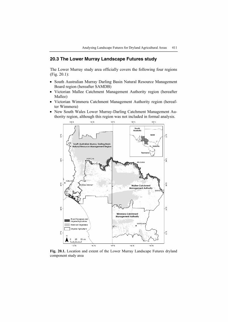
Analysing Landscape Futures for Dryland Agricultural Areas 411
20.3 The Lower Murray Landscape Futures study
The Lower Murray study area officially covers the following four regions (Fig. 20.1):
• South Australian Murray Darling Basin Natural Resource Management Board region (hereafter SAMDB)
• Victorian Mallee Catchment Management Authority region (hereafter Mallee)
• Victorian Wimmera Catchment Management Authority region (hereaf-ter Wimmera)
• New South Wales Lower Murray-Darling Catchment Management Au-thority region, although this region was not included in formal analysis.
Fig. 20.1. Location and extent of the Lower Murray Landscape Futures dryland component study area
412 BA Bryan, ND Crossman and D King
The Lower Murray is a diverse landscape ranging from the moist, hilly uplands of the southern Wimmera and western SAMDB, through large ar-eas of productive agricultural cropping/grazing country, to semi-arid rangelands in the northern parts of the SAMDB. The River Murray also winds its way across the predominantly flat topography, supporting a cor-ridor of high value irrigated agriculture.
The Lower Murray maintains significant biodiversity, land, and water resources. However, the cumulative impact of 90 years of land clearance and productive use has led to the ongoing degradation of these natural resources. Management is required to halt threatening processes and reverse this de-clining trend in the condition of natural resources in the Lower Murray.
20.3.1 Collaborative and Participatory Approach
Productive collaboration between researchers from several Commonwealth, state government and commercial agencies was essential in analysing a complex problem such as landscape futures over such a large area. The team consisted of a core of geographers and integrated modellers, complemented by collaborators with a range of disciplinary expertise and experience in the Lower Murray. The project team included researchers from: CSIRO Land and Water (CLW): Policy and Economic Research Unit (PERU); Agricul-ture, Water and Environment (AWE); Australian Research Centre for Wa-ter in Society (ARCWIS); CSIRO Sustainable Ecosystems (CSE); Primary Industries Research Victoria (PIRVic); EconSearch Pty Ltd; The Univer-sity of Adelaide; South Australian Research and Development Institute (SARDI).
Close linkages between researchers and stakeholders was also essential in ensuring a successful research outcome. Participatory approaches were used from the outset of the project to ensure the inclusion of stakeholder input framing the:
• research questions • definition of policy options and scenarios • methods and techniques used • interpretation of the results.
The participatory approach enabled stakeholders to be involved in the processes that shaped the research methods and outcomes. Active co-operation and participation of regional stakeholders in these facets of the LMLF dryland component research helped to:
• clarify the research questions
Analysing Landscape Futures for Dryland Agricultural Areas 413
• increase the relevance of the research • engender a sense of ownership of the research by regional agencies • increase the potential for long-term adoption and impact of the research.
The two main mechanisms for encouraging participation by regional stakeholders were through the Project Steering Committee and the Techni-cal Reference Panel. The Project Steering Committee met regularly and the membership consisted of senior people from: CSIRO; University of Ade-laide; Primary Industries Research Victoria; South Australian Department of Water, Land and Biodiversity Conservation; Murray-Darling Basin Commission; and the Chief Executive Officers of the SAMDB Natural Re-source Management Board, and Mallee and Wimmera Catchment Man-agement Authorities. The role of this group was to provide strategic over-sight of the project direction.
The Technical Reference Panel consisted of technically skilled and ex-perienced people from: Primary Industries Research Victoria; South Aus-tralian Department of Water, Land and Biodiversity Conservation; SAMDB Natural Resource Management Board; and Mallee and Wimmera Catchment Management Authorities. The role of this group was to provide technical advice on the development of methods, contribute to the devel-opment of scenarios, interpretation of results, and broker networks and linkages into other relevant studies and work.
Communication of results was an ongoing focus of the dryland project team. Presentations have been tailored for specific audiences at all levels including international and national conferences, state government work-shops, regional agencies, and to on-ground local practitioner groups. Communication of the project is currently geared toward increasing the adoption and impact of the work.
20.3.2 Defining Targets, Scenarios and Policy Options
The regional agencies involved in the LMLF project have developed re-gional plans and strategies for managing natural resources. The foundation of these plans is a set of targets aimed at achieving regional sustainability. Analysis of regional natural resource management plans identified 15 rele-vant plans and strategies relevant to the Lower Murray region. Considera-tion of regional plans and consultation with regional stakeholders revealed four environmental objectives of particular interest in the dryland agricul-tural areas of the Lower Murray:
• protect and restore ecosystems to enhance terrestrial biodiversity • reduce deep drainage to prevent rising saline groundwater
414 BA Bryan, ND Crossman and D King
• manage soils to minimise wind erosion • sequester carbon and reduce carbon emissions to mitigate climate
change.
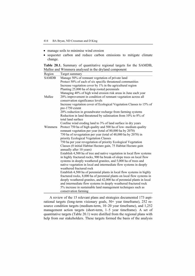
Table 20.1. Summary of quantitative regional targets for the SAMDB, Mallee and Wimmera analysed in the dryland component Region Target summary SAMDB Manage 50% of remnant vegetation of private land Protect 50% of each of six specific threatened communities Increase vegetation cover by 1% in the agricultural region Planting 25,000 ha of deep rooted perennials Managing 40% of high wind erosion risk areas in June each year Mallee 20% improvement in condition of remnant vegetation across all
conservation significance levels Increase vegetation cover of Ecological Vegetation Classes to 15% of
pre-1750 extent 20% reduction in groundwater recharge from farming systems Reduction in land threatened by salinisation from 10% to 8% of
total land surface Confine wind eroding land to 3% of land surface in dry years Wimmera Protect 750 ha of high quality and 500 ha of low–medium quality
remnant vegetation per year (total of 80,000 ha by 2070) 750 ha of revegetation per year (total of 48,000 ha by 2070) in
priority Ecological Vegetation Classes 750 ha per year revegetation of priority Ecological Vegetation
Classes (0 initial Habitat Hectare gain, 75 Habitat Hectare gain annually after 10 years)
Establish 4,500 ha of tree and native vegetation in local flow systems in highly fractured rocks, 900 ha break-of-slope trees on local flow systems in deeply weathered granites, and 5,000 ha of trees and native vegetation in local and intermediate flow systems in deeply weathered fractured rock
Establish 4,500 ha of perennial plants in local flow systems in highly fractured rocks, 8,000 ha of perennial plants on local flow systems in deeply weathered granites, and 42,000 ha of perennial plants in local and intermediate flow systems in deeply weathered fractured rock
5% increase in sustainable land management techniques such as conservation farming
A review of the 15 relevant plans and strategies documented 173 aspi-rational targets (long-term visionary goals, 50+ year timeframe), 252 re-source condition targets (medium-term, 10–20 year timeframe), and 1,252 management action targets (short-term, 1–5 year timeframe). A set of quantitative targets (Table 20.1) were distilled from the regional plans with help from our stakeholders. These targets formed the basis of the analysis

Analysing Landscape Futures for Dryland Agricultural Areas 415
of landscape futures because targets are achieved under each landscape fu-ture. Six natural resource management actions were identified from re-gional plans and stakeholder consultation as having potential for address-ing the biodiversity, deep drainage, wind erosion and climate change environmental objectives. The six natural resource management actions are explained in Table 20.2.
Table 20.2. Appropriate natural resource management actions for addressing envi-ronmental objectives in the Lower Murray
NRM actions Description Areas of remnant vegetation only: Vegetation management Including stock exclusion, restoration of local
native species, regeneration, weed management Cleared agricultural areas only: Ecological restoration Restoration of local native species, ecological
structure and function Conservation farming Incorporation of minimum tillage and stubble
retention techniques in crop/fallow rotation Deep-rooted perennials Plantation of fodder crops (e.g. lucerne, salt-
bush) for sheep grazing Biomass Oil mallee species grown for processing into
activated charcoal, oil, and renewable energy
Biofuels Wheat/canola rotation (using conservation farming techniques) for ethanol and biodiesel production
The LMLF project used a futures and scenario analysis methodology. In this methodology, landscape futures are alternative arrangements of natural resource management actions (Table 20.2) in the landscape that, together, achieve selected regional targets in the SAMDB, Mallee and Wimmera regions (Table 20.1). In the tradition of futures analysis, land-scape futures are generated as plausible, but not necessarily probable, out-comes. Futures were selected that bound the range of possible alternatives and enable the assessment of costs, benefits and trade-offs of policy choices available to regional agencies as a guide for strategic natural re-source management decision making. We used a combination of internal and external drivers to define landscape futures. Internal drivers are policy options which are strategic choices that decision makers can make with re-gard to how they go about achieving regional targets through the location of natural resource management actions in the landscape. External drivers include change in climate and commodity prices.

416 BA Bryan, ND Crossman and D King
Six alternative policy options were analysed. Policy options were de-vised specifically to aid natural resource management decision making through pair-wise comparison. Hence, the impacts of different decision strategies such as cost minimisation (Cheapest policy option), single (Best for Biodiversity policy option) and multiple (Best for NRM policy option) benefit maximisation, cost effectiveness maximisation (Most Cost Effec-tive policy option), and sustainability enabling (Sustainability Ideal policy option) were assessed relative to each other and relative to having no strat-egy at all (Go Anywhere policy option). Analysis of the impact of alterna-tive policy options enabled us to understand the potential influence of stra-tegic choices (over which the decision maker has full control) on landscape futures. Table 20.3 describes the policy options.
Table 20.3. Description of the alternative policy options assessed in landscape fu-tures analysis
Policy options Brief description
Go Anywhere Achieve regional targets by a non-strategic, non-targeted approach of locating NRM actions at random in the landscape
Cheapest Minimise economic cost of achieving targets including establish-ment costs and opportunity costs of foregone agricultural produc-tion
Best for Biodiversity
Achieve biodiversity targets whilst maximising biodiversity bene-fits, achieve other targets using the Go Anywhere approach
Best for NRM Achieve regional targets whilst maximising benefits for the mul-tiple environmental objectives of biodiversity, deep drainage, wind erosion, and climate change
Most Cost Effective
Achieve regional targets whilst minimising economic cost relative to benefits for the multiple environmental objectives of biodiversi-ty, deep drainage, wind erosion, and climate change
Sustainability Ideal
Achieve a new set of regional targets aimed at achieving sustaina-bility whilst minimising economic cost relative to benefits for the multiple environmental objectives of biodiversity, deep drainage, wind erosion, and climate change
Five of these policy options are constrained by the need to meet exist-ing targets, whilst the Sustainability Ideal policy option is constrained by a new parsimonious and consistent set of targets based on the best available scientific knowledge and aimed at achieving the long-term aspirational goal of sustainability of regional systems. Sustainability Ideal targets in-clude the following:
• At least 15% of each pre-European vegetation community, climate zone, soil type, and bioregion (subregion) must be either under remnant vegeta-tion or targeted for ecological restoration with a minimum size of 1,000 ha.
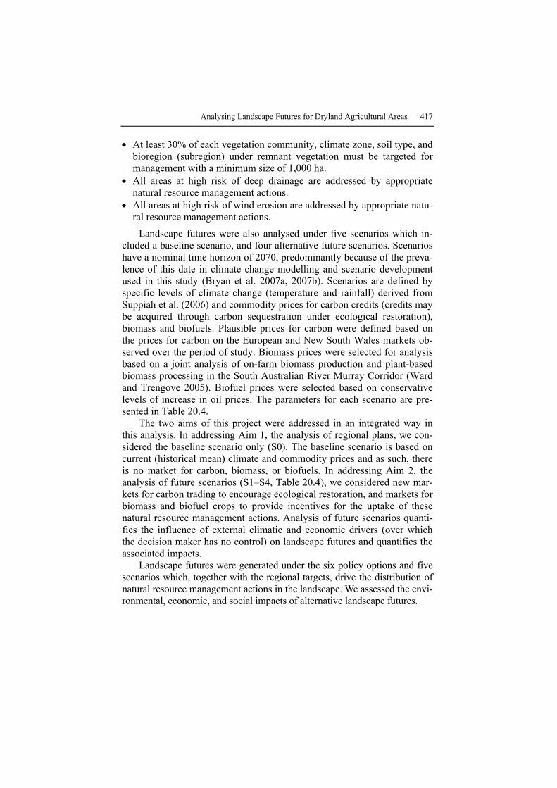
Analysing Landscape Futures for Dryland Agricultural Areas 417
• At least 30% of each vegetation community, climate zone, soil type, and bioregion (subregion) under remnant vegetation must be targeted for management with a minimum size of 1,000 ha.
• All areas at high risk of deep drainage are addressed by appropriate natural resource management actions.
• All areas at high risk of wind erosion are addressed by appropriate natu-ral resource management actions.
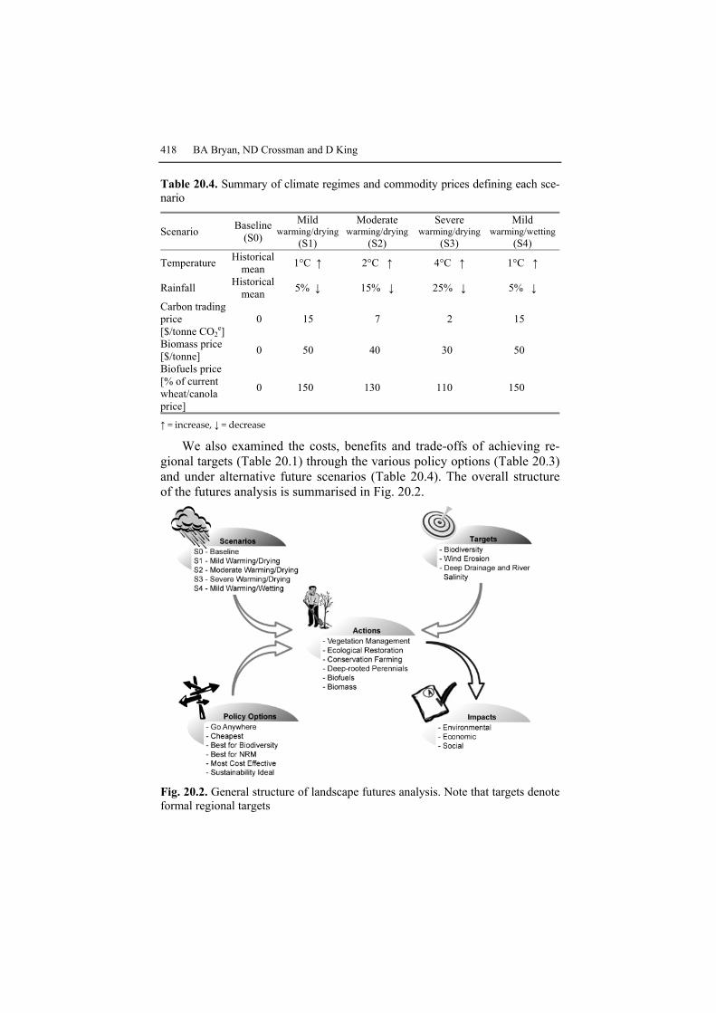
Landscape futures were also analysed under five scenarios which in-cluded a baseline scenario, and four alternative future scenarios. Scenarios have a nominal time horizon of 2070, predominantly because of the preva-lence of this date in climate change modelling and scenario development used in this study (Bryan et al. 2007a, 2007b). Scenarios are defined by specific levels of climate change (temperature and rainfall) derived from Suppiah et al. (2006) and commodity prices for carbon credits (credits may be acquired through carbon sequestration under ecological restoration), biomass and biofuels. Plausible prices for carbon were defined based on the prices for carbon on the European and New South Wales markets ob-served over the period of study. Biomass prices were selected for analysis based on a joint analysis of on-farm biomass production and plant-based biomass processing in the South Australian River Murray Corridor (Ward and Trengove 2005). Biofuel prices were selected based on conservative levels of increase in oil prices. The parameters for each scenario are pre-sented in Table 20.4.
The two aims of this project were addressed in an integrated way in this analysis. In addressing Aim 1, the analysis of regional plans, we con-sidered the baseline scenario only (S0). The baseline scenario is based on current (historical mean) climate and commodity prices and as such, there is no market for carbon, biomass, or biofuels. In addressing Aim 2, the analysis of future scenarios (S1–S4, Table 20.4), we considered new mar-kets for carbon trading to encourage ecological restoration, and markets for biomass and biofuel crops to provide incentives for the uptake of these natural resource management actions. Analysis of future scenarios quanti-fies the influence of external climatic and economic drivers (over which the decision maker has no control) on landscape futures and quantifies the associated impacts.
Landscape futures were generated under the six policy options and five scenarios which, together with the regional targets, drive the distribution of natural resource management actions in the landscape. We assessed the envi-ronmental, economic, and social impacts of alternative landscape futures.
418 BA Bryan, ND Crossman and D King
Table 20.4. Summary of climate regimes and commodity prices defining each sce-nario
Scenario Baseline (S0)
Mild warming/drying
(S1)
Moderate warming/drying
(S2)
Severe warming/drying
(S3)
Mild warming/wetting
(S4)
Temperature Historicalmean 1°C ↑ 2°C ↑ 4°C ↑ 1°C ↑
Rainfall Historicalmean 5% ↓ 15% ↓ 25% ↓ 5% ↓
Carbon trading price [$/tonne CO2
e] 0 15 7 2 15
Biomass price [$/tonne] 0 50 40 30 50
Biofuels price [% of current wheat/canola price]
0 150 130 110 150
↑ = increase, ↓ = decrease
We also examined the costs, benefits and trade-offs of achieving re-gional targets (Table 20.1) through the various policy options (Table 20.3) and under alternative future scenarios (Table 20.4). The overall structure of the futures analysis is summarised in Fig. 20.2.
Fig. 20.2. General structure of landscape futures analysis. Note that targets denote formal regional targets
Analysing Landscape Futures for Dryland Agricultural Areas 419
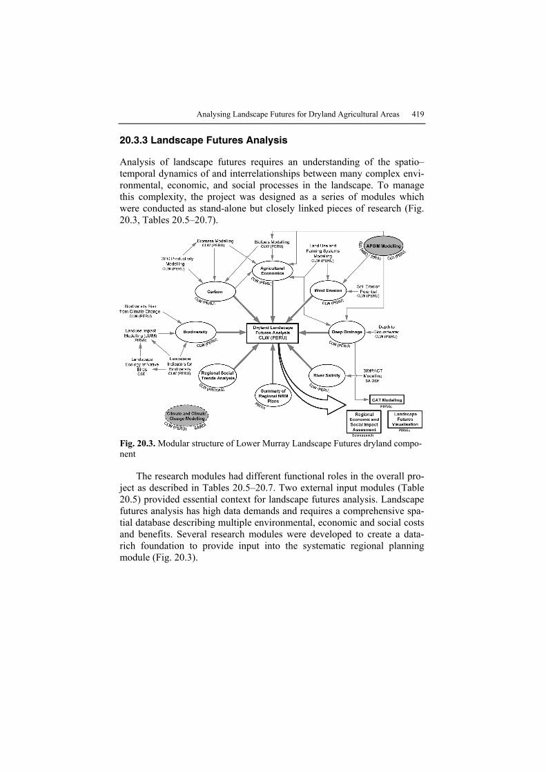
20.3.3 Landscape Futures Analysis
Analysis of landscape futures requires an understanding of the spatio–temporal dynamics of and interrelationships between many complex envi-ronmental, economic, and social processes in the landscape. To manage this complexity, the project was designed as a series of modules which were conducted as stand-alone but closely linked pieces of research (Fig. 20.3, Tables 20.5–20.7).
Fig. 20.3. Modular structure of Lower Murray Landscape Futures dryland compo-nent
The research modules had different functional roles in the overall pro-ject as described in Tables 20.5–20.7. Two external input modules (Table 20.5) provided essential context for landscape futures analysis. Landscape futures analysis has high data demands and requires a comprehensive spa-tial database describing multiple environmental, economic and social costs and benefits. Several research modules were developed to create a data-rich foundation to provide input into the systematic regional planning module (Fig. 20.3).
420 BA Bryan, ND Crossman and D King
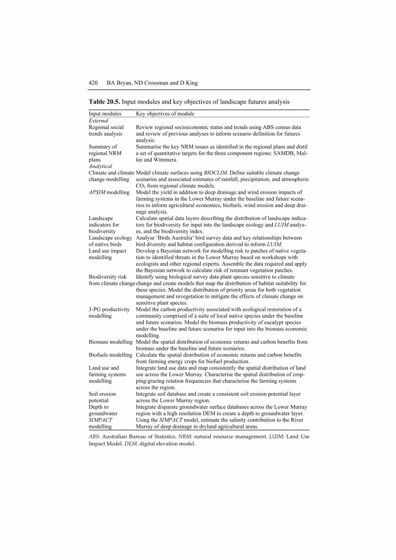
Table 20.5. Input modules and key objectives of landscape futures analysis
Input modules Key objectives of module External Regional social trends analysis
Review regional socioeconomic status and trends using ABS census data and review of previous analyses to inform scenario definition for futures analysis.
Summary of regional NRM plans
Summarise the key NRM issues as identified in the regional plans and distil a set of quantitative targets for the three component regions: SAMDB, Mal-lee and Wimmera.
Analytical Climate and climate change modelling
Model climate surfaces using BIOCLIM. Define suitable climate change scenarios and associated estimates of rainfall, precipitation, and atmospheric CO2 from regional climate models.
APSIM modelling Model the yield in addition to deep drainage and wind erosion impacts of farming systems in the Lower Murray under the baseline and future scena-rios to inform agricultural economics, biofuels, wind erosion and deep drai-nage analysis.
Landscape indicators for biodiversity
Calculate spatial data layers describing the distribution of landscape indica-tors for biodiversity for input into the landscape ecology and LUIM analys-es, and the biodiversity index.
Landscape ecology of native birds
Analyse ‘Birds Australia’ bird survey data and key relationships between bird diversity and habitat configuration derived to inform LUIM.
Land use impact modelling
Develop a Bayesian network for modelling risk to patches of native vegeta-tion to identified threats in the Lower Murray based on workshops with ecologists and other regional experts. Assemble the data required and apply the Bayesian network to calculate risk of remnant vegetation patches.
Biodiversity risk from climate change
Identify using biological survey data plant species sensitive to climate change and create models that map the distribution of habitat suitability for these species. Model the distribution of priority areas for both vegetation management and revegetation to mitigate the effects of climate change on sensitive plant species.
3-PG productivity modelling
Model the carbon productivity associated with ecological restoration of a community comprised of a suite of local native species under the baseline and future scenarios. Model the biomass productivity of eucalypt species under the baseline and future scenarios for input into the biomass economic modelling.
Biomass modelling Model the spatial distribution of economic returns and carbon benefits from biomass under the baseline and future scenarios.
Biofuels modelling Calculate the spatial distribution of economic returns and carbon benefits from farming energy crops for biofuel production.
Land use and farming systems modelling
Integrate land use data and map consistently the spatial distribution of land use across the Lower Murray. Characterise the spatial distribution of crop-ping/grazing rotation frequencies that characterise the farming systems across the region.
Soil erosion potential
Integrate soil database and create a consistent soil erosion potential layer across the Lower Murray region.
Depth to groundwater
Integrate disparate groundwater surface databases across the Lower Murray region with a high resolution DEM to create a depth to groundwater layer.
SIMPACT modelling
Using the SIMPACT model, estimate the salinity contribution to the River Murray of deep drainage in dryland agricultural areas.
ABS: Australian Bureau of Statistics. NRM: natural resource management. LUIM: Land Use Impact Model. DEM: digital elevation model.
Analysing Landscape Futures for Dryland Agricultural Areas 421
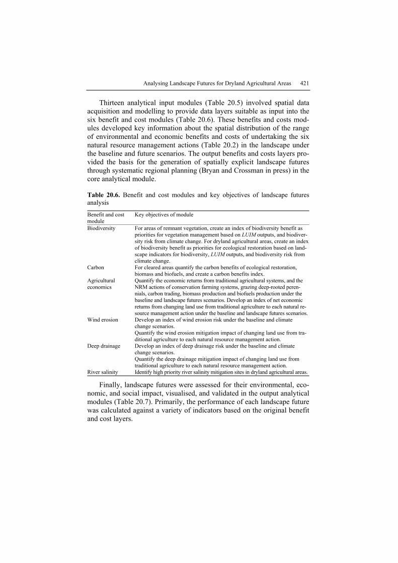
Thirteen analytical input modules (Table 20.5) involved spatial data acquisition and modelling to provide data layers suitable as input into the six benefit and cost modules (Table 20.6). These benefits and costs mod-ules developed key information about the spatial distribution of the range of environmental and economic benefits and costs of undertaking the six natural resource management actions (Table 20.2) in the landscape under the baseline and future scenarios. The output benefits and costs layers pro-vided the basis for the generation of spatially explicit landscape futures through systematic regional planning (Bryan and Crossman in press) in the core analytical module.
Table 20.6. Benefit and cost modules and key objectives of landscape futures analysis
Benefit and cost module
Key objectives of module
Biodiversity For areas of remnant vegetation, create an index of biodiversity benefit as priorities for vegetation management based on LUIM outputs, and biodiver-sity risk from climate change. For dryland agricultural areas, create an index of biodiversity benefit as priorities for ecological restoration based on land-scape indicators for biodiversity, LUIM outputs, and biodiversity risk from climate change.
Carbon For cleared areas quantify the carbon benefits of ecological restoration, biomass and biofuels, and create a carbon benefits index.
Agricultural economics
Quantify the economic returns from traditional agricultural systems, and the NRM actions of conservation farming systems, grazing deep-rooted peren-nials, carbon trading, biomass production and biofuels production under the baseline and landscape futures scenarios. Develop an index of net economic returns from changing land use from traditional agriculture to each natural re-source management action under the baseline and landscape futures scenarios.
Wind erosion Develop an index of wind erosion risk under the baseline and climate change scenarios. Quantify the wind erosion mitigation impact of changing land use from tra-ditional agriculture to each natural resource management action.
Deep drainage Develop an index of deep drainage risk under the baseline and climate change scenarios. Quantify the deep drainage mitigation impact of changing land use from traditional agriculture to each natural resource management action.
River salinity Identify high priority river salinity mitigation sites in dryland agricultural areas.
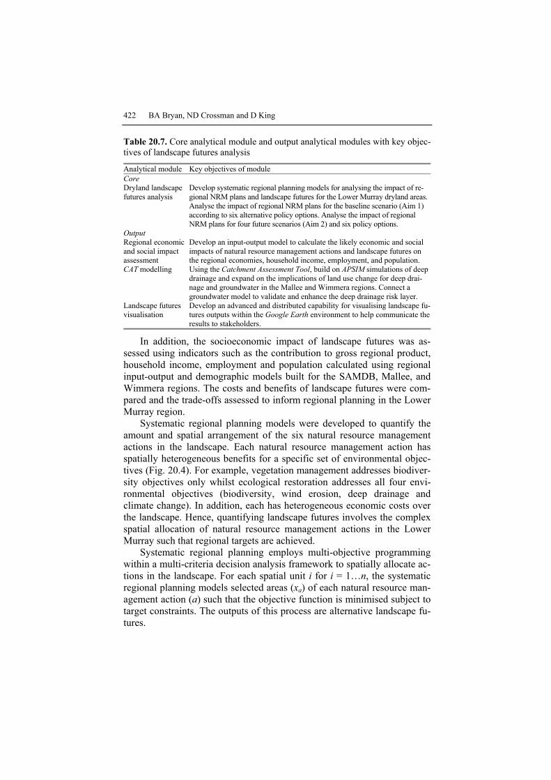
Finally, landscape futures were assessed for their environmental, eco-nomic, and social impact, visualised, and validated in the output analytical modules (Table 20.7). Primarily, the performance of each landscape future was calculated against a variety of indicators based on the original benefit and cost layers.
422 BA Bryan, ND Crossman and D King
Table 20.7. Core analytical module and output analytical modules with key objec-tives of landscape futures analysis
Analytical module Key objectives of module Core Dryland landscape futures analysis
Develop systematic regional planning models for analysing the impact of re-gional NRM plans and landscape futures for the Lower Murray dryland areas. Analyse the impact of regional NRM plans for the baseline scenario (Aim 1) according to six alternative policy options. Analyse the impact of regional NRM plans for four future scenarios (Aim 2) and six policy options.
Output Regional economic and social impact assessment
Develop an input-output model to calculate the likely economic and social impacts of natural resource management actions and landscape futures on the regional economies, household income, employment, and population.
CAT modelling Using the Catchment Assessment Tool, build on APSIM simulations of deep drainage and expand on the implications of land use change for deep drai-nage and groundwater in the Mallee and Wimmera regions. Connect a groundwater model to validate and enhance the deep drainage risk layer.
Landscape futures visualisation
Develop an advanced and distributed capability for visualising landscape fu-tures outputs within the Google Earth environment to help communicate the results to stakeholders.
In addition, the socioeconomic impact of landscape futures was as-sessed using indicators such as the contribution to gross regional product, household income, employment and population calculated using regional input-output and demographic models built for the SAMDB, Mallee, and Wimmera regions. The costs and benefits of landscape futures were com-pared and the trade-offs assessed to inform regional planning in the Lower Murray region.
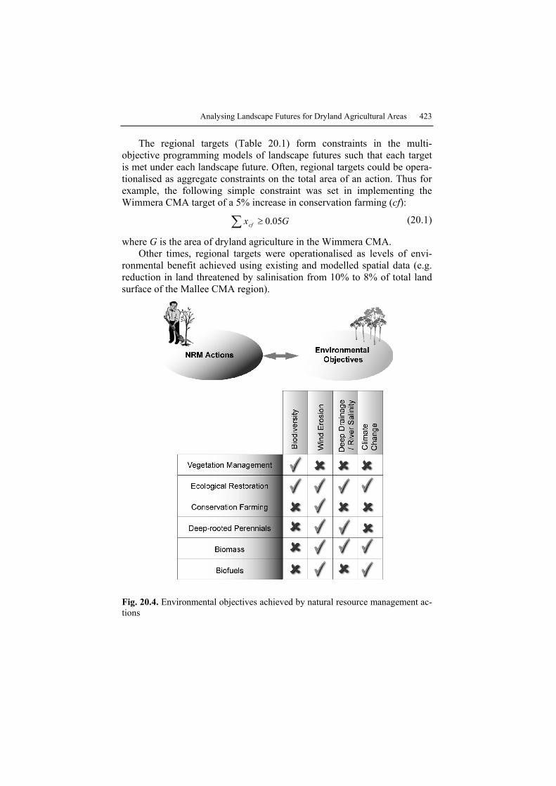
Systematic regional planning models were developed to quantify the amount and spatial arrangement of the six natural resource management actions in the landscape. Each natural resource management action has spatially heterogeneous benefits for a specific set of environmental objec-tives (Fig. 20.4). For example, vegetation management addresses biodiver-sity objectives only whilst ecological restoration addresses all four envi-ronmental objectives (biodiversity, wind erosion, deep drainage and climate change). In addition, each has heterogeneous economic costs over the landscape. Hence, quantifying landscape futures involves the complex spatial allocation of natural resource management actions in the Lower Murray such that regional targets are achieved.
Systematic regional planning employs multi-objective programming within a multi-criteria decision analysis framework to spatially allocate ac-tions in the landscape. For each spatial unit i for i = 1…n, the systematic regional planning models selected areas (xa) of each natural resource man-agement action (a) such that the objective function is minimised subject to target constraints. The outputs of this process are alternative landscape fu-tures.
Analysing Landscape Futures for Dryland Agricultural Areas 423
The regional targets (Table 20.1) form constraints in the multi-objective programming models of landscape futures such that each target is met under each landscape future. Often, regional targets could be opera-tionalised as aggregate constraints on the total area of an action. Thus for example, the following simple constraint was set in implementing the Wimmera CMA target of a 5% increase in conservation farming (cf):
Gxcf 05.0≥∑ (20.1)
where G is the area of dryland agriculture in the Wimmera CMA. Other times, regional targets were operationalised as levels of envi-
ronmental benefit achieved using existing and modelled spatial data (e.g. reduction in land threatened by salinisation from 10% to 8% of total land surface of the Mallee CMA region).
Fig. 20.4. Environmental objectives achieved by natural resource management ac-tions
424 BA Bryan, ND Crossman and D King
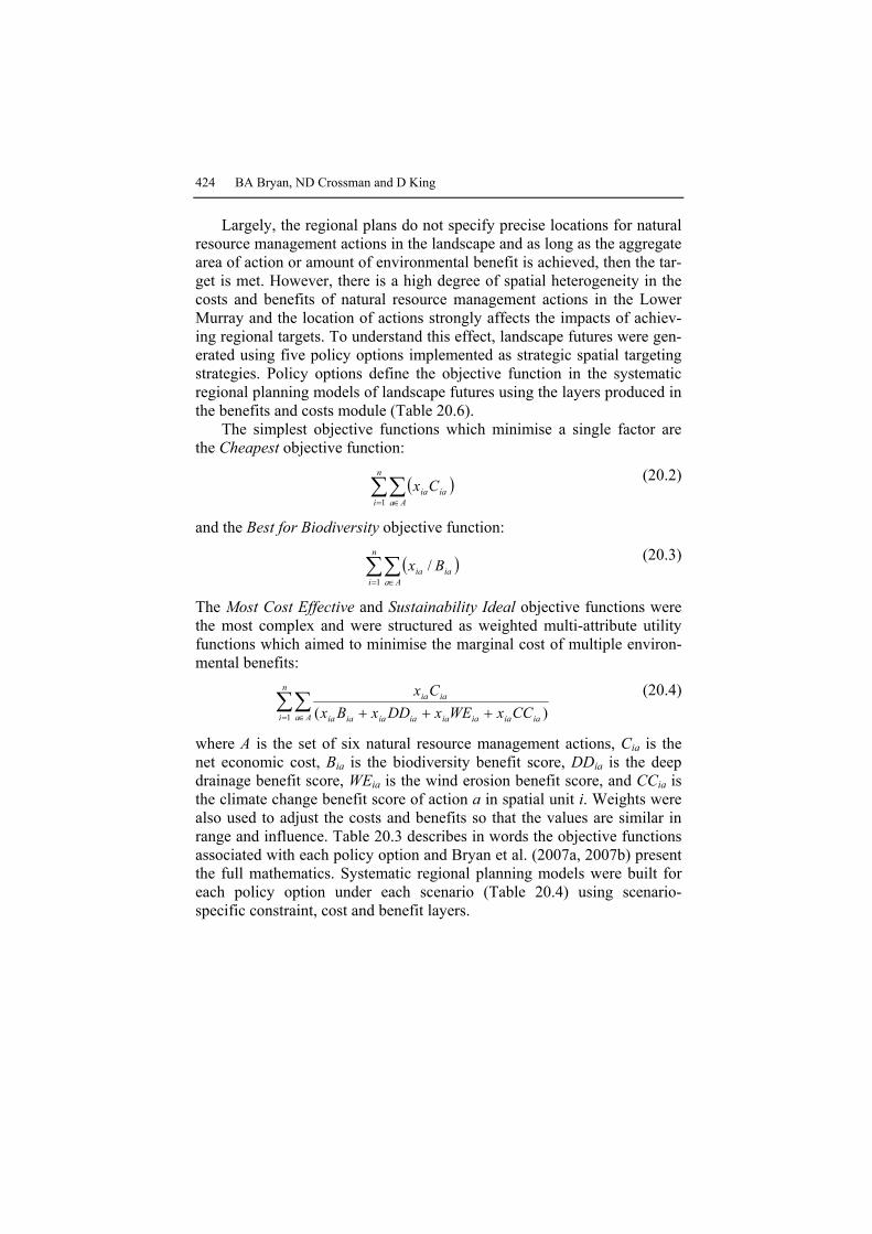
Largely, the regional plans do not specify precise locations for natural resource management actions in the landscape and as long as the aggregate area of action or amount of environmental benefit is achieved, then the tar-get is met. However, there is a high degree of spatial heterogeneity in the costs and benefits of natural resource management actions in the Lower Murray and the location of actions strongly affects the impacts of achiev-ing regional targets. To understand this effect, landscape futures were gen-erated using five policy options implemented as strategic spatial targeting strategies. Policy options define the objective function in the systematic regional planning models of landscape futures using the layers produced in the benefits and costs module (Table 20.6).
The simplest objective functions which minimise a single factor are the Cheapest objective function:
( )∑∑= ∈
n
i AaiaiaCx
1
(20.2)
and the Best for Biodiversity objective function:
( )∑∑= ∈
n
i Aaiaia Bx
1/ (20.3)
The Most Cost Effective and Sustainability Ideal objective functions were the most complex and were structured as weighted multi-attribute utility functions which aimed to minimise the marginal cost of multiple environ-mental benefits:
∑∑= ∈ +++
n
i Aa iaiaiaiaiaiaiaia
iaia
CCxWExDDxBxCx
1 )( (20.4)
where A is the set of six natural resource management actions, Cia is the net economic cost, Bia is the biodiversity benefit score, DDia is the deep drainage benefit score, WEia is the wind erosion benefit score, and CCia is the climate change benefit score of action a in spatial unit i. Weights were also used to adjust the costs and benefits so that the values are similar in range and influence. Table 20.3 describes in words the objective functions associated with each policy option and Bryan et al. (2007a, 2007b) present the full mathematics. Systematic regional planning models were built for each policy option under each scenario (Table 20.4) using scenario-specific constraint, cost and benefit layers.
Analysing Landscape Futures for Dryland Agricultural Areas 425
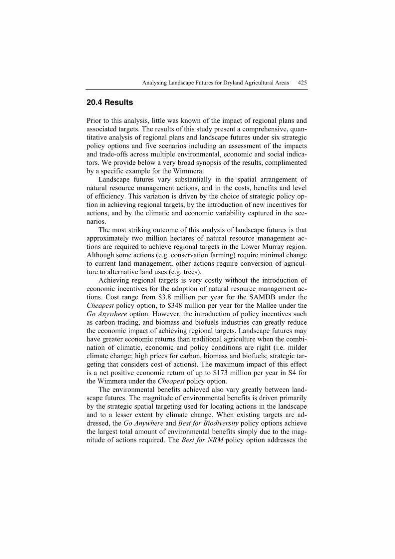
20.4 Results
Prior to this analysis, little was known of the impact of regional plans and associated targets. The results of this study present a comprehensive, quan-titative analysis of regional plans and landscape futures under six strategic policy options and five scenarios including an assessment of the impacts and trade-offs across multiple environmental, economic and social indica-tors. We provide below a very broad synopsis of the results, complimented by a specific example for the Wimmera.
Landscape futures vary substantially in the spatial arrangement of natural resource management actions, and in the costs, benefits and level of efficiency. This variation is driven by the choice of strategic policy op-tion in achieving regional targets, by the introduction of new incentives for actions, and by the climatic and economic variability captured in the sce-narios.
The most striking outcome of this analysis of landscape futures is that approximately two million hectares of natural resource management ac-tions are required to achieve regional targets in the Lower Murray region. Although some actions (e.g. conservation farming) require minimal change to current land management, other actions require conversion of agricul-ture to alternative land uses (e.g. trees).
Achieving regional targets is very costly without the introduction of economic incentives for the adoption of natural resource management ac-tions. Cost range from $3.8 million per year for the SAMDB under the Cheapest policy option, to $348 million per year for the Mallee under the Go Anywhere option. However, the introduction of policy incentives such as carbon trading, and biomass and biofuels industries can greatly reduce the economic impact of achieving regional targets. Landscape futures may have greater economic returns than traditional agriculture when the combi-nation of climatic, economic and policy conditions are right (i.e. milder climate change; high prices for carbon, biomass and biofuels; strategic tar-geting that considers cost of actions). The maximum impact of this effect is a net positive economic return of up to $173 million per year in S4 for the Wimmera under the Cheapest policy option.
The environmental benefits achieved also vary greatly between land-scape futures. The magnitude of environmental benefits is driven primarily by the strategic spatial targeting used for locating actions in the landscape and to a lesser extent by climate change. When existing targets are ad-dressed, the Go Anywhere and Best for Biodiversity policy options achieve the largest total amount of environmental benefits simply due to the mag-nitude of actions required. The Best for NRM policy option addresses the

426 BA Bryan, ND Crossman and D King
highest environmental benefit sites. The Most Cost Effective policy option efficiently trades off benefits for multiple environmental objectives with economic cost. The Sustainability Ideal policy option provides high aggre-gate environmental benefits very cost effectively and achieves long-term sustainability targets.
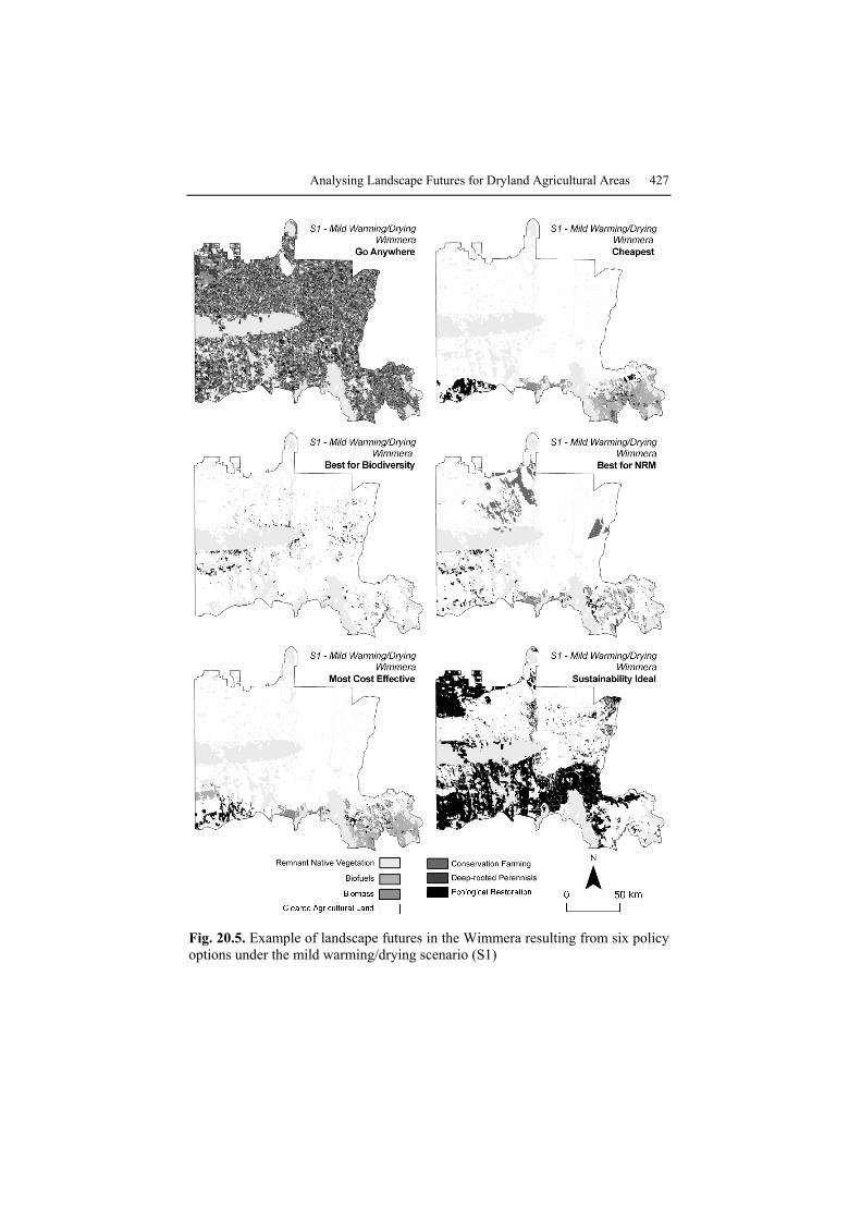
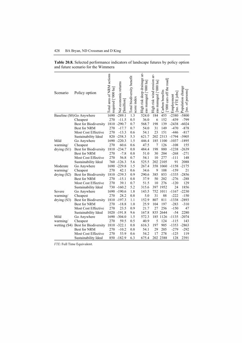
The outputs of landscape futures analysis are complex and multi-dimensional. The primary outputs are map-based depictions of natural re-source management actions. The impacts of landscape futures were also calculated across a wide variety of indicators. A variety of communication tools were used to convey the outputs to regional stakeholders. An exam-ple of some of the map-based and indicator table outputs produced from analysis of the landscape futures of dryland agricultural areas in the Wim-mera region are presented in Fig. 20.5 and Table 20.8.
Specifically for the Wimmera:
• Under the baseline scenario (S0), the achievement of existing targets is estimated to have a high net economic cost to the region of between $12 million per year and $290 million per year, depending on policy option. High social costs are also experienced including the loss of between 439 to 2,438 jobs and up 6,024 people to the region.
• Under the future scenarios S1 to S4, the economic impact of achieving regional targets is estimated to range between a net economic cost of $322 million per year to a benefit of $60 million per year. The social impacts of landscape futures on the region ranges from strongly nega-tive effects on employment and population (in the order of thousands of jobs and people) to weak positive effects (hundreds of jobs and people).
• The economic impact of achieving long-term sustainability targets in-volves substantial economic costs for the Wimmera ranging from a cost of $258 million per year under the baseline scenario to $126 million per year under the future scenario S1.
• Strategic spatial targeting of natural resource management actions can lead to a 154% improvement in efficiency of natural resource manage-ment actions.
Analysing Landscape Futures for Dryland Agricultural Areas 427
Fig. 20.5. Example of landscape futures in the Wimmera resulting from six policy options under the mild warming/drying scenario (S1)
428 BA Bryan, ND Crossman and D King
Table 20.8. Selected performance indicators of landscape futures by policy option and future scenario for the Wimmera
Scenario Policy option
Tota
l are
a of
NR
M a
ctio
ns
requ
ired
[‘00
0 ha
]
Net
eco
nom
ic re
turn
s [$
mill
ion]
Tota
l bio
dive
rsity
ben
efit
scor
e in
dex
Hig
h ris
k de
ep d
rain
age
ar-
eas m
anag
ed [‘
000
ha]
Hig
h ris
k w
ind
eros
ion
ar-
eas m
anag
ed [‘
000
ha]
Car
bon
bene
fits
[‘00
0 ca
rs o
ff th
e ro
ad]
Empl
oym
ent
[no.
FTE
jobs
] Po
pula
tion
chan
ge
[no.
of p
erso
ns]
Baseline (S0)Go Anywhere 1690 -289.1 1.3 524.0 184 455 -2380 -5800 Cheapest 270 -11.5 0.5 36.0 6 152 -439 -799 Best for Biodiversity 1810 -290.7 0.7 568.7 198 139 -2438 -6024 Best for NRM 270 -17.7 0.7 54.0 31 149 -470 -878 Most Cost Effective 270 -13.3 0.6 54.1 23 151 -446 -817 Sustainability Ideal 820 -258.3 5.3 621.7 202 2313 -1794 -3905Mild Go Anywhere 1690 -220.3 1.5 446.4 185 1100 -1037 -1895warming/ Cheapest 270 60.6 0.6 47.5 7 126 -108 155drying (S1) Best for Biodiversity 1810 -234.7 0.8 484.4 198 880 -1238 -2639 Best for NRM 270 -7.8 0.8 51.0 30 204 -268 -271 Most Cost Effective 270 56.8 0.7 54.1 10 277 -111 148 Sustainability Ideal 760 -126.3 5.6 525.5 202 2105 91 2088Moderate Go Anywhere 1690 -229.8 1.5 267.4 358 1060 -1158 -2175warming/ Cheapest 270 42.1 0.6 34.6 9 108 -159 21drying (S2) Best for Biodiversity 1810 -239.3 0.9 290.6 385 853 -1335 -2856 Best for NRM 270 -15.1 0.8 37.9 50 202 -276 -288 Most Cost Effective 270 39.1 0.7 51.5 10 276 -120 129 Sustainability Ideal 730 -160.2 5.2 315.6 397 1952 24 1856Severe Go Anywhere 1690 -190.6 1.8 143.5 752 1011 -1167 -2230warming/ Cheapest 270 28.2 0.8 5.0 31 88 -222 -150drying (S3) Best for Biodiversity 1810 -197.3 1.1 152.9 807 811 -1338 -2893 Best for NRM 270 -18.8 1.0 25.9 104 197 -283 -310 Most Cost Effective 270 23.5 0.9 21.7 27 256 -150 47 Sustainability Ideal 1020 -191.8 9.6 167.8 835 2644 -54 2280Mild Go Anywhere 1690 -304.0 1.5 572.3 185 1126 -1135 -2074warming/ Cheapest 270 59.5 0.5 40.9 5 124 -115 143wetting (S4) Best for Biodiversity 1810 -322.1 0.8 616.3 197 905 -1353 -2863 Best for NRM 270 -10.2 0.8 54.1 29 205 -279 -292 Most Cost Effective 270 53.9 0.6 54.2 17 278 -125 119 Sustainability Ideal 850 -182.9 6.3 675.4 202 2388 128 2391
FTE: Full Time Equivalent.
Analysing Landscape Futures for Dryland Agricultural Areas 429
20.5 Risk, Preference and Strategic Policy Adoption
The results of the analysis of landscape futures can be used to inform and support regional planning and decision making. We assess for the first time the feasibility of achieving existing regional targets through quantify-ing the costs and benefits associated with achieving regional environ-mental targets. This is done under a number of alternative policy options and scenarios. A fundamental finding is that a large amount of actions are required to achieve regional targets and the economic cost and flow-on impacts of achieving regional targets are likely to be prohibitively large. However, the introduction of policy innovations such as a carbon trading scheme, and biomass and biofuel industries are likely to reduce the eco-nomic impact of achieving regional targets. The results are useful for in-forming future refinements of regional plans and targets within the ongo-ing planning cycle.
We are not aware of any regional plans in Australia that have em-braced a systematic spatial targeting approach to prioritising investments in natural resource management. However, a major finding of the study is the increased level of cost effectiveness achieved through strategic target-ing of natural resource management actions in high benefit and low cost sites in the landscape compared to adopting no strategic targeting in re-gional planning. This maximises the efficiency of regional investment in natural resource management, whilst at the same time minimising the loss of productive agriculture and the regional economic and social impacts. The results suggest that more than double the environmental benefits can be achieved from a given budget through spatial targeting of actions in the landscape. Given the amount of resources devoted to natural resource management in Australia, the potential for achieving increased environ-mental benefits is substantial.
These results convincingly support the adoption of intelligent, in-formed, and strategic spatial targeting of investment in natural resource management actions. However, the objectives of targeting are less clear and are dependent upon the preferences of stakeholders and decision mak-ers. The trade-offs of choosing one strategic direction over another are made explicit in this study but there is no dominant solution. That is, no one strategy performs best on all environmental, economic and social indi-cators. Hence, there are still trade-offs that need to be made depending on the strategic policy objectives. For example, under the baseline scenario in the Wimmera, the biodiversity benefits of a Sustainability Ideal policy are nearly an order of magnitude greater than the Most Cost Effective policy,
430 BA Bryan, ND Crossman and D King
but the trade-off is a much greater decrease in employment, regional popu-lation, and net economic returns (Table 20.8).
This leaves regional agencies and stakeholders still with decisions to make. Based on the results of this study, we suggest that decisions about whether to select policy options that favour economic returns over envi-ronmental benefits, or different components of environmental benefits (e.g. those options that perform better with respect to biodiversity or carbon, as opposed to deep drainage), should be founded on two factors:
• The preferences and weights that the decision maker attributes to the various objectives, criteria and indicators.
• The performance of each policy option against the more important indi-cators given uncertainty in future scenarios.
For example, a risk-averse decision maker who wishes to minimise the economic impacts associated with achieving regional targets may be will-ing to accept the lesser environmental benefits associated with the Cheap-est policy option as a trade-off for the considerable softening in economic and social cost. Conversely, a more environmentally focussed decision maker may be prepared to take the risk on a high economic cost strategy that produces substantially higher environmental benefits. Further, they may be willing to adopt a set of very expensive long-term goals if there is confidence that the outcome will be more sustainable regional biophysical systems.
20.6 Further Research
There will be a range of different perspectives amongst stakeholders that regional decision makers need to take into account. The Most Cost Effec-tive policy option is a good compromise solution because it trades-off eco-nomic cost and multiple environmental benefits. From an efficiency per-spective, the Most Cost Effective policy option is by definition, the most efficient use of regional natural resource management funds. Most Cost Ef-fective landscape futures are specific to the scaling and weighting applied to costs and benefit scores. By adjusting the weights of costs relative to benefits in the objective functions we may achieve different landscape fu-tures that are also ‘most cost effective’. These alternative Most Cost Effec-tive landscape futures are still maximally efficient but their differences re-flect a relative change in preference of economic costs or environmental benefits.
Analysing Landscape Futures for Dryland Agricultural Areas 431
Analysis of landscape futures in this study has identified the social, economic and environmental advantages of spatial targeting in achieving regional targets. Ideally we would refine the Most Cost Effective landscape futures based upon the actual preferences of stakeholders and decision makers. There are several techniques based on trade-off games that can be used to elicit the relative weights people place on competing objectives such as Analytical Hierarchy Process (Saaty 1980). These techniques could be used in a group decision conference setting to formally quantify the relative importance of economic cost and environmental objectives (in this case enhancing biodiversity, minimising wind erosion and deep drain-age, and mitigating climate change). These weights can then be used to generate new Most Cost Effective or Sustainability Ideal landscape futures using the systematic regional planning engine. This would make explicit the most preferred landscape futures that meet the existing targets or some new set of long-term sustainability targets. This would also further strengthen the participatory approach and provide stakeholders with a greater sense of ownership of the research outcomes.
20.7 Application in Other Regions and Contexts
We have focussed on a quantitative, data-centric approach to the analysis of landscape futures. Conducted within a participatory and collaborative framework, this approach embraces the spatial and process complexity and detail of alternative landscape futures. The landscape futures analysis framework presented here can be adapted to other regions with different natural resource management and planning issues, and with different physical and biotic, economic and social environments. To apply this form of landscape futures analysis to different regions and different contexts, a substantial amount of adaptation is required to understand the environ-mental, economic, social and spatial nuance of the new region. There will need to be a large data collection and modelling exercise to assemble the multi-dimensional data layers required. Substantial tailoring of existing models and development of new models will also be required.
20.8 Conclusion
The results of this landscape futures analysis can inform regional decision making through making explicit the costs, benefits, and trade-offs of achieving regional environmental objectives under alternate strategic poli-
432 BA Bryan, ND Crossman and D King
cies. Uncertainty in achieving environmental objectives is explicitly han-dled through analysis across scenarios that capture the range of future pos-sibilities. However, no single dominant option and obvious choice of stra-tegic direction in regional planning does exist and trade-offs in decision making based on pragmatics and preferences of policymakers are inevita-ble. Further research should focus on elicitation of decision maker prefer-ences for refinement of strategic policy options that incorporate spatially explicit knowledge on the costs and benefits of natural resource manage-ment actions.
Success in undertaking such ambitious aims that consider complex spatial processes over a broad and heterogeneous region is contingent on a trans-disciplinary approach put into effect through a multidisciplinary team of collaborative researchers. Our experiences in the Lower Murray also re-inforce the fact that this kind of complex planning and futures analysis works best when regional stakeholders and decision makers enter a coop-erative and collaborative arrangement with the researchers and analysts. This collaboration generates a two way flow which enhances regional stakeholders’ understanding of the potential of futures analysis and at the same time enhances the research analysts’ understanding of the regionally-specific environmental, economic, and social context, problems and priori-ties.
Acknowledgements
The authors gratefully acknowledge funding from the National Action Plan for Salinity and Water Quality and CSIRO’s Water for a Healthy Country Flagship program through the Lower Murray Landscape Futures project. We are also grateful to our project stakeholders including many individu-als from: CSIRO; the University of Adelaide; MDBC; Victorian and South Australian State Governments; and the SAMDB, Mallee and Wimmera re-gional agencies under the banner of the Land Technologies Alliance. Thanks also to John Ward for comments on the manuscript.
References
Baker JP, Hulse DW, Gregory SV, White D, Van Sickle J, Berger PA, Dole D, Schumaker NH (2004) Alternative futures for the Willamette River basin, Oregon. Ecological Applications 14:313–324
Baker JP, Landers DH (2004) Alternative futures analysis for the Willamette River basin, Oregon. Ecological Applications 14:311–312
Analysing Landscape Futures for Dryland Agricultural Areas 433
Berger PA, Bolte JP (2004) Evaluating the impact of policy options on agricul-tural landscapes: an alternative-futures approach. Ecological Applications 14:342–354
Bryan BA, Crossman ND (in press) Systematic regional planning for multiple ob-jective natural resource management. Journal of Environmental Management, doi:10.1016/j.jenvman.2007.06.003
Bryan BA, Crossman ND, King D, McNeill J, Wang E, Barrett G, Ferris MM, Morrison JB, Pettit C, Freudenberger D, O’Leary G, Fawcett J, Meyer W (2007a) Lower Murray landscape futures dryland component: volume 2 – analysis of regional plans and landscape futures. Land Technologies Alliance and CSIRO Water for a Healthy Country, Canberra
Bryan BA, Crossman ND, King D, McNeill J, Wang E, Barrett G, Ferris MM, Morrison JB, Pettit C, Freudenberger D, O’Leary G, Fawcett J, Meyer W (2007b) Lower Murray landscape futures dryland component: volume 3 – pre-liminary analysis and modelling. Land Technologies Alliance and CSIRO Water for a Healthy Country, Canberra
Carpenter SR, Pingali PL, Bennet EM, Zurek MB (2005) Ecosystems and human wellbeing: scenarios. Millenium ecosystem assessment report volume 2. Is-land Press, Washington
Dole D, Niemi E (2004) Future water allocation and in-stream values in the Wil-lamette River Basin: a basin-wide analysis. Ecological Applications 14:355–367
Hulse DW, Branscomb A, Payne SG (2004) Envisioning alternatives: using citi-zen guidance to map future land and water use. Ecological Applica-tions14:325–341
IPCC (2001) Climate change 2001: mitigation. Third assessment report of the In-tergovernmental Panel on Climate Change. Cambridge University Press, Cambridge
Raskin PD (2005) Global scenarios: background review for the millennium eco-system assessment. Ecosystems 8:133–142
Raskin P, Kemp-Benedict, E (2002) GEO scenario framework. Background paper for UNEP’s third Global Environmental Outlook Report. United Nations En-vironment Program, Nairobi
Saaty TL (1980) The analytic hierarchy process. McGraw-Hill, New York Santelman MV, White D, Freemark K, Nassauer JI, Eilers JM, Vaché KB, Daniel-
son BJ, Corry RC, Clark ME, Polasky S, Cruse RM, Sifneos J, Rustigian H, Coiner C, Wu J, Debinski D (2004) Assessing alternative futures for agricul-ture in Iowa, USA. Landscape Ecology 19:357–374
Schumaker NH, Ernst T, White D, Baker J, and Haggerty P (2004) Projecting wildlife responses to alternative future landscapes in Oregon’s Willamette Ba-sin. Ecological Applications 14:381–400
Schwartz P (1996) The art of the long view: planning for the future in an uncertain world. Doubleday, New York
Steinitz C (1990) A framework for theory applicable to the education of landscape architects (and other environmental design professionals). Landscape Journal 9:136–143
434 BA Bryan, ND Crossman and D King
Steinitz C, Arias H, Bassett S, Flaxman M, Goode T, Maddock T III, Mouat D, Peiser R, Shearer A (2003) Alternative futures for changing landscapes – the Upper San Pedro River Basin in Arizona and Sonora. Island Press, Washing-ton, DC
Suppiah R, Preston B, Whetton PH, McInnes KL, Jones RN, Macadam I, Bathols J, Kirono D (2006) Climate change under enhanced greenhouse conditions on South Australia. An updated report on: Assessment of climate change, im-pacts and risk management strategies relevant to South Australia. Climate Im-pacts and Risk Group, CSIRO Marine and Atmospheric Research, Victoria
Theobald D (2005) Landscape patterns of exurban growth in the USA from 1980 to 2020. Ecology and Society 10:32. Available online, http://www.ecologyandsociety.org/vo110/iss1/art32/
Van Sickle J, Baker J, Herlihy A, Bayley P, Gregory S, Haggerty P, Ashkenas L, Li J (2004) Projecting the biological condition of streams under alternative scenarios of human land use. Ecological Applications 14:368–380
Ward JR, Trengove G (2005) Developing re-vegetation strategies by identifying biomass based enterprise opportunities in the mallee areas of South Australia. CSIRO client report for South Australian Department Water, Land, Biodiver-sity and Conservation
Wilhere GF, Linders MJ, Cosentino BL (2007) Defining alternative futures and projecting their effects on the spatial distribution of wildlife habitats. Land-scape and Urban Planning 79:385–400
Williams J, Saunders D (2005) Land use and ecosystems. In: Goldie J, Douglas B, Furnass B (eds) In search of sustainability. CSIRO Publishing, Victoria


![[Schaum - Murray R.Spiegel] Mecanica Teorica](https://static.fdokumen.com/doc/165x107/6316b839c5ccb9e1fb03d12d/schaum-murray-rspiegel-mecanica-teorica.jpg)

