An Atlas of Kailash Sacred Landscape-India - ICIMOD
112
An Atlas of Kailash Sacred Landscape-India
-
Upload
khangminh22 -
Category
Documents
-
view
1 -
download
0
Transcript of An Atlas of Kailash Sacred Landscape-India - ICIMOD

An Atlas of
Kailash Sacred Landscape-India

An Atlas of Kailash Sacred Landscape-India, is the compendium of Geo-spatial maps covering characteristics Physiographic features, Cultural diversity and tourism, Land use land cover (1:10,000 scale), Vegetation types, Landscape vulnerability and Management of natural resources of the Kailash Sacred Landscape (KSL)-India. The Atlas specifically designed to cater the need of researchers, practitioners and other stakeholders interested on KSL. The text and photographs included in the Atlas supplement spatial information of the maps.
Kailash Sacred Landscape-India covers an area of 7120 sq.km, extending to cover the most of Pithoragarh district (96%>) and relatively smaller portion of Bageshwar (4%) district in the state of Uttarakhand. At sub-district level, the landscape covers 14 sub units (i.e., tehsil) in district Pithoragarh and 02 in district Bageshwar. The target landscape covers 10 developmental units (i.e., Development Blocks). Biogeographically it falls in the confluence of Western, Central and Trans-Himalaya where not only floral and faunal elements but also diverse human cultures converge.

An Atlas of Kailash Sacred Landscape-India 1
An Atlas
of
Kailash Sacred Landscape-India
Gajendra Singh
Shashank Lingwal
Arvind Pandey
MPS Bisht
2 An Atlas of Kailash Sacred Landscape-India
An Atlas of Kailash Sacred Landscape-India
© 2019, Uttarakhand Space Application Centre, Dehradun
All right reserved. No part of this publication may be reproduced, stored in
a retrieval system or transmitted in any form or by any means, electronic,
mechanical, photocopying, recording or otherwise, without prior written
permission of copyright. The information is for the scientific purpose.
Funding:- Partial funding from Kailash Sacred Landscape Conservation
& Development Initiative (KSLCDI) and National Mission for Himalayan
Studies (NMHS) Programmes.
Front Cover: View of Panchachuli Peaks from Dantu village.
Back Cover: Alpine meadows of Ralam Valley.
Citation: Singh, G., S. Lingwal, A. Pandey and M.P.S. Bisht (2019). An
Atlas of Kailash Sacred Landscape-India. Uttarakhand Space Application
Centre, Dehradun.
ISBN: 978-93-82830-43-6
Publisher: Winsar Publishing Co., Dehradun
and printed at Manglamm Arts, Dehradun (Uttarakhand)

An Atlas of Kailash Sacred Landscape-India 3
xksfoUn cYyHk iUr jk”Vªh; fgeky;h i;kZoj.k ,oa lrr~ fodkl laLFkkudkslh & dVkjey] vYeksM+k & 263 643] mÙkjk[kaM] Hkkjr
G.B. Pant National Institute of Himalayan Environment
& Sustainable Development
Kosi-Katarmal, Almora-263 643, Uttarakhand, INDIA
FOREWORD
Kailash Sacred Landscape (KSL), which covers the remote southwestern portion of the
Tibetan Autonomous Region (TAR) of China, and adjacent parts of northwestern Nepal,
and India, contains a highly diverse array of bio-physical features and distinctly rich
heritage of local cultures. The region being the source of four major rivers (i.e., the Indus,
the Brahmaputra, the Karnali and the Sutlej) provides transboundary ecosystem services
vital for the region and far beyond. More importantly, owing to its spiritual, religious, and
natural significance this landscape attracts people from across the world. However, the landscape is identified one amongst the most vulnerable ecosystems on accounts of its geological fragility, climate sensitivity and ever-increasing threats to biological diversity.
Within the Indian territory, approximately 7120 km2 area in north-eastern part of
Uttarakhand state forms the part of KSL. This area covers most of the district Pithoragarh
(96%) and small part of district Bageshwar (04%). In this part of KSL, since the time
immemorial, sacredness values have been the driving force for the existence of some
of the most natural sites, and time-tested traditions of management and sustainable
harvest of natural resources. However, the indigenous communities and their value
based traditional systems are passing through a stage of rapid transformation. So is
the case with retreating glaciers, hydrological regimes, and the biodiversity elements.
All these issues, and many more, have implication for inhabitants of the landscape as
well as to a considerably large population in downstream areas. This calls for scientific monitoring of the health of the landscape and its effective management for sustaining
its services. In this context, among others, synchronized baseline, high-resolution geo-
spatial information is one of the most emergent need towards institutionalizing scientific monitoring of ecosystem components in the landscape.
The Uttarakhand Space Application Centre (USAC), as one of the key partner agency for
implementation of Kailash Sacred Landscape Conservation and Development Initiative
(KSLCDI) in India, has come up with an Atlas of the landscape, which is specifically designed to cater to the need of researchers, practitioners and other stakeholders
interested on KSL. The text and photographs included in the Atlas very well supplement
spatial information of the maps. I understand the authors have taken all cautions to
draw maps with accuracy (1:10,000 scale) and in a manner to avoid controversy. The
Atlas provides information on characteristics of physical geography, geology, cultural
diversity, vegetation type, vulnerability and natural resource management. I am confident, diverse stakeholders, especially District Line Departments, researchers, NGOs and other
agencies/individuals interested on KSL-India, will find the Atlas extremely informative and useful.
Dr. R.S. Rawal
Director GBPNIHESD
& Coordinator, KSLCDI-India

4 An Atlas of Kailash Sacred Landscape-India
PREFACE
The Kailash Sacred Landscape Conservation and Development Initiative (KSLCDI),
a trans-boundary collaborative programme among three neighbouring nations, i.e.
China, India and Nepal, is facilitated by International Centre for Integrated Mountain
Development (ICIMOD). It aims to achieve long-term conservation of ecosystems,
habitats, and biodiversity while encouraging sustainable development, enhancing the
resilience of communities in the landscape, and safeguarding the cultural linkages
between local populations. During its fi rst phase (2012-17) several geo-spatial maps
were prepared for the Kailash Sacred Landscape-India under Culture, Land use Land
cover, Physiographic features, Vegetation, Landscape vulnerability and Management.
Several institutions and individuals helped us in various ways throughout the course
of preparation of maps for the landscape. Our fi rst and foremost thanks are due to
Ministry of Environment, Forest & Climate Change (MoEF & CC), Government of India
(KSLCDI & NMHS) and Government of Uttarakhand for necessary permission and
guidaince. We acknowledge GB Pant National Institute of Himalayan Environment
and Sustainable Development (GBPNIHESD), Kosi-Katarmal, Almora, Nodal agency
of KSLCDI project in India for fi nancial support and all the KSLCDI-India partners
namely Wildlife Institute of India (WII), Dehradun, Uttarakhand State Biodiversity
Board (UKSBB), Uttarakhand Forest Department (UKFD) and Central Himalayan
Environment Association (CHEA).
We are thankful to ICIMOD, especially Dr. David Molden, Director General,
Dr. Eklabya Sharma (Deputy Director General), Dr. Rajan Kotru (Regional Manager,
Transboundary Landscape Programme), Mr. Swapnil A. Chaudhri (Programme offi cer,
KSLCDI) and entire Kailash Team for encouragement and facilitation of KSLCDI
programme implementation in India.
Thanks is also due to the District Administration of Pithoragarh district and various
District Line Departments for providing logistics and information during the entire
course of the study.
We thank the following persons for helping us in various ways: Dr. G. S. Rawat, Dean, Dr.
B. S. Adhikari, Dr. Arti Kala, Shri Ajaj (WII), Dr. R.S. Rawal, Scientist and Nodal Person
KSLCDI-India, Dr. Rajesh Joshi, Dr. Ravindra Joshi (GBPNIHESD), Dr. Pankaj Tiwari
(CHEA). Shri C. Ravishankar, DM, Ms. Vandana, CDO, Shri Gopal Giri, DDO (District
Administration) Shri Manoj Chandran, CCF, Dr. Vinay Bhargav, DFO Pithoragarh
(UKFD), Dr. Rakesh Shah, Shri S.S. Rasaily, Shri Dhananjai Prasad (UKSBB),
Dr. M.S. Sarkar, Govind Singh Negi, Vineet Pal, Naveen Chandra and Deepak Negi.
We also thank the scientists and administration of USAC for their consistent support
and encouragement.
(Authors)

An Atlas of Kailash Sacred Landscape-India 5
CONTENTS
ifo= dSyk”k Hkw {ks=&Hkkjr% ,d ifjp; @ Kailash Sacred Landscape-India: An
Introduction
Page no.
1
ifo= dSyk”k Hkw {ks=&Hkkjr dk Hkw&LFkkfud lwpuk l`tu @Geo-spatial Information
Generation for Kailash Sacred Landscape- India
11
Major Themes Geo-spatial Layers
Ikz”kklfud lhek,a@ Administrative
Boundaries
ifo= dSyk”k Hkw {ks=@Kailash Sacred Landscape
ifo= dSyk”k Hkw {ks=&Hkkjr@Kailash Sacred Landscape- India
3
7, 10
HkkSfedh; vkd`fr@ Physiographic
Features
Ikzeq[k Å¡pkbZ {ks=@Major Elevational Zone
<+yku ekufp=@Slope Map
<+ky vfHkeq[k ekufp=@Aspect Map
HkwxHkÊ; ,oa fo”ks’keq[k js[kk,a@Geological Map and Lineament
Ek`nk lajpuk@Soil Texture
Ukfn;k¡] >hy] pksfV;k¡ ,oa Xysf”k;j@Rivers, Lake, Peaks and
Glacier
izeq[k unh ?kkfV;ka o lw{e tykxe@Major River Basins and
Micro-Watersheds
20
22
24
26
28
30
32
Kailash Sacred Landscape-India

7 An Atlas of Kailash Sacred Landscape-India
laLd`fr ,oa i;ZVu@ Culture and
Tourism
LFkkfud lkaLd`frd {ks=@Indigenous Cultural Zones
efUnj ,oa LFkkuh; nsork@Temples and Local Deities
izeq[k esys@R;kSgkj vk;kstu LFky@Major Fair /Festival Sites
fojklr ,oa VªSfdax ekxZ@Heritage and Trekking Routes
Lkkgkfld i;ZVu LFky@Spots for Adventure Tourism
36
38
40
42
44
Hkw&mi;ksx ,oa Hkw&vkoj.k@ Land
use and Land cover
(LULC)
Hkw&mi;ksx ,oa Hkw&vkoj.k@Land use and Land cover
ty fudkl ekufp=@Drainage Map
lM+d ekxZ@Road Network
clklr@Human Habitation
tula[;k ?kuRo@Population Density
48
50
52
54
56
ouLifr@Vegetation Ik;kZoj.kh; {ks=@Eco-Regions
ouLifr izdkj ¼eq[kkd`fr½ ekufp=@Vegetation Type Map
(Physiognomic)
ouLifr izdkj ¼iztkfr@leqnk;½ ekufp=@Vegetation Type Map
(Species/Community)
ou ?kuRo ekufp=@Forest Density Map
ifo= izkd`frd LFky@Sacred Natural Sites (SNS)
mPp tSo fofo/krk {ks=@Biodiversity Rich Areas
Ckkat vksd ou forj.k {ks=@Distribution of Banj oak Forest
;klkZ xEcw forj.k {ks=@Distribution of Yartsa Gambu Areas
d`f’k ,oa nkysa izpqjrk {ks=@Agriculture and Pulses Rich Areas
cqX;ky ,oa ?kklh; {ks=@Alpine Meadows and Grasslands
d`f’k {ks= esa cnyko fLFkfr@Changes in Agriculture area:
1976-2011
ou {ks= esa cnyko fLFkfr@Changes in Forest area: 1976-
2011
clklr {ks= esa cnyko fLFkfr@Changes in Settlements area:
1976-2011
60
62
64
66
68
70
72
74
76
78
80
82
84
Hkw&{ks= Hks|rk@Landscape
Vulnerability
HkwL[kyu ¼okLrfod½ {ks=@Landslide (Actual) Areas
HkwL[kyu laHkkfor ekufp=@Landslide Probability Map
Ikzoklh ekxZ ¼HksM+&cdjh½@ Migratory Routes (Sheep-Goats)
HkkSfrdh Hks|rk ekufp=@Landscape Vulnerability Map
88
90
92
94
izcU/ku@Management
lajf{kr {ks=@Protected Areas
ou iapk;r@Van Panchayat
98
100

An Atlas of Kailash Sacred Landscape-India 1
ifo= dSyk”k Hkw {ks=&Hkkjr% ,d ifjp;
Kailash Sacred Landscape-India: An Introduction
ifo= dSyk”k Hkw&{ks= laj{k.k ,oa fodkl igy] dks rhu lehiorhZ jk’Vªksa ^phu] Hkkjr o usiky* ds e/; ,d lhekikjh; lg;ksx dk;ZØe ds :i esa vUrjk’Vªh; ,dhd`r ioZrh; fodkl dsUnz ¼blheksM½ }kjk izkjEHk fd;k x;k gS] tks fd eq[;r% ikfjfLFkfrd ra=] vf/kokl ,oa tSo&fofo/krk ds nh?kZdkyhu laj{k.k tSls&y{;ksa dh izkfIr ds lkFk&lkFk lrr~ fodkl ds izksRlkgu] Hkw&{ks= esa leqnk;ksa dh tyok;q ifjorZu gsrq izfrjks/k {kerk c<+kus] LFkkuh; leqnk;ksa ds chp lakLd`frd lEcU/kksa dh lqj{kk tSls vge eqn~nksa ds fy, dk;kZfUor dh xbZ gSA
fgeky;] i`Foh ij lcls vkd’kZd o je.khd LFkkuksa esa ls ,d gSA bldh tSo
fofo/krk ,oa lkaLd`frd le`f) dh ljkguk ges”kk dh tk;sxhA izd`fr ,oa laLd`fr dk
lEcU/k fgeky; esa izkd`frd :i ls lkFk&lkFk gksrk gS tks ifo= dSyk”k Hkw&{ks= esa
izeq[krk ls ns[kus dks feyrk gSA bl {ks= esa ikfjfLFkfrd ra=] ck;kse] LFkkfud iztkfr;ksa]
LFkkuh; laLd`fr;ksa ,oa tkrh; leqnk;ksa dh fofo/krk “kkfey gSA ;g Hkw&{ks= i;kZoj.k n`f’V
ls fofHkUu LFkkfud ouLifr;ksa ,oa tho&tUrqvksa dk fuokl LFkku gS] tks oSf”od tSo
fofo/krk o LFkkuh; vkthfodk nksuksa dks cuk, j[kus esa lgk;d gSA ;g {ks= ikjaifjd Kku
esa Hkh le`) gS o ;gka lqxaf/kr ,oa vkS’k/kh; ikS/kksa dh mPp fofo/krk fo|eku gSA ifo= dSyk”k
ioZr {ks=] pkj izeq[k ufn;ksa fla/kq] czg~eiq=] djukyh ,oa lryt dk mn~xe LFky gS] tks
nwj&nwj rd ds Hkw&{ks= dkss egRoiw.kZ lhekikjh; ikfjfLFkfrd ra= dh lsok,a iznku djrs gSaA
Hkw&{ks= esa yxkrkj fi?kyrs Xysf”k;j o Hkw tyh; lajpuk esa ifjorZu fupys {ks=ksa esa fLFkr
vkcknh ds fy, fpark dk fo’k; gSA
dSyk”k Hkw&{ks= dk oSf”od vkSj {ks=h; egRo ,oa bldh lhekikjh; izd`fr] bldh lhek
ls yxs ns”kksa ds chp lhekikjh; lg;ksx ds fy, mfpr LFkku iznku djrk gS] ftls bzZlheksM
(ICIMOD) tks ,d vUrjkZ’Vªh; laLFkk gS ds }kjk] {ks=h; lg;ksx <kaps ds fodkl ds fy,
phu] Hkkjr ,oa usiky esa fLFkr fofHkUu laLFkkuksa ds lkFk feydj O;ogk;Zrk ewY;kadu fjiksVZ]
laj{k.k j.kuhfr;ka ,oa O;kid i;kZoj.k fuxjkuh ;kstukvksa dks rS;kj djus esa lg;ksx iznku
fd;k tk jgk gSA

2 An Atlas of Kailash Sacred Landscape-India
lHkh rhu lnL; ns”kksa ¼phu] Hkkjr o usiky½ us ^{ks=h; lg;ksx <kaps* dk leFkZu fd;k gS] tks dSyk”k Hkw&{ks= dk;ZØe ds fodkl ,oa dk;kZUo;u ds fy, ,d ekxZn”kZd lk/ku gSA ;g <kapk lhekikjh; lg;ksx vkSj ikfjfLFkfrd ra= izcU/ku n`f’Vdks.k ij vk/kkfjr gS] tks nh?kZdkfyd laj{k.k igy ds fy, lHkh lhekikjh; lg;ksxh laLFkkuksa dks ,d lkFk ykrk gSA
The Kailash Sacred Landscape (KSL)
The Kailash Sacred Landscape Conservation and Development
Initiative (KSLCDI), a trans-boundary collaborative programme among
three neighbouring nations, i.e. China, India and Nepal, is facilitated by
International Centre for Integrated Mountain Development (ICIMOD). It aims
to achieve long-term conservation of ecosystems, habitats, and biodiversity
while encouraging sustainable development, enhancing the resilience
of communities in the landscape, and safeguarding the cultural linkages
between local populations.
Himalaya is one of the most beautiful and fascinating places on the earth.
Its biodiversity and cultural richness are to be celebrated, and cherished.
Nature and culture are intimately concomitant in Himalaya particularly
surrounding the sacred landscape of Mt. Kailash. The region comprise
a highly diverse array of ecosystems, biomes, indigenous and endemic
species, local cultures, and ethnic communities. This environmentally
fragile landscape is home to a range of endemic fl ora and fauna, which
are imperative in maintaining both global biodiversity and local livelihoods.
It is also rich in traditional knowledge and contains a high diversity of
aromatic and medicinal plants. The Mt. Kailash territory is the source of
four major rivers namely the Indus, the Brahmaputra, the Karnali, and the
Sutlej, providing transboundary ecosystem services vital to the region, and
far beyond. Melting glaciers and changes in the hydrological regime of the
landscape are of concern to the large downstream populations.
KSL’s global and regional signifi cance, and its transboundary nature
call for cross-border cooperation among countries that share the landscape.
ICIMOD works closely with partner institutions in China, India, and Nepal
to facilitate the development of a regional cooperation framework, and
prepare feasibility assessment reports, conservation strategies (CS) and
comprehensive environmental monitoring plans (CEMPs).
All three member countries have endorsed the regional cooperation
framework, a guiding instrument for developing and implementing the KSL
regional programme. The framework brings partner institutions together
under the shared vision of a long-term conservation initiative that is based
on regional transboundary cooperation, and ecosystem management
approaches.

An Atlas of Kailash Sacred Landscape-India 3
ifo= dSyk”k Hkw&{ks=
dSyk”k Hkw&{ks=] phu ds ̂ ^frCcr Lo”kklh {ks=** dk lqnwjorhZ nf{k.k&if”peh Hkkx] usiky ds lqnwj if”pe esa yxs gq, tuin] ,oa mRrj Hkkjr ds mRrjk[k.M jkT; ds mRrj&iwohZ lhekvksa esa lfUufgr] dqy 31]175 oxZ fd-eh- ds {ks=Qy esa QSyk gqvk gS] tks ,d o`gn cgq&lkaLd`frd ,oa laosnu”khy Hkw&{ks= dk izrhd gSA
ifo= dSyk”k Hkw&{ks=] ,f”k;k o nqfu;k Hkj esa fLFkr fgUnqvksa] ckS)ksa] tSuksa] fl[kkas o ckWu vuq;kf;;ksa ,oa fofHkUu vU; /kkfeZd ijaijkvksa ds egRo ds lkFk&lkFk gtkjksa&yk[kksa yksxksa ds fy, ifo= {ks= gSA fo”o Hkj ds gtkjksa / kkfeZd o vk/;kfRed rhFkZ;k=h gj lky bl ifo= Hkw&{ks= dh ;k=k djrs gSaA eq[; :i ls Hkkjr] usiky ,oa frCcr o vU; fgLlksa ls yksx ;gka vkrs gSaA izR;sd o’kZ ;gka vkus okys rhFkZ;kf=;ksa o i;ZVdksa dh la[;k esa o`f) dks ns[krs gq, i;ZVu o lacaf/kr cqfu;knh lqfo/kkvksa dh vko”;drk esa mYys[kuh; o`f) gksus dh mEehn gSA Hkw&{ks= esa vusd ifo= LFky fLFkr gSa] ftuesa vR;f/kd ÅapkbZ okys >hyksa] cQZ&f”k[kjksa ,oa rhuksa ns”kksa esa fLFkr /kkfeZd LFkyksa dk usVodZ “kkfey gSA dSyk”k ioZr o ekuljksoj >hy nksuksa dks] fgUnqvksa] ckS)ksa] tSuksa] fl[kkas ,oa ckWu leqnk;ksa }kjk vR;Ur ifo= ekuk tkrk gSA
4 An Atlas of Kailash Sacred Landscape-India
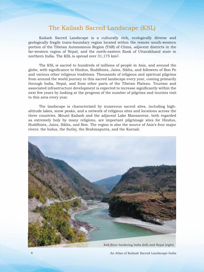
The Kailash Sacred Landscape (KSL)
Kailash Sacred Landscape is a culturally rich, ecologically diverse and
geologically fragile trans-boundary region located within the remote south-western
portion of the Tibetan Autonomous Region (TAR) of China, adjacent districts in the
far-western region of Nepal, and the north-eastern fl ank of Uttarakhand state in
northern India. The KSL is spread over 31,175 km2.
The KSL is sacred to hundreds of millions of people in Asia, and around the
globe, with signifi cance to Hindus, Buddhists, Jains, Sikhs, and followers of Bon Po
and various other religious traditions. Thousands of religious and spiritual pilgrims
from around the world journey to this sacred landscape every year, coming primarily
through India, Nepal, and from other parts of the Tibetan Plateau. Tourism and
associated infrastructure development is expected to increase signifi cantly within the
next few years by looking at the progress of the number of pilgrims and tourists visit
to this area every year.
The landscape is characterized by numerous sacred sites, including high-
altitude lakes, snow peaks, and a network of religious sites and locations across the
three countries. Mount Kailash and the adjacent Lake Mansarovar, both regarded
as extremely holy by many religions, are important pilgrimage sites for Hindus,
Buddhists, Jains, Sikhs, and Bon. The region is also the source of Asia’s four major
rivers: the Indus, the Sutlej, the Brahmaputra, and the Karnali.
Kali River bordering India (left) and Nepal (right)
An Atlas of Kailash Sacred Landscape-India 5
y{;
ifo= dSyk”k Hkw&{ks= ifj;kstuk fuEufyf[kr nwjxkeh y{;ksa ds lkFk izkjEHk dh x;h gS] ftlds ikap izeq[k ?kVd gSaA
� {ks=h; lg;ksx gsrq cqfu;knh <+kaps ds ?kVdksa dks laLFkkxr dj {ks=h; ,oa lhekikjh; lg;ksx dks lqn`<+ djukA
� lrr~ ifjrU=h; izcU/ku izfof/k;ksa dks dSyk”k ifo= Hkw&{ks= esa tyok;q ifjorZu gsrq vuqdwyu ds lUnHkZ esa eq[;/kkjk esa ykuk rFkk rn~uqlkj jk’Vªh; uhfr;ksa o ;kstukvksa ls fofo/k Lrjksa ij tksM+ukA
� nh?kZdkyhu i;kZoj.k fuxjkuh o ;kstukvksa ds fu/kkZj.k o fu.kZ; esa lgk;d lkekftd&vkfFkZd ”kks/k gsrq izeq[k laLFkkvksa dk {kerk fodkl djukA
� {ks=h; o jk’Vªh; Lrj ij lk{;&vk/kkfjr fu.kZ; gsrq ,d {ks=h; Kku&forj.k ra= LFkkfir djukA
Objectives
Kailash Sacred Landscape project initiated with the following longterm
objectives. It has fi ve major components.
� To strengthen regional, transboundary cooperation by
institutionalization the elements of the Regional Cooperation
Framework (RCF).
� To mainstream sustainable ecosystem management approaches
and practices in the context of climate change adaptation in the
KSL and in national polices and plans at all levels.
� To build the capacity of key institutions for long-term environmental
monitoring and socio-economic research for better planning and
decision making.
� To establish a regional knowledge sharing platform to support
evidence-based decision-making at regional and national levels.

6 An Atlas of Kailash Sacred Landscape-India
ifo= dSyk”k Hkw {ks=&Hkkjr
Hkkjr dh lhekvksa esa] ifo= dSyk”k Hkw {ks= yxHkx 7120 oxZ fd-eh- esa QSyk {ks= gqvk gS] ftlesa mRrjk[k.M jkT; ds fiFkkSjkx<+ tuin dk yxHkx lEiw.kZ Hkw&Hkkx (96%) o fudVorhZ ckxs”oj tuin dk NksVk Hkw&Hkkx (4%) lfEEkfyr gSA tSo HkkSxksfyd dh n`f’V ls ;g {ks= Hkkjr ds if”peh fgeky;h izkUr ds vUrxZr if”pe] e/; ,oa Vªkal fgeky; {ks=ksa ds laxe ij fLFkr gSA ;gka u dsoy ikni o tho&tUrq leqnk; dh fofo/krk gS] cfYd fofo/k ekuo laLd`fr;ksa dk Hkh laxe fo|eku gSA
mi&ftyk Lrj ij ifj;kstuk {ks= esa 16 mi bdkb;ka ¼rglhy½ “kkfey gSa] ftlesa ftyk fiFkkSjkx<+ esa 14 o ckxs”oj ftys dh 02 rglhy “kkfey gSaA Hkw&{ks= esa dqy 10 bdkb;ka ¼fodkl[k.M½ “kkfey gSaA
eq[; ?kVd/Major Components
vfHkuo vkthfodk fodYi ,oa
tyok;q ifjorZu gsrq vuqdwyuA
Innovative Livehood
Approaches
lrr~ lsokvksa gsrq ifjra=h; izca/kuA
Ecosystem Management for
Sustainable Servies
{ks=h; lg;ksx] leFkZd uhfr;kas o Kku izca/kuA
Regional Cooperation
Enabling Policies and
Knowledge management
yphys leqnk;ksa ds fuekZ.k gsrq lqyHkrk ,oa fgrykHk lgHkktuA
Access and Benefit Sharing
nh?kZdkfyd ifjra= laj{k.k o
i;kZoj.kh; ekfuVfjaxA
Long-term Conservation
and monitoring

An Atlas of Kailash Sacred Landscape-India 7
Kailash Sacred Landscape (KSL)- India
Kailash Sacred Landscape within India covers an area of 7120 sq. km, extending
to cover the most of Pithoragarh district (96%) and relatively smaller portion of
Bageshwar (4%) district in the state of Uttarakhand. Biogeographically it falls in the
confl uence of Western, Central and Trans-Himalaya where not only fl oral and faunal
elements but also diverse human cultures converge.
At sub-district level the project area covers 14 sub units (i.e., tehsil) in district
Pithoragarh and 02 in district Bageshwar. The target landscape covers a total of 10
developmental units (i.e., Development Blocks).
Figure: Geographical location of Kailash Sacred Landscape (KSL) and the position of Indian
part of KSL region.

8 An Atlas of Kailash Sacred Landscape-India
Socioeconomic Statistics
Total Area 7120 Km² (Pithoragarh-96%,
Bageshwar-4%)
Tehsil 14, (Pithoragarh-12, Bageshwar-2)
Developmental Blocks 10, (Pithoragrh-8, Bageshwar-2)
Number of Villages 1672
Gram Panchayats 690
Nyay Panchayats 64
Populations (Lakh) (2011) 4.84
Male (Lakh) (2011) 2.39
Female (Lakh) (2011) 2.44
Sex ratio (female/1000 male) 1020
Population Density (Individuals/ sq.km) 69
Decadal Population Growth (%) 4.58
Literacy Rate (%) 82.25 (Male-92.7, Female-72.3)
Rural Population (Lakh) (2011) 4.14
Urban Population (Lakh) (2011) 0.7O
Per capita income (Rs) 79981
Forests and Agriculture Statistics
Area under Forest (km2) 5401.5
Area under Forest Cover (km2) (SFR
2017)
2078 (29.31%)
Forest Divisions 2-Pithoragarh and Bageshwar Forest
Division (partial)
Forest Ranges 7 (Pithoragarh, Didihat, Askot,
Dharchula, Munsyari, Berinag,
Gangolihat
Area under Reserve Forests (km2) 798.5
Total Van Panchayats 1620
Area under Van Panchayats (km2) 2847.42
Sacred Natural Site 139
Major Alpine Meadows 30
Biodiversity Rich Sites 18
Protected Area (PA) 1 (Askot Wildlife Sanctuary)
Area of the PA (km2) ~600
Net sown area (agriculture) (km2) 402.95
Net irrigated area (km2) 36.38
Kailash Sacred Landscape-India : At a Glance
An Atlas of Kailash Sacred Landscape-India 9
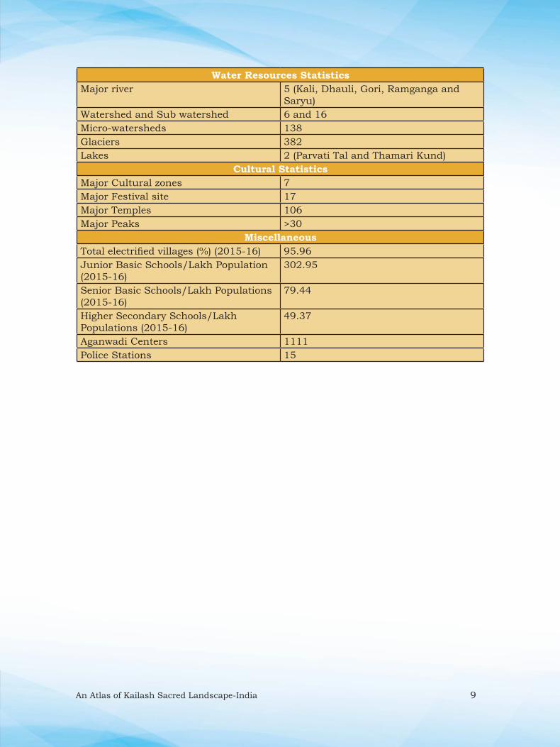
Water Resources Statistics
Major river 5 (Kali, Dhauli, Gori, Ramganga and
Saryu)
Watershed and Sub watershed 6 and 16
Micro-watersheds 138
Glaciers 382
Lakes 2 (Parvati Tal and Thamari Kund)
Cultural Statistics
Major Cultural zones 7
Major Festival site 17
Major Temples 106
Major Peaks >30
Miscellaneous
Total electrified villages (%) (2015-16) 95.96
Junior Basic Schools/Lakh Population
(2015-16)
302.95
Senior Basic Schools/Lakh Populations
(2015-16)
79.44
Higher Secondary Schools/Lakh
Populations (2015-16)
49.37
Aganwadi Centers 1111
Police Stations 15

10 An Atlas of Kailash Sacred Landscape-India
Prepared by:
Uttarakhand Space Application Centre, Dehradun as part of KSLCDI Project.
Administrative Boundary: KSL India

An Atlas of Kailash Sacred Landscape-India 11
Hkw&LFkkfud lwpuk l`tu
Hkw&LFkkfud lwpuk] fdlh Hkh LFkku dk ,slk lwpuk ra= gS ¼HkkSxksfyd funsZ”kkad dk
,d lsV½ ftls okLrfod le; esa ,df=r] vkadfyr ,oa iznf”kZr fd;k tk ldrk gSA bu
Hkw&LFkkfud lwpukvksa esa jkT;] ftyk ,oa xkao dh lhek,a] dk;kZy;@ljdkjh Hkou] ufn;ka]
lM+d usVodZ] ty fudklh bR;kfn vko”;drkuqlkj vusd izdkj dh lwpuk,a “kkfey gksrh
gSaA Hkw&LFkkfud rduhdh tSls] HkkSxksfyd lwpuk iz.kkyh ¼th-vkbZ-,l½ mixzgh; lqnwj laosnu
,oa ØkmM lksflZax dh enn ls Hkw&LFkkfud tkudkfj;ksa dks fofHkUu ijrksa vFkok fo’k;ksa ij
vko”;drk ds vuqlkj izkIr dh tk ldrh gSaA Hkw&LFkkfud izkS|ksfxdh ,d ,slk vewY;
lk/ku gS] ftldh enn ls fofHkUu Lrjksa ij lrr~ fodkl dh xfr dk vkadyu fd;k tk
ldrk gSA
fdlh {ks= vk/kkfjr ifj;kstuk dk;ksZa ds izca/ku] fo”ys’k.k ,oa izpkj&izlkj ds fy,
vk/kkj ekufp= ,dek= egRoiw.kZ lk/ku gSA HkkSxksfyd lwpuk iz.kkyh }kjk ,df=r dh xbZ
lwpukvksa dks MkVkcsl ds :i esa lajf{kr fd;k tk ldrk gS] ftUgsa rsth ls viMsV ¼v|ru½
djus o vusd mn~ns”;ksa ds vuqlkj ekufp=ksa dks lEikfnr djus esa iz;ksx esa yk;k tk ldrk
gSA Hkw&LFkkfud lwpukvksa dk izHkkoh mi;ksx] fodkl ds iz;klksa dks c<+kus] yf{kr ;kstukvksa
ds lQyrkiwoZd fØ;kUo;u] fuxjkuh o tokcnsgh r; djus esa fd;k tk ldrk gSA
Geospatial Information Generation
Geospatial information is a data referenced to a place—a set of geographic
coordinates—which can often be gathered, manipulated, and displayed in real time.
Geospatial information include features like village, district, state boundaries, offi ce/
government buildings, rivers, road network, drainage etc. Geospatial information
technologies, such as Geographic Information Systems (GIS), Remote Sensing, and
crowd sourcing have the ability to combine geospatial information in unique ways—
by layers or themes—and extract something new as per the requirement. Geospatial
technologies represent an invaluable tool for enhancing the capacity to benchmark
and measure performance of sustainable development at different scales.

12 An Atlas of Kailash Sacred Landscape-India
Base maps are the critical component of site-based monitoring programmes
and are the single most important tool for organizing, analyzing and communicating
monitoring information. By using of GIS tools, map preparation is directly linked to
databases, which provides means to update quickly and permits maps to be produced
in relation to numerous specifi c objectives and outputs. Effective use of geospatial
information can help to galvanize development efforts, implement successful targeted
interventions, track performance and improve accountability.
ifo= dSyk”k Hkw&{ks= Hkkjr ds fy;s l`ftr Hkw&LFkkfud lwpukvksa dk mi;ksx
ifo= dSyk”k Hkw&{ks= laj{k.k ,oa fodkl igy (KSLCDI) ds rgr ifo= dSyk”k
Hkw {ks=&Hkkjr ds fy, vusd Hkw&LFkkfud lwpuk,a (Layers) rS;kj dh xbZ gSaA bu lwpuk ijrksa
dks N% ¼6½ izeq[k fo’k;ksa esa j[kk x;k gS&
1- HkkSfedh; fo”ks’krk,a 2- laLd`fr vkSj i;ZVu 3- Hkw&mi;ksx o Hkw&vkoj.k
4- ouLifr 5- Hkw&{ks= Hks|rk 6- lalk/kuksa dk izca/ku
Hkw&{ks= ds fy, vk/kkj ekufp= l`ftr djus dk eq[; mn~ns”; LFkkuh; leqnk;ksa]
fofHkUu ftyk Lrjh; js[kh; foHkkxksa] ljdkjh o xSj ljdkjh laLFkkvksa }kjk fo’k;xr ;kstukvksa
dks c<+kus] izHkkoh vkadyu] fuxjkuh djus ,oa fofHkUu pqukSfr;ksa dks de djus esa lg;ksx iznku
djuk gSA bu l`ftr Hkw&LFkkfud ijrkas dk mi;ksx fofHkUu xzke iapk;r] CykWd ,oa ftyk
Lrj dh ;kstukvksa ds fu;kstu gsrq fd;k tk ldrk gSA
Application of Geospatial Information Generated for
Kailash Sacred Landscape-India
Several geospatial layers have been prepared for the Kailash Sacred Landscape-
India, under the Kailash Sacred Landscape Conservation and Development Initiative
(KSLCDI). These information layers are grouped under six major themes namely
1) Physiographic features, 2) Culture and tourism, 3) Land use and land cover,
4) Vegetation, 5) Landscape vulnerability and 6) Resource Management. The
purpose of generating base maps for the landscape is, to deliver information to
the local communities, various district line departments, other Governmental and
non-governmental agencies to enhance thematic planning, effectively measure,
monitor and mitigate challenges. Geospatial layers Created can be used at Gram
Panchayat, Block and District level planning.

An Atlas of Kailash Sacred Landscape-India 13
Table: Various Geo-spatial layers and possible applictiions
izeq[k fo’k;@Major
Themes
Hkw&LFkkfud ekufp=@Geo-spatial
layers
ekufp= esa nh tk jgh tkudkjh o mldk mi;ksx@Information
being provided and its application
lEHkkfor foHkkx tks bl tkudkjh dk mi;ksx dj ldrs gSa@User
Departments
HkkSxksfyd ekufp=@Physio-
graphic
maps
izeq[k ÅapkbZ {ks=@Major
Elevational
zones
fMftVy ,fyosaf”k;y ekWMy ¼Mh-bZ-,e-½ ls izkIr tkudkjhA fdlh Hkh LFkku dh ÅapkbZ ls lEcfU/kr tkudkjh izkIr djus dk vk/kkjA;g tkudkjh lalk/kuksa vkSj xkaoksa ds fooj.k dks le>us ds fy, mi;ksxh gksrh gSA
Information generated from the Digital Elevational
Model (DEM). Basis for generating any elevation re-
lated information.
The information can be useful to understand the el-
evational pattern of the resources and villages.
leLr foHkkx eq[;r% d`f’k] ou] ckxokuh] i;ZVu@All the De-
partments,
Agriculture,
Forest,
Horticulture,
Tourism
<yku ekufp=@ Slope Map
fMftVy ,fyosaf”k;y ekWMy ¼Mh-bZ-,e-½ ls izkIr tkudkjhA;g tkudkjh Hkw&{ks= dh fofHkUu <yku Jsf.k;ksa dks le>us ds fy, mi;ksxh gS] fofHkUu o`{kkjksi.k dk;ZØe vkSj fodkl ;kstuk ds fy, mi;ksxh gks ldrh gSA
Generated from the Digital Elevational Model (DEM).
The information is useful to understand the various
slope categories, and can be useful for various plan-
tation programme and developmental planning.
d`f’k] ou] ckxokuh] fu;kstu] vkink izcU/ku@Forest,
Agriculture,
Horticulture,
Planning,
Disaster
management
<ky&vfHkeq[k ekufp=@Aspect Map
fMftVy ,fyosaf”k;y ekWMy ¼Mh-bZ-,e-½ ls izkIr tkudkjhAfofHkUu d`f’k vkSj okfudh ;kstukvksa esa mi;ksxhA
Generated from the Digital Elevational Model (DEM).
Useful for various agriculture and forestry planning.
Oku] d`f’k] ckxokuh@
Forest,
Agriculture,
Horticulture
HkwxHkÊ; ,oa fo”ks’keq[kjs[kk,a@Geological and
Lineament
;g ekufp= pV~Vkuksa o ySaMekl bR;kfn dh fLFkjrk dks le>us ds fy, mi;ksxh gSA
The information is useful to understand the stability
of rocks, landmass etc.
vkink izcU/ku] HkwfoKku vkSj [kuu@Disaster
Management,
Geology and
Mining
Ek`nk lajpuk@ Soil Texture
Ikkuh dh gksfYMax {kerk vkSj feV~Vh dh fNnzrk dks le>us ds fy, ;g tkudkjh lgk;d gksxhA
The information can be helpful to understand the
water holding capacity and porosity of soil.
d`f’k] ou@Agriculture,
Forestry,
ufn;ka] >hysa] pksfV;ka ,oa fgeun@ Rivers,
Lakes, Peaks
and Glaciers
Hkw&{ks= esa 6 izeq[k ufn;ka] 2&3 NksVs >hy] 5000 ehVj ls vf/kd ÅapkbZ dh 15 pksfV;ka ,oa 382 ls vf/kd ¼NksVs vkSj cM+s½ fgeun ekStwn gSaA
6 major rivers, 2-3 small lakes, more than 15 peaks
above 5000m asl and more than 382 (small & large)
glaciers are present in the landscape.
Tkykxe@ Watershed

14 An Atlas of Kailash Sacred Landscape-India
izeq[k unh ?kkfV;ka o lw{e tykxe@Major river
basins
& Micro-
watershed
Hkw&{ks= esa 6 izeq[k unh ?kkfV;ka gSa o 130 ls vf/kd lw{e tykxe ekStwn gSaA
There are 6 major river basins and more than 130
micro-watersheds are present in the landscape.
Tkykxe] flapkbZ] ou@Watershed,
Forest,
planning
laLd`fr ,oa i;ZVu ekufp=@ Culture and
Tourism
maps
LFkkuh; lkaLd`frd {ks=@Indigenous
Cultural
Zones
Hkw&{ks= esa 8 izeq[k lkaLd`frd lewg dkyh] /kkSyh] xksjh] jkexaxk ,oa lj;w unh ?kkfV;ka ekStwn gSaA
8 major cultural groups in 5 major river valleys Kali,
Dhauli, Gori, Ramganga and Saryu are present in
the Landscape
Ik;ZVu@Tourism
Ekafnj vkSj LFkkuh; nSoh; LFkku@ Temples &
Local Deities
Hkw&{ks= esa 100 ls vf/kd eafnjksa dks n”kkZrk gqvk ekufp= rS;kkj fd;k x;k gS] tks lkaLd`frd fofo/krk dks le>us esa lgk;d gSA
More than 105 temples and local deities shown.
The information can be helpful developing cultural
circuits etc.
Ik;ZVu] jkT; tSo fofo/krk cksMZ@Tourism,
State
Biodiversity
Board
izeq[k esys o R;kSgkj vk;kstu LFky@ Major
Fair & Festival
sites
Hkw&{ks= esa yxHkx 15 izeq[k esys@R;kSgkj vk;kstu o laxe LFky ekStwn gSaA
About 15 major fair and confl uence sites are present
in the landscape.
Ik;ZVu@Tourism
fojklr vkSj VªSfdax ekxZ@ Heritage
and Trekking
Routes
;gka 2 fojklr ekxZ vkSj 30 ls vf/kd NksVs vkSj yacs VSªfdax ekxZ ekStwn gSaA
2 heritage routes and more than 30 short and long
trekking routes are present.
Ik;ZVu] ou@ Tourism,
Forest
Lkkgfld i;ZVu LFky@ Spots
for Adventure
Tourism
;gka lkgfld xfrfof/k;ksa ds fy, 20 ls vf/kd {ks= gSa] tSls ioZrkjksg.k] VSªfdax] vfHk;ku] jkWd Dykbafcax] unh jkf¶Vax] iSjkXykbfMax bR;kfnA
There are more than 20 sites for adventure activities
viz., Mountaineering, Trekking, Expedition, Rock
climbing, River rafting, Paragliding, Forest walk etc.
Ik;ZVu@Tourism
Hkwfe mi;ksx@ Hkw&vkoj.k ekufp=@
Land use
and Land
cover maps
Hkw&mi;ksx ,oa Hkw&vkoj.k@ Land use and
Land cover
7 izeq[k Hkw&mi;ksx ,oa Hkw&vkoj.k Jsf.k;kas ¼ou] d`f’k] ty] cQZ&fgeun] ?kklh; {ks=] >kfM;ka] clklr½ esa izkIr tkudkfj;kaA Hkw&{ks= Lrj dh ;kstukvksa ds fØ;kUo;u esa ennxkj gksaxhA
Information generated at 7 broad LULC categories
(eg., Forest, Grassland, Agriculture, Scrubland,
Habitation, Waterbody, Snow-Glaciers)
Map can be used at landscape level planning
Oku] d`f’k] fu;kstu@Forest,
Agriculture,
Planning
ty fudkl ekufp=@ Drainage
Network
Hkw&{ks= eas fLFkr ufn;ksa] ukfy;ksa vkSj ty /kkjkvksa dks iznf”kZr fd;k x;k gSA;g ekufp= xzke@iapk;r] tykxe o fodkl[k.M Lrj ij fLFkr ty /kkjkvksa dh fLFkfr le>us esa lgk;d gksxkA
Rivers, Drains and Streams have been marked in
the landscape. Maps can be prepared how many
drains and streams are present at Gram Panchayat,
Watershed level
flapkbZ] d`f’k] ty lalk/ku] ty laLFkku] ou@Irrigation,
Agriculture,
Watershed,
Jal Sansthan,
Forest

An Atlas of Kailash Sacred Landscape-India 15
lM+d ekxZ@ Road Network
jk’Vªh;] jkTkdh;] tuin Lrjh; lM+dksa dks iznf”kZr fd;k x;k gS] ftls vkink o fodkl ;kstuk izcU/ku ds fy, mi;ksx esa yk;k tk ldrk gSA Marked National, State, District roads
Map can be used to see the easiest connectivity
and alternate routes during disaster and for
developmental planning.
leLr foHkkx] mRrjk[k.M ifjogu fuxe@All the
Departments,
Uttarakhand
Transport
corporation
clklr@
Human
Habitation
Hkw&{ks= esa 1672 ls vf/kd xkao fLFkr gSaA {ks= dh 87% vkcknh xzkeh.k gSA There are more than 1672 villages in the landscape.
The 87% population of the area is rural.
xzkeh.k vkSj “kgjh fu;kstu@Rural
and Urban
planning
Tkula[;k ?kUkRo ¼O;fDr@xkao½@
Population
Density
Hkw&{ks= esa vf/kdre la[;k okys xkao 100&500 O;fDr@xkao gSaAMaximum no. of villages are having 100-500
individuals/village in the landscape.
xzkeh.k vkSj “kgjh fu;kstu@Rural
and Urban
planning
ouLifr ekufp=@ Vegetation
maps
Ik;kZoj.kh; {ks=@ Eco-regions
Hkw&{ks= esa pkj izeq[k i;kZoj.kh; ¼bdks {ks=½ mifLFkr gSA4 major eco-regions are present in the landscape.
Oku] jkT; tSo fofo/krk cksMZ@Forest, State
Biodiversity
Board
ouLifr izdkj ¼eq[kkd`fr½@ Vegetation
Type Map
(Physio
gnomic level)
12 izeq[k ouLifr izdkjksa ¼eq[kkd`fr½ vkSj 5 vU; xSj&ouLifr oxksZa ds lkFk ekufp= rS;kj fd;k x;k gSA;g ekufp= Hkw&{ks= Lrj ij izeq[k ouLifr izdkjksa dh fuxjkuh ds fy, mi;ksx fd;k tk ldrk gSA Map with 12 major vegetation types (physiognomic)
and 5 other non-vegetation classes have prepared
Map can be used for monitoring of major vegetation
types (broadleaved, conifer, scrubland, grassland) at
landscape level.
Oku] jkT; tSo fofo/krk cksMZ@
Forest, State
Biodiversity
Board
ouLifr izdkj ¼iztkfr@leqnk;½ @ Vegetation
Type Map
(species/
community
level)
13 izdkj ds ou] 5 izdkj dh >kfM+;ka] 4 izdkj ds ?kklh; {ks= ,oa 5 xSj&ouLifr leqnk; ds lkFk ouLifr ekufp= rS;kj fd;k x;k gSA;g ekufp= iztkfr;ksa dh fuxjkuh vkSj izcU/ku ds fy, mi;ksx esa yk;k tk ldrk gSA Vegetation map with 13 tree species, 5 scrub species,
4 grass species and 5 non-vegetation classes have
prepared
Map can be used for species level monitoring and
management.
Oku] jkT; tSo fofo/krk cksMZ] ou fuxe@Forest, State
Biodiversity
Board, Forest
Corporation
ou ?kuRo ekufp=@
Vegetation
Density map
Hkw&{ks= esa e/;e l?kurk okys ouksa dh vf/kdrk gSA KSL-India have maximum forest under moderately
dense forest.
Oku@Forest
ifo= izkd`frd LFky@Sacred
Natural Sites
(SNS)
Hkw&{ks= esa yxHkx 140 NksVs o cM+s ifo= izkd`frd LFky ekStwn gSaA;g tkudkjh ifo= LFkyksa ds vklikl tSo fofo/krk dh fuxjkuh esa mi;ksx esa yk;h tk ldrh gSaA About 140 small and large Sacred Natural Sites
(SNS) are present in the landscape. Information can
be used in monitoring biodiversity in and around
sacred sites.
Oku] jkT; tSo fofo/krk cksMZ] i;ZVu@ Forest, State
Biodiversity
Board,
Tourism

16 An Atlas of Kailash Sacred Landscape-India
mPp tSo fofo/krk {ks=@Bio diversity
Rich Areas
Hkw&{ks= esa 15 ls 18 mPp tSo fofo/krk le`) {ks= fo|eku gSaA In the landscape 15-18 major Biodiversity
rich areas (eg., Thalkedar, Dhwaj, Gangolihat-
Patalbhuwaneshwar, Sandev, Ghandhura, Gori
valley, Chiplakedar, Napalchu nala, Ralam etc.)
ou] i;ZVu] jkT; tSo fofo/krk cksMZ@Forest,
Tourism, State
Biodiversity
Board
Ckkat vksd ou forj.k {ks=@Banj oak
Forest
Distribution
Map
Hkw&{ks= esa ckat vksd ¼eq[; pkjk iztkfr½ taxyksa dk Hkw&LFkkfud ekufp= rS;kj fd;k x;k gSA iztkfr dh izHkkoh fuxjkuh ,oa izcU/ku ¼o`{kkjksi.k½ ds fy, lwpuk dk mi;ksx fd;k tk ldrk gSAGeospatial distribution of Bnaj oak (key fodder
species) forests in the KSL-India
Information can be used for effective monitoring
and management (plantation) of the species in the
landscape
Oku] i”kqikyu@
Forest, Animal
husbandry
;klkZ xECkw@dhM+k tM+h forj.k {ks=@Banj
oak Forest
Distribution
Map
;klkZ xEcw miyC/krk o vklikl ds 180 xkaoksa dks n”kkZrk ekufp=A;g tkudkjh ;klkZ xEcw ds forj.k vkSj LFkkuh; leqnk;ksa esa tkx:drk dk;ZØeksa o laj{k.k gsrq iz;qDr dh tk ldrh gSA Distribution (highly suitable and suitable area) of
Yartsa Gambu availability map with distribution
of >180 villages in the surroundings have shown.
Information can help, to understand the distribution
pattern of Yartsa Gambu and organisation awareness
programmes among communities
ou] “kgjh vkSj xzkeh.k] jktLo@Forest, Urban
and Rural,
Revenue
d`f’k ,oa nkysa izpqjrk {ks=@Agriculture
and Pulses
Rich Areas
Hkw&{ks= esa 97 Qlyksa ¼vukt 8] cktjk 6] nkysa 15] frygu 11] lfCt;ka 28] elkys 10] Qy 19½ dh [ksrh dh tk jgh gSA;g tkudkjh fofHkUu nkyksa@lfCt;ka izpqjrk {ks= ds lewgksa dh igpku djus esa enn dj ldrh gSaA97 crops (cereals-08, millets-06, pulses-15,
oilseeds-11, vegetables-28, spices and
condiments-10, fruits-19) are being cultivated.
Information can help to identify the clusters of
various pulses/ vegetable rich areas
d`f’k] ckxokuh@Agriculture
cqX;ky ,oa pkjkxkg@Grasslands
and grazing
pastures
Hkw&{ks= esa 30 ls vf/kd NksVs&cM+s cqX;ky {ks= ekStwn gSaA There are more than 30 major alpine meadows are
present in the landscape
Oku] HksM+ vkSj Åu] fodkl cksMZ@Forest, Sheep
and wool
Development
Board
1976 ls 2011 rd ouksa esa ifjorZu dh fLFkfr@Changes in
Forests since
1976-2011
1976 ls 2011 rd ou {ks= esa cnyko fLFkfr dks n”kkZ;k x;k gSA;g ekufp= ouksa ds cnyrs Lo:i dks le>us ds fy, mi;ksx esa yk;k tk ldrk gSA Changing pattern for forest area from 1976 to 2011
have been prepared
The information can be used to understand the
changing trends in the forested area.
ou@Forest
1976 ls 2011 rd d`f’k Hkw&{ks= esa ifjorZu fLFkfr@
Changes in
agriculture
since 1976-
2011
1976 ls 2011 rd d`f’k Hkw&{ks= esa cnyko fLFkfr Kkr dh x;h gSA;g ekufp= {ks= ds cnyrs d`f’k Hkw&{ks= dk fujh{k.k@vkadyu djus ds fy, iz;qDRk fd;k tk ldrk gSAChanging scenario in the agriculture since 1976 to
2011
The maps can be used to observe the changing
pattern in the agriculture area.
d`f’k@Agriculture

An Atlas of Kailash Sacred Landscape-India 17
1976 ls 2011 rd clklr esa ifjorZu@ Changes in
settlement
since 1976-
2011
1976 ls 2011 rd ekuo clklr esa cnyko dh fLFkfr dk vkadyuAbl ekufp= ls clklr cnyko fLFkfr dks le>us o “kgjhdj.k fu;kstu dks le>us ds fy, mi;ksxh gksxkA
Changing scenario in the settlements since 1976 to
2011
The maps will be useful to understand the migration
pattern in the landscape.
xzkeh.k vkSj “kgjh fu;kstu@Rural
and urban
planning
Hkw&{ks= Hks|rk ekufp=@Landscape
Vulnerability
maps
okLrfod HkwL[kyu ekufp=@ Actual
Landslide
Hkw&{ks= esa HkwL[kyu izHkkfor xkaoksa ds lkFk orZeku HkwL[kyu {ks=ksa dks fpfUgr fd;k x;k gSA
Current landslide areas marked along with the
villages affected in the landscape
vkink izcU/ku Disaster
Management
HkwL[kyu laHkkfor {ks=@ Landslide
Probability
fofHkUu oSKkfud fof/k;ksa dh enn ls HkwL[kyu laHkkfor {ks= vkSj lqjf{kr {ks= fpfUgr fd, x, gSaAekufp= HkwL[kyu izcU/ku j.kuhfr;ksa dks de djus esa ennxkj gksaxsA
With the help of various models landslide probability
zones and safety zones have marked
Maps can help to mitigate landslide management
strategies
vkink izcU/ku/Disaster
Management
HkkSfrdh; Hks|rk@ Landscape
vulnerability
vkØked iztkfr;ksa] oukfXu] HkwL[kyu {ks= ds forj.k vkfn dh tkudkjh iznku dh xbZ gSA
Information on distribution of invasive species,
forest fi re, landslide area have been provided
Information can be used in prioritization of
restoration programme
ou] vkink izcU/ku@Forest,
Disaster
Management
izoklh ekxZ ¼HksM+&cdfj;ka½@Migratory
Routes
(Sheep &
Goats)
Hkw&{ks= esa fLFkr HksM+&cdfj;ksa ds izoklh ekxksZa dks n”kkZ;k x;k gSA
Thousands of migratory sheep/goats graze in alpine
pastures during summer months. During winter,
they forage around the villages or in the foothils
(Tankpur, Haldwani regions).
Oku] HksM+ vkSj Åu fodkl cksMZ] i”kqikyu@ Forest, Sheep
and wool
Development
board, Animal
husbandry
Lkalk/kuksa dk izcU/ku ekufp=@ Management maps
lajf{kr {ks= ¼vkjf{kr ,oa vH;kj.;½@ Protected
areas (RF &
PAs)
Hkw&{ks= esa ,d lajf{kr {ks= ¼vLdksV oU;tho vH;kj.;½ 7 vkjf{kr ou {ks= gSaA
KSL-India has one protected are (Askote Wildlife
Sanctuary) 7 forest ranges under 2 sub-divisions
namely Didihat and Berinag.
ou] fu;kstu@ Forest,
Planning
ou iapk;r@ Van
Panchayat
Hkw&{ks= esa 1620 ou iapk;rksa ds vUrxZr 284742 gsDVs;j ¼2847-42 oxZ fdeh½ {ks= “kkfey gSA
There are 1620 Van Panchayats covering 2,84,742
ha (2847.42 sq.km) area in the landscape.
ou@Forest

18 An Atlas of Kailash Sacred Landscape-India
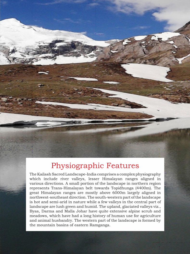
HkkSfedh; vkd`frifo= dSyk”k Hkw {ks=&Hkkjr esa tfVy HkkSfedh fHkUurk,a gSaa] ftlesa unh ?kkfV;k¡ o fuEu fgeky; Jsf.k;k¡ fofHkUu fn”kkvksa esa Js.khc) gSaA Hkw&{ks= dk NksVk mRrjh Hkw&Hkkx Vksih<qxak ¼4400 eh0½] ikj&fgeky;h {ks= dk izfrfuf/kRo djrk gSA mPp fgeky;h ioZr Ja`[kyk,a tks 6000 eh0 Å¡ph o eq[;r% mRrj if”pe&nf{k.k iwoZ fn”kk esa Js.khc) gSaA Hkw&{ks= dk nf{k.k&if”peh Hkkx izd`fr esa xeZ vkSj v)Z “kq’d gS] tcfd Hkw&{ks= ds e/; Hkkx esa dqN ?kkfV;k¡ gjh Hkjh o ue gSaA Å¡ps {ks=ksa o fgeun ?kkfV;ksa] tSls& C;kl] nkjek] eYyk tkSgkj vkfn esa cqX;ky] pkjkxkg o >kfM+;ka O;kid :Ik esa ik;h tkrh gSa] ftudk d`f’k ,oa i”kqikyu esa ekuo }kjk mi;ksx dk yEck bfrgkl jgk gSA Hkw&{ks= dk if”peh Hkkx iwohZ jkexaxk dh igkM+h ?kkfV;ksa ls vkjEHk gksrk gSA
An Atlas of Kailash Sacred Landscape-India 19
Physiographic FeaturesThe Kailash Sacred Landscape-India comprises a complex physiography
which include river valleys, lesser Himalayan ranges aligned in
various directions. A small portion of the landscape in northern region
represents Trans-Himalayan belt towards Topidhunga (4400m). The
great Himalayan ranges are mostly above 6000m largely aligned in
northwest-southeast direction. The south-western part of the landscape
is hot and semi-arid in nature while a few valleys in the central part of
landscape are lush green and humid. The upland, glaciated valleys viz.,
Byas, Darma and Malla Johar have quite extensive alpine scrub and
meadows, which have had a long history of human use for agriculture
and animal husbandry. The western part of the landscape is formed by
the mountain basins of eastern Ramganga.

20 An Atlas of Kailash Sacred Landscape-India
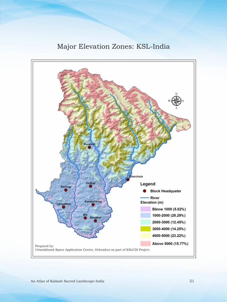
izeq[k Å¡pkbZ {ks=% ifo= dSyk”k Hkw {ks=&HkkjrMajor Elevation Zones: KSL-India
dSyk”k Hkw {ks=&Hkkjr] if”peh fgeky; esa lcls fofo/k ikfjfLFkfrd ra=ksa dk izfrfuf/kRo djrk gS] tks iaps”oj ¼<400 eh0] dkyh@“kkjnk vkSj lj;w ds laxe ij½ ls uUnk nsoh iwoZ f”k[kj ¼7434 eh0½ rd QSyk gqvk gSA tSo&HkkSxksfyd :Ik ls ;g {ks= if”peh] e/; ,oa Vªkal&fgeky; ds laxe ij fLFkr gS] tgka fofHkUu izdkj ds fefJr ou] o tho&tUrq ik;s tkrs gSaA Hkw&{ks= dks ÅapkbZ ,oa tyok;q ds vk/kkj ij fuEufyf[kr eq[; thou&{ks= ;k Ik;kZoj.k tyok;q {ks= esa foHkkftr fd;k tk ldrk gS%& (i) miks’.k dfVcU/kh; (<1000 eh0), (ii) xeZ le”khr¨‘.k (1000&2200 eh0), (iii) ”khr le”khr¨‘.k (2200&3000 eh0), (iv) mi&vYikbu (3000&3500 eh0), (iv) mPp fgeky; dk vYikbu {ks= o (3500&5000 eh0), (vi) Vªkal&fgeky; dk ”kq‘d vYikbu {ks= (> 5000 eh0)A
The Kailash Sacred Landscape-India represents most diverse ecosystems
in the Western Himalaya within a short distance from Pancheshwar (400m asl),
at the confl uence of the Saryu and Kali or Sharada to the summit of Nanda
devi East (7434m). Biogeographically, this landscape lies at the confl uence
of Western, Central and Trans-Himalaya where fl oral and faunal elements
converge. The landscape is divisible into following major life-zones or eco-
climatic zones based on the altitude and climate: (i) Sub-tropical (<1000m),
(ii) Warm temperate (1000-2200 m), (iii) Cool temperate (2200-3000 m),
(iv) Sub-alpine zone (3000-3500 m), (iv) Alpine zone of greater Himalaya (3500-
5000 m), (vi) Alpine arid zone of Trans-Himalaya (>5000m).
Table: Area across elevation zones in KSL-India
Elevation zone (m) Area (Km2)
Sub Tropical (<1000) 357.59
Warm Temperate (1000-2000) 2014.64
Cool Temperate (2000-3000) 886.64
Sub-alpine (3000-(3500) 4000) 1014.44
Alpine zone (4000-5000) 1653.10
Alpine arid zone of Trans Himalaya
(>5000)
1193.82
Total 7120.24
An Atlas of Kailash Sacred Landscape-India 21
Prepared by:
Uttarakhand Space Application Centre, Dehradun as part of KSLCDI Project.
Major Elevation Zones: KSL-India
22 An Atlas of Kailash Sacred Landscape-India
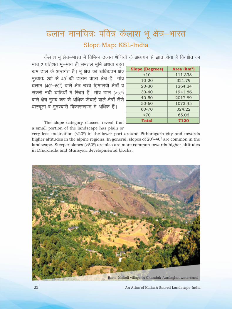
<yku ekufp=% ifo= dSyk”k Hkw {ks=&HkkjrSlope Map: KSL-India
dSyk”k Hkw {ks=&Hkkjr esasa fofHkUu <yku Jsf.k;ksa ds v/;;u ls Kkr gksrk gS fd {ks= dk ek= 2 izfr”kr Hkw&Hkkx gh lery Hkwfe vFkok cgqr de <ky ds vUrxZr gSA Hkw {ks= dk vfËkdre {ks= eq[;r% 200 ls 400 dh <yku okyk {ks= gSA rhoz <yku ¼400&600½ okys {ks= mPp fgeky;h {ks=ksa o ladjh unh ?kkfV;ksaa esa fLFkr gSaA rhoz <ky (>500) okys {ks= eq[; :i ls vf/kd Å¡pkbZ okys {ks=ksa tSls /kkjpwyk o eqUkL;kjh fodkl[k.M esa vf/kd gSaA
The slope category classes reveal that
a small portion of the landscape has plain or
very less inclination (<200) in the lower part around Pithoragarh city and towards
higher altitudes in the alpine regions. In general, slopes of 200–400 are common in the
landscape. Steeper slopes (>500) are also are more common towards higher altitudes
in Dharchula and Munsyari developmental blocks.
Slope (Degrees) Area (km2)
<10 111.338
10-20 321.79
20-30 1264.24
30-40 1941.86
40-50 2017.89
50-60 1073.45
60-70 324.22
>70 65.06
Total 7120
Bans-Maitoli village in Chandak-Aunlaghat watershed

An Atlas of Kailash Sacred Landscape-India 23
Prepared by:
Uttarakhand Space Application Centre, Dehradun as part of KSLCDI Project.
Slope Map: KSL-India

24 An Atlas of Kailash Sacred Landscape-India
<ky&vfHkeq[k ekufp=% ifo= dSyk”k Hkw {ks=&HkkjrAspect Map: KSL-India
dSyk”k Hkw {ks=&Hkkjr ds <ky vfHkeq[k ekufp= ds vkadyu ls Kkr gksrk gS fd lEiw.kZ Hkw&Hkkx esa nf{k.k&iwoZ ¼14-4%½] nf{k.k ¼13-8%½ vkSj nf{k.k&if”pe ¼13-7%½ <ky vfHkeq[k {ks= izeq[k gSaA fupys ,oa vf/kd Å¡pkbZ okys {ks=ksa esa] tgka vf/kd lE; <yku@?kkfV;ka gSa] ogka mRrj] mRrj&iwohZ vkSj iwoZ <ky vfHkeq[k {ks= vf/kd gSaA dSyk”k Hkw&{ks= Hkkjr esa if”pe ¼10-7%½ vkSj mRrj&if”pe ¼10-6%½ izdkj ds <ky vfHkeq[k U;wure gSaA Hkw&{ks= esa lHkh izdkj ds <kyksa dh miyC/krk ls ;gka ouLifr leqnk;ksa esa fHkUurk ik;h tkrh gSA
The aspect map of the KSL-India revels that
south-east (14.4%), south (13.8%) and south-west
(13.7%) aspects prevail in the entire landscape. The
lower and higher altitudinal region where there are
more gentler slopes/valleys the areas are having
high north, north-east and east facing slopes.
West (10.7%) and north-west (10.6%) facing slopes are minimum in the landscape.
The representation of all the asspects support high plant community diversity in the
landscape.
Various aspects at Chiyalekh-Byas Valley
Aspect Area (% of
landscape)
North 11.9
North-East 12.3
East 12.7
South-east 14.4
South 13.8
South-West 13.7
West 10.7
North-West 10.6

An Atlas of Kailash Sacred Landscape-India 25
Prepared by:
Uttarakhand Space Application Centre, Dehradun as part of KSLCDI Project.
Aspect Map: KSL-India

26 An Atlas of Kailash Sacred Landscape-India
HkwxHkÊ; ,oa fo”ks’keq[k js[kk,a% ifo= dSyk”k Hkw {ks=&HkkjrGeological and Lineament: KSL-India
HkwxfHkZd :i ls dSyk”k Hkw&{ks= Hkkjr esa eq[;r% fuEu] mPp ,oa Vªkal fgeky;h pV~Vkuksa ds lewg “kkfey gSaA Hkw {ks= esa HkwdEi tfur gypy ls cus Hkw[k.M gksus ds dkj.k vusd izdkj ds ”kSy ik;s tkrs gSaA tgk¡ lj;w unh ?kkVh ds fuEu ÅapkbZ okys {ks=ksa esa ofrZdk lewg o yiFky {ks= esa VsFkhl leqnz ds Lihfr ”kSy fo|eku gSaA e/; fgeky;h {ks= dk T;knkrj Hkkx fQYykbV ”kSy o LysV ds iRFkj] pwukiRFkj] DokVZlkbV ;k LifVdk”e] eSXuslkbV] [kfM+;k o dqN {ks= esa xzsukbV] uhl o f”k’V ik;k tkrk gSA fiFkkSjkx<+ ”kgj {ks= esa ”kksj LysV fo|eku gSa tks dkys] Hkwjs o cSaxuh jaxksa esa ik;k tkrk gSA blh rjg vLdksV fdzLVkykbu {ks=ksa esa rkack (Copper)] ”kh”kk (Lead)] lksuk] pkanh o ftad ds [kfut fo|eku gSaA
Geologically the Kailash Sacred landscape-India covers mainly the Lesser, Higher and Trans Himalayan group of rocks. Due to various tectonic activities there are several rock types are present. Where low altitude areas along river Saryu has Vartika group and high altitude regions of Lapthal area has Spiti rocks of Tethys Sea. Maximum part of the middle Himalayan region of the landscape are dominated by Phyllites rock, Limestone, Quartzite, Magnesite, Talk and in some places Granite. Shor rock is present in the Pithoragarh city that occur in black, brown and purple colours. Similarly, the Askot Crystalline area, Copper, Lead, Gold, Silver and Zink minerals are present.
Fossil belt in Topidhunga-Lapthal area

An Atlas of Kailash Sacred Landscape-India 27
Prepared by:
Uttarakhand Space Application Centre, Dehradun as part of KSLCDI Project.
Geological and Lineament Map: KSL-India
Source: after Valdiya 1972

28 An Atlas of Kailash Sacred Landscape-India
e`nk lajpuk% ifo= dSyk”k Hkw {ks=&HkkjrSoil Texture: KSL-India
dSyk”k Hkw&{ks= Hkkjr esa vusd izdkj ds e`nk {ks= ik;s tkrs gSaA Hkw&{ks= esa unh ?kkfV;ksa esa lS.MLVksu o jsrhyh e`nk ls ysdj ikj&fgeky;h yiFky {ks= esa VsFkhl egklkxj dh leqnz ryh; feV~Vh ik;h tkrh gSA fupyh ?kkfV;ksa esa jsrhyh nkseV e`nk ik;h tkrh gS tks DokVZTk ds fo?kVu rFkk fQYykbV ds lfEeJ.k ls curh gaSA e/; fgeky;h {ks= ds T;knkrj {ks= esa f”k’V fo?kVu ls rS;kj vHkzdh; o ckywe; e`nk ik;h tkrh gSA ”kSy o LysV ds fo?kVu ls fpduh nkseV feV~Vh rS;kj gksrh gS tks fofHkUu xgjkbZ esa izpqj ek=k esa ik;h tkrh gSA pwuk iRFkj ds fo?kVu ls yky ,oa dkyh feV~Vh rS;kj gksrh gS tks ou {ks=ksa ds fy, mi;ksxh gksrh gSA uhl o xzsukbV ds fo?kVu ls rS;kj jsrhyh o nkseV feV~Vh xgjh ,oa vf/kd mitkÅ gksrh gSA
In the KSL-India several types of soil texture are present. Along the river banks,
sandstone and sandy to Tethys sea bed soil occur in the Trans-Himalayan area.
Lower valleys have reported Sandy-loamy soil, which developed due to the dissolution
of quartz and mixing with Phyllites. Sandy soil occur in the middle Himalaya regions.
Due to dissolution of rock and slates, Smooth-loamy soil forms and occur in abundant
at different depths. Red and Black soil forms due to the dissolution of Limestone,
which is useful for forested areas. Dissolution of Nees and Granite forms Sandy-
loamy soil, which is generally highly fertile in nature.
Name Area (km2)
Calcareous 1537.40
Clayey 72.20
Fragmental 574.68
Loamy 4302.89
Rock-outcrops 69.35
Sandy 563.64
Total 7120
Table: Area statistics of various soil types in KSL-India

An Atlas of Kailash Sacred Landscape-India 29
Prepared by:
Uttarakhand Space Application Centre, Dehradun as part of KSLCDI Project.
Soil Texture Map: KSL-India

30 An Atlas of Kailash Sacred Landscape-India
ufn;ka] >hy] pksfV;ka o fgeun% ifo= dSyk”k Hkw {ks=&HkkjrRivers, Lakes, Peaks and Glaciers: KSL-India
dSyk”k Hkw&{ks= Hkkjr esa 5 izeq[k ufn;k¡ ¼dkyh] /kkSyh] xksjh] jkexaxk o lj;w½ o 2&3 NksVh >hy fo|eku gSaA Hkw&{ks= ds yxHkx 10% {ks= esa vkPNkfnr 382 NksVs&cM+s fgeun gSa] ftuls vusd unh&ukyksa dk mn~xe gksrk gSA lcls vf/kd 135 lgk;d fgeun /kkSyhxaxk ?kkVh esa fLFkr gaSA dqfV ;kaXrh ?kkVh esa 112 fgeun gaSA xksjhxaxk ?kkVh esa 128 fgeun gaS] ftlesa lcls cM+k fgeun 18 fd0eh0 yack] feye fgeun gSA jkexaxk ?kkVh esa 7 fgeun gaS] ftlesa lcls cM+k fgeun ukfed gS] ftldk {ks=Qy 2-4 oxZ fd0eh0 gSA dqN fgeunksa tSls] feye o iapkpwyh esa okrkoj.kh; cnykvksa dk izHkko Li’V :i ls ns[kk tk ldrk gSA fgeunksa] ufn;ksa o tyk”k;ksa dk lh/kk lEcU/k fupyh ?kkfV;ksa dh d`f’k] vkthfodk o tSo fofo/krk ls gSA Hkw {ks= esa fofHkUu unh&?kkfV;ksa dh Hkkafr] 30 ls vf/kd eq[; ioZr pksfV;ka] mRrj if”pe ls nf{k.k iwoZ dh vksj QSyh gqbZ gSaA
Saryu river at Panar-Rameshwar
In the KSL-India there are five major rivers (Kali, Dhauli, Gori, Ramganga and Saryu) and 2-3 small lakes. In the 10% area of the landscape, there are more
than 382 small and large glaciers. Those are source of several streams and rivers.
Maximum 135 glaciers found in the Dhauliganga valley. Kuti-Yangti valley has
112 glaciers. Goriganga has 128 glaciers with largest Milam glacier having 18 km
in length. There are 7 glaciers in Ramganga valley and Namik is largest with 2.4
Km2 in size. The impact of environmental change can be clearly visualize in a few
glaciers i.e., Milam and Panch Chuli. These glaciers, rivers and lakes are directly
linked to the agriculture, livelihood and biodiversity of downstream areas. Similar
to rivers, more than 30 mountain ranges of the landscape are distributed towards
north-west to south-east.

An Atlas of Kailash Sacred Landscape-India 31
Peaks: 6904-(Panchachuli-I), 6312-(Panchachuli II), 6334-(Panchachuli
III), 6437-(Panchachuli IV), 6072-(Panchachuli V), 5029-(Gelding),
5035-(Dunkhan), 5105-(Halsyun), 6123-(Lalla We), 6321-(Adi Kailash),
6537-(Rajrambha), 6632-(Deo Damia), 6302-(Bamchhu), 6258-(Syakaram),
6565-(Mangron), 6389-(Latu Dhura), 5858-(Bati ka Dhura), 5782-(Nanda
Lapak), 5421-(Kalchhu Dhura), 5206-(Mapa Dhura).
Prepared by:
Uttarakhand Space Application Centre, Dehradun as part of KSLCDI Project.
Rivers, Lakes, Peaks and Glaciers Map: KSL-India

32 An Atlas of Kailash Sacred Landscape-India
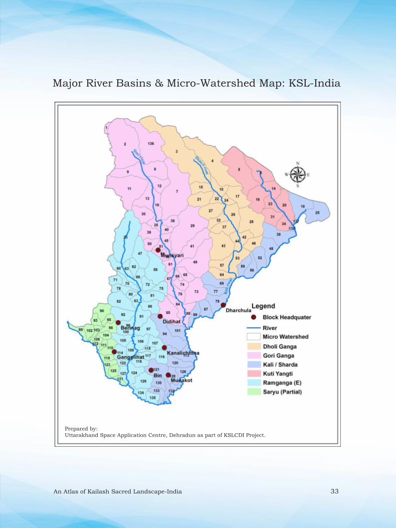
izeq[k unh ?kkfV;k¡ o lw{e tykxe% ifo= dSyk”k Hkw {ks=&HkkjrMajor River Basins and Micro-Watersheds: KSL-India
S.No. MWS Area
(km2)
S.No. MWS Area
(km2)
S.No. MWS Area
(km2)
1 Dunagiri 7.86 47 GadiyarNadi 70.32 93 Karariyagaon 19.38
2 Milam 243.56 48 4 55.3 94 Charmagad 102.01
3 11 321.18 49 Kulkagad Gadhera 136.46 95 Dauligad 18.9
4 13 205.23 50 Senargad 29.5 96 Karkigaon 23.9
5 10 167.07 51 Dharanti 17.98 97 Bhanarigad 56.13
6 11 81.79 52 3 46.87 98 Mageswari Nadi 27.35
7 Ralam gad 240.16 53 Suwa 53.11 99 Jamtola 23.03
8 Burphu gad 72.71 54 Bhadoligad 17.61 100 Titargad 27.65
9 Pachhugad 69.55 55 Sungariya Gadhera 12.11 101 Gurujigad 41.92
10 12 34.66 56 Sirkha 38.76 102 Ganai Gadhera 23.25
11 Martoli gad 170.49 57 KanchiliNadi 47.11 103 Simalta 13.86
12 Tola Badli gad 41.6 58 Bhujgad 95.46 104 Suyalgad 17.56
13 Laspa Badligad 65.05 59 Jiuntigad 33.45 105 Mangarhgad 36.99
14 12 43.64 60 LetiRauli 44.99 106 Chamungad 37.91
15 10 42.23 61 Tumariya Gadhera 25.91 107 Kakragad 35.44
16 9 81.5 62 Rimliyagad 24.87 108 Chuna 13.66
17 14 62.84 63 JajarRauli 20.65 109 Boelkigad 27.02
18 14 74.49 64 Dukkigad 40.8 110 NargalNala 34.31
19 Khilanch 39.71 65 Ranchigad 29.57 111 Ghatgad 11.95
20 13 67.28 66 Dhaulgad 25.44 112 Pharsula 9.46
21 9 59.76 67 Ghungargad 33.09 113 Sagarigad 66.77
22 8 21.19 68 Jonligad 15.36 114 Tanarkigad 37.68
23 8 32.44 69 Relagad 60.94 115 Batula 15.15
24 15 17.76 70 Kheti 26.19 116 Kaligad 30.77
25 15 76.06 71 Chanoli 21.89 117 Nargoli 24.49
26 16 53.74 72 Simgad 27.2 118 Gokarneshwar gad 31.94
27 7 63.47 73 Ghosigad 84.37 119 Nanoligad 16.19
28 17 114.56 74 Jaragad 25.58 120 Katiyanigad 41.04
29 Madkani River 199.6 75 Patligad 32.45 121 Thulligad 73.81
30 Pottinggad 53.14 76 Dogrigad 25.18 122 Bhulgaon 13.91
31 7 50.29 77 Kullagad 36.52 123 Chhanigad 24
32 Malchhigad 33.99 78 Lamagarh 29.45 124 Kingad 44.53
33 Gogina 190.09 79 Dharchula 57.98 125 Linggad 22.84
34 6 35.25 80 Jhiniyagad 12.51 126 Chaurigad 30.69
35 Rajgari 25.22 81 Silgad 40.86 127 Saurongad 25.7
36 Piitigad 30.41 82 Barargad 68.88 128 Ghatgad 32.67
37 Nagling 48.74 83 Lakrigad 20.85 129 Silanggad 51.34
38 5 83.15 84 Bherigad 39 130 Simalgad 30.17
39 Kwirigad 50.51 85 Khetargad 83.29 131 Timla 12.82
40 Pehalgad 17.25 86 Ranikhet 40.71 132 Rupagad 27.06
41 Painagad 94.22 87 Chuagad 38.31 133 Lodgad 28.01
42 Dhauli Ganga 27.07 88 Patmoligad 31.99 134 Ghatgad 25.69
43 Naingalgad 108.95 89 Guiamgad 32.68 135 Kheti Gad 27.35
44 Dar 30.23 90 Kulurgad 41.8 136 Gonkha gad 171.76
45 Dhuratoli 24.99 91 Lathiyagad 46.4 137 137 3.37
46 NandarmaNadi 36.75 92 Gurghatiya 51.4 138 6 6.16
dSyk”k Hkw&{ks= Hkkjr esa 6 tykxe] 16 mi&tykxe rFkk 138 lw{e tykxe gaSA KSL-India has 6 watershed and 16 sub-watershed and about 138 micro-watersheds are present.
An Atlas of Kailash Sacred Landscape-India 33
Prepared by:
Uttarakhand Space Application Centre, Dehradun as part of KSLCDI Project.
Major River Basins & Micro-Watershed Map: KSL-India
34 An Atlas of Kailash Sacred Landscape-India

An Atlas of Kailash Sacred Landscape-India 3535
ifo= dSyk”k Hkw {ks=&Hkkjr vf}rh; lkaLd`frd {ks= dk izfrfuf/kRo djrk gS] tks ,sfrgkfld :i ls vusd laLd`fr;ksa ,oa lw{e laLd`fr;ksa ds {ks= ds :i esa fodflr gqvk gSA bu fofHkUu laLd`fr;ksa dk lekos”k o lkaLd`frd lekurk,a {ks= dks vuwBk cukrh gSaA dkyh] xksjh] jkexaxk o lj;w ufn;ksa dh ?kkfV;ksa esa fofHkUu lkaLd`frd lewg fodflr gq, gSaA ;g {ks=] vusd latkrh;] cgqHkk’kh ,oa LkkaLd`frd lewgksa dk dsUnz Hkh gSA vkt ds rsth ls cnyrs ifjos”k esa bu lkaLd`frd ewY;ksa] fjoktksa o ikjEifjd Kku dk nLrkosthdj.k@vkys[ku dj lajf{kr fd;k tkuk vfr vko”;d gSA
Kailash Sacred Landscape-India, represents one of the unique cultural sites,
which has historically evolved as an amphitheatre for several cultures and micro
cultures, blending with each other, forming a rainbow of cultural commonality.
Various cultural groups have evolved in river valleys of Kali, Dhauli, Gori,
Ramganga and Saryu. The landscape has been a centre of activities of ethnic,
lingual and cultural groups, which came from different directions at different
times. It is highly imperative to document and conserve their cultural values,
customs and traditional wisdom in today’s fast changing environment.
laLd`fr ,oa Ik;ZVuCulture and Tourism

36 An Atlas of Kailash Sacred Landscape-India
LFkkuh; lkaLd`frd {ks=% ifo= dSyk”k Hkw {ks=&HkkjrIndigenous Cultural Zones: KSL-India
dSyk”k Hkw {ks=&Hkkjr ds dkyh] /kkSyh] xksjh] jkexaxk o lj;w unh dh ?kkfV;ksa esa fofo/k lkaLd`frd lewgksa dk fodkl gqvk gSA Hkw&{ks= esa 7 izeq[k LFkkuh; lkaLd`frd {ks= ¼O;kl] nkjek] tksgkj] vLdksV] lksj] lsjk ,oa xaxksyh½ gSaA tgka dh lakLd`frd ijEijkvksa o Hkk‘kkvksa esa fHkUurk ns[kus dks feyrh gSA vkt ds rsth ls cnyrs ifjos”k esa ;gk¡ ds lkaLd`frd ewY;ksa] jhfr&fjoktksa o ikjEifjd Kku dk nLrkosthdj.k dj bUgsa cpk, j[kuk vfr vko”;d gks x;k gSA
In Kailash Sacred Landscape-India, various cultural groups have evolved in
river valleys of Kali, Dhauli, Gori, Ramganga and Saryu. There are 7 major indigenous
cultural zones (Byas, Darma, Johar, Askot, Sera, Sor, Gangoli) in the landscape.
Where there is differece in there cultural belief and local dilect in each cultural zone.
It is highly imperative to document and conserve their cultural values, customs and
traditional wisdom in today’s fast changing environment.
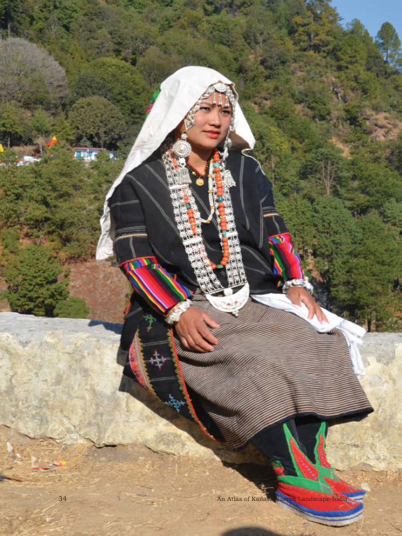
Traditional attire of Sor, Gangol, Askot and Seera areas

An Atlas of Kailash Sacred Landscape-India 37
Prepared by:
Uttarakhand Space Application Centre, Dehradun as part of KSLCDI Project.
Cultural Zones Map: KSL-India
38 An Atlas of Kailash Sacred Landscape-India
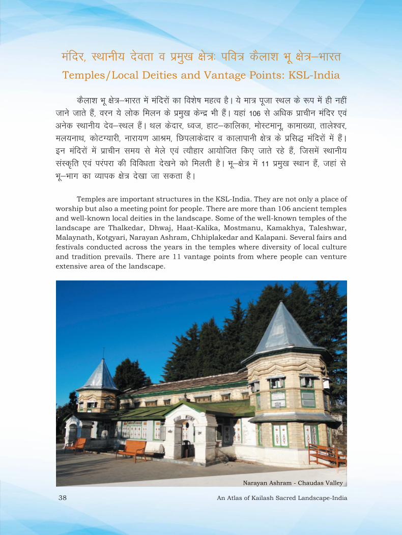
Ekafnj] LFkkuh; nsork o izeq[k {ks=% ifo= dSyk”k Hkw {ks=&HkkjrTemples/Local Deities and Vantage Points: KSL-India
dSyk”k Hkw {ks=&Hkkjr esa eafnjksa dk fo”ks’k egRo gSA ;s ek= iwtk LFky ds :i esa gh ugha tkus tkrs gSa] oju ;s yksd feyu ds izeq[k dsUnz Hkh gSaA ;gka 106 ls vf/kd izkphu eafnj ,oa vusd LFkkuh; nso&LFky gSaA Fky dsnkj] /ot] gkV&dkfydk] eksLVekuw] dkek[;k] rkys”oj] ey;ukFk] dksVX;kjh] ukjk;.k vkJe] fNiykdsnkj o dkykikuh {ks= ds izfl) eafnjksa esa gSaA bu eafnjksa esa izkphu le; ls esys ,oa R;kSgkj vk;ksftr fd, tkrs jgs gSa] ftlesa LFkkuh; laLd`fr ,oa ijaijk dh fofo/krk ns[kus dks feyrh gSA Hkw&{ks= esa 11 izeq[k LFkku gSa] tgka ls Hkw&Hkkx dk O;kid {ks= ns[kk tk ldrk gSA
Temples are important structures in the KSL-India. They are not only a place of
worship but also a meeting point for people. There are more than 106 ancient temples
and well-known local deities in the landscape. Some of the well-known temples of the
landscape are Thalkedar, Dhwaj, Haat-Kalika, Mostmanu, Kamakhya, Taleshwar,
Malaynath, Kotgyari, Narayan Ashram, Chhiplakedar and Kalapani. Several fairs and
festivals conducted across the years in the temples where diversity of local culture
and tradition prevails. There are 11 vantage points from where people can venture
extensive area of the landscape.
Narayan Ashram - Chaudas Valley

An Atlas of Kailash Sacred Landscape-India 39
Prepared by:
Uttarakhand Space Application Centre, Dehradun as part of KSLCDI Project.
Temples/Local Deities and Vantage Points: KSL-India
Source: GS Negi, USAC (Unpublished)
Vantage Points: 1-Nabhidhang, 2-Parvati Tal, 3-Munsyari, 4-Didihat (Malayanath),
5-Dhwaj, 6-Dantu, 7-Chandak, 8-Chaukori, 9-Thalkedar, 10-Chhiplakedar,
11-Bharbedan.

40 An Atlas of Kailash Sacred Landscape-India
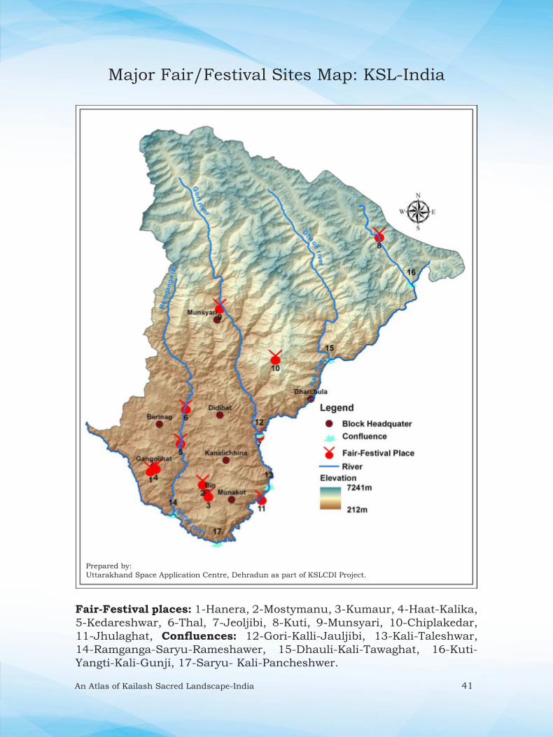
izeq[k esys@R;kSgkj vk;kstu LFky% ifo= dSyk”k Hkw {ks=&HkkjrMajor Fair/Festival Sites: KSL-India
dSyk”k Hkw {ks=&Hkkjr fofo/k esyksa o R;ksgkjksa dk vk;kstu LFky gS] ftlesa LFkkuh; yksd R;ksgkjkas dh fofo/krk ns[kus dks feyrh gSA Hkw&{ks= esa efUnj o ufn;ksa ds laxe LFky bu esyksa dks vk;ksftr djus ds izeq[k LFkku gSaA ;gkaa yxHkx 15 ,sls LFkku gSa] tgka gj o’kZ esyksa dk vk;kstu gksrk gSA dqekSM+ ¼fiFkkSjkx<+½] eksLVekuw ¼paMkd½] gkV&dkfydk ¼xaxksyhgkV½] Fky] equL;kjh] >wyk?kkV ,oa tkSythoh vkfn LFkkuksa esa izfro’kZ esys vk;ksftr fd, tkrs gSaA tkSythoh esyk ,d lhekikjh; esyk gS tks fd izfro’kZ uoacj ekg esa xksjh o dkyh ufn;ksa ds laxe LFky ij vk;ksftr fd;k tkrk gSA Hkw&{ks= ds dqN LFkkuksa ¼tSls& dqVh esa vk;ksftr daMkyh esyk½ esa esys izR;sd 12 o’kZ ds vUrjky ij vk;ksftr fd;s tkrs gSaA
Kailash Sacred Landscape-India is the land of several fairs and festivals, where
diversity of local festival prevails. Temples and confl oences of the rivers are the main
areas to organise the fairs in the landscape. There are about 15 places where every year
major fairs occur across the seasons. Some of the places viz., Kumour (Pithoragarh),
Mostmanu (Chandak), Hat-Kalika (Gangolihat), Thal, Munsyari, Jhulaghat and
Jauljibi are well known places for conducting regular fairs. Jauljibi fair is one of the
transboundary fair organised every year during November month at the confl uence
of Gori and Kali rivers. In the landscape at places (eg., Kuti, kandali festival) festivals
are also being organized at an interval of 12 years.
Johar festival at Munsyari
An Atlas of Kailash Sacred Landscape-India 41
Fair-Festival places: 1-Hanera, 2-Mostymanu, 3-Kumaur, 4-Haat-Kalika,
5-Kedareshwar, 6-Thal, 7-Jeoljibi, 8-Kuti, 9-Munsyari, 10-Chiplakedar,
11-Jhulaghat, Confluences: 12-Gori-Kalli-Jauljibi, 13-Kali-Taleshwar,
14-Ramganga-Saryu-Rameshawer, 15-Dhauli-Kali-Tawaghat, 16-Kuti-
Yangti-Kali-Gunji, 17-Saryu- Kali-Pancheshwer.
Prepared by:
Uttarakhand Space Application Centre, Dehradun as part of KSLCDI Project.
Major Fair/Festival Sites Map: KSL-India

42 An Atlas of Kailash Sacred Landscape-India
fojklr ,oa VªSfdax ekxZ% ifo= dSyk”k Hkw {ks=&HkkjrHeritage and Trekking Routes: KSL-India
dSyk”k Hkw {ks=&Hkkjr] ekuo dks vusd mYys[kuh; vHkkSfrdh; ykHk iznku djrk gS TkSls& vk/;kfRed lao)Zu] laKkukRed fodkl] izfrfcEc] euksjatu ,oa lkaSn;Z vuqHko vkfnA ;s lHkh ykHk Hkw&{ks= ds lkaLd`frd ewY;ksa esa lekfgr gSaA nks iqjkus fojklr ekxZ ¼1½ rYyklsjk ls >wyk?kkV ,oa ¼2½ >wyk?kkV ls fyiqys[k ¼dSyk”k ekuljksoj ;k=k dk ikSjkf.kd ekxZ½ dk mi;ksx vrhr esa fd;k tkrk jgk gSA orZeku esa lM+d ekxksZa dh lqfo/kk gksus ls >wyk?kkV&fyiqys[k fojklr ekxZ dk dsoy NksVk lk fgLlk gh dSyk”k ekuljksoj ,oa vkfn dSyk”k ;k=k ds nkSjku iz;ksx esa yk;k tkrk gSA Hkw {ks= esa nks fojklr ekxksZa ds vfrfjDr 30 ls vf/kd NksVs&cM+s VªSfdax ekxZ Hkh gSaA bu VªSfdax ekxksZa dk mi;ksx iorkZjksg.k ij vkus okys i;ZVdksa ds vfrfjDr ”kks/k dk;ksZa o lqj{kk x”r ¼ou foHkkx] lsuk ,oa v)Z lsuk½ ds fy, Hkh fd;k tkrk gSA
In the KSL-India various non-material benefi ts people obtain from the landscape
through spiritual enrichment, cognitive development, refl ection, recreation and
aesthetic experiences, thereby taking account of the cultural values of the landscape.
There are two old heritage routes i) Talla-Sera to Jhulaghat and ii) Jhulaghat to
Lipulekh (way to Kailash Mansarowar) were being used in the past. Currently, due to
development of motrable roads only small part of the Jhulaghat- Lipulekh heritage
route is trekked during Kailash Mansarovar and Adi-Kailash yatra. Other than heritage
routes there are more than 30 short and long trekking routes in the landscape. These
trekking routes are being used by tourists for mountaineering, research works and
also for security (Forest department, army and paramilitary force) purposes.
Trekking around Munsyari

An Atlas of Kailash Sacred Landscape-India 43
Trekking Routes: 1-Pancheswar-Jhulaghat, 2-Munsyari-Milam, 3-Leelam to Ralam, 4-Ralam-
Burfu, 5-Munsyari-Khaliya top, 6-Tedang-Sipu-Ralam, 7-Baram-Chiplakedar-Khet, 8- Bedang-
Jeolingkong, 9- Dave, 10- Tedang-Dave, 11- Tedang-Lessar, 12- Dar-Tedang, 13-Sipu-Mahadev Khola,
14-Baimangwar Khela, 15-Birthi-Namik, 16-Bundi-Rongkong, 17-Chiplakot-Sera, 18-Gangolihat
Rameshwar, 19-Ghorpatta-Jaurasi, 20-Gunji-Kuti-Jolingkong-Limpiya, 21-Hokara-Dor, 22-Kanar-
Baimangwar, 23-Kauguri Bhel-Poting, 24-Namik-Hokara, 25-Namik-Sudamkhan pass, 26-Pachhu-
Nandakund, 27-Poting-Bagudiyar, 28-Rameshwar-Pithoragarh, 29-Rurkhan-Jimia, 30-Rurkhan-Namik,
31-Sudamkhan pass-Kauguri Bhel, 32-Sumdum Bauna, 33-Thalkedhar-Gurana
Prepared by:
Uttarakhand Space Application Centre, Dehradun as part of KSLCDI Project.
Heritage and Trekking Routes Map: KSL-India
Lipulekh
Tallasera
Jhulaghat

44 An Atlas of Kailash Sacred Landscape-India
lkgfld Ik;ZVu LFky% ifo= dSyk”k Hkw {ks=&HkkjrSpots for Adventure Tourism: KSL-India
dSyk”k Hkw&{ks= Hkkjr esa lkgfld xfrfof/k;ksa tSls] ioZrkjksg.k] VSªfdax] Xysf”k;j vfHk;ku] jkWd Dykbafcax] fjoj jkf¶Vax] iSjkXykbfMax] taxy lSj vkfn dh vikj lEHkkouk,a gSaA bu xfrfof/k;ksa dks LFkkuh; leqnk;ksa ds lkFk feydj jkstxkj ls tksM+k tk ldrk gS] ijUrq lrr~ fodkl ,oa i;kZoj.k laj{k.k dh n`f’V ls bu LFkkuksa dk leqfpr j[k&j[kko fd;k tkuk Hkh vR;Ur egRoiw.kZ gSA
Kailash Sacred Landscape-India offers several areas of adventure activities
viz., Mountaineering, Trekking, Glacier expedition, Rock climbing, River rafting,
Paragliding, Forest walk etc. These activities can be connected with the employment
of local communities. However, proper maintenance of these places will be of high
importance.
Paragliding at Pithoragarh

An Atlas of Kailash Sacred Landscape-India 45
Rock Climbing: 1- Birthi, 2- Bhatkot, 3- Marh, 8- Ghunsera, 9- Majhpati
River Rafting: 4- Jauljibi, 5- Jhulaghat, 6- Pancheshwar, 7- Rameshwar
Prepared by:
Uttarakhand Space Application Centre, Dehradun as part of KSLCDI Project.
Spots for Adventure Tourism Map: KSL-India

46 An Atlas of Kailash Sacred Landscape-India
ls gSA Hkw&mi;ksx oxhZdj.k] Hkwfe dh LFkkfud ;kstuk] izcU/ku ,oa Hkwfe ds mi;ksx dk
,d egRoiw.kZ ?kVd gSA Hkw&mi;ksx/Hkw&vkoj.k eq[; :Ik ls fdlh Hkh {ks= ds izkd`frd
dkjdksa@lajpukvksa] lkekftd&lkaLd`frd ,oa cqfu;knh lqfo/kkvksa ls fu;af=r gksrk gSSA
ifo= dSyk”k Hkw {ks=&Hkkjr ds fy, Hkw&mi;ksx ,oa Hkw&vkoj.k uD”ks 1%10000 Ldsy
ij cuk, x, gSa] tks o’kZ&2011 ds dkVksZlsV PAN o LISS-4 mixzgh; Nk;kfp=ksa ij
vk/kkfjr gSa] ftldk LFkkfud jsTkksY;w”ku 2-5 eh0 gSA mixzgh; Nk;kfp= us”kuy fjeksV
lsaflax lsUVj ¼NRSC½ gSnjkckn }kjk SISDP ifj;kstuk ds ek/;e ls miyC/k djk, x;s
FksA
Hkw&mi;ksx / Hkw&vkoj.k
Hkw&mi;ksx/Hkw&vkoj.k dk vk”k; lEiw.kZ izkd`frd vFkok ekuo fufeZr Hkwfe mi;ksx

An Atlas of Kailash Sacred Landscape-India 47
Land use / Land cover
Land use-Land cover refers to includes entire natural or man-made
uses of land. The land use classification forms an important component of spatial planning, management and utilization of land. Land use is
mainly govern by natural factors, socio-cultural and infrastructural
facilities of an area.
Land Use/Land Cover maps were prepared at 1:10,000 scale for KSL-
India by using fused product of Cartosat I – PAN and LISS-IV (Carto–
LS) for the year 2011 with spatial resolution of 2.5m. National Remote
Sensing Centre (NRSC), Hyderabad under Space Based Information
support System for Decentralized Planning (SISDP) project had provided
the satellite imageries.

48 An Atlas of Kailash Sacred Landscape-India
Hkw&mi;ksx ,oa Hkw vkoj.k% ifo= dSyk”k Hkw {ks=&HkkjrLand Use and Land Cover: KSL-India
dSyk”k Hkw&{ks= Hkkjr dh xzke iapk;rksa vkSj tykxe Lrj ls lwpuk@ tkudkjh ,d= dj foLr`r Hkw&mi;ksx ,oa Hkw vkoj.k ekufp= 1%10000 Ldsy ij rS;kj fd;k x;k gSA Hkw&mi;ksx ,oa Hkw vkoj.k ekufp= esa ou] ?kklh; {ks=] >kfM+;ka] ty] ekuo clklr] d`f‘k Hkwfe] cQZ ,oa fgeun vkfn dks n”kkZ;k x;k gSA ekufp=.k ds vk/kkj ij dSyk”k Hkw&{ks= Hkkjr dk 0-85% ekuo clklr] 10-08% d`f‘k Hkwfe] 13-65% ?kklh; {ks= ,oa 26-56% ou vkoj.k {ks= gSaA
After gaining the information at Gram Panchayat and watershed level
a detailed LULC map for the entire KSL-India was prepared at 1:10k
scale. The major LULC classes are Forest, Grassland, Scrubland, Water,
Human Settlements, Agricultural Lands, and Snow/ Glaciers. Human
Settlement (0.85%), Agricultural Lands (10.08%), Grasslands (13.65%)
and Forests were 26.56%. In the grasslands, summer grazing sites were
also recorded through intensive ground survey.
Table: Area statistics of LULC in the KSL-India
Hkw&mi;ksx@Hkw&vkoj.k Land Use/Land Cover
{ks=Qy@Area (km2)
d`f’k@Agriculture 717.89
ou@Forest 1891.01
>kfM+;ka@Scrubland 875.27
?kklh; {ks=@Grassland 971.63
clklr@Habitation 60.35
ty@Waterbody 39.82
cQZ&fgeun@Snow, Glaciers & Rocky
outcrops
2563.95
dqy@Total7120

An Atlas of Kailash Sacred Landscape-India 49
Prepared by:
Uttarakhand Space Application Centre, Dehradun as part of KSLCDI Project.
Land Use and Land Cover Map: KSL-India
50 An Atlas of Kailash Sacred Landscape-India
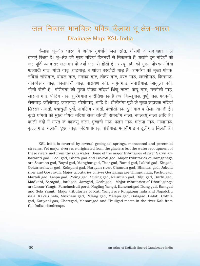
ty fudkl ekufp=% ifo= dSyk”k Hkw {ks=&HkkjrDrainage Map: KSL-India
dSyk”k Hkw&{ks= Hkkjr esa vusd HkwxHkhZ; ty lzksr] ekSleh o lnkcgkj ty /kkjk,a fLFkr gSaA Hkw&{ks= dh eq[; ufn;ka fgeunksa ls fudyrh gaS] ;|fi bu ufn;ksa dh tykiwfrZ T;knkrj tykxe ds o‘kkZ ty ls gksrh gSA lj;w unh dh eq[; iks’kd ufn;ka QY;kVh xkM+] xksnh xkM+] ?kkVxkM+] o Fkkstk cLdksVh xkM+ gaSA jkexaxk dh eq[; iks’kd ufn;ka lkSjksaxkM+] cks;y xkM+] eu?k<+ xkM+] rhrj xkM+] cjM+ xkM+] y[rhxkM+] fduxkM+] xksd.ksZ”oj xkM+] dkykikuh xkM+] ukjk;.k unh] pkequxkM+] HkukjhxkM+] tkdqyk unh] xkslh jkSyh gSA xksjhxaxk dh eq[; iks‘kd ufn;ka fFkaQw ukyk] ikNw xkM+] ejrksyh xkM+] yklik xkM+] iksfVax xkM+] lqfjaxxkM++ o jkSafr”kxkM+ gS rFkk fcYtwxkM+] cqQZw xkM+] enduh] lsjkxkM+] tkSayhxkM+] tkjkxkM+] xks”khxkM]+ vkfn gSaA /kkSyhxaxk iwohZ ds eq[; lgk;d ufn;ka fyLlj ;kaxrh] iapkpqyh iwohZ] ukxfyax ;kaxrh] dapksrhxkM+] naqx xkM+ o lsyk&;kaxrh gaSA dqVh ;kaxrh dh eq[; iks’kd ufn;ka lsyk ;kaxrh] jksaxdksax ukyk] uiyP;w ukyk vkfn gSA dkyh unh esa Hkkjr ds dkdlw ukyk] eq[kkuh xkM] iyax xkM] ekyik xkM] xkykxkM] dqYykxkM+] xykrh] Nqvk xkM+] dfV;kuhxkM+] pksjhxkM+] eukuhxkM+ o BwyhxkM+ feyrh gaSA
KSL-India is covered by several geological springs, monsoonal and perennial
streams. Yet major rivers are originated from the glaciers but the water recoupment of
these rivers met from the rain water. Some of the major tributaries of river Saryu are
Falyanti gad, Godi gad, Ghata gad and Biskoti gad. Major tributaries of Ramganaga
are Sauraon gad, Boyal gad, Manghar gad, Titar gad, Barad gad, Lakhti gad, Kingad,
Gokarneshwar gad, Kalapani gad, Narayan river, Chamun gad, Bhanari gad, Jakula
river and Gosi rauli. Major tributaries of river Goriganga are Thimpu nala, Pachu gad,
Martoli gad, Laspa gad, Poting gad, Suring gad, Rauntish gad, Bilju gad, Burfu gad,
Madkani, Seragad, Jauligad, Jaragad, Goshigad. Major tributaries of Dhauliganga
are Lissar Yangti, Panchachuli porvi, Nagling Yangti, Kanchotigad Dung gad, Ramgad
and Sela Yangti. Major tributaries of Kuti Yangti are Rongkong nala and Napalchu
nala. Kaksu nala, Mukhani gad, Palang gad, Malapa gad, Galagad, Galati, Chhua
gad, Katiyani gas, Choregad, Mananigad and Thuligad meets in the river Kali from
the Indian landscape.

An Atlas of Kailash Sacred Landscape-India 51
Prepared by:
Uttarakhand Space Application Centre, Dehradun as part of KSLCDI Project.
Drainage Map: KSL-India

52 An Atlas of Kailash Sacred Landscape-India
lM+d ekxZ% ifo= dSyk”k Hkw {ks=&HkkjrRoad Network: KSL-India
dSyk”k Hkw&{ks= Hkkjr esa eksVj ekxksZa dk fuekZ.k o’kZ 1950 ds ckn izkjaHk gqvkA Hkw&{ks= ds varxZr vkokxeu gsrq fofHkUu izdkj ds eksVj ekxZ] v”o ekxZ o iSny cfV;k,a gSaA Hkw&{ks= dk eq[; jk’Vªh; jktekxZ Vudiqj&fyiqys[k jktekxZ gS] tks ?kkV ls rok?kkV&?kfV;kcxM+ rd iw.kZ gqvk gSA ?kfV;kcxM+ ls fyiqys[k rd yxHkx 72 fd0eh0 dk ekxZ fuekZ.kk/khu gSA Hkw&{ks= ds vU; eq[; eksVj ekxZ iukj&xaxksyhgkV&jkbZvkxj] lsjk?kkV&jkbZvkxj&csjhukx&Fky&equL;kjh] Fky&ik[kwWa&dksVeU;k&/kje?kj] Fky&xkSpj&MhMhgkV&vksxyk] tkSythch&equL;kjh o lkrflfyax ls Fky gSaA blds vfrfjDr vusd LFkkuh; dPps eksVj ekxZ Hkh gSSaA
In KSL-India, construction of roads started after year 1950. In the landscape
various motor roads, cart routes and several footpaths are present for movements.
Tanakpur-Lipulekh National highway is the major national highway of the landscape,
which is built up to Tawaghat-Ghatiyabagar only. About 72 km road between
Ghatiyabagar to Lipulekh is under construction. Other major motor roads of the
landscape are Panar-Gangolihat-Raiagar, Seraghat-Raiagar-Berinag-Thal-Munsyari,
Thal-Pankhu-Kotmanya-Dharamghar, Thal-Gauchar-Didihat-Ogla, Jauljibi-
Munsyari and Satsiling to Thal. Apart from these, several earthen roads are also
there. there.
Hill road in KSL-India

An Atlas of Kailash Sacred Landscape-India 53
Road Network Map: KSL-India
Prepared by:
Uttarakhand Space Application Centre, Dehradun as part of KSLCDI Project.

54 An Atlas of Kailash Sacred Landscape-India
clklr% ifo= dSyk”k Hkw {ks=&HkkjrHuman Habitation: KSL-India
dSyk”k Hkw&{ks= Hkkjr dh 87% vkcknh xzkeh.k {ks=kas esa clh gS] tks dqy 1672 xkaoksa esa gSA lEiw.kZ {ks= dk ek= 0-38% Hkkx “kgjh {ks= cukrk gS] ftlesa dqy vkcknh dh 13% tula[;k fuokl djrh gSA {ks= dh 75-8% tula[;k ek= 23-74% {ks= esa forfjr gSA lkekU;r% Hkw {ks= ds >70% tula[;k dk eq[; O;olk; d`f’k o i”kqpkj.k gSA
In Kailash Sacred Landscape-India about 87% of population resides in rural
areas, comprising of 1672 villages. Urban area is only 0.38%, which contribute 13%
of the total population. About 75.8% population is spread in 23.74% area of the
landscape. In general, agriculture and livestock rearing are the main occupation of
>70% inhabitants.
Hill settlement (Sirkha village)

An Atlas of Kailash Sacred Landscape-India 55
Human Habitation Map: KSL-India
Prepared by:
Uttarakhand Space Application Centre, Dehradun as part of KSLCDI Project.
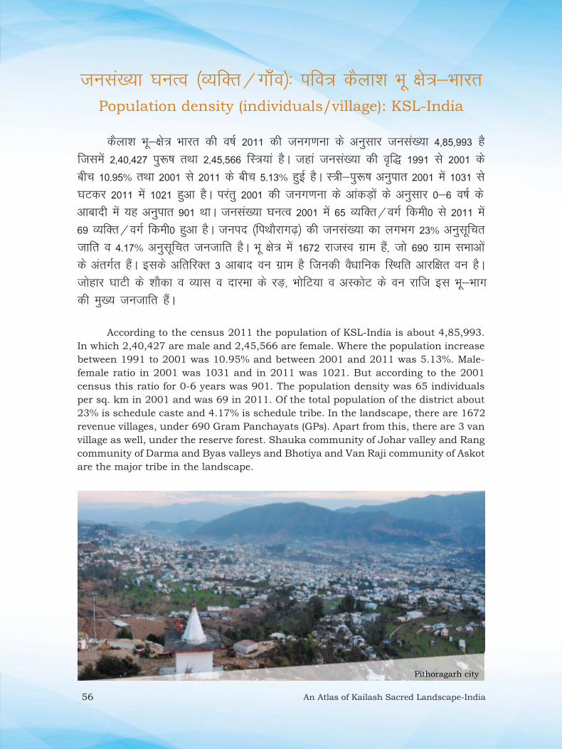
56 An Atlas of Kailash Sacred Landscape-India
tula[;k ?kuRo ¼O;fDr@xk¡Wo½% ifo= dSyk”k Hkw {ks=&HkkjrPopulation density (individuals/village): KSL-India
dSyk”k Hkw&{ks= Hkkjr dh o’kZ 2011 dh tux.kuk ds vuqlkj tula[;k 4]85]993 gS ftlesa 2]40]427 iq:‘k rFkk 2]45]566 fL=;ka gSA tgka tula[;k dh o`f) 1991 ls 2001 ds chp 10-95% rFkk 2001 ls 2011 ds chp 5-13% gqbZ gSA L=h&iq:‘k vuqikr 2001 esa 1031 ls ?kVdj 2011 esa 1021 gqvk gSA ijarq 2001 dh tux.kuk ds vkadM+ksa ds vuqlkj 0&6 o‘kZ ds vkcknh esa ;g vuqikr 901 FkkA tula[;k ?kuRo 2001 esa 65 O;fDRk@oxZ fdeh0 ls 2011 esa 69 O;fDr@oxZ fdeh0 gqvk gSA tuin ¼fiFkkSjkx<+½ dh tula[;k dk yxHkx 23% vuqlwfpr tkfr o 4-17% vuqlwfpr tutkfr gSA Hkw {ks= esa 1672 jktLo xzke gSa] tks 690 xzke lHkkvksa ds varxZr gSaA blds vfrfjDr 3 vkckn ou xzke gS ftudh oS/kkfud fLFkfr vkjf{kr ou gSA tksgkj ?kkVh ds ”kkSdk o O;kl o nkjek ds j³+] HkksfV;k o vLdksV ds ou jkft bl Hkw&Hkkx dh eq[; tutkfr gSaA
According to the census 2011 the population of KSL-India is about 4,85,993.
In which 2,40,427 are male and 2,45,566 are female. Where the population increase
between 1991 to 2001 was 10.95% and between 2001 and 2011 was 5.13%. Male-
female ratio in 2001 was 1031 and in 2011 was 1021. But according to the 2001
census this ratio for 0-6 years was 901. The population density was 65 individuals
per sq. km in 2001 and was 69 in 2011. Of the total population of the district about
23% is schedule caste and 4.17% is schedule tribe. In the landscape, there are 1672
revenue villages, under 690 Gram Panchayats (GPs). Apart from this, there are 3 van
village as well, under the reserve forest. Shauka community of Johar valley and Rang
community of Darma and Byas valleys and Bhotiya and Van Raji community of Askot
are the major tribe in the landscape.
Pithoragarh city
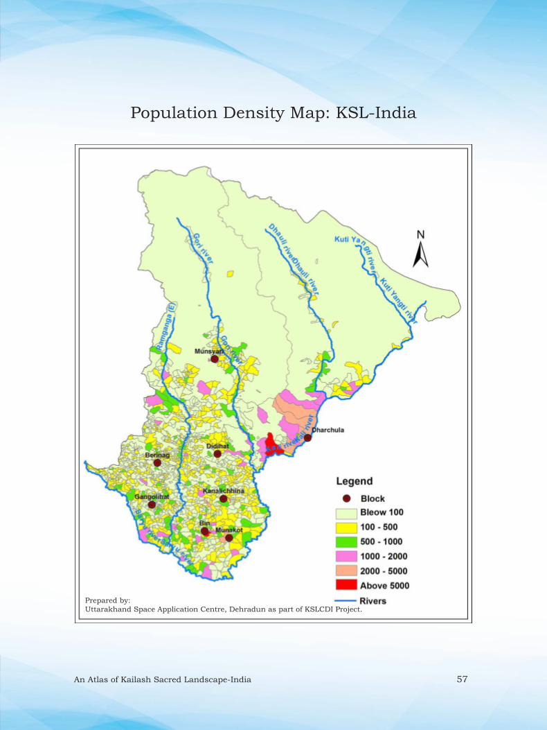
An Atlas of Kailash Sacred Landscape-India 57
Population Density Map: KSL-India
Prepared by:
Uttarakhand Space Application Centre, Dehradun as part of KSLCDI Project.

58 An Atlas of Kailash Sacred Landscape-India
ouLifrdSyk”k Hkw {ks=&Hkkjr esa fofHkUu izdkj dh ouLifr fofo/krk ik;h tkrh gS] tgka unh ?kkfV;ksa esa m’.kdfVcU/kh; ue i.kZikrh ouksa ls ysdj mPp fgeky;h {ks=ksa esa ue ,oa “kq’d cqX;ky {ks= miyC/k gSaA tgka ou] >kfM+;ka ¼izkd`frd ,oa f}rh;d½] ?kklh; {ks= ¼izkd`frd ,oa ekuotfur½ ,oa cqX;ky {ks= vkfn izeq[k Jsf.k;ka gSa] ftUgsa fofHkUu leqnk;ksa@mioxkasZ esa foHkkftr fd;k tk ldrk gSA

An Atlas of Kailash Sacred Landscape-India 59
VegetationThe landscape bestowed with varied vegetation types ranging from tropical moist
deciduous forests to alpine moist and dry pastures. Physiognomically, the forests,
scrub (natural and secondary), grasslands (natural and anthropogenic) and alpine
meadows represent major categories that are further divisible into a number of
communities/sub-classes.
Thalkedar Reserve Forest

60 An Atlas of Kailash Sacred Landscape-India
i;kZoj.kh; {ks=% ifo= dSyk”k Hkw {ks=&HkkjrEco-regions: KSL-India
ikfjfLFkfrdh; ,oa HkkSxksfyd :i ls ifjHkkf’kr {ks=] bdks&{ks=z ;k i;kZoj.kh; {ks= dgykrk gSA dSyk”k Hkw&{ks= Hkkjr esa if”pe fgeky;h {ks= ds pkj izeq[k bdks&{ks= vofLFkr gSa] ftlesa if”pe fgeky;h pkSM+h iRrh ou] Hkw&{ks= esa lcls vf/kd miyC/krk okyk bdks&{ks= gS] blds mijkUr if”pe fgeky;h ,Yikbu >kM+h ,oa cqX;ky vf/kdrk esa ik;s tkrs gSaA Hkw&{ks= esa if”pe fgeky;h lc&,Yikbu ”kadq/kkjh ou lcls de ik, tkrs gSaA
Ecologically and geographically defi ned area is known as an eco-region
(ecological region). KSL-India has four major eco-regions of the western Himalaya.
West Himalayan Broad leave Forests are most dominated eco-region in the landscape
followed by West Himalayan Alpine Shrub & Meadows. West Himalayan Sub-Alpine
Conifer Forest are minimum in the landscape.
Table: Various eco-regions in the KSL-India
Eco-regions Area (km2)
West Himalayan broad leave forests 1285.7
Himalayan sub tropical pine forests 1155.2
West Himalayan sub-alpine conifer
forests
244.46
West Himalayan alpine shrub &
meadows
1052.5
Other Classes
Agriculture 717.89
Habitation 60.35
River 39.82
Snow, Glacier & rocky outcrops 2563.95
Total 7120

An Atlas of Kailash Sacred Landscape-India 61
Eco-regions Map: KSL-India
Prepared by:
Uttarakhand Space Application Centre, Dehradun as part of KSLCDI Project.

62 An Atlas of Kailash Sacred Landscape-India
ouLifr izdkj ¼Ekq[kkd`fr vk/kkfjr½% ifo= dSyk”k Hkw {ks=&HkkjrVegetation Types (Physiognomic): KSL-India
dSyk”k Hkw&{ks= Hkkjr esa 12 izdkj ds ouLifr oxksZa ¼eq[kkd`fr vk/kkfjr½ dh igpku rhu izeq[k ouLifr Jsf.k;ksa ¼ou] >kfM+;ka o ?kklh; {ks=ksa½ esa dh x;h gSA fofHkUu ou izdkjksa esa] ioZrh; pkSM+h iRrh ou ¼lnkcgkj½] >kfM+;ksa esa lSdsaM+jh] ?kklh; {ks=ksa esa ue cqX;ky Hkw&{ks= izeq[k :i ls mifLFkr gSaA ftlesa Vªksfidy pkSM+h iRrh ouksa esa lky ds ou] lc&Vªksfidy pkSM+h iRrh ds ouksa esa lky] Vqu] :ekyh ou] lc&Vªksfidy ¼yEcs½ LkqbZuqek iRrh ouksa esa phM+ ds ou] ekWUVsu pkSM+h iRrhnkj ¼lnkcgkj½ ouksa esa ckat] eks:] [klwZ ou] ekWUVsu pkSM+h iRrhnkj ¼i.kZikrh½ ouksa esa dkapqyk ou] ekWUVsu lqbZuqek iRrh ouksa esa dkSy] Qj ou o lc&,Yikbu ouksa esa Hkksti=] cqjkal ouksa dks lfEefyr fd;k x;k gSA
Twelve broad physiognomic vegetation classes have been identifi ed under
three major vegetation categories (Forest, Scrub and Grassland). Mountain
broadleaved (Evergreen) forests among the forest category and Secondary
scrub under Scrub
and Alpine moist
meadows under
grassland categories
are dominant in
the landscape.
Where in the
Tropical broadleaved
forests; Sal forests,
in Subtropical
b r o a d l e a v e d
forests; Sal, Toon,
Macaranga forest,
Subtropical (long)
needleleaved forests;
Chir pine forest,
Montane broadleaved
(Evergeen) forests;
Banj, Moru, Kharsu
forest, Montane
b r o a d l e a v e d
(Deciduous) forests;
Acer forest, Montane needleleaved forests; Blue pine, Abies forest and Sub-
alpine forest; Betula, Rhododendron have included.
Major
Categories
Vegetation (Physiognomic) Types Area (km2)
Forest Tropical broadleaved forests 53.06
Subtropical broadleaved forests 54.57
Subtropical (long) needleleaved forests 658.73
Montane broadleaved (Evergreen) forests 726.10
Montane broadleaved (Deciduous) forests 49.03
Montane needleleaved forests 195.43
Subalpine forests 154.09
Scrub Secondary scrub 496.51
Subalpine scrub 206.11
Alpine dry scrub 172.65
Grassland Montane grasslands 297.92
Alpine moist meadows 673.71
Other Classes
Agriculture 717.89
Habitation 60.35
River 39.82
Snow & glaciers 2000.00
Rocky outcrops 563.95
Total 7120

An Atlas of Kailash Sacred Landscape-India 63
Vegetation Types (Physiognomic) Map: KSL-India
Prepared by:
Uttarakhand Space Application Centre, Dehradun as part of KSLCDI Project.

64 An Atlas of Kailash Sacred Landscape-India
ouLifr izdkj ¼iztkfr@leqnk;½% ifo= dSyk”k Hkw {ks=&HkkjrVegetation Types (Species): KSL-India
dSyk”k Hkw&{ks= Hkkjr dk iztkfrokj okuLifrd ekufp= rS;kj fd;k x;k gSA Hkw&{ks= esa dqy 22 izdkj ds okuLifrd leqnk;ksa esa 4 ?kklh;] 5 >kM+huqek ,oa 13 izdkj ds ouksa dks fpfUgr fd;k x;k gSA blds vfrfjDr 4 xSj okuLifrd leqnk; Hkh n”kkZ, x, gSaA
Species level vegetation map of KSL-India was also prepared. A total of, 22 vegetation classes having 4 grassland, 5 scrub and 13 forest classes were identifi ed. Four non-vegetation classes were also delineated.
Table: Area statistics of various vegetation types in KSL-India
Ekq[; oxZ@Major Categories ouLifr ¼iztkfr½ izdkj@Vegetation (species) types {ks=Qy@Area (km2)
ou@Forest Lkky ou@Sal forest 53.65
phM+ ou@Chir pine forest 671.81
dkSy ou@Blue pine forest 3.00
mRkhl&:ekyh ou@Alnus-Macaranga forest 54.26
ykWjsfl;l ou@Lauracious mixed forest 121.16
nsonkj ou@Deodar forest 10.85
Ckakt vksd fefJr ou@White (Banj) oak mixed forest 340.70
ekS: vksd ou@Moru oak mixed 58.21
[klwZ ou@Kharsu oak forest 195.59
dkapqyk fefJr ou@Acer mixed forest 47.37
Qj ou@Fir forest 15.43
Qj&rkulsu fefJr ou@Fir-Tsuga mixed forest 168.53
Hkksti= ou@Himalayan birch forest 154.11
>kfM+;ka@Scrub ;wQkWjfc;k >kM+h@Euphorbia mixed scrub 39.34
jl&f?ka?kk:@Rhus-Pyricantha 122.88
fdjekSM+k&fglkyw @Beberis-Rubus scrub 330.54
cqjkal@Rhododendron (Krummholz) 205.04
Tkqfuij&xqyko >kM+h@Juniper-Rosa scrub 163.70
?kklh; {ks=@Grassland bfj;ksQkWje&fFkfeMk @Eriophorum-Themeda grassy slope 6.00
[kkSM+@Chrysopogon grassy slope 291.50
fQph ekeyk@Danthonia grassy slope 352.51
ekeyk@Kobresia grassy slope 313.22
vU; xSj okuLifrd oxZ@Other Vegitation Classes
d`f’k@Agriculture 728.03
cQZ ,oa pV~Vku@Snow cover & Rock 2581.25
clklr@Settlement 51.83
ty@Water body 39.27
dqy@Total 7120

An Atlas of Kailash Sacred Landscape-India 65
Vegetation Types (Species) Map: KSL-India
Prepared by:
Uttarakhand Space Application Centre, Dehradun as part of KSLCDI Project.
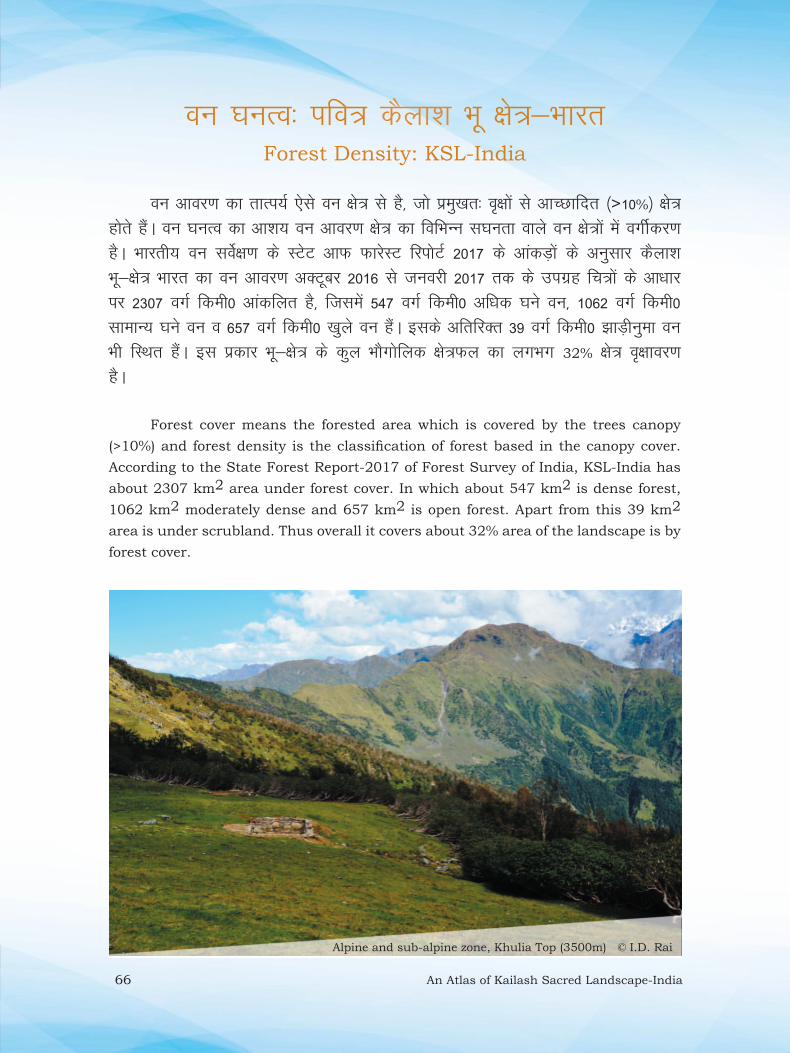
66 An Atlas of Kailash Sacred Landscape-India
ou ?kuRo% ifo= dSyk”k Hkw {ks=&HkkjrForest Density: KSL-India
ou vkoj.k dk rkRi;Z ,sls ou {ks= ls gS] tks izeq[kr% o`{kksa ls vkPNkfnr ¼>10%½ {ks= gksrs gaSA ou ?kuRo dk vk”k; ou vkoj.k {ks= dk fofHkUu l?kUkrk okys ou {ks=ksa esa oxhZdj.k gSA Hkkjrh; ou losZ{k.k ds LVsV vkQ QkjsLV fjiksVZ 2017 ds vkadM+ksa ds vuqlkj dSyk”k Hkw&{ks= Hkkjr dk ou vkoj.k vDVwcj 2016 ls tuojh 2017 rd ds mixzg fp=ksa ds vk/kkj ij 2307 oxZ fdeh0 vkadfyr gS] ftlesa 547 oxZ fdeh0 vf/kd ?kus ou] 1062 oxZ fdeh0 lkekU; ?kus ou o 657 oxZ fdeh0 [kqys ou gaSA blds vfrfjDr 39 oxZ fdeh0 >kM+huqek ou Hkh fLFkr gSaA bl izdkj Hkw&{ks= ds dqy HkkSxksfyd {ks=Qy dk yxHkx 32% {ks= o`{kkoj.k gSA
Forest cover means the forested area which is covered by the trees canopy
(>10%) and forest density is the classifi cation of forest based in the canopy cover.
According to the State Forest Report-2017 of Forest Survey of India, KSL-India has
about 2307 km2 area under forest cover. In which about 547 km2 is dense forest,
1062 km2 moderately dense and 657 km2 is open forest. Apart from this 39 km2
area is under scrubland. Thus overall it covers about 32% area of the landscape is by
forest cover.
Alpine and sub-alpine zone, Khulia Top (3500m) © I.D. Rai

An Atlas of Kailash Sacred Landscape-India 67
Forest Density Map: KSL-India
Prepared by:
Uttarakhand Space Application Centre, Dehradun as part of KSLCDI Project.

68 An Atlas of Kailash Sacred Landscape-India
ifo= izkd`frd LFky% ifo= dSyk”k Hkw {ks=&HkkjrSacred Natural Site (SNS)/Sacred Groves: KSL-India
dSyk”k Hkw {ks= Hkkjr esa dqy 139 NksVs&cMs+ izkd`frd ifo= LFky gSa] ftUgsa xzkeh.kksa }kjk LFkkuh; nsoh&nsorkvksa dks lefiZr dj dbZ ihf<+;ksa ls lajf{kr fd;k tkrk jgk gSA bu ouksa dks nso ou Hkh dgk tkrk gSA bu nso ouksa esa fdlh izdkj dk fonksgu ;k gfFk;kj ds lkFk izos”k djuk oftZr gSA bu LFkkuksa dk izkd`frd lalk/kuksa o lkaLd`frd fofo/krkvksa ds lao)zZu o laj{k.k esa egRoiw.kZ ;ksxnku gksrk gSA Hkw&{ks= dk yxHkx 0.5% Hkw&Hkkx nso ouksa ls vkPNkfnr gSA
Kailash Sacred Landscape-India has about 139 small and large Sacred Natural
Sites (SNS). These places play an important role in management of natural and
cultural diversity. Villagers are protecting these sites for generations by offering them
to local god and goddess. These forests are locally known as ‘Dev van’. In these forests
any type of exploitation and weapons are not allowed. These places play an important
role in management of natural and cultural diversity.
Nakuleshwar Sacred Grove, Pithoragarh
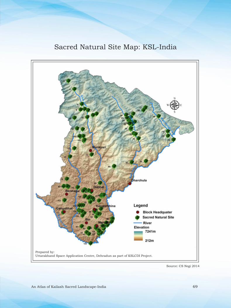
An Atlas of Kailash Sacred Landscape-India 69
Sacred Natural Site Map: KSL-India
Source: CS Negi 2014
Prepared by:
Uttarakhand Space Application Centre, Dehradun as part of KSLCDI Project.

70 An Atlas of Kailash Sacred Landscape-India
mPp tSo fofo/krk {ks=% ifo= dSyk”k Hkw {ks=&HkkjrBiodiversity Rich Areas: KSL-India
dSyk”k Hkw {ks= Hkkjr dk yxHkx 52% Hkw&Hkkx ou {ks= gSA ftlesa vusd mPp tSo fofo/krk okys ou Hkh lfEefyr gSaA fiFkkSjkx<+ izcUËku ;kstuk ¼2011&2022½ ds vuqlkj Hkw&{ks= esa 16 izdkj ds ou gSa] tks 2389 iq’ih; ikS/ks] 13 uXuchth ikS/ks] 193 i{kh iztkfr;k¡] 09 mHk;pj] 19 ljhliZ] 90 eNyh iztkfr;k¡] 38 Lru/kkjh tUrqvksa dk izfrfuf/kRo djrs gSaA Hkw {ks= esa yxHkx 15 mPp tSo fofo/krk okys {ks= fo|eku gSa] tSls& Fkydsnkj] lkSM+ys[k] /ot] pafMdk?kkV] fNiykdsnkj] xaxksyhgkV&ikrky Hkqous”oj] pf.Mdk ?kkV] lkunso] ?kU/kqjk] dkykequh VkWi] xksjh?kkVh] fge[kksyk&djaxnkax] fN;kys[k] uiYP;w ukyk o jkye vkfn gSaA
About 52% land of the Kailash Sacred Landscape-India is covered by forest area
including some of the highly biodiversity rich forests. According to the Management
Plan of Pithoragarh Division (2011-22), in the landscape, there are major 16 types of
forest types representing 2389 angiospermic plants, 13 gymnosperms, 193 birds, 09
amphibians, 19 reptiles, 90 fi shes and 38 -mammal species. The landscape represents
about 15 biodiversity rich areas namely Thalkedar, Shorlekh, Dhwaj, Chandika ghat,
Gangolihat-Patal Bhuwaneshwar, Chandika Ghat, Sandev, Ghandhura, Kalamuni-
Khaliya Top, Gori valley, Chiplakedar, Himkhola-Karangdang, Chiyalekh, Napalchu
nala and Ralam.
Table: Biodiversity rich area with their unique features in KSL-India
Name (elevation range in m.) Characteristic features
Thalkedar (1600-1980) Known for endemic Trachycarpus takil population in the region, rich in bird and MAPs at lower elevational area. Excellent wildlife habitat.
Saurlekh (1800-2100) Dense Banj oak forests, excellent wildlife habitat and high bird diversity
Dhwaj (1850-2450) Dense Mixed forest, high plant diversity, ideal habitat for wildlife eg., Common leopard, black beer, Goral, Barking dear, Wild boar etc.
Chandika Ghat (670-1050) Rich sites for butterfl ies, Golden Mahaseer, low altitude plant diversity.
Gangolihat-Patalbhuwaneshwar (1520-
1800)
Few old Deodar stands and good population of Myrica esculenta, high bird diversity.
Sandev (1650-1750)
Known for Cythea spinulosa (tree fern) an endangered fern species and good
orchid population on way to Chaubati. Ideal habitats for wildlife and bird
diversity
Ghandhura (1800-2150)
Good forests of Rianj (Q. lanuginosa) mixing with old Banj oak forest. Makes for
buffer zone for high altitude wildlife during winter season.
Khaliya top (3200-3730)
Medicinal Plant Conservation (MPCA) site, home to several MAPs and wildlife.
Monal, barking dear, can be easily spotted there.
Gori valley (1000-1550) Excellent habitats for orchid diversity, more than 120 species are reported.
Chiplakedar (3500-4400) High altitude spiritual site, home of high altitude MAPs and RET species eg.,
Aconites, Sassurea obvallata, Primulas etc.
Chiyalekh (3300-3400) Having elements of cold desert and great Himalayan region, home to many
MAPs and 2 endemic species.
Napalchu nala (3600-3700)
Community protected forests, dedicated to local deity. Rich in MAPs eg.,
Angelica glauca, Podophyllum hexandrum, Allium spp. Polygonatum spp.
Habitat for Himalayan Musk Deer
Panchachuli base (Dugtu) (3500-3800) Rich in MAPs, ideal habitat for Himalayan Musk Deer, Black Beer etc.
Ralam valley (3100-4500) Hot spots for MAPs, specially known for Cordyceps sinensis a parasitic fungus.
Chandika Ghat (670-900) Rich site for Golden mahaseer and butterfl y diversity.

An Atlas of Kailash Sacred Landscape-India 71
Biodiversity rich areas: 1-Thalkedar, 2-Saurlekh, 3-Sandev, 4-Ralam
valley, 5-Panch Chuli, 6-Napalchu Nala, 7-Lamkeshwar, 8-Kalamuni,
9-Himkhola, 10-Gori valley, 11-Ghandhura, 12-Dwaj, 13-Chiyalekh,
14-Chiplakedar, 15-Chandika ghat
Biodiversity Rich Areas Map: KSL-India
Prepared by:
Uttarakhand Space Application Centre, Dehradun as part of KSLCDI Project.

72 An Atlas of Kailash Sacred Landscape-India
ckat vksd ouksa dk forj.k {ks=% ifo= dSyk”k Hkw {ks=&HkkjrDistribution of Banj Oak (Quercus leucotrichophora) forests: KSL-India
ckat dh fofHkUu iztkfr;ksa esa lQsn vksd ;k ckat vksd (Quercus leucotrichophora)
e/; ÅapkbZ okys {ks=ksa ¼1000 ls 2500 eh0½ esa O;kid :i ls ik;k tkrk gSA dSyk”k Hkw {ks= esa yxHkx 155 oxZ fdeh0 Hkkx esa ckat ds taxy QSys gSa] ftlesa 60 oxZ fdeh0 vkjf{kr ou {ks= esa rFkk 95 oxZ fdeh0] vkjf{kr ou {ks= ds ckgj fLFkr gSA bUgha e/; ÅapkbZ ¼1000&2500 eh0½ okys {ks=ksa esa gh vf/kdrj clklr gksrh gS] tks fd bZa/ku dh ydM+h o pkjs ds fy, eq[;r% ckat ouksa ij gh fuHkZj jgrs gSaA tyok;q pjekoLFkk ds vfrfjDr Hkh ckat ds ou ekuo ds fy, vusd ikfjfLFkfrdh; lsok,a iznku djrs gSaA
Of the various species of oaks, the white oak or Banj (Quercus leucotrichophora)
forms extensive belt along the middle elevation (1000-2500 m) in the landscape. KSL-
India has about 155 sq. km area under Banj oak forests, of which 60 sq.km falls
within reserve forests (RF) and 95 sq. km lies outside the RF. Highest cover of Banj
oak was recorded between 1801-2200 m elevation followed by 1501-1800 m asl. Banj
oak forests in the landscape are mainly distributed in Thalkedar, Chandak, Saurlekh,
Dhwaj, Sandev, Jaurasi, Ghandhura, Munsyari, Dharamghar and Gangolihat areas.
Besides, being a climatic climax, Banj oak forests provide numerous ecosystem
services to humankind.
Banj Oak forest (Nakot-Chandak)
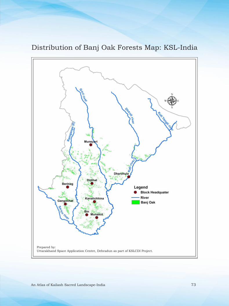
An Atlas of Kailash Sacred Landscape-India 73
Distribution of Banj Oak Forests Map: KSL-India
Prepared by:
Uttarakhand Space Application Centre, Dehradun as part of KSLCDI Project.

74 An Atlas of Kailash Sacred Landscape-India
;klkZ xEcq@dhM+k tM+h dk forj.k {ks=% ifo= dSyk”k Hkw {ks=&HkkjrDistribution of Yartsa Gambu (Ophiocordyceps sinensis): KSL -India
Hkkjr esa dSyk”k Hkw {ks= lokZf/kd ;klkZ xEcq@dhM+k tM+h izpqjrk {ks= gSA ;klkZ xEcq Hkw&{ks= ds /kkjpwyk o equL;kjh fodkl[k.M ds mPp fgeky;h {ks=ksa ¼3700&4500 eh-½ esa dksczsfl;k ds vf/kdrk okys ?kklh; <ykuksa esa ik;k tkrk gSA izfro’kZ yxHkx 180 ls vf/kd xkaoksa ds 10]000 ls vf/kd yksx ebZ o twu ds eghus esa bu ?kklh; <ykuksa ls ;klkZ xEcq@dhM+k tM+h dks ,df=r djrs gaSA ;g Hkw&{ks= esa O;kl] nkjek] feye] pkSnkl ,oa jkye ?kkfV;ksa ds Åaps ?kklh; <ykuksa esa ik;k tkrk gSA {ks= ds oSKkfud v/;;u ls Kkr gqvk gS fd Hkw&{ks= dk 56 oxZ fdeh0 {ks= ;klkZ xEcq@dhM+k tM+h ds fy, vR;f/kd mi;qDr o yxHkx 234 oxZ fdeh0 {ks= de mi;qDr ik;k x;k gSAHkw {ks= esa fNiykdksV@fNiykdsnkj o jkye {ks= ;klkZ xEcq@dhM+k tM+h ckgqY; {ks= gSaA
KSL-India is one of the
largest production site of Yartsa
gambu in India. It is found in high altitude areas (3700-4500 m), mainly dominated by
Kobresia spp. of Munsyari and Dharchula blocks of the landscape. Every year, more
than 10,000 inhabitants representing from >180 villages goes to alpine pastures for
the collection of Yarsha gambu. Yarsha gambu is mainly distributed in lower part of
Byas, Darma, Milam, and upper ridges of Chaudans and Ralam. In the landscape,
about 56 km2 area is highly suitable and 234 km2 area is suitable for the growth. The
hot spot of Yarsha gambu in the KSL-India are Chiplakot/Chhiplakedar and Ralam
region.
Temporary tents pitched for Yarsta Gambu collection at Chhiplakedar

An Atlas of Kailash Sacred Landscape-India 75
Distribution of Yartsa Gambu Map: KSL-India
Prepared by:
Uttarakhand Space Application Centre, Dehradun as part of KSLCDI Project.
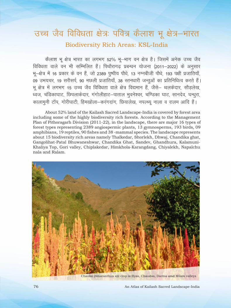
76 An Atlas of Kailash Sacred Landscape-India
mPp tSo fofo/krk {ks=% ifo= dSyk”k Hkw {ks=&HkkjrBiodiversity Rich Areas: KSL-India
dSyk”k Hkw {ks= Hkkjr dk yxHkx 52% Hkw&Hkkx ou {ks= gSA ftlesa vusd mPp tSo fofo/krk okys ou Hkh lfEefyr gSaA fiFkkSjkx<+ izcUËku ;kstuk ¼2011&2022½ ds vuqlkj Hkw&{ks= esa 16 izdkj ds ou gSa] tks 2389 iq’ih; ikS/ks] 13 uXuchth ikS/ks] 193 i{kh iztkfr;k¡] 09 mHk;pj] 19 ljhliZ] 90 eNyh iztkfr;k¡] 38 Lru/kkjh tUrqvksa dk izfrfuf/kRo djrs gSaA Hkw {ks= esa yxHkx 15 mPp tSo fofo/krk okys {ks= fo|eku gSa] tSls& Fkydsnkj] lkSM+ys[k] /ot] pafMdk?kkV] fNiykdsnkj] xaxksyhgkV&ikrky Hkqous”oj] pf.Mdk ?kkV] lkunso] ?kU/kqjk] dkykequh VkWi] xksjh?kkVh] fge[kksyk&djaxnkax] fN;kys[k] uiYP;w ukyk o jkye vkfn gSaA
About 52% land of the Kailash Sacred Landscape-India is covered by forest area
including some of the highly biodiversity rich forests. According to the Management
Plan of Pithoragarh Division (2011-22), in the landscape, there are major 16 types of
forest types representing 2389 angiospermic plants, 13 gymnosperms, 193 birds, 09
amphibians, 19 reptiles, 90 fi shes and 38 -mammal species. The landscape represents
about 15 biodiversity rich areas namely Thalkedar, Shorlekh, Dhwaj, Chandika ghat,
Gangolihat-Patal Bhuwaneshwar, Chandika Ghat, Sandev, Ghandhura, Kalamuni-
Khaliya Top, Gori valley, Chiplakedar, Himkhola-Karangdang, Chiyalekh, Napalchu
nala and Ralam.
Chaulai (Amaranthus sp) crop is Byas, Chaudas, Darma amd Milam valleys

An Atlas of Kailash Sacred Landscape-India 77
Agriculture and Pulses Rich Area Map: KSL-India
Prepared by:
Uttarakhand Space Application Centre, Dehradun as part of KSLCDI Project.
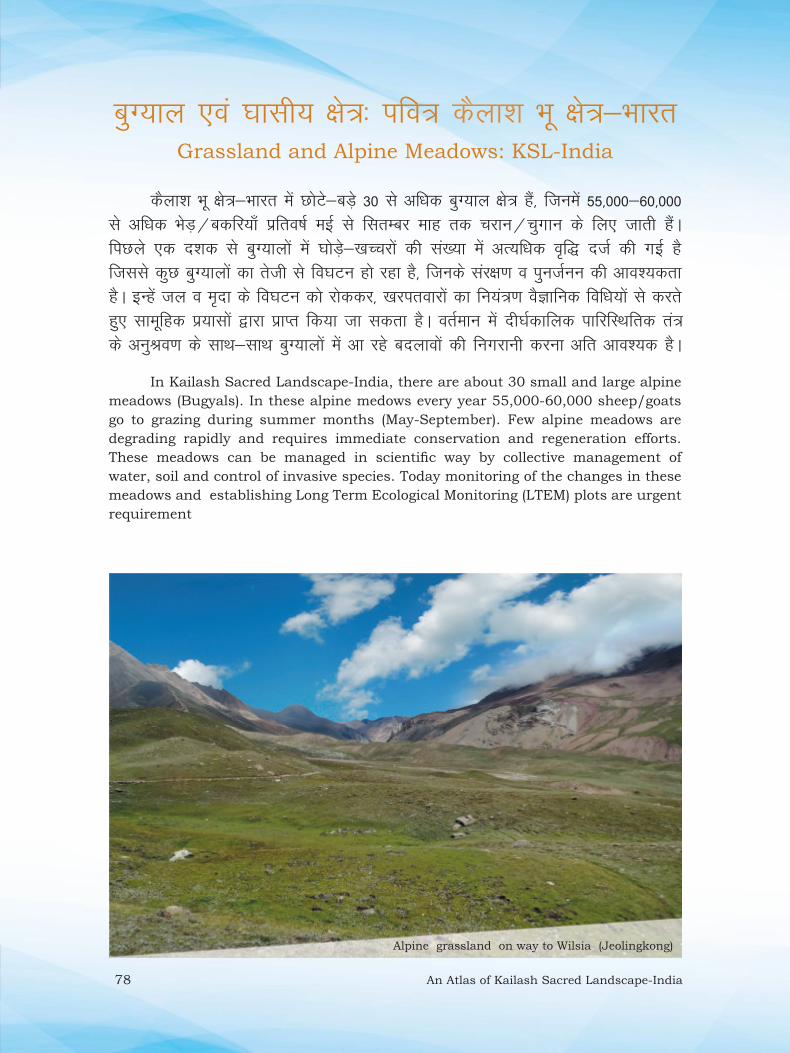
78 An Atlas of Kailash Sacred Landscape-India
cqX;ky ,oa ?kklh; {ks=% ifo= dSyk”k Hkw {ks=&HkkjrGrassland and Alpine Meadows: KSL-India
dSyk”k Hkw {ks=&Hkkjr esa NksVs&cMs+ 30 ls vf/kd cqX;ky {ks= gSa] ftuesa 55]000&60]000 ls vf/kd HksM+@cdfj;k¡ izfro’kZ ebZ ls flRkEcj ekg rd pjku@pqxku ds fy, tkrh gSaA fiNys ,d n”kd ls cqX;kyksa esa ?kksM+s&[kPpjksa dh la[;k esa vR;f/kd o`f) ntZ dh xbZ gS ftlls dqN cqX;kyksa dk rsth ls fo?kVu gks jgk gS] ftUkds laj{k.k o iqutZuu dh vko”;drk gSA bUgsa ty o e`nk ds fo?kVu dks jksddj] [kjirokjksa dk fu;a=.k oSKkfud fof/k;ksa ls djrs gq, lkewfgd iz;klksa }kjk izkIr fd;k tk ldrk gSA orZeku esa nh?kZdkfyd ikfjfLFkfrd ra= ds vuqJo.k ds lkFk&lkFk cqX;kyksa esa vk jgs cnykoksa dh fuxjkuh djuk vfr vko”;d gSA
In Kailash Sacred Landscape-India, there are about 30 small and large alpine
meadows (Bugyals). In these alpine medows every year 55,000-60,000 sheep/goats
go to grazing during summer months (May-September). Few alpine meadows are
degrading rapidly and requires immediate conservation and regeneration efforts.
These meadows can be managed in scientifi c way by collective management of
water, soil and control of invasive species. Today monitoring of the changes in these
meadows and establishing Long Term Ecological Monitoring (LTEM) plots are urgent
requirement
Alpine grassland on way to Wilsia (Jeolingkong)

An Atlas of Kailash Sacred Landscape-India 79
Alpine meadows: 1-Palang Gar, 2-Chhiyalekh-Garbyang, 3-Nabedhang,
4-Nampha, 5-Kuti-Sela Yangti, 6-Jeolingkong, 7-Bedang-Dawe, 8-Baun,
9-Dugtu Bugyal, 10-Sipu-Mahadev Khola, 11-Balchhi Dhura, 12-Lissar valley,
13-Chhiplakot, 14-Shyama Gwar, 15-Molepani- Primula Valley, 16-Dhunkhan,
17-Khaliya – Rurkhan, 18-Marjhali, 19-Rajthor-Barjikang, 20-Yangchari,
21-Galpari-Sibu Gwar, 22-Tola-Bhadel Gwar, 23-Sumtu-Khelanch, 24-Laspa-
Poting, 25-Martoli, 26-Shallang/Lwan, 27-Ghanghar-Pachhoo, 28-Burphu,
29-Bilju, 30-Namik.
Grassland and Alpine Meadows Map: KSL-India
Prepared by:
Uttarakhand Space Application Centre, Dehradun as part of KSLCDI Project.
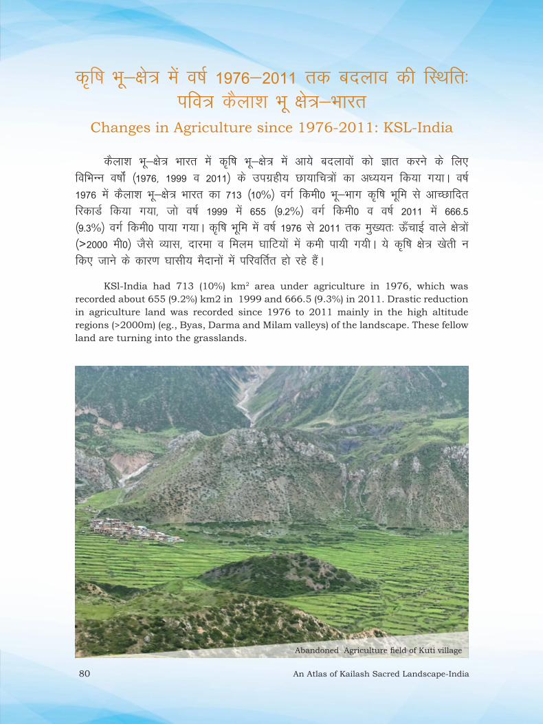
80 An Atlas of Kailash Sacred Landscape-India
d`f’k Hkw&{ks= esa o’kZ 1976&2011 rd cnyko dh fLFkfr%ifo= dSyk”k Hkw {ks=&Hkkjr
Changes in Agriculture since 1976-2011: KSL-India
dSyk”k Hkw&{ks= Hkkjr esa d`f’k Hkw&{ks= esa vk;s cnykoksa dks Kkr djus ds fy, fofHkUu o’kksaZ ¼1976] 1999 o 2011½ ds mixzgh; Nk;kfp=ksa dk v/;;u fd;k x;kA o’kZ 1976 esa dSyk”k Hkw&{ks= Hkkjr dk 713 ¼10%½ oxZ fdeh0 Hkw&Hkkx d`f’k Hkwfe ls vkPNkfnr fjdkMZ fd;k x;k] tks o’kZ 1999 esa 655 ¼9-2%½ oxZ fdeh0 o o’kZ 2011 esa 666-5 ¼9-3%½ oxZ fdeh0 ik;k x;kA d`f’k Hkwfe esa o’kZ 1976 ls 2011 rd eq[;r% Å¡pkbZ okys {ks=ksa ¼>2000 eh0½ tSls O;kl] nkjek o feye ?kkfV;ksa esa deh ik;h x;hA ;s d`f’k {ks= [ksrh u fd, tkus ds dkj.k ?kklh; eSnkuksa esa ifjofrZr gks jgs gSaA
KSl-India had 713 (10%) km2 area under agriculture in 1976, which was
recorded about 655 (9.2%) km2 in 1999 and 666.5 (9.3%) in 2011. Drastic reduction
in agriculture land was recorded since 1976 to 2011 mainly in the high altitude
regions (>2000m) (eg., Byas, Darma and Milam valleys) of the landscape. These fellow
land are turning into the grasslands.
Abandoned Agriculture fi eld of Kuti village

An Atlas of Kailash Sacred Landscape-India 81
Changes in Agriculture since 1976-2011: KSL-India
Prepared by:
Uttarakhand Space Application Centre, Dehradun as part of KSLCDI Project.

82 An Atlas of Kailash Sacred Landscape-India
ou {ks= esa o’kZZ 1976&2011 rd cnyko dh fLFkfr% ifo= dSyk”k Hkw {ks=&Hkkjr
Changes in Forest since 1976-2011: KSL-India
mixzg ls izkIr Nk;kfp=ksa ds vk/kkj ij o’kZ 1976 esa dSyk”k Hkw&{ks= Hkkjr dk 2388 ¼33-5%½ oxZ fdeh0 Hkw&Hkkx ou vkPNkfnr fjdkMZ fd;k x;k] tks o‘kZ 1999 esa 2153-4¼30-2%½ oxZ fdeh0 o o‘kZ 2011 esa 1880 ¼26%½ oxZ fdeh0 jg x;k gS] ftlesa ouksa esa ifjorZu o fo?kVu ”kgjksa ¼tSls& fiFkkSjkx<+] xaxksyhgkV] csjhukx] MhMhgkV] dukyhNhuk o /kkjpwyk½ ds vklikl vf/kd ik;k x;k gSA
Based on the satellite imageries, in the KSL-India about 2388 (33.5%) km2 area
was recorded as forest, which was 2153.4 (30.2%) km2 in 1999 and remains 1880
(26%) km2 area in 2011. The more degradation in forested area is observed around
the town eg., Pithoragarh, Gangolihat, Berinag, Didihat, Kanalichina and Dharchula.
Changes in forest (increasing) at Dugtu village (Panchachuli area) (a) Year 2004
(©Dr. G.S. Rawat) (b) Year 2016.

An Atlas of Kailash Sacred Landscape-India 83
Changes in Forest since 1976-2011: KSL-India
Prepared by:
Uttarakhand Space Application Centre, Dehradun as part of KSLCDI Project.
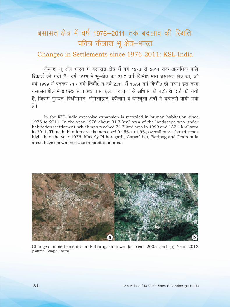
84 An Atlas of Kailash Sacred Landscape-India
clklr {ks= esa o’kZ 1976&2011 rd cnyko dh fLFkfr% ifo= dSyk”k Hkw {ks=&Hkkjr
Changes in Settlements since 1976-2011: KSL-India
dSyk”k Hkw&{ks= Hkkjr esa clklr {ks= esa o’kZ 1976 ls 2011 rd vR;f/kd o`f)fjdkMZ dh x;h gSA o‘kZ 1976 esa Hkw&{ks= dk 31-7 oxZ fdeh0 Hkkx clklr {ks= Fkk] tks o‘kZ 1999 esa c<+dj 74-7 oxZ fdeh0 o o‘kZ 2011 esa 137-4 oxZ fdeh0 gks x;kA bl rjg clklr {ks= esa 0-45% ls 1-9% rd dqy pkj xquk ls vf/kd dh c<+ksrjh ntZ dh x;h gSS] ftlesa eq[;r% fiFkkSjkx<+] xaxksyhgkV] csjhukx o /kkjpwyk {ks=ksa esa c<+ksrjh ik;h x;h gSA
In the KSL-India excessive expansion is recorded in human habitation since
1976 to 2011. In the year 1976 about 31.7 km2 area of the landscape was under
habitation/settlement, which was reached 74.7 km2 area in 1999 and 137.4 km2 area
in 2011. Thus, habitation area is increased 0.45% to 1.9%, overall more than 4 times
high than the year 1976. Majorly Pithoragarh, Gangolihat, Berinag and Dharchula
areas have shown increase in habitation area.
Changes in settlements in Pithoragarh town (a) Year 2005 and (b) Year 2018 (Source: Google Earth)

An Atlas of Kailash Sacred Landscape-India 85
Changes in Settlements since 1976-2011: KSL-India
Prepared by:
Uttarakhand Space Application Centre, Dehradun as part of KSLCDI Project.

86 An Atlas of Kailash Sacred Landscape-India
Hkw&{ks= Hks|rkLandscape Vulnerability
fofo/k Hkw&vkd`fr] HkwxHkhZ; vfLFkjrk] tyok;q ifjorZu ,oa ufn;ksa dh dh
de ”kkUr izd`fr vkfn vusd dkj.kksa ls dSyk”k Hkw {ks=&Hkkjr] fofHkUu izdkj izkd`frd vkinkvksa dh n`f’V ls laosnu”khy {ks= gSA bu izkd`frd vkinkvksa esa HkwL[kyu] oukfXu] ekuo&oU;tho la?k’kZ vkSj dqN LFkkuksa esa xSj&LFkkuh; iztkfr ds ikS/kksa dk vR;f/kd izlkj izeq[k gSaA ;s vkink,a {ks= ds ikfjfLFkfrd ra=] lalk/kuksa] laifRr ,oa thou vkfn ds uqdlku ds eq[; dkjd gSa] ftlls {ks= ds vkfFkZd fodkl dh izxfr Hkh izHkkfor gksrh gSA
Varied topography, geological instability, climatic variations, and turbulent
nature of rivers make the Kailash Sacred Landscape-India area vulnerable to
various kind of natural hazards viz., landslide, forest fi re, human-wildlife confl ict
and at places spread of invasive plant species, being known to cause major losses
to ecosystem, resources, property and life in the region and thereby affecting its
process of economic development.
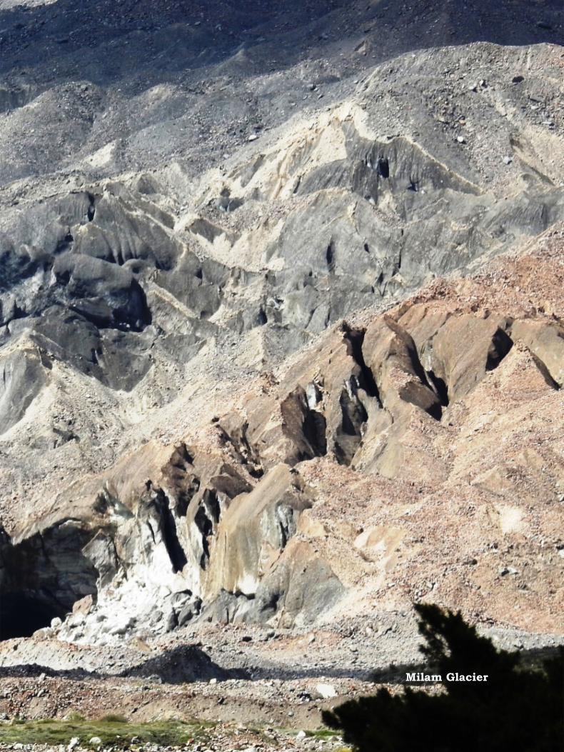
An Atlas of Kailash Sacred Landscape-India 87
Milam Glacier

88 An Atlas of Kailash Sacred Landscape-India
Hkw&L[kyu ¼okLrfod½ izHkkfor {ks=% ifo= dSyk”k Hkw {ks=&HkkjrLandslide (actual) Areas: KSL-India
dSyk”k Hkw {ks=&Hkkjr esa /kkjpwyk ,oa equL;kjh fodkl[k.Mksa ds xksjh o dkyh ufn;ksa ds tykxe {ks= esa fLFkr Hkw&{ks=] HkwL[kyu vf/kdrk okys {ks= gaSA Hkw&{ks= esa mifLFkr yxHkx 518 HkwL[kyu {ks=ksa dkss mPp foHksnu mixzgh; Nk;kfp=ksa dh enn ls fpfUgr fd;k x;k gS] tks Hkw&{ks= dk 7-16 oxZ fdeh0 Hkw&Hkkx {ks= gSA leLr HkwL[kyu {ks=ksa esa yxHkx 25% HkwL[kyu {ks=ksa dh okLrfod fLFkfr dk lR;kiu Hkh fd;k x;kA HkwL[kyuksa ds LFkkfud vkadyu ls Kkr gksrk gS fd bu HkwL[kyu ls Hkw&{ks= ds yxHkx 35 xkao eq[;r% izHkkfor gks jgs gSaA tgka HkwL[kyu ls 200 eh0 O;kl dh ifjf/k {ks= esa 196 o 500 ehVj dh ifjf/k esa 227 xkao fLFkr gSaA
The northern part of the landscape precisely Dharcahula and Munsyari
developmental blocks are greatly prone to landslides and a few places evacuation has
been fl agged for residents. Landslide in the rainy season are common phenomenon to
break connectivity within or with outside the area. A total of 518 landslides have been
marked with the help of high resolution satellite datasets and 1/4th of them were
verifi ed on the ground. The actual landslide effected area is about ~7.16 km2 area
affecting directly to about 35 villages. Whereas if created a buffer of 200m radius from
the village, about 196 villages, and within the radius of 500m a total of 227 villages
are being affected in the landscape.
Landslide in Byas valleyLandslide in Byas valley

An Atlas of Kailash Sacred Landscape-India 89
Landslide Map: KSL-India
Prepared by:
Uttarakhand Space Application Centre, Dehradun as part of KSLCDI Project.

90 An Atlas of Kailash Sacred Landscape-India
Hkw&L[kyu laHkkfor ekufp=% ifo= dSyk”k Hkw {ks=&HkkjrLandslide Probability Map: KSL-India
HkwL[kyu laHkkfor {ks=ksa ds fo‘k; esa vkadyu djuk] fiNyh HkwL[kyu ?kVukvksa dh tkudkjh] Hkw&xHkhZ; ekudksa ,oa fo”ks’krkvksa o ekuo tfur xfrfof/k;ksa ds vk/kkj ij dh tkrh gSA bl izdkj dh x.kukvksa dks djuk Hkw&oSKkfud vuqla/kku dk ,d egRoiw.kZ dk;Z {ks= gS] ftlesa lkaf[;dh; oxhZdj.k fu;e ykxw fd, tkrs gSaA dSyk”k Hkw&{ks= Hkkjr esa Hkfo‘; esa HkwL[kyu laHkkfor {ks=ksa dh x.kuk ds fy, orZeku esa miyC/k ekWMy dk mi;ksx fd;k x;k tSls& ¼A½ vf/kdre ,UVªkWih ¼eSDlUV½ ekWMy] ¼B½ osVst jSf[kd la;kstu ekWMy] ¼C½ egyksuksfc”k nwjh ekWMy ¼D½ lkekU;hd`r jSf[kd ekWMyA mijksDr pkj ekWMyksa ds vk/kkj ij la;qDr vkSlr laHkkO;rk ekWMy ¼E½ rS;kj fd;k x;k] tks HkwL[kyu ds mPp laHkkouk {ks=ksa dks iznf”kZr djrk gSA Hkw&{ks= esa vf/kdrj Hkw&L[kyu lEHkkfor {ks= equL;kjh CykWd esa ¼ekufp= ¼E½ esa iznf”kZr xgjk yky {ks=½ xksjh unh ds fupys tykxe ,oa jkexaxk unh ds Åijh tykxe {ks= o /kkjpwyk CykWd esa dkyh unh ds Åijh tykxe {ks=ksa esa ik;s x;s gSaA
Prediction of landslide hazards zone depends on the knowledge of past landslide
events, terrain parameters, geological attributes, anthropogenic activities is one
important fi eld of geo-scientifi c research in which statistical classifi cation rules have
been applied. By using several exiting models viz., (A) Maximum entropy (MaxEnt)
model; (B) Weightage Linear Combination model; (C) Mahalanobish distance model;
(D) Generalized Linear model. Based on above four models Combined mean probability
model (E) was derived, which shows high probability zones (dark red colour in map
(E) of landslides mostly fall in lower catchment of Gori River, upper catchment of
Ramganga in Munsyari block and along the Kali River in Dharchula block.
Active Landslide at Khet-Tawaghat

An Atlas of Kailash Sacred Landscape-India 91
Landslide Probability Map: KSL-India
Prepared by:
Uttarakhand Space Application Centre, Dehradun as part of KSLCDI Project.

92 An Atlas of Kailash Sacred Landscape-India
izoklh ekxZ ¼HksM+@cdfj;k¡½% ifo= dSyk”k Hkw {ks=&HkkjrMigratory Routes (sheep/goats): KSL-India
mPp fgeky;h ,oa cqX;ky {ks=ksa] ftUgsa ijEijkxr :i ls pjokg leqnk; }kjk i”kqvksa ds pjku@pqxku ds fy, mi;ksx esa yk;k tkrk gS] dks pkjkxkg ¼rangeland½ dgk tkrk gSA dSyk”k Hkw&{ks= Hkkjr ds cqX;ky {ks=ksa esa lkekU;r% HksM+@cdfj;k¡ ,oa xk;ksa@[kPpjksa }kjk pjku@pqxku fd;k tkrk gSA Hkw&{ks= esa fLFkr yxHkx lHkh cqX;kyksa esa pjku@pqxku fd;k tkrk gS] tgka izfro‘kZ xfeZ;ksa ds ekSle esa ebZ ls flrEcj eghuksa ds e/; yxHkx 55000&60000 HksM+@cdfj;k¡] 6000 xk;@?kksM+s o 4000&4200 [kPpj bu cqX;kyh {ks=ksa esa pjku@pqxku djrs gSaA lfnZ;ksa ds eghuksa esa ;s i”kq xkao ds vklikl ,oa jkT; ds Hkkcj {ks=ksa ¼Vudiqj] iw.kkZfxjh] lq[kh<+kax] pksjxfy;k] dqaojiqj½ ds ouksa esa pjku@pqxku ds fy, tkrs gSaA
The temperate and alpine pastures in this landscape, which have traditionally
been used for livestock grazing by the pastoral communities, are also termed as
rangelands In the alpine region of KSL-India, grazing by sheep/goats and cows/
mules are common in almost all the meadows. Approximately, there are more than
55000-60000 sheep/goats, 6000 bovines/horses and 4000-4200 mules grazed during
summer season between May to September ever year. During winter months, these
livestock graze around the villages or nearby forest of Bhabhar region of the state.
Grazing near Parvati lake (Byas valley)

An Atlas of Kailash Sacred Landscape-India 93
Migratory Route (sheep/goats) Map: KSL-India
Prepared by:
Uttarakhand Space Application Centre, Dehradun as part of KSLCDI Project.
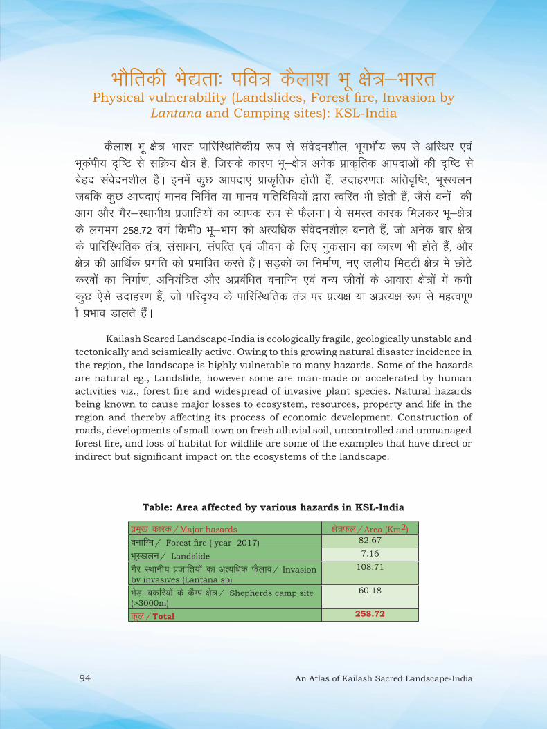
94 An Atlas of Kailash Sacred Landscape-India
HkkSfrdh Hks|rk% ifo= dSyk”k Hkw {ks=&HkkjrPhysical vulnerability (Landslides, Forest fi re, Invasion by
Lantana and Camping sites): KSL-India
dSyk”k Hkw {ks=&Hkkjr ikfjfLFkfrdh; :i ls laosnu”khy] HkwxHkhZ; :i ls vfLFkj ,oa Hkwdaih; n`f‘V ls lfØ; {ks= gS] ftlds dkj.k Hkw&{ks= vusd izkd`frd vkinkvksa dh n`f’V ls csgn laosnu”khy gSA buesa dqN vkink,a izkd`frd gksrh gSa] mnkgj.kr% vfro`f‘V] HkwL[kyu tcfd dqN vkink,a ekuo fufeZr ;k ekuo xfrfof/k;kas }kjk Rofjr Hkh gksrh gSa] tSls ouksa dh vkx vkSj xSj&LFkkuh; iztkfr;ksa dk O;kid :i ls QSyukA ;s leLr dkjd feydj Hkw&{ks= ds yxHkx 258-72 oxZ fdeh0 Hkw&Hkkx dks vR;f/kd laosnu”khy cukrs gSa] tks vusd ckj {ks= ds ikfjfLFkfrd ra=] lalk/ku] laifRr ,oa thou ds fy, uqdlku dk dkj.k Hkh gksrs gSa] vkSj {ks= dh vkfFkZd izxfr dks izHkkfor djrs gSaA lM+dksa dk fuekZ.k] u, tyh; feV~Vh {ks= esa NksVs dLcksa dk fuekZ.k] vfu;af=r vkSj vizcaf/kr oukfXu ,oa oU; thoksa ds vkokl {ks=ksa esa deh dqN ,sls mnkgj.k gSa] tks ifjn`”; ds ikfjfLFkfrd ra= ij izR;{k ;k vizR;{k :i ls egRoiw.kZ izHkko Mkyrs gSaA
Kailash Scared Landscape-India is ecologically fragile, geologically unstable and
tectonically and seismically active. Owing to this growing natural disaster incidence in
the region, the landscape is highly vulnerable to many hazards. Some of the hazards
are natural eg., Landslide, however some are man-made or accelerated by human
activities viz., forest fi re and widespread of invasive plant species. Natural hazards
being known to cause major losses to ecosystem, resources, property and life in the
region and thereby affecting its process of economic development. Construction of
roads, developments of small town on fresh alluvial soil, uncontrolled and unmanaged
forest fi re, and loss of habitat for wildlife are some of the examples that have direct or
indirect but signifi cant impact on the ecosystems of the landscape.
Table: Area affected by various hazards in KSL-India
izeq[k dkjd@Major hazards {ks=Qy@Area (Km2)
oukfXu@ Forest fi re ( year 2017) 82.67
HkwL[kyu@ Landslide 7.16
xSj LFkkuh; iztkfr;ksa dk vR;f/kd QSyko@ Invasion
by invasives (Lantana sp)
108.71
HksM+&cdfj;ksa ds dSEi {ks=@ Shepherds camp site
(>3000m)
60.18
dqy@Total 258.72
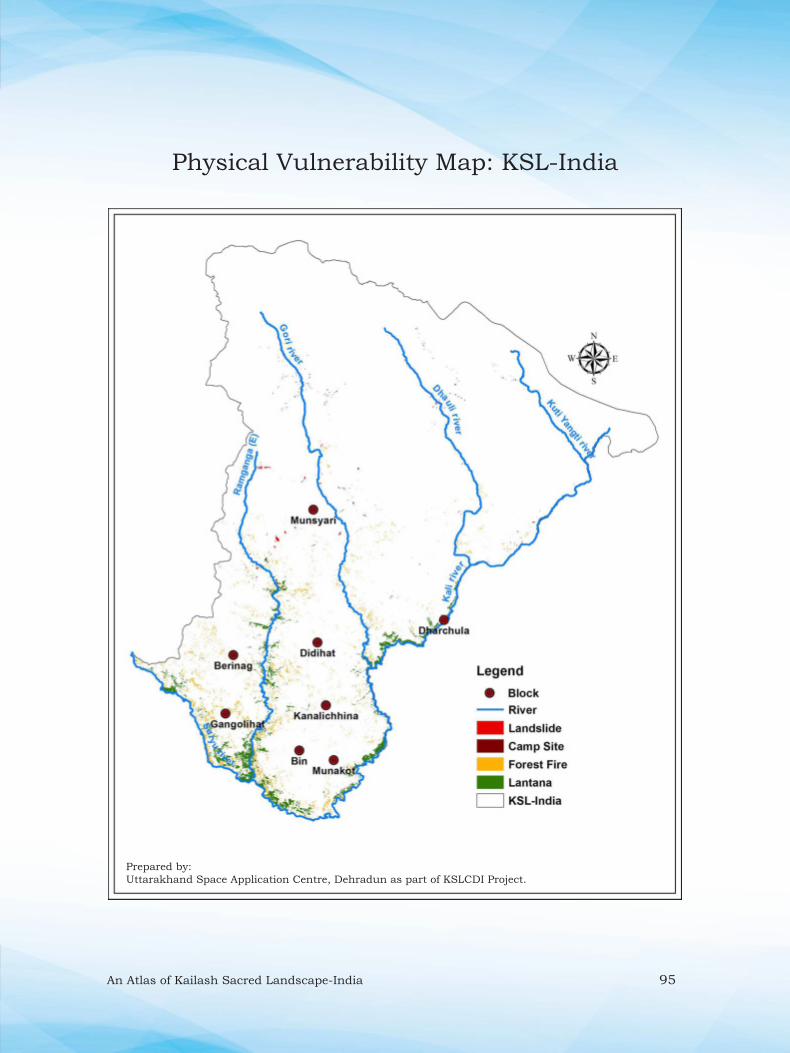
An Atlas of Kailash Sacred Landscape-India 95
Prepared by:
Uttarakhand Space Application Centre, Dehradun as part of KSLCDI Project.
Physical Vulnerability Map: KSL-India
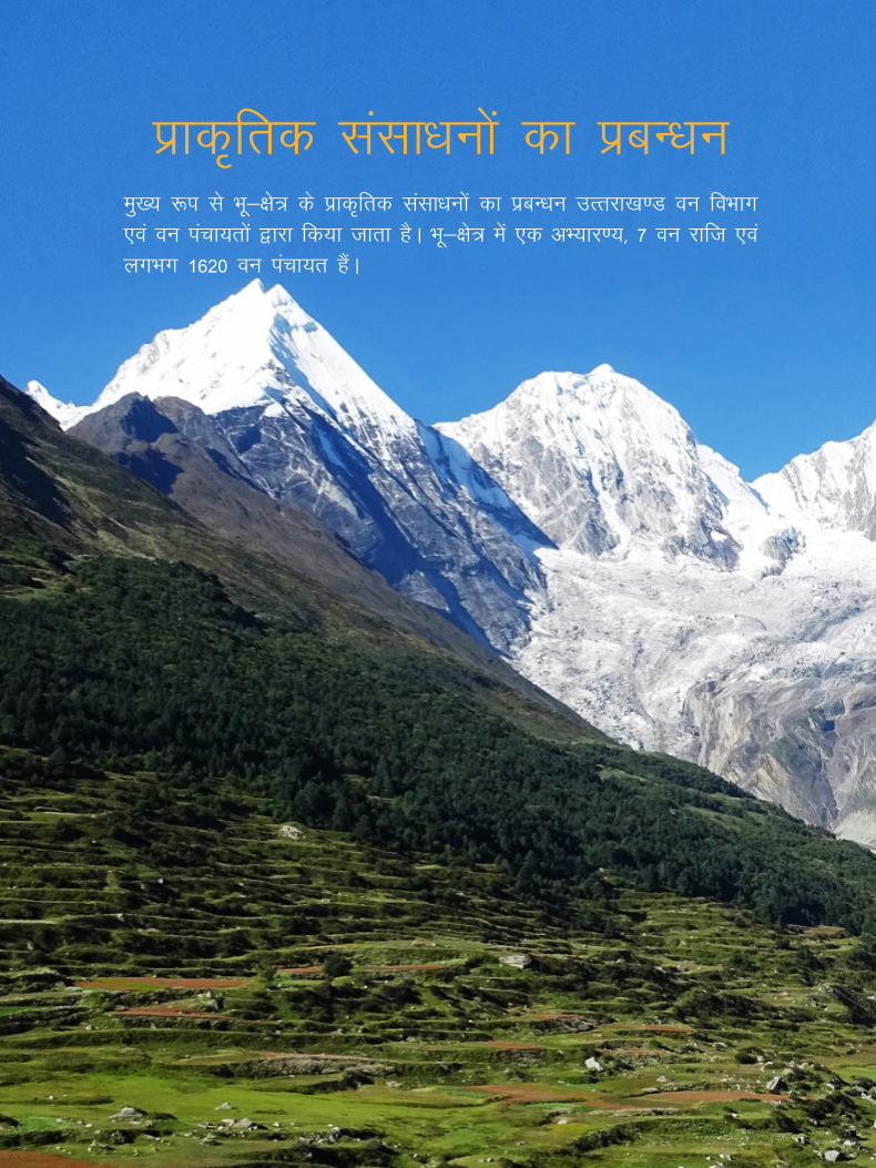
96 An Atlas of Kailash Sacred Landscape-India
izkd`frd lalk/kuksa dk izcU/kueq[; :i ls Hkw&{ks= ds izkd`frd lalk/kuksa dk izcU/ku mRrjk[k.M ou foHkkx ,oa ou iapk;rksa }kjk fd;k tkrk gSA Hkw&{ks= esa ,d vH;kj.;] 7 ou jkft ,oa yxHkx 1620 ou iapk;r gSaA

An Atlas of Kailash Sacred Landscape-India 97
Management of Resources
Uttarakhand Forest Department and Van Panchayat manages
the large gamet of natural resources of the landscape. There
are one Wildlife Sanctury, 7 Forest Ranges and 1620 Van
Panchayats.
Panchachuli peaks from Dantu village

98 An Atlas of Kailash Sacred Landscape-India
lajf{kr {ks= ¼vH;kj.; ,oa vkjf{kr ou½: ifo= dSyk”k Hkw {ks=&Hkkjr
Protected Area (Wildlife Sancturay & Reserve Forest): KSL-India
dSyk”k Hkw {ks=&Hkkjr esa ,d ek= lajf{kr {ks= vLdksV vH;kj.; gS] ftldh izkjafHkd vf/klwpuk oU;tho laj{k.k vf/kfu;e 1972 dh /kkjk 18 ds varxZr 1986 esa rFkk iqu% 2004 esa tkjh gqbZ gS] ftlds vuqlkj rRdkyhu vLdksV jsat ds leLr vkjf{kr ou 289 oXkZ fdeh0 rFkk 225 oxZ fdeh0 flfoy ou o 85 oxZ fdeh0 d`f’k Hkwfe dqy yXkHkx 600 oxZ fdeh0 dks vH;kj.; ?kksf‘kr fd;k x;k gSA Hkw Hkkx dk 79853 gsDVs;j ¼798-5 oxZ fdeh0½ {ks= vkjf{kr ou {ks= gS] tks 2 mi& ou izHkkxksa] MhMhgkV ¼fiFkkSjkx<+] MhMhgkV] vLdksV ,oa /kkjpwyk jsat½ ,oa csjhukx ¼equL;kjh] csjhukx] xaxksyhgkV jsat½ ds vaUrZxr 7 ou jsatksa esa vkrs gSaA
In the KSL-India, Askot Wildlife Sanctuary is the only Protect Area (PA). The
fi rst notifi cation of the sanctuary made under article 18 of the Wildlife protection act
1972 in 1986 and again in 2004. Of which, all the reserve forest (289 km2) of the then
Askot range, 225 km2 Civil forest and 85 km2 Agricultural land, overall an area of
600 km2 area form the Wildlife Sanctuary. The KSL-India has 7 forest ranges under
2 sub-divisions namely Didihat (Pithoragarh, Didihat, Askot and Dharchula ranges)
and Berinag (Munsyari, Berinag, Gangolihat ranges) covering 79853 ha (798.5 Km2)
area.
Marmot

An Atlas of Kailash Sacred Landscape-India 99
Protected Area Map: KSL-India
Prepared by:
Uttarakhand Space Application Centre, Dehradun as part of KSLCDI Project.

100 An Atlas of Kailash Sacred Landscape-India
ou iapk;rsa% Ikfo= dSyk”k Hkw {ks=&HkkjrVan Panchayats: KSL-India
dSyk”k Hkw {ks=&Hkkjr esa yxHkx 1620 ou iapk;rsa gSa] ftudk {ks=Qy 2]84]742 gsDVs;j (2847.42 oxZ fdeh0) gSA buesa ls ou iapk;rksa dk 4270-28 gsDVs;j {ks= vkjf{kr ouksa ds v/khu gS vkSj “ks’k flfoy lks;e ouksa esa fLFkr gSA vf/kdka”k ou iapk;r phM+ ,oa ckat vksd ouksa ls vkPNkfnr gSaA Hkw&{ks= esa yxHkx 48 ou iapk;rsa “kq) phM+ ouksa dh vf/kdrk okys {ks= gSa] tks 4463-10 gsDVs;j {ks= esa QSys gSaA buesa xaxksyhgkV ou izHkkx ¼1422-3 gsDVs;j½] MhMhgkV ou izHkkx ¼1379-3 gsDVs;j½ vkSj fiFkkSjkx<+ ou izHkkx ¼1622 gsDVs;j½ dk {ks= izeq[k gaSA Hkw&{ks= esa ou iapk;rsa 1 gsDVs;j ls 45]500 gsDVs;j {ks=Qy dh gaSA Hkw&{ks= dh dqy 1620 ou iapk;rksa esa ls vf/kdak”k ou iapk;rksa ¼1405½ dk {ks=Qy 100 gsDVs;j ls de gSA Hkw&{ks= esa dsoy 30 ou iapk;ras ,slh gSa] ftudk {ks=Qy 1000 gsDVs;j ls vf/kd gSA
Kailash Sacred Landscape-India has about 1620 Van Panchayats covering
2,84,742 ha (2847.42 km2) area. Of which about 4270.28 ha area of VPs are under
the reserve forests and rest are in the civil soyam forests. Most of the VPs are covered
by Chir pine and Banj oak forests. In the landscape, about 48 VPs are dominated by
pure Chir pine forests covering 4463.10 ha area in Gangolihat (1422.3 ha), Didihat
(1379.3 ha) and Pithoragarh (1622 ha) forest ranges. Van panchayats in the landscape
are varies from <1 ha to >45500 ha in size. Of the total 1620 VPs of the landscape,
most of the van panchayats (1405) are less than 100 ha in size. There are only 30 VPs
having are >1000 ha.
Protected Van Panchayat near village -Kanar

An Atlas of Kailash Sacred Landscape-India 101
Van Panchayats Map: KSL-India
Prepared by:
Uttarakhand Space Application Centre, Dehradun as part of KSLCDI Project.

102 An Atlas of Kailash Sacred Landscape-India
Key references
Anonymous (2007). Sankhiki Patrika. Janpad, Pithoragarh.
Anonymous (2010). Kailash Sacred Landscape Conservation Initiative: Feasibility
Assessment Report India. GB Pant National Institute of Himalayan Environment and
Sustainable Development, Almora.
Anonymous (2017). State of Forest Report. Forest Survey of India, Dehradun.
Anonymous (2018). Socio-Economic Atlas of Uttarakhand. Raj Bhawan Dehradun.
Champion, H.G. and S.K. Seth., 1968. A Revised Survey of the Forest types of India.
Manager of Publications, New Delhi.
Management Plan of Pithoragarh Forest Division 2011-22.
Negi CS (2014). Sacred Uttarakhand: Ethano-Biological surrounding sacred natural
sites in Uttarakhand. Bishan Singh Mahendra Pal Singh, Dehradun.
Dr. Gajendra Singh is a Scientist in Forestry and Climate Change Division, Uttarakhand Space Application Centre (USAC), Dehradun. He did his post graduation (2004) and Ph.D. (2009) in Botany from Kumaun University Nainital. Prior joining to USAC in 2014, he worked as research scholar at Wildlife Institute of India for more than 10 years on various environmental monitoring and management issues. His research interests include Plant Taxonomy, Forest Ecology, Spatial Environmental Monitoring and Natural Resource Management. Till date he has contributed in more than 40 research papers/book chapters, 01 book and 01 manual. ([email protected])
Shashank Lingwal is presently working as a Scientist in Uttarakhand Space Application Centre (USAC), Dehradun. He received graduation degree in Engineering and Technology (2009) from H.N.B. Garhwal University and did post graduation in Computer Science and Engineering (2012) from G.B. Pant Engineering CoUege, Ghurdauri, Pauri Garhwal. Prior joining USAC in 2014, he was engaged in teaching engineering students for about 4 years at H.N.B. Garhwal University and National Institute of Technology, Uttarakhand. He has worked in the areas of fractal, computer graphics and applications. Till date he has contributed in more than 10 research papers/book chapters/articles in various national and international journals. ([email protected])
Mr. Arvind Pandey is an Assistant Professor in the Department of Remote Sensing and GIS in the SSJ Campus, Kumaun University, Nainital. He did his initial schooling from Government Inter College, Peepli Pithoragarh. He did h is Masters in Remote Sensing & GIS and in Geography from Kumaun University, Nainital. Prior joining to Kumaun University, he worked as Senior Research Fellow over >3 years at Uttarakhand Space Application Centre, Dehradun. He is actively involved in various outdoor activities eg., mountaineering, trekking, adventure and sport. Rashtrapati and Rajyapal awards for working in the field of Search and Rescue in Disaster Management during the year 2013 have awarded him. Till date, he has contributed in 8 research papers in various national/international journals. ([email protected])
Dr. M.P.S. Bisht is Director, Uttarakhand Space Application Centre (USAC), Dehradun. He did his post graduation (1985) from H.N.B. Garhwal University and Ph.D. (1991) from H.N.8. Garhwal University and Wadia Institute of Himalayan Geology, Dehradun. Environment geology, natural resource management, remote sensing and GI$ modeling are among his research interests. He is having research experience of more than 32 years in Uttarakhand Himalayan region, Aravalli mountain ranges, Arakan valley in Assam and Satpura valley. Prior joining USAC, he had served H.N.B. Garhwal University as Professor of Geology. In his academic carrier, he had produced 11 Ph.D., authored 2 books and more than 65 research papers. (mpbisht@'gmail.com)