All roads lead to Constantinople: Exploring the Via Militaris in ...
317
Matthew Larnach The Medieval and Early Modern Centre The University of Sydney, 2016 All roads lead to Constantinople: Exploring the Via Militaris in the medieval Balkans, 600-1204 A thesis submitted to The Medieval and Early Modern Centre in the Faculty of Arts and Social Sciences, at the University of Sydney, in fulfilment of the requirements for the degree of Doctor of Philosophy.
-
Upload
khangminh22 -
Category
Documents
-
view
0 -
download
0
Transcript of All roads lead to Constantinople: Exploring the Via Militaris in ...

Matthew Larnach
The Medieval and Early Modern Centre
The University of Sydney, 2016
All roads lead to Constantinople:
Exploring the Via Militaris in the medieval Balkans,
600-1204
A thesis submitted to The Medieval and Early Modern Centre in the Faculty of Arts and Social
Sciences, at the University of Sydney, in fulfilment of the requirements for the degree of Doctor of
Philosophy.

All roads lead to Constantinople
2
Declaration
This is to certify that to the best of my knowledge, the content of this thesis is my own work.
This thesis has not been submitted for any degree or other purposes.
I certify that the intellectual content of this thesis is the product of my own work and that all
the assistance received in preparing this thesis and sources has been acknowledged.

All roads lead to Constantinople
3
Abstract
The aim of this thesis is to provide an accurate depiction of the route and condition of the Via Militaris,
the grand military highway that linked Belgrade and Constantinople, as it existed from the seventh
century till the beginning of the thirteenth. It will consider the development of Roman roads in this
region and how these changed, over time, into Byzantine roads. Further, the urban landscape of the
Balkan Peninsula will be explored, from the changes wrought by the establishment of Roman
authority, the impact of the Slav and Avar incursions, to what sort of settlements, if any, emerged
afterwards. Finally the material effect this turmoil had on the administration and maintenance of the
Via Militaris, and to what extent was the road restored after the Byzantine reconquest of the Balkans
by Emperor Basil II, will be discussed.
This thesis draws upon a wide variety of sources, not only medieval texts, but those pertaining to the
Roman and Ottoman periods as well, and marries these with material sources, such as archaeological
investigations of the road and accompanying road stations, numismatic and sigillographic sources, as
well as observations in the field of contemporary remains along its route. It also discusses how the
contribution of new technologies, in particular the use of Geographical Information Systems and
topographical data, can further enhance our understanding of historical landscapes and
communication networks. Finally, through considering the passage of the German contingent of the
Third Crusade as a case study, this thesis demonstrates how a greater awareness of the physical
condition of the route can provide a context whereby such events might be more adequately critiqued.
Perhaps the most significant conclusion drawn by this thesis is the influence of topography on both
the choice of route of the Via Militaris, and its subsequent prominence in the crusading period. The
mountain passes through which the road travels are far less steep than might be assumed for a region
that is largely defined by its rugged terrain, and over its entire course the road never attains the sort
of gradients that would have rendered the use of wheeled vehicles impractical, if not outright
impossible. This stands in stark contrast to the route of the Via Egnatia, which is far more precipitous,
and this is one of the main reasons, it is argued, why the Via Militaris emerges as the primary road
taken by those participants of the Second and Third Crusades who took the overland route to the Holy
Land.
It also argues that the quality of the road was far from uniform during this period, and in particular
from the mid-eleventh century onwards there is convincing evidence that the Byzantine state
deliberately abandoned a long stretch of this road, between the Danube River and the city of Naissus,
through a region known as the ‘Bulgarian Forest’, in order to create on its frontier a logistically

All roads lead to Constantinople
4
challenging ‘no man’s land’. The road which subsequently emerged in this region likely bore little
resemblance to that of a well-travelled highway.
However despite its stated aim, this thesis has been unable to provide as clear a representation of the
road at a local level as was hoped, and concludes that no such depiction is currently possible owing to
a fundamental lack of research, in particular of verified archaeological remains, along much of its
route. This is compounded by the fact that the sources make clear that a number of alternate routes
not only existed, but were actively used, in the medieval era, and it is difficult to determine which road
was being utilised at any given point in time. Instead of a single road, this thesis argues that the
medieval Via Militaris instead more likely existed as a network of roads, as the decayed remains of the
Roman highway, as well as lesser known secondary routes, were used in conjunction. The confusion
which subsequently emerges in modern depictions of the route of the Via Militaris is evidenced by the
sometimes vast differences which exist between them, and seldom are two maps of the route of the
road alike.
It is argued that without further research to ascertain the quality and route of the road at a local level,
the medieval Via Militaris cannot be described except in the most general of terms, and owing to this
confusion the Roman, Byzantine and Ottoman identities of the road have become irrevocably
entwined. What is required, therefore, is a new emphasis on how the route of the road was influenced
by, and in turn influenced, the development of unique local geographies, and from these geographies
build a broader conception of the road as a whole. That is, rather than top down analysis of the road,
our understanding of it, and its importance to the medieval Balkans, needs to be reconsidered from
the bottom up.

All roads lead to Constantinople
5
Acknowledgements
The author is indebted to the contributions made to this thesis by Professor Vrasidas Karalis, Associate
Professor John Pryor, and the Medieval and Early Modern Centre at the University of Sydney for its
ongoing assistance. I would also like to thank the American Research Center in Sofia for allowing me
to access their library archives, and Dr Ivan Vasilev for providing me with unpublished material and
GPS co-ordinates directing me to unrecorded surviving segments of the Via Militaris within Bulgaria. I
would also like to thank Barry O’Rourke for his invaluable aid in proof-reading and editing this thesis.
Finally I would like to thank my family for their ongoing support and infinite patience in my peculiar
obsession with a strange road located on the other side of the world.
A note on transliterations
For the sake of consistency, I have endeavoured to use Latinised forms of Byzantine names of people
and places wherever possible, whilst technical terms and titles have been transliterated from their
Greek or Latin forms with as few changes as possible.

All roads lead to Constantinople
6
Contents
Abstract .................................................................................................................................................. 3
Acknowledgements ................................................................................................................................ 5
Preface .................................................................................................................................................... 8
Chapter 1: Introduction ........................................................................................................................ 12
Chapter 2: The Geography of the Balkan Peninsula ........................................................................... 18
Chapter 3: Sources................................................................................................................................ 25
3.1: Archaeological Sources ............................................................................................................. 27
3.2: Itineraria .................................................................................................................................... 28
3.3: Literary Sources ......................................................................................................................... 40
3.4: Taktika ....................................................................................................................................... 42
3.5: Byzantine Sources ..................................................................................................................... 43
3.6: Crusader Sources ....................................................................................................................... 44
3.7: Early Modern Sources ............................................................................................................... 50
3.8: Contemporary Sources .............................................................................................................. 53
Chapter 4: Historiography .................................................................................................................... 57
Chapter 5: Methodology ...................................................................................................................... 62
Chapter 6: Roman Roads ...................................................................................................................... 67
6.1: Construction .............................................................................................................................. 69
6.2: Stations ...................................................................................................................................... 71
6.3: Financing .................................................................................................................................... 73
Chapter 7: Byzantine Roads ................................................................................................................. 77
Chapter 8: The Roman Balkans ............................................................................................................ 91
Chapter 9: The Byzantine Balkans ....................................................................................................... 99
Chapter 10: The Roads of the Ottoman Balkans ............................................................................... 125
Chapter 11: The Via Militaris ............................................................................................................. 131
11.1: Belgrade ................................................................................................................................. 131
11.2: Branichevo ............................................................................................................................. 135
11.3: Naissus ................................................................................................................................... 145
11.4: Serdica ................................................................................................................................... 174
11.5: The Succi Pass ........................................................................................................................ 183
11.6: Philippopolis .......................................................................................................................... 214
11.7: Adrianople ............................................................................................................................. 232
11.8: Thrace .................................................................................................................................... 234
11.9: The Via Militaris – Some Conclusions ................................................................................... 247

All roads lead to Constantinople
7
Chapter 12: Case Study - The role of the Via Militaris in the passage of the Third Crusade ........... 263
Chapter 13: Conclusion ...................................................................................................................... 289
Bibliography........................................................................................................................................ 298
Primary Sources .............................................................................................................................. 298
Secondary Sources ......................................................................................................................... 303

All roads lead to Constantinople
8
Preface
With the foundation of Constantinople as the new Roman capital, the Via Militaris became arguably
the most important strategic route in the entire Roman Empire, linking this vast urban metropolis, and
the key cities of the Balkans, with Northern Italy and Central Europe. Yet what was this road like in the
medieval era? A wealth of anecdotal information exists, but little in the way of definitive evidence.
Whilst some major routes, such as the Via Egnatia, had become severely dilapidated by as early as the
sixth century, the Via Militaris was still capable of accommodating the throngs of soldiers, wagons,
and animals that swarmed over it during the passage of the first three crusades. Had the Via Militaris
therefore been revived in the preceding centuries, or had it never been allowed to decline in the first
place?
We know little of the actual physical condition of the road throughout this period. Literary sources
typically offer little in the way of reliable information on routes or even locations, let alone the quality
of roads themselves. Similarly the archaeological record along much of this route can only be
described as patchy, with many surveys being limited to the late Roman period, and by modern
national boundaries. The defining history of the road is still the late nineteenth century examination
of it provided by Konstantin Jireček, Die Heerstrasse von Belgrad nach Constantinopel und die
Balkanpässe.1 Whilst the influence of Jireček’s ground breaking work is without dispute, a number of
conclusions he reached as to the route of the Via Militaris in particular do not stand up to close
scrutiny. Given the importance of this route to the medieval Balkans, and in particular to the passage
of the first three crusades, this is a topic that deserves to be considered anew.
The inspiration for this study has come from travel undertaken within the Balkans, and observations
of how its unique geography has shaped and influenced the manner in which people travel and
interact with this region even today. It was further felt that existing depictions of the region, within
maps or historical atlases, failed to adequately portray its complex geography. Such depictions often
seemed bland, devoid of necessary detail and with roads so marked that their passage seemed almost
trivial. As one former lecturer remarked, these depictions gave the impression that for a crusader to
travel from Belgrade to Constantinople, all he needed to do was put his horse into ‘gear’ and roll on
down the highway.
1 K. Jireček, Die Heerstrasse von Belgrad nach Constantinopel und die Balkanpasse: eine historisch-geographische studie (Prague, 1887).

All roads lead to Constantinople
9
Further it was felt that the urban history of this region was poorly represented in existing sources. The
wave of Slavic tribes which swept over the region in the sixth and seventh centuries is often argued to
have destroyed the ‘Roman’ identity of the Balkans. We possess, though, little in the way of definitive
evidence with which to argue either for or against this point. Those sites which are of interest to
medieval historians, such as Philippopolis and Serdica, are also of interest to classical or ancient
historians, and often we know more of their inhabitants in these periods than we do of their more
recent medieval populations. Was it the case that the Greek or Roman identities of these cities were
wiped out at a stroke? As Geoffrey Blainey notes in The Tyranny of Distance, identities can be changed
more quickly on a map than they can in the mind.2
We don’t know what was in the minds of those people who lived in this region, or who subsequently
may have lived in its cities afterwards. Were these people Greeks? Slavs? Bulgars? Or something else
entirely? We simply don’t know for sure, and discussion on this issue has advanced little further than
acceptance that such absolute divisions are extremely rare in practice, and what emerged instead was
more likely a blend of peoples and cultures.3 If we can tell so little of these places, or even the people
who inhabited them, might not we learn more by investigating how people interacted with the world
around them, how they moved from place to place, between the town and the countryside, but more
importantly, between the provincial towns and imperial capital, Constantinople. To better understand
the difficult history of this region, it appears imperative to achieve a better appreciation of its
communication routes.
It has been argued by historians such as John Haldon and John Pryor that medieval texts have now
been mined to exhaustion for all the information they can provide on the topic of historical logistical
networks. For a more detailed picture to emerge, new sources of information, especially in light of the
economic and demographic changes experienced within the medieval Balkans, need to be explored if
these networks are to be understood further. Study of the Via Militaris, however, is subject to an
enormous diversity of specialist discourses, from geographers and archaeologists, to classicists and
medieval historians. Alan Baker, in Geography and History: bridging the divide, argues for the need for
a closer collaboration between these disciplines, and the necessity of promoting a common language
in order to encourage meaningful dialogue.4 This thesis seeks to display an example of the utility
offered by a cross-disciplinary approach which brings this material together into one argument, in
which the whole can potentially become greater than the sum of its parts.
2 G. Blainey, The Tyranny of Distance: how distance shaped Australia's history (Sydney, 2001), p. 341. 3 R. C. Hall, The modern Balkans; a history (London, 2011), p. 14. 4 A. Baker, Geography and History: bridging the divide (Cambridge, 2003), p. 2.

All roads lead to Constantinople
10
In doing so this thesis will take the Braudelian concept of the longue durée as both its conceptual and
structural framework, in that only through an investigation of the relationship between history and
geography over time can the importance and utility of a road such as the Via Militaris be effectively
expressed. Geography is not merely a passive stage upon which historical events are played out, it
exerts an important influence over them, shaping them and the furthermore providing a context in
which they can subsequently be studied. Similarly this thesis will draw upon analogous studies of the
road networks of Asia Minor, such as William Ramsay’s The Historical Geography of Asia Minor, in
which topography is argued to be a foundation upon which the analysis of historical events can be
explored. It will also draw inspiration from Jireček’s own pioneering approach in raising awareness of
the importance of considering the history of the Balkan Peninsula in terms of its most convenient and
strategically important route.
This is not to argue against the utility of studying specialised subjects within this setting, but rather
that a better understanding of the physical framework in which cultural and social interactions
occurred could make a positive contribution to our overall understanding of the history of this region.
That is, it is necessary to conceptualise the importance of the route as a whole, as opposed to studying
small sections of it in isolation, in particular since a large part of its subsequent prominence and fame
was derived from the fact that this was the imperial highway, the road to Constantinople, or Tsargrad
as it was also known in the Balkans. The status of this road was further enhanced by the fact that it
entered the city via the monumental Golden Gate, and through the Theodosian Walls, symbols of the
unconquerable status of the Roman Empire.
Cities along the Via Militaris, such as Philippopolis and Serdica, therefore did not exist inside vacuums,
and the road itself which ran through them indelibly linked them to administrative bodies of imperial
authority that were located within the capital. How these administrative mechanisms operated over
space, however, is difficult to discern, and a more comprehensive appreciation of the means by which
these cities were linked physically with the capital Constantinople would allow us a greater
appreciation of not only how these regions were incorporated within the greater Byzantine
‘Commonwealth’, but also to analyse the formation of distinct urban communities within them, such
as the heretical ‘Manichean’ population in Philippopolis.
Material and literary sources provide one way of looking at the historical world, but a consideration
of geography offers an alternate, complimentary, perspective on the same topics, and so the road
shall also be considered in terms of the landscape it encompasses, its topography and climate, as well
as the human geography of those regions through which it ran. In this respect the study of historical
geography is seen in terms of a compilation of a wide variety of different sources, not only literary

All roads lead to Constantinople
11
sources and material remains, but also climate, fluvial erosion, the impact of diseases such as malaria,
and demographic change. Bringing this material together offers historians an opportunity to consider
historical events from a wide variety of different perspectives not covered by a more traditional study
of literary texts.
This approach raises certain dangers as well. How is material drawn from such a wide variety of
sources to be balanced against each other? An imaginative reconstruction of the Via Militaris, as this
must necessarily be owing to the fact that we simply do not know enough about the route to
convincingly reconstruct its medieval identity in detail, inevitably requires dangerous assumptions to
be drawn. The structuralism of the longue durée will, it is hoped, help in providing a convincing context
in which to consider this variety of sources, for although the roads of the Roman, Byzantine and
Ottoman periods were manifestly different, of different compositions and occasionally following
different routes, they all served the same essential purpose: the effective projection of imperial power
and authority over the Balkan Peninsula. So whilst some of the conclusions reached by this thesis may
subsequently attract criticism, it is felt that the attempt still ought to be made in order to hopefully
promote a greater dialogue on the nature of the medieval Via Militaris. Indeed the main argument of
this thesis is that historians should know far more about this road than is currently the case.
Finally, in order to demonstrate the practical applications and possibilities a greater appreciation of
the route affords, a case study of the passage of the German contingent of the Third Crusade along
the Via Militaris is presented. This event is often considered in terms of the personality clash between
its two main actors; the stubbornness of Frederick Barbarossa on the one hand, against the paranoia
of Isaac II Angelos on the other. What is typically underemphasised, however, in both medieval texts
and contemporary histories of this event, is the geographical context in which these clashes occurred.
The movement of vast crusader forces was first and foremost a formidable logistical exercise. By
framing the passage of the Third Crusade within the context of the geography of the route and
condition of the medieval Via Militaris, this thesis provides an example of how a closer examination
of the physical settings in which these interactions occurred can enhance our understanding of such
dramatic events, and deliver a more nuanced appreciation of the decisions made by those leaders
involved.

All roads lead to Constantinople
12
Chapter 1: Introduction
Fernand Braudel described mountains as being conspicuous actors in the life of the medieval
Mediterranean. Braudel marvelled at how these domineering geographical masses, whose slopes
often run right down to the shores of the Mediterranean itself, are so often overlooked in studies of
the region that historians who had never left the towns and their archives would be surprised to
discover their existence.5 The mountain ranges of the Balkan Peninsula, perhaps better than any other
region that borders the Mediterranean, have come to uniquely shape its history in a manifold number
of ways. Rugged and densely forested, these ranges, along with the river valleys that bisect them, have
dominated regional patterns of human migration and settlement for millennia.
Yet despite their often foreboding reputation the mountains of the Balkan Peninsula have, over time,
provided refuge and sanctuary for a myriad of different population groups. Owing to competition over
limited resources and outside pressures, the populations of these regions were constantly in flux, with
transitory groups migrating between Asia Minor and the Danube River, whilst other more permanent
settlers varied between the high land and the lower river valleys as season dictated. The historical
geography of the Balkans has therefore typically been highly dynamic, with the region playing host to
a number of different population groups throughout recorded history. This makes analysis of the
cultural history of this region, especially during the medieval period, exceptionally difficult. The few
sources that exist from this time, be they literary, archaeological, or epigraphical, can seldom be used
to differentiate between the different groups that have historically inhabited the Balkan Peninsula, or,
the ability of the medieval Byzantine state to exert any degree of influence over them. Indeed at times
it is difficult to determine whether large parts of this region were inhabited at all.
This thesis will attempt to offer an alternative approach to these questions by evaluating the region
primarily in regards to its distinctive geographical setting. It shall do so by exploring the Via Militaris,
the main highway that bisected this region and ultimately terminated at Constantinople, capital of the
Byzantine Empire. Control over this route, usage of which dates back to antiquity, was of critical
importance to the economic and political administration of the Balkans, as it offered by far the easiest
and most direct access to the middle Danube, and in doing so passed en route the majority of major
urban centres to be found in the region; Adrianople, Philippopolis, Serdica, Naissus, and Belgrade. In
essence, this thesis seeks to expand upon existing analysis of human interaction over space within the
5 F. Braudel, La Méditerranée et le Monde Méditerranéen à l'époque de Philippe II, trans. S. Reynolds, The Mediterranean and the Mediterranean world in the age of Philip II (London, 1972), p. 29-30.

All roads lead to Constantinople
13
medieval Balkans by exploring it from its very lowest level, literally by studying what existed below
people’s feet.
Although some of its cities, such as Philippopolis and Naissus, Plovdiv and Niš in modern Bulgaria and
Serbia respectively, attracted the envy of passing crusaders, the Balkans was never an especially rich
region and as such Byzantium, aside from the agricultural exploitation of Thrace, likely gained
relatively little economically from it. It was far more important, however, in strategic terms.
Possession of this region afforded control over the most direct access routes to Thrace, and
Constantinople beyond. Even as importantly it allowed the frontiers of the Byzantine Empire to reach
the Danube River. Byzantium lacked the manpower and resources to hold this defensive line as the
Romans had, but control over this geographical space allowed for an expansion of the empire’s
‘defensive potential’, in that it increased the physical boundary that separated vital agricultural
regions from those enemies who threatened them. Furthermore, establishing a presence along the
Danube allowed the Byzantines to maintain contact with those living beyond and attempt to draw
them, by tribute or religious conversion, into the fold of the Byzantine Ecumene. In effect, control over
interior communication lines, such as the Via Militaris, allowed Byzantium to fulfil one of the crucial
requirements of an empire: the effective projection of power over space.
The nations of the Balkans today are typically treated as autonomous units, divided geographically
along religious, ethnic and cultural lines. However during the medieval period in question the
mountain ranges likely proved not to be an insurmountable hindrance to the movement of those
pastoral groups that settled in the region, or their seasonal migrations. In the classical world the river
valleys acted as outlets leading towards the Aegean, and this role was reprised in the Middle Ages by
crusaders and pilgrims seeking passage east to Constantinople and thence to the Holy Land beyond.
Bulgaria, which sits astride the two major routes leading to the Aegean, the Struma and Maritsa Rivers,
has historically been regarded as a ‘transit’ country, characterised by the movement and conquests of
numerous peoples.6 Indeed in contemporary studies of the region there is an increasing tendency to
eschew use of the word ‘Balkan’ because of the pejorative associations it attracts, and instead use the
term ‘Southeastern Europe’, in order to emphasise this region’s interconnectivity with the rest of the
continent.7 The sheer number and variety of archaeological remains to be found in this region stands
testament to the fact that it has acted as a conduit between Asia Minor and Central Europe since the
6 G. W. Hoffman, ‘Transformation of rural settlement in Bulgaria’, Geographical Review, 54, no. 1 (Jan, 1964), p. 45. 7 Hall, The modern Balkans, p. 21.

All roads lead to Constantinople
14
Stone Age, and at the heart of this lies in particular the Maritsa and Nishava River valleys, which, along
with the Succi Pass, are corridors that would in time come to host the route of the Via Militaris.
Yet existing analysis of the Via Militaris has typically been both sporadic and uncoordinated. Surveys
have usually been limited in spatial scope, focusing on short segments of the route, largely in
connection with the major cities of the region, or constrained by modern national boundaries.
Discussion has also typically been limited temporally as well, with the majority of investigations of the
route usually focused on its existence in the late Roman period. Analysis of the Byzantine history of
the road has been rare, and of its Ottoman identity rarer still.
Surveys of the Via Militaris as it existed in the late Roman period are useful to medieval scholars, but
owing to the distinct demographical changes experienced within the Balkans after this period they
must also be treated with some caution. The Via Militaris of the Byzantine period, that is to say from
the seventh century onwards, was almost certainly a far different entity to that which had existed in
the late Roman period. Population decline and political upheaval would have not only changed the
physical appearance of the road, as some sections doubtlessly suffered through neglect, it likely also
changed how the road was perceived more generally. As Harvey notes, societies construct objective
conceptions of both time and space sufficient unto their own needs and purposes of material and
social reproduction.8 As late Roman society collapsed both the form and function of what once had
been a major imperial highway, especially within an increasingly isolated periphery, would have
become materially different, and it is likely only along its final stretch through Thrace, as it approached
the capital itself, did the Via Militaris retain some semblance of its former significance and identity.
As such, this thesis seeks to challenge depictions of the route as static, and relatively unchanged from
its Late Antique form. The medieval Via Militaris typically exists as a diagonal line drawn in historical
atlases and maps of the region, following the course of the ancient road and usually traversing a
featureless vacuum punctuated only by the important cities that lay along its route. Topographical
details in these representations are usually either entirely absent, or highly simplistic. As Goffart notes
in his critique of the format, this image creates its own reality, and the long unbroken line that bisects
the Balkan Peninsula in historical atlases gives rise to the belief that not only was the continued
existence of a major highway a given constant in the history of this region, but that it was also
presumably uniform in composition over the entirety of its extent.9
8 D. Harvey, ‘Between space and time: reflection on the Geographical Imagination’, Annals of the Association of American Geographers, 80 (1990), p. 419. 9 W. A. Goffart, Historical Atlases; the first three hundred years 1570-1870 (Chicago, 2003), p. 449.

All roads lead to Constantinople
15
Depictions of roads as linear, static lines on a map also often underemphasise the importance and
complexity of communication networks such as the Via Militaris.10 The movement of men and material
through space is only infrequently touched upon in historical sources and travellers seldom comment
upon the nature of roads unless they happen to be exceptionally bad. It is typically only through
military treatises and crusading records that any impression of the quality and importance of local
roads can be gathered. This can sometimes lead to the assumption that travel was a mundane, even
insignificant, practice, merely a case of following a road through a frictionless environment until it
reached its destination. Yet travel, especially over long distances, was seldom straightforward in the
Middle Ages. It was typically fraught with difficulties, not the least being the threat of banditry, and
became especially hazardous over winter, or during spells of poor weather when available roads could
become enormously difficult to traverse.
In particular a great deal can be learnt about the operation and planning of medieval military
campaigns through the examination of logistical infrastructures. This can, in turn, be used to analyse
underlying social structures. The mobilisation and deployment of armies for instance, along with the
distribution of the requisite supplies and its modes of transportation, required integrated networks of
social and administrative institutions. But the very existence of such administrative structures would
challenge pre-existing depictions of the medieval Balkans, where other than a few isolated coastal
communities, urban centres are often presumed to have been destroyed in the upheavals of the
tumultuous seventh century. Moreover, whilst it is typically assumed that the Byzantine Empire
utilised and maintained the decaying infrastructure it inherited from the late Roman Empire, the
manner in which this was done, and how these road networks were maintained, has seldom been the
subject of scholarly attention, or have been the subject of unproven assumptions rarely tested against
evidence.11
The Roman identity of the Balkans was unquestionably shattered by the inexorable wave of invaders
who washed over it in the seventh century. Yet the absence of comprehensive evidence of both urban
settlement and road construction has hampered the ability of historians to define just how far
reaching the implications of this event was, and in particular challenge the depiction of a Balkan
interior stripped of major cities. More recent studies, however, and archaeological surveys in
particular, have suggested the possibility of persistent urban communities beyond the seventh
century, even if they can tell us little of the inhabitants themselves. Moreover, from the mid-eleventh
10 For a critique of such approaches, see P. Hordell & N. Purcell, The Corrupting Sea; a study of Mediterranean history (Malden, 2000), p. 563. 11 P. Murgatron et al., ‘Medieval Military Logistics: An agent-based simulation of a Byzantine army on the march’, Computational and Mathematical Organization Theory, 18, no. 4 (December, 2012), p. 488.

All roads lead to Constantinople
16
century onwards the mass movement of pilgrim traffic along this route argues for at least the
retention of functioning logistical networks, networks such as roads and bridges which were by then
nearing one millennium of existence and could hardly have sustained themselves over such a long
period of time.
Haldon argues that if the operation of these logistical networks is to be understood, historians are
required to move beyond constant argument over the same sparse references in a few medieval
texts.12 If research on the manner in which these networks were maintained and utilised is to be lifted
beyond the level of generalisations, new approaches need to be considered. This thesis will attempt
to offer one such approach, and focus directly upon the medieval Via Militaris itself, providing as
accurate as possible description of its course, the quality of the road surface, its width, the regions
that it encompassed, and in what respect the road may have differed from those which existed in the
Roman and Ottoman periods. This information will then be used to model the passage of a particular
army along it, the German contingent of the Third Crusade as led by Frederick Barbarossa, in order to
demonstrate the sorts of challenges such a journey entailed.
Given the highly fluid nature of debates pertaining to the urban settlements of the Balkan Peninsula
and their associated cultural identities in the Middle Ages, this thesis will only be able, at best, to
briefly touch upon them, and even then only insofar as they directly relate to the mechanics of road
construction and repair. The settlement of diverse ethnic groups, their relationship with the Byzantine
state, and the spread of orthodox Christianity, for instance, will be largely passed over. Indeed the
intention of this thesis is that it will provide a material foundation upon which further analysis of the
cultural history of the region can be undertaken.
It is necessary, however, to define the practical limitations that unavoidably narrow the scope of this
research. By far the most important is the lack of verified archaeological evidence of the remains of
the Via Militaris. Only a few sections of the road’s surface have been subjected to archaeological
excavations, and equally few roadside stations have been explored in any great detail. It is important,
too, that some of these works exist only in the Bulgarian language, which the author is unfamiliar with,
and is then indebted to such compilations as the Tabula Imperii Byzantini series, or contemporary
archaeologists such as Dr Mitko Madzharov, who have endeavoured to make such material available
to the wider academic community. Nevertheless such sources can be scarce, and determining the
route of the road, therefore, is often a case of landscape analysis coupled with what information can
12 J. Haldon, ‘Roads and communications in the Byzantine Empire: wagons, horses, and supplies’, in J. Pryor ed., Logistics of warfare in the age of the Crusades: proceedings of a workshop held at the Centre for Medieval Studies, University of Sydney, 30 September to 4 October 2002 (Aldershot, 2006), p. 131.

All roads lead to Constantinople
17
be gleaned from available literary and archaeological sources. This method is, of course, not an exact
one, and in some regions, and in particular along the Morava River, the absence of evidence means
the route of the medieval road can only by delineated in the most general of terms.
Nevertheless, it is felt that a more detailed examination of the Via Militaris, the region’s single most
important transport route, can make a vital contribution to our understanding of the medieval
Balkans. The ability of travellers or armies to progress along this road, and the difficulties encountered
owing to its quality, or natural obstacles such as mountain passes or narrow river valleys, are
important considerations when it comes to determining the development over time of the Balkans as
a distinct Byzantine ‘space’. As Collingwood argued when considering the Roman road network of
Ancient Britain, civilisation is transportation.13 The distances which separated the major settlements
along its route from Constantinople both limited and contested the projection of Byzantine authority
over this region, whose more distant communities were likely more tightly integrated into local
networks of trade and cultural exchange, then they were with a distant imperial capital. A study of the
material identity of the road, and the regions it encompassed, therefore affords the ability to examine
these connections in practice, and thus identify some of the weaknesses inherent in traditional
approaches to both medieval road networks and the historical geography of the Balkans as a whole.
This work will therefore necessarily touch upon many different strands of historical enquiry: histories
of urban settlement, administrative structures, military histories, and cultural histories. Whilst
influencing and being influenced in turn by all of the above, the history of the Via Militaris does not
truly belong to any one of these categories either. In this sense the road itself forms the direct body
of enquiry, and its existence throughout the Middle Ages, it will be argued, represents a definable
structure whose influence can be traced over a long time span. In the context of the tumultuous
medieval history of the Balkan Peninsula the road, and the landscape it traverses, will be considered
as one of the primary means by which the overarching historical developments that affected the
region were shaped.
13 R. G. Collingwood, The Archaeology of Roman Britain (London, 1930), p. 1.

All roads lead to Constantinople
18
Chapter 2: The Geography of the Balkan Peninsula
The Balkan Peninsula is bound by the Adriatic, Ionian, Mediterranean and Aegean Seas, together with
the Danube River to the north, and in total covers an area of approximately 666,000 square kilometres.
It is dominated by a number of mountain ranges that run both east-west and north-south. The main
ranges of the peninsula are the Central Balkan (the ancient Haimos range, known as the Stara Planina
in modern Bulgaria, literally the 'old mountains'), Rila, Rhodope and Pirin Mountains. Running parallel
and to the south of the Central Balkans Mountains is the Sredna Gora range, over which the Via
Militaris passes directly. The region is also defined by the course of a number of major river systems,
most notably the Danube River, which marks its northern extent, and those rivers which provide the
easiest means by which the mountain ranges can be traversed, such as the Morava, Nishava, Maritsa
and Tundzha, along with their smaller tributaries (Figure 1).

All roads lead to Constantinople
19
Figure 1: The Medieval Balkans. From C. Holmes, Basil II and the Governance of Empire, 976-1025 (Oxford,
2005), p. 397.

All roads lead to Constantinople
20
Belonging to the Thraco-Macedonian massif, the ranges of the southerly Rila and Rhodope mountains
are typically higher than those of the Central Balkan or Sredna Gora, and the highest peak in the region
is Mount Musala, at 2925 metres, in the Rila Mountains. Ridges in the Central Balkan Mountains are
typically located at 1600 metres, whilst the highest peak in the Sredna Gora range is 1604 metres
above sea level. The distinctive features of these more northerly ranges are well rounded summits
(the result of long erosion of rock formations that were mostly formed in the Mesozoic period) with
heavily forested slopes, although generally southern slopes are steeper and barer.14
There are few passes through the sheer Rila and Rhodope ranges, which as well as being higher are
also more rugged than the Central Balkan Mountains, and access to the Aegean coast therefore largely
occurs via the valleys of the Vardar and the Struma rivers. The Mesta River (known as the Nestos in
Greece) also connects the Maritsa Valley with the Aegean, but owing to the sparse archaeological
record it is extremely difficult to determine whether this was also a major transport route, linking the
city of Nicopolis ad Nestum with Thrace.15 Instead, Nicopolis was more probably linked to the Maritsa
Valley via a trans-Rhodopean road that passed through the modern Bulgarian town of Dospat,
although owing to the narrowness of this road it was likely never a major thoroughfare, and certainly
not one capable of accommodating large numbers of marching men.
There are numerous passes through the Central Balkan ranges however, the most famous being the
Varbitsa Pass, where the Bulgar Khan Krum ambushed the Byzantine Emperor Nicephorus in 811 AD,
and the Shipka Pass, where in 1877-8 a combined Russo-Bulgarian force held back numerous assaults
from Ottoman forces attempting to break through the narrow pass and relieve the siege of Plevna.
Other passes include the Troyan, or Beklemento, Pass situated north of the city of Plovdiv, along which
ran a Roman road, the Via Trajana, linking the Maritsa Valley with the legionary forts located in
Moesia, and the Iskar Gorge which runs north from the city of Serdica (Figure 2). These passes are
easier to negotiate coming from the direction of the Danube, where the slopes of the Central Balkan
Mountains shelve gently upwards from the Danubian plain, then they are from the south, where they
steeply drop into the Maritsa Valley.16
14 Z. H. Archibald, The Odrysian Kingdom of Thrace: Orpheus unmasked (Oxford, 1998), p. 11-2. 15 P. Delev, ‘The middle Mesta region in antiquity’, in P. Delev & D. Vulcheva eds., Koprivlen Archaeological Site: Rescue Investigations along Gotse Delchev - Drama Road, 1998-1999, Vol. 1 (Sofia, 2002), p. 27-8. 16 P. Sophoulis, Byzantium and Bulgaria, 775-831 (Leiden, 2012), p. 51.

All roads lead to Constantinople
21
Figure 2: The major Roman passes of the Central Balkan Mountains, from left to right are the Iskar Gorge, the
Troyan Pass, and Shipka Pass located above the city of Beroe. The Varbitsa Pass is not shown but is located in
the eastern half of the range, near the modern city of Shumen. Map captured from http://pleiades.stoa.org/

All roads lead to Constantinople
22
Moreover, the passes further to the east, as the mountains fall away into the Black Sea, are more
accessible than those to the west, which are generally narrow and densely forested, making them
ideal locations for ambushes.17 Emperor Isaac Angelos was caught in one such pass in 1191, after a
failed expedition to drive the Vlachs from the mountain passes.18 By the beginning of the twentieth
century only the Shipka Pass was considered navigable for wheeled traffic, although even then only
with a great deal of difficulty.19 Nevertheless, passage across the Central Balkan range was far from
impossible, and it therefore did not represent as insurmountable barrier as might be assumed.
Michael Attaleiates, for instance, mentions the numerous passes through which a hostile army might
travel in order to raid Thrace.20
The Sredna Gora Mountains meanwhile run west to east and are located between the Central Balkan
and Rhodope ranges. They are typically extremely rugged on their slopes, featuring winding and
densely forested valleys. Although the mountains are not remarkably high, owing to the irregular
position, steepness and narrowness of the valleys running between them, which tend to run in
numerous directions, they are quite difficult to cross.21 The Succi Pass, holding almost a due south-
easterly course over its entire extent, is a notable exception to this, and thus offers the most direct
route by which the Sredna Gora can be traversed on an east-west axis. There is, however, another
potential route through the Sredna Gora in this direction, through the ‘Momina Klissura’, or ‘Maiden’s
Gorge’, that follows the course of the Maritsa River, some ten kilometres to the south of the Succi
Pass, and is today followed by the modern trans-Bulgarian train line. This was in the medieval period,
however, a much more difficult route, and it is arguable that it was ever used by large armies in the
period in question.22 More will be said of these routes below.
The mountain ranges also play a decisive role in shaping weather patterns over the region. The climate
of the Balkan Peninsula is influenced by intensive atmospheric circulation from the Atlantic Ocean
coast, continental Europe, the Aegean Sea and the Black Sea. Weather patterns are generally of a
continental European type, characterised by warm summers, cold winters and rainfall that is, whilst
heaviest in summer, generally distributed throughout the year.23 Cold northerly winds blow across the
17 P. von Soustal, Thrakien (Thrake, Rodope und Haimimontos) Tabula Imperii Byzantini Vol. 6 (Vienna, 1991), p. 53-4. 18 Nicetas Choniates, Historia, trans. H. Magoulias, O City of Byzantium (Detroit, 1984), p. 236. Also see R. L. Wolff, ‘The “Second Bulgarian Empire” Its Origin and History to 1204’, Speculum, 24, no. 2 (Apr, 1949), p. 185-6. Brand argues that the pass was actually located in the eastern flank of the Sredna Gora range, C. Brand, Byzantium confronts the West: 1180-1204 (Michigan, 1968), p. 93. 19 Great Britain Naval Intelligence Division, A handbook of Bulgaria (London, 1920), p. 24. 20 M. Attaleiates, The History, trans. A. Kaldellis & D. Krallis (Washington D.C., 2012), p. 65. 21 Great Britain Naval Intelligence Division, A handbook of Bulgaria, p. 26-7. 22 Soustal, Thrakien (Thrake, Rodope und Haimimontos) Tabula Imperii Byzantini, Vol. 6, p. 134 23 Great Britain Naval Intelligence Division, A handbook of Bulgaria, p. 15.

All roads lead to Constantinople
23
region in the winter months as a consequence of the high pressure systems that largely prevail over
much of the European continent, as opposed to the belt of low pressure that occupies the basin of the
Mediterranean, which leads to low winter temperatures and heavy snowfalls.24
The Maritsa Valley and the Thracian plain are largely protected from these weather patterns however,
and in particular from the northerly winds by the Central Balkan Mountains, and as a consequence a
more Mediterranean climate prevails there as opposed to much of the rest of the region. Well-
watered and with an agreeable climate, experiencing in particular mild winter and autumn frosts that
seldom damages growth, they were consequently the principal grain-growing regions within the
Byzantine empire after the loss of its Egyptian provinces in the early seventh century.25 Moreover they
produced large quantities of olive oil, wine and barely, most of which was likely designated for
consumption by the Constantipolitan market.26
The soils along the rivers of Thrace and the Maritsa Valley are also particularly well suited to
agricultural exploitation, being enriched by nutrients washed down from the surrounding mountains.
In comparison, the heavily forested mountain slopes are typically extremely poorly suited to
agricultural activity, as most of the nutrients have been leeched from the soils, leading to low levels
of phosphates and nitrogen.27 One exception however, is the Sredna Gora range, whose round
summits and relatively low altitudes makes them ideally suited for use as summer pasture land.
Rainfall in Thrace and the Maritsa Valley is highly seasonal, and sudden heavy downfalls are quite
common during summer in particular, which can lead to flash flooding. Those areas that neighbour
the Mediterranean itself typically experience much warmer and dryer summers however. In
comparison rainfall in the Sofia plain is more evenly distributed throughout the year, although large
downfalls in the surrounding Rhodope and Rila mountains during both summer and winter are not
uncommon. Snowfalls are also naturally heavier in these regions, and even today heavy snowfalls can
still block roads for considerable periods. In the river valleys snowfalls can occasionally be considerable
but far less dramatic than those experienced in the mountains, and along the coast snow is a relatively
rare occurrence.28
Plant life in the region varies considerably depending on altitude and seasonal rainfall, although
human activity has also played a major role in shaping vegetation patterns. On the plains south of the
Danube the existence of loess soils (silt soils formed by the northerly winds, which are
24 Great Britain Naval Intelligence Division, A handbook of Bulgaria, p. 39. 25 J. L. Teall, ‘The grain supply of Byzantine Empire, 330-1025’, Dumbarton Oaks Papers, 13 (1959), p. 122-25. 26 M. Hendy, Studies in the Byzantine Monetary Economy c.300–1450 (Cambridge, 1985), p. 52. 27 Archibald, The Odrysian Kingdom of Thrace, p. 17-8. 28 Great Britain Naval Intelligence Division, A handbook of Bulgaria, p. 43.

All roads lead to Constantinople
24
characteristically highly fertile) led to extensive forest steppe vegetation, although today this has been
mostly cleared. The mountain slopes are covered with thick deciduous forests; Hornbeam being the
dominant species on northern slopes and Oak on southern, although the overall biological diversity of
these regions is extraordinarily high. In comparison the Maritsa Valley and Thrace are sparsely
forested, and this is believed to be largely owing to massive deforestation undertaken by early human
settlements, and dated by pollen samples to have occurred between the Neolithic and Early Iron Age.29
The Balkan Peninsula can, therefore, be roughly split into two regions, one in the north-west featuring
a continental European climate, and the other in the south-east with a more Mediterranean climate.
Beyond this however, such easy divisions are harder to define. Many of the mountain ranges that
bisect the region are not as difficult to traverse as first impressions might suggest, and in particular
the many passes through the Central Balkan range, and valleys of the Morava, Nishava, Struma,
Maritsa and Vardar rivers offer passage both on a north-south and east-west axis. The Rila and
Rhodope ranges, meanwhile, are daunting obstacles, and the densely forested slopes that comprise
much of the rest of the region represent formidable barriers to the movement of large numbers of
marching men in particular. Indeed, approximately 80% of the total surface area of the Balkan
Peninsula is categorised as mountainous terrain.
As a consequence, the majority of large urban settlements are to be found along the major river
systems. The ease of communications and agriculturally fertile land these offer make the river valleys
far better suited to accommodating large populations than the rugged, densely forested, environment
that constitutes much of the rest of the Balkans. The region does possess valuable mineral resources,
but these are typically located some distance away from these major population centres, making their
exploitation difficult. Indeed, aside from those ancient cities that predated Roman occupation of the
Central Balkans, and which exploited the agricultural potential of the river valleys, population density
in the region has historically been extremely low, with much of the population residing in relatively
isolated rural communities, a pattern that the Balkans retained right up until the mid-twentieth
century.
29 Archibald, The Odrysian Kingdom of Thrace, p. 19-21. On historic changes to vegetation patterns in Bulgaria see in particular E. D. Bozilova & S. B. Tonkov, ‘The impact of man on the natural vegetation in Bulgaria from the Neolithic to the Middle Ages’, in S. Bottema, G. Entjes-Nieborg & W. Van Zeist eds., Man’s role in the shaping of the Eastern Mediterranean landscape: proceedings of the INQUA/BAI Symposium on the impact of ancient man on the landscape of the Eastern Mediterranean Region and the Near East, Groningen, Netherlands, 6-9 March 1989 (Rotterdam, 1990).

All roads lead to Constantinople
25
Chapter 3: Sources
Given how prominent a role the Via Militaris has played in the history of the Central Balkans, it is
surprising how little attention the route has subsequently been given. In historical surveys of the
Balkan Peninsula it is usually overshadowed by the older, and far more famous, Via Egnatia. To take
just one example, in his survey of the history of the Balkan Peninsula, Richard Hall twice refers to the
Via Egnatia, and its importance as a route between Rome and Constantinople, but only once to the
road which ran from Naissus to the capital, and then not even by name.30 Similarly, in Toynbee’s survey
of the world of Emperor Constantine Porphyrogenitus the road is likewise mentioned just the once,
and again only in passing.31 This lack of recognition is curious, as the Via Militaris was the main road
by which the Imperial capital, Constantinople, was reached from both Northern Italy and Central
Europe. It was also the route by which Gothic and Hunnic invaders penetrated into the rich province
of Thrace, over which pilgrims and crusaders travelled en route to the Holy Land, and the setting for
defining military engagements, such as the Battle of Adrianople (378), the Bulgar ambush of Emperor
Basil II at the Gates of Trajan (986), and the Battle of Slivnitsa (1885).
Part of this may be due to, or even the result of, a lack of a consistently identifiable name for the road.
Its most common name is attributable to the nineteenth century study of the road by Konstantin
Jireček, who determined that the Romans had called the route the Via Militaris. This interpretation is
based on Jireček’s translation of a Latin inscription, carved into a bare rock face near the city of
Philippopolis, that lists a decree from Emperor Nero for the construction of road stations, ‘tabernas
et praetoria’. However rather than referring explicitly to a single road, as Jireček concluded, the
inscription referred to the construction of stations along all the military roads of Thrace, of which there
were several. That is it uses the plural vias militaris, not the singular via militaris.32
30 Hall, The modern Balkans, p. 13. 31 A. Toynbee, Constantine Porphyrogenitus and his World (Oxford, 1973), p. 358. 32 K. Belke, ‘Roads and travel in Macedonia and Thrace in the middle and late Byzantine period’, in R. Macrides ed., Travel in the Byzantine world: papers from the thirty-fourth spring symposium of Byzantine Studies, Birmingham, April 2000 (Birmingham, 2002), p. 74. For the text of the inscription in full see G. Rushforth, Latin Historical Inscriptions: illustrating the history of the early empire (Oxford, 1893), p. 116.
divi Claudi f(ilius), Germ(anici) Caesaris n(epos),
Ti(beri) Caesaris Aug(usti) pron(epos), divi Aug(usti) abn(epos),
Caesar Aug(ustus) Germ(anicus), pontif(ex) max(imus), trib(unicia) pot(estate)
VIII, imp(erator) VIII, co(n)s(ul) IIII, p(ater) p(atriae),

All roads lead to Constantinople
26
Via Militaris was, therefore, likely never the name of the Roman road, as is often claimed; instead it
was purely a technical description, in that the road was constructed for military purposes and was a
carriage road wide enough to allow two-wheeled vehicles to pass each other.33 In the Roman period
the road may instead have been known as the Via Singidunum. In Byzantine sources the road was
occasionally referred to as the Basilike Hodos or Via Regia (Royal Road), and in crusader sources it was
sometimes referred to as ‘Trajan’s road’, or simply the ‘public road’.34 In the Ottoman period it was
known as the Stamboulyol, whilst sometimes named in Western sources as the Via Trajana.
Intriguingly, three texts of the First Crusade, the anonymous Gesta Francorum et aliorum
Hierosolymitanorum, and the works of Peter Tudebode and Robert of Reims, all state that the force
led by Godfrey of Bouillon followed ‘Charlemagne’s’ road to Constantinople.35 The reference in the
Gesta Francorum reads, ‘Isti potentissimi milites et alii plures quos ignoro venerunt per viam quam
iamdudum Karolus Magnus mirificus rex Franciae aptari fecit usque Constantinopolim.’36 Whether or
not this passage indicates that the crusaders saw themselves as deliberately following in
Charlemagne’s footsteps, or if the author of the text was simply adding a piece of historical
information about the road for the benefit of his audience, is unclear.37 In Bulgaria the name Via
Diagonalis is generally preferred, however in modern Western literature the name Via Militaris is
predominately used, and will also be employed here in order to avoid confusion.
The absence of scholarly attention given to the Via Militaris, however, is almost certainly a
consequence of the lack of literary sources concerning the route. Contemporary accounts of the road
are rare; the cities along the route, such as Serdica, Philippopolis and Adrianople, typically excited
comment, but the road surface itself did not. Often all that is available for the historian to analyse are
the number of days it took to reach each city. For example, the Greek diplomat and historian Priscus,
journeying to the Hunnic court in 448/9, provided detailed descriptions of the conditions he
encountered in cities he visited en route, however as for the journey itself all the information that is
tabernas et praetoria
per vias militares fieri iussit per
T(itum) Iulium Ustum proc(uratorem) provinciae Thrac(iae).
33 R. Chevallier, Roman Roads, trans. N. H. Field (London, 1976), p. 16. 34 Belke, ‘Roads and travel in Macedonia and Thrace in the middle and late Byzantine period’, p. 303. 35 M. Gabriele, An Empire of Memory: the legend of Charlemagne, the Franks, and Jerusalem before the First Crusade (Oxford, 2011), p. 65. Gabriele, however confuses the route taken by Godfrey for the Via Egnatia, when it was in fact the Via Militaris. 36 Gesta Francorum et aliorum Hierosolymitanorum, trans. R. Hill, The Deeds of the Franks and Other Pilgrims to Jerusalem (London, 1962), p. 2-3. 37 For more on this debate see A. A. Latowsky, Emperor of the World: Charlemagne and the construction of Imperial authority, 800-1229 (Ithaca, 2013), p. 216.

All roads lead to Constantinople
27
provided is a comment that it took thirteen days for an unladen traveller to reach Serdica from
Constantinople.38 It is not till the crusading period that more detailed descriptions are made available,
although even then they are not comprehensive, and tend only to highlight where travel was difficult.
3.1: Archaeological Sources
The most accurate means of determining the route of the Via Militaris is through investigation of the
remains of the road itself. Unfortunately few segments have as yet been the subject of archaeological
excavations. Two sections of the original Roman road have recently been examined, one located near
the Serbian town of Dimitrovgrad, and the other near the remains of a Roman station in eastern
Bulgaria, the mutatio Castra Rubra.39 Certainly further excavation of the road’s surface is the one area
where the most progress could currently be made. However such research, where it exists, is
proceeding only sporadically, and even then often focused instead on routes that branched off from
the Via Militaris. One reason for this is that the development of the Ottoman road, and later
infrastructure, including modern roads, highways and railways, has frequently rendered access to the
original road bed of the Via Militaris difficult, if not impossible. Indeed, owing to the decline in state
funding that accompanied the collapse of the Communist states through which the road ran, ‘rescue
archaeology’ of sites uncovered by modern road construction is increasingly the prevalent means by
which the original road has become the subject of archaeological study.40 The recent excavation of
the road surface near Dimitrovgrad belongs to this class of research, which is by definition necessarily
haphazard in its execution, being uncovered during the construction of a new trans-European
highway.
The inscriptions found on milestones are also a first-rate resource for tracing the route of the road. To
inform travellers of the distance to the next town or station, milliaria were positioned to mark every
mile. These columns were constructed of cylindrical stones (typically either basalt, granite, limestone
or sandstone) and stood between two and four metres tall.41 The inscriptions on milliaria provide a
great deal of information, not only just distances but also information about the road, who built it and
38 Priscus, Historia, trans. R. C. Blockley, The Fragmentary Classicising Historians of the Later Roman Empire: Eunapius, Olympiodorus, Priscus and Malchus, Vol. II (Liverpool, 1983), p. 247. 39 M. Lazic, ‘Via militaris - римски друм код Цариброда’, ГЛАСНИК ДРУШТВА КОНЗЕРВАТОРА СРБИЈЕ, 35 (2011) [in Serbian]. 40 F. Curta, ‘Medieval Archaeology in South-Eastern Europe’, in R. Gilchrist & A. Reynolds eds., Reflections: 50 years in Medieval Archaeology, 1957-2007 (Leeds, 2009), p. 194. 41 M. Madzharov, Roman Roads in Bulgaria. Contribution to the Development of Roman Road System in the Provinces of Moesia and Thrace (Veliko Tarnovo, 2009), p. 57.

All roads lead to Constantinople
28
when. In later periods they were also typically used to display imperial propaganda. These signposts
were a regular feature of the Roman road network and large numbers of them have been located
along the route of the Via Militaris.42 However for reasons that are largely unknown, but probably
associated with the disintegration of late Roman administration, from the fifth century onwards the
use of milliaria sharply declined and no milestones after this period have been found. The lack of
milliaria, or other similar inscriptions, is one of the main reasons why it is so difficult to trace the
development of road networks after the late Roman period.
Numismatic and sigillographic evidence can also make an important contribution to our understanding
of the Byzantine road network and its operation. For instance a tenth century seal from
Constantinople denotes that a certain Demetrios held the title of Imperial spatharokandidatos and
chartoularios of the dromos of the West.43 The office of the dromos will be further discussed below,
however it is believed that one responsibility of the office was maintenance of roads and bridges. The
ambiguity which surrounds the responsibilities of particular offices denoted on such seals, however,
necessitates caution in their use. Numismatic evidence is also valuable in detailing the disruption to
the local economy in this region caused by the Slav and Avar incursions of the sixth and seventh
centuries, and the volume of seals and coins discovered in a location can provide a great deal of
information about the routes and tempo of communications, and the flow of command in the
provinces.44
3.2: Itineraria
The most widely used means of determining the course of Roman roads is through the use of classical
itineraria. Three major itineraries have been preserved; the Tabula Peutingeriana, the Itinerarium
Burdigalense, and the Itinerarium provinciarum Antonini Augusti. All of these provided practical
42 Perhaps the most comprehensive compilation of milliaria along the Via Militaris is found in E. Kalinka, Antike denkmäler in Bulgarien (Vienna, 1906) & V. Beševliev, Spätgriechische und spätlateinische Inschriften aus Bulgarien (Berlin, 1964). 43 N. Oikonomides & J. Nesbitt eds., Catalogue of Byzantine Seals at Dumbarton Oaks and in the Fogg Museum of Art, Vol. 1 (Washongton D.C., 1991), p. 3-4. 44 For example see D. Metcalf, ‘Avar and Slav incursions into the Balkan peninsula (c.575-625): the nature of the numismatic evidence’, Journal of Roman Archaeology, 4 (1991), and Y. Yurukova, ‘Byzantine Fortresses to the south of the Hemus Mountain in the light of coin finds from the last decades of the sixth century’, in V. Gyuzelev & K. Petkov eds., Church and State: studies in medieval Bulgaria and Byzantium (Sofia, 2011), also see M. McCormick, ‘Byzantium on the move: imagining a communications history’, in R. Macrides ed., Travel in the Byzantine world; papers from the thirty-fourth spring symposium of Byzantine Studies, Birmingham, April 2000 (Birmingham, 2002), p. 12.

All roads lead to Constantinople
29
information for travellers, in particular names of locations where lodging could be found, and the
distances between them. In this capacity the straightness of Roman roads, with its regular system of
milliaria, were a great aid to travellers moving from one place to another, in that they created a
familiar and readily understandable landscape. They were also much used by Roman armies, and the
military manual of Vegetius suggests that itineraria were often accompanied by coloured drawings
(picta).45
Of the three itineraries the Tabula Peutingeriana is the most well-known. The copy we possess today
is a medieval copy of a fourth century painted map (itinerarium pictum).46 The heritage of the original
is disputed and it may itself have been a copy of an even older map made in the first or second
century.47 One argument is that the map, which is near seven metres long and divided into twelve
segments, was produced specifically to adorn Diocletian’s palace at Spalato.48 Land is drawn in a
deformed 1:21 scale, whilst the roads are drawn in red, with stations marked along their length (Figure
3).49 The stations and cities on the map are represented differently depending on their relative
importance, typically ranging from one tower to multiple towers for smaller towns and cities, whilst
the major urban centres (Rome, Constantinople and Antioch) are given divine personifications.
Although the heavily deformed scale of the Tabula Peutingeriana is atypical of Roman picta, it
otherwise represents a classic example of Roman map making, in that they tended to ignore scientific
representations of land-shapes, and instead simply required their maps to provide practical
information, such as road distances and amenities along the way.50 However it should not be
overlooked that the Tabula Peutingeriana still contains a great wealth of geographical information,
including naming rivers, deserts, and mountains.
45 Vegetius, Vegetii epitoma rei militaris, trans. N. P. Milner, Vegetius: epitome of military science (Liverpool, 1993), p. 71. 46 Theophanes, The Journey of Theophanes; travel, business and daily life in the Roman east, trans. J. Matthews (Boston, 2006), p. 71. 47 R. J. A. Talbert, Rome’s World: the Peutinger Map reconsidered (Cambridge, 2010), p. 134. 48 Talbert, Rome’s World: the Peutinger Map reconsidered, p. 144-5. 49 Talbert, Rome’s World: the Peutinger Map reconsidered, p. 88. 50 Chevallier, Roman Roads, p. 29, also see O. A. W. Dilke, ‘Itineraries and Geographical Maps in the Early and Late Roman Empires’, in J. B. Harley & D. Woodwards, eds. The History of Cartography, Vol 1: Cartography in prehistoric, ancient and medieval Europe and the Mediterranean (Chicago, 1987), p. 234-257.

All roads lead to Constantinople
30
Figure 3: Part of the Tabula Peutingeriana, showing the province of Thrace. Image obtained from www.hs-
augsburg.de/~harsch/Chronologia/Lspost03/Tabula/tab_intr.html (accessed 22/1/2016).
The Itinerarium provinciarum Antonini Augusti, or simply Itinerarium Antonini, is of unknown
authorship, and is thought to have been composed from information dating to the reigns of both Julius

All roads lead to Constantinople
31
Caesar and Augustus.51 It was compiled sometime in the late third century, possibly during the reign
of Diocletian, whilst the first print copy of the itinerary dates to 1512.52 Unlike the Tabula
Peutingeriana it has no graphical element, and instead consists of lists of names and distances along
the main highways of the Roman Empire.
The third of the itineraria is the Itinerarium Burdigalense, which records the journey of an anonymous
pilgrim to Jerusalem in 333 AD.53 It consists of names of stations along the route, along with distances
between them, interspersed with a few occasional notes of the historic significance of regions
encountered. The first entry in the itinerary is for the city of Bordeaux, from which it draws its name.
The Itinerarium Burdigalense is most likely the latest of the three surviving itineraria, especially if the
Tabula Peutingeriana is based upon an earlier copy. This explains why the information contained in
the Itinerarium Burdigalense can sometimes contradict that found in the earlier itineraries, as the
Itinerarium Burdigalense lists stations that probably had not yet been constructed when the earlier
itineraries were compiled.
A fourth source also exists, in the shape of the Ravenna Cosmography. This work, compiled in the late
seventh century, lists the names of towns, countries and rivers throughout the known world, and is
derived from older Roman sources.54 The Cosmography has proven an invaluable source in recreating
parts of road networks of the Roman Empire, in particular in Roman Britain, but in respect to the
Balkan provinces, and the route of the Via Militaris, it is less useful a source than the three previously
described itineraria.
Of the three, the Itinerarium Burdigalense contains by far the most detail. The Tabula Peutingeriana
and the Itinerarium Antonini list all of the major stations en route where a party could potentially rest
after a day’s journey. The Itinerarium Burdigalense, however, lists all of the smaller stages along each
day’s journey where mounts could be changed. That is, it lists the smaller mutationes as well as the
larger mansiones.55 By way of example, along the Via Militaris between Belgrade and Constantinople,
the Itinerarium Burdigalense lists 64 separate locations; 35 mutationes, 22 mansiones, and 7 civitates.
In comparison the Tabula Peutingeriana lists 32 locations along the same route, whilst the Itinerarium
Antonini lists 31.
51 Itinerarium provinciarum Antonini Augusti, O. Cuntz ed., Itineraria Romana, Vol. 1, Itineraria Antonini Augusti et Burdigalense (Leipzig 1929). 52 T. Codrington, Roman Roads in Britain (London, 1903), p. 16. 53 Itinerarium Burdigalense, trans. A. Stewart, Itinerary from Bordeaux to Jerusalem, ‘the Bordeaux pilgrim’ (London, 1887). 54 A. Richmond & O. G. S. Crawford, ‘The British section of the Ravenna Cosmography’, Archaeologia, 93 (1949). 55 The different types of station employed by the Romans will be discussed further below in Chapter 6.

All roads lead to Constantinople
32
Interpretations of classical itineraria, in particular the Tabula Peutingeriana, have historically proven
highly controversial. Attempting to correlate the distances between the stations of the itineraria with
modern recorded distances sometimes works, but almost as often it does not.56 One reason for this is
that the locations of many of the named stations are not known. This is then compounded by the fact
that Roman roads often did not run as straight as they are usually represented as doing. What the
Tabula Peutingeriana, as well as many modern maps of the Roman road network, represent as straight
lines connecting each location, can actually be far different on the ground. As a consequence, the
method of drawing straight lines from point to point, and comparing these distances to those noted
in the itineraria, can lead to flawed conclusions being reached.
To confuse matters even more, it is not clear what the distances in the itineraria are exactly meant to
represent. The assumption that they indicate the distance, in Roman miles, between each named
‘node’ on the map may be an incorrect one. Instead the distances may have been measured between
specific milestones or important intersections where a traveller could potentially make a wrong turn,
in which case the road network itself formed the geographical reference system by which travellers
found their way, not the cities or stations along its length.57 Nor is it to be assumed that the itineraria
depict the route of a single road between two points. It may instead be describing a series of stretches
of a number of different roads all connecting the same point, therefore it may not necessarily
represent the route of a single road between two locations, yet neither might it represent all possible
roads available either.58 Some of the distance shown on the routes may even correspond to distances
covered by water, when this was more convenient than travel by land.59
The itineraries also cannot be treated as infallible. As Ramsay argues in his work on the historical
geography of Asia Minor, it is possible that they contain false information, such as the misnaming of
stations, which could either be attributable to errors made in the initial compilations, or by later
copyists.60 The names of stations changed constantly as well, and given that few stations along the Via
Militaris have been definitively located, it is often difficult to tell whether different names across the
three itineraries represent a simple change of name, or indicate completely different stations.
The use of these itineraries within historical geography is therefore something of a necessary evil, in
that so few other sources pertaining to the Roman road network are available. To use them, and the
56 This is the opinion of French after reviewing the Roman roads of Asia Minor, D. H. French, ‘A study of Roman roads in Anatolia: principles and methods’, Anatolian Studies, 24 (1974), p. 148. 57 Chevallier, Roman Roads, p. 31. 58 Chevallier, Roman Roads, p. 31. 59 Chevallier, Roman Roads, p. 31. 60 W. Ramsay, The Historical Geography of Asia Minor (London, 1890), p. 48. For an example see the confusion which surrounds the locations of the stations Bagaraca and Sarto further below in Chapter 11.4.

All roads lead to Constantinople
33
distances they provide, as a guide to locating the relative positions of roads and stations along them
is fraught with difficulties. If, however, they are used in close corroboration with analysis of the
geographical environment and archaeological remains, they can prove invaluable aids. That is,
itineraries should not be treated as authorities themselves, but rather as support for more conclusive
evidence.
Interpretations of the itineraria are the key focus of a number of contemporary works that have
attempted to reconstruct the Roman road network in its entirety. The German cartographer Konrad
Miller provided perhaps the definitive treatment of the Tabula Peutingeriana in his work, Itineraria
Romana: Römische Reisewege an der Hand der Tabula Peutingeriana.61 Miller’s ambitious work
included a complete depiction of the entire Roman network, based on ancient sources as well as
contemporary field research, which was compiled together in over three hundred hand drawn
sketches.
This theme was returned to in the Barrington Atlas of the Greek and Roman World, a similarly
monumental compilation of 102 colour topographic maps that cover the span of the ancient world,
from the Atlantic as far as the fringes of western China.62 The aim of the project was to be able to
represent the entire breadth of the ancient world, utilising the modern contributions of both
archaeological and epigraphical research, in a single volume, while its overall purpose is to present a
viable means for classicists to appreciate the geographical context of the ancient world. Owing to the
sheer scale of the project, however, it did not aim to be exhaustive in its depiction of the ancient
landscape.
A project with a similar aim is the Tabula Imperii Byzantini (henceforth TIB) series. Launched by the
Austrian Byzantinist Herbert Hunger in 1966 and co-ordinated by the Austrian Academy of Sciences,
this ongoing project seeks to provide a complete topographical depiction of the land area
encompassed by the medieval Byzantine Empire, which combines aspects of history, archaeology,
bibliography and field research and surveys.63 As a consequence it contains a massive amount of
material, covering the entire scope of Byzantine history. However its depiction of the road network of
the Byzantine Empire has, in particular, attracted criticism. The TIB series occasionally makes no
recognisable distinction between the road network of the Roman and Byzantine Empires, and this
61 K. Miller, Itineraria romana: Römische Reisewege an der Hand der Tabula Peutingeriana (Rome, 1964), for a critique of Miller’s methodology, see Talbert, Rome’s World, p. 68-71. 62 R. J. A. Talbert ed., Barrington Atlas of the Greek and Roman World (Princeton, 2000). 63 M. Popović, ‘Mapping Byzantium; the project “Macedonia, Northern Part” in the series Tabula Imperii Byzantini (TIB) of the Austrian Academy of Sciences’, in K. Kriz et al eds., Mapping Different Geographies (Vienna, 2010), p. 222.

All roads lead to Constantinople
34
conflation of the two at times does not match up with archaeological evidence.64 As Popović notes,
the work relies very heavily on the publication of archaeological reports of monuments.65 In some
regions, and as will be seen in particular along the route of the Via Militaris, the level of archaeological
research is very low, which creates some uncertainty in the depictions provided by the TIB series.
These compendiums of historical geography have also influenced a number of online cartographic
projects primarily aimed at depicting the geography of the classical world. These include the Pleiades
project,66 the Digital Atlas of Roman and Medieval Civilizations,67 the Ancient World Mapping Centre,68
OmnesViae,69 and the Pelagios Project.70 The benefit of online based cartographies is that the
historical map can also function as an interface or index to additional information; geographic
locations on the map can be linked to a magnification of the particular location, to the original or the
translated text that mentions the site, to settlement plans, photographs, or other contemporary maps
(see Figures 4 & 5).71 It is hoped that this burgeoning field will, in the near future, both accommodate
and spur cross disciplinary dialogue between geographers, classicists and archaeologists.72
64 D. H. French, ‘A Road problem: Roman or Byzantine?’, Istanbuler Mitteilungen, 43 (1993), p. 445. 65 Popović, ‘Mapping Byzantium; the project “Macedonia, Northern Part”, p. 222 66 http://pleiades.stoa.org/home 67 http://darmc.harvard.edu/icb/icb.do?keyword=k40248&pageid=icb.page188865 68 http://awmc.unc.edu/wordpress/about/ 69 http://omnesviae.org/ 70 http://pelagios-project.blogspot.com.au/ 71 D. Drakoulis, ‘The study of late antique cartography through web based sources’ e-Perimetron, 2, no. 3 (2007), p. 161. 72 T. Elliott & S. Gillies, ‘Digital Geography and Classics’, Changing the Center of Gravity: Transforming Classical Studies Through Cyberinfrastructure, 3, no.1 (2009).

All roads lead to Constantinople
35
Figure 4: For example, OmnesViae attempts to drape the routes of the Tabula Peutingeriana over a modern
topographical map, with each location containing a link to the original text. Map captured from
http://omnesviae.org/

All roads lead to Constantinople
36
Figure 5: An overview of the Roman road network of the Balkan Peninsula. Map captured from
http://pleiades.stoa.org/

All roads lead to Constantinople
37
Historical atlases are an invaluable aid to both scholars and students alike in terms of providing a
comprehensive overview of the geographical context of the ancient and medieval worlds. Yet a few
caveats must also be considered. As Baker notes, over time historical atlases themselves become
sources, and the material selected for inclusion within them reflects the ideologies of the people who
produced them, and of the periods in which they were produced.73 Modern historical atlases which
simply show the route of the Via Militaris as a linear line seemingly passing effortlessly through a
largely empty expanse may in part reflect contemporary perspectives on geographical space, where
modern transportation has shrunk frontiers and reduced travel to a largely mundane and frictionless
exercise.
Furthermore, historical atlases can only ever be as accurate in their depiction of the landscape as the
historical record allows them to be, and in many regions this is extremely patchy. Even the location of
road stations, a fundamental requirement for tracing the Roman road network, are frequently a
source of contention. Moreover, owing to issues of scale, the routes of roads so depicted can often
only be taken as a general approximation of where the classical road surface may have been located.
The 1:1,000,000 scale maps used by the Barrington Atlas and the Tabula Imperii Romani, and
1:800,000 scale maps by the Tabula Imperii Byzantini, provide an inadequate representation of
topographic detail in particular. As a consequence of their universal approach and the need to present
information at a practical scale, these atlases typically fail to provide accurate information of the route
of roads at a local level.
This is frequently not an acceptable compromise, as routes are specific to the configuration of micro-
regions; Roman roads were universally straight but locally variable in accordance with geographic and
social requirements, and furthermore these routes changed over time as the environment, and the
requirements of those who used them, likewise changed.74 The assumption that routes can be
mapped by linking archaeological sites with straight lines is often a misleading one. Yes, Roman roads
were typically as straight as they possibly could be, but this was not always the case, nor were they as
immune to the influence of local geography as these atlases sometimes suggest, particularly along
river valleys or through mountain passes. Occasionally those roads that are depicted are extremely
abstractly drawn, and at a local level run through or over geographical obstacles as if they were not
even there, and are therefore almost completely useless in terms of ascertaining the exact position of
the road at any one point (Figure 6).
73 Baker, Geography and History: bridging the divide, p. 198. 74 Hordell & Purcell, The Corrupting Sea, p. 128.
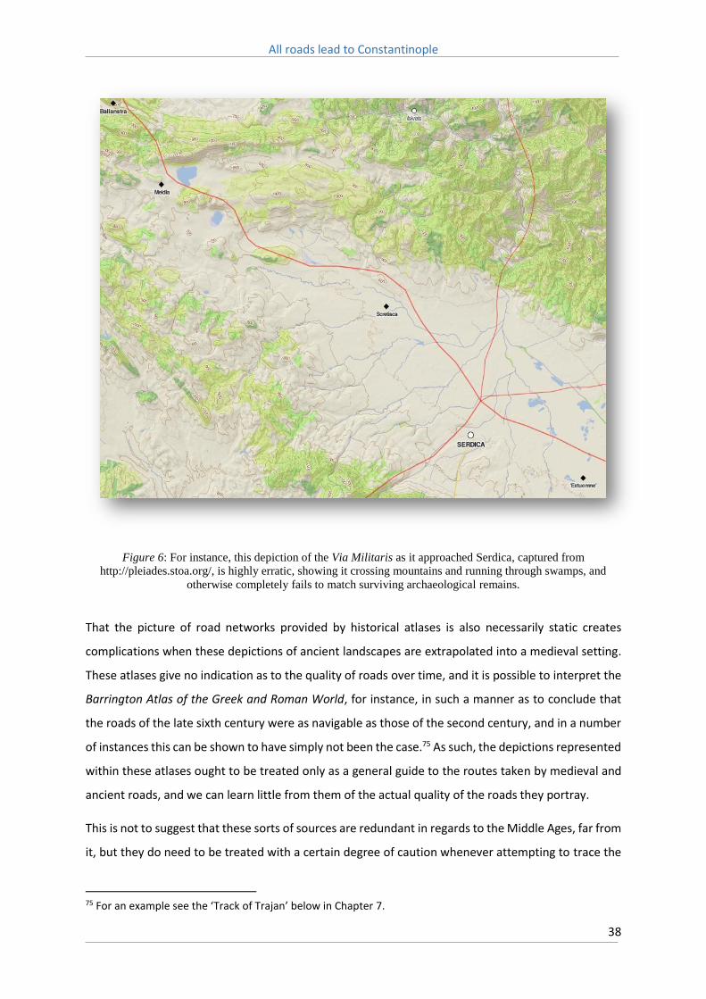
All roads lead to Constantinople
38
Figure 6: For instance, this depiction of the Via Militaris as it approached Serdica, captured from
http://pleiades.stoa.org/, is highly erratic, showing it crossing mountains and running through swamps, and
otherwise completely fails to match surviving archaeological remains.
That the picture of road networks provided by historical atlases is also necessarily static creates
complications when these depictions of ancient landscapes are extrapolated into a medieval setting.
These atlases give no indication as to the quality of roads over time, and it is possible to interpret the
Barrington Atlas of the Greek and Roman World, for instance, in such a manner as to conclude that
the roads of the late sixth century were as navigable as those of the second century, and in a number
of instances this can be shown to have simply not been the case.75 As such, the depictions represented
within these atlases ought to be treated only as a general guide to the routes taken by medieval and
ancient roads, and we can learn little from them of the actual quality of the roads they portray.
This is not to suggest that these sorts of sources are redundant in regards to the Middle Ages, far from
it, but they do need to be treated with a certain degree of caution whenever attempting to trace the
75 For an example see the ‘Track of Trajan’ below in Chapter 7.

All roads lead to Constantinople
39
route of Roman roads, and it is likewise dangerous to assume that the medieval road network was an
exact mirror of the Roman. Such resources are not attempting to provide a complete picture of the
medieval or ancient worlds at a local scale, as this is often impossible owing to the scarcity of reliable
data. As opposed to pursuing a dedicated ‘scientific’ approach, the primary goal is to instead represent
what information is currently available in a manner that is readily accessible, and can furthermore be
improved upon in the future as more material is uncovered. In this respect these web-based
gazetteers, as well as more traditional historical atlases, play an important role in combining history
and geography as fields of enquiry, and despite their limitations enable greater co-operation between
historians and geographers.76
One alternative approach to determining the likely routes of historical road networks at a local level
is through the application of predictive modelling. There are a number of different modelling
techniques that can be utilised, with perhaps the most common being that of least-cost analysis, which
ranks probable routes based on accumulated cost, with costs usually reflecting time and gradients, i.e.
which route was the shortest and required the lowest expense of energy.77 Popović has demonstrated
how existing archaeological and literary sources, when further informed through the use of
Geographical Information Systems (GIS) can lead to a more nuanced understanding of historical
transport routes. Such an approach is dependent on a number of factors, not the least being a known
starting and finishing point, and a local topography that does not allow for infinite variables of possible
routes, such as a flat open plain.78
The use of satellite imaging tools vastly enhances the range of what can be achieved through
landscape analysis, but itself contains inherent limitations. Such approaches can prove surprisingly
fruitful, especially where the routes of modern infrastructure networks can be shown to mirror those
of antiquity through the location of associated historical landmarks. However at other times it is overly
reliant on the assumption that the landscape of the medieval world can be identified within the
modern. This can lead to dangerous geographical assumptions being drawn, particularly owing to large
changes that have occurred in the modern environment owing to such processes as deforestation,
erosion, and the damming of major river systems.
The application of such tools is therefore still being refined through experience gained by their
practical use. As GPS data collection, via such techniques as airborne and remote sensing satellite
76 Baker, Geography and History: bridging the divide, p. 205. 77 On alternate approaches see G. Bellavia, ‘Predicting communication routes’, in J. Haldon ed., General Issues in the Study of Medieval Logistics: sources, problems and methodologies (Boston, 2006). 78 M. Popović & J. Jubanski, ‘On the function of "least-cost path" calculations within the project Tabula Imperii Byzantini (TIB) of the Austrian Academy of Sciences: a case study on the route Melnik-Zlatolist (Bulgaria)’, Anzeiger der philosophisch-historischen Klasse der Österreichischen Akademie der Wissenschaftern, 145 (2010).

All roads lead to Constantinople
40
imagery, becomes both even more refined (in terms of resolution) and cost effective, the possibilities
available to historians engaged in landscape analysis are increasing exponentially.79
3.3: Literary Sources
Amongst the earliest written sources that deal with the Balkan Peninsula are Ptolemy’s Geographia,
which outlines many of the main cities the Via Militaris would later come to connect,80 and Herodotus’
description of the Thracian tribes and the campaign of Darius to subdue the Scythians.81 From these
descriptions it appears likely that the route that would come to be followed by the Via Militaris was
already well known in antiquity. Indeed it is notable that Ptolemy mentions not only the large cities
the future route would one day come to encompass, but also some of the smaller towns such as Arzus
and Druzipara.82 Amongst Roman authors Ammianus Marcellinus offers detailed descriptions of the
geography of ancient Thrace.83 Although not directly applicable to the Via Militaris, the journeys of
Theophanes in the eastern provinces of the Roman Empire, thought to have occurred in either 322 or
323, provide useful insights into how the road network operated in this region, and in particular the
Roman post system.84
Of particular value is the Codex Theodosianus, which contains no less than 66 pronouncements on the
operation of the cursus publicus, the post system operated by the Roman Empire. These texts cover
the sorts of abuses that the system was subjected to, covering mistreatment of animals, the proper
loading of wagons, provision of fodder, and so on.85 Furthermore the Codex contains a number of
79 For discussion on the potential future applications of airborne and satellite based imagery for historical landscape recreation see S. M. Wilkes, ‘Filling the gap: supporting landscape investigation’, in J. Haldon ed., General Issues in the Study of Medieval Logistics: sources, problems and methodologies (Boston, 2006). For a thorough overview on the current state of research in this field see M. Popović, ‘Are the historical geography of the Byzantine Empire and digital humanities a contradiction per se?’, Bulgaria Mediaevalis, 3 (2012), whilst for an introduction to GIS and its employment see P. Burrough & R. A. McDonnell, Principles of Geographical Information Systems (Oxford, 1998). 80 Claudius Ptolemy, Geographia, trans. E. L. Stevenson, Claudius Ptolemy, The Geography (Dover, 1991), p. 83-5. 81 See D. Boteva, ‘Re-reading Herodotus on the Persian Campaigns in Thrace’, in R. Rollinger et al eds., Herodot und das Persische Weltreich, Akten des 3. Internationalen Kolloquiums zum Thema “Vorderasien im Spannungsfeld klassischer und altorientalischer Überlieferungen“, Innsbruck, 24.–28. November 2008 (Wiesbaden, 2011). 82 Claudius Ptolemy, Geographia, p. 85. 83 Ammianus Marcellinus, Rerum gestarum libri, trans. J. C. Rolfe, Ammianus Marcellinus Vol. 1-3 (Cambridge, 1948-52). 84 Theophanes, The Journey of Theophanes; travel, business and daily life in the Roman east, trans. J. Matthews (Boston, 2006). 85 Codex Theodosianus, trans. C. Pharr, The Theodosian code and novels and the Sirmondian constitutions: a translation with commentary, glossary and bibliography (New York, 1969).

All roads lead to Constantinople
41
declarations relating to the responsibility of road construction and repair. From these it can be
deduced that in the empire of the fourth century it was the duty of the provincial prefects and
landowners to maintain local road networks, with the necessary work the responsibility of local
citizens. A pronouncement to the Praetorian Prefect, Asclepiodotus, states that, ‘no class of man, by
merit of any high rank or veneration, shall be exempt from the construction and repair of roads and
bridges.’86 The Novellae of Justinian indicates that in the sixth century the state continued to apply the
same approach towards road construction and maintenance in the provinces.87
Detailed information of the Via Militaris’ route and surface can sometimes be gleaned from Byzantine
hagiographies, in particular of St Alexander of Rome, which makes mention of several stations along
the route in the late third century, and that of Blaise of Amorion in the late ninth.88 Beginning in the
eleventh century descriptions of the route from the perspective of pilgrims who were journeying to
the Holy Land, such as the great German Pilgrimage of 1064-589 or Henry the Lion’s pilgrimage in 1172,
become available.90 Even then, though, we do not possess detailed guidebooks for the journey, such
as existed for those who made the pilgrimage to Santiago in Spain, which is surprising considering the
volume of pilgrim traffic that made use of this route in the eleventh and twelfth centuries.91
Another important source, particularly for the existence of settlements and roadside stations along
the route, and the military units attached to them, is the Notitia Dignitatum, which lists several
thousand offices throughout the entirety of the Eastern and Western Imperial administrative
organisations.92 It is thought to have been compiled in either the late fourth or early fifth centuries,
and modern compilations are derived from a sixteenth century source. The Balkans, in particular, are
comprehensively covered and it therefore provides an invaluable overview of the military
administration of the region as it existed under Roman rule in the fourth century. Usage of this
document is, however, problematic, largely as the context for its creation is unclear, and the highly
ordered bureaucratic world it depicts may have never actually wholly existed in reality.93
86 Codex Theodosianus, p. 432. 87 See Chapter 7 below. 88 For the route taken by Blaise of Amorion see E. Malamut, Sur la route des saints byzantins (Paris, 1993), p. 258-60. 89 Annales Altahenses Maiores, trans. J. Brundage, The Crusades: a documentary survey, (Milwaukee, 1962). 90 Arnold of Lübeck, Arnoldi Chronica Slavorum, ed., J. M. Lappenberg, Scriptores rerum Germanicarum in usum scholarum ex Monumentis Germaniae Historicis recudi fecit (Hannover, 1868). 91 K. N. Ciggaar, Western Travellers to Constantinople: The West and Byzantium, 962-1204: cultural and political relations (Leiden, 1996), p. 29. 92 Notita Dignitatum trans. W. Fairley, Notitia Dignitatum or Register of Dignitaries, in Translations and Reprints from Original Sources of European History (Philadelphia, 1899). 93 M. Kulikowski, ‘The "Notitia Dignitatum" as a Historical Source’, Historia: Zeitschrift für Alte Geschichte, 49 (2000), p. 359.

All roads lead to Constantinople
42
3.4: Taktika
The Byzantine Empire possessed a rich literary tradition of military manuals, or Taktika, one that
flowered particularly during the tenth and eleventh centuries. These works were highly influenced by
the Roman strategist Vegetius, whose Epitoma Rei Militaris was widely read throughout the medieval
world. The examples of army organisation, training, order of march and camp construction provided
by Vegetius were closely followed in Byzantine texts that sought to adapt these examples to the
realities of contemporary warfare, in particular to a state that lacked the wealth and manpower of the
Roman empire at its height.
A deficiency in manpower resources compared to their enemies on both eastern and western fronts
became a defining feature of Byzantine warfare from the seventh century onwards.94 This
disadvantage can be traced in the military manuals produced during this era, which placed great
emphasis on the importance of intelligence, drill, and manoeuvre. The Emperor Maurice defined this
adaption in his Strategikon, with its intense focus on the discipline, organisation and armament of
Byzantine armies.95 Maurice’s work was written without literary pretension, and intended as a
practical guide for the officer in the field. Indeed, so comprehensive was it in regards to campaign
organisation that the tenth century Taktika of Leo VI contains little in the way of new thinking on this
topic.96
A late tenth century treatise on skirmish tactics and guerrilla warfare on the empire’s eastern frontiers,
known as De velitatione bellica, is believed to have possibly been penned by Emperor Nicephorus II
Phocas himself.97 The work clearly exhibits an intimate familiarity with the practical challenges posed
by campaigning against Muslim adversaries. In particular it pays close attention to how the unique
geography of the eastern frontier could be used to the advantage of an observant Byzantine
commander, especially in regards to the setting of ambushes.
Yet even a distinguished and experienced general of the empire’s eastern frontiers, such as
Nicephorus II, still regarded a prospective campaign in the Balkans with an enormous degree of
trepidation, and this forms the focus of another military manual, known as the Taktikon Vari after its
94 The number of soldiers that Byzantium could call upon has been the subject of extensive debate. See M. Whittow, The Making of Byzantium, 600-1025 (Berkeley, 1996), p. 181-193, and J. Haldon, Warfare, State and Society in the Byzantine World, 565-1204 (London, 1999), p. 99-106. 95 Maurice, Strategikon, trans. G. T. Dennis, Maurice’s Strategikon: handbook of Byzantine military strategy (Philadelphia, 1984). 96 Maurice, Strategikon, p. xiii. 97 De velitatione bellica, trans. G. T. Dennis, Three Byzantine Military Treatises (Washington D.C., 1985).

All roads lead to Constantinople
43
editor Rezső Vári, and dated to the late tenth century.98 The authorship of this treatise is unclear,
however it has been argued that it was the work of Nicephorus Ouranos, Domestikos of the West
during the reign of Basil II. Ouranos was an experienced campaigner, and was entrusted with
prosecuting the war against the Bulgarians when Basil II was forced to devote his attention to the
eastern frontier between 995 and 999.99
The work is clearly addressed to the emperor personally, in the form of providing advice regarding any
future campaign to be undertaken in the Balkans. It focuses a great deal of attention, for instance, on
how mountain passes should be approached, how the order of march should change in such confined
areas, and what precautions needed to be taken before pitching camp to ensure it could be defended
in event of attack. In this context the text appears very much like the sort of advice an experienced
and trusted general, such as Ouranos, could have provided to a relatively young and inexperienced
emperor who, moreover, had recently suffered a devastating and humiliating defeat in the exact same
conditions. After his defeat at the Gates of Trajan in 987, it was not till 991 that Basil II was able to
retake the offensive against the Bulgarians, and, aged only 33, he was arguably still in a position to
justifiably receive such advice.100
3.5: Byzantine Sources
Other than within these military treatises, references to the geography of the Balkans within Byzantine
sources are few. This can be largely ascribed to the typically Constantipolitan orientation of Byzantine
literature, where matters pertaining to the provinces were typically given scant regard by Byzantine
scholars, or mentioned only in passing.101 We are therefore largely reliant on the works of authors
who resided outside of Constantinople itself, such as Theophylact of Ohrid, Michael Choniates, and
Eustathius of Thessalonica, for depictions of life outside of the capital. And yet even in these works
references to roads in particular are few, if not non-existent. Similarly, whilst regional maps are
immensely useful in recreating the route of medieval road networks, aside from notable exceptions
98 Taktikon Vari, trans. G. T. Dennis, Three Byzantine Military Treatises (Washington D.C., 1985). 99 E. McGeer, ‘Tradition and Reality in the Taktika of Nikephoros Ouranos’, Dumbarton Oaks Papers, 45 (1991), p. 129. 100 G. T. Dennis, Three Byzantine Military Treatises (Washington D.C., 1985), p. 241. 101 G. Ostrogorsky, ‘Byzantine cities in the Early Middle Ages’, Dumbarton Oaks Papers, 13 (1959), p. 47.

All roads lead to Constantinople
44
such as the Madaba Mosaic, such maps were rarely produced in Byzantium, and those few world maps
which do exist are lacking in sufficient detail with which to reconstruct the medieval Balkans.102
The most useful references to the Via Militaris within Byzantine works are therefore generally to be
found in Theophylact Simocatta’s Historiae, the Chronicle of Theophanes the Confessor, Leo the
Deacon’s Historiae and the Alexiad of Anna Comnena. Whilst in all of these works, as well as others of
the period, direct references to the actual road are few, they all contain information of cities and
locations along its route that, if not drawn from first-hand experience, were most likely drawn from
contemporary sources. The Alexiad, for instance, refers to the ‘highroads’ that were swamped by
numerous crusaders travelling to the capital during the passage of the First Crusade, but otherwise
detail is generally lacking.103
It is curious, however, that even those authors who definitely had made use of the Via Militaris at one
point, such as Leo the Deacon during Basil II’s aborted campaign against Serdica, and Nicetas
Choniates whilst governing the city of Philippopolis, make no specific mention of its existence. The
most likely reason is because a road was such a mundane subject, these authors felt no compulsion
to do so. On the other hand, if the road had proven enormously difficult to traverse, it’s much more
likely to have warranted comment. One obvious conclusion to draw, therefore, is that the Via Militaris
was generally in a good state of repair, at least along those sections which these authors travelled,
and therefore thoroughly unremarkable.
3.6: Crusader Sources
Instead it is the crusader histories of the late eleventh and twelfth centuries that prove to be the most
valuable sources in terms of detailed descriptions of not only the route of the Via Militaris, but also of
the quality of the road’s surface. Until the beginning of the thirteenth century, and the Fourth Crusade,
the overland route to the Holy Land was preferred, and the majority of participants of the First
Crusade, almost the entirety of the Second, and the largest single contingent of the Third, all made
use of the Via Militaris on their journey to Constantinople, and hence onwards to the Holy Land.
102 E. Savage-Smith, ‘Maps and Trade’, in M. M. Mungo ed., Byzantine Trade, 4th-12th centuries: the archaeology of local, regional and international Exchange. Papers of the Thirty-eighth Spring Symposium of Byzantine Studies, St John's College, University of Oxford, March 2004 (Oxford, 2009), p. 18. 103 Anna Comnena, Alexiad, trans. E. Dawes, The Alexiad of the Princess Anna Comnena: being the history of the reign of her father, Alexius I, Emperor of the Romans, 1081-1118 A.D. (London, 1928), p. 249.

All roads lead to Constantinople
45
Those who participated in the First Crusade took one of either three routes: after crossing the Straits
of Otranto between Bari and Dyrrachium taking the Via Egnatia to Constantinople, or following the
course of the Danube as far as Belgrade and then travelling along the Via Militaris. The third and final
route was the curious itinerary pursued by Raymond of Toulouse along the Adriatic coast, before
finally linking up with the Via Egnatia (Figure 7). Godfrey of Bouillon, who took the Via Militaris, led a
host that numbered amongst the largest of all those that departed to the East, and along with the
‘People’s Crusade’ that preceded it, the expense (and danger) of the crossing at Bari probably
influenced the decision to take the landward route.

All roads lead to Constantinople
46
Figure 7: Itineraries of the First Crusade. From J. France, Victory in the East: a military history of the First
Crusade (New York, 1994), p. 89.

All roads lead to Constantinople
47
It is interesting that the major participants of the Second Crusade, the hosts led by Louis VII and Conrad
II, both opted to take the overland route along the Via Militaris. For Conrad this was the logical choice
as from Central Germany this was the most direct route to Constantinople. Yet even though Louis was
offered free passage across the Straits of Otranto by King Roger II of Sicily, he too preferred to take
the overland route.104 This decision was likely influenced by numerous factors, such as avoiding the
need to negotiate the passes of the Alps, and the inherent dangers involved in crossing the Straits, as
well, perhaps, by a desire to imitate the journey of Godfrey of Bouillon. Yet likely the single largest
reason was, considering that the host was accompanied by large numbers of wagons, the Via Militaris
represented a faster and easier voyage for the crusaders, avoiding potential delays in transporting
baggage across the Straits, and then making the difficult journey across the Pindus Mountains.105
The largest single contingent of the Third Crusade, led by Frederick Barbarossa, likewise chose to take
the overland route to Constantinople, again, no doubt influenced by the large numbers of wagons that
accompanied the host. This proved to be the last crusader force that would choose to make the
overland journey to the Holy Land, and from this point onwards travel by sea became the norm, a shift
that was undoubtably influenced by advancements in naval technology made in the late twelfth
century.106
The overland route along the Via Militaris, therefore, was undoubtedly the preferred means of
travelling to Constantinople during the crusading period until advances in naval technology rendered
it redundant. Equally notable is that the ‘Great German Pilgrimage’ of 1064-5, which travelled with a
considerable baggage train, also chose this road. The popularity of the Via Militaris, particularly in
comparison to the Via Egnatia, was most likely the consequence of a growing familiarity with the
route, and the suitability of the road for conveying large numbers of wheeled vehicles, and the sources
that cover these expeditions are therefore uniquely valuable in regards to the condition of the
medieval Via Militaris.
104 Odo of Deuil, De profectione Ludovici VII in orientem, trans. V. G. Berry (New York, 1948), p. 11. It is not clear if Roger II was offering to transport Louis VII’s host all the way to the Holy Land, or merely across the straits, see J. France, ‘Logistics and the Second Crusade’, in J. Pryor ed., Logistics of warfare in the age of the Crusades: proceedings of a workshop held at the Centre for Medieval Studies, University of Sydney, 30 September to 4 October 2002 (Aldershot, 2006), p. 79-80. 105 A. Murray, ‘Roads, bridges and shipping in the passage of crusade armies by overland routes to the Bosporus 1096-1190’, in K. Holzner-Tobisch, T. Kuhtreiber & G. Blaschitz eds., Die Vielschichtigkeit der Straße: Kontinuität und Wandel in Mittelalter und früher Neuzeit (Vienna, 2012), p. 189. 106 It is, however, difficult to determine what specific technological advances prompted this transformation. For more on this topic see J. Pryor, Geography, technology and war: studies in the maritime history of the Mediterranean, 649–1571 (Cambridge, 1988).

All roads lead to Constantinople
48
The most valuable crusading source of the First Crusade in regards to the Via Militaris is the Historia
Hierosolymitanae expeditionis of Albert of Aachen.107 Albert did not himself participate in the crusade
but his record of it, which was written no earlier than 1102, was drawn from first hand sources. His
account is unique in that it provides invaluable detail of the ‘People’s Crusade’ of Peter the Hermit,
and the Crusade of 1101. Although Albert of Aachen is scathing in his contempt for the participants of
the ‘People’s Crusade’, he provides enough information of their journey that it is possible to recreate
their itinerary in some detail. This information has led scholars to conclude that far from the
disorganised rabble that Albert depicts, Peter the Hermit’s force must have been a highly organised
one, as it was able to maintain a more than respectable rate of march of 17.7 miles per day over the
duration of the journey to Constantinople.108
For the Second Crusade the De profectione Ludovici VII in Orientem, written by Odo of Deuil, a monk
of the abbey of St Denis, is an extremely useful source. Odo became chaplain to Louis VII of France
and accompanied him on his crusade to the Holy Land, from December 1145 till the arrival of what
remained of the French army at Antioch in the spring of 1148. Odo was virulently anti-Byzantine in his
outlook, and whilst this definitely colours his text from an objective viewpoint, the observations he
makes during the journey suggests that his factual reliability was based on solid foundations.109 Odo’s
account provides a surprising amount of information on the route to Constantinople, including
remarks on the quality of the road surface, the time in days it took to reach each city along its length,
and the sorts of wagons that accompanied the force. It is believed that he intended his work to act as
advice for future crusaders, and to explain the reasons why this particular crusade had failed.110 This
makes his history an invaluable text in regards to the logistics of crusading, and medieval logistics in
general.
In relation to the Third Crusade, the anonymous Historia de Expeditione Friderici Imperatoris offers a
great deal of information on the Via Militaris.111 This text is traditionally attributed to a certain
Ansbert, although this name was added only to a later thirteenth century copy, with the original text
107 Albert of Aachen, Historia Ierosolimitana, trans. S. B. Edgington, Historia Ierosolimitana: history of the journey to Jerusalem (Oxford, 2007). 108 J. Nesbitt, ‘The rate of march of Crusading armies in Europe: A study and computation’, Traditio, 19 (1963), p. 180. In comparison the supposedly better organized force led by Godfrey managed only 15.5 miles per day. 109 H. Mayr-Harting, ‘Odo of Deuil, the Second Crusade, and the Monastery of Saint-Denis’, in M. A. Meyer ed., The Culture of Christendom: essays in medieval history in commemoration of Denis L.T. Bethell (London, 1993), p. 227. 110 France, ‘Logistics and the Second Crusade’, p. 78-9. France, however, argues that Odo was happy to manipulate facts to some extent, as will be readily seen when it comes to computing travel times between locations. 111 Historia de Expeditione Friderici Imperatoris, trans. G. A. Loud, The Crusade of Frederick Barbarossa: the history of the expedition of the Emperor Frederick and related texts (Leeds, 2010).

All roads lead to Constantinople
49
ascribed only to ‘an Austrian cleric who was present at this time’. It is argued that this text must have
been completed no later than 1200, and is therefore a composite text that drew on several first-hand
sources, with Ansbert possibly being the last contributor to it.112 Certainly the comprehensive
description it provides of the crusading expedition of 1189-90, in particular its numerous references
to specific details along the crusaders march, such as accounts of disturbances with local populations,
must have been that of an eyewitness.
A further contemporary text, a diary, or memoria, of a crusader named Tageno, is also incorporated
into the Historia de Expeditione. Tageno accompanied the crusaders and provided detailed
descriptions of Barbarossa’s passage across the Balkans and Anatolia, as well as observations on local
geography and climate, before his death in Syria in 1190. It is unclear, however, to what extent the
compiler of the Historia de Expeditione relied upon the diary of Tageno. The original manuscript is lost,
and is largely only known through another composite source of the Third Crusade, that compiled by
Magnus of Reichersberg.113 The relationship between the Historia de Expeditione and Tageno,
therefore, is difficult to determine. Loud argues that whilst the Historia copies Tageno’s diary verbatim
for a period of three and a half weeks preceding the death of Barbarossa (between May 16 to June 9,
1190), stylistic differences between the Historia and the text preserved by Magnus of Reichersberg
suggest that the compiler of the Historia was not overly reliant on Tageno’s work, and indeed until the
crossing of the Bosporus these two narratives can be considered as being essentially independent
from one another.114
An additional source for the crusade is the Historia peregrinorum, which survives only from a
thirteenth century manuscript, and is thought to have been based on an early, now lost, version of
the Historia de Expeditione.115 The text contains numerous alterations to that of the Historia de
Expeditione, particularly in regards to chronology, but also contains observations that suggests it was
derived from an eyewitness account of the crusade, perhaps that of a Swabian monk of the Salem
monastery where the manuscript was written.116 The differences in chronology, again, are of particular
interest in recreating Barbarossa’s itinerary and will be dealt with below.
112 Loud, The Crusade of Frederick Barbarossa, p. 2-5 113 Magnus of Reichersberg, The Chronicle of Magnus of Reichersberg, trans. G. A. Loud, The Crusade of Frederick Barbarossa: the history of the expedition of the Emperor Frederick and related texts (Leeds, 2010). 114 Loud, The Crusade of Frederick Barbarossa, p. 4-6. 115 Historia peregrinorum, trans. G. A. Loud, The Crusade of Frederick Barbarossa; The history of the expedition of the Emperor Frederick and related texts (Leeds, 2010). 116 Loud, The Crusade of Frederick Barbarossa, p. 7-8.

All roads lead to Constantinople
50
A final source is the Gesta Federici I. Imperatoris in Expeditione Sacra.117 This is a brief anonymous
history of the crusade of Frederick Barbarossa, compiled shortly after the conclusion of the expedition,
and likely before the year 1200. Its relationship with both the Historia peregrinorum and the Historia
de Expeditione, however, is unclear.118
3.7: Early Modern Sources
The Via Militaris, and the ruins that marked its route, captured the fascination of numerous late
medieval and Early Modern European travellers and modern scholarship is indebted to their
observations. Indeed the region attracted so many travellers that only a few of the most notable can
be mentioned here. Perhaps the most valuable contribution is that provided by the Italian naturalist,
Luigi Marsigli, who, in the early eighteenth century, published a six volume series, the Danubius
Pannonico-mysicus, which studied both the historical and natural environment of the Balkan
Peninsula.119 The second volume of this series contains numerous illustrations of surviving monuments
in the area, and provides both a depiction of the ruins of the Gates of Trajan, and the orientation of
the Via Militaris and the neighbouring fortifications as it navigated the Succi Pass.
Maps of the region produced in this era also provide useful information as to the route of the Via
Militaris. Of particular value is a map of European Turkey created in 1853 by the German cartographer
Heinrich Kiepert.120 As well as producing compendious historical atlases, Kiepert conducted numerous
trips into the Ottoman Empire during the mid-nineteenth century and provided extremely detailed
depictions of the contemporary road network in the Balkans. Maps such as Kiepert’s are invaluable
for showing the route followed by Ottoman roads, in particular in negotiating the narrow mountain
passes along the Via Militaris (Figure 8).
117 Gesta Federici I. Imperatoris in Expeditione Sacra, trans. G. A. Loud, The Crusade of Frederick Barbarossa: the history of the expedition of the Emperor Frederick and related texts (Leeds, 2010). 118 E. Eickhoff, Friedrich Barbarossa im Orient: Kreuzzug und Tod Friedrichs I (Tübingen, 1977), p. 191. 119 L. F. Marsigli, Danubius Pannonico-mysicus: observationibus geographicis, astronomicis, hydrographicis, historicis, physicis, perlustratus et in sex tomos digestus (Amsterdam, 1726). 120 H. Kiepert, General-Karte von der europäischen Türkei: nach allen vorhandenen Originalkarten und itinerarischen Hülfsmitteln (Berlin, 1853).

All roads lead to Constantinople
51
Figure 8: Section of the Ottoman Via Militaris as it passes through the Gates of Trajan (Kapulu Dervend). From
Kiepert, General-Karte von der europäischen Türkei: nach allen vorhandenen Originalkarten und
itinerarischen Hülfsmitteln.
In 1716 Lady Mary Wortley Montagu travelled to Constantinople as the wife of the English ambassador
to the Ottoman court, Edward Wortley Montagu. Over the course of a large corpus of letters written
during her journey she described, often in great detail, the minutiae of life in the Ottoman Empire,
and this included observations of the route taken to Constantinople, the quality of the road, the towns
and cities that lay along its length, and the dangers encountered.121 Similar observations are to be
found in the correspondence of the mid-sixteenth century Habsburg ambassador to the Ottoman
court, Ogier Ghiselin de Busbecq,122 as well as the memoirs of the Bohemian merchant Hans
Dernschwam.123 The account of the French Ambassador, Gabriel d’Aramon, who travelled to the
Ottoman Court in 1547, contains some interesting observations, as do the letters of the sixteenth
century Croatian diplomat, Antun Vrančić.124 Even earlier, in 1432, the French pilgrim (and spy)
121 Lady M. W. Montagu, The letters and works of Lady Mary Wortley Montagu: edited by her great-grandson, Lord Wharncliffe; with additions and corrections derived from original manuscripts, illustrative notes, and a memoir by W. Moy Thomas (London, 1887). 122 O. Ghiselin de Busbecq, Legationis Turcicae Epistolae quatuor, trans. E. S. Forster, Turkish letters of Ogier Ghiselin de Busbecq, Imperial Ambassador at Constantinople. 1554-62 (Oxford, 1927). 123 H. Dernschwam, Ein Fugger-Kaufmann im Osmanischen Reich: Bericht von einer Reise nach Konstantinopel und Kleinasien 1553 – 1555, ed., H. Hattenhauer & U. Bake (Frankfurt am Main, 2012). 124 J. Chesneau, Le voyage de Monsieur d'Aramon, ambassadeur pour le Roy en Levant: Escript par noble homme Jean Chesneau, publie et annote par Ch. Schefer (Paris, 1887), A. Vrančić, Monumenta Hungaria Historica VI. Scriptores. ed., L. Szalay (Pest, 1860).

All roads lead to Constantinople
52
Bertrandon de la Brocquière, returned to Europe via Constantinople over the Via Militaris, and
provided vivid and detailed descriptions of the regions he traversed, his intention being to both spy
out the land and to excite Western lords into pursuing another crusade against the Turks.125 As such
his work contains careful observations of the fortified towns in each region and the number of men
garrisoned in them, and of the road and its condition.
In the nineteenth century the Balkans continued to attract the attention of Western scholars, a
process that was only accelerated by the disintegration of Ottoman control over the region, the
emergence of new European states, and the development of new rail linkages, in particular the Paris
to Istanbul route. However no formal schools of geography developed in the region during this time,
and as a consequence most of the academic impetus continued to come from outside of the Balkans
proper.126 A few examples are the French geographer Guillaume Lejean, who conducted numerous
studies, between 1857 and 1870, of the Balkan Peninsula, and extensively mapped the demography
of the region,127 and the British travellers, and women’s rights advocates, Georgina Muir Mackenzie
and Paulina Irby, who, in 1877, published in two volumes memoirs describing their experiences of
travelling in the Balkans, which provides invaluable insights into rural life.128 The geographical
handbooks published by the British Admiralty Naval Intelligence Division in the early twentieth century
also contain thorough overviews of the climate, geography and transport infrastructure of the Balkan
Peninsula.129 The US Army Map Service series of topographical maps are likewise a valuable resource
for depictions of the transport infrastructure of the pre-modern Balkans.130
Another nineteenth century European scholar who was attracted by the research opportunities to be
found in the newly opened Balkans, Konstantin Jireček, provided what remains today the defining
study of the Via Militaris. Jireček, a Czech historian and diplomat who devoted numerous studies to
the history of the Balkan Peninsula and the Slavic people, published in 1877 a monograph tracing the
route of the road, Die Heerstrasse von Belgrad nach Constantinopel und die Balkanpasse: eine
historisch-geographische studie. Jireček stated that the importance of the road spread beyond just the
125 B. de La Brocquière, Le Voyage d'Outremer, trans. T. Johnes., The travels of Bertrandon de la Brocquière, counsellor & first esquire-carver to Philippe le Bon, duke of Burgundy, to Palestine and his return from Jerusalem overland to France, during the years 1432 & 1433 (Wales, 1807). 126 F. W. Carter ed., An Historical Geography of the Balkans (London, 1977), p. 10. 127 G. Lejean, Ethnographie de la Turquie d'Europe (Gotha, 1861). 128 G. M. Mackenzie & P. Irby, Travels in the Slavonic provinces of Turkey-in-Europe (London, 1877). 129 For instance see, Great Britain Naval Intelligence Division, A handbook of Bulgaria. Compiled by the Geographical section of the Naval intelligence division, Naval staff, Admiralty (London, 1920). 130 All US Army Maps used in this thesis are sourced from the Army Map Service Topographic Map Series of the University of Texas Perry-Castañeda Library Map Collection, http://www.lib.utexas.edu/maps/ams/ (accessed, 22/1/2016).

All roads lead to Constantinople
53
immediate Balkan Peninsula, claiming that ‘for a long time it was the only mainland route between the
Orient and Occident’ and that the important role it had played during the invasions of Goth, Huns,
Avars and Slavs, as well as the Crusades, not to mention within Byzantine and Ottoman history, gave
the route a world-wide historical significance (weltgeschichtliche Rolle).131
Whilst the influence of his ground breaking work is without doubt, it is not without some limitations.
Jireček based his interpretation of the route primarily on the use of classical itineraria and his own
observations of remains of the road’s surface and ruins along its length. Unfortunately on occasion
Jireček confused the route of the Roman road with that of the newer Ottoman, particularly between
Philippopolis and Adrianople, where for a long stretch the Roman road ran to the north of the Maritsa
River, yet Jireček continued to trace its course to the south of the river, confusing Thracian and
Ottoman remains as those of Roman road stations. Jireček himself admitted in his introduction that
he was not able to verify all of the source material himself, and could only provide a general depiction
of the road, intending for his work to act as a basis for further research.132
3.8: Contemporary Sources
That Jireček’s work remains the pre-eminent study of the route of the Via Militaris in itself illustrates
how lacking in scope contemporary geographical surveys of the Balkan Peninsula have been.
Comprehensive studies of the historical record of the region have largely focused on the remains of
the Roman period, such as V. Velkov’s, The cities in Thrace and Dacia in Late Antiquity,133 M. Biernacka-
Lubanska’s, The Roman and early-Byzantine fortifications of lower Moesia and northern Thrace,134 and
R. Hoddinott’s Bulgaria in Antiquity.135 The Tabula Imperii Romani series has attempted a more
ambitious survey of the entire Roman world, however it is still, to date, incomplete, and in addition it
could be argued that it suffers from the same weaknesses that hinder the Tabula Imperii Byzantini
series, i.e. an over-reliance on an at times patchy archaeological record.
Beyond archaeological surveys much has been written on the scope and mechanics of medieval trade,
the most valuable perhaps being the surveys of medieval trade networks, based upon extensive
131 Jireček, Die Heerstrasse von Belgrad nach Constantinopel und die Balkanpasse, p. III. 132 Jireček, Die Heerstrasse von Belgrad nach Constantinopel und die Balkanpasse, p. IV. 133 V. Velkov, The cities in Thrace and Dacia in Late Antiquity (Amsterdam, 1977). 134 M. Biernacka-Lubanska, The Roman and early-Byzantine fortifications of lower Moesia and northern Thrace (Warsaw, 1982). 135 R. Hoddinott, Bulgaria in Antiquity: an archaeological introduction (London, 1975).

All roads lead to Constantinople
54
research of primary sources, presented by Robert Lopez.136 But, again, comparatively little attention
generally has been given in particular to roads and road transport in the Middle Ages, and given that
evidence for the existence of medieval roads is so sparse, the road networks of this period are often
regarded as a brief, relatively unimportant, interlude between the transport networks of the Roman
era and that of the Early Modern period.137 Wendel’s survey of the transport networks of northern
Thrace is particularly useful in this regard in that it is one of the few such works that expands the
temporal scope of the study beyond the reign of Justinian.138
As a result, the works of Jireček and Konrad Miller remain the best known surveys of the Via Militaris.
A number of other surveys, including those by the Škorpil brothers, Pavel Detev and Veselin Beševliev,
contain a great deal of information about the remains of the road, along with associated stations.
Unfortunately, many of these surveys exist only in the Bulgarian language, and the author has been
indebted to the work of Dr Mitko Madzharov, whose Roman Roads in Bulgaria: contribution to the
development of Roman road system in the provinces of Moesia and Thrace provides a comprehensive
summary of the current state of research on Roman roads within the territory of modern Bulgaria. In
addition to this Madzharov provides critiques of existing interpretations, largely based on his own
fieldwork. It could be argued that Madzharov does not support a number of his own conclusions as to
the location of stations along the route of the Via Militaris with convincing original evidence, but on
the whole his methodological framework is sound, and it provides a solid foundation upon which
further study of the route of the Via Militaris can be based.
Amongst contemporary scholarship there have been few other attempts to trace the route of the Via
Militaris in its entirety, particularly as it existed in the medieval era. To cite just a few examples, the
geography of the region is briefly overviewed in Dmitri Obolensky’s The Byzantine Commonwealth,139
which also provides a lively description of a hypothetical journey along the Via Militaris, and is given
rather more attention by John Haldon in Warfare, State and Society in the Byzantine World.140
Gavro Škrivanić also provides an, albeit brief, overview of the road and its stations in F. W. Carter’s An
Historical Geography of the Balkans.141 Conversely, perhaps the most comprehensive recent study of
the relationship between the Byzantine state and the population of its Balkan provinces, Paul
136 R. Lopez, Medieval trade in the Mediterranean World: illustrative documents, translated with introduction and notes by R. Lopez, and I. Raymond (New York, 1955). 137 I. Whyte, ‘Medieval Economy and Society’, in M. Pacione ed., Historical Geography: Progress and Prospect (London, 1987), p. 110. 138 M. Wendel, Karasura. Untersuchungen zur Geschichte und Kultur des alten Thrakien: die Verkehrsanbindung in frühbyzantinischer Zeit (Langenweissbach, 2005). 139 D. Obolensky, The Byzantine Commonwealth; eastern Europe, 500-1453 (London, 1971), p. 35-38. 140 J. Haldon, Warfare, State and Society in the Byzantine World, 565-1204 (London, 1999). 141 G. Škrivanić, ‘Roman Roads and Settlements in the Balkans’, in F. W. Carter ed., An Historical Geography of the Balkans (London, 1977), p. 120-122.

All roads lead to Constantinople
55
Stephenson’s Byzantium’s Balkan Frontier, never directly outlines the geographic context in which
these relationships occurred.142 Similarly J. V. A. Fine, in The Early Medieval Balkans, devotes a mere
three pages to the geography of the region, and expresses the hope that the reader will instead
familiarise themselves with the most important features of the region, as descriptions of geography
are ‘usually boring and virtually impossible to remember.’143
Admittedly Obolensky and Stephenson in particular are primarily concerned with the cultural and
political dimensions, respectively, of interactions between the Byzantine state and its Balkan
neighbours, and so the lack of attention given to its geographical setting is understandable. Their
methods, however, are emblematic of modern historiographical approaches to the medieval Balkans,
where the geographical context is sometimes considered as having a negligible influence on the
cultural interactions that shaped the formation of the Balkan Peninsula.144 This is not to argue that
there is anything inherently wrong with these approaches, and on the contrary a focus on the cultural
and social dynamics of the region has greatly enhanced our understanding of the development of the
medieval Balkans. However, an emphasis on large scale processes at the expense of local realities, of
the macro over the micro, can have contentious consequences. One such example can be found in a
work that portends to evaluate the total scope of Byzantine strategic policy, Edward Luttwak’s The
Grand Strategy of the Byzantine Empire, which not only eschews the geographical context, but indeed
goes as far as to argue that strategic planning need not have any spatial element at all, and posits that
the movement of armies through space, ‘as in board games’, is a marginal element within it.145
In one sense this might well be true, and Byzantine strategic thought certainly encompassed a far
broader field than the movement of soldiers through space alone. If indeed a Byzantine ‘operational
code’ existed, it would have devoted as much attention to questions of diplomacy and espionage as it
did to geography and logistics. Yet for the Byzantine Empire, where warfare on both eastern and
western frontiers was a constant theme, strategy did not exist on a largely theoretical basis. Enough
soldiers would have had the practical experience of campaigning on either front to advise strategic
planners, if indeed any existed, that Luttwak’s claim that bad roads are good because they offer the
advantage of surprise, was not a sound foundation on which to base an operational policy.146
142 P. Stephenson, Byzantium's Balkan Frontier: a political study of the Northern Balkans, 900–1204 (Cambridge, 2000). 143 J. V. A. Fine, The Early Medieval Balkans: a critical survey from the sixth to the late twelfth century (Ann Arbor, 1983), p. 1. 144 For more on this argument see also D. Obolensky ‘The Balkans in the Ninth Century: barrier or bridge?’, in J. D. Howard-Johnston ed., Byzantium and the West: c. 850 - c. 1200; proceedings of the XVIII Spring Symposium of Byzantine Studies, Oxford 30. March - 1. April 1984 (Amsterdam, 1988). 145 E. Luttwak, The grand strategy of the Byzantine Empire (Cambridge, 2009), p. 420. 146 Luttwak, The Grand Strategy of the Byzantine Empire, p. 421.

All roads lead to Constantinople
56
Notably a few works have attempted to explore the history of the Byzantine Empire in terms of its
geographical context, including Philippson’s Das Byzantinische Reich als geographische Erscheinung,147
and Demetrukas’ Reisen und Verkehr im Byzantinischen Reich.148 However no work has, as of yet,
sought to emulate Jireček’s approach in both tracing the route of the Via Militaris and arguing for its
key role in the historical development of the Balkan Peninsula. This is perhaps a consequence of the
region’s tortured political history throughout much of the twentieth century. For much of this period,
and particularly after the Second World War, trans-national travel in the Balkans was difficult, and
between Bulgaria and Yugoslavia an impossibility. Consequently, study of the historical remains of the
region was largely the preserve of either native historians or those from elsewhere in Eastern Europe,
and often tended to focus on high profile sites of perceived national importance, such as Preslav, Pliska
and Justiniana Prima.149
Whilst the study of Byzantine cultural history has recently seen a surge in popularity owing to easier
access to the region since the fall of the Soviet Union, Western historians have been curiously slow to
embrace the similar potential to be found in historical geography. Modern overviews of the Via
Militaris, therefore, have tended to exhibit one common weakness; an overreliance on Jireček’s
analysis of the route, which as has been show above, is flawed both in its approach and the conclusions
it draws as to the actual route followed by the road.
147 A. Philippson, Das Byzantinische Reich als geographische Erscheinung (Leiden, 1939). 148 I. Demetrukas, Reisen und Verkehr im Byzantinischen Reich vom Anfang des 6. bis zur Mitte des 11. Jahrhunderts (Athens, 1997). 149 On the development of historical archaeology in this region in the twentieth century, see Curta, ‘Medieval Archaeology in South-Eastern Europe’.

All roads lead to Constantinople
57
Chapter 4: Historiography
The cause for this absence of contemporary works that seek to emulate Jireček’s holistic approach,
outside that offered by such surveys as the TIB, can be traced to the differing historiographical
approaches that largely defined late nineteenth and early twentieth century methodology, and those
which dominate the field today. In order to understand the current state of research on a topic such
as the Via Militaris it is necessary, therefore, to briefly explore the historiographical changes that have
occurred within the field of historical geography since Jireček’s time.
One of the first prominent challengers to conventional historiographical methodology, and an
exponent of a geographically mediated approach that captured the imagination of contemporary
scholars, was the late nineteenth century German military historian Hans Delbrück. Delbrück’s four
volume Geschichte der Kriegskunst im Rahmen der politischen Geschichte outlined this new approach,
with his methods perhaps being best demonstrated with his analysis of the Battle of Marathon.150
Based largely on investigations of the site where the battle took place, and his own experiences with
contemporary forces in the field, Delbrück concluded that the numbers provided by Herodotus for the
conflict were a factual impossibility.
Herodotus claimed that the invading Persian army was comprised of 2,641,610 fighting men, and at
least as many again crew members, servants and camp followers.151 Delbrück estimated that not only
was the terrain completely incapable of accommodating such large numbers of soldiers, he also
calculated that the Persian army would have formed a marching column over 420 miles long.152 Based
on his evaluation of the battlefield, Delbrück concluded that not only had Herodotus drastically over
inflated the Persian’s numbers, but given his description of the course of the battle, Delbrück argued
that it was the Greeks who actually must have held the numerical advantage.153
Delbrück’s critique of the account of the battle provided by Herodotus may not have been original,
but the methodological manner in which he supported his arguments formed a systematic framework
by which he was able to analyze conflicts ranging from the Persian Wars to the Napoleonic Age.154
150 H. Delbrück, History of the Art of War within the framework of political history, Vol 1, trans. W. J. Renfroe (Westport, 1975). 151 Herodotus, The Histories, trans. A. De Sélincourt (Edinburgh, 1954), p. 480. 152 Delbrück, History of the Art of War within the framework of political history, Vol. 1, p. 118-120. A more modern perspective on these fanciful numbers opines that five million men would have turned all of Thrace, Macedonia and Greece into a desert, R. Kapuściński, Travels with Herodotus (New York, 2008), p. 198. 153 Delbrück, History of the Art of War within the framework of political history, Vol. 1, p. 72-81. 154 G. Craig, ‘Delbrück: The military historian’, in P. Paret ed., Makers of Modern Strategy: from Machiavelli to the Nuclear Age (Princeton, 1986), p. 334.

All roads lead to Constantinople
58
Although some of the conclusions Delbrück derived from this methodology have subsequently
attracted criticism, especially his assertion that the development of military science ceased altogether
in the Middle Ages, he was able to powerfully demonstrate that the geographical context was not
merely ancillary to historical methodology, but existed as an inseparable component within it.
The influence of geography in historical processes subsequently became a key focus of a number of
historical surveys during the early twentieth century. William Ramsay, for instance, felt confident
enough in the inherent importance of the geographical context to declare that topography is the
foundation of history.155 Henri Pirenne likewise asserted the pre-eminence of geographical
interactions in his thesis on the development of Mediterranean civilisation in the early Middle Ages.156
Perhaps its most famous (or infamous) manifestation, however, was the move towards a more
universal history as demonstrated in the works of Arnold Toynbee.
Toynbee determined that the ‘intelligible unit of society’ was not the nation state nor mankind as a
whole, but rather ‘the grouping of humanity that we have called society’.157 According to Toynbee a
society evolved into a civilisation once it had overcome a specific challenge, which could be manifested
in various different forms, such as harsh climate or military confrontation. Much of Toynbee’s thesis
was devoted to describing these challenges, the civilisations that evolved from them, and using this
formulae to interpret the rise and fall of civilisations over time. This was not necessarily an original
contribution, in that such arguments had been previously explored by Oswald Spengler and Henri
Pirenne. Toynbee’s monumental, twelve volume, A Study of History, however, was a major
commercial success, which helped bring his theories sharply into the public realm.
Even at the time of its release Toynbee’s thesis was sharply criticised, not least for his selective use of
sources and evidence in what he claimed to be a purely empirical work.158 Today not only the
methodology used by Toynbee to analyse the development of civilisations, but even the hypothesis
itself, are seen as highly anachronistic. Although Toynbee’s approach of interpreting history in the
context of civilisation growth and decay was flawed, it did, however, provide a framework in which
historical processes could be contextualised. For instance, Toynbee argued that the deterioration of
the Roman road network was not a cause of the decline of the Roman Empire, but rather a
consequence, and therefore reflected not so much a deficit of technical skills as a symptom of a
155 Ramsay, The Historical Geography of Asia Minor, p. 51. 156 H. Pirenne, Medieval Cities; their origin and the revival of trade, trans. F. D. Halsey (New Jersey, 1956). 157 A. Toynbee, A Study of History, abridgement of volumes I-X, ed., D. C. Somervell (London, 1946), p. 11. 158 J. Joll, ‘Two Prophets of the Twentieth Century; Spengler and Toynbee’, Review of International Studies, 11, no. 2 (1985), p. 95. On Toynbee’s selective use of evidence see P. Geyl, ‘Toynbee’s System of Civilizations’, Journal of the History of Ideas, 9, no. 1 (1948).
All roads lead to Constantinople
59
greater malaise affecting Roman society.159 In this interpretation Toynbee is almost certainly correct,
in that rather than acting as a catalyst, the Roman road network declined as a consequence of the
economic, social and political factors that undermined the operation of the Roman state.
No historian, however, has done more to promote the cause of the geographical context within
historical methodology than Fernand Braudel.160 His defining opus, La Méditerranée et le Monde
Méditerranéen à l'époque de Philippe II, laid out the framework of his argument that geography was
not merely a stage upon which historical dramas were enacted, but that historiography should be seen
in terms of a continuous interweaving of history and geography, where the changing ecological
environment, and cultural appraisals of natural resources (including both time and space) together
contribute to form distinctive landscapes.161 Braudel’s thesis argued against inherently positivist
approaches, instead debating that only through a holistic conception of the multitudinous different
‘geographies’ that together constitute the Mediterranean was it possible to understand the distinctive
cultural landscape of the region. Braudel included in this interpretation not only the Mediterranean
basin itself and the cities along its edges, but also the frequently overlooked forests and mountains
that ran down to its shore, which he believed played a vital role in the formation of the whole.162
In this Braudel was largely following in the footsteps of his mentor, Lucian Febvre. Febvre argued that
human activity was at all times constrained by the bounds of the environment it inhabited, and that
humans could never truly be free of its grip.163 Yet Febvre refused to allow his conception of human
activity to be inhibited by the limitations of geographical determinism, rather arguing that the true
and only geographical problem is that of the utilisation of possibilities.164
Both Febvre and Braudel argued that the ‘landscape’ must be considered in terms of both its human
and geographical parameters. They were strongly opposed to the specialisation of discourses in which
functions of either the human or geographic equation were compartmentalised and considered in
isolation from the whole. Integral to this approach was the theory of the longue durée, that history
ought to be considered in terms of long term structural change rather than more immediate casual
factors, an approach Braudel defined as the ‘sin of eventism’.165
159 Toynbee, A Study of History, abridgement of volumes I-X, p. 256. 160 For a more comprehensive outline of Braudel, his influences and his contemporaries, see Baker, Geography and History, p. 16-24. 161 A. Baker, ‘Reflections on the relations of historical geography and Annales school of history’, in A. Baker ed., Explorations in Historical Geography: interpretative essays (Cambridge, 1984), p. 6. 162 Braudel, La Méditerranée et le Monde Méditerranéen à l'époque de Philippe II, p. 29-30. 163 L. Febvre, A Geographical Introduction to History, trans. E. F. Mountford and J. H. Paxton (London, 1932), p. 315. 164 Febvre, A Geographical Introduction to History, p. 349. 165 A. Baker, ‘Reflections on the relations of historical geography and Annales school of history’, p. 9.

All roads lead to Constantinople
60
By reference to the longue durée, Braudel had in mind the quasi-immobile geographical, climactic, and
other physical conditions, and the limits on productivity, that both supported and provided obstacles
to social development over very long periods of time.166 Braudel did not reject the utility of studying
short term individual events. Instead he insisted that in comparison to the slower rhythmic histories
that constituted the longue durée, they were like ‘waves that are raised on the seas by their powerful
movements. A history of brief, rapid, nervous oscillations.’167
At the heart of the theory of the longue durée lay the recognition of structures that defined the
existence and development of relationships over time.168 In this respect the geographical constraints
of human existence, as defined by Febvre, formed one such structure within which human civilisation
was required to conform. Braudel himself recognised the difficulties that the acceptance of such
inherent structures would prove, as he noted that, ‘for good or ill’, the word dominated the problems
of longue durée.169
The structuralism of Braudel and his contemporaries, as Braudel himself anticipated, has not been
universally accepted. Instead of over-arching ‘world histories’, the trend, highly influenced by both
Marxist writings and the structural anthropology of Claude Lévi-Strauss, has instead been towards the
local, of studying the interactions of people and space at the micro level.170 Today the field is largely
influenced by what has been described as the ‘Cultural Turn’. In this respect culture is seen as the lens
through which the world is approached and defines how human agents find their own place within
it.171
Contemporary academic discourse, therefore, is more focused on the worlds of relatively small groups
over confined periods of time, in which the dull rhythms of the longue durée command relatively little
attention.172 Studies of micro-regions, therefore, fail to provide due recognition of the importance of
the Via Militaris within the wider Balkans as a whole, while in more universal histories the road tends
to often fall between the cracks, or is outshone by the far more famous Via Egnatia. In a study that
proposes to re-evaluate the medieval Balkans in respect to its underlying geographical interactions it
is necessary to recast this question in terms of the maxims of Braudel and Febvre, where the
geographical context itself provides a structure within which historical processes may be evaluated.
166 F. Holmes, ‘The longue durée in the History of Science’, History and Philosophy of the Life Sciences, 25, no. 4 (2003), p. 463. 167 Braudel, La Méditerranée et le Monde Méditerranéen à l'époque de Philippe II, p. 12. 168 F. Braudel, On History, trans. S. Matthews (Chicago, 1982), p. 31. 169 Braudel, On History, p. 31. 170 R. G. Suny, ‘Back and Beyond: Reversing the Cultural Turn?’, The American Historical Review, 107, no. 5 (December 2002), p. 1478. 171 Suny, ‘Back and Beyond: Reversing the Cultural Turn?’, p. 1479. 172 Horden & Purcell, The Corrupting Sea, p. 41.

All roads lead to Constantinople
61
In light of the scarcity of sources that confronts the modern historian of the region, if the medieval
Balkans are to be ever fully understood, then consideration of the landscape itself must play some
part in its analysis.

All roads lead to Constantinople
62
Chapter 5: Methodology
In many ways, Jireček’s hope that his study of the Via Militaris would raise awareness of what he
described as a ‘dilapidated and forgotten route’ has proven, ultimately, to be a false one.173 Rather
than open the study of the road up to a wider audience, historians have largely eschewed the
possibilities inherent in analysis of the route as a key factor in the development of the medieval
Balkans. Whilst the course of the Via Militaris has been touched upon by nearly every modern work
that seeks to chart the historical development of the Balkan Peninsula since the Roman period,
detailed analysis of both the geography of the route and the road itself has been lacking.
The aim of this thesis therefore is to continue in Jireček’s footsteps and present a study that is focused
primarily upon the geographical and topographical features of the landscape which the route of the
Via Militaris encompassed, and in doing so provide a much more comprehensive depiction of both the
road surface and the route it took in the Middle Ages than has hitherto been available. This will be
primarily based upon previous studies in this field, such as by Jireček and the TIB series, and will be
further complemented by field work, and benefit from contemporary archaeological excavations.
This information will then be used to demonstrate the wider applications of such research, in
particular in regards to the field of medieval military history, but also more generally the historical
geography of the Balkans. In providing an overall depiction of the road, Jireček’s claim that it possessed
a ‘world-wide historical importance’ can be explored. In particular the questions of how important was
the route to the establishment and retention of Roman and Byzantine authority over the Balkans, and
was the ‘re-opening’ of the route to Western travellers after the Byzantine reconquest of the Balkan
Peninsula in the early eleventh century a driving factor in the emergence of the crusading movement,
will be discussed.174
Owing to the paucity of available sources, these questions cannot be answered through an objective
view of the route of the medieval road alone, and therefore this thesis seeks to apply the Braudelian
concept of the longue durée in that the wider history of the road, and the landscape which it traversed,
represent elements of quasi-permanent systems, whose functioning over time can be derived from
primary sources. The Roman, Byzantine and Ottoman empires all utilised the road for ultimately
173 Jireček, Die Heerstrasse von Belgrad nach Constantinopel und die Balkanpasse, p. 91. 174 This topic is argued in K. Belke, ‘Roads and travel in Macedonia and Thrace in the middle and late Byzantine period’, p. 79., also see B. Hamilton & P. McNulty, ‘Orientale lumen et magistra latinitas: Greek Influences on Western Monasticism (900-1000)’, in B. Hamilton, Monastic Reform, Catharism and the Crusades, 900-1300 (London, 1979), p. 192-3.

All roads lead to Constantinople
63
similar purposes. The first was to facilitate the effective and efficient transmission of men, material
and information between Constantinople and the Balkan frontiers. Secondly, the road itself
represented a statement of imperial authority, a symbol of central control over provinces and peoples
far removed physically and culturally from the ruling elite centred at Constantinople. It is no accident
that the Via Militaris, after crossing the Balkan Peninsula, entered the imperial capital by way of the
Golden Gate.175 Here was imperial authority writ large, and the maintenance and utilisation of this
monumental road would have held important symbolic power.
Tracing the medieval route of the road is a difficult task. References to the Via Militaris as a functional
route most frequently refer to the road as it existed in the Roman Empire. Contemporary descriptions
of the road, therefore, typically focus on the period between its construction and the reign of Justinian.
This is entirely understandable for, as has been seen, the literary record after this period declines to
almost nothing. It is, therefore, unavoidably necessary to use sources from outside of the period in
question in order to try and define its medieval identity. Balancing these sources is a difficult task, as
the road undeniably underwent a number of changes over the near two millennia of its existence.
Indeed it would be more accurate to say that three different roads existed, each with distinct identities
but all sharing the contemporary name of Via Militaris, these being the Roman, Byzantine and
Ottoman roads. Differentiating between these roads is largely reliant on the archaeological
identification of road debris and accompanying artefacts (such as pottery sherds, coins etc.), and the
observations of later travellers.
The Byzantine route of the road is typically assumed to have been identical to that of the Roman Via
Militaris, and whilst this generally appears to have been the case, there are examples, as will be seen,
where the Byzantines may have made use of alternate routes. Since what few sources are available
are often extremely vague on which particular road was used, or where the bed of the road lay, the
existence of alternate routes remains largely untested. This thesis will, therefore, be able to do little
more than point out the locations where such confusion exists.
Typically, based on the observations of Early Modern travellers who noted the remains of the older
road as they travelled, the Ottoman road seems to have run largely parallel with the older Roman
road. It is likely that this was because the decayed surface of the Roman road often proved too difficult
to repair, so instead was used as a ready supply of building material with which to construct a new
route. There were sections though, in particular between the cities of Philippopolis and Adrianople,
175 T. F. Madden, ‘Triumph Re-imagined: The Golden Gate and popular memory in Byzantine and Ottoman Constantinople’, in R. Gertwagen & E. Jeffreys eds., Shipping, trade and Crusade in the medieval Mediterranean: studies in honour of John Pryor (Farnham, 2012).

All roads lead to Constantinople
64
where the Roman and Ottoman routes differed greatly. On these occasions it becomes difficult to
judge which route the medieval road followed; the older Roman or the newer Ottoman. Furthermore,
there are a few sections, particularly through extremely narrow river valleys or mountain passes,
where the Roman and Ottoman routes appear to have been one and the same, with the Ottoman road
lying directly upon the older Roman one. The practice of building directly upon older Roman roads,
and utilising material found within embankments to rebuild the surface, is a well attested practice in
eighteenth-century England, for instance.176
Given that this scenario is further confused by modern infrastructure networks, large sections of which
were built directly upon existing Ottoman roads, it quickly becomes very difficult to identify, beyond
the most general of terms, the route of the Roman road, let alone that of the Byzantine. Only very few
segments of the Roman road surface have been uncovered. Far more common are surviving fragments
of the Ottoman route, which can be, in places, quite extensive.
Determining the route of the Roman road is largely, therefore, an exercise in landscape analysis.
Roman roads typically displayed some very predictable characteristics in terms of their choice of route;
they followed watercourses, they tried to follow higher ground wherever possible without over
exposing the route to distant observation, and they did not run along the bottom of valleys but rather
along their side.177 This last observation was particularly true in the narrow river valleys of the Balkans,
which are highly susceptible to flood after periods of either heavy rainfall or rapid snow melting.178
Ottoman roads largely conformed to these exact same conditions, which is one reason why the two
often exist in parallel. Therefore, when such conditions exist it can largely be assumed that the two
routes were almost identical. The one, main, difference between each was that Roman roads sought
to pursue a route that avoided marshy and flood prone areas, and minimised the number of bridges
required. Ottoman roads, as will be seen, often did not.
In order to demonstrate the importance of the Via Militaris in the medieval period use will be made
of logistical modelling techniques to establish the manner in which armies, and in particular the
German contingent of the Third Crusade, utilised this route in traversing the Balkan Peninsula. The
field of logistical modelling is a relatively new one within medieval scholarship, however the benefits
of its application have already been demonstrated in parallel fields of historical enquiry.179 The limits
of information pertaining to logistical structures that can be practically obtained from medieval
176 Codrington, Roman Roads in Britain, p. 15. 177 Chevallier, Roman Roads, p. 114-6. 178 Archibald, The Odrysian Kingdom of Thrace, p. 13. 179 In particular see D. W. Engels, Alexander the Great and the Logistics of the Macedonian army (Berkeley, 1978).

All roads lead to Constantinople
65
sources have, it has been argued, already been reached, and in order to expand our knowledge of how
medieval logistical infrastructures operated in practice, including estimations of their carrying
capacity, and the social structures that supported them, it is necessary to introduce new quantitative
methodologies.180 Logistical modelling is not in itself necessarily a means to an end, but when used in
conjunction with existing sources it can vastly enhance the small glimpses that they provide of
medieval life outside of the major cities, and allow the construction of a much broader and more
detailed depiction of the medieval landscape.
Logistical modelling as a whole owes a debt of gratitude to the ground-breaking work undertaken by
Martin van Creveld, whose Supplying war: logistics from Wallenstein to Patton has forced historians
to consider the matter of military logistics, particularly those of the pre-Modern era, in a new light.181
Although aspects of Creveld’s methodology have since attracted criticism, his underlying argument
that until the First World War armies relied largely on foraging to sustain themselves in the field has
compelled historians to reconsider the question of medieval logistics, and in particular its influence
on decision making within pre-Modern armies.182
In constructing the logistical model heavy use will be made of previous work in this field by Haldon,183
Bachrach,184 and Pryor.185 There is no one ‘accepted’ method of logistical modelling, and the
parameters that govern it (for example daily required supplies for men and animals) are the source of
ongoing debate, and in particular there are difficulties associated with comparing such information
across different time periods.186 It is not the intention of this work to argue for one method definitively
over the other, and instead the most applicable will be chosen to model the movement of the German
contingent of the Third Crusade along the Via Militaris. As such, models of the structure of an army
on the march will draw upon the computations of Pryor, the carrying capacity and speed of animals
on Bachrach, whilst supply consumption will be based upon the equations developed by Haldon.
180 J. Haldon, ‘Why model logistical systems?’, in J. Haldon ed., General Issues in the Study of Medieval Logistics: sources, problems and methodologies (Boston, 2006), p. 3. 181 M. van Creveld, Supplying war: logistics from Wallenstein to Patton (Cambridge, 1977). 182 For a critique of Creveld’s methodology see J. A. Lynn ed., Feeding Mars: logistics in Western warfare from the Middle Ages to the present (Boulder, 1993). 183 Haldon, Warfare, State and Society in the Byzantine World, 565-1204, p. 281-293. 184 B. S. Bachrach, ‘The Crusader March from Dorylaion to Herakleia, 4 July –ca. 2 September 1097’, in R. Gertwagen & E. Jeffreys eds., Shipping, trade and Crusade in the medieval Mediterranean: studies in honour of John Pryor (Farnham, 2012). 185 J. Pryor, ‘Introduction: modelling Bohemond’s march to Thessalonike’, in J. Pryor ed., Logistics of warfare in the age of the Crusades: proceedings of a workshop held at the Centre for Medieval Studies, University of Sydney, 30 September to 4 October 2002 (Aldershot, 2006). 186 Haldon, ‘Roads and communications in the Byzantine Empire: wagons, horses, and supplies’, in J. Pryor ed., Logistics of warfare in the age of the Crusades, p. 135.

All roads lead to Constantinople
66
A comprehensive logistical model of the route of the Via Militaris, however, would encompass a large
number of variables, including the carrying capacity of the land traversed, the size of population
centres, the accessibility of water resources (including access to rivers, stream and springs), and
availability of beasts of burden.187 The mathematical modelling of these variables, along with the
utilisation of contemporary GIS technology to form detailed topographical maps, represents the
cutting edge of contemporary research in this field. However the current state of research on such
subjects in the medieval Balkans is extremely limited, and until such information is compiled it is
impossible to complete such an accurate model of the route in question. Instead, the logistical model
used will employ parameters of a more modest scope, namely focusing on the road itself: the quality
of its surface, its width, and its route. It is hoped that this model would then prove to be a foundation
upon which more detailed analysis of the Via Militaris could subsequently be applied, or at least
engender further debate of its route and condition within the medieval period.
Modelling the passage of forces along the Via Militaris can help inform our understanding of the
medieval Balkans in a number of ways. Firstly it can help in defining the logistical bounds that governed
the movement of armies through this region. For example, it will be possible to use such models to
calculate the rate of march which armies of various sizes were able to achieve. Secondly it can be used
as a means to evaluate and critique Byzantine strategic planning in this region, in that the effectiveness
of blockading passes and denying provisions to an enemy force can only be truly understood if the
underlying logistical context can be defined. Thirdly, and finally, by developing a greater
understanding of the logistical context that underlay interactions along the Via Militaris we are better
positioned to answer questions relating to the development of the medieval Balkan Peninsula as a
whole. How isolated were the cities along its length, such as Philippopolis, Serdica and Naissus, from
Constantinople? How long could it reasonably take an army of a certain size, or a smaller group of
travellers, to reach these cities, and during what periods of the year could they safely travel? Answers
to such questions would go a long way to determining the relationship between provincial cities and
Constantinople, and whether, during the Middle Ages, these cities were intimately connected with it,
existed as long distance satellites, or were instead effectively culturally isolated from the imperial
capital.
187 An example of such a study along part of the route of the Via Militaris can be found in J. Crow & S. Turner, ‘Silivri and the Thracian hinterland of Istanbul: an historic landscape’, Anatolian Studies, 59 (2009).

All roads lead to Constantinople
67
Chapter 6: Roman Roads
The construction of major roadways is synonymous with the Roman Empire. Recently absorbed
territories were soon crisscrossed with highways connecting the major population centres together
with legionary barracks, and, inevitably, with the capital Rome itself. Beyond their practical
application, the road networks that the Romans created also served to unify the empire into a more
coherent whole; they were part of a recognisable landscape that emphasised a cultural unity across
the empire, in contrast to those regions beyond it.188
The legions themselves played an important role in their construction, and imperial legions and
engineers may have been as familiar with bridge and road construction as they were with the erection
of their highly ordered marching camps. The primary purpose of these roads, especially those built in
newly acquired territories, was to facilitate military organisation: to ease the movement of men and
material to wherever it was needed and to enable the exploitation of resources by military and
administrative means.189 Any other benefits, whether to trade or public administration, were initially
a secondary concern. Indeed for designated military roads, such as the Via Militaris, non-military use
was severely curtailed through the use of passports; use of the road was limited to soldiers, military
officials with valid warrants, and personnel of the offices of the procurators who were responsible for
the grain supply for the troops.190 These restrictions were put in place in order to limit the amount of
wear and tear on their surface, although doubtless private use was still made of these roads.
The construction of roads held an important place in Roman history; Strabo attributed the pacification
of the Italian peninsula to the construction of roads through the dangerous, bandit infested, mountain
passes of the Apennines.191 Given the number, and fame, of the roads of the Roman Empire it is
surprising therefore how little is known either of their construction, or their repair. No handbooks of
road construction have survived and much of what is known is dependent on the few references to
road construction that can be gleaned from the works of authors such as Livius, Diodorus, Tacitus and
Strabo. Given how vital the road network was for the efficient function of imperial administration, and
188 C. Adams & R. Laurence eds., Travel and Geography in the Roman Empire (London, 2001), p. 172, see also Obolensky, The Byzantine Commonwealth, p. 18. 189 Chevallier, Roman Roads, p. 30-1, and D. H. French, ‘The Roman road-system of Asia Minor’, Aufstieg und Niedergang der Romischen Welt, II. 7. 2 (1980), p. 698. 190 P. Kehne, ‘War and Peacetime Logistics; Supplying Imperials in East and West’, in P. Erdkamp ed., A Companion to the Roman Army (Malden, 2007), p. 329. 191 Strabo, Geographica, trans. H. L. Jones, The Geography of Strabo (London, 1917), p. 275.

All roads lead to Constantinople
68
the widespread practice of road construction and necessary repair within the empire, this meagre
literary record is curious.
One reason for this may be the decentralised military supply system adopted by the empire from the
time of Augustus onwards. With the legions largely displaced along the borders of the empire, in
widely differing economic conditions, coupled with the inherent mistrust of almost every Roman
emperor of any concentration or centralisation of imperial functions or powers in hands other than
his own, a general organisation of military logistics was an impossibility.192 Road construction,
therefore, likely relied more on an ad hoc appropriation of local materials and resources rather than
conforming to a standardised template. The vast number of different construction techniques that
have subsequently been uncovered indicates that there was no universal method of road
construction.193
Nevertheless, a number of constants in Roman road construction can be observed. By far their most
defining feature is their straightness. The question as to why, exactly, Roman engineers were so
fastidious in constructing roads as straight as physically possible has excited a great deal of debate.
One simple answer may be that since a straight line is the shortest route between two points, this
option involved the least amount of effort, which was likely an important consideration when the
costs of construction were factored in.194 The unerring accuracy of Roman roads over long distances,
where they were able to ascertain the exact direction between one city and the next to a fraction of
a degree, is impressive even by modern road construction standards.195 Routes, therefore, would have
most likely been chosen in advance, and a preference given to those which would have allowed the
road to remain as straight as possible.
The famous straightness of Roman roads, however, can lead to misleading conclusions being drawn.
Roman roads certainly were straight wherever they could possibly be, but they were not immune to
the influences of local geography. Roman roads were constructed, whenever the ground permitted,
in a rectilinear fashion, in that they were laid out in straight sections from one point of view to the
next.196 Where the road did need to change direction, it did so typically on hill tops, where the next
point of view came into sight, and changes of direction were angular, not curved.197 In hilly terrain,
therefore, Roman roads frequently made changes of direction, although Roman engineers always
192 Kehne, ‘War and Peacetime Logistics’, p. 326. 193 For an overview of some of the many different types of Roman roads, see R. J. Forbes, Notes on the history of ancient roads and their construction (Amsterdam, 1964), p. 131-151. 194 T. Bekker-Nielsen, The Roads of Ancient Cyprus (Copenhagen, 2004), p. 87. 195 H. E. H. Davies, ‘Designing Roman roads’ Britannia, 29 (1998), p. 3. 196 Davies, ‘Designing Roman Roads’, p. 5. 197 Collingwood, The Archaeology of Roman Britain, p. 2.

All roads lead to Constantinople
69
sought to maintain the principle of straight lines as much as possible.198 This meant that Roman roads
typically negotiated hills directly, rather than obliquely, and as a consequence gradients on Roman
roads were often quite high, sometimes well over 10%, which is beyond what is generally tolerated
on modern roads.199
6.1: Construction
Even today the immense scale of the construction of Roman roads is impressive. Roman roads were
colossal undertakings, developed with intimidatingly large foundations and then built up with
successive layers of stonework. The effort involved in their construction, not to mention the costs
involved, would have been enormous.
Owing to the lack of surviving technical manuals, the methods of Roman road construction are not
completely known. The first-century poet, Statius, recorded his impressions of observing a work gang
involved in the construction of the Via Domitiana. He described how furrows were first traced to
delineate the route, and that any existing tracks or paths were cleared away as a deep trench was
dug.200 Statius was fascinated by the widespread activity associated with road construction and noted
that whilst the trench was being dug further preparation was being carried out along the route, with
hills being cleared of trees, and hand driven pumps used to drain groundwater. It should be noted,
however, that Statius provides only a very general description of road construction, and he may have
been more concerned with flattering the road’s benefactor, Domitian, in his description of the energy
and enthusiasm with which it was constructed, than he was in providing an accurate depiction.201 It is
also notable that Domitian had explicitly requested that no expense be spared in its construction,
suggesting that this was road construction under uniquely favourable conditions.202
The architect Vitruvius also provides a description of the deeply dug trench that served to
accommodate the foundations of a road. Owing to the mass of material involved in the road’s
construction, it was imperative that it lay on firm ground, and so sometimes the foundations were dug
198 Collingwood, The Archaeology of Roman Britain, p. 4. 199 In Australia, for instance, maximum grades vary between 3% and 10%, with major roads typically limited to gradients of less than 7%. http://www.tams.act.gov.au/__data/assets/pdf_file/0011/396857/ds03_roaddesign.pdf (accessed, 22/1/2016). 200 Statius, Silvarum, trans. D. A. Slater, The Silvae of Statius (Oxford, 1908), p. 149. 201 Codrington, Roman Roads in Britain, p. 9. 202 B. W. Jones, The Emperor Domitian (London, 1992), p. 72.

All roads lead to Constantinople
70
so deeply that the road lay directly upon the underlying bedrock. Where this was not possible the
foundations were often reinforced through ramming of the soil, piles or brushwood. This solid floor
(ruderatio) was then built up in successive layers of fist sized stones (statumen), then gravel and sand
(rudus), before the surface was given a covering of paving stones (pavimentum).203 The rudus acted as
a watertight layer that shut out damp from the statumen, and the two together formed the foundation
proper. A nucleus of concrete was then applied, into which the paving stones were tightly fitted.
Further, a central spine was sometimes added to the road to assist in drainage. This technique of
construction was not followed universally however, because sometimes the four distinct layers were
replaced by just the two, particularly in mountainous regions where the road was built atop of a
naturally solid surface.204 Similarly plaster was sometimes used to fix the paving stones in place, but
this was only typically done when the road was required to traverse exceptionally difficult ground.205
The careful work required to prepare the foundations emphasises the massive nature of the road
itself. Roman roads have been referred to as ‘walls on the flat’, and the analogy is a good one.206
Roman roads were extremely dense and solid, utilising construction methods similar to those used in
fortifications. These massive foundations are the prime reason for the incredible longevity of Roman
roads, yet they also posed complications too.
The necessity of preparing solid foundations limited the areas where roads could be constructed.
Regions which lacked solid bedrock especially needed to be avoided. This included areas that were
prone to becoming swampy or marshy, such as along valley floors or alongside rivers. Therefore, when
Roman roads travelled along valleys, they did so along one side instead of the valley floor, which
necessitated large embankments to be built up to provide a level surface and to support the road
surface.
It was the tightly fitted pavimentum that frequently proved the weak link however. The use of a
concrete nucleus created an extremely riged surface that allowed no provision for contraction or
expansion in extreme weather conditions. Extreme heat could cause the stone slabs to expand, buckle
and then crack, whilst in cold environments water seeped under the stones and then expanded as it
froze, separating the pavement from the foundations.207 Such phenomenon, repeated season after
season, could cause the surface of a sturdily constructed road to begin to disintegrate. It is for this
203 Vitruvius, De architectura, trans. M. H. Morgan, Vitruvius: ten books on architecture (London, 1914), p. p. 202-3. 204 Madzharov, Roman Roads in Bulgaria, p. 33. 205 Chevallier, Roman Roads, p. 83. 206 R. J. Forbes, Studies in Ancient Technology (Leiden, 1972), p. 149. 207 L. White, ‘Technology and Invention in the Middle Ages’, Speculum, 15, no. 2 (April, 1940), p. 150-1.

All roads lead to Constantinople
71
reason that the best surviving roads today are found in regions of less extreme climate variation, such
as are typically found around the Mediterranean basin.
This rigidly constructed surface puts Roman roads at odds with modern road construction, which
favours an elastic surface composed of more plastic material, such as cobble or macadam.208 This type
of surface does not require the heavy foundations of Roman roads, as their elastic quality allows them
to take on the properties of the underlying material. Indeed it is notable that no society ever again
attempted to construct roads in the prohibitively expensive and labour intensive manner adopted by
the Roman Empire. In particular the Roman usage of concrete ultimately prohibited their
experimentation with far more efficient materials. For the Romans, however, the distinction may have
remained a purely academic one; the primary requirement of their roads was to accommodate large
numbers of marching men in every season of the year, and they were ideally suited to that role.209
6.2: Stations
The development of roadside stations occurred alongside that of Roman roads themselves and they
emerged primarily as market places, fora, to serve road traffic. It was during the reign of Augustus
that this system came to become formalised, specifically with the development of the state post
system, the cursus publicus.210 The system was further organised when Emperor Claudius decreed that
rest houses and official quarters (mansiones) were to be built along military roads, in order to free the
public from forced billets.211
The post system was divided into two branches: the slow post of ox carts and similar heavy vehicles,
and the fast post which covered faster moving pack animals, light carts and horses or ponies.212 Indeed
one of the reasons why the foundations of Roman roads were so securely constructed was to
accommodate these oxen packs, and the large wagon loads they conveyed, all year round.
208 Forbes, Studies in Ancient Technology, p. 149. It must be noted, however, that since not all Roman roads were the same, some may have indeed possessed a relative plasticity, see A. Leighton, Transport and communication in Early Medieval Europe AD 500-1100 (Newton Abbot, 1972), p. 51. 209 Forbes, Studies in Ancient Technology, p. 159. 210 An overview of the operation of cursus publicus is provided by A. H. M. Jones, The Later Roman Empire, 284-602: a social, economic and administrative survey (Oxford, 1973), p. 830-4. 211 Kehne, ‘War and Peacetime Logistics’, p. 328. 212 J. Haldon, ‘Economy and Administration; how did the Empire work?’, in M. Maas ed., The Cambridge Companion to the Age of Justinian (Cambridge, 2005), p. 33-4.

All roads lead to Constantinople
72
The fast post enabled emperors to secure information and tribute from the distant parts of the empire
in as speedily a manner as possible, and it was preferred to use a single man to transport news, so
that they could also be questioned if needed. According to Procopius the fast post consisted of a
number of ‘stages’ (usually between five and eight) across the distance a courier could be expected to
cover in a single day, with approximately 40 horses, and an accompanying number of grooms, located
at each stage.213 In Procopius’ opinion this allowed a single courier to cover as much territory in one
day that they would have otherwise have been capable of covering in ten.214
The speed at which the fast post operated is a fiercely debated one, particularly since conclusions
drawn from the operation of the fast post have, at times, been used to demonstrate the potential rate
of march of armies along Roman roads generally.215 Evidence garnered from ancient sources can tend
to be misleading, however, as the times of journeys recorded therein are likely to be exceptional.216
An example is when Suetonius famously claimed that Julies Caesar was able to travel 100 miles a day
for eight days in a row in a hired carriage.217 Ramsay calculates that each of Procopius’ stages were
approximately eight and a third Roman miles apart, and as such a courier would therefore typically
cover between 41 and 67 Roman miles a day, depending on the terrain and the weather.218
Theophanes, in the early fourth century, covered 64 Roman miles in a single day, between Laodicea
and Antioch, although this was again probably an exceptional occurrence, and likely the result of
Theophanes separating from the main travelling party and riding ahead with only one or two travelling
companions.219
A number of different road side stations developed along each route, and it is at times problematical
to differentiate between these types as each station developed differently, and largely in relation to
the size of the market it offered and the specifics of the local terrain.220 The first two types to emerge
were tabernae and praetoria, the latter serving as inns that accommodated high-standing persons and
military officials of high rank and were built of stone, whilst the former were typically of wooden
construction and served as a place of lodging for ordinary travellers and couriers.221 A third type, the
213 Procopius, The Secret History, trans. G. A. Williamson (Harmondsworth, 1981), p. 187-8. 214 Procopius, The Secret History, p. 188. 215 A. Ramsay, ‘The Speed of the Roman Imperial Post’, The Journal of Roman Studies, 15 (1925), p. 62. 216 Ramsay, ‘The Speed of the Roman Imperial Post’, p. 67. 217 Suetonius, De Vita Caesarum, trans. J. Cavorse, Lives of the Twelve Caesars (New York, 1931), p. 34. 218 Ramsay, ‘The Speed of the Roman Imperial Post’, p. 73. 219 Matthews, The Journey of Theophanes, p. 67. 220 Madzharov, Roman Roads in Bulgaria, p. 48. 221 Madzharov, Roman Roads in Bulgaria, p. 48.

All roads lead to Constantinople
73
stabulum appears to have developed in the mid-second century, serving as a shelter for animals, a
cattle-shed and horse-station, whilst also providing the standard amenities of a taberna.222
These stations were expected to service the needs of all travellers on the road, and therefore would
fulfil a wide variety of functions. Inside and around them developed whole communities, in which a
traveller could find inns, shops, craftsman’s workshops, eating houses, brothels, and even altars,
shrines and sanctuaries offered to different deities from the Greco-Roman pantheon.223
For the sake of convenience the whole system of stations can be roughly divided into two distinct
groups; the mutationes, which were smaller and typically comprised of an inn and a stables where a
traveller could find rest and fresh mounts during each day’s journey, and the larger mansiones, which
were located approximately one day’s march from each other. The mansiones were typically
positioned at a distance from each other of about 18-20 Roman miles (approximately 25-30
kilometres) in good terrain, and from 6 to 12 miles (13 to 18 kilometres) in mountainous regions.224
6.3: Financing
One unmistakable feature of Roman roads were the costs involved, and it has been estimated that the
cost of the construction of a road, including all the accompanying features such as bridges, stations
and milestones, amounted to approximately 500,000 sestertii per mile.225 Owing to the extraordinary
difficulties involved in converting the sestertii to modern monetary values, it is difficult to quantify
this expense directly. One interesting comparison is provided by Lt. Col. C. J. Napier, who, whilst
inspecting the road networks of Cephalonia in 1825, estimated that fifty men could construct new
roads, fifteen feet wide, at a rate of two miles per year for the cost of three hundred dollars per mile,
which indicates that not only was road building an expensive business, it was also an incredibly time
consuming one.226
Road construction in the empire passed through many stages of development, from literal cattle trails,
to paved roads constructed of broken stone. Early Roman roads therefore tended to vary greatly in
terms of width, with unpaved routes often being extraordinarily wide, being mostly used to drive
222 Madzharov, Roman Roads in Bulgaria, p. 46. 223 Madzharov, Roman Roads in Bulgaria, p. 48. 224 Madzharov, Roman Roads in Bulgaria, p. 51. 225 T. Kissel, ‘Road Building as a munus publicus’, in P. Erdkamp ed., The Roman Army and the Economy (Amsterdam, 2002), p. 130. 226 C. J. Napier, Memoir on the roads of Cefalonia (Athens, 1977), p. 25.

All roads lead to Constantinople
74
herds of cattle from one location to the next.227 An early attempt at standardisation came in The Law
of the Twelve Tables, which proscribed that ‘Where a road runs in a straight line, it shall be eight feet,
and where it curves, it shall be sixteen feet in width’.228 During the reign of Emperor Augustus road
widths became more formalised, with paved major highways (viae munitae) being at least 5.5 metres
wide, this being the minimum width necessarily to allow two wagons to pass each other.229
This distinction has led to the categorisation of Roman roads as either primary or secondary; primary
roads were typically at least five metres wide and covered the great trunk routes of the empire.
Secondary roads were narrower, often three metres wide, and typically acted as arterial routes
connecting the great highways.230 Although a great number of different road types are named in the
sources, such as viae publicae, viae private, viae vicinales, and so on, in terms of identifying roads in
regards to archaeological evidence, it is more feasible to regard roads as being simply either vehicular
or non-vehicular. Vehicular roads (or highways) are usually at least twice the width of non-vehicular
roads (or roadways) and often possess a centred spine to assist in drainage.231
Although the army traditionally played an important role in the construction of roads, from the second
century BC onwards there is evidence that provincial authorities also assumed some responsibility for
this task.232 One incentive for the state to formalise the road building process likely arose out of
concern over the occasional fraudulence of building contractors so employed, who constructed
substandard roads, at a great cost to the public purse.233 Likely in response to rapidly amounting costs,
Augustus determined that the necessary financial investment would need to be provided by those
communities through which the roads ran (civitates stipendarie).234 Regional governors and
landowners were therefore given the authority to raise extra taxes to cover the expenses incurred,
and according to the Roman legal scholar Hermogenianus, the repair of roads was determined to be
a public concern (munus personale).235
Owing to a lack of surviving evidence, it is difficult to determine how this worked in practice. One
example, detailed by the Roman surveyor, Siculus Flaccus, records that roads were to be maintained
publicly (publice muniuter) by public employers (redemptores/mancipes) and landowners (possessors)
227 Chevallier, Roman Roads, p. 2-5. 228 Leges Duodecim Tabularum, C. Pharr ed., Ancient Roman statutes: a translation, with introduction, commentary, glossary, and index (Austin, 1961), p. 11. 229 Forbes, Studies in Ancient Technology, p. 147. 230 For a discussion on road widths, see Bekker-Nielsen, The Roads of Ancient Cyprus, p. 92-3. 231 Madzharov, Roman Roads in Bulgaria, p. 38. 232 Forbes, Notes on the history of ancient roads and their construction, p. 156. 233 Tacitus, Annals, trans. J. Humphrey, J. Oleson & A. Sherwood eds. Greek and Roman Technology: A sourcebook (London, 1998), p. 412. 234 Kissel, ‘Road Building as a munus publicus’, p. 130. 235 Kissel, ‘Road Building as a munus publicus’, p. 135.

All roads lead to Constantinople
75
from whom at times a direct amount was demanded by imperial authorities for the maintenance of
roads (tutelam per tempora summa certa exigitur).236 However this example seems to apply only to
public roads within Italy itself, and the critical office of curator viarum is unknown throughout the rest
of the empire.237
According to the Roman jurist Ulpian, rather than belonging to a specific office, in the provinces the
responsibility for road construction, alongside maintenance and implementation of new building
projects, was assumed by the provincial governor, who would delegate this duty to his subordinates
(curators operum). Much of the road construction work was then done by large groups of seasonal or
itinerant workers who were hired by building contractors (mancipes viarum).238 Governors were also
empowered to raise levies in order to pay for the costs incurred by these building projects. However
it also seems that, increasingly, maintenance of roads was carried out by local populations along the
route. This occurred either in lieu of the payment of specific levies, or by compulsory exactions. An
inscription from Thrace dated to AD 202, for instance, mentions that villagers in the territory of
Alexandroupolis and Traianopolis were required to repair a section of the Via Egnatia. Milestones
served as a convenient means to demarcate which sections of the road were the responsibility of
which community along its length.239 Although inscriptions might dedicate the finished work to an
emperor, in this arrangement he was likely the mere recipient, with local cities acting as donors, and
with provincial authorities assuming the entire cost of construction.240
Such a measure must have been an extremely cost effective one, considering the rate at which repair
work was required. Research on Roman roads in Spain suggests that roads which saw little traffic could
last for as long as 70-100 years before requiring maintenance, however on more heavily trafficked
routes a time span of 30-40 years is more likely.241 Climate no doubt played a large role in determining
the frequency of repairs required, but the largest single factor was traffic, as the movement of troops,
with their associated baggage trains, could cause a great damage to the road surface. Along frequently
used corridors, particularly those where the Roman legions mustered for major campaigns, the quality
of the road surface must have been an ongoing concern. Soldiers were therefore likely pressed into
making repairs themselves as they marched, and Xenophon cites an example where along the Royal
236 Siculus Flaccus, De condicionibus agrorum, in C. Thulin, Corpus agrimensorum romanorum (Stuttgart, 1971), p. 110. 237 Kissel, ‘Road Building as a munus publicus’, p. 135. 238 Kissel, ‘Road Building as a munus publicus’, p. 155. 239 Kissel, ‘Road Building as a munus publicus’, p. 140. 240 Bekker-Nielsen, The Roads of Ancient Cyprus, p. 99-100. 241 C. E. Van Sickle, ‘The repair of roads in Spain under the Roman Empire’, Classical Philology, 24, no. 1 (Jan, 1929).

All roads lead to Constantinople
76
Road Persian generals commanded soldiers to march ahead of the column with axes, mattocks and
shovels.242
Imperial authorities would have been very aware of the necessity of keeping major routes in a high
state of repair. An inscription dating to the reign of Vespasian claims that if a road was not well
maintained it could cost as much to restore the road as it did to originally construct it,
‘restitutori aedium sacrarum quod vias urbis neglegentia superiorum temporum corruptas sua
impensa restituii’.243 The reason for this expense was that the proper repair of a road required
extensive work, involving the opening up of the surface, completely cleaning out the pavimentum,
reapplying the nucleus, before restoring the surface to its original state.244 If the foundations had been
compromised, by flood or landslide for example, restoration efforts would need to be even more
extensive.
The impact of using non-specialist labour to carry out these repairs can only be imagined. It’s quite
feasible that rather than completely restoring the road surface, unskilled work gangs were employed
by provincial authorities to instead merely fill in any opening in the surface with crushed rock, or other
easily obtained material. The use of compulsory exactions to maintain roads (along with the inevitable
corruption of provincial officials who were charged with financing the operation) has been described
as a fundamental mistake, one that led to the eventual breaking down of the entire road system.245
Whilst this is most likely correct, it is difficult to envision how the Roman Empire of the fourth or fifth
centuries could have acted otherwise, given its reduced means and the extensive road system that it
had inherited. Regional governors frequently found other issues more pressing than the maintenance
of public roads, in particular the maintenance of city fortifications, and in any case it is arguable that
the empire retained the engineering skills necessary for the task.
Ultimately Roman roads had been constructed with a specific purpose in mind; the large scale
movement of infantry and material to the frontiers during all periods of the year, and in this role they
proved to be of exceptional value to the growing empire. As the empire’s ability to maintain its borders
declined, however, so did the quality of those roads that serviced them.
242 Xenophon, Cyropaedia, trans. J. Humphrey, J. Oleson & A. Sherwood eds. Greek and Roman Technology: A sourcebook (London, 1998), p. 415. 243 W. Henzen, Corpus Inscriptionum Latinarum, Vol. 6, Inscriptiones urbis Romae Latinae, 931 = ILS 245 (Berlin, 1882), p. 3070. 244 Kissel, ‘Road Building as a munus publicus’, p. 131. 245 Forbes, Studies in Ancient Technology, p. 155.

All roads lead to Constantinople
77
Chapter 7: Byzantine Roads
If little is known of the mechanics or financing of Roman road construction, even less is known of those
built by the Byzantine Empire. It is usually implicitly accepted that Roman roads transformed, over
time, into Byzantine ones, although the distinction between the two is seldom explicitly defined.246 As
will be shown below, the practice of equating Roman roads with Byzantine ones can lead to erroneous
conclusions being drawn, yet, owing to the absence of literary sources or archaeological field work,
the two are typically regarded as being synonymous.
Over the course of its history the Byzantine state was able to integrate politically, economically and
culturally lands and people that today comprise of over a dozen different independent states.247 This
on its own argues for the existence of a highly organised administration overseeing the development
and maintenance of the infrastructure necessary to connect these disparate regions to the imperial
capital of Constantinople. It is puzzling, therefore, that so little evidence of such apparatus exists, and
after the reign of Justinian there is no direct evidence relating to the central-direction of road building
or maintenance, even in the laudatory accounts of the building programs of emperors such as Basil
II.248
Against this backdrop of administrative uncertainty is the reality that, in the late eleventh century and
throughout the twelfth, large numbers of crusaders were able to pass along the Via Militaris as they
travelled to the Holy Land. Whilst the crusader sources contain the occasional complaint about local
conditions, in particular along the Morava and Nishava river valleys, they are on the whole remarkably
quiet on the topic of Balkan roads, particularly in contrast to what faced them in Asia Minor, where
roads were so bad crusaders would occasionally wander off them and become lost. This comparative
lack of remonstration within the sources as to conditions encountered throughout much of the
Balkans suggests that local conditions, on the whole, proved adequate to the crusaders needs, and
were therefore not especially remarkable. This is particularly notable given that the logistical needs of
the crusaders were in themselves, exceptional. The Via Militaris was required to accommodate armies
numbering in the tens of thousands, along with associated followers, wagons, and all the other
paraphernalia a crusading army took along with it. A dilapidated, forgotten route simply could not
have accommodated such hosts without placing upon them logistical pressures so large that the
sources would almost certainly have acknowledged them.
246 French, ‘A Road Problem: Roman or Byzantine?’, p. 445. 247 McCormick, ‘Byzantium on the move: imagining a communications history’, p. 3. 248 Haldon, ‘Roads and communications in the Byzantine Empire: wagons, horses, and supplies’, p. 137.

All roads lead to Constantinople
78
It is nevertheless certain that the Roman road network that the Byzantines inherited underwent a
process of gradual decline, culminating in many roads becoming unusable in even good weather
conditions. It has been argued that after the loss of its Egyptian provinces in particular, the attendant
dramatic reduction in tax income led to a radical transformation of late Roman institutions, which
almost certainly impacted upon road maintenance and repair.249 The decline of major roads in the
empire however was already well advanced by this time, and by the early fifth century the Codex
Theodosianus refers to the ‘immense ruin of the highways’.250 The Via Egnatia was described by
Malchos of Philadelphia in the late fifth century as being in such a state of disrepair that travellers
could barely pass along it,251 and it was furthermore described by Procopius as being in the sixth
century ‘for the most part uneven; and if rain chanced to fall it became a bog and was difficult for
travellers to get through.’252
A further example is provided by Theophylact Simocatta, who described the difficulties faced by the
general Comentiolus as he attempted to make his way back to Constantinople after campaigning on
the Danube against Avar raiders in 599 AD. Owing to the uniqueness of the passage, it warrants being
reproduced in full;
‘But Comentiolus, as if he were with difficulty coming round from lengthy dreams, appeared to be
released from his illness. Accordingly he reached Novae, assembled some of the inhabitants, and
demanded to be given a guide by them so that he might pass across the Track of Trajan, as it is called:
for he was hastening to Byzantium to spend the coming winter season. And so the inhabitants
dissuaded Comentiolus from this particular path; enraged at this, he executed two of those who were
dissuading him. And so the men of Novae declared to Comentiolus that they did not have anyone to
show the way, but that twelve miles distant was an exceedingly ancient old man, whom they
guaranteed knew the Track of the emperor Trajan, as it is called. Then the general Comentiolus came
to that place, and demanded that the veteran act as guide for the journey. But the old man was
perplexed and distressed; he predicted to the general the extreme difficulty of the enterprise, and
described in detail the difficult terrain, the wintry conditions, and the wildness of the track: for this
track had not been traversed in ninety years. Then the general opposed the old man's words, and after
the worse plan had prevailed the Roman troops began their journey. During these very days, there was
a visitation of an abnormally severe cold, a heavy frost occurred, and the biting winds pressed strongly,
249 Haldon, Warfare, State and Society in the Byzantine World, 565-1204, p. 47. 250 Codex Theodosianus, p. 431. 251 Malchos of Philadelphia, Byzantiaka, ed., R. C. Blockley, The fragmentary classicising historians of the Later Roman Empire: Eunapius, Olympiodorus, Priscus and Malchus, Vol 2: text, translation and historiographical notes (Liverpool, 1983), p. 440. 252 Procopius, De Aedificiis, trans. H. B. Dewing, Buildings (London, 1940), p. 285.

All roads lead to Constantinople
79
so that many of the force and the greatest portion of the baggage animals perished. So Comentiolus
was most thoroughly execrated when he reached Philippopolis. Then he remained there for the whole
of the winter season, and at the beginning of spring he came to Byzantium.’253
The ‘Track of Trajan’ described by Simocatta is not the road through the Gates of Trajan, but more
likely the Via Trajana, a road that connected Philippopolis with the important legionary barracks
located at Oescus, through the Troyan Pass in the Central Balkan Mountains.254 This had been an
important route in the late Roman Empire, and excavations of its surface show that it was
exceptionally wide in parts.255 From the city of Novae this is a much shorter route to reach
Philippopolis than travelling via the Gates of Trajan (Figure 9). However, with the abandonment of the
legionary barracks along the Danubian frontier it is quite possible this particular route had been
unused for some time, and allowed to fall into a state of ruin.
253 Theophylact Simocatta, Historiae, trans. M & M Whitby, The History of Theophylact Simocatta (Oxford, 1986). 254 Hoddinott believes this passage indicates the use of either the Troyan or Shipka passes, Hoddinott, Bulgaria in Antiquity, p. 336. See also V. Beševliev, ‘Bemerkungen uber die Antiken Heeresstrassen im Ostteil der Balkanhalbinsel’, Klio: Beiträge zur alten Geschichte, 51 (1969). 255 Madzharov, Roman Roads in Bulgaria, p. 33-5.

All roads lead to Constantinople
80
Figure 9: The 'Track of Trajan' ran north-south, connecting Philippopolis and the Danubian barracks at Oescus.
Map captured from http://pleiades.stoa.org/
Whilst it is sometimes argued that, owing to the expense involved, the Byzantine state simply
abandoned the practice of road maintenance,256 there is some evidence that road construction and
maintenance continued, albeit it is difficult to determine how widespread or effective it was. Literary
evidence suggests that the Byzantines continued the Roman practice of charging provincial governors
with the responsibility of maintaining roads within their jurisdiction. Initially this was overseen by a
256 L. White, ‘Technology in the Middle Ages’, in M. Kranzberg & C. W. Pursell Jr eds., Technology in Western Civilization (New York, 1967), p. 66-7.

All roads lead to Constantinople
81
council of heredity landowners, known as the bouleutai, who assumed responsibility for the collection
of taxes, billeting of troops and repairing roads, amongst other tasks.257 By the mid-sixth century such
autonomous institutions had begun to decline, and the state took a far more active role in overseeing
such obligations. Book XXVI of Justinian’s Novellae, for instance, contains detailed instructions to the
newly installed praetor of Thrace. Chapter IV proscribes that ‘He must look after the public works in
his province, and must not permit ports, walls, bridges, roads or anything else, to fall to pieces, but
must see to it that they are restored, as far as possible, with municipal funds’.258
The care and maintenance of infrastructure, ‘viarum et pontium sollicitudo’, mentioned within the
Novellae of Justinian is also repeated in a number of later sources, including the late ninth century
Basilika, and further references to οδόστρωσία (paving) and γεφύρωσης (bridging) can be found in
sources up to the twelfth century.259 Constantine Porphyrogenitus also makes mention of the
responsibilities of military governors, in particular noting how, before commencing on a campaign,
the emperor should take note of which roads were to be used, and to ensure that they were in good
condition.260
Other than these examples, direct references to either road building or maintenance in Byzantine
sources are rare. Procopius records that during the reign of Justinian the Thracian road to
Constantinople, near Rhegion, was repaved. Procopius describes the surface of the road in some
detail, noting the paving stones were ‘very carefully worked so as to form a smooth and even surface,
and they give the appearance not simply of being laid together at the joints, or even of being exactly
fitted, but they seem actually to have grown together.’261 Procopius’ emphasis on the quality of the
road’s surface suggests that it was probably to some degree exceptional, and in particular the effort
taken in its reconstruction was likely owing to the road’s proximity to Constantinople, and the
prominent role this route assumed during triumphal entrances into the capital.
Further work was carried out by Justinian on a road in Bithynia, and another that ran northward from
Antioch, towards Cilicia.262 Similarly a stretch of road that linked the important cities of Antioch and
Aleppo has been dated as having being constructed in the fifth century, in part over a pre-existing
257 Whittow, The making of Byzantium, 600-1025, p. 57. 258 Novellae Constitutione, trans. F. H. Blume, Annotated Justinian Code, 2nd edition, University of Wyoming, College of Law, http://www.uwyo.edu/lawlib/blume-justinian/ajc-edition-2/novels/1-40/novel%2026_replacement.pdf (accessed, 22/1/2016) 259 Haldon, Warfare, State and Society in the Byzantine World, p. 52-3. 260 Constantine Porphyrogenitus, What should be observed when the Emperor intends to go on an expedition, trans. J. Haldon, Constantine Porphyrogenitus, three treatises on imperial military expeditions (Vienna, 1990), p. 83-5. 261 Procopius, De Aedificiis, p. 286-7. 262 Procopius, De Aedificiis, p. 286-7.

All roads lead to Constantinople
82
road surface, and displays evidence of even later repair work.263 These are isolated examples,
however, and all are concerned with improving the approaches to major cities. It is unlikely that even
in the sixth century the Byzantines possessed either the resources or technical skills necessary to carry
out this sort of construction work on a large scale, and outside of those specific instances mentioned
by Procopius the sophisticated paving techniques practiced during the Roman period likely fell into
abeyance. Certainly it appears evident that many of the road stations that once populated the major
routes simply ceased to function between the fourth and seventh centuries, and subsequent
uncertainty over their location makes it difficult to determine the route of the medieval Via Militaris
with any conviction.264
More generally Ramsay argues that in the early Byzantine period many Roman roads were adapted to
the meet the demands of the rapidly changing demography of the empire, as the cities of the Roman
era declined, and new population centres emerged.265 Evidence of this can be seen along the Via
Militaris, where the previously important Roman town of Heraclea on the Marmara coast (the ancient
Greek town of Perinthos) was bypassed by a new, more direct, route that connected the road to the
city of Selymbria that had been revived during the reign of Arcadius.266 Population decline, particularly
after the sixth century, when the empire was subjected to plague and repeated invasions, would have
rendered sections of the existing road network redundant. The decay of the ‘Track of Trajan’ noted
above may represent one such example of this phenomenon, as the formerly important legionary
barracks along the Danube were abandoned, the roads which had connected them with the Maritsa
Valley also fell into disuse. In consequence, the empire of the seventh century onwards would have
required an appreciably different road network, of a different composition and servicing different
routes, than that of the preceding centuries.
The picture of the medieval road network is somewhat clearer in the Anatolian provinces. Owing to
more favourable climatic conditions surviving roads are more prevalent here than in the Balkans, and
a number of surveys have catalogued the remains of Byzantine roads in the region, and attempted to
reconstruct the overall Byzantine road network.267 Ramsay argues a ‘Great Military Road’ that ran to
Caesarea and Sebasteia played a prominent role in the history of the region, marking the route taken
by emperors towards the frontiers, and was the site of mustering camps.268 Ramsay further remarks
263 French, ‘A Road Problem: Roman or Byzantine?’ p. 446-7. 264 Soustal, Thrakien (Thrake, Rodope und Haimimontos) Tabula Imperii Byzantini, Vol. 6, p. 132. 265 Ramsay, The Historical Geography of Asia Minor, p. 74. 266 F. von Hochstetter, ‘Reise durch Rumelien im Sommer 1869’, Mittheilungen der Kaiserlich-Königlichen. geographischen Gesellschaft in Wien, 13 (1870), p. 112-130. 267 In particular see D. H. French, Roman roads and milestones of Asia Minor Vol. 1 & 2 (Oxford, 1981-8). 268 Ramsay, The Historical Geography of Asia Minor, p. 75.

All roads lead to Constantinople
83
that this road was deliberately constructed and maintained by Byzantium for purely military purposes,
in that it was not the most direct route across this region of Anatolia, but rather the easiest for an
army to negotiate.269
The lack of surviving evidence: archaeological, epigraphical, literary, or otherwise, therefore does not
imply that road maintenance necessarily did not occur in the Byzantine Empire. Even where
compelling evidence is lacking, the routine deployment of Byzantine armies to the frontiers, as
occurred on an almost yearly basis on the Byzantine-Arab frontier, argues for the maintenance of
some transport networks, in particular the heavily used arterial routes.270 The difficulty, given the
paucity of the evidence available, is in ascertaining how extensive the activity of road maintenance
and construction was, and what sort of techniques were utilised.
Certainly whatever road work was undertaken by the Byzantines must have differed extensively from
that employed by the Roman empire in its pomp, and perhaps the key difference between Roman and
medieval roads was in their utility; Byzantine armies came to rely far more on pack animals than
Roman armies had, which predominately made use of two, three and four wheeled wagons in their
baggage trains, a shift that changed the nature of roads within the empire. The roads the Romans
constructed were specifically designed to bear these enormous wagon loads in all seasons of the year.
Within the Byzantine Empire, however, there was a far greater emphasis on short-range transport,
utilising beasts of burden, than on the long-distance freight undertaken by wagons in the Roman era,
and this must have inevitably altered the requirements of Byzantine road builders.271 In short, the
massive foundations and tightly paved surfaces common to Roman roads were completely
unnecessary for the far humbler requirements of the Byzantine state, and as Lopez notes, even if the
surface of the original Roman road had become heavily decayed, the road beds themselves could still
be utilised to accommodate the passage of infantry, cavalry and pack animals.272
The rigid, heavily constructed, roads of the Roman Empire therefore came instead to be replaced with
a highway of cobbles or broken stone in a loose bed of sand, a mix that could expand with heat and
cold and which additionally was easily repaired.273 Often all that was required to maintain such a road
was a ready supply of stone that could be broken to fill in any potholes that emerged. The paving
stones of existing Roman roads were frequently used in this manner, as can be observed on repaired
Byzantine roads in Anatolia. A section of the Via Sebaste, which negotiated the Taurus Mountains on
269 Ramsay, The Historical Geography of Asia Minor, p. 75. 270 Velkov, The cities in Thrace and Dacia in Late Antiquity, p. 193. 271 M. McCormick, Origins of European Economy: communications and commerce, A.D. 300-900 (Cambridge, 2001), p. 76. 272 R. Lopez, ‘The evolution of land transport in the Middle Ages’, Past and Present, 9 (1956), p. 17. 273 Forbes, Studies in Ancient Technology, p. 159.

All roads lead to Constantinople
84
the way to Colonia Antiochia, reveals the use of spoila (such as sarcophagus and column fragments),
as well as reused paving stones from the original road, where the previously formed wheel marks
(ruts) are visible.274 It is estimated, largely based upon epigraphic evidence, that this road was
constructed between 500 and 625 approximately.275
One distinctive feature of Roman roads that were repaired in the Byzantine empire was that on steep
inclines roads tended to become ‘stepped’ so as to make them easier to negotiate, particularly during
bad weather, for beasts of burden. Paving stones on Byzantine roads tended to be laid transversely so
as to give horses and pack animals a greater hold on the road.276 On steep slopes these paving stones
were dug into the hillside, creating steps, to further assist the accompanying pack animals. This
technique dated back to ancient Greek roads, where the use of steps (klimakes, or basmides) was
common.277 There is evidence of stepping along rehabilitated segments of the Via Egnatia, as well as
on roads in Syria.278
What is not clear, however, is if all Byzantine roads were repaired in this manner. The use of stepping
along the Via Egnatia may have been a necessary expedient to quickly and inexpensively restore
sections of the route to working use. The Via Egnatia was arguably not necessarily a vitally important
strategic route for the Byzantine Empire, as its importance had declined in conjunction with the decay
of Roman Italy in the late Roman period. It is curious that the road subsequently never seems to have
regained its earlier prominence, for even when Arab piracy threatened maritime links with southern
Italy, no commensurate restoration of the Via Egnatia appears to have occurred.279 Instead, from the
seventh century onwards, it is likely that the Via Egnatia remained largely dilapidated, at least further
west than Thessalonica, and this situation was not improved until after Byzantine control over the
region was re-established by Basil II in the early eleventh century.280 However even then, movement
along this road was exceptionally difficult, with the narrowness of the road typically reducing
progression along it to a crawl.281
While the Via Egnatia came to be stepped on steep inclines, and therefore difficult, if not impossible,
for wheeled vehicles to traverse, it does not necessarily follow that the Via Militaris was as well, and
274 French, ‘A Road Problem: Roman or Byzantine?’ p. 447-8. 275 French, ‘A Road Problem: Roman or Byzantine?’ p. 449-50. 276 Collingwood, The Archaeology of Roman Britain, p. 3. 277 Forbes, Studies in Ancient Technology, p. 136. 278 N. Hammond, ‘The Western part of the Via Egnatia’, The Journal of Roman Studies, 64 (1974), p. 187. 279 N. Oikonomides, ‘The Medieval Via Egnatia’, in E. Zachariadou ed., The Via Egnatia under Ottoman rule; 1380-1699 (Crete, 1996), p. 9. 280 Oikonomides, ‘The Medieval Via Egnatia’ p. 11-12, also Stephenson, Byzantium's Balkan Frontier, p. 66-71. 281 On the condition of this road in the eleventh century, and the difficulties it posed for participants of the First Crusade, see J. Pryor, ‘Introduction: modelling Bohemond’s march to Thessalonike’, p. 4-6.

All roads lead to Constantinople
85
no evidence of stepping along the route has yet been found. In particular, the Via Militaris never
achieved the sorts of gradients the Via Egnatia reached, which likely rendered the use of stepping
unnecessary, or at least steps located so far apart that wheeled vehicles could still negotiate them.
Contemporary investigations of the route of the Via Egnatia have shown that it was extremely steep
in certain sections, with gradients of 16-18%, and one section in particular near Kavala reaching over
20%.282 The Via Militaris, meanwhile, never reached even moderately comparable gradients, and even
on its steepest section, as it negotiates the Succi Pass and enters the Maritsa Valley, as will be
discussed further below, the gradient of the road is on average 5%, and no greater than approximately
8% at its steepest.283
Furthermore, it is arguable whether the Via Militaris was ever allowed to fall into complete disuse, at
least not on a scale comparable to that of the western Via Egnatia. It is almost certain that the
Byzantine state gave precedence to certain routes based on their strategic significance, and roads that
linked locations that could also be supplied by sea may have been considered as routes of secondary
importance. Whereas the importance of the Via Egnatia declined, the Via Militaris, linking the major
cities of the Balkan Peninsula to the capital, and as importantly providing the only overland route to
the middle Danube and to Central Europe beyond, was likely regarded as a route of great strategic
significance, and therefore maintained to a higher standard than other, less vital, roads in the empire.
Recognition of the pre-eminent strategic status of the Via Militaris arguably dates from 292 AD, when
Diocletian made Nikomedia the capital of the Eastern half of the empire.284 However the importance
of the road was likely realised as early as the first century AD, owing to the ease with which it
connected Northern Italy with the Balkans. Indeed it has been argued that this route, which connected
Siscia (near modern Zagreb), Sirmium and Singidunum with Naissus, was at that time the most
important road in the entire Roman Empire.285 The relative size and importance of the cities that lay
along its route, in particular Adrianople, Philippopolis and Naissus, also suggest that both local
administrations to guide repair work, and populations necessary to undertake it, existed in situ, a
notable difference between it and the western sections of the Via Egnatia, which was almost entirely
bereft of major population centres.
These local populations also mean that the Via Militaris likely remained in constant use, and therefore
retained some degree of functionality. Even when no record survives to hint at their existence, it
282 G. Xeidakis & E. Varagouli, ‘Design and construction of Roman roads: The case of Via Egnatia in the Aegean Thrace, Northern Greece’, Environmental & Engineering Geoscience March (1997), p. 128. 283 See Chapter 11 for more detailed discussion of the Succi Pass. 284 Ramsay, The Historical Geography of Asia Minor, p. 74. 285 R. Syme, The Provincial at Rome and Rome and the Balkans, 80BC-AD14, ed., A. Birley (Exeter, 1999), p. 206.

All roads lead to Constantinople
86
would be erroneous to assume that patterns of local trade along the road simply vanished after the
sixth century. On the contrary, in the fertile and relatively well populated Maritsa Valley in particular,
it’s likely that they never did. It is also possible that the Bulgarian Empire, which seized control over
large sections of the road in the beginning of the ninth century, may have also made attempts at
preserving the road surface, particularly in regards to facilitating trade across the Byzantine border.
The Bulgarian Empire certainly was no stranger to large scale construction projects, as evidenced by
the ditch fortifications constructed along the Black Sea Coast.286 It has been argued that based on
locally uncovered seals of customs officials, kommerkiarioi, overland trade between Serdica and
Constantinople along the Via Militaris operated from the late ninth century onwards, and trading
rights between the two states was the subject of a war waged from 894-6.287 It is therefore possible
there was never the same need to completely rebuild sections of its surface from scratch, as was most
likely the case for the long abandoned western sections of the Via Egnatia, which would explain why
the two roads were so different in composition by the late eleventh century.
The administrative structures necessary to organise the maintenance of Byzantine road networks are
largely unknown, and there is no record of any official title relating to the maintenance of roads within
the empire. One office which may have assumed responsibility for these duties was that of the
dromos. This office was the successor to the cursus publicus, the state run post system of the Roman
Empire.288 There are seals of a ‘chartoularios of the dromos of the West’ dating to the tenth and
eleventh centuries, and this is thought to relate to an office that oversaw all transport activities in the
western provinces of the empire (Figure 10).289
286 P. Squatriti, ‘Moving earth and making difference’, in F. Curta ed., Borders, Barriers, and Ethnogenesis: frontiers in Late Antiquity and the Middle Ages (Turnhout, 2005), p. 79-80. 287 A. E. Laiou, ‘Regional networks in the Balkans in the Middle and Late Byzantine Periods’, in C. Morrisson ed., Trade and Markets in Byzantium (Washington D.C., 2012), p. 128. 288 A. Dunn, ‘The Kommerkiarios, the Apotheke, the Dromos, the Vardarios and the West’, Byzantine and Modern Greek Studies, 17 (1993), p. 17-8. 289 Item 1.5, Catalogue of Byzantine Seals at Dumbarton Oaks and in the Fogg Museum of Art, Vol. 1 (Washington DC, 1991), p. 3-4.

All roads lead to Constantinople
87
Figure 10: Seal of Stephanos protospatharios epi tou koitonos and chartoularios of the dromos of the West (XI
c.). From http://www.harvardartmuseums.org/art/73398 (accessed, 22/1/2016).
Agents of the dromos were, in the Balkans at least, in addition to controlling the movement of
individuals, such as diplomats, foreigners and internal security, responsible for the acquisition and
redistribution of the materials in which the state dealt, and in this capacity were also charged with
maintaining road networks and the provision of pack animals.290 In Asia Minor this had been the role
of the apotheke, but evidence of its operation begins to disappear by the mid-eighth century, and no
indication of their activity can be found at all in the western provinces of the empire. These agents
were involved in tax collection and tax-farming, but also in sourcing pack animals and supplies for use
by the imperial armies, and as such were likely responsible for broad geographic areas.291 Some
evidence does exist to suggest that Byzantium maintained post horses for the speedy transmission of
messages and information, and their use is mentioned by Michael Psellos for instance.292 Likewise, in
the late eleventh century (the exact year is not certain, but possibly 1091), the sebastocrator Isaac
raced from Constantinople to Philippopolis in ‘two days and two nights’ in order to defend his son,
John, the doux of Dyrrachium, from charges of treason.293 This could only have been possible if fresh
mounts had been readily available across the length of the journey.
In 1188 the logothete of the dromos, John Doukas, was sent to meet with Frederick Barbarossa in
order to arrange the passage of the latter’s forces through Byzantine land as part of the Third
290 A. Avramea, ‘Land and Sea Communications, Fourth-Fifteenth Centuries’, in A. E. Laiou ed., The Economic History of Byzantium: from the seventh through to the fifteenth century, Vol. 1 (Washington D.C., 2002), p. 59. 291 N. Oikonomides, ‘The Role of the Byzantine State in the Economy’, in A. E. Laiou ed., The Economic History of Byzantium: From the Seventh through the Fifteenth Century (Washington D.C., 2002), p. 984-5. 292 Avramea, ‘Land and Sea Communications, Fourth-Fifteenth Centuries’, p. 60. 293 Anna Comnena, Alexiad, p. 209.

All roads lead to Constantinople
88
Crusade.294 Once an accord had been reached, Emperor Isaac Angelos, in the words of Nicetas
Choniates, ‘proceeded to make arrangements for the collection of food supplies and issued orders that
they should be immediately be transported by the provincials to those places through which the king
[Barbarossa] was to pass’.295 This passage no doubt reflects part of Choniates’ deviousness, in that by
recording Isaacs’ meticulous preparations to meet the crusaders he would have more evidence with
which to damn the emperor for later having failed to have met them.296
However it also suggests that the empire still possessed the administrative ability to direct such
complex logistical arrangements, and that the responsibility for the collection and transportation of
supplies remained, as it had in Justinian’s era, the duty of provincial governors. Although Emperor
Manuel II Comnenus had made extraordinary preparations ahead of the arrival of the participants of
the Second Crusade, in particular in gathering supplies at Serdica, the ability of Isaac to actually meet
this obligation in 1188-9 is doubtful, as much of the Balkans was in the grips of a popular uprising that
would ultimately lead to the formation of the Second Bulgarian Empire, and the capacity of the
Byzantines to co-ordinate such activities in a region heavily devastated by endemic warfare must have
been limited.
Whilst it therefore appears that the maintenance of roads remained largely the responsibility of
provincial governors, who acted upon guidance provided by the state, who actually undertook the
necessary work is unclear. It cannot simply be assumed that local military forces were used as there is
an absence of evidence regarding their employment in the construction of bridges or new roads.297
The example of Emperor Nicephorus at Serdica, where the Byzantine army threatened to revolt after
being ordered to repair the city’s walls, suggests that even the construction of fortresses may have
ceased to be a routine function of a soldier’s life.298 An exception to this was whilst on campaign,
where detachments were routinely sent forward to ensure the road ahead was clear. Maurice states
that when traversing rough, steep, heavily wooded, or other difficult terrain, soldiers were to be sent
forward to clear and level the land as much as possible, to ensure that horses in particular were not
worn out.299
294 Choniates, Historia, p. 221. 295 Choniates, Historia, p. 221. 296 For more on Choniates’ hostility towards Isaac see P. Magdalino, 'Aspects of twelfth-Century Byzantine Kaiserkritik', Speculum, 58 (1983), p. 345. 297 Haldon, Warfare, State and Society in the Byzantine World, 565-1204, p. 237. 298 Theophanes, Chronicle, trans. H. Turtledove, The Chronicle of Theophanes: an English translation of anni mundi 6095-6305 (A.D. 602-813) (Philadelphia, 1982), p. 166. 299 Maurice, Strategikon, p. 21.

All roads lead to Constantinople
89
Otherwise, construction duties formally devolved onto local communities along the route. The Roman
munera publicia, the duty of citizens to provide services for the benefit of the state, and in particular
one form of these duties, munera personalia, which typically involved physical labour such as road
building or fortress construction, was adapted to the needs of the Byzantine Empire. The Theodosian
Codex contains numerous references to the compulsory services provincial citizens were obligated to
render to the state, and in particular mentions the construction and repair of roads.300 During the reign
of the emperor Justinian this practice was codified into law, becoming an obligation for all citizens,
and exemption from which could only be granted by special dispensation from the emperor.301
Within the Byzantine Empire the appropriation of local labour by corvée was known as angareia or
para-angareia. Angareia covered both private and public obligations, and in the former could be
counted against tax obligations to the state. In the late Roman period it was exclusively associated
with the state’s communication service but came during the Byzantine period to cover a whole
manner of obligations, including the provision of food and pack animals for military use.302 A similar
term, and one that was occasionally listed alongside that of angareia, was epereia, which was used by
fiscal officials to designate extraordinary state ‘requisitions’, part of which could include services
rendered to the state in lieu of tax payment.
These obligations evolved into specific new forms, such as kastroktisia, the construction and
maintenance of fortresses, and hodostrosia, which was specifically linked to road construction. The
imposition of these duties is known to have existed from at least as early as the tenth century, owing
to reference to freedom from these duties, or exkousseia, within foundation actes of monasteries that
were established during this period.303 Maintenance of road networks in the Balkans was therefore
associated with the legal appropriation of local labour by regional governors, and likely occurred
largely in response to official requests from the state ahead of planned military campaigns.
The survival of local road networks was, therefore, fundamentally associated with the fate of urban
settlements in the region and their associated administrative structures. That is, in order to carry out
repair work relatively large urban populations were required to provide the needed labour, whilst
administrative bodies were necessary to arrange and direct the work. The subject of urban continuity,
300 Codex Theodosianus, p. 431-2. 301 Justiniani Digesta, trans. A. Watson, The Digest of Justinian, Vol. 4 (Philadelphia, 1985), p. 431. 302 Oikonomides, ‘The Role of the Byzantine State in the Economy’, p. 1000. 303 On these, and other, examples, see J. Haldon, ‘The organization and support of an expeditionary force; manpower and logistics in the Middle Byzantine period’, in N. Oikonomides, ed., Byzantium at war (9th-12th c.) (Athens, 1997), p. 143, P. Lemerle, The Agrarian history of Byzantium from the origins to the twelfth century: the sources and problems (Galway, 1979), p. 224. & M. Bartusis, Land and Privilege in Byzantium: the institution of pronoia (Cambridge, 2012), p. 67-9.

All roads lead to Constantinople
90
however, is perhaps the single most controversial issue in the entire history of the medieval Balkans.
If, as has frequently been claimed, the Slavic and Avar incursions of the sixth and seventh centuries
signalled, with the exception of a few isolated coastal enclaves, the death of Roman urban life in the
Balkans, then the administrative apparatus of road maintenance must also have collapsed entirely.304
The question of urban continuity is therefore a key one as far as the maintenance of the Via Militaris
is concerned. To effectively explore this question, however, it is necessary to consider the nature of
urban settlement in the region from the period of Roman occupation onwards. The Romans
dramatically changed the shape of human settlement in the Balkan Peninsula, and it was this
environment which the Byzantine Empire inherited and was subsequently destroyed in the upheavals
of the sixth and seventh centuries.
304 For an overview of the history of these debates see J. Haldon, Byzantium in the seventh century; the transformation of a culture (Cambridge, 1990), p. 93-99.

All roads lead to Constantinople
91
Chapter 8: The Roman Balkans
The Balkan Peninsula was completely absorbed into the Roman Empire in AD 46, during the reign of
Claudius, when Thrace was made a procuratorial province. It did not become fully organised under
Roman dominion, however, till the reign of Trajan, when the region became a full imperial province,
under a praetorian legatus.305 It was at this point that the development of new Roman roads such as
the Via Militaris, or the redevelopment of existing roads, was undertaken.
At the time of Roman occupation the region already possessed a number of highly developed urban
settlements. Singidunum (modern Belgrade) had been settled by Celtic tribes in approximately the
third century BC, whilst the city of Naissus (modern Niš), was founded during roughly the same period.
Serdica (modern Sofia), had even older roots, having been settled as a Thracian outpost, before
coming under Celtic control. The settlements of the Maritsa Valley could claim an even greater
venerability, especially Philippopolis (modern Plovdiv), which has been inhabited by Thracian tribes
since as early as 5000 BC, and is one of the oldest, if not the oldest, continuously inhabited site on the
European continent.
The location of each of these cities was either in response to defensive requirements (such as
Singidunum at the confluence of the Sava and Danube rivers), on the site of prominent thermal springs
(such as Serdica), or conformed to the classical Greek model of a city based around an acropolis that
hosted a cult centre, such as Philippopolis.306 All of these cities would subsequently come to play an
integral part in the Roman occupation of the region and, all lying along the future route of the Via
Militaris, assumed key roles in the administrative networks through which Roman authority was
established and enforced.
Another important feature shared by all of these sites is that they lay along river valleys, specifically
either the Danube, Morava, Nishava or Maritsa rivers. It is in these river valleys that a high proportion
of the arable land is to be found in the Balkans, specifically because they have been formed, and
improved by, water-borne alluvium.307 Mountainous terrain, and the elevated plateaus, which
comprise much of the rest of the region, are far less suited to traditional agricultural practices, in
particular crop cultivation, which typically occurs in the valleys instead. As a consequence, in the
305 Ramsay, ‘The Speed of the Roman Imperial Post’, p. 71. 306 Biernacka-Lubanska, The Roman and early-Byzantine fortifications of lower Moesia and northern Thrace, p. 107. 307 A. Beshkov, ‘The upper Thracian plain in Bulgarian agriculture’, Economic Geography, 15, no. 2 (April, 1939), p. 179.

All roads lead to Constantinople
92
ancient and medieval periods the mountain chains of the Central Balkan and Rhodope Mountains
were very lightly populated. Indeed the only evidence for significant rural populations during these
periods comes within the immediate hinterland of Constantinople itself.308
Aside from these examples, therefore, there were few large urban centres to be found in the Balkans.
The Itinerarium Burdigalense notes a total of ten cities in the region, seven of which lay along the Via
Militaris (Singidunum, Viminacium, Naissus, Serdica, Philippopolis, Adrianople and Heraclea), whilst
the remaining three (Bassianae, Aureus Mons, and Margus) all possessed a primarily military basis and
were particularly concerned with the defence of the Danube.309 The establishment, in the first and
second centuries, of new cities along both the routes of the Via Egnatia and Via Militaris, such as
Adrianople, Plotinopolis and Trajanopolis, was aimed at establishing political administration,
facilitating tax collection and the provision of essential services. As Adams points out, urbanisation
was an attendant circumstance, and not necessarily the Romans’ motive for the establishment of new
urban centres.310 In order to further link these cities, the construction of tabernae and praetoria along
the military roads of the region was first ordered by the government of Nero in AD 65, but not
accomplished till the reigns of Trajan and Hadrian. Again, owing to the low population of the region,
there was a need to establish new administrative structures along these roads because the Roman
state could not rely on locals to furnish the services that travellers required.311
The Romans further added to this network of cities, most prominently with the construction of large
legionary barracks which formed key links in the Danubian limes, the most important of which were
Viminacium and Nicopolis ad Istrum. Both of these carefully planned cities were established in the late
first century, and at their height could have accommodated populations of close to 40,000. Such
artificial urban constructs as these legionary barracks represented could not be imposed upon the
environment without consequence, particularly not an environment as sparsely populated as the
Balkans. The construction of legionary barracks, the supply of those legions who served in them, and
the establishment of defences along the Danube itself, therefore necessitated the development of
new economic networks.
In order to not only build, but also maintain these military cities, a tremendous weight of different
supplies were required. Staples such as stone, iron, wood, food, nails, and rope were needed in
enormous quantities. Owing to the exorbitant costs involved in transporting foodstuffs by land, much
308 A. H. M. Jones, The cities of the eastern Roman provinces (Oxford, 1971), p. 23. 309 Hendy, Studies in the Byzantine Monetary Economy c.300–1450, p. 73. 310 J. P. Adams, ‘Communications in southeastern Thrace in the Roman period’, in D. Triandaphyllos ed., Actes. 2e Symposium international des Etudes Thraciennes, Vol. 1 (Komotini, 1997), p. 141. 311 Adams, ‘Communications in Southeastern Thrace in the Roman Period’, p. 140-1.

All roads lead to Constantinople
93
of this material must have been sourced locally. Even the use of Danubian flotillas to secure supplies
must have proven difficult, owing to the distances involved, not to mention the disruptions caused by
the barbarian invasions of the third century onwards. To provide such material it appears that the
Romans relied upon a system of slave worked villae rusticae. Archaeological surveys in the Balkans
have identified a large number of such rural settlements dating down to the fourth century.312 The
villae of the Maritsa Valley and Moesian plain would have, therefore, played an important role in
supplying the legionary troops gathered along the frontier, in particular in the regular distribution of
food supplies (annona).313
The other prominent feature of the Roman Balkans was the presence of forts that, though typically
quite small themselves (usually no larger than half a hectare in total area), were often accompanied
by houses, churches and amenities that suggests the existence of permanent garrisons.314 These
fortifications were laid down in almost a checkerboard pattern on the Danubian front as well as along
the main transport routes. Elsewhere they were typically constructed at a distance of 15, 30 or 60
kilometres from each other, with the whole intended to form a plan of cohesive defensiveness that
would make the region impenetrable against raiding bands of barbarians from north of the Danube.315
The Roman system of defences therefore consisted of a highly integrated series of fortifications. The
first of these was nominally the Danubian limes system, the second series of fortifications ran in front
of the Central Balkan range, protecting the Danubian plain, the third covered the mountain passes of
the Central Balkans, whilst the fourth covered the coast of the Black Sea as far as the Bosporus.316 A
fifth line consisted of the fortified towns of the Thracian plain and, following the course of the Via
Militaris, contained mountain fortresses, some of which had once been refuges of the ancient
Thracians, that protected the approaches to Thrace and Illyricum.317
The subsequent picture that emerges of the Roman controlled Balkans is one of a supremely closely
entwined system of communication and defensive networks, all directed towards the maintenance of
312 F. Curta, ‘Peasants as “makeshift soldiers for the occasion”: Sixth-century settlement patterns in the Balkans’, in T. S. Burns & J. W. Eadie eds., Urban Centers and Rural Contexts in Late Antiquity (Michigan, 2001), p. 205. 313 Curta, ‘Peasants as “makeshift soldiers for the occasion”: Sixth-century settlement patterns in the Balkans’, p. 212. 314 Curta, ‘Peasants as “makeshift soldiers for the occasion”: Sixth-century settlement patterns in the Balkans’, p. 207. 315 F. E. Wozniak, ‘The Justinianic fortification of interior Illyricum’, in R. L. Hohlfelder ed., City, Town and Countryside in the early Byzantine era (Michigan, 1982), p. 205-6. 316 Biernacka-Lubanska, The Roman and early-Byzantine fortifications of lower Moesia and northern Thrace, p. 109. 317 Biernacka-Lubanska, The Roman and early-Byzantine fortifications of lower Moesia and northern Thrace, p. 109.

All roads lead to Constantinople
94
the large number of soldiers who constituted the Danubian limes. Extensive fortifications were
erected to protect the supply lines that linked the front line troops with the villae that provisioned
them. These defences formed the backbone of the Roman Balkans, and were intended to protect the
large cities, and smaller villae, of the hinterland from the depredations of barbarian raiders. Largely
established during the reign of Trajan, over time this system was added to and improved. According
to uncovered inscriptions, dating from between AD 172 and 180, during the reign of Marcus Aurelius,
the fortifications of Serdica and Philippopolis were extended. Repairs to these were then made in the
mid-third century, during the reign of Gallienus, probably after they were damaged during the Gothic
invasion of the same century.318
From the late third century and beginning of the fourth century onwards this defensive arrangement
began to be overhauled, beginning during the reign of Diocletian, and further accelerated by
Constantine. Diocletian personally made numerous journeys into Thrace, specifically in order to
oversee the strengthening of fortifications in the region.319 The growing importance of the region was
demonstrated when the Augustus, Licinius, made Adrianople his capital, and subsequent
confrontations between Constantine and Licinius were focused primarily along the route of the Via
Militaris. The two pursued each other along its route in 314, before agreeing to an uneasy peace until,
ten years later, Constantine pressed Licinius again along the same route, and forced a decisive
confrontation near Adrianople.320
After securing victory against Licinius, Constantine would famously consider the city of Serdica as the
site of his new Roman capital, before eventually settling upon the Greek colony of Byzantium. This
decision further enhanced the strategic importance of the Central Balkan region, and Constantine
lavished particular attention on the cities of Serdica and Naissus, the latter of which is reputed to have
been his birthplace. Yet with this new found opulence also came new threats; the Huns and the Goths
both subjected the area to heavy raids, with Naissus suffering particularly heavy treatment. The
Hunnic and Gothic raids of the fourth and fifth centuries severely damaged the cohesion of the Roman
Balkans, with the villae of the Morava Valley particularly suffering as a result of their depredations.
Although archaeological evidence is admittedly sparse, it has been argued that the Roman settlements
of the Morava Valley never recovered from these raids, whilst the hitherto important city of Sirmium
descended into a long, and ultimately terminal, decline.321
318 S. Mitchell, ‘Imperial Building in the Eastern Roman Provinces’, Harvard Studies in Classical Philology, 91 (1987), p. 340-1. 319 Velkov, The cities in Thrace and Dacia in Late Antiquity, p. 22-4. 320 Velkov, The cities in Thrace and Dacia in Late Antiquity, p. 26-7. 321 J. Eadie, ‘City and Countryside in late Roman Pannonia: The Regio Simiensis’, in R. L. Hohlfelder ed., City, Town and Countryside in the early Byzantine era (Michigan, 1982), p. 33.

All roads lead to Constantinople
95
In the mid-sixth century Justinian embarked upon an ambitious building program aimed at reviving
the defences of the Balkan Peninsula and ensuring the safety of the major landward routes to the
capital. Justinian’s building program, which was extensively chronicled by Procopius, has been the
subject of enormous criticism ever since its inception, not the least by Procopius himself, who accused
Justinian of bleeding the state dry in order to accomplish his vision. Its primary aim, so far as can be
discerned, was to repair and improve upon existing defences that the Byzantine Empire had
inherited.322 According to Procopius, Justinian built, or rebuilt, over 600 forts in the Balkans, which is
over eight times as many as were built in the Asian provinces of the empire. In this frenzy of
construction activity particular attention was given to fortifications along the main transport routes,
as well as the defences of the cities of the Central Balkans.
A consistently observed theme in Justinian’s building program was the strengthening and heightening
of existing walls, and the narrowing or even walling up of gates. In the towns and cities of the region
the circuit of existing Roman walls were shortened in order to reduce the total area that needed to be
defended, which in turn increased their defensiveness by means of concentrating military strength
within a smaller area.323 These measures indicate that the population of these cities had shrunk
dramatically from their Roman peaks, most likely as a consequence of endemic warfare and the great
plague of the mid-sixth century which, according to Procopius, laid waste to the countryside.324 It is
noticeable within Byzantine sources that whilst the designation polis had been used up till this time to
distinguish cities from fortifications, from the end of the sixth century the distinction between a polis
and a kastron (a Byzantine fort) became increasingly blurred.325
The scale of Justinian’s building program was enormous and it was, arguably, partially successful in its
execution. Aside from their defensive duties, forts along the route of the Via Militaris would also have
helped protect travellers from the threat of brigandage, and provided stations in which rest,
provisions, and remounts could be found. A number of fortifications so raised would survive well into
the eleventh century, and many of the cities in the Balkan hinterland owed their survival (as will be
seen) to their new, and far more appropriate, defences. Indeed it has been remarked that Justinian’s
fortification program coincided with a remarkably peaceful 20 year period for the region.326
Yet the underlying problem, as has often been raised, was one of both cost and manpower. Although
the aim of the refortification efforts had seemingly been to reduce the number of men required to
322 Wozniak, ‘The Justinianic fortification of interior Illyricum’, p. 206. 323 Biernacka-Lubanska, The Roman and Early-Byzantine fortifications of lower Moesia and northern Thrace, p. 219. 324 Procopius, The Secret History, trans. G. A. Williamson (Middlesex, 1981), p. 157. 325 A. Harvey, Economic Expansion in the Byzantine Empire, 900–1200 (Cambridge, 1989), p. 200. 326 F. Curta, Southeastern Europe in the Middle Ages, 500-1250 (Cambridge, 2006), p. 58.

All roads lead to Constantinople
96
effectively hold each location, the number of soldiers in the empire’s employ subsequently increased
as a consequence of the revival of a large number of previously abandoned fortifications. Even before
the end of Justinian’s reign this system proved to be unworkable; garrisons in northern Greece appear
to have already been severely reduced in the mid-sixth century in order to meet more pressing needs
elsewhere, which opened the region to the Slavic raids of 539/40.327 The resources of the empire,
sharply reduced by the plague of the mid-sixth century, as well as the raids of the preceding centuries,
were stretched too thinly to adequately accommodate a building program as ambitious as Justinian’s.
Even before the invasion of Avars and Slavs commenced in the late sixth century Justinian’s program
had already begun to fail, and this failure was rooted in the demographic decline of the Balkan
Peninsula, with its subsequent economic impacts.328 In the late fifth century, for instance, owing to
barbarian devastations, Thrace was unable to meet its fiscal requirements.329 Several laws
promulgated in the sixth century further hint at this trend. One, issued in 505 by Emperor Anastasius,
recognised the difficulties in raising taxes in Thrace and introduced strong measures for compulsory
collection, whilst another, issued by Justinian in 545, made every farmer responsible for taxes from
the abandoned land of his next-door neighbour.330
The Byzantine Empire appears to have been suffering under a manpower crisis, one that Justinian’s
fortification programme was likely aimed at alleviating. The necessity of guarding both the eastern
and western frontiers simultaneously however meant that shortcuts had to be made. Accordingly
Slavic incursions, particularly those that occurred from 578-583 AD, were able to almost effortlessly
push aside those defences that had been specifically erected to impede them. The fortifications of the
Central Balkan Mountain passes were either overcome or simply bypassed, leaving the Maritsa Valley
and Thracian plain open to attack. Thrace was severely ravaged, and Slavic tribes penetrated deep
into southern Greece and the Peloponnese along routes that had previously been closely guarded by
well-garrisoned fortifications.331 Whilst the Byzantines were able to subsequently restore the situation
in the late sixth century, the chronic shortage of manpower meant that effective operations in the
Balkans could only occur when the eastern frontiers were quiet. The Persian invasion of the early
seventh century therefore created an opportunity in the Balkans that the Slavic tribes north of the
Danube were perfectly positioned to exploit.
327 E. W. Kase ed., The Great Isthmus Corridor route: explorations of the Phokis-Doris Expedition (Dubuque, 1991), p. 145-6. 328 Harvey, Economic Expansion in the Byzantine Empire, 900–1200, p. 21-2. 329 Hendy, Studies in the Byzantine Monetary Economy c.300–1450, p. 397. 330 Hendy, Studies in the Byzantine Monetary Economy c.300–1450, p. 67-8. 331 Kase, The Great Isthmus Corridor route: explorations of the Phokis-Doris Expedition, p. 145.
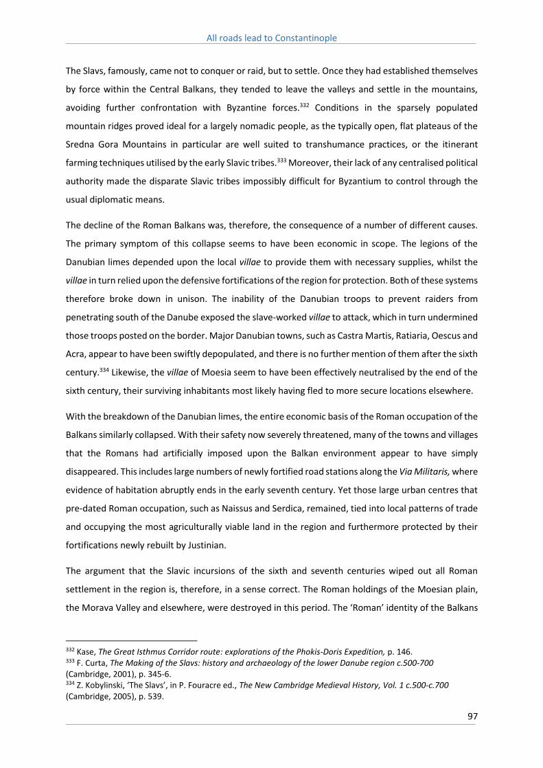
All roads lead to Constantinople
97
The Slavs, famously, came not to conquer or raid, but to settle. Once they had established themselves
by force within the Central Balkans, they tended to leave the valleys and settle in the mountains,
avoiding further confrontation with Byzantine forces.332 Conditions in the sparsely populated
mountain ridges proved ideal for a largely nomadic people, as the typically open, flat plateaus of the
Sredna Gora Mountains in particular are well suited to transhumance practices, or the itinerant
farming techniques utilised by the early Slavic tribes.333 Moreover, their lack of any centralised political
authority made the disparate Slavic tribes impossibly difficult for Byzantium to control through the
usual diplomatic means.
The decline of the Roman Balkans was, therefore, the consequence of a number of different causes.
The primary symptom of this collapse seems to have been economic in scope. The legions of the
Danubian limes depended upon the local villae to provide them with necessary supplies, whilst the
villae in turn relied upon the defensive fortifications of the region for protection. Both of these systems
therefore broke down in unison. The inability of the Danubian troops to prevent raiders from
penetrating south of the Danube exposed the slave-worked villae to attack, which in turn undermined
those troops posted on the border. Major Danubian towns, such as Castra Martis, Ratiaria, Oescus and
Acra, appear to have been swiftly depopulated, and there is no further mention of them after the sixth
century.334 Likewise, the villae of Moesia seem to have been effectively neutralised by the end of the
sixth century, their surviving inhabitants most likely having fled to more secure locations elsewhere.
With the breakdown of the Danubian limes, the entire economic basis of the Roman occupation of the
Balkans similarly collapsed. With their safety now severely threatened, many of the towns and villages
that the Romans had artificially imposed upon the Balkan environment appear to have simply
disappeared. This includes large numbers of newly fortified road stations along the Via Militaris, where
evidence of habitation abruptly ends in the early seventh century. Yet those large urban centres that
pre-dated Roman occupation, such as Naissus and Serdica, remained, tied into local patterns of trade
and occupying the most agriculturally viable land in the region and furthermore protected by their
fortifications newly rebuilt by Justinian.
The argument that the Slavic incursions of the sixth and seventh centuries wiped out all Roman
settlement in the region is, therefore, in a sense correct. The Roman holdings of the Moesian plain,
the Morava Valley and elsewhere, were destroyed in this period. The ‘Roman’ identity of the Balkans
332 Kase, The Great Isthmus Corridor route: explorations of the Phokis-Doris Expedition, p. 146. 333 F. Curta, The Making of the Slavs: history and archaeology of the lower Danube region c.500-700 (Cambridge, 2001), p. 345-6. 334 Z. Kobylinski, ‘The Slavs’, in P. Fouracre ed., The New Cambridge Medieval History, Vol. 1 c.500-c.700 (Cambridge, 2005), p. 539.

All roads lead to Constantinople
98
was irretrievably shattered, and the cities of the Roman period, with their open forums and large
numbers of public buildings and squares, came to be replaced instead with walled defensive
fortresses, in which houses and churches alike huddled together for safety.335 The question of how
many cities survived, though, and what sort of existence their populations led afterwards, is one that
is still open to debate.
335 E. Kirsten, ‘Die Byzantinische Stadt’, Berichte zum XI Internationalen Byzantinisten Kongress, V, 3 (Munich, 1958), p. 1-35.

All roads lead to Constantinople
99
Chapter 9: The Byzantine Balkans
The argument that the Slavic incursions spelt the end of the major cities of the Balkan Peninsula has
largely rested upon two passages from the Miracles of St Demetrius. The first book of miracles, written
in approximately 620, contains two accounts of Slavic attacks on Thessalonica which took place in 597.
References to the abandoned cities of the Balkans, however, only occur in the second book, which
was probably compiled about a century later.336 The most frequently recited passage is as follows;
‘they said that the city was about to be taken by the Slavs, and not only did Thessalonica stand in the
midst of them, since all the cities and provinces which had formerly been under its control had become
uninhabited because of the Slavs, but Thessalonica alone, so to speak, existed in their midst, and
received all the refugees of the Danube regions, from Pannonia and Dacia and Dardania and the
remaining provinces and cities, who were now tightly compressed inside the city’.337
The second passage relates to a joint Avaro-Slavic attack on the city in 618-9, where refugees from the
cities of Serdica and Naissus were particularly noticeable, owing to their loud lamentations that they
had fled from the destruction of their own cities only to perish in Thessalonica.338
Owing to its location and well-ordered defences, Thessalonica was perfectly positioned to attract the
large numbers of inhabitants who were displaced by the Slavic and Avar raids of the late sixth and
early seventh centuries. The Struma River valley in particular, which runs south from Serdica and is
followed by the main Serdica-Thessalonica highway, was utterly devastated in this period.
Archaeological excavations here suggest that, unlike in other regions which suffered similar
devastation, such as the Maritsa Valley, communities in this region never fully recovered from these
raids.339 Refugees from here and elsewhere would have flocked to Thessalonica in large numbers, no
doubt bringing tales of widespread devastation and destruction with them. It has been argued that
the emergence in the sixth century of large numbers of small houses, built of stone and clay, inside
the walls of major cities like Thessalonica, indicate that these cities were inundated by dislocated rural
villagers, however this identification is disputed.340
336 D. Abrahamse, Hagiographic sources for Byzantine cities, 500-900 A.D. (Michigan City, 1967), p. 68. 337 Miracula Sancti Demetrii, trans. D. Abrahamse, Hagiographic sources for Byzantine cities, 500-900 A.D, p. 70. 338 Abrahamse, Hagiographic sources for Byzantine cities, 500-900 A.D, p. 71. 339 Yurukova, ‘Byzantine Fortresses to the south of the Hemus Mountain in the light of coin finds from the last decades of the sixth century’, p. 96. 340 Curta, Southeastern Europe in the Middle Ages, 500-1250, p. 44.

All roads lead to Constantinople
100
A further source of evidence that potentially argues against the survival of the cities of the Balkan
Peninsula are the conciliar lists of the period. These lists, which cover the councils of 680, 692, 787
and 869, represent almost the entirety of surviving written sources across the whole region from this
period. The sees represented at the councils of 680/1 and 691/2 are not only extremely few in number,
but represent cities that are almost entirely limited to those on the coast (Stobi, near Gradsko in the
modern day Republic of Macedonia, being the single exception).341 It is only in the lists of 869/7 that
the cities of the inland Balkans begin to reappear once more. Usage of these lists however involves
the assumption of a clear equation between a secular city and an ecclesiastical see.342 Whilst this is
generally the case, this is problematical owing to the fact that the sites of a large number of cities or
sees in the Balkans are unknown to us, and even further complicated by the fact that there is always
a possibility that some of the bishops so listed may have been absentees, or even represented
locations that no longer existed.343
The sparse nature of the representatives at these earlier councils need not argue for the complete
destruction of urban settlement in the Central Balkans. The Bulgar Khan Krum, for instance, captured
Serdica from Byzantium only in 809 AD, which renders its absence from earlier conciliar lists curious.
Furthermore, whilst we know that the cities of Anchialos, Beroe and Philippopolis were restored by
the Empress Irene in 784, none of these cities are recorded as having sent representatives to the
Second Council of Nicaea in 787. It is not clear, therefore, whether the conciliar lists can be treated as
definitive evidence, in particular since there is clear evidence that at least the see of Anchialos was
occupied at this time.344
Largely owing to the lack of reliable sources, no clear picture of the Balkan Peninsula during this
confused period has therefore emerged. For instance, based on the lack of literary evidence of
recorded journeys along these routes, McCormick states that overland travel within the Balkan
Peninsula definitely ceased at some point between 550 and 650 AD.345 Toynbee draws the conclusion,
largely based on the research of the etymologist Max Vassmer, that after the death of Justinian the
empire quickly lost possession of almost the entirety of its European possessions, with the exception
of a few isolated beach heads on the Aegean, a conclusion also reached by Francis Dvornik.346
341 Curta, Southeastern Europe in the Middle Ages, 500-1250, p. 99. 342 Hendy, Studies in the Byzantine Monetary Economy c.300–1450, p. 77. 343 For further discussion on the use of these sources see Whitby, The Emperor Maurice and his historian, p. 186-7. 344 Sophoulis, Byzantium and Bulgaria, 775-831, p. 164. 345 McCormick, Origins of European Economy: communications and commerce, A.D. 300-900, p. 69. 346 Toynbee, Constantine Porphyrogenitus and his World, p. 631., also see M. Vassmer, Die Slaven in Griechenland (Berlin, 1941), p. 317-25., and F. Dvornik, The Slavs: their early history and civilization (Boston, 1956), p. 42.

All roads lead to Constantinople
101
Obolensky, however, argues that the inland routes may have stayed open until the mid-eighth
century, before falling into disuse, and further surmises that after the death of Khan Krum in 814,
peaceful conditions prevailed along the Via Militaris for the rest of the century, although concedes
that little to no evidence, outside of conciliar lists, exists to support this hypothesis.347
Conclusions drawn from the little literary evidence that exists therefore tend to fail to find support in
the known archaeological record, and visa versa. On the whole, the inability of the archaeological
record to provide a clear answer to the question of urban continuity in the Balkans is frustrating.
Whittow argues that the failure of many archaeologists, until quite recently, to adequately catalogue
low grade medieval remains in the region, in particular early medieval pottery, discounts much of their
work.348 It is only recently that more attention has been given to such finds, and excavations
undertaken at Serdica, Karasura and Castra Rubra indicate a continuation of habitation beyond the
seventh century that is usually taken as the terminal point of the Roman Balkans.349
A closer examination of the urban histories of some of the major cities along the route of the Via
Militaris offers some opportunity for a more detailed picture of the Byzantine Balkans to emerge,
although even here broad assumptions and generalisations are, owing to the absence of sources,
inevitable. Philippopolis, in particular, provides a fascinating case study of how a distinct urban
community was able to develop within the medieval Balkans.350
The city of Philippopolis emerged in the late Roman period as an important regional centre, and its
walls were repaired in the third century, during the reign of Gallienus, and again during the reign of
Justinian. The city suffered a major population decline during the early Byzantine period however and,
mirroring a general trend experienced by most provincial cities in this period, shrank to occupy a much
smaller space than the Roman city had. The walls built by Justinian fortified only the three major hills
of the city, whilst repairs to these walls dated to the seventh century were found to reuse a large
number of artefacts from earlier Roman buildings, including columns, capitals and friezes.351 An inner
fortress was also constructed covering the central acropolis, and one of its gates, near the church of
SS Constantine and Helena, still stands today (see Figures 11 & 12).
347 Obolensky, ‘The Balkans in the ninth century: barrier or bridge?’ p. 53-4. 348 Whittow, The making of Byzantium, p. 267. 349 M. Wendel, ‘Die Ausgrabungen in Iatrus and Karasura’, in J. Henning ed., Post-Roman Towns, Trade and Settlement in Europe and Byzantium, Vol. 2: Byzantium, Pliska and the Balkans (Berlin, 2007). These sites will be discussed further below in Chapter 11. 350 Naissus and Serdica will be dealt with in more detail in Chapter 11. 351 R. T. Ivanov ed., Tabula Imperii Romani, K35/2 Philippopolis (Sofia, 2012), p. 65-6.
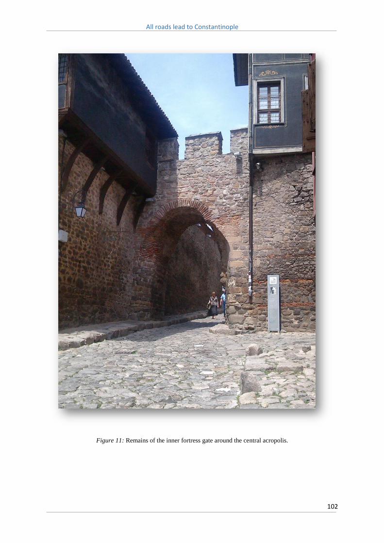
All roads lead to Constantinople
102
Figure 11: Remains of the inner fortress gate around the central acropolis.

All roads lead to Constantinople
103
Figure 12: Plan of the fortifications of Philippopolis, showing the wall built by Justinian in the sixth century,
and the walls around the central acropolis. From Hoddinott, Bulgaria in Antiquity, p. 189.

All roads lead to Constantinople
104
It is difficult to determine if the city survived the Avar and Slavic incursions of the seventh and eighth
centuries intact, as numismatic evidence suggests many nearby fortresses in the Maritsa Valley were
destroyed during this period.352 It’s likely that owing to these incessant raids, and a dwindling
population, during this period the city shrank in size even further to occupy only the area enclosed by
the inner fortress, around the central acropolis itself.353 When Anna Comnena later visited the city in
the early twelfth century, she noted that remains of the hippodrome and other ancient buildings could
then only barely be seen, suggesting they had long been abandoned and likely used instead as quarries
for building material.354
In 811, after Emperor Nicephorus was caught in an ambush by the Bulgar Khan Krum in the Varbitsa
Pass to the north-east of the city, its population is said to have abandoned it in panic.355 It is not clear
if the city was captured by Khan Krum at this point although both Philippopolis and the even more
exposed Serdica may have been left deliberately undefended for some time afterwards.356 Definitive
evidence of either city’s inhabitation during this period is so scarce it is difficult to determine whether
this was indeed the case, although it is argued that Philippopolis possibly remained abandoned for a
time during the ninth century in accordance with the treaty agreed between Leo V and Krum’s
successor, Khan Omurtag.357
This is, however, potentially at odds with the account provided by an inscription known as the ‘Stone
annals of the ruler Malamir.’ Khan Malamir, who succeeded Omurtag, renewed hostilities with the
Byzantines in 836 and invaded Thrace. Here, according to the inscription, ‘The ruler Malamir, who
reigned together with the kavhan Isbul, took the field against the Greeks with his army and devastated
the fortress of Provat, the fortress Burdizo, and the lands of the Greeks. Covered with glory he came to
Philippopolis and the Greeks fled. Kavhan Isbul, together with the glorious ruler conducted negotiations
with the citizens of Philippopolis.’358 Clearly some inhabitants had remained in the city, and afterwards
it is suggested that Khan Malamir may have subsequently led some of these off into captivity.359
352 Yurukova, ‘Byzantine Fortresses to the south of the Hemus Mountain in the light of coin finds from the last decades of the sixth century’, p. 96. 353 Hoddinott, Bulgaria in Antiquity, p. 291. 354 Anna Comnena, Alexiad, p. 463. 355 Theophanes, Chronicle, p. 175. 356 Obolensky, ‘Byzantine Frontier Zones and Cultural Exchanges’, p. 304. 357 J. B. Bury, ‘The Bulgarian Treaty of A. D. 814, and the Great Fence of Thrace’, The English Historical Review, 25, no. 98 (Apr., 1910), p. 281-2. Also see R. Browning, Byzantium and Bulgaria: a comparative study across the early medieval frontier (London, 1975), p. 50-1. 358 K. Petkov, The voices of medieval Bulgaria, seventh-fifteenth century: the records of a bygone culture (Leiden, 2008), p. 12. 359 Browning, Byzantium and Bulgaria, p. 99.

All roads lead to Constantinople
105
Whatever the fate of its inhabitants during the ninth century, it must have been repopulated again
the following century, ahead of its sack by the Kievan Rus. In 969 the Byzantine emperor, John
Tzimiskes, recaptured the city and shortly afterwards, in 971, the Kievan Prince Svjatoslav I invaded
the Balkans. He placed the city under siege and, according to Leo the Deacon, after its capture had its
twenty thousand inhabitants impaled.360 Whilst this number is almost certainly an exaggeration, it
does suggest that even at this point in its history the city was a relatively well populated one. Tzimiskes
soon recaptured the city and in order to re-populate it once more, in a fateful step resettled a large
number of Paulicians in the region.361
In this instance it was probably hoped that the militant Paulicians, removed from their homelands in
eastern Asia Minor, might help in the defence of the city, and eventually be absorbed into the local
population. In this respect John Tzimiskes was to be disappointed, as the Paulicians proved to be a
divisive element in the history of the city from this point onwards, and would later come to be joined
by another ethnic group, émigré Armenians who migrated westwards after the annexation of the sub-
kingdoms of Armenia by Basil II.362 Anna Comnena, who visited the city in 1114 with her father,
Emperor Alexius Comnenus, described the city thusly:
‘Practically all the inhabitants of Philippopolis were in fact Manichaeans, so that they lorded it over
the Christians there and plundered their goods, paying little or no attention to the emperor’s envoys.
Their numbers increased until all the people around the city were of their persuasion. They were joined
by a new flood of immigrants. These newcomers were Armenians – a brackish stream – and they were
succeeded by others from the foulest springs of James. Philippopolis was a meeting place, so to speak,
of all polluted waters.’363
During the eleventh and twelfth centuries the Paulicians were associated with a number of large
revolts in the region. In the late eleventh century a prominent member of Philippopolis’ Paulician
community, Lecus, incited a rebellion that originated near Serdica and subsequently spread to
Naissus.364 This uprising suggests that Paulicians were making use of the Via Militaris to spread word
of the revolt, and that the road itself may have facilitated the expansion of the heresy to further cities
along its length. In response to this, and his concerns over the faithfulness of Paulician soldiers after
the Battle of Dyrrhachium in 1081, Alexius attempted to break up the heretical population of the city
360 Leo the Deacon, Historia, trans. A-M. Talbot & D. Sullivan, The History of Leo the Deacon: Byzantine military expansion in the tenth century (Washington D.C., 2005), p. 155. 361 John Skylitzes, Synopsis historiarum, trans. J. Whortley, A synopsis of Byzantine history, 811-1057 (Cambridge, 2010), p. 273-4. 362 P. Charanis, 'The Armenians in the Byzantine Empire', Byzantinoslavica, 22 (1961), p. 237. 363 Anna Comnena, Alexiad, p. 385. 364 D. Obolensky, The Bogomils: a study in Balkan neo-manichaeism (Middlesex, 1972), p. 189-90.

All roads lead to Constantinople
106
by subjecting its leaders to a series of show trails staged in Constantinople. Obolensky argues that
Alexius adopted this approach because he feared he was too weak, on account of the devastating
losses suffered at Dyrrhachium, to confront the Paulicians directly in Philippopolis, suggesting the sect,
as Anna Comnena implies, had indeed become a law onto themselves in the city.365
This approach evidently proved unsuccessful however, as indicated by the subsequent revolt of the
Paulician leader Traulos, in 1084. Further, correspondence between its mid-twelfth century bishop,
Michael Italikos, and his friend in Constantinople, Theodore Prodromus, indicates that a sizeable
heretical community remained in the city. Although Italikos’ original letter is lost, Prodromus, in reply,
stated that, ‘I am sure you will be able, with the Patriarch’s help, to deal with the heresies so rife in
your diocese, and by argument bring the heretics back to the fold of Orthodoxy.’366 It seems highly
likely that Italikos had been specifically charged with leading the city back into the fold of orthodoxy,
and a seal of his office bore the poignant inscription, ‘City of Philipp, nurtured by the apostles, you
have me as your nurse.’367
During the passage of the Third Crusade the city’s governor, Nicetas Choniates, remarked that the only
inhabitants who remained to meet the crusaders were the poor, those 'whose entire substance was
reckoned in the clothing he wore', and that besides its Armenian population, the rest abandoned the
city to the crusaders.368 These Armenians greeted the crusaders as friends, since, in Choniates' words,
‘they agreed in each other’s heresies’.369 On the crusader side we have the testimony of The Chronicle
of Magnus of Reichersberg, which states that 'The Armenians are our loyal subjects’,370 whilst the
Historia de Expeditione explained that local Armenian and Bulgarian communities had agreed to
supply the crusaders with provisions in return for protection.371 Geoffrey of Villehardouin likewise
mentions ‘the great part of the people, who were Paulicians’ who offered to surrender the city to the
Bulgar Khan Kaloyan in 1205.372
Although the number of Paulicians residing in the city was almost certainly exaggerated in
contemporary sources, in particular by Anna Comnena, they no doubt constituted a sizeable
365 Obolensky, The Bogomils, p. 191. 366 R. Browning, ‘Unpublished correspondence between Michael Italikos, Archbishop of Philippopolis, and Theodore Prodromos’, Byzantinobulgarica, I (1962), p. 286. 367 See Item 68.2, Catalogue of Byzantine Seals at Dumbarton Oaks and in the Fogg Museum of Art, Vol. 1 p. 152. Whilst Philipp the Deacon was not an apostle, as the inscription claims, he was popularly believed by the Byzantines to have been. 368 Choniates, Historia, p. 222. 369 Choniates, Historia, p. 222. 370 Magnus of Reichersberg, The Chronicle of Magnus of Reichersberg, p. 152. 371 Historia de Expeditione Friderici Imperatoris, p. 74-5. 372 Geoffrey of Villehardouin, De la Conquête de Constantinople, trans. M. R. B. Shaw, The conquest of Constantinople in Chronicles of the Crusades, Joinville and Villehardouin (Middlesex, 1963), p. 105.

All roads lead to Constantinople
107
proportion of its population in the Middle Ages. This suggests that the overall population of the city,
especially after its sack by the Kievan Rus in 971, was probably quite small. Nevertheless, Philippopolis
remained a major city by Balkan standards, and during the crusading period was not only able to offer
market facilities to crusader forces, but accommodate for a time the entirety of Barbarossa’s
contingent of the Third Crusade.
So whilst it is difficult to differentiate between its Armenian and Paulician communities, which
Byzantine sources mostly refer to as ‘Manichean’, it is clear that despite Byzantine efforts to quash
the heresy, these communities remained a readily recognisable, and divisive, element of Philippopolis’
population throughout the eleventh and twelfth centuries. Indeed the remarkable persistence of this
community is emphasised by Lady Montagu who, passing through the city in 1716, noted the
continuing existence of ‘a sect of Christians that call themselves Paulines.’373 The capacity of the
Paulicians to defy Byzantine authority, as well as their ability to seemingly spread their faith to further
cities along the route of the Via Militaris, argues, at the very least, for the development of lively and
largely self-sufficient urban communities in the medieval Balkans.
In comparison to Philippopolis, Adrianople, and the cities of Thrace, appear to have weathered the
turmoil of the sixth and seventh centuries relatively well, although Adrianople itself was sacked by
Khan Krum in 813, who then retreated, leading away ’12,000’ captives, who were subsequently settled
along the Danube.374 Nevertheless the cities of this region, and Adrianople in particular, seem to have
benefitted greatly from the upheavals of the period, as their populations were swelled through an
influx of refugees from elsewhere in the Balkans, and they accordingly emerged as far more important
administrative and ecclesiastical centres than they had been previously during the late Roman period.
Indeed a number of formerly obscure stations, such as Arcadiopolis and Bulgarophygon, as a
consequence of their position astride the Via Militaris, their agricultural production, and their
fortifications, emerged as notable regional centres. Owing to the importance of this region for
provisioning the capital, from the late sixth century onwards the Byzantines regularly transferred
populations from its eastern provinces and resettled them in Thrace, further swelling the populations
of these urban centres.375 Their subsequent growth and increased prominence therefore challenges
the conception that the seventh and eighth century was exclusively a period of decline and
devastation in the Byzantine Balkans.
373 Lady M. W. Montagu, The letters and works of Lady Mary Wortley Montagu, p. 159. 374 Leo Grammaticus, Chronographia, D. Kosev & H. Hristov eds., Documents and materials on the history of the Bulgarian people (Sofia, 1969), p. 13-4. 375 P. Charanis, ‘The transfer of population as a policy in the Byzantine Empire’, Comparative Studies in Society and History, 3, no. 2 (Jan, 1961), p. 142-4.

All roads lead to Constantinople
108
So whilst the literary and archaeological records remain mixed, scattered evidence indicates the
retention of at least some urban populations within the Central Balkans. This still does not, however,
give any insight into the actual conditions that prevailed within these settlements. As Haldon points
out, the survival of urban sites does not tell us anything of the economic and social relations that
developed from the seventh century onwards, only that they offered more protection than life in the
surrounding countryside, and that they likely continued to function as administrative and ecclesiastical
centres, as is to be expected.376 As Curta likewise states, it is almost impossible, using the available
evidence, to differentiate between smaller towns and larger cities in the medieval Balkans, and the
inability to do so impacts upon our ability to trace economic and social developments over this
period.377
Angold argues that it therefore is not the decline of provincial cities during the sixth and seventh
centuries that requires the most explanation, but rather their subsequent slow recovery.378
Geographical proximity, or conversely isolation, to Constantinople unsurprisingly appears to have
played a leading role in determining the fate of many urban settlements in this period. Yet other
possible factors, such as climate, were likely highly influential. One factor in particular that has of yet
received little consideration is the long term impact of land degradation and erosion. Owing to its
unique geography and distinctive weather patterns, in particular high summer rainfall and heavy
spring snow melts, the Balkan region is highly susceptible to the impact of erosion in particular.379
In the Balkans this process typically results in the removal of soil from the mountain ranges and its
deposition along the river valleys, which is a major cause of the high fertility that they have historically
displayed and retain to this very day. However it also has other unwanted side effects, one of which
is the creation of marshes that are highly susceptible to infestations of mosquitoes carrying malaria.
Human activity can also dramatically increase both the scope and severity of erosion. Historically,
overpopulation and overexploitation of the landscape has been the catalyst for catastrophic erosion
events that can lead to cultural and demographic collapse.380 The influence of such processes in the
Balkans are only poorly understood, and while endemic war, plague and political instability are the
376 J. Haldon, ‘Some considerations on the Byzantine society and economy in the seventh century’, Byzantinische Forschungen, 10 (1995), p. 85. 377 Curta, Southeastern Europe in the Middle Ages, 500-1250, p. 430. 378 M. Angold, ‘The shaping of the medieval Byzantine ‘city’’, Byzantinische Forschungen, 10 (1985), p. 1. 379 For a deeper discussion of these processes see B. Geyer, ‘Physical factors in the evolution of the landscape and land use’, in A. E. Laiou ed., The Economic History of Byzantium: from the seventh through to the fifteenth century, Vol. 1 (Washington D.C., 2002), p. 36-7. Also see Hordell & Purcell, The Corrupting Sea, p. 312-328, for a discussion of these processes within the wider Mediterranean context. 380 J. Bintliff, ‘Erosion in the Mediterranean lands: a reconsideration of pattern, process and methodology’, in M. Bell & J. Boardman eds., Past and present soil erosion: archaeological and geographical perspectives (Oxford, 1992), p. 126.

All roads lead to Constantinople
109
more obvious causes for dramatic population declines in the region, the delayed period of population
recovery may have been in part owing to the environmental impact of the intensive agricultural
practices of the late Roman period.
Malaria may therefore have been a serious concern on some stretches of the Via Militaris, in particular
along the Maritsa Valley and in Thrace owing to their warmer climates. In the Ottoman period this
region was infamous for the disease, with the marshy banks of the Maritsa especially providing fertile
breeding grounds for mosquitos, something which the introduction of rice crops to the region only
exacerbated. Early Modern travellers spoke of this area in fearful tones, particularly during the
summer and autumn months when ‘places became almost uninhabitable from fever.’381 Elsewhere
there are descriptions of the ‘sultry and feverish Thracian plain’382 and that ‘the plain reeks vapourish
in the summer.’383 Malaria has long been associated with miasmas, or ‘bad air’.384 Accordingly,
travellers who were forced to cross this region preferred to do so on horseback and as quickly as
possible, and avoided staying in the poor local inns along the route, whilst during the First World War
the malarial marshes of the region brought Allied armies to almost a complete standstill.385
Whether malaria was an issue during the medieval period is difficult to determine from the sources
alone. The Chronicle of Magnus of Reichersberg describes how participants of the Third Crusade
suffered from tertian and quartan fever on their journey.386 These afflictions, where symptoms
including fever, sweating and shaking, occur every three to four days are usually associated with the
early onset of malaria. Hendy argues that whilst there is no direct evidence to support his hypothesis,
general evidence suggests that Justinian and Anastasius were the last Byzantine emperors possessed
of the resources required to undertake the extensive civil projects necessary to drain these regions
and allow their full agricultural exploitation.387 Subsequently allowing marsh land to remain would
have exacerbated the susceptibility of these regions to malaria, whilst also reducing available arable
land.
Land degradation and subsequent malarial infestations, therefore, may offer a partial explanation for
the slow pace of recovery experienced by cities such as Serdica. Though fertile, much of the land in
the Sofia plain in particular is quite marshy, whereas the city itself sits upon a diluvial terrace. The
381 Mackenzie & Irby, Travels in the Slavonic provinces of Turkey-in-Europe, p. 136. 382 Mackenzie & Irby, Travels in the Slavonic provinces of Turkey-in-Europe, p. 140. 383 J. F. Fraser, Pictures from the Balkans (London, 1912), p. 100. 384 R. Neghina, A. Neghina, I. Marincu, & I. Iacobiciu, ‘Malaria, a Journey in Time: In Search of the Lost Myths and Forgotten Stories’, The American Journal of the Medical Sciences, 340, no. 6 (December, 2010), p. 493. 385 Great Britain Naval Intelligence Division, Greece Vol. 1 Physical geography, History, Administration & Peoples. (Cambridge, 1944), p. 272-6. 386 Magnus of Reichersberg, The Chronicle of Magnus of Reichersberg, p. 149-50. 387 Hendy, Studies in the Byzantine Monetary Economy c.300–1450, p. 67-8.

All roads lead to Constantinople
110
difficulties arising from land reclamation may therefore offer one explanation as to why the city of
Serdica in particular declined in prominence from the late Roman period onwards. As the population
declined as a consequence of the devastation it suffered at the hands of barbaric incursions from the
third century onwards, this impacted upon its ability to reclaim and exploit nearby land, which in turn
increased the regions susceptibility to outbreaks of malaria.
It is also possible that this situation was exacerbated by, or even contributed to, a general agricultural
backwardness. Gregory of Antiochos, a Byzantine official, was appalled at the wretchedness of this
region in the 1170s, and complained bitterly about the standards of local agriculture, and in particular
that in the vicinity of Serdica it was possible to only reap one harvest a year.388 Local farmers may have
practiced ‘itinerant farming’, where each patch of land was farmed until it lost its fertility after
repeated cultivation without manuring, then abandoned. This could potentially explain the abject
poverty that greeted the Third Crusade. On the whole, however, a lack of research, especially in
regards to pollen analysis or archaeological study of fields, makes it difficult to trace agricultural
developments in any great detail, and in particular how they may have varied from region to region in
the medieval Balkans.389
Climate also likely played a significant factor in population growth and decay. As noted above, weather
conditions between modern Sofia and Plovdiv are noticeably different (see Figures 13 & 14). The
Maritsa Valley, with its more Mediterranean style climate and the absence of damaging spring frosts,
is far better suited to agricultural activity than the more exposed regions surrounding Sofia. In
particular, grape vines and olives are grown in abundance in the Maritsa Valley, and Philippopolis has
therefore, with its ample supply of wine and olive oil, historically been considered as the limit of
‘civilised’ Greek settlement in the Balkans, as opposed to the ‘Slavic’ settlement of Serdica, whose
inhabitants, instead of olive oil, had to make do with butter.390
388 J. Darrouzès, ‘Deux lettres de Grégoire Antiochos Écrites de Bulgarie vers 1173’, Byzantinoslavica, 23 (1962), p. 279. 389 Curta, Southeastern Europe in the Middle Ages, 500-1250, p. 419-20. For theoretical approaches to this issue see J. Koder, ‘Land use and settlement: theoretical approaches’, in J. Haldon ed., General Issues in the Study of Medieval Logistics: sources, problems and methodologies (Boston, 2006). 390 The Gates of Trajan are also often taken to represent the line of demarcation between the ‘Greek’ and ‘Latin’ halves of the Balkan Peninsula, Obolensky, The Byzantine Commonwealth, p. 37.

All roads lead to Constantinople
111
Figure 13: Comparison of monthly temperature means between Sofia and Plovdiv. Data is collected from 2000-
2012.

All roads lead to Constantinople
112
Figure 14: Comparison of monthly average rainfall between Sofia and Plovdiv. Data is collected from 2000-
2012.

All roads lead to Constantinople
113
The impact of climate change in the Balkans has also been little explored, and it is tempting to
correlate the generally milder period between the ninth and twelfth centuries with the economic
expansion so evident during this period.391 However, as Barber notes, this temptation should be
resisted for there are other, non-climatic reasons for this expansion, in particular increasing political
stability, and the data simply does not yet exist which could make any such link convincing.392 So whilst
climate change may appear to offer a convincing explanation for population growth and decay from
the sixth to the twelfth centuries, it is likely the very fragility of those environments which were
populated was the most decisive factor involved, and this, as Geyer argues, is a history that is still yet
to be written.393
That any cities in the Balkan hinterland were able to survive the upheavals of the seventh century at
all, however, was surely due to the fact that, in direct contrast with the situation then prevailing
throughout much of Western Europe, Byzantium still possessed a major urban settlement that could
exert a strong gravitational influence over the surrounding region. With the economic environment
created by the Romans destroyed, a city’s survival was subsequently dependent on its place within an
organisational system that centred upon the massive urban metropolis of Constantinople, and those
that had no place within this new dispensation simply withered away.394 Cities, in effect, lost their
independent economic and institutional identities, and instead existed purely as distant functionaries
of administrative organs located within Constantinople.
Yet those cities that had a role to play within this system stood to do relatively well, and in particular
the presence of military garrisons, with their regular wages, would have provided an important spur
to local economic activity.395 These transactions can perhaps be traced through local numismatic
records, or more accurately the lack thereof. Whilst the golden coinage of the period is not unknown
in this region, copper coins are much rarer. This suggests that most commercial interactions occurred
with the state, which insisted upon taxes being paid in gold, and local transactions that required
smaller denominations were relatively lacking.396
391 Geyer, ‘Physical factors in the evolution of the landscape and land use’, p. 41-4. 392 M. Barber, The Two Cities; medieval Europe 1050-1320 (New York, 1992), p. 17. 393 Geyer, ‘Physical factors in the evolution of the landscape and land use’, p. 44. 394 Angold, ‘The shaping of the medieval Byzantine ‘city’’, p. 351. 395 On the wages of salaried troops in provincial or thematic forces see Haldon, Warfare, State and Society in the Byzantine World, 565-1204, p. 120-3. 396 Whittow, The making of Byzantium, p. 59-61. Although the dangers involved in interpreting numismatic evidence in this manner are noted by J. Haldon, ‘Commerce and exchange in the seventh and eighth centuries; regional trade and the movement of goods’, in C. Morrisson ed., Trade and Markets in Byzantium (Washington D.C., 2012), p. 108-12.

All roads lead to Constantinople
114
In particular the task of feeding the teeming masses of Constantinople, especially after the loss of the
empire’s Egyptian provinces, must have been a daunting one, yet it has been convincingly argued that
this was accomplished through the surplus grain production of Thrace and the regions around the
Aegean Sea.397 Thrace also provided a large proportion of the fruit and vegetables required by the
capital, and Attaleiates describes how the pillage of this region by Pechenegs in the mid-eleventh
century, when ‘summer was beginning and the fruit was still hanging unpicked from the trees’ caused
‘no small shortage of food in the Reigning City and the other western cities’, which ultimately led to
widespread famine and civil unrest.398
Even though the population of the capital in the seventh century, and into the eighth, appears to have
been much reduced from its late Roman height, it still likely needed large quantities of imported
foodstuffs to adequately sustain itself. From the late eighth century onwards its population started to
increase once more, and these demands only subsequently grew, so much so that in the mid-twelfth
century Michael Choniates, in a famous passage, related how ‘all the rivers of goods run towards the
imperial city, as if to the sea.’399 Much of this produce was transported to Constantinople by sea, but
it still needed to reach the ports, and provincial cities must have played an important role in overseeing
the logistical networks necessary to ensure a steady supply of foodstuffs flowed towards the capital,
as well as providing the necessary local security.
Local trade would also have played an important, if largely unrecognised, role in facilitating
agricultural exchange in provincial communities but would not, by itself, have provided the impetus
required to maintain decaying logistical networks nor supply a metropolis like Constantinople. This
was only possible through the administrative direction provided by bureaucratic bodies located in the
capital. Given the critical importance of keeping the population of Constantinople well fed, it is certain
that Byzantine emperors took a keen interest in the maintenance of a stable supply of goods to the
capital from nearby provinces. That local transport networks were being kept in at least a moderately
good state of repair, enough to accommodate wagons at least, is suggested by the large numbers of
ox-carts Manuel Comnenus requisitioned from Thracian farmers for his campaign of 1160.400
The city of Raidestos, for instance, which is located along the route of the Via Egnatia, was evidently
a major port for the transport of Thracian grain to Constantinople, and became the site of a phoundax,
or state corn exchange, for a period during the reign of Michael VII. Michael Attaleiates provides a
397 Teall, ‘The grain supply of Byzantine Empire, 330-1025’, p. 87-139. 398 Attaleiates, The History, p. 379. 399 Michael Choniates, trans. S. Lambros, Michael Akominatou tou Choniates ta Sozomena, Vol. 2 (Groningen, 1968), p. 83. 400 John Kinnamos, The Deeds of John and Manuel Comnenus, trans. C.M. Brand (New York, 1976), p. 151.

All roads lead to Constantinople
115
description of how carts were used to bring grain to the kastron of Raidestos for sale, and how, until
the phoundax was constructed, a thriving local market economy existed in the region.401 Magdalino
surmises that these vendors were paroikoi who worked the great estates of Thrace, and in particular
the imperial domains (episkepsis) that lay along the Via Militaris as far as Adrianople, and were selling
their produce in order to pay their rents or taxes.402 Lemerle also argues for the persistence of ‘great
properties’ in Thrace beyond the seventh century that were worked by dependent cultivators.403 Much
of this produce was likely ported down river systems such as the Maritsa, but local road networks
would have played an equally important role in allowing the system to operate smoothly.
Similarly, provincial cities played an important role as bulwarks protecting the approaches to the vital
agricultural lands of Thrace, and the capital beyond.404 That the Byzantines were aware of this need
can be deduced from attempts by successive emperors during the tenth and eleventh centuries to
transfer populations to Thrace and along the Nishava River, which had been the subject of extensive
devastation from the late sixth century onwards. In either 688 or 689, Emperor Justinian II settled
large numbers of ‘Scythians’ along the previously devastated Struma River, which indicates Byzantium
still had an interest in maintaining the strategically important route between Thessalonica and Serdica,
even if the archaeological evidence indicates that this measure must have failed.405 Philippopolis, as
seen above, was also repopulated in the tenth century, and played an important role in protecting the
Thracian hinterland. Whilst it retained the defensive fortifications constructed by Justinian, it clearly
was not an impregnable fortress, and was sacked by the Kievan Rus in 971, and furthermore
abandoned by its citizens both during the depredations of Khan Krum in the early ninth century, and
ahead of the passage of the Third Crusade during the late twelfth.
Instead Philippopolis’ importance was related to its ability to act as a military staging post. Well
supplied by the agricultural production of the Maritsa Valley, it was conveniently positioned to act as
a base to conduct operations either to the west through the Succi Pass, or north to the passes through
the Central Balkan Mountains. Philippopolis, therefore, functioned as a forward supply base, and seals
of horreiarioi, which indicate the presence of warehouses that stored grain from imperial estates, have
401 Attaleiates, The History, p. 367-9. 402 P. Magdalino, ‘The grain supply of Constantinople, ninth-twelfth centuries’, in C. Mango & G. Dagron eds., Constantinople and Its Hinterland: Papers from the Twenty-seventh Spring Symposium of Byzantine Studies, Oxford, April 1993 (Oxford, 1995), p. 40-1. 403 P. Lemerle, The Agrarian history of Byzantium from the origins to the twelfth century: the sources and problems (Galway, 1979), p. 65. 404 For a deeper discussion of this region during this period see K. Gagova, ‘Bulgarian-Byzantine border in Thrace from the 7th to the 10th century (Bulgaria to the south of the Haemus)’, Bulgarian Historical Review, 14 (1986). 405 Curta, Southeastern Europe in the Middle Ages, 500-1250, p. 98.

All roads lead to Constantinople
116
been found in the city.406 Successive emperors, from the late tenth century onwards, would use
Philippopolis as a staging post from which campaigns further afield in the Balkans were prosecuted,
such as Basil’s against Serdica in 986, or Alexius Comnenus’ against the Pecheneg incursions through
the passes of the Central Balkan Mountains in the late eleventh century. In the late twelfth century
Isaac Angelos installed his cousin, Constantine Angelos Doukas, in the city in order to check Vlach raids
into the Maritsa Valley, a role in which the young general, for a time, experienced a great deal of
success.407 In this regard Philippopolis serves as an example of the other benefit of defensive
fortifications, in that they functioned not only as a means of providing sanctuary to local populations,
but also as a point from which to attack and establish control over the surrounding region. The
similarly well defended cities of Thrace would have likewise fulfilled these dual roles.408
The argument that all urban settlement in the Central Balkans was destroyed in this period, their
populations fleeing to the security of the coastal ports, is one that has therefore been steadily losing
sway, as archaeological and numismatic evidence is increasingly being utilised in conjunction with
existing literary sources. A more nuanced scenario has come to be discussed, one that argues for the
continuing existence of at least some urban settlements, but on a far different basis to that which had
predominated in the late Roman period. Haldon succinctly summarises these arguments by pointing
out that Byzantine cities were necessary different from their classical antecedents, in that they
performed very different roles.409 In this sense it is true that the cities of the classical period were
destroyed, for as the cities lost their economic independence, their classical identities likewise
vanished. In their stead arose medieval communities of a far different nature.
So whilst we can learn little of their size, or indeed their ethnic composition, some urban settlements
at least remained in the Balkan Peninsula after the seventh century, especially in those regions closest
to the imperial capital. Perhaps it was the case that the well-fortified cities of the Balkan interior were
able to come to an accommodation with the Slavic communities that settled in the mountainous
regions around them. The second book of miracles of St Demetrius tells of a Slavic King named
Perboundus who, whilst living in the city of Thessalonica, was placed under arrest by the emperor,
prompting a joint Greek and Slavic embassy to travel to Constantinople to plead for his release.410 John
Kaminiates likewise describes how, in the late ninth, early tenth, century, Byzantine settlements near
Thessalonica paid taxes to nearby ‘Skythians’, and that trade and relations between the two groups
406 Laiou, ‘Regional networks in the Balkans in the Middle and Late Byzantine Periods’, p. 129. 407 Choniates, Historia, p. 239. 408 On the dual role of the medieval castle, as a place both for defence and offence, see J. France, Western warfare in the age of the Crusades, 1000-1300 (Ithaca, 1999), p. 77-8. 409 Haldon, Byzantium in the seventh century, p. 94. 410 Abrahamse, Hagiographic sources for Byzantine cities, 500-900 A.D, p. 79.

All roads lead to Constantinople
117
were often cordial and mutually beneficial.411 Given that there was little cause for conflict between
the Slavic tribes that predominately occupied relatively isolated forested and mountainous terrain,
and the urban settlements of the valleys and plains, the process of urban decline in the Balkans was
gradual, uneven and it is clear that in several cases it was never completed.412
For all of this, however, owing to the upheavals of the seventh century, Byzantine authority was, at
the least, heavily compromised along large sections of the Via Militaris. Thrace and the Maritsa Valley
may have remained at least partially within the bounds of effective Byzantine control, and therefore
retained relatively significant urban settlements, but beyond the Sredna Gora and the Gates of Trajan
it must be assumed that any such authority was ephemeral at best. Certainly in these regions the
conditions necessary for the establishment of stable administrative structures were lacking, and this
would have been reflected in the surface of the road itself, which likely was rendered impassable in
parts owing to the ravages of time and neglect. In this period, therefore, the prominence of the Via
Militaris as an overland route to Constantinople naturally declined, with travellers instead making the
journey by sea, in particular via the trunk routes that connected Italy with southern Greece and were
further extended to the Byzantine capital itself.413 What little information that can be gleaned from
the itineraries of eighth and ninth century ambassadors to Constantinople would suggest that the Via
Militaris was avoided in preference of coastal routes, the overland route via the Danube, or even the
Via Egnatia.414
It is not until the mid-eleventh century, after this region between the Danube River and Serdica was
reabsorbed into the Byzantine Empire during the reign of Basil II, that we see travellers, in particular
pilgrims, once more making the overland journey to the capital along the Via Militaris. Whilst other
factors, including the restoration of the Holy Sepulchre and the normalisation of relations between
Byzantium and the Fatimid Caliphate were also highly influential, the political stabilisation of the
Central Balkans under Byzantine governance was likely the catalyst that reopened this route to
Western pilgrims.415
411 John Kaminiates, De excidio Thessalonicensi, D. Kosev & H. Hristov eds., Documents and materials on the history of the Bulgarian people (Sofia, 1969), p. 12. 412 J. D. Howard-Johnston, ‘Urban continuity in the Balkans in the Early Middle Ages’, in A. G. Poulter ed., Ancient Bulgaria : papers presented to the International Symposium on the Ancient History and Archaeology of Bulgaria, Vol. 2 (Nottingham, 1981), p. 243. 413 Pryor, Geography, technology and war, p. 93-111. 414 McCormick, Origins of European Economy: communications and commerce, A.D. 300-900, p. 138-150. 415 D. Jacoby, ‘Bishop Gunther of Bamberg, Byzantium and Christian pilgrimage to the Holy Land in the Eleventh Century’, in L. H. Hoffman ed., Zwischen Polis, Provinz und Peripherie. Beiträge zur byzantinischen Geschichte und Kultur (Wiesbaden, 2005), p. 268-74.

All roads lead to Constantinople
118
The hypothesis that the conquest of the Balkans by Basil II resurrected the Via Militaris finds support
not only in the volume of recorded pilgrim traffic of the mid-eleventh century onwards, but also in the
administrative reforms enacted by Basil himself. Holmes argues that in the late tenth century, Basil
initially sought to arrange purely for the defence of the Balkan provinces in order to free his hand for
more pressing issues that required his intervention in the East, not the least being the Anatolian
rebellions of Bardas Skleros and Bardas Phocas, and a lightning campaign undertaken against the
Fatamid invasion of Aleppo in 995.416 Accordingly, provincial governors, such as Doux Gregory
Taronites at Thessalonica, and his successors in the post John Chaldos and Nicephorus Ouranos, as
well as a strategos, Theodorokan, located at Philippopolis, were installed. These governors were,
Skylitzes suggests, initially instructed to remain purely on the defensive and to impede any hostile
ingression into the fertile Maritsa Valley and Thracian plain, while offensive campaigns initially appear
only to have occurred when Basil II and the imperial field army at his command, was present.417
During Basil’s systematic reduction of the Bulgarian empire between 1001 and 1018, officers from the
Byzantine field army were installed as garrison commanders in conquered fortresses, and the
ecclesiastical administration of the region was restored.418 Far from the all-conquering warlord which
later reputation would represent him as, Stephenson argues that Basil was most likely more concerned
with the peaceful reabsorption of Bulgar lands into the empire than he was in waging a brutal war of
extermination, and thus other than the control of strategic fortresses, local administration remained
often in the hands of local nobility that had accepted Byzantine titles.419 Indeed Holmes argues that
whilst Skylitzes focuses on the martial achievements of Basil, his record also contains incidental
references that indicate that Byzantine administration in the newly conquered regions was
characterised by a considerable degree of flexibility and the involvement of local Bulgarians in both
military and civil administration, perhaps best expressed in Basil’s confirmation of the autocephalous
status of the Bulgarian church in 1019/20.420
In particular, Basil’s decree that in these newly conquered territories taxes could continue to be paid
in kind was no doubt aimed at fostering the smooth transition of these regions to Byzantine rule.
These frontier regions, where new cultures were being actively integrated into the empire, were
particularly susceptible to not only internal disaffection, but external manipulation by neighbouring
416 Holmes, Basil II and the Governance of Empire, 976-1025, p. 406-7. 417 Holmes, Basil II and the Governance of Empire, 976-1025, p. 407-9. 418 Stephenson, Byzantium's Balkan Frontier, p. 63-4. 419 Stephenson, Byzantium's Balkan Frontier, p. 66-77. Whittow further argues that Skylitzes’ description of Basil blinding ’15,000’ Bulgar prisoners in 1014 is pure fantasy, Whittow, The making of Byzantium, p. 388. 420 Holmes, Basil II and the Governance of Empire, 976-1025, p. 421.

All roads lead to Constantinople
119
states as well.421 However, despite periodic episodes of unrest, on the whole these communities
appear to have tolerated Byzantine rule relatively amicably. Although tensions were likely never far
from the surface, and would ultimately explode into outright rebellion in 1185, archaeological
evidence, in particular the number of new churches constructed, suggests that the eleventh and much
of the twelfth centuries were relatively prosperous for the Balkans.422
Byzantine control over Bulgaria was established through the creation of new themes, primarily those
of Bulgaria, Sirmium and Serbia. Some controversy concerns the date of the creation of a further
theme, Paradunavon, owing to the absence of any seals related to the relevant office of katepano.
The office of katepano is comparable with that of doux, in that it involved the command of a tagmata,
a small unit of handpicked professional troops who were often used for garrison duties in reconquered
regions.423 Madgearu notes that until the late eleventh century the commanders of older themes, such
as Philippopolis or Naissus, continued to hold the title of strategoi, whilst provinces newly created
under Basil II and his successors employed the use of either the title doux or katepanoi.424
The administrative establishments enacted by Basil II evolved under the patronage of subsequent
regimes, with the ultimate aim of ensuring the stability of the Balkan region, and protecting it from
external threats. Provincial borders were redrawn, and new ones, such as the aforementioned
Paradunavon, were created. In particular a province of Serdica, which encompassed the river valleys
between Naissus and Philippopolis, may have been created during the reign of Issac I Comnenus.425 It
is notable that Basil, possibly in a continuation of the policy of John Tzimiskes, did not try and introduce
a similar civilian or financial administration along the lower Danube, and this policy was largely
followed by his successors.426 The frontier fortresses were instead held by local military elites who, in
return for Byzantine titles, guarded the far flung borders of the empire. Stephenson dates the
emergence of this same policy along the middle Danube from 1027, when the governor of the newly
created province of Sirmium, Constantine Diogenes, was withdrawn and instead installed as Doux in
Thessalonica, with responsibility for the governance of the province of Bulgaria.427
Between these frontier fortresses and the relatively richer river valleys and plains of the Balkan
hinterland, Byzantium subsequently established a ‘no man’s land’, a half open space where settlement
421 A. Kazhdan & A. W. Epstein, Change in Byzantine culture in the eleventh and twelfth centuries (Berkeley, 1985), p. 170. 422 M. Mullett, Theophylact of Ochrid: reading the letters of a Byzantine Archbishop (Aldershot, 1997), p. 68. 423 Haldon, Warfare, State and Society in the Byzantine World, p. 78. 424 A. Madgearu, Byzantine Military Organization on the Danube, 10th-12th Centuries (Leiden, 2013), p. 64. 425 Madgearu, Byzantine Military Organization on the Danube, 10th-12th Centuries, p. 77. 426 Stephenson, Byzantium's Balkan Frontier, p. 80-1. 427 Stephenson, Byzantium's Balkan Frontier, p. 124.

All roads lead to Constantinople
120
was forbidden in order to create a geographically foreboding buffer zone.428 Obolensky describes this
arrangement not as a limes, the hard frontier border that the Romans had employed, but a limen, a
threshold through which invading armies were required to traverse.429 This approach, the value of
which the empire learnt through its experiences confronting Muslim razzias on its eastern frontiers,
was notably enacted along the Moesian plain, between the lower Danube and the Central Balkan
Mountain range, where the empty expanse of land behind the frontier offered an invading force little
opportunity for looting or resupply.430 A similar frontier was also established along the empire’s
Serbian border, where it pointedly did not install garrisons beyond the Morava River, into Raška and
Bosnia.431
Aware that most barbaric incursions were of short duration, the Byzantines adopted a policy of ‘doing
nothing’, refusing to give battle and denying their opponents the possibility of gaining military victories
in the field.432 These border zones, therefore, bought Byzantium time to react, whilst simultaneously
robbing their opponents of the possibility of an early victory that might have swelled their numbers
and turned a small raid into an outright invasion. All the while the absence of local settlements to
pillage increased logistical pressure upon these invaders, and the lack of sources of dry fodder in
particular would have been a pressing concern given the proportionally large number of mounted
warriors participating in such raids.
Complementing this approach was the retention of fortresses placed along the frontier. The main
purpose of these was to gather information and facilitate commercial interaction across the frontier,
and there is convincing evidence, particularly in the form of coin and pottery finds, that suggests
Byzantium maintained strong trading networks across the lower Danube.433 Michael Attaleiates vividly
describes how these cities became ethnic melting pots, whose inhabitants ‘constitute a multilingual
crowd’.434 Local fortresses were often placed in the hands of self-sufficient local nobility who had
accepted Byzantine titles, such as the Pecheneg Kegenes mentioned by Skylitzes, who after travelling
428 Madgearu, Byzantine Military Organization on the Danube, 10th-12th Centuries, p. 169. 429 D. Obolensky, ‘The Byzantine Frontier Zones and Cultural Exchanges’, in M. Berza & E. Stinescu eds. Actes du XIVe Congres International des Etudes Byzantines, Vol. 1 (Bucharest, 1974), p. 304. 430 For instance, see Theophanes, Chronicle, p. 61, for the deliberate Byzantine depopulation of the Upper Tigris. 431 Stephenson, Byzantium's Balkan Frontier, p. 125. 432 Shepard, 'Information, disinformation and delay in Byzantine diplomacy' Byzantische Forschungen, 10 (1985), p. 251-3. 433 I. Dimopoulos, ‘Trade of Byzantine red wares, end of 11th-13th centuries’, in M. M. Mungo ed., Byzantine Trade, 4th-12th centuries: the archaeology of local, regional and international Exchange. Papers of the Thirty-eighth Spring Symposium of Byzantine Studies, St John's College, University of Oxford, March 2004 (Oxford, 2009). 434 Attaleiates, The History, p. 373.

All roads lead to Constantinople
121
to Constantinople and promising to become baptised in the Orthodox faith, was granted a title and
possession of three fortresses along the Danube by Emperor Constantine IX Monomachos.435
It appears that a similar approach was also applied to the empire’s frontiers along the middle Danube.
After the reconquest of this region by Basil II, the frontier zone was pushed back further to encompass
the stretch of the Morava River between Naissus and the Danube. The wild, overgrown ‘Bulgarian
Forest’ here represented as difficult a barrier to encroaching armies as did the barren Moesian plain.
Forests have historically often played a vital role in forming defensive barriers bordering hostile
neighbours, and Procopius, for instance, relates how Justinian, in order to overcome the Tzani people
that occupied part of the Black Sea coast, deforested vast tracts of land, and by ‘transforming the
rough places and making them smooth and passable for horses, he brought it about that they mingled
with other peoples in the manner of men in general and consented to have intercourse with their
neighbours.’436
The Byzantines were well aware of the difficulties associated with traversing such heavily forested
regions, and Maurice advised that on such expeditions, lightly equipped infantry were to be preferred,
and pack animals were to be used instead of a heavy baggage train.437 The difficulties experienced
during the passage of the Third Crusade, as will be seen, underlies the wisdom of this advice. William
of Tyre, who was doubtlessly influenced by his own experiences within Byzantium, provides in his
history of the First Crusade a depiction of the wild, lawless conditions prevalent along the Morava
River. William claimed that lands which ‘border on foreign kingdoms and through which their own
lands are approached’ were deliberately left unpopulated by the Byzantines, with the emperor
forbidding any settlement or cultivation in these regions. In doing so Byzantium, in the opinion of
William, hoped that difficult roads and thorny brambles alone would hinder the passage of hostile
forces.438 Similarly Odo of Deuil referred to the section of the route beyond Branichevo as ‘the
uninhabited portion’,439 and also made mention of the ‘wastelands of Bulgaria’ that the crusaders
would need to traverse.440
The situation does not seem to have been much improved during the Ottoman era, and in the
eighteenth century Lady Montagu wrote that ‘the desert woods of Servia, are the common refuge of
thieves, who rob fifty in a company, so that we had need of all our guards to secure us; and the villages
435 Skylitzes, Synopsis historiarum, p. 428. 436 Procopius, De Aedificiis, p. 209. 437 Maurice, Strategikon, p. 152. 438 William of Tyre, Historia rerum in partibus transmarinis gestarum, trans. E. A. Babcock & A. C. Krey, A history of deeds done beyond the sea, Vol. 1 (New York, 1976), p. 122. 439 Odo of Deuil, De profectione Ludovici VII in orientem, p. 41. 440 Odo of Deuil, De profectione Ludovici VII in orientem, p. 25.

All roads lead to Constantinople
122
are so poor, that only force could extort from them necessary provisions.’441 Further, in the nineteenth
century, the French writer Alphonse de Lamartine described how the Serbians used this imposing
region for much the same purposes as the Byzantines had, describing a conversation with a local
inhabitant who states that ‘each of these trees is a Servian!’, for ‘during the war the Servians found a
rampart behind the trunks of their oaks; their forests were and still are their fortresses; every one of
these trees is as a comrade in fight; they love them like brothers; so, when Prince Milosch, their present
governor, ordered so many trees to be cut down through these forests, to mark out the long road we
are tracking, the old Servians often gave him a curse. “Cut down the oaks!” they said, “it is murder
against men.” In Servia, man and the oaks are friends.’442
It can be seen, therefore, the important role this region played in Byzantine strategic approaches to
the Balkans. The vast forests of the Morava River were a far more daunting obstacle than even the
Danube itself, and possession of this region vastly increased the ‘defensive potential’ of the empire.
In particular the description of this region by Lady Montagu as a ‘desert’ is a fitting one, for despite its
thick vegetation and fertile soils the Morava Valley, if devoid of indigenous habitation, offered next to
no succour for any army that attempted to make the passage. In particular there would have been
little fodder for horses, and the Taktikon Vari notably declares that armies ought to bring as much dry
fodder as possible with them before campaigning in the region, as there was no barley, in particular,
to be found in ‘Bulgaria’.443
The actions of those governors whom the crusaders encountered on the Byzantine frontier also
suggests the isolation of these frontier fortresses. Nicetas, the ‘governor of Bulgaria’, also named by
William of Tyre as the ‘Bulgarorum dux’, was residing in Belgrade during the passage of the First
Crusade, and appears to have been caught unawares by the approach of large numbers of pilgrims
and armed mercenaries.444 He’d likely had little to no warning of the crusaders arrival and, fearing
attack, rapidly retired to Naissus.445 This may also explain the attitude of the Duke of Branichevo who
greeted the arrival of the participants of the Third Crusade with a similar level of confusion. The
crusaders accused the Duke, who they surmised was under instruction from Emperor Isaac Angelos,
of deliberately attempting to mislead them, and instructing guides to lead the host by the wrong
road.446 Afterwards Alexius, Isaac’s uncle, met with Barbarossa at Naissus and apologised for the
441 Lady M. W. Montagu, The letters and works of Lady Mary Wortley Montagu, p. 164. 442 Alphonse de Lamartine, A Pilgrimage to the Holy Land: comprising recollections, sketches, and reflections, made during a tour in the East in 1832-1833, Vol. 3 (Philadelphia, 1835), p. 115. 443 Taktikon Vari, p. 303-5. 444 William of Tyre, Historia rerum in partibus transmarinis gestarum, p. 100. 445 Stephenson, Byzantium's Balkan Frontier, p. 177. 446 Historia de Expeditione Friderici Imperatoris, p. 59-60.

All roads lead to Constantinople
123
actions of the Duke, claiming that he ‘had greatly erred, because he had not guided the emperor
faithfully and had not given him in any way the service that his lord had instructed him to do.’447 These
episodes, in particular Nicetas’ rapid retreat from the advance of Peter the Hermit, suggests that it
was at Naissus, rather than on the Danube, that effective Byzantine authority was established, with
those depopulated lands beyond instead typically entrusted in the hands of native župans.448
Aside from complications arising from the arrival of crusading forces, the policy of devolving power
into the hands of local nobility appears to have been a largely successful one. It is notable that serious
difficulties during this period arose when, under Manuel Comnenus, this policy was largely abandoned
and the state both took a firmer grip over these outlying fortresses, and sought to extend imperial
dominion even further through the annexation of Sirmium and Dalmatia, which led to friction between
Byzantium and its Hungarian neighbour. It is possible, however, that Manuel did not entirely abandon
the concept of a soft frontier region. The fortress of Belgrade was reconstructed in this period,
seemingly not to provide better protection to the local community, but rather to serve as a command
post for an imperial officer to police the local community and monitor the lands beyond. The fortress
was designed so as to be approached only from the river itself, and from this orientation it can be
surmised that the most convenient connection with Belgrade was via the Danube, rather than along
the road to Naissus.449
Even though Manuel’s approach to the empire’s frontiers did not long survive his death, whereupon
devastating Hungarian raids quickly restored the status quo, they are largely seen as being successful
in that they created the peaceful conditions that are the pre-requisite for economic and social
growth.450 Could the administrative reorganisation of the Balkans from the early eleventh to late
twelfth century have therefore also encompassed road construction and maintenance? There is no
direct evidence of this occurring, yet the bureaucratic platforms set in place, in particular the
installation of military governors, certainly provided the template under which such activity could have
occurred. Basil II’s famous decree allowing the native population to continue paying taxes in kind quite
possibly generated the necessary work force required. Skylitzes reports that this allowed Bulgarian
peasants to supply the state with a yearly measure of corn, millet and wine, but this may have only
been an example of one kind of service they could render instead of paying their taxes in gold coin.451
This was evidently a popular measure, for when this privilege was revoked in the 1030s violent
447 Historia de Expeditione Friderici Imperatoris, p. 64. 448 Stephenson, Byzantium's Balkan Frontier, p. 124. 449 Stephenson, Byzantium's Balkan Frontier, p. 241-2. 450 For instance see Stephenson, Byzantium's Balkan Frontier, p. 271-4, and P. Magdalino, The empire of Manuel Komnenos, 1143-1180 (Cambridge, 1993), p. 174. 451 Skylitzes, Synopsis historiarum, p. 387.

All roads lead to Constantinople
124
uprisings resulted. Under Byzantine rule the Balkans beyond the Maritsa Valley and the Gates of Trajan
appear to have remained somewhat marginal, and never the object of extensive economic
exploitation, with the frequency of coin finds dating from the early eleventh to mid-twelfth centuries
suggesting a very slow monetization of the local economy.452 It is therefore possible that local
Byzantine authorities employed instead compulsory exactions, such as kastroktisia and hodostrosia,
in lieu of monetary payments.
The medieval urban landscape of the Balkan Peninsula, and the administrative reforms of the eleventh
century, therefore provide an enticing backdrop under which the rehabilitation of the Via Militaris
may have occurred. Such an argument, without the support of corroborative archaeological evidence
in particular, must remain mere conjecture. However, what cannot be denied is that by the mid and
late eleventh century the Via Militaris was able to accommodate a high volume of pilgrims en route
to the Holy Land. Whilst this does not in itself argue conclusively for comprehensive road construction
activity in the preceding decades, it is very difficult to conceive how a road surface that would
otherwise have remained largely unrepaired since the reign of Justinian in the sixth century could have
so successfully tolerated such a mass of human traffic, as well as its accompanying wagons and beasts
of burden.
452 C. Morrisson, ‘Byzantine Money: its production and circulation’, in A. E. Laiou ed., The Economic History of Byzantium: from the seventh through to the fifteenth century, Vol. 1 (Washington D.C., 2002), pp. 909-966.

All roads lead to Constantinople
125
Chapter 10: The Roads of the Ottoman Balkans
The Ottoman roads of the Balkan region are often overlooked, which is unfortunate as they represent
a valuable source of information on practices of road construction and maintenance, and in particular
offer insight into the ability of the Via Militaris to accommodate large volumes of vehicular traffic.
Indeed, more information is available about the Ottoman roads of the Balkan Peninsula, in the form
of official records and the observations of Western travellers, than those of the preceding periods.
More recently Popović has compiled in a single volume a chronological record of travel histories of the
Via Militaris, in particular focusing on the second half of the sixteenth century.453
The almost universal description of Ottoman roads, recorded in the memoirs of Western travellers,
was bad. Ottoman roads were infamous for their poor quality; one road near Thessalonica is described
as being ‘barely made and full of ruts, in summer it is as hard as stone, and in winter a Slough of
Despond.’454 The general impression was that the Ottomans had no particular interest in roads, and
were happy to make their own way along rough tracks that were marked infrequently by piles of
rubble along their edge. Such descriptions are not necessarily hyperbole, there were indeed some very
poor roads in the Ottoman Balkans, particularly in the regions of modern day Albania and the Republic
of Macedonia. However, as in the Byzantine Empire and late Roman Empire, the Ottomans built and
maintained roads according to their needs, necessarily prioritising those that serviced key strategic
frontiers.
The main cause for the misconception held by many Western travellers that the Ottomans simply did
not care about roads was due to the frequent employment of beasts of burden by the Ottomans, of
which the camel held pride of place. As has been convincingly argued by Bulliet, the camel was such
an amazingly efficient means of conveying goods over large distances, the use of the wheel largely fell
into abeyance throughout much of the Ottoman Empire. 455 Without the need for smooth surfaces to
convey wheeled vehicles, roads therefore were built rough, and as such were far different to those
which Western travellers were more accustomed to travelling on. The use of camels was not universal
however, and especially along main roads in the Balkans, ox-drawn carts also were frequently
employed, and teams of bison were the favoured means of hauling artillery.456
453 M. Popović, Von Budapest nach Istanbul: Die Via Traiana im Spiegel der Reiseliteratur des 14. bis 16. Jahrhunderts (Leipzig, 2006). 454 Mackenzie & Irby, Travels in the Slavonic provinces of Turkey-in-Europe, p. 90. 455 R. W. Bulliet, The Camel and the Wheel (Cambridge, 1975). 456 R. Murphy, ‘Problems of trade along the Via Egnatia in the seventeenth century’, in E. A. Zachariadou, The Via Egnatia under Ottoman rule: 1380-1699 (Crete, 1996), p. 178.

All roads lead to Constantinople
126
The Ottoman state did expend some resources on infrastructure development, and increasingly so in
the nineteenth century as the developments of modern warfare required better communication
networks as hitherto had existed. In particular the Ottoman state employed Western engineers to
construct new transport routes, capable of accommodating artillery trains, although with mixed
success.457 The state also became involved in the construction of enormous roads that serviced key
frontiers. It is claimed that one that was constructed in the nineteenth century and ran to the Russian
frontier was between 50 to 60 yards wide.458 Most major roads in the Balkans, however, were usually
between 20 and 26 feet wide and constructed of large broken stones and mud.459 Observing similar
routes in the Anatolian provinces, Ramsay noted that the rough surface of such roads proved so
uncomfortable to negotiate, and kicked up so much dust in summer, that most traffic preferred to
instead take the old, well-trodden paths.460 In the sixteenth century Ogier de Busbecq, who between
Philippopolis and Adrianople travelled to the north of the Maritsa River, rather than along the main
Ottoman road to its south, may have deliberately chosen to take the old Roman road for this very
reason.461
To build such roads the Ottoman state employed much the same type of resources that the Roman
Empire had relied upon, in that they were often constructed either by the army, or large groups of
itinerant workers who were contracted to build roads once the harvesting season was over. Groups
of seasonal workers, typically of a uniform ethnic composition and organised around a single
leadership figure, were a constant feature of the Balkan landscape, right up till the early part of the
twentieth century.462 The roads themselves were similar to how they would have been in the
Byzantine era; crushed rock or other such material was embedded in a bed of sand or gravel, creating
an easily maintainable surface that could expand or contract in differing weather conditions. Travellers
along Ottoman roads noted regular piles of marble along their length that were used to carry out
repairs, whilst the brick work of surviving Byzantine fortresses was often broken down and used in
road maintenance.463
Another means of road building and maintenance employed by the Ottoman Empire in the Balkans
was via forced exactions on the local populace. According to impressions from Western travellers, in
457 Mackenzie & Irby, Travels in the Slavonic provinces of Turkey-in-Europe, p. 170-1. 458 H. F. Baldwin, A war photographer in Thrace: an account of personal experiences during the Turco-Balkan War, 1912 (London, 1913), p. 129. 459 Great Britain Naval Intelligence Division, Handbook of Turkey in Europe. Compiled by the Geographical section of the Naval intelligence division, Naval staff, Admiralty (London, 1917), p. 195. 460 Ramsay, The Historical Geography of Asia Minor, p. 82. 461 Ghiselin de Busbecq, Legationis Turcicae Epistolae quatuor, p. 24. 462 R. J. Crampton, Bulgaria (Oxford, 2007), p. 284-5. 463 Fraser, Pictures from the Balkans, p. 168.
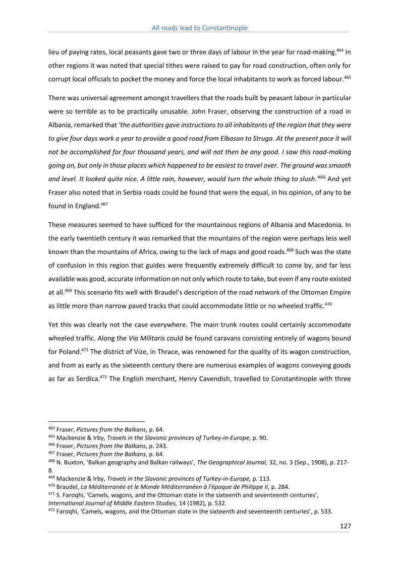
All roads lead to Constantinople
127
lieu of paying rates, local peasants gave two or three days of labour in the year for road-making.464 In
other regions it was noted that special tithes were raised to pay for road construction, often only for
corrupt local officials to pocket the money and force the local inhabitants to work as forced labour.465
There was universal agreement amongst travellers that the roads built by peasant labour in particular
were so terrible as to be practically unusable. John Fraser, observing the construction of a road in
Albania, remarked that ‘the authorities gave instructions to all inhabitants of the region that they were
to give four days work a year to provide a good road from Elbasan to Struga. At the present pace it will
not be accomplished for four thousand years, and will not then be any good. I saw this road-making
going on, but only in those places which happened to be easiest to travel over. The ground was smooth
and level. It looked quite nice. A little rain, however, would turn the whole thing to slush.’466 And yet
Fraser also noted that in Serbia roads could be found that were the equal, in his opinion, of any to be
found in England.467
These measures seemed to have sufficed for the mountainous regions of Albania and Macedonia. In
the early twentieth century it was remarked that the mountains of the region were perhaps less well
known than the mountains of Africa, owing to the lack of maps and good roads.468 Such was the state
of confusion in this region that guides were frequently extremely difficult to come by, and far less
available was good, accurate information on not only which route to take, but even if any route existed
at all.469 This scenario fits well with Braudel’s description of the road network of the Ottoman Empire
as little more than narrow paved tracks that could accommodate little or no wheeled traffic.470
Yet this was clearly not the case everywhere. The main trunk routes could certainly accommodate
wheeled traffic. Along the Via Militaris could be found caravans consisting entirely of wagons bound
for Poland.471 The district of Vize, in Thrace, was renowned for the quality of its wagon construction,
and from as early as the sixteenth century there are numerous examples of wagons conveying goods
as far as Serdica.472 The English merchant, Henry Cavendish, travelled to Constantinople with three
464 Fraser, Pictures from the Balkans, p. 64. 465 Mackenzie & Irby, Travels in the Slavonic provinces of Turkey-in-Europe, p. 90. 466 Fraser, Pictures from the Balkans, p. 243. 467 Fraser, Pictures from the Balkans, p. 64. 468 N. Buxton, ‘Balkan geography and Balkan railways’, The Geographical Journal, 32, no. 3 (Sep., 1908), p. 217-8. 469 Mackenzie & Irby, Travels in the Slavonic provinces of Turkey-in-Europe, p. 113. 470 Braudel, La Méditerranée et le Monde Méditerranéen à l'époque de Philippe II, p. 284. 471 S. Faroqhi, ‘Camels, wagons, and the Ottoman state in the sixteenth and seventeenth centuries’, International Journal of Middle Eastern Studies, 14 (1982), p. 532. 472 Faroqhi, ‘Camels, wagons, and the Ottoman state in the sixteenth and seventeenth centuries’, p. 533.

All roads lead to Constantinople
128
wagons in 1589, with the trip between Serdica and Philippopolis taking three days to complete.473 The
English traveller, Peter Mundy, made the journey from Constantinople to Belgrade in 1620 with a
company that was accompanied by twelve wagons (Figure 15).474 In 1665 the Scotsman John Burbury
was part of a diplomatic mission to Constantinople, led by Duke Henry Howard, that, after travelling
to Belgrade via the Danube, travelled the rest of the way along the Via Militaris, and was accompanied,
according to Burbury, by two hundred wagons, with each wagon being pulled by three or four
horses.475 Commenting on the route between Belgrade and Adrianople, Lady Montagu noted that,
‘the road is now made (with great industry) as commodious as possible, for the march of the Turkish
army; there is not one ditch or puddle between this place and Belgrade, that has not a large strong
bridge of planks built over it.’476
473 A. C. Wood, ed., ‘Mr Harrie Cavendish his Journey To and From Constantinople by Fox, his servant’, Camden Miscellany, 17 (1940), p. 15. 474 P. Mundy, Itinerarium Mundi, R. C. Temple ed., The Travels of Peter Mundy, in Europe and Asia, 1608-1667 Vol. 1 (1907, Oxford), p. 44. 475 J. Burbury, A relation of a journey of the Right Honourable My Lord Henry Howard, from London to Vienna and thence to Constantinople (Michigan, 1978), p. 117. 476 Lady M. W. Montagu, The letters and works of Lady Mary Wortley Montagu, p. 168.

All roads lead to Constantinople
129
Figure 15: The itinerary of Peter Mundy in 1665. From Mundy, Itinerarium Mundi, R. C. Temple ed., The
Travels of Peter Mundy, in Europe and Asia, 1608-1667 Vol. 1 (1907, Oxford).

All roads lead to Constantinople
130
This heavy volume of traffic argues that the Via Militaris remained throughout the Ottoman period
the main trunk route by which Constantinople could be reached, and therefore far better maintained
than less vital roads. In this respect the Via Militaris was likely somewhat exceptional, for it has been
argued that trade within the Ottoman Empire was seldom ever more than localised or intra-regional,
with long or even medium distance exchange between regions a rare occurrence, and probably largely
limited to the camel caravans of the East.477 Indeed, Hendy estimates that until the introduction of
railways, the speed and cost of transporting goods within the Ottoman Empire likely differed very little
from that which had existed in the medieval period.478
On the whole, therefore, it appears that Ottoman roads differed little in type and condition from
earlier Byzantine or even roads of the late Roman period. As a result, overland trade in this period was
also likely highly similar to earlier eras, in that it was predominately local in scope, and the costs of
transporting food over long distances would have proved prohibitive. The exception would be where
the state was directly involved, either in the appropriation of foodstuffs for the population of
Constantinople, or the provisioning of armies in the field. In this respect the Via Militaris, still the
premier strategic route servicing the middle Danube, likely garnered an exceptional degree of
attention. That the Ottoman state sought to maintain the Via Militaris in a good condition, capable of
accommodating wheeled vehicles, is not terribly surprising, in that the route played a vitally important
role in conveying men, artillery and supplies for the campaigns for Belgrade, Budapest and Vienna, to
note just a few.
477 Murphy, ‘Problems of trade along the Via Egnatia in the seventeenth century’, p. 174. 478 Hendy, Studies in the Byzantine Monetary Economy c.300–1450, p. 555.

All roads lead to Constantinople
131
Chapter 11: The Via Militaris
11.1: Belgrade
There is no definitive beginning point for the Via Militaris. This thesis will only cover its length from
Belgrade onwards, but it is possible to trace its course even further west than that, following the Sava
River to Sirmium, then either continuing to follow the Danube to Buda, or, cutting out the great
Danubian bend of the central Hungarian plain, taking the pilgrim route across the plain that was built
in the early eleventh century.479 From here the route proceeded onto Pressburg (modern Bratislava)
and then Vienna, opening the way into Central Germany beyond via Regensburg.
Belgrade is a convenient starting point as it can be taken, in a sense, to delineate the furthest extent
of Byzantine control over the Danube. In truth, Byzantine authority at times stretched even further to
the west, as far as Sirmium. The city of Sirmium declined rapidly from the fourth century onwards
however, and although Byzantine hegemony was re-established at this site during the eleventh
century, it typically remained outside of the bounds of the empire’s direct control and most likely
largely under the nominal leadership of local Serbian župans.480
As such Belgrade, which was approached from the west, across the Sava River, was likely the first
contact most travellers would have had with the Byzantine Empire. The fortress of Zemun (Roman
Taurunum, and sometimes referred to in crusading sources as Semlin, or Mallevilla), sat opposite
Belgrade, across the Sava. The crossing of the Sava was typically a difficult, and time consuming,
undertaking. The Sava is fast flowing, with the highest discharge of any tributary into the Danube and
prone to flash floods in early summer.481 Crusaders often found there were too few boats available,
which created long delays in crossing. Peter the Hermit’s forces during the First Crusade, for instance,
took five days to cross from Zemun to Belgrade.482
Belgrade itself sits upon a promontory formed by the confluence of the Sava and the Danube (Figure
16). Protected on three sides by water, it has historically represented the most strategically important
location along the middle Danube. The site has been fortified since the early Iron Age, and its defences
479 Murray, ‘Roads, bridges and shipping in the passage of crusade armies by overland routes to the Bosporus 1096-1190’, p. 188. 480 Stephenson, Byzantium's Balkan Frontier, p. 122-4. On the late Roman decline of Sirmium see Eadie, ‘City and Countryside in late Roman Pannonia: The Regio Simiensis’. 481 Murray, ‘Roads, bridges and shipping in the passage of crusade armies by overland routes to the Bosporus 1096-1190’, p. 201. 482 Albert of Aachen, Historia Ierosolimitana, p. 71.

All roads lead to Constantinople
132
were improved upon by the Roman, Byzantine, Ottoman, Austrian and finally Serbian occupiers of the
site. Sir Arthur Evans, visiting the city in the late nineteenth century, remarked that it possessed the
most commanding position of any city in Europe.483
Figure 16: Plan of the medieval fortress at Belgrade. From M. Popović, ‘Les forteresses du système defensif
byzantin en Serbie au XIe–XIIe siècle’ Starinar, 42 (1991), p. 171.
The Byzantine city was a far less impressive sight than the one that greeted later travellers however.
Crusading sources described the city as being ‘half-ruined’ and ‘a quite miserable place’.484 The Roman
fortifications that ringed the site had been repaired by Justinian, and further repairs had been made
during the reign of Basil II, but by the end of the eleventh century they were evidently in an extremely
poor state of disrepair. Furthermore its fortifications enclosed a relatively large area, encompassing
the dimensions of the classical city, of approximately 200 by 350 metres, and the small contemporary
483 A. J. Evans, ‘The Adriatic Slavs and the overland route to Constantinople’, The Geographical Journal, 47. no. 4 (April, 1916), p. 260. 484 Historia de Expeditione Friderici Imperatoris, p. 59.

All roads lead to Constantinople
133
population could not hope to defend such a large site.485 As such, during the passage of the First
Crusade the commander of the city despaired of being able to hold the walls against a potential attack,
one that looked likely when Peter the Hermit’s forces ravaged Zemun, and so retired instead to the
far more secure location of Naissus.486 It was not till the reign of Manuel Comnenus that the city would
receive more appropriate fortifications, although even then they were more directed at providing a
means of policing the frontier and detecting threats originating from across the river than securing
the safety of the local inhabitants, which would explain why the participants of the Third Crusade
found the city at large to still be in a deplorable state.487
From Belgrade the Via Militaris proceeded almost due east. Little is known in general of the road
throughout much of Serbia, either of its surface, or even its location in more than the most general
terms, and that is true here. Two stations are listed in the Itinerarium Burdigalense and the Itinerarium
Antonini between Belgrade and Viminacium; Aureo Monte (or Aureus Mons) and Margo (or Margus).
These sites are argued to lie in present day Smederevo and Požarevac respectively.488 Smederevo lays
on the western bank of the Morava River, some 24 Roman miles (approximately 36 kilometres) from
Belgrade, whilst Požarevac is some 8 Roman miles (approximately 12 kilometres) further east, across
the Morava and situated on its eastern bank (Figure 17). A bridge may have existed here, and Sir John
Mandeville mentions a certain ‘bridge of stone that is upon the river of Marrok’, that was likely the
Morava.489
485 Stephenson, Byzantium's Balkan Frontier, p. 241-2. 486 Albert of Aachen, Historia Ierosolimitana, p. 17. 487 Stephenson, Byzantium's Balkan Frontier, p. 241-2. 488 D. Mladenovic, Urbanism and Settlement in the Roman Province of Moesia Superior (Oxford, 2012). 489 John Mandeville, The travels of Sir John Mandeville, trans. C. W. R. D. Moseley (London, 2005), p. 7.

All roads lead to Constantinople
134
Figure 17: The Roman road network between Singidunum and Branichevo (Viminatio), from Miller, Itineraria
Romana, p. 499.

All roads lead to Constantinople
135
11.2: Branichevo
Lying approximately ten Roman miles from Margo was the legionary barracks of Viminacium, also
known as Branichevo or Branits in medieval sources. Like Belgrade, Branichevo’s walls were rebuilt by
Justinian, and were further repaired during the reign of Basil II (Figure 18). Again like Belgrade, the city
seems to have fallen largely into ruin by the twelfth century, and Odo of Deuil referred to it as a ‘poor
town’.490 For those who had travelled overland, the journey from Belgrade was of about three days
duration (although Odo of Deuil claimed it could be made in a single day), whilst for those who had
travelled down the Danube, Branichevo represented their terminus point, and it was from here that
boats were unloaded and preparations made for the long overland journey south to Naissus.491 During
the Third Crusade Barbarossa shipped a large amount of goods and supplies, in addition to a tent that
had been gifted to him by Queen Margaret of Hungary, to Branichevo, and the army was there delayed
for six days whilst the ships were unloaded.492
490 Odo of Deuil, De profectione Ludovici VII in orientem, p. 31. 491 Odo of Deuil, De profectione Ludovici VII in orientem, p. 31. 492 Historia de Expeditione Friderici Imperatoris, p. 59-60. For the chronology of the crusade’s departure from Branichevo see Nesbitt, ‘The rate of march of Crusading armies in Europe’, p. 178.

All roads lead to Constantinople
136
Figure 18: Plan of medieval Branichevo, from Popović, ‘Les forteresses du système defensif byzantin en Serbie
au XIe–XIIe siècle’, p. 171.
The route south from Branichevo to Naissus is perhaps the least known section of the entire route of
the Via Militaris. The Itinerarium Burdigalense lists nine stations along the route; Municipium, Jovis
Pagus, Bao, Idomum, Oromagus, Sarmatae, Cametae, Ipompei, and Rappiana. The Tabula
Peutingerina lists six stations between the two; Municipio, Jovis Pago, Idimo, Horrea Margi, Presidio
Pompei, and Gramrianis, whereas the Itinerarium Antoninii lists only four: Municipio, Idimo, Horreo
Margi, and Pompeis (Figure 19). This region was so heavily devastated during the fourth and fifth
centuries that the archaeological record suggests it was never again repopulated to any great degree.
Even then, archaeological surveys of this region have been few, and only a small number of these
stations have been definitively located, such as Horreum Margi in the modern Serbian town of

All roads lead to Constantinople
137
Ćuprija.493 This location may also correspond to the town of Rabnel, which is mentioned in the Historia
de Expeditione.494 Certainly a great deal is yet to be done in tracing the history of the Morava Valley
region in the post-Roman era, and all that can be confidently said is that the Via Militaris must have
followed the course of the Morava River closely, as it is the only practical north-south route in this
part of the Balkan Peninsula.
493 On the current state of archaeological research in the Morava Valley see Mladenovic, Urbanism and Settlement in the Roman Province of Moesia Superior, p. 7. 494 Eickhoff, Friedrich Barbarossa im Orient, p. 59.

All roads lead to Constantinople
138
Figure 19: The route south from Viminatio (Branichevo) to Naissus, from Miller, Itineraria Romana, p. 530.
The Roman road ran through this forested region down the eastern bank of the Morava as far as the
city of Naissus, some 120 Roman miles (approximately 180 kilometres) distant. In total this journey

All roads lead to Constantinople
139
took approximately five to eight days to complete and the latter is the length of time it took Peter the
Hermit’s contingent of the First Crusade to cover this distance.495 For a single mounted traveller, or a
small group, this distance could naturally be covered much faster. A Hunnic messenger to the
Byzantine court in the fifth century complained that the terms of their recently agreed peace
agreement were not being followed as markets were not being provided on the Danube as agreed,
but rather at Naissus, a five day march to the south.496
A travel time of between five to eight days is roughly consistent across the history of this route. For
instance in the seventeenth century, the English traveller Henry Blount, in a large party that included
numerous horse-drawn wagons, took twelve days to travel from Belgrade to Sofia.497 Yet it took
Barbarossa’s forces during the Third Crusade a similar amount of time just to cover the distance
between Branichevo and Naissus, leaving the former on the 9th of July and reaching Naissus on the
23rd.498 The much slower progress of Barbarossa’s army during the Third Crusade raises a curious issue.
The Historia de Expeditione relates that the crusaders were led by guides, given to them by the Doux
of Branichevo, along an alternate road south (saxosa et non publica).499 The crusaders, believing that
the Doux had deliberately misled them on the orders of the Byzantine Emperor Isaac Angelos,
confronted their guides and demanded to be led back onto the ‘public road’ (trita semita seu strata
publica).500
This episode has raised differing opinions as to the route between Branichevo and Naissus during this
period. The main Roman road clearly ran down the eastern bank of the Morava; Ogier de Busbecq
describes how, when travelling down the Ottoman road on the eastern bank of the Morava, fragments
of an older Roman road could clearly be seen running parallel to it.501 Murray argues that in the twelfth
century, however, the Via Militaris had become so difficult to traverse, owing to lack of repair, that
the guides sought to lead the crusaders by an alternate, easier, road, one that potentially lay on the
western bank of the Morava, and likely followed the route taken by a secondary Roman road.502
495 Albert of Aachen, Historia Ierosolimitana, p. 19. 496 Priscus, Historia, p. 243. 497 H. Blount, A voyage into the Levant with particular observations concerning the moderne condition of the Turks, and other people under that Empire (Amsterdam, 1977), p. 11-12. 498 Nesbitt, The rate of march of crusading armies in Europe, p. 179. 499 Historia de Expeditione Friderici Imperatoris, p. 59-60. 500 Historia de Expeditione Friderici Imperatoris, p. 60. It is notable that Otto of St Blasien provides a very different account, claiming that since the Bulgarian inhabitants ‘denied him “the king’s high way”’, Barbarossa took it by force, hanging many of those who opposed him on the trees alongside the road. Otto’s account, however, lacks the credibility of a first-hand source like that of the Historia de Expeditione. See Loud, The Crusade of Frederick Barbarossa, p. 177. 501 Ghiselin de Busbecq, Legationis Turcicae Epistolae quatuor, p. 16. 502 Murray, ‘Roads, bridges and shipping in the passage of crusade armies by overland routes to the Bosporus 1096-1190’, p. 203.

All roads lead to Constantinople
140
Indeed the French pilgrim Bertrandon de La Brocquière, who travelled from Naissus to Belgrade in
1433, clearly does so on the west bank of the Morava, along what he describes as a muddy road.503 In
1553 Hans Dernschwam likewise travelled down the west bank of the Morava, as does John Burbury
in 1655, before crossing the Morava via a wooden bridge to reach Naissus.504 This bridge was likely
located at Ćuprija, and depictions of the Ottoman road network in this region show the road splitting
here, with one road following the east bank, and another the west (Figure 20).
Figure 20: The Ottoman road where it crossed the Morava at Ćuprija. From Kiepert, General-Karte von der
europäischen Türkei: nach allen vorhandenen Originalkarten und itinerarischen Hülfsmitteln.
A further complication is raised by the account of Priscus, who made the journey from Naissus to the
Danube himself in the sixth century as an ambassador to the court of Attila.505 Priscus describes
travelling along a path that took ‘many twists and turns and detours’, and indeed the path twisted
around so much that owing to the ‘irregularity of the terrain’ the travellers lost their sense of direction
and were shocked to see the sun rise in the west the next morning, not the east. This has raised debate
as to which route Priscus took to the Danube, and indeed where exactly Attila’s court lay.
503 B. de La Brocquière, Le Voyage d'Outremer, p. 275. 504 Dernschwam, Ein Fugger-Kaufmann im Osmanischen Reich, p. 10., Burbury, A relation of a journey of the Right Honourable My Lord Henry Howard, p. 124. 505 Priscus, Historia, p. 249-50.

All roads lead to Constantinople
141
Browning argues that Priscus must have crossed the Danube at Ratiaria, a legionary barracks located
further down the Danube near the modern city of Vidin, claiming that since the party travelled for
only two days to reach the river then it is more reasonable to assume that the party covered the
distance between Ratiaria and Naissus (approximately 60 Roman miles) in this time than the near 120
Roman miles to Branichevo.506 Blockley, however, challenges this interpretation, claiming that this
ignores Priscus’ own statement that he was marching westwards.507 This thesis cannot offer a
definitive answer to this question, however Browning’s argument that Priscus’ description of the route
from Naissus, with its twists and turns and difficult terrain, was highly unlike that which a traveller
would expect along a major Roman road, such as the Via Militaris, seems a highly pertinent one. The
route through the Morava Valley was densely forested, but it was otherwise free of the ‘irregular
terrain’ that Priscus describes, and moreover the Roman road, as far as can be ascertained, travelled
consistently to the north. This either suggests that Priscus did indeed take the road to Ratiaria, which
encompasses far rougher terrain than that found in the Morava Valley, or that another route to the
north existed. Certainly it seems doubtful that the road Priscus described could possibly have been a
major Roman highway like the Via Militaris.
A potential answer may be found in the argument that the link between Branichevo and Naissus was
a late addition to the Via Militaris. An inscription, dating to the reign of Hadrian, suggests that the
road was only completed after the conquest of Dacia.508 Until this point the road along the Danube
built by Nero, through the ‘Iron Gates’, was a more important route for the Romans whilst Viminacium
was used as a base from which the conquest of Dacia was being prosecuted. Speidel, however, argues
that the use of ‘nova’ in the inscription does not necessarily mean ‘new’, but rather ‘renewed’, in that
an existing road south to Naissus was rebuilt in the second century during the reign of Hadrian (Figure
21).509 Accordingly, whilst a road between Viminacium and Naissus existed from the second century
onwards, it was also the case that an important road between Naissus and Ratiaria was also in
existence at this time. Whilst with the collapse of the Danubian limes the road along the Morava River
became the preferred route, other potential roads between the Danube and Naissus may have been
available, albeit of varying levels of quality, one of which may have indeed run to the west of the
Morava, and subsequently been utilised by the Byzantines in the twelfth century.
506 R. Browning, ‘Where was Attila’s camp?’, The Journal of Hellenic Studies, 73 (1953), p. 143-4. 507 R. C. Blockley, The Fragmentary Classicising Historians of the Later Roman Empire: Eunapius, Olympiodorus, Priscus and Malchus, Vol. II (Liverpool, 1983), p. 382, n.29. 508 M. Mirkovic, ‘Vom obermosischen Limes nach dem Suden: Via Nova von Viminiacum nach Dardanien’, in W. S. Hanson & L. J. F. Keppie eds., Roman frontier studies 1979: papers presented to the 12th International Congress of Roman Frontier Studies (Oxford, 1980), p. 745-55. 509 M. P. Speidel, ‘The road to Viminacium’, Roman Army Studies, Vol 2 (Stuttgart, 1992), p. 170-2.

All roads lead to Constantinople
142
Figure 21: Depiction of the Roman road system of Upper Moesia showing roads running down both sides of the
Morava River, from Speidel, ‘The road to Viminacium’, p. 171.
Whichever course the Via Militaris took between Branichevo and Naissus, it is evident that it was in
an appalling condition in the twelfth century. Henry the Lion, Barbarossa’s long time sparring partner,
attempted to travel this route whilst on pilgrimage to the Holy Land in 1172. The wagons which were

All roads lead to Constantinople
143
used, which had been shipped down the Danube from Regensburg before being unloaded at
Branichevo, had to be abandoned before the pilgrims reached Naissus, as the road was so swampy
and muddy the pilgrims simply could not get them through.510
Moreover, the route was often a dangerous one. This region was in crusader sources a wild, lawless
land, typically referred to as the Bulgarian Forest (variously Silva Bulgarica, nemora Bulgarorum, or
silva Bulgarorum). This was a vast impenetrable forest of predominately oak trees, known locally as
the Šumadija, which covered much of modern lowland Serbia until the mid-nineteenth century when
it was largely cleared. Nourished by the long cool winters and heavy rains typical of this region, it long
represented a formidable barrier to travellers.511 Alexander Kinglake, travelling to Constantinople in
1834, describes his journey through this region: ‘we entered the great Servian forest. Through this our
road was to last for more than a hundred miles. Endless and endless now on either side the tall oaks
closed in their ranks, and stood gloomily lowering over us, as grim as an army of giants with a thousand
years’ pay in arrear.’512
This region was regarded with a great deal of fear and trepidation by crusaders, for the forest had
been allowed to grow right up to the edges of the road, indeed during the passage of the Third Crusade
Barbarossa was forced to send men ahead with axes to clear a path (Figure 22).513 The overgrown
route afforded ample opportunities for brigands to launch ambushes, and their assaults were a
common aggravation for travellers. The Great German Pilgrimage of 1064-65 was subjected to attacks
in this region, and as soon as the pilgrims crossed the Morava River they were assaulted by robbers
and bandits.514 Barbarossa’s followers suffered particularly heavily in this region, with foragers being
‘murdered wholesale during the daytime’ and as a result the force suffered a heavy death toll through
starvation.515
510 Arnold of Lübeck, Arnoldi Chronica Slavorum, p. 15. 511 M. Mazower, The Balkans: a short history (New York, 2000), p. 4. 512 A. W. Kinglake, Eothen: traces of travel brought back home from the East (Illinois, 1996), p. 13-4. 513 Historia de Expeditione Friderici Imperatoris, p. 59-60. 514 Annales Altahenses maiores, p. 3-4. 515 Historia de Expeditione Friderici Imperatoris, p. 60.

All roads lead to Constantinople
144
Figure 22: Barbarossa ordering the clearing of forests in 'Hungary' during the passage of the Third Crusade,
from Peter of Eboli, De Rebus Siculis Carmen, ed., E. Rota, Rerum Italicarum Scriptores, 31 (Città di Castello,
1904), p. 360.
Nevertheless, for all of the difficulties it presented the road was not an impassable one, and the
contingents of the First and Second Crusades who had made use of it seemingly suffered far less in
the journey than did Barbarossa’s contingent of the Third Crusade. Indeed, according to Odo of Deuil
the French contingent of the Second Crusade were able to cover this section in a mere four days,
although this is surely a gross underestimate. Moreover, shortly after the passage of the Third Crusade
(in either 1191 or 1192) Isaac Angelos was able to lead a successful campaign against the Vlachs that
were menacing Naissus, and thereafter march to the Sava River for a meeting with King Béla III of
Hungary, before returning to Philippopolis.516
The sources would therefore seem to suggest that by the late twelfth century the road between
Naissus and the Danube was navigable for light troops, likely accompanied by limited numbers of
beasts of burden, but far less so for large armies and heavily loaded wagons. It is curious therefore,
that the passage of the First Crusade and Second Crusades appears to have involved far less difficulties
than that experienced by the Third. Perhaps it was the case that the increase in traffic in the
intervening period had seriously impacted upon the road surface, the quality of which therefore
declined rapidly as the century came to a close.
516 Choniates, Historia, p. 239.

All roads lead to Constantinople
145
11.3: Naissus
Naissus is situated on the Nishava River, which is a tributary of the Morava, and the city is located
some ten kilometres downriver from where the two meet. The area inhabited by the modern city of
Niš has been occupied for over two millennia, and was protected by a fortress located on the northern
bank of the Nishava. The current remains of a fortress on this site are entirely of Ottoman origin, built
in the early eighteenth century, and covering an area of some 22 hectares. Pre-dating this construction
are Roman and later medieval fortifications. The orientation of the earlier construction has been
preserved, particularly in the location of the two main gates, its western and southern gates, which
were known in the Ottoman period as the Belgrade and Stambol gates respectively.
Naissus, aside from those cities on the Danube, the most distant from the capital on the route of the
Via Militaris and therefore most isolated, was subjected to a brutal sack by Hunnic forces in 441, and
the historian Priscus, passing through a short time later, described the city as ‘utterly devoid of
inhabitants, full only of horror and ruins.’517 The city was restored under Justinian, with its Roman walls
being repaired and thickened. Naissus was further attacked numerous times by Slavic tribes during
the course of the sixth and seventh centuries, before falling to a combined Slavic-Avar assault in 615.
Little is known of its fate after this period, other than that it was seized by the Bulgar Khan Krum in
809, before its reabsorption back into the Byzantine Empire by Basil II.
The valley in which the city sits is an extremely fertile one, fed by alluvial deposits carried by the
Nishava River, and favoured by a temperate continental climate, it is today the centre of intensive
agricultural production. Numerous historical sources also contain descriptions of the richness of the
region. Albert of Aachen spoke of the ‘wonderful abundance of food’ that greeted the crusaders
here,518 whilst the Roman historian Ammianus Marcellinus commented that Naissus was a well-
supplied city (copiosum oppidum).519 Visiting the city in 1717, Lady Mary Wortley remarked that it
possessed ‘so fruitful a soil, that the great plenty is hardly credible.’520 The city was heavily devastated
by a Hungarian invasion in 1185 however, and by the time Barbarossa’s force arrived the region had
still not completely recovered. Nevertheless, throughout the medieval period the city was a relatively
rich one, and one of the few places en route to Constantinople where crusaders could hope to be
provided with markets with which to purchase food.
517 Priscus, Historia, p. 249. 518 Albert of Aachen, Historia Ierosolimitana, p. 73. 519 Ammianus Marcellinus, Rerum gestarum libri, trans. J. C. Rolfe. Ammianus Marcellinus, Vol.2, p. 137. 520 Lady M. W. Montagu, The letters and works of Lady Mary Wortley Montagu, p. 158.

All roads lead to Constantinople
146
Naissus had therefore always been a key commercial and strategic site along the Via Militaris. Given
municipal status in the second century AD, according to Ammianus Marcellinus it was ‘magnificently
ornamented’ by Constantine the Great in the fourth century, when it also became an important
episcopal seat.521 The Augustus Julian chose the city as his base of operations when civil war broke out
in the empire in 361, partly because of the ease of securing supplies in the region, but also because
the city’s position afforded it a commanding position over not only the Via Militaris, but also routes
south to Thessalonica, and west to Dalmatia. A further road, as noted above, linked the city with the
legionary station of Ratiaria, located on the Danube, approximately 27 kilometres from the modern
city of Vidin. Naissus sat in the centre of a matrix of road networks that spread in all four directions,
and was therefore a crucial location for the control of the Central Balkans.522
The city retained this status whilst under Byzantine control, and upon its reabsorption into the empire
in the beginning of the eleventh century its importance as a military outpost is emphasised by a seal,
dated to the mid-eleventh century, that indicates it became the seat of a strategos, initially held by
Nicephorus Lykaon, protospatharios.523 Further, its economic status was enhanced by its connection,
via the Vardar Valley, to the flourishing trade centre of Thessalonica, with medieval ceramic finds
within the city suggesting it was the beneficiary of long distant trade.524 In the De Administrando
Imperio Constantine Porphyrogenitus makes the astounding claim that ‘from Thessalonica to the river
Danube where stands the city called Belgrade, is a journey of eight days, if one is not travelling in haste
but by easy stages.’525. This claim is certainly difficult to believe, even if the roads were in good repair
and changes of mounts readily available. However it does argue for the importance of this north-south
route, which Naissus was ideally positioned to benefit from. Later in the mid-twelfth century, during
the reign of Manuel Comnenus, Naissus emerged as an important mustering site for imperial armies,
and a convenient base to guard over potential advances from both the Serbians to the east, and the
Hungarians to the north.526
The surrounding environment of Naissus provides plentiful information as to the route the Via
Militaris took as it left the city, even if the road itself has disappeared. Just beyond the city walls of
Naissus lay the suburb of Mediana, built alongside the southern bank of the Nishava, and around a
521 V. P. Petrovic, V. Filipovic, & K. Luka, ‘The roman road Naissus - Timacum Maius – Timacum Minus – Conbustica – Ratiaria’, Ratiaria Semper Floreat, 1 (2014), p. 97. 522 For further information on these routes, see J. J. Wilkes, ‘The Roman Danube: an archaeological survey’, The Journal of Roman Studies, 95 (2005). 523 Stephenson, Byzantium's Balkan Frontier, p. 124. 524 Laiou, ‘Regional networks in the Balkans in the Middle and Late Byzantine Periods’, p. 136-7. 525 Constantine Porphyrogenitus, De administrando imperio, trans. R. J. H. Jenkins (Washington D.C., 1967), p. 183. 526 Kinnamos, The Deeds of John and Manuel Comnenus, p. 83 & p. 161-2.

All roads lead to Constantinople
147
thermal spring. The site covers some 6,000 square metres, and its main feature is a Roman villa that
is reputedly the birth place of Constantine the Great. The villa was richly expanded in the early fourth
century, with the addition of mosaics and frescos, whilst at the site itself 80 structures have been
uncovered, including thermae, churches, and granaries, as well as a complex water supply system and
aqueduct (Figure 23).527
Figure 23: Remains of Mediana, on the outskirts of modern Niš.
Mediana held a prominent role in the history of the fourth century Roman Empire. Constantine stayed
often in the villa, and passed numerous laws there in his lifetime. The co-emperors Valentinian and
Valens also met there in 365 in order to define their respective spheres of influence. In the late fourth
century, however, the site was subject to a fire, and then completely destroyed in the Hunnic invasion
of 441. Partly restored under Justinian, it subsequently fell into decay once again, and was finally
abandoned, probably sometime in the late sixth century when Naissus came under continued Slavic
attack.
Meanwhile, between the modern city of Niš and the remains of Mediana, sits what is locally known as
the ‘Tower of Skulls’ (Serbian Ćele kula). This three metre high tower was raised in 1809 on the orders
of Hurshid Pasha, the Ottoman Grand Vizier of Niš, after a failed Serbian uprising in the city in that
527 J. Šašel, Tabula imperii Romani: Naissus, Dyrrhachion-Scupi-Serdica-Thessalonike: d'après la Carte internationale du monde au 1:1,000,000, K 34 Sofia (Ljubljana, 1976), p. 84-5.

All roads lead to Constantinople
148
same year. In it were embedded 952 skulls of slain Serbian revolutionaries, from whence it draws its
name, and served as a warning against any further uprisings in the city. In order to fulfil this purpose
the Skull Tower would have been located in the most prominent location possible and was therefore
positioned on the main Ottoman highway leading from the city towards Constantinople, and there are
references to the tower by nineteenth century travellers which remark upon the striking impact it
made.528
That the Via Militaris left the city via the south gate and crossed the Nishava River before proceeding
to the east is further supported by evidence found within crusading chronicles. Albert of Aachen, in
relating the experiences of Peter the Hermit at the city, states that Peter and his men approached the
walls of the city, and ‘there they crossed a river by way of a stone bridge in front of the city, and by
pitching their tents they took possession of a meadow, delightful in its greenness and wide extent, and
the bank of the river’.529 The following day Peter was compelled to return to the city to solve a dispute
that erupted between its citizens and certain ‘Swabians’ in his force. Whilst Peter was ‘a mile away’
from the city, trying to restore order, a large group broke free from the main army and, ‘advanced in
great assault over the aforesaid stone bridge to the walls and gate over the city’, whilst ‘another
thousand similarly frivolous youth, rushing together across the ford and the bridge with loud shouting
and rage, joined them in support.’530
This stone bridge dated from the Roman period and was positioned outside the southern gate of the
city, on the site of the modern bridge (Figure 24).531 This suggests that, coming from the north, Peter
and his host crossed the Nishava and camped on it southern bank. When, after Peter had departed to
the east, elements turned back to attack the city, they recrossed the bridge to assault the walls. The
Roman road, therefore, must have run along the southern bank of the Nishava as it progressed to the
east. This lends credence to the argument that the suburb of Mediana and the Skull Tower both lay
on the route of the ancient Roman road, which is today covered by a section of the major Serbian-
Bulgarian road, the E-771, suggesting a continuity of road infrastructure in this region that stretches
back near two millennia (Figure 25).
528 Alphonse de Lamartine, A Pilgrimage to the Holy Land, p. 105-6. 529 Albert of Aachen, Historia Ierosolimitana, p. 19. 530 Albert of Aachen, Historia Ierosolimitana, p. 23. 531 Bertrandon de La Brocquière also mentions crossing a bridge before entering the city, Le Voyage d'Outremer, p. 271.
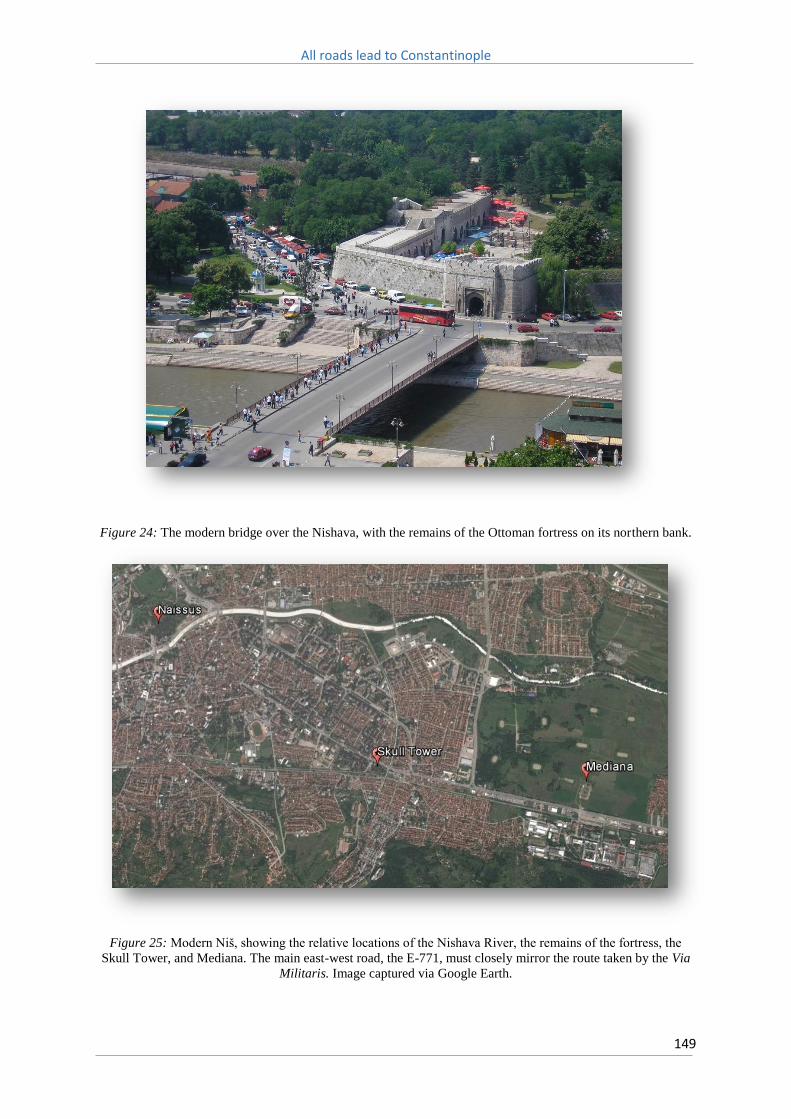
All roads lead to Constantinople
149
Figure 24: The modern bridge over the Nishava, with the remains of the Ottoman fortress on its northern bank.
Figure 25: Modern Niš, showing the relative locations of the Nishava River, the remains of the fortress, the
Skull Tower, and Mediana. The main east-west road, the E-771, must closely mirror the route taken by the Via
Militaris. Image captured via Google Earth.

All roads lead to Constantinople
150
Heading east, the Via Militaris followed the course of the Nishava River as far as the modern Serbian-
Bulgarian border, approximately 150 kilometres distant. The route of the road can be closely
approximated, particularly when it travels through the narrow, 17 kilometre long, Nishava River gorge
(known in Serbia as the Sićevo gorge). The Nishava generally lies approximately 250 metres above sea
level, whilst the ridges of the valley through which it runs rise to 500 to 750 metres in height on either
side, with occasional peaks of over 1000 metres. The main Serbian-Bulgarian highway, the E-80 (which
the E-771 joins), follows this route, as does the rail line connecting the two countries, constructed in
the late nineteenth century. The Via Militaris kept to the south of the Nishava, although just before it
reached the modern Bulgarian border it must have crossed to the north of the river, as this is where
a segment of the road was recently uncovered. There is no mention of a bridge in any of the sources,
however the Nishava is not especially broad nor fast flowing as it approaches Bulgaria and therefore
relatively easily fordable. Kieperts map of the Ottoman road as it existed in the mid-nineteenth
century indicates that the Via Militaris crossed the Nishava at Zaribrod, or Tsaribrod, the old Bulgarian
name for Dmitrovgrad (Figure 26).
Figure 26: Route of the Ottoman road through the Dragoman Pass in the nineteenth century, and the crossing at
‘Zaribrod’. From Kiepert, General-Karte von der europäischen Türkei: nach allen vorhandenen Originalkarten
und itinerarischen Hülfsmitteln.

All roads lead to Constantinople
151
The three different Roman itineraries share the same number of major stations between Naissus and
the next city along the route, Serdica. The Itinerarium Burdigalense lists three mansion: Romansiana,
Turres and Meldia, and five mutation: Redices, Latina, Translites, Ballanstra and Ulmus Scretisca. The
Tabula Peutingerina lists three mansion: Remesiana, Turribus, and Meldiis, the same number as the
Antonini Augusti; Remisiana, Turribus, and Meldia (Figure 27). Two of the three mansio that are
common across all three sources can be readily identified with contemporary locations; Remesiana
(or Romansiana) with the city of Bela Palanka, and Turres (or Turribus) with Pirot. The third station,
Meldiis (or Meldia), is usually identified with either Dimitrovgrad, or Dragoman.

All roads lead to Constantinople
152
Figure 27: Route of the Via Militaris between Naissus and Serdica. From, Šašel, Tabula imperii Romani:
Naissus, Dyrrhachion-Scupi-Serdica-Thessalonike.
The first major station after Naissus, Remesiana, is marked as lying between 24 and 27 Roman miles
from Naissus across the three itineraries. This distance (between 35 and 39 kilometres) does not

All roads lead to Constantinople
153
equate neatly with the modern road distance between Niš and Bela Palanka of 44 kilometres, where
the modern road closely follows the course of the Nishava through the narrow Nishava Gorge. The
difference in the noted distances is, therefore, surprising, although, as noted above, distances noted
in the itineraries need to be handled with some care, even if the Roman route would not have been
as sinuous as the modern road.
There seems little doubt that the route of the Via Militaris would have generally followed the course
of the Nishava quite closely. Indeed, it has been suggested that the existence of a medicinal herb
within the Sićevo Gorge, Salvia officinalis, which is indigenous to the Adriatic Coast, may have been
introduced to the area by those who travelled along the route.532 However a potential answer to the
above discrepancy is that it may have been the case that the Roman road, or perhaps a branch of it,
did not exactly follow the course of the Nishava River across this particular section, as the modern
roads do today, but rather continued due east, cutting off a long loop of the Nishava, and re-joining it
just before it reaches Bela Palanka. The US Army map of 1943 indicates the existence of a road in this
region that took this course and a journey along this route is far closer to the 24-27 Roman miles
mentioned in the itineraries (Figure 28).
532 D. Stojanović, J. Aleksić, I. Jančić & R. Jančić, ‘A Mediterranean medicinal plant in the continental Balkans: A plastid DNA-based phylogeographic survey of Salvia officinalis (Lamiaceae) and its conservation implications’, Willdenowia, 45 (2015), p. 104.

All roads lead to Constantinople
154
Figure 28: Detail of US Army map of 1943 that shows the main road (red) cutting off the loop of the Nishava
between Nis and Bela Palanka, as opposed to the route of the rail line in black.

All roads lead to Constantinople
155
Remesiana is known to have been fortified during the reign of Justinian, who also built or rebuilt a
number of fortresses in the region that guarded the strategically important narrow passes along the
Nishava.533 Albert of Aachen relates that Peter the Hermit, after his chastening defeat outside of
Naissus, retreated with those few followers who remained with him into the mountains to regroup
his forces with signals and horns.534 To rebuild their depleted stores, they then moved onto a nearby
town, which Tyerman suggests was Remesiana, and there attempted to gather the harvest.535 The
geography between Naissus and Remesiana closely matches this description, and Peter could have
retreated into the Suva Planina range to the south of the Nishava. The heights here (approximately
1000 metres above sea level) would have provided a highly visible location from which to regroup
before leading what remained of his army to the east.
Between Remesiana and the next masnio, Turres, the Itinerarium Burdigalense and the Antonini
Augusti both list a distance of 18 Roman miles (approximately 30 kilometres). This fits almost exactly
with the modern road distance between these two sites (Bela Palanka and Pirot), of 29.8 kilometres.
The Tabula Peutingerina, however, gives a far different figure, 25 Roman miles (approximately 37
kilometres). These differences in stated distances, over a course of the Via Militaris that can be quite
closely approximated on modern geographical maps, indicates how fraught with uncertainty this
method can be, even when the location of Turres has been firmly established, by archaeological
excavations, at the town of Pirot.
The station of Turres was heavily fortified in the Roman period, and ruins dated to the third century
can still be located in Pirot today. It is possible that this fortress was the ‘Quimedava’ mentioned by
Procopius, which Justinian repaired in the sixth century, before it fell to Slavic tribes, sometime in the
seventh. It was recaptured and restored during the reign of Basil II, however its fate after 1185 is
uncertain, and it most likely was abandoned. Archaeological excavations have uncovered a settlement
on the site, containing Christian basilicas and thermae, covering a total area of nearly 100 hectares.536
Bertrandon de La Brocquière, passing the town in 1433, and claiming that the road leading through
the region was ‘tolerably good for horseback riding’, noted a small castle at the site, defended to the
north by the Nishava River and to the south by a marsh.537 The Croatian diplomat, Antun Vrančić, who
533 Šašel, Tabula imperii Romani: Naissus, Dyrrhachion-Scupi-Serdica-Thessalonike, p. 108. 534 Albert of Aachen, Historia Ierosolimitana, p. 27. 535 C. Tyerman, God’s War: a new history of the Crusades (London, 2007), p. 97. Albert of Aachen does not specifically name which city that the pilgrims retreated to, only describing it as ‘a certain city’, Albert of Aachen, Historia Ierosolimitana, p. 27. 536 Šašel, Tabula imperii Romani: Naissus, Dyrrhachion-Scupi-Serdica-Thessalonike, p. 128-9. 537 B. de La Brocquière, Le Voyage d'Outremer, p. 270-1.

All roads lead to Constantinople
156
passed through the town of Pirot in 1567, en route to Constantinople, noted the paved remains of a
road that the native inhabitants of the region called the ‘Trajan’.538
The location of the next station, Meldiis, is not certain. The Tabula Peutingerina gives a distance of 24
Roman miles (35.5 km), whilst the Itinerarium Burdigalense and the Antonini Augusti give 31 and 30
miles respectively (44-45 km). The modern distance by road between Pirot and the next two largest
towns along the route, Dimitrovgrad and Dragoman, is 27 and 46 kilometres respectively.
Dimitrovgrad is mentioned by Hans Dernschwam as being a town on the route of the Via Militaris, and
he also remarked that well preserved sections of the Roman road were still visible in this region.539
Dragoman would appear the most likely location for Meldiis, however the Bulgarian archaeologist
Mitko Madzharov argues that it was located partly between the towns of Dragoman and Slivnitsa. In
Madzharov’s opinion Roman remains found near the railway station in modern day Dragoman are,
therefore, not those of the mansio Meldiis, but rather of the mutatio Ballanstra that is listed in the
Itinerarium Burdigalense.540
A potential problem with this interpretation is that would mean a distance between Turres and Meldiis
of some 51 kilometres, or 34 Roman miles, through quite difficult terrain. Between Turres and Meldiis
sits what is today known as the Dragoman Pass, a narrow valley of some four kilometres that follows
one of the southern tributaries of the Nishava River, known as the Ezhevitsa (Figure 29).541 This pass
today delineates the Serbian-Bulgarian border, and was the site of a famous confrontation between
Bulgarian and Serbian forces on November 16, 1885, as Bulgarian forces unsuccessfully attempted to
halt a Serbian advance on Sofia in the narrow mountain valley, before defeating the Serbians shortly
afterwards at the Battle of Slivnitsa (17-19 November, 1885).
538 Vrančić, Monumenta Hungariae Historica VI. Scriptores, p. 80. 539 Dernschwam, Ein Fugger-Kaufmann im Osmanischen Reich, p. 20. 540 Madzharov, Roman Roads in Bulgaria, p. 75. 541 Great Britain Naval Intelligence Division, A handbook of Bulgaria, p. 238.

All roads lead to Constantinople
157
Figure 29: The Dragoman Pass. The Via Militaris ran along the side of the valley to the right of the modern
road. The modern train line runs to its left.
One potential answer to this question may be provided in analysis of the road itself, and it is fortunate
that in this region there are several stretches of preserved road surface, whilst on the outskirts of
Dimitrovgrad a section of the original road was unearthed during construction of the trans-European
highway, Corridor 10. Further excavations at the site revealed that the road in this location was eight

All roads lead to Constantinople
158
metres wide with a cobblestoned surface and dated to the late fourth century (Figure 30).542 This
indicates that the road was wider than the minimum 5.5 metre width proscribed for highways by
Augustus, and reaffirms that in the late Roman Empire the Via Militaris was an extremely important
strategic route, hence the magnitude of its construction. Dernschwam described the road sections he
observed along the Nishava River in the sixteenth century as being an ‘old stone paved street’, and so
wide ‘two wagons could pass each other’, indicating that in the mid-sixteenth century the road
retained its impressive width in this region.543
Figure 30: Excavated section of the Via Militaris on the outskirts of Dimitrovgrad. Image courtesy of the World
Bank, http://www.worldbank.org/en/news/feature/2014/05/07/breaking-through-to-future-discovering-past-
serbia/
Some five kilometres to the south-east of this find, just across the Serbian-Bulgarian border, are
located further exposed fragments of the road’s surface, on the northern bank of the Nishava, and the
fringe of the Bulgarian village of Kalotina. These remains have not been the subject of excavations,
and so their dimensions or origins are unclear, although these most likely are the remains of the
Ottoman road surface. Alongside the remains of the road sits the Church of St Nicholas, which contains
an inscription that dates its construction to the reign of the Bulgarian Emperor Ivan Alexander in the
542 Lazic, ‘Via militaris - римски друм код Цариброда’, p. 70. 543 Dernschwam, Ein Fugger-Kaufmann im Osmanischen Reich, p. 18.

All roads lead to Constantinople
159
fourteenth century.544 Its location alongside the road suggests that this route was utilised during the
late Middle Ages.
There are further clear remains of the Via Militaris between Kalotina and Dragoman, located slightly
to the east of the modern road through the Dragoman Pass, the E-80, and running parallel to it.
Running through a forested region, and then open farmland, before terminating at the edge of the
Dragoman township itself, exists approximately four kilometres of unbroken road surface. In the
forested region the road sits upon a steep embankment, which gradually declines before disappearing
altogether as it enters the level field beyond, leaving behind just the paved road surface itself (Figure
31). The road is approximately eight metres wide, and consists of rough stones of irregular size.
Furthermore, whilst the surface of the road uses extremely irregular stones, regular flagstones can
also be seen used to mark the kerbs (see Figures 32-35). This road is again almost certainly of Ottoman
origin, but owing to its location, the existence of an embankment within the Dragoman Pass, and the
relative position of stations, most likely closely followed the same route of the earlier Roman road.
544 I. Biliarsky, Word and Power in Medieval Bulgaria, East Central and Eastern Europe in the Middle Ages, 450–1450 (Leiden, 2011), p. 25.

All roads lead to Constantinople
160
Figure 31: The route of the road as it approaches modern Dragoman. The road (highlighted in red) bends to the
left then, as it leaves the forest, bends to the right and enters open fields. The modern highway runs to the right
of it, as does the rail line. Image captured via Google Earth.

All roads lead to Constantinople
161
Figure 32: Remains of the road in the Dragoman Pass, where it bends to the left in the above image. A steep
embankment drops away to the left of the picture.

All roads lead to Constantinople
162
Figure 33: Exposed pavement of the road as it nears Dragoman.
Figure 34: Regular sized paving stones mark the kerb of the road.

All roads lead to Constantinople
163
Figure 35: The route of the road as it runs through fields near the town of Dragoman. The modern highway can
be seen running parallel to the right.
On the southern edge of Dragoman, between it and the town of Slivnitsa, the road appears once more,
crisscrossing the train lines several times before disappearing again at the town of Slivnitsa itself.
Along its entire length it maintains a south-easterly course, in the direction of Sofia. In several places
the road seems to have been overlaid by the, now largely abandoned, paved nineteenth century
Bulgarian road that ran to Sofia. Again, the surface is comprised of rough, uneven stones and is
approximately eight metres wide. At times it sits upon a large embankment, but in other sections the
embankment is entirely missing (see Figures 36-38). This may be explained by the Ottomans having
deliberately broken up embankments of the original road to provide building material to repair the
original surface or build a new road. The remains that exist today are again almost certainly those of
the Ottoman road, and its route matches quite closely that of the road in this region traced in the early
twentieth century, in particular in its frequent crossing of the railway lines.545
545 Great Britain Naval Intelligence Division, A handbook of Bulgaria, p. 238.

All roads lead to Constantinople
164
Figure 36: Overgrown remains of road near Slivnitsa. A steep embankment is present. The tree line on the right
follows the course of the modern rail line.
Figure 37: Exposed stones on the overgrown surface of the road.

All roads lead to Constantinople
165
Figure 38: Further remains of the road as it passes through a field. The embankment is now completely absent.
The station of Meldiis may well then conform to a series of ruins situated to the north of this road
surface, on the outskirts of the town of Slivnitsa, and alongside the protected marshland
Aldomirovsko. These ruins have not been excavated, although locals refer to them as a ‘Roman
station’, and they match with the position of the station Meldiis, as stated by Madzharov, as being
between Dragoman and Slivnitsa (Figure 39).546 Just to the north of these ruins are the remains of a
Thracian shrine to Sabazios, which was later converted into a Christian church.547 Despite the distance
between Pirot and this location, given the evident width of the road in this region, and the straightness
of the route after it exits the Dragoman Pass, it is not unreasonable that this might well have been
location of the station Meldiis.
546 Madzharov, Roman Roads in Bulgaria, p. 75. 547 Hoddinott, Bulgaria in Antiquity, p. 179.

All roads lead to Constantinople
166
Figure 39: Possible remains of a Roman station located to the north of the road, on the edge of the
Aldomirovsko Marsh.
A final station existed before Serdica, the mutatio Scretisca, located on the fringes of the modern town
of Kostinbrod, some 15 kilometres from the city centre of Sofia. Scretisca is the one of the few stations
along the Via Militaris within modern Bulgaria that has been the subject of extensive archaeological
study.548 The station was excavated in the 1990s, and revealed to consist of nine rooms situated
around an open patio, with a total area of 730 square metres. It is thought the three rooms on the
eastern wing were used by the personnel who serviced the station, with the six rooms and patio on
the western side catering for travellers and their mounts. It was found that the station went through
a number of different stages of development, originally built sometime between the years 317 and
324, further added to by Constantine, before ceasing to function around the time of the Second Goth
War (377-8). A section of the Via Militaris unearthed here was measured as being 6.8 metres wide.
548 V. Dinchev, Late Roman and early Byzantine residence Scretisca, settlement Kratiskara: Archaeological excavations in the area Gradishteto in 1990-1994 (Sofia, 2003).

All roads lead to Constantinople
167
Located approximately one kilometre to the east of the station, on the banks of the Belichka River, a
tributary of the Iskar, is a large Roman residence, known as Villa Scretisca. This villa, which covers an
area of some 15,000 square metres, dates to the late Roman period, probably the early third century,
and contains a number of buildings arranged around a central peristylium yard (see Figures 40-42).
During the reign of Constantine the villa was expanded and adorned with intricate mosaics, and it may
have acted as an imperial residence when Constantine was visiting Serdica, as well as hosting some of
the bishops who attended the Council of Serdica, that was held c. 343 AD. However it was clearly not
an urban residence, and instead likely formed the nucleus of an extensive estate, and thus represents
an example of a villa rustica.549
Figure 40: Part of the remains of Villa Scretisca today.
549 Dinchev, Late Roman and early Byzantine residence Scretisca, settlement Kratiskara, p. 111.

All roads lead to Constantinople
168
Figure 41: Plan of Scretisca. The station is shown in the south-west corner (4), inside the perimeter of a Coca
Cola bottling plant, with the larger villa (1) to the east. The route of the excavated section of the Via Militaris is
also shown in the south-west corner. From Dinchev, Late Roman and early Byzantine residence Scretisca,
settlement Kratiskara, p. 132.

All roads lead to Constantinople
169
Figure 42: Part of the remains of Screstisca can be seen in the extended section at the bottom left of the Coca
Cola bottling plant. Image captured via Google Earth.
After being destroyed at the same time as the neighbouring station in the late fourth century, the villa
was restored during the reign of Justinian, when a fortress was built on the site. The fortress contained
three round turrets and a single gate in the northern wall that was protected by a rectangular turret.550
It has been identified with the location of Cratiscara, mentioned by Procopius, and it appears to have
survived till the late sixth century, when all evidence of inhabitation ceases.551
Between Naissus and Serdica it is possible therefore to trace the route of the Via Militaris with a great
deal of confidence. Much of the Serbian portion of this journey is through narrow river valleys carved
by the Nishava River, while in Bulgaria the existence of the remains of stations, as well as the road
surface itself, means that even over open land the route can be traced with some accuracy. These
Bulgarian remains likely owe their existence, in part, to the 50 mile wide exclusion zone that covered
the Serbian-Bulgarian border during the Soviet period which prevented large scale urban development
in the region, and even today the area remains largely uneconomically developed and predominantly
550 Dinchev, Late Roman and early Byzantine residence Scretisca, settlement Kratiskara, p. 118. 551 Procopius, De Aedificiis, p. 228-9.

All roads lead to Constantinople
170
rural in character.552 Certainly this region is far better represented in terms of surviving medieval
churches than anywhere else in Bulgaria, and the lack of development similarly may have helped
preserve the road surface in this area.
The surviving stretches of road suggest that in this region the Via Militaris was of impressive
proportions, consistently near eight metres wide, and the route of the road between Dragoman and
Sofia is almost completely straight, without very little deviation. As it traversed the Sofia plain it kept
close to the foothills of the Stara Planina, which provided protection along its northern flank (Figure
43). How closely the remains of the road located here relate to the medieval route is unclear, as much,
if not all, of what exists today of the road would be of Ottoman origin. Jireček noted that in the late
nineteenth century the road was very well preserved between the towns of Pirot and Sofia, and
comments that he believed that the road-bed of the original Roman road was used in its
reconstruction by the Ottomans, which likely occurred sometime after the middle of the sixteenth
century.553
552 R. Koroutchev, ‘The Bulgarian-Serbian border region: problems and perspectives’, Klagenfurter Geographische Schriften, 29 (2013), p. 128. 553 Jireček, Die Heerstrasse von Belgrad nach Constantinopel und die Balkanpasse, p. 26.

All roads lead to Constantinople
171
Figure 43: Route of the Via Militaris between Naissus and Serdica. From Dinchev, Late Roman and early
Byzantine residence Scretisca, settlement Kratiskara, p. 133.
For the medieval traveller the journey from Naissus to Serdica was a difficult one, although perhaps
less so than the road south from Branichevo. Naissus was located in a fertile valley that meant it was
able to provide the market facilities that were so vitally needed to sustain crusading forces who had
depleted their supplies traversing the Bulgarian Forest. Beyond Naissus, however, things were more
difficult; the roads were in poor condition, provisions were difficult to attain, and the narrow passes
along the Nishava left armies exposed to ambush. It is likely that this is the region described by Michael
Attaleiates in his account of Emperor Michael IV’s campaign in Illyrikon, which from Serdica was only
accessed through narrow passes, and which had ‘for many years resisted previous emperors precisely

All roads lead to Constantinople
172
because it is so difficult to exit from its defiles’.554 John Kinnamos likewise described the region from
the Danube as far as Serdica as being difficult country, owing to the many high and inaccessible
mountains that lined the route.555
The area as a whole was likely very sparsely populated from the seventh century onwards. In the mid-
eleventh century a large number of defeated Pechenegs were settled along the road between Naissus
and Serdica by Emperor Constantine IX Monomachos, probably to garrison the fortresses along the
route, but it is not clear how successful this proved to be.556 Peter the Hermit’s hope to forage for food
to replace that which was lost outside of Naissus proved in vain and the plain of Serdica, being likewise
sparsely populated, did not offer much opportunity for reprovisioning either unless extraordinary
efforts were made beforehand, as occurred prior to the arrival of the contingents of the Second
Crusade. It was realistically not till the Maritsa Valley was reached that conditions began to improve.
The passage of the Third Crusade between Naissus and Serdica, in particular, proved an extremely
hazardous affair. Whilst negotiating the narrow Nishava Valley the crusaders were ambushed several
times, with barricades thrown across the road to impede their path.557 The Chronicle of Magnus of
Reichersberg relates that between Naissus and Strelitz, which can be taken to mean Serdica, the
crusaders negotiated two passes. In the first they suffered serious losses to their baggage, whilst in
the second a ‘great crowd of looters and robbers’ was put to flight with minimal casualties.558 The lack
of detail in the source leaves it unclear as to where these two passes were located exactly. It can be
surmised, however, that the first pass was perhaps the Nishava Gorge, whilst the second was either
found near Pirot, or was the Dragoman Pass.
The Historia de Expeditione, meanwhile, describes the road from Naissus as ‘difficult and uneven’ and
that furthermore it afforded great opportunity for ‘enemy Greeks and Vlachs’ to launch ambushes
from dense thickets alongside the road.559 It narrates how Count Henry I of Sayn, who was ‘with his
men marching in front of the emperor because of the extraordinary difficulty of the road’ was
ambushed but managed to drive his attackers off. It also describes how an ill knight, who was being
carried in a litter, was set upon but managed also to set the bandits to flight. These examples show
how the bandits sought to target isolated parties within Barbarossa’s army, either those who marched
ahead or behind the main columns.
554 Attaleiates, The History, p. 15. 555 Kinnamos, The Deeds of John and Manuel Comnenus, p. 61. 556 Stephenson, Byzantium's Balkan Frontier, p. 90. 557 Historia de Expeditione Friderici Imperatoris, p. 65-7. 558 Magnus of Reichersberg, The Chronicle of Magnus of Reichersberg, p. 149-50. 559 Historia de Expeditione Friderici Imperatoris, p. 66-7.

All roads lead to Constantinople
173
The sources further make clear that the ambushers targeted the baggage train and foragers in
particular. The Historia peregrinorum tells how ‘certain men who were marching without proper care
fell into the hands of the enemy, by whom they were plundered, two knights were killed, and many
others who were leading carts were mortally wounded.’560 The Historia de Expeditione relates how the
ambushers constantly harassed the crusaders, ‘attacking us from the flanks along the mountain
slopes’ and launching night time raids.561 The rugged terrain through which the Nishava River winds
would have afforded numerous opportunities to prepare ambuscades, and the sources suggest that
the brigands made great use of the mountain heights to launch attacks down their slopes upon the
vulnerable flanks of the crusader column.
In order to combat these attacks detachments of crossbowmen and knights were deployed to guard
the vulnerable flanks of the columns.562 These precautions, the constant attacks, and the poor
condition of the road, slowed the crusader’s progress to a crawl, and it took fourteen days to cover
the distance between Naissus and Serdica.563 By way of comparison, Odo of Deuil claimed that it took
only four days for the forces of Louis VII to cover the same distance during the passage of the Second
Crusade in 1147.564 In 1585 the English traveller, Captain Henry Austell, took five days to cover this
distance, and noted the region was very sparsely populated.565 Peter Mundy took four days to make
the journey, and described the road as ‘very troublesome and wearisome by reason of the rocky, stony
way’.566 He also noted that travellers in the narrow passages through the mountains were frequently
the target of thieves, indicating that the region retained its unsavoury reputation amongst
travellers.567
560 Historia peregrinorum, p. 136-7. 561 Historia de Expeditione Friderici Imperatoris, p. 66-7. 562 Historia de Expeditione Friderici Imperatoris, p. 66. 563 Historia de Expeditione Friderici Imperatoris, p. 67. 564 Odo of Deuil, De profectione Ludovici VII in orientem, p. 33. 565 H. Austell, ‘The voyage of M. Henry Austell by Venice to Ragusa, and thence ouer-land to Constantinople: and from thence through Moldauia, Polonia, Silesia, and Germany into England, Anno 1586’, in R. Hakluyt, The Principal Navigations, Voyages, Traffiques and Discoveries of the English Nation - Volume 05: Central and Southern Europe (Cambridge, 1965), p. 320. 566 Mundy, Itinerarium Mundi, p. 66. 567 Mundy, Itinerarium Mundi, p. 66.

All roads lead to Constantinople
174
11.4: Serdica
The city of Serdica is located in an extremely advantageous setting. The broad Sofia plain is
approximately 75 kilometres wide and well-watered by numerous rivers, the largest of which is the
Iskar, and is surrounded on three sides by mountain ranges; the Sredna Gora, Rhodope and Rila. To
the south of the city, opposite Mount Vitosha, runs the Struma River, which provides an access route
south to the Aegean.
In the late Roman period the city of Serdica was a large and prosperous one. Constantine the Great
often resided in the city, and between 317 and 330 he issued large numbers of laws, letters and
rescripts whilst there. It was in Serdica, for example, in early 330, he wrote to Valentine, the Consular
of Numidia, on the issue of the Donatatist schism. The city contained an amphitheatre, public baths,
basilica, and an extensive circuit of walls. Constantine himself would famously consider the city as the
site of his new capital, before ultimately deciding upon Byzantion.
The remains of the Roman city can be seen in Sofia today, in particular the amphitheatre. The northern
and eastern city gates, which were built by Justinian, have also been extensively excavated. The main
road running to the south-east of the city, that once formed part of Via Militaris, can be traced from
the eastern gate, which is today overshadowed by the old communist headquarters (Figure 44). The
route of this road is today covered by the modern highway, and largest boulevard in the city, which
ultimately connects Sofia to Plovdiv. This road has retained its identity as part of the route leading
towards Constantinople, and is named Tsarigradsko shose, literally the ‘Istanbul Road’.

All roads lead to Constantinople
175
Figure 44: Remains of the eastern city gates in Sofia, inside a modern subway station.
Like Naissus, Serdica was sacked by the Huns, in 447, although the historian Priscus claimed the
damage it suffered was only minor, and was then restored by Justinian, who improved its
fortifications, the remains of which can be seen today. According to uncovered inscriptions the walls
of Serdica were repaired, and pentangular bastions erected, between 578-80 AD during the reign of
Tiberius Constantinus II, and the city’s water system was also repaired at this time (Figure 45).568
During the seventh century, however, the city appears to have entered into a long decline. Its
subsequent history during this period is very difficult to trace, and it is not clear if the city fell to Slavic
and Avar attacks in the seventh and eighth centuries, or if it remained in Byzantine hands. Owing to
the repair work of the previous century though, the fortifications would have been in good repair by
the time of the Slavic invasions. Excavations of the St. Sophia Church, which was located outside the
568 Biernacka-Lubanska, The Roman and early-Byzantine fortifications of lower Moesia and northern Thrace, p. 219.

All roads lead to Constantinople
176
walls built by Justinian, indicate it remained in use until the beginning of the ninth century, suggesting
that at least a small Christian population had therefore remained at the site.569
Figure 45: Reconstruction of an early Byzantine corner tower at Serdica, from Hoddinott, Bulgaria in Antiquity,
p. 171.
The Bulgar Khan Krum seized the city, after a long siege, in 809, but then retired before the advancing
army of the Byzantine Emperor Nicephorus.570 Theophanes states that after retaking the city
Nicephorus contemplated rebuilding it, but was opposed in this by the army, who would have been
required to undertake the construction work.571 Whether this means the walls had been destroyed by
Krum, or instead refers to general destruction in the city is not clear. Theophanes states that a large
number of private citizens, and a garrison numbering 6,000 soldiers, were treacherously killed after
569 Howard-Johnston, ‘Urban continuity in the Balkans in the Early Middle Ages’, p. 247-8. 570 Theophanes, Chronicle, p. 165-6. 571 Theophanes, Chronicle, p. 166.

All roads lead to Constantinople
177
the defenders had agreed to terms, indicating widespread devastation.572 Nicephorus subsequently
withdrew from the city, and it must have therefore been quickly retaken by the Bulgarians, or was
captured by them at a later date, for it was the subject of a Byzantine siege by Emperor Basil II in 986.
However the fortifications of the city were able to resist the Byzantine siege engines for nearly a
month, ultimately forcing the Byzantine army to withdraw, suggesting that the walls had either never
been destroyed by Krum, or had been extensively rebuilt by the Bulgars sometime afterwards. The
city was finally retaken by Basil II in 1001, and remained under Byzantine control until it was seized by
Tsar Ivan Asen I in 1191.
Serdica was not an especially rich town in the crusading period. The Franks received a market here
during the passage of the Second Crusade, although according to Odo of Deuil this was only on account
of the careful preparations made by its governor.573 In comparison, when Frederick Barbarossa
reached the city on August 13, 1189, the town was described as being ‘empty and lacking through
poverty in all human comfort’.574 The crusaders, who had been promised market facilities at the town,
were bitterly disappointed when no such services were to be found. The Chronicle of Magnus of
Reichersberg also states that the crusader force suffered greatly here through a shortage of wine.575
As seen above, the ability of the local population to agriculturally exploit the surrounding land was
highly deficient in the late twelfth century, and it is likely for this reason the city was never able to
recover either its former size or prominence. Serdica owed much of its subsequent fame to the
thermal and mineral springs found on the site. These springs, with a temperature of between 20 to 50
degrees, formed the basis of a number of bathhouses, and during the Ottoman period the city became
a major balneological centre. As a result, whilst the city retained its regional status during the Ottoman
period, largely owing to its location astride the main road to Constantinople and its rich mineral
springs, it was by the late nineteenth century little more than a provincial town, and far smaller than
the far more populous Philippopolis to the east.
There is some confusion between the three itineraries as to the stations that lay between Serdica and
Philippopolis. The Tabula Peutingerina lists Sarto, Egirka, Zyrmis, and Bessapora, the Antonini Augusti
names the stations Bagaraca, Helice, Lissas, and Bessapara, while the Itinerarium Burdigalense names
Buragara, Hilica, Bona Mansio, and Basapare. The differences across the three itineraries has caused
no small amount of controversy as to where the stations lay along this important section of the road,
572 Hoddinott interprets this as meaning Krum must have levelled the walls of the city, Hoddinott, Bulgaria in Antiquity: an archaeological introduction, p. 269, as does Obolensky, The Byzantine Commonwealth, p. 96. 573 Odo of Deuil, De profectione Ludovici VII in orientem, p. 45. 574 Historia de Expeditione Friderici Imperatoris, p. 67. 575 Magnus of Reichersberg, The Chronicle of Magnus of Reichersberg, p. 150.

All roads lead to Constantinople
178
as the Via Militaris crossed the Sredna Gora mountains and entered the Maritsa Valley. However a
general agreement of four mansio between Serdica and Philippopolis indicate it took four days travel
between the two cities, and this is reinforced by the sources. Odo of Deuil claimed it took four days to
travel between the two,576 and in the eighteenth century Lady Mary Montagu also covered this
distance in four days.577
Owing to the confusion surrounding the locations of stations in this region, it is better to begin with
the Itinerarium Burdigalense that lists both the larger mansio and the smaller mutatio. The first such
station after Serdica was the mutatio Extuomnes, located eight Roman miles from the city. It is
believed Extuomnes was located in what is now the outer suburb of Sofia, Gorubylana. Observations
at this site in 1947, at what was then a small village on the outskirts of the city, detail remains of a
possible road side station on the route of the modern Tsarigradsko shose, and near the grounds of the
summer palace of the nineteenth century Bulgarian monarchs, known as Vrana (Figure 46).578
576 Odo of Deuil, De profectione Ludovici VII in orientem, p. 33. 577 Lady M. W. Montagu, The letters and works of Lady Mary Wortley Montagu, p. 159. 578 Madzharov, Roman Roads in Bulgaria, p. 80.

All roads lead to Constantinople
179
Figure 46: Sofia to Vakarel from US Army Map of 1943. Gorubylana is a small village to the south-east of
Sofia.

All roads lead to Constantinople
180
Both the Antonini Augusti and the Itinerarium Burdigalense name the next station along the route as
Bagaraca (or Buragara in the latter). The Tabula Peutingerina, however, lists Sarto as the next station,
a site the Itinerarium Burdigalense also mentions (as Sparata), but only as a mutatio. The locations of
Bagaraca and Sarto are argued to be in the towns of Novi Han and Vakarel respectively, but there is
little archaeological evidence to support either of these arguments.579 Novi Han is a small village
located in the Sofia plain, approximately 25 kilometres east of Sofia. This fits well with the 16 and 18
Roman mile distances listed in the Itinerarium Burdigalense and the Antonini Augusti respectively.
Continuing east the Via Militaris then begins its ascent of the western slopes of the Sredna Gora
Mountains through the Vakarel Pass. The town of Vakarel itself marks the highest point which the Via
Militaris attains across its entire length; 880 metres above sea level. It is approached by a deep,
winding valley that is today followed by both the train line and the modern ‘Trakia’ Highway, as well
as the old Sofia-Plovdiv road, the E-80. The climb to Vakarel is not particularly steep however, as the
Sofia plain itself is 500 metres above sea level. The approach is, therefore, not a difficult one, although
the slopes of the Sredna Gora are densely forested, making deviations from the route unfeasible.
The distance from Sofia to Vakarel is approximately 39 kilometres (26 Roman miles). The Tabula
Peutingeriana lists the distance between the two stations as 20 Roman miles, although that is, as has
been seen, often not a reliable figure. Madzharov postulates that the stations of Bagaraca and Sarto
may possibly be the same location, and that perhaps the confusion is the result of errors made in the
copying of the itineraries, although he concedes that no real answer will be found until archaeological
excavations are able to pinpoint the location of the Roman stations in this region.580 The lack of
recorded archaeological remains makes tracing the route of the Via Militaris in this region difficult,
although its progression across the Sofia plain and the climb towards Vakarel probably mirrors very
closely the route taken by the Old Sofia-Plovdiv road, today the E-80. Hans Dernschwam claimed that
in 1553 the Roman road was well preserved and still in use in the Vakarel Pass, consisting of well-
formed and carefully ordered stones.581
From Vakarel the road emerges onto the Ihtiman Plateau, a large open expanse approximately 600-
700 metres above sea level, and typical of summits in the Sredna Gora range. The road declines from
Vakarel some 200 metres over a course which was described by the Geographical Section of the British
Admiralty in 1920 as being wooded county where the road descended steeply, and furthermore the
most difficult section of the entire route as it navigated Bulgaria.582 As the road crossed the Ihtiman
579 Madzharov, Roman Roads in Bulgaria, p. 81-2. 580 Madzharov, Roman roads in Bulgaria, p. 82. 581 Dernschwam, Ein Fugger-Kaufmann im Osmanischen Reich, p. 28. 582 Great Britain Naval Intelligence Division, A handbook of Bulgaria, p. 256.
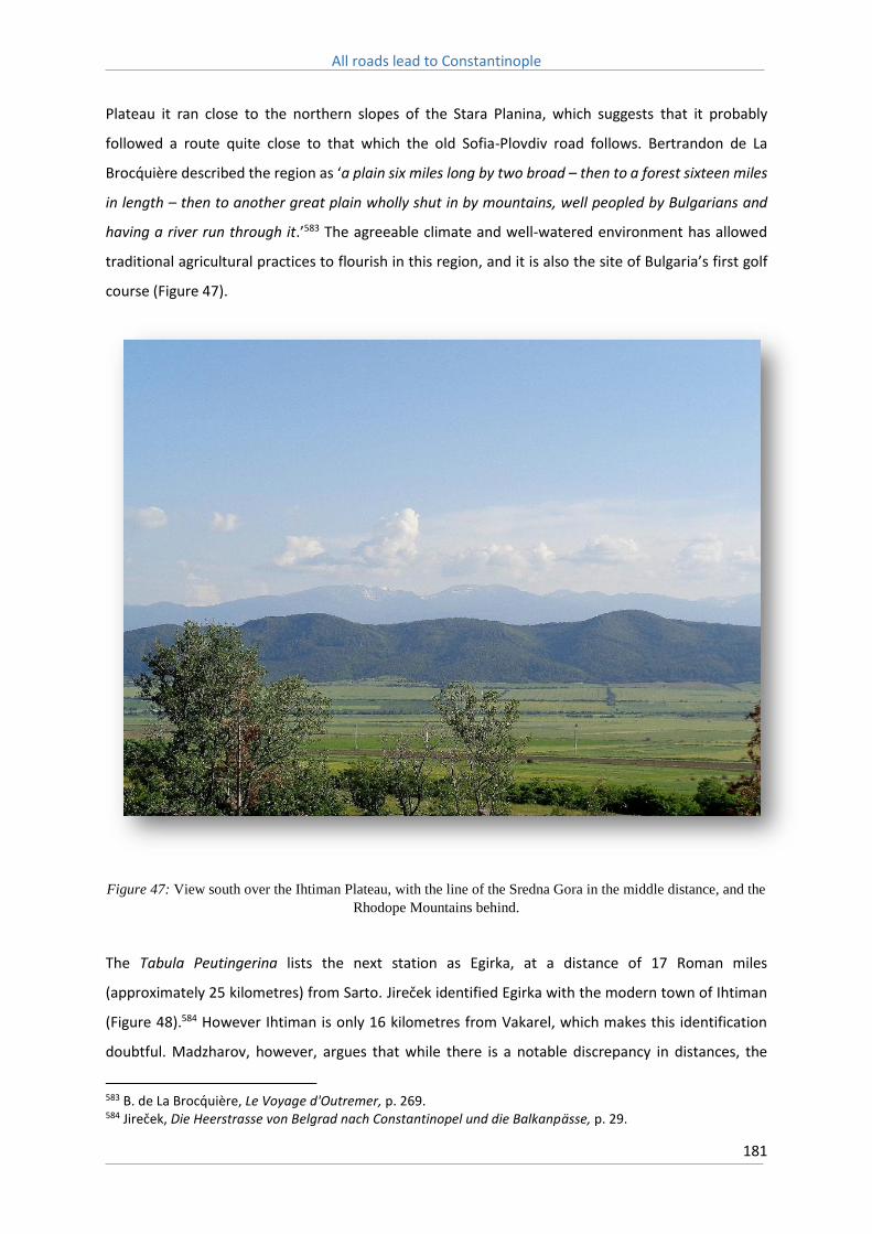
All roads lead to Constantinople
181
Plateau it ran close to the northern slopes of the Stara Planina, which suggests that it probably
followed a route quite close to that which the old Sofia-Plovdiv road follows. Bertrandon de La
Brocquière described the region as ‘a plain six miles long by two broad – then to a forest sixteen miles
in length – then to another great plain wholly shut in by mountains, well peopled by Bulgarians and
having a river run through it.’583 The agreeable climate and well-watered environment has allowed
traditional agricultural practices to flourish in this region, and it is also the site of Bulgaria’s first golf
course (Figure 47).
Figure 47: View south over the Ihtiman Plateau, with the line of the Sredna Gora in the middle distance, and the
Rhodope Mountains behind.
The Tabula Peutingerina lists the next station as Egirka, at a distance of 17 Roman miles
(approximately 25 kilometres) from Sarto. Jireček identified Egirka with the modern town of Ihtiman
(Figure 48).584 However Ihtiman is only 16 kilometres from Vakarel, which makes this identification
doubtful. Madzharov, however, argues that while there is a notable discrepancy in distances, the
583 B. de La Brocquière, Le Voyage d'Outremer, p. 269. 584 Jireček, Die Heerstrasse von Belgrad nach Constantinopel und die Balkanpasse, p. 29.

All roads lead to Constantinople
182
location of Ihtiman fits well with the distance of 34 Roman miles (50 kilometres) between Serdica and
Egirka stated in the Itinerarium Burdigalense.585 The modern road distance between Sofia and Ihtiman
is 54 kilometres.
Figure 48: The route of the Old Sofia-Plovdiv road across the Ihtiman Plateau. From US Army Map Service,
Western Europe, 1959.
It is quite likely that a station, either by the name of Egirka or Hilice was located in the environs of
modern Ihtiman. The passage of the Succi Pass, which began immediately after, was a difficult
proposition and it would have required at least a full day’s march to negotiate. Ruins located in the
585 Madzharov, Roman roads in Bulgaria, p. 81.

All roads lead to Constantinople
183
southern part of the modern town are thought to be the remains of the Roman station at this site, but
this has yet to be verified.586
11.5: The Succi Pass
The Succi Pass, or Pass of St Basil, is the most famous section of the entire route of the Via Militaris,
and its most formidable geographical obstacle. The word ‘Succi’ in the Thracian language can mean a
crack, or a gorge. Ammianus Marcellinus stated that the region, ‘being in the form of a crescent,
resembles a splendid theatre; it is bound in the west by mountains, on the abrupt summit of which are
the thickly wooded passes of the Succi, which separate Thrace from Dacia’.587 He claimed that whilst
previously the pass had been an obscure one, through Roman engineering ‘it was opened even for the
passage of carts; and yet it could sometimes be so closed as to check the attempts of great and mighty
leaders.’588 The fourth century theologian, Philostorgius, whilst describing the campaign of Alaric I
against the city of Constantinople, compared the narrowness of the pass to that of Thermopylae.589
The Historia de Expeditione describes it as the furthest and strongest pass of Bulgaria (clusae ultimae
et firmissimae Bulgariae).590 In the Ottoman period the pass was referred to by travellers as the Kapu
Durbent, the ‘Narrow Gate’.
The Succi Pass is formed by the south-eastern course of the Yavoritza River, a tributary of the
Topolnitsa River which is, itself, a tributary of the Maritsa. The Ihtiman Plateau sits approximately 650-
700 metres above sea level as it enters the pass, and it then slowly descends to the Maritsa Valley, of
an altitude of 250-300 metres, over the course of approximately 25-30 kilometres. On either side of
the valley rise steep, heavily forested ridges, reaching 1000 metres to the south of the valley, and 1200
metres to the north, narrowing the route to a small area on either side of the river. Despite its narrow
confines, the pass is therefore not an overly steep one. Indeed, Lady Mary Wortley, after making the
trip through the pass would later remark that ‘the precipes (sic) were not so terrible as I had heard
them represented.’591
586 M. Biernacka-Lubanska, The Roman and Early-Byzantine fortifications of Lower Moesia and Northern Thrace, p. 248. 587 Ammianus Marcellinus, Rerum gestarum libri, trans. J. C. Rolfe. Ammianus Marcellinus, Vol. 3, p. 23. 588 Ammianus Marcellinus, Rerum gestarum libri, trans. J. C. Rolfe. Ammianus Marcellinus, Vol. 2, p. 135. 589 Philostorgius, Church History, trans. P. R. Amidon (Atlanta, 2007), p. 58. 590 Historia de Expeditione Friderici Imperatoris, p. 68. 591 Lady M. W. Montagu, The letters and works of Lady Mary Wortley Montagu, p. 168.

All roads lead to Constantinople
184
In order to measure the approximate steepness of the pass, the author measured its elevation profile
by hiking the route with a Garmin eTrex 30 handheld GPS, and then uploading the co-ordinates into
Google Earth. The data obtained is not an exact depiction of the pass, as the modern road detours via
the remains of Soneium discussed below, which forms the central peak in the following graph.
However even taking this into consideration, over the course of its 30 kilometre length, the average
gradient of the pass is approximately 4.8%, whilst its steepest slope, as it enters the Maritsa Valley, is
approximately 7-8% (Figure 49). Even given the simplistic manner in which this information was
collected, and the inaccuracies inherent in topographic data of this kind, it is abundantly clear that the
slope along this section of the pass was much less than the 15-20% gradients found along similar
sections of the Via Egnatia. Gradients of 5-7% are navigable for wagons drawn by draft animals,
although it is at the upper limit of their endurance, and for steeper gradients than this loads would
have needed to be reduced, or the wagons unloaded completely.592
592 W. G. Harger & E. A. Bonney, Handbook for highway engineers: containing information ordinarily used in the design and construction of roads warranting an expenditure of $5000 to $30,000 per mile (New York, 1919), p. 11-23.

All roads lead to Constantinople
185
Figure 49: Elevation profile, captured by GPS of the descent through the Succi Pass. Elevation profile generated
via GPSvisulazer.com

All roads lead to Constantinople
186
Owing to the narrowness of the pass, and its location along the main route leading to Constantinople,
the Succi Pass is regarded as one of the most important strategic sites within the Roman Empire, a
natural chokepoint where the advance of an enemy army could be checked.593 The pass was
consequently the focal point of numerous campaigns, and in particular was defended in an attempt
to stop the invading Gothic and Hunnic forces from invading Thrace in the fourth and fifth centuries.
Constantine occupied the pass during his campaign against Licinius, as did the Augustus Julian during
his conflict with Constantius in 361. The entrance of the valley was further protected by a fortress that
can be identified as the mutatio Soneium named in the Itinerarium Burdigalense, and was known in
Byzantine sources as Stoponion (Figure 50).594 Jireček, visiting the site in the nineteenth century,
described the fortress as having a quadrangular form, with a length and width of about 40 steps, and
a round tower on its southern side.595
Figure 50: The remains of Soneium, overlooking the Succi Pass which runs along the valley below.
593 H. Eton, Warfare in Roman Europe, AD 350-425 (Oxford, 1996), p. 231. 594 Skylitzes, Synopsis historiarum, p. 313. 595 Jireček, Die Heerstrasse von Belgrad nach Constantinopel und die Balkanpasse, p. 30-1.
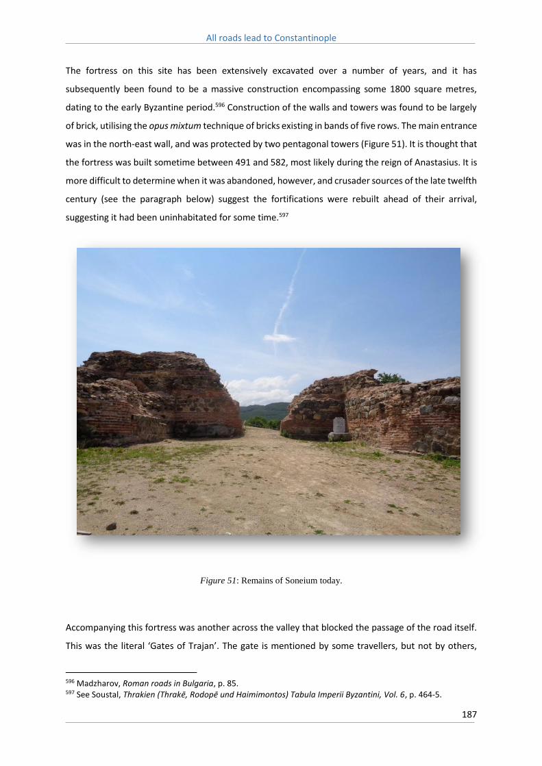
All roads lead to Constantinople
187
The fortress on this site has been extensively excavated over a number of years, and it has
subsequently been found to be a massive construction encompassing some 1800 square metres,
dating to the early Byzantine period.596 Construction of the walls and towers was found to be largely
of brick, utilising the opus mixtum technique of bricks existing in bands of five rows. The main entrance
was in the north-east wall, and was protected by two pentagonal towers (Figure 51). It is thought that
the fortress was built sometime between 491 and 582, most likely during the reign of Anastasius. It is
more difficult to determine when it was abandoned, however, and crusader sources of the late twelfth
century (see the paragraph below) suggest the fortifications were rebuilt ahead of their arrival,
suggesting it had been uninhabitated for some time.597
Figure 51: Remains of Soneium today.
Accompanying this fortress was another across the valley that blocked the passage of the road itself.
This was the literal ‘Gates of Trajan’. The gate is mentioned by some travellers, but not by others,
596 Madzharov, Roman roads in Bulgaria, p. 85. 597 See Soustal, Thrakien (Thrake, Rodope und Haimimontos) Tabula Imperii Byzantini, Vol. 6, p. 464-5.

All roads lead to Constantinople
188
whilst no trace of any such fortification remains today. The Historia de Expeditione tells that the
Byzantines blocked the road with trees and ‘an extraordinary quantity of rocks’, and they ‘had fortified
the ancient passes of St Basil by renewing the towers and bastions in defiance of the pilgrims of
Christ.’598 It is also mentioned during John Hunyadi’s campaign against the Ottomans in 1443, where
the pass, and its gate, played a prominent role during his march on Philippopolis.599
Bertrandon de La Brocquière curiously fails to mention it at all whilst traversing the pass in 1433;
however he does note that travellers were frequently ambushed by bandits in the region.600 Hans
Dernschwam similarly fails to mention the gate, but does remark that up into the mountains, and then
down again, existed a ‘wide paved road’.601 Peter Mundy, though, in 1620, noted ‘a great, high, ruinous
Arch of brick’ in the pass.602 Lady Wortley also mentions the gate as still standing in 1716, stating ‘We
passed near the piece of an arch, which is commonly called Trajan's Gate, from a supposition, that he
made it to shut up the passage over the mountains, between Sophia and Philippopolis.’603 Both Luigi
Marsigli and Guillaume Lejean provide depictions of the route of the Via Militaris through the ‘Porte
Trajane’ (see Figures 52 & 53). The French geologist, Ami Boué, whilst travelling through the region,
claimed that the gate had been dismantled in 1837 on the orders of the Ottoman General, Ferik
Ahmed Pasha.604 Boué claims that from the material acquired from this fortification the Ottomans
were able to construct a watch-tower and two inns, whilst the rest was then used to repair the Sofia-
Plovdiv road.
598 Historia de Expeditione Friderici Imperatoris, p. 68. 599 G. B. Malleson, Ambushes and surprises: being a description of some of the most famous instances of the leading into ambush and the surprise of armies, from the time of Hannibal to the period of the Indian mutiny (London, 1885), p. 176-8., also see Soustal, Thrakien (Thrake, Rodope und Haimimontos) Tabula Imperii Byzantini, Vol. 6, p. 190-1. 600 B. de La Brocquière, Le Voyage d'Outremer, p. 269. 601 Dernschwam, Ein Fugger-Kaufmann im Osmanischen Reich, p. 25. 602 Mundy, Itinerarium Mundi, p. 61. 603 Lady M. W. Montagu, The letters and works of Lady Mary Wortley Montagu, p. 168. 604 A. Boué, La Turquie d'Europe, ou, Observations sur la geographie, la geologie, l'histoire naturelle, la statistique, les moeurs, les coutumes, l'archeologie, l'agriculture, l'industrie, le commerce, les gouvernements divers, le clerge, l'histoire et l'etat politique de cet empire (Paris, 1840), p. 357.

All roads lead to Constantinople
189
Figure 52: Depiction of the route of the Via Militaris as it enters the Succi Pass, and the remains of the Gates of
Trajan. From Marsigli, Danubius Pannonico-mysicus, p. 51.

All roads lead to Constantinople
190
Figure 53: Route of the Via Militaris through the Gates of Trajan. From G. Lejean, ‘Voyage en Bulgarie’, Le
tour du Monde, 26 (1873), p. 159.

All roads lead to Constantinople
191
The retreat of Basil II from the failed siege of Serdica in 986 also contains useful information pertaining
to this region. Leo the Deacon relates that after Basil II raised the siege the army marched for a full
day back towards the capital, before pitching camp in a thicket, and the next day they negotiated a
wooded defile, full of caves, before entering steep terrain full of gullies.605 This description neatly
matches the terrain that would have been encountered passing through the Succi Pass, as the
enclosed valley with steeply forested slopes opens into foothills as it enters the Maritsa Valley. It was
here that the Bulgarians, under Emperor Simeon I, ambushed the Byzantine column and annihilated
it.
Approximately half way down the Succi Pass the Yavoritza River turns to the north, and the valley here
rises from approximately 600 metres up to a little over 700 metres, before finally descending more
sharply as it approaches the modern town of Vetren. In this section the road follows a small, fast
flowing mountain stream that runs south-east, through the town of Vetren, before finally joining the
Maritsa River some 5 kilometres distant. Curiously, Miller depicts the Via Militaris as turning to follow
the course of the Yavoritza River to the north, a course that matches that of the modern highway
(Figure 54).606 This final part of the pass, as it enters the Maritsa Valley, is the steepest section of the
route, and it is likely to avoid this region that the modern highway branches to the north. However
there is no evidence to suggest that the Roman road took this route. Indeed, the main road in the
early twentieth century proceeded directly along the course of the Succi Valley, passing the medieval
fortress of ‘Palanka’, located approximately 10 kilometres from the village of Vetren and named after
the now abandoned village of Palankata that once existed at this site, and the remains of which survive
today.607
605 Leo the Deacon, Historia, p. 214. 606 Miller, Itineraria Romana, p. 534. 607 Great Britain Naval Intelligence Division, A handbook of Bulgaria, p. 255.

All roads lead to Constantinople
192
Figure 54: The route of the Via Militaris through the Succi Pass, containing the detour to Pons Ucasi as depicted
by Miller, Itineraria Romana, p. 534.

All roads lead to Constantinople
193
After Soneium, the Itinerarium Burdigalense lists the mutatio Pons Ucasi at a distance of six Roman
miles (approximately 9 kilometres). Ucasus is the ancient name of the Yavoritza River, and so it is
thought that this station was located at the site of a bridge over the river.608 The remains of the fortress
of Palanka are also conveniently located 9 kilometres distant from Soneium, although no clear link
between these two has been established (see Figures 55 & 56). Aside from the aforementioned
fortress that governs the entrance to the pass, and that of Palanka which is located approximately
halfway along its length, another fortress exists on the fringe of Vetren, covering the southern flank
of the pass as it enters the Maritsa Valley, known variously as Litopolis or Kamengrad. Nearby was
uncovered a cemetery that is claimed to contain the remains of ‘Germans’, who are presumed to
perhaps be participants of the Third Crusade, however the veracity of this association is difficult to
ascertain.609 Nevertheless, the position of these medieval fortifications strongly suggests that the
medieval route of the Via Militaris proceeded directly along the Succi Pass, without the deviation to
the north that Miller depicts.
608 Madzharov, Roman roads in Bulgaria, p. 86. 609 E. Koytcheva, ‘Logistics of the early crusades in the Balkans on Via Militaris’, in K. Holzner-Tobisch, T. Kuhtreiber & G. Blaschitz eds., Die Vielschichtigkeit der Straße: Kontinuität und Wandel in Mittelalter und früher Neuzeit (Vienna, 2012), p. 223.

All roads lead to Constantinople
194
Figure 55: Route through the Succi Pass, showing the fortress of Soneium, the point where the 'Trakia' Highway
turns to the north, and the remains of Palanka. Image captured via Google Earth, whilst the white line represents
the GPS path traced by the author.

All roads lead to Constantinople
195
Figure 56: Remains of the fortress of 'Palanka'.
The road through the Succi Pass may also have been relatively broad, and the narrowness of the route
as mentioned in sources relating to the Third Crusade may be more a reflection of the fact that there
was little or no opportunity for an army to spread out on either side of the road, than directly related
to the dimensions of the road itself. Indeed, in this section of the pass, after the Yavoritza, and the
modern highway which follows it, turns to the north, evidence remains of a road of significant
proportions that is today followed by an unpaved service road. The existing surface that can be
observed here consists of a bed of loosely fitted small broken stones, very similar to the road surfaces
near Dragoman mentioned above. This road was evidently exceptionally broad, and is near eight
metres wide along its entire extent during this section of the pass, again similar to other identified
segments of the Via Militaris (see Figures 57-61).

All roads lead to Constantinople
196
Figure 57: Remains of the Via Militaris in the Succi Pass. The existing dirt road covers only a small part of the
total surface. The edge of the embankment can be seen on the left.
Figure 58: Detail of loose fitting stones typical of the surface of the road.

All roads lead to Constantinople
197
Figure 59: Further examples of surviving stonework.
Figure 60: Surviving stone kerbs. The embankment drops away sharply beyond.

All roads lead to Constantinople
198
:
Figure 61: Further example of surviving stone surface. The road surface extends as far as the tree line on the
right of the image.
This road is yet to be the subject of archaeological excavation, but the surviving surface is almost
certainly of Ottoman origin. What is most impressive are the steep embankments that have been
constructed to allow the road to run along the northern flank of the Succi Pass, above the small stream
mentioned above. These embankments may also be of Ottoman origin, but they might equally
represent Roman construction, as given the narrowness of the route through the pass it is highly likely
that the Ottoman road followed the course of the existing Roman road (Figure 62). Given the critical
importance of the Succi Pass in the late Roman era, especially after the establishment of
Constantinople as the new imperial capital, it is not surprising that the road here may have been of
such impressive proportions, and it may have been extensively rebuilt during or after the reign of
Constantine so as to better befit the most strategically important pass governing the main highway to
the new capital.

All roads lead to Constantinople
199
Figure 62: An example where the road has been terraced into the slope of the valley.
This does not tell us what condition the road might have been during the medieval period, however,
and few hints can be derived from sources from the period as to its state. Leo the Deacon only
mentions that the pass was ‘narrow and steep.’610 Likewise crusading sources make no special mention
of the pass, other than the fact that it was very narrow, which suggests that the road surface was
limited by the existing Roman embankments. Wheeled vehicles could seemingly make use of the pass,
but likely slowed progress considerably. The pass also seems to have been usable, to some extent,
during winter. Emperor Isaac Angelos, leading a campaign against Vlachs in the Central Balkan
Mountains north of Serdica, found that winter was closing in and so, whilst leaving the bulk of the
army behind, in the month of December retreated back to Constantinople over the pass, accompanied
610 Leo the Deacon, Historia, p. 213.

All roads lead to Constantinople
200
only by ‘light armed troops.’611 John Hunyadi likewise approached the pass in late December, and
despite the efforts of the defending Ottomans, was able to force a way into the Maritsa Valley.612
The next station mentioned by the Itinerarium Burdigalense is Bona Mansio, and it is likely that this
location can be identified with a site on the outskirts of the Bulgarian town of Vetren where the ruins
of a Roman fortification have been discovered. The fort at this site was of rectangular shape, covering
approximately 400 square metres, and was protected by three towers.613 It is possible that the station
Lissas, named by the Antonini Augusti, is the same station. Excavations at Bona Mansio uncovered an
inscription dating to the reign of Emperor Gordian I, and it is also mentioned as part of the journey
made by St Alexander in Thrace in 289, as he was escorted by Roman soldiers to the town of Druzipara
(near Adrianople), where he was executed.614 It is further also recorded that Emperor Valens stayed
at this location, during a tour of the Balkan provinces, in the spring of 365.615
Historically the region where the Succi Pass enters the Maritsa Valley appears to have played a major
role in cross-Balkan trade. Located just south of Bona Mansio, on the banks of the Maritsa River, was
the important Thracian trading post of Pistiros. An inscription related to the site, dating to 350 BC
when it formed part of the Odyrisian Kingdom of Thrace, was found at Bona Mansio, where it was
likely being reused, and contains guarantees offered to Maronitans, Thasians, and people from
Apolliana who traded there. Discovered in excavations at the site were fortifications and also large
storage sites, and a great number of coins.616 Pistiros was clearly an emporia of some significance,
attracting trade not only from the Aegean heading north and east, to the important Thracian sites at
Philippopolis and Panagyurishte, but also possibly westwards as well, across the Sredna Gora.
From Bona Mansio the Via Militaris took an easterly route across the Marista Valley in the direction
of the modern town of Pazardjik. The Itinerarium Burdigalense lists the mansio Alusor at nine Roman
miles from Bona Mansio, and it is thought that it was sited near the modern village of Boshulya.
Remains of the road were discovered in this region in the late nineteenth century, where its surface
was said to be well-preserved and ran to the south of the village of Boshulya, and parallel to the
Maritsa River, towards Pazardjik (Figure 63).617
611 Choniates, Historia, p. 219. 612 Malleson, Ambushes and surprises, p. 178-9. 613 Madzharov, Roman roads in Bulgaria, p. 86-7. 614 Ivanov ed., Tabula Imperii Romani, K35/2 Philippopolis, p. 55. 615 Velkov, The cities in Thrace and Dacia in Late Antiquity, p. 32. 616 On Pistiros see Archibald, The Odrysian Kingdom of Thrace, p. 317. 617 Madzharov, Roman roads in Bulgaria, p. 87.

All roads lead to Constantinople
201
Figure 63: US Army map of 1944 showing the route through Vetren, from Ihtiman, towards Pazardjik. The
alternate route to the south is through the Momina Klissura.

All roads lead to Constantinople
202
It is difficult to interpret the Tabula Peutingerina along this section of the Via Militaris. It lists the next
station after Egirka as ‘Zyrmis’. The Itinerarium Burdigalense and Antonini Augusti, however, both list
Bessapara as the next station along the route. The location of Bessapara is well founded, as will be
seen below, but no evidence exists of a station ‘Zyrmis’, and it is possible that it was located in the
modern city of Pazardjik. After the settlement of Tatars in the fifteenth century, Pazardjik emerged as
an important market centre along the Maritsa, but no remains of a Roman station are known at this
location. Madzharov argues that Zyrmis is, therefore, most likely the same location as Bessapara.618
It is believed that the Via Militaris crossed the Maritsa in the region of Pazardjik, possibly in the same
location as the modern bridge today, however the earliest known remains of a bridge on this location
date to the late seventeenth century, from a Bulgarian inscription discovered at the site.619 Jireček
makes an interesting argument that another road existed to the south of the Maritsa River that
likewise ran to Philippopolis. He claims this road was made because the area through which the
northern road ran was extremely swampy, and proved impossible to use during the spring and winter.
In Jireček’s opinion the Roman road therefore crossed to the south of the Maritsa at a distance of
some 15 kilometres after the station of Bona Mansio and well before it entered Pazardjik.620 There is
no evidence of any Roman bridge existing in this region and it is possible that any road Jireček
observed was of later Ottoman construction. However this is far from certain, and the northern bank
of the Maritsa River is still, to this day, quite marshy in places (see Figures 64 & 65).
618 Madzharov, Roman roads in Bulgaria, p. 87-8. 619 Madzharov, Roman roads in Bulgaria, p. 89. 620 Jireček, Die Heerstrasse von Belgrad nach Constantinopel und die Balkanpasse, p. 36.

All roads lead to Constantinople
203
Figure 64: This US Army map of 1959 depicts the swampy land in particular to be found north of the Maritsa
between Pazardjik and Plovdiv.

All roads lead to Constantinople
204
Figure 65: View of the Maritsa River, looking east, taken from the modern bridge in Pazardjik that is thought to
be located on or near the site of the Roman bridge.
What is clear, though, is that the Via Militaris crossed the Maritsa River at some point in this area, and
then proceeded the rest of the way to the city of Philippopolis along its southern bank. In the environs
of the modern Bulgarian village of Sinitovo remains of a walled Roman settlement were uncovered,
which are believed to be of the mansio Bessapara. Nothing survives of the site today, and it has been
suggested that stones from the area were reused as building material by local villagers, and that
erosion and landslides from the Bessaparian hills served to destroy what was left, to the extent that
in the 1950s only the foundations of the walls remained.621 Other archaeological finds in the area
include the remains of an earthen water main, weaving workshops, and a large building of
approximately 300 square metres.622 Furthermore, located four kilometres from Sinitovo, on a spur of
the Bessaparian hills, are the remains of a Byzantine fortress.
621 Madzharov, Roman roads in Bulgaria, p. 90-1. 622 Ivanov ed., Tabula Imperii Romani, K35/2 Philippopolis, p. 46-7.

All roads lead to Constantinople
205
It appears, therefore, that after crossing the Maritsa River, the Via Militaris then proceeded along its
southern bank, between it and the Bessapar Hills that run parallel to the river for a length of some five
kilometres (Figure 66). The location of the remains of the Byzantine fortress indicate it was used as a
watch tower overlooking the road below, and it is one of the fortifications of Thrace rebuilt by
Justinian, Besuparum, that is mentioned by Procopius.623 The height of the Bessapar Hills
(approximately 500 metres above sea level) provide a good vantage point from which to observe the
road as it proceeded along the valley towards the city of Philippopolis.
Figure 66: The view south over the Maritsa. The Bessapar Hills are in the foreground, with the Rhodope
Mountains in the background.
This evaluation though is far from universally agreed upon. One argument is that the road ran far
further to south, close to the northern foothills of the Rhodope Mountains, and that the station of
Bessapara was therefore found somewhere in the environs of the modern town of Persuhtitsa, which
is located approximately 25 kilometres from Pazardjik and 26 kilometres from Plovdiv.624 This region
was an important site in the early Byzantine period, as evidenced by the remains of the ‘Red Church’,
dating to approximately the early sixth century (Figure 67).
623 Procopius, De Aedificiis, p. 309. 624 Madzharov, Roman roads in Bulgaria, p. 90.

All roads lead to Constantinople
206
Figure 67: Remains of the sixth century 'Red Church' in Persuhtitsa, south-west of modern Plovdiv.
That remains of a Roman road have been found in this region, near the town of Ustina, just to the
west of Perushtitsa, seem to give some credence to this claim. Madzharov, however, argues that this
instead represents a secondary trans-Rhodopian road. Remains of this road have been discovered
further in the Rhodope Mountains, and are remarkably well preserved. This road was approximately
three metres wide and makes a number of sharp turns as it negotiates the steep mountain terrain.625
Although its exact route is difficult to trace, it had evidently been an important route in the Ottoman
period, linking the Maritsa Valley with the Aegean, before declining in the late nineteenth century,
likely as a result of the establishment of modern political frontiers in 1878.626
The Itinerarium Burdigalense lists the last station before Philippopolis as the mutatio Tugugerum. It
has been suggested that this station lay near to the village of Zlatitrap, located approximately ten
625 Delev, ‘The middle Mesta region in antiquity’, p. 27-8. 626 For more discussion of this route see Delev & Popov, ‘The Ancient Road Network in the Middle Mesta Region’, p. 60-2.
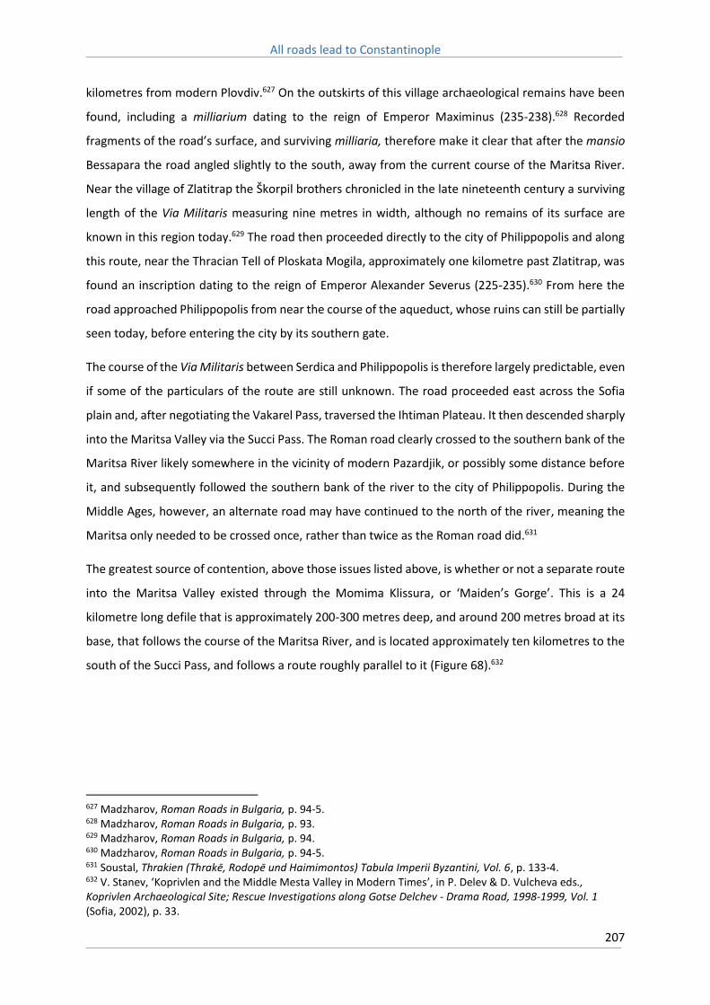
All roads lead to Constantinople
207
kilometres from modern Plovdiv.627 On the outskirts of this village archaeological remains have been
found, including a milliarium dating to the reign of Emperor Maximinus (235-238).628 Recorded
fragments of the road’s surface, and surviving milliaria, therefore make it clear that after the mansio
Bessapara the road angled slightly to the south, away from the current course of the Maritsa River.
Near the village of Zlatitrap the Škorpil brothers chronicled in the late nineteenth century a surviving
length of the Via Militaris measuring nine metres in width, although no remains of its surface are
known in this region today.629 The road then proceeded directly to the city of Philippopolis and along
this route, near the Thracian Tell of Ploskata Mogila, approximately one kilometre past Zlatitrap, was
found an inscription dating to the reign of Emperor Alexander Severus (225-235).630 From here the
road approached Philippopolis from near the course of the aqueduct, whose ruins can still be partially
seen today, before entering the city by its southern gate.
The course of the Via Militaris between Serdica and Philippopolis is therefore largely predictable, even
if some of the particulars of the route are still unknown. The road proceeded east across the Sofia
plain and, after negotiating the Vakarel Pass, traversed the Ihtiman Plateau. It then descended sharply
into the Maritsa Valley via the Succi Pass. The Roman road clearly crossed to the southern bank of the
Maritsa River likely somewhere in the vicinity of modern Pazardjik, or possibly some distance before
it, and subsequently followed the southern bank of the river to the city of Philippopolis. During the
Middle Ages, however, an alternate road may have continued to the north of the river, meaning the
Maritsa only needed to be crossed once, rather than twice as the Roman road did.631
The greatest source of contention, above those issues listed above, is whether or not a separate route
into the Maritsa Valley existed through the Momima Klissura, or ‘Maiden’s Gorge’. This is a 24
kilometre long defile that is approximately 200-300 metres deep, and around 200 metres broad at its
base, that follows the course of the Maritsa River, and is located approximately ten kilometres to the
south of the Succi Pass, and follows a route roughly parallel to it (Figure 68).632
627 Madzharov, Roman Roads in Bulgaria, p. 94-5. 628 Madzharov, Roman Roads in Bulgaria, p. 93. 629 Madzharov, Roman Roads in Bulgaria, p. 94. 630 Madzharov, Roman Roads in Bulgaria, p. 94-5. 631 Soustal, Thrakien (Thrake, Rodope und Haimimontos) Tabula Imperii Byzantini, Vol. 6, p. 133-4. 632 V. Stanev, ‘Koprivlen and the Middle Mesta Valley in Modern Times’, in P. Delev & D. Vulcheva eds., Koprivlen Archaeological Site; Rescue Investigations along Gotse Delchev - Drama Road, 1998-1999, Vol. 1 (Sofia, 2002), p. 33.

All roads lead to Constantinople
208
Figure 68: The two passes through the Sredna Gora. The blue line on the left is the course of the modern rail
line, through the Momina Klissura, the white line on the right the route of the Succi Pass. Image captured via
Google Earth.
Jireček attests to a road in this region, one that followed the course of the modern rail line and passed
through the Bulgarian town of Belovo before proceeding towards Samakov. In the fourteenth century,

All roads lead to Constantinople
209
Jireček claims, this was the main road linking Constantinople with Bosnia and Ragusa.633 Certainly a
major road existed in this region during the Ottoman period. Visiting the site of the Gates of Trajan in
1717, Lady Mary Wortley opinioned that it more likely represented the remains of a triumphal arch
than a fortress, for ‘if that passage had been shut up, there are many others that would serve for the
march of an army.’634 Undoubtedly she was referring to the alternate route south through the Momina
Klissura. By the beginning of the twentieth century this was a major route, and ranked as a first class
road by the British Naval Intelligence division.635
Did a secondary road run through the Momina Klissura into the Maritsa Valley in the earlier medieval
period though? Jireček concludes that since no remains of a cobbled path could be identified in the
area, and moreover no fortresses cover the pass, in contrast to the well-guarded route through the
Succi Pass, Roman road builders had not known about this narrow, heavily forested, defile.636 Yet the
region displays remains of medieval fortification and settlement. The modern town of Belovo, which
sits at the foot of the Momina Klissura, may have been the centre of a Byzantine diocese in the tenth
to twelfth centuries.637 Near the village of Momina Klissura, on the left bank of the Maritsa River, sits
the fortress of Gradishte, covering the pass below. Displaying impressive masonry work and walls
some 70 centimetres thick, it is difficult to date its construction exactly.638 Excavations of a church in
the environs of the modern village below however uncovered an inscription that dates its construction
to 1355, during the reign of Tsar Ivan Alexander. Undoubtedly a medieval settlement existed on this
site, and the region also displays evidence of even older Thracian occupation.639
Evidently an important road ran through the Momina Klissura, as far as Samakov, and then onto
medieval Velevousdion, ancient Pautalia, near the modern town of Kyustendil, where the extensive
remains of a medieval church, popularly known as ‘Spasovica’, which was constructed in 1330, were
uncovered.640 This route provided direct access to the Struma River valley, and thence onto the
Aegean, as well as towards the Dalmatian coast. What is less easy to determine, however, is the
importance of this route during the crusading period. Samakov, in particular, only emerged as a major
trading hub from the fifteenth century onwards when it became host to a major iron mining and
633 Jireček, Die Heerstrasse von Belgrad nach Constantinopel und die Balkanpasse, p. 36-7. 634 Lady M. W. Montagu, The letters and works of Lady Mary Wortley Montagu, p. 168. 635 Great Britain Naval Intelligence Division, A handbook of Bulgaria, p. 215-7. 636 Jireček, Die Heerstrasse von Belgrad nach Constantinopel und die Balkanpasse, p. 93. 637 Soustal, Thrakien (Thrake, Rodope und Haimimontos) Tabula Imperii Byzantini 6, p. 198. 638 Soustal, Thrakien (Thrake, Rodope und Haimimontos) Tabula Imperii Byzantini 6, p. 367. 639 M. Vaklinov, ‘The Roman Imperial Period, Late Antiquity and the Middle Ages’, in P. Delev & D. Vulcheva eds., Koprivlen Archaeological Site; Rescue Investigations along Gotse Delchev - Drama Road, 1998-1999, Vol. 1 (Sofia, 2002), p. 54. 640 S. Ćurčić, ‘The Role of Late Byzantine Thessalonike in Church Architecture in the Balkans’, Dumbarton Oaks Papers, 57 (Washington D.C., 2003), p. 78.

All roads lead to Constantinople
210
smelting industry.641 So whilst a road may have run through the pass, and it undoubtedly emerged as
a major thoroughfare during the Ottoman period, it is difficult to determine whether it was used
during the period in question.642
Nevertheless, it is sometimes argued that this alternate route played an important role during the
passage of the Third Crusade, and in particular the Byzantine attempt to blockade the Succi Pass in
order to deny access to the Maritsa Valley gives rise to the possibility of alternate routes being utilised.
The sources chronicle that the crusaders, after finding Serdica ‘lacking in all human comfort’ marched
for one day before making camp, at which they were met by a group of crusaders that had been
following in their footsteps.643 The next day the crusaders approached the ‘last and most narrow
passes of Bulgaria’ which they found to be blockaded against them, and that further a nearby
Byzantine army was keeping their progress under close observation.
The crusader sources provide uniformly similar depictions of what followed. The Historia de
Expeditione states that Barbarossa ‘left part of the army in camp, and accompanied by the squadrons
of armoured knights, he broke through the passes after a brief but triumphant fight, intending sensibly
to cut through the obstacles that had been placed in various places by the Greeks. The latter turned
tail and fled, running away from the imperial majesty and the champions of Christ; anyway they never
dared to await the charge of our men.’644 The Historia peregrinorum claims this force contained 500
knights, picked from ‘among the most astounding of his army, whose horses also had iron surcoats’,
and further adds that it was led by the Duke of Swabia.645 The Gesta Federici I Imperatoris in
Expeditione Sacra also describes the scene: ‘as the Greeks saw those who had been sent in advance to
the Gates of St Basil, immediate fear and confusion of mind fell upon them and they withdrew as fast
as they could, spreading the news throughout the whole army of the Greeks that the indomitable and
iron-clad army of the Germans had arrived on iron-clad horses, and it was safer to hasten in flight than
to await their terrible attack. On hearing this, the army was greatly afraid and immediately turned and
told the citizens of Philippopolis to flee, announcing the arrival of the German people, whose valour no
human force could resist in battle.’646
The crusader sources, therefore, all agree in the details; a detachment of knights charged the Greeks,
who subsequently fled, and the defences were then committed to flames before the crusaders
641 J. R. Lampe & M. R. Jackson, Balkan Economic History, 1550-1950: from Imperial borderlands to developing nations (Bloomington, 1982), p. 144. 642 Soustal, Thrakien (Thrake, Rodope und Haimimontos) Tabula Imperii Byzantini, Vol. 6, p. 191. 643 Historia de Expeditione Friderici Imperatoris, p. 68. 644 Historia de Expeditione Friderici Imperatoris, p. 68. 645 Historia peregrinorum, p. 68. 646 Gesta Federici I. Imperatoris in Expeditione Sacra, p. 68.

All roads lead to Constantinople
211
proceeded unmolested into the valley below. It is not clear within the sources, however, which pass
was blockaded; the Vakarel Pass or the Succi Pass, and it may have been the case that both were
blocked against their passage to some degree. This depiction certainly appears plausible, and Duke
Frederick of Swabia with his mounted vanguard was in an advantageous position to deliver an
immediate, and irresistible, assault upon the defenders in the pass and clear a passage for the rest of
the army to follow.647
Nicetas Choniates, however, provides a slightly different depiction of events, and claims that Emperor
Isaac Angelos resolved to block the mountain passes against Barbarossa and so ordered them to be
rendered impassable through the felling of trees. The Domestikos of the West Alexius Gidos and
protostrator Manuel Kamytzes were instructed to follow close behind with their troops and stealthily
attack the Germans as they collected fodder and searched for food. The humour of the situation, in
Choniates’ words, was that ‘the king took another road, arrived before Philippopolis, and set up an
entrenched camp. By passing on the opposite side, he was undetected by the Romans until he was in
front of them, occupying those places from which he was to have been barred and for which purposes
the mountain passes had been barricaded.’648
Choniates’ depiction certainly gives the impression that an alternate route, such as that through the
Momina Klissura, had been used in order to flank the Byzantine defences, but this scenario ignores
any confrontation in the pass, which all of the crusader sources agree upon. It is possible that
Choniates describes a detachment that was led through the Momina Klissura, but this is difficult to
envisage. Whilst Jireček claims that this route was ‘easier’ and only lacking in a cobblestoned path to
follow, it would in reality have presented serious complications. For one the route through the
Momina Klissura was more winding that that of the Succi Pass, and without an established road bed
to follow a force on horseback would have found the going very difficult indeed.649 Moreover, the
diversion would have been a lengthy one, and from the modern village of Mirovo, where the alternate
road branches to the south, it would have nearly doubled the distance a detachment would have
needed to cover before reaching the Maritsa Valley.
The main Byzantine force was evidently not occupying the mountain passes, and Choniates states that
Gidos and Kamytzes were instructed to instead shadow the crusader force and attack its foraging
parties. Certainly this army remained in the field after the loss of Philippopolis, and continued to keep
the crusaders under observation, occasionally attacking isolated parties as they searched for
647 Eickhoff, Friedrich Barbarossa im Orient, p. 66-7. 648 Choniates, Historia, p. 221. 649 Koytcheva, ‘Logistics of the early crusades in the Balkans on Via Militaris’, p. 223.

All roads lead to Constantinople
212
firewood.650 Choniates’ use of the phrase to describe Barbarossa’s course of action, ‘by passing on the
opposite side, he was undetected by the Romans until he appeared in front of them’, might mean the
opposite bank of the Maritsa River, for it is not entirely clear where the river was bridged in this period,
or even on which bank the main road was located, as it approached Philippopolis, and it is possible
that roads existed on both sides of the river. That Choniates does not comment upon the battle in the
pass mentioned within crusader sources is curious, as he would have had no reason not to, as it offered
the opportunity to both heap scorn on Isaac’s hostility towards the crusaders, and to further praise
the military prowess of Barbarossa, a man whom he evidently greatly admired.
It is difficult to envision how a detour through the Momina Klissura, by a relatively large force, could
possibly have shortened the time necessary to reach Philippopolis. Without an established road bed
to follow, and there is no clear evidence of one having existed at this time, it would instead have
necessitated lengthy delays in manoeuvring through difficult terrain. A passage in the Historia
peregrinorum states that ‘the division of the lord emperor’ joined the main host at Philippopolis, but
this may have been due to time it took for the entire army to reunite at the city, and does not
necessarily suggest that a diversion was made, rather that Barbarossa’s division, which was the last in
the column, reached Philippopolis some time later than the rest of the army. Eickhoff concludes that
those Romans mentioned by Choniates, that the crusaders simply bypassed, must have been located
on the road below the pass, and declines to even mention the possibility of a detachment using the
Momina Klissura at all.651 This interpretation, given the difficulties such a detour must have
encompassed, is likely the only feasible conclusion to draw.
Choniates’ hostility towards Isaac Angelos should also be noted here, and in particular it is clear that
Choniates believed that Isaac’s hostility towards the crusaders was entirely misplaced. It is interesting
that in his description of the passage of the Second Crusade, noting Manuel Comnenus’ military
preparations, Choniates’ argues that they were done ‘in a pacific manner and not by engaging in
combat’.652 Indeed Choniates declines to mention any of the military confrontations cited by
Kinnamos, in particular the manner in which Prosouch drove the Germans out of Adrianople, and
instead argues that all disputes with the crusaders were settled amicably. Choniates favoured a
diplomatic approach to be taken towards Barbarossa, one which he was ultimately able to convince
the emperor to adopt, and therefore this passage is likely intended to ridicule Isaac’s earlier
commitment to military confrontation, and portray it as hopelessly flawed and misguided.
650 Choniates, Historia, p. 224. 651 Eickhoff, Friedrich Barbarossa im Orient, p. 67. n. 39. 652 Choniates, Historia, p. 36.

All roads lead to Constantinople
213
A further curious incident also remains to be explored. In early December, 1189, the crusader host
was split between Philippopolis and Adrianople. Barbarossa detached a force of infantry to return to
Philippopolis (1,200 according to the Historia de Expeditione, and 300 to the Historia peregrinorum),
to assist in its evacuation and escort the crusaders baggage to Adrianople. The Historia de Expeditione
also states that discussions were to meanwhile take place with ‘the Great Count of Serbia at the passes
on the frontier of Bulgaria’.653 As the last of the crusaders left Philippopolis, committing the city to
flames as they departed, they halted for some days at Constantia whilst Duke Berthold of Dalmatia
and his escort made for their designated meeting place with the Count of Serbia.654
The Count did not arrive however, being busy with ‘his efforts to conduct a campaign in Bulgaria’, and
so the Duke of Dalmatia returned to Constantia, and the crusaders continued along their journey until,
finally, they ‘straggled into Adrianople in several groups’.655 The diary of Tageno, as related by The
Chronicle of Magnus of Reichersberg, presents an even more detailed depiction of events, indicating
that the force left Philippopolis on January 15, 1190, reaching Constantia on January 21, before being
reunited with the main army at Adrianople on February 6.656 The relatively long stretch of time
between Constantia and Adrianople can be accounted for by the need to await the return of the Duke
of Dalmatia, and his messengers, and the difficult conditions they no doubt encountered travelling in
the height of winter.
Jireček asserts that the town of Constantia was Kostonec, the modern town of Kostenets, and that the
Duke of Dalmatia, led by guides provided to him by Stephen Nemanja, therefore had made use of the
Momina Klissura during this meeting in January of 1190.657 Jireček’s identification of Constantia with
Kostenec is doubtful however, as the crusaders were at this time marching in completely the opposite
direction. The Thracian town of Konstanteia, located north of the modern Bulgarian town of
Simeonovgrad, near the site of the Roman station of Arzos, is a possible alternative. Konstanteia is
known to have been an important Thracian town in the Middle Ages, and lay directly on the route
between Philippopolis and Adrianople.658
As will be discussed further below, Jireček erroneously believed that the Via Militaris travelled along
the right bank of the Maritsa River in this region, rather than the left, and therefore, mistakenly placing
the station of Arzos somewhere in the vicinity of modern Harmanli, was unaware of the association
between the road and the town of Konstanteia to the north of the river. As a consequence, Jireček’s
653 Historia de Expeditione Friderici Imperatoris, p. 82-3. 654 Historia de Expeditione Friderici Imperatoris, p. 88. 655 Historia de Expeditione Friderici Imperatoris, p. 88. 656 Magnus of Reichersberg, The Chronicle of Magnus of Reichersberg, p. 156. 657 Jireček, Die Heerstrasse von Belgrad nach Constantinopel und die Balkanpasse, p. 93. 658 Soustal, Thrakien (Thrake, Rodope und Haimimontos), p. 314.

All roads lead to Constantinople
214
claim that the Duke of Dalmatia made use of the Momina Klissura during the winter of 1190 must be
considered as unlikely, as there is no other evidence to support this statement, other than the passage
within the Historia de Expeditione that states that the meeting took place at the ‘mountain passes on
the frontier of Bulgaria’. It may have even been that the passes in question were located in the Central
Balkans, to the north, as these were far closer and more accessible to the crusaders than the passes
through the Sredna Gora to the east.
While the usage of the Momina Klissura in the medieval period as of yet has no clear answer, it seems
highly unlikely that Barbarossa would have embarked on a diversion through this pass when he had
specifically placed himself at the rear of the army in order to ensure the maintenance of march
discipline in the face of expected ambush. To abandon the army and take instead an alternate route
is entirely opposed to this intention, and makes little sense given that the main Byzantine army in the
region remained unfought. It is less clear whether or not Barbarossa’s envoys had made us of this pass
during the ultimately aborted attempt to meet with Stephen Nemanja, as a small force would have
had less difficulty in negotiating such terrain. However, since there is no support within the sources to
confirm Jireček’s identification of Constantia with the modern city of Kostenets, this interpretation
must also remain doubtful.
11.6: Philippopolis
The city of Philippopolis is located on a series of hills that are the remains of a peneplain that has been
overlayed with sedimentary deposits.659 The three central hills of the city remain its most famous
characteristic. The satirist Lucian described the city, in a conversation between Heracles and Hermes,
in his play, The Runaways:
“Heracles. You see those two magnificent mountains (the big one is Haemus, and the other Rhodope),
and the fertile plain that spreads between them, running to the very foot of either? These three grand,
rugged crests that stand out so proudly yonder form as it were a triple citadel to the city that lies
beneath; you can see it now, look.
Hermes. Superb! A queen among cities; her splendours reach us even here. And what is the great river
that flows so close beneath the walls?
659 Beshkov, ‘The upper Thracian plain in Bulgarian agriculture’, p. 179.

All roads lead to Constantinople
215
Heracles. The Hebrus, and the city was built by Philip”660
The city was not built by Philipp II of Macedon, although it would continue to carry his name after his
conquest of it in 342 BC. Before this it had been host to a Thracian population who had built a
settlement on the central acropolis. The first Thracian settlement at the location, known as Eumolpais,
is thought to date from approximately 5000 BC, which makes Philippopolis one of the oldest, if not
the oldest, continuously inhabited sites in Europe.
In 72 AD the city was captured by the Romans, who retained its classical Greek name, and it thereafter
expanded greatly under Roman rule. There are archaeological remains in the city of a treasury (dated
to the reign of Commodus [183-184], and the only discovered treasury in the entire region), an agora
that is the largest found in the region, a theatre and stadium dating to the first half of the second
century, as well as extensive fortifications, with an inscription on the city gates dated to the principate
of Marcus Aurelius (172).661 During the Roman period the city was not only an important link on the
Via Militaris, but also to the Danube, via the Philippopolis-Oescus Road, as well as the Aegean via the
previously mentioned Rhodope Mountain road.
Geographically the region surrounding Philippopolis is an extremely fertile one, constantly fed by
alluvial deposits carried by the Maritsa River and its tributaries from the Rila, Rhodope, Sredna Gora
and Central Balkan Mountains. The Maritsa Valley is today the most agriculturally productive region
in the modern state of Bulgaria, despite accounting for only 7% of its total area, and in particular is
host to a thriving viticultural industry.662 It is possible that in the Roman period the Maritsa River,
unlike today when it is only navigable as far as Adrianople, also provided access to Adrianople and the
Aegean beyond, with Roman coins displaying depictions of merchantmen plying the river having been
uncovered in the city.663
Medieval visitors to Philippopolis often remarked upon the agricultural wealth of the region. Odo of
Deuil stated that the land ‘abounds in all kinds of good things’ and reported a ‘rich, wide, pleasant
plain’,664 whilst The Chronicle of Magnus of Reichersberg exclaimed that ‘the level plains around
Philippopolis is full of vines and all sorts of good things’.665 After the city’s conquest by the Kieven Rus
660 Lucian, The Runaways, translated by H. W. Fowler & F. G. Fowler, The Works of Lucian of Samosata, Vol. 4 (Oxford, 1905), p. 103. 661 Biernacka-Lubanska, The Roman and early-Byzantine fortifications of lower Moesia and northern Thrace, p. 34. 662 Beshkov, ‘The upper Thracian plain in Bulgarian agriculture’, p. 179. 663 Archibald, The Odrysian Kingdom of Thrace, p. 13-4. 664 Odo of Deuil, De profectione Ludovici VII in orientem, p. 33. 665 Magnus of Reichersberg, The Chronicle of Magnus of Reichersberg, p. 151.

All roads lead to Constantinople
216
in 971, Skylitzes remarked that they were ‘so charmed by the fertility of the land’ that despite a
subsequent treaty with Byzantium ‘they thought it would be to their advantage to remain in that
country and take control of the land.’666
Similarly, Bertrandon de La Brocquière, visiting the city in 1433, remarked that ‘it is situated in a plain
of the Mariza (sic), in an excellent country where all sorts of provisions are sold very cheap. It was
formerly a formidable town, and indeed is so now.’667 Gabriel d’Aramon even claimed that, in the mid-
sixteenth century, rice grown in the region supplied all the provinces of the Ottoman Empire as far as
Baghdad.668 Certainly under Ottoman rule the city flourished as an important regional centre.669
After the long and difficult journey from the Danube, the Maritsa Valley therefore provided welcome
relief for hungry crusaders, and Philippopolis was able to offer much needed provisions. Odo of Deuil
also speaks of a Latin settlement near Philippopolis that provided market services, ‘Outside the walls
of Philippopolis was located a fine settlement of Latins who sold a great many supplies to travellers.’670
It is not clear if this represented a permanent settlement or a temporary initiative undertaken by
foreign merchants to trade with the passing crusaders, as no other source makes mention of it,
however Laiou argues that its existence proves that in the mid-twelfth century Philippopolis was an
important location for the distribution of local agricultural produce, a role the city has played
throughout much of its long history.671
The Via Militaris left Philippopolis by the north gate and then crossed the Maritsa River. This
represents the one major deviation between the Roman and Ottoman routes of the Via Militaris, as
the Ottoman road left the city by the east gate and proceeded towards Adrianople along the southern
bank of the Maritsa. These two different routes have created no small amount of confusion, and
Jireček mistakenly locates Roman road stations to the south of the Maritsa, along what was the
Ottoman road. The two roads would remain divided until they both reached the outskirts of the
modern Bulgarian city of Svilengrad, some 150 kilometres distant, and close to where the Bulgarian-
Turkish border lies today.
There are three potential reasons to explain why the two routes differed so markedly in this region.
The first is that by travelling north of the Maritsa, the Roman road ran closer to the passes through
the Central Balkan Mountains, and therefore provided greater access to the forts covering those
666 Skylitzes, Synopsis historiarum, p. 275. 667 B. de La Brocquière, Le Voyage d'Outremer, p. 268. 668 J. Chesneau, Le voyage de Monsieur d'Aramon, ambassadeur pour le Roy en Levant, p. 14. 669 Evliya Celebi, The Book of Travels, trans. J. Von Hammer, Narrative of Travels in Europe, Asia, and Africa in the seventeenth century (London, 1834), p. 90. 670 Odo of Deuil, De profectione Ludovici VII in orientem, p. 43. 671 Laiou, ‘Regional networks in the Balkans in the Middle and Late Byzantine Periods’, p. 134.

All roads lead to Constantinople
217
passes, and the legionary barracks located beyond on the Danube. The second is that by travelling
along the northern bank, Roman engineers avoided the necessity of bridging the many tributaries that
flow from the Rhodope Mountains and enter the Maritsa from the south. As noted previously, Roman
roads sought to limit bridge construction wherever possible. The Ottoman road, instead, simply
crossed all of these tributaries in turn, and the route today, which is closely followed by the main road
leading to the Turkish border (the E-8) features a steady procession of iconic Ottoman humpbacked
bridges (Figure 69).
Figure 69: Ottoman humpbacked bridge, bridging the Harmanliyska River, a tributary of the Maritsa, in modern
Harmanli.
Whilst the route of the Ottoman road was subsequently far more direct than that which the Roman
road had followed, it also was in constant risk of inundation, and until the Maritsa was dammed in the
early twentieth century the road was frequently subjected to flash floods that threatened both the
road and the modern railroad, which ran in parallel along its southern bank.672 Indeed the humpback
672 Great Britain Naval Intelligence Division, A handbook of Bulgaria, p. 29.
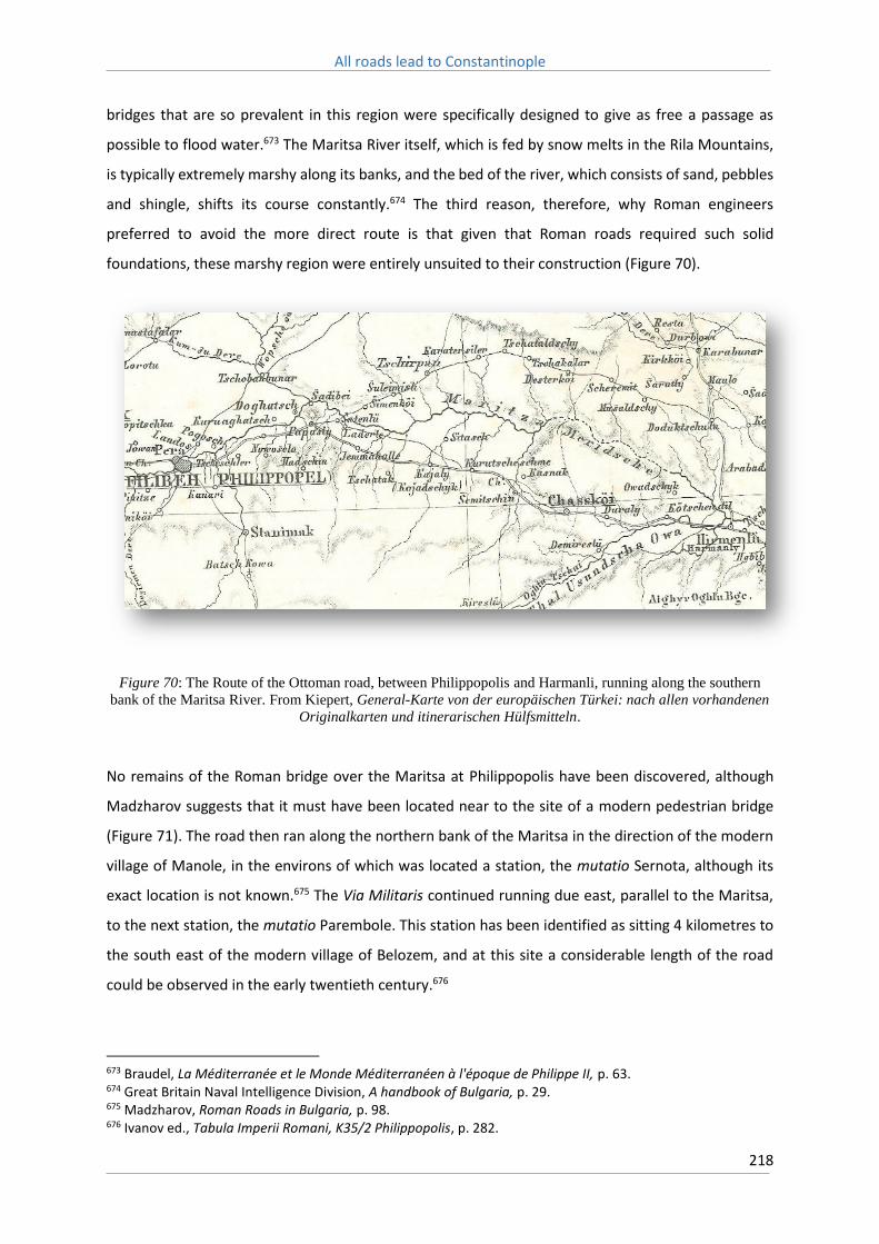
All roads lead to Constantinople
218
bridges that are so prevalent in this region were specifically designed to give as free a passage as
possible to flood water.673 The Maritsa River itself, which is fed by snow melts in the Rila Mountains,
is typically extremely marshy along its banks, and the bed of the river, which consists of sand, pebbles
and shingle, shifts its course constantly.674 The third reason, therefore, why Roman engineers
preferred to avoid the more direct route is that given that Roman roads required such solid
foundations, these marshy region were entirely unsuited to their construction (Figure 70).
Figure 70: The Route of the Ottoman road, between Philippopolis and Harmanli, running along the southern
bank of the Maritsa River. From Kiepert, General-Karte von der europäischen Türkei: nach allen vorhandenen
Originalkarten und itinerarischen Hülfsmitteln.
No remains of the Roman bridge over the Maritsa at Philippopolis have been discovered, although
Madzharov suggests that it must have been located near to the site of a modern pedestrian bridge
(Figure 71). The road then ran along the northern bank of the Maritsa in the direction of the modern
village of Manole, in the environs of which was located a station, the mutatio Sernota, although its
exact location is not known.675 The Via Militaris continued running due east, parallel to the Maritsa,
to the next station, the mutatio Parembole. This station has been identified as sitting 4 kilometres to
the south east of the modern village of Belozem, and at this site a considerable length of the road
could be observed in the early twentieth century.676
673 Braudel, La Méditerranée et le Monde Méditerranéen à l'époque de Philippe II, p. 63. 674 Great Britain Naval Intelligence Division, A handbook of Bulgaria, p. 29. 675 Madzharov, Roman Roads in Bulgaria, p. 98. 676 Ivanov ed., Tabula Imperii Romani, K35/2 Philippopolis, p. 282.

All roads lead to Constantinople
219
Figure 71: The modern pedestrian bridge over the Maritsa, where the Roman bridge is thought to have been
located.
Both the Itinerarium Burdigalense and Antonini Augusti state that the next station was the mansio
Cillis, however the Tabula Peutingerina instead lists Ranilum as the next station. This has engendered
a great deal of debate, and no clear answer as to where Ranilum lay, or if it was the same station as
Cillis, exists (Figure 72). Little is known of Cillis itself either, and it is thought to have perhaps been
located on the site of the modern rail station in the village of Cherna Gora.677
677 Madzharov, Roman Roads in Bulgaria, p. 101.

All roads lead to Constantinople
220
Figure 72: Route of the Via Militaris from Philippopolis from the Barrington Atlas of the Greek and Roman
World. The branch north to Beroe is here represented as being located at Cillis.
The road then proceeded almost due east, past the modern town of Chirpan, to the mutatio Karasura.
From here a branch in the road connected the Via Militaris with the city of Beroe (modern Stara
Zagora) to the north. The ruins at the site of the road station have been extensively excavated by a
joint German-Bulgarian team that found that Karasura was fortified in the fourth century with walls
over two metres thick, and contained two early Christian basilicas.678 Devastated by the Goths in the
fifth century, it was rebuilt by Justinian, and retains evidence of settlement dating to as late as the
fourteenth century.679 Karasura, therefore, emerges as a key location along the Via Militaris,
protecting the crossroad to Beroe, as well as providing a position from which to guard against raiders
entering into the Maritsa Valley through the Central Balkan Mountain passes to the north (see Figures
73 & 74).
678 Wendel, Karasura. Untersuchungen zur Geschichte und Kultur des alten Thrakien, p. 5-11. 679 Soustal, Thrakien (Thrake, Rodope und Haimimontos), p. 301-2.

All roads lead to Constantinople
221
Figure 73: The route of the Via Militaris as it passes Karasura and turns to the south-east. From Wendel,
Karasura. Untersuchungen zur Geschichte und Kultur des alten Thrakien, p. 6.

All roads lead to Constantinople
222
Figure 74: Remains of the uncovered basilica on the site of Karasura are clearly visible from above today. The
modern ‘Trakia’ Highway passes the site just to the north. Image captured via Google Earth.
From Karasura the Via Militaris angled to the south-east, and followed an almost entirely straight line
till it reached the outskirts of the modern town of Svilengrad, where the Ottoman and Roman roads
reunited and proceeded to the city of Adrianople. Along this length of the Via Militaris the Tabula
Peutingerina names four stations; Pizos, Arzum, Castra Rubra and Burdenis. The Antonini Augusti also
names four stations; Opizo, Arso, Subzupara, and Burdipta. The Itinerarium Burdigalense, however,
presents a slightly different picture, naming three mansiones; Arzum, Castozobra, and Burdista, and
two mutatio; Palae and Rhamis (Figure 75).
The first station after Karasura was the mansio Pizos, which has been located on a hill to the north-
east of the modern village of Dimitrievo, approximately 25 kilometres from the town of Chirpan. Pizos
was a notable ancient emporium, and an inscription discovered at the site provides information not
only on its founding, during the reign of the co-emperors Lucius Verus and Marcus Aurelius (161-169
AD), but also of its 171 original settlers, who were drawn from nearby Thracian towns.680 The
680 Hoddinott, Bulgaria in Antiquity, p. 206.
All roads lead to Constantinople
223
inscription further describes how the marketplace was established, funded, fortified and guarded.
Archaeological evidence indicates that this marketplace was destroyed in the middle of the third
century by Gothic raiders, and Justinian afterwards raised a fortification on the site.681
681 Ivanov ed., Tabula Imperii Romani, K35/2 Philippopolis, p. 301.

All roads lead to Constantinople
224
Figure 75: This recreation of the route of the Via Militaris attempts to drape the route of the road between
Philippopolis and Burdenis over a modern topographical map. From http://omnesviae.org/

All roads lead to Constantinople
225
The next station, Arzum, has been located as lying on the Sazliyka River, a northern tributary of the
Maritsa River that flows from the Sredna Gora Mountains and enters the Maritsa near the modern
town of Simeonovgrad, some two kilometres to the south. Excavations at the site unearthed pottery
fragments and coins dating from the third to the fifth centuries.682 In the medieval period an important
town known as Konstanteia existed on this site, containing evidence of settlement until at least the
beginning of the thirteenth century. In the late nineteenth century the remains of two medieval
fortresses, with walls three metres thick, were uncovered, with the road running directly between
them.683 The remains of a six metre wide bridge across the Sazliyka River were also identified.684 This
may also correspond to the town of Blisnos, or Blisnus, mentioned by Anna Comnena in the Alexiad
as being located on or near to the Maritsa River, and close to the city of Philippopolis.685 As discussed
above, it is also mentioned in the Historia de Expeditione as being a town visited by the crusaders as
they marched towards Adrianople, and was located three days march from Philippopolis.686
The next station, Castra Rubra, is one of the best known sites along the entire route of the Via Militaris.
This site, which is approximately seven kilometres south-west of the town of Izvorovo, was the subject
of extensive excavations in 2007 (see Figures 76-78).687 As a result sections of the fortifications there
have been uncovered, indicating an irregular pentagonal fortress defended by rectangular towers,
which was constructed either in the late fifth or early sixth century.688 Procopius mentions the fortress
as one of those restored by Justinian, naming it Castrazarba.689 The fortress was sacked during the
invasions of the early seventh century, rebuilt and then sacked again during the invasion of Khan Krum
in the early ninth, at which point it was abandoned for good.690 However a further settlement was
subsequently raised upon the site, dating from the first half of the ninth century, from which were
uncovered pottery remains, which represent a wide variety of ceramic traditions and date to as late
as the middle Byzantine period, as well as copper coins dating to the reign John Tzimiskes. From these
finds Borisov surmises that this new settlement was populated by a wide variety of different ethnic
groups.691
682 Madzharov, Roman Roads in Bulgaria, p. 113. 683 Soustal, Thrakien (Thrake, Rodope und Haimimontos), p. 314. 684 Madzharov, Roman Roads in Bulgaria, p. 114. 685 Anna Comnena, The Alexiad, p. 166. Also see Soustal, Thrakien (Thrake, Rodope und Haimimontos, p. 210. 686 Historia de Expeditione Friderici Imperatoris, p. 80. 687 B. Borisov, ‘Excavations at Castra Rubra’, American Journal of Archaeology, 114 (October, 2010), p. 724-6. 688 Ivanov ed., Tabula Imperii Romani, K35/2 Philippopolis, p. 74. 689 Procopius, De Aedificiis, p. 309. 690 Borisov, ‘Excavations at Castra Rubra’, p. 725. 691 Borisov, ‘Excavations at Castra Rubra’, p. 725.

All roads lead to Constantinople
226
Figure 76: Excavated remains of the station Castra Rubra.
Figure 77: Further detail of the remains of Castra Rubra

All roads lead to Constantinople
227
Figure 78: As part of the excavation of Castra Rubra a short section of the Via Militaris was reconstructed. It is
today quite overgrown.
The Via Militaris, which had run in a straight line to the south-east since the station of Karasura, now
veered further to the south, in the direction of the Maritsa. Madzharov notes that part of the road’s
surface can still be seen to the east of the town of Yerusalimovo.692 It then passed the mutatio Rhamis,
the location of which is not known but is presumed to lie to the north of the town of Lyubimets, which
sits on the banks of the Maritsa, in a series of hills known as Hissar. Here remains dating back to 3000
BC have been discovered, as well as ruins of a fortification, and ceramics dating to as late as the
thirteenth century.693 Madzharov, however, argues that the original station must have lain closer to
the village of Momkovo, as the ruins at Hisar are located nearly five kilometres to the west of the road,
and therefore too distant to have been a station along its route.694
692 Madzharov, Roman Roads in Bulgaria, p. 124. 693 Soustal, Thrakien (Thrake, Rodope und Haimimontos), p. 338. 694 Madzharov, Roman Roads in Bulgaria, p. 124-6.

All roads lead to Constantinople
228
From the station of Rhamis the road ran parallel to the northern bank of the Maritsa River. Remains
of the road can still be seen some 800 metres to south of the village of Momkovo, and here also have
been discovered milliaria.695 The Via Militaris must have run, therefore, close to and likely parallel to
the route of the modern Maritza Highway. On the outskirts of the town of Svilengrad, in the heights
to the north known as ‘Hisarya’, sat the station of Burdenis. The site is currently unexcavated, but the
remains of fortress walls are still visible, and these may belong to the fortress of Burdepto mentioned
by Procopius. The position would have afforded a clear line of sight across the Thracian plain in the
direction of Adrianople, which lay 20 Roman miles distant, and it has been suggested, based on
scattered ceramic and jewellery fragments found at the site, that it remained occupied till the
fourteenth century.696
The final station within the borders of modern Bulgaria is the mutatio Daphabae mentioned by the
Itinerarium Burdigalense, and it has been identified as existing near the border town of Kapitan
Andreevo. Approximately four kilometres to the west of the modern town was discovered a milliaria,
dated to the reign of Emperor Alexander Severus (222-235), that states that the city of Adrianople was
12 Roman miles distant. Based on this evidence, Madzharov believes that the station Daphabae must
have been located close to the site where the milliaria was discovered.697
From here the Via Militaris continued to closely follow the northern bank of the Maritsa River as it
approached Adrianople. The city of Adrianople, modern day Edirne, sits at the confluence of the
Maritsa and Tundzha Rivers, and the Tundzha River is bridged as the road approaches the city from
the west. A bridge, dating from the reign of Emperor Michael Palaiologos (1261-1282) is known to
have existed on this site, and was subsequently restored in 1420 by Gazi Mihal Bey, whose name the
bridge now carries (Gazi Mihal Bridge), and is the oldest bridge in Edirne (Figure 79).698 Another bridge
likely crossed the Maritsa and an alternate road ran south along it, via Didymoteicho, to the important
Byzantine city of Traianoupolis and the Via Egnatia.699
695 Madzharov, Roman Roads in Bulgaria, p. 126. 696 Soustal, Thrakien (Thrake, Rodope und Haimimontos), p. 224. 697 Madzharov, Roman Roads in Bulgaria, p. 128-9. 698 I. S. Canitez, T. Canitez, & N. Ilhan, ‘The bridges of Edirne: comprehensive buildings for the lecture of the city’, Trakia Journal of Sciences, 7 (2009), p. 226. 699 C. Bakirtzis, ‘Byzantine Thrace (AD 330-1453)’, in G. Selimis ed., Thrace (Athens, 1994), p. 199.

All roads lead to Constantinople
229
Figure 79: The Gazi Mihal Bridge, leading into modern Edirne. Photo obtained from
http://wikimapia.org/94974/Gazi-Mihal-Köprüsü (accessed 22/1/2016).
The most important question governing the route between Philippopolis and Adrianople is whether
or not the Byzantine road followed that of the earlier Roman road, to the north of the Maritsa River,
or the later Ottoman route to the south of the river. The archaeological evidence is mixed, and
suggests settlements existed both north and south of the Maritsa between the tenth and thirteenth
centuries, such as the important fortress of Makrolibada, mentioned in the peace treaty of 816, which
nestled in the foothills of the Rhodope Mountains.700 Certainly by the sixteenth century the road south
of the Maritsa was in use; Hans Dernschwam followed this route in 1553, although he complained the
road was poorly made and few villages lay along it.701 However as noted above, also in the mid-
sixteenth century, Ogier de Busbecq made the journey between Philippopolis and Adrianople, and
explicitly states that the Maritsa was kept to the right of the road, with the Central Balkan Mountains
on the travellers left. It is likely that some travellers preferred the older well-beaten paths to the main
roads as they were easier to travel on and probably had the additional benefit of avoiding the worst
700 Soustal, Thrakien (Thrake, Rodope und Haimimontos), p. 343. 701 Dernschwam, Ein Fugger-Kaufmann im Osmanischen Reich, p. 29.

All roads lead to Constantinople
230
of the marshy, mosquito infested, land along the Maritsa. Depictions of the route of the medieval Via
Militaris in maps of this region, therefore, tend to vary between the northern and southern banks of
the Maritsa (Figure 80).
Figure 80: For instance, this representation of the medieval Balkans, from Stephenson, Byzantium's Balkan
Frontier, p. 20, depicts the route of the Via Militaris as proceeding along the southern bank of the Maritsa.

All roads lead to Constantinople
231
The importance of guarding the passes through the Central Balkan Mountains argues for the retention
of a road north of the Maritsa, as this would allow the quickest deployment of troops from Adrianople
or Philippopolis to these regions when threatened. This does not suggest that a road did not also exist
south of the Maritsa at this time, only that there were important strategic arguments for the retention
of the original Roman route.
The mountain passes through the Central Balkan Mountains were of critical importance to the security
of the Maritsa Valley, and Byzantium certainly kept a close guard over them, as with the abandonment
of the Moesian plain they represented the empire’s first line of defence from barbarian incursions
from the north. In 1092, for instance, Alexius Comnenus sought to keep close guard over these passes
in order to prevent their passage by an invading Cuman force.702 In this Alexius was defeated through
the duplicity of the native Vlachs, who provided guides to lead the Cumans through unoccupied
passes. The Vlachs had likely been deliberately settled in the region in order to guard the mountain
passes, but their subsequent untrustworthiness in this role would provide a constant cause for
concern.703
A further point arguing for the retention of a road to the north of the Maritsa River is the restoration
of the city of Beroe by the Empress Irene in 784, at which point she renamed the city after herself;
Irenepolis.704 It is believed that Beroe was likely abandoned after an Avar or Slavic attack sometime in
the sixth century, although archaeological remains suggest it may have retained a small population.705
Velkov argues that the city continued to exist and survived the turmoils of the sixth century, in at least
some form.706 Irene certainly restored the city’s walls, as archaeological surveys, in particular of the
southern gate, attest, and it likely thereafter remained an important outpost guarding the northern
approaches to Thrace.707
Beroe could be reached from the Black Sea via a road from Anchialos, and this is the road which Irene
took in the late eighth century.708 It was then further linked to Philippopolis via another road which
met the Via Militaris at Karasura. As such it was tightly integrated into the logistical network of the
region and formed an important linchpin in the defence of the northern Maritsa Valley and the
702 Anna Comnena, Alexiad, p. 239. 703 Stephenson, Byzantium's Balkan Frontier, p. 104-5. 704 Theophanes, Chronicle, p. 143. 705 Hoddinott, Bulgaria in Antiquity, p. 312-5. 706 Velkov, The cities in Thrace and Dacia in Late Antiquity, p. 286. 707 N. Sharankov & D. Yankov, ‘A 784 AD Inscription of Constantine VI and Irene from Beroe-Irenopolis (modern Stara Zagora, South Bulgaria)’, Archaeologia Bulgarica, 12 (2008). 708 Evidence indicates this road had remained in use until at least the late sixth century, see Beševliev, ‘Bemerkungen uber die Antiken Heeresstrassen im Ostteil der Balkanhalbinsel’, p. 486. Also Laiou, ‘Regional networks in the Balkans in the Middle and Late Byzantine Periods’, p. 128.

All roads lead to Constantinople
232
mountain passes beyond. The roads leading to it would, therefore, likely have remained in use at least
until the late twelfth century when, during the passage of the Third Crusade, a detachment of
crusaders, en route to Adrianople from Philippopolis, plundered the city of everything of worth, and
then committed the rest to flames.709
Soustal suggests that as the older Roman road fell into disuse and began to lose its identity, the shorter
and more direct route along the south of the river came to be preferred.710 With the available evidence
it is impossible to clearly determine at what point this occurred. Such a clear cut distinction is likely
unreachable for, as has been seen with the example provided by Ogier de Busbecq, even when the
southern road was in active use, some travellers still preferred the northern. As Koder notes, based
on evidence in Asia Minor, the decline of Roman roads did not usually result in road relocation, and
unless there were compelling reasons to do so, such as dramatic changes to the natural landscape,
regional and trans-regional routes typically remained constant during the Byzantine period.711 The
Byzantines were capable of utilising alternate roads, but after the sixth century there is little evidence
of them constructing entirely new routes. It therefore seems likely that the route of the Via Militaris
remained on the northern bank of the Maritsa until such time as the Ottoman Empire, with its greater
resources, constructed the new route sometime in the late fifteenth or early sixteenth century.
11.7: Adrianople
The Roman city of Adrianople was established by Emperor Hadrian in 123-124, who delineated the
extent of its new walls on the site of an existing Greek settlement. This site encompassed some 36
hectares and became, in time, an important city along the Via Militaris, forming both a key location
along the route, and an administrative and ecclesiastical centre for the Thracian region. The notitiae
episcopatuum ecclesiae constantinopolitanae, which ranked the metropolitan and suffragan
bishoprics of the church, listed Adrianople as only 36th out of 38 metropolises in the seventh century,
but, likely swelled by refugees from elsewhere in the Balkans, the city grew in importance, and the
number of suffragan bishoprics within the city increased from five in the seventh century, to eleven in
the tenth.712 With this increase in prominence the city experienced a commensurate expansion in size,
709 Historia de Expeditione Friderici Imperatoris, p. 88. 710 Soustal, Thrakien (Thrake, Rodope und Haimimontos), p. 572. 711 J. Koder, ‘Regional networks in Asia Minor during the Middle Byzantine Period’, in C. Morrisson ed., Trade and Markets in Byzantium (Washington D.C., 2012), p. 152-3. 712 On Balkan cities and the notitiae episcopatuum, see Hendy, Studies in the Byzantine Monetary Economy c.300–1450, p. 76-7.

All roads lead to Constantinople
233
to cover near 100 hectares, and it would ultimately reach its apogee in the fourteenth century, when
it became the capital of the burgeoning Ottoman Empire.713
One reason for the city’s emergence as a key strategic and administrative centre was its location not
only on the Via Militaris, but also on the Maritsa River, which is navigable by flat bottomed barges
from Adrianople till it enters the Aegean. In the Ottoman period such barges were used to convey rice
and other crops to Constantinople, and it’s highly likely such craft were used in the Roman period as
well.714 Adrianople was also host to a sizeable arms workshop industry in the late Roman period,
although virtually nothing is known of its production after the seventh century.715
The city attracted the praise of medieval visitors for its agricultural wealth. The Historia peregrinorum
relates that it was ‘an admirable and famous city, both from the suitability of its site and from the
fertility of the nearby regions. Although it is defended on the western and southern sides by the waters
of two rivers flowing through, it lies further strengthened by walls and towers on the outside, while
inside the height of its palatial buildings appears to tower over these’.716 Major exports from the city
were cotton and linen, which were suited to the local environment, which is characterised by largely
barren hills and extremely hot summers, more typical of the Mediterranean than the more protected
Maritsa Valley region. Michael Attaleiates also mentions the cultivated fields and vineyards that
surrounded the city in the mid-eleventh century.717
Not only was Adrianople an important city for its connections to the south and east, but also to the
north, towards the Central Balkan Mountains. Between Adrianople and the Black Sea lies the Istrandja
region (or Strandzha in Bulgarian), a series of low, heavily forested rolling hills that historically have
contained extremely poor communications and proved exceptionally difficult to move an army
through.718 Even today the region is notable for the absence of major roads. To reach the Black Sea
coast, or the eastern fringes of the Central Balkan Mountains, from Constantinople, it was more
convenient to come as far inland as Adrianople, or in the late Ottoman period the important frontier
city of Kirkilisse, before turning to the north and then to the east.719 Adrianople has, consequently,
been a key battleground throughout history, from the Roman period right through to the Balkan Wars
of the early twentieth century.
713 Canitez, et al, ‘The bridges of Edirne: comprehensive buildings for the lecture of the city’, p.221-2. 714 Great Britain Naval Intelligence Division, A handbook of Bulgaria, p. 29. 715 Haldon, ‘The organization and support of an expeditionary force; manpower and logistics in the Middle Byzantine period’, p. 142. 716 Historia peregrinorum, p. 146. 717 Attaleiates, The History, p. 59. 718 Archibald, The Odrysian Kingdom of Thrace, p. 14. 719 Great Britain Naval Intelligence Division, Handbook of Turkey in Europe, p. 12.

All roads lead to Constantinople
234
11.8: Thrace
Given the importance of Thrace in the history of the Mediterranean at large, it is surprising that so
little is known of the historical geography of this region. The routes of the two major roads that crossed
it, the Via Militaris and Via Egnatia, are known only in part, and educated guesses must be made for
much of their course.720 Remains of the road surface itself are scarce, and few milliaria have been
recovered in this region. The route of the Via Militaris, therefore, must largely be derived from the
remains of stations and the impressions of Early Modern European travellers in the region. Much like
the course of the Via Militaris along the Morava Valley, this makes it difficult to recognise deviations
or alternate routes. The general route of the road, however, is not difficult to discern, and would have
closely matched the existing highway to Istanbul today, covering a distance of approximately 320
kilometres between Edirne and Istanbul.721 As the British Naval Intelligence survey of Turkey describes
it, the road from Adrianople to Constantinople via Silivri follows the natural line of approach to the
capital, avoiding the Istrandja Mountains to the north, and largely following the course of the Ergene
River, a major tributary of the Maritsa.722
In the early Byzantine era, up till the death of Justinian, Thrace was a rich region, containing no less
than 14 cities and a further 24 minor settlements.723 As with elsewhere in the Balkans, from the eighth
and ninth century onwards many of the towns came to take on new Byzantine names, likely reflecting
their changing identities in the midst of a general decline in population.724 Nevertheless, it was still a
relatively productive region agriculturally, containing vast areas of pastures and meadows, fertile hills,
a rich riverine system and extended coastal areas.725 Much of the produce of this region, in particular
its wheat crop, helped feed the teeming masses of the imperial capital, and Skylitzes makes mention
of an annual fair, which was held at public expense, which operated in Adrianople.726
720 A. Külzer, ‘The Byzantine road system in eastern Thrace: some remarks’, in C. Bakirtzis, N. Zekos & X. Moniaros eds., Byzantine Thrace: evidence and remains, Komotini 18-22 April 2007 (Amsterdam, 2011), p. 179-80. Perhaps the best overview of the road network of Thrace until the 7th century is provided by Beševliev, ‘Bemerkungen uber die Antiken Heeresstrassen im Ostteil der Balkanhalbinsel’. 721 Great Britain Naval Intelligence Division, Handbook of Turkey in Europe, p. 283. 722 Great Britain Naval Intelligence Division, Handbook of Turkey in Europe, p. 24. 723 Hierocles, Synekdemos, trans. E. Honingman, Le Synekdemos d’Hiérocles et l’Opuscule géographique de Georges de Chypre (Brussels, 1939), p. 12. 724 Bakirtzis, ‘Byzantine Thrace (AD 330-1453)’, p. 157-8. 725 D. Drakoulis, ‘European and Asiatic Settlements of the Bosporus Hinterland in the Early Byzantine Period’, in G. R. Tsetskhladze et al. eds., The Bosporus: Gateway between the Ancient West and East (1st Millennium BC–5th Century AD) Proceedings of the Fourth International Congress on Black Sea Antiquities Istanbul, 14th–18th September 2009 (Oxford, 2013), p. 238. 726 Skylitzes, Synopsis historiarum, p. 328.

All roads lead to Constantinople
235
From Adrianople the road proceeded almost due south-east, with the first station along its length
being Nike, modern Havsa. The Historia de Expeditione mentions this location as the castle of Nikiz,
and notes that the region was famous for its resinated wine, or more accurately infamous during the
crusading period, as the crusaders often mistook the strange tasting concoction as a form of poison.727
The next station was Bulgarophygon, ancient Bourtoudizos, on the site of modern Babaeski.728 The
town here played an important role during the Ottoman period as a collection point for local produce,
such as grain, cheese and eggs, destined for export to the capital.729
The road then led to Arcadiopolis, modern Lüleburgaz, one of the largest towns of medieval Thrace,
and approximately 80 kilometres to the west of Constantinople. It is said to be located in the best
grain growing district along the Ergene River.730 The city evidently retained strong fortifications, rebuilt
by Justinian, as in 969 an imperial army, led by Bardas Skeleros, took refuge in it from a much larger
force of raiding Kieven Rus, along with their Pecheneg allies.731 A detachment of Barbarossa’s force,
led by the Duke of Swabia, sacked the city whilst the crusaders were wintering in nearby Adrianople,
and found it abandoned by its inhabitants, and otherwise empty save for some stocks of corn and
wine.732
Arcadiopolis evidently sat in the centre of a network of communications governing Byzantine Thrace.
In 775 Emperor Constantine V, at the head of an army with which he intended to invade Bulgaria,
reached the city before he succumbed to the effects of fever, which compelled him to withdraw back
down the road to Selymbria.733 To the north was Bizye, not only an important fortress guarding the
northern approaches to Thrace, but also a cult centre dedicated to Saint Mary the Younger.734 An
inscription, dated to 773/4, details repairs made to a bridge along a nearby road, possibly that which
linked the two cities.735 Not only does this argue for the existence of secondary roads linking the Via
Militaris to fortresses to the north, but also that Byzantium was actively engaging in road maintenance
and bridge repair, at least in the anticipation of major military campaigns, such as Constantine V’s
aborted expedition against the Bulgars. This is not in itself surprising, as the treatise on military
727 Historia de Expeditione Friderici Imperatoris, p. 81-2. 728 Külzer, ‘The Byzantine road system in eastern Thrace: some remarks’, p. 181. 729 Great Britain Naval Intelligence Division, Handbook of Turkey in Europe, p. 202. 730 Great Britain Naval Intelligence Division, Handbook of Turkey in Europe, p. 203. 731 John Skylitzes, Synopsis historiarum, p. 275-6. 732 Historia de Expeditione Friderici Imperatoris, p. 88. 733 Theophanes, Chronicle, p. 135. 734 F. A. Bauer & H. A. Klein, ‘The Church of Hagia Sophia in Bizye (Vize): Results of the Fieldwork Seasons 2003 and 2004’, Dumbarton Oaks Papers, 60 (Washington D.C., 2006), p. 249. 735 C. Mango, ‘Three inscriptions of the reign of Anastasius I and Constantine V’, Byzantinische Zeitschrift, 65 (1973), p. 391. It is also possible that the bridge was constructed on a secondary road that ran along the Tundzha Valley, see C. Asdracha, ‘Inscriptions byzantines de la Thrace orientale (VIIIe – XIe siècles). Présentation et commentaire historique’, Archaiologikon Deltion, 47 (1992).

All roads lead to Constantinople
236
campaigns compiled by Constantine VII explicitly calls for the repair of bridges along the army’s
expected line of march.736 These road networks likely fostered both local and longer distance trade
with the capital. Situated at an important crossroads, Arcadiopolis evidently benefited greatly from
local trade networks, and Choniates makes mention of its ‘wealthy and illustrious residents’ who fled
the town ahead of the arrival of a Frankish army in 1205.737
The next station along the route, Narco, is thought to have existed near the modern Turkish village of
Evrensekiz.738 The road then reached Druzipara, located at the site of the village of Misinli. The town
was an important ecclesiastical centre in the early Byzantine period, and like Arcadiopolis and Bizye
was nominated an autocephalous archiepiscopate, and listed in the Notitiae Episcopatuum as
Mesene.739 It also contained a church dedicated to the cult of Saint Alexander, who was martyred here
during the reign of Emperor Maximian.740 Although much of the ruins in this location remain
unexcavated, a bridge to the south-west of the modern town is argued to contain the remnants of
older Byzantine construction.741
From Druzipara the road continued in the same south-easterly course, reaching the mutatio Tipsos,
located on the banks of the Ergene River. Continuing in the same direction the next station was Izirallo,
which in the Byzantine period was known as Tzouroulon (or Tzurulum) and is located at the site of
modern Çorlu. Theophanes makes mention of this location as lying along the route of Emperor Michael
I Rangabe’s march against the Bulgars in 811.742 In the ninth century it is known to have been the seat
of a kourator, an imperial magistrate, held by Sisinnios, who fled the town ahead of the arrival of
Bulgar forces, and died in nearby Heraclea in 813.743 Anna Comnena describes it as being in the late
eleventh century as variously a ‘little town’,744 a ‘Thracian village’,745 and ‘a fortified town on a very
steep hill.’746 According to Anna’s description of a battle that occurred here between Alexius
Comnenus and invading Pecheneg forces, the town evidently retained impressive fortifications which
736 Constantine Porphyrogenitus, What should be observed when the Emperor intends to go on an expedition, p. 85. 737 Nicetas Choniates, Historia, p. 336. 738 Külzer, ‘The Byzantine road system in eastern Thrace: some remarks’, p. 181. 739 B. Dumanov, ‘Thrace in late antiquity’, in J. Valeva, E. Nankov, & D. Graninger, eds., A Companion to Ancient Thrace (Sussex, 2015), p. 93. 740 Miller, Itineraria romana, p. 538. 741 Külzer, ‘The Byzantine road system in eastern Thrace: some remarks’, p. 181-2. 742 Theophanes, Chronicle, p. 175. 743 I. Ševčenko, ‘Inscription commemorating Sisinnios, “curator” of Tzurulon (AD 813)’, Byzantion, 35 (1965), p. 564-74. 744 Anna Comnena, Alexiad, p. 51. 745 Anna Comnena, Alexiad, p. 56. 746 Anna Comnena, Alexiad, p. 191.

All roads lead to Constantinople
237
Alexius was able, through use of a feigned flight, to draw his enemies within range of and
comprehensively defeat.747
The towns of Bulgarophygon, Arcadiopolis and Tzouroulon, therefore, all appear to have been well
defended by extensive fortifications and were relatively well populated in the late twelfth and early
thirteenth centuries. Choniates describes the ‘fields and villages and all else that formerly came under
the jurisdiction of these cities’ that were ravaged by Cuman raids after the capture of Constantinople
in 1204.748 Otto of Freising also relates how the German contingent of the Second Crusade marched
with ‘much gladness of heart’ through the ‘most fruitful regions of lower Thrace on our way to the
Royal city.’749 The status of these cities was without doubt a consequence of the fertility of this region
and their respective positions astride the major landward route to the capital.
From Tzouroulon the medieval Via Militaris followed a different route to that followed by the original
Roman road, bypassing the city of Heraclea in favour of a more direct course towards Selymbria that
was likely constructed during the reign of Justinian. Whether this meant that the older route fell into
abeyance is unclear. The city of Raidestos, as noted above, was the site of a major grain exchange, as
well as numerous estates, such as that owned by Michael Attaleiates that was damaged by an
earthquake in 1063.750 It is likely that the old route of the road, therefore, still remained in active use
by local producers travelling to and fro, whilst travellers to Constantinople, and forces marching for
the frontiers, took the newer, more direct route instead (Figure 81).
747 Anna Comnena, Alexiad, p. 191-3. 748 Nicetas Choniates, Historia, p. 345. 749 Otto of Freising, Gesta friderici imperatoris, trans. C. C. Mierow, The deeds of Frederick Barbarossa (New York, 1953), p. 80. 750 Attaleiates, The History, p. 445.

All roads lead to Constantinople
238
Figure 81: The Ottoman road between Çorlu and Silivri, which bypasses Eregli, ancient Heraclea. From
Kiepert, General-Karte von der europäischen Türkei: nach allen vorhandenen Originalkarten und
itinerarischen Hülfsmitteln.
Selymbria itself was an important town in its own right. Its position along the coast, and astride the
main road leading to the capital, made it an ideal staging post for Byzantine armies. It was from here,
for instance, that Alexius Comnenus, at the head of an imperial army, observed the arrival of
Nicephorus Byrennios’ rebels in 1077.751 At some point between 1166 and 1169 Manuel Comnenus
raised the local see to metropolitan status, and restored a pre-existing church within the city, whilst
the city also continued to receive repairs to its defences till the beginning of the thirteenth century.752
Additionally the Anastasian, or Long, Wall met the coast just to the west of Selymbria.753 Little remains
of these fortifications in this region today, but vast sections of it were visible to earlier travellers. Ogier
de Busbecq noted, in the mid-sixteenth century, ‘traces of an ancient ditch and rampart which are said
to have been constructed by the later Greek emperors from the Sea of Marmara to the Danube, in
751 Attaleiates, The History, p. 457. 752 P. Magdalino, ‘Byzantine churches of Selymbria’, Dumbarton Oaks Papers, 32 (1978), p. 312. 753 The course of the walls, or ‘Anastasischen Mauer’, is indicated in the above Figure 81.

All roads lead to Constantinople
239
order to include their territory within a line of defence and secure the estates of the inhabitants of
Constantinople from the inroads of barbarians.’754
It was here also that the Via Militaris finally united with the Via Egnatia. The fork in the road was
notably marked by a nearby aqueduct, likely constructed in the sixth century, which ran to the town.755
The latter road is arguably the more famous, and has attracted a great deal of scholarly attention. It
is curious, therefore, that the Thracian extent of the Via Egnatia has been comparatively somewhat
neglected. Perhaps this has been the influence of its first geographer, Strabo, who only measured the
length of the road as far as Cypsela, modern Ipsala, on the Maritsa River. The original road ended here
as this was the boundary of the Roman state at the time of its construction (between 140-120 BC),
with the lands beyond being held by the Kingdom of Pergamon.756 Evidently the rest of the road was
constructed later, and at least sometime before the third century owing to its appearance in the
Itinerarium Antonini.
There were therefore actually two routes to Constantinople across Thrace, sometimes referred to as
the strata vetus, the older road, and a newer road, the strata nova.757 Jireček argues that the older
road ran from Cypsela to Constantinople, travelling mostly via the Thracian hinterland, and that the
settlement of Caenophrurium, the site of the murder of Emperor Aurelian in 275, existed on this
route.758 Caenophrurium was possibly located near the modern town of Sinekli, some 20 kilometres
inland from the Marmara coast, and Drakoulis suggests that Caenophurium therefore lay along the
road that also directly connected Constantinople to Bizye (Figure 82).759 Certainly a road along the
route of the strata vetus existed in the Ottoman period, connecting the capital with the important
frontier city of Kirkilisse. August Giacomo Jochmus provided a detailed description of this road as it
existed in the mid-nineteenth century, including references to remains of Roman bridges along the
route.760 In the early twentieth century it was the main road connecting Constantinople with the
Russian frontier, and approximately 26 feet wide.761
754 Ghiselin de Busbecq, Legationis Turcicae Epistolae quatuor, p. 25-6. 755 Crow & Turner, ‘Silivri and the Thracian hinterland of Istanbul: an historic landscape’, p. 170. 756 Adams, ‘Communications in southeastern Thrace in the Roman period’, p. 137-8. 757 Külzer, ‘The Byzantine road system in eastern Thrace: some remarks’, p. 192. 758 Jireček, Die Heerstrasse von Belgrad nach Constantinopel und die Balkanpasse, p. 52. 759 D. Drakoulis, ‘European and Asiatic Settlements of the Bosporus Hinterland in the Early Byzantine Period’, p. 238. 760 A. Jochmus, ‘Notes on a Journey into the Balkan, or Mount Hæmus, in 1847’, Journal of the Royal Geographical Society of London, 24 (1854). 761 Great Britain Naval Intelligence Division, Handbook of Turkey in Europe, p. 209.

All roads lead to Constantinople
240
Figure 82: Caenophurium is here located on the inland road leading to Bizye, although no connection with the
Via Egnatia is depicted. The connection between Selymbria and the Via Militaris is also absent. Perinthus is the
original Samian name for Heraclea. Map captured from http://pleiades.stoa.org/
All roads lead to Constantinople
241
A new road, the strata nova, in Jireček’s opinion, was constructed by Constantine at the same time as
the foundation of the new capital, and ran along the coast, likely following the route of a pre-existing
path that linked the Greek colonies along the shore of the Marmara.762 It is likely that Constantine
wished for a grander road to his new imperial capital, and the connection between this road and the
Golden Gate, as will be seen, suggests that from the very beginning it was deliberately constructed
with the intention of being associated with imperial triumphs and public veneration of the state.
Following the coast, Rhegion was an important town in the early Byzantine period, featuring imperial
estates, extensive hunting grounds, and considerable defensive fortifications. It declined during the
late Byzantine period, likely as a consequence of repeated devastations of Thrace from the beginning
of the thirteenth century onwards, and was afterwards revived as an important caravan post under
the Ottoman Empire.763 The road from Rhegion to Constantinople, as previously noted, was a specific
focus of restoration efforts during the reign of Justinian, and Procopius describes the lavish nature
with which the road was constructed in this region. Included in this was a bridge over the Myrmex,
the lagoon on the shores of the Marmara known today as Küçükçekmece.764 In one of the few
examples of public work projects after the reign of Justinian, this bridge is known to have been
restored, or rebuilt entirely, during the reign of Basil I.765 Hans Dernschwam mentions a stone bridge
that existed here in the mid-sixteenth century, and further describes the remains of the old Roman
road that were then still clearly visible.766
In the late Roman and early Byzantine periods the final stretch of the Via Militaris, from Rhegion to
Constantinople itself, was likely the best maintained section of the entire route. Constantine
Porphyrogenitus, in De Ceremoniis, details how on triumphal entrances into the city emperors would
be greeted by dignitaries (archons and tribunes) at Rhegion, or even as far away as Herakleia, and
escorted to the city.767 Hebdomon, so named for lying seven Roman miles from the Milion in
Constantinople, assumed a prominent part in these triumphs, and likely played the same role as the
Campus Martius in Rome, in that it was the official starting point for triumphal entrances into the city
(Figure 83). Returning from a successful campaign against the Paulicians, near the Euphrates, Basil I
762 Jireček, Die Heerstrasse von Belgrad nach Constantinopel und die Balkanpasse, p. 53-4. 763 S. Turgut & E. Ceylan, In the Wake of a Local Government Initiative: Istanbul – Küçükçekmece urban regeneration project (Southampton, 2012), p. 6-7. 764 K. Belke, ‘Communications: roads and bridges’, in E. Jeffreys, J. Haldon, & R. Cormack eds., The Oxford Handbook of Byzantine Studies (Oxford, 2008), p. 303. 765 Constantine Porphyrogenitus, De administrando imperio, p. 247. 766 Dernscham, Ein Fugger-Kaufmann im Osmanischen Reich, p. 37. 767 Constantine Porphyrogenitus, De administrando imperio, p. 495.

All roads lead to Constantinople
242
sailed from Hiereia, on the Asian shore of the Bosporus, to Hebdomon, where he was greeted by the
senate and the people of the city, before proceeding into the city.768
Figure 83: The approach to Constantinople, as depicted in the Barrington Atlas of the Greek and Roman World.
Such triumphal processions naturally entered the city via the Golden Gate, but it is not immediately
clear which gate was preferred for more mundane entrances into the city. The Golden Gate itself is
curiously placed, at the far southern end of the Theodosian Walls, and was connected to the Mese,
the main boulevard through the city, via a southern branch. It is likely that use of the Golden Gate as
an entrance into the city ceased altogether by the end of the eleventh century, for although Alexius
and Manuel Comnenus celebrated triumphs in the imperial capital, it is not clear if the Golden Gate
was used at all during them.769 During the reign of Isaac Angelos the Golden Gate is known to have
been permanently sealed shut, and when the city was captured during the Fourth Crusade, Choniates
768 Constantine Porphyrogenitus, De administrando imperio, p. 498-9. 769 Madden, ‘Triumph Re-imagined: the Golden Gate and popular memory in Byzantine and Ottoman Constantople’, p. 318-9.

All roads lead to Constantinople
243
describes how the Byzantine army broke through a wall that had been erected in front of the gate in
order to flee the city, and that he and other evacuees later fled the same way (Figure 84).770
Figure 84: Interior view of the remains of the Golden Gate.
770 Choniates, Historia, p. 313 & 324.
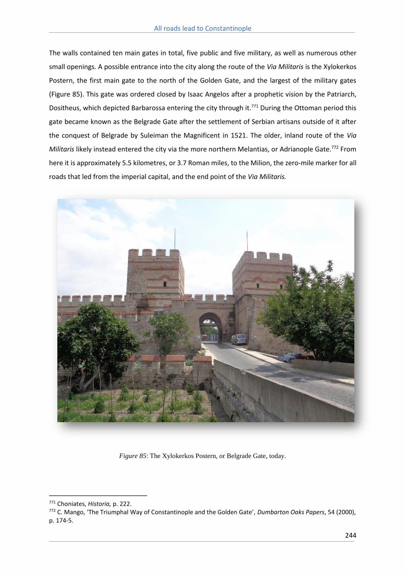
All roads lead to Constantinople
244
The walls contained ten main gates in total, five public and five military, as well as numerous other
small openings. A possible entrance into the city along the route of the Via Militaris is the Xylokerkos
Postern, the first main gate to the north of the Golden Gate, and the largest of the military gates
(Figure 85). This gate was ordered closed by Isaac Angelos after a prophetic vision by the Patriarch,
Dositheus, which depicted Barbarossa entering the city through it.771 During the Ottoman period this
gate became known as the Belgrade Gate after the settlement of Serbian artisans outside of it after
the conquest of Belgrade by Suleiman the Magnificent in 1521. The older, inland route of the Via
Militaris likely instead entered the city via the more northern Melantias, or Adrianople Gate.772 From
here it is approximately 5.5 kilometres, or 3.7 Roman miles, to the Milion, the zero-mile marker for all
roads that led from the imperial capital, and the end point of the Via Militaris.
Figure 85: The Xylokerkos Postern, or Belgrade Gate, today.
771 Choniates, Historia, p. 222. 772 C. Mango, ‘The Triumphal Way of Constantinople and the Golden Gate’, Dumbarton Oaks Papers, 54 (2000), p. 174-5.

All roads lead to Constantinople
245
Which of these two roads across Thrace to the capital was subsequently the most frequently used
route in the Middle Ages is a matter of debate. The road along the coast was likely the most
convenient, being the most direct, but was dependent on the bridges that forded the lagoons that lay
in its path. The longer, inland, route around the lagoons may instead have been preferred when these
were known, or suspected, of being in poor repair.773 Secondary roads also linked the two, and Külzer
describes a crossroads at Rhegion where a minor road ran to the north, likely connecting the strata
nova with the strata vetus (Figure 86).774 During the passage of the Second Crusade the German
contingent took the inland road, and the crusaders camped in the plain of the Choirobacchoi, a fertile
meadow located on the northern shore of the Büyükçekmece lagoon, along the banks of the Melas
River (the modern Karasu).775 A flashflood subsequently washed away a large part of the crusaders’
baggage.
The barring of the gates on the southern end of the walls of Constantinople suggests that by the end
of the twelfth century at least, the coastal approach to the city had declined in preference to the older,
inland route that skirted the northern shores of the lagoons, the road which was taken by the German
contingent of the Second Crusade. As a consequence, during this period it was likely the older road,
the strata vetus, rather than the newer coastal road, which carried the greatest weight of traffic.
773 Mango, ‘The Triumphal Way of Constantinople and the Golden Gate’, p. 175. 774 Külzer, ‘The Byzantine road system in eastern Thrace: some remarks’, p. 193. 775 Odo of Deuil, De profectione Ludovici VII in orientem, p. 47. See also Choniates, Historia, p. 37-8, and Otto of Freising, Gesta friderici imperatoris, p. 80-1.

All roads lead to Constantinople
246
Figure 86: A diagrammatical representation of the medieval road network of Thrace. The Via Militaris is
represented by the route A1, but the numerous other potential routes are also depicted. From Külzer, ‘The
Byzantine road system in eastern Thrace: some remarks’, p. 800.

All roads lead to Constantinople
247
11.9: The Via Militaris – Some Conclusions
This thesis has been unable to provide clear answers to some of the more pressing questions
concerning the medieval Via Militaris, in particular in regards to the exact route it followed, and what
alternative courses existed. Indeed these questions are likely unanswerable until further evidence,
particularly in the form of archaeological excavations, are brought to bear. But what this thesis has
been able to accomplish is highlight the unsatisfactory nature of existing depictions of the Via Militaris.
This vitally important road ought to be intimately familiar to all historians of the medieval Balkans, but
the reality is that uncertainty governs almost its entire extent. Indeed, what is surprising is that when
the road is examined in detail, how little can be said with any degree of certainty of either its route or
condition in the medieval period. This is not a new claim, indeed it is a charge that has also been
levelled against the far more studied Via Egnatia.776 Nevertheless, whilst this topic had been
approached in the expectation that the level of available resources would be low, the sheer paucity
of material available to the researcher of the medieval Via Militaris still came as a stunning revelation.
The most startling discovery is the near universal lack of agreement within existing depictions of the
route of the Via Militaris. The assumptions that are made over its course are revealed through the
diversity in the maps that seek to plot its path through space, few of which are alike, and most of
which seek safety in scales so large as to render local detail meaningless. The greatest discrepancies
exist in depictions of its extent between Philippopolis and Adrianople, but there is a general lack of
agreement over its route along other sections as well. The Atlas of the Crusades, for instance, is unique
in that it shows the route followed by Barbarossa on the Third Crusade as continuing to follow the
Danube seemingly as far as modern Vidin (although it is labelled as Branits), before then travelling
south-west to Naissus (Figure 87). Many depictions of the road show it travelling south from Serdica,
following the Iskar River, rather than progressing east across the Sofia plain. There is likewise a lack of
agreement over the exact route of the road through the Gates of Trajan, which vary from diversions
through the Momina Klissura, to the curious detour depicted by Miller, whilst furthermore in many
sources, such as the Barrington Atlas of the Greek and Roman World, the Succi Pass is not depicted at
776 M. Popović, ‘Moving through Medieval Macedonia; late modern cartography, archive material, and hydrographic data used for the regressive modelling of transportation networks’, Studia Ceranea, 2 (2012), p. 165.

All roads lead to Constantinople
248
all, with the scale employed simply being too large for such a narrow geographical feature (Figure 88).
Figure 87: A depiction of the itinerary of Frederick Barbarossa during the Third Crusade. Branits here is located
much further to the west, near modern Vidin. From J. Riley-Smith ed., The Atlas of the Crusades (New York,
1990), p. 63.

All roads lead to Constantinople
249
Figure 88: The valley of the Succi Pass is not represented at all in this depiction, as the topographical scale
simply does not allow it. From the Barrington Atlas of the Greek and Roman World.

All roads lead to Constantinople
250
Such deviations are not surprising, many Roman roads crisscrossed the Balkan Peninsula, not just
major highways but also smaller secondary roads. If the main road became too dilapidated or unsafe
to use in the Middle Ages, it stands to reason that alternate routes would be utilised, but given the
ambiguity within the sources it is often almost impossible to determine which was used at any one
point in time. Existing depictions of the medieval Via Militaris, therefore, fail to represent the fact that
in this period it was almost certainly not one single road, but rather a network of roads. A failure to
recognise this has led to the multitude of variations which exist between depictions of the route today.
Archaeological remains of road stations, therefore, whilst convenient signposts, do not necessarily
demarcate the route of the medieval road, and simply drawing lines between them is not an adequate
solution. Instead, geographical considerations must also be utilised. So whilst stations such as
Scretisca, on the outskirts of Serdica, almost certainly lay across the route of the medieval Via Militaris,
if only because there are few other routes the road feasibly could have followed in this region, it is not
necessarily the case that the medieval road followed the route of Roman road stations along the
eastern bank of the Morava River for instance, or along the coast of the Sea of Marmara on the
approach to Constantinople. Here the road possibly utilised alternate routes, of which our knowledge
is comparatively lacking. Further archaeological surveys are therefore required, such as those
undertaken at Karasura and Castra Rubra which suggest that whilst these sites may have been
unrecognisable compared to the mansio of the Roman period, ceramic remains indicate the existence
of medieval settlement, and they therefore represent locations where medieval travellers might find
rest and supplies.
It might reasonably be asked how important these deviations really are, or indeed if any ‘correct’
depiction of the complete route is even possible. The latter is debatable, and given the manifold
number of alternate routes, usage of which likely varied dependent on weather and relative
conditions, no single true depiction of the route exists. However the former postulation raises the
important question of road construction and repair under the Byzantine Empire, and to what extent
was it able to engage in large scale practices of either, for to depict the road between Philippopolis
and Adrianople as travelling south of the Maritsa is to suggest that the Byzantines were capable of
constructing entirely new roads to suit their needs.
Evidence of such activity beyond the sixth century is almost entirely lacking, and unless considerable
evidence pertaining to the contrary is uncovered, it must be assumed that original Roman road beds
were utilised over the construction of entirely new road surfaces. As no known Roman road ran to the
south of the Maritsa River, a Byzantine road here could only have been the result of construction
activity on a scale far larger than the scanty evidence of administrative apparatus would suggest was

All roads lead to Constantinople
251
possible. However, neither should it be assumed that no road maintenance occurred at all, even if
little evidence survives to indicate its existence. Although the construction of extensive new roads was
almost certainly beyond the means of the medieval Byzantine state, the rehabilitation of existing
routes would likely have formed an important compliment to the reabsorption of territory considered
to form part of the wider Byzantine Ecumene, such as during and after Basil II’s conquest of the
Balkans. Here the construction and repair of highways was potentially prioritised, as it was via these
major routes that Byzantine authority was enforced.
Yet the imposition of Byzantine authority over this region was not without contest. This is most
spectacularly demonstrated by the ‘Manichean’ community in Philippopolis, which proved
impressively capable of withstanding attempts by imperial authorities to stamp it out. Instead the
‘Manichean’ community appears to have not only remained a prominent presence in the city until at
least the Early Modern era, but spread to further cities along the route of the Via Militaris, such as
Serdica and Naissus. The persistence of such a divisive element located no more than a few weeks
march from the imperial capital appears difficult to countenance, but clearly the geographical distance
which separated Philippopolis from the capital played a strong role in protecting this community from
more direct persecution, and fermented the development of a distinct local identity far different from
that in ‘Orthodox’ Constantinople. If Philippopolis was capable of hosting such a community, then
what must have been the case in far more isolated cities, such as Serdica and Naissus? Currently
available literary and archaeological sources are little help in answering such questions directly, but
perhaps greater scrutiny of the transport routes that linked these cities may provide more insight.
The greatest volume of literary sources concerning such routes occurs during the crusading period,
yet even here issues arise. For instance the participants of the First Crusade appear to have
experienced no particular hardships travelling from the Danube to Naissus, yet for Barbarossa on the
Third Crusade this was a slow and arduous journey. Attempting to discern why is no easy task; as a
consequence of the heavy pilgrim traffic of the previous century had the road degenerated to the
point where it was rendered largely impassable, or had their guides genuinely attempted to waylay
and mislead the crusaders by taking them along a different road? Perhaps it was simply a case that
poor recent weather had turned the track into a muddy quagmire, as had been the case for Henry the
Lion, whilst previous crusaders had benefitted from far more benign conditions.
This uncertainty provides further evidence that the Via Militaris of the third century was not the same
road of the eleventh and twelfth, and measuring the variations between the two over time and space
introduces a number of complications. In regions such as along the Morava River, where there is a lack
of conclusive evidence, attempting to determine both the route and quality of the road at any one

All roads lead to Constantinople
252
point in time is a difficult proposition indeed owing to the alternate routes available. Even on
seemingly more straightforward stretches of the route, such as the approaches to both Philippopolis
and Constantinople, it is difficult to ascertain where, exactly, the road lay. Multiple potential routes
here are available, and the sources themselves rarely give any conclusive indication of which was being
utilised at any one point in time (Figure 89).
Figure 89: The Roman road network of the Morava Valley as depicted by pleiades.stoa.org. Whilst the main
highway followed the river’s east bank, as its surface deteriorated in the Middle Ages any or even all of these
roads may have been utilised as alternatives.

All roads lead to Constantinople
253
Nevertheless, this thesis is able to offer some provisional answers to some of the more pressing issues
confronting studies of the medieval Via Militaris. The most obvious conclusion is that the Via Militaris
was not uniform in either its route or composition over time. It followed different routes that reflected
the changing demography of the lands through which it ran, and its surface likewise changed over
time in accordance with the requirements and administrative capabilities of those who used and
maintained it. Roads are not natural phenomena, and in particular roads in mountainous areas, where
they are subjected to extremes of temperature, flash floods, landslides or erosion, can be rendered
impassable, or simply disappear, in relatively short periods of time. Moreover, roads are also highly
mutable, and can change in both location and composition according to the needs of contemporary
society.
In this respect the Via Militaris of the Middle Ages was highly unlike that which had existed in the late
Roman period, as the Byzantine state had little need for a road capable of accommodating large
numbers of marching troops and heavy oxen-borne wagons in all weather conditions and every season
of the year. This can easily be inferred from the time it took armies to travel along this route. To travel
between Belgrade and Constantinople on the Roman road would have taken approximately 35-40
days, and Obolensky argues small parties or couriers could have managed it in half this time.777 Yet it
took the German contingent of the Third Crusade approximately 50 days to march from Branichevo
to Philippopolis. Clearly the road which these crusaders followed was a very different one to that taken
by travellers in earlier periods.
The medieval Via Militaris was, therefore, a demonstrably different road from that which had existed
in the late Roman period, and its quality undoubtedly varied greatly across its length in accordance
with the ability of the Byzantine Empire to maintain its surface. The capacity of the Byzantine state to
actually undertake necessary repair work, however, is difficult to discern. So little evidence has
emerged of the Balkans in the seventh and into the eighth centuries that it can only be concluded that
in this period chaos must have reigned. We are unaware if even the cities themselves survived, so the
administrative structures that they sustained must surely have collapsed, indeed were likely the first
to disintegrate as organised society broke down. The cities of Serdica and Naissus during this period
were largely isolated, and although some remnants of their original populations may have remained,
between the Danube and Serdica it is possible that the Via Militaris simply ceased to function at all.
Even the fate of Philippopolis is uncertain, although its superb defensive location, the agricultural
richness of the region, and the convenience afforded it by the Maritsa River, likely spared it from the
worst, and the road here possibly fared somewhat better.
777 Obolensky, The Byzantine Commonwealth, p. 18.

All roads lead to Constantinople
254
Those regions closest to the capital Constantinople, with larger rural populations and a Mediterranean
style climate, must surely have weathered the storm far better than those further afield, and in
particular those regions that were integrated into the agricultural matrix that supplied the teeming
masses of the capital likely retained some degree of local transport functionality. Therefore, only with
the reconquest of the Balkans by Basil II, and the introduction of formal military administration over
this region, does the potential for the rehabilitation of the road beyond the Gates of Trajan, and the
possibility of the route accommodating the passage of the vast contingents of the first three crusades,
emerge. Although the First Bulgarian Empire may have dedicated some efforts towards the
preservation of this road, it was the large-scale restoration of this route under Byzantine auspices
which turned the idea of mass armed pilgrimages to the Holy Land, accompanied by both two and
four-wheeled wagons, into a practical reality.
During the subsequent passage of crusading forces across the Balkans there can be discerned at least
three notably different sections of the route. The first being that which ran from the Danube River to
Naissus, the second ran along the Nishava River from Naissus to Serdica, and finally the third section
progressed through the Maritsa Valley, from Philippopolis to Adrianople, and then onto the capital
itself. Each of these sections appear to have been materially different from the others, and it can be
assumed that climate, terrain, and proximity to major urban centres, and therefore sources of labour,
were defining factors.
The most distant section of the road, between the Danube and Naissus, was by far the worst
maintained of the entire route. Overgrown and unmaintained, the route along the Morava River
through the formidable ‘Bulgarian Forest’, presented innumerable challenges for an army to
overcome, not the least being the constant threat of starvation and brigandage. If William of Tyre’s
claim that the empire forbade settlement in this region is to be believed, with the associated absence
of a native workforce to carry out necessary repairs, or simply keep the route open through constant
local use, then these deleterious conditions are exactly what could be expected of a road in this region.
The confusion that surrounds the passage of the Third Crusade through the Morava Valley indicates
that if alternate routes existed here they were probably so poor themselves that they offered no real
improvement over the main road, no matter how badly maintained it might be.
The section along the Nishava River, between Naissus and Serdica, was also in poor condition,
although unlike along the Morava River this was less the consequence of deliberate Byzantine policy
than simply a reflection of the naturally low population density along this section of the route, one
which Byzantium sought to alleviate through forced resettlements. Similar to the thick ‘Bulgarian
Forest’ along the Morava River, the narrow valleys along this section of the route exposed parties to

All roads lead to Constantinople
255
the constant threat of ambush, as the road was easily blocked and raids could be launched down the
slopes on either side of the road. Furthermore, owing to heavy seasonal rains and the flash floods
common to this region, where the road negotiated narrow river valleys the formation of potholes,
erosion channels, or even the loss of whole sections of road through washouts, would have formed a
considerable hindrance, a reality reflected by the repeated references within crusading sources to the
‘hard’ or ‘difficult’ nature of the road here.
On more open, densely populated, sections of the route, in particular along the Maritsa River and
through Thrace, such hindrances were likely far less frequent, and this is reflected again in the
crusading sources which have almost nothing to say of the quality of the road between Philippopolis
and the capital. This would suggest that its surface here was, for the most part, relatively good, and
certainly presented no great hindrance to the passage of large numbers of marching men with their
attendant pack animals and baggage. Here, as opposed to more distant sections of the route, existed
relatively large urban populations that could be pressed through corvée to maintain local road
networks. Opportunities for pursuing alternate routes were also more likely in these regions owing to
a higher general density of traffic. The strata vetus and strata nova is one such example where
travellers could opt for an alternate route if a particular section of the road proved to be ill-maintained,
or the bridge over the Myrmex in a poor state of repair.
What little road construction that did occur during this period was almost certainly the consequence
of ad hoc appropriation of local resources by regional governors who were acting under direct
instruction from administrative bodies located in Constantinople. The Via Militaris was therefore
surely only rendered consistently useable when, in anticipation of a major campaign, explicit orders
were given by the state to ensure that local roads were maintained in a good state of repair. The
construction activity that did occur was almost certainly low level maintenance work aimed at
rendering the surface usable in the most expedient manner possible, and involved the exploitation of
local populations by corvée, or perhaps the employment of itinerant workers. The filling in of pot holes
was likely a priority, and as Lopez notes, much of this work was applied directly to the formidable bed
of the original Roman road, with its former paved surface being instead replaced by a matrix of rubble
and spoila. Indeed the pavimentum of the original road, after being broken up and reused, would have
provided an important source of material for this work.
Another potentially valuable source of building material were the abandoned stations and
watchtowers, refortified by Justinian, which dotted the route. Many of these were likely demolished,
and reused as a ready source of construction material. Certainly they were utilised by Ottoman road
builders for this purpose, who demolished the ‘Trajan Gate’ in order to use the material to resurface

All roads lead to Constantinople
256
the road through the Succi Pass. This stone would have been broken down into fragments and laid
into the surface, fixed into place by gravel and mud. The impact of differing weather conditions on a
road of this type would have been pronounced, and so whilst the solidly paved road of the Roman
period was usable in all but the worst of conditions, even brief summer thunderstorms likely turned
much of the medieval Via Militaris into a muddy quagmire.
But even then, the ability of the Byzantine state to accomplish even such modest maintenance feats
is questionable, and other than those sections close to major population settlements, such as in Thrace
or along the Maritsa River, much of the road must have remained relatively untended, and certainly
between the Danube and Serdica little work would have been possible, owing to the low population
densities along this section. Progress along the road, therefore, would have been slowed by both poor
weather and the constant need to pick a safe route through obstructions such as potholes, gullies and
roadside erosion. Even though the medieval road would have largely utilised the foundations of the
pre-existing Roman road, the extent of its operable surface area, in particular for wheeled vehicles,
would have been largely reduced as Byzantium surely lacked the means to maintain such a broad
surface area. So whilst the archaeological evidence, and surviving stretches of the Ottoman road
today, indicate that the Roman Via Militaris maintained a consistent width of near eight metres, the
width of the Byzantine road must instead have been highly variable.
Typically the Via Militaris would have been narrower and more uneven from the Danube to Serdica,
and then wider and more consistently even from then on. This is a gross generalisation of course, and
poor stretches of the road almost certainly existed in the Maritsa Valley and Thrace, and some earlier
sections of the road may have been maintained in a quite good state, particularly around the city of
Naissus. Unquestionably the quality of the road would have directly reflected the strength and stability
of the Byzantine state as a whole. When, during the reigns of John and Manuel Comnenus, Serdica
hosted a mustering ground, or aplekta, local roads were likely kept in a good state of repair.778 Yet by
the time of the passage of the Third Crusade during the reign of Isaac Angelos, the town was
considered as being intolerably poor, and local road surfaces would subsequently have undoubtedly
reflected this.
The Via Militaris, as it existed in the Roman period, would appear to have been uniformly eight metres
wide, and occasionally even wider than this, reflecting its status as the premier overland route linking
the new capital with Northern Italy and Central Europe. The section of the road, dated to the fourth
century, unearthed near Dimitrovgrad is of these dimensions, as are several other remains noted by
late nineteenth and early twentieth century archaeologists such as Pavel Detev (Figure 90). Surviving
778 Haldon, Warfare, State and Society in the Byzantine World, 565-1204, p. 151.

All roads lead to Constantinople
257
sections of road surface today, which are almost certainly of Ottoman origin, are also of this uniform
width, and furthermore often sit upon impressively broad embankments when negotiating narrow
valleys, suggesting that in these environments at least they may be following the exact course of the
earlier Roman road. The lack of a centralised system of maintenance during the Byzantine period,
however, renders the idea that the Via Militaris could have been sustained at a width of eight metres
across its extent difficult to believe. If the necessary administrative apparatus pertaining to road repair
did exist, surely some evidence of their activity would have survived.

All roads lead to Constantinople
258
Figure 90: Cross sections of the Roman Via Militaris between the stations Burdenis and Arzus as depicted by
Pavel Detev, reproduced in Madzharov, Roman Roads in Bulgaria, p. 33.
How wide, then, was the Via Militaris utilised by the participants of the Third Crusade? Since it was
still usable by vehicles, it likely conformed to the minimum width necessary for two wagons to pass
each other, i.e. 18 feet or approximately 5.5 metres. This width is enough for five men, or two horses,
to march abreast. At times the road may have been narrower than this, reducing vehicle traffic to
single file, and at times perhaps wider. But on average this is a reasonable figure, and there would
have been little to no reason for the Byzantine state to maintain a road surface wider than this, and
given its resources it almost certainly lacked the means to do so. In any case, a width of 5.5 metres is

All roads lead to Constantinople
259
wider than that measured along many other major routes, such as the Via Egnatia which was closer
to three metres wide during this period, and stands testament to the strategic importance of the road,
as well as the extraordinarily broad foundations of the Roman road upon which it lay.
That the sources provide clear evidence that the Via Militaris was definitely able to accommodate
wheeled vehicles across it entire extent is also the result of the fact that it never reached the sorts of
gradients, like along the Via Egnatia, which would have rendered them impractical, if not unusable.
When considering the Balkans, attention is immediately drawn to the mountains ranges of the region.
Even the name itself, Balkan, refers to them.779 Yet whilst the route of the Via Militaris was shaped by
the mountainous terrain it negotiated, this thesis has definitively shown that it was not a mountain
road. It was, if anything, a hill road. This may seem a small detail, but it had enormous ramifications
for the importance of this route during the crusading period in particular.
Owing to the convenience of the topography along its route, only the descent through the Succi Pass,
which reaches gradients of 8% but averages closer to 5%, would have represented a significant
obstacle to vehicles, and even this pales in comparison to those encountered on the far more
precipitous Via Egnatia, which frequently reached gradients which were at least twice as steep. Early
twentieth century studies show that inclines of up to 7% are tolerable for horse-drawn wagons, but
beyond these, and certainly above 11%, they become very difficult to negotiate, not just uphill but
downhill as well. Gradients greater than this become very demanding for even small two-wheeled
wagons, and therefore likely necessitated their unloading and the usage of pack animals.780 In this
context it can be seen how favourable the route of the Via Militaris was in terms of the landscape it
encompassed, and how, by travelling largely east to west through river valleys, the Via Militaris
avoided a difficult transit through far more precipitous mountain ranges.781 It is for this reason that it
is dangerous to generalise too broadly about the mountains, and mountainous terrain, of the Balkans,
and the difficulties involved in negotiating them.782
Nevertheless, Odo of Deuil’s remarks that the wagons employed during the Second Crusade offered
more ‘hope than usefulness’, and that in trying to avoid broken down carts, or long traffic jams, they
‘ran into more serious hindrances’ suggests that whilst the Via Militaris could indeed accommodate
wheeled vehicles, sections of poorly maintained road surface still often made them impractical and
779 The word can be roughly translated from the Turkish as ‘a chain of wooded mountains’. 780 Harger & Bonney, Handbook for highway engineers, p. 10-1. Although early twentieth century team hauled wagons were capable of conveying far larger loads than their medieval antecedents, these figures are still largely applicable. 781 E. C. Semple, The Geography of the Mediterranean Region: its relation to Ancient History (Constable, 1932), p. 218. 782 Hordell & Purcell, The Corrupting Sea, p. 80-2.

All roads lead to Constantinople
260
led to extensive traffic jams, whilst attempting to make use of detours or alternate routes only created
further problems. Many of these alternate routes were likely much narrower than the main highway,
which would have made their use highly problematical for forces which contained large numbers of
wheeled vehicles, and the delays these would have caused would have proven exceptionally tiresome.
But the utility wagons provided must have outweighed the negatives, for the convenience they
offered surely played an important role in the decision of the leaders of the Second Crusade, as well
as Barbarossa during the Third, to take this route. That Barbarossa abandoned the army’s wagons
before crossing over to Asia Minor suggests that there, unlike in the Balkans, the roads were entirely
unsuited to their use, as Barbarossa likely well knew himself from previous experience.783
Finally, it can also be deduced from the sources that from the mid-eleventh century onwards the
Byzantines adopted a deliberate policy of abandoning the land behind the middle Danubian frontier
in order to create a ‘no man’s land’ that posed a severe logistical hindrance to the movement of large
forces. Whilst Basil II’s conquest of Bulgaria appears as a deliberately offensive act, it began, and can
actually be considered in its entirety, on a purely defensive basis. The goal was the achievement of
defensive potential, of pushing the borders of the empire further back to increase the size of the
defensive zones that protected the heartland of the empire, which in this instance were the vital
production centres of the Maritsa Valley and Thracian hinterland.784
Whilst the subsequent abandonment of the middle Danube predated the crusading period, having
been implemented in the mid-eleventh century, its advantages proved beneficial here as well, as the
Byzantines were naturally suspicious of the motives of the large crusader forces that traversed its
territory during the late eleventh and twelfth centuries. Sustained logistical pressure was one of the
means whereby the loyalty of these groups could be assured, in that by reducing them to a state of
dependency both Alexius and Manuel Comnenus were able to extract oaths from crusade leaders that
guaranteed the behaviour of crusading forces on Byzantine territory, as well as recognition of their
rights to reconquered territory in Asia Minor.
This approach, which had been successfully applied by both Alexius and Manuel Comnenus during the
First and Second Crusades, imploded spectacularly during the passage of the Third Crusade. Rather
than reduce Barbarossa to a state of compliance, Isaac Angelos merely provoked Barbarossa into a
position of outright hostility, occupying both Philippopolis and Adrianople, and raiding throughout
Thrace, until Isaac capitulated and agreed to the immediate transportation of the crusader host to
Asia Minor.
783 Historia de Expeditione Friderici Imperatoris, p. 96. 784 Haldon, Warfare, State and Society in the Byzantine World, 565-1204, p. 40-1.

All roads lead to Constantinople
261
Why Isaac had not previously acquiesced to Barbarossa’s demand for transport across the straits was
likely a consequence of the mutual suspicion held by each party of the others motives. The crusaders
believed Byzantium was in league with Saladin against them, and the failure to provide the promised
markets, as well as the constant ambushes along the route, only appeared to confirm their suspicions.
Isaac, meanwhile, influenced by the bitter anti-Western preaching of the Patriarch Dositheus, believed
Barbarossa wished for nothing more than to place himself, or his son, upon the imperial throne. Brand
argues that, fresh after a Norman invasion of the empire, the harried emperor would have found it
inconceivable that Barbarossa harboured any designs other than that of overthrowing the Byzantine
Empire, and was likely conspiring with both the Serbs and Bulgarians to this end.785
Added to the perceived need to protect the capital from any potential attack was a desire to ensure
that before Barbarossa was transported to the Asian shore he could be bound through the same oaths,
in regards to conquered territory, that previous crusader leaders had been pressed to accept. It is
reported within crusader sources that Isaac had demanded ‘half the land which our army conquered
from the Saracens to be assigned to him’ before he would transport the host to Asia Minor.786 Whilst
the Germans were offended by the tone of the missives they received from the Byzantine Emperor,
Harris notes that the demands contained within them were much in line with those made during
previous crusades.787 Although the threat the crusaders posed to Byzantium is often emphasised, and
certainly Isaac himself appears to have believed that they harboured designs upon the capital itself, it
should be noted that they also represented a precious opportunity. For Isaac, the passage of the
crusaders offered the possibility of not only making significant territorial gains in Asia Minor, but of
restoring his own beleaguered authority in the capital.
The logistical pressures faced by Barbarossa’s force were immense, and even in optimal conditions
the difficulties of supplying such a horde would have been severe. In hostile territory that had been
ravaged by war for a number of years, and with winter rapidly closing, Barbarossa’s position was a
precarious one. Isaac’s intent had seemingly been to increase the logistical pressures faced by the
crusaders through both military and diplomatic means. By first offering free passage, then
withdrawing it and seizing the German ambassadors, he aimed to throw the crusaders into confusion,
during which their advance would be delayed as they sought to find a solution to the impasse.
Meanwhile Byzantine forces would harry the crusaders, denying them access to provisions and fodder.
The Byzantines, who through the work of their envoys would have been well informed of the size of
the approaching army, were well aware of the extraordinary logistical pressures Barbarossa’s force
785 Brand, Byzantium confronts the West, p. 176. 786 Magnus of Reichersberg, The Chronicle of Magnus of Reichersberg, p. 150-1. 787 J. Harris, Byzantium and the Crusades (London, 2003), p. 133-4.

All roads lead to Constantinople
262
would have faced, and each day of potential delay in its passage of the Balkans would have seen these
pressures only mount further.
These methods were certainly partly directed towards protecting local producers from the
depredations of hungry crusaders, but more importantly they would have sought to increase pressure
on the crusader leadership in order to make it more malleable to Byzantine diplomacy. At the heart
of this approach therefore is the issue of logistics and logistical planning. Isaac’s strategy towards the
crusaders belies easy explanation, particularly if we do not take at face value Choniates’ claim that he
had simply taken all leave of his senses. Choniates artfully illustrates how Isaac’s paranoia, fuelled by
the rabid anti-Western sentiment of his close ally, the Patriarch Dositheus, reached a fever pitch in
the winter of 1189/0, and this directly led to the bizarrely erratic decisions he made during this
period.788 Yet beneath this possibly lay a more subtle intent, one that sought to throw the crusaders
advance into confusion, and use the logistical pressures this delay would create against it at the
negotiating table.
In order to appreciate Isaac’s otherwise seemingly nonsensical attitude during this critical period, and
the sorts of pressures Barbarossa’s force was subjected to, it is therefore essential to define the
underlying logistical context. The movement of large armies, in particular crusader armies, were feats
of extraordinary logistical management, yet whilst medieval logistics is a field that currently receives
relatively more attention than previously has been the case, it is still extremely poorly defined in
regards to the medieval Balkans. In particular it is necessary to outline the sorts of demands that the
mechanics of moving and supplying armies over long distances can create. For to fail to appreciate
these particular demands can result in the wrong conclusions being drawn. As the Confederate
President, Jefferson Davis, bemoaned, a lack of understanding of basic logistics can lead to a critical
popular opinion that ‘measured the movements of an army by the capacity of locomotion of an
individual’, or, as the Union general Don Carlos Beull remarked, ‘the appliances that are necessary to
make them successful cannot move over dirt roads in the winter with quite as much facility as a man
takes the cars at Washington and goes to Baltimore.’789 Without understanding the logistical
mechanics that governed the passage of the Third Crusade across the Balkans, we are unable to
effectively critique Byzantine responses to it.
788 Choniates, Historia, p. 222. 789 H. Hattaway & A. Jones, How the North won: a military history of the Civil War (Urbana, 1983), p. 63.

All roads lead to Constantinople
263
Chapter 12: Case Study - The role of the Via Militaris in the passage of the Third Crusade
The route of the Via Militaris, even if it can only currently be traced imperfectly, still represents a
powerful tool with which to analyse the mechanics of army movement across the Central Balkans, and
therefore determine the ability of not only people to move along it during the Middle Ages, but also
of the Byzantine Empire to project its power and authority over this space, and in particular how it
was able to use logistical pressure as a means with which to manage the passage of vast forces whose
motives were, in Byzantine eyes at least, questionable. The passage of the German contingent of the
Third Crusade across the Balkan Peninsula, led by the Holy Roman Emperor Frederick Barbarossa,
offers a unique opportunity to explore the movement of an army across the Via Militaris in practice,
to analyse the condition of this road as it existed in the late twelfth century, and the sorts of difficulties
movement across it imposed.
The Third Crusade has specifically been chosen for this case study as we are relatively well informed
of the progress of this force through numerous contemporary sources, which affords the possibility of
not only calculating its average rate of march, but of modelling the passage of this force through space.
Such a model could subsequently provide valuable insights into the logistical demands such an
expedition encompassed, and furthermore offer a context within which Emperor Isaac Angelos’
seemingly bizarre attitude towards the crusaders might be effectively critiqued.
Before the crusaders’ departure Barbarossa sought, and received, assurances from Byzantine envoys
that markets would be made available from which provisions could be bought. The careful precautions
subsequently undertaken by Barbarossa indicate that he took the Byzantine envoys’ promises of
market services at face value, and intended for his force to resupply itself through the purchase of
provisions. Prospective crusaders were required to bring wealth necessary to sustain themselves for
one, or two, years on campaign, whilst maintenance of discipline on the march was a key priority for
Barbarossa. Before the crusade departed Regensburg Barbarossa introduced strict disciplinary
protocols, upheld by appointed judges, who were empowered to order the execution of those who
were found guilty of breaching market regulations.790
In reality, however, Barbarossa’s hopes of purchasing required provisions were to prove in vain. The
Byzantines did not provide the promised markets, and it is likely they lacked the means to even do so
given the turbulent political climate prevalent in the Balkan Peninsula prior to the crusaders’ arrival.
790 Historia de Expeditione Friderici Imperatoris, p. 57.

All roads lead to Constantinople
264
Unlike the relatively stable political environment that greeted the Second Crusade, the Balkans were
in chaos during the passage of the Third. The Bulgar uprising of 1185 still raged unchecked in 1189,
and owing to the confusion the Serbs, in particular, were able to make significant inroads towards
their aim of forming an autonomous state independent of Byzantine influence. So whereas Manuel
had been able to make careful preparations for the crusaders arrival, in particular in collecting
provisions at Serdica, Isaac’s means were more limited, and any potential local food surpluses were
likely destroyed through years of raids and counter raids throughout the region.
It is unsurprising, therefore, that the crusaders very quickly began to run low on provisions once they
crossed into Byzantine territory. The force was plagued by attacks from bandits, who targeted foraging
parties in particular. The Historia de Expeditione states that as the army struggled through the
Bulgarian Forest between Branichevo and Naissus there was a heavy death toll among the poor who
had already consumed their supplies of food.791 That the poor are explicitly identified suggests an
internal market governing supplies within the army had already formed, and as demand increased
prices accordingly rose beyond the ability of the poor to pay. Demand for green fodder also became
acute, and those who attempted to forage for ‘edible plants or fodder for horses’ away from the main
army subsequently fell easy prey to the ambushes of bandits.792
Naissus itself was at this time still ‘partially destroyed’ after its sack by Hungarian forces in 1185,
nevertheless the army was still provided with markets, and further offered gifts of wine, barley, flour,
sheep and oxen by the ‘Great Count’ Stefan Nemanja and his brother, Casimir.793 Yet when the
‘servants and boys of the army’ attempted to pillage the surrounding countryside for supplies of
vegetables, corn and honey, disturbances broke out between them and local producers. The Bishop
of Würzburg was compelled by Barbarossa to mediate in the dispute, and appealed for calm. This
incident suggests that all of the crusaders’ needs were likely not being met through the offered
markets, and that the demand for food, in particular highly perishable food like vegetables, remained
high.
The sheer size of the army, the quality of the roads and its subsequent slow rate of progress created
enormous logistical hurdles. In particular its vulnerability would have increased in direct proportion
to the size of its baggage train, and this is borne out by the difficulties the crusaders experienced as
they traversed the Bulgarian Forest. Before departing from Naissus, the force was therefore split into
four separate divisions, with Barbarossa taking up a position in the rear detachment in order to ensure
791 Historia de Expeditione Friderici Imperatoris, p. 60. 792 Historia de Expeditione Friderici Imperatoris, p. 60. 793 Historia de Expeditione Friderici Imperatoris, p. 61.

All roads lead to Constantinople
265
march discipline was maintained. This division of the army was almost certainly undertaken to ease
logistical pressures, especially as it negotiated the narrow passes along the Nishava River, and then
through the mountain passes between Serdica and Philippopolis, and was further influenced by the
need to better protect the baggage train in particular from attacks on the vulnerable flanks of the
marching column.
This division would also have made setting up and breaking camp far more efficient. If the army had
marched as a single unit, the lead elements would have needed to stop far sooner in the day to
establish camp, in order for the rear of the army to be able to reach it by nightfall.794 This was clearly
a concern for a force this large, and the Historia de Expeditione states that on the journey south from
Branichevo, those who were ‘last into camp’ were specifically targeted by bandits.795 Indeed if the
army had been exceptionally large, and the route so narrow it offered little opportunity to widen the
frontage of the army as it marched, it was highly possible that because of the time it took to break
camp, some elements in the rear would inevitably be required to march into the evening. The
establishment of secure camp sites in order to avoid the necessity of marching at night, and the
breaking up of a force into mutually supporting divisions, is specifically suggested in the Taktikon Vari
as a necessary expedient for an army negotiating narrow passes where ambushes are to be
expected.796 After reaching Philippopolis, a further fifth division was formed, suggesting that this
arrangement had proven a beneficial one.
The sources further imply that in order to combat the incessant attacks of bandits, before departing
Naissus Barbarossa arranged the army along similar lines to the famous ‘fighting march’ that had
evolved during the crusading period. Louis VII, for instance, during the Second Crusade, had taken care
to ensure that front and rear guards were appointed each day whilst traversing Asia Minor in constant
threat of Turkish ambush.797 Bitter experience proved the necessity of maintaining strict march
discipline whilst negotiating difficult terrain, with each man to hold his place in the line and suffer the
enemy’s attacks without leaving it. The baggage and wounded, who were carried on carts, were
assembled in the middle of the column, guarded by armed men, and with further forces protecting
the van and the rear. In this manner, according to Odo, the force ‘proceeded safely, but not very
advantageously.’798 Smail describes how a similar arrangement was adopted by King Baldwin III in
1147 during a march to occupy Bosra. As with the Third Crusade, wagons were used to carry the sick
794 The mechanics associated with an army breaking camp are the source of some debate. For further discussion see Haldon, Warfare, State and Society in the Byzantine World, 565-1204, p. 164. 795 Historia de Expeditione Friderici Imperatoris, p. 60. 796 Taktikon Vari, p. 299-301. 797 R. C. Smail, Crusading Warfare, 1097-1193 (Cambridge, 1995), p. 157. 798 Odo of Deuil, De profectione Ludovici VII in orientem, p. 111.

All roads lead to Constantinople
266
and the wounded, and any man who left his ordained position in the ranks whilst marching was
threatened with severe penalties.799
The fighting march would become one of the defining features of crusading warfare, and although it
slowed the rate of progress, it allowed the efficient movement of men and material in hostile territory
whilst guarding against attacks that sought to target the weakest sections of the column. It is therefore
not surprising that Barbarossa, who had participated in the Second Crusade and experienced its
hardships, adopted such an approach when similar difficulties confronted the Third Crusade in the
Balkans. Units of cavalry covered both the van and the rear, with his son, Frederick, the Duke of
Swabia, taking the van, whilst he himself led the rear. Crossbowmen were posted along the flanks to
counter the missile fire of ambushers, and further detachments of knights were also positioned here
to drive off attacks with sorties, such as that delivered by the Bishop of Passau, and his relative the
Duke of Merania who, along with an armed escort, drove away an attempted attack upon the baggage
train as the force negotiated the passes along the Nishava River.800
These precautions, with their attendant slowing of the rate of march, would have resulted in the
crusader column becoming distended over an exceptionably long distance. Whilst the composite
nature of the sources covering Barbarossa’s march creates a rather confusing situation in regards to
specific dates, this can be accounted for by what Nesbitt describes as a ‘charming logic’.801 In essence,
Nesbitt argues, the different dates given across the various sources relating to the expedition reflect
the relative position of each author within the army. The author of the Historia de Expeditione, for
instance, is accompanying Barbarossa’s party at the head of the army, so initially provides dates earlier
than those in the other sources, such as the Historia peregrinorum. After leaving Naissus, however,
when Barbarossa takes up a position with the rear of the army, the dates given by the Historia de
Expeditione are henceforth later than those provided by the Historia peregrinorum, so whilst the
Historia de Expeditione states that the force reached Serdica on August 13, the Historia peregrinorum
provides instead the date of August 11.802
A further intriguing example occurs when the army reached the city of Philippopolis. The Historia de
Expeditione relates that while the city of Philippopolis was reached on August 24, Barbarossa himself
799 Smail, Crusading warfare, p. 158. 800 The presence of a large number of bishops was a distinctive feature of military campaigns under the Salian and Hohenstaufen dynasties, see K. F. Krieger, 'Obligatory military service and the use of mercenaries in imperial military campaigns under the Hohenstaufen emperors', in A. Haverkamp & H. Vollrath eds., England and Germany in the High Middle Ages (Oxford, 1996), p. 155. 801 Nesbitt, ‘The rate of march of Crusading armies in Europe’, p. 178. 802 Nesbitt, ‘The rate of march of Crusading armies in Europe’, p. 178.

All roads lead to Constantinople
267
did not enter it till the 26th.803 Nesbitt interprets this as to mean that while the head of the army
reached the city on the 24th, the rear division did not arrive till three days later owing to the fact that
it had become strung out over an extraordinary distance whilst it exited the Succi Pass and began
traversing the Maritsa Valley.804 Loud, in his translation of the text, points out that the Historia
peregrinorum clearly states that on the orders of the emperor the army initially encamped outside the
walls of Philippopolis for a number of days.805 Brand suggests that this may have been because
Barbarossa regarded the abandoned city with suspicion, possibly suspecting a Byzantine trap.806
The two passages are not inherently exclusive however, and if the force had been spread out over
many days marching distance, with Barbarossa himself still a number of days distant from the city
when it was reached by the van, there are a number of reasons as to why he might wish for the lead
elements of the army to await his arrival before entering. The first is that he may well have expected
a trap, given the curious haste with which the Byzantines had abandoned it. Certainly the crusaders
were by this time ready to believe Byzantium was capable of all manner of duplicitous behaviour. The
second is that concerned by the increasingly intransigent position taken by the Byzantine emperor,
and the need for his co-operation in order for the force to be transported across the straits, Barbarossa
likely concluded that the city may need to be occupied for some time whilst the impasse was resolved.
This standoff was confirmed when, the day after the army reached Philippopolis, messengers arrived
to inform Barbarossa that the emperor had not only forbid any further progress, but had seized his
ambassadors to the Byzantine court and placed them under arrest.807
In the Balkans the end of the campaigning season usually occurred in late autumn, and in the Ottoman
Empire the approach of the day of Kasim (St Demetrius’ day, 26th October) ordinarily marked the end
of the Turkish campaigns on land and sea.808 Given the slow rate of progress, Barbarossa, therefore,
likely had already concluded that securing a safe base of operations in event of continuing Byzantine
intransigence was a priority, and this dramatic turn of events effectively robbed the crusaders of any
possibility of crossing the straits before the year was out. The fertile Maritsa Valley, where the harvest
would be collected in November, offered a valuable opportunity to pause and take stock of the
situation. Allowing an unsupervised occupation of the city could have led to widespread looting and
devastation, undermining this intent, for, as the Historia de Expeditione states, the crusaders entered
803 Historia de Expeditione Friderici Imperatoris, p. 86. 804 Nesbitt, ‘The rate of march of Crusading armies in Europe’, p. 180. 805 Historia peregrinorum, p. 140, The Latin text reads, ‘antequam urbem ex precepto serenissimi imperatoris intrarent, aliquot diebus in castris extra menia conmanserunt’. 806 Brand, Byzantium confronts the West, p. 180. 807 Historia de Expeditione Friderici Imperatoris, p. 69. 808 Braudel, La Méditerranée et le Monde Méditerranéen à l'époque de Philippe II, p. 253.

All roads lead to Constantinople
268
the city intending for it to serve as their ‘new home’.809 Indeed, the author of the Historia claimed that
in hindsight this delay seemed to have been the cause of divine clemency, as otherwise they would
have been required to march through the ‘wastelands of Romania during the harsh winter season, in
which both men and animals would have suffered through bad weather and lack of food.’810
A third factor is introduced by the presence of the native ‘Armenian’ population of the city who
remained behind to await the arrival of the crusaders. Again, given the expectation that the city would
need to be occupied for some time, ensuring the collaboration of the local population was an
important precaution to take, and Barbarossa may have wished to be on hand when these first
meetings took place. Ultimately the crusader host was able to establish a close rapport with local
inhabitants, both Armenians and Bulgarians, who in return for their protection provided a market at
Philippopolis for the duration of their stay.811
Certainly these factors seem to be more plausible than having the entire crusader army camping
outside an abandoned city for a number of days before entering it. Instead only the lead elements
waited outside the city until Barbarossa himself arrived, and began its formal occupation. This
particular scenario, therefore, provides an opportunity to test the oft repeated remark that
Barbarossa’s force was so large that it took three days to pass a single spot.812 If the size of the force,
and the dimensions of the road, can be estimated, then the length of the army can therefore be
modelled, providing a means with which to test the hypothesis that whilst the head of the army
reached Philippopolis on the 24th, the rear was still three days marching distance behind.
A complete logistical model of the passage of the Barbarossa’s force across the Balkans would entail
far greater attention than such a question can be afforded in this thesis. Indeed a great deal of new
research, in particular in regards to the carrying capacity of the regions encompassed, would need to
be undertaken before such a question could even be approached. Even considerations of water
availability are far more complex than appearances might suggest. With the exception of some parts
of the overland route across Thrace, there were plentiful sources of water along the course of the Via
Militaris, through both rivers and springs.813 That is not to say, however, that access to water would
not have been an ongoing concern for the crusader host, as watering large numbers of horses and
beasts of burden would have proven both difficult and time consuming, especially along rivers, such
as the Maritsa, which were swampy along their banks. Such conditions would sometimes have
809 Historia de Expeditione Friderici Imperatoris, p. 69. 810 Historia de Expeditione Friderici Imperatoris, p. 94. 811 Historia de Expeditione Friderici Imperatoris, p. 74-5. 812 For instance see Nesbitt, The rate of march of crusading armies in Europe, p. 179. 813 Great Britain Naval Intelligence Division, Handbook of Turkey in Europe, p. 197.

All roads lead to Constantinople
269
required water to be brought to the animals, rather than visa versa, and even when easy access along
the banks was available, the vast numbers of pack animals attached to the force would have occupied
long stretches of river bank, requiring close supervision, especially given the frequency of bandit
attacks and the easy targets the animals would have represented. Given the complexity of modelling
such variables however, availability of water will be discounted entirely, although it was surely an ever
present concern for the crusaders.
The intention instead is not to provide an exhaustive catalogue of all the attendant logistical
requirements of this force, but rather to more generally display how both its size and the quality of
the road upon which it travelled would have impacted upon its line of march and increased its
exposure to the threat of ambush. Therefore this thesis will focus on a more modest depiction of
Barbarossa’s passage of the Balkans, and seek only to determine the length of the column the
crusaders formed as they marched in order to represent how difficult such an undertaking was in
practice. Indeed it will be seen that the crusaders’ cohesiveness during this difficult period represents
a remarkable achievement of logistical planning, military discipline and strong leadership.
As Bachrach notes, all studies of logistics must start with numbers.814 The first necessary calculation is
of the crusaders’ rate of march. Whilst we possess dates and locations, this is complicated by the fact
the sources provide no allowance for rest days, or delays encountered gathering supplies or crossing
rivers. For instance, Nesbitt calculates that of the 89 days it took Duke Godfrey’s contingent of the
First Crusade to march from Burch to Constantinople, only 59 were spent actually marching, and
equally of the 103 days it took Peter the Hermit to reach Constantinople from Cologne, 86 were spent
on the march.815
Medieval sources typically provide very little information as to the frequency of days an army spent
resting whilst on campaign. Rest days were specifically prescribed by Byzantine Taktika before going
into battle, or when enemy activity was expected, while the Taktikon Vari suggests that infantry are
to be a given a full days’ rest before attempting to negotiate a mountain pass where an enemy ambush
was expected.816 For crusader forces the sources suggest that each stage of the march must have been
punishing on both men and animals, who would require long periods of convalescence afterwards.
Duke Godfrey’s contingent of the First Crusade, for instance, marched from the Danube to Naissus,
814 Bachrach, ‘The Crusader March from Dorylaion to Herakleia, 4 July –ca. 2 September 1097’, p. 45. 815 Nesbitt, The rate of march of crusading armies in Europe, p. 172. 816 Taktikon Vari, p. 299.

All roads lead to Constantinople
270
where it spent four days recovering, and then spent a further eight days resting once the force reached
Philippopolis.817
Long marches such as these would have placed great strain on the horses in particular, and the need
to allow them the time to effectively recover, as well as the complication of reshoeing, would have
necessitated long layovers. Horses would typically have needed, at the very least, one day of rest in
every six in order to overcome the numerous issues that long marches would give rise to. In later
periods generals showed a far greater concern for the wellbeing of their soldiers, and their mounts.
Frederick the Great, for example, insisted that Prussian armies were to rest one day for every three
days spent on the march.818 Crusader marches likely followed far more punishing schedules than this,
and it is no surprise, therefore, that they exacted a heavy toll amongst their participants, and a long
tail of stragglers was common.
It is impossible to accurately determine the number and frequency of rest days in Barbarossa’s march
through the literature alone. Nesbitt, in his analysis of the march, inserts an arbitrary four day delay
between Naissus and Serdica in order to account for the fighting that occurred along this stretch of
the route.819 Nevertheless, the rates of march that Nesbitt calculates along the Via Militaris are largely
uniform, with the army averaging 8 miles (approximately 13 kilometres) per day between Branichevo
and Naissus, and then 8.5 miles (approximately 13.5 kilometres) between Naissus and Serdica, and
then the same rate again between Serdica and Philippopolis.820 These numbers, whilst slow, are not
surprising given the difficulties the force was presented with, and are typical of large armies that
contained both a baggage and a supply train.821 As will be seen, given the practical limitations it faced,
the crusader force could hardly have marched any faster than this.
The second necessary calculation is the size of the army. Estimating the size of medieval armies is
fraught with difficulties owing to over exaggeration within contemporary sources, and this is only
compounded when dealing with a force such as Barbarossa’s. Rumour of Barbarossa’s approach
swelled the force he led to astronomical proportions, and in Arabic sources it is claimed he led as many
as a quarter of a million men.822 Some more modern evaluations which calculate the force at over
817 Nesbitt, The rate of march of crusading armies in Europe, p. 172. 818 Frederick the Great, Des marches d’armee, at de ce qu’il faut observer a’ cet egard, trans. J. Luvaas, Frederick the Great on the Art of War (New York, 1966), p. 103. 819 Nesbitt, The rate of march of crusading armies in Europe, p. 179. 820 Nesbitt, The rate of march of crusading armies in Europe, p. 179. 821 Haldon, Warfare, State and Society in the Byzantine World, 565-1204, p. 165. 822 Baha' al-Din Ibn Shaddad, Al-Nawādir al-Sulṭāniyya wa'l-Maḥāsin al-Yūsufiyya, trans. D. S. Richards, The rare and excellent history of Saladin (Aldershot, 2002), p. 106.

All roads lead to Constantinople
271
100,000 participants are scarcely more believable.823 Both Eickhoff824 and Murray825 estimate that the
force Barbarossa commanded amounted to some 12,000-15,000 men, of whom a high proportion
were mounted knights. Loud agrees with this figure, and further fixes the number of knights at
approximately 3,000.826
If such figures seem low (and they may be conservative estimates) it must be remembered that
medieval armies were typically quite small. Haldon estimates that a typical force the Byzantine Empire
could put into the field during this period likely numbered little more than 10,000 soldiers.827 On
occasions larger forces than this were assembled, such as for Manuel’s campaign in 1176 that ended
disastrously at the Battle of Myriokephalon, however these were notable exceptions, and likely
necessitated the weakening of defences in other parts of the empire. It was not necessarily a function
of manpower and finances that limited the size of field armies, although these were important factors,
but also the means available of supplying them, the ability of the road network to support such
numbers and assembling the vast numbers of pack animals that would be required to accompany it.
It is also important to note that Barbarossa was determined to ensure his force was not slowed down
by hordes of non-combatants, who would have inflated the size of the force whilst adding nothing, or
even detracting from its fighting capability. Accordingly Barbarossa ‘forbade anyone on foot, or who
lacked the capacity in the use of arms, also anyone who could not finance themselves for the journey
for at least two years, from undertaking the way of pilgrimage with him, since a weak and unwarlike
crowd was customarily more of a hindrance than a help to such a difficult expedition.’828 The
Itinerarium Peregrinorum et gesta Regis Ricardi further states that a great many wagons were
constructed so that sick travellers could be carried and hence not slow the expedition.829
Such measures display a great deal of foresight. Indeed, the Taktikon Vari explicitly advised that all
unnecessary baggage and non-combatants were to be left behind before embarking on a campaign in
the Balkans, warning that, ‘It is extremely harmful, as it seemed to the ancient authorities and as
experience has proven to us, to bring along a useless crowd of noncombatants in hostile territory, or
more baggage than is really needed, or a large number of mules, asses, or camels. This is especially
823 K. Setton, 'The Crusades of Frederick Barbarossa and Henry VI' in K. Setton, gen. ed., A History of the Crusades, Vol. 2: the later Crusades 1189-1311 (Madison, 1969), p. 92, 824 Eickhoff, Friedrich Barbarossa im Orient, p. 47. 825 A. Murray, 'Finance and logistics of the Crusade of Frederick Barbarossa', in I. Shagir ed., In laudem Hierosolymitani; Studies in Crusades and medieval culture in honour of Benjamin Z. Kedar (Aldershot, 2007), p. 364. 826 Loud, The Crusade of Frederick Barbarossa, p. 19. 827 Haldon, Warfare, State and Society in the Byzantine World, 565-1204, p. 103. 828 Historia peregrinorum, p. 144. 829 Itinerarium Peregrinorum et gesta Regis Ricardi, trans. H. J. Nicholson, Chronicle of the Third Crusade; a translation of the Itinerarium peregrinorum et gesta Regis Ricardi (Aldershot, 1997), p. 55.
All roads lead to Constantinople
272
true in the land of the Bulgarians, in which there are rugged, wooded mountain passes with very
narrow roads. If an army plans to traverse these roads, such a crowd will greatly slow it down. When
the army brings along a useless crowd, unnecessary baggage, luxury items, expensive equipment which
serves no purpose, then a journey of one day will not be completed even in four.’830
Shedding an army of cumbersome followers is an extremely effective means of enabling it to not only
move faster, but also respond far quicker to threats. In Engels words, a similar dramatic reduction in
size of the baggage train turned the Macedonian army of Alexander the Great into the fastest, lightest
and most mobile force in existence.831 Barbarossa likely had a similar intention in mind, with the
challenges faced by the Second Crusade in traversing Asia Minor at the forefront of his planning.
This analysis will therefore be based upon the assumption that Barbarossa was leading a force of some
12,000 infantry and 3,000 mounted knights, giving a total force of approximately 15,000.832 Despite
Barbarossa’s intention of shedding the force of useless non-combatants, the size of the force would
not have been a hard 15,000 effectives however, as it still would have required muleteers to guide the
pack animals, squires to lead a knight’s warhorse, drivers for the wagons, and any number of other
specialists who accompanied the force, such as blacksmiths and engineers. The Historia de
Expeditione, for instance, makes numerous references to ‘servants and boys’ who accompanied the
army, and assisted in the gathering of fodder. An estimation of the number of attendant followers
who accompanied a Roman legion on campaign, by comparison, which likewise emphasised speed
and mobility on the march, is approximately 1,000.833
For a crusading force these numbers were likely even higher. For instance each knight who
participated in the expedition would have brought along a number of retainers, typically a squire and
a groom, along with at least one remount, and as many as four pack animals carrying needed
equipment, money, fodder and food. The knight’s main warhorse would be led by the squire and
carried as little weight as possible in order to keep it in peak condition. So in total a single knight could
actually encompass as many as three participants, and at least two horses, before further pack animals
are considered.834 Given the number of knights that accompanied the force, it can quickly be seen how
non-combatants, despite Barbarossa’s intentions, must have constituted a sizeable proportion of the
total army. In order to keep the model as simple as possible, the number of non-combatants, however,
will not be considered. That they represented a vital contingent of the army is undeniable, but
830 Taktikon Vari, p. 287-9. 831 Engels, Alexander the Great and the Logistics of the Macedonian army, p. 119. 832 Despite Barbarossa’s demand that those who marched on foot were not to make the journey, a large number of infantry ineviatably accompanied the force. 833 J. Peddie, The Roman War Machine (Gloucestershire, 1994), p. 52. 834 For these calculations see Pryor, ‘Introduction: modelling Bohemond’s march to Thessalonike’, p. 7-9.

All roads lead to Constantinople
273
Barbarossa’s strict prohibitions against participants who could not support themselves, and the
attrition suffered on the slow march south from the Danube River, means that they likely did not
represent as heavy a burden as they did to previous crusades.
The third estimate regards the width of the road itself. This is a question to which, at present, no
definitive answer exists. We know very little of the mechanics or administrative apparatus which
governed Byzantine road construction and maintenance. Indeed, given the paucity of the available
evidence, it seems almost certain that no formalised structures pertaining to road work existed at all,
and instead it operated on an ad hoc basis, driven by imperial diktat and undertaken by provincial
officials. Such measures may have been adequate to maintain key roads in a nominally usable state,
at least in those regions where the necessary labour could be found. Per the arguments raised above,
it will be assumed that the road utilised by the crusaders possessed a consistent width of 5.5 metres,
allowing five men, or two horses, to march abreast. Whilst this is a gross assumption, given the
dimensions of the original road, it is not, perhaps, an unreasonable one.
The fourth, and final, estimate regards the size of the accompanying baggage train. If we were to take
as a basis, for instance, an army consisting of four Roman legions and a road 5.5 metres wide, it would,
along with its necessary baggage, form on the march a column approximately 25 kilometres long, from
its forward scouts to its rear guard.835 This estimation is also based upon the assumption that the
baggage train would carry enough provisions to supply the army for ten days, before needing to be
resupplied. In consequence the resultant baggage train alone accounts for approximately half of this
calculated distance.
It is possible that Barbarossa’s force may have carried even more provisions than this, enough for
twenty days on the march. This seems a reasonable assumption given Barbarossa’s careful
preparations for the expedition, and accounts for the six days it took to unload the accompanying
ships at Branichevo. Twenty days’ worth of supplies is also roughly equivalent to the carrying capacity
of the knight’s troop modelled above, including dry fodder for the horses.836 Literary evidence
indicates that forces were certainly in the practice of transporting relatively large quantities of food
whilst on the march. The Codex Theodosianus prescribed that soldiers on campaign were to receive
from the state’s storehouses rations enough to last twenty days,837 and Maurice’s Strategikon likewise
stipulated that soldiers must be provided with adequate rations to sustain them in the field.838 The
835 Peddie, The Roman War Machine, p. 57-8. 836 Pryor calculates that the modelled troop could carry provisions enough for 17-18 days, ‘Introduction: modelling Bohemond’s march to Thessalonike’, p. 19. 837 Codex Theodosianus, p. 159. 838 Maurice, Strategikon, p. 67.

All roads lead to Constantinople
274
Taktikon Vari similarly insisted that armies must bring ample supplies of food with them if they were
to operate effectively in enemy territory, in particular emphasising the necessity of bringing stocks of
dry fodder when campaigning in the Balkans, as supplies of barley were otherwise impossible to
obtain.839
For the Third Crusade the difficulty of transporting the large amounts of supplies, for both men and
animals, necessitated the use of a separate supply train that included carts as well as pack animals.
Horses, mules and donkeys are all extremely inefficient at carrying large loads, at least in comparison
to what a human can achieve, with all being unable to carry more than approximately 20% of their
own body mass without risking injury.840 A horse can carry a maximum weight of roughly 113
kilograms, therefore a ridden horse would have been able to carry only an extra 30 or 40 kilograms of
supplies above the weight of the rider, a saddle horse around 80 kilograms, whilst an un-ridden horse
without a saddle might carry approximately 100 kilograms of supplies.841 In comparison donkeys and
mules can carry loads of approximately 76 and 105 kilograms respectively. Whilst these loads were no
doubt exceeded on occasion (perhaps even routinely), doing so increased the risk of injury to the
animal.
Even more efficient again at transporting large loads are two-wheeled carts and four-wheeled wagons,
both of which were widely used by Roman legions. Bachrach has calculated that two-wheeled carts
could carry 500 kilograms, whilst their four-wheeled equivalents could accommodate 650
kilograms.842 Odo of Deuil informs us that both two and four wheeled wagons were used on the
Second Crusade, and despite Odo’s reservations over their usefulness, the sources suggest that both
types were again employed by Barbarossa’s force to carry baggage and money, as well as to transport
sick and injured crusaders.843 It has been calculated that under optimal conditions a two-wheel mule-
drawn cart could cover as much as 30 kilometres per day; an ox-drawn four-wheeled vehicle, between
15 and 24 kilometres per day, depending on the number of sunlight hours available.844
There is no uniform consensus as to how much food a solider required each day whilst on campaign,
and hard numbers are conflated by the fact that troops no doubt added to their daily provisions
839 Taktikon Vari, p. 303-5. 840 J. Pryor, ‘Introduction: modelling Bohemond’s march to Thessalonike’, p. 19. 841 Haldon, Warfare, State and Society in the Byzantine World, 565-1204, p. 283. Also see discussion in Pryor, ‘Introduction: modelling Bohemond’s march to Thessalonike’, p. 18-9. 842 B. S. Bachrach, ‘Animals and warfare in early medieval Europe’, Settimane di studio del Centro italiano di sull'alto Medioevo, 31 (1985), p. 717. 843 Odo of Deuil, De profectione Ludovici VII in orientem, p. 31. 844 J. Roth, The logistics of the Roman army at war, 264 B.C.-A.D. 235 (Boston, 1999), p. 208-12. Also see J. Haldon, et al, ‘Marching across Anatolia: Medieval Logistics and Modelling the Mantzikert Campaign’, Dumbarton Oaks Papers, 65/66 (2011-2012), p. 216-20. On the development of the medieval wagon see Leighton, Transport and communication in Early Medieval Europe AD 500-1100, p. 112-25.

All roads lead to Constantinople
275
through the pillaging of local supplies as they marched. In terms of the ‘biscuit’ that was the staple
ration of marching men from the Roman period through to the First World War, estimates range from
1 to 1.3 kilograms per day.845 This was carried either as flour or prebaked biscuit on a soldier’s back,
and a twenty day supply of twenty kilograms is not an unreasonable load to expect a soldier to carry.846
Stocks could be supplemented with supplies obtained in the field, and ground wheat was baked in
field ovens, or simply placed into the ashes of camp fires, in order to produce more biscuit.847 The use
of hand mills and field ovens for this purpose was a vital prerequisite for ensuring an army maintained
its coherence whilst on the march, and didn’t disintegrate into a ragtag collection of foraging parties.
Frederick the Great, for instance, insisted that field ovens were employed in his armies, with soldiers
to be properly instructed in their use, and fresh supplies of bread were to be baked each time the
army made camp to ensure at least ten days of supplies were always at hand.848 Crusaders would
certainly have been familiar with the necessity of harvesting, grinding and baking wheat in the field,
and Peter the Hermit, for instance, sought to harvest local crops in order to acquire badly needed
provisions after their baggage train was lost outside of Naissus.849
Estimating the attendant baggage train accompanying Barbarossa’s force is further complicated by
the wealth the crusaders brought with them. Through uncovered hoards this can be seen to have
typically taken the form of un-minted silver bars or ingots, silver pennies of various types, and other
assorted objects with a high intrinsic value such as jewellery and gold and silver plate.850 Such bulky
items, especially the unwieldy silver ingots and plate, could not be carried personally during the
journey, and so were likely transported in carts, which would have needed to be closely guarded at all
times. That this constituted a wearisome burden can be inferred through the decision to leave this
money behind, along with the crusaders baggage, when the bulk of the army departed Philippopolis
for Adrianople.851
How much of the crusaders’ supply requirements was alleviated by the carrying capacity of the wagons
that were employed is therefore difficult to ascertain for they would have been used to fulfil a wide
variety of roles, from carrying tents and camping equipment, field ovens, sick and injured soldiers,
blacksmithing tools and horseshoes, as well as the aforementioned material wealth of the crusaders.
845 Haldon, ‘The organization and support of an expeditionary force; manpower and logistics in the Middle Byzantine period’, p. 124-6. 846 Haldon, ‘The organization and support of an expeditionary force; manpower and logistics in the Middle Byzantine period’, p. 124. 847 Haldon, Warfare, State and Society in the Byzantine World, 565-1204, p. 284. 848 Frederick the Great, Des marches d’armee, at de ce qu’il faut observer a’ cet egard, p. 109. 849 Albert of Aachen, Historia Ierosolimitana, p. 27. 850 Murray, 'Finance and logistics of the Crusade of Frederick Barbarossa', p. 364. 851 Historia de Expeditione Friderici Imperatoris, p. 80.

All roads lead to Constantinople
276
It is similarly difficult to estimate how many wagons may have accompanied the host. Manuel is
reported to have employed 3,000 wagons in his army in 1176.852 It seems highly unlikely that such
numbers accompanied the crusader host, and although it is difficult to estimate their numbers exactly,
more than a few hundred seems unlikely. For the purposes of this model it will be assumed that the
wagons were not used to carry any food or fodder, but rather were dedicated to transporting the
crusader’s material wealth, plus the manifold other goods that were regularly taken whilst on
campaign.
If Barbarossa’s force indeed carried food reserves enough for twenty days, it is possible to roughly
estimate the number of pack animals required to carry both the soldiers’ provisions and dry fodder.
Given an assumed size of 15,000 men and 6,000 horses (including remounts), and using the
calculations regarding daily provisions provided by Haldon, we can estimate that it would require
32,700 kilograms of provisions per day.853 If this entire load was carried by pack animals, a staggering
12,576 of them would be required. Not only would these have occupied an enormous physical space
within the army’s line of march, and needed close supervision at all times, but the difficulties in simply
assembling such vast numbers of animals in the first place must have been an almost impossible
difficulty to overcome.
This number can be reduced, however, if the remounts were required to carry provisions too, lowering
the number of pack animals to a still impressive 8,653. This could have been even further reduced by
the infantry carrying their provisions on their backs, resulting in 6,576 pack animals being required.
However this was likely not always the case, and especially during a fighting march each soldier could
not be expected to carry a full twenty days of provisions on his back. In this scenario it is likely that
provisions were stored with the supply train in order to allow soldiers to better defend themselves.
Although, by the same token, when the army departed Naissus it was quite likely not carrying with it
a full complement of twenty days provisions anymore, as it is unlikely that the city possessed the
resources to resupply the entire army. Since this model is not intended to be an exact replica of
Barbarossa’s march, instead merely a rough estimate, a compromise number of 6,000 pack animals
will be used.
With such a large number of pack animals, the amount of fodder required along the march is an
important consideration, especially for an army negotiating a region such as the Morava Valley where
little opportunity for resupply existed. Byzantine military treatises suggest that 24 days’ supply of dry
852 Haldon, Warfare, State and Society in the Byzantine World, 565-1204, p. 166. 853 For these equations see Appendix 3 of Haldon, Warfare, State and Society in the Byzantine World, 565-1204, p. 287-292.

All roads lead to Constantinople
277
fodder, typically barley, was to be made available for major campaigns, particularly into the Balkans
where supplies were otherwise at a premium, and it is likely that a similar amount of dry fodder was
carried by the crusaders.854 This fodder, tied into bundles, would have been carried by the above pack
animals, or if need be on the accompanying wagons. If the army was required to carry green fodder
as well though this quickly explodes the number of required pack animals out to utterly unworkable
proportions, especially given that the law of diminishing returns would apply, and each extra pack
animal added to the army would, in turn, only further increase its demand for fodder.855 Therefore
only a minimum amount of green fodder was likely transported by the army, and almost certainly no
more than five days’ worth.
Using these estimations, it is possible to make some rough calculations as to the length of the column
the army formed.856 Under optimal conditions a force of 12,000 infantry and 3,000 cavalry, on a road
5.5 metres wide, would have formed a column approximately 17 kilometres long, with the infantry,
marching five abreast, covering approximately 4.8 kilometres, and the 6,000 horses (including
remounts) forming a double column of 12 kilometres. If we were to estimate that 6,000 pack animals
were able to march three abreast, with each 2.5 metres long and a further 2.5 metres between each
rank in case one were to stumble and fall, at its most basic computation such a baggage train would
be at least 10 kilometres long. Realistically it was likely even longer than this, with the gaps between
each rank being even wider.857 If two hundred wagons were added, progressing two abreast, and ten
metres apart, this adds a further kilometre, at least, to the baggage train.
These rough calculations indicate that under ideal conditions the army formed a column on the march
roughly 28 kilometres long (Figure 91). Clearly Barbarossa’s force did not proceed under optimal
conditions however, and even before additional non-combatants are considered, the partitioning of
the army into four divisions creates further complications, as the infantry and cavalry did not all march
together, and therefore form the most efficient column possible. Instead they were split into groups,
with crossbow-armed infantry covering the flanks of the column, whilst besides being located at the
van and the rear, units of cavalry were further interspersed along the line. The gaps between each
division must also be taken into account.
854 Taktikon Vari, p. 303-5. 855 Haldon, Warfare, State and Society in the Byzantine World, 565-1204, p. 168-70. 856 These calculations are derived from Bachrach, ‘The Crusader March from Dorylaion to Herakleia, 4 July –ca. 2 September 1097’, p. 56-7. 857 In his study of the logistics of a Roman legion, Peddie assumes a distance of approximately five metres between each pack animal, Peddie, The Roman War Machine, p. 57.

All roads lead to Constantinople
278
Figure 91: A hypothetical diagrammatical representation of the crusader column as it marched.
The speed of the marching infantry creates a further consideration. Peddie calculates that Julius
Caesar’s army of six Roman legions in Gaul, including its baggage train, formed a column near 33
kilometres long.858 In this example the infantry marched at approximately 4.5 kilometres per hour,
which is standard for infantry across history. Each camp along the route was located approximately
fifteen kilometres from the other, which allowed the entire army, with 10.5 hours of available sunlight,
to safely encamp at the end of each stage. Pryor calculates that Bohemond’s force during the First
Crusade would typically have had ten hours of sunlight a day on its march to Thessalonica. Deducting
an hour for the vanguard to eat, tend to its animals, and decamp, would have reduced this to
effectively nine hours marching time.859
However the necessity of protecting the baggage train meant that Barbarossa’s force would have been
moving even slower than this. In normal circumstances much of this extra baggage would have been
left behind or if possible sent ahead, particularly whilst the army negotiated difficult territory. But
clearly crusade expeditions did not operate under normal circumstances, and the necessity of
conveying and protecting this material on the march introduced extraordinary difficulties to be
overcome. Small horse or mule-drawn wagons are capable of travelling at 4.5 kilometres per hour,
858 Peddie, The Roman War Machine, p. 74. 859 Pryor, ‘Introduction: modelling Bohemond’s march to Thessalonike’, p. 6-7.

All roads lead to Constantinople
279
and can therefore keep pace with the infantry, but larger four-wheeled oxen-drawn wagons travel far
slower.
Oxen, whilst able to survive on a diet of grass and hay, and therefore not requiring the oats or barley
required by horses, are extremely slow moving and can only reach speeds of perhaps 2.5 kilometres
per hour.860 It is likely that packs of oxen accompanied the force from the outset, being used to haul
the crusaders baggage and money reserves, and the Historia de Expeditione makes clear more were
gifted to the crusaders at Naissus. Given approximately nine hours of sunlight available, in addition to
such complications as poor sections of the road, breakdowns, or even the time it took for the wagons
to decamp each morning as they would have marched in the middle of the column where they could
be best protected, these oxen-drawn wagons would typically have only been able to cover at best 15
kilometres a day, slowing the entire force down to this speed.861 It comes as, therefore, no surprise
that Odo of Deuil complained so bitterly about the inclusion of heavy wagons in the Second Crusade.
If we were to subsequently estimate the size of each separate division, then it is possible to therefore
formulate a rough idea of how long it would have taken to break camp if it had available nine hours
of sunlight, and was marching at 2.5 kilometres per hour in order to protect the valuable oxen-drawn
wagons. A vanguard of 1,000 knights, including remounts, would take roughly an hour to leave camp.
The next two divisions, each possibly comprising of 6,000 infantry, 500 knights, 3,000 pack animals
and 100 wagons, would take at least two hours each to decamp. Finally the vanguard would take
another hour. It would therefore take, at the absolute least, six hours for the entire army to decamp.
Given that Nesbitt calculates that each stage was approximately 13 kilometres long, this would take
five hours for an army marching at 2.5 kilometres per hour to complete. As a consequence, most of
the third division, as well as the vanguard, could not hope to reach the next camp before sunset. This
scenario is, even assuming the army worked like clockwork and nothing impeded its march each day,
clearly unworkable, and likely accounts for the heavy attrition suffered from bandit attacks during the
march south to Naissus.
After the army was broken into separate divisions at Naissus, the second and third divisions together
could potentially march thirteen kilometres per day on their own, although it would have been close
run thing. It would have taken near four hours for these divisions to fully decamp, and given the
necessary five hours marching time the last elements would have been entering camp just as evening
was falling. For this to occur maintenance of march discipline would have been imperative, and it
860 The exact speed of oxen-drawn wagons is a source of some debate, see Roth, The logistics of the Roman army at war, p. 211. 861 Bachrach, ‘Animals and warfare in early medieval Europe’, p. 718-9.

All roads lead to Constantinople
280
would have been particularly punishing on the beasts of burden, as well as non-combatants not
accustomed to spending long days marching. Such pressures would have been alleviated somewhat
in open terrain, such as in the Maritsa Valley, where the army could expand its frontage and march
along both sides of the road. But in narrow confines, such as the Succi Pass or along the Nishava River,
where there was limited opportunity for the army to widen its front and spread out beyond the
margins of the road, the maintenance of march discipline was of vital importance. Barbarossa’s
decision to position himself at the rear of the army indicates he was well aware of this issues, and the
need to continuously, day after day, drive the force onwards.
The picture that therefore emerges of the crusader army as it marched, was that the van was likely
positioned well ahead of the main force to avoid unnecessary traffic jams, and its role was to ensure
that the path ahead was clear for the following divisions, which needed to keep moving forwards at
all costs lest its logistical demands became overwhelming. The main body of the army was split into
the aforementioned two divisions, one containing the Hungarians and Bohemians and the other the
German infantry. These divisions contained both its baggage and supplies, and therefore marched as
one slowly moving whole, with detachments of crossbowmen and cavalry protecting its flanks, and
the wagons protected in the middle of the column. Behind, covering its rear and ensuring that no
stragglers fell behind, came the rearguard led by Barbarossa himself.
The army, therefore, whilst divided into four divisions was split into effectively three detachments,
with each making camp separately from the other, and able to defend itself when needed. Some
distance existed between each of these detachments, but not so great that they could not provide
mutual support if required. The Chronicle of Magnus of Reichersberg relates how in the second pass
between Naissus and Serdica, the vanguard was held at bay by a ‘great crowd of looters and robbers’
who had blocked the road with rocks and wood.862 Although the knights did ‘great damage’ to the
defenders, they were obliged to wait until the third division, commanded by Duke Berthold of
Merania, arrived to sweep away the remaining defenders and clear a path for the army to progress.
Given these gaps between each detachment it is difficult to estimate the total length of the
subsequent crusader column, although it was surely longer in practice than the 28 kilometres
calculated above, and likely appreciably greater than 30 kilometres. If this estimation of the disposition
and speed of the crusader force as it marched is correct, then covering approximately 13 kilometres a
day it definitely was the case that Barbarossa’s force took three days to pass any one single point, as
being effectively split into three separate detachments, which together constituted four divisions, it
862 Magnus of Reichersberg, The Chronicle of Magnus of Reichersberg, p. 150.

All roads lead to Constantinople
281
would take the rearguard of the army over two days marching time to cover the necessary distance
to reach its vanguard.
With this rate of march, the main force would have been required to halt at least once during the
passage of the 25 kilometre long Succi Pass, and most likely made camp near the remains of Palanka,
which is approximately 13 kilometres from the head of the pass near the modern town of Mirovo. This
would have then allowed the baggage train a full day to negotiate the remaining ten or so kilometres
of the pass as it enters the Maritsa Valley, which is also its most difficult section. With a Byzantine
army known to be nearby, the crusader force was certainly in an extremely vulnerable position at this
point. Barbarossa’s vanguard would have been required to stay behind the slowly moving main
column as it negotiated the pass, and then covered it from the rear as it traversed the Maritsa Valley.
Barbarossa’s subsequent late arrival, and the decision to order the vanguard to halt at Philippopolis,
makes a great deal of sense in this context, and any detour taken by him through the Momina Klissura
would surely only have increased the danger the main column was under at this point, not reduced it.
Certainly this is, as best, a simplistic depiction of Barbarossa’s march, and many aspects of it warrant
further detailed investigation. In particular the length of the column formed by the marching crusaders
appears exceptional, although this may be because the logistical demands placed upon medieval
armies have tended to be generally underemphasised. Yet it serves to highlight the extreme logistical
pressures the force was subjected to. Ordinarily these would have been alleviated by splitting the
army and having sections follow different routes, sending forces or baggage ahead or simply leaving
it behind, but this was not an option for Barbarossa. Instead, he was required to keep the force
together and as coherent as possible whilst ensuring it continued moving forwards. If the army had
been even larger than the 15,000 men estimated here, and contained more than two hundred wagons,
a not implausible scenario, then these issues would only have been further exacerbated.
An interesting comparison can be made between this example and the army Emperor Manuel
Comnenus led against the Seljuk Turks in 1176, which was said to number in the ‘tens of thousands’,
and contained a siege train that was attended by large numbers of non-combatants.863 Haldon
estimates the army numbered approximately 25,000 men, and was accompanied by a baggage train
comprised of 3,000 wagons.864 In a letter to King Henry II of England, Manuel described how the army
came to be ambushed at Myriokephalon, ‘In consequence of the narrowness of the road and the
difficulties of the passage, the army of our empire was extended in a line fully ten miles in length; and,
inasmuch as who went first were unable to support those who came last, and again, on the other hand,
863 Choniates, Historia, p. 100-1. 864 J. Haldon, The Byzantine Wars (Gloucestershire, 2008), p. 198.

All roads lead to Constantinople
282
those who came last were unable to aid those who went before, it was no common misfortune that
this distance lay between them. Indeed the troops that formed the van were divided by a very
considerable interval from the main body of our army, having at last forgotten it altogether, and not
waiting for its coming up.’865
This passage gives the impression that Manuel’s army was ten miles long in total, and this large
discrepancy between the physical sizes of the two armies, negotiating similar terrain, is hard to
account for. One possible explanation is offered by Finlay, who argues that Manuel’s army had become
so distended along its march that the ten miles Manuel refers to, rather than the total length of the
army, was the distance between each division, in that this was the length of the gap that had been
allowed to open between the van and the main body of the army owing to the narrowness of the
route, and the poor march discipline of its participants.866 Certainly this appears a far better
explanation than the column being ten miles long in total, a scarcely believable figure given the
numbers involved. If 3,000 wagons were indeed accompanying the army then these alone, progressing
two abreast, would have formed a column approximately 15 kilometres long.867
This explanation also reflects how only part of Manuel’s army was destroyed during the Seljuk ambush
for, as Manuel himself explains, the other divisions were simply too far away to assist in the fighting.
Allowing the vanguard to pass unmolested, before falling upon the centre of the column, was a
common tactic for ambushers. The same ploy was used against an army commanded by Isaac Angelos
during the summer of 1191, when it was ambushed in a narrow mountain pass. His army suffered a
similar fate to that of Manuel’s, when an ambushing force of Vlachs ‘deemed it more advantageous to
allow the first troops to proceed through without bloodshed and by outflanking both ends rise against
the center.’868
It was this exact scenario which Barbarossa sought to avoid, and comparing his experience with that
of Manuel and Isaac raises two interesting points, the first being the importance of maintaining strict
discipline on a march, as was enforced by Barbarossa, to ensure such gaps did not open up in the
column and ensure that the army, even when necessarily split into separate divisions, was able to
provide mutual support in event of ambush. The second is the ease with which logistical issues, and
the terminology which depicts them, can potentially be a source of confusion for historians. The
865 Roger de Hoveden, Annals of Roger de Hoveden: Comprising the history of England and of other countries of Europe from A.D. 732 to A.D. 1201. Vol. 1. (London, 1853), p. 420-1. 866 G. Finlay, History of the Byzantine and Greek Empires, Vol. 2 (London, 1854), p. 236. 867 Bachrach estimates that on similar roads, the 2,000 wagons that accompanied the First Crusade likely stretched out for some ten kilometres, ‘The Crusader March from Dorylaion to Herakleia, 4 July –ca. 2 September 1097’, p. 45. 868 Choniates, Historia, p. 236.

All roads lead to Constantinople
283
physical complexities involved in manoeuvring large numbers of men, along with their accompanying
material, can be difficult to define explicitly, and the reports of those who participated in these events
may reflect only their own experience of a certain section of the entire host.
Thus even the admittedly crude computations presented here still give some insight into the sorts of
logistical pressures that the crusader host was required to confront, and these, by any calculation,
must have been immense. Even if the force had departed from Branichevo with twenty days of
provisions on hand, these would have not lasted long. Constant attrition of the baggage train, as well
as the inability to resupply on the march, either along the Morava or Nishava Rivers, would have slowly
depleted available reserves. The reports of disputes and robberies suggest that even the relatively
prosperous city of Naissus struggled to meet the enormous demand, and it was likely not till the
crusaders reached Philippopolis that the force was fully resupplied. If we take the crusaders’ date of
departure from Branichevo as July 9, when the lead elements set off, and its arrival at Philippopolis
on August 24, it would have needed to be entirely resupplied at least twice whilst en route.
The demand for fodder in particular would have created insurmountable logistical pressures. The
approximate twelve days it took for this force to negotiate the distance between Branichevo and
Naissus, especially given that the sources suggest they were under constant attack during this period,
would have placed enormous strain on its accompanying baggage train. Given the crusaders were
almost certainly carrying no more than five days supply, insufficient green fodder would have required
servants, as the sources note, to spend time cutting fresh grass away from the main army, and thus
exposing them to ambush. How much grass was available in a heavy forested region like that of the
Morava Valley is also an important consideration, and it can only be concluded that the accompanying
animals must have suffered heavily through lack of fresh fodder whilst traversing this region, with the
vital warhorses receiving preferential treatment at all times. Again, the journey along the Nishava
River would have been little better in this regard.
Once available stocks had been exhausted, 15,000 participants (discounting non-combatants) would
have required over 15 tonnes of grain per day, while 6,000 horses would equally require a little over
13 tonnes of dry fodder, and an additional 40 tonnes of green fodder, a day. Given that the pack
animals would have required a further 40 tonnes of green fodder per day on top of this, it is extremely
difficult to see where these supplies could possibly have been sourced. It is no surprise that the
Historia de Expeditione relates the enormous relief experienced by the army, after the trial of spending

All roads lead to Constantinople
284
‘six weeks in Bulgaria’, when it finally entered the Maritsa Valley, where ‘through Divine grace the
thirsty army found water and all of its wants were relieved.’869
It is in this context that Isaac Angelos’ attempts to throw the crusaders advance into confusion, at
least in theory, appear to have some merit. Each extra day the crusaders spent on the march
compounded the logistical pressures they faced. That Isaac attempted to prohibit their entrance into
the Maritsa Valley by blockading the Succi Pass confirms that he sought to deny them access to, by
now, desperately needed provisions. This was by far the most advantageous location in which to
confront the crusaders, and in addition to exposing it to ambush, time spent trapped in this mountain
pass would have wreaked a terrible toll upon its baggage and supply trains, deprived of both fresh
fodder and adequate water supplies. Meanwhile the army stationed nearby, under the command of
the protostrator Manuel Kamytzes, was under instruction to attack foraging parties, limiting its ability
to relieve the almost crippling stress the crusader force must have been under. This course of action
fits with those strategies well chronicled within Byzantine Taktika, which argued that instead of risky
direct confrontation with an enemy, it should instead be delayed until it could no longer stay in the
field, misled with false information about Byzantine intentions, and potential sources of provisions
should be denied.870
In this, therefore, Isaac was following a long established Byzantine tradition of using logistical pressure
as a means by which to reduce crusaders, or indeed any perceived foe, to either a state of compliance,
or limit the harm they could inflict.871 During the passage of the First and Second Crusades the
Byzantines had employed military measures to ensure that the crusaders were kept moving, partly to
prevent excessive pillaging, but also in order to keep them from uniting into one host that would prove
too difficult to control. Alexius Comnenus took careful precautions to ensure that the participants of
the First Crusade were kept divided along their march to the capital, profiting greatly from the use of
Pechenegs to this end, and also did not hesitate to cut off deliveries of supplies when leaders proved
hesitant to accept his offered gifts, along with their attached oaths. Likewise Manuel Comnenus
employed military force to compel the Germans of the Second Crusade to not tarry overlong in any
one place on their march, dispatching an army under the Turkish general Prosouch that followed the
Germans for some time to counter excessive looting, and then drove them out of Adrianople.872
869 Historia de Expeditione Friderici Imperatoris, p. 68-9. 870 Haldon, Warfare, State and Society in the Byzantine World, 565-1204, p. 37. 871 For more on this approach see Shepard, 'Information, disinformation and delay in Byzantine diplomacy', also J. Haldon, ‘Blood and Ink: some observations on Byzantine attitudes towards warfare and diplomacy’, in J. Shepard & S. Franklin eds., Byzantine Diplomacy: papers from the Twenty-fourth Spring Symposium of Byzantine Studies, Cambridge, March 1990 (Aldershot, 1992). 872 Kinnamos, The Deeds of John and Manuel Comnenus, p. 61.

All roads lead to Constantinople
285
Isaac’s plan, as originally conceived, was for Philippopolis to hold out against the crusaders, and for
this reason he instructed Choniates to repair its walls. At some point, however, Isaac changed his mind,
perhaps on account of the suspect loyalties of the city’s ‘Manichean’ community. Choniates, now
instructed to raze the walls, was seemingly surprised by the advance of the crusaders and fled, leaving
the city, with its fortifications and supplies, in their hands. From here Byzantine resistance rapidly
collapsed. The inability of the Byzantines to prevent the crusaders from freely pillaging the
surrounding landscape was underlined by the military defeat suffered on November 22, 1189, when
an attempted ambush on a crusader supply train near the fortress of Prousenos turned instead into a
complete rout.873 The ill-disciplined Byzantine forces were no match for the crusaders, and further
cities, such Adrianople and Arcadiopolis, were similarly abandoned.
That Isaac’s approach failed so utterly can partly be explained through the upheavals experienced
throughout the empire in the period immediately preceding the crusaders arrival, and Isaac’s error
was in not appreciating that the empire no longer possessed the military might with which to
intimidate a potential or perceived foe like Barbarossa into submission. The massacre of 1182 robbed
the empire of the services of western mercenaries, although the ‘Alans’ subsequently employed
performed admirably in clashes with Barbarossa’s crusaders.874 Similarly the number of Turkish
mercenaries appears to have sharply declined after the disaster at Myriokephalon in 1176, likely
because service in Byzantine employ ceased to be viewed as either profitable or desirable, whilst an
anti-Turkish element in Constantinople quickly achieved prominence after Manuel’s death in 1180.875
Meanwhile the highly contentious reign of Andronicus Comnenus had only served to widen the
divisions that existed between the state and the powerful landed nobility. The Angeloi, far from the
only powerful dynasty seeking to seize control over the empire, were in desperate need of strong
alliances. This set in motion the train of events that led to Isaac’s marriage to the eldest daughter of
King Béla III of Hungary, and the subsequent Bulgar uprising of 1185. Fearful that the Serbs or Bulgars
would seek to profit from the confusion created by Barbarossa’s passage to further their own
ambitions, Isaac’s disjointed response to the crisis, especially the conflicting instructions he gave to
Nicetas Choniates in regards to the defence of Philippopolis, serves to highlight the insecurity of his
own position.
873 Nicetas Choniates, Historia, p. 224-5. 874 Nicetas Choniates, Historia, p. 225. 875 On the divisions which hamstrung the Byzantine court see in particular, C. Brand, ‘The Turkish element in Byzantium, eleventh – twelfth centuries’, Dumbarton Oaks Papers, 43 (1989), p. 25., and also, A. Kazhdan, ‘Latins and Franks in Byzantium: Perception and reality from the eleventh to the twelfth century’, in A. E. Laiou & R. P. Mottahedeh eds., The Crusades from the perspective of Byzantium and the Muslim world (Washington D.C., 2001).

All roads lead to Constantinople
286
It is also important to not overestimate Byzantine reach in this period either. Whilst Isaac sought to
delay the crusaders passage through the mountain passes, it does not necessarily follow that he had
been conspiring against the crusaders from the outset. Crusader accusations of Byzantine duplicity
were not unfounded, as deception formed a cornerstone of Byzantine strategic approaches to such
scenarios, but most of the hardships endured by the crusaders between the Danube and Serdica were
likely the consequence of political instability and constant war in the region, rather than the direct
machinations of a distant Byzantine emperor.876 On the contrary, the conditions endured by the
crusaders highlight the limited reach of Byzantine authority over this region at that time, when a
hostile force occupied Naissus, and even Philippopolis was determined to be untenable in the face of
anticipated crusader aggression. Indeed, such an episode highlights the practical limitations that
hindered the enforcement of Byzantine authority in the Balkans. Distances were too vast, and
communication lines too precarious, to allow for the establishment of efficient administration over
regions far removed from the capital when the state itself was weak.
In consequence, as opposed to negotiating from the position of strength he had hoped to hold, Isaac
was instead reduced to suing for peace from a position of abject weakness. Rather than receiving the
binding oaths of goodwill and cooperation that he doubtlessly wished to extract from a starving and
dispirited crusader host, the only strength that remained to the Byzantines were the walls of
Constantinople itself, which protected them at least from direct assault, and with its final bargaining
chip being possession of the vessels required to transport the crusader army across the straits. Bereft
of further options, his only choice was to yield to the crusaders demands.
The terms of the subsequent Treaty of Adrianople, agreed February 14, 1190, read more like the
capitulation of a defeated foe than an agreement between equal parties. Byzantine arms had
singularly failed to deny the crusaders possession of vital centres, and the only attempts to confront
the crusaders directly, in the Succi Pass and again at Prousenos, had ended in fiasco. And yet, despite
having the bounty of the Maritsa Valley and Thrace, and the stores of Philippopolis and Adrianople,
within his grasp, Barbarossa would have found the logistical pressures still facing his force exacting.
Even once the crusaders had secured Philippopolis, and the large stores of food held there, parties
ranged far and wide, from Beroe in the north, and Gornoslav to the south. These raids secured large
stores of loot, but obtaining further supplies was likely their primary aim.877 The Chronicle of Magnus
of Reichersberg, for instance, complains about the stench of the countless bodies that littered
876 On this point also see Eickhoff, Friedrich Barbarossa im Orient, p. 60-4. 877 On the sites subjected to attack by the Germans see in particular M. Hendy, ‘The Gornoslav hoard, the Emperor Frederick I, and the Monastery of Bachkovo’, in M. Hendy ed., The economy, fiscal administration and coinage of Byzantium (Northampton, 1989), p. 180-5.

All roads lead to Constantinople
287
Philippopolis a month after its seizure by the crusaders.878 Since the city had been taken without issue
these were likely the remains of the ‘poor’ who had stayed behind, and had subsequently starved to
death during its occupation, indicating that supplies of food, even with the assistance of local
Armenians and Bulgarians, was still a serious concern. The decision to split the force between
Philippopolis and Adrianople was undoubtedly taken to ease logistical pressures.
Moreover, a breakdown in crusader discipline associated with widespread pillaging would have been
a worrying development considering the arduous crossing of Anatolia that was still to come. The
Historia de Expeditione describes how the army was ‘overflowing with booty taken from these Greek
enemies, and since luxuries were available in abundance and many of the army remained idle for a
long time this served to encourage bad behaviour among them’ and that as a consequence, ‘whereas
good faith and concord had formerly flourished in the army of Christ, they now disappeared among
many as avarice and its daughter envy flourished.’879 For Barbarossa, who well knew the hardships the
crossing of Asia Minor would entail, developments such as these would have been extremely
disturbing.
A rapprochement was therefore highly desirable to both sides; with winter nearing its end Barbarossa
would naturally have been eager to press on, whilst in light of the failure of his attempts to extract
oaths from the crusader leadership, and reassured by his advisors that Barbarossa did not seek the
capital for himself, Isaac was by now happy to agree to any terms that would rid him of this menace,
however humiliating they may have been.
In hindsight Barbarossa’s force weathered the demands of the long and arduous trek across the
Balkans with remarkable success. The logistical strains placed upon the crusaders were, as can be
seen, immense. After available food reserves had been exhausted little possibility for resupply existed,
with even Naissus arguably lacking the means to resupply the entire force. After the slow and difficult
march south from the Danube, the journey between Naissus and Serdica likewise would have offered
little to no opportunity to obtain supplies. The crusaders would therefore have been reduced to
foraging whilst under constant threat of ambush. Procuring the enormous amounts of food and fodder
required would have been an enormously difficult proposition, and one that was likely not alleviated
until the army finally was able to enter the Maritsa Valley.
Barbarossa’s primary error was in over-estimating the ability, or even the willingness, of Byzantium to
supply his force. Likely fuelled by false expectations drawn from his experience during the Second
Crusade, and the promises of Byzantine envoys, Barbarossa appears to have believed that a majority
878 Magnus of Reichersberg, The Chronicle of Magnus of Reichersberg, p. 153. 879 Historia de Expeditione Friderici Imperatoris, p. 86.

All roads lead to Constantinople
288
of the necessary provisions would be available to purchase en route. When this proved not to be the
case, acrimony between the crusaders and the Byzantines festered and ultimately broke out into
outright conflict. The poverty of Serdica in particular, where the crusaders had expected to purchase
much needed supplies after the gruelling journey from Naissus, as had been the case during the
Second Crusade, came as a cruel surprise. Worse was the fact that the crusaders were required to
transport the vast sums of money they had been obliged to bring with them. This, and the teams of
oxen who were required to haul the heavy wagons, represented a serious burden to the army, slowing
its progress dramatically. Akin to Napoleon’s disastrous invasion of Russia in 1812, the elaborate
logistical preparations undertaken beforehand ultimately served only to hinder the crusaders
progress.
For Barbarossa’s army, though, the ultimate disaster was reserved for Asia Minor and, despite the
numerous difficulties encountered, it appears to have weathered the arduous passage of the Balkans
remarkably well. For this surely the leadership offered by Barbarossa, as well as the experience of the
soldiers involved, played an important role in ensuring the crusade remained a cohesive force, and
that Byzantine attempts to hinder their progress ultimately came to naught.

All roads lead to Constantinople
289
Chapter 13: Conclusion
In his book, How to lie with maps, Mark Monmonier describes how map makers must offer a selective,
incomplete view of reality, and that to present a useful and truthful picture, even accurate maps must
contain white lies.880 The difficulties associated with creating maps, and their interpretation, are well
known, but have perhaps not been adequately acknowledged when it comes to a subject such as the
road networks of the Middle Ages. Here the well-meaning desire to present information to the reader
in the most accessible fashion possible has resulted in maps of broad scales, and with selective
features conspicuously highlighted. The historian of the medieval Balkans is therefore presented with
maps that are, at best, abstractions of the road network of this region, or at worst contain outright, if
inadvertent, falsehoods.
This thesis has aimed to explore this issue through the study of the history of the medieval Balkans in
respect to its single most prominent land route, the Roman military road that connected
Constantinople with the middle Danube. For the Byzantine Empire the Via Militaris formed the
linchpin of their strategic approach towards the Central Balkans. For a state, such as Byzantium, that
was required to continuously guard extensive frontiers located, in both the east and west, at
enormously long distances from the capital, geographic space itself became an important, perhaps
even a key, element in strategic planning, and a significant contributing factor in the long survival of
the state itself despite the constant threat of invasion on multiple fronts. Rather than guard the entire
front, a proposition beyond their limited means, the unique geography of the Balkans was utilised to
establish buffer zones and establish control over key strategic sites which afforded access to the rich
interior. These strategic sites, it is argued, all shared the common traits of prominent locations on the
Via Militaris and extensive fortifications dating to the rule of Justinian.
After the tumultuous seventh and eighth centuries much of the road surface undeniably experienced
a long period of neglect and decay. In particular those sections of the route through mountain passes
or along narrow river valleys, which represented tempting locations for ambushes and would
furthermore have been rendered difficult or impassable by poor weather, would have proven
prohibitively difficult to negotiate. Yet the sources demonstrate that large crusader armies were still
able to travel over this road, even if their progress was slow or difficult.
880 M. Monmonier, How to lie with maps (Chicago, 1996), p. 1.

All roads lead to Constantinople
290
This was likely the result of three factors, the first being the size of the cities along the route and
presence of local communities who could be pressed through corvée to repair dilapidated sections of
the road. This work, whilst necessarily abandoning the smooth paved surface of the original Roman
road, would have been able to render their formidable beds navigable, if only for the immediate
future. The second is, after the reconquest of the region by Emperor Basil II, the establishment of
military governors along the route who were responsible for the maintenance of roads within their
jurisdiction, and could guide the necessary work. The third factor is that the terrain the road traversed
never reached gradients so steep as to require stepping, or at least steps placed so far apart that
wheeled vehicles could still adequately negotiate them. As has been shown, the geographical
obstacles the route encompassed are not as difficult as might be expected, and despite the fact that
the mountains of the region gave the Balkans its name, the Via Militaris was most definitely not a
mountain road. A more detailed analysis of the topography of the road proves that, in comparison to
the more mountainous Via Egnatia, gradients along the Via Militaris were never so high as to prohibit
the use of heavy four-wheeled wagons, which undoubtedly played a role in the route’s prominence
during the Second and Third Crusades.
However, where this study has failed to provide clear evidence is in regards to the use of alternate
routes, and confusion over this issue renders the idea that the Via Militaris constituted one single road
in the Middle Ages almost certainly a vast oversimplification. Numerous alternate, or secondary, roads
dating from the Roman period existed, and which were preferred at any given point in time is
extremely difficult to ascertain given the lack of geographical detail within existing literary sources. It
is possible that many such routes were in use at once, with travellers and armies choosing between
them based on differing local conditions. Analysis of the passage of the Third Crusade in particular
gives rise to numerous such occasions where it is difficult to establish exactly where the road the
crusaders were travelling on lay.
There is nevertheless encountered within modern literature an erroneous sense that the identity of
the medieval Via Militaris is now largely ‘known’, that between the history of Jireček and modern
compilations such as the Tabula Imperii Byzantini, the Via Militaris has been comprehensively
mapped. This thesis sharply opposes this view, and argues instead that, owing to the inherent static
nature of those depictions, the medieval Via Militaris remains a largely nebulous concept, almost
impossible to differentiate from the Roman and Ottoman roads, and therefore subject to the broadest
of assumptions. The manifold variations which exist in contemporary depictions of the route
adequately portrays the confusion which now surrounds these roads.

All roads lead to Constantinople
291
This has today led to a scenario in which the medieval Via Militaris possesses no clear identity. The
Roman history of the road is much celebrated, and in 2010 the ‘Roman Emperor’s Road’ tourist project
was unveiled, a series of linked itineraries that explore the Roman history of Serbia, Croatia, Bulgaria
and Romania. The Serbian itinerary, called the Itinerarium Romanum Serbiae, has already been
launched, and showcases numerous sites located on or near to the route of the Via Militaris, such as
ancient Viminacium and Naissus, although the itinerary does not attempt to follow the route of the
Via Militaris as such (Figure 92). No such attention is given to the medieval identity of the road, even
though many of these sites also possess long and rich histories in the Middle Ages. The lack of
recognition accorded to the medieval road is curious, especially given its prominence as a route for
pilgrims and crusaders alike.

All roads lead to Constantinople
292
Figure 92: Map of locations visited by the Itinerarium Romanum Serbia. From
http://viminacium.org.rs/en/projekti/itinerarium-romanum-serbiae/
Therefore this thesis, whilst unable to present definitive evidence of the exact route of the medieval
Via Militaris across its entire length, has at least been able to highlight the inadequacies of existing
depictions of the road. Those depictions which exist in historical atlases, or the maps that often
accompany contemporary texts on the region, are typically delivered at so large a scale that they
portray a highly ambiguous representation of the route of the road, and almost always provide no
clear picture of the exact position of the road bed, only the general region through which it is believed
to have travelled. This is further compounded by topographical data that is similarly either completely
absent or at so large a scale that distinctive features, such as the Nishava Valley or the Succi Pass, are

All roads lead to Constantinople
293
lost entirely. Moreover, these representations are highly reliant on evidence pertaining to the road’s
Late Antique condition, and the occasionally flawed conclusions reached by Konstantin Jireček. No
clear depiction has therefore emerged of the road’s identity during the medieval period, of either its
width, the quality of its surface, the choice of route, or even more generally the importance with which
it was regarded by the Byzantine state.
A better understanding of such issues would allow for more detailed analysis of the broad scope of
Byzantine strategy, particularly in regards to such traumatic events as the passage of large crusader
forces. Such hordes placed extraordinary demands upon their Byzantine hosts, and the oft repeated
complaint that the locals were not as forthcoming with market services as had been expected would
be better understood if we could conceive of the ability, or otherwise, of Byzantium to actually meet
their needs. Could the Byzantines freely move foodstuffs along the Via Militaris in order to create
necessary stockpiles? The sources indicate they could, such as at Serdica during the passage of the
Second Crusade, but the effort required, and the organisational mechanics which underpinned such
labours, are mostly unknown to us.
Yet even at a local level the route of the road can provide important information for historians, in
particular in regards to the decisions made by leaders of armies who used it, and those who sought to
deny them passage along it. Isaac Angelos’ attempt to deny the participants of the Third Crusade easy
entry into the Maritsa Valley looks, in hindsight, utterly and hopelessly flawed if an alternate route, as
suggested by Choniates, was left entirely unguarded. If this was indeed the case it also raises
important considerations as to the level of intelligence available to Byzantine decision makers. Was it
the case that foreign invaders, guided by local sympathisers, were better informed of local roads and
road conditions than the Byzantines were themselves?
The example of the general Comentiolus, and his attempt to negotiate the ‘Track of Trajan’, indicates
how even along formerly important routes intelligence could be entirely lacking, and Byzantine armies
were instead reliant on the employment of local guides. Such examples prove how local knowledge,
even along a route as well known as the Via Militaris, remained important, and that Byzantine generals
were in need of information on local conditions or available alternate routes. It is not surprising that
Byzantine Taktika place such a heavy emphasis on the use of guides and intelligence gathering whilst
in the field, not only to track movement of the enemy but also to scout the condition of the road
ahead, as without this aid generals were effectively operating blind.
Such uncertainties over the route find little expression within existing depictions of the ‘Byzantine’
Balkans, which tend to carry with them very broad assumptions. Borders are often placed somewhat
arbitrarily, and the area they encompass is generally regarded to be both subservient to Byzantine

All roads lead to Constantinople
294
authority, and to assume a largely orthodox identity, with the roads that link each location
prominently marked, as if their route, quality, or even existence, was an accepted geographical fact.
The example of Philippopolis, a major strategic city located at no more than two or three weeks march
from the capital, along what surely were the best preserved and maintained roads in the region, yet
which also played host to a sizeable heretical community who appears to have shown nothing but
contempt for Byzantine authority, shows the limitations of such representations. If the loyalty of the
populace of Philippopolis was uncertain, then what could be said for more distant cities such as Serdica
and Naissus? Depictions of the medieval Via Militaris as one long, static, unbroken stretch of road
along which travel occurred frictionlessly, or at such a scale that local details are completely drowned
out, fails to afford due recognition of these issues.
Historians are able to inform themselves of such geographical details through use of compendiums
such as the Barrington Atlas of the Greek and Roman World, but this does little to avail them of
debates over the actual route at a local level in the Middle Ages. What exists instead is a bewildering
array of locations and a confusion of possible routes, and in this respect Fine’s complaint that the
geography of the Balkans is endlessly complicated, and the multitude of place names almost
impossible for a non-specialist to remember, is actually a quite valid one. But this does not mean that
the attempt should not be made, and certainly a great deal more could be done in terms of
representing the historical geography of this region in a manner that is more accessible to the non-
specialist. Better quality maps, at more comprehensive scales, and the use of online cartographic
resources, are just two ways in which this information could be better presented to the reader. And
in doing so it allows a more thorough analysis of the medieval geographical context to be approached.
What is required therefore are clear concise depictions of the route of the Via Militaris as it existed in
the medieval period, including what possible alternatives were available, as well as detailed
examinations of the quality of its surface. Existing depictions in the TIB series offer a great deal of
promise in this regard, but are constrained by the paucity of published archaeological remains along
much of its route, and given the slow pace of progress in archaeological excavations there is no
promise of a more detailed analysis emerging in the near future. However even low level field research
can make an important contribution to our understanding of the medieval Via Militaris. This thesis
has demonstrated that large tracts of unexplored road surface along its route remain, in particular
near the modern Serbian-Bulgarian border and in the Succi Pass, and Dr Mitko Madzharov
furthermore makes mention of numerous additional examples, which the author was unfortunately
unable to locate in the field, north of the Maritsa River between modern Plovdiv and Edirne. It has
also demonstrated how a more focused study of the topography of the route can enhance our
understanding of the strategic importance of the road, and in particular in this instance of its ability

All roads lead to Constantinople
295
to accommodate wheeled vehicles during the crusading period. A more comprehensive survey of
these, and other remains, would be of great benefit to historians of this region, and would also greatly
assist in the compilation of web-based gazetteers such as the Pleiades Project. That the sections of
surviving road surface detailed within this thesis, especially those within the Succi Pass, have not been
the subject of even preliminary archaeological investigations, indicates just how much more can be
done in studying the route at a local level and if nothing else these, and other remains along the route
of the Via Militaris, deserve to be brought to the attention of the wider academic community.
Individual study of a topic as broad as this, such as this thesis represents, is bound to encounter more
questions than can possibly be answered. Group projects such as Medieval Warfare on the Grid
(MWGrid) therefore also appear to offer a way forward, in that by bringing a multi-divisional
collaborative approach to the subject some of the issues associated with analysis of archaeological or
literary evidence alone can be alleviated.881 Analysis of geographical data and the employment of
predictive modelling, such as routes of least-cost, when allied with known archaeological remains,
offers an opportunity to greatly enhance our understanding of medieval logistical networks,
particularly in areas which are poorly covered by existing sources. Recent developments in this
direction, and in particular by the TIB series and historians such as Mihailo Popović and Johannes
Koder, suggest that in the near future the historical geography of the medieval Balkans may be able
to be presented in far greater detail than has ever before been possible. It is on this topic that greater
cross-disciplinary attention is therefore required if the medieval Via Militaris as a dynamic entity with
a living history, as opposed to a linear line traversing empty space, is ever to be adequately explored.
As Popović notes, these approaches would not be unfamiliar to geographers or even many
archaeologists, but remain relatively unutilised by historians.882
GIS tools cannot by themselves provide answers however, and they ought not to be treated as a
panacea for all of the issues pertaining to the study of medieval roads that have been raised here. In
particular they are only ever as good as the data that they are provided with, and further research into
establishing the underlying geographical context in the medieval period is therefore required,
especially in defining such parameters as availability of water, and agricultural practices and their
variation over space. Landscape archaeology, in particular the examination of chronological patterns
of settlement and land use, would be of enormous benefit in determining how medieval communities
interacted with the physical landscape that the Via Militaris negotiated. Currently we know little of
881 Medieval Warfare on the Grid, http://www.cs.bham.ac.uk/research/projects/mwgrid/ (accessed, 22/1/2016). 882 Popović, ‘Moving through Medieval Macedonia; late modern cartography, archive material, and hydrographic data used for the regressive modelling of transportation networks’, p. 165.

All roads lead to Constantinople
296
such questions, and so whilst logistical planning was at the forefront of both the crusaders passage
across the Balkans, and the Byzantines response to it, we have very little by the way of context, beyond
anecdotal evidence, with which to actually measure such important variables as access to water or
dry fodder.
As this thesis has argued, the most immediate benefit from such an approach could be found in the
field of medieval military logistics. The passage of the German contingent of the Third Crusade along
the Via Militaris represents one such example where some of those questions which the literary record
gives rise to, such as the curious delay before entering an abandoned Philippopolis, or the bizarre
attitude of the Byzantine Emperor Isaac Angelos, might find explanation through detailed logistical
modelling. It is hoped that even the simple example offered here serves to highlight the benefits such
an approach can offer, not to just analysis of the crusading period, but the upheavals of earlier
centuries as well.
The challenge is how to present all of this information in a manner that is both accessible and
understandable to the non-specialist, and to raise study of the Via Militaris, or indeed medieval
logistical networks in general, beyond the realm of specialist discourses. This is a difficult issue to
solve, and cannot simply be answered by arguing for ‘better maps’ alone. Maps are unavoidably static,
and whilst web-based gazetteers have dramatically increased the scope of information that is readily
available to the non-specialist, there remains the problem of scale, of determining the routes of roads
at the local level, but also of context: what routes were used at any specific point at time, and why?
Without a better appreciation of the manner in which routes interacted with the surrounding
landscape, and the physical quality of the roads themselves, all that remains is a confusing mass of
possible roads and destinations. As Jireček himself argued, it is imperative to consider these routes
within the broader historical context, and in this sense it is not enough to even study the Via Militaris
alone, but instead how it connected into a wider matrix of roads and routes, including the Via Egnatia,
and the secondary roads which linked the two. Only through a consideration of the greater
geographical setting can the importance of routes, and their alternatives, be conceived.
This thesis has therefore attempted to analyse the Via Militaris in terms of the Braudelian longue
durée, and has shown that although the physical road of the late twelfth century was demonstrably
different to that of the Late Antique period, it served remarkably similar purposes. Manuel Comnenus
occupied the city of Naissus in 1162 for the same reasons that the Augustus Julian had occupied it in
361, in that it commanded control over all the major roads of the Central Balkans, and its fertile
environs allowed it to accommodate the needs of even large armies for prolonged periods of time. In
the twelfth century Byzantium allowed the ‘Bulgarian Forest’ to engulf the road along Morava River

All roads lead to Constantinople
297
for the same reasons the Serbians did in the nineteenth century, for it checked the advance of hostile,
or potentially hostile, armies. Similarly the Byzantines fortified and blockaded the Succi Pass against
the passage of the Third Crusade in 1189 in the same manner that the Romans had attempted to hold
back the Hunish invasion of Thrace in the mid-fifth century, or the Goths in the fourth. The agricultural
wealth of Philippopolis delighted fifth century historians as much as it did hungry twelfth century
crusaders. And at the end of the road lay the imperial capital, Constantinople, the largest and most
influential city in the European medieval world.
These similarities exist because the underlying geographical context, whether in the Late Antique or
medieval eras, was fundamentally equivalent. The human geography of those regions encompassed
by the Via Militaris had been sharply altered over time by war, plague and migration, but the
importance of the Via Militaris was derived primarily from the landscape it negotiated. It followed the
major river systems, linked the largest cities which occupy the most fertile land, and crossed the
mountains through the most convenient pass in the entirety of the Central Balkans. These are not
incidental details, and any study of the route ought to hold its geographical setting as the foremost
factor in the road’s operation, function, and subsequent prominence. The physical appearance of the
road changed over time as a reflection of the comparative resources of those who commanded control
over it, yet it still remained the single most important route via which imperial authority could be
projected over the Central Balkans, and it was, especially from the eleventh century onwards, likewise
the single most accessible road via which those wishing to travel both east and west through this
region might do so.
The Via Militaris, therefore, was perfectly positioned to exert a powerful influence on the
development of the Balkan region. Navigating the most accessible terrain, linking its most populous
cities with the imperial capital, and it in turn with Northern Italy and Central Europe, the road was
bound to play a defining role in those issues that shaped the history of this region. For the early
Europeans who followed the course of the river systems inland towards the middle Danube, the
crusaders travelling in the opposite direction towards the distant Holy Land, or the Ottomans in their
campaigns towards Central Europe and the gates of Vienna, the road, or the route it would one day
come to encompass, played a crucial role. Its route shaped the physical dimensions of human
interaction across the entire region, from trade and settlement, the spread of religion and heresy, to
war and defence. Even the refugee crisis that overwhelmed Europe in the summer of 2015 can be
analysed in terms of this route through the Balkans, and the role it has historically played as a conduit
for the movement of people between East and West. To understand the route, and the mechanics of
movement across it, is to therefore achieve insight into not only how the identity of the Balkans was
forged, but is still being shaped today.

All roads lead to Constantinople
298
Bibliography
Primary Sources
Albert of Aachen, Historia Ierosolimitana, trans. Susan. B. Edgington, Historia Ierosolimitana: history of the journey to Jerusalem (Oxford: Clarendon Press, 2007).
Alphonse de Lamartine, A Pilgrimage to the Holy Land: comprising recollections, sketches, and reflections, made during a tour in the East in 1832-1833, Vol. 3 (Philadelphia: Carey, Lea, & Blanchard, 1835).
Ammianus Marcellinus, Rerum gestarum libri, trans. John. C. Rolfe, Ammianus Marcellinus, Vol. 1-3 (Cambridge: Harvard University Press, 1948-52).
Anna Comnena, Alexiad, trans. Elizabeth Dawes, The Alexiad of the Princess Anna Comnena: being the history of the reign of her father, Alexius I, Emperor of the Romans, 1081-1118 A.D. (London: Kegan Paul, Trench, Trubner, 1928).
Annales Altahenses Maiores, trans. James Brundage, The Crusades: a documentary survey, (Milwaukee: Marquette University Press, 1962).
Arnold of Lübeck, Arnoldi Chronica Slavorum, ed., Johann. M. Lappenberg, Scriptores rerum Germanicarum in usum scholarum ex Monumentis Germaniae Historicis recudi fecit (Hannover: Hannoverae Impensis bibliopolii Hahniani, 1868).
Austell, Henry, ‘The voyage of M. Henry Austell by Venice to Ragusa, and thence ouer-land to Constantinople: and from thence through Moldauia, Polonia, Silesia, and Germany into England, Anno 1586’, in Richard Hakluyt ed., The Principal Navigations, Voyages, Traffiques and Discoveries of the English Nation - Volume 05: Central and Southern Europe (Cambridge: Hakluyt Society, 1965).
Baha' al-Din Ibn Shaddad, Al-Nawādir al-Sulṭāniyya wa'l-Maḥāsin al-Yūsufiyya, trans. Donald. S. Richards, The rare and excellent history of Saladin (Aldershot: Ashgate, 2002).
Blount, Henry, A voyage into the Levant with particular observations concerning the moderne condition of the Turks, and other people under that Empire (Amsterdam: Theatrum Orbis Terrarum, 1977).
Boué, Ami, La Turquie d'Europe, ou, Observations sur la geographie, la geologie, l'histoire naturelle, la statistique, les moeurs, les coutumes, l'archeologie, l'agriculture, l'industrie, le commerce, les gouvernements divers, le clerge, l'histoire et l'etat politique de cet empire (Paris: Bertrand, 1840).
Browning, Robert, ‘Unpublished correspondence between Michael Italikos, Archbishop of Philippopolis, and Theodore Prodromos’, Byzantinobulgarica, I (1962), pp. 279-297.
Burbury, John, A relation of a journey of the Right Honourable My Lord Henry Howard, from London to Vienna and thence to Constantinople (Michigan: University Microfilms International, 1978).
Chesneau, Jean, Le voyage de Monsieur d'Aramon, ambassadeur pour le Roy en Levant: Escript par noble homme Jean Chesneau, publie et annote par Ch. Schefer (Paris, 1887).
Choniates, Michael, trans. Spyridon Lambros, Michael Akominatou tou Choniates ta Sozomena, Vol. 2 (Groningen: Verlag Bouma’s Boekhuis N.V., 1968).

All roads lead to Constantinople
299
Choniates, Nicetas, Historia, trans. Harry Magoulias, O City of Byzantium (Detroit: Wayne State University Press, 1984).
Claudius Ptolemy, Geographia, trans. Edward. L. Stevenson, Claudius Ptolemy; The Geography (Dover: General Pub. Co., 1991).
Codex Theodosianus, trans. Clyde Pharr, The Theodosian code and novels and the Sirmondian constitutions: a translation with commentary, glossary and bibliography (New York: Greenwood Press, 1969).
Constantine Porphyrogenitus, De administrando imperio, trans. Romilly. J. H. Jenkins (Washington D.C.: Dumbarton Oaks Center for Byzantine Studies, 1967).
Constantine Porphyrogenitus, What should be observed when the Emperor intends to go on an expedition, trans. John Haldon, Constantine Porphyrogenitus, three treatises on imperial military expeditions (Vienna: Verlag der Österreichischen Akademie der Wissenschaften, 1990).
Darrouzès, Jean, ‘Deux lettres de Grégoire Antiochos Écrites de Bulgarie vers 1173’, Byzantinoslavica, 23 (1962), pp. 276-284.
De velitatione bellica, trans. George. T. Dennis, Three Byzantine Military Treatises (Washington D.C.: Dumbarton Oaks Research Library and Collection, 1985).
Dernschwam, Hans, Ein Fugger-Kaufmann im Osmanischen Reich: Bericht von einer Reise nach Konstantinopel und Kleinasien 1553 – 1555, ed., Hans Hattenhauer & Bake, Uwe (Frankfurt am Main: Peter Lang, 2012).
Evliya Celebi, The Book of Travels, trans. Joseph Von Hammer, Narrative of Travels in Europe, Asia, and Africa in the seventeenth century (London: Oriental Translation Fund, 1834).
Frederick the Great, Des marches d’armee, at de ce qu’il faut observer a’ cet egard, trans. Jay Luvaas, Frederick the Great on the Art of War (New York: Free Press, 1966).
Geoffrey of Villehardouin, De la Conquête de Constantinople, trans. Margaret. R. B. Shaw, The conquest of Constantinople in Chronicles of the Crusades, Joinville and Villehardouin (Middlesex: Penguin Books, 1963).
Gesta Federici I. Imperatoris in Expeditione Sacra, trans. Graham. A. Loud ed., The Crusade of Frederick Barbarossa: the history of the expedition of the Emperor Frederick and related texts (Leeds: Ashgate, 2010).
Gesta Francorum et aliorum Hierosolymitanorum, trans. Rosalind Hill, The Deeds of the Franks and Other Pilgrims to Jerusalem (London: T. Nelson, 1962).
Ghiselin de Busbecq, Ogier, Legationis Turcicae Epistolae quatuor, trans. Edward. S. Forster, Turkish letters of Ogier Ghiselin de Busbecq, Imperial Ambassador at Constantinople. 1554-62 (Oxford: Clarendon Press, 1927).
Henzen, Wilhelm, Corpus Inscriptionum Latinarum, Vol. 6, Inscriptiones urbis Romae Latinae (Berlin: Walter de Gruyet, 1882).
Herodotus, The Histories, trans. Aubrey De Sélincourt (Edinburgh: Penguin Books, 1954).
Hierocles, Synekdemos, trans. Ernest Honingman, Le Synekdemos d’Hiérocles et l’Opuscule géographique de Georges de Chypre (Brussels: Editions de l'Institut de Philologie et d'Histoire Orientales et Slaves, 1939).

All roads lead to Constantinople
300
Historia de Expeditione Friderici Imperatoris, trans. Graham. A. Loud, The Crusade of Frederick Barbarossa: the history of the expedition of the Emperor Frederick and related texts (Leeds: Ashgate, 2010).
Historia peregrinorum, trans. Graham. A. Loud, The Crusade of Frederick Barbarossa; The history of the expedition of the Emperor Frederick and related texts (Leeds: Ashgate, 2010).
Itinerarium Burdigalense, trans. Aubrey Stewart, Itinerary from Bordeaux to Jerusalem, ‘the Bordeaux pilgrim’ (London: Palestine Pilgrims’ Text Society, 1887).
Itinerarium Peregrinorum et gesta Regis Ricardi, trans. Helen. J. Nicholson, Chronicle of the Third Crusade; a translation of the Itinerarium peregrinorum et gesta Regis Ricardi (Aldershot: Ashgate, 1997).
Itinerarium provinciarum Antonini Augusti, Otto Cuntz ed., Itineraria Romana, Vol. 1, Itineraria Antonini Augusti et Burdigalense (Leipzig: Bretschneider, 1929).
John Kaminiates, De excidio Thessalonicensi, Dimitur Kosev & Hristo Hristov eds., Documents and materials on the history of the Bulgarian people (Sofia: Pub. House of the Bulgarian Academy of Sciences, 1969).
Justiniani Digesta, trans. Alan Watson, The Digest of Justinian, Vol. 4 (Philadelphia: University of Pennsylvania Press, 1985)
Kiepert, Heinrich, General-Karte von der europäischen Türkei: nach allen vorhandenen Originalkarten und itinerarischen Hülfsmitteln (Berlin: Dietrich Reimer, 1853). Digital reproduction, http://www.lib.uchicago.edu/lib/public/full_screen.html?http://www.lib.uchicago.edu/e/collections/maps/kiepert/G6800-1853-K5/ (accessed 22/1/2016).
Kinglake, Alexander. W, Eothen: traces of travel brought back home from the East (Illinois: Northwestern University Press, 1996).
Kinnamos, John, The Deeds of John and Manuel Comnenus, trans. C.M. Brand (New York: Columbia University Press, 1976).
La Brocquière, Bertrand de, Le Voyage d'Outremer, trans. T. Johnes, The travels of Bertrandon de la Brocquière, counsellor & first esquire-carver to Philippe le Bon, duke of Burgundy, to Palestine and his return from Jerusalem overland to France, during the years 1432 & 1433 (Wales: James Henderson, 1807).
Leges Duodecim Tabularum, Clyde Pharr ed., Ancient Roman statutes: a translation, with introduction, commentary, glossary, and index (Austin: University of Texas Press, 1961).
Leo the Deacon, Historia, trans. Alice Mary Talbot & Denis Sullivan, The History of Leo the Deacon: Byzantine military expansion in the tenth century (Washington D.C.: Dumbarton Oaks Research Library and Collection, 2005).
Leo Grammaticus, Chronographia, Dimitur Kosev & Hristo Hristov eds., Documents and materials on the history of the Bulgarian people (Sofia: Pub. House of the Bulgarian Academy of Sciences, 1969).
Lucian, The Runaways, trans. Henry. W. Fowler & Francis. G. Fowler, The Works of Lucian of Samosata, Vol. 4 (Oxford: Bibliobazaar, 1905).
Mackenzie, Georgina. M & Irby, Paulina, Travels in the Slavonic provinces of Turkey-in-Europe (London: Daldy, Isbister & Co., 1877).

All roads lead to Constantinople
301
Magnus of Reichersberg, The Chronicle of Magnus of Reichersberg, trans. Graham. A. Loud, The Crusade of Frederick Barbarossa: the history of the expedition of the Emperor Frederick and related texts (Leeds: Ashgate, 2010).
Malchos of Philadelphia, Byzantiaka, ed., Roger. C. Blockley, The fragmentary classicising historians of the Later Roman Empire: Eunapius, Olympiodorus, Priscus and Malchus, Vol 2: text, translation and historiographical notes (Liverpool: Cairns, 1983).
Mandeville, John, The travels of Sir John Mandeville, trans. Charles. W. R. D. Moseley (London: Penguin Books, 2005).
Marsigli, Luigi. F, Danubius Pannonico-mysicus: observationibus geographicis, astronomicis, hydrographicis, historicis, physicis, perlustratus et in sex tomos digestus (Amsterdam, 1726).
Maurice, Strategikon, trans. George. T. Dennis, Maurice’s Strategikon: handbook of Byzantine military strategy (Philadelphia: University of Pennsylvania Press, 1984).
Miracula Sancti Demetrii, trans. David Abrahamse, Hagiographic sources for Byzantine cities, 500-900 A.D. (Michigan City: University Microfilms, 1967).
Montagu, Lady Mary Wortley, The letters and works of Lady Mary Wortley Montagu: edited by her great-grandson, Lord Wharncliffe; with additions and corrections derived from original manuscripts, illustrative notes, and a memoir by W. Moy Thomas (London: George Bell & Sons, 1887).
Mundy, Peter, Itinerarium Mundi, ed., Richard. C. Temple, The Travels of Peter Mundy, in Europe and Asia, 1608-1667 Vol. 1 (1907: Hakluyt Society, Oxford).
Notita Dignitatum, trans. William Fairley, Notitia Dignitatum or Register of Dignitaries, in Translations and Reprints from Original Sources of European History, Vol. 6 (Philadelphia: University of Pennsylvania Press, 1899).
Novellae Constitutione, trans. Fred. H. Blume, Annotated Justinian Code, 2nd edition, University of Wyoming, College of Law, http://www.uwyo.edu/lawlib/blume-justinian/ajc-edition-2/novels/1-40/novel%2026_replacement.pdf (accessed, 22/1/2016).
Odo of Deuil, De profectione Ludovici VII in orientem, trans. Virginia. G. Berry (New York: Columbia University Press, 1948).
Otto of Freising, Gesta friderici imperatoris, trans. Charles. C. Mierow, The deeds of Frederick Barbarossa (New York: Norton, 1953).
Peter of Eboli, De Rebus Siculis Carmen, ed., Ettore Rota, Rerum Italicarum Scriptores, 31 (Città di Castello, 1904).
Philostorgius, Church History, trans. Philip. R. Amidon (Atlanta: Society of Biblical Lit, 2007).
Priscus, Historia, trans. Roger. C. Blockley, The Fragmentary Classicising Historians of the Later Roman Empire: Eunapius, Olympiodorus, Priscus and Malchus, Vol. II (Liverpool: Cairns. 1983).
Procopius, De Aedificiis, trans. Henry. B. Dewing, Procopius (London: Harvard University Press, 1940).
Procopius, The Secret History, trans. Geoffrey. A. Williamson (Harmondsworth: Penguin Books, 1981).
Siculus Flaccus, De condicionibus agrorum, ed., Carl Thulin, Corpus agrimensorum romanorum (Stuttgart: B.G. Teubner, 1971).
Simocatta, Theophylact, Historiae, trans. Michael & Mary Whitby, The History of Theophylact Simocatta (Oxford: Clarendon Press, 1986).

All roads lead to Constantinople
302
Skylitzes, John, Synopsis historiarum, trans. John Whortley, A synopsis of Byzantine history, 811-1057 (Cambridge: Cambridge University Press, 2010).
Statius, Silvarum, trans. David. A. Slater, The Silvae of Statius (Oxford: Clarendon Press, 1908).
Strabo, Geographica, trans. Horace. L. Jones, The Geography of Strabo (London: Heinemann, 1917).
Suetonius, De Vita Caesarum, trans. Joseph Cavorse, Lives of the Twelve Caesars (New York: The Modern Library, 1931).
Tacitus, Annals, trans. John Humphrey, John Oleson & Andrew Sherwood eds. Greek and Roman Technology: A sourcebook (London: Routledge, 1998).
Taktikon Vari, trans. George. T. Dennis, Three Byzantine Military Treatises (Washington D.C.: Dumbarton Oaks Research Library and Collection, 1985).
Theophanes, Chronicle, trans. Harry Turtledove, The Chronicle of Theophanes: an English translation of anni mundi 6095-6305 (A.D. 602-813) (Philadelphia: University of Pennsylvania Press, 1982).
Theophanes, The Journey of Theophanes; travel, business and daily life in the Roman east, trans. John Matthews (Boston: Yale University Press, 2006).
Vegetius, Vegetii epitoma rei militaris, trans. Nicholas. P. Milner, Vegetius: epitome of military science (Liverpool: Liverpool University Press, 1993).
Vitruvius, De architectura, trans. Morris. H. Morgan, Vitruvius: ten books on architecture (London: Cambridge University Press, 1914).
Vrančić, Antun, Monumenta Hungariae Historica VI. Scriptores ed., László Szalay (Pest, 1860).
William of Tyre, Historia rerum in partibus transmarinis gestarum, trans. Emily. A. Babcock & August. C. Krey, A history of deeds done beyond the sea, Vol. 1 (New York: Octagon Books, 1976).
Wood, Alfred. C, ed., ‘Mr Harrie Cavendish his Journey To and From Constantinople by Fox, his servant’, Camden Miscellany, 17 (1940), pp. 1-29.
Xenophon, Cyropaedia, John Humphrey, John Oleson & Andrew Sherwood eds. Greek and Roman Technology: A sourcebook (London: Routledge, 1998).

All roads lead to Constantinople
303
Secondary Sources
Abrahamse, David, Hagiographic sources for Byzantine cities, 500-900 A.D. (Michigan City: University Microfilms, 1967).
Adams, Colin & Laurence, Ray eds., Travel and Geography in the Roman Empire (London: Routledge, 2001).
Adams, John Paul, ‘Communications in southeastern Thrace in the Roman period’ in Diamandis Triandaphyllos ed., Actes. 2e Symposium international des Etudes Thraciennes, Vol. 1 (Komotini: Edition de l'Association Culturelle de Komotini, 1997), pp. 135-145.
Ancient World Mapping Centre, http://awmc.unc.edu/wordpress/about/ (accessed, 22/1/2016).
Angold, Michael, ‘The shaping of the medieval Byzantine ‘city’’, Byzantinische Forschungen, 10 (1985), pp. 1-37.
Archibald, Zosia. H, The Odrysian Kingdom of Thrace: Orpheus unmasked (Oxford: Clarendon Press, 1998).
Asdracha, Catherine, ‘Inscriptions byzantines de la Thrace orientale (VIIIe – XIe siècles). Présentation et commentaire historique’, Archaiologikon Deltion, 47 (1992), pp. 251-286.
Australian Capital Territory, Design Standards for Urban Infrastructure; 3 Road Design, http://www.tams.act.gov.au/__data/assets/pdf_file/0011/396857/ds03_roaddesign.pdf (accessed, 22/1/2016).
Avramea, Anna, ‘Land and Sea Communications, Fourth-Fifteenth Centuries’, in Angelika. E. Laiou ed., The Economic History of Byzantium: from the seventh through to the fifteenth century (Washington D.C.: Dumbarton Oaks Research Library and Collection, 2002), pp. 57-90.
Bachrach, Bernard. S, ‘Animals and warfare in early medieval Europe’, Settimane di studio del Centro italiano di sull'alto Medioevo, 31 (1985), pp. 707-751.
Bachrach, Bernard. S, ‘The Crusader March from Dorylaion to Herakleia, 4 July –ca. 2 September 1097’, in Ruthy Gertwagen & Elizabeth Jeffreys eds., Shipping, trade and Crusade in the medieval Mediterranean: studies in honour of John Pryor (Farnham: Ashgate, 2012), pp. 231-254.
Baker, Alan, Geography and History: bridging the divide (Cambridge: Cambridge University Press, 2003).
Baker, Alan, ‘Reflections on the relations of historical geography and Annales school of history’, in Alan Baker ed., Explorations in Historical Geography: interpretative essays (Cambridge: Cambridge University Press, 1984), pp. 1-28.
Bakirtzis, Charalampos, ‘Byzantine Thrace (AD 330-1453)’, in G. Selimis ed., Thrace (Athens: Idea Advertising-Marketing SA, 1994).
Baldwin, Herbert. F, A war photographer in Thrace: an account of personal experiences during the Turco-Balkan War, 1912 (London: Fisher Unwin, 1913).
Bartusis, Mark, Land and Privilege in Byzantium: the institution of pronoia (Cambridge: Cambridge University Press, 2012)
Bauer, Franz. A & Klein, Holger. A, ‘The Church of Hagia Sophia in Bizye (Vize): Results of the Fieldwork Seasons 2003 and 2004’, Dumbarton Oaks Papers, 60 (Washington D.C., 2006), pp. 249-270.

All roads lead to Constantinople
304
Bekker-Nielsen, Tønnes, The Roads of Ancient Cyprus (Copenhagen: Museum Tusculanum Press, 2004).
Belke, Klaus, ‘Communications: roads and bridges’, in Elizabeth Jeffreys, John Haldon & Robin Cormack eds., The Oxford Handbook of Byzantine Studies (Oxford: Oxford University Press, 2008), pp. 295-308.
Belke, Klaus, ‘Roads and travel in Macedonia and Thrace in the middle and late Byzantine period’, in Ruth Macrides ed., Travel in the Byzantine world: papers from the thirty-fourth spring symposium of Byzantine Studies, Birmingham, April 2000 (Birmingham: Ashgate, 2002), pp. 295-308.
Bellavia, Gino, ‘Predicting communication routes’, in John Haldon ed., General Issues in the Study of Medieval Logistics: sources, problems and methodologies (Boston: Brill, 2006), pp. 185-198.
Beševliev, Veselin, ‘Bemerkungen uber die Antiken Heeresstrassen im Ostteil der Balkanhalbinsel’, Klio: Beiträge zur alten Geschichte, 51 (1969), pp. 483-495.
Beševliev, Veselin, Spätgriechische und spätlateinische Inschriften aus Bulgarien (Berlin: Akademie Verlag , 1964).
Beshkov, Anastas, ‘The upper Thracian plain in Bulgarian agriculture’, Economic Geography, 15, no. 2 (April, 1939), pp. 179-184.
Biernacka-Lubanska, Malgorzata, The Roman and early-Byzantine fortifications of lower Moesia and northern Thrace (Warsaw: Zakład Narodowy im. Ossolińskich, 1982).
Biliarsky, Ivan, Word and Power in Medieval Bulgaria, East Central and Eastern Europe in the Middle Ages, 450–1450 (Leiden: Brill, 2011).
Bintliff, John, ‘Erosion in the Mediterranean lands: a reconsideration of pattern, process and methodology’, in Martin Bell & John Boardman eds., Past and present soil erosion: archaeological and geographical perspectives (Oxford: Oxbow Books, 1992), pp. 125-131.
Blainey, Geoffrey, The Tyranny of Distance: how distance shaped Australia's history (Sydney: St. Martin’s Press, 2001).
Borisov, Boris, ‘Excavations at Castra Rubra’, American Journal of Archaeology, 114 (October, 2010), pp. 724-726.
Boteva, Dilyana, ‘Re-reading Herodotus on the Persian Campaigns in Thrace’, in Robert Rollinger, Brigitte Truschnegg & Reinhold Bichler eds., Herodot und das Persische Weltreich, Akten des 3. Internationalen Kolloquiums zum Thema “Vorderasien im Spannungsfeld klassischer und altorientalischer Überlieferungen“, Innsbruck, 24.–28. November 2008 (Wiesbaden: Harrassowitz Verlag, 2011), pp. 735-761.
Bozilova, Elissaveta & Tonkov, Spassimir, ‘The impact of man on the natural vegetation in Bulgaria from the Neolithic to the Middle Ages’, in Sytze Bottema, Gertie Entjes-Nieborg & Willem Van Zeist eds., Man’s role in the shaping of the Eastern Mediterranean landscape: proceedings of the INQUA/BAI Symposium on the impact of ancient man on the landscape of the Eastern Mediterranean Region and the Near East, Groningen, Netherlands, 6-9 March 1989 (Rotterdam: A.A. Balkema, 1990), pp. 327-333.
Brand, Charles, Byzantium confronts the West: 1180-1204 (Michigan: University Microfilms International, 1968).
Brand, Charles, ‘The Turkish element in Byzantium, eleventh – twelfth centuries’, Dumbarton Oaks Papers, 43 (1989), pp. 1-25.

All roads lead to Constantinople
305
Braudel, Fernand, La Méditerranée et le Monde Méditerranéen à l'époque de Philippe II, trans. Siân Reynolds, The Mediterranean and the Mediterranean world in the age of Philip II (London: Harper & Row, 1972).
Braudel, Fernand, On History, trans. Sarah Matthews (Chicago: University of Chicago Press, 1982).
Browning, Robert, Byzantium and Bulgaria: a comparative study across the early medieval frontier (London: Temple Smith, 1975).
Browning, Robert, ‘Where was Attila’s camp?’, The Journal of Hellenic Studies, 73 (1953), pp. 143-145.
Bury, John. B, ‘The Bulgarian Treaty of A. D. 814, and the Great Fence of Thrace’, The English Historical Review, 25, no. 98 (Apr, 1910), pp. 276-287.
Bulliet, Richard. W, The Camel and the Wheel (Cambridge: Harvard University Press, 1975).
Burrough, Peter, & McDonnell, Rachael. A, Principles of Geographical Information Systems (Oxford: Oxford University Press, 1998).
Buxton, Noel, ‘Balkan geography and Balkan railways’, The Geographical Journal, 32, no. 3 (Sep, 1908), pp. 217-234.
Canitez, Salih., Canitez, Tulay & Ilhan, Nevzat, ‘The bridges of Edirne: comprehensive buildings for the lecture of the city’, Trakia Journal of Sciences, 7 (2009), pp. 221-228.
Carter, Francis. W, ed., An Historical Geography of the Balkans (London: Academic Press, 1977).
Charanis, Peter, 'The Armenians in the Byzantine Empire', Byzantinoslavica, 22 (1961), pp. 226-240.
Charanis, Peter, ‘The transfer of population as a policy in the Byzantine Empire’, Comparative Studies in Society and History, 3, no. 2 (Jan., 1961), pp. 140-154.
Chevallier, Raymond, Roman Roads, trans. N. H. Field (London: Batsford, 1976).
Ciggaar, Krijna. N, Western Travellers to Constantinople: The West and Byzantium, 962-1204: cultural and political relations (Leiden: Brill, 1996).
Codrington, Thomas, Roman Roads in Britain (London: Sheldon P, 1903).
Collingwood, Robin. G, The Archaeology of Roman Britain (London: Methuen, 1930).
Craig, Gordon, ‘Delbrück: The military historian’, in Peter Paret ed., Makers of Modern Strategy: from Machiavelli to the Nuclear Age (Princeton: Princeton University Press, 1986), pp. 326-353.
Crampton, Richard. J, Bulgaria (Oxford, Oxford University Press, 2007).
Crow, Jim & Turner, Sam, ‘Silivri and the Thracian hinterland of Istanbul: an historic landscape’, Anatolian Studies, 59 (2009), pp. 167-181.
Ćurčić, Slobodan, ‘The Role of Late Byzantine Thessalonike in Church Architecture in the Balkans’, Dumbarton Oaks Papers, 57 (Washington D.C., 2003), pp. 65-84.
Curta, Florin, ‘Medieval Archaeology in South-Eastern Europe’, in Roberta Gilchrist & Andrew Reynolds eds., Reflections: 50 years in Medieval Archaeology, 1957-2007 (Leeds: Maney Publishing, 2009), pp. 191-223.
Curta, Florin, ‘Peasants as “makeshift soldiers for the occasion”: Sixth-century settlement patterns in the Balkans’, in Thomas. S. Burns & John. W. Eadie eds., Urban Centers and Rural Contexts in Late Antiquity (Michigan: Michigan State University Press, 2001), pp. 199-217.

All roads lead to Constantinople
306
Curta, Florin, Southeastern Europe in the Middle Ages, 500-1250 (Cambridge: Cambridge University Press, 2006).
Curta, Florin, The Making of the Slavs: history and archaeology of the lower Danube region c.500-700 (Cambridge: Cambridge University Press, 2001).
Davies, Hugh. E. H, ‘Designing Roman roads’, Britannia, 29 (1998), p. 1-16.
Delbrück, Hans, History of the Art of War within the framework of political history, Vol. 1, trans. Walter. J. Renfroe (Westport: Greenwood Press, 1975).
Delev, Peter, ‘The middle Mesta region in antiquity’, in Peter Delev & Darina Vulcheva eds., Koprivlen Archaeological Site: Rescue Investigations along Gotse Delchev - Drama Road, 1998-1999, Vol. 1 (Sofia: Bulgarian Academy of Sciences, 2002), pp. 13-29.
Demetrukas, Ioannes, Reisen und Verkehr im Byzantinischen Reich vom Anfang des 6. bis zur Mitte des 11. Jahrhunderts (Athens: Historical Publications St. D. Basilopoulos, 1997).
Digital Atlas of Roman and Medieval Civilizations, http://darmc.harvard.edu/icb/icb.do?keyword=k40248&pageid=icb.page188865 (accessed, 22/1/2016).
Dilke, Oswald. A. W, ‘Itineraries and Geographical Maps in the Early and Late Roman Empires’, in John. B. Harley & David Woodwards eds., The History of Cartography, Vol 1: Cartography in prehistoric, ancient and medieval Europe and the Mediterranean (Chicago: University of Chicago Press, 1987), pp. 234-257.
Dinchev, Ventsislav, Late Roman and early Byzantine residence Scretisca, settlement Kratiskara: Archaeological excavations in the area Gradishteto in 1990-1994 (Sofia: NOUS, 2003).
Drakoulis, Dimitris, ‘European and Asiatic Settlements of the Bosporus Hinterland in the Early Byzantine Period’, in Gocha. R. Tsetskhladze, Sumer Atasoy, Alexandru Avram, Sevket Donmez & James Hargrave eds., The Bosporus: Gateway between the Ancient West and East (1st Millennium BC–5th Century AD) Proceedings of the Fourth International Congress on Black Sea Antiquities Istanbul, 14th–18th September 2009 (Oxford: Archaeopress, 2013), pp. 237-249.
Drakoulis, Dimitris, ‘The study of late antique cartography through web based sources’, e-Perimetron, 2, No. 3 (2007), pp. 160-172.
Dumanov, Boyan, ‘Thrace in late antiquity’, in Julia Valeva, Emil Nankov, & Denver Graninger eds., A Companion to Ancient Thrace (Sussex: John Wiley & Sons Inc, 2015), pp. 91-107.
Dunn, Aarchibald, ‘The Kommerkiarios, the Apotheke, the Dromos, the Vardarios and the West’, Byzantine and Modern Greek Studies, 17 (1993), pp. 3-24.
Dvornik, Francis, The Slavs: their early history and civilization (Boston: American Academy of Arts and Sciences, 1956).
Eadie, John. W, ‘City and Countryside in late Roman Pannonia: The Regio Simiensis’, in Robert. L. Hohlfelder ed., City, Town and Countryside in the early Byzantine era (Michigan: Columbia University Press, 1982), pp. 25-42.
Eickhoff, Ekkehard, Friedrich Barbarossa im Orient: Kreuzzug und Tod Friedrichs I (Tübingen: E. Wasmuth, 1977).
Elliott, Tom & Gillies, Sean, ‘Digital Geography and Classics’, Changing the Center of Gravity: Transforming Classical Studies Through Cyberinfrastructure, 3, no.1 (2009), http://digitalhumanities.org:8081/dhq/vol/3/1/000031/000031.html

All roads lead to Constantinople
307
Engels, Donald. W, Alexander the Great and the Logistics of the Macedonian army (Berkeley: University of California Press, 1978).
Eton, Hugh, Warfare in Roman Europe, AD 350-425 (Oxford: Clarendon Press, 1996).
Evans, Arthur. J, ‘The Adriatic Slavs and the overland route to Constantinople’, The Geographical Journal, 47, no. 4. (April, 1916), pp. 241-261.
Faroqhi, Sumiya, ‘Camels, wagons, and the Ottoman state in the sixteenth and seventeenth centuries’, International Journal of Middle Eastern Studies, 14 (1982), pp. 3-28.
Febvre, Lucien, A Geographical Introduction to History, trans. E. F. Mountford & J. H. Paxton (London, Kegan Paul, Trench, Trubner & Co, 1932).
Fine, John. V. A, The Early Medieval Balkans: a critical survey from the sixth to the late twelfth century (Ann Arbor, University of Michigan Press, 1983).
Finlay, George, History of the Byzantine and Greek Empires, Vol. 2 (London: William Blackwood & Sons, 1854).
Forbes, Robert. J, Notes on the history of ancient roads and their construction (Amsterdam: Hakkert, 1964).
Forbes, Robert. J, Studies in Ancient Technology (Leiden: Brill, 1972).
France, John, ‘Logistics and the Second Crusade’, in John Pryor ed., Logistics of warfare in the age of the Crusades: proceedings of a workshop held at the Centre for Medieval Studies, University of Sydney, 30 September to 4 October 2002 (Aldershot: Ashgate, 2006), pp. 77-93.
France, John, Victory in the East: a military history of the First Crusade (New York: Cambridge University Press, 1994).
France, John, Western warfare in the age of the Crusades, 1000-1300 (Ithaca: Cornell University Press, 1999).
Fraser, John. F, Pictures from the Balkans (London: Cassell, 1912).
French, David. H, ‘A Road problem: Roman or Byzantine?’, Istanbuler Mitteilungen, 43 (1993), pp. 445-454.
French, David. H, ‘A study of Roman roads in Anatolia: principles and methods’, Anatolian Studies, 24 (1974), pp. 143-149.
French, David. H, Roman roads and milestones of Asia Minor Vol. 1 & 2 (Oxford: British Institute of Archaeology at Ankara, 1981-8).
French, David. H, ‘The Roman road-system of Asia Minor‘, Aufstieg und Niedergang der Romischen Welt, II. 7. 2 (1980), pp. 698-729.
Gabriele, Matthew, An Empire of Memory: the legend of Charlemagne, the Franks, and Jerusalem before the First Crusade (Oxford: Oxford University Press, 2011).
Gagova, Krasimira, ‘Bulgarian-Byzantine border in Thrace from the 7th to the 10th century (Bulgaria to the south of the Haemus)’, Bulgarian Historical Review, 14 (1986), pp. 66-77.
Geyer, Bernard, ‘Physical factors in the evolution of the landscape and land use’, in Angeliki. E. Laiou ed., The Economic History of Byzantium: from the seventh through to the fifteenth century, Vol. 1 (Washington D.C.: Dumbarton Oaks Research Library and Collection. 2002), pp. 31-45.

All roads lead to Constantinople
308
Geyl, Pieter, ‘Toynbee’s System of Civilizations’, Journal of the History of Ideas, 9, no. 1 (1948), pp. 93-124.
Goffart, Walter. A, Historical Atlases; the first three hundred years 1570-1870 (Chicago: University of Chicago Press, 2003)
Great Britain Naval Intelligence Division, A handbook of Bulgaria. Compiled by the Geographical section of the Naval intelligence division, Naval staff, Admiralty (London: H. M. Stationery office, 1920).
Great Britain Naval Intelligence Division, Handbook of Turkey in Europe. Compiled by the Geographical section of the Naval intelligence division, Naval staff, Admiralty (London: H. M. Stationery office, 1917).
Great Britain Naval Intelligence Division, Greece Vol. 1 Physical geography, History, Administration & Peoples. (Cambridge: H. M. Stationery office, 1944).
Haldon, John, ‘Blood and Ink: some observations on Byzantine attitudes towards warfare and diplomacy’, in Jonathan Shepard & Simon Franklin eds., Byzantine Diplomacy: papers from the Twenty-fourth Spring Symposium of Byzantine Studies, Cambridge, March 1990 (Aldershot: Ashgate, 1992), pp. 281-294
Haldon, John, Byzantium in the seventh century; the transformation of a culture (Cambridge: Cambridge University Press, 1990).
Haldon, John, ‘Commerce and exchange in the seventh and eighth centuries; regional trade and the movement of goods’, in Cécile Morrisson ed., Trade and Markets in Byzantium (Washington D.C.: Dumbarton Oaks Research Library and Collection, 2012), pp. 99-125.
Haldon, John, ‘Economy and Administration; how did the Empire work?’, in Michael Maas ed., The Cambridge Companion to the Age of Justinian (Cambridge: Cambridge University Press, 2005), pp. 28-60.
Haldon, John., Gaffney, Vince., Theodoropoulos, Georgios & Murgatroyd, Philip, ‘Marching across Anatolia: Medieval Logistics and Modeling the Mantzikert Campaign’, Dumbarton Oaks Papers, 65/66 (2011-2012), pp. 209-235.
Haldon, John, ‘Roads and communications in the Byzantine Empire: wagons, horses, and supplies’, in John Pryor ed., Logistics of warfare in the age of the Crusades: proceedings of a workshop held at the Centre for Medieval Studies, University of Sydney, 30 September to 4 October 2002 (Aldershot: Ashgate, 2006), pp. 131-158.
Haldon, John, ‘Some considerations on the Byzantine society and economy in the seventh century’, Byzantinische Forschungen, 10 (1995), pp. 75-112.
Haldon, John, The Byzantine Wars (Gloucestershire: The History Press, 2008)
Haldon, John, ‘The organization and support of an expeditionary force; manpower and logistics in the Middle Byzantine period’, in Nikolaos Oikonomides ed., Byzantium at war (9th-12th c.) (Athens: Idryma Goulandrē-Chorn, 1997), pp. 111-151.
Haldon, John, Warfare, State and Society in the Byzantine World, 565-1204 (London: UCL Press, 1999).
Haldon, John, ‘Why model logistical systems?’, in John Haldon ed., General Issues in the Study of Medieval Logistics: sources, problems and methodologies (Boston: Brill, 2006), pp. 1-35.
Hall, Richard. C, The modern Balkans; a history (London: Reaktion Books, 2011).

All roads lead to Constantinople
309
Hamilton, Bernard & McNulty, Patricia, ‘Orientale lumen et magistra latinitas: Greek Influences on Western Monasticism (900-1000)’, in Bernard Hamilton ed., Monastic Reform, Catharism and the Crusades, 900-1300 (London: Variorum Reprints, 1979), pp. 181-216.
Hammond, Nigel, ‘The Western part of the Via Egnatia’, The Journal of Roman Studies, 64 (1974), pp. 185-194.
Harger, Wilson. G & Bonney, Edmund. A, Handbook for highway engineers: containing information ordinarily used in the design and construction of roads warranting an expenditure of $5000 to $30,000 per mile (New York: McGraw-Hill Book Co, 1919).
Harris, Jonathan, Byzantium and the Crusades (London: Hambledon Continuum, 2003).
Harvey, Alan, Economic Expansion in the Byzantine Empire, 900–1200 (Cambridge: Cambridge University Press, 1989)
Harvey, David, ‘Between space and time: reflection on the Geographical Imagination’, Annals of the Association of American Geographers, 80 (1990), pp. 418-434.
Hattaway, Herman & Jones, Archer, How the North won: a military history of the Civil War (Urbana: University of Illinois Press, 1983).
Hendy, Michael, Studies in the Byzantine Monetary Economy c.300–1450 (Cambridge: Cambridge University Press, 1985).
Hendy, Michael, ‘The Gornoslav hoard, the Emperor Frederick I, and the Monastery of Bachkovo’, in M. Hendy ed., The economy, fiscal administration and coinage of Byzantium (Northampton: Variorum Reprints, 1989), pp. 179-191.
Hoddinott, Ralph, Bulgaria in Antiquity: an archaeological introduction (London: Benn, 1975).
Hoffman, George. W, ‘Transformation of rural settlement in Bulgaria’, Geographical Review, 54, no. 1 (Jan, 1964), pp. 45-64.
Holmes, Catherine, Basil II and the Governance of Empire, 976-1025 (Oxford, Oxford University Press, 2005).
Holmes, Frederick, ‘The longue durée in the History of Science’, History and Philosophy of the Life Sciences, 25, no. 4 (2003), pp. 463-470.
Hordell, Peregrine & Purcell, Nicholas, The Corrupting Sea; a study of Mediterranean history (Malden: Blackwell, 2000).
Howard-Johnston, James. D, ‘Urban continuity in the Balkans in the Early Middle Ages’, in Andrew. G. Poulter ed., Ancient Bulgaria: papers presented to the International Symposium on the Ancient History and Archaeology of Bulgaria, Vol. 2 (Nottingham: University of Nottingham, 1981), pp. 242-254.
Ivanov, Rumen. T, ed., Tabula Imperii Romani, K35/2 Philippopolis (Sofia: Tendril Publishing House, 2012).
Jacoby, David, ‘Bishop Gunther of Bamberg, Byzantium and Christian pilgrimage to the Holy Land in the Eleventh Century’, in Lars. H. Hoffman ed., Zwischen Polis, Provinz und Peripherie. Beiträge zur byzantinischen Geschichte und Kultur (Wiesbaden: Otto Harrassowitz Verlag, 2005), pp. 267-285.
Jireček, Konstantin, Die Heerstrasse von Belgrad nach Constantinopel und die Balkanpasse: eine historisch-geographische studie (Prague: Verlag von F. Tempsky, 1887).
Jochmus, August, ‘Notes on a Journey into the Balkan, or Mount Hæmus, in 1847’, Journal of the Royal Geographical Society of London, 24 (1854), pp. 36-85.

All roads lead to Constantinople
310
Joll, James, ‘Two Prophets of the Twentieth Century; Spengler and Toynbee’, Review of International Studies 11, no. 2 (1985), pp. 91-104.
Jones, Arnold. H. M, The cities of the eastern Roman provinces (Oxford: Clarendon Press, 1971).
Jones, Arnold. H. M, The Later Roman Empire, 284-602: a social, economic and administrative survey (Oxford: Basil Blackwell, 1973).
Jones, Brian. W, The Emperor Domitian (London: Routledge, 1992).
Kalinka, Ernst, Antike denkmäler in Bulgarien (Vienna: A. Hölder, 1906).
Kapuściński, Ryszard, Travels with Herodotus (New York: Vintage Books, 2008).
Kase, Edward. W, ed., The Great Isthmus Corridor route: explorations of the Phokis-Doris Expedition (Dubuque: Kendall/Hunt Pub. Co., 1991).
Kazhdan, Aleksandr & Epstein, Ann, Change in Byzantine culture in the eleventh and twelfth centuries (Berkeley: University of California Press, 1985).
Kazhdan, Aleksandr, ‘Latins and Franks in Byzantium: Perception and reality from the eleventh to the twelfth century’, in Angeliki. E. Laiou., & Roy. P. Mottahedeh eds., The Crusades from the perspective of Byzantium and the Muslim world (Washington D.C.: Dumbarton Oaks Research Library and Collection, 2001), pp. 83-100.
Kehne, Peter, ‘War and Peacetime Logistics; Supplying Imperials in East and West’, in Paul Erdkamp ed., A Companion to the Roman Army (Malden: Blackwell, 2007), pp. 323-339.
Kirsten, Ernst, ‘Die Byzantinische Stadt’, Berichte zum XI Internationalen Byzantinisten Kongress, V, 3 (Munich, 1958), pp. 1-35.
Kissel, Theodor, ‘Road Building as a munus publicus’, in Paul Erdkamp ed., The Roman Army and the Economy (Amsterdam: Gieben, 2002).
Kobylinski, Zbigniew, ‘The Slavs’, in Paul Fouracre ed., The New Cambridge Medieval History, Vol. 1 c.500-c.700 (Cambridge: Cambridge University Press, 2005), pp. 524-547.
Koder, Johannes, ‘Land use and settlement: theoretical approaches’, in John Haldon ed., General Issues in the Study of Medieval Logistics: sources, problems and methodologies (Boston: Brill, 2006), pp. 159-183.
Koder, Johannes, ‘Regional networks in Asia Minor during the Middle Byzantine Period’, in Cécile Morrisson ed., Trade and Markets in Byzantium (Washington D.C.: Dumbarton Oaks Research Library and Collection, 2012), pp. 147-177.
Koroutchev, Rossen, ‘The Bulgarian-Serbian border region: problems and perspectives’ Klagenfurter Geographische Schriften, 29 (2013), pp. 126-139.
Koytcheva, Elana, ‘Logistics of the early crusades in the Balkans on Via Militaris’, in Kornelia Holzner-Tobisch, Thomas Kuhtreiber & Gertrud Blaschitz eds., Die Vielschichtigkeit der Straße: Kontinuität und Wandel in Mittelalter und früher Neuzeit (Vienna: Verlag der Österreichischen Akademie der Wissenschaften, 2012).
Krieger, Karl-Friedrich, 'Obligatory military service and the use of mercenaries in imperial military campaigns under the Hohenstaufen emperors', in Alfred Haverkamp & Hanna Vollrath eds., England and Germany in the High Middle Ages (Oxford: Oxford University Press, 1996), pp. 151-168.
Kulikowski, Michael, ‘The "Notitia Dignitatum" as a Historical Source’, Historia: Zeitschrift für Alte Geschichte, 49 (2000), pp. 358-377.

All roads lead to Constantinople
311
Külzer, Andreas, ‘The Byzantine road system in eastern Thrace: some remarks’, in Charalampos Bakirtzis, Nikos Zekos & Xenophon Moniaros eds., Byzantine Thrace: evidence and remains, Komotini 18-22 April 2007 (Amsterdam: Verlag Adolf M. Hakkert, 2011), pp. 179-201.
Laiou, Angelika. E, ‘Regional networks in the Balkans in the Middle and Late Byzantine Periods’, in Cécile Morrisson ed., Trade and Markets in Byzantium (Washington D.C.: Dumbarton Oaks Research Library and Collection, 2012), pp. 125-147.
Lampe, John. R & Jackson, Marvin. R, Balkan Economic History, 1550-1950: from Imperial borderlands to developing nations (Bloomington: Indiana University Press, 1982).
Latowsky, Anne. A, Emperor of the World: Charlemagne and the construction of Imperial authority, 800-1229 (Ithaca: Cornell University Press, 2013).
Lazic, Miroslav, ‘Via militaris - римски друм код Цариброда’, ГЛАСНИК ДРУШТВА КОНЗЕРВАТОРА СРБИЈЕ, 35 (2011), pp. 69-73.
Leighton, Albert, Transport and communication in Early Medieval Europe AD 500-1100 (Newton Abbot: David & Charles, 1972).
Lejean, Guillaume, Ethnographie de la Turquie d'Europe (Gotha: Perthes, 1861).
Lejean, Guillaume, ‘Voyage en Bulgarie’, Le tour du Monde, 26 (1873).
Lemerle, Paul, The Agrarian history of Byzantium from the origins to the twelfth century: the sources and problems (Galway: Galway University Press, 1979).
Lopez, Robert, Medieval trade in the Mediterranean World: illustrative documents, translated with introduction and notes by R. Lopez, and I. Raymond (New York: Columbia University Press, 1955).
Lopez, Robert, ‘The evolution of land transport in the Middle Ages’, Past and Present, 9 (1956).
Luttwak, Edward, The grand strategy of the Byzantine Empire (Cambridge: Belknap Press of Harvard University Press, 2009).
Lynn, John. A, ed., Feeding Mars: logistics in Western warfare from the Middle Ages to the present (Boulder: Westview Press, 1993).
Madden, Thomas. F, ‘Triumph Re-imagined: The Golden Gate and popular memory in Byzantine and Ottoman Constantinople’, in Ruthy Gertwagen & Elizabeth Jeffreys eds., Shipping, trade and Crusade in the medieval Mediterranean: studies in honour of John Pryor (Farnham: Ashgate, 2012).
Madgearu, Alexandru, Byzantine Military Organization on the Danube, 10th-12th Centuries (Leiden: Brill, 2013).
Madzharov, Mitko, Roman Roads in Bulgaria. Contribution to the Development of Roman Road System in the Provinces of Moesia and Thrace (Veliko Tarnovo: Faber, 2009).
Magdalino, Paul, 'Aspects of twelfth-Century Byzantine Kaiserkritik', Speculum, 58 (1983).
Magdalino, Paul, ‘Byzantine churches of Selymbria’, Dumbarton Oaks Papers, 32 (1978).
Magdalino, Paul, The empire of Manuel Komnenos, 1143-1180 (Cambridge: Cambridge University Press, 1993).
Magdalino, Paul, ‘The grain supply of Constantinople, ninth-twelfth centuries’ in Cyri Mango & Gilbert Dagron eds., Constantinople and Its Hinterland: Papers from the Twenty-seventh Spring Symposium of Byzantine Studies, Oxford, April 1993 (Oxford, 1995), pp. 35-49.
Malamut, Elisabeth, Sur la route des saints byzantins (Paris: CNRS Editions, 1993).

All roads lead to Constantinople
312
Malleson, George. B, Ambushes and surprises: being a description of some of the most famous instances of the leading into ambush and the surprise of armies, from the time of Hannibal to the period of the Indian mutiny (London: W. H. Allen & Co, 1885).
Mango, Cyril, ‘The Triumphal Way of Constantinople and the Golden Gate’, Dumbarton Oaks Papers, 54 (2000).
Mango, Cyril, ‘Three inscriptions of the reign of Anastasius I and Constantine V’, Byzantinische Zeitschrift, 65 (1973).
Mayr-Harting, Henry, ‘Odo of Deuil, the Second Crusade, and the Monastery of Saint-Denis’, in Marc. A. Meyer ed., The Culture of Christendom: essays in medieval history in commemoration of Denis L.T. Bethell (London: Hambledon Press, 1993).
Mazower, Mark, The Balkans: a short history (New York: Modern Library, 2000).
McCormick, Michael, ‘Byzantium on the move: imagining a communications history’, in Ruth Macrides ed., Travel in the Byzantine world; papers from the thirty-fourth spring symposium of Byzantine Studies, Birmingham, April 2000 (Birmingham: Ashgate, 2002).
McCormick, Michael, Origins of European Economy: communications and commerce, A.D. 300-900 (Cambridge: Cambridge University Press, 2001).
McGeer, Eric, ‘Tradition and Reality in the Taktika of Nikephoros Ouranos’, Dumbarton Oaks Papers, 45 (1991).
Metcalf, David, ‘Avar and Slav incursions into the Balkan Peninsula (c.575-625): the nature of the numismatic evidence’, Journal of Roman Archaeology, 4 (1991).
Miller, Konrad, Itineraria romana: Römische Reisewege an der Hand der Tabula Peutingeriana (Rome: Bretschneider, 1964).
Mirkovic, Miroslava, ‘Vom obermosischen Limes nach dem Suden: Via Nova von Viminiacum nach Dardanien’, in William. S. Hanson & Lawrence. J. F. Keppie eds., Roman frontier studies 1979: papers presented to the 12th International Congress of Roman Frontier Studies (Oxford: BAR, 1980).
Mitchell, Stephen, ‘Imperial Building in the Eastern Roman Provinces’, Harvard Studies in Classical Philology, 91 (1987).
Mladenovic, Dragana, Urbanism and Settlement in the Roman Province of Moesia Superior (Oxford: BAR, 2012).
Monmonier, Mark, How to lie with maps (Chicago: University of Chicago Press, 1996).
Morrisson, Cécile, ‘Byzantine Money: its production and circulation’, in Angeliki Laiou ed., The Economic History of Byzantium: from the seventh through the fifteenth centuries. (Washington D.C.: Dumbarton Oaks Research Library and Collection, 2002).
Mullett, Margaret, Theophylact of Ochrid: reading the letters of a Byzantine Archbishop (Aldershot: Variorum, 1997).
Murgatron, Philip., Craenen, Bart., Theodoropoulos, Georgios., Gaffney, Vincent & Haldon, John, ‘Medieval Military Logistics: An agent-based simulation of a Byzantine army on the march’, Computational and Mathematical Organization Theory, 18, no. 4 (December, 2012).
Murphy, Rhoads, ‘Problems of trade along the Via Egnatia in the seventeenth century’, in Elisavet. A. Zachariadou ed., The Via Egnatia under Ottoman rule: 1380-1699 (Crete, Crete University Press, 1996).

All roads lead to Constantinople
313
Murray, Alan, 'Finance and logistics of the Crusade of Frederick Barbarossa', in Iris Shagir ed., In laudem Hierosolymitani; Studies in Crusades and medieval culture in honour of Benjamin Z. Kedar (Aldershot, 2007).
Murray, Alan, ‘Roads, bridges and shipping in the passage of crusade armies by overland routes to the Bosporus 1096-1190’, in Kornelia Holzner-Tobisch, Thomas Kuhtreiber & Gertrud Blaschitz eds., Die Vielschichtigkeit der Straße: Kontinuität und Wandel in Mittelalter und früher Neuzeit (Vienna: Verlag der Österreichischen Akademie der Wissenschaften, 2012).
Napier, Charles. J, Memoir on the roads of Cefalonia (Athens: Karavias, 1977).
Neghina, Raul., Neghina, Adriana., Marincu, Iosif & Iacobiciu, Ioan, ‘Malaria, a Journey in Time: In Search of the Lost Myths and Forgotten Stories’, The American Journal of the Medical Sciences, 340, no. 6 (December, 2010)
Nesbitt, John, ‘The rate of march of Crusading armies in Europe: A study and computation’, Traditio, 19 (1963).
Obolensky, Dmitri, ‘The Balkans in the Ninth Century: barrier or bridge?’, in James. D. Howard-Johnston ed., Byzantium and the West: c. 850 - c. 1200; proceedings of the XVIII Spring Symposium of Byzantine Studies, Oxford 30. March - 1. April 1984 (Amsterdam: Hakkert, 1988), pp. 47-67.
Obolensky, Dmitri, The Bogomils: a study in Balkan neo-manichaeism (Middlesex: Anthony C. Hall, 1972).
Obolensky, Dmitri, The Byzantine Commonwealth; Eastern Europe, 500-1453 (London: St. Vladimir's Seminary Press, 1971).
Obolensky, Dmitri, ‘The Byzantine Frontier Zones and Cultural Exchanges’, in Mihai Berza & Eugen Stinescu eds., Actes du XIVe Congres International des Etudes Byzantines, Vol. 1 (Bucharest: Editura Academiei Republicii Socialiste România, 1974), pp. 303-313.
Oikonomides, Nicolas & Nesbitt, John eds., Catalogue of Byzantine Seals at Dumbarton Oaks and in the Fogg Museum of Art (Washongton D.C.: Dumbarton Oaks Research Library and Collection, 1991).
Oikonomides, Nicolas, ‘The Medieval Via Egnatia’, in Elisavet. A. Zachariadou ed., The Via Egnatia under Ottoman rule; 1380-1699 (Crete: Crete University Press, 1996).
Oikonomides. Nicolas, ‘The Role of the Byzantine State in the Economy’, in Angeliki. E. Laiou ed., The Economic History of Byzantium: From the Seventh through the Fifteenth Century (Washington D.C.: Dumbarton Oaks Research Library and Collection, 2002).
OmnesViae: Roman Routeplanner, http://omnesviae.org/ (accessed, 22/1/2016).
Ostrogorsky, George, ‘Byzantine cities in the Early Middle Ages’, Dumbarton Oaks Papers, 13 (1959).
Pelagios Project, http://pelagios-project.blogspot.com.au/ (accessed, 22/1/2016).
Petkov, Kiril, The voices of medieval Bulgaria, seventh-fifteenth century: the records of a bygone culture (Leiden: Brill, 2008).
Petrovic, Vladimir. P., Filipovic, Vojislav & Luka, Krassimira, ‘The roman road Naissus - Timacum Maius – Timacum Minus – Conbustica – Ratiaria’, Ratiaria Semper Floreat, 1 (2014).
Philippson, Alfred, Das Byzantinische Reich als geographische Erscheinung (Leiden: Brill, 1939).
Pirenne, Henri, Medieval Cities; their origins and the revival of trade, trans. Frank. D. Halsey (New Jersey: Anchor Books, Doubleday, 1956).

All roads lead to Constantinople
314
Pleiades Project, http://pleiades.stoa.org/home (accessed, 22/1/2016).
Pryor, John, Geography, technology and war: studies in the maritime history of the Mediterranean, 649–1571 (Cambridge: Cambridge University Press, 1988).
Pryor, John, ‘Introduction: modelling Bohemond’s march to Thessalonike’, in J. Pryor ed., Logistics of warfare in the age of the Crusades: proceedings of a workshop held at the Centre for Medieval Studies, University of Sydney, 30 September to 4 October 2002 (Aldershot: Ashgate, 2006), pp. 1-24.
Popović, Mihailo, ‘Are the historical geography of the Byzantine Empire and digital humanities a contradiction per se?’, Bulgaria Mediaevalis, 3 (2012), pp. 259-269.
Popović, Mihailo, ‘Les forteresses du système defensif byzantin en Serbie au XIe–XIIe siècle’, Starinar, 42 (1991), pp. 169-185.
Popović, Mihailo, ‘Mapping Byzantium; the project “Macedonia, Northern Part” in the series Tabula Imperii Byzantini (TIB) of the Austrian Academy of Sciences’, in Karel Kriz, William Cartwright, Lorenz Hurni eds., Mapping Different Geographies (Vienna: Springer-Verlag Berlin Heidelberg, 2010), pp. 219-234.
Popović, Mihailo, ‘Moving through Medieval Macedonia; late modern cartography, archive material, and hydrographic data used for the regressive modelling of transportation networks’, Studia Ceranea, 2 (2012), pp. 165–180.
Popović, Mihailo & Jubanski, Juilison, ‘On the function of "least-cost path" calculations within the project Tabula Imperii Byzantini (TIB) of the Austrian Academy of Sciences: a case study on the route Melnik-Zlatolist (Bulgaria)’, Anzeiger der philosophisch-historischen Klasse der Österreichischen Akademie der Wissenschaftern, 145 (2010), pp. 55-87.
Popović. Mihailo, Von Budapest nach Istanbul: Die Via Traiana im Spiegel der Reiseliteratur des 14. bis 16. Jahrhunderts (Leipzig: Eudora-Verlag, 2006).
Ramsay, Agnes, ‘The Speed of the Roman Imperial Post’, The Journal of Roman Studies, 15 (1925), pp. 60-74.
Ramsay, William, The Historical Geography of Asia Minor (London: John Murray, 1890).
Richmond, Archibald & Crawford. Osbert. G. S, ‘The British section of the Ravenna Cosmography’, Archaeologia, 93 (1949), pp. 1-50.
Riley-Smith, Jonathan, ed., The Atlas of the Crusades (New York: Facts on File, 1990).
Roth, Jonathan, The logistics of the Roman army at war, 264 B.C.-A.D. 235 (Boston: Brill, 1999).
Rushforth, Gordon, Latin Historical Inscriptions: illustrating the history of the early empire (Oxford: Clarendon Press, 1893).
Šašel, Jaroslav, Tabula imperii Romani: Naissus, Dyrrhachion-Scupi-Serdica-Thessalonike: d'après la Carte internationale du monde au 1:1,000,000, K 34 Sofia (Ljubljana: Slovenska Akademija Znanosti in Umetnosti, 1976).
Savage-Smith, Emilie, ‘Maps and Trade’, in Marlia. M. Mungo ed., Byzantine Trade, 4th-12th centuries: the archaeology of local, regional and international Exchange. Papers of the Thirty-eighth Spring Symposium of Byzantine Studies, St John's College, University of Oxford, March 2004 (Oxford: Ashgate, 2009), pp. 15-31.
Semple, Ellen. C, The Geography of the Mediterranean Region: its relation to Ancient History (Constable: H. Holt and Company, 1932).

All roads lead to Constantinople
315
Setton, Kenneth, 'The Crusades of Frederick Barbarossa and Henry VI', in Kenneth Setton, gen. ed., A History of the Crusades, Vol. 2: the later Crusades 1189-1311 (Madison: University of Wisconsin Press, 1969).
Ševčenko, Ihor, ‘Inscription commemorating Sisinnios, “curator” of Tzurulon (AD 813)’, Byzantion, 35 (1965), pp. 564-74.
Sharankov, Nicolay & Yankov, Dimitar, ‘A 784 AD Inscription of Constantine VI and Irene from Beroe-Irenopolis (modern Stara Zagora, South Bulgaria)’, Archaeologia Bulgarica, 12 (2008).
Shepard, Jonathan, 'Information, disinformation and delay in Byzantine diplomacy', Byzantische Forschungen, 10 (1985).
Škrivanić, Gavro, ‘Roman Roads and Settlements in the Balkans’, in Francis. W. Carter ed., An Historical Geography of the Balkans (London: Academic Press, 1977), pp. 115-145.
Smail, Raymond. C, Crusading Warfare, 1097-1193 (Cambridge: Cambridge University Press, 1995).
Sophoulis, Panos, Byzantium and Bulgaria, 775-831 (Leiden, Brill, 2012).
Speidel, Michael. P, ‘The road to Viminacium’, Roman Army Studies, Vol. 2 (Stuttgart: J.C. Gieben, 1992).
Squatriti, Paolo, ‘Moving earth and making difference’, in Florin Curta ed., Borders, Barriers, and Ethnogenesis: frontiers in Late Antiquity and the Middle Ages (Turnhout: Brepols, 2005), pp. 59-90.
Stanev, Vladimir, ‘Koprivlen and the Middle Mesta Valley in Modern Times’, in Peter Delev & Darina Vulcheva eds., Koprivlen Archaeological Site; Rescue Investigations along Gotse Delchev - Drama Road, 1998-1999, Vol. 1 (Sofia: Bulgarian Academy of Sciences, 2002), pp. 33-41.
Stephenson, Paul, Byzantium's Balkan Frontier: a political study of the Northern Balkans, 900–1204 (Cambridge: Cambridge University Press, 2000).
Stojanović, Danilo., Aleksić, Jelena., Jančić, Ivan., & Jančić, Radiša, ‘A Mediterranean medicinal plant in the continental Balkans: A plastid DNA-based phylogeographic survey of Salvia officinalis (Lamiaceae) and its conservation implications’, Willdenowia, 45 (2015), pp. 103-118.
Suny, Ronald. G, ‘Back and Beyond: Reversing the Cultural Turn?’, The American Historical Review, 107, no. 5 (December 2002), pp. 1476-1499.
Syme, Ronald, The Provincial at Rome and Rome and the Balkans, 80BC-AD14, ed., Anthony Birley (Exeter: University of Exeter Press, 1999).
Talbert, Richard. J. A, ed., Barrington Atlas of the Greek and Roman World (Princeton: Princeton University Press, 2000).
Talbert, Richard. J. A, Rome’s World: the Peutinger Map reconsidered (Cambridge: Cambridge University Press, 2010).
Teall, John. L, ‘The grain supply of Byzantine Empire, 330-1025’, Dumbarton Oaks Papers, 13 (1959), pp. 87-139.
Toynbee, Arnold, A Study of History, abridgement of volumes I-X, ed., David. C. Somervell (London: Oxford Paperbacks, 1946).
Toynbee, Arnold, Constantine Porphyrogenitus and his World (Oxford: Oxford University Press, 1973).
Turgut, Sirma & Ceylan, Eda, In the Wake of a Local Government Initiative: Istanbul – Küçükçekmece urban regeneration project (Southampton: WIT Press, 2012).

All roads lead to Constantinople
316
Tyerman, Christopher, God’s War: a new history of the Crusades (London: Penguin, 2007).
US Army Map Service Topographic Map Series, University of Texas, Perry-Castañeda Library Map Collection, http://www.lib.utexas.edu/maps/ams/ (accessed, 22/1/2016).
Vaklinov, Mihail, ‘The Roman Imperial Period, Late Antiquity and the Middle Ages’, in Peter Delev & Darina Vulcheva eds., Koprivlen Archaeological Site; Rescue Investigations along Gotse Delchev - Drama Road, 1998-1999, Vol. 1 (Sofia: Bulgarian Academy of Sciences, 2002), pp. 51-57.
Van Creveld, Martin, Supplying war: logistics from Wallenstein to Patton (Cambridge: Cambridge University Press, 1977).
Van Sickle, Clifton. E, ‘The repair of roads in Spain under the Roman Empire’, Classical Philology, 24, no. 1 (Jan, 1929), pp. 77-88.
Vassmer, Max, Die Slaven in Griechenland (Berlin: Verlag der Akademie der Wissenschaften, 1941).
Velkov, Velizar, The cities in Thrace and Dacia in Late Antiquity (Amsterdam: A.M. Hakkert, 1977).
Von Hochstetter, Ferd, ‘Reise durch Rumelien im Sommer 1869’, Mittheilungen der Kaiserlich-Königlichen geographischen Gesellschaft in Wien, 13 (1870), pp. 350-358.
Von Soustal, Peter, Thrakien (Thrake, Rodope und Haimimontos) Tabula Imperii Byzantini, Vol. 6 (Vienna: Verlag der Österreichischen Akademie der Wissenschaften, 1991).
Wendel, Michael, ‘Die Ausgrabungen in Iatrus and Karasura’, in Joachim Henning ed., Post-Roman Towns, Trade and Settlement in Europe and Byzantium, Vol. 2: Byzantium, Pliska and the Balkans (Berlin: Walter de Gruyter, 2007), pp. 509-527.
Wendel, Michael, Karasura. Untersuchungen zur Geschichte und Kultur des alten Thrakien: die Verkehrsanbindung in frühbyzantinischer Zeit (Langenweissbach: Beier & Beran, 2005).
White, Lynn, ‘Technology and Invention in the Middle Ages’, Speculum, 15, no. 2 (April, 1940), pp. 141-159.
White, Lynn, ‘Technology in the Middle Ages’, in Melvin Kranzberg & Carroll W. Pursell Jr eds., Technology in Western Civilization (New York: Oxford University Press, 1967), pp. 66-79.
Whittow, Mark, The Making of Byzantium, 600-1025 (Berkeley: University of California Press, 1996).
Whyte, Ian. D, ‘Medieval Economy and Society’, in Michael Pacione ed., Historical Geography: Progress and Prospect (London: Croom Helm, 1987), pp. 96-122.
Wilkes, John. J, ‘The Roman Danube: an archaeological survey’, The Journal of Roman Studies, 95 (2005), pp. 124-225.
Wilkes, Steve. M, ‘Filling the gap: supporting landscape investigation’, in John Haldon ed., General Issues in the Study of Medieval Logistics: sources, problems and methodologies (Boston: Brill, 2006), pp. 229-250.
Wolff, Robert. L, ‘The “Second Bulgarian Empire” Its Origin and History to 1204’, Speculum, 24, no. 2 (Apr, 1949), pp. 167-206.
Wozniak, Frank. E, ‘The Justinianic fortification of interior Illyricum’, in Robert. L. Hohlfelder ed., City, Town and Countryside in the early Byzantine era (Michigan: Columbia University Press, 1982), pp. 119-209.

All roads lead to Constantinople
317
Xeidakis, Georgios, & Varagouli, Evgenia, ‘Design and construction of Roman roads: The case of Via Egnatia in the Aegean Thrace, Northern Greece’, Environmental & Engineering Geoscience, March (1997), pp. 123-132.
Yurukova, Yordanka, ‘Byzantine Fortresses to the south of the Haemus Mountain in the light of coin finds from the last decades of the sixth century’, in Vassil Gyuzelev & Kiril Petkov eds., Church and State: studies in medieval Bulgaria and Byzantium (Sofia: American Research Center in Sofia, 2011), pp. 93-101.