Agricultural Expansion in Northern Alberta
24
American Geographical Society Agricultural Expansion in Northern Alberta Author(s): Dawn Bowen Source: Geographical Review, Vol. 92, No. 4 (Oct., 2002), pp. 503-525 Published by: American Geographical Society Stable URL: http://www.jstor.org/stable/4140932 . Accessed: 02/01/2015 17:26 Your use of the JSTOR archive indicates your acceptance of the Terms & Conditions of Use, available at . http://www.jstor.org/page/info/about/policies/terms.jsp . JSTOR is a not-for-profit service that helps scholars, researchers, and students discover, use, and build upon a wide range of content in a trusted digital archive. We use information technology and tools to increase productivity and facilitate new forms of scholarship. For more information about JSTOR, please contact [email protected]. . American Geographical Society is collaborating with JSTOR to digitize, preserve and extend access to Geographical Review. http://www.jstor.org This content downloaded from 199.111.91.13 on Fri, 2 Jan 2015 17:26:10 PM All use subject to JSTOR Terms and Conditions
Transcript of Agricultural Expansion in Northern Alberta
American Geographical Society
Agricultural Expansion in Northern AlbertaAuthor(s): Dawn BowenSource: Geographical Review, Vol. 92, No. 4 (Oct., 2002), pp. 503-525Published by: American Geographical SocietyStable URL: http://www.jstor.org/stable/4140932 .
Accessed: 02/01/2015 17:26
Your use of the JSTOR archive indicates your acceptance of the Terms & Conditions of Use, available at .http://www.jstor.org/page/info/about/policies/terms.jsp
.JSTOR is a not-for-profit service that helps scholars, researchers, and students discover, use, and build upon a wide range ofcontent in a trusted digital archive. We use information technology and tools to increase productivity and facilitate new formsof scholarship. For more information about JSTOR, please contact [email protected].
.
American Geographical Society is collaborating with JSTOR to digitize, preserve and extend access toGeographical Review.
http://www.jstor.org
This content downloaded from 199.111.91.13 on Fri, 2 Jan 2015 17:26:10 PMAll use subject to JSTOR Terms and Conditions
AGRICULTURAL EXPANSION IN NORTHERN ALBERTA
DAWN BOWEN
ABSTRACT. Since the early 1980s some 40,ooo acres of forested land have been cleared and placed under cultivation by Mennonite farmers near the small town of La Crete in northern Alberta's Peace River district. This incipient agriculture has been accompanied by dramatic increases in road building and home construction and by the establishment of churches and schools. The principal force behind the acquisition of land has been a desire of families to have homes in rural areas where they can enjoy lifestyles based on traditional Mennonite values. Because most new farmers cannot earn a living in the district from agriculture alone, they must rely on the wood industries to supplement their incomes. Demand is building for the province to open still more land, but disagreements between the government and the Mennonite community about the most appropriate location for developing new farms has put further expansion on hold until the conflict can be resolved. Keywords: agricultural ex- pansion, Alberta, Canada, Mennonites.
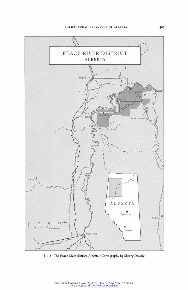
Is the twenty-first century begins, agricultural expansion in Canada's north is assuredly not at an end. In the lower Peace River country of northern Alberta, 500 miles toward the Arctic Circle from Edmonton, families are busy clearing land and creating farms on the fringes of existing settlement (Figure 1). Such activity is part of a process begun in the late 1970s, when the Alberta provincial government, in response to residents' demands, made available to beginning farmers better than 50,000 acres of raw land southwest of the small agricultural service center of La Crete. In the early 1980s, thousands of acres of forest were cleared and burned an- nually in preparation for crop production. Although the pace has eased, the process continues. Indeed, prospective farmers are demanding yet more land, but the gov- ernment, citing economic and environmental concerns, is reluctant to open addi- tional tracts.
What is taking place in Alberta's north is unique. Elsewhere in North America, farmers are giving up as commodity prices sink below levels necessary for small family operators to make a living (Economist 1999; Gorelick 2000; Lilliston and Ritchie 2000). In light of these conditions and the pervasive fact of farm abandon- ment at other fronts of western Canada's forest-farmland interface, it is astonishing that people in this northern region have established new farms and are urging the government to make additional land available (Vanderhill 1971, 1982). I examine the forces that have contributed to agricultural expansion southwest of La Crete, de- scribe the remarkable transformation of this area, and assess the prospects for fu- ture development. A critical element of this process, in the past, at present, and in the future, are the cultural values of the area's Mennonite people, today numbering some 6,000, who account for the vast majority of the population in and around La Crete.
% DR. BOWEN is an assistant professor of geography at Mary Washington College, Fredericksburg, Virginia 22401.
The Geographical Review 92 (4): 503-525, October 2002
Copyright ? 2003 by the American Geographical Society of New York
This content downloaded from 199.111.91.13 on Fri, 2 Jan 2015 17:26:10 PMAll use subject to JSTOR Terms and Conditions
504 THE GEOGRAPHICAL REVIEW
The Peace River region has been called Canada's "last agricultural frontier." It was the southernmost part of the district that first attracted large numbers of set- tlers, encouraged by railroad building in the second decade of the twentieth cen- tury (Dawson 1934). The northern portion was much slower to develop. Some settlers penetrated the area via riverboat before 1930, but numbers were small and settler impact limited. After 1930, large numbers of conservative Mennonites entered the area, settling on natural prairies, surrounded by forest, in the vicinity of La Crete. As more Mennonite settlers arrived, demand for farmland was met by clearing wooded tracts adjacent to existing farms (Bowen 199o; Plett 2001, 156-158). This
process satisfied farmers' needs until the 1970s, when population growth outpaced the availability of land, triggered by high birthrates and an influx of Mennonite migrants from Latin America, in effect completing a cycle of migration that had taken many from Canada to Latin America from the 1920os onward (Sawatsky 1971; Van Dyke 1972). This presented a serious dilemma for the Mennonite community, which wanted to keep its young people, provide them with opportunities to farm, and make it possible for them to raise their children in rural settings, insulated from outside influences. Many residents believed that the problem could be re- solved if the province opened more land for settlement.
The land being developed southwest of La Crete is part of a nearly flat plain that was once the floor of a glacial lake. The soils, developed from lacustrine silts and clays, are often poorly drained, and most government experts consider them mar- ginal for agriculture. Indeed, the Canada Land Inventory has rated the land as Class 4, which means that it has severe limitations, including dense subsurface layers, that restrict crop production. This evaluation has been confirmed by Alberta's Public Lands Division, whose studies in the early 1980s showed that no more than 70 per- cent of the area contained arable land and that many places, including some parcels that were later opened for settlement, fell short of the 50 percent mark (AENR
1980b; Hanus 1980, 12-13; AENR 1981, 11; Northern Development Branch 1982, 4-6; Sisson 1984, 28; Ojamaa and McNeil 1985, 43-45). Deficiencies in the land base are
compounded by climatic limitations. The area receives between 12 and 15 inches of precipitation annually and experiences a frost-free period that seldom exceeds sev- enty-five or eighty days. These problems are partly offset by a concentration of pre- cipitation in the warmer months and by long summer days (with 18.5 hours of daylight on June 21), which helps push the number of growing degree days to slightly above the minimum needed to produce cereal grains and forage crops (Hanus 1980, 13-16; AENR 1981, 21-22; Sisson 1984, 27-30; ECA 1985, 127-128; NP 1985a). Despite these well-documented impediments, farmers in the area have been convinced for years that this land is more than satisfactory and that it would prove a good place for agricultural expansion (NP 1985a; Friesen 1998; Krahn 1999).
ACQUISITION OF LAND
Opening the new farmland southwest of La Crete involved a complex interplay of local initiative and provincial cooperation. The first steps were taken in 1976, when
This content downloaded from 199.111.91.13 on Fri, 2 Jan 2015 17:26:10 PMAll use subject to JSTOR Terms and Conditions
AGRICULTURAL EXPANSION IN ALBERTA 505
PEACE RIVER DISTRICT ALBERTA
L
Edmonton
Red Earth
0 10 20 30 Miles
0 1 0 20 30 Kilometers
Peace River
FIG. 1-The Peace River district, Alberta. (Cartography by Sherry Dowdy)
This content downloaded from 199.111.91.13 on Fri, 2 Jan 2015 17:26:10 PMAll use subject to JSTOR Terms and Conditions
506 THE GEOGRAPHICAL REVIEW
active farmers, young men seeking to establish farms, and La Crete business leaders turned to northwestern Alberta's Agricultural Development Committee (ADC), a board created in the 196os to oversee local land-use issues, for assistance in opening large blocks of land. The province's land-development policy was reactive or "pas- sive," for under most circumstances the government simply awarded individual parcels in response to applicants' requests (Carcajou Research 1977, 65; Hanus 1980, 65-66). It was up to the people of La Crete to demonstrate that sufficient demand existed for the province to allocate land on a grander scale. In October 1976 the ADC authorized Martin Wieler, one of La Crete's representatives on the committee, to canvass the Mennonite community and prepare a list of people who would estab- lish farms, or expand existing farms, if land were made available (ADC 1976a). A month later Wieler presented the committee with the names of forty people who wanted more land (ADC 1976b). Although the list was incomplete, the number of land seekers was large enough to persuade D. W. Schmidt, the Alberta associate minister of public lands, to meet with the people of La Crete in February 1977 to determine whether a large, compact tract should be opened. Schmidt's decision, it was said, would depend on the size of the turnout of interested parties. Anticipating a large attendance, Wieler declared that "if a hundred sections [were] opened ... there'd be applicants for all of them" (NP 1977a).'
Wieler's prediction was not far off the mark. More than loo farmers and pro- spective farmers attended the meeting and urged Schmidt to open more land. Cor- respondence between the ADC and the Ministry of Public Lands, combined with two follow-up meetings with Schmidt, reinforced their demands (ADC 1977, 1978; NP 1977b). But the province was not willing to open large amounts of land until it had gathered additional information about prospective farmers' needs through a survey of farmers in La Crete and other parts of the northern Peace River country. The survey yielded three major conclusions. First, it confirmed that demand for land was high. Second, respondents made it clear that the purchase of public land was the only practical way for young families, who could not ordinarily afford pri- vately owned, developed land, to get started. Finally, almost every person who was interviewed agreed that if the government did make land available, it should in- clude a development requirement in its sales agreements to ensure that purchasers would use their land for farming and not for speculation (Hanus 1980, 61-63).
With this information in hand, the province was ready to act. Even before the survey results were made available to the public, it designated parts of five town- ships southwest of La Crete, in an area that became known as Blue Hills,2 for devel- opment, with land to be made available in three phases. Because this was a new policy, no specific guidelines existed for allocating so much land at one time (Haden and Ironside 1990o, 199). Accordingly, at the request of the minister of agriculture, the ADC held a public meeting at La Crete in December 1979 to establish proce- dures. Nearly 200 people attended the meeting, to determine the size of parcels to be allocated and the criteria to be used in screening applicants. Some residents fa- vored parcels of approximately 500 acres of arable land, arguing that at least that
This content downloaded from 199.111.91.13 on Fri, 2 Jan 2015 17:26:10 PMAll use subject to JSTOR Terms and Conditions

AGRICULTURAL EXPANSION IN ALBERTA 507
much was needed for farmers to make a profit. Others supported smaller parcels, with no more than 300 arable acres per unit (ADC 1979; NP 1979). The latter group knew that smaller parcels were not the best choice from an economic perspective but insisted that economics should be a secondary concern. For them, providing as many young Mennonite families as possible with a means to have their own farms, and to enjoy a traditional lifestyle, was more important (Siemens 1998). As one observer put it, "farming ... in La Crete is as much an act of faith as a livelihood" (Corbett 1988, 40). By a show of hands, the overwhelming majority indicated their preference for smaller units, which would be pieced together in such a way that each contained about 300 acres of arable land (ADC 1979, 1980). With this issue settled, those in attendance unanimously approved a proposal giving preference in the se- lection process to beginning farmers from La Crete (ADC 1979; NP 1979). These de- cisions, based primarily on community values, laid the groundwork for the special land postings and draws (lotteries) that would follow.
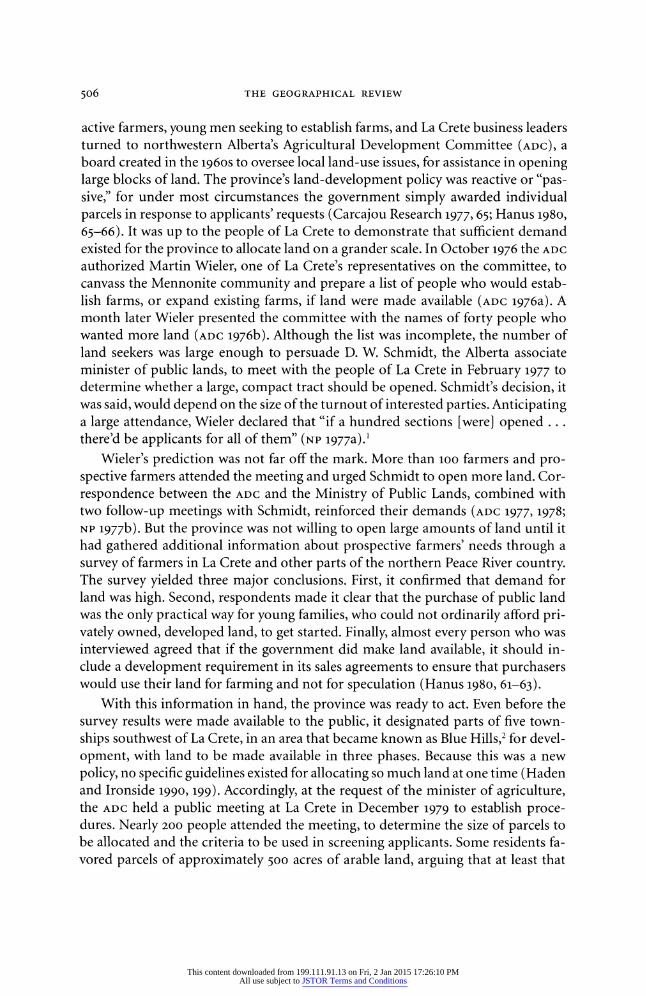
In January 1980, when the first nineteen parcels were offered under a special posting, 179 people filed applications (Figure 2). After the application period ended, the ADC began to screen the applicants, who were required to complete a two-page questionnaire and appear for an interview. To be selected for the draw, applicants had to satisfy the committee that they were familiar with the land, understood the time and cost involved in creating a viable farm, had some farming experience, could guarantee that they had access to appropriate machinery, and had concrete plans for financing the development of their farming operations (ADC 198oa; NP
1980).
On the basis of these criteria, seventy-one people were chosen to enter the first draw, held in October 1980. Seventy-one pieces of paper with seventy-one numbers were placed in a barrel. The person who drew number one had the first choice of a farm unit, and so on, until all nineteen parcels were claimed (NP 1980). Rather than selling the land outright, the government gave successful applicants five-year Farm Development Leases, with options to purchase after the terms of the lease had been met. Under the lease agreement, farmers were required to have 90 acres in seedbed condition, or 160 acres cleared and piled, by the end of the third year and 160 acres in seedbed condition by the end of the fifth year. Each new homesteader was re- quired to establish residence on the leased land or live on a farm within a lo-mile radius of the property (AENR 1980a). The cost of the land varied because of differences in quality, but in general it was leased each year for 2 percent of its fair-market value, and when it was sold it cost approximately $50 per acre for arable land and about $35 per acre for nonarable land (NP 1980).
In November 1980 the government made another thirty parcels available, and the process was repeated, with nearly 150 people filing applications (NP 1980). The second draw was held in June 1981, and when it was completed all units were in the hands of beginning farmers from La Crete, all under the age of thirty (AENR 1980b; NP 1980; ADC 1981). After that, land allocations were put on hold until the province could iron out problems stemming from delays in completing paperwork, increases
This content downloaded from 199.111.91.13 on Fri, 2 Jan 2015 17:26:10 PMAll use subject to JSTOR Terms and Conditions
508 THE GEOGRAPHICAL REVIEW
1 2 Miles
1.980,
Part One
1980, Part Two
1984 Special Postings of Land, Blue Hills, Alberta
FIG. 2-Special postings of land, Blue Hills, Alberta, 1984. (Cartography by Sherry Dowdy)
This content downloaded from 199.111.91.13 on Fri, 2 Jan 2015 17:26:10 PMAll use subject to JSTOR Terms and Conditions
AGRICULTURAL EXPANSION IN ALBERTA 509
in the cost of land, and inconsistencies in the appeal process for individuals whose applications had been rejected. These issues were not fully resolved until 1983 (ADC
1982a, 1983a; NADC 1983). By that time farmers were breaking ground on thousands of acres annually, and pressure was building for the government to open still more land (ADC 1982b, 1983b). This was accomplished in 1984, when the province allo- cated another thirty parcels, containing more than 15,000 acres, a few miles north- west of the original development area (ADC 1983a; AENR 1984; NP 1984). With the
completion of this draw, Blue Hills contained seventy-nine new farming units. All but one belonged to young Mennonites, with the single exception a non-Menno- nite man of German descent who obtained four 160-acre quarter-sections in the 1984 draw (ID 1986; Haden 1990; Siemens 1998).
CHANGING LANDSCAPES
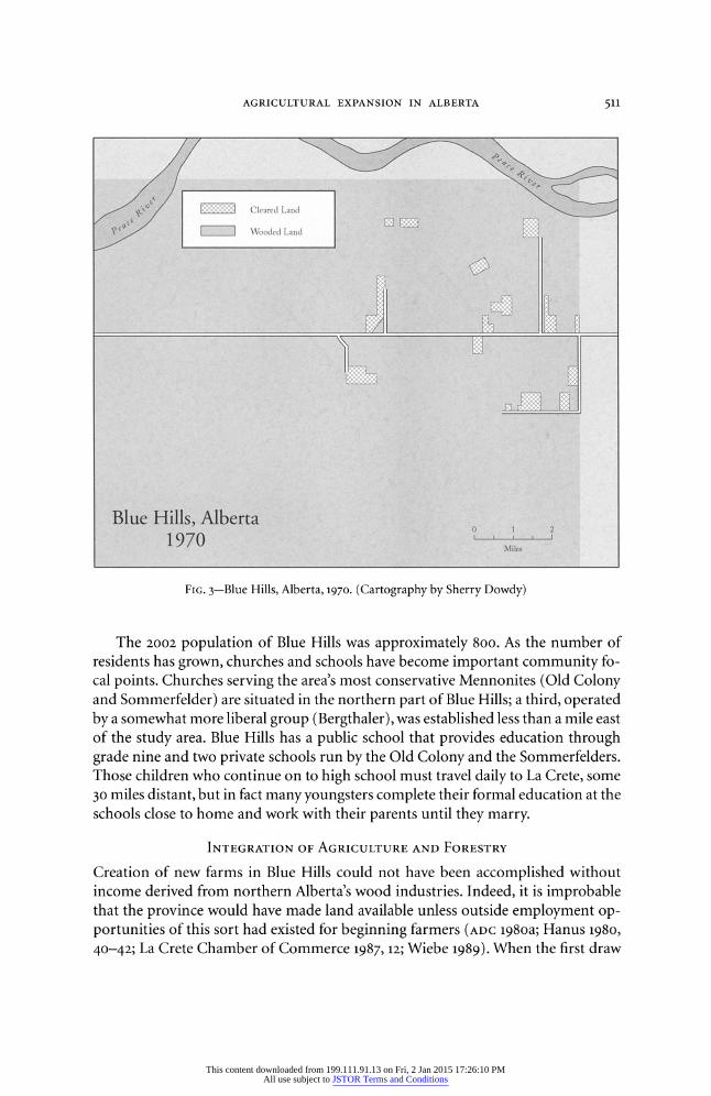
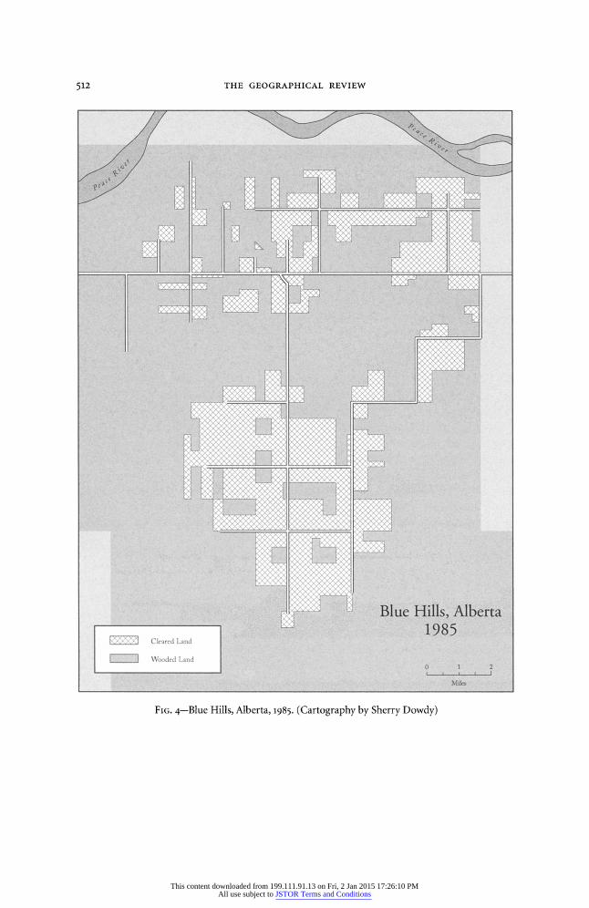
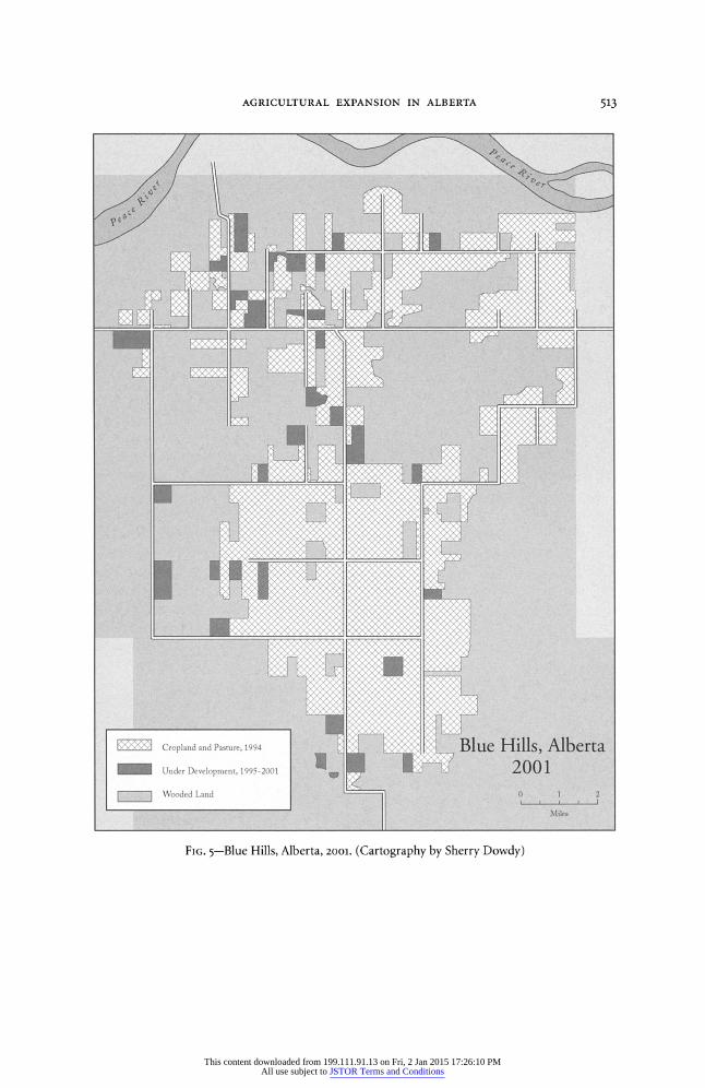
Maps based on evidence obtained from aerial photographs, topographic sheets, and fieldwork I conducted between 1998 and 2001 demonstrate the magnitude of change that has taken place since the 1970s. Blue Hills has been transformed from a forested plain to a land of grain and canola, with well-maintained farmsteads dot- ting the countryside. In 1970, cleared land consisted of just thirteen fields, totaling fewer than 1,5oo acres, on quarter-sections that had been homesteaded in the 1960s near an east-west road that connects La Crete with a ferry crossing on the Peace River (Figure 3). By 1985, more than 25,000 acres had been cleared, mostly in the south-central part of Blue Hills, on land acquired in the 1980 and 1981 draws (Figure 4). To the north, the most significant changes had taken place on homesteads claimed before 1970, on individual quarter-sections acquired in the 1970s, and on parcels made available by a special posting for expansion of existing farms (Homestead Files 1964-1969; ADC 1983a; Smith 1983). From 1986 through 1994, an additional lo,ooo acres were placed under cultivation. Since that time, development has begun on approximately 4,000 acres, particularly on the periphery of lands made available in 1980 and 1981 and within the area opened in 1984 (Figure 5). All parcels designated as "Under Development" in Figure 5 have been logged in preparation for farming, most are ready or nearly ready for planting, and some, logged in 1995 and 1996, are producing crops.
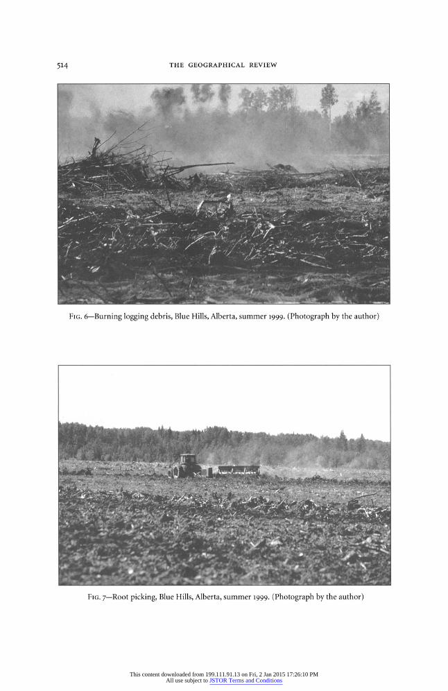
Bringing raw land into production has not been easy, for it can take up to four years before a first crop is planted. Land first is logged, and debris is piled and burned (Figure 6). Next, roots are picked, piled, and burned (Figure 7). With enormous expenditures of time and effort, these procedures can be completed in two years, but most beginning farmers are unable to devote full attention to them, so develop- ment work is usually into its third year before all of the roots are picked and burned. Then comes the time to plant. Some men succeed in rushing the process and, in their third year, manage to plant crops between smoldering windrows of logging debris and roots, but this is not common (Hanus 1980; Woods Gordon Manage- ment Consultants 1983; Barber and Taylor 1990; Unrau 1999). The years following each land-selection drawing witness development activity almost beyond belief as
This content downloaded from 199.111.91.13 on Fri, 2 Jan 2015 17:26:10 PMAll use subject to JSTOR Terms and Conditions
510 THE GEOGRAPHICAL REVIEW
farmers work to ready their land for planting. It is estimated that close to 20,000 acres were logged in Blue Hills in the winter of 1983/1984 alone, and from 1982 through 1986 piling, picking, burning, or plowing took place on at least io,ooo acres annu- ally. Most new farmers use their own machinery or that of their fathers, but some employ others to do this work, established farmers from La Crete who provide custom root picking and plowing services (ADC 1983b; Friesen 1989; Driedger 1999; Schmidt 2001). Since the mid-198os the rate of development has subsided, but even today it is not unusual to see plumes of smoke rising skyward, indicating that someone is burning logging debris or roots on still more land being prepared for farming.
Almost all of the agricultural land in Blue Hills has been planted to cash crops; only a tiny fraction is in pasture. Considering the high cost of converting wooded land to cropland, it might seem reasonable for farmers to place greater emphasis on raising cattle, but this is not the case, primarily because of financial and time con- straints. The cost of creating pasture is nearly as high as that associated with prepar- ing land for crops, and because most beginning farmers must work in the logging industry in winter to make ends meet, producing cash crops makes more sense. Once crops are harvested, a farmer's responsibilities are over for several months, whereas cattle must be fed and cared for throughout northern Alberta's harsh win- ters. When farmers can earn $25,000 or more by working on logging crews from November to March and still be home every weekend, making the choice between producing cash crops and raising cattle is not difficult (Siemens 1998; Wieler 1999; Peters 2001; West 2001). This situation is clearly reflected in land-use patterns. In the summer of 2001 no more than 5 percent of cleared land in Blue Hills was in pasture, with most of the remainder planted to grain or canola.
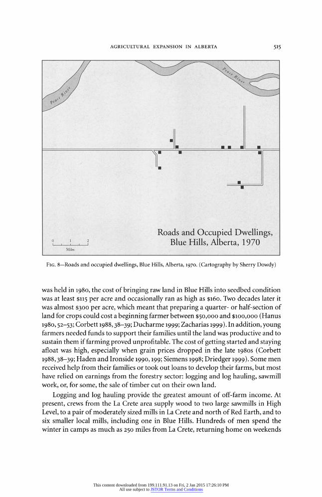
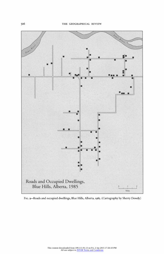
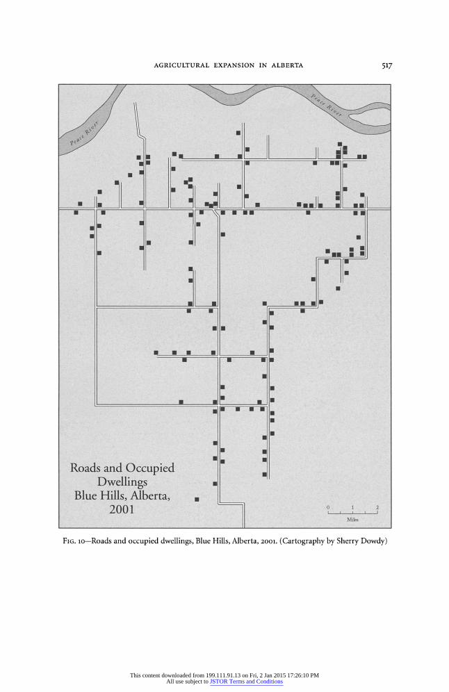
Creation of new farms in Blue Hills has been accompanied by an enormous increase of population and by development of a community infrastructure, which includes roads, churches, and schools. In 1970, only 8 miles of roads extended from the main east-west highway (Figure 8). By 1985, the province had constructed 50 more miles of roads (Figure 9), with nearly one-third of that total built in 1980 alone in preparation for the first land openings (NP 1980). During the next decade, another 20 miles were added to the road system. In 2002, Blue Hills was served by 12 miles of paved highway and more than 80 miles of gravel roads (Figure io).
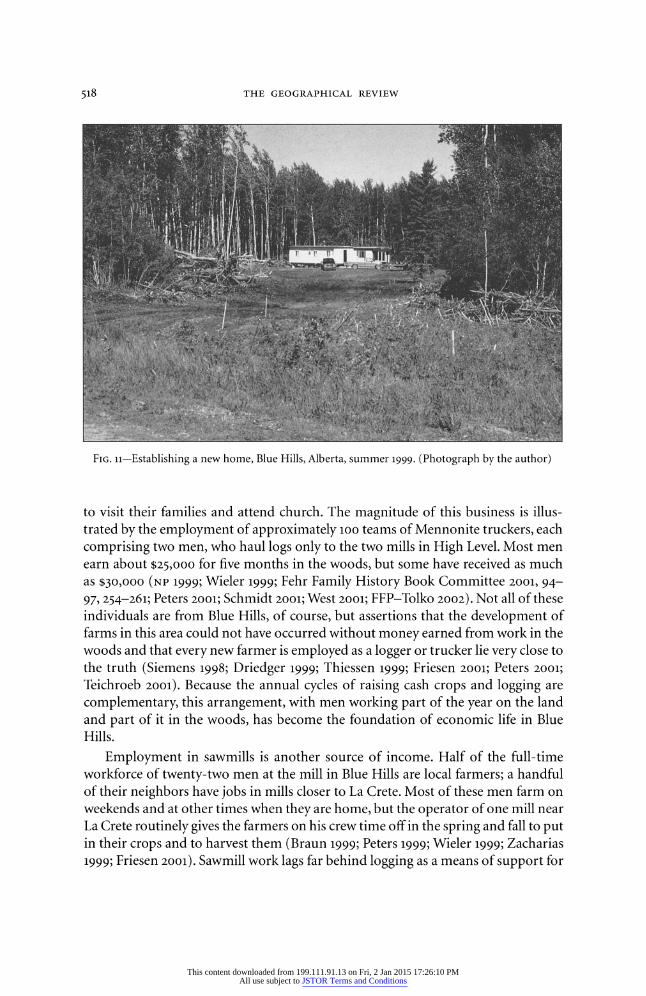
Similar rates of growth occurred in the number of households, as young fami- lies established residence on their new farms (Figure 11). The number of occupied dwellings increased from 12 in 1970 (Figure 8), to 74 in 1985 (Figure 9), to approxi- mately 140 in 2001 (Figure lo). The dramatic increase of households since 1985 has been due in part to the movement of new farmers and their families onto their land, particularly in the northwest, where parcels were first made available in 1984. But it also represents the establishment of homes by settlers' children who have not yet succeeded in acquiring land of their own. In many instances the children, often recently married, live in modest frame structures or mobile homes on their parents' property, just yards from where they grew up.
This content downloaded from 199.111.91.13 on Fri, 2 Jan 2015 17:26:10 PMAll use subject to JSTOR Terms and Conditions
AGRICULTURAL EXPANSION IN ALBERTA 511
:19
Cleared Land
S Wooded Land
77 1M
1Miles
FIG. 3-Blue Hills, Alberta, 1970. (Cartography by Sherry Dowdy)
The 2002 population of Blue Hills was approximately 800. As the number of residents has grown, churches and schools have become important community fo- cal points. Churches serving the area's most conservative Mennonites (Old Colony and Sommerfelder) are situated in the northern part of Blue Hills; a third, operated by a somewhat more liberal group (Bergthaler), was established less than a mile east of the study area. Blue Hills has a public school that provides education through grade nine and two private schools run by the Old Colony and the Sommerfelders. Those children who continue on to high school must travel daily to La Crete, some 30 miles distant, but in fact many youngsters complete their formal education at the schools close to home and work with their parents until they marry.
INTEGRATION OF AGRICULTURE AND FORESTRY
Creation of new farms in Blue Hills could not have been accomplished without income derived from northern Alberta's wood industries. Indeed, it is improbable that the province would have made land available unless outside employment op- portunities of this sort had existed for beginning farmers (ADC 198oa; Hanus 1980, 40-42; La Crete Chamber of Commerce 1987, 12; Wiebe 1989). When the first draw
This content downloaded from 199.111.91.13 on Fri, 2 Jan 2015 17:26:10 PMAll use subject to JSTOR Terms and Conditions
512 THE GEOGRAPHICAL REVIEW
7 -7
>"
F 77
V \< )?<K K
. .K
7<32> K
xx x
7 / 7 / Cleared Land
71
L?X?
S .x-
_igx
r,/
?-X:
A" X
. . . . . . . . .I.-X: X">\ )<j X" X,:
<x :xr Kv
x ,:x >? xX, X X
< x ''-I ::?X,/ X xz.M\ >,,QX Q /,/Xx ?,?</16 -1y, /
Cleared Land
'Wooded Land o :::f~l ---.i:2
FIG. 4-Blue Hills, Alberta, 1985. (Cartography by Sherry Dowdy)
This content downloaded from 199.111.91.13 on Fri, 2 Jan 2015 17:26:10 PMAll use subject to JSTOR Terms and Conditions
AGRICULTURAL EXPANSION IN ALBERTA 513
X,
V••~i•'i•
-:::_ 4 i:•i ):?i
2>0/
....... . . si .... ...
V,_ "x Xd
T -,
X/I
X x >"x
>x AX X'/ x :I\ \MI/
X",,x ' -<'V'< Mx, X X",
UnderDevelpmen,>/ X, X0 f;!:_J I, _I;:i\A/ \> an X><<'?x 'x V ' _'?;;Y: \1 x x \X-: x 'x":;
FIG. 5-Blue Hills, Alberta, 2001. (Cartography by Sherry Dowdy)
This content downloaded from 199.111.91.13 on Fri, 2 Jan 2015 17:26:10 PMAll use subject to JSTOR Terms and Conditions
514 THE GEOGRAPHICAL REVIEW
FIG. 6-Burning logging debris, Blue Hills, Alberta, summer 1999. (Photograph by the author)
FIG. 7-Root picking, Blue Hills, Alberta, summer 1999. (Photograph by the author)
This content downloaded from 199.111.91.13 on Fri, 2 Jan 2015 17:26:10 PMAll use subject to JSTOR Terms and Conditions
AGRICULTURAL EXPANSION IN ALBERTA 515
Roads and Occupied Dwellings, S 1
21 Blue Hills, Alberta, 1970 Miles
FIG. 8-Roads and occupied dwellings, Blue Hills, Alberta, 1970. (Cartography by Sherry Dowdy)
was held in 1980, the cost of bringing raw land in Blue Hills into seedbed condition was at least $115 per acre and occasionally ran as high as $16o. Two decades later it was almost $300 per acre, which meant that preparing a quarter- or half-section of land for crops could cost a beginning farmer between $50,ooo and $1oo,ooo (Hanus 1980, 52-53; Corbett 1988, 38-39; Ducharme 1999; Zacharias 1999). In addition, young farmers needed funds to support their families until the land was productive and to sustain them if farming proved unprofitable. The cost of getting started and staying afloat was high, especially when grain prices dropped in the late 1980s (Corbett 1988, 38-39; Haden and Ironside 199o, 199; Siemens 1998; Driedger 1999). Some men received help from their families or took out loans to develop their farms, but most have relied on earnings from the forestry sector: logging and log hauling, sawmill work, or, for some, the sale of timber cut on their own land.
Logging and log hauling provide the greatest amount of off-farm income. At present, crews from the La Crete area supply wood to two large sawmills in High Level, to a pair of moderately sized mills in La Crete and north of Red Earth, and to six smaller local mills, including one in Blue Hills. Hundreds of men spend the winter in camps as much as 250 miles from La Crete, returning home on weekends
This content downloaded from 199.111.91.13 on Fri, 2 Jan 2015 17:26:10 PMAll use subject to JSTOR Terms and Conditions
516 THE GEOGRAPHICAL REVIEW
J1 I
. U
Roads nd Occ ed Dllings,
0 1
Blue Hills, Alberta, 1985 SMiles
-.U .
- " . '
"" ] f"] :Miles
FIG. 9-Roads and occupied dwellings, Blue Hills, Alberta, 1985. (Cartography by Sherry Dowdy)
This content downloaded from 199.111.91.13 on Fri, 2 Jan 2015 17:26:10 PMAll use subject to JSTOR Terms and Conditions
AGRICULTURAL EXPANSION IN ALBERTA 517
---- ....
0 N
N F.
Roads and Occupied Dwellings
Blue Hills, Alberta, 2001 o
2
U m
Road anUOccpie Dwellings
,BlueHill, Alerta ?m
FIG. lo-Roads and occupied dwellings, Blue Hills, Alberta, 2001. (Cartography by Sherry Dowdy)
This content downloaded from 199.111.91.13 on Fri, 2 Jan 2015 17:26:10 PMAll use subject to JSTOR Terms and Conditions
518 THE GEOGRAPHICAL REVIEW
FIG. 11-Establishing a new home, Blue Hills, Alberta, summer 1999. (Photograph by the author)
to visit their families and attend church. The magnitude of this business is illus- trated by the employment of approximately ioo teams of Mennonite truckers, each comprising two men, who haul logs only to the two mills in High Level. Most men earn about $25,000 for five months in the woods, but some have received as much as $30,000 (NP 1999; Wieler 1999; Fehr Family History Book Committee 2ool, 94- 97, 254-261; Peters 2001; Schmidt 2001; West 200o; FFP-Tolko 2002). Not all of these individuals are from Blue Hills, of course, but assertions that the development of farms in this area could not have occurred without money earned from work in the woods and that every new farmer is employed as a logger or trucker lie very close to the truth (Siemens 1998; Driedger 1999; Thiessen 1999; Friesen 2oo1; Peters 2ool; Teichroeb 2001). Because the annual cycles of raising cash crops and logging are complementary, this arrangement, with men working part of the year on the land and part of it in the woods, has become the foundation of economic life in Blue Hills.
Employment in sawmills is another source of income. Half of the full-time workforce of twenty-two men at the mill in Blue Hills are local farmers; a handful of their neighbors have jobs in mills closer to La Crete. Most of these men farm on weekends and at other times when they are home, but the operator of one mill near La Crete routinely gives the farmers on his crew time off in the spring and fall to put in their crops and to harvest them (Braun 1999; Peters 1999; Wieler 1999; Zacharias 1999; Friesen 2001). Sawmill work lags far behind logging as a means of support for
This content downloaded from 199.111.91.13 on Fri, 2 Jan 2015 17:26:10 PMAll use subject to JSTOR Terms and Conditions
AGRICULTURAL EXPANSION IN ALBERTA 519
Blue Hills farmers, but for those few who do not work in the woods in the winter, it
provides an alternative way to make ends meet. A number of Blue Hills farmers have improved their finances by selling timber
from their own land. In the 198os beginning farmers simply burned the trees (prin- cipally aspen and poplar) that were cut during land clearing, but with the establish- ment of small, local sawmills in the 199os, this practice came to a halt (Letkeman 1999; Thiessen 1999). Two of the new mills rely primarily on timber from private land; another obtains part of its supply from that source (Braun 1999; Wieler 1999; NP 2000b, 200ooa; Friesen 2001). Demand from these mills has created new opportu- nities for Blue Hills farmers, who have responded by cutting much of the timber
remaining on their land. In recent years some individuals have sold their timber for as much as $9o,ooo-$100oo,ooo, far in excess of the cost of the land. These men un- derstand that the sale of timber is a one-time bonanza but readily agree that it has been a major factor in debt reduction, which in turn has put development of their farms on a solid financial footing (Driedger 1999; Letkeman 1999; Wieler 1999).
Few families in Blue Hills are supported by agriculture alone. Instead, they view
farming as a desirable way of life but know that wood pays the bills. The importance of farming as a lifestyle rather than as a strictly financial venture was made clear by information supplied in 1988 and 1989 by seventy-four Mennonite farmers living in the La Crete area, including several from Blue Hills. These men declared that the
principal reason they were engaged in farming was the lifestyle it provided, both for themselves and their families, and added that farming was also important because it is part of Mennonite culture. Farming as a way to make a living was at the bottom of the list (Haden 1990, 84). Further evidence that farming is driven by cultural rather than financial considerations is found in the words of one Blue Hills resi- dent, who averred that for him and his neighbors, farming is "the lifestyle we prefer ... everything else is secondary to maintaining this way of life" (Siemens 1998). Another man declared that "we... hope to teach our children the value of farming and a life of farm satisfaction and the love for the land" (quoted in Haden 1993, 166). Nearly all farmers I interviewed in Blue Hills echoed these sentiments. The economic side of this equation is confirmed by the chairman of La Crete's Timber
Advisory Committee (and formerly a farmer), who asserts that the development of farms in Blue Hills has been made possible only by forestry-related work. Today, he maintains, "each and every farm is supported by forestry ... it is the community's economic lifeblood" (Friesen 2001).
AN UNCERTAIN FUTURE
Dramatic changes have taken place in Blue Hills, but the area faces an uncertain future. At present, relationships between the province and the Mennonite commu- nity in and around La Crete are clouded by tension and mistrust. Two interrelated issues lie at the root of this problem. The first is sharp disagreement about modifi- cations of government policy for acquiring land near the fringes of settlement. The second is debate about whether new blocks of land should be made available under
This content downloaded from 199.111.91.13 on Fri, 2 Jan 2015 17:26:10 PMAll use subject to JSTOR Terms and Conditions
520 THE GEOGRAPHICAL REVIEW
special postings and, if so, where they should be located. These matters affect all discussion of the future of agricultural expansion in Alberta's north.
In Blue Hills the first issue revolves around gradual replacement of traditional homesteading procedures with auction sales and around the province's ruling in 1998 that timber must be removed before parcels can be advertised for auction (Haden 1990o; Ducharme 1999). Between the 1984 draw and 1998, it was not uncom- mon for prospective farmers to homestead properties adjacent to land already allo- cated and to finance development of their farms through the sale of timber. Indeed, by 1994 more than three dozen quarter-sections had been acquired in this manner (ID 1986, 1994; Friesen 1998; Letkeman 1999; Zacharias 1999). But the new regula- tions have placed serious obstacles in the way of young families seeking farms. Sell- ing land at auction has often driven prices beyond the reach of aspiring farmers, and if an individual does succeed in obtaining land through this procedure, funds to develop his farm are now limited because the timber has already been cut and sold (Letkeman 1999). Officials argue that the province is simply fine tuning an existing process and that new farmers managed to get started in the past when they burned all of their timber, but the people of Blue Hills are not so sure (Ducharme 1999). "When the government saw how much money farmers were making from logging their land," said one, "they got into the act, and what they have done is not good for the future of our young people" (Driedger 1999).
The second issue is driven by continued high demand for land among the area's young Mennonite families, who remain determined to create farms and establish homes where they can raise their children in a suitable social environment. One resident said that if the government opened twenty new parcels near Blue Hills, it would receive 400 applications for the land (Driedger 1999). Indeed, the only point of agreement in the platforms of two farmers from Blue Hills who ran for a local political office in October 2001 was that they both wanted more land set aside for agriculture. As one candidate expressed it, opening new land is essential "to give the next generation the opportunity that we have had" (NP 2001C).
The land that the Mennonite community wants the province to open includes several sections west and southwest of property made available in the 1980 and 1984 special postings, along with two townships immediately south of Blue Hills. Alberta Agriculture, the provincial department that oversees agricultural concerns, con- cedes that some land to the west and southwest can be converted into farms but believes that the southern townships are unsuitable for agriculture (Freehill and Ducharme 1998, 2; Ducharme 1999). Blue Hills residents disagree with this assess- ment and argue that they are more familiar with the land and its potential than are the people who make the decisions. One farmer explained that "my friends and I hunt moose down there every year, so we know what the land is like and what can be done with it" (Teichroeb zool2001). Another Blue Hills man now cultivates more than 90 percent of a full 640-acre section that the government originally declared had only 3o6 arable acres and contends that settlers in the southern townships will do the same (AENR 1980b; Letkeman 1999). Other individuals who acquired four or
This content downloaded from 199.111.91.13 on Fri, 2 Jan 2015 17:26:10 PMAll use subject to JSTOR Terms and Conditions

AGRICULTURAL EXPANSION IN ALBERTA 521
even five quarter-sections of supposedly marginal land have cleared and drained the wet places and brought most of their property under cultivation, proving in their minds that the government's "so-called experts," who relied largely on aerial photographs for their judgments, were wrong (Driedger 1999; Krahn 1999; Teichroeb 2001). These people see little difference between their land when they first came to Blue Hills and land to the south that has been declared off limits, and they have no doubt that their success can be repeated.
The position of the provincial authorities is that most of the land south of Blue Hills is too wet for agriculture and that the cost of establishing satisfactory infra- structure is prohibitive. It believes that a few spots do have potential but that they are separated by large areas of muskeg that must be crossed or bypassed to make them accessible. When the cost of building roads and bridges, cutting drainage ditches, and installing power lines is factored in, Alberta Agriculture is certain that the benefits of opening this tract would not outweigh the expense (Ducharme 1999). Complicating the issue is recognition that some of the land the Mennonites are seeking overlaps part of a provincial Timber Management Area whose wood is allo- cated to a large pulp mill near the town of Peace River. At a time when the provin- cial government is actively encouraging the expansion of wood industries in northern Alberta, it is doubtful that policy will be modified to accommodate settlers on what the government considers marginal land (Haden 1990, 136, 142; NP 2000ooa; Friesen 2001). Moreover, as opponents of agricultural development south of Blue Hills are quick to point out, land is still available east of La Crete.
But government efforts to place settlers on the properties east of La Crete have enjoyed only spotty success. Knowing that many deserving applicants had failed to obtain land in Blue Hills, the province opened more than 22,000 additional acres, beginning 12 miles east of La Crete and extending across the Bear River to points more than 3 miles east of the Fort Vermilion-Red Earth road. This land, made avail- able to beginning farmers through special postings in 1987 and 1989, was divided into thirty-eight parcels ranging in size from 400 to 640 acres. The province built roads and drainage ditches and adopted development requirements almost identi- cal to those for Blue Hills farmers (ADC 1985a, 1985b; NP 1985b; La Crete Chamber of Commerce 1987, 31; ID 1988, 1991; Haden 199o, 16-26). Since 1990o Alberta Agricul- ture has designated more land for development still farther to the east and south- east (Ducharme 1999; Friesen 2001).
The response to this initiative has been disappointing. Although the area con- tained nearly half as many parcels as Blue Hills, the number of participants in the draws dropped to fewer than one-fourth, indicating that many young Mennonites were not interested in the eastern lands (Haden 1990, 26). The pace of development has also been slow. True, the extreme western part of this tract, which adjoins land farmed for decades, has begun to fill in. But beyond the Bear River conditions are less promising. In the summer of 2001 only eight occupied dwellings were located in the area, all but three of them within a mile of the river. No one lived east of the Fort Vermilion-Red Earth road. Some fields were no longer under cultivation, and
This content downloaded from 199.111.91.13 on Fri, 2 Jan 2015 17:26:10 PMAll use subject to JSTOR Terms and Conditions
522 THE GEOGRAPHICAL REVIEW
one 320-acre tract, which had recently been logged and prepared for cultivation, was abandoned. Several access roads were impassable, and others could be used
only by four-wheel-drive vehicles. A visitor needed to spend only a few hours east of the Bear River to see that agricultural settlement had not made much headway there and that, in some instances, the forest was regaining its hold on the land.3
Several factors explain why young Mennonite families have not flocked to the
country east of the Bear River. One problem is that much of the land is wet and thus
requires an enormous amount of work before it can be farmed. Some of it cannot be reached by road. In fact, in 1998 Alberta Agriculture removed approximately 8,000 acres east of the river from its list of parcels with farming potential because
they were too wet and inaccessible (Freehill and Ducharme 1998, 5-6; Ducharme 1999). Another factor is that with so few people living here, no incentive exists to establish churches and schools (either public or private) or to improve the roads, further reducing the area's appeal to prospective settlers.
But wet ground, poor accessibility, and pioneer conditions have not prevented Mennonites from developing farms in Blue Hills or making demands for additional land to the south that is even more poorly drained, more difficult to reach, and without the slightest hint of social infrastructure. The most serious impediment to
developing land east of the Bear River is its location near two Indian reservations a short distance to the south. The problem with this, in the eyes of the Mennonite
community, is seldom discussed openly with outsiders, or if it is brought up at all, it is usually alluded to in an oblique way. It was expressed most explicitly to me by a
respected community and church leader, who admitted that most Mennonites from La Crete did not want to live close to First Nation communities because of their concern about natives' violent behavior (often alcohol induced), the need for their children to attend school with natives, and the fear that, eventually, some Menno- nite young people might marry natives or other outsiders. "We Mennonites are
deeply concerned with preserving our culture," he said, "and we fear that moving out to the east will be a first step in the wrong direction" (Janzen 1989). This view was repeated by a supporter of agricultural expansion south of Blue Hills, who
explained that many members of the community prefer that the government open a block of land to be occupied exclusively by Mennonites, dozens of miles from any people except their own (Driedger 1999). The Alberta public lands specialist who is
responsible for making lands available understands the Mennonite position but is
unwilling to give in, insisting that if young Mennonites wish to develop farms of their own, they must do so under existing government terms on land that has al-
ready been set aside (Ducharme 1999).
For the foreseeable future, the only newly opened lands that most Mennonites will consider taking are individual quarter-sections close to Blue Hills, where the acquisition process continues to involve logging followed by auction sales to the highest bidders (Freehill and Ducharme 1998, 2; Ducharme 1999; NP 200oolb, 6). Land seekers and government officials hope that the impasse over the settlement of larger blocks can be resolved, but neither is convinced that this will occur. Only one thing
This content downloaded from 199.111.91.13 on Fri, 2 Jan 2015 17:26:10 PMAll use subject to JSTOR Terms and Conditions
AGRICULTURAL EXPANSION IN ALBERTA 523
is certain: Occupation of significant amounts of new land by farmers in this fron- tier region will require an extraordinarily delicate balance of provincial policy, Men- nonite objectives and values, and economic realities.
NOTES
1. A section consists of i square mile, or 640 acres.
2. The Blue Hills area is named for the blue appearance of the forest-covered Buffalo Head Hills, a few miles to the east. Blue Hills comprises six townships, of which five were opened through pro- cesses described in this section. A small part of the area's northeasternmost township was home- steaded in the 196os and 1970s. Settlement elsewhere in this township took place during the 198os, when additional quarter-sections were made available; and from then on, development there has gone hand in hand with agricultural expansion in Blue Hills' other five townships.
3. Indeed, the recent decision by a La Crete pork firm to build a large sow barn approximately 6 miles east of the Bear River instead of in the Blue Hills area was based primarily on its recognition that the inevitable stench produced by this business would create fewer problems at the site east of the Bear River because "this area ... has no residences and there are a lot of open areas" (NP 200ld, 2002).
REFERENCES
ADC [Agricultural Development Committee, ID 231]. 1976a. Meeting minutes, 12 October. Accession Number 91.9o. Provincial Archives of Alberta, Edmonton.
. 1976b. Meeting minutes, to November. Accession Number 91.9o. Provincial Archives of Alberta, Edmonton.
. 1977. Meeting minutes, 14 July. Accession Number 91.9o. Provincial Archives of Alberta, Edmonton.
. 1978. Meeting minutes, Edmonton, 11 January. Accession Number 91.9o. Provincial Archives of Alberta, Edmonton.
. 1979. Meeting minutes, 17 December. Accession Number 91.9o. Provincial Archives of Alberta, Edmonton.
. 1981. Meeting minutes, 9 January. Accession Number 91.9o. Provincial Archives of Alberta, Edmonton.
. 1981. Meeting minutes, 2 April. Accession Number 91.9o. Provincial Archives of Alberta, Edmonton.
. 1982a. Meeting minutes, 1 December. Accession Number 91.9o. Provincial Archives of Alberta, Edmonton.
. 1982b. Meeting minutes, 21 July. Accession Number 91.9o. Provincial Archives of Alberta, Edmonton.
. 1983a. Meeting minutes, 26 January. Accession Number 91.9o. Provincial Archives of Alberta, Edmonton.
. 1983b. Brief to the Environment Council of Alberta Public Hearing on Maintaining and
Expanding the Agricultural Land Base in Alberta, 28 July. Accession Number 91.9o. Provincial Archives of Alberta, Edmonton.
. 1985a. Meeting minutes, 6 December. Accession Number 91.9o. Provincial Archives of Alberta, Edmonton.
. 1985b. Meeting minutes, 11 December. Accession Number 91.9o. Provincial Archives of Alberta, Edmonton.
AENR [Alberta Energy and Natural Resources]. 1980a. Special Posting No. 1, 30 September. Acces- sion Number 90.92, File NW 32-102-17-5-1. Provincial Archives of Alberta, Edmonton.
. 1980b. Special Posting of Land, 7 November. Accession Number 90.92, File NW 32-102-17- 5-1. Provincial Archives of Alberta, Edmonton.
. 1981. Integrated Resource Plan: Lower Peace River Regional Overview. Edmonton: Alberta En- ergy and Natural Resources.
. 1984. Special Posting of Lands, 15 March. Accession Number 90.92, File NW 32-102-17-5-1. Provincial Archives of Alberta, Edmonton.
This content downloaded from 199.111.91.13 on Fri, 2 Jan 2015 17:26:10 PMAll use subject to JSTOR Terms and Conditions
524 THE GEOGRAPHICAL REVIEW
Barber, G. L., and A. D. Taylor. 199o. Land Development: A Guide to Clearing, Piling, Breaking, and Working Down Land in Northwestern Alberta. Edmonton: Alberta Environment Information Centre, Alberta Forestry, Lands and Wildlife.
Bowen, D. S. 199o. The Transformation of a Northern Alberta Frontier Community. M.A. thesis, University of Maine.
Braun, J. 1999. Interview with the author. Blue Hills, Alberta, 15 June. Carcajou Research. 1977. Agriculture in Northern Alberta: An Introductory Study. Unpublished manu-
script, Carcajou Research Ltd., Edmonton. Corbett, B. 1988. Mennonites Break New Ground in Northern Alberta. Canadian Geographic 10o8 (2):
34-40. Dawson, C. A. 1934. The Settlement of the Peace River Country: A Study of a Pioneer Area. Toronto:
Macmillan Company of Canada. Driedger, J. 1999. Interview with the author. Blue Hills, Alberta, 15 June. Ducharme, C. 1999. Interviews with the author. Fort Vermilion, Alberta, lo and 16 June. ECA [Environmental Council of Alberta]. 1985. Maintaining and Expanding the Agricultural Land
Base in Alberta. Unpublished manuscript, Environmental Council of Alberta. Economist. 1999. True Grit. Economist 352 (8134): 21-22. Fehr Family History Book Committee. 2001. David W & Sarah (Wall) Fehr Family History, 188o-
2001. Altona, Manitoba: Friesens Corporation. FFP-Tolko [Footner Forest Products-Tolko Industries]. 2002. Contractor Profile. FFP-Tolko News-
letter, February, [6]. Freehill, K., and C. Ducharme. 1998. Green/White Land Exchange Proposal. Unpublished manu-
script, Alberta Agriculture, Fort Vermilion. Friesen, J. 1998. Interview with the author. Blue Hills, Alberta, 3 June. Friesen, T. 1989. Interview with the author. La Crete, Alberta, 14 June. -- . 2001. Interview with the author. La Crete, Alberta, 8 June. Gorelick, S. 2000. Facing the Farm Crisis. Ecologist 30 (4): 28-31. Haden, A. J. 1990o. Farmers' Attitudes and Agricultural Land Expansion in Improvement District 23,
Alberta. M.A. thesis, University of Alberta. --. 1993. Farmers' Attitudes and Agricultural Land Expansion in Improvement District 23, Al-
berta. In The Uncovered Past: Roots of Northern Alberta Societies, edited by P. A. McCormack and R. G. Ironside, 157-171. Edmonton: Boreal Institute for Northern Studies.
Haden, A. J., and R. G. Ironside. 1990. Agricultural Land Expansion in Improvement District 23 by Mennonite and Non-Mennonite Farmers. In Proceedings of the Fort Chipewyan and Fort Vermil- ion Bicentennial Conference, edited by P. A. McCormack and R. G. Ironside, 193-202. Edmonton: Canadian Circumpolar Institute.
Hanus, F. 1980. Farm Development and Public Land Disposition in the Lower Peace River Area, Alberta. Unpublished manuscript, Alberta Agriculture, Edmonton.
Homestead Files. 1964-1969. Township 104, Range 17, W of 5th Meridian. Provincial Archives of Alberta, Edmonton.
ID [Improvement District #231]. 1986, 1988, 1991, 1994. Map of Property Ownership. High Level: Im-
provement District #23. Janzen, G. 1989. Interview with the author. La Crete, Alberta, 21 June. Krahn, I. 1999. Interview with the author. Blue Hills, Alberta, 11 June. La Crete Chamber of Commerce. 1987. La Crete Economic Growth Study. Unpublished manuscript,
La Crete Chamber of Commerce. Letkeman, J. 1999. Interview with the author. Blue Hills, Alberta, to June. Lilliston, B., and N. Ritchie. 2000. Freedom to Fail: How U.S. Farming Policies Have Helped
Agribusiness and Pushed Family Farmers toward Extinction. Multinational Monitor 21 (7 and 8): 9-12.
NADC [Northern Alberta Development Council]. 1983. The Development of New Agricultural Land in Northwestern Alberta. Unpublished manuscript, Northern Alberta Development Council, Peace River.
Northern Development Branch. 1982. The Development of New Agricultural Land in Northern Al- berta. Unpublished manuscript, Northern Development Branch, Edmonton.
NP [Northern Pioneer]. 1977a. To Open Land? Northern Pioneer, 2 February, 1. -. 1977b. Homestead Land to Open. Northern Pioneer, 30 June, 1.
This content downloaded from 199.111.91.13 on Fri, 2 Jan 2015 17:26:10 PMAll use subject to JSTOR Terms and Conditions
AGRICULTURAL EXPANSION IN ALBERTA 525
* 1979. Young Local Homesteaders Favored. Northern Pioneer, 19 December, 1. * 1980. More Than a Hundred File for 30 Homestead Parcels at La Crete. Northern Pioneer, to
December, i. - 1984. Special Posting of Land for Beginning Farmers. Northern Pioneer, 21 March, 1. - 1985a. Area Farmers Have Their Say. Northern Pioneer, 3 July, 3. . 1985b. ID 23 Agricultural Development Committee Meets. Northern Pioneer, 11 December, 1. . 1999. Brewster Mill Acknowledges Truckers. Northern Pioneer, 21 April, 10.
- . 2000a. Associate Forestry Minister Tours Peace Region Mills. Northern Pioneer, 16 February, 1, 4.
. 2000b. La Crete Chamber Holds Monthly Meeting. Northern Pioneer, io May, 5.
- 2oola. Chamber Holds AGM. Northern Pioneer, 7 February, 1. --. 2001b. Council Meeting Highlights. Northern Pioneer, 25 July, 6.
. 2001C. Candidate Profiles. Northern Pioneer, 10 October, i.
. 2001d. Mackenzie Pork Plans for Barn. Northern Pioneer, 24 December, 1.
-- . 2002. Mackenzie Pork Initiates Plans for New Barn. Northern Pioneer, 13 February, 7. Ojamaa, P. M., and R. L. McNeil. 1985. Arable Lands Inventory of Five Areas in the Peace River Re-
gion. Unpublished manuscript, Ojamaa Associates, Edmonton. Peters, D. 2001. Interview with the author. La Crete, Alberta, 8 June. Peters, W. 1999. Interview with the author. La Crete, Alberta, 14 June. Plett, D. E, ed. 2001. Old Colony Mennonites in Canada, 1875-2ooo. Steinbach, Manitoba: Crossways
Publications. Sawatsky, H. L. 1971. They Sought a Country: Mennonite Colonization in Mexico. Berkeley: University
of California Press. Schmidt, G. 2001. Interview with the author. La Crete, Alberta, 7 June. Siemens, B. 1998. Interview with the author. Blue Hills, Alberta, 3 June. Sisson, J. 1984. Environmental Limitations to the Proposed Expansion of Farmland in the Peace River
Area. Albertan Geographer 20: 25-35. Smith, D. 1983. Inspector's Reports. In homestead file NE 12, Twp 104, Range 18, W of 5th Meridian.
Provincial Archives of Alberta, Edmonton. Teichroeb, J. 2001. Interview with the author. Blue Hills, Alberta, 13 June. Thiessen, A. 1999. Interview with the author. Blue Hills, Alberta, io June. Unrau, B. 1999. Interview with the author. Blue Hills, Alberta, 14 June. Van Dyke, E. 1972. Blumenort: Study of Persistence in a Sect. Ph.D. diss., University of Alberta. Vanderhill, B. G. 1971. The Ragged Edge: A Review of Contemporary Agricultural Settlement along
the Canadian Northern Frontier. Geografisch Tijdschrift 5 (2): 123-133. . 1982. The Passing of the Pioneer Fringe in Western Canada. Geographical Review 72 (2):
200-217. West, D. 2001. Interview with the author. High Level, Alberta, 5 June. Wiebe, J. B. 1989. Interview with the author. La Crete, Alberta, 20 June. Wieler, J. 1999. Interview with the author. Buffalo Head Prairie, Alberta, 14 June. Woods Gordon Management Consultants. 1983. The Development of New Agricultural Land in North-
western Alberta. Edmonton: Woods Gordon. Zacharias, G. 1999. Interview with the author. Blue Hills, Alberta, 12 June.
This content downloaded from 199.111.91.13 on Fri, 2 Jan 2015 17:26:10 PMAll use subject to JSTOR Terms and Conditions