Africa: Kenya: Nairobi: Metropolitan structure management Mass Transit TOD
53
D4D Document for Debate 110211 CiTi Metropolitan Model Sub-Saharan Africa Finance, Economics and Urban Department, Urban Unit. FEU UR For more information, please contact Pedro Ortiz (FEU UR) Email: [email protected] Documents for Debate (D4D) are not official World Bank policy statements. D4D are Documents to promote Debate on urban and metropolitan spatial issues, ground based for tangible strategic priorities and action, all spatial focused as an unavoidable complement to socio-economic policies. The aim of this series of Documents is to discuss, internally and externally, the spatial issues of development as an integrated part of economic and social policies, with the aim of providing through this debate insight and criteria for those who participate, and help to focus their policy decisions in the frame of their own responsibilities.
Transcript of Africa: Kenya: Nairobi: Metropolitan structure management Mass Transit TOD
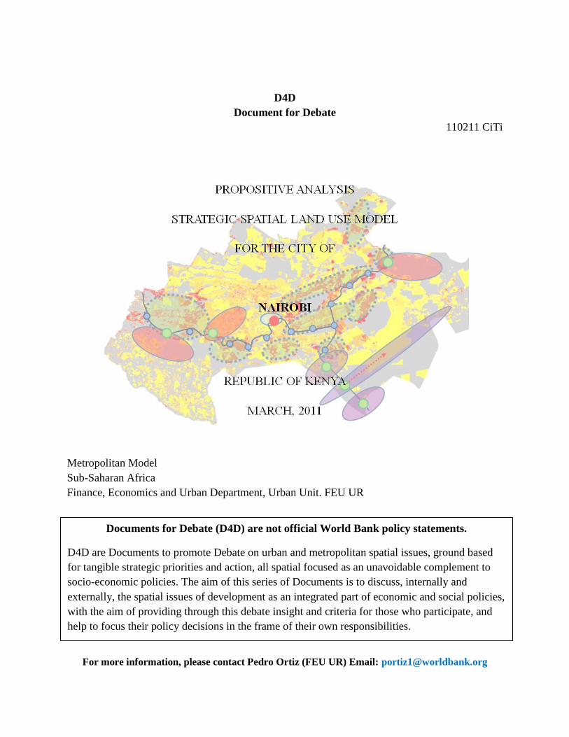
D4D
Document for Debate
110211 CiTi
Metropolitan Model
Sub-Saharan Africa
Finance, Economics and Urban Department, Urban Unit. FEU UR
Foreword
For more information, please contact Pedro Ortiz (FEU UR) Email: [email protected]
Documents for Debate (D4D) are not official World Bank policy statements.
D4D are Documents to promote Debate on urban and metropolitan spatial issues, ground based
for tangible strategic priorities and action, all spatial focused as an unavoidable complement to
socio-economic policies. The aim of this series of Documents is to discuss, internally and
externally, the spatial issues of development as an integrated part of economic and social policies,
with the aim of providing through this debate insight and criteria for those who participate, and
help to focus their policy decisions in the frame of their own responsibilities.
Foreword
The Propositive Analysis series produces a methodological approach to the global demand for strategic and
physical planning for the rapid growth phenomena of metropolises during the first decades of the 21st century.
Historical administrative boundaries have been overgrown by urban growth and expansion. Governance of
these territories confronts the difficulty of interadministrative dialogue of the territorial administrations involved
and, in some cases, administrative revision of structures, competences and boundaries. This is a process that requires
dialogue, compromise, agreements, and time.
Time is what growth does not respect. Growth will take and is taking place whether the administrative
framework is able to allocate it adequately or not. An administration must respond in the right manner, deciding the
adequate locations within a sustainable vision of the land use (compatibilities, synergies, bottlenecks) while
providing basic urban infrastructural, social, and economic facilities.
Growth is taking place and allocation that has to be rationally forecasted and confronted on the territory.
World Bank development strategies and policies stand on a three-leg stool: the Economic, Social and
Spatial – built and environmental – dimensions of Development. When dealing with physical investments
(infrastructure, social facilities, productive equipment), all of which are tangible, the spatial component is the
support for economic and social policies. Most of time spatial dimension plays an essential role in coordinating
synergies or antagonisms among other sectors. Without the Spatial dimension, social or economic policies unrelated
to the interaction of the specific location, may be at risk of either being endlessly recurrent (non strategic) or
cyclically counterproductive (short-long term incompatibility). Recurrent ignorance of this third leg would
produce enormous costs due to metropolitan spatial chaos that very often precludes future reshaping, making
economic and social development impossible as well. The World Bank is well aware of that.
The methodological approach of Propositive Analysis stands on:
1) The actual situation and characteristics of the metropolis
2) Highlighting the metropolis‟ assets and potential
3) Applying a set of basic rules for intra land use location for a sustainable structure (see appendix
Urban Regional Charter)
4) Developing a sector interdisciplinary rationale for the location of activities in a long-large
scenario.
Propositive analysis is an indicative process. Neither the analysis nor the proposed solutions are in any way
compulsory.
It is a holistic interdisciplinary approach, where the different subsystems that compose the territory
(Basically: housing, transport, environment, productive activities and social facilities) are analyzed together and
framed in a comprehensive and consistent set of proposed solutions.
Propositive analysis looks to trigger debate, needs to be fed with specific and more detailed data and for the
analysis and further development of solutions.
The final analytical equilibrium and precision requires the input of the stakeholders of the territory subject to
strategic planning. Those inputs, divulgated, contrasted and debated must produce a consensus in society that makes
the plan implementable by all participants, each in their corresponding social role. Propositive analysis results are
input for governance.
I) Nairobi Goals: As Stated in its Strategic Plan for 2030 Nairobi
1) Nairobi has a 2030 Strategic Plan that aims to make the city a „World Class African City.‟
2) The Plan establishes that to do so Nairobi needs to find its economic niche in the global
Economy.
3) Nairobi serves as a global finance center for Sub Saharan Africa. It is history and the links with
economic and financial markets such as London that has made Nairobi the hub for Sub-Saharan
Africa.
4) But Nairobi can‟t rely on just that. New fields of development have to be strategically defined
and built upon.
5) As such, Nairobi should not ask herself in a passive way, “What can the world make for it” but
rather actively and competitively ask, “what can Nairobi make for the world?”
6) Both the Kenya and Nairobi 2030 Strategic Plan confront this type of issue.
II) Urban Difficulties, Limitations and Bottlenecks to be Confronted
1) Nairobi has serious urban problems that can jeopardize strategic objectives for the future.
2) Nairobi is a very complex city.
3) It has an informal structure disseminated upon the eastward slopes and ravines of the Nairobi
River and its parallel streams.
4) It is formally unstructured, which causes a lack of order and use of public spaces for the adequate
flow of traffic and civic life.
5) The result is a concerning situation of traffic which is well documented by local, national and
international reports.
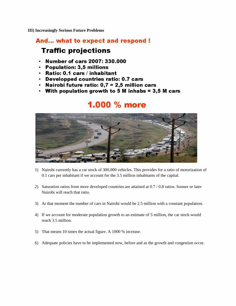
III) Increasingly Serious Future Problems
1) Nairobi currently has a car stock of 300,000 vehicles. This provides for a ratio of motorization of
0.1 cars per inhabitant if we account for the 3.5 million inhabitants of the capital.
2) Saturation ratios from more developed countries are attained at 0.7 / 0.8 ratios. Sooner or later
Nairobi will reach that ratio.
3) At that moment the number of cars in Nairobi would be 2.5 million with a constant population.
4) If we account for moderate population growth to an estimate of 5 million, the car stock would
reach 3.5 million.
5) That means 10 times the actual figure. A 1000 % increase.
6) Adequate policies have to be implemented now, before and as the growth and congestion occur.
IV) Complex Structure Determined by Minor Conjunctural Elements
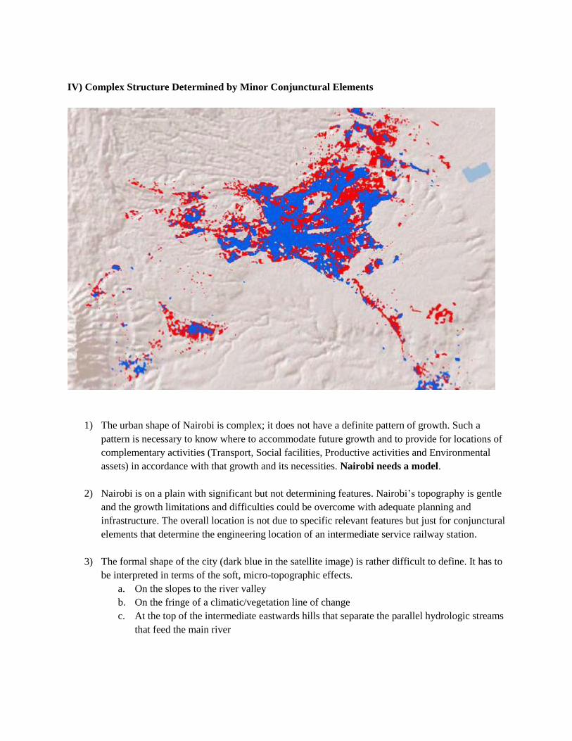
1) The urban shape of Nairobi is complex; it does not have a definite pattern of growth. Such a
pattern is necessary to know where to accommodate future growth and to provide for locations of
complementary activities (Transport, Social facilities, Productive activities and Environmental
assets) in accordance with that growth and its necessities. Nairobi needs a model.
2) Nairobi is on a plain with significant but not determining features. Nairobi‟s topography is gentle
and the growth limitations and difficulties could be overcome with adequate planning and
infrastructure. The overall location is not due to specific relevant features but just for conjunctural
elements that determine the engineering location of an intermediate service railway station.
3) The formal shape of the city (dark blue in the satellite image) is rather difficult to define. It has to
be interpreted in terms of the soft, micro-topographic effects.
a. On the slopes to the river valley
b. On the fringe of a climatic/vegetation line of change
c. At the top of the intermediate eastwards hills that separate the parallel hydrologic streams
that feed the main river
V) The Search for Nairobi’s Metropolitan DNA
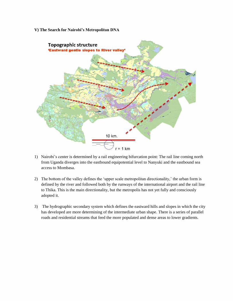
1) Nairobi‟s center is determined by a rail engineering bifurcation point: The rail line coming north
from Uganda diverges into the eastbound equipotential level to Nanyuki and the eastbound sea
access to Mombasa.
2) The bottom of the valley defines the „upper scale metropolitan directionality,‟ the urban form is
defined by the river and followed both by the runways of the international airport and the rail line
to Thika. This is the main directionality, but the metropolis has not yet fully and consciously
adopted it.
3) The hydrographic secondary system which defines the eastward hills and slopes in which the city
has developed are more determining of the intermediate urban shape. There is a series of parallel
roads and residential streams that feed the more populated and dense areas to lower gradients.
VI) The Metropolitan Structure
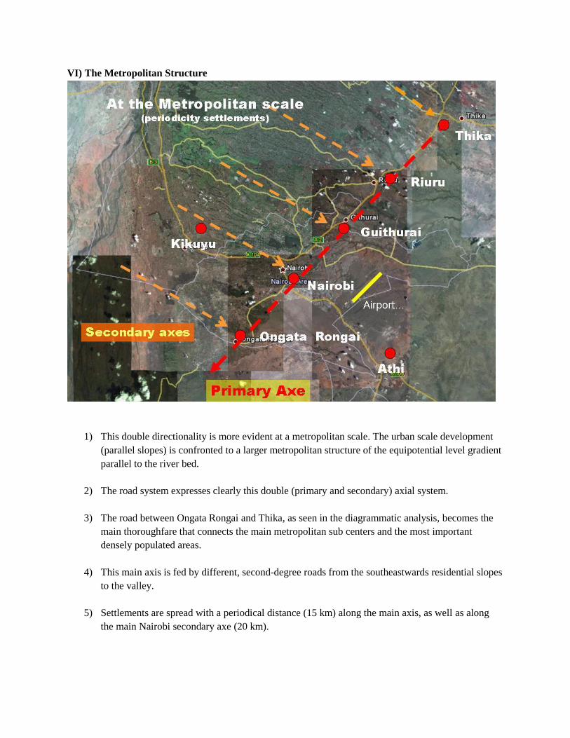
1) This double directionality is more evident at a metropolitan scale. The urban scale development
(parallel slopes) is confronted to a larger metropolitan structure of the equipotential level gradient
parallel to the river bed.
2) The road system expresses clearly this double (primary and secondary) axial system.
3) The road between Ongata Rongai and Thika, as seen in the diagrammatic analysis, becomes the
main thoroughfare that connects the main metropolitan sub centers and the most important
densely populated areas.
4) This main axis is fed by different, second-degree roads from the southeastwards residential slopes
to the valley.
5) Settlements are spread with a periodical distance (15 km) along the main axis, as well as along
the main Nairobi secondary axe (20 km).
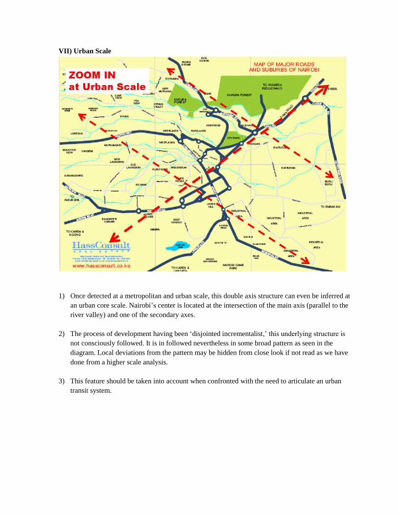
VII) Urban Scale
1) Once detected at a metropolitan and urban scale, this double axis structure can even be inferred at
an urban core scale. Nairobi‟s center is located at the intersection of the main axis (parallel to the
river valley) and one of the secondary axes.
2) The process of development having been „disjointed incrementalist,‟ this underlying structure is
not consciously followed. It is in followed nevertheless in some broad pattern as seen in the
diagram. Local deviations from the pattern may be hidden from close look if not read as we have
done from a higher scale analysis.
3) This feature should be taken into account when confronted with the need to articulate an urban
transit system.
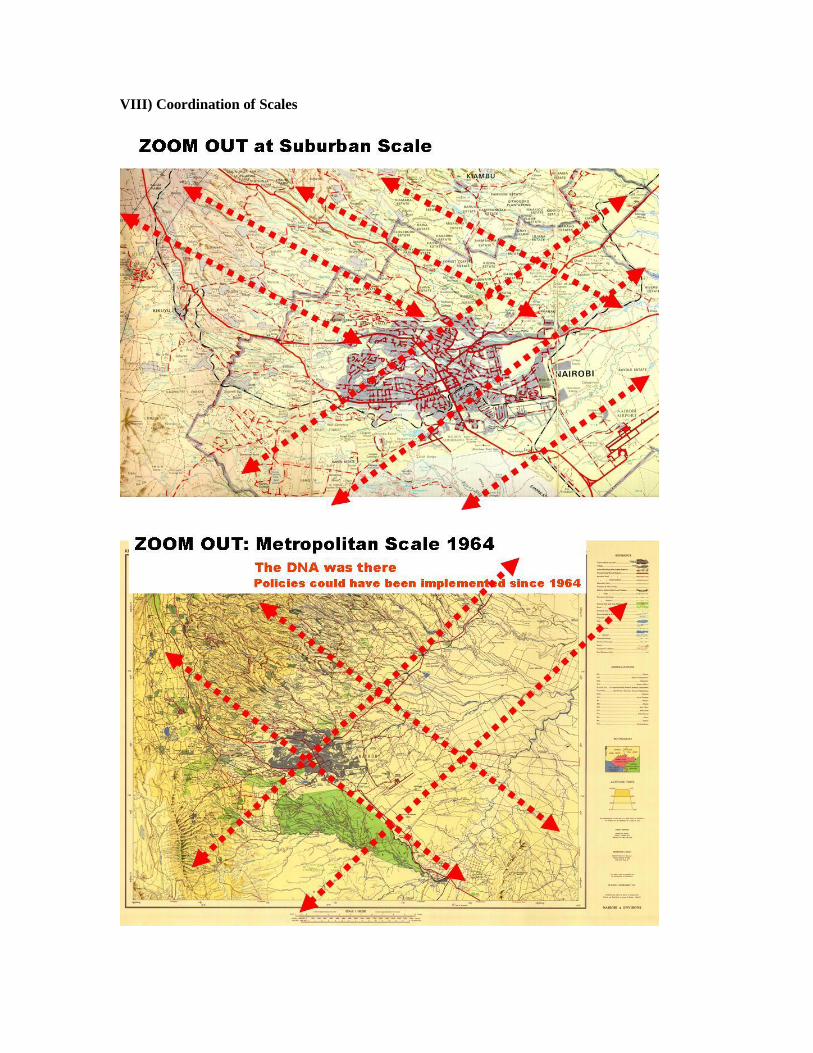
VIII) Coordination of Scales
IX) Environmental Structure
1) Climatic gradients, temperatures and rainfalls also express this axial system.
2) Vegetation has responded to the climatic characteristics.
3) Human settlements have adapted to both the topographic peculiarities, as mentioned before, and
the microclimatic elements.
4) The urban system, complex and chaotic in a first reading, appears to produce a structure that
responds adequately to a whole system of climate, flora, topography and human settlement.
5) Nevertheless, policies have not yet responded to this system and have not been able to conform a
metropolitan structure in accordance with both infrastructure and urban service sufficient to
respond to the urban and population needs (transport, facilities location, density control, housing
provision, etc).
X) The Nairobi 2030 Metropolitan Plan
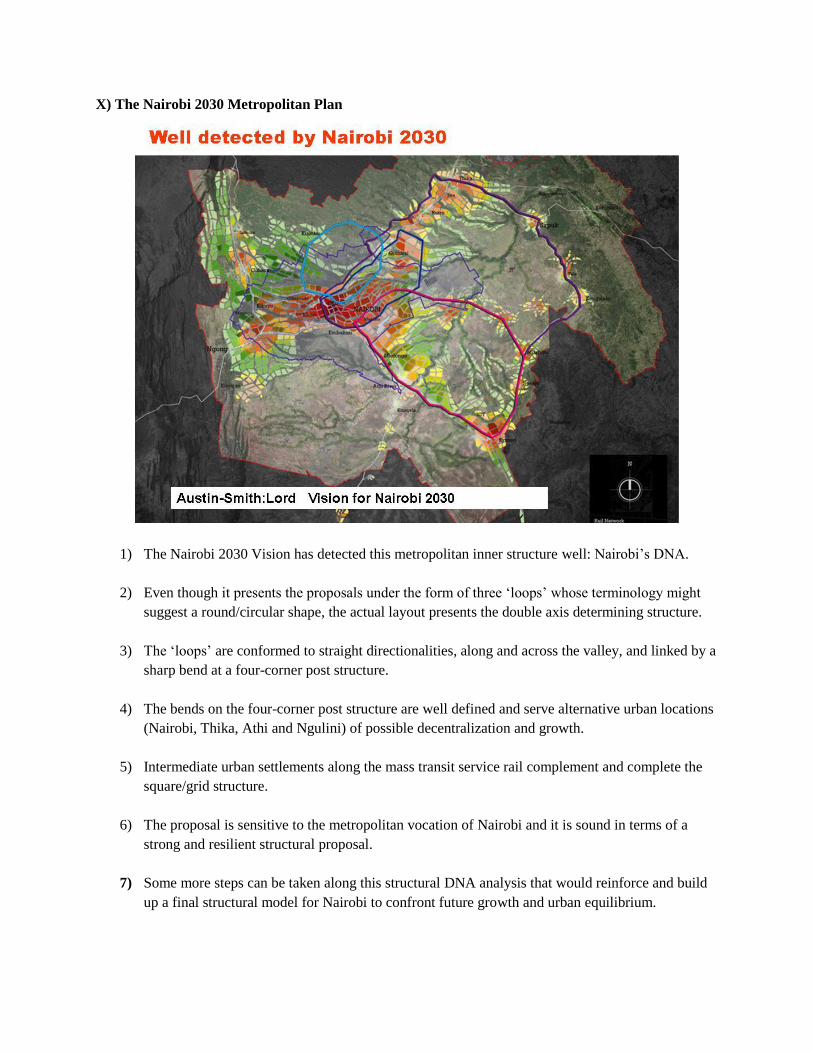
1) The Nairobi 2030 Vision has detected this metropolitan inner structure well: Nairobi‟s DNA.
2) Even though it presents the proposals under the form of three „loops‟ whose terminology might
suggest a round/circular shape, the actual layout presents the double axis determining structure.
3) The „loops‟ are conformed to straight directionalities, along and across the valley, and linked by a
sharp bend at a four-corner post structure.
4) The bends on the four-corner post structure are well defined and serve alternative urban locations
(Nairobi, Thika, Athi and Ngulini) of possible decentralization and growth.
5) Intermediate urban settlements along the mass transit service rail complement and complete the
square/grid structure.
6) The proposal is sensitive to the metropolitan vocation of Nairobi and it is sound in terms of a
strong and resilient structural proposal.
7) Some more steps can be taken along this structural DNA analysis that would reinforce and build
up a final structural model for Nairobi to confront future growth and urban equilibrium.
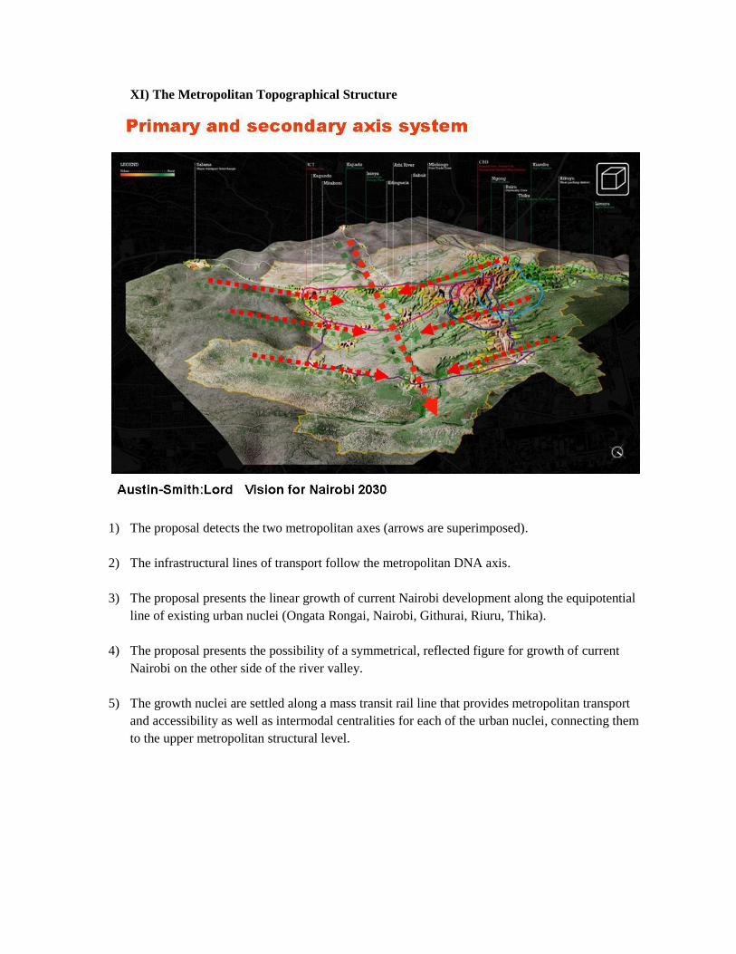
XI) The Metropolitan Topographical Structure
1) The proposal detects the two metropolitan axes (arrows are superimposed).
2) The infrastructural lines of transport follow the metropolitan DNA axis.
3) The proposal presents the linear growth of current Nairobi development along the equipotential
line of existing urban nuclei (Ongata Rongai, Nairobi, Githurai, Riuru, Thika).
4) The proposal presents the possibility of a symmetrical, reflected figure for growth of current
Nairobi on the other side of the river valley.
5) The growth nuclei are settled along a mass transit rail line that provides metropolitan transport
and accessibility as well as intermodal centralities for each of the urban nuclei, connecting them
to the upper metropolitan structural level.
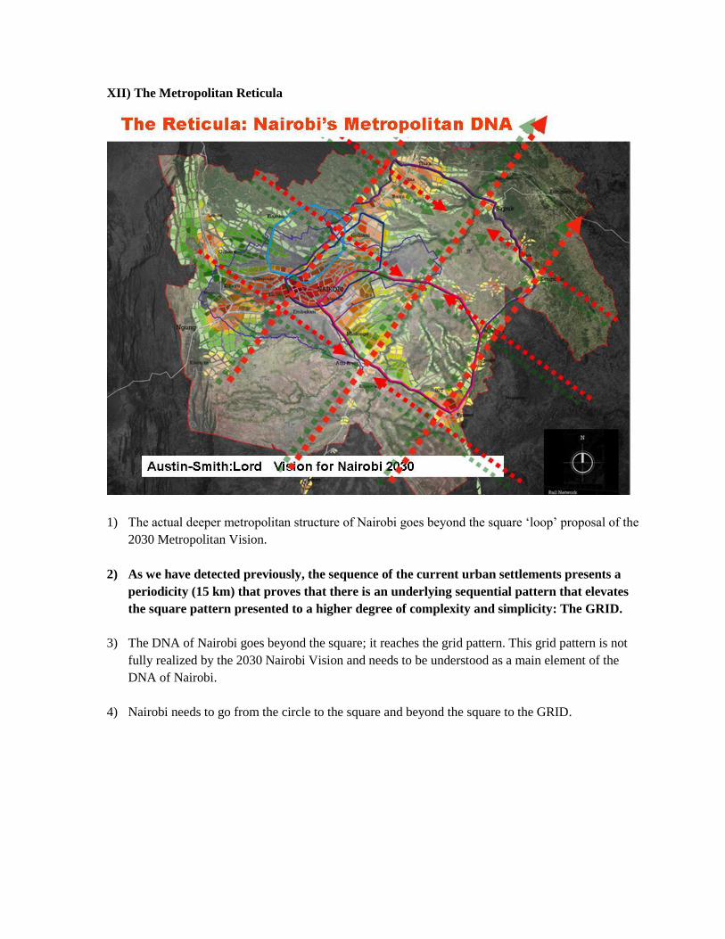
XII) The Metropolitan Reticula
1) The actual deeper metropolitan structure of Nairobi goes beyond the square „loop‟ proposal of the
2030 Metropolitan Vision.
2) As we have detected previously, the sequence of the current urban settlements presents a
periodicity (15 km) that proves that there is an underlying sequential pattern that elevates
the square pattern presented to a higher degree of complexity and simplicity: The GRID.
3) The DNA of Nairobi goes beyond the square; it reaches the grid pattern. This grid pattern is not
fully realized by the 2030 Nairobi Vision and needs to be understood as a main element of the
DNA of Nairobi.
4) Nairobi needs to go from the circle to the square and beyond the square to the GRID.
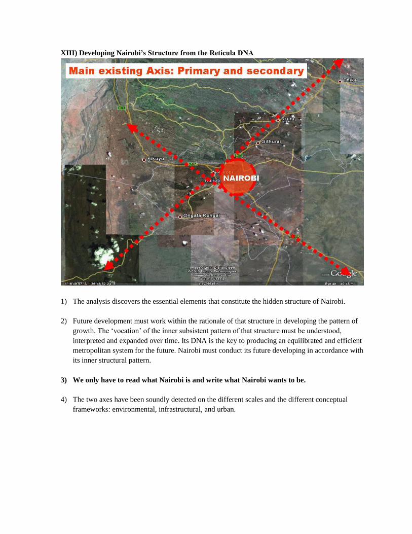
XIII) Developing Nairobi’s Structure from the Reticula DNA
1) The analysis discovers the essential elements that constitute the hidden structure of Nairobi.
2) Future development must work within the rationale of that structure in developing the pattern of
growth. The „vocation‟ of the inner subsistent pattern of that structure must be understood,
interpreted and expanded over time. Its DNA is the key to producing an equilibrated and efficient
metropolitan system for the future. Nairobi must conduct its future developing in accordance with
its inner structural pattern.
3) We only have to read what Nairobi is and write what Nairobi wants to be.
4) The two axes have been soundly detected on the different scales and the different conceptual
frameworks: environmental, infrastructural, and urban.
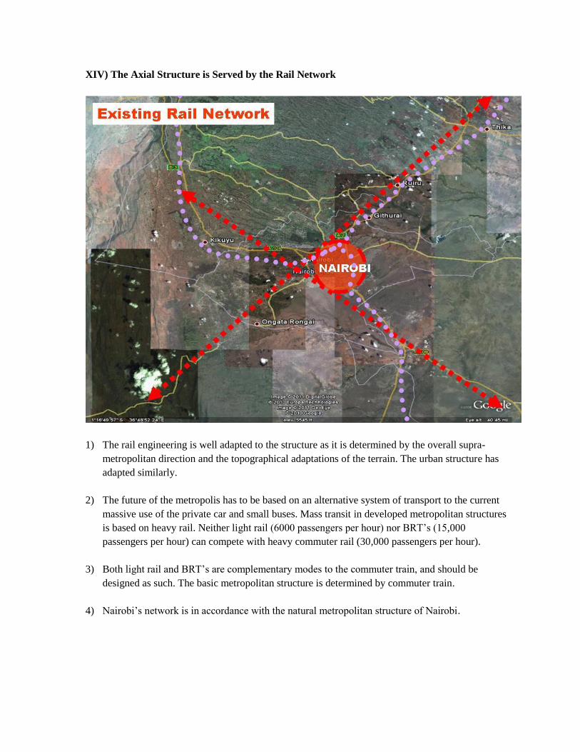
XIV) The Axial Structure is Served by the Rail Network
1) The rail engineering is well adapted to the structure as it is determined by the overall supra-
metropolitan direction and the topographical adaptations of the terrain. The urban structure has
adapted similarly.
2) The future of the metropolis has to be based on an alternative system of transport to the current
massive use of the private car and small buses. Mass transit in developed metropolitan structures
is based on heavy rail. Neither light rail (6000 passengers per hour) nor BRT‟s (15,000
passengers per hour) can compete with heavy commuter rail (30,000 passengers per hour).
3) Both light rail and BRT‟s are complementary modes to the commuter train, and should be
designed as such. The basic metropolitan structure is determined by commuter train.
4) Nairobi‟s network is in accordance with the natural metropolitan structure of Nairobi.
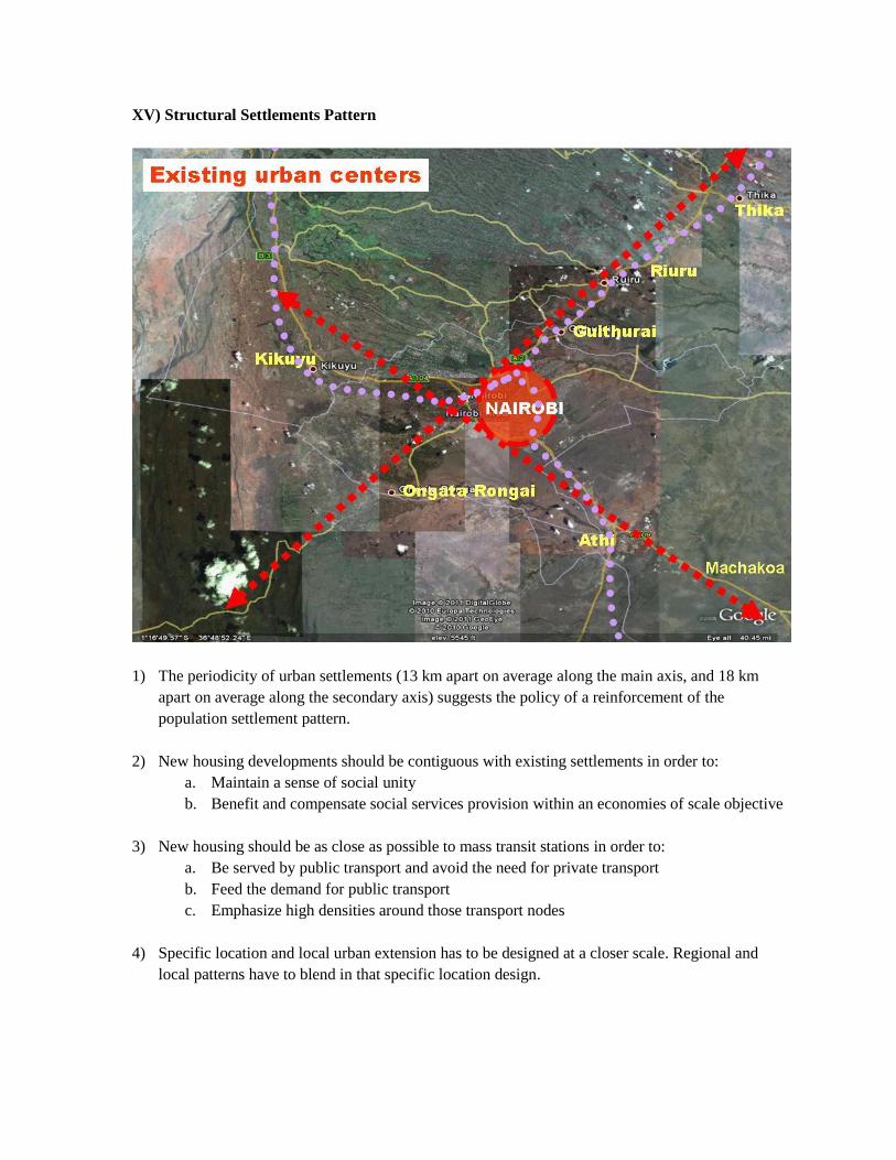
XV) Structural Settlements Pattern
1) The periodicity of urban settlements (13 km apart on average along the main axis, and 18 km
apart on average along the secondary axis) suggests the policy of a reinforcement of the
population settlement pattern.
2) New housing developments should be contiguous with existing settlements in order to:
a. Maintain a sense of social unity
b. Benefit and compensate social services provision within an economies of scale objective
3) New housing should be as close as possible to mass transit stations in order to:
a. Be served by public transport and avoid the need for private transport
b. Feed the demand for public transport
c. Emphasize high densities around those transport nodes
4) Specific location and local urban extension has to be designed at a closer scale. Regional and
local patterns have to blend in that specific location design.
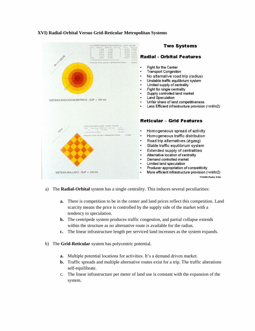
XVI) Radial-Orbital Versus Grid-Reticular Metropolitan Systems
a) The Radial-Orbital system has a single centrality. This induces several peculiarities:
a. There is competition to be in the center and land prices reflect this competition. Land
scarcity means the price is controlled by the supply side of the market with a
tendency to speculation.
b. The centripede system produces traffic congestion, and partial collapse extends
within the structure as no alternative route is available for the radius.
c. The linear infrastructure length per serviced land increases as the system expands.
b) The Grid-Reticular system has polycentric potential.
a. Multiple potential locations for activities. It‟s a demand driven market.
b. Traffic spreads and multiple alternative routes exist for a trip. The traffic alterations
self-equilibrate.
c. The linear infrastructure per meter of land use is constant with the expansion of the
system.
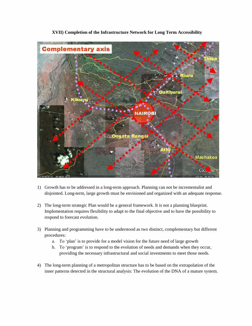
XVII) Completion of the Infrastructure Network for Long Term Accessibility
1) Growth has to be addressed in a long-term approach. Planning can not be incrementalist and
disjointed. Long-term, large growth must be envisioned and organized with an adequate response.
2) The long-term strategic Plan would be a general framework. It is not a planning blueprint.
Implementation requires flexibility to adapt to the final objective and to have the possibility to
respond to forecast evolution.
3) Planning and programming have to be understood as two distinct, complementary but different
procedures:
a. To „plan‟ is to provide for a model vision for the future need of large growth
b. To „program‟ is to respond to the evolution of needs and demands when they occur,
providing the necessary infrastructural and social investments to meet those needs.
4) The long-term planning of a metropolitan structure has to be based on the extrapolation of the
inner patterns detected in the structural analysis: The evolution of the DNA of a mature system.
XVIII) Residential Land Use Needs for Nairobi
1) Needs:
More than 1,000,000 new families (4 million inhabitants) and dwellings are expected in Nairobi
in the next 20 years. This is the combination of two phenomena:
a) Immigration to Nairobi taking the overall population
• from 3.5 M current inhabitants
• to 6 M inhabitants
This means 700,000 new households, which require a similar amount of dwellings
b) The family shift that comes about with urban living and economic growth.
Family size will shrink from 5 to 4 members (developed metropolises 2.4
members)
This will mean 300,000 new families and dwellings
2) Required housing response:
1,000,000 dwellings would require the development of 20 units of 50,000 dwellings:
- 200,000 inhabitants
- fully grown city
- efficient economies of scale
- social provision of services
- economic provision of infrastructure
3) Required land provision response:
Average density:
- 400 inhabitants per hectare (actual average density of Nairobi as low as 120 inha/hec)
- 100 dwellings per hectare: 500 hect/urban unit
- 5 km per urban unit
Total requirement:
- 1,000,000 dwellings: 100 dw/hect: 10,000 hect: 100 Km2 in 20 years
- 5 km2 per year: one unit per year
One unit of 5 km2 per year at the commuter rail stations
If these figures are not confronted with adequate policies, the slums‟ growth will be
proportional to the lack of the public administration‟s capacity to manage growth.
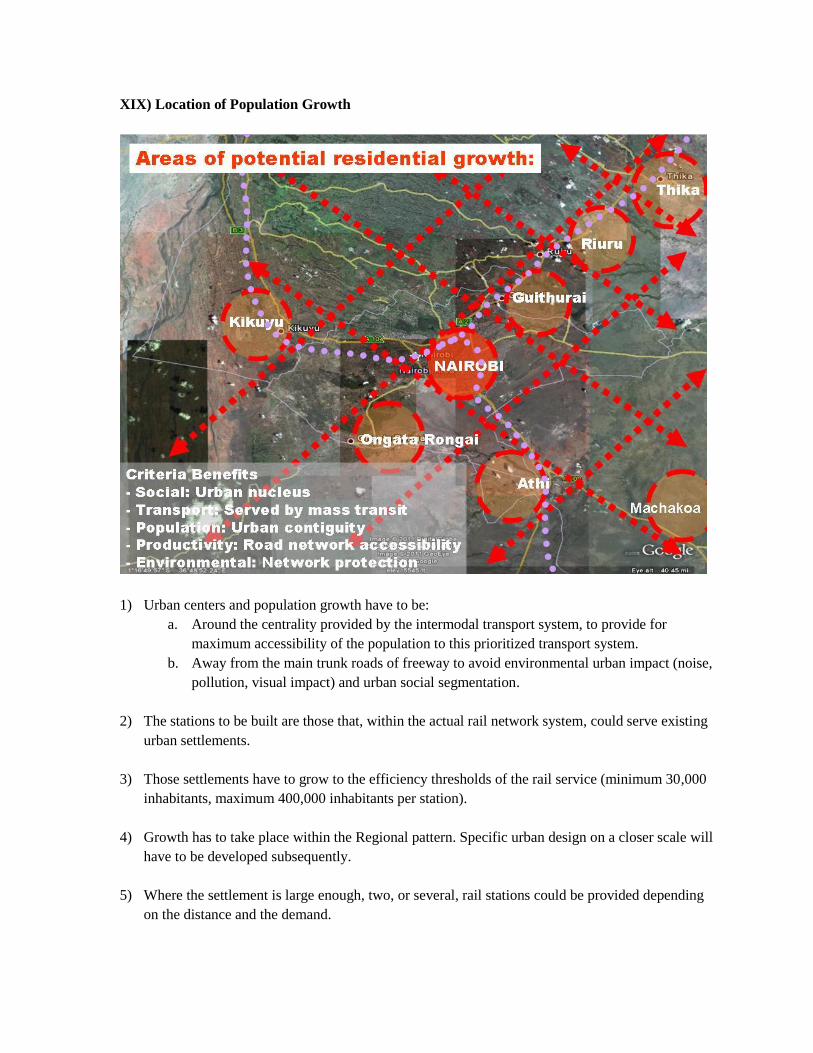
XIX) Location of Population Growth
1) Urban centers and population growth have to be:
a. Around the centrality provided by the intermodal transport system, to provide for
maximum accessibility of the population to this prioritized transport system.
b. Away from the main trunk roads of freeway to avoid environmental urban impact (noise,
pollution, visual impact) and urban social segmentation.
2) The stations to be built are those that, within the actual rail network system, could serve existing
urban settlements.
3) Those settlements have to grow to the efficiency thresholds of the rail service (minimum 30,000
inhabitants, maximum 400,000 inhabitants per station).
4) Growth has to take place within the Regional pattern. Specific urban design on a closer scale will
have to be developed subsequently.
5) Where the settlement is large enough, two, or several, rail stations could be provided depending
on the distance and the demand.
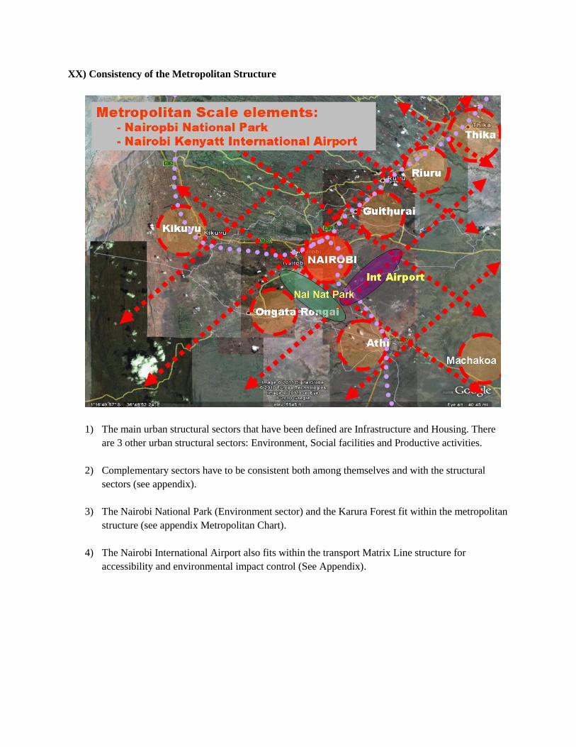
XX) Consistency of the Metropolitan Structure
1) The main urban structural sectors that have been defined are Infrastructure and Housing. There
are 3 other urban structural sectors: Environment, Social facilities and Productive activities.
2) Complementary sectors have to be consistent both among themselves and with the structural
sectors (see appendix).
3) The Nairobi National Park (Environment sector) and the Karura Forest fit within the metropolitan
structure (see appendix Metropolitan Chart).
4) The Nairobi International Airport also fits within the transport Matrix Line structure for
accessibility and environmental impact control (See Appendix).
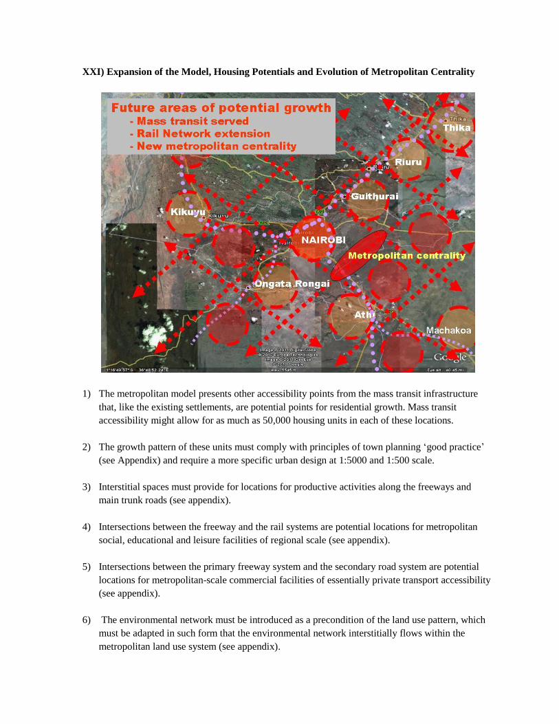
XXI) Expansion of the Model, Housing Potentials and Evolution of Metropolitan Centrality
1) The metropolitan model presents other accessibility points from the mass transit infrastructure
that, like the existing settlements, are potential points for residential growth. Mass transit
accessibility might allow for as much as 50,000 housing units in each of these locations.
2) The growth pattern of these units must comply with principles of town planning „good practice‟
(see Appendix) and require a more specific urban design at 1:5000 and 1:500 scale.
3) Interstitial spaces must provide for locations for productive activities along the freeways and
main trunk roads (see appendix).
4) Intersections between the freeway and the rail systems are potential locations for metropolitan
social, educational and leisure facilities of regional scale (see appendix).
5) Intersections between the primary freeway system and the secondary road system are potential
locations for metropolitan-scale commercial facilities of essentially private transport accessibility
(see appendix).
6) The environmental network must be introduced as a precondition of the land use pattern, which
must be adapted in such form that the environmental network interstitially flows within the
metropolitan land use system (see appendix).
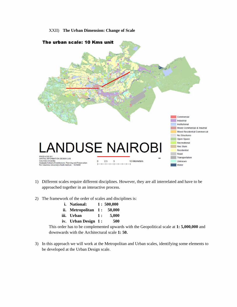
XXII) The Urban Dimension: Change of Scale
1) Different scales require different disciplines. However, they are all interrelated and have to be
approached together in an interactive process.
2) The framework of the order of scales and disciplines is:
i. National: 1 : 500,000
ii. Metropolitan 1 : 50,000
iii. Urban 1 : 5,000
iv. Urban Design 1 : 500
This order has to be complemented upwards with the Geopolitical scale at 1: 5,000,000 and
downwards with the Architectural scale 1: 50.
3) In this approach we will work at the Metropolitan and Urban scales, identifying some elements to
be developed at the Urban Design scale.
XXIII) Nairobi Urban Structure
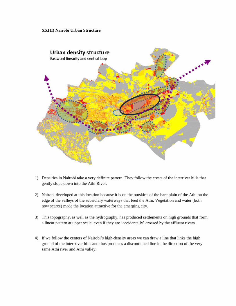
1) Densities in Nairobi take a very definite pattern. They follow the crests of the interriver hills that
gently slope down into the Athi River.
2) Nairobi developed at this location because it is on the outskirts of the bare plain of the Athi on the
edge of the valleys of the subsidiary waterways that feed the Athi. Vegetation and water (both
now scarce) made the location attractive for the emerging city.
3) This topography, as well as the hydrography, has produced settlements on high grounds that form
a linear pattern at upper scale, even if they are „accidentally‟ crossed by the affluent rivers.
4) If we follow the centers of Nairobi‟s high-density areas we can draw a line that links the high
ground of the inter-river hills and thus produces a discontinued line in the direction of the very
same Athi river and Athi valley.
XXIV) Land Use and Transport Infrastructure
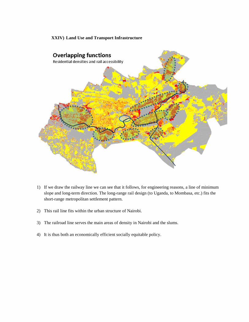
1) If we draw the railway line we can see that it follows, for engineering reasons, a line of minimum
slope and long-term direction. The long-range rail design (to Uganda, to Mombasa, etc.) fits the
short-range metropolitan settlement pattern.
2) This rail line fits within the urban structure of Nairobi.
3) The railroad line serves the main areas of density in Nairobi and the slums.
4) It is thus both an economically efficient socially equitable policy.
XXV) Mass Transport Policies
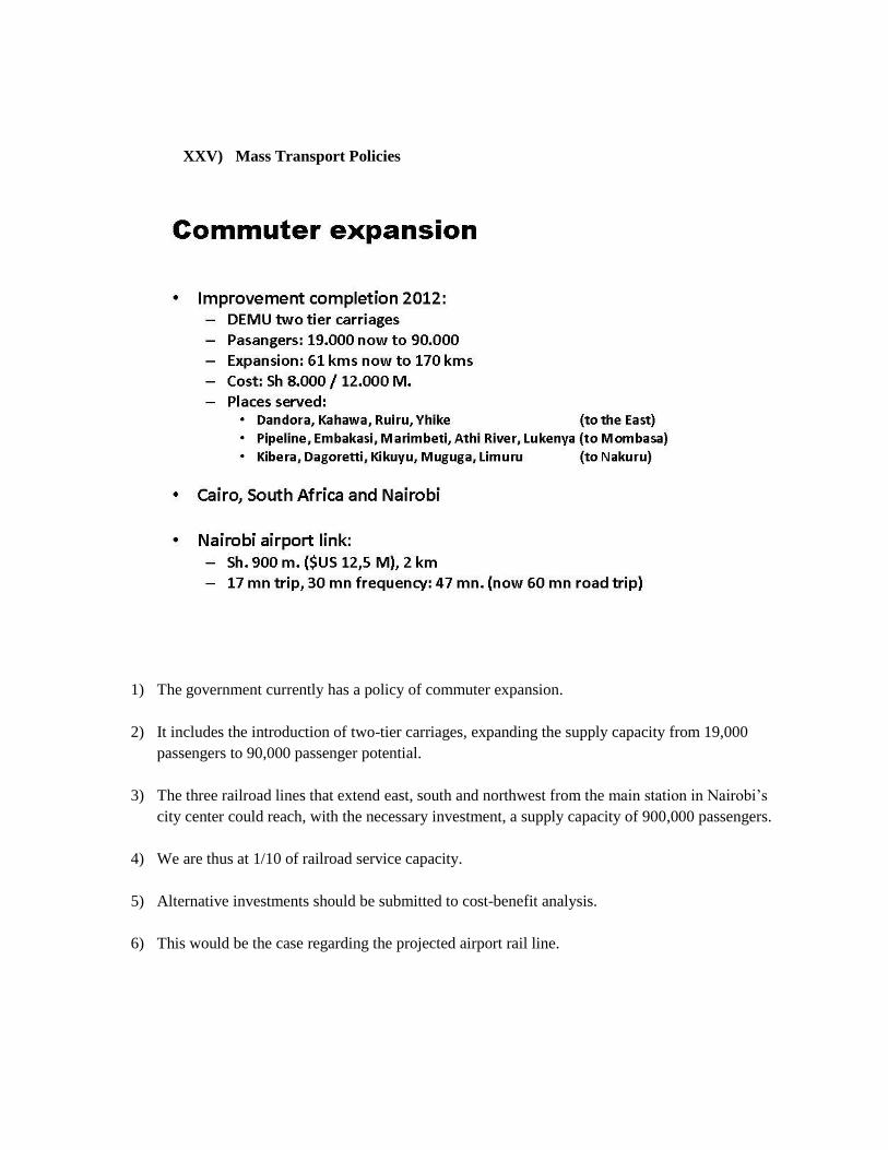
1) The government currently has a policy of commuter expansion.
2) It includes the introduction of two-tier carriages, expanding the supply capacity from 19,000
passengers to 90,000 passenger potential.
3) The three railroad lines that extend east, south and northwest from the main station in Nairobi‟s
city center could reach, with the necessary investment, a supply capacity of 900,000 passengers.
4) We are thus at 1/10 of railroad service capacity.
5) Alternative investments should be submitted to cost-benefit analysis.
6) This would be the case regarding the projected airport rail line.
XXVI) Integration of Transport and Land Use Policies
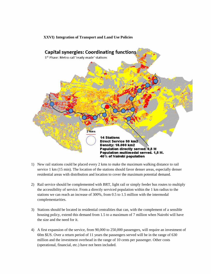
1) New rail stations could be placed every 2 kms to make the maximum walking distance to rail
service 1 km (15 min). The location of the stations should favor denser areas, especially denser
residential areas with distribution and location to cover the maximum potential demand.
2) Rail service should be complemented with BRT, light rail or simply feeder bus routes to multiply
the accessibility of service. From a directly serviced population within the 1 km radius to the
stations we can reach an increase of 300%, from 0.5 to 1.5 million with the intermodal
complementarities.
3) Stations should be located in residential centralities that can, with the complement of a sensible
housing policy, extend this demand from 1.5 to a maximum of 7 million when Nairobi will have
the size and the need for it.
4) A first expansion of the service, from 90,000 to 250,000 passengers, will require an investment of
60m $US. Over a return period of 11 years the passengers served will be in the range of 630
million and the investment overhead in the range of 10 cents per passenger. Other costs
(operational, financial, etc.) have not been included.
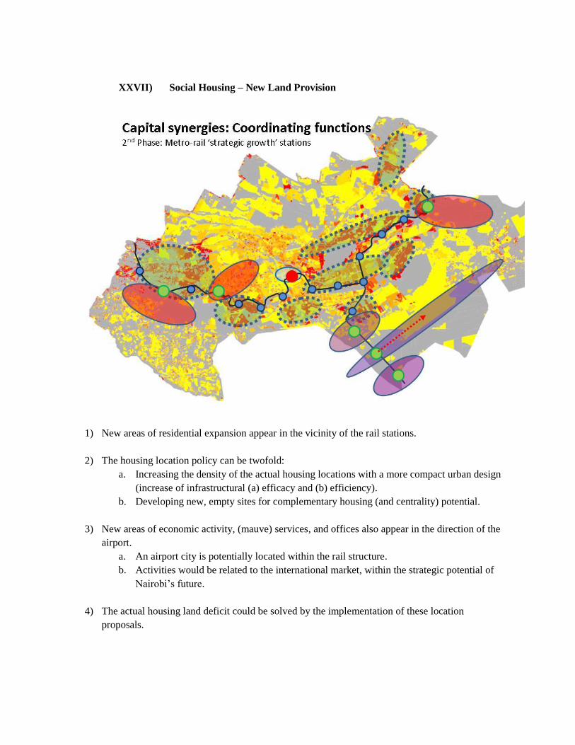
XXVII) Social Housing – New Land Provision
1) New areas of residential expansion appear in the vicinity of the rail stations.
2) The housing location policy can be twofold:
a. Increasing the density of the actual housing locations with a more compact urban design
(increase of infrastructural (a) efficacy and (b) efficiency).
b. Developing new, empty sites for complementary housing (and centrality) potential.
3) New areas of economic activity, (mauve) services, and offices also appear in the direction of the
airport.
a. An airport city is potentially located within the rail structure.
b. Activities would be related to the international market, within the strategic potential of
Nairobi‟s future.
4) The actual housing land deficit could be solved by the implementation of these location
proposals.
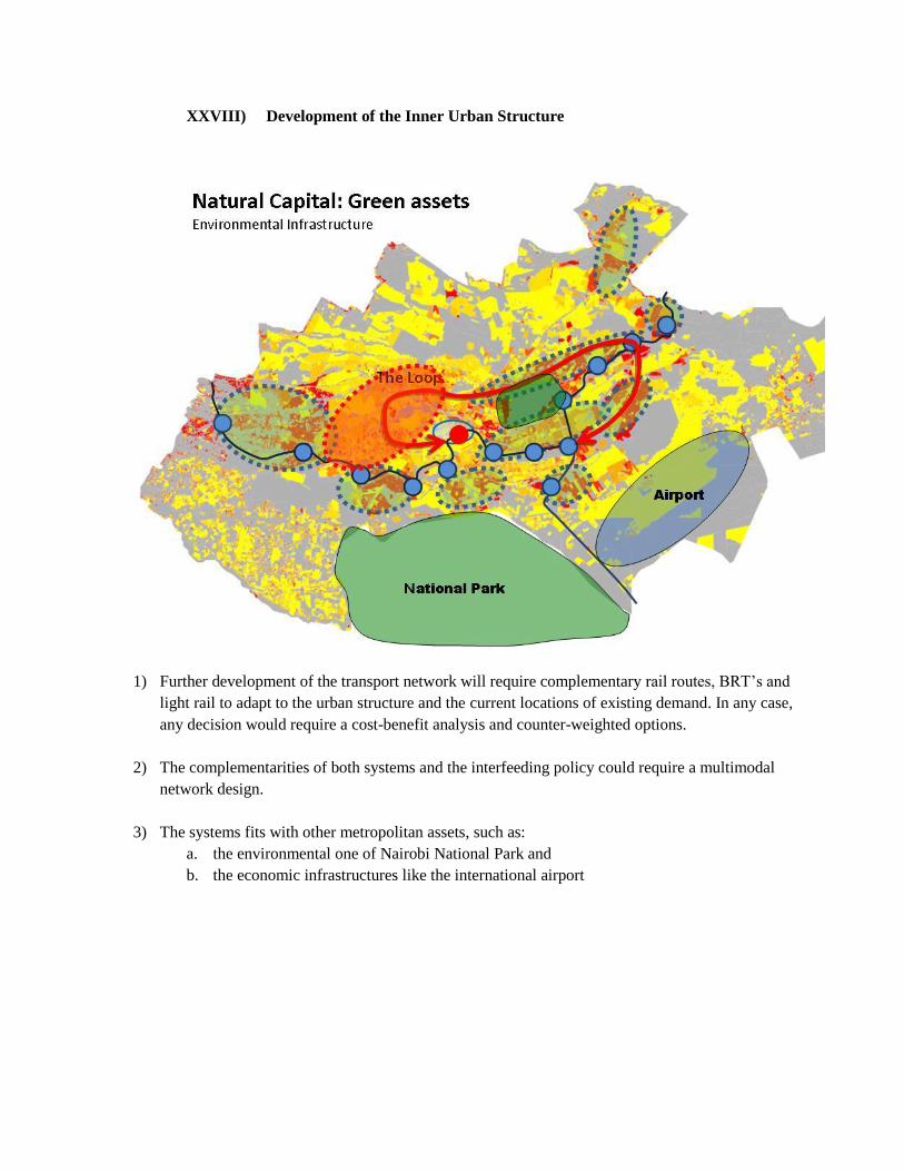
XXVIII) Development of the Inner Urban Structure
1) Further development of the transport network will require complementary rail routes, BRT‟s and
light rail to adapt to the urban structure and the current locations of existing demand. In any case,
any decision would require a cost-benefit analysis and counter-weighted options.
2) The complementarities of both systems and the interfeeding policy could require a multimodal
network design.
3) The systems fits with other metropolitan assets, such as:
a. the environmental one of Nairobi National Park and
b. the economic infrastructures like the international airport
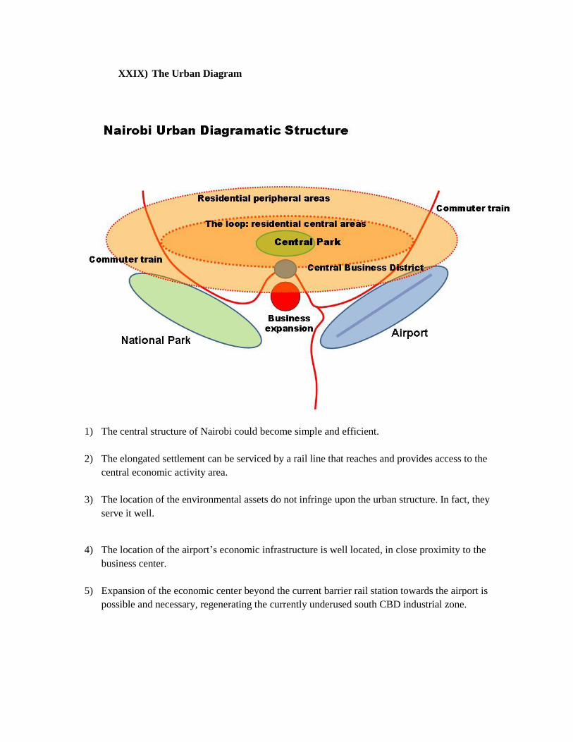
XXIX) The Urban Diagram
1) The central structure of Nairobi could become simple and efficient.
2) The elongated settlement can be serviced by a rail line that reaches and provides access to the
central economic activity area.
3) The location of the environmental assets do not infringe upon the urban structure. In fact, they
serve it well.
4) The location of the airport‟s economic infrastructure is well located, in close proximity to the
business center.
5) Expansion of the economic center beyond the current barrier rail station towards the airport is
possible and necessary, regenerating the currently underused south CBD industrial zone.
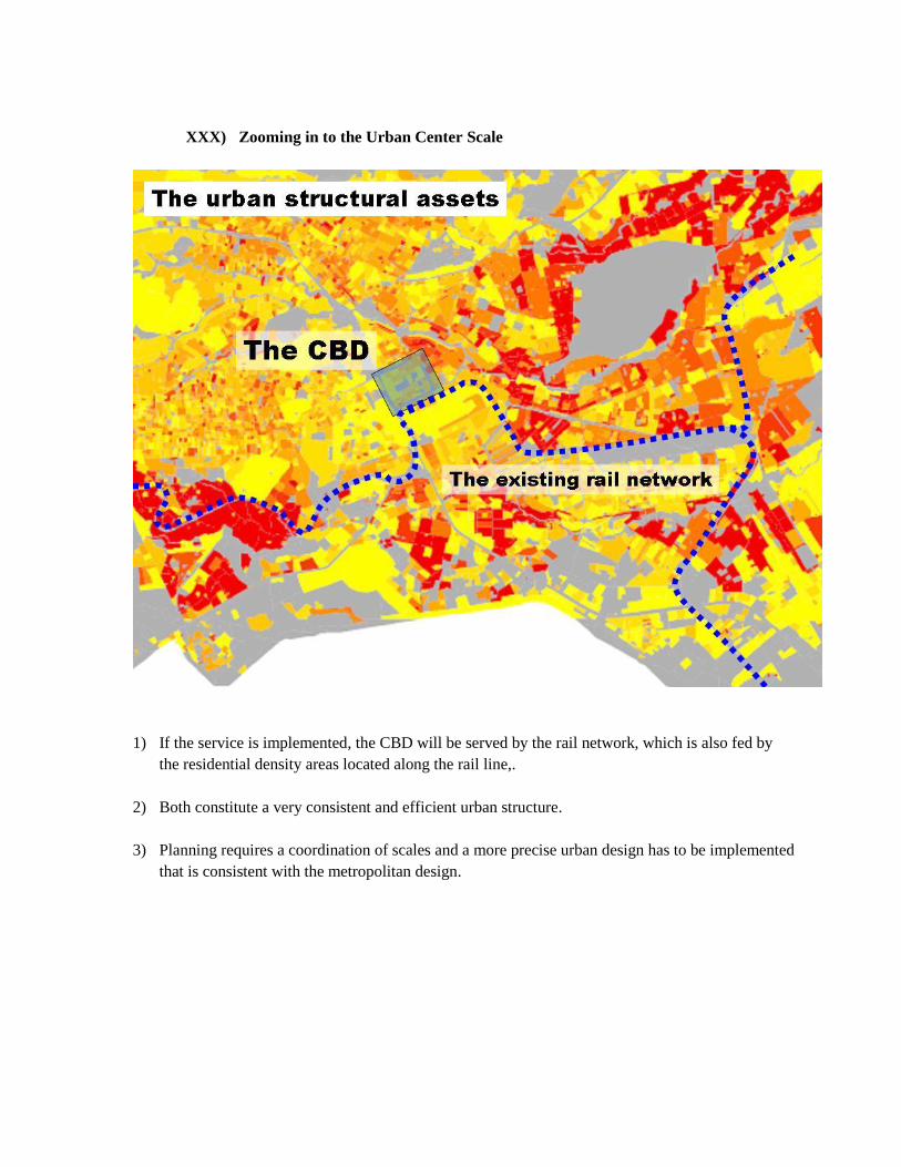
XXX) Zooming in to the Urban Center Scale
1) If the service is implemented, the CBD will be served by the rail network, which is also fed by
the residential density areas located along the rail line,.
2) Both constitute a very consistent and efficient urban structure.
3) Planning requires a coordination of scales and a more precise urban design has to be implemented
that is consistent with the metropolitan design.
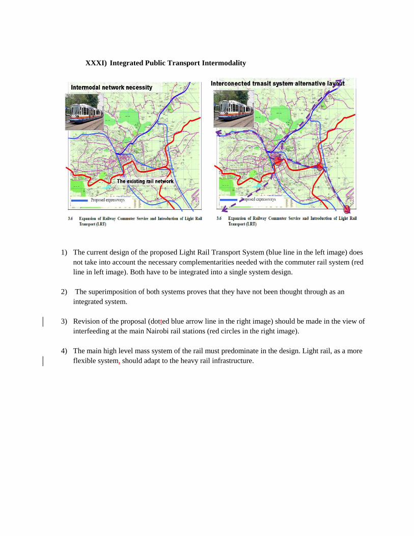
XXXI) Integrated Public Transport Intermodality
1) The current design of the proposed Light Rail Transport System (blue line in the left image) does
not take into account the necessary complementarities needed with the commuter rail system (red
line in left image). Both have to be integrated into a single system design.
2) The superimposition of both systems proves that they have not been thought through as an
integrated system.
3) Revision of the proposal (dotted blue arrow line in the right image) should be made in the view of
interfeeding at the main Nairobi rail stations (red circles in the right image).
4) The main high level mass system of the rail must predominate in the design. Light rail, as a more
flexible system, should adapt to the heavy rail infrastructure.
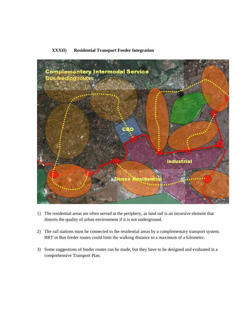
XXXII) Residential Transport Feeder Integration
1) The residential areas are often served at the periphery, as land rail is an incursive element that
distorts the quality of urban environment if it is not underground.
2) The rail stations must be connected to the residential areas by a complementary transport system.
BRT or Bus feeder routes could limit the walking distance to a maximum of a kilometer.
3) Some suggestions of feeder routes can be made, but they have to be designed and evaluated in a
comprehensive Transport Plan.
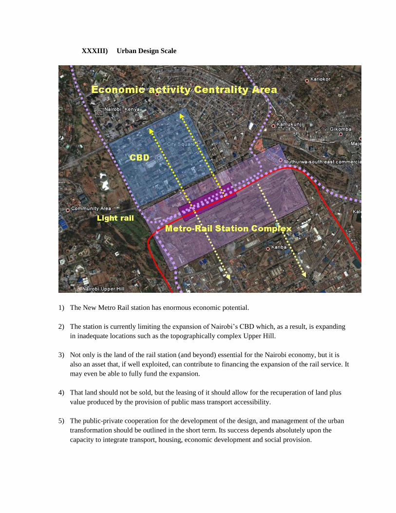
XXXIII) Urban Design Scale
1) The New Metro Rail station has enormous economic potential.
2) The station is currently limiting the expansion of Nairobi‟s CBD which, as a result, is expanding
in inadequate locations such as the topographically complex Upper Hill.
3) Not only is the land of the rail station (and beyond) essential for the Nairobi economy, but it is
also an asset that, if well exploited, can contribute to financing the expansion of the rail service. It
may even be able to fully fund the expansion.
4) That land should not be sold, but the leasing of it should allow for the recuperation of land plus
value produced by the provision of public mass transport accessibility.
5) The public-private cooperation for the development of the design, and management of the urban
transformation should be outlined in the short term. Its success depends absolutely upon the
capacity to integrate transport, housing, economic development and social provision.
XXXIV) Nairobi Priorities
Among the discussed long-term policies, priorities must be made:
1) Mass public transport: The first short-term priority is to exploit the huge potential of the
existing rail line structure.
a. Restructuring of the tracks will most likely be necessary but the increase of moving
material from secondary international markets will not require a high financial outlay and
can be based on a progressive policy and services build-up approach.
2) Road network: As we have seen, the metropolitan structure is not concentric (orbital). Building
up concentric roads will only increase the centrality and congestion of Nairobi.
a. A linear, decongestive, structurizing network should be envisioned and the main priority
lines should be moved to the planning forefront. The A.T.H.I. (Athi Trunk Highway
Infrastructure) along the Athi River plain, at the foot of Nairobi hills in Thika direction,
between Nairobi and the Airport should play a key role, probably connecting with the
Langata Rd.
b. These should probably not reinforce the existing urban thoroughfares, but rather produce
a metropolitan parallel axis that will become an alternative route for passing vehicles and
that will produce accessibility to important new economic land that could be fed within
the metropolitan system, thereby increasing land provision and reducing land shortage
and land prices. The Nairobi economy will benefit from it as a complement to the traffic
and transport benefits.
3) Public Transport Plan: In further developments, an extension of the rail network can be
envisioned within the comprehensive context of a Metropolitan Transport Plan.
4) Social Housing and Metropolitan Structure: The land housing provision is part of the
efficiency of the metropolitan system in both equity and economic terms. The need for 40 Sq Km
of residential land in the next 20 years – 2 Sq Km per year – requires immediate action. These
locations on the rail centralities must be obtained and built upon in a metropolitan management
policy. It is a short-term necessity with a long-term vision. Centralities will be required in an
intermodal and mixed-use approach (see appendix).
For more information, please contact Pedro Ortiz (FEU UR) Email: [email protected]
Appendix 1: WB Projects in Nairobi
I) Municipal Program
Project ID: P066488 | Project Status: Active Abstract* last updated: 15-OCT-2010
The development objective of the Municipal Program Project for Kenya is to strengthen local governance
and improve service delivery in selected municipalities. There are four components to the project.
a. The first component of the project is institutional strengthening. This component will support
institutional strengthening, capacity building, and policy development at the national and
municipal levels to facilitate decentralization and build a capable and accountable local
government system.
b. The second component of the project is participatory strategic urban development planning. This
component will provide support for:
(a) preparation of strategic urban development plans including physical structure plans and capital
investment plans developed in consultation with stakeholders;
(b) community mobilization and participation in these planning processes and in other program-
related initiatives; and
(c) establishing and strengthening municipal planning offices.
c. The third component of the project is investment in infrastructure and service delivery. This
component will support investments in critical urban infrastructure and services. The following
areas of investments will be eligible for financing under the Kenya Municipal Program (KMP):
solid waste facilities, motorized and non-motorized transport facilities (including bus parks,
access roads, sidewalks and paved paths), street lighting, markets, storm water drainage, disaster
management and prevention (facilities and equipment), and public parks and green spaces.
The fourth component of the project is project management, monitoring and evaluation. This
component will finance the management activities associated with program implementation, design
and implementation of a comprehensive baseline, establishment of a monitoring and evaluation
system, and preparation of phase two of the KMP.
II) Northern Corridor Transport Improvement Project
Project ID: P082615 | Project Status: Active Abstract* last updated: 09-JUN-2009
The additional financing to the Republic of Kenya for the Northern Corridor Transport Improvement
Project will help finance the costs associated with:
(i) completion of the original project activities whose scope and costs have increased unexpectedly
(78 percent);
(ii) implementing expanded project activities that scale up the development effectiveness of the
project to address institutional capacity constraints and strengthen governance in the
construction industry and carrying out feasibility and design studies for the Sudan Link Road
and Urban Public Transport (12 percent); and
(iii) emergency rehabilitation and replacement of infrastructure and public assets damaged as a result
of the political crisis that followed the general elections in December 2007 (10 percent).
The project paper also includes a for restructuring of the project consisting of:
(i) dropping activities pertaining to construction of the North Airport Road and Rehabilitation of the
Old Embakasi Airport;
(ii) introducing a new activity of constructing a new Passenger Terminal at Jomo Kenyatta
International Airport (JKIA), Nairobi;
(iii) reallocating funds among the disbursement categories; and extending the closing date of the
Credit from December 31, 2009 to June 30, 2012 to allow sufficient time to implement the
expanded and new activities.
III) Northern Corridor Additional Financing
Project ID: P106200 | Project Status: Active Abstract* last updated: 09-JUN-2009
The additional financing to the Republic of Kenya for the Northern Corridor Transport Improvement
Project will help finance the costs associated with:
(i) completion of the original project activities whose scope and costs have increased unexpectedly
(78 percent);
(ii) implementing expanded project activities that scale up the development effectiveness of the
project to address institutional capacity constraints and strengthen governance in the
construction industry and carrying out feasibility and design studies for the Sudan Link Road
and Urban Public Transport (12 percent); and
(iii) emergency rehabilitation and replacement of infrastructure and public assets damaged as a result
of the political crisis that followed the general elections in December 2007 (10 percent).
The project paper also includes a for restructuring of the project consisting of:
(i) dropping activities pertaining to construction of the North Airport Road and Rehabilitation of the
Old Embakasi Airport;
(ii) introducing a new activity of constructing a new Passenger Terminal at Jomo Kenyatta
International Airport (JKIA), Nairobi;
(iii) reallocating funds among the disbursement categories; and extending the closing date of the
Credit from December 31, 2009 to June 30, 2012 to allow sufficient time to implement the
expanded and new activities.
IV) East Africa Trade and Transport Facilitation Project
Project ID: P079734 | Project Status: Active Abstract* last updated: 10-AUG-2009
The East Africa Trade and Transport Facilitation Project will improve railway services in Kenya and
Uganda.
The project consists of the following components:
(1) Support to East African Community (EAC) Customs Union Implementation: This will include:
(a) long term support to the EAC Secretariat for the implementation of the Customs Union;
(b) equipment to implement a modem customs integrated system and common database; and
(c) support the strengthening and modernization of national customs departments.
(2) Institutional support for Transport Facilitation: This will involve:
(a) strengthening of the Northern Corridor Transit Transport Coordination Authority;
(b) supporting Governments to establish an appropriate management mechanism for the Central
Transport Corridor; and
(c) helping improve the regional transport policy and harmonize transport regulations.
(3) Investment Support for Trade and Transport Facilitation: The proposed support includes:
(a) enhancing security and facilitation in the ports of Mombasa and Dar-es-Salaam;
(b) improving goods security by financing a regional/national electronic cargo tracking system
from the ports of Mombasa and Dar es Salaam throughout the EAC and Rwanda;
(c) financing the establishment of key joint border posts at main cross-border posts within the
region;
(d) investing in Inland Container Depots, intermodal infrastructure; and (e) supporting the
implementation of a common weigh bridges policy.
(4) Support to Kenya and Uganda Railways Concessions: This will include:
(a) technical support to the Kenya Railways Corporation (KRC) and the Uganda asset holding
company;
(b) support for the retrenchment and social mitigation of KRC staff;
(c) support for establishment of a Pension Fund for the staff of KRC;
(d) support for the Kenya Relocation Action Plan implementation;
(e) investment support for Uganda Railways Corporation; and
(f) support to the Joint Railways Concession through the provision of Partial Risk Guarantees to
Rift Valley Railway Consortium subsidiaries.
V) Water and Sanitation Service Improvement Project
Project ID: P096367 | Project Status: Active Abstract* last updated: 05-DEC-2007

The objectives of the Kenya Water and Sanitation Service Improvement Project are to:
(a) increase access to reliable, affordable and sustainable water supply and sanitation services; a
(b) to improve the water and wastewater services.
The project would have three major components:
(1) support to the Athi Water Services Board (including limited complementary support to the
Water Sector Regulatory Board and the Water Appeal Board through technical assistance, goods and
works);
(2) support to the Coast Water Services Board; and
(3) support to the Lake Victoria North Water Services Board.
All three main components include the following subcomponents with respect to their region: the
rehabilitation and expansion of existing water supply systems including transmission pipelines, water
treatment works, storage, water distribution networks, boreholes; construction of water treatment works in
Nairobi and in selected small towns; and extension of water distribution networks and metering; the
rehabilitation and expansion of sewerage networks; and supporting selected equipment and activities
aimed at strengthening the commercial, financial and technical operations
VI) Energy Sector Recovery Project
Project ID: P083131 | Project Status: Active Abstract* last updated: 23-JUN-2004
The Project Development Objectives are to:
(i) enhance the policy, institutional and regulatory environment for private sector participation and
sector development;
(ii) support efficient expansion of power generation capacity to meet the economy's projected supply
deficits by FY2006/07; and
(iii) increase access to electricity in urban and peri-urban areas while improving the efficiency,
reliability and quality of service to existing consumers.
The project has the following four components.
Component 1) comprises:
(i) implementation of a comprehensive corporate recovery program (CRP) to bring Kenya Pipeline
Company (KPLC) back to sound operational efficiency (reduction in system losses to
acceptable levels, reduced outages, improved voltage levels and increased access) and
improved financial performance after years of poor governance;
(ii) strengthening the sector regulator's capacity to review and set power tariffs, prepare secondary
legislation and enforce regulations under the law, including equipping KEBS with the skills,
training and equipment necessary for effective setting and monitoring of the standards of
petroleum products at import entry points and at distribution points throughout the country;
and
(iii) upgrading staff skills in other sector entities.
Component 2) Studies and Engineering services.
Component 3). The Project Concept Note had included the conversion of the 2x30 MW gas turbines
at Kipevu to combined cycle operation, in accordance with the GoK request of July 15,2003.
Component 4). The Upgrading of the Distribution Network will reduce losses, now standing at
18.7%, improve the quality of supply, as well as reduce frequency and duration of interruptions
caused in part by overloaded transformers and lines.

Appendix 2: The Metropolitan Chart
La Carta de Región Capital Bogotá / Cundinamarca
99 lineamientos para la Ordenación Urbana en un Contexto Metropolitano
100606
INTRODUCCIÓN: ‘DIVERSIDAD en la HOMOGENEIDAD’
- El presente documento contiene un conjunto de principios de localización de actividades y usos
de suelo a escala local aplicables a un municipio inserto en el marco de crecimiento de una
Ciudad-Región Metropolitana.
- Este es el caso de los municipios que se encuentran en el ámbito de la Sabana de Cundinamarca.
- Estos principios tienen también utilidad para la ordenación metropolitana de ciudades-región
latinoamericanas que se encuentren ante características similares de expansión y crecimientos
rápidos. Lo ha sido también para la Región de Madrid a lo largo de estos 15 últimos años, en el
marco de los procesos de ordenación regional y municipal iniciados con el Plan Regional del 1
Marzo de 1996.
- Estos lineamientos son una Propuesta de Borrador para ser debatidos entre los protagonistas y
responsables de tomar las decisiones de uso de suelo de esos ámbitos municipales y regionales.
Es necesario conformar y articular dicho debate y consenso.
- Su vocación es la de conformar, una vez consensuados, un marco de referencia para las
decisiones que se tomen a nivel local en el ámbito de competencias de cada municipio. Si los
principios de estas decisiones, que se toman con un carácter disgregado sobre el territorio, han
sido consensuados y son homogéneamente aplicados, el conjunto metropolitano tendrá
coherencia.
- Son principios de „Buena Práctica‟ profesional urbanística y de ordenación territorial. Pueden
tener utilidad para cualquiera de los municipios independientemente aunque no hayan sido
debatidos y consensuados a una escala metropolitana
- Aunque sean rechazados por algún municipio que realice su ordenación territorial sobre otros
criterios la alteración y la excepcionalidad de este caso no reduce la eficacia de su aplicación al
conjunto metropolitano. Se requerirá solo un tratamiento diferencial de las políticas
metropolitanas ese caso de alteración de la ‘diversidad homogénea’ generada por estos
principios. La metrópolis se verá beneficiada de su aplicación a pesar de la alteración
circunstancial.
- Como Epílogo a La Carta de Región Capital: Bogotá/Cundinamarca, se ofrecen ejemplos e
aplicación practica de estos principios a varios casos específicos de la región para que se pueda
comprobar la flexibilidad y adaptabilidad de la aplicación de los mismos así como la
heterogeneidad de las soluciones, todas ellas en la diversidad homogénea antes mencionada.
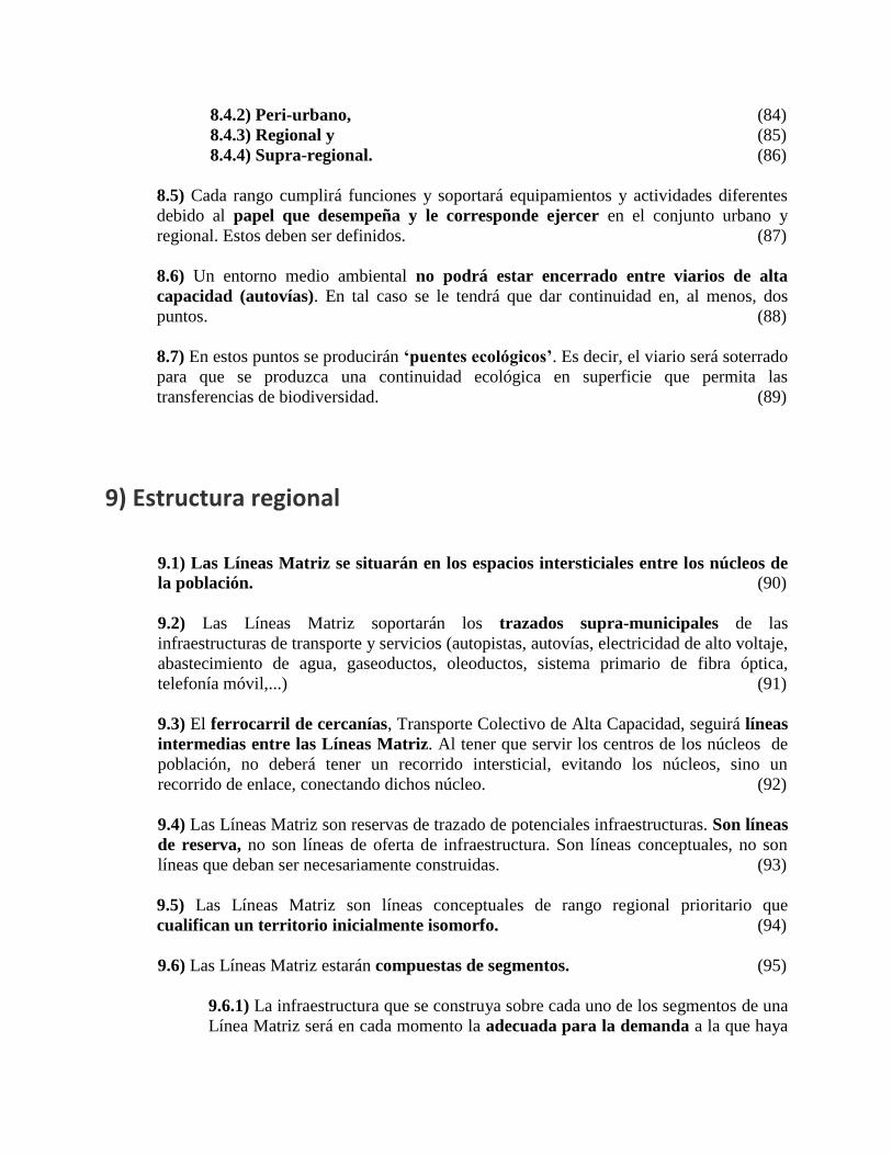
1) Estructura urbana
1.1) El territorio regional quedará ordenado en unidades municipales, la Manzana
Regional (01)
1.2) Cada Manzana Regional contendrá, salvo excepción, un núcleo urbano de
población. (02)
1.3) La Manzana Regional queda definida por los segmentos de Líneas Matriz que
conforman su perímetro. (03)
1.4) El núcleo de población de la Manzana Regional deberá quedar localizado lo mas
próximo posible a su centro. (04)
1.5) La Centralidad Cívica de la Manzana Regional (unidad municipal) se consigue
generando una sinergia por acumulación de “funciones de centralidad” urbana
complementarias: (05)
1.5.1) Estación o intercambiador modal de transportes (06)
1.5.2) Espacios cívicos de convivencia. (07)
1.5.3) Actividad comercial de tamaño pequeño y/o medio. (08)
1.5.4) Equipamientos Sociales. (09)
1.5.5) Niveles altos de densidad residencial (>40 viv/ha) (10)
1.5.6) Edificios Institucionales públicos. (11)
1.5.7) Elemento emblemático referente social. (12)
2) Residencial
2.1) Los nuevos desarrollos residenciales deberán tener un diseño de contigüidad que
alcance la integración urbana con el núcleo de población existente del casco urbano
consolidado. (13)
2.2) La localización de los nuevos desarrollos residenciales deberán localizarse lo más
próximos posibles a las estaciones de Transporte Colectivo de Alta Capacidad
(T.C.A.C), que a su vez adquirirán un carácter de centralidad urbana. (14)
2.3) No deberá haber desarrollos residenciales frente a las Líneas Matriz para evitar el
impacto medio ambiental y acústico que estas producen sobre la vivienda. (15)
2.4) Si el núcleo poblacional alcanza la Línea Matriz, la primera línea edificatoria, la
primera manzana urbana, deberá ser de usos empresariales, industriales o terciarios de
oficinas, para que sean estos los que absorban el impacto acústico de la Línea Matriz.
(16)
2.5) La integración urbana es un objetivo que se alcanza mediante: (17)
2.5.1) la conexión viaria, tanto de orden urbano como capilar, (18)
2.5.2) la localización articuladora de equipamientos cívicos y sociales. (19)
2.5.3) la continuidad residencial, que no sea segmentada por un sistema verde
transversal al eje de acceso al centro cívico. (20)
2.6) Densidades
2.6.1) Las densidades residenciales deberán ser mas altas en el centro del núcleo
(mas de 40 viv/ha). (21)
2.6.2) Las densidades residenciales deberán progresivamente ir disminuyendo
hacia la periferia. (Menos de 10 viv/ha) (22)
2.7.1) Diversidad
2.7.1) En cada Manzana Regional deberá estar representada toda la diversidad
tipológica, todos los regímenes, y la mayor amplitud del espectro de precios de
viviendas. (23)
2.7.2) En cada Manzana Regional se debe alcanzar una diversidad social y un
beneficioso efecto de integración, evitando la segregación territorial y la formación de
guetos. (24)
3) Equipamientos Sociales
3.1) Los equipamientos sociales se localizarán de forma diferente en función de su carácter
local o regional. (25)
3.2) Los equipamientos sociales de carácter local se localizarán bien en el interior, bien
en contigüidad, de la trama urbana residencial del núcleo de población. (26)
3.2.1) El déficit actual de equipamientos sociales en el núcleo deberán ser compensados
por los que aporten los nuevos desarrollos residenciales. (27)
3.2.2) Los equipamientos sociales de carácter local que requieren
fundamentalmente accesibilidad, se localizarán en el interior de la trama
urbana, en intersecciones urbanas de primer rango, reforzando el carácter de
centralidad cívica que poseen esos nudos. (28)
3.2.3) Los equipamientos sociales de carácter local que requieren espacios más
importantes para su desarrollo, se localizarán en contigüidad a los bordes
urbanos, entre la trama residencial del núcleo y los parques urbanos que penetran
intersticialmente desde los parques peri-urbanos hasta el centro histórico
consolidado. (29)
3.3) Los equipamientos sociales de carácter regional inter-municipal se localizarán en
la intersección de las Líneas Matriz con las líneas del sistema ferroviario, buscando la
doble accesibilidad regional viaria y ferroviaria. (30)
3.3.1) Los grandes equipamientos sociales de carácter regional, universidades,
grandes hospitales, ciudades deportivas, etc., tendrán un servicio ferroviario de
estación de cercanías. (31)
3.3.2) Los estacionamientos de los grandes equipamientos regionales estarán
dimensionados para que puedan ejercer complementariamente la función de
estacionamientos de conveniencia, para evitar el uso indiscriminado del vehículo
en el centro urbano. Las poblaciones que no estén directamente servidas por el
sistema de cercanías pueden utilizarlos por localizarse a lo largo de su recorrido
viario de acceso hasta el centro metropolitano. (32)
4) Actividades Comerciales
4.1) Los equipamientos comerciales se localizarán de forma diferente en función de su
carácter local o supra-local. (33)
4.2) Los equipamientos comerciales de carácter local, el pequeño y mediano comercio,
tendrán una localización interna a la trama urbana. (34)
4.2.1) Los equipamientos comerciales de carácter local cumplirán una función,
complementaria e interactiva, de refuerzo de las centralidades cívicas,
beneficiándose de sinergias mutuas. (35)
4.3) Los equipamientos comerciales de carácter supra-local, las grandes superficies
comerciales, se deberán localizar en la confluencia del sistema viario primario regional,
las Líneas Matriz, con el sistema viario secundario de acceso a las Manzanas. (36)
4.3.1) El impacto económico de los equipamientos comerciales de carácter supra-
local sobre la estructura comercial de las Manzanas afectadas por su radio de
influencia requiere un control y limitación de su tamaño, tipología y superficie.
(37)
4.3.2) Los equipamientos comerciales de carácter supra-local estarán
territorialmente repartidos de tal forma que se produzca un ratio equivalente de
metros cuadrados por habitante equilibrado en cada una de las Manzanas
Regionales. (38)
4.3.3) La recalificación del suelo para estos equipamientos llevará implícita la
reconversión del mismo, una vez definitivamente obsoletos y amortizados los
equipamientos comerciales, en suelos de equipamientos sociales de carácter peri-
urbano o supra-regional. (39)
5) Actividades Empresariales
5.1) Las actividades económicas y empresariales, tanto de carácter terciario de oficinas
como especialmente las industriales, por sus necesidades de accesibilidad y transporte de
carga, estarán localizadas paralelas a las vías regionales y directamente conectadas a
estas, las Líneas Matriz. (40)
5.2) Las Líneas Matriz estarán consustancialmente blindadas desde su creación a
interferencias de tráfico desde las actividades colindantes. (41)
5.3) Las actividades económicas y empresariales que no sean plenamente compatibles
con la actividad residencial, tanto en su impacto contaminante diario, como por sus
necesidades de accesibilidad y transporte de carga, deberán localizarse de forma
segregada. (42)
5.4) Localizaciones
5.4.1) Intersecciones Líneas Matriz con sistema ferroviario: Las empresas que
por su tamaño o por su producción, requieran un transporte pesado, tanto de tipo rodado
como ferroviario, se pueden localizar en los puntos de intersección del sistema
ferroviario con las Líneas Fuerza regionales. (43)
5.4.2) Intersecciones Líneas Matriz y sistema viario secundario: Serán las
localizaciones prioritarias, buscando una mayor accesibilidad, se encuentren más
próximas a los nudos de conexión del sistema viario secundario, interno a la Manzana,
con el sistema viario principal, las Líneas Fuerza regionales. (44)
5.4.3) Fachada Líneas Matriz: Los solares empresariales visibles desde las Líneas
Fuerza, debido a los importantes tráficos que estas vías soportarán, se convertirán en
localizaciones escaparate. Tendrán tendencia a alcanzar mayor valor y a ser utilizados
prioritariamente para actividades terciarias o para industrias escaparate. (45)
5.4.4) Fachadas a sistema viario secundario: El efecto escaparate que se produce
sobre las Líneas Matriz se reproducirá con carácter más local sobre las vías del sistema
secundario de acceso a los núcleos urbanos, siendo recomendadas para comercio y
servicios. (46)
5.4.5) Fachadas a sistema verde intersticial: Las fachadas interiores de las zonas
empresariales, las contrapuestas a las Líneas Matriz, solo adquirirán valor de localización
si se desarrollan los espacios verdes intersticiales de separación entre las zonas y los
núcleos de población de la Manzana. (47)
5.4.6) Intersecciones de Líneas Matriz
5.4.6.1) Los espacios próximos a los nudos de intersección de dos Líneas
Matriz, debido a su baja accesibilidad por carecer de conexiones o salidas
de carácter local, NO deberán ser localizaciones prioritarias para
actividades de alta intensidad. (48)
5.4.6.2) Los espacios próximos a los nudos de intersección de dos Líneas
Matriz serán espacios codiciados para actividades de alta intensidad
debido a su alta visualización. (49)
5.4.6.3) Los espacios próximos a los nudos de las Líneas Matriz son
puntos de intersecciones de infraestructuras de servicios, (agua, telefonía,
electricidad, etc). Son lugares adecuados para la localización de los
centros de control y distribución de estas redes. (50)
5.4.6.4) Por la fuerte visibilidad de los espacios próximos a los nudos de
las Líneas Matriz, es conveniente que los centros de control y distribución
de las infraestructuras asuman un carácter emblemático y de referente
colectivo, recibiendo un tratamiento arquitectónico acorde con este
carácter. (51)
6) Transportes Colectivos
Se distingue entre los transportes colectivos de alta capacidad, con marcado carácter regional, de
los transportes colectivos de baja/media capacidad, con un carácter más urbano. (52)
6.1) Sistemas de transportes colectivos Alta capacidad (TCAC)
6.1.1) Las líneas de trazado del Transporte Colectivo de Alta Capacidad (TCAC),
ferrocarril de cercanías y/o metro, conectarán los diversos núcleos de población
que se encuentren entre dos Líneas Matriz. (53)
6.1.2) Las estaciones de Transporte Colectivo de Alta Capacidad (TCAC),
cercanías o metro, tendrán dos localizaciones prioritarias: 6.1.2.1) en el núcleo residencial de la Manzana Regional. (54)
6.1.2.2) en la intersección con el viario de primer orden regional, las Líneas
Matriz. (55)
6.1.3) La estación de TCAC en el núcleo residencial de la Manzana Regional
tendrá dos localizaciones prioritarias: 6.1.3.1) en el centro del núcleo, y (56)
6.1.3.2) en el borde del núcleo. (57)
6.1.4) Centro de núcleo
6.1.4.1) La estación de TCAC en el centro del núcleo residencial
coincidirá con los espacios cívicos de centralidad. (58)
6.1.4.2) La estación de TCAC en el centro del núcleo se verá reforzada por
la acumulación de funciones urbanas de centralidad. (59)
6.1.5) Borde de núcleo
6.1.5.1) La estación de TCAC en borde del núcleo residencial deberá
aprovechar su potencial de centralidad para generar una centralidad urbana
que alimente, y se alimente, de futuros desarrollos residenciales
urbanos. (60)
6.1.5.2) En el entorno de las estaciones de TCAC debe producirse la
sinergia de una acumulación de funciones de centralidad (acceso, espacio
cívico, residencia, comercio, equipamiento social, institucional y
referencial) (61)
6.1.6) La estación de TCAC en la intersección con una Línea Matriz se deberá
establecer solamente en función de su servicio a un gran equipamiento de carácter
regional: universidad, hospital, ciudad deportiva, etc. (62)
6.1.7) Los nuevos trazados de transporte ferroviario se producirán en trinchera
para no seccionar irremediablemente el potencial de continuidad de la trama
urbana en superficie. (63)
6.2) Sistemas de transportes colectivos de Baja capacidad (TCBC)
6.2.1) Las cabeceras del sistema de Transporte Colectivo de Baja Capacidad
(TCBC), autobuses y taxis, deberán localizarse en las estaciones del sistema de
alta capacidad. (64)
6.2.2) El recorrido de las líneas de TCBC podrán hacerse de dos formas: 6.2.2.1) en bucle interno a la manzana regional. (65)
6.2.2.2) abierta entre dos o varias manzanas regionales. (66)
6.2.2) El recorrido en bucle del TCBC tendrá origen y destino en el mismo
intercambiador modal. (67)
6.2.3) El recorrido abierto del TCBC tendrá origen y destino en dos
intercambiadores modales distintos. (68)
6.2.4) Los sistemas de Alta y Baja Capacidad trabajaran de manera
complementaria. (69)
6.2.4.1) La complementariedad entre Baja y Alta Capacidad podrá ser por
prolongación, cuando la demanda no alcanza los umbrales de viabilidad
del TCAC. (70)
6.2.4.2) La complementariedad entre Baja y Alta Capacidad podrá ser por
inter-conexión, para crear relaciones perpendiculares y transversales entre
las diversas líneas de TCAC. (71)
6.2.4.3) La complementariedad entre Baja y Alta Capacidad podrá ser por
superposición de trazado, para pormenorizar la accesibilidad local con
una mayor frecuencia de paradas. (72)
6.2.5) La modalidad de Transporte Colectivo de Baja Capacidad, (taxi, microbús,
autobús, autobús guiado, tranvía) se seleccionará en función de los umbrales de
eficacia de cada sistema. (73)
7) Viario
7.1) El sistema viario de primer rango, las Líneas Matriz, estará protegido a lo largo de todo
su recorrido. (74)
7.2) El sistema viario secundario establece la accesibilidad entre los núcleos urbanos
de las Manzanas y el sistema viario de primer rango, la retícula regional de Líneas
Matriz. (75)
7.3) El sistema viario terciario dará servicio al interior de la trama urbana. Estará compuesto
por la “red” del sistema arterial urbano de rango superior. (76)
7.4) El sistema viario cuaternario estará compuesto por el sistema capilar de
accesibilidad interna de carácter local. (77)
7.5) Cada una de las tipologías tendrán un perfil y unas características tipológicas
propias. (78)
8) Medio Ambiente
8.1) La estructura regional de parques superará el concepto básico de una simple
protección del patrimonio medio ambiental. Incorporará el concepto de incremento de
capital fijo medio ambiental mediante la inversión en creación de patrimonio. No
solo protegerá, creará patrimonio medio-ambiental. (79)
8.2) El sistema medio ambiental, etológico, de la región tendrá por objetivo la
continuidad espacial desde los espacios de rango supra-regional hasta los de rango
urbano. (80)
8.3) El sistema de espacios verdes debe evitar la confluencia y compactación de las
zonas urbanas en expansión. El objetivo del sistema medio ambiental continuo, además
de por razones internas de continuidad de los flujos territoriales de la biodiversidad,
tiene por objetivo evitar la convergencia de las diversas zonas urbanas alcanzando una
conurbación continua que no permite la localización de las infraestructuras, y
equipamientos sociales regionales necesarias así como un esponjamiento territorial
sostenible. (81)
8.4) El sistema medioambiental regional se compone de espacios de diverso rango,
especialización y caracterización: (82)
8.4.1) Urbano, (83)
8.4.2) Peri-urbano, (84)
8.4.3) Regional y (85)
8.4.4) Supra-regional. (86)
8.5) Cada rango cumplirá funciones y soportará equipamientos y actividades diferentes
debido al papel que desempeña y le corresponde ejercer en el conjunto urbano y
regional. Estos deben ser definidos. (87)
8.6) Un entorno medio ambiental no podrá estar encerrado entre viarios de alta
capacidad (autovías). En tal caso se le tendrá que dar continuidad en, al menos, dos
puntos. (88)
8.7) En estos puntos se producirán ‘puentes ecológicos’. Es decir, el viario será soterrado
para que se produzca una continuidad ecológica en superficie que permita las
transferencias de biodiversidad. (89)
9) Estructura regional
9.1) Las Líneas Matriz se situarán en los espacios intersticiales entre los núcleos de
la población. (90)
9.2) Las Líneas Matriz soportarán los trazados supra-municipales de las
infraestructuras de transporte y servicios (autopistas, autovías, electricidad de alto voltaje,
abastecimiento de agua, gaseoductos, oleoductos, sistema primario de fibra óptica,
telefonía móvil,...) (91)
9.3) El ferrocarril de cercanías, Transporte Colectivo de Alta Capacidad, seguirá líneas
intermedias entre las Líneas Matriz. Al tener que servir los centros de los núcleos de
población, no deberá tener un recorrido intersticial, evitando los núcleos, sino un
recorrido de enlace, conectando dichos núcleo. (92)
9.4) Las Líneas Matriz son reservas de trazado de potenciales infraestructuras. Son líneas
de reserva, no son líneas de oferta de infraestructura. Son líneas conceptuales, no son
líneas que deban ser necesariamente construidas. (93)
9.5) Las Líneas Matriz son líneas conceptuales de rango regional prioritario que
cualifican un territorio inicialmente isomorfo. (94)
9.6) Las Líneas Matriz estarán compuestas de segmentos. (95)
9.6.1) La infraestructura que se construya sobre cada uno de los segmentos de una
Línea Matriz será en cada momento la adecuada para la demanda a la que haya
de satisfacer. (96)
9.6.2) Si no existe demanda no será necesario construirla, salvo que exista una
política de inducción a la demanda por razones estratégicas. (97)
9.6.3) Si la Línea Matriz en alguno de sus segmentos atraviesa un espacio de alto
valor medio ambiental, o ecológico, no deberá soportar ninguna infraestructura
que pueda dañar esos valores. (98)
9.6.4) Las Líneas Matriz deberán evitar aquellos segmentos urbanos que puedan
atravesar y dañar zonas consolidadas que no deben soportar una compleja
intervención de cirugía, dolorosa social y económicamente. (99)
Sistema verde intersticial
La Manzana Regional
Crecimientos urbanos
Industria pesada
acceso ferroviario
Grandes equipamientos regionales
Comercial
periférico
Crecimientos empresariales
Desarrollo segmentos
Líneas FuerzaRedes y Centros de
Infraestructuras
Localización
Industrial
Sistema viario
Primario y SecundarioCentralidad urbana
Equipamientos
Nuevos crecimientos
Tren Cercanías
Núcleo y accesibilidad histórica
Cundinamarca, 06 de Junio de 2010

EPÍLOGO
- Ejemplos de aplicación de “La Carta de Ciudad Región” a algunos casos municipales del
ámbito de la Sabana de Cundinamarca
- Los resultados de la aplicación de los lineamientos y principios a cada uno de los
territorios de ejemplo requiere una argumentación del proceso y de las conclusiones que
no están incorporados al presente Epílogo. Los mismos pueden y deben ser debatidos,
uno a uno, con cada uno de los municipios y con sus responsables municipales para
incorporar aspectos específicos y pormenorizados que pueden requerir una adaptación o
flexibilización de las propuestas.
- Los ejemplos se aportan para explicitar dicha flexibilidad en el proceso de aplicación, así
como para ilustrar la riqueza de soluciones. Se produce un beneficio general
metropolitano regional al alcanzar el territorio una estructura de diversidad dentro de la
homogeneidad. Se alcanza con ello una racionalidad en la asignación de localizaciones
para los usos del suelo tanto al nivel del ámbito regional como en el ámbito municipal
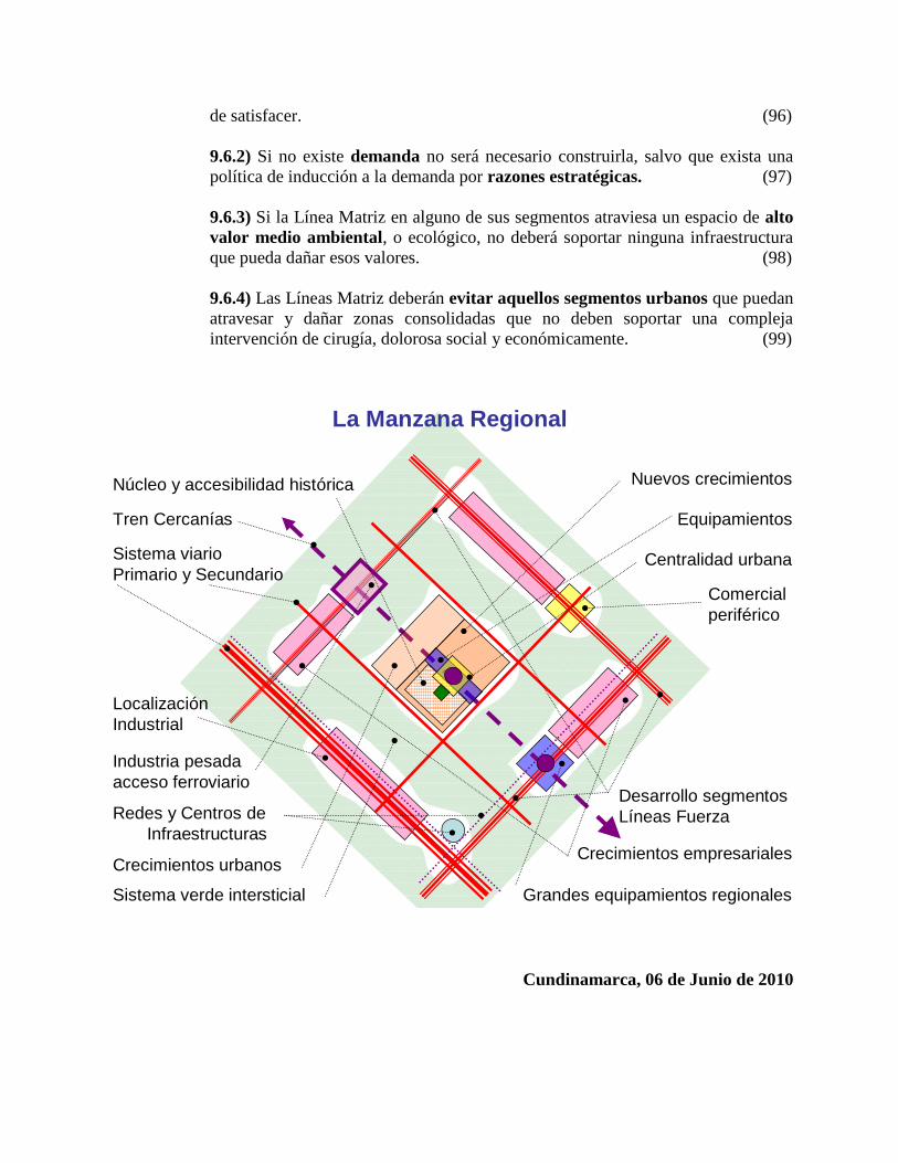
Ejemplo: Facatativá
Ejemplo: Funza, Mosquera y Madrid
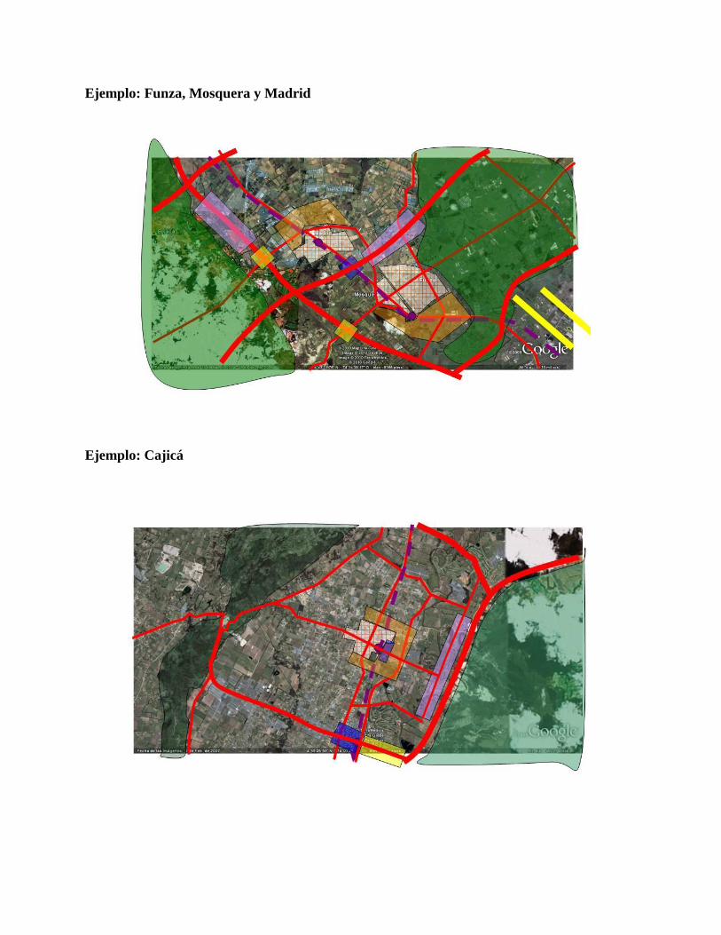
Ejemplo: Cajicá