Accumulation trend of heavy metals in the surfacial sediments ...
13
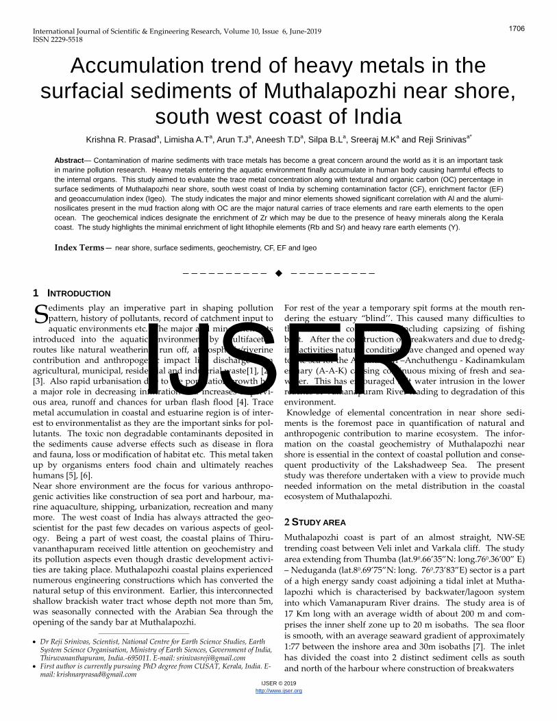
International Journal of Scientific & Engineering Research, Volume 10, Issue 6, June-2019 ISSN 2229-5518 IJSER © 2019 http://www.ijser.org Accumulation trend of heavy metals in the surfacial sediments of Muthalapozhi near shore, south west coast of India Krishna R. Prasad a , Limisha A.T a , Arun T.J a , Aneesh T.D a , Silpa B.L a , Sreeraj M.K a and Reji Srinivas a* Abstract— Contamination of marine sediments with trace metals has become a great concern around the world as it is an important task in marine pollution research. Heavy metals entering the aquatic environment finally accumulate in human body causing harmful effects to the internal organs. This study aimed to evaluate the trace metal concentration along with textural and organic carbon (OC) percentage in surface sediments of Muthalapozhi near shore, south west coast of India by scheming contamination factor (CF), enrichment factor (EF) and geoaccumulation index (Igeo). The study indicates the major and minor elements showed significant correlation with Al and the alumi- nosilicates present in the mud fraction along with OC are the major natural carries of trace elements and rare earth elements to the open ocean. The geochemical indices designate the enrichment of Zr which may be due to the presence of heavy minerals along the Kerala coast. The study highlights the minimal enrichment of light lithophile elements (Rb and Sr) and heavy rare earth elements (Y). Index Terms— near shore, surface sediments, geochemistry, CF, EF and Igeo —————————— —————————— 1 INTRODUCTION ediments play an imperative part in shaping pollution pattern, history of pollutants, record of catchment input to aquatic environments etc. The major and minor elements introduced into the aquatic environment by multifaceted routes like natural weathering, run off, atmospheric/riverine contribution and anthropogenic impact like discharge from agricultural, municipal, residential and industrial waste[1], [2], [3]. Also rapid urbanisation due to the population growth has a major role in decreasing infiltration and increases impervi- ous area, runoff and chances for urban flash flood [4]. Trace metal accumulation in coastal and estuarine region is of inter- est to environmentalist as they are the important sinks for pol- lutants. The toxic non degradable contaminants deposited in the sediments cause adverse effects such as disease in flora and fauna, loss or modification of habitat etc. This metal taken up by organisms enters food chain and ultimately reaches humans [5], [6]. Near shore environment are the focus for various anthropo- genic activities like construction of sea port and harbour, ma- rine aquaculture, shipping, urbanization, recreation and many more. The west coast of India has always attracted the geo- scientist for the past few decades on various aspects of geol- ogy. Being a part of west coast, the coastal plains of Thiru- vananthapuram received little attention on geochemistry and its pollution aspects even though drastic development activi- ties are taking place. Muthalapozhi coastal plains experienced numerous engineering constructions which has converted the natural setup of this environment. Earlier, this interconnected shallow brackish water tract whose depth not more than 5m, was seasonally connected with the Arabian Sea through the opening of the sandy bar at Muthalapozhi. ———————————————— Dr Reji Srinivas, Scientist, National Centre for Earth Science Studies, Earth System Science Organisation, Ministry of Earth Siences, Government of India, Thiruvananthapuram, India.-695011. E-mail: [email protected] First author is currently pursuing PhD degree from CUSAT, Kerala, India. E- mail: [email protected] For rest of the year a temporary spit forms at the mouth ren- dering the estuary ‚blind’’. This caused many difficulties to the fisherman communities including capsizing of fishing boat. After the construction of breakwaters and due to dredg- ing activities natural condition have changed and opened way to the sea for the Akathumuri –Anchuthengu - Kadinamkulam estuary (A-A-K) causing continuous mixing of fresh and sea- water. This has encouraged salt water intrusion in the lower reaches of Vamanapuram River leading to degradation of this environment. Knowledge of elemental concentration in near shore sedi- ments is the foremost pace in quantification of natural and anthropogenic contribution to marine ecosystem. The infor- mation on the coastal geochemistry of Muthalapozhi near shore is essential in the context of coastal pollution and conse- quent productivity of the Lakshadweep Sea. The present study was therefore undertaken with a view to provide much needed information on the metal distribution in the coastal ecosystem of Muthalapozhi. 2 STUDY AREA Muthalapozhi coast is part of an almost straight, NW-SE trending coast between Veli inlet and Varkala cliff. The study area extending from Thumba (lat.9 0 .66’35‛N: long.76 0 .36’00‛ E) – Neduganda (lat.8 0 .69’75‛N: long. 76 0 .73’83‛E) sector is a part of a high energy sandy coast adjoining a tidal inlet at Mutha- lapozhi which is characterised by backwater/lagoon system into which Vamanapuram River drains. The study area is of 17 Km long with an average width of about 200 m and com- prises the inner shelf zone up to 20 m isobaths. The sea floor is smooth, with an average seaward gradient of approximately 1:77 between the inshore area and 30m isobaths [7]. The inlet has divided the coast into 2 distinct sediment cells as south and north of the harbour where construction of breakwaters S 1706 IJSER
-
Upload
khangminh22 -
Category
Documents
-
view
0 -
download
0
Transcript of Accumulation trend of heavy metals in the surfacial sediments ...
International Journal of Scientific & Engineering Research, Volume 10, Issue 6, June-2019 ISSN 2229-5518
IJSER © 2019http://www.ijser.org
Accumulation trend of heavy metals in the surfacial sediments of Muthalapozhi near shore,
south west coast of India Krishna R. Prasad
a, Limisha A.T
a, Arun T.J
a, Aneesh T.D
a, Silpa B.L
a, Sreeraj M.K
a and Reji Srinivas
a*
Abstract— Contamination of marine sediments with trace metals has become a great concern around the world as it is an important task
in marine pollution research. Heavy metals entering the aquatic environment finally accumulate in human body causing harmful effects to
the internal organs. This study aimed to evaluate the trace metal concentration along with textural and organic carbon (OC) percentage in
surface sediments of Muthalapozhi near shore, south west coast of India by scheming contamination factor (CF), enrichment factor (EF)
and geoaccumulation index (Igeo). The study indicates the major and minor elements showed significant correlation with Al and the alumi-
nosilicates present in the mud fraction along with OC are the major natural carries of trace elements and rare earth elements to the open
ocean. The geochemical indices designate the enrichment of Zr which may be due to the presence of heavy minerals along the Kerala
coast. The study highlights the minimal enrichment of light lithophile elements (Rb and Sr) and heavy rare earth elements (Y).
Index Terms— near shore, surface sediments, geochemistry, CF, EF and Igeo
—————————— ——————————
1 INTRODUCTION
ediments play an imperative part in shaping pollution pattern, history of pollutants, record of catchment input toaquatic environments etc. The major and minor elements
introduced into the aquatic environment by multifaceted routes like natural weathering, run off, atmospheric/riverine contribution and anthropogenic impact like discharge from agricultural, municipal, residential and industrial waste[1], [2], [3]. Also rapid urbanisation due to the population growth has a major role in decreasing infiltration and increases impervi-ous area, runoff and chances for urban flash flood [4]. Trace metal accumulation in coastal and estuarine region is of inter-est to environmentalist as they are the important sinks for pol-lutants. The toxic non degradable contaminants deposited in the sediments cause adverse effects such as disease in flora and fauna, loss or modification of habitat etc. This metal taken up by organisms enters food chain and ultimately reaches humans [5], [6]. Near shore environment are the focus for various anthropo-genic activities like construction of sea port and harbour, ma-rine aquaculture, shipping, urbanization, recreation and many more. The west coast of India has always attracted the geo-scientist for the past few decades on various aspects of geol-ogy. Being a part of west coast, the coastal plains of Thiru-vananthapuram received little attention on geochemistry and its pollution aspects even though drastic development activi-ties are taking place. Muthalapozhi coastal plains experienced numerous engineering constructions which has converted the natural setup of this environment. Earlier, this interconnected shallow brackish water tract whose depth not more than 5m, was seasonally connected with the Arabian Sea through the opening of the sandy bar at Muthalapozhi.
————————————————
Dr Reji Srinivas, Scientist, National Centre for Earth Science Studies, EarthSystem Science Organisation, Ministry of Earth Siences, Government of India,Thiruvananthapuram, India.-695011. E-mail: [email protected]
First author is currently pursuing PhD degree from CUSAT, Kerala, India. E-mail: [email protected]
For rest of the year a temporary spit forms at the mouth ren-dering the estuary ‚blind’’. This caused many difficulties to the fisherman communities including capsizing of fishing boat. After the construction of breakwaters and due to dredg-ing activities natural condition have changed and opened way to the sea for the Akathumuri –Anchuthengu - Kadinamkulam estuary (A-A-K) causing continuous mixing of fresh and sea-water. This has encouraged salt water intrusion in the lower reaches of Vamanapuram River leading to degradation of this environment. Knowledge of elemental concentration in near shore sedi-ments is the foremost pace in quantification of natural and anthropogenic contribution to marine ecosystem. The infor-mation on the coastal geochemistry of Muthalapozhi near shore is essential in the context of coastal pollution and conse-quent productivity of the Lakshadweep Sea. The present study was therefore undertaken with a view to provide much needed information on the metal distribution in the coastal ecosystem of Muthalapozhi.
2 STUDY AREA
Muthalapozhi coast is part of an almost straight, NW-SE trending coast between Veli inlet and Varkala cliff. The study area extending from Thumba (lat.90.66’35‛N: long.760.36’00‛ E) – Neduganda (lat.80.69’75‛N: long. 760.73’83‛E) sector is a partof a high energy sandy coast adjoining a tidal inlet at Mutha-lapozhi which is characterised by backwater/lagoon system into which Vamanapuram River drains. The study area is of 17 Km long with an average width of about 200 m and com-prises the inner shelf zone up to 20 m isobaths. The sea floor is smooth, with an average seaward gradient of approximately 1:77 between the inshore area and 30m isobaths [7]. The inlet has divided the coast into 2 distinct sediment cells as south and north of the harbour where construction of breakwaters
S
1706
IJSER
International Journal of Scientific & Engineering Research, Volume 10, Issue 6, June-2019 ISSN 2229-5518
IJSER © 2019http://www .ijser.org
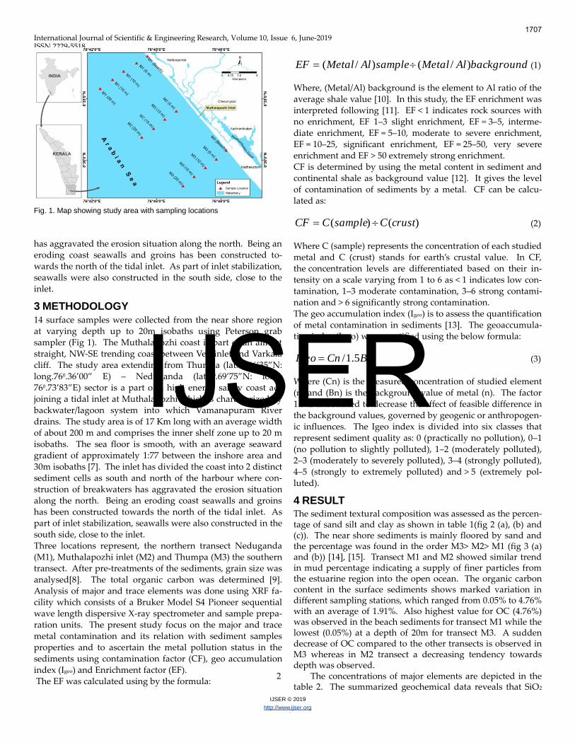
Fig. 1. Map showing study area with sampling locations
has aggravated the erosion situation along the north. Being an eroding coast seawalls and groins has been constructed to-wards the north of the tidal inlet. As part of inlet stabilization, seawalls were also constructed in the south side, close to the inlet.
3 METHODOLOGY
14 surface samples were collected from the near shore region at varying depth up to 20m isobaths using Peterson grab sampler (Fig 1). The Muthalapozhi coast is part of an almost straight, NW-SE trending coast between Veli inlet and Varkala cliff. The study area extending from Thumba (lat.90.66’35‛N: long.760.36’00‛ E) – Neduganda (lat.80.69’75‛N: long. 760.73’83‛E) sector is a part of a high energy sandy coast ad-joining a tidal inlet at Muthalapozhi which is characterized by backwater/lagoon system into which Vamanapuram River drains. The study area is of 17 Km long with an average width of about 200 m and comprises the inner shelf zone up to 20 m isobaths. The sea floor is smooth, with an average seaward gradient of approximately 1:77 between the inshore area and 30m isobaths [7]. The inlet has divided the coast into 2 distinct sediment cells as south and north of the harbour where con-struction of breakwaters has aggravated the erosion situation along the north. Being an eroding coast seawalls and groins has been constructed towards the north of the tidal inlet. As part of inlet stabilization, seawalls were also constructed in the south side, close to the inlet. Three locations represent, the northern transect Neduganda (M1), Muthalapozhi inlet (M2) and Thumpa (M3) the southern transect. After pre-treatments of the sediments, grain size was analysed[8]. The total organic carbon was determined [9]. Analysis of major and trace elements was done using XRF fa-cility which consists of a Bruker Model S4 Pioneer sequential wave length dispersive X-ray spectrometer and sample prepa-ration units. The present study focus on the major and trace metal contamination and its relation with sediment samples properties and to ascertain the metal pollution status in the sediments using contamination factor (CF), geo accumulation index (Igeo) and Enrichment factor (EF). The EF was calculated using by the formula:
backgroundAlMetalsampleAlMetalEF )/()/( (1)
Where, (Metal/Al) background is the element to Al ratio of the average shale value [10]. In this study, the EF enrichment was interpreted following [11]. EF < 1 indicates rock sources with no enrichment, EF 1–3 slight enrichment, EF = 3–5, interme-diate enrichment, EF = 5–10, moderate to severe enrichment, EF = 10–25, significant enrichment, EF = 25–50, very severe enrichment and EF > 50 extremely strong enrichment. CF is determined by using the metal content in sediment and continental shale as background value [12]. It gives the level of contamination of sediments by a metal. CF can be calcu-lated as:
)()( crustCsampleCCF (2)
Where C (sample) represents the concentration of each studied metal and C (crust) stands for earth’s crustal value. In CF, the concentration levels are differentiated based on their in-tensity on a scale varying from 1 to 6 as < 1 indicates low con-tamination, 1–3 moderate contamination, 3–6 strong contami-nation and > 6 significantly strong contamination. The geo accumulation index (Igeo) is to assess the quantification of metal contamination in sediments [13]. The geoaccumula-tion index (Igeo) was quantified using the below formula:
BnCnIgeo 5.1/ (3)
Where (Cn) is the measured concentration of studied element (n) and (Bn) is the background value of metal (n). The factor 1.5 is introduced to decrease the effect of feasible difference in the background values, governed by geogenic or anthropogen-ic influences. The Igeo index is divided into six classes that represent sediment quality as: 0 (practically no pollution), 0–1 (no pollution to slightly polluted), 1–2 (moderately polluted), 2–3 (moderately to severely polluted), 3–4 (strongly polluted), 4–5 (strongly to extremely polluted) and > 5 (extremely pol-luted).
4 RESULT
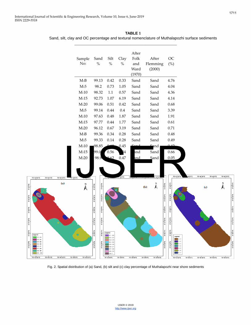
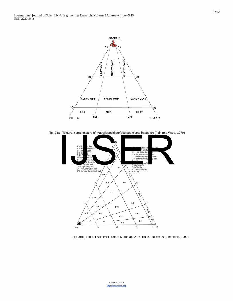
The sediment textural composition was assessed as the percen-tage of sand silt and clay as shown in table 1(fig 2 (a), (b) and (c)). The near shore sediments is mainly floored by sand and the percentage was found in the order M3> M2> M1 (fig 3 (a) and (b)) [14], [15]. Transect M1 and M2 showed similar trend in mud percentage indicating a supply of finer particles from the estuarine region into the open ocean. The organic carbon content in the surface sediments shows marked variation in different sampling stations, which ranged from 0.05% to 4.76% with an average of 1.91%. Also highest value for OC (4.76%) was observed in the beach sediments for transect M1 while the lowest (0.05%) at a depth of 20m for transect M3. A sudden decrease of OC compared to the other transects is observed in M3 whereas in M2 transect a decreasing tendency towards depth was observed.
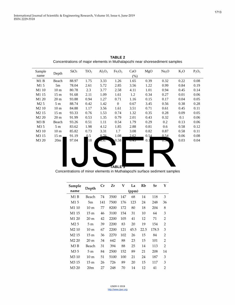
2 The concentrations of major elements are depicted in the table 2. The summarized geochemical data reveals that SiO2
1707
IJSER
International Journal of Scientific & Engineering Research, Volume 10, Issue 6, June-2019 ISSN 2229-5518
IJSER © 2019http://www .ijser.org
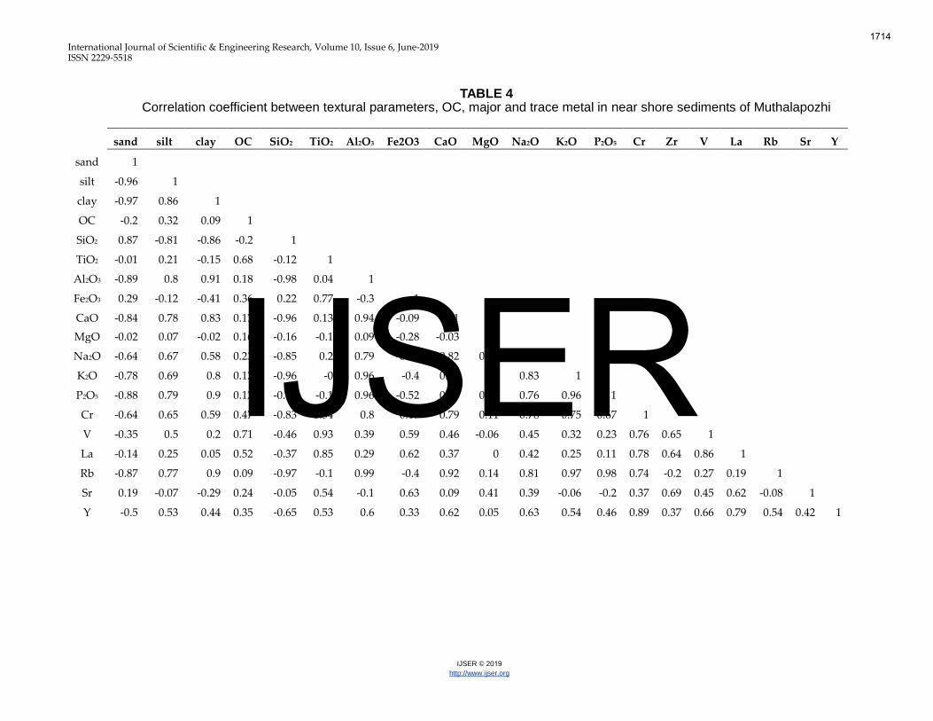
constitutes 85% of the oxides followed by Al2O3, FeO, CaO and TiO2. Other than SiO2, TiO2 and CaO are greater in near shore samples when compared to shale value. The highest average for SiO2 was shows in the southern transect M3 (90.19%) which also coincides with the percentage of sand in this sector. The M1 transects shows highest average value for TiO2 (1.94%) than the other two. The lower content of calcium was noticed in the bar mouth, transect M2 (1.88%) which can be attributed to the effects of turbulence of the tidal flow which hamper the growth of organism. The other two transect showed similar trend. Among the transition trace metals V, Cr and Zr (table 3), Zr shows higher concentration than average shale value in all the sampling locations, with an overall average of 2912 ppm and a maximum average concentration of 49000 ppm for tran sect M1. V exceeds the limit only in M1, where as Cr is within the limits. Large ion lithophile elements (LILE) like Rb and Sr are within the average shale limits, but a sudden increase in Sr concentrations was noticed in all the three transect at a depth of 5 and 10m. A similar pattern was shown by Light Rare Earth Element (LREE) La also. As shown in table 4 the elemen-tal correlation suggests that a positive correlation of Si with sand and negative correlation with all other elements. Al shows positive correlation with silt, clay, Ca, Na, K and P and with trace elements like Cr, Rb, Y. Fe is having good correla-tion with Ti, Zr, V, La and Sr. Silt and clay showed good corre-lation with Al, Ca, Na, K, P, Cr and Rb whereas OC shows pos-itive correlation with Ti, V and La only. Rb is showing good correlation with mud, Al, Ca, Na, K. P and Cr while elements like La, Rb, Sr and Y are having good correlation among them-selves.
4.1 Enrichment Factor, Contamination Factor & Geo accumulation Index
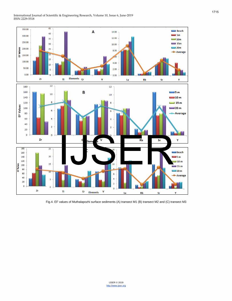
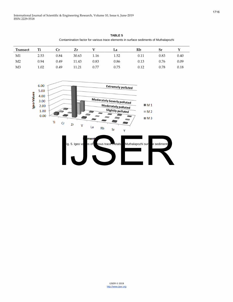
The enrichment factor (EF) generally helps us to decide the amount of trace element pollution anthropogenically sourced in an environment. Various metals including Fe, Al, K are ap-plied as normalizing elements to diminish the deviation go-verned by the sediments. In the present study EF (fig 4) calcu-lated for the trace elements depicts that Zr shows extremely strong enrichment for all the transects. Ti shows significant enrichment for M1 and moderate to severe for M2 and M3, while the condition reverses for V showing significant enrichment in M3. Similarly Cr and Sr shows moderate enrichment for M2 and M1 transect respectively and moderate to severe enrichment for other two transect. La showed mod-erate to severe enrichment for all transects. EF is in the order of Zr>Ti>La>V>Cr>Sr>Y>Rb for M1, Zr>Ti>V>Sr>La>Cr>Rb>Y for M2 and Zr>V>Ti>Sr>La>Cr>Y>Rb for M3. To study and evaluate environment pollution using a single parameter, the contamination factor (CF) acts as a fundamen-tal indicator for the sediment. In the present study CF ranges form 0.23-2.58 for Ti, 0.29-1.5 for Cr, 31.88- 1.55 for Zr, 0.54-1.17 for V, 0.31-1.98 for La, and 0.09-0.53 for Rb. The average CF for Zr shows nearly three time higher for transect M1 and nearly twice higher for the other two transect. Cr, Rb, Sr and Y shows low contamination for all the three transect and Ti, V and La shows moderate for M1 transect and low for the other two transects (table 5). The calculated Igeo values (fig 5) is in accordance with the CF values for Zr showing extreme status
in transect M1, moderate to strong values (2-3) in transect M2 and M3. All the other studied elements show slight pollution.
5 DISCUSSIONSediments are final destination of trace metals which are the potentially excellent gauges of the state of environment. The accumulation of metal into the sediments occurs as a result of adsorption, desorption, precipitation, diffusion processes, chemical processes, biological activity and amalgamation of these phenomena [16]. Once they are discharged into estu-aries and coastal water, there fortune is controlled by the re-dox potential in the sediment water interface present in the biological systems [17]. The origin of major part of these se-diments in such environment is from terrestrial input and also a considerable amount was incorporated by adsorption and other process [18]. The higher percentage of sand in the near shore area may be due to the current from the abrasion zone which transport the finer particles and prevent them from settling [19]. The sedi-ments have >90% of sand suggests the relict nature of the se-diment, probably the part of paleo shoreline. The presence of relict sediments at seaward stations suggests the modern de-trital sediments from land that are probably trapped by the Akathumuri-Anchuthengu-Kadinamkulam estuary thereby detrital sediments that escape from these marginal body may spread as a continuous blanket across the inner shelf. Steep bathymetry and winnowing action of waves may also contri-bute higher concentration of sand in the area. The long shore currents flowing towards the north and constant flushing ac-tivity of tide along with the impact of wave, remove finer frac-tions. The construction of breakwater caused deposition in the south and accelerated erosion the northern side of the Mutha-lapozhi inlet. The sand percentage reported for Adimalathura to Kovalam sector was 89.9 to 99.7% [7]. Also the Poovar – Varkala sector shows steep gradient with medium size grains indicating a high energy coast [20], [7]. The distribution of OC mainly depend of the sediment grain size, hydrodynamic process, rate of supply of sediment, rate of deposition and primary productivity [21], [22], [23]. The en-hancement of organic carbon in fine-grained sediments is also due to the correspondence in sinking and performance of finer particles and organic matter [24]. Also organic residue ap-pears to be subsided more in the surface by percolation process. The higher contribution of organic carbon and lower percentage of sand in the northern transect (M1) may be due to increased input from agriculture activities and inflow of organic rich waste form the established hinterland tourist and pilgrimage centre Varkala. Earlier it was reported that a calm environment for the Neduganda region as it falls in the sha-dow region of the Varkala Cliff and also due to the construc-tion of groin north of Nedunganda [7]. Increased organic con-tent in sediments is also produced by hydro carbon oxidizing bacteria which enhance biological productivity from the land discharge. Similar observations were reported for Visakha-patnam coastal sediments, Cochin and Chettuva coast of Kera-la [25, 26]. The lower organic content in transect M3 can be owing to the diffusion of free oxygen and oxidising salts in the coarse sediments of the sub surface which support the eradica-
1708
IJSER
International Journal of Scientific & Engineering Research, Volume 10, Issue 6, June-2019 ISSN 2229-5518
IJSER © 2019http://www.ijser.org
tion of organic matter [27]. Also the coarser nature of the se-diments along with soaring tidal activity supports poor absor-bability of organics [28]. The lower percentage of OC in tran-sect M3 is in well accordance with the reported values for Adimalathura to Kovalam (0.1 – 0.8%), which lies further south of this transect [29]. The abundance of SiO2 and Al2O3 suggest felsic composition for the source rock in the provenance [30]. The calcium values obtained are a function of carbonate and non-carbonate since the chemical analysis was performed on bulk sediment. In the tropical warm waters organisms separate CaCO3 by precipita-tion and extraction [31]. The calcium carbonates and non car-bonates are principally originating from fish bones and other biogenic debris in marine sediments in the form of calcium phosphate and in plagioclase [32]. The ratio between K2O and Al2O3 are used to represent ancient sediment composition. Its ratio for clay is <0.3 and for feldspar ranges from 0.3 to 0.9. In the present study, ratio for the near shore samples ranges from 0.01 to 0.27, indicating weak influence of clay in the surface sediments [33]. Higher percentage of TiO2 is due to the pres-ence of heavy minerals along the Kerala coast. Ilmenite and rutile are the important Ti bearing heavy minerals present in the west coast of India. Similar reason was explained for Co-chin estuary and Thengapattanam estuary [34], [35]. Zr is considered as High Field Strength Element due to their resistant to weathering in alteration process. The high concen-tration of Zr in the study area is due to the heavy mineral con-tent in the beach sands of the area. The study area is adjacent to the largest heavy mineral deposit of Chavara where the heavy minerals include ilmenite (35-64%), zircon (2-17%), sil-limanite (4-9%), rutile (2-11%), monazite (1-2%) and leucoxene (1-2%) [36]. The heavy mineral concentration results from the hinter land geology, laterization of gneissose rocks, presence of small streams and the sorting by waves and tides. The provenance for the placer minerals of south west coast of India are from the charnockite and khondalite and gneissic rocks [37], [38]. Factors like cliffs, shore processes; long shore cur-rents etc. are responsible for the concentration of modern beach placers along Kerala coast [39]. The geochemical beha-viour of Cr in sediment is controlled by its two-oxidation states Cr (Ill) and Cr (IV). Under oxic condition Cr (IV) is the dominant species and is more soluble and mobile where as Cr (Ill) which usually occur in reduced condition is not only less mobile but also rather insoluble and therefore strongly ab-sorbed by organic matter. Chromium (IV) is the most toxic form for bacteria, plants and animals, after release in the pore waters they migrate downward into the reducing zone and precipitations again as Cr (OH)2 [40], [41]. Minerals like Ca, Mg, Mn, Ni, Co, Cu and Zn decreases during the weathering process of Illmenite while, two elements like Cr and V increase [42]. The increase in Sr concentration along particular depth of 5 and 10m may perhaps due to the increase in biogenic car-bonates [43]. Sr in marine sediments is linked to the carbonate phase and particularly in the skeletons of foraminifera, cocco-liths, corals and sponges. The anthropogenic sources for Sr are due to industrial and waste disposal including hazardous ra-dioactive waste. The natural Sr concentration in soil is 0.2 mg/Kg. The Sr concentration reported for the soil samples
from inhabited areas of near KMML, Chavara, Kollam ranged from 138 – 524ppm which is in accordance with the present study [44]. Y is also a High Field Strength element of the group III A and considered as REE due to their similarity in chemistry as that of REE. Highest concentration of Y can be observed in monazite on the beach sands. Higher concentra-tion of REE was reported in the inner shelf from Ponnani to Vizhinjam > 200 mg/kg and this sector show highest concen-tration of La which ranges between 1.08 to 78.57 mg/Kg [45]. The sources reported for the concentration of LREE are detrital monazite, apatite and sphene in the heavy minerals. The enrichment of LREE reflects the abundance of REE in conti-nental crust whereas the enrichment of HREE reflects the abili-ty of these elements to form soluble complex. During the transport of REE from estuaries to ocean half of the dissolved rare earth elements gets removed through adsorption by mi-croorganisms and by co-precipitation with oxyhydroxides [46], [47], [48], [49]. There is a negative correlation between Si and Al which indi-cates predominance of weathering and also the ratio between them provide an estimation of textural maturity. The smaller ratio implies smaller sedimentary cycle, and decrease in the grain size [50]. The positive correlation of Si with sand and negative correlations with almost all of the other metals sug-gests dilution of trace metals by sandy detrital sediments [51]. The positive correlation of Al and Fe with majority of the stu-died elements may be due to the similar redox condition which helps in incorporation and adsorption on to their oxides. These correlations suggest same origin for the studied metals. Al is extremely immobile and held in lattice of allumi-nosilicates minerals. The negative correlation between Al and Fe shows less control of clay which is evident from the textural parameters of the study area. The good correlation between Al and K indicates their origin from the weathering of parent rock in the source area. The positive correlation of Ti with Fe and Zr usually relates to silicate components of terrestrial ori-gin and that the source of titanium might have been fixed by hydrous ferric oxide. These minerals are considered as indica-tors of high energy deposition zones [10], [52]. The study in-dicates that even though the area is having coarse grained tex-ture, the major and minor elements showed significant corre-lation with Al, Fe and OC. The sediment chemical composi-tion, grain size and distribution of organic carbon appreciably force the distribution of heavy metals in the nearshore envi-ronment. Positive correlation between them also designate that the metal have familiar source, reciprocated dependence and matching performance during their transportation and depositional period. A similar result was reported for the con-tinental shelf of India [53] and in the coastal sediment of Cas-pian [54]. Salinity and pH of the ocean water also bias the as-sociation of metals with fine particles through flocculation and coagulation [55]. The divergence in EF values may be due to the diversity in the amount of contribution of metal or the difference in the rate of exclusion metal from the sediments [56]. EF values lower than 0.5 can be a sign of loss of these elements or an increase of ref-erence metal [57]. EFs close to one or less than one point to crustal origin or they are depleted relative to crustal abun-
1709
IJSER
International Journal of Scientific & Engineering Research, Volume 10, Issue 6, June-2019 ISSN 2229-5518
IJSER © 2019http://www.ijser.org
dance however element with greater EF (>10) should be viewed with caution as they imply preferential release of these metals, making them bio available [58]. In case of trace metal if the value of EF>1.5 it can be considered that these metals are delivered from other anthropogenic sources suggesting envi-ronmental contamination [59]. Since, the toxicity of any trace metals depends on its chemical form and concentration. It can be inferred that samples with higher EF for trace metals along with higher labile fractions are potential sources for mobility and bioavailability in the aquatic ecosystem [60]. According to Muller scale the geo-accumulation index for the studied ele-ments are less than 1 suggesting that the Muthalapozhi near-shore region has not been polluted, whereas in contract the mean geo accumulation index of Zr reached 3.56. The Igeo value reported for the nearshore area off Calicut shows highly polluted with Cr, Pb and Ni [61].
6 CONCLUSION
The grain size analysis showed that the sand fraction domi-nates the near shore region constituting more than 90% for the studied samples. The organic carbon showed a decreasing trend from north to south transects. Distribution pattern of the textural parameters indicates that the supply of finer par-ticles with organic matter from the adjacent estuary gets transported due to the long shore current and constant win-nowing action of the waves. Steep bathymetry and high wave energy aided the deposition of sand in this region. In this study the distribution of major elements (Fe, Ca, Mg, Na, Al, K and P) and selected trace elements (Cr, Zr, V, La, Rb, Sr and Y) were examined in the surface sediments. The measured level of the studied elements followed the decreasing concentration order of Si> Ca> Al>Fe>Ti>Mg>K>Na>P. It was observed that inorganic scavengers like Al and Fe along with OC are the dominant factors controlling trace metal distribution in the nearshore sediments of Muthalapozhi. The ecological risk valuation based on Igeo, CF and EF designate high Zr content in the surface sediments, could be mainly due to the heavy mineral distribution along the coastal tract of Kerala. The study area is along the southern side of Chavara, the richest ilmenite sand in the world having an estimate reserve 32.8 metric tones of ilmenite. Large lithophile elements Rb and Sr and heavy rare earth element Y shows minimal enrichment in the area. The present study reveals that the area is stress free in terms of heavy metal accumulation. These finding provide useful information about the sediment quality which can be used for development strategies of contaminable control re-quired for marine environment/human health protection.
ACKNOWLEDGMENT
The first author is thankful to the Kerala State Council for Science Technology and Environment for the financial support under ‚Back to lab Programme‛. The author is grateful to the Director, National Centre for Earth Science Studies, Thiruva-nanthapuram for the encouragement and facilities provided.
1710
IJSER
International Journal of Scientific & Engineering Research, Volume 10, Issue 6, June-2019 ISSN 2229-5518
IJSER © 2019http://www.ijser.org
TABLE 1 Sand, silt, clay and OC percentage and textural nomenclature of Muthalapozhi surface sediments
Sample No:
Sand
%
Silt
%
Clay
%
After
Folk
and
Ward
(1970)
After
Flemming
(2000)
OC
(%)
M1B 99.13 0.42 0.33 Sand Sand 4.76
M15 98.2 0.73 1.05 Sand Sand 4.04
M110 98.32 1.1 0.57 Sand Sand 4.36
M115 92.73 1.07 6.19 Sand Sand 4.14
M120 99.06 0.51 0.42 Sand Sand 0.68
M25 99.14 0.44 0.4 Sand Sand 3.39
M210 97.63 0.48 1.87 Sand Sand 1.91
M215 97.77 0.44 1.77 Sand Sand 0.61
M220 96.12 0.67 3.19 Sand Sand 0.71
M3B 99.36 0.34 0.28 Sand Sand 0.48
M35 99.33 0.14 0.28 Sand Sand 0.49
M310 98.85 0.69 0.45 Sand Sand 0.42
M315 99.08 0.56 0.34 Sand Sand 0.66
M320 98.9 0.62 0.47 Sand Sand 0.05
Fig. 2. Spatial distribution of (a) Sand, (b) silt and (c) clay percentage of Muthalapozhi near shore sediments
1711
IJSER
International Journal of Scientific & Engineering Research, Volume 10, Issue 6, June-2019 ISSN 2229-5518
IJSER © 2019http://www.ijser.org
Fig. 3 (a). Textural nomenclature of Muthalapozhi surface sediments based on (Folk and Ward, 1970)
Fig. 3(b). Textural Nomenclature of Muthalapozhi surface sediments (Flemming, 2000)
1712
IJSER
International Journal of Scientific & Engineering Research, Volume 10, Issue 6, June-2019 ISSN 2229-5518
IJSER © 2019http://www.ijser.org
TABLE 2 Concentrations of major elements in Muthalapozhi near shoresediment samples
Sample
name Depth
SiO2 TiO2 Al2O3 Fe2O3 CaO MgO Na2O K2O P2O5
(%)
M1 B Beach 88.97 1.75 3.33 1.26 1.65 0.39 0.32 0.22 0.08
M1 5 5m 78.04 2.61 5.72 2.85 3.56 1.22 0.99 0.84 0.19
M1 10 10 m 80.78 2.3 3.77 2.58 4.11 1.01 0.94 0.45 0.14
M1 15 15 m 91.68 2.11 1.09 1.61 1.2 0.34 0.27 0.01 0.06
M1 20 20 m 93.88 0.94 1.27 0.71 1.16 0.15 0.17 0.04 0.05
M2 5 5 m 88.74 0.42 1.42 0 0.67 3.45 0.56 0.38 0.28
M2 10 10 m 84.88 1.17 3.56 1.61 3.51 0.71 0.61 0.45 0.11
M2 15 15 m 93.33 0.76 1.53 0.74 1.32 0.35 0.28 0.09 0.05
M2 20 20 m 91.99 0.53 1.35 0.79 2.01 0.43 0.32 0.1 0.06
M3 B Beach 93.26 0.51 1.11 0.54 1.79 0.29 0.2 0.13 0.06
M3 5 5 m 83.62 1.98 4.12 1.85 2.88 0.81 0.6 0.58 0.12
M3 10 10 m 85.82 0.73 3.31 1.7 3.08 0.82 0.87 0.58 0.11
M3 15 15 m 91.19 0.5 0.76 1.08 2.62 0.54 0.54 0.06 0.08
M3 20 20m 97.04 0.18 0.47 0.58 0.43 0.11 0.35 0.03 0.04
TABLE 3
Concentrations of minor elements in Muthalapozhi surface sediment samples
Sample
name Depth
Cr Zr V La Rb Sr Y
(ppm)
M1 B Beach 74 3500 147 68 14 118 3
M1 5 5m 141 7500 176 123 24 248 36
M1 10 10 m 77 8200 172 80 18 204 8
M1 15 15 m 46 3100 154 31 10 64 3
M1 20 20 m 42 2200 105 41 12 71 2
M2 5 5 m 39 2200 83 20 19 154 2
M2 10 10 m 67 2200 121 45.5 22.5 178.5 3
M2 15 15 m 36 2270 102 26 15 84 2
M2 20 20 m 34 642 88 23 15 101 2
M3 B Beach 31 394 88 25 14 113 2
M3 5 5 m 84 2500 152 89 21 208 14
M3 10 10 m 51 5100 100 21 24 187 3
M3 15 15 m 26 726 89 20 15 117 3
M3 20 20m 27 248 70 14 12 41 2
1713
IJSER
International Journal of Scientific & Engineering Research, Volume 10, Issue 6, June-2019 ISSN 2229-5518
IJSER © 2019http://www.ijser.org
TABLE 4 Correlation coefficient between textural parameters, OC, major and trace metal in near shore sediments of Muthalapozhi
sand silt clay OC SiO2 TiO2 Al2O3 Fe2O3 CaO MgO Na2O K2O P2O5 Cr Zr V La Rb Sr Y
sand 1
silt -0.96 1
clay -0.97 0.86 1
OC -0.2 0.32 0.09 1
SiO2 0.87 -0.81 -0.86 -0.2 1
TiO2 -0.01 0.21 -0.15 0.68 -0.12 1
Al2O3 -0.89 0.8 0.91 0.18 -0.98 0.04 1
Fe2O3 0.29 -0.12 -0.41 0.36 0.22 0.77 -0.3 1
CaO -0.84 0.78 0.83 0.17 -0.96 0.13 0.94 -0.09 1
MgO -0.02 0.07 -0.02 0.16 -0.16 -0.1 0.09 -0.28 -0.03 1
Na2O -0.64 0.67 0.58 0.23 -0.85 0.2 0.79 -0.02 0.82 0.39 1
K2O -0.78 0.69 0.8 0.12 -0.96 -0 0.96 -0.4 0.88 0.2 0.83 1
P2O5 -0.88 0.79 0.9 0.12 -0.94 -0.1 0.96 -0.52 0.85 0.23 0.76 0.96 1
Cr -0.64 0.65 0.59 0.47 -0.83 0.54 0.8 0.19 0.79 0.11 0.78 0.75 0.67 1
V -0.35 0.5 0.2 0.71 -0.46 0.93 0.39 0.59 0.46 -0.06 0.45 0.32 0.23 0.76 0.65 1
La -0.14 0.25 0.05 0.52 -0.37 0.85 0.29 0.62 0.37 0 0.42 0.25 0.11 0.78 0.64 0.86 1
Rb -0.87 0.77 0.9 0.09 -0.97 -0.1 0.99 -0.4 0.92 0.14 0.81 0.97 0.98 0.74 -0.2 0.27 0.19 1
Sr 0.19 -0.07 -0.29 0.24 -0.05 0.54 -0.1 0.63 0.09 0.41 0.39 -0.06 -0.2 0.37 0.69 0.45 0.62 -0.08 1
Y -0.5 0.53 0.44 0.35 -0.65 0.53 0.6 0.33 0.62 0.05 0.63 0.54 0.46 0.89 0.37 0.66 0.79 0.54 0.42 1
1714
IJSER
International Journal of Scientific & Engineering Research, Volume 10, Issue 6, June-2019 ISSN 2229-5518
IJSER © 2019http://www.ijser.org
Fig.4. EF values of Muthalapozhi surface sediments (A) transect M1 (B) transect M2 and (C) transect M3
1715
IJSER
International Journal of Scientific & Engineering Research, Volume 10, Issue 6, June-2019 ISSN 2229-5518
IJSER © 2019http://www.ijser.org
TABLE 5
Contamination factor for various trace elements in surface sediments of Muthalapozhi
Transect Ti Cr Zr V La Rb Sr Y
M1 2.53 0.84 30.63 1.16 1.52 0.11 0.83 0.40
M2 0.94 0.49 11.43 0.83 0.86 0.13 0.76 0.09
M3 1.02 0.49 11.21 0.77 0.75 0.12 0.78 0.18
Fig. 5. Igeo values of various trace metals in Muthalapozhi surface sediments
1716
IJSER
International Journal of Scientific & Engineering Research, Volume 10, Issue 6, June-2019 ISSN 2229-5518
IJSER © 2019http://www.ijser.org
References [1] M.G. Yalcin, I. Narin, and M. Soylak, ‘’Multivariate analysis of heavy
metal contents of sediments from Gumusler creek, Nigde, Turkey,’’
Environ.Geol, vol. 54, pp. 1155–1163, 2008.
[2] W. Zhang, H. Feng, J. Chang, J. Qu, H. Xie, and L. Yu, ‘’Heavy metal
concentration in surface sediments of Yangtze River intertidal zone:
An assessment from different indexes, ‘’Environ. Poll, Vol. 157, pp.
1533–1543, 2009.
[3] C. Christophoridis, D. Dedepsidis, and K. Fytianos, ‘’Occurrence and
distributed of selected heavy metals in the surface sediments of
Thermaikos Gulf, N. Greece. Assessment using pollution indicators,
‘’J. Hazardous Mat, vol. 168 pp. 1082-1091, 2009.
[4] T.D. Aneesh, Reji Srinivas, Archana M. Nair, Krishna R. Prasad, T.J.
Arun and Bhuvaneswari Ande, ‚ Estimation of runoff with respect to
temporal and spatial landuse changes in Cochin Urban Agglomerate,
India: A case study of 2018 flood, ‚ IJSE, vol. 9, no. 11, pp. 498-502,
2018.
[5] S.N. Sin, H.Chua, W. Lo, and L.M. Ng, ‘’Assessment of heavy metal
cations in sediments of Shing Mun River, Hong Kong, ‘’Environ. Int,
vol. 26, pp. 297–301, 2001.
[6] M. Varol, and B. Sen, ‘’Assessment of nutrient and heavy metal con-
tamination in surface water and sediments of the upper Tigris River,
Turkey,’’ Catena, vol. 92, no. 1, pp. 10, 2012.
[7] B.L. Silpa, ‘’Morphodynamics in tropical beaches of varying energy
regimes. Ph D Thesis, Cochin University of Science and Technology.,
2016.
[8] R.L.-Folk, Petrology of sedimentary rocks. Hemphill's, Austen, Texas.,
pp. 182, 1980.
[9] S.K. El Wakeel, and J.P. Riley, ‘’The determination of organic carbon
in marine mud.’’ J. Du Cons. Intel. four I “Expl. De. La. Mer, vol. 22 pp.
180-183, 1957.
[10] K. H.- Wedepohl, Environmental influences on the chemical composition
of shales and clays. Physics and Chemistry of the Earth, vol. 8, 1971.
[11] S.M. Sakan, D.S. Dordevic, D.D. Manojlovic, P.S. Predrag, ‘’Assess-
ment of heavy metal pollutants accumulation in the Tisza river sedi-
ments.’’ J. Environ. Manag, vol. 90 pp. 3382–3390, 2009.
[12] K.K. Turekian, and K.H. Wedepohl, ‘’Distribution of the Elements in
some major units of the Earth’s crust, ‘’ Geol. Soc. Am. Bull, vol. 72 pp.
175-192, 1961.
[13] P.J. Muller, and E. Suers, ‘’Productivity, sedimentation rate and sedi-
mentary organic matter in the ocean 1-Organic carbon preservation,’’
Deep Sea Res., vol. 26 pp. 831-835, (1979).
[14] R.L. Folk, and W.C. ‘’Ward, Brazos River bar: A study in the signific-
ance of grain size parameters,’’ J. Sed. Petrol, vol. 27 pp. 3-26, 1957.
[15] B.W. Flemming, ‘’A revised textural classification of gravel- free
muddy sediments on the basis of ternary diagrams,’’ Conti. Shelf. Res,
vol. 20 pp. 1125-1137, 2000.
[16] U. Försterner, G.T.W. Wittmann, ‘’Metal Pollution in the Aquatic
Environment, 2nd edn. Springer Verlag: Berlin, 1981.
[17] P. Hanson, Evans, D. Colby and V. Zdanowics, ‘’Assessment of ele-
mental contamination in estuarine and coastal environments based
on geochemical and statistical modeling of sediments,’’ Mar. Environ.
Res, vol. 36 pp. 237-266, 1993.
[18] J.D. Willey, and R.A. Fitzgerald, ‘’Trace metal geochemistry in sedi-
ments from the Miramichi estuary, New Brunswick,’’ Can J. Earth Sci,
vol. 17 pp. 254-265, 1980.
[19] J.A.B. Neto, B.J. Smith, and J.J. Mc Allister, ‘’Heavy metal concentra-
tions in surface sediments in a nearshore environment. Jurujauba
Sound, southwest Brazil,’’ Environ. Poll, vol. 109 pp. 1-9, 2000.
[20] K.V. Thomas, and M. Baba, ‘’Berm development on a monsoon influ-
enced micro tidal beach,’’ J. Sedi, vol. 33 pp. 537-546, 1986.
[21] M.M. Nair, and K.K. Ramachandran, ‘’Textural and trace element
distribution in sediments of Beypore estuary south west coast of In-
dia and adjoining innerself,’’ Indian. J Mar. Sci, vol. 31, pp. 295-304,
2002.
[22] J. Valdes, G. Vargas, A. Sifeddine, L. Ortlieb, and, M. Guiñez, ‘’Distri-
bution and enrichment evaluation of heavy metals in Mejillones Bay
(23°S), Northern Chile, geochemical and statistical approach,’’ Mar.
Poll. Bull,’’ vol. 50, no. 12, pp. 1558–1568, 2005.
[23] M.R. Rodrı´guez-Barroso, J.L. Garcı´a-Morales, M.D. Coello Oviedo,
and J.M. Quiroga Alonso, ‘’An assessment of heavy metal contamina-
tion in surface sediment using statistical analysis,’’ Environ. Monit As-
sess, vol. 163 pp. 489–501, 2010.
[24] P.D. Trask, ‘’Organic content of recent marine sediments 9Ed, Recent
marine sediments. Am. Assoc. Pet. Geol., Oklahoma,’’ pp. 428-453,
1968.
[25] D. Satyanarayana, P.K. Panigrahy, and S.D. Sahu, ‘’Texture, mineralo-
gy, carbon, nitrogen and phosphorus of Visakhapatnam shelf sedi-
ments, east coast of India,’’ Indian J. Mar Sci, vol. 22 pp. 235–239, 1993.
[26] P. Udayakumar, j. Jean Jose, K. Anoop Krishnan, C.S. Ratheesh Ku-
mar, M.N. Manju, and P.M. Salas, ‘’Heavy metal accumulation in the
surfacial sediments along southwest coast of India,’’ Environ Earth
Sci, pp. 3097-9, 2014.
[27] A.L. Paropakari, C. Praksah Babu, and A. Mascarenhas, ‘’A critical
evaluation of depositional parameters controlling the variability of
organic carbon in Arabian Sea sediments,’’ Mar.Geol, vol. 107, pp. 213-
226, 1992.
[28] A. G. Anitha, and P. K. Sugirtha, ‘’Environmental geochemistry of
elements in a sediment core of Thengapattanam Estuary, south west
coastal zone. Tamil Nadu, India,’’ Inter. J. of Res. in Chem and Envirn,
vol. 4, no.1, pp. 12-24, 2014.
[29] B.L. Silpa, T.D. Aneesh, Reji Srinivas., Krishna R Prasad., T.J. Arun,
and K. Sajan, ‘’An appraisal of pollution level in the sediments of
forthcoming Vizhinjam port zone, South west coast of India,’’ Indian J
Geo. Mar. Sci., vol. 48 pp. 137-142, 2019.
[30] S. Asha, and M.K. Pandit, ‘’Geochemistry of Hindoli Group Metase-
diments, SE Aravalli Craton, NW India: Implications for Pa;aeo wea-
thering and Provenance,’’ J. Geol. Soc. India, vol. 79, pp. 267-278, 2012.
[31] E.J. Feller, and J.L. Wary, ‘’Factors influencing the precipitation of
calcium carbonate,’’ Bull. Am. Asso. Petrol. Geol, vol. 40, pp. 140- 152,
1956.
[32] F. Sirocko, , D. Garbe-Schonberg and C. Devey, ‘’Process controlling
trace element geochemistry of Arabian Sea sediment during the last
25,000 years,’’ Glob. Planet. Chang, vol. 26 pp. 217-303, 2000.
[33] R. Cox, D.R. Lowe, and R.L. Cullers, ‘’The influence of sediment
recycling and basement composition on evolution of mud rock che-
mistry in the southwestern United States. Gochim,’’ Cosmochim. Act,
vol. 59 pp. 2919-2940, 1995.
[34] K.P. Shajan, ‘’Geochemistry of bottom sediments from a river-
estuary-self mixing zone on the tropical southwest coast of India,’’
Bull. Geol. Surv. Japan, vol. 52 no. 8 pp. 371-382, 2001.
[35] G. Anitha, and P.K. Sugirtha, ‘’Seasonal variations in the physico-
chemical parameters of Thengapattanam estuary, south west coastal
zone, Tamil Nadu, India,’’ Intl. J Environ. Sci, vol. 3 pp. 1253-1260,
1717
IJSER
International Journal of Scientific & Engineering Research, Volume 10, Issue 6, June-2019 ISSN 2229-5518
IJSER © 2019http://www.ijser.org
2013.
[36] E. Unnikrishnan, A.C. Dinesh, A.R. Nambiar, A.V. Gangadharan,
‘’Granulometric study of placer sands across a multi-berm beach at
Chavara, south west coast of India,’’ Indian J. Mar. Sci, vol. 29, pp.
295-304, 2000.
[37] V. P. Unnikrishnan, ‘’Textural, mineralogy and provenance of the
beach sands of south Kerala,’’ Ph.D Thesis, Cochin University of
Science and Technology, 1988.
[38] K. Soman, Geology of Kerala, (Geological Society of India, Bangalore,
India) pp. 336, 2002.
[39] D. S. Suresh Babu, and K. P. Thrivikramaji, ‘’Palaeogeographic inter-
pretation of Kerala beach placers, SW coast of India,’’ Ind. J. Mar. Sci,
vol. pp. 22 203-8, 1993.
[40] M.P. Jonathan, S.K. Sankar, P.D. Roy, , A. Alam, M. Chatterjee, B.D.
Bhattacharya, Bhattacharya and K.K. Satpathy, ‘’Acid leachable trace
metals in sediment cores from Sunderban Mangrove Wetland, India:
an approach towards regular monitoring,’’ Ecotoxicology, vol. 19, pp.
405- 418, 2010 .
[41] P. Kumar, and P. Edward, ‘’Assessment of metal concentration in the
sediment cores of Manakudy estuary, South west coast of India,’’ In-
dian J Mar. Sci, vol. 38, pp. 235-248, 2009.
[42] R.R. Anand, and R.J. Gilkes, ‘’Weathering of illmenite in alateritic
pallid zone,’’ Clays and Clay minerals, vol. 32, pp. 363- 374, 1974.
[43] E. Front, C. Veiga-Pires, M. Pozo, S. Nave, S. Costas, F.R. Munoz, M.
Abad, N. Simoes, S. Durate, and J. Rodriguez-Vidal, ‘’Benchmark and
sediment source(s) of the 1755 Libson tsunami deposit at Boca do Rio
Estuary,’’ Mar.Geol, vol. 343 pp. 1-14, 2013.
[44] Tekedil, Zeenat Humsa, R.K. Srivastava, ‘’Impact of Rare Earth Min-
ing and Processing on Soil and Water Environment at Chavara, Kol-
lam, Kerala: A case study,’’ Procedia Earth and Planetary Science, vol.
11 pp. 566 – 581, 2015.
[45] C. Jayaprakash, R. Rajeev, and A. Anil Kumar, ‘’Distribution of rare
earth elements in the innershelf sediments, off the south west coast of
India,’’ Indian. J Geo. Mar. Sci, vol. 45, pp. 1623-1630, 2016.
[46] E.D. Goldberg, M. Koide, R.A. Schmitt, and R.H. Smith, ‘’Rare earth
distributions in the marine environment,’’ J. Geophys. Res, vol. 68 pp.
4209- 4217, 1963.
[47] J.M. Martin, O. Hogdahl, and J.C. Phillipo, ‘’Rare earth element
supply to the ocean,’’ J Geophys. Res, vol. 81, pp. 3119-3124, 1976.
[48] K.K. Turekian, A. Katz, and L. Chan, ‘’Trace element trapping in
pteropod tests,’’ Limnol. Oceanogr, vol. 18, pp. 240-249, 1973.
[49] S.R. Aston, and R. Chester, ‘’ the influence of suspended particles on
the precipitation of iron in natural waters,’’ Estuarine Coast. Mar. Sci,
vol. 1, pp. 225-231, 1973.
[50] G.J. Weltje, and H. V. Eynatten, ‘’Quantitative provenance analysis of
sediments: review and outlook,’’ Sedi. Geol., vol. 171pp. 1-11, 2004.
[51] D.E. Buckley, and G.V. Winters, ‘’Geochemical characteristics of con-
taminated surficial sediments in Halifax Harbour: impact of waste
discharge,’’ Can. J. Earth Sci, vol. 29 pp. 2617-2639, 1992.
[52] E.-Front, C. Nascimento, R. Omira, M.A. Bapsitsta, and P.F. Silva,
‘’Identification of tsunami induced deposits using numerical modeling and
rock magnetism techniques: a study case of the 1755 Libson tsunami in Al-
garve, Portugal,’’ Physics of the Earth and Planetary Interiors, vol. 182,
pp. 187-198, 2010.
[53] R. Alagarsamy, and J. Zhang, ‘’Geochemical characterization of major
and trace elements in the coastal sediments of India. ‘’Environ Monit
Assess, vol. 161, pp. 161–176, 2010.
[54] K.D. Bastami, M.R. Neyestani, F. Shemirani, F. Soltani, S. Sarah Hagh
parast, and A. Akbari, ‘’Heavy metal pollution assessment in relation
to sediment properties in the coastal sediments of the southern Cas-
pian Sea,’’ Mar. Poll. Bull, vol. 92, pp. 237-243, 2015.
[55] R. Bouezmarni, and R. Wollast, ‘’Geochemical composition of sedi-
ments in the Scheldt estuary with emphasis on trace metals,’’ Hydro-
biologio, vol. 540 pp. 155–168, 2005.
[56] H.A. Ghrefat, Y. Abu-Rukah, and M.A. Rosen, ‘’Application of geoac-
cumulation index and enrichment factor for assessing metal conta-
mination in sediments of Kafrain Dam, Jordan,’’ Environ. Monit. As-
sess, vol. 178, pp. 95-109, 2011.
[57] J. Zhang, ‘’Geochemistry of trace metals from Chinese river/estuary
systems: an overview,’’ Estu.Coast. Shelf Sci, vol. 41, pp. 631-658, 1995.
[58] R.F. Nolting, A. Ramkema, and J.M. Everaats, ‘’the geochemistry of
Cu, Cd, Zn, Ni and Pb in sediment cores from the continental slope
of the Banc d’Arguin (Mauritania). Continental Shelf Research, vol. 19,
pp. 665–691, 1999.
[59] H. Feng, X. Han, J. Zhang, and L. Yu, ‘’A preliminary study of heavy
metal contamination in Yangtze River intertidal zone due to urbani-
zation,’’ Mar Pollut Bull, vol. 49 pp. 910 – 915, 2004.
[60] Y.T. Kwon, C.W. Lee, and B.Y. Ahn, ‘’Sediment pattern and sediments
bioavailability in a wastewater discharging area by sequential metal
analysi,’’ J. Microchem., vol. 63, pp. 135-141, 2000.
[61] R. Srinivas, R. Shynu, M.K. Sreeraj, and K.K. Ramachandran, ‘’Trace
metal pollution assessment in the surface sediment of nearshore area
off Calicut, southwest coast of India, ‘’Mar Pollut Bull, vol. 120 pp.
370-375, 2017.
1718
IJSER