Abandonment of the Decapolis Region in Northern Jordan – Forced by Environmental Change?
17
Quaternary International 135 (2005) 65–81 The abandonment of the Decapolis region in Northern Jordan—forced by environmental change? B. Lucke a, , M. Schmidt a , Z. al-Saad b , O. Bens c , Reinhard F. Hu¨ttl c a Brandenburg University of Technology Cottbus, Chair of Environmental Planning, 03044 Cottbus, Germany b Yarmouk University, Faculty of Archaeology and Anthropology, Irbid, Jordan c Brandenburg University of Technology Cottbus, Chair of Soil Protection and Recultivation, 03044 Cottbus, Germany Available online 7 January 2005 Abstract The Decapolis region in Northern Jordan flourished during the Roman, Byzantine and Umayyad period, leading to the construction of great monuments. They are very well preserved, because the region was abandoned in the 10th century AD and no significant resettlement took place. Earthquakes, diseases and political reasons are in general thought to be responsible for this development. However, rain-fed agriculture was the economic basis of the Decapolis cities, and only a surplus in production made their wealth possible. Thus environmental change, caused by mismanagement or climate change, could have been responsible for the abandonment of the area. Historical land use reconstruction and soil analysis are well-suited to prove environmental changes. Mismanagement should have left erosion on the plateau and colluvial substrates in the valleys, while a change of climate should be detectable in a differentiated soil genesis and indirectly by assessment of agricultural productivity of land use change. The analysis of the land use pattern and the study of soils at the Decapolis city of Abila indicate that a climate change had great influence in the abandonment of the site. In this context land use, soil development and local climate are important interrelated site factors. r 2004 Elsevier Ltd and INQUA. All rights reserved. 1. Introduction The ruins of the Decapolis cities in Northern Jordan are very famous and important places for cultural tourism. Their fame is due largely to the fact that much of the ancient building substance from the Roman, Byzantine and Umayyad periods has been preserved, as it has not been reused in later construction activities (Hoffmann and Kerner, 2002). This is due to the nearly complete abandonment of the region in the 10th century AD (Fuller, 1987; Geraty and Herr, 1989). Rain-fed agriculture in the vicinity formed the economic basis of the Decapolis cities (Fuller, 1987). Agriculture in this region must have exceeded subsistence economy and produced a considerable surplus, able to supply food to huge cities (up to 12,000 individuals in Abila) and also the construction of impressive buildings (Fuller, 1987; Fahlbusch, 2002). The causes of the abandonment are still unknown. However, various authors suggested environmental reasons for this process (Huntington, 1911, 1915; Lowdermilk, 1944; Butzer, 1961; Fuller, 1987; Brentjes, 1994; Brown, 1998; Issar, 1990, 1998; van der Steel 2002; al-Shorman, 2002a). From this, three theories can be generalized: The first theory suggests a combination of political reasons, earthquakes and human diseases to be responsible (Walmsley, 1992). The second theory argues that mismanagement caused the exodus (Lowdermilk, 1944; Butzer, 1955, 1961), while the third theory postulates a medieval climate change (Huntington, 1911; Issar, 1990, 1998, 2003). If there was an environmental change, this should be detectable in changes of the land use pattern and in soil development. The combination of land use and soil analysis provides relevant insight into environmental history. This methodology has indeed been successfully ARTICLE IN PRESS 1040-6182/$ - see front matter r 2004 Elsevier Ltd and INQUA. All rights reserved. doi:10.1016/j.quaint.2004.10.024 Corresponding author. Fax: +49 1212 603603603. E-mail address: [email protected] (B. Lucke).
-
Upload
uni-erlangen -
Category
Documents
-
view
4 -
download
0
Transcript of Abandonment of the Decapolis Region in Northern Jordan – Forced by Environmental Change?

ARTICLE IN PRESS
1040-6182/$ - se
doi:10.1016/j.qu
�Correspond
E-mail addr
Quaternary International 135 (2005) 65–81
The abandonment of the Decapolis region in NorthernJordan—forced by environmental change?
B. Luckea,�, M. Schmidta, Z. al-Saadb, O. Bensc, Reinhard F. Huttlc
aBrandenburg University of Technology Cottbus, Chair of Environmental Planning, 03044 Cottbus, GermanybYarmouk University, Faculty of Archaeology and Anthropology, Irbid, Jordan
cBrandenburg University of Technology Cottbus, Chair of Soil Protection and Recultivation, 03044 Cottbus, Germany
Available online 7 January 2005
Abstract
The Decapolis region in Northern Jordan flourished during the Roman, Byzantine and Umayyad period, leading to the
construction of great monuments. They are very well preserved, because the region was abandoned in the 10th century AD and no
significant resettlement took place. Earthquakes, diseases and political reasons are in general thought to be responsible for this
development. However, rain-fed agriculture was the economic basis of the Decapolis cities, and only a surplus in production made
their wealth possible. Thus environmental change, caused by mismanagement or climate change, could have been responsible for the
abandonment of the area. Historical land use reconstruction and soil analysis are well-suited to prove environmental changes.
Mismanagement should have left erosion on the plateau and colluvial substrates in the valleys, while a change of climate should be
detectable in a differentiated soil genesis and indirectly by assessment of agricultural productivity of land use change. The analysis of
the land use pattern and the study of soils at the Decapolis city of Abila indicate that a climate change had great influence in the
abandonment of the site. In this context land use, soil development and local climate are important interrelated site factors.
r 2004 Elsevier Ltd and INQUA. All rights reserved.
1. Introduction
The ruins of the Decapolis cities in Northern Jordanare very famous and important places for culturaltourism. Their fame is due largely to the fact that muchof the ancient building substance from the Roman,Byzantine and Umayyad periods has been preserved, asit has not been reused in later construction activities(Hoffmann and Kerner, 2002). This is due to the nearlycomplete abandonment of the region in the 10th centuryAD (Fuller, 1987; Geraty and Herr, 1989). Rain-fedagriculture in the vicinity formed the economic basis ofthe Decapolis cities (Fuller, 1987). Agriculture in thisregion must have exceeded subsistence economy andproduced a considerable surplus, able to supply food tohuge cities (up to 12,000 individuals in Abila) and also
e front matter r 2004 Elsevier Ltd and INQUA. All rights
aint.2004.10.024
ing author. Fax: +491212 603603603.
ess: [email protected] (B. Lucke).
the construction of impressive buildings (Fuller, 1987;Fahlbusch, 2002).
The causes of the abandonment are still unknown.However, various authors suggested environmentalreasons for this process (Huntington, 1911, 1915;Lowdermilk, 1944; Butzer, 1961; Fuller, 1987; Brentjes,1994; Brown, 1998; Issar, 1990, 1998; van der Steel 2002;al-Shorman, 2002a). From this, three theories can begeneralized: The first theory suggests a combination ofpolitical reasons, earthquakes and human diseases to beresponsible (Walmsley, 1992). The second theory arguesthat mismanagement caused the exodus (Lowdermilk,1944; Butzer, 1955, 1961), while the third theorypostulates a medieval climate change (Huntington,1911; Issar, 1990, 1998, 2003).
If there was an environmental change, this should bedetectable in changes of the land use pattern and in soildevelopment. The combination of land use and soilanalysis provides relevant insight into environmentalhistory. This methodology has indeed been successfully
reserved.
ARTICLE IN PRESS
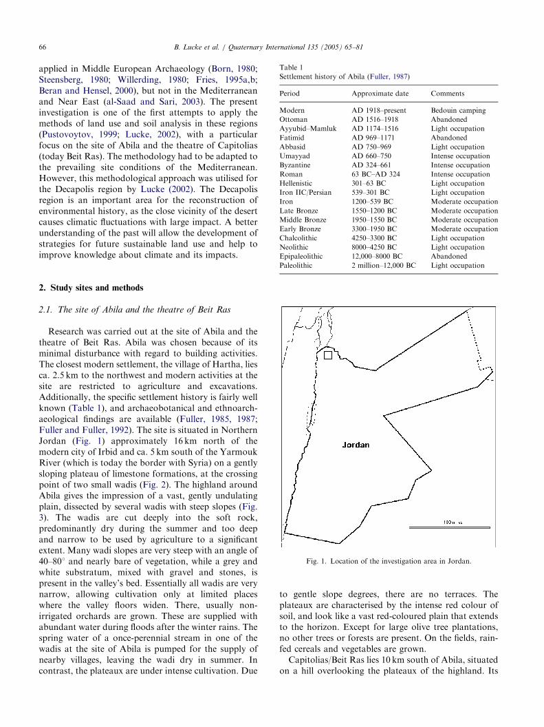
Table 1
Settlement history of Abila (Fuller, 1987)
Period Approximate date Comments
Modern AD 1918–present Bedouin camping
Ottoman AD 1516–1918 Abandoned
Ayyubid–Mamluk AD 1174–1516 Light occupation
Fatimid AD 969–1171 Abandoned
Abbasid AD 750–969 Light occupation
Umayyad AD 660–750 Intense occupation
Byzantine AD 324–661 Intense occupation
Roman 63 BC–AD 324 Intense occupation
Hellenistic 301–63 BC Light occupation
Iron IIC/Persian 539–301 BC Light occupation
Iron 1200–539 BC Moderate occupation
Late Bronze 1550–1200 BC Moderate occupation
Middle Bronze 1950–1550 BC Moderate occupation
Early Bronze 3300–1950 BC Moderate occupation
Chalcolithic 4250–3300 BC Light occupation
Neolithic 8000–4250 BC Light occupation
Epipaleolithic 12,000–8000 BC Abandoned
B. Lucke et al. / Quaternary International 135 (2005) 65–8166
applied in Middle European Archaeology (Born, 1980;Steensberg, 1980; Willerding, 1980; Fries, 1995a,b;Beran and Hensel, 2000), but not in the Mediterraneanand Near East (al-Saad and Sari, 2003). The presentinvestigation is one of the first attempts to apply themethods of land use and soil analysis in these regions(Pustovoytov, 1999; Lucke, 2002), with a particularfocus on the site of Abila and the theatre of Capitolias(today Beit Ras). The methodology had to be adapted tothe prevailing site conditions of the Mediterranean.However, this methodological approach was utilised forthe Decapolis region by Lucke (2002). The Decapolisregion is an important area for the reconstruction ofenvironmental history, as the close vicinity of the desertcauses climatic fluctuations with large impact. A betterunderstanding of the past will allow the development ofstrategies for future sustainable land use and help toimprove knowledge about climate and its impacts.
Paleolithic 2 million–12,000 BC Light occupation
Fig. 1. Location of the investigation area in Jordan.
2. Study sites and methods
2.1. The site of Abila and the theatre of Beit Ras
Research was carried out at the site of Abila and thetheatre of Beit Ras. Abila was chosen because of itsminimal disturbance with regard to building activities.The closest modern settlement, the village of Hartha, liesca. 2.5 km to the northwest and modern activities at thesite are restricted to agriculture and excavations.Additionally, the specific settlement history is fairly wellknown (Table 1), and archaeobotanical and ethnoarch-aeological findings are available (Fuller, 1985, 1987;Fuller and Fuller, 1992). The site is situated in NorthernJordan (Fig. 1) approximately 16 km north of themodern city of Irbid and ca. 5 km south of the YarmoukRiver (which is today the border with Syria) on a gentlysloping plateau of limestone formations, at the crossingpoint of two small wadis (Fig. 2). The highland aroundAbila gives the impression of a vast, gently undulatingplain, dissected by several wadis with steep slopes (Fig.3). The wadis are cut deeply into the soft rock,predominantly dry during the summer and too deepand narrow to be used by agriculture to a significantextent. Many wadi slopes are very steep with an angle of40–801 and nearly bare of vegetation, while a grey andwhite substratum, mixed with gravel and stones, ispresent in the valley’s bed. Essentially all wadis are verynarrow, allowing cultivation only at limited placeswhere the valley floors widen. There, usually non-irrigated orchards are grown. These are supplied withabundant water during floods after the winter rains. Thespring water of a once-perennial stream in one of thewadis at the site of Abila is pumped for the supply ofnearby villages, leaving the wadi dry in summer. Incontrast, the plateaux are under intense cultivation. Due
to gentle slope degrees, there are no terraces. Theplateaux are characterised by the intense red colour ofsoil, and look like a vast red-coloured plain that extendsto the horizon. Except for large olive tree plantations,no other trees or forests are present. On the fields, rain-fed cereals and vegetables are grown.
Capitolias/Beit Ras lies 10 km south of Abila, situatedon a hill overlooking the plateaux of the highland. Its
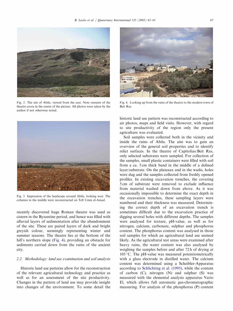
ARTICLE IN PRESS
Fig. 2. The site of Abila, viewed from the east. Note remains of the
theatre cavea in the centre of the picture. All photos were taken by the
author if not otherwise noted.
Fig. 3. Impression of the landscape around Abila, looking west. The
columns in the middle were reconstructed on Tell Umm el-Amad.
Fig. 4. Looking up from the ruins of the theatre to the modern town of
Beit Ras.
B. Lucke et al. / Quaternary International 135 (2005) 65–81 67
recently discovered huge Roman theatre was used ascistern in the Byzantine period, and hence was filled withalluvial layers of sedimentation after the abandonmentof the site. These are paired layers of dark and brightgreyish colour, seemingly representing winter andsummer seasons. The theatre lies at the bottom of thehill’s northern slope (Fig. 4), providing an obstacle forsediments carried down from the ruins of the ancientcity.
2.2. Methodology: land use examination and soil analysis
Historic land use patterns allow for the reconstructionof the relevant agricultural technology and practice aswell as for an assessment of the site productivity.Changes in the pattern of land use may provide insightinto changes of the environment. To some detail the
historic land use pattern was reconstructed according toair photos, maps and field visits. However, with regardto site productivity of the region only the presentagriculture was evaluated.
Soil samples were collected both in the vicinity andinside the ruins of Abila. The aim was to gain anoverview of the general soil properties and to identifyrelict surfaces. In the theatre of Capitolias/Beit Ras,only selected substrates were sampled. For collection ofthe samples, small plastic containers were filled with soilfrom a ca. 5 cm thick band in the middle of a definedlayer/substrate. On the plateaux and in the wadis, holeswere dug and the samples collected from freshly openedprofiles. In existing excavation trenches, the covering5 cm of substrate were removed to exclude influencefrom material washed down from above. As it wasoccasionally impossible to determine the exact depth inthe excavation trenches, these sampling layers werenumbered and their thickness was measured. Determin-ing the correct depth of an excavation trench issometimes difficult due to the excavation practice ofdigging several holes with different depths. The sampleswere analysed for texture, pH-value, as well as fornitrogen, calcium, carbonate, sulphur and phosphoruscontent. The phosphorus content was analysed in thosesoil samples for which an agricultural land use seemedlikely. As the agricultural test areas were examined afterheavy rains, the water content was also analysed byweighing the samples before and after 72 h of drying at105 1C. The pH-value was measured potentiometricallywith a glass electrode in distilled water. The calciumcontent was determined using a Scheibler-Apparatusaccording to Schlichting et al. (1995), while the contentof carbon (C), nitrogen (N) and sulphur (S) wasmeasured with the elemental analysis apparatus VarioEl, which allows full automatic gas-chromatographicmeasuring. For analysis of the phosphorus (P) content

ARTICLE IN PRESSB. Lucke et al. / Quaternary International 135 (2005) 65–8168
the samples experienced pressure decomposition accord-ing to Loftfield (Bock, 1972), allowing photometricmeasurement with the molybden-blue method accordingto Murphy and Riley (Schlichting et al., 1995). Thetexture was determined using wet sieving according toDIN 19683 (1973), while the smaller particles weremeasured with a laser diffraction device (HRLD ModeSympatec) according to ISO 13320-1 (1999). Beforesieving, the samples were treated with abundant hydro-chloric acid (HCl) to eliminate carbonates. The hydro-chloric acid was evaporated again and the samples weredispersed with natrium pyrophosphate solution(Na4P2O4) to eliminate organic matter. Before measur-ing with the laser diffraction device, the samples wereadditionally exposed to 60 s of ultrasound to destroy anyagglomerations.
Fig. 5. Cistern on field 2A.
3. Results and discussion
3.1. Land use
This study revealed that the present intensive land useprevented the preservation of relict patterns, forexample under former forest cover. Also in literature,only little is known about the ancient land use in theDecapolis region. Here the most valuable sources aretravel reports written in the 19th century (Seetzen, 1854;Schumacher, 1890). These authors indicate that the areawas densely forested with the stone-oak (Quercus
petraea) and tabor-oak (Q. itharburensis), but as thepopulation grew quickly after reforms in the OttomanEmpire, the wood was cut for heating purposes(Schumacher, 1890). Also archaeological excavationreports allow insight into former land use. Carbonisedseeds from ancient graves recovered by flotation duringthe 1982 and 1984 excavations at Abila consisted ofolive, barley, wheat, grape, lentil, pea, bitter vetch, wildplum, hackberry and date palms (Fuller, 1987). Incomparison, today olive trees, sunflowers, tomatoes,okra, eggplant, melons, barley, cucumber, tobacco,black mustard and wheat are cultivated on the fields(Lucke, 2002). This indicates a land use very similar toantiquity, as plants like eggplant were not availablebefore the Arab conquest reached India. In ancienttimes Abila was famous for its wine grapes, as coins andgrave paintings show (Wineland, 1992). There may havebeen a complex network of cisterns and small irrigationdams produced from local cores on the plains nearMadaba (Geraty and Herr, 1989), but this cannot yet beconfirmed for Abila, although there are ancient cisternson the fields (Lucke, 2002; Fig. 5).
However, overall only little is known about the landuse system and technology in the Decapolis region. Forexample, the ancient ploughing technique is not known.Field visits and the study of air photos revealed long
fields at Abila, which could be inherited from the ancientpattern; these observations point to the use of amedieval heavy plough (Fig. 6). This would be surpris-ing for the Near East, because the heavy plough wasusually used primarily under moist site conditions.Nevertheless, the use of heavy ploughs is also indicatedby other findings in the Carmel Mountains in Israel(Kuhnen, 1989). The present information does not allowfor any conclusions on how environmental history mighthave been influenced by land use or for an assessment ofthe productivity of ancient agriculture.
Analysis of the present land use of the region foundthat crops are highly dependent on rainfall patterns.Therefore, farmers do not usually decide before the firstrainfalls which crops to sow (Lanzendorfer, 1985). Ifthere are no well-distributed rains at the beginning ofthe rainy season a hard drought crust is likely to form inthe summer heat, impeding germination of most cropseeds. Additionally, harvest is endangered if there are nolate rains with regard to the growing season. As well,excessive rains are reported to be of disadvantage, sincethe soil becomes elastic and hence the field work difficult(personal communication, farmers in the village ofHartha close to Abila, December 2001). Similarproblems of ancient agriculture are reported from OldTestament sources (Borowski, 1987). If there is sufficientand well-distributed rain, productivity is quite good(Lanzendorfer, 1985). There are a small number ofperennial streams, all fed by rainwater, and thusirrigation is theoretically possible at some locations.However, the only spring close to the site of Abila ispumped to supply drinking water to the nearby villages,leaving no water for irrigation in the wadi. The nextperennial water sources are located in the Wadi AinGhazal approximately 3 km south-east of Abila, and inthe Yarmouk valley in the north. This water is not usedfor irrigation, as height differences of 240–300m to the

ARTICLE IN PRESS
Fig. 6. Air photo of Abila and land use patterns (1979). The photo was purchased from the Royal Geographic Centre of Jordan and edited by the
author.
B. Lucke et al. / Quaternary International 135 (2005) 65–81 69
plateau, very steep slopes and the narrow valley floorsmake irrigation difficult, if not impossible.
The water of the spring Ain Queilby locatedapproximately 1.2 km south of the site of Abila waschannelled in antiquity by two underground aqueducts.The water was conducted to a nymphaeum in the centreof the city, close to a bath. Another undergroundaqueduct extended ca. 5 km south up to a spring at themodern village Khureiba (which is today also pumped).There are indicators that a fourth aqueduct broughtwater from the west (Fuller, 1987; Wineland, 2001).According to Wineland (2001), the Khureiba and upperAin Queilby aqueducts were cut through the soft rockduring the Late Roman period, while the lower AinQueilby aqueduct was probably build already in theIron Age or Hellenistic period. Fuller (1987) calculatedthe water transporting capacity of the Ain Queilbyaqueducts and found it to be 100 times greater than thepresent flow of the spring. This could mean more waterwas available in the past, but the size of the tunnelscould also be related to construction requirements. Inany case, it can be assumed that the spring water wascompletely channelled for the supply of the city, andmore water was brought from distant springs, support-
ing up to 20,000 people (Fuller, 1987). The aqueductscarried the water in underground tunnels directly to thecentre of the city, so it was not available for irrigation.
Before construction of the aqueducts, the populationof the city had to carry the water up from the perennialstream in the wadi or to rely on rainwater collected incisterns. There is also evidence for numerous cisterns onthe plateaux, which seem to be related to ancientfarmsteads. It is possible that cisterns were also usedto collect water for irrigation, but we assume theirprimary purpose was to supply drinking water as there isno other water source on the plateaux. Although theexact density of cisterns on the fields is as yet unknown,it seems that irrigation from cisterns was only possiblefor horticulture related to farmsteads (Geraty and Herr,1989). Water channels observed close to cisterns areusually understood to carry water from roofs, etc. to thecistern and not to distribute it from there (Fuller, 1987).Additionally, both spring water recharge and the fillingof cisterns at Abila fully depend on rainfall. Thus it isassumed that irrigation in ancient times was similar totoday and played no major role for agriculture.
As irrigation is minimal and strong winter rains arecommon, salinization is not a problem for agriculture in

ARTICLE IN PRESS
Fig. 7. Soil and rock openings at a street close to Abila. Each mark of
the measuring staff represents 10 cm.
Fig. 8. Field 1A, looking to the north-west.
Fig. 9. Field 2A, looking north.
B. Lucke et al. / Quaternary International 135 (2005) 65–8170
the highlands of Northern Jordan (Lanzendorfer, 1985).Thus, crop production in this area is fully rain-fed, andthe shallowness of soils results in a high vulnerability todroughts.
Rostovtzeff (1932) argued that the Decapolis citiesdepended strongly on caravan trade. While there is nodoubt that important trade lines went through theregion, it is questionable whether they had importantinfluence in the settlement history. The region dependedeconomically on local agriculture as is indicated byarchaeological evidence from the tombs. Only a smallelite may have been involved in caravan trade, but theevidence from the graves is not conclusive (Fuller, 1987).The majority of artefacts and artistic styles at Abilashows influence from the west in contrast to eastern ororiental influences that would have resulted fromcaravan trade (Fuller, 1987). Additionally, Abila wasfamous for its grapes and olives, while a highlydeveloped industry for pottery required considerableamounts of wood (Wineland, 2001).
A major earthquake in 747/748 AD was oftenconsidered to be responsible for the abandonment ofthe region (Hoffmann and Kerner, 2002). However,fallen columns in Gerasa/Jerash rest on a layer of debriswhich was accumulated before the earthquake (Walms-ley, 1997). The same was reported from the Decapoliscity of Gadara/Umm Queis, indicating that these partsof the cities were already abandoned when the earth-quake took place (personal communication with J.Telfah, excavation supervisor in Umm Queis). Addi-tionally, resettlement took place after the earthquakes,but the small reconstructed towns were graduallyabandoned and vanished until the beginning of theFatimid period (Walmsley, 1992). From this weconclude that the earthquake alone did not enforce theabandonment of the region. Indeed, it seems thatagricultural productivity was most relevant for thesettlement history.
3.2. The plateau
On the one hand, the soil on the agricultural plateauaround the old city is too shallow to allow an unadaptedtransfer of the Middle European soil analysis methodol-ogy as no relict surfaces were preserved. On the otherhand, the substrate is derived from calcareous rocks,allowing analysis using a pedogenetic approach. Soiland rock openings along streets at Hartha showdifferent depths of soil on seemingly the same sourcerock. Partially, these differences seem to be related tothe position in the relief, but variations in soil depth arealso visible at similar relief positions. The street open-ings show profile depths of 40 cm–1m, but most profilesreveal a mean soil depth of ca. 60 cm (Fig. 7). Thisproved also true for the sampling pits on fields 1A (Fig.8) and 2A (Fig. 9), which were dug in the middle of a
ARTICLE IN PRESSB. Lucke et al. / Quaternary International 135 (2005) 65–81 71
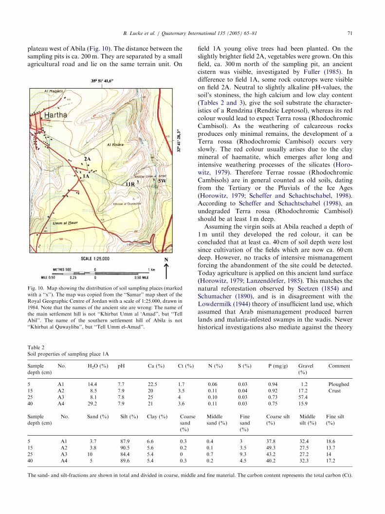
plateau west of Abila (Fig. 10). The distance between thesampling pits is ca. 200m. They are separated by a smallagricultural road and lie on the same terrain unit. On
Fig. 10. Map showing the distribution of soil sampling places (marked
with a ‘‘x’’). The map was copied from the ‘‘Samar’’ map sheet of the
Royal Geographic Centre of Jordan with a scale of 1:25.000, drawn in
1984. Note that the names of the ancient site are wrong: The name of
the main settlement hill is not ‘‘Khirbat Umm al ‘Amad’’, but ‘‘Tell
Abil’’. The name of the southern settlement hill of Abila is not
‘‘Khirbat al Quwayliba’’, but ‘‘Tell Umm el-Amad’’.
Table 2
Soil properties of sampling place 1A
Sample
depth (cm)
No. H2O (%) pH Ca (%) Ct (%)
5 A1 14.4 7.7 22.5 1.7
15 A2 8.5 7.9 20 3.5
25 A3 8.1 7.8 25 4
40 A4 29.2 7.9 21 3.6
Sample
depth (cm)
No. Sand (%) Silt (%) Clay (%) Coarse
sand
(%)
5 A1 3.7 87.9 6.6 0.3
15 A2 3.8 90.5 5.6 0.2
25 A3 10 84.4 5.4 0
40 A4 5 89.6 5.4 0.3
The sand- and silt-fractions are shown in total and divided in coarse, middle
field 1A young olive trees had been planted. On theslightly brighter field 2A, vegetables were grown. On thisfield, ca. 300m north of the sampling pit, an ancientcistern was visible, investigated by Fuller (1985). Indifference to field 1A, some rock outcrops were visibleon field 2A. Neutral to slightly alkaline pH-values, thesoil’s stoniness, the high calcium and low clay content(Tables 2 and 3), give the soil substrate the character-istics of a Rendzina (Rendzic Leptosol), whereas its redcolour would lead to expect Terra rossa (RhodochromicCambisol). As the weathering of calcareous rocksproduces only minimal remains, the development of aTerra rossa (Rhodochromic Cambisol) occurs veryslowly. The red colour usually arises due to the claymineral of haematite, which emerges after long andintensive weathering processes of the silicates (Horo-witz, 1979). Therefore Terrae rossae (RhodochromicCambisols) are in general counted as old soils, datingfrom the Tertiary or the Pluvials of the Ice Ages(Horowitz, 1979; Scheffer and Schachtschabel, 1998).According to Scheffer and Schachtschabel (1998), anundegraded Terra rossa (Rhodochromic Cambisol)should be at least 1m deep.
Assuming the virgin soils at Abila reached a depth of1m until they developed the red colour, it can beconcluded that at least ca. 40 cm of soil depth were lostsince cultivation of the fields which are now ca. 60 cmdeep. However, no tracks of intensive mismanagementforcing the abandonment of the site could be detected.Today agriculture is applied on this ancient land surface(Horowitz, 1979; Lanzendorfer, 1985). This matches thenatural reforestation observed by Seetzen (1854) andSchumacher (1890), and is in disagreement with theLowdermilk (1944) theory of insufficient land use, whichassumed that Arab mismanagement produced barrenlands and malaria-infested swamps in the wadis. Newerhistorical investigations also mediate against the theory
N (%) S (%) P (mg/g) Gravel
(%)
Comment
0.06 0.03 0.94 1.2 Ploughed
0.11 0.04 0.92 17.2 Crust
0.10 0.03 0.73 57.4
0.11 0.03 0.75 15.9
Middle
sand (%)
Fine
sand
(%)
Coarse silt
(%)
Middle
silt (%)
Fine silt
(%)
0.4 3 37.8 32.4 18.6
0.1 3.5 49.3 27.5 13.7
0.7 9.3 43.2 27.2 14
0.2 4.5 40.2 32.3 17.2
and fine material. The carbon content represents the total carbon (Ct).
ARTICLE IN PRESS
Table 3
Soil properties of sampling place 2A
Sample depth (cm) No. H2O (%) pH Ca (%) Ct (%) N (%) S (%) P (mg/g) Gravel (%) Comment
5 A5 9.2 7.9 45.9 6.6 0.16 0.04 1.35 21.4 Ploughed
15 A6 5.3 7.9 40.3 6.3 0.13 0.04 1.18 46.6 Crust
30 A7 6.6 7.9 47.3 6.4 0.13 0.04 1.29 4.5
50 A8 7.5 7.9 47.4 6.3 0.10 0.03 1.29 3.2
Sample
depth (cm)
No. Sand (%) Silt (%) Clay (%) Coarse
sand
(%)
Middle
sand (%)
Fine
sand
(%)
Coarse silt
(%)
Middle
silt (%)
Fine silt
(%)
5 A5 1.9 90.7 7.4 0.5 0.4 1.1 27.9 41 21.8
15 A6 1.3 92.1 6.5 0.04 1.3 1.3 38 37.2 17
30 A7 1.6 92.7 5.6 0.05 1.4 1.6 41.1 35.7 16
50 A8 2.2 92.2 5.4 0.3 1.9 2.2 47.8 31 13.4
B. Lucke et al. / Quaternary International 135 (2005) 65–8172
of insufficient land use, because they demonstrate howIslamic Conquerors were not uncultivated Bedouins,destroying the agricultural systems, but indeed highlydeveloped agriculturists (Watson, 1981).
The sampling plot on field 2A was characterised byenrichment of nutrients, very high calcium content andstronger weathering of bedrock (Table 3). As samplingplot 2A lies about 200m next to plot 1A on the sameterrain unit, differences due to the parent rock or reliefcan be excluded for this area. Although Schumacherreported in 1888 the fields close to Abila to be forested(Schumacher, 1890), field 2A apparently did notexperience reforestation, or if it did this was for ashorter time than the surrounding area. Both field 1Aand 2A revealed many ancient sherds, mostly from theLate Roman and Byzantine–Umayyad period. From thecistern on field 2A, Ayyubid–Mamluk sherds arereported by Fuller (1985), indicating a medieval farm-stead which matches well to the stronger weathering andnutrient enrichment of the soil of field 2A.
Land use changed the character of the landscape. Thehigh calcium contents indicate that the soils wereconsiderably eroded, as the upper layers of a TerraRossa (Rhodochromic Cambisol) should be leached ofcalcium, while the clay content should number ca.40–60% clay (Scheffer and Schachtschabel, 1998). Thecomparison of the sampling places on fields 1A and 2Ashows differences which can only be explained withdifferent land use intensities and periods, as changes inparent material, relief and climate can be excluded. Thesoil on field 2A is characterised by a higher calciumcontent, brighter colour, and enrichment in carbon,nitrogen and phosphorus. Although the texture is notmuch different from plot 1A, it is slightly finer,indicating stronger weathering. All these indicatorspoint to longer and more intensive land use than onthe neighbouring plot 1A, which is further supported bythe reported Ayyubid–Mamluk sherds and more numer-ous rock outcrops.
The red colour of the soils does not necessarily meanthat this land surface dates from the Tertiary or from thePluvials of the Pleistocene. According to Bronger (1976)and Bronger and Sedov (1998, 2003), the red colour canbe caused by other weathering remains of the limestone,and haematite can emerge under today’s climaticconditions, if the mean annual temperature reaches7 1C and above. The limestone then weathers into acoarse and well-ventilated substrate, often becomingdry, and the parent rock contains a high proportion ofFeCO3 (Meyer, 1979; Schwertmann et al., 1982; Cornelland Schwertmann, 2003). The possibility that the soilsaround Abila are very young cannot be ruled out atpresent. The low clay contents point into this direction.
Yaalon and Ganor (1973) postulate that aeoliandeposition during rainstorms plays an important rolein the formation of soils in the Near East. Dry aeoliandeposition from the desert would bring sand, whichshould accumulate in the wind-shadow of the valleys(Smalley and Krinsley, 1978). This could not beobserved, and the main winds come from the west, butYaalon and Ganor (1973) characterise the aeolian inputas loess material derived from the Sahara and trans-ported with the winter depressions and rainstorms to thearea. According to them, it can be measured in soilsderived from basalt according to the quartz contentwhich is strange to the bedrock. Since no markerminerals give evidence on limestone soils, aeoliancontribution can be assessed according to the clay-to-silt ratio. Yaalon and Ganor (1973) emphasise that theaeolian deposition is a process too slow and steady to beobserved in the soil profile. Other authors found aeoliandeposition mainly to be restricted to the last glacialperiod from 100,000 to 10,000 years BC (Issar andBruins, 1983; Frumkin and Stein, 2003). It is stilldiscussed whether and where aeolian deposition is adominating factor of soil formation, and whether it isrestricted to the areas close to the desert and thepleistocene period (Smalley and Krinsley, 1978; Jahn,
ARTICLE IN PRESSB. Lucke et al. / Quaternary International 135 (2005) 65–81 73
1995). According to Reifenberg (1947), soil developmentis dependent on the source rock. The clay-to-silt ratio isalso affected by land use and erosion. However, for thesoils close to the ancient city Abila it can be concludedthat the observed differences in soil development atfields 1A and 2A are even more striking if a great part ofthe parent material is of aeolian origin, as the depositionshould be identical on two plots in a distance of ca.200m and should not vary according to field borders.From the examination of soils on fields 1A and 2A it canbe concluded that ancient land use can be tracedaccording to the soil’s development and that the thesisof a catastrophic erosion has to be rejected. Theobserved differences in soil development at fields 1Aand 2A can only result from long periods of land usewith different intensities. It is a hint that many of thepresent field borders on the plateaux around Abila referto ancient ones, as variations of soil depth and colourare visible on many fields on the apparently same source
Fig. 11. Sampling place 5W. Note the Tell Abil to the right and the
theatre cavea behind the orchard.
Table 4
Soil properties of sampling place 5W
Sample depth (cm) No. H2O (%) pH Ca (%) Ct (%
10 A17 n.a. 7.6 49.7 8.6
30 A18 n.a. 7.8 52.6 7
60 A19 n.a. 8.1 62.8 7.9
Sample
depth (cm)
No. Sand (%) Silt (%) Clay (%) Coarse
sand
(%)
10 A17 14.4 79.4 6.2 0.3
30 A18 4.5 90.2 5.3 0.1
60 A19 2.7 90.7 6.6 0.2
rock and relief position. However, this has to beinvestigated further.
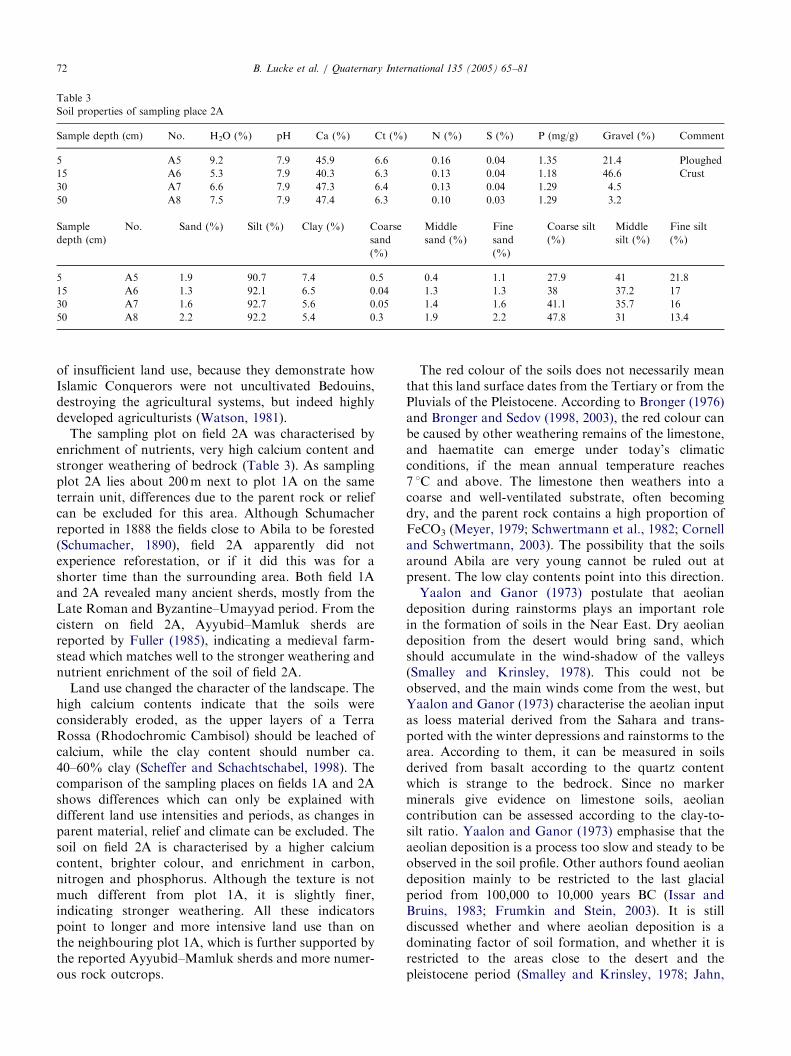
3.3. The wadis
A wadi soil was sampled in the wadi Queilby (plot5W), a small valley passing by the site of Abila, in whicha perennial stream flowed until pumping at the springAin Queilby started. This wadi was selected as it widensat the crossing point with another small wadi, where theancient site is situated (Fig. 10). Here, the wadi floor isquite broad and the western slopes are gentle, providinggood opportunities for irrigation (Fig. 11). Close to theold riverbed, a 60 cm deep pit was dug on a gentle slope,which had been ploughed by a Bedouin family livingclose by. The soil material in the wadi was found to be amixture of eroded material from probably both theslopes and the plateau (Table 4). As its colour is greyand the calcium content very high, it seems that only thesubstrate of the steep slopes and not the red soil of theplateau feeds the wadi. The mixture process of the soilwas illustrated by the discovery of sherds from variousepochs throughout the wadi profile. As excavationtrenches show, in the depressions bed rock is reachedin depths of about 12m.
In comparison with the soils on the plateau, the wadisubstrate is characterised by variations of calciumcontent and texture. Some dry aeolian deposition maybe indicated by the higher sand content recorded in thesurface layer. The wadi substrate has not undergonelong genesis, as is indicated by the high calcium contentand grey colour. Indeed, it has the characteristics ofmixed material enriched with organic garbage, asindicated by high phosphorus contents, and is probablymoved again with every winter flood.
A massive Roman bridge in the main wadi at Abila isgathering point for eroded soil (Fig. 12). As Schumachermeasured this bridge during his visit in 1888, it waspossible to conclude that in the past 113 years 2.50m
) N (%) S (%) P (mg/g) Gravel (%) Comment
0.4 0.1 2.91 24.4 Ploughed
0.2 0.05 2.97 48.9 Crust
0.16 0.05 3.38 11.7
Middle
sand (%)
Fine
sand
(%)
Coarse silt
(%)
Middle
silt (%)
Fine silt
(%)
11.7 2.4 27.8 33 18.5
0.4 4 43.3 31.8 15
0.7 1.8 26.5 42.5 21.7

ARTICLE IN PRESS
Fig. 12. Roman bridge in Wadi Queilbeh.
Fig. 13. Excavated Roman tomb, which was sealed with an Iron door
in 1986 and partially covered again by greyish substrate until 2002.
Only ca. 30 cm of the door are still visible, which is ca. 2m high.
Fig. 14. Steep slopes close to Abila: Wadi Queilbeh, looking north.
B. Lucke et al. / Quaternary International 135 (2005) 65–8174
substrate accumulated at the bridge, nearly filling itsarch completely (Schumacher, 1889; Lucke, 2002). If theRoman bridge would be excavated up to its fundaments,interesting results about the erosion regime can indeedbe expected because the obstacle in form of the bridgeshould have prevented continued mixing of the accu-mulated substrate.
The weathering of rock, landslides and erosionprocesses can also be illustrated by ancient graves atthe wadi slopes located in opposition of the ancient site.Here, excavations between 1980 and 1986 uncoveredtombs which were conserved and protected againstgrave robbers with iron doors. Many of these doors arenow partially covered with huge masses of greyish soilmaterial (Fig. 13), demonstrating well the erosion at thesoft wadi slopes. As the texture and calcium content ofthe substrate in the wadi is very similar to the soils onthe plateau, but not coloured or ordered, it is assumedthat both the wadi substrate and soils on the plateau areproducts of the same soft rocks.
Landslides and erosion are a major threat forJordanian water reservoirs, but the exact compositionand weathering behaviour of the rocks is not known yet(Sven-Oliver Lorenz, University of Wurzburg, workingnear the Wadi el-Arab dam, personal communication).Based on the publications of Lowdermilk (1944) andButzer (1961), erosion on the plateaux was estimated tobe a threat for agriculture and to be responsible for thesilting of the dams. However, the results of our wadisampling indicate that the plateaux are not the mainsource of silt. This is supported by erosion measuring inthe framework of the Zarqa-River Basin Project of theMinistry of Agriculture (MoA) and German Agency forTechnical Cooperation (GTZ), which proved to be mostdifficult, ranging from zero to catastrophic scenarios(Hashemite Kingdom of Jordan, 1986). As an eroded,
but old land surface is present on the plateaux, it ispossible that not the plateaux, but the soft rocksexposed at the wadi slopes are the main sources for siltin the water reservoirs (Fig. 14).
ARTICLE IN PRESSB. Lucke et al. / Quaternary International 135 (2005) 65–81 75
3.4. The ruins of Abila
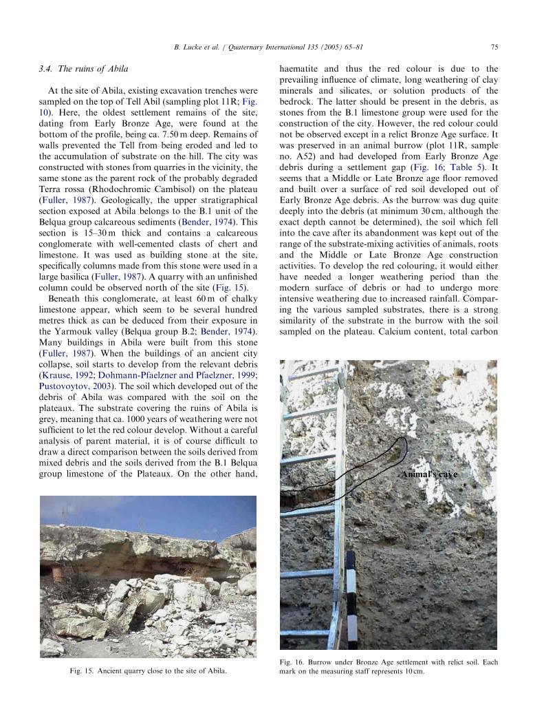
At the site of Abila, existing excavation trenches weresampled on the top of Tell Abil (sampling plot 11R; Fig.10). Here, the oldest settlement remains of the site,dating from Early Bronze Age, were found at thebottom of the profile, being ca. 7.50m deep. Remains ofwalls prevented the Tell from being eroded and led tothe accumulation of substrate on the hill. The city wasconstructed with stones from quarries in the vicinity, thesame stone as the parent rock of the probably degradedTerra rossa (Rhodochromic Cambisol) on the plateau(Fuller, 1987). Geologically, the upper stratigraphicalsection exposed at Abila belongs to the B.1 unit of theBelqua group calcareous sediments (Bender, 1974). Thissection is 15–30m thick and contains a calcareousconglomerate with well-cemented clasts of chert andlimestone. It was used as building stone at the site,specifically columns made from this stone were used in alarge basilica (Fuller, 1987). A quarry with an unfinishedcolumn could be observed north of the site (Fig. 15).
Beneath this conglomerate, at least 60m of chalkylimestone appear, which seem to be several hundredmetres thick as can be deduced from their exposure inthe Yarmouk valley (Belqua group B.2; Bender, 1974).Many buildings in Abila were built from this stone(Fuller, 1987). When the buildings of an ancient citycollapse, soil starts to develop from the relevant debris(Krause, 1992; Dohmann-Pfaelzner and Pfaelzner, 1999;Pustovoytov, 2003). The soil which developed out of thedebris of Abila was compared with the soil on theplateaux. The substrate covering the ruins of Abila isgrey, meaning that ca. 1000 years of weathering were notsufficient to let the red colour develop. Without a carefulanalysis of parent material, it is of course difficult todraw a direct comparison between the soils derived frommixed debris and the soils derived from the B.1 Belquagroup limestone of the Plateaux. On the other hand,
Fig. 15. Ancient quarry close to the site of Abila.
haematite and thus the red colour is due to theprevailing influence of climate, long weathering of clayminerals and silicates, or solution products of thebedrock. The latter should be present in the debris, asstones from the B.1 limestone group were used for theconstruction of the city. However, the red colour couldnot be observed except in a relict Bronze Age surface. Itwas preserved in an animal burrow (plot 11R, sampleno. A52) and had developed from Early Bronze Agedebris during a settlement gap (Fig. 16; Table 5). Itseems that a Middle or Late Bronze age floor removedand built over a surface of red soil developed out ofEarly Bronze Age debris. As the burrow was dug quitedeeply into the debris (at minimum 30 cm, although theexact depth cannot be determined), the soil which fellinto the cave after its abandonment was kept out of therange of the substrate-mixing activities of animals, rootsand the Middle or Late Bronze Age constructionactivities. To develop the red colouring, it would eitherhave needed a longer weathering period than themodern surface of debris or had to undergo moreintensive weathering due to increased rainfall. Compar-ing the various sampled substrates, there is a strongsimilarity of the substrate in the burrow with the soilsampled on the plateau. Calcium content, total carbon
Fig. 16. Burrow under Bronze Age settlement with relict soil. Each
mark on the measuring staff represents 10 cm.

ARTICLE IN PRESS
Table 5
Soil properties of sampling location 11R
Sample/thickness No. pH Ca (%) Ct (%) N (%) S (%) P (mg/g) Gravel (%) Comment
11R 8/60 cm A46 8.5 64.4 7.8 0.08 0.04 5.86 12.4 Surface today
11R 7/25 cm A47 8.3 39 5.1 0.08 0.03 5.59 4.9 Brownish substrate
11R 6/1.75 m A48 8.4 39 5 0.07 0.06 5.13 6 Grey debris
11R 3/15 cm A51 9.1 24 1.9 0.04 0.03 2.69 4.5 Mudbrick stone
11R 2/5 cm A52 8.6 20 1.9 0.05 0.04 1.30 15.7 Burrow
11R 1/2 m A53 8.6 53 7 0.08 0.06 6.38 13 Grey debris
11R 0/30 cm A54 8.4 48.8 6 0.08 0.8 5.56 11 Soil over bedrock
Sample/
thickness
No. Sand
(%)
Silt
(%)
Clay
(%)
Coarse
sand (%)
Middle
sand (%)
Fine sand
(%)
Coarse silt
(%)
Medium
silt (%)
Fine silt
(%)
11R 8/60 cm A46 2.5 86.8 10.6 0.2 1 1.3 12 42.2 32.6
11R 7/25 cm A47 8.2 82.4 9.3 0.7 2 5.5 28.7 31.2 22.5
11R 6/1.75m A48 7 85.8 7.2 0.5 2.1 4.4 23.3 39.1 23.3
11R 3/15 cm A51 11.9 81.9 6.2 0.1 0.2 11.6 39 27.5 15.5
11R 2/5 cm A52 15.3 78.7 6 6.7 0.3 8.3 39.9 25.7 13
11R 1/2m A53 6.1 86.1 7.8 0.5 1.9 3.7 24.8 37.8 23.5
11R 0/30 cm A54 8 84.3 7.8 0.6 1.6 5.8 23.7 37.8 22.8
The samples were numbered and their thickness added, because it was not possible to measure their exact depth. The trench is in total 7.50m deep,
but the sampling had to avoid remains of walls, etc. The samples are listed as they are positioned in the trench.
Fig. 17. Remains of mudbrick stones from Middle or Late Bronze Age
on Tell Abil. Each mark on the measuring staff represents 10 cm.
B. Lucke et al. / Quaternary International 135 (2005) 65–8176
content, texture and nutrients are very similar, only thephosphorous content is increased which is interpreted asinfluence of organic waste and leachate in the debrisprofile. As the Early Bronze Age lasted from 3300 to1950 BC, and the Late Bronze Age from 1550 to 1200BC, the substrate could have experienced 500–1500years of weathering, dependant on the time when theEarly Bronze Age debris was abandoned. The exact timeof weathering cannot be determined, but these resultspoint to increased rainfall during the Bronze Agecompared to today, matching the results of Bar-Matthews et al. (1998; Fig. 19). Other debris surfacesdid not develop red colouring and the emergence of thered colour is in general thought to be related to higherprecipitation (Horowitz, 1979).
This also matches the results of Khresat et al. (1998)and Khresat (2001), who concluded that soils in Jordandeveloped in a humid climate that shifted graduallytowards a more arid climate. Further, remains ofmudbrick stones (Sample No. A51; Fig. 17) fromMiddle or Late Bronze Age could be observed in theupper part of the profile. They were seemingly quicklycovered with debris and thus kept out of the range ofanimals, roots or other soil-mixing activities. Themudbrick remains are nearly identical with the presentagricultural surface on the plateau. If this similarity canbe proven for more mudbrick stone remains, it couldmean that the Bronze Age agricultural conditions werealready similar to the ones present today, because theinhabitants usually used local mudbrick for constructionof their houses. This would mean that already theBronze Age soils were considerably eroded, and eitherre-weathering of bedrock or aeolian deposition pre-
vented the landscape to transform into a plateau ofbarren rock. The other sampled debris substrates showmerely the characteristics of the wadi samples, pointingto a mixed substrate that did not undergo a genesisprocess but was deposited and mixed during construc-tion activities.
It is theoretically possible that the soil observed in theburrow (Sample No. A52) represents remains of oldmudbrick stones. This is not assumed as there are noother remains of mudbrick preserved at this part of theprofile, and the area where once the entrance of the cavewas sealed with remains of a Middle or Late Bronze Ageplaster floor. However, if sample A52 representspreserved mudbrick (in this case from the Early Bronze

ARTICLE IN PRESSB. Lucke et al. / Quaternary International 135 (2005) 65–81 77
Age) and not a relict surface, it would support theassumption that the land surfaces on the plateaux arevery old, as in this case no red colour of soil wasdeveloped in historical time. Careful analysis of parentmaterial will allow us to understand the age anddevelopment process of soils.
3.5. The theatre of Capitolias/Beit Ras
A huge theatre was constructed in the Roman periodand later used as cistern, indicated by the weathering ofthe inner stones (personal communication, K. al-Rousan and J. Telfah, excavation supervisors, Decem-ber 2001). Like Abila, Capitolias/Beit Ras and itstheatre was constructed with limestone from the vicinity(Lenzen and Knauf, 1987; Karasneh et al., 2002). Whenan earthquake destroyed the old city, the inner walls ofthe theatre in direction to the city collapsed. Rubblerolled down and filled the space up to the top of theremaining inner walls, creating a ramp and allowing
Fig. 18. Alluvial sedimented fill in the theatre of Capitolias/Beit Ras.
Table 6
Soil properties of sampling place 7R
Sample/thickness No. pH Ca (%) Ct (%) N (%)
7R+2/5 cm A30 7.7 53 7.5 0.31
7R+1/20 cm A29 8 48 7.4 0.44
7R–1/35 cm A27 7.7 38.2 9 0.83
7R–2/5 cm A26 7.7 58.8 9.9 0.23
A25 7.7 53.1 7.8 0.25
Sample/
thickness
No. Sand
(%)
Silt
(%)
Clay
(%)
Coarse
sand (%)
7R+2/5 cm A30 5.8 85.5 8.6 0.06
7R+1/20 cm A29 6.7 85.6 7.7 0.3
7R–1/35 cm A27 6.9 85.2 7.9 0.1
7R–2/5 cm A26 8.5 86.5 5 0.5
7R–3/1m A25 5.2 84 10.7 0.1
alluvial sediments to enter. These sediments accumu-lated at the outer wall of the theatre, which was stillstanding. The excavation trenches clearly show thisdebris accumulating in yearly paired layers fading outtowards the blocking backstage wall and finally movingover it (Fig. 18). This pattern of dark and light greysubstrate in thin, paired layers is sometimes disturbed byash and brownish-red soil deposits.
The fill of the theatre seems to be a mixture ofsubstrates carried there by rainwater or humans (Table6). The brownish substrate did also not develop in place,but was carried there by humans (personal communica-tion, K. al-Rousan and J. Telfah, excavation super-visors, December 2001). During the archaeologicalexcavations, the mixture and abundance of sherdsindicated that the theatre was used as a disposal pit,supported by the soil analysis (Lucke, 2002). The highphosphorus and nitrogen contents make it very prob-able that the brownish substrates resemble garbage. Thedistribution of the layers in the profile indicates that thegrey substrates were carried there by rainwater: Some-times thin bands fade out soon, while sometimesconsiderable amounts of substrate accumulate at thebackstage wall. The texture of the substrates is verysimilar, while the differences in calcium content seem tobe distributed randomly. These substrates look like thewadi samples and the debris in the ruins of Abila,pointing to a similar source: Weakly weathered lime-stone products.
This indicates that the limestone groups present at thesites seemingly weather into similar substrates, althoughthis has to be investigated further. Analyses of fullprofiles of the alluvial sediments in the theatre areneeded to demonstrate the sedimentation history ofBeit Ras. Here, interesting results can be expected as theash deposits will allow dating. It is evident fromthe archaeological findings that the theatre filledwith sediments and material culture from the
S (%) P (mg/g) Gravel (%) Comment
0.18 n.a. 14.4 Light grey band
0.12 n.a. 8.5 Dark grey band
0.24 7.60 9.5 Brownish substrate
0.55 n.a. 40.7 Light grey band
0.26 n.a. 9.7 Mixed debris
Middle
sand (%)
Fine sand
(%)
Coarse silt
(%)
Middle silt
(%)
Fine silt
(%)
1.2 4.6 30.8 33.6 21
1.4 5 30.8 35 19.8
1.5 5.3 33 34.3 18
2.4 5.6 61.6 15.9 9
1.3 3.8 22.5 36 25.4
ARTICLE IN PRESSB. Lucke et al. / Quaternary International 135 (2005) 65–8178
Byzantine–Umayyad and earlier periods, carried downwith the debris from the destroyed city and depositedduring domestic re-use of the theatre. The vaults leadingto the seats were used for housing and as domestic areasafter the theatre was already partially covered withsediments (personal communication, K. al-Rousan andJ. Telfah, excavation supervisors, December 2001). It ispossible that the major earthquake in 747/748 ADdestroyed the city and allowed the sediments to enter.Clarification of the sedimentary processes in the theatrewould give evidence for the sedimentation regime sincethis event and about the domestic resettlement of thepartially destroyed theatre.
3.6. Land use, soil genesis and local climate
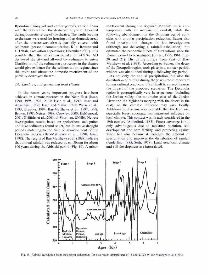
In the recent years, important progress has beenachieved in climate research in the Near East (Issar,1990, 1995, 1998, 2003; Issar et al., 1992; Issar andAngelakis, 1996; Issar and Yakir, 1997; Weiss et al.,1993; Brentjes, 1994; Bar-Matthews et al., 1997, 1998;Brown, 1998; Netser, 1998; Crowley, 2000; DeMenocal,2001, Griffiths et al., 2001; al-Shorman, 2002b). Newestinvestigation results based on speleothem stalagmitesand lake sediments found short, but intensive droughtperiods matching to the time of abandonment of theDecapolis region (Bar-Matthews et al., 1998; Issar,1998). The results of Bar-Matthews et al. (1998) indicatethat annual rainfall was reduced by ca. 50mm for about100 years during the Abbasid period (Fig. 19). A minor
Fig. 19. Rainfall calculation from speleothem stalagmites (for cave wa
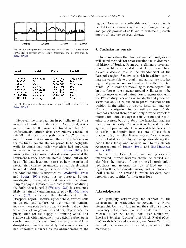
resettlement during the Ayyubid–Mamluk era is con-temporary with an increase of rainfall, while thefollowing abandonment in the Ottoman period coin-cides with another precipitation reduction. Butzer alsofound precipitation changes in his investigations(although not delivering a rainfall calculation), butestimated the economic effects of fluctuations since theRoman period to be negligible (Butzer, 1955, 1961; Figs.20 and 21). His dating differs from that of Bar-Matthews et al. (1998). According to Butzer, the decayof the Decapolis region took place in a moister period,while it was abandoned during a following dry period.
As not only the annual precipitation, but also thedistribution of rainfall during the year is most importantfor agricultural practices, it is difficult to correctly assessthe impact of the proposed scenarios. The Decapolisregion is geographically very heterogeneous (includingthe Jordan valley, the mountains east of the JordanRiver and the highlands merging with the desert in theeast), so the climatic influence may vary locally.Additionally, it seems very probable that the land use,especially forest coverage, has important influence onlocal climate. This context was already considered in the19th century (Anderlind, 1885). Forest coverage is notonly advantageous due to moisture retention, soildevelopment and core fertility, and protecting againstwind, but also because it increases the amount ofprecipitation and improves the distribution of rainfall(Anderlind, 1885; Seth, 1978). Land use, local climateand soil development are interrelated.
ter temperatures of 18 and 20 1C) by Bar-Matthews et al. (1998).
ARTICLE IN PRESS
Fig. 20. Relative precipitation changes (in ‘‘+’’ and ‘‘–’’) since about
12,000 BC in comparison to today (horizontal line) as proposed by
Butzer (1961).
Fig. 21. Precipitation changes since the year 1 AD as described by
Butzer (1955).
B. Lucke et al. / Quaternary International 135 (2005) 65–81 79
However, the investigations in past climate show anincrease of rainfall for the Bronze Age period, whichmatches well to the relict soil found on Tell Abil.Unfortunately, Butzer gives only relative changes ofrainfall and does not explain what ‘‘dry’’ or ‘‘verymoist’’ means. Butzer assesses the climate fluctuationsfor the time since the Roman period to be negligible,while he thinks that earlier variations had importantinfluence on the settlement history (Butzer, 1961). Heassumes that not climate, but soil erosion governed thesettlement history since the Roman period, but on thebasis of his data, it cannot be assessed how the impact ofprecipitation changes on agriculture or soil developmentlooked like. Additionally, the catastrophic erosion afterthe Arab conquest as suggested by Lowdermilk (1944)and Butzer (1961) could not be observed by ourinvestigation. Taking into consideration that the IslamicEmpire enjoyed a peaceful and prosperous time duringthe Early Abbasid period (Watson, 1981), it seems mostlikely the rainfall variations measured by Bar-Matthewset al. (1998) influenced the abandonment of theDecapolis region, because agriculture cultivated soilson an old land surface. As the mudbrick remainsindicate, these soils were probably already shallow. Dueto a lack of irrigation possibilities, dependence onprecipitation for the supply of drinking water, andshallow soils with high contents of calcium carbonate, itcan be assumed that agriculture was very vulnerable todrought and thus it seems likely that climate variationhad important influence on the abandonment of the
region. However, to clarify this exactly more data isneeded to assess ancient agriculture, to analyse the ageand genesis process of soils and to evaluate a possibleimpact of land use on local climate.
5. Conclusion and synopsis
Our results show that land use and soil analysis arewell-suited methods for reconstructing the environmen-tal history of Jordan. From our preliminary investiga-tion it might be concluded, that climate could haveplayed a decisive role in the abandonment of theDecapolis region. Shallow soils rich in calcium carbo-nate are vulnerable to drought, and agriculture is todayhighly dependent on sufficient and well-distributedrainfall. Also erosion is prevailing to some degree. Theland surface on the plateaux around Abila seems to beold, having experienced natural forest regeneration untilthe 19th century. Variation of soil depth and propertiesseems not only to be related to parent material or theposition in the relief, but also to historical land use.Further investigation in the soil patterns of theDecapolis should therefore not only provide importantinformation about the age of soil, erosion and weath-ering processes, but also about the historical land usepattern and intensity. For now it an be said that theagricultural productivity of the ancient fields seems notto differ significantly from the one of the fieldspresent today. A relict Bronze Age surface recoveredfrom Tell Abil points to higher precipitation during thatperiod than today and matches well to the climatereconstructions of Butzer (1961) and Bar-Matthewset al. (1998).
As land use, local climate and soil genesis areinterrelated, further research should be carried out,clarifying the impact of the proposed precipitationreductions and assessing the role of land use withregard to the environmental history and its influence inlocal climate. The Decapolis region provides goodresearch opportunities for these questions.
Acknowledgements
We gratefully acknowledge the support of theDepartment of Antiquities of Jordan, the RoyalGeographic Centre of Jordan, and the staff of YarmoukUniversity, Irbid, Jordan. We also would like to thankMichael Fuller (St. Louis), Arie Issar (Jerusalem),Eberhard Schaller (Cottbus) and Ulrich Riebel (Cott-bus) for their help and assistance, and Norm Catto andtwo unknown reviewers for their advice to improve themanuscript.

ARTICLE IN PRESSB. Lucke et al. / Quaternary International 135 (2005) 65–8180
References
Anderlind, L., 1966 (reprint of 1885). Einfluss der Gebirgswaldungen
im nordlichen Palastina und die Vermehrung der wasserigen
Niederschlage daselbst. Zeitschrift des Deutschen Palastina-Vereins
9, 101–116.
Bar-Matthews, M., Ayalon, A., Kaufmann, A., 1997. Late Quaternary
Paleoclimate in the Eastern Mediterranean Region from Stable
Isotope analysis of Speleothems at Soreq Cave, Israel. Quaternary
Research 47, 155–168.
Bar-Matthews, M., Ayalon, A., Kaufmann, A., 1998. Middle to Late
Holocene (6500 yr Period) Paleoclimate in the Eastern Mediterra-
nean Region from stable isotopic composition of speleothems from
Soreq Cave, Israel. In: Issar, A., Brown, N. (Eds.), Water,
Environment and Society in Times of Climatic Change. Kluwer
Academic Publishers, Dordrecht, pp. 203–215.
Bender, F., 1974. Geology of Jordan. Gebruder Borntrager, Berlin.
Beran, J., Hensel, N., 2000. Sondierungsschnitte durch mittelalterliche
Hochacker, Stadt Cottbus. In: Einsichten. Archaologische Beitrage
fur den Suden des Landes Brandenburg 1999, Arbeitsberichte zur
Bodendenkmalpflege in Brandenburg 4, 244–251.
Bock, R., 1972. Aufschlussmethoden der anorganischen und orga-
nischen Chemie. Wiley Verlag, Weinheim.
Born, M., 1980. Acker- und Flurformen des Mittelalters nach
Untersuchungen von Flurwustungen. In: Beck, H., Deneke, D.,
Jankuhn, H. (Eds.), Untersuchungen zur eisenzeitlichen und
fruhmittelalterlichen Flur in Mitteleuropa und ihrer Nutzung, Part
I. Vandenhoek and Ruprecht, Gottingen, pp. 306–323.
Borowski, O., 1987. Agriculture in Iron Age Israel. Ph.D. dissertation
at the University of Michigan, Eisenbrauns, Winona Lake.
Brentjes, B., 1994. Klimaschwankungen und Siedlungsgeschichte
Vorder- und Zentralasiens. Archiv fur Orientforschung 40/41,
74–87.
Bronger, A., 1976. Kalksteinverwitterungslehme als Klimazeugen?
Zeitschrift fur Geomorphologie NF Suppl. 24, 138–146.
Bronger, A., Sedov, S., 1998. Boden als Zeugen der Landschaftsent-
wicklung in der atlantischen Kustenregion Marokkos. In: Kieler
geographische Schriften, Beitrage zur Kusten- und Meeresgeogra-
phie. Selbstverlag des geographischen Instituts der Universitat
Kiel, Kiel, pp. 41–48.
Bronger, A., Sedov, S., 2003. Vetusols and Paleosols: Natural versus
Man-Induced Environmental Change in the Atlantic Coastal
Region of Morocco. Quaternary International 106–107, 33–60.
Brown, N., 1998. Approaching the medieval optimum, 212 to 1000
AD. In: Issar, A., Brown, N. (Eds.), Water, Environment and
Society in Times of Climatic Change. Kluwer Academic Publishers,
Dordrecht, pp. 69–96.
Butzer, K., 1955. Some aspects of the postglacial climatic variations in
the near east considered in relation to movements of population.
Ph.D. Thesis, McGill University.
Butzer, K., 1961. Climatic change in arid regions since the Pliocene. In:
Stamp, D. (Ed.), A History of Land Use in Arid Regions.
UNESCO, pp. 31–56.
Cornell, R.M., Schwertmann, U., 2003. The Iron Oxides—Structure,
Properties, Reactions, Occurrence and Uses, second ed. VCH
Verlag, Weinheim.
Crowley, T.J., 2000. Causes of climatic changes over the past 1000
years. Science 289, 270–277.
DeMenocal, P., 2001. Cultural responses to climate change during the
Late Holocene. Science 292, 667–673.
DIN 19683, Deutsches Institut fur Normung, 1973. Blatt 1-3,
Physikalische Laboruntersuchungen, Bestimmung der KorngroX-
enzusammensetzung nach Vorbehandlung mit Natriumpyropho-
sphat. Beuth Verlag, Berlin.
Dohmann-Pfaelzner, H., Pfaelzner, P., 1999. Ausgrabungen der
Deutschen Orient-Gesellschaft in Tall Mozan/Urkes. Bericht uber
die Vorkampagne 1998. Mitteilungen der Deutschen Orient-
Gesellschaft 131, 17–46.
Fahlbusch, H., 2002. Die Wasserversorgung des antiken Beth She’an.
In: Ohlig, C., Peleg, Y., Tsuk, T. (Eds.), Schriften der Deutschen
Wasserhistorischen Gesellschaft (DWhG) e.V., Band 1, Cura
aquorum im memoriam Dr. Ya’akov Eren: Proceedings of the
11th International Conference on the History of Water Manage-
ment and Hydraulic Engineering in the Mediterranean Region (11,
2001, Yerusalaym), Siegburg, pp. 55–63.
Fries, J., 1995a. Mit dem Pflug furs taglich Brot, Archaologie in
Deutschland, Heft 2, 1995.
Fries, J., 1995b. Ur- und fruhgeschichtliche Agrartechnik auf den
britischen Inseln und auf dem Kontinent. Eine vergleichende
Studie. Marie Leidorf Verlag, Espelkamp.
Frumkin, A., Stein, M., 2003. The Sahara–East Mediterranean dust
and climate connection revealed by strontium and uranium
isotopes in a Jerusalem Speleothem. Earth and Planetary Science
Letters 6890, 1–14.
Fuller, N., 1985. Analysis of ethnoarchaeological studies. Near East
Archaeological Society Bulletin 25, 73–90.
Fuller, M., 1987. Abila of the decapolis: a Greco-Roman City in
Transjordan. Dissertation at Washington University, St Louis.
Fuller, M., Fuller, N., 1992. Regional Survey and Ehtnoarchaeological
Investigations at Abila, ARAM 4: 1&2, 157–171.
Geraty, L., Herr, L. (Eds.), 1989, Madaba Plains Project: The 1984
season at Tell el-Umeiri and Vicinity and Subsequent Studies.
Andrews University Press and the Institute of Archeology Berrien
Springs, Michigan.
Griffiths, H.I., Schwalb, A., Stevens, L.R., 2001. Environmental
change in southwestern Iran: The Holocene Ostracod Fauna of
Lake Mirabad. The Holocene 11 (6), 757–764.
Hashemite Kingdom of Jordan, Ministry of Agriculture, Department
of Projects/Federal Republic of Germany, German Agency for
Technical Cooperation/Agrar- und Hydrotechnik Essen GmbH,
1986. Zarqua River Basin Project: Feasibility Study 1986, vol. 1:
Present Situation and Development Principles. Amman.
Hoffmann, A., Kerner, S. (Eds.), 2002, Gadara-Gerasa und die
Dekapolis. Phillip von Zabern Verlag.
Horowitz, A., 1979. The Quaternary of Israel. Academic Press, New
York.
Huntington, E., 1911. Palestine and its Transformation. Houghton
Mifflin Company, Boston and New York.
Huntington, E., 1915. Civilisation and Climate. Yale University Press,
New Haven.
Issar, A., 1990. Water shall flow from the rock. Hydrogeology and
Climate in the Lands of the Bible. Springer, Heidelberg.
Issar, A., 1995. Climate change and the history of the Middle East.
American Scientist 83, 350–355.
Issar, A., 1998. Climate Change and History during the Holocene in
the Eastern Mediterranean Region. In: Issar, A., Brown, N. (Eds.),
Water, Environment and Society in Times of Climatic Change.
Kluwer Academic Publishers, Dordrecht, pp. 113–128.
Issar, A., 2003. Climate Changes during the Holocene and their Impact
on Hydrological Systems. International Hydrology Series. Cam-
bridge University Press, Cambridge.
Issar, A., Angelakis, A.N. (Eds.), 1996, Diachronic Climatic Impacts
on water Resources. NATO ASI Series. Springer, Berlin.
Issar, A., Bruins, H.J., 1983. Special climatological conditions in the
deserts of Sinai and the Negev during the Latest Pleistocene.
Paleography, Paleoclimatology, Paleoecology 43, 63–72.
Issar, A., Yakir, D., 1997. Isotopes from wood buried in the roman
siege ramp of Masada: the Roman period colder climate. Biblical
Archaeologists 60 (2), 101–106.
Issar, A., Govern, Y., Geyh, M., Wakshal, E., Wolf, M., 1992. Climate
changes during the upper Holocene in Israel. Israel Journal of
Earth Sciences 40, 219–223.

ARTICLE IN PRESSB. Lucke et al. / Quaternary International 135 (2005) 65–81 81
ISO 13320-1, International Organisation for Standardisation, 1999.
Particle Size Analysis—Laser Diffraction Methods—Part 1: Gen-
eral Principles. International Organisation for Standardisation,
Geneva.
Jahn, R., 1995. AusmaX aolischer Eintrage in circumsaharische Boden
und ihre Auswirkungen auf Bodenentwicklung und Standortei-
genschaften. Hohenheimer bodenkundliche Hefte 23. Stuttgart.
Karasneh, W., al-Rousan, K., Telfah, J., 2002. New discovery in
Jordan at Beit Ras Region (Ancient Capitolias). Orient & Occident
7 (1), 9–11.
Khresat, K., 2001. Calcic horizon distribution and soil classification in
selected soils of North-West Jordan. Journal of Arid Environments
47, 145–152.
Khresat, S.A., Rawajfh, Z., Mohammad, M., 1998. Morphological,
physical and chemical properties of selected soils in the arid and
semi-arid region in North-West Jordan. Journal of Arid Environ-
ments 40, 15–25.
Krause, R., 1992. Vom Ipf zum Goldberg. Archaologische Wander-
ungen am Westrand des Rieses. Fuhrer zu archaologischen
Denkmalern in Baden-Wurttemberg, vol. 16. Konrad Theiss
Verlag, Stuttgart, 157pp.
Kuhnen, H.P., 1989. Studien zur Chronologie und Siedlungsarchao-
logie des Karmel. Beihefte zum Tubinger Atlas des vorderen
Orients, Reihe B, No. 72. Dr. Ludwig Reichert Verlag, Wiesbaden.
Lanzendorfer, M., 1985. Agricultural mechanisation in Jordan. A
study of its processes in a socioeconomic context. Soziookono-
mische Schriften zur ruralen Entwicklung 62, Dissertation at
University of Gottingen.
Lenzen, C., Knauf, E., 1987. Beit Ras/Capitolias. A Preliminary
Evaluation of the Archaeological and Textual Evidence, vol.
LXIV, Syria, pp. 21–46.
Lowdermilk, W., 1944. Palestine—land of promise. London.
Lucke, B., 2002. Abila’s Abandonment. Master Thesis at Brandenburg
University of Technology Cottbus and Yarmouk University, Irbid.
Meyer, B., 1979. Die Entcarbonatisierungsrotung als bodengenetischer
Teilprozess. Mitteilungen der Deutschen Bodenkundlichen Ge-
sellschaft 28, 705–708.
Netser, M., 1998. Population growth and decline in the Northern part
of Eretz-Israel during the historical period as related to climatic
changes. In: Issar, A., Brown, N. (Eds.), Water, Environment and
Society in Times of Climatic Change. Kluwer Academic Publishers,
Dordrecht, pp. 129–146.
Pustovoytov, K., 1999. Die Spatholozane Bodenerosion in der
Umgebung von Troia im Spiegel der Bodendecke. Studia Troica,
Band 9, Phillip von Zabern Verlag, Mainz, pp. 353–366.
Pustovoytov, K., 2003. Growth rates of pedogenic carbonate
coatings on coarse clasts. Quaternary International 106–107,
131–140.
Reifenberg, A., 1947. The Soils of Palestine. T. Murby, London.
Rostovtzeff, M.I., 1932. Caravan Cities. Oxford Press, Clarendon.
Saad, Ziad al-, Sari, S., 2003. Scientific Analysis and its Role in the
Explanation of Archaeology: A Case Study from Dohaleh (in
Arabic), Accepted for Publication, Muıtah Journal For Research
and Studies: Humanities and Social Sciences Series.
Scheffer, F., Schachtschabel, P., 1998. Lehrbuch der Bodenkunde, 14th
ed. Enke Verlag, Stuttgart.
Schlichting, E., Blume, H.P., Stahr, K., 1995. Bodenkundliches
Praktikum. Pareys Studientexte 81, Blackwell Verlag.
Schumacher, G., 1889. Abila of the Decapolis. London Palestine
Exploration Fund, Quaterly Statement 21, 8–52.
Schumacher, G., 1890. Northern Ajlun: Within the Decapolis.
Palestine Exploration Fund, London.
Schwertmann, U., Murach, D., Schulze, G., 1982. Is there Holocene
Reddening (Haematite Formation) in Soils of Axeric Temperature
Areas? Geoderma 27, 209–223.
Seetzen, U., 1854. Reisen durch Syrien, Palestina, Phonicien, die
Transjordan-Lander und Unter-Agypten. Berlin.
Seth, S.K., 1978. The Desiccation of the Thar Desert and its Environs
During the Proto-Historical and Historical Periods. In: Brice, W.
(Ed.), The Environmental History of the Near and Middle East
Since the Last Ice Age. Academic Press, London, pp. 279–306.
Shorman, A. al-, 2002a. Archaeological Site Distribution in Jordan
since the Paleolithic and the Role of Climate Change. Adumatu 5,
Januar 2002.
Shorman, A. al-, 2002b. The Middle and Late Bronze Age Climate of
Ya’amoun in Northern Jordan Using Oxygen Isotope Analysis
from Human Tooth Enamel. Adumatu 6, Juli 2002.
Smalley, I., Krinsley, D., 1978. Loess deposits associated with deserts.
Catena 5, 53–66.
Steel, E. van der, 2002. Tribes and territories in transition. Dissertation
at University of Groningen.
Steensberg, A., 1980. Agrartechnik der Eisenzeit und des fruhen
Mittelalters. In: Beck, H., Deneke, D., Jahnkuhn, H. (Eds.),
Untersuchungen zu eisenzeitlichen und fruhmittelalterlichen Flur
in Mitteleuropa und ihrer Nutzung, Part II, Gottingen.
Walmsley, A., 1992. Vestiges of the Decapolis in North Jordan During
the Late Antique and Early Islamic Periods. ARAM 4: 1&2,
346–371.
Walmsley, A., 1997. Land, resources and industry in Early Islamic
Jordan (Seventh–Eleventh century). Current research and future
directions. In: Bisheh, G., Zaghloul, M., Kehrberg, I. (Eds.),
Studies in the History and Archaeology of Jordan, vol. 6:
Landscape Resources and Human Occupation in Jordan through-
out the Ages. Department of Antiquities of Jordan, Amman, pp.
345–351.
Watson, A.M., 1981. A medieval green revolution—new crops and
farming techniques in the early Islamic world. In: Udovitch, A.L.
(Ed.), The Islamic Middle East, 700–1900: Studies in Economic and
Social History. The Darwin Press Inc, Princeton, pp. 29–58.
Willerding, U., 1980. Anbaufruchte der Eisenzeit und des fruhen
Mittelalters, ihre Anbauformen, Standortverhaltnisse und Ernte-
methoden. In: Beck, H., Deneke, D., Jahnkuhn, H. (Eds.),
Untersuchungen zu eisenzeitlichen und fruhmittelalterlichen Flur
in Mitteleuropa und ihrer Nutzung, Part II, Gottingen.
Wineland, J. D., 1992. Archaeological and numismatic evidence for the
political structure and Greco-Roman religions of the Decapolis,
with particular Emphasis on Gerasa and Abila. ARAM 4:1&2,
329–342.
Wineland, J. D., 2001. Ancient Abila. An Achaeological History. BAR
International Series 989, Archaeopress, Oxford.
Weiss, H., Courty, M.-A., Wetterstrom, W., Guichard, L., Senior, L.,
Meadow, R., Curnow, A., 1993. The Genesis and collapse of third
millenium North Mesopotamian Civilisation. Science 261,
995–1004.
Yaalon, D., Ganor, E., 1973. The influence of dust on soils during the
quaternary. Soil Science 116 (3), 146–155.