A View from the Predynastic Settlement at el-Mahâsna - CORE
343
TITLE PAGE Power and Competition in the Upper Egyptian Predynastic: A View from the Predynastic Settlement at el-Mahâsna, Egypt. University of Pittsburgh 2006 Submitted to the Graduate Faculty of Arts and Sciences in partial fulfillment of the requirements for the degree of Doctor of Philosophy by David A. Anderson A.B. Anthropology, University of Chicago, 1990 A.B. Near Eastern Languages and Civilizations, University of Chicago, 1990 M.A. Anthropology, University of Pittsburgh, 1995
-
Upload
khangminh22 -
Category
Documents
-
view
2 -
download
0
Transcript of A View from the Predynastic Settlement at el-Mahâsna - CORE

TITLE PAGE
Power and Competition in the Upper Egyptian Predynastic:
A View from the Predynastic Settlement at el-Mahâsna, Egypt.
University of Pittsburgh
2006
Submitted to the Graduate Faculty of
Arts and Sciences in partial fulfillment
of the requirements for the degree of
Doctor of Philosophy
by
David A. Anderson
A.B. Anthropology, University of Chicago, 1990
A.B. Near Eastern Languages and Civilizations, University of Chicago, 1990
M.A. Anthropology, University of Pittsburgh, 1995

ii
COMMITTEE PAGE
UNIVERSITY OF PITTSBURGH
Faculty of Arts and Sciences
This dissertation was presented
by
David A. Anderson
It was defended on
April 20, 2006
and approved by
Robert D. Drennan, Professor, Department of Anthropology
Richard Scaglion, Professor, Department of Anthropology
Kathryn Linduff, Professor, Department of History of Art and Architecture
Dissertation Advisor: James B. Richardson, III, Professor, Department of Anthropology

iii
COPYRIGHT PAGE
Copyright © by David A. Anderson
2006

iv
DEDICATION
This dissertation is dedicated to the memory of
Charles R. Anderson 1938-1999

v
ABSTRACT
Questions concerning the basis of power and processes which lead to social stratification have
occupied anthropological research for decades, resulting in a number of competing schools of
thought. This research examines two of these; factional competition and managerial models for
the rise of social complexity. Factional competition models propose that individuals are in a
constant state of competition for power and leadership positions and use a variety of arenas and
methods by which to compete. Managerial models on the other hand suggest individuals are
given power by the populace in exchange for managing subsistence goods and production for the
overall benefit of the society.
These models are evaluated in light of evidence from the Predynastic period cultures of
Upper Egypt, where scholars have suggested that each of these models reflect the processes
which led to the formation of the centralized Egyptian state. Data for this study was obtained
through a program of systematic surface collections and new, large-scale excavations at the
Predynastic settlement site of el-Mahâsna. Patterns of artifacts and activity areas revealed
through these efforts are evaluated against implications for intrasite patterning derived from
managerial and factional competition models specifically proposed for the Nile Valley.
Results of this study suggest that elites during the later Naqada I and early-mid Naqada II
periods were not heavily involved in the management of subsistence goods, nor do they appear to
have been competing through large scale feasting or the production of luxury goods for use in the
funerary industry, as suggested. Further, results from this study suggest that competition for
power in the Nile Valley may already have progressed beyond the level of individual
communities, and may have been taking place at a regional level between established leaders by
the mid-Naqada I. Finally, the data from el-Mahâsna reveals a pattern of elite activities focused
upon ritual and ceremony associated with a possible early cult structure.
Power and Competition in the Upper Egyptian Predynastic:
A View from the Predynastic Settlement at el-Mahâsna, Egypt.
David A. Anderson, Ph.D.
University of Pittsburgh, 2006
Power and Competition in the Upper Egyptian Predynastic:
A View from the Predynastic Settlement at el-Mahâsna, Egypt.
David A. Anderson, Ph.D.
University of Pittsburgh, 2006

vi
TABLE OF CONTENTS
ACKNOWLEDGMENTS ........................................................................................................ xvii
1.0 COMPETITION FOR POWER AND THE DEVELOPMENT OF SOCIAL COMPLEXITY ............................................................................................................ 1
1.1 Models for the Development of Social Complexity in the Nile Valley.................. 4
1.2 The Present Study ................................................................................................... 7
2.0 PREDYNASTIC PERIOD OF UPPER EGYPT....................................................... 8 2.1 Cultural Chronology of the Upper Egyptian Predynastic ....................................... 8
2.1.1 Badarian .......................................................................................................... 9
2.1.2 Naqada I ........................................................................................................ 10
2.1.3 Naqada II....................................................................................................... 14
2.1.4 Naqada III/Protodynastic .............................................................................. 15
2.2 Predynastic of the Abydos Region........................................................................ 16
3.0 THE SITE OF EL-MAHÂSNA ................................................................................ 21 3.1 Location and Setting of el-Mahâsna ..................................................................... 21
3.2 Previous Investigations at el-Mahâsna.................................................................. 28
3.2.1 John Garstang – 1900-1901 .......................................................................... 29
3.2.2 Edward Aryton and William L. S. Loat – 1909............................................ 30
3.2.3 Diana Craig Patch – 1982-83........................................................................ 31
3.3 El-Mahâsna and the Interpretation of Competition for Power in the
Predynastic............................................................................................................ 33
4.0 METHODOLOGY..................................................................................................... 38 4.1 Field Investigation Activities and Methods .......................................................... 38
4.1.1 Surface Reconnaissance/Collection Methodology ....................................... 39
4.1.2 Excavation Methodology.............................................................................. 46
4.2 Artifact Analysis Methods .................................................................................... 51

vii
4.2.1 Ceramics ....................................................................................................... 52
4.2.2 Faunal Remains............................................................................................. 62
5.0 RESULTS OF FIELD INVESTIGATIONS, PART I: STRATIGRAPHY AND FEATURES....................................................................................................... 64
5.1 Surface Collection Results.................................................................................... 68
5.1.1 Positioning of the Excavation Blocks ........................................................... 69
5.2 Excavation Results................................................................................................ 71
5.2.1 Excavation Block 1 ....................................................................................... 71
5.2.2 Excavation Block 2 ....................................................................................... 89
5.2.3 Excavation Block 3 ....................................................................................... 97
5.2.4 Excavation Block 4 ..................................................................................... 123
5.2.5 Excavation Block 5 ..................................................................................... 133
5.2.6 Excavation Block 6 ..................................................................................... 137
5.2.7 Excavation Block 7 ..................................................................................... 138
5.2.8 Excavation Block 8 ..................................................................................... 139
5.2.9 Excavation Block 9 ..................................................................................... 147
6.0 RESULTS OF FIELD INVESTIGATIONS, PART II: ARTIFACTS AND INTRA-SITE DISTRIBUTION ANALYSIS......................................................... 151
6.1 Ceramics ............................................................................................................. 152
6.1.1 General Nature of the el-Mahâsna Ceramic Assemblage ........................... 152
6.1.2 Defining the “Native” Predynastic Ceramics of the Abydos Region ......... 153
6.1.3 Defining Wares From Other Regions ......................................................... 154
6.1.4 Discussion of Ceramics from Each Excavation Block ............................... 156
6.1.5 Spatial Distribution of Non-local and Decorated Wares ............................ 169
6.2 Faunal Remains................................................................................................... 180
6.2.1 General Nature of the Faunal Assemblage at el-Mahâsna.......................... 180
6.2.2 Domestic Mammal Assemblage ................................................................. 186
6.2.3 Fish Assemblage ......................................................................................... 195
6.2.4 Reptile Assemblage .................................................................................... 208
6.3 Bone, Ivory, and Ostrich Eggshell Objects......................................................... 211
6.3.1 Bone Tools .................................................................................................. 211
6.3.2 Ivory Objects............................................................................................... 214

viii
6.3.3 Items of Ostrich Eggshell............................................................................ 215
6.4 Figurines ............................................................................................................. 216
6.4.1 Anthropomorphic Figurines........................................................................ 216
6.4.2 Zoomorphic Figurines................................................................................. 222
6.4.3 Figurine Fragments ..................................................................................... 224
6.5 Miscellaneous Other Artifact Categories............................................................ 231
6.5.1 Weapons...................................................................................................... 231
6.5.2 Spindle Whorls............................................................................................ 232
6.5.3 Copper Items............................................................................................... 234
6.5.4 Beads and Pendants..................................................................................... 235
6.5.5 Administrative Items................................................................................... 237
6.5.6 Grinding Stones .......................................................................................... 239
6.6 Summary............................................................................................................. 240
7.0 DISCUSSION OF RESULTS AND CONCLUSIONS ......................................... 242 7.1 Elites?.................................................................................................................. 242
7.2 Distribution of Materials and Their Relationship to Hypothesized Patterns
of Elite Activity................................................................................................... 248
7.2.1 Evidence for Storage and Accumulation of Subsistence Goods................. 248
7.2.2 Evidence for Redistribution and Feasting................................................... 250
7.2.3 Evidence for the Production of Funerary and Luxury Goods..................... 256
7.2.4 Evidence for Interaction and Alliance Building at a Regional Level. ........ 257
7.2.5 Evidence for Rituals and Ceremonies......................................................... 258
7.3 Management or Competition?............................................................................. 260
7.4 The Nature of Predynastic Settlements in Upper Egypt and
Recommendations for Future Research .............................................................. 263
APPENDIX A............................................................................................................................ 267
APPENDIX B ............................................................................................................................ 274
APPENDIX C............................................................................................................................ 280
APPENDIX D............................................................................................................................ 283
APPENDIX E ............................................................................................................................ 290
BIBLIOGRAPHY..................................................................................................................... 297

ix
LIST OF TABLES
Table 2.1: Chronology of the Upper Egyptian Predynastic. .................................................... 9
Table 4.1: Ceramic ware analysis codes. ............................................................................... 58
Table 4.2: Subjective shape classes and functional categories used in vessel form and function analysis. .................................................................................................. 59
Table 5.1: Stem-and-leaf diagram of post diameters from Excavation Block 1.................... 75
Table 5.2: Summary of features associated with Habitation Phase 3B................................ 103
Table 5.3: Summary of features associated with Habitation Phase 3C................................ 109
Table 5.4: Summary of features associated with Habitation Phase 3D ............................... 114
Table 5.5: Summary of post holes associated with calages present in the structure in Excavation Block 3. ............................................................................................ 119
Table 5.6: Summary of post molds present in Excavation Block 8. .................................... 144
Table 6.1: Frequency of tempering agents in R-ware ceramics........................................... 155
Table 6.2: Decorations on ceramics from el-Mahâsna......................................................... 156
Table 6.3: Relative porportions of ceramic ware classes within each excavation block. .... 157
Table 6.4: Percentage of temper types among the R-ware ceramics in each excavation block.................................................................................................................... 157
Table 6.5: Basic nature of the faunal assemblage at el-Mahâsna. ....................................... 181
Table 6.6: Basic nature of the faunal assemblage at Adaïma. ............................................. 182
Table 6.7: Summary of faunal remains recovered during the 2000 Season at el-Mahâsna. ............................................................................................................. 182
Table 6.8: Ratios of cattle remains to the remains of other domestic mammal. .................. 188
Table 6.9: Basic nature of the fish remains from el-Mahâsna. ............................................ 195
Table 6.10: Proportions of fish types in each Excavation Block. .......................................... 200
Table 6.11: Taxonomic breakdown of fish remains recovered from el-Mahâsna. ................ 202
Table 6.12: Bone and ivory items recovered at el-Mahâsna. ................................................. 210
Table 6.13: Summary of bone tool manufacturing debris by taxon and skeletal element. .... 213

x
Table 6.14: Items of Ostrich eggshell. ................................................................................... 216
Table 6.15: Summary of anthropomorphic figurines recovered from el-Mahâsna during the 2000 season. .................................................................................................. 221
Table 6.16: Summary information for zoomorphic figurines. ............................................... 225
Table 6.17: Origin of figurine fragments from secure Predynastic contexts. ........................ 229
Table 6.18: Summary of recovered figurine fragments. ........................................................ 230
Table 6.19: Distribution of spindle whorls from el-el-Mahâsna............................................ 233
Table 6.20: Copper items recovered at el-Mahâsna............................................................... 235
Table 6.21: Beads and pendants recovered from el-Mahâsna................................................ 236
Table 6.22: Administrative objects recovered during the 2000 season at el-Mahâsna. ......... 238
Table 6.23: Grinding stones recovered at el-Mahâsna........................................................... 240
Table 7.1: Values used in the calculation of the Elite Index................................................ 247

xi
LIST OF FIGURES
Figure 2.1: Map of Egypt showing Predynastic sites discussed in the text............................. 13
Figure 3.1: Map of the area around el-Mahâsna...................................................................... 22
Figure 3.2: View of low desert rise looking toward the southern end of el-Mahâsna. ........... 24
Figure 3.3: View looking north over the modern cultivation from the northern end of el-Mahâsna. ............................................................................................................... 24
Figure 3.4: Map of the area of Predynastic settlement at el-Mahâsna. ................................... 25
Figure 3.5: View of el-Mahâsna showing the central depressed area. .................................... 26
Figure 3.6: View looking west showing later tomb disturbances south of the central depression. ............................................................................................................ 26
Figure 3.7: View looking southwest showing destroyed site area at the far southern end of el-Mahâsna........................................................................................................ 27
Figure 3.8: View looking south showing the southern plowed area. ...................................... 27
Figure 3.9: View looking northwest showing the area of new fields which border s the southwestern portion of the site. ........................................................................... 28
Figure 3.10: Map of el-Mahâsna showing the location of Garstang's 1900-01 excavations shown in Garstang 1903, plate IV......................................................................... 32
Figure 4.1: Area of 1995 field investigations at el-Mahâsna. ................................................. 42
Figure 4.2: Creating the topographic map of el-Mahâsna in 1996.......................................... 44
Figure 5.1: Location of surface collections from the 1995 and 2000 field seasons at el-Mahâsna. ............................................................................................................... 66
Figure 5.2: Map of el-Mahâsna showing the location and designation of the Excavation Blocks ................................................................................................................... 67
Figure 5.3: Density of Predynastic period ceramic sherds recovered from the surface. ......... 70
Figure 5.4: Area of Excavation Block 1 prior to excavation................................................... 72
Figure 5.5: Reconstructed north-south profile looking east thorugh Block 1 showing habitation phases. .................................................................................................. 73
Figure 5.6: Plan view of Excavation Block 1 showing features associated with Habitation Phase 1A. ............................................................................................ 76
Figure 5.7: Post structure in Excavation Block 1 .................................................................... 79
Figure 5.8: Large Post (Locus 51) at southern end of Structure in Excavation Block 1......... 80

xii
Figure 5.9: Locus 63 in Operation 26 with darker materials as well as Wall 2 posts visible.................................................................................................................... 80
Figure 5.10: Modern house in the village of Maslahet Harun showing example of post and mat architecture. ............................................................................................. 81
Figure 5.11: View of Locus 62, the mudplaster surface............................................................ 81
Figure 5.12: Distribution of post diameters from el-Mahâsna Block 1 Structure and Structure C1 at Adaïma......................................................................................... 82
Figure 5.13: Locus 42................................................................................................................ 83
Figure 5.14: Locus 69................................................................................................................ 84
Figure 5.15: Plan view showing features associated with Habitation Phase 1B. ...................... 87
Figure 5.16: Locus 46................................................................................................................ 88
Figure 5.17: Location of Locus 81, Habitation Phase 1C. ........................................................ 88
Figure 5.18: Area of Excavation Block 2 (right half of photograph) showing the relationship to the edge of the low desert escarpment. ......................................... 90
Figure 5.19: Plan view of Habitation Phase 2A showing the locations of associated features. ................................................................................................................. 92
Figure 5.20: Locus 39................................................................................................................ 93
Figure 5.21: Locus 52 in plan view........................................................................................... 93
Figure 5.22: Locus 52 in profile view ....................................................................................... 94
Figure 5.23: Habitation Phase 2C showing the visible line of a former fence/wall. ................. 96
Figure 5.24: Area of Excavation Block 3 prior to excavation................................................... 99
Figure 5.25: Schematic East-West Profile of Excavation Block 3 showing the sequence of reconstructed Habitation Phases. .................................................................... 100
Figure 5.26: Plan view of Excavation Block 3 showing remains associated with Habitation Phase 3A. .......................................................................................... 101
Figure 5.27: Plan view of Excavation Block 3 showing remains associated with Habitation Phase 3B............................................................................................ 105
Figure 5.28: View looking east of Excavation Block 3, Habitation Phase 3B showing Locus 74 (bottom center) and Locus 72 (right of center) and Locus 68 (center). ............................................................................................................... 106
Figure 5.29: Profile of southern end of Locus 74 looking west. ............................................. 106
Figure 5.30: Loci 50 (back) and 51 (front) in situ. .................................................................. 107
Figure 5.31: Plan view of Excavation Block 3 showing remains associated with Habitation Phase 3C............................................................................................ 111
Figure 5.32: Locus 79 shown in (a) oblique view and (b) plan view...................................... 112
Figure 5.33: Ceramic cup (MAP1792) recovered from the surface of Locus 73.................... 112

xiii
Figure 5.34: View of (a) Locus 82 and (b) Locus 97 in situ in Habitation Phase 3C. ............ 113
Figure 5.35: Box-and-Dot plot showing the comparison of post diameters from structures in Excavation Blocks 1, 3, and 8......................................................................... 118
Figure 5.36: Box-and-Dot plot showing the comparative distribution of post diameters associated with calages at Adaïma and Block 3 at el-Mahâsna. ........................ 119
Figure 5.37: Plan view of Excavation Block 3 showing remains associated with Habitation Phase 3D. .......................................................................................... 121
Figure 5.38: Cross Section of Locus 95 in OP 20 looking north showing internal structure of the areas of mud flooring and two types of calages. ....................... 122
Figure 5.39: View of Locus 95 and 105 in OP 20 looking south............................................ 122
Figure 5.40: Locus 115............................................................................................................ 123
Figure 5.41: Schematic north-south profile showing the relative thickness of the individual Habitation Phases in Excavation Block 4. ......................................... 125
Figure 5.42: General view of the area of Excavation Block 4. ............................................... 126
Figure 5.43: Plan view of Habitation Phase 4A showing the locations of associated features. ............................................................................................................... 127
Figure 5.44: Plan view of Habitation Phase 4B showing the locations of associated features. ............................................................................................................... 129
Figure 5.45: Plan view of Habitation Phase 4C showing the locations of associated features. ............................................................................................................... 132
Figure 5.46: View of the north end of Excavation Block 5. Note the dark ash and charcoal laden nature of the deposits. ................................................................. 134
Figure 5.47: Plan view of Habitation Phase 5B (left) and 5C (right)...................................... 136
Figure 5.48: Remains of Garstang's 1900-01 expedition house. ............................................. 139
Figure 5.49: Concentration of discarded stone tools on the floor of Garstang's expedition house. .................................................................................................................. 140
Figure 5.50: Excavation Block 8 and surrounding plowed area. ............................................ 140
Figure 5.51: Southern area of the site showing the position of Excavation Block 8. ............. 141
Figure 5.52: Plan View of Excavation Block 8. ...................................................................... 146
Figure 5.53: View of Locus 7 before excavation. ................................................................... 147
Figure 5.54: West Wall of Operation 3. .................................................................................. 150
Figure 6.1: Relative proportion of vessel forms within each Excavation Block.................. 158
Figure 6.2: Comparison of the proportion of chaff/straw tempered Rough ware ceramics in each of the excavation blocks. ......................................................... 159
Figure 6.3: Comparison of the proportion of jar forms in each excavation block. ............... 160
Figure 6.4: Comparison of the proportion of basins in each excavation block..................... 161

xiv
Figure 6.5: Comparison of the proportion of all jar forms within each of the excavation blocks. ................................................................................................................. 161
Figure 6.6: Black-topped red ware vessel (Locus 69; MAP1599) recovered from Excavation Block 1, Phase 1A............................................................................ 162
Figure 6.7: Comparison of the proportion of Normal tempered Rough ware ceramics in each of the excavation blocks. ............................................................................ 163
Figure 6.8: Comparison of the relative proportions of all bowl forms recovered from each excavation block. ........................................................................................ 164
Figure 6.9: Comparison of the relative proportion of miniature bowl forms within each of the excavation blocks...................................................................................... 164
Figure 6.10: Comparison of the combined proportion of Shallow Bowl and Platter vessel forms in each of the excavation blocks.............................................................. 166
Figure 6.11: Complete ceramic vessels recovered from Excavation Block............................ 167
Figure 6.12: Comparison of the relative proportions of Normal and Chaff/Straw tempered R-ware ceramics in each of the excavation blocks. ............................ 168
Figure 6.13: Distribution of ceramics from Nubia and Lower Egypt ..................................... 171
Figure 6.14: Distribution of surface ceramics originating in the Hemamieh Region ............. 172
Figure 6.15: Distribution of surface ceramics originating in the Naqada Khattara Sites regions................................................................................................................. 173
Figure 6.16: Comparison of the proportions of non-local wares in each Excavation Block. .................................................................................................................. 174
Figure 6.17: Proportion of Naqada Region wares from each excavation block...................... 174
Figure 6.18: Comparison of the proportion of Hemamieh Region wares from each excavation block. ................................................................................................ 175
Figure 6.19: Comparison of the proportions of Decorated wares in each of the excavation blocks. ................................................................................................................. 176
Figure 6.20: Distribution of C-ware ceramics recovered from surface contexts. ................... 177
Figure 6.21: Selection of recovered C-ware vessel sherds...................................................... 178
Figure 6.22: Selection of recovered D-ware vessel sherds...................................................... 179
Figure 6.23: Distribution of Faunal Classes Across Excavation Blocks................................. 183
Figure 6.24: Graph comparing the relative proportions of mammal, fish, and reptile remains within each excavation block. ............................................................... 184
Figure 6.25: Relative Abundance of all Wild and Domestic species in each excavation block.................................................................................................................... 185
Figure 6.26: Proportions of wild and domesticated mammal remains within each excavation block. ................................................................................................ 186

xv
Figure 6.27: Distribution of wild mammal remains, excluding rodents, across the excavation blocks................................................................................................ 186
Figure 6.28: Comparison of the proportions of domestic mammal species in each excavation block. ................................................................................................ 187
Figure 6.29: Relative abundance (as percentage) of the various age classes for each excavation block and the entire site. ................................................................... 191
Figure 6.30: Age profile graphs for cattle (top), sheep/goat (center), and pig (bottom). ........ 192
Figure 6.31: Comparison of the proportion of very young domestic mammals relative to all specimens identified to age class within each excavation block ................... 193
Figure 6.32: Proportions of body parts of domestic mammals in each excavation block...... 196
Figure 6.33: Comparison of domestic mammal forelimbs as a percentage of the identified skeletal elements of each species........................................................ 197
Figure 6.34: Comparison of domestic mammal hind limbs as a percentage of identified skeletal elements of each species. ....................................................................... 198
Figure 6.35: Relative abundances various of fish taxa within individual excavation blocks. ................................................................................................................. 203
Figure 6.36: Relative abundance of the three families of catfish recovered from el-Mahâsna. ............................................................................................................. 203
Figure 6.37: Relative abundance (as percentages) of different catfish families by excavation block. ................................................................................................ 204
Figure 6.38: Distribution by excavation block of large Synodontis as a percentage of the total specimens of this size recovered................................................................. 204
Figure 6.39: Distribution by excavation block of large Clariidae remains as a percentage of the total specimens of this size recovered. ..................................................... 205
Figure 6.40: Distribution of large Bagridae catfish................................................................. 205
Figure 6.41: Distribution of large perch .................................................................................. 207
Figure 6.42: Distribution of large tilapia. ................................................................................ 208
Figure 6.43: Distribution of turtle remains as a percentage of the entire site assemblage. ..... 209
Figure 6.44: Representative examples of bone tools recovered from el-Mahâsna.................. 213
Figure 6.45: Ivory (MAP 1028 and 3001) and Ostrich eggshell (MAP 2281) objects. .......... 215
Figure 6.46: Three views of figurine Mah.IV.1; right side (left), top (center) and three-quarter (right) views............................................................................................ 219
Figure 6.47: Two views of Figurine Mah.IV.2; right side (left) and front (right) views. ....... 219
Figure 6.48: Figurines Mah.IV.4 (right) and Mah.IV.6 (left). ................................................ 220
Figure 6.49: Front (left) and back (right) views of Figurine Mah.IV.5................................... 220
Figure 6.50: Selection of zoomorphic figurines recovered at el-Mahâsna.............................. 228

xvi
Figure 6.51: Cattle figurine with slash mark incisions on neck. ............................................. 229
Figure 6.52: Chipped stone arrowheads (left) and a stone mace head (right) recovered from el-Mahâsna. ................................................................................................ 232
Figure 6.53: Representative specimens of spindle whorls from el-Mahâsna. ......................... 234
Figure 6.54: Copper objects from el-Mahâsna. ....................................................................... 235
Figure 6.55: Sample of Beads and Pendants recovered from el-Mahâsna. ............................. 237
Figure 6.56: Mud jar sealings recovered from Locus 36......................................................... 239
Figure 6.57: Distribution of grinding stones recovered from surface contexts....................... 241
Figure 7.1: Comparison of mean post diameter in each excavation block............................ 245
Figure 7.2: Elite Index Scores for each Excavation Block.................................................... 247
Figure 7.3: Comparison of the proportion of all jar forms within each of the excavation blocks. ................................................................................................................. 250
Figure 7.4: Comparison of the proportion of large jars from each excavation block. .......... 250
Figure 7.5: Comparison of ceramic vessel size. .................................................................... 252
Figure 7.6: Comparison of the proportion of deep bowl and basin vessel forms in each excavation area.................................................................................................... 254
Figure 7.7: Hearth feature in the section cut at the southern end of el-Mahâsna. ................ 255
Figure 7.8: Remains of a possible beer kiln (Locus 36) in the disturbed southern area of el-Mahâsna. ......................................................................................................... 255

xvii
ACKNOWLEDGMENTS
This dissertation would not have been possible with the support, help and encouragement of
many individuals, family members, friends, and colleagues. With any project of this scope and
duration, the number of people who have contributed to its success are so numerous, that the
process of sitting down to acknowledge them all is daunting.
First, I must begin by thanking the members of my dissertation committee, James B.
Richardson, III, Robert D. Drennan, Richard Scaglion, and Kathy Linduff for their unwavering
support over the years. From initial conception of the project, through writing grants, and finally
during the “great push” of this last year, they have offered freely of their time, knowledge, and
advice. Each of them in their own way has contributed greatly to who I am as an archeologist.
Dick Drennan introduced me to the world of statistics in archaeological analysis as well as
guided me through the maze of complex societies. While I may not have always agreed with his
suggestions with respect to methods of analysis, or revisions to text, they always made me think,
and ultimately helped me to create a better product, whether in this dissertation project or others
projects throughout the years where I have sought his advice.
Rich Scaglion, the “honorary archaeologist” on the committee, has exposed me to the
vast wealth of ethnographic data on tribal and chiefdom level societies in the Pacific. Over the
years, Rich has kept me grounded in the fact that archaeology is about understanding cultures of
the past, and therefore, archaeologists should always be anthropologists first, and artifact
analysts second. I also must thank Rich for agreeing to join the committee at a very late date
despite his busy schedule as chair of the department.
I would like to offer my thanks to Kathy Linduff for her advice over the years. It was
Kathy who many years ago when I was looking for another class one semester suggested that I
take a survey course on Chinese archaeology which was being offered by a visiting scholar at
Pitt. That class exposed me to an entirely new world of archaeological cultures and comparative
data. I would also like to thank her for graciously giving her time this past Spring. As new

xviii
chapters arrived, always at the last possible moment, she always found time to read them and
offer advice and encouragement when it was most needed.
Finally, I cannot begin to express the debt of gratitude that I owe my committee chair Jim
Richardson. Since my arrival at Pitt, Jim has served as a trusted advisor, mentor, colleague, and
most of all, a good friend. JBR has always supported me, allowing me the freedom to pursue my
disparate research interests; whether they be Contact Period Susquehannock Indians in Eastern
Pennsylvania, Predynastic chiefdoms in the Nile Valley, or our joint interest in the Monongahela
culture of Southwestern Pennsylvania. No matter what the topic, Jim always seemed to have a
valuable opinion to offer, and usually a stack of suggested articles to read. I know I couldn’t
have finished without his constant encouragement and, at times, much needed pushes to “just
finish already.”
In addition to my committee, the el-Mahâsna Archaeological Project could not have been
possible with the support of Dr. David O’Connor. This project was conducted under the larger
auspices of the University of Pennsylvania-Yale University-Institute of Fine Arts, New York
University Expedition to Abydos, Egypt, co-directed by O’Connor and Dr. William Kelly
Simpson. David has graciously allowed me to work under the larger Penn-Yale-IFA umbrella
over the years, helped in obtaining permits, served as co-principal investigator on grant
applications, and opened the expedition house at Abydos to me and my staff as a base of
operations for all the field and analysis seasons.
I must also thank the other project directors of the Penn-Yale-IFA expedition, especially
Matt Adams, Janet Richards, Joe Wegner, and Diana Craig Patch. Matt is responsible for getting
me involved with the expedition back in 1991 as a member of his dissertation project field staff.
It was during that season that I fell in love with the Abydos area and began several friendships
that would prove instrumental in the success of the el-Mahâsna project. Over many long nights
of discussions, debates, and hours of traveling, Matt and I planned how to solve all the problems
of the archaeology of early Egypt. We may not have yet succeeded in doing so, but we haven’t
given up.
In 1996 I was fortunate to work at Abydos with Janet Richards and Peter Lacovara on
Janet’s Middle Cemetery project. That short, very hot season was one of the most enjoyable
times I have had doing archaeology in over 20 years of projects. In between laughing ourselves
sick, we managed to accomplish an incredible amount of work, including the mapping and

xix
surface reconnaissance at el-Mahâsna. I must thank them both for their assistance during those
two long days at el-Mahâsna. It was also during that season that Janet, whether knowingly or
not, became my role model for how to be Mudir. Over the years, we have not had the
opportunity to work together again in the field, but have become good friends and Janet is
always there to providing advice and encouragement.
I would like to express my gratitude to Diana Craig Patch for providing me with
information from her 1982-83 survey of the Abydos region, as well as for granting permission
for me to pursue excavations at el-Mahâsna, as well as future work at en-Nawâhid and el-
Barâghît. Also, my thanks go out to Joe Wegner for allowing Stine Rossel the time and space
during his seasons at Abydos to conduct the analysis of the faunal materials form el-Mahâsna.
I am extremely grateful to the Supreme Council of Antiquities of the Government of
Egypt for permission to carry out the fieldwork for this dissertation in 1995, 1996, and 2000. In
particular, I would like to thank the former Secretaries General, Dr. Gaballa Ali Gaballa and Dr.
Mohamed Abd el-Halim Nour ed-Din, and the current Secretary General, Dr. Zahi Hawass. The
work of the Expedition was greatly facilitated by the very kind assistance and consideration of
Dr. Yahia el-Masry, former Director General of Antiquities, Sohag Antiquities District, and Mr.
Ahmed el-Khattib, former Chief Inspector, Balliana. Most sincere thanks are also due to the
inspectors for the work at el-Mahâsna, Mr. Fendi Ahmed Mahmoud (1995), Mr. Adel Makary
Zekery (1996), and Mr. Attif William Assad (2000), for their assistance during the work and
their many efforts on behalf of the project.
Funding for this project was provided by a Dissertation Improvement Grant (#9815953)
from the National Science Foundation and by the McHugh Award for Geoarchaeology and
Prehistoric Archaeology in Egypt from the American Research Center in Egypt. I would like to
thank Dr. John Yellen at NSF and the various anonymous reviews for their valuable comments,
criticisms, and suggestions, which helped to improve the research design of this project.
The success of my project would not have been possible without the support of many
individuals during the course of the field projects. First, I would like to thank Madame Amira
Khattab, Assistant Director of the Cairo office of the American Research Center in Egypt.
Without the amazing skill and dedication of Madame Amira and her staff, myself and the other
project staff members would still be sitting in the Cairo airport trying to figure out how to get our
equipment through customs. Also, I would like to thank Mr. Emile Assad and the staff of the

xx
American Express office in Luxor. Somehow, they were always able to find us rooms and
transportation, even at a moment’s notice.
During the 2000 Season at el-Mahâsna, I was fortunate to have a project staff of highly
qualified individuals who put their lives on hold for three months in order to participate in the
project. These include the field supervisors, Holly Anderson, Gary Mead, Don Tatum, and
David Etheridge, our ceramicist Diane Folsom, and lab director Debbie Casselberry. Holly,
Gary, Don and Dave deserve a great deal of thanks for jumping in head first, with very little
knowledge of Arabic, and conducting top rate excavations day after day. Without the divine
patience and commitment of Diane, I don’t know how we would have managed to analyze even
a fraction of the over 60,000 sherds that she miraculously finished analyzing in roughly six
weeks time. I also must extend my deepest thanks to Stine Rossel of Harvard University for
agreeing to analyze the faunal materials. Little did she know that a brief look, just out of
curiosity, would pull her into a multi-year endeavor. During the time that I was writing this
dissertation, Stine was also working on finishing her dissertation at Harvard. I want to thank her
for the hours of discussions we had about the materials from el-Mahâsna, as well as for her
efforts to produce sections of her dissertation ahead of schedule so that I would have them
available while writing this dissertation. I look forward to many more years of fruitful
collaboration to come.
In addition to the American staff members, the el-Mahâsna Archaeological Project would
not be a success without the many skilled and dedicated archaeological workmen from Beni
Mansur, el-Mahâsna, and Maslahat Harun, especially my close friend, Reis Hamdi Abdurman.
Reis Hamdi and I first worked together in 1991 during Mathew Adams’ project on the Old
Kingdom town site at Abydos. We were both much younger than now, and I spoke little to no
Arabic and he spoke no English, but yet somehow, we fast became friends and began to teach
and learn from each other. Without his constant attempts to teach me Arabic by playing
“Sesame Street”-like games while we traipsed across the low desert doing survey work, I’d still
be asking things like “where am I a trowel?” Because of his skill and ability, not to mention his
passion for knowledge about his own history, there is no one who I would want to run my
excavations more than Hamdi. Over the years, my wife and I have been fortunate to be
considered members of his family. While we do not get to see him and his family as often as we
would like, they are always in our thoughts.

xxi
Many individuals provided valuable assistance prior to, during and after the various field
seasons at el-Mahâsna. First I would like to thank Mara Pritchard, the former head of the NEPA
Services Group of Michael Baker Jr., Inc. for all her efforts in helping make it possible not only
for me to take a leave of absence from co-managing the Cultural Resources Section to conduct
the field work in 2000, but also for arranging leaves of absence for five other staff members who
were participating in the project. Many other individuals at Baker deserve thanks for their help
over the years. Ray Wattras, the Manager of the Environmental Sciences Group, has patiently
put up with one of his managers being absent on many occasions during the past year while
writing this dissertation. Further, despite it being a rather hectic time of the year, Ray graciously
allowed me to drop to half-time status for a month during the final push.
During my absences over the last year, Stephen Hinks, Assistant Manager of the Cultural
Resources Section stepped in to cover the day-to-day running of the group, thus allowing me to
concentrate on the dissertation. Additionally, over the years I have learned a great deal form
Steve from management to editing skills. He is the Editor Extraordinaire. I only wish that there
had been time for him to give this dissertation the “Hinks treatment” as it would have been much
better off for it. I also want to thank Jonathan Glenn for the many hours that we spent discussing
statistics and various CAD and GIS issues. Mark “Sparky” Fetch deserves a great deal of thanks
for digitizing the hundreds of field sherd drawings, only a fraction of which appear here. He
completed all this while, in true Ancient Egyptian fashion, accepting payment only in beer and
food. Finally, I’d to thank the entire staff of the Cultural Resource Section at Baker for their
encouragement over the years.
In Pittsburgh, Chicago, and abroad, I’d like to thank all those colleagues and friends who
over the years have participated in discussions, seminars and instruction that have been
instrumental in developing my thinking and interests in archaeology, Predynastic studies, and
Egyptology, especially Robert and Linda Braidwood, Helene Kantor, Doug Esse, Lanny Bell,
Ray Tindell, Bruce Williams, Terry Wilfong, John Nolan, Chuck Jones, and Leslie Freeman in
Chicago; John Crock, Alvaro Hiqueras, Ana Maria Boada, Ana Maria Boza, David Watters, Bill
Johnson, Ron Carlisle, Kathleen Allen, and Bob Hayden in Pittsburgh; Barry Kent, Stephen
Warfel, Susan Hannah, and Kurt Carr in Harrisburg; and Renee Friedman, Jeffrey Spencer, Peter
Ucko, Christiana Köhler, Günter Dreyer, Ulrich Hartung, and Thomas Hikade in Europe.

xxii
The first day of graduate school in Pittsburgh, I met Tim McAndrews, who would
become one of my best friends. It was Tim who took over many of my duties at Baker in 2000
so that I could conduct the long excavation season at el-Mahâsna. Tim also handled all of my
personal finances and logistics in Pittsburgh during my absence, allowing me to forget about
Pittsburgh and concentrate solely on the work at hand. Throughout the years, Tim and his wife
Dayce have always been there. I consider myself fortunate to have such great friends.
My family deserves my deepest gratitude for the years of support and encouragement
they have provided. First, I must thank my parents Charles and Carol Anderson for their
unending love and support throughout my life. You have always been there offering
encouragement and support, both financial and emotional, when it was most needed. After long
hours of overtime, my father was always willing to take time off to drive me to New York or
Philadelphia to see the Egyptian collections. While battling cancer in the fall of 1999, he was
concerned about delaying my fieldwork and having to cancel plans to come over to Egypt to
surprise me. Although ultimately he lost the battle in November 1999, he was there with me
during the 2000 season and is with me now and always, and it is to his memory that this
dissertation is dedicated. I also wish to thank my mother, my brother Chuck and his wife Karla,
my sister Cindy and her husband Nate, and our niece Kara for their understanding and support
over the years, especially during my long absences from family visits and functions this past
year. I’d also like to thank my wife’s family, Ed and Marilyn Colerich, brother Ed and sister
Kristine and her husband Joe, for making me part of their family, and offering their support and
encouragement through this process.
Last, but in no way least, I want to express my most sincerest love and appreciation to my
wife Holly. Holly has been an unending source of support and encouragement. She was
instrumental in the success of the 2000 field season by serving as one of the field supervisors, as
well as my emotional support as long days of security delays and staff problems took their toll
during the season. She always managed to keep me focused on the task at hand. Since the 2000
season, Holly worked evenings and days off while participating in other projects at Abydos to
conduct analysis, photography and illustrations of various artifacts from el-Mahâsna. She has
spent many an hour sitting at the computer working on graphics, helping to interpret the remains
from the areas of the site she helped to excavate, or reading and helping edit earlier drafts of this
manuscript. Over this past year, she has taken on all the household duties, freeing me up to

xxiii
concentrate on writing my dissertation on the weekends. She has unconditionally put up with me
throughout this process even when I was pretty intolerable at times. Most importantly, she has
been always been there offering encouragement when I was down, and a much needed kick in
the pants when I was procrastinating. I am fortunate to be blessed with the best wife in the
world. Without her efforts as an archaeologist and support as a wife and best friend, this project
and dissertation could not have happened.

1
1.0 COMPETITION FOR POWER AND THE DEVELOPMENT OF SOCIAL
COMPLEXITY
Traditional cultural ecology models for the development of social complexity have looked upon
the emergence of elites as a coping mechanism or adaptation to specific environmental
conditions such as the need for subsistence product redistribution (Sahlins 1963; cf. Earle 1977;
see Brumfiel 1994 for a complete discussion) or to manage subsistence risk caused by
intensification (Earle 1987:293; Lightfoot 1983; Upham 1983). In such cases, the power of those
individuals controlling resources comes from the populace in exchange for the benefits reaped by
the populace as a result of a ruler’s activities. Ruling individuals are merely an adaptation for
better survival within a larger system composed of social and environmental subsystems. In
these models, elites are “big-hearted” individuals who manage for the good of the whole
community. Models of this kind have been called “managerial” (Earle 1987:292-293) and
“consensus” or “voluntaristic” (Carneiro 1970:733, 1981:64). Such models have been
questioned (Earle 1977, 1978, and 1987) and it has been proposed that elites really perform their
duties in order to further their own goals and activities (Earle 1977; Hayden and Garget 1990;
Brumfiel and Fox 1994).
Recently models have been developed which view society as an arena within which
prospective leaders compete with one another to attract supporters and further their own
ambitions (Brumfiel and Fox 1994). In these models of factional competition, rulers acquire and
expand their power by increasing the number of their supporters. However, these supporters
must be maintained by receiving either benefits or perceived benefits as a result of their
allegiance to a particular faction
Leaders obtain power either directly in the form of control of resources, or through the
support of their faction. According to Earle (1991a), following Mann (1986), power can be
divided into the component realms of economic, political, and ideological. While control of one

2
or several of the realms may provide an individual or group/faction with temporary power, it is
only with the consolidation of power within all the realms that long lasting control can be
attained and maintained (Earle 1991; Kirch 1991; Savage 1995).
Traditionally, anthropologists have distinguished between two systems of social
hierarchy: (1) the power of elites is based on prestige; and (2) the power of elites is based on
control and/or production of basic resources and the acquisition of wealth (D’Altroy and Earle
1985; Earle 1978; Fried 1967; Sahlins 1963, 1972; and Service 1968). Prestige systems have
been seen as representing an earlier stage in the evolutionary development of complex social
systems. However, these two systems need not be seen as separate, contrasting systems.
Factional competition provides a means to integrate these two models of prestige and resource
control that have been perceived as antithetical. In fact, taken together, these two models
provide a wider arena within which competition for power and supremacy can take place.
In prestige systems, individuals gain power and prestige through the redistribution of
wealth and resources which is accomplished by gift giving, ceremonial exchange, feasting, and
the sponsorship of public ceremonies and rituals (Sahlins 1963). For instance, feasting entails
the production of subsistence surplus which can be consumed during feasting events.
Additionally, surplus is needed so that it might be converted into other wealth and prestige goods
to be used in ceremonial exchanges, gift giving, and ceremonial displays. In order to accomplish
such activities, individuals must successfully persuade family members or others to produce the
products needed for such displays. One way to increase one’s ability to compete in such systems
is through successful manipulation of the domestic cycle (Gallant 1991) enabling an increase in
kin membership through either reproduction (Clark and Blake 1994), or the adoption of
individuals such as orphans and widows (Gallant 1991) or the taking of multiple wives (Clark
and Blake 1994). Further ability to increase surplus resources is available through acquiring
resources from supporters who act as “backers” in the bid for power.
In systems of resource control, individuals have control over basic resources and/or the
means of production of these resources. Ownership of land, storage facilities, and productive
technology may reflect control over subsistence goods (Earle 1991a,1991b; Gilman 1991).
Control of wealth items may include ownership of the specific localities where raw materials are
found (Suttles 1991), rights to the exclusive use of certain species of animals and plants (Earle
1977, 1987, 1990; Dillon 1985) or the “ownership” or monopolization of trade routes or trading

3
partners (Brunton 1975; Burns, Cooper and Wild 1972; Feil 1982; Helms 1979). Additionally,
elites may control resources through controlling the labor necessary for the production of such
resources as in the case of elite patronage of craft specialization (Brumfiel and Earle 1987).
Elites may sanction their control of resources by means of an ideology which emphasizes
their necessity in the maintenance of local subsistence fertility through rituals and ceremonies
(Earle 1991; Hassan 1988, 1992). Further, elites can utilize ideology as a motivating factor for
production of resources needed for these rituals and ceremonies. By organizing these rituals,
elites establish control of surplus production and can appropriate portions for their own use
(Stein 1994; Fernea 1970). Elites may further legitimize their power, land-ownership and
control of resources through an ideology which stresses ancestor worship or the importance of
lineage descent (Earle 1991; Hassan 1988, 1992; Renfrew 1984a, 1984b).
Elites additionally may utilize foreign symbols, ideology and knowledge to legitimize
their control of basic resources. Helms (1979) has shown how possession and control of objects
obtained through long distance trade often imbues those individuals with esoteric knowledge
which can be used to legitimize power and control.
Both prestige and resource control systems provide a broader spectrum of avenues that
elites may pursue in their machinations for power acquisition. In managerial models, elites may
utilize methods from either system to demonstrate their necessity in the maintenance of society.
In models of factional competition these same avenues may be utilized by elites in building their
factions and alliances. Both approaches have been proposed to explain the development of
social complexity and state formation in the Nile Valley. This research proposes to identify to
what extent the development of complex society can be understood from the perspective of
managerial benefits and to what extent from the perspective of elite competition for power. In
order to do so, data obtained from the Upper Egyptian Predynastic settlement site of el-Mahâsna
will be evaluated in light of managerial and competition models.

4
1.1 MODELS FOR THE DEVELOPMENT OF SOCIAL COMPLEXITY IN THE
NILE VALLEY
Managerial and factional competition models have been proposed to understand the formation of
the ancient Egyptian state by Hassan (1988) and Kemp (1989, 2006). Hassan proposes that the
development of a “managerial” elite was an “attempt to dampen the effect of agricultural
fluctuations” (1988:165). According to Hassan the “...uniformity of the Nile Valley is a
cartographic illusion; the area of cultivable land for a village varies annually, not just because of
variations in floodstage height, but also due to local changes from unusual siltation or breaching
of levees or embankments” (1988:168). These varying environmental conditions lead to a
situation in which periodic crop shortages are a way of life. It is precisely this inherent condition
of settled agricultural life that Hassan sees as leading to the emergence of an elite class.
Given these environmental effects on agricultural production, elites emerge in order to
manage the intracommunity production and storage, and intercommunity exchange of
subsistence goods during times of shortage. Elites serve a managerial function which causes
“mutual long-term benefits” and is supported by the producers of subsistence products “because
of its benefits to all participants” (Hassan 1988:168-169).
Hassan’s model views ideology as playing an integral role in “choosing” and legitimizing
those who are to become community leaders/elites (1988, 1992, 2004). According to the model,
descent in early Neolithic villages in Egypt was matrilineal with some senior, female lineage
heads being singled out for their supernatural power associated with fertility and crop
production. Sons, real or fictive, of these chosen females were placed in positions of community
leadership and management of communal agricultural resources (Hassan 1988:169-170). Hassan
further integrates the role of ideology by stating that “the ability of leaders to integrate resources
and mobilize people for cooperative agricultural work, defense, or conquest were primarily a
function of their image as agents of divine power,” (Hassan 1992:319). The leaders’ continued
authority relied upon the community’s continued acceptance of their “god-given” right to rule
and benefits or perceived benefits that the community received as a result of these leaders’
actions.
In order to maintain their “right to rule” elites fused their religious power with a
multitude of funerary and luxury goods imbued with iconography which legitimated their

5
supremacy (Hassan 1988:163). In many cases these items were symbols of power and status
which originated in, and were used to mark these individuals during intergroup interactions
(Hassan 1988:169; see also Shortman and Urban 1987). Regional and district chiefs utilized
luxury goods in order to bestow status upon and obtain support from local or village level chiefs
(Hassan 1988:172). The demand for luxury and exotic goods stimulated sponsorship of craft
specialization and trade leading to increased interregional interactions (Hassan 1988:170).
In summary, Hassan’s model sees elite power and authority coming from a communal
consensus based upon perceived divine right of the individual or family to rule, as well as
benefits that the community received as a result of these actions of elites as managers alleviating
subsistence risk through production, storage and intercommunity exchange. Since elites are
granted their power by the community, only at the supra-community level would one expect to
see competition for power taking place between leaders vying for authority over larger regions of
the landscape. Therefore, if Hassan’s model is an accurate reflection of the development of
centralized authority in the Nile Valley, then we should not see evidence of competition for
power within settlements, but rather see evidence for a single, unified elite group managing the
internal affairs of the community for its benefit.
Alternatively, Kemp (1989, 2006) suggests that the process of competition for power in
order to benefit a few individuals and their factions provides a more adequate model for the
development of centralized leadership in Egypt. In accordance with Hassan, Kemp (2006:74)
believes that the development of social complexity and power hierarchy are an outcome of
factors inherent in sedentary agricultural life. According to Kemp, a psychology of territoriality
develops from the continued tending and occupation of portions of the landscape. This in turn
awakens in some a competitive urge, and they see the possibility of obtaining an agricultural surplus, and thus a more satisfactory life, not through extra agricultural work on their own part, but by purchasing it or coercing it from others. The combination of ambition and mystic sense of identity put individuals and communities into potential competition with one another. (Kemp 1989:32)
This process of intra-community and inter-community competition Kemp likens to a
game of Monopoly. All the “players” begin with “roughly equal” potential resources and
opportunity to succeed. The “players” compete over time with combinations of chances related
to environmental and locational conditions and, most importantly, personal decisions by each of
the players. “Fortunes” of the players vacillate back and forth in equilibrium, with the eventual

6
advantage of one player upsetting the equilibrium and leading to that player following a
trajectory toward overall success at the expense of the other players. Competition takes the form
of exchanges of various types of commodities, conflict (Kemp 1989:32) and manipulation of
symbols and rituals (1989:35). Kemp (2006:76) points out that the game does not take place
within the lifetime of one individual, but rather over multiple generations. I would add that in
such cases, it is families, lineages, or other corporate groups (Hayden and Cannon 1982) which
are the “players,” receiving both benefits and hindrances toward ultimate success from the
previous generations’ successes and failures.
Even once obtained, ultimate success in the game does not secure indefinite power for the
winning “player,” but rather the game continues due to processes of decay and fissioning (Kemp
2006:76). Therefore, the competition continues with other “players” trying to better their
positions in the game at the expense of those who are already ahead (D.G. Anderson 1994).
Although Kemp believes that this competition is taking place everywhere across the landscape,
and that it is inevitable that certain players will achieve a position of power and control over
others, he also states that for this process to be successful and for the “winners” to maintain their
position, an ideology must be fashioned composed of a “wealth of symbol and ritual” that
“commands widespread respect”; therefore legitimating a leader’s control and power (Kemp
1989:35). Additionally, this competition must take place within an environmental setting which
is capable of producing surplus production to be used in competition (Kemp 1989:35; see
Hayden and Gargett 1990 and Clark and Blake 1994).
Kemp’s Monopoly model focuses attention upon multiple individuals or factions
competing at both the internal (community) and external (supra-community/regional) level for
power and control. If Kemp’s model proves to be an accurate reflection of the competition for
authority in the Predynastic, then one would expect to see several foci within a settlement which
show evidence for individuals conducting activities associated with competition for power, rather
than a single elite group. Further, since this is a continuing process of development and decay,
one would also expect to see changes in the number of competitors over time and hence shifts in
the number and location of the different loci within the settlement during different periods.

7
1.2 THE PRESENT STUDY
The implications derived from the models of Kemp and Hassan allow for the development of
several hypothetical patterns one would expect to see in the archaeological remains of a
Predynastic settlement. This study attempts to examine the models using these patterns to
evaluate to what degree each of the models may or may not reflect the processes that were at
work within a single Predynastic village in the Abydos region of Upper Egypt—el-Mahâsna.
Before defining the specific patterns that will be looked for in the village at el-Mahâsna, it is first
necessary to briefly examine the Predynastic culture of Upper Egypt and the socio-cultural
changes that occurred during the roughly 1000 year period that has become known as the Naqada
period (Chapter 2.0 ). This is followed by a more specific discussion of the Predynastic period in
the Abydos region and el-Mahâsna’s place within the regional settlement system. Chapter 3.0
discusses the site of el-Mahâsna and reviews the previous investigations conducted at the site
since the early part of the 20th century. It concludes by establishing a series of hypothetical
patterns of remains and artifacts that would be expected based on the implications derived from
the models of Kemp and Hassan (Section 3.3).
Chapter 4.0 provides a discussion of the methodologies employed in the investigations
conducted at el-Mahâsna for the present study since 1995. This includes a detailed explanation
of the surface collection strategies and excavation methods used to recover information from the
site in order to determine which of the specific patterns defined in Chapter 3.0 are present at el-
Mahâsna. This is followed by a discussion of the methodologies employed in the analysis of the
large artifact assemblage recovered during these excavations.
Chapters 5.0 and 6.0 present information on the results of the field investigations.
Chapter 5.0 details the stratigraphy and features encountered in each of the excavation areas.
Chapter 6.0 presents the results of the analysis of the various artifact categories and their
distribution within the site area.
Finally, Chapter 7.0 evaluates each of the hypothetical patterns developed in Chapter 3.0
in light of the information presented in Chapters 5.0 and 6.0 It concludes by discussing the
successes and failures of applying these two models to a settlement context and makes
suggestions on work/data that is needed for future research into the nature of power and the
development of social complexity that results in the formation of the ancient Egyptian State.

8
2.0 PREDYNASTIC PERIOD OF UPPER EGYPT
The period typically referred to as the “Predynastic” covers roughly the time span of
4400 – 3000 B.C. Although most frequently associated with the work of Sir W. M. Flinders
Petrie, the term and proper chronological placement of materials associated with these cultures
was coined by Jacques de Morgan in 1896. The Predynastic period encompasses the cultures
that inhabited Upper, or the area south of modern Cairo; and Lower Egypt, or the area around
Cairo and the Delta. It is the former, or Upper Egyptian cultures that will be the focus of this
dissertation. This culture which can be divided into the earlier Badarian and later Naqada
cultures, is best known from the large cemeteries excavated in the late 19th and early 20th
centuries. This chapter provides a basic discussion of the internal chronology of the Upper
Egyptian Predynastic, as well as cultural and political developments which took place throughout
Upper Egypt. It concludes with a discussion of specific developments in the region centered
around Abydos.
2.1 CULTURAL CHRONOLOGY OF THE UPPER EGYPTIAN PREDYNASTIC
The Upper Egyptian Predynastic has been divided into four periods (Table 2.1); the Badarian,
Naqada I (Amratian), Naqada II (Gerzean), and Naqada III/Dynasty 0; with the Naqada II being
further broken-down in to the Naqada IIa-b (Early Gerzean) and Naqada IIc-d (Late Gerzean).1
Several recent and thorough summaries of these periods have been published (Bard 1994, 1999;
Brewer 2005; Hassan 1988; Hendrickx and Vermeersch 2000; Kemp 1989, 2006; Midant- 1 Following the convention used in Hendrickx, et. al. (2004) and Levy and van den Brink (2002:9), when
dates are given using Kaiser’s Stufen system (Kaiser 1957, 1990), lower case letter suffixes are used. When dates use the revised system developed by Hendrickx (1989, 1996, 1999), upper case letters will be used.

9
Reynes 1992, 2000; Savage 2001; Wenke 1989, 1991). Therefore, I have not attempted to
duplicate those efforts here, but rather to provide the reader with a brief overview of the cultural
developments which take place in each of these subperiods.
Table 2.1: Chronology of the Upper Egyptian Predynastic.
Period Absolute Dates Badarian ca. 4400 – 3800 B.C. Naqada I (Amratian) ca. 3800 – 3650 B.C. Naqada IIa-b (Early Gerzean) ca. 3650 – 3450 B.C. Naqada IIc-d (Late Gerzean) ca. 3450 – 3200 B.C. Naqada III/Dynasty 0 ca. 3200 – 3000 B.C. Source: Compiled from information in Patch (1991:Figure 1) and
Shaw (2000:479).
2.1.1 Badarian
Although the validity of Badarian as a discrete temporal phase, rather than a regional
manifestation of Early Naqada I culture in Middle Egypt (Kaiser 1956:97-98) has been
questioned, most scholars prefer to see the Badarian as a precursor to the Naqada I or Amratian
culture of Upper Egypt (Friedman 1994; Hendrickx and Vermeersch 2000). The Badarian
culture was first discovered and defined by Brunton (1928, 1929, 1937 and 1948) based on
extensive survey and excavation work in the area around Hemamieh and Badari in Middle Egypt
(Figure 2.1). These efforts identified 42 cemeteries and 46 settlement or habitation sites
(Friedman 1994:18). The Badarian artifact assemblage includes lithics, primarily focused on a
flake and blade industry, but also including a limited number of fine, bifacial tools, bone and
ivory objects, most notably hairpins and a limited number of ivory figures/figurines, limited
amounts of copper, and rectangular and oval cosmetic palettes (Midant-Reynes 2000:152-166;
Hendrickx and Vermeersch 2000:40-41). Perhaps the most distinctive Badarian artifacts are
ceramics from the period. These are simple shaped vessels, typically cups and bowl forms with
rounded bases that have a characteristic black topping around the vessel opening that is similar to
later Black-topped red ware of the remainder of the Predynastic. However, during the Badarian,
the majority of the body of these black-topped vessels is typically much browner in color than
the later, more familiar red body Naqada I-II vessels. Perhaps the most distinctive characteristics
of Badarian pottery however, are the ripple patterned surfaces that are highly burnished/polished,

10
and the carinated profile also present in many of the vessel forms (Friedman 1994:18; Midant-
Reynes 2000; Hendrickx and Vermeersch 2000:40-41).
Based upon data from excavations at habitation sites of the period, Badarian settlements
are characterized by concentrations of ash and artifactual materials. Contained within these areas
are evidence of posts associated with houses/windbreaks, hearths, and large pits; the latter having
been interpreted as storage pits for grain (Brunton 1937:16). Subsistence during the period is
based on a combination of both domesticated and wild resources. Agricultural products included
barley and wheat as well as lentils and tubers (Hassan 1988: 153-154). Domestic animal
resources included livestock of sheep/goat and cattle. The remains of gazelle and various species
of fish and fowl indicate that hunting also played a role in subsistence during this period
(Brunton and Caton-Thompson 1928:41; Hassan 1988: 154; Hendrickx et al. 2001).
Cemeteries of the Badarian period consist of a collection of simple oval or
rectangular/subrectangular shaped pits. The cemeteries contain the burials of children through
adult age individuals which are found typically in a loosely contracted position on their left sides,
often lying upon a mat. The remains of very young children are typically not found in the
cemeteries, with the exception of new-born infants (Midant-Reynes 2000:153), but rather in the
settlement areas (Hendrickx and Vermeersch 2000:40). While earlier studies of burials from this
period have suggested a lack of social stratification (Castillos 1982:69-78), more recent analysis
(W. Anderson 1992) has suggested the possibility of a two tiered social system (Friedman
1994:19); however, our knowledge of Badarian society is still far from complete.
2.1.2 Naqada I
Our knowledge of the Naqada I period is almost entirely derived from cemetery contexts, with
very few settlements of the period having been investigated. Kaiser (1957) has divided the
Naqada I into three sub-periods, or Stufen, Naqada Ia, b, and c, based on changes he recognized
in the mortuary ceramic assemblage. While the Naqada I period represents a continuation of
Badarian lifeways, data indicates that several changes in socioeconomic organization took place
during the Naqada I. These changes include a more standardized funerary treatment (Castillos
1982:174ff), an extension of the ceramic assemblage, and evidence for more long distance trade

11
seen in materials indicating connections with Lower Egypt, Nubia, and the Red Sea coast
(Friedman 1994:24-25; Rizkanna and Seeher 1984; 1987:66-73; S. Smith 1991).
Ceramics of the period are dominated (at least in the cemetery contexts) by the familiar
Black-topped red ware (B-ware) and Polished red wares (P-ware). Both of these types are
characterized by vessel surfaces that are red in color and highly polished/burnished, with B ware
differing from P ware primarily in the presence of a blacked zone surrounding the vessel opening
and extending to varying degrees down the walls of the vessel. The Naqada I period is also
know for the occurrence of the rarer White Cross Line (C-ware) ceramics consisting of a
polished red ware that has the addition of designs painted in white pigment, typically consisting
of geometric patterns, but also figural designs of both animal and human motifs. It is the
presence of this ceramic type that most distinguishes the period from the succeeding Naqada II.
Other artifacts from the Naqada I include various bone and lithic tools; figurines of both
clay and ivory; the appearance of stone vessels; and an increase in the occurrence of copper
items and evidence for the smelting of copper. Also present are bifacially worked lithic tools,
particularly finely flaked lances and the fishtail knives that are similar to the Dynastic period psš-
kf knives (Roth 1992). Groundstone cosmetic palettes of the Naqada I period are rhomboidal in
shape during the earlier sub-phases of the period, but by the Naqada Ic various animal and fish
forms have also developed, as well as the “pelta” or boat-like forms (Regner 1996).
It is during this period that we see the beginnings of artifacts that appear to represent
displays of status or class differentiation. These are most clearly seen in the appearance of
discoid mace heads manufactured of hard stones, but also limestone, pottery and unfired clay
(Midant-Reynes 2000:179-180). These items are believed to have been used as portable symbols
of power based on their recovery from only the larger tombs of the period and are believed to
form “essential aspects of the chieftaincy” (Midant-Reynes 2000:180). In addition to actual
artifacts, items containing elements of “royal” iconography dated to the late Naqada I have been
recovered at Abydos (Dreyer 1995).
Cemeteries of the Naqada I period are similar to those of preceding Badarian with the
majority of individuals having been interred in pit graves “on their left-hand sides, in a
contracted position, with the head to the south, looking towards the west” (Midant-Reynes
2000:170). Castillos (1982) has documented that there is a small number of individuals who
were buried in larger and better equipped tombs than during the previous period. Cemetery

12
evidence points to a two tiered social hierarchy, with a limited number of richly endowed graves
present within individual cemeteries of the period (Bard 1994; Castillos 1982; Wilkinson 1996).
Settlements of the period are not well known and have received less attention
traditionally than the better know cemetery sites. However, data available from settlement
contexts suggests that village life was dependent upon agricultural production, domesticated
animal husbandry, and fishing, with a decrease in the importance of hunting activities (Midant-
Reynes 2000:184-185; Friedman 1994:26). Domesticated plant remains recovered include
barley and wheat and possibly peas, vetch and nabk, or Christ’s-thorn bush, berries. Faunal
remains recovered from Naqada I settlements reveal that cattle, sheep, goat, and pigs are all
being maintained as livestock and utilized in the subsistence strategies of inhabitants, along with
substantial quantities of fish (Brewer 2005:92; Midant-Reynes 2000:185).
Settlements themselves were composed of small huts or shelters congregated to form
small villages or hamlets. These living structures were associated with pits (presumably
storage), hearths, and refuse areas (Friedman 1994:26). Our knowledge of settlement patterns
for the period is limited to the low deserts areas bordering the alluvial plain, where Naqada I
settlements are often located on spurs or rises (Hassan 1991, 1998; Patch 1991). Existing
settlement data shows evidence for the development of craft specialization and specialized
production areas within settlements. Further data from settlement contexts shows small scale
regional ceramic and lithic assemblages indicative of low levels of regional social organization
(Holmes 1989; Friedman 1994).

13
Figure 2.1: Map of Egypt showing Predynastic sites discussed in the text.

14
2.1.3 Naqada II
The Naqada II period has been divided by Kaiser (1957) into four sub-phases, Naqada IIa-d
based on variations in the mortuary ceramic assemblages. However, the Naqada IIa still retains
several Naqada I traits, namely the occurrence of C ware ceramics, discoid mace heads, and
rhomboid shaped palettes (Friedman 1994:28). While some have suggested grouping the
Naqada IIa with Naqada Ic, most typically agree that the Naqada II can be subdivided into two
primary sub-periods comprised of the Naqada IIa-b, or Early Naqada II, and Naqada IIc-d, or
Late Naqada II. (Friedman 1994; Hassan 1988).
The first of these periods, IIa-b (especially Naqada IIa) appears to represent a
continuation of the earlier Naqada I lifeways and has been grouped by some scholars with this
earlier period. Analysis of cemeteries has revealed a similar two tiered ranked society during the
Naqada IIa-b with a progressive enrichment and diversity in the grave assemblages (Friedman
1994:29) There is a continuation of the small scale regional ceramic and lithic assemblages seen
during the Naqada I period, while there is an appearance of painted D-ware vessels with motifs
that have been interpreted as representing rituals and activities of ideological significance
(Friedman 1994:30; Hassan 1988). It is during the Naqada IIa-b period that social changes are
set into motion which result in very noticeable changes in the following Naqada IIc-d.
The shift from the Naqada IIa-b to the Naqada IIc-d represents a shift from smaller scale
regional polities to much larger scale societies. The Naqada IIc-d period represents a classed
society comprised of several large scale polities or kingdoms in Upper Egypt each ruled by
single individuals/lineages and centered at Hierakonpolis, Naqada, and Abydos/This (Kemp
1989, 2006). Evidence from cemeteries at Naqada, Hierakonpolis and Abydos from this period
support the presence of powerful rulers who are utilizing objects and iconography associated
with royalty in later historic periods (Bard 1992, Hoffman 1979, and Dreyer 1992).
Settlements from the period suggest a hierarchy ranging from small agricultural villages
to large population centers having evidence of functionally specific zones of craft production,
and brewing (Geller 1992), as well as temple/palace areas (Barocas et al. 1989; Friedman 1994).
There is evidence of increased foreign trade with areas to both the north and south of Upper
Egypt. Increased importance of trade within the Nile Valley is also believed to be seen in the
depiction of boats on D-ware vessels during this period (Hassan 1988). Increased interaction

15
between regions within the valley can also been seen in the replacement of regional domestic
ceramic assemblages by a more homogeneous assemblage throughout Upper Egypt (Friedman
1994:2). The period is also characterized by an extension of Upper Egyptian cultural traits out of
Upper Egypt; possibly resulting from colonization and conquest of the surrounding areas by
Upper Egyptians. However, the evidence upon which this interpretation is built is debated
(Friedman 1994; Kaiser 1957, 1985, 1990; Köhler 1992, 1995).
2.1.4 Naqada III/Protodynastic
The Naqada III or Protodynastic period is a transitional period between the developments that
have been taking place during the preceding Late Naqada II period and the initial stages of the
Early Dynastic period. Subdivisions of the Naqada III were defined by Kaiser (1957, 1985,
1990) using a combination of the degeneration in the decoration of D ware vessels and the form
of Wavy-handled jars, which first appear in the Naqada IIc. Following Wilkinson (1996), this
period can best be divided into two sub-periods, Early Naqada III and Late Naqada III. The first
of these sub-periods, the Early Naqada III includes Kaiser’s IIIa2 and Hendrickx’s (1996) IIIA1-
IIIA2 and represents the period that encompasses a series of anonymous rulers known only from
their elaborate burials (Wilkinson 1996:11-12). Late Naqada III, on the other hand, includes
Kaiser’s IIIb1-IIIb2 and Hendrickx’s IIIB, and corresponds roughly to Dynasty 0, or that period
comprised of a series of rulers known from inscriptions who were in power prior to Narmer.
It is sometime during the Naqada III that unification of Egypt takes place. A series of
elaborate tombs uncovered at Abydos (Dreyer 1992) show what appear to be a succession of
royal elites. However, it is not known if these rulers controlled the entire valley, or were simply
rulers of a regional kingdom centered at Abydos/This (Wilkinson 1996:7). However, Tomb U-j
at Abydos dates to the Early Naqada III and shows evidence, in the form of linen dockets which
name estates in Lower Egypt, that the rulers at Abydos may have exercised control over this
region as early as the Early Naqada III (Dreyer 1992; Friedman 1994).

16
2.2 PREDYNASTIC OF THE ABYDOS REGION
The Abydos region of Upper Egypt is an important area for the study of the early development of
Egyptian civilization. Situated in the center of the region is the early cult center and cemeteries
of Abydos. The area encompassed by this discussion stretches from the center approximately 20
km north to Nag’ ed-Deir and 20 km south to el-Barâghît; about two-thirds of the historically
known Thinite Nome (Patch 1991:21). The region is characterized by a wide, relatively level
floodplain along the banks of the Nile River. Along the eastern and western margins of the
floodplain, the low desert plain extends back to high, steep cliffs which rise up to the high desert
plateau. Bisecting the low desert plateau are several wadis where old stream channels and rain
runoff from the high desert have carved channels into the low desert surface on their way to the
Nile River floodplain.
Archaeological research in the Abydos area has long been interested in the Predynastic
and Early Dynastic periods. Early in the 20th century, many important excavations focused on
Predynastic period remains, particularly cemeteries. In 1900, Randall-MacIver and A.C.
Mace(1902) excavated the important Predynastic cemetery at el-’Amra. Hundreds of shallow
graves were excavated revealing burial remains from all periods of the Predynastic. Other
important early excavations were conducted at the cemeteries of Nag’ ed-Deir (Lythogoe 1965;
Mace 1909; Reisner 1904, 1908), el-Mahâsna (Aryton and Loat 1911), Nag’ el-Mashâyikh
(Fischer 1913), Beit Allam (de Morgan 1897; Garstang 1903), and the numerous cemeteries at
Abydos (Cemeteries B, C, D, E, G, U, X, and φ [Aryton and Loat 1911; Naville 1914; Peet 1914;
Petrie 1902; and Randall-MacIver and Mace 1902]). More recently, excavations of cemeteries at
Deir el-Nawâhid (Asfour 1979) and es-Salmâni (el-Sayed 1979) have increased our knowledge
of the burial practices and social organization of Predynastic society in the region.
In addition to the excavation of cemeteries, early archaeologists also excavated at several
habitations or settlement sites within the region. T. Eric Peet (1914), while excavating
Predynastic and later dynastic tombs at Abydos, discovered and excavated the remains of a late
Predynastic period settlement. At the same time, John Garstang identified the settlement at el-
Mahâsna. These settlements provide valuable information for reconstructing the daily life of the
Predynastic inhabitants of the region.

17
Although settlement sites in the Abydos region were investigated in the early 20th
century, it was not until the final decades of the last century that any serious attention was paid to
the larger pattern of Predynastic habitation of the region. In 1982-83, Diana Craig Patch
conducted a large scale regional survey of the low desert plain in the Abydos region in order to
locate all preserved Predynastic remains (Patch 1991, 2004). Her survey identified both
settlement and cemetery sites. Using this information, Patch was able to reconstruct the spatial
arrangement of Predynastic villages and towns in the region. Settlements appear to have been
evenly spaced, approximately 1-2 km apart, along the low desert’s margin. This pattern holds
true for the areas north and south of the main Abydos core area. However, there appears to be
somewhat greater spacing between the Abydos core area itself and those sites immediately north
and south. This may suggest that an artificial “spacing” was maintained between the larger
zones of settlement and the adjacent smaller ones than between the individual smaller sites
(Patch 1991, 2004).
Based on data collected, Patch concluded that the majority of settlements appeared to be
rather uniform in size; 1.5-2 hectares (Nag el-Alâwana, en-Nawâhid, and el-Barâghît) and were
typically located on the edge of the low desert, usually adjacent to banks of one of the many
wadis which cross the low desert plain. These settlements appear to represent small farming
villages, especially in the earlier phases of the Predynastic (Naqada I-IIa/b). As the Predynastic
period progressed, some nucleation and abandonment of settlements occurred in the region. By
the later Naqada II period, populations were concentrated at the Abydos core, el-Mahâsna, and
Thinis (Patch 1991:304-308). With the exception of el-Mahâsna, the increase in size of these
settlements is only evident in the increased size of the cemeteries at Abydos itself and Nag’ ed-
Deir, one of the cemeteries for Thinis; unfortunately, the actual settlement of Thinis, later an
important nome capital, has never been located. The abandonment of the other settlements may
not have been entirely the result of populations nucleating at the larger settlements, but rather a
result of settlement patterns shifting from low desert locations to locations within the floodplain
itself, but because of overlying flood deposits, these settlements have yet to be located.
The larger settlements at this time show specialized areas within the village for certain
activities. By the end of the Naqada II, el-Mahâsna, had grown in size and may have covered up
to 7-8 hectares. At the southern end of the site, Garstang (1902, 1903) identified the remains of
several kiln structures which he interpreted as pottery kilns. Recently however, Geller, in

18
comparing these to similar structures excavated at Hierakonpolis, has suggested that the kilns are
actually beer brewing facilities (Geller 1992). At the Predynastic period settlement just outside
the temmenos wall of the New Kingdom temple of Seti I at Abydos, Peet (1914) also identified
evidence of specialized activity zones.
Peet’s settlement consisted of a layer of dark debris which the excavators interpreted as
decayed mud that was used as daub in small wattle-and-daub structures as well as organic and
non-organic living debris. Within this stratum of midden were found thousands of flint tools and
flakes as well as pottery dating the site to the Naqada IId1-IIIa1 (Patch 1991:437). Two of the
more important finds come from these excavations. First, a concentration in the center of the
settlement of numerous small stone drills and borers associated with unworked pieces of
semiprecious stones and the debris from working these materials was discovered. These objects
have been interpreted as being indicative of craft specialization and the manufacture of semi-
precious stone beads (Hoffman 1979:151). The second important discovery was a large kiln
structure consisting of at least 23 large ceramic vats emplaced in supports made of baked
mudbricks (Peet 1914:7). At the time of its original discovery, the excavators interpreted the
remains as a kiln for parching large quantities of grain to increase its storage life (Peet 1914:7-
10; Peet and Loat 1913:1-7). However, as with the “pottery kilns” at el-Mahâsna, these also
have been shown to be large scale brewing facilities (Geller 1992).
Cemeteries in the Abydos region have also received renewed attention. Excavated by
George Reisner and Albert Lythgoe in 1902-1904, cemetery 7000 at Nag ed-Deir contained 635
Predynastic period graves dating from all phases of the Predynastic (Lythgoe 1965). These well
excavated and documented graves recently have been subjected to a detailed analysis by Steven
Savage (1995, 1997). This analysis provides us with valuable data concerning social
organization in the region. The cemetery appears to have been divided into two sections, one for
the more “elite” of society and a second area for the graves of “commoners.” By examining the
spatial location of the individual graves and materials recovered from these graves, Savage has
presented evidence suggesting that Predynastic society was organized along family lineages.
Further, according to Savage, the status of certain lineages appears to have risen and fallen
throughout Predynastic. Analysis of the grave goods from the graves of these various lineages
suggest that the power and status of individual lineages was based not just on economic wealth,
but also on ritual and religion.

19
In a recent reanalysis of the remains recovered form the Predynastic cemetery at el-
Mahâsna excavated by Aryton and Loat (1911), Wilkinson (1996) has documented a pattern of
increasing social status, differentiation, and authority at el-Mahâsna during the period of Naqada
Ia-IId2 (Wilkinson’s Mahasna 1a-2b periods). This is followed by a marked decline in evidence
of social differentiation during the Naqada III and Early Dynastic periods (Wilkinson 1996:79).
The size and wealth of graves together with the presence of symbols of authority in graves of
Naqada Ia-Ic date indicate that marked social stratification was already present in the community
at el-Mahâsna. This differentiation increases again during the Naqada IIb-IId2 periods, only to
decline during the following Naqada IId2. Wilkinson suggests that the pattern seen at el-
Mahâsna during the Naqada I-IId2 is a reflection of the increasing importance of This as a
developing regional center, and possible capital for the Kemp’s proto-kingdom centered on
Abydos/This (Kemp 2006:77; Wilkinson 1996:79). Further, he sees the post-Naqada IId2
decline connected with the decline of This as a major center once Memphis has been established
as a national capital (1996:79).
Work by the German Archaeological Institute at the Predynastic Cemetery U in the area
of Umm el-Qa’ab at Abydos (Dreyer 1990, 1992, 1993, 1998; Dreyer and Hartung 2000; Dreyer
et al. 1996, 1998, 2000, 2003; Hartung 2002) further documents the increasing social
stratification that occurs through the Naqada I-III and seems to support Savage’s conclusion that
the power of early Predynastic rulers was based on a connection with ritual and religion. During
the late Naqada I/early Naqada II, tombs in Cemetery U show an increase in size and the number
of grave goods included with the deceased, including numerous ceramic vessels; copper objects;
ivory and bone combs, tags, and tusks; and anthropomorphic and zoomorphic clay figurines.
Several ceramic vessels have been recovered dating to the late Naqada I/early Naqada II which
contain decorative motifs suggestive of ritual activities, including hippopotamus and crocodile
hunting and dances (Dreyer et al. 1998; Garfinkel 2001; Hartung 2002:1).
By Naqada IIc/d, Cemetery U appear to be restricted to the burial of only high status
individuals in very large and rich tombs (Hartung 2002). Along with an increase in the
investiture of energy in the construction of the tombs, the grave good assemblages of these tombs
increases in both diversity, quantity, and wealth of materials present. These include large
numbers of ceramic and stone vessels; gamming pieces and sticks; model vessels; beads of gold
foil, amethyst, lapis lazuli and other semiprecious materials; as well as decorated ivory knife

20
handles (Hartung 2002:1). Finally, by Naqada III, all the tombs in Cemetery U are constructed
of mudbrick and clearly belong to individuals of exceptionally high status. Most spectacular of
these is Tomb U-j which consists of 12 chambers and appears to have been the internment of
king Scorpion of Dynasty 0 (Dreyer 1998).
As can be seen from the information presented above, the region surrounding Abydos
contains early evidence for the development of social stratification and the development of
regional polities, whether we call them chiefdoms, kingdoms, proto-kingdoms, or proto-states.
From the limited amount of settlement data available, it appears that at least a two-tiered
settlement hierarchy was present by at least the late Naqada II period, with el-Mahâsna, This, and
Abydos occupying the upper stratum. Additionally, data from the cemeteries at Abydos, Nag ed-
Deir and el-Mahâsna demonstrate the presence of elite individuals/families, and a socially
stratified society with these individuals having authority over others. For these reasons, the
Predynastic settlement at el-Mahâsna provides a perfect arena within which to examine the
development of social inequality during the Upper Egyptian Predynastic.

21
3.0 THE SITE OF EL-MAHÂSNA
The ground itself was darker than the desert around, an appearance caused by the mixing of the sand with dust of a dark colour [sic]…Pottery of the pre-dynastic character was common; fragments lay strewn thickly about, while more rarely was to be seen ‘blacked-topped’ pottery, or an occasional piece decorated with white lines of the kinds familiar in the tombs. (Garstang 1903:6).
3.1 LOCATION AND SETTING OF EL-MAHÂSNA
The Predynastic period remains at el-Mahâsna were first identified by John Garstang during his
1900-1901 excavation season conducted on behalf of the Egyptian Research Account. While
originally attracted to the site by the presence of Old Kingdom period tombs, Garstang
recognized that the “great number of worked flints and some domestic pottery indicated the
presence of a Settlement also of the prehistoric period” (Garstang 1903:1). Although he believed
the site to be greatly impacted and disturbed by the construction of the later tombs, he expended
more than limited effort in its investigation, conducting one of the earliest, scientific
investigations of a Predynastic settlement.
The archaeological site commonly referred to as el-Mahâsna is located approximately
10.5 km north of Abydos and actually consists of two distinct loci of Predynastic activity; a
settlement area and its associated cemetery (Figure 3.1). The Predynastic cemetery [26º15'16"N,
31º50'13"E] is situated approximately 0.8 km west of where the low desert borders the
cultivation and was investigated by Aryton and Loat in 1909 under the auspices of the Egypt
Exploration Fund (Aryton and Loat 1911; see Section 3.2.2 below).

22
Figure 3.1: Map of the area around el-Mahâsna.
The Predynastic settlement at el-Mahâsna [26º15'39"N, 31º50'26"E], and the focus of this
dissertation is located approximately 0.8 km east/northeast of the cemetery and is situated along
a prominent rise of the low desert at the edge of the modern cultivation (Figure 3.2 and Figure
3.3). In the area of the settlement, the low desert escarpment rises to heights as great as eight
meters above the adjacent alluvial plain in the northern portion, and as little as two meters at the
far southern terminus of the site. The settlement area is bounded on the south and north by dry
valleys or wadis, and is bisected by a wide, shallow depression in its center, which slopes toward
the cultivation (Figure 3.4). Encompassing nearly 7.6 hectares, the site extends approximately
608 m along the edge of the low desert escarpment and 155 m into the low desert plain from the
edge of the modern cultivation.
The site area is generally characterized by a flat, low desert surface, interspersed with
areas of undulating ground with low mounds and depressions. These latter features are the
results of later tomb intrusions, earlier excavations by Garstang, and past looting activities. The
northern portion of the site, north of Excavation Block 1, is generally undisturbed and consists of
a compact, level surface comprised of sand and gravels. Moving southward, the area becomes

23
more undulating and displays evidence of disturbance. The area immediately west of Excavation
Blocks 3 and 4 is relatively level, while the areas to the east and south slope toward the
cultivation and toward a wide, shallow depression that characterizes the central portion of the
site as can be seen in Figure 3.5. The areas to the west and south of the central depression show
much more evidence for earlier tomb pits and disturbances caused by earlier excavation/looting
efforts (Figure 3.6).
The southern portion of the site has suffered the effects of modern expansion of the zone
of cultivation out of the natural alluvial plain and into areas of the low desert. In the far,
southern portion of the site, an area of approximately 0.6 ha in size has been entirely destroyed
by mechanically lowering the desert surface to the level of the cultivation, and an area of
approximately 0.83 ha of the low desert surface has been plowed at least twice between 1983 and
the early autumn of 1995 (Figure 3.7 and Figure 3.8). Subsequently, between October 1996 and
October 2000, an additional 0.1 ha was destroyed along the boundary between the plowed area
and the area of mechanical disturbance. Further a ramp was cut from the plowed area down to
the level of the alluvium, destroying an additional 206 m2 of site area in order to create an
avenue of access for tractors traveling from the lower fields to the upper fields located west of
the site (see Figure 4.1). The site has further been subjected to agricultural activities by the
placement of at least 30 cm of new silts along the southwestern edge of the site. These areas
have been continuously planted, typically with tomatoes, since 1995. (Figure 3.9).

24
Figure 3.2: View of low desert rise looking toward the southern end of el-Mahâsna.
Figure 3.3: View looking north over the modern cultivation from the northern end of el-Mahâsna.

25
Figure 3.4: Map of the area of Predynastic settlement at el-Mahâsna.

26
Figure 3.5: View of el-Mahâsna showing the central depressed area.
Figure 3.6: View looking west showing later tomb disturbances south of the central depression.

27
Figure 3.7: View looking southwest showing destroyed site area at the far southern end of el-Mahâsna.
Figure 3.8: View looking south showing the southern plowed area.

28
Figure 3.9: View looking northwest showing the area of new fields which border s the southwestern
portion of the site.
3.2 PREVIOUS INVESTIGATIONS AT EL-MAHÂSNA
Over the more than a century since its initial discovery, the various Predynastic remains at el-
Mahâsna have been investigated (in chronological order) by Garstang (1903), Aryton and Loat
(1911), and Patch (1991), prior to the present study. In addition to actual field investigations,
data collected at el-Mahâsna by the earlier investigators has figured prominently in Predynastic
studies, particularly discussions of ceramic typology and chronology based on materials
recovered from the Predynastic cemetery area (Hendrickx 1989, 1996; Kemp 1982; Kaiser 1957;
Wilkinson 1993, 1996). In the sections that follow, the work of these earlier field investigators is
briefly summarized and discussed. The reader is referred to the original publications for more
detailed information.

29
3.2.1 John Garstang – 1900-1901
In the late autumn of 1900, John Garstang, while working for the Egyptian Research Account,
was attracted to the site of el-Mahâsna by the presence of a partially excavated cemetery of Old
Kingdom date. Amongst, and apparently partially avoided by these later tombs, were the
remains of a prehistoric period settlement which Garstang recognized by the presence of a “great
number of worked flints and some domestic pottery” (Garstang 1903:1).
Based upon the topography, Garstang arbitrarily divided the area of el-Mahâsna into four
subdivisions which he designated M1 through M4, noting that evidence of the Predynastic
settlement was most apparent in sections M1 and M2. Based on the apparent concentrations of
settlement debris in these two areas, Garstang defined two separate settlement areas, S1 and S2.
These two areas were separated by zones of much lower surface densities of Predynastic artifacts
as well as lighter colored sands and silts, although Garstang does note that some evidence of
Predynastic habitation was visible in all the sectors of the el-Mahâsna area (Garstang 1903:5-6).
These two defined settlement areas, S1 and S2, became the focus of Garstang’s attention relative
to the Predynastic settlement remains at the site. As a result of this attention and a later
misunderstanding of Garstang’s descriptions of the areas, an impression of el-Mahâsna as two
separate village sites developed which would continue through the 1980s and early 1990s (see
sites S83-40 and S83-41 in Patch 1991)
Garstang focused his excavation efforts in area S2 on a “small flat area” adjoining a
mound that he interpreted as having been thoroughly disturbed by the activities of the
sebbakhin.2 In this area he uncovered structural remains along with debris related to the
Predynastic habitation, including numerous intact ceramic vessels. The structural remains found
in this area consisted of a series of “wood-piles arranged in some system, and between them the
abundant traces of small twigs intertwined and of powdered mud,” which he interpreted as
evidence of wattle-and-daub construction (Garstang 1903:6). These wood-piles or posts were
arranged in lines running roughly north-south and east-west. However, according to Garstang’s
descriptions as well as the published map of excavations in S2 (1903:7 and Plate IV), only two
2 Sebbakh is the term given to organic-rich soil that is removed from ancient sites to be used as agricultural
fertilizer. Those who perform the activity of digging this sebbakh are referred to as sebbakhin (diggers of sebbakh).

30
walls were present for each structure, one long wall running north-south along the eastern edge
of the structure and another running east-west along the northern edge.
Structural remains in area S1 were less definite according to Garstang (1903:7) and while
the mud and twigs were present, he did not identify any apparent piles or posts. One feature type
identified by Garstang in S1 that was not present in S2 is what he then referred to as a pottery
kiln (Garstang 1902:38-40, 1903:7). These structures, now interpreted as being related to beer
brewing/production activities (Geller 1992), consisted of a large pot supported by vertical bars of
fire-brick.
In addition to various flint implements and sherds of Black-topped red ware, White-
crossed line ware, and Rough ware, notable artifacts that Garstang recovered from the
Predynastic settlement areas included at least 15 ceramic vessels and a “small stone vessel, of
excellent work, fashioned in the form of a seated frog,” mace-heads, spindle whorls, and at least
one polished stone celt (1903: 6 and Plates III and V).
Figure 3.10 shows the modern map of el-Mahâsna with the approximate location of
Garstang’s excavations in his area S2. This location was reconstructed based on information
available in Plates II and IV of his publication (1903) using the remains of his excavation house
as a basis for referencing the earlier maps with the modern map of the site (see Section 5.2.7
below for a discussion of the excavation house remains). Unfortunately, a search for remaining
excavation notes and records from the 1900-01 fieldwork among the collections of institutions
known to have archives related to Garstang’s field activities has, of yet, proved unsuccessful.
3.2.2 Edward Aryton and William L. S. Loat – 1909
As part of the Egypt Exploration Fund’s 1908-09 field season at Abydos, Edward Aryton and
William L. S. Loat excavated the remains of a Predynastic period cemetery located near the
Predynastic settlement at el-Mahâsna. Hearing of extensive looting by villagers taking place at
the cemetery in November 1908, Aryton and Loat proceeded to investigate and subsequently
began formal excavations in January of 1909.
According to their description, the cemetery covered an area approximately 165 (north-
south) x 137 meters (east-west) along the north bank of a broad wadi, approximately a half mile
west of the boundary between the low desert and the cultivation (Aryton and Loat 1911:1). The

31
cemetery itself was roughly oval, and portions of it were positioned on the sloping sides of the
wadi. This positioning afforded some portions of the site protection from looting as sands had
accumulated over the areas on the sides of the wadi to depths of several feet (1911:2). Despite
this protection, the baulk of the cemetery had been subjected to extensive looting resulting in
approximately more than half the burials being disturbed. During the 1909 excavations, Aryton
and Loat excavated approximately 300 of an estimated 600 graves that originally occupied the
cemetery. As discussed above (Section 2.2), data obtained from these excavations provides us
with evidence of social stratification at el-Mahâsna during the Naqada I-II, with social status and
differentiation appearing to have been increasing, only to declines during the Naqada III, when
we see evidence for powerful rulers in Cemetery U at Abydos.
3.2.3 Diana Craig Patch – 1982-83
Following the work of Garstang in 1900-1901 and Aryton and Loat in 1909, the Predynastic
remains at el-Mahâsna received little attention until 1982-83. At this time, Diana Craig Patch,
working under the auspices of the University of Pennsylvania-Yale University Expedition to
Abydos, conducted limited surface collections at the sites as part of a larger regional survey of
the Abydos region (Patch 1991).
Surface collections conducted by Patch consisted of a stratified random sample of 5 m x
5 m squares (Patch 1991:118). These squares were selected by establishing a grid base line
along one edge of the site, and laying out transects perpendicular to the base line every five
meters. Each transect was then subdivided in five meter sections along its length. A 10%
sample of available squares was then randomly selected (Patch 1991:120-121). Since the
purpose of the survey was to obtain information from which to accurately date each of the sites
investigated, only those sherds with diagnostic characteristics (i.e. rims, bases, and decorated
body sherds) were collected and their information was recorded in the field (Patch 1991:121).
Next, all the sherds from each transect were placed in a pile at the end of the transect from which
they originated (Patch 1991:122).

32
Figure 3.10: Map of el-Mahâsna showing the location of Garstang's 1900-01 excavations shown in Garstang
1903, plate IV.
Patch, following Garstang, considered the Predynastic settlement area to consist of two
spatially distinct areas; Garstang’s Prehistoric Settlement S1 and Prehistoric Settlement S2
(Garstang 1903: plate II). She assigned each of these areas a separate regional survey number
and conducted separate surface collections, aligned to different base lines, in each site area. At

33
site S83-40 (covering Garstang’s S2), Patch collected a 10% stratified random sample from 18
transects (Patch 1991:406). At site S83-41 (Garstang’s S1) a random sampling strategy was not
used and all potentially diagnostic sherds were collected from the 12 transects that were
established. The reason given for the departure from the random sampling strategy in this
portion of the settlement remains was the overall sparse density of surface materials in this area
(Patch 1991:408).
Patch’s work, together with that of Garstang, revealed that the Predynastic settlement
remains at el-Mahâsna date to the Naqada I-IIc-d2 periods. Patch concluded that the area of the
Predynastic settlement had suffered significant impacts from both the construction of the later
period tomb pits and the early excavations, and therefore might have little surviving integrity
(Patch, personal communication 1995.).
3.3 EL-MAHÂSNA AND THE INTERPRETATION OF COMPETITION FOR
POWER IN THE PREDYNASTIC
The interpretation of competition for power in the Predynastic from materials collected at el-
Mahâsna will be conducted in light of implications derived from the models of Hassan (1988)
and Kemp (1989, 2006). These models while idealized, and perhaps simplified, provide
frameworks within which to evaluate evidence for either centralized control, or competition for
control. According to both Hassan and Kemp, elites in the Egyptian Predynastic are engaging in
activities aimed at both legitimizing and increasing their status and power. Activities include
storage and accumulation of subsistence goods, redistribution of subsistence items, rituals and
ceremonies linking them with a wide-spread ideology, economic activities associated with the
production of funerary and luxury goods, competition, alliance building, and identification with
other elites at the regional level. I propose that such activities may be seen archaeologically as
follows:
• Storage and accumulation of subsistence goods will be seen through
evidence of unusually large volumes of storage facilities such as storage pits, silos,
or storage vessels. Such facilities should be connected with areas of elite
residence.

34
• Redistribution of subsistence goods will be seen through items such as
standardized vessel sizes used to measure grain or beer as known from the historic
periods (Kemp 1989:174-179);
brewing and baking facilities capable of producing quantities which exceed the
normal levels needed by individual households as determined by Geller (1992).
• Rituals and ceremonies connecting elites with ideology and religion will produce:
specialized ceramic vessels of a ritual or cultic nature (Friedman 1994:697-720);
“specialized” faunal assemblages related to ritual sacrifice or restricted
consumption by certain individuals (Brewer 1987; Friedman 1994:688-89;
McArdle 1992);
lithic tools identified as serving ritual functions, i.e. ripple-flake and Psš-kf knives
(Friedman 1994:688; Holmes 1992; Savage 1995; Roth 1992);
items with elite iconography such as ceramic vessels depicting ceremonies, rituals,
or other scenes of ritual significance (Finkenstaedt 1980, 1981; Garfinkel 2001;
Hassan 1988, 1992), mace-heads, ceremonial regalia, and ceremonial equipment,
such as figurines.
• Production of funerary and luxury goods will be seen through:
evidence of specialized craft production of luxury and funerary goods as seen
through the recovery of both actual goods, and the byproducts of their
manufacture;
production facilities such as pottery kilns for the production of funerary vessels
(Hoffman 1982,1987a, 1987b);
long distance exchange goods.
• Competition, alliance building, and identification with other elites at the regional
level will be seen by:
the recovery of items from other regions such as ceramic vessels and lithic tools
produced in other regions of Egypt (Friedman 1994) or foreign locales (such as
Petrie’s N-ware and Palestinian wares [Friedman 1994:96-98]).
If, as Hassan has proposed, leaders were chosen based upon ideology and a communally
accepted right to rule, then there should be evidence of a single elite group within a Predynastic
community. Further, this group should be integrally connected with centralized storage because

35
of its role in the management of agricultural production, storage, and intercommunity exchange
of agricultural products. Therefore, patterns of elite activities recovered from the Predynastic
settlement at el-Mahâsna should show a tendency toward a single, centralized locus of elite
expression. This should be visible in large scale, centralized, communal storage, centralized
areas of ritual and ceremonial activity, and production facilities for the large scale production of
subsistence goods (breweries and bakeries) and specialized craft goods, all connected with the
single focus of elite activity.
However, if competition for power and control was taking place at both the sub- and
supra-community level between multiple individuals/factions as suggested by Kemp, one should
observe several or all of the following patterns in the archaeological record at el-Mahâsna:
• One would see evidence of multiple loci within a single community with evidence of
elite activities.
• There should not be centralized, larger scale, storage facilities, but rather several loci
within the community with evidence of unusually high volumes of storage. Such
facilities would suggest evidence of amassing agricultural surplus by multiple
individuals/families to be utilized in feasting activities aimed at obtaining and
rewarding factional supporters (Clark and Blake 1994).
• There should be evidence for public feasting in different loci seen in differential
distribution of proportions of serving vessels utilized in feasting activities (Clark and
Blake 1994; Feinman, Kowalewski, and Blanton 1984; Hastdorf 1993).
• Production facilities such as breweries and bakeries capable of production above
subsistence levels should also occur in association with multiple elite loci, as these
facilities would be utilized for feasting activities. Additionally such facilities would be
utilized to feed/pay individuals engaged in production activities associated with
individual elites, such as grave construction, textile production, and agricultural
production as known from later historic periods (Kemp 1989).
• Savage (1995) believes there is sufficient evidence to show that elites competing for
power in Predynastic society utilized different strategies. Savage provides evidence
showing that some elites focused on producing ceramic and groundstone vessels for
use in the mortuary cult (Savage 1995:288-289; see also Hoffman 1983), while others
competed for power through trade, ritual or connections with different regions (Savage

36
1995 285-287, 289-292). Therefore, if competition was taking place at the intra-
community level as proposed by Kemp (and Savage), then one would expect to see
inter-locus variability in the types of activities or strategies being utilized by elites such
as:
evidence of contact with different regions of Upper Egypt indicating interaction
and possible factional alliance building.
different loci “looking” toward different external regions for economic
possibilities as seen by variability in distribution of materials obtained from Nubia,
Mesopotamia, or Syro-Palestine.
differences in craft specialization between loci.
• Since elites are consolidating their power through ritual and ideology as both Kemp
and Hassan propose, items of a ritual and cultic nature should be present within each of
the multiple loci. Further, if as Savage (1995: 289-293) has suggested, ritual was being
utilized, manipulated and reinvented variation should be seen between loci in relative
amounts of items of this nature, as well as differences in the rituals taking place in each
loci.
Patterns of artifacts and activities from el-Mahâsna will be examined to determine the
degree to which power was centralized in a single elite group. It is recognized that the two
models being tested are ideal, simplified models of a complex process. However, by placing
these models in opposition it is possible to examine to what extent complex society can be
understood from the perspective of managerial benefits and to what extent from the perspective
of elite competition for power. For competing elites to successfully build factions and attract
supporters, they must provide benefits to their supporters. These benefits may be the distribution
of non-subsistence goods. However, these benefits may be the same as those provided by elites
in managerial models, i.e. the management of subsistence resources in order to overcome
periodic short falls. If managerial benefits are the driving force behind the development of social
complexity, then one of two possible patterns should be seen in the results from el-Mahâsna: (1)
a single elite locus with evidence for centralized storage and management of subsistence goods,
or (2) multiple elite loci whose primary focus is the storage and redistribution of subsistence
goods. In case of the first pattern, managerial benefits may have outweighed other forms of
benefits to such a magnitude that one group quickly established superiority over its rivals and

37
maintained its position of power within the society, thus effectively eliminating competition
from other rivals. In the case of the second pattern, competition between rival elite groups was
taking place, but the management of subsistence goods was the primary benefit provided by
competitors. Such a pattern would be interpreted as showing that managerial benefits
contributed to a greater extent in the development of social complexity than did other benefits.
A third pattern may also be identified at el-Mahâsna, namely one in which there are
multiple loci of elite activities each focused on providing multiple or different benefits to their
supporters, with the managerial benefits being provided utilized equally or less then other
benefits. Such a pattern would be interpreted as showing that the process of elite competition for
power contributes to a greater extent to the development of social complexity.

38
4.0 METHODOLOGY
This chapter details the various field and analysis methods utilized for the present study. These
were employed during field investigations and seasons of analysis which occurred over multiple
seasons extending from 1995 until 2004. This chapter begins by detailing the methods and
various activities which took place during the three seasons of field work. Following this
discussion is a description of the methods employed in the analysis of artifacts recovered during
the fieldwork.
4.1 FIELD INVESTIGATION ACTIVITIES AND METHODS
Field work was conducted during three separate seasons of activity at el-Mahâsna. Initial
investigations began in the fall of 1995 as part of an overall re-examination of several
Predynastic settlement sites identified by Patch during her intensive regional survey (1991).
Originally, work planned at el-Mahâsna during the 1995 season was intended to include only a
cursory surface reconnaissance to confirm the location of the site and to document its current
condition. However, upon arriving at el-Mahâsna, it was immediately apparent that the site had
recently been subjected to severe impacts resulting from recent agricultural expansion in the
southern portion of the site area (southern end of Garstang’s Settlement S1) and additional
investigations were needed to properly assess the extent and degree of the impact (Anderson
1995). Therefore, it was decided that a systematic surface collections in the area of disturbance
and limited test excavations were necessary. The methodologies employed during this effort (see
Sections 4.1.1 and 4.1.2) and the results (Sections 5.1) are presented below.
In the fall of 1996, a second brief field season was conducted at the site. Investigations
consisted of limited surface reconnaissance to roughly delineate the extent of Predynastic

39
settlement remains and a topographic survey to create a detailed map of the settlement area.
Additionally, the boundaries of the new agricultural fields were recorded and provided to the
Supreme Council for Antiquities to assist them in their protection efforts at the site. The results
of this brief season provided the first modern, detailed topographic map of the site as well as
defined the boundaries of Predynastic habitation remains (Anderson 1996).
The fall 2000 field season consisted of extensive surface collection, subsurface
excavation, and analysis of recovered cultural materials. Specific efforts during this season are
detailed below in Sections 4.1.1.3 and 4.1.2. Using information obtained from surface
collections, Predynastic settlement remains were documented over an area of approximately 7.6
ha. and extending 608 m north-south along the low desert margin and 155 m from the modern
cultivation into the low desert (Anderson 1996).
In addition to the three seasons of fieldwork, several study seasons were conducted since
the 2000 excavation season. During January and February 2001, limited examination of
materials collected in 2000 was conducted. In the early winter and spring of 2002, additional
photography and metric analysis of recovered figurines was performed. In the late fall of 2002, a
more detailed study season was conducted for the purposes of examining several classes of
objects from the 2000 field season, as well as provide planning information for the analysis of
the extensive faunal assemblage. This assemblage was the subject of study during seasons in the
spring of 2003 and fall of 2004 by project faunal specialist, Stine Rossel of Harvard University.
The remainder of this chapter will detail the specific methodologies employed for both
field investigation and artifact analysis during the seasons of investigation summarized above.
4.1.1 Surface Reconnaissance/Collection Methodology
A variety of different, but compatible, surface reconnaissance/collections methodologies have
been employed at el-Mahâsna over the course of the three field seasons conducted between 1995
and 2000. These methodologies were designed for different purposes, but with the intent that
they be compatible with one another and not impact the results of subsequent surveys. The three
methodologies are hereafter referred to by reference to the field season during which they were
employed.
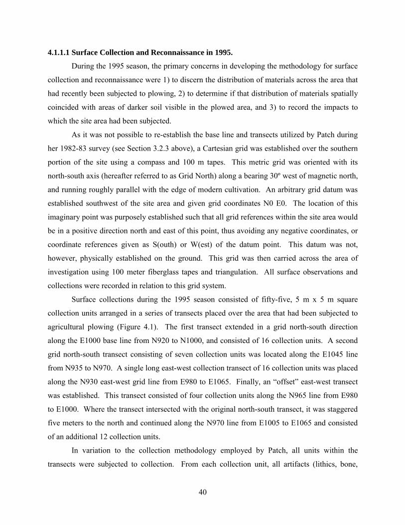
40
4.1.1.1 Surface Collection and Reconnaissance in 1995.
During the 1995 season, the primary concerns in developing the methodology for surface
collection and reconnaissance were 1) to discern the distribution of materials across the area that
had recently been subjected to plowing, 2) to determine if that distribution of materials spatially
coincided with areas of darker soil visible in the plowed area, and 3) to record the impacts to
which the site area had been subjected.
As it was not possible to re-establish the base line and transects utilized by Patch during
her 1982-83 survey (see Section 3.2.3 above), a Cartesian grid was established over the southern
portion of the site using a compass and 100 m tapes. This metric grid was oriented with its
north-south axis (hereafter referred to as Grid North) along a bearing 30º west of magnetic north,
and running roughly parallel with the edge of modern cultivation. An arbitrary grid datum was
established southwest of the site area and given grid coordinates N0 E0. The location of this
imaginary point was purposely established such that all grid references within the site area would
be in a positive direction north and east of this point, thus avoiding any negative coordinates, or
coordinate references given as S(outh) or W(est) of the datum point. This datum was not,
however, physically established on the ground. This grid was then carried across the area of
investigation using 100 meter fiberglass tapes and triangulation. All surface observations and
collections were recorded in relation to this grid system.
Surface collections during the 1995 season consisted of fifty-five, 5 m x 5 m square
collection units arranged in a series of transects placed over the area that had been subjected to
agricultural plowing (Figure 4.1). The first transect extended in a grid north-south direction
along the E1000 base line from N920 to N1000, and consisted of 16 collection units. A second
grid north-south transect consisting of seven collection units was located along the E1045 line
from N935 to N970. A single long east-west collection transect of 16 collection units was placed
along the N930 east-west grid line from E980 to E1065. Finally, an “offset” east-west transect
was established. This transect consisted of four collection units along the N965 line from E980
to E1000. Where the transect intersected with the original north-south transect, it was staggered
five meters to the north and continued along the N970 line from E1005 to E1065 and consisted
of an additional 12 collection units.
In variation to the collection methodology employed by Patch, all units within the
transects were subjected to collection. From each collection unit, all artifacts (lithics, bone,

41
organics and ceramics, diagnostic or otherwise) were collected, bagged, and labeled according to
the collection unit from which they were recovered. Different material types were bagged
separately with each bag receiving a tag with unique tracking number (APSP number – see
Section 4.1.2.1 below) and the collection unit grid provenience recorded. Materials were then
returned to the Penn-Yale-IFA Expedition house at Abydos for processing and analysis as
described below (see Section 4.2)
In addition to the systematic surface collection of artifacts from the plowed area, it was
also necessary to map a series of darker areas that were visible. It was thought that these areas of
darker soil/sand might indicate the locations of subsurface habitation remains. These areas were
most visible from atop a pile of silt recently deposited in the southwest corner of the plowed area
by local farmers. Mapping of the darker areas was accomplished by having one individual stand
atop the earthen mound to direct another individual around the plowed area. The individual on
the ground was then able to delineate each dark area by scribing in the loose soil a line that
followed the boundaries of each dark area. Once scribed on the ground, the areas could then be
mapped using triangulation with 100 m tapes from fixed grid points and drawn to scale on the
site map.
Using the grid and a system of triangulation, various other site features were recorded
and drawn to scale on the site map. These included the locations of several piece-provenienced
artifacts recovered from outside of the designated collection units, areas of agricultural plowing,
and areas impacted and destroyed by the removal of low desert deposits to take advantage of the
underlying silt beds. Finally, the section cuts created by this destruction were examined and
visible stratigraphy and Predynastic features were recorded to scale in profile view.
Unfortunately without availability of a transit/theodolite, it was not possible to record the
elevation of these section drawings. However, ground surface of the section was recorded on the
drawings and was subsequently tied into the arbitrary vertical site datum (see Section 4.1.1.2
below).

42
Figure 4.1: Area of 1995 field investigations at el-Mahâsna.

43
4.1.1.2 Surface Reconnaissance and Mapping in 1996
In the fall of 1996 a small team returned to el-Mahâsna for the purpose of creating a
detailed, modern topographic map of the site area and conducting surface reconnaissance across
the entire site area in order to delineate the extent of the surface distribution of Predynastic
materials. These activities were necessary as surface collections during 1995 were limited only
to the area that had been damaged by plowing in the early 1990s, and mapping was limited to
that accomplished using 100 meter fiberglass tapes and triangulation.
At the end the 1995 field season, a series of 1.5 m long steel rods were driven into the
ground at known grid intersections, with their tops buried 15-20 cm below the ground surface to
prevent their disturbance by local village youths. With the assistance of the hand drawn map
from the 1995 season, these “datum” points were relocated and exposed, and using a laser
theodolite the horizontal metric grid was reestablished. As no vertical datum had been
previously established for the entire site, the ground surface at N1000 E1000 was assigned an
arbitrary vertical elevation of 100 m. Using the instrument, the grid was then physically
extended over the entire site area and several “Stations” were established by driving one meter
steel rods into the ground at known grid points. It was from these stations that the topography of
the site was surveyed (Figure 4.2).
In order to create a detailed topographic map of the site area, individuals carrying optical
prisms walked systematic transects across the site area, stopping to allow the surveying of points
every 6-10 meters as needed based on changes in the topography. In cases of specific features,
such as the drop off from the low desert to the adjacent cultivation, breaklines were recorded for
the top and toe of slope to allow for better interpolation of data points. Linear and polygonal
landscape features (roads, cuts, tomb depressions) were recorded as a series of sequential points
along an either open or closed polygon. All data points were collected electronically using a
Corvallis MC-V data collector attached to the theodolite and downloaded to a laptop computer
on a daily basis.
Ultimately, over 400 individual data points were collected and used to create the first
detailed topographic map of el-Mahâsna. This was accomplished by interpolating the collected
points using the software package Surfer 7.0 (Golden Software 1999).

44
During the 1996 season a controlled surface reconnaissance of the entire site area was
also conducted. The purpose of this activity was to determine the horizontal extent of the
Predynastic surface remains. In order to accomplish this goal, a series of systematically spaced
east-west transects were defined at 10 meter intervals north to south from the southern area of
agricultural impact, to the northern edge of the wadi that was thought to delineate the northern
end of the site. These transects were then walked by an individual knowledgeable in Predynastic
materials, starting at the low desert edge and proceeding westward. In the case of each transect,
the individual placed a pin flag along the transect at the location where Predynastic materials
were last identified. The locations of these pin flags were then mapped with the theodolite, thus
delineating the boundary of the zone of Predynastic habitation. It should be noted that except in
a few specific instances, no materials were collected from the surface during the walking of these
reconnaissance transects. In the limited number of cases where items of note were identified,
these were assigned a unique point provenience number and APSP number, collected and
bagged, and marked in the field with a different colored pin flag from that used for delineating
horizontal distribution. The locations of these point provenienced artifacts were then recorded
using the theodolite and added to the electronic site map. In all, only six objects were collected
in this manner during the 1996 season.
Figure 4.2: Creating the topographic map of el-Mahâsna in 1996.

45
4.1.1.3 Surface Collections in 2000
The surface collection methodology developed for the 2000 field season was designed to
obtain data on the distribution of various artifact classes and densities across the entire area of
Predynastic settlement remains at el-Mahâsna and how these distributions might relate to
subsurface architectural remains. Two concerns were primary in designing the system of
collection: (1) that the system be comprehensive with a tight enough spatial interval to be likely
to not miss individual household areas, and (2) be expeditious and time effective, while not
degrading the nature of the data collected.
The systematic spacing interval for surface collection units in 2000 was determined based
on the results of the 1995 investigations at el-Mahâsna (Anderson 1995, 1997). During these
investigations, dark areas of domestic refuse and debris were noted in the area of the site which
was impacted by plowing. These areas consisted of dark stains clustered in areas approximately
20 m in diameter, and were located approximately 15 m apart (Figure 4.1). Surface collections
in this area were conducted as adjacent 5 x 5 m square units. Artifact density distributions from
these collection units revealed that artifacts were clustered in areas of approximately 20 m in
diameter and spatially correlated with the areas of dark staining. Test excavations in an area of
the dark stains confirmed that these stains are associated with subsurface house remains (see
Section 5.2.9 below). Therefore, from this information it appeared that the spatial extent of a
typical house at el-Mahâsna was approximately 20 m in diameter and that houses were spaced
approximately 15 m apart. Using this information, it was decided to place surface collections
systematically across the site at 15 m interval spacing. Further, in order to make the results from
the 2000 surface collection compatible with earlier collection efforts, a collection unit size of 25
m2 was employed.
The second goal in designing the collection methodology (i.e. time efficiency) was
accomplished by employing a collection strategy commonly referred to as “dog leash”
collections. These collection units are circular in shape and are located and delineated in the
field by means of surveying the center point of the circle, placing a stake at this location, and
then scribing a circle around the point by tying a rope or “leash” of a length equal to the radius of
the designated circle size being used to the stake and walking around the stake like a dog on a
leash. Once delineated, all the materials within the circle may then be quickly collected from the
surface. This system proved to be incredibly time efficient as only a single grid point need be

46
surveyed as opposed to four points when using a square-shaped collection unit. Further time
efficiently was accomplished by the fact that the local workmen employed during the surface
collection could “lay out” a unit without assistance from the trained archaeological supervisors
by using pre-made “leashes.”
Thus, surface collections during the 2000 field season were accomplished by laying out a
series of 25 m2 circular collection units systematically spaced at 15 m intervals across the site
area as determined during the 1996 season. The center points of each collection unit were then
recorded using the theodolite. In a very few, limited cases, the placement of a particular
collection unit was slightly adjusted to avoid a modern obstruction such as an animal pen fence
or cane pile that could not be moved due to the potential presence of venomous snakes. In total,
240 collection units were collected during the 2000 season, amounting to a total of 7.5% of the
site area having been subjected to controlled surface collection during this effort. In combination
with the collections conducted in 1995, a total of 9.2% of the site area has been surface collected.
Once established, each collection unit was subjected to complete collection of all cultural
and potentially cultural materials visible on the surface. In all cases, the surface collection units
presented 100% surface visibility. Surface collections were given an Operation designation
consisting of “SC-” followed by their grid coordinates, e.g. SC-N1000 E1000, and a Locus
designation of Locus 0 (see Section 4.1.2 below for a discussion of the OP/Locus/Lot system).
Collected materials were divided according to predefined artifact categories (see Section 4.1.2.1
below), with each category from each collection unit being assigned one or more unique tracking
numbers (MAP #).
In a limited number of cases, items of note were identified outside of defined collection
units. In such cases, the item was given a point-provenience designation (PP-#), assigned a MAP
number, and then recorded relative to its three-dimensional location within the site area.
4.1.2 Excavation Methodology
Excavation methods utilized by the el-Mahâsna Archaeological Project are a modified version of
those employed by other individual projects operating under the auspices of the University of
Pennsylvania-Yale University-Institute of Fine Arts, New York University Expedition to Abydos
(Penn-Yale-IFA Expedition) co-directed by Drs David O’Connor and William Kelly Simpson

47
(cf. M. Adams 2005:103-108; Harvey 1998:146-149; Wegner 2002: 41-44). This system is
based on the concepts of operations, loci, and lots. Traditionally, the size of excavation units
utilized in the Abydos area by the Penn-Yale-IFA Expedition has been 10 x 10 m square units.
These excavations have primarily been conducted on sites dating to the historic period, during
which time mud-brick architecture is prevalent and excavation units must be of a size to provide
sufficient exposure of these remains. As the archaeological remains at el-Mahâsna are, with the
exception of the Old Kingdom – First Intermediate Period intrusive tomb structures, devoid of
mud-brick architecture and are more ephemeral in nature, it was necessary to modify the system.
4.1.2.1 Provenience Recording
Proveniences at el-Mahâsna were recorded using a version of what is commonly called
the OP/Locus/Lot system of excavation. The smallest unit of provenience is therefore a
combination of the excavation Operation, the particular locus within that operation and the
specific lot of soil removed from that locus from which an artifact(s) originate(s). Individual
artifacts or groups of like artifacts from these provenience units were assigned field specimen
numbers called MAP numbers. These various provenience terms are defined and utilized as
follows.3
Operation: An operation is the basic spatial unit of excavation within which the
excavator works and is equivalent to terms such as excavation unit, or test unit. In the case of
excavations conducted by the el-Mahâsna Archaeological Project, operations are defined as an
excavation unit 3 x 3 m in size.4 These dimensions were chosen to provide for relatively close
horizontal proveniencing of recovered materials, while providing sufficient area of exposure to
recognize the difference between large horizontal features and more spatially extensive
stratigraphic deposits. An additional factor in the choice of operation size is the issue of “bulk
slump” resulting from the unconsolidated nature of the sandy site deposits. These deposits tend
3 Terms such as artifact, feature, and stratum are used throughout the present study in their commonly
accepted archaeological meanings. See Renfrew and Bahn 1996 and Thomas 1989, among others for definitions.
4 The size of all Operations was 3 x 3 meters with the exception of Op 3 (Excavation Block 9 – See Section 5.2.9) which was 2 x 2 meters in size and Op 46 (Excavation Block 7 – See Section 5.2.7) which was 8 x 13 meters in size.

48
to slump inward at a rate of approximately 10 cm horizontally for every 15 cm of vertical
excavation.
Each individual 3 x 3 m unit was designated as an Operation (OP) and assigned a
sequential number within the site, beginning with Operation 1 which was the first test unit
excavated in 1995. Larger excavation areas, or Excavation Blocks, were created by the
excavation of multiple operations positioned adjacent to each other in order to form larger
horizontal exposures. However, even in larger exposures, artifacts were provenienced according
to the individual 3 x 3 m operation in which they were found. The only exception to this practice
is Operation 46. This operation measures 13 m x 8 m in size and was established as such in
order to completely expose the remains of Garstang’s 1900-01 excavation house located in the
central area of the site.
As of the end of the end of the 2000 field season at el-Mahâsna, a total of 45 individual 3
x 3 m Operations have been defined and excavated/partially excavated within the Predynastic
remains, amounting to a total of 405 m2 of controlled excavation.
Locus: A locus can be defined as any spatially defined, archaeologically
recognizable entity within the site. In the case of el-Mahâsna, this typically includes features and
strata as typically defined in archaeology. Loci are assigned unique numbers within the site,
rather than within individual operations. While a locus can be something as specific as a
particular wooden post in a specific operation, they can also be much larger spatial constructs
such as Locus 0 which is assigned to the surface of the entire site, and is only subdivided on the
basis of the boundaries of a particular operation or surface collection unit. In cases where a locus
number is assigned to a larger spatial entity or stratum, it is usually referred to in combination
with the operation number in which it is present, i.e. OP 5 Locus 44; a stratum of Predynastic
habitation debris. In instances where a locus number has been assigned to a spatially limited,
specific entity, the Locus number is usually referred to without reference to the operation within
which it is found, i.e. Locus 69; a pot that was found broken in place in OP 30.
As of the end of the 2000 field season at el-Mahâsna, three loci have been defined which
cover very large horizontal areas, with the horizontal extent of two of them being limited only by
the boundaries of the site. These are Locus 0, Locus 1, and Locus 2. Locus 0 was assigned to
the surface of the site and was used to record the origin of any materials recovered that were

49
resting upon the ground surface. Locus 2 is the second locus whose boundaries equal that of the
site. It was assigned to initial 5 cm +/- of “natural” deposits beginning at the surface. By
“natural” it is meant the initial material beginning at surface level that has not been subjected to
agricultural plowing as in the case of Locus 1, or the result of recent dumping of alluvial
materials in the southwestern portion of the site (Locus 10). Locus 1 is defined as the plow zone
created by the agricultural plowing in the southern most portion the site investigated in 1995 (see
Sections 3.1 and 5.2.9). A total of 115 loci were defined and assigned as of the end of the 2000
field season. A complete list of defined loci can be found in Appendix A.
Lot: A Lot can be described as any defined volume of soil with three-dimensional
boundaries. Lot numbers are assigned sequentially within a specific Locus, within a particular
Operation. In the case of el-Mahâsna, lot designations are typically used to refer to a specific
vertical subdivision of a locus; for instance, Lot 1 might be assigned to the first arbitrary 10 cm
level excavated from Locus 44 in OP 5, or it might represent one of many discernable lenses or
internal strata comprising a larger feature such as deposits that accumulated on a floor/living
surface. However, lot designations can also be used to subdivide a horizontal space within
which the excavator wanted more horizontal provenience control such as defining Lot 1 of Locus
44 in OP 5 as a 10 cm arbitrary level removed from the northwestern most 1 x 1 m square area of
stratum Locus 44 in Operation 5. In another instance, a lot subdivision of a locus might refer to
the western half of a pit feature that was excavated first in order to provide a cross-section profile
of the pit. In all cases, lot numbers are assigned to very specific, definable volumes of soil that
were excavated.
MAP Numbers: In order to track the provenience of all recovered artifacts and
ecofacts, a system of field specimen numbers was utilized. Referred to as MAP numbers, these
consisted of a sequential number assigned to a single object, or group of like objects, from the
same archaeological provenience, i.e. OP/Locus/Lot. This number was then attached to the
bag/basket containing the particular group of objects in the field. These artifact tags in addition
to containing the MAP number also contained information about the specific provenience as well
as indicated the artifact category, i.e. ceramic, faunal, lithics, etc. This information was also
noted on daily tracking sheets for later cross-verification at the expedition lab. Once received at

50
the lab, the tags were checked against the tracking sheets and the information was entered into a
relational database for integration with later analysis.
In instances where MAP numbers were assigned to groups of similar items and it was
necessary to record details of individual specimens, this was accomplished through assigning
three digit, decimal suffixes to the original MAP number (i.e. MAP2460.001 and MAP
2460.002). In cases where fragments from different MAP numbers conjoined to form a single
object, the object is then referred to using either a combination of the two or more MAP numbers
(MAP 2913/2944-a stone mace head) or by reference to only the lower of the MAP numbers
(MAP 2913 in the previous example). In instance where the conjoining fragments were from the
same original MAP number, no change was made, except to assign a decimal suffix if there were
more than the conjoining fragments present within the group of objects.5
4.1.2.2 Method of Excavation Excavation of a particular operation began with the
removal of the deflated natural surface materials (Locus 2) as a single lot down to a level at
which the distinct darker, silt, charcoal, and ash enriched sands of the Predynastic habitation
remains were encountered; typically not more than 15 cm below existing ground surface. Once
exposed, the Predynastic habitation material was assigned a new locus number within each
excavation block. Excavation then proceeded by the removal of arbitrary vertical(/horizontal)
lots within distinguishable stratigraphic units. While lots occasionally were removed in
thicknesses of up to 25 cm, they typically were not more than 5-10 cm thick. Unfortunately, due
to the nature of the deposits at el-Mahâsna, it was sometimes not possible to identify a
stratigraphic break, until having excavated one, or several lots into the underlying strata.
Therefore, in some cases, the final lot or two from one locus may in fact belong with the
underlying locus. In such cases, the lot numbers retain their original locus designation, but have
been later assigned to the appropriate habitation phase (see Section 5.0 ) based on elevation and
observations recorded during excavation. If, during excavation of a particular lot, a potential
“feature plane” was identified, the excavation of the lot was terminated at the elevation of the
5 An exception to this reference system will be the use of ceramic figurine corpus numbers to refer to
anthropomorphic figurines recovered from the site (see Section 6.4.1). These numbers are those which will be used in the forthcoming volume, Early Anthropomorphic Figurines from Egypt by Peter J. Ucko and Barbara Adams, with contributions by David Anderson, Beatrix Midant-Reynes, Ulrich Hartung and Wilhelm van Haarlem.

51
features. Vertical control was maintained during excavation by recording the opening and
closing elevations of each lot in all four corners as well as the center point of the horizontal
extent of the lot within each operation. All vertical measurements were recorded relative to the
arbitrary site vertical datum using either the total station or builders level and stadia rod.
Excavations were conducted by trained Egyptian workmen supervised by an Egyptian
foreman and trained American archaeologists. Deposits were removed using trowels, brushes
and tureyah, a traditional Egyptian agricultural tool similar to a short-handled hoe. All removed
materials were placed in buckets and carried to specified screening stations that were assigned to
each unique lot being excavated. All excavated deposits were 100% dry screened through 4 mm
hardware mesh and all cultural materials were retained and bagged according to predefined
categories of artifacts/ecofacts and assigned a unique tracking number referred to as a el-
Mahâsna Archaeological Project (MAP) Number.
4.2 ARTIFACT ANALYSIS METHODS
Excavations at el-Mahâsna generated a considerable quantity of artifacts in a variety of
categories. For the purpose of the present study, not all categories of objects have been subjected
to detailed analysis. Analysis efforts were focused on those categories which could most directly
address the research questions and hypothetical patterns of elite activity presented above (Section
3.3). With the exception of flaked stone artifacts (both debitage and tool fragments), and
botanical remains, each category received at least a basic level of analysis and description.
Unfortunately, it was not possible to analyze the extensive lithic artifact and paleobotanical
assemblages due to time and financial constraints.
Categories of objects recovered from el-Mahâsna were defined primarily based upon the
material from which an artifact was made. However, in some cases, artifact categories were also
based on functional/descriptive criteria, rather than on material type. In either case, these
categories are the same or similar to those traditionally employed by archaeologists working in
Egypt and elsewhere. The remainder of this chapter details the analysis methodologies
employed in analyzing the ceramic and faunal assemblages. These sections do not discuss the

52
actual nature of the individual assemblages nor the results of the analysis which are presented
below in Chapter 6.0 .
4.2.1 Ceramics
With perhaps the exception of flaked stone debitage and tool fragments, ceramics make up the
largest single category of artifacts recovered from the Predynastic settlement at el-Mahâsna.
This category includes the numerous sherds as well as whole and nearly whole vessels
recovered. Other items manufactured of ceramic such as beads, modified sherds such as spindle
whorls, and clay figurines, etc., are not included in this category.
The system of ceramic analysis utilized in the study of sherds and vessels from el-
Mahâsna was developed in order to address specific issues related to the research questions
posed above in Sections 1.1 and 3.3. Specifically the system of analysis needed to: (1)
characterize the nature of the “native” Abydos-area Predynastic ceramic assemblage relative to
fabric and temper composition; (2) identify wares originating from other areas/regions of Egypt
(Friedman 1994; Adams and Friedman 1992); (3) allow for the identification of foreign, i.e.
non-Egyptian, wares; (4) identify potential luxury or “fine” wares; (5) allow for comparison
with other recently analyzed ceramic assemblages from other Predynastic period settlements and
cemeteries (Friedman 1994; Buchez 2002, 2004; Patch 1991; Vermeersch et al. 2004; among
others); (6) allow for chronological assignations where possible (Hendrickx 1989, 1996; Kaiser
1957; Kemp 1982; Patch 1991); and (7) allow for easy comparison with earlier studies of
Predynastic ceramics, namely Petrie (1901, 1902, 1920, 1921, 1953; Petrie and Quibell 1896)
and others (Aryton and Loat 1911; Brunton 1927, 1937, 1948; Brunton and Caton-Thompson
1928, Mond and Myers 1937). In addition to allowing for all these needs, the system needed to
be such that it provided for the quick recording of multiple attributes for each recovered sherd in
an assemblage that would be greater than 100,000 individual specimens. In order to accomplish
these goals, I chose to use a modified version of those systems used by ceramicists working at
Hierakonpolis (Friedman 1994; Hoffman and Berger 1982), Tell el-Fara’in (Buto) and Abydos
Settlement Site (Köhler 1993, personal communication 1995) as I understood them at the time of
analysis. This system of analysis and documentation is described and discussed below.

53
4.2.1.1 System of Ceramic Analysis
The system of ceramic analysis employed in analyzing the ceramics collected during the
1995, 1996 and 2000 field seasons at el-Mahâsna consisted of recording seven individual
attributes for each sherd/vessel. Analysis was performed by grouping sherds matching in all
seven attributes and then assigning a seven “digit” alpha-numeric code and recording the number
of rim, body and base sherds present of that particular grouping. Each “digit” of the code
represented one of seven individual analysis attributes or variables being recorded, with the
position within the alphanumeric sequence indicating the variable being recorded. So, a group of
sherds assigned a code of B21425B were all Black-topped red ware with a vessel wall thickness
between 0.5 and 1.5 cm, made of Nile Silt clays, highly burnished, red slipped surface with no
temper and a pot mark present. A complete list of the individual code possibilities for each
attribute and their associated values can be seen in Table 4.1. The following is a discussion of
the seven recorded attributes, presented according to their order within the alpha-numeric code
“Petrie-Class”: While originally intended only as a way to assign one of the
traditional Predynastic period ware classes as defined by Petrie, i.e. R-ware, D-ware, etc (1901,
1920, 1921, 1953; Petrie and Quibell 1896) this variable also was used to quickly assign sherds
to other relevant categories/types/periods such as Meydum bowls, Coptic period wares, or Old
Kingdom period Beer Jar fragments. In this way, it was possible to quickly exclude non-
Predynastic period ceramics from later analyses. A single letter was used to represent each of
the traditional Predynastic period wares as well as these additional categories.
The various classes of pottery as defined by Petrie and used herein include his B-, P-, C-,
D-, R-, W-, N-, and L-wares. These wares are described by Petrie in his various publications
(1901, 1921; Petrie and Quibell 1896) and have been discussed by others over the years.6 I refer
the reader to these publications for a detailed description of the definition of these classes.
However, I must note here that I have chosen to use Petrie’s R-ware or Rough-faced pottery to
include all those ceramics of a more “utilitarian” or “rough” nature regardless of the temper
employed in the manufacturing process, not just those of straw tempering as originally defined
by Petrie and Quibell (1896: 11; see also Friedman 1994:99-100).
6 See Friedman (1994:99-101) for a thorough summary of the Petrie’s various pottery classes as well as
problems with Petrie’s definitions, modifications, and his and others’ uses of the system of classification.

54
Vessel Wall Thickness: Vessel wall thickness was recorded as a categorical
variable with three possible values based on relative thickness of the sherd; 3-Fine (≤ 0.5 cm), 2-
Medium (0.5 -1.5 cm), and 1-Coarse (> 1.5 cm); or 4-Indeterminent. This variable was recorded
based on the thickest portion of the vessel wall as preserved.
Clay Type: This attribute records the type of clay used in the manufacture of the
vessel. There has been an extensive effort to classify Egyptian clays into a series of
subcategories based on origin (alluvial clay from floodplain settings and marl clays from desert
settings) taken together with, primarily, the size and quantity of sand grains present within the
matrix (referred to as the “Vienna System”; see Bourriau 1981; Arnold 1982; Nordstrom 1985 ;
and Nordstrom and Bourriau 1993, as well as others, for a discussion of the Vienna System).
Those clay types of the Vienna System most relevant to Predynastic ceramics are Nile Silt A, B1,
B2, and C and Marl A1, A2, and A4 (Friedman 1994: 111-117). However, given the time (and
difficulty) in distinguishing between some of the subtypes in the field it was decided to classify
the clays utilized in the manufacture of ceramics from el-Mahâsna according to the larger
categories of Nile Silt and Marl Clay.
Surface Finish: This attribute refers to the final surface finishing of the vessel,
typically performed prior to the addition of any types of decoration. In addition to intentional
finishes, this category was also used to record the surface condition of the sherd in cases where
the surface was worn and the surface finish could not be determined. Types of intentional
surface finishing that were most frequently identified are high grade polishing/burnishing,
smoothing, and burnishing/polishing. Also identified were roughening, scrapping, and streak
and pattern burnishing/polishing. For definitions and descriptions of these categories, the reader
is referred to Friedman (1994:188-193), as these definitions were followed in developing the
system used at el-Mahâsna.
Surface Coating: This attribute refers to intentional coatings, slips and washes,
added to the surface of the vessel. Following Friedman, the difference between slips and washes
was based on thickness and opacity, with slips being those coatings that “effectively hide the

55
underlying surface and create a smooth texture” to the sherd (1994:178). As with the previous
category, sherds were recorded as “worn” when it was not possible to determine the nature of the
surface coating due to post-depositional effects on the sherd. The types of surface coating most
frequently recorded included Red slip, an absence of coating, and Black and Red slip. A
complete list of Surface Coatings can be found in Table 4.1. Again, the reader is referred to
Friedman (1994:178-188), for definitions and descriptions of the surface coatings as these
definitions were followed in developing the system used at el-Mahâsna.
Temper: As used in this study, the term “temper” refers to non-plastic materials
which were intentionally added to the clay in order to modify its working attributes (Rice 1987:
406-412). This attribute variable was also used to record the absence of temper as well as
specific tempering materials or combinations of materials. In recording this attribute in the field,
an attempt was made to distinguish intentional temper materials from those of accidental
inclusion or materials naturally occurring as inclusions in the clay source. Fabric/temper classes
were defined based on the combination of clay type and temper material (Friedman 1994: 127-
132). Great attention was paid to the definition of temper types, as this variable was shown to be
significant in defining regional wares important in examining extra-regional interaction
(Friedman 1994).
Decoration: Decoration was the final attribute recorded during analysis and refers to
intentional decoration of the vessel which is separate and different from both Surface Finish and
Surface Coatings. This includes such techniques as painting, as well as modifications to the
body of the ceramic such as incisions, punctuations, or impressions. I have also chosen to
include in this category other modifications to the surface of a vessel that are both post
manufacture, such as pot marks, drill holes, as well as the result of the manufacturing process,
such as wheel turning marks on sherds from later periods.
4.2.1.2 Rim/Base Analysis
In addition to the seven fabric/ware attributes recorded, a sample of rim and base sherds
from each provenience, where feasible, were subjected to further metric analysis to record
information concerning vessel form and size. Attributes recorded included the profile of the

56
vessel wall as seen in cross section, the percentage of the original base/orifice circumference
preserved, and the base/orifice diameter of the original vessel.
Vessel wall profiles were recorded using two different methods of drawing. During the
1995 and 2000 seasons, rim/base profiles were draw by hand using calipers, carpenter’s molding
combs and graph paper. This was accomplished by first determining the “stance” of the sherd by
using a flat surface placed perpendicular the sheet of paper. The rough outline of the sherd was
then traced using a fine lead mechanical pencil. Using the carpenter’s comb, the detailed shape
of the cross section was then obtained and the drawing modified to reflect this more detailed and
precise information. While this method proved to be accurate it was necessary to develop a more
time efficient method for drawing and recording the vessel wall profiles.
Recording rim/base profiles during the 2002 study season was accomplished through the
use of a flat bed scanner, modified to provide a stable, vertical surface against which to
determine proper sherd “stance.” Once the sherd was properly positioned such that the break
was parallel to the glass scanning surface and the sherd was aligned to its proper stance, a high
resolution scan (300 dpi) was made of the cross section. Vessel cross sections were then drawn
from the resulting scans using AutoCAD software back in the United States. This method
proved to be not only very accurate in recording detail, but also capable of recording twice as
many sherds in the same period of time as the former method.
Diameters of the orifice/base of the vessel were recorded using a diameter template with
half-centimeter gradations and divided into 5% circumference intervals as described in Rice
(1987:222-223, fig. 7.9). Rim sherds with less than 5% of the orifice circumference and bases
with less that 10% of the orifice circumference preserved, while recorded, were considered to be
unreliable for diameter measurements and subject to interpretation regarding the proper stance as
determined by either method.
4.2.1.3 Vessel Form and Function
Using the information on the shapes of the rim profiles obtained through the rim/base
analysis, the reconstructed form of vessels represented by the sherd assemblage was determined
using a system of subjective shape classes as defined by Friedman (1994:221-228). This
analysis was only conducted using the rim sherds and complete/nearly complete vessels
recovered. Base sherds were not used as these are less diagnostic of the overall form of the

57
vessel. The classification of vessel shape followed the breakdown developed by Friedman
(1994: tables 6.1a and 6.1b) with a few modifications. These modifications are indicated in
Table 4.2 by bold, italic text, and included: (1) increasing the orifice diameter of Miniature
Bowls (subjective shape 1m) from ≤ 8 cm to ≤ 10 cm; (2) adding the subjective shape variations
of 1n1 and 2n1 which vary from the original subjective shape class of Friedman (1n and 2n) by
having body thickness criteria of ≥ 0.5 cm and < 1.5 cm, rather than solely ≥ 1.5cm; and finally,
(3) adding of subjective shape class 1p to the possible subjective shapes for open vessel forms.
Subjective shape class 1p was defined as an open, very shallow-to-nearly flat platter with an
orifice diameter greater than 20 cm.
Assigning a function to vessel forms, particular when forms have been determined from
sherds, is a difficult problem that has received a great deal of attention in the archaeological and
ethnoarchaeological literature (Bedaux and van der Waals 1987; Braun 1983; David and Hennig
1972; Howard 1981; Longacre 1981, 1991; and Strauss 2000). In her analysis of Predynastic
ceramics from settlement contexts, Friedman (1994) examined several different avenues by
which to determine the function of Predynastic vessel forms, including analogy with Dynastic
forms, and an analysis of the contents of various vessel forms recovered from cemetery contexts
(1994:246-254). For the purposes of this study, I have chosen to follow Friedman’s broad
categories of bowls, jars, bottles, basins, etc. (1994:tables 6.1a and 6.1b), where function is
implied from vessel form with open vessel forms, bowls and beakers, being used more in food
preparation, consumption, presentation and display, while closed forms were more suited for
storage and transportation. In Table 4.2 I list the “functional categories” for each of the
subjective shape classes as used in the present study.

58
Table 4.1: Ceramic ware analysis codes.

59
Table 4.2: Subjective shape classes and functional categories used in vessel form and function analysis.
Subjective Shape Code
Shape Description Basic Form Category
Functional Category
Open Forms 1a Bowls with convex contour, direct rim Bowl Food Preparation 1a1 Shallow to medium depth Shallow Bowl Food Serving 1a2 Deep bowls Deep Bowl Food Preparation/Serving 1b Bowls with sloping contour, direct rim Bowl Food Preparation 1b1 Bowls with straight sloping walls Bowl Food Preparation 1b2 Shallow bowls with straight sloping walls Shallow Bowl Food Serving 1b3 Bowls with slight curvature in wall Bowl Food Preparation 1b4 Deep bowls, slight curvature in wall Deep Bowl Food Preparation/Serving 1b5 Bowls with elliptical orifice Bowl Food Preparation 1c Beakers with direct rim Beaker a Food Preparation b 1c1 Beakers with vertical (90°) walls, direct rim Beaker Food Preparation 1c2 Beakers with near vertical (100°) walls, direct rim Beaker Food Preparation 1d Beakers with everted rim Beaker Food Preparation 1d1 Beaker with vertical wall, slightly evened rim Beaker Food Preparation 1d2 Beaker with vertical wall, strongly everted rim Beaker Food Preparation 1d3 Beaker with near vertical wall, slightly everted rim Beaker Food Preparation 1d4 Beaker with near vertical wall, strongly everted rim Beaker Food Preparation 1e Bowls with composite contour Bowl Food Preparation 1f Bowls with everted rims Bowl Food Preparation 1g Bowls with modeled rims Bowl Food Preparation 1h Bowls with ledge rims Bowl Food Preparation 1j Bowls with broad ledge or everted rims and convex
body contour Bowl Food Preparation

60
Subjective Shape Code
Shape Description Basic Form Category
Functional Category
1j1 Deep Bowls with broad ledge or everted rims Deep Bowl Food Preparation/Serving 1j2 Shallow Bowls with broad ledge or everted rims Shallow Bowl Food Serving 1k Bowls with exterior carination Bowl Food Preparation 1l Shallow elliptical pans Pan Food Preparation/Serving 1m Miniature bowls; diameter ≤ 10 cm Miniature
Bowl Eating/Drinking vessel
1n Large basins; diameter ≥3 5 cm, body thickness ≥ 1.5 cm
Basin Food Preparation
1n1 Large Basins; diameter ≥ 35 cm, body thickness ≥ 0.5 and < 1.5 cm
Basin Food Preparation
1o Crude, shallow, elliptical platters Platter Food Serving 1p Shallow, nearly flat Platters > 20 cm diameter Platter Food Serving
Closed Forms 2a Hole mouth jars, direct rims Hole Mouth Jar Storage/Transportation 2a1 Hole mouth jars with low sloping contour Hole Mouth Jar Storage/Transportation 2a2 Hole mouth jars with medium sloping contour Hole Mouth Jar Storage/Transportation 2a3 Hole mouth jars with high sloping contour Hole Mouth Jar Storage/Transportation 2a4 Hole mouth jars with convex contour, low shoulder Hole Mouth Jar Storage/Transportation 2a5 Hole mouth jars with convex contour, medium
shoulder Hole Mouth Jar Storage/Transportation
2a6 Hole mouth jars with convex contour, high shoulder Hole Mouth Jar Storage/Transportation 2b Jars with modeled rims Jar Storage/Transportation 2b1 Jars with sloping contour, low shoulder Jar Storage/Transportation 2b2 Jars with sloping contour, medium shoulder Jar Storage/Transportation 2b3 Jars with sloping contour, high shoulder Jar Storage/Transportation 2b4 Jars with convex contour, low shoulder Jar Storage/Transportation 2b5 Jars with convex contour, medium shoulder Jar Storage/Transportation 2b6 Jars with convex contour, high shoulder Jar Storage/Transportation 2c Jars with low neck, modeled rims Jar Storage/Transportation

61
Subjective Shape Code
Shape Description Basic Form Category
Functional Category
2d Small jars with modeled rims or low necks: diameter ≤5 cm
Small Jar Storage/Transportation of liquids
2e Bottles with high evened necks Bottle Storage/Transportation of liquids 2f Jars with everted rims Jar Storage/Transportation 2g Jars with concave profile (low vertical neck), direct
rim Jar Storage/Transportation
2h Jars with collar Jar Storage/Transportation 2j Small jars with everted rims; diameter ≤ 8 cm Small Jar Storage/Transportation of liquids 2k Jars with ledge rim Jar Storage/Transportation 2m Miniature jars; diameter ≤ 2 cm Miniature Jar Storage/Transportation of liquids 2n Large jars or pithoi; diameter ≥ 35 cm, wall thickness
≥ 1.5 cm Large Jar Storage
2n1 Large jars or pithoi; diameter ≥35 cm, wall thickness ≥ 0.5 and <1.5 cm
Large Jar Storage
Source: Adapted from Friedman 1994, tables 6.1a and 6.1b. Note: Modifications to Friedman are indicated by bold, italic text.
a Beakers with a diameter ≥ 37cm were classified as a “Large Beaker” b Beakers may also have been used for storage purposes, particularly those with large orifice diameters.

62
4.2.2 Faunal Remains
Based upon data obtained during the 1995 test excavations, it was know that faunal remains were
well preserved at el-Mahâsna, even in those areas that had been impacted by the agricultural
plowing and irrigation. Further, these preliminary results indicated that the faunal assemblage
was rich in both mammal, fish, and reptile remains, and would require a specialist versed in the
various species of the Nile Valley. Therefore, Stine Rossel from Harvard University was invited
to analyze the faunal assemblage from the 2000 season at el-Mahâsna. The reader is referred to
Rossel (2006) for a detailed discussion of the methods of analysis and identification that were
used in analyzing the el-Mahâsna assemblage. Included here is only a brief discussion of the
methods of recovery, cleaning, and tabulating of the faunal materials.
During both the 1995 and 2000 excavation seasons, faunal remains were recovered from
excavated deposits though 100 percent dry-screening of the matrix through 4 mm wire mesh
screens. Once sifted, the matrix was examined and all visible faunal materials were removed
from the screen, bagged separately from other artifact classes, and assigned separate MAP
numbers different from those of other artifacts from a provenience. Upon returning to the field
house, the faunal materials were removed from their plastic bags and laid out in order to dry out
any moisture present from the matrix in which they were recovered. Following this process, the
remains were examined by the lab supervisor, and those remains determined to be too fragile to
be washed were dried brushed with a soft bristle brush. All other remains were gently washed to
remove any attached sediment, Finally, after washing/dry brushing all bone tools/tool fragments
were removed and assigned new MAP numbers, while the remaining materials were allowed to
fully dry before being counted and re-bagged to await later analysis.
Faunal materials from the 2000 season were analyzed by Rossel during the 2003 and
2004 study seasons. Unfortunately, the faunal materials recovered during the 1995 test
excavations were not available at that time and have yet to be analyzed. Rossel’s analysis
focused upon identifying individual bones/bone fragments to the most detailed level of
taxonomic classification, preferably to species level, where possible. In those cases where it was
not possible to identify to the level of species, higher level classifications were used. Each
specimen was then identified as to skeletal element, portion of element preserved, side of body

63
where applicable, percent preserved, as well as age, size and sex of the individual when possible.
Also recorded were various modifications, both intentional like cut marks and burning, as well as
taphonomic modifications such as weathering and rodent gnawing. Finally, a count of the
number of identified specimens (NISP) and weight in grams was recorded.
While an attempt was made to analyze the entire collection of faunal materials from the
2000 season, it was necessary to prioritize the collection to ensure a maximal return of
information from well provenienced materials over those from more suspect contexts.
Therefore, faunal remains from surface contexts, as well as potentially disturbed contexts such a
those in Habitation Phase 3GAR (see Section 5.2.3), and later pits and disturbances were given
lower priority and have not yet been analyzed.
Finally, it should be noted here that the Number of Identified Specimens or NISP has
been used in all tabulations and analysis of the faunal materials. While some scholars choose to
use Minimum Number of Individuals (MNI) or a combination of NISP/MNI when handling
faunal data, we have chosen to use NISP, following Grayson (1984).

64
5.0 RESULTS OF FIELD INVESTIGATIONS, PART I:
STRATIGRAPHY AND FEATURES
Field investigations at el-Mahâsna during the 1995 and 2000 field seasons resulted in a detailed
systematic surface collection comprised of 295, 25 m2 surface collection units (Figure 5.1), as
well as the controlled hand excavation of 405 m2 of Predynastic habitation remains. As
discussed above (Section 4.1.2), excavations were spatially organized as a series of Excavation
Blocks consisting of one or more adjacent 3 x 3 meter excavation Operations (or 2 x 2 meter in
the case of Op 3- See Section 5.2.9). For ease of reference, each of these Excavation Blocks has
been assigned a sequential number, beginning at the northern end of the site and progressing
south (see Figure 5.2). This chapter begins with a discussion of the general nature of the
deposits at el-Mahâsna as revealed through excavation and the methods employed to subdivide
them into recognizable habitation phases within each of the excavation blocks. Next, detailed
results of both the surface collections and excavations are provided. Organized according to
individual excavation blocks, each of the following sections presents (a) a discussion of the
proposed reconstructed habitation phases within a specific block as revealed during excavation
and subsequent analysis of the field results; (b) a discussion of the features associated with each
phase; and (c) chronological assignation of each of the habitation phases. Cursory discussions of
the types of artifacts recovered from each block are given, however, in depth discussion of
artifacts recovered from each block is reserved for Chapter 6.0
Before beginning a discussion of each Excavation Block, it is necessary to discuss the
methods employed in determining the habitation phases. As described above (Section 4.1.2.1),
excavations within each operation were conducted in a series of arbitrary horizontal and vertical
divisions designated as Lots. The precise thickness/volume of soil removed in each Lot varied
according to the specific natural/cultural stratigraphic situation. In the majority of cases, these
Lots consisted of 5-10 cm of vertical depth removed from across an entire 3 m x 3 m excavation

65
operation within discernable stratigraphy. However, in some cases, it was not possible to
precisely define stratigraphic breaks due to the nature of the deposits at el-Mahâsna, and the final
lot or two of one locus may in fact later prove to have been the upper lots of an underlying
stratum. Or, as is more often the case, there were no discernable differences in the nature of the
deposits present when in fact, a living floor was apparent based on the presence of several
features, all originating on the same horizontal plane.
Following excavation, the vertical extent of every excavated Lot within every Operation
was plotted in cross-section based on recorded opening and closing elevations. The vertical
position of each identified feature was also plotted on the cross sections relative to its absolute
elevation and known placement within each Lot, i.e. identified at the base of Locus 44, Lot 2.
Once each Operation was reconstructed in cross section, adjacent cross sections were combined,
creating continuous north-south and east-west profiles through each of the Excavation Blocks.
Using these resulting cross sections, recorded stratigraphic breaks, and actual stratigraphic
profiles where available, it was then possible to recognize distinct habitation surfaces and the
deposits associated with these surfaces in each Block. Each recognizable habitation phase was
then assigned a unique alphanumeric designation based on the excavation block number and an
uppercase alphabetic suffix assigned sequentially from upper- to lower-most phase.7 Exceptions
to this vertical order is the use of the suffix “L” to indicate loci/lots that have origins of post-
Predynastic date, such as intrusive tomb pits/shafts, and the suffix “GAR” to indicate materials
believed to have originated as excavation dump from Garstang’s 1900-01 excavations and
sebbakh digging.8 Once determined which locus/lot combinations from each Operation belonged
to which habitation phase, this information was then added to the central provenience database.
The resulting reconstructed phase stratigraphy is subsequently presented in the individual
Excavation Block discussions.
7 It was decided to assign habitation phase designations in increasing order top-to-bottom, or in reverse
chronological order, rather than in increasing order from oldest to most recent. This decision was made, since with the exception of Blocks 2 and 5, it is not possible to definitively determine that the earliest phase of habitation has been reached in the excavations.
8 The “GAR” designation for a phase was only used in the case of Excavation Block 3.

66
Figure 5.1: Location of surface collections from the 1995 and 2000 field seasons at el-Mahâsna.

67
Figure 5.2: Map of el-Mahâsna showing the location and designation of the Excavation Blocks

68
5.1 SURFACE COLLECTION RESULTS
Artifacts recovered from the 295 surface collection units primarily included ceramic sherds and
lithic debitage as well as an occasional lithic tool fragment, fragment of grinding stone, or bead.
Unfortunately however, these other classes of artifacts were recovered in such minimal number
as to exclude the usage in defining areas of elite occupation within the site. Therefore, only the
distribution of ceramics was examined in detail, and then primarily for the purposes of
identifying areas of lighter and denser habitation debris.
When one takes into account all the ceramic sherds recovered during the surface
collections, the number of sherds recovered ranged from as little as zero to as many as 2,026 per
collection unit. However, in many cases the recovered sherds were small (<2 cm) and highly
eroded and thus could not be definitively assigned to the Predynastic period. It was important to
consider only those sherds that could be reliably determined to be Predynastic as later period
sherds were recovered in quantities exceeding 270 sherds per collection unit in some areas
(primarily the areas with surface evidence of Old and First Intermediate Period tombs [FIP]).
These later materials ranged in date from Old Kingdom through Roman and Coptic periods,
although were mostly either Old Kingdom/FIP or Roman. Because of the presence of these later
materials only Predynastic period sherds where ultimately used in the creation of surface density
maps that were used in selection of areas to conduct subsurface excavations.
Predynastic sherd densities recovered from the 295 collection units ranged from zero to
286 sherds per unit, or just over 11 sherds/m2, and an average of 20.3 sherds/unit. Using
interpolation software, a surface density map was created from the collection unit data (Figure
5.3). The resulting map, reveals that an extremely dense concentration of surface sherds in the
northern portion of the site. This concentration is primarily the result of four collection units
which all produced in excess of 200 sherds. Further, these high counts may partially be the
result of surface disturbances caused by sebbakh digging as well as dump materials from
Garstang’s excavations. However, as we will see below, these high counts also appear to reflect
the nature of Predynastic use of this area.
In addition to this primary concentration, several other areas of higher sherd densities
were identified. The first of these is located just west of Excavation Blocks 4 along the western
boundary of the limits of Predynastic remains as identified from surface reconnaissance in 1996.

69
The next most dense clustering of surface material can be seen as a roughly linear concentration
running northeast–southwest away from the main cluster surrounding Excavation Block 3.
Nearly as dense as this linear cluster is a concentration of material located approximately three-
quarters of the way between Excavation Blocks 3 and 6/7. Finally, the remaining higher density
area identified through the surface collections is the area surrounding Excavation Block 8 at the
southern end of the site in the area that was impacted by agricultural plowing in the early 1990s.
5.1.1 Positioning of the Excavation Blocks
Using the patterns of surface density obtained from the surface collection units, the locations for
subsurface excavation were chosen, with the exception of Blocks 8 and 9. These excavation
areas were specifically positioned to evaluate the degree of impact caused by the illegal creation
of the agricultural fields in the early 1990s. Block 8 was positioned based upon the results of the
1995 surface collections and mapping of the darker midden areas visible in the plowed zone as
discussed above in Section 4.1.1.1. Block 9 was excavated to determine the impacts to the site in
those areas actively under cultivation in 1995 and its location was partially decided based upon
several hearth features visible in the nearby section cut located just to the east of block.
Following the completion of the 2000 season surface collections, the locations for Blocks
1-5 were chosen. These blocks were positioned in order to investigate the very dense
concentration of surface materials at the northern end of the site. Originally, it was intended that
these blocks would only consist of a few 3 x 3 meter operations each, and then several
excavators would shift their activities to other areas of surface concentration just discussed,
while one or two very promising blocks at the northern end would be expanded by one or two
staff members. Unfortunately, concerns of the security detail that accompanied us each day
prohibited us from working in multiple areas of the site at any one time because of issues of
visibility and lack of availability of additional guards. Therefore, we were restricted to working
on a single area of the site until all members of the staff could move to another area. Therefore,
because of the complex nature of Block 3 and the degree of material uncovered there and in
Block 1, these areas occupied our efforts until nearly the end of the excavation season at which
time we were briefly able to excavate in Blocks 6 and 7.

70
Figure 5.3: Density of Predynastic period ceramic sherds recovered from the surface.

71
The location of Block 6 was chosen to investigate an area with very low concentrations
of surface ceramics while at the same time having a dense cluster of fine flint blades visible on
the surface. As will be discussed below in Section 5.2.6, this concentration proved to be the
result of Garstang discarding materials excavated elsewhere and not the result of Predynastic
activities. Block 7 was subsequently positioned to investigate a large mud brick structure visible
on the surface that based on the results of Block 6 and a close examination of Garstang’s map
appeared to represent the remains of his 1900-01 expedition house. These excavations were
important for correlating his map with the modern landscape and thus determine where his areas
of excavation were located (see Section 5.2.7).
The criteria used in choosing the location of the excavation blocks is discussed more
specifically below in the detailed discussion of each excavation block.
5.2 EXCAVATION RESULTS
5.2.1 Excavation Block 1
Excavation Block 1 is located toward the northern end Predynastic settlement and consists of 12
contiguous 3 x 3 meter Operations, OPs 4, 5, 6, 7, 8, 9, 26, 29, 30, 31, 42, and 43 (Figure 5.2).
The modern ground surface in the area surrounding Block 1 is characterized by relatively level,
compact sands and gravels with a slightly darker appearance than the surrounding area (Figure
5.4). Just to the north of this Excavation Block is a shallow, linear depression running roughly
east-west. This area of Block 1 was chosen for excavation based on the concentration of artifacts
recovered during the controlled surface collections and because the darker nature of the
surrounding ground surface appeared to indicate the existence of subsurface habitation remains.

72
Figure 5.4: Area of Excavation Block 1 prior to excavation.
Excavations within Block 1 resulted in the removal, on average, of 45 cm of vertical
deposition from Predynastic period habitation. Analysis of the excavations in Block 1 have
resulted in the identification of three primary Predynastic period habitation phases (Figure 5.5)
containing several pyrotechnic features (i.e. hearths/ash pits) and living floor remains, in addition
to the well preserved remains of numerous wooden and reed posts that appear to constitute a
portion of one or more former structures. Besides the Predynastic period remains, several later
period intrusive loci were also identified and will be briefly described below.
As excavations within Block 1 were some of the first conducted during the 2000 field
season, the first two operations in the block (OPs 4 and 6) were considered to be somewhat
exploratory. Consequently, the locus designation Locus 2, normally reserved for only the upper
5-10 cm of natural desert surface, was used to refer to all the Predynastic period deposits
excavated within these operations until Locus 64 and Locus 65 were encountered near the base
of the excavations. Nevertheless, it has been possible to successfully and reliably subdivide
these deposits into Habitation Phases in these operations based on the individual Lots that were
excavated.

73
Figure 5.5: Reconstructed north-south profile looking east thorugh Block 1 showing habitation phases.

74
Categories of some of the artifacts recovered from Block 1 include ceramic sherds, lithic
debitage and tool fragments, faunal remains, bone tools, beads, copper tools, figurine fragments,
ostrich eggshell, ground stone, and wood.
5.2.1.1 Habitation Phase 1A
Habitation Phase 1A is the uppermost phase identified in Block 1 and encompasses both
Locus 2, the natural desert surface materials, as well as the upper portions of Locus 44. Locus
44 is a stratum of dark, organic-rich, fine sands and silts resulting from Predynastic habitation
debris and midden deposits which have accumulated within and around a post structure. The
boundary between Phase 1A and the underlying Phase 1B has been determined based upon the
vertical co-occurrence of several features and living surface areas present within the block, as
well as correlation with stratigraphic breaks visible in three stratigraphic profiles which were
fortunate to hold up long enough to record their details. Averaging 23 cm in thickness,
Habitation Phase 1A deposits ranged in thickness from as few as 12 cm in the northern end of the
block to as much as 30 cm in the eastern portion of Operation 9. This observed variation in the
thickness of the Phase 1A midden deposits is most likely associated with the 28 cm drop in
surface elevation from the southern to the northern end of Block.
Features: A number of features associated with Phase 1A were identified, including a post
structure, living floors/surfaces and ash pits/hearths (Figure 5.6).
Structural Remains –Posts and Living Surfaces: Perhaps the most significant feature
associated with Habitation Phase 1A is a structure comprised of posts and associated living floor
deposits. While most likely originally constructed as part of Habitation Phase 1B, the structure
appears to have been used and modified during Phase 1A. A total of at least 58 wooden and reed
posts were identified during the excavation of Block 1 and appear to be associated with the Phase
1A usage of the structure.9 While details were not recorded in the field for six of the posts,
details regarding the material and the diameter of the posts was recorded for the remaining 52
9 The remains of several other possible posts were also identified, but given the extremely deteriorated
nature of even the well preserved posts, it was not possible to confirm that these additional posts were indeed posts and not the remains of some other organic matter.

75
posts. Of these, 90.4% (n = 47) were wood while 9.6% (n = 5) were reed. The reed posts had an
average diameter of 1.9 cm with a range of 1-3 cm, while the wooden posts averaged 4.1 cm in
diameter with a much greater range of 1.5-18.1 cm. When taken together, the post diameter from
both wood and reed posts has a 5% trimmed mean of 3.5 cm, and range in diameter from a
minimum of 1 cm to a maximum of 18.1 cm. Examination of the distribution of the diameters of
posts reveals that six of the posts represent outliers with respect to their unusually large
diameters (> 7.1 cm; Table 5.1).
Table 5.1: Stem-and-leaf diagram of post diameters from Excavation Block 1
Frequency Stem & Leaf 5.00 1 . 00555 18.00 2 . 000000000000002445 12.00 3 . 000000000005 6.00 4 . 000005 2.00 5 . 05 3.00 6 . 000 6.00 Extremes (>=7.1) Stem width: 1.0 Each leaf: 1 case(s)
Unfortunately, the entire horizontal extent of the structure has not been exposed, and
therefore it is difficult to determine the precise shape and layout of the structure. Nevertheless,
several observations can be made. The structure appears to be comprised of a wall
approximately 12.94 m in length, running roughly grid north-south (Figure 5.7; Wall 1).
Included among the posts making up this wall are the six posts that were classified as being
unusually large in diameter. The southern most post of this wall (Locus 51) was the largest in
diameter (18.1 cm) and was associated with a very large R-ware sherd that has been used as
chocking or wedging for added support along the southern face of the post (Figure 5.8).10
10 When first uncovered, post Locus 51 was the only post that had been identified during the 2000 season
and was not known to be part of a structure and therefore was assigned a locus number. However, with the exception of the next post to the north (Locus 58), the practice of giving Locus numbers to individual posts was not typically followed during the 2000 season. The location of the majority of the posts was simply recorded on plan view drawings and using the digital mapping system. Associated information concerning material type and diameter was recorded next to each post on the plan view drawings and in the comment field of the data collector record.
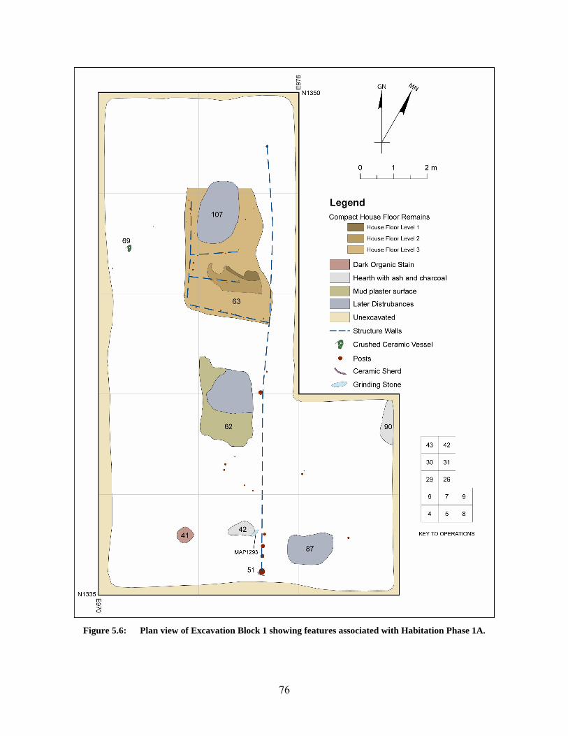
76
Figure 5.6: Plan view of Excavation Block 1 showing features associated with Habitation Phase 1A.

77
It is interesting to note that with the exception of Locus 51, no other posts in Block 1 have
evidence of chocking or reinforcement and there are no calages or mud reinforced post mold
structures in Block 1.11
Perpendicular to this wall were built at least two east-west walls (Figure 5.7;Walls 2 and
4) comprised of smaller diameter posts (generally those ≤ 5.0 cm in diameter) and located toward
the northern end of Block 1. Wall 2 forms the southern boundary of Locus 63 (see below). Wall
3 connects these two perpendicular walls and is located approximately 2.5 meters west of the
first. It is a north-south running wall that is generally comprised of 2.5-5.0 cm diameter posts
and forms the western edge of Locus 63. Based on the recovery of fragments of twigs and
segments of vines with knots present, it would appear that this structure was constructed using a
combination of vertical posts with mats tied to the posts to form walls that potentially held
wattle-and-daub. This would be very similar to contemporary construction techniques still used
in small rural villages such as near-by Maslahet Harun as can be seen in a photograph of such a
structure taken in 1995 (Figure 5.10).
Locus 63 is an area delineated by Walls 1, 2, and 3 and recognized during excavation as
an area of darker brown sands/silts with a high organic content and much more compact than the
surrounding deposits (Figures Figure 5.6, Figure 5.7, and Figure 5.9). This locus appears to
represent an interior space surrounded on at least three sides and covering an area of at least 8.86
m2. The eastern boundary of these darker deposits lends support for the reconstruction of Wall 1
extending nearly the length of the Block. Unfortunately, the northern edge of the locus was not
well defined, except by the absence of the darker deposits, and it appears that this area may have
been impacted by later disturbances. Wall 4 appears to subdivide the space, creating a room or
partition approximately 0.95 x 1.6 m in size at the southern end of the structure.
In the portion of Locus 63 immediately north of Wall 2, three strata of floor debris were
preserved to varying extents. Given the shallow depth below ground surface of Locus 63, the
two uppermost of these strata were not as extensively preserved as the lowermost. The
uppermost of these strata was preserved over an area of only 0.17 m2 while the next lowest
covers only 0.72 m2. Material recovered from this Locus included lithic debitage, faunal and
11 See Section 5.2.3.4 below for a definition and discussion of mud reinforced post molds or calages.

78
botanical remains, ceramic sherds, fragments of wood, knotted vine fragments, and a large
bivalve shell (see Section 6.0 ).
A second apparent living surface, Locus 62, was identified and appears to have been
associated with the post structure in Habitation Phase 1A (Figure 5.6). Originally thought during
field excavation to be associated with a potential later tomb intrusion, Locus 62 is a rectangular
area of prepared mud plaster floor/surface measuring 1.59 x 2.34 meters in maximum
dimensions (Figure 5.11). While impacted in the northeastern corner by later pitting, this surface
would have originally covered an area of approximately 3.35 m2. The mud plaster used to
construct the surface is heavily tempered with straw/organic material and had a surviving
thickness of approximately 2-3 cm. The southern and eastern edges of the plastering appear to
“lap” upward, suggesting that this surface is associated with Wall 1 and a wall to the south for
which no posts survived or were identified during excavation.
The remains of the post structure were compared to a similar structure identified at the
Naqada IC-IIID site of Adaïma located south of Esna. Here, a post structure designated
Structure C1 and measuring 4.3 m x1.2m was defined by 39 posts ranging in size from 2 cm to
as large as 14 cm in diameter (Midant-Reynes and Buchez 2002: 37-40; and Appendix III, 149-
160).12 An examination of the distribution of post diameters from the two structures reveals that
diameters from the el-Mahâsna Block 1 Structure tend to be skewed toward the lower end of the
distribution and have a less normal distribution with several outliers to the upper end of the scale,
while those from the structure at Adaïma, while also slightly skewed downward, have a much
more normal distribution (Figure 5.12). The mean post diameter for Structure C1 at Adaïma is
5.69 cm, which is 1.78 cm larger on average than the posts recovered from Block 1 Structure at
el-Mahâsna. While this roughly 2 cm difference in average post diameter might not be
considered to be very strong, it is statistically significant (t = -2.815, df = 89, p = 0.006).
12 The mean diameter of posts associated with Structure C1 was calculated based on information
concerning post diameters presented in Appendix III of Midant-Reynes and Buchez 2002. In cases where a post diameter was listed as “12 x 9”, the maximum dimension was used as the post diameter.

79
Figure 5.7: Post structure in Excavation Block 1

80
Figure 5.8: Large Post (Locus 51) at southern end of Structure in Excavation Block 1.
Figure 5.9: Locus 63 in Operation 26 with darker materials as well as Wall 2 posts visible.

81
Figure 5.10: Modern house in the village of Maslahet Harun showing example of post and mat architecture.
Figure 5.11: View of Locus 62, the mudplaster surface.

82
el-Mahâsna Block 1 StructureAdaïma Structure C1Site
20
15
10
5
0
Post
Dia
. (cm
)
20
15
10
5
0
Post Dia. (cm)
25 20 15 10 5 0
Frequency2520151050
Frequency
Figure 5.12: Distribution of post diameters from el-Mahâsna Block 1 Structure and Structure C1 at Adaïma.
Pyrotechnic Features – Hearths and Ash Pits: Two hearth/ash pit features were identified
in Excavation Block 1 as associated with Habitation Phase 1A. The first of these, Locus 42, is
an oblong shaped, shallow pit containing ash and charcoal rich sands and silts found in Op 5, just
west of Wall 1 of the post structure (Figure 5.6 and Figure 5.13). With a maximum length of 82
cm and maximum width of 44 cm, Locus 42 extended approximately 18 cm into the underlying
deposits. The hearth did not have any discernable internal structure, nor did there appear to have
been any special preparation of the pit itself.
Locus 90 is similar to Locus 42, but slightly larger in size with a maximum length of 131
cm and a maximum width of at least 40 cm.13 Vertically, Locus 90 extends approximately 25 cm
in depth, with the deepest portion of the hearth being the southern end, while the northern end
was relatively shallow. As with Locus 42, Locus 90 did not appear to have any discernable
internal structure and the pit was not lined.
13 The final dimensions of Locus 90 are not known as the eastern portion of the feature was unexcavated at
the end of the 2000 field season.

83
Miscellaneous Features: In addition to those features already described, two other features
from Excavation Block 1 are associated with Habitation Phase 1A. These are Locus 41 and
Locus 69 (Figure 5.6). Locus 41 is a shallow (< 7 cm), 50 cm in diameter, circular stain of very
organic rich materials containing the remains of sheep/goat dung as well as what appears to be a
limey, plaster-like substance.
Locus 69 is a Black-topped red ware ceramic vessel that was found broken in place just
below the modern ground surface in the western half of Op 30 (Figure 5.14 and Figure 6.6).
Chronological Assignation of Habitation Phase 1A: Based on recovered ceramic rim
sherds from deposits and features, Habitation Phase 1A appears to date to the Naqada IIa-b.
Figure 5.13: Locus 42.

84
Figure 5.14: Locus 69.
5.2.1.2 Habitation Phase 1B
As with Habitation Phase 1A, the main stratigraphic deposit associated with Phase 1B is
a Locus 44. Comprised of dark, organic rich, fine sands and silts, Locus 44 is a stratum resulting
from Predynastic habitation debris and midden deposits which have accumulated within and
around the post structure. Another stratum associated with this phase of occupation in the area
of Block 1 is Locus 64. This stratum is described as a loose yellowish brown sand containing
silts and fine charcoal particles. Averaging 21 cm in thickness, Habitation Phase 1B deposits
ranged in thickness from as few as 7 cm in the northern end of the block to as much as 40 cm in
the northwestern corner of Operation 5.
Structural Remains – Living Floors and Posts: The post structure discussed above, while
believed to have been originally constructed during this phase, is less complex in nature than that
described above during Phase 1A. In fact, during Phase 1B, it appears as though this structure
consisted only of Wall 1, as the bases of the posts associated with Walls 2-5 did not extend
sufficiently into Phase 1B deposits such that they would have been able to support walls during
this period.

85
Pyrotechnic Features – Hearths and Ash Pits: Two hearth/ash pits are associated with
Habitation Phase 1B (Figure 5.15). Both features are very similar in form and dimension. The
first of these, Locus 61, measures 52 x 46 cm and is roughly circular in plan view with a shallow
bowl shape in profile, with a maximum depth of 8 cm. Locus 109 is also circular in plan view
with similar dimensions of 51 x 44 cm with a shallow bowl shape profile and a maximum depth
of 10cm. In both cases, the matrix of these loci consisted of ash and/or ashy silt with charcoal.
While Locus 61 produced lithic debitage, nine fragments of faunal remains, and 24
ceramic sherds, only a single, non-descript, figurine fragment was recovered from Locus 109
(see Section 6.4.3; MAP 2823).
Miscellaneous Features: The only other feature associated with Habitation Phase 1B is
Locus 46, a possible lithic cache. Located in Operations 4 and 5, Locus 46 consists of a group of
lithic cores resting in a small pit 30 cm in diameter (Figure 5.15 and Figure 5.16). Placed on top
of this pit was a rough tabular piece of limestone acting as a cap-stone.
Chronological Assignation of Habitation Phase 1B: Dating of Habitation Phase 1B was
based upon an examination of diagnostic rim and body sherds recovered from deposits and
features associated with this phase. Based on all those sherds examined, Phase 1B appears to
date to the Naqada Ic-IIb period. However, the extension of this phase into the Naqada IIb sub-
period is based solely on the recovery of a single D-ware sherd (MAP 1298.001; Figure 6.22)
from the upper-most surface of Phase 1B in Operation 5. This sherd may very well have
originated in the directly overlying Phase 1A deposits with which it fits chronologically. If one
does not consider this single sherd, the remaining sherds from Phase 1B form a very nice, tight
cluster from the Naqada Ic-IIa. Therefore, I have chosen to use this latter dating for the Phase.
5.2.1.3 Habitation Phase 1C
This phase of Habitation is represented by a thin deposit of Locus 64 materials overlying
Locus 65, a stratum of compact sands, pebbles, and gravels that slopes upward in a west to east
direction. Deposits associated with this Phase, while identified in other operations, were only
excavated in Operations 4, 29 and 30. Therefore, no calculation has been made concerning the
thickness of deposits as excavated. Artifacts recovered from this Phase include lithic debitage,

86
faunal remains, and limited ceramics. Only 90 sherds were recovered from this Phase, with
78.8% (n = 71) being recovered from Locus 81.
Features: Only a single feature was identified as associated with this phase. Locus 81
appears to be a tomb pit, which was looted during Predynastic times. Located in the
northwestern portion of the excavation block, Locus 81 is 1.88 m in length north-south and 1.28
m in width east-west (Figure 5.17). Containing a matrix of light yellowish brown sand, this pit
was not visible until the removal of both the Locus 44 and Locus 64 materials. Because of time
constraints at the end of the excavation season, it was not possible to excavate this pit in its
entirety. However, from the excavation that did take place, lithic debitage, 71 ceramic sherds,
and 43 pieces of bone were recovered, including human bone fragments. The human bone
fragments discussed below (Loci 59 and 60) may be associated with this burial but are more
likely to be associated with later period burials given their origin very high in the stratigraphic
profile.
Chronological Assignation of Habitation Phase 1C: Given the limited amount of deposits
excavated from Phase 1C, only three rim sherds were recovered. In all cases, these rim sherds
were two small to provide accurate vessel shape information. Therefore, it is not possible at this
time to date this phase of occupation of the Block 1 area.
5.2.1.4 Post-Predynastic Remains
It is necessary to briefly mention several later period intrusive features that were identified
within the area of Excavation Block 1 (Figure 5.6). Primarily, these are related to the occurrence
of concentrations of human remains and the depressions from possible Old Kingdom – First
Intermediate Period pit tombs excavated by Garstang or possibly looters. However, in the case
of the latter, these pits/in-filled depressions may in fact be the result of either ancient and modern
looting activities or the result of sebbakh digging.
Two concentrations of human remains were identified in Operation 6 at the base of Locus
2 and within the upper 5-10 cm of Locus 44. In both cases, these remains most likely originated
from the excavation and/or looting of nearby Loci 87 and 107 described below. However, there
is also a possibility, though very slight, that given the proximity to Locus 81 described above,
they may in fact be human remains associated with this early burial.

87
Figure 5.15: Plan view showing features associated with Habitation Phase 1B.

88
Figure 5.16: Locus 46.
Figure 5.17: Location of Locus 81, Habitation Phase 1C.

89
Two depressions, both filled with relatively clean yellow/yellowish brown sand were
identified as excavated/looted tomb pits dating most likely from the Old Kingdom-First
Intermediate Period. In the case of Locus 87, this pit does not appear to have significantly
impacted the Predynastic period remains. However, Locus 107 did impact the post structure as
well as the living floor remains (Locus 63) associated with the structure.
Also deserving of mention here is the pit feature that impacted the northeast corner of
Locus 62 which also appears to be either a Old Kingdom-First Intermediate Period tomb pit or a
later looter’s hole. This feature is described above on page 78
5.2.1.5 Excavation Block 1 Summary
In summary, the remains uncovered in Excavation Block 1 appear to represent in-situ habitation
features and midden deposits associated with a large, partially exposed structure. This structure
was delineated based on the recovery of 58 wooden and reed posts arranged in a pattern forming
a long north-south wall with at least two perpendicular walls running east-west and a shorter
north-south wall approximately 2.5 meters west of the first. Based on ceramic materials
recovered from the stratigraphic deposits associated with this structure, the remains identified in
Excavation Block 1 date to the Naqada Ic-IIab subperiods.
5.2.2 Excavation Block 2
Positioned near the edge of the low desert escarpment, Excavation Block 2 is 3 x 9 meters in size
and is comprised of three contiguous Operations, OPs 11, 12, and 13. Block 2 was situated so as
to investigation the nature of deposits along the edge of the site area and also due to the relatively
high number of Predynastic period sherds recovered from an adjacent surface collection (SC-
N1300 E1000) . The area occupied by Block 2 is situated just at the base of a slight north-south
direction slope and just west of the slope which leads down to the low desert edge, located
approximately 17 m to the east (Figure 5.18).
Excavations within Block 2 resulted in the removal of an average of 77 cm of Predynastic
period deposition for a combined excavated volume of approximately 20.79 m3. Analysis of the
excavations in Block 2 have resulted in the identification of three primary Predynastic habitation
phases which appear to be associated with an outdoor activity area. Features associated with

90
these habitation phases include clusters of artifacts on living surfaces, a large hearth feature, two
smaller ash features, as well as evidence for a fence or reed wall. Categories of artifacts
recovered from Block 2 include ceramic sherds, lithic debitage and tool fragments, faunal and
botanical remains, bone tools, perforated ceramic disks, eggshell, groundstone, wood, and animal
coprolites, among others.
Figure 5.18: Area of Excavation Block 2 (right half of photograph) showing the relationship to the edge of
the low desert escarpment.
5.2.2.1 Habitation Phase 2A
Habitation Phase 2A is the upper most phase identified in Excavation Block 2 and ranges
in thickness from 20 cm to as thick as 27 cm, with an average thickness of 23 cm. Habitation
Phase 2A encompasses deposits associated with both deflated desert surface (Locus 2) as well as
the upper portions of a stratum of Predynastic habitation debris/midden designated Loci 38 and
66. These loci represent an inter-fingering of micro depositional events varying in extent both
horizontally and vertically (Locus 38) within a more homogenous stratum of deposition (Locus
66). Locus 38 was light brownish gray to gray in color and contained varying amounts of
artifacts, ash, and charcoal. Locus 66 consisted of pale brown silty sand/sand deposits generally
containing less ash and charcoal than Locus 66, but appeared to contain larger quantities of

91
artifacts. An attempt was made during excavation to remove these deposits separately, but
occasionally it was necessary to excavate them as “Locus 38/66” because of the inter-digitated
nature of the remains. This interweaving of Loci 38 and 66 continued throughout the entirety of
Habitation Phase 2A. The top and base of these deposits sloped in a north to south direction,
mimicking the slope of the modern ground surface as well as the underlying pre-Predynastic
ground surface. Taken together, these two loci appear to represent deposition from a
combination of activity area debris and intentional trash disposal from nearby activity
areas/structures in Block 3.
Features: Features associated with Habitation Phase 2A (Figure 5.19) include a portion of a
broken ceramic vessel (Locus 39), a dark circular organic stain (Locus 40), a cluster of artifacts
(Locus 67) and a large hearth (Locus 52). All of these features appear to be related to a slightly
more compact living surface located just below the level of the deflated desert surface (Locus 2).
Locus 39 consisted of several large B-ware ceramic sherds broken in-situ surrounding a
lump of a white limey substance that resembled harden lime plaster (Figure 5.20). Located in
Operation 12, Locus 40 was an area of dark organic staining and decaying organic material
measuring 29 x 34 cm in plan view. As can be seen in Figure 5.19, Locus 40 was situated on top
of Locus 52, with only centimeters separating the two features vertically. While extremely
decayed, the organic material that made up the feature appears to be the remnants of either
basketry or matting.
The largest feature uncovered in Excavation Block 2 was Locus 52, a large hearth
structure. Measuring 120 x 135 cm in plan view, this complex hearth had a maximum depth of
37 cm. Unlike those hearth features described above in Excavation Block 1 (page 82), Locus 52
was a more substantial structure with evidence of intentional construction. Bowl-shaped in cross
section, the walls of Locus 52 appear to have been intentionally lined with mud/clay and small
rocks prior to initial use (Figure 5.22). Over time, this prepared lining was baked hard and
resembled a coarse ceramic in appearance and texture. While the upper stratum of feature fill
was characterized by a loose ashy sand matrix, the lower portion was a dense stratum of charcoal
and burned material. From the rubified nature of the surrounding sands, coupled with the baked
nature of the mud/clay lining, it is obvious that this hearth was utilized multiple times over a
period of time. In both size and internal structure, this hearth is similar to Type D hearths as

92
defined by Tristant (2004:97-100) and is the only example of this complex form so far identified
at el-Mahâsna during the modern excavations.
Figure 5.19: Plan view of Habitation Phase 2A showing the locations of associated features.

93
Figure 5.20: Locus 39
Figure 5.21: Locus 52 in plan view

94
Figure 5.22: Locus 52 in profile view
Chronological Assignation of Habitation Phase 2A: The majority of ceramic materials
recovered from Phase 2A indicate a Naqada IIab-c date for these deposits. This dating has been
extended into at least the Naqada IIc based on the recovery of a single body sherd of a D-ware
vessel with a wavy-handle recovered from deposits of this Phase (MAP1150.001). However, the
majority of the materials recovered suggest a date of Naqada IIa-b.
5.2.2.2 Habitation Phase 2B
Habitation Phase 2B is represented by the accumulation of midden deposits designated as
Loci 38 and 66. These two matrices became much more homogeneous shortly below the top of
the habitation zone such that Locus 38 was no longer recognized below the first 5-10 cm of the
habitation phase. Deposits associated with Habitation Phase 2B averaged 21 cm in thickness and
ranged from as little as 16 cm at the northern boundary of Op 11 with Op 12, to as much as 25
cm. Artifact types recovered from this phase of habitation include ceramics, faunal remains,
lithic debitage and tool fragments, bone tool fragments, coprolites, shell, groundstone, perforated
ceramic disks, and a fragment of a possible mud sealing. No features were associated with
Habitation Phase 2B.

95
These materials associated with Habitation Phase 2B appear to represent a series of
midden deposits and outdoor living areas which accumulated between the much more
recognizable living surfaces associated with Habitation Phase 2A and 2C.
Chronological Assignation of Habitation Phase 2B: Based on recovered ceramic rim
sherds from deposits and features associated with Habitation Phase 2B it would appear that this
Phase dates to Naqada IIa-b.
5.2.2.3 Habitation Phase 2C
Habitation Phase 2C was defined based on a recognized living surface associated with a
visible change in the nature of the stratigraphic deposition. Comprised of the very lower most
Lots of Locus 66 and deposits from Loci 80 and 94/93, Habitation Phase 2C deposits ranged in
thickness from a maximum of 31 cm in the central portion of the block to as little as 16 cm at the
northern edge of Operation 12, with an overall average thickness of 26 cm.
The upper surface of Habitation Phase 2C is characterized by a compact living surface
comprised of two vertically coterminous, but horizontally distinct deposits (Locus 80 to the north
and Locus 93/94 to the south) which appear to represent deposits that have accumulated on either
side of a fence/wall like structure. This fence/wall line corresponds roughly with the boundary
between Operations 11 and 12. Locus 80 is comprised of brown, consolidated/compacted sands,
pebbles, and small gravels, which have a much higher organic content along the boundary with
Locus 94/93. Locus 94/93 is characterized by light brownish gray sands with little gravel or
inclusions (<10%). Further, Locus 94/93 deposits are much less consolidated/compacted. Both
Locus 80 and Locus 94/93 rest upon a stratum of naturally deposited silts (Locus 89) which
occurs at a depth ranging from 64 cm to 88 cm below modern ground surface and represents the
pre-settlement land surface.
Evidence of the fence/wall was recovered at the base of Habitation Phase 2B in the form
of a wooden post preserved in three pieces measuring a total of 122 cm in length lying flat upon
the Habitation 2C surface. It was clearly apparent from its position that it has collapsed or been
knocked down. There was some evidence, though not clear, of a highly decayed portion of the
post continuing vertically into the under lying deposits. Additional evidence for the fence/wall
was present in the location of artifacts upon the living surface itself. Materials deposited upon

96
the living surface abruptly stop along a roughly east-west line, with heavier concentrations
present to the north of this line as well as a much stronger organic content along the northern
edge of the line. Further, the deposits to the north of the line were much more compact, and
contained a higher content of lithic debitage, faunal remains, and small pebbles and rocks, while
those to the south of the line (Locus 94) were much loser in nature and contained much fewer
artifact and rock inclusions. This division between Locus 80 and Locus 94 materials can clearly
be seen in Figure 5.23; especially in the concentration of date pits (Figure 5.23b). Other features
associated with the living surface are Locus 84, a concentration of seeds found lying on the
surface of Locus 94 in Operation 11, and Locus 88, a cluster of animal hair, mostly goat, found
on Locus 80, although this last feature may be associated with a nearby rodent disturbance. No
other features were identified associated with this phase of habitation.
Figure 5.23: Habitation Phase 2C showing the visible line of a former fence/wall.
A. Note the distribution of materials along the northern side of the wall; B. Close up of the concentration of date pits visible in the lower portion of A.
Chronological Assignation of Habitation Phase 2C: Dating of Phase 2C was based upon
an examination of ceramic rim sherds as well as a C-ware body sherd. These materials suggest a
date of Naqada Ic-IIab for this Phase.

97
5.2.2.4 Excavation Block 2 Summary
The area of Block 2 appears to represent a combination of outdoor activity zone and trash
disposal area. There appears to have been a wall/fence present that was either part of a structure,
or helped to define/divide the outdoor space. From ceramics recovered in Block 2, the excavated
deposits date to the Naqada Ic-IIc periods.
5.2.3 Excavation Block 3
Comprised of 18 contiguous Operations (OPs 10, 16 – 23, 32 – 39, and 41) and encompassing
162 m2, Excavation Block 3 is the single largest excavated area from post-Garstang excavations
at el-Mahâsna. The area surrounding Block 3 is slightly elevated from the surrounding terrain,
and characterized by an undulating ground surface comprised of numerous rises as well as
several deeper depressions (Figure 5.24). The ground itself is very dark in color and has a very
high concentration of surface artifacts, primarily ceramics, but also faunal and lithic materials.
Based on the nature of the ground surface, it was believed that this area represented either an
area of excavation dump from Garstang’s 1900-01 excavations, 2) one of the “mound” areas
subjected to sebbakh digging noted by Garstang, and shown on his map (Garstang 1903:6 ; Plate
II); or 3) a disturbed area resulting from a combination of these two factors.
Excavation Block 3 was started as OP 10 in this area initially as a single 3 x 3 m test
excavation, with the purpose of determining which of these three factors caused the disturbed
appearance of this area. The placement of Block 3 was also such as to investigate the unusually
dense concentration of surface materials recovered from surface collections SC-N1285 E970,
SC-N1285 E985, and SC-N1300 E985; which represent three of the four densest surface
collections with respect to Predynastic period ceramics. This OP 10 revealed evidence of
excavation dumping upon a surface that had, prior to 1900/01 been impacted through the
activities of the sebbakhin. However, below these disturbed levels, Operation 10 quickly
revealed a very intact sequence of stratified Predynastic period deposits associated with what
appears to be a rather substantial post structure. Therefore, Block 3 was expanded as a series of
18 operations to expose this structure. This expansion occurred to the down-slope areas of the
eastern side of the visible rise (i.e. to the east and north of OP 10) in order to minimize the

98
amount of overlying deposits that would need to be removed in order to reach the depths of the
floor remains of the structure.
Excavations within Block 3 resulted in the removal of an average of 0.99 m of
Predynastic period deposition for a combined excavated volume of approximately 161.55 m3.
Depths of excavation in Block 3 ranged from a maximum of 1.69 m in the southwest corner of
OP 16 to as little as 0.34 m in the northeast corner of OP 38, Analysis of excavation results from
Block 3 revealed a complex sequence of stacked Predynastic living surfaces associated, at least
for the lower levels, with a large structure, possibly ceremonial in nature. Following a review of
the excavation records and a series of six reconstructed cross sections running both east-west and
north-south through the block, it has been possible to define at least 5 habitation phases based on
the presence of compacted living surfaces, and co-planar occurrence of features. These 5 phases
are, unfortunately, not represented in all operations that make up Block 3, and the upper most of
these, Habitation Phase 3A is only preserved in portions of OPs 10 and 16.
From the perspective of both recovered artifacts and features, Excavation Block 3 shows
the greatest diversity in Predynastic remains. Feature types identified include prepared “mud
plaster” floors, large, reinforced post holes, in-the-floor ceramic vessel emplacements, hearths,
pits, and compacted living surfaces. Artifact categories recovered from Excavation Block 3
include complete ceramic vessels, ceramic sherds, lithic debitage and tools, projectile points,
mace fragments, querns, pestles, bone needles and awls, spindle whorls, copper needles, beads
and pendants, and a large assemblage of anthropomorphic and zoomorphic figurines and figurine
fragments.
5.2.3.1 Habitation Phase 3A
Habitation Phase 3A represents the latest identified Predynastic occupation in the area of
Excavation Block 3. Highly impacted and destroyed by the activities of the sebbakhin, Phase 3A
was only recognized in portions of OPs 10 and 16 (Figure 5.26). Deposits making up the
primary matrix of Phase 3A were designated during excavation as Locus 2, as this phase was not
clearly identified at first during excavation and was originally thought to be part of Garstang’s
dump material, and Locus 43. Because of this failure to notice the remnants of this phase during
excavation, there may be some mixing with Garstang dump material overlying the Habitation
Phase 3A. It averaged 32 cm in thickness with a range of 6 - 49 cm, where preserved.

99
Figure 5.24: Area of Excavation Block 3 prior to excavation.
Note the undulating nature of the ground surface.
The existence of Habitation Phase 3A was primarily defined based upon an area of
preserved, compact living surface remains designated Locus 43. This material is described as
compact, organic rich brown to dark brown sand with patches of heavily decayed organic
material present on its surface. The boundaries of Locus 43 are amorphous and clearly the result
of pitting from the removal of sebbakh. The compact deposits of Locus 43 averaged 14 cm in
thickness. Artifacts recovered from Locus 43 include ceramics, lithic debitage and tool
fragments, animal bone and shell, and a single ceramic figurine fragment.
Features: The only feature identified as associated with Habitation Phase 3A is a pit feature
designated Locus 45. This pit is located at the far eastern extreme of the preserved section of
Locus 43. Measuring 116 x 53 cm in plan view, Locus 45 had a maximum depth of
approximately 35 cm, although the bottom of the pit was indistinct. The matrix of the pit
consisted of sand mixed with decayed organics, charcoal, and some silts. Aside from a few
ceramic sherds and 17 fragments of animal bone (including 4 fish and 1 cattle), no other artifacts
were recovered from the pit fill. Therefore, it is most likely that Locus 45 represents a refuse pit
for the disposal of organic based trash.

100
Figure 5.25: Schematic East-West Profile of Excavation Block 3 showing the sequence of reconstructed Habitation Phases.

101
Figure 5.26: Plan view of Excavation Block 3 showing remains associated with Habitation Phase 3A.

102
Chronological Assignation of Habitation Phase 3A: As was stated above, Habitation
Phase 3A was not recognized during the 2000 excavations and was thought to be part of the
disturbed deposits associated with the sebbakhin and Garstang’s dump. Therefore, only 10.2%
(n = 185) of the approximately 1816 sherds recovered from Phase 3A deposits have been
analyzed to date. Of those analyzed, only 14 were rim sherds, all of which were insufficiently
preserved to allow for proper shape and chronological determination. Thus it is not possible at
this time to assign Habitation Phase 3A to a particular sub-period of the Naqada sequence.
However, based on the dating for Phase 3B discussed below, this phase appears to post date
Naqada IIa.
5.2.3.2 Habitation Phase 3B
Aside from OPs 10 and 16 as discussed above, Habitation Phase 3B is the uppermost
preserved phase in the vast majority of Excavation Block 3; it is present in all Block 3
operations. Deposits which have been assigned to this phase averaged 15 cm in thickness and
ranged from 2 cm to as much as 44 cm in the western portion of the block. The primary matrix
of Habitation Phase 3B (as well as the remaining phases of Block 3 described below) is a pale
brown to very pale brown silty sand containing organic matter, ash, and charcoal particles
designated Locus 49. Typically, Phase 3B includes only the uppermost Lot of Locus 49
excavated in any particular operation. While portions of Locus 49 designated as Habitation
Phase 3B stretch across the entirety of the block, features associated with this phase are spatially
congregated in the west/central portion of Block 3 (Figure 5.27). Artifact categories recovered
from Habitation Phase 3B deposits and loci include ceramic vessels and sherds, lithic debitage
and tool fragments, animal bone and shell, bone tools, spindle whorls, unbaked clay “pot lids”,
worked fragments of wooden artifacts, a possible copper bead, a possible mud sealing fragment,
and fragments of clay figurines, including a seated women with thigh tattoos (Mah.IV.1 [MAP
2558]; see Section 6.4.1 below).
Features: Features associated with Habitation Phase 3B (Table 5.2 and Figure 5.27) include
wooden posts, three ceramic vessel emplacements, and several areas of artifact concentration.
All of these features appear to be related to a compact living surface and an area of organic
staining (Loci 72 and 74) located in the same general area of the block as Locus 43 in Phase 3A.

103
Table 5.2: Summary of features associated with Habitation Phase 3B.
Locus Number
Operations Feature Type Feature Description
50 10 Ceramic Vessel Emplacement ceramic vessel 53 10 Ceramic Vessel Emplacement ceramic vessel 54 17 Artifact Cluster Concentration of Bone, ceramic
with organics &ash 68 21 Ceramic Vessel Emplacement ceramic vessel 71 33 Artifact Cluster Ceramic and bone 72 10,16,20,21 Living Surface large horizontal stained organic
area with burning. 74 21,22 Living Surface Hard packed sand and burned area 76 10 Posts two wooden posts
Structural Remains –Posts and Living Surfaces: Structural remains associated with
Habitation Phase 3B include a living surface as well as three associated wooden posts. Locus 74
is an area of stratified, compact living surface deposits located in the western portion of the
block, covering the majority of Operation 21 (Figure 5.27 and Figure 5.28). Originating in Phase
3C (see below), these floor deposits ranged in thickness from 15 – 33 cm, with an average
thickness of 33 cm overall across both Phases 3B – 3C, with the upper approximately 5-10 cm
belonging solely to Phase 3B (Figure 5.29). Consisting of gray to dark gray, hard packed sands
with ash, charcoal, and decayed organic matter, Locus 74 measured at least 2.66 x 2.89 m in
horizontal extent. The southern end of Locus 74 is characterized by a dense, linear concentration
of organic material. When examined in profile view (Figure 5.29) this organic area appears to be
trench-like in nature, with the southern “wall” of the trench being nearly vertical with a
maximum depth of 25 cm, while the northern “wall” rises very sharply at first for approximately
10-15 cm and they slopes more gently to the north. The matrix making up the “trench” fill is
much looser in composition than the remainder of Locus 74 and consists of sands with a very
high content of decayed wood and other organic material mixed with some ash. The far northern
end of the organic deposits is slightly darker and woodier in nature than the remainder of the
organic fill. The depth of the trench is deepest at the western end, where there is a roughly
circular, slightly deeper area. As the “trench” extends to the east, it quickly becomes much more
shallow, and eventually is nothing more than a surface concentration of dense organic matter.
Also recovered from among this organic material were the decayed remains of a wooden post

104
measuring 4 cm in diameter. This organic stain/trench is interpreted as the decayed remains of a
large post (northern end) and intervening matting/wattle of a wall of a large structure, as well as
decayed organic material that had accumulated along the wall. This potential structure is
discussed further below in Sections 5.2.3.4.
Artifacts recovered from the upper portion of Locus 74 include lithic debitage and tool
fragments, 58 ceramic vessel sherds, a complete ceramic vessel (Locus 68; see below), and 16
fragments of animal bone, only one of which was identifiable; as coming from a small rodent.
Adjacent to and associated with Locus 74 is Locus 72, a large area of organic staining
extending to the south and west and covering large portions of Operations 10, 16, and part of 20.
Locus 72 was described as a thin (2-5 cm thick) layer of organic material with occasional areas
of higher concentrations of ash and charcoal. Running roughly east-west, Locus 72 has a
maximum east-west dimension of 7.1 m and a north-south dimension of 2.78 m and covers
approximately 12.1 m2. Running along the northern edge of Locus 72 is a band of much darker
sands with higher organic content than Locus 72 and the surrounding Locus 49 matrix. This is
interpreted as a continuation of the decayed remains of the probable wall associated with Locus
74 and discussed below. This features appears to be a living surface associated with the upper
portion of Locus 74 and the probable wall and structure just mentioned. Additional structural
features associated with Locus 74 include the remains of two wooden posts (Locus 76) found in
the southwest corner of the feature, each measuring 2.5 – 3 cm in diameter (Figure 5.27).
Artifacts recovered from Locus 72 include lithic debitage and tool fragments, 265 ceramic
sherds, and 66 fragments of animal bone (9 fish, 2 turtle, 2 cattle, 1 sheep/goat, and 2 small
rodent).

105
Figure 5.27: Plan view of Excavation Block 3 showing remains associated with Habitation Phase 3B.

106
Figure 5.28: View looking east of Excavation Block 3, Habitation Phase 3B showing Locus 74 (bottom
center) and Locus 72 (right of center) and Locus 68 (center).
Figure 5.29: Profile of southern end of Locus 74 looking west.

107
Ceramic Vessel Emplacements: Three ceramic vessels were found associated with, and cut
into the Locus 72 and 74 living surfaces and each was assigned individual loci numbers. Loci 50
and 53 were emplaced in small pits located in the southwest quadrant of Locus 72 (Figure 5.27
and Figure 5.30) such that their rims were just above the level of the matrix of Locus 72. Both
vessels are classified as Rough ware vessels with each having evidence of use wear and damage.
The pits within which they were placed were not much larger in diameter than the vessels
themselves and did not contain any other artifacts. These vessels are discussed in more detail
below in Section 6.1.
Locus 68 was a small Rough ware vessel with an opening diameter of approximately 7
cm that was found emplaced in the Locus 74 floor deposits (Figure 5.27). This ceramic vessel
was exposed at the very end of the day and left in place to be excavated the next day.
Unfortunately, it was stolen overnight before any additional information or close-up photographs
could be obtained.
Figure 5.30: Loci 50 (back) and 51 (front) in situ.
(Note: several levels of surrounding deposits have been removed from the floor level in which these vessels were emplaced.)

108
Miscellaneous Features: Two miscellaneous features were identified as belonging to
Habitation Phase 3B; Locus 54 and Locus 71, both of which are thin, spatially confined
concentrations of artifacts. Locus 54 was a scatter of animal bone, ceramic sherds, ash and
organic material lying on the surface of Phase 3B along the southern boundary of the excavation
block. In plan view, Locus 54 measured 1.79 m east-west, and at least 0.87 m north-south,
although the full extent of the feature is unknown.
Locus 71 was assigned to two nearly adjacent areas of surface concentrations of ash and
ceramic sherds located along the northern boundary of the excavation block. The largest of the
concentrations measured 1.12 x 0.87 m in size while the smaller measured 0.32 x 0.56 m.
Neither of these concentrations had any depth.
Chronological Assignation of Habitation Phase 3B: Based on recovered ceramic rim
sherds from deposits and features associated with Habitation Phase 3B it would appear that this
Phase dates to Naqada IIa-c.
5.2.3.3 Habitation Phase 3C
Habitation Phase 3C was comprised mainly of stratum Locus 49 matrix as described
above for both Phase 3A and 3B. The vertical extent of Phase 3C was defined based on the
horizontal co-occurrence of several features coinciding with a visible stratigraphic break within
the Locus 74 living surface deposits described above. Deposits assigned to this phase occur in
all 18 Operations of Block 3 and averaged 21 cm in thickness with a range of 32 cm; the thinnest
(2 cm) deposits occurring along the eastern margin of the excavation block and the thickest (34
cm) in the south central area of the block. Artifacts recovered from Habitation 3C deposits
include lithic debitage and tool fragments, ceramic sherds and complete vessels, faunal remains,
bone awls, ceramic figurine fragments, mud jar stoppers, and a possible mud seal fragment.
Features: Features associated with Habitation Phase 3C (Table 5.3 and Figure 5.31) include
wooden posts, three ceramic vessel emplacements, a mud-reinforced post mold, and several
areas of artifact concentration. All of these features appear to be related to a living surface
associated with a potential large structure (see Section 5.2.3.4 below).

109
Table 5.3: Summary of features associated with Habitation Phase 3C.
Locus Operations Feature Type 73 19 Artifact and Post concentration 74 21,22 Hearth and living surface? 79 22 Calage de limon et piere/ mud reinforced post mold 82 22,23 Pot 97 39 Pot-large 130 23, 34 Ash and organic stain/concentration
Structural Remains – Living Floors and Posts: The primary living floor remains associated
with Habitation Phase 3C are the lower deposits of Locus 74, which was previously described.
The portions of Locus 74 assigned to Phase 3C are lower deposits, approximately 18 – 23 cm,
which like those in Phase 3B were very compact in nature with a high content of decayed
organic matter present.
In addition to the living floor remains of Locus 74, a large mud-reinforced post mold
(Locus 79) and a concentration of five wooden posts (associated with Locus 73; see below) were
recovered. The wooden posts from Locus 73 ranged in diameter from 4.7 – 6.4 cm and had an
average diameter of 5.1 cm. These five posts were tightly cluster in the northwestern quadrant of
OP 19 and are in direct association with a small R-ware ceramic cup/bowl (MAP1792; Figure
5.33) found lying upside-down just west of the posts. These posts also appear to be associated
with Locus 73 a area of artifact concentration belonging to both Phase 3C and the earlier Phase
3D, which is described in Section 5.2.3.4 below.
Locus 79 is a large mud reinforced post mold or calage located in the southwest corner of
OP 22 (Figure 5.31).14 This feature is comprised of thick mud and stones/cobbles that have been
packed up against a large wooden post (22 cm in diameter). While the large post that occupied
the center of this feature was no longer present, nor was the cavity filled with decayed wood
material, the faint impression of wood grain could be distinguished on the inner faces of the near
vertical walls of the central opening. At least five other mud reinforced post molds have been
identified in Block 3 and are associated with Phase 3D. It is believed that Locus 79 is in fact part
of the same structure to which these other features belong, but has been assigned to Habitation
Phase 3C based on the elevation of its rim and its being coplanar with the top of the Locus 74
14 These types of structures have been referred to by Midant-Reynes and Buchez as calages (Midant-
Reynes and Buchez 2004: 41-48).

110
Phase 3C deposits. However, it is most likely that it was constructed at the same time as the
other large post supports. This feature type is discussed more completely in Section 5.2.3.4
below. A total of 12 ceramic sherds were recovered from among the mud reinforcing and
included fragments of Polished red ware, Black-topped red ware, and Rough Ware. Faunal
remains recovered from among the mud and stones include a single unidentified specimen.
Ceramic Vessel Emplacements: Three ceramic vessel emplacements were identified
associated with Phase 3C. These include Loci 82 (MAP2724) and 97 (MAP2741) as well as
vessel MAP2480 associated with the Locus 73 artifact concentration and found just south of the
small ceramic cup/bowl (MAP 1792) previously mentioned. Both Loci 82 and 97 are large R-
ware vessels. Locus 82 is a large basin with punctate decoration running around the vessel lip.
Locus 97 on the other hand is a large jar form. The third vessel emplacement, MAP2480 is a
small, fine (< 0.5 cm wall thickness), Black-topped red ware jar with a very worn surface which
also has areas of surface exfoliation. All three of these vessels were intentionally placed in tight
pits that were not much larger in diameter than the maximum diameter of the vessel itself.
Miscellaneous Features: A single miscellaneous feature, Locus 130, was identified in
Habitation Phase 3C. Consisting of a surface concentration of ash and decayed organics, Locus
130 is located along the northern boundary of OP 23. Measuring 1.09 x 0.45 m in horizontal
extent, this feature did not extend vertically more than 2-3 cm in thickness and most likely
represents sheet midden deposition of materials from a nearby hearth feature located
north/northeast of the excavation block. No artifacts were recovered from the feature.
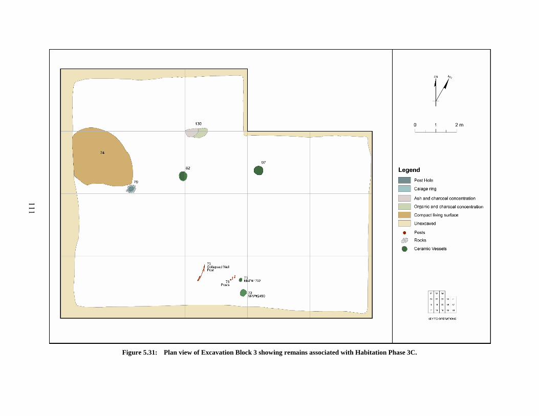
111
Figure 5.31: Plan view of Excavation Block 3 showing remains associated with Habitation Phase 3C.

112
Figure 5.32: Locus 79 shown in (a) oblique view and (b) plan view.
Figure 5.33: Ceramic cup (MAP1792) recovered from the surface of Locus 73.

113
Figure 5.34: View of (a) Locus 82 and (b) Locus 97 in situ in Habitation Phase 3C.
Chronological Assignation of Habitation Phase 3C: Dating of Habitation Phase 3C is
based upon an examination of ceramic rim and body sherds as well as the three complete vessels
recovered from deposits associated with this Phase. These materials suggest a date of Naqada
IIa-b. These materials included two D-ware body sherds, one of which has a depiction of the
arm and shoulder of a human or lizard figure (Figure 6.22 [MAP 3331]).
5.2.3.4 Habitation Phase 3D
Habitation Phase 3D represents the earliest occupation phase identified within Excavation
Block 3. This phase includes a substantial number of features including both mud reinforced
post molds, sections of prepared mud flooring, and the deposits found surrounding and overlying
these features. These deposits appear to rest upon a layer of clean yellow sand (Locus 117;
Habitation Phase 3E). As will be discussed, these various features appear to represent the partial
remains of a large and fairly substantial structure possibly serving a ritual/cultic purpose based
upon the artifacts recovered from this phase as well as Excavation Block 3 in general. Deposits
associated with Phase 3D are comprised of Locus 49 matrix and averaged 39 cm in thickness
with a range in thickness of 14 – 61 cm. Artifacts recovered from Phase 3D represent the greatest
diversity of types recovered from any habitation phase investigated during the 1995 and 2000

114
excavation seasons. These categories include ceramic vessels and sherds, lithic debitage and
tools, bone awls, copper and bone needles, groundstone mace head fragments, flint and ivory
projectile points, stone and clay beads/pendants, spindle whorls, jar stoppers and lids, stone
marbles, and a significantly large assemblage of anthropomorphic and zoomorphic clay figurines
and figurine fragments.
Features: Features associated with Habitation Phase 3D (Table 5.4and Figure 5.37) include
wooden posts, large areas of prepared mud flooring, mud reinforced post molds, and areas of
organic staining.
Table 5.4: Summary of features associated with Habitation Phase 3D
Locus Number
Operations Feature Type
73 19 ceramic vessel and posts 86 20 Calage en pot/Pot-broken 95 16,17,18,20,23 Mud flooring consisting of hard mud/plaster areas with cobbles 102 36 Calage en pot/Pot-broken 105 20 Calage de limon et piere/ Mud-reinforced post mold 106 16 Calage de limon et piere/ Mud-reinforced post mold 112 16 Calage de limon et piere/ Mud-reinforced post mold 113 18 Calage de limon et piere/ Mud-reinforced post mold 114 19 Calage de limon et piere/ Mud-reinforced post mold 115 36 Basket remains 116 19 Organic stain with Wood and mud mass in wall of operation
Structural Remains –Floors: The primary feature type identified for Habitation Phase 3D
is a combination of remnants of prepared mud flooring with or without preserved post holes.
The Locus numbering scheme used for these features involved assigning Locus 95 to the areas of
prepared flooring and assigning another unique locus number to each of the post hole cavities
identified. Seven large, reinforced post holes were identified associated with areas of mud
flooring, while one additional posthole did not have any associated mud flooring. These mud-
reinforced post holes have been referred to as “chocks” or calages by Midant-Reynes and
Buchez (2002:41-48) at Adaïma, where they define three types based upon the materials used for
the “chocking”. As can be seen in Figure 5.37, areas of mud flooring were identified in nearly
every portion of the excavation block.

115
Assigned Locus 95, these mud flooring areas consist of a combination of a gray to light
gray, thick, hardened sandy silt matrix containing pebbles, cobbles, and sub-angular rock
fragments (Figure 5.38 and Figure 5.39). Also occasionally found among the inclusions are
ceramic sherds and lithic debitage. The areas of flooring were created by first excavating a
depression in the underlying deposits in which a mud and stone mixture was placed. In cases
where a post was to be erected, it appears as though a preliminary layer of the mud mixture was
placed in the area of the post and allowed to partially harden, prior to filling in the remaining
portion of the depression with the mud mixture. In at least one case (Locus 114), a larger flat
rock was placed on top of the initial mud layer in the location of the post as an added
support/stable surface on which to rest the bottom of the post. Whether a post was present or
not, the upper surface of the mud mixture was roughly smoothed and in a few places partial hand
impressions and finger channeling could be seen. It also appears as though larger rock fragments
were intentionally pressed down into the mud and “smeared” over to provide for a more even
finished surface. Also, in at least one location, there is evidence to suggest that these areas of
mud surface may have been painted or washed with a white pigment.
Structural Remains – Reinforced Post Holes/Calages: In analyzing the results of their
extensive excavations at the Naqada IC-IIID settlement at Adaïma, Midant-Reynes and Buchez
have defined a feature type they refer to as a calage or “chock” (Midant-Reynes and Buchez
2002:41-48). These features are the result of intentional chocking or wedging placed against or
around posts to add structural support because of the loose, sandy make-up of the underlying
deposits present at Adaïma. Based on the composition of the materials used for the “chocking”,
they define three primary types: 1) calages en pot, 2) calages en limon, and 3) calages en pierres
(Midant-Reynes and Buchez 2002:41). Type 1 calages are distinguished by the use of a ceramic
vessel placed in a depression and surrounded by compacted silts/mud and filled with silts. Type
2 calages are characterized by a hole or depression that was filled with mud packed around a
vertical post which is no longer present. The resulting hole caused by the removal/decay of the
post is filled with silts and sands. Midant-Reynes and Buchez further distinguish two subtypes
of Type 2 (2a and 2b) primarily based on the diameter of the post cavity as well as slight
differences in the composition of the mud used in the construction (2002: 44-45). Type 2a
calages are defined as an accumulation of gray-brown silt with off-white concretions present

116
where the post holes vary from 15 to 35 cm in diameter (Midant-Reynes and Buchez 2002:44).
Type 2b calages are defined as generally having a smaller post diameters (10 – 20 cm) with a
mud mixture lacking the concretion inclusions and having a composition of varying amounts of
sand and silt (Midant-Reynes and Buchez 2002:46). The final type of calage, Type 3, is
comprised entirely of stones with no surrounding mud/silt matrix (Midant-Reynes and Buchez
2002:41). At Adaïma, these defined types cover all of the posts where reinforcement is present.
Based on information provided in the Adaïma publications, the average post diameter for which
a calage was constructed is 19.22 cm with posts ranging from 9 –37 cm (Midant-Reynes and
Buchez 2002:42-47).15
In addition to Midant-Reynes and Buchez’s three types, and based on the remains
uncovered at el-Mahâsna, I propose a fourth type of calage, Type 4: calage en limon et pierres,
or chocking of silt (mud) and stones. Type 4 is defined based on the chocking material being
comprised of a sandy silt mud mixed with pebbles, rounded cobbles, and sub-angular rock
fragments, with the occasional inclusion of ceramic sherds and lithic debitage. This type of
calage occurs with the highest frequency at el-Mahâsna accounting for six of the eight identified
calages found in Block 3. The reason for the addition of larger rock fragments to the mud
mixture may have been an increased need for added support to the posts given the rather loose,
sandy deposits that underlie Habitation Phase 3D (see Section 5.2.3.5 below)
Seven calages have been identified in Block 3 and are associated directly with Habitation
Phase 3D. These can be seen in Figure 5.37 and information concerning post diameter and
calage type has been summarized in Table 5.5. I have chosen to include Locus 79 in this
discussion of the large reinforced post holes associated with Habitation Phase 3D since it is
apparent that this post hole is also associated the same structure for which the other seven post
holes were constructed. Of the eight calages identified from the Block 3 structure, the average
post size is 25.75 cm in diameter and ranged in diameter from 19 – 36 cm. Calage types
identified in Block 3 include only Type 1 and Type 4 calages, with Type 1 being represented by
two examples, Loci 86 and 102. Locus 86 consists of a substantial portion of an R-ware vessel
embedded in a matrix of mud mixed with “chunks” of dried, consolidated mud. Unlike Locus
102, Locus 86 was not directly associated with a larger portion of mud flooring; Locus 95. Like 15 The average post diameter was calculated based on information provided for 23 calages where the
diameter of the post was given.

117
Locus 86, Locus 102 was also constructed from a sizable fragment of a R-ware vessel, this time
embedded in a large portion of Locus 95 mud flooring. In both cases, the ceramic vessel
fragments were used in conjunction with surrounding mud mixture to provide support for large
posts. Further, the posts associated with these calages were removed at some point in the past, as
there were no remnants of decayed wood present, but rather the holes themselves had been in-
filled with silts and sands.
The remaining calages from Habitation Phase 3D can be defined as the Type 4 variety.
Each of these calages is directly associated with areas of Locus 95 mud flooring. The post cavity
in these cases varied from those with nearly vertical sided walls (Locus 105 [and Locus 79
discussed above]) to those with walls which out-sloped in their lower portion and then became
nearly vertical (Locus 112), and finally to those where the walls essentially out-sloped for the
entirety of their depth (Locus 114). In each of the calages examined, no substantial evidence for
decayed wood was identified during excavation of the cavities, though as in Locus 79, there were
instances where the negative impressions of what appear to be wood grain could be seen on the
interior walls of the post cavities. In all cases, it appears that the identified large postholes
(including Locus 79) are all associated with a large, substantially built structure.
In order to compare this large structure to that identified in Block 1, the mean difference
in post diameters was examined. A total of 13 post diameters (both those with calages and
without calages) from Block 3 and 52 posts (all without calages) from Block 1 were compared.
Posts from the Block 3 Structure are nearly 14 cm (13.9 cm) larger in diameter on average than
those from the Block 1 Structure. This observed difference is quite strong and very significant (t
= 7.888, df = 63, p < 0.00000000005) suggesting that larger timbers were purposely chosen for
the construction of the Block 3 Structure. This can be seen graphically in Figure 5.35 where it is
clear that post diameters from Block 3 are skewed toward those with larger diameters, where,
with the exception of a few outliers, those from Block 1 are skewed to posts with smaller
diameters.
Comparison with structural post remains from Block 8 (see 5.2.8.1 below) reveals a
similar pattern. Posts from the Block 3 Structure are 7.39 cm larger on average than those from
Block 8, which while not as strong of a difference than seen above, it is still significant (t =
1.745, df = 19, p = 0.097). This weaker, less significant difference is most likely related to the
fact that the structure in Block 8 is also constructed using larger posts than Block 1 as well as the

118
use of calages (Type 2b) indicating a greater investiture of energy in its construction, but still not
as great as that used in the building of the Block 3 Structure.
The nature of the construction of the Block 3 Structure was further investigated through a
comparison between the size of posts associated with calage features from this structure and all
the posts from calage features identified at Adaïma. As can be seen in Figure 5.36, the post
holes from this structure, while ranging from 19 – 36 cm in diameter, tend to be skewed toward
the upper end of the distribution. This is in comparison to those recovered from Adaïma, where
post diameters tend toward the lower end of their range. A further comparison of the mean
diameter of post holes from Block 3 with those associated with calages at Adaïma reveals a
significant difference, with those at el-Mahâsna being 6.53 cm larger in diameter on average (t =
2.491, df = 29, p = 0.018715). This would suggest that the structure in Block 3 may have been
more substantial than those at Adaïma or that the individuals who constructed the Block 3
Structure at el-Mahâsna had greater access to larger diameter wooden beams than did Adaïma
inhabitants and were purposely selecting for them.
Block 8Block 3Block 1
Structure
40.0
30.0
20.0
10.0
0.0
Post
Dia
met
er
5
56
60
5957
Figure 5.35: Box-and-Dot plot showing the comparison of post diameters from structures in Excavation
Blocks 1, 3, and 8.

119
Mahasna Block 3Adaïma
Site
40
30
20
10
Dia
met
er
26
Figure 5.36: Box-and-Dot plot showing the comparative distribution of post diameters associated with
calages at Adaïma and Block 3 at el-Mahâsna. Table 5.5: Summary of post holes associated with calages present in the structure in Excavation Block 3.
Summary Statistics for Posts Locus Calage Type a Post Hole Diameter (cm) Statistic Value (cm)
79 b 4 22 Mean: 25.75 86 1 27 Minimum: 19 102 1 36 Maximum: 36 105 4 19 Std. Dev.: 4.95 106 4 26 112 4 24 113 4 25 114 4 27
a These types are based upon a modified version of those defined in Midant-Reynes and Buchez 2002:41-48. b Locus 79 has been included in this table and the calculation of the statistics since it is clearly apparent that it
belongs to the same structure/building as the other seven calages associated with Habitation Phase 3D.
In addition to the structural elements associated with Block 3 Structure, it must be noted
that a significant quantity of artifacts were recovered from those deposits directly overlying and
surrounding the mud flooring and calage remains. Of particular note is the large number of in-
situ grinding stone remains (both quern fragments, manos and pestles) found lying on/next to
Locus 95 materials in Operations 16, 18, 19 and 20 (see Section 6.5.5 for a further discussion of
the distribution of these items).

120
Miscellaneous Features: Other features associated with Habitation Phase 3D include
Locus 115, the remains of the bottom of a basket, and Locus 116, a dense concentration of ash
and organic material located along the southern edge of Operation 19 (Figures Figure 5.37and
Figure 5.40).
Chronological Assignation of Habitation Phase 3D: Based on an examination of ceramic
rim sherds, and select body sherds, Habitation Phase 3D appears to date to the Naqada Ic-IIab.
These materials included the recovery of 11 fragments of C-ware vessels (eight rim and 3 body
sherds) and a single D-ware body sherd.
5.2.3.5 Habitation Phase 3E
Habitation Phase 3E has been assigned to the deposits directly underlying those making
up Phase 3D. While exposed in many of the operations comprising Excavation Block 3, Stratum
Locus 117 was only excavated in Operations 16 and 20, where a minimal amount of deposits
were removed. Averaging 9.2 cm in thickness, deposits excavated from Locus 117 ranged from
4 –14 cm in thickness. These deposits were composed of a very pale brown, homogeneous, fine
sand layer containing very few inclusions of rocks or artifacts. Artifacts recovered include a
small amount of lithic debitage, approximately 30 small animal bone fragments, ten ceramic
sherds, and four unbaked clay figurine fragments; two cattle figurines and two unidentified
fragments.. Based on an examination of the surface of this stratum as well as the artifacts
recovered from the two excavated areas, it is believed that Locus 117 is primarily a culturally
sterile layer and that the artifacts recovered from this stratum represents items that migrated
down from the overlying Locus 49 materials through natural means. Unfortunately since
excavations did not proceed further beyond this level, it is not know whether these Locus 117
deposits represent a natural, basal deposit present prior to Predynastic occupation of the site area,
or a naturally deposited layer of sand accumulated during a period of abandonment of el-
Mahâsna. A further possibility is that these deposits may represent an intentional deposit of
clean sand as a way to ritually purify the area prior to the construction of the large structure.

121
Figure 5.37: Plan view of Excavation Block 3 showing remains associated with Habitation Phase 3D.

122
Figure 5.38: Cross Section of Locus 95 in OP 20 looking north showing internal structure of the areas of
mud flooring and two types of calages.
Figure 5.39: View of Locus 95 and 105 in OP 20 looking south.

123
Figure 5.40: Locus 115.
5.2.3.6 Excavation Block 3 Summary
Remains uncovered in Block 3 appear to represent a large, substantially constructed
building. These remains included eight large postholes and numerous areas of compacted mud
and stone flooring. The various postholes appear to have held large wooden posts at one time,
and formed at least two parallel walls along with two possible internal supports. Deposits in this
area appear to be directly related to the use of the structure and seem to reflect a possible ritual or
cultic function to the structure as will be discussed further below.
5.2.4 Excavation Block 4
Excavation Block 4, consisting of Operations 14, 15, 24, 25, 27, and 28, measures 6 x 9 meters
in size. Positioned near the western margin of the site area (Figure 5.2), Excavation Block 4 was
located here in order to investigate an area of decreasing surface sherd density to the west of the
large concentration surrounding Excavation Block 3, as well as to investigate the area adjacent to
where it appears that Garstang focused his efforts and revealed a possible structure and activity
zone (see Figure 3.10). The ground surface is essentially level and located just west of a zone of

124
undulating surface that appears to be both the location of Garstang’s excavation dump, and
potentially one of the “mound” areas subjected to sebbakh digging noted by Garstang, and
shown on his map (Garstang 1903:6 ; Plate II).
Excavations within Block 4 resulted in the removal, on average, of 49 cm of Predynastic
period deposits. Ranging in depth from 45 cm to 55 cm, excavations in Block 4 removed an
estimated 26.19 m3 of deposits. Analysis of the excavations in Block 4 have resulted in the
identification of three primary Predynastic period habitation phases (Figure 5.41) containing
pyrotechnic features (i.e. hearths/ash pits), and living surface remains, in addition to several
wooden posts.
Categories of artifacts recovered from Block 4 include ceramic sherds, lithic debitage and
tool fragments, faunal remains, bone tools, beads, figurine fragments, ostrich eggshell,
groundstone, and wood.
5.2.4.1 Habitation Phase 4A
Habitation Phase 4A is the uppermost phase identified in Block 4 and encompasses both
Locus 2, the natural desert surface materials, as well as the upper portions of Locus 47. Locus
47 is a stratum of dark, organic rich, fine sands and silts resulting from Predynastic habitation
debris and midden deposits (Figure 5.42). Averaging 10 cm in thickness, Habitation Phase 4A
deposits ranged in thickness from as few as 7 cm along the boundary between Operations 24 and
27 to as much as 15 cm at the far southern edge of the block. Categories of artifacts recovered
from Phase 4A Locus 47 material include ceramics, lithic debitage and tool fragments, faunal
remains, shell, an unidentified, unbaked, clay figurine fragment, and a small stone bead.
Running roughly north-south along the western quadrant of the excavation block and
originating during Habitation Phase 4A is Locus 48 (Figure 5.43). This locus appears to be a
trough-like feature averaging 109 cm in width and 17 cm in depth. The matrix of Locus 48 is
characterized by light, yellowish brown fine sand containing lesser amounts of ash and charcoal
than the surrounding matrices of Loci 47 and 78. Artifacts recovered from Locus 48 include
animal bone, shell, ceramics, lithic debitage and tool fragments.

125
Figure 5.41: Schematic north-south profile showing the relative thickness of the individual Habitation Phases in Excavation Block 4.

126
Figure 5.42: General view of the area of Excavation Block 4.
Note the darker nature of the Locus 47 remains.
Paralleling and located between Locus 48 and the western edge of the excavation block is
Locus 78, a long, linear feature comprised of pale brown sands with ash and charcoal fragments.
Given its location along the edge of the block, it was not possible to determine if this feature was
a “ditch” or “trough” like Locus 48 or the eastern edge of an adjacent living surface.
Nevertheless, based on the profile shape of Locus 48 and that its apparent cut into Locus 47,
Locus 78 is most likely is an adjacent living surface. Artifact densities from Locus 78 were
lower than Locus 47 and included ceramic sherds, faunal materials, and lithic debitage.
Chronological Assignation of Habitation Phase 4A: Ceramics recovered from Habitation
Phase 4A suggest that this phase dates to the Naqada IIa-b.

127
Figure 5.43: Plan view of Habitation Phase 4A showing the locations of associated features.
5.2.4.2 Habitation Phase 4B
The primary matrix comprising Habitation Phase 4B deposits is made up of portions of
Loci 47 and 78 as in Phase 4A just discussed. These deposits ranged in thickness from as few as
17 cm at the southern end of the excavation block to as much as 28 cm along the boundary
between OPs 14 and 24. The average thickness of Phase 4B deposits was 24 cm. The upper
surface of Phase 4B was defined based upon the occurrence of three features, Loci 55, 56 and 57;
all occurring on roughly the same horizontal plane (Figure 5.44).
Locus 55 was a small concentration of broken ceramics and organic staining located in
the southwestern corner of OP 14. Measuring 20 x 28 cm in planview. While having a
maximum depth of approximately 11 cm, Locus 55 had an amorphous shape in profile, and
appears to represent either a shallow pit feature originating from a possible living surface.
Artifacts recovered from Locus 55 consisted solely of 12 ceramic sherds.

128
Locus 56, located slightly over one meter to the north of Locus 55, was a shallow (< 5 cm
in depth) hearth feature composed of gray to dark gray sands containing a high concentration of
ash and charcoal particulate material. Having distinct edges and measuring 50 x 54 cm in plan
view, Locus 56 demonstrated no internal structure or apparent intentional preparation of a formal
pit prior to use. Combined with a lack of evidence for thermal alteration of the surrounding
matrix, the character of Locus 56 suggests that it represents an ephemeral hearth feature, similar
in nature to Type A hearths as defined by Tristant (2004:98). No artifacts were recovered from
the feature.
Locus 57 was a large area of dark sands having a high ash and charcoal content.
Measuring at least 1.43 x 1.16 m in size, this feature is situated in, and extends beyond, the
northeast corner of the excavation block. This feature did not appear to have any internal
structure and was less than 10 cm in maximum thickness. Artifacts recovered from Locus 57
include lithic debitage, 36 ceramic sherds, and 28 animal bone fragments (9 fish, 3 mammals, 4
turtle, and 12 unidentified).
Finally, the only other features associated with Habitation Phase 4B include 10 wooden
posts (Figure 5.44). Posts in Excavation Block 4 varied in diameter from 3 cm to 5 cm with a
mean diameter of 3.9 cm, and were not associated with calage structures. No apparent structural
pattern can be discerned from the locations of the posts. However, given the close proximity of
the structure recovered by Garstang just west of this excavation block (Figure 3.10; Garstang
1903: plate IV) it is likely that these posts are associated with that structure.
Chronological Assignation of Habitation Phase 4B: As with Phase 4A discussed above,
recovered ceramics from Phase 4B suggest that it dates to the Naqada IIa-b.
5.2.4.3 Habitation Phase 4C
Locus 47 forms the basal matrix of deposits comprising Habitation Phase 4C and differs
very little from that described above for the stratum. Loci 48 and 78 are no longer present along
the western margin of the excavation block, and Locus 47 horizontally extends across the block,
with the exception of feature areas to be described. As with Phase 4B above, the upper boundary
of Habitation Phase 4C was defined based upon the co-occurrence of several features across the
same horizontal plane as well as a slight, recognizable compaction to the Locus 47 materials at

129
this depth which may represent a living surface. All six of these features are associated with
pyrotechnic activities and include hearths and areas of ash disposal. Artifacts recovered from
Habitation Phase 4C include ceramics, lithic debitage and tool fragments, faunal remains, clay
figurine fragments and wood.
Locus 83 was a 7 cm thick, circular concentration of consolidated ash and fine sands
located in the northeastern quadrant of Operation 14 (Figure 5.45). Very dark grayish brown in
color and roughly 25 cm in diameter, this feature was bowl-shaped in profile and had no
apparent internal structure. Artifacts recovered from Locus 83 include a small amount of lithic
debitage, and a single unidentified animal bone fragment.
Figure 5.44: Plan view of Habitation Phase 4B showing the locations of associated features.

130
Locus 85 was a large irregular shaped stain in the southeastern quadrant of OP 14 and
extending into OP 15 to the east (Figure 5.45). The matrix of Locus 85 consisted of a very dark
gray to black consolidated ash and sand mix measuring roughly 1.23 m in maximum length and
0.96 m in maximum width. In profile, this feature extended to a maximum thickness of 5 cm and
had no evidence for any internal structure or differentiation of the deposits. Artifacts recovered
are minimal and include a single R-ware body sherd, a few pieces of lithic debitage, and six
unidentified fragments of animal bone. Based on the nature, size, and shape of Locus 85, it
appears to represent an accumulation of ashy midden material upon the Habitation Phase 4C
living surface.
Situated along the eastern boundary of Excavation Block 4 is Locus 96, a very large
stain/midden area measuring at least 3.8 x 1.4 m in horizontal extent (Figure 5.45). Very dark
grayish brown in color the matrix of Locus 96 is characterized by fine sands with a very high ash
content as well as a dense charcoal lens near the northern end of the feature. This charcoal lens
is only 6 cm in thickness and appears to be re-deposited rather than originating in-situ. Locus 96
deposits average 19 cm in depth and appear to represent an area of ash/trash disposal. The east-
west horizontal extent of the feature is unknown, and the southern end has been impacted by
later disturbance (Locus 75; see below). Artifacts recovered from Locus 96 include lithic
debitage and tool fragments, 115 ceramic sherds, 50 fragments of faunal remains (including
primarily fish [n = 8] turtle [n = 4] and sheep/goat [n = 1]), a horn fragment from a clay animal
figurine, and a small, rectangular shaped, fired clay object.
Locus 99 is located in the far southern end of Operation 27 and measures 1.67 m east-
west and at least 0.81 m north-south, although the full southern extent of the feature is not
known. Comprised of grayish brown ashy sands, Locus 99 is basin shaped in profile and has a
maximum depth of 23 cm. While the pit had a very high concentration of ash material, no
charcoal was observed, nor was any internal structure apparent. Recovered artifacts from Locus
99 include 34 fragments of faunal remains (including fish [n = 17], sheep/goat [n = 1], and turtle
[n = 3]), lithic debitage and tool fragments, ceramic sherds, and a single unidentified, unfired
clay figurine fragment.
Locus 100, located just northwest of Locus 99, was a large, roughly oval-shaped pit
containing a matrix of grayish brown ashy sand with a notable lack of charcoal. Measuring 1.52
x 0.83 m in plan view, Locus 100 was basin shaped in profile with a maximum depth of 24 cm.

131
Aside from a perceptible compaction of the sands forming the sides and bottom of the pit, no
internal structure was apparent. Artifacts from Locus 100 consist of a small amount of lithic
debitage and ceramics, as well as 16 fragments of faunal remains which include 4 specimens of
fish and a single specimen of domestic pig (Sus domesticus).
The last feature identified in association with Habitation Phase 4C is Locus 101, a hearth
located in the northern portion of Operation 27. Composed primarily of grayish brown ashy
sand, Locus 101 measured 1.26 x 1.04 m in plan view and was basin shaped with a maximum
thickness of 18 cm. Internal structure of Locus 101 consisted of a layer of pebbles and cobbles
lying upon the base of the feature surrounded by dark brown and rubified sands. In the northern
half of the feature, approximately 5-8 cm from the top was a thin lens of charcoal. Based on the
internal structure of the feature, it appears to be an in-situ hearth associated with the Phase 4C
living surface. Artifacts recovered include minimal amounts of ceramic, lithic debitage, and
faunal remains.
Chronological Assignation of Habitation Phase 4C: Ceramic rim sherds examined from
Habitation Phase 4C indicate that this phase dates to the Naqada Ic-IIab.
5.2.4.4 Post-Predynastic Remains
The Predynastic period deposits in Excavation Block 4 were impacted by a single later
period intrusive feature. Locus 75 was located along the eastern edge of the excavation block in
the area of the boundary between Operations 25 and 28 (Figure 5.44 and Figure 5.45).
Consisting of a light yellowish sand matrix, Locus 75 was visible on the ground surface as an
area of slight depression in an otherwise fairly level portion of the site. Once excavation of the
block began, it became apparent that this area was disturbed by later ground altering activities.
However, as Locus 75 was not excavated in its entirety, it is not clear whether its origin is the
result of later period tomb disturbance, looting, activities of the sebbakhin, or early excavation
by Garstang.

132
5.2.4.5 Excavation Block 4 Summary
Excavation Block 4 appears to contain the remains of a domestic activity area, perhaps
associated with a post structure identified earlier by Garstang. Given the number of ash features
present in this area, it would appear food processing activities may have been taking place in this
area. Recovered ceramics suggest that these remains date to the Naqada Ic-IIb.
Figure 5.45: Plan view of Habitation Phase 4C showing the locations of associated features.

133
5.2.5 Excavation Block 5
Measuring 3 x 6 meters in horizontal extent, Excavation Block 5 is located six meters to the
north of Excavation Block 2 and is comprised of two Operations, OPs 40 and 44, and occupies
an area of north-to-south trending slope near the edge of the low desert escarpment (Figure 5.2).
This block was excavated in order to investigate whether the deposits observed in Block 2 were a
localized phenomenon or if these continued to the north and characterized the eastern edge of the
site in this area. Further, the location of Block 5 was also chosen to investigate an area
characterized by a substantial drop in surface concentration of Predynastic period ceramics as
seen in the decrease from 126 sherds in SC-N1300 N1000 adjacent to Block 2 and 33 sherds in
SC-N1315 E1000 adjacent to the northern end of Block 5.
Excavations within Block 5 resulted in the removal of an average of 55 cm of Predynastic
period deposition for a combined excavated volume of approximately 9.81 m3. Analysis of the
excavations in Block 5 have resulted in the identification of three primary Predynastic habitation
phases which correspond to the three habitation phases identified in Excavation Block 2, and
also appear to be associated with an outdoor activity area. Features associated with these
habitation phases include two possible hearths and living surfaces.
5.2.5.1 Habitation Phase 5A
Habitation Phase 5A encompasses the existing deflated desert surface deposits (Locus 2)
as well as material from the uppermost Lots of Locus 98 (in Op 40) and Locus 108 (in Op 44).
Both of these loci are equivalent to one another both stratigraphically and compositionally. This
matrix consists of a light brownish gray to gray colored fine sand mixed with high ash content
and charcoal, containing isolated lenses of possible organic material (Figure 5.46). The deposits
of Habitation Phase 5A average 10 cm in thickness with a minimum thickness of 7 cm at the
southern end of the block and maximum of 13 cm in thickness at the far northern edge of the
excavation block. Artifacts recovered from Phase 5A include ceramic sherds, lithic debitage and
tool fragments, and faunal remains. No features were identified associated with this phase.
Based on the stratigraphy of the excavation block and the adjacent Excavation Block 2,
Habitation Phase 5A is equivalent both stratigraphically and chronologically to Habitation Phase

134
2A, and Locus 98 and Locus 108 are equivalent to Locus 38/66 discussed above (Section
5.2.2.1).
Chronological Assignation of Habitation Phase 5A: Unfortunately, only 26 ceramic
sherds were recovered from Habitation Phase 5A deposits. Of this total, 4 were rim sherds, none
of which was sufficiently preserved to allow for profile recording and chronological comparison.
However, as this phase is equivalent to Habitation Phase 2A, a date of Naqada IIa-c can be
assigned with some confidence.
Figure 5.46: View of the north end of Excavation Block 5. Note the dark ash and charcoal laden nature of
the deposits.
5.2.5.2 Habitation Phase 5B
Like Habitation Phase 5A just described, Phase 5B consists of Predynastic midden
deposits, and were designated Locus 98 and Locus 108 during excavation. The portion of these
loci that make up Habitation Phase 5B average 38 cm in thickness, with only a 9 cm range in
thickness across the excavation block. In addition to the usual ceramics, lithic debitage and tool
fragments, and faunal remains, a single unidentified, unfired clay figurine fragment (MAP 2658)

135
was recovered from Locus 108 in Operation 44 as well as a small piece of wood with evidence of
having been worked (MAP 2666) recovered from Locus 110 described below.
Only a single feature was identified in Habitation Phase 5B. Locus 110 is a concentration
of ash, charcoal, and burned wood fragments 40 cm long and at least 37 cm wide. It is located at
the northern end of the excavation block (Figure 5.47). With a maximum depth of only 9 cm,
Locus 110 appears to be the remains of a small, simple, shallow hearth feature similar to those
found elsewhere at el-Mahâsna. Three ceramic body sherds (2 P-/B-ware and a single
unidentified, eroded sherd), a single unidentifiable bone fragment, a small number of pieces of
lithic debitage, and the possible worked fragment of wood mentioned above were the only
artifacts recovered from the feature.
This Habitation Phase is equivalent both in composition and stratigraphic position with
Habitation Phase 2B discussed above (Section 5.2.2.2).
Chronological Assignation of Habitation Phase 5B: Only approximately 214 ceramic
sherds were recovered from Habitation Phase 5B.16 Of this estimated number, 82.2 % (n = 176)
were subjected to full ware analysis. A total of 23 rim sherds were identified, but unfortunately
none were subjected to profile recording and therefore cannot be dated. Nevertheless, using
information obtained from the equivalent Habitation Phase 2B, this phase would appear to date
to the Naqada IIa-b.
16 This number was calculated based on 176 sherds recovered and analyzed from a total of 14 MAP
numbers from this Habitation phase. Using this number, an average of 12.57 sherds/MAP number was obtained. Three additional MAP numbers were not analyzed to date. Therefore, 12.57 x 3 equals 38 (37.71) additional sherds on average were recovered giving a total estimated recovery of 214 sherds.

136
Figure 5.47: Plan view of Habitation Phase 5B (left) and 5C (right).
5.2.5.3 Habitation Phase 5C
The final habitation phase identified in Excavation Block 5 is comprised the very final lot
(Lot 10) of Locus 108 in OP 44, and Locus 93 in both OP 40 and 44. Locus 93 in Block 5
appears to be the same stratigraphic deposits designated by the same locus number in the
southern portion of Excavation Block 2 described above (5.2.2.3). This stratum consists of an
average of 11 cm of yellowish brown sand with ~10% pebbles and rests upon the natural silt
beds of Locus 89 discussed above (5.2.2.3). In OP 40, Locus 93 surrounds an area of compact,
poorly sorted cobbles, pebbles, and coarse sands, designated Locus 104, which also rests directly
upon Locus 89. This gravel area appears to be a natural deposit that has served as a substrate
upon which Predynastic habitation occurred. Evidence for this can be seen in a hearth feature,
Locus 103, which is cut into both Locus 104 and Locus 93 (Figure 5.47). Four ceramic body
sherds, lithic debitage and seven bone fragments were recovered from the surface and upper 15

137
cm of Locus 104. Included among the seven faunal remains were a single specimen of domestic
cattle (Bos taurus) and a single specimen of Nile perch (Lates niloticus).
Locus 103 is a shallow, simple hearth feature at least 60 x 70 cm in plan view with a
maximum depth of 11 cm containing a matrix of brownish gray fine sand with a high content of
ash and charcoal. Artifacts recovered from Locus 103 include lithic debitage, three ceramic
body sherds, and three bone fragments, including one fragment identified as domestic sheep
(Ovis aries).
Chronological Assignation of Habitation Phase 5C: Determining the period of
occupation for Habitation Phase 5C is very difficult based on materials recovered from deposits
excavated in Block 5. Only 32 sherds were recovered from this habitation phase, and only two
of these were rim sherds, both of which were too small to reliably provide profile and
chronological information. However, Habitation Phase 5C can be directly equated
stratigraphically with nearby Habitation Phase 2C deposits which have been dated to Naqada Ic-
IIab.
5.2.5.4 Excavation Block 5 Summary
The area of Excavation Block 5, like nearby Block 2, appears to have been an outdoor activity
area and trash disposal area.
5.2.6 Excavation Block 6
Excavation Block 6 is comprised solely of Operation 45 and is located in the central area of the
site (Figure 5.2). This Operation was located in this area in order to obtain information from an
area of the site that contained very few surface ceramics as determined from the surface
collections (Figure 5.3) and to investigate a concentration of lithic blades and blade tools visible
on the surface and identified during the surface collections.
Work in this Excavation Block began with a full surface collection of the Operation in
order to collect all the blade/blade tools and other artifactual materials. Excavation proceeded
with the removal of the Locus 2 materials. Immediately upon beginning excavations, it became
apparent that this area had been disturbed by the nearby Garstang 1900-01 expedition house (see

138
Section 5.2.7 below). This was apparent by the recovery of lithic tools and human bone
fragments upon which were written pencil and ink catalog/registration numbers. Excavations
were terminated at this point in time. Based on the results of the excavations in Block 7 and the
site map depicted in Garstang’s publication (1903: plate II), this area appears to be part of a large
exterior courtyard area in front of the house.
5.2.7 Excavation Block 7
Excavation Block 7 is a single 8 x 13 meter excavation operation (OP 46) located in the central
area of the site. This operation was excavated in order to investigate and define a large mudbrick
structure that was believed to be the remains of Garstang’s expedition house. It was important to
expose and map the walls of this structure as it is one of only a few landmarks depicted on
Garstang’s map of el-Mahâsna (Garstang 1903: plate II) through which it might be possible to
rectify his map with the modern map of the site and thus delimit those areas of the Predynastic
settlement excavated by him.
Excavations within and around Garstang’s house were successful in defining the outlines
of the house walls. These were then used along with other landmarks to rectify as best as
possible Garstang’s map with the modern map of the site. Using this information, it has been
possible to approximately determine the areas of the settlement where his excavations took place
(Figure 3.10; Garstang 1903: Plates II and IV). Also recovered from within and around the
house were numerous artifacts of both Predynastic and later date that were excavated by
Garstang from the Predynastic settlement and later period tombs (Figure 5.49). Recovery and
examination of these materials is providing valuable insight into the types of artifacts that
Garstang did and did not choose to transport back to England, and thus a way to determine how
representative these resulting museum collections are.17
17 In addition to the ancient materials recovered in Excavation Blocks 6 and 7, numerous historic period
artifacts related to expedition life at the turn of the 20th century were also recovered. These materials are currently undergoing analysis and will be reported in a forthcoming article (Anderson and Anderson, forthcoming).

139
5.2.8 Excavation Block 8
Excavated in 1995 in order to determine the extent of plow damage to the southernmost area of
the site, Excavation Block 8 consists of two adjacent 3 x 3 meter Operations (OP 1 and OP 2), as
well as a small (1 x 0.5 meter) expansion area along the western edge of the block designated OP
1ext (Figure 5.51). The exact placement of the block was based on the results of the 1995
surface collection which indicated a concentration of artifacts in this area, as well as the presence
of a darker area of sands which was visible as a result of the agricultural plowing. As discussed
above, this area of the site has been subjected to at least two different plowing episodes in the
mid-1990s, as well as mechanical leveling using heavy machinery (Figure 5.50). Based on an
examination of the edges of the plowed area, it is estimated that approximately 25-40 cm of
surface materials were removed/disturbed by these activities. However, despite this unfortunate
destruction, excavations in Block 8 have demonstrated the presence of intact Predynastic period
settlement remains. These remains have been assigned to a single Habitation Period designated
8A.
Figure 5.48: Remains of Garstang's 1900-01 expedition house.

140
Figure 5.49: Concentration of discarded stone tools on the floor of Garstang's expedition house.
Figure 5.50: Excavation Block 8 and surrounding plowed area.

141
Figure 5.51: Southern area of the site showing the position of Excavation Block 8.

142
5.2.8.1 Habitation Phase 8A
Three strata were identified in Excavation Block 8 and have been assigned to Habitation
Phase 8A. The uppermost of these strata is Locus 1 which is the plow zone material overlying
the intact Predynastic period deposits.18 This stratum varied from 10 – 20 cm in thickness
depending on position in, or between, plow furrows. All Locus 1 materials were removed as a
single Lot. This stratum was assigned to Habitation Phase 8A given that the plow penetrated
deep enough in some areas to mix materials from the underlying deposits.
Locus 9 is a cultural stratum comprised of compact sands and gravels containing
charcoal, ash and other organic particles which gives it a darker color. In some places within the
excavation block, Locus 9 has a higher gravel content and is more compact in nature, suggesting
that rather than representing occupation midden deposited upon a living surface, in these places,
Locus 9 represents a compact living surface itself. This stratum has been impacted and
destroyed in several locations by plowing, particularly in the southern one-third of Operation 2.
Where preserved, Locus 9 appears to overlie Locus 8.
Stratum Locus 8 consists of loose, yellowish brown, medium to fine grained sands
underlying the Predynastic period remains. Based on the nature of the deposits, this stratum has
been interpreted as a layer of natural sands and represents a natural rather than cultural deposit
that has been cut into in several locations by Predynastic period features. This stratum was not
excavated but visual examination suggested that the stratum did not contain cultural artifacts.
Several features were identified in Block 8 and consist of posts/postmolds, prepared
living surfaces, hearths/ash pits, a possible storage pit, and a single ceramic vessel emplacement.
Structural Remains – Living Floors and Posts: In several places within Block 8, the
remnants of what appears to a prepared living surface were identified (Figure 5.52). Designated
Locus 4, these area consisted of compact sands and fine gravels that appear to have had a very
18 It is appropriate to provide here a note concerning Locus numbers assigned during the 1995 field season.
At the time of the test excavations, Locus numbers were assigned sequentially on an Operation-by-Operation basis with each Operation’s Loci beginning with Locus 1. Prior to the 2000 field season, these earlier identified loci were reassigned new Locus numbers sequentially within the entire site area. Where possible, the original locus numbers were preserved such that 1995 Op 1 Locus 3 still retains its original designation as Locus 3; as Op 1 Locus 4 is still Locus 4. However, Op 3 Locus 3 is now Locus 12. For the most part, this process was accomplished by starting with Operation 1 and progressing through Op 2 and then Op 3.

143
thin “skim coat” of a mud plaster applied. This mud plaster was lighter in color and may
possibly have contained some lime material.
In addition to the living surfaces, other structural remains preserved within Block 8
consist of mud reinforced post molds or calages (Midant-Reynes and Buchez 2002: 41-48), and
post molds without any apparent reinforcement. (Loci 19, and 22-28; see Figure 5.52). These
consist of hollow areas which have been lined/surrounded by a mixture of mud, sand, and small
pebbles/gravels, or hollows within a compact surface that are filled with a powdery organic
material that appears to be decayed wood. The insides of some of the mud lined hollows have
the impressions of wood, while others are smooth. In the case of several of the post molds, there
is present a built-up ring (Loci 23 and 24) or a partial ring (Loci 26 and 28) of mud and small
pebbles/stones that appears to be functioning as chocking or wedging, adding additional support
to the former posts. All of the calages in Block 8 are Type 2b as described by Midant-Reynes
and Buchez (2002: 45). The posts identified in Block 8 range in size from a minimum diameter
of 5 cm to a maximum diameter of 22 cm, with a mean diameter of 10.4 cm (Table 5.6).19 On
average, posts from Block 8 are 6.52 cm larger in diameter than those from the structure
uncovered in Block 1. This difference in post diameters is very significant (t = 4.738, p <0.0000)
and perhaps indicates, taken together with the use of mud reinforcement in 63% of the posts, that
the structure in Block 8 was designed to be more permanent in nature than the Block 1 structure.
Pyrotechnic Features – Hearths and Ash Pits: Two pyrotechnic features were identified
within Block 8; Locus 3 and Locus 5 (Figure 5.52). Locus 3 was a oval shaped, shallow
depression with an undulating bottom. Measuring 43 x 64 cm in plan view, Locus 3 was only 9
cm deep and was filled with a very loose ashy deposit. This feature has been interpreted as an
ash disposal feature as there is not evidence of thermally altered sands/soils surrounding or under
the ashy deposits.
19 All eight posts were included in this analysis. In the case of the calages, the diameter of the central
cavity was used as the diameter of the post.

144
Table 5.6: Summary of post molds present in Excavation Block 8.
Locus Calage Type a
Post Dia.
Summary Statistics for Posts
Mud Ring Dia.
Summary Statitics fo Mud Rings
(cm) Statistic Value (cm)
(cm) Statistic Value (cm)
19 2b 10.5 Mean 10.44 18 Mean 16.3 22 -- 10 Minimum 5 -- Minimum 10.5 23 2b 8 Maximum 22 16 Maximum 20.0 24 2b 10 Std. Dev. 5.4 17 Std. Dev. 3.6 25 -- 22 -- 26 2b 13 20 27 -- 5 -- 28 2b 5 10.5
a These types are based upon those defined in Midant-Reynes and Buchez 2002:41-48.
Artifacts recovered from Locus 3 include lithic debitage, faunal remains, and ceramics.
All of the recovered faunal remains (n = 30) showed evidence of burning/charring and included
specimens of sheep/goat sized mammals as well as at least four specimens of what appear to be
bird remains. Ceramics recovered included 17 sherd of R-ware, 12 sherds of B-ware, and 2
sherds of P-ware.
Similar to Locus 3 in both size and form is Locus 5, a hearth feature located in the
northeast corner of Block 8. Locus 5 is ovoid in shape and measures 46 x 68 cm in plan with a
maximum depth of 9 cm. The matrix of Locus 5 consisted charcoal rich silts and sands also
containing larger fragments of charcoal and charred organic material. Surrounding the matrix of
the hearth is a band of reddened, thermally altered sands along both the sides and bottoms of the
feature. Additionally, a thermally altered stone was present in the bottom center of the feature.
Artifacts recovered from Locus 3 include lithic debitage, faunal remains, and ceramics.
Ceramics recovered include 4 sherds of R-ware, and a single sherd of B-ware.
Pits: A single pit feature was identified in Excavation Block 8. Designated Locus 6, this pit
was a large, flat bottomed pit with out-slopping sides containing a matrix of gray, very fine sand
with fine particles of charcoal (Figure 5.52). Measuring 131 cm x 118 cm in plan, the pit
extends to a depth of 23 cm below the surface of the adjacent living surfaces (Locus 2 and 4). It
has been cut into the underlying natural sand stratum, Locus 8. Further, it is possible that this pit
was also cut through the adjacent mud plaster living surface, Locus 4, although this could not be
definitively determined during excavation. If in fact it does cut through the Locus 4 surface, then

145
this would suggest that the pit is associated with a later habitation phase, or later phase of use of
the structure represented by the living floor materials and postmolds discussed above; in which
case, the upper portion of the feature has been truncated by the agricultural plowing.
There is evidence that this pit either contained a basket, or was lined with basketry. In
the center of the bottom of the feature an area of very decayed organics approximately 20 cm in
diameter was encountered. These materials, while extremely friable, appeared to have visible a
spiral pattern, reminiscent of the bottom central coil of a basket. Other artifacts recovered from
the pit include 21 pieces of lithic debitage, 66 fragments of bone and shell, and 24 ceramic
sherds. The recovered ceramics are primarily R-ware (n = 15) but also include seven sherds of
B-ware and 2 sherds of P-ware.
This pit has been interpreted as a storage pit based on the presence of the basketry and
other morphological traits that are similar to pits from other Predynastic settlement sites in Upper
Egypt that have been interpreted as functioning for storage (Ginter and Kozłowski 1994; Midant
Reynes and Buchez 2002) Given the size of the pit and the presence of the basketry in the bottom
this pit has been interpreted as being for storage purposes, perhaps for agricultural materials.
Ceramic Vessel Emplacement: The remains of a ceramic vessel emplacement were
recovered along the central west edge of Block 8 (Figure 5.52). As a result of the discovery of
this vessel, a small extension to the excavation block designated OP 1ext was excavated. The
ceramic vessel emplacement, designated Locus 7, consisted of a single upside-down R-ware
vessel that was severely truncated by the actions of the plow (Figure 5.53). Only preserved for
approximately 9.5-10 cm below the rim, this sand tempered vessel has a roughened exterior
surface without added slip or paint (ceramic code R212030) and a vessel wall thickness of 8 mm
and vessel opening of 26 cm. The exterior of the vessel shows evidence of fire blackening
resulting from use. The vessel was repaired at least once in antiquity based on the presence of
drill holes on either side of a vertical crack. In addition to damage from plow impact, the vessel
was also extensively affected by salt damage as a result of this area of the site having been
subjected to agricultural irrigation for at least one growing season.
It is unclear what was the original purpose/function of this vessel emplacement. With the
exception of vessel MAP1792 from Locus 73 discussed above and a large majur discovered by
Garstang (1903:6 and Plate II), all the other vessel emplacements encountered at el-Mahâsna

146
have been in an upright position. Other artifacts recovered from the matrix within (i.e. under)
the vessel include two bone fragments most likely of fish, several pieces of lithic debitage, and a
single probable seed.
Chronological Assignation of Habitation Phase 8A: Diagnostic ceramics recovered from
Excavation Block 8 suggest that this phase dates to the Naqada Ic-IIb.
Figure 5.52: Plan View of Excavation Block 8.

147
Figure 5.53: View of Locus 7 before excavation.
5.2.9 Excavation Block 9
Excavation Block 9 consisted of a single 2 x 2 m excavation operation (OP 3) near the extreme
southern end of the Predynastic settlement. Located within the area being used for agricultural
fields in 1995, Op 3 was excavated in order to verify the presence of Predynastic settlement
remains under the area of new fields and to determine any impact these fields may have caused
to the archaeological remains if present.20 Excavations revealed the presence of 0.25 - 0.32 m of
recently added silts/sands overlying intact Predynastic period habitation deposits. Excavations in
Block 9 extended to a total depth of 0.90 m below the surface of the agricultural fields and
revealed the presence of at least 0.52 m of Predynastic period remains.
As a result of irrigation from the agricultural fields surrounding Block 9, the deposits
were constantly damp, allowing for the vertical walls of the operation to survive without
slumping (Figure 5.54). Therefore, it was possible to examine and record these preserved
profiles, and from these to assign the deposits to three habitation phases, designated 9A-9C.
While three phases have been defined, only two of these phases, 9B and 9C, are the result of 20 The eastern boundary of the fields was moved west of Operation 3 following the 1995 season.

148
Predynastic habitation, while 9A represents recently added materials for the construction of new
agricultural fields.
5.2.9.1 Habitation Phase 9A
As stated above, Habitation Phase 9A is comprised entirely of silts and sands recently
added to the land surface (Locus 10) as well as a small area of darker sands containing several
pieces of debitage with evidence of “desert polish” (Locus 11) present at the very base of the
Locus 10 and lying upon Locus 12 of Habitation Phase 9B.
Very little cultural material was recovered from Habitation Phase 9A and consisted of
several “desert polished” pieces of lithic debitage and six ceramic sherds. The recovered
ceramics were comprised of four, non-chronologically diagnostic fragments of Predynastic
period utilitarian ware and two fragments of probable Roman period pottery, further supporting
the recent redeposition of these materials.
5.2.9.2 Habitation Phase 9B
Habitation Phase 9B is represented archaeologically primarily by a stratum of compact
fine sand and small gravels (Locus 13) and two lenses of darker, more charcoal/ash rich sands
(Loci 12 and 14) located in the upper portion of the stratum. Additionally, a single pit feature,
Locus 15, was also identified in the southeast corner of Operation 3.
Locus 13 was identified directly below Locus 10 and represents Predynastic period
occupation. This stratum varied in thickness from 20 cm along the western portion of the
operation to 32 cm in the southeastern corner of the operation. Lying on top of this stratum were
two thin lenses of darker materials designated Locus 12 and Locus 14. Locus 12 consisted of
dark brown silts with fine sands and charcoal, while Locus 14 was comprised of yellowish brown
sands with silt and fine charcoal and ash. Both of these loci would appear to represent lenses of
habitation debris resting upon the surface of Locus 13. Cultural materials recovered from these
three loci consist of lithic debitage, three unidentifiable fragments of bone, and eight ceramic
body sherds; 2 B-ware, 1 P-ware, 4 R-ware, and a single fragment of either B- or P-ware.
Locus 15 was identified in the southeastern corner of the operation at a depth of 66 cm
below the modern ground surface and is interpreted as a pit type feature. The portion present
within the operation was approximately 65 x 65 cm in horizontal dimensions with a maximum

149
depth of 34 cm, but the actual dimension of the entire feature are unknown. The pit matrix was
comprised of two distinguishable internal strata. The upper most of these consisted of very light
yellowish drown fine sands and appears to represent windblown materials deposited within the
pit after being abandoned. The lower of the internal strata was a dark yellowish brown sandy silt
with charcoal particles. Artifacts recovered from Locus 15 are two fragments of animal bone,
one of which was a fragment of a radius from a sheep/goat sized artiodactyls, several pieces of
lithic debitage, and three sherds of Predynastic period ceramics. These ceramics consisted of a
single body sherd of B-ware and two small rim sherds of R-ware.
One final feature associated with Habitation Phase 9B was a possible a single wooden
post designated Locus 29. This post consisted of a concentration of highly decayed wood
fragments approximately 12 cm in diameter and located in roughly the center of the Operation.
Unfortunately no chronologically diagnostic artifacts were recovered from Habitation
Phase 9B.
5.2.9.3 Habitation Phase 9C
Habitation Phase 9C was not excavated and was only identified at the base of excavations
in the northeast corner of Operation 9 at the end of the 1995 field season. Assigned Locus 16, it
was identified by a change in soil color to one of a much lighter sandy silt with less charcoal than
the overlying Locus 13. The only artifacts recovered were several pieces of lithic debitage
collected when the top of Locus 16 was cleaned for final unit photographs.

150
Figure 5.54: West Wall of Operation 3.

151
6.0 RESULTS OF FIELD INVESTIGATIONS, PART II:
ARTIFACTS AND INTRA-SITE DISTRIBUTION ANALYSIS
In Section 3.3 a number of patterns concerning the nature of, and spatial distribution of various
artifact and feature classes were put forward which I believe allow us to look at the issue of intra-
settlement competition for power at el-Mahâsna and thus address the larger issue of the nature of
power acquisition during the Predynastic period in Upper Egypt.
This chapter presents the results of analyses for those categories of artifacts believed to
provide information about elite activities at el-Mahâsna. Each section first discusses the analyses
that were performed for each class/category of object, followed by a discussion of the general
nature of that particular artifact assemblage at el-Mahâsna as a whole. In the case of some of the
larger artifact categories (specifically ceramics and faunal remains) the discussion then focuses
on the sub-assemblages for that category in each of the major excavation blocks. Given rather
small sample sizes in some of these categories, discussions of the artifacts is presented within
each of the blocks without attention to Habitation Phase. Finally, the intra-site spatial
distribution of the artifact category (and subcategory in the case of the larger artifact classes) is
presented. Following the presentation of the artifact analysis and spatial distributions, the spatial
distribution of select feature classes having relevance to the research questions are presented.
While discussion of the implications of the spatial patterning as they relate to addressing the
greater research questions put forth in Section 3.3 is reserved for Chapter 7.0 below, some
observations will be presented herein.21
21 It should be noted that the total assemblage of artifacts recovered from the three seasons of field work at
el-Mahâsna is extremely large and the information presented here is a subset of that overall larger body of data. Various time and financial constraints limited the amount of analysis conducted on the assemblage. Further the size of some of the individual artifact categories greatly exceeded expected artifact yields based on the 1995 test excavations and surface collections. Therefore, some categories of objects originally intended for analysis were not analyzed at this time, while for other categories it was necessary to analyze a sample of those recovered. Finally, while all the structural remains (i.e. features and strata) that have been excavated to date were presented above in Chapter 5.0 , this chapter only presents data on those categories of artifacts, and specific types of analysis conducted

152
6.1 CERAMICS
6.1.1 General Nature of the el-Mahâsna Ceramic Assemblage
The ceramic assemblage from el-Mahâsna represents potentially the largest category of artifacts
recovered, amounting to nearly 100,000 sherds and partial/complete ceramic vessels. Of this
total, a sample of just over 70% was examined as part of the ceramic analysis as described above
in Section 4.2.1. As discussed in that section, only sherds greater than 2 cm in diameter were
fully analyzed by this process. In the end, 43,454 sherds or 44% of the entire assemblage was
subjected to detailed analysis for the purposes of identifying characteristics relative to ceramic
ware type, and special purpose ceramics, as well as indentifying any potentially non-local or
imported wares. Detailed results of the analysis of the el-Mahâsna ceramics will be reported in a
forthcoming publication. This section focuses only on those aspects of the assemblage and
subsequent analyses which allow us to address issues of ceramic usage at the site relative to the
research questions and hypothetical patterns of ceramic distributions within the settlement.
Specifically these include (1) defining the nature of local Abydos region ceramics relative to
fabric and temper so that ceramics from other areas of Upper and Lower Egypt may be
identified; (2) determining the nature of the ceramic assemblages in each of the excavation
blocks with respect to relative ware frequencies; (3) identifying specialty ceramics that may have
functioned in ritual contexts; and finally, (4) determining the nature and distribution of vessel
forms at el-Mahâsna.
The ceramic assemblage from el-Mahâsna is, as expected, dominated by rough utilitarian
ceramics, equivalent to Petrie’s Rough ware or R-ware class ceramics, amounting to 66.26 ±
0.61% of all Predynastic period ceramics recovered.22 Also, as expected, the next most prevalent
on those artifact types, that are required to address the research questions outlined in Section 3.3. Additional data on the artifact assemblages recovered from el-Mahâsna has been/will be presented in other/future works, including Anderson 2002b; Anderson and Anderson, forthcoming; Rossel 2006.
22 This includes all those ceramics of a more “utilitarian” or “rough” nature regardless of the temper employed in the manufacturing process, not just those of straw tempering as originally defined by Petrie and Quibell (1896: 11; see also Friedman 1994:99-100).
Additionally, it should be noted that whenever error ranges are presented, they are done so for the 95% Confidence level.

153
class of ceramics is the combined Black-topped red ware and Polished red ware assemblage (B-
and P-wares) comprising 33.5 ± 0.61% of the assemblage. Those ceramics with painted
decoration, Petrie’s C- and D-ware ceramics account for only 0.14 ± 0.05%, while the remaining
0.10 ± 0.04% of the ceramic assemblage consists of a combination of Petrie’s L-, and N-, and W-
wares. Within the approximately 33% of the assemblage that is comprised of B- and P-wares,
45.18 ± 1.11% are classified as Black-topped red ware while only 33.77 ± 1.05% are Polished
red ware. The remaining 21.05 ± 0.91% consists of sherds (designated “K” during analysis) that
could not be definitively classified as originating from either B- or P-ware vessels based on the
portion preserved. Given this rather high percentage of B/P fragments, the categories of B- and
P-ware are typically combined in the following discussions. Therefore, when proportions of
ceramic wares are discussed throughout this chapter, they are discussed relative to the following
larger categories: 1) Rough ware or R-ware; 2) Polished wares or B- and P-wares; 3) Decorated
wares or C- and D-wares; and 4) Others.23
The remainder of this section discusses specifics of the ceramic assemblage including the
topics of temper use, local versus non-local ceramics, vessel forms, and the nature of the ceramic
assemblage in each of the excavation blocks.
6.1.2 Defining the “Native” Predynastic Ceramics of the Abydos Region
In order to define those Predynastic ceramics that are local to el-Mahâsna and the Abydos region,
particular attention was paid to the types of tempers utilized in their production. Friedman
(1994) has demonstrated that regional variation exists within the Upper Egyptian Predynastic
ceramic sequence, and that this variation is most notable in the selection of tempering agents
used by potters in any particular area. Additionally, she noted that these choices manifest
themselves most often in the utilitarian wares (Petrie’s R-ware) rather than the fine wares
(Petrie’s B-, P-, C- and D-wares), although some variation in temper choice does exist in these
wares as well (Finkenstaedt 1985:143). In her study, Friedman defined three primary regional
23 The term “Decorated wares” will generically be used to refer to a combination of Petrie’s White Cross-
lined or C-ware and Petrie’s Decorated or D-ware classes (Petrie 1901:14-15; 1921). Where referring specifically to one or the other of the types, the single letter abbreviations (i.e. C-ware or D-ware) will be used. Additionally, when the meaning is specifically Petrie’s Decorated class, then it will be referred as such with “Petrie’s” as a prefix.

154
zones of local ceramic “tradition” based around Hierakonpolis, Naqada, and Hemamieh. While
Abydos is bordered on the north and south by regions in her study, Friedman did not have an
assemblage of settlement ceramics from the Abydos region available for analysis.
For the purposes of “defining” the local Abydos “ware” only sherds of the utilitarian
ceramics (i.e. R-ware) manufactured using Nile silt clays were used. In total, 13 varieties of
tempering agent were identified within the R-ware assemblage and are listed in decreasing
relative frequency in Table 6.1. From this table it is readily apparent that the two most prevalent
tempers are what was referred to as “Normal” and chaff/straw temper, both making up over 40%
of the overall assemblage. The designation “normal” was used during analysis to describe what
quickly appeared to be a prime tempering agent at el-Mahâsna, namely a combination of roughly
equal proportions of chaff/straw, sand, and crushed limestone. This is not a combination of
tempering agents that Friedman (1994:167) identified in her study of ceramics from the other
three regions and therefore most likely represents the typical or regional signature for the Abydos
region during at least the early-mid Predynastic period, and possibly later. Further, limestone
tempered ceramics recovered from el-Mahâsna which comprise roughly 2% of the assemblage
are not equivalent to Friedman’s fabric/temper class 5, which appears to be much more like the
marl clay fabrics characteristic of the D-, W-, and L-wares of Petrie’s classification scheme
(Friedman 1994:157-158). Ceramics from el-Mahâsna containing limestone tempering very
much resemble those of the other Nile silt based R-ware ceramics tempered with various mineral
or organic substances.
6.1.3 Defining Wares From Other Regions
From the results of the analysis just described, taken in conjunction with the results of
Friedman’s study, it is possible to identify several ceramic wares that originated in other regions
of both Upper and Lower Egypt and potentially Nubia; thus providing a means for examining
inter-regional interaction by members of the el-Mahâsna community. Friedman’s Fabric/Temper
classes 7 and 27, or those containing grog as a tempering agent, are noted by Friedman as only
occurring at the Naqada Khattara sites (1994:152-154, 878). Fabric/temper class 21 occurs only
in the Hemamieh assemblages, but according to Friedman is very similar in all other ways except

155
Table 6.1: Frequency of tempering agents in R-ware ceramics
Temper Total Sherds % Fabric/Temper class of Friedman a Normal 7477 48.95 --- Chaff/Straw 6353 41.59 1 Coarse Organic 418 2.74 21 Grog 372 2.44 7 Limestone 294 1.92 --- Sand 151 0.99 9 Poorly prepared clay 103 0.67 --- None 63 0.41 2 and 22 Grog and Organic 33 0.22 27 Marl Clay and Limestone 5 0.03 5 (?) Chaff/Straw and Sand 3 0.02 --- Dung 2 0.01 11 Shale 1 0.01 3 Total 15275 100.00 a From Friedman 1994. No number present indicates that there did not appear to be an equivalent in Friedman’s
classification.
lacking grog and therefore may be also related to Fabric/temper class 27 and thus may be
associated with the Naqada Khattara sites as well (1994:151). Fabric/temper class 9, or sand
tempered ceramics were only identified in the Hierakonpolis assemblage by Friedman
(1994:155-156). However, given the prevalent use of sand as part of the el-Mahâsna “normal”
temper, it is possible that rather than indicating an origin at Hierakonpolis, this temper may have
local roots as well. Further support of this local origin for sand tempering comes from it being
the second most prevalent temper type (11.4 ± 0.71%) of the polished wares. Fabric/temper
class 11 appears to be related to ceramics whose origin lies with Nubia and this class was only
rarely identified in the assemblages of Hierakonpolis and the Naqada Kattara sites (Friedman
1994:148). Finally, Friedman has identified Fabric/temper class 3 in the assemblages of
Hierakonpolis and the Naqada Khattara sites and it further occurs at Armant (type 5) as well as
Adaïma (type 3) (Friedman 1994:154-155).
In addition to relying purely on tempering agent as a method for identifying non-local
ceramics found at el-Mahâsna, other recorded attributes were examined that have been shown to
have relevance in identifying ceramics from particular regions. Most useful of these attributes is
decoration; typically in the form of punctuates, incisions, and impressions. Surface decorations
are very rare in the el-Mahâsna assemblage and consist of pot marks, impressions/incisions,
finger channeling, thumb impressions, and red and white paint. These are listed in Table 6.2

156
along with their associated frequency of occurrence. In all cases, those sherds indicated as
having red or white paint decorations are Petrie’s D-ware and C-ware respectively. As can be
seen, occurrences of various decoration types are in many cases limited to only a few specimens.
Further in only a few instances has it been possible to identify any particular sherd as originating
outside of the Abydos area based solely on decoration with the exception of two sherds of
Petrie’s N-ware which has Nubian origins and is characterized by surface incisions that have
been in-filled with a white pigment/clay, as well as a single small jar sherd with regular
punctuates that appears very similar to vessel fragments recovered at Hierakonpolis Locality 29A
and believed by Friedman to have originated in the Predynastic cultures of Lower Egypt
(Friedman 1994: 713-716). The distributions of all those ceramics that have been determined to
be of non-local origin are discussed below in Section 6.1.5.1.
Table 6.2: Decorations on ceramics from el-Mahâsna.
Decoration Type Total Sherds Finger Channeling 1 Impressed/Incised 45 Pot Mark 8 Punctate 7 Red Paint 9 Thumb Impressed 3 White Paint 23
6.1.4 Discussion of Ceramics from Each Excavation Block
This section briefly discusses the nature of the ceramic assemblage in each excavation block
relative to ceramic wares, temper types present within the Rough ware class, and the types and
proportions of vessel forms recovered. Observations of note are discussed as are complete
ceramic vessels where these items were recovered. These topics are summarized in Error!
Reference source not found. and Figure 6.1 as well as Table 6.3 and Table 6.4. Because of the
very small number of ceramics recovered from Blocks 5 and 9 which could be identified to the
level of both temper and ware class (n = 178 and n = 21 respectively), relative to the other blocks
these areas are not discussed further below.

157
Table 6.3: Relative porportions of ceramic ware classes within each excavation block.
Proportion of Ceramic Ware Class Excavation
Block Polished Wares (B and P)
Decorated Wares
(C and D)
Rough Wares
(R) Other
1 26.53 0.10 73.37 -- 2 42.09 0.11 57.73 0.08 3 35.48 0.21 64.31 -- 4 42.65 0.11 57.23 -- 5 61.85 -- 38.15 -- 8 30.96 -- 69.04 -- 9 33.33 -- 66.67 --
Table 6.4: Percentage of temper types among the R-ware ceramics in each excavation block.
Excavation Block
Chaff / Straw
Chaff / Straw and
Sand
Coarse Organic
Dung Grog Grog and Organic
Limestone Marl Clay and
Limestone
No Temper
Normal Poorly prepared
clay
Sand
1 47.94 0.07 1.29 -- 0.47 -- 0.74 0.07 0.07 49.36 -- -- 2 29.25 -- 0.59 -- 3.47 0.20 3.08 -- -- 63.42 -- -- 3 39.06 -- 2.77 0.02 3.31 0.37 2.96 0.09 -- 51.16 -- 0.26 4 38.01 -- 1.00 -- 2.81 -- 2.51 -- 0.10 55.07 -- 0.50 5 7.58 -- 1.52 -- 7.58 -- 6.06 -- -- 77.27 -- -- 8 29.94 -- -- -- 0.57 -- 1.43 -- 7.45 34.96 10.17 15.47 9 50.00 -- -- -- -- -- -- -- 10.00 30.00 -- 10.00

158
Figure 6.1: Relative proportion of vessel forms within each Excavation Block.

159
6.1.4.1 Block 1
Only 27% of the examined ceramic sherds from excavated contexts in Block 1 were
sufficiently preserved (>2cm in diameter with non-eroded surfaces) to allow for classification
with respect to both temper and ware class. As can be seen in Table 6.3, Block 1 has a higher
proportion of Rough ware ceramics than do the other blocks. Of these, the predominate temper
type other than Normal is Chaff/Straw. When compared to the other excavation blocks, the
proportion of Chaff/Straw tempered R-ware ceramics in the Block 1 assemblage is significantly
higher than we see in any of the other blocks where a sufficiently large sample of ceramics was
recovered (Figure 6.2). Also of note is that Block 1 has a significantly lower proportion of non-
local wares than any of the other blocks with the exception of Block 8 (see Section 6.1.5.1)
Figure 6.2: Comparison of the proportion of chaff/straw tempered Rough ware ceramics in each of the
excavation blocks.
Vessel forms recovered from Block 1 include every category of shape/form with the
exception of large beakers. Of special note in Block 1 is the unusually high proportion of basins
and jars relative to the other excavation blocks (Figure 6.3 and Figure 6.4). As can be seen in the
graphs, Block 1 has a significantly higher proportion of jars (p < 0.001) than Blocks 2 – 4, and a

160
higher, though slightly less significant, proportion of basins than Blocks 3, 4, and 8. This may
suggest that Block 1 was more highly involved in subsistence production and storage activities
than some of the other blocks. However, when one examines the proportion of all jar forms
(Figure 6.5) Block 1 shows a very similar proportion of these vessel forms to that seen in the
other blocks, suggesting at least that Block 1 is not any more involved in storage pursuits than
the other areas.
Representative profiles for each of the vessel forms recovered at el-Mahâsna are
presented in Appendix B below.
A single, nearly complete, ceramic vessel was recovered from Excavation Block 1, and is
a very nice example of a Black-topped red ware jar (Figure 6.6). It was recovered from
Habitation Phase 1A, just under the modern ground surface where it was found broken in
numerous large fragments. It is manufactured of untempered Nile silt clays and has been highly
burnished across the entirety of its external surface.
Figure 6.3: Comparison of the proportion of jar forms in each excavation block.

161
Figure 6.4: Comparison of the proportion of basins in each excavation block.
Figure 6.5: Comparison of the proportion of all jar forms within each of the excavation blocks.

162
Figure 6.6: Black-topped red ware vessel (Locus 69; MAP1599) recovered from Excavation Block 1, Phase
1A.
6.1.4.2 Block 2
Excavation Block 2 had the highest density of ceramic sherds recovered from the site
with just slightly more than 702 sherd/m3 of excavation. This is more than 2.8 times greater than
the next densest, Excavation Block 1, which has only 249 sherds/m3. Further, Block 2 has one of
the highest proportions of very small sherds (< 2cm) suggesting that this area was subjected to a
higher degree of traffic/trampling in Predynastic times than the other areas, supporting the
suggestion presented above that Block 2 is likely an outdoor activity area, potentially associated
with Block 3, that was also used for trash disposal.
While still having a higher proportion of Rough ware ceramics than other classes, the
difference between the proportion of Rough ware and the polished wares is not nearly as
pronounced as in Block 1, with only slightly less than 58% of the Block 2 assemblage comprised
of Rough ware and approximately 42% of polished wares (Table 6.3). The temper types
employed in the manufacture of the Rough ware ceramics recovered in Block 2 show a much
heavier use of Normal temper than any of the other blocks, with over 63.4% of the ceramics
having this temper (Figure 6.7). In comparison to Blocks 1, 3, and 4, the ceramic assemblage

163
from Block 2 has a significantly much lower proportion of chaff/straw tempered ceramics
(Figure 6.2).
Vessel forms recovered from Block 2 are notable for the absence of bottles, shallow
bowls, platters, and large jars (Figure 6.1). Also of note is a much higher proportion of miniature
bowls (8.82%), basins (20.59%), beakers, both large and small (32.35% combined), and hole-
mouth jars (20.59%), in comparison to the other excavation blocks. Block 2 also has a
significantly lower proportion (0.05 > p > 0.01) of all types of bowls than the other blocks
(Figure 6.8). Unfortunately, because of the relatively small number of rim sherds that were
studied, error ranges associated with proportions of the various vessel forms in Block 2 are
typically much larger than the other blocks thus making comparisons and observed differences,
while still very suggestive, less statistically confident. As with the vessel forms from Block 1,
those recovered from Block 2 suggest an involvement with food preparation as seen in the high
proportions of basins and deep bowl forms which may indicate evidence of dough preparation
for bread making. Additionally, the larger proportion of miniature bowls, most likely drinking
cups, suggest an increased consumption of liquids (beer?) than in the other blocks with the
exception of Block 3 which also has a noticeably higher proportion of these items than do Blocks
1, 4 and 8 (Figure 6.9).
Figure 6.7: Comparison of the proportion of Normal tempered Rough ware ceramics in each of the
excavation blocks.

164
Figure 6.8: Comparison of the relative proportions of all bowl forms recovered from each excavation
block.
Figure 6.9: Comparison of the relative proportion of miniature bowl forms within each of the excavation
blocks.

165
6.1.4.3 Block 3
Block 3 has a relatively lower density of ceramic material than Blocks 1, 2, and 8, with
only 210.8 sherd/m3. Slightly more than 42% of the examined ceramic sherds from excavated
contexts in Block 3 were sufficiently preserved (>2cm in diameter with non-eroded surfaces) to
allow for classification with respect to both temper and ware class compared to only 21.4% in
Block 2 and 27% in Block 1. This difference is directly related to the assemblages in Block 1
and 2 having very high proportions of sherds smaller than 2 cm in diameter (52.2% and 50.5%
respectively) in comparison to the Block 3 assemblage where less than 34% were too small for
detailed analysis.
Rough ware accounts for just over 64% of the ceramic assemblage from Block 3 and is
primarily tempered with Normal temper, but also has a high proportion of chaff/straw tempered
sherds relative to the other temper materials. However, in comparison to the other blocks, Block
3 has a much higher proportions of these other temper materials as well as a significantly higher
percentage of non-local ceramics (see Section 6.1.5.1 and Figure 6.16). Also of note is a
moderately significant (0.20 > p > 0.05), higher percentage of Decorated wares in Block 3 than
in the other areas, with 0.21% of the assemblage comprised of C- and D-ware ceramics
compared to only 0.10-0.11% in Blocks 1, 2, and 4 (Figure 6.19).
Vessel forms recovered in Block 3 are dominated by bowls and beakers, which combined
account for 48.19% of the assemblage. With the exception of Block 2 in which they do not
occur, Block 3 has the lowest combined proportion of shallow bowls and platters, although this
difference is well within the 80% confidence limits for the estimated proportions of the other
blocks (Figure 6.10). Block 3 also has a significantly lower proportion of basins (0.05> p >0.01)
than do Blocks 1 and 2, while having a much more similar proportion to Block 4 (Figure 6.4).
Finally, Block 3 has a higher proportion of bottle forms (2.28 ± 1.98%) than does Block 1 (1.37
± 2.67%) which is the only other locationfrom which they have been recovered. These vessels
are rare at el-Mahâsna accounting for only 1.43 ± 1.17% of the entire ceramic assemblage.24
24 The rarity of bottles at the site may be a factor of their shape and size. Typically, these items have a very
small orifice, which when broken into individual sherds may results in these sherds being too small to reliably obtain stance and diameter information and therefore have not been analyzed to the level of determining vessel form.

166
Figure 6.10: Comparison of the combined proportion of Shallow Bowl and Platter vessel forms in each of
the excavation blocks.
A total of six complete, or nearly complete, ceramic vessels were recovered from Block 3
(Figure 6.11) including two jars (MAP1394 and MAP2480), two hole-mouth jars (MAP1395 and
MAP2741), one basin (MAP2724), and one miniature bowl/drinking cup (MAP1792) These
vessels, with the exception of the MAP1792 (see Figure 5.33 above), were all purposely
emplaced in pits within floor levels of the large structure identified in Block 3 and presumably
served as storage vessels. One of these vessels, the large basin (MAP2724) is notable for the
series of roughly evenly spaced, small circular punctates that are executed around the lip surface
of the rim (Figure 6.11). These punctates are very reminiscent of similar large vessels with
punctates surrounding the rim reported at Adaïma (Buchez 2002:fig 2.8).
6.1.4.4 Block 4
Block 4 has very similar sherd density as Block 3, with just under 200 sherds/m3. Block
4 is also similar to Block 3 in having a relatively low proportion of the assemblage comprised of
sherds less than 2 cm in diameter (30.6%) and a higher proportion of the assemblage for which
temper and ware designations could reliably be made (42.4%). Block 4 is very similar to Block
2 in the proportion of Rough, Polished, and Decorated wares present, with slightly more than
57% of the assemblage comprised of Rough ware. These Rough ware ceramics are
predominately tempered with Normal temper (55.07%) and chaff/straw temper (38.01%). Other
tempers that occur in percentages greater than one-percent include coarse organic, grog, and
limestone tempers.

167
Figure 6.11: Complete ceramic vessels recovered from Excavation Block.
With the exception of bottles and large beakers, all vessel forms were recovered from
Block 4. Dominating the assemblage however are bowls which account for 35.71% of the vessel
types recovered, 7.5 % more than Block 8 and 8.31% more than Block 1. However, these
differences are within the 80% confidence level and therefore are not very significant.
6.1.4.5 Block 8
Located at the southern end of the site, Block 8 is unique in that it is they only excavated
area that has been impacted by plowing. Surprisingly though, Block 8 has the lowest proportion
of sherds that were considered to be too small for analysis (1.3%), thus indicating that plowing
did not significantly increase the number of sherds that were present prior to these impacts as
well as suggesting that Block 8 was not an area subjected to large amounts of trampling during
its period of use. With respect to sherd density, Block 8 is more similar to Block 1 with a density
of 239 sherds/m3. Analysis of the assemblage in Block 8 reveals that like Block 1, Block 8 has a
relatively high proportion of Rough wares at 69.04%, but unlike the other excavation blocks is
devoid of Decorated wares.

168
In comparison to the other areas of the site, Block 8 has a rather unique ceramic
assemblage with respect to the tempering agents employed. Block 8 ceramics have a much
lower proportion of Normal and Chaff/Straw tempered ceramics than do the other blocks, with a
combined percentage of only 64.9% compared to the next closest, Block 3, which has just over
90% of its assemblage comprised of these temper types (Figure 6.12). The reason for this drastic
difference is the presence, in relatively large proportions of other tempers that do not occur, or do
so in extremely small quantities, in the other areas. These temper types are Sand, Poorly
prepared clay, and None, or the lack of tempering which is typically only seen in the non-Rough
ware classes of ceramics. These “exotic” temper types occur in relatively large proportions,
between 7 and 15.5% of the Block 8 assemblage and may indicate that different activities were
taking place in the area in and around Block 8 than elsewhere on the site.
Figure 6.12: Comparison of the relative proportions of Normal and Chaff/Straw tempered R-ware ceramics
in each of the excavation blocks.
Vessel forms recovered in Block 8 show higher proportions of bowls, beakers, and jars
than other forms, as well as a total lack of bottles, basins and large beakers (Figure 6.1). Block 8
has the highest proportion of all jar forms of any area of the site suggesting that inhabitants of
Block 8 were more highly involved in storage activities than those in other areas. Additionally,

169
it is interesting that of the jar forms recovered, modeled rim jars occur at a ratio of 2.25:1
compared to hole-mouth jars, suggesting a greater need for the ability to tightly seal the openings
of the jars (Friedman 1994:244-245). A single vessel was recovered in Block 8 and has been
previously discussed above in Section 5.2.8.1.
6.1.5 Spatial Distribution of Non-local and Decorated Wares
Of interest in addressing questions of extra-regional interactions and ritual activities by some or
all members of the el-Mahâsna community during the Naqada Ic-IIb/c periods is the presence
and distribution of ceramic wares originating from outside the Abydos region, as well as those
ceramic types/vessels that may have been used in ritual practice or signify elites. This section
examines specifically those wares which are believe to have originated in areas both north and
south el-Mahâsna and the internal distribution of Decorated wares.
6.1.5.1 Distribution of non-local wares
In Section 6.1.3 above, several temper types and modes of surface decoration were
discussed and defined as most likely originating from areas outside the Abydos region.
Specifically, these included the following tempers: coarse organic, grog and grog and organics,
marl clay and limestone, dung, and shale. Surface decorations that appear to represent non-local
origin include regular punctuates as well as pigment filled incisions characteristic of Petrie’s N-
ware.
Unfortunately, no ceramics that are believed to have originated from either the
Predynastic cultures of Lower Egypt or Nubia have been recovered from secure, excavated
contexts. However, a total of 5 sherds from these areas have been recovered either from the
surface or from within Habitation Phase 3GAR deposits. Three of the five sherds are believed to
have originated from Lower Egypt, two of which were found in the southern portion of the site,
while the third was recovered in the area of Block 3 (Figure 6.13). The two sherds of Nubian
origin were found with one originating in the far southeast portion of the site, and the other from
Operation 16, Phase 3GAR.
The surface distribution of wares from the Naqada Khattara sites and from the Hemamieh
region are shown in Figure 6.14 and Figure 6.15. Those originating from Hemamieh show

170
several areas of concentration, primarily two zones in the central portion of the site, and another
concentration in the areas around Excavation Blocks 3 and 4, with very low concentrations in the
entire southern half of the site. Naqada region ceramics on the other hand, show a much more
limited concentration with the densest concentration being in the area between Blocks 3 and 4.
Two other areas of lesser concentration are halfway between Block 3 and Garstang’s Excavation
House (Block 7), and the second being a much more diffuse concentration in the southeastern
corner of the site where several collection units produced higher concentrations of Naqada wares
than their neighbors.
Non-local ceramics recovered from excavated contexts show a much more limited and
focused occurrence. When one examines the distribution of all non-local ceramics as a
proportion of the entire ceramic assemblage from each block, Excavation Block 3 has a
significantly higher proportion (6.55 ± 0.72%) of these wares than do the other areas, with 2.3%
more non-local ceramics than Block 2 and 2.74% more than Block 4 (Figure 6.16). Further, both
Blocks 1 and 8 have significantly lower proportions than what is found in Blocks 2-4.
When the distribution of wares from each of the regions is examined separately, a
different pattern emerges where Block 3 has proportions of Naqada region wares in quantities
that are not significantly different from Blocks 2 and 4 (Figure 6.17), while having significantly
higher proportions of Hemamieh region ceramics than any of the other blocks (Figure 6.18).
These patterns suggest that Block 3 inhabitants had more interaction with individuals from
outside the local Abydos region than did those in the other areas of the site, and further these
interactions were focused more to the northern Hemamieh region than to Naqada to the south.

171
Figure 6.13: Distribution of ceramics from Nubia and Lower Egypt

172
Figure 6.14: Distribution of surface ceramics originating in the Hemamieh Region

173
Figure 6.15: Distribution of surface ceramics originating in the Naqada Khattara Sites regions

174
Figure 6.16: Comparison of the proportions of non-local wares in each Excavation Block.
Figure 6.17: Proportion of Naqada Region wares from each excavation block.

175
Figure 6.18: Comparison of the proportion of Hemamieh Region wares from each excavation block.
6.1.5.2 Distribution of Decorated Wares
Decorated wares recovered at el-Mahâsna refer to those wares classified by Petrie as
White cross-lined or C-ware and Decorated or D-ware. C-ware ceramics represent the decorated
wares of the Amaratian or Naqada Ia-Ic and possibly continuing into the early Naqada IIa period,
while D-ware ceramics do not appear until the Naqada IIb and continue until the end of the
Naqada sequence. In both cases however, the motifs depicted on these vessels include painted
decoration that has been interpreted as depicting scenes of ritual significance.
Finkenstaedt (1980, 1981, 1982, and 1985) has extensively studied C-ware ceramics and
has concluded that it is possible to define several regional variants of the ware based primarily on
stylistic grounds and the images portrayed. Those vessels originating in the Naqada region tend
to have more abstract geometric designs and a more “pastoral mood” with depictions of domestic
animals, where those from the Abydos region “reflect a far more active, energetic style and
presents uniquely the human figure in combinations with wild animals which are not potential
domesticates, but life-threatening beasts” (Finkenstaedt 1985:144). She further suggests that
“pottery [C-ware] from the Abydos region suggests a magical or magical-religious bias”
(1980:120).

176
D-ware vessels are famous for their depictions of what appear to be dancing figures as
well as large boats which are believed to indicate an increase in river-born trade during the
Naqada IIb-d periods (Hassan 1988). In some cases the motifs depicted on these vessels are very
suggestive of later royal/religious iconography. Like the earlier C-ware, these vessels also
appear to have regional styles and studies have suggested that these vessels may have been
produced in a limited number of workshops (Aksamit 1992; Smith 1993; Harvey 1987).
The recovery of fragments of these ceramic types is very rare within settlement contexts
as they are general more restricted to funerary contexts. The results from the settlement at el-
Mahâsna are in agreement with this pattern. Of nearly 99,000 ceramic sherds subjected to rough
sorting, counting and examination for decorated wares, only a total of 32 sherds have been
recovered to date. Of this number, 23 are C-ware and 9 are D-ware. The larger number of C-
ware sherds is likely a reflection of the settlement area having been essentially abandoned by the
end of the Naqada IIc. The fragments of C-ware have been recovered from Blocks 1-4, while D-
ware has only been identified so far in Blocks 1-3 with six of the eight excavated D-ware sherds
originating in Block 3 (Figure 6.21 and Figure 6.22). When one examines the distribution of
these wares across the site as a proportion of the total assemblage from each block (Figure 6.19),
Block 3 has a higher, though only moderately significant (0.20 > p >0.05), proportion of these
decorated ceramics than the other three blocks where they occur. This would suggest that the
area of Block 3 may have been more involved with ritual practices than the other areas, a pattern
which is supported by other categories of artifacts to be discussed below.
Figure 6.19: Comparison of the proportions of Decorated wares in each of the excavation blocks.

177
Figure 6.20: Distribution of C-ware ceramics recovered from surface contexts.

178
Figure 6.21: Selection of recovered C-ware vessel sherds.

179
Figure 6.22: Selection of recovered D-ware vessel sherds.

180
6.2 FAUNAL REMAINS
6.2.1 General Nature of the Faunal Assemblage at el-Mahâsna.
Excavations in 2000 at el-Mahâsna resulted in the recovery of over 18,000 fragments of animal
bones.25 Of this total, 5,260 specimens, or approximately 29% were sufficiently preserved to
enable identification to at least the level of Order, and in a majority of cases to Family and Genus
if not species.26 Analysis of the faunal assemblage was conducted by Stine Rossel of the
Department of Anthropology, Harvard University. The following discussion is based upon raw
data provided by Rossel, and it is not intended to be a full discussion of the assemblage as
analyzed by her. Rather, this section will focus on the basic nature of the faunal materials and
several aspects of the assemblage directly related to addressing the research questions and
patterns posed in Section 3.3. The reader is referred to Rossel (2006) for a detailed discussion of
the results of the faunal analysis.
At the most basic level, the faunal assemblage at el-Mahâsna is comprised of 61.49 ±
0.97% mammal and 34.62 ± 0.95% fish remains, with the remaining 3.89% represented by
remains of reptiles and birds (Table 6.5). This stands in stark contrast to the faunal assemblage
at Adaïma (Table 6.6) where nearly 96% of the assemblage is comprised of the bones of
mammals with fish accounting for only slightly less than four-percent of the assemblage. The
two assemblages further differ in the utilization of reptile species with these playing a slightly
larger role at el-Mahâsna than at Adaïma; a difference made even more prominent by the fact
that for Adaïma, this category also includes amphibian remains. 25 This number does not include materials recovered from floatation and micro-screening (<3mm) samples
that were taken during excavation, as these samples have not been processed. All faunal materials discussed in this and following sections were recovered through 100% dry screening through 4mm mesh. Additionally, faunal materials recovered from Excavation Blocks 8 and 9, excavated in 1995, are not included in the present analysis, as these materials were not accessible to the faunal analyst at the time of analysis. Finally, while bird remains were identified as such, they were not subjected to more detailed analysis and therefore are not discussed except at the level of Class. Analysis of these materials will be conducted and reported at a later date.
26 It was possible to assign 9,639 specimens to at least the basic categories of Mammal, Reptile, Fish, and Bird.

181
When one examines the distribution of animal classes across the site (Figure 6.23) it is
readily apparent that fish and reptile remains are present in very different proportions in each of
the blocks.27 In the case of Block 1, fish account for only 23.1 ± 2.63% of the faunal remains,
while in both Blocks 2 and 3, fish account for over 35% of the assemblage. Reptile remains on
the other hand are represented in greater proportion relative to other classes in Block 4 than in
any other area of the site, accounting for nearly 10% (9.68 ± 1.84%) of the faunal remains from
this area. Figure 6.24 shows a comparison of the proportions and associated error ranges of the
three dominant faunal classes represented in the five excavation blocks. This figure shows that
both Blocks 1 and 4 have significantly lower proportions of fish remains in comparison to
Blocks 2 and 3 (p < 0.00001). Further, Block 4 has a significantly higher proportion of reptile
remains than do the other four excavation blocks (p < 0.000001). Finally, Block 1 shows a much
greater reliance on mammal remains, which comprise nearly 76% of its assemblage, which is
over 14% higher than the next highest, Block 4; a difference that is both strong and very
significant (p < 0.000001). This comparison, while admittedly coarse, demonstrates differential
utilization of available species by the inhabitants of el-Mahâsna.
Table 6.5: Basic nature of the faunal assemblage at el-Mahâsna.
Classification NISP % of assemblage Error Rangea Mammalia 5,927 61.49% ± 0.97% Reptilia 351 3.64% ± 0.37% Pisces 3,337 34.62% ± 0.95% Aves 24 0.25% ± 0.10% Total 9,639 100 a Error ranges shown are the 95% level of confidence
27 While the various distributions etc. for Block 5 are presented in the graphs and tables throughout this
section, it should be noted that Block 5 produced a very limited amount of faunal remains (n=212) relative to the other areas. Therefore, given the very small sample size relative to the other excavation blocks, few statistically reliable conclusions can be made regarding this area.

182
Table 6.6: Basic nature of the faunal assemblage at Adaïma.
Classification a NISP % of assemblage Error range Mammalia 21,298 95.68% ± 0.27% Reptilia b 52 0.23% ± 0.06% Pisces 874 3.93% ± 0.26% Aves 36 0.16% ± 0.05% Total 22,260 100 Source: Van Neer 2002: table 1. a For the purposes of comparison, mollusks were excluded from the data as these have
not yet been tabulated in the assemblage from el-Mahâsna. b Includes amphibians.
Table 6.7: Summary of faunal remains recovered during the 2000 Season at el-Mahâsna.
Taxanomic Classification NISP % of Class
% of Total Assemblage
Weight (g)
MAMMALIA Carnivora 1 0.05 0.02 3 Canidae 1 0.05 0.02 3 Canis sp. 8 0.41 0.15 43 Artiodactyla 5 0.26 0.10 44 medium artiodactyle 19 0.97 0.36 73 large artiodactyle 2 0.10 0.04 20 Sus scrofa 271 13.82 5.15 1947 Hippopotamus amphibius 2 0.10 0.04 538 Bovidae 16 0.82 0.30 85 large bovidae 27 1.38 0.51 342 small bovidae 292 14.89 5.55 1080 Bos taurus 472 24.07 8.97 11987 Ovicapra 471 24.02 8.95 2282 Ammotragus lervia 1 0.05 0.02 41 Ovis aries 173 8.82 3.29 1251 Capra hircus 104 5.30 1.98 626 Gazelle sp. 10 0.51 0.19 73 Antelope 1 0.05 0.02 11 Rodentia 85 4.34 1.62 87
Subtotal: 1961 100.00 37.27 20536 REPTILIA
Trionyx triunguis 335 99.11 6.37 2776 Crocodylus niloticus 3 0.89 0.06 91
Subtotal: 338 100.00 6.42 2867 PISCES
Cyprinidae 131 4.42 2.49 Barbus sp. 86 2.90 1.63 Barbus bynni 14 0.47 0.27 Siluriformes 76 2.57 1.44

183
Taxanomic Classification NISP % of Class
% of Total Assemblage
Weight (g)
Bagrus sp./Clariidae 1 0.03 0.02 Bagridae/Lates niloticus 2 0.07 0.04 Bagridae 8 0.27 0.15 Bagrus sp. 192 6.48 3.65 Bagrus bajad 6 0.20 0.11 Auchenoglanis occidentalis 1 0.03 0.02 Clariidae 353 11.92 6.71 Clarias gariepinus 8 0.27 0.15 Heterobranchus sp. 3 0.10 0.06 Synodontis sp. 1451 49.00 27.58 Synodontis schall 396 13.37 7.53 Synodontis serratus 2 0.07 0.04 Perciformes 22 0.74 0.42 Lates niloticus 138 4.66 2.62 Tilapia sp. 67 2.26 1.27 Tetraodon lineatus 4 0.14 0.08
Subtotal: 2961 100.00 56.27 Grand Total NISP 5262 100.00 Notes: Only those specimens where is was possible to provide a sub-class taxonomic designation are
presented here. Therefore the totals for each of the major categories differ from those provided in Table 6.5; Additionally, total gram weights for fish remains were not available at the this time and are therefore not presented.
Figure 6.23: Distribution of Faunal Classes Across Excavation Blocks

184
Figure 6.24: Graph comparing the relative proportions of mammal, fish, and reptile remains within each
excavation block.
Wild species dominate the faunal assemblage at el-Mahâsna with slightly over 74% of
the recovered bones being from wild species. These wild species are dominated by an
abundance of aquatic wildlife (97.71%) including various species of fish (89.58%), as well as
soft-shelled turtle and crocodile (8.13%), indicating that fishing provided a significant dietary
supplement to domestic animals and plant-based foods. Only slightly more than two-percent of
the wild faunal species are mammals, and this category itself is dominated by the remains of
small mammals, particularly rodents.28 Figure 6.25 shows the relative abundance of wild versus
domesticated fauna within each excavation block. From this figure, it can be seen that Blocks 2
and 4 appear to have a higher reliance on wild species than do Blocks 1, 3, and 5. An
examination of the data and comparison with Figure 6.23 reveals that this difference is a direct
28 These rodent remains are very likely later intrusions and do not constitute dietary refuse.

185
result of the greater amount of fish and turtle recovered from Blocks 2 and 4 relative to the other
blocks.
If one examines only the wild mammal species, i.e. excluding fish, reptiles, birds and
rodents, a different picture emerges of the distribution of wild and domestic fauna (Figure 6.26).
Figure 6.27 shows the distribution of the percentage of all wild mammal remains for the entire
site.29 Block 3 clearly dominates the site, with 62.52% of all wild mammal remains originating
from this area. Specific wild mammal species recovered el-Mahâsna include Gazelle sp.
(71.43%), Ammotragus lervia (common name Aoudad or wild sheep; 7.14%), Hippopotamus
amphibius (14.29%), and antelope (7.14%). All but a single specimen of Gazelle sp. (Block 4)
and the single specimen of antelope (Block 1) were recovered from Block 3.
Figure 6.25: Relative Abundance of all Wild and Domestic species in each excavation block.
29 It should be noted here that whenever the distribution of materials is discussed in this section with respect
to proportion of the entire site assemblage of a particular item that these proportions are based on an adjusted quantity that takes into account the differential volume of excavated deposits in each block. These figures were calculated by dividing the quantity recovered from a particular excavation block by the estimated volume of Predynastic period deposits excavated from that block. In the case of Excavation Block 3, those deposits associated with Habitation Phase 3GAR were excluded from volumetric calculations.

186
Figure 6.26: Proportions of wild and domesticated mammal remains within each excavation block.
Figure 6.27: Distribution of wild mammal remains, excluding rodents, across the excavation blocks.
Proportions have been adjusted to account differences in excavated volume.
6.2.2 Domestic Mammal Assemblage
A total of 1,722 specimens of domestic mammal bone were recovered from deposits dating to the
Naqada Ic-IIc phases of the Predynastic during the 2000 excavations at el-Mahâsna. Nearly 77%
(n = 1320) of these could be definitively identified as being domesticated species, including

187
cattle, sheep, goat, pig, and dog.30 The relative abundance of these families in each of the
excavation blocks can be seen in Figure 6.28. The following discussion of the domestic
mammalian fauna focuses upon the spatial distribution of each of the three subfamilies, Bovidae
(Bos taurus), Suidae (Sus scrofa), and Caprinae (Ovicaprids), the age profile of recovered
individuals, and finally, the spatial distribution of various body parts of each of the members of
these subfamilies.
Figure 6.28: Comparison of the proportions of domestic mammal species in each excavation block.
30 The last of these, Canis sp. was only present as five specimens, or 0.38% of the total domestic mammal
assemblage. Therefore, it is not discussed further and is not included in any of the calculations and analyses of the domestic faunal assemblage that follow. Further, though while it was possible in many cases to distinguish between the remains of sheep (Ovis aries) and goat (Capra hircus), in roughly two-thirds of the cases, this was not possible. Therefore all remains of these species whether distinguishable or not have been combined into a single sheep/goat or Ovicaprid designation.

188
6.2.2.1 Spatial Distribution of Domestic Mammals
As Figure 6.28 demonstrates, cattle are represented in roughly equal proportions (± 5%)
in Blocks 1, 2, and 4, with slightly greater proportions in Blocks 1 and 2 than in Block 4. A
similar pattern can be seen for sheep/goat, where again, in Blocks 1, 2 and 4, sheep/goat account
for a roughly equal proporation of the assemblage, although in this case, Blocks 1 and 4 show
slightly higher proportions of sheep/goat than Block 2. Pigs on the other hand make up nearly
equal proportions of the domestic mammal assemblage in all four blocks.
Unlike the other excavation areas, however, Block 3 shows strong, significant differences
in the proportions of both cattle and sheep/goat present in this area. The relative percentage of
sheep/goat remains (46.85 ± 3.04%) is slightly more than eight percent less than that in the next
closest distribution, namely Block 2 (54.9 ± 7.97%); a strong, and significant difference (0.01 <
p < 0.05). Further, there is a strong and very significant difference in the percentage of cattle in
Block 3 compared with the other blocks (p <0.01), with Block 3 having a 9.36% higher
proportion of cattle remains (34.85 ± 2.91%) than either Blocks 1, 2, or 4 (Figure 6.28). Of
further note, when adjusted for excavated volume, just over 35% of all cattle remains at el-
Mahâsna were recovered from Block 3 contexts which had an overall density of 2.41
specimens/m3 compared to the next highest density of 1.64/m3 in Block 2. While showing some
variation, sheep/goat remains on the other hand, have a more even distribution across the various
excavated areas. Finally, an examination of the ratios of cattle to the other domestic mammals
reveals that Block 3 displays much higher ratios than any other block, as well as in comparison
to the site as a whole (Table 6.8).
Table 6.8: Ratios of cattle remains to the remains of other domestic mammal.
Excavation Block Cattle:Sheep/Goat Cattle:Pig Cattle:Sheep/Goat and Pig 1 0.37 1.25 0.283 2 0.47 1.17 0.337 3 0.90 1.72 0.591 4 0.35 1.05 0.264
Entire Site 0.71 1.57 0.487

189
6.2.2.2 Distribution of Age Classes for Domestic Mammals
Six age classes were distinguished for the domestic mammal remains in the el-Mahâsna
assemblage: fetal-infant, neonatal, juvenile, subadult, adult, and finally older or aged adult.
Figure 6.29 shows the relative proportions of these age classes for all domestic mammals within
each excavation blocks, as well as for the entire domestic mammal assemblage at el-Mahâsna.
The pattern revealed at el-Mahâsna is very different from those seen at other Predynastic sites
where faunal data has been published. The el-Mahâsna assemblage has a surprisingly skewed
profile towards animals of fetal – juvenile ages, with over 63% of these younger animals
originating from Blocks 2 and 3.31 The age distributions for these same species as reported for
Localities 11 and 29 at Hierakonpolis (McArdle 1992; Yokell 2004:fig. 6.1) show age profiles
more heavily weighted toward juvenile through adult age mammals in the case of Locality 11
and subadult through mature adult individuals at Locality 29. In both cases, there is a near lack
of newborns (<5%) and juvenile (<10%) age individuals. These age profiles for Locality 11 and
29 have been interpreted as indicating that pigs were not slaughtered until reaching their
maximum body size and that cattle, as well, were allowed to reach maximum body size, and in
the case of females to have outlived their productive milk producing years prior to slaughter.
Further it is believed that cattle were maintained more for their milk and traction purposes rather
than for meat (Yokell 2004:68). Again, in both cases, the age profiles have been interpreted as
signifying that while the distribution of ages for sheep/goat at the two locales were different, in
both cases, animals were being allowed to attain mature, to near-mature, body size prior to
slaughter and use for meat. As was already stated, this is a much different pattern than that at el-
Mahâsna. In contrast to Hierakonpolis Localities 11 and 29, Redding and Hunt (2005) note a
pattern much more similar to el-Mahâsna for Giza pyramid settlement. They report that 80% of
cattle died before the age of 16 months and 90% of sheep/goat were killed prior to 10 months of
age.
31 It is possible that this skewing may be the result of the ability to better state ages of younger animals
based on epiphyseal fusion then in animals once fusion has taken place; thus younger animals would appear to be over represented in the assemblage. This may not be the case at el-Mahâsna. The bones of very young animals are the most susceptible to poor preservation given the structural density of many of the elements. However, bones of these invididuals are well represented at el-Mahâsna, as are other more fragile fish bones, demonstrating the overall good preservation of the faunal remains, thus suggesting that the pattern of age classes seen is a reflection of past usage, rather than analysis techniques.

190
An analysis of the distribution of age classes within each species of domestic mammal
reveals a strikingly high incidence at el-Mahâsna of very young (fetal – infantile) cattle (Figure
6.30). In fact, 61.85% of all cattle remains for which it was possible to assign an age class are
from these very young classes. Nearly 40% of these very young cattle originate in Block 3
deposits where they account for 22.7 ± 3.71% of assemblage (Figure 6.31). In Block 2 very
young cattle comprise 18.18 ± 8.79% of the assemblage, while in Blocks 1 and 4, they comprise
less than 15% of each assemblage. While the difference in the proportion of young cattle
between Blocks 2 and 3 is not very strong nor significant, the nearly 8% higher proportion of
very young cattle in Block 3 when compared with Block 4 is strong, and moderately significant
(0.10 < p < 0.11).
The distribution of age classes of sheep/goat is very similar to that discussed for cattle,
with again the majority of individuals falling in the fetal-infantile age classes (Figure 6.30,
center). Unlike cattle (28.15%) though there is a greater representation of juvenile and subadult
age sheep/goat (42.29%). Further, the majority (32.43%) of these very young individuals were
recovered from Block 2, rather than Block 3. Over 37% of the sheep/goat recovered from Block
2 are very young age individuals. This is nearly 12% higher than in Block 4 where the only
25.93 ± 11.93% of the individuals are from these age classes, a difference that is both strong and
statistically significant (0.05 < p < 0.10). Aside from Block 2, the other three blocks; namely 1,
3, and 4, have roughly equal proportions of very young sheep/goats.
Finally, the age distribution for pigs is very different from both cattle and sheep/goats
(Figure 6.30, bottom). While still focused on younger animals, the age classes for pig show
much higher proportions of juvenile and subadult aged individuals than either cattle or
sheep/goats. In fact, juvenile age individuals out number those of the very young classes,
accounting for 35.34% of the assemblage while the very young categories combined account for
approximately 30% of the assemblage. Blocks 1, 2, and 4 have nearly equal proportions of
young pigs, while Block 3 has a slightly higher proportion; that while statistically significant, is
only 2.7% higher than the next highest proportion which is found in Blocks 1 and 2.

191
Figure 6.29: Relative abundance (as percentage) of the various age classes for each excavation block and the
entire site.
6.2.2.3 Distribution of Body Parts of Domestic Mammals
In order to investigate a possible differential distribution of preferred meats throughout
the settlement at el-Mahâsna, the distribution of body parts of domestic mammals was
investigated. The animal body was divided into seven categories of body parts: skull, neck, rib
cage/fore-body, forelimbs, hind limbs, lower spine, and finally pelvic girdle area. A key
indicating which skeletal elements were included in the individual body part categories is
provided in Appendix C. Figure 6.32 shows the relative proportion of body parts for each of the
excavation blocks as well as the entire site for each of these three families of domestic mammals.
From this graph it appears that skulls dominate the assemblages in each block as well as the
entire site. However, this pattern is heavily influenced by inflation caused by individual teeth
counting the same as entire mandibles or large skull fragments, and therefore the actual relative
proportion of skull remains is likely much lower than that shown. Nevertheless, Blocks 1 and 4
still apparently have higher combined proportions of medial parts (heads, necks, spine and pelvic
girdle areas) than do Blocks 2 and 3 which have much higher proportions of limbs. It is
significant to note here that it is the forelimbs which are most frequently shown being offered to
the gods and deceased individuals in offering scenes (Ikram 1995:129). Further, the forelimbs
typically are considered to have the choicest meat compared to medial parts of the body

192
Figure 6.30: Age profile graphs for cattle (top), sheep/goat (center), and pig (bottom).

193
Figure 6.31: Comparison of the proportion of very young domestic mammals relative to all specimens identified to age class within each excavation
block

194
when traditional butchering practices are used and still fetch the highest price for meat in local
village markets in the Abydos area today (H. Abdurman personal communication 1995). Based
on the apparent differential distribution of medial versus limb elements, the spatial patterning of
fore- and hind limbs was examined to determine if there was differential access to choice cuts of
meat by some individuals of the el-Mahâsna community.
Figure 6.33 and Figure 6.34 present the distribution of forelimbs and hind limbs at el-
Mahâsna for all three families of domestic mammals. These figures demonstrate that forelimbs
make up a significantly higher proportion of the assemblages in Blocks 2 and 3 than in the other
areas. Hind limbs on the other hand, while showing some variation, do not significantly differ
from one block to another. This suggests that while hind limbs were differentially available to
certain locales at el-Mahâsna, access to these body parts was not as restrictive as forelimbs
appear to have been. An even more interesting pattern emerges when one examines the
distribution of these body parts on a species-by-species bases.
The distribution of cattle forelimbs (Figure 6.33) reveals that these particular body parts
account for a significantly higher proportion of the Block 3 assemblage compared to the other
blocks. At 12.69 ± 2.35%, forelimbs occur nearly twice as frequently in Block 3 than in Blocks
2 and 4, a very strong and very significant (p < 0.01) difference, and over four times as
frequently than in Block 1. In fact, when adjusted for volume of excavation, 46.04% of all cattle
forelimbs originate in Block 3, and 22.13% from Block 2.
A very different pattern is present in the distribution of sheep/goat forelimbs. In Block 2,
20.63 ± 7.14% of the identified body parts come from sheep/goat forelimbs (Figure 6.33), more
than 6.5% higher than in Block 3, and 7.85% higher than in Block 1. Block 4 has the lowest
percentage of sheep/goat forelimbs, at only 8.33 ± 5.27% of the assemblage. The strong and
statistically significant higher proportion of sheep/goat forelimbs in Block 2, again, demonstrates
a pattern of restricted access to this cut of meat.
Finally, an examination of the distribution of pig forelimbs reveals a near equal
proportions across the blocks, ranging from as little as 3.01 ± 2.93% in Block 1, to as high as
6.48 ± 4.69% in Block 4. In summary, it is apparent that the distribution of cattle and sheep/goat
forelimbs was much more restrictive than that of pig. Further, this restricted access appears to be
primarily limited to Excavation Blocks 2 and 3. While these body parts are represented in

195
Blocks 1 and 4, it is in much more limited frequencies, especially in Block 1 which has the
lowest concentration of forelimbs of any species.
The distribution of hind limbs, while slightly restricted does not appear to be as restricted
as that of the forelimbs just discussed. In fact, when one examines the distributions of the
individual species (Figure 6.34), no particular excavation block stands out as having a much
larger proportion of this body part than any other.
6.2.3 Fish Assemblage
The assemblage of fish remains recovered from el-Mahâsna is dominated by the various species
of catfish that inhabit the Nile River (Table 6.9). Also represented in the assemblage, in
descending importance are, cyprinids, particularly Barbus (carps); Nile Perch (Lates niloticus);
Tilapia (Tilapia sp.); perch/tilapia, and puffer fish (Tetraodan lineatus). A detailed breakdown
of the fish remains by species and excavation block is provided in Table 6.11. This section
focuses on several aspects of the fish assemblage, namely the spatial distribution of various
species as well as the distribution of size classes within select species. For a full discussion of
fishing at el-Mahâsna and the environmental implications of these remains, the reader is referred
to Rossel (2006).
Table 6.9: Basic nature of the fish remains from el-Mahâsna.
Common Names N %a Catfish 2273 83.6 ± 1.39 Carp 226 8.31 ± 1.04 Perch 128 4.71 ± 0.80 Tilapia 66 2.43 ± 0.58 Perch/Tilapia 22 0.81 ± 0.34 Puffer Fish 4 0.15 ± 0.14 a Error ranges shown are for the 95% level of confidence

196
Figure 6.32: Proportions of body parts of domestic mammals in each excavation block.

197
Figure 6.33: Comparison of domestic mammal forelimbs as a percentage of the identified skeletal elements of each species.

198
Figure 6.34: Comparison of domestic mammal hind limbs as a percentage of identified skeletal elements of each species.
199
The assemblage of fish remains recovered from all the excavation blocks is dominated by
high percentages of catfish (Figure 6.35) An interesting exception to this pattern is that found in
Excavation Block 2 which has a much lower proportion of catfish (only 60.83%) relative to
categories of fish than do Blocks 1, 3, and 4 (Table 6.10). In fact, catfish remains from Block 2
make up 26.4% less of the assemblage than in Block 3 where these species account for slightly
more than 87% of the total. Conversely, Block 2 has much higher percentages of carp species
(specifically Barbus sp.) and perch/tilapia than do the other blocks. This is not surprising given
that just over 80% of all cyprinid remains were recovered from Block 2 as were 71.48% of all
Tilapia sp. and 28.61% of perch. What is interesting however, is that, as we will see below
(Section 6.2.3.2), while the majority of Tilapia were recovered from Block 2, 64% of the largest
specimens (> 20-30 cm Standard Length [SL]) were recovered from Block 3 contexts. Both
Barbus sp. and Tilapia sp. are fish that are known to spend extended periods of time in the
floodplain during the annual flood unlike Lates niloticus which prefers the deeper waters of the
river channel (Rossel 2006; Van Neer 2004). Therefore, these species may have been more
easily obtainable during the annual flood than species requiring forays to the river itself which
presently is ca. 11 km to the east.32 Of further note is the overall high percentage of the
cyprinids in the el-Mahâsna assemblage. Von den Driesch (1986:13) states that cyprinids never
appeared to have great economic significance and usually occur in restricted numbers in most
archaeological assemblages. However, at el-Mahâsna these species account for 8.31% of the
total assemblage, making them the second most prevalent category of fish recovered, as well as
occurring nearly twice as frequently as perch and three-and-half times as frequently as tilapia,
both of which are traditionally considered to be of economic importance in the Nile Valley
(Rossel 2006).
32 Unfortunately, the location of the Nile River channel in the Abydos region during Predynastic times is
presently unknown. However, given that the river has been trending in a general west-to-east direction over time in this region, it is not unreasonable to assume that the river was closer to el-Mahâsna prehistorically than today.

200
Table 6.10: Proportions of fish types in each Excavation Block.
Excavation Block Carp Catfish Perch and Tilapia Puffer Fish Total 1 2.78% 92.13% 5.09% 0.00% 1002 27.19% 60.83% 11.98% 0.00% 1003 4.98% 87.25% 7.66% 0.11% 1004 3.95% 90.35% 4.82% 0.88% 1005 15.38% 69.23% 15.38% 0.00% 100
6.2.3.1 Catfishes
As noted above, catfish species account for 86.3% of the identified fish remains at el-
Mahâsna. Within this category three families of catfish are represented; Clariidae, including the
genera Heterobranchus and Clarias; Bagridae, including Bagrus bajad and Bagrus sp.; and
finally Mochokidae, represented by the genus Synodontis. By far, the remains of Synodontis
dominate the el-Mahâsna catfish assemblage, as well as the fish assemblage as a whole,
accounting for 77.66% of all catfish remains and 62% of all identified fish remains (Table 6.11
and Figure 6.36). Clariids make up the next highest proportion of catfish at 13.53% with Bagrids
following at 8.8%.
Synodontis is considered by van Neer (2004) to be a so-called open water species which
does not spend extended periods of time in the floodplain areas during the annual flood as do
other common species such as the clariids, cyprinids, and Tilapiini. Therefore, this species, like
perch, would have been available to the inhabitants of el-Mahâsna from the main river channel.
Over 70% of the Synodontis remains recovered are from combined Blocks 2 and 3. An
examination of the distribution of the Standard Length size categories of Synodontis across the
site reveals that while this species is represented in all the excavation blocks, and makes up
relatively equal proportions of the fish remains in Blocks 1-3, nearly 70% of all specimens larger
than 30-40 cm SL were recovered from Block 3, while no specimens of this size were recovered
from Blocks 1 and 4 (Figure 6.38).
Clariidae species identified at el-Mahâsna are species which have an accessory breathing
organ enabling them to breathe atmospheric oxygen and therefore stay in the muddy floodplain
after the floodwaters have receded. During this time, they are easily captured by hand without
the use of tools (Darby et al. 1977). Species from two genera of Clariidae have been identified at
el-Mahâsna, Clarias gariepinus and Heterobranchus sp. This latter species is among the earliest

201
fish depicted in Egypt, and is most know from its prominent depiction on the Narmer palette
where it is used in the writing of Narmer’s name (Brewer and Friedman 1989:63).
Clariidae account for relatively equal proportions of the fish remains from each
excavation block, with Excavation Block 4 having only a slightly higher proportion than in
Blocks 1-3 (Figure 6.37). The remains of this family of species are relatively equally distributed
among Blocks 2, 3, and 4 with approximately 24 – 33% of the remains coming from each of
these blocks. Block 1 on the other hand produced less than 10% of the overall number of
Clariidae specimens at the site. When one examines the distribution of this species with respect
to size of individual fish represented, Block 3 has a significantly higher proportion of all those
specimens with a standard length greater than 80 cm. In fact, 37.27% of all of the very large
Clariidae recovered originated in deposits associated with Block 3 (Figure 6.39). However,
unlike with Synodontis, these large specimens have been recovered from all the excavation
blocks were fish remains have been identified.
The final family of catfish represented at el-Mahâsna is Bagridae which comprises 8.8%
of the catfish assemblage and approximately 10% of the total number of identified fish remains.
These fish can reach sizes over one meter in length and weigh up to approximately 100 kg and
are known for having very good tasting meat (Rossel 2006). These species are considered to be
open water species, but are known to spawn in the shallower waters of the Nile floodplain during
the inundation (Worthington and Ricardo 1936). Given their behavioral patterns, these fish are
more likely to have been caught near the shore of the river or during the inundation (Rossel
2006). Excavation Blocks 1, 2, and 3 have relatively equal, small proportions of their fish
assemblages comprised of Bagridae species (<10%), while in Excavation Block 4, Bagridae
make up 19.42% of the identified catfish remains (Figure 6.37). When the site is examined as a
whole, slightly more than 35% of the Bagridae remains are found to originate in Block 4, while
the next highest contributors are Block 2 with 26.57% and Block 3 with 21.0% of the site
assemblage of Bagridae, and Block 1 has a mere 7.1% of the remains. It is not surprising
therefore to find that nearly thirty-nine percent (38.96%) of the very large specimens (>80-90 cm
SL) of Bagridae were recovered from Block 4 (Figure 6.40).

202
Table 6.11: Taxonomic breakdown of fish remains recovered from el-Mahâsna.
Block 1 Block 2 Block 3 Block 4 Block 5 Taxon Total Quantity NISP % of ID NISP % of ID NISP % of ID NISP %of ID NISP % of ID
Auchenoglanis occidentalis 1 1 0.44 - - - - - - - -Bagridae 8 1 0.44 - - 6 0.30 1 0.41 - -Bagridae/Lates niloticus 2 - - - - 2 0.10 - - - -Bagrus bajad 6 - - - - 6 0.30 - - - -Bagrus sp. 192 14 6.11 24 5.14 110 5.54 40 16.46 4 28.57Bagrus sp./Clariidae 1 - - - - 1 0.05 - - - -Barbus bynni 14 - - - - 14 0.70 - - - -Barbus sp. 86 2 0.87 36 7.71 45 2.26 2 0.82 1 7.14Clarias gariepinus 8 1 0.44 - - 7 0.35 - - - -Clariidae 320 23 10.04 25 5.35 234 11.78 36 14.81 2 14.29Cyprinidae 131 4 1.75 82 17.56 37 1.86 7 2.88 1 7.14Heterobranchus sp. 3 1 0.44 - - 2 0.10 - - - -Lates niloticus 138 8 3.49 11 2.36 112 5.64 6 2.47 1 7.14Perciformes 22 1 0.44 14 3.00 6 0.30 - - 1 7.14Siluriformes 88 5 2.18 31 6.64 37 1.86 14 5.76 1 7.14Synodontis schall 396 32 13.97 16 3.43 333 16.76 15 6.17 - -Synodontis serratus 2 - - - - - - 2 0.82 - -Synodontis sp. 1451 132 57.64 201 43.04 1002 50.43 113 46.50 3 21.43Tetraodon lineatus 4 - - - - 2 0.10 2 0.82 - -Tilapia sp. 67 4 1.75 27 5.78 31 1.56 5 2.06 - -Total Indentified 2940 229 100.00 467 100.00 1987 100.00 243 100.00 14 100.00Total UID 938 41 201 640 48 8 Total Fish Remains 3878 270 668 2627 291 22 Total Fish/cu meter 14.53 5.56 32.13 16.26 11.11 2.24

203
Figure 6.35: Relative abundances various of fish taxa within individual excavation blocks.
Figure 6.36: Relative abundance of the three families of catfish recovered from el-Mahâsna.

204
Figure 6.37: Relative abundance (as percentages) of different catfish families by excavation block.
Figure 6.38: Distribution by excavation block of large Synodontis as a percentage of the total specimens of
this size recovered.

205
Figure 6.39: Distribution by excavation block of large Clariidae remains as a percentage of the total
specimens of this size recovered.
Figure 6.40: Distribution of large Bagridae catfish.

206
6.2.3.2 Perch, Tilapia, and Puffer Fish
Perch, Tilapia and Puffer Fish species account for only 8.1% of the overall number of
identified fish remains at el-Mahâsna, with Puffer Fish (Tetraodon lineatus) being the least
represented species at only 0.15% (Table 6.9). Nile Perch (Lates niloticus) and Tilapia are found
in all five excavation blocks in combined quantities that never exceed 15.5% of any block’s fish
assemblage. Of the four blocks from which sufficient quantities of fish remains have been
recovered (Blocks 1-4) this proportion does not exceed 12% of the assemblage. Blocks 2 and 3
have the largest relative proportions of these species (Figure 6.35). Of all the perch remains
recovered from el-Mahâsna, 46.82% were recovered from Block 3 deposits, while 71.48% of all
Tilapia was recovered from Excavation Block 2. The distribution of large individuals of each of
the species was examined to see if there was any pattern to the distribution of large versus small
fish (Figure 6.41 and Figure 6.42). As these figures show, 65.55% of the very large (≥100 cm)
perch were recovered from Block 3 as were 64% of the largest (≥30cm) tilapia. In the case of
perch, this is not too surprising since the majority of perch remains were recovered from Block 3.
However, such a large proportion of the very large individuals being found in one area is
significant since individuals of this size account for only 13.8% of the total specimens recovered
from the site. The distribution of large tilapia specimens is also very interesting in that, contrary
to expectations and the distribution of all tilapia remains, the highest proportion of large
individuals again was recovered from Block 3 (64%) rather than Block 2 as would have been
expected.
Perch are known to inhabit the main river channel, preferring the deep, oxygen rich water
(Brewer and Friedman 1989:74). Perch the size of the larger specimens recovered at el-Mahâsna
could only have been acquired from the deep channel and would have required group
cooperation to be caught and successfully landed (Rossel personal communication 2006).
Further, individuals of the size of specimens recovered would have weighed in excess of 90 kg
(Brewer and Friedman 1989:74) and may have presented a transportation challenge given the
potentially large distance to the main river. Finally, the abundance of various skeletal elements
present at el-Mahâsna suggests that these large fish were transported whole, rather than having
been processed elsewhere and transported piecemeal (Rossel 2003, 2006).
A similar pattern of restricted distribution of large specimens of perch is noted for the
cult building in Locality HK29A at Hierakonpolis (Friedman 1996: 24; Linseele and Van Neer

207
2003:7). Here, larger specimens dominate the assemblage with lengths of up to of 1.5 m
(Linseele and van Neer 2003:7). Rossel (personal communication 2006) has also identified a
restricted distribution of perch, in general, and larger perch in particular at the Middle Kingdom
mortuary temple complex of Senwosret III at South Abydos. In the latter case, remains of large
perch were restricted to contexts directly associated with the dwellings of high level priests
(Rossel personal communication 2006). While post-dating el-Mahâsna and Hierakonpolis by
more than 1,500 years this site demonstrates that preferential access to selected portions of the
catch is quite obviously reserved for higher status members of the society as well as
cultic/religious contexts; the two of which need not be separate.
The final fish species documented at el-Mahâsna is the puffer fish or Tetraodon lineatus.
This fish species, like others of its family, contains the poison tetrodotoxin, a highly poisonous
toxin report to be between 1,200 – 10,000 times stronger than cyanide. Despite the presence of
this poison, the meat of this fish is edible once internal organs and skin have been removed
(Rossel 2006). This fish is only represented at el-Mahâsna by the occurrence of four specimens,
two recovered from each of Block 3 and Block 4.
Figure 6.41: Distribution of large perch

208
Figure 6.42: Distribution of large tilapia.
6.2.4 Reptile Assemblage
A total of 301 reptile remains were recovered from the Predynastic period deposits at el-
Mahâsna. Of these, 94.35% (n = 284) can be attributed to the soft-shell turtle (Trionyx
triunguis), while only <1% can be attributed to Nile crocodile (Crocodylus niloticus). The
remaining 4.65% were unidentified as to species level, but are likely additional specimens of
turtle. Turtle remains are well known from Predynastic contexts and were used as a food source
into the earlier portions of the Old Kingdom, although by the end of this period they were
considered to have negative connotations and ceased to be eaten (Fischer 1966:194). Along with
crocodile, turtles are dangerous aquatic animals that can reach diameters of up to four feet and
have been known to inflict serious wounds on fishermen when not handled carefully. Further, as
with the crocodile, these creatures become regarded as one of the forces of chaos or evil and by
Middle Kingdom times, turtles are regarded as one of the enemies of the sun god Ra‛ (Fischer
1966:195).
The distribution of reptile remains at el-Mahâsna is very restricted, with 57.39% of all
turtle remains recovered in Block 4 (Figure 6.43). Crocodile remains were only recovered from
Blocks 1 and 3, with two-thirds coming from Block 3. However, when adjusted for volume of

209
excavated deposits, these two blocks have nearly equal representation. A similar pattern of
restricted distribution for these species was noted by Friedman for the Naqada IIc-III/Dynasty 0
cultic structure at Hierakonpolis Locality 29A (1996:24).
Figure 6.43: Distribution of turtle remains as a percentage of the entire site assemblage.

210
Table 6.12: Bone and ivory items recovered at el-Mahâsna.
Object Type
MAP Number
OP Locus Taxon Skeletal Element Habitation Phase
Bone Items Awl 1773 18 49 Clariidae, Synodontis
sp., or Lates niloticus pectoral spine or dorsal spine
3B
Awl 1793 16 49 sheep/goat distal metapodial 3B Awl 3045 23 49 large mammal long bone 3D Awl 3045 23 49 sheep/goat distal metacarpal 3D Awl 3045 23 49 sheep/goat distal metapodial 3D Awl 3047 16 95 sheep/goat distal metatarsal 3D Awl 3181 9 44 unknown spine 1B Awl 3181 9 44 Lates niloticus dorsal spine 1B Awl 3182 11 66 unknown spine 2B Awl 3183 14 47 sheep/goat distal metapodial 4B Awl 3184 14 47 pig/sheep/goat distal metapodial 4B Awl 3186 36 49 sheep/goat distal metapodial 3C Awl 3187 23 49 sheep/goat distal metapodial 3D Awl 3188 17 49 sheep/goat distal metatarsal 3D Awl 3189 21 49 sheep/goat distal tibia 3C Awl 3258 23 49 sheep/goat distal metatarsal 3D Awl 3261 37 49 unknown unknown 3D Awl 3261 37 49 Lates niloticus dorsal spine 3D Awl 3262 39 49 sheep/goat distal metapodial 3D Awl 3263 16 95 pig/sheep/goat distal metapodial 3D Awl 3264 35 49 Lates niloticus dorsal spine 3D Awl 3264 35 49 Lates niloticus dorsal spine 3D Awl 3265 41 49 sheep/goat distal tibia 3D Awl 3267 18 49 pig/sheep/goat distal metapodial 3C Awl 3267 18 49 Lates niloticus pterygiophore 3C Awl 3267 18 49 Perciforms (Lates
niloticus or Tilapia sp.
dorsal spine 3C
Awl 2996 23 49 unknown long bone 3D Awl 3155 13 38 unknown long bone 2B Needle 973 16 2 UID long bone 3GAR Needle 3043 19 49 unknown long bone 3D Needle 3185 21 49 sheep/goat distal metapodial 3D
Ivory Items Amulet 1028 4 2 Elephant or Hippo Tusk 1A Bracelet 952 17 2 Elephant or Hippo Tusk 3GAR Projectile Point
3001 16 49 Elephant or Hippo Tusk 3D

211
6.3 BONE, IVORY, AND OSTRICH EGGSHELL OBJECTS
A total of 34 items manufactured from bone and ivory were recovered during the 2000 field
season at el-Mahâsna. These items include awls, needles, a projectile point, and a portion of an
amulet or “tag.” A complete list of these items can be found in Table 6.12.
6.3.1 Bone Tools
Of the recovered bone/ivory items, 82.4% (n = 28) are awls and fragments of awls. In 67.9% of
the awls (n = 19), bones of mammals, primarily sheep/goat, were used for their manufacture,
with the remaining 32.1% manufactured from fish remains (n = 9). Of the mammal bone awls,
63.2 % are from sheep/goat (n = 12), 15.8% are from medium sized artiodactyls ([sheep/goat/pig
size] n = 3), 5.3% are from large mammals (n = 1), and 15.8 % are unidentifiable fragments of
mammal long bones (n = 3). With respect to skeletal element used in the manufacture process,
preference appears to have been given to the lower limbs of artiodactyls, specifically the distal
ends of metacarpals (5.3%, n = 1), metapodials (47.4%, n = 9) and metatarsals (15.8%, n = 3).
Also used was the distal end of the tibia (10.5%, n = 2). The remaining specimens could not be
directly attributed to a specific skeletal element but appear to have been manufactured using long
bones of mammals.
Additional specimens (n = 9) of awls were manufactured using the spines from dorsal and
pectoral fins of Nile fish, primarily perch (Lates niloticus), but also possibly members of the
Clariidae and Mochokidae families. These items can be very difficult to distinguish from
unmodified examples of these spines as the distal ends of these elements can appear quite
polished naturally. However, in the case of these examples, wear marks running perpendicular
to the “shaft” axis could be observed with the aid of a 10x hand lens and appear to be indicative
of these items being used in a rotary or twisting motion to pierce materials.
A total of three fragments of bone needles were also recovered during the 2000 season.
Due to the nature of these artifacts, it is not possible to definitively determine the skeletal
element used in their manufacture aside from a general designation of “mammal long bone
fragment.” However, in one particular case (MAP 3185), it is likely that it is from a sheep/goat
metapodial.

212
The bone tools recovered from el-Mahâsna are very similar to those reported from
Adaïma with respect to type and form. However unlike el-Mahâsna, bone tools from Adaïma
were exclusively made using mammal bones, specifically those of sheep/goat. Twenty-six bone
tools have been detailed from Adaïma and consist of 21 awls, 4 needles, and a single harpoon. A
greater use was made of tibia for manufacturing tools, with 28.6% (n = 6) of the awls made on
this element compared to only 10.5% of the el-Mahâsna examples. Nine examples (42.9%) of
awls were manufactured using metapodial bones at Adaïma compared to 68.4% of the el-
Mahâsna assemblage (Midant-Reynes and Buchez 2002: 436-437)..
In addition to finished bone tools recovered at el-Mahâsna, 14 pieces of bone debris from
the tool manufacturing process were also noted during analysis of the faunal assemblage. These
debris were identified as originating from sheep/goat (64.3%), cattle (14.3%), and gazelle
(21.4%) (Table 6.13). In 85.7% of the cases, these manufacturing debris originate from the
lower portion of the leg (meta-podials, -carpals, and –tarsals), while 7.1 % each originate from
the upper leg and rib bones. The similar distribution, relative to skeletal element, of the
manufacturing debris versus the completed tools suggests that the bone tools recovered from el-
Mahâsna were manufactured locally and not an item acquired from external sources.
An examination of the distribution of the bone tools across the site reveals a pattern of
heavier concentration in Block 3 relative to the other excavated areas. Slightly over 50% (n =
25) of the bone tools recovered at el-Mahâsna originate from Block 3. Block 4 has the next
highest concentration with 28.1% (n = 3). Sixty-eight percent of the bone tools recovered from
Block 3 are associated with Habitation Phase 3D and one-hundred percent of those recovered in
Block 4 are from Phase 4B deposits. This concentrated pattern suggests that activities were
being conducted in Block 3 that required the extensive use of awls and needles in comparison to
the other areas of the site that have been investigated. These activities possibly include either the
production of textiles and textile related items or perhaps production of fishing related
paraphernalia such as cords, sails, and nets. This pattern is discussed further in Section 7.2.1
below.

213
Table 6.13: Summary of bone tool manufacturing debris by taxon and skeletal element.
Taxon Quantity Bovidae 2 Ovis sp./ Capra sp. 9 Gazelle sp. 3 Total 14
Skeletal Element Quantity
metacarpal 3 metapodial 3 metatarsal 6 rib 1 tibia 1 Total 14
Figure 6.44: Representative examples of bone tools recovered from el-Mahâsna.

214
6.3.2 Ivory Objects
Only three ivory items are known to have been recovered from the settlement area at el-Mahâsna
(Figure 6.45).33 These include a fragment of an ivory bracelet (MAP952), an ivory projectile
point tip and partial shaft (MAP 3001), and a fragment of an ivory amulet, tag, or figurine (MAP
1028). While the identification of these items as ivory is fairly secure, it is not known if the
ivory is elephant, which presumably would indicate a southern or Nubian/Sudanese origin, or
hippopotamus, which would have been locally available in the Nile Valley of Egypt. The ivory
bracelet fragment is approximately 40% preserved and had an inside diameter of 4.9 cm and an
outside diameter of 5.7 cm; dimensions in keeping with at least some of the examples recovered
from the el-Mahâsna cemetery area (Aryton and Loat: pls XI, XII, and XVI, XVIII, and XXI).
The ivory project point and partial shaft (MAP3001) measures 4.52 cm in maximum
length, 1.0 cm in maximum width, and 0.74 cm in thickness (Figure 6.45). The anterior or point
end has been burned at some point in time, while the posterior end has been broken. The pattern
of the break is more suggestive of having been “snapped” rather than the result of an impact
fracture.
Finally, the last ivory item recovered is most likely a portion of what have commonly
been refered to as amulets or ivory tags. This item consists of a piece of ivory, plano-convex in
cross section measuring 0.59 cm in thickness, 1.57 cm wide, and with a maximum preserved
length of 2.33 cm. The object has been broken along the lower of two carved groves that are
present and has been darkened through exposure to fire. Given the small portion preserved, it is
unclear whether this specimen represents a carved tag in the more stylized geometric mode such
as those depicted by Petrie (1920: pls XXXII-XXXIII; see also Spencer 1993:32) or the lower
end of a so-called “bearded man” figure (Petrie 1920 pl II, nos. 1-5; Nowak 2005:896-899).
However, in both size, style and workmanship, it is similar to one from Tomb H 85 at el-
Mahâsna (Aryton and Loat 1911: pl XIX).
33 While two ivory items, a bead and bracelet, are depicted by Garstang (1903: pl. IV) these appear to be
from his work in cemetery at el-Alawna rather than from the settlement at el-Mahâsna. Aryton and Loat recovered a number of ivory items from Predynastic graves at el-Mahâsna including bracelets, combs, figurines (both anthropo- and zoomorphic), tags, pins, beads, etc. (Aryton and Loat 1911).

215
Figure 6.45: Ivory (MAP 1028 and 3001) and Ostrich eggshell (MAP 2281) objects.
6.3.3 Items of Ostrich Eggshell
Over the course of the 1995 and 2000 excavations at the el-Mahâsna settlement a total of six
items manufactured from or fragments of ostrich eggshell were recovered (Table 6.14). These
include two beads, three undecorated fragments of eggshell, and a single fragment of decorated
shell. This last item, MAP 2281, is a fragment of eggshell approximately 2.41 x 1.84 cm in size.
The outer surface of the shell has a brownish orange patina/coloration through which a design
has been incised using a series of cross-hatched lines contained within two lines forming the
boundary of the design element (Figure 6.45). Decorated ostrich eggs are known from
Predynastic cemetery and settlement contexts (Brunton and Caton-Thompson 1928:28; Kantor
1948:46; Petrie and Quibell 1896; Midant-Reynes 2000) and the eggs themselves would
presumably been available locally (Hendrickx 2000:24, Houlihan 1986:1) Both decorated and
undecorated fragments are reported for the settlement at Adaïma where 86 fragments were
recovered including five specimens decorated with incised lines (Midant-Reynes and Buchez
2002:438). Additionally, a single ostrich eggshell bead was recovered from the cemetery at
Adaïma, however, unlike those recovered from el-Mahâsna, this bead was square in shape
(Midant-Reynes and Buchez 2002: 429, 438, and pl 4.1).

216
Table 6.14: Items of Ostrich eggshell.
MAP Number
OP Locus Object Habitation Phase
190 2 1 Bead 8A 1212 10 2 Bead 3GAR 1935 12 66 Fragment of ostrich eggshell 2A 2085 12 66 Fragment of ostrich eggshell 2C 2281 14 47 Engraved fragment of ostrich eggshell 4B 2770 7 44 Fragment of ostrich eggshell 1B
6.4 FIGURINES
One of the more unusual categories of artifacts recovered from the settlement at el-Mahâsna is an
assemblage of 86 anthropomorphic and zoomorphic clay figurines and figurine fragments.
While well known from purchased collections and cemetery excavations (Ucko 1965, 1968),
these items are rare from settlement contexts, and when found are usually in very limited
numbers. Recovered nearly entirely from Excavation Block 3, these figurines represent portions
of five, and possibly seven, anthropomorphic, and 25 zoomorphic figurines. In addition, to these
recognizable figurine forms, a total of 54 additional figurine fragments were also recovered.
This section will first discuss the assemblage of anthropomorphic and zoomorphic figurines,
followed by a discussion of the figurine fragments.
6.4.1 Anthropomorphic Figurines
Five figurines that can reliably be assigned to the category of anthropomorphic were recovered
from el-Mahâsna during the 2000 season. Additionally, two other fragments that are believed to
also be from anthropomorphic figures were also found. In six of the seven cases, these figurines
were recovered from Habitation Phase 3D contexts, while the remaining figurine was found in
Habitation Phase 3B deposits. These figurines are summarized in Table 6.15 and shown in
Figure 6.46 - Figure 6.49.

217
The anthropomorphic figurines from Block 3 represent individuals in at least two
postures. Mah.IV.1 is a seated female which based on the angle of the surviving portion of the
waist appears to have been sitting with a straight, upright posture (Figure 6.46). Mah.IV.2 is a
seated female who is reclining at a very steep angle, bent backwards at the waist, rather than the
hips (Figure 6.47). Fragmentary figurines Mah.IV.4 and Mah.IV.6 also appear to represent
similarly seated and postured females as Mah.IV.2 (Figure 6.48). Finally, it is not possible to
assign postures to figure fragments Mah.IV.3 and Mah.IV.5 (Figure 6.49).
Detailed descriptions and the particulars of the anthropomorphic figurines are described
in Appendix D as well as elsewhere (Anderson 2002b). In the following discussion, I have
chosen to focus here on more general issues regarding the techniques employed in their
manufacture and evidence for their potential use within the Predynastic settlement.34
In all but one case (Mah.IV.3), the anthropomorphic figures recovered from the structure
in Block 3 were manufactured using untempered, Nile silt fabric. The clay utilized appears to
have been carefully prepared to remove all but the smallest natural inclusions. The figurines
were formed in multiple parts which were then subsequently joined to form the finished figure.
Based on evidence from figurine Mah.IV.2, it appears that the figures were manufactured in at
least four (and possibly five) individual parts. These include the right and left legs individually,
the torso, and breasts. The head may also have been formed separately, however, no heads have
been recovered to date, and breaks on the upper necks of Mah.IV.2 and Mah.IV.5 do not appear
to be along join lines. In four cases (Mah.IV.1, Mah.IV.2, Mah.IV.4, and Mah.IV.6), this
method of manufacture resulted in weak points along which the figurines subsequently split.
Evidence from the individual fragments reveals that prior to joining, the join surfaces were not
scored to increase the likelihood of their fusion with the adjoining part.
Following construction, the figurines were allowed to dry slowly as seen in the absence
of drying cracks/fissures which would have resulted had they been subjected to rapid drying.
From evidence of tool marks evident on Mah.IV.2, it appears as though final shaping/finishing of
the figurines was conducted while they were in a leather-hard stage with a sharp, flat implement.
In contrast, however, the tattoo decorations and pubic triangle indications on Mah.IV.1 appear to
have been incised using a sharp pointed tool while the clay was rather wet. In the case of the
34 This discussion has been taken and modified from Anderson, 2002b.

218
pubic triangle incisions of Mah.IV.1, these may have been further accented by the addition of
white pigment or lighter color clay to the incisions (Figure 6.46). In all cases, except Mah.IV.3,
the figures were left unfired or only minimally fired.
Figure fragment Mah.IV.3 represents a departure from the other figures recovered being
constructed of sand tempered Nile silt fabric, as well as having been fired. Further, following
firing, the figure was covered in a red pigment, over which a field of white pigment was added to
one face. Upon this white background, an indeterminate decoration was painted in black lines.
In addition to the painted decoration, Mah.IV.3 also has two holes at one end which pass through
the figure. These may have been intended for the attachment of additional decorative elements.
From the context in which the figurines were recovered, it is apparent that they were
utilized within the Block 3 structure. The four fragments which make up Mah.IV.2 were
recovered over an area of 8 m2. This would suggest that the figure was broken during use and
the individual pieces scattered across the floor area. Further evidence for the use of this figure
comes from the pre-depositional wear and abrasion present on the breasts of the figure.
Additionally, the five conjoining fragments of Mah.IV.5 were also recovered across an area of
approximately 2 m2, again suggesting breakage and discard during use of the building. In all
cases, these figures do not appear to be manufacturing rejects, but rather figurines that were
discarded following use. Further, given the evidence of use, it is clear that these figures were not
manufactured specifically for the funerary industry (i.e. as grave goods), but rather to be utilized
as part of rituals taking place within the settlement itself.

219
Figure 6.46: Three views of figurine Mah.IV.1; right side (left), top (center) and three-quarter (right) views.
Figure 6.47: Two views of Figurine Mah.IV.2; right side (left) and front (right) views.

220
Figure 6.48: Figurines Mah.IV.4 (right) and Mah.IV.6 (left).
Figure 6.49: Front (left) and back (right) views of Figurine Mah.IV.5.

221
Table 6.15: Summary of anthropomorphic figurines recovered from el-Mahâsna during the 2000 season.
Corpus Number a
MAP Number
Operation Locus Lot Habitation Phase
Figurine Subject Portion Preserved
Mah.IV.1 2558 35 49 1 3B
Seated woman with incised tattoo pattern of zigzag line and incised dots; perhaps representing water and grain.
legs and lower waist only
2920.1 19 49 5 3D 2923 19 49 5 3D Mah.IV.2 3046 16 95 1 3D
Seated woman legs, waist, and upper body. Head missing
Mah.IV.3 2934 20 49 6 3D Unknown indeterminate Mah.IV.4 3019 18 49 7 3D Seated woman b left leg only
Mah.IV.5 3020 18 49 7 3D Woman, seated (?) upper body only; head and lower body missing
Mah.IV.6 3059 16 49 7 3D Seated woman right leg only
Mah.IV.7 3332 20 49 5 3D Seated woman (?)
portion of leg only. Anthropomorphic
ascription made based on construction
techniques a Corpus numbers given are those to be used in Ucko and Adams, forthcoming. b This figurine has previously been classified as the right leg of a standing female (Anderson 2002b). However, reanalysis in late 2002 suggests that it represents the left leg of a seated female figurine similar to Mah.IV.1, Mah.IV.2, and Mah.IV.6.

222
6.4.2 Zoomorphic Figurines
A total of 25 zoomorphic figurines have been recovered from the settlement at el-Mahâsna. Of
those recovered, 22 originate from secure, Predynastic contexts, while two are from disturbed
deposits (MAP 933 and MAP 1205; both Habitation Phase 3GAR). A final animal figurine
(MAP 3152) was recovered from unknown stratigraphic contexts from the wall of Operation 11
following cleaning in preparation for drawing the stratigraphic profile; but most likely is also
from secure Predynastic context. The assemblage of zoomorphic figurines is summarized in
Table 6.16 below and includes all those complete figurines and figurine fragments that can be
reliably be determined as being part of an animal figurine. The following discussion includes
only those 22 figurines from secure contexts.
With the exception of a single specimen, (MAP 2408) all the animal figurines were
recovered from Excavation Block 3 contexts. The only non-Block 3 specimen was recovered
from Locus 96 in Block 4. Of those figurines recovered form Block 3, 85.7% (n = 18) were
recovered from deposits associated with the floor of the structure, namely Phases 3C, 3D, and
3E. Over 86% (n = 19; 86.4%) of the animal figurines are constructed of untempered, Nile silt
clays, with two examples having been tempered with sand, while temper was not recorded for
the final specimen. In all twenty-two cases, the figurines do not appear to have been fired, but
were left in an unfired state. Based on visible wear and breakage patterns, it appears as though
these figurines were intentionally unfired, rather than being in an unfinished state of
manufacture, awaiting firing.
In twenty-one of the specimens, the figurines appear to depict bovine or cattle forms,
while a single specimen (MAP 969) may represent a ram or sheep; however, it most likely also
depicts a bovine form. Like the anthropomorphic figurines just discussed, these cattle figurines
are stylized representations of the actual animals, with the depictions focusing on the
representation of the heads and horns. A total of nine figurines were complete or nearly complete
and allow us to determine the manufacturing process and final form of the figures (Figure 6.50).
Based on evidence from several broken examples, it is possible to reconstruct the process
or steps used in manufacturing the cattle figurines. It appears as though the artist began by
forming a cylinder of clay around a stick or dowel toward the back of the figure, while leaving

223
the area that was to become the head solid clay. Once the desired length and thickness were
reached, the impression of the hump of the shoulders was achieved by slightly bending the front
portion downward, while also pinching the clay of the bottom front of the figure to form the
muzzle or face of the animal. The horns were then formed either by pinching and forming clay
that was part of the main body up and away from the figure, or by adding additional clay and
then forming the horn structure; although the former method seems to have been most prevalent.
Once the entire figure was formed, it was removed from dowel and the back end was sealed and
reformed to hide the dowel cavity.
As can be seen in the examples shown in Figure 6.50 and Figure 6.51 the artists chose to
concentrate on the form of the head and horns, while indicating the body purely by an elongated
extension of the neck; lacking any further distinction except in the case of MAP 2562.001
discussed below. In some of the examples, the length of the body is proportional to the head (ex.
MAP 3149.001 and MAP 3149.002) and while in others (MAP 3013 and MAP 3149.003) the
body is much shorter or truncated, giving the figurine and even more stylized appearance.
Complete examples have an average, overall body length of 4.46 ± 1.08 cm but show much
variation (n = 9, σ =1.4018), ranging in length from as small as 1.87 cm to as long as 6.0 cm.
In at least five examples, the figurine has been further modified to indicate other features,
namely the presence of legs (MAP 2562.001); and possible slaughtering cuts or slashes on the
neck (MAP numbers 2974, 2989.001, 3002, and 3054; Figure 6.51). In the case of the former,
what appear to represent two hind legs are indicated on MAP 2562.001 by the presence of two
small protrusions on the belly of the figure at the very hind end (Figure 6.50). These “lumps”
appear to have been formed, not by the addition of clay, but by pinching and forming part of the
main clay body.
The only other modifications or decorations to the figurines is the occurrence of two
incised slashes on the neck of the animal that occur on four of the figurines. In all cases, these
slash marks appear only on the right side of the animal’s neck, and not on the left. They appear
to indicate cut marks suggestive of cutting the neck during butchering, and were made while the
clay was still damp, rather than afterward. These can be seen most clearly in MAP 2974 (Figure
6.51).
Similar figurines have been recovered from Predynastic settlements, such as those found
at the Predynastic settlement site MA 21a/83 near Armant (Ginter and Kozłowski 1994:100 and

224
plate 68[f]) and Adaïma (Midant-Reynes and Buchez 2002:454) as well as funerary contexts at
sites like Abydos (Randall-MacIver and Mace 1902: plate IX; Payne 2000:21, Fig. 14, nos 57-
59) and Naga el-Mashayikh (BMFA 12.1182 – 12.1185). However, unlike at least one example
from Naga el-Mashayikh (BMFA 12.1182) which has decoration defined by a series of
punctuates, those from the settlement at el-Mahâsna are devoid of decoration. While cattle
figurines in both clay and ivory were recovered from the cemetery at el-Mahâsna (Aryton and
Loat 1911: plates XIX, no. 2, and XXI, nos 5 and 8), these figurines are different from the
settlement area examples. Being much more naturalistic in their depiction of bovines, these
figurines include well defined limbs and in some cases facial features.
As was noted above, many of the cattle figurines show evidence of wear suggesting that
they were being utilized in the context of the structure in Excavation Block 3. This is further
supported by the broken nature of some of the figurines (ex. MAP 3149.001 and 3149.002) as
well as the presence of the numerous figurine fragments discussed below. Finally, based on their
co-occurrence with the female figurines discussed above and other items of a ceremonial nature
(see Section 7.2.5) it would appear that the animal figurines were serving a ceremonial or ritual
function within the settlement and are not examples of items being manufactured for inclusion in
graves.
6.4.3 Figurine Fragments
As previously mentioned, a total of 54 figurine fragments were also recovered during the 2000
season at el-Mahâsna. These fragments have been examined for cross-mends in an effort to
further classify the fragments, but this has not resulted in further clarification to final form. Of
the total fragments recovered, 85.2% (n = 46) were recovered from secure Predynastic period
contexts, while the remaining eight fragments were recovered from surface (n = 3) or disturbed
contexts (Habitation Phase 3GAR, n = 2; Block 7, n = 3). The origin of those fragments from
secure contexts in summarized in Table 6.17. As can be seen in this table, the vast majority
(91.3%, n = 42) of the fragments from secure contexts originate from Block 3. Further, the
majority of the fragments are not only associated with Block 3, but more specifically directly
associated with the floor deposits of Phases 3D and 3E.

225
Table 6.16: Summary information for zoomorphic figurines.
Provenience Measurements (cm) MAP Number
OP Locus Lot Habitation Phase
Material Temper Complete? Description Portion Preserved
Length Width Height of
Body
Width Between Horns
933 17 2 1 3GAR Fired Nile Silt
Normal Cattle figurine body and head
--- --- --- ---
969 16 2 3 3A Unfired Nile Silt
Sand Possible ram figurine
head and neck
--- --- --- ---
1205 16 2 1 3GAR Fired Nile Silt
Normal Cattle figurine, horns missing and had fully formed legs at one time.
body and head
5.76 2.63 3.13 1.75
1799 18 49 3 3C Unfired Nile Silt
Sand X Small crescent shaped horns
horns only --- --- --- ---
2408 25 96 2 4C Unfired Nile Silt
Untempered Single horn from a cattle figurine
single horn only
--- --- --- ---
2456 16 49 5 3D Unfired Nile Silt
--- X Complete cattle figurine.
complete 5.26 2.19 2.3 2.33
2562.001 36 49 1 3B Unfired Nile Silt
Untempered X Complete cattle figurine that appears to have the back legs indicated by small protrusions at the hind end.
whole body
4.41 1.37 1.86 1.09
2562.002 36 49 1 3B Unfired Nile Silt
Untempered Head of a cattle figurine
head 2.8 1.74 1.74 ---
2974 20 49 6 3D Unfired Nile Silt
Untempered Head and neck of a cattle figurine. Slash marks incised on neck area.
head and neck
4.01 1.49 1.91 1.48
2981 20 49 7 3D Unfired Nile Silt
Untempered Head of cattle figurine
head 3.98 1.18 1.9 ---
2989.001 23 49 8 3D Unfired Untempered Head and head and 2.5 1.33 1.99 1.94

226
Provenience Measurements (cm) MAP Number
OP Locus Lot Habitation Phase
Material Temper Complete? Description Portion Preserved
Length Width Height of
Body
Width Between Horns
Nile Silt small portion of neck of a cattle figurine. Slash marks are incised on neck portion.
neck
3002 16 49 7 3D Unfired Nile Silt
Untempered Head and neck of cattle figurine. May have slash marks incised on neck.
head and neck
3.63 1.84 2.64 1.31
3013 18 49 7 3D Unfired Nile Silt
Untempered X Large complete cattle figurine depicting on the head and neck of animal. Horns are missing and ends are worn at break
Complete. 5.83 3.33 4.12 3.33
3030 19 49 7 3D Unfired Nile Silt
Untempered Head and head and majority of the body of a cattle figurine
head and majority of body
3.88 1.7 2.81 2.19
3054 16 49 7 3D Unfired Nile Silt
Untempered Neck and portion of head of a cattle figurine. Slash marks incised on neck.
neck and portion of head
3.65 1.48 1.65 ---
3149.001 35 49 8 3D Unfired Nile Silt
Untempered X Nearly complete cattle figurine.
nearly complete
6.0 1.85 2.76 1.53

227
Provenience Measurements (cm) MAP Number
OP Locus Lot Habitation Phase
Material Temper Complete? Description Portion Preserved
Length Width Height of
Body
Width Between Horns
Several small fragments missing.
3149.002 35 49 8 3D Unfired Nile Silt
Untempered X Nearly complete cattle figurine.
nearly complete
5.75 1.51 1.71 2.06
3149.003 35 49 8 3D Unfired Nile Silt
Untempered X Complete cattle figurine.
complete 3.39 1.66 1.82 1.67
3149.005 35 49 8 3D Unfired Nile Silt
Untempered Rump area of cattle figurine only.
rump 1.37 1.56 1.59
3149.006 35 49 8 3D Unfired Nile Silt
Untempered Head of cattle figurine.
head 2.76 1.63 2.05 1.01
3152 11 38 14 Wall Cleaning
Unfired Nile Silt
Untempered Head of cattle figurine. Appears to be missing a thin veneer on top of head and shoulders.
head and neck
4.61 2.47 3.45 3.3
3257.001 23 49 9 3D Unfired Nile Silt
Untempered X Possible head of a cattle figurine.
head 1.87 1.79 2.73 ---
3277 35 49 8 3D Unfired Nile Silt
Untempered X Complete cattle figurine
complete 3.33 1.24 1.47 1.44
3296.001 20 117 1 3E Unfired Nile Silt
Untempered X Complete cattle figurine
complete 4.27 1.63 2 1.08
3296.002 20 117 1 3E Unfired Nile Silt
Untempered Head of a cattle figurine.
head 2.37 1.38 1.89 ---
Note: Measurements were taken at the maximum point for a particular dimension. Further, measurements shown in italics indicate that the figure was preserved in its entirety for that dimension.

228
Figure 6.50: Selection of zoomorphic figurines recovered at el-Mahâsna.
(White dot indicates face of animal.)

229
Figure 6.51: Cattle figurine with slash mark incisions on neck.
Table 6.17: Origin of figurine fragments from secure Predynastic contexts.
Habitation Phase Quantity 1B 1 3A 2 3B 4 3D 34 3E 2 4A 1 4C 1 5B 1
Each of the figurine fragments from secure contexts was examined to determine the
presence or absence tempering agent having been added to the clays. This analysis revealed that
80.4% (n = 37) of the fragments were untempered, and 10.9% (n = 5) were tempered with sand.
Two of the remaining four fragments did not have information recorded for temper, while chaff
and normal tempering were both represented by individual specimens.

230
With the exception of a single specimen, all of the figurine fragments from secure
contexts were unfired, Nile silt clays. The single specimen that shows evidence for having been
fired is MAP3333, which was recovered from Habitation Phase 3A deposits. However, it is
unclear if the piece has been intentionally fired, or only exposed to heat subsequent to its
manufacture.
Table 6.18: Summary of recovered figurine fragments.
MAP Number
OP Locus Lot Habitation Phase
Material Temper Quantity
396.001 General Surface
0 PP13 surface Fired Nile Silt Normal 1
396.002 General Surface
0 PP13 surface Fired Nile Silt Normal 1
961 10 43 1 3A Unfired Nile Silt Normal 1 1134 14 47 4 4A Unfired Nile Silt Chaff 1 1206 16 2 1 3GAR Unfired Nile Silt Untempered 1 1383 SC-N1060
E925 0 0 surface Unfired Nile Silt Normal 1
1387 18 49 1 3B Unfired Nile Silt Sand 4 1483 17 2 1 3GAR Unfired Nile Silt not recorded 1 2422 27 99 1 4C Unfired Nile Silt Untempered 1 2529 20 49 4 3D Unfired Nile Silt Untempered 1 2658 44 108 3 5B Unfired Nile Silt Untempered 1 2823 31 109 1 1B Unfired Nile Silt Untempered 1 2906 46 119 1 7A Unfired Nile Silt Untempered 3 2930 23 95 2 3D Unfired Nile Silt Sand 1 2979 18 49 6 3D Unfired Nile Silt not recorded 1 2989.002 23 49 8 3D Unfired Nile Silt Untempered 2 2990 36 49 6 3D Unfired Nile Silt Untempered 2 2991 19 49 6 3D Unfired Nile Silt Untempered 1 3012 18 49 7 3D Unfired Nile Silt Untempered 1 3014 18 49 7 3D Unfired Nile Silt Untempered 4 3021 18 49 7 3D Unfired Nile Silt Untempered 1 3028 19 95 1 3D Unfired Nile Silt Untempered 1 3040 23 49 8 3D Unfired Nile Silt Untempered 1 3125 22 49 5 3D Unfired Nile Silt Untempered 2 3135 22 49 5 3D Unfired Nile Silt Untempered 1 3149.004 35 49 8 3D Unfired Nile Silt Untempered 5 3242 39 49 5 3D Unfired Nile Silt Untempered 1 3246 41 49 4 3D Unfired Nile Silt Untempered 3 3250 36 49 7 3D Unfired Nile Silt Untempered 4 3257.002 23 49 9 3D Unfired Nile Silt Untempered 1 3292 20 117 1 3E Unfired Nile Silt Untempered 1 3299.001 38 49 3 3D Unfired Nile Silt Untempered 1 3322 16 117 1 3E Unfired Nile Silt Untempered 1 3333 10 2 4 3A Fired(?) Nile Silt not recorded 1

231
6.5 MISCELLANEOUS OTHER ARTIFACT CATEGORIES
6.5.1 Weapons
A small number (n = 7) of items that can be classified as weapons or weaponry have been
recovered from the recent excavations at el-Mahâsna. These include projectile points and
fragments of a stone mace head. The projectile points recovered include five of chipped stone
and a single ivory specimen already discussed above (section 6.3.2). Three of the chipped stone
specimens (MAP numbers 395, 3029, and 2528; Figure 6.52) are finished items, while two of the
recovered specimens appear to represent pre-forms or unfinished examples. These unfinished
examples were both recovered from surface contexts in the area between Blocks 3 and 4.
The three finished items are all concave-based arrowheads of the type which Gilbert has
recently designated Type 1a, and are typical of the Naqada I-II (Gilbert 2004: 50-55). Of these,
two (MAP 2528 and 3029) were recovered from the floor deposits associated with the large
structure identified in Block 3 (Section 5.2.3.4). The third specimen (MAP 395) was recovered
from the surface in the northern end of Block 4. In all three cases, these arrowheads are
characterized by the incredibly fine attention paid to the pressure flaking used in their
manufacture. The edges of each point have been finished with a very fine serration or
denticulation, while the interior of the basal concavity has been slightly ground.
In addition to the six projectile points, a single diorite mace head comprised of two
conjoining fragments was also found (Figure 6.52; right). Recovered lying upon the mud
flooring of the structure associated with Habitation Phase 3D, and in close proximity to the two
arrowheads just discussed, this item is a finely polished conical mace head (Type 1a [Ciałowicz
1987: 15-17) and measures 8.8 cm in diameter and 1.9 cm in thickness. The central, biconically
drilled hole has a minimum diameter of 1.2 cm and has also been well polished, removing all
traces of drilling process. While classified as a weapon, this item most likely served a symbolic
or ceremonial purpose rather than functional as the small diameter of the central hole would not
have allowed for the insertion of a handle sufficiently sturdy to withstand the force of impact.
This type of mace head is more characteristic of the Naqada I period but is also know from the
early Naqada II (Ciałowicz 1987). The deposits from which it was recovered date to the Naqada
Ic-IIab. It is interesting to note that Ciałowicz sees this time as the time during which there is a

232
possible shift from maces serving primarily as weapons to serving a more symbolic function
indicative of power or ritual offerings (1987:54-55). According to Lucas and Harris (1962:409)
diorite of this variety was most likely obtained in the region surrounding Aswan.
Figure 6.52: Chipped stone arrowheads (left) and a stone mace head (right) recovered from el-Mahâsna.
6.5.2 Spindle Whorls
A total of 28 objects that I have classified as spindle whorls were recovered from both
surface and excavated contexts (Figure 6.53 and Table 6.19). In nearly 90% (n = 25) of the
cases, these objects consist of sherds of ceramic vessels that have been modified through
intentional grinding in order to make them circular/nearly circular, and then drilled in their
centers.35 The function of these perforated ceramic disks has been much debated among
Predynastic scholars. Both Needler (1984) and Rizkana and Seeher (1989) question assigning
these items to the functional category of spindle whorls. Needler argues that “this is improbable
because they would not twirl evenly nor receive a sufficiently strong wooden shaft: they are too 35 The remaining 10.1% of the spindle whorls consist of two intentionally made ceramic spindle whorls one
with a bi-convex profile (Figure 6.53; MAP3925), and a third specimen consisting of circular stone disk with a centrally drilled hole.

233
light and too irregular in outline…and the perforation is usually too small, off-center and at a
distinctly oblique angle” (Needler 1984:293). She goes on to suggest that they may have been
tied together in sets of three or four and used as bolas for hunting birds and small animals.
Needler’s arguments against these items functioning as spindle whorls are based on a
subjective analysis of the size and shape of the objects. If, as Needler states they are too light to
have allowed for sufficient spin and pull to create string from plant fibers, surely these items
would not have been sufficiently heavy (even in sets of three or four) to provide for adequate
throwing velocity to have served as bolas. Needler also bases her argument on the placement
and size of the central hole. A metric analysis of 20 of the recovered specimens at el-Mahâsna
revealed that the hole perforating the disks are nearly central with no more than 0.25 cm of
variation away from the center of the piece. When measured, these central holes have a mean
diameter of 0.60 cm (n = 20) and range from as small as 0.3 cm to as large a 1.17 cm. When
compared to a sample of data obtained from objects known to be utilized as spindle whorls in
Mexico (Fauman-Fichman 1999:fig. 84) the central hole diameters from el-Mahâsna specimens
are only 0.06 cm smaller on average than the Mexican examples. Further when the mean
diameters of the two samples are compared, this weak difference is shown to be statistically very
insignificant (t = -0.894, df = 32, p =0.378). Therefore, in contradiction to both Needler and
Rizkana and Seeher I believe that these items may in fact have functioned as spindle whorls,
especially in light of the near lack of what have been interpreted as specifically manufactured
spindle whorls at el-Mahâsna, Adaïma (Midant-Reynes and Buchez 2002), and Predynastic
settlements MA21/83 and MA21a/83 near Armant (Ginter and Kozłowski 1994).
As can be seen in Table 6.19, spindle whorls are more prevalent in Blocks 2 and 3 than in
Block 1, and are absent in Blocks 4, 5, 8 and 9, suggesting a greater focus on fiber based
industries such as textile, or cordage production in Blocks 2 and 3 than in other portions of the
site.
Table 6.19: Distribution of spindle whorls from el-el-Mahâsna.
Provenience Quantity Density per m3 Surface 3 -
Excavation Block 1 4 0.08 Excavation Block 2 5 0.24 Excavation Block 3 16 0.13
Total 28

234
Figure 6.53: Representative specimens of spindle whorls from el-Mahâsna.
6.5.3 Copper Items
Item manufactured of copper were very rare at the Predynastic settlement of el-Mahâsna with
only five items recovered during the 1995-2000 excavations which include two needles, one awl,
and one fish hook (Table 6.20). With the exception of the copper bead (MAP1485) which is not
sufficiently well preserved, each of the copper objects is very finely crafted and appear to have
been manufactured using a hammer-anvil technique as opposed to having been cast in their final
forms (Figure 6.54). Both of the needles are characterized by thicker, round midsections which
taper toward both ends. The eye of the needle is formed by the end having be bent back on itself
into a spiral. The fish hook and awl on the other hand are characterized by a square cross section
that has been beaten/ground into a round point on one end. The square end of the awl suggests
that this object was inserted into a wooden or bone handle. The distribution of these objects is
limited to Blocks 1 and 3.

235
Table 6.20: Copper items recovered at el-Mahâsna.
MAP Operation Locus Lot Habitation Phase Object Type1485 18 49 1 3B Bead 1591 31 2 1 1A Fish Hook 1592 31 2 1 1A Needle 2829 42 44 1 1A Awl 3298 38 49 3 3D Needle
Figure 6.54: Copper objects from el-Mahâsna.
6.5.4 Beads and Pendants
A surprisingly low number of beads and pendants were recovered at el-Mahâsna during the
1995-2000 field seasons. Only 23 total specimens were recovered, with only 13 originating in
secure, Predynastic contexts. Of the remaining 10 specimens, three originated in Habitation
Phase 3GAR and seven were recovered from surface contexts.36 Materials used in the
manufacture of beads recovered from Predynastic contexts vary widely as can be seen in Table
6.21. While many of these materials are locally available in the greater Abydos region (ceramic,
36 These surface and phase 3GAR materials have not been included in the analyses since it is possible that
these items may have originated from later Old Kingdom/First Intermediate Period tombs looted in antiquity/modern times and excavated by Garstang.

236
faience, wood, breccia, and possibly ostrich eggshell), several other of the materials have origins
in more distant parts of the Nile Valley (copper and green serpentine – Eastern Desert [Lucas and
Harris 1962:205, 420]; and coral – Red Sea Coast [Lucas and Harris 1962:392-393]).
Additionally, two specimens appear to have been manufactured of lapis lazuli whose nearest
source is northeast Afghanistan (Lucas and Harris 1962:399). However, the identification of
lapis has not been confirmed and it is known that sodalite, a blue stone without the gold flecks
characteristic of lapis that is found in the Western Desert areas of Egypt, can be easily confused
with true lapis (Nekhen News 1987:9; Griswold 1992a:71). In either case, these objects would
indicate materials originating outside the valley proper.
Table 6.21: Beads and pendants recovered from el-Mahâsna.
MAP Number
OP Locus Lot Object Type Material Habitation Phase Quantity
Beads from Surface and Disturbed Contexts 806 SC - N1270 E910 0 0 Bead UID Stone surface 1 840 SC - N1285 E970 0 0 Bead Faience surface 2 860 SC - N1285 E985 0 0 Bead UID Stone surface 1 877 SC - N1300 E955 0 0 Bead Faience surface 2 881 SC - N1296 E969.50 0 0 Bead Faience surface 1 945 17 2 1 Bead Ceramic 3GAR 1
1212 10 2 1 Bead Ostrich Eggshell 3GAR 1
1509 22 2 1 Bead UID Stone 3GAR 1 Subtotal: 10
Beads from Secure Predynastic Contexts
190 2 1 2 Bead Ostrich Eggshell 8A 1
1039 4 2 3 Bead Coral 1B 1 1485 18 49 1 Bead Copper 3B 1
1565 24 47 1 Bead Green Serpentine 4A 1
1846.001 30 44 1 Pendant Lapis 1A 1 1846.002 30 44 1 Bead Lapis 1A 1
2686 37 49 3 Bead Wood 3C 1 2771 7 44 2 Bead Calcite 1B 1 2791 43 44 2 Bead Faience 1A 1 3011 18 49 7 Bead Ceramic 3D 1 3052 16 49 7 Bead UID Stone 3D 1 3245 39 49 5 Pendant Breccia 3D 1 3291 39 49 4 Bead UID Stone 3D 1
Subtotal: 13
Total Beads: 23

237
Figure 6.55: Sample of Beads and Pendants recovered from el-Mahâsna.
6.5.5 Administrative Items
This category includes those items that appear to indicate potential administrative activities at the
site; specifically sealing fragments and mud jar sealings/stoppers. A total of fourteen objects
have been recovered to date at el-Mahâsna that appear to represent fragments of sealings or mud
jar stoppers (Table 6.22). The sealings are fragments of unfired, untempered Nile clay and have
impressions of either cordage or fabric on one face, while the other face is either a convex,
unshaped form, or has a depression, sometimes with visible fingerprint markings. In no cases do
these items have discernable seal impressions such as are found on examples from later periods.
A total of nine sealings were recovered, with only six of these coming from secure, Predynastic
deposits. Of the six from Predynastic levels, 50% were recovered from Excavation Block 3
(Phases 3B and 3C) and the remaining three examples came from Excavation Block 1 (n = 2;
33%) and Excavation Block 2 (n = 1; 17%). While the classification of the three examples from
Block 3 as sealing fragments is definitive, those examples from Blocks 1 and 2 are only
tentatively classified as such, and may represent fragments of other mud remains such as the mud
plastered area of living surface Locus 62 in Block 1.

238
Jar sealings, or stoppers, are lumps of unfired Nile mud, sometimes tempered with straw
or chaff. These are typically circular with a rounded or dome shaped upper surface, with the
lower surface usually roughly flat, with the exception of an impression running around the
circumference caused by the rim of the vessel that it sealed. A total of seven jar sealings were
recovered. Two of the jar sealings were recovered in association with a possible brew kiln
(Locus 36; see Section 7.2.2 for a discussion of this feature) identified at the far southern end of
the site, and most likely associated with the kiln structures identified by Garstang (1903:7).
These two examples were unbaked and did not contain seal impressions on their upper surfaces,
but did still preserve impressions of the modeled rims of the jars that they were used to seal
(Figure 6.56). Of the remaining three examples, two originated in deposits associated with
Habitation Phase 3B, while one each was recovered from Phases 3C and 3D in Excavation Block
3. These are deposits directly associated with the floor of the large structure identified in this
area.
Table 6.22: Administrative objects recovered during the 2000 season at el-Mahâsna.
MAP Number Operation Locus Lot Object Type Habitation Phase 691 South section cut 36 1 Jar Sealing 692 South section cut 36 1 Jar Sealing 852 SC - N1285 E970 0 0 Sealing 935 17 2 1 Sealing 3GAR 1033 4 37 1 Sealing ? 1A 1038 4 2 3 Sealing ? 1B 1263 18 2 1 Sealing 3GAR 1282 10 49 1 Sealing 3B 1462 13 38 8 Sealing ? 2B 1771 20 2 1 Jar Sealing 3GAR 1772 16 49 1 Sealing 3B 1797 17 49 3 Sealing 3C 1961 16 49 2 Jar Sealing 3C
2566.001 35 49 1 Jar Sealing 3B 2566.002 35 49 1 Jar Sealing 3B
2953 10 49 4 Jar Sealing 3D

239
Figure 6.56: Mud jar sealings recovered from Locus 36.
6.5.6 Grinding Stones
Sixteen grinding stone or grinding stone fragments have been recovered from el-Mahâsna since
1995 (Table 6.23). These items include both fragments of querns (saddle-querns), mortars (those
with a circular-shaped), pestles (longer cylindrical shaped items), and hand grinders (what are
commonly referred to in New World settings as manos). In the case of the first – third types of
grinding implements, these are typically manufactured of quartzite which is known geologically
from several locations in Egypt (Aston et al. 2000:53-54; Lucas and Harris 1962:62-63), but only
known to have been quarried at two locations in antiquity; one near Cairo and the other near
Aswan (Klemm and Klemm 1993:283-303 cited in M. Adams 2005:504). Therefore, quartzite
items would have required extra effort to obtain and indicate interactions with groups either to
the north or south of the Abydos region by members of the el-Mahâsna community.
The fourth type of grinding implement, the hand grinders, are modified, naturally
occurring large flint nodules. These items are typically slightly crescent shaped in plan view, but
loaf shaped in cross-section with one face ground smooth through use. These are used in
conjunction with the querns and are well known from depictions in later period tomb scenes as
well as tomb servant statues of the Old Kingdom (ex. BMFA 21.2601; OIM10637, OIM10638).

240
From Table 6.23 it can be seen that the majority of the recovered grinding stone items
were recovered from Excavation Block 3 deposits, with the exception of two items (MAP1293
and MAP1612) which were recovered from Block 1. Those recovered from surface contexts
were found just south of Block 3 and just west of Block 4 or in the plowed area at the southern
end of the site (Figure 6.57)
6.6 SUMMARY
In summary, the artifact assemblage at el-Mahâsna, taken together with the structural remains
discussed in Chapter 5.0 , reveals several interesting patterns relative to nature of activities which
occurred in the different areas of the site as well as to the “individuals” who inhabited those
areas. These patterns are discussed in Chapter 7.0 as they relate to the identification of elites and
the potential for competition for power within this late Naqada I – Naqada II community.
Table 6.23: Grinding stones recovered at el-Mahâsna.
MAP Number
Operation Locus Lot Material Type Type of Grinding Stone Habitation Phase
Grinding Stones from Surface or Disturbed Contexts 6 SC - N996.5 E1020.5 0 0 Quartzite Quern
119 SC - N940 E1045 0 0 UID Stone Quern 124 General Surface, north
end of Plowed Area 0 0 UID Stone Quern
125 General Surface, north end of Plowed Area
0 0 Flint, nodule Hand Grinder
404 N1268.59 E974.91 0 PP19 UID Stone Quern 1747 N1319.50 E928.74 0 PP24 UID Stone Quern 1382 17 2 1 Quartzite Quern 3GAR 1500 22 2 1 Quartzite Quern 3GAR 1824 33 2 1 Quartzite Possible grinding stone 3GAR
Grinding Stones from Excavated Contexts 1293 5 44 1 Flint, nodule Hand Grinder 1A 1612 26 62 3 Quartzite Quern 1A 2917 20 49 5 Flint, tabular
slab (?) Hand Grinder 3D
2918 16 49 5 Quartzite Mortar 3D 2997 23 49 8 Flint, nodule Hand Grinder 3D 3009 16 49 7 UID Stone Quern 3D 3260 18 49 6 Quartzite Quern 3D

241
Figure 6.57: Distribution of grinding stones recovered from surface contexts.

242
7.0 DISCUSSION OF RESULTS AND CONCLUSIONS
In Section 3.3 I discussed several implications derived from the models proposed by Hassan and
Kemp to account for the development of social inequality and eventually the formation of the
central state in the Nile Valley. Based on these implications, I suggested a number of
hypothetical patterns of elite activity one might see in the archaeological record that could be
used to evaluate the nature of power and competition in the village at el-Mahâsna, and by
extension, the Upper Egyptian Predynastic as a whole. In this final chapter, I use the results
presented in the previous two chapters to evaluate the degree to which each pattern is present or
absent in the el-Mahâsna data. At a most basic level, evaluation of these patterns relies on
determining whether one or more than one locus of elite activity is present at el-Mahâsna. Once
accomplished, it is then necessary to conduct a closer examination of the nature of intra-loci
activities which have occurred in each area.
I begin by discussing the identification of elite areas and the criteria used in this process.
This is followed by an evaluation of the data relative to each of the five hypothetical patterns of
activities expected within elite areas. Next, I discuss implications the results from el-Mahâsna
may have on the larger issue of what role management versus competition may have played in
the development of social complexity and early leadership in Egypt. Finally, I present a
discussion of future research that I believe is needed relative to the nature of the internal
structure of Predynastic settlements.
7.1 ELITES?
Identifying evidence of social hierarchy in the archaeological record has long been a focus of
archaeologists, with various researchers offering criteria that can and should be used in the

243
process (Brown 1981; Braun 1981; Costin and Earle 1989; Hayden and Gargett 1990; Hirth
1993; Hodder 1982; Lightfoot and Feinman 1982; O’Shea 1981, 1984; Peebles and Kus 1977;
Smith 1987). In most cases, mortuary analysis and the examination of cemetery remains has
received more attention than settlements, and Egypt, especially Predynastic Egypt, has been no
exception (see Atzler 1981, W. Anderson 1989, 1992; Bard 1988, 1989, 1994; Castillos 1982;
Griswold 1992a, 1992b; Savage 1995, 1997; and Wilkinson 1993, 1996; among others). In these
studies, researchers evaluated the presence/absence and degree of social inequality through a
combination of variables. Typically these have included some measure of the effort or labor
required for the construction of the grave or tomb (usually evaluated through grave size [m2 or
m3]); diversity of the grave assemblage; and a measure of wealth based upon the type of raw
materials used in manufacturing the grave goods interred with the grave occupant (see. Richards
1992:47-84, and 2005: 54-59, 69-74 for a review). Further, in some studies (e.g. Bard 1994; and
Wilkinson 1993, 1996) items believed to represent symbols of “eliteness,” power, or authority
(i.e. mace heads, decorated pottery, etc.) have also been used.
From Wilkinson’s (1993, 1996) analysis of the several Upper Egyptian Predynastic
cemeteries, including el-Mahâsna, it is clear that social stratification, and thus elites, existed at
el-Mahâsna since, at least, mid-Naqada I times. However, in order to examine the nature of their
power base and possible evidence for competition between these elites, it is first necessary to
develop a method for identifying elite areas within the settlement. This can be accomplished by
using a modification to the approach used in mortuary studies of the Predynastic and succeeding
periods. Of particular importantance when identifying elite areas at el-Mahâsna to focus more
attention on measures of wealth, as used in the analysis of mortuary contexts, as opposed to
symbolic representations of social differentiation and authority, as objects of this kind will be
examined in an effort to elucidate the activities and practices of elites within the community once
identified. Therefore, the method employed in this study computes what I have chosen to call an
Elite Index Score for each area by using a combination of two variables to differentiate elite from
non-elite areas of the site. Values for each variable were computed for each area, and the various
excavation blocks at el-Mahâsna were ranked according to each variable in order from greatest to
smallest. Next, the order of ranking for each area was divided by the total number of rankings
within that variable, thus providing a rank score number ranging from zero to one for each
variable. Finally, the resulting rank scores from both variables were added together and divided

244
by two, resulting in a final Elite Index Score for each area with a standardized value between
zero and one.
The first variable used in computing the Elite Index Score is a measure of the level of
effort or labor expended in the construction of structures in a specific excavation block. This
variable was calculated using the mean diameter of posts employed in construction as a proxy for
the level of effort expended in construction; the assumption being that larger diameter posts
required greater wealth to acquire, and greater physical effort to transport and subsequently erect.
Once the mean diameter was computed, these values were plotted to see if differences existed
between the areas and if so, were these differences statistically significant. As can be seen in
Figure 7.1, the structures in Blocks 3 and 8 both had significantly higher levels of effort
expended than did those in Blocks 1 and 4, which themselves are similar to one another. Block
3 also shows significantly more expenditure of effort in its construction than the structure in
Block 8. Using this information, each block was assigned a rank score from zero to four, with
four being the highest expenditure (assigned to Block 3) and one being the lowest (Table 7.1),
Blocks 1 and 4 were both assigned scores of two since their mean diameters were nearly
identical in size, and Blocks 2 and 5 were assigned values of one.37
The second variable used in computing the Elite Index Score is an index of wealth based
upon that developed by Richards (1992) in her study of Middle Kingdom mortuary remains at
Abydos. This index uses access to different raw materials, particularly those obtained through
long distance trade as the basis for determining the wealth of the grave, or in this case, the
inhabitants of a particular area. Richards calculated a wealth index value for each raw material
based on ranked values assigned to the effort expended in obtaining and working these materials
using five factors: distance, mode of transport, extraction, processing and hardness (Richards
1992:111). Once values were calculated, materials were then ranked according to the total score
and then assigned a new value based on their overall placement in the ranking (Richards
2005:111). Having obtained these values, a wealth index value for each grave was then obtained
by adding up the individual values for each raw material present, counting each raw material
only once, no matter how many times it occurred in a grave.
37 Block 9 was not included in the analysis of elite index since no structure was apparent and no wealth
items were identified in the block. Blocks 6 and 7 were not included as they were not Predynastic habitation areas, but rather areas highly disturbed by early 20th century activities.

245
A similar process was conducted for the materials recovered from the various excavation
areas at el-Mahâsna. However, unlike for the graves in Richards’ study only those raw materials
that were slightly unusual were used, i.e. materials that were not ceramic, bone, or flint. These
materials included ivory, quartzite, copper, serpentine, lapis, etc.38 Once a total score was
calculated for each Excavation Block, the blocks were ranked from one to four, with four being
assigned to Blocks 1 and 3, which both had the highest wealth values of 99, followed by Block 4
with the next highest value at 26. Scores for Blocks 2, and 8 each received rankings of 2 with
values of 14, and Block 5 was ranked lowest as no wealth items were recovered (Table 7.1).
Figure 7.1: Comparison of mean post diameter in each excavation block.
38 Where materials were identified at el-Mahâsna that were not included in Richards’ table of wealth index
scores (Richards 2005:111), the values for materials of similar origin, extraction method, hardness, etc. were used based on information provided in Richards (1992:appendix 4). Additionally, the value for lapis lazuli was reduced from 19 to 17 in the ranking in an attempt to account for the possibility that this material is in fact sodalite (see page 236) and could be obtained from sources closer than lapis lazuli which would have originated in Afghanistan.

246
The ranking scores obtained from the effort of expenditure and wealth index calculations
were standardized by dividing each ranking by the total number of ranks in that variable and then
adding these resulting values together. Finally, this resulting value was divided by two in order
to create a resulting Elite Index Score of zero to one that could be used to compare the various
areas (Figure 7.2).
The results of this analysis reveal that Block 3, by far, has the highest Elite Index score
suggesting that it is unique within the settlement. Blocks 1, 4, and 8 on the other hand have very
similar scores to each other suggesting that these areas do not show substantial differences in
“eliteness” from each other and most likely represent “typical” members of the el-Mahâsna
community. It should be noted that along with Block 3, Block 1 had the highest wealth index
score and is in fact closer in overall Elite Index Score to Block 3 than any of the other blocks.
However, Block 1 is much closer in over all score to Blocks 4 and 8 than to Block 3, with Block
3 having a score 0.25 higher than Block 1, while Block 1 is only 0.125 higher than the scores of
both Blocks 4 and 8. The very low Elite Index Scores for Blocks 2 and 5 are most likely the
result of two factors. First, these areas are devoid of structural remains (Block 2 had only a
single post identified) and therefore were ranked lowest among the blocks in associated
expenditure of effort scores. Secondly, these two areas appear to be either external activity areas
with Block 2 (and possibly Block 5) associated with Block 3, or they represent trash disposal
areas for Block 3, or elsewhere. In the later case, they would be expected to contain less long
distance raw materials as these items would be more highly valued and thus less likely to end up
in a disposal context.
In summary, from this analysis it would appear that only a single locus of elite activity
was identified at el-Mahâsna, and is centered around Excavation Block 3. As discussed above in
Section 5.1, because of the near lack of surface artifacts from categories other than ceramics and
lithics it is not possible to know conclusively if Block 3 is the only elite locus present within the
entire site as large portions of the site area have yet to be excavated. Nevertheless, the evidence
available at this time suggests the presence of a single locus of elite activity surrounding Block 3,
with a possible second area around Block 1 that may be beginning, or attempting to engage in
some elite behavior. In the next section, I will examine the nature of this primary elite area in
comparison to other excavated areas of the site focusing on patterns of activities/artifacts as

247
predicted from the managerial and competition models that have been proposed by Kemp (1989,
2006) and Hassan (1988) for the Predynastic.
Table 7.1: Values used in the calculation of the Elite Index.
Expenditure of Effort Index Wealth Index Excavation
Block Effort Ranking
Effort Rank Score
Wealth Index Score
Wealth Index
Ranking
Wealth Rank Score
Final Elite Index Score
1 2 0.5 99 4 1 0.75 2 1 0.25 14 2 0.50 0.38 3 4 1 99 4 0.1 1.00 4 2 0.5 26 3 0.75 0.63 5 1 0.25 0 1 0.25 0.25 8 3 0.75 14 2 0.50 0.63
Figure 7.2: Elite Index Scores for each Excavation Block

248
7.2 DISTRIBUTION OF MATERIALS AND THEIR RELATIONSHIP TO
HYPOTHESIZED PATTERNS OF ELITE ACTIVITY
7.2.1 Evidence for Storage and Accumulation of Subsistence Goods
In his model, Hassan (1989) proposed that elites in Predynastic society functioned as mangers in
the production and storage of subsistence goods; a role obtained based upon a perceived divine
right of the individual or family to rule. I have suggested that if such were the case, than we
would expect to find only a single elite locus within the settlement at el-Mahâsna, and that this
locus would have evidence of larger scale, centralized storage facilities. I have also suggested,
however, that such facilities would be expected to occur in association with the multiple loci of
elite activity as predicted by Kemp’s model if elites are using the management of subsistence
products as the primary benefit provided to their factional supporters. In either case, a pattern of
larger scale storage of subsistence goods found in association with elite areas would imply that
managerial benefits contributed to a greater extent in the development of complex society and
power within Predynastic Egypt than did competition for power where the benefits provided to
factional supporters focused on the distribution of non-subsistence goods.
Prior to initiation of the 2000 season excavations at el-Mahâsna, it was expected that
evidence of storage within the community would be seen through a combination of the presence
of large storage pits, potentially lined with basketry, and large ceramic vessels suitable for the
storage of agricultural products. Such vessels typically would be found in more “permanent”
positions, i.e. inset in floors, and would be well suited for the storage of grain. Also, it was
expected that such items would occur with regular frequency in each of the households
identified, but with greater frequency in elite loci or a centralized storage area. Evidence
obtained from the 1995 and 2000 excavations however, recovered little evidence of storage
within the community as a whole. Storage pits were only identified in Block 8 where a single
large, basketry lined pit was uncovered (Locus 6; Section 5.2.8.1 above). Evidence of storage
was identified in Block 3 by the presence of several storage jars set into the living surface of the
large structure. Nevertheless, in both of these cases, identified storage facilities cannot be
regarded as “large scale” facilities intended for the centralized storage and redistribution of

249
subsistence goods as predicted by the managerial models despite the apparent elite nature of the
remains in Excavation Block 3.
In addition to storage features and complete storage vessels, the distribution of jar
fragments was also examined to see if a differentially higher occurrence of these vessel types
was present in any particular portion of the site. First, the distribution of all jar forms, regardless
of overall vessel size, was considered through examining what proportion of the ceramic
assemblage of each block was comprised of these vessel types. As can be seen in Figure 7.3,
little difference exists in the proportion of all jar forms present, with proportions only varying
slightly more than ten percent between Block 4 with the lowest proportion (23.21 ± 11.28), and
Block 8 with the highest proportion (33.33 ± 15.26%), a rather modest difference of only
moderate statistical significance (0.20 > p > 0.05). An examination of the distribution of large
jar forms (i.e. those with orifice diameters of ≥ 35cm) reveals a pattern of even more equal
distribution (Figure 7.4). Block 1 has the highest proportion of large jars (4.1 ± 4.6%), Blocks 3
and 4 have nearly equal proportions at 1.83 ± 1.77% and 1.79 ± 3.54% of their assemblages
respectively, while these forms are absent from Blocks 2 and 8. Again, the observed differences
in the proportions of large jars present is weak and only moderately statistically significant.
Taken together, the near lack of storage pits with the low amount of storage jars/jar
fragments does not suggest a concentration of storage in any particular area of the site. Elites do
not appear to have been heavily involved in the storage and management of subsistence goods.
This is not say that elites are not involved in managing the production, processing, and
redistribution of subsistence goods, only that they do not seem to be involved in the storage of
goods once produced.

250
Figure 7.3: Comparison of the proportion of all jar forms within each of the excavation blocks.
Figure 7.4: Comparison of the proportion of large jars from each excavation block.
7.2.2 Evidence for Redistribution and Feasting
In both managerial and factional competition models, elites are thought to engage in the
redistribution of subsistence goods and large scale feasting. These activities would be connected
with elite individuals and families who were either in charge of managing the subsistence
251
materials, or who were redistributing the goods in a manner that was used to reward factional
supporters. In either case, I have suggested that these activities might be seen at el-Mahâsna
through the presence of vessels of standardized sizes that may have been used in measuring
rations of grain/beer as known from historic periods (Kemp 2006:174-178), and the presence of
brewing and/or baking facilities capable of producing quantities of these items in excess of
household consumption levels. Also, evidence for feasting might be seen in the differential
distribution of serving vessels (shallow bowls and platters) which would have been used during
these activities (Clark and Blake 1994; Feinman, Kowalewski, and Blanton 1984; Hastdorf
1993). Finally, activities associated with feasting might be seen in the distribution of artifacts
utilized in preparing food and beverages served to guests during feasts; namely grinding stones
for flour and large basins/vats used in the mixing and proofing of dough for bread and beer.
The use of standardized vessel sizes for redistribution is known from the historic periods
and relies on the equal capacity or volume of a vessel for the equal portioning of the product in
question. Determining vessel volume is best accomplished with complete or nearly complete
vessels. However, with a near lack of complete ceramic vessels from el-Mahâsna, it is necessary
to utilize sherds for this purpose. While it is recognized that orifice diameter does not directly
correlate with overall vessel volume, it is the only variable for which consistent data is available
and has here been utilized as an estimate of overall vessel size. In order to determine whether
standardized vessel sizes existed at el-Mahâsna, the frequency of vessel diameters was plotted
for all jar, bowl, and beaker forms (Figure 7.5). These vessels forms were chosen as they
represent the majority of forms recovered at the site, and given their general forms, they could be
used for measuring either dry or wet goods with consistent results. Platters and shallow bowls
were excluded from this analysis since they are less likely to be used in measuring given their
shallow nature. Basins were also excluded due to their large, open nature. From the graph in
Figure 7.5 it can be seen that for both jar forms and bowls/beakers, the distribution of vessel
diameters is nearly continuous, with jar forms showing slightly more small discontinuities in the
upper end of the spectrum. If standardized vessel sizes were present, one would expect to see
multi-modality in the distribution, rather than the continuous distribution that is present.
Therefore, it does not appear that vessels of standardized size were present at el-Mahâsna, and
thus it is not possible to examine redistribution in this fashion.

252
Figure 7.5: Comparison of ceramic vessel size.
Feasting is a form of redistribution, where subsistence goods, including specialty foods,
are given out during the feast in quantities that would not require standardized vessels sizes.
Feasting is typically identified in the archaeological record by the presence of a differential
distribution of vessels (shallow bowls and platters) which would have been used to serve and
consume food and drink during the feast (Clark and Blake 1994; Feinman, Kowalewski, and
Blanton 1984; Hastdorf 1993). The distribution of shallow bowls, platters, and drinking cups or
miniature bowls was examined at el-Mahâsna and was discussed above in Section 6.1.4. There it
was shown that these vessel types did not occur in significantly different proportions in any
particular area of the site. Shallow bowls and platters combined do not account for more than
11% of any block’s assemblage and do not vary in their proportion more than 4.1%, except for in
Block 2, where they do not occur. Miniature bowls, which most likely served as drinking cups,
show greater variation, varying from as little as 2.56 ± 5.12% of the assemblage in Block 8 to as
much as 8.82 ± 9.83% in Block 2. However, while these proportions may vary, the differences
between blocks are statistically weak (p > 0.20; see Figure 6.9 above). This is not surprising
given the small number of miniature bowls that were recovered from the site as a whole and
individual blocks in particular (n = 22, mean = 4.4, s = 4.87).
Examining the remains of the actual process of feasting, namely serving vessels, is only
one approach for identifying the evidence of feasting. Another method is to consider the

253
distribution of artifacts/features used in producing the food and beverages served at these
feasting events: i.e. grinding stones for preparing flour for making bread/beer, and large ceramic
basins/vats used in the mixing and proofing of dough for the bread.39 Sixteen grinding
stones/grinding stone fragments have been recovered from surface and excavation contexts at el-
Mahâsna. Grindstones were only recovered from secure contexts in Block 1 (n = 2) and Block 3
(n = 5), while an additional three grinding stones were recovered from the disturbed upper
horizon in Block 3 (see Table 6.23 and Figure 6.57 above). This concentration of grinding
implements originating in and around Block 3 suggests that grinding of grain was taking place
here more than in the other areas.
Large basins and deep bowls may be associated with the preparation of dough for use in
baking and brewing. An examination of the distribution of these vessel forms reveals that they
are present in significantly higher proportions (0.05 > p > 0.01) in Block 2, where they represent
just under 25% of the ceramic assemblage, than elsewhere on the site (Figure 7.6). It is
interesting to note that only Block 2 has evidence of a large complex hearth feature capable of
producing high levels of heat for an extended period of time (Locus 52; Section 5.2.2.1). This
feature may in some way be associated with baking bread which from later depictions we know
was baked in ceramic bread molds (at least some of the varieties) in open air settings (Ancient
Egypt Research Associates 2005). Further, if Block 2 represents an outdoor activity area/trash
area associated with activities taking place in Block 3, as has been suggested, then these
baking/brewing activities may be also associated with Block 3.
A final line of evidence for feasting preparations is the presence of brewing facilities at
the site capable of producing quantities in excess of the normal household level of consumption.
A reanalysis by Geller (1992) of kiln remains uncovered by Garstang (1902, 1903) at the
southern end of el-Mahâsna indicate that a number of beer kilns were present at the site. From
descriptions of the area where these were found (Garstang 1903:7) they most likely were located
in the far, southernmost portion of the site that has subsequently been destroyed in modern times
by leveling of approximately 0.8 ha of area with heavy machinery (see Section 4.1.1.1 above).
39 It should be noted here that when I am referring to bread, I am also including the potential for beer
production since the process involves making a lightly baked loaf of bread that is subsequently used in the brewing process (Geller 1992 :124-125). Also, the vessels utilized in the process of making the dough for bread and in the early beer making process are very similar in shape to those depicted in tomb reliefs showing the process, such as those in the Tomb of Ti at Saqqara (Wild 1966:113-114).

254
While Garstang is vague concerning the exact number of beer kilns uncovered, it would appear
from his descriptions that at least four were found (1903:7). These beer kilns were described as
very large ceramic vessels supported by vertical bars of brick with some of the pots potentially as
large as 1.4 m in height (Garstang 1902:39-40). Examination of the vertical section cuts caused
by the destruction of the southern area of the site in 1995 and again in 2000 revealed several
hearth structures (Figure 7.7) as well as a large, nearly completely destroyed pyrotechnic feature,
at the base of which were fragments of several partially baked mud/clay bricks (Figure 7.8).
Also found in association with this possible kiln feature were two unbaked mud jar stoppers
which, while not containing seals on their upper surfaces, still preserved impressions of the
modeled rims of the jars they were used to seal (see Figure 6.56 above). Aside from these
remains, no evidence of brewing kilns was identified during the 1995-2000 excavations at the
site.
In summary, it would appear that aside from Garstang’s beer kilns and Locus 36 just
discussed, the only other evidence of feasting is an unusually high number of grinding stones,
and a larger proportion of deep bowls and basins presumably used in bread/beer making found in
association with the Block 3 (and Block 2) complex.
Figure 7.6: Comparison of the proportion of deep bowl and basin vessel forms in each excavation area.

255
Figure 7.7: Hearth feature in the section cut at the southern end of el-Mahâsna.
Figure 7.8: Remains of a possible beer kiln (Locus 36) in the disturbed southern area of el-Mahâsna.

256
7.2.3 Evidence for the Production of Funerary and Luxury Goods
Savage (1995:288-296) believes that there is evidence to suggest that elites competing for
power in Predynastic society did so using different economic strategies, one of which was the
production of luxury goods, specifically ceramics and groundstone vessels, for the mortuary
“industry.” Hoffman has also stated (1982, 1987a, and 1991) that production of certain ceramic
forms/wares was closely tied to funerary purposes. To determine if elites at el-Mahâsna were
participating in similar activities, the various artifact assemblages were examined for evidence of
finished luxury items, tools used in their manufacture, as well as the byproducts of the
manufacturing processes.
The manufacture of groundstone vessels begins with roughly shaping the raw block by
chipping using a hard hammerstone; a process which produces fragments/debitage of the raw
material being worked. Following this step, the vessel is drilled using a flint or quartzite drill
bits that are either crescent or triangular in shape (Mallory 2000:175-178). Although the lithic
assemblage recovered from el-Mahâsna has yet to subjected to full analysis, there did not appear
to be any evidence of stone vessel manufacture taking place. No fragments of stone vessels were
recovered, and only a few (< 5) pieces of debitage of raw materials typically associated with
stone vessels (i.e. granite, basalt, breccia, serpentine) were identified. Additionally, at this time,
no crescent or triangular drill bits were noted in the lithic assemblage.40 Garstang did, however,
recover several flint drill bits as well as a very finely executed stone vessel in the form of a frog,
now in the collections of the University of Pennsylvania Museum (1903: pls. III and V). While
never occurring in very large numbers in graves, it is interesting to note here that very few stone
vessels were recovered from the Predynastic cemetery at el-Mahâsna excavated by Aryton and
Loat (1911). This perhaps indicates that not only were the inhabitants of el-Mahâsna not
producing groundstone vessels, but they also did not have substantial access to finished vessels,
although the scarcity of vessels in the cemetery may be related to the extensive looting that was
documented by the excavators.
40 Although the vast quantity of lithic materials recovered during the 2000 season has not been analyzed,
“exotic” raw materials other than flint were typically pulled during screening and brought to the attention of the excavators. The same is true of complete or nearly complete bifacially worked flint tools, as these were readily recognized by the workmen as being different from the ubiquitous flint debitage and naturally occurring fragments.

257
Very little other evidence suggesting specialized production activities has been recovered
from el-Mahâsna, perhaps with the exception of textile production.41 In Excavation Block 3 and
associated Block 2, an unusually high number of awls and needles (both bone and copper
[Sections 6.3 and 6.5.3]) as well as the majority (75%) of spindle whorls (Section 6.5.2) were
recovered in these areas. Such a concentration of tools associated with processing and
manufacture of fiber-based products (textiles) suggests the inhabitants of these areas were
potentially focused on these industries. However, based solely upon the tools, it is not possible
to determine the exact nature of the products being produced. If textiles were the end product,
then we might make the assumption that these may have been fine quality textiles which in later
periods are considered to be luxury goods. However, it is just as possible that the fibers being
produced using the spindle whorls were being used for the production of fishing nets, although
no items that might have been used as net gauges were recovered. Whatever may have been
produced using the spindle whorls, awls, and needles, these constitute the only potential evidence
for specialized production recovered thus far at el-Mahâsna.
7.2.4 Evidence for Interaction and Alliance Building at a Regional Level
The topic of, and evidence for, extra-regional interaction at el-Mahâsna has been explored above
using the distribution of ceramics of non-local origin (Section 6.1.5.1). This analysis revealed a
pattern suggesting that the inhabitants of Block 3 had much greater interaction with communities
to the north and south of the Abydos region than did other members of the el-Mahâsna
community. The quantities of ceramics recovered would appear to indicate a greater interaction
with Hemamieh to the north than to Naqada and Hierakonpolis to the south. Although, these
differences in quantity between “Naqada” wares and “Hemamieh” wares are not drastically
different and therefore can be interpreted as showing that inhabitants of el-Mahâsna made a point
to interact equally with their neighbors to the north and south. In addition to these two areas,
they may also have had interactions with the Lower Egyptian Predynastic cultures as well as the
41 This statement must remain preliminary, as the lithic debitage assemblage has not been analyzed. We
know from Locality 29A at Hierakonpolis that from the debitage assemblages it is possible to identify the production of not only high quality bifacial tools, but also microdrills used in the production of stone beads (Holmes 1992:41-44).

258
cultures of Nubia as seen in the recovery of ceramics and ivory from these areas, although these
items more likely were acquired from intermediaries rather than directly from the sources by
individuals from el-Mahâsna. In either case, it is within Block 3 that we see the greatest
evidence for interactions with groups from other regions. This interaction may not have been
solely the right of these individuals/families as the other blocks all have items, although in much
lower frequencies than Block 3, from these other regions. Given the pattern of lower
concentrations in the other areas, it is possible that this may indicate members of Block 3 were
controlling access to these commodities and redistributing them to others within the community;
a practice know from later periods as well as other regions of the globe (Brunton 1975; Burns,
Cooper and Wild 1972; Feil 1982; Helms 1979; Suttles 1991).
7.2.5 Evidence for Rituals and Ceremonies
Both Hassan and Kemp believe that whether elites are involved in the management of
subsistence goods, or competing for power in other fashions, they use ritual and ideology as a
method through which to legitimize and increase their power. In Hassan’s view it is actually
their position within the ritual and ideology of the time that provides elites with their rights to
leadership and the management of communal resources (Hassan 1988:169-170). Moreover,
Hassan believes that “the ability of leaders to integrate resources and mobilize people for
cooperative agricultural work, defense, or conquest were primarily a function of their image as
agents of divine power,” (Hassan 1992:319). Therefore, as stated above, we should expect to see
evidence for ritual practice connected with elite areas; exactly the pattern we see in Block 3 at el-
Mahâsna.
In the discussion of the various artifact assemblages recovered from the site, I noted a
number of times where Block 3 had unusually high amounts of certain types of items and
remains compared to the other areas. This is particularly true with items and remains that appear
to indicate ritual or ceremonial practices. Perhaps most notable is the occurrence in Block 3 of
an exceptionally large concentration of both anthropomorphic and zoomorphic figurines which
appear to have served a ritual purpose within the living community of el-Mahâsna, and were not
solely for inclusion as grave goods. These figurines indicate an ideology focused on both

259
women and cattle, a pattern noted by Hassan (1988, 1992, 2004), Hendrickx (2002), and
Wengrow (2001), among others.
Additional evidence for ritual practices in Block 3 is the “specialized” nature of the
faunal assemblage and its suggestions of ritual sacrifice and restricted consumption. As shown
in detail above (see Section 6.2), faunal remains from Block 3 reveal a pattern of differential use
of certain species and body parts relative to the other areas at el-Mahâsna. Block 3 shows an
unusually high proportion of cattle remains, particularly young cattle, relative to the other areas,
as well as a much higher incidence of the forelimbs of animals, again particularly cattle. It is
precisely these types of meat (cattle) and body parts (forelimbs) that are most often depicted in
scenes of offering and sacrifice from the later periods (Ikram 1995:129), suggesting that similar
practices are taking place within the substantially built structure identified in Block 3. In
addition to the domestic mammals, Block 3 is also the location of the greatest amount of wild
mammal species including gazelle and hippopotamus. This suggests that at this time, the hunting
and consumption of wild game was restricted to an elite activity having ritualistic implications as
suggested by the motifs of hunting these and other wild species depicted on C-ware bowls from
the Abydos region (Finkenstaedt 1980, 1981, 1982, 1985).
A similarly interesting pattern is seen in fish remains recovered from the site. While all
families of fish identified at el-Mahâsna have been recovered in the four excavation blocks from
which a large enough sample exists, it is primarily within Block 3 that we find very large
specimens of Nile Perch, Tilapia, and catfish of the Clariidae family. Such a very restricted
distribution would appear to indicate that individuals inhabiting Block 3 had a differential right
to the best of the catch, a pattern seen in other chiefdom level societies (Earle 1977, 1987, 1990;
Dillon 1985). The very large Nile Perch would appear to represent specimens of a special catch,
given the special techniques needed to catch and land such large fish (Friedman 1996:24).
Friedman (1996) and Linseele and Van Neer (2003) note a similar pattern in the
occurrence of faunal specimens form the early cultic/temple structure Locality 29A at
Hierakonpolis. In this structure, domestic fauna is dominated by cattle and sheep/goat,
particularly young sheep/goat remains. Unfortunately, data is not yet available on distribution of
body parts from Locality 29A. Also of particular note is the high number of very large Nile
Perch, crocodile and soft-shelled turtle, the last two of which are considered to be dangerous
aquatic reptiles, as well as a greater occurrence of wild mammals, recovered from the temple

260
areas (Linseele and Van Neer 2003:7). Linseele and Van Neer interpret this unusual assemblage
as evidence of ritual activity, which based on seasonality data may have been related to festivals
associated with the anticipated arrival of the annual Nile flood (2003:7).
Other evidence from Block 3 suggesting ritual and ceremonial practices includes the
ceremonial mace head, weapons which might be associated with warfare or hunting of wild
animals, and the presence of decorated pottery typically associated with ritual practices. Block 3
has a greater proportion of decorated wares in its ceramic assemblage than the other blocks,
although this difference is only moderately statistically significant because of the overall small
number of decorated wares recovered from the site. Nevertheless, the concentration of C- and
D-ware vessel fragments found in, and around, Block 3 is interesting when considered along
with other ritual elements present, since decorative motifs frequently depicted on these vessels
are have been interpreted as illustrating rituals associated with hunting, warfare and elite
ceremonies (Dreyer, et. al. 1998; Finkenstaedt 1980, 1981, 1982; Garfinkel 2001; Graff 2003,
2004; Midant-Reynes 1992, 2000; and Podzorski 2005).
In summary, it is only in Block 3 that we find substantial evidence of ritual and
ceremonial activities. Moreover, these activities by nature of their occurrence in the context of
an elite area suggest that, as believed by both Kemp and Hassan, elites were using ideology and
ritual as a method to legitimize their positions of leadership. However, a lack of evidence for
ritual activities elsewhere at the site suggests that ideology and ritual were not being actively
used and manipulated in a competition for power as suggested by Savage (1995).
7.3 MANAGEMENT OR COMPETITION?
In the preceding sections and chapters, patterns of artifacts and activities recovered through
surface collection and excavation at el-Mahâsna have been presented and discussed. These
investigations were structured, and their methodologies developed in order to address the
questions raised by Kemp and Hassan concerning the nature and basis of complex society in
Predynastic Egypt; specifically to what extent this complexity can be understood from the
perspective of managerial benefits to society and to what extent from the perspective of elite
competition for power. For competing elites to successfully build factions and attract supporters,

261
they must provide benefits to their supporters. These benefits may be the distribution of non-
subsistence goods such as exotic long-distance trade items, or a less “concrete” benefit such as
protection from rival factions or villages. However, the benefits received by factional supporters
may be exactly the same as those provided by elites in managerial models, i.e. the management
of subsistence resources in order to overcome periodic shortfalls. If managerial benefits were the
driving force behind the development of social complexity in Predynastic Egypt, then one of two
possible patterns should have been seen in the results from el-Mahâsna: (1) a single elite locus
with evidence for centralized storage and management of subsistence goods, or (2) multiple elite
loci whose primary focus is the storage and redistribution of subsistence goods. In either case,
the management of subsistence resources and their redistribution would have been seen as
having contributed to a greater extent in the development of social complexity than did other
benefits. If on the other hand a pattern where multiple loci of elite activities, each focused on
providing multiple or different benefits to their supporters, with managerial benefits utilized
equally or less than other benefits, were found at el-Mahâsna, then such a pattern would be seen
as showing that the process of elite competition for power contributed to a greater extent to the
development of social complexity.
The patterns revealed at el-Mahâsna have, as is typically the case in archaeology,
presented a much more complex situation than these idealized patterns derived by setting up a
dichotomy between the two models and placing them at opposite ends of a spectrum. If we look
at the pattern revealed from the work at el-Mahâsna, it appears that management of subsistence
goods did not play a role in the dynamics of social complexity within this Predynastic
community. In fact, little evidence of storage of subsistence goods was found anywhere except
for several storage vessels and a single storage pit. Does this mean that elites played no role in
the production of subsistence products? Not necessarily. The absence of storage facilities does
not preclude elite involvement in the management of production. Storage facilities are simply a
convenient and simplified way in which to archaeologically “look for” the management of
subsistence activities. Managerial activities may have taken many forms related more to
scheduling and organization of work parties than in the actual management of the products of
these labors. Additionally, benefits received by society (or factional members for that matter)
from a “managerial elite” may be even more esoteric and ideologically based, for as Kemp states
when discussing the acquisition of agricultural surplus in a competition scenario, “Placating the

262
gods through the development of shrines and the donation of produce under the supervision of a
priestly elite achieves the same end” (Kemp 2006:74). If such is the case, then perhaps, the
pattern we see at el-Mahâsna is one in which the elites of Block 3 are performing managerial
benefits to society through performing rituals and organizing production for provisioning such
rituals and sacrifices; thus in turn helping to guarantee the continued fertility and productivity of
the valley.
So, does this mean that competition for power did not play a role in the development of
social complexity in Predynastic Egypt? The identification of only a single locus of elite activity
at el-Mahâsna would appear to indicate as such based on the patterns predicted from the models.
While Block 1 does appear to have more “elite tendencies” than Blocks 4 and 8 according to its
Elite Index Score, it is still difficult to compare it to Block 3 once the elements of ritual,
ceremony, and potential production for feasting are taken into account. However, we must be
very cautious in rushing to dismiss competition as a factor in the development of social
complexity based on the el-Mahâsna data. This process is not necessarily one that occurs
overnight or even within one or two generations (Kemp 2006:74-76). As Kemp proposes, the
competition for control begins within individual settlements between multiple
individuals/families with one faction eventually gaining the upper hand in a particular settlement.
This “player” then goes on to compete against other “winners” on an increasingly larger regional
scale, eventually leading to a single leader controlling a large regional polity where “sub-
chiefs/leaders” exist within individual communities who may continue to compete to gain control
of the larger polity. Given the rather late date of the materials recovered from el-Mahâsna,
namely Naqada Ic-IIb/c, it is entirely possible that we are viewing the “game” once it has moved
beyond the level of individual settlement and is being played on a regional scale between elites at
the larger settlements of el-Mahâsna, Abydos, and Thinis who are competing for control of what
eventually becomes Kemp’s “Kingdom of This” (1989:34). If such is the case, then what we
may be seeing at el-Mahâsna is a ceremonial/cult building connected with the elites of the
community within which they are conducting ceremonies and rituals that provide a perceived
benefit to the community which then in turn maintains the community’s support for these
“individuals” in their competition with elites from other communities. Another equally valid
possibility is that there are other elite loci present at el-Mahâsna which were not identified given
the methods used and the restricted area within which excavations were conducted. This could

263
further be complicated by our understanding and knowledge of the basic nature of Predynastic
settlements.
7.4 THE NATURE OF PREDYNASTIC SETTLEMENTS IN UPPER EGYPT AND
RECOMMENDATIONS FOR FUTURE RESEARCH
Despite a concerted effort to increase our knowledge of Predynastic settlements in both Upper
and Lower Egypt by researchers over the past three decades, many large gaps in our
understanding of even the basic layout and structure of settlements still exist. The recent
publication of reports on settlements at Adaïma (Midant-Reynes and Buchez 2004) and
M23/M23A near Armant (Ginter and Kozłowski 1994), as well as the work of the Hierakonpolis
Project (Friedman 1990, 1994, 1996, 1997, 2001; Harlan 1980, 1982, 1985; Hoffman 1980,
1982, 1987b; Hoffman and Berger 1982; among others ) have made available valuable data
increasing our knowledge of several aspects of Predynastic settlements. Hoffman’s excavation
of an Amratian period house in Locality HK29, and more recently the excavation of a house
compound in Locality 11 (Watrall 2000:11-12 and 2001:8-9; Friedman 2001:10-11), provide a
detailed window into the structure of individual houses and the spaces contained within and
surrounding them. Excavations in various other localities at Hierakonpolis have allowed us to
examine special purpose settlements such as a herding station, beer production areas, pottery
workshops and kilns, and of course an early temple structure in Locality 29A. Nevertheless,
most of these areas are separated by hundreds of meters, and in some cases more than a
kilometer, and thus could be considered individual sites themselves.
But, is bigger better? With the publication of the multi-year research project at the
Predynastic settlement and cemetery of Adaïma, scholars now have information on over 1000 m2
of contiguous Predynastic settlement. In combination, the two volumes of this publication
provide a wealth of information on various artifact assemblages recovered as well as detailed
information on features and other structural remains uncovered. However, even this Herculean
effort does not answer the basic question of the internal structure of Predynastic settlements.
What is the typical size of houses? How are they positioned in relation to each other, or the site
as a whole? Are there specific trash disposal zones as suggested at Hierakonpolis Locality 11?

264
Or does each household have its own midden directly adjacent to the house, a practice still
common in rural Egyptian villages today? Are elite residences clustered in one restricted area of
a settlement, or scattered and surrounded by lower classes who may have been attached in some
way to the elite household like we see in later settlements such as the Abydos Settlement Site
and el-Amarna? Or, did elites live in separate settlements? What is the nature of activities and
activities areas within a Predynastic village? We know from Hierakonpolis and Peet’s settlement
at Abydos that special purpose sites exist. Are these sites the norm? Is the nature of the low
desert settlements special purpose by definition and we really do not have data on typical
settlements since these are buried in the floodplain? For that matter, what is a typical
Predynastic settlement?
As can be seen from this laundry list, there are still many, basic questions to be answered
about Predynastic settlements. Only through attempting to answer these questions can we hope
to tackle larger issues of societal change and continuity throughout the Predynastic and into the
historic periods. It is not my intention here to provide a definitive answer on how to rectify our
situation, but rather to suggest several types of studies/methodologies that should be pursued in
future Predynastic research.
First, we need to obtain data from both large and small settlements. The settlements at
Hierakonpolis, Naqada, Adaïma, and el-Mahâsna that have been investigated represent
settlements from the larger end of the size spectrum for sites known from the low desert area.
While these sites have provided an incredible wealth of information, we need more data from
smaller settlements such as en-Nawâhid and el-Barâghit located south of Abydos near the
modern villages from which they derive their names. Both of these settlements are relatively
small (ca. 1 ha.), and relatively intact, though both are threaten by growth of the modern villages.
It is important to obtain this information soon, as agricultural development taking place along the
low desert edge through large portions of Upper Egypt is rapidly destroying Predynastic sites,
particularly the smaller sites which are less visible, generally unknown to the local Inspectorate
staff, and therefore not protected from these development activities.
For any settlement, the data most needed is representative spatial data from which to
reconstruct the composition and internal layout of these villages. An approach that combines
controlled surface collections, such as those described for el-Mahâsna, and a blend of both
systematically and randomly place excavation areas can help to achieve this goal. However,

265
while the surface collections at el-Mahâsna provided interesting data on the locations of areas
with a higher density of occupation, they failed to provide sufficient information on the nature of
past activities in these areas as well as the social status of those who occupied them. Only
through controlled excavation can these data be obtained.
Secondly, even larger exposures within individual settlements are needed, but not at the
expense of tight horizontal provenience control. Often in excavations in Egypt, the basic unit of
excavation is a 5 x 5 or 10 x 10 meter square. These sizes are too large for the nature of the
remains and data that is to be recovered from Predynastic contexts. At el-Mahâsna the largest
single excavation unit employed was 3 x 3 meters in size, which was even too large in some
instances to provide adequate control, especially within the context of living floors. In these
instances, units were subdivided into individual lots of 1 x 1 meter size, allowing for more
control in the collection of artifacts important to understanding intra-site/intra-structure activity
areas. Larger excavation exposures need to be such that the interplay of structure positioning
and activity areas surrounding and within structures can be examined, not through small
windows, but through large expanses.
Third, detailed intra-site spatial analysis studies need to be undertaken, such as those now
typically employed on large scale cultural resource management excavations in North America
(Anderson et al. 2005; McAndrews 2005; Bergmen et al. 1996; among many others) and other
areas of the globe. Accomplishing this task requires controlled, detailed excavations, preferably
utilizing areas of large horizontal exposure. However, sampling units that have been statistically
selected to provide representative samples from every area of a site can also be used to achieve
the same goal. Excavations need to be followed by detailed, interdisciplinary analysis of the
artifacts and ecofacts, followed by spatial analysis using statistical techniques that have proven
utility in elucidating patterns of past human activity.
Finally, data is desperately needed from sites within the alluvial flood plain areas of the
valley. Work by various research groups in the Delta have proven that it is possible to obtain
data from the Predynastic periods, even in very deeply buried situations under the water table,
such as the work by the German Institute of Archaeology, Cairo at Tell el-Fara’in/Buto (von der
Way 1997). Yet, with perhaps the exception of the work of Hoffman in a sondage in the ancient
town area of Nekhen at Hierakonpolis (Hoffman 1986, 1987b, 1989; Hoffman et al. 1987;
Friedman and Adams 2000:15; Hikade 2000:15-16) and Harlan’s (1985) survey of canal areas,

266
very little attention has been given to locating and investigating Predynastic settlements in the
alluvial plain of Upper and Middle Egypt. Research is needed to allow for a geomorphological
reconstruction of the movement and behavior of the Nile channel, deposition and erosion caused
by such movements, and changes in the base level of the river over the millennia. Such a
reconstruction could allow for the prediction of those locations with the greatest potential to
yield buried Predynastic period habitation remains and thus areas at which to conduct targeted
test excavations designed to find these elusive sites that we know had to have existed. Such
research needs to involve a series of deep, mechanical core borings conducted by a team of
trained fluvial geomorphologists, geologists, and archaeologists. These studies need to include
not only an examination of the sediment cores and any artifacts retrieved, but also an extensive
program of carbon dating the sediments that are identified, either through AMS or bulk soil
dates, thus allowing for a diachronic reconstruction of the valley bottom area.
Without attempting to find and excavate these settlements, we will always be missing a
large portion of the archaeological record as it pertains to the Predynastic inhabitants of the Nile
Valley. Who is to say that the evidence we need to answer larger questions concerning the
beginnings of Egyptian civilization, development of social complexity, formation of the state,
and rise of a single divine ruler is to be found in the low desert and not the alluvial plain?

267
APPENDIX A
SUMMARY OF DEFINED LOCI
The following presents summary information for all Locus numbers that were assigned at el-
Mahâsna from 1995-2006.

268
Table A.1: Summary of defined Loci at el-Mahâsna.
Locus Number
Operations where present
Feature Type Feature Description Assigned to Habitation Phase(s)
0 Surface Stratum-Surface Surface Material 1 1, 1ext, 2 Stratum-Plow zone Plow Zone Material at south end of site 8A 2 all Stratum-Gebel Natural Surface Material 1A, 2A, 3A, 3B, 4A, 5A,
6A, 7A 3 1 and 2 Dark Stain dark stain with charcoal and ash 8A 4 1 Plaster (?) floor Possible Plaster (?) floor remnant 8A 5 1 Hearth hearth 8A 6 1 Pit storage pit with basketry bottom 8A 7 1, 2, and 1ext Pot upside-down pot 8A 8 1, 1ext, and 2 Natural stratum yellow sand underlying Predynastic
materials 8B
9 1, 1ext, 2 Stratum-Predyn Habitation
Predynastic habitation materials under plowzone
8A
10 3 Stratum-Recent Alluvium
recent alluvium dumped on ground 9A
11 3 Stratum? habitation materials 9A 12 3 staining staining 9B 13 3 Stratum stratum of darker material 9B 14 3 staining might be same as Loc 12 9B 15 3 Pit pit feature 9B 16 3 Stratum? stratum? 9C 17 3 placeholder placeholder 18 2 placeholder placeholder 19 2 Mud ring (?) mud ring in center of unit 8A 20 reserved reserved 21 reserved reserved 22 1 post mold post mold 8A 23 1 post mold post mold 8A

269
Locus Number
Operations where present
Feature Type Feature Description Assigned to Habitation Phase(s)
24 1 post mold post mold 8A 25 1 post mold post mold 8A 26 1 post mold post mold 8A 27 1 post mold post mold 8A 28 1 post mold post mold 8A 29 1 post mold post mold 8A 30 reserved 31 reserved 32 reserved 33 reserved 34 reserved 35 reserved 36 South E-W
Section Cut Beer Kiln Beer kiln
37 4 Living Surface? Brown-white stain, floor 1A 38 11,12 Stratum-Cultural 2A & 2B 39 12 Pot-broken in place Broken pot with contents, s. end 2A 40 12 Stain-circular Dark circular stain, n. half 2A 41 4 Stain-circular Dark stain, decaying organic/dung 1A 42 5 Hearth-shallow Hearth, light ash 1A 43 10,16 Stain-irregular Dark stain, irregular 3A 44 5 Stratum-Cultural Pre-dyn habitation layer? 1A & 1B 45 16 Hearth ? Possible hearth 3A 46 5 Lithic cache? Lithic cache? 1B 47 14 Stratum-Cultural Pre-dyn habitation layer? 4A, 4B, 4C 48 14 Stain-semi circular Semi-circular area of light sand within 47 4A 49 10,16,17,18 Possible pre-dyn floor Possible pre-dyn floor 3B, 3C, 3D, 3E 50 10 Pot Jar/pot 3B 51 5 Post Post with pottery? 1B 52 12 Hearth Hearth 2A

270
Locus Number
Operations where present
Feature Type Feature Description Assigned to Habitation Phase(s)
53 10 Pot Jar 3B 54 17 Artifact Cluster Concentration of Bone, ceramic with
organics &ash 3B
55 14 Artifact Cluster Pottery concentration and stain in SW corner
4B
56 14 Hearth ? Possible hearth in NW 1/4 4B 57 15 Stain-irregular Large stain in east 1/2 of Op 15 4B 58 5 Post Smaller post in Op 5 1B 59 6 Artifact Cluster Possible human bones 1L 60 6 Artifact Cluster Human bones 1L 61 6 Stain-irregular Ash/darker sand 1B 62 7,26 Tomb-later Later tomb pit? 63 26 Living Floor
surrounded by posts Post line and house floor? 1A
64 6 Stratum-Cultural? Yellow sand strat 1B & 1C 65 4 Living Surface Pre-dyn house floor/gravel 1C 66 12,13 ??? Light sand atop ashy layer 2A, 2B, 2C 67 11,13 Artifact Cluster Artifact cluster: bone, ceramic, lithic 2A 68 21 Pot Jar 3B 69 30 Pot-broken Smashed pot 1A 70 11 Pit Possible pit or infilled scour (erosion) 2A 71 33 Artifact Cluster Ceramic with associated human cranium
fragments 3B
72 10,16,20,21 Stain-irregular Stained organic-burned area 3B 73 19 Pot and Posts Posts and pot area location 3C & 3D 74 21,22 Hearth and living
surface? Hard packed sand and burned area 3B & 3C
75 25,28 Tomb-later Later tomb disturbance 4L 76 10 Posts Post molds 3B 77 30 Unknown ??

271
Locus Number
Operations where present
Feature Type Feature Description Assigned to Habitation Phase(s)
78 24,27 Stain-irregular Narrow darker stain along W side of Locus 48, exte
4A & 4B
79 22 Postmold-mud ring Large post mold 3C 80 12 Living Surface Upper surface floor/goat pen? 2C 81 29 Tomb-later(?) Burial 1C 82 22,23 Pot Pot 3C 83 14 Stain-circular-ash Ash concentration in the NE 1/4 of Op 14 4C 84 11 Artifact Cluster-seeds 2C 85 14 Stain-irregular-ash Ash concentration in SE corner under post
from Lot 4C
86 20 Pot-broken Broken pot in situ 3D 87 8 Stratum-cultural or
later tomb Gravel oval 1L
88 12 Artifact Cluster-goat hair
Goat hair cluster 2C
89 12 Stratum-Natural Silt stratum 2D, 5D 90 9 Stain-irregular-ash Ash concentration in NE 1A 91 8 Sherd Large sherd 1B 92 Unassigned 93 11,13 Stratum-natural with
Cultural materials 10 YR 6/4 Light brownish gray Fine sand <
10% silt 2C & 5C
94 11,13 Stratum-cultural 10 YR 6/3 Pale brown fine sand, stratified organic
2C
95 16,17,18,20,23 Living Surface-mud floor
Hard mud/plaster areas with cobbles 3D
96 15,25,28 Hearth? Thick charcoal concent. in SE of Op15, E edge of O
4C
97 39 Pot-large Large pot 3C 98 40 Stratum-Cultural 10 YR 5/3 Brown, medium texture sands 5A & 5B 99 27 Stain-circular-ash Large ash concentration in S edge of Op 27
into S 4C

272
Locus Number
Operations where present
Feature Type Feature Description Assigned to Habitation Phase(s)
100 27 Stain-irregular-ash Large ash concentration in W 1/2 of Op 27 4C 101 27,28 Stain-irregular-ash Irregular ash stain in NE corner of Op 27
and SW corner of Op 28 4C
102 36 Pot-broken Large pot, broken 3D 103 40 Hearth? Ash pit or possible hearth with bones 5C 104 40 Stratum-Natural Flint cobble bar or pile 5B 105 20 Post mold-mud Post moldings 3D 106 16 Post mold-mud Possible post moldings 3D 107 31 Tomb-possible-later Possible tomb 1L 108 44 Stratum-cultural Ash laden sands, medium texture 10 YR 7/1
to 10 YR 5A, 5B, 5C
109 31 Hearth? Charcoal / ash concentration 1B 110 44 Hearth Charcoal / ash concentration 5B 111 45 Stratum-Natural Stratum beneath Locus 2, the gebel surface 6A 112 16 Post mold-mud Possible post mold/ pot stand, SE quad 3D 113 18 Post mold-mud Possible post mold/ pot stand 3D 114 19 Post mold-mud Possible post mold/ pot stand 3D 115 36 Basket fragments Basket fragments 3D 116 19 Stain-organic Wood and mud mass in wall 3D 117 20,36 Stratum-Natural(?) Stratum underlying Locus 49 3E 118 46 Wall-mudbrick Walls of Garstang's house 7A 119 46 Fill-room fill Fill from northern room of Garstang's house 7A 120 46 Fill-room fill Fill from southern room of Garstang's house 7A 121 46 Artifact Cluster-lithic-
Garstang Lithic cache in south room 7A
122 46 "Fill from ""floor"" in north room"
"Fill from ""floor"" in north room" 7A
123 46 "Fill from ""floor"" in south room"
"Fill from ""floor"" in south room" 7A
124 46 Artifact Cluster- Pottery concentration from the NW corner 7A

273
Locus Number
Operations where present
Feature Type Feature Description Assigned to Habitation Phase(s)
pottery-Garstang of Garsta 125 reserved 126 reserved 127 reserved 128 reserved 129 reserved 130 23, 34 Ash and organic
stain/concentration Ash and organic stain/concentration 3C

274
APPENDIX B
REPRESENTATIVE CERAMIC SHAPE PROFILES
This appendix presents representative profiles for the various vessel forms recovered at el-
Mahâsna. Naturally, not all recorded profiles are presented, but rather a representative sample
intended to demonstrate the typical shape and diameter of each Subjective Shape class. The
following figures show the reconstructed interior (right) and exterior (left) shape of the vessel.
Figures are keyed with the subjective shape class code given at the top center of each profile, the
Petrie class letter designation apperring to the right, and the Habitation Phase of origin below the
Petrie class.

275
Figure B.1: Representative profiles of miniature bowls, shallow bowls, and bowls.

276
Figure B.2: Representative profiles of beakers and large beakers.

277
Figure B.3: Representative profiles of deep bowls and basins.

278
Figure B.4: Representative profiles of jars and bottles.

279
Figure B.5: Representative profiles of hole mouth jars, large jars, and platters.

280
APPENDIX C
KEY TO BODY PART CATEGORIES BASED ON SKELETAL ELEMENTS

281
Table C.1: Key to skeletal element assignments to body part categories
Body Part Category Body Part Sub-Category Skeletal Elements Included humerus radial carpal radius scapula ulna
Upper Forelimb
ulnar carpal anterior phalanx 1 anterior phalanx 2 carpal IV carpal_ rad + interm. intermediate carpal metacarpal metacarpal III metacarpal III+IV
Forelimb
Lower Forelimb
metacarpal IV femur patella Upper Hind limb tibia astragalus calcaneum central tarsal +IV first phalanx_ posterior metapodial III+IV metatarsal II metatarsal III metatarsal III+IV metatarsal IV metatarsal V posterior phalanx
Hind Limb
Lower Hind Limb
second phalanx_ posterior atlas axis Neck
cervical vertebra rib Rib Cage sternum
Lower Spine lumbar vertebra

282
Body Part Category Body Part Sub-Category Skeletal Elements Included ilium ilium+ischium ischium ischium+pubis+ilium pelvis pubis
Pelvic Girdle
sacrum basisphenoid cranial dental fragment dental fragment_ lower dental fragment_ upper frontal horncore lateral malleolus mandible w/ dentition mandible w/t dentition maxilla w/ dentition maxilla w/t dentition nasal occipital parietal petrosal premax w/ dentition premax w/t dentition temporal
Skull
zygomatic distal sesamoid first phalanx metapodial miscellaneous fragment proximal sesamoid second phalanx
Not Specifically Assigned
third phalanx

283
APPENDIX D
CATALOGUE OF ANTHROPOMORPHIC FIGURINES
The anthropomorphic figurines from el-Mahâsna have been previously described and detailed in
Anderson (2002b). What follows in this appendix are revised and updated versions of the
detailed catalogue entries prepared for that work.

284
Figurine Corpus Number: Mah.IV.1
Context: Operation 35, Locus 49, Lot 1.
Excavation Number and Present whereabouts: MAP 2558, stored at the University of Pennsylvania-Yale University-Institute of Fine Arts, New York University Expedition to Abydos expedition house in Abydos, Egypt.
Material and Technique of manufacture: Unbaked, untempered Nile Silt clay. Figure was manufactured in at least two parts; left leg, and right leg and waist. These sections were joined without scoring joining surfaces and thus contributed to the figuring “splitting apart” between the legs just after excavation.
Description: Small seated figure of a female individual with missing upper body. Each leg and buttock was formed separately, with the waist and upper pelvic areas having been formed along with the right leg. The buttocks are clearly defined as each was formed separately as part of the leg and then joined together.
Description of painted or incised decoration: The upper, outer thigh of the right leg has two distinct tattoo patterns indicted by incisions made in the clay while in a leather-hard state (see Figure 6.46 above). The first (lower on the leg) consists of a zigzag pattern indicated similar to the hieroglyphic determinative for water or alphabetic sign letter n (Gardiner 1978; sign N35). The upper tattoo consists of a pattern of shallow incised dots or punctates which may indicate seeds of grain. The pubic triangle area is indicated by three incised lines which have traces of either pigment or lighter colored clay having been pressed into the incisions.
Measurements as follows:
Height: 2.6 cm (as preserved)
Width at shoulders: n/a
Width at waist: 1.1 cm
Width at hips: 2.6 cm
Depth from front to back: 4.5 cm
Relative Date: Habitation Phase 3B; Naqada IIa-c.
Comments: In form and manufacturing technique this figurine is very similar to a fragmentary figurine recovered from grave 2028 at Naga el-Mashayikh, now in the collections of the Boston Museum of Fine Arts (BMFA 12.1188; MFA, Boston 2006) It is also very similar to Ucko’s Figurine 42 (1968: fig. 32 and pl. X) recovered from Tomb 1687 at Naqada and now in the Ashmolean Museum. This figure dates to the late Naqada I/early Naqada II period and is also decorated with a zigzag pattern, although in paint on the upper left leg.

285
Figurine Corpus Number: Mah.IV.2
Context: Right Leg: OP 16, Locus 95, Lot 1; Left Leg: OP 19, Locus 49, Lot 5; and Torso: OP19, Locus 49, Lot 5
Excavation Number and Present whereabouts: MAP 2920-left leg; MAP 2923-torso; MAP 3046- right leg. Stored at the University of Pennsylvania-Yale University-Institute of Fine Arts, New York University Expedition to Abydos expedition house in Abydos, Egypt.
Material and Technique of manufacture: Unbaked, untempered Nile Silt clay. Figure was manufactured in at least three parts; left leg, right leg, and torso. In all three cases, these sections were joined without scoring the joining surfaces and thus contributed to the figurine “splitting” between the legs and at the waist.
Description: Seated figure of a female reconstructed from four fragments found in close proximity to one another. Head, upper left thigh and buttock are missing. The figure is steeply reclined forming an angle of approximately 130 degrees. Each leg/buttock was formed separately, with the waist/upper torso having been formed as a separate piece and attached to the legs following their joining. The buttocks are clearly defined as each was formed separately as part of the leg and were then joined together. The breasts were each formed separately and then attached to the chest area. These joins were then smoothed and made to appear as a single entity with the torso, with the exception of the right side of the left breast where the join in still visible. While the breasts show evidence of prehistoric damage and wear, they appear to have originally been slightly pendulous in form, perhaps similar to Mah.IV.5. Arms are indicated by arm stubs. See Figure 6.47.
Description of painted or incised decoration: No decoration is present.
Measurements as follows:
Height: 9.7 cm (as preserved)
Width at shoulders: 4.8 cm
Width at waist: 2.5 cm
Width at hips: 4.3 cm
Depth from front to back: : legs: 9.6 cm; overall figure: 13.2 cm
Relative Date: Habitation Phase 3D; Naqada Ic-IIab.
Comments: The lower body of this figurine is very similar to a fragmentary figurine recovered from grave 2028 at Naga el-Mashayikh, now in the collections of the Boston Museum of Fine Arts (BMFA 12.1188; MFA, Boston 2006) The upper body is very similar to Ucko’s Figurines 71 and 72 in the stylistic depiction of the arms and form of the breasts (Ucko 1968: figures 45 & 46). Both of these figures were recovered from Tomb 186 at Ma’amerieh and are now in the collections of the Brooklyn Museum.

286
Figurine Corpus Number: Mah.IV.3
Context: OP 20, Locus 49, Lot 6
Excavation Number and Present whereabouts: MAP2934. Stored at the University of Pennsylvania-Yale University-Institute of Fine Arts, New York University Expedition to Abydos expedition house in Abydos, Egypt.
Material and Technique of manufacture: Baked clay.
Description: Fragment of a figurine(?) made of baked clay. The entire fragment has been painted in red pigment. On one face, a white ground has been painted over the red pigment. Upon this white ground additional decoration has been indicated with black pigment. In addition to the painted decoration, the figurine has been pierced, front-to-back by two holes, the purpose of which is unknown. Given the fragmentary nature of the piece, it is unclear what portion of a figurine is represented by the fragment.
Measurements as follows:
Length: 3.1 cm (as preserved)
Width: 2.4 cm
Thickness: 1.6 cm
Relative Date: Habitation Phase3D; Naqada Ic-IIab
Comments:
Figure D.1 Front (left) and back (right) views of Figurine Mah.IV.3.

287
Figurine Corpus Number: Mah.IV.4
Context: OP18, Locus 49, Lot 7
Excavation Number and Present whereabouts: MAP3019. Stored at the University of Pennsylvania-Yale University-Institute of Fine Arts, New York University Expedition to Abydos expedition house in Abydos, Egypt.
Material and Technique of manufacture: Unbaked, untempered Nile Silt clay.
Description: Fragment of a seated female of unbaked clay. The fragment is the right leg and buttock of a figure, which based on Mah.IV.1 and Mah.IV.2 described above, most likely depicts a female individual. The lower leg has been broken off and is missing. This leg appears to have been formed separately from the left and the area of the join was not scored prior to joining and may have accounted for its breaking off from the remainder of the figurine. See Figure 6.48.
Description of painted or incised decoration: No decoration present
Measurements as follows:
Height: 4.9 cm (as preserved)
Width at shoulders: n/a
Width at waist: 1.4 cm
Width at hips: n/a cm
Depth from front to back: 2.4 cm
Relative Date: Habitation Phase 3D; Naqada Ic-IIab.
Comments:

288
Figurine Corpus Number: Mah.IV.5
Context: OP 18, Locus 49, Lot 7
Excavation Number and Present whereabouts: MAP3020. Stored at the University of Pennsylvania-Yale University-Institute of Fine Arts, New York University Expedition to Abydos expedition house in Abydos, Egypt.
Material and Technique of manufacture: Unbaked, untempered Nile Silt clay.
Description: Upper torso of a female figure made of unbaked clay. This figure has been reconstructed from six fragments. Only the area from the base of the neck to just below the breasts is preserved The arms are represented by arm stubs. The breasts are present and were created separately and joined to the body of the figurine. They are pendulous and have not been damaged in antiquity. Given the portion of the figurine preserved, it is not possible to determine if the individual was standing or in a seated position. See Figure 6.49.
Description of painted or incised decoration: No decoration present
Measurements as follows:
Height: 4.8 cm (as preserved)
Width at shoulders: 5.7 cm
Width at waist: n/a
Width at hips: n/a
Depth from front to back: 2.2 cm
Relative Date: Habitation Phase3D; Naqada Ic-IIab.
Comments: In its stylistic depiction of the pendulous breasts, this figurine is very similar to a purchased figurine in the collections of the Metropolitan Museum of Art (MMA 07.228.71).

289
Figurine Corpus Number: Mah.IV.6
Context: OP16, Locus 49, Lot 7
Excavation Number and Present whereabouts: MAP3059. Stored at the University of Pennsylvania-Yale University-Institute of Fine Arts, New York University Expedition to Abydos expedition house in Abydos, Egypt.
Material and Technique of manufacture: Unbaked, untempered Nile Silt clay.
Description: This fragment represents the right leg and lower waist of a seated woman. It has been reconstructed from five smaller fragments and is very similar to the lower body of Mah.IV.2 and the preserved portion of Mah.IV.1. See Figure 6.48.
Description of painted or incised decoration: No decoration present
Measurements as follows:
Height: 2.97 cm
Width: 1.7 cm
Depth from front to back: 5.64 cm
Length: 5.32 cm
Relative Date: Habitation Phase3D; Naqada Ic-IIab.
Comments:
Figurine Corpus Number: Mah.IV.7
Context: OP20, Locus 49, Lot 5
Excavation Number and Present whereabouts: MAP3332. Stored at the University of Pennsylvania-Yale University-Institute of Fine Arts, New York University Expedition to Abydos expedition house in Abydos, Egypt.
Material and Technique of manufacture: Unbaked, untempered Nile Silt clay.
Description: This figurine fragment is a small portion of the leg of a figurine, which based on construction techniques and form as preserved, most likely was a seated female like figurines Mah.IV.1, Mah.IV.2, and Mah.IV.6.
Description of painted or incised decoration: No decoration present
Measurements as follows:
not available
Relative Date: Habitation Phase3D; Naqada Ic-IIab.
Comments:

290
APPENDIX E
COPIES OF STANDARDIZED FORMS UTILIZED
This appendix presents copies of the standardized forms that were used during both excavation
as well as some of the various analyses conducted. However, since the majority of the artifact
analysis was conducted and recorded directly in digital format, the data forms for these analyses
are not presented.

291

292

293

294

295

296

297
BIBLIOGRAPHY
Adams, Barbara and Renee Friedman
1992 Imports and Influences in the Predynastic and Protodynastic Settlement and Funerary Assemblages at Hierakonpolis. In The Nile Delta in Transition: 4th – 3rd Millennium B.C. Edited by E.C.M. van den Brink, pp 317 – 338. Published by the editor, Tel Aviv.
Adams, Mathew D.
2005 Community and Society in Egypt in the First Intermediate Period: An Archaeological Investigation of the Abydos Settlement Site. Unpublished Ph.D. Dissertation, Departments of Anthropology and Near Eastern Languages and Civilizations, University of Pennsylvania.
Aksamit, Joanna
1992 Petrie’s Type D46D and Remarks on the Production and Decoration of Predynastic Decorated Pottery. Cahiers de la Céramique égyptienne, 3: 17-21.
Ancient Egypt Research Associates
2005 Feeding the Pyramid Workers. Ancient Egypt Research Associates, http://www.aeraweb.org/lost_city_bakeries.asp (accessed July 9, 2006).
Anderson, David A.
1995 El-Mahâsna. In Report on the University of Pennsylvania, Yale University, Institute of Fine Arts, New York University Expedition to Abydos 1995 Field Season, edited by Mathew D. Adams. Submitted to the Supreme Council for Antiquities, United Arab Republic of Egypt.
1996 El-Mahâsna. In Report on the Work of the 1996 Middle Cemetery Project of the Pennsylvania-Yale-Institute of Fine Arts/New York University Expedition to Abydos Southern Egypt, edited by Janet E. Richards, pp. 3-4. Submitted to the Supreme Council for Antiquities, United Arab Republic of Egypt.
1997 Recent investigations at the Predynastic Settlement at El-Mahâsna. Paper presented at the 48th Annual Meetings of the American Research Center in Egypt. April 11-13, 1997. Ann Arbor, Michigan.

298
2000 The Fall 2000, Season of the University of Pennsylvania Museum-Yale University-Institute of Fine Arts, New York University Expedition to Abydos: El-Mahâsna, El-Baraghit, and El-Nawahid. Report to the Supreme Council for Antiquities, United Arab Republic of Egypt.
2002a Recent Investigations at the Predynastic Settlement of El-Mahâsna, Southern Egypt. Paper presented at the 53rd Annual Meeting of the American Research Center in Egypt. Baltimore, MD. April 26-28, 2002.
2002b Recently Excavated Figurines from the Predynastic Settlement at el-Mahâsna. Book chapter and catalogue entry manuscript submitted to Peter J. Ucko, May 2002 for the forthcoming volume: Early Anthropomorphic Figurines from Egypt by Peter J. Ucko and Barbara Adams with contributions by David Anderson, Béatrix Midant-Reynes, Ulrich Hartung and Wilhelm van Haarlem.
Anderson, David A., Paula Bienenfeld and Elizabeth Fauber
2005 Phase III Archaeological Investigations at the Leetsdale Site (36AL480) Area 3-South, Leetsdale, Pennsylvania. By David A. Anderson, Paula Bienenfeld, and Elizabeth Fauber, with contributions from Jeffrey Dorman, Jonathan Glenn, William C. Johnson, Michael Kagelmacher, Hope Leininger, Timothy McAndrews, and Molly Stephens. Report submitted to the Planning Branch, Pittsburgh District, U.S. Army Corps of Engineers. Pittsburgh, Pennsylvania.
Anderson, David G.
1994 Factional competition and political evolution of Mississippian chiefdoms in the Southeastern United States. In Factional Competition and Political Development in the New World, edited by E. Brumfiel and J. Fox, pp. 61-76. Cambridge University Press. Cambridge.
Anderson, Holly N. and David A. Anderson
forthcoming Archaeology of the Archaeologist: Excavation of Garstang’s 1900-01 expedition house at el-Mahâsna, Egypt. To be submitted to Egyptian Archaeology, The Bulletin of the Egypt Exploration Society.
Anderson, Wendy
1989 Badarian Burials: Possible Indicators of Social Inequality in Middle Egypt During the Fifth Millennium B.C. Unpublished Masters Thesis. McGill University, Montreal.
1992 Badarian Burials: Evidence of Social Inequality in Middle Egypt During the Early Predynastic Era. Journal of the American Research Center in Egypt, 29:51-66.
Arnold, Dieter
1982 Per-nu. Lexikon der Ägyptologie 4:932-933.

299
Aryton, Edward R. and William L. S. Loat
1911 Pre-dynastic Cemetery at El-Mahâsna. Egypt Exploration Society, volume 31. London.
Asfour, M.A.M.
1979 From One of My Old Diaries: Deir-en-Nawahid. In Glimpses of Ancient Egypt, edited by John Ruffle, G.A. Gaballa, and Kenneth A. Kitchen, pp. 4-11. Aris and Phillips, Ltd., Warminster, England.
Aston, Barbara G., James A Harrell, and Ian Shaw
2000 Stone. In Ancient Egyptian Materials and Technology, edited by Paul T. Nicholson and Ian Shaw, pp. 5-77. Cambridge University Press, Cambridge.
Atzler, Michael
1981 Untersuchungen zur Herausbildung von Hemchfisfomen in Ägypten. Hildesheimer Ägyptologische Beiträge, 16. Pelizaeus Museum, Hilderscheim.
Bard, Kathryn. A.
1988 Quantitative Analysis of Predynastic Burials in Armant Cemetery 1400-1500. Journal of Egyptian Archaeology 74: 39-55.
1989 The Evolution of Social Complexity in Predynastic Egypt: An Analysis of the Naqada Cemeteries. Journal of Mediterranean Archaeology 2: 223-248.
1992 Toward an Interpretation of the Role of Ideology in the Evolution of Complex Society in Egypt. Journal of Anthropological Archaeology 11:1-24.
1994 From Farmers to Pharaohs: Mortuary Evidence for the Rise of Complex Society in Egypt. Sheffield Academic Press, Sheffield, England.
1999 Predynastic Period. In Encyclopedia of the Archaeology of Ancient Egypt, Compiled and edited by Kathryn A. Bard with the editing assistance of Steven Blake Shubert, pp. 23-30. Routledge, London and New York.
Barocas, C., R. Fattovich, and M. Tosi
1989 The Oriental Institute in Naples expedition to Petrie’s South Town (Upper Egypt), 1977-1983: and Interim Report. In Late Prehistory of the Nile Basin and the Sahara, edited by L. Krzyaniak and M. Kobusiewicz, pp. 295 - 302. Poznan, Poznan, Poland
Bedaux, Rogier and Diderik van der Waals
1987 Aspects of Life-Span of Dogon Pottery. In A Knapsack Full of Pottery: Archaeo-Ceramological Miscellanea, edited by A. van As. Department of Pottery Technology Newsletter vol. 5, Leiden.

300
Bergman, Christopher A., John F. Doershuk, Larry R. Kimball, and Veronica Riegel
1996 Archaeological Data Recovery for Transcontinental Gas Pipe Line Corporation’s 6.79 Mile Leidy Natural Gas Pipeline Expansion, Sandts Eddy Site (36-NM-12), Northampton County, Pennsylvania, with contributions by Philip LaPorta, Lucinda McWeeney, Roger Moeller, and Joseph Schuldenrein. Report submitted to Transcontinental Gas Pipe Line Corporation, Houston Texas.
Bourriau, J.D.
1981 Umm el Ga’ab. Pottery from the Nile Valley before the Arab Conquest. Cambridge.
Braun, David P.
1981 A critique of some recent North American mortuary studies. American Antiquity 46(2):398–416.
1983 Pots as Tools. In, Archaeological Hammers and Theories. Edited by J. A. Moore and A. S. Keene, pp. 107-134. Academic Press, New York.
Brewer, Douglas J.
1987 A Report on the Aquatic Fauna from HK-29A. In A Final Report to the National Endowment for the Humanities on Predynastic Research at Hierakonpolis 1985-86. edited by M.A. Hoffman , pp 45 - 47. University of South Carolina Press.
2005 Ancient Egypt: Foundations of a Civilization. Pearson Education Limited, Harlow, England.
Brewer, Douglas J. and Renée F. Friedman
1989 Fish and Fishing in Ancient Egypt. The Natural History of Egypt: volume II. Aris and Phillips, Warminster, England.
Brown, James
1981 The search for rank in prehistoric burials. In The Archaeology of Death, edited by R. Chapman, I. Kinnes and K. Randsborg, pp. 25–38. Cambridge University Press, Cambridge.
Brumfiel, Elizabeth
1994 Factional competition and political development in the New World: an Introduction. In Factional Competition and Political Development in the New World, edited by E. Brumfiel and J. Fox, pp. 3-13. Cambridge University Press. Cambridge.
Brumfiel, Elizabeth. and Timothy K. Earle, (editors)
1987 Specialization, Exchange, and Complex Societies. Cambridge University Press. Cambridge.

301
Brumfiel, Elizabeth M. and John W. Fox (editors)
1994 Factional Competition and Political Development in the New World. Cambridge University Press. Cambridge.
Brunton, Guy
1927 Qau and Badari I. British School of Archaeology in Egypt, volume 29. London.
1928 The Badarian Civlization and the Predynastic Remains near Badari. British School of Archaeology in Egypt and Egyptian Reasearch Account, volume 46. London.
1929 The Beginnings of Egyptian Civilization. Antiquity 3: 456-467.
1937 Mostagedda and the Tasian Culture. British Museum Expeditions to Middle Egypt, 1928-9. London.
1948 Matmar. London.
Brunton. Guy and G. Caton-Thompson
1928 The Badarian Civlization and the Predynastic Remains near Badari. British School of Archaeology in Egypt and Egyptian Reasearch Account, volume 46. London.
Brunton, Ron
1975 Why do the Trobriands have chiefs? Man 10 (4): 544-558.
Buchez, Nathalie
2002 Le mobibilier céramique. In Adaïma. 1. Économie et habitat. Fouiles de l’Institue français d’archéologie orientale, number 45. Edited by Béatrix Midant-Reynes and Nathalie Buchez, pp. 169-290. Cairo.
2004 The Study of a Group of Ceramics at the end of the Naqada Period and Socio-Economic Considerations. In Egypt at it Origins: Studies in Memory of Barbara Adams. Proceedings of the International Conference “Origin of the State. Predynastic and Early Dynastic Egypt”, Kraków, 28th August – 1t September 2002. Edited by S. Hendrickx; R.F. Friedman, K.M. Ciałowicz, and M. Chłodnicki, pp. 665-688. Peeters, Leuven.
Burns, Tom; Mathew Cooper and Bradford Wild.
1972 Melanesian Big Men and the accumulation of power. Oceania 43(2):104-112.
Carneiro, Robert
1970 A Theory of the Origin of the State. Science 169:733-738.
1981 The chiefdom: precursor of the state, In The Transition to Statehood in the New World. edited by G. D. Jones and R. R. Kautz, pp. 37-79. Cambridge University Press, Cambridge.

302
Castillos, J.J.
1982 A Reappraisal of the Published Evidence on Egyptian Predynastic and Early Dynastic Cemeteries. Toronto.
Ciałowicz, Krzysztof M.
1987 Les têtes de massues des périodes prédynatique et archaïque dans la vallée du Nil. Uniwersytet Jagielloński, Państwowe Wydawnictwo Naukowe, Warszawa-Kraków.
Clark, J. and M. Blake
1994 The power of prestige: competitive generosity and the emergence of rank societies in lowland Mesoamerica. In Factional Competition and Political Development in the New World. Edited by E. Brumfiel and J. Fox, pp. 17-30. Cambridge University Press. Cambridge.
Costin, C. L. and T. K. Earle
1989 Status distinction and legitimation of power as reflected in changing patterns of consumption in late prehispanic Peru. American Antiquity 54:691-714.
D'Altroy, T and T. Earle
1985 Staple finance, wealth finance, and storage in the Inka political economy. Current Anthropology 26(2):187-197.
Darby, William D., Paul Ghalioungui, and Louis Gravetti
1977 Food: The Gift of Osiris, vol. 1 and 2. Academic Press, London.
David, Nicholas and Hilke Hennig
1972 The Ethnography of Pottery: A Fulani Case Seen in Archaeological Perspective. Addison Wesley Modular Publications No. 21. Addison Wesley, Reading, Mass.
Dillon, R.
1985 Chiefly households in precolonial Met'a society. Paideuma 31:3-13.
Dreyer, Günter
1990 Umm el-Qaab : Nachuntersuchungen im frühzeitlichen Königsfriedhof ; 3./4. Vorbericht. Mitteilungen des Deutschen Archäologischen Instituts, Abteilung Kairo 46:53-90.
1992 Recent Discoveries in the U-Cemetery at Abydos. In The Nile Delta in Transition; 4th. - 3rd. Millennium B.C. Edited by Edwin C.M. van den Brink, pp. 293 - 300. published by editor, Tel Aviv.
1993 Umm el-Qaab : Nachuntersuchungen im frühzeitlichen Königsfriedhof : 5./6. Vorbericht. Mitteilungen des Deutschen Archäologischen Instituts, Abteilung Kairo 49:23-62.

303
1995 Recent Activities of the German Institute of Archaeology in Egypt. Unpublished paper presented at the Seventh International Congress of Egyptologists, cited in Toby A. H. Wilkinson, State Formation in Egypt: Chronology and Society. Cambridge Monographs in African Archaeology 40, John Alexander, series editor, British Archaeological Reports International Series 651. Tempvs Reparatvm, Oxford.
1998 Umm el-Qaab I, Das prädynastische Königsgrab U-j und seine frühen Schriftzeugnisse. Von Zabern, Mainz.
Dreyer, Günter and Ulrich Hartung
2000 The Royal Tombs of Abydos/Umm el-Qaab. Report on the 12th and 13th campaign 1997/98 and 1998/99. Annales du Service des Antiquités de l'Égypte 75:25-34
Dreyer, Günter; Eva-Maria Engel, Ulrich Hartung,; Thomas Hikade, E. Christiana Köhler, Frauke Pumpenmeier,
1996 Umm el-Qaab : Nachuntersuchungen im frühzeitlichen Königsfriedhof. 7./8. Vorbericht. Mitteilungen des Deutschen Archäologischen Instituts, Abteilung Kairo 52:11-81.
Dreyer, Günter; Ulrich. Hartung, Thomas Hikade, E. Christiana Köhler, Vera Müller and Frauke Pumpenmeier
1998 Umm el-Qaab: Nachuntersuchungen im frühzeitlichen Königsfriedhof; 9./10. Vorbericht. Mitteilungen des Deutschen Archäologischen Instituts Abteilung Kairo 54: 79–167.
Dreyer, Günter ; Angela von den Driesch, Eva-Maria Engel, Rita Hartmann, Ulrich Hartung, Thomas Hikade, Vera Müller, Joris Peters
2000 Umm el-Qaab, Nachuntersuchungen im frühzeitlichen Königsfriedhof : 11./12. Vorbericht. Mitteilungen des Deutschen Archäologischen Instituts, Abteilung Kairo 56:43-129.
Dreyer, Günter; Rita Hartmann, Ulrich Hartung, Thomas Hikade, Heidi Köpp,; Claudia Lacher, Vera Müller, Andreas Nerlich, Albert Zink,
2003 Umm el-Qaab. Nachuntersuchungen im frühzeitlichen Königsfriedhof : 13./14./15. Vorbericht. Mitteilungen des Deutschen Archäologischen Instituts, Abteilung Kairo 59:67-138.
Earle, Timothy
1977 A reappraisal of redistribution: Complex Hawaiian chiefdoms. In Exchange Systems in Prehistory. edited by T. K. Earle and J. Ericson, pp. 213-227. Academic Press, San Diego.
1978 Economic and Social Organization of a Complex Chiefdom: The Halelea District, Kaua'i, Hawaii. Anthropological Papers. Museum of Anthropology, University of Michigan No. 63. Ann Arbor, Michigan.

304
1987 Chiefdoms in Archaeological and Ethnohistorical Perspective. Annual review of Anthropology 16:279-308.
1990 Style and Iconography as Legitimation in Complex Chiefdoms. In The Uses of Style in Archaeology. edited by M. Conkey and C. Hastorf, pp. 73-81. Cambridge University Press. New York.
1991 The Evolution of Chiefdoms. In Chiefdoms: Power, Economy and Ideology. Cambridge University Press. Cambridge. pp 1-15.
Earle, Timothy (editor)
1991 Chiefdoms: Power, Economy and Ideology. Cambridge University Press. Cambridge.
Fauman-Fichman, Ruth
1999 Postclassic Craft Production In Morelos, Mexico: The Colton Thread Industry In The Provinces. Unpublished Ph.D. dissertation, Department of Anthropology, University of Pittsburgh.
Feil, Daryl K.
1982 From Pigs to Pearlshells: The Transformation of a New Guinea Highlands Exchange Economy. American Ethnologist 9:291-306.
Feinman, Gary; Stephen Kowalewski, and Richard Blanton
1984 Modeling ceramic production and organizational change in prehispanic Valley of Oaxaca, Mexico. In The Many Dimensions of Pottery: Ceramics in Archaeology. Edited by Sander E. van der Leeuw and Auson C. Pritchard, pp. 226-333. Universitaet von Amsterdam. Amsterdam.
Fernea, Robert
1970 Shaykh and effendi. Changing patterns of authority among the el Shabana of southern Iraq. Harvard University Press Cambridge, Massachusetts.
Finkenstaedt, Elizabeth
1980 Regional Painting Style in Prehistoric Egypt. Zeitschrift für Ägyptische Sprache und Altertumskunde, 107:116-120.
1981 The Location of Styles in Painting: White Cross-Lined Ware at Nagada. Journal of The American Research Center in Egypt,18:7-10.
1982 Painting Style and Place Location in Most Ancient Egypt. Bulletin de Liason du Groupe International d’Étude de la Céramique Égyptienne, Caire 7:37-39.
1985 Cognitive vs. Ecological Niches in Prehistoric Egypt. Journal of the American Research Center in Egypt 22:143-147.

305
Fischer, Clarence
1913 The Harvard University-Museum of Fine Arts Egyptian Expedition. Bulletin of the Museum of Fine Arts 11:19-22.
Fischer, Henry G.
1966 Egyptian Turtles. The Metropolitan Museum of Art Bulletin, New Series 24(6):193-200.
Fried, Morton
1967 The Evolution of Political Society. An Essay in Political Anthropology. Random House, Inc., New York.
Friedman, Renée
1990 Hierakonpolis, Locality 29A. Bulletin de Liaison du Groupe International d'Etude de la Ceramique Egyptienne XIV: 18-25.
1994 Predynastic Settlement Ceramics of Upper Egypt: A Comparative Study of the Ceramics of Hierakonpolis, Naqada and Hemamieh. Ph.D. dissertation, Ancient History and Archaeology, University of California, Berkeley. University Microfilms, Ann Arbor.
1996 The Ceremonial Centre at Hierakonpolis, Locality HK29A. In Aspects of Early Egypt, edited by A. J. Spencer. pp. 16-35. British Museum Press: London.
1997 Hierakonpolis: a new look at an old site. Egyptian Archaeology: Bulletin of the Egypt Exploration Society 11: 12-14.
2001 The Beginning of Consumer Society? Ceramics from HK11. Nekhen News 13:10-11.
Friedman, Renée and Barbara Adams (editors)
2000 10N5W at Nekhen. Nekhen News 12:15.
Gallant, Thomas
1991 Risk and Survival in Ancient Greece; Reconstructing the Rural Domestic Economy. Stanford University. Stanford.
Gardiner, Allan
1978 Egyptian Grammar. Being an Introduction to the Study of Hieroglyphs. 3rd revised edition. Griffith Institute, Ashmolean Museum, Oxford.
Garfinkel, Yosef
2001 Dancing or Fighting? A Recently Discovered Predynastic Scene from Abydos, Egypt. Cambridge Archaeological Journal 11(2): 241–54.
Garstang, John
1902 A Pre-Dynastic Pot-Kiln Recently Discovered at Mahasna, in Egypt. Man 2:38-40.

306
1903 Mahasna and Bet Khallaf, Egyptian Research Account, London.
Geller, Jeremy R.
1992 Predynastic Beer Production at Hierakonpolis, Upper Egypt: Archaeological Evidence and Anthropological Implications. Ph.D. Dissertation, Department of Anthropology, Washington University, St. Louis, Missouri. University Microfilms, Ann Arbor.
Gilbert, Gregory P.
2004 Weapons, Warriors and Warfare in Early Egypt. British Archaeological Reports Series number 1208. Archeopress, Oxford
Gilman, Antonio
1991 Trajectories toward social complexity in the prehistoric Mediterranean. In Chiefdoms, Power, Economy and Ideology, edited by Timothy Earle. pp. 146-168. Cambridge University Press. Cambridge.
Ginter, Bolesław and Janusz K. Kozłowski
1994 Predynastic Settlement near Armant. Studien zur Archäologie und Geschichte Altägyptens, Band 6. Heidelberger Orentverlag. Heidelberg.
Golden Software
1999 Surfer, version 7.0. Golden Software Inc. Golden, Colorado.
Graff, Gwenola
2003 Les vases naqadiens comportant des représentations d’addax. Cahiers Caribéens d’Égyptologie 5:35-57
2004 Les peintures sur vases Nagada I – Nagada II. Nouvelle approche sémilogique. In Egypt at it Origins: Studies in Memory of Barbara Adams. Proceedings of the International Conference “Origin of the State. Predynastic and Early Dynastic Egypt”, Kraków, 28th August – 1t September 2002. Edited by S. Hendrickx; R.F. Friedman, K.M. Ciałowicz, and M. Chłodnicki, pp.765-777. Peeters, Leuven.
Grayson, Donald K.
1984 Quantitative Zooarchaeology: Topics in the Analysis of Archaeological Faunas. Academic Press, Orlando.
Griswold, W.A.
1992a Imports and Social Status: The Role of Long-Distance Trade in Predynastic Egyptian State Formation. Ph.D. dissertation, Harvard University, University Microfilms, Ann Arbor.
1992b "Measuring Social Inequality at Armant", In The Followers of Hours. Studies Dedicated to Michael Allen Hoffman. Edited by Renée Friedman and Barbara Adams. pp. 193-198.

307
Egyptian Studies Association Publication No. 2, Oxbow Monograph 20. Oxbow Books, Oxford
Harlan, J. F.
1980 Excavations at Locality 11, Hierakonpolis: 1978 and 1979. Unpublished M.A. thesis, Washington University, St. Louis, Missouri.
1982 Excavations at Locality 11C. In The Predynastic of Hierakonpolis. (Egyptian Studies Association, volume 1, edited by Michael A. Hoffman, pp. 14-25. Cairo and Illinois.
1985 Predynastic Settlement Patterns: A View from Hierakonpolis. Unpublished Ph.D. dissertation, Washington University, St. Louis, Missouri.
Hartung, Ulrich
2002 Anthropomorphic Figurines from Cemetery U at Abydos. Draft book chapter and catalogue entry manuscript submitted to Peter J. Ucko, 2002 for the forthcoming volume: Early Anthropomorphic Figurines from Egypt by Peter J. Ucko and Barbara Adams with contributions by David Anderson, Beatrix Midant-Reynes, Ulrich Hartung and Wilhelm van Haarlem.
Hassan, Fekri A.
1988 The Predynastic of Egypt. Journal of World Prehistory 2(2):135-185.
1992 Primeval Goddess to Divine King: The Mythogenesis of Power in the Early Egyptian State. In The Followers of Hours. Studies Dedicated to Michael Allen Hoffman. Edited by Renée Friedman and Barbara Adams, pp 307-322.. Egyptian Studies Association Publication No. 2, Oxbow Monograph 20. Oxbow Books, Oxford.
2004 Between Man and Goddess: The Fear of Nothingness & Dismemberment. In Egypt at it Origins: Studies in Memory of Barbara Adams. Proceedings of the International Conference “Origin of the State. Predynastic and Early Dynastic Egypt”, Kraków, 28th August – 1t September 2002. Edited by S. Hendrickx; R.F. Friedman, K.M. Ciałowicz, and M. Chłodnicki, pp. 779-799. Peeters, Leuven.
Hastdorf, Christine
1993 Agriculture and the onset of political inequality before the Inka. Cambridge University Press, Cambridge.
Harvey, Stephen P.
1998 The Cults of King Ahmose At Abydos. Ph.D. dissertation, University of Pennsylvania, University Microfilms, Ann Arbor.
1987 Predynastic Egyptian Pottery in the Collection of Yale University: A Cataloque, with a Regional Analysis of Gerzean Decorated Ware. Unpublished Senior Essay, Yale University.

308
Hayden, Bryan and A. Cannon
1982 The corporate group as an archaeological unit. Journal of Anthropological Archaeology. 1:132-158.
Hayden, Bryan and Rob Gargett
1990 Big man, big heart? A Mesoamerican view of the emergence of complex societies. Ancient Mesoamerica 1:3-20. Cambridge University Press, Cambridge
Helms, Mary
1979 Ancient Panama. Chiefs in search of power. University of Texas Press, Austin.
Hendrickx, Stan
1989 De grafvelden der Naqada-cultuur in Zuid-Egypte, met bijzondere aandacht voor het Naqada III grafveld te Elkab. Interne chronologie en sociale differentiatie. Unpublished Ph.D. dissertation, Katholieke Universiteit te Leuven..
1996 The Relative Chronology of the Naqada Culture : Problems and Possibilities. In Aspects of Early Egypt. edited by Jeffrey Spencer, pp. 36-69. British Museum Press, London.
1999 La chronologie de la préhistoire tardive et des débuts de l’historie de l’Égypte. Archéo-Nil 9:13-81, 99-107.
2000 Autruches et flamants: les oiseaux représentés sur la céramique prédynastique de la catégorie Decorated. Cahiers Caribéens d’Egyptologie 1:21-52.
2002 Bovines in Egyptian Prehistory and Early Dynastic Iconography. In Droughts, Food and Culture: Ecological Change and Food Security in Africa’s Later Prehistory. Edited by Fekri A. Hassan, pp. 275-318. Kluwer Academic/Plenum Publishers, New York.
Hendrickx, S; R.F. Friedman, K.M. Ciałowicz, and M. Chłodnicki
2004 Egypt at it Origins: Studies in Memory of Barbara Adams. Proceedings of the International Conference “Origin of the State. Predynastic and Early Dynastic Egypt”, Kraków, 28th August – 1t September 2002. Edited by S. Hendrickx; R.F. Friedman, K.M. Ciałowicz, and M. Chłodnicki. Peeters, Leuven.
Hendrickx, Stan and Pierre Vermeersch.
2000 Prehistory: From the Palaeolothic to the Badarian Culture (c.700,000-4000 BC). In The Oxford History of Ancient Egypt. edited by Ian Shaw, pp. 17-43. Oxford University Press, Oxford.
Hendrickx, Stan, Béatrix Midant-Reynes, and Wim van Neer
2001 Mahgar Dendera 2 (Haute Egypte), un site d’occupation badarien. Egyptian Prehistory Monographs 3. Leuven University Press, Leuven.

309
Hikade, Thomas
2000 From Chiefdom to Kingdom and Back- A Contribution Based on the Lithic Analysis from Square 10N5W at Nekhen. Neken News 12:15-19.
Hirth, K. G.
1993 Identifying rank and socioeconomic status in domestic contexts. An example from central Mexico. In Prehispanic Domestic Units in Western Mesoamerica, edited by R. S. Santley and K. G. Hirth. pp 121-146. CRC, Boca Raton.
Hodder, Ian
1982 The identification and interpretation of ranking in prehistory: a contextual perspective. In Ranking, Resource and Exchange: Aspects of the Archaeology of Early European Society, edited by C. Renfrew and S. Shennan. Cambridge Universtiy. pp 192-218. Cambridge.
Hoffman, Michael A.
1979 Egypt Before the Pharaohs. A. Knopf, Inc. New York.
1980 A Rectangular Amratian House from Hierakonpolis and its Significance for Predynastic Research. Journal of Near Eastern Studies 39: 119-137.
1982 The Predynastic of Hierakonpolis, Egyptian Studies Association, volume 1. Cairo and Illinois.
1983 Where Nations Began. Science 83 4(8):42-51
1986 A Preliminary Report on 1984 Excavations at Hierakonpolis", Newsletter of the American Research Center in Egypt 132: 3-14
1987a A Regional Perspective of the Predynastic Cemeteries of Hierakonpolis. In The Fort Cemetery at Hierakonpolis, edited by Barbara Adams, pp. 187-202. London
1987b A Final Report to the National Endowment for the Humanities on Predynastic research at Hierakonpolis 1985-1986. South Carolina.
1989 A Stratified Predynastic Sequence from Hierakonpolis (Upper Egypt). In Late Prehistory of the Nile Basin and the Sahara. edited by L. Krzyzaniak and M. Kobusiewicz, pp 317-323. Poznan Archaeological Museum, Poznan.
Hoffman, Michael A. and M. Berger
1982 A Taxonomic System for Predynastic Settlement Ceramics and the Locality 29 Assemblage. In M.A. Hoffman (ed.), The Predynastic of Hierakonpolis. Egyptian Studies Associations, volume 1. Cairo and Illinois: 66-84.

310
Hoffman, Michael A. , H. A. Hamroush, and R. O. Allen
1987 The Environmental and Evolution of an Early Egyptian Urban Center: Archaeological and Geochemical Investigations at Hierakonpolis. Geoarchaeology 2 (1): 1-13.
Holmes, Diane L.
1989 The Predynastic Lithic Industries of Upper Egypt. BAR International Series, 469.
1992 Chipped Stone-working Craftsmen, Hierakonpolis and the Rise of Civilization in Egypt. In The Followers of Horus, Studies dedicated to Michael Allen Hoffman. Edited by Renée Friedman and Barbara Adams, pp 37-44.. Egyptian Studies Association Publication No. 2, Oxbow Monograph 20. Oxbow Books. Oxford.
Houlihan, Patrick F.
1986 The Birds of Ancient Egypt. Aris & Phillips, Warminster, England.
Howard, Hilary
1981 In the Wake of Distribution: Towards an Integrated Approach to Ceramic Studies in Prehistoric Britain. In Production and Distribution: A Ceramic Viewpoint, edited by H. Howard and E. L. Morris, pp.1-30. BAR (British Archaeological Reports), Oxford.
Ikram, Salima
1995 Choice Cuts: Meat Production in Ancient Egypt. Peeters, Leuven.
Kaiser, Werner
1956 “Stand und Probleme der ägyptische Vorgeschichtsforschung” Zeitschrift für Ägyptische Sprache und Altertumskunde 81: 87-109.
1957 Zur inneren Chronologie der Naqadakultur. Archaeologia Geographica 6:66-77, plates 15-26.
1985 Zur Südausdehnung der vorgeschichtlichen Deltakulturen und zur frühen Entwicklung Oberägyptens. Mitteilungen des Deutschen Archäologischen Instituts, Abteilung Kairo, 41: 61-87. Cairo.
1990 Zur Entstehung des gesamtägyptischen Staates. Mitteilungen des Deutschen Archäologischen Instituts Abteilung Kairo 46:287-299.
Kantor, Helene
1948 A Predynastic Ostrich Egg with Incised Decoration. Journal of Near Eastern Studies, 7(1):46-51.
Kemp, Barry J.
1982 Automatic analysis of Predynastic cemeteries: a new method for an old problem. Journal of Egyptian Archaeology 68:5-15.

311
1989 Ancient Egypt: Anatomy of a Civilization. Routledge Press. London and New York.
2006 Ancient Egypt: Anatomy of a Civilization. 2nd revised edition. Routledge, London and New York.
Kirch, Patrick
1991 Chiefship and competitive involution: the Marquesas Islands of eastern Polynesia. In Chiefdoms: Power, Economy and Ideology. edited by Timothy Earle, pp. 119-145. Cambridge University Press. Cambridge.
Klemm, Rosemarie, and Dietrich D. Klemm
1993 Steine und Steinbrüche im alten Ägypten. Springer, Berlin.
Köhler, E. Christiana
1992 The Pre- and Early Dynastic Pottery of Tell el-Fara’in/Buto. In The Nile Delta in Transition: 4th.-3rd. Millennium B.C, edited by E.C.M van den Brink, pp. 11- 22. Published by editor, Tel Aviv:
1993 Tell el-Fara’in-Buto: Die Keramik der Schichten III bis VI. Untersuchungen zur Töpfereiproduktion einer frühen Siedlung des Nildeltas. Unpublished Ph.D. dissertation, Heidelberg University.
1995 The State of Research on Late Predynastic Egypt: New Evidence for the Development of the Pharaonic State? Göttinger Miszellen 147:79-92.
Levy, Thomas E. and Edwin .C. M. van den Brink
2002 Interaction models, Egypt and the Levantine Periphery. In Egypt and the Levant: Interrelations from the 4th through the Early 3rd Millennium B.C.E. edited by Edwin C. M. van den Brink and Thomas E. Levy. pp. 3-38. London
Lightfoot, Kent G.
1983 Resource uncertainty and buffering strategies in an arid, marginal environment. In Ecological Models in Economic Prehistory. edited by G. Bronitsky, pp. 189-218. Arizona Southern University Anthropology Papers, Arizona Southern University.
Lightfoot, K. G. and G. M. Feinman
1982 Social differentiation and leadership development in Early pithouse villages in the Mogollon region of the American Southwest. American Antiquity 47(1):64-86.
Linseele, Veerle and Wim van Neer
2003 Gourmets or Priests? Fauna from the Predynastic Temple. Neken News 15:6-7.

312
Longacre, William A.
1981 Kalinga Pottery: An Ethnoarchaeological Study. In Pattern of the Past, edited by I. Hodder, G. Isaac, and N. Hammond, pp. 49-66. Cambridge University Press, Cambridge.
1991 Sources of Ceramic Variability Among the Kalinga of Northern Luzon. In Ceramic Ethnoarchaeology, edited by W. A. Longacre. The University of Arizona Press, Tuscon, pp. 95-111.
Lucas, A., and J. R. Harris
1962 Ancient Egyptian Materials and Industries, 4th edition. London.
Lythgoe, Albert E.
1965 The Predynastic Cemetery N7000, Naga-ed-Dêr, Part IV. Edited by Dows Dunham. University of California, Publications in Egyptian Archaeology, No. 7. University of California Press, Berkeley.
McAndrews, Timothy
2005 Intrasite spatial analysis. In Phase III Archaeological Investigations at the Leetsdale Site (36AL480) Area 3-South, Leetsdale, Pennsylvania. By David A. Anderson, Paula Bienenfeld, and Elizabeth Fauber, with contributions from Jeffrey Dorman, Jonathan Glenn, William C. Johnson, Michael Kagelmacher, Hope Leininger, Timothy McAndrews, and Molly Stephens. Report submitted to the Planning Branch, Pittsburgh District, U.S. Army Corps of Engineers. Pittsburgh, Pennsylvania.
McArdle, John E.
1992 Preliminary Observations on the Mammalian Fauna from Predynastic Localities at Hierakonpolis. In The Followers of Horus, Studies dedicated to Michael Allen Hoffman. Edited by Renée Friedman and Barbara Adams, pp 53-56. Egyptian Studies Association Publication No. 2, Oxbow Monograph 20. Oxbow Books, Oxford.
Mace, Arthur
1909 The Eaerly Dynastic Cemeteries of Nag-ed-Dêr, Part II. University of California, Publications in Egyptian Archaeology No. 3. Leipzig.
Mallory, Leanne May
2000 Predynastic and First Dynasty Egyptian Basalt Vessels. Unpublished Ph.D. thesis, Graduate Department of Near and Middle Eastern Civilizations, University of Toronto. University Microfilms, Ann Arbor.
Mann, Michael
1986 The Sources of Social Power: A History of Power from the Beginning to AD 1760, Volume 1. Cambridge University Press, Cambridge.

313
MFA Boston
2006 Object 12.1186, Lower body of a female figurine. In Boston Museum of Fine Arts on-line catalogue of the collections. http://www.mfa.org/collections/search_art.asp? recview=true&id=140223&coll_keywords. (accessed July 31, 2006).
Midant-Reynes, Béatrix
1992 Préhistoire de L'Égypte: des Premiers Hommes aux Premiers Pharaons. Armand Colin, Paris.
2000 The Prehistory of Egypt: From the First Egyptians to the First Pharaohs. Translated by Ian Shaw. Blackwell, Oxford.
Midant-Reynes, Béatrix and Nathalie Buchez
2002 Adaïma. 1. Économie et habitat. Fouiles de l’Institue français d’archéologie orientale, number 45. Cairo.
Mond, Robert and Oliver H. Myers
1937 Cemeteries of Armant I. Egypt Exploration Society. London.
de Morgan, Jacques
1896 Recherches sur les Origines de L’Égypte I. L’Age de la Pierre et les Métaux. Leroux, Paris.
1897 Recherches sur les Origines de L’Égypte II. Ethnographie préhistorique et tombeau royal de Nagada. Leroux, Paris.
Naville, H.E.
1914 The Cemeteries of Abydos, Part I. Memoir of the Egypt Exploration Fund, Number 33. Egypt Exploration Fund, London.
Needler, W
1984 Predyanstic and Archaic Egypt in the Brooklyn Museum. New York.
Nekhen News
1987 Predynastic Use of Lapis Lazuli in the Nile Valley. Nekhen News 3(1):9.
Nordstrom, H-A
1985 1982 Ton. Lexikon der Ägyptologie 6:629-634.
Nordstrom, H-A and J. Bourriau
1993 Ceramic Technology: Clay and Fabrics. In An Introduction to Ancient Egyptain Pottery, edited by Dorothea Arnold and J. Bourriau. Sonderschrift des Deutschen Archäologischen Instituts, Abteilung Kairo, Mainz.

314
Nowak, Edyta Maria
2005 Egyptian Predynastic Ivories Decorated with Anthropomorphic Motifs. In Egypt at it Origins: Studies in Memory of Barbara Adams. Proceedings of the International Conference “Origin of the State. Predynastic and Early Dynastic Egypt”, Kraków, 28th August – 1t September 2002. Edited by S. Hendrickx; R.F. Friedman, K.M. Ciałowicz, and M. Chłodnicki, pp.891-904. Peeters, Leuven.
O’Shea, John
1981 Social configurations and the archaeological study of mortuary practices. In The Archaeology of Death, edited by R. Chapman, I. Kinnes, and K. Randsborg, pp. 39–52. Cambridge University Press, Cambridge.
1984 Mortuary Variability. Academic Press, New York.
Patch, Diana Craig
1991 The Origin and Early Development of Urbanism in Ancient Egypt: A Regional Study. Ph.D.. Dissertation in Egyptology, Department of Oriental Studies, University of Pennsylvania, Philadelphia, Pennsylvania. University Microfilms, Ann Arbor.
2004 Settlement Patterns and Cultural Change in the Predynastic Period. In Egypt at it Origins: Studies in Memory of Barbara Adams. Proceedings of the International Conference “Origin of the State. Predynastic and Early Dynastic Egypt”, Kraków, 28th August – 1t September 2002. Edited by S. Hendrickx; R.F. Friedman, K.M. Ciałowicz, and M. Chłodnicki, pp.905-918. Peeters, Leuven.
Payne, Joan Crowfoot
2000 Catalogue of the Predynastic Egyptian Collection in the Ashmolean Museum, with addenda. Griffith Institute, Ashmolean Museum, Oxford.
Peebles, C. and S. Kus
1977 Some archaeological correlates of ranked societies. American Antiquity 42:421-448.
Peet, T. Eric
1914 The Cemeteries of Abydos, Part II, 1911-12. Memoir of the Egypt Exploration Fund, Number 34. Egypt Exploration Fund, London.
Peet, T. Eric and William L. S. Loat
1913 The Cemeteries of Abydos, Part III 1912-1913. Memoir of the Egypt Exploration Fund, Number 35. Egypt Exploration Fund, London.
Petrie, W. M. Flinders
1899 Sequence in Prehistoric Remains. Journal of the Anthropological Institute of Great Britain 29: 295-301. London.

315
1901 Diospolis Parva. Egyptian Exploration Fund, volume 20. London.
1902 Abydos, Part I. Memoir of the Egypt Exploration Fund, Number 24. Egypt Exploration Fund, London.
1920 Prehistoric Egypt. British School of Archaeology in Egypt, volume 31. London
1921 Corpus of Prehistoric Pottery and Palettes. British School of Archaeology in Egypt, volume 32. London.
1953 Ceremonial Slate Palettes and Corpus of Proto-dynastic Pottery. British School of Archaeology in Egypt volume 68. London
Petrie, W. M. Flinders and J. E. Quibell
1896 Naqada and Ballas. British School of Archaeology in Egypt, 1. London.
Podzorski, Patricia V.
2005 Decorated Ceramics of the Late Predynastic: Update on Methodology and Findings Related to a Study of Production, Distribution and Function. Paper presented at the 56th Annual Meeting of the American Research Center in Egypt. Cambridge, Massachusetts.
Randall-MacIver, David. and Arthur C. Mace
1902 El Amrah and Abydos. Egypt Exploration Fund Memoir 23. London.
Redding, Richard and Brian V. Hunt
2005 Pyramids and Protein, of Cattle, Sheep, Goats, and Pig. Archaeozoology at Giza. Ancient Egypt Research Associates. http://www.aeraweb.org/spec_zoo.asp (accessed on July 17, 2006).
Regner, Christina
1996 Schminkpaletten. Bonner Sammlung von Aegyptiaca, Band 2. Harrassowitz Verlag, Wiesbaden.
Reisner, George A.
1904 Work of the University of California at Naga-ed-Dêr. Annales du Service des Antiquités de l’Égypte 5:105-109.
1908 Early Dynastic Cemeteries of Naga-ed-Dêr, Part I. University of California Publications in Egyptian Archaeology, No. 2. J.C. Hinrichs, Leipzig.
Renfrew, Collin
1984a Monuments, Mobilization, and social organization in Neolithic Wessex. In Approaches to social archaeology. Harvard University Press. Cambridge, Massachusetts. Pp 225-245.

316
1984b Megaliths, territories and populations. In Approaches to social archaeology. Harvard University Press. Cambridge Massachusetts. Pp. 165-199.
Renfew, Colin and Paul Bahn
1996 Archaeology: Theories, Methods, and Practice. 2nd edition. Thames and Hudson, New York.
Rice, Prudence M.
1987 Pottery Analysis: A Source Book. University of Chicago Press, Chicago.
Richards, Janet E.
1992 Mortuary Variability and Social Differentiation in Middle Kingdom Egypt. Ph.D. dissertation, University of Pennsylvania, University Microfilms, Ann Arbor.
2005 Society and Death in Ancient Egypt: Mortuary Landscapes of the Middle Kingdom. Cambridge University Press, Cambridge and New York.
Rizkana, Ibrahim and Jürgen Seeher
1984 New Light on the Relation of Maadi to the Upper Egyptian Cultural Sequence. Mitteilungen des Deutschen Archäologischen Instituts, Abteilung Kairo 40: 237-252.
1987 Maadi I. The Pottery of the Predynastic Settlement Archäologische Veröffentlichungen, Deutsches Archäologisches Institut. Abteilung Kairo, volume 64. Mainz am Rhein.
1989 Maadi III. The Non-Lithic Small Finds and the Structural Remains of the Predynastic Settlement. Archäologische Veröffentlichungen, Deutsches Archäologisches Institut. Abteilung Kairo, volume 80. Mainz am Rhein.
Rossel, Stine
2003 Fish-exploitation in the region of Abydos: The fish remains from the Predynastic settlement of Mahasna and the Middle Kingdom settlement at South Abydos. Paper presented at the 2003 Poznan Symposium on the Prehistory of Northeastern Africa. Poznan, Poland, July 14-18, 2003.
2004 Food for the dead, the priest, and the mayor: Looking for status and identity in the Middle Kingdom settlement at South Abydos, Egypt. In Behavior Behind Bones: The Zooarchaeology of Ritual, Religion, Status, and Identity. Proceedings of the 9th Conference of the International Council of Archaeozoology, Durham, August 2002, edited by Sharyn Jones O’Day, Wim Van Neer and Anton Ervynck. Owbow Books, Oxford.
2006 The Development of Productive Subsistence Economies in the Nile Valley: Zooarchaeological Analysis at El-Mahâsna and South Abydos, Upper Egypt. Unpublished Ph.D. Dissertation, Harvard University.

317
Roth, Ann M.
1992 The Psš-kf and the 'Opening of the Mouth' Ceremony: A Ritual of Birth and Rebirth. Journal of Egyptian Archaeology 78:113-148.
Sahlins, Marshall D.
1963 Poor Man, Rich Man, Big-Man, Chief: Political Types in Melanesia and Polynesia. Comparative Studies in Society and History. 5:285-303.
1972 Stone Age Economics. Aldine-Atherton. Chicago.
Savage, Stephen H.
1995 Decent, Power and Competition in Predynastic Egypt: Mortuary Evidence from Cemetery N7000 at Naga-ed-Dêr. 4th Draft. Unpublished Ph.D. dissertation presented to the Department of Anthropology, Arizona State University. Tempe, Arizona.
1997 Descent Group Competition and Economic Strategies in Predynastic Egypt. Journal Of Anthropological Archaeology 16:226–268.
2001 Some Recent Trends in the Archaeology of Predynastic Egypt. Journal of Archaeological Research 9(2):101-155.
el Sayed, Abdullah
1979 A Prehistoric Cemetery in the Abydos Area. Mitteilungen des Deutschen Archäologischen Instituts Abteilung Kairo 35:249-301.
Service, Elman.
1968 Primitive Social Organization. An Evolutionary Perspective. Random House. New York.
Schortman, Edward and Patricia Urban
1987 Modeling Interregional Interaction in Prehistory. In Advances in Archaeological Method and Theory, vol. 11, edited by M.B. Schiffer. Academic Press, San Diego.
Shaw, Ian (editor)
2000 The Oxford History of Ancient Egypt. Oxford University Press, Oxford.
Smith, Alexandre
1993 “Identification d'un potier prédynastique.” Archeo-Nil 3: 23-33.
Smith, Michael E.
1987 Household possessions and wealth in agrarian states: implications for archaeology. Journal of Anthropological Archaeology 6(4):297-335.

318
Smith, Stuart T.
1991 A Model for Egyptian Imperialism in Nubia. Göttinger Miszellen 122, pp. 77-102.
Spencer, A. Jeffrey
1993 Early Egypt: The Rise of Civilization in the Nile Valley. London: .
1996 Aspects of Early Egypt. British Museum Press, London.
Stein, Gill
1994 Economy, Ritual, and Power in 'Ubaid Mesopotamia. In Chiefdoms and early states in the Near East. Edited by G. Stein and M. Rothman. Monographs in World Archaeology No. 18. Prehistory Press. Wisconsin. pp 35-46.
Strauss, Alisa Natalie
2000 Iroquoian Food Techniques And Technologies: An Examination Of Susquehannock Vessel Form And Function. Unpublished Ph.D. dissertation, Department of Anthropology, Pennsylvania State University.
Suttles, Wayne
1991 Streams of Property, Armor of Wealth: The Traditional Kwakiutl Potlatch. In Chiefly Feasts. The Enduring Kwakiutl Potlatch, edited by Aldona Jonaitis. The American Museum of Natural History. University of Washington Press, Seatle.
Thomas, David Hurst
1989 Archaeology. 2d ed. Holt, Rinehart and Winston, Fort Worth, Texas.
Tristant, Yann
2004 L’habitat prédynastique de la Vallée du Nil: Vivre sur les rives du Nil aux Ve et IVe millénaires. British Archaeological Reports International Series 1287. John and Erica Hedges, Ltd, London.
Ucko, Peter J.
1965 Anthropomorphic Ivory Figurines from Egypt. The Journal of the Royal Anthropological Institute of Great Britain and Ireland, 95(2): 214-239.
1968 Anthropomorphic Figurines of Predynastic Egypt and Neolithic Crete with Comparative Material From the Prehistoric Near East and Mainland Greece. Royal Anthropological Institute Occasional Paper No. 24. Andrew Szmidla, London.
Ucko, Peter J. and Barbara Adams
forthcoming Early Anthropomorphic Figurines from Egypt by Peter J. Ucko and Barbara Adams with contributions by David Anderson, Béatrix Midant-Reynes, Ulrich Hartung and Wilhelm van Haarlem.

319
Upham, Steadman
1983 Intensification and exchange: an evolutionary model of non-egalitarian socio-political organization for the prehistoric plateau Southwest. In Ecological Models in Economic Prehistory. edited by G. Bronitsky. Arizona Southern University Anthropology Papers 29,:219-245.
Van Neer, Wim
2002 Le matériel faunique. In Adaïma. 1. Économie et habitat. Fouiles de l’Institue français d’archéologie orientale, number 45. Edited by Béatrix Midant-Reynes and Nathalie Buchez, pp. 521-565. Cairo.
2004 Evolution of Prehistoric Fishing in the Nile Valley. Journal of African Archaeology 2(2):251-269.
Vermeersch, Pierre M., Wim van Neer and Stan Hendrickx
2004 El Abadiya 2, A Naqada I Site Near Danfiq, Upper Egypt. In Egypt at it Origins: Studies in Memory of Barbara Adams. Proceedings of the International Conference “Origin of the State. Predynastic and Early Dynastic Egypt”, Kraków, 28th August – 1t September 2002. Edited by S. Hendrickx; R.F. Friedman, K.M. Ciałowicz, and M. Chłodnicki, pp.213-276. Peeters, Leuven.
von den Driesch, Angela
1986 Tierknochenfunde aus Qasr el-Sagha/Fayum: Neolithikum und Mittleres Reich. Mitteilungen des Deutschen Archäologischen Instituts, Abteilung Kairo 42:1-8.
von der Way, Thomas
1997 Tell el-Fara’în. Bouto I. Ergebnisse zum frühen Kontext Kampagenen der Jahre 1983-1989, Archver 83. Mayence.
Watrall, Ethan C.
2000 Excavations at Locality HK11. Nekhen News 12:11-12.
2001 Tales of Trash: Excavations at HK11. Nekhen News 13:8-9.
Wegner, Mary-Ann Pouls
2002 The Cult of Osiris at Abydos: An Archaeological Investigation of the Development of an Ancient Egyptian Sacred Center during the Eighteenth Dynasty. Ph.D. dissertation, University of Pennsylvania, University Microfilms, Ann Arbor.
Wengrow, David
2001 Rethinking 'cattle cults' in early Egypt: towards a prehistoric perspective on the Narmer Palette. Cambridge Archaeological Journal 11(1):91-104.

320
Wenke, Robert J.
1989 Egypt: Origins of Complex Societies. Annual Review of Anthropology 18: 129-155.
1991 The Evolution of Early Egyptian Civilization: Issues and Evidence. Journal of World Prehistory 5:279-329.
Wild, Henri
1966 Brasserie et panification au tombeau de Ti. Bulletin de l’Institute Français d’Archaéologie Orientale 64:95-120.
Wilkinson, Toby A. H.
1993 Egypt in Transition: Predynastic-Early Dynastic Chronology and the Effects of State Formation. Unpublished Ph.D. dissertation, Cambridge University.
1996 State Formation in Egypt: Chronology and Society. Cambridge Monographs in African Archaeology 40, John Alexander, series editor, British Archaeological Reports International Series 651. Tempvs Reparatvm, Oxford.
Worthington, E. B. and C. K. Ricardo
1936 The fish of Lake Tanganyika (other than Cichlidae). Proceedings of the Zoological Society of London: 1936, pt 4: 1061-1112.
Yokell, Carol A.
2004 Modeling Socioeconomic Evolution and Continuity in Ancient Egypt: The Value and Limitations of Zooarchaeological Analyses. Archaeopress, Oxford.