A risk analysis of winter navigation in Finnish sea areas
17
A risk analysis of winter navigation in Finnish sea areas Osiris A. Valdez Banda *, Floris Goerlandt, Jakub Montewka, Pentti Kujala Aalto University, Department of Applied Mechanics, Research Group on Maritime Risk and Safety, Kotka Maritime Research Centre, Heikinkatu 7, FI-48100 Kotka, Finland A R T I C L E I N F O Article history: Received 16 December 2014 Received in revised form 16 March 2015 Accepted 17 March 2015 Available online xxx Keywords: Winter navigation operations Accident data analysis Finnish–Swedish winter navigation system Maritime risk analysis Maritime safety A B S T R A C T Winter navigation is a complex but common operation in north-European sea areas. In Finnish waters, the smooth flow of maritime traffic and safety of vessel navigation during the winter period are managed through the Finnish–Swedish winter navigation system (FSWNS). This article focuses on accident risks in winter navigation operations, beginning with a brief outline of the FSWNS. The study analyses a hazard identification model of winter navigation and reviews accident data extracted from four winter periods. These are adopted as a basis for visualizing the risks in winter navigation operations. The results reveal that experts consider ship independent navigation in ice conditions the most complex navigational operation, which is confirmed by accident data analysis showing that the operation constitutes the type of navigation with the highest number of accidents reported. The severity of the accidents during winter navigation is mainly categorized as less serious. Collision is the most typical accident in ice navigation and general cargo the type of vessel most frequently involved in these accidents. Consolidated ice, ice ridges and ice thickness between 15 and 40 cm represent the most common ice conditions in which accidents occur. Thus, the analysis presented in this article establishes the key elements for identifying the operation types which would benefit most from further safety engineering and safety or risk management development. ã 2015 Elsevier Ltd. All rights reserved. 1. Introduction Maritime transportation is essential for the development of the world economy, as it still constitutes the main means of trans- porting goods, accounting for approximately 90% of the world trade freight (Mansell, 2009). In Finland, about 80% of the import and export of goods are transported by sea (Asplund and Malmberg, 2011). Therefore, maritime traffic in the Gulf of Finland is recognized as one of the busiest vessel-operated areas in the world (Lappalainen et al., 2012). In this region, maritime traffic is continuously growing due to the constant increase in the transportation of various cargoes to Russia and of oil from Russia (Kujala et al., 2009; Wang et al., 2013). This increment of traffic is also reflected in winter navigation when ice conditions dominate in the area (FTA, 2014a). Winter navigation in the Finnish maritime areas may begin in mid-November in the Bay of Bothnia and between mid-December and early January in the Gulf of Finland and Sea of Bothnia. The ice conditions commonly remain until mid-April in the Gulf of Finland and beginning of May in the Bay of Bothnia (Jalonen et al., 2005). During this season, the ships entering these areas are subject to restrictions established by the Finnish–Swedish winter navigation system (FSWNS). The system aims at ensuring the safety of the ships and at controlling ship navigation in ice- covered waters (FTSA, 2010). Navigation in ice conditions can be classified into two main categories: ship independent navigation and icebreaker assistance. In order to support winter navigation, each winter the Finnish Meteorological Institute releases daily descriptions and forecasts of ice and weather conditions for all Finnish maritime areas (FMI, 2011). Thus, the combination of the information contained in the FSWNS and the reports of ice and weather conditions provide essential support for developing winter navigation safely (Kotovirta et al., 2009; Montewka et al., 2015). Different studies have analysed the safety and risks of maritime navigation and the occurrence of accidents in the maritime industry. For example, various models have been put forward to evaluate the accidental risk of shipping in a sea area (Li et al., 2012; Özbaş, 2013; Mazaheri et al., 2014; Hänninen et al., 2014; Goerlandt and Montewka, 2015a; Soares and Teixeira, 2001). Other research has addressed the types of accidents occurring in a certain maritime area (Hänninen, 2003; Hänninen and Kujala, 2014; Mullai and Paulsson, 2011; Qu et al., 2012; Rambøll, 2006; Rosqvist et al., 2002), or focused on specific vessel types, e.g., * Corresponding author. E-mail address: osiris.valdez.banda@aalto.fi (O.A. Valdez Banda). http://dx.doi.org/10.1016/j.aap.2015.03.024 0001-4575/ ã 2015 Elsevier Ltd. All rights reserved. Accident Analysis and Prevention 79 (2015) 100–116 Contents lists available at ScienceDirect Accident Analysis and Prevention journa l homepage: www.e lsevier.com/locate/aap
Transcript of A risk analysis of winter navigation in Finnish sea areas

Accident Analysis and Prevention 79 (2015) 100–116
A risk analysis of winter navigation in Finnish sea areas
Osiris A. Valdez Banda *, Floris Goerlandt, Jakub Montewka, Pentti KujalaAalto University, Department of Applied Mechanics, Research Group on Maritime Risk and Safety, Kotka Maritime Research Centre, Heikinkatu 7, FI-48100Kotka, Finland
A R T I C L E I N F O
Article history:Received 16 December 2014Received in revised form 16 March 2015Accepted 17 March 2015Available online xxx
Keywords:Winter navigation operationsAccident data analysisFinnish–Swedish winter navigation systemMaritime risk analysisMaritime safety
A B S T R A C T
Winter navigation is a complex but common operation in north-European sea areas. In Finnish waters,the smooth flow of maritime traffic and safety of vessel navigation during the winter period are managedthrough the Finnish–Swedish winter navigation system (FSWNS). This article focuses on accident risks inwinter navigation operations, beginning with a brief outline of the FSWNS. The study analyses a hazardidentification model of winter navigation and reviews accident data extracted from four winter periods.These are adopted as a basis for visualizing the risks in winter navigation operations. The results revealthat experts consider ship independent navigation in ice conditions the most complex navigationaloperation, which is confirmed by accident data analysis showing that the operation constitutes the typeof navigation with the highest number of accidents reported. The severity of the accidents during winternavigation is mainly categorized as less serious. Collision is the most typical accident in ice navigationand general cargo the type of vessel most frequently involved in these accidents. Consolidated ice, iceridges and ice thickness between 15 and 40 cm represent the most common ice conditions in whichaccidents occur. Thus, the analysis presented in this article establishes the key elements for identifyingthe operation types which would benefit most from further safety engineering and safety or riskmanagement development.
ã 2015 Elsevier Ltd. All rights reserved.
Contents lists available at ScienceDirect
Accident Analysis and Prevention
journa l homepage: www.e l sev ier .com/ locate /aap
1. Introduction
Maritime transportation is essential for the development of theworld economy, as it still constitutes the main means of trans-porting goods, accounting for approximately 90% of the worldtrade freight (Mansell, 2009). In Finland, about 80% of the importand export of goods are transported by sea (Asplund andMalmberg, 2011). Therefore, maritime traffic in the Gulf of Finlandis recognized as one of the busiest vessel-operated areas in theworld (Lappalainen et al., 2012). In this region, maritime traffic iscontinuously growing due to the constant increase in thetransportation of various cargoes to Russia and of oil from Russia(Kujala et al., 2009; Wang et al., 2013). This increment of traffic isalso reflected in winter navigation when ice conditions dominatein the area (FTA, 2014a).
Winter navigation in the Finnish maritime areas may begin inmid-November in the Bay of Bothnia and between mid-Decemberand early January in the Gulf of Finland and Sea of Bothnia. The iceconditions commonly remain until mid-April in the Gulf ofFinland and beginning of May in the Bay of Bothnia (Jalonen et al.,
* Corresponding author.E-mail address: [email protected] (O.A. Valdez Banda).
http://dx.doi.org/10.1016/j.aap.2015.03.0240001-4575/ã 2015 Elsevier Ltd. All rights reserved.
2005). During this season, the ships entering these areas aresubject to restrictions established by the Finnish–Swedish winternavigation system (FSWNS). The system aims at ensuring thesafety of the ships and at controlling ship navigation in ice-covered waters (FTSA, 2010). Navigation in ice conditions can beclassified into two main categories: ship independent navigationand icebreaker assistance. In order to support winter navigation,each winter the Finnish Meteorological Institute releases dailydescriptions and forecasts of ice and weather conditions for allFinnish maritime areas (FMI, 2011). Thus, the combination of theinformation contained in the FSWNS and the reports of ice andweather conditions provide essential support for developingwinter navigation safely (Kotovirta et al., 2009; Montewka et al.,2015).
Different studies have analysed the safety and risks of maritimenavigation and the occurrence of accidents in the maritimeindustry. For example, various models have been put forward toevaluate the accidental risk of shipping in a sea area (Li et al., 2012;Özbaş, 2013; Mazaheri et al., 2014; Hänninen et al., 2014;Goerlandt and Montewka, 2015a; Soares and Teixeira, 2001).Other research has addressed the types of accidents occurring in acertain maritime area (Hänninen, 2003; Hänninen and Kujala,2014; Mullai and Paulsson, 2011; Qu et al., 2012; Rambøll, 2006;Rosqvist et al., 2002), or focused on specific vessel types, e.g.,
O.A. Valdez Banda et al. / Accident Analysis and Prevention 79 (2015) 100–116 101
fishing vessels (Jin and Thunberg, 2005; Wang et al., 2005; Wu,2008) and oil tankers (Lehikoinen et al., 2013; Lee and Jung, 2013;Montewka et al., 2013).
However, only limited research has been conducted onaccidents and the related risks of maritime operation in winter-time conditions in the Baltic Sea area. Limited information onaccidents in winter conditions is available in Riska et al. (2007), anda preliminary risk analysis of winter navigation is presented byJalonen et al. (2005). Furthermore, descriptive information aboutsafety and risk management systems implemented to supportmaritime navigation is infrequently considered in analyses of thistype.
This article identifies hazardous scenarios and analysesaccidents during winter navigation in Finnish sea areas. Basedon this, a high-level risk assessment is presented. As a backgroundfor the analysis of different operation types, a brief description isprovided of the ice conditions experienced each year in these seaareas. Subsequently, the operational characteristics of shipindependent navigation in ice conditions and icebreaker assistanceare presented. Further, the functioning of the Finnish–Swedishwinter navigation systems is outlined. Next, two analyses areperformed, including a hazard identification of winter navigationmade by experts in the field and a review of accident data extractedfrom four winter periods. Finally, six matrices are depicted forvisualizing the risks associated with winter navigation.
The main purpose of this article is to gain a high-level insightinto which winter navigation operations pose the highest risk tolife, property and the environment. In addition, the conditionsunder which accidents occur are investigated. Such a high-levelanalysis is primarily useful for identifying which operations andaccident events should be prioritized in devising strategies forreducing the risk of winter navigation.
The rest of the article is organized as follows. Section 2 definesthe risk perspective adopted for the elaboration of this analysis.Section 3 describes the background of maritime winter naviga-tion in Finnish maritime areas. Section 4 presents the methodsand available data adopted for this study. Section 5 identifieshazardous scenarios in winter navigation performed by experts inthe field, analyses accident data extracted from four winterperiods and concludes by presenting a risk analysis of winternavigation. Section 6 discusses the research findings, andSection 7 provides the final conclusions and recommendationsfor future research.
2. Risk perspective
An important consideration in risk analyses concerns theconceptual understanding of risk and the corresponding riskperspective. In this article, risk is understood as uncertainty aboutand severity of consequences with respect to something thathumans value (Aven, 2010). This implies adopting a constructivistbasis for risk analysis, based on an interpretation of the views ofexperts and risk assessors about the possible occurrence of eventsof interest, in light of available evidence (Goerlandt and Montewka,2015a). One fundamental issue in this approach is that the analysisshould not be seen as a revelation of truth, but rather as a reflectionof the most reliable knowledge available at a given time. The aim isto put forward an argument about the occurrence of events andconsequences (Watson, 1994).
In line with this, the following risk perspective, i.e., thesystematic approach to measure and describe risk, is adopted:
R � ðA; C; OU; SEjBKÞ (1)
In the above, risk R is described by (“�”) as a set of events A,consequences C, occurrence uncertainties OU and strength of
evidence assessment SE. The risk analysis is performed based onthe available background knowledge BK, which can consist of data,models, judgments and assumptions.
Uncertainties about the possible occurrence of the events A andconsequences C are described. In the current analysis, subjectiveprobabilities are applied to measure the occurrence of events A.Such probabilities are defined as an assessor’s degree of belief inlight of the available evidence BK (Watson, 1994). For theconsequences C, a categorical measurement scale is applied, inline with the accident severity classification adopted by IMO (IMO,2013).
The assessment of strength of evidence of BK, i.e., the availablebackground knowledge on which the assessment is based, isperformed by means of an ordinal measurement scale suggested inAbrahamsen et al. (2014). The purpose of this assessment is toqualitatively convey how warranted the measurements of A andC are.
3. Background
This analysis of winter navigation in Finnish sea areas focuseson accident occurrence in the main navigational operationsperformed after implementing the components included in theFSWNS. Therefore, understanding the aspects covered andcontrolled by the system is essential for the detection of differentclusters influencing the performance of winter navigation. Iceconditions represent the context of the navigational environmentin which the FSWNS is applied. Thereby, knowledge of the ice typesformed in Finnish sea areas is essential for understanding thepeculiarities of winter navigation. Ship independent navigation inice conditions and icebreaker assistance are the resulting generalnavigational operation types after the implementation of thewinter navigation system. Therefore, the description of thecommon characteristics of these navigational operations isanother key aspect in interpreting the functioning of the system.
3.1. Ice conditions
The hazards of maritime winter ice navigation typically induceloads on a vessel due to contact with sea ice (Riska et al., 2007).Finnish maritime areas may experience several forms of floatingand fasted ice each winter, with the sea ice cover extending to thesouth from the Bay of Bothnia and to the west from the eastern Gulfof Finland. In the Bay of Bothnia, sea ice is present every year andthe ice period may be longer than the open water season(Leppäranta, 1998). On the other hand, ice may form in the Gulfof Finland and the Sea of Bothnia for shorter periods, which dependon the severity of the winter (BIM, 2010).
The formation of sea ice starts with the appearance of the firstsmall ice spicules above few centimeters of the water. The falling ofsnow over those ice spicules results in the creation of a layer ofshuga. Waves and winds move and regroup the shuga, trans-forming it into what is called “new ice”. As the cooling processcontinues, ice nilas start to build up. These ice nilas may be fromfive to ten centimetres thick, and they appear in several individualfields which are later grouped into very open and open packed iceby wind and water current stresses. The very open and openpacked ice continue to freeze, so that the space between packed icediminishes, creating close packed ice.
Once sea water is no longer visible between the packed ice, theice is regarded as level ice or consolidated and/or very compactpacked ice. Sea ice is generally classified into two categories basedon its mobility: drift and fast ice. Drift ice is continually in motion,affected by wind and current forces, and fast ice is firmly attachedto coasts or islands. The pressure between the encountering fieldsof drifting ice creates a deformation of the ice surface. These
102 O.A. Valdez Banda et al. / Accident Analysis and Prevention 79 (2015) 100–116
deformations in thicker ice create ridges and hummocks, and thedraught of these ridges can be three to five times greater than theirheight (Jalonen et al., 2005; Frederking et al., 2005). This results ina situation in which the ice thickness of a ridge is several timeshigher than the level ice.
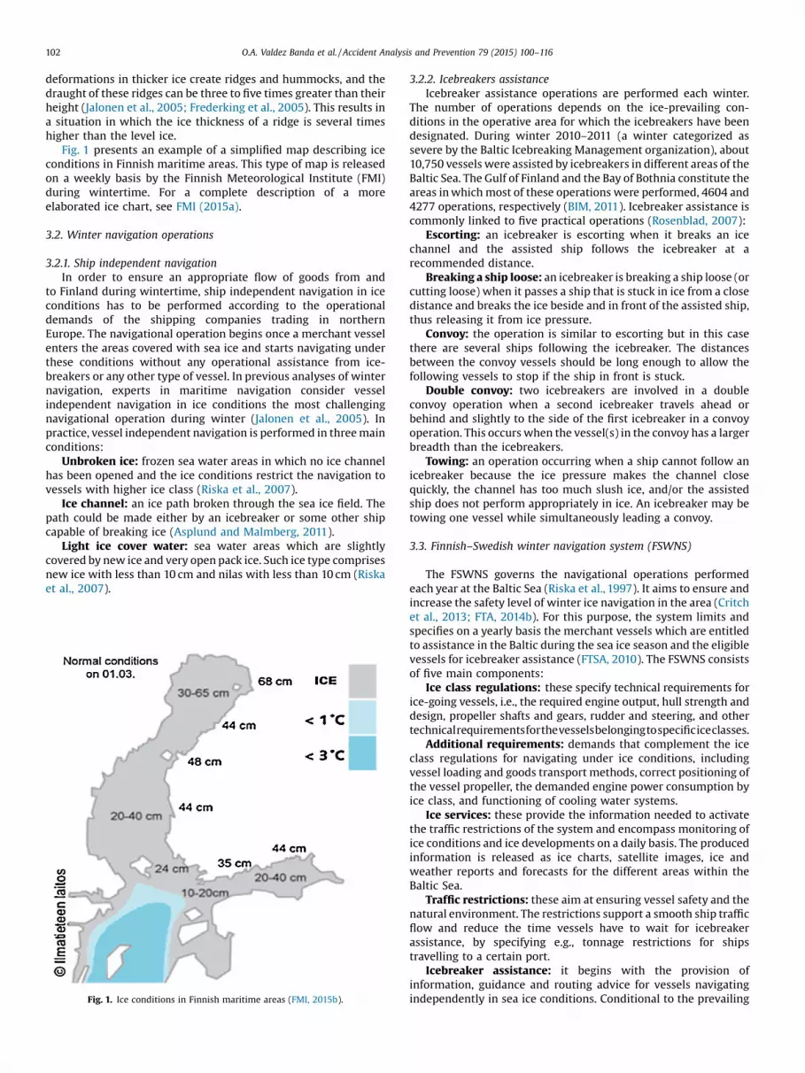
Fig. 1 presents an example of a simplified map describing iceconditions in Finnish maritime areas. This type of map is releasedon a weekly basis by the Finnish Meteorological Institute (FMI)during wintertime. For a complete description of a moreelaborated ice chart, see FMI (2015a).
3.2. Winter navigation operations
3.2.1. Ship independent navigationIn order to ensure an appropriate flow of goods from and
to Finland during wintertime, ship independent navigation in iceconditions has to be performed according to the operationaldemands of the shipping companies trading in northernEurope. The navigational operation begins once a merchant vesselenters the areas covered with sea ice and starts navigating underthese conditions without any operational assistance from ice-breakers or any other type of vessel. In previous analyses of winternavigation, experts in maritime navigation consider vesselindependent navigation in ice conditions the most challengingnavigational operation during winter (Jalonen et al., 2005). Inpractice, vessel independent navigation is performed in three mainconditions:
Unbroken ice: frozen sea water areas in which no ice channelhas been opened and the ice conditions restrict the navigation tovessels with higher ice class (Riska et al., 2007).
Ice channel: an ice path broken through the sea ice field. Thepath could be made either by an icebreaker or some other shipcapable of breaking ice (Asplund and Malmberg, 2011).
Light ice cover water: sea water areas which are slightlycovered by new ice and very open pack ice. Such ice type comprisesnew ice with less than 10 cm and nilas with less than 10 cm (Riskaet al., 2007).
Fig. 1. Ice conditions in Finnish maritime areas (FMI, 2015b).
3.2.2. Icebreakers assistanceIcebreaker assistance operations are performed each winter.
The number of operations depends on the ice-prevailing con-ditions in the operative area for which the icebreakers have beendesignated. During winter 2010–2011 (a winter categorized assevere by the Baltic Icebreaking Management organization), about10,750 vessels were assisted by icebreakers in different areas of theBaltic Sea. The Gulf of Finland and the Bay of Bothnia constitute theareas in which most of these operations were performed, 4604 and4277 operations, respectively (BIM, 2011). Icebreaker assistance iscommonly linked to five practical operations (Rosenblad, 2007):
Escorting: an icebreaker is escorting when it breaks an icechannel and the assisted ship follows the icebreaker at arecommended distance.
Breaking a ship loose: an icebreaker is breaking a ship loose (orcutting loose) when it passes a ship that is stuck in ice from a closedistance and breaks the ice beside and in front of the assisted ship,thus releasing it from ice pressure.
Convoy: the operation is similar to escorting but in this casethere are several ships following the icebreaker. The distancesbetween the convoy vessels should be long enough to allow thefollowing vessels to stop if the ship in front is stuck.
Double convoy: two icebreakers are involved in a doubleconvoy operation when a second icebreaker travels ahead orbehind and slightly to the side of the first icebreaker in a convoyoperation. This occurs when the vessel(s) in the convoy has a largerbreadth than the icebreakers.
Towing: an operation occurring when a ship cannot follow anicebreaker because the ice pressure makes the channel closequickly, the channel has too much slush ice, and/or the assistedship does not perform appropriately in ice. An icebreaker may betowing one vessel while simultaneously leading a convoy.
3.3. Finnish–Swedish winter navigation system (FSWNS)
The FSWNS governs the navigational operations performedeach year at the Baltic Sea (Riska et al., 1997). It aims to ensure andincrease the safety level of winter ice navigation in the area (Critchet al., 2013; FTA, 2014b). For this purpose, the system limits andspecifies on a yearly basis the merchant vessels which are entitledto assistance in the Baltic during the sea ice season and the eligiblevessels for icebreaker assistance (FTSA, 2010). The FSWNS consistsof five main components:
Ice class regulations: these specify technical requirements forice-going vessels, i.e., the required engine output, hull strength anddesign, propeller shafts and gears, rudder and steering, and othertechnicalrequirementsforthevesselsbelongingtospecificiceclasses.
Additional requirements: demands that complement the iceclass regulations for navigating under ice conditions, includingvessel loading and goods transport methods, correct positioning ofthe vessel propeller, the demanded engine power consumption byice class, and functioning of cooling water systems.
Ice services: these provide the information needed to activatethe traffic restrictions of the system and encompass monitoring ofice conditions and ice developments on a daily basis. The producedinformation is released as ice charts, satellite images, ice andweather reports and forecasts for the different areas within theBaltic Sea.
Traffic restrictions: these aim at ensuring vessel safety and thenatural environment. The restrictions support a smooth ship trafficflow and reduce the time vessels have to wait for icebreakerassistance, by specifying e.g., tonnage restrictions for shipstravelling to a certain port.
Icebreaker assistance: it begins with the provision ofinformation, guidance and routing advice for vessels navigatingindependently in sea ice conditions. Conditional to the prevailing
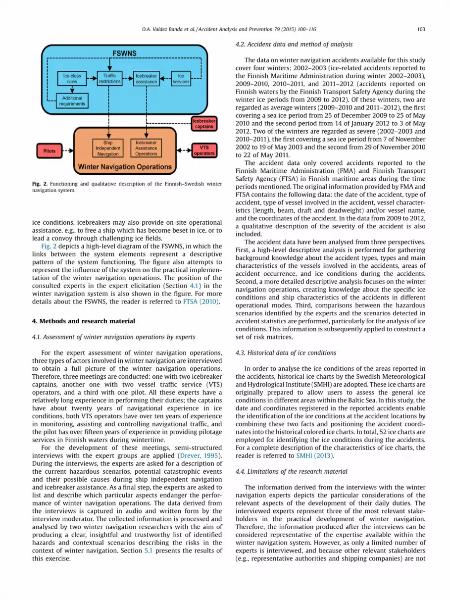
Fig. 2. Functioning and qualitative description of the Finnish–Swedish winternavigation system.
O.A. Valdez Banda et al. / Accident Analysis and Prevention 79 (2015) 100–116 103
ice conditions, icebreakers may also provide on-site operationalassistance, e.g., to free a ship which has become beset in ice, or tolead a convoy through challenging ice fields.
Fig. 2 depicts a high-level diagram of the FSWNS, in which thelinks between the system elements represent a descriptivepattern of the system functioning. The figure also attempts torepresent the influence of the system on the practical implemen-tation of the winter navigation operations. The position of theconsulted experts in the expert elicitation (Section 4.1) in thewinter navigation system is also shown in the figure. For moredetails about the FSWNS, the reader is referred to FTSA (2010).
4. Methods and research material
4.1. Assessment of winter navigation operations by experts
For the expert assessment of winter navigation operations,three types of actors involved in winter navigation are interviewedto obtain a full picture of the winter navigation operations.Therefore, three meetings are conducted: one with two icebreakercaptains, another one with two vessel traffic service (VTS)operators, and a third with one pilot. All these experts have arelatively long experience in performing their duties; the captainshave about twenty years of navigational experience in iceconditions, both VTS operators have over ten years of experiencein monitoring, assisting and controlling navigational traffic, andthe pilot has over fifteen years of experience in providing pilotageservices in Finnish waters during wintertime.
For the development of these meetings, semi-structuredinterviews with the expert groups are applied (Drever, 1995).During the interviews, the experts are asked for a description ofthe current hazardous scenarios, potential catastrophic eventsand their possible causes during ship independent navigationand icebreaker assistance. As a final step, the experts are asked tolist and describe which particular aspects endanger the perfor-mance of winter navigation operations. The data derived fromthe interviews is captured in audio and written form by theinterview moderator. The collected information is processed andanalysed by two winter navigation researchers with the aim ofproducing a clear, insightful and trustworthy list of identifiedhazards and contextual scenarios describing the risks in thecontext of winter navigation. Section 5.1 presents the results ofthis exercise.
4.2. Accident data and method of analysis
The data on winter navigation accidents available for this studycover four winters: 2002–2003 (ice-related accidents reported tothe Finnish Maritime Administration during winter 2002–2003),2009–2010, 2010–2011, and 2011–2012 (accidents reported onFinnish waters by the Finnish Transport Safety Agency during thewinter ice periods from 2009 to 2012). Of these winters, two areregarded as average winters (2009–2010 and 2011–2012), the firstcovering a sea ice period from 25 of December 2009 to 25 of May2010 and the second period from 14 of January 2012 to 3 of May2012. Two of the winters are regarded as severe (2002–2003 and2010–2011), the first covering a sea ice period from 7 of November2002 to 19 of May 2003 and the second from 29 of November 2010to 22 of May 2011.
The accident data only covered accidents reported to theFinnish Maritime Administration (FMA) and Finnish TransportSafety Agency (FTSA) in Finnish maritime areas during the timeperiods mentioned. The original information provided by FMA andFTSA contains the following data: the date of the accident, type ofaccident, type of vessel involved in the accident, vessel character-istics (length, beam, draft and deadweight) and/or vessel name,and the coordinates of the accident. In the data from 2009 to 2012,a qualitative description of the severity of the accident is alsoincluded.
The accident data have been analysed from three perspectives.First, a high-level descriptive analysis is performed for gatheringbackground knowledge about the accident types, types and maincharacteristics of the vessels involved in the accidents, areas ofaccident occurrence, and ice conditions during the accidents.Second, a more detailed descriptive analysis focuses on the winternavigation operations, creating knowledge about the specific iceconditions and ship characteristics of the accidents in differentoperational modes. Third, comparisons between the hazardousscenarios identified by the experts and the scenarios detected inaccident statistics are performed, particularly for the analysis of iceconditions. This information is subsequently applied to construct aset of risk matrices.
4.3. Historical data of ice conditions
In order to analyse the ice conditions of the areas reported inthe accidents, historical ice charts by the Swedish Meteorologicaland Hydrological Institute (SMHI) are adopted. These ice charts areoriginally prepared to allow users to assess the general iceconditions in different areas within the Baltic Sea. In this study, thedate and coordinates registered in the reported accidents enablethe identification of the ice conditions at the accident locations bycombining these two facts and positioning the accident coordi-nates into the historical colored ice charts. In total, 52 ice charts areemployed for identifying the ice conditions during the accidents.For a complete description of the characteristics of ice charts, thereader is referred to SMHI (2013).
4.4. Limitations of the research material
The information derived from the interviews with the winternavigation experts depicts the particular considerations of therelevant aspects of the development of their daily duties. Theinterviewed experts represent three of the most relevant stake-holders in the practical development of winter navigation.Therefore, the information produced after the interviews can beconsidered representative of the expertise available within thewinter navigation system. However, as only a limited number ofexperts is interviewed, and because other relevant stakeholders(e.g., representative authorities and shipping companies) are not
Table 1Guidelines for categorizing the strength of evidence.
Evidence base All of the following conditions are met
Data� Low number of errors in the available data� High accuracy of the methods for recording� High reliability of the data source� Much relevant data available� Low number of missing data sets� Low level of underreporting
� Conditions between those characterising high andlow strength of the evidence
� High number of errors in the available data� Low accuracy of the methods for recording� Low reliability of the data source� Little available data� High number of missing data sets� High level of underreporting
Expert judgement� A lot of reliable data is available� The assertion is seen as very reasonable� There is a broad agreement among the experts� The phenomena involved are well understood
� Conditions between those characterising high andlow strength of the evidence
� Data is unreliable� The assertion is seem as unreasonable� There is a lack of consensus among the experts� The phenomena involved are not well understood
104 O.A. Valdez Banda et al. / Accident Analysis and Prevention 79 (2015) 100–116
accounted for, the expert knowledge could be further strength-ened.
Regarding the accident data, the main restriction is set by thelimited information available within the four winter periodscovered in this study. In this regard, it should be noted that the datahave recently been systematically collected, and that more data arepresently unavailable.
Another significant restriction is linked to the very limitedaccident event descriptions in the available data sources, a typicallimitation of accidents reported in the maritime industry(Hänninen, 2014). This is due to the accident investigationrequirements: for less serious accidents, there is no requirementfor far-reaching accident investigation. Consequently, this datapaucity also has implications for the analysis methods: descriptivesummary statistics, as in Kujala et al. (2009),Le Blanc and Rucks(1996), Lee and Jung (2013), Papanikolaou, et al. (2014) and Wanget al. (2005) are preferred over more advanced analysis methods.
A final limitation of the data is linked to the ways accidents arereported in the context of ice navigation. Many minor damagesoccurring during the navigational operations are difficult to detectbecause these damages do not appear until the next dry docking(BIM, 2011). Therefore, vessel crews may be unaware of damages,resulting in an underreporting of ice-related incidents, implyingthat the presented available data may underestimate the numberof ice-induced hull damages. The underreporting of accidents inmaritime operations poses a problem raised also in earlier work onmaritime accidents (Hassel et al., 2011; Lappalainen et al., 2011;Oltedal, 2010; Psarros et al., 2010).
The above-mentioned limitations in expert availability and dataclearly have an influence on the weight that can be given to the riskanalysis results. However, if risk analysis is understood as a toolsystematically representing the most reliable knowledge availableat a given time, these limitations present no in-principle objectionto perform a risk analysis. Nevertheless, as outlined in Sections 2and 4.5, it is important to acknowledge this through the strength ofknowledge.
4.5. Representing risk
This study performs risk analysis by employing a set of riskmatrices in which the strength of knowledge is systematicallydelineated, using a version of a tool suggested in Abrahamsen et al.(2014). The rationale of this risk matrix and the derivation of theinformation are represented based on the risk perspectiveillustrated in Section 2 and it is described as follows:
Events (A): these are represented by a particular numberassigned to each included event. Each number describes a type ofevent (accident) in the performance of the winter navigationoperations analysed in this study. The allocation of numbers withinthe matrix depends on the probabilities of the event occurrenceand the severity degree reported in the accident data periodscovered.
Severity (C): this is based on the three-level categorizationreported on the accident data (2009–2012). This categorization isbased on the impact of an event (accident) on people, property andenvironment (IMO, 2013):
� Very serious: an accident that leads to human casualty and/orseriously exposes to it, and can also be associated with total lossor severe damage of vessels and the environment.
� Serious: an accident that has consequences that could lead to amajor impact on human safety, vessel structural safety and theenvironment.
� Less serious: an accident that has a minor repercussion onhuman safety, minor damage to ship machinery and structure,and a non-significant impact on the environment.
Probability (OU): the probability of event occurrence is basedon the results of the accident data analysis in Section 5.4. For theanalysis of the accident probability in ship independent navigation,the total number of arrivals and departures in Finnish operatingports during the sea ice season of each winter period (four periodsin total) is collected. The accident probability of icebreakersoperations is calculated by comparing the total number of assistedvessels in Finnish maritime areas during three winter periods(2009–2010, 2010–2011 and 2011–2012) and the number ofaccidents in these periods. The calculated frequencies are regardedas the degree of belief of accident occurrence.
Strength of evidence “data” (SE): three different levels (low,medium, high) are adopted for assessing the strength of accidentdata (BK) and therefore for addressing uncertainties in thisanalysis. The guidelines applied for assessing the strength ofaccident data are based on ideas presented in Kloprogge et al.(2011) as modified by Goerlandt and Montewka (2015b). In thematrices, different sizes of the bubbles reflect the strength ofaccident data.
Strength of evidence “expert judgements” (SE): these arerepresented by lines which describe the possible severity of theevents identified on the basis of expert opinions (BK). Theguidelines for assessing the strength of the expert judgementsare adopted based on ideas presented in Flage and Aven (2009). Inthe matrices, different types of lines covering a certain range ofseverity reflect the strength of the expert judgements. The mainidea behind the assessment of the strength of evidence is to assureconsistency in the categorization of the uncertainty in both data
Table 2Hazardous scenarios identified for the performance of ship independent navigation.
Scenario Event Contributing factors
Vessels navigating independently may haveproblems in navigating under difficult iceconditions
Ice compression and vesselsstuck in ice
Environmental and ice conditionsLevel ice, consolidated ice and fasted ice with an thickness between 15 and 40 cm.
Drifting ice affecting the course of the ship Collision and grounding Environmental and ice conditionsParticularly, drifting ice due to current and winds during spring time.
Drifting ice which moves and/or creates pressure toa ship stuck in ice
Ice compression and vesselsstuck in ice
Environmental and ice conditionsDrifting ice moving due to currents and winds, which creates pressure on ship’s hull.
The overtaking of independently navigating vesselsin an ice channel.
Collision Operational modeManoeuvring the ship in a limited space.
Ships navigating independently and encounteringice ridges.
Hull damage, propellerdamage and icecompression
Environmental and ice conditionsThe thickness of the ridges is higher than the ice thickness of the level ice, and thoseridges may act as hidden barrier when ships are breaking the sea ice.
Formed ship convoys navigating in ice conditions. Collision Operational modeThe limited manoeuvring space and the high speeds commonly required fornavigating under ice conditions possibly trigger accidents.
The independent navigation of large vessels (e.g.,tankers, bulk carriers and containerships).
Grounding Environmental and ice conditionsParticularly during spring time when the ice is thick and ice fields start to moveaffecting the course of the vessels.
A vessel hitting large ice floes Hull damages Environmental and ice conditionsLarge ice fields which break off from ice level and consolidated ice.
O.A. Valdez Banda et al. / Accident Analysis and Prevention 79 (2015) 100–116 105
sources. Table 1 presents the guidelines description for theassessment of the evidence.
5. Results
This section presents the results derived from the analysisperformed in this study. First, the results of the hazardidentification of winter navigation yielded by experts aredisplayed. Second, results of the descriptive analysis of accidentstatistics are presented. Subsequently, the outcome of combiningthe expert assessments with the accident statistics is shown.Furthermore, results of the analysis of the probability andseverity of accidents in winter navigation are displayed. Finally,six matrices derived from the analysis of the risk of winternavigation are presented.
Table 3Identified hazardous scenarios for the performance of icebreaker assistance operations
Scenario Event Contributing
An icebreaker leading convoy operationsunder severe ice conditions
Collision EnvironmentIce ridges an�40 �C.A precariousendanger thprevent the fby the icebr
Escorting, convoy and towing operationsunder severe ice conditions
Collision, hull damageand propeller damage
EnvironmentSevere ice co30 cm, as we
Manoeuvring in limited space areas (e.g., icechannel) during convoy operations.
Collision Operational mAvoiding coledges of the
channel.
5.1. Expert assessment of winter navigation
5.1.1. Ship independent navigationIn general, ship independent navigation is regarded as the most
complex operation in ice conditions. This operation is alsoexpected to be most commonly involved in accidents duringwinter navigation. Table 2 presents particular hazardous scenariosof this operation as identified by experts.
5.1.2. Icebreaker assistance operationsConvoy is considered the most complex operation performed by
icebreakers. Based on the collected evidence, convoy is theicebreaker assistance operation prone to accidents with more severeconsequences. Table 3 presents particular hazardous scenarios oficebreaker assistance operations identified by the experts.
.
factors
al and ice conditions and operational moded level ice with thickness over 40 cm and extremely low temperatures �20 to
balance needs to be established between keeping enough distance as to note operation by leading to a collision, while keeping the distance small enough toollowing vessels becoming beset in ice due to a fast closing of the channel openedeaker.
al and ice conditionsnditions such as: level ice, consolidate and fasted ice with an ice thickness overll as ice ridges.
odelisions within an ice channel can be difficult because the ice conditions in theice channel may cause a vessel trying to go out of the channel to bounce back to the
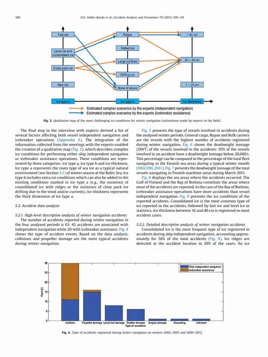
Fig. 3. Qualitative map of the most challenging ice conditions for winter navigation (estimations made by experts in the field).
106 O.A. Valdez Banda et al. / Accident Analysis and Prevention 79 (2015) 100–116
The final step in the interview with experts derived a list ofseveral factors affecting both vessel independent navigation andicebreaker operations (Appendix A). The integration of theinformation collected from the meetings with the experts enabledthe creation of a qualitative map (Fig. 3), which describes complexice conditions for performing either ship independent navigationor icebreaker assistance operations. These conditions are repre-sented by three categories: ice type a, ice type b and ice thickness.Ice type a represents the main type of sea ice as a typical naturalenvironment (see Section 3.1) of winter season at the Baltic Sea. Icetype b includes extra ice conditions which can also be added to theexisting conditions marked in ice type a (e.g., the existence ofconsolidated ice with ridges or the existence of close pack icedrifting due to the wind and/or currents). Ice thickness representsthe thick dimension of ice type a.
5.2. Accident data analysis
5.2.1. High-level descriptive analysis of winter navigation accidentsThe number of accidents reported during winter navigation in
the four analysed periods is 63. 43 accidents are associated withindependent navigation while 20 with icebreaker assistance. Fig. 4shows the type of accident events. Based on the data analysis,collisions and propeller damage are the most typical accidentsduring winter navigation.
Fig. 4. Type of accidents registered during winter na
Fig. 5 presents the type of vessels involved in accidents duringthe analysed winter periods. General cargo, Ropax and Bulk carriersare the vessels with the highest number of accidents registeredduring winter navigation. Fig. 6 shows the deadweight tonnage(DWT) of the vessels involved in the accidents: 95% of the vesselsinvolved in an accident have a deadweight tonnage below 20,000 t.This percentage can be compared to the percentage of the total fleetnavigating in the Finnish sea areas during a typical winter month(HELCOM, 2011). Fig. 7 presents the deadweight tonnage of the totalvessels navigating in Finnish maritime areas during March 2011.
Fig. 8 displays the sea areas where the accidents occurred. TheGulf of Finland and the Bay of Bothnia constitute the areas wheremost of the accidents are reported. In the case of the Bay of Bothnia,icebreaker assistance operations have more accidents than vesselindependent navigation. Fig. 9 presents the ice conditions of thereported accidents. Consolidated ice is the most common type ofice reported in the accidents, followed by fast ice and level ice instatistics. Ice thickness between 16 and 40 cm is registered in mostaccident cases.
5.2.2. Detailed descriptive analysis of winter navigation accidentsConsolidated ice is the most frequent type of ice registered in
accidents during ship independent navigation, accounting approx-imately for 58% of the total accidents (Fig. 9). Ice ridges aredetected at the accident location in 20% of the cases. An ice
vigation on winters 2002–2003 and 2009–2012.
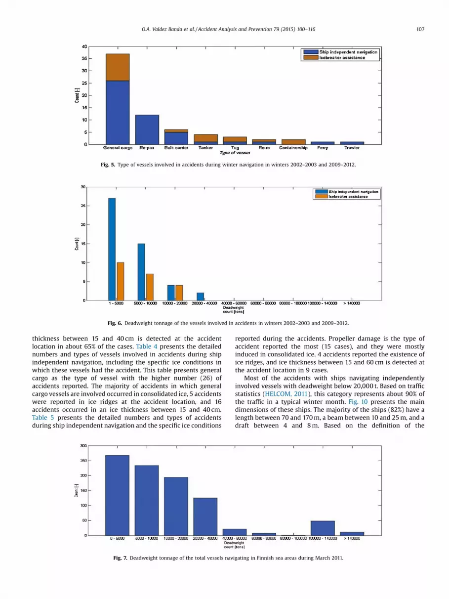
Fig. 5. Type of vessels involved in accidents during winter navigation in winters 2002–2003 and 2009–2012.
Fig. 6. Deadweight tonnage of the vessels involved in accidents in winters 2002–2003 and 2009–2012.
O.A. Valdez Banda et al. / Accident Analysis and Prevention 79 (2015) 100–116 107
thickness between 15 and 40 cm is detected at the accidentlocation in about 65% of the cases. Table 4 presents the detailednumbers and types of vessels involved in accidents during shipindependent navigation, including the specific ice conditions inwhich these vessels had the accident. This table presents generalcargo as the type of vessel with the higher number (26) ofaccidents reported. The majority of accidents in which generalcargo vessels are involved occurred in consolidated ice, 5 accidentswere reported in ice ridges at the accident location, and 16accidents occurred in an ice thickness between 15 and 40 cm.Table 5 presents the detailed numbers and types of accidentsduring ship independent navigation and the specific ice conditions
Fig. 7. Deadweight tonnage of the total vessels navi
reported during the accidents. Propeller damage is the type ofaccident reported the most (15 cases), and they were mostlyinduced in consolidated ice. 4 accidents reported the existence ofice ridges, and ice thickness between 15 and 60 cm is detected atthe accident location in 9 cases.
Most of the accidents with ships navigating independentlyinvolved vessels with deadweight below 20,000 t. Based on trafficstatistics (HELCOM, 2011), this category represents about 90% ofthe traffic in a typical winter month. Fig. 10 presents the maindimensions of these ships. The majority of the ships (82%) have alength between 70 and 170 m, a beam between 10 and 25 m, and adraft between 4 and 8 m. Based on the definition of the
gating in Finnish sea areas during March 2011.
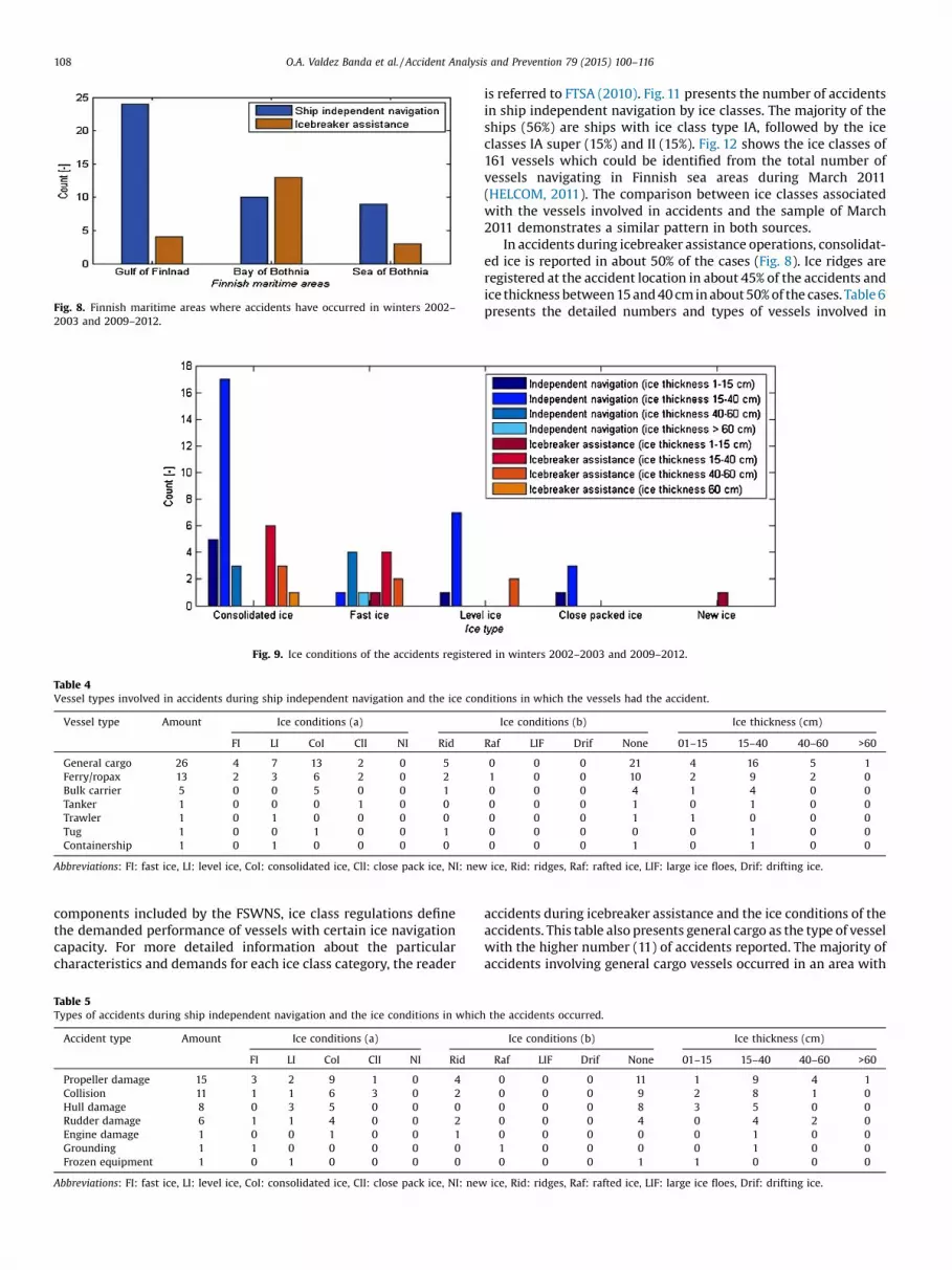
Fig. 8. Finnish maritime areas where accidents have occurred in winters 2002–2003 and 2009–2012.
Fig. 9. Ice conditions of the accidents registered in winters 2002–2003 and 2009–2012.
Table 4Vessel types involved in accidents during ship independent navigation and the ice conditions in which the vessels had the accident.
Vessel type Amount Ice conditions (a) Ice conditions (b) Ice thickness (cm)
FI LI CoI ClI NI Rid Raf LIF Drif None 01–15 15–40 40–60 >60
General cargo 26 4 7 13 2 0 5 0 0 0 21 4 16 5 1Ferry/ropax 13 2 3 6 2 0 2 1 0 0 10 2 9 2 0Bulk carrier 5 0 0 5 0 0 1 0 0 0 4 1 4 0 0Tanker 1 0 0 0 1 0 0 0 0 0 1 0 1 0 0Trawler 1 0 1 0 0 0 0 0 0 0 1 1 0 0 0Tug 1 0 0 1 0 0 1 0 0 0 0 0 1 0 0Containership 1 0 1 0 0 0 0 0 0 0 1 0 1 0 0
Abbreviations: FI: fast ice, LI: level ice, CoI: consolidated ice, ClI: close pack ice, NI: new ice, Rid: ridges, Raf: rafted ice, LIF: large ice floes, Drif: drifting ice.
108 O.A. Valdez Banda et al. / Accident Analysis and Prevention 79 (2015) 100–116
components included by the FSWNS, ice class regulations definethe demanded performance of vessels with certain ice navigationcapacity. For more detailed information about the particularcharacteristics and demands for each ice class category, the reader
Table 5Types of accidents during ship independent navigation and the ice conditions in which
Accident type Amount Ice conditions (a)
FI LI CoI ClI NI Rid
Propeller damage 15 3 2 9 1 0 4
Collision 11 1 1 6 3 0 2
Hull damage 8 0 3 5 0 0 0
Rudder damage 6 1 1 4 0 0 2
Engine damage 1 0 0 1 0 0 1
Grounding 1 1 0 0 0 0 0
Frozen equipment 1 0 1 0 0 0 0
Abbreviations: FI: fast ice, LI: level ice, CoI: consolidated ice, ClI: close pack ice, NI: new
is referred to FTSA (2010). Fig. 11 presents the number of accidentsin ship independent navigation by ice classes. The majority of theships (56%) are ships with ice class type IA, followed by the iceclasses IA super (15%) and II (15%). Fig. 12 shows the ice classes of161 vessels which could be identified from the total number ofvessels navigating in Finnish sea areas during March 2011(HELCOM, 2011). The comparison between ice classes associatedwith the vessels involved in accidents and the sample of March2011 demonstrates a similar pattern in both sources.
In accidents during icebreaker assistance operations, consolidat-ed ice is reported in about 50% of the cases (Fig. 8). Ice ridges areregistered at the accident location in about 45% of the accidents andice thickness between 15 and 40 cm in about 50% of the cases. Table 6presents the detailed numbers and types of vessels involved in
accidents during icebreaker assistance and the ice conditions of theaccidents. This table also presents general cargo as the type of vesselwith the higher number (11) of accidents reported. The majority ofaccidents involving general cargo vessels occurred in an area with
the accidents occurred.
Ice conditions (b) Ice thickness (cm)
Raf LIF Drif None 01–15 15–40 40–60 >60
0 0 0 11 1 9 4 10 0 0 9 2 8 1 00 0 0 8 3 5 0 00 0 0 4 0 4 2 00 0 0 0 0 1 0 01 0 0 0 0 1 0 00 0 0 1 1 0 0 0
ice, Rid: ridges, Raf: rafted ice, LIF: large ice floes, Drif: drifting ice.
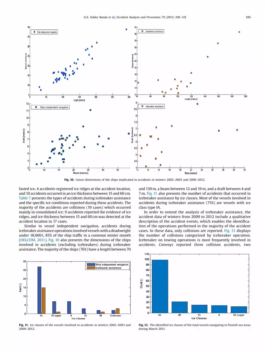
Fig. 10. Linear dimensions of the ships implicated in accidents in winters 2002–2003 and 2009–2012.
O.A. Valdez Banda et al. / Accident Analysis and Prevention 79 (2015) 100–116 109
fasted ice, 4 accidents registered ice ridges at the accident location,and 10 accidents occurred in an ice thickness between 15 and 60 cm.Table 7 presents the types of accidents during icebreaker assistanceand the specific ice conditions reported during these accidents. Themajority of the accidents are collisions (19 cases) which occurredmainly in consolidated ice; 9 accidents reported the evidence of iceridges, and ice thickness between 15 and 60 cm was detected at theaccident location in 17 cases.
Similar to vessel independent navigation, accidents duringicebreaker assistance operations involved vessels with a deadweightunder 18,000 t, 85% of the ship traffic in a common winter month(HELCOM, 2011). Fig. 10 also presents the dimensions of the shipsinvolved in accidents (excluding icebreakers) during icebreakerassistance. The majority of the ships (76%) have a length between 70
Fig. 11. Ice classes of the vessels involved in accidents in winters 2002–2003 and2009–2012.
and 130 m, a beam between 12 and 19 m, and a draft between 4 and7 m. Fig. 11 also presents the number of accidents that occurred inicebreaker assistance by ice classes. Most of the vessels involved inaccidents during icebreaker assistance (75%) are vessels with iceclass type IA.
In order to extend the analysis of icebreaker assistance, theaccident data of winters from 2009 to 2012 include a qualitativedescription of the accident events, which enables the identifica-tion of the operations performed in the majority of the accidentcases. In these data, only collisions are reported. Fig. 13 displaysthe number of collisions categorized by icebreaker operation.Icebreaker on towing operations is most frequently involved inaccidents. Convoys reported three collision accidents, two
Fig. 12. The identified ice classes of the total vessels navigating in Finnish sea areasduring March 2011.
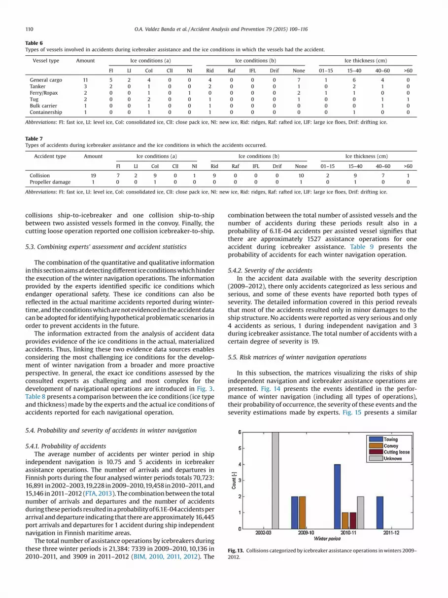
Table 6Types of vessels involved in accidents during icebreaker assistance and the ice conditions in which the vessels had the accident.
Vessel type Amount Ice conditions (a) Ice conditions (b) Ice thickness (cm)
FI LI CoI ClI NI Rid Raf IFL Drif None 01–15 15–40 40–60 >60
General cargo 11 5 2 4 0 0 4 0 0 0 7 1 6 4 0Tanker 3 2 0 1 0 0 2 0 0 0 1 0 2 1 0Ferry/Ropax 2 0 0 1 0 1 0 0 0 0 2 1 1 0 0Tug 2 0 0 2 0 0 1 0 0 0 1 0 0 1 1Bulk carrier 1 0 0 1 0 0 1 0 0 0 0 0 0 1 0Containership 1 0 0 1 0 0 1 0 0 0 0 0 1 0 0
Abbreviations: FI: fast ice, LI: level ice, CoI: consolidated ice, ClI: close pack ice, NI: new ice, Rid: ridges, Raf: rafted ice, LIF: large ice floes, Drif: drifting ice.
Table 7Types of accidents during icebreaker assistance and the ice conditions in which the accidents occurred.
Accident type Amount Ice conditions (a) Ice conditions (b) Ice thickness (cm)
FI LI CoI ClI NI Rid Raf IFL Drif None 01–15 15–40 40–60 >60
Collision 19 7 2 9 0 1 9 0 0 0 10 2 9 7 1Propeller damage 1 0 0 1 0 0 0 0 0 0 1 0 1 0 0
Abbreviations: FI: fast ice, LI: level ice, CoI: consolidated ice, ClI: close pack ice, NI: new ice, Rid: ridges, Raf: rafted ice, LIF: large ice floes, Drif: drifting ice.
Fig. 13. Collisions categorized by icebreaker assistance operations in winters 2009–2012.
110 O.A. Valdez Banda et al. / Accident Analysis and Prevention 79 (2015) 100–116
collisions ship-to-icebreaker and one collision ship-to-shipbetween two assisted vessels formed in the convoy. Finally, thecutting loose operation reported one collision icebreaker-to-ship.
5.3. Combining experts’ assessment and accident statistics
The combination of the quantitative and qualitative informationin thissectionaimsatdetectingdifferent iceconditions whichhinderthe execution of the winter navigation operations. The informationprovided by the experts identified specific ice conditions whichendanger operational safety. These ice conditions can also bereflected in the actual maritime accidents reported during winter-time,and theconditionswhich arenotevidencedintheaccidentdatacan be adopted for identifying hypothetical problematic scenarios inorder to prevent accidents in the future.
The information extracted from the analysis of accident dataprovides evidence of the ice conditions in the actual, materializedaccidents. Thus, linking these two evidence data sources enablesconsidering the most challenging ice conditions for the develop-ment of winter navigation from a broader and more proactiveperspective. In general, the exact ice conditions assessed by theconsulted experts as challenging and most complex for thedevelopment of navigational operations are introduced in Fig. 3.Table 8 presents a comparison between the ice conditions (ice typeand thickness) made by the experts and the actual ice conditions ofaccidents reported for each navigational operation.
5.4. Probability and severity of accidents in winter navigation
5.4.1. Probability of accidentsThe average number of accidents per winter period in ship
independent navigation is 10.75 and 5 accidents in icebreakerassistance operations. The number of arrivals and departures inFinnish ports during the four analysed winter periods totals 70,723:16,891 in2002–2003,19,228in 2009–2010,19,458in 2010–2011, and15,146 in 2011–2012 (FTA, 2013). The combination between the totalnumber of arrivals and departures and the number of accidentsduring theseperiodsresultedinaprobabilityof6.1E-04accidentsperarrival and departure indicating that there are approximately 16,445port arrivals and departures for 1 accident during ship independentnavigation in Finnish maritime areas.
The total number of assistance operations by icebreakers duringthese three winter periods is 21,384: 7339 in 2009–2010, 10,136 in2010–2011, and 3909 in 2011–2012 (BIM, 2010, 2011, 2012). The
combination between the total number of assisted vessels and thenumber of accidents during these periods result also in aprobability of 6.1E-04 accidents per assisted vessel signifies thatthere are approximately 1527 assistance operations for oneaccident during icebreaker assistance. Table 9 presents theprobability of accidents for each winter navigation operation.
5.4.2. Severity of the accidentsIn the accident data available with the severity description
(2009–2012), there only accidents categorized as less serious andserious, and some of these events have reported both types ofseverity. The detailed information covered in this period revealsthat most of the accidents resulted only in minor damages to theship structure. No accidents were reported as very serious and only4 accidents as serious, 1 during independent navigation and 3during icebreaker assistance. The total number of accidents with acertain degree of severity is 19.
5.5. Risk matrices of winter navigation operations
In this subsection, the matrices visualizing the risks of shipindependent navigation and icebreaker assistance operations arepresented. Fig. 14 presents the events identified in the perfor-mance of winter navigation (including all types of operations),their probability of occurrence, the severity of these events and theseverity estimations made by experts. Fig. 15 presents a similar
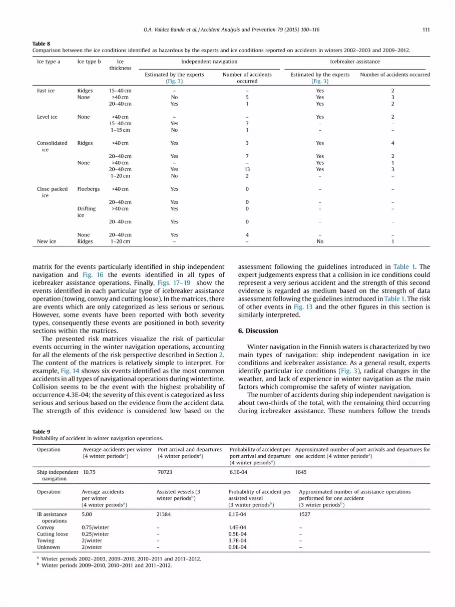
Table 8Comparison between the ice conditions identified as hazardous by the experts and ice conditions reported on accidents in winters 2002–2003 and 2009–2012.
Ice type a Ice type b Icethickness
Independent navigation Icebreaker assistance
Estimated by the experts(Fig. 3)
Number of accidentsoccurred
Estimated by the experts(Fig. 3)
Number of accidents occurred
Fast ice Ridges 15–40 cm – – Yes 2None >40 cm No 5 Yes 3
20–40 cm Yes 1 Yes 2
Level ice None >40 cm – – Yes 215–40 cm Yes 7 – –
1–15 cm No 1 – –
Consolidatedice
Ridges >40 cm Yes 3 Yes 4
20–40 cm Yes 7 Yes 2None >40 cm – – Yes 1
20–40 cm Yes 13 Yes 31–20 cm No 2 – –
Close packedice
Floebergs >40 cm Yes 0 – –
20–40 cm Yes 0 – –
Driftingice
>40 cm Yes 0 – –
20–40 cm Yes 0 – –
None 20–40 cm Yes 4 – –
New ice Ridges 1–20 cm – – No 1
O.A. Valdez Banda et al. / Accident Analysis and Prevention 79 (2015) 100–116 111
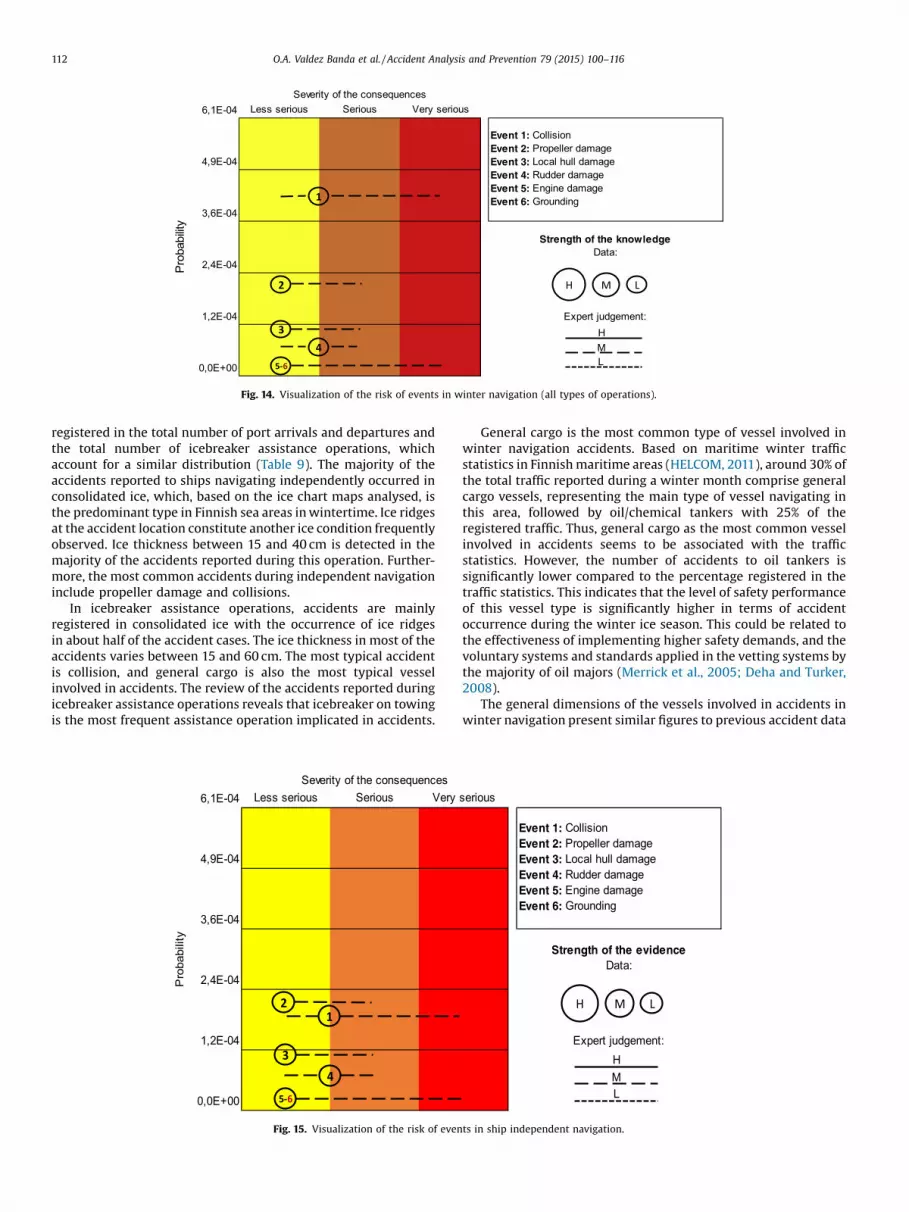
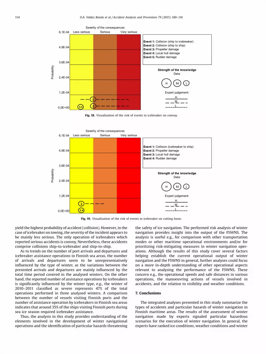
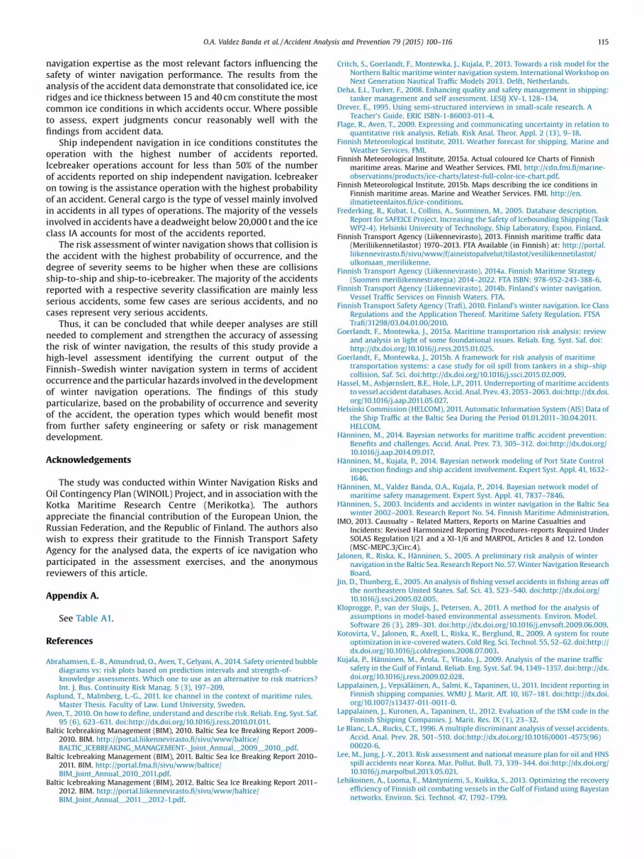
matrix for the events particularly identified in ship independentnavigation and Fig. 16 the events identified in all types oficebreaker assistance operations. Finally, Figs. 17–19 show theevents identified in each particular type of icebreaker assistanceoperation (towing, convoy and cutting loose). In the matrices, thereare events which are only categorized as less serious or serious.However, some events have been reported with both severitytypes, consequently these events are positioned in both severitysections within the matrices.
The presented risk matrices visualize the risk of particularevents occurring in the winter navigation operations, accountingfor all the elements of the risk perspective described in Section 2.The content of the matrices is relatively simple to interpret. Forexample, Fig. 14 shows six events identified as the most commonaccidents in all types of navigational operations during wintertime.Collision seems to be the event with the highest probability ofoccurrence 4.3E-04; the severity of this event is categorized as lessserious and serious based on the evidence from the accident data.The strength of this evidence is considered low based on the
Table 9Probability of accident in winter navigation operations.
Operation Average accidents per winter(4 winter periodsa)
Port arrival and departures(4 winter periodsa)
Propor(4 w
Ship independentnavigation
10.75 70723 6.1
Operation Average accidentsper winter(4 winter periodsa)
Assisted vessels (3winter periodsb)
Proassi(3 w
IB assistanceoperations
5.00 21384 6.1E
Convoy 0.75/winter – 1.4ECutting loose 0.25/winter – 0.5ETowing 2/winter – 3.7EUnknown 2/winter – 0.9E
a Winter periods 2002–2003, 2009–2010, 2010–2011 and 2011–2012.b Winter periods 2009–2010, 2010–2011 and 2011–2012.
assessment following the guidelines introduced in Table 1. Theexpert judgements express that a collision in ice conditions couldrepresent a very serious accident and the strength of this secondevidence is regarded as medium based on the strength of dataassessment following the guidelines introduced in Table 1. The riskof other events in Fig. 13 and the other figures in this section issimilarly interpreted.
6. Discussion
Winter navigation in the Finnish waters is characterized by twomain types of navigation: ship independent navigation in iceconditions and icebreaker assistance. As a general result, expertsidentify particular ice conditions (Fig. 3), radical changes in theweather, and lack of experience in winter navigation as the mainfactors which compromise the safety of winter navigation.
The number of accidents during ship independent navigation isabout two-thirds of the total, with the remaining third occurringduring icebreaker assistance. These numbers follow the trends
bability of accident pert arrival and departureinter periodsa)
Approximated number of port arrivals and departures forone accident (4 winter periodsa)
E-04 1645
bability of accident persted vesselinter periodsb)
Approximated number of assistance operationsperformed for one accident(3 winter periodsb)
-04 1527
-04 –
-04 –
-04 –
-04 –
6,1E-04 Less serious Serious Very serious
4,9E-04
3,6E-04
2,4E-04
1,2E-04
0,0E+00
Severity of the con sequ ences
Pro
babi
lity
Event 1: Collision Event 2: Propell er da mage Event 3: Local hull da mage Event 4: Rud der damag e Event 5: Eng ine damage Event 6: Grou nding
Strength of the kno wledg e Data:
Expert judge men t:3
5-6
H M L
HML
1
2
4
Fig. 14. Visualization of the risk of events in winter navigation (all types of operations).
112 O.A. Valdez Banda et al. / Accident Analysis and Prevention 79 (2015) 100–116
registered in the total number of port arrivals and departures andthe total number of icebreaker assistance operations, whichaccount for a similar distribution (Table 9). The majority of theaccidents reported to ships navigating independently occurred inconsolidated ice, which, based on the ice chart maps analysed, isthe predominant type in Finnish sea areas in wintertime. Ice ridgesat the accident location constitute another ice condition frequentlyobserved. Ice thickness between 15 and 40 cm is detected in themajority of the accidents reported during this operation. Further-more, the most common accidents during independent navigationinclude propeller damage and collisions.
In icebreaker assistance operations, accidents are mainlyregistered in consolidated ice with the occurrence of ice ridgesin about half of the accident cases. The ice thickness in most of theaccidents varies between 15 and 60 cm. The most typical accidentis collision, and general cargo is also the most typical vesselinvolved in accidents. The review of the accidents reported duringicebreaker assistance operations reveals that icebreaker on towingis the most frequent assistance operation implicated in accidents.
6,1E-04 Less seriou s Seriou s Very
4,9E-04
3,6E-04
2,4E-04
1,2E-04
0,0E+00
Severity of the con seque nces
Pro
babi
lity
2
34
5-6
1
Fig. 15. Visualization of the risk of even
General cargo is the most common type of vessel involved inwinter navigation accidents. Based on maritime winter trafficstatistics in Finnish maritime areas (HELCOM, 2011), around 30% ofthe total traffic reported during a winter month comprise generalcargo vessels, representing the main type of vessel navigating inthis area, followed by oil/chemical tankers with 25% of theregistered traffic. Thus, general cargo as the most common vesselinvolved in accidents seems to be associated with the trafficstatistics. However, the number of accidents to oil tankers issignificantly lower compared to the percentage registered in thetraffic statistics. This indicates that the level of safety performanceof this vessel type is significantly higher in terms of accidentoccurrence during the winter ice season. This could be related tothe effectiveness of implementing higher safety demands, and thevoluntary systems and standards applied in the vetting systems bythe majority of oil majors (Merrick et al., 2005; Deha and Turker,2008).
The general dimensions of the vessels involved in accidents inwinter navigation present similar figures to previous accident data
seriou s
Expe rt jud gemen t:
Event 1: Coll ision Event 2: Prope ller da mag e Event 3: Local hull damage Event 4: Rudde r da mage Event 5: Engine damag e Event 6: Groun ding
Strength of the evidence Data:
H L
HML
M
ts in ship independent navigation.
6,1E-04 Less serious Serious Very serious
4,9E-04
3,6E-04
2,4E-04
1,2E-04
0,0E+00
Severity of the con sequ ences
Prob
abilit
y
Event 1: Collision (ship t o s hip) Event 2: Collision (ship t o icebrea ker) Event 3: Collision (iceb reaker t o ship) Event 4: Prop ell er da mage Event 5: Local hull da mage Event 6: Rud der damag e
Strength of the kno wledg e Data:
Expert judge men t:
135-6
H M L
HML
2
Fig. 16. Visualization of the risk of events in icebreaker assistance (all operations).
O.A. Valdez Banda et al. / Accident Analysis and Prevention 79 (2015) 100–116 113
analysis performed in the open water season in the same maritimearea. In the analysis performed by Kujala et al. (2009), which coversthe period from 1997 to 2006, the mean deadweight tonnage of thevessels involved in accidents is 7770 t, the deadweight of vesselsinvolved in accidents during winters 2002–2003 and 2009–2012have a mean of 6384 t. The mean ship length in the periods from1997 to 2006 is 70 m and the mean ship length in winters 2002–2003 and 2009–2012 is 116 m. Thus, it seems that in wintertime,the ships involved in accidents are larger than the ones involved inaccidents during open water season.
The combination of accident statistics and expert data supportsthe elaboration of a high-level analysis to detect, based on accidentdata, the ice conditions in which accidents have occurred and toestimate, based on expert judgements, other ice conditions inwhich accidents may occur. In the comparison between the twoinformation sources, experts appear to have accurate knowledge ofthe ice conditions which pose challenges for icebreaker assistanceoperations. In case of ship independent navigation, the discrep-ancies between the expert assessment and the results of the dataanalysis are somewhat larger, but also here, good correspondenceis obtained. The analysis of expert data, accident statistics, andcombination of these two represent a simple, structured and
6,1E-04 Less seriou s Serious Very seriou
4,9E-04
3,6E-04
2,4E-04
1,2E-04
0,0E+00
Severity of t he consequen ces
Pro
babi
lity
23-4
1
Fig. 17. Visualization of the risk of e
constructive method for identifying the key elements affecting thedevelopment of winter navigation.
The visualization of the risks detected in ship independentnavigation and icebreaker assistance operations in Section 5.5serves as a simple framework for the identification of particularevents affecting such operations, including their probability andseverity degree. Collision yields the highest probability and thehighest severity degree. However, the majority of the collisions arereported with a severity degree of less serious accidents. Theseverity degree of the accidents in ice conditions is lowercompared to the severity of accidents during navigation in openwater. This can be confirmed by including the number of accidentsin Finnish maritime sea areas during the last three months of theopen water season before the beginning sea ice season in the sameyear periods from 2009 to 2012. This information adds 8 seriousaccidents and 1 very serious accident. Furthermore, these periodsalso add 14 less serious accidents. Thus, the number of accidentsreported in open water is also higher in a relatively shorter period.
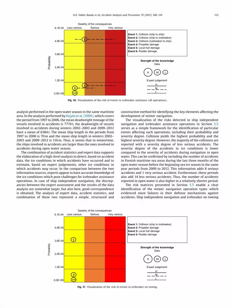
The risk matrices presented in Section 5.5 enable a clearidentification of the winter navigation operation types whichevidenced more failures in their defense mechanisms againstaccidents. Ship independent navigation and icebreaker on towing
s
Event 1: Colli sion (ship t o icebrea ker) Event 2: Prope ller da mage Event 3: Local hu ll da mage Event 4: Rudde r damage
Streng th of the kno wledg e Data:
Expe rt judg emen t:
H M L
HML
vents in icebreaker on towing.
6,1E-04 Less serious Serious Very serious
4,9E-04
3,6E-04
2,4E-04
1,2E-04
0,0E+00
Event 1: Collision (ship t o icebrea ker) Event 2: Collision (ship t o s hip) Event 3: Propell er da mage Event 4: Local hull da mage Event 5: Rud der damag e
Strength of the kno wledg e Data:
Expert judge men t:
Severity of the con sequ ences
Pro
babi
lity
23-5
H M L
HML
1
Fig. 18. Visualization of the risk of events in icebreaker on convoy.
6,1E-04 Less serious Serious Very serious
4,9E-04
3,6E-04
2,4E-04
1,2E-04
0,0E+00
Strength of the kno wledg e Data:
Expert judge men t:
Severity of the con sequ ences
Pro
babi
lity
Event 1: Collision (iceb reaker t o ship) Event 2: Prop ell er da mage Event 3: Local hull da mage Event 4: Rud der damag e
2-4
H M L
HML
1
Fig. 19. Visualization of the risk of events in icebreaker on cutting loose.
114 O.A. Valdez Banda et al. / Accident Analysis and Prevention 79 (2015) 100–116
yield the highest probability of accident (collision). However, in thecase of icebreaker on towing, the severity of the incident appears tobe mainly less serious. The only operation of icebreakers whichreported serious accidents is convoy. Nevertheless, these accidentscomprise collisions ship-to-icebreaker and ship-to-ship.
As to trends on the number of port arrivals and departures andicebreaker assistance operations in Finnish sea areas, the numberof arrivals and departures seem to be unrepresentativelyinfluenced by the type of winter, as the variations between thepresented arrivals and departures are mainly influenced by thetotal time period covered in the analysed winters. On the otherhand, the reported number of assistance operations by icebreakersis significantly influenced by the winter type, e.g., the winter of2010–2011 classified as severe represents 47% of the totaloperations performed in three analysed winters. A comparisonbetween the number of vessels visiting Finnish ports and thenumber of assistance operation by icebreakers in Finnish sea areasindicates that around 35% of the ships visiting Finnish ports duringsea ice season required icebreaker assistance.
Thus, the analysis in this study provides understanding of theelements involved in the development of winter navigationaloperations and the identification of particular hazards threatening
the safety of ice navigation. The performed risk analysis of winternavigation provides insight into the output of the FSWNS. Theanalysis is useful e.g., for comparison with other transportationmodes or other maritime operational environments and/or forprioritizing risk-mitigating measures in winter navigation oper-ations. Although the results of this study cover several factorshelping establish the current operational output of winternavigation and the FSWNS in general, further analyses could focuson a more in-depth understanding of other operational aspectsrelevant to analysing the performance of the FSWNS. Theseconcern e.g., the operational speeds and safe distances in variousoperations, the manoeuvring actions of vessels involved inaccidents, and the relation to visibility and weather conditions.
7. Conclusions
The integrated analyses presented in this study summarize thetypes of accidents and particular hazards of winter navigation inFinnish maritime areas. The results of the assessment of winternavigation made by experts signaled particular hazardousscenarios for the execution of winter navigation. In general, theexperts have ranked ice conditions, weather conditions and winter
O.A. Valdez Banda et al. / Accident Analysis and Prevention 79 (2015) 100–116 115
navigation expertise as the most relevant factors influencing thesafety of winter navigation performance. The results from theanalysis of the accident data demonstrate that consolidated ice, iceridges and ice thickness between 15 and 40 cm constitute the mostcommon ice conditions in which accidents occur. Where possibleto assess, expert judgments concur reasonably well with thefindings from accident data.
Ship independent navigation in ice conditions constitutes theoperation with the highest number of accidents reported.Icebreaker operations account for less than 50% of the numberof accidents reported on ship independent navigation. Icebreakeron towing is the assistance operation with the highest probabilityof an accident. General cargo is the type of vessel mainly involvedin accidents in all types of operations. The majority of the vesselsinvolved in accidents have a deadweight below 20,000 t and the iceclass IA accounts for most of the accidents reported.
The risk assessment of winter navigation shows that collision isthe accident with the highest probability of occurrence, and thedegree of severity seems to be higher when these are collisionsship-to-ship and ship-to-icebreaker. The majority of the accidentsreported with a respective severity classification are mainly lessserious accidents, some few cases are serious accidents, and nocases represent very serious accidents.
Thus, it can be concluded that while deeper analyses are stillneeded to complement and strengthen the accuracy of assessingthe risk of winter navigation, the results of this study provide ahigh-level assessment identifying the current output of theFinnish–Swedish winter navigation system in terms of accidentoccurrence and the particular hazards involved in the developmentof winter navigation operations. The findings of this studyparticularize, based on the probability of occurrence and severityof the accident, the operation types which would benefit mostfrom further safety engineering or safety or risk managementdevelopment.
Acknowledgements
The study was conducted within Winter Navigation Risks andOil Contingency Plan (WINOIL) Project, and in association with theKotka Maritime Research Centre (Merikotka). The authorsappreciate the financial contribution of the European Union, theRussian Federation, and the Republic of Finland. The authors alsowish to express their gratitude to the Finnish Transport SafetyAgency for the analysed data, the experts of ice navigation whoparticipated in the assessment exercises, and the anonymousreviewers of this article.
Appendix A.
See Table A1.
References
Abrahamsen, E.-B., Amundrud, O., Aven, T., Gelyani, A., 2014. Safety oriented bubblediagrams vs: risk plots based on prediction intervals and strength-of-knowledge assessments. Which one to use as an alternative to risk matrices?Int. J. Bus. Continuity Risk Manag. 5 (3), 197–209.
Asplund, T., Malmberg, L.-G., 2011. Ice channel in the context of maritime rules.Master Thesis. Faculty of Law. Lund University, Sweden.
Aven, T., 2010. On how to define, understand and describe risk. Reliab. Eng. Syst. Saf.95 (6), 623–631. doi:http://dx.doi.org/10.1016/j.ress.2010.01.011.
Baltic Icebreaking Management (BIM), 2010. Baltic Sea Ice Breaking Report 2009–2010. BIM. http://portal.liikennevirasto.fi/sivu/www/baltice/BALTIC_ICEBREAKING_MANAGEMENT-_Joint_Annual__2009__2010_.pdf.
Baltic Icebreaking Management (BIM), 2011. Baltic Sea Ice Breaking Report 2010–2011. BIM. http://portal.fma.fi/sivu/www/baltice/BIM_Joint_Annual_2010_2011.pdf.
Baltic Icebreaking Management (BIM), 2012. Baltic Sea Ice Breaking Report 2011–2012. BIM. http://portal.liikennevirasto.fi/sivu/www/baltice/BIM_Joint_Annual__2011__2012-1.pdf.
Critch, S., Goerlandt, F., Montewka, J., Kujala, P., 2013. Towards a risk model for theNorthern Baltic maritime winter navigation system. International Workshop onNext Generation Nautical Traffic Models 2013. Delft, Netherlands.
Deha, E.I., Turker, F., 2008. Enhancing quality and safety management in shipping:tanker management and self assessment. LESIJ XV-1, 128–134.
Drever, E., 1995. Using semi-structured interviews in small-scale research. ATeacher’s Guide. ERIC ISBN-1-86003-011-4.
Flage, R., Aven, T., 2009. Expressing and communicating uncertainty in relation toquantitative risk analysis. Reliab. Risk Anal. Theor. Appl. 2 (13), 9–18.
Finnish Meteorological Institute, 2011. Weather forecast for shipping. Marine andWeather Services. FMI.
Finnish Meteorological Institute, 2015a. Actual coloured Ice Charts of Finnishmaritime areas. Marine and Weather Services. FMI. http://cdn.fmi.fi/marine-observations/products/ice-charts/latest-full-color-ice-chart.pdf.
Finnish Meteorological Institute, 2015b. Maps describing the ice conditions inFinnish maritime areas. Marine and Weather Services. FMI. http://en.ilmatieteenlaitos.fi/ice-conditions.
Frederking, R., Kubat, I., Collins, A., Suominen, M., 2005. Database description.Report for SAFEICE Project. Increasing the Safety of Icebounding Shipping (TaskWP2-4). Helsinki University of Technology, Ship Laboratory, Espoo, Finland.
Finnish Transport Agency (Liikennevirasto), 2013. Finnish maritime traffic data(Meriliikennetilastot) 1970–2013. FTA Available (in Finnish) at: http://portal.liikennevirasto.fi/sivu/www/f/aineistopalvelut/tilastot/vesiliikennetilastot/ulkomaan_meriliikenne.
Finnish Transport Agency (Liikennevirasto), 2014a. Finnish Maritime Strategy(Suomen meriliikennestrategia) 2014–2022. FTA ISBN: 978-952-243-388-6.
Finnish Transport Agency (Liikennevirasto), 2014b. Finland’s winter navigation.Vessel Traffic Services on Finnish Waters. FTA.
Finnish Transport Safety Agency (Trafi), 2010. Finland’s winter navigation. Ice ClassRegulations and the Application Thereof. Maritime Safety Regulation. FTSATrafi/31298/03.04.01.00/2010.
Goerlandt, F., Montewka, J., 2015a. Maritime transportation risk analysis: reviewand analysis in light of some foundational issues. Reliab. Eng. Syst. Saf. doi:http://dx.doi.org/10.1016/j.ress.2015.01.025.
Goerlandt, F., Montewka, J., 2015b. A framework for risk analysis of maritimetransportation systems: a case study for oil spill from tankers in a ship–shipcollision. Saf. Sci. doi:http://dx.doi.org/10.1016/j.ssci.2015.02.009.
Hassel, M., Asbjørnslett, B.E., Hole, L.P., 2011. Underreporting of maritime accidentsto vessel accident databases. Accid. Anal. Prev. 43, 2053–2063. doi:http://dx.doi.org/10.1016/j.aap.2011.05.027.
Helsinki Commission (HELCOM), 2011. Automatic Information System (AIS) Data ofthe Ship Traffic at the Baltic Sea During the Period 01.01.2011–30.04.2011.HELCOM.
Hänninen, M., 2014. Bayesian networks for maritime traffic accident prevention:Benefits and challenges. Accid. Anal. Prev. 73, 305–312. doi:http://dx.doi.org/10.1016/j.aap.2014.09.017.
Hänninen, M., Kujala, P., 2014. Bayesian network modeling of Port State Controlinspection findings and ship accident involvement. Expert Syst. Appl. 41, 1632–1646.
Hänninen, M., Valdez Banda, O.A., Kujala, P., 2014. Bayesian network model ofmaritime safety management. Expert Syst. Appl. 41, 7837–7846.
Hänninen, S., 2003. Incidents and accidents in winter navigation in the Baltic Seawinter 2002–2003. Research Report No. 54. Finnish Maritime Administration.
IMO, 2013. Causualty – Related Matters, Reports on Marine Casualties andIncidents: Revised Harmonized Reporting Procedures-reports Required UnderSOLAS Regulation I/21 and a XI-1/6 and MARPOL, Articles 8 and 12. London(MSC-MEPC.3/Circ.4).
Jalonen, R., Riska, K., Hänninen, S., 2005. A preliminary risk analysis of winternavigation in the Baltic Sea. Research Report No. 57. Winter Navigation ResearchBoard.
Jin, D., Thunberg, E., 2005. An analysis of fishing vessel accidents in fishing areas offthe northeastern United States. Saf. Sci. 43, 523–540. doi:http://dx.doi.org/10.1016/j.ssci.2005.02.005.
Kloprogge, P., van der Sluijs, J., Petersen, A., 2011. A method for the analysis ofassumptions in model-based environmental assessments. Environ. Model.Software 26 (3), 289–301. doi:http://dx.doi.org/10.1016/j.envsoft.2009.06.009.
Kotovirta, V., Jalonen, R., Axell, L., Riska, K., Berglund, R., 2009. A system for routeoptimization in ice-covered waters. Cold Reg. Sci. Technol. 55, 52–62. doi:http://dx.doi.org/10.1016/j.coldregions.2008.07.003.
Kujala, P., Hänninen, M., Arola, T., Ylitalo, J., 2009. Analysis of the marine trafficsafety in the Gulf of Finland. Reliab. Eng. Syst. Saf. 94, 1349–1357. doi:http://dx.doi.org/10.1016/j.ress.2009.02.028.
Lappalainen, J., Vepsäläinen, A., Salmi, K., Tapaninen, U., 2011. Incident reporting inFinnish shipping companies. WMU J. Marit. Aff. 10, 167–181. doi:http://dx.doi.org/10.1007/s13437-011-0011-0.
Lappalainen, J., Kuronen, A., Tapaninen, U., 2012. Evaluation of the ISM code in theFinnish Shipping Companies. J. Marit. Res. IX (1), 23–32.
Le Blanc, L.A., Rucks, C.T., 1996. A multiple discriminant analysis of vessel accidents.Accid. Anal. Prev. 28, 501–510. doi:http://dx.doi.org/10.1016/0001-4575(96)00020-6.
Lee, M., Jung, J.-Y., 2013. Risk assessment and national measure plan for oil and HNSspill accidents near Korea. Mar. Pollut. Bull. 73, 339–344. doi:http://dx.doi.org/10.1016/j.marpolbul.2013.05.021.
Lehikoinen, A., Luoma, E., Mäntyniemi, S., Kuikka, S., 2013. Optimizing the recoveryefficiency of Finnish oil combating vessels in the Gulf of Finland using Bayesiannetworks. Environ. Sci. Technol. 47, 1792–1799.
116 O.A. Valdez Banda et al. / Accident Analysis and Prevention 79 (2015) 100–116
Leppäranta, M., 1998. Physics of ice-covered seas. Lecture Notes from a SummerSchool in Savonlinna. Finland 6–17 June, 1994, 2. Department of Geophysics,University of Helsinki.
Li, S., Qiang, M., Xiaobo, Q., 2012. An overview of maritime waterway quantitativerisk assessment models. Risk Anal. 32 (3), 496–512.
Mansell, J.N.K., 2009. Development of International law for flag state responsibility.Flag State Responsibility. Springer, Berlin, Heidelberg, pp. 53–69.
Mazaheri, A., Montewka, J., Kujala, P., 2014. Modeling the risk of ship grounding – aliterature review from a risk management perspective. WMU J. Marit. Aff. 13 (2),269–297.
Merrick, J., Grabowski, M., Ayyalasomayajula, P., Harrald, J., 2005. Understandingorganizational safety using value-focused thinking. Risk Anal. 24 (4), 1029–1041.
Montewka, J., Weckström, M., Kujala, P., 2013. A probabilistic model estimating oilspill clean-up costs – a case study for the Gulf of Finland. Mar. Pollut. Bull. 76,61–71.
Montewka, J., Goerlandt, F., Kujala, P., Lensu, M., 2015. Towards probabilistic modelsfor the prediction of a ship performance in dynamic ice. Cold Reg. Sci. Technol.112, 14–28.
Mullai, A., Paulsson, U., 2011. A grounded theory model for analysis of marineaccidents. Accid. Anal. Prev. 43, 1590–1603. doi:http://dx.doi.org/10.1016/j.aap.2011.03.022.
Oltedal, H., 2010. The Use of Safety Management Systems within the NorwegianTanker Industry – Do They Really Improve Safety. In: Bris, Guedes Soares,Martorell (Eds.), Reliability, Risk, and Safety: Theory and Applications. Taylor &Francis Group, London.
Papanikolaou, A., Bitha, K., Eliopoulou, E., Ventikos, N.-P., 2014. Statistical Analysis ofShip Accidents Occurred in the Period 1990–2012 and Assessment of SafetyLevel of Ship Types. Maritime Technology and Engineering, Lisbon.
Psarros, G., Skjong, R., Eide, M.S., 2010. Under-reporting of maritime accidents.Accid. Anal. Prev. 42, 619–625. doi:http://dx.doi.org/10.1016/j.aap.2009.10.008.
Qu, X., Meng, Q., Li, S., 2012. Analyses and implications of accidents in SingaporeStrait Transportation Research Record. J. Transport. Res. Board 2273, 106–111.
Rambøll, 2006. Navigational safety in the sound between Denmark and Sweden(Øresund): risk and cost-benefit analysis. Technical Report. Rambøll,Danmark A/S.
Table A1Factors affecting the safety of maritime winter navigation.
Operation Safety endanger fac
Ship independent navigation Ice conditions
Weather conditions
Lack of experience
Icebreaker assistance operations Ice conditions
Weather conditions
Riska, K., Wilhelmson, M., Englund, K., 1997. Performance of merchant vessels in icein the Baltic. Winter Navigation Research Board, Research Report No. 52.Helsinki University of Technology, Ship Laboratory.
Riska, K., Izumiyama, K., Uto, S., Kubat, I., Frederking, R., Liljeström, G., Rosenblad,M., Kirs, C., Kouts, T., Wang, K., Leppäranta, M., 2007. Increasing the Safety ofIcebound Shipping, Final Scientific Report, 1. Helsinki University of Technology,Ship Laboratory, Espoo, Finland.
Rosenblad, M., 2007. Increasing the safety of icebound shipping. Final ScientificReport. WP4. Operative Environment (Icebreaker Operations), 1. HelsinkiUniversity of Technology, Ship Laboratory, Espoo, Finland.
Rosqvist, T., Nyman, T., Sonninen, S., Tuominen, R., 2002. The implementation of theVTMIS system for the Gulf of Finland – a FSA study. RINA InternationalConference on Formal Safety Assessment, London, UK. The Royal Institution ofNaval Architects (RINA) Citeseer, pp. 151–164.
Swedish Meteorological and Hydrological Institute (SMHI), 2013. Ice chart mapsduring winter 2002–2003, 2009–2010, 2010–2011, 2011–2012 winter – 2009–2010, 2010–2011, 2011–2012 winter – 2010, 2010–2011, 2011–2012 winter –
2011–2012 winter – 2012. Oceanographic, Ice Services. SMHI. http://www.smhi.se/oceanografi/iceservice/is_prod_en.php.
Soares, C.G., Teixeira, A.P., 2001. Risk assessment in maritime transportation. Reliab.Eng. Syst. Saf. 74, 299–309. doi:http://dx.doi.org/10.1016/S0951-8320(01)00104-1.
Wang, J., Pillay, A., Kwon, Y.S., Wall, A.D., Loughran, C.G., 2005. An analysis of fishingvessel accidents. Accid. Anal. Prev. 37, 1019–1024. doi:http://dx.doi.org/10.1016/j.aap.2005.05.005.
Wang, Y., Wu, C., Yang, L., 2013. Oil price shocks and stock market activities:evidence from oil-importing and oil-exporting countries. J. Comp. Econ. 41,1220–1239. doi:http://dx.doi.org/10.1016/j.jce.2012.12.004.
Watson, S.R., 1994. On the meaning of probability in probabilistic safety analysis.Reliab. Eng. Syst. Saf. 45, 261–269.
Wu, Y., 2008. Statistical evaluation of weather patterns on fishing vessel incidents inAtlantic Canada. Doctoral Thesis. Dalhousie University, Halifax, pp. 197.
Özbaş, B., 2013. Safety risk analysis of maritime transportation: review of theliterature. J. Transport. Res. Board 2326, 32–38.
tor Description
Consolidated iceClose pack iceIce ridgesDrifting pack iceIce large floesIce thickness over 15 cmEdge of ice channelIce compression
Snow stormsPoor visibility (e.g., fog, snow, and day time)IcingHeavy windsAccumulation of snowInadequate training (lack of training)Few years of practical experience
Fast iceConsolidated iceIce ridgesIce thickness over 30 cm
Snow stormsVisibility (day light, fog, snow, etc.)IcingWind