A multi-regional analysis of heritage management - PRISM
357
University of Calgary PRISM: University of Calgary's Digital Repository Graduate Studies Legacy Theses 2000 A multi-regional analysis of heritage management: An approach to building new partnerships Wood, Barry Paul Wood, B. P. (2000). A multi-regional analysis of heritage management: An approach to building new partnerships (Unpublished master's thesis). University of Calgary, Calgary, AB. doi:10.11575/PRISM/21323 http://hdl.handle.net/1880/42872 master thesis University of Calgary graduate students retain copyright ownership and moral rights for their thesis. You may use this material in any way that is permitted by the Copyright Act or through licensing that has been assigned to the document. For uses that are not allowable under copyright legislation or licensing, you are required to seek permission. Downloaded from PRISM: https://prism.ucalgary.ca
-
Upload
khangminh22 -
Category
Documents
-
view
0 -
download
0
Transcript of A multi-regional analysis of heritage management - PRISM

University of Calgary
PRISM: University of Calgary's Digital Repository
Graduate Studies Legacy Theses
2000
A multi-regional analysis of heritage management:
An approach to building new partnerships
Wood, Barry Paul
Wood, B. P. (2000). A multi-regional analysis of heritage management: An approach to building
new partnerships (Unpublished master's thesis). University of Calgary, Calgary, AB.
doi:10.11575/PRISM/21323
http://hdl.handle.net/1880/42872
master thesis
University of Calgary graduate students retain copyright ownership and moral rights for their
thesis. You may use this material in any way that is permitted by the Copyright Act or through
licensing that has been assigned to the document. For uses that are not allowable under
copyright legislation or licensing, you are required to seek permission.
Downloaded from PRISM: https://prism.ucalgary.ca

University of Calgary
A MULTI-REGIONAL ANALYSIS OF EIERITAGE MANAGEMENT: AN APPROACH TO BUILDING NEW PARTNERSHIPS
by
Barry Paul Wood
A Master's Degree Project submitted to the Faculty of Environmental Design in partial fulfillment of the requirements for the degree of Masters of Environmental Design
Calgary, Alberta
April, 2000
O Barry Paul Wood 2000

National Library 1+1 of Canada Bibliothhue nationale du Canada
Acquisitions and Acquisitions et Bibliographic Services services bibliographiques
395 Wellington Street 395. me Wellington OnawaON KlAON4 OtrawaON K l A W Canada Canada
~wrw votmnl[irrw*
Our m Mmm riw-
The author has granted a non- exclusive licence allowing the National Library of Canada to reproduce, loan, distribute or sell copies of this thesis in microform, paper or electronic formats.
The author retains ownership of the copyright in this thesis. Neither the thesis nor substantial extracts firom it may be printed or otherwise reproduced without the author's permission.
L'auteur a accorde une licence non exclusive permettant a la Bibliotheque nationale du Canada de reproduire, preter, distribuer ou vendre des copies de cette these sous la fonne de microfiche/film, de reproduction sur papier ou sur format electronique .
L'auteur conserve la propriete du droit d'auteur qui protege cette these. Ni la these ni des extraits substantiels de celle-ci ne doivent iitre imprimes ou autrement reproduits sans son autorisation.
A Multi-Regional Analysis of Heritage Management: An Approach to Building New Partnerships
by Barry Paul Wood
A Master's Degree Project submitted to the Faculty of Environmental Design, University of Calgary in partial fulfillment of the requirements for the degree of Masters of
Environmental Design
Grant A. Ross
Waterton Lakes National Park, Alberta (WLNP) and the geographic regions adjacent to it including Akamina Kishinena Provincial Park (AKPP) and portions of the Flathead Provincial Forest, British Columbia, Glacier National Park, Montana (GNP), the Castle-Carbondale River Valleys, Front Range Canyons and Foothills of Alberta are rich in natural resources and Precontact cultural heritage sites. WLNP and GNP and more recently AKPP have been protected as National and Provincial Parks in order to preserve the scenic beauty and stretches of remote mountainous wilderness.
Past archaeological and ethnographic studies and other research conducted under the umbrella of this Master's Degree Project (MDP) also attest to the use of the study region by First Nations people as a trade, transportation and cultural diffusion corridor affected by the diverse physiography and variable paleoenvironmental conditions over many millennia.
This MDP explores the roles of public and private agencies and stakeholder representation in the Precontact Cultural Heritage Site Management Process and further identifies issues affecting that management.
The objective of this MDP research is to examine overall geographic complexities, legislative frameworks, agency and stakeholder perceptions, levels of cooperation, levels of field inventory and those natural and cultural processes that have affected and continue today to affect cultural heritage sites. This was undertaken in order to provide recommendations for the identified issues and strategies designed to assist in the future development of an effective Cultural Heritage Site Management Plan.
Key Words: Cultural Heritage Site Management; Archaeology; Precontact; Cultural Chronologies; Paleoenvironmental Reconstruction; Waterton Lakes National Park; Glacier National Park; Akamina Kishinena Provincial Park; Castle-Carbondale Valleys; Front Range Canyons; FoothiIls
ACKNOWLEDGEMENTS
Numerous individuals made this research project come to fruition and mere mention of their names and agency affiliations does not do justice to their invaluable contributions. To all I offer my sincere gratitude and appreciation for your assistance. It was a great pleasure to be affiliated with so many keen avocationals and consummate professionals who all gave generously of their valuable time. Thank-you very much.
Main funding for this research project was received, from Waterton Lakes National Park (WLNP) and Parks Canada. Rob Watt (Cultural Resource Management Specialist & Senior Warden), from WJNP, agreed to the project early in its formative stages and was consulted throughout the project planning and implementation phases. He also acted in the capacity as project manager. His knowledge of the Park and the adjacent areas is vast and his concern for its proper management obvious and a source of great encouragement.
Additional assistance from other individuals in WLNP such as Bill Dolan (Chief Warden & Acting Superintendent), Kevin Van Tighem (Conservation Biologist), Diane Rosse tti (Clerical S upport/Park Librarian), Shelley S heppard (Information Management Specialist) was greatly appreciated. WLNP staff provided every possible assistance at their disposal inchding the production of 1 :20,000 base maps from information provided by Alberta Environmental Protection, Land Information Division, Mapping Branch, Edmonton, Alberta, assistance in the form of helicopter lifts to several high alpine locations, archival & other reference material, general technical and logistical assistance.
The Parks Canada - Cultural Resource Services - staff in Calgary in the persons of Dr. Martin (Marty) Magne (Cultural Resources Manager - Western Region), Gwyn Langemann (Archaeologist), Bill Perry (Assistant Archaeologist) and Phyllis Kennedy (Administrative Assistant) were instrumental in the preliminary planning and implementation stages of the entire research project. They assisted in many ways, including funding, technical, logistical, proposal and preliminary report reviews. It has been a pleasure to work with all of you who so obviously care about the long-term management of all heritage sites within and outside of your jurisdiction. To Marty I must include special thanks - you for your friendship, professional guidance and continued encouragement throughout all phases of research and report writing.
The Archaeological Society of Alberta agreed to provide a significant amount of funding which was used to cover all field and related report writing costs. Jean Cody of Calgary and Jim McMurchy of Lethbridge, past and present Provincial Secretary Treasurers of the Archaeological Society of Alberta, respectively, assisted in securing these necessary funds.
My sincere gratitude to Dr. Michael S. Quinn (Assistant Professor of Environmental Science & Planning), who served in the capacity of my Faculty Advisor, at the Faculty of Environmental Design (EVDS), University of Calgary for unhesitatingly offering his much needed assistance, on short notice, with the many essential administrational

functions and scholarly advice. Mike is a great source of encouragement for young, and some not so young, graduate students and the faculty of EVDS.
Representatives from the Ministry of Environment, Lands and Parks - British Columbia (BC) Parks, Kootenay District, Wasa, British Columbia namely Wayne Stetski (Parks District Manager - Kootenay Region) and Will Van Delft (Area Supervisor - Wasa District Office) agreed early in the formative stages to the project in principal, provided site reports and important local and regional information.
The Ktunaxa-Kinbasket Tribal Council, Cranbrook, BC in the person of Thomas Munson (Resource Prcteetion Manager) facilitated in obtaining the required permission and encouragement to undertake heritage site inspections within Ktunaxa traditional territory and reviewed portions of the 1998 Interim Report providing useful comments and advice. Mr. Nick Phillips (Resource Protection Officer) also reviewed portions of the 1998 Interim Report and paid the research team a short visit into Akamina-Kishinena valley in the 1999 field season.
The Ministry of Small Business, Tourism and Culture - Archaeology Branch in Victoria, BC including, Ray A. Kenny (Manager Planning and Assessment), Bob Powell (Project Officermanager), John McMurdo (Coordinator, Provincial Heritage Register - Inventory and Mapping), Barb Rimmer (Inventory and Mapping) and Romi Casper (Librarian) provided the necessary permits and site inventory forms in both electronic and hard copy formats.
The Provincial Museum of Alberta - Archaeology and Ethnology Branch staff in Edmonton, Alberta including Jack Brink (Head Archaeological Survey), Rod Vickers (Plains Archaeologist), Dr. Alwynne Beaudoin (Paleoenvironmentalist) and Joan Damkjar (Site Data Compiler) provided site file inventory forms, regional site information in both electronic and hard copy format, reports and monographs and the required field research permits for those investigations under their jurisdiction.
Wayne Choquette (archaeological consultant) was contacted early in the projects formative stages because of his extensive knowledge of heritage sites gained from over 30 years of experience in the Kootenays. He agreed to an in-field visit in the Akarnina - Kishinena Valley. at his own expense, and provided much written and verbal information in the form of limited distribution consultant field reports and regional overviews which proved useful in defining Precontact subsistence and settlement patterns, local and regional archaeological site data, assigning significance of recorded archaeological sites, research directions and interpretations. He also provided the 1999 season field crew with a visit to two lithic quarries in the Kootenays and arranged for participation in a small pipeline right - of - way excavation.
Elliot Fox (Director of Lands for the Blood Tribe) and Rhonda Blood (Director Blood Tribe Outreach) arranged for an in-field visit to the Blood Timber Limit, provided available archaeological and environmental site information and the funds necessary to cover salaries for field assistants for both the 1998 and 1999 field seasons.
Many thanks are owed to 1998 field staff, Jackie Davis and Eldon Davis (Blood Tribe) and 1999 field staff in the person of Mr. Blair First Rider (Blood Tribe). Thanks to Matthew Wood my oldest son, who came along when I allowed which is not as much as he would have liked, for providing much assistance and enjoyment and to Nolan Card who accompanied me into the South Drywood Valley and the Sage Pass area. Thanks to Dr. Bruce McKay and Rebecca Smith for their assistance on the Blood Timber Limit.
Jeff & Debra Watson (who manage Alpine Stables in WLNP) provided the horses necessary to bring in, and out, the field crew to the Akamina-Kishinena Valley, in 1998, and also provided a ride out from the Snowshoe Cabin via Twin Lakes and the Blakiston Valley, in 1999, and for that, I am most appreciative. Jeff has 'sold* me on the value of utilizing horses in these remote high elevation investigations.
To Dave Eider his wife Marilyn and sons Cory and Justin, who have the enviable position of controlling the guidinghutfitting territory that includes the Akamina- Kishinena and Sage Creek valleys in southeastern British Columbia I also, say thank you. Dave was kind enough to show us the trailhead to the South Kootenay Pass. Marilyn and Dave also fed me on occasion and offered their insightful opinions and observations gained in their relatively short stay in the region.
Frank Goble, long-time area resident, trapper and historian also assisted by graciously offering his time and considerable expertise on the region. His books, talks and discussions assisted me in ways too numerous to mention. His visit with son Erik into the Gorges and the Akamina-Kishinena valley assisted in identifying some of the "old Indian trails and campsites.'* Also thanks to Dr. David Goble, Dr. Ron Goble and Michelle Macdonald for their assistance and accompaniment on a trip into the Yarrow Valley.
Thanks to Bonnie Campbell (Eagle Vision Geomatics and Archaeology Ltd.) from Cranbrook, British Columbia for information on their newly recorded sites in the nearby Flathead Valley and Jean Bussey (Points West Heritage Consulting Ltd.) British Columbia for allowing us to assist on an excavation at Yahk, British Columbia.
To the landowners in the Foothills and the Front Ranges, east of WLNP, who allowed us access; namely, Russell and Faye Wallburger, Kim Hanson (Birdseye Ranch), Ben Olson, Blaine Marr and the Flundras (Shoderee Ranch) I say thank you as well.
Special thanks are owed to my committee for their perceptive comments, motivations and patience. Each of these true scholars may rest assured that I alone accept responsibility for any errors, omissions or oversights contained herein.
Most of all, to Cathy my wife and Matthew, Cody and Jordan my children, I thank you all for your infinite support. I could not have done this without you and your faith in my abilities. You allowed me to achieve a lifelong dream - this belongs to you as much as me.

TABLE OF CONTENTS
Abstract Acknowledgements Table of Contents List of Figures, Tables & Plates Docztrnent Structure
i . . 11
v xiii xiv
CHAPTER 1.0 INTRODUCTION
I . I Background to Research Problem 1
1.2 Introduction to Stakeholders 3
I .2.1 Parks Canada a ) Waterton Lakes National Park ( WLNP), Alberta b) Cultural Resource Services, Calgary, Alberta
1.2.2 Alberta Provincial Lands a) Crowsnest Forest Reserve 6 ) Front Range Canyons c ) Foothills
1.2.3 Fitst Nations I 2 a ) Kainaiwa (Blood) Tribe, Standofi Alberta 11 6 ) Ktrtnaxa- Kinbasket Tribe, Crartbrook, British Columbia 12 C ) Piikani (Peigan), Lukoda Stoney & others 13
1.2.4 British Columbia Provincial Lands 14 a ) Akamina-Kishinena Provincial Park (AKPPP), Wasa, British Colrtmbia 16 b) Akamina- Kishinena and Sage Valley 19
1.2.5 Glacier National Park (GNP), Mon&na, USA 19
1.2.6 Summary 21
1.3 Research Objectives 23
1.4 Research Methodology 24
1.4.1 Literature Review 24 1.4.2 Key In formant Interviews 25 1.4.3 Paleoenvironmental & CuIhtral History Reconstnrction 27 1.4.4 Archaeological Field Survey and Inventory 28 1.4.5 Strategies to Aid in Developing a H e d g e Site Management Phn 29

TABLE OF CONTENTS
CHAPTER 2.0 NATURAL HISTORY OVERVlEW
2.1 Geology
2.2 Physiography
2.3 Lewis Overthrust
2.5 Climate
2.6 Ecoregions
2.6.1 Fescue Grass Ecoregion a) Fescue Grass Ecoregion & Hen'rage Sites
2.6.2 Foothills (Aspen) Parkland Ecoregion a ) Foothills (Aspen) Parkland Ecoregion & Heritage Sires
2.6.3 Montane Ecoregions a ) Montane Ecoreg ions & Heritage Sires
2.6.4 Subalpine Ecoregions a) Lower Subalpine 6 ) Upper Subalpine C ) Subalpine Ecoregions & Heritage Sites
2.6.5 Alpine Ecoregions a) Alpine Ecoregions & Heritage Sires
2.6.6 Summary
2- 7 Flora & Fauna
2.7.1 Flora a) Rare & Endangered Flora b) Old Growth Forest c) Forest Composition & Archaeological Slre Potential
2.7.2 Mammalian Fauna 2.7.3 Avifauna & Fish
2.8 Regional Paleoenvironrnental Reconstruction
2.8.1 British Columbia 2.8.2 Alberta 2.8.3 Summary

TABLE OF CONTENTS
CHAPTER 3.0 CULTURAL HISTORY OVERVIEW
3.1 Introduction 73
3.2 Previous Archaeological Research 73
3.2.1 Wderton Lakes Notional Park (WLNP) 73
3.2.2 Albe~a Provincial Lands a) Crowsnest Forest Reserve 6) Eastern Slopes Foothills C ) Front Range Canyons
3.2.3 Bfood Reserve # 148A (Blood Timber Limit - BTL) 80
3.2.4 British Columbia Provincial Lands a ) Akamina-Kishinena Provincial Park (AKPP)
3.2.5 Glacier National Park (GNP), Montana, USA 3.2.6 Summajy
3.3 Regional Culture History and Ethnography 89
3.3.1 Ktunaxa-Kinbasket Nation 3.3.2 Blackfoot Confederacy
3.4 Kootenay Region, BC Cultural History 105
3.4. I Early Period (ca. 11,000 to 7,000 yr BP) 3.4.2 Middle Period (ca 7,000 to 4,000 yr BP) 3.4 3 Lute Period (ca4,UOO to undefined yr BP)
3.5 Waterton Lakes National Park (WLNP) 108
3.5. I Early Period ( c d 0,SOUO to 7,750 yr BP) a ) Lake Linnet I & I1 (ca.10,000 to 9,000 yr BP) 6) Red Rock Canyon Subphase (ca.9,000 to 7,750 yr BP) C ) Early Period Land & Resource Use
3.5.2 Middle P e a (ca. 7,750 to 1,600 yr B P) 114 a ) Bellevue Hill Subphase (ca. 7,750 to 4,800 yr BP) 114 6) Early Bellevue Hill Subphase (ca. 7,500 to 4,800 yr BP) 114 C) h t e Bellevue Hill Subphase, McKean Complex(ca.4,Sa) to 3,500 yr BP) 115 d ) Blue Slate Canyon Subphuse (ca.3,500 to 1.600 yr BP) 115 e) Waterton RiverSubphase(ca.2.aW)to 1,500yrBP) 117 fl Middle Period Land & Resource Use 117

TABLE OF CONTENTS
3.5.3 Late Period (ca. 1,600 to 200 yr BP) a ) Crandell Mountain Subphase (ca. 1,600 to 800 yr BP) b) Pass Creek Valley Subphase (ca.800 to 200 yr BP)
3.5.4 Transitional Period (cat00 to I23 yr BP) 3.5.5 Reserve Period (I23 yr BP to present)
3.6 Glacier National Park (GNP), Montana, USA 122
3.6.1 Early Penod (ca. Z0,50O to 7,750 yr BP) a ) Early Period h n d & Resource Use
3.6.2 Middle Period (ca 7,750 to 1,600 yr BP) a) Mummy Cave Complex (ca. 7,750 to 3,500 yr BP) b) The McKean Comple-r (~a.4~500 to 3,500 y r BP) C ) Pelican Lake Phase (ca.3,500 to 1,800 yr BP) d ) Besant Phase (ca.2.000 to 1,500 y r BP) e) Middle Period Land & Resource Use
3.6.3 Lute Period (ca. 1,600 to 200 yr BP) I28 a ) Avonlea Phase (ca.I,600 to 800 y r BP) 129 b) Old Woman's & Tobacco Plains Phase (ca.800 to 200 y r BP) 129
3.6.4 Transitional Period (ca.200 to 125 yr BP) 3.6.5 Summary
CHAPTER 4.0 ARCHAEOLOGICAL FIELD SURVEY RESULTS
4.1 Introduction 134
4.2 Field Methodology 136
4.3 Field Crew & Equipment 137
4.4 Site Veniication 137
4.5 Site Recording & Assessment Procedures 138
4.6 Site Evaluation 4.6.1 Site Types
4.7 Significance Evaluation 1.7.1 Artifact Identi@ation & SigniRance 4.7.2 Projectile Point IdenhfiaCion & Significance
viii
TABLE OF CONTENTS
4.8 Field Collection Procedures for Archaeoiogical Specimens
4.9 Selection of o Suitable Sampling Design 4.9.1 Collection of Surface mate* 4.9.2 Excavated Collections
4.10 Final Disposition of Artriacfs
4.11 Record Keeping
4.13 Heritage Site Description Summaries
4.13.1 Blood Reserve # 14& (Blood Timber Limit - BTL) a ) Objectives b) Methodology C ) Results & Evaluations
i. Previously Recorded Sites ii. Newly Recorded Sites
4.13.2 Waterton Lakes National Park ( WLNP) a ) Objectives 6) Methodology C ) Results & Evaluations
i. Previously Recorded Sites ii. Newly Recorded Sites
4.13.3 Ahminu- Kishinena Provincial Park (A KPP), British Columbia a) Objectives 6 ) Methodology C ) Results & Evaluations
i. Previously Recorded Sites ii. NewlyRecordedSites
4.13.4 Alberta Provincial Lands, Albem
4.13.5 Castle-Carbondale Vdley a) Objectives 6) Methodology C ) Results & Evaluations
i. Previously Recorded Sites ii. Newly recorded Sites

TABLE OF CONTENTS
4.13.6 Front Range Canyons a ) Objectives 6) Methodology C ) Results & Evaluations
i. Previously Recorded Sites ii. Newly recorded Sites
4.13.7 Foothills a) Objectives 6 ) Methodology C ) Results & Evaltrations
i. Previously Recorded Sites ii. Newly Recorded Sires
4.13.8 British Columbia Provincial L a d
4.13.9 A kamina-Kishinena Valley a ) Objectives 6 ) Methodology C ) Resiclts & Evaluations
i. Previously Recorded Sires ii. Newly Recorded Sites
3.13. I0 Sage V d e y a ) Objectives b) Methodology C ) Results & Evaluations
i. Previously Recorded Sites ii. Newly Recorded Sites
4.23.11 Other Areas Investigated
4.13.12 Glacier NahbnaI Park (GNP), Montana, USA
4.14 Summary
CHAPTER 5.0 ISSUE IDENTIFICATION & MANAGEMENT STRATEGIES
5.1 Introduction
5.2 Key informant Interview Overview
TABLE OF CONTENTS
Issue # 1: INCONSISTENT MANAGEMENT PRACTICES 187
Issue # 2: FIRST NATION'S INVOLVEMENT LACKING 189
zssrre # 3: INTACT TRAIL SECTION POTENTIAL 190
I s s u e # 4: CONTlNUED FIELD INVESTIGATIONS REQUIRED 190
Issue # 5: INCREASING PRESSURE IMPACTING SITES 192
Issue # 6: NO PROTECTNE LEGISLATION ON BTL. 193
Issue # 7: NA T M L FORCES IMPACTING SITES 193
Issue # 8: ISSUE AWARENESS LACKING 194
Issue # 9: CENTRALIZ4TION OF MANAGEMENT 194
Issue # 10: lNVESTlGATIONS DRIVEN BY DEVELOPMENT M O D E 195
Issue # 11: VARYING DEGREES OF IM/ESTIGATION 196
I s s u e # 12: MINIMAL STAKEHOLDER COORDINATION & COOPERATION 196
Issue # 13: FRAGMENTED CULTURAL CHRONOLOGIES 197
Issue # 14: l1VTERPRETATION LACKING 198
Issue # 15: SCIENTIFIC METHOD INADEQUATE 198
Issrte # 16: LIMZTED TIME ALLOWED
5.3.1 Summary
5.4 Management Strategies 200
5.4.1 Introduction to Heritage Site Management 200
5.4.2 General Strategies a) Develop 6 ) Institute C ) Propose d ) Incorporate e ) Decentralize

TABLE OF CONTENTS
5.4.3 Stakeholder Strategies a ) First Nations 6 ) General Regional Management Strategies C) Continued Archaeological Research Required d ) General Heritage Sire Management and Interpretation
5.4.4 Jurisdiction Speciic Strategies a ) Blood Reserve # 148A (Blood Timber Limit - BTL) b) Waterton Lakes National Park (WLNP) C ) Akarnina Kishinena Provincial Park (AKPP) d ) Alberta Provincial Lands
i. Castle-Carbondale Valleys ii. Front Range Canyons iii. Foothills
e ) British Columbia Provincial Lcrads i. Akarnina- Kishinena Valley ii Sage Valley
fl Giacier National Park g ) Others
5.6 Concluding Renurrks
6.0 PERSONAL COMMUNICATIONS
7.0 REFERENCES CITED
APPENDIX A Glossary of Terms
APPENDIX B Archival & Field Research Activities
APPENDIX C Important Dates In Study Region History
APPENDIX D Research Pennits Received
APPENDIX E Summary of Key In fonnant Interviews
APPENDIX F List of Maps and Air Photos Utilized
APPENDIX G Plafes
xii

usuummw Figure 1. Regional Overview of Cultural Features Figure 2. General Physiography of Study Region Figure 3. History of Lewis Overthrust Figure 4. Major Vegetation Zones of WLNP & GNP Figure 5. Location of Tribes in Late 1800s Figure 6. Proposed Cultural Sequence for Kootenay Region, BC Figure 7. Projectile Points from the Windust Phase. Kootenay Region, BC Figure 8. Proposed Cultural Sequence for WLNP & Plains Figure 9. Projectile Points from Early & Middle Periods in WLNP Figure 10. Projectile Points from Middle & Late Periods in W L W Figure 11. Proposed Cultural Sequences for GNP Figure 12. Common Projectile Point Types from Plains
Tab Tab Tab Tab Tab Tab Tab Tab Tab Tab Tab
- le 1. Archaeological Responsibilities in WLNP le 2. Geological Formations of Belt Series le 3. Rare & Threatened Plant Species in BC le 4. Common & Rare Small Mammals in WLNP le 5. Common Medium Size Mammals in WLNP le 6. Large Mammals & Ungulates in WLNP le 7. Mammal Sub-species with Restricted Ranges in BC le 8. Species of Concern List for North Fork in Southeastern BC le 9. Regional Lake Core Locations le 10. Common Lithic Tool Types le 11. Summary of Investigations by Sub-Region -
late 1. Lookout Butte Site (DgPk- 12) late 2. Lease Meadow Site (DgPk-15) late 3. Well-Ribbon Site (Borden pending) late 4. Sofa Mountain (DgPk- 105/1533R) late 5. Sofa Mountain (DgPk-3 1/153 1R) late 6. Crandell Mountain (DgPk-161/1338R) late 7. Goat Lake Platform Cairn (DgPk-28/1528R) late 8. Cloudy Ridge Cairn (DhPI-14/1544R) late 9. South Kootenay Pass (DgPm-03/PC#764R) late 10. Carbondale Bridge Site (DiPo-01) late 11. Lynx Creek Site (DiPo-03) late 12. Blue Lake Site (DhPm- 16) late 13. Pine Ridge Cairn (Borden pending) late 14. Kishinena Little Prairie (Borden pending) late 15. Sage Pass Site (DgPm-3 1/PC#1838R) late 16. Sage Camp Site (Borden pending)
xiii

This Master's Degree Project (MDP) commences with Chapter 1 an Introduction
that establishes individual agency and stakeholder geographic position(s), outlines
mandates in relation to the management of Precontact cultural heritage sites within the
study region and begins to illustrate present levels of cooperation and the potential for
management coordination.
Chapter 2 provides a Natural History Overview in order to assess the study
region's carrying capacity throughout its known history. Natural History plays a major
role in determining Precontact First Nations subsistence and settlement strategies,
particularly factors such as structural geology, glacial episodes and transient ecosystem
boundaries resulting from past climatic fluctuations. A Regional Paleoenvironnzental
Reconstruction is also provided.
Chapter 3 provides a Cultural History Overview and Culrurd History Sequences.
This chapter provides an overview of the changes over time in the Precontact
archaeological record throughout the study region. Because of the relative absence of
intensive excavations in portions of the study region, chronological comparisons and
cross dating from neighboring regions are utilized.
Chapter 4 presents a summary of the results of the Archaeological Field Survey
undertaken during the 1998 and 1999 field seasons. Investigations were conducted in
selected portions of the study region to re-examine previous fieldwork, assess the
potential for new sites and further assess past and present impacts to heritage sites.
Chapter 5 presents a summary of Issue Identification related to the management of
cultural heritage sites within the study region as derived from the research objectives,
answering of the research questions and incorporating the results of the Key Informant
Interviews conducted with stakeholders within and adjacent to the study region. This aids
in determination of issue complexities and levels of cooperation within the study region.
The chapter concludes with several Sfra!egies Designed to aid in the Development of a
Multi- Regional Cultural Heritage Site Management Plan.
The References Cited section has been expanded to include selected Additional
Bibliographic sources. This was done because of the obstacles that this author
experienced in obtaining information because of the unavailability of limited circulation
xiv
reports and disparate data sources. Much site-specific information is of a 'Protected' or
'Restricted' nature and under the control of a number of agencies in Victoria, British
Columbia, Calgary and Edmonton, Alberta, Glacier National Park, Montana and
Waterton Lakes National Park, Alberta. This author was made privy to all classes of
information but site specific information has not been included within this document.
Appendices include a Glossary of Terms (Appendix A) provided to assist the multi-
disciplinary audience that may read this MDP. A table outlining Archival & Field
Research Activities (Appendix B) of all reviewed, revisited and new heritage sites that
the research team investigated is included. It is subdivided by region. An abbreviated
Important Dates in the Study Region 's History (Appendix C) has been included in order
to better familiarize the reader with the chronological order of events that helped shaped
the study region. Inclusion of copies of the Research Pernits (Appendix D) required
prior to initiating field related activities are intended to better acquaint the reader with the
process undertaken to complete this research. Summaries of the Key Informant
Interviews (Appendix E) and the responses from the stakeholders and agency
representatives are provided to familiarize the reader with the process utilized by this
author to develop the issues and strategies presented in the conclusion of this MDP. A
List of the Maps and Air Photos (Appendir F) utilized during the research is provided to
familiarize the interested reader with the study region and finally a series of Plates
(Appendix G) is provided to illustrate several of the significant sites visited during the
field component of this project.

Chapter 1 - Introduction
CHAPTER 1 INTRODUCTION
I . I Background to Research Problem
The study region for this Master's Degree Project (MDP) is defined as Watenon
Lakes National Park (WLNP) in the southwestern comer of the province of Alberta; the
extreme southeastern comer of the province of British Columbia (BC), including the
Akamina Kishinena Valley, Akamina Kishinena Provincial Park (AKPP) and selected
adjoining portions of the Flathead Provincial Forest; the Blood Reserve # 148A (Blood
Indian Timber Limit - BTL); and adjoining portions of the Crowsnest Forest Reserve
within the Castle-Carbondale River valleys and Front Range Canyons north of WLNP as
well as selected high elevation ridges, hills and buttes east of WLNP; and Glacier
National Park, Montana (see Figure I).
The purpose of this research is to assist stakeholders - namely, local and regional
Parks Canada staff, Kainaiwa (Blood) and Ktunaxa-Kinbasket (Kootenai) tribal members
and provincial agencies - to better manage the Precontact (prior to the arrival of
Europeans explorers and settlers) cultural heritage sites contained within the study region.
This will be accomplished through the completion of the research objectives and
answering the research questions.
This situation is complicated by the multi-jurisdictional nature of the study region.
Canadian Federal officials direct heritage management within the confines of WLNP and
to a lesser extent have in the past on the lands known as the Blood Timber Limit. The
Archaeological Survey of Alberta, in Edmonton. manages the regions surrounding the
park, namely the Castle-Carbondale Valleys and Front Range Canyons within the
Crowsnest Forest Reserve, Foothills and the nearby Plains. The British Columbia
Heritage Board. in Victoria, and British Columbia provincial park employees manage the
Akamina-Kishinena Provincial Park and Flathead Provincial Forest in BC and the U.S.
National Park Service manages Glacier National Park in Montana.
The multi-jurisdictional nature of the region has in the past impeded the decision
making process. fragmented archaeological site records and generally hampered the
reconstruction of an accurate regional cultural history and thus the proper identification
and management of archaeological sites.

Chapter 1 - Introduction
Adapted from Pickard (1995: 66)
FIGURE 1 REGIONAL OVERVIEW OF CULTURAL FEATURES

Chapter 1 - Introduction
1.2 Introduction to Stakeholders
Defined within the parameters of this MDP, a working definition of stakeholders is
people with interests or concerns in this research initiative, either because they are
affected by i t or involved in it. These stakeholders are vested with the management of or
are engaged in activities that to varying degree impact, the Precontact cultural heritage
sites within the study region.
The study region's stakeholders have various definitions of heritage site
management all generally similar but with enough differences to produce some
confusion.
This introduction wiil first establish the individual agency and stakeholder
position(s) within the study region. The intention of the remainder of the MDP will be to
further illustrate levels of cooperation and the potential for management coordination
followed by provision of a series of strategies.
1.2.1 Parks Cartada
The responsibilities associated with the management of cultural heritage sites
tkpithin the boundaries of WLNP are vested in local Park staff (WLNP staff) and regional
archaeological and management staff from the Cultural Resources Service Center,
Calgary, A1 berta.
a) Watertort Lakes National Park (WLNP), Alberta
WLNP is located in the extreme southwest comer of the Province of Alberta.
Canada, bounded by the Continental Divide and the Province of British Columbia to the
west and Glacier National Park (GNP), Montana (U.S.A.) to the south. The park was
established in I895 and was the fourth national park designated in the Canadian Park
system after Banff, Yoho, and Glacier.
Federal official's set aside 87 square kilometers (km.) or 34 square miles (mi.) as
Kootenai Lakes Forest Park in 1895 due to lobbying by conservation minded individuals.
Waterton Lakes Forest Reserve was established in 1908 due to the continued lobbying of
this group as they watched the forests and wildlife populations disappear with the ever-
increasing tourist traffic. In 191 1, its name was changed to Waterton Lakes Dominion
(National) Park and its area was slightly reduced. The park was enlarged to 1095 sq. km.

Cha~ter 1 - Introduction
(427 sq. mi.), the largest it has ever been, in 19 14. At this point it included those lands
north to the Carbondale River and the Crowsnest Forest Reserve. Land withdrawn in
1927. 1947 and 1955 left the park at its current size of 525 sq. km. (205 sq. mi.).
~MacDonald (1992) has produced the most recent written history of the park's
formation and growth and includes a summary of the archaeological and ethnographic
evidence for the park. Getty (1972) also produced a written history of the park.
On December 6th, 1995, the United Nations Educational. Scientific and Cultural
Organization (UNESCO) designated Waterton-Glacier International Peace Park as a
world heritage site because of its "significant example of past and present biologicai
processes." UNESCO designates cultural and natural heritage sites of outstanding global
value and also gives the area recognition for its exceptional natural beauty. Examples of
other World Heritage Sites include the Grand Canyon, Australia's Great Barrier Reef, the
Egyptian Pyramids and Head-Smashed-In buffalo jump in Alberta. In 1995 there were
about 469 World Heritage Sites, of which 350 are cultural sites, 102 are natural sites and
17 are classed as mixed sites - both natural and cultural.
Although the park falls within the larger Rocky Mountain natural region it is
distinguished from the four other mountain parks (Banff, Jasper, Kootenay and Yoho) to
the north both naturally and culturally. The mountains in WLNP are lower less rugged
and glaciers are absent from its Alpine regions. The climate is milder and, most
importantly to the density and distribution of Precontact cultural heritage sites a portion
of prairie is contained within the WLNP.
There is a Cultural Resource Management Specialist (Rob Watt) in Waterton,
although he is not an archaeologist but rather is a Senior Warden with many other
responsibilities. He is knowledgeable about and concerned with the proper identification
and long-term management of all heritage sites in WLNP and the surrounding region.
His mandate is particularly guided by the principles in the Parks Canada Guiding
Prirlciples and Operational Policies (Canadian Heritage 1994) (Perry and Langemann
1997:O 1 ). Perry and Langemann also note, "There are also Grtidelitzes for the
1Marzagenzerzt of A rclzaeological Resolrrces in the Canadian Parks Sen~ice" (Environment
Canada - Parks Service 1993) which describe how Parks Canada will manage the
archaeological heritage entrusted to it within the context of the CRM Policy "...and the

Chapter 1 - introduction
process of carrying out archaeological inventory, evaluation, and monitoring studies, and
[the] mitigation of threats to archaeological resources and collections."
There are 3 16 sites in Waterton, including aboriginal. historic and palaeontological
sites. Of this total 286 are classified as Precontact archaeological sites, some dating back
almost 11.000 years before present (yr BP). The location of many of these sites and the
updating of accumulated information are largely due to the efforts of Pickard (1995) and
Perry and Langemann (1997). Perry and Langernann (1997: 142) report:
Only 28 per cent of all sites have had any testing, and of these only 10 per cent have been excavated. One site has been trenched by a backhoe as part of an archaeological resource impact assessment. The remaining categories in descending order: mapped, surface collected, and informant, represent the bare minimum of archaeological recording. Few investigations of a detailed testing or excavation have occurred in the park. Given the low incidence of detailed investigation the quality of information about a site is often at a basic level.
Most areas of the park have a detailed inventory of sites with work concentrating in
the Waterton Lakes-Waterton River and the Blakiston (Pass) Creek Valleys. An
expanding systematic inventory of the majority of high elevation locations in WLNP, and
nearby GKP. for ceremonial sites. including Vision Quest sites has been largely due to
the efforts of Dormaar (1988, 199 1, 1992, 1994, 1996, 1997, 1999). Pickard (1995) and
Reeves (1989, 1990, 1993, 1995, 1996b. Reeves and Kennedy 1993). There are several
ridges and mountain peaks yet to be completely surveyed but most are rated at having
only moderate to low potential.
6) C~dtzwal Resozrrce Services, Calgary, Alberta
Cultural Resource Services from Calgary consists of a team of field and Parks's
management staff most of who are trained archaeologists. The Cultural Resource
Services is headed by Dr. Martin (Marty) P. R. Magne (Cultural Resource Manager for
Alberta and BC - Parks Canada), with Gwyn Langemann the assigned archaeologist for
WLNP.
With local staff they conduct inventory, assessment and direct mitigation strategies.
They have the following responsibilities in WLNP as outIined under various policy
statements and guidelines and illustrated in Table 1.

Chapter 1 - Introduction
TABLE 1 ARCHAEOLOGICAL RESPONSIBILITIES IN WLNP
RESPONSIBILITIES DIRECTIVE OR POLICY to acquire sufficient information to allow Directive 2.3.2 Archaeological Research responsible planning decisions. This requires Permir (Environment Canada. Parks Service. the promotion of studies that expand the 1990b) resource inventory, that identify management CRM Policy. Guiding Prirlciples and and resource protection problems. and that Operarional Policies. (Canadian Heritage build upon the research priorities of the park. 1994).
Guidelines for rile Managenrertr of Arclraeologicai Resources in [he Canadian Park Service (Environment Canada-Parks Senice 19931.
i to conduct archaeological studies within the 1 Canadian Environmental Assessment Act
process. This involves the completion of overviews. archaeological resource impact assessments, and other mitigation measures.
to protect and manage significant archaeological resources. including both sites and collections.
Canadian En vironrnenral Assessmenr A cr, B ill C- 13 (Environment Canada 1994). Western Region Directive 37. Historic Resources Committee (Environment Canada- Parks 1986~)
Directive 2-1-23, Collection management System. ArchaeoIogical Research Services 1986 (Environment Canada-Parks 1986~). Directive 2.3.1 Human remains, Cemeteries and Grave Sites. June 1990 (Environment Canada- arks Service 1990a)
I ro present and interpret archaeological CRM Policy. Guiding Principles arrd resources to the public and to professional Operariortal Policies. Canadian Heritage 1994). archaeological audiences. particularly those that
I are designated Level 1 resources of national s i ~ n i ficance.
Adapted from Perry and hngernann ( 1977: 02)
1.2.2 Alberta Provincial Lands
There are heritage sites on lands within the Province of Alberta that are within the
study region. They are under the jurisdiction of Alberta Community Development -
Provincial Museum of Alberta - Archaeology and Ethnology Branch in Edmonton.
Alberta and the Heritage Resources Act. and include the Front Range Canyons. portions
of the Crowsnest Forest Reserve (i.e. the Castle-Carbondale rivers and tributary valleys).
and selected hills, ridges and buttes in the Foothills east of the Front Range Canyons and
WLNP.
It should be noted that the research team did not visit all of these locations, but all
were subject to an archival, ethnographic and local history search. The research team did
enter the Yarrow and South Drywood Valleys. It also spent a considerable amount of

Chapter 1 - Introduction
time in the Castle-Carbondale Valleys on the Continental Divide at the MiddIe Kootenay
Pass and examined all the selected hills, ridges and buttes that were mentioned.
Property in all archaeological resources is vested in the government in the province
of Alberta and is recognized are as nonrenewable resource. It is subject to protective
measures and is defined within the Hisrorical Resorrrces A~nendmenr Ac (1 997r. The
Archaeological Survey of Alberta (the "Survey") administers select portions of the Act
and further operates a cultural resources management program.
The basic principle of archaeological resource management in Alberta is one of maximizing resource protection and preservation in conjunction with research programs, which enhance our knowledge of prehistoric and historic archaeology. Consequently, only qualified individuals are given permission to excavate sites and that permission is contingent upon demonstration that the resulting gain of knowledge will be an equitable trade off to site destruction. Approval for site excavation is granted through the archaeological permit system. administered pursuant to the Archaeological Research Permit Regulation L24/79 (Alberta Culture and Multiculturalism 1989: I . 1).
a) Cro wsrtest Forest Reserve
The Crowsnest Forest Reserve is located in southwestern Alberta and comprises an
area of approximately 970 sq. km. (378 sq. mi.) It is north of WLNP and south of the
Crowsnest Pass. east of the British Columbia border, within the Municipality of
Crowsnest Pass.
Access is via the Satoris and Adanac roads from the Crowsnest Pass and Secondary
roads 505, 507, 774, 775 and 800 and several routes westbound from Highway # 6 and
the Town of Pincher Creek. The Municipal Districts of Pincher Creek and Cardston
maintain an extensive network of gravel roads that lead into the sub-region from the
south and east.
Transportation routes within the sub-region include Lynx Creek, O'Hagen and
Adanac roads, the Carbondale, South castle and Lost Creek haulroads, Secondary roads
773 and 775 and a series of industrial roads whose initial development and upgrading was
motivated by oil/gas exploration and related infrastructure development. Other
undeveloped access routes and trails within the sub-region included maintained public
recreation trails (i.e. ATV and snowmobile), seismic lines and trails, forestry
management and ranching operations.
Chapter 1 - Introduction
Present high levels of recreational access have resulted because of industrial activity
dating back to the late 1800s. Early coal exploration, logging and oil/gas exploration
opened the area up to 'travelers.' With the discovery of the Pincher Creek gas field in
1948 "subsequent development of industrial roads. motorized recreational access has
become a traditional use in the subregion over the past twenty-five yearsW(Rose 1992:01).
The sub-region remains a popular destination for winter snowmobilers and ATV off-road
enthusiasts during the spring, summer and fall months.
Other uses of the sub-region includes increasingly large numbers of hunters
pursuing big game species incfuding mule deer (Odocoilercs hemionrts), white-tailed deer
(Oclocoilei~s virginiartrts), elk/wapiti (Cenprcs eiaplttis), cougar (Felis concolor), black and
grizzly bears (Ursris atrtericarrris & nrctos), bighorn sheep (Ovis carzadensis) and moose
(Alces nlces).
There are " . . . five [developed] forest recreation areas within the subregion including
Beaver Mines Lake. Syncline A and B Camps, Castle River Bridge. Castle Falls and
Lynx Creek.. ." (Rose 199202). According to Rose (1992). "Facility use tends to be low
during weekdays. at capacity during weekends and above capacity during long weekends
throughout the summer season, depending upon local weather conditions." Random
camping also occurs throughout the subregion with most 'established' random camping
sites located along main access routes close to streams and rivers.
The Lands and Forest Service (LFS) division of Alberta Environment (AE) is
responsible for the management of the forested public lands in the province of Alberta
under the Forest Act (Chapter F- 16) and the Prtblic Lands Act (Chapter P-30). The LFS
monitors compliance mandated by these acts through a series of schedules and random
audits including 'field checks.'
The wealth of renewable and non-renewable resources including water, scenery,
timber, forage, wildlife, fisheries and mineral resources and the demands for their use
"...have led to conflicts in land allocation and to a rising concern for the protection of
environmental quality and the management of this extremely important watershed
region" (Alberta Government 1984).
The development of resource and land use poIicies arose as a result of these
pressures. According to the 1984 Eastern Slopes Policy (Alberta Government 1984) the
Cha~ter 1 - Introduction
subregion falls within Prime Protection, Critical Wildlife Zones and Special Use, General
Recreation and Multiple Use areas cf protection and management. These regional zones
"identifies units of land for which intents and objectives are specified" (Alberta
Government 1984: 10).
Under the broader geographic area covered by the Eastenz Slopes Policy (revised
1984) the Castle River Sub-Regional Integrated Resortrce Plan (Alberta Energy and
Natural Resources 1985) deals more specifically with the Castle River watershed. It was
designed as a functional guide to, "allocate use and coordinate management of natural
resources." Its central management focus is directed at the value of recreation, tourism
and watershed protection.
To balance environmental protection and recreational activities a recreational user
group, industry and provincial government agencies developed the Castle Access
Management Plan (Alberta Forest Service 1992). The "Castle River Access Management
Plan was developed to provide a balance between use in the Castle River Subregion by
motorized recreational vehicles and resource protection" (Carlson et al. 1998:82).
The Castle AMP implemented as part of the Castle Special Management Area
Forest Land Use Zone (FLUZ). Alberta Regulation 99/98, allows for the closure of trails
and roads. outlines types of motorized recreational vehicles permitted and other
recreational interests. Most recently, the Natrtral Heritage Acr (Alberta Environment
1999) is proposed legislation intended to consolidate management of Alberta' parks and
other protected areas defined under a single piece of legislation.
It is under this vast network of provincial and municipal legislation including the
Hisroric Resortrces Anzendnlerzt Acr (1997) Chapter 12 that the management of the
Crowsnest Forest Reserve and its natural and cultural heritage is mandated.
Prior to the initiation of this research there were 12 identified Precontact heritage
sites within the Crowsnest Forest.
b) Front Range Canyons
The Front Range Canyons immediately north of WLNP are east, northeast and
north trending Montane and Subalpine valleys and ridges, including (from south to north)
the Yarrow, Spionkop, South and North Drywood, Pincher, Whitney, Mill, and Gladstone

Chapter 1 - Introduction
Valleys. They are included within the General Recreation and Prime Protection Zones of
the 1984 Eastern Slopes Policy (Alberta 1984). They also fall withir, the mandate of the
Castle AMP (Alberta Forest Service 1992) plan that has resulted in the closure of all but
one (South Drywood) valley to public motorized vehicles.
Past major impacts in the Front Range Canyons has been predominantly from the
resource sector. namely from oil and gas which resulted in the drilling of over twenty-
five gas wells and the construction of small diameter feeder gas pipelines and the nearby
Shell Waterton Gas Plant. As well, ancillary work has resulted in the development of a
number of roads into the valley interiors.
This development was undertaken in the late 1960s and early 1970s and resulted in
greatly increased accessibility to hunters and others. Many of the canyons were virtually
hunted out because of increased accessibility and their narrow nature. Hunters had only to
drive in on the new roads and 'glass' the dopes and upper ridges for deer, elk, sheep,
goats or bears.
The future status of the gas wells is in question as the subterranean gas reserves are
expected to run out by 2007 (pers. cornm. Louise Broderson, August 1999), which will
necessitate the reclamation of roads. well sites and other anciIlary facilities.
Prior to the commencement of this research project there were no recorded
Precontact cultural heritage sites in the Front Range Canyons.
C) Footlt ills
The Rocky Mountain Foothills in this part of Alberta are greatly compressed ridges
trending in a northwest-southeast direction with intermediate size drainages in the
intervening valleys (i.e. Belly, Waterton and Castle Rivers).
Steep ridges characterize much of these uplands with surficial deposits the result of
"Continental and Cordilleran glaciation, the former most prevalent closer to the Plains
and the latter most prevalent westward nearer the Rocky Mountains" (Cottonwood
1987:OS). One heavily forested high elevation ridge - Mokowan Butte in the Municipal
District of Cardston and east of WLNP and the BTL - remains un-glaciated. It is capped
with red lateritic soils estimated to be some two million years old, known as the FIaxville
Surface (see Horberg 1964; Karlstrorn r1.d.; and Rock & Wood 1988).

Chapter 1 - Introduction
Numerous Precontact cultural heritage sites were recorded in the late 1960s and
early 1970s along portions of the Belly and Waterton Rivers, Crooked Creek and the
numerous hills. ridges and buttes (i-e. Bald Hill or Council Butte, Birdseye Butte.
Observation Point or Hudson Bay Butte, and Pine Ridge).
Most of this portion of the study region is private ranchland and consists of large
cattle ranches, some thousands of acres in size.
1.2.3 First ffatiorts
The First Nations who have a long-standing traditional interest in the study region
include the Kainaiwa (Blood), Piikani (Peigan), Siksika and Nakoda Stoney east of the
Continental Divide and the Ktunaxa-Kinbasket (Kootenay) and the "Interior Salish"
groups such as the Kalispell, Pend d' Orielle, Flathead. Couer d' Alene and Spokane to C
the west. Neighboring groups. mostly to the south and east, like the Tsatpel (Nez ferce),
the Haaninin (Atsina), the Cree, the Absaroka (Crow) and Nimi (Shoshone) also have
long-standing traditional interests and histories that include long a relationship with the
study region.
The signing of Treaty 7, in 1877. on the nearby Great Plains with the Blood. Peigan,
Siksika. Stoney and T'suu T'ina assigned these principal groups with reservation lands in
close proximity to the study region and their traditional territory (Treaty Seven Elders
and Tribal Council et a1.1997). In the BC portion of the study region ". . .there has been
no specific action to extinguish aboriginal title" (Tennant 1991: 13). Presently land claims
issues are being raised on both sides of the Rockies, especially BC. Resolving these
issues will necessarily affect the future management of all classes of heritage sites.
a) Kaitraiwa (Blood) Tribe, Standoff, Alberta
The lands known as Kainaiwa (Blood) Reserve #148A (Blood Timber
Limit-BTL) are located in the southwest corner of the province of Alberta. The BTL
was initially surveyed in 1883. and again in 1888, by John C. Nelson, of the Dominion
Survey of Canada and originally contained 17 sq. km. (6.5 sq. mi.) Since the initial
survey and subsequent establishment of the BTL, land surrenders and trades with Parks
Canada for the establishment of a Park Warden cabin and to alIow for the initial

Chapter 1 - Introduction
construction, and later upgrading, of the Chief Mountain Highway (Hwy. #6), the BTL
holdings were increased to 19 sq. km. (7.5 sq. mi.).
The BTL was allocated to the Blood Tribe, in 1888, for the use and benefit of Tribal
members and was intended to assist them in obtaining materials necessary for the
maintenance of their daily needs. Its establishment was intended to provide members of
the Blood Tribe access to timber for their tipi poles. fencing materials. firewood. home
construction and for other significant cultural purposes such as vision questing, sweat
lodges and family camping. The location of the main Blood Reserve #I48 was (is) on the
prairie and therefore it does not contain the forested regions needed to supply these
resources.
Whereas the Alberta Historical Resortrces Antendment Act (1997) provides the
framework for Heritage Site Management within the province of Alberta, i t is not
responsible for lands designated as 'Reservations.' Under certain circumstances, the
Itzdiatt Act (R.S., 1985 c.32 (1" Supp.). R.S., c.27 (Znd Supp.) and R.S. 1985, c. 17,13. 48
(41h Supp.)) (Government of Canada 1989) and the Canadian Environtnental Assessnlent
Act ( C E A A ) (Government of Canada 1995) can have authority over heritage sites on
'Reserves.' There are no legislation or bylaws directly responsible for the day-to-day or
long-term management of any class of heritage sites on the BTL.
6 ) Kturraxa- Ki~z basket Tribe, Cran broo k, Bn'tish Colum bicr
The Ktunaxa-Kinbasket Tribal Council (KKTC) have a traditional interest,
according to oral traditions and several ethnographic and archaeological references, in the
research area on both the BC and the Alberta side of the border. According to Reeves
(1997:ii), "Traditionally Ktunaxa bands, resident on the west side of the [Rocky]
mountains for thousands of years, seasonally crossed the Crowsnest and.. .Kootenay
passes to hunt buffalo in the foothills and adjacent plains until the 1870s." Another band
of Ktunaxa who resided year round in the Crowsnest (Raven's Lodge in Kutenai) Pass
once lived in these lands.
The KKTC, in the person of Thomas Munson (Resource Protection Manager) was
contacted early in the formative stages of the research project. A completed copy of the

Cha~ter 1 - Introduction
research application was referred to him for comment, as required under the Herirage
Consematiorz Act (1996, RSBC, Chap. 187) in BC.
C ) Piikatti (Peigan), Lakoda Stoney, and others
The Peigan band is also traditionally associated with the study region. They
"wintered for thousands of years along the Oldman River and it's principle
tributaries ... with some bands [also spending] most of the summer in the foothills and
along the front [ranges]; hunting, collecting roots and berries, carrying out religious
ceremonies and digging for the sacred red paint in the Castle-Carbondale area (Reeves
1997:ii).
The Peigan reside today on the Peigan Reserve #147 and 147B, east of Pincher
Creek, Alberta and on the Blackfeet Reservation in Montana and reportedly claim large
portions of the study region were intended to be part of the lands they asked for when
they signed Treaty 7. They also consider the Rocky Mountains that they call Mistakis
(Backbone) to be one of their most sacred places.
The Stoney today are concentrated on several reserves with the main ones at Morley
(I.R. # 142. 143 and 144), Alberta, on the Bow River west of Calgary. They later
purchased two smaller Reserves on the Highwood River (the Eden Valley Reserve - I.R.
# 2 16) and on the North Saskatchewan River (the Bighorn Reserve - I.R.# 144A). The
Lakoda Stoney are:
... descendants of the Dakota Sioux who were once living in the upper Missouri River. When smallpox epidemics were killing thousands.. .small bands began to break away and migrate to outlying areas. One such splinter group moved west into the vicinity of Chief Mountain, [Montana] while another moved first north and then west into the Red Deer and North Saskatchewan River areas. The Band at Chief Mountain filtered northward along the eastern Slopes and Front ranges of the Rocky mountains; its descendants are now the Bearspaw and Chiniki Bands of the Stoney Indians ... The other splinter group became known as the Wesley Band. It also spread out along the Front ranges of the Rocky mountains.. . The area used by the three Bands ... forms an arc along the Eastern Slopes. extending from the Castle River in the south to the Brazeau in the north (Chiniki Band of the Stoney Tribe 1983).
Other western tribes who have a traditional interest in portions of the study area
include various Salish groups who resided in the Flathead Valley and further west - the
Chapter I - Introduction
Kalispell, Pend d' Orielle, Flathead, Couer d' Alene and Spokane. The Nez Perce also
reportedly utilized the mountain passes to access the buffalo plains to the east.
Other buffalo hunting tribes to visit the area included the Atsina. the northernmost
of the five tribes of the Arapaho, also known as the Fall River Indians, after the Great
Falls on the Missouri River (Reeves 1993:03). The Cree were also familiar with the study
region and their hunters were observed in the North Fork of the Flathead Valley in the
early decades of this century. The Crow and Shoshone passed through the foothills, along
the Old North Trail to war with the Blackfoot Tribes and their allies during the 1700s
(Reeves L993:03-04).
1.2.3 British Columbia Provincial Lands
That portion of the study region contained within the province of British Columbia
includes Akarnina-Kishinena Provincial Park (AKPP), the lower elevations of the
Akarnina and Kishinena Valleys. the Sage Valley and selected portions of the adjacent
Flathead Valley immediately to the west.
Precontact cultural heritage sites within the province of British Columbia are under
the protection of the Heritage Corzservatiorz Act (RSBC 1996, Chap.187) and permits are
issued under section 12 or 13 before a person can undertake any actions that may affect
heritage objects "as referred to in subsection 13(1) or affecting heritage sites as referred
to in subsection 13(2)" (Archaeology Branch revised Operational Procedures). Permits
under the Heri tage Corlservarion Acr are awarded for academic research, resource
management or alterations to sites or for infrastructure upgrading or development under
Sections I4(2) and 12(2). The provisions of the Act apply whether the heritage sites are
located on public or private land.
The foIIowing objectives reflect archaeological management policy in BC as
identified by BC Ministry of Small Business, Tourism and Culture - Archaeology
Branch. (l996b):
(a) to preserve representative samples of the province's archaeological resources for the scientific and educational benefit of present and future generations;
(b) to ensure that development proponents consider archaeological resource values and concerns in the course of project planning; and
Chapter 1 - Introduction
(c) to ensure where decisions are made to develop land. the proponents adopt one of the following actions:
I. avoid archaeological sites wherever possible; 11. implement measures which will mitigate project impacts on
archaeological sites; or 111. compensate British Colombians for unavoidable losses of
significant archaeological value.
In managing archaeological resources, the Branch endeavors to develop a
cooperative relationship with project proponents. The lands within BC, including AKPP
and the Flathead Provincial Forest are also afforded protection under the Park Act, Forest
Practices Code of Bririslz Coirtrnbia Acr and its regulations and the Ministry of Forests
( M O F ) Prorecrion of Aboriginal Rig/zts Policy.
Further, the MOF Consultation Guidelines provide staff with general directions
when consulting First Nations. The Guidelines do not address specific requirements that
afford protection to archrteological sites, as that is done under the umbrella of the BC
Heritage Conservation Act. but rather they address aboriginal rights and title issues as
defined by case taw. The MOF has an obligation to address aboriginal issues as well as to
ensure that issues concerning archaeologica1 sites are properly addressed.
The mechanisms presently in place and designed to ensure the protection of
heritage sites in this area in advance of forestry development or planned harvesting and
road building or upgrading include:
ArchaeologicaI Overview Assessment (AOA) undertaken by Wayne Choquette
(private consultant in the Kootenay region of BC with almost 30 years of
experience) and the Ktunaxa-Kinbasket Tribal Council which included the
mapping of polygons judged to have high or moderate likelihood of historic use;
Field survey through a Preliminary Field Review (PFR) or an Archaeological
Impact Assessment (AIA) when proposed road construction or harvest proposal
overlap identified polygons;
Wayne Choquette reviews proposed road and harvest development in areas where
AOA's are not complete and then directs PFR or AIA if required; and,
Crestbrook Forest Industries then completes a prescription (follows consultant
archaeologist and Archaeology Branch recommendations) to either protect or
minimize disturbance to any sites located during the PFR or AIA phases.
Chapter 1 - Introduction
a) Akamina- Kislrinena Provincial Park ( A m ) , Wasa, British Columbia
The main spine of the Continental Divide extends from the North Kootenay Pass
into GNP, Montana and is the source of three great river systems, which flow into the
Hudson Bay, the Gulf of Mexico and the Pacific Ocean. In the last century, the term
Crown Jewel of the Continent was applied to this area of high alpine glaciated mountain
peaks and streams. This has since been shortened to the Crown of the Continent.
The Kootenay region of southeastern British Columbia contains approximately
65,000 sq. km. (25,000 sq. mi.) and is immediately west of the Crown of the Continent. It
incIudes the upper drainages of the Columbia and Flathead Rivers and the entire drainage
of the Kootenay River north of the International Boundary (4gh parallel of nonh latitude).
It is bordered on the west by the Flathead River on the east and south by WLNP, Alberta,
Canada and GNP, Montana. USA, respectively and to the nonh by the Sage Creek
watershed.
AKPP encompasses some 10,921 hectares (4400 acres) mostly contained in a
narrow band of high elevation (Alpine and Sub Alpine) lands in the southeast comer of
the Koorenays. AKPP remains a relative wilderness of rugged high elevation
n~ountainous terrain. broad valleys and steep-sided forested slopes.
Scientific research has been severely restricted by AKPP's remoteness and, until
relatively recently, a virtually non-existent road system.
AKPP has been under considerable pressure for the establishment of both a
National and Provincial park for many years. As early as 1917 the Chief Superintendent
of Dominion Parks. P.C. Barnard Hervey, recommended that a National Park be created
in the southeast comer of the province of British Columbia. Hervey stated in his annual
report, "I would again recommend that the small comer of British Columbia north of the
International Boundary, inaccessible except from Alberta, be incorporated in [to]
Waterton Lakes Park" (as cited in Frederick 1976:Ol).
Pressure continued for the establishment of a provincial park in 1927, 1930, 1938,
1962. 1973 and 1977. A large use, recreation and enjoyment area for the public was
established in 1956 and included over 63,500 hectares (25,700 acres). This status

Chapter 1 - Introduction
afforded little. if any, protection for the region and further proposals for the area to be
given ecologicaI reserve status were rejected in 1970 and 1975. t
In 1985. the British Columbia Environment Minister appointed a Special Advisory
Committee on wilderness preservation. Their mandate was to review land use issues in
sixteen key areas within the province. One of the committee's study regions was the
Akamina-Kishinena where a proposal for a Class A provincial park of some 20,000
hectares was entertained. The large park proposal was rejected but the southern half of
the study area was conferred Recreation Area status in 1986. This is the lowest form of
protection under the Park Act under which mineral claims could still be staked and
operated for periods of many years.
Class A Park status was obtained on July 12, 1995 under the Park Antendrnent Act,
(1995). An initiative is presently underway to seek designation under the International
Biosphere program. The establishment of a worldwide network of reserves known as
man and the Biosphere includes eight such reserves in Canada, one being the nearby
WLNP. The rest include Charlevoix and Mont Saint-Hilare. Quebec, Long Point and
Niagara Escarpment, Ontario, Riding Mountain, Manitoba and Red Berry Lake,
Saskatchewan. GNP in Montana has been similarly designated. The United Nations
Educational, Scientific and Cultural Organization (UNESCO) and the Canada Man and
the Biosphere Program (Canada MAB) sponsor this program.
The creation of AKPP completes not only an ecological connection between
WLNP. GNP. the Crowsnest and Flathead Forest Reserves, in Alberta and BC
respectively, and the Flathead National Forest, Montana but also a heritage connection.
The high alpine trails and mountain passes that were used for millennia by First Nations
and early Euro-Canadian travelers traverse some of the Parks most remote regions.
In a recently produced draft document entitled "Akamina-Kishinena Provincial Park
Management Direction Statement" (pers. comrn. W. Van Delft 1999) park staff have
identified several "protected areas attributes" which include; conservation, recreation,
cuIturaI heritage and significance in the protected areas system. They have also identified
land use. tenures and interests. These include access, existing tenures, existing land use
activities and facilities, adjacent patterns of land use, First Nations interests. other agency
interests and private and public stakeholder interests. They are further addressing issues
Chapter 1 - Introduction
of management direction and strategies including objectives and actions, consultation and
future planning as well as zoning descriptions.
All archaeological field investigations conducted within AKPP, and any other
provincial park within the province of BC, are subject to prior review and approval by
local First Nations (Ktunaxa-Kinbasket Tribal Council - KKTC), written permission from
the BC Heritage Branch in Victoria and receipt of a Park Use Permit (see Appendix D).
Information requested by the author from BC Parks staff, namely Will Van Delft
(Area Supervisor - Wasa District Office) and Ministry of Small Business. Tourism and
Culture - Archaeology Branch (Barb Rimmer - Inventory and Mapping Program) - incIuded the forwarding of a British Columbia Archaeological Site Inventory Request
Form. This request included a site filz search for the Sage Creek, Akamina and Kishinena
Valleys, PIKPP and adjacent portions of the Flathead Provincial Forest east of the
Flathead Valley.
The resulting search included 1 I records from the BC Provincial Heritage Register,
including seven non-designated historic and four archaeological. Three of the precontact
archaeological sites were located immediately adjacent to the Flathead Valley in the
prosimity of Proctor Lake and effectively on the western periphery of the study region.
The fourth was located on the Continental Divide bordering WLNP and is known as the
South Kootenay Pass (DgPm-03/PC# 764R). This is one of the key sites within the study
region.
Inconsistencies. such as a reported site at the Akarnina Meadows and an improper
Borden designation for the nearby South Kootenay Pass site, were noted between
information received from the BC Parks Branch and the British Columbia Provincial
Heritage Register. These inconsistencies were dealt with in the resulting archival search,
field research and report (Wood 1999b).
6) A kamina- Kislt inena Valley and Sage Valley
Archival and field investigation were undertaken in portions of the Flathead
Provincial Forest adjoining AKPP in the lower elevation regions of the Akamina-
Kishinena Val ley and Sage Creek Valleys. No Precontact archaeological sites had been
recorded prior to the initiation of this research. Although this region is remote it has

Chapter 1 - Introduction
experienced limited development, logging and oil/gas exploration and drilling was
undertaken in the 1960s and 1970s.
1.2.5 Glacier National Park (GNP), Montana, USA
Whether it is called the "Crown of the Continent" the "Land of Shining
Mountains," "Ahkwaiswa'lko" (the Ktunaxa word for a glacier cawed mountain wall),
"iVist'kiszlkana'z(iaw)'* (the Blackfoot word for "Mountains of Crystals" or "Backbone
of the World), GNP was named not primarily for the numerous small glaciers that can
still be found in its high alpine locations but for "... all the peaks [that] have been
chiseled and scooped out by the mountain range-sized glaciers of the last ice age"
(Rockwe11 1995: vii to viii).
GNP was the third national park established in the United States and encompasses a
large and physiographically complex 4144 sq. km (1600 sq. mi.) Northern Rocky
Mountain ecosystem that straddles the Continental Divide. In traditional times, Northern
Montana's eastern slopes were part of the southern Blackfeet territory. The Ktunaxa
resided west of the Rocky Mountain Main Ranges in the Kootenay and Flathead valleys.
They rsportedIy visited the region now known as GNP as well as travelling over the high
alpine passes to hunt and camp on the eastern slopes and in the adjacent plains.
The Blackfeet, Ktunaxa and other First Nation groups left behind a rich and diverse
archaeological record. Within GNP more than 200 archaeological sites and artifact find
spots have been recorded (Reeves 1993:i).
Archaeological evidence indicates almost 10,000 years of occupation in GNP and
adjacent areas. Indications are "that valleys of the eastern and western slopes, as well as
the alpine, were extensively used in Precontact times by Native Americans, not only
while travelling over the passes such as the Backbone (Marias) and Kootenai, but also as
part of a seasonally structured round of settlement and subsistence activities. GNP was in
the past as i t is today, a focal area for traditional religious activities as evidenced by a
number of vision quest sites. some of which are very ancient, found along the Front
[Ranges] and at Ninastakis (Chief Mountain), the sacred mountain to a number of Native
American people" (Reeves 1993:i).

Chapter 1 - Introduction
The Ncrriot?al Historic Preservation Act ( N H P A ) , in Section 110, sets out the broad
historic preservation responsibilities of all federal agencies and is further intended to
ensure that historic preservation is fully integrated into their ongoing programs.
Amendments to the NHPA in 1992 further strengthened the provisions of section
1 10 and under the law:
. . .the head of each federal agency must do several things. First, he or she must assume responsibility for the preservation of historic properties owned or controlled by the agency. Each federal agency must establish a preservation prGgram for the identification, evaluation, nomination to the National Register, and protection of historic properties. Each federal agency must consult with the secretary of the Interior (acting through the director of the National Park Service) in establishing its preservation programs (National Park Service 1998).
The 1992 additions to section 110 also set out specific benchmarks for federal
Agency preservation programs, including:
(a) Historic properties under the jurisdiction or control of the agency are to be managed and maintained in a way that considers the preservation of their historic, archaeological, architectural, and cultural values;
(b) Historic properties not under agency jurisdiction or control but potentially affected by agency actions are to be fully considered in agency planning;
(c) Agency preservation-related activities are to be carried out in consultation with other federal, State, and local agencies, Indian tribes, native Hawaiian organizations, and the private sector;
(d) Agency procedures for compliance with section 106 of the Act are to be consistent with regulations issued by the Advisory Council on Historic Preservation: and,
(e) An agency may not grant assistance or a license or permit to an applicant who damages or destroys historic property with the intent of avoiding the requirements of section 106, unless specific circumstances warrant such assistance (National Park Service 1998).
There are several other laws, regulations, standards, guidelines and executive orders
enacted in the United States that currently determine the status and disposition of
archaeological properties. They include but are not limited to:
a) Ar7zerican Ar?tiqi(ities Act of 1906 ( 1 6US Code 43 1-433) b) Arcltaeological nrzd Historic Preservariort Act of 1974 ( 16 US Code 469-
469c) C ) Arcllaeological Resortrces Protection Act of 1979, as amended (1 6 US
Code 470aa-mm) d) Endangered Species Act of 1973, as amended 9 16 US Code 153 1 - 1543)

Chapter 1 - Introduction
e) Native Arnericart Graves Protection and Repatriation Act of 1990 (25 U S Code 300 1-30 13)
t) Crtration of Federally-Orvned and Administered Arclzaeological Collections (36 Code of Federal Regulations 79)
g) Natil-e American Graves and Repatriation Act: Final Rrtle (43 Code of federal regulations 10)
h) Presenlatiort of Americart Antiquities (43 Code of Federal Regulations 3) i) Protection of Arcitaeological Resortrces (43 Code of Federai Regulations
7 ) j) Protection of Historic and Crtlrrtral Properties (36 Code of federal
Regulations 800). k j The Secretary of the Interior's proposed Historic Preservatiorz
Professiorlal Qualification Standards I ) The Secretaq of the Interior's Standards for the Treatrnenr of Historic
Properties (36 Code of Federal Regulations 68) m) Esecrttive Order No. 11593 Protection and Enhancement of the Cultural
Environment n) Esecrtrive Order No. 13007. Indian Sacred Sites 1996.
Heritage sites would seem well protected with this impressive listing but it should
be recognized that when i t comes to sites on private land there are issues of individual
property rights and the laws on private lands are generally weak to non-existent and also
vary from state to state (pers. cornm. T. Light 1999).
1.2.6 Surnrnary
Within the Province of Alberta, heritage resources. including Postcontact,
Precontact and paleontological sites are recognized as nonrenewable resources subject to
protective measures and are defined within the Historical Resoltrces Arnendmenr Act.
1997 (Alberta Culture and Multiculturalism, Provincial Museum of Alberta - Archaeology and Ethnology Branch 1997). A site inventory file is maintained by the
Provincial Museum of Alberta, Archaeology and Ethnology Branch, in Edmonton,
Alberta. These files consist of individual site records of located archaeological and
paleontological sites found and reported upon by archaeologists. The basic principle of
historic resource management is one of maximizing resource protection and preservation.
In British Columbia the governing legislation, under the Herirage Consen?ation Act
[RSBC 1996, Cizapter 1871 (British Columbia 1996a) was established ". ..to encourage
and facilitate the protection and conservation of heritage property in the province"
(British Columbia 1996b). Under the Guidelines provided in this document the

Chapter 1 - Introduction
Archaeological Impact Assessment and Review Process is outlined for all research and
development related projects.
Parks Canada's commitment to the protection and management of archaeological
resources in national parks is spelled out in the document Parks Canada Guiding
Pri~rciples and Operating Policies (Canadian Heritage 1994), particularly in Part 111,
Cllltrtral Resorrrce Manageme)zt (CRM) Policy. Parks Canada is also guided by the
Glridelines for rlze ~kfanagevtent of Arc/zaeological Resolrrces in the Canadian Parks
Sen-ice (Environment Canada - Parks Service 1993). Management of the archaeological
heritage. including the process of carrying out archaeological inventory, evaluation and
monitoring studies. and mitigation of threats to archaeological resources and collections,
are described in these documents. Under the Canadian Park Service's, CRM Policy:
... resources are evaluated as either Level I or 2. Level 1 resources have been designated as of national historic significance, and are generally those associated with National Historic Sites, as designated by the Minister on the recommendation of the Historic Sites and Monuments Board of Canada, all other archaeological sites and collections are level 2. Level 2 resources are not second class resources; they are still resources with value, and are protected as having historic value. Most of the archaeological sites from [WLNP] are considered as level 2 resources (Perry and Langemann 1997: 1-2).
There are two Level 1 National Historic Sites in WLNP and only one with
associated archaeological remains at Oil City (PC# 1508R). The second is the Prince of
Wales Hotel (PC # 1 1 18R) which remains a functioning seasonal resort.
The archaeological responsibilities in WLNP are shared by local park staff, in the
person of Rob Watt (CRM Specialist and Senior Warden) and the Archaeological
Services Unit in Calgary under the guidance of Dr. Martin P. R. Magne (CRM Manager - Western Region Parks Canada) and Gwyn Langemann (Archaeologist responsible for
WLNP).
In GNP, the National Park Service (NPS) undertakes the same responsibilities that
Parks Canada and the BC and Alberta provincial authorities have taken on. Since the
beginning of the 20th century when the US Antiq~ities Act that protected archaeological
sites on public lands became law, the NPS "has been relied upon as a source of expertise
and knowledge for public archaeology in the US."

Chapter 1 - Introduction
Government-wide archaeology and historic preservation responsibilities were
expanded in 1935 by the Historic Sites Act and later by the National Historic
Presen!ation Act, the Arc/zaeological Resortrce Protection Act, the Abandoned Sltiprvreck
Act and most recently the Native Anzerican Graves Prorecrion arzd Repatriation Acr
(h!4GPRA).
In the past the NPS archaeologists provided professional and technical support for
all government agencies but in the 1970s other public agencies, in particular land
management agencies (e.g. US Forest Service) and individual states (as expressed in
State Historic Preservation Offices - SHPOS), have built their own professional staffs in
archaeology.
The NPS archaeology program provides for the identification, evaluation,
interpretation, protection and preservation of archaeological resources in national park
units. As reported by McManamon (1997:20),
We also carry out the leadership and coordination of federal archaeology programs assigned to the Secretary of the Interior by several United States statutes. The coordination and leadership of federal archaeology by the NPS is exercised through regulations, guidance and cooperative activities with other federal agencies on topics of special importance. Current examples of such topics are: archaeological collection management, public outreach. the protection of archaeological resources, and providing appropriate access to archaeological information and records.
1.3 Research Objectives
This MDP research will examine the state of known, and potentially unknown,
cultural heritage sites within the study region and the protection afforded to, and threats
against, them. In order to achieve the purpose of this MDP, the following research
questions will be addressed.
Has an adequate Precontact cultural history and paleoenvironmental
reconstruction been developed for the study region?
Are the stakeholders adequately represented and do they cooperatively contribute
to the management of the study region's heritage sites?
Have the region's recreational and resource extraction users impacted in the past,
or are they presently impacting, the heritage sites in the study region?

Chapter 1 - Introduction
How can the above investigations aid in the development of effective strategies
for the development of a Cultural Heritage Resource Management Plan for the
study region and be used to ensure the identification, protection and potential
interpretation of all classes of cultural heritage sites?
Specifically, the purpose of this MDP is to incorporate new and existing
archaeological site data, from disparate sources. into the data bases of Parks Canada.
British Columbia Heritage Board, Provincial Museum of Alberta and other identified
stakeholders. The state of heritage site management throughout and adjacent to the study
region was evaluated as a basis for developing strategies designed to assist in the
development of an effective cultural heritage site management plan.
1.4 Research Methodology
The methods or techniques employed to complete the stated objectives and answer
the research questions varied among research phases and sub-regions due to the complex
geographical and multi-jurisdictional nature of the study region.
The overall research methodology was guided by the research questions and was
comprised of a five-stage process. It included the completion of the following activities: a
literature review, key informant interviews. cultural history and paleoenvironmental
reconstruction, archaeological field survey and inventory and the development of
strategies designed to aid in the development of an effective Cultural Heritage
Resource Management Plan.
1.3.1 Literature Review
The literature review assisted in developing a conceptual frame of reference which
facilitated the evaluation of past and present issues related to regional heritage site
identification, protection and the potential for interpretation. It also assisted in further
refining the research questions. The resultant overview and analysis was developed in
order to determine if an adequate pre EuroCanadian (Precontact) cultural history
sequence and paleoenvironmental reconstruction has been developed and to further assess
levels of investigation in all jurisdictions.

Chapter I - Introduction
The literature review included the following:
an extensive review of private consulting reports, government documents and
university research papers, topographical maps, aerial photos, ethnographic
sources. historic sources and a compilation of the history of archaeological
research completed in the region;
an evaluation of issue complexities and identification of individuals and
agencies involved iri heritage management; and,
an overview of information concerning heritage site location, distribution and
densities throughout the study region.
1.4.2 Key In formartt Interviews
There has not been a complete enough data base developed to obtain the required
information entirely from a literature review and a questionnaire is not needed because
the number of individuals with specific knowledge related to the study region is small
enough that most were contacted directly. Due to the complex multi-jurisdictional nature
of the region and information sought, additional clarification or explanation was
sometimes required. This was not possible in a generalized questionnaire format. Results
of the Key Informant Interviews are incorporated within the entire MDP document and
for the most part are not identified as such except in the issue identification section as
observations.
Informal interviews were conducted throughout the project with the intention of
seeking advice and guidance on, or clarification of, issues when the researcher felt he
lacked adequate understanding, expertise or knowledge.
Key informant interviews were conducted with individuals from the following
stakeholder groups pertinent to the study region:
Cultural Resource Managers (from Canadian Federal and Provincial and US
National, agencies);
Private Consultants. University Researchers;
First Nations (from Alberta and British Columbia);
Industry (forestry and mining);
Municipal Districts;

Chapter 1 - Introduction
Provincial and State Agencies (Transportation, Public Works, Forest Service,
Fish and Wildlife); mad,
Environmental Organizations (from Alberta and British Columbia).
The Key Informant Interview is a conversation with an informant "for the purpose
of obtaining research-relevant information and focused by him [the researcher] on
content specified by research objectives of systematic description, prediction or
explanation" (Cohen and Manion 1989:307). Though seemingly unstructured, key
informant interviews do have form. Key informants are specifically chosen with a view to
cathering a predetermined set of information (Trernblay 1982:98). - Interviews were conducted with individuals "with a particular knowledge set or set
of skills of interest to the researcher" (Spradley 197925). identified during the literature
review and subsequent field investigations. These individuals were contacted for the
purpose of determining factors significant to the management of the heritage sites within
the study region. More specifically, a "key informant is an individual whose information
can be presumed to be factually correct, based on the individual's exposure to relevant
in fortnation, expertise and appropriate position and/or authority" (Wardell 1997). They
are also used to assess if stakeholders are adequately represented and cooperatively
contribute to heritage site management within the study region.
To assist in defining local and regional issues within the study region a key
informant interview process was conducted with representatives from a variety of
agencies and stakeholders relevant to the research subject (i-e. BC Forestry, Parks
Canada, Alberta Lands and Forests, US National Park Service, US National Forest
Service, Alberta Infrastructure, First Nations, Municipal Districts, Industry, Non-profit
Environmental Organizations and Archaeological Consultants). Representatives were
contacted on the basis of:
representing an agency or department which has purview over a geographically
defined sub-region within or immediately adjacent to the study region;
maintaining a professional or related responsibility for activities concerning and
knowledge of issues related to heritage site management within and immediately
adjacent to the study region;
Cha~ter 1 - Introduction
employed in a position of responsibility. within industry or government, that has
the potential of impacting heritage sites in the undertaking of what are conceived
to be every day work related activities;
participation in regional or provincial land use planning, policy implementation or
infrastructure development that has the potential to irnpac t heritage sites; and.
willingness to participate in the study.
Interview forms (see Appendix E) were forwarded to participants by email and fax
after initial contact had been made over the telephone. The interview structure used for
the key informant interviews followed a semi-structured format (Bernard 1988: 203-2 16)
and focussed on two general areas of inquiry related to agency and stakeholder
participation in activities that are deemed to be in potential conflict with Precontact
heritage sites. These are 1) individual terms of reference for stakeholder participation;
and 2) knowledge of issues related to heritage management.
The rationale for utilizing a semi-structured interview format and email/fax was
influenced by time, financial restraints, the long distances that would need to be traveled
for personal interviews. the diversity of participants contacted and the qualitative nature
of the information being sought.
1 .%3 P aleoen vironmental arrd Cultural History Reconstruction
The construction of an up-to-date paleoenvironmental and Precontact (prior to the
arrival of Europeans to North America) cultural history sequence is essential to evaluate
the adaptive and basic land and resource use strategies utilized by early First Nations*.
Past variable environmental conditions would have caused movement up and down slope
shifting of vegetation boundaries, and in combination with the resultant changes in
ungulate use patterns, would have altered human settlement and subsistence patterns.
The paleoenvironmental and cultural history reconstruction was developed from the
literature review and key informant interviews and included the following activities:
compilation of information on when the study region was available for
habitation and what climatic fluctuations had taken place since; and, (prior to
the arrival of Europeans explorers and settlers)

Chapter 1 - Introduction
an assessment of the study region's carrying capacity throughout its cultural
history in terms of potential food sources and overall human adaptation
strategies that would have been required.
1 . 4 Arclraeological Field Survey and Inventory
Archaeological field survey and inventory is the first step in the management of
heritage sites and was necessary to investigate selected portions of' the study region that
had received only cursory investigation. Much of the inventory is complete t-iithin
WLNP, but it is recognized by Parks Canada and WLNP local staff that there is a need
for better recording of high elevation sites, including trails and high mountain valleys and
passes. As well. the archaeological survey and inventory of regions immediately adjacent
to W LNP is incomplete (Perry and Langemann 1997: 152). This survey was necessary to
better place WLNP in its regional context. Field survey and inventory activities were also
essential in assessing the vulnerability of heritage sites to the region's recreational and
resource extraction proponents.
Field methodologies were adapted to constraints imposed by the physical
environment accessibility. funding, logistics and personnel available. Sampling strategies
had to be employed for some areas, especially outside WLNP.
The following activities were undertaken during this phase of research:
an archaeological field survey of the significant high alpine trails and
mountain passes that were perceived to have played an important role in the
development of the Precontact history of the region as identified through
examination of all relevant archaeological, ethnographic and other historic
accounts in the literature review was completed;
investigations were undertaken in selected portions of the Crowsnest Forest
Reserve and the Flathead Provincial Forest and private ranch lands, east of
the Front Ranges;
several recently reported archaeological sites on high alpine ridges and
mountain peaks were investigated; and.
an archaeological field survey of the nearby Blood Reserve 148A (Blood
Timber Limit - BTL) was undertaken, including: the identification of sites and

Cha~ter 1 - Introduction
their precise locations, basic recording of surficial characteristics such as
topographic features, vegetation cover, degree of disturbance, assessment of
significance; and recording of sub-surface features where possible, including soil
types and depth and nature of stratigraphy.
1.4.5 Strategies to Aid in Developing A Hen'tage Site Management PIan
Upon completion of the literature review, key informant interviews, field survey
and resulting data and issue analysis stages of the project. recommendations for the
preparation of strategies necessary for the development of an effective Cultural Heritage
Resource iMantlgernent Plan were undertaken. The Pian considers the region's diverse
character, stakeholder involvement, and the existing and new archaeological site
information. Additions were made to the previously constructed cultural prehistory.
where needed, and suggestions for better preservation, scientific investigation and public
interpretation of the study region's heritage sites were outlined.
The number and complexity of issues necessitates the completion of the following
activities in order to make recommendations for the preparation of strategies necessary
for the development of an effective heritage site management plan:
collating a summary of the status of Precontact archaeological sites within the
study region, which will include an inventory and evaluation of the sites and the
necessity for future monitoring pro, rams;
identifying of stakeholders within the study region:
develop an understanding of the Iegislative/regulatory framework(s);
evaluating existing archaeological site management processes. and developing
recommendations for a new adaptive, consultative process between stakeholders
with the intent of future interpretive and inventive mitigative strategies;
defining the environmental relationships and contextual characteristics of
Precontact archaeological sites; and,
identifying issues and proposing future management strategies.

Chapter 2 - Natural History Overview
CHAPTER 2 NATURAL HISTORY OVERVIEW
2.1 Geology
Within the boundaries of the study region there is exhibited a greater variety of
geologic features than in any other region in North America. A large percentage of the
study region is above the timberline so that the rocks, which make up the mountains, are
visible as are the complex stratigraphic sequences. The most distinguishing and readily
apparent characteristic of the mountains is the distinctive color banding of the 'Belt*
sedimentary series (Harrison 1976). Brilliant red, purple, green, white, brown and buff
colored layers of rock of various origins and ages are exposed.
Geologists have separated the rocks of the region into formations and groups (see
Table 2). Formations and groups are usually assigned the name of the locality where they
were fmt identified for study. For example, the Waterton Formation is a sedimentary unit
of red, green and gray layers that is prominent at Cameron Falls in the Waterton Lakes
town site. Waterton's sedimentary bedrock is extremely old, ranging from 1.5 billion
years in the lower units to 800 million in the upper units. It is the oldest exposed
sedimentary bedrock in the Rocky Mountains.
The vast majority of rocks are of sedimentary origin. They accumulated layer by
layer on the floor of a shallow inland-sea during a time when the ancient Bearpaw Sea
covered much of western North America. Many of the rocks within the study region
exhibit ripple marks that were made when the rock material was soft sand and mud.
Preserved raindrop impressions and mud cracks show that the mud was exposed, from
time to time, to rains and the drying action of the air (Frederick 1976: 15).
The sediments were laid down in warm shallow water that produced an ideal
situation for the growth of one of the earth's earliest life forms, colonies of cyanobacteria.
Previously, they were called blue-green algae or stromatolites. Stromatolite means "stone
mat" or "fossil mat," the name refemng to the mat-like accumulations of algae that
created them. The remains of these one - celled water plant colonies can be found at
several locations within the study region (i.e. South Drywood Canyon north of WLNP
and numerous locations in lower rock formations in WLNP, at Apikuni Falls in east
Glacier, on both sides of Going-to-the-Sun Road east of the Logan Pass in what is called

Chapter 2 - Natural History Overview
FORMATION LI~OLOGY/CHARACTERISTICS THICKNESS i Poorly sorted conglomerate derived from other Kishenehn 300m. i formations.
Kintla ! Red argillite, siltstone, dolomite & sandstone with small 1OC)Om. cubes thought to be casts from salt crystals. ,
i Sheppard I Thinly bedded pale red, green, yellowish & purplish ' 200 - 420m.
1 argillite Br sandstone with a few cyanobacterial (Canadian rennia) 1 , sauctures or blue-green algae (suomatolite) beds & ' quartzite near top. !
Furcell i Mostly darlc green or purplish fine-grained pillowed ' 60-150111. ( I 100 mybp) 1 basalt flow (volcanic igneous rock). j
Siyeh 1 A thick, cliff forming limestone/dolomite unit with 1 800-1OOom. (Canadian remrin) ' some sandy & silty layen thab weathers to a buff color. ,
1 The rock is wavy-bedded and loaded with suomatolites. , Grinnel 1 Red argillite sandstone & siltstone with color derived 100-335m.
( 13oomybp) 1 from hematite (iron oxide) that acts as cementing agent. 1 Weathers into slabs that form talus slopes. i
I Interbedded narrow white bands of quartzite. mud I I i cracks, ripple marks, as well as rain drop impressions I
Appekunoy 1 Dark gray-green & purple argillite & shales. as well as I 820m. ( 13Oomybp) 1 interbedded layers of white quartzite, outcropping I
r mostly in the lower slopes, ledgy & loose. i I Pale gray sandy limestone at the base. then black 1 145 - 375m. 1 argiuite. followed by gray limestone &
I
I greenishhrownish dolomites at the top. The lower part 1 I tends to erode easily into talus slopes, while the middle t j dolomite form cliffs. Formed in shallow marine water & i I exhibits ripple marks. cross-bedded sandy layers & ! j stromatolites. j
Waterton i Limestone and dolomite, argillite & argillaceous 170 - 248m. ( I S O h y b p ) / dolomite. t f i
TABLE 2 GEOLOGIC FORMATIONS
the Conophyton Zone). This zone occurs throughout GNP and forms "a massive 100-foot
thick cliff.. . 1.3 billion years old" (Rockwell 199553). In AKPP stromatolites have also
been recorded in both the Altyn and Siyeh rock formations. It is also interesting to note
that "living stromatolites in Shark Bay, Australia are identical to those found in the Siyeh
Formation" within the study region (Gadd 199558).
There are also exposures of igneous rock or rock that was once molten. Molten lava
was forced up into the sedimentary layers by internal pressure and hardened quickly to
form basalt dikes and sills. Other magma cooled more slowly and formed a coarse,
crystalline rock called gabbro. The basalt is black or purplish with many internal
impurities while the gabbro is dark gray or pale violet with a salt and pepper appearance,
often causing the incorrect conclusion that it is granite.
Cha~ter 2 - Natural Historv Overview
2.2 Physiography
The major physiographic features of the study region are the Mountains, Foothills
and Prairies (Horberg 1954). The rocks of the mountains exhibit massive low-angle
thrust faulting which has affected some 4500 meters (15,000 feet) of Precambrian
sedimentary rock, including dolomite, limestone, argillite and some igneous quartzite.
Because of the varied lithology of the rock formations, there is a repeated pattern of
argillite slopes and valleys combined with more resistant ridges and cliffs of limestone.
dolomite and quartzite.
Discontinuous hogbacks, ridged crests and solitary groups of hills characterize the
foothills region. Wide basins and straight valleys separate the hogbacks and uplands. The
region between Cardston and Waterton (see Figure 2) displays a strong northwest-
southeast trend paralleling the Rocky Mountain Front Ranges but the structural
determination is not so marked north of the Park. The area from the WLNP to Pincher
Creek has a more east-northeast trend, a result of post-Wisconsin ice age drainage.
The associated Prairie region consists of extensive lowlands that evolved on weakly
consolidated, easily eroded sediments of Cretaceous age. Glacial lacustrine deposits
contribute to their flat nature and rivers and streams are deeply incised into the Prairie
surface.
Within the BC portion of the study region we find the Clarke Range of the Rocky
Mountain system. R.A. Daly changed this range, originally named the Livingston Range
by Blakiston in 1858, in 1912. The name change to Clarke is not recognized in the United
States. The Flathead Valley separates the Clarke Range from the more western
MacDonald Range.
2.3 Lewis Overthrust
Local sedimentary rocks were originally laid down in relatively flat-lying layers, these
being subsequently deformed by folding, faulting and uplifting (see Figure 3). This series
of deformations or orogenies began about 100 million years ago and it is believed
continued sporadically for approximately 50 million years (towards the end of the
Cretaceous). These episodes of orogenic activity promoted large segments of rock to be
thrust eastward relative to the surrounding rock masses. Older Precambrian rock layers
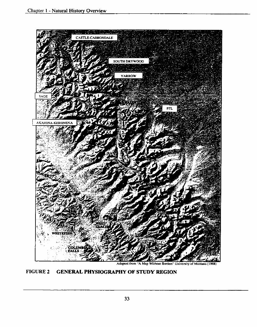
Chapter 1 - Natural History Overview
FIGURE 2 GENERAL PHYSIOGRAPFN OF STUDY REGION

Chapter 2- Natural History Overview
HYPOTHETICAL SECTION NEAR THE CLOSE O F CRETACEOUS TIME I
PRESSURE FROM WEST CREATES LARGE FOLDS OVERTURNING THE STRATA
NEW MOUNTAINS ARE CUT DOWN BY EROSION
CONTINUED PRESSURE BREAKS THE STRATA & THE LEWIS OVERTHRUST 1s FORMED
Dotted line shows approximate present outline o f surface
SECTION ACROSS WLNP SHOWING RELATIONSHIP OF ROCK FORMATIONS & THE LEWIS OVERTHRUST
1 I Source: Adapted from Dyson (1x9: 17)
FIGURE 3 HISTORY OF LEWIS OVERTHRUST
Chapter 2 - Natural History Overview
were thrust up and over younger Cretaceous aged formations along a major fracture zone
called the Lewis Thrust or Over Thrust fault. One of the best examples of what the over
thrusting movement was capable of is Chief Mountain. Chief Mountain, located just a
few kilometers south of the international border in GNP and the Blackfeet Indian
Reservation, Montana, is the eastern most outpost of the great slab of Precambrian
sedimentary rock.
Chief Mountain has been called a "mountain without roots" and has been
subsequently isolated by erosion like an island surrounded on all sides by much younger
Cretaceous rock. It is known by the German term "KLippe" and gives direct evidence of
the more than 20 km. (12.5 mi.) of movement eastward initiated by the orogenic activity.
Crowsnest Mountain in the Crowsnest Pass is also an example of a "Klippe" that was
subsequently isolated by erosion. The Lewis Thrust Fault extends north to the Bow River
area of Banff National Park.
2.4 Glaciation
Most visible landscape features today are a result of the Wisconsin Cordilleran
(Alpine) and Laurentide (Continental) ice sheets that covered most of the region
approximately 17,000 to 20,000 years before present (yr BP). By 12,000 to 1 1,000 yr BP
the ice had retreated from most low elevation locations in the study region. Alpine ice
induced erosion in the mountains and the resultant debris flows upon melting resulted in
deposition on the nearby Foothills and Prairies. Probably the most prominent glacial
feature in WLNP is Upper Waterton Lake which is a trough carved out by glacial action
and is over 400 feet deep. It is the deepest lake in the Front Ranges of the Canadian
Rockies.
As the glacial ice moved down slope towards the foothills and prairies it gouged
away rock creating scooped out depressions called cirques. A mountain peak that is
heavily glaciated can have a series of cirques on it forming sharp intervening ridges
(arretes) and perhaps display the classic "Matterhorn" appearance. Blakiston Mountain
displays such characteristics with its ice-quarried cliffs and knife like ridges between
adjacent cirques.

Cha~ te r 2 - Natural Historv Overview
Glaciers greatiy altered mountain landscapes in another way. Stream-cut mountain
valleys are generally narrow and V-shaped with streams joining at the same level.
Glacially carved mountain valleys on the other hand have steep slopes, sharp ridges and
wide U-shaped valleys. Where two glaciers join, the valley with the bigger glacier is
carved more deeply. Thus the mouth of the smaller valley is left hanging part way up the
side of the larger valley. Cameron Falls is an example of a 'hanging valley' and drops
from the Akamina Valley into the deeper Waterton Valley. There are still numerous high
alpine glaciers in GNP but none in WLNP. This is most likely due to the higher
frequencies of warm Chinook winds that WLNP experiences.
The material carved from the mountain slopes by the glaciers is carried along,
under, on top of and inside the moving ice. Eventually advancement of the ice begins to
cease and abatement (receding) begins leaving behind a mixture of mud and stone. These
till deposits form features called moraines and exhibit characteristic shapes. Till
deposited at the front of a glacier is called an end moraine. There are no examples of
large end moraines in WLNP as the melting glacial water washed them away. But one
can see small end moraines that presently dam Cameron and Alderson lakes.
There are also lateral moraines found plastered to the sides of valleys. The Waterton
Valley viewpoint, on the parkway into the town site, is located on top a large lateral
moraine. The height of this moraine above the valley floor is some 400 feet, which
indicates the thickness of the ice at its maximum at this location. Looking across the
valley the matching lateral moraine can be seen on the opposite or south side.
Traveling eastward from WLNP on Highway 5 you cross an area of hummocky
moraine left by the much larger Continental ice sheets. Close visual inspection of the till
left behind by the these ice sheets reveals granite and gneiss materials transported many
hundreds of kilometers from the north and east, the closest areas of Precambrian bedrock.
As there are no natural granites and gneiss rock formations in the Waterton region, it is
possible to differentiate the Continental and Alpine tills and thus the extent of glaciation
by each.

Chapter 2 - Natural History Overview
The reiationship of climate to the earth system is perhaps one of the most important
aspects of physical geography. "Soils affect vegetation; vegetation affects animal life;
both vegetation and animal life in turn affect soils. But most important of all is the way
temperature, precipitation, wind and other elements of climate affect other parts of the
earth system - and especially people" (Gabler et al. 1977: 146).
Climate is controlled, on a day-to-day basis, by the passage of the sun, by the nature
of the weather systems, and by local atmospheric factors, such as local winds and air
movements. Climate, in the longer term, "is determined by the relationship of the area to
the sun and by its position relative to major atmospheric features such as the permanent
centers of high and low pressure, or the main components of the circulation" (Briggs et
al. 1993: 114). Thus according to Briggs el al. it's possible to distinguish seven main
factors that control climate:
latitude,
altitude,
the distribution of land and sea,
the nature of ocean currents,
the distribution of mountain barriers,
the pattern of prevailing winds; and,
the location of the main centers of high or low pressure.
Briggs er al. (1993: 1 15-1 16) elaborate:
. . . latitude affects the seasonal pattern of temperature because, the inputs of solar radiation decline markedly away from the equator, altitude affects temperature because the atmosphere becomes cooler with height at an average of about 6.4 degrees C for every 1 0 meters (called the average environmental lapse rate).
The climate of the study region is highly variable. The Columbia Plateau in
Washington presents little in the way of a barrier to storm systems moving in from the
southwest, resulting in heavy precipitation on the western slopes of the Continental
Divide. Moisture precipitates out as storms gain altitude towards the northwest in GNP
and southeast in BC. The bulk of the precipitation falls on the west side of the

C h a ~ t e r 2 - Nahual Historv Overview
Continental Divide in BC but the numerous low mountain passes do allow the air to carry
a substantial amount of moisture through.
The study region's climate (except portions of the prairie-foothills region) is
characterized by short, cool, moist summers and long cold winters with heavy
accumu~ations of snowfall. In the southwest, the Whitefish Range, west of the Flathead
Valley in Montana, receives annual precipitation averaging 203 centimeters (cm) or 81
inches (in) while the Livingston Range, immediately to the east of the Flathead Valley, in
GNP, accumulates annual averages of 305cm (122 in). Polebridge, Montana on the valley
floor receives a scant 57cm (23 in). To the north, on the BC side, the Corbin weather
station receives a mean annual rainfall of 43 cm (17 in) and a mean annual snowfdl of
390cm (153 in). Annual precipitation east of the Continental Divide in the Castle Valley,
Alberta amounts to 86.6cm (34 in). This is the wettest region in Alberta with the deepest
recorded provincial snow packs in the upper Southcastle and Westcastle valleys (Perraton
1 994).
Alberta's greatest winter snow pack occurs in the Subalpine and decreases
progressively through to the Montane region. Snow accumulation is minimal due to the
steep rock faces and exposed slopes. This combination of a high winter snow pack and
high spring snow and rain accumulations often bring flooding to portions of Alberta's
eastern slopes, foothills and adjacent prairie regions.
Overall, British Columbia's climate can be explained by its location on the east side
of the Pacific Ocean and its mid-latitude position. The prevailing westerly blowing off
the Pacific moderate temperatures on a seasonal basis. The moderating influence of the
ocean keeps temperatures within a relatively narrow but comfortable range throughout
much of the province.
The south central interior portion of BC, between the Coast Mountains and the
Continental Divide (Rocky Mountains) consists of deep valleys, high plateaus and rugged
uplands. The windward or west-facing slopes of the three intervening mountain ranges - Monashee, Selkirk and Purcell - which comprise the Columbia system, are moist and
thickly forested. The leeward or east-facing slopes and valley bottoms are in many cases
dry and shrub covered. Generally, rainfall decreases from west to east, but snowfall
Chapter 2 - Natural History Overview
shows some increases, especially over the higher Front and Main Ranges of the Rocky
Mountains and the study region.
The Rocky Mountain ranges along BC's eastern border, with summits that reach
3000 masl, extract what moisture remains from the Pacific maritime air and also keep
cold air from the north and the Prairies out for the majority of the winter. On occasion
cold air does surge into the province through the mountain passes.
In the interior a larger percentage of precipitation (ca. 40 to 50%) falls as snow. A
transect of weather stations across the south shows an increase of precipitation as one
moves up the slopes but a noticeable decrease as distance from the Pacific decreases.
Precipitation exceeds 400cm (156 in) a year on the summits of the outer Coast Mountains
on the mainland but falls to fewer than 30cm (12 in) in some portions of the BC interior.
In the interior summer rains are derived mostly from afternoon thunderstorms and
convection rather than from Pacific disturbances and fronts. Annual precipitation in the
nearby Kootenay Valley averages from a high of 125 (49) cm to less than 75 cm (29 in)
over the Rocky Mountains with up to 400cm (156 in) falling in the winter months as
snow. The colder annual temperatures mean a greater percentage of the year's
precipitation falls as snow rather than rain (Phillips 1990).
Across BC the average temperatures varies from a winter value of -24 degrees
centigrade (C) in northeastern BC to +20 degrees C in the southern interior river valleys
in July and August. Winter temperatures reflect the ocean's influence and interior
topography and valley orientation. In nearby Cranbrook, BC the July average temperature
is +27 degrees C with the average January temperatures being -1 3 degrees C. Cranbrook
also has the highest numbers of bright sunshine hours per year (2244) on average in the
province. Although this is less than that recorded on the southern Prairies it is above most
locations in Ontario, Quebec and Atlantic Canada.
AKPP is contained in a relatively narrow band of Alpine and Subalpine lands
situated partially on the windward side of the Rocky Mountains. It is generally hot and
dry during the summer months with temperatures often exceeding +20 degrees C. Due to
its high elevation, temperatures have been known to drop below freezing during any
month of the summer.

Chapter 2 - Natural History Overview
Micro-climatic regimes (solar aspect, valley orientation, elevation, etc.) all
influence the Park's climate. This necessarily influences[ed] ungulate and other large
mammal population movements and therefore early aboriginal utilization of the region
(see section on paleoenvironmental).
Winters in southwestern Alberta, east of the Rocky Mountains, are relatively short,
not very snowy nor are they bitterly cold for extended periods compared to other areas of
the Prairie Provinces. The summers on the other hand are fairly long and warm, usually
without extended hot spells. Southern Alberta does, however, experience strong winds,
especially during the winter months. As Fletcher (1972:20) notes:
Air moving into the region from British Columbia and the Pacific Ocean is usually dry due to the "rain-shadow" protection of the mountains.. .Also, the air is relatively warm because it is heated by compression while moving down the eastern side of the Rocky Mountains. This is the Chinook phenomenon which may produce a considerable increase in temperature during summer as well as winter.
Temperatures in southern Alberta are the warmest of the Prairie Provinces during
both the winter and summer seasons and average among the warmest in the study region.
Southern Alberta also experiences more hours of sunshine per year than the remainder of
the province with the nearby city of Lethbridge receiving more than any other city in
Canada.
Precipitation over southern Alberta occurs "as a result of the cooling of moist air by
uplift along cyclonic fronts and within convection currents over the plains" (Fletcher
1972:23). Rainfall can be expected to be light in all months except June. In WLNP June
and April are the cloudiest and wettest months. WLNP receives Alberta's highest average
annual precipitation levels at 107.2cm (42 in). Cameron Lake receives an average annual
precipitation of 152 cm (60 in), with the town site at 107cm (42 in) and the park gate
76cm (30 in).
Within WLNP weather is highly variable and can change rapidly at any time of the
year. Waterton's climate is strongly influenced by both the Arctic Continental (cold, dry)
and the more dominant Pacific Maritime (warm and moist). Wind is the most important
modifying element and after the Crowsnest Pass, Waterton is the second windiest and
warmest place in Alberta. Prevailing winds are from the southwest with average daily
Chapter 2 - Natural History Overview
winds calculated at 32 kilometers per hour (20 miles per hour) and gusts of 120
kilometers per hour (75 miles per hour) being recorded. Winds are the strongest in the
winter months with gusts of over 150 kilometers per hour (90 miles per hour) being
recorded in the main valley.
2.6 Ecoregions
Naturalists long ago discovered that diverse kinds of plants grow at different
elevations in any mountain range. They thought in terms of elevational zones. This works
welt for the Alpine and Subalpine zones but not so well for the lower Foothills and
Montane zones. Ecological variety is also based on elevation and on geographical
location (Gadd 1995221). Below the Subalpine zone in the Canadian Rockies, it is not
how high up you are, but where you are that matters. The Foothills and Montane zones
contain a patchwork quilt of various plant communities.
Numerous plant species occur on both sides of the Continental Divide. The largest
regional variation within the study region is defined by the Main Ranges of the Rocky
Mountains: the eastern slope and the western slope.
The term ecoregion is derived from the words "ecosystem" and "region," literally
meaning a regional ecological classification. It is formally defined as "an area
characterized by a distinctive regional climate as expressed by vegetation"
(Subcommittee on Biophysical Land Classification 1969). Ecoregions "are usuaily of
large areal extent and can be conveniently mapped as unique entities at scales ranging
from lcm to lOkm (Reference Fraction 1: 1 000 000) to lcm to 30km (Reference
Fraction 1: 3 000 000) (Strong & Leggat 1992:Ol).
The concept of "reference site" is most often utilized to facilitate the recognition
and characterization of ecoregions. Strong and Leggat (1992:Ol) further note that:
By focusing on sites with similar characteristics it is possible to directly compare the vegetation and soil conditions among different climatic zones. Reference sites are usually defined as having deep, well to moderately well drained, medium-textured soils, with neither a lack nor an excess of soil nutrients or moisture, and neither exposed nor protected from climatic extremes. Therefore, the primary environmental influence is regional climate, which results in unique biological and/or pedological responses in each ecoregion.

Chapter 2 - Natural History Overview
These recurring vegetation and soil responses are commonly referred to as "zonal"
sites in BC (Watts 1983), "modal** sites in Alberta (Strong & Leggat 1981), and "normal"
sites at a national [Canadian] level (Ecoregions Working Group 1989). These terms are
"conceptually similar" because they all attempt to ascertain the identity of sites that are
primarily controlled by regional climate. but Strong and Leggat (1992:Ol) also note they
"reflect differences in provincial phiiosophy and schools-of-thought."
Achuff et al. (1997) used vegetation as the basis for defining the ecoregions in the
Ecological Land Classification of Waterton Lakes Narional Park. Similar ecological land
classifications have been completed for Banff and Jasper National Parks (Holland &
Coen 1982), Kootenay National Park (Achuff et al. 1984a), Mount Revelstoke and
Glacier National Parks (Achuff et al. 1984b and Yoho National Park (Achuff et al. 1993).
Ecoregions are conceptually similar to Daubenmire's (1968), La Roi's (1975) and
Lea's (1980 & 1983) zone, Krajina's (19651, Meidinger & Pojar's (1991), Braurnandl et
al.'s (1992) biogeoclimatic zone, the biophysical region of Lacate (1969)- the forest
section of Rowe (1972) and the natural subregion of Achuff (1992).
Five ecoregions are present within the study region and are presented here from east
to west as they occur: Fescue Grass, Foothills or Aspen Parkland, Montane, Subalpine
and Alpine. Boundaries occur at different elevations and are determined according to
aspect (direction a slope faces) and wind exposure. They are higher on warmer, drier
southerly and westerly aspects and wind exposed slopes and lower on cooler, moister
northerly and easterly aspects and leeward slopes. The altitudinal ranges for the Foothills
Parkland and Montane Ecoregions overlap. Achuff (1992) notes that the:
. ..environmental gradients are very steep in WLNP compared with other portions of the Canadian Rockies and the distance occupied by an Ecoregion along a landscape gradient may be small, a few kilometers or less. This results in a large amount of environmental diversity being packed into a relatively small area in WLNP.
2.6.1 Fescue Grass Ecoregwn
The Fescue Grass ecoregion occurs immediately east of both the Montane and
Foothills or Aspen Parkland and runs parallel to the Rocky Mountains in the eastern
portion of the study region and is found on both Plains and Foothills topography. Strong
& Leggat (1992:12) base the boundaries, within the province of Alberta, for this
Chapter 2 - Natural History Overview
ecoregion "on the BlacWDark Brown Chernozem soil boundary and the eastern extent of
the aspen."
Because of two related factors, increased elevation and proximity to the Rocky
Mountains, the Fescue Grasslands do not have typical grassland climate and experience
cooler summers and warmer winters. Precipitation and temperature characteristics are
more typical of Cordilleran (mountain) rather than Grassland climates. Wailis (1980:21-
24) describes vegetation typical in the Fescue Grass Ecoregion as:
Rough fescue (Festuca scabrella) and bluebunch fescue (Festuca idahoensis) are the dominant species. Associated grasses include wheat p s s (Agropyron trachycaulum), Parry oat grass ( Danthonia parryi) and minor amounts of June grass, mountain Timothy (Phleum comrnutatum), bluegrass and sweat grass (Hierochloe odorata).
According to Peacock (1992: 15- 16):
The herb component is extremely diverse and includes species such as old man's whisker's (Geum trifrorum), cinquefoil (Potentilla spp.), northern bedstraw (Galium boreale), prairie parsely (Lomatiurn witernarum), alum root (Heuchera parvifolia), wild strawberry, prairie crocus, onions, wild caraway (Perideridia gairdnen'), willow-herb (Epilobium glandulosurn) and white death camas (Zigadenus venenosus) is found on drier sites. Balsamroot (Balsamorhiza sagittata) thrives on the south-facing slope in this [ecolregion.
Due to the increased moisture available in the coulees and on steep north-facing
slopes shrub communities are more common in the Fescue Grass ecoregions. Shrubs
commonly found include buckbrush/wolfbe~/snowberry (Symporicarpos occidentalis - honeysucle family). wolf willow/silverberry (Elaeagnus commutata - oleaster family),
rose (Rosa spp. - rose family), saskatoon/serviceberry/junebeny (Arnelanchier alnifalia),
choke cherry (Prunus virginiana - rose family) and willows (Salix spp.). Trees are
uncommon but aspen (Populus tremuloides) and balsam poplar (Populus balsamifera)
occur where moisture is ample.
a) Fescue Grass Ecoregion and H e d g e Sires
The climate regimes, including precipitation and temperature, of the Fescue Grass
ecoregion are suitable for supporting large ungulate populations. Many large
Chapter 2 - Natural History Overview
archaeological kill sites are located in this ecoregion with the winter campsites located in
the adjacent river valleys.
2.6.2 FoothiUs (Aspen) Parkland Ecoregwn
The Aspen Parkland Ecoregion is associated with foothills. In WLNP and GNP the
Aspen Parkland Ecoregion occurs at an altitudinal range of between 1280 to 1500 meters
above sea level (masl). The climate is somewhat moister than areas to the east and the
topography changes more abruptly. Because of these factors the vegetation is unique and
diverse, consisting of a mixture of grasslands, shrub communities and aspen forests.
This ecoregion is characterized by rough Fescue (Festuca scabrella) grassland and
aspen (Populus rremuloides) grove forests. In Canada and the USA, Foothills Parkland
occurs in a limited geographic area and occupies:
... a narrow band along the eastern edge of the foothills from Calgary south to the Porcupine Hills, and from Pincher Creek south to the US border, including portions of WLNP, and into parts of adjacent Montana in Glacier National Park and the Blackfeet Indian Reservation (Achuff 1992, Cooper and Pfister 198 1).
Wallis (1980:55-56) describes the grasslands of the Aspen Parkland as comprising
Fescue grass (Festuca spp.), bluegrass and oat grass. Blue carnas, old man's whiskers and
lupines (Lupinus spp.) are also prevalent. Herbs found here include prairie parsley, bistort
(Polygonurn bistortoides), and sticky purple geranium. Low larkspur (Delphinium
bicolor), alumroot, balsamroot, western spring beauty (Claytonia lanceolata), musineon
(Musineon divarcatum) and valeriana (Valeriana dioica) are also present
Shrub communities within the Aspen Parkland include willow, saskatoon, wild
rose, buckbrush, snowbemy (Symphon'carpos albus) and wolf willow. There are also
extensive willow stands in moist, poorly drained sites where herbs such as gaillardia,
valeriana, blue camas, veiny meadfow rue, yarrow and glacier lily (Erythronium
grandiflorurn) are found (Wallis 1980:27-28).
The open woodlands are perhaps the richest habitats in the Aspen Parkland. They
support "a diverse undentorey with a unique combination of species, many of which do
not occur elsewhere in the province. Peacock (1992: 17) notes:
In early spring, glacier lilies and blue camas are common in the understorey. As the season progresses, the woodlands develop a dense

Chapter 2 - Natural History Overview
undergrowth of herbs, shrubs and grasses. The herb layer includes veiny meadow rue, red and white baneberry, common pink wintergreen (Pyrola asarifolia), cow parsnip (Herrrcleum lamnun), fairy bells, purple clematis (Clematis occidentalis), yellow angelica (Angelica dawsonii), valeriana, creeping mahonia (Berberis repens), dewberry (Rubus pubescenr), wild caraway, sweet cicerly (Osmorhiza chilensis and 0. occidentalis), wild rasberry (Rubus idaeus), twining honeysucle (Lonicera dioca) and false hellabore (Veratmrn eschscholtzii).
a) Foothills (Aspen) Parkland Ecoregion and Heritage Sites
The Aspen Parkland Ecoregion contains some of the highest potential for
habitation, large and small kill, and processing sites within the study region because of
the favorable environmental conditions. The favorable climate and lush vegetation
provide browse for ungulate populations and therefore game for early hunters. The wide
variety of herbs, shrubs and other plants were also favorable for aboriginal picking and
included processing of floral species for medicinal or food purposes.
2.6.3 Montane Ecoregion
Within the study region, the majority of the Montane ecoregion occurs in the
foothills and major valleys of the Rocky Mountains. The main portions in Alberta are
found between the Montana border and Chain Lakes area (Anderson 1978; Strong 1979).
There are also portions identified along the Bow and Athabasca River valleys (Downing
er al. 1989; Holland & Coen 1982), and the North Saskatchewan River valley (Rayner &
Dutchak 1984). Small occurrences have also been reported in the Ya Ha Tinda (Stelfox
1981) and the Grande Cache (Archibald et al. 1984) areas as well the Banff and Jasper
townsites. The upper portions of the Cypress Hills were also recently re-classified as
Montane (Strong & Leggat 1992: 19). In total, the Montane ecoregion comprises only 0.9
percent of the province of Alberta or approximately 5,714 sq. km. (2230 sq. mi.)
Elevationally, the Montane occurs below the Subaipine and above the Fescue Grasslands
and Aspen Parkland Ecoregions.
Within the study region the distinction is made between eastem-slope and westem-
slope Montane. The eastern-slope Montane forest is extensive and covers the lower
mountain slopes and valley floors over much of the Foothills belt. Generally speaking,
the westem-slope Montane forest is a wetter version of the eastem-slope Montane forest.

Chapter 2 - Natural History Overview
It tends to be somewhat heavier and shrubbier, with species such as western larch and the
Columbia lily.
The Eastern Slopes Montane ecoregion overlies a broad range of topography and
generally covers "lower mountain slopes, the valley floors and much of the foothills belt"
(Gadd I995:225). Ecological conditions are highly variable in Montane regions which is
usually the result of "complex topography and their small size and strong ecotonal
effect[s] from their surrounding environments"(Strong & Leggat 199232 1). Gadd
( 1995225) notes that, "ecological variety at Montane elevations.. .is mostly the result of
forest fues and a patchy climate.. .and as having several subsets. . .all of them have[ing] a
common boundary."
Two distinctive ecological sequences exist for the Montane vegetation: closed
canopy lodgepole pine (Pinus contorts) and Douglas-fir (Pseudotsuga menziesii)
communities. The Lodgepole pine community is a primary reference vegetational
community with less well-drained sites being dominated by balsam poplar (Populus
balsamz~era) and willow (Salk spp.) stands found along creek and river bottoms.
On the other hand, closed-canopy aspen groves can occur on warmer and drier
locations than the reference condition. This can include "lower elevation north and upper
elevation south facing slopes" (Strong & Leggat 1992:23).
At lower elevations and on steep southeast and southwest aspects rough Fescue and
groves of aspen form vegetation that is similar to portions of the Aspen Parkland
Ecoregions. These locations are often warm and dry site conditions and promote the
development of Black Chernozernic soils. Stringer (1973) notes that, "In more northerly
locations, grasslands are dominated by June grass (Kaeleria rnacrantha) and soils are
often variable." Montane Ecoregions often exhibit a wide range of vegetational
communities within a relatively confined region. For example the Whaleback Ridge and
Porcupine Hills north and east, respectively, of the Crowsnest Pass, and the BTL are
composed of a mixture of rough Fescue grassland, aspen, Douglas-fir and lodgepole pine
stands (Strong 1979). On well-drained sites the lodgepole pine stands have the potential
to climax into the second reference vegetational community the Douglas-fir or White
spruce (Picea engelmannii & P. glauca) forest.

Chapter 2 - Natural History Overview
The second reference vegetation community is a "distinctive and relatively common
component of the Montane. It usually grows on steep south facing slopes with shallow
rocky soils, and very course textured outwash [deposits] in valley bottoms" (Stringer &
La Roi (1970) as cited in Strong & Leggat (1992:21). These site situations are xeric (dry)
and a result of poor soil water retention. high insolation. and rapid overland runoff. Open
growing Lodgepole pine and Douglas-fir in similar locations "probably represent the
transitional [zone] between Douglas-fir and the lodgepole pine reference vegetation
(Strong & Leggat 1992:23). The occurrence of limber pine (Pinus flerilis) appears to
represent an extreme of this sequence often occupying exposed rocky sites under very
xeric conditions.
Strong & Leggat (1992:23) note that, "Historically, natural fire probably helped to
maintain healthy Douglas-fir stands by removing ground litter and [many] invading
species, and by minimizing stand density." In the absence of fire, litter accumulates and
forest stands inevitably become denser, which allows for the invasion of a secondary
successional species of white spruce. which will ultimately replace Douglas-fir in some
locations.
Within the study region the "...Montane Ecoregion occurs at altitudes of between
1280 & 1680 mas1 and is characterized by both open and closed coniferous forests"
(Achuff et al. 1997:3 1).
a) Montane Ecoregions and He&zge Sites
The Montane ecoregions of Alberta's Eastern Slopes are included within many
Canadian and American provincial and national parks and other nature preserves such as,
the Cypress Hills Provincial Park. Kootenay Plains Ecological Reserve, Yamnuska
Candidate Natural Area and Banff, Jasper and Waterton Lakes National Parks. Common
activities outside of these protected areas are domestic cattle grazing, forestry and four-
season recreation use.
The implications of the past and present locations of Montane ecoregions to the
study of contemporary and traditional native land use is of paramount importance.
Montane Ecoregions represent important wildlife habitats and provide critical wintering
habitat for ungulate populations including elk or wapiti (Cervus elaphus), bighorn sheep

Chapter 2 - Natural History Overview
(Ovis canadensis), and mule deer (Odocoileus hemionus). The nearby Subalpine and
Alpine Ecoregions provide important summer habitat for these species with the warm
winter Chinook conditions providing the required lower snow depths essential for winter
survival. The nearby Aspen forests found on the alluvial fans of the Montane river
valleys (on the BTL) are relatively rare, but where they occur, they support greater than
average wildlife diversity as do the nearby Montane wetlands found in the Belly River
lowlands.
These areas provide some of the study region's greatest potential for high
frequencies of Precontact archaeological sites. Site types include campsites, kill and
processing sites, trails, ribbon offering and vision quest sites,
2.6.4 Subalpine Ecoregion
"The Subalpine ecoregion is a Rocky Mountain altitudinal vegetation zone with its
upper boundary formed by the unforested Alpine Ecoregion, whereas the lower boundary
abuts the Montane, Aspen Parkland and Upper Boreal-Cordillera Ecoregions" (Strong &
Leggat 1992:23). Elevation differences between the upper and lower boundaries average
about 650 meters.
It is divided into Lower and Upper Subalpine portion as described in Achuff et al.
(1997:3 1-32).
a) LOwer Subalpine
The Lower Subalpine is characterized by a closed coniferous forest community and
extends from the Montane-Subalpine boundary at about 1650 to about 1950 masl. The
Lower Subalpine Ecoregion are composed of two distinct plant communities: ( I )
lodgepole pine and successional stands of Engelmann spruce (Picea engelmannii) and (2)
Subalpine fir (Abies lasiocarpa). They are found at lower elevations and on moderately
well drained soils and open stands occurring on well-drained warm sites.
Shrub growth is mainly the result of avalanche activity and includes green alder
(Alnus crispa) with fern, aspen (Populur trernuloides), saskatoon (Amelanchie alnifolia),
subalpine fir (Abies lasiocarpa), false azalea (Menziesia ferruginea) and soopolallie or
buffaloberry (Shepherdia canadensis) to name but a few.

Chapter 2 - Natural History Overview
On warm, dry wind-exposed locations grassland communities can be found,
including bluebunch wheatgrass (Agropyron spicaturn) and rough fescue (Fesruca
scabrel la).
6) Upper Subalpine
The Upper Subalpine occurs from 1950 to 2250 mas1 and is broadly ecotonal
between the Lower Subalpine closed forest and the treeless Alpine Ecoregion above.
Vegetation growth at higher elevations is predominated by open stands of low-growing
Engelmann spruce, subalpine fir, whitebark pine (Pinus albicaulis) and alpine Iarch
(Larix lyallii). Open forests and stunted trees (Krummholz) are characteristic.
Conifer dominated forests and often severe winters conditions combine to produce a
unique and specialized wildlife assemblage that is closely linked to the Alpine and
Montane habitats. "Habitats of greatest importance, within the Subalpine ecoregion, are
avalanche and stream-side shrub communities, forb-rich meadows and in addition the
south facing grasslands provide important wintering habitats for many ungulate species
as well as early spring forage for both ungulates and bears" (Strong & Leggat 1992:25).
Subalpine Ecoregions provide not only important habitat for wildlife but also watershed
management and protection, forest production/rnanagement, natural parks and recreation
areas.
C ) Subalpine Ecoregions and Heritoge Sites
The Subalpine ecoregions generally have low to moderate potential for high
frequencies of Precontact archaeological sites. Within the study region heritage sites
commonly found in this ecoregion include ribbon offering sites, vision quest sites and
transitory hunting campsites. The potential exists for mid elevation trails either
paralleling or transecting (east-west) the Ecoregion as well.
2.6.5 Alpine Ecoregion
Alpine Ecoregions occur above the upper climatic forest-line in the Rocky
Mountains and the Subalpine Ecoregion. Elevationally, the Alpine occupies terrain
between 2250 and 2650 mas1 in the southern Alberta Rockies (Achuff et al. 1997:33).

Chapter 2 - Natural History Overview
Dwarf shrubs and other low growing species such as white mountain heather
(Cassiope menensiana) and pink mountain heather (Phyllodoce empetriformis) dominate
the Alpine Ecoregions. Other common species can include Engelmaan spruce, subalpine
fir, whitebark pine, and alpine larch. The occurrence of these tree species above the tree-
line account for their often stunted and unusual shapes. The vegetation varies in response-
to protection from the harsh environment and substrate conditions (Strong & Leggat
1992:26). Vegetation types can also include lichens, low-growing evergreens, deciduous
shrubs, fescue grasslands and scattered krummholz. The variability is due to several
environmental factors such as strong winds, snow protection, substrate conditions and
aspect (topographic position) or other microclimatic conditions, such as solar aspect,
wind exposure, timing of snowmelt, available soil moisture, evapotranspiration rates and
seasonal snow depth.
The Alpine ecoregion is one of the most distinctive, fragile and fragmented
ecos ys terns found throughout the study region. Watershed management and protection,
recreation and wildlife habitat are important concerns and uses. Most areas of Alpine
Ecoregions are under federal and provincial control and are commonly designated as park
or protected wilderness areas.
a) Alpine Ecoregions and Hetitage Sites
Alpine Ecoregions generally have moderate to low potential for Precontact
archaeological sites. Within the study region heritage sites commonly found in this
ecoregion include vision quest sites and isolated surface finds of lithic (stone) artifacts.
There is also potential for lithic extraction (quarry sites), temporary hunting camps and
trails or high elevation mountain passes in this ecoregion. Although potential is not high,
the significance of the archaeological sites found can be high, due to their special
religious or ceremonial nature.
2.6.6 Summary
In summary, the study region exhibits a great geological, physiographic,
geomorphologic, climatic and ecological diversity. The complex relationships between
these factors have in the past, and continue today, too greatly influence the floral and
faunal communities over a relatively short geographic distance. The variation and
Chapter 2 - Natural History Overview
diversity exhibited within the study region has made available to indigenous populations
an abundance of natural resources over the millennia.
2.7 Flora & Fauna
The study region's mountainous character and regional climatic patterns provide the
opportunity for significant ecosystem diversification. The "diversity of ecosystems is due
to climate and physiography, time and the degree to which their development has been
disturbed" (Harding & McCullum 1994:227). The development of complex ecosystems
requires time. Therefore, regions which were re-glaciated during the most recent glacial
advances (Ice Ages) have less complex ecosystems than those that were not. Harding &
McCullum (1994:227) continue:
More complex ecosystems tend to have high numbers of species that use rnicrohabitats, such as insects and birds that [have] evolved symbiotic and complex host-parasite relationships, and plants and animals with conservative reproductive and dispersal capabilities.
It is also important to note that the Frequency of disturbances such as local and
regional scale natural disasters can affect the development of ecosystems. Landslides,
floods and grass or forest fires are relatively frequent especially in steep-sided, rugged
mountainous regions. These small-scale disasters create high ecosystem diversity by
providing habitats suitable for early, floral and faunal, colonizers and other species that
require a variety of habitat types.
Elevation varies considerably throughout the study region. The majority of
archaeological field investigations specifically undertaken for this study were conducted
in the high elevation Engelmann spruce-subalpine fir and Alpine Tundra ecozones,
although Fescue Grasslands, Aspen Parkland and Montane zones were also investigated
and traversed to gain access into the higher zones.
2.7.1 Flora
Historically, vegetation in the BC portion of the study region "was predominantly a
mature spruce-fir system intermingled with regenerating lodgepole pine (Pinus contorla)
and larch (Larix spp.)" (Konrad et al. 1999:24). Mostly these coniferous species were
mature to old aged with the expansive lower elevation Montane grasslands maintained in

Chapter 2 - Natural History Overview
the long-term by climatic fluctuations/cycles and in the short-term by fire from both
natural and human causes.
Today, vegetation is still a mixture of coniferous forests, wetlands and Montane
grasslands. Coniferous forests are dominated by Douglas-fir (Pseudotsuga menziessi) and
subalpine fir (Abies lasiocarpa) with western white pine (Pinus rnonticola), western
hemlock (Tsuga hetrophylla), western red cedar (Thuja plicata) and whitebark pine
(Pinus albicaulis). Wetland vegetation communities consist of a diversity of forbs (seed-
bearing non-woody plants/wildflowers), sedges (perennial grass-like plants with
triangular, typically solid stems and flattened triangular leaves) and rushes (hollow round
stems, like grasses but with no joints and round leaves) with scattered shrubs (any woody
plant that is not a tree) throughout. The Subalpine meadows are also noted as being
structurally diverse components of the grass/forb vegetation communities found in the
Rocky Mountains.
The Akamina-Kishinena region was originally defined by Vladimir Krajina (1965),
as belonging to the Engelmann Spruce - Subalpine Fir Biogeoclimatic Zone of the
Canadian Cordilleran Subalpine Forest Region. Foster & Brolly (19785) state:
... approximately 30% of the Akamina-Kishinena watershed is alpine tundra consisting of rock, alluvial gravel and vegetated cliffs of herb and scrub habitat types. Approximately 70% [or the remainder] is coniferous and deciduous forest with deciduous and mixed [tree] types found in the lower valley bottoms.
Frederick ( 1976:3 I) elaborates and describes:
... vegetational variation as a consequence of altitude, and state[s] that, lower elevation stands are characterized by closed forest stands and the upper areas by trees growing in clumps or small colonies. These colonies occur where snow lies moderately longer.
a) Rare and Endangered Flora
The overall climatic regime and general geographic location of the study region,
both on the BC and Alberta sides, has resulted in a relatively high number of rare plant
species. Amateur naturalists and scientist catalogue known occurrences and report to
regional Conservation Data Centers. Occurrences are mapped and made available to
managers. The following table (Table 3) lists species which have been identified as 'Red-
Listed' or 'Rare' within the study region by the BC Conservation Data Center, Montana

Chapter 2 - Natural History Overview
TABLE 3 RARE AND TEREATENED PLANT SPECIES IN BC
I Red-listed (rare) I High Alpine Butterweed Senecio comenninus Sweet-Marsh Butterweed Senecio foeridus var. foetidus Large-Flowered Brickellia Brickellia grandiflora Obscure Cryptantha Ctyptar~hu ambigua Slim Larkspur Delphinium depauperatwn Howell's Quillwon Isoeres howellii Northern Linanthus Linanthus seprentrionalis
[ Parry's Townsendia Towmendia panyi 1 Adapted from Konrad et at. ( 1999:26)
Natural Heritage Program and the USA National Forest Service (as cited in Konrad et al.
I999:26 & 27). Konrad et al. also provide Blue Listed (threatened) and sensitive species
and species of Special Concern in BC and adjoining portions in the USA portion of the
North Fork of the Flathead National Forest.
6) Old Growth Forest
The study region's frequent stand replacing forest fires has historically limited old
growth stand potential. Mature trees are more often found in the cool, moist spruce-fir
forests than in the -Montane larch-pine. Old growth forest can still be found within the
study region, but historically its distribution has changed.
BC Ministry of Forests defines old growth differently within ecozones. In the
Montane spruce ecozone, trees are classified as mature when they reach 100 years of age
and old when they reach 140 years. In Englemann spruce-Subalpine fir subzones, trees
are mature at 120 years of age and old at 140 years.
Within BC, old-growth forests are predominantly located in dry, cool Engelmann
spruce - subalpine fir forests. Within, or near the study region, there are two small rare
old-growth areas: one on the north face of Mount Yarrell on the north-side of Akamina-
Kishinena valley adjacent to the confluence of the Beavertail Creek valley and the other
in the South Lodgepole Creek area, west of the Flathead River valley.
C ) Forest Composition and Archaeological Sile Potenlial
Forest stands are constantly being altered by disease, fire and fze suppression and
harvesting (logging). Low elevations, which have traditionally been dominated by

Chapter 2 - Natural History Overview
spruce-fir forests have given way, in the past 50 years, to young lodgepole pine,
immature western larch, Douglas-fir and spruce. Low elevation riparian areas, marshes
and dry meadows persist but due to fue suppression coniferous stands are encroaching.
High elevation mountainous areas of spruce, Douglas and subalpine fir, whitebark pine
and subalpine larch persist, however, whitebark pine distribution has declined with the
infectious invasion of whitepine blister rust.
Old growth stands of Engelmann spruce, Douglas-fx and western larch have been,
and continue to be in some areas, altered by commercial forest harvesting. Konrad et al.
(1 997:30) note: ". ..that prior to commercial logging, approximately 28% of the spruce/fu
stands in the North Fork [of the Flathead River valley] were old growth." Konrad et al.
further notes that "estimate about 9% of the forests are [presently] in an old growth
condition and much of those are at high elevations and widely dispersed."
Historically, forest stand composition and general health, including age and stand
size, would have influenced early animal and human movements and the potential for a
variety of heritage site types. There is ethnographic evidence of early human populations
burning forest stands in order to improve favorite hunting/carnping locations by clearing
tall grasses, weeds and other brush for better safety/visibility; to improve preferred trail
routes that have become clogged with blow-downs or thick impassable undergrowth; to
aid in communal deer hunting or assist in the establishing of suitable areas where
medicinal plants were collected (see also Arno 2976; Barrett 1980; Chittendon &
Richardson 1969; Multan 1861; Johnson 1969; Lewis 1977; Malouf 1969; Phillips 1940;
Shaeffer 1940; Stewart 1954; Thwaites 1969). Banett (1980: 18) writes:
Indians had many purposes for igniting fires.. .and.. .it is apparent that most fires were set to achieve simultaneous objectives. For example, many persons said fires were commonly set to bum out the old, dense underbrush and stimulate a new growth of big-game browse. Others said burning underbrush protected the forest fiom destructive crown fires by reducing fuel accumulations. Still other informants said Indians practiced 'underburning' to enhance growth of food [or medicinal] plants such as berries, or to aid food gathering and travel.
Archaeological site locations then are understandably influenced by forest stand
composition. A basic understanding of forest dynamics is essential in the prediction of
heritage site locations, types and densities at any elevation within the study region.

Chapter 2 - Natural History Overview
The floral mosaic in the n N P and GNP region has also developed since the
retreat of the last glacial episodes approximately 10,000 years ago in most elevations. In
High Alpine locations extreme and variable climate and moderate to no soil development
limit plant community development. Lower elevation Montane and Aspen Parkland
Ecoregions have a more moderate climate and have allowed a "succession of plant
communities leading to a forest cover that has been present for thousands of years"
(Shaw & On 1979:ix-x). As the ice receded from the lower slopes, lodgepole pine
invaded, accompanied by species of spruce, fir and Douglas-fir. Shaw and On also note
that, "Forest fires have probably always had some role in patterning these early forests."
Forest communities on the eastern slopes alternate with prairie, moist meadows,
shrub communities, aspen groves, scattered limber pine and rock outcrops. "The most
obvious and dominant pattern is that which roughly horizontally divides Waterton [and
Glacier] into three major vegetational zones" (Kuijt 1982:xx) (see Figure 4). The
Subalpine is composed of whitebark pine and subalpine fir. In lower elevations Douglas-
fir, spruce and subalpine fir are characteristic of mature forests with much of the area
now covered with lodgepole pine. Local variants and mixed vegetation types caused by
microclimatic factors including topography, soil types, slope exposure or aspect and
vegetational history factors make this a 'rough' division but still useful.
The recently produced Ecological Land Classification of Waterton Lakes National
Park, Alberta (Achuff ef al. 1997) provides a comprehensive overview of landforms,
soils and vegetation within the Park and applies to many portions of GNP.
2.7.2 Mammalian Fauna
Scientific reports and general information on faunal species is often weighted
heavily towards large carnivores and ungulates - the popular 'game' species. Historic
books and old family albums contain photos of fisherman with 50 - 'fish stringers' or
'meat poles' filled with deer. Further more, many historical accounts from before the turn
of the century portray an abundance of all wildlife in some regions.
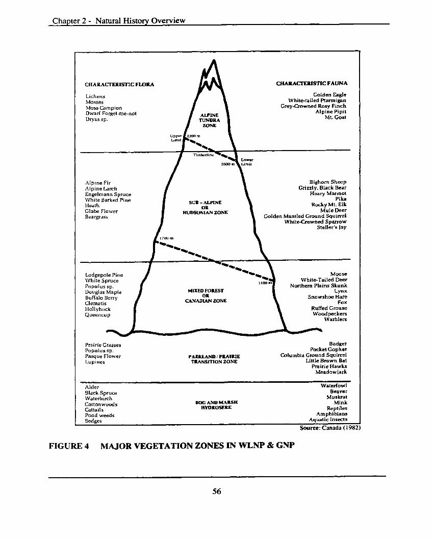
Chapter 2 - Natural History Overview
FIGU
CIIARACI'ERISTIC FLORA CHAlUCTEIUSITC FAUNA
Lichens Golden Eagle Masses White-tailed Ptarmigan .Moss Campion Grey-Crowned Rosy Finch Dwarf Forget-me-not Alpine Pipit Dryas sp. Mt. Goat
Alpine Fir Bighorn S h e p Alpine Larch Grizzly. Black Bear Engelmann Spruce Hoary Marmot \\lhite Barked Pine SUB - ALPINE
Pika Heath Rocky Mt. Elk Globe Flower Mule Deer B ea w a s s Golden Mantled Ground Squirrel
WhiteXtowned Sparrow Steller's lay
Lodgepole Pine Moore White Spruce White-Tailed Deer Populus sp. Northern Plains Skunk Douglas Maple LPX Buffalo Bcrry Snowshoe Hare
U W l A N ZONE Fox
Ruffed Grouse Woodpeckers
Warhlers
Prairie Grasses Badger Populus sp. Pocket Gopher Pasque flower PAIYLAND l PRAIRIE Columbia Ground Squirrel Lupines TRANSmON ZONE Little Brown Bat
Prairie Hawks Meadowlark
Alder Waterfowl Black Spruce Beaver IVaterbirch .Uusluat Coftonwoods BOG LWD M.*ISH Mink Cattails tlYOROSERE Reptiles Pond weeds Amphibians Sedges Aquatic Insects
Source: Canada (1982)
RE 4 MAJOR VEGETATION ZONES IN WLNP & GNP
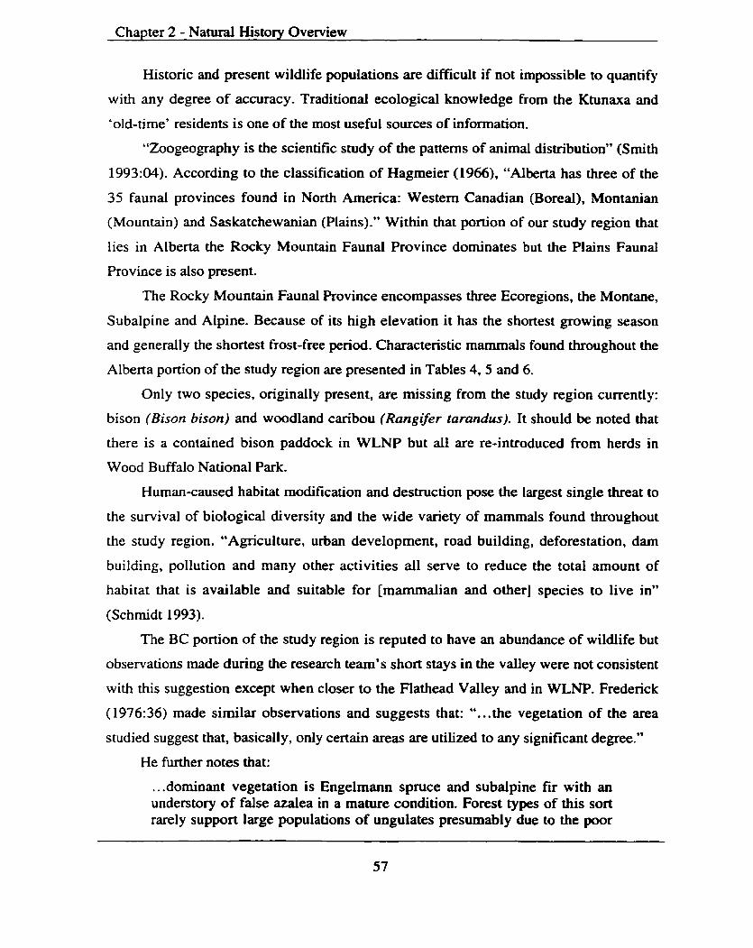
Chapter 2 - Natural History Overview
Historic and present wildlife populations are difficult if not impossible to quantify
with any degree of accuracy. Traditiond ecological knowledge from the Ktunaxa and
'old-time' residents is one of the most useful sources of information.
"Zoogeography is the scientific study of the patterns of animal distribution" (Smith
1993:W). According to the classification of Hagmeier (1966), "Alberta has three of the
35 faunal provinces found in North America: Western Canadian (Boreal), Montanian
(Mountain) and Saskatchewanian (Plains)." Within that portion of our study region that
lies in Alberta the Rocky Mountain Faunal Province dominates but the Plains Faunal
Province is also present.
The Rocky Mountain Faunal Province encompasses three Ecoregions, the Montane,
Subalpine and Alpine. Because of its high elevation it has the shortest growing season
and generally the shortest frost-free period. Characteristic mammals found throughout the
Alberta portion of the study region are presented in Tables 4, 5 and 6.
Only two species, originally present, are missing from the study region currently:
bison (Bison bison) and woodland caribou (Rangveer tarandus). It should be noted that
there is a contained bison paddock in WLNP but all are re-introduced from herds in
Wood Buffalo National Park.
Human-caused habitat modification and destruction pose the largest single threat to
the survival of biological diversity and the wide variety of mammals found throughout
the study region. "Agriculture, urban development, road building, deforestation, dam
building, pollution and many other activities all serve to reduce the total amount of
habitat that is available and suitable for [mammalian and other] species to live in"
(Schmidt 1993).
The BC portion of the study region is reputed to have an abundance of wildlife but
observations made during the research team's short stays in the valley were not consistent
with this suggestion except when closer to the Flathead Valley and in WLNP. Frederick
( 1976:36) made similar observations and suggests that: ". . .the vegetation of the area
studied suggest that, basically, only certain areas are utilized to any significant degree."
He M e r notes that:
... dominant vegetation is Engelmann spruce and subalpine fir with an understory of false azalea in a mature condition. Forest types of this sort rarely support large populations of ungulates presumably due to the poor
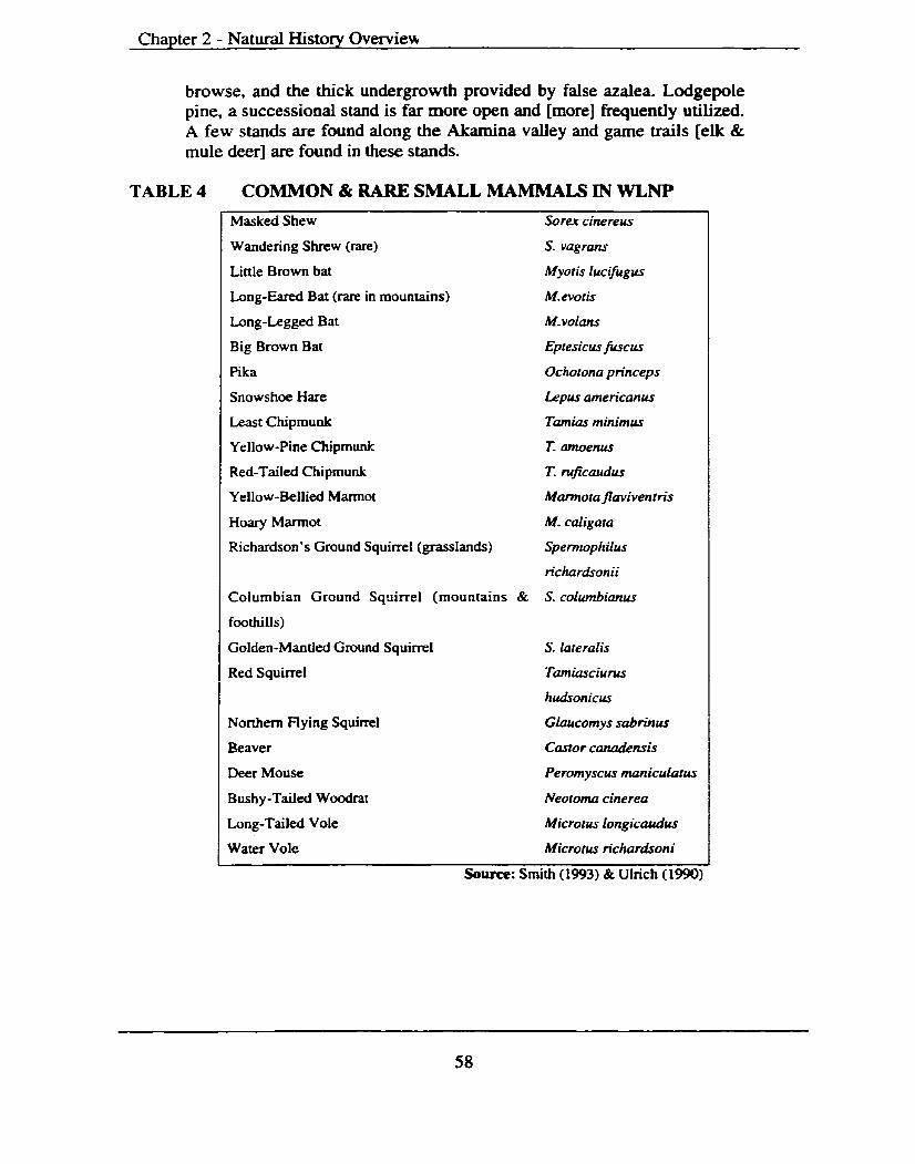
Chapter 2 - Natural History Overviem
browse, and the thick undergrowth provided by false azalea. Lodgepole pine, a successioaal stand is f a . more open and [more] frequently utilized. A few stands are found along the Akamina valley and game trails [elk & mule deer] are found in these stands.
TABLE 4 COMMON & RARE SMALL MAMMALS IN WLNP
Masked Shew Sorex cinereus
Wandering Shrew (rare)
Little Brown bat
Long-Eared Bat (rare in mountains) M. evoris
Long-Legged Bat
Big Brown Bat
Pika
M. volam
Eptesicus fLscus
Ochorona princeps
Snowshoe Hare Lepus amencanus
Least Chipmunk Tamias minimus
Yellow-Pine Chipmunk T. atnoenus
Red-Tailed Chipmunk T. nrficaudus
Yellow-Bellied Marmot Manno ra flaviventris
Hoary Marmot M. caligara
Richardson's Ground Squirrel (grasslands) Spermophilus
Columbian Ground Squirrel (mountains & S. columbianus
foothills)
Golden-Mantled Ground Squirrel S. lateralis
Red Squirrel Tamiascium
Northern Flying Squirrel
Beaver
hudson icus
Glaucomys sabrinus
Castor canadensis
Deer Mouse Peromyscus maniculatus
Bushy -Tailed Woodrat Neororna cinerea
Long-Tailed Vole Microtus longicaudus
Water Vole Microrus richardsoni
Source: Smith (1993) & Ulrich ( 1990)
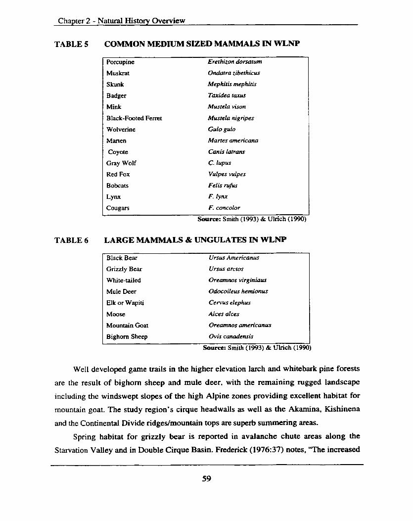
Chapter 2 - Natural History Overview
TABLE 5
TABLE 6
COMMON MEDIUM SIZED MAMMALS IN WLNP
Porcupine Ererhizon dorsanun
Muskrat Ondatra ziberhicus
Skunk Mephitis mephitis
Badger Taridea tams
Mink Mustela vison
Black-Footed Ferret M m e h nigripes
Wolverine Gulo gulo
I Marten Martes americana I Coyote
Gray Wolf
canis latram
C. lupus
I ~ e d FOX vulpes vulpes I Bobcats Feiis mfus
Lynx F. lynx
Cougars F. concolor
Source: Smith (1993) & Wlrich (1 990)
I Black Bear Ursus Amencanus I Grizzly Bear
White-tailed
Ursus arctos
Oreamnos virginiaus
I Mule Deer Odocoiieus hemionus I I Elk or Wapiti Cervus elephus I 1 Mwse Alces alces I I Mountain Goat Oreamnos amencanus I Bighorn Sheep Ovis canadensis I
Source: Smith (1993) & Ulrich (1990)
Well developed game trails in the higher elevation larch and whitebark pine forests
are the result of bighorn sheep and mule deer, with the remaining rugged landscape
including the windswept slopes of the high Alpine zones providing excellent habitat for
mountain goat. The study region's cirque headwalls as well as the Akamina, Kishinena
and the Continental Divide ridges/mountain tops are superb summering areas.
Spring habitat for grizzly bear is reported in avalanche chute areas along the
Starvation Valley and in Double Cirque Basin. Frederick (1976:37) notes, 'The increased

Chapter 2 - Natural History Overview
moisture in these areas provides spectacular displays of lilies, the bulbs of which are
often dug by these animals."
Konrad et al. (1999:37) reports on the nearby Nonh Fork Flathead Valley in
Montana. They state:
... deer and moose (Alces alces) were plentiful historically, but elk were practically non-existent. Elk were 'planted' here in 1928, corning from Yellowstone and were more common by the 1950s and 60s. Bighorn sheep and mountain goats were more common in the 1940s and 50s. Woodland caribou (Rangifer tarandus) persisted here until about 1936, when large fires swept through north of the border.
The BC region presently contains populations of eight (8) species of large
carnivores: black bears, grizzly bears, bobcats, lynx, cougars, coyotes, wolves, wolverine
and six species of ungulates: elk, mountain goat, moose, mule deer, whitetailed deer,
Rocky Mountain bighorn sheep (McLellan 1989; Basaraba 1977).
Of interest to many are certain subspecies of mammals with their ranges restricted
in British Columbia. Table 7 is a list of these taxa.
TABLE 7 MAMMAL SUBSPECIES WITH RESTRICTED RANGES IN BC
Little Brown Bat Myotis lucifugus Least Chipmunk Eutumias minimus selkirki Rufus Tailed Chipmunk Eutamias nificaudus ruficaudus Pocket Gopher Ttromomys talpoides suturalus Pack Rat T. t. cogFatus Pack Rat Neoroma cinerea cinerea Mountain Heather Vole Phenacomys inrennedius levis Yellowstone Moose Alces alces shirasi Mountain Goat Oreamnos americanus missoulae Northern Rocky Mountain Canis lupus irremotus
I Wolf Adapted from Frederick (1976:37)
Although provincial and federal governments currently lack Endangered Species
legislation, the BC Forest Practices Code does contain a mechanism to protect
biodiversity. A list of wildlife, wildlife habitat areas and associated landscape units under
an identified ' Wildlife Management Strategy ' means animal species or plant communities
that are considered to be at risk (e.g. endangered, threatened, vulnerable or sensitive) may
require management of the critical habitats where they are found.
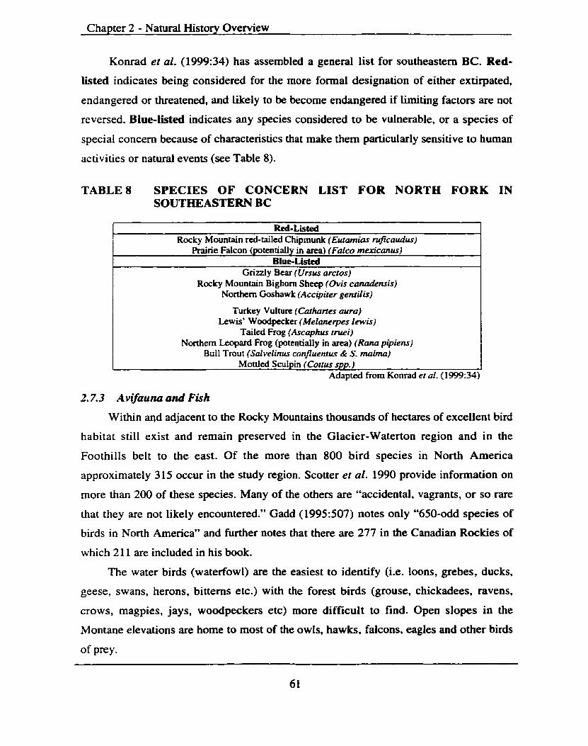
Chapter 2 - Natural History Overview
Konrad er al. (1999:34) has assembled a general list for southeastern BC. Red-
listed indicates being considered for the more formal designation of either extirpated,
endangered or threatened, and Likely to be become endangered if Limiting factors are not
reversed. Blue-listed indicates any species considered to be vulnerable, or a species of
special concern because of characteristics that make them particularly sensitive to human
activities or natural events (see Table 8).
TABLE8 SPECIES OF CONCERN LIST FOR NORTH FORK IN SOUTHEASTERN BC
Red-Listed Rocky Mountain red-tailed Chipmunk (Eutamias mficaudus)
I Prairie Falcon (potentially in area) (Falco m ~ c u n u s ) 1 Blue-Listd
Grizzly Bear (Ursus arctos) Rocky Mountain Bighorn Sheep (Ovis c&mis)
Northern Goshawk (Accipirer genrifis)
Turkey Vulture (Cathrtes aura) Lewis* Woodpecker (Melanerpes lewis)
Tailed Frog (Ascaphus rruei) Northern Leopard Frog (potentially in area) ( R a m pipiens)
Bull Trout (Salvelinus confluenrus & S. rnalma) Mottled Sculpin (Cottu spp. ) 1
Adapted from Konrad er al. (1999:34)
2.7.3 Avifauna and Fish
Within a d adjacent to the Rocky Mountains thousands of hectares of excellent bird
habitat still exist and remain preserved in the Glacier-Waterton region and in the
Foothills belt to the east. Of the more than 800 bird species in North America
approximately 3 15 occur in the study region. Scotter et al. 1990 provide information on
more than 200 of these species. Many of the others are "accidental, vagrants, or so rare
that they are not likely encountered." Gadd (1995507) notes only "650-odd species of
birds in North America" and further notes that there are 277 in the Canadian Rockies of
which 21 1 are included in his book.
The water birds (waterfowl) are the easiest to identify (i.e. loons, grebes, ducks,
geese, swans, herons, bitterns etc.) with the forest birds (grouse, chickadees, ravens,
crows, magpies, jays, woodpeckers etc) more difficult to find. Open slopes in the
Montane elevations are home to most of the owls, hawks, falcons, eagles and other birds
of prey.

Chapter 2 - Natural History Overview
There still exist twice-yearly migrations along the major flyways immediately east
of the Rocky Mountain Front Ranges, which include waterfowl and both bald and golden
eagles.
Within the Canadian portion of the Rocky Mountains there is recorded 41 species of
fish. Documented species observed throughout the Alberta portion of the study region are
"bull trout, rainbow trout, brook trout, mountain whitefish, mountain sucker, white sucker
and longnose dace" (Carlson et al. 1998:36). The Flathead Lakefiver system currently
supports 24 species of fish, 10 that are native. The bull trout, westslope cutthroat trout,
mountain whitefish, mottled and slimy sculpin and large-scale sucker are the most
common. Both the Alberta and BC side of the study region are important spawning and
rearing habitats for many fish species.
2.8 Regiond Paleoenvironmenfal Reconstruction
Paleoenvironmental investigations are being undertaken around the globe in an
effort to better understand the variability of the earth's climatic system and facilitate the
prediction of future climate change. For prediction purposes "the instrumental record that
spans the last century is simply too short to establish the baseline of natural variability, or
to evaluate the slowly changing components of the climate system such as ice sheets and
deep ocean circulation" (Anderson 1993:03). Anderson continues, "Palaeoclimatic data
can include quantitative estimates of past climates and environmental changes derived
from natural recorders such as ice cores, tree rings, ocean and lake sediments, cave
speleothems, corals and macrofossil deposits." It is these past climatic indicators that
interest archaeologists and aid in cultural history reconstruction(s) and past subsistence
and settlement resource patterns.
Paleoenvironmental investigations in and adjacent to our study region mostly
involve the examination of plant remains, especially seeds and pollen, preserved in Iake-
bottoms and peat deposits from a variety of locations (see Table 9). The remains can
often be identified according to the plants that produced them. Identifying the plant types
that were growing on past landscapes provides information on climates and climatic
change often in association with absolute dates.
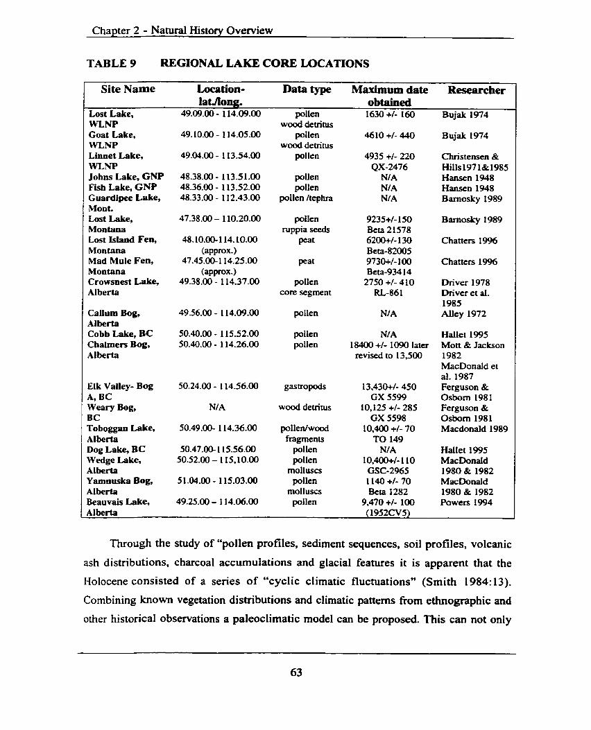
Chapter 2 - Natural History Overview
TABLE 9 REGIONAL LAKE CORE LOCATIONS
Site Name h a tion- Data type Maximum date Researcher
~ o s t Lake, WLNP Goat Lake, FVLNP Linnet Lake, WLNP Johns Lake, GNP Fish Lake, GW Guardipee Lake, Mont. Lost Lake, Moa tana Lost Island Fen, Montana Mad Mule Fen, Montana Crowsnest Lake, Alberta
Callurn Bog, Alberta Cobb Lake, BC Chahners Bog, Alberta
Elk Valley- Bog A, BC Weary Bog, BC Toboggan Lake, A1 berta Dog Lake, BC Wedge Lake, Alberta Yamnuska Bog, Alberta Beauvais Lake, Alberta
49.09.00 - 114.09.00 pollen wood detritus
49.10.00 - 1 14.05.00 pollen wood detritus
49.04.00 - 1 13.54.00 pollen
48.38.00 - 1 13.5 1.00 pollen 48.36.00 - 1 13.52.00 pollen 48.33.00 - 112.43.00 pollen Itephra
ruppia seeds 48.10.00-1 14.10.00 Peat
(approx.) 49.38.00 - 114.37.00 pollen
core segment
49.56.00 - 1 14.09.00 pollen
50.40.00 - 1 15.52.00 pollen 50.40.00 - 114.26.00 pollen
N/A wood detritus
50.49.00- 1 14.36.00 pollen/wood fragments
50.47.00- 1 15.56.00 pollen 50.52.00 - 1 15,10.00 pollen
molluscs 5 1.04.00 - 1 15.03.00 pollen
molluscs 49.25.00 - 1 14.06.00 pollen
obtained 1630 +/- 140 Bujak 1974
46 10 +I- 440 Bujak 1974
4935 +I- 220 Christensen & QX-2476 Hills197 1&1985
N/A Hansen 1948 NI A Hansen 1948 Nl A Barnosky 1989
9235+/- 150 Barnosky 1989 Beta 21578 6200+/- 130 Chatters 1996 Beta-82005 9730+/- 100 Chatters 1996 Beta-934 14 2750 +/- 4 10 Driver 1978
RL-86 1 Driver et al. 1985
NIA Alley 1972
N/A 18400 +I- 1090 later revised to 13,500
1 3,430+1- 450 GX 5599
10,125 +I- 285 GX 5598
10,400 +/- 70 TO 149
N/ A 10,4m+/- 1 10 GSC-2965 1140 +/- 70 Beta 1282
9,470 +I- 100 (1 952CV5)
Hallet 1995 Mott & Jackson 1982 MacDonald et al. 1987 Ferguson & Osborn 1981 Ferguson & Osborn 1981 Macdonald 1989
Hallet 1995 MacDonald 1980 & 1982 MacDonald 1980 & 1982 Powers 1994
Through the study of "pollen profiles, sediment sequences, soil profiles, volcanic
ash distributions, charcoal accumulations and glacial features it is apparent that the
Holocene consisted of a series of "cyclic climatic fluctuations" (Smith 1984:13).
Combining known vegetation distributions and climatic patterns from ethnographic and
other historical observations a paleoclimatic model can be proposed. This can not only
Chapter 2 - Natural History Overview
aid in the interpretation of past environments within the study area but it can produce
hypotheses, which require firrther testing and ultimately refinement.
2.8.1 British Columbia
The last major glacial advance (Late Wisconsin) began approximately 25,000 yr
BP. The alpine glacial advances in the high altitudes were initiated simultaneously when
the Laurentide ice sheets began to form and advance in the high elevation. Snow
accumulation in the mountainous regions formed ice caps that eventually merged to form
a single ice sheet that covered the majority of British Columbia by ca. 15,000 yr BP.
Around 13,000 yr BP temperatures began to rise and the glacial ice mass in
southern BC began to ablate (recede). The recession of the ice sheets and the released
volumes of water formed melt-water lakes in valleys still blocked by ice and till deposits,
and in others resulted in melt-water channels. The newly formed sediment laden lake
waters deposited horizontal silts and sands many hundreds of feet thick in places. Some
of these deposits are still intact. As the climate continued to warm much of BC became
available for colonization by plants and eventually animals and humans.
Chronologies of the glacial and early post-glacial events are not well documented
within the BC portion of the study region but relevant radiocarbon dates have been
obtained from the nearby Elk Valley* Peat deposits were dated at 13,430+/- 450 yr BP
(Ferguson & Osborn 198 1) indicating that glacial ice had receded from that locality prior
to that date. A second date from the Elk Valley indicates that Glacial Lake Elk had
drained prior to 12,000 yr BP (Harrison 1976).
Lake cores obtained from other locations within the Kootenay region of
southeastern BC indicate that vegetation was colonizing ice-free locations by 12,000-
13,000 yr BP. The earliest vegetation in the Elk Valley was a birch-sagebrush-tundra
with pine, spruce and fir present in valley bottoms (Ferguson 1978:99). This cold desert
habitat persisted until about 10,000 years ago, by which time a warming cLimate allowed
for the invasion of coniferous forests into valley bottoms. Further data derived fiom cores
in the form of pollen, soils and sediment sequences seem to indicate that the climate of
southeastern British Columbia continued to become warmer and drier resulting in sub-
climax pine and fir forests between 9700 and 6800 yr BP. This warrn/dry interval (called

Chapter 2 - Natural History Overview
the Altithermal or Hypsithermal) encouraged ftequent forest fires and further expansion
of the Montane grasslands.
Around 7,000 yr BP the Pacific Maritime westerly began to dominate the regional
climate increasing precipitation rates. This increased precipitation on the western slopes
decreased forest fue frequency and encouraged the expansion of forest cover. According
to Choquette (1997a: 02) "grasslands persisted and possibly even expanded in the
rainshadows [eastern facing slopes] due to Chinook winds." The newly established plant
regime ultimately resulted in the complex vegetational mosaics (biogeoclimatic regions)
that characterize the Flathead Valley, Kootenay region and southeastern BC today.
Ecological elements such as soils and animal populations also became more diverse
and complex within the last 7,000 years.
Between 2000 and 400 years ago a major return to warmer and drier conditions led
again to increased wildfires, the expansion of grasslands and the expansion of bison into
the Kootenay River drainage area, including the Elk Valley (Choquette 1987a).
In the late seventeenth century the final glacial episode in the region's, and western
North America's, paleoclimatic sequence occurred. The "Little Ice Age" which was the
most severe glacial advance in the Canadian Rockies since the Late Wisconsin glaciation
(Luckrnan et al. 1993 & Smith et al. 1995) disrupted developing plant and animal
communities resulting in selected regional ungulate extinction(s).
Choquette (1996a) summarizes pollen studies which indicate that 12,000 or more
years ago, the nearby Columbia River drainage area was being colonized by a vegetation
consisting of sage and grasses, scattered birch. spruce, fir and cattails or an open 'steppe
tundra' like environment. Charred pIant remains on an early floodplain of the Kootenay
River to the south indicate that fire was already part of the regional ecology by ca.11,730
yr BP (Mierendorf 1984). Dense coniferous forests invaded the region some 10,000 yr
BP but its structure and species composition did not resemble that of the modem forest
until well after 7,000 yr BP. Instead, the 10,000 to 7,000 yr BP interval was characterized
by drought and the highest forest fue frequency of the entire post-glacial period.
Choquette (1996a) further explains that within the study region the modem
vegetational regime consists of a mosaic of grasslands and coniferous forests of varying
age classes. Fire successional stands of lodgepole pine are common throughout the region
Chapter 2 - Natural History Overview
with south-facing slopes supporting rich grass covers, forbs and shrubs such as juniper
(Juniperus communis & J. horizontalis) and trembling aspen (Populus tremuloides).
Montane Ecoregions of pine-spruce-fm and the sub-alpine forests give way to grasslands
and bare rock in the high elevations.
Faunal population dynamics, in the Kootenays, in the post-glacial period are poorly
understood. Most Likely they were similar to animal populations inhabiting regions to the
south and east for which there is a somewhat more complete record. The remains of
"mammoth, horse, musk oxen, [camel], sloth, mountain sheep, caribou and bison"
(Choquette 1993a: 05) have been recovered from various sites in adjacent regions.
Early indigenous human population dynamics were necessarily tied to the variable
climatic patterns and the floral and faunal regimes that ensued after the retreat of the
glacial ice, Human populations were successful at developing strategies as the climate
varied, vegetation evolved and animals responded. For millennia they inhabited the
Kootenay region, certainly hunting but no doubt also fishing and gathering plants.
Initial archaeological sequences are interpreted to represent "an initial interval of
directional nahlrd selection, during which [populations] adapted to the new environment
of post-glacial times" (Choquette 1987a: 65-67). Correlation in both the archaeological
and paleoenvironmental record provides data necessary to postulate human-plant-animal-
environmental relationships. These data are still being accumulated and will assist greatly
in future analysis and interpretations.
Within Choquette's framework identifiable archaeological phases appear to have
maintained their human population densities under similar conditions throughout the
climatic fluctuations over time. Adaptive cultural use patterns were defined where intense
occupations of high elevation sites took place under arid conditions. Populations then
dispersed into low-elevation environments during moister periods. Choquette (1987a: 67)
posits:
. . .this change in human occupational focus probably reflected the effects of desertification at lower elevations during arid intervals and the expansion of mountain grasslands. The larger low elevation land areas could, however, support dispersed human populations during moister cycles whereas expansion of forests might have reduced the carrying capacity of the higher elevation area.

Chapter 2 - Natural History Overview
Although the relationship between cultural and environmental models is largely
hypothetical it has become apparent that, while the overall 'timing* of major climatic
events seems to correlate from region to region, the particulars regarding the extent of
glaciation on the nature of the climate of any given time can vary between regions,
sometimes markedly (Choquette 1987a: 70-71). It does appear that valley bottom &
glacial lake margins and high elevation locations figured prominently in the earliest
occupations and regional patterns of utilization of seasonal resources was established by
at least 8,000 yr BP. Reeves (1975247) notes, "this earlier [mountain/plateau] pattern is a
broader based, more flexible, human adaptation than that of the [more] specialized bison
hunting cultures[s] present on the Northern Plains during these early times."
Population centers varied depending on whether resource strategies were based on a
salmon fishing economy or the procurement of ungulates. The first populations adapted
to the initial environmental instability, or moved in after stabilization, and later sustained
environmental diversity of the Kootenay region. Whether exploiting the abundant interior
salmon fisheries in the upper Columbia River basin or wintering near lakes and larger
river valleys, they migrated with the seasons. Throughout the cultural history of the
Kootenay region seasonal encampments, associated with the harvesting of either floral or
faunal resources, were probably inhabited by small groups of First nation's peoples.
Subsistence strategies were necessarily flexible regardless of environmental variability
with human populations being opportunistic and responding quickly to changing or
variable environmental stimuli.
2.8.2 Alberta
The Rocky Mountain (Cordilleran) glaciers were, according to Reeves (1983),
"limited in extent and did not advance beyond the mountain fronts." Evidence based on
the Late Wisconsin glacial record indicates the lower valleys of WLNP were available for
human habitation by ca.11,500 yr BP and the higher elevations were ice free by ca.10,
000 yr BP. A number of palynological and dendrochronological studies have addressed
the question of post-glacial climate change in southern Alberta (Case & MacDonald
1995; Driver et al. 1985; MacDonald 1989; Sauchyn & Porter 1992; and Vance el al.

Chapter 2 - Natural History Overview
1995), but to date only three lake cores (Bujak 1974; Christianson & Hills 1985) have
been reported on.
The two high elevation locations are at Lost and Goat Lake in WLNP (Bujak 1974)
with a low elevation core taken from Lake Linnet (Christenson & Hills 1985) below the
Prince of Wales hotel. Palynological studies fiom the Lake Linnet core reveal:
. . .a warm dry interval (the Altithennal) from 7,000 to 5,000 yr BP; a cooler period with some downward movement of such alpine species as Abies (balsamea & lasiocarpa - balsam and sub alpine fir) between 5,000 and ca.4, 000 yr BP; a warm, dry period with considerable expansion of the Grasslands from ca.4.000 to 3,000 yr BP; and a cooling trend from 3,000 yr BP to the present timew(Christenson & Hills 1985:352-3).
At the time of this writing officials at WLNP are waiting for the analysis of new
cores, two taken from Summit Lake in 1996i97 by Dr. L.V. Hills (formerly of the
University of Calgary's Faculty of Geology and Geophysics) and one taken by Dr. D.
Smith (presently at the University of Calgary at the Geography Department) in 1997/98
at Waterton Lake, (pers. cornm. R. Watt, Nov. 97). Plans are also underway to core
another low elevation lake east of WLNP.
A volcanic tephra, identified as Mazama ash, is located at the bottom of the Lake
Linnet core. This ash layer is one of four that have been deposited over large portions of
western North America, by prevailing winds from volcanic eruptions in the Cascade and
Coastal Mountains. Ash layers are found as far north as Grande Cache, Alberta. Mazarna
ash is the thickest and most widely distributed and also the easiest to recognize. It is from
two closely spaced eruptions of Mt. Mazama (now Crater Lake, Oregon) 6,850 yr BP
(Gadd 1995:153). This ash can be found in profiles of many archaeological sites and
proves a most useful 'absolute' time marker. Further. a lake core (one of two procured by
L. Hills) from Summit Lake (pers. cornm. L. Hills, April 99) has identified Glacier Peak
ash from the volcanic eruption of a mountain in Washington state, dated at 11,200 yr BP.
This is one of only a few cases where this ash has been identified in the Eastern Slopes in
a core. This core also has two to three meters of sediments below the Glacier Peak ash,
which will push the paleoenvironmental reconstruction back considerably.
In a palynological study of cores from Crowsnest Lake, Driver et al. (1985:392-3)
suggest that after the early post-glacial period:

Chapter 2 - Natural History Overview
... major changes affecting the inhabitants of the Crowsnest Pass were probably few. After 10,500 yr BP, grasslands were almost certainly established. Forest zones gained elevation, perhaps reaching modem Limits at about 9,000 yr BP, a brief decline in elevation may have occurred from about 8,500 to 8,000 yr BP but the extent of the grasslands cannot have been seriously affected. Expansion of the grassiand zone started shortly after this and, by 7,500 to 7,000 yr BP the area had increased considerably. Then, Subalpine forest moved up the valley sides, and increased herds occupied the Grassland and Montane forest ecoregions. Between 6,000 and 5,000 yr BP, a change took place. Temperatures dropped, precipitation increased, and less productive Subalpine forest expanded into the valley grasslands, reducing the Montane forest to a thin strip. At that time, vegetation zones may still have been somewhat higher in elevation than today. Following a second grassland expansion, cool, wet conditions reappeared, possibly reducing [the] Grasslands (ecoregions] to an area approximateIy the same as today. With minor fluctuations in climate, this situation continue[s].
A similar scenario most likely exists in the Waterton Valley, a fact that will be
borne out upon completion of the examination of Dr. Hills' and Smiths' new set of lake
cores. Although the grasslands in Waterton's mountain valleys are less extensive than
those located in the Crowsnest Pass it does not appear that the Blakiston Valley (Pass
Creek) was ever without grassland.
Powers (1994) conducted investigations at Beauvais Lake, Alberta, east of the
Castle-Carbondale valieys, reconstructing the paleoenvironmental history by mapping the
surficial geology and analyzing the contents of the lake bottom sediments. He
summarizes his results as follows:
Four pollen zones characterize the Late Quaternary history: from the time of the most recent deglaciation to 9500 yr. BP a tundra-like vegetation covers the newly deglaciated landscape, and the climate is cool and moist; from 9500 - 6800 yr. BP the soil conditions stabilized, conifers have succeeded the tundra-like vegetation, and the climate is warmer and drier than the climate during the interval from 6800 - 5000 yr. BP (the Aitithermal), grasslands dominate the landscape, and the climate is the warmest and-driest of post-glacial times; from 5000 yr. BP to the present the vegetation comprises a mixture of montane, Aspen Parkland and Fescue Grassland, and the climate is cooler and moister than during the Altithermal(l994: iii).
Beaudoin (1989) has compiled an Annotated Bibliography of Late Quaternary
studies of Alberta's Western Corridor and more recently Late Quaternary Studies in
Bering ia and Beyond, 1 950-1 993: An Annotated Bibliography (Beaudoin 1994). Other
Chapter 2 - Natural History Overview
reports pertinent to the present study and the understanding of environmental variability
within and adjacent to the study region include Vance er al. (1994) and Sauchyn and
Beaudoin (1 998).
Vance et al.'s (1994) synthesis of paleoecological studies in the adjacent Prairie
Provinces supports the evidence from mountain locations. Although the "peak in
postglacial aridity that characterized early Holocene climate of the western Foothills and
Plains had passed, conditions remained warmer and drier than present throughout the
region to ca.6,000 yr BP." They continue:
Compared to today, tree line elevations were higher and alpine glaciers were reduced in size in the Rocky Mountains. Lake-levels were lower over much of the Interior Plains, and the Grasslands and Boreal forest ecozones extended north of their present positions. Forest fires were more prevalent ~ a . 6 ~ 0 0 0 yr BP than they are today, aiding westward migration of jack pine (Pinus banksiana) through the Boreal forest and increasing the area occupied by Grassland in boreal and Montane forest regions.
Ongoing archaeological and paleontological investigations approximately 60
kilometers (35 miles) east of WLNP at the St. Mary reservoir (Wally's Beach Site, DhPg-
08) have recovered mega-fauna skeletal remains including what may be the most
complete and numerous remains of Equus conversidens (extinct horse) with an AMS date
of 11,330+/-70 (TO-7696), Bison b. anriquus (extinct bison) (Note: identification
tentative as it is not conFmed by measurements) with an AMS date of 11,130+/-90 (TO-
7693) and Boorheriurn bombifions (extinct muskoxen) with an AMS date of 10,980 +/- 80 (TO-7691) fMcNeil et al. 1999, Hills et al. 1999a and Hills et al. 1999b). This
indicates that the area was ice-free before 11,300 yr BP and had stabilized to the point
where vegetation was established and fauna had moved in. It is also interesting to note
that almost every projectile point from the Plains sequence is represented at DhPg-08,
from Clovis to a metal trade point. The only direct association that has been made
between the Clovis projectile points and the extinct early Holocene fauna (Equus
conversidens) is positive results of protein residue analysis conducted at the University of
Calgary which has yet to be published (pers. comm. B. Kooyman, May 1999). The truth
remains we have evidence of human occupation of this region before 11,000 yr BP (see
also Center for the Study of the First Americans 1999, Dacks 1999).
Chapter 2 - Natural History Overview
2.8.3 Summary
Specific patterns of early F i t Nations occupation, including local and regional site
densities and distributions, of a region depend upon various factors including. but not
limited to: bedrock geology (includes the availability of stonenithic material suitable for
artifact/tool manufacture), physiography (includes river/stream valley orientation,
comdors/trails/passes affecting animaVhuman movement, solar aspect, degree of slope,
distance to water, etc.), ungulate range and vegetation (includes vailey bottom Fescue
Grasslands, Aspen Parkland and Montane grasslands and other areas such as avalanche
chutes, Subalpine meadows and high elevation Alpine locations).
The overall remoteness of the study region has preserved large tracks of pristine
wilderness only recently exploited by resource extraction and recreation enthusiasts. The
abundant and diverse floral and faunal resources are unique and this fact is recognized by
the fact that UNESCO has designated the Waterton-Glacier International Peace Park a
world heritage site because of its significance as an example of past and present
biological processes. Although climatic fluctuations are readily apparent in the
paleoclimatic record, the study region has been available for human occupation for more
than 10,000 years.
The variable environmental conditions experienced in the region would have
affected prehistoric settlement and subsistence patterns. Fluctuation up and down slope of
vegetation boundaries (transient ecosystem indicators) and consequent changes in
ungulate use patterns would have altered settlement and subsistence strategies.
A research question was posed earlier: Has an adequate paleoenvironmental
reconstruction been developed for the study region?
It is apparent from an examination of the Late Wisconsin glacial record that lower
elevation valley locations throughout the majority of the study region were 'Ice Free' and
available for First Nations occupation commencing ca.11,500 yr BP. Numerous
palynological and dendrochronological studies have addressed the question of post-
glacial climatic fluctuations and stabilization in the study region (Case & MacDonald
1995; Choquette 1987a, 1996a, 1997. Driver et al. 1985; MacDonald 1989; Sauchyn &
Porter 1992; Reeves 1975, 1983; Vance 1986 and Vance et al. 1995). Other
investigations (Alley 1972; Barnosky 1989; Bujak 1974; Christenson & Hills 1971, 1985;
Chapter 2 - Natural History Overview
Driver 1978; Driver et al. 1985; Ferguson & Osborn 1981; Hansen 1948; Hallet 1995;
Hanison 1981; MacDonald 1980, 1982, 1989; Mott & Jackson 1982 and Powers 1994)
have hen canducted which required the coring of mostly lake sediments within and
adjacent to the study region.
The paleoecology of southwestern Alberta has aiso been the focus of other recent
studies related to the 'Ice Free' corridor (Reeves 1971, 1973; Jackson 1978, 1979, 1980;
Stalker 1969, 1977, 1978, 1980 and Rutler 1984). A geochronological and
paleoecological study (Chatters 1996) in the Hungry Horse Reservoir in the Flathead
National Forest, Montana also affords a glimpse of past paleoenvironmental conditions.
Beaudoin (1989) and Beaudoin & Reintjes (1994) provide comprehensive annotated
bibliographies, of Late Quaternary studies in Alberta's western conidor. Beaudoin (1 993)
has also compiled the postglacial pollen records for Alberta. Beaudoin et al. (1997) and
Vance et al. (1995) also provide informative summaries that aid in our understanding of
climate change and ecosystem responses to it.
As a result of the numerous detailed studies undertaken throughout and adjacent to
the study region general spatial and temporal trends have been conceptualized. Although
several studies related to the Late Wisconsin glaciation, particularly in southwestern
Alberta, have included the issue of the so-called 'Ice Free' corridor (Stalker 1977, Stallcer
& Harrison 1977, Jackson 1979 and Rutler 1984) absolute ages of the Laurentide and
Cordilleran advances have not been determined. However, this researcher maintains that
an adequate paleoenvironmental reconstruction has been developed and that it further
provides a means of interpreting and reconstructing past vegetation assemblages which in
turn provide critical data related to early faunal species distributions and, concomitantly,
human occupation and subsequent use of the area.
Chapter - 3 Cultural History Overview
CHAPTER 3 CULTORAL HISTORY OVERVIEW
3.1 Introduction
The following chapter presents an overview of the changes over time in the
Precontact archaeological record of the study region including WLNP, adjoining portions
of the Crowsnest Forest Reserve, AB, the Blood Reserve # 148A (Blood Timber Limit),
adjoining portions of the Flathead Provincial Forest, BC, Akamina-Kishinena Provincial
Park, BC and Glacier National Park, Montana. It also presents a synthesis of
archaeological research undertaken within the study region and provides selected portions
of ethnographic materials in order to better familiarize the readers with the study region
and early First Nations' interactions.
The First Nations who occupied the study region over the millennia were well
adapted to the geographical setting and intimately familiar with the wide range of local
and distant natural resources available to them. The culture record in the study region
exhibits influences fiom the surrounding Great Plains to the east and the mountain and
plateau regions to the west and south respectively.
Definitions applied by Plains and Mountain archaeologists to describe facets of the
culture history sequence within the archaeological context are provided in Appendix A
(Glossary of Terms).
3.2 Previous Archaeological Research
In order to understand the different levels of archaeological investigation within the
study region it is necessary to provide a synopsis of previousIy undertaken academic and
consultant's research. This is provided by sub-region and further illustrates issue
complexities and data deficiencies.
3.2. I Waterton M e s National Pork Local residents, park staff and visitors have recovered aboriginal stone artifacts
since at least the 1920s in WLNP. The shores of Lake Linnet and Emerald Bay, in the
Waterton town site, have been particularly rich with heavy visitor use, as well as building
and road construction exposing artifacts and faunal (bone) remains.

Chapter - 3 Cultural History Overview
A systematic research initiative. the first in WLNP and probably the study region,
was initiated by B. 0. K. Reeves between 1962 and 1964 when Reeves (1964) recorded a
number of archaeologicd sites and examined numerous privately held collections. It is
still a common practice within the professional and avocational archaeological
community to utilize collections of archaeological materials in private hands (see Boag
1989; Hjennstad 199 1; Wood 1991; Wood et al. 1992). Gryba (1988) also produced An
Invenrory of Fluted Point Occurrences in Alberta, largely from Early Period spear points
from privately held collection. They remain, both the archaeological materials and the
one-time collectors, very valuable sources of locational site information, especially in
areas where a minimal amount of archaeological studies have been undertaken.
Wormington and Forbis (1965) employed this method of preliminary study in the
first systematic survey of the province of Alberta and the nearby northern Great Plains.
This avenue of research affords the archaeological community valuable spatial and
temporal information that otherwise would be very time consuming and perhaps
impossible to accumulate. Avocational archaeologists still record large numbers of sites
and remain a valuable source of information to the professional archaeological
community.
Reeves (1966) carried out a survey of the Blakiston (Pass) Creek Valley in response
to Public Works Canada proposing construction of a new parkway, as highways are
called within the Park, to Red Rock Canyon and the vicinity of the South Kootenay Pass.
With the Blakiston and Waterton Valleys as the focus of investigations research
continued until 1971 when a total of 208 aboriginal sites had been recorded within
WLNP. Resulting reports included summary reports (Reeves 1967, 1968, 1969, 1971)
and a major synthesis (Reeves 1972).
Under the continued direction of Reeves and the University of Calgary, Department
of Archaeology and Parks Canada a series of archaeological field schools were held in
WLNP between 1969 and 197 1. Excavations by Milne-Brumley (1971) at the Narrows
Site (PC# 638R/DgPl-04) were undertaken in 1969; at Indian Springs (PC# 639R/DgPl-
07) in 1970 (Reeves 1980); and Waterton River (PC# 572R/DgPl-10) in 1971 (Reeves
1980). Later in 1978 test excavations were carried out at Red Rock Canyon (Lifeways of
Canada 1980) in response to the proposed upgrading of visitor facilities. Excavation at

Chapter - 3 Cultural History Overview
the Red Rock Canyon (PC# 762IUDgPrn-01) site recorded the earliest 'in-situ'
archaeological component within WLNP radiocarbon dated at 8,200 yr BP.
An ongoing Salvage Archaeological Program initiated by the Archaeological
Research Services Unit, Canadian Park Service, Western Region involves the assessment
of proposed development impacts on known and potential archaeological sites. In 1984,
seven development areas were examined (Sumpter 1985) and another impact assessment
was made of a proposed natural gas transmission line (Reeves 1985). In 1985 ten
proposed developments were assessed (Sumpter 1986), in 1986 nine projects (Sumpter
1987) and in I987 eight projects (Sumpter and Perry 1988). Sumpter and Perry (1988)
also tested a proposed AGT alignment and a proposed TransAlta realignment was tested
by Gryba (1989).
A comprehensive Archaeological Resource Survey and Inventory was initiated in
1988, which updated and synthesized all previous research (Pickard 1995). The intent of
this inventory was preparation of an Archaeological Resource Description and Analysis.
Evaluative tests were carried out at four major sites; the Dardanelles (PC# 637R/DgPl-
02), Lake Linnet (PC# 646R/DgPl-18), Indian Springs (PC# 639R/DgPl-07) and Red
Rock Canyon (PC# 762R/DgPm-0 1).
At this point in time (1988-89) some 240 archaeological sites were registered in
WLNP.
In 1989, six salvage projects were undertaken (Sumpter et al. 1990), and
excavations at Lake Linnet (PC# 646R/DgPl-18), Emerald Bay (PC# 570R/DgPl-03j, and
the Entrance Site (PC# 572R/DgPl-10) were carried out (Light 1993). Also in 1989
Reeves completed his Waterton Lakes National Park Management Plan-Cultural
Resource Public Document (Reeves 1989b) and his Waterton Lakes National Park
Cultural Resource Technical Report (Reeves 1989a). Archaeological projects have been
ongoing every year since then including environmental assessments, site monitoring
projects, and responses to concerns related to the Parks' Cultural Resource Management
Division (Langemann 1992, 1994, 1995a, 1996a, 1996~; Golder Associates Ltd. 1995).
Swayze (1993) also undertook testing in advance of highway realignment at the Park
entrance gates. Cultural Resource Services staff, from Calgary, spend some time in the
Park every year.

Chapter - 3 Cultural History Overview
Reeves in 1994 began a two year program of ethnoarchaeological work which
complemented an archaeological inventory and ethnoarchaeological study he had
previously started in Glacier National Park, Montana (Reeves 1993). His goal in the
Waterton study was to interview Peigan elders about traditional [and contemporary] use
of the Waterton area, and to provide a synthesis of his reported high elevation sites in the
region (Reeves and Peacock 1995; Reeves 1996).
Most recently Perry and Langemann ( 1997) completed the Archaeological
Resource Description and Analysis (ARDA). This document presents a summary of all
archaeological research that has been undertaken in WLNP and begins to place the Park
within its regional context. It identifies sites that are suitable for interpretive purposes.
sites that should be protected. as well as identifying areas where there are clusters of
significant sites, threatened sites and further suggests possible mitigative measures. The
report was written to provide a guide for managers and researchers involved with
planning, development, and research at both a regional and park level.
Altogether, there have been 286 prehistoric sites recorded, including 16 with both
historic and prehistoric components, 42 historic and 4 palaeontological sites. The
majority of these sites are in the Waterton Lakes and River, Blakiston and Bauennan
Creek watersheds.
The lands that are under the jurisdiction of the Alberta provincial government and
are included within the study region are contained within the Crowsnest Forest Reserve
north of WLNP and south of the Crowsnest Pass, Front Country Canyons north of WLNP
and the Foothills physiographic province east of WLNP which is mostly privately held
ranch land.
a) Crowsnest Forest Reserve
There are several large gaps in the archaeological database for those lands
contained within the Crow snest Forest Reserve with only small-scale project-specific
impact assessment research being undertaken. Areas to the west, in the Montane,
Subalpine, and Alpine regions of the Front and Main Ranges of the Rocky Mountains
including neighboring portions of British Columbia have received little or no

Cha~ter - 3 Cultural Histom Overview
archaeological investigation. The Limited development that has been undertaken such as
seismic, drilling, logging and related infrastructure development was carried out before
the institution of the Alberta Historical Resources Acr. Consequently, for those projects
no archaeological site assessments were undertaken. Areas investigated through either
archival or field investigations included portions of the Castle, Carbondale and West
Castle Rivers, Lynx and Lost Creeks and portions of the Continental Divide near the
Middle and North Kootenay passes and those trails and roads leading to them.
More recent projects that have required HRIAs within the Forest Reserve and
produced mainly site specific inventory reports, and other publications in extremely
limited publication numbers, include Fedirchuk, McCullough and Associates Ltd. 1996;
Golder Associates Ltd. 1994; Gryba 1980; Heitzmann and Priegert 1978; Landals 1997;
Quigg t 98 1 ; Van Dyke 1994 and Vivian 1998. These projects resulted in the discovery of
a limited number of small Precontact aboriginal camps and transitory hunting sites in
advance of highway upgrading and small diameter pipeline construction. Gryba (1980),
Heitzmann and Priegert (1978) and Quigg 1980, 1981 projects were assessment and
mitigation contracts, at DiPo-01, in advance of the bridge replacement over the
Carbondale River.
The potential for intact undiscovered archaeological materials in the form of
campsites, trails, resource extraction sites (quarries), vision quest sites remains moderate
to high within this portion of the study region.
b) Eastern Slopes Foothius
This portion of the study region is an arbitrary subdivision assigned for the purposes
of this research only - as opposed to most others which are totally distinct jurisdictions.
This portion of the study region had limited archaeological investigations conducted in
the early 1970s and intermittently ever since (see Duncan 1972; Perry 1974; Reeves
1964, 1970, 1972; Quigg 1972; Taylor 1972 and Gryba 1988). Many of these are names
were later attached to site inventory forms by Archaeological Survey of Alberta
representatives and do not represent report authors. These field investigations were
undertaken before enactment of the Alberta Historical Resources Act and the
standardization of site inventory forms or the routine of shovel testing therefore the
Chapter - 3 Cultural History Overview
examination of subsurface archaeological materials was minimal. Many of the projects
were associated with early Glenbow (Foundation) Museum and University of Calgary
projects (i.e. Belly River Salvage Project). There is also a considerable number of Borden
Numbers reserved by Reeves between 1984 and 1996 for which no site form or other
documentation exists.
Areas deemed suitable for further investigations were deduced fiom archival (i.e.
consultants reports, university research papers), site inventory forms, map and air photo
interpretation. They included topographically high hills and buttes east of the Rocky
Mountain front, including the Birdseye, Lookout Butte, Hudson Bay Butte/Observation
Point, Pine Ridge and Bald Hill (Council Butte).
Impacts to this portion of the study region have been minimal to moderate with
most of the land considered some of Alberta's best ranchland. Ranches remain large with
holdings up to thousands of acres not uncommon (i.e. Birdseye Ranch, Shoderee Ranch
and Ben Olson's land north of the Crooked Creek Campground). Small-scale oil/gas
exploration, wells and related infrastructure development was undertaken in the 1960s
and 1970s with small collector pipelines and compressor stations installed at strategic
locations. One main pipeline parallels the Rocky Mountains (i.e. Nova line from the Shell
Waterton Gas Plant) and Foothills and ties into the Crowsnest Pass main line (i.e. Central
Route collector) (Axys Environmental Consulting Ltd. 1997). Most of this work was
undertaken prior to the implementation of the Historical Resources Act, therefore no
Historical Resources Impact Assessment (HRIA) was conducted.
Projects that will potentially have a significant impact on the interpretations of the
study region's cultural and natural history reconstruction throughout the Precontact
Period include the nearby Oldman River dam investigations conducted between 1988 and
199 1. Planning for this large on-stream dam and reservoir project included the historical
and archaeological assessments undertaken by Forbis (1966), Quigg (1975). and included
other major reports such as Lifeways of Canada (1987). Mitigation of those sites and
areas that were undertaken included major reports by Brumley (1995), Dau (1997a,
1997b), Environmental Management Associates (1990, 1991) and Van Dyke (1994).
Unfortunately, no Occasional Paper Series reports have yet to be produced and the
final synthesis of all field investigations is outstanding. The potential for these

Chapter - 3 Cultural History Overview
investigations, the largest single archaeological project in the history of the province of
Alberta, to provide evidence of trans-mountain travel and/or trade is considerable. The
significance to this study region of the results of the Oldman Dam investigations is
considerable.
Other nearby projects that could potentially aid in the development of a
comprehensive overview include the Weasel Valley Water Use Study (Reeves 1982) and
Yellowhorn's (1993) Peigan Archaeological Survey which formed part of his thesis
entitled Since The Bad Spirit Became Our Master. Both of these archaeological field
surveys were located on Peigan Reserves # 147 and 147B north and east of the present
study region.
The potential for significant intact undiscovered archaeological materials and sites
within this portion of the study region remains moderate to high. There is a need to revisit
many of the previously recorded locations, especially along portions of the Belly and
Waterton Rivers, where information is sparse and potential is high for 'long-term' winter
campsites and kill sites.
C ) Front Range Canyons
The Front Country Canyons include the eastern slopes of the Front Ranges of the
Rocky Mountains. Canyons and valleys investigated in this study either by archival or
field investigations included the Yarrow Valley. immediately nonh of WLNP, the
S pionkop, South and North Drywood. Pincher. Whitney . Mill and Gladstone valleys.
Portions of this part of the study region have received moderate to heavy impact
from the oil and gas sector in the 1960s and 1970s with the construction of oiVgas wells.
pipelines, roads and other infrastructure development as well as the construction of the
Shell and Waterton gas plants.
Recorded sites are minimal but the potential for vision quest sites, seasonal
transitory hunting and temporary campsites are great. There is a considerable number of
Borden Numbers reserved by Reeves for work done in 1989, 1990, 1995, 1996b for
which no completed site inventory forms exist. This information was obtained from the
Archaeological S w e y of Alberta in Edmonton.

Chapter - 3 Cultural History Overview
Some of these reserved Borden Numbers are probably from the ridges and peaks
that separate the Front Range Canyons.
3.2.3 Blood Reserve #I& (Blood Timber Limit - BTL)
The 1974 hectares (4935 acres or 7.5 square miles) that presently constitute the
BTL are predominantly heavily forested hills with steep sided slopes which contain lands
classified as Montane, Subalpine and Alpine Subregions (see Silvacom Ltd. 1993). They
are also adjacent to areas classified as the Foothills Parkland Subregion. The BTL is
drained by the main Belly River, which also serves as its eastern boundary, the North
Fork Belly River, Indian Creek and an unnamed tributary. The Belly River and the
Waterton River join forces before draining into the Oldman River and ultimately the
Saskatchewan River system and the Hudson Bay.
The BTL has been spared many of the development woes of other regions found
along Alberta's Eastern Slopes. The construction of the Chief Mountain Highway in the
early 1930s, and later upgrading in the 1960s. and the development of oiVgas prospects
which resulted in several kilometers of small diameter pipelines, the drilling of five, still
producing gas wells, and the reclamation of one as well as the necessary road
construction and upgrading are the only major projects that have been undertaken. These
projects have resulted in the largest scale surface disturbance to the BTL. These
developments may have jeopardized heritage sites, although initial research indicates
minimally.
Other minor development on the BTL have included land improvements and lease
agreements including; Beebe's late 19* century homestead, early logging and milling
operations on the Belly and the North Fork Belly rivers, the construction of service
buildings along the highway (in the area known locally as Crossbell) and their eventual
removal, the illegal cutting of a five hectare block of forest in 1995, fencing and the
continued designation of cattle grazing leases-mostly with neighboring non-native
ranchers north of the Chief Mountain Highway. Salvage logging is planned in the area of
the Sofa Mountain fire in the fall of 1998, but will require little to no road or skidder trail
development.
Chapter - 3 Cultural History Overview
This minimal level of development and resource extraction has allowed for the
maintenance of a high degree of ecological integrity and a potentially high degree of
archaeological site integrity. Recent research projects undertaken by the Blood Tribe
(Fox and Bocking 1997) corroborate this high level of integrity.
Previous archaeological investigations on the BTL have been limited. Unofficial
reports by Mr. Jack Christiansen, who at the time was a Park Warden, in the early and
mid 1960s to Barney Reeves. who was then a student at the University of Calgary,
resulted in the filing of archaeological site inventory forms with the Glenbow Museum.
These early investigations resulted in five prehistoric and one historic site being recorded
(see Appendix B). Recommendations at the time were not included due to the status of
the land, it being "private land or Indian reservation" as noted by Reeves (1970) on the
site forms, and no further work has been initiated until the present investigations.
3.2.4 British Columbia Provinciui Lands
Within the British Columbia portion of the study region archival and field
investigations focused on the high altitude Akamina Kishinena Provincial Park, and the
lower altitude Akamina-Kishinena Valley and Sage Valley in the Flathead Provincial
Forest,
In the early part of the twentieth century Harlan I. Smith conducted brief spot
surveys in the greater Kootenay region. With the assistance of local collectors he
compiled the first official list of archaeological sites.
Dr. C. E. Borden from the University of British Columbia, in response to proposed
hydroelectric developments, conducted field investigations in the East Kootenays
(Borden 1956). As well, in response to the then proposed Columbia River Development,
survey and salvage excavations were conducted in the High Arrow Reservoir/Arrow
Lakes (formerly Columbia River) region in the 1960s (Harrison 1961; Mitchell 1968 and
TurnbuII 197 1).
W .T. Choquette undertook the first systematic, regionally oriented investigations,
with field surveys in the Rocky Mountain Trench (Choquette 197 la, 197 1b and 1973d).
Also in 1971, salvage operations were initiated in the Canadian portion of the Libby

Chapter - 3 Cultural History Overview
Reservoir. These investigations continued for the following two years (Choquette 197 lc,
1972, 1973a, 1973b and 1973~).
Archaeological field surveys in the East Kootenays continued throughout the 1970s
with intensive investigations of selected areas resulting from project specific
development initiatives (Choquette i 974a, 1974b and 1975a, 1975b, 1975c, Mitchell and
Choquette 1974).
In 1975 Choquette stated that "the Flathead valley has great potential for containing
data relevant to the study of both cultural dynamics and physical population movements"
(Choquette I975a: 02). He continued: "access to this large valley is easiest from the
south, while the North, Middle and South Kootenay Passes connect it [Flathead valley]
directly with the Plains to the east." The Flathead Valley provided bison, which could
potentially have gained access to the upper Flathead over the trans-mountain trails/passes
to the east or from the Montana inter-Montane grasslands to the south. The valley also
has a second large-scale food source, namely yearly runs of char fish up to 25 pounds
[each] from Flathead Lake.
Prior to 1978 there were four recorded prehistoric archaeological sites within, or at
least immediately adjacent to the study region. Three are in the Flathead valley and were
recorded by Bill Brown and Greta Lundborg during a "forest utilization impact
assessment project" in 1976 (Brown and Lundborg - unpublished Permit Report 1976-
006). Two of these sites (DgPo-1 and DgPo-2) are on the southern and western edge,
respectively, of Proctor Lake and the other (DgPo-3) is on the east side of the Flathead
River near the International Boundary.
Brown and Lundborg recorded a "single flake of milky vitreous chert, a sharpening
flake" and also noted the recent additions of "teepee poles" at DgPo-01 but did not record
any site dimensions. The other site at Roctor Lake DgPo-02, was recorded as being 100
square meters in size based on fue-broken-rock and "one formed uniface and two flakes
all of Kootenay Argillite" which they left in situ.
DgPo-03 was recorded as being approximately 300 square meters in size with the
authors reporting "one retouched flake of green grainy material, possibly Kootenay
Argillite and burnt bone.. .all of which were left in situ" (Brown and Lundborg 1976).

Chapter - 3 Cultural History Overview
The fourth site was recorded by Bob Powell of the BC Provincial Museum Erom
data supplied by an unknown informant. This site is today known as the South Kootenay
Pass Site (DgPm-03/PC # 764R) and is one of the key sites in the region due to it's
strategic location which forms the summit of the once heavily utilized trail and mountain
pass.
Foster and Brolly (1978:20-22) re-recorded a prehistoric site "on the summit of the
South Kootenay Pass" which they noted "is in a cleared, open, dome-shaped area on top
of the Pass." They recorded a triangular cairn "probably placed on the site by the
Boundary Commission of 1887" and also reported "pieces of chipped stone and artifacts
spread over an area approximately 70 metres long by 50 metres wide."
They recorded a total of seven artifacts including, a small oval scraper of Montana
chert, a side notched triangular projectile point of Etherington or Topof-the-World chert,
a side notched point with excurvate edges of Avon chert, a thick end scraper of local
argillite, two cores of local argillite and a quartzite biface.
a) Akamina Kishinena Provincial Park (AKPP)
Scientific research has been severely restricted by AKPPs remoteness and, until
relatively recently, a virtually non-existent road system. The only prior archaeological
investigations within the study region, namely, Foster and Brolly's 1978 inventory of
heritage sites prior to the proposed harvesting of mountain pine beetle killed and infected
timber, was not only plagued by bad weather but extremely poor access. As noted by
Foster and Brolly (1978:lS):
There are [were] three routes into Akarnina-Kishinena: (1) via the seismic road which involved travelling down the Flathead South Road almost to the border [International] and [then] along a cut line to the first crossing of the Kishinena [Creek]. This involved fording Sage and Elder Creeks which were too high during the majority of [their] survey; (2) along the Kishinena Road to the cut line and taking the cut line to the first crossing of the Kishinena. This was not possible until the beginning of August when the road was being converted from a winter road to an all weather route; and (3) driving to Waterton and going over [the] Akamina Pass from the Alberta side. This became impossible after the beginning of August because the Federal Parks people in Waterton closed the road to all M 1 c .

Chapter - 3 Cultural History Overview
Today, several routes can gain access into the study region. Logging, seismic
exploration and oiVgas drilling in the nearby Flathead, Sage and below the Park in the
Akamina and Kishinena valleys have resulted in improved road conditions. The Flathead
Valley can be accessed by vehicle via the Morrisey turnoff, some 16-km west of Fernie.
A series of forestry roads namely, the Momsey, Lodgepole and the Kishinena-Sage must
be followed into the lower reaches of the Akamina-Kishinena Valley. This route is only
accessible by vehicle during the late spring, summer and fall months, unless winter
logging is being undertaken. It takes approximately three hours to cover the more than
100 km from the Highway # 3 turn-off to Akamina Meadows, depending on logging
activities. Access is also possible via a logging road that follows the Flathead valley
south from the town of Corbin. This route was heavily damaged by the spring flood of
1995 with passage only possible in four-wheel drive trucks at times of low water
although restoration work had begun in 1999. This route was traveled twice, once in the
beginning of the 1998 field season and at the end of the 1999 field season.
Access to the lower valley during the winter months is possible by snowmobile via
several routes from Sage or the Flathead Valley. It is also a popular cross-country skiing
and winter camping destination with access gained over the Akamina Pass from the
Cameron parkway in WLNP. It is approximately 15 km via this route.
It is also possible to hike, horseback, or mountain bike into the lower valley over
the Akamina Pass from the Cameron Parkway. The South Kootenay Pass can be accessed
by horseback or foot traverse from the Red Rock Canyon parking lot/trailhead also in
WLNP.
Areas deemed to have potential for containing heritage sites had been previously
prioritized, and categories developed, by Ray Kenny of the Heritage Conservation
Branch, Archaeology Division. Kenny designed the categories as follows (as cited in
Foster and Brolly 1978:2-3):
... ranging from highest (# 1) to those of lowest potential (# 5). Priority 1 areas included terraces along major drainages of Sage, Kishinena and Akamina Creeks and confluence's of these creeks with major tributaries. These areas were identified as having the potential for containing major travel corridors for aboriginal [peoples]. Priority 2 areas included terraces along lower reaches of the aforementioned creeks and lakeshores [that] display flat habitable landforms. Priority 3 areas include terraces along
Chapter - 3 Cultural History Overview
upper reaches of major tributaries, terraces along secondary tributaries, and the shoreline of lakes with poor access. Riority 4 areas include alpine meadows and forested mountain slopes with a southern exposure. Priority 5 areas constituted the bulk of the study area and was characterized by uninhabitable landforms and poor.
A number of foot traverses and sub-surface tests (shovel-tests) were undertaken in
the Nettie Creek and in the Akamina-Kishinena valley. Two artifacts were discovered in
the Akarnina Meadows in the "south-west portion of the westerly test area near the
meadow margin overlooking Kishinena Creek" (Foster 198 1: 197). The authors reported
the "recovery of two flakes [indicating] that a site is probably present at Akamina
Meadows" and indicate that "further controlled testing at this site should establish site
boundaries ." Unfortunately, Foster and Brolly (1978:24) concluded that: 'The status of the
meadows did not warrant declaring the area as an archaeological site at [that] time
[because] the area has been listed by the British Columbia Forest Service as being
protected from development."
In June of 1979, Brian C. Apland (Aresco Ltd.) conducted a heritage resource
inventory and impact assessment of a proposal by Sage Creek Coal Development in the
nearby Cabin and Howell Creek areas west of the Flathead River. This included a
judgmental archaeological field survey designed to locate heritage sites in conflict with
the proponent's proposed open pit coalmine development. Their results included the
location of seven historic period sites and no prehistoric sites (Apland 1979:Ol).
The lack of prehistoric sites seemed a surprise to Apland (1979:22) in the face of
numerous ethnographic descriptions of Ktunaxa lifestyles and the varied and plentiful
floral and faunal resources present. There is no palaeoecological or other evidence that
the floral and faunal resources now present were not available for several millennia.
Apland maintained that the study region hardly represented a significant portion of
the valley proper. Given prior prehistoric archaeological knowledge of the East
Kootenays, which was minimal in the late 1970s, it was felt that, "It is more likely, that
the results of the survey reflect the true nature of the archaeological potential" and that a
"review of the overall physiography of the Upper Flathead drainage melps] to understand
the low archaeological potential of the study area" (Apland 1979:22).

Chapter - 3 Cultural History Overview
Recently investigations undertaken by Eagle Vision Geomatics and Archaeology
Ltd. (pers. comm. Bonnie Campbell August 1999) in advance of planned forest
harvesting activities by Crestbrook Forest Industries, during the summer of 1999 in the
Proctor Lake area, recorded the discovery of three new archaeological sites immediately
adjacent to (west and south of) the lake and near an unnamed creek. A Middle Period
projectile point basal fragment (tentatively identified as a McKean) is the fust 'phase
diagnostic' from the nearby Flathead Valley. Results are unpublished and Borden
numbers have not been assigned.
3.2.5 Glacier National Park, (GNP), Montana, USA
Tom Kehoe undertook the first archaeological field investigations within GNP in
the 1950s. He was then at the Museum of the Plains Indian, Browning and published in
American Antiquity (Kehoe 1958). These early investigations included reports on a
fraudulent pictograph (Kehoe 1960). The 1958 report was "on three dry wall rock
structures in the Marias Pass" that Kehoe attributed to Apache origin, but as Reeves
(1993:34) reports were most likely "bread ovens associated with the construction of the
Great Northern Railway in the late 1800's."
In 1963 the first areal surveys in GNP were carried out under the direction of
Carling Malouf (Malouf 1965). Under the direction of Alan Carmichael this ten-week
survey focused primarily on the Camas Creek Cutoff and areas in the vicinity of Lake
McDonald, the North Fork of the Flathead, St. Mary's and Two Medicine Lakes.
Artifacts then in the possession of the Park were also examined. These investigations
were for most part unproductive with surface inspection being the primary means of
artifact and site identification.
In 1970 Dale and Lynn Fredlund surveyed the North Forks of the Flathead for the
US Forest Service which also included areas within GNP. Their investigations included
"the North Fork of the Flathead from the International Boundary to the junction of the
Middle Fork of the Flathead, and the Middle Fork of the Flathead upstream to the
junction with Bear Creek" (Reeves 1993:35). These investigations relied on surface
inspection only and recorded five new sites.
Chapter - 3 Cultural History Overview
Since 1974, the National Park Service has carried out over 36 studies within GNF.
The majority were "compliance studies associated with facility development."
Development projects included Linear and areal impacts from highway to sewer pipelines
to surveys of prescribed bums and various building sites.
Other archaeological investigations include a survey of proposed development areas
in West Glacier (Stiger 1977), "on a north talus slope of a large bench" south of Bowman
Creek, upstream from the Polebridge Ranger Station (Guthrie 1978) which was relocated
by Scott (1989a).
Compliance studies during the 1980s, according to Reeves (1993:37) were
generally unproductive, with Scott (1989b) unable to relocate the Bowman Lake
Campground site (24FH509) located by Fredlund in 1970. Connor (1992) later did
relocate 24FH509 and reported that "large areas of the site with buried components are
still present." Connor has also conducted archaeological investigations at several other
locations during the 1980s and early 1990s (see Connor 1984a, 1984b, 1 9 8 4 ~ ~ 1986, 1987
and 1990).
Pre-construction surveys of the Going-to-the-Sun Highway below Rising Sun
(Guthrie 1978) and from Rising Sun to the Logan Pass (Dominguez 1989a) were
undertaken with rnixed results. According to Fladmark (1992) as cited in Reeves
(199337) a site observed by Mac Donafrio in 1992 resulted in a visit by Cultural
Resource Ranger Bruce Fladmark and later by a US Forest Service archaeologist but
resulted in "generally negative" results. Mckean (1992), the Forest Service archaeologist,
concluded that "it did not meet criteria to be an eligible site."
The previously recorded 24GL89 recorded by Dominguez (1989a) was tested by
Jones and Winfrey (1992) when it "was determined to extend west of the Continental
Divide." This resulted in a re-designation since it "extended into Flathead County."
Subsurface tests did produce archaeological materials but the site was "not sufficiently
significant to be nominated to the National Registrar of Historic Places, and ... no
additional archaeological investigations were recommended.
Connor (1992) conducted field research at the Bowman Lake site, along the shores
of Lake Sherburne and Lower Two Medicine reservoirs. These investigations resulted in
the recording of 11 new sites including, 2 small lithic scatters (24FH478 and 479) on the

Chapter - 3 Cultural History Overview
Bowman Lake road, sites at the exits of Lower and Upper Quartz Lakes (24FH480), sites
on Lake Sherburne (24GL199 and 200), a site at the Two Medicine Campground
(24GL204) and a site at the St. Mary Lake exit (24GL203).
The previously mentioned investigations plus an additional 15 sites as recorded by
park employees and others familiar with GNP, information associated with several ridges
and mountain peaks along the eastern slopes of the Front Ranges (Dormaar 1988;
Dormaar and Reeves 1993) resulted in the recording of 52 known or observed Precontact
archaeological sites within GNP.
Most recently under the supervision of Dr. Brian Reeves and his Glacier National
Park Precontact Native American Archaeological Research Design (Reeves 1993)
several reports have been produced: Reeves (1995, 1996); Shorn (1996, 1997) and Shorn
and Reeves (1997). The last is a four-year (1993-1996) GNP archaeological inventory.
The 1993 "inventory project" was conducted over a two-and-a-half month period
during the summer. According to Reeves (1995) "the inventory's prime objective, based
on an archaeological research design completed the previous year (see Reeves 1993), was
to locate and evaluate archaeological sites for National Register of Historic Places [for]
interpretive and management purposes."
During the summer and fall of 1994 Reeves (1996a) conducted test evaluations at
eight Precontact Native American archaeological sites. Objectives for the second year of
his multi-year project "were designed to evaluate the sites' potential to contain buried
cultural deposits" for eligibility for the National Register and to determine "the extent to
which the sites were being impacted by past and ongoing natural and cultural site
degradation processes."
During the fall of 1995 field crews under the direction of Reeves (1997) conducted
"archaeological test evaluations at seven Precontact archaeological sites. The 1995 field
studies were designed to evaluate site potential for buried cultural deposits, eligibility
assessment purposes, to determine the extent to which sites were being impacted and
"conserving artifactual data endangered by the June 1995 flood."
The 1996 GNP Archaeological Site Assessment Program was the conclusion of
Reeves' current investigations. The "archaeological site evaluation program" conducted
in August visited sites in GNP backcountry campgrounds with the objective "to

Chapter - 3 Cultural History Overview
determine individual sites' research/interpretive potential, degree of impact by past and
ongoing back country campground activities and to evaluate status in the National
Register of Historic Places status."
This concluded the latest and most comprehensive archaeological inventory of
GNP. The total number of Recontact sites in the park now totals over 200. Local and
regionaI National Parks Service staff are presently awaiting a synthesis report on the
multi-year investigations.
3.2.6 Summary
AIthough a considerable amount of archaeological investigation has been conducted
within WLNP and recently GNP, there do exist radically different levels of
archaeological field assessment investigations throughout the study region. Some areas
have received almost no field assessments (i.e. Akarnina-Kishinena and Sage Valleys in
BC) and still others have received only recently limited amounts of field work
(Crowsnest Forest Reserve). Finally, the Front Range Canyons and portions of the
Foothills east of WLNP suffer from the fact that records have either become incomplete
or were insufficient in the first place.
3.3 Regional Cultural History and Ethnography
The following section presents an overview of the changes over time in the pre-
contact and early transitional period of selected portions of the Kootenay region of
British Columbia, WLNP. GNP and adjoining portions of Crowsnest and Flathead Forest
Reserves. It is important to understand the culture history of adjacent regions, so that the
study region can be understood in the broader regional context.
References are provided for important sources for the historic period within
Appendix C - Important Dates in Study Region's History.
As a result of Choquette's (1984, 1985a, 1987a, 1987b) project specific consultant
reports and regional overviews, Rohl's (1982) investigations associated with the
construction of the Libby Dam, the Lake Koocanusa Reservoir, and the proposed Libby
Re-regulation Reservoir and Smith's (1984) very useful technical report for the US Army
Corps of Engineers. a culhire history for the nearby Kwtenay Valley has been developed.

Chapter - 3 Cultural History Overview
Little work has been done on the western slopes of the Rocky Mountain Main Ranges
and the valleys connecting the Kootenay Valley and Eastern Slopes.
The cultural record in WLNP shows strong influences from the surrounding areas.
in the nature of subsistence strategies, tool types and the lithic materials used in tool
manufacture. "The Plains, the Eastern Slopes of the Rocky Mountains [including the
Crowsnest Pass, the Bow Valley in Banff National Park, and the Oldman Dam
Reservoir], the Kootenay region, the Montana Rocky Mountains and Flathead Valley are
all neighboring regions, and their cnlture histories are reievant to gaining an
understanding of the mNP] record (Perry and Langemann 1997:09). Langemann (pers.
cornrn 1998), however, reports significant differences in the archaeological record in the
central Canadian Rocky Mountains near Banff national Park.
Ronaghan (1986) produced a volume which is a compilation of selected papers on
Eastern Slopes studies and Vickers (1986) and Reeves (1983a) provide reviews of
Alberta Plains Precontact history. All are relevant to the study region because of their
proximity and the migratory nature of the early people who inhabited the study region.
Most recently, Reeves (1993, 1995, 1996a), Shortt and Reeves (1997) and Shortt
(1996, 1997) were involved in compiling an inventory of Glacier National Park, Montana
which is also relevant to reconstructing regional cultural history throughout the study
region. Kannizki (1997) has also produced an inventory and assessment on historic land
use in the Glacier National Park area. McKay (1994) has recently produced a history of
the nearby Flathead National Forest. which is also closely tied to that of the larger study
region.
These investigations have only recently been completed, with the final synthesis
presently being completed by B.O.K. Reeves. This author has received copies of the
Glacier National Park research and has included information from it where appropriate.
3.3.1 Ktunaxa-Kinbasket Nation
It is important to note the different spellings of Kootenai and Kootenay and the use
of Ktunaxa within this report and the many sources utilized throughout the duration of the
research project. The use of Ktunaxa is the accepted and proper way to refer to the First
Nations people who have traditionally occupied portions of the study region (pers. comm.
Chapter - 3 Cultural History Overview
W. T. Choquette, December 1998) for millennia. For political divisions (i.e. Kootenay
District) and geographic place-names (i.e. Kootenay River) either Kootenai or Kootenay
is acceptable. Where a direct quote is utilized the author's spelling is used.
The Ktunaxa have probably always been of limited numbers and somewhat isolated
from other native populations by their unique language, geography and perhaps by
choice. Their distinctive language and culture has been "preserved until comparatively
recent times by the remoteness of their mountainous territory, limited historical contact
and small floating bands" (Smith 1984:OS).
Smith (1984:05) provides a summary of ethnographic literature sources related to
the Ktunaxa. He states that: Curtis (191 1); Schaeffer (1940); Ray (1942) and Turney-
High (1941) are all based on field research and have inherent limitations. Curtis' very
brief report was compiled from data gathered by a field assistant and emphasizes
mythology and ceremonial life.
Schaeffer's (1940) as cited in Smith (1984:OS) "doctoral dissertation focused on the
subsistence component predominantly of the Upper Ktunaxa." Smith continues:
In some respects, however. it is the most useful. It not only relates predominantly to the Upper Kutenai, but also focuses upon the subsistence component of the Kutenai culture and far more often than the other sources distinguishes explicitly between Upper and h w e r Kutenai divisions, even on occasion calling attention to the Tobacco Plains and Jennings bands of the present Lake Koocanusa dismct.
Smith (1984:OS) characterizes Turney-High's (194 1) work as a ". . .comprehensive
ethnographic monograph for the tribe.. ." but notes that it ". . .fails to reveal whether his
data ...[ applies] to the tribe as a whole or to only one of the two primary divisions
[bands]."
Rays' (1942) work as assessed by Smith (1984:06) applies to the "Upper people and
also makes reference to bison as a staple Kutenai food but is otherwise fragmented."
Much of the current ethnobotanical data is from Hart's (1976) and Turner's (1978)
documents "from whose summaries most of the plant information is derived, generally
present plant-use descriptions for the Kutenai as a whole.. .rarely differentiating between
the two principal divisions."
Chapter - 3 Cultural History Overview
Smith (1984) concludes, relating to his document Kutenui Indian Subsistence and
Settlement Patterns that he omitted "'ethnographical and ethnobotanical information tied
explicitly or circumstantially to the Lower Division ... unless there is some evidence to
disclose its applicability to the upper people as well."
Any attempt to geographically delineate the extent of traditional Ktunaxa territory is
in the least difficult and in reality virtually impossible. Not only were there "...minor
boundary shifts during the late Precontact and early contact periods.. ." but ". . .they
wandered freely over the total temtory . . ." (Smith 1984:06-07).
Smith (1 984:07) draws fiom Tolmie and Dawson's (1 884: pocket map) first attempt
at describing tribal boundaries; Hale's (1 89 I ) maps and descriptions; Teit's (1909)
definition of the neighboring Secwepemc (Shushwap) common border; Boas' (1928) pre-
1800 map based on his own field investigations; Jenness' (n-d.) reconstructed the
boundaries of Ktunaxa territory north of the 4gm parallel as they existed ca.1725, prior to
the earliest fur trade influence; Ray's (1936) estimates of Ktunaxa mbal limits from his
research with the Lakes and Kalispell tribes, which enabled him to estimate the western
and southern boundaries including the southern border east of the Libby area; and
Turney-High' s ( 194 1) map delineating the total Ktunaxa temtory.
There have been other maps proposed in anthropological literature marking the
borders of Ktunaxa traditional territory but most are "derivative in nature rather than
based on first-hand or historical research" (Smith 1984:23).
Smith (1984:25) provides an evaluation and summary and notes that "by defining
the boundaries we are better able to discuss subsistence and settlement strategies within
their proper geographical context". He further elaborates:
The approximate northernmost limits of the Kutenai country seems clear. Certainly the Columbia and Windemere Lakes region at the headwaters of the Columbia River fell within the tribe's territory. It likewise.. .included some segment of the uppermost reaches of the Columbia valley.
He further places the " approximate border along the trail that leaves the Columbia
River between Golden and Donald, BC, following the Blaeberry River, ascending the
slopes to Howse Pass." The border then "arcs southwestward along the ridge between the
headwaters of Beaver River on the north and the Spillimachen and Duncan Rivers." He
provisionally "bring[s] the Kutenai boundary down the watershed along the west side of

Chapter - 3 Cultwal History Overview
Kootenay Lake." He elaborates that the west shore of the lake provided "little ground
available for Indian settlements" a notion refuted by Choquette (pers. comm. Oct. 1999).
Choquette maintains that anyone familiar with the lake region and the current
archaeological evidence "knows that.. .there are deltas and high terraces" at locations all
around the lake.
The western boundary crosses the lower Kootenay River not far below Kootenay
Lake. The exact location is uncertain but somewhere between 10 and 25 miles below the
lake. The southwest and southern boundary is easier to define. It followed the watershed
that divides the Kootenay Lake and River above the lake on the northeast and north from
the Pend Oreille - Clark Fork drainage on the southwest and south. It ran above the
headwaters of Salmo, Priest and Pack Rivers.
Not withstanding considerations made to allow for the "Plains Kutenai" group; the
eastern territorial limits coincide with the Continental Divide formed by the crest of the
Main Ranges of the Rocky Mountains - at least in post-contact times. Recently land and
treaty negotiations have resulted in the production of a map defining land claimed to be
included within the traditional temtory of the Ktunaxa (pers. comm. T. Munson
December 1999).
The length of time the Kutenai have occupied the temtory is unknown. According
to Curtis ( I 9 11: 117) as cited in Srnith (1984:27) "they had no tradition of migration into
the region but Chamberlain (1893:550) as cited in Smith (1984:27) writes that the
Ktunaxa "preserve a distinct recollection of having formerly lived east of the Rocky
Mountains." Curtis (191 1:117-118) also notes that "legends and traditions [of the
Canadian Ktunaxa] indicate that they originally dwelt east of the Rocky Mountains,
probably in Montana, whence they were driven westward by the ... Blackfeet. Hale
(1 89 1553) as cited in Smith (1984:27) also states that "according to the best evidence we
possess.. .the [Kutenai] are intruders. having penetrated into this region from the country
east of the Rocky Mountains."
There appears to be no consensus on the origins of the Ktunaxa peoples but there
does appear to be Little doubt that by the late 1700s and early 1800s Ktunaxa were found
on the eastern flanks of the Rockies occasionally some distance to the east out on the
prairies. Whether these were permanent residents or wandering bands is uncertain. The
Chapter - 3 Cultural History Overview
eastern flanks of the Rockies and adjoining portions of the Northern Great Plains were a
also occupied by several other linguistic groups as described in Ray 1939, Jemess n.d.,
Boas 1928, Teit 1909 and Tolmie and Dawson 1884.
Population estimates derived from ethnographic sources during the late pre-contact
times are fraught with difficulties. Smiths* (198454) comments are paraphrased below:
1) The Kootenai population encountered by D. Thompson's men had already been reduced by a small pox epidemic in the early 1780s;
2) The Kutenai temtory was vast and contorted by mountainous terrain covered by virtually unbroken forest and their band units were small, roving and often widely scattered;
3) Although many elements of Kutenai lifeways - subsistence and settlement mostly - remained strong into the late 1 8 0 0 ~ ~ initial contact with Euro-Canadians facilitated disintegration of several bands.
Ethnographic sources including traders, missionaries and government personnel
during the initial five decades following western contact should be considered only as
approximations of varying and generally undeterminable accuracy.
According to Smith (198455) "the approximately 900 person figure of Thompson's
unpublished manuscript of about 18 10 and the 630 population estimate of Work in 1829-
1830" are probably the "most accurate representation of the entire population." Smith
summarizes, "that it appears from the best of the early historical estimates that the
number of Kutenai [in both Upper and Lower divisions] and all bands was not far from
1,000 at the beginning of the lgh century.. .and that prior to the small pox epidemic. the
numbers may have been about 1,200."
The Ktunaxa consist of two cultural and linguistic divisions, namely the Upper
Ktunaxa and the Lower Ktunaxa or Lake Indians. The Lower Ktunaxa bands traditionally
occupied the lower reaches of the Kootenay River, below Kootenay Falls and the
Kootenay Lakes region. The Upper Ktunaxa traditionally occupied the upper reaches of
the Kootenay River. the headwaters of the Columbia River, the Columbia Lakes region,
and seasonally the Rocky Mountain valleys to the east.
The major difference between the Upper and Lower Ktunaxa, aside fkom minor
dialectical variations, are reflected in their subsistence base. The Lower Ktunaxa tended
Chapter - 3 Cultural History Overview
to be more sedentary (fixed geographically) and oriented more towards the use of the
rivers and lakes for transportation. They relied more heavily on deer, duck hunting and
fishing. These 'Lake People' reportedly had fewer horses, lived in long covered lodges
and had a complex leadership structure.
The majority of the Upper Ktunaxa bands resided west of the Continental Divide,
some the year round, while others seasonally crossed the Front Ranges of the Rocky
Mountains to hunt buffalo in the Foothills and on the Great Plains. Reeves (1997:03)
notes that, "Traditional Upper Ktunaxa territory, included the eastern slopes of the
Rockies from the valley of the North Saskatchewan River south to the Waterton-Glacier
region."
The Upper Ktunaxa traditionally had a number of culture traits considered to have
derived on the Plains such as a "diluted form of the Sundance." Reeves (1997:03) notes
however ". ..that some of these supposedly borrowed plains traits which relate to Ktunaxa
religious belief and practice only superficially resemble plains ritual systems.. ." and that
they are in fact, "...very ancient Ktunaxa ritual systems. specifically reflective of and
integrated into their cosmotheistic [study of the physical nature, form, etc. of the universe
as a whole] religious system centering on the Rocky Mountains."
"Ktunaxa social organization was kinship-based and loosely organized into
politically independent bands of related families" (Choquette 1997a: 13). The seasonal
resource use adaptation strategies were reliant on fish. waterfowl and deer and
necessitated a system of "resource chieftanship." Responsibilities of the chiefs included
the coordination and allocation of harvested resources among the resident group. Band
members from throughout the region attended religious gatherings together. Vision
questing (guardian spirit quests) was an important component of Ktunaxa religion and
"localities of spiritual energy were sought out as sites for vigils" (Choquette 1997a: 14).
They included caves, rock shelters and unusual geological formations. Burial was a
simple internment either under a rock cairn or exposed in tree or scaffolds.
The Upper and Lower Ktunaxa were comprised of bands of 50 to one 100
individuals who were essentially politically independent of other Ktunaxa bands and
occupied favorable territories. The number of bands and their individual territories is not

Chapter - 3 Cultural History Overview
clear but Schaeffer (1940) provides the most accurate listing. He lists seven bands that
usually derived their band name from their favorite wintering locale.
The Akiskenekkikik were the northernmost band. They are generally referred to as
the Columbia Lakes or Windemere band because their traditional area centered on the
Columbia Lakes. The Akaminik were the next band to the south. They are generally
referred to as the Fort Steele or St. Mary band. Their homeland was located along the
Kootenay River, in the vicinity of Fort Steele. Their name is said to mean "dense wood
people" because there was no open country around Fort Steele where they lived in the
1850s. They reportedly utilized both the North Kootenay Pass and the Crowsnest Pass to
travel east to hunt buffalo.
The Gakawakamitutkinik, commonly referred to as the Michel Prairie or Fernie
band moved seasonally across the continental divide (Rocky Mountains) spending much
of the year hunting bison along the eastern Foothills between the Oldman River and
Waterton-Glacier region. They were all but destroyed by the small pox in the 1730s.
Some members escaped westward to join the Tobacco Plains and other bands. They took
their name from today's Michel Prairie where they wintered. The name translates as
"people of a small stream (Michel Creek) flowing into the river (Elk River) and then out
again." Ktunaxa tradition says they were the largest of the bands before the small pox
epidemic.
To the south of the Akaminik along the Kootenay River were the Akanahonek, or
the Tobacco Plains band. Their traditional wintering village sites were on the Tobacco
Plains east of the Kootenay River near the International Boundary. They traditionally
journeyed, via the South Kootenay Pass, to the eastern slopes three times a year to hunt
buffdo. They considered the Waterton-Glacier area as part of their traditional territory.
Dempsey (199459-60) captures the essence of the utilization strategies employed
by the Ktunaxa peoples in a time after the introduction of the horse. He writes of a time
when:
Once again there was peace between the Kootenays and the Bloods.
Usually they were enemies. but every once and awhile a messenger would come across the mountains bearing a pipe and sweetgrass. It was the Kootenays who wanted peace. for they were the ones who needed access to the great buffalo plains.
Chapter - 3 Cultural History Overview
Sometimes, in early summer, a Kootenay scout slipped through one of the mountain passes and prowled the region of the Watenon and Belly Rivers. If the weather was warm and the spring had brought plenty of rain, the Bloods probably would be far to the east.. . and if the . . .Kwtenay scout found the campfires cold and the Belly River country deserted, he darted back through the craggy peaks to relay the good news ... and a few days later, the first guards rode out cautiously.. . and positioned themselves near the summits signaling to the main camp that it was safe to come out.
Soon a trickle of riders filtered down the mountain pass ... moving carefully and slowly.. .Women and children and whole families traveled together.
Over the next several days the hunters searched for buffalo, the scouts watched for enemies, and the women followed along with their butcher knives ready. If the Kootenays were lucky, a few stray herds were found on the upper waters of the Waterton River.
The Akukuatsukinik were a small band located in the Kootenay River valley
between present-day Tweed and Warland, Montana. They became extinct a t an early
time. Another band, called the Akiyinik lived along the Kootenay River near present-day
Jennings, Montana. Shortly before 1850 they moved to the Kalispell area, after which
seasonal bison hunting on the eastern slopes became a more important aspect of their
subsistence patterns. They mostly utilized the Marias Pass and other routes to the south,
reportedly hunting often with the Salish and Upper Kalispell groups. Below the Akiyinik,
also on the Kootenay River, the Aksuekkinik lived near present-day Libby, Montana.
They later moved to Fort Steele and the Windemere area in the late 1800s.
"The Ktunaxa followed a nomadic seasonal subsistence round, the scheduling of
which was determined by the location and timing of abundance and condition of a broad
range of animal and plant resources" (Choquette 1997a: 12). Deer were hunted
communally and were the most important ungulate to the Lower Ktunaxa. Deer were
procured by fire surrounds and drives that were conducted in riparian zones. Fish
comprised the staple diet of the Lower Ktunaxa and included sturgeon (Acipenser
transmountanus - sturgeon family), lingcod or burbot (Lota lota - codfish family), char
(Salvefinus finfinalis - salmon~trout family), whitefish (Prosopiurn spp. - salrnon/rrout

Chapter - 3 Cultural History Overview
family). trout (Onorhynchus clarki and Salvelinus namaycush - salmon/rrour families)
and salmon (Oncorhynchus nerka - salmon/rrout family).
Movement by the Lower Ktunaxa between their resource exploitation foci, during
their seasonal round, was via their distinctive canoes made with a cedar framework and
whitebark pine covering. Seasonally groups of related people occupied the camps that
were involved in the gathering of resources. In winter the camps were smaller and
supported by smaller scale subsistence activities such as individual deer hunting, ice
fishing and taking hibernating bears from their dens. Prior to the adoption of the horse the
main dwelling of the Lower and probably Upper Ktunaxa was the mat-covered tipi.
The traditional utilization of locally available materials included animal products
such as hides, bones, antler and sinew for clothing, containers and tools. Plants provided
material for weapons, nets and containers.
The methods utilized by the Ktunaxa in acquiring and preparing their subsistence-
based supplies varies between their hunting, fishing and gathering activities. While no
animals were reportedly kept in domestication except dogs and later horses, acquired in
late Precontact times, neither was a primary source of food and not commonly eaten.
As reported by Smith (1984:93), "How the three food groups acquired by the
hunting, fishing, and gathering processes ranked in relative importance is unknown."
Smith continues:
. . .on the basis of an impressionistic weighing of. . . facts.. .it seems safe to conclude that the upper Kutenai--even without considering the bison addition to their diet-relied more heavily on game than nearby tribes, much less on fish than those neighboring groups with rich anadromous fish resources conveniently at their elbow, and less on plant foods, particularly roots of the important camas-bitterroot varieties, than the Salishan tribes to their south and west.
The Ktunaxa's nomadic 'seasonal subsistence round* resulted in far-reaching
travels throughout the mountains, foothills and plains. The scheduling of the individual
bands movements was inexorably "determined by the location and timing of abundance
and the condition of a broad range of both animal (faunal) and plant (floral) resources"
(Choquette 1997a: 05).
The Ktunaxa utilized a diverse variety of plant resources. As reported by Choquette
(1997a: 13). The year's first important plant resources were edible green shoots such as

Cha~ter - 3 Cultural Historv Overview
balsamroot (Balsamorhiza sagittata). Late spring began the really active gathering
season, for roots such as balsamroot, biscuit root (Lomatiwn tritematurn. - carrot family),
mariposa Lily (Calochonus apiculams - lily family) corms (the fleshy underground stem),
nodding onion (Allium cernuum - lily family) plus green cow-parsnip (Heracleum
Zanatum - carrot family) stalks and leaf stems and stems of water parsnip (G. ssp.).
Bitterroot (Lewisa pygrnae. -purslane family) digging was followed by camas (Camassia
quamash - lily family) digging at various root grounds.
Mid to late summer saw a shift to berry crops: servicebemes (Amelanchier alnifolia
- rose family), strawberries (Fragari4. spp.), soapbemes (Shepherdia canadensis - oleaster family), wild raspberries (Rubus idaeus - rose family), blueberries (Vaccinium
spp.- heath family), black hawthorne berries (Cratagus columbiana - rose family),
thimblebemes (Rubus parviflonrs - rose family), red-osier dogwood bemes (Cornus
stolonifera - dogwood family), wild gooseberries (Ribes spp. - saxifrage family) and
currents (Ribes spp. - saxifrage family) were collected using baskets and special picking
devices, starting at lower elevations and moving to successively higher elevations where
other plant foods such as huckleberries (Vacciniurn spp. - heath family) and whitebark
pine (Pinus albicaulis) nuts were gathered as well. Also gathered in summer were black
tree lichens (Bryoria spp.), balsamroot seeds and blue elderberries (Sambucus cerulea - honeysuckle family). Chokecherries (Prunus virginiana - rose family) were a very
important late summer crop. In fall, a new set of berries ripened, including bog and high
bush (Viburnum opulus - honeysuckle family) cranberries, rose hips (Rosa spp.), and
kinnickinnick (Arctostaphylos uva-ursi - heath family) bemes. While most winter
subsistence was on stored foods, some fall berries such as bog and high bush cranberries,
kinnikinnick berries, plus rose hips and black tree moss were, gathered to supplement the
larder.
Because of the disappearance of resident bison populations during the 'Little Ice
Age' ethnographic literature contains no references to their local hunting. It does contain
references to treks across the mountain passes to hunt them on the Plains. Other big game
species, most notably deer and elk, were taken singly with bows and traps and in
communal hunts, mostly in the spring and fall. The latter provided the majority of the
meat that was dried and stored for winter consumption. From late spring through early

Chapter - 3 Cultural History Overview
fall, game, fish, waterfowl and plant foods were acquired by dispersed task groups. After
obtaining horses from the Flathead around AD 1730, the Ktunaxa began the thrice-yearly
trips to the Plains for bison.
Cooking was by stone boiling for food intended for immediate consumption, except
for roots and bitterroot, which were baked in earth ovens. Foods not consumed
immediately were dried for winter storage. The Ktunaxa employed a wide range of plant
and animal materials in their traditional technologies, which were characterized by a very
high level of craft; in particular, their hide work and bows were recognized as
outstanding by adjacent groups.
Data on animal groups that were regarded as food by the Upper Ktunaxa are drawn
mostly from four ethnographic studies (Curtis 191 1; Ray 1942; Schaeffer 1940 and
Turney-High 1941). Although the information gleaned from these sources is "non-
exhaustive.. .it is sufficiently full to allow the principal parameters of the Upper Ktunaxa
food-non food orientation to be plotted" (Smith 1984:89).
Virtually all mammals were considered a potential food source "with varying
degrees of relish." Turney-High (1941:41-42) (as cited in Smith 1984339) reports "almost
every conceivable bird they could shoot was eaten by the Upper Ktunaxa." Exceptions
are noted as loon and the crow, magpie, meadowlark, raven and robin. Ray (1942: 130) as
cited in (Smith 1984:89) reports eagles never to have been used as a food but Turney-
High (194 1 :4 1) (cited in Smith 1984:89) repons young eagles were often eaten. There are
no fish reported that were not utilized by the Upper Ktunaxa.
3.3.2 Blackfoot Confederacy
The Nitsitapii (Real People) consists of the Piikanni (Peigan), the Kainaiwa (Blood)
and the Siksika (Blackfoot) tribes. All tribes share a common language and culture with
only minor dialectical and cultural differences. By the late ISrn and early lgh century the
three Tribal territories encompassed much of the Upper Saskatchewan and Missouri
River basins.
The Peigan were "traditionally associated with the Foothills and western Plains
from the Red Deer River on the north to the Missouri River on the southW(Reeves
1997: 15). The Blood Tribe generally occupied the more eastern Plains as far north as the

Chapter - 3 Cultural History Overview
Red Deer River and the South Saskatchewan River basin, while the Siksika ranged north
of the Blood. The Peigan were considered the "guardians of the Western Blackfoot
territory," the Siksika "guardians of the northern territory" with the larger Blood tribe the
"guardians of the eastern and southern territories9* (pers. comm. B. First Rider June
1999).
According to Treaty 7 Elders and Tribal Council ef af- (1997: xvi), and illustrated in
Map 1, during the late 1800s neighboring groups included the River and Mountain
Absaroka (Crow) on the Yellowstone and its southern tributaries, the Assiniboine Tribes
and the Haaninin (Astina or Gros Ventre) to the southwest. The north and e&t neighbors
were considered the T'suu T'ina (Sarcee), Plains and Bush Cree territory with the Upper
Ktunaxa residing and moving through the Front and main ranges of the Rocky Mountains
into the Flathead River country (see Figure 5).
Many other tribes visited, rnoved through or temporarily resided within the large
Blackfoot territory depending on the changing alliances that were struck and dissipated
on an on-going basis.
Although, some would argue that the Cheyenne to the south were more socially
complex (pers. comm. B. Kooyman December 1999 and LleweIlyn and Hoebel 1973:67),
the Blackfoot were, according to Reeves (1997: 18) "...the most socially culturally
complex as well as the most numerous of all the worth American Great Plains] nomadic
tribes." The Blackfoot physical and culturaI 'being' revolved around the seasonal
migrations of the immense bison herds that roamed the Great Plains. The complexity of
the 'bison plains people' culture and lifeways speaks of a long standing history with the
study region as opposed to a relatively recent arrival theorized by some.
The traditional Blackfoot oral histories and scientific evidence "in the use of focal
bison jumps with [Peigan] traditional names-such as Head-Smashed-In-(Reeves 1978)
and Old Woman's" (Forbis 1962) "as well as other ideological and archaeological
elements indicate the Blackfoot Confederacy has been resident within the plains of the
Upper Saskatchewan and Upper Missouri for thousands of years (Reeves 1997: 19).
The "traditional settlement and subsistence r o u n d of the plains bison hunters was
dictated by the seasons and migrations of the bison herds. Different bands within the
tribal units of the Blackfoot Confederacy had their own preferred wintering grounds
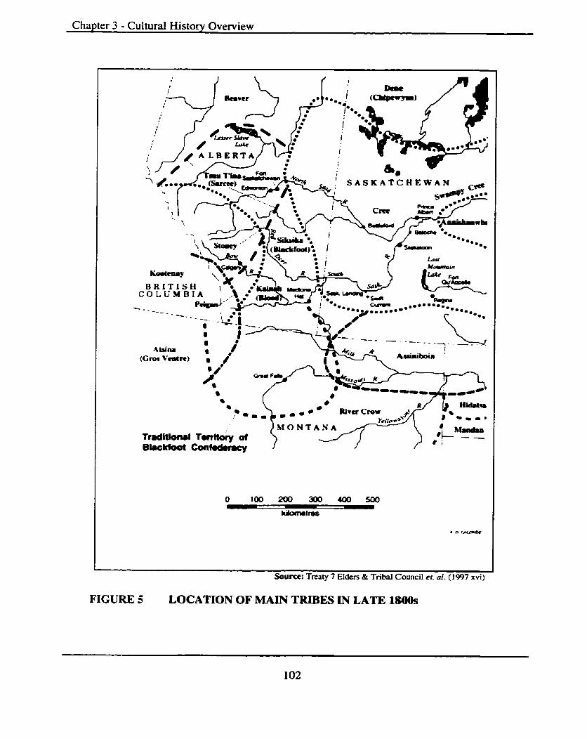
Chapter 3 - Cultural History Overview
S A S K A T C H E W A N c#
iCf O N T A N A TmditlOm8l twttofy of Bkckfoot C m t ~
. n tatmnc
Soum: Treaty 7 Elders & Tribal Council et. al. (1997 xvi)
FIGURE 5 LOCATION OF MAIN TRIBES IN LATE 1800s
Chapter - 3 Cultural History Overview
usually where good supplies and firewood were available in the river and stream valleys
of the foothills and adjacent plains.
Rosie Red Crow, a Blood Tribe elder, born in 1916, and cited in The True Spirit
and Original Intent of Treaty 7 (Treaty Seven Elders and Tribal Council et al. 1997:85-
86) remembers a variety of activities that were part of the Blood way of life:
During the summer we picked berries and hunted just before fall we dried meat; in this way we were well prepared for the winter. We knew winter was near when migrating birds began to fly south. The old people would look at the sun and when it's at a certain point it will tell them how cold the winter will be. Then they would move to the river where there are a lot of trees. We used the trees for firewood, also for shelter from the cold winter. We never moved from our winter quarters unless we were invaded by the Cree or some other tribe.. .The first sound of thunder was our sign to begin to prepare for our annual Sun Dance. All owners of Medicine Bundles took out their pipes and smoked their tobacco that was left over from the previous year.
Elsie Crow Shoe, born in 1927 and raised on the Peigan reserve, as cited in The
True Spirit and -Original Intent of Treaty 7 (Treaty Seven Elders and Tribal Council et al.
1997:99) recited detailed memories about the economies of the Peigan "Buffalo were the
prime sources of life." She further recalled:
... that the women made the travois when it was time to move and that dogs were still used extensively. Buffalo and bemes were staples, while moose and elk were hunted when necess ary... The Peigan hunted over a wide temtory--our land was along the Oldman River and Porcupine Hills.. .we used water and wood at Waterton Lakes, especially in winter time.
Reeves (1997: 17) further relates accounts, mostly from his Peigan informants and
over 30 years of field and related research, on the seasonal migrations of the Blackfoot
peoples.
Bison were hunted throughout the winter.. .both in communal hunts using jumps and corrals as well as driving into snowdrifts, and individual stalking. In the particularly bad winters (Peigan) would go up against the mountains, where other game animals-deer, elk, bighorn sheep- were also abundant ... In other winters, when the bison remained far out on the Plains, the bands would camp far out along the wooded bottoms of the Bow, Oldman, Beaver (Marias), Teton and Sun Rivers as well as on the mainstream of the Missouri River. Camps varied in size and duration in the winter.. .large camps of five hundred or more people were not unusual.

Chapter - 3 Cultural History Overview
Early spring was also a time when major bison kills were organized in the bison
calving grounds as is evidenced in the archaeological record at large sites like the Fort
Macleod Junction Site @kPi-02) (see Forbis 1964; Reeves et al. 1981 and Unfreed 1992,
1993, 1994). Meat was dried and pemmican prepared for use during the spring and
summer. Prairie turnip and camas were dug in the foothius and new lodgepoles were cut,
barked and left to cure over the summer for the next winter's camp if needed. Reeves
(1997: 17) notes that, 'Tobacco was planted at traditional sacred tobacco gardens, which
at times in the last century included sites in the St. Mary and Two Medicine valleys" in
present-day GNP.
Summers found many of the tribes making preparations for the opening of the
bundIes and preparing for the Okan (Sundance). This was a time of the gathering of the
bands within the tribal units at preferred sites. The Peigan ceremonies were held in the
vicinity of the Sweetgrass Hills and the Bloods gathered as they do today on the
Mokowan or Belly Buttes.
With the conclusion of the summer's festivities, bands dispersed to hunt and make
preparations for the late summer and earIy fall berry picking. Families and band units
picking locations would be determined by past favorite areas and local weather
conditions, which dictated the timing of berry ripening.
The rains and snows of fall and the movement of the bison herds back from the
short grass prairies in the east once again found the families and bands congregating in
anticipation of the large fall bison kills to lay in provisions of dried meat and pemmican
for the winter.
Early population estimates of the Blackfoot tribes and others changed markedly
immediateIy before and during the fur traded era on the plains. Reeves (1997:66) notes
that "before the first epidemic of ca. 1732 it [was] estimated that the population of the
[Blackfoot tribes] and the Atsina was on the order of 20,000 or more ... up to 80% died.
Smallpox struck again in 1782.. .and by 1832 the populations were again back to 20,000.
Almost 50% died in the epidemic of 1837."
The establishment of Fort Benton in 1847 soon dominated trade with the Blackfoot
and all the First Nations that would later enter into Treaty 7 found that their territory was
now restricted to a small core of the land base they had once used. Their freedom of

Chapter - 3 Cultural History Overview
movement was now curtailed and the presence and absence of game affected their ability
to hunt and move. The whiskey trade also greatly impacted the tribes, people trading
throughout what is now called "Whoopup Country," especially preceding the arrival of
the Royal Northwest Mounted Police (1874) and the signing of Treaty 7 at Blackfoot
Crossing ( 1 877).
3.4 Kootemy Region, BC Culhrral History
The Precontact history of the western portion of the study region in the British
Columbia interior west of WLNP and east of the Flathead River valley is poorly
understood. Development has not yet greatly impacted this area and except for some oil
wells that were drilled in the 1930s and logging operations in the 1970s it is all but
untouched. This means that even consulting reports associated with Environmental
Impact Assessments @IAs) are virtually non-existent.
The construction of a culture history sequence for the British Columbia portion of
the study region is hampered by the absence of intensive excavation. Chronological
comparisons must necessarily rely on information from archaeological typological cross-
dating and pdeoenvironmental data from neighboring regions.
A general summary based on Fladmark (1982, 1986), Richards and Rousseau
(1987) and Choquette (198 1, 1987a, 1987b, 1988a, 1996a and 1996b) will be outlined.
Fladmark (1982) divided the Precontact cultural sequence of the Kootenays into Early,
Middle and Late Periods based on changes in technology, house styles ar.d resource
procurement strategies (see Figure 6).
3.4.1 Early Period (ca. 11,000 to 7,000 yr BP)
Choquette' s ( 198 1. 1996a) research in the Rocky Mountain Plateau region
demonstrates that Early Prehistoric occupations are present but poorly understood.
Stemmed spear points or microblade industries characterize this period. Surface finds
from the British Columbia Interior indicate that Plains, Columbia-Snake River and
Windust Phase (see Figure 7) material is present. Choquette (1988a: 10) states that there
is evidence for an inland hunting adaptation[s] by 8,200 yr BP and for riverine fishing,
possibly for salmon, by as early as 7,500 yr BP.

Chapter - 3 Cultural History Overview
GOATFELL COMPLEX
FIGURE 6 PROPOSED CULTURAL SEQUENCE FOR KOOTENAY REGION, BC
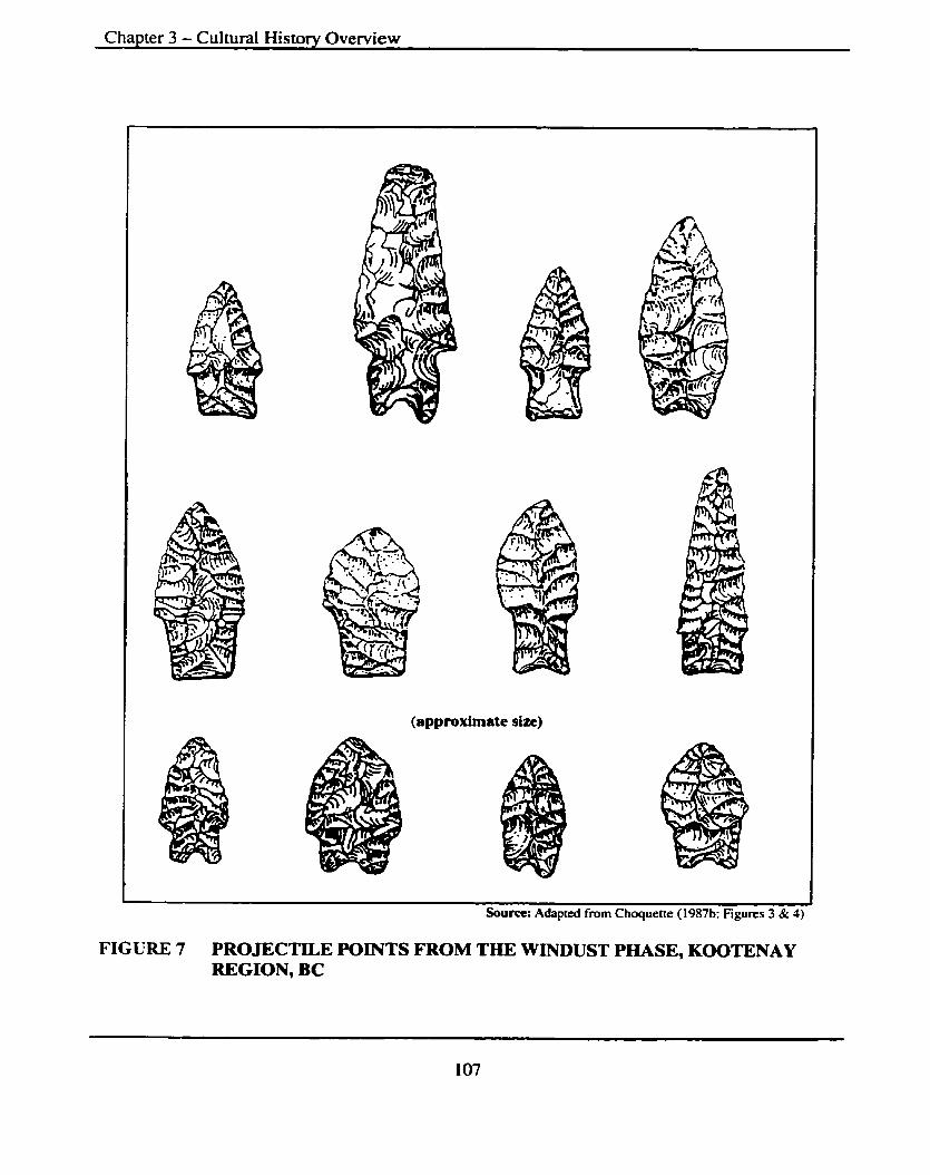
Chapter 3 - Cultural History Overview
I (approximate size) I
t I Sourn: Adapted from Choquene (1987b: Figures 3 & 4)
FIGURE 7 PROJECTILE POINTS FROM THE WINDUST PHASE, KOOTENAY REGION, BC
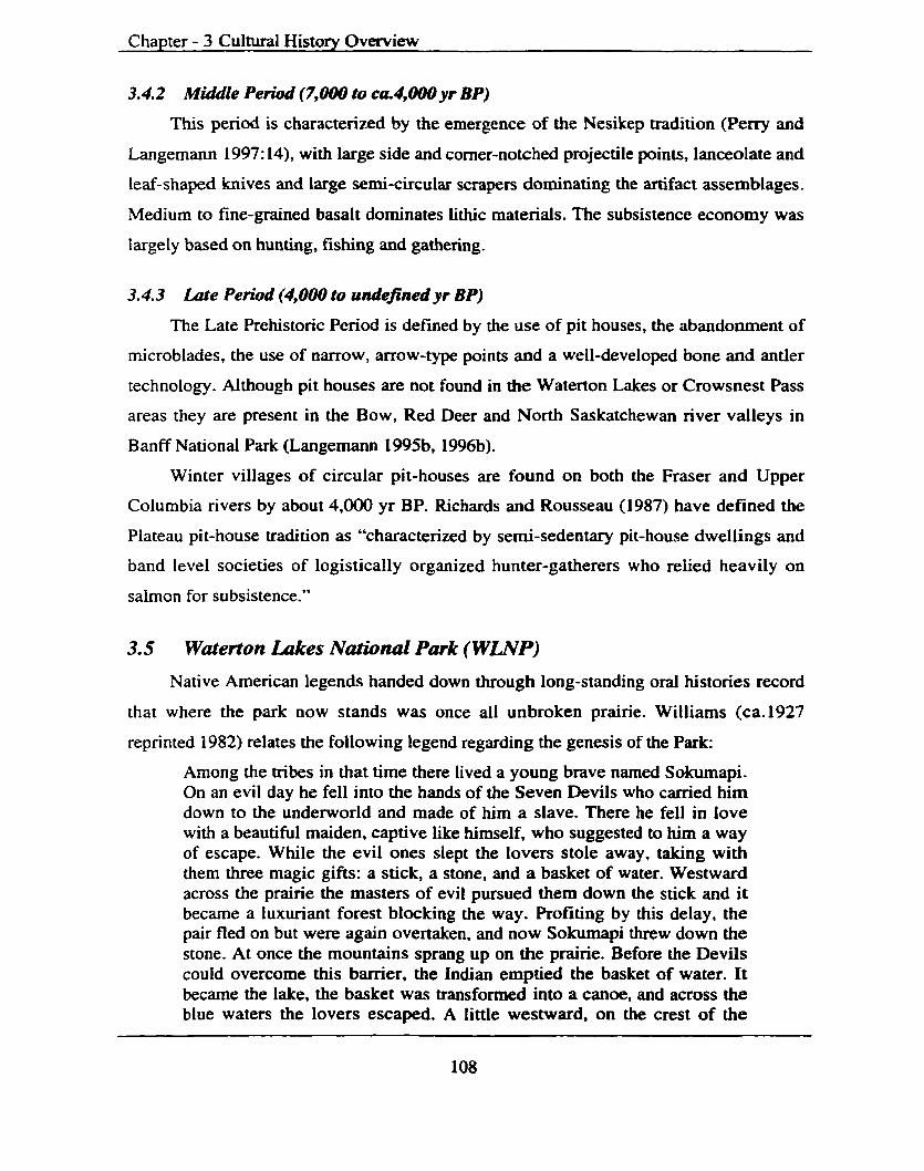
Chapter - 3 Cultural History Overview
3.4.2 Middle Period (7,000 to ca4,OOOyt BP)
This period is characterized by the emergence of the Nesikep tradition (Perry and
Langemann 1997: 14), with large side and comer-notched projectile points, lancwlate and
leaf-shaped knives and large semi-circular scrapers dominating the artifact assemblages.
Medium to fine-grained basalt dominates lithic materials. The subsistence economy was
Iargely based on hunting, fishing and gathering.
3.4.3 Late Period (4,000 to undefrnedyr BP)
The Late Prehistoric Period is defined by the use of pit houses, the abandonment of
rnicroblades, the use of narrow, arrow-type points and a well-developed bone and antler
technology. Although pit houses are not found in the Waterton Lakes or Crowsnest Pass
areas they are present in the Bow, Red Deer and North Saskatchewan river valleys in
Banff National Park (Langemann 1995b, 1996b).
Winter villages of circular pit-houses are found on both the Fraser and Upper
Columbia rivers by about 4,000 yr BP. Richards and Rousseau (1987) have defined the
Plateau pit-house tradition as "characterized by semi-sedentary pit-house dwellings and
band level societies of logistically organized hunter-gatherers who relied heavily on
saimon for subsistence."
3.5 Waterton Lakes Narionul Park (WLNP) Native American legends handed down through long-standing oral histories record
that where the park now stands was once all unbroken prairie. Williams (ca.1927
reprinted 1982) relates the following legend regarding the genesis of the Park:
Among the tribes in that time there lived a young brave named Sokumapi. On an evil day he fell into the hands of the Seven Devils who carried him down to the underworld and made of him a slave. There he fell in love with a beautiful maiden, captive like himself, who suggested to him a way of escape. While the evil ones slept the lovers stole away, taking with them three magic gifts: a stick, a stone, and a basket of water. Westward across the prairie the masters of evil pursued them down the stick and it became a luxuriant forest blocking the way. Profiting by this delay, the pair fled on but were again overtaken, and now Sokumapi threw down the stone. At once the mountains sprang up on the prairie. Before the Devils could overcome this barrier, the Indian emptied the basket of water. It became the lake, the basket was transformed into a canoe, and across the blue waters the lovers escaped. A Iittle westward, on the crest of the

Chapter - 3 Cultural History Overview
divide, they made a home together, and there are those who believe that to this day their happy spirits haunt the shores of lovely 'Omoksikimi,' which in the Indian tongue means 'beautiful waters' and which is now known as Waterton Lakes (Williams 1982:06).
The Bloods later called it "Where we Killed the Kootenays River," and it was also
known for many years as just the Kootenai River. Waterton was a name coined by
Thomas Blakiston of the 1858-59 "explorations of British North America."
This section is reproduced almost in its entirety from Perry and Langemann
( 1997: 16-34) and originally was largely taken, by Perry and Langemann, from Reeves
(I989 and 1993) who was under contract to Parks Canada-Western Region to produce a
WLNP prehistory. This author cannot presume to rewrite scch a complex and up to date
cultural history reconstruction.
"The significance of Waterton's Native archaeological sites is more than any single
site or the total number of sites. Each site represents component parts of a seasonally
scheduled round of activity over the past 10,000 years and the whole therefore is larger
than the sum of the parts" (Perry and Langemann 1997: 16).
Native cultural history of WLNP has been divided into five periods. The first three
termed, the Early, Middle and Late Prehistoric Periods, are associated with aboriginal
culture and land use history from ca.10,000 yr BP until the late 1700s, by which time the
impact of the horse, and artifacts of European manufacture, radically changed material
culture and land use. This short period of transition, before confinement to the Reserve in
1877, is termed the Transitional Period. The present period is terrned the Reserve Period.
Figure 8 shows the developed culture history sequence (after Reeves 1971, 1972,
1975 and 1980 and Reeves 1969, 1983 as cited in Vickers 1986) for WLNP and also for
the adjacent northern Plains.
3.5.1 Early Period (ca 10,500lo 7,750 yr BP)
Aboriginal occupations assigned to the Early Period in WLNP are represented by
twelve archaeological sites and tentatively issigned to two occupations. The triangular,
fluted, lanceolate and stemmed projectile points were most likely hafted onto throwing or
stabbing spears. Nine sites have occupations dating between 10,000 and 7,7500 yr BP
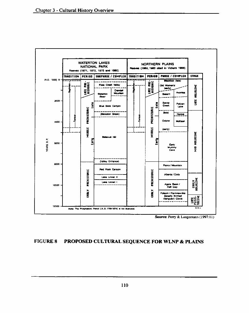
Chapter 3 - Cultural History Overview
(AD. 1950) 0
!Jjoume: Perry & Langemann ( 1997: 1 I )
WATERTON LAKES NORlilERN PLAINS NATIONAL PARK R- ( I % Q . ~ W ~ ciw h V i I S M )
R m (1971. 1S72. 1975 Md 1980) L
~ R ~ ~ D I T I U N PERIOD S U ~ P ~ R S L I COMPLEII 1111)01110~ ~ ~ 1 1 0 0 PMSE I COMPLEU n n ~ f 1
---r---- --------------- "-r'-'-' - We) P8uCrrJrHp.y --p- --. W W a n n ' s r w Z
C V
__---- ------ 0 t
------- z - f PICQn C
a euswm~npn 4
li ' LAru 2 ' = - - - - - - - - - - -- - - - < -------
e 0 ( ' -1 C
MI.) - - ' a = - - - - - ~ - - -- - - - -, 3 = - ------. Z
' a L L cheOw Ud<om
1 4 (-*I
FIGURE 8 PROPOSED CULTURAL SEQUENCE FOR WLNP & PLAINS
-
-
-
-
-
-
-
-------- --L----. 0 ---- ---------
9 ~ l a l - C m Y
I a - L a w
uufn"v C.V.
-
w s u 0 = t
E I
PI.* I Mountain
u . - utecurcoay
---------------<
MlirrEn-)
w
E
t
Y
5 3 C C Y
6 = m - w -I I ---------------
= E
X L, - x
w-CMyon
L.Lu LiM.( II
Chapter - 3 Cultural History Overview
with an average of 8,000 yr BP. Only one of these early sites at Red Rock Canyon (PC#
762RJDgPm-0 1 ) has been extensively sampled.
a) Lake Linnet I and 11 (ca10,000 to 9,000 yr BP)
The earliest evidence of occupation in W N P is at Lake Linnet (PC# 646RtDgPl-
18). Reeves (1969) in 1968 recovered a 'Lerma* or 'Cascade' point at the 75cm level
while another earlier occupation at 1 lOcm below surface yielded no diagnostic materials.
Also a stemmed point was found on a nearby beach similar in form and style to those
from the Windust Phase on the Columbia Plateau where they date to ~a.10~000 to 10,500
yr BP.
Lake Linnet I is defined by this stemmed point, found on the surface, and Lake
Linnet I1 by the Lerma or Cascade points found 'in situ.' A similar complex has been
identified in the east Kootenays by Choquette (1982) and in the Columbia Plateau region
where they are identified as parts of an ongoing "Old Cordilleran" cultural tradition and
separate from the Clovis tradition of the Great Plains.
b) Red Rock Canyon Subphase (ca9,OOO to 7,ISOyr BP)
This subphase is defined on the basis of Reeves' 1967-68 excavations at Red
Rock Canyon (PC#762R/DgPm-01), a series of prehistoric campsites located on
Baueman Creek at its juncture with Red Rock Canyon (Reeves 1972). Projectile point
diagnostic attributes include lanceolate and stemmed points, namely: Agate Basin, Lusk,
Love11 Constricted and Scottsbluff (see Figure 9) with the earliest cultural layers
providing radiocarbon dates of ca.8,270 yr BP. Important to note is evidence of trade, or
far reaching travels, to obtain lithic materids from Central Montana and the Banff region.
Cryptocrystalline cherts like Banff, Avon, Montana, Top of the World and Knife River
Flint portend of far-reaching travel networks. There are also microcrystalline lithic types
represented in the form of red and green argillites (mudstone), siltstone and quartzite.
Also present and assigned diagnostic status by Reeves are small basin-shaped earth filled
hearths with no fire reddened or cracked rock.
Investigations undertaken by Perry et al. (199 1) and Pickard (1995) suggest that
two occupations are represented at the lowest levels, the earliest identified as Cody

Chapter 3 - Cultural Historv Overview
Lerma Lusk Bitterroot Salmon River
McKean Duncan Hanna Oxbow
centimeters 0 1 2 3 4 S
Sourre: Perry & Langemann (1997: 19)
FIGURE 9 PROJECTILE POINTS FROM EARLY & MIDDLE PERIODS IN WLNP
Chapter - 3 Cultural History Overview
Complex. It is proposed that, "climatic change at around 9,500 yr BP resulted in the
expansion of a bison hunting culture, known as Cody, from the Central High Plains
displacing the earlier people into the mountains." They, in turn, physically displaced or
absorbed the Old Cordilleran Culture persisting in the mountains as the Plains Mountains
Complex until 7,750 yr BP (Reeves 1978). More extensive sampling is required to define
their [early site] characteristics [and assist in a possible revision to the developed]
cultural sequence and interpretations (Perry and Langemann 1997: 18).
C ) Early Pe&d Land and Resource Use
Perry and Langemann ( 1997: 1 8) state:
Although nine (9) sites have occupations dating in the ca. 10,000-7,750 B.P. range, most of these date to the end of the period, ca. 8,000B.P. as the landforms on which they are found did not become stable until then. The earliest occupation in many of these sites is mixed with later occupations.. .and.. .only one of these early sites (Red Rock Canyon) has been extensively sampled.
Reeves (1975: 13) notes:
The earliest known site DgP1-18 [PC# 646R- Lake Linnet a stratified campsite listed in the ARDA (Perry and Langemann 1997:186) as largely disturbed with a high significance rating] dates to ca 8000B.C ... The majority of the sites date later than ca 6000B.C. The temporal site patterning is ... reflective of the age of the associated landforms, and cannot be construed either as evidence of non occupation before 8000 B.C., nor changes in later population size.
It does appear that, "basic land and resource pattern use and seasonal scheduling
[round] known from later periods was established by ca.8,000 [yr BPI" (Perry and
Langemann 1997:21). The seasonal round consisted of winter camping in the main valleys
with the spring and fall seasons finding the groups in the tributary valleys and higher
alpine regions. These early inhabitants were hunting bison in the main and tributary
valleys and also taking fish.
Most sites from the Early Period have disturbed deposits. Sites with intact deposits
from this period are considered very significant and include Red Rock Canyon (PC#
762R/DgPm-0 1 ), Dardanelles (PC# 637RDgPl- 1 1 ), Lake Linnet (PC# 646R/DgPI- 18),
and Emerald Bay (PC# 570R/DgPI-03).

Chapter - 3 Cultural History Overview
The resource base for the Early Period is reconstructed on a minimum of evidence.
Faunal material (bone) was poorly preserved in those sites that were sampled. Reeves
(1 975: 13) notes; "that bison are represented at 5 sites, including DgPm-0 1, suggesting
that bison were the prime terrestrial ungulate exploited.
Reeves (1975:16) summarizes the basic land and resource utilization pattern as
follows:
The large base camps.. .are, with one exception, situated in sheltered areas on the valley floor, either on the shores of Waterton Lake, at the Waterton River exit or in the sheltered locales on the valley side. These, one may hypothesis, served as base camps for the exploitation of ungulates in their late fall to winter ranges, located on the valley plain, the lower valley sides and in the adjacent foothills. Spring or fail occupations are suggested for the sites adjacent to the Waterton townsite and mid-winter occupations for the sites adjacent to the Waterton River and valley side.
3.5.2 Middle Period (7,750 to 1,600yr BP)
The Middle Period is the best known, both in Waterton and throughout the Southern
Canadian Rockies and also very well represented on the adjacent Great Plains. Notched,
stemmed, lanceolate and triangular dart points propelled by a spear thrower or atlatl
characterize it.
a) Bellevue Hill Su bphase (ca 7,750 to 3,500 yr BP)
This phase has been divided into the Early and Late Bellevue Hill Subphases,
each with its own characteristic projectile point types. Other diagnostic artifacts include
small ovate bifaces, cores, wedges and extensive use of locally obtained argillite for tool
manufacture. The Early Subphase also exhibits an emphasis on the utilization of local
iithic types, such as quartzite cobbles from the adjacent plains. Later groups tend to favor
material from the central Montana quarries perhaps suggesting the development of
trading networks.
b) Early BeUevue HiU Subphase (ca 7,500 to 4,800 yr BP)
Point styles from this subphase have been classified as expressions of the Mummy
Cave Complex, being Bitterroot and Salmon River Side Notched dart points. Excavated
pit hearths are absent and there is no fire-cracked-rock (FCR), stone-lined roasting pits or
evidence of stone boiling.

Chapter - 3 Cultural History Overview
Buried sites, from this subphase, containing stratigraphically intact components are
extremely rare in WLNP and considered significant. The Dardanelles (PC# 637RIDgPl-
11) and Emerald Bay (PC# 570RlDgP1-03) are examples of sites representing this
temporal unit.
C ) Late BeUevue NiU Subphase, The Mckean Complex (ca4,500 to 3,500 yr BP)
The McKean Complex and its identifying points came onto the northern Great
Plains and Rocky Mountain regions from the Northern Great Basin (Reeves n.d. as cited
in Perry and Langemann 1997: 22). Three distinctive projectile points; McKean, Duncan
and Hanna represent this complex. Sites now contain stone boiling pits and FCR in
association with activity areas. Oxbow points also occur in association with technological
elements of the Late Bellevue Subphase.
Sites and components in WLNP [that] isolate the McKean Complex from this
subphase are rare (Perry and Langemann 1997:23). According to Reeves (1983b) they
represent the first appearance of a new cultural tradition. This suggests contact between
different cultures and possible exchanges in the form of trade taking place.
Large-scale excavations are required at such sites as Lake Linnet (PC# 646R/DgP1-
18),) and PC# 940RlDgPl-154 (Sumpter 1986, 1987) to detennine if this complex is
present.
d) Blue Slate Canyon S u b p h e (ca3,500 to 1,600 yr BP)
This is Reeves* (1983b) local expression of the Pelican Lake phase from the
nearby Great Plains. It is characterized by the telltale comer-notched Pelican Lake and
Hanna-like S ternmed points (see Figure 10). Projectile points with rounded shoulders,
broad notches and concave bases sometimes co-occur. These are known as Kootenay
Side Notched (Reeves 1972; Loveseth 1980).
Diagnostic artifacts include triangular knives, rectangular and oval scrapers, and
serrated flakes. Lithic use patterns are characterized by extensive use of Montana cherts
represented in some sites by up to 80%. Perry and Langemann (1997:23) report that 'Tie-
cracked rock is common, and excavated cobble-lined roasting pits with or without cobble
fills are diagnostic" and that "some of these pits were probably used for roasting camas
and other roots."
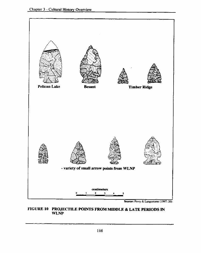
Chapter 3 - Cultural History Overview
Pelican Lake Timber Ridge
- variety of small arrow points fmm WLNP
FIGURE LO PROJECTILE POINTS m O M MIDDLE & LATE PERIODS IN WLNP

Chapter - 3 Culturai History Overview
e) Waterton River Subphuse (2,000 to 1,500 yr BP)
Waterton River is the local expression of the Besant Phase (Reeves 1980). In
WLNP and the Crowsnest Pass Besant style points are not found as discrete well-defined
occupations. There is only one excavated site (Waterton River PC# 572R/DgPl-10) that
appears to have an extensive Besant occupation.
Characteristic tools also include dorsally retouched triangular shaped endscrapers
and asymmetrical knives (Reeves 1983b). Lithic use includes a high percentage of Knife
River Flint.
8 ..Mddle Penbd Lond and Resource Use
Blue Slate Canyon peoples and their sites range from valley bottoms to high
alpine zones and are generally distributed in small sites throughout the park. There are
also large winter campsites like the Crooked Creek site (PC# 606RlDgPk-10) in the main
Waterton valley. Subsistence focused on communal bison hunts as well as the
procurement of sheep, deer, elk and moose. Faunal remains found in many of theses sites
include beaver (Castor canadensis - beaver family), fox (Vulpes vulpes - dog family),
coyote (Canis latrans - dog family), wolf (Canis lupus - dog family), swans (Cygnus
columbianus and C. buccinator - waterfowl family), ducks (genus and species
unidentified - waterfowl family) and Canada geese (Branta canadensis - waterjbwl
family).
The early people's seasonal round was intimately tied into the seasonal movements
of the mountain bison herds. The herds wintered and calved in the main valley later
moving in the spring to the higher pastures in the Blakiston (Pass Creek) valley. This
utilization of the upper Blakiston Valley most likely figured prominently into the
neighboring Ktunaxa 1ifestyleAifeways. In fact the Middle prehistoric inhabitants of
WLNP may have been the Ktunaxa.
Fall fishing camps were established at locations like the Narrows site (PC#
638WDgPl-04) (Milne-Bmrnley 197 1) between upper and Middle Waterton Lakes. Here
fish were intercepted during spawning runs and intensely processed.
The high percentage of exotic (non-local) lithics from geographic regions outside
the park, namely southeastern British Columbia, north and central Montana, indicates a
Chapter - 3 Cultural History Overview
pervasive pattern of trade involving travel over the high alpine passes/trails (namely the
Akamina, South, Middle and North Kootenay Passes) and north-south along the eastern
slopes (via the Old North Trail and associated tributary trails).
3.5.3 Late Period (ca.I,600 to 200 yr BP)
The Late Period is characterized by the introduction of the bow and arrow m d is
represented by a variety of small un-notched, stemmed, comer and side notched arrow
points. Reeves, (1980, 1983b) has identified the following two phases within this period.
In the Napikwan tradition, the transition from the use of the spear thrower (atlatl) to
the bow and arrow was relatively gradual. Small points of the same style and shape
gradually replace the larger points. In the Tunaxa tradition, the change in the weapons
was very rapid, as represented in the abrupt change in point sizes and types at Head-
Smashed-In Buffalo Jump (DkPj-01) (Reeves 1983b).
a) Crandell Mountain Subphase (ca.I,600 to 800 yr BP) This is the local expression of the Avonlea phase of the Tunaxa cultural tradition.
The phase diagnostics or projectile points are small exquisitely crafted arrowheads of the
Head-Smashed-In Comer Notched and more common Timber Ridge Side Notched
varieties (see Figure 10). Other tools characteristic of this subphase include asymmetrical
ovate and bi-pointed knives, triangular shaped end scrapers and a unique percussion
technique that produces "conical" blade Like cores.
Lithic utilization patterns include the use of Montana cherts and chalcedonies as
well as Top-Of-the-World cherts. According to Reeves, (1980) this is the fust time in the
Waterton record that we see extensive use of the Top-of-the-World (i.e. DIPu-12)
quarries. He goes on to say that in contrast in the Crowsnest Pass and the Kootenays,
Top-of-the-World chert appears earlier, in Pelican Lake times, whereas on the Plains it
appears in Avonlea times.
Rock-filled pit and surface hearths, roasting and boiling pits and the extensive use
of FCR are characteristic of this subphase.

Chapter - 3 Cultural History Overview
b) Pass Creek VaUey Subphase (800 to 200yr BP)
The Late Period in southern Alberta is characterized by two cultural phases that
are likely ancestral to two modern cultures: the Ktunaxa, possibly represented by the
Tobacco Plains Phase of the Rocky mountains, and the Peigan, possibly represented by
the Old Women's Phase in the adjacent Foothills and Plains (Perry and Langemann
1997).
There are a variety of small arrow points from this time period, (Vickers (1986:95)
summarizes the different names). The Pass Creek Valley Subphase in WLNP contains
both Old Women's and Tobacco Plains, in some cases found within the same site.
Winter settlement patterns shift with an emphasis on the eastern slopes for the
Tobacco Plains and Old Women's cultures. Peny and Langemann (1997:29) report, by
the 1600s the eastern slopes of Waterton-Glacier are the traditional wintering grounds of
the Peigan and visited only occasionally by the Ktunaxa.
3.5.4 Transitional Period (ca200 to 123 yr BP)
The Transitional Period is also referred to as the Proto-Historic Period. It refers to
that period of time when traditional aboriginal lifeways underwent a rapid and radical
change as a result of the continuing impact of the horse and gun. The penetration of the
study region by European explorers, fur and whiskey traders, miners, missionaries,
arrny/police forces, ranchers and settlers wishing to farm the vast tracts of open country
forever changed millennia of aboriginal Weways and history.
The horse aIlowed for rapid movement throughout the traditional hunting territories
of both the Ktunaxa and the Peigan. In the late 1700s winter camps were still large but
again the horse and improved mobility allowed for constant raiding among the
neighboring groups. Because of this constant raiding, or in spite of it. the Peigan
reoriented their winter camps to smaller and more highly mobile ones (Perry and
Langemann 1 997:28). European manufactured trade goods such as metal points, muskets.
rifles, steel knives and copper pots replaced stone tools and ceramic wares. The
archaeological record becomes more homogeneous and cultural affiliations difficult to
discern. Trade goods have been recovered at a few sites in W L W , some in direct
association with traditional stone tools.
Chapter - 3 Cultural History Overview
It appears that many indigenous groups expanded their traditional boundaries
because of their newfound mobility and military strength. This increased inter-group
conflicts and aggressions. Groups that were once true allies, because of the new trade
goods and inequalities that resulted, became antagonistic towards each other. Aboriginal
populations were all looking for and establishing new power structures - or jockeying for
position.
Declining wildlife populations as well as many other impacts from advancing
Europeans, particularly 'rot-gut' whiskey and small pox, had pronounced effects on early
aboriginal inhabitants. The bison herds were all but gone by the mid-1880s and rather
than a majority of bison bones being recovered in archaeological excavations, sites like
(PC#67 1 R/DgPI-5 I ) , a Protohistoric site, in the Blakiston Creek watershed, are
characterized by the remains of deer, elk, sheep, badger, beaver and avifauna (bird).
3.5.5 Reserve Period (123 yr BP to present)
During the closing decades of the last century aboriginal groups continued to utilize
WLNP. Tribes like the Ktunaxa, Nez Perce, Flathead and the southern Blackfeet traded at
Kootenay Brown's trading post (Rodney 1996:126). There are numerous ethnographic
reports of Mountain Stony hunting parties occupying the border ranges, utilizing traiis
and passes and camping in the valleys.
After the establishment of the reserves, and confinement of aboriginal groups to
them, life was never the same. Walter McCLintock returned to spend some time with the
groups that had befriended him earlier and reports that he "found former chiefs reduced
to lives of poverty unnoticed and seemingly unknown by the younger generations." In
1896, McClintock was a member of the U.S. Forest service expedition to northwestern
Montana. Upon leaving the Forest Service employ he lived with the South Peigan and
was subsequently adopted by one of their chiefs.
With the extermination of the great bison herds the final deathblow had been dealt.
Tribal organization was gone and after being suddenly cut off from their 'never-ending'
food supply government relief was needed to w a d off starvation. The 'gratuitous
support' of the government and enforced lifestyle of idleness reduced and degraded a
once powerful nation. To add insult to injury their main contact with the advancing

Chapter - 3 Cultural History Overview
Europeans was with some of its worst representatives who had amassed along the frontier
to seek their fortunes. Many of these individuals looked upon the natives as the largest
obstacle. if not the only one, in the advancement of their fortunes. Government policy did
not come to the aid of the First Nations people. We return to McClintock's journal for he
summed it up well:
Their condition and the similar condition of other Indian tribes simultaneously reached an acute stage. Disposed of their ancestral domains, their armed resistance overcome, their source of subsistence destroyed, they had become the helpless dependents of the American nation, requiring immediate action and the highest statesmanship and constructive philanthropy for their redemption (1968:s 10).
On the Plains, among the Blackfoot peoples and all First Nations, there is and
always has been a recording of significant events. According to W. Goodstriker (In:
Treaty Seven Elders and Tribal Council et al. 1997:03) "The stories have been recorded
in many forms, through our winter counts, on the land, but most importantly in the minds
and spirit of our people."
The winter-counts of the First Nations people in the Treaty 7 area in the year 1877,
which was the year that the treaty was entered into "between the First Nations
people ... and the representatives of the Queen of Britain," did not include the treaty
signing. Rather, it is referred to as the "year when the winter was open and cold" by the
Blackfoot. Among other nations, it is remembered as " the year when there was great
hunger," "the year when the long rains did not come," "the year of starvation and
hunger," or "the year when the first snow was late." Whatever it was referred to it was
not a normal year.
The memories have been kept alive through a history of oral traditions that span
thousands of years. The story has been told many times throughout the years since. The
Blackfoot peoples continue to live mainly on the reserves assigned to them as a result of
the negotiations but the "True Spirit and Original Intent of Treaty 7" remains in question.
The situation on the western side of the Continental Divide, in what was to be
called British Columbia, was handled somewhat differently. A Reserve Commission was
formed by the Dominion government in the 1880s and assigned land to Aboriginal
peoples without the signing of treaties. Land was assigned to individuals and p u p s on

Chapter - 3 Cultural History Overview
the basis of occupancy at the time of the commissions visit and was assessed at a fraction
of what the Plains Tribes received. In fact after the canceling of Douglas* pre-emption, in
the early 186Os, "Indian families could now expect at most a ten-acre share of a reserve
that had often been defined to exclude the prime land desired by whites" (Tennant 1991).
3.6 Ghcier N&nal Park (GNP), Montana, USA
GNP was traditionally part of the Blackfoot and Ktunaxa First Nation territory. The
South Peigan today reside on the Blackfeet Reservation, Montana that until 1896
included the eastern slopes of present-day GW. Other members of the Blackhot Nation
such as the North Piegan, residents on today's Piegan Reserve # 147 in southern Alberta,
the Siksika, residents on Reserve # 146, and Kainaiwa (Blood), residents on Blood
Reserve # 148, also have strong traditional associations with the GNP area.
Reeves (1993:03) reports on the western tribes known to have been in the study
region and includes:
... various Salishan (Flathead), Coeur d' Alene and Spokane ... Tsatpel (Nez Perce) also passed through the passes of the 'Backbone* to hunt buffalo on the foothills and plains." He also notes that "depending on intertribal relationships at any one time, the western tribes, as well as the Ktunaxa, were either on friendly relations or at war with the peigan].
Other buffalo hunters also paid occasional visits including the Haaninin (Atsina)
who are the northernmost of the original five tribes of the Arapaho - also known as the
Fall River Indians, after the Great Falls of the Missouri and the Cree and Nakoda peoples.
Nakoda (Assiniboine) traditional oral history tells of the Bearspaw and Chiniki Bands,
today's residents of the Stoney Reserves # 142, 142B, 143 and 144 west of Calgary,
Alberta moving west from their traditional homelands in today's eastern Montana, then
north along the mountain front into the Bow River country some time in the L700s.
The Absaroka (Crow) and associated Nimi (Shoshone) peoples, referred to by the
Peigan and their allies as the Snake, also spent some time in the region. They passed by
utilizing the Old North Trail to war with the Blackfoot tribes until well into the 1870s.
The following section is produced almost entirely from Reeves (1 993:05- 17) and
his Glacier National Park Preconract Native American Archaeological Research Design,

Chapter - 3 Cultural History Overview
The First Nations cultural history, prior to the amval of the Europeans, has been divided
into three periods (see Figure 11) termed the Early, Middle and Late . These periods are
associated with Native cultural and land use history that extends back over 10,000yr BP
and are derived from the extensive excavations undertaken in nearby WLNP and the
Plains. They persisted until the late 1700s when the introduction of the horse and other
artifacts of European manufacture and origin radically altered Native American material
culture and land use.
3.6.1 Early Period ( ca 10,500 to 7,750 yr BP)
Archaeological phases or complexes - developed by researchers - containing stone
projectile points displaying triangular, fluted, lanceolate or stemmed attributes
characterize this period. They were most likely used (hafted) onto throwing or stabbing
spears.
The earliest known occupations (ca. 10,500 yr BP) - generally known as the Clovis
Complex - utilized a particular style of fluted point. As cited by Reeves (1993:05)
"Clovis is represented by a [single] fluted point found [by a Park Ranger] on a trail along
the Belly River just south of the International Boundary" (Glacier Museum Accession #
A712 or Glacier Site -24). Reeves' has identified the Clovis Complex in private
colIections from the WLNP and from adjacent locations on the adjoining foothills and
plains. Unfortunately the Waterton specimens were apparently destroyed in a house fire
some years ago before documentation could be completed. Lanceolate and stemmed
projectile points generally manufactured of basalt characterize a second early tradition
called the "Old Cordilleran". This tradition is associated with the Columbia and Fraser
Plateaus to the west. A "cache" of bifacially worked artifacts, possibly points and knives,
was found on the west side of the Middle Fork at the junction of the Flathead River and
McDonald Creek (24FH00148 or Glacier Site G-5). Reeves (1990) has recorded the
earliest excavated in place evidence of this tradition, in the form of a "Lerma" or
"Cascade" point (see WLNP section) from the Lake Linnet site (DgPl-18/PC#646R) in
WLNP. At Lake Linnet Reeves also recovered a stemmed point similar to a point
complex identified by Choquene (1982) in the east Kootenays. They are similar in "form

Chapter 3 - Cultural History Overview
+ AGE B.P. PERlOO SUBPHASWCOMPLEX TRAOmON
RESERVE 100 c a
TRANSmON s 200
' I a TOBACCO P W N S 4 2 Z
& OLD WOMANS LATE - - - - - - - - - - -
1000 AVONLEA g f --- - - -- * * 8 *
E ' 2000
BLUE SLATE CANYON 3000 (PEUCAN LAKE)
I 2 - - - - -
4000 LATE
MCKEAN
MIDOLE 5000
MUMMY CAVE 6000
7000 EARLY
8000 PLAlNSlMOUNTAlN COOW
9000
EARLY OLD CORDILLERAN
10.000
11.000 CLOVIS
FIGURE 11 PROPOSED CULTURAL SEQUENCES FOR GNP

Chapter - 3 Cultural History Overview
and configuration?' to Choquettes's Windust Phase on the Columbia Plateau. There they
have been dated to 10,500 -9,000 yr BP. Reeves notes that "Cody, however, also
represents an intrusive cultural unit into the eastern slopes in sites Like MacHaffie Site
near Helena (Forbis and Speny 1952)." Fedje (1987, 1988) has also identified stemmed
point complexes from excavated components in Banff National Park that dated between
10,200 - 9,600 yr BP.
The Cody and Plains/Mountain cornpiexes are the other Early Period Complexes
represented in the Glacier region (Reeves 1978). The Cody complex is represented at
sites like the Hole-In-The-Wall (Glacier Museum Accession # AC888 or Glacier Site G-
33) by an Alberta styie obsidian point and at the stratified Red Rock Canyon Site (DgPm-
01 /762R) (see Reevzs 1972 and WLNP Culture History section). The recording of an
obsidian lanceolate point base by Malouf (1965:17 as cited in Table 2 Reeves 1993:131)
from the Triple Divide Pass (Glacier Site # 26 or Glacier Museum Accession Cat. #
5016) may also relate to the Plains/Mountain Complex. Reeves (1978) theorized that:
"the presence of occasional Cody points in Plains/Mountain complex sites could
represent contact between the two distinct temporally co-terminous and geographically
adjacent cultural traditions." Excavations at Red Rock Canyon, the Crowsnest Pass
(Kennedy er a[. 1982) and Wyoming (Frison 1991) all suggest a co-occurrence in "post-
8,500 year old components."
a) Eady Period Land and Resource Use
According to Reeves (1993:07) "Despite the very limited and temporally skewed
sample, it would appear that in Waterton-Glacier the basic land and resource use pattern
and seasonal scheduling of activities was established by ca. 8,000 years ago." Prior to
that time many landforms had not become stabilized and therefore available for use.
Bison were hunted in the tributary and main valleys with fish also taken by some
groups. Over-wintering in the main valleys characterized the seasonal round with spring-
fall hunting camps in the tributary valleys and higher altitudinal regions. Native groups
traveled throughout the Rockies; seasonally utilizing the high elevation trails and passes
to hunt, fish, quarry, and trade with neighboring bands and tribes.

Chapter - 3 Cultural History Overview
3.6.2 Middle Period(cu.7,750tol,600yrBP)
Notched, stemmed, lanceolate and triangular atlatl dart points characterize the
Middle Period in GNP, as well as many adjoining regions. Phases and complexes that
date to the Middle Period are numerous and perhaps the most numerous.
a) Mummy Cave Complex (7,750 to 3,3500 yr BP)
This complex in the WatertodGlacier region is reported on by Reeves (1969,
1972 and 1973) and is named after the "type site" - the Mummy Cave Site in Wyoming
(see Wedel et al. 1968). I t is manifested by large side notched projectile points - called
Bitterroot or Salmon River (Swanson 1972). Reeves (1993: 08) notes; "that the plains
Mummy Cave people are well-adapted bison hunters.. .and.. .in the mountains they are
diversified hunters and fishers."
In WLNP and the Crowsnest Pass, Late Mummy Cave sites are more frequently
encountered than early because the more recent glacial landforms are better preserved.
Early Mummy Cave sites with buried stratigraphically intact components are rare. Reeves
reports no Mummy Cave sites from his GNP studies and further states that, "The
relationship between Mummy Cave as represented in Waterton by Early Bellevue Hill
and the Plains/Mountain Complex as represented at Waterton by Red Rock Canyon
Subphase remain obscure ... other sites, dating to around 7,750 [yr BPI [suggest] a very
rapid technological and/or cultural replacement (see Frison 1991, Van Dyke and Stewart
1954) like that which occurred with the introduction of the bow and arrow at the end of
the Late Middle period some 6,000 radiocarbon years later."
b) The McKean Complex (ca.4,500 to 3,SWyr BP)
The McKean Complex is believed to be an intrusive cultural component to the
Northern Plains/Rocky Mountains whose origins are considered to "lie in the Northern
Great Basin (see J e ~ e s s n.d., Mulloy 1954, 1958; Kornfield and Todd 1985).
It is represented by three projectile point styles - McKean, Duncan and Hanna - and
is often in association with Oxbow points on the Plains and Parkland. Brumiey (1975)
and Reeves (1983b) generally agree that McKean appears to represent the movement of a
new group of people into the Northwestern Plains and Northern Rockies from the
notthem parts of the Great Basin and adjacent areas to the west." Brumley and Reeves

Cha~ter - 3 Cultural Histow Overview
continue, "Continuity in artifact assemblages and other archaeological traits can be traced
forward in time to the subsequent Pelican Lake Phase [further] suggesting that McKean is
the ancestral culture of this later buffalo hunting culture of the Western Plains and Rocky
Mountains."
In GNP, the McKean Complex is represented by a site on Swift Current Lake
(246100015), classified as a campsite with a point, biface and flakes recovered (see
Guthrie 1978).
C ) Pelican Lake Phase (ca3,SOO to 1,800yr BP)
This is the "best documented of the Middle Period Phases in the Northern Rocky
Mountains" (Reeves 1983b) and Plains and as a result multiple regional subphases have
been proposed from excavated materials in both WLNP and the GNP.
It is characterized by Pelican Lake Comer Notched dart points and possibly Hanna
Comer Notched and stemmed points. A variant with rounded shoulders, broad notches
and comer bases, calIed Kootenay Side Notched (Reeves 1972 and Loveseth 1980) has
also been included.
Pelican Lake points have been recovered from the Cracker Flats (Glacier Museum
Accession # A679 or Glacier Site G-27) and Cosley Lake (Glacier Museum Accession #
A8 19# 10724-34 or Glacier Site G-32) sites.
d) Besant Phase (2,000 to 1,500 yr BP)
Distinctive projectile point types include the Besant Side Notched dart points and
Samantha Side Notched arrow points. Although Beasant occupations (see Reeves1972;
Lifeways 1980; Milne-Brumley 1971) have been identified in nearby WLNP, only one
excavated site on the Waterton River (DgPl-lO/PC# 572R (Reeves 1972, 1980) appears
to have an extensive discrete Besant Phase occupation. Driver (1978) recognized a
similar pattern in the Crowsnest Pass as did Fedje (1988) in the Banff Bow Valley.
Reeves ( 1993: 1 1 - 12) proposes that, "Besant . . .peoples of the Plains.. .summered
eastward and southward out on the Plains rather than in the.. . mountains valleys, alpine
and western stopes."
Chapter - 3 Cultural History Overview
e) Middle Period Land and Resource Use
Phase diagnostic projectile points and distinctive Lithic types have been found at a
number of sites in and around GNP, including sites in the Belly River Valley, Swift
Current, St. Mary and the Two Medicine and Bowman Lakes. These and other sites
located in the Alpine represent a wide range of seasonal settlement characteristics of the
Middle Period.
The native people moved with the bison herds, establishing larger camps in the
spring in tributary valleys utilizing corrals andlor wetlands or cliffs to kill bison. No
doubt other game was taken including sheep, deer and the occasional moose. This was
also the time for the ceremonial opening of the bundles and other religious gatherings
(pers. comm. B. First Rider July 1999).
As summer progressed the groups fragmented into smaller family or band units to
hunt in the nearby Alpine zones. In the fall preparations for the big communal hunts were
undertaken before the winter snows began to fall. Other big game, including elk, deer,
sheep and black bear, were also taken.
Recovered pestles and grooved mauls, used in pounding berries and dried meat,
from subsurface as well as surface finds attest to the use of plant foods in the Waterton-
Glacier region (Perry and Langemann 1997:25).
It does not appear to Reeves (1993:13) from the evidence so far obtained that
"native people could complete the entire seasonal round within Waterton-Glacier*' and in
fact "the evidence indicates that [it] was part of a much larger yearly or multi-year
round." He continues, "This larger pattern is evidenced by the pervasive pattern of travel
[as is seen in the lithic types identified in archaeological assemblages] back and forth
over the passes and north-south along the eastern slopes - interior mountain valleys
systems and, at times, out onto the plains."
3.6.3 Late Period (ca 2,600 to 200 yr BP)
This period is characterized by the introduction of the Bow and arrow and
represented by a variety of small un-notched, stemmed, comer and side notched arrow
points.

Chapter - 3 Cultural History Overview
To the north in Alberta at Head-Smashed-In Buffalo Jump site(DkPj-01) the
change over in weapons from the use of the atlatl dart to the bow and arrow was abrupt
but elsewhere appears gradual. Reeves (1993: 14) notes; "small [arrow] points of the same
style and shape gradually replace the larger [dart] points.
a) Avonlea Phase ( ~ ~ 1 , 6 0 0 to 800 yr BP)
Projectile points or phase diagnostics are small, finely crafted arrowheads with the
Head-Smashed-In Comer Notched and more common Timber Ridge Side Notched types
dominating. Reeves (1993: 14) notes a "point of this type was recovered from a site on the
top of Logan Pass (24GLOOO89) (see Jones and Winfrey 199 1 ).
According to Reeves (1980) "this is the first time in the [nearby] Waterton record
that extensive use of the Top-Of-The World quarries appears." This is in contrast to the
more northern and western Crowsnest Pass and Kootenay Valley areas where the use of
this high elevation quarry fust becomes common in earlier Pelican Lake times. This
indicates use of the high elevation quarry and movement of its, often distinctive lithic
material can be used to trace either trade or group movements into the Waterton Park
area. Influence from the south and southeast of other desirable lithic types (i.e. Montana
chert, Knife River Flint, Yellowstone obsidian, etc.) dominates the Northern Plains and
eastern Slopes until this new influence arrives relatively late in the Precontact Period.
6) Old Woman's and Tobacco PIains Phases (ca800 to 200 yr BP)
The Late Period is characterized by two quite distinct cultural traditions - the
Ktunaxa, represented by the Tobacco Plains Phase of the Rocky Mountains - and the
Piikani (Peigan) represented by the Old Woman's Phase in the Foothills and Western
Plains (Reeves 1993: 15). Tobacco Plains is known from the "traditional Ktunaxa camps
in the Crowsnest Pass (Loveseth 1980), Waterton valley (Reeves 1980), and the
Kootenay Valley (Rohl 1982).
Reeves (1972) identified sites in the Waterton valley containing both Old Woman's
and Tobacco Plains, which, according to Reeves, in some cases represent "mixed
assemblages created by successive camps of the two tribes on the same site area", and "in
other cases, ... represents a joint encampment of Ktunaxa and Piikani." Reeves (1993: 15)
recognizes that "Ktunaxa arrow points in Tobacco Plains sites, while within the general

Cha~ter - 3 Cultural Historv Overview
range of Plains Side Notched, have distinct recognizable micro-stylistic traits, most
noticeable of which is the tendency to place the notch relatively high up along the edge of
the point blank. Piikani points, in contrast, tend to place the notches relatively low on the
edge. Ktunaxa points tend to have relatively high basal edges relative to the total point
length."
Reeves notes that typical Old Woman's style points have been found in buffalo
jumps on the adjacent Blackfeet Reservation (see also Kehoe 1967). The Pass Creek
valley subphase in the Waterton valley (Reeves 1972) contains both kinds of sites. In
some cases, the sites represent mixed assemblages, in other cases a joint encampment
created by successive camps of the respective tribes on the same site &a.
3.6.4 Transitional Period (ca200 to 125 yr BP)
This is the short period of time when the long-standing First Nations culture,
subsistence and settlement patterns underwent rapid and radical change as a result of the
continuing impact of disease, the introduction of the horse and the amval of the fur and
whiskey traders, miners, missionaries, army and ranchers.
As noted by numerous researchers, the introduction of the horse and the
replacement of stone tools by items of European manufacture, such as metal trade points,
muskets and rifles, knives and copper pots resulted in a "very sharp change in
archaeological visibility of the Native peoples." Sites are less visible and marked by the
introduction of European items. Reeves (1 993 : 16) notes that "In Watenon, these
[European trade goods] have been found at several sites" and also notes that there are "no
sites in Glacier."
3.7 Summary The Recontact history of the study region, as defined from the construction of the
cultural chronologies, including that of the Blackfoot Confederacy and the Ktunaxa
Nation, extends back to the Late PleistoceneIEarly Holocene era more than 10,000 yr BP.
I, as do many other authors, have avoided using the term "prehistory" throughout this
MDP on purpose. It implies that before contact with advancing European exploration and
settlement the First Nations were before or without history. It applies to those periods of
time in both the New and Old Worlds whose histories were recorded through an oral

Chapter - 3 Cultural History Overview
rather than a written format are not history. This is obviously not the case. As "western
scientific thinkers" we are bound by a written record of the past but as archaeologists we
can demonstrate - although not as clearly as we would like - that First Nations have been
a part of the study region since at least the ending of the last ice age.
There are inherent difficulties in the developed cultural chronologies in almost all
sub-regions within the study region. This summary will highlight those diKiculties and
then answer the previously posed research question: Has an adequate Precontact
cultural chronology been developed for the study region?
Leslie B. Davis has conducted a sustained program of site specific archaeological
research east of the Continental Divide for almost 30 years. Davis* work has contributed
significantly to our understanding of, particularly, lithic quarrying activities and early
First Nations occupation. Davis has so far not proposed an independent regional
chronology for the Missouri headwaters, preferring instead to "plug" his sites and
components into Reeves' southern Alberta and Northern Plains classification system, on
the basis of projectile points. According to Davis and Zeier (1978), 'This has on more
than one occasion resulted in misidentification and rnisclassification of late period ethnic
groups and archaeological assemblages."
The archaeology of the western half of Montana is also not well known - especially
west of the Continental Divide, where no substantive regional surveys or excavations
have been undertaken. Regional surveys and excavation programs that assist in
developing cultural chronologies have not been undertaken in Montana. Most research
and other development driven initiatives have been superficial in nature and what
material has been rescued in the limited test excavations that have been conducted has
produced few culturally diagnostic items and absolute dates.
Flint's (1982) dissertation The Northern Rocky Mountain Region: Environmental
and Cultural History terminates, according to Flint, at the 49'"- He also relied on plugging
the sites and artifact assemblages into general chronologies. There is little to be said in
detail with regard to this portion of Montana.
In British Columbia Choquette's almost 30 years of work in the Kootenays has
resulted in the development of an evolving cultural history framework. The majority of
Choquette's interpretations resulted from his and others research associated with the

Chapter - 3 Cultural History Overview
construction of the Libby Dam, the Lake Koocanusa reservoir, the Libby Re-regulation,
excavations at Wildhorse Creek and Goatfell. Much of Choquette's other work and
resulting interpretations have come from numerous surface finds, private artifact
collections and small project specific impact assessments. Choquette has advanced his
own cultural chronologies relying on his "explorations of the interaction between the
prehistoric inhabitants of the Kootenay region and the natural environment." He has
focused on "the influence of regional geology on the local Stone Age technological
system (Choquette 1981:22). He has postulated a somewhat divergent genesis of the
projectile point continuum initiating in leaf-shaped and lanceolate points resembling early
points virtually identical to the 9,000 to 10,000 year old Wiodust Subphase defined in the
Columbia Plateau (Rice 1972; Ames et al. 1981). These large stemmed projectile points
from "the Kootenay region all fall within the range of variability of those from the
Windust Phase" (Choquette 1982:09). Choquette further posits that the frequency and
wide distribution of large stemmed points displayed by Wormington and Forbis (1965)
on the nearby Plains clearly demonstrates the variability in form of the long stemmed
points which also easily encompass the Kootenay region. This fact is further positioned
by Reeves (1975) and Driver (1978) who identify "the earliest cultural complexes on the
east slope of the Alberta Rocky Mountains at the similar latitudes as the Kootenays" as
also characterized by similar large stemmed points.
The position that Choquette takes and his reluctance by him to "plug" his finds into
previously defined chronologies should be applauded. There is a scarcity of fluted points
from all locations within the study region with none being the resuit of archaeological
excavations. If one applies the developed Plains cultural chronology a priori to the
Kootenays, including its genesis in the Fluted Point Tradition, then one has to ignore the
alternative sequences that appear to originate west of the Continental Divide.
The upper Saskatchewan and upper Missouri Plains cultural history of the Northern
Great Plains and the vast amount of archaeological, ethnographic and other research done
there have resulted in a well developed cultural sequence. This is based on Mulloy's
( 1958) "tripartite periodization," later expanded by Reeves (1972, 1978 and 1983) and
Vickers (1986) to accommodate new data and interpretations. Research on the Alberta
Chapter - 3 Cultural History Overview
Plains and Foothills continues to provide abundant high quality data and refinements to
the developed chronologies.
There is no doubt that the archaeological research undertaken in the WLNP and
nearby Crowsnest Pass has provided the most detailed look at the study region's
Precontact history. The fact that many have, and continue to, "plug" their finds into
Reeves' system should not be a surprise. Reeves' long lasting, high quality, and often-
insighdid work has, and continues to be, a useful construct with which to measure other
finds. What concerns this author, and presumably many others, is the heavy reliance on
one construct when the overaii complexity of the study region, as well as ethnographic
evidence, speaks of many groups inhabiting the region for many millennia.
Upon completion of this portion of research it would have to be concluded that
there has not yet been an adequate Recontact cultwal chronology developed for the study
region.
Chapter 4 - Archaeological Field Survey Results
CHAPTER 4 ARCHAEOLOGICAL FIELD SURVEY RESULTS
Archaeological field survey and inventory is the first step in the management of
heritage sites and it was deemed essential to undertake basic or exploratory field
investigations within those portions of the study region that have to date received only
cursory levels of investigation. According to Magne (1997:33):
Inventory implies completeness: an inventory of a store's stock means that every item is accounted for, as is its value. An archaeological inventory of a park [or our study region] implies to managers that we know all that's there, and it means that we can offer an appraisal of the worth of various resources. Archaeological inventories hardly ever approach that kind of ideal, or they do so with probabilistic models. The varying degrees of uncertainty we have about the nature of the resources very directly affect the ways we will manage them.
Magne continues:
Other than ideal financial and human resourcing, three inherent factors largely determine the completeness of an inventory: site visibility, the size of the area of concern, and the variety of prehistoric.. .resources that are present.
In areas within the study region, namely WLNP and to a lesser extent GNP, where a
substantial amount of archaeological survey, excavation, analysis and ultimately
management has, and is, being undertaken, field investigations focused on the monitoring
of previously recorded sites in the more heavily utilized areas. In the case of GNP no in-
field investigations were undertaken during this research project. GNP staff and the
National Park Service - Midwest Archaeological Center have recently concluded multi-
year field assessment and test evaluations of there own headed by B.O.K. Reeves. Copies
of the reports (as cited in Chapter 3 - Cultural History Overview) produced include
Karrnizki (1997), Reeves (1993, 1995 and 1996), Shortt and Reeves (1997) have been
obtained by this researcher and the data utilized in the appropriate regional overviews and
proposed strategies.
Much of the inventory is considered complete, within WLNP, but it is recognized
by the Parks Canada-Cultural Resources Services Unit in Calgary and WLNP local staff
that there is a need for improved and continuing recording of high elevation sites,
Chapter 4 - Archaeological Field Survey Results
including trails and high mountain valleys and passes, prominent mountain and ridge
peaks, and the archaeological survey and inventory of regions immediately adjacent to
WLNP (Perry and Langemann 1997:152). This is considered essential by regional and
local Parks Canada staff to better place WLNP into its regional context. Field survey and
inventory activities are also essential in assessing the vulnerability of archaeological sites
to the region's recreational and resource extraction proponents.
Field methodologies were adapted to constraints imposed by the physical
environment or accessibility, funding, logistics and personnel available. Sampling
methods in areas, especially outside WLNP, were necessary.
The previously stated research questions, federal and provincial guidelines and the
general terms of reference identified by the author, stakeholders and the project
management team refined this stage of research.
The field survey's main objective was to provide site specific and overall regional
inventory level data relevant to:
i > the potential for new heritage sites in those areas that have received only cursory investigations;
ii) the updating of existing site inventory data and the incorporation of new archaeological site data into Parks Canada's, British Columbia Heritage Conservation Board's and the Provincial Museum of Alberta's existing data bases; and,
iii) answering the previously stated research questions and completion of objectives.
Completion of these objectives and the resulting interim and final reports and MDP
necessitated the establishment and implementation of two (2) field seasons and two (2)
winters of research, report and MDP writing.
The following activities were undertaken during this phase of research:
i) an archaeological field survey of selected High Alpine trails and mountain passes that are perceived to have played an important role in the development of the Precootact history of the study region as identified through examination of relevant archaeological, ethnographic and other historic accounts in the literature review;
ii) identification and recording of recently reported archaeological sites on several high alpine ridges and mountain peaks (i.e. vision quest sites in particular) throughout the study region;
iii) an archaeological field survey of the Blood Reserve 148A (Blood Timber Limit - BTL);
Chapter 4 - Archaeological Field Survey Results
iv) an archaeological field survey of selected portions of adjoining regions of the Crowsnest Provincial Forest, Alberta and the Flathead Provincial Forest, British Columbia that may have played an important role in the study region's Precontact history; and,
V) an archaeological survey of selected locations within the adjoining Foothills Ecoregion of AIberta.
Field crews under the supervision of the author and guidance of the project manager
Rob Watt (CRM Specialist and Senior Warden in WLNP), academic supervisors
including Dr. Martin Magne (CRS Manager: Parks Canada-Westem Canada Service
Center) and Gwyn Langemann (Archaeologist responsible for WLNP) utilized standard
field inventory techniques as established by, and dependant upon, the respective agency's
permit guidelines and regulations. Methods of in-field site visits, discovery, recording
and evaluative techniques were guided by regional overviews, project objectives and
research questions specifically designed for the study region.
4.2 Field Methodology
The appropriate research and investigative permits (see Appendix E) were applied
for and received from WLNP and Parks Canada-Archaeological Services Unit, Calgary,
Alberta (Research Collection Permit #WL-98-05-CEA Registration #WL-9608), Alberta
Community Development-Provincial Museum of Alberta: Archaeological Survey,
Edmonton, Alberta (ASA Pennit #98-132 further amended to ASA Permit #99-016),
British Columbia Heritage Inspection Permit (Permit #1998- 14 I), British Columbia
Ministry of Environment, Lands and Parks: BC Parks-Kootenay District Park, Wasa,
British Columbia Use Permit (Permit #KO98 10 15 1) and Blood Tribe Land Management,
Standoff, Alberta (Permit #s 648,649 and 551).
Numerous backcountry trips required overnight stays, often in remote areas. The
research team stayed in dome tents (provided by the Leavitt, Alberta Boy Scouts), tipi
(belonging to the author) and cabins (provided by WLNP and local outfitters) depending
again on jurisdiction and location of field investigations.
Whatever transportation mode (i.e. foot, ATV, truck, helicopter) was utilized the
primary target areas included known or previously recorded sites, significant locations
based on known and perceived site distribution patterns, known trails and high alpine
passes and areas perceived to have a high potential for sites through the Literature review,

Chapter 4 - Archaeological Field Survey Results
ethnographic or historicai research, map and/or air photo interpretation and the author's
experience.
Visual inspection of the ground surface was the primary means of locating and
relocating archaeological remains with every effort made to inspect all natural and
artificial surfaces. The "archaeological capability assessment process" represents a "best-
guess" only and was an iterative process refined in the field on an ongoing basis. Selected
sites and areas designated in the pre-field overview and analysis as having high potential
were sometimes eliminated because of environmental factors (i.e. alpine wetland habitat
or steep gradient) or human induced factors (i.e. previously logged or othemise impacted
by road or other land-disturbing activities). Others were added and required immediate
investigation - sometimes intempting planned scheduling.
4.3 Field Crew and Equipment
The field crew consisted of the author, in the capacity of principal investigator, with
the field crew both seasons comprised of members of the Kainaiwa (Blood) Tribe. Jackie
Davis and her son Eldon assisted in all phases of research during the 1998 field season.
During the 1999 field season Blair F is t Rider served as field assistant. During both field
seasons my oldest son Matthew Wood assisted on numerous occasions, as did family
friend Nolan Card.
The field crew was fortunate to have at their disposal a number of means with
which to undertake investigations, including 4x4 truck, quad (belonging to the author),
and helicopter (supplied by WLNP and Bighorn Helicopters). A number of
supplementary aids were also utilized including a Global Positioning System (GPS),
1 :50,000 National Topographic System maps, 1 :20,000 scale maps (provided courtesy of
Shelly S heppard-Information Management Specialist- WLNP and Crestbrook Forest
Industries courtesy of Ken Streloff - Forest Planning Superintendent), 1/4 mesh screens,
shovels, trowels and other equipment cornmon to archaeological field investigations.
4.4 Site Ven'fiation
Probable new site locations were initially hypothesized from the completion of the
literature review, review of ethnographic and other historical or environmental data,
Chapter 4 - Archaeological Field Survey Results
completion of key informant interviews (see Appendix E), study of large and small scale
topographic maps, aerial photographs (see Appendix F), satellite imagery and review of
previously filed site inventory forms (see Appendix B).
However, to be positively identified as an archaeological site "a particular location
must exhibit unequivocal remains of past cultural behavior, including either artifacts or
features, including habitation remains, hearths, burials, rock alignments, rock art etc.
(Fladmark 1978:OS). Fladmark further notes, "Most Precontact Indian or Eskimo sites are
identified by a surface scatter of artifacts, detritus, or faunal remains, or [other] early
cultural deposits."
4.5 Site Recording a ~ d Assessment Procedures
An assessment of all located archaeological sites is a critical stage within this
research project, or any development driven, impact assessment process. Once lacated the
collection of data necessary to complete the appropriate site inventory forms provides the
data required for evaluating site significance, management strategies, interpretation
potential and potentially future mitigation and recommendations. This includes filing of
the respective site inventory forms and the subsequent assignment of Borden numbers (by
both British Columbia and Alberta provincial authorities) or Parks Canada numbers by
Parks Canada regional staff. This information is not for public distribution and is only
disclosed for archaeological purposes and to appropriate individuals using it only for said
purposes.
The recording of information on the site forms includes obtaining Global
Positioning System Universal Transverse Mercator (UTM) coordinates and
Latitude/Longitude (within WLNP) coordinates, the production of a detailed site map,
photographic documentation including both prints and color slides as well as written
records of observations of significant natural or cultural features.
Once a site was located, data were gathered through a program of either shovel-
testing and/or the visual examination of natural and artificial exposures such as natural
deflation surfaces, trails or roads, strearn/river banks, rodent or badger disturbance, tree
throws, hiking trails, road cuts, motorbike or ATV trails etc. An evaluation of site size,
depth, integrity, complexity, cultural content and artifact density was also made where

Chapter 4 - Archaeological Field Survey Results
possible. The location of all observed and collected artifacts and shovel tests were
numbered and mapped in either by tape and compass or numbered paces with appropriate
topographic and other natural features noted.
Every site represents a unique circumstance and determination of a site specific
assessment strategy was made on an individual basis. For example, high Alpine locations
and especially Vision Quest sites present a challenge in both their recording and ultimate
management. A program of "as found" recording was adopted from previous Parks
Canada strategies and no sub-surface shovel tests were conducted in such locations. This
was deemed necessary because of the obvious special or sacred nature of the Vision
Quest sites. Some may still be utilized for such purposes and any disturbance to the
fragile high Alpine surfaces could possibly accelerate erosional processes and could
potentially draw attention to such locations. There are no specific standards established
for the intensity of individual site testing. Determination of the level of testing is a
professionally based decision dependent upon site-specific information requirements.
Where there was any doubt, on the part of the research team, as to intensity of testing,
o ffic ids from the Cultural Resource Services Uni t-Parks Canada were consulted.
4.6 Site Evaluation
The nature of site evaluation undertaken at any heritage site "is partially contingent
upon the nature of the site identified" (Fedirchuk, McCullough and Associates I997:22).
Examples of information required for a number of common heritage site types and the
expected in-field treatment were provided by several of the agencies charged with their
protection. The Provincial Museum of Alberta-Archaeology and Ethnology Branch's
document Guidelines for Archaeological Pennir Holders in Alberta (Alberta Culture and
Multiculturalism 1989), Canadian Heritage Parks Canada's, Alberta Region/Pacific and
Yukon Region and their Archaeological Services Guide to the Archaeological Site Visit
Form, ( 1 994) and the British Columbia Archaeological Impact Assessment Guidelines,
( 1 996) were consulted on an on-going basis.
4.6.1 Site Types and Methods of Eval&n
The following list briefly defines a representative sample of Recontact cultural
heritage site types. It is not meant to be all-inclusive.

Chapter 4 - Archaeologicai Field Survey Results
ZsolutedfSnd - Documentation of an isolated find requires sufficient shovel tests to verify the artifact's isolated context. Four shovel probes (tests) surrounding the find and one placed immediately adjacent to it is viewed as the minimum according to British Columbia and Alberta provincial standards. Scatter - A location in which archaeological specimens are located on the ground surface with no apparent spatial patterning or any evidence of subsurface occurrences. The level or intensity of data recovery is dependent on many variables including site size, complexity and the level of adverse impact(s), if any. Data recovery from surface scatters can include a complete or partial systematic collection or test excavation in the form of shovel tests may be required. Campsite - Contains evidence of a fireplace or hearth (i.e. rue-broken rocks, ash or stained earth) and at least one other culturally modified material (i.e. lithics, faunal remains, ceramics and/or structural remains). Levels of data recovery depend on proposed adverse impacts and could include photographic and written documentation or shovel tests in order to assist in comparative analysis, interpretation and integration into regional site types and density patterns. Buried site, shaflow deposition - The emphasis in site assessment should be placed on investigation of horizontal extent, stratigraphic complexity, material culture densities, preservation and, if possible, cultural content. This would require an unspecified number of shovel probes and, depending upon stratigraphic complexity, a controlled excavation unit(s). Multi-component, deeply buried site - Shovel probes may or may not be effective, depending on the depth of the site. Controlled excavation for the purposes of stratigraphic documentation is considered mandatory. This could involve one meter by one meter or larger test excavation units. In archaeological assessments where a development proponent plans large-scale disturbance over a broad area and/or deep disturbance subsurface tests may include the use of heavy equipment (backhoe) to create exposures suitable for examination. Stone Feature - Includes any cultural arrangement or formation of usually, but not always. cobble size stones. In a research driven assessment such as this one a system of 'as found' recording was employed. This included photographic and written documentation as well as obtaining other necessary information to complete the respective site forms. Seven categories of stone features have been defined: stone circles, cairns, medicine wheeis, stone lines, drive lanes, effigies and other. Stone circle - In the assessment of a stone circle site, emphasis is to be placed on the investigation of material culture densities, both within and between rings. A representative sample of rings must be tested for this purpose. A relatively detailed map of site surface features is required for a site assessment program. Cnirns - It refers to all sizes (i.e. but mostly cobble size or larger) of stone piles constructed of various sizes and kinds of rocks (i.e. of sedimentary flat slabs, angular or blocky quartzite's, etc.). Medicine Wheels - These are primarily constructed of unmodified stone often with some earth intentionally incorporated into the construction. They consist of a generalized and radially symmetrical arrangement of at least two of the following components: a) a prominent, centrally located cairn of varying size; b) usually one but sometimes several concentric rings of generally circular shape; c) multiple (two or

Chapter 4 - Archaeo1op;ical Field Survey Results
more) lines radiating outward from a central cairn or margins of a stone ring (see B d e y 1988). Stone Line - Refers to a line or linear formation of rocks and generally to all sizes of stone or cairn alignments constructed of various sizes and kinds of rocks. Drive Lanes - Include single or multiple rock or cairn alignments used to direct animals towards a trap, jump, etc. Effigies - Include rock arrangements in the general shape of an animal or anthropomorphic (human) form. Other - Could include stone features consisting of arcs, partial circles, marker lanes, rock-lined depressions and other stone feature types not previously described. Killsite - An area where animals (i.e. bison, elk, deer, etc.) were killed and ultimately dis-articulated or butchered to some degree. They may vary from the remains of a single animal to massive bone deposit of considerable depth with associated tools. Categories include jumps, processing areas, surrounds, mires and box canyon (coulee) traps. Quarry - An area where lithic raw material has been mined or othenvise extracted from a suitable source location (i-e. bedrock outcrop, glacial till, fluvial or alluvial source). Rock A n - Includes any cultural modification of suitable rock surfaces and takes the form of either petroglyphs or pictographs.
Pefroglyphs are pictures, symbols or other rock artwork pecked. carved, etched, incised, ground or rubbed into a natural rock face. Includes ribstones, petrographs and other carvings on rocks. Pictographs are aboriginally painted designs on natural rock surfaces. Red ochre and charcoal are the most commonly utilized pigments.
Human Burial - Any human internment, including placement of remains in a crevice, scaffold, grave, crib burials in a flexed, extended, single, multiple or secondary context. Ceremonial - A location where special features are found that indicate a set of acts or special ceremonies were carried out (i.e. medicine wheels, sundance lodges or vision quest sites). Vision Quest or Ribbon and Offering sires - The assessment of these sites is problematic in the sense that they are significant for the function(s) that are attributed to them more so than the features that are physically found in the field. A vision quest site is significant for its location and often significant view shed of surrounding area and could be manifested by a rock cairn (platform or stacked) or dream-bed. Ribbon and offering sites are often associated with standing or collapsed sweat lodges and the associated fire-heated and water cracked and broken cobble-size rocks. Modem or recent offerings consist of ribbons of cloth, tobacco or other more personal items.
These examples present only a representative sampling of the most common site
types that may be encountered in an archaeological survey. It is further emphasized that
the extent of individual site treatment is an independently based professional decision that
varies between sites, regions and types of investigations (i.e. pure research or impact

Chapter 4 - Archaeological Field Survey Results
assessment with associated mitigative measures). It is important to note that sufficient
data must be collected in order to ensure that an accurate characterization of the site is
made. This will aid in, and ultimately result in, an appropriate evaluation of site
significance and potential recommendations and mitigation requirements necessary to
identify, protect and potentially interpret heritage sites. This author maintains that proper
management also includes regular monitoring on a predetermined and site specific (i.e.
site type and location - heavily impacted or remote) basis (i.e. on a yearly basis or every
3 or 5 years).
4.7 Significance Evaluation
Individual heritage site significance is evaluated on the basis of the results of the in-
field program and the regional archaeological context within which the site is situated.
Relative site significance is based on the data obtained to date (i.e. inclusion of all
previously recorded archival and related site information from past impact assessment or
excavations) from that site. Factors considered include site type, size and complexity, the
presence or absence of subsurface features (if known) and the number of artifacts
observed or collected. Site significance is deemed to be low (i.e. generally of local or
regional significance) if substantial disturbance has impacted the site, if less than ten (10)
artifacts are recorded or recovered from an undisturbed subsurface provenience, if the
surface artifacts observed or recovered lack finished tools, if temporally diagnostic (i.e.
projectile points, radiometrically sufficient samples of dateable material-usually bone
and/or charcoal) or exotic lithic materials are not present. Sites of an obvious or supposed
ceremonial or 'sacred' nature are rated on different scales. Sites where numerous
identifiable faunal (bone) remains are present, especially when exhibiting some form of
processing (i-e. cut-marks or identifiable butchering unit patterns), high numbers (i.e.
more than 10) of lithic debitage resulting from the reduction of either exotic or local
materials, cultural stratification, or stone features (i-e. hearths, boiling pits, etc), are
classified as having high significance (i.e. provincial, national or international
significance).

Chapter 4 - Archaeological Field Survey Results
Dependent on past technological innovations and adaptations archaeological
interpretations are largely based on the recovery and subsequent analysis of stone tools-
The recovery, cataloguing and analysis of !ithic tools and material types can allow for
sourcing "of lithic materials from specific geographic locations allow[ing] us to trace
patterns of trade, movement and con tact" (Kooyman 2000: 35).
By tabulating frequencies of various tool types recovered from a site or multiples of
sites within a regional context, the "frequencies of different tools in a site [can]
presumably [be] related to the importance of those activities in the site" (Kooyman
2000: 105). Kooyman continues:
The presence of many cutting and chopping tools, in the absence of scrapers but the presence of much game animal bone, likely indicates a specialized butchering or perhaps kill site. If a site has many tasks represented--cores from lithic reduction, cutting tools, scrapers, grinding implements, etc.-it is likely to be some type of habitation site, where a great variety of tasks are commonly performed.
There are numerous tool types identified in the archaeological 'tool kit' that have
been "specifically modified and shaped to perfonn a particular function or a restricted
range of functions" (Kooyman 2000:102). Table 10 presents the most commonly
identified tools recorded within and adjacent to the study region.
The importance of temporally diagnostic artifact materials (i.e. particularly
projectile points) in North American archaeology cannot be overstated but is sometimes
overemphasized.
Vickers (1986) has recently summarized the archaeological record for the nearby
Alberta plains. He outlines significant finds, presents interpretations since the inception
of research in Alberta and provides a detailed sequence of diagnostic projectile points
throughout the Precontact Period. This is one of the most useful chronologies for the
northern Plains and applies directly, for the most part, to our study region. However,
Yellowhorn (1993: 14) cautions that:
Significantly, plains archaeological cultures do not bespeak of people; rather they are about projectile point styles that have become a reality in their own right. Indeed it is not uncommon for archaeologists in Alberta [and elsewhere] to speak of projectile points begetting other projectile points, as if they have the ability to procreate.

Chapter 4 - Archaeological Field Survey Resuits
TABLE 10 COMMON LITHIC TOOL TYPES
Common interpretations of the Northern Plains and other Precontact chronologies
"generally reflect technological variation in projectile point styles as the basis for
designating archaeological cultures. Each projectile point is named and the name is
synonymous with a time or phase, or complex (Yellowhorn 1993: 14).
Tool Type Function, Characteristics and Comments
4.7.2 Projectile Point Idenhiation and Signinance
While projectile point varieties have the potential of supplying archaeologists with
valuable temporal information on recently recognized sites, identifying particular
projectile points to type can be an extremely arduous task. Some projectile points, such as
Folsom, Pelican Lake and Avonlea, are so distinctive as to be quite easily identified,
while other varieties such as Mummy Cave and Besant, are somewhat more difficult to
identify. Below is a list of different types of projectile points that have been found on the
scrapers
Spokeshaves
Knives
Choppers
Bifaces
Unifaces
Perforators
Grooved Mauls
cores
Flakes
Debitage
- used for scraping, usually unifacial and may have been hafted or hand-held, most distinguishing feature is a moderately steep (obtuse) edge angle (i-e. 80 to 90 wF=) - concave-edged scrapers assumed to be wood-working tools (i.e. shaping arrow orspear sh-e) - identified as cutting tools, basic feature is an ac&e angle (usually 30-10 40 degrees) and entire tool is quite thin, may be hafted with dorsal and/or ventral surfaces diff~cult to identi9 because of hcavy rn+ific_ations - can be either unifacial or bifaciaily modified and are distinguished by their relatively large size and a moderate edge angle (ca- 50 to 70 degrees), usually h ~ d - h e l d - refers to any artifact regardless of -;ize that has been worked br retouched (flaked) on opposite faces(sides) - ky artifact modiked (flaked) on a single face. usually refers to retouched or modified flakes - includes an assortment of tools designed to create holes or grooves (i.e. drills, gravers - - and burins) - - - large cobble sized (often quortzitc) tools showing evidence of grinding and/or pecking on its lateral edges with the groove to aid in hafting/attaching
- - - - - is the piece of remaining lithic material from which flakes we; struck leaving distinctive flake scars with the removed flakes assumed to have been either immediately used or f u r t h ~ refined (flaked/retouched) - classification based on the amount of cortex present on the dorsal surface (i-e. primary decortication, secondary decortication, secondary flake or type of distal end ternnagon (i.5 feather, s teb - - hinge, ---- overshoot) -
- refers to all discarded lithic debris resulting from the manufacture or repair of stone tools and includes waste flakes, shatter and exhausted cores

Chapter 4 - Archaeological Field Survey Results
nearby Plains along with a brief description defining what are thought to be the discrete
characteristics to each type. The descriptions that follow each projectile point (see Figure
12) type were adapted from Epp and Dyck (1983); Kooymm (2000); Mirau et al. (1999)
and Vickers (1986).
Clevis (11, 500 to 11, 000 yr BP): A lanceolate spear point with a distinctive flute running from the base to one-quarter to one-half the length of the point. They are widest about the middle of the point and taper gradually towards the tip. Folsorn (Il.000 to 10,000 yr BP): A large, lanceolate spear point with a large flute running from the base to near the top of the point. The basally thinned base might, if broken, lead to confusion with the Clovis. Agsrte Basin (10,500 to 9,500 yr BPI: An elongate lanceolate spear point with straight or slightly rounded basal edges that often shows evidence of grinding. It often tapers towards both the tip and the base. It is widest between half and three-quarters of the way from the point base to the tip and exhibits neither, a stem, notch nor fluting. Hell Gap (10,000 to 9,500 yr BP): A long, lanceolate spear point distinguished fiom Agate Basin by the slightly constrictive edge and distinct shoulder between the base and the mid-point, Also has a stemmed appearance and a restricted basal portion with the stem edges often exhibiting grinding. If broken, might be misidentified as Agate Basin. Alberfa (9,500 to 8,500 yr BPI: A large, stemmed Ianceolate spear point with large, distinctive shoulders somewhat rounded at the tip. Scoftsbluff (9,500 to 8,300 yr BP): A large, stemmed lanceolate spear point with small, but distinctive, shoulders. Can be confused with Eden points. Eden (9,000 to 8,300 yr BP): A large, stemmed lanceolate spear point with very small shoulders. It is famous for its fine craftsmanship and quite distinctive lateral flaking. Flaking from both horizontal sides results in a generally diamond shaped cross-section along the entire length of the point. They are part of the Cody Cultufal Complex that includes Scotsbluff points, Alberta points and Cody knives. Frederick (8,400 to 7,900 yr BP): Are large lanceolate spear points with basal concavities. They have a distinctive flaking pattern commonly called a parallel- oblique pattern, where the flake scars run parallel and at a slight angle to the long axis of the point. Bitterroot (7,200 to 6,000 yr BP): A large, side-notched point with a straight or slightly concave base. Distinguished from Besant and fiom Prairie Side-notched by its size. It is extremely difficult to separate these side-notched varieties with a strong degree of confidence. Oxbow (4,600 to 3,000 yr BP): A medium-sized Side Notched-notched projectile point with considerable basal thinning resulting in a distinctive concave base and ears. When the ears remain unpronounced, they might be mistaken for Hanna. McKean (4,200 to 3,900 yr BP): A medium-sized lanceolate point with a distinctive indented base. Basal thinning in some instances might be mistaken for a flute, resulting in misclassification. Duncan (4,200 to 3,000 yr BP): A medium-sized lanceolate point with a slightly constricted edge above the concave base.
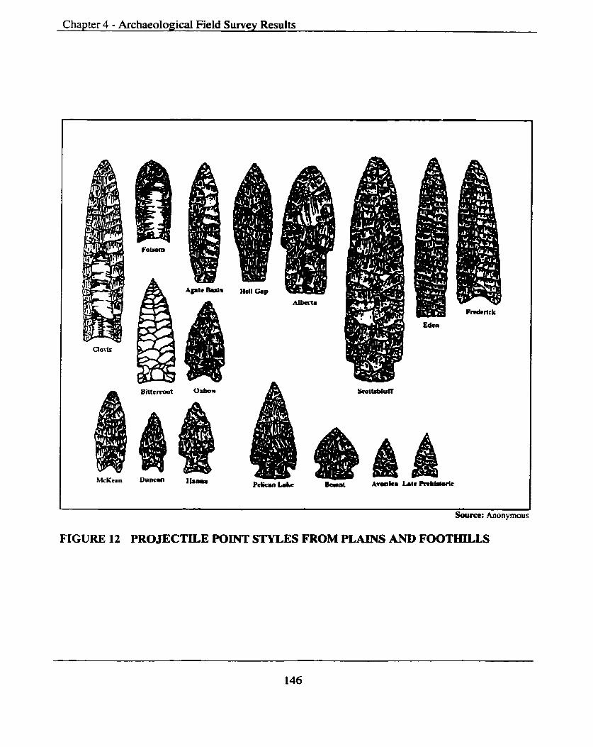
Chapter 4 - Archaeological Field Survey Results
Soum: Anon-vrnous
FIGURE 12 PROJECTILE POINT STYLES FROM PLAINS AND FOOTHILLS
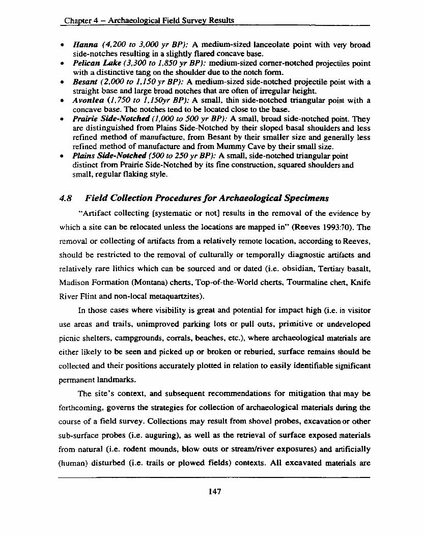
Chapter 4 - Archaeological Field Survey Results
Hanna (4,200 to 3,000 yr BP): A medium-sized lanceolate point with very broad side-notches resulting in a slightly flared concave base. Pelican Lake (3,300 to 1.850 yr BP): medium-sized comer-notched projectiles point with a distinctive tang on the shoulder due to the notch form. Besant (2,000 to 1,150 yr BP): A medium-sized side-notched projectile point with a straight base and large broad notches that are often of irregular height. Avonlea (1,750 to 1,150yr BP): A small, thin side-notched triangular point with a concave base. The notches tend to be located close to the base. Prairie Side-Notched (1,000 lo 500 yr BP): A small, broad side-notched point. They are distinguished from Plains Side-Notched by their sloped basai shoulders and less refined method of manufacture, from Besant by their smaller size and generally less refined method of manufacture and from Mummy Cave by their small size. Plmns Side-Notched (5Ml to 250 yr BPI: A small, side-notched triangular point distinct from Prairie Side-No tched by its fine construction, squared shoulders and small, regular flaking style.
4.8 Field Collection Procedures for Archaeologr~caL Specimens
"Artifact collecting [systematic or not] results in the removal of the evidence by
which a site can be relocated unless the locations are mapped in" (Reeves 199370). The
removal or collecting of artifacts from a relatively remote location, according to Reeves,
should be restricted to the removal of culturally or temporally diagnostic artifacts and
relatively rare lithics which can be sourced and or dated (i-e. obsidian, Tertiary basalt,
Madison Formation (Montana) cherts, Top-of-the-World cherts, Tourmaline chert, Knife
River Flint and non-local metaquartzites).
In those cases where visibility is great and potential for impact high (i.e. in visitor
use areas and trails, unimproved parking Iots or pult outs, primitive or undeveloped
picnic shelters, campgrounds, corrals, beaches, etc.), where archaeological materials are
either likely to be seen and picked up or broken or reburied, surface remains should be
collected and their positions accurately plotted in relation to easily identifiable significant
permanent landmarks.
The site's context, and subsequent recommendations for mitigation that may be
forthcoming, governs the strategies for collection of archaeologicd materials during the
course of a field survey. Collections may result from shovel probes, excavation or other
sub-surface probes (i.e. auguring), as well as the retrieval of surface exposed materials
from natural (i-e. rodent mounds, blow outs or s t redr iver exposures) and artificially
(human) disturbed (i-e. trails or plowed fields) contexts. All excavated materials are

Chapter 4 - Archaeological Field Survey Results
recorded in appropriate catalogues and submitted as an obligation of the research permit.
The circumstances involved with surface collecting are fiirther elaborated or based on the
provincial and federal guidelines with additions made by the author which better suit the
nature of investigations within the overall study region and this research design.
In selected instances sub-surface exploration (shovel tests) to determine the nature
and extent of both natural (stratigraphic) and cultural (site) information supplemented
visual surface inspections. Shovel tests were utilized to evaluate areas with potential for
buried near-surface archaeoiogical sites lacking suitable archaeological visibility or
exposure. It is important to note that some sites and areas were not shovel tested because
of their potentially high religious or spiritual (i.e. vision quest sites) significance or their
environmental sensitivity (i.e. high alpine ecoregions). In situations exhibiting either of
the above criteria, methods of "as found" recording were undertaken and only non-
destructive methods were employed (i-e. site inventory form completion, photographic
documentation and detailed line drawings-when weather (wind usually) permitted).
Shovel test prospecting was mostly judgmental depending on a site's situation.
Prospects were on the average 40 cm x 40 cm with the sod or forest 'litter-mat' set aside
for eventual replacement. Removed soil and other sediments were screened, in 1/4-inch
mesh, when possible (i.e. when soil or regolith was not too wet or hard) and sod replaced
slightly compacted in order to restore the site to the best of our abilities. The particular
geomorphologic landform and sedimentary depositional sequences determined depth of
individual shovel tests. Depths ranged from a few centimeters to over a meter. If deemed
necessary, because of observed at or near surface archaeological materials, the underside
of the sod was hand trowelled. As well, all spoil that was not screened was trowelled by
hand.
In those areas deemed to have high a potential for accelerated erosion shovel tests
were excavated off the trail - usually to both sides if possible.
Landforms with the potential for deeply buried deposits or that were interpreted as
stratigraphically complex but that lacked suitable exposures for examination were
recorded in field notes. These included river terraces and fluvial (river) deposits (i.e.
deltas) along the Belly River (in the BTL) where sedimentary columns exceeded the
depth practical for shovel tests. Significant fluvial and alluvial (low angle fan deposits)

Chapter 4 - Archaeological Field Survey Results
do exist (i.e. in the BTL, Akamina Valley and the Castle-Carbondale valleys). Reeves
( 199359) notes, "sites in the.. . Waterton and Crowsnest [valley J have occupations in
excess of 8,000 years buried deeply in fans."
During the course of these field investigations it was not deemed desirable, or
practical (i-e. due to time and financial constraints), to test for deeply buried
archaeological deposits in the fans or terraces. This usually requires a tire or track
mounted backhoe excavation at great cost, which is also very destructive.
Recommendations are provided for project specific developments within Interim and
Final reports in those areas with high potential for intact deep deposits.
The excavation of shovel tests is not expected to locate sites in all cases. It does
however result in a higher discovery rate than if field survey relied solely on surface
inspections, especially in conditions of low archaeological visibility (i.e. thick ground
cover or vegetation). In the location of Recontact heritage sites within the study region
the following factors influencing site visibility were considered:
the nature and structure of archaeological sites is highly variable with most sites found, and previously recorded, being relatively small campsites whose subsurface and surface artifact frequencies or activity areas are spatially clustered and often represent former lithic reduction stations (flaking areas), dwelling floors or hearth areas;
a high number of surfaces within the study region are of relatively recent age - less than 5,000 rears of age therefore a minimal potential for deeply buried archaeological materials (i-e. shallow sedimentary profiles) is present in many areas;
fire-broken-rock (FBR - also called fire-cracked-rock or FCR) is often a useful location indicator of archaeological sites especially in mountain or forest environments under conditions of high vegetation cover. Note: Rocks chosen for their specific heat retaining qualities and subsequently used in hot rock roasting, stone boiling, sweat lodges or merely defining a hearth (fire-pit) generally exhibit different and more intense fracturing than those cracked from direct sun or other natural causes;
organic remains (i.e. faunal remains) are often useful site indicators but they seldom preserve in the largely forested acidic soils and sediments within the study region;
those artifacts found exposed in trails and several high alpine locations are replaced - once collected - at a very slow rate - if ever. Note: Reeves (1993: 69) observed that, "in Waterton some sites that were located 25 years ago in the alpine [that were] found through inspection of trails, have yet to yield another artifact." Therefore the

Chapter 4 - Archaeological Field S w e y Results
collection of artifacts in some locations was done not only on the basis of finished or diagnostic tools or exotic lithic types;
locations deemed suitable for vision quest sites utilizing Reeves' (1996b:ii) "right rock and view" hypothesis were actively sought out Note: Reeves explains "...with few exceptions the sites [vision quest] occur in those locales which have a direct view to Ninastakis [Chief Mountain] and where the right kind of rock [includes the Pwcell basalt and diorites] is present."
Use of these techniques in and adjacent to the study region (i-e. specifically WLNP
and the Crowsnest Pass) has according to Reeves (1993:70) "been highly successful in
the location of both shallowly and deeply buried pre and post contact Native sites" and
". . . where development projects are involved and the area is to be destroyed, application
of a motorized backhoe and scraping techniques is an highly effective method of locating
sites which would otherwise not be located through hand prospecting techniques."
4.9 Selection of a Suitable Sampling Design The selection of a suitable sampling design is necessarily "done in relation to the
size and environmental characteristics of the survey area: funding, logistics and personnel
and specific research goals" (Fladmark 1978:03). Hadmark continues "...if the area is
too Iarge or rugged to allow examination of 100% of the ground surface.. .then one must
select a sampling method to determine which parts of the survey area [or study region]
will be examined and which will not."
The research team employed a variety of sampling designs in order to locate and
identify archaeological sites. Since there are numerous approaches to archaeological field
survey and some areas within the study region had no previously recorded sites, strategies
varied. Systematic surface inspections were made along exposures afforded by identified
trails and mountain peaks in WLNP. Other sub-regions such as the BTL, Castle-
Carbondale and the Akamina-Kishinena valley required judgmental sampling strategies
based o n known site densities and distributions, archival searches and the author's
personal experience.
Consultations with the project manager, Rob Watt, Dr. M. P. R. Magne and Gwyn
Langemann were ongoing and assisted greatly in developing field methodologies and
sampling strategies.

Chapter 4 - Archaeological Field Survey Results
4.9.1 Collection of Surface Mate*
The type of project (i.e. Historic Resource Impact Assessment - HRIA - or pure
research) guides surface collection strategies, ultimate evaluation and subsequent
recommendations intended for that site. Usually a representative artifact sample is
collected as a standard measure of mitigation. This refers not necessarily to a statistical
representation but to a sample taken at the field archaeologist's discretion in order to
"document assemblage variability in style, function and morphology. Sample size may be
dictated by the requirement of assemblage variability" [Alberta Culture and
Multiculturalism 1989: 4.1 1). These Alberta provincial guidelines outline sample
numbers depending on whether or not mitigation is going to be recommended. Sites with
a small number of artifacts (less than 30) are recommended for total collection and those
with larger artifact assemblages (more than 30) must have a minimum sample of 30. The
mapping of each collected specimen is preferred, as is a systematic procedure for
collecting.
Collection of archaeological materials at those sites, which will be recommended
for mitigation, should be limited to a representative sample. The sample ideally should
illustrate particular site qualities defined by previously identified research problems and
questions. It is recommended that diagnostic specimens, tools and exotic materials be
collected. If further work is anticipated, then collected specimens should be accurately
plotted.
4.9.2 Excavated Collections
All archaeological materials recovered from subsurface tests (i-e. shovel test,
auguring, cores, 1x1 meter test evaluations, etc.) during a field survey must be
maintained. A record was kept that identifies observed/collected materials from any one
test-unit (shovel test), site or region distinguishable from others. The catalogues and lithic
analysis are provided in site pennit reports.
4.10 Final Disposition of CoUections
Within the province of Alberta "by virtue of Alberta regulation 124/79, a permit
holder must transmit to the Provincial Museum of Alberta, Archaeology and Ethnology
Branch, Edmonton, Alberta within specified time period, in addition to site records, all
Chapter 4 - Archaeological Field Survey Results
cul turd and natural specimens collected pursuant to the permit.. . " (Alberta Culture and
Multiculturalism 1989: pg. 7.4).
Within the province of British Columbia the permit holder must prior to receiving
the permit make arrangements for the disposition of materials collected. In the case of
this project the Royal British Columbia Museum in Victoria BC had agreed to curate any
collected archaeologicd materials.
Collections made within WLW are forwarded upon completion of cataloguing and
conservation, if needed, to the Parks Canada Western Region Archaeological Services
Unit in Calgary. The Archaeological Services Unit maintain for display or educational
purposes only a representative sampling of archaeological specimens and the rest are
forwarded to Winnipeg. Manitoba for final curation.
Those archaeological materials removed from the BTL remain the property of the
Blood Tribe with final disposition of them dependant on Tribal officids' requests.
No collections were made from within the boundary of AKPP as stipulated within
the permit received from BC Provincial Park officials.
4.1 1 Record Keeping
Under provincial and federal guidelines all holders of archaeological research,
mitigation or other permits are required to keep a detailed documentation of all field
related activities. These documents and materials are considered ancillary to the final
report and often are included within. The following provides a list of records that most
governing agencies require:
field notes - a daily log of work undertaken, observations and recommendations made and similar items must be kept and usually submitted; artr!act docurnentation - a catalogue of all collected and notes on observed specimens. including their provenience, must be maintained and submitted; plrotographric documerrlolion - al l photographs taken during the course of the impact assessment or research project must be catalogued as to content. When photographic transparencies (slides) form part of the record. a representative catalogued sample must be submitted; and, site data - all site data including archaeological inventory site forms, ancillary data forms, site maps and site profiles are to be documented and submitted.
(Guidelines for Archaeological Pennit Holders in Alberta: Alberta Culture and
Multiculturalism 1989: pg. 4.13).

Chaoter 4 - Archaeoloeical Field Survev Results
These materials form the permanent record of the individuai sites and the project.
Their submission is critical for not only site evaluation and significance estimation but
also, long-term management.
4.12 FonnuMon of Recommendations
The recommendations arising from archival and fieldwork are critical components
of the archaeological site management process. The context and caliber of the
recommendations will have a significant influence upon the future disposition of
archaeological sites. Recommendations should be well supported, unambiguous and
detailed in nature. They are formulated on the basis of the level of available site-specific
information and within the context of the predicted impact (if any). Avoidance, the
preferred option, implies site preservation whereas mitigation implies some level of
destruction. At significant sites avoidance is preferred and mitigative measures are only
developed and subsequently implemented after all available options have been exhausted.
Further, recommendations wiU follow the format outlined in provincial and federal
regulations. This will include, but not be limited to, Borden Numbers, Parks Canada
designation numbers, detailed site descriptions, cultural material content and density, an
estimation of site integrity, avoidance and other protective measures.
4.13 Cultural H e d g e Site Descriptions
An archaeological survey within selected portions of the study region was carried
out during the 1998 and 1999 field seasons. Field investigations were initiated in May of
1998 and continued until September of 1998 and again in April of 1999 until October of
1999. Days spent in the field were not contiguous, meaning we were not out every day
but rather on an intermittent basis dictated by weather, location of planned activities and
other matters of logistics. The research team lives in the study region so was allowed
considerable flexibility.
Ancillary to the primary purposes is the aim of assisting stakeholders namely, Parks
Canada and BC Provincial Park staff, both the Alberta and BC provincial regulatory
agencies, as well as the Blood and Ktunaxa-Kinbasket tribal councils and other cultural

Chapter 4 - Archaeological Field Survey Results
heritage site managers to better manage the Recontact cultural heritage sites contained
throughout the study region.
The study region was divided into sub-regions based on current land status (i.e.
BTL, Front Ranges, Foothills, Castle-Carbondale Valley, WLNP, AKPP, GNP,
Akamina-Kishinena Valley, Sage Valley and Flathead Valley). The nature and results of
field investigations are briefly summarized below. This section provides a summary of
field investigations intended to complement this MDP document and assist in defining
issues and providing strategies. Fully documented interim reports, including restricted
site-specific information (see Wood 1998. 1999a, 1999b) are being prepared for the
regulatory agencies as required by federal and provincial legislation in completion of
research permit requirements.
All field and related archival research are reported by sub-region in Appendix B
(Archival and Field Research Activities). Included within are Borden Numbers and Parks
Canada (PC#s) Numbers, site name (if given or known), site type (if discernible), land
status, site status (new or revisit), site condition and significance rating, investigations
undertaken and management direction recommended.
Field investigations resulted in the discovery of new sites in all sub-regions except
WLNP where the research team focused on the monitoring of areas perceived as
receiving a moderate to high amount of visitor use (i.e. trails and favorite camping,
hiking or climbing areas) and GNP where no in-field visits were conducted. The potential
exists for the discovery of new sites within the confines of WLNPs borders in more
remote regions and in some of the regions that the team did visit. The results of archival
and related field investigations are presented in Table 11.
Archival research and field investigations are summarized below by sub-region and
include a brief overview of objectives, methodologies, results and evaluations. Not
included in this MDP is detailed site information including completed site inventory
forms, artifact catalogues and descriptions, complete site photos or maps. Much of this
information is not considered public nor directly pertinent or essential for inclusion in
this MDP. This information is presently being prepared and will be included in
jurisdiction specific research or investigative reports as required by the research permits
currently held by this author.
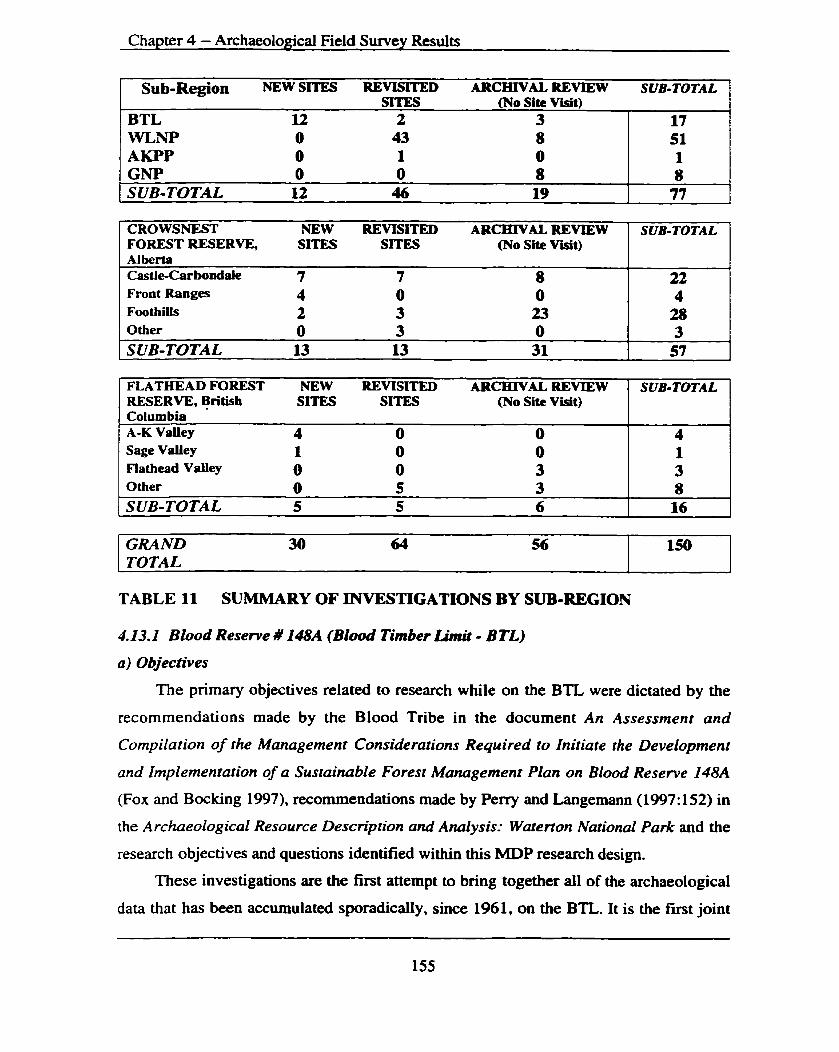
Chapter 4 - Archaeological Field Survey Results
Sub-Region NEW SITE!3 REVISITED ARCHIVAL REVIEW SUB-TOTAL ' SITES (No Site Visit) ,
BTL 12 2 3 WLNP 0 43 8 AKPP 0 1 0 GNP 0 0 8 SUB-TOTAL 12 46 19
CROWSNEST NEW REVISITED ARCHIVAL REVIEW FOREST RESERVE, SITES SITES (No Site Visit) Alber!a Castle-Carbondale 7 7 8 Front Ranges 4 0 0 Foothills 2 3 23 Other 0 3 0 SUB-TOTAL 13 13 31
17 51 1 8 77
SUB-TOTAL
22 4 28 3 57
FLATHEAD FOREST NEW REVISITED ARCHIVAL REVIEW RESERVE, British SITES SITES (No Site Visit) Columbia A-K Valley 4 0 0 Sage Valley 1 0 0 Flathead Valley 0 0 3 Other 0 5 3 SUB-TOTAL 5 5 6
TABLE 11 SUMMARY OF INVESTIGATIONS BY SUB-REGION
SUB-TOTAL
4 1 3 8 16
GRAND 30 64 56 TOTAL
4.13.2 Blood Reserve # 148A (Blood Timber Limit - BTL) a) Objectives
The primary objectives related to research while on the BTL were dictated by the
recommendations made by the Blood Tribe in the document An Assessment and
Compilation of the Management Considerations Required to Initiate the Development
and Implementation of a Sustainable Forest Management Plan on Blood Reserve I48A
(Fox and Bocking 1997). recommendations made by Perry and Langernann (1997: 152) in
the Archaeological Resource Description and Analysis: Waterton National Park and the
research objectives and questions identified within this MDP research design.
These investigations are the fmt attempt to bring together all of the archaeological
data that has been accumulated sporadically. since 1961, on the BTL,. It is the first joint
150
Chapter 4 - ArchaeoloRical Field Survey Results
research project initiated by regional stakeholders and the fmt attempt at incorporating
the BTL into its larger regional context with the surrounding WLNP and the province of
Alberta.
b) Methodology
A site file search was conducted for the BTL prior to field investigations and also
for regions immediately surrounding the BTL; namely, adjoining portions of WLNP, the
Belly River valley to the north and Mokowan Butte to the east. Numerous archaeological
sites have been previously recorded in al l regions. A better understanding of the history
of the BTL can be obtained by gaining an understanding of site types, distributions and
densities in the adjacent regions. Fieldwork consisted of the archaeological
reconnaissance via foot traverse of landforms considered to have the highest
archaeological potential and the subsurface testing of selected areas on those landforms.
Survey techniques were dictated by many variables such as topography, vegetation
cover and other natural and human induced disturbance factors. Typically, in forest
environments the probability of finding surface remains of archaeological sites is low.
Therefore, the research team employed a combination of strategies, which included the
visual examination of natural (stredriver cuts) and human induced (wagon roads/truck
trails) surface exposures, the examination of rodent (gopher) mounds and a program of
sub-surface shovel tests.
The majority of the flat, grass covered area, on Beebe Flats was not surveyed. A
systematic random stratified program of shovel-testing was initiated during the 1999 field
season on the large geomorphologically undifferentiated expanse, which makes up the
majority of the Flats. Due to time considerations these investigations were not completed
but areas deemed to have the highest potential <i.e. relict stream and river channel
margins and areas afforded protection from the west winds) were sufficiently tested.
Judgmental survey techniques based on the principal investigator's experience,
acquired knowledge of the BTL and regional patterns (site densities and distributions)
and research decisions as to where sites should be located were employed. Judgmental
survey techniques were employed when 100% coverage could not be achieved, as it
seldom can.

Chapter 4 - Archaeological Field Swvey Results
C) Resuits and Evaluations
i) Previously Recorded Sites
A search of provincial and federal archaeological site inventory files produced six
previously recorded archaeological and historic sites. During the 1998 field season five of
these sites were relocated and 12 additionat archaeological sites were recorded (see Table
1 1 and Appendix B).
Information contained in the previously recorded site inventory forms was often
ambiguous and included no general or detailed site maps to aid in site re-location. Other
locational data including UTM coordinates were often incorrect (see DgPk-02) and
directions to others confusing (see DgPk- 12). DgPk- 12 was relocated and presently
consists of s series of cairns (n=3) on top of Lookout Butte (see Plate 1). DgPk-02 was
recorded by information received from a Blood Tribe informant but never actually seen
by the original recorder. Still others (DgPk-13) where ". ..chips [lithic flakes], bones and
tools.. ." had been reported ". . .eroding out of a wagon road and trails.. ." could not be
located because they were probably destroyed by the construction of an oiYgas lease
road.
The research team did re-locate DgPk-14, which is recorded as having both post
and Precontact significance and was evaluated as being stable and not presently in danger
of being impacted by other than rodent diggings. The site below and on the east side of
Lookout Butte (Lease Meadow Site DgPk-15) (see Plate 2) was also relocated where a
substantial mount of FBR, lithic flakes, tool fragments and debitage was observed and
collected. The site is to date the most significant on the BTL for the amount and diversity
of cultural materials found on the surface and recovered from a shovel-testing program. It
is presently being impacted by rodent activities, cattle grazing and picnicking or camping.
The site size was increased to include both sides of the road but two earlier recorded
", . .unnatural mounds approximately six by two feet.. ." were not mlocated.
ii) Newly recorded sites
Newly recorded sites were varied in cultural material observed/collected,
significance rating assigned and interpreted activities associated with them. Most were
categorized as surface campsites @gPk-103, 110 and 112) and lithic, tool scatters or

Chapter 4 - Archaeological Field Survey Results
workshops (DgPk-1% and 107) assigned low to moderate ratings with no further work
recommended other than periodic monitoring. Others were more complex with evidence
of both contemporary and traditional use (DgPk-104, 105, 109 and 11 I). These sites
contained evidence of recently abandoned sweat lodges. numerous cloth ribbon offerings
and as in the case of DgPk-105 the WeU-Ribbon Site (see Plate 3) a possible dream-bed
locations. There may be an association with the nearby Sofa Mountain vision quest
structures above the BTL and in WLNP. DgPk-111 appears to be a multiple use site
exhibiting recently abandoned sweat lodges, ribbon offerings, a buried Precontact
component, nearby Culturally Modified Trees (CMTs) and potentially an historic surface
component (i-e. Old Man Beebes' unofficial homestead). One site (DgPk-113) is a CMT
with names, initials, and dates carved into large balsam poplar trees. DgPk-108, 109 and
114 are categorized as having undetermined functions and characterized by both surface
and subsurface Lithic and faunal remains. They probably represent temporary campsites
or single animal kill and processing sites.
During the 1999 field season a shovel-testing program was conducted along
selected portions of a relict North Fork Belly river channel and the Belly River with no
further sites recorded. Information obtained from various sources also included the
location of the remains of an old rifle and other historic remains. Members of the Blood
Tribe found these remains during the fighting of the Sofa Mountain fire in the fall of
1998. To date this author has not been able to view the rifle to ascertain its age or make.
Another tribal member involved in the bull trout studies sponsored by the Blood Tribe
and WLNP has recovered two projectile points from an as of yet undisclosed location on
the BTL.
Also during 1999 the research team investigated portions of the BTL and WLNP
that had been burned by the Sofa Mountain fire because of the increased visibility.
Although numerous, seemingly modem, faunal remains were noted no further
archaeological sites were recorded.

Chapter 4 - Archaeological Field Survey Results
4.13.2 Waterton b k e s N & d Pwk
a) Objectives
The main objective of field activities within WLNP was to monitor and assess
impact on high elevation visitor use areas (i.e. trails, passes, campsites), complete the
recording of several newly reported high alpine vision quest sites in some of the parks
more remote regions and review all available documentation - which is extensive - with
the intention of assisting in the identification of the potential for new heritage sites in
adjacent sub-regions.
b) Methodology
Research within WLNP included an archaeological survey and inventory of
selected high alpine trails and passes. An examination of the trails and passes was made
to assess if recreational or other activities are jeopardizing the integrity of archaeological
sites.
These high Alpine mountain trails and passes were reportedly utilized by
indigenous aboriginal groups for thousands of years and many of them, with the
exception of the Akamina and Middle Kootenay Pass to the north have been virtually
untouched by modem development. Archaeological and ethnographic data attests to the
potentid use of this region as a trade, transportation and cultural diffusion corridor (pers.
comm. W. Choquette. Dec. 1997). Recreational use and interest by resource extraction
proponents is increasing in these regions and an archaeological survey/inventory is
needed to locate heritage sites and assess potential impacts in advance of development.
Another important component of the WLNP research is the archaeological survey
and inventory of recently reported vision quest sites on high alpine mountain peaks and
ridges. WLNP has a high number of recorded vision quest site locations. Several other
locations had recently been reported by independent sources and verification of their
existence is essential and the first step to proper management of this significant site type
(Reeves 1996b). The fragile nature of the high alpine locations of these sites makes them
vulnerable to disturbance by naive park visitors (Perry and Langemann 1997: 13 1).

Cha~ter 4 - Archaeoloeical Field Survev Results
c) Results and E v a l ~ m
i) Previously recorded sites
Field research and related activities within WLNP consisted of the archival review
of 51 Precontact archaeological sites and included site visits to 43. Most of these sites
were in high elevation Locations in the Bauerman, Blakiston, Yarrow, Dungarvan and
Galwey watersheds in the Parks eastern, northern and nofieastern regions.
Field investigations within WLNP consisted of monitoring and revisiting previously
recorded sites along several major trails that receive heavy visitor use, completion of site
forms on recently reported high elevation vision quest sites, investigation of high
elevation passes to monitor and complete the appropriate site inventory forms.
Field investigations on Sofa Mountain (DgPk-3 11153 1R. DgPK-98/1802R, DgPk-
104/ 1532R, DgPk- 1051 1533R, DgPk- 10611 536R) (see Plates 4 and 5) and Crandell
Mountain (DgPl- 16 111 338R, DgP1-16011337R and DgPl- 189) (see Plate 6), above Goat
Lake (DgPk-2811528R) (see Plate 7) on both Avion and Cloudy Ridges (DhPI-13/1534R,
DhPl-14/1544R and DhP1-151no PC#) (see Plate B), Kishinena Peak and at the South
Kootenay (DgPm-03/764R), Sage (DgPm-3 111838R) and Akarnina Passes resulted, in
most cases, in the production of detailed site maps, photographs and written
documentation of highly significant and vulnerable vision quest sites, trailslpasses and
campsites. Some of these represent the first documentation of these sites. These sites
receive moderate to heavy visitor use from hikers and climbers and require regular
rnoni toring.
Field investigations in WLNP also included the monitoring of mid and lower
elevation locations and trails where numerous sites have been previously recorded.
Investigations consisting of mostly visual inspections, photographs and updating of site
forms were conducted at locations including the Red Rock Canyon parking lot (DgPm-
Oll762R), along the Bauerman trail (DgPm-02/763R, Dgh-09/770R and 1513R). Twin
Lakes (DgPm- 17/778R, DgPm- 18l779R), Kesler Lake @W-07/936R, 1537R, 1539R),
Lake Linnet (DgPl- 1 8/646R), the Narrows (DgPI-04/638R), the Dardanelles (DgPl-
OU637R) and Maskinonge (DgPI- 1 11640R).
Many other sites were located while on route to these locations and a considerable
number of sites were investigated only through a review of the site inventory forms.

Chapter 4 - Archaeological Field Survey Results
Past and present impacts to sites within WLNP are variable and will require site
specific management strategies to mitigate impacts.
ii) Newly recorded sites
There were no new sites recorded within Waterton Lakes National Park during the
coarse of this MDP research. Field investigations were restricted to heavily used trails,
mountain peaks and high elevation ridges. An attempt was made to complete the
documentation of previously reported but as of yet not recorded significant sites and
assess park visitor use impacts. The potential does exist for more Precontact cultural
heritage sites within the Park and most assuredly more will be found in the future.
4.13.3 A kamina- Kishinena Provincial Park, British Columbia (A KPP)
a) Objectives
The purpose of these field investigations was to assist Parks Canada and BC
Provincial Park staff, the and Ktunaxa-Kinbasket Tribal CounciVMembers and other
stakeholders to better manage the Precontact archaeological sites within AKPP by
providing additional research and information. Research within AKPP required
completion of the following objectives.
The 1" phase of research included the examination of topographic maps and air
photos, archival search of private consulting reports, university research papers and other
public and private reports/publications. It also included a preliminary in-field visit and
helicopter fly-over of Akamina-Kishinena valley.
The 2"d phase of research included an archaeological survey and inventory of
selected high alpine trails located within the park. Field investigations included an
examination of the trail system to assess if past or present recreational, resource
extraction, or other activities are now jeopardizing, or have in the past jeopardized, the
integrity of heritage sites.
The 3* phase of research included an archaeological survey and inventory of high
alpine mountain passes within, and immediately adjacent to AKPP. Passes and trails that
were investigated included the South Kootenay, Akamina and Sage Passes.
The 4h phase of research included the re-visit of previously recorded archaeological
sites within and adjacent to AKPP.
Chapter 4 - Archaeological Field Survey Results
This research project is appropriate and relevant to the mandates and objectives of
BC Parks and more specifically to AKPP. The archaeological investigations are all
related to survey and inventory levels of information gathering. These are largely non-
destructive and do not threaten or endanger the archaeological sites being investigated. In
fact the AKPP has, to date, not been sufficiently covered by an archaeological survey.
The primary purpose of these investigations was to identify, define and properly record,
in both a photographic and written format, those Precontact heritage resources within
selected regions of the Park. Subsurface investigations were not conducted and as
outlined in the permit (see Appendix D) no surface collections were made. The high-
alpine nature of AKPP negated the need or desire for shovel-testing.
Secondary to the above primary purpose of site identification and definition is
assessing the past and present impact that the regions' resource exploitation and
recreational users are having on the Parks heritage sites. This was accomplished by
walking several of the Parks trails, mountain passes, and examining them for heritage
sites whose integrity has been jeopardized and conducting comprehensive archival
research.
The significance of this research and benefits for BC Parks are three-fold:
1). Because of the limited archaeological research in the AKPP there is insufficient
information on aboriginal site location to properly manage them - this project will
potentially identify previously unrecorded or undocumented sites;
2). Because of the Parks attraction to the ever increasing numbers of recreational users
the region is experiencing, many high alpine sites may be in jeopardy from naive
park visitors - this project wiI1 begin to identify by foot traverse those trails and
passes that are experiencing higher use and heritage sites that are being impacted;
3). Because of the Parks location adjoining WLNP and Glacier National Park the
records of aboriginal site locations are often maintained by a number of disparate
sources and research is often undertaken in a non-regional manner, with access to
reports extremely lirnited/difficult. This project will begin to place AKPP into the
larger regional picture of aboriginal site location, protection and management.
Chapter 4 - Archaeo1op;ical Field Survey Results
6) Methodology
Permit applications were forwarded to the appropriate agencies, namely the British
Columbia Heritage Conservation Board, Victoria BC Provincial Parks. Wasa and the
Ktunaxa-Kinbasket Tribal Council, Cranbrook before any field investigation was
initiated. The necessary pertnits were received prior to undertaking field investigations.
Preliminary literatwe reviews and known archaeological site locational information
were requested and received from the appropriate agencies before field investigations
were initiated namely: BC Provincial Parks - Kootenay Region, Wasa, BC Ministry of
Small Business, Tourism and Culture - Archaeology Branch, Victoria, Waterton Lakes
National Park, Waterton Lakes, Archaeological Services Unit, Calgary and the Provincial
Museum of Alberta - Archaeology Branch, Edmonton.
C ) R e s u k and Evaiuations
i ) Previously recorded sites
Archival investigations resulted in the identification of one site in AKPP (DgPm-
03/764R), the South Kootenay Pass (see Plate 9). This is perhaps the single most
important site yet to be identified in this portion of the sub-region and the overall study
region. Its significance lies in the pivotal role that it played in the highly documented
trans-mountain travels of the Ktunaxa to gain access to the bison herds on the plains. Its
connection to the well-documented site at Red Rock Canyon (DgPm-01/762R) in WLNP
and the newly recorded sites in the nearby Akamina-Kishinena Valley can only be
hypothesized at this time. Further field investigations, archival stcdy and elder interviews
are necessary to fully understand the importance of the trails and passes.
The importance of the geographical proximity and central Iocation of AKPP to the
rest of the study region in respect to trails and passes and the complication arising out of
fact that the South Kootenay Pass site is on the border and controlled by multiple
agencies (Parks Canada, BC provincial parks and both the BC and Alberta provincial
governments) complicates management.
Impact to the high elevation site is from horseback riders, hikers, natural agencies
(wind, water, frost and down-slope movement or creep) and potentially from hunting
activities from the BC side. The potential for more sites along the Continental Divide is

Chapter 4 - Archaeological Field Survey Results
high and investigations should include the entire ridge south to the Akamina Pass and
Ridge above Cameron Lake.
The Akarnina Pass and trails to both Wall and Forum Lakes were also examined.
This more southerly portion of AKPP receives high visitor use as is evidenced by the
deeply worn trails. Although no Precontact cultural heritage sites have been previously
recorded on the main routes to both lakes the potential for campsites is moderate to high
in some Iocations. The main trail used to be a road and vehicles were allowed into the
Akamina-Kishinena Valley until the late 1970s. Locals from Cardston and Pincher Creek
as well as the Waterton town site regularly fished and hunted on the BC side. Early
logging and oil drilling was also conducted on the BC side with the logs for the Prince of
Wales hotel, in the 1920s, and the Waterton town site coming from this area.
ii) Newly recorded sites
There were no new sites recorded within the borders of Akamina-Kishinena
Provincial Park. Field investigations were restricted to the South Kootenay TraiVPass,
Akamina Trail/Pass and the Wall and Forum Lakes and the trails leading up to them.
These are the most heavily used areas of the Park and are also considered by this author
to have the highest potential for Precontact cultural heritage sites.
Other portions of the Park, particularly along the Continental Divide, also have a
high potential for high elevation sites (i-e. rock alignments associated with sheep and goat
hunting, cairns, trails, etc.) and require investigation. Access to these high elevation
regions is difficult but once attained mobility is relatively easy.
4.1 3.4 Alberta Provincial Lands
The Alberta portion of this research project that falls under the Provincial Museum
of Alberta's Archaeology and Ethnology Branch's jurisdiction plays a minor, but
important, role in the overall project.
Field investigations within the Crowsnest Forest Reserve and Front Ranges
included research in the Middle and North Kootenay Passes, the Yarrow and South
Drywood Valleys and portions of the Castle-Carbondale Valleys.
Locations within the Foothills sub-region included field visits to the Birdseye Butte
and unnamed hill on, and to the north-west, of the Birdseye Ranch, the Hudson's Bay

Chapter 4 - Archaeological Field Survey Results
Butte/Observation Point east of WLNP and north of Highway # 5, the Pine Ridge north-
east of WLNP and 'Bald Hill'/Council Butte north-east of the BTL and adjoining
portions of nearby WLNP.
The inventory of known and unknown archaeological sites contained in these
regions is important to helping place WLNP into its proper regional context and in
gaining a better understanding of the entire study region. It should also be noted that most
of the previously recorded archaeological sites in these regions have not been revisited
for over 20 years and most need to be mapped, properly recorded and their overall
integrity assessed. Objectives, methodologies and evaluations within sub-regions are
varied and identified appropriately within the following section.
4.13.5 Castle-Carbondale Valley
This sub-region consists of moderate to steep sided mostly forested mountains north
of WLNP and south of the Crowsnest Pass. It includes portions of the Castle, Carbondale,
South and West Castle River drainages as well as selected portions of the Lynx and Lost
Creek drainage's, especially at their confluence with aforementioned rivers. It included
regions from the Continental Divide in the upper watershed of the Carbondale River and
the vicinity of the North Kootenay and McDonald Passes and the upper Castle River
watershed in the vicinity of the Middle Kootenay Pass.
a) Objectives
Re-locate the recently reported sites in the Lynx Creek and the Carbondale River
areas located by Vivian (1997) in relation to the Crowsnest Pass Pipeline project and
further access impact to other previously recorded sites, especially DiPo-01, recorded by
Forbis and the Glenbow Foundation Survey, revisited by Heitzmann and Priegert (1978)
and later assessed and excavated by Gryba (1980) and Quigg (1981) in advance of the
bridge replacement.
Survey the valley from the confluence of Carbondale and Lynx Creek to the height
of land known as the North Kootenay Pass. The Alberta and B.C sides of the traiUpass
probably have to be surveyed separately because the ruggedness of the region and the fact
that the pass is impassible by quad.

Chapter 4 - Archaeological Field Survey Results
b)MethodoZogy
It is impossible to obtain 100% coverage of the Castle-Carbondale due to its
immense size and diverse physiography. Areas that were investigatsd include the
Carbondale Valley upstream from the Carbondale Bridge and the Lynx Creek
campground. Portions of the West and South Castle valleys were also visited briefly to
assess potential but contain no previously recorded sites nor were any new ones found.
These investigations were very preliminary in nature and do not constitute a
comprehensive field survey.
Suitable landforms investigated most notably included river terraces and the
confluence of tributary streams and rivers. Numerous rodent mounds were examined as
were ATV, motorcycle, unimproved truck trails, modern-day random camping sites and
other human induced exposures.
C ) Results and Evaluations
The investigations conducted by Vivian (1997) and this author confirm the
significance of the sub-region as a past seasonal settlement and resource harvesting area.
The identification of numerous Precontact archaeological sites along the proposed
Crowsnest Pipeline Project HRIA and under the guise of this research initiative has
produced sites and site clusters of regional significance. Their presence is most likely
indicative of a larger and more complex regional archaeological association of sites as
indicated by the large numbers of recorded sites in the adjacent Crowsnest Pass and
WLNP.
Past and present impacts to the Recontact archaeological sites identified in the sub-
region are from a variety of sources including but not limited to random camping, off-
road vehicle use (ATV and four-by-four trucks) and forestry activities (i.e. logging and
related infrastructure development - roads and bridges).
i) Previously recorded sites
Field investigations were initiated in June of 1999 with revisits to the previously
recorded Dipo-01, 02, 03, 04, 05 and 11 and DiPn-11. Visual surface inspections were
conducted which included the collection of identifiable tool fragments, exotic lithic
materials and a general assessment of site situations, levels and kinds of impacts. Shovel
Chapter 4 - Archaeological Field Survey Results
tests were conducted at DiPo-01 and 03 in order to ascertain what percentage of DiPo-01
(see Plate 10) was intact and ascertain the site boundaries of DiPo-03 (see Plate 1 I).
Upon completion of the site revisits the team initiated field surveys upstream fiom
the Lynx Creek campground and the Carbondale Bridge in the general locality of DiPo-
01.
ii) Newly recorded sites
Six new sites were recorded upstream from the Carbondale Bridge including lithic
and tool scatters associated with what have been tentatively identified as temporary
hunting camps and trails associated with the use of the North Kootenay Pass. A variety of
lithic types were recovered from both surface and buried contexts including obsidian,
gray (Top-of-the-World) and white (BowmadAvon) cherts and Madison formation
(Montana) cherts,
Tool fragments included Middle Period (Pelican Lake) atlatl point fragments,
bifacial and unifacially modified flakes. Flakes were identified in the field as mostly
small bifacial reduction thinning flakes resulting from the sharpening or otherwise
modifying of stone tools.
The initial evaluation which will require verification upon completion of
cataloguing and examination of all collected archaeological materials is that the sites
recorded are temporally discrete small transitory hunting camps that were occupied while
accessing the trails and passes in the region. Previous obsidian trace element analysis
(Hughes 1997) from DiPo-03 and 04 completed by Vivian (1998) indicate two sources
including, Obsidian Cliff, Wyoming and Bear Gulch Idaho. Results of blood residue
analysis (Bioarch 1997) from a projectile point recovered from DiPo-03 produced a
positive result for deer.
Vivian (1997:32) summarizes that, "A particularly significant site complex was
identified in the vicinity of the junction of Lynx Creek and the Carbondale River - the
favored camping place on the east side of the North Kootenay Pass" (Reeves 1997). His
test excavations at DiPo-03 indicate occupations dating back at least 5,000 years
" c o n f d n g the signifcance.. .of this locale.. .not only as a camping place while crossing
the pass, but also as a significant seasonal settlement and resource harvesting locale."

Chapter 4 - Archaeological Field Survey Results
4.13.6 Front Range Canyons
The Front Ranges consist of narrow east-west oriented, steep U-shaped glacially
carved valleys and the intervening high elevation ridges and peaks. They provide relative
ease of access to the Main Ranges of the Rocky Mountains and interior portions of
southeastern BC. The ridges and peaks that separate the Front Range canyons provide
outstanding views of the prairies and many also of Chief Mountain making them ideal
places for Vision Quest sites and lookouts.
Two eastern slopes front-country canyons were selected because they were
reportedly utilized as trails/passes into the main ranges of the Rocky Mountains and
further to the Kootenay district of British Columbia. The two canyons were the Yarrow
and South Drywood Valleys. The Ymow Creek Canyon has been selected because of its
immediate proximity to the northern border it shares with Waterton Lakes National Park.
The South Drywood was selected because of the ease of access provided by the
seasonal opening of a road almost to its western terminus, the reported finding of a
complete projectile point by a Boy Scout camping at Bovine (Blue) Lake, and a trail that
appears on older editions of the National Topographic Map that provides access to the
Castle Valley. No archaeological sites had been previously recorded within the valley.
The remaining Front Range Canyons (i.e. Spionkop, North Drywood, Pincher,
Whitney and Mill) have a moderate to high potential for a variety of sites including
Vision Quest, hunting camps and trails but due to time and financial considerations they
could not all be investigated under this research project.
a) Objectives
Objectives identified within this portion of the study region were to examine the
valleys for unrecorded archaeological sites, assess past and present impact to sites and
valley, assess potential for unrecorded archaeological sites in neighboring valleys and the
ridges that separate the valleys, locate a reported ochre source and assess its suitability
for present use by local First Nations.
b) Methodology
The entire length of the Yarrow Valley was traversed by foot during the summer of
1998 with an examination of natural (i.e. stream cut, animal trails and rodent mounds)
Chapter 4 - Archaeological Field Survey Results
and cultural exposures afforded by the past construction of a road to provide access for
resource extraction proponents (i.e. oil and gas expIoratioo/exploitation).
The South Drywood valley was visited during the 1998 and 1999 field seasons. The
entire length of the valley was traversed by foot and portions were also driven by quad
and truck to further access newly recorded sites. All natural and cultural exposures were
visually examined.
C ) ResulfS and Evalutions
i) Previously Recorded Sites
There is one recorded site (DhPl-9)- at the mouth of Yarrow Canyon and several
previously reported and only recently recorded (mapped) Vision Quest Sites (DhPl-13, 14
and 15) on nearby Cloudy Ridge in the park. There is also an unsubstantiated report of a
camp of Stoney Indians who were trying to escape the epidemics in the 1700s being
plundered by Grizzly bears in the valley (pers. comm. Frank Goble 1999). Reeves also
reports a small campsite at the head of the valley (Reeves n.d.) that needed to be verified.
ii) Newly Recorded Sites
No sites were recorded in the upper Yarrow Valley although a possible ochre quarry
site and new vision quest site (Borden Number pending) were recorded on and below the
south ridge crest of Blind Canyon on Spread Eagle Mountain formerly known as Ochre
Mountain. Two new sites were recorded in the South Drywood Valley. The uniqueness of
the newly recorded South Drywood Cairn Site (DhPm-15) and Blue Lake Camp Site
(DhPm-16) (see Plate 12), and the closeness of the trail to the South Castle Valley
system, indicates the valley's potential to yield new information regarding the use of the
narrow front range canyons and mountain ridge systems.
The past environmental indications provided by the numerous widely spaced large
spruce snags resulting from forest fire(s) indicates that the newly recorded archaeological
site could be much larger. The Williams (1982) reprinted map further verifies this
possibility. Continued investigations should be carried out in the thick spruce and pine
bush on the east and south east side of the lake, the trail over the ridge, and the ridge
above the cirque headwails. An opportunity exists to test Reeves* hypothesis concerning

Chapter 4 - Archaeological Field Survey Results
the 'right rock' and 'view' of Chief Mountain afforded many of his vision quest sites in
WLNP.
Although the area is only open seasonally to vehicular -c and the lake is closed
to all motorized traffic, the area is frequented by horseback riders. hunters and campers.
The potential for more artifacts is high. There is a reported artifact collection in the
Crowsnest Pass that came from this valley some years previous. The collections should
be traced down and the site monitored regularly.
4.13.7 Foothius
The Foothills portion of the study region consists of gently rolling topography. It is
partially aspen covered and is mostly comprised of land occupied by large family owned
cattle ranches. Some portions have been broken to provide livestock producers with
winter feed and several homes have been constructed within it.
These lands are located east of WLNP in the Fescue Grass and Montane
Ecoregions. Areas to be examined were identified from the study of topographic maps,
air photos, site inventory reports and the authors experience with and knowledge about
the sub-region. Matters of accessibility and land status (i-e. some landowners denied
access to areas deemed to have high potential) dictated locations investigated.
a) Objectives
The objective of investigations was to update site information recorded almost 30
years previously on many of the high ridges and hills or buttes. These locations were
targeted because of the views afforded from the heights of land, and the fact that most
were relatively intact surfaces receiving Little impact from the farrninglranching activities.
b) Methodology
Investigations were undertaken on Birdseye Butte, Pine Ridge, Hudson Bay Butte
(Observation Point), Bald Hill (Council Butte). Investigations also included Lookout
Butte, which is reported on in the BTL sub-region.
Chapter 4 - Archaeological Field Survey Results
C) Resuits and Evaluations
i) Previously Recorded Siles
There are numerous previously recorded sites north of the BTL within and adjacent
to the Belly River Valley (see Appendix B). The available site inventory forms were
reviewed but no attempt was made to revisit the river valley. There is also several sites
east of WLNP adjacent to Crooked Creek and Hudson Bay Butte (Observation Point) on
Ben Olson's land that were not re-visited due to time constraints.
Investigations on Birdseye Butte were not successful in relocating the previously
recorded cairns (DgPk- 16). Subsequent to undertaking the field investigations a visit was
made to Dr. John Dorrnaar to ascertain if he had located them in an earlier attempt. He
had not and we confirmed that we had searched all the right locations. Subsequent
discussions with Frank Goble revealed that there had been a Boy Scout Jamboree with
several hundred scouts camped up there and the fact that it was a known 'party spot' for
decades as well. We suggest that the site has been destroyed.
DgPk-07 was relocated on Hudson Bay Butte (Observation Point) north of the
Crooked Creek campground on highway # 5 on land owned by Mr. Ben Olson. Several
cairns were mapped, an artifact scatter was recorded but no evidence of a burial, as noted
on the site form, was located. The hill top was reportedly quarried in the 1960s for rock
to face the Mormon church in the Waterton townsite (pers. comm. Ben Olson July 1998)
which may account foi. the previously reported burial type feature. Knowledge of this
disturbance was not noted on the previously recorded site form. It is possible that this is
the location that Blakiston climbed to observe Chief Mountain and the prairies beyond
hence the local name of Observation Point.
The previously recorded site on Bald HiWCouncil Butte (DgPk-72) was relocated
with exotic obsidian flakes observed and several large choppers/cores of local argillite
also noted. This hill top was also the reported location of the council held with the Blood
Tribal members before they were given the BTL in 1888 (pers. comm. E. Fox 1998) thus
the local First Nations name of Council Butte.
Chapter 4 - Archaeological Field Survey Results
ii) Newly Recorded Sites
Investigations on Pine Ridge north east of WLNP recorded a new platform cairn
(Borden Number pending) consisting of six large cobbles overlooking the Waterton River
(see Plate 13).
4.13.8 British Columbia Provincial Lands
The Flathead Provincial Forest Reserve is located within the Cranbrook Forest
District, which is in the Nelson Forest Region. It is in the extreme southeast comer of the
province of British Columbia. The areas accessed as part of this research initiative are
contained within the Akamina, Kishinena and Sage Creek drainages east of the Flathead
River and west of the province of Alberta and WLNP.
4.13.9 Akamina-Kkhinenu Valley
The Akamina-Kishinena watersheds are confined to two narrow valleys in the
extreme southeast comer of the province of British Columbia. The main valley contains
the headwaters of the Akamina Creek whose source is contained in the Wall Lake and
Creek, Forum Lake and the height of land known as the Continental Divide, which also
forms the border between the provinces of Alberta and British Columbia and WLNP's
western border. The Akamina Creek flows in a gentle westerly curve to its confluence
with the Kishinena Creek at what is known locally as the Akamina Meadows. The
combined streams, now known as the Akamina-Kishinena Creek or merely the Kishinena
Creek, continue in a more o r less westerly and southwesterly direction until the
confluence with the mathead River approximately four miles south of the International
Border.
a) Objectives
Objectives identified included the location of Precontact campsites along the British
Columbia extension of the South Kootenay Pass and associated trail and possibly locating
any portions of the early trail system that might still be intact.

Chapter 4 - Archaeological Field S w e y Results
b) Methodology
Investigations in the Akamina-Kishinena valley were restricted to those areas
below, elevationally, the Akamina-Kishinena Provincial Park. Field work focused on
Akamina Meadows and those portions of the Kishinena Creek immediately downstream
from the Meadows, the Beavertail Creek at its confluence with the Akamina-Kishinena
Creek, the "Gorges,' and portions of the Akamina Creek valley above its confluence
with Kishinena Creek.
The Akamina Meadows was divided into four (4) quadrants utilizing the road
junction at km.114 as the center.
Foster and Brolly (1978:16) investigated the Akamina Meadows to "test the
hypothesis that it was utilized as a prehistoric campsite." Its location in reiation to the
nearby South Kootenay Pass, which can be seen from the meadow, and the Akamina Pass
seems strategic. They recorded finding two artifacts in the southwestern portion of the
westerly test area during their testing program and further indicated that a "site is
probably present" at Akamina Meadows and speculated that "further testing at the site
will hopefully be of a more controlled nature and will outline the site boundaries" (Foster
and Brolly 1978:24).
Unfortunately they further elaborate that the "status of the Meadows is such that
declaring an archaeological site is not seen as necessary at this time. The area has been
listed by the British Columbia Forest Service as being protected from development. If the
area is not to be developed then materials still in the ground (if any) will reside there until
subsequent investigations are carried out" (Foster and Brolly 1978:24).
This can only be seen as an unfortunate oversight on the part of Foster and Brolly
because later the Meadow was severely disturbed by logging operations and evidence of
the site may be lost.
The southeast quad was first inspected, as it initially appeared to be the Akamina
Meadow proper, although it was on the east side of the Akamina-Kishinena Creek(s)
junction. This quadrant has (had) the highest potential for archaeological remains as it is
on the northern flanks of the main Akamina Creek immediately upstream from its
confluence with the Kishinena Creek. The ground itself is now severely disturbed and
heaved up in places. There are bulldozer piles of mixed rocks, stumps and trees. Upon
Chapter 4 - Archaeological Field Survey Results
investigation of this area, it was estimated that there is not 10 square meters of
undisturbed ground. Soil development was minimal and easily observable in numerous
tree throws with fire-broken rocks noted in several locations. At this time it can not be
verified that they are not of historic origin. No shovel tests were undertaken once it
became apparent to the field crew that there was no undisturbed ground to test.
The northwest quadrant has limited potential for intact archaeological remains.
Although it does not exhibit similar levels of disturbance, it has been severely impacted
with considerable refuse lying around, no doubt from past logging or road building
activities. It rises gently to the north, in a series of barely noticeable benches, has an
excellent south aspect and a plentiful source of water on its western edge.
The southwest quadrant from the junction west to the Kishinena Creek appears
similar, but the closer to the Akarnina-Kishinena Creek confluence the pine trees get
larger with more successional spruce and fir growth. The ground did not appear disturbed
but little or no soil development was noticed in the tree throws.
Although there appear to be several suitable locations for prehistoric camp sites no
shovel tests were undertaken at this time. Visibility was afforded by tree throws and
several game trails. There is minimal stream terrace development but there is evidence of
stream meanders and small hills everywhere.
The final quadrant in the Akamina Meadows investigated was the northeast. This
area is characterized by a series of long benches/terraces covered with mostly new
growth pine, spruce and some fir. There are several fresh water streams still flowing
down from the top, which by itself was remarkable due to the dry summer we
experienced. The lower benches were examined since there were skid trails and large
stumps everywhere. Many of the stumps had been beaten as if the benches had been
further utilized as unmodified skidder trails. Deadfall was extremely thick as the higher
benches were exposed to winds and many trees appeared to have been blown down.
Several well-traveled game trails were examined and the upper benches were
climbed because of the south aspect and abundance of fresh water available.
The area immediately west of the Kishinena Creek, which may be the area
examined by Foster and Brolly in 1978 (they produced no map and descriptions were
insufficient to relocate with a great degree of confidence), also has moderate to high
Chapter 4 - Archaeological Field Survey Results
potential for undiscovered archaeological sites. This was later re-examined with Wayne
Choquette acting as in-field advisor and included a foot traverse of numerous old
skiddernogging trails. There were several small terraces each separated by 2 112 to 3
meter high escarpments. Soil development was virtually non-existent and several black
dirt (topsoil) piles were located.
c) Results and Evaluutions
i) Previously recorded sites
There are no previously recorded Precontact archaeological sites recorded in the
~kamina-Kishinena Valley.
ii) Newly recorded sites
A moderate amount of success was achieved in the sense that new heritage sites
were located and subsequently recorded and a trail section may have been located above
the Nettie and Eider Creek drainage's during the helicopter fly-over.
Investigations recorded four new sites. including one multi-component campsite
(Little Prairie Campsite Site), one FBR scatter (Junction View Site), a hearth and
coresAarge flakes (Upper Beavertail Creek Site) and a lithic scatter (Lower Beavertail
Creek Site). Borden numbers are pending submission of completed site inventory forms
to the BC Archaeology Branch in Victoria.
A high bench afforded an excellent view of the valley and the km. 1 14 junction
below. There were areas apparently not logged because of the large trees growing. It was
on one of these benches that a Fire-Broken-Rock scatter was located. An attempt was
made to refit the pieces because it was thought that they could have resulted from sun
spalling on the exposed bench. This could not be done and it was further noticed that
some darkening could be discerned. Because of the intact terrace edge that they were
located in it was felt that they represented a site.
Two areas adjacent to the Akamina Creek (often referred to Akamina-Kishinena
Creek after the confluence of the two creeks) were investigated west of Akamina
Meadows. Both are small meadows on the north side of the creek and consisted of low
angle fan deposits overlying fluvial deposits as evidenced in the exposures afforded by
sueam down cutting and shovel tests.
Chapter 4 - Archaeological Field Survey Results
"Kishinena Little Prairie Site located 3/4 of a mile north-east of the North Fork of
the Kishinena.. .was an old campsite of the early travelers through the valley, including
the Kootenay Indians, the Mountain Stoney, the Hudson's Bay men on their way to and
from their Post at Tobacco Plains [and] the early prospectors - it was the fmt campsite
after crossing over the South Kootenay Pass on their way west, and the last campsite
before crossing the South Kootenay Pass on their way out to the prairies to the east"
(Goble Vol. #1 1996:32) (see Plate 14).
These areas both showed high potential for buried archaeological deposits because
of their suitable location for a campsite (i-e. south aspect, water nearby, etc.) and of the
proximity to the South Kootenay Pass and Trail. After an examination of maps and air
photos, a 'fly-over' of the entire valley in a helicopter and discussions with long-time
resident, trapper and local historian Frank Goble, they were tested.
A foot traverse of sections on the south side of Akamina-Kishinena Creek adjacent
to the confluence of Beavertail Creek was conducted. This portion was easily accessible
by quad via several old-logging roads. Mr. Frank Goble had reported finding
archaeological remains some years previous (pers. cornm. F. Goble, June 1998).
A core of green argillite (Lower Beavertail site) was found on an old gravel bar
approximately 2 to 3 meters above the present level of the Creek. The gravel bar is
mostly covered with small fw, spruce, cottonwood and aspen trees ranging in height from
3 to 5 meters. The find spot was approximately 100 meters east of the confluence of the
Beavertail and Akamina-Kishinena Creeks.
The research team also located two green ar@lite flakes on the remains of a narrow
bench isolated by road construction (Upper Beavertail Site). This site is on the south side
(north aspect) of the valley immediately adjacent to the main road. Funher examination
revealed other possible argillite flakes on a continuation of the bench.
The small bench remnant is thickly forested with old growth trees (fir and white
pine) that apparently escaped the loggers.
Any upgrading of road or bridge should be preceded by a project specific in-field
inspection and construction activities monitored by an archaeologist at a predetermined
schedule.

Chapter 4 - Archaeological Field Survey Results
4.I3.10 Sage V d e y
Field investigations in the Lower Sage Valley were restricted to a drive through in
the early 1998 field season to further assess the valley's potential. Upon review of
topographic maps and the author's prior visits to the valley it had been deemed to have a
low potential for intact surfaces and archaeological sites.
The valley had been extensively logged in the late 1960s and early 1970s with
logging operations removing trees to about mid way up the steep valley sides. This
coupled with the fact that the valley was narrow with no noticeable terrace development
and highly impacted with logging roads and skidder trails negated the need for any
further investigations in the lower elevations.
a) Objectives
Identified objectives in the Sage Valley were restricted to assessing the valley's
overall potential for intact surfaces that may contain Precontact cultural heritage sites.
b) Methodology
Field investigations were initiated in the high alpine zone with access gained from
the Sage Pass (DgPm-31/PC#I838R) (see Plate 15) and Snowshoe Warden Cabin in
nearby WLNP. The Sage Pass has long been known as an archaeological site (pers.
comm. W. Choquettel998) but until recently had not been fully recorded. A Borden
Number has been reserved by B. Reeves but theses investigations represent the fust filing
of a site inventory form.
c) Results and Evaluations
i) Previously Recorded Sites
There were no previously recorded sites in the Sage valley. The valley is narrow
and steep sided and was subject to extensive logging during the 1960s and 1970s.
ii) Newly Recorded Sires
A new Precontact camp site was recorded with the discovery of a lithic flake/tool
scatter at a previously reported 'outfitters camp' The high alpine camp (see Plate 16) was

Chapter 4 - Archaeological Field Survey Results
located on the main trail northeast of Sage Pass and is also near the only source of water
for a great distance.
The potential for more sites on the nearby Sage Mountain and the Continental
Divide is high as both nearby locations could have afforded excellent positions to hunt
Bighorn Sheep or Mountain Goat.
4.13. I 1 Other Areas Investigated
Several other areas were surveyed with negative results including, the 'Gorges.' an
isolated hill that juts out into the main valley immediately west of the Beavertail valley,
isolated portions on the north side of the main valley and portions east of the confluence
of the Akarnina and Kishinena Creeks. The large south-facing meadow above the Gorges
was according to Goble also an 'old Indian camp' where he reported picking up stone
tools some years ago. The research team accompanied Frank Goble and his son Erik to
this location late in the 1999 field season and was shown the location of the campsite that
Frank used in the 1930s and 40s when he ran a trap line in the valley. Immediately
adjacent to the campsite were the remnants of an old trail long out of use. Later in the
field season the author followed the trail east to the confluence of the Beavertail Creek. It
has all the appearance of a very old trail with sections of it utilized as the first road into
the valley according to Frank Goble. Results and recommendations arising from these
investigations are to be included in their respective agency reports.
4.13.1 2 Glacier National Pork (GNP), Montona, USA
There were n o field investigations conducted by the research team in GNP
associated with this research project. Under the guidance and supervision of Dr. Brian
Reeves and his Glacier National Park Precontact Native American Archaeological
Research Design (Reeves 1993b) several reports have been produced (Reeves (1995,
1996)' Shortt (1996, 1997), Shortt and Reeves (1997)) a four-year (1993-1996) GNP
wide archaeological inventory was undertaken.
The 1993 "inventory project" was conducted over a two-and-a-half month period
during the summer. According to Reeves (1995) "the inventory's prime objective, based
on an archaeological research design completed the previous year (see Reeves 1993b)'

Chapter 4 - Archaeological Field Survey Results
was to locate and evaluate archaeologicai sites for National Register of Historic Places
[for] interpretive and management purposes."
Results of the 1993, 1994, 1995 and 1996 seasons were by far the most
comprehensive investigations ever undertaken in GNP. The work increased the parks
inventory to more than 220 Precontact archaeological sites.
Of critical significance to the understanding and management of the study region's
archaeological sites and cultural history reconstruction is the work that Reeves undertook
on Ninaistakis (Chief Mountain) and several of the Park's passes and trails. A
professional team of archaeologists had never investigated Chief Mountain, long known
for its pivotal position in local traditional and contemporary First Nations' religious
beliefs and practices. Certainly archaeologists have been to its summit prior to the GNP
research initiative, the present author included and Reeves no doubt countless times, but a
systematic investigation and recording of the stone cairns and vision quest sites had never
been completed.
Chief Mountain "is the most outstanding and sigmficant peak, from a historical and
contemporary native sacred perspective, in these latitudes of the Rocky Mountains
(Reeves 1995; Reeves and Peacock 1995). Half of its summit is within GNP boundaries,
with the other half in the Blackfeet Reservation. Reeves further reports that "its
continuing sacred significance and focal role in vision questing has long been known and
documented, as has the presence of vision quest sites on its summit." Its lower slopes are
also a place for fasting, sweats and the placement of ribbon, tobacco and "a number of
archaeological stone feature sites".
A Glacier Park and Blackfeet Reservation Inventory Crew hiked to the summit and
initiated detailed documentation during the 1994 field season. The primary intentions
were twofold: "first, to record the stone struchues on the west and center summits and,
secondly, to recover through excavation calcined bone fragments that [Reeves] had
observed earlier eroding out of the mineral soil that caps the center summit.
The role that Chief Mountain plays within the study regions cultural history is of
paramount importance as many of the vision quest sites, some still utilized, within and
north of WLNP are reportedly oriented towards it. The management of such a complex

Chapter 4 - Archaeological Field Survey Results
archaeological area as Chief Mountain requires unique strategies developed by all
stakeholders, especially the First Nations.
Reeves also reports on the significance of several of GNP's trails and high alpine
passes within and adjacent to GNP and WLNP. These trails provided access to WLNP,
the Flathead Valley and the Plains.
The results of Reeve's multi-year GNP surveys and excavations and the
implications and applications to the remainder of the study region are readily apparent.
Site types and densities, environmental associations and the analysis of recovered
archaeologicd materials should upon completion of the summary verify similar patterns
of early First Nation's seasonal settlement and subsistence patterns.
Archaeological and ethnographic studies indicate similar site patterning with
campsites and resource specialization. Group movements according to Reeves (1993:82)
are :
. . .best conceptualized as being largely tethered to the seasonal movement of the mountain bison herds between their preferred wintering ranges located in the grasslands of the valley fronts and adjacent foothills and their summer ranges in the Subalpine/Alpine grasslands. Bison represent between 79-90% of the fauna in campsites of all seasons ... in Waterton sheep and deer are next in importance, while elk are very rare. A similar patterning of sites is therefore predicted for the east slopes of Glacier.
Comparable regions on the western slopes of the Rocky Mountains have not been
intensively examined and site prediction can only be based on known site locations and
environmental associations.
Reeve's findings so far substantiate a continuous First Nation's occupancy along
the Plains, Foothills, Front and Main Ranges of the Rocky Mountains. Remnants of the
ancestral aboriginal populations remain within or near the study region. Fragmentation
has occurred since the implementation of the currently maintained international and
provincial borders.
4.14 Summary The field investigations undertaken during the course of this MDP research project,
the archaeological sites revisited and newly recorded, the cultural features recorded,

Chapter 4 - Archaeological Field Survey Results
artifacts observed and collected constitute only the beginning of research in a large
percentage of the overall study region.
The field investigations should not be considered exhaustive as that is most
certainly beyond the scope of even the most ambitious research design. The archival and
initial field investigations indicate that potential for high numbers and kinds of
archaeological sites exists and further that the records contained within them are being
disturbed by a variety of natural and cultural agencies.
Continued field research is required in all sub-regions within the study region.
Provincial agency records (both Alberta and British Columbia) contained inconsistencies
within their respective inventories and although not often, missing or incomplete site
inventory forms or site reports. Within the province of Alberta where Borden Numbers
can still be 'Reserved' for extended periods (i.e. often years) potentially significant sites
(many probably vision quest sites), are not properly identified and management is greatly
impeded or virtually impossible. The reserving of Borden Nu,mbers is no longer practiced
in British Columbia because of past mistreatment of the system.
The extensive investigations that have been conducted in WLNP over almost thirty
years and more recently in GNP has provided the baseline data by which complex
cultural chronologies have been developed. The identification of complexes and phases
aids in the interpretation of adjacent regions. It at least provides a suitable measure by
which to 'fit' other finds into.
Precontact and other cultural heritage sites have been, and are being, disturbed by
both cultural and naturd agencies. Past and present harvesting of timber resources and
related infrastructure development and random or primitive camping, ATV, horse and
4x4 truck trails are continually endangering the integrity of sites throughout the region.

Chapter 5 - Issue Identification & Management Strategies
CHAPTER 5 ISSUE IDENTIFICATION AND MANAGEMENT
STRATEGIES
5.1 Introduction
The identification of issues pertaining to the management of Precontact cultural
heritage sites within the study region was a process that began with the review of the first
site inventory form and continues to this day with the completion of this MDP document.
The study region is geographically complicated, isolated portions of it are virtual
tvilderness and it is managed by a diversity of agencies including: Municipal Districts
(i.e. MD # 6 Cardston and MD # 9 Pincher Creek), provincial (i-e. Alberta and British
Columbia), federal (i.e. Parks Canada and U.S. National Park Service). state (i.e.
Montana), and First Nations (i-e. Kainaiwa (Blood), Ktunaxa-Kinbasket (Kootenai),
Piikani (Peigan) and Nakoda Stoney) to name a few.
This research was a cognitive and iterative process and issue complexities are such
that a short project of this nature can not hope to identify and suggest strategies to address
all deficiencies.
Issue analysis began with the literature review, which assisted in further developing
the conceptual frame of reference which permitted the author to better evaluate past and
present issues related to the management of cultural heritage sites. It also assisted in
further refining the research questions and ultimately the identification, protection and
potential for interpretation of cultural heritage sites within the study region.
I t was next necessary to conduct archaeological field survey and inventory
investigations in selected portions of the study region. This is considered the first step in
the management of heritage sites and was necessary to investigate those areas that have to
date received only cursory field investigations. This 'grounded' the research team and
proved to remind us that the issues are real not merely constructs in our minds or the
minds of the other research or agency reports we had examined.
The key informant interviews were informal and emailed or faxed and designed to
gather qualitative and descriptive data. The format focused on general areas of inquiry
related to establishing stakeholder terms of reference, involvement and participation with
matters related to heritage site management throughout and adjacent to the study region.
Interview subjects were encouraged to relate those issues and concerns that they maintain

Chapter 5 - Issue Identification & Management Strategies
are relevant from their agency affiliation perspective. No attempt was made to elicit
personal views. Interviews were conducted with stakeholders from as many different
professional or related organizations as time allowed. The identified and contacted
individuals are not meant to be all-inclusive but rather representative of those vested with
the responsibility of managing the heritage sites.
The Key Informant Interview is a decision support tool used to further assist the
author to identify the individuals and agencies and their roles and better define overall
multi-agency processes of heritage site management. It also proved useful to heighten
overall levels of awareness of the large geographically and politically complex study
region. And finally it allowed the author to define the pertinent issues related to heritage
site management, provide recommendations and propose strategies necessary for the
development of a heritage site management plan.
A total of 18 Key Informant Interview questionnaires and guides were either e-
maiIed. faxed or hand delivered. 14 of these were returned, one individual formally
withdrew. and three individuals did not respond. A variety of agencies and stakeholders
responded \klith their complete responses provided in Appendix E.
The Interview was divided into two sections with the first establishing individual
terms of reference related to personal levels of interviewee involvement. The second
section elicited responses related to actual cultural heritage management and further
defined agency and stakeholder perception(s), active processes, mechanisms and
identified levels of management. It also describes levels and types of land use activities,
cooperation and representation among stakeholders and data management. The results of
the Key Informant Interviews were incorporated into all aspects of this research. Some of
this incorporation was conscious and deliberate on the author's part - and ultimately the
reader's. Some was included subconsciously, and although seemingly invisible, was
important.
Agency representation and stakeholders interviewed are vested with the
responsibility of managing an immense geographic area with a variety of land use
activities many potentially affecting heritage sites. Provincial (Cranbrook Forest District,
Crowsnest Forest Reserve and the Flathead Provincial Forest) Forests as well as the
nearby 2.2 million-acre Flathead National Forest, I million-acre GNP and the much

Chapter 5 - Issue Identification & Management Strategies
smaller WLNP and AKPP, form the bulk of the study region. These sub-regions are
subject to multiple land use activities including all manners of natural resource extraction
( i .e. timber, minerals, coal, oil/gas & hydro-electric) and four season recreation activities
(i.e. down hil l skiing, random and permitted camping, hunting, guiding, fishing,
snowmobiling, ATVs, 4x4 trucks, biking and horseback riding), as well as infrastructures
related to both (i.e. road development and maintenance, pipeline construction and
maintenance, cottages, campgrounds and commercial businesses).
FinalIy the issues identified herein will assist in completing the final stage of this
-MDP. that being developing strategies designed to aid in the development of a multi-
regional cuttural heritage site management plan.
I t should be noted that the number and types of issues, observations and
recommendations made, and subsequently strategies provided, are assumed by this author
to be limited by the nature of the research methodology and identified objectives. This
author does claim a decided amount of familiarity with the study region and research
topic on several levels: heritage site and archaeology from more than 12 years of working
at a professional level and living in the study region for an equal amount of time. There is
the very real possibility that other issues exist that remain to be discovered. Many are
perhaps beyond the scope of this project. This MDP does not profess to have all the
answers but it has attempted to address the issues raised as a result of this project.
The following section presents an overview of the Key Informant Interviews
high1 ighting common themes and differences, as well as issues observed throughout the
duration of all aspects of this research project. It also provides some further discourse in
the form recommendations to address individual and broader issues.
5.2 Key In formant Ztztervie w Overview
Involvement with heritage site management is moderately seasonal for most
managers (i.e. foresters, developers and to a lesser extent archaeologists) with 36%
reporting only yearly involvement (i.e. once a year), 28% monthly (i.e. once a month)
and 28% daily (i.e. at least once a day). Seven percent report no involvement at all.
Land use activities include all manner of resource extraction, recreation, agriculture
and both commercial and residential development. Respondents identify numerous

Chapter 5 - Issue Identification & Management Strategies
institutions and agencies with which they have contact in matters related to cultural
heritage sites. This list provides few surprises but does illustrate compIexities inherent
within the study region. Commonly identified, especially in BC, where it is mandated, are
local First Nations, archaeologists, and government representatives' (i.e. federal and
provincial) representation and involvement.
Perceived levels of cooperation amongst respondents vary. Those involved with
First Nations (i.e. archaeologists and some government agencies) on a regular basis and
First Nations themselves generally maintain there are minimal levels of cooperation-
Problems identified include feelings that the regulatory agencies (i-e. provincial agencies)
only maintain a data base and issue permits and - what management that actually does
take place is 'reactive' arising from development proposaIs. Others (municipal districts,
provincial and state forest district managers) are unsure of what levels of cooperation
exist, have no knowledge of cooperation levels or admit that probably any higher level
wilI probably never be obtained.
A variety of processes and mechanisms were identified that aid in management.
ConsuItations, referrals, overviews. management plans, review panels, screenings with
what this author identifies as 'top-down' effect, are present. Upper levels of government
(i.e. Canadian and U.S. federal and provincial) processes are well placed, usually
effective and afford direct management on those lands so identified as being under their
respective mandates. Active management, apparent concern and knowledge appears to
diminish down the government ladder to a point where Municipal and local agencies
either do not know and do not get involved, do n o t identify heritage protection because of
a lack of interest or only get involved through consultation as and when the need arises.
Issues related to 'sacredness' were handled differently. Government employees and
consultant archaeologists were reluctant to release 'site specific' information and directed
the author, as they are required to do, to First Nations, provincial and state regulatory
agencies. First Nations and consultant archaeologists responded describing traditional use
arras and the integration of religion into at1 aspects of traditional life adding the caveat of
information privacy and the potential of inforrnation retrieval based on site integrity. Site
specific information that is considered restricted o r not for public consumption is done so
at First Nations and the provincial and state regulatory requests. Implications for

Chapter 5 - Issue Identification & Management Strategies
managers are related to access to this information which although restricted is necessary
to protect site integrity. Sites described as 'sacred' are difficult. if not impossible, to
quantify.
Almost all agreed to the necessity of treating site specific information as
confidential and keeping reports 'in-house' and seek either government or First Nations
approval prior to dissemination. It was also noted that industry is obliged to pay for the
work and is not interested in releasing it for their own reasons. This does not encourage
discourse among managers and further illustrates high levels of non-cooperation.
When asked to comment on provincial and federal government knowledge and
perceptions concerning cultural heritage issues, a variety of responses were recorded.
Conflicts, lack of sensitivity and knowledge, highly variable, inconsistent, unresponsive
bureaucracy, were the norm. Industry representatives tended to maintain that regulatory
agencies are sensitive. Again a 'top-down' effectiveness was noted with the federal and
provincial agencies (i.e. Parks Canada, and BC Parks) being the most responsive and
proactive.
Levels of disturbance and those activities deemed incompatible with proper
management varied greatly. Industry was reluctant to admit their activities were
incompatible with. proper management, with First Nations, archaeologists and
environmental organizations providing long lists of problems.
Adequate stakehotder representation and cooperation was reported as low and
improving but requiring more First nations consultation with resources and/or staff
lacking. except for federal parks who have most resources and relatively smaII areas to
cover. A large percentage of respondents reported they either did not know, probably or a
definite no, if there was adequate representation and cooperation.
When asked to suggest strategies that could aid in ensuring proper management
several common threads were identified. Public education, research, enhanced
interpretation, information and database management, better communication, awareness,
more dollars, greater First Nations involvement and a more proactive local and regional
process were a11 noted. The vast majority of respondents agreed that there is room for
improvement and appeared genuinely concerned.
Chapter 5 - Issue Identification & Management Strategies
5.5 Issue Identification
The identification and analysis of issues raised during the course of the research
project are supported by observations made by the author and ranked importance is
iIlustrated by its position within the following hierarchy. The foIlowing recommendations
offered by the author are a point of personal and professional responsibility and not
necessarily representative of the interview respondents. supervisory committee or any
other agencies. The recommendations are intended to offer stakeholders a framework for
facilitating meaningful discourse and a foundation on which to base strategies.
ISSUE # I
Matragement practices related to high elevation stone cortstructions, including rock alignments, enclosures (circles & u-shaped), plafforms, cairrrs and/or vision quest sites are inconsistent with those required to properly manage these urrique attd highly significant cultural heritage sites.
OBSERVATIONS:
The utilization of these sites is "context sensitive" - meaning their physical setting
(view-shed) is significantly tied to their integrity as archaeological sites. The view
from a vision quest site is what is most important. The on-the-ground physical
manifestation that forms the site may seem rather obscure and insignificant.
Initial map and air photo interpretation, archival and field investigations indicate that
the high concentrations of vision quest sites found in the Waterton-Glacier Peace Park
have potential to continue outside of the protected boundaries.
Areas in the Waterton-Glacier Peace Park where there are high concentrations of
vision quest sites (i.e. Sofa, Crandell & Chief Mountain) are receiving increasingly
high numbers of hiker and climbers.
I t appears that selected locations within and adjacent to the study region are still being
used for ceremonial 'sweats' and vision questing (i-e. BTL, Sofa & Chief Mountain).
Utilization of traditional sources of information (i-e. First Nation elder interviews)
related to vision quest sites and similar uses of other high elevation sites are virtually
non-existent.
Chapter 5 - Issue Identification & Management Strategies
Hikers and climbers constructing sheherdwind breaks on high elevation peaks and
ridges are utilizing old cairns. vision quest sites.
The accumulated basic site information is inconsistent with regards to presently
accepted fundamental site inventory form requirements and legislated operational
guidelines that ultimately guide site and regional management strategies.
Numerous archaeological sites within the study region have not had the accumulated
data o bserved/coIlected (artifact assemblages) analyzed and sites such as the South
Kootenay Pass (DgPm-03/PC#764R) have not had an analysis of the accumulated
lithic materials conducted-
The policy of assigning Borden numbers to rock features identified as recently
constructed climber's cairns or wind shelters is not consistent with archaeological site
management.
Other researchers report that significant numbers of potential vision quest sites have
been identified north of WLNP along the Front Ranges but to date there are no filed
site forms.
The province of British Columbia has discontinued the practice of assigning reserved
Borden Numbers because of continued mis-use and delinquent site forms.
Uncertainty of ages. relative or absolute, of stone features encountered in the field.
RECOlMMENDA TIONS:
Development should be further restricted to select areas with heritage sites
considered/included in all area plan developments. Values should be directed toward
site protection and not merely mitigation by minimizing impact or partial excavation.
Heritage Site management needs to be coordinated with those First Nations (i.e.
Ktunaxa. Blackfoot, etc.) who have a traditional & contemporary interest.
Development of joint programs with WLNP, Alberta and British Columbia provincial
agencies and GNP and leading researchers in the field to further investigate
appropriate lichometric dating curves for the specific rock types utilized for the
construction of stone structures so that their ages can be assessed.

Chapter 5 - Issue Identification & Manapement Strategies
Institution of a coordinated or standardized program of as found recording to be
utilized by all investigators for vision quest sites along with regular monitoring of
selected locations.
Establishment of method(s) of informing park wardens (provincial and federal),
forestry officials or other managers of significant sites (i-e. interpretation or
information brochures) or restrict access in an effort to minimize damage.
Continuation of traditional First Nations use be allowed, recognizing that WLNP
visitor use and these activities are not considered cornpatibie.
Contact the British Columbia Heritage Branch in Victoria, Provincial Museum of
Alberta - Archaeology Branch and Parks Canada and any other researchers who have
had the opportunity to conduct research on the South Kootenay Pass and ascertain
what has been observed/collected from the site and then conduct an analysis.
Collected archaeological materials from selected sites resulting from past field
investigations should be consolidated for further analysis, reference and interpretive
purposes.
ISSUE # 2
First Natiorr s in vol vemetit, cooperation and participation is lacking at all le vels of cultural heritage site management within most jurisdictions.
-
OBSERVATIONS:
Although First Nations involvement is mandated and actively sought in British
Columbia. no such policy exists in the province of Alberta or the national park system
in Canada.
Local First Nations can provide valuable knowledge on the study region's history
(including aboriginal place names, legends and other traditional knowledge). This
should include all interested First Nations who have a traditional and contemporary
interest in study region. Initial discussions should be with First Nations and heritage
site managers and attempt to establish priorities and form the ongoing process should
take.
Chanter 5 - Issue Identification & Management S trate~ies
RECOMMENDA TIONS:
Establish a cultural heritage site management consultative process with First Nations.
ISSUE # 3
The potential exists for intact sections of significant portions of early trails witlain the study region.
OBSERVATIONS:
OId trail sections were recorded in the field. above the Akamina-Kishinena Creek,
Nettie and Elder Creeks in BC, which are potentially a part of the early South
Kootenay Trail and the route utilized by the Ktunaxa Nation to access the buffalo
herds on the prairies.
Conversation with Rob Watt noted a section of what appears to be intact portion of an
old trail above the present Blakiston Trail and Falls in WLNP.
RECOMMENDATIONS:
Continued archival (elder interviews and ethnographic reports) and field
investigations are required to confirm, map and record segments of reported trail
sections and test suitable locations for early campsites associated with trail use.
Continued field investigations are required to confirm preliminary findings within
study region.
Possible inclusion of newly identified trail sections under the Traditional Use Study
protective measures in BC. Trail sections in Alberta should receive similar treatment.
ISSUE # 4
Several key areas within the study region require continued field irt vestigations.
--
0 BSER VA TiO-WS:
Trans-jurisdictional trails/passes identified from archival, field research and personal
communications need identification, mapping and testing. This includes sections of

Chapter 5 - Issue Identification & Management Strategies
the South Kootenay Pass and trail along section of the Akamina-Kishinena Creek
from the 'Gorges' and trail sections above the BIakiston Falls.
Several key locations with high archaeological potential need to be field checked to
ascertain site status (i-e. confluence of Akamina-Kishinena Creek & Flathead River in
Montana, Commerce Peak. potential chert beds on Yarrow Mountain).
Several ridges/peaks above the Front Range canyons require examination for Vision
Quest sites,
Portions of the Continental Divide in AKPP need immediate archaeological field
survey (i-e. from South Kootenay Pass south to Fescubert & Akamina Pass and north
to Sage Pass).
Nearby portions of the Belly and Waterton Rivers need to be re-examined for large
winter campsites, kill and processing sites.
The South Castle Valley. including Castle Mountain, Font Mountain and Matkin
Mountains and selected portions of the lower valley requires field investigations.
British Columbia side of the Middle Kootenay Pass/Trail (i-e. Middlepass &
Commerce Creek, confluence with Flathead River) requires field investigations.
Complete field investigations needed in the upper Carbondale River drainage to the
head of the North Kootenay Pass and then down the BC side to the Flathead River.
Selected locations on Sofa Mountain (DgPk-98) and a reported cave on Sofa require
detailed recording and investigation.
RECOMMENDATIONS:
Continued multi-agency archival and field investigations in key areas need to be
initiated and completed under the supervision of a qualified archaeologist
knowledgeable in all aspects of archaeology throughout study region.
Refine developed archaeological sensitivity models to further assist heritage site
managers with site protection, potential assessment and identifying associations
between archaeological sites and environmental zones.

Chapter 5 - Issue Identification & Management Strategies
ISSUE # 5 i I
itzcreasing pressure from public and private sectors, in the form of all classes of recreatiort, resource extraction and tourism in most sub- regions are impacti~~g heritage sites throughout the study region.
- . . -- .- - -
OBSER VA TIONS:
Modern day roads, trails and favorable camping sites are in geographically favored
locations (i-e. river terraces. benches, etc ...) where the potential for cultural heritage
sites is also high.
Continued increasing numbers of visitor use within Parks (AKPP, WLNP and GNP)
are the single most destructive impact to high elevation backcountry cultural heritage
sites.
Off-road all terrain vehicles (ATV's), motorbikes, 4x3 trucks and to a lesser extent
horseback trail riding are damaging cultural heritage sites throughout many portions
of the study region.
Many sites in heavily forested areas were located on exposures afforded by off
road vehicle use (Note: Catch 22 position).
Random camping and activities associated with it in areas of both the Crowsnest
Forest Reserve and to a lesser extent the Flathead Provincial Forest are jeopardizing
the integrity (damaging) of heritage sites.
RECOMMENDA TIONS:
Requires regular site revisits to further assess/determine protective measures.
Education of the general public and managers required.
Investigate the opportunities with managers to implement restricted access and
regular site monitoring of selected sites and areas.
Assess potential opportunities with regional and park managers to better define or
upgrade selected trails and close others.
Initiate archaeological field research project utilizing Castle Crown Wilderness
Coalition's trail survey, maps and field notes to prioritize trail system sensitivity.
Initiate field investigations with provincial forestry representatives to better define
and potentially develop or discourage presently utilized random campsite locations.

Chapter 5 - Issue Identification & Management Strategies
ISSUE # 6
There is presently no protective legislation or guidelines in place for tltose cultural heritage sites contained on the Blood Timber Limit (Blood Reserve # 148).
0 BSER VA TiOiVS:
Both native and non-natives are reportedly removing archaeological materials from
the Blood Timber Limit.
There are presently no mechanisms or agency in place for interested individuals to
report finds of archaeological materials.
RECOlMMENDA TIONS:
Propose discussions with Blood Tribe representatives regarding implementation of a
Band Council resolution required for putting in place a cultural heritage site
management policy on the Blood Timber Limit (see Yellowhorn 1993 for example).
Natural forces are damagirrg key sites with potential to yield significarrt past ert virort mental artd archaeological irt formatior1 .
OBSER VA TiONS:
Natural forces (i.e. streamlriver down cutting and meandering) are heavily
impacting cuItural heritage sites in many areas within the study region.
Some sites are positioned well for excavation, potential interpretation and
trrrining initiatives.
Information from these sites could assist greatly in constructing a n d o r
refining past settlement, subsistence and resource utilization patterns and
regional cultural chronologies.
R ECOMMENDA TIONS:
Review archival information and revisit selected sites to determine potential to
yield significant past environmental and archaeological information.

Chapter 5 - Issue Identification & Management Strategies
ISSUE # 8 I 1
Certain levels and sectors of local and provincial government are not aware of issues, importance and legislation protecting heritage sites.
- - . -. - -- - - - -
OBSERVA TIONS:
Alberta forestry and municipal agency representatives felt required to withdraw from
Key Informant Interview because they felt that they had no knowledge in heritage
issues.
R ECOMEIVDA TIONS:
Federal and provincial managers should conduct information sessions/workshops
aimed at specific organizations/agencies (i-e. private sector stakeholders) relating to
those types of sites and impacts they can expect while conducting 'business.'
Develop/upgrade linked resource centers (libraries) in central locations (i-e. WLNP,
GNP, Brocket, Standoff & Cranbrook) providing information in both hard copy and
electronic format.
ISSUE # 9 1
~ktartagement of cultural heritage sites centralized in Calgary, Ednr onton, Victoria and Ottawa.
OBSERVATIONS:
Officials in major centers who are responsible for overall referral process are not
generally knowledgeable of local or regional issues.
Present process does not encourage individuals to contact agency officials because of
their general/basic distrust of government (i-e. especially First Nations and general
public) on issues related to cultural heritage site management.
Inherent complexities associated with the diverse geography, social structure and
ecology present a variety of land use potentials and an accompanying variety of
interests and stakeholders.

Cha~ter 5 - Issue Identification & Manarrernent Strategies
RECOMMENDATIONS:
Raise visibility level of provincial and regional archaeologists within study region by
conducting visits/workshops with stakeholders and general public.
Appointment of local volunteer 'file keepers' (i.e. Archaeological Society of Alberta
members) to work with First Nations and others within the study region,
sponsoredlpaid by multi-agency group, who reports to local stakeholders, trains
interested individuals First Nations to identify, protect & interpret cultural heritage
sites.
More responsibility for site management transferred to local park managers - may
require minimaIIy in-Park archaeologist who could serve as regional liaisonnink to
other sub-regions and enhanced training/workshops of park wardens and other
managers.
ISSUE # 10
Investigatiori of cultural heritage sites is largely undertaken in the 'deveiopment mode' resulti~g in limited quantity of reports with minimal regional perspective it1 corporated.
OBSER VA TZOiVS:
Archaeological impact assessment is an important component of the overall
environmental or historical resource impact assessment reviews process and should
be considered in all environmental screenings which involve terrain disturbance.
Several agency representatives (through the Key Informant Interviews) noted
working with different consultant archaeologists every season was not helpful. Parks
Canada Western Canada Service Center is well placed with technical and professional
expertise to provide assistance in the overall screening process.
Values in development situations are aimed at mitigating impacts whereas in
protected area values are aimed at preserving.
There is some multiple. incomplete or incorrect Borden numbers especially in those
sub-regions (i-e. borders regions) under joint management.
Field surveys undertaken in the late 1960s and early 1970s before protective
legislation was put into place produced information and artifact records below the
Chapter 5 - Issue Identification & Management Strategies
presently accepted standards with many records appearing to have become confused
or incomplete.
RECOfWENDA TIONS:
Revisit previously recorded sites along the Waterton and Belly rivers recorded in the
1960s and 1970s in order to complete site forms and assess river valleys further
potential.
Establishment of mechanism(s) in the form of research grants. directed study or
graduate and postgraduate training initiatives for ensuring non-impact assessment
driven. pure research is being conducted.
The appointment of a regional archaeologist or volunteer assistance could assist in
ensuring continuity
ISSUE # I I I 1 I Degree and levels of in vestigation varies greatly between jurisdictions i
OBSERVA TIO.WS:
Wlnp. Crowsnest Pass. and GNP show high levels of quality research undertaken in
past as opposed to remaining sub-regions (i.e. Castle-Carbondale, Akamina-
Kishinena and Sage valleys and the Front Ranges) where there has been none.
RECO-MMENDA TIONS:
Continued field investigations in those portions of the study region where insufficient
coverage has been identified.
1
Lack of regional coordi~aation and cooperatiort between stakeholders. 1
OBSERVATIONS:
There is minimal contact between many of the agency representatives.
Levels of information sharing lacking. as there is no real network in place to facilitate
sharing.

Chapter 5 - Issue Identification & Management Strategies
Degree and level of information sharing not sufficient to place study region into
proper regional context.
Isolation in past has impeded efficient undertaking of information gathering and has
even hidden the need for research.
RECOMMENDATIONS:
Initiate discussions aimed at developing a cooperative working relationship with
managing agencies. historical and archaeological societies, foundations, universities
and other interest groups.
Investigate potential of developing multi-regional Cultural Heritage Site Management
Plan involving all interested stakeholders.
Investigate feasibility of establishing full time archaeologist in region (i.e.
possibly funded by multiple agencies) to facilitate coordination and ensure
cooperation and dissemination of information between stakeholders.
ISSUE # 13 I 1
Development of cultural chronologies for errtire study regiorr is fragmented and derived mostly from work corzducted irz Waterton Lakes National Park.
OBSERVA TIONS:
Majorities of those conducting research are utilizing existing cultural chronologies
automatically .
RECOMMENDATIONS:
Development of detailed sub-regional cultural chronologies relying on the completion
of the re-analysis of previously recorded information, and the survey and excavation
of selected sites. Parks Canada's recently completed Archaeological Resource
Description and Analysis (ARDA) (see Perry and Langemann 1997) is a good model
to follow.

Chapter 5 - Issue Identification & Management Strategies
ISSUE # 14
Accumulated knowledge, excluding exact site-specific in formation, is not being commu rr icated to rile general public through interpretive or other programs.
OBSERVATIONS:
Interpretation programs although mandated by provincial and federal agencies not
incorporated into management plans.
'Profite' of cultural history related to study region is low (Due in part to specific
exclusion in Park Policy).
Public is interested in cultural and natural history of study region.
RE COMMENDA TiONS:
Establish working relationship with local First Nations in developing interpretive
=rams. Pros
Develop seasonal interpretive program in both National and Provincial parks.
Develop summary documents relating different aspects of study region's cultural
heritage sites to agency managers for inclusion into interpretive programs.
ISSUE # 15 I 1
It is not always possible to explain/describe by the application of scientific methodologies the function or meaning of past human belzavior.
OBSER VA TIONS:
The scientific method is not always a suitable vehicle for explaining present
human behavior let alone past cultures of which we have minimal
information.
RE COMMEi\'DA TiONS:
A11 levels of research should be undertaken in conjunction with First Nations
representatives in order to ensure their best interests are maintained.
Chapter 5 - Issue Identification & Management Strategies
Time allotted for conducting archival and related research including writirzg of this MD P was a significant limitation (Note: researclz sc/zedrtlir.zg was initially estinzated to take I year rr*itl~ Parks Canada esterzdirzg ro 2 - all other deadlines were irnposed by the alrtlzor).
--
OBSER VA TiONS:
This research was being completed as partial requirements of a Master's Degree and
Lvas so designed and undertaken so that it could be completed in conjunction with
other required coursework and permit requirements.
Because of the relatively short time designated (by the author and project
management team) for this research no time was spent with First Nation elders.
RECOMMENDA TZONS:
Establishment and maintenance of long-term multi-agency research initiatives is
required.
5.3.1 Si~nrrnary
Undertaking this research project has heightened awareness of the complexity of
issues related to the management of Precontact cuitural heritage sites. From the initiation
of archival studies, map and air photo interpretation to the writing of several related
araduate school research papers, annotated bibliographies, applications for investigative 2
research permits, field research, telephone and personal conversations with agency
representatives and other stakeholders, key informant interviews and finally completion
of this MDP, this author has gained valuable knowledge and experience.
To suggest strategies that will assist all agencies and stakeholders a variety of
conventional and additional sources were consulted. One of the most informative sources
Iocated by this author and utilized during all stages of research was the Arcl~aeologicai
Resortrce Description arzd Analysis: Wntertorz National Park (ARDA) completed by
Perry and Langemann (1997). This document and much of the other research completed,
and ongoing, by both Waterton Lakes National Park local and Cultural Resource Services
staff in Calgary are responsible for virtually the only proactive management of non-

Chapter 5 - Issue Identification & Management Strategies
renewable heritage sites within the study region. Parks Canada should be applauded for
their insight, contributions and daily efforts. Although not totally without shortcomings
theirs is a model that should be emulated by all agencies and stakeholders. Other sources
consulted late in the research stage include Choquette (1988b), de Caen (1997).
Goodjohn ( L 997). Maher (1997). Reeves ( 1996), Reeves & Peacock (1995), Tennant
( 199 1). Treaty 7 Elders and Tribal Council et al. (1997) and Yellowhorn (1993). These
sources include a variety of university graduate thesis, MDPs, consultant's reports and
treatise's. Although by no means exhaustive, they identify numerous related issues and
provided this author with a base upon which to make recommendations designed to aid
stakeholders in the development of strategies to manage the Precontact heritage sites
within the study region.
5.4 Managementstrategies
5.4. I IIZ froduction to Heritage Site Management
The management of cultural heritage sites began with the Swedish Royal
Proclamation of 1666 which stated that "objects of antiquity are the property of the
Crown" (Cleere 1989:Ol). Archaeological excavation was undertaken by the Kingdom of
Naples at the cities of Herculaneum, in 1738, and Pompeii, in 1748, in order to preserve
these remains (Goodjohn 1997:83). The Kingdom of Italy in 1889 established "twelve
regional inspectorates for the protection of the archaeological. artistic, and monumental
heritage" (d' Agostino 1984373).
Kristiansen (1981:24) reports that "in 1807, the Crown Prince of Denmark enacted
recommendations in order to protect archaeological sites and ancient monuments." Cleere
( 1989:02) credits the "devastation in Europe caused by World War 11.. ." as being the
"...impetus for many archaeological projects and led to archaeological heritage
management being incorporated into social and economic planning." During the 1960s
Cleere further hypothesizes that the following trends assisted "to put intense pressure on
. . . historic sites:
development became very important, financially well-off countries gave aid to and made investments in developing countries; and, tourism and its attendant infrastructure grew as an industry."
Cha~ter 5 - Issue Identification & Management Strategies
Cultural heritage sites are also important for their educational value and "the
associative and symbolic value of cultural resources is found in their ability to form
tangibIe and direct links with the past" (Lipe 1984:02). Whether the perceived
importance is aesthetic (Barry 1991) or economic (Lipe 1984). in many areas these
natural and cultural treasures require protection from destruction by development or other
initiatives.
This author has avoided using the term 'resource' (i-e. archaeological or historical
resource) because as Goodjohn ( 1997:86) reports "by incorporating the term 'resource'. . . into that which is being protected [it] becomes available for exploitation." This point is
also made by Yellowhorn (1993:97) and alluded to by Bell (1992:460). Yellowhorn
reports that cultural resource management operates on the following assumptions:
development will inevitably occur; archaeological sites will face potential disturbances; salvage archaeology occurs on the leading edge of development; and, government or developers sponsor archaeological research as part of cultural resource management, thus ensuring archaeology's inclusion in the wage ecsnomy.
Discussions continue concerning the role of heritage site protection, interpretation
and management. It has been viewed as a way to protect artifacts and sites for the benefit
of all - including white and aboriginal sectors of the general population. However, as
Cleere (1989:lO) indicates there are problems inherent in defining the "public for whose
benefit the heritage is being managed." Robinson states (1991:14) "it can consist of
taxpayers. tourists, indigenous cultures, and academics, and with their different demands,
conflicts can result." Nonetheless, researchers have acknowledged that many perspectives
exist, and that the challenge is to ensure the representation of them all.
Within the study region cultural heritage site management takes many forms.
Levels of involvement range from proactive to that which is legislated by the 'powers
that be' in advance of development, to virtually no management.
After completion of all stages of archival. field and related research the following
strategies are proposed. They have been developed out of the previously identified issues,
observations, recommendations and other related research.

Chapter 5 - Issue Identification & Management Strategies
5.4.2 Gerr era1 Strategies
The final research question posed: How can the investigations aid in the
development of effective strategies designed to assist in the development of a Cultural
Heritage Site Management Plan for the study region and be used to ensure the
identification. protection and potential interpretation of all classes of heritage sites? This
is the final stage of this research project but only the beginning of long-term holistic
management.
The inherent complexities associated with the diverse geographic study region.
multiple Legislative frameworks. various agency and stakeholder perceptions, perceived
levels of cooperation, identified levels of field inventory and the past and ongoing natural
and cultural processes have been identified, to the best of this authors abilities, within this
MDP.
The study region presents countless land uses and a large variety of interests and
stakeholders. Developing strategies in this complex and diverse environment will require
". . .considerable knowledge of, and sensitivity tc, the number and variety of stakeholders,
interests and land uses.. ." (Maher 1997:87).
The following strategies represent a summery of the actions thought by this
researcher as being essential for, and required immediately to, begin the process of
effective management. They have been developed from the literature review; key
informant interview, cultural history and paleoenvironmental reconstruction,
ctrchaeologicrtl survey and inventory or personal communications identified within the
research methodology and are also subsequently developed out of the issues. observations
and recommendations.
Therefore, this researcher identifies the following main elements as constituting the
basis of a strategy deemed essential for proper heritage site management within the study
region.
a) Develop an active working relationship with First Nations who have
traditional and contemporary interests in the study region and include them in all levels of
management including research, basic inventory, preservation, protection and
interpretation or public education.

Chapter 5 - Issue Identification & Management Strategies
Watkins (2000:68) notes that, "In discussions with American Indians across the
United States and Canada, certain concerns are frequently raised: the lack of Native voice
within the discipline: the patronizing attitude of many scientists toward American
Indians: the lack of respect for the Indian viewpoint; and the absence of true equality
between parties." Watkins continues, "These conflicts are products of a combination of
factors derived from cultural differences and public-policy positions.. .American Indians
have an important viewpoint to add to that story, and if they are unwilling or unable to
contribute. a dimension is lost. Archaeologists must find a way to get all parties equally
involved in telling the story."
Bonnichsen (2000:70) reports that, "Creating public policy to cover America's
earliest cultural and biological resources presents a unique problem for decision makers.
Ancient remains add a new and very different factor to the American tradition of
balancing the demands of various interest groups."
Momaday (1999:153) is "...convinced that the greatest threat to the American
Indian today is the theft of the sacred. the destruction of those elements of heritage that
enable us [Native Americans] to know who we are." He continues, "The loss of cultural
heritage is more devastating than all the wars, the poverty, the persecution. and the
indifference that have been the burden of Native Americans from the time of the
European invasion."
The writers* represent First Nation and the western European scientific ideological
traditions. They express basically different viewpoints that further illustrate the problems
inherent both within and outside the study region. They speak of issues identified over
the width and breadth of North America but ones that are also relevant in the study
region. The First Nations identified within this MDP should be included in all levels of
management including research, basic field inventory, excavation and interpretation,
preservation, protection and interpretation.
b) Institute workshops/lectures with stakeholders throughout and adjacent to
the study region in order to heighten awareness of issues related to the management of
heritage sites. I t is essential to get all cultural resource managers, archaeologists, First
Nations and other stakeholders together to discuss common themes, problems and map
out future directions. Stakeholders as identified throughout the course of this research

Chapter 5 - Issue Identification & Management Strategies
including individuals with extensive experience within the study region (i.e. Dr. B. 0. K.
Reeves, W. Choquette, G. Langemann. B. Fladmark, T. Light, Dr. M. P. R. Magne, R
Watt. T. Munson and E. Fox) should be requested to participate - if not direct - workshops.
C ) Propose the continuation of field inventory level research in those
portions of the study region and adjacent regions that are considered to have moderate to
high potential. Reeves ( 1993:75) states that "The cultural constructs.. .are based primarily
on the detailed studies that have been undertaken in the adjacent Eastern Slope valleys of
the Alberta Rockies and the Foothills and Plains to the east.'' He emphasizes, "that the
regionaI survey and excavation programs.. .have been both extensive and intensive" and
that "the cultural sequence. particularly for the last 5000 years is neither conjectural or
hypothetical, it is the interpretation of it which is open to alternate explanation."
Little is known about the first 5000 years because of the paucity of intact landforms
and concomitantly intact archaeological sites dating within that time. The little
substantive research that has been undertaken on Early Period sites has prevented the
development of clear cultural chronologies from that time period.
Magne ( 1997:33) states that "Inventory implies completeness.. ." and that. "An
archaeoIogica1 inventory of a park implies to managers that we know all that's there, and
it means that we can offer an appraisal of the worth of various resources." Perry and
Langernann ( 1997: 129) report that "In Waterton Lakes, the first objective of inventory
has been substantially met. It is neither scientifically sound nor economically responsible
to thoroughly examine every conceivable location where an archaeological site may be
found."
Parks Canada employees can boast of professedly satisfactory levels of inventory
investigations and are actively pursuing further evaluations of cultural resources and what
it is that constitutes their historic value. Actions affecting conservation and preservation,
monitoring and review ensuring that conservation and presentation are effectively met.
The rest of the study region, with the possible exception of GNP and their recently
concluded inventory, has not received similar levels of investigation. Large gaps exist in
adjacent sub-regions with these investigations constituting the 'first look' at many areas.

Cha~ter 5 - Issue Identification & Management Strategies
d) Incorporate information from neighboring regions and large-scale
projects (i.e. Oldman Dam, Libby Reservoir, Lake Koocanosa, Crowsnest Pass etc.) into
the developed cultural chronologies to facilitate the evaluation of site significance and
cultural description.
Surrounding areas have been subject to major archaeological research projects.
Many have so far produced volumes of preliminary findings and resulted in presenting
similarly large volumes of descriptive quantitative data with little or no interpretation,
Still others have not yet produced final reports. The formation of multi-regional cultural
chronologies and interpretations on a study region-wide basis is hampered if not
impossible ~vithout this information.
Heritage site significance is a major task undertaken by all managers throughout the
study region. Perry and Langemann (1 997: 132) note. "Significance itself is a
management construct. While archaeological resources are not more or less significant in
a research context. i t is impossible to manage all resources equally." A process of
evaluation that includes rating the quality and quantity of individual archaeological site
evidence determines individual and group heritage site significance. Perry and
Langernann continue, "The underlying assumption is that a site with a broad range of
intact cultural inforrnation offers the most potential for addressing archaeologicaYcultural
probIems and for interpreting cultural information ..." and also that " if a site is felt to
typify a specific classification of sites, the site is said to be a Type Site and therefore is
also signi ticant."
Although site locations and potentially site types are not directly comparable
throughout the study region it is understood by most that the study region has most likely
been only part of a much larger temtory used by First Nations. With the accumulation
and incorporation of more detailed cultural heritage site and environmental data sites can
be more confidentialty placed within the larger regional setting.
e) Decentralize the established infrastructure responsible for the
management of heritage sites in order to make it more responsive and responsible to local
issues including, both First Nations and the general public. The administration of the
study region's heritage sites is undertaken by more than a dozen distinct public and
private sector agencies. Research, management and interpretation is segmented and
Chapter 5 - Issue Identification & Management Strategies
further divided among other administrative subdivisions. Many western Canadian
universities have conducted archaeological research within or adjacent to the study region
almost none of which is being interpreted back to the general public.
The Provincial Museum in Victoria and BC Parks are the only agencies with a
mandate for cultural heritage management within the province of BC. Within Alberta the
Provincial Museum in Edmonton. Parks Canada - Cultural Resource Services, Calgary
and Waterton Lakes National Park also have a mandate to manage cultural heritage sites.
Unfortunately there appears to be little or no coordination between these agencies.
Important archaeological sites in border regions have multiple or no Borden numbers,
Iarge areas have not received even the most basic field inventories and site information
that is being recorded is done so on different site inventory forms with no effort to cross
reference sites in neighboring regions or develop regional strategies.
There has recently been a tendency toward the privatization of heritage
management. This includes awarding contracts to mostly private consultants for
management related purposes. Management being considered site mitigation in advance
of some sort of ground disturbing activities. Competition for these contracts is keen and
competing companies, often archaeologists themselves. contribute to the breakdown in
communication. Choquette (1 988b) notes, "...competition for contracts, which
essentially involve selling knowledge, has caused a serious breakdown in communication
among archaeologists - pooling one's knowledge with your peers eliminates your
competitive edge."
Within the study region "...present administrative mechanisms, both public and
private, are not well suited to the functioning of a holistic entity ... (Choquette 1988b)."
Choquette here is discussing difficulties associated with developing a proposed Kootenay
Ecomuseum concept in Cranbrook, British Columbia. This statement also applies - perhaps even more so - to the present much larger study region. He continues, "Not only
is the definition of Heritage itself inconsistent from one administration to the next, but
there is a welter of different jurisdictions dealing with segments of Heritage."
Management of the study region's cultural heritage sites from Victoria, Edmonton,
Calgary and Ottawa has resulted in fragmented records, inconsistent policies and little or
no coordination or proactive strategies.

Cha~ter 5 - Issue Identification & Management Strategies
5.3.3 Stakeholder Strategies
The following strategies represent the required actions thought by this author to be
the next step in the development of cultural heritage management strategies throughout
the study region.
a) FIRST IVA TIONS
Heritage site management needs to be coordinated with those First Nations (i.e.
Ktunaxa, Blackfoot, Stoney, etc.) who have a traditional & contemporary interest in
the study region.
Continuation of traditional First Nations use be acknowledged (i-e. use of selected
peaks and ridges for vision quest sites), recognizing that park, especially WLNP,
visitor use and activities may not be compatible.
Continued archival (i.e. elder interviews, ethnographic accounts and other reports)
and field investigations are required to confirm. map, record segments of reported
trail sections and test suitable locations for early campsites associated with trail use.
b) GENERAL REGIONAL MANAGEMENT STRATEGIES
Federal and provincial managers should conduct information sessions/workshops
aimed at specific organizationsfagencies (i.e. public and private sector stakeholders,
First Nations and general public) relating types of sites and impacts they can expect
while conducting 'business.'
Develop method(s) (i.e. on-site interpretation or information brochures) of informing
park wardens (provincial and federal), forestry officials, other managers and general
public of significant sites and/or restrict access in an effort to minimize inadvertent
damage.
Contact the British Columbia Heritage Branch in Victoria, Provincial Museum of
Alberta. Edmonton - Archaeology Branch, Parks Canada and any other researchers
who have had the opportunity to conduct research on the South Kootenay Pass and
other border regions and ascertain what has been observed/collected from the site(s)
and then conduct an analysis.
Chapter 5 - Issue Identification & Management Strategies
Possible inclusion of newly identified trail sections in the Akamina Kishinena Valley.
BC under the Traditional Use Study protective measures. Identified trail sections in
AIberta should receive similar treatment.
Investigate with provincial, regional and local park managers the opportunity for the
implementation of restricting access and regular site monitoring (i.e. on a yearly
basis) of selected archaeological sites and important trails.
Refine developed archaeological sensitivity models to further assist managers with
site protection, potential assessment and identifying associations between
archaeological sites and environmental zones.
Review archival information and revisit selected sites to determine potential to yield
significant past environmental and archaeological information.
C ) CONTINUED ARCHAEOLOGICAL RESEARCH REQUIRED
Initiate archaeological field research project utilizing the results of the Castle Crown
Wilderness Coalition's recently completed trail survey maps and field notes to
prioritize trail system sensitivity in retation to archaeological site management.
Initiate field investigations in association with provincial forestry representatives,
both Alberta and BC, to better define, develop or discourage presently utilized
random campsite locations.
Institution of a coordinated or standardized program of as found recording (i.e. no
subsurface testing) to be utilized by all investigators for vision quest sites.
Continued multi-agency archival and field investigations in key areas need to be
initiated and completed under the supervision of a qualified archaeologist(s)
knowledgeable in all aspects of archaeology within the study region.
Promote the development of joint programs with WLNP, Alberta and British
Columbia provincial agencies and GNP, Montana leading researchers in to further
investigate appropriate lichometric dating curves for the specific rock types utilized
for the construction of stone structures (i.e. vision quest sites, rock alignments, etc.)
so that their ages can be relatively and comparatively assessed.

Chapter 5 - Issue Identification & Management Strategies
d ) GENERAL HERITAGE SITE MANAGEMENT AND INTERPRETATION
Initiate the development of detailed regional cultural chronologies relying on the
completion of the re-analysis of previously recorded information. and the survey and
excavation of selected sites. Parks Canada's recently completed Archaeological
Resource Description and Analysis (ARDA) (see Perry and Langemann 1997) is a
sood model to follow.
Raise visibility level of provincial and regional archaeologists (i-e. from Edmonton,
Calgary and Victoria) within study region by conducting visits/workshops with
stakeholders and general public.
Investigate feasibility of establishing full time archaeologist in region (i-e. possibly
funded by multiple agencies) to facilitate the coordination and ensure cooperation and
dissemination of information among stakeholders.
Establish mechanism(s) in the form of research grants. directed study or graduate and
postgraduate training initiatives to ensure non-impact assessment driven, pure
research is being conducted.
Initiate discussions aimed at developing a cooperative working relationship with
managing agencies, historical and archaeological societies, foundations, universities
and other interest groups.
Appoint local volunteer 'file keepers' (i-e. Archaeological Society of Alberta
members) to work with First Nations who are sponsored or paid by multi-agency
groups. who report to local stakeholders, trains interested individuals and First
Nations to identify, protect and interpret cultuml heritage sites.
5-44 Jurisdiction Specific Strategies
The fotlowing represent specific actions or strategies designed to assist stakeholders within their respective jurisdictions.
a) Blood Reserve # 138A (Blood Timber Limit - BTL)
Continue discussions with Blood Tribe representatives regarding implementation of a
Band Council resolution necessary for putting in place a cultural heritage site
management policy (i.e. By-laws) on the Blood Timber Limit (see Yellowhorn 1993
for example).
Chapter 5 - Issue Identification & Management Strategies
Conduct impact assessment, with First Nations assistant. in the face of present
salvage logging of burnt timber and proposed selective harvesting of mature fir and
spruce.
Investigate (i-e. elder interviews, archival research and field research) potential of
association of ribbon sites with nearby high elevation vision quest sites in WLNP.
Investigate potential for the examination of recently abandoned sweat lodges to assist
in the identification of similar features in archaeological situations.
Investigate the potential for development of ecornuseum or ecotourisrn.
Watertorz Lakes National Park
The location of numerous vision quest sites within the park require special
management strategies that need to be established in consultation with those First
Nations who have a traditional and contemporary interest in the Park (i.e. Piegan,
Blood. Ktunaxa, Stoney, etc.)
First Nations involvement should be mandated in monitoring, testing and
interpretation of key sites (i-e. Narrows, Dardanelles, Lake Linnet, Maskinonge sites)
and others at times of low water level (i-e. late winter or early spring). Some sites,
especially the Dardanelles, (pers. comm. B. Reeves, July 1998) are well placed for
test excavation especially if being destroyed by natural agencies (i-e. river and stream
meandering and down-cutting)).
WLNP should take leading role now with its inventory almost complete to start the
next step in management namely the testing of selected sites to fill in information
gaps in the archaeological and paleoenvironmental record.
There is considerable potential to add to the paleoenvironmental database of study
region with test excavations of selected multi-component sites.
More responsibility for archaeological site management transferred to local park
managers - may require minimally in-Park archaeologist who could serve as regional
liaison/link to other sub-regions and enhanced training/workshops of park wardens
and other managers.

Chapter 5 - Issue identification & Management Strategies
Scheduling of small-scale short (i.e. week at a time) multi-year field investigations in
high alpine locations (i-e. Sofa Mountain, Newman Peak, etc.) - utilizing horses or
helicopters as the situation warrants.
A kamina- Kishinena Provincial Park
Inclusion of park into larger regional context, especially in relation to reported
traivpass system (i.e. Red Rock Canyon site, BIakiston, and Bauerrnan valleys).
Investigate (i.e. archival, Ktunaxa and Blackfoot tribal elder interviews and field
investigations) potential for other high elevation archaeological sites as manifest in
features such as cairns. hunting suuctures/alignments, lithic scatters, quames etc.
Investigate potential for Precontact heritage sites along the Akamina Pass/Trail,
Forum and Wall Lake trails.
Initiate and encourage direct consultation with First Nations representatives (i.e.
Ktunaxa-Kinbasket) to establish and maintain their participation in the Park's
planning process especially related to traditional and contemporary park and adjacent
areas use and significant Precontact heritage sites.
Alberta Provirrcial Larrds
Revisit previously recorded sites along the Waterton and Belly rivers in order to
complete site inventory forms and assess river valley's further potential to provide
archaeological and environmental data.
Field investigations required to establish continuation of vision quest sites into this
sub-region are required.
Many valleys provide access to the interior Main and Front Ranges where the tops of
many ridges have perceived high potential for vision quest sites and trails.
Further discuss the potential of testing Reeves & Dormaars - "right rock and right
view" theory by continuing field investigations.
i) Castle-Carbondale Valley
Continue archaeological field investigations up the Carbondale River to the summit
of the North Kootenay Pass in order to assess the potential for the existence of
archaeological sites associated with the use of the trail and pass.

Cha~te r 5 - Issue Identification & Management Strategies
Investigations required in the West and South Castle Valleys because of reported
jadite artifact find by local guidedoutfitter (pers. comm- B. Reeves, July 1999) at base
of Castle Mountain and potential for other undiscovered sites.
ii) Front Range Canyons
Proceed with proposed field investigations in other valleys (i-e. Spionkop. North
Drywood, Pincher, Whitney, Mill, Gladstone), especially in Whitney Canyon where a
reported projectile point was located by a hunter (pers. comm. R. Shipley. June 1998)
iii) Footlt ills
Large cattle ranches in foothills have to date minimally impacted sites. Impacts
include some farming practices including forage crops, house and other building
construction. There are reported artifact finds from several locations, extensive
collections in some rancher's hands and locations along river valley margins have
high potential for multi-component sites.
Bririslt Columbia Provincial Lands
Field investigations are required to confirm reported trail(s) from Font and Matkin
~Vtns. into the upper Sage Valley (pers. comm. R. Watt. May 1998).
Field investigations are required to confirm site (i.e. horse effigy) on Broken Castle
(Thumb Peak) Mtn. (pers. comm. 0. Hungry Wolf, July 1999).
Field investigations are required in the nearby Flathead Valley because of reported
high potential for sites (pers. cornm. B. Campbell, July 1999) and potential to
establish reported north-south trails from US.
Field investigations are required on the BC side of the North and Middle Kootenay
Pass for Precontact campsites associated with trail use and in the vicinity Commerce
Peak to verify reported high elevation cairns (pers. comm. F. Goble, May 1998).
i) A karnina- Kis hinena Valley
Continued field investigations are required to discover new sites and trails.

Chapter 5 - Issue Identification & Management Strategies
Further evaluations in the form of test excavations at the newly recorded Kishinena
Little Prairie site have the potential to provide unique supplementary environmental
and archaeological data.
ii) Sage Valley
Field investigations are required in areas adjacent to newly recorded high elevation
Sage Camp Site.
fi Glacier National Park Review summary and final synthesis reports in order to incorporate information into
regional cultural history and paleoenvironmental reconstruction.
g) Otlzers
Continued discussions are required with Flathead National Forest representatives (i.e.
Forestry archaeologist Tim Light) to further explore the potential of initiating joint
field investigations at the confluence of the Akamina-Kishinena Creek and the
Flathead River. which according to ethnographic, literature review, map and air photo
interpretation and personal communication appears to have high potential for
undisturbed archaeological (i-e. both pre and post contact remains).
5.6 Concluding Remarks
Throughout the natural and cultural history of the study region many factors
influenced the timing of First Nations initial and continued occupation, their subsistence
and settlement strategies and the location of their trails, passes and religious sites. First
Nations people persisted for over 10,000 years, leaving seemingly abundant evidence of a
complex society and its interrelationship with the seasonal cycles.
It was barely over 200 years ago that non-native people first visited the study
region. Initially "contact" and its impact upon First Nations was negligible and even non-
injurious to their nomadic ways. Indeed the new arrivals - the Europeans - were most
successful if they allied themselves with First Nations individuais or bands and adopted
their lifestyles, Utilization of the study region's natural resources focused on obtaining
furs, exploring for mineral resources and finding trade routes to the coast.

Chapter 5 - Issue Identification & Management Strategies
For over a hundred years, until the mid-1800s, there was an abundance of natural
resources in both the rnountains/foothills and the plains regions, with the First Nations
readily adopting the new technologies introduced by the Europeans. The Transitional
Period was the beginning of the end for the 10,000-year-old lifeways of the First Nations
peoples. Impact to traditional camping sites was minimal with the tribes often utilizing
the same locations themselves for centuries. The new arrivals noted the "geographic
optimum" of the early campsites and chose to build their settlements in key locations
with the "old Indian trails" becoming the first developed trails and later roads. This then
is the first notable impact to First Nations sites. Many of our present day towns and cities
occupy these favorable geographic locals (i-e. at the confluence's of streams and rivers.
tlzt high benches or terraces and junction points along major trails).
Some of the early settlers were people of vision and noted beFore the turn of the
century that the wilderness was being decimated by hoards of newcomers. Attempts to
protect large tracks of wilderness in what was to become Montana. Alberta and British
Columbia were partially successful with the formation of Glacier National Park and later
Waterton Lakes National Park and ultimately their joining and assignation of World
Heritage Site status. What a different picture we would have if Waterton's northern
border was maintained at the Carbondale River and its southeast border still encompassed
the present-day Pole Haven grazing reserve in the MunicipaI District of Cardston. Early
efforts to include the Akamina-Kishinena Valley under the protection of the Canadian
Park system met with strong opposition, mostly from resource extraction proponents.
Although still virtual wilderness by today's standards impacts to the natural and
cultural integrity of the study region continue. The scale of impact has increased, and is
difficult to assess, since the early European settlements. Initially the forest was the
primary resource, with early logging resulting in thousands of hectares being clear-cut.
As the industrial age advanced the scale of destruction grew with mechanized
improvements (i-e. heavy equipment). Demand from the growing population centers
increased and the logging continued unabated. It was not until the late 1960s and early
1970s that protective legislation was enacted. We have no way of knowing how many
Precontact heritage sites were destroyed in the interim.

Chapter 5 - Issue Identification & Management Strategies
It was in the early 1900s that the first petrochemical (oil & gas) explorations and
drilling efforts in western Canada and the United States were initiated. Roads were
pushed into the Akamina-Kishinena Valley to bring men and equipment and drilling
commenced in the Waterton town site, at Oil City and in the upper Akarnina Valley.
These early wells and roads opened up the valleys to others including early explorers,
adventurers, trappers and additional loggers. Later. in the 1960s and 1970s, a new round
of oil and gas exploration and drilling resulted in large-scale impacts when over 30 gas
wells were drilled in the Front Range Canyons and exploration and drilling commenced
in the high elevation Alpine regions near the Middle and North Kootenay passes. the
Akamina-Kishinena, Sage and Flathead valleys of British Columbia. This activity
potentially resulted in direct impacts to numerous heritage sites and provided easier
access to areas that were previously remote and inaccessible except by foot or horseback.
Impact to heritage sites was both direct, from construction of the wells, roads, and
pipelines, and indirect by the placement of facilities (i.e. wells and refineries) within the
view-shed of previously utilized Vision Quest sites on mountain peaks and ridges for.
The location of the Pincher Creek Shell Plant and the Waterton Plant including several of
the smaller compressor stations on the Blood Timber Limit, have all but destroyed the
"scenes" available for the vision seeker.
Since the boom of the 1960s and 1970s. and compared to the prior lack of any
environmental or cultural heritage site protection, the scale of impacts has been
somewhat reduced. The mountainous portions of the study region once thought to be not
suitable for early First Nations people now appear to be rich containing a diversity of site
types. This research was successful in discovering sites in valleys that previously had no
sites recorded. The new sites in the Akamina-Kishinena and upper Sage Valleys, above
the Middle Kootenay Pass. and upstream of the Carbondale Bridge (construction of
which mostly destroyed one of the most important sites in the Castle-Carbondale). are the
first recorded in these locales. This is not because of any unique or special ability o n the
part of the research team but rather because we were the first to look. Impacts continue
but on a somewhat reduced scale. Clear-cut logging has been replaced with selective
harvesting and is considerably more sensitive to First Nations traditional claims and some
foresters even initiating a proactive role in site discovery and protection - especially in

Chapter 5 - Issue Identification & Management Strategies
British Columbia. As local populations increase, pressures are taking a new dimension
including random camping, off-road motorized vehicles and to a lesser degree hiking,
climbing and horseback riding. Outdoor enthusiasts in ever increasing numbers are once
again utilizing favorable geographical locations. This is clearly evident in the Crowsnest
Forest Reserve north of Waterton where people come from as far away as Calgary,
Lethbridge and Medicine Hat during the summer and fall camping and hunting season.
Flat terraces and benches above streams and rivers adjacent to roads are receiving heavy
use. Field investigations in these Iocations - although limited by time and financial
constraints - located numerous new and previously recorded sites and identified other
areas with high potential. Many of the agencies so charged with the management of these
regions; are not aware of the heritage site potential and significance, or potential
uniqueness, of the region. Some withdrew early in the interview process admitting no
knowledge, or apparent interest, in cultural heritage issues and even failed to show for
scheduled meetings. They did appear surprised that ours was the first investigations into
portions of these regions and that we actually found new sites.
Recent road improvements in the Crowsnest Forest proceeded before any
environmental or heritage impact assessments were conducted. The Lynx Creek Valley
and the tributary streams such as the Goat and Snowshoe Creeks were recently identified
by Vivian (1997) as having high potentid to yield significant information on the region's
Precontact history. No referral was made by the pertinent agencies to conduct an
Environmental or Historical Resource Impact Assessment. Presently this author is unsure
if this was an oversight or if established procedures are inadequate. especiatly in the
~vilderness regions where limited previous archaeological investigations have been
undertaken.
Similarly i n the Akamina-Kishinena Valley plans by forestry proponents are
proceeding with the upgrading of bridges and roads already. At least in British Columbia
there is an air of proactive management. The Ktunaxa Nation and archaeological
consultants are actively involved with conducting Archaeological Impact Assessments
and Overviews.
The National Parks of Glacier and Waterton and the Aka~nina Kishinena Provincial
Park are receiving higher visitor numbers every year. The impact to trails, backcountry

Cha~ter 5 - Issue Identification & Management Strategies
and high elevation locations is measurable and inevitable. It is these agencies and only
these. who are actively involved in proactive management. Research is - and has been -
conducted into many remote locations as well as the town sites and related infrastructure
development and upgrading. This research is viewed by this author to be the only true
management within the entire study region. I t is hoped that more First Nations
invoivement is being sought and that interpretation is planned. The general public is very
interested in the traditional stories, legends and scientific research being conducted on
lands belonging to them.
In conclusion this researcher would have to answer a resounding yes to the research
question posed pertaining to past and present impact to the study region's Precontact
cultural heritage sites. It has happened in the past and is continuing today. The stock of
sites is a finite number and non-renewable. With the loss of every site we lose a piece of
North America's, and the world's. cultural heritage.
6.0 PERSONAL COMMUNICATIONS
Broderson, Louise Ciunpcugn O m e r - Castle Crown Wilderness Coalition, Pincher Creek, Alta.
Campbell, Bonnie C o n s u W An:ko&gist - Eagle Vision Geomatics & Archaeology Ltd., Cranbrwk, BC.
Choquette, Wayne T. Consultant Archaeologist - Y a k BC.
First Rider, Blair B b d Tribe Member & 1999 F W Assistcurt - Standoff, Alta.
Fox, Elliot Director Blood Tribe Lurid Management - Standoff, Alta.
Goble, Frank tong Time Resident, Tiupper and Lmd Historib - Cardston, Alta.
Hills, Len Professor Emerittls and Consuhnt - Department of Geology and Geophysics, University of Calgary. Calgary, Alta.
Hungry Wolf, Okan Blood T d e Member - Standoff, Alta.
Kooyman, Brian Associate Profssor - Department of Archaeology, Univ. of Calgary, Calgary, Alta.
Langemann, Gwyn E. Archaeologist responsible for W4terton Lakes National Park - Parks Canada Cultural Resources Service Center, Western Region. Calgary, Alta.
Light, Tim Forest Archaeologist - Flathead National Forest, Mow, USA.
Munson, Thomas Resource Pmtection O m e r - Ktunaxa-Kinbasket Tribal Council, Cranbrook, BC.
Olson, Ben Rancher/Landowner - Mountain View, Alta.
Reeves, Brian 0. K. h f e s s o r Emeritus and Consdbtt - Depamnent of Archaeology, University of Calgary. & Lifeways of Canada Ltd. Calgary, Alta.
Shipley, Randy Local Hunter and Outdoor Enlltusiosl- Cardston, Alta.
Van Delft, Will Area Supemisor - Wasa District Office, BC Provincial Parks, Wasa, BC.
Watt, Rob Cultural Resowcc Management Spechzikt a d Senior Wordcn - Waterton Lakes National Park, Alta.

7.0 REFERENCES CITED Achuff, P. L.
1992 Natural Regions and Subregions of Alberta: a revised classification for protected areas management. Alberta Parks Service, Alberta Tourism, Parks and Recreation and Natural and Protected Areas, Alberta Forestry, Lands and Wildlife. 85 pgs. + map.
Achuff, P. L., W. D. Holland, G. M. Coen and K. Van Tighem (Eds) 1984a Ecological Land Classification of Kootenay National Park, British
Columbia. Volume 1 : Integrated Resource Description. Alberfa Zmtitute of Pedology Publication M-84-10: 373 pgs. + maps.
Achuff, P. L., W.D. Holland, G. M. Coen and K, Van Tighem (Eds) 1984b Ecological Land Classification of Mount Revelstoke and Glacier
National Parks, British Columbia. Volume 1: Integrated Resource Description. Alberta Institute of Pedology Publication M-84-11.261 pgs. + maps.
Achuff, P. L, R. L. McNeil and M. L. Coleman. 1997 Ecological Land C l a ~ s ~ c a t i o n of Waterton Lakes National Park. Soil and
vegetation resources. Waterton Lakes National Park, Alta.
Achuff, P. L., W. S. Taylor and L. J. Knapik 1993 Ecoiogical Land Classification of Yoho National Park, British Columbia.
Yoho National Park, Field, BC. 283 pgs. + maps.
AIberta Government 1984 A Policy for Resource h f a ~ g e m e n t of the Eastern Slopes. W i s e d 1984.
Alberta Energy and Natural Resources, Info. Center, Edmonton, Alta.
Alberta Culture and Multiculturalism 1989 Guidelines for Archaeological P e m i t Holders in Albena, Archaeologicai
Survey of Alberta Historical Resources Division. Alberta Culture and Multiculturalism. Edmonton, Alta.
1997 Historical Resources Amendmenr Act 1997. Archaeological Survey of Alberta Historical Resources Division. Alberta Culture and Multiculturalism - Provincial Museum of Alberta Archaeology and Ethnology Branch. Edmonton, Alta.
Alberta Energy and Natural Resources 1985 Castle River Sub-Regional Integrated Resource Plan. Resources
Evaluation and Planning Division. Edmonton, Alta.
Alberta Environment 1999 Natural Heritage Act. Proposed Policy Foundation. Revised Summary

report. Publication W56. Alberta Environment. Edmonton, Alta.
Alberta Forest Service (Forestry, Lands and Wildlife) 1992 Castle River Access Management Plan For Motorized Recreational
Access. Project Summary Document. Final Draft. Bow/Crow Forest. Blahore , A1 ta.
Alley, N. F. 1972 The Quaternary History of part of the Rocky Mountains, Foothills, Plains
and Western Porcupine Hills, southwestern Alberta. Unpublished Ph.D. dissertation. Department of Geography, University of Calgary. Calgary, Alta.
Arnes, K. M., J. P Green and M. ffmrtner 198 1 Hatwi (lONP143): Interim Report. Boise State University Archaeological
Repon No. 9.
Anderson, D. M. (editor) 1993 Global Paleoenvironmental Data. A report from the workshop sponsored
by Past Global Changes (PAGES). Organized by J. T. Overpeck and J. Pilc her.
Anderson, H. G. 1978 Biophysical analysis and evaluation of capability: Castle River. Alberta
Energy and Natural Resources. Edmonton, Alta. Report No. 64.
Archibald, J. H., N.B. Ferguson, R. W. Haag, W. K. Hay and D. J. O'Leary 1984 Integrated resource inventory of the Deep Basin area (NST 83L). Alberta
Energy and Natural Resources. Edmonton, Alta. Technical Report No. T r n .
Arno, S. F. 1976 The historical role of !Ire on the Bitterroot National Forest. USDA-Forest
Service. Research Paper INT-187. Intermountain Forest and Range Experimental Station. Ogden, Utah. 29 pgs.
Aplmd Brian C. (Aresco Ltd.) 1979 Heritage Resources Inventory and Impact Assessment of the Proposed
Sage Creek Coal Development. Sage Creek Coal Development c/o Lomex Mining Corporation Ltd. Vancouver, BC.
Arveno, R.; B. G. Warner, G. M. MacDonald and K. I. Harf 1992 Carbon Isotope Composition of Lake Sediments in Relation to Lake
Productivity and Radiocarbon Dating. Quarenuzr y Research 37. pgs. 333- 345.
Axys Environmental Consulting Ltd. 1997 Crowsnest Pipeline Project. Volwne I. Application to the National Energy
Board. Crowsnest Pipeline Project, CU and Shell Canada. Calgary, Alta.
Baillie-Grohman, W. A. 1907 Fifteen Years' Sport and Life in the Hunting Grounds of Western America
and British Columbia. 2" edition. Horace Cox, London.
Balcom, Rebbecca J. (Golder Associates Ltd.) 1994 Final Report on Historical Resources Impact Assessment Shell
Carbondale Pipeline. (ASA permit # 94-064). Shell Canada Ltd. Calgary, Alta.
Barnosky, C.W. 1989 Postglacial Vegetation and Climate in the Northwestern Great Plains of
Montana. Quaternary Research 31. pgs. 57-73.
Barrett, Stephen W. 1980 Indians and Fire. Western Wildlands. Report prepared for and sponsored
by United States Forestry Service and Range Experiment Station and the University of Montana: School of Forestry. Missoula, Mont. pgs. 17-21.
Barry, Pamcia S. 1991 Mystical Themes in Milk River Rock Art. The University of Alberta Press.
Edmonton, Alta.
Basaraba, Rhonda 1977 Grizzly Bear Management in the Flathead Region of British Columbia.
Beaudoin, A. B. 1 989 Annotated Bib1 iography: Lute Quatemry Studies in Alberta's Western
Corridor 1950-1988. Archaeological Survey of Alberta Manuscript Series NO. 15 Alberta Culture and Multiculturalism. Edmonton, Alta. 362 pgs.
1993 A Compendium and Evaluation of Postglacial Pollen records in Alberta. Canadian Journal of Archaeology, 1 7. pgs. 92- 1 12.
Beaudoin, A. B. and Frances D. Reintjes 1994 Late Quaternary Studies in Beringia and Beyond, 1950-1 993: An
Annotated Bibliography. Archaeological Survey Occasional Paper No. 35. Alberta Community Development, Cultural Facilities and Historical Resources Division.
Beaudoin, Alwynne B., Donald Lehman and Robert E. Vance 1997 Paleoenvironrnental records of postglacial ctimate change in the Prairie
ecozone. Presented at the 3*. National EMAN meeting. Saskatoon, Sask.

Bell, C. 1992 Aboriginal Claims to Cultural Property in Canada: A Comparative Legal
Analysis of the Repatriation Debate. American Indian Law Review, 17(2). pgs. 457-52 1.
Bernard, Russell H. 1988 Research Methods in Cultural Anthropology. London. Sage Publications.
Bioarch, Inc. 1997 Immunological Analysis of Lithic Artifacts from Site DiPo-03, Alberta.
Lifeways of Canada. Calgary, Alta.
Boag, Franca 1989 Project P.A.S.T. (Prehistoric Artifact Survey Team). Final Report.
Strathcona Archaeological Society and Employment and Immigration Canada. Edmonton, Aka.
Boas, Franz 1889 Preliminary Notes on the Indians of British Columbia. In Fourth Report
on the North Western Tribes of the Dominion of Canada. In: Repon of the Meeting of the British Association for the Advancement of Science for 1888. P ~ S . 236-242.
1890 First General Report on the Indians of British Columbia. In: Fifth report on the Northwestern Tribes of the Dominion of Canada. In: Reporl of the Meeting of the British Association for the Advancement of Science for 1889. P ~ S . 801 -893.
1918 K u t e ~ i Tales. Bureau of American Ethnology. Bulletin 59.
1928 Distribution of Salish Dialects and of Languages Spoken in the Adjoining territory, before 1800. Bureau of American Ethnology, 41" Annual Report.
Bonnichsen, R. 2000 Public Policy: An Archaeologist's View. The Paradox of Public Policy. In
Scientific American Discovering Archaeology. January/February 2000. Volume 2 Number 1. pgs.70-7 1.
Borden, Charles E. 1956 Results of Two Archaeological Surveys in the East Koottnay Region of
British Columbia. Research Studies State College of Washington. 24(1). Pullman, Washington. pgs. 73- 104.
Braumandl, T. F., M. P. Cumn and D. L. DeLong 1992 The biogeoclimatic ecosystem classification (BEC) system. In: T.F.

Braurnandl and M.P. Curran. A field guide for site identification and interpretation for the Nelson Forest Region. British Columbia Minisw of Forests, Nelson, BC. pgs. 4-8.
British Columbia Ministry of Small Business. Tourism and Culture: Archaeology Branch 1 989 British Colwn bia Archaeological Site Recording Guide. Reprinted 1995.
Archaeology Branch. Victoria, BC.
1996a Heritage Conservation Act 19%. Archaeology Branch. Victoria, BC.
1996b Archaeological Impact Assessment Guidelines. Third Revised Edition. Archaeology Branch. Victoria, BC.
Briggs, David, Peter Smithson, Timothy Ball, Peter Johnson, Peter Kershaw and Antoni Lewkowitcz
1993 Fundamentals of Physical Geography. Second Edition. Copp Clark Pitman Ltd. Toronto, Ont. 692 pgs.
Brown, William and Greta Lundborg 2976 British Columbia Forest Service Archaeological Sites Inventory of the
East Kootenay s. Pennit 1976-006. Heritage Consemation Board. Victoria, BC. 56 pgs.
Brumley, John H. 1975 The Cactus Flower Site in Southwestern Alberta 1972-74 Excavations.
National Museum of Man Mercury Series, Archaeological Survey of Canada Paper No. 46. Ottawa, Ont. 234 pgs.
1988 Medicine Wheels on the Northern Plains: A Summary and Appraisal. Archaeological Survey of Alberta, Manuscript Series No. 12. Alberta Culture and Multiculturaiism. Edmonton, Alta.
Brumley, John H. (Ethos Consultants Ltd.) 1995 Prehistoric Settlement and Subsistence in the Plains of Southern Alberta
and Northern Montana: The Seasonality Evidence. Alberta Public Works, Supply and Services. Edmonton, Alta.
Bujak, C. A. 1974 Recent Palynology of Goat Lake and Lost Lake, Waterton Lakes National
Park. Unpub. MSc. Dissertation. University of Calgary, Calgary, Alta.
Canadian Heritage 1994 Parks Canada Guiding Principles and Operating Policies. Ministry of
Supply and Services Canada. Ottawa, Ont.

Canada (Minister of the Environment) 1982 Wild Flowers of Waterton Lakes National Park. Minister of Supply and
Services Canada. Ottawa, Ont.
Carlson, Lea, Norm Comoly, Matthew MacNeil, Marie Tremblay and Barry P. Wood 1998 Beaver Mines Planning Shrdy. Municipal District of Pincher Creek No. 9.
Facdty of Environmental Design, University of Calgary. Calgary, Alta.
Case, Roslyn A. and Glen M. MacDonald 1995 A Dendrochronological Reconstruction of Annual Precipitation on the
Western Canadian Prairies since AD 1505 from Pinusfrexr'fis. Quatemry Research 44: pgs. 267-75.
Center for the Study of First Americans 1999 Mammoth Trumpet. Center for the Study of First Americans, Dept. of
Anthropology, Oregon State University. Corvallis, Oregon. Vol. 14, Number 4. October 1999.
Chamberlain, A. F. 1892 Report on the Kootenay Indians of Southeastern British Columbia. Eighth
Report on the Northwestern Tribes of Canada. British Association for the Advancement of Science, Edinburgh Meeting. pgs. 5-7 1.
Chance, David H. 198 1 The Kootenay Fur Trade and its Establishments: 1795-1871. US Army
Corps of Engineers, Seattle District.
Chatters, James C. 1996 Paleoecology and Geochronology of Hungry Horse Reservoir, Flathead
National Forest, Montana: A First Approximation. Hungry Horse Archaeological Project Investigations, Flathead National Forest. Richland, Washington. Research Report -7.
Chiniki Band of the Stoney Tribe 1983 Stoney History Notes. Morely, Alta.
Chittenden, H. M. and A.T. Richardson (editors) 1969 Life, letters and travels of Father Pierre-Jean De Smet, 1801- 1873. Arno
Press Inc. New York, NY.
Choquette, Wayne T. 1971a Field report archaeological survey in the lower Rocky Mountain Trench.
British Columbia Heritage Conservation Branch. Victoria, BC.
197 1 b New Discoveries in the Kootenays. Ttre Midden. 35: 10.
197 1c Archaeological salvage operations within the Libby Dam Pondagc.
British Columbia Heritage Conservation Branch. Victoria, BC.
1972 Preliminary Report, Libby Reservoir Salvage Project. British Columbia Heritage Conservation Branch. Victoria, BC.
1973a Canadian Libby Reservoir Archaeological Salvage Project, Interim Report. National Museum of Man Mercury Series, Archaeological Survey of Canada Paper 26. Ottawa, Ont. pgs. 42-45.
1973b Libby Pondage Archaeological Salvage Project, 1973 season report. Ministry Library, Ministry responsible for Culture. Victoria, BC.
1973c Preliminary results of Archaeological Salvage in the Canadian Libby Reservoir Area. Paper presented at the Northwest Anthropological Conference. La Grande, Ore.
1973d Archaeological Investigations in the Rocky Mountain Trench and Adjacent Mountains, southeastern BC Bulletin of the Canadian Archaeological Association. pgs. 1 17- 1 19.
1974a Archaeological Survey in the Middle Elk River drainage, southeastern British Columbia. British Columbia Heritage Conservation Branch. Victoria, BC.
1974b Kootenay Provincial Park Archaeological Survey. Preliminary report. British Columbia Heritage Conservation Branch. Victoria, BC.
1975a Archaeological Sites in the vicinity of Top of the World, BC Parks Branch, BC Department of recreation and Conservation. Culture Department Library. Ministry of Small Business, Touism and Culture. Victoria, BC.
1975b Heritage Impact Assessment. In: Environmental Impact Assessment Report of the 12 inch Inland Natural Gas Co. East Kootenai Link Pipeline, Section B. Williams Brothers Pipeline Engineers. Calgary, Alta.
1975c Archaeological site inventories in the Kootenay Region, summer 1975. Archaeology Branch, Ministry responsible for Culture. Victoria, BC.
1977 Field Report, Kootenay Archaeological Survey, 1977 season. Archaeology Branch, Minis try Responsible for Culture. Victoria, BC.
1981 The Role of Lithic Raw Materials in Kootenay Archaeology. BC Studies, No. 48, Winter 1980-81. pgs. 21-36.
1982 An Ekly Culture Complex in the Kootenay Region. Paper presented at the

408. Annual Plains Conference. Calgary, Alta.
1984 A Proposed Cultural Chronology for the Kootenai Region. In Cultwal Resources Investigations of the Bomeville Power Administration's Libby Integration Project, northern Idaho and northwestern Montana. S. Gough ed. Eastern Washington University Reports in Archaeology and History. pgs. 100-129.
1985a Archaeological Salvage Excavations at DjPv- 14, the Wild Horse River Site, Southeastern BC. Submitted to BC Heritage Conservation Branch. Victoria, BC.
1985b Excavations at DiQ-18, South Slocan: A Test of a Model of Upper Columbia Basin Human Settlement Dynamics. Report on file, Ministry Library, Ministry responsible for Culture. Victoria, BC.
1987a A Palaeoclimatic Model for the Upper Columbia River Drainage Basin. In Man and the Mid-Holocene Climatic Optimum. McKinnon, Neil and Glen Stuart, eds. The Students' Press. Calgary, Alta.
1987b Typological Visibility and the Stemmed Point Tradition. Paper presented at the Canadian Archaeological Association Conference, April 25, 1987, Calgary, Alta. Program and Abstracts: 46.. Kwtenay Cultural Heritage Center. Cranbrook, BC.
1987c Archaeological Investigations in the Middle Kootenai Region and Vicinity. In: Prehiston'c Land use in the Rocky Mountains: a perspective from the Middle Kootenai Valley. Thomas, Alston and Greg Burtchard, eds. Washington State University, Center for Northwest Anthropology, Project Report No. 4. pgs. 57-1 19.
1988a Results of an Archaeological Resource Survey and Assessment in Kootenay Park. National Historic Parks and Sites Branch Manuscript Report. Canadian Park Service-Cultural Resource Services, Western Region. Calgary, Alta.
1988b Developing a Kootenay Ecomuseum. Proceedings of the First World Congress on Heritage Presentation and Interpretation. Heritage Interpretation International.
1993 Archaeological Resource Overview for the Nelson Forest Region. Archaeology Branch, Ministry responsible for Culture. Victoria, BC.
1993a Heritage Resource Overview Assessment of the Proposed CPR Swansea Ridge Ballast Blast Quarry Southeastern British Columbia. Supporting Document V. Report prepared for Clifton Associates Ltd. 23 pgs.

1994a Early post-glacial habitation of the upper Columbia region. In Carlson, R. editor. Early Human Occupation in British Columbia. Burnaby: Simon Fraser University. Burnaby , BC.
1994b Heritage Potential mapping in part of Ktunaxa Traditional Territory. Archaeology Branch, Ministry responsible for Culture. Victoria, BC.
1996a Early Post-Glacial Habitation of the Upper Columbia Region. Early Human Occupation in British Columbia, ed. by Roy L. Carlson and Luke Dalla Bona, University of British Columbia Press. Vancouver, BC. pgs. 45-50.
1996b Early remains in the Kootenay Region. In Carlson, R. editor. Proceedhgs of a Symposium on Early Cultures in BC. University of British Columbia Press. Vancouver, BC.
1997a An Archaeological Overview Assessment of Woodlots 435, 437, 439. 491 and 495, Kootenay Lake Forest District. Ministry of Forests, Kootenay Lake District. 28 pgs.
1997b Archaeological Overview Assessment of Landscape Unit 38, Cranbrook Forest District. Ministry of Forests, Cranbrook, BC. 19 pgs.
Choquette, Wayne T. and Craig Holstine 1980 A cultural resource overview of the Bonneville Power Administration'
proposed transmission line from Libby Dam, Montana to Ratham, Idaho. Washington State University Archaeological Center, Project Repon no. 100.
1982 An archaeological and historical overview of the Bonneville Power Administration's proposed Gamson-Spokane transmission line, northern Idaho, and eastern Washington. Bonneville Cultural Resource Grwp, East Washington University Reports in Archaeology and History. No. 100-20.
Choquette, Wayne T. and Rod Pickard 1990 Archaeological Resource Description and Anulysis, Kootenay National
Park 1989. Archaeological Research Services Unit, Canadian Park Service, Environment Canada, Western Region. Calgary, Alta.
Chiniki Band of the Stoney Tribe 1983 Stoney History Notes. Morely, Alta.
Christensen, 0. A. and L. V. Hills 1971 Palynologic and paleoclimatic interpretation of recent sediments,
Waterton Lakes National Park, Alberta. National and Historic Parks
Branch, Dept. of Indian Affairs and Northern Development, Ottawa. 15 Pgs-
1985a Part 1: Palynologic and Paleoclimatic Interpretation of Holocene Sediments, Waterton Lakes National Park, Alberta. In Postglacial Pollen and Paleoclimatic in Southwestern Alberta and Southeastern British Columbia, by Hills, L.V., Christensen, O.A. Fergusson, A. Driver, J.C. and B.O.K. Reeves. Climatic Change in Canada 5. Critical periods in the Quaternary Climatic History of Northern North America. National Museum of Natural Sciences Project on Climatic Change in Canada during the past 20,000 Years. Syllogeus No. 55. Ed. C.R. Harrington. pgs. 345-96.
1985b Part 3: Holocene Paiynology of Crowsnest Lake, Alberta, with comments on Holocene Paleoenvironments of the Southern Alberta Rockies and Surrounding Areas. In Postglacial Pollen and Paleoclimatic in southwestern Alberta and southeastern British Columbia, by Hills, L.V., Christensen, O.A., Fergusson, A., Driver, J.C., and B.O.K. Reeves. Climatic Change in Canada 5. Critical Periods in the Quaternary Climatic History of Northern North America. National Museum of Natural Sciences Project on Climatic Change in Canada During the Past 20,000 Years. Syllogeus No. 55- Ed. C.R. Harrington. pgs. 345%.
Clague, J. J. 1982 Minimum Age of Glaciation of Upper Elk Valley, British Columbia:
Discussion. Canadian Journal of Earth Sciences 19. pgs. 1099-1 100.
Cleere, H. F. (editor) 1989 Archaeological Heritage Management in the Modem World. Unwin
Hyman Ltd. London, UK.
Cohen, L. and L. Manion 1989 Research Metho& in Education, Third Edition. Routledge. Lnndon, UK.
Connor, Melissa 1984a Archaeological Investigations Along Going-to-the-Sun Road, Phase I.
Rocky Mountain Region Archaeological Project Report, dated August 7 , 1 984. National Park Service, Midwest Archaeological Center. Lincoln, Nebr.
1984b Archaeological Investigations at Sperry Chalet, July 1984. Rocky Mountain Region Archaeological Project Report, dated August 7 , 1984. National Park Senrice, Midwest Archaeological Center. Lincoln, Nebr.
1984c Archaeological Investigations at Swift Current developed A . . Rocky Mountain Region Archaeological Project Report. dated August 7. 1984.
National Park Service, Midwest Archaeological Center. Lincoln, Nebr.
1986 Rocky Mountain Region Archaeological Project Report, dated July 7 , 1986. National Park Service, Midwest Archaeological Center. Lincoln, Nebr.
1987 Site testing at Jackson Lake: A Jackson Lake Archaeological Project Interim Report. Midwest Archaeological Center, National Park Service. Lincoln, Nebr.
1990 Archaeological Inventory for a Volley Ball Court, Glacier National Park. Rocky Mountain Region Archaeological Project Report. Dated June 1992. National Park Service, Midwest Center. Lincoln, Nebr.
1992 Rocky Mountain Region Archaeological Project Report Glacier National Park September 1992. Preliminary report. United States Department of the Interior, National Park Service, Midwest Archaeological Center. Lincoln, Nebr.
Cooper, S.V. and R. D. Pfister 198 1 Forest habitat types of the Blackfeet Indian Reservation. Bureau of Indian
Affairs, Wind River Agency, Ft. Washakie, W. Review draft.
Cottonwood Consultants Ltd. 1987 Environmentally Significant Areas in the Oldman River Region:
Municipal District of Pincher Creek. Resource Evaluation and Planning Alberta Forestry, Lands and Wildlife and the Oldman River Regional Planning Commission. Lethbridge, Alta.
Crow Shoe, Elsie 1997 In: The True Spirit and Original Intent of Treaty 7. By: Treaty Seven
Elders and Tribal Council with Hildebrandt, Carter and First Rider. pg. 99. McGill-Queen's University Press. Montreal, Quebec. 408 pgs.
Curtis, Edward S. 19 1 1 The Kutenai. In: The North American Indian, Norwood Press, Plimpton.
1915 Indian Days of the Long Ago. Yonkers-On-Hudson, New York World Book Company. 221 pgs.
Dacks, Barbara 1999 Amazing Discovery. Legacy. Alberta Cultural Heritage Magazine.
Novemkr 1999-January 2000. pgs. 10- 13.
d' Agostino, B. 1984 Xtaly ; in H.F. Cleere, editor 1984. pgs. 73-8 1.

Dau, Barry 1. (Ethos Consultants Ltd.) 1997a Oldman River Darn. Prehistoric Archaeology Mitigation Program.
Technical Series, Na. 3. Stone Features Snrby. Final Report Volume I of 2. (ASA permits 88-34,89-42,90- 18). Alberta Public Works, Supply and Services Reservoir Development. Edmonton, Alta.
1997b Oldman River Dam. Prehistoric Archaeology Mitigation Program. Technical Series, No. 3. Stone Features Study. F i ~ l R e p o ~ Vofume 2 of 2. (ASA permits 88-34,89-42,90-18). Alberta Public Works, Supply and Services Reservoir Development. Edmonton, Alta.
Daubenmire, R. F. 1968 Plant Communities. H-r and Row, New York, NY. 300 pgs.
Davis, L. B. and C. D. Zeier 1978 Multi-Phase late Period Bison Procurement at the Antonsen Site,
Southwestern Montana. In: Bison procurement and Utilization: A Symposium, edited by L. B. Davis and M. Wiison. Plains Anthropologist, Memoir No. 14. pgs. 222-235.
Dawson, George Mercer 1884 Kootenhua, Upper Kootenhua Tribe. In: W. Fraser Tolmie and George M.
Dawson. Comparative Vocabularies of the Indian Tribes of British Columbia. Geological and Natural History Survey of Canada. Dawson Brothers. Montreal, Que.
1886 Preliminary Report on the Physical and Geological Features of that portion of The Rocky Mountains Between htitude 49 and 51 30. Geological and Natural History Survey of Canada Annual Report, 1885, Part B. Dawson Brothers. Montreal, Quebec.
de Caen, Susan Alexandra Jane 1997 The Human History of the Yellowhead Corn'dor: Recommendations for a
Cultural Interpretation program for Jasper National Park. M.E.Des. Master's Degree Project. (Planning), Faculty of Environmental Design, University of Calgw. Calgary, Alta.
Dempsey, Hugh A. 1994 The Amazing Death of Calf Shirt and other Black$oot Stories: Three
Hundred Years of Blacl$oot History. Fi f th House Ltd. Saskatoon, Sask.
Desanto, Jerome 1985 Drilling at Kintla Lake: Montana's First Oil Well, 1901. Montana: The
Magazine of Westem History (Winter) 35 (1). pgs. 24-37.
DeVorro, B. 1953 The joumals of Lewis and Clark. Houghton Mifflin Company. Boston,
Ma.
Dominguez, Steve 1989a Report on 1989 Field Investigations for Glacier National Park, Logan
Pass Road Widening. R o c 6 Mountain Region Archaeological Project Report, dated August 11, 1989. National Park Service, Midwest Archaeological Center. Lincoln, Nebr.
1989b Report on 1989 Field Investigations for Glacier National Park, Saint Mary residential Area. Rocky Mountain Region Archaeological Project Report, dated August 11. 1989. National Park Service, Midwest Archaeological Center. Lincoln, Nebr.
1990 Report on 1989 Field Investigations for Glacier Route Seven, South of Polebridge in Glacier National Park. Rocky Mountain Region Archaeological Project Report, dated March 7 , 1990. National Park Service, Midwest Archaeological Center. Lincoln, Nebr.
Dorrnaar, John F. 1988 Waiting for a Vision. The Explorers Journal. Official Quarterly of the
Explorers Club. Volume 66. Number 4. December 1988. pgs. 144-149.
1991 The Land Speaks. Turtle Times: Newsletter from the Frank Slide Interpretive Center. Winter 199 1.
1992 The Mystic Landscape. The C a d i a n Alpine Journal. Volume 75. Alpine Club of Canada.
1994 GEOSPIRITUALITY. Going to the Sun. November 1994.
1996 Three Sacred Summits Within the Physical landscape of Southern AlbertdNorthern Montana. Paper presented at the Annual Meeting Western Division Canadian Association of Geographers. March 8-9, 19%. Lethbridge, Alta.
1997 Sweetgrass Hills, Montana, USA. Alberta Archaeological Review. Supplement. April 1997. Archaeological Society of Alberta.
1999 Vision Questing in Glacier National Park. Archaeology in Montana. In Press.
Donnaar, John F. and B. 0. K. Reeves 1993 Vision Quest Sites in the Southern Canadian and Northern Montana
Rockies. In: Ku~i tupi i : Coming Together on Native Sacred Sites. Edited
by Brian 0. K. Reeves and Margaret A. Kennedy. Archaeological Society of Alberta. pgs. 162- 178.
Douma, D, 1957 The History of Oil and Gas in Montana. In: A History of Montana, Vol. 2,
edited by M.G. Bwlinqaue and K. Ross Toole. Lewis History Publication Company Ltd, New York, NY. pgs. 3 1-52.
Downing, D., W. K. Hay, E. Karpuk and D. Bradshaw 1989 Biophysical inventory of the proposed Yamnuska Natural Area. Alberta
Forestry, Lands and Wildlife, Edmonton, Alta. Publication No. TnOI .
Driver, Jonathan C. I976 Excavations and Survey of the Crowsnest Pass. In: Archaeology in
Alberta, 1975. Compiled by J.M. Quigg and W.J. Byme. Archaeological Survey of Alberta. Occasional Paper No. 1. pgs. 69-75.
1978 Holocene Man and Environment in the Crows Nest Pass, Alberta. Ph.D. Dissertation, Dept. of Archaeology, University of Calgary. Calgary, Alta.
1983 DjPp-08, A Prehistoric Campsite on the Continental Divide: A Report for the 1976 Excavations. Alberta Historical Resources Foundation. Archaeological Survey of Alberta, Edmonton, Alta. (AS A permit 76-43).
Driver, Jonathan C., L.V. Hills and B. 0. K. Reeves 1985 Part 3: Holocene Palynology of Crowsnest Lake, Alberta, with comments
on Holocene Paleoenvironements of the Southern Alberta Rockies and Surrounding Areas. In: Postglacial Pollen and Paleoclimate in Southwestern Alberta and Southeastern British Columbia, by Hills, L.V., Christensen, O.A. , Driver, J.C., and B.O.K. Reeves. Climate Change in Canada 5. Critical Periods in the Quaternary Climate History of Northern North America. National Museum of Natural Sciences Roject on Climatic Change in Canada During the Past 20,000 years. Syllogeus No. 55 Editor C.R. Harrington. pgs. 345-396.
Duncan, L. 1972 Archaeological Site Inventory Data Form. DgPk-63. Alberta Community
Development, Archaeoiogical Survey Provincial Museum of Alberta. Edmonton, Alta.
Dyson, James L. 1969 The Geologic Story of Glacier National Park. Revised Edition. Special
Bulletin No. 3. Glacier Natural History Association and National Park Service, US Department of the Interior. Thomas Rinters. Kalispell. Mont.

Ecoregions Working Group 1989 Ecoclimatic regions of Canada, first approximation. Environment Canada,
Canada Committee on Ecological Land Classification, Ecological Land Classification Series, No. 23. Ottawa, Ont.
Environment Canada 1994 Canadian Environmental Assessment Agency, 1994. The Responsible
Authority's Guide to the Canadian Environmental Assessment Act. Environment Canada. Hull, Que.
Environment Canada-Parks 1986a In Trust for Tomorrow, A Management Framework for Four Mountain
Parks. Environment Canada-Parks. Ottawa. Ont.
1986b Western Region Directive 37 Western Region Resources Committee. Environment Canada-Parks, Western Region. Calgary, Alta.
1986~ Management Directive 2.1.13: Collection Management System. Environment Canada-Parks. Ottawa, Ont.
Environment Canada, Parks Service 1990a Management Directive 2.1.3, Human Remains, Cemeteries and Grave
Sites. Environment Canada-Parks. Ottawa, Ont.
1990b Management Directive 2.3.2. Archaeological Research Pennit. Environment Canada-Parks. Ottawa, Ont.
199 1 Waterton Lakes National Park Management Plan. Environment Canada, Parks Service. Ottawa, Ont.
1993 Guidelines for the Management of Archaeological Resources in the Canadian Parks Service. Parks Canada. Ottawa, Ont.
Environmental Management Associates (Alison Landals) 1990 1989 Oldman River Dam Prehistoric Archaeology Mitigation Program.
Kill Sites Component, ASA permit 89-32. Final Report Volume 1. Alberta Environment. Edmonton, Alta. 352 pgs.
1991 1990 Oldman River Dam Prehistoric Archaeology Mitigation Program. Kill Sites Component, ASA permit 90-27. Final Report Volume I . Alberta Public Works, Supply and Services. Edmonton, Alta. 334 pgs.
Elliot, T. C. (editor) 1914 Journals of John Work. Washington Historicui Quarterly 5.
1926 In the Land of the Kootenai. Oregon Historical Quarterly 27. pgs. 279- 29 1.

Epp, Henry T. and Ian Dyck 1983 Tracking Ancient Hunters. Prehistoric Archaeology in Saskatchewan.
Saskatchewan Archaeological Society. Regina, Sask.
Ewers, John C. 1958 The Blackfeet: Raiders of the Northwestern Plains. University of
Oklahoma Press. Norman, Okla.
Fedirchuk McCullough and Associates (Alison J. Landals) 1997 Historical Resources Impact Assessment. Canadian 88 Energy
Corporation, Burmis Pipeline Project. Prepared for AXYS Environmental Consulting Ltd. ASA Permit 96-090.55 pgs. + appendices.
Fedje, Daryl 1987 Eclipse: An Early Stemmed Point Occupation in the Northern Rocky
Mountains. Paper presented at the Canadian Archaeological Association Conference. Calgary, Alta.
1988 Banff Prehistory: A Provisional Paleocultural Sequence. Parks Canada Cultural Resollrce Services, Western Region. Calgary, Alta.
Ferguson, A. J. 1978 Late Quaternary Geology of the Upper Elk River Valley, British
Columbia. M.Sc. thesis (Geology), University of Calgary. Calgary, Alta.
Ferguson, A. J. and G. Osborn 1981 Minimum Age of Deglaciation of Upper Elk Valley, British Columbia.
Canadian Journal of Earth Sciences 18. pgs. 1635-1636.
Ferguson, A. J. and L.V. Hills 1985 A Palynological Record, Upper Elk Valley, British Columbia. Syllogeus
No. 55. National Museum of N a d Sciences. Ottawa, Ont. pgs. 355-369.
Fidler, Peter 1793 Journal of Journey Overland from Buckingham House to the Rocky
Mountains in 1792 and 1793. Manitoba Provincial Archives. Winnipeg, Man.
Fladmark, Bruce 1992 St. Mary Bridge Roadside Survey. Rocky Mountain Region
Archaeological Project Report, dated April 29, 1992. National Park Service, Midwest Archaeological Center. Lincoln, Nebr.
Flaclmark, K. R. 1978 A Guide To Basic Archaeological Field Procedures. Publication Number
4. Department of Archaeology, Simon Fraser University. Burnaby, BC.
1982 An Introduction to the Prehistory of British Columbia. CQnadiun Journal of Archeology. No. 6:.pgs. 95- 156.
1986 British Columbia Prehistory. National Museums of Canada. Ottawa, Ont.
Fletcher, Roy Jackson 1972 The Climate of Southern Alberta. In: Southern Alberta: A Regional
Perspective. Editor F. Jankunis. The University of Lethbridge. Leth bridge, Alta. pgs. 20-34.
Flint, Patricia 1982 The Northern Rocky mountain Region: Environment and Culture History.
University of Oregon. Ph-D. Dissertation. Eugene, Oregon.
Forbis, Richard G. 1962 The Old Women's Buffalo Jump, Alberta. Contribution to Anthropology.
1960: Part I. National Museum of Canada. Bulletin no. 180 (Anthropological Series. No 57). Department of Northern Affairs and National Research Canada. Ottawa, Oat. pgs. 52- 123.
1964 Archaeological Site Inventory Form site DkPi-02. Unpublished record on file Archaeological Survey of Alberta Provincial Museum of Alberta. Edmonton, Alta.
1966 A report on Archaeological Investigations in Three Proposed Reservoir Basins in Southwest Alberta during 1965. National Museum of Man. Archaeological Survey of Alberta. Edmonton. Nta.
Forbis, Richard G. and Sperry 1952 An Early Man Site in Montana. American Antiquity 33(1). pgs. 1-10.
Foster, John 198 1 A Preliminary Hen tage Impact Assessment of the Akamina-Kishinena
and Flathead Areas of Southeast British Columbia. In: Annual Research Report-Selected Research Reports and Activities of the Heritage Conservation Branch. December 1981. Edited by Bjom Simonsen, Ray K ~ M Y , John McMurdo and Pauline Rafferty. Victoria, BC. pgs. 167-208.
Foster, John and Richard Brolly 1978 A Preliminary Heritage Impact Assessment In the Akamina-Kishinena
and Flathead Areas of Southeastern British Columbia. Permit report # 1978-08 British Columbia Heritage Conservation Branch. Victoria, BC.
Fox, Elliot and Jim Bocking 1997 An Assessment And Compilation of rhe Management Considerations

Required to Initiate the development and implementation of a Sustainable Forest Management Plan on Blood Reserve 148A (Blood Timber Limit). Blood Tribe Lands Division. Standoff, Alta.
Frederick, Bruce G. 1976 Report on the Proposed Akamina-Kishinena Park Area of southeastern
British Columbia. Interpretation Assessment, Provincial Parks Branch, Department of Recreation and Travel Industry.
Fredlund, Dale E. and Lynn Fredlund 1970 Archaeological survey of the Three Forks of the Flathead River: A
preliminary Report. Archaeology in Montana 1 l(4). pgs. 15-59.
Frison, George C. 1991 Prehisroric Hunters of the High Plains. Znd edition. Academic Press
Incorporated. New York, NY.
Gabler, Robert E., Robert J. Sager, Sheila Brazier and Jacqueline Pourciau 1977 Essentials of Physical Geography. Holt, Rinehart and Winston. New
York, NY.
Gadd, Ben 1995 Handbook of the C d i a n Rockies. Geology, plants, animals, history and
recreation from Waterton/Glacier to the Yukon. Second Edition. C o r n Press, Jasper, Alta. 830 pgs.
Getty, I. A. 1972 The History of Waterton Lakes National Park 1800-1 937. Manuscript on
fde (Revised), Environment Canada - Parks. Calgary, Alta.
Goble, F. 1996a The Trapper. Volume 1. Edited by Erik Goble. Cardston, Alta.
1996b The Trapper. Volume 2. Edited by Erik Goble. Cardston, Alta.
n.d. The Trapper. Volume 3. Cardston, Alta.
Goodjohn, Mitchell Taylor 1997 Sacred Sites and Secular Reasoning: Managing the Majorville Medicine
Wheel Area. M.Sc. thesis, Resources and the Environment, University of Calgary. Calgary, Alta.
Goodstriker, W. 1997 In: The True Spirit and Original Intent of Treaty 7. pg. 03. McGill-
Queen's University Press. Montreal, Quebec. 408 pgs.

Golder Associates Ltd. 1994 Historical Resources Lmpact Assessment Shell Carbondale Pipeline (ASA
pennit 94-064). Shell Canada Ltd., Calgary, Alta. 23 pgs. + appendices.
1995 Archaeological Resources Impact Assessment for Waterton National Park, 1994, Pennit #WRA94-12. Microfiche R e p o ~ Series No. 505, Canadian Heritage, Parks Canada. Ottawa, Ont.
Government of Alberta 1984 A Policy for Resource Management of the Eastern Slopes. Revised 1984.
Alberta Energy and Natural Resources. Edmonton, Alta.
Government of Canada 1989 Indian Act. Ministry of Supply and Services. Ottawa, Oat.
1995 Canadian Environmental Assessment Act. Minis try of Supply and Services. Hull, Que.
Grimell, George Bird 1892a Blackfoot Lodge Tails. The Story of a Prairie People. MacMillan,
London, UK. 3 10 pgs.
1 892b Early Blackfoot History. American Anthropologist 0,s. 5. pgs. 153- 164, Menesha, Wis.
Gryba, Eugene M. 1980 Highway Archaeoiogical Salvage Projects in Alberta. (ASA permit 79-
66). pgs. 74-94. Edmonton, Alta.
1988 An Inventory of Fluted Point Occurrences in Alberta. Alberta Historical Resources Foundation. Edmonton, Alta.
1989 Archaeological Resources Impact assessment of the proposed TransAlta Utilities Realignment in Waterton Lakes National Park, Alta. Microfiche Report Series No. 449, Environment Canada, Parks Service. Ottawa, Ont.
Guthrie, Mark 1978 Cultural resource inventory of specified areas within Glacier National
Park, Montana. M S thesis on file, National Park Service, Midwest Archaeological Center. Lincoln, Nebr.
Hagmeier, E. M. 1966 A numerical analysis of the distributional patterns of North American
mammals. II. Re-evaluation of the provinces. Systenratiic %logy 15. pgs. 279-299.

Hale, Horatio 1891 Remarks on the Ethnology of British Columbia. In: Sixth report on the
Northwestern Tribes of Canada. In: Repon of the Brirish Association for the Advancement of Science for 1890. pgs. 552-562.
Hallett, D. J. 1995 Holocene Vegetation Dynamics in the Kootenay Valley, British
Columbia. CAP Newsletter 18(2). 12.
Hansen, H. P. 1948 Postglacial Forests of the Glacier National Park Region. Ecology 29. pgs.
146-152.
Harding, Lee E. and Emily McCullum 1994 Biodiversity in British Columbia: Our Changing Environment.
Environment Canada, Canadian Wildlife Service. Ottawa, Ont.
Harrison, Peter D. 1961 Report on the Archaeological Survey of High Arrow Reservoir. On file,
Provincial Archaeologist's Office. Victoria, BC.
Harrison, J. E. 1972 Geomorphology and Pleistocene Geology of Waterton Lakes National
Park, Alta. Department of Geology, University of Calgary. Calgary, Alta.
1976 Evolution of A Landscape: the Quaternary Period in Waterton Lakes National Park. Geological Survey of Canada Misc. Report 26. Non- technical description of landforms and deposits in the Park. 33 pgs.
1976 Dated Organic Material Below Mazama Tephra: Elk Valley, British Columbia. Geological Survey of Canada Paper 76- 10. pgs. 169-170.
Hart, Jeff 1976 Montana - Native Plants and Early Peoples. Montana Historical Society
and Montana Bicentennial Administration. Helena, Mont.
Heitzmann Roderick J. and John Pxiegert 1978 Alberta Highways South Survey: Historical Resources Assessment
Programme 1978. In: Archaeology In Alberta, 1978. Compiled by J.M. Hillerud. Archaeological Survey of Alberta Occasional Paper No. 14. Alberta Culture Historical Resources Division. (ASA permit 78-53c). Edmonton, Alta. pgs. 120- 13 1.
Hills, L.V. 197 1 Palynology of Luke Linnet, Waterton Lakes N a t i o ~ i Pork. Parks Canada.
22 pgs.

Hills, L.V., B. Kooyman, S. Tolman and P. McNeil 1999a The St. Mary Reservoir Late Pleistocene Paleontological and
Archaeological Site. Paper presented at the Canadian Quaternary Association (CANQUA) and Canadian Geomorphology Research Group (CGRC), August 1999. University of Calgaq. Calgary, Alta.
Hills, L.V., B. Kooyman, S. Tolman and P. McNeil 1999b First Reported Canadian Proboscidean Trackway from the St. Mary
Reservoir, Alberta, Canada. Paper presented at the Fifty-Ninth Annual Meeting of Vertebrate Paleontology. Society of Vertebrate Paleontology. Denver, Colo.
Hjermstad, Benjamin 199 1 T. R.A. C. E. An artifact recording program in south-central Alberta.
Archaeologicai Society of Alberta, Calgary Center. Calgary, Alta.
Holland, W. D. and G. M. Coen 1982 Ecological (Biophysical) Land Classification of Banff and Jasper National
Parks. Volume II Soil and Vegetation Resources. Alberta Institute of Pedology Publication SS-8244.540 pgs.
Horberg, L. 1954 Rocky Mountain and Continental Pleistocene Deposits in the Waterton
Region, Alberta, Canada. Bulletin of the Geological Society of America, vo1.65, Washington. pgs. 1093-1 150.
Hughes, Richard 1997 Report on X-ray Fluorescence Analysis of Obsidian Artifacts from
Southwestern Alberta. Lifeways of Canada. Calgary, Alta.
Jackson, L. E. 1978 Quaternary stratigraphy and history of the Alberta portion of the
Kananaskis Lakes 1:250,000 sheet (82J) and its implications for the existence of an ice-free corridor during Wisconsin time. AMQUA Abstracts, 1978 Meeting. Edmonton, Alta. pgs. 12-15.
1979 New evidence for the existence of an ice-free corridor in the Rocky mountains Foothills near Calgary, Alberta, during the late Wisconsin time. Geological Survey of Canada, Paper 79-IA. pgs. 107- 1 1 1.
1980 Glacial History and Stratigraphy of the Alberta portion of the Kananaskis Lake map area. Canadian Joumal of Earth Sciences, I f . pgs. 459-477.
Jenness, Diamond n.d. The Indians of Canada, 2"* edition. Department of Mines, National
Museum of Canada, Bulletin 65, Anthropological Series No. 15.
Johnson, 0. 1969 Flathead and Kootenui. Arthur H . Clark Publishing Company. New Yo&
NY.
Jones, Bruce A. and James Winfiey 1992 1990 Site Testing at 24GL89Q4FH451 on Logan Puss, GZacier N a t i o ~ z
Park, Montana. Uaited States Department of the Interior, National Park Service, Midwest Archaeological Center. Lincoln, Nebr.
Karmizki , Kenneth W. 1997 Glacier National Park. Archaeological Inventory and Assessment-1 995
Field Season Final Repon Part IIZ. Hisroric Land Use. Edited by Leslie B. Davis. National Park Service Rocky Mountain Region in fulfiUment of Contract 290847 under Cooperative Agreement No. CA-1268- 1-90 17.
Karlstrom, Eric T. n.d. Pre-Wisconsin Paleosois on Mokowan Butte. Department of Geography,
Northern Arizona University.
Kehoe, Thomas F. 1958 Three Dry-Laid Masonry Structures in the Northern Rocky Mountains.
American Antiquity 23(4). pgs. 430-432.
1960 A Fraudulent Petroglyph from Glacier National Park. P l a i n s Anthropologist 5(10). pgs. 79-80.
1967 The Boarding School Bison Drive Site. Plains Anthropologist, Memoirs 4.
1968 The Small Side-Notched Point System. American Antiquity 31. pgs. 827- 841.
Kennedy, Margaret A. 1991 A Whiskey Trade Frontier On The Northwestern Plains. Ph.D.
dissertation, Dept. of Archaeology, University of Calgary. Calgary, Alta. 226 pgs. + appendices.
Kennedy, Margaret A. and Brian 0. K. Reeves 1983 An Inventory of Whiskey Posts in Southern Alberta. Alberta Historic Site
Service. Edmonton, Aita.
Kennedy, Margaret A., Thayer Smith and Brian 0. K. Reeves (Lifeways of Canada) 1982 Djpq-01 : An 8,000 year record of Human Occupation in the Crowsnest
Pass, BC. Alberta Natural Gas Company Calgary. BC Heritage Branch. Victoria, BC.

Konrad, Erica, Brian Peck, Andrea Stewart and Craig Stewart 1999 State of the Crown of the Continent Ecosystem: Transboundary Bioregion.
DRAFT DOCUMENT. Flathead Transboundary Network, Miistalcis Institute for the Rockies, Biological Sciences, University of Calgary. Calgary, Alta.
Kooyman, Brian P. 2000 Understanding Stone Tool and Archaeological Sites. In Press, University
of Calgary Press. Calgary, Alta.
Kornfield, Marvel and Lawence C. Todd 1985 Mckeanl'iddle Plains Archaic: Current Research Occasional Papers on
Wyoming Archaeology No. 4. Office of Wyoming State Archaeology. Department of Anthropology, University of Wyoming. Laramie, Wyo.
Krajina, V. J. 1965 Biogeoclimatic zones and classification of British Columbia. Ecology of
Western North America I . pgs. 1 - 17.
Kristiansen, K. 1984 Denmark; in H.F. Cleere, editor 1984. pgs. 21-36. -
Kuijt, Job 1982 A Flora of Waterton Lakes National Park. The University of Alberta
Press, Edmonton, Alta.
Lacate, D. S. 1969 Guidelines for biophysical land classification. Cmdian Forestry Service
Publication 1264.61 pgs.
Landals, Alison J. 1991 1990 Oldman River Dam Prehistoric Archaeology Mitigation Program
Kill Sites Component. Final report, Volume 1. July 1991. Alberta Public Works, Supply and Senices Edmonton, Alta. (ASA permit 90-27).
Langemann, E. Gwyn 1992 1990/91 Waterton Lakes EARP (Salvage) Archaeology Programme. In
1990/9 1 EARP (Salvage) Archaeology Program, Western Region National Parks and National Historic Sites. Edited by Ian D. Sumpter, E. Gwyn Langemann and Tod J. Heitzmann, Microfiche Report Series No. 474, Environment Canada, Parks Service. Ottawa, Ont. pgs. 165-190.
1994 199 1-92 Archaeological Resource Management Programme: Waterton Lakes National Park. In 1991-92 Archawlogical Resouras Management Programme: Canadian Parks Service, Western Region National Parks and National Historic Sites, Editor Peter D. Francis, Microfiche rep^ Series

No. 530, Canadian Heritage, Parks Canada. Ottawa, Ont. pgs. 157-195.
1995a 1992-93 Archaeological Resource Management Programme: Waterton Lakes National Park. In 1992-93 Archaeological Resources Management Programme: Canadian Parks Service, Western Region National Parks and National Historic Sites, Editor Peter D. Francis. Microfiche Repon Series N0.531. Canadian Heritage, Parks Canada. Ottawa, Ont. pgs. 16 1-202.
1995b Cultural Depressions. Research Links 3(3). Parks Canada, Canadian Heritage. Calgary, ALta. pgs. 4-5.
1996a 1993-94 Archaeological Resource Management Programme: Waterton Lakes National Park. In: 1993-94 Archaeological Resource Management Programme: Canadian Parks Service, Western Region National Parks and National Historic Sites. Editor Peter D. Francis. Microfiche Report Series, Canadian Heritage, Parks Canada. pgs. 18 1-225.
1996b 1995-96 Archaeological Resource Management Programme: Banff National Park. Archaeological Services, Professional and Technical Services, Alberta District and Regional Services, Canadian Heritage. mgq* Aha.
1996c Final report, 1995-96 Archaeological Resource Management Programme, Waterton Lakes National Park. Archaeologicai Services, Parks Canada, Canadian Heritage. Calgary, Alta.
La Roi, G. H. 1975 A description and delineation of the major plant community types aloag
the Signal-Pyramid environmental transect in Jasper National Park. In: G.H. La Roi, T.D. Lee and G.F. Tande. A study of vegetation in relation to elevation and fire history in the Athabasca River valley near Jasper townsite. Report to Parks Canada. Calgary, Alta. 291 pgs.
Lea, E. C. 1980 Explanatory legend for vegetation maps of the East Kootenay area. British
Columbia Ministry of Environment. Kelowna, BC. 36 pgs.
1983 Explanatory maps for the Purcell study area. British Columbia Ministry of Environment. Kelowna, BC.
Lewis, H. 1977 Makuta: The ecology of Indian fires in northern Alberta. Western
Canadian J o u d of Anthropology V. 11 (15). pgs. 15-52.
Lifeways of Canada 1980 Archaeological Test Ercavations at Red Rock Canyon DgPm-I, Wutenon

Lakes National Park, Alberta. Archaeological Research Services Unit, Canadian Parks Service. Calgary, Alta.
Lifeways of Canada (B. 0. K. Reeves) 1987a Oldman River Dam. Phase II Archaeological and Historical Resources
Inventory and Assessment. Volume II. Prehistoric Sites (ASA Permit 85- 4 7c). Part I . Alberta Environment Planning Division. Edmonton, Alta. February 1987.
1987b Oldman River Dam. Phase II Archaeological and Historical Resources Inventory a n d Assessmenr. Volume II . Preh is tor ic Sites Recornrnenda~ions (ASA Permit 85-47c). Alberta Environment Planning Division. Edmonton, Alta. February 1987.
Light, James A. 1993 Archaeological Mitigation of Three sites in Waterton Lakes National
Park. Microfiche Report Series No.493, Parks Canada. Ottawa, Ont.
Lipe, W. D. 1984 Value and Meaning in Cultural Resources; in H.F. Cleere, editor. 1984.
pgs. 1-20.
Llewellyn, Karl N. and E. Adamson Hoebel 1973 The Cheyenne Way. Conflict and Case Law in Primitive Junspnrdence.
In The Civilization of the American Indian Series. University of Oklahoma Press. Fifth Printing 1973.
Loveseth, B. 1976 Crowsnest Pass Lithic Source Survey. Archaeological Survey of Alberta
and the University of Calgary. Calgary, Alta. (ASA permit 76-45).
1980 The Crowsnest Lake Dance Hall Site. Master's Thesis, Department of Archaeology, University of Calgary. Calgary, Alta.
Luckman, B. H., G. Holdsworth and G. D. Osborn, 1993 Neoglacial glacier fluctuations in the Canadian Rockies, Quaternary
Research 39. pgs. 144- 1 53.
MacArthur, R. H. and E. 0. Wilson 1967 The theory of island biogeography. Princeton University Press, Princeton,
NJ.
MacDonald, G. M. 1980 The postglacial paleoecology of the Morley Flats-Kananaskis Valley
region southwest Alberta. MSC thesis, Department of Geography, University of Calgary. Calgary, Alta. 78 pgs.

1982 Late Quaternary Paleoenviroaments of the Morley Hats and Kananaskis Vailey of southwestern Alberta. Canadian Journal of Earth Sciences 19. pgs. 23-35.
1989 Postglacial Palaeoecology of the Subalpine Forest - Grassland Ecotone of Southwestern Alberta: New Insights on Vegetation and Climate Change in the Canadian Rocky Mountains and Adjacent Foothills. Pulueogeogrqphy, Palaeoclimatology, Pulaeoecology 73. pgs. 1 55-73.
MacDonald, G. M., R. D. Beukens and W. E. Kieser 1991 Radiocarbon Dating of Limnic Sediments: A Comparative Analysis and
Discussion. Ecology 72. pgs, 1 150- 1 155.
MacDonald, G. M., R. D. Beukens, W. E. Kieser and D. H. Vin I987 Comparative Radiocarbon Dating of Terrestrial Plant Macrofossils and
Aquatic Moss from the "Ice-Free Comdor" of Western Canada. Geology IS. pgs. 837-840.
MacDonald, Graham A. 1992 Where the Mountains Meet the Prairies: A History of Warerton Lakes
National Park. Parks Canada, Western Region. Calgary, Alta.
MacGregor, J. G. 1977 A History of Alberta. Hurtig Publishing. Edmonton, Alta.
1998 Peter Fidler - Canada's Forgotten Explorer 176991822. Fifth House Ltd. Calgary, Alberta. First published as Peter Fidler: Canada's Forgotten Surveyor 1769- 1822.
Magne, Martin P. R. 1997 How Much Archaeological Inventory in Large National Parks is Enough?
Parks Canada Archaeology and Aboriginal Partners. CRM. Cultural Resource Management, Volume 20 No. 4. U.S. Department of the Interior, National Parks Service, Cultural Resources. pgs. 33-36.
Maher, Sean Kevin 1997 Asking the Right Questions: facilitating Citizen and Stakeholder
participation in Ecosystem Management Initiatives. M.E.Des. (Planning) Master's Degree Project, Faculty of Environmental Design, University of Calgary. Calgary, Alta.
Malouf, Carling I. 1957 Montana's Aboriginal Inhabitants - The Indians. In: A History of
M o n t u ~ b y Memll G. Bwlingame and K. Ross Twle. Chapter 2. The Lewis Publishing Company. New York, NY. pgs. 3 1-53.

1965 Archaeological Reconnaissance, Vicinity of West Glacier, Glacier National Park, Montana 1961. National Park Service, Midwest Center. Lincoln, Nebr.
1969 The coniferous forests and their use in the northern Rocky Mountains through 9,000 years of prehistory. In: Coniferous forests of the northern Rocky Mountains. Processing Center for Nanual Resources, University of Montana. Missoula, Mont.
n.d. Economy and land use by the Indians of western Montana. Garland Publishing lac. New York, NY.
Malone, Michael P. 1976 Montana: A History of Two Centuries. University of Washington Press.
Seattle and London.
McClintock, Walter 1968 The Old North Trail: L$e, Legendr and Religion of the Blackfeet Indians.
University of Nebraska Press, Lincoln and London.
McKay, Kathryn L. 1994 Trails of the Past: Historical Overview of the Flathead National Forest,
Montana 1800-1960. Final report of a Historic Overview prepared under agreement with the United States Depanment of Agriculture, Flathead National Forest. Kalispell, Mont.
Mclean, Gary A. 1992 Project Inventory St. Mary Bridge Roadside Survey. National Park Service
Rocky Mountain Region. Denver, Colo.
McLellan, B. N. 1989 Habitat Selection by Ungulates Wintering in the Flathead River Drainage,
BC.
McLellan, B. N. and D. M. Shackelton 1989 Grizzly bears and resource extraction industries: Habitat displacement in
response to seismic exploration, timber harvesting and road maintenance. Journal of Applied Ecology 26. pgs. 37 1-380.
McManarnon Francis P. 1997 NPS Archaeology Program. CRM. Cultural Resource Management,
Volume 20 No. 4. U.S. Department of the Interior, National Parks Service, Cultural Resources. pg. 20.

McNeil, Paul E., Len V. Hills, Brian Kooyrnan and Shayne Tolman 1999 Late Pleistocene Fauna from the St. Mary reservoir, Southwestern
Alberta. Paper presented at the Ninth Canadian Paleontology Conference, in conjunction with the XZV International Congress on the Carboniferous and Pennian. Edited by A.D McCracken. Univ. of Calgary. Calgary, Alta.
Meidinger, D. and J. Pojar 1991 Ecosystems of British Columbia. British Columbia Ministry of Forests,
Special Report Series 6.330 pgs.
Mierendorf, Robert R. 1984 Landforms, Sediments, and Archaeological Deposits along Libby
Reservoir. Chapter 7 in Thorns, Alston (ed), Environment, Archaeology, and Land Use partems in the Middle Kaotenay River Valley. Washington State University, Center for Northwest Anthropology, Cultuml Resources Investigations for Libby Reservoir, Lincoln County, Northwest Montana, Project Report. pgs. 107- 136.
Middleton, S. H. 1953 Kootenai Brown: Adventurer, Pioneer, Plainsman, Park Warden and
Waterton Lakes National Park. Longmans, Green and Company.
Milne-Brurnely, Laurie 1971 The Narrows Site in Waterton Lakes National Park, Alberta. Unpublished
MA thesis, Dept. of Archaeology, University of Calgary. Calgary, Alta.
Mirau, Neil A., James McMurchy and Carleton R. Stewart 1999 Record In Stone. Familiar Projectile Points From Alberta. 3". edition.
Archaeological Society of Alberta, Lethbridge Center. Lethbridge, Alta. 43 pgs.
Mitchell, D. H. 1968 Archaeological Investigations, 1967. Provincial Archaeologist's Office.
Victoria, BC.
Mitchell, D. H. and W. Choquette 1974 An Archaeological Survey of the Prehistoric and Historic Resources of
Kootenay National Park. Manuscript Report Number 129. National Historic Parks and Sites Branch, Parks Canada. Department of Indian and Northern Affairs. 34 pgs.
Momaday, N. Scott 1999 Vision Quest: A Mystical Journey Revealed. In Cowboys and Indians.
July 1999. pgs. 149-153.

Mott, R. J. and L. E. Jackson 1982 An 18,000 Year Palynological Record from the Southern Alberta Segment
of the Classical Wisconsin "Ice Free Corridor." Canadian Jouml of Earth Sciences. 19. pgs. 504-5 1 3.
Mullan, I. 1861 Military road from Fon Benton to Fort Walla Walla. 3 6 Congress, 2"
session. House Ex. Document No. 44.
Mulloy, WilLiam T. 1954 The Mckean Site in North East Wyoming. Southwest Journal of
Anthropology 1 q4) . pgs. 432-460.
I958 A Preliminary Historical Outline for the North West Plains. Wyoming Publications 22(1). Laramie, Wyo.
National Park Service 1998 Federal Agency Preservation: Assistance Program. Implementing Section
1 10 of the National Park Preservation Act. Federal Register 1998.
Pdliser, John W. 1859 Papers Relative to the Exploration by Captain PaUiser of that portion of
British North America which lies between The Northern Branch of the River Saskatchewan and the Frontier of the United States; and between the Red River and the Rocky Mountains. Greenwood Press, New York, NY. pgs. 66-75.
Parks Canada Alberta RegiodPacific and Yukon Region Archaeological Services 1994 Guide to the Archaeological Site Visit Form. Calgary, Alta.
Parrish, Roberta, Ray Coupe and Dennis Lloyd (editors) 1996 Plants of Southern Interior British Columbia and the Inland Northwest.
BC Ministry of Forests and Lone Pine Publishing, Vancouver, Edmonton and Renton. WA.
Peacock, Sandra 1 992 Piikani Ethnobotan y : Traditional Plant Knowledge of the Piikani Peoples
of the Northwestern Plains. Unpublished Master's thesis, Dept. of Archaeology, University of Calgary. Calgary, Alta. 119 pgs. + appendices.
Perraton, Dave 1994 Submission to the Castle River Consultative Group. Alberta Parks
Service. Blairrnore, Alta.
Perry, W. (Bill) and Gwyn E. Langemann 1997 Archaeological Resource Description and Analysis: Waterton National

Park. Environment Canada Parks Service - Archaeological Research Services Unit, Western Region. Calgary, Alta.
Perry, W. (Bill), Daryl Fedje, Bruce Morton, Rod Pickard, John Porter and Don Stecr 1991 Environment Canada, Canadian Parks Service, Archaeology in Alberta,
1988. Archaeological Survey of Alberta, Provincial Museum of Alberta Occasional Paper No. 23. Edmonton, Alta. pgs. 205-222.
Perry, Pamela 1 974 Archaeological Investigations and Interpretations. St. Mary River Valley.
Department of Archaeology. University of Calgary. Calgary, Alta.
Phillips, David 1990 The Climates of Canada. Environment Canada. Canadian Government
Publishing Center. Ottawa, Ont,
Phillips, P. C. (editor) 1940 W. A. Ferris: Life in the Rocky Mountains (diary of the wonderings of a
trapper in the years 183 1-1 832). The Old West Publishing Company. Denver, Cofo.
Pickard, Rod 1995 An Archaeological Survey of Waterton Lakes National Park. Edited by
Gabriella Prager and Rod J. Heitzxnan. Canadian Heritage, Parks Canada. Western Region, Calgary, Alta.
Powers, Jeffrey Steven 1994 Late Quaternary Paleoenvironmental Reconstmction of the Beauvis Lake
Area. Alberta. M.Sc. thesis Department of Geology and Geophysics, University of Calgary. Calgary, Mta.
Quigg J. Michael 1972 Archaeological Site Inventory Data Form. DgPk-16. Birdseye Butte.
Alberta Community Development, Archaeological Survey Provincial Museum of Alberta. Edmonton, Alta.
1974 The Belly River: Prehistoric Cultural Dynamics in a Northwestern Plains Transition Zone. National Museum of Man Mercury Series, Archaeological Survey of Canah Paper No. 23. Ottawa, Ont.
1975 Archaeological Assessment of the Oldman River Basin Reservoir Study. Archaeological Survey of Alberta. Edmonton, Alta.
1981 1980 Highway Assessment Program in Southern Alberta. Alberta Culture and Alberta Transportation. Edmonton, Alta. June 1981. 36 pgs. + appendix.

Ray, Verne F. 1936 Native Villages And Groupings Of The Columbia Basin. Pacific
Northwest Quarterly 2 7. pgs. 99- 152.
1939 Culnual Relations in the Plateau of Northwestern America. Publications of the Frederick Webb Hodge Anniversary Publication Fund 3. The Southwest Museum. Los Angeles, Calif.
1942 Culture Element Distributions: XXU, Plateau Anthropological Records 8(2). pgs. 98-262.
Rayner, M. R. and K. L. Dutchak 1984 Ecological land classification and evaluation Chungo-Cline-Nordegg.
Alberta Energy and Natural Resources, Edmonton, Alta. Report No. T/l2.
Reeves, B. 0. K. 1964 An Archaeological Survey of Waterton Lakes National Park.
Archaeological Services, Parks Canada, Environment Canada. Calgary, Alta.
1966 An Archaeological Suwey of Pass Creek Valley, Wate~on Lakes National Park. Archaeological Services, Environment Canada-Parks Canada. Calgary, Alta.
1967 Archaeological Investigations in Pass Creek Valley, Waterton Lakes National Park: Preliminary Report, 1967. Archaeological Research Services Unit, Environment Canada-Parks- Calgary, Alta.
1968 Archaeological Investigations in Waterton Lakes National Park: Preliminary Report 1968. Archaeological Research Services Unit, Environment Canada-Parks. Calgary, A1 ta.
1969 Archaeological Investigations in Waterton Lakes National Park: Preliminary Report 1969. Archaeological Research Services Unit, Environment Canada - Parks. Calgary, Alta.
1970 Archaeological Site Inventory Data Form. DgPk-04. Birdseye Butte. Alberta Community Development, Archaeological Survey Provincial Museum of Alberta. Edmonton, Alta.
197 1 An Archaeological Resource Inventoty of Waterton Lakes National Park and Preliminary Reporr for 1971. Parks Canada, Department of Indian and Northern Affairs. Ottawa, Ont.
1972 The Prehistory of the Pass Creek Valley, Waterton Lakes National Park. National Historic Sites Service, Manuscript Report No. 69.

1973 The Concept of an Altithermd Cultural Hiatus in Northern Plains Prehistory. American Anthropologist 75(5). pgs. 122 1 - 1253.
1975 Early Holocene (Ca. 8000 to 5500 B.C.) Prehistotic Land/Resource Utilization Patterns in Watexton Lakes National Park, Alberta. Arctic and Alpine Research, Vol. 7, No. 3. pgs. 237-248.
1978 Men, Mountains and Mammals: A View from the Canadian Alpine. Paper presented at the Plains Conference. Denver, Colo.
1980 DgPl-10, A Winter Base Campsite in Waterton Lakes National Park. Archaeological Research Unit, Environment Canada-Parks. Calgary, Alta.
1982 Historical resources inventory, Weasel Valley Water Use Study. Peigan Nation Administration. Brocket, Alta.
1983a Bergs, Barriers and Beringia: Reflections on the Peopling of the New World, In Quaternary Coastlines and Marine Archaeology: Towards the Prehistory of h n d Bridges and Continental Shelves, ed. P . M. Masters and N.C. Fleming. Academic Press. New York, NY. pgs. 389-4 1 1.
1983b Culture Change in the Northern Plains: 1 0 0 B.C. - AD 1000. Archaeological Survey of Alberta. Occasional Paper No. 20. Edmonton, Alta.
1985 Heritage Resources Site Survey & Impact Assessment Waterton Lakes National Park Natural Gas Transmission Line & Highway Improvements. Microfiche Report Series No. 183. Parks Canada, Ottawa, Ont.
1986 Northern Rocky Mountain Archaeology: A Bibliography. In: Eastern Slopes Prehistory Selected Papers, edited by Brian Ronaghan. Archaeological Survey of Alberta, Occasional Paper No. 30, Edmonton, Alta. pgs. 353-405.
1989a Waterton Lakes National Park Management Plan. Cultural Resources Public Document. Final Draft. Archaeological Research Unit Parks Canada, Western Region. Calgary, Alta.
1989b Communal Bison Hunters of the Northern Plains. In: Hunters of the Recent Past. Edited b y Leslie B. Davis and Brian 0. K. Reeves. Unwin and Hyman. London, UK. pgs. 169-194.
1990 Waterton Lakes Management Plan Cultural Resources. Canadian Park Service, Western Region. Calgary, Alta.

1993 Glacier National Park Precontact Native American Archaeological Research Design. National Park Service. Midwest Archaeological Center. Lincoln, Nebr.
1995 Glacier National Park Archaeological Inventory: 1993 Field Season Final Report. National Park Service, Rocky Mountain Region. Denver, Colo.
1996a Glacier National Park Archaeological Inventory and Assessment - 1994 Field Season Final Report. Part I : Inventory. Edited b y Leslie B. Davis. National Park Service, Rocky Mountain Region. Denver, Colo.
1996b Wmerton Lakes Nptional Park Ethnoarchaeological Study. Vision Quest and Related Stone Structures. 1995 Preliminary Report. Consultants Report Lifeways of Canada for Parks Canada. Waterton Park, Alta.
1997 Crowsnest Pipeline Project Historical Resources Overview and Route Assessment. Final Report. Canada Ltd. Alberta Culture, Archaeological Survey of Alberta. Edmonton, Alta.
n.d. The McKean Complex in Northern Plains prehistory. Manuscript in possession of the author.
Reeves, Brian 0. K. , Bea Loveseth and Veronica Maltin (Lifeways of Canada Ltd.) 198 1 Final Report 1980 Field Investigations DkPi-02, Fort Macleod. (ASA
permit 80-053). Alberta Culture, Archaeological Survey of Alberta. Edmonton, Alta. 1 l 1 pgs.
Reeves, Brian 0. K. and Margaret A Kennedy (editors) 1 993 Kunaitupii. Coming Together an Native Sacred Sites. Their Sacredness,
Conservation and Interpretation. Proceedings of the First Joint Meeting of the Archaeological Society of Alberta and the Montana Archaeological Society, May 2-6, 1990 Waterton Lakes National Park, Alta.
Reeves, Brian 0. K. and Sandra Peacock (Lifeways of Canada Ltd.) 1995 Waterton Lakes National Park Ethnoarchaeological Study, Preliminary
Report 1994. Waterton Lakes National Park, Parks, A1 ta.
Red Crow, Rosie 1997 In: The True Spirit and Original Intent of Treaty 7. By: Treaty Seven
Elders and Tribal Council with Hildibrandt, Carter and Fit Rider. pg. 85- 86. McGill-Queen's University Press. Moatteal, Que. 408 pgs.
Rice, D. G. 1972 The Windust phase in lower Snake River region prehistory. Laboratory of
Anthropology, Whrhington State University, Report of Investigmbns 50.

Richards, Thomas H. and Michael K. Rousseau 1987 Late Prehistoric Cultural Horizons on the Canadian Plateau. Department
of Archaeology, Simon Fraser University Publication Number 16. Archaeology Press. Simon Fraser University. Bwnaby, BC.
Robinson, N. Chris 1991 The Majorville Medicine Wheel: An Exercise in Cultural Resource
Management. MDP Project, Faculty of Environmental Design, University of Calgary. Calgary, Alta. 120 pgs.
Robinson, Donald H. 1960 Through the Years in Glacier National Park: An Administrative History.
Glacier National History Association, hc. Mont.
Robson, Colin 1993 Real World Research: A Resource For Social Scientists and Practitioner
Researchers. Blackwell Publishing, Oxford, UK.
Rock, Bob and Barry P. Wood 1988 Introduction to Waterton Geology. Dept. of Geography, University of
Leth bridge. Lethbridge, A1 ta.
Rockwell, David 1995 Glacier National Park: A Natural History Guide. Houghton Mifflen
Company, Boston and New York. 278 pgs.
Rodney, William 1996 Kootenai Brown. Canada's Unknown Frontiersman. Heritage House.
Surrey, BC. 256 pgs.
Roe, F. G. 1955 The Indian and the Horse. University of Oklahoma Press. Norman, Okla.
Rohl, Tom C. 1982 Kootenai Canyon Archaeology. The 1979 LAURD Project Final
Mitigation report. Montana State University. Bozeman, Mont.
Ronaghan, B. 1986 Eastern Slopes Prehistory: Selected Papers. Archaeological Survey of
Alberta. Occasional Paper No. 30. Edmonton, Alta.
Rose, Craig David 1992 Castle River Access Management Plan. Project Summary document.
B o w/Cro w Forest, A1 berta Forestry Service. Forestry, Lands and Wildlife. Blainnore, Alta.

Rowe, J. S. 1972 Forest Regions of Canada. Canadian Forestry Service Publication 13W.
172 pgs.
Rutter, N. W. 1984 Pleistocene History of the Western Canadian ice-free comdor: Geological
Survey of Canada Paper 84-10. pgs. 50-56.
Sauchyn, D. J. and Alwynne B. Beaudoin 1998 Recent Environmental Change in the Southwestern Canadian Plains. The
Canadian Geographer 42. No 4. pgs. 337-53.
Sauchyn, D. J. and S. C. Porter, 1992 Pre-Settlement precipitation Variability in Southeastern Alberta and
Southwestern Saskatchewan, Final Report to PFRA on an Environmental Sustainability Initiative Project (Regina: PFRA).
Schaeffer, C. E 1940 The Subsistence Quest of the Kutenai: A Study of the Interaction of
Culture and Environment. Ph.D. dissertation, Department of Anthropology, University of Pennsylvania. Philadelphia, Penn.
Schmidt, Karen J. 1993 Island Biogeography and Glacier. Glacier National Park Biodiversity.
Paper #4.
Scott, Douglas 1989a Evaluation of Cultural Resources Affected by the Red Bench Fire,
Glacier National Park. Rocky Mountain Region Archaeological Project Report. Park Service, Midwest Arc hamlogical Center. Lincoln, Nebr .
1989b Archaeological Inventory of the Bowman Lake Campground, Glacier National Park. Rocky Mountain Region Archaeological Project R e p o ~ , dated October 4, 1989. National Park Service, Midwest Archaeological Center. Lincoln, Nebr.
Scotter, George W., Tom J. Ulrich and Edgar T. Jones 1990 Birds of the Canadian Rockies. Western Producer Prairie Books.
Saskatoon, Sask.
Shaw, Richard J. and D a ~ y On 1979 Plants of Waterton-Glacier Notional Parks and the Northern Rockies.
Mountain Press Publishing Company. Missoula, Mont.
Sheire, James W. 1970 Glacier National Park Historic Resource Study. Office of History and
Historic Architecture, Eastern Service Center, National Park Service, United States Department of the Interior.
Shortt, Mack W. 1996 Glacier National Park Archaeological Inventory and Assessment - 1994
Field Season Final Repon. Pan II: Assessment. Edited by Leslie B. Davis. National Park Service Rocky Mountain Region. Denver, Colo.
1997 Glacier N a t i o ~ t Park Archaeological Inventory and Assessment - 1995 Field Season Final Report. Part II: Assessment. Edited by Leslie B. Davis. National Park Service Rocky Mountain Region. Denver, Colo.
Shortt, Mack W. and Brian 0- K. Reeves 1997 Glacier National Park Archaeological Site Assessment: 1996 Field
Season Final Report. Edited b y Leslie B. Davis. National Park Service, Rocky Mountain Region. Denver, Colo.
Silvacom Ltd. 1993 Forest Management Plan, Blood Timber Reserve, I R 148A. Canadian
Partnership Agreement in Forestry. Edmonton, Alta.
Smith, Allan H. 1984 Kutenai Indian Subsistence and Settlement Patterns, Northwest Montana.
U.S. Army Corps of Engineers, Seattle District, Wash. 29 1 pgs.
Smith, Hugh C. 1993 Alberta Mammals. An Atlas and Guide. With contributions from R. I.
Hastings and J. A. Bums. Provincid Museum of Alberta. Edmonton, Alta.
Smith, D. J., D. P. McCarthy, and M. E. Colenutt 1995 Little Ice Age glacial activity in Peter Lougheed and Elk Lake Provincial
Park, Canadian Rocky Mountains. Canadian Journal of Earth Sciences 32. P ~ S . 579-589.
Spradley, James 1979 The Ethnographic Interview. Holt, Rinehart and Winston Inc. Orlando,
Fla.
Spry, Irene M. 1995 The Palliser Expedition. The Dramatic Story of Western Canadian
Exploration 1857-1860. Fifth House Publishers Ltd. Calgary, Alta. Originally published by Macmillan. 1963.
Stalker, A. MacS. 1969 A probable Late Pinedale terminal moraine in the Castle River Valley,
Alberta. Bulletin of the Geological Society of America 80. pgs. 2 1 15-2 122.
1977 The probable extent of classical Wisconsin ice in southern and central Alberta. Cadian Jountal of Earth Sciences, 14. pgs. 2614-26 19.
1978 The geology of the ice free comdor: the southern half. AMQUA Abstracts, 1978 meeting. Edmonton, Alta. pgs. 19-22.
1980 The geology of the ice free corridor: the southern half. Canadian Journal of Anthropology I. pgs. 1 1 - 13.
Stalker, A. MacS. and Harrison, J. E. 1977 Quaternary glaciation of the Waterton-Castle River region of Alberta. In:
Cordilleran Geology of Southern Alberta and Adjacent Areas. Edited by M.S. Shawa. Bulletin of Canadian Petroleum Geology, 25(4). pgs. 882- 906.
Stelfox, H. A. 1981 Ecological Land Classification and Evaluation: Red Deer-James. Alberta
Energy and Natural Resources. Edmonton, Alta. Report No. T/I bNo.8.
Stewart, 0. C. 1954 Forest fires with a purpose. Southwestern Lore (4). pgs. 59-64.
1955 Fire as the first great force employed by man. Background paper No. 7. Wenner-Gren Foundation International Symposium: Man's role in changing the face of the earth.
Stiger, Mark 1977 Pre-construction archaeological investigations in Glacier National Park.
National Park Service, Midwest Archaeological Center. Lincoln, Nebr.
Stringer, P. W. 1973 An ecological study of grasslands in Banff, Jasper, and Waterton Lakes
National Parks. Canadian Journal of Botany 51. pgs. 383-4 1 1.
Stringer, P. W. and G. H. LeRoi 1970 The Douglas-fir forest of Banff and Jasper National Parks, Canada.
Canadian Journal of Botany 48. pgs. 1703- 1726.
Strong, W. L. 1979 Ecological land classification and evaluation: Livingstone-Porcupine.
Alberta Energy and Natural Resources. Edmonton, Alta. Report No. 94.
Strong, W. L and K. R. Leggat 198 1 Ecoregions of Alberta. Alberta Energy and Natural Resources. Edmonton,
Alta. Technical Report No T/4.
1992 Ecoregions of Alberta. Alberta Forestry, Lands and Wildlife, Land Information Services Division. Resource Information Branch. Edmonton, Alta.
Subcommittee on Biophysical Land Classification 1969 Guidelines for biophysical land classification. Compiled and Edited by
D.S. Lacate. Canada Department of Fisheries and Forestry, Forest Service Publication 1264.
Sumpter, I. D. 1 985 Heritage Resource Impact Assessments, Waterton Lakes National Park,
1 984. Archaeological Research S e ~ c e s Unit, Environment Canada - Parks. Calgary, Alta.
1986 Historical Resource Impact Assessment, Waterton lakes National Park, 1985. Archaeological Research Unit, Environment Canada - Parks. Calgary, Alta.
1987 Archaeological Resource Impact Assessment, Waterton Lukes ~ t i o n a l Park, 1986. Archaeological Research Unit, Environment Canada - Parks. Calgary, Alta.
Sumpter, I. D. and W. (Bill) Perry 1988 1987 Salvage Archaeology Program, Western Region National Parks.
Archaeological Research Services Unit, Canadian Parks Service, Environment Canada, Western Region. Calgary, Alta.
Surnpter, I. D., W. (Bill) Perry and John Porter 1990 1989/90 EARP (Salvage) Archaeology Program, Western Region
National Parks and National Historic Parks and Sites. Microfiche Report Series No. 432, Environment Canada, Parks Service. Ottawa, Ont.
Swanson, Earl H. 1972 Birch Creek: Human Ecology in the Coll Desert of the Northern Rocky
Mountains 9,000 B.C.-A.D. 1850. Idaho State University. Pocatelto, Idaho.
Swayze, Ken 1993 Entrance Roads Archaeology, Waterton Lakes National Park. Microfiche
Report Series No. 468. Parks Canada. Ottawa, Ont.
Taylor, P. 1972 Archaeological Site Inventory Data Form. DgPk-66. Birdseye Butte.
Alberta Community Development, Archaeological Survey Provincial Museum of Alberta. Edmonton, Alta.
Teit, James A. 1909 The Shushwap. American Museum of Natural History, Memoirs 4 (7).
pgs. 443620.
Tennant, Paul 1991 Aboriginal People and Politics: The Indian land Question in British
Columbia, 1849-1989. University of British Columbia Press. Vancouver, BC. 305 pgs.
Thompson, David 1925 Narrative of the Expedition to the Kootanae @ Flat Bow tndian Countries,
1807. In: T.C. Elliot, The discovery of the Source of the Columbia River. Oregon History Quarterly 26. pgs. 23-49.
1950 David Thompson's Journals relating to Montana and Adjacent regions, 1800-1 81 2. Edited by M. Catherine White, Montana State University Press. Missoula, Mont.
1962 David Thompson ' s Narrative: 1 784-181 2, edited by Richard Glover. Champlain Society. Toronto, Ont.
Thwaites, R. G. (editor) 1969 Original Journals of Lewis and Clark Expedition, 1804-06. Arno Press
Inc. New York, NY.
Tolrnie, W. Fraser and George M. Dawson 1884 Map Showing the Distribution of the Indian tribes of B.C. In: W.F.
Tolmie and G. M. Dawson, Comparative Vocabularies of the Indiun Tribes of BC. Geology and Natural History Survey of Canada. Dawson Brothers. Montreal, Que.
Treaty Seven Elders and Tribal Council with Walter Hildebrandt, Sarah Carter and Dorothy First Rider
1997 The True Spirit and Original Intent of Treaty 7. McGill-Queen's University Ress. Montreal, Quebec. 408 pgs.
Tremblay, Marc-Adelard 1982 The Key Informant Technique: A Non-Ethnographic Application in Field
Research: a Sourcebook and Field Manual. Edited by Rokn Burgess. George Allen and Unwin Publishers, London, UK.
Turnbull, Christopher 1971 Recent Archawlogical Fieldwork in the Arrow Lakes, B. C. In A b o r i g i ~ l
Man and Environments on the Plateau of Northwestern America. Stryd and Smith, eds. The Student's Press. Calgary, Alta.
1977 Archaeology and Ethnohistory in the Arrow Lakes. National Museum of Man Mercury Series, Archaeological Survey of CUM& Paper 65. Ottawa, Ont. 305 pgs.
Turner, Nancy J. 1978 Food Plants of British Columbia Indians Part 11: Interior Peoples. BC
Provincial Museum Handbook No. 36. Victoria, BC.
Turney-High, Harry Holbert 1937 The Flathead Indians of Montana. Americans Anthropological
Association Memoirs No. 48. Menasha Wisc.
1941 Ethnography of the Kutenai. American Anthropological Association Memoirs No. 56. Menasha, Wisc.
Ulrich, Tom J. 1990 Manunals of the Northern Rockies. Mountain Press Publishing. Missoula,
Mont.
Unfreed, Wendy J. 1992 Historical Resources Impact and Mitigation. 1991 Field Season ar Site
M i - 0 2 . Volwne One. (ASA permit 91-056). Alberta Transportation and Utilities and the Archaeological Survey, Provincial Museum of Alberta- Edmonton, Alta, 303 pgs.
1993 Final Report, Archaeological Investigations at Highway 2/3 Junction Site (DkPi-02). 1 99 I - 1992. (AS A permit 93-08 1 ). Alberta Transportation and Utilities and the Archaeological Survey, Provincial Museum of Alberta. Edmonton, Alta- 493 pgs.
1994 Monitoring of Highway Construction at Dkpi-02, The Highway 2/3 junction Site, West of Fort Macleod. (ASA permit 93-081). Alberta Transportation and Utilities and the Archaeological Survey, Provincial Museum of Alberta. Edmonton, Alta. 50 pgs. + appendices.
University of Montana 1998 A Map Without Boundaries. Crown of the Continent Ecosystem
Education Consortium. KalispeLl, Mont.
Van Dyke, Stanley (Bison Historical Services) 1994 Oldrnan River Darn Prehistoric Archaeology Mitigation Program
Technical Series, No. I . Campsite Study 1988- 1 991. A1 berta Public Works, Supply and Services, Edmonton, Alta and Alberta Culture and Multiculturalism, Provincial Museum of Alberta. Edmonton, Alta. (ASA permits 88-39,89-25,90-25,91-05).

Van Dyke, Stanley and Sally Stewart 1984 The Hawkwood Site EgPn-179: A Multicomponent Prehistoric Campsite
on Nose Hill. Archaeological Survey of Alberta. Edmonton, Alta. (ASA permit 81-109).
Vance, Robert E. 1986 Aspects of the postglacial climate of Alberta: calibration of the pollen
record. Geographie Physique et Quaternaire 40. pgs. 153- 160.
Vance, Robert E., Alwyne B. Beaudoin and Brian H. Luckman 1995 The Paleoecological Record of 6 ka B.P. Climate in the Canadian Prairie
Provinces. Geographie physique et Quaternire 49 (1). pgs. 8 1-98.
Vickers, J. Roderick 1986 Alberta Plains Prehistory: A Review. Occasional Paper Series No. 27.
Archaeological Survey of Alberta. Edmonton, Alta. 139 pgs.
Vivian , Brian C. 1998 Historical Resources Impact Assessment Crowsnest Pipeline Project.
Shell Canada Limited. Calgary, Alta. (ASA permit 97-3 1). 96 pgs. + appendix.
Wallis, Cliff 1980 Montane, Foothills Parkland and Southwest Rivers: Natural Landscapes
Survey, 1978- 1979. Resource Assessment and Management Section, Alberta Recreation and Parks, Parks Division.
Wardell, R. 1997 EVDS 617. Key Informant Interview Notes. March 25, 1997. Faculty of
Environmental Design, University of Calgary. Calgary, Alta.
Watkins, J. 2000 Public Policy: A Native American Perspective. The Power of Respect. In
Scientific American Discovering Archaeology. January/February 2000. Volume 2 Number 1. pgs. 68-69.
Watts, S.B. (Editor) 1983 Forestry Handbook for British Columbia. h Edition. Faculty of Fomsay,
University of British Columbia. Vancouver, BC.
Wedel, Waldo R., W. M. Husted and J.M. Moss 1968 Mummy cave: Prehistoric Record from Rocky Mountains of Wyoming.
Science 160(3824). pgs. 1 84- 185.
Williams, M. B. 1982 Waterton Lakes National Park Alberta, Canada. Department of the

Interior, National Parks of Canada. Ottawa, Ont. Originally published ca. 1927.45 pgs.
Wilson, Charles William 1969 Mapping the Frontier, edited by George Stanely, MacMillan of Canada.
Wood, Barry P. 1991 Operation Artifact. Artifact Recording in Southern Alberta of Amateur
Collections. Archaeological Society of Alberta. Lethbridge, Alta. 194 pgs.
1998 Multi-Regional Heritage Site Inspections of Selected portions of southwestern Alberta and southeastern British Columbia. Draft report. Waterton Lakes National, Park Canadian Heritage Parks Canada: Archaeological Services, Kainaiwa (Blood) Tribal Council. Ktunaxa- Kinbasket Tribal Council, Archaeological Society of Alberta, Akamina- Kishinena Provincial Park. Final report in preparation. (ASA permit #98- 132 further amended to ASA permit #99-016) Parks Canada WL-98- 05-CEA, British Columbia Heritage Inspection Permit (Permit # 1998- 141). British Columbia Ministry of Environment, Lands and Parks: BC Parks-Kootenay District Park, Wasa, BC Use Permit #KO98 10 15 1. 1 1 1 pgs. + appendix.
1999a Heritage Site Inspections of the Blood Reserve # 148A (Blood Timber Limit). 1998 Interim Report. Kainaiwa (Blood) Tribe Land Management Division, Waterton Lakes National Park, Parks Canada: Cultural Resource Services, Western Region, Ca1ga;y Archaeological Society of Alberta. 42 pg. + appendices.
1999b Heritage Site Inspections and Overview of Akamina-Kishinena Provincial Park and selected adjacent portions of Flathead Provincial Forest, southeastern British Columbia. 1998-Interim Report. BC Provincial Park use permit No. KO981 10151 and BCHCB permit # 1998- 14 1. Akamina-Kishinena Provincial Park, Waterton Wes National Park, Parks Canada: Cultural Resource Services, Western Region, Calgary, Ktunaxa-Kinbasket Tribal Council, Archaeological Society of Alberta. 124 pgs. + appendices.
1999~ Annotated Bibliography and Addirional References Related to Forestry Management Practices and Archaeological Site Management on the Blood Reserve #148A (Blood Timber Limit). Report prepared in collaboration with Mr. Elliot Fox (Forest and Environmental Management Coordinator) and Dr. Michael S. Quinn in the form of a directed study at the Faculty of Environmental Design, University of Calgary. Calgary, Alta. 33 pgs.

19996 Annotated Bibliography and additional References about High Elevation Archaeological Sites in the Rocky Mountains and Foothills. Western Canada Service Centre, Parks Canada - Cultural Resource Services. Calgary, Alta. 46 pgs.
Wood, Barry P., Dale MacDonald-Hauck and Steven Laubenstein 1992 S. E.A. R. C.H. (South Eastern Alberta Recordation of Cultural Heritage).
Archaeological Society of Alberta, Southeastern Alberta Archaeological Centre. Medicine Hat, Mta.
Work, John 1830 Some Information Relating to Colville District- Hudson's Bay Company
Archives, B.4S/e/3/ pgs. 1- 14.
Wormington, H. Marie and Richard Forbis 1965 An introduction to the Archaeology of Alberta, Canada. Denver Museum
of Natural History. Proceedings no. 1 1. 248 pgs.
Yellowhorn, Eldon Carlyle 1993 Since The Bad Spirit Became Our Master. Ma. Thesis, Department of
Archaeology, Simon Fraser University, Vancouver, BC.

GLOSSARY OF TERMS
Alluvial Fan - A cone-shaped deposit of sediments generally formed where a mountain stream discharges onto a level surface. Alluvial fan deposits are among the most common surficid sediments in mountainous :errah.
Amorphous - Lacking crystal strucnuc (e.g. as in most cheru, chalcedony, jasper and flint).
Archaeology - The science concerned with the recovery, analysis, description and cxplaaation of the remains of past human cultures. Usually refers to the unwritten portion of human historic and prehistoric past,
Archaeological Research Permit Regulations -These permits are intended to apply to those projects. which are not occasioned by development impacts or regulatory requirements. Such projects are considered scientific in nature and the mult of considerable planning.
Archaeoiogical Site - Any location with detectable evidence of past human activity. Includes habitation, kill quarry, rock-an, burial sitcs to name a few.
Archaeological Site Survey -This refers to the actual inspection of an area. normally on foot, to locate and record archaeological sites. Field survey is the only reliable means of developing and improving a regions site inventory level.
Archaeological visibility - The ease to which archaeological specimens/anifacts or features are visible. It is complicated by tall grass. thick tree and ground cover. Archaeological visibility is considered high in areas of no vegetation.
Artifacts - Any manually portable product of human workmanship (see feature). In its broadest sense, it includes tools, weapons, ceremonial items. and art objects. All industrial waste, and floral and faunal remains modified by human activity.
Assemblage - A collection of cultural marerids fiom a sampling area or unit, such as a site. excavation pits ( 1 x 1 ), or level (5 or 10 cms).
Association - Archaeological materials am said to 'be associated* or 'in association' when they am found in close physical proximity in an undisturbed context.
Atlatl -A hand held wooden implement in which a spear shaft is placed. The resultant extension of the arrn increases the velocity and accuracy of the spear itself. Utilized in most parts of North America prior to, and possibly contemporaneous with, the appearance of the bow and arrow.
Atlatl Weight - Usually a ground and/or polisbed stone object with grooving or polishing designed to aid in the attachment to the shaft of an atlatl. Presumed to firnction in balancing the weapon prior to throwing.
Avonlea - Avonlea 'pmple* were first recognized in Saskatchewan and is named from the type-site in south central Saskatchewan. The Avonlea point is a medium to small. thin, side notched, triangular point, usually with a concave base. They am recognized in a variety of sizes and for the most part are very finely crafted points.

Basalt - A fine-grained volcanic rock often used for the manufacture of chippedMaked stone artifacts if mineralogical and other physical properties are desirable. Color black to gray with texture granular to almost glass-like.
Borden Numbers (System) - A code of four (4) letters and a number used to designate archaeological sites in Canada (e.g. DgPm-36). Proposed by Charles E. Borden, University of British Columbia in 1954
Biface - A stone artifact flaked on both faces (sides).
Bulb of Percussion - A raised rounded area on the ventral surface of a conchoidal flake directly below the striking platform.
- Stones of any size. but usually cobble size or larger, piled by humans.
Caicined Bone - Burned bone reduced to its white or blue mineral constituents.
Catalogue - The systematic list recording artifacts and other finds. recovered by archatological research, including their description and provenience,
Chalcedony - A semi-transparent silicate (quartz) rock - from the silica group of minerals - with a wax-like lustre and a great range of colors, used as raw material for the manufacture of chippcd/flaked stone artifacts.
Chert - A mainly opaque, fairly granular, silicate rock with a dull shiny lustre and a great range of colors, used as raw material for the manufacture of chippcdlflaked artifacts.
Chopper - A natural pebble to cobble size rock with a crude, steep cutting edge formed by unifacial percussion flaking.
Chronolgy - Arrangement of past events in a temporal (time) frame.
CoUuvium - Materials (dirt, rocks etc.) deposited by gravity at the foot of a dope.
Complex - A consistently recurring assemblage of artifacts or traits which may be indicative of a specific set of activities, or a common cultural tradition. Is utilized when the relationship between assemblages that come before and after is unclear. For example, the McKean complex is so named because its origins are not well understood, even though it and its successors appcar to be part of the larger Tunaxa uadition.
Component - The manifestation of a given archaeological Phase at a site (Wiley & Phillips 1958: 21). Sites may be 'single component' (only one distinct cultural unit) or 'multi-component' (two or more units).
concentration - A discernible accumulation of archaeological materials in a defined usually small area, such as a concentration of flakes.
Context - The spatial relationship of archaeological materials within a site. 'Primary context* refers to materials recovered in their original position whereas 'secondary context* refers to archaeological materials that have been displaced and re-deposited.
Cortex - The naturally weathered outer surface of any rock of any size.
C r y p t o c r y s ~ e - A term used to describe silica minerals (e-g. chert, chalcedony, etc.) that break with a conchoidal fracture, such as obsidian (Black volcanic glass). Crystal structure can only be seen by x- ray diffkaction.
Cr'j'stdhIe - The crystals arc visible in hand specimens (e-g. quartz).
Culture - The sum of human non-biological behavioral traits - learned, p a t t e d and adaptive.
Culture A m - a classification of cultures within a specific geographic - environmental region, sharing enough distinctive traits to set them apan fiom adjacent areas
Culture - The identification and classification of cu~tural change through time. A primary aspect of archaeologicd interpretation concerned with establishing the chronological context of cultural items and complexes.
Culture Sequence -The chro~~logical succession of cultural traits. phases or traditions in a local arra
Debitage - Waste by-products from stone tool manufacture.
Diagnostic toowartitacts - An artifact that can be related to specific culnual complex and/or time period based on its form or style.
Faunal n?main~ - Bones and other animal parts found in archaeological sites. Important in the reconsuuction of past ecosystems and cultural subsistence patterns.
Feature - A non-portable product of human workmanship. Usually clusters of associated objects such as structural remains, hearths, clusters of associated objects.
Fire-Cracked-Rock (FCR) or Fire-Broken-Rock (FBR) - heat fractured stone, usually of cobble size, that results from rapid or alternate heating and cooling as in stone boiling pits, campfires or sweat baths.
Flake - A fragment removed from a core of cryptocrystalline or other fine-grained rock by direst percussion or pressure. The flake is often utilized as a tool itself if suitable for a particular task, or may be formed into a specific tool by further flaking. A typical flake will display a platform or striking surface, bulb of percussion and resulting rings of force radiating from the platform.
muvial deposits - Sediments laid down (deposited) by running water.
Formed tooh -Those artifacts/tools that have undergone considerable alteration and refinement in their design and manufacture and can be assigned a function based on their shape.
Geomorphology - The study of the eanh's surface and the forces (i-e. wind & water) which shaped i t
HistoricaVHeritage Resources - Works of man or nature which arc valued for their palaeontological, archaeological. prehistoric, historic, cultural, natural, scien tific or aesthetic interest.
Historic Period - The time after European contact.
Isolated Surface Fhd - nK occumnce of a single artifact with no other associated or features.

Judgmental Suwey/Sampling - used when it is not possible to survey entire area or achieve 100% coverage. This involves using opinion or judgement based on previous experience in choosing areas for survey. In this approach, many factors, which may have influenced the selection of site locations in the past, should be considered (e-g. I d topography; proximity to water, wood fuel or other resources, wildlife habitat, shelter, vantage points, aspect, etc. Other types of criteria such as case of access, the availability of surface exposures, or previous discoveries can also be considered in a judgment& survey.
KrummhoidkruppeIboh - means, 'bcrippled wood" and refers to those tree-islands up the slope from the Subalpine ecorcgion and to those trees that arc shrublike, growing only waist high and ofkn on the eastern, leeward side of rocks and ridges. In so doing they hide under the snow and escape the winds.
Late Prehistoric Period - This period is characterized by small, notched or triangular projectile points believed to have been hafted to arrows propelled by bows. The beginning of the period is marked by the introduction of two kinds of artifacts, one is clay pottery and the other is the side-notched arrow point
Lithics - Of, or pertaining to stone.
Microcrystalline - Individual crystals within a modified or unmodified lithic type can only be seen with a micfoscope (e-g.. Some quartz)
Middle Prehistoric Period - This period is characterized by medium sized, notched or stemmed projectile points thought to have been hafted to darts propelled by atlatls. It is estimated to have lasted from approximately 7,500 years before present (yr BP) to 2,000 yr BP
Multi-component sites - A sitc is said to be multicomponent whcn it shows evidence of two (2) or more distinctive cultural occupations.
NTS Maps - National Topographic System maps published by the Department of Energy, Mines and Resources in Canada.
Phase - Is an archaeological unit with identifiable traits that allows one to distinguish it from others, over a space and time It is usually identified on a Iocal or regional scale, and over a brief time period and is seen as part of a larger tradition, when the miationship between the archaeological assemblage that comes before and after is clear. For example, the pelican take phase has characteristic corner notched projectile points, and can be easily idcntificd with a minimal of experience from the Besant phase side notch points, although there is probably some time overlap.
Pre-EuroCanadian or Prehistoric -The period prior to written records for m y given area of study. In North America it is synonymous with Recontact, the time beforc Europeans arrived.
Project ile Point - An all-inclusive term for an arrow, atlatl dart or spear point. Characterized by a symmetrical point, a relatively thin cross-section and some element to allow attachment to the projectile shaft (arrow, dart or spear). Arc usually classified by several identifiable attributes.
Provenience -The horizontal and/or vertical position of an object in relation to a set of known spatial coordinates.
Site - Acy location with discernible evidence of past human activity.
Speleothem - mineral deposit formed in a cave by the action of water
Stratigraphy - The succession of deposits laid on top of another, so that the uppermost deposits am later in date that the lower ones. A study of the stratigraphy of the site is the basis for rcconsmrcting its history; it can ref- to natural or cultural sequences
Subphase - is used for the local expression of a geographically more widespread phase; for examplc the Blue Slate canyon subphasc is what Pelican Lake phase material is called when found in WLNP. Named subphases are not common outside of the mountains and arc mostly due to Reeves' extensive work within the park.
Surfact? CoUeCtion - archaeological materialdartifacts obtained from the pund or surfacc.
Tradition - is utilized to describe a widespread and long term cultural complex, and usually includes several phases groupcd together, that appear to be related over time. One phase has clearly evolved into another, or they share enough technological or stylistic attributes or similarities that they appear to be linked.
U.T.M. (Universal Transverse Mercator or the Military Grid System) - is a system of geographical coardinates devised by the military to specify locations to within 100 meters accuracy. Appears on 1:50,0 scale NTS maps as a series of Blue-outiined squares measuring 2 cm (or 1 km) per side.
yr BP - years before pncsen t


BLOOD TIMBER LIMIT (continued)
r
i Borden # Site Site Type Land Site Status, Investigations Recommended # ' Name Status Condition & Undertaken Management
Significance Rating Direction 8 ' not assigned Well Ribbon Ceremonial Ribbon BTL Newtstable with potential As found recording Elder interviews &
Offering, dream-bed for disturbance from (mapping & photos) regular monitoring of hill visitor use & high Wood 1999a top
9 not assigned Belly River QuarrytWork-Shop BTL Newtstable (floodplain) & Shovcl-tested, site No futthcr work required Core -local quartzite low rating form, photo, etc, except regular monitoring
Wood 1999a 10 not ussigned North Fork LithidTool Scatter BTL NewlpartiaHy disturbed Shovel-tested, site Requires additional
Bdly - surface & buried (truck trail) & moderate form, photo, etc. survey & monitoring Chopper lithic & faunal Wood 1999a
11 not assigned West Beebe Faunal & Lithic BTL Newlpanially disturbed Shovel-tested, site Monitor rodent activity Meadow Scatter (Multi- (lease road) & moderate form, photo, etc. for exposure of diagnostic
I Component) Wood 1999a artifacts or formed tools 12 not assigned 'l'railhead Faunal & Lithic BTL NewlpartiaHy disturbed Shovel-tested, site Rcquircs hdditional
Entrance Scatter (Surface & (rodent, visitor use & form, photo, etc. survey & rcgular Buried) truck mil) & moderate Wood 1999a monitoring
13 ' not assigned lndian Creek Campsite (partially BTL Ncw/pucially disturbed Shovel-tested, site No further work except Bridge buried FBR, Ige (cmk & lease mad) & form, photo, etc, regular monitoring
tools & faunal low to modcrate Wood 1999a I 4 ; not assigned Nor(h Fork Ceremonial (Ribbon BTL ficw/stable to partially S hovel-tested, si te Elder interviews, archival
Belly Camp & Sweatlodge), disturbed (visitor use) & form, photo, etc. research & additional FaunalLihics, Hist. very high Wood 1999a surveytttsting
I S not assigned Belly River Campsite BTL Ncwlstable Bt low Shovel-testcd, site No further work except Hearth - buried hearch Wood 1999a form, photo, etc, regular monitoring
I6 not assigned Name Tne Historic BTL New/stablc & moderate As fwnd recording A~hival research &
I (mapping & photos) regular monitoring
I Wood 19990 /additional survey - I 17 ! n i t assigned Beebe Flats undetermined BTL Newlpartially disturbed Shovel-tested, site No further work cxcept
I (lease road) & low to form, photo, etc. regular monitoring ! I
moderate Wood 1999a
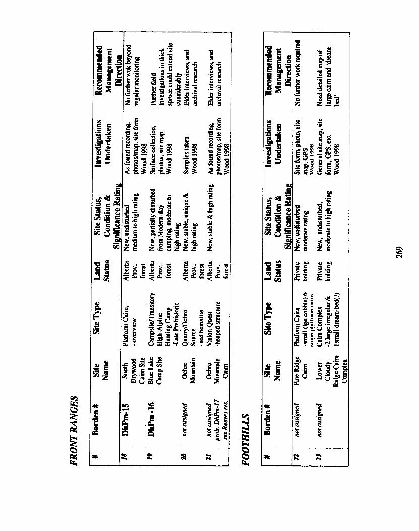

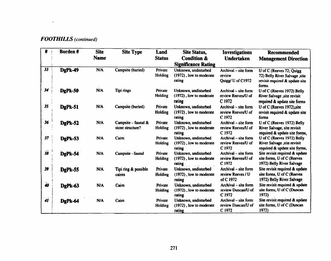
F m T m Ls (continued)
W 1 Bordenl Site Site Type Land Site Status, Investigations Recommended I Name Status Condition & Undertaken Management Direction I Significance Rating
33 I DgPk-49 NIA Campsite (buried) Private Unknown, undisturbed Archival - site form U of C (Reeves 72; Quigg
I Holding (1972) , low to moderate review 72) Belly River Salvage ,site rating Quigg/ U of C1972 revisit required & update site
I fonns 34 i hpk-50 NIA Tipi rings Private Unknown, undisturbed Archival - site form U of C (Reeves 1972) Belly
Holding (1972), low to moderate rcview Rctves/U of River Salvage ,site revisit t
! raring C 1972 required & update site fbms 35 DgPk-51 N/A Campsite (buried) Private Unknown, undisturbed Archival - site form U of C (Reeves 1972),sitt
I
1 Holding (1972). low to moderate review Rccves/U of rcvisit required & update site rating C 1972 forms
36 ' hpk-52 NI A Campsite - faunal & Private Unknown, undisturbed Archival - site form U of C (Reeves 1972) Belly I I stone structure? Holding (1972) , low to moderate review ReevesRl of River Salvage, site revisit
rating C 1972 rcqui@ & update site foes , 37 / DgPk-53 NIA Cairn Private Unknown, undisturbed Archival - site form U of C (Reeves 1972) Belly
I Holding (1972) , low to moderate review Rteves/U of River Salvage ,site revisit
I - - rating C 1972 q u i @ & update site forms, 38 I ~ ~ p k - 5 4 NIA Campsite - faunal Private Unknown, undisturbed Archival - site form Site revisit required & update
I Holding (1972). low to moderate review RcevesN of site forms, U of C (Reeves rating C 1972 1972) Belly River Salvage
39 i h ~ k - 5 ~ NIA Tipi ring & possible Rivate unknown, undisturbed Archival - site form Site revisit required & update
I cairns Holding (1972) , low to moderate nvicw Reeves / U site forms, U of C (Reeves I rating of C 1972 1972) Belly River Salvage
Wk-63 N/ A Cairn Rivate Unknown, undisturbed Archival - site form Site revisit quired & update
I Holding (1972) , low to moderate revicw DuncantU of site forms, U of C (Duncan
i rating C 1972 1972)
41 D g P k 4 - NIA Cairn Private Unknown, undisturbed Archival - site form Site revisit required & update Holding (1972), low to moderate review Duncan/' of site forms, U of C (Duncan
rating C 1972 1972)
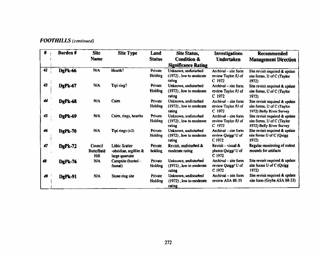
FOOTHILLS (continued)
# I Borden# Site Site Type Land Site Status, Investigations Recommended I Name Status Condition & Undertaken Management Direction I Significance Rating
42 ( DgPk-66 N/A Hearth? Private Unknown, undisturbed Archival - site form Site revisit required & update Holding (1972) , low to moderate review Taylor R1 of site fonns, U of C (Taylor
rating C 1972 1972) 43 DgPk-67 NIA Tipi ring? Private Unknown, undisturbed Archival - site form Site revisit raquircd & update
1 Holding (1972) , low to moderate review Taylor N of site foms, U of C (Taylor I
t rating C 1972 1972) 44 DgPk-68 NI A Cairn Private Unknown, undisturbed Archival - site form Site revisit required & update
Holding (1972). low to moderate review Taylor /U of site fonns, U of C (Taylor rating C 1972 1972) Belly River Survey
45 : DgPk-69 NI A Cairn, rings, hearths Private Unknown, undisturbed Archival - site form Site revisit required & update I Holding (1972), low to moderate review Taylor / l J of site forms, U of C (Taylor
rating C 1972 1972) Belly River Survey 4 hpk-70 NI A Ti pi rings (x3) Private Unknown, undisturbed Archival - site form Site revisit required & update
i Holding (1972) , low to moderate revicw Quiggt U of site fonns U of C (Quigg rating C 1972 1972)
47 Wk-72 Council Lithic Scatter Private Revisit, undisturbed & Revisit - visual BL Regular monitoring of radent Buttdald -obsidian, argillite & holding moderate rating photos Quiggt U of mounds for artifacts
Hill large quartzite C 1972 48 Wk-76 N/A Campsite (buried - Rivate Unknown, undisturbed Archival - site form Site revisit required & update
faunal) Holding (1972), low to moderate review Quiggt U of site forms U of C (Quigg rating C 1972 1972)
4 9 ' Wk-91 N/A Stonc ring site Private Unknown, undisturbed Archival - site form Site revisit required & updste 1 Holding (1972), low to moderate review ASA 88-33 site form (Glyba ASA 88-33) I rating

FOOTHILLS (continued)
# Borden # Site Site Type Land Site Status, Investigations Recommended Name Status Condition & Undertaken Management Direction
I Significance Rating 50 DhPg-08 Wally's Campsite, killsite, Alberta Revisit, partially Archival, site visit NIA
Beach processing quarry, prov disturbed & high rating Kooyman, Hills, workshop Tolman, MacNeil
I
-Multicomponet I Early/Middle/Late
51 , DkPj-01 Head- Kill,processing& Alberta Revisit, partially Archival, site visit N/A Smashed-In campsite prov disturbed h high rating
-Middle & Late I Prehistoric
52 kPI-01 Old Kill, processing & Revisi I, pattially Archival, Forbis NIA Women's campsite disturbed & high rating Buffalo Jump -
CRO WSNEST FOREST RESERVE
# ' BordenU Site Site Type Land Site Status, Investigations Recommended Name Status Condition & Undertaken Management Direction
I I Significance Rating
53 not assigned Upper Surface & buried Alberta New, moderate to heavy Shovel-tested, si te Regular monitoring of Carbondale lithics Prov. disturbance & low to form, photos, GPS mildmads for time
Bridge -Middle Prehistoric forest moderate rating reading ASA 99-16 diagnostic artifacts, f o n d tolls & exotic lithics & test
I - 51 1 no1 assigned Lost Creck Surface & buried Alberta New, minimal Shovel-tested, site Regular monitoring of
I Lithic Scatter Prov. disturbance but potential form, photos, GPS traildroads for time -Middle Prehistoric forest for more high & reading Wood diagnostic artifacts, formed
1 moderate to high rating ASA 99- 16 tolls & exotic lithics & test ,
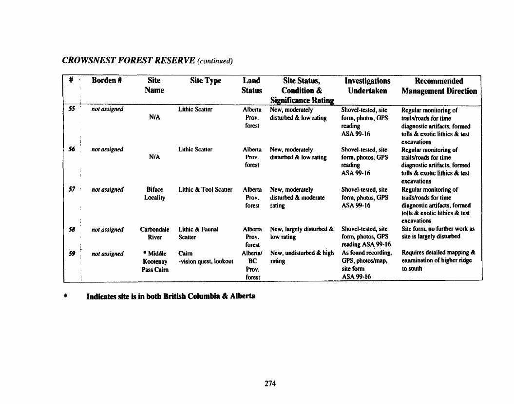
CRO WSNEST FOREST RESER VE (co~ltin ued)
# Borden # Site Site Type Land Site Status, Investigations Recommended Name Status Condition & Undertaken Management Direction
I Significance Rating 55 nor assigned Lithic Scatter Alkrto New, moderately Shovel-tested, site Rcgular monitoring of
NIA Prov. disturbed & low raling form, photos, GPS trails/roads for time forest reading diagnostic artifacts, formed
ASA 99-16 tolls & exotic lithics & test I cxcavat ions
56 nor assigned Lithic Scarter Alberta New, moderately Shovel-tested, site Regular monitoring of N/A Prov. disturbed & low rating form, photos, GPS ~railslnwds for time
forest reading diagnostic artifacts, formed I ASA 99- 16 tolls & exotic lithics & tcst
excavations 57 not arsigned Biface Lithic & Tool Scatter Alberta New, moderately Shovel-tested, site Regular monitoring of
Locality Prov, disturbed & moderate fonn, photos, GPS trails/roads for time forest rating ASA 99-16 diagnostic artifacts, formed
tolls & exotic lithics & test excavations
58 not assigned Carbondale Lithic & Faunal Alberta New, largely disturbed & Shovel-tested, site Site form, no further work as River Scatter Prov. low rating form, photos, GPS site is largely dislurbcd
4 forest reading ASA 99-16
59 : norassigned + Middle Cairn Albertd New, undisturbed & high As found recording, Requires detailed mapping & Kootcnay -vision quest, lookout BC rating GPS, photostmap, examination of higher ridge
I Pass Cairn h v . site form to south I forest ASA 99-16
a Indicates site is in both British Columbia & Alberta

CROWSNEST FOREST RESERVE (continued)
# ' Borden # Site Site Type Land Site Status, Invesliga tions Recommended Name Status Condition & Undertaken Management Direction
I Significance Rating 60 DiPo-01 Carbondale Campsite (buried) Alberta Revisit, largely Glenbow 1958 Site photo, surface collection
Bridge -Middle Prehistoric Prov, destroyed, low to Heiczmann(78:53c) shovel-tested, examination of (not oflcial) forest moderate rating Gryba (79:66) exposures
Quigg (80: 126c) Wood (99: 16)
61 D~Po-02 Lynx Cmk Campsite Alberta Revisit, partially Archival, photos, Regular monitoring (yearly) Falls - surface lithic scatter Prov. destroyed, regional surface collection of trail/road/camp spots for
(not oflcial) of exotic cherts forest significance rating (Vivian 97:31) time diagnostic artifacts 62 DiP0-03 Lynx Creek Large campsite Alberta Revisit, partially Site map & shovel Regular monitoring (5 year
-Middle prehistoric Prov. destroyed, high regional tested (Vivian ASA interval) of traiVroad, todent stratified forest significance rating 97:3 1) mounds & cattle disturbances
Archival, revisit, photos, shovel test, surface collection
1 (Wood 99: 16) 63 MPo-04 NIA Lithic & faunal Alberta Unknown, partially Site map & shovel Regular monitoring (5 year
scatter Prov, disturbed, 75% intact & tested (Vivian ASA interval) of traiUmad & forest local or low significance 97:3 1) camping spots, rodent
I rating Archival - site from mounds I review, site revisit b
M DiP0-05 N/ A Campsitclhistoric Alberta Revisit, partially Surface inspection, Regular monitoring (5 year I Rov. destroyed (70 % intact), photos, site map interval) of uaiUtOBd, rodent
forest local or low significance (Vivian 97:31) disturbance & nearby random I I
I raring Archival - site form camping activities I
review, sitc rcvisit I

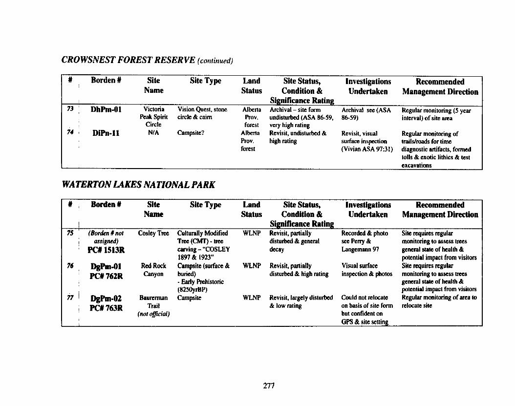
CROWSNEST FOREST RESERVE (continued)
# Borden # Site Site Type Land Site Status, Investigations Recommended Name Status Condition & Undertaken Management Direction
Significance Rating 73 , D h h - 0 1 Victoria Vision Quest, stone Alberta Archival - site form Archival see (ASA Regular monitoring (5 year
Peak Spirit circle & cairn Prov. undisturbed (ASA 86-59, 86-59) interval) of si te m a Circle forest vcry high rating
74 Dih-11 NIA Campsite? Alberta Revisit, undisturbed & Revisit, visual Regular monitoring of Prov, high rating surface inspection trailsfroads for time forest (Vivian ASA 979 1) diagnostic artifacts, formed
tolls & exotic lithics & test excavations
WATERTON LAKES NATIONAL PARK
# Borden # Site Site Type Land Site Status, Investigations Recommended Name Status Condition & Undertaken Management Direction
I Significance Rating 75 ' (Borden # not Cosley Tree Culturally Modified WLNP Revisit, partially Recorded & photo Sitc requires regular , assigned) Tne (CMT) - tree disturbad & general see Peny & monitoring to assess trees
PC# 1513R carving - "COSLEY decay Langemann 97 general state of health & 1897 & 1923" potential impact from visitors
7 , DgP~n-ol Red Rock Campsite (surface & WLNP Revisit, partially Visual surface Site quires regular PC# 762R Canyon buried) disturbed & high rating inspection & photos monitoring to assess trees - Early Prehistoric general state of health &
j (8250yrBP) potential impact from visitors 77 1 p . 0 2 Baurennan Campsite WLNP Revisit, largely disturbed Could not rclocatc Regular monitoring of area to
PC# 763R Trail & low rating on basis of site form relocate site (not oflcial) but confident on
I
I GPS & fiitc setting

WA TERTON LAKES NA TIONA L PARK (conrinued)
# Borden # Site Site Type Land Site Status, Investigations Recommended I Name Status Condition & Undertaken Management Direction
I
78 I)gh-03 South Lithic Scatter & High PC# 7 a ~ Kootenay Elevation Cairns
Pass - high elevation
I tridpass 79 m - 0 9 Snowshoe Campsite
PCU77OR Warden Cabin
(nor oflcial)
- Significance Rating:
WLNP Revisit, partially Visual surface Regular monitoring because & disturbed 8 high rating inspeetion of trail & of horseback riding & hiker
AKPP natural exposures, impact site map & photos
WLNP Revisit, largely disturbed Visual surface Monitoring of suitable & low rating inspection of exposurts provided by
traivcamping area & traiVcarnpground when in photos area - site probably impacted
by road & other park related I activities d0 ' m - 1 0 Goat Lake Bison skulls reported WLNP Revisit. undisturbed k Reeves 71 Site requires tcgular
K# 7 7 1 ~ (point find) & campsite moderate rating Tested. photo, site monitoring and more testing (not oflciul) - Middle Prehistoric form Pickard 88
81 . DgpIII-16 Lone Lake Campsite WLNP Revisit, largely disturbed Visual surface No further work required - , 776R Horse Trail & low rating inspection of much of site area impacted I (not official) general site arca by past park-related activities
& reclamation of camping I mas.
82 : Dgh-16 Cameron Campsite WLNP Revisit, largely disturbed Visual surface No further work required - 1 PC#777R Lake & low rating inspection of much of site area impacted
(not oflcial) general si te area by past park-related activities & reclamation of camping
Indicates site is in both British Columbia & Alberta

WA TERTON LAKES NA TIONA L PARK (contiriued)
# Borden # Site Site Type Land Site Status, Investigations Recommended Name Status Condition & Undertaken Management Direction
SignMirnnce Rating 83 Dkpm-17 Twin Lakes Campsite WLNP Revisit, partially Visual inspection of Regular monitoring of
PC# 778R Outlet disturbed & low rating trail with photos traildroads for time (not oflcial) Reeves 69, Sumpter diagnostic artifacts, f o d
86 & Pickiud 88 tolls & exotic lithics & test excavations
d . m . 1 8 Twin Lakes Campsite WLNP Revisit, partially Visual inspection of Regular monitoring of
PC# 779R Trail disturbed & low rating trail with photos trailsfroads for t ime (not olp7cial) Reeves 69Bi 7 1, diagnostic artifacts, fonncd
Pickard 88 tolls & exotic lithics & test excavations
85 m - 2 1 Lower Rowe Isolated finds, cores, WLNP Revisit, partially Could not relocate Regular monitoring when in
1 PCIt782R Creek lithic scatter disturbed & low rating on basis of site form m a of area for artifacts (nor oflcial) but confident on
1 t GPS & site setting
86 ' m - z N/ A Lithic scatter WLNP Revisit, partially Could not relocate Regular monitoring when in
1 PC#1119R disturbed & low rating on basis of site form area of area for artifacts but confident on GPS & site setting
87 , -48 Upper Goat Vision Quest - WLNP Revisit, undisturbed & Detailed site map Regular monitoring because
, PC# 1582R M e platform high rating produced, photos & of hikcrlclimber related Platform site fonn activities - perhaps signage
(not official) 0 1 w - 3 1 *Sage Pass Highelevation WLNP Revisit, partially Detailed site map, Regular monitoring because
1 PC# 183811 Pasdtrai I, cairn(s), & disturbed h high rating photos & site form of horseback riders & hikers I artifact scatter BC - d s Provincial (BC & I Albcm) & Parks Canada I form filed
I) Indicates site is in both Britlsh Columbia & Alberta
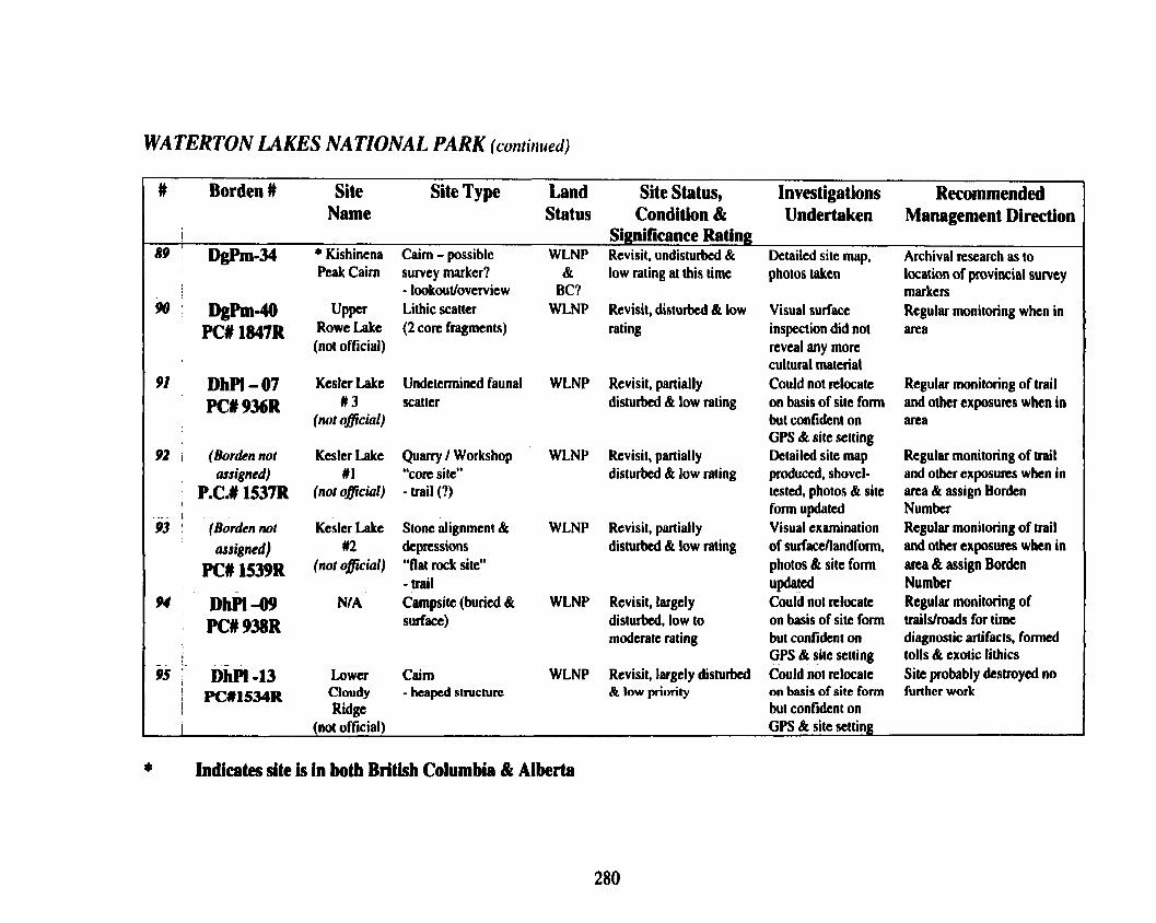
WATERTON LAKES NATIONAL PARK (continued)
# Borden # Site Site Type Land Site Status, Investigations Recommended 1
Name Status Condition & Undertaken Management Direction I Significance Rating
89 i DgPm.34 . Kishinena Cairn - possible WLNP Revisit, undisturbed & Detailed site map, Archival research as to I Peak Cairn survey marker? & low rating at this time photos taken location of provincial survey - lookout/ovewiew BC? markers
w D@m-40 Upper Lithic scatter WLNP Revisit, disturbed & low Visual surface Regular monitoring when in PC# 1847~ ROWC M e (2 core fragments) rating inspection did not area
(not official) reveal any more culturat material
91 DhPl- 07 Kesler Lake Undetermined faunal WLNP Revisit, partially Could not relocate Regular monitoring of trail
PC# 9361 w 3 scatter disturbcd & low rating on basis of sitc form and other exposures when in (not oflcial) but confident on area
GPS & site setting 92 I (Borden not Kesler Lake Quarry / Workshop WLNP Revisit, partially Detailed site map Regular monitoring of trail
assigned) # I "core site" disturbed & low rating produced, shovel- and other exposures when in P.C.# 15371 (not oflcial) - trail (1) tested, photos & site area & assign Borden
1 form updated Number 9.3 (Borden not Kesler Lake Stone alignment & WLNP Revisit, partially Visual examination Regular monitoring of trail
assigned) U2 depressions disturbed & low rating of surfacefiandform, and other exposures when in PC- 1539~ not 0 1 "flat rock site" photos & site fonn area & assign Bordcn
- trail updated Number w DhI'l-w NJA Campsite (buried & WLNP Revisit, largcly Could not nlocate Regular monitoring of
I PC#938R surface) disturbed, low to on basis of site form trails/roads for time I moderate rating but confident on diagnostic artifac ts, formed 1
! GPS & sitc setting tolls & exotic lithics a i ~ b ~ l . 1 3 Lower Cairn WLNP Revisit, largely disturbed Could not relucale Site probably dcstroycd no
' PCW1534R Cloudy - heaped structure & low priority on basis of site fonn further work ! Ridge but confident on
(not official) GPS & site setting
le Indicates site is in both British Columbia & Alberta

WA TERTON LAKES NATIONAL PARK (continued)
# ' Borden # Site Site Type Land Site Status, Investigations Recommended Name Status Condition & Undertaken Management Direction
Significance Rating 94 1 DhPl-14 Mid Cloudy Vision Quest - - WLNP Revisit, undisturbed & Detailed site map Regular monitoring when in
PC#1544R Ridge heaped platform moderate to high rating produced, photos & area (not official) site form
97 1 Dhm-15 Upper Cairn - Vision Quest WLNP Revisit, undisturbed & Detailed site map Regular monitoring when in PC# Cloudy strut ture moderate to high rating produced, photos & area
Ridge site form
I (not official)
98 DgPI-02 Dardanelles Campsite (stratified) WLNP Revisit, partially Archival, surface Regular monitoring when in
I PC#637R - Early (?) & Middle disturbed & moderate to inspection of trails area & test excavation Prehistoric high rating & shoreline
99 1 WI -04 Narrows site Campsite WLNP Revisit. Largely Archival, surface Regular monitoring (yearly) I
P.C.# 638R - fishingtcamping site disturbad & moderate to inspection of trails especially in times of low I high rating & shoreline water (late falllwinter)
100 Dgfi-06 Fish Campsite (stratified) WLNP Unknown, stable & high Archival Regular monitoring when in 1 5 7 1 ~ Hatchcy - Euly (Clovis) rating arcs I Prehistoric
101 1 WI-11 Maskinongc Campsite (surface & WLNP Revisit, partially Surface coHcction & Regular monitoring (yearly)
I PC#640R buried), lithic & disturbed & moderate to update of sitc form of trails, natural (rodent &
1 faunal high rating waters edge) 102 I J)@blJ Golf Course Campsite WLNP unknown, largely Archival, review of None at this time
Camp disturbed & low rating site form
~ ~ f i - 1 8 Lakc Linnet Campsite (stratified) WLNP Revisit, largely disturbed Visual surface Io3 I Regular monitoring (yearly)
1 & high rating inspection & photos of trails, natural (rodent &
waters edge) IM , -29 Upper Campsitehistoric WLNP Revisit, largely disturbed Could not relocate Regular monitoring when in
! Pa653 W atcrton & moderate to low rating on basis of site form area Lake but confident on
(not official) GPS & site setting

WA TERTON LAKES NATIONAL PARK (continued)
# Borden # Site Site Type Land Site Status, Investigations Recommended 7
I Name Status Condition & Undertaken Management Direction Significance Rating
la WI-51 NI A Protohistoric WLNP Revisit, partially Archival, review of No further work beyond
PC# 671R campsite disturtud & low rating site form monitoring when in area Upper
Waterton Lake
(not official) Upper
Waterton Lake
(not official) NIA
Prince of Wales Hotel
Campsite WLNP Revisit, partially disturbed & low rating
Isolated lithic find WLNP Revisit, partially disturbed & low rating
Campsite, killsite WLNP Partially disturbed by road & gas line construction
National Historic Site WLNP Stmctural modifications, utilities, constnrctions
Could not relocate Regular monitoring when in on basis of site form area but confident on GPS & site setting Could not relocate Regular monitoring when in on basis of site form area but confident on GPS & site setting Archival, review of No further work beyond site form monitoring when in area
1
I activity, intact 110 , DgPJ-161 Crandell # 1 Vision Quest, cairns WLNP Revisit, undisturbed & As found recording
1 P(-J 1 3 ~ ~ (noi oflcial) & stn~cture high priority including, map photos & update site foml
111 ; Dgm-160 ~randcll# 2 Vision Quest* WLNP Revisit, undisturbed & Could not relocate ' 1337~ (not official) multiple horseshoe high priority on basis of site form I I shaped cairns but confident on
i12 1 D~PJ-189 CnndellU3 Cairn I (not oflcial)
GPS & site setting WLNP Revisit, largely disturbed Could not relocate
& low to moderate rating on basis of site fonn but confident on GPS & site setting
Regular monitoring on yearly basis including special management plan because of potential for conflict wirh present use of site Regular monitoring on yearly basis including special management plan because of high visitor use of mountain Regular monitoring on y&~y basis including special management plan because of high visitor use of mountain
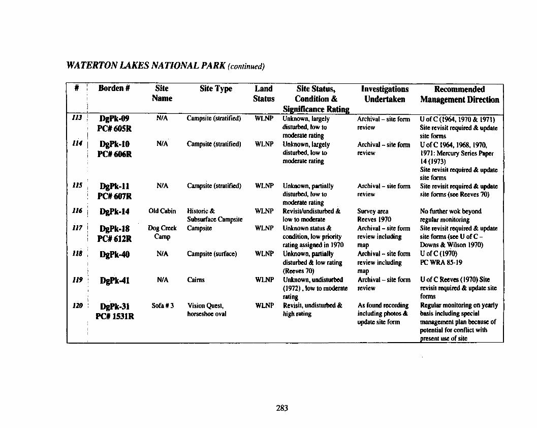
WATERTON LAKES NATIONAL PARK (continued)
# 1 Borden# Site Site Type Land Site Status, Investigations Recommended Name Status Condition & Undertaken Management Direction
1 Significance Rating If3 i DgPk-o!l N/A Campsite (stratified) WLNP Unknown, largely Archival-siteform UofC(1964,t970&1971)
PC# 605R disturbed, low to review Site revisit required & update 1 moderate rating site forms
114 I DgPk-10 NIA Campsite (slratified) WLNP Unknown, largely Archival - site form U of C 1%4, 1968, 1970, 1 PC#606R disturbed, low to review 197 1 : Mercury Series Paper I moderate rating 14 (1973)
Site revisit required & update site forms
115 DgPk-11 NIA Campsite (stratified) WLNP Unknown, partially Archival - site fonn Site revisit required & update 1 PCU607R disturbed, low to review site forms (see Reeves 70)
moderate rating I16 1 m k - 1 4 Old Cabin Historic & WLNP Revisit/undisturbed & Survey area NO further wok beyond
Subsurface Campsi~e low to moderate Reeves I970 regular monitoring 117 / bPk.18 Dog Crak Campsite WLNP Unknown status & Archival - site form Site revisit q u i d & update
; PC#612R Camp condition, low priority review including site forms (see U of C - rating assigned in 1970 map Downs & W Wilson 1970)
118 : DgPk-40 N/A Campsite (surface) WLNP Unknown, partially Archival - site form U of C (1970) I disturbed & low rating review including PC WRA 85-19 I (Reeves 70) map
I19 i -41 N/ A Cairns WLNP Unknown, undisturbed Archival - site form U of C Reeves (1970) Site I
I (1972) , low to modcrate review revisit required & update site , 1 rating forms
I20 I m . 3 1 Sofa # 3 Vision Quest, WLNP ~ e i s i l , undisturbed & As found recording Regular monitoring on yearly
' PCU1531R horseshoe oval high rating including photos & basis including special update site fonn management plan because of
I potential for conflict with
I present use of site

WATERTON LAKES NATIONAL PARK (continued)
# I Borden # Site Site Type Land Site Status, Investigations Recommended
I Name Status Condition & Undertaken Management Direction I Significance Rating:
121 I DgPk-71 N/A Cairn WLNP Unknown, undisturbed Archival - site form Site revisit required & update (1972) , low to moderate review sire forms U of C (Reeves
I , rating 1970) 122 : &Pk -98 Sofa U5 Vision Quest, ovals WLNP Revisit, undisturbed & As found wording Regular monitoring on yearly
! PC#1802R & cairns very high rating including photos & basis including special 1 update site form management plan because of
potential far conflict with present use of site
123 , DgPk-104 Sofa # 2 Vision Quest, oval WLNP Revisit, partially As found recording Regular monitoring on yearly ' PC# 1532R disturbed & moderate including photos & basis including special
rating update site form management plan because of potential for conflict with present use of site
124 i DgPk-105 Sofa # I Vision Quest, cairn & WLNP Revisit, pmially As found recording ~ e ~ u l a r monitoring on yearly
/ PC# 1533R circle disturbed & high rating including photos & basis including special I update site form management plan because of
potential for conflict with present use of site
I25 I Wk-106 Sofa # 4 Vision Quest, oval WLNP Revisit, undisturbed & Could not relocate Regular monitoring on yearly
i ! PC# 1536R high rating on basis of site form basis including special but confident on management plan because of
I
I GPS & site setting potential for conflict with
I sec Pickard 88 & present use of site I Reeves % could not i rclocate PC# 1508R Oil City Oil drilling features WLNP Partially disturbed N/ A N/A
National Historic Site
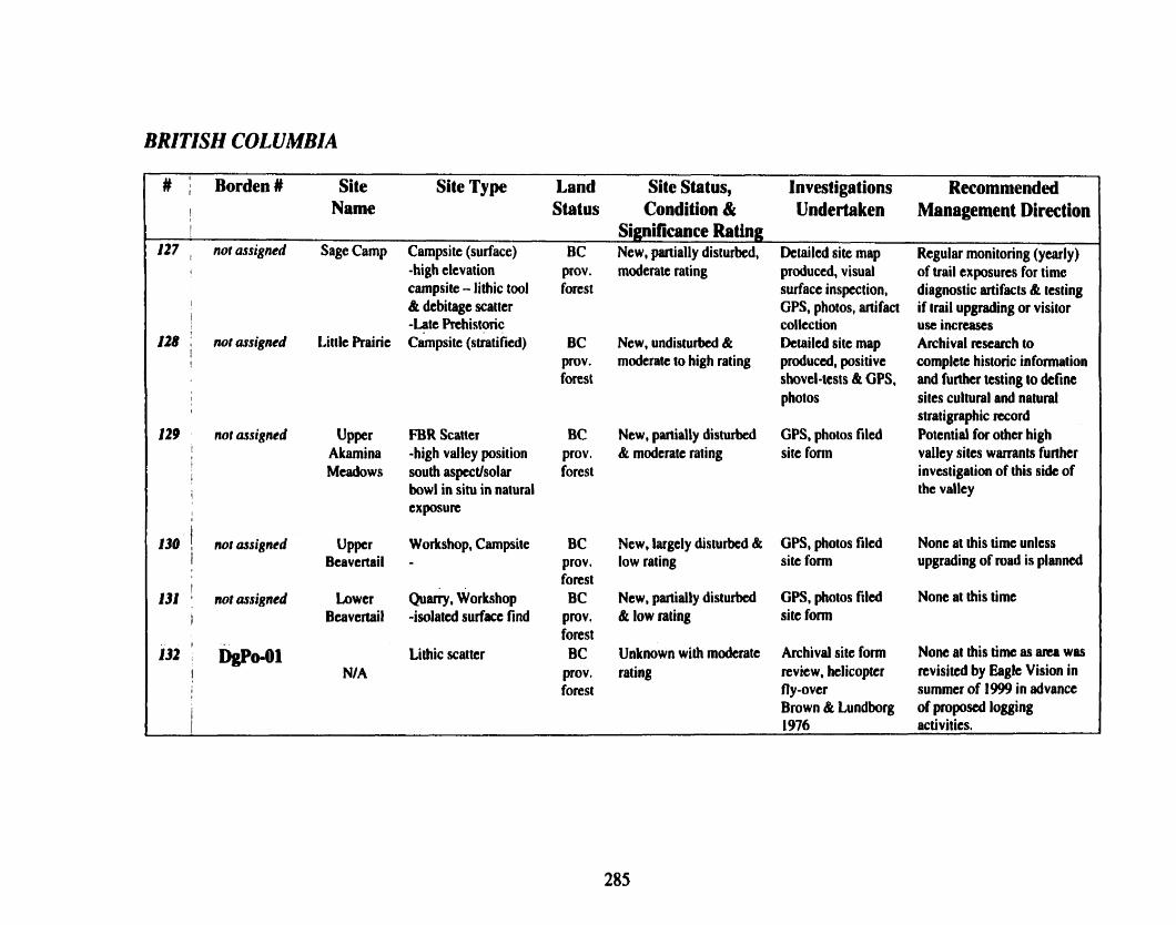
BRITISH COLUMBIA
# Bordent Site Site Type Land Site Status, Investigations Recommended
! Name Status Condition & Undertaken Management Direction I S i p i b n c e Rating
127 , not assigned Sage Camp Campsite (surface) BC New, partially disturbed, Dctailcd site map Regular monitoring (yearly) I -high elevation prov. moderate rating produced, visual of trail exposures for time
campsite - lithic tool forest surface inspection, diagnostic artifacts & testing I
I & debitage scatter GPS, photos, artifact if trail upgrading or visitor -Late Prehistoric collection use increases
128 : not assigned Littk Prairie ~dmpsite (stratified) BC New, undisturbed & Detailed site map Archival research to i ! prov. moderate to high rating produced, positive complete historic information
forest shovel-tests & GPS, and further testing to define I photos sites cultural and natural 1 stratigraphic record
129 nor ossigned Upper FBR Scatter BC New, partially disturbed GPS, photos filed Potential for other high I Akamina -high valley position prov. & moderate rating site fonn valley sitcs warrants further 1 I Meadows south aspectJsolar forest investigation of this side of
1 bowl in situ in natural the valley I cxposurc
130 not ussigned Upper Workshop, Campsite BC New, largely disturbed & GPS, photos filed Nonc at this time unlcss i Beavertail - prov, low rating site form upgrading of road is planned
I forest
131 not assigned Lower Quarry, Workshop BC New, partially disturbed GPS, photos filed None at this time I Bcavcrtail -isolated surfau find pmv. & low rating sit t form
forest I32 ' Dspd)l Lithic scatter BC Unknown with moderate Archival site form None at this time as am was
I N/A prov, rating review, htlicoptcr revisited by Eagle Vision in I forest fly -over summer of 1999 in advance ,
Brown & Lundborg of proposed logging 1976 activities.

BRITISH COLUMBIA (continued)
# Borden # Site Site Type Land Site Status, Investigations Recommended I I Name Status Condition & Undertaken Management Direction -
Significance Rating " 1 DgP0-02 NI A Lithic scatter BC Unknown with moderate Archival site form None at this time as area was
135 , Unnamed NIA creek site
136 Proctor Lake- N/A west
I 137 ! Proctor Lake- N/ A
I
south 1
lb Dhpv-01 Mine Hill I
Site (not official)
139 DgQa.04 Moyic River 1 (not official)
I 140 M h - ? Moyic Lake
I
Lithic scatter
Campsite Middle prehistoric
Sub-surface lithics
Eagle Vision McKearl site
Campsite -Early prchistoric)
Campsitc -Early prehistoric)
Stratified campsite - Early & Middle Rehistoric
prov. forest
BC prov. forest
BC prov. forest BC
prov. forest BC
prov. forest BC
prov. forest
Private holding
rating
Unknown with modcrate rating
Low to moderate
Luw to moderate
Moderate to high
Revisit, partially to largely(?) disturbed with modcrate to high rating
Unknown, partially to largely disturbed with high rating
Unknown, moderately to largely disturbed, moderate to high rating.
review helicopter fly-over Brown & Lundborg 1976 Archival site form review helicopter fly-over Brown & Lundborg 1976 New site discovered by Eagle Vision in summer of 1999 New si tc discovered by Eagle Vision in summer of 1999 New site discovered by Eaglc Vision in summer of 1999 Revisit
Archival, pcrs, comm W. Choquette 1999, test excavations (Bussey 1999)
revisited by Eagle Vision in summer of 1999
None at this time as area was revisited by Eagle Vision in summer of 1999
HI Permit 1999-089
HI Permit 1999-089
None at this time, site was ncwly recorded by Choquette in 1999 in advance of highway realignment None at this lime
None at this dm although site is being impacted by sand/gravel(?) operations

BRITISH COLUMBIA (continued)
# Borden # I
Site Site Type Land Site Status, Investigations Recommended I Name Status Condition & Undertaken Management Direction
Significance M n g 141 , MQu-? Negro Lake Quarry, workshop BC Revisit, partially Revisit with W. None at this time
Quarry Prov, disturbed, moderate to Choquctte (1999) forest high rating
142 t DbQb-02 Goatfel Workshop Private Revisit, partially Revisit with W. None at this time I workshop holding disturbed, moderate to Choqucttc (1999)
high rating 143 DgQb-03 Goatfel Quarry Private Revisit, partially Revisit with W. None at this time
‘w'."Y holding disturbed, moderate to Choquette ( 1 999) high rating
144 DIpu-7&12* Topof-the- Highelevation BC Unknown, partially Archival, pers. None at this time, This park there is almost World quany, workshop, Prov disturbed, high rating cornm W.Choquette is outside of study area but
, 40 ngistcred campsite, cairns, Park 1998& 1W information on high elevation I sites within Top kill/processing. use of is relevant to this
' of-the-World lookouts, trails, drive project I provincial park lanes, religious
of ferings I

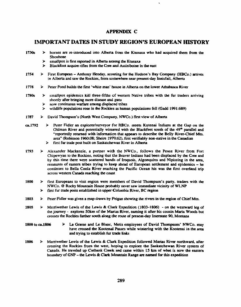
APPENDIX C
WORTANT DATES IN STUDY REGION'S EUROPEAN HISTORY
1730s R horses arc re-introduced into Alberta from the Ktunaxa who had acquired them from the Shoshone
9 smallpox is k t reported in Alberta among the Ktunaxa 9 Blackfoot acquire rifles from the Cree aad Assiniboinc in the east
1754 First European - Anthony Henday, scouting for the Hudson's Bay Company (HBCo.) arrives in Alberta and saw the Rockies, from somewhcrt near present-day Innisfail, Aibcrta
1778 P Peter Pond builds the first 'white man' house in Alberta on the lowa Athabasca River
1780s R smallpox epidemics kiil three-fifths of western Native tribes with the fur traders aniving shortly after b ~ g i n g mott disease and guns
9 now continuous warfare among displaced tribes 9 wildlife populations rose in the Rockies as human populations fell (Gadd 1991:689)
1787 P David Thompson's (North West Company. NWCo.) first view of Alberta
ca.1792 > Peter Fidler an explorer/surveyor for HBCo. meets Kutenai Indians at the Gap on the Oldman River and potentially wintered with the Blacldtet south of the 49" parallel and "reportedly returned with information that appears to describe the Belly River-Chief Mtn. area" (Robinson 1960:08; Sheice 1970:62), first verifiably non-native in the Canadian
P first fur trade post built on Saskatchewan River in Alberta
1793 P Alexander Mackenzie, a partner with the NWCo., follows the Peace River from Fort Chipewyan to the Rockies. noting that the Beaver Indians had been displaced by the Cra and by this time there were scattered bands of Iroquois, Algonquins and Nipissing in the area. remnants of eastern tribes trying to keep ahead of European settlement and epidemics - he continues to Bella Coola River reaching the Pacific Ocean his was the first overland trip across western Canada reaching the coast
1800 P first Europeans to visit region were members of David Thompson's parry, traders with the NWCo. @ Rocky Mountain House probably neva saw immediate vicinity of WL.NP
P first fur trade posts established in upper Columbia River, BC =@on
1803 P Peter Fidler was given a map drawn by Peigan showing the rivers in the region of Chief Mm.
1805 Memwether Lewis of the Lewis & Clark Expedition (1803-1806) - on the westward leg of the journey - explores 5Okm of the Marias River. naming it after his cousin Maria Woods but crosses the Rockies farther south along the route of present-day Interstate 90, Montana
1800 to ca.1806 P La Grasse and Lc Blanc, Metis employees of David Thompsons* NWCo. may have crossed the Kootcnai Passes while wintering with the Kootcnai in the area and trying to establish fur trade links
1806 P Memwether Lewis of the Lewis & Clark Expedition followed Marias River northward, aftcr crossing the Rockies from the west. hoping to explore the Saskatchewan Rivcr system of Canada. He traveled up Cutbank Creek and came within 15 Irm of what is now the eastern boundary of GNP - the b w i s & Clark Mountain Range are named for this expedition

1807 P guided by Kmnaxa Indians David Thompson followed the North Saskatchewan valley to Howse Pass and crosses the Rocky Mountains to reach the Columbia River, here he built 'Kootenae House' near present-day Invermere
P after recruiting the Ktunaxa as trappers Thompson returns but was harassed @ Rocky Mountain House by the Peigan who f e d he would arm the Ktunaxa - which he did
1808 > David Thompson travels on the Kootenai River
1808to1830s > fut trade posts established near the mouths of Rainy Creek Libby Creek & Fisher River immediately upstream from the Lake Koocanusa region in BC
1810 P Finian MacDonald party crossed the Rockies (probably @ Marias Pass - along the southern boundary of GNP)
1811 > fur trade post operated at Bonners Ferry - one of two operated within Lower Ktunaxa boundaries
> after the Peigan closed Howse Pass David Thompson looked farther north for an alternative route and led by an Iroquois guide crossed over the Athabasca Pass and down the Wood River to the Columbia River where they wintered at Boat Encampment on the Big Bend of the Columbia (now under Kinbasket Lake) on route to the west coast where he claimed Ongoa (actually only part of a vast territory that included Washington)
1812 > f m t all white child born in Alberta P white-traders using Cut Bank Pass - east of Continental Divide (Robinson 1960.09; Sheire
1970:55)
1813 P Pacific Fur Company sells to NWCo.
1814 P fur trader Hugh Monroe in east Glacier area
1818 Great Britain and the USA agree on the 49& parallel of latitude as boundary from Lake of the Woods to the Rockies
1821 P amalgamation of HBCo. & NWCo.
1839 to ca.1866 P trading posts were maintained in the Tobacco Plains region of BC
ca.1840 > whites traveling and living with the Pcigan Indians. such as Hugh Monroe and William Gladstone most likely passed through W area on way into St. Mary's, GNP
1841 P HBCo. Orcgon-bound colonists pass through Fort Edmonton
1846 B HBCo. traders began operating in Tobacco Plains P dispute over the Oregon Territory is resolved with the signing of the Oregon Treaty
1850s > Ktunaxa and other mountain tribes appeal to Washington Territory over continued disputes with the Blackfoot - Ktunaxa agree to give up all claim to mountain passes and prairie
1852 P Benetsee Finlay found gold in western Montana
1854 P Isaac I. Stevens surveys for tailroad in GNP area
1855 > Treaty with the Blacldet Tribe in Montana
1856 to 61 P Palliscr Expedition in region, probably north on the Oldman River
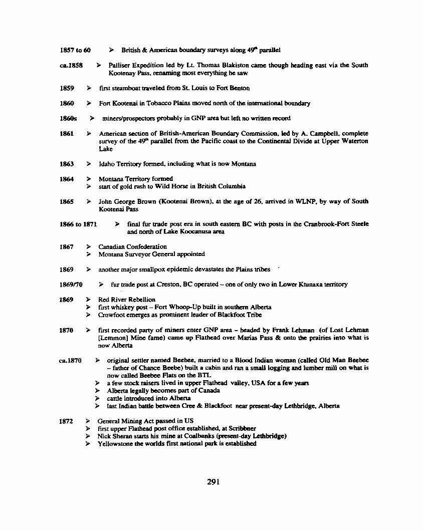
1857 to 60 h British & American boundary surveys along 49" parallel
ca.1858 & Palliser Expedition led by Lt. Thomas Blakiston came though heading east via the South Kootenay Pass, renaming most everything he saw
1859 3 first steamboat traveled from St. Louis to Fort Benton
1860 P Fort Kootcnai in Tobacco Plains moved north of the international boundary
1860s > miners/prospectoss probably in GNP area but left no written record
1861 > American section of British-American Boundary Commission, led by A. Campbell, complete survey of the 4Qb pafallel from the Pacific coast to the Continental Divide at Upper Watcnon Lake
1863 3 Idaho Tmitory formtd including what is now Montana
1864 P Montana Territory formed > stan of gold rush to Wid Horse in British Columbia
1865 P John George Brown (Kootcnai Brown). at the age of 26, arrived in WLNP, by way of South Kootenai Pass
1866 to 1871 P find fur trade post era in south eastern BC with posts in the Cranbrook-Fort Stetle and nonh of Lake Koocanusa area
1867 > Canadian Confederation 3 Montana Surveyor General appointed
1869 > another major smallpox epidemic devastates the Plains tribes '
1869n0 3 fur trade post at Creston, BC operated - one of only two in Lower Ktunaxa territory
1869 P Red River Rebellion P first whiskey post - Fort WhoopUp built in southern Alberta P Crowfoot emerges as prominent leader of Blackfoot Tribe
1870 3 first recorded party of miners enter GNP area - headed by Frank Lthman (of Lost hhrnan [Ltmrnon] Mine fame) camc up Flathead over Marias Pass & onto the prairies into what is now Alberta
ca.1870 P original settler named Beebee, married to a Blood Indian woman (called Old Man B a b e - father of Chance Beebe) built a cabin and ran a small logging and lumber mill on what is now called B e c k Flats on the BTL
9 a few stock raisers Iived in upper Flathead valley, USA for a few years & Alberta legally becomes part of Canada i, cattle introduced into Alberta P last Indian battle between Cree & Blackfoot near present-day Letlibridge, Alberta
1872 P General Mining Act passed in US 9 first upper Flathead post office established, at Scribbner > Nick Sheran starts his mine at CaalbanLs (present-day kthbridge) P Ycllowstone the worlds first national park is established

late 12370s
Michael Phillips and John Collins become first Euopcans to cross the Cmwsnest Pass looking for new trapping territory
P Kootenai Brown and Fred "Kamouse" Taylor constructed small uading post, called m d c whiskey shack by some. on the west side of Watcrton River at the exit of Lower Watcrton Lake
> first Dominion land survey in Alberta undertaken
British Boundary Commission. led by Major D.R. Cameron camped in area completing survey from Lake of the Woods. Minnesota to Continend Divide Duncan McDonald crosses the Marias Pass George Dawson the govanmcnt geologist in WLNP & AKPP buffalo all but gone from northern Great Plains trading post (Whiskey) established @ Kennedy Creek & St. Mary river - east of GNP R.N.W.M.P. build Ft. Macleod and arrive 8 Fort Edmonton Bureau of Land Management Executive order resulted in withdrawal of lands from Forest Reserve for an Indian reservation 'Tor the use and occupancy of the Gros Ventre. Piegan, Bl& Blackfeet, River Crow ..." east of GNP
fmt steamboat, the Northcoate, reached Fort Edmonton Royal North West Mounted Police establish Fort Calgary, Alberta
Indian Treaty No. 6 signed with Cree Sitting Bull's Sioux seek refuge in Canada aftcr the Li& Bighorn pmspectors/mincrs crossed Logan Pass on way to Fort Benton, Montaua for supplies s e v d ranchers around Fon Macleod
Treaty 7 signed at Blackfoot Crossing in Alberta between First Nations including the Kainaiwa (Blood), the Piikani (Peigan), the Siksika (Blackfoot), the Nakoda Stoney & the Tsuu T'ina (Sarcee) & the Canadian govenunent Dawes Act opened US reservations to white settlement
first interest shown in surface oil on Cameron Creek in WLNP. deposits by Europeans Timber & Stone Act passed in US Kootenai Brown returns to Watcnon with his family and remains
the Dewdney Trail, a wagon road constructcd across southern BC to the Rocky Mountain Trench, was extended to the Crowsnest Pass and becomes the first improved route across the Rockies- today's Highway # 3 (Cmwsnest Trail)
P Duncan McDonald, a HBCo. trader traveled into West Glacier leaving his name forever associated with Lake McDonald
Cardston man soaking up oil on Cameron Creek in WLNP with gunny sacks and selling
mining intcmts rising in GNP James Willard Shultz & George Bird Grimel explored GNP area and wrotdpublished their experiences - and were followed by Dr. Lyman B. Spcrry. Henry L. Stimson & G.E. Culver
P G.M.Dawson renuns to complete geological survey in area P Macleod Gazette started in Fort Macleod, Alberta
Northwest Territories divided into four dismcts, one of which was Alberta
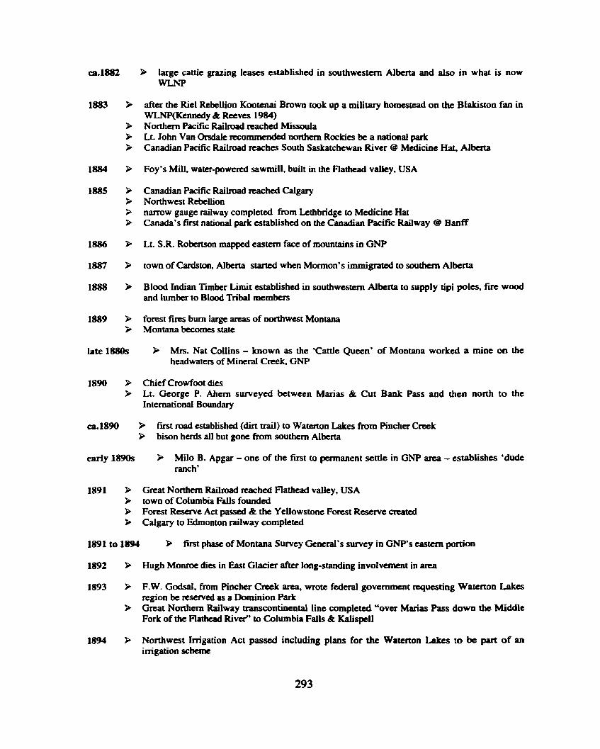
call382 P large cattle grazing leases established in southwestern Alkm and also in what is now WLNP
1883 > after the Riel Rebellion Kmtenai Brown took up a military homestead on the Blakiston fan in WLNP(Kennedy & Rccves 1984)
> Northern Pacific Railroad reached Missoula P Lt. John Van Ondale recommended northern Rockies be a national park 3 Canadian Pacific Railroad reaches South Saskatchewan River @ Medicine Hat, Alberta
1884 > Foy's Mill, water-powered sawmill, built in the Flathead valley, USA
1885 > Canadian Pacific Raiiroad reached Calgary 3 Northwest Rebellion > narrow gauge railway completed h m Lethbridge to Medicine Hat 3 Canada's fvst national park cstabtishcd on the Canadian Pacific Railway 8 Banff
1886 P Lt. S.R. Robertson mapped eastern face of mountains in GNP
1887 P town of Cardston, Albena started when Mormon's immigrated to southern Alberta
1888 P Blood Indian Timber Limit established in southwestern Alberta to supply tipi poles, fire wood and lumber to Blood Tribal members
18J39 P forest fires bum large areas of northwest Montana Montana becomes state
late 1880s P Mrs. Nat Collins - known as the 'Cattle Queen' of Montana worked a mine on the headwaters of Mineral Creek GNP
1890 Chief Crowfoot dies Lt. George P. Ahem surveyed between Marias & Cut Bank Pass and then north to the international Boundary
ca. 1890 P first road established (dirt trail) to Waterton Lakes from Pincher Creek P bison herds all but gone from southern Alberta
early 1890s P Milo B. Apgar - one of the first to permanent settle in GNP area - establishes 'dude ranch'
1891 P Great Northern Railmad reached Flathead valley, USA > town of Columbia Falls founded P Forest Reserve Act passed & the Yellowstone Forest Reserve created P Calgary to Edmonton railway completed
1891 to 1894 P fitst phase of Montana Survey General's survey in GNP's eastern portion
1892 Hugh Monroe dies in East Glacier after long-standing involvement in area
1893 F.W. Godsal, from Pinchcr Creek area, wrote federal government requesting Watcrton Lakes region be reserved as a Dominion Park
> Great Northern Railway transcontinental line completed "over Maxias Pass down the Middle Fork of tfie Flathead River" to Columbia Falls & Kalispell
1894 P Northwest Irrigation Act passed including plans for the Watcrton Lakes to be part of an irrigation scheme
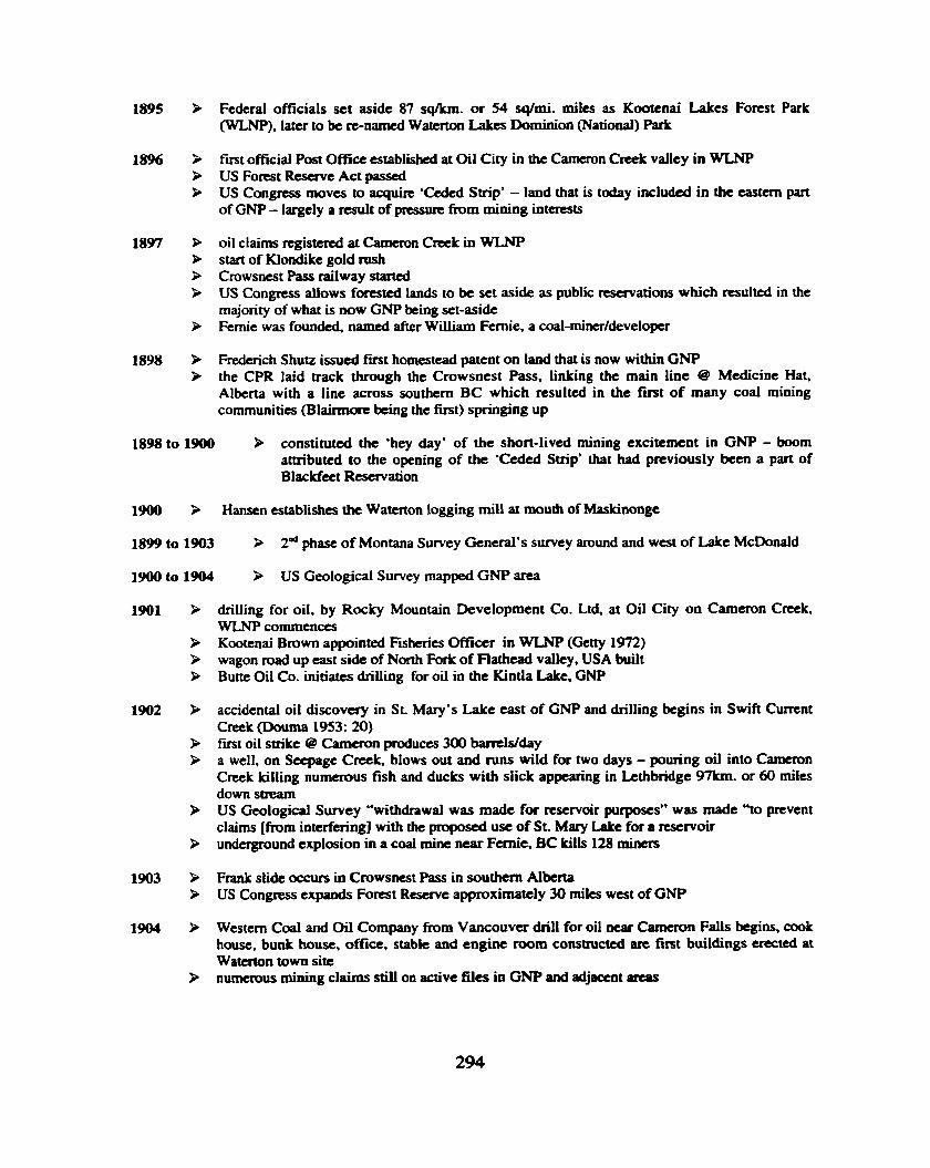
1895 b Federal officials set aside 87 sqkm. o r 54 sq/rni. miles as Kootcnai Lakes Forest Park (WLNP), later to be re-named Watenon Lakes Dominion (National) Park
18% > first official Post Office established at Oil City in the Cameron Crcek valley in WLNP > US Fomt Reserve Act passed P US Congress moves to acquire 'Ceded Strip* - land that is today included in the eastern part
of GNP - largely a result of pressure from mining interests
1897 b oil claims registered at Cameron Creek in WLNP P start of Klondike gold rush P Crowsnest Pass railway started > US Congress allows forested lands to be set aside as public reservations which resulted in the
majority of what is now GNP k i n g set-aside 9 Fernie was founded, named after William Fernie, a coal-minerldeveloper
1898 P Frederich Shutz issued first homestead patent on land that is now within GNP P the CPR laid track through the Crowsnest Pass, linking the main line @ Medicine Hat,
Alberta with a line across southern BC which resulted in the f m t of many coal mining communities (Blairmorc k i n g the first) springing up
1898 to 1900 > constituted the 'hey day* of the short-lived mining excitement in GNP - boom attributed to the opening of the 'Ceded Strip* that had previously been a part of Blackfeet Reservation
1900 P Hansen establishes the Watcrton logging mill at mouth of Maskinonge
1899 to 1903 9 2d phase of Montana Survey General's survey around and west of Lakt McDonald
1900 to I904 9 US Geological Survey mapped GNP area
1901 > drilling for oil, by Rocky Mountain Development Co. Ltd, at Oil City on Cameron Creek, WLNP commences
P Kootenai Brown appointed Fisheries Officer in WLNP (Getty 1972) wagon road up east side of North Fork of Flathead valley, USA built
P Butte Oil Co. initiates drilling for oil in the Kintla Lake, GNP
1902 P accidental oil discovery in SL Mary's Lake cast of GNP and drilling begins in Swift Current Creek (Douma 1953: 20)
F fmt oil strike @ Cameron ptoduces 300 bamlslday P a well, on Seepage Creek. blows out and runs wild for two days - pouring oil into Cameron
Cnek killing numerous fish and ducks with slick appearing in Lcthbridge 97km. or 60 miles down stream
P US Geological Survey "withdrawal was made for reservoir purposes" was made 30 prevent claims [ h m interfering] with the proposed use of St. Mary Lalce for a rcstrvou
> underground explosion in a coal mine near Fernie, BC kills 128 m i m
1903 P Frank slide occurs in Crowsnest Pass in southern Alberta P US Congress expands Forest Reserve approximately 30 miles west of GNP
1904 P Western Coal and Oil Company from Vancouver drill for oil near Cameron Falls begins, cook house, b u d house, office, stable and engine mom constructed are first buildings erected at Watemn town site
P numerous mining claims still on active files in GNP and adjacent ateas

1905 3 F. W. Godsal writes to Federal Govrmment requesting Park m e be enlarged 3 Watcrton Mills established on east shore of Maskinonge Lake; included Post Office, boarding
house, stables, and numerous other buildings (Getty 1972) R Rovince of Alberta created with Edmonton as temporary capitol & A.C. Rutherford becomes
first Premier
1906 3 US Forest Homestead Act opened some National Forest lands to homesteaders
1906 to 1910 land withdrawals set aside for GNP ranger station sites
1907 3 US Congress passed Act prohibiting creation of additional forests from public domain within Montana & other states & term Forest Reserve r e p l d by National Forests
1908 P Kootenay M c s Forest Reserve established in response to continued conxrvationist lobbying > Present townsite leased to Western Cod and Oil Co. Ltd. P Hansen's sawmill @ Maskinonge is closed after heavy flooding causes damage & bankruptcy
1909 to 21 B drilling for oil sporadically revived in Oil City on lands excluded from park
1910 > Public Law 171 passed by US Congress creates GNP, Montana > first lots in Watcnon town site offeted for sale P approximately 2000 people visit Waterton
1911 P Dominion Forest Reserve and Parks Act revised and Kootenay Lakes Forest Reserve acquired Park status and name change to Waterton Lakes National Park with size reduced to 35 sq. km.
P 64 people visit WLNP
1912 3 Montana General Surveyor completes surveys east of Lake McDonald
1913 R US geological Survey in G W area again P Glacier Park Lodge opened in East Glacier, Montana > US Ranger Albert "Death-on-the-Trail Reynolds - a friend of Kootcnai Brown's dies in
Pincher Creek due to complications related to frostbite
1914 P WLNP size increased to 423 sq. miles (1095 sq. lun). extending to Carbondale River in Castle Region and Cameron Lake, and road from Pincher Creek improved
P due to old age & failing health Kootenai Brown retires at 75 years of age from the rank of Superintendent to that of Park Warden
P explosion in coal mine kills 189 miners at Hillcrest, Alberta
1915 R Montana Genemi Surveyor surveys lands on GNP's southern boundary - west of Continental Divide
P biweekly mail service established to Pincher Creek
1916 R Kootenai Brown dies and is buried with his first wife on the shores of Lower Water- Lake
1917 P elk which had b a n hunted to extinction in the southern & central Rockies by the turn of the century were re-introduced to Banff National Park (63 animals) from herds in Yellowstone National Park, Wyoming
> campground is cleared near Cameron Falls in the Watcrton town site
1918 > Spanish flu outbnalr in Alberta

1919 P engineering crew From Alberta provincial government recommend construction of dam between Upper and Middle Watcrton Lakes (on Bosporos Straits, but U.S. authorities denied authority to flood their land)
P first telephone service established between Watcrton Lakes town site & Pinchcr Creek major forest fires near Oil City & east of the Belly River
P 9,000pcoplevisitWLNP
1920 P Jasper National Park, Alberta receives 88 elk from Yellowstone National Park. Wyoming P Banff National Park receives 194 more elk from Yeflowstone National Park > telephone service extended from Cardston to WLNP
ca.1920 Waterton Lakes townsite begins to assume identity with log cabins, shingle sided cabins, government building, hotel, furnished cottages for rent, restaurant, garage, dance hall and police station
3 basic road and trail system consmcted within WLNP
early 1920s > upgrading of uaiVroad results h the first automobile mute over the Crowsnest Pass
1921 B WLNP size reduced to 220 sq. miles due to administrative difficulties > construction begins on the Akamina Highway in WLNP
1923 B plans for a 40 to 60 foot high imgation dam across Bosporous Narrows are dropped - due to American opposition
1924 water supply for Watcrton Iakes town site from Cameron Creek established
1926 B construction begins on R i n a of Wales Hotel, WLNP by Great Northern Railway > Montana Surveyor General surveys lands on GNP's south boundary - west of Continental
Divide
1927 P Rince of Wales opened and maiden voyage of M.V. International on upper Watcrton Lalccs P Rince of Wales begins supplying power to Watcrton Lalces town site on seasonal basis (cont-
until 1942) P more lands withdrawn from WLNP B bus service to GNP from WLNP begins B Akarnina Highway to Cameron opens
1929 Waterton-Cardston road which was dirt trail was graded and graveled (now Primary Highway 1 5)
P start of Great Depression in North America P Joe Cosley, mountain man and former US Ranger is charged with poaching in Belly River
country
1930 P mad over the Marias Pass. Montana (presentday US Highway 2) completed > conflicting use of National Park resources, along with preservation concerns prompts a shift
in direction for Canadian National Parks & the Narionul Park Act is created - "National parks are hereby dedicated to the people of Canada for their benefit, education & enjoyment & such parks shall be maintained so as to leave them unimpaired for the use of future generations"
1930s B depression relief camps were established and responsible for construction of Chief Mountain Highway (now primary Highway 1 6). Akamina Parkway and upgrading of Pincher Creek (WLNP nocth entrance) and Cardston (WLNP east entrance) Park entrance highways
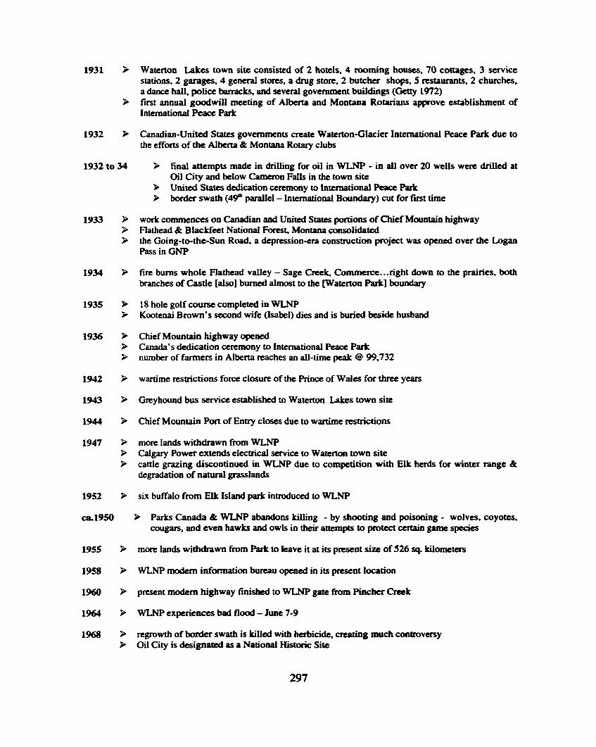
Watcrton Lakes town site consisted of 2 hotels, 4 rooming houses, 70 cottages, 3 service stations, 2 garages, 4 general stores, a drug store, 2 butcher shops, 5 mtaurants, 2 churches. a dance hall, police barracks, and several government buildings (Gctty 1972) first annual goodwill meeting of Alberta and Montana Rotarians approve establishment of International Peace Park
Canadian-United States governments create Waterton-Glacier International Peace Park due to the efforts of the Alberta & Montana Rotary clubs
P final attempts made in drilling for oil in WLNP - in all over 20 wells were drilled at Oil City and below Cameron Falls in the town site
P United States dedication ceremony to International Peace Park border swath ( 4 p parallel - Lntcrnational Boundary) cut for fust time
work commences on Canadian and United States portions of Chief Mountain highway Flathead & Blackfeet National Forest, Montana consolidated the Going-to-the-Sun Road, a depression-era cons t~ct ion project was opened over the Logan Pass in GNP
fire burns whole Flathead valley - Sage Creek, Commerce. ..right down to the prairies, both branches of Castle [also] burned almost to the waterton Park] boundary
18 hole golf course completed in WLNP Kootenai Brown's second wife (Isabel) dies and is buried beside husband
Chief Mountain highway opened Canada's dedication ceremony to International Peace Park number of farmers in Alberta reaches an ail-time peak @ 99,732
wartime restrictions force closure of the Rinct of Wales for three years
Greyhound bus service established to Watcnon Lakcs town site
Chief Mountain Pon of Entry closes due to wartime restrictions
more lands withdrawn fiom WLNP Calgaxy Power extends electrical service to Watcrton town site cattle grazing discontinued in WLNP due to competition with Elk herds for winter range & degradation of natural grasslands
six buffalo from Elk Island park introduced to WLNP
B Parks Canada & WLNP abandons killing - by shooting and poisoning - wolves, coyotes, cougars, and even hawks and owls in their attempts to protect certain game species
more lands withdrawn from Park to leave it at its present size of 526 4. kilometers
WLNP modern information buncau opened in its present location
present modern highway finished to WLNP gate fiom Pinchcr Creek
WLNP experiences bad flood - June 7-9
regrowth of border swath is killed with herbicide, creating much controversy Oil City is designated as a National Historic Site

Mica Dam, on the Columbia River upstream from Revelstoke, backed up Kinbasket Lake, called "NcNaughton Laken for a few years, which flooded thc Rocky Mountain Trench from Golden to Valemount
WLNP experiences another bad spring flood
Alberta government presented its Eastern Slopes Policy, which protected much of the Foothills and mountains outside the national parks from development but a later revision in I984 made it easier for &velopment to occur first & only bear caused mortality in WUWs history public use of snowmobiles ceases in WLNP
WLNP is designated a biosphere reserve in response to Glacier having been designated in 1976
Parks Canada & WLNP abandon no tolerance policy for fires and starts prescribed bums to control undergrowth, diseases, ctc.
Waterton Lakes National History Association is formed to help promote the goals and ideals of the park
International border swath (49& parallel of latitude) is cut again, this time by hand
fish stocking in WLNP discontinued
Oldman River, near Pincher Crtck Alberta dammed by province of Alberta
Prince of Wales designated a National Historic site
UNESCO's World Heritage Committee declares Watcrton/Glacicr In tcrnational Peace Park a Joint World Heritage Site highway from Cardston widening and realignment completed Akamina-Kishincna Provincial Park obtained Class A park status under the Park Amendment Act, 1995
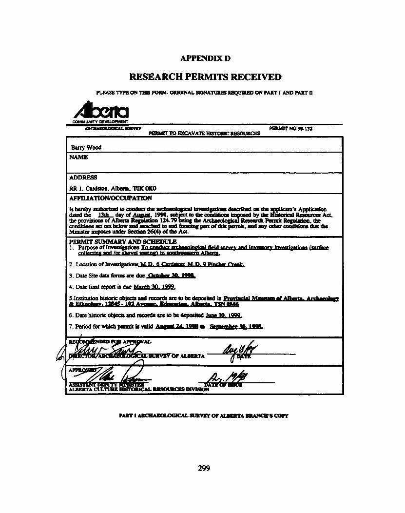
APPENDIX D
RESEARCH PERMlTS RECEIVED PLEASE 'IYPE ON 'I1IIS W. ORIGINAL SIGNATURES RBQWRED ON PART 1 AND PART U
COMwum - -m P a l m ' NOS132
W I L # I T T ' Q W C A V A ' H I S l D i l l C ~
t 1
I ADDRESS
RR 1. m. AtbaP. TDK OK0

PLEASE TYP6 ON THIS FORM. UmA- PmT 1 AND P m U
3. Date Site data fatms ue due -r 30. 1999
4. Dare f d r c p o r ( i s d u c ~
6. Date historic objects and We to b+ deQorited Jurc 30,

Pamlt No. -141
-AGE CONSERVATION ACI'
HERITAGE INSPECTION PERMIT

KTUNAXA/KINBASKET TRIBAL C.0UNCIL
S.S. 13. S m 15. COMP. 14, MISON ROAD CRANBROO~ B,C VI c 6R3
Fax m0) 489-5760 . -N& T k k p b ~ ~ (30) 489-2464
0- -TION P m
PERMIT NUMBER:
PERM~T PERIOD: TO.. (dry) (-1 6-1 (dry) (-1 (yco)
ISSUEDBY: ' - ( s m of-waaiaod KI.aw Nm@ Od3d.I)
DATE: .. . (W) (-1 6'-)
bberebyrrnborimdtocondua.~ . *
(.mcofpaaibdda) - Archaco~ogical h v d p t i o n as -bod in tbc Appliation by& pennit-holder dateQ ' mbjscttothtcnarPad~tionsrctoutoatkmcncof
(ar) (-1 -1 this permit a well u tbt dditioarl d i t i & below. -
. .
ON- AND CO-
Check or con## if4ppIicdIe:
0 2. T b c p m i t . b o l & L t o ~ t n r i b n r . p n p l c , d a b a r . ~ l o g i c a l m u c r i J I ~ b y t h i s ~ o a , i n m u t f o r t b e - Krunwa Nation, with
(Nmuofkthuhmaorbamratr) .
%
. .
COLUMBIA LAKE LOWER KOOTENAY n. MARYS SHCSWAP TOBACCO Pl.AINS

1. The Archaeological tnvcstigatim Permit is valid only f a tbe parnit h o d indicated onthePamit ' I b t p e i m i t p c r i d l n a y b c e x t a d e d b y t h c K ~ N a s i o n ~ receipt the pennit-blda ofa written application for an extended p m i t period.
2. The permit-holder must dv*c the Ktunaxa Nation of my changes in the hvestigation as described in the &lication prior to implementing the changes. Such must
appved in writing by the Ktsl~llao Nation prior to the pnnit-hofikr impkmcuting the changes. Failw to dvije.the Nltim of Neb chrys may tc& the
. P e t .
3. The I(- ati ion m e s the nght to require the cmploymaM of participants in thc investigation by the permit-holder to rqmescnt the twriPgc interests of the K ~ m a u
- Nation where.relevant (e.g. for traditional uadchmgwphic bsckground reseurch, geomorpbologi~soiy&cnt investigatioi. W c mataial analysis).
4. A person designated by the ~tlmrru ati ion may at any thnc insp* any investigation bchg rnoonduasd unda prmit, i~ciuding rsmrds or ~ c o v e l m d a tbe authority of the Permit. -
5. Upon completion of any investigation involving excavatioas, tht-parnit-holder ahall ensure all sites are r c s h d as nearly possible to their fanner condition, to the satisfaction of the Ktmaxa Nation:
6. The perinit-holder must provide the K 6 Nuion will a copy of dl thesis, dissertations, papers and other statements of finding of the investigation within 60 . days of completion. If no reports or findings are gemm&d, the permit-bl&r must inform tbe Ktunaxa Nlrion in uriting of tbe objectives. mahods md results of the investigarion.
7. The permit-holder must provide Ktunaxa Nation with a capy of all field notes, forms, photographs and other original documents resulting.fiom thc investigation.
8. The permit-bolder must be present "on site" for at 1- 80% off all field work tmdcrtakcn under this &t
9. If human maains m found, tbe permit-bol&r must coatact tbc Ktunaxa Nation immediately and must not disturb the mmh until authorized by the Ktunaxa Nation.
10. Thc penait-holder must with the Kbmaxa Nation the "ethnic si-- of - any archaeological rcmaiBs found.
NOTE: Additiod te& a d m y k bpd by tk Ktunmx8 Nrtiaa in the Rnr& such rr rcqulring anploymcnf of 8 r~anbsr of the N&m or deposit of dl lrdrrsolagial mamiab in mut for the Naiba with paticuk h s t h t h .
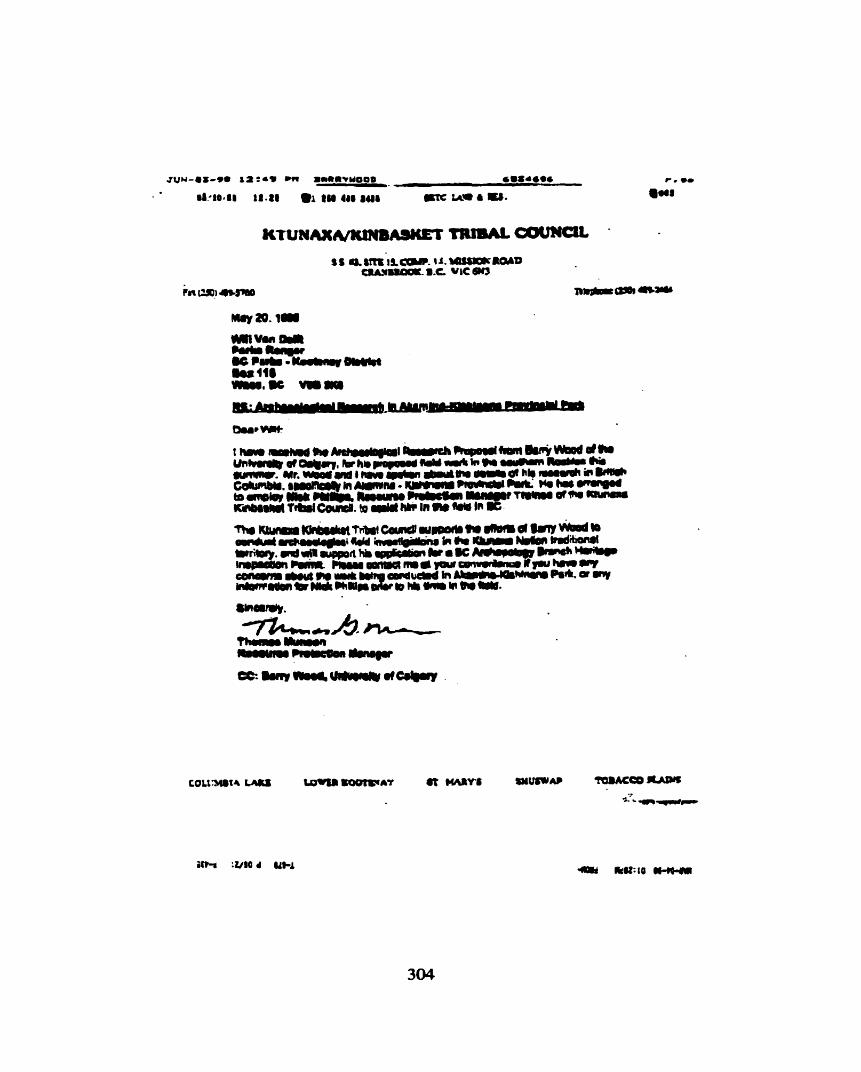

Ql~.~p+, :-bi < . . -
wed * g i j @ @ 39
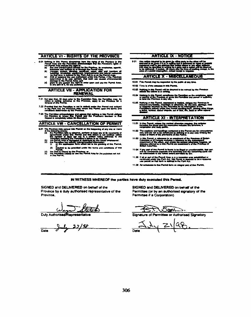
v ARTICLE VI - RIGHTS OF THE PROVINCE ARTICLIE 1X - NOTICE
ARTICLE VU - APQUCATION FOR RLNEWAL
ARTICLE vnr - CANCELLATION OF PERMIT
ARTlCLE XI - INTERPRETATION
- - - - - . . .-
IN WITNESS WHEREOF tha parties haw duly r x u u b d thh Pormit.
SIGNED and DELIVERED on k h J I of the SIGNED and DLUVEREO on b.nlf of the Province by a duly authorbed npmrentotive of the Pannittea (or by an 8uthofiwd signatoy d the Province. Permittee if a CorpemWn)
Duly ~ u t h o r i ~ e p r e s e n ~ -
Signature of Parmittme or Authorisad Signatory 1
5kLkLl 2\ cce,& Data
- Date L

*-:MA-NAGEMENT PLAN SCHEDULE
PERMIT AREA MESCRIPTION
The Permittee is authorised to enter the Permit Area described below and outlined in red on the atteched map.
AkamimMshin.na Provincial Park
PURPOSE
This P m i t is issued to the Permittee for the purpase of cultad rrsourro mmrgmrntnnwntory.
SPECIAL PROVISIONS
- Parmittn mrnt contact BC Padm prior to any field work in park to adviw of schsduio and arrange joint fidd inspection.
- permittee Is not pamWod to romove any cultural retsources from the park
- copies of m y nport8, summaried, documents produced for thb project to bo copled to 6C pukr district office.
- contact for this project will tk Will VanDdft Area Supervisor.

To: &nywood f'emmeeFle KO8610181 RR #l No.: -101 51
-,Ukrb W O K 0 hmrlt No.: Jury 20, f mo me:
the 'PemMxtrn
Purpow: Su- Area: U u m t n l ~ ~ P l o ~ P I l k
WHEREAS:
A. HER M S N THE QUEEN IN RJGHT OF T I E PROVINCE OF BRITISH COCUMBU, mpmemW by the Mirrbtsr mpomibb lbr the Park &t (the --,) b8wd eblmit NO. KO9610151 (me 'PemJt.) b the Perwmw.
8. The Prwince agrees to renew the Psrmlt for a term of hrvo(2) years a#nmendng on hmrnkr 1,l- ard expiring on AugW 31,2000.
C. The pmvidom of this Pmit Renewal C o m drdl be domed Do be incorporstsd i n t b a m mentioned permit -to the m W the term ofthe Pam& b ederrded and dl ather pcovisionr and corrd4bft~ 8hal m i n in WI for#, and dfact * Dub of the
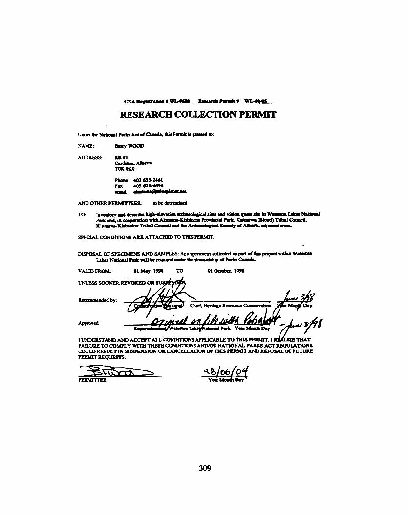
RESEARCH COLLECTION PERMIT
NAME: -WOOD
ADDRESS: RR U 1 -- 'IOAOKO
SPECIAL aNDmOZiS ARE AlTACHBD 'TO THIS m.
DEPOSAL OF SPECIMENS AND SAMPLE& Any rpffimem c o w u prrt &(hi plojsA a W m ~ N a t i d P I l t d k I U 8 i d * c h c ~ d P r t r r m v L

SPECIAL CONDTLTONS:

BLOOD TRIBE LAND MANAGEMENT P.O. BOX 470 STANOOFF, ALBERTA TOC 1 YO Phone: (403) 737-81 51 Fax: (403) 737-2336
PER DATE i4 r 1998
Y GRANTED
PURPOSE : &
EXPIRY DATE
c-~NwRl lTD

BLOOD TRIBE LAND MANAGEMENT P.O. BOX 470 STANDOFF, ALBERTA TOL 1 YO Phone: (403) 737-81 51 F a : (403) 737-2336
DATE
EXPIRY DATE
P-CLllrrrmLTD
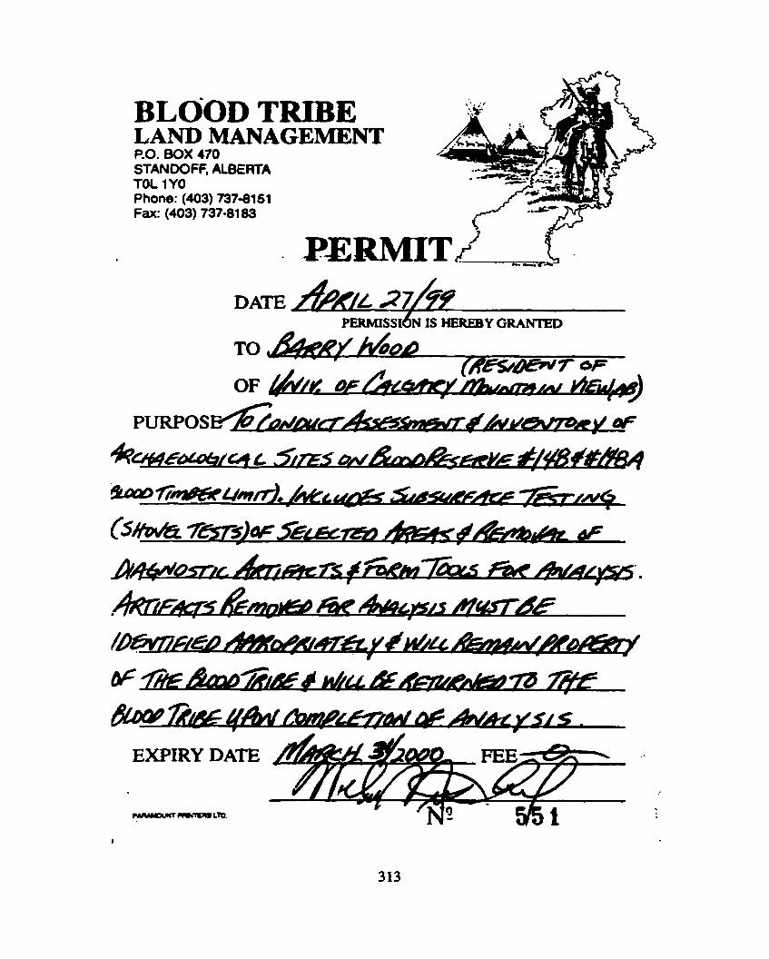
BLOOD TRIBE LAND MANAGEMENT P.O. BOX 470 STANDOFF, ALBERTA TOL 1YO Phone: (403) 737-8151 Fa: (403) 737-8183
DATE 2 7 / ~ PERMISSI~N IS HEREBY GRAKPED
-
PURPOS
EXF'IRY DATE
r.- - L t a
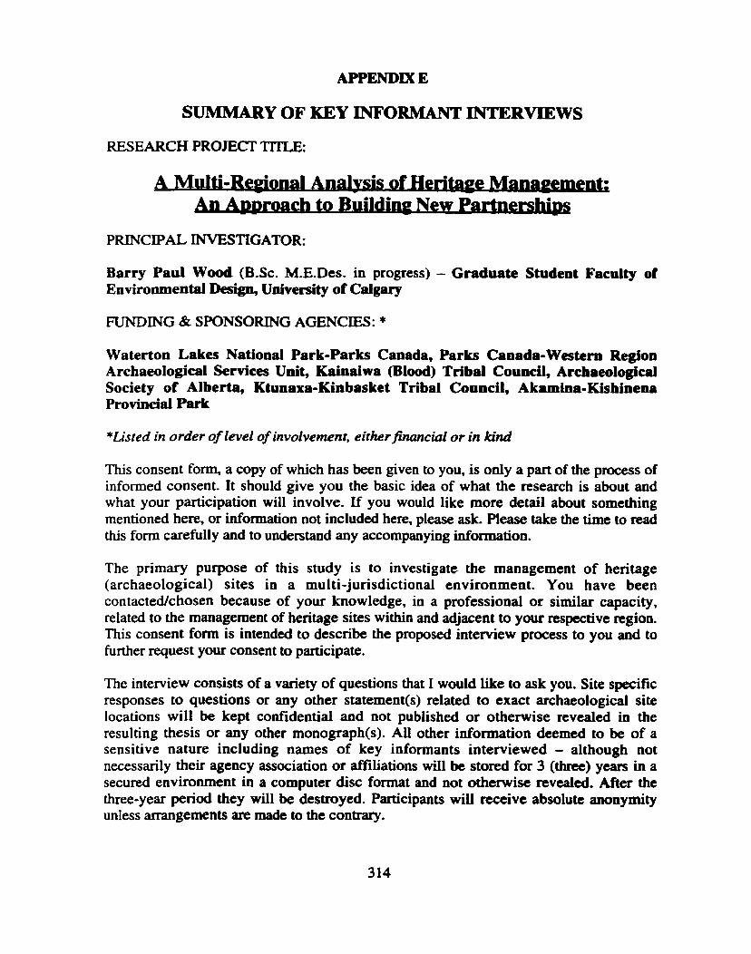
APPENDIX E
SUMMARY OF KEY INFORMANT INTERVIEWS
RESEARCH PROJECT TITLE:
n b r o a c h to B- New P e e r s m
PRINCIPAL INVESTIGATOR:
Barry Paul Wood (B.Sc. M.E.Des. in progress) - Graduate Student Faculty of Environmental Design, University of Calgary
FUNDING & SPONSORING AGENCIES: *
Waterton Lakes National Park-Parks Canada, Parks Canada-Western Region Archaeologjd Services Unit, Kainaiwa (Blood) Tribal Council, Archaeological Society of Alberta, Ktunaxa-Kinbasket Tribal Council, Akamina-Kishinena Provincial Park
*Listed in order of level of involvement, either financial or in kind
This consent form, a copy of which has been given to you, is only a part of the process of informed consent. It should give you the basic idea of what the research is about and what your participation will involve. tf you would like more detail about something mentioned here, or information not included here, please ask. Please take the time to read this form carefully and to understand any accompanying orm mat ion.
The primary purpose of this study is to investigate the management of heritage (archaeological) sites in a multi-jurisdictional environment. You have been contacted/chosen because of your knowledge, in a professional or similar capacity, related to the management of heritage sites within and adjacent to your respective region. This consent form is intended to describe the proposed interview process to you and to further request your consent to participate.
The interview consists of a variety of questions that I would like to ask you. Site specific responses to questions or any other statement(s) related to exact archaeological site locations will be kept confidential and not published or otherwise revealed in the resulting thesis or any other monograph(s). All other information deemed to be of a sensitive nature including names of key informants interviewed - although not necessarily their agency association or affiliations will be stored for 3 (three) years in a secured environment in a computer disc format and not otherwise revealed. After the three-year period they will be destroyed. Participants will receive absolute anonymity unless arrangements are made to the contrary.

It is hoped that participation in the process will assist al l stakeholders (people with interests or concerns in this research initiative, either because they are affected by it, or involved in it) in defining past and present issues andlor problems and aid in developing strategies for future scenarios related to the long-term management of heritage sites.
The interview is expected to take approximately I hour to complete and can be administered in your choice of locations, or if you if prefer, email or fax format. This latter scenario is envisioned appropriate in those circumstances where the individual to be interviewed lives some distance from the principal investigator or whose woridtime schedule cannot otherwise include a personal meeting.
Your signature on this form indicates that you understood to your satisfaction the information regarding participation in this research project and agree to participate as a subject. In no way does this wave your legal rights nor release the investigators, sponsors, or involved institutions from their legal and professional responsibilities. You are free to withdraw from the study at any time. Your continued participation should be as informed as your initial consent, so you should feel free to ask for clarification or new information throughout your participation. If you have any further questions concerning matters related to this research, please contact:
Barry Paul Wood at:Rural Route # 1, Cardston, Alberta, TOK OK0 Telephone: (403) 653-2461 Facsimile: (403) 653-4696 Email:-@bm - ' -or
If you have any questions concerning your participation in this project, you may also contact the Environmental Design Research Ethic Committee, Professor Richard Revel, Ph. D. (403) 220-3622
Participant Date
Investig ator/Witness (optional) Date
Please make a copy of this consent form to keep for your records and reference.

KEY INFORMANT INTERVIEW GUIDE
This key informant interview is designed to follow a semi-structured fonnat. The format will focus on general areas of inquiry related to involvement and/or participation with matters related to heritage site management. Interview subjects will be encouraged to relate those issues and concerns that they maintain are relevant to the nature of information being sought. It is an attempt to gather qualitative and descriptive data in order to compile information that when combined with other phases of research will provide a usefd decision support tool.
This questionnaire is designed to elicit information on a professional or otherwise work related level. No inferences will be made to suggest those individuals interviewed have expressed a personal view on the subject of the management of heritage sites and none will be made or expressed by the principal investigator in the interpretation of the results in any document, report(sj or thesis.
Names will be with held from the Master's Degree Project (thesis) document. Agency affiliation may however be included in order to illustrate overall stakeholder involvement and cooperation within the study region.
Name:
Affiliated Organization:
Position Held:
If you have any further questions concerning matters related to this questiomaire, please contact: Barry Paul Wood at: Rural Route # 1, Cadston, Alberta, TOK OK0
Telephone: (403) 6552461 Facsimile: (403) 653-4696 Email: &mid@-
bwood @ ucalgary.ca
NOTE: Pleae feel free to respond by email, fcuc, mail or courier. I would ask that responses by submitted by the week of November 15 to 19,1999 in order to be included within the thesis document that is presently being completed
I would like to thank you in advance for any and all assistance you provide on matters related to this questionnaire and research. Your response is considered valuable and aa important part of this research project.
1 F o f - (total respondents = 14)
I I The length of time you have been in the gosition that you now hold 6: I 57% have been in position they now hold for between one &jive years
43% have been in position they now hold for more than five years
2 Have you ever visilcd a heritage site under your agency protection or ' management? If so, what kind of site was it?
36% have never visited m y heritage sites 36% have visited both Precontact & Historic sites in both a business & pleasure capacity 2 1 % have visited both Precontact & Historic sites ifi an official capacity 7% have visited both Precontact & Historic sites for pleasure only
3 Your involvement with matters related to heritage she management and lrerilage siles @rehistoric, historic & paleontological) is:
36% report their involvement is yearly 28% report a monthly involvement 28% report a &ily involvement 7% report no involvement
14 Describe or iUustrate the boundiuies ofthe jurisdiction that you nonage* I RESPONSES
primary highways & associated infrastnrcnue (gravel pits, borrow pits, bridges throughout Alberta) the operating area for forest License A20213 in the Kootcnay Lake Forest District Cranbrook Forest District (see attached map) Southern portion (30%) of the Cranbtook Forcst District - from the Yahk range on the west to the BUAlta border on the cast & Elko on the north to the CanadaNSA border on the south Glacier National Park (ca. 1 million acres) Municipal District of Pincher Creek I do not manage any land area or land base. I advocate conservation of natural history and wildlife on the landscape. I work on issues in the Flathead Valley & the Elk Valley The Flathead National Forcst manages 2.2 million acres of public land stretching along the wcst side of the Continental Divide from the Canadian border to the Blackfoot River & wcst to the Stillwater River. It shares a common boundary with the Flathead Indian Reservation, Glacier National Park & 4 other National Forests. These lands are in 5 different Montana counties surrounding a dozen or more separate communities. These lands include 1 million acres of Congressionally designated wilderness. The Castle Forest Land Use Zone or the Castle Wilderness from Waterton Lakes National Park to the Carbondale/Crowsncst drainage divide. National Parks & National Historic Sites in Alberta & British Columbia Ktunaxa-Kinbasket Traditional territory includes the Columbia Basin watershed and tributaries in British Columbia (see attached map) Within boundaries of Alramina-Kishinena Provincial Park, BC

Upper Columbia River drainage excluding Okanagan & Kettle rivers with regard to archaeological research and information management; District Lot 12975, Kwtcnay District, with regard to any kind of real on-the-ground effective input into land use decision-making Boundaries of federal laads designated to Kainaiwa (Blood Tribe) include those lands in southern Alberta now known as Blood Rtserve #148 and #148A (Blood Timber Limit). Kainaiwa also has an interest in traditional lands utilized and occupied by them prior to European settlement, that now exist outside of the cumnt Blood Reserve boundaries.
5 What htad use activities occur on or in your jur*&efin? Attach list vrequrrd 1 RESPONSES
all manner of natural resource extraction (timber, minerals, coal), agriculture, range land pasture, residential & industrial development, hydro dams protec tion/prohibition of use, Trans Canada highway, commercial, midential, tourism, guiding, park management logging, grazing, oil & gas extraction, pipelines, ski resorts, off-mad vehicle use, recreation activities, random camping & cottages/villages timber harvesting. some road construction & maintenance, some mineral extraction. Lots of recreational activities - camping, hunting, fishing, hiking, boating, skiing (there am 2 ski resorts on Flathead National Forest lands), snowmobiling, outfitted backcountry nips with professional guides forestry, mining, oil & gas. recreational access (ATV's etc.), backcountry commercial tenure operations, hunting & fishing (local & guide outfitters), cattle gazic1g country residential, fanning/agriculture, ranching, foresay, parks-provincial, recreational. hamlets, commercial highways. Oil & gas tourism, sightseeing, fishing, camping, staying in historic hotels Recreation - hunting, fishing, hiking, biking, touring, canoeing. boating, snowmobiling, skiing(downhil1 & back country), petroleum exploration, mineral exploration, guiding/outfitting (fishing & hunting), timber harvesting (road construction) Forestry & Range management Road development & harvesting s i l v i c u l ~ treatments (planting, site preparation, brushing, pruning & spacing, etc.) Road way construction & maintenance Recreation Agriculture; forestry; road, railway & pipeline construction and maintebaace on DL 12975 Land use activities that occur can be divided into two categories, 1) traditional and 2) currcnt and include but aren't limited to the following: traditional - hunting, fishing, trapping, plant (root, timber, herb, berry and seed) and mineral collecting for ceremonial, healing and sustenance purposes, use of various sites (on and off resene) for vision questing, sweat lodges, ribbon sites, etc. current - agricuItura1 (cropping and livestock grazing), oil and gas exploration, water (irrigation) diversion, mineral (ammonite and aggregate) excavation and surface collection, timber harvesting, public utility right-of-way construction (power, gas and communication lines), community (educational, medical, public utility facility and public road construction), residential (housing, water, sewer and electrical construction), and commercial (grocery ston, gas station and other small business venture construction) &velopmcnt.
6 Name any and/or oU individuals, irastitutbns, agencies who have a concern with or you huve dealt with, on matters rewed to heritage siles - either within your respective jurisdiction or outside.
RESPONSES Alberta Community Development, Indian & Northern Affairs Archaeology Branch, BC government, Eagle Vision Geomatics & Archaeology (Ktunaxa-Kinbasket Tribal Council) Forest indusuy, government ministries. First Nations groups (local), stakeholder groups (eg. - guide outfitters. ranchers, mcmtion clubs Wayne Choquette (archaeologist), Bonnie Campbell (archaeologist), Margaret Rogers (archaeologist), Thomas Munson (Knmaxa-Kinbasket Tribal Council), Doug Glaum (Archaeology Branch - Ministry of Small Business, Tourism & Culture (BC) National Park Service, Montana State Historic Reservation Office. President's Advisory Council on Historic Preservation, National Trust for Historic Reservation. Glacier Park Incorporated (Park's main concession), Waterton Lakes National Park Canada (occasional). Property owners, Blackfeet Nation, Flathead Nation (Kootenai & Salish) None Ktunaxa Tribal Council (Elders Committee) Montana State Historic Reservation Off~ce (MtSHPO), Confederated Salish & Kootenai Tribes (CSKT), Blackfeet Nation, Advisory Council on Historic preservation, Bonnevitlc Power Administration (BPA), Bureau of Reclamation (BoR). Glacier National Park (GNP), The University of Montana (UM), Montana Department of Transportation (MDOT) In the broad definition of heritage sites none of these organizations or the CCWC has heritage sites as the primary mandate; ANHIC, Peigan, Friends of the Oldman River, MD of Pincher Creek, forestry, organizations with more direct interest include Waterton Lakes National Park & local archaeological researchers Other park managers. Superintendents, Wardens. First Nations, universities, commercial operators Archaeology Branch (Victoria), BC Parks, Parks Canada, Consulting archaeologists. Resource developers, local museums Ktunaxa Kinbasket Tribal Council All of the major logging and mining companies in the east Kootenay area, BC Hydro, BC Gas, Alberta Natural Gas, BC Ministries of Forests, Parks & Highways, the East & Central Kootenay regional Districts, numerous local land &velopcrs. etc. Individuals and agencies contacted re: heritage site matters:
- Rennie Tallow (Kainaiwa historian) - Louis Knife I (deceased Kainaiwa elder) - Rosie Red Crow (Kainaiwa elder) - Tom Holy Singer (Kainaiwa eldcr) - Annabel Crop Eared Wolf (Kainaiwa Tribal Government) - Dennis First Rider (Kainaiwa Tribal Government) - Barry Wood (University of Calgary) - Rob Wan (Parks Canada - Watemn Lakes) - Brian Kooyman (U of C) - Len Hills (U of C) - Marty Magne (Patks Canada Western Archatological Services Unit - Calgary) - Jack Brink (Provincial Museum of Alberta)

! 7 Do you maintain that the level of cooperation, between srctkehoIders, is adequate to properly manage, (e.g. including but not limited to affording protection, conducting research & providing public interpreiWon) h e d g e sites within, and adjacent to, your jurisdiction? If not, why not?
RESPONSES No, the BC archaeology branch has management authority, but really only maintains a dambase of heritage sites & issues permits for heritage site inspection. on the ground protection of heritage sites is minimal outside of BC or Federal Park Usually, yes No, heritage site protection is not the primary interest of any of these groups, it is an add on, there is little cooperation between groups beyond initial contact, some of the interest arc in exact opposite direction to protection Yes, I believe we all work well together to meet our common goals of preserving and protecting heri rage resources I'm not sure what level of cooperation exists between other stakeholders so cannot adequately answer this question I have no knowledge of what the level of cooperation between stakeholders is or whether it is adcquatc I don't think any higher level will ever be adequate. cooperation is handicapped by lack of communication and by some stakeholders needs to make a profit. and by some individuals need to vigorously defend their private property rights Yes Yes, as per: Heritage Conservation Act (1979) & BC Archaeological Impact Assessment Guidelines At the present time cooperation is reasonable & ow company has not identified any sites - the logistics of producing an accurate overview assessment to private arcas for detailed surveys is currently ongoing Yes Yes The cooperation of local agencies would probably work if there was support, both administrative and legislative, from the provincial govenunent. Othenvise, there is no real heritage "management", rather knee-jerk reactive situation arising from a limited amount of referrals that are reviewed by the Archaeology Branch in Victoria and which are subsequently dealt with in some fashion by consulting archaeologists who do not necessarily have the background or expertise to respond adequately. There is no coordination of the information arising from any archaeological investigations in the region at an institutional level and no effective follow-up with regard to the effects of development on sitcs that have been considered as a result of referral. No. Wor to the current Kainaiwa Forest Management Pilot Initiative, cooperation with Kainaiwa by other neighboring agencies and vice-versa was not occurring as it should have been. Primarily, I believe, due to ignorance and lack of awareness of cultural resource and heritage site management and the threat this type of issue may have on economic and resource development initiatives. Since this so- called "Pilot" initiative has evolved, cooperation in regards to management of resources on the Blood Timber Limit has improved, but is still lacking and could improve for the main Reserve (J1148).
8 What are the specific processes andlor mechanisms for idmti i ing and involving stkzkehocder~ in heritage site management within your jurisdiction? At w h t s w e in the process do you get involved?
RESPONSES Commences with functional planning, intergovernmental referrals until roadway construction identification - archaeological overview assessment to priorize survey sites, developmental plan referrals to Ktunaxa Kinbasket Tribal Council for review by archaeologist, district manager Ministry of Forests instructs forest license to conduct detailed survey, surveys done under permit by Eagle Vision

(Tribal Council organization) and their archaeologists, fons t company involved at forest development plan dependant on results on the m e y
- (not involved) general overview - ranking of district by lancfscape unit, - (involved) using stage 1 results (plus input from forest industry & First Nations) of priority in which landscape units to conduct archaeological Overview Assessment (AOAs), - (involved) using stage 2 results to conduct Archacological Impact Assessments (AIAs) SteD1) Ministry of Forests complete a Archaeological Overview Assessment (AOA) Wayne ChoquettcKKTC currently working on project completion; p lygons mapped as having high or moderate likelihood of historic use arc further field surveyed through a prciiminary field review (PFS) or an Archaeological Impact Assessment (AIA) when proposed road construction o r harvest proposal overlap onto these polygons identified in an AOA; CCFI has used Wayne Choquette to review proposed road & harvest development in areas where AOAs an not completed he then directs PFS or AIA works if required; CFI completes a prescription to either protect or minimize disturbance to any sites found during PFS or AIA phases, prescription usually follow archaeologist & Archaeology Branch recommendations, CFI gets involved b m Step 2a Meetings, newslentrs, notices o f public review of proposals, telephone calls, newspaper articles, 1 should be involved at every stage, I get involved as early as I can in any process I don't know, I don't get involved NI A As the Forest Archaeologist I am involved from the earliest stages of project development whether the project directly involves cultural trsources or not. The National Envimnrncntal Policy Act (NEPA) and the National Historic Preservation Act (MIPA) require the involvement of cultwal resource specialist early in project dcvclopment. We arc also required by law to consult with SHPO and the relevant tribes throughout the process. Most of out stakeholders arc listed above and have been identified by Law, custom, and experiences. Additional project specific stakeholders should be identified through the NEPA process which requires and defines the amount of public involvement in the development of a project and the management of public lands We do not have any because heritage protection is not our main focus. There is not a lot of interest in heritage sites locally. They arc occasionaliy discussed at MD planning meetings but there is no apparent policy on how to deal with them. Many processes, public consultation on Park Management Plans & Town Site Plans, Canadian Environmental Assessment review panels (CEAA) & CEAA screenings by other Ftdcral departments Archaeology Branch referrals for Heritage Inspection Permits & Site Alteration Permits, Ministry of Forests/License referrals for Archaeology Impact Assessments & Archaeological Overview Assessments and involved through consultation on referrals. Consultation as andlor when issues arise Sporadic referrals to the Archaeology branch or to the Ktunaxa/Kinbasket Tribal Council. My involvement, if any, usually begins when an agency or developer contacts me as a result of consultations with the Archaeology branch or the Ktunaxa/Kinbasket Tribal Council. Currently, there arc no formal processes or mechanisms in place other than what is required under the Canadian Environmentai Assessment Act (CEAA). However. relevant processes and mechanisms arc currentIy being developed, and it is the intent, that an archaeological and traditional land use inventory be conducted for all lands undcr the current and traditional jurisdiction of Kainaiwa. 'Ihe purpose would be to identify, protect, p m e and promou various significant sites for the use and benefit of current and funuc generations. Kainaiwa Lands Administration currently gets involved when there is a potential site reported dwing development construction or personal experience. That's only if these sites get reported, which in most cases they don't.

9 Describe or List areas and/or sites that the agency you represent considcr csensih've' and thereby wortlry of protection. Please feel fiee to e h s e p m t e list if required
RESPONSES All traditional archaeological sites within the traditional temtory, areas designated as having 'high archaeologicd potential' using archacological potential modeling or archaeological overview assessments All National Parks and National Historic sites The Peigan paint colletion site. the Vision Quest sites on Table Mountain, the Native trails through the mountains, campsites and hunting sites of the native people. We also have an interest in sites of logging, mining, trappers cabins. etc. not for preservation but for restoration The National Historic Preservation Act established the National Register of Historic Places (NRHf) and the criteria that a site or property must meet to be considered eligible for listing on the National Register. If a cultural site is located on National Forest land we evaluate it against the criteria and if its determined to be eligible then it is managed to protect its historic values. This &termination is made in consultation with the SHPO, the Tribes, the Advisory Council and other interested parties if there are any. We have a list of some 400 cultural sites in the Forest not all of which have gone through the formal process but probably half would be considered eligible for the NRHP. We work with the Ktunaxa to receive this information. Please contact the Tribal Council directly. River bank. wildlife corridor & flood plains Archaeological sites (subject to vandalism, loss through weathering. sensitive to Native American concerns), historic buildings, roads (need appropriate maintenance. must meet standards for safety and accessibility) All areas identified and recorded with Archaeology Branch plus areas (new) discovered during CFI funded AIA or PFS works that an recommended for preservation. As per the Forest Practices Code there is a requirement to manage and conserve archaeological sites, we will manage identified sites to a level acceptable to Tribal Council. Archaeology Branch with final approval by the district manager (MOF) Cranfotd Junction Follow guidelines of Ministry of Small Business, Tourism & Culture, Archaeology Branch (eg - prehistoric sites, campsites) South Kootenay Pass site I don't really represent any "agency" any more as I am a consultant but also an independent researcher. Almost all of the sites in the region are sensitive unless they have been determined to be too disturbed to yield information or be useful for interpretation Areas or sites classficd as "sensitive" would include but arc not limited to:
- Sundance (traditional and current) lodge sites; - Vision quest sites; - Medicine Wheel sites; - Buffalo Jump sites; - Shecp oappiag sites; - Traditional sweat lodge sites; - Traditional burial sites; - Traditional landmark sites (glacial erratics, prominent landforms. etc.); - Traditional prehistoric tool-making and camp sites (tipi rings); - Plant and mineral collection sites (ceremonial, healing and sustenance); - Habitat where significant species occur that arc utilized for ceremonial, healing or sustenance
PW"-=

10 Describe or list areas and/or sites that your agency understands to be sacred accoiding to Treditiond a d o r Contemporcvy First Nations beliefs. Please feel pee to altuch s e m e list ifrequired
RESPONSES Most of southern Alberta where water, shelter & food sources were available, along rivers, lakes & prairie areas N/A A Traditional Use Study (TUS) was completed by Ktunaxa/Kinbasket tribal Council (KKX) (August 1998). We work with KKTC to identify specific sensitive areas. Local P i t Nations art sometimes reluctant to release information on samd/scnsitive areas. As per the Iist at Archaeology Branch & archaeologist recommendations (W. Choquettc). Local Ktunaxa-Kinbasket F i t Natioas do not specifically identify artas or sites No. That son of idonnation is not readily available without discussion. It is more the business of those "First Nations" This infomation may be on file in the M.D. but I don't know what they are nor can I List them. Contact the Ktunaxa See above. Even if I had such a list or map, I could not ethically or legally release it. The paint site and Vision Quest sites. My "agency" does not grasp this entirely. There arc, however, designated amas that are recommended for their national significance on terms of Aboriginal ...All of these have some degree of "sacredness" to the respective groups. Certain areas and sites within the Ktwraxa traditional territory where ceremonies w e d a r t performed; ancient quarries; vision quest sites; pictograph sites' caves. The above site (South Kootenay Pass) is considered sacred as all significant places are considered sacred Because of the complete integration of religion into the Knmaxa's daily lives, all of their sites arc sacred. There are areas that contain specific features such as cairns or rock art that western culture would consider to be "more sacred" but the Ktunaxa religion does not pennit discussion of them. There are also places that arc of cultural significance but these arc not coextensive with archaeological deposits or features and are not protected by the heritage Conservation Act Areas documented on the Blood Timber Limit in the 1998-99 archaeological and traditional land use initiative and areas on the Blood Reserve and surrounding traditional Kainaiwa tcmtory where some are known and documented and others are not. (*Note: a complete listing of these sites is not known by the author, but several have been documented as part of the Little Bow-Highwood, Oldman Dam, and other major development initiatives and others are known by various Kainaiwa members and the Department of Tribal Government, but have not been officially documented). For further information on site locations and descriptions, Kainaiwa TribaI Govenuncnt should be contacted.
11 Is it an outornutic andor understood policy that all stakeholders freely disseminate information (egg. in-louse reports, university research or consultants reprts) telated to heritage sac managemen!? FuUy undcr~tmuibg the necessity to treat the in/onnation as protected and not for the gened public - How often does it happen? .
RESPONSES a Cultural (archaeological) and traditional use information is treated as confidential and not for
dissemination; government agencies do ppt apply normal F.O.1 rules to Fmt Nations a No - we do not automatically divulge some ... information to protect the resoume and sometimes u the
request of Aboriginal peoples. No

With certain exceptions, such as places having important spiritual conaections for the Tribes, there is a pretty good exchange of information between the various stakeholders We do not publicize heritage sites and rarely have access to this information (we d i z e the necessity to treat this info as protected). Instead, we encourage all stakeholders involved in land use development and resource extraction to contact the Ktwraxa before development plans arc approved - for heritage mgmt info Bi sensitive sites. Not applicable No. Archaeological site locations are legally pmtectcd in the US and I am reluctant to divulge sacred site location information. No information is distributed from CFI funded projects this was requested by the Knmnaxa-Kinbasket Tribal Council. CFI archacologist/KICIY: and Archaeology Branch hold information only. General understanding of process; held workshops with stakeholders (1997, 1998 & 1999) Liaison with First Nations regarding sacred sites and their management is channeled through the Ministry of Forests and then to the company. We respect the privacy of not releasing information on sensitive sites (as instruct& by the Ktumxa-Kinbasket Tribal Council) Yes. Reports provided to.. . We usually seek tribal council approval to disseminate information. Requests for information occurs very infrequently Very erratic - usually the "stakeholders" (the ones who arc obliged to pay for the work and thus get the reports) are not interested in disseminating information because it costs them money but there arc no consistent policies or guidelines regarding dealing with inquiries with the public. Otherwise, it is left up to the "professionals" to share information, which is also erratic due to the money factor. There is one consulting firm [...name removed by author ...I who explicitly do not share information or participate in research with me due to their adherence to a privatist profit-oriented ethic (or lack of ethics) - this competition in an information-management context where the information is by its very nature a common good (i.e. "heritage") is illustrative [of) a serious dysfunction in contemporary heritage management in the upper Columbia region. As far as I am aware, no, it is not an automatic or understood policy that this type of information is freety disseminated by stakeholders. Also, as far as I am aware, I am not sure how this **classified information is treated and if it is truly 'klassified"
I2 Are the regulatory agencies (provincial & federal) sensitive of and knowledgeable a&& local and regional issues pertatoning to the management of all classes of herifrge sites within your jurisdiction? Yes or no - please feel /rcc to comment d attach extra page if required.
RESPONSES Yes No. There are some significant conflicts be tween Archaeology Branch and the Ktunaxa-Kinbasket group; MOF is very in tune with all issues and arc the lead agency for referrals and consultation Yes, with the Ministry of Small Business, Tourism & Cultwe. Archaeology Branch Yes to the pre 1870 sites; Yes/No to the post 1870 sites, logging camps need more documentation ctc. Before they disappear (decompose, etc) ? Usually. Lack of sensitivity is usualIy demonstrated because of lack of knowledge. I believe both levels of regulatory agencies are reasonably sensitive of and knowledgeable about local and regional issues relating to heritage sites but I don't have anything to base this belief on, BC Parks, Archaeology Branch of! Some agencies are and some are not. Most federal land management agencies have 30 years experience with these issues ands art fairly sensitive to them. The federal government has the strictest laws after all. As you move away from federal land management to just regularity agencies and state and local agencies the seasitivity seems too generally dacrease. No the provincial government downloaded a lot of responsibility on land use to the MDs and those people have no training, exptrtisc or even a reference manual about heritage sites. Some have no interest in them either-
Yes. Government agencies are sensitive to need for protection of confidential cultural information but some agencies would like access to more information that is held by First Nations BC Parks is sensitive to sites within park boundaries that we are aware of. Full knowledge of local or regional issues remains with the Tribal Council and may not be divulged to public agencies Highly variable and inconsistent, but generally no. Even depends upon individuals within the various agencies, including the Archaeology Branch who arc basically the ONLY agency with any kind of legal mandate to deal with archaeology in the province. Nobody in the Arch. Branch can k considered to be d y knowledgeable about local and regional issues, although perhaps a few of them might be considered to be "sympathetic". In general, though the Archaeology Branch has turned into an unresponsive bureaucracy who considers heir mandate to be "administering tht Heritage Conservation Act", which to them means dealing with permits, not dealing with archaeological resources. Nobody else in the province has any kind of mandate to pursue interest in issues to the level of meaningful involvement, At this point, based on my experience, I believe the only federal depamnent that is sensitive and about heritage site management issues is Parks Canada- The Department of Indian and Northern Affairs Canada (INAC), who is the federal pordolio responsible for heritage site management on First Nation lands, although knowledgeable about heritage sites, sterns disconcened and indifferent on these issues. Although some heritage site investigations have been conducted over the past 40 years through INAC initiatives, no protection or promotion measures have b a n implemented
13 Have you ever comkute4 or been contacted by, any of the fobwing individuals or groups on matters related to heritage site munagemeat? P h e circle any or all that apply.
RESPONSES non profit society, foundation or non-governmental organization
Yes (n=7) No (nd)
First Nation individual or representing agency official Yes (n=Zl) No ( n d ) 1 Yes regukuly
Provincial or Federal regulatory agency (e.g. BC Ministry of Small Business, Tourism & Culture - Archaeology Branch or Alberta Community Development - Archaeological Survey Provincial Museum of Alberta or Canadian Heritage - Parks Canada)
Yes (n=9) No (n=3) I Yes through r e f e d
Consultant archaeologist or University Researcher Yes (n=12) No (n=I) 1 Yes W. Choquette
Other.,.please List - Environmental groups - Resource developers - Private lando~~~rs/devtlopers - Hydro utilitks - Individuals Intertsw ib ncotding/pmtding lad paat 1870 sites - Scbods - Industry grrwrps - Interested members d tbe gcnerrl public

14 Are their mechunisllls ih p k e 9 or phned, to effectively deal with d pmperly coordinate the ~ ~ g e m e n t of all levels of heritage sites within yours and djacent jurisdictions? -
RESPONSES Yes (n=9)
I planned - currently in BC today Treaty negotiations Ktunaxa plan to take control of management & protection of Ktunaxa cultural resources, because thc Bc government is not adequately protecting them by Yes I mean that @C] Heritage Branch has made an overview and map notation of this area & deemed it worthy of protection (but] no other physical management takes place Yes but could be improved No/Yes? post 1870 - CFI currently identifies & protects or preserves minimal disturbance activities on identified post 1870 sites as well Yes pre 1870
No (n=12) No-significantinformationgapsexist No - probably not. As employees we maintain working relationships & communications with counterparts in brother agencies. But not always mechanisms. We all ay to comply with the same laws
Don 't know qeelfiee to expand) (n=2).
15 How are locational data (e.g. archaeological sites - dots on a map or Geographic Infomsatiun System, etc.) marurged wirhin your agency?
RESPONSES We depend on Alberta Community development to track locations of sites Survey site locations are mapped GIs Tribal Council maintains data base; we would maintain sitc locations (in GIs) as well AOAs - Two (2) copies: one (1) in office (and copy to industry upon q u e s t ) and One (1) copy to Archaeology Branch GIs location identified as an "archaeologica1 sitc" on silviculture prescription maps and text; yearly archaeology report (CFI funded) which is stored in private CFI files. Protected-Notreleased Presently locational data is managed by symbols on a map. We arc implementing a GIs system which will be used for this among other things NIA On this Forest we still have the maps with the dots but we arc slowly switching over to GIs. Other Forest and other agencies arc at different stages of the change. We have no access to information about them. They arc not our primary concern so it is unlikely we would seek them out. We advocate restriction of industrial activity and motorized vehicles so even not knowing were the sites are exactly, our activities support protection of the sites. Site database & GIs; paper files; data on Parks GIs system also. Currently building a lands and resource central database to contain traditional use information, archaeological sitc information/AIA information, archaeological potential mapping. Archaeological sites are catalogued in our fling system As I don't really have an "agency"; there sites exist to me fmt and foremost as places on the landscape in which I live and work and also in my mind with regard to the archaeological aspects. I uy to maintain my own site files but am limited to the results of my own investigations because of the lack of any kind of broader coordination of information management. ~t this point, due to lack of technology (no GIS). information on documented sites on-reserve (received from the Provincial Museum of Alberta) have been manually mapped (pins) and any future developments that may impact documented sites. will be addressed appropriately, where potection of the sitc (based on significance) will be of the highest priority.

16 What knowledge of disturbance(s), include past and present, to heritage sitcs are you aware of?
RESPONSES Grave robbing & 'pot hunting* of heritage sitcs exposed in Koocanusa reservoir, collection of artifacts/quarry materials from known Ktunaxa quarry sites, damage & vandalism of pictograph sitcs and CMTs, physical removal of pictographs, known destruction of sitcs on private lands. Lots Logging, mining ORV use & random camping Historically there have been all kinds of disturbances to heritage properties - settlement, dcvclopment, road consuuction. pothunting, etc. these forces continue but at feast on federal lands they arc moderated by the requirements of NHPA & NEPA. Agencies at least have to think about what they're planning on doing and its effects on heritage sites and where possible, avoid or mitigate any adverse effects, At least in theory and generally this is true. And them arc pretty good criminal punishments for collecting on federal land- If caught and with the evidence to prosecute. Sites on private lands arc not protected at all. NI A None If you mean disturbance by humans, there is some looting. Surface scavenging. Natural weathering such as stream bank erosion has caused losses. And certainly some facility development efforts. especially early ones, caused some damage. Libby Dam & M e Koocanusa flooding Old development sites & past harvesting None in our operation area, we have not found any sitcs All construction activity- Because information on heritage sites remains "in house" and not for public use, dishirbances to sites remains very minimal There are roughly 2000 archaeologicaI sites on record in the provincial inventory in Victoria for the upper Columbia region of Canada excluding the Kettle and Okanagan drainages. Of these. I would estimate that perhaps 10% at most have not been either partially or completely destroyed by indusaial development; private, agricultural or recreational land uses; natural erosion; or vandalism. The same can be extrapolated to unrecorded sites. Of the 200+ sites documented on Blood Reserve #I48 and W148A by the Provincial Museum of Alberta, only those documented as disturbed at that time, and several others disturbed since then are known. However other sites not ducumented up to this point. but still in existence, should be properly investigated, which is anticipated once the proposed inventory is addresd.
17 What land-use activities does your agency ma imin are compatible, or incompatible, witA heritage sites witirin and adjacent to your jurisdiction? Pleuse feelfree to a#ach s e p d e lid if required
RESPONSES All activities undertaken by Alberta Lnfrastnrcture are incompatible with heritage sites This would vary based on site sensitivity, harvesting and development provided that impact mitigation is incorporated into planning, silviculture treatments that do not create ground disturbance. access management maybe an issues for sensitive sites (i.c. road closuh or deactivation) Compatible - harvesting, range and recreation activities, with appropriate considerations where neceSSary To date all CFls forest activities have been compatible - once sites were identified through AIAs or PFSs road locations have been changed to avoid sites and harvest areas deleted (protected) or specific activities prescribed to minimize disnrrbance or protect sitcs
By heritage sites, I am beginning to understand that you may mean only archaeological sites, sacred sites, and ethnographic sites. Incompatible uses would include driving off roadways, camping in undesignated sites. I think this list is a little too vast for me to complete within my time - and your time I cannot answer this as I am not aware of any Depending on what type of heritage site - resource extraction such as mining, forestry and mad building can be incompatible. ATV and ORV use can ruin heritage rrails. Other than standard maintenance kind of activities - painting an historic building, clearing brush of a trail, this agency does not have a list of activities considered compatible or incompatible. Rather, each activity for its effect on heritage sites on a project by project basis. Dependkg on what the site is. why it's considered to be significant and what the activity is depends our evaluation of adverse e f ' t s - whether there are any and whether we need to mitigate. Then arc a number (30-40) publications put out by the national Park Service that provide guidance on determining the efftcts on different classes of sites. So, using these, consultation with SHfO, and working with other specialists, we make a decision about effects and go from there. We support habitat protection. Rotection of habitat in its natural state automatically protects heritage site within area. Industrial activity (logging, oil & gas exploration and extraction are incompatible. Camping, non-motorized recreation, wildlife viewing, horseback riding, hunting, fishing, grazing, guiding, & outfitting, snowshoeing, cross-country skiing & berry picking arc compatible uses. Compatible is a broad term - all uses can be seen as compatible. How you manage the values set forth for the resources is what matters. (lomDatible - activities with little surface disturbance (recreation, tourism, winter selective logging); IncomDatible - road construction, residential or commercial construction, hydro dam flooding, intensive logging/clear cutting, mining. Recreational use i.c. W n g and horseback riding takes place in the vicinity of South Kootenay Pass. Most users are not aware of the archaeological significance of the area which tbcy are passing, hence the activity is considered compatible Depends upon the "information value" of the sites themselves. There arc some sites that arc "context sensitive", i.e. their settings are part of their heritage value and their view-, sound, and smell- sheds must maintain their integrity for the sites to themselves be preserved. At the other end of the spectrum are sites that contain deeply buried archaeological deposits that are still capable of yielding information to controlled data recovery even though their surfaces and their contexts have been completely alurtd. In the latter case, more development of the surface or the surroundings would not degrade the site further as long as the buried deposits themselves were not affected. At this time, no fonnal process has been implemented where compatibility and incompatibility of land use on heritage sites has been addressed. However, it is anticipated that this process will occur. Those land uses believed to be compatible will be those where site disturbance is minimized through non- intrusive development and use. Obviously, those defined as incompatible will include uses where site integrity is affected.
Are the region's stcrkehoIdem adeqU4te~y represented and do they cooper~h*ve& contribute to the management of the region's heritage sacs?
ESPONSES Krunaxa Nation and BC Parks staff has few resources or staff; Archaeology Branch staff all in Victoria; Federal Parks have most resources & small arca to cover, very few staff or dollar resources devoted to areas heritage management outside federal parks. Need more input from Aboriginal peoples No On the whole, I believe that Forest Service stakeholders arc well represented and have the opportunity to influence agency decisions. As I have said above, we work closely with the Trik on issues of cukural importance and can usually meet their needs . And we work with members of the general public to mainrain. rcstorr, and interpret heritage rwources located on FS land. However, having said that, I must point out that most of the sites important to the tribe and/or the larger society arc located on private lands and the opportunity there is much more limited, There arc issues of individual

property rights and the laws protecting heritage resources on private land arc generally week and vary from state to state and by local governing authority. Persistence, perseverance and finding cooperative partners can be the key to protecting heritage resources on private land. NI A I don't know Probably not. Because we really have not consulted with "First peoples" north of the border. And we probably are not doing well enough in the state either. No matter how the effort is heightened, it will never be adequate for tong. And that is probably not good- Process improving - yearly when the KKTC and stakeholders trust levels build up of system will greatly improve and be more effectivdeffrcien~ Yes they participate in discussion, workshops & process. The only involvement is Fust Nations (Ktunaxa-Kinbasket Tribal Council) so they play a key mk. Yes. Yes, although limited activity takes place to cooperatively contribute to any management. Definitely not. At present, only the Archaeology B m c h has any kind of mandate and they have defaulted to the free enterprise "let the entrepreneurs d o it" mentality and eonfine themselves to hiding behind their desks in Victoria and waiting for referrals. UnfortunatcIy, the Ktunaxa/Kinbasket Tribal Council have not seen fit to step up to involve themselves to any significant degree. This has left things up to me as an interested and involved private individual. a situation that has, ironically, occasionally caused me to be accused of being in a conflict of interest because I also work as a consultant. No.
19 Can you suggest any strategies that could aid in the development of a more effective Multi-Regional Heritage Resource Management Pkrn tha! would ensure the iden&@&n, protection and p t e d interpretWon of all clmses of heritage sites?
J
RESPONSES More dollars for Alberta Community Development would assist We appearing to be keying on First Nations concerns with little thought to the other settlement and development histories (i.e. old logging, camps, mining, sites etc.); this is a significant part of our history as well. Computerized (compatible) predictive model to sped up the process. Good system in place now and could be further improved with post 1870 sites strategy clearly defined. Too little time No I cannot. I do not know what is presently in place nor do I know what strategies arc being used elsewhere. A cooperative approach to identification and conservation of heritage values, involving all land-use stakeholders (First Nations. governments, non-profit organizations, local knowledge, rod & gun clubs, etc.) No answer The first step is awareness. Local people have to be made aware of archatology and history in a way that encourages caring about the sites. Then there has to be some direction set out for managing the sites and a stakeholder involvement set up. There has to be a dispute resolution process set up for those who wish to protect and those who wish to exploit. Both are stakeholders. Stakeholder involvement has to be handled in such a way that those participating feel their time and effort is worth while, not just another process the decision makers go through but never listen to. Greater involvement of Aboriginal peoples; better communication of heritage values, history. prehistory & ecosystem relationships to visitors; greater involvement of adjacent landowners, better training of wardens and supcrintcndcnts. Up to date database for all agencies which contains status reports of all sites; on-ground resource protection staff for all agencies which have physical presence in site protection; stronger penalties for site robbing or destruction; First Nation control over archaeological site investigation and msauch by archaeologists.
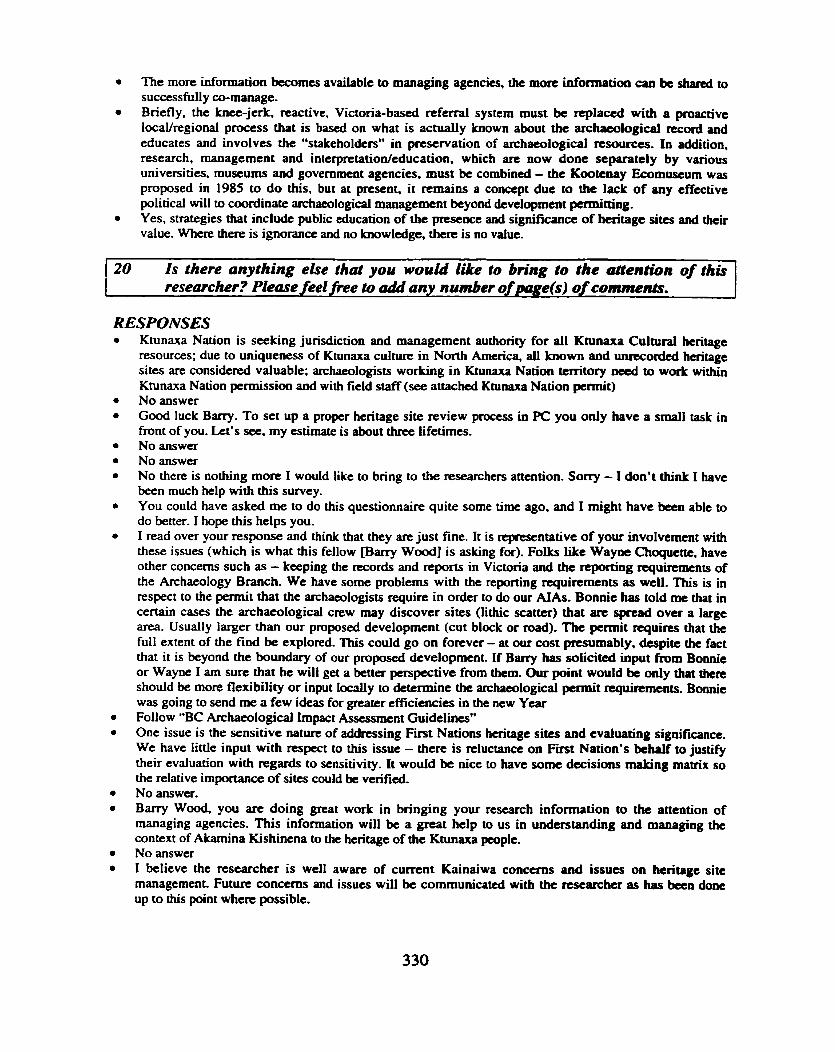
The more information becomes available to managing agencies, the more information can be shared to successfully cu-manage. Briefly, the knee-jerk, reactive, Victoria-based referral system must be replaced with a proactive IocaYregional process that is based on what is actually known about the archaeological record and educates and involves the "stakeholders" in preservation of archaeological resources. In addition, research, management and interpretation/cducation, which are now done separately by various universities, museums and government agencies. must be combined - the Kootenay Ecomuscum was proposed in 1985 to d o this, but at present, it remains a concept due to the lack of any effective political will to coordinate archaeological management beyond development permitting. Yes, strategies that include public education of the presence and significance of heritage sites and their value. Where there is ignorance and no knowledge, there is no value.
20 is there anything ehe that you would like to bring to the attention of this researcher? Please feel fiee to add any number of page(s) of comments.
RESPONSES Ktunaxa Nation is seeking jurisdiction and management authority for all Ktunaxa Cultural heritage resources; due to uniqueness of Ktunaxa cultwe in North America, al l known and unrecorded heritage sites are considered valuable; archaeologists working in Ktunaxa Nation tcmtory need to work within Ktunaxa Nation permission and with field staff (see attached Ktunaxa Nation permit) Noanswer Good luck Barry. To set up a proper heritage site review process in PC you only have a small task in front of you. k t ' s see, my estimate is about three lifetimes. No answer Noanswer No there is nothing more I would like to bring to the researchers attention. Sorry - I don't think I have been much help with this survey. You could have asked me to do this questionnaire quite some time ago, and I might have been able to do better. I hope this helps you. I read over your response and think that they are just fine. It is representative of your involvement with these issues (which is what this fellow marry Wood] is asking for). Folks like Wayne Choqucttc. have other concerns such as - keeping the records and reports in Victoria and the reporting requirements of the Archaeology Branch. We have some problems with the reporting requirements as well. This is in respect to the permit that the archaeologists require in order to do our AIAs. Bonnie has told me that in certain cases the archaeological crew may discover sites (lithic scatter) that are spread over a large area. Usually larger than our proposed development (cut block or road). The pennit requires that the full extent of the find be explored. This could go on forever - at our cost presumably, despite the fact that it is beyond the boundary of our proposed development. If Barry has solicitad input fiom Bonnie or Wayne I am sure that he will get a better perspective from them. Our point would be only that there should be more flexibility or input Iocdly to determine the archaeological permit requirements. Bonnie was going to send me a few ideas for greater efficiencies in the new Year Follow "BC Archaeological Impact Assessment Guidelines" One issue is the sensitive nature of addressing First Nations heritage sites and evaluating significance. We have little input with respect to this issue - there is reluctance on Fit Nation's behalf to justify their evaluation with regards to sensitivity. It would be nice to have some decisions making matrix so the relative importance of sites could be vefied. No answer. Barry Wood, you are doing great work in bringing your research information to the attention of managing agencies. This information will be a great help to us in understanding and managing the context of Akamina Kishinena to the heritage of the Ktunaxa people. No answer I believe the researcher is well aware of current Kainaiwa conarns and issues on heritage site management. Future concerns and issues will be communicated with the researcher as has been done up to this p i n t where possible.

APPENDIX F
LIST OF MAPS & AIR PHOTOS UTILIZED
Waterton Lakes, AB 1 : 50,000 NTS map sheet 82H/4 edition 2 & 3
Sage Creek, BC 1: 50,000 NTS map sheet 82Gl1 edition 3 & 4
Beaver Mines, BC & AB 1: 50,000 NTS map sheet 82 G/8 edition 3
Waterton Lakes National Park 1 :50,000 National Parks of Canada, Edition 1
Glacier/Waterton Lakes National Parks 1: 142,747 National Geographic Maps Revised 1997
Southwest Glberta & Southeast BC 1: 600,000 Gem Trek Publishing, 1997
Cranbrook Forest District 1: 250,000 - Recreation Map, British Columbia, 1997
Crowsnest Forest District - Southern East Slopes Region 1 :250,000, Lands & Forest Service, Alberta Environmental Rotection 1995
P Forest Cover Map Series. Serial: OS2G010 1 : 20,000 Ministry of Forests, BC, 1997
P Forest Cover Map Series. Serial: 082G009 1: 20,000 Ministry of Forests, BC, 1997
P Forest Cover Map Series. Serial: 0826008 1: 20,000 Ministry of Forests, BC, 1997
82GOS 1:50,000 Environmental Protection Land Division, AB 82GOl 1:50,000 Environmental Protection Land Division, AB
Sofa Mountain Fire - 1998 1: 20,000 AB Digital Base, Nov. 1998
Waterton Lakes National Park 1 : 20,000 Number 1 1996 Waterton Lakes National Park 1 : 20,000 Number 2 1996 Waterton Lakes National Park 1: 20,000 Number 3 1996 Waterton Lakes National Park 1 : 20,000 Number 4 1996 Waterton Lakes National Park 1 : 20,000 Number 5 1996
Air Photos 82 H 50 1993: 5-l1,70-75,3e32 82 G 50 1993: 12,7678,33037

APPENDIX G
PLATES
Plate 1 Lookout Butte (DePk-121 (v = north west1
Plate 2 Lease Meadow Site (DgPk-15) (v = north)
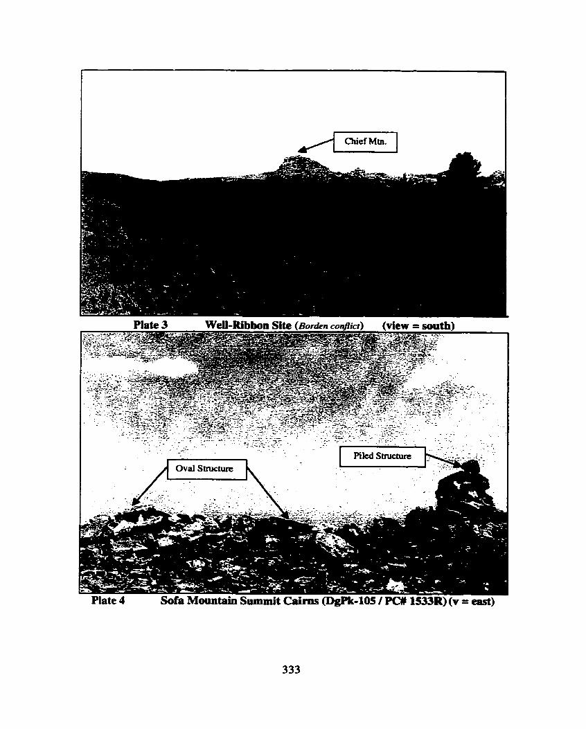
. _ ~ . .._. - - , -,.-..*.. ..-A1.. .-. . :.- .-- . .. -. "..* - - - 3 7 ' . .. ' . m.- '. .. ,. -. --- .' 1-* - . . . . . -. . . .. . .. L. . . . . ; ... .;- ; .,: .. - -. , . . . . - . . _ . - ' - 7
,- - . ., - . . . -
. . Piled Structure
Plate 4 Sofa Mountain Summit Cairns (DgPk-I05 / PC# 153311) (v = east)


Plate 9 South Kootenay Pass (DgPm-03/PC# 1544R) (v = north)
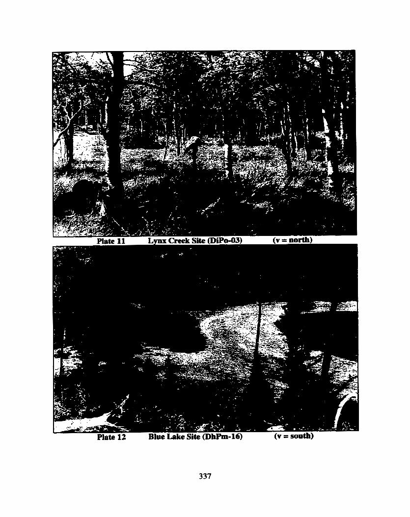
Plate 12 Blue Lake Site (DbPm-16) (v = south)
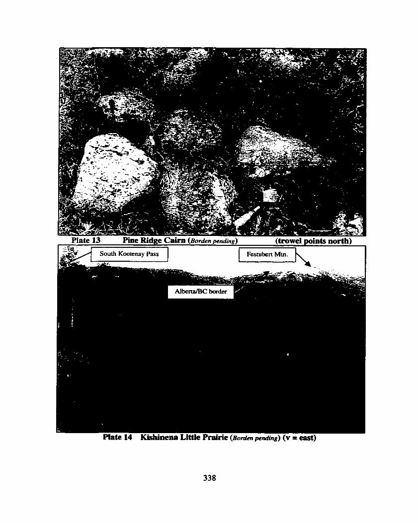

Plate 16 Sage Camp Site (l3or&n pending) (V = north west at main site area & trab)