A Model of Urban Infrastructural Planning for Sustainable Urban Development in Traditional African...
13
1 | Page February 28, 2014 A Model of Urban Infrastructural Planning for Sustainable Urban Development in Traditional African City ADEDOKUN OLUTOYIN MOSES (Ph.D) DEPARTMENT OF GEOGRAPHY FEDERAL COLLEGE OF EDUCATION, ZARIA [email protected] [email protected] ABSTRACT The paper examines various models of cities structures, urban activities and their linkages and the time spent on these activities. These models, though have witnessed considerable improvement over the years have been criticized on a number of grounds as not very suitable to explain land use and spatial organization of cities, especially in Third World Countries because they were too American in outlook and does not relate to situations in African society. Secondly the theories do not take into consideration the cultural value of African societies where land value and ownership are not solely determined by land rent rather they are largely determined by socio-cultural attributes and family ties. Third, residential areas in African countries are not segregated on the basis of race, occupation and tribe as explained by social area analysis. It is in view of this that this paper, based on an empirical study titled “a spatio-temporal analysis of urban activity linkages in Ilorin” proposed an “Urban Neighbourhood Activity Centre model” The model is of the view that instead of strict land use zonation approach, activity centers (infrastructures and other facilities) should be located close to the people especially between homes and work places so as to eliminate time and energy consuming travels. Keywords: model; urban infrastructural planning; sustainable development; traditional African city. Council for Innovative Research Peer Review Research Publishing System Journal: JOURNAL OF ADVANCES IN GEOGRAPHY Vol 1 No.1 [email protected] www.jag.cirworld.com , www.cirworld.com
-
Upload
independent -
Category
Documents
-
view
0 -
download
0
Transcript of A Model of Urban Infrastructural Planning for Sustainable Urban Development in Traditional African...

1 | P a g e F e b r u a r y 2 8 , 2 0 1 4
A Model of Urban Infrastructural Planning for Sustainable Urban Development in Traditional African City
ADEDOKUN OLUTOYIN MOSES (Ph.D)
DEPARTMENT OF GEOGRAPHY
FEDERAL COLLEGE OF EDUCATION, ZARIA
ABSTRACT
The paper examines various models of cities structures, urban activities and their linkages and the time spent on these activities. These models, though have witnessed considerable improvement over the years have been criticized on a number of grounds as not very suitable to explain land use and spatial organization of cities, especially in Third World Countries because they were too American in outlook and does not relate to situations in African society. Secondly the theories do not take into consideration the cultural value of African societies where land value and ownership are not solely determined by land rent rather they are largely determined by socio-cultural attributes and family ties. Third, residential areas in African countries are not segregated on the basis of race, occupation and tribe as explained by social area analysis. It is in view of this that this paper, based on an empirical study titled “a spatio-temporal analysis of urban activity linkages in Ilorin” proposed an “Urban Neighbourhood Activity Centre model” The model is of the view that instead of strict land use zonation approach, activity centers (infrastructures and other facilities) should be located close to the people especially between homes and work places so as to eliminate time and energy consuming travels.
Keywords: model; urban infrastructural planning; sustainable development; traditional African city.
Council for Innovative Research
Peer Review Research Publishing System
Journal: JOURNAL OF ADVANCES IN GEOGRAPHY
Vol 1 No.1
www.jag.cirworld.com, www.cirworld.com
2 | P a g e F e b r u a r y 2 8 , 2 0 1 4
INTRODUCTION
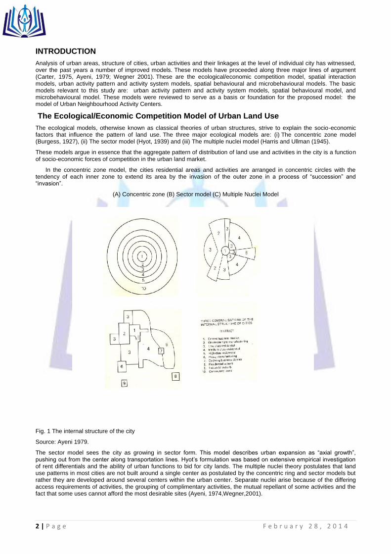
Analysis of urban areas, structure of cities, urban activities and their linkages at the level of individual city has witnessed, over the past years a number of improved models. These models have proceeded along three major lines of argument (Carter, 1975, Ayeni, 1979; Wegner 2001). These are the ecological/economic competition model, spatial interaction models, urban activity pattern and activity system models, spatial behavioural and microbehavioural models. The basic models relevant to this study are: urban activity pattern and activity system models, spatial behavioural model, and microbehavioural model. These models were reviewed to serve as a basis or foundation for the proposed model: the model of Urban Neighbourhood Activity Centers.
The Ecological/Economic Competition Model of Urban Land Use
The ecological models, otherwise known as classical theories of urban structures, strive to explain the socio-economic factors that influence the pattern of land use. The three major ecological models are: (i) The concentric zone model (Burgess, 1927), (ii) The sector model (Hyot, 1939) and (iii) The multiple nuclei model (Harris and Ullman (1945).
These models argue in essence that the aggregate pattern of distribution of land use and activities in the city is a function of socio-economic forces of competition in the urban land market.
In the concentric zone model, the cities residential areas and activities are arranged in concentric circles with the tendency of each inner zone to extend its area by the invasion of the outer zone in a process of “succession” and “invasion”.
(A) Concentric zone (B) Sector model (C) Multiple Nuclei Model
Fig. 1 The internal structure of the city
Source: Ayeni 1979.
The sector model sees the city as growing in sector form. This model describes urban expansion as “axial growth”, pushing out from the center along transportation lines. Hyot‟s formulation was based on extensive empirical investigation of rent differentials and the ability of urban functions to bid for city lands. The multiple nuclei theory postulates that land use patterns in most cities are not built around a single center as postulated by the concentric ring and sector models but rather they are developed around several centers within the urban center. Separate nuclei arise because of the differing access requirements of activities, the grouping of complimentary activities, the mutual repellant of some activities and the fact that some uses cannot afford the most desirable sites (Ayeni, 1974,Wegner,2001).

3 | P a g e F e b r u a r y 2 8 , 2 0 1 4
The multiple nuclei theory in essence is both an amalgamation and generalization of earlier models. It is very adaptable to situation in the developing and developed countries (Mabogunje, 1968; Ayeni, 1979). The zones and sectors identified by the Chicago ecologist were presented in social terms by Shevky and Williams (1949) and later translated into „Social Area Analysis‟ in 1955 by Shevky and Bell. In the social Area Analysis Model, the city was conceived as a product of the complex modern society, which should be understood within the context of the changing character of the larger containing society. Three aspects which were identified as epitomizing this changing character are: (a) change in the range and intensity of relations, (b) differentiation of functions, and (c) complexity of organization.
The economic models argue that urban land use pattern is determined by urban land rent mechanism, which explains the tradeoff between site rent and the cost of overcoming the friction of distance (Carter, 1975; Ayeni, 1979). In general the ecological and economic models of urban spatial structure have been criticized on a number of grounds as not very suitable to explain land use and spatial organization of cities, especially in Third World countries. First the models were too American in outlook and does not relate to situations in African society. Even in America, not all cities grow concentrically around a single nucleus. Secondly the theories do not take into consideration the cultural value of African societies where land value and ownership are not solely determined by land rent (as explained by the economic model) rather they are largely determined by socio-cultural attributes and family ties. Third, residential areas in African countries are not segregated on the basis of race, occupation and tribe as explained by social area analysis.
Spatial interaction Model
The basis or historical background to spatial interaction model can be traced to the unprecedented 1910 and post 1945 economic prosperity in U.S.A. and Europe respectively which fuelled the push to sub-urbanization, car ownership and industrial decentralization. This development led to the problem of improving road capacity to maintain these inter-related and self-reinforcing processes, especially during the morning peak hour trip of the sub-urban commuters. The model developed during the 1950s for this task was the “four stage” transport model consisting of: (a) trip generation, (b) trip distribution, (c) modal split, and (d) trip assignment.
Spatial interaction therefore provides the means for the satisfaction of certain needs arising from the locational separation of providers and consumers. It depends on the reciprocal relationship between different places on the earth‟s surface based on the principles of complimentarity, intervening opportunities and transferability (Abler, et al, 1972). Spatial interaction in an urban area is of two types namely, those that involve physical contact, such as day-to-day movements of people and those that do not require physical contact like phoning. Of special importance in the study of urban activity structure are day-to-day movements.
Robinson and Bamford (1978) identified seven broad types of movements within the city. They are (a) trip making to and from places of work, (b) movement within business during the course of work, (c) educational movement, (d) market, shopping and business trips, (e) social and entertainment trips, (f) trips for no specific purpose, and (g) movement to reach home. These are not just forms of movement in the city, but they represent both function and process. They are functions because they maintain the status quo in the spatial interaction in different parts of the city, while they represent a process when changes in their volume, intensity and direction come to determine growth and organization of the spatial structure of the city (Ayeni, 1979).
Models of Urban Activity Pattern and Activity System
Most theoretical work in the area of activity analysis stems from geography and urban planning. This is largely based on two important publications in the 1970s first by Haggerstrand (1970) and Chapin (1974). The formulation of the Activity Approach in the 1970‟s was a reaction against certain weaknesses of the four stage modelling approach such a poor data quality, poor quality of the model calibration and on poor quality of forecasts made with it. Questions about the appropriateness of the model structure were also raised by the works of the Swedish school of time-geography (Atkins, 1987, Axhausen, 1990).
Until the end of the 1980s, these questions were not thought to be serious enough to challenge the practical use of the four-stage model. The propositions of the approach have been explained by Clarke (1985), Eurotopp (1989) and Axhausen (1990) as follows:
(a) Activities are primary, travel is secondary. This subsumes the truism that „travel is a derived demand‟ and refocuses attention away from simple trip generation and towards the participation of individuals in activities.
(b) Activities and travel take place in time-space. This implies that travel behaviour must be tackled through time as well as over space. This in turn, means that conventional descriptions of travel patterns in terms of origin-destination movements‟ space must be augmented by descriptions of the scheduling and sequencing of activities (time) and also the linkages between them.
(c) Behaviour is influenced by space-time and other constraints. Since activities and travel take place in space-time they will be constrained by (i) the location of facilities where activities may be undertaken, (ii) the times of day when such activities are possible or desirable and only in that context, and (iii) the availability and cost of transport facilities. Other constraints such as those based on inter-personal linkages are also important.
(d) Household activity patterns are related to household structure. It follows that the nature of the link between household categories and trip making behaviour can only be understood in the context of the different activities undertaken by

4 | P a g e F e b r u a r y 2 8 , 2 0 1 4
different households. An important aspect of this link is the way in which the structure of a household influences the activity and travel patterns of the members of the household through their interactions with each other.
(e) Interactions within households change over time. Households pass through definite „lifecycle stages‟ (for example, marriage, birth of children, schooling, ageing) with effects on license and vehicle acquisition, participation in out-of-home activities, the modifiability of constraints and so on. At each stage the nature of the interactions that take place between household members and the consequent activity patterns are different. Households and individuals can adapt to changes in circumstances. Although the activity-based perspective has provided important insights into the influence of constraints and habits on behaviour, especially in the short term, it is also the case that households can be ingenious and inventive in finding ways of adapting to (especially offsetting) a new policy or constraint.
The nature of the response can be very different depending upon whether the policy change is „forced‟ or „permissive‟. Activity and travel behaviour change through time so they should not be viewed as static phenomena. The nature of the dynamic processes underlying changes in activity behaviour appear to be very complex, and involve changes in attitudes, preferences, perceptions and in overt behaviour, operating at different rates over a number of different time scales.
(f) Activity and travel behaviour is constrained by the experience of the traveler. The current experiences of the traveler structure space and time in domains of different intensity of use and information. The activity space comprises the time-space domain visited regularly by the Individual. The knowledge space covers the time-space domain for which the individual has personal experiences, in contrast to the information field, in which the individual relies on the information of external sources, like relatives, friends or the media. The expectation field extends to those parts of time-space, in which the individual expects to be able to rely on his or her experiences, like finding the platforms in a station of an unknown town or the availability of a phone booth on its main shopping street. This constraint is implicit in the „Activity Approach‟ , but has not been made explicitly in much of the literature (Reichenbach, 1984, Downs and Stea, 1974)
The „Activity Approach‟ stands apart from the other traditions of transport modeling identified by Pas (1988). The concern of the „Activity Approach‟ has not been the derivation of mathematical descriptions of human behaviour as was the concern of the application of social physics, econometric and psychometric to transport modeling. One important concept that emerged from the models of urban activity pattern and activity system is the concept of “Action Space” which is the collection of all urban locations about which the individual has information and the subjective utility or preference associated with these locations (Horton and Reynolds, 1971).
The core of an individual‟s action space is termed the “activity space” which is defined as the subset of action space, that is, all locations or areas that an individual has ever visited or had direct contact with as a result of day-to-day activities. In terms of activity system, persons and firms are regarded as behavioural units, which perform some activities in some locales. The activity space is the most structured by individuals because it comprises locations, which have actually been visited. A location will change from being part of the action space to being part of the activity space once a trip has been made. The difference between activity space and action space is that although both are part of time-space environment, Action space is a part of time space environment for which an individual has positive information through media, relatives or friends while activity space is a part of time- space environment frequently used.
The pattern displayed by individuals as they carry out their activities is the “activity pattern” of individuals. An Activity Pattern (AP) is an ordered sequence of activities of an individual that takes place within a space-time continuum, the activities being linked by travel. An activity pattern is, therefore, an activity programme with its schedule. An activity programme, on the other hand, is the collection of all the activity undertaken during a certain period of time irrespective of the order of their occurrence. The activity pattern is determined by individual‟s propensity and opportunity to engage in particular activities (Chapin. 1974), based on “predisposition” factors (such as role obligations, traits, etc.)
Associated with activity pattern are certain features, which characterized its inherent utility to the individual. These features include the (a) total number and types of activities and activity types included in activity pattern, (b) time of the day each activity was performed, (c) duration of each activity, (d) activity sequence, (e) location of each activity, (f) total distance travel, and (g) amount of flexibility or space-time autonomy. Constraints on urban spatial behaviour are observed to be imposed by a person‟s social and economic status, household and societal relationship or one‟s location vis-à-vis the transport system and activity sites. (Mansfield, 1969; Perry, 1973; Chappelle, 1973; Mercer, 1973)
Though not a model per se, the activity system provides a stimulating and different way of looking at urban land use structure and a coherent framework for interpreting it. The approach describes the behavioral pattern of individuals, institutions and firms that occur and how they are linked in space (Chapin, 1965; Carter, 1975). The behaviours of people and organizations are themselves rooted in the value both attach to land. The linkages among establishments are in the form of recurrent interaction that require movement of persons or of goods or the exchange of information. These links can be traced, and can, to some extent, be measured and quantified. The result is a land use element that can be seen as a product of a complex of linkages that are the creation of the activity systems of the various components. The tracing of the system and the identification of the linkages is a pre-requisite to the understanding of the components and patterns of land use.
The advantages of the activity system approach is that it is broad: its values - behavioural - patterns framework permits the introduction of the widest range of operating factors without limiting assumptions and deductive arguments which characterized the neo-classical economic/ecology models that ignore all the competing forces and identifying only one link - that with the centre of the city. The activity system, though nearer the ecological framework, is very different in that instead of generalizing from aggregate condition, it attempts to examine the real city in micro detail. It therefore presents a

5 | P a g e F e b r u a r y 2 8 , 2 0 1 4
different method of looking at the city, for while maintaining contact with reality; it still identifies the framework of forces that shape the aggregate, the total structure.
Spatial Behavioral Models
The weakness of economic and ecological models gave rise to spatial behavioural models. Lloyd (1976) attempted an examination of the linkages among cognition, preferences and migration behaviour in different states in the United States of America and found a strong structural linkage among them. He concluded that, based on the three components, it is possible to predict the direction of movement, in that preferred locations of cognitive space would receive larger percentages of migrants and vice-versa. Hanson (1977) revealed that when the spatial form and extent of information levels are compared with the travel patterns that emerged from the travel diary of the urban residents, it is evident that the set of locations actually contacted is but a small sub-set of the cognitive opportunity. Cadwallader (1978) used information and preference surfaces in explaining individual‟s cognitive space. Preference surface reflects the varying attractiveness as a place to live in, which people attach to different locations. It was, however, discovered that the underlying structures of information and preference surfaces are more difficult to disentangle, especially in the case of information surface, and there is no evidence that these structures are strongly related.
Information about the objective environment as stored subjectively in the individual‟s brain is called the cognitive constructs of the urban environment. Cognitive image is, however, different from locational schematic or mental map. The term “cognitive” is used to indicate the non-locational character of most images, and to suggest that thinking and verbal behaviour form a stronger component of cognitive images than concrete visual imagery (Wong, 1979). Cognitive affective maps are mental orderings of the environment that involve preference ratings that guide residential choice, but personal and financial considerations often preclude selection of the preferred location (Preston, 1982). Behavioural models provide psychological oriented accounts of the destination choice process in repetitive urban spatial behaviour (Pipkin, 1981).
Behavioural approach is increasingly finding a place in urban and transportation planning in an attempt to improve the policy contents of plan proposals (Chorkor, 1986a; 1987, 1988). The earlier approach of urban/transportation planners has leaned heavily towards the environmentalists‟ viewpoint, which, according to Herz (1982) maintains that spatial behaviour, including personal and social constraints, is essentially a function of the material environment. Thus, what appears to be close to environmental deterministic view of behaviour has been jettisoned and planners are currently adopting behavioural approach, which sees the spatial structure, material environment and man as mutually interacting elements of the urban space.
Man is considered as having the ability to evaluate, interprete and react to his environment as observed and perceived. However, Lundqvist (1978) observes that existing planning models are not capable of integrating structure and behaviour in a theoretically sound way and at a level of detail that is useful for planning purposes. He suggests that it may be necessary to work with less ambitious approaches built on iterative use of structural and behavioural models. This problems is still evident despite the fact that sophisticated techniques are being developed and employed in planning to analyse spatial behaviour (Burnett, 1977: Arad and Berechman, 1978; Smith, et al, 1982). Timmermans and Veldhuisen (1982) observe that behavioural models offer a potentially more valuable approach to predict the likely effects of physical planning schemes as compared with the gravity-type approaches. They, however, noted that behavioural models share with the gravity type models the problem of whether equations could be developed solely on the basis of policy sensitive factors or whether other influential factors should be included.
The Micro-Behavioral Approach
The micro-behavioral approach, otherwise known as systems approach, to urban activity network, seeks to explain urban spatial structure, not in a mechanistic term as done by the neo-classical economists. Rather it explains urban spatial structure, especially the interactions in an urban setting, as an interaction between population (people), activities, locations and time. This approach is different from the activity network i.e. spatial interaction approach and activity system model, in the sense that it incorporates the time element and individual instance of behaviour and activity, obtained in the form of disaggregated data.
The important features of this approach are (i) incorporating time as a commodity, (ii) giving new meaning to land (multiplicity of land use), (iii) perceiving people‟s behaviour as linked to the ways in which they perceive space, and (iv) providing a holistic approach to urban structure. This approach of integrating an individual spatial behaviour overtime was pioneered by Hãggerstrand (1969). He used a simple diagram to illustrate his concept of space-time dimensions. Hãggertrand postulated the geographers‟ two-dimensional space on the surface of the earth or on the surface of a map. A line on this surface indicated movement in space but not in time. He suggested a third dimension to signify time.

6 | P a g e F e b r u a r y 2 8 , 2 0 1 4
Time
9Pm
8Pm
7Pm
6Pm
5Pm
4Pm
3Pm
2Pm
1Pm
12Non
Space
Office Home
Fig. 2 Man’s daily space-time dimensions
Source: Adapted from Haggerstrand (1969).

7 | P a g e F e b r u a r y 2 8 , 2 0 1 4
Figure 2 represents a very simple working day. Solid lines represent the path of all obligatory activities and dotted lines the prism or feasible regions of movement in periods for which there are no fixed activities. The worker is assumed to be effectively fixed at home until 7:30am to 8:00am where he can conveniently sleep and take breakfast. He must then take a direct route to work, where he is obliged to stay until lunchtime. During the lunch hour he has a certain amount of freedom, he must be back in the office exactly an hour. From 2pm until about 5pm he is again expected to stay at work. But after 5pm he has no need to be home until 7pm for supper. In this period, 5-7pm, he can stay on at work or he can go somewhere near or stop off on the way back for a drink or visit. The main feature implicit in this model of daily behaviour is the idea that certain activities are fixed in both space and time. This model (of the individual‟s activity -time -space decision) is based on a set of assumptions Six of these assumptions were identified by Cullen and Godson (1975). They are:
Organised behaviour:
This implies that individual behaviour varies in strength between individuals and amongst the different activities undertaken by a single individual so that some behaviours appears to be virtually instinctive whereas others are carefully thought out. i.e. the individual operates with imperfect knowledge in conditions of uncertainty and has bonded cognitive ability, containing highly organized episodes which give structure and pattern to the whole stream of behaviour. There is therefore the need to isolate that behaviour which demonstrates recurrent pattern.
The Action Space:
This is the framework within which an individual operates which is structured by physical pattern and needs and are, to a large extent, institutionalized by availability of services and by norms expectations and habits acquired by the individual himself.
Priorities:
Within the framework of a collection of urban activity locations (action space) the individual selects amongst possible alternative activities by order or priorities assigned in accordance with their attributes. The factors that may contribute to an individual‟s assessment of an order of priorities include (i) the importance of an activity as measured in financial, strategic, physical or other terms, (ii) the presence of participants and their characteristics - relationship to the decision maker, frequency of conduct, distance traveled etc (iii) the order in which activities were planned, and (iv) likes and dislikes for some activities will affects their order of priority.
Constraint:
As with priorities, constraints on choice operate differently in planning horizons. Whereas priorities are self-generated, constraints are externally imposed. Constraint to human activity, according to Haggerstrand (1969) and Axhausen (1990), can be classified into: (i) capability constraints that are imposed on the individual because of the limits of his or her physical ability or because of the limit of the tools available to him, (ii) coupling constraints that are created by both the rules that govern the time-space accessibility of the environment and the agreements into which a person enters, for the purpose of meeting with other persons, and (iii) authority constraints that describe the temporal and spatial authority and individual has over a specific domain. The person concerned controls the access to that time-space domain.
Flexibility of Activities:
As a result of the constraints felt and priorities set by the individual, any specific activity has a subjective fixity rating according to the degree of commitment associated with it and the extent to which it is constrained in time and space. The two dimensions of flexibility, commitment and space fixity are correlated but they are theoretically independent which can be approached separately. The degree of commitment primarily governs the flexibility of choice of activity type but this is also related to timing. There are four main categories of commitment. These are (i) arranged activities where joint actions with other people has been planned and the times of the activities are therefore usually fixed, (ii) routine activities which often frequently attain the status of virtually immovable points in a person‟s day, (iii) planned activities which an individual decides to undertake sometime in the future. The degree of flexibility associated with these planned activities varies widely from vaguely formulated idea to aroused intention. Thus the degree of flexibility attached to planned activities may be greater or less than that of routine or even arranged activities, but would generally be greater. And (iv) unexpected activities which either just happen as the individual drifts into some pursuit, such as reading, or which are imposed on a person by chance meetings, accidents etc. which have no fixity and long tem planning horizon but may override all previously arranged or planned activities instantaneously. Once the degree of commitment to an activity is established, its time and space fixity is determined by a combination of this and the personal physical and institutional constraints peculiar to that event. The activity may either be fixed in time or fixed in place, or both.
Scheduling:
In order to facilitate synchronization of activities and movements and to conserve time and resource, a variable proportion of the individual‟s day is scheduled. The daily activity schedule model according to Timmermans (2000), was initially developed by Ben-Akiva et al (1985) for Boston area (Bowman, 1995; Ben-Akiva and Bowman, 1986) and later implemented for travel forecast in Portland (Bowman, et al., 1998) At the core of the model is a daily activity schedule, which represents the individual‟s demand for activity and travel as a multidimensional choice encompassing all the combinations of activity and travel an individual might choose through the course of a day ( Timmermans,2000)

8 | P a g e F e b r u a r y 2 8 , 2 0 1 4
A schedule consists of a set of tours, which are organized and tied together by a daily activity pattern. The daily activity pattern is characterized by (a) a primary activity, with one alternative being to remain at home for all the day‟s activities; (b)the type of tour for the day‟s primary activity, including the number, purpose and sequence of activity stops; and (c) the number and purpose of secondary tours. For each tour in the daily activity pattern the tour schedule includes the choices of destinations for activities in the tour as well as the mode and timing of the associated travel.The scheduling is carried out in accordance with the fixity ratings discussed above and with estimates of activity durations and travel times. Activities to which the individual is strongly committed and which are both space-and time fixed tend to act as pegs around which the ordering of other activities are arranged and shuffled according to their flexibility ratings. Any periods of the day which are left free after this process are either scheduled in a later or shorter planning period or are ultimately occupied by “spur of the moment” activities or “doing nothing”.
Spatial Interaction Function Model
The Spatial Interaction Function has made it possible to recognize the interaction between people (Population), activities, locations (of the activities) and times (of the day) when the activities took place. This is not in the conventional mechanistic method, but rather in terms of attractiveness of places. Also through this modeling, it is possible to predict at any point the location and quantity of new population through what can be described as Inter-Element Linkages as shown in Figure
Population Social contact (1)
Activities Activity pattern (2) Activity Transition (3)
Locations Individual spatial behaviour (4)
Activity Location (5) Time (6)
Time Individual Temporal behaviour (7)
Activity Timing (8) Use Density (9)
Population Activities Locations
Fig.3 Inter-element Linkages.
Source: Procos and Harvey, 1977
Fig..3 shows the linkages among the time and the space in which the activities of a given population take place. The figure shows that linkages between population sub-groups would produce social contacts (cell 1). The linkage between activity and population and activity and another activity would produce activity pattern and activity transition respectively (cells 2 and 3). On the other hand, the linkages between locations and population, locations and activities and locations and locations produce individual spatial behaviour, activity location and time of day when activities take place (cells 4,5 and 6). Finally the linkages between time and population, time and activities and time and locations produce individual temporal behaviour, activity timing and use density of land respectively (cells 7,8 and 9).This modeling technique is thus unique and different from the conventional method which only explains linkages through origin destination using the gravity modeling technique (Abler et al, 1992, Ayeni 1979, 1992 etc).
The Functioning Model
The Modeling Function unlike the conventional modeling technique did not consider the attractivity of a space in a mechanistic or unidirectional way rather it recognizes it (attractivity) in terms of interaction between population (people), location activities and times. The most important aspect of this modeling technique is its multidirectionality as shown in the figure.4
Population Activities/Time
Location/Time
Fig.4: Cycle of Inter-Element Interaction.
Source: Procos and Harvey, 1977
From figure 4, it is possible to enter the cycle at any point and predict not only the location and quantity of new population and services facilities but aspects of housing services and other infrastructures needed to reflect the behavioural expectations of predictable users. The cycle can be first entered from the location (urban form) point of view by using

9 | P a g e F e b r u a r y 2 8 , 2 0 1 4
environmental quality and the quantity of land supply as the policy variable and the sub-population types and their activity requirements as the dependent variables. Secondly activities can be used as policy variable in which case, the travels associated with certain activities are highlightened, urban from and sub-population thus become the dependent variable. Finally, the population can be dealt with as the policy (variable) aimed at equitable access to certain forms of leisure for certain subpopulation and how the utilization of the activity in the urban form varies.
Recent works on time-space activity unlike the earlier ones, have been largely concentrated on modeling time-space activity pattern (Zahavi, 1978; Lantrip, 1990; Axhausen and Garling 1991; Garling, Kwan and Golledge, 1993; Vander Knaap 1996; Golledge, Kwan and Garlin 1994; Bhat, 1997; Garling, Romanes and Vilhelmson, 1996; Timpf, 2002), computational process and the application of Geographical Information System (GIS) in modeling time-space activity (Hirsh Prashkea and Akiva, 1988; Kitamira, 1988; Axhausen, 1990; Kwan, 2000; Root and Recker 1990; Timmermams 2000; Golob and Mcklally, 1995; Ben-Akiva et al 1996; Kwan, 2003, 2004, 2005; LLoyd and Shuttle 2005). For instance Ben-Akiva et al (1996) applied the daily activity schedule model to data from the Boston metropolitan area, including a 24-hour household travel diary survey collected in 1991, as well as zonal and transportation system attributes from the same time period to produce the daily activity schedule model.
Most of the works in developed countries especially in the United States have been in the field of transportation geography especially in the area of urban travel activity pattern and telecommuting in the city. A few of the most recent time-use studies have examined the impact of new Information Technology (IT) on people‟s everyday lives. For instance, Robinson et al (1997) compared the mass media use and social life of internet users, based on a 1998 survey of 3,993 adults in the U.S. They found no significant or consistent evidence of time displacement by mass media use of social activities as a result of internet or computer use. Another study by University of California, Los Angeles Center for Communication Policy (UCLA – CCP, 2000) involving 2096 households in the U.S found that internet use has considerable impact on a person‟s time use pattern and shopping behavior.
The literature, although revealing about how people spend their time, have shown that studies do not explicitly incorporate the spatial dimension in their data collection procedure and analysis. The time displacement perspective therefore needs to be expanded to a space-time displacement perspective to be useful for understanding people‟s activity pattern in space - time and the urban economy. The space- time displacement perspective suggests that there are distinctive geographical consequences associated with such time displacement Kwan (2000) explored and implemented the extensibility diagram as an analytical tool within a three dimensional (3D) geographical information system (GIS). Using the navigational history of a person‟s web browser and data collected through personal interview, she developed a method that takes into account the multiple spatial scales and temporal complexities (simultaneity and disjuncture) involved in individual activities both in the physical and virtual worlds. Kwan (2002, 2003) also proposed a conceptual frame work of human cyberspatial behaviour based on time - geographic perspective, she argued that space-time constraint are still important even in the information age.
Although all these recent time geographical studies observed that telecommuting did not induce a significant increase in non-work trips and activities, they also suggested that significant insights can be gained through examining the impact of new IT on people‟s space time constraint, and indicated the kind of data and methods useful for geographical studies of everyday life and the urban economy (Mokhtarian, 1990; Mokhtarian et al 1995, 1999; Kwan, 2001). But as noted by Kwan (2003, 2004 and 2005); Kwan, Murray, O‟Kelly and Tiefelsdorf (2003), Weber and Kwan (2002, 2003) this kind of research (IT - Cyber spatial - Time geographic research) is still uncommon in geography to date in both advanced and developing countries. This is due to the fact that the required data are complex, costly and time consuming to collect, and there are a few established methods for analyzing these complex data.
In developing countries in general and Nigeria in particular, works on urban activity linkages through time and space are rare or non-existing. The few existing works in Nigeria like those of the American and European scholars focus mainly on interaction or movement within urban areas. For instance, Fadare (1986, 1989) and Ojo (1990) examined the factors affecting household trip generation in Ibadan while Aderamo (1990, 2000, 2004) examined the impact of road development on urban expansion in Ilorin, the spatial pattern of Intra-Urban trips and the role of transport factor in the structure and growth of Ilorin. Adeniji-Soji (1995) also analyzed the pattern of telecommuting and intra-city travel in Ibadan. Others such as Adagbasa (1995) and Bello (1995) studied intra-pattern urban movement in Benin City. One thing that is common to all these works is that they are all carried out within the framework of transportation geography without necessarily linking movement in space with the activity of the people.
In the light of the above, a study was conducted to explore the missing link between people, their activities, locations of these activities and the times of the day when these activities take place with the aim of providing information that could be used to develop a model applicable to activity location and land use planning and management in a traditional African city in transition (Adedokun, 2008, 2009). From the data collected and analyzed in the study area, about 90 percent of the respondents had their activities fixed in space especially at home/place of work and about 89 percent had their activities fixed in time. The population characteristics and the activity pattern (fixed in space and time) generated mainly home and office/work place based activities which the people have adjusted and accustomed to. The implication of this is that certain spaces would be in greater (or lesser) demand at a particular time. This forms the basis for the proposed model for this study.

10 | P a g e F e b r u a r y 2 8 , 2 0 1 4
A MODEL OF URBAN NEIGHBOURHOOD ACTIVITY CENTRES
Based on the foregoing, a generalized model of land use planning and facility location in a traditional medium size urban center using Ilorin as a case study was proposed.
Figure 5: A Model of Urban Neighbourhood Activity Centers
Source: O.M. Adedokun, 2009.
Figure 5 shows the linkages among population, time and space and urban activities. Given a medium size urban centre with its population, there would emerge various types of urban activity located in different parts of the city. The location of these activities would in turn generate activity pattern with space and time (or spatio-temporal) dimensions. The activity pattern itself would generate human spatio-temporal behavior. In this paper, it is shown that human behaviour in space and time is fixed. The fixity in human spatial behaviour is shared between home and office/work place. The urban neighbourhood activity centre model is of the view, therefore, that in planning for a medium size urban centre in developing world, there is the need to adopt a strategy that would incorporate the behaviour of the people. Instead of strict land use zonation approach; facilities may be located closely to or around neighborhoods where people are fixed. In this
Space
Human (Spatio-Temporal)
Behaviour
Office/Workplace
Neighbourhood Activity
Centres
Fixed
Home
Activity Pattern Time
Activity Location
Urban Activities
Urban Centre Urban Population

11 | P a g e F e b r u a r y 2 8 , 2 0 1 4
case and as demonstrated, facilities and infrastructures should be located between homes and work places. Obviously, if there is a demonstrable linkage between two activities in time, it makes sense to locate the facilities housing them in the same space so as to eliminate time and energy consuming travel.
Conclusion
Over the years, studies on urban land use have been dominated by increasing mechanistic approach. These studies have not elucidated on a better understanding on dynamic model of urban infrastructural planning. We are not oblivious of the fact that oftentimes, models showcase the peculiarity of the context within which they are produced. Also, most of the earlier models were based on experiences of European and American cities that have little or direct bearing with orthogenetic or traditional African cities in transition. There is, therefore, the need for an active involvement of those who are directly impinged upon (the people) in issues relating to land use planning and activity location. Here lies the importance of Urban Neighbourhood Activity Centers Model. This model if implemented, especially in medium sized traditional or orthogenetic cities, where modern day town planning theory is alien and unenforceable, will help to achieve efficiency and optimality in land use planning and activity location. It will also help to achieve and ensure spatial and social justice, equity and equal opportunity for all environmental (urban land users) consumers.
Although this research used disaggregated data to determine house hold activities which were latter classified into three category of activities i.e. home based, office/work place and outdoor based activities respectively and the linkages between the populations these activities, their location in time and space. Future research frontiers could pick on any of the three groups (home, workplace and outdoor activities) and further disaggregate them to determine their locations, time spent on each and the level of linkages between the activities. Furthermore, future research could focus on larger cities that are not necessarily state capitals (even two adjacent or contiguous cities (Conurbations) and compare their spatio-temporal activity linkages for the purpose of achieving optimality in urban land use planning and management.
References
1. Abler, R; Adams, J and Gould P.R. (1972) Spatial Organisation: The Geographers view of the World. New York, Prentice Hall.
2. Adagbasa, J.O. (1995), Spatial Analysis of Intra-Urban Patterns of Movements in Benin-City, Nigeria. Unpublished Ph.D Thesis, University of Benin, Nigeria, pp 25-75
3. Adedokun, O. M. (2008), “A Spatio-Temporal Analysis of Activity Linkages in Ilorin, Kwara- State”,Savannah, Volume 21, Number 2, pp.41-52
4. Adedokun, O. M. (2009), A Spatio-Temporal Analysis of Urban Activity Linkages: A Case Study of Ilorin, Nigeria, Unpublished Ph.D Thesis, Department of Geography, Ahmadu Bello University, Zaria, pp 17-37
5. Aderamo, A.J. (1990), “Road Development and Urban Expansion: The case of Ilorin”, Unpublished Ph.D Thesis, University of Ilorin, Nigeria pp 10-25
6. Aderamo, A.J. (2000), „Spatial Pattern of Intra – Urban Trips in Ilorin, Nigerian‟ Geo-Studies Forum 1, 1& 2 pp. 46-57.
7. Aderamo, A.J. (2004), “Transport Factor in the Structure and Growth of a Traditional Settlement: A Case study of Ilorin”, Nigeria‟ Geo-Studies Forum, Volume 2 (1), pp. 145-156.
8. Adeniji-Soji, (1995), Patterns of telecommuting and Intra-City Travel: A case study of Ibadan Metropolis; Nigeria, Unpublished Ph.D Thesis, University of Ibadan.
9. Arad, R.W. and J. Berechman (1978), “A Design Model for Allocating Inter-related Land Use Activities in Discrete Space”, Environment and Planning A. Volume 10, pp. 1319 – 1332.
10. Atikins, S. T. (1987), “The Crisis of Transportation Planning Model” Transport Reviews, Volume 7, pp. 307 – 325.
11. Axhausen, K.W. (1990), An Introduction to the “Activity – Approach”. Transport Studies Unit (TSU) Working Paper 533. Oxford University, London.
12. Axhausen, K.W. and T. Gashing (1991), “Activity Based Approaches to Travel Analysis: Conceptual Frameworks, Models and Research Problem”, Transport Review, pp. 1-25.
13. Ayeni, B. (1992), A Place for everything and everything in its Place. An Inaugural Lecture, University of Ibadan, .
14. Ayeni, M.A.O. (1979), Concepts and Techniques in Urban Analysis. London, Croom Helm Books.
15. Bello, A. S. (1995), Urban Public Transportation in a Growing city: The case of Ilorin, Nigeria, Unpublished Ph.D Thesis, University of Ilorin.
16. Ben-Aktiva, M.E., S.R. Lerman and J. Swait Jr. (1996), „Discrete Choice Analysis - Theory and Application to Travel Demand‟, MIT Press Cambridge, Massachusset.
17. Bhat, C. (1997), Recent Methodological Advances Relevant to Activity and Travel Behaviour Analysis. Resource Paper for the International Association for Travel Behaviour Research. Austin Texas.

12 | P a g e F e b r u a r y 2 8 , 2 0 1 4
18. Burnett, P. (1977), “Perceived Environmental Utility Under the Influence of Alternative Transportation Systems”, Environment and Planning A, Volume 11, pp. 393 – 401.
19. Cadwallader, M. (1979), “Neighbourhood Evaluation of Residential Mobility”, Environment and Planning A, Volume 11, pp. 393 – 401.
20. Carter, H. (1975), The Study of Urban Geography, London, Edward Arnolds
21. Chapin, E.S. (1974), Human Activity Pattern in the city. New York, John Wiley and Sons.
22. Chokor, B.A (1986), “Developments in Environment-Behaviour-Design Research: a Critical Assessment in the Context of Geography and Planning”, Environment and Planning A, Volume 18, pp.5-26
23. Chokor, B.A (1986b) „City profile: Ibadan‟ Cities, 3, 2, pp.106-116
24. Chokor, B.A (1987), “Environmental-Behaviour-design-research Techniques: An appraisal and Review of Literature with Special Reference to Environment and Planning in Third World”, Environment and Planning A, Volume 19, pp.7-32
25. Chokor, B.A (1988), “Environment-Behaviour-Design Research: An Agenda for the Third World”, Environment and Planning A, Volume 20, pp. 425-434
26. Clarke, M. I. (1985), “Activity Modelling – a Research Tool or Practical Planning Technique?”, Paper presented at International conference on Travel Behaviour, Nordwijk.
27. Cullen, I. and V. Godson (1972), “The Structure of Activity Patterns: a bibliography”, Research Paper, No 2, Joint Unit for planning research.
28. Eurotopp (1989), „The Potential for Using Activity Based Approaches Report to Drive‟ Transport Studies Unit, Oxford University, U. K.
29. Fadare, S.O. (1986), Intra – Urban Travel Characteristics. A study of socio-economic Attributes in Ibadan. Unpublished Ph.D Thesis, Department of Town and Regional Planning, University of Sheffield.
30. Fadare, S. O. (1989), „Analysis of Factors Affecting Household Trip Generation in the Residential Areas of Ibadan‟ Ife Research Publications in Geography, Number 3, 34 – 48.
31. Garling, T., T. Kalen; J. Romanus, M. Selart and B. Vilhelmson (1996), “Computer Simulation of a Theory of House hold Activity Scheduling”, Environment and Planning A, 1 – 37.
32. Garling T., J. Saisa, and R. Linderberg (1986), “The Spatio-Temporal Sequencing of Everyday Activities in the Large Scale Environment”, Journal of Environmental Psychology, 6, 261-268.
33. Golledge, R.G; Mei-Po Kwan and T. Garling (1994), “Computational Process Modelling of House-hold Travel Decision using a Geographical Information System”, Papers in Regional Science, Number 72 (2), pp. 99 – 117.
34. Golob, F.G. and M.G. McNally, (1995), A Model of Household Interactions in Activity Participations and the Derived demand for Travel, Paper Presented at the Conference of Activity Patterns, Endhoven University of Technology, the Netherlands.
35. Haggerstand, T. (1969), “What about People in Regional Science”, Regional Science Association, 24, pp. 5-35
36. Hanson, S (1977) “Measuring the Cognitive Levels of Urban Residents”. Geographical Annaler 58(2) Pp 57 – 81.
37. Hert, R. (1982) „The Influence of Environmental Factors on Daily Behavior‟ Environment and Planning A Vol. 14 Pp 1175 – 1193.
38. Hirsh, M; J.N. Prashkea and M.B. Akwa (1986) „Dynamic Model of Weekly Activity Pattern‟ Transport Science, Volume 20 (1), pp. 24 – 36.
39. Horton, F.E. and Reynold, D.R. (1971) “Effects of Urban Spatial Structure on individual Behaviour”, Economic Geography, Volume 47 (1), pp. 10-25
40. Joh, G.H., T.A. Arentze and H.J.P. Timmermans (2005) „A Utility-based analysis of activity time allocation decisions underlying segmented daily activity-travel patterns‟ Environment and Planning A, Number 37 (11), pp.105-125.
41. Kitamora, R. (1988) “An Evaluation of Activity-Based Travel Analysis”, Transportation Research, Number 15, pp. 9 – 34.
42. Kwan, Mei-Po, (2002) „Time, Information Technologies and the Geographies of Everyday Life‟ Urban Geography, Number 25 (5), pp. 471-482.
43. Kwan, Mei-Po, (2003a) New Information Technologies, Human Behaviour In Space Time and the Urban Economy Paper Presented at the 82nd Annual Meeting of Transportation Research Board (TRB) Washington D.C. Jan 12-16.

13 | P a g e F e b r u a r y 2 8 , 2 0 1 4
44. Kwan, Mei-Po, (2003b) „Geovisualization of Activity Travel Patterns Using 3D Geographical Information Systems‟ Paper Presented at 10th International Conference on Travel Behaviour Research. Luierne. Aug. 10-15.
45. Kwan, Mei-Po, (2004) „GIS Methods in Time Geographic Research: Geo-computational and Geovisualization of Human Activity Patterns‟ Geografiska Annaler B, Volume 354, pp. 341 – 353.
46. Kwan, Mei – Po (2005) „Measuring Activity and Action Space/time‟ in Martins E.H.,Lee-Gosselin and T. D. Seen (eds) Integrated Land-Use and Transportation Models: Behavioural Foundaations. Oxford: Pergamon-Elsevier, pp. 101-132.
47. Kwan, Mei-Po, (2002) „Time, Information Technologies and the Geographies of Everyday Life‟ Urban Geography, Number 25 (5), pp. 471-482.
48. Kwan, Mei-Po, (2003a) New Information Technologies, Human Behaviour In Space Time and the Urban Economy Paper Presented at the 82nd Annual Meeting of Transportation Research Board (TRB) Washington D.C. Jan 12-16
49. Kwan, Mei-Po, (2003b) „Geovisualization of Activity Travel Patterns Using 3D Geographical Information Systems‟ Paper Presented at 10th International Conference on Travel Behaviour Research. Luierne. Aug. 10-15.
50. Kwan, Mei-Po, (2004) „GIS Methods in Time Geographic Research: Geo-computational and Geovisualization of Human Activity Patterns‟ Geografiska Annaler B 354, pp. 341 – 353.
51. Kwan, Mei – Po (2005) “Measuring Activity and Action Space/time”, In: Martins E.H., Lee-Gosselin and T. D. Seen (eds) Integrated Land-Use and Transportation Models: Behavioural Foundaations. Oxford: Pergamon-Elsevier, pp. 101-132
52. Lantrip, D. (1990) „The Built Environment as a constraint to Human Freedom: An Activity Based Stochastic Model‟ Environment Design Research Association (EDRA), Number 21, pp. 52 – 63.
53. Lloyd, R.E. (1976) “Cognition, Preference and Behaviour in Space : An Examination of the Structural Linkages” Economic Geography, Number 52, pp. 241 – 253.
54. Lloyd C and I. Shottle worth (2005) „Analysing Commuting using local regression techniques: Scale, Sensitivity and geographical patterning‟ Environment and Planning A, Number 37 (1), pp. 81 – 103.
55. Londquist, L. (1998) “Urban Planning of Locational Structures with due regard to user Behaviour‟ Environment and Planning A, Number 10, pp. 1413-1429.
56. Ojo, O. E. (1990) “Urban Travel Activity Pattern: The example of Ibadan”, Unpublished Ph.D Thesis, University of Ibadan, Nigeria.
57. Pas, E. (1988) Weekly travel – activity Behaviour. Transportation Research, 15 B, pp. 89-107.
58. Pipkin, J.S. (1981) “The Concept of Choice and Cognitive Explanations of Spatial Behaviour”, Economic Geography, Volume 57(4), pp. 315-361.
59. Root, G.S. and Recker W. W. (N.S.) “Towards a Dynamic Model of Individual Activity Pattern”, Formulation, 1, 371 – 382.
60. Smith, T.R., Pellegrino, J.W. and Golledge R.G. (1982) “Computational Process Modeling of Spatial Cognition and Behaviour”, Geographical Analysis, Volume 4(4), pp. 305-325.
61. Stinson, L.L. (1999) „Measuring How People Spend Their Time : A Time use Survey Design‟ Monthly Labour Review, Number 122, pp. 12-19.
62. Timmermans, H.J.P. (2000) “Theories and Models of Activity Patterns”, Albataros, pp. 6 – 70.
63. Timmersmans, H.J.P. and Veldhuisen, K.J. (1982) „Behavioural Models and Spatial Planning: Some Methodological Considerations and Emperical Tests‟ Environment and Planning A Volume 13, pp. 1485 – 1498.
64. Timpf, S. (2002) “Geographic Activity Models”, In: Goodchild, M; M. Duckham and M.F. Worbays (eds) Perspectives in Geographic Information System (GIS) New York, Taylor and Francis.
65. Van-der-Knap, W.G.M. (1995), Analysis of Time-Space Activity Patterns in Tourist Recreation Complexes. Working paper, centre for Recreation and Tourism studies Wagenirogen Agricultural University, The Netherlands.
66. Wegener, M. (2001) “New Spatial Planning Models”, International Journal of Applied Earth Observation and Geo-Information, Volume 3(3), pp 15-25
67. Wong, K.Y. (1979) “Maps in Minds: An Empirical Study” Environment and Planning A Volume 11, pp. 1289-1304.
68. Zahavi, Y. (1978) “The Measurement of Travel Demand and Mobility”, Paper presented at the Joint International Meeting on the Integration of Traffic and Transportation Engineering in Urban Areas. Tel-Aviv Israel.


![Progospodarcza polityka infrastrukturalna gmin [PRO-ECONOMIC INFRASTRUCTURAL POLICY OF COMMUNES]](https://static.fdokumen.com/doc/165x107/6332f2b44e0143040300e5c9/progospodarcza-polityka-infrastrukturalna-gmin-pro-economic-infrastructural-policy.jpg)