A Geographic Analysis of Traders and Trade Goods in Japan’s Late Medieval Seto Inland Sea.
14
1 A Geographic Analysis of Traders and Trade Goods in Japan’s Late Medieval Seto Inland Sea Michelle Damian University of Southern California, Department of History, Social Sciences Building (SOS) 153, 3502 Trousdale Parkway, Los Angeles, CA 90089-0034 USA Email: [email protected] Abstract This paper will discuss ongoing research into the flow of both goods and people in medieval (14th - 16th centuries) Japan’s Seto Inland Sea area. Prior to colonialism and contact with the West, there was already a complex, well developed maritime network in place within Japan that has received little attention. Understanding the extent of the domestic trade network reveals the thriving trade between communities within the Inland Sea, in conjunction with the better known court- centric tribute and tax system. Examining archaeological and written records concerning trade goods and collaboration among ships’ captains provides a clearer understanding of the networks and developments in this region. Although the foundation for much of this research comes from the documentary record, incorporating the archaeological evidence into a GIS (Geographic Information Systems) database paints a fuller picture of the networks within the Inland Sea before contact with the West. Key words: Medieval Japan, Maritime shipping, GIS (geographic information systems), Trade routes, Bizen pottery Introduction Japan has traditionally been considered a “closed country,” seen as almost entirely removed from any interactions with the rest of the world until contact with the Portuguese in the sixteenth century. Scholars therefore tend to omit discussion of Japan’s role in Asian trade and ignore the established trade networks within the archipelago itself. Janet Abu-Lughod’s Before European Hegemony, though generally an excellent introduction to medieval trade routes beyond Europe, completely excludes Japan even though she devotes an entire chapter to Asia. Official documents clearly show trade connections with China and Southeast Asia throughout the premodern era, and mainland pottery and other goods are regularly
Transcript of A Geographic Analysis of Traders and Trade Goods in Japan’s Late Medieval Seto Inland Sea.
1
A Geographic Analysis of Traders and Trade Goods in Japan’s Late Medieval Seto Inland Sea
Michelle Damian University of Southern California, Department of History, Social Sciences Building (SOS) 153, 3502 Trousdale Parkway, Los Angeles, CA 90089-0034 USA Email: [email protected]
Abstract This paper will discuss ongoing research into the flow of both goods and people in medieval (14th - 16th centuries) Japan’s Seto Inland Sea area. Prior to colonialism and contact with the West, there was already a complex, well developed maritime network in place within Japan that has received little attention. Understanding the extent of the domestic trade network reveals the thriving trade between communities within the Inland Sea, in conjunction with the better known court-centric tribute and tax system. Examining archaeological and written records concerning trade goods and collaboration among ships’ captains provides a clearer understanding of the networks and developments in this region. Although the foundation for much of this research comes from the documentary record, incorporating the archaeological evidence into a GIS (Geographic Information Systems) database paints a fuller picture of the networks within the Inland Sea before contact with the West.
Key words: Medieval Japan, Maritime shipping, GIS (geographic information systems), Trade routes, Bizen pottery
Introduction
Japan has traditionally been considered a “closed country,” seen as almost entirely
removed from any interactions with the rest of the world until contact with the
Portuguese in the sixteenth century. Scholars therefore tend to omit discussion of
Japan’s role in Asian trade and ignore the established trade networks within the
archipelago itself. Janet Abu-Lughod’s Before European Hegemony, though
generally an excellent introduction to medieval trade routes beyond Europe,
completely excludes Japan even though she devotes an entire chapter to Asia.
Official documents clearly show trade connections with China and Southeast Asia
throughout the premodern era, and mainland pottery and other goods are regularly
2
excavated throughout archaeological sites in Japan1. Much of the medieval
documentation of the domestic trade, though, shows goods coming from the
periphery to the central court in the Kyoto region. While these connections are
important to note, it ignores the role played by trade hubs in the provinces on the
cusp of contact with the West. Understanding those domestic trade routes will
eventually help clarify the role that smaller ports en route to the capital region
would have played in transporting foreign goods. Through a geography-based
analysis of the domestic trade routes in late medieval Japan, it becomes apparent
that the connections and collaborations between different local ports and ship
captains facilitated a thriving local trade.
Sources and Methodology
Though few trade-related documents from the medieval period have survived the
centuries, one set of port records provides much information about Inland Sea
shipping. The Records of Incoming Ships at the Hyōgo Northern Checkpoint
(Hyōgo Kitaseki Irifune Nōchō, below, Records) record data for over 1900 vessels
that passed through the checkpoint at Hyōgo, today part of Kobe City, in 1445 and
the first two months of 1446 (Hayashiya, 1981). Each dated entry notes the port of
registry of the ship, the type and volume of cargoes carried, the taxes levied on the
items and dates collected, the name of the ship’s captain and the name of the
warehouse manager that handled the incoming items2. As the records show the
flow of goods from the provinces to Hyōgo, gateway to the central court region of
Kyoto, this collection has been very useful in learning about center-periphery trade
relations. By analyzing the imports through a geographical lens, though, the focus
becomes on the roles of the provincial ports. From there it is possible to learn more
about the connections between those provincial ports and understand more about
regional trade networks.
Sets of maritime regulations (Kaisen shikimoku or kaisen taihō) also reveal
additional information about seafaring practices in the medieval period3. The dates
of these regulations are disputed, as the language used and the age of the extant
3
copies suggest a late 16th century author but the dates on the documents
themselves are from 1223. Even if they were written in the later era and predated
to suggest an established precedent, however, their widespread recopying implies
that though the written codification came later, the practices themselves were likely
already widely followed. Other information about medieval trade comes from the
archaeological record. Unfortunately in many cases there is little archaeological
signature for the items noted in the Records, particularly for consumables such as
rice, salt, and marine life. Site reports from locations along the Inland Sea help
paint a richer picture of the flow of other items such as pottery or iron. Incorporating
both the documentary information from the Records with the archaeological
evidence into a GIS (Geographic Information Systems) database helps highlight
the patterns of trade throughout the Inland Sea, suggesting new relationships
between the locales and revealing some previously lesser-known trade hubs.
Trade Routes: Commodities
The Records note nearly ninety different cargoes being shipped throughout the
Inland Sea in 1445. As it is impossible to discuss all of them in depth, this paper
will focus on trade patterns for salt, the most traded commodity in the Records, and
pottery, best representative of the archaeological signature. Since salt was
recorded usually noting its production point (“Aga salt,” “Mihara Salt,” “Bingo Salt,”
etc.), it is relatively easy to identify the different shipping routes. Even though (Fig.
1) reflects a large amount of data, the overall color distribution indicates that the
salt often was shipped directly to Hyōgo from a port close to its point of production.
Mihara salt came from the ports on Awaji Island near the port of Mihara, Katamoto
salt from Sanuki province ports near Katamoto, and so on. Looking only at ports
that shipped more than five hundred koku (1 koku = approximately 330 lbs) of salt
to Hyōgo over the year, however, reveals further information about transshipment
trends (Fig. 2).

4
Fig. 2 Ports shipping more than 500 koku of salt in the Records. (Michelle Damian)
Fig. 1 All salt shipments in the Records (Michelle Damian)

5
One of best examples of an unexpected
transshipment hub is Takasaki. Particularly in
comparison to its neighbor ports of Onomichi
and Setoda, Takasaki was not a major port. It
shipped to Hyōgo only about one-third to one-
quarter of the total amount of goods sent by
either Setoda or Onomichi. Yet even Takasaki
shipped a smaller quantity of items, it served as
a transshipment point for Suō salt, produced in
Suō province west of Takasaki. The ports of
Tomita, Yanai, and Kaminoseki, actually located in Suō, sent less Suō salt to
Hyōgo than the six hundred koku shipped from Takasaki in Aki province. The
absence of Suō salt in other ports east of Takasaki strongly suggests that Takasaki
was the primary destination for ships carrying that cargo. After those ships
offloaded their cargo there, it was then in turn sent to Hyōgo. Takasaki’s role
becomes even more interesting when other goods and locations are also
considered. Cloth often was brought to Japan from the mainland via Kyushu. When
mapping the shipments of cloth to Hyōgo in the records, Takasaki and the adjacent
Kamagari are apparent as the major suppliers, with Sakihama a distant third (Fig.
3). In considering rice shipments as well, the only port shipping Kyushu rice to
Hyōgo is Kamagari. A fourth product named nikomi in the Records is shipped to
Hyōgo only from Moji and Kamagari4. Other ports noted in the Records that are
closer to Kyushu, including the adjacent ports of Shimonoseki and Moji as well as
all of the other Suō province ports, were bypassed by the Kyushu products in favor
of the further Takasaki and Kamagari, but did not go as far as the much heavier
trafficked Onomichi and Setoda. One possible reason for Takasaki and Kamagari’s
favored role may have been an attempt to protect cargo shipments. The seas
around the islands immediately to the west of Takasaki are home to strong currents
and treacherous waters. Moreover, slightly southwest of Takasaki but east of
Fig. 3 Shipments of cloth in the Records. (Michelle Damian)
6
Setoda were islands inhabited by pirate clans as early as the mid-1300s
(Shapinsky, 2005: 147). In the Records, ships coming from the western ports were
generally larger but less frequent than their counterparts from the eastern ports.
Their captains would therefore have had to maneuver their large ships through
dangerous shoals with which they were less familiar, and needed to defend against
piracy to boot. Transshipping at Takasaki or Kamagari would have allowed them to
transfer their goods to captains in smaller ships that were more familiar with the
waters, without crossing over the more treacherous areas to Onomichi and Setoda.
Items that allow the incorporation of the archaeological record into the analysis
provide much more information about the spread of trade goods throughout the
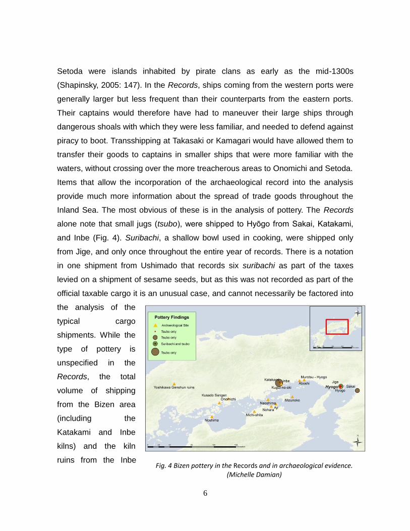
Inland Sea. The most obvious of these is in the analysis of pottery. The Records
alone note that small jugs (tsubo), were shipped to Hyōgo from Sakai, Katakami,
and Inbe (Fig. 4). Suribachi, a shallow bowl used in cooking, were shipped only
from Jige, and only once throughout the entire year of records. There is a notation
in one shipment from Ushimado that records six suribachi as part of the taxes
levied on a shipment of sesame seeds, but as this was not recorded as part of the
official taxable cargo it is an unusual case, and cannot necessarily be factored into
the analysis of the
typical cargo
shipments. While the
type of pottery is
unspecified in the
Records, the total
volume of shipping
from the Bizen area
(including the
Katakami and Inbe
kilns) and the kiln
ruins from the Inbe Fig. 4 Bizen pottery in the Records and in archaeological evidence.
(Michelle Damian)
7
area strongly suggest that the majority if not all of the pottery was Bizen ware
(San’yo, 1978: 62)5. The pottery coming from Sakai is more questionable, but the
pottery was brought in on the same boat that contained Kojima salt, also on the
Bizen peninsula. This suggests that that vessel also visited or was shipping items
from Bizen, and could therefore have been transporting Bizen ware to Hyōgo as
well.
While the Records provide information about the flow of Bizen pottery from its
production point to Hyōgo, it is only a small part of the entire picture. In looking at
archaeological site reports along the Inland Sea, the presence of Bizen ware is
ubiquitous. Excavations in terrestrial settlements in Bingo province (Onomichi,
Kusado Sengen), Sanuki (Nohara, Michi-shita site), Harima (Aboshi, Murotsu-
Hyōgo)6, and even far inland in Aki (Yoshikawa Genshun site) reveal significant
amounts of Bizen ware, ranging from suribachi cooking dishes, to tsubo jars, to
larger vats and other implements. Underwater recoveries, which were not
systematic excavations but simply pottery discovered through serendipity such as
being caught up in fishing nets, also dot the Inland Sea. These are mostly located
in the central inland sea area at sites near Naoshima, Aji, and Kugui-no-oki, and
likely are the remnants of either shipwrecks or jettisoned cargo. The final type of
site is represented only by Mizunoko-iwa, which was a shipwreck site that yielded
nearly two hundred pieces of Bizen pottery (San’yo, 1978: 80-81).
Looking at the sites alone certainly suggests a wider variety of usage for Bizen
ware throughout the inland sea. Not only flowing from the production point east to
Hyōgo and the central court, Bizen ware was also shipped out to destinations far
west of the kilns. More Kamakura and Muromachi-era Bizen ware has been
discovered on Honshu than on the western areas of Shikoku, possibly suggesting
more direct interaction with the former area. Two sites are of particular interest. The
first is Aboshi in Harima, a destination in between the kilns near Inbe and the
checkpoint at Hyōgo. A number of pieces of Bizen pottery from the 15th century
were found here, especially larger vats (kame) (Nakagawa, 2008: 119). They show
8
evidence of use, and as such were likely imported to Aboshi as a final destination
(Nakagawa, 2008: 124). Large numbers of pottery found in one area with no signs
of usage would have been more likely to indicate a transshipment location. The
information from the Records shows Aboshi as a small-to-medium sized port,
sending sixty two ships to Hyōgo over the course of the year, most of which carried
less than 100 koku of goods. It does not appear to have been a major source of
transshipping based on traceable goods, but the evidence of Bizen ware used in
Aboshi still suggests that there was direct trade happening with other estates along
the Inland Sea. Instead of being a commercial center for incoming and outgoing
goods, though, Aboshi was mainly an import destination.
The second significant archaeological site is the shipwreck at Mizunoko-iwa.
Located approximately six kilometers offshore of Shōdoshima, it is one of the only
underwater discoveries of a Muromachi-era shipwreck site to date. Though the
ship itself has been lost to the elements, the pottery cache recovered yielded 35
large jars (kame), 71 large jugs (tsubo), 14 small jugs (tsubo) and 66 cooking
bowls (suribachi), totaling 189 objects. This provides at least a minimum
representation of the number and types of items that would have been shipped
longer distances. The ship’s intended final destination is unknown, though it may
have been the Kumano area on the Kii peninsula. Bizen ware has often been
discovered along the coast of Wakayama prefecture, and the wreck site places a
ship leaving the kilns at Katakami and Inbe squarely along that route (San’yo,
1978: 65). The first archaeological evidence of ballast stones used on ships also
comes from the Mizunoko site. Although the origin of the ballast stones has not yet
been identified, studies have shown that they were not from the region near the
kilns, which suggests that the vessel had loaded them at yet another port possibly
from the Kishū or Shikoku area (San’yo, 1978: 87-88). The likely route of the
voyage from Bizen directly to Kishū, as well as the combination of Bizen ware and
ballast from a different location, suggests the direct interaction between two
9
removed locales, further demonstrating the wide range of domestic ties and trade
routes.
Trade routes: People
The maritime regulations suggest that voyaging together was a common
occurrence. Several articles refer to the responsibility of one boat to lend aid to
another in trouble, or to rescue individuals in the case of a shipwreck. As the
regulations also suggest disputes in the case of allocating profits when cargo was
lost or ships were damaged, it is possible that sailors traveling together also acted
as witnesses to provide evidence to settle those disputes (Shinjō, 1994: 777). The
Records note 171 vessels as edabune (“branch ships”), a term used in the
maritime regulations as referring to an accompanying ship on a voyage7.
Understanding that this was a common practice further suggests stronger ties
between individual captains. With common Japanese names such as Tarō Jirō or
Shirō Gorō – roughly equivalent to trying to research the backgrounds of captains
named “Bob” or “Joe” in the English world – and no other corroborating records,
scholars have assumed that the captains in the Records were generally
untraceable. Captaining a ship is a particular skill, though, particularly in the
sometimes treacherous waters of the Inland Sea. In a finite geographical area, it is
highly unlikely that there were multiple men with the same names plying the waters
simultaneously. Examining the captain’s names through a geographic lens reveals
that these individuals were indeed traceable and furthermore highlights
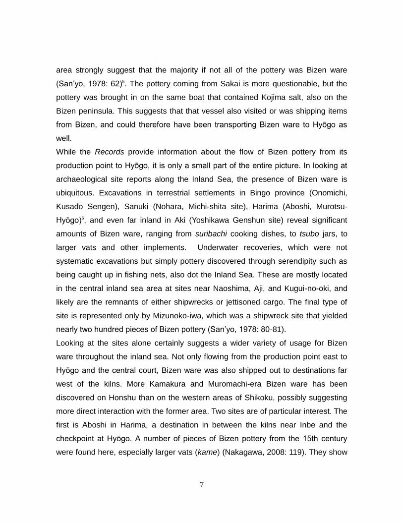
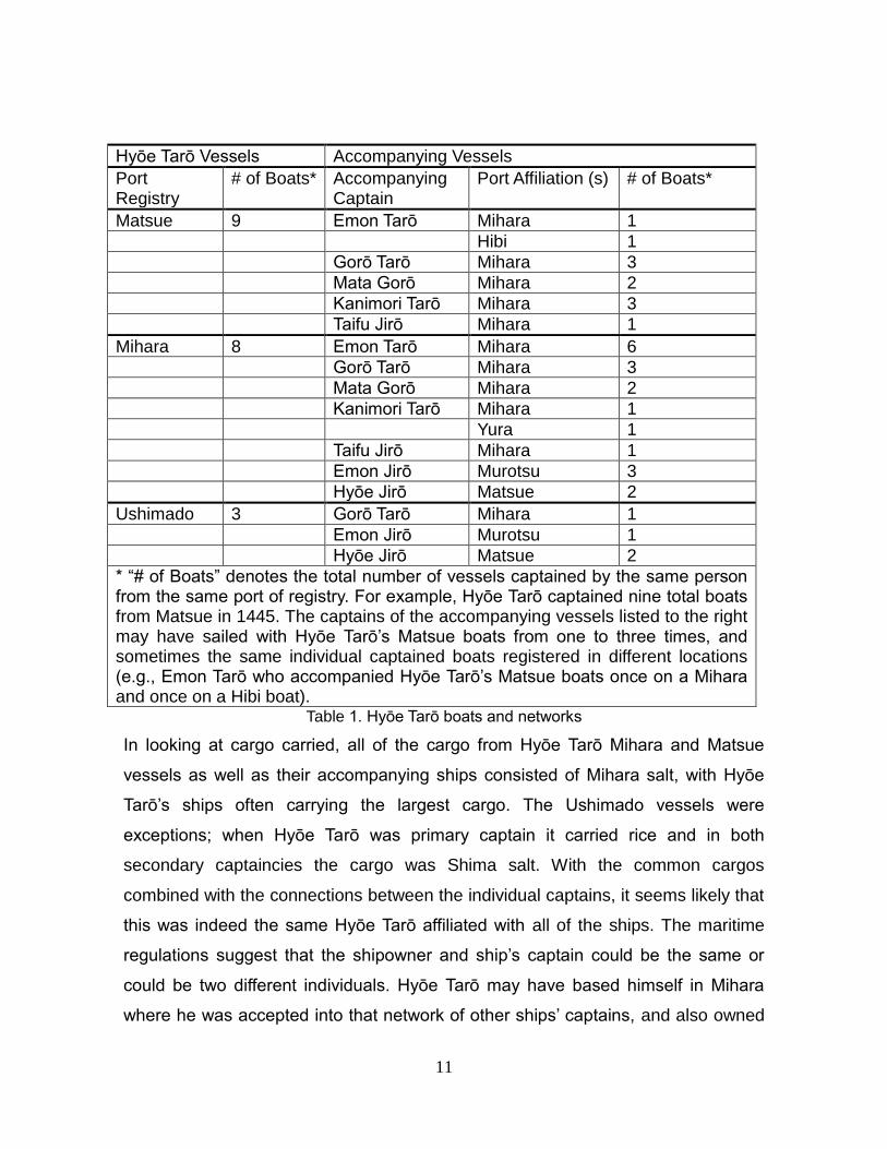
collaboration between captains in their voyages. The voyages of Hyōe Tarō are an
excellent example of one such ship captain’s network in play. His name appears
associated with nine ships registered in Matsue, eight in Mihara, and three in
Ushimado (once as primary and twice as secondary captain) (Fig. 5). The ships
often arrive within one or two days of each other, and in one case a Hyōe Tarō-
captained vessel from Matsue and Mihara arrive on the same day. Since the same
10
individual could not be physically captaining both vessels, at first glance it seems
impossible that this was the same individual in every case.
Considering the names of the captains of other ships that arrived in Hyōgo on the
same days, though, the question becomes more complex. The same names
appeared regularly, hailing from nearby ports – Yura, Murotsu, Hibi, and the same
Matsue, Mihara, and Ushimado, though the majority were registered to Mihara.
The table below details the names of the accompanying captains and the ports
they were registered to, along with the type (Matsue, Mihara, or Ushimado) of
Hyōe Tarō-captained vessel that they arrived in Hyōgo alongside (Table 1).
Regardless of whether Hyōe Tarō’s ships were from Matsue or Mihara, the names
of the accompanying captains were often the same: Emon Gorō, Mata Gorō, Gorō
Tarō and others, mostly from Mihara, accompanied Hyōe Tarō’s boats regularly.
Fig. 5 Ports affiliated with Hyōe Tarō and his extended network.
11
Hyōe Tarō Vessels Accompanying Vessels
Port Registry
# of Boats* Accompanying Captain
Port Affiliation (s) # of Boats*
Matsue 9 Emon Tarō Mihara 1
Hibi 1
Gorō Tarō Mihara 3
Mata Gorō Mihara 2
Kanimori Tarō Mihara 3
Taifu Jirō Mihara 1
Mihara 8 Emon Tarō Mihara 6
Gorō Tarō Mihara 3
Mata Gorō Mihara 2
Kanimori Tarō Mihara 1
Yura 1
Taifu Jirō Mihara 1
Emon Jirō Murotsu 3
Hyōe Jirō Matsue 2
Ushimado 3 Gorō Tarō Mihara 1
Emon Jirō Murotsu 1
Hyōe Jirō Matsue 2
* “# of Boats” denotes the total number of vessels captained by the same person from the same port of registry. For example, Hyōe Tarō captained nine total boats from Matsue in 1445. The captains of the accompanying vessels listed to the right may have sailed with Hyōe Tarō’s Matsue boats from one to three times, and sometimes the same individual captained boats registered in different locations (e.g., Emon Tarō who accompanied Hyōe Tarō’s Matsue boats once on a Mihara and once on a Hibi boat).
Table 1. Hyōe Tarō boats and networks
In looking at cargo carried, all of the cargo from Hyōe Tarō Mihara and Matsue
vessels as well as their accompanying ships consisted of Mihara salt, with Hyōe
Tarō’s ships often carrying the largest cargo. The Ushimado vessels were
exceptions; when Hyōe Tarō was primary captain it carried rice and in both
secondary captaincies the cargo was Shima salt. With the common cargos
combined with the connections between the individual captains, it seems likely that
this was indeed the same Hyōe Tarō affiliated with all of the ships. The maritime
regulations suggest that the shipowner and ship’s captain could be the same or
could be two different individuals. Hyōe Tarō may have based himself in Mihara
where he was accepted into that network of other ships’ captains, and also owned
12
boats (or in the Ushimado cases where he is listed as secondary captain, perhaps
shares in vessels) registered in other ports. If Hyōe Tarō were the shipowner but
had someone else piloting his vessel, his name may have been written in the
Records as the person primarily responsible for the ship and its cargo. The fact
that he was an established member of the extant Mihara-based network allowed
his boats from Matsue to join the voyages to Hyōgo, all carrying salt from Mihara.
There are many such examples of captains’ networks that are revealed through a
geographic analysis of individual names in the Records. The implications of this on
the study of medieval Japanese labor practices are worth noting. Skilled workers,
such as the ships’ captains, could be affiliated with ships registered to different
ports in entirely different provinces. Most studies of medieval laborers focus on the
agrarian sector, which were by their nature tied to the land they cultivated.
Examining maritime practices shows that labor mobility may have been more
possible than had been previously thought. In cases such as Hyōe Tarō’s, if he was
indeed the ship owner for the Matsue vessels, it also implies the ability of
individuals to own property in diverse regions – a privilege generally thought to
have been reserved for members of the upper classes. Examining the geographic
ties between the ship’s captains simultaneously suggests the potential for their
mobility and their property owning.
Conclusion
Though this paper focuses on domestic trade routes in medieval Japan before
direct interactions with the Western world began, the principles outlined here are
still relevant to later maritime connections. This analysis demonstrates the
established domestic maritime networks for both people and commodities and
suggests transshipment hubs. Particularly in cases such as Takasaki and
Kamagari, the geographic tracking of the flow of goods shows the role that
relatively smaller ports might have played in transshipping goods from the southern
regions. As Western trade was funneled through the offices in Kyushu, additional
research will show whether those ports continued in their middleman role in
13
shipping goods to eastern Japan, or whether their importance faded as
infrastructure improved and the threat of piracy was squelched.
The captains’ networks may have been useful in facilitating Western trade as well.
Peter Shapinsky’s analysis of portolans (nautical charts) from early modern Japan
shows their hybrid nature, using a mixture of Western and Asian scripts and
iconographies (Shapinsky, 2006: 5). Further, he suggests that the ships’ crews in
the 16th century were largely a mixture of nationalities and that the captains were
the arbiters of knowledge on board, responsible for the safety of the ship and its
crew and therefore for keeping accurate charts and records (Shapinsky, 2006: 15).
The maritime networks of the inland sea show that collaboration between captains
was already common practice, and could have easily extended their reach in
cooperating with foreign captains in later years. The connections shown through
this geographic analysis, while focused on domestic trade, are representative of
the importance of the Inland Sea region as a shipping center. Privileging the
geography and incorporating both documentary and archaeological evidence into
the analysis further deepens our understanding of shipping and common maritime
practices within medieval Japan.
Acknowledgements
I am grateful for the opportunity to be a part of the panel that Dr. María Cruz
Berrocal and Dr. Mark Staniforth have coordinated. I would like to thank my advisor,
Dr. Joan Piggott, for her support at the University of Southern California. Financial
support from the USC Provost’s Fellowship and the Fulbright Doctoral Fellowship
for research both in the USA and Japan was critical. The Tokyo University
Historiographical Institution and Meiji University both generously opened their
archives to me. I am indebted to many people for their feedback during this
process, but most especially from Dr. Kurt Knoerl and Sachiko Kawai.
Endnote 1For the purposes of this paper, the premodern era is defined as pre-Tokugawa era (i.e., prior to
1603) and the medieval period refers to the Kamakura through Muromachi/Sengoku periods (1185–1603). The focus of this paper is largely the late medieval as represented by the Muromachi era (1337– 1573).
14
2The port of registry was not necessarily the beginning point of each boat’s voyage to Hyōgo,
though in many cases it is likely that they were indeed the same. 3The word “kaisen” literally translates to “ship going from place to place,” and usually refers
specifically to a coastal trade ship. Since some of the articles in the regulations refer to riverboats, port regulations, and personnel issues, I have chosen to translate this as “maritime” rules or regulations. 4The actual meaning of nikomi is unclear. It is thought to have been some kind of fish or marine
good. 5One kiln in the Furōzan area of Inbe was nearly forty meters long, which based on other
contemporary kilns suggests that it was producing pottery from at least the early Muromachi era (15th c). 6Murotsu-Hyōgo is different from the port of Murotsu in the Records. The latter is in Awaji province.
7Flagships are referred to as honsen/motobune in the maritime regulations. The Records do not
denote any boats as honsen, but do have several “nagabune” (longboat) notations which may have been another term for flagship.
References
Hayashiya, T., (Ed.), 1981. Hyōgo Kitaseki Irifune Nōchō. Chūo Kōron Bijutsu
Shuppan, Tokyo.
Nakagawa, T., 2008. Ceramics Unearthed at the Furuaboshi Site in Hyogo
Prefecture. Trade Ceramics Studies, Vol. 28: 118–125.
San’yō, S., (Ed.), 1978. Kaitei No Kobizen: Mizunoko Iwa Gakushutsu Chōsa
Kiroku. San’yō Shinbunsha, Okayama-shi, Japan.
Shapinsky, P. D., 2006. Polyvocal Portolans: Nautical Charts and Hybrid Maritime
Cultures in Early Modern East Asia. Early Modern Japan, Vol. 14: 4-26.
Shapinsky, P. D., 2005. Lords of the Sea: Pirates, Violence, and Exchange in
Medieval Japan. PhD Dissertation. University of Michigan, Michigan, USA.
Shinjō, T., 1994. Chūsei suiunshi no kenkyū. Hanawa Shobo, Tokyo.
Michelle Damian has an MA in Maritime Archaeology from East Carolina University and is currently a PhD candidate at the University of Southern California. She has volunteered as Exhibits Editor with the online Museum of Underwater Archaeology (http://www.themua.org) since 2004. Her dissertation focuses on the maritime cultural landscape of Japan’s Seto Inland Sea, combining both written and archaeological evidence to explore maritime practices in the late medieval period (15th - 16th centuries).