A Cultural Resources Survey for the San Antonio Animal Care ...
31
A Cultural Resources Survey for the San Antonio Animal Care Spay and Neuter Adoption Facility Project, Bexar County, Texas Herbert G. Uecker, Principal Investigator With an Appendix by Imogen R. Cooper, AICP, Historic Preservation Specialist Prepared for Jackson & Ryan Architects and the City of San Antonio August, 2011 Texas Antiquities Permit 6016 South Texas Archeological Research Services, LLC Report of Investigations No. 182
-
Upload
khangminh22 -
Category
Documents
-
view
0 -
download
0
Transcript of A Cultural Resources Survey for the San Antonio Animal Care ...
A Cultural Resources Survey for the San AntonioAnimal Care Spay and Neuter Adoption FacilityProject, Bexar County, Texas
Herbert G. Uecker, Principal Investigator
With an Appendix by Imogen R. Cooper, AICP,Historic Preservation Specialist
Prepared for Jackson & Ryan Architects and the City of San Antonio
August, 2011
Texas Antiquities Permit 6016
South Texas Archeological Research Services, LLCReport of Investigations No. 182
_____________________________________________________________________________________________
_____________________________________________________________________________________________i
South Texas Archeological Research Services, LLCReport of Investigations 182
Abstract
In mid August, 2011, South Texas Archeological Research Services, LLC, performed a cultural resourcessurvey for about 2.01 acres of land in central Bexar County, Texas―the project area for the proposed San Antonio Animal Care Spay and Neuter Adoption Facility. The survey was done according to a scope of work approved bythe Texas Historical Commission and the staff of the City of San Antonio Historic Preservation Officer. Because theland was owned by the City, and due to the relatively high density of significant cultural resources known to be inthe general vicinity, the survey was necessary to comply with requirements applicable City historic codes and theAntiquities Code of Texas, and was done under Texas Antiquities Permit 6016. Because there was no federalinvolvement in the project, compliance with Section 106 of the National Historic Preservation Act was not required.
A background search conducted prior to fieldwork revealed that apparently the project area contained norecorded archeological sites and had not been previously investigated. However, it also indicated that numerousarcheological sites had been found in the general vicinity and registered with the State of Texas, including manysites landmarked or eligible for landmarking at the state and federal levels.
During fieldwork, systematic pedestrian visual inspection and subsurface probing revealed that the entireproject area apparently was severely disturbed and contained either asphalt paving or a mantle of artificial fillaveraging several meters in thickness. Most of the cultural evidence encountered was the remnants of modernimprovements that obviously originated during the mid to late twentieth century, none of which appeared to bearcheologically or historically significant. Exceptions were stone masonry walls or wall remnants and quarry markson the face of a limestone bluff along one edge of the area. Those items and evidence of past disturbances werephotographically documented. No artifacts that warranted collection or curation were found and therefore nothingwas collected or curated. No areas worthy of site designation were distinguished and no sites were recorded.
Additional survey-level background research was briefly conducted in an attempt to determine theapproximate age and historic or cultural associations of the quarry marks in the bluff face. However, nothing wasfound that firmly established when or by whom that particular quarrying was done. The types of marks, whichapparently resulted from vertical drilling by mechanized means, and the information gathered about the history ofstone quarrying in the general vicinity seemed to suggest that the marks originated sometime between about 1880and 1917, during quarrying by the Alamo Portland and Roman Cement Company. However, additional informatonwould be needed to firmly support that notion.
Based on those findings, the Principal Investigator believed that most of the project area contained nothingworthy of further investigation, preservation, or landmarking at the federal, state, or local levels. Therefore it wasrecommended to the Texas Historical Commission, the City of San Antonio Historic Preservation Officer, andproject sponsors and consultants that the proposed animal care spay and neuter adoption facility as planned at thetime of the survey should proceed without further archeological work, but that the afore-described masonry wallsand the bluff face should not be disturbed until their landmark potential is clarified.
Per applicable historic preservation statutes, it was also recommended that construction work should besuspended in the vicinity of any finds of archeological evidence unearthed or exposed by construction activities untilthe finds are examined by the Texas Historical Commission, the City of San Antonio Historic Preservation Officer,and/or a qualified professional archeological consultant.
_____________________________________________________________________________________________
_____________________________________________________________________________________________ii
South Texas Archeological Research Services, LLCReport of Investigations 182
Acknowledgments
South Texas Archeological Research Services, LLC, was assisted in coordinating and performing its workby several persons whose help is gratefully acknowledged: Martha Seng, FAIA, of Jackson and Ryan Architects,Houston; San Antonio Capital Improvements Management Services Project Manager William A. Hensley andEconomic Development Specialists Brenda Navarro and Fernando Hernandez; San Antonio Planning Departmentstaff archeologist V. Kay Hindes; historic preservation specialist Imogen R. Cooper; archeological field assistant JayMcCracken; and Texas Historical Commission Archeology Division reviewer Mark H. Denton.
_____________________________________________________________________________________________
_____________________________________________________________________________________________Page 1 of 25
South Texas Archeological Research Services, LLCReport of Investigations 182
Introduction
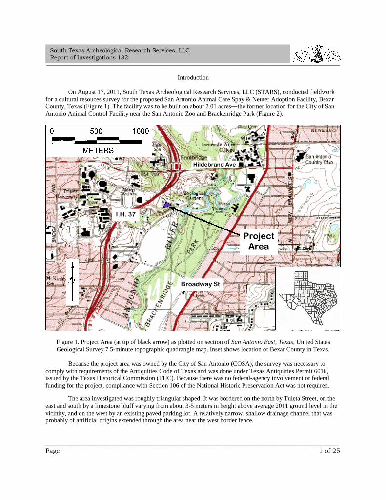
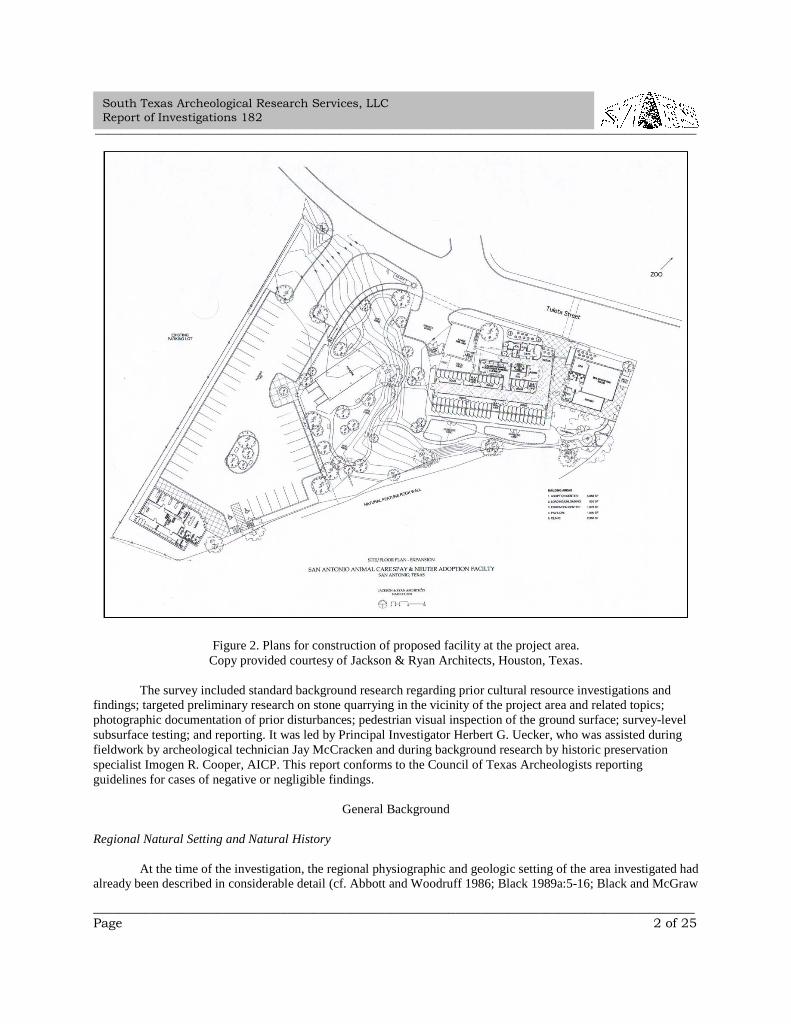
On August 17, 2011, South Texas Archeological Research Services, LLC (STARS), conducted fieldworkfor a cultural resouces survey for the proposed San Antonio Animal Care Spay & Neuter Adoption Facility, BexarCounty, Texas (Figure 1). The facility was to be built on about 2.01 acres―the former location for the City of San Antonio Animal Control Facility near the San Antonio Zoo and Brackenridge Park (Figure 2).
Figure 1. Project Area (at tip of black arrow) as plotted on section of San Antonio East, Texas, United StatesGeological Survey 7.5-minute topographic quadrangle map. Inset shows location of Bexar County in Texas.
Because the project area was owned by the City of San Antonio (COSA), the survey was necessary tocomply with requirements of the Antiquities Code of Texas and was done under Texas Antiquities Permit 6016,issued by the Texas Historical Commission (THC). Because there was no federal-agency involvement or federalfunding for the project, compliance with Section 106 of the National Historic Preservation Act was not required.
The area investigated was roughly triangular shaped. It was bordered on the north by Tuleta Street, on theeast and south by a limestone bluff varying from about 3-5 meters in height above average 2011 ground level in thevicinity, and on the west by an existing paved parking lot. A relatively narrow, shallow drainage channel that wasprobably of artificial origins extended through the area near the west border fence.
ProjectArea
I.H. 37
Broadway St
Hildebrand Ave
_____________________________________________________________________________________________
_____________________________________________________________________________________________Page 2 of 25
South Texas Archeological Research Services, LLCReport of Investigations 182
Figure 2. Plans for construction of proposed facility at the project area.Copy provided courtesy of Jackson & Ryan Architects, Houston, Texas.
The survey included standard background research regarding prior cultural resource investigations andfindings; targeted preliminary research on stone quarrying in the vicinity of the project area and related topics;photographic documentation of prior disturbances; pedestrian visual inspection of the ground surface; survey-levelsubsurface testing; and reporting. It was led by Principal Investigator Herbert G. Uecker, who was assisted duringfieldwork by archeological technician Jay McCracken and during background research by historic preservationspecialist Imogen R. Cooper, AICP. This report conforms to the Council of Texas Archeologists reportingguidelines for cases of negative or negligible findings.
General Background
Regional Natural Setting and Natural History
At the time of the investigation, the regional physiographic and geologic setting of the area investigated hadalready been described in considerable detail (cf. Abbott and Woodruff 1986; Black 1989a:5-16; Black and McGraw
_____________________________________________________________________________________________
_____________________________________________________________________________________________Page 3 of 25
South Texas Archeological Research Services, LLCReport of Investigations 182
1985:40-54). Briefly, the area is near the southern edge of the Balcones Escarpment and Fault Zone at an averageelevation of about 200 meters above sea level. The fault and escarpment region is also known as the BalconesCanyonlands. Intermittent faulting began in the area during the Miocene geologic epoch about 15-21 million yearsago and continued until about a million years ago.
The regional geomorphology consists of a series of northeast to southwest trending fault scarps andassociated erosional features. The regional drainage pattern is dendritic and major drainages in the region include theMedina, Guadalupe, and San Antonio Rivers. Several prominent secondary drainages, such as Culebra, San Pedro,Salado, Mud, and Elm Creeks, also dissect the general area.
Base or parent rocks in the canyonlands zone include several members of the Lower Cretaceous seriesincluding the Del Rio shale formation and the Buda, Edwards, and Glenrose limestones. These formationscollectively range up to as much as 10,000 meters thick over much of central and south Texas. They were formedduring the Cretaceous geologic period between about 120 and 65 million years ago. During the last several millionyears, numerous karst features have formed within the limestone formations, which also house the Edwards aquifer(cf. Veni 1988:11-26; 1998). The aquifer is a regional-scale phenomenon composed of porous beds of limestone andshale sandwiched between less permeable calcareous strata and it is virtually the sole source of potable water formuch of central Texas. Soils in the canyonlands region are derivatives of the local bedrock and are typically verythin, stony, and underdeveloped in the uplands.
Ecologically, the area has been a resource-refugium zone since the middle of the Holocene geologic epochabout 7,000 years before present (B.P. [present being arbitrarily defined by culture historians as A.D. 1950]). It wasat that juncture in time that the onset of the Altithermal climatic episode (Nance 1972) began to substantially alterthe climate of the North American southwest, including Texas. The Altithermal was a period of relatively intenseheating and drying that lasted, with many short breaks, until the present time. As the lush tall-grass steppes andmixed-grass prairies of south and west Texas were reduced to thorn scrublands and semiarid deserts over severalmillennia, both animal and human populations congregated in such areas as the Rio Grande basin and the mountainforests of west Texas and northern Mexico, and also in the central Texas Hill Country. South and west of the HillCountry, riparian zones slowly evolved into isolated ribbons of resources, and many unique places along the area'srivers and streams became centers of human population.
The area investigated is situated within a broad ecotonal zone that exhibits characteristics of three majornatural regions (cf. Blair 1950; Riskind and Diamond 1988): (1) the Balconian Biotic Province, a subtropical,subhumid mixed woodland or parkland that is geographically congruent with much of the Texas Hill Country and isdominated by juniper-oak scrub forests; (2) the Tamaulipan Biotic Province, a subtropical to megathermal desertsteppe or thorn scrubland that ranges southward from central Texas into the coastal and Rio Grande plains and wellinto northern Mexico that is dominated by huisache and mesquite; and (3) the Blackland Prairie, a subtropical,subhumid area characterized by mixed savannah grassland or prairie and by postoak-blackjack oak woodlands thatranges northward and eastward to the Red River area near the Texas-Oklahoma border. The climate of these regionsduring the last several millennia has been typified by short mild winters and long hot summers. Modern annualprecipitation in the area averages about 700-800 mm and follows a bimodal pattern with maxima in May andSeptember. The Balcones tablelands have sometimes been the locus of world record precipitation events triggeredby tropical waves of warm moist air from the Gulf of Mexico colliding with colder dryer air of arctic and subarcticorigins surging southward from the high plains (Caran and Baker 1986).
In 2011, there were hundreds or even thousands of species of plants, animals, and insects thriving in centralTexas. It is beyond the scope of this report to include a comprehensive listing or description of these species but theinterested reader is referred to publications by Davis (1960), Enquist (1987), Everitt and Drawe (1993), Kutac andCaran (1994), Neck (1986), Riskind and Diamond (1986), Simpson (1988), and Vines (1984). Major terrestrialfaunal species and avifaunal species of the area include the white-tailed deer, javalina, coyote, red fox, opossum,
_____________________________________________________________________________________________
_____________________________________________________________________________________________Page 4 of 25
South Texas Archeological Research Services, LLCReport of Investigations 182
raccoon, ringtailed cat, squirrel, striped skunk, armadillo, wild turkey, bobwhite quail, Inca dove, white-wingeddove, box tortoise, and western diamondback rattlesnake. Prominent raptors of the region include turkey and blackvultures and various species of owls; and red-tailed hawks, eagles, and peregrine falcons. Also, modest numbers ofcougar and bobcat are present in the less populated areas.
Prominent plant species and communities of the San Antonio/Bexar County areas are typical of those foundthroughout much of central Texas. Live oak, mountain laurel, persimmon, and juniper are major tree varieties of thehill country scrub forests. Tree species such as mesquite, huisache, and blackbrush acacia; and many cacti andyuccas including prickly pear, Spanish dagger, and sotol are prevalent in lowland thorn shrub thickets. Streamcourses and river bottoms of the region contain a broad spectrum of native deciduous trees including Spanish oak,cedar elm, hackberry, pecan, walnut, cherry, and ash. Whitebrush, giant ragweed, cockle burrs, snow-on-the-prairie,frost plant, and numerous other herbs and forbs cover the forest floors. Dozens of types of short and mid grassescarpet the region's prairies and savannas.
Regional Culture History and Cultural Ecology
Probably attracted by the abundance of pristine water, the steep ecological gradients, and the rich bioticmicroenvironments present, humans first occupied the central Texas area at least 11,000 years B.P. The local culturehistory contains four broad divisions (cf. Black 1989b:25-33, 1989c:48-57; Black and McGraw 1985:35-40; Hester1980:27-37; Turner and Hester 1993:50-63): the Paleoindian period (ca. 11,000-8000 B.P.), the Archaic period (ca.8000-1500 B.P.), the Late Prehistoric period (ca. 1500 B. P. to A.D. 1528), and the Historic period (ca. A.D. 1528 topresent). During all but the Historic period, humans in the area were engaged in a nomadic to semi-sedentaryhunting and foraging lifeway. Archeological evidence indicates that they were organized as small groups or bandsthat traveled much of the time in regular patterns, known as subsistence forays, in order to exploit a variety ofseasonably available natural resources. This lifeway was practiced in most of North America for many thousands ofyears before the fifteenth century infusion of Europeans to the New World.
Such peoples were largely of Asiatic origin, but are variously referred to as aboriginals, native Americans,American Indians, ancient Americans, or early Americans. Apparently many of these pioneers entered NorthAmerica from eastern Siberia via the Bering Strait, sometime prior to about 15,000 B.P., probably during a majorepisode of global cooling and glaciation, when an ice sheet or bridge connected Siberia to Alaska. They eventuallyspread throughout the Americas, and their cultures flourished and greatly diversified, especially during the last fewthousand years. By the early eighteenth century when the Spanish established missions in Texas, several hundredIndian groups, each having a fairly distinct linguistic or socio-political identity, lived in the southwestern UnitedStates, Texas, and northern Mexico (cf. Campbell 1979:1, 1988:39; Schuetz 1976:1). The story of these peoples'prehistoric past encompasses the first three major periods in the culture history of the central Texas area.
The Paleoindian period includes the terminus of the Pleistocene geologic epoch and the beginning of theHolocene. The climate of the period was generally somewhat cooler and more humid than that of later periods. Thenatural landscape in much of central Texas during this period consisted mostly of forest parkland, i.e., savannahgrasslands with numerous clusters of trees. The lush vegetation of the period provided a trophic base whichsupported many large ice-age herbivores and carnivores. Sea level along the Texas coast is estimated to have beenabout 120 m lower than at present; thus, a broad seaward expanse of land, which is now inundated, existed duringthose times. Paleoindians were typically organized as small, nomadic, stone-age, hunting and foraging bands thatoften pursued such large game as bison, mammoth, and mastodon. The fact that they supplemented their diets withwild plant foods has been documented only occasionally in much of Texas because of the poor preservation ofpollen and plant fibers in most local soils. The relatively few Paleoindian sites documented in Texas consistprimarily of isolated finds of chipped stone spear points that exhibit highly distinctive styles and workmanship, andrare kill and butchering sites of Pleistocene game animals.
_____________________________________________________________________________________________
_____________________________________________________________________________________________Page 5 of 25
South Texas Archeological Research Services, LLCReport of Investigations 182
The Archaic period is characterized by a shift to generally dryer and warmer conditions, sometimesreferred to as the Altithermal climatic period (Nance 1972). The Altithermal of Texas apparently was punctuated byalternating mesic and xeric episodes that were sometimes of significant duration and magnitude. In spite of theseerratic patterns, the landscape gradually evolved into a mosaic of alternately sparse and lush savannah grasslandswith isolated stands of trees on the uplands and heavier arboreal growth in the riparian zones. This drying out of theland after the Pleistocene corresponds to broad changes in the lifeways and cultures of native peoples. Thearcheological record indicates that a substantial degree of diversification in human subsistence patterns occurred.Emphasis shifted from the hunting of large Pleistocene mammals, by then extinct, to a new focus on the hunting ofsmaller game and on plant food gathering, processing, and consumption. During most of the period the dominantlifeway continued to be nomadic hunting and foraging by small egalitarian bands who exploited scattered seasonalresources. As evinced principally by the appearance in the archeological record of large communal or clancemeteries toward the end of the period, land and other resource scarcities occurred, larger groups were formed, andterritorialism, sociopolitical complexity, and semi-permanent or permanent settlements formed.
The predominant type of central and south Texas archeological site of the period is the occupational refusepile, or midden. Such midden sites are frequently large, open, seasonally occupied base camps located along riversand streams. They were central places used for the accumulation, processing, cooking, and consumption of foods,and presumably for habitation as well. They were also occasionally used for burying the dead (Hester 1985). Burnedrock middens are the most common type present at interior sites. At such sites, foods were often cooked in earthenpits lined with rock slabs or boiled in hide pouches filled with water, food, and hot stones. The rocks had to beroutinely replaced as they disintegrated from continual exposure to the intense heat. This resulted in the gradualaccumulation of large heaps of thermally fractured and discolored rocks mixed with food scraps, discarded tools,and tool manufacturing debris. Diagnostic projectile points, radiocarbon dates, and other archeological data fromburned-rock-midden sites indicate that many of them were occupied intermittently for several hundreds or eventhousands of years by peoples who normally wandered about in small bands, but who gathered into much largerbands for special seasonal activities and ceremonies. Other types of sites that are associated with the Archaic periodinclude smaller, shorter-term occupancy or use sites such as upland hunting-butchering camps, quarry-workshopsites for the procurement of raw stone for the manufacturing of chipped stone tools, cavern or rockshelter habitationsites, isolated hearths and stone chipping scatters, burial and cemetery sites, and isolated finds or caches of projectilepoints or other tools.
During the Late Prehistoric period, plant domestication and other agricultural practices were graduallyadopted. Due to the poor preservation of plant remains in prehistoric archeological deposits of central and southTexas, the extent to which these new subsistence activities were used is not known. The bow and arrow and ceramictechnology were introduced from neighboring regions. Permanent settlements arose and trade networks for theroutine exchange of goods with neighboring regions were greatly expanded. Sociopolitical relationships wereelaborated and the concepts of local group identity and coherence were undoubtedly strengthened.
The impact of these changes on the lifeways of the native peoples living in central and south Texas duringthe period is just beginning to be known. Apparently with few exceptions, the Archaic lifeways practiced in southand south-central Texas continued largely unmodified into the Late Prehistoric period. The modifications in thetechnological and cultural inventory that occurred there during the Late Prehistoric period and that manifestarcheologically include the production and widespread distribution of smaller, lighter stone tips for arrows and theroutine production and use of ceramics. The subsurface remains of prehistoric houses or village sites, and theattendant traces of nearby activity areas, fortification features, agricultural plots, and irrigation systems from theperiod are present in Texas, but are confined mostly to the northern, eastern, and western margins of the state.Ethnographic accounts from European explorers who ventured into the south Texas or Texas coastal areas duringthe sixteenth and seventeenth centuries also mention the existence of villages of crude structures, but at this writingthere was little known archeological evidence for the existence of such structures (cf. Johnson 1997).
_____________________________________________________________________________________________
_____________________________________________________________________________________________Page 6 of 25
South Texas Archeological Research Services, LLCReport of Investigations 182
Many of the indigenous Texas Indian groups, including such long-term residents of the central Texasregion as the Coahuiltecans and Tonkawas, continued to engage primarily in nomadic hunting and foraging well intohistoric times. This was the case in spite of the fact that some of their Late Prehistoric predecessors had begun theroutine practice of horticulture or agriculture, and had apparently settled in permanent or nearly permanent villagesby about A.D. 500. Archeological evidence has recently emerged that indicates that small permanent or semi-permanent villages were probably present in what is now central Texas as early as the Middle Archaic period(Johnson 1997). Shortly after the accidental introduction of horses into American Indian culture in the sixteenthcentury by the Spanish, bison-hunting became the way of life for many tribes on the Great Plains, where nomadismalso continued. The Apaches and Comanches are the main southern plains tribes that invaded the central Texas areafrom the west and north during the 1600s and 1700s, displacing, absorbing, or exterminating many of the originalinhabitants of the area (cf. Hester 1980; Newcomb 1961; Sjoberg 1953). They also frequently raided European-American settlements in or near the Texas Hill Country. During the eighteenth century, most of the survivingindigenous groups apparently fled to outlying regions or sought protection from invaders in the Spanish missions.
The Historic period in Texas began in the early sixteenth century (ca. 1528-1536). The first Spaniard, if notthe first European, to set foot on Texas soil was probably Alvár Núñez Cabeza de Vaca. He was sailing theCaribbean with an exploratory Spanish expedition and was shipwrecked off the Florida coast in 1528. For about thenext eight years, he allegedly wandered along the gulf coast, well into Texas, and finally arrived in Mexico in 1536.By that time, the Spanish had conquered and dominated many of the aboriginal cultures that occupied Mexico,Central America, and a sizeable portion of South America, and thus established a foothold of European-stylecivilization in those areas. During the period from roughly the second decade of the sixteenth century to the terminalseventeenth century, the Spanish colonized all of what is now Mexico to the Rio Grande. In 1691, an expedition ofSpaniards from Mexico penetrated Texas to San Pedro Springs, now located in the northern portion of San Antonio'scentral business district. In an often-quoted report to the viceroy, explorer Domingo Terán de los Ríos related:
We marched five leagues over a fine country with broad plains---the most beautiful inNew Spain. We camped on the banks of an arroyo, adorned by a great number of trees, cedars,willows, cypresses, osiers, oaks and many other kinds. This I called San Antonio de Padua,because we reached it on his day [Terán de los Ríos 1691 as quoted in Crook 1967:1-2].
Fray Damian Massanet, also with the 1691 Spanish expedition, is cited by Crook as attesting that they encountered avery large tribe of Payaya Indians at that same location.
Several more preliminary expeditions into Texas were conducted by the Spanish during the next fewdecades. The landing of the Frenchman René Robert Cavelier, Sieur de La Salle, on Matagorda Island in 1684 andthe subsequent activities of the French in Texas appear to have consolidated the resolve of the Spanish to colonizethe region north of the Rio Grande. Some Spanish families had permanently settled in the vicinity of San Antonio by1715 (Chabot 1936:8), and by 1718 the Spanish officially established the first settlement north of the Rio Grandenear San Pedro Park. Called San Antonio de Padua, it consisted of a mission and a presidio based on agricultureemploying Indian labor and irrigation. This subsistence base was used by the Spanish for virtually the entire timethat they controlled the area.
The Spanish soon expanded their colony southward along San Pedro Creek and the San Antonio River, andby 1726, citizens of the crown numbered about 200 in the San Antonio area. In 1731, a party of about 52 additionalsettlers arrived from the Canary Islands and joined the fledgling colony. The Bexar County missions south of thepresent Alamo were imported during the mid eighteenth century from what were originally satellite locations in eastTexas, and the relocation constituted a final impetus for Spanish settlement in the vicinity. The missions continuedactive throughout much of the remainder of the eighteenth century. With the beginning of secularization of themissions in the early 1790s came the granting of what had previously been the mission-controlled lands in Texas toSpanish citizens. By the end of the mission era, the indigenous Indians who were, presumably, descendants of the
_____________________________________________________________________________________________
_____________________________________________________________________________________________Page 7 of 25
South Texas Archeological Research Services, LLCReport of Investigations 182
first human inhabitants of south and central Texas, had been virtually eradicated. Many of those who took refuge inthe missions died of European-introduced diseases, and the hunting-gathering lifeways of the remnant populationsradically disrupted by mission life and the trials of acculturation.
For many decades after the missions waned, the culture history of much of Texas continued to bedominated by their influences. Throughout the periods of Mexican and Texan independence, the U. S.-MexicanWar, and until just prior to the Civil War, the subsistence base of the region was largely agricultural and localpopulation growth was fairly benign. There were very few changes in land usage in the area throughout the reigns ofseveral major imperial powers over almost a century and a half until the railroad and the Industrial Revolution cameto the region (Fehrenbach 1978:114-117).
Due principally to the infusion of German culture into Texas, substantial changes in local land usage beganto occur during the second quarter of the nineteenth century, and their affects lasted through virtually the remainderof the century. It is clear from the history of immigration in Texas that there were simultaneous appearances ofsignificant numbers of several other ethnic groups, mostly of northern European origins, but German immigrantswere remarkably talented and unusually tenacious settlers, organizers, builders, and commercializers in the CentralTexas area. The Germans came early, quickly planted deep roots, and spurred much later development. As early asthe 1830s, a few Germans had already migrated to Texas (Lich 1986:6). Substantial German colonization in Texasbegan in about 1845 with Prince Carl of Solms-Braunfel's founding of New Braunfels (Biesele 1930:119). Duringthe next decade, the German settlements of Fredericksburg and Boerne developed in the Hill Country north of SanAntonio. Contemporaneously, the Germanic population of San Antonio was on the increase and by 1876, accordingto the town assessor, totaled 5,630 Germans and Alsatians (Fehrenbach 1978:117).
The Germans settled principally along the Balcones Escarpment in central Texas. The Escarpment is themost prominent landform in the Central Texas region and has served as a transitional zone between broadly differentlifeways throughout most of the Historic period: “Since earliest European settlement, the Balcones Escarpmentstood as a cultural frontier, a dividing line between the farming economy of the coastal plain and the ranchingeconomy of the Texas Hill Country. The Escarpment has greatly influenced the cultural development in the landwhich it transects [Palmer 1986:153].” Since about the beginning of the nineteenth century, and especially prior tothe Civil War, the Escarpment has been the physical and cultural boundary between the Old South and the Old West.Before the coming of the Industrial Revolution to the area during the late-nineteenth century, the economy of theOld South was based primarily on the growing of cotton, while that of the Old West was based mainly on livestockproduction (Abbott and Woodruff 1986:Preface). Many German-American settlers were attracted to the escarpmentregion because of its general physiological similarities to certain portions of Germany, such as Bavaria.
Local Historical Context
By the time of the STARS survey, the culture history of the Bexar County and San Antonio areas were welldocumented in both popular and technical literature of the nineteenth, twentieth, and twenty-first centuries (cf.Corner 1890; Fehrenbach 1978; Rust 2006). A cogent summary of the history of the Brackenridge Park vicinity hadbeen published by Houk (2002:17-20), and several similar summaries were prepared during about the first decade ofthe twenty-first century (cf. San Antonio Parks & Recreation 2011; Uecker et al. 2004:16-51). The nomination ofBrackenridge Park to the National Register of Historic Places was in progress at the time of the survey. This sectionincludes only brief summaries of the topics deemed most relevant for inclusion. Readers interested in additionalinformation are encouraged to consult the references cited.
_____________________________________________________________________________________________
_____________________________________________________________________________________________Page 8 of 25
South Texas Archeological Research Services, LLCReport of Investigations 182
Upper Labor Farm and Acequia
During the Spanish Colonial Period (c. 1716-1821), irrigation in the area that later became the modern cityof San Antonio was accomplished by construction and use of seven main ditches, called acequias, that were dugroughly parallel to San Pedro Creek and the San Antonio River (Cox 1999:317). Most acequias apparently wereoriginally only a few meters wide and about one to one-and-a-half meters deep. Adjoining fields were routinelyflooded by gravity flow through sluice gates, auxiliary ditches, and aqueducts. Some local grain mills, such as theone of twelfth-century Moorish design restored in recent years at Mission San Jose y San Miguel de Aguayo, werepowered by acequia water, and the circuitous routes of several major San Antonio thoroughfares, such as North St.Mary’s Street near project area, follow those of the acequias (cf. Cox 2005:1-9).
Archeological investigations and associated archival and historical background research conducted fromabout 1968 to 2004 revealed important information about construction and use of local acequias, and proved thatburied traces of those acequias often survived along historically mapped routes beneath later improvements (cf. Cox1993, 1995, 1999, 2005; Fox 1985; Fox and Cox 1991; Henderson and Clark 1984; Nickels et al. 1996; Schuetz1970; Uecker 2004). Such research also revealed that segments of some acequias were lined with stone, clay,plaster, or wood, or were covered with wood or metal sheeting, and that regular use of several Spanish acequias,most of which were originally earthen lined, continued after the end of Spanish rule in 1821 until the early to midtwentieth century.
The level lands between the San Antonio River and North St. Mary’s Street just a few hundred meterssouth of the project area were part of the Upper Labor Farm irrigated by the Upper Labor Acequia that extendedthrough the area (COSA Public Works Department 2002). According to Cox (2005:71), the acequia was activelyused in that vicinity from Spanish times until about 1880, when it was filled, but in 1935: “…during a WorksProgress Administration rockwork project in Brackenridge Park and San Pedro Springs, the headgate andapproximately 1,500 feet of the Upper Labor Acequia's discharge channel was reconstructed. A portion of thechannel above the old Water Works waterway and a segment in the waterfowl area of the San Antonio Zoo werealso rebuilt, though few zoo visitors realize their historical significance [Cox 1995:72].”
A fairly comprehensive and well-documented history of the area from late Spanish times until theformation of the San Antonio Zoo and Brackenridge Park appears in Uecker et al. (2004:17-22), the relevanthighlights of which are:
In 1762, Governor Angel Martos y Navarete ordered selection of an access for a newacequia to be established west of the San Antonio River for the purpose of irrigating new farmland to be known as the Upper Farm. The site chosen for the weir was two-and-one-half milesupstream from the town near the springs of the San Antonio River. However, the projectlanguished until 1776, when Governor Ripperda issued orders that participants share expenses toclear land and create a 1.75-mile-long acequia for the new fields ... …The participants wereCanary Island descendants… …Most of the recipients had been brought from Los Adais in eastTexas for re-settlement in the south-central Texas area. The families who did not return to eastTexas with Gil Y’Barvo were awarded lands in the Upper Labor.
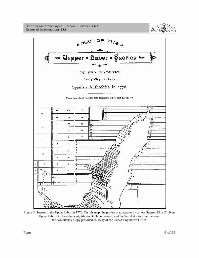
Distribution of land and water rights… … began in April, 1777… …The land wasdivided into 26 suertes [Figure 3], and each suerte included the right to one day of water, with theparticipants drawing numbers for the plots. Each suerte extended as a long and narrow tract fromthe acequia on the west to the San Antonio River on the east... …After distribution, each newowner cleared the land for field crops…
_____________________________________________________________________________________________
_____________________________________________________________________________________________Page 9 of 25
South Texas Archeological Research Services, LLCReport of Investigations 182
Figure 3. Suertes in the Upper Labor in 1776. On this map, the project area apparently is near Suertes 23 or 24. NoteUpper Labor Ditch on the west, Alamo Ditch on the east, and the San Antonio River between
the two ditches. Copy provided courtesy of the COSA Engineer’s Office.
_____________________________________________________________________________________________
_____________________________________________________________________________________________Page 10 of 25
South Texas Archeological Research Services, LLCReport of Investigations 182
Because Mariano Rodriguez was granted the portion nearest to Alsbury Springs, wherethe San Antonio River met the Upper Labor Ditch, he claimed all the intervening land. Heconstructed and maintained a bridge on the river just below the dam that diverted water into theditch, strengthening his claim on the commons area. In 1798, Pedro Flores acquired part of theMariano Rodriguez land, the southern portion of which later became the Brackenridge Polo Field.
Pedro Flores’ Acquisition of the Upper Labor Suertes
During the early to mid nineteenth century, Pedro Flores… …continued to acquireadjoining suertes to the north and to the south, and the family held nine suertes by 1863. Between1840 and 1860, Flores individually became administrator for several of the descendants of theinitial owners of Upper Labor suertes. By gaining control of so many suertes of the Upper Laborarea, Flores also acquired rights to much of the commons between the northernmost suerte andSan Antonio Springs.
The commons included land on the north and south sides of today’s East Mulberry Streetwhere the street crossed the Upper Labor Ditch and the San Antonio River channel…
Confederate States of America Manufacturing Plan
In late 1862, the City of San Antonio and Pedro Flores had a dispute regarding theownership of the land adjacent to and north of the original Mariano Rodriguez Suerte acquired in1798 by Pedro Flores… …In settlement of the issue, both the City of San Antonio and PedroFlores deeded 75 acres… …which included the acreage in dispute, to the Confederate States ofAmerica (CSA) for a manufacturing facility. From the springs southward, the portion west of theSan Antonio River and east of the Upper Labor Ditch became part of a tannery operation.
CSA contractors constructed a manufacturing plant and tannery and began to alter thewater system from the springs to the various acequias stemming from the water source. Since1863 was a drought year, the citizens of San Antonio became concerned over the loss of water andthe activities of the contractors. In 1864, the city filed an injunction to stop contractorsWashington and Friesenhawn from working on the Alsbury Springs or Main Springs of the SanAntonio River. The contractors responded that they had deepened and widened the river channeland created a new dam on the land then identified as 77 acres. They had channeled water from theprincipal springs into the west acequia, or Upper Labor Ditch, by building a new dam anddiverting the water from the old channel into the new channel.
The contractors accused city authorities of previously closing the old channel of the SanAntonio River by a dam or obstruction and preventing water from flowing from the main channelthrough the old ditch. The old river channel appears to have been closed by the city at an earlierdate. Due to the drought, the Alamo Ditch had only a small amount of water. The contractorsprevailed and developed the tannery so that 6,000 hides could be simultaneously processed. A millfor cotton and wool operated by water power also produced hats and cotton cards. Salt was alsoreported to be a byproduct of the enterprise. The close of the Civil War ended the dispute with thecity and the enterprise. During Reconstruction, the city petitioned the Union authorities for a deedto the 77 acres previously sold to the CSA and received it by 1869.
_____________________________________________________________________________________________
_____________________________________________________________________________________________Page 11 of 25
South Texas Archeological Research Services, LLCReport of Investigations 182
Tannery Plat of Lots 1-10 in the Upper Labor
In 1874, the city ordered a survey by John Bobbin to divide the former CSAmanufacturing land into ten tracts varying in size from three to seven acres and City AttorneyGeorge Brackenridge purchased the tracts. Brackenridge agreed to remove the dam constructed bythe CSA contractors near the mouth of the spring in 1863, and to close a 20-vara-wide street onboth sides of the San Antonio River in exchange for opening a street of the same width along thesouth line of the Water Works Company land. The new thoroughfare… …was Josephine Street...
Within a few years, Brackenridge became a major stockholder in the Water WorksCompany, which conducted its operations just south of the former CSA manufacturing site. In1899, Brackenridge donated about 199 acres to the city for Brackenridge Park… …Immediatelyfollowing his purchase of the tannery tract from the city in 1874, Brackenridge sold Lots 1-10.
Tannery Plat of Lots 8, 9, and 10
On June 27, 1883, Lots 8, 9, and 10 were sold by Brackenridge to Helen Madarasz…
By 1880, Helen Madarasz and her two sons had developed the Ilka Nursery on Lots 8, 9,and 10, and were selling cut flowers, potted plants, and trees. The property had a RoseGreenhouse, a Carnation House, a barn, and four or five rent houses for the help. Helen also livedon the property, renting part of her home to a railroad engineer from New York and his wife...Specific records indicate that in 1880, Helen Madarasz, age 44, and a native of Hungary, wasliving on Tannery Lots 8, 9 and 10, and was helping her two sons run the Ilka Nursery. Five renthouses on the property were occupied by employees who were from Kentucky, Virginia,Germany, and Mexico...
Helen Madarasz apparently signed a Bond for Title for the three Tannery Tract lots priorto 1880, and received her first deed in 1882, and a second deed in 1883, from previous ownerGeorge W. Brackenridge... …Brackenridge had purchased the lots in 1881 from banker andsteamship representative J. S. Lockwood. Lockwood and business partner James Manney hadacquired the land from the city in 1875...
Within ten years after Helen’s receipt of these deeds, her son William L. Madaraszbecame the proprietor of Ilka Nurseries, which advertised roses as a specialty. The expandingnursery was located on Rock Quarry Road at the San Antonio Springs and had a retail outlet at theCity Stand and Depot at 309 East Houston Street. The Ilka Nursery also grew a limited supply ofevergreens, as well as ornamental and flowering shrubs in pots... …William also worked as abookkeeper at George W. Brackenridge’s San Antonio National Bank.
By 1894, William deeded his interest in the nursery business to his mother and moved toNew York City to continue his banking career... …Helen died in July, 1899, and her estate,including the nursery plants and land, was sold in 1901 to the owners of the San Antonio BrewingAssociation via S. G. Newton... …The brewing association, headed by Otto Koehler, deeded theproperty to Emma Koehler in 1915, after which Emma created Koehler Park. In response toBrackenridge’s 1899 and 1915 deed restrictions prohibiting the sale of alcoholic beverages inBrackenridge Park, the city agreed to allow beer to be sold within Koehler Park... [Uecker et al.2004:17-22].
_____________________________________________________________________________________________
_____________________________________________________________________________________________Page 12 of 25
South Texas Archeological Research Services, LLCReport of Investigations 182
San Antonio Zoo
In 1910, San Pedro Park in San Antonio housed a private collection of small animals. In 1914, George W.Brackenridge donated a few elk and buffalo for public display in Brackenridge Park. In 1928, the San AntonioZoological Society, a nonprofit organization, was established to purchase animals to be housed adjoiningBrackenridge and Koehler parks on a 51-acre tract of land from a Spanish grant that belonged to the city. The sitehad been a rock quarry, and the resultant limestone cliffs provided a natural habitat for the animals. The San AntonioRiver flowed through the area, and an extensive canal system was developed using its water.
The zoo opened in 1929 with 344 specimens in the collection, including 72 white-tailed deer and 67 ring-necked doves. The collection now comprises more than 3,000 animals representing more than 700 species. Thesociety oversees building, maintenance, and purchases of the animals; the city provides the land and continuessupport. The San Antonio Zoo is the only one in the world that exhibits the endangered whooping crane, the giantarmadillo, and the shoebill.
The first white rhino born in the New World was born in the zoo in 1972. Many endangered species areexhibited and propagated at the zoo, including golden lion tamarins, black rhinos, Grevy's zebras, scimitar-hornedoryx, and sable antelope. The zoo features an innovative children's zoo, in which a boat ride passes by islandsrepresenting different parts of the world and exhibiting animals native to each region, and an education center whereprograms are offered for visitors of all ages.
Work Projects Administration
Much of the stone masonry, including decorative landscaping elements, retaining walls, and severalbuildings within Brackenridge Park, the San Antonio Zoo, and immediate vicinity were constructed by the WorksProgress Administration or Works Projects Administration (WPA). This summary of the history of the WPA closelyfollows Handbook of Texas Online (Texas State Historical Association 2011) and focuses on the activities of theWPA in Texas.
The WPA was originally named the Works Progress Administration when it was established as a nationalagency on May 6, 1935, by an executive order of President Franklin D. Roosevelt. Several of the HBSO studiedwere constructed by the WPA during the 1930s. Harry Hopkins, who had been chief of the Federal EmergencyRelief Administration (FERA) and the Civil Works Administration (CWA) during 1933 and 1934, was appointedhead of the new WPA, which succeeded these organizations. The name of the agency was changed to Work ProjectsAdministration on July 1, 1939, when it was made a part of the Federal Works Agency, but its continuity wasunbroken and the purposes of the WPA remained the same. It was established as a relief measure during the GreatDepression and lasted until it was phased out in 1943, after it was rendered unnecessary by increased employmentand reduced relief rolls.
Prior to the WPA, the problems of unemployment in Texas had been faced by Governor Miriam AmandaFerguson, who issued an executive order establishing the Texas Relief Commission in March, 1933. Thecommission used FERA funds, enabling Texans to participate in various early New Deal programs such asconstruction and white-collar projects of the Civil Works Administration (CWA) and the camp programs of theCivilian Conservation Corps (CCC). One CWA program, the Public Works of Art Project (PWAP) of 1933-34,employed dozens of Texas artists in the decoration of public buildings, but the program was not administered by theTexas Relief Commission.

_____________________________________________________________________________________________
_____________________________________________________________________________________________Page 13 of 25
South Texas Archeological Research Services, LLCReport of Investigations 182
Due to the PWAP administrative procedures under the United States Treasury Department, payrolls wererouted through federal customs officers in the 16 CWA regions, and expenditures were authorized by the federalgovernment. The FERA, under which these projects had been organized, was discontinued in December, 1935. Priorto that, in July 1935, Texas had established an administration in San Antonio, directed by H. P. Drought, tocoordinate WPA activities. The WPA functioned in Texas until after unemployment had begun to fall off sharply in1942. The phase-out was completed in 1943, and Drought’s final report was written in March of that year.
Under the WPA, 600,000 persons in Texas were helped to provide subsistence for themselves and theirfamilies. According to its regulations anyone employed by the WPA had to be the economic head of his family andhad to be certified as destitute on the rolls of the Texas Relief Commission. People of both sexes and of all raceswere employed. WPA wages in Texas ranged from 45 to 75 dollars per month. Peak employment under the TexasWPA program was 120,000 persons in February, 1936. This figure perhaps reflects the level of administrativeefficiency at that time rather than the need for employment, since the peak caseload of the relief commission camelater, in February 1939, when 218,291 of the unemployed were on relief rolls.
Soon after that time, in September 1939, the name of the state relief organization was changed bylegislative act to the State Department of Public Welfare. State WPA administrator Drought blamed the increase incaseload in 1939 on widespread crop failure in Texas in that year. The caseload remained high from 1939 through1942, always staying between 120,000 and 150,000, while the number of workers employed by the WPA was nevermore than half of the caseload figure.
The biggest drop in caseload in Texas did not come until the period February-October 1942, when areduction of 75 percent occurred, with a proportional drop in WPA employment. The major reason for a worker'sleaving WPA relief employment was that he found other work, although some were forced off by lack of projectfunds. The 1942 drop in Texas WPA employment was undoubtedly due to the increase of business activityfollowing United States entry into World War II.
The WPA activities in Texas were varied. As its art project, the state conducted an excellent survey of folkart objects for the Index of American Design. There were so few artists on relief rolls that better-than-averagecraftsmen had to be employed and trained on the jobs. The objects were listed and pictorial records were made ofthem. The original plates for this index are on deposit at the National Gallery of Art in Washington, D.C. The WPAArcheological Survey studied the Indians of Texas. This study entailed the finding, mapping, and excavation of 50archeological sites, including Indian villages, camp sites, and burial mounds; collection of artifacts from these sites;and analysis of all data gathered. In the paleontologic-mineralogic survey, WPA workers, again under thesupervision of professional scientists, worked many sites in Texas for fossils, mineral resources, and combinationsof both. As war requirements increased, work focused on discovery and investigation of minerals, especiallylocation of road materials and mineral resources designated as strategic.
The Federal Music Project in Texas consisted of the organization of groups of musicians into ensembles ofvarious sizes, including dance bands, a Mexican folk group, and two Latin-style orchestras. The program alsoincluded teaching in CCC camps, in underprivileged parts of three metropolitan areas, and in public schools havingno musical curriculum. A broad adult-education program was instituted to provide instruction in such basic areas asliteracy and citizenship, in vocational training and home economics, and in foreign languages and other academicsubjects. Programs designed primarily to answer the needs of unemployed women were a child protection program,for training in the care of preschool children; a clothing program, for the operation of shops that trained workers tomake and repair garments and shoes for free distribution to the needy; a feeding program, which included storageand distribution of relief food, as well as the provision of school lunches, matron service, gardening, and foodpreservation; a housekeeping aid program, which trained women to fill positions as domestic workers and providedemergency aid in home services; and a health service program, which provided training and personnel for work inhealth agencies and institutions.
_____________________________________________________________________________________________
_____________________________________________________________________________________________Page 14 of 25
South Texas Archeological Research Services, LLCReport of Investigations 182
The American Imprints Inventory employed library workers and supervisors, first as a part of the TexasHistorical Records Survey program and later in cooperation with the library service program. This inventoryincluded books, pamphlets, broadsides, broadsheets, maps, newspapers, and periodicals in public, semipublic, andprivate collections in the state for the period from the beginning of printing into the nineteenth century; it calendaredor transcribed three major manuscript collections. Copies of these materials were deposited at the University ofTexas and other institutions. This program also included compilation of a list of all libraries in Texas. Other archivaland literary programs were the research and records programs, which provided clerical labor to public agencies forthe installation or improvement of records systems; the library training program, which covered every phase oflibrary science; and the library service program, which gave support in labor, funds, or technical knowledge to alltypes of libraries in Texas. Perhaps the best known was the Texas Writers' Project, which conducted large-scaleresearch into the state's cultural history and its geographical points of interest. This work resulted in manypublications, including several state and local guides to Texas. All manuscript materials from the writers' projectwere deposited in the University of Texas at Austin archives.
The greatest single area of WPA public spending in Texas was construction. As in most of the other WPAprojects in Texas, one-fourth of the construction costs had to be provided by sponsors. This was a regulationimposed by the Texas WPA administrators, there being no federal requirement for matching monies. Constructionprojects included parks, swimming pools, highways, bridges, stadiums, and other public buildings. Recreationalfacilities were increased, but recreational leadership and organizational help were also boosted under the WPA. Anattempt was made to provide leisure-time activities for persons of all ages, races, and economic groups during allseasons of the year. The WPA in Texas built and organized pre-school play centers, playgrounds, communityrecreation centers, toy loan centers, athletic leagues, boys' clubs, girls' clubs, and, during the period of World War II,centers for all branches of armed forces personnel. All recreational programs were begun with the idea ofestablishing permanent facilities.
Soils
According to the Soil Survey of Bexar County, Texas (Taylor, et al. 1966:Sheet 45), the principal naturalsurface soils in the general vicinity of the project area are Lewisville silty clay (LvA) and Trinity and Frio soils (Tf).Lewisville silty clay generally occurs as nearly level, broad terraces along rivers and creeks. Trinity series soils aredeep, dark, calcareous clays that range in texture from clay loam to gravelly clay and that typically occupybottomlands that are frequently flooded. They are usually derivatives of the surrounding upland soils. Because theyare ideal for cultivation, Trinity series soils were farmed intensively during the historic era wherever they werepresent in Bexar County and surrounding areas. They frequently contain pockets of Venus Clay Loam (Vcb) andHouston Black Clay (HtA).
Archeological Context
Texas culture history has generally been divided by archeologists into four broad periods (cf. Black1989a:25-33, 1989b:48-57; Black and McGraw 1985:35-40; Hester 1980:27-37; Turner and Hester 1993:50-63): thePaleoindian (c. 11,000 B.P. to 8000 B.P.), the Archaic (c. 8000 B.P. to 1500 B.P.), the Late Prehistoric (c. 1500 B.P.to A.D. 1528), and the Historic (c. A.D. 1528 to present). Although there is evidence for several specializedsubsistence adaptations, during all but the Historic period, apparently humans in the area were engaged primarily ina broad-spectrum nomadic to semi-sedentary hunting and foraging lifeway (Hester 1989:119-125). Archeologicaland ethnohistorical evidence indicates that they were organized as small groups or bands that traveled much of thetime in regular patterns, known as subsistence forays, in order to exploit a variety of seasonably available naturalresources (Collins 2004:123; Johnson 1994:282). Such a hunting-foraging lifeway apparently was practiced not justin what is now Texas, but in most of today’s North America for many thousands of years before the fifteenth centuryinfusion of historically modern Europeans to the New World.
_____________________________________________________________________________________________
_____________________________________________________________________________________________Page 15 of 25
South Texas Archeological Research Services, LLCReport of Investigations 182
In recent decades, several scholars have summarized the archeology of the region that includes the projectarea. Black (1989a:18, 1989b:5) named it the Central Texas Plateau-Prairie. Apparently following Turner andHesters’ (1993:67) Central Texas Region, Collins (1995:363, 2004:121) used the title Central Texas archeologicalarea. For their purposes, Mercado-Allinger et al. (1996:12) called it the Central and Southern Planning Region.Interested readers are encouraged to consult those references for details.
As revealed by archeological work spanning many decades, the zone within about a kilometer of the projectarea is rich in archeological resources. It contains several dozen previously discovered and recorded sites, many ofwhich are designated State Archeological Landmarks or Recorded Texas Historic Landmarks, are listed in theNational Register of Historic Places, or are eligible for such designation or listing.
For example, in 2004 the remnants of prehistoric camping or cooking fires and associated chipped-stoneartifacts were found within the floodplain deposits of the San Antonio River near the previously-recordedBrackenridge Polo Field archeological site (41BX264) just a few hundred meters south of the project area (Uecker etal. 2004). In one area of the site, 36 clusters of burned limestone fragments were archeologically investigated asspatially discrete, hot-rock activity features. Since they were found at the same level about a meter below theaverage 2004 ground surface and were similar in shape and contents, the features apparently were contemporaneous.Three similar features were documented at a second location, and two additional features were subjected to limiteddata-recovery excavations at a third location investigated. Associated temporally diagnostic artifacts facilitateddating of the features to the Middle Archaic period. Apparently the features were intact or were only slightlydisturbed, having been very gradually buried by alluvium during repeated low-energy flood events.
During investigations at the Olmos Basin Site (41BX1) in 1980, the Principal Investigator helped excavateabout a dozen prehistoric human burials in the Olmos Creek floodplain, just north of Olmos Dam near InterstateHighway 37 and only about a kilometer north of the project area (Lukowski 1988). Associated grave goods, burialmorphology, and radiocarbon dating facilitated assignment of the interments to the Transitional Archaic period. Thespatial distribution and density of the burials suggests that the site might be a traditional burial area where manymore interments occurred during centuries or perhaps even millennia. Remnants of hot-rock features, possiblyceremonial fires, and an isolated chipped-stone projectile point of the Paleoindian period were also found at the site,which is deemed eligible as a State Archeological Landmark and for National Register listing.
State Archeological Landmark Site 41BX323, which is a few hundred meters from the subject project areaalong the San Antonio River margin, was tested in 2002 by SWCA, Inc., and found to contain prehistoricarcheological deposits to depths of about two meters below the surface (Houk 2002). The oldest of those depositsoriginated during the late Paleoindian period.
Beginning April 1, 2006, and continuing to this writing, the Fools Rockshelter (41CM294) wasarcheologically investigated by members of the Southern Texas Archeological Association (2006). The smallrockshelter is situated within a limestone bluff about four meters above a narrow alluvial terrace of Indian Creeknear Bulverde in Comal County. Although it is many kilometers north of the subject project area, its setting isgenerally similar to that of the bluff along the east side of the area. The site has yielded well-preserved stratifiedcultural deposits several meters thick associated with Early Archaic- through Late Preshistoric-period artifacts,including numerous chipped chert projectile points and several intact hot-rock cooking features, or hearths.
Survey Rationale
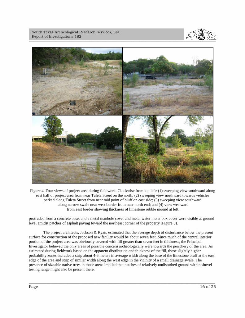
At the time of the survey, the buildings and other substantive above-ground improvements of the formerCOSA animal control facility had been removed and virtually the entire surface of the project area was covered withimported, crushed limestone fill or remnants of asphalt parking areas (Figure 4). Much of the fill cap averagedseveral meters in thickness and at maximum was about 4-6 meters thick in a few places. Some capped utilities pipes
_____________________________________________________________________________________________
_____________________________________________________________________________________________Page 16 of 25
South Texas Archeological Research Services, LLCReport of Investigations 182
Figure 4. Four views of project area during fieldwork. Clockwise from top left: (1) sweeping view southward alongeast half of project area from near Tuleta Street on the north; (2) sweeping view northward towards vehicles
parked along Tuleta Street from near mid point of bluff on east side; (3) sweeping view southwardalong narrow swale near west border from near north end; and (4) view westward
from east border showing thickness of limestone rubble mound at left.
protruded from a concrete base, and a metal manhole cover and metal water meter box cover were visible at groundlevel amidst patches of asphalt paving toward the northeast corner of the property (Figure 5).
The project architects, Jackson & Ryan, estimated that the average depth of disturbance below the presentsurface for construction of the proposed new facility would be about seven feet. Since much of the central interiorportion of the project area was obviously covered with fill greater than seven feet in thickness, the PrincipalInvestigator believed the only areas of possible concern archeologically were towards the periphery of the area. Asestimated during fieldwork based on the apparent distribution and thickness of the fill, those slightly higherprobability zones included a strip about 4-6 meters in average width along the base of the limestone bluff at the eastedge of the area and strip of similar width along the west edge in the vicinity of a small drainage swale. Thepresence of sizeable native trees in those areas implied that patches of relatively undisturbed ground within shoveltesting range might also be present there.
_____________________________________________________________________________________________
_____________________________________________________________________________________________Page 17 of 25
South Texas Archeological Research Services, LLCReport of Investigations 182
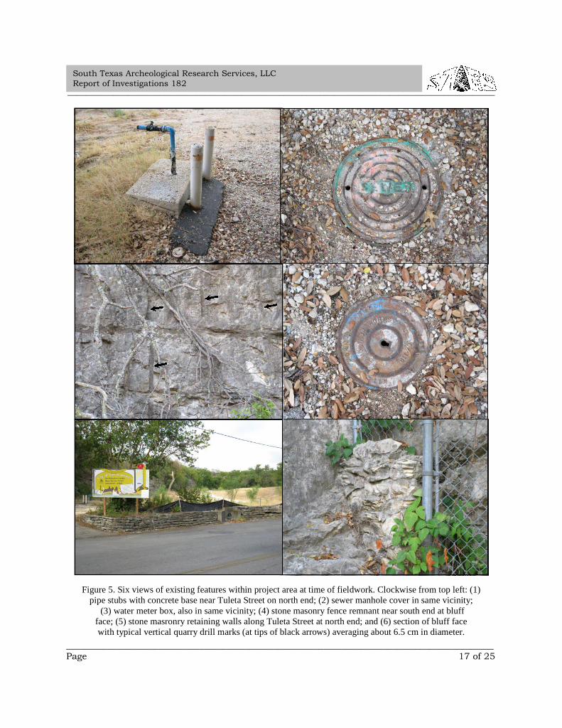
Figure 5. Six views of existing features within project area at time of fieldwork. Clockwise from top left: (1)pipe stubs with concrete base near Tuleta Street on north end; (2) sewer manhole cover in same vicinity;
(3) water meter box, also in same vicinity; (4) stone masonry fence remnant near south end at bluffface; (5) stone masronry retaining walls along Tuleta Street at north end; and (6) section of bluff facewith typical vertical quarry drill marks (at tips of black arrows) averaging about 6.5 cm in diameter.
_____________________________________________________________________________________________
_____________________________________________________________________________________________Page 18 of 25
South Texas Archeological Research Services, LLCReport of Investigations 182
When first seen from a distance, the bluff along the west edge of the project area appeared to be entirely ofnatural origins, but upon closer inspection during fieldwork it proved to have been altered substantially by historicstone quarrying. The bluff obviously contained no crevices or cavities suitable for human occupation, but itspresence raised the possibility that people might have camped along its base during prehistory or during the earlyHistoric period (c. A.D. 1400 to 1800), or that it might have been a focus for hunting or butchering of larger gameanimals such as white tailed deer, antelope, or bison, by such people.
Thus, it was important to try to accurately estimate, to the extent feasible at the survey level of effort,whether or not well preserved original soils were present anywhere within the project area. If such deposits werefound within normal shovel testing range (c. 1.0-1.5 meters below surface), then either backhoe trenching prior toconstruction ground disturbances or monitoring of such disturbances in selected high probability areas might havebeen appropriate for a future phase of work. Conversely, if shovel testing during the initial survey established withreasonable certainty that it was unlikely that the project as planned would impact any intact deposits, and if theresults of all tests were negative or negligible in terms of encountering cultural resources, then neither furtherarcheological work prior to construction nor monitoring during construction would be warranted. In the latter case,photographic documentation of disturbances would be appropriate.
Methods and Results
A search of the Texas Historical Commission’s (2011) Texas Archeological Sites Atlas conducted prior tofieldwork revealed that apparently the project area contained no previously recorded archeological sites and had notbeen investigated. However, the Atlas also showed that numerous archeological sites had been found in the generalvicinity and registered with the State of Texas, including the three previously described.
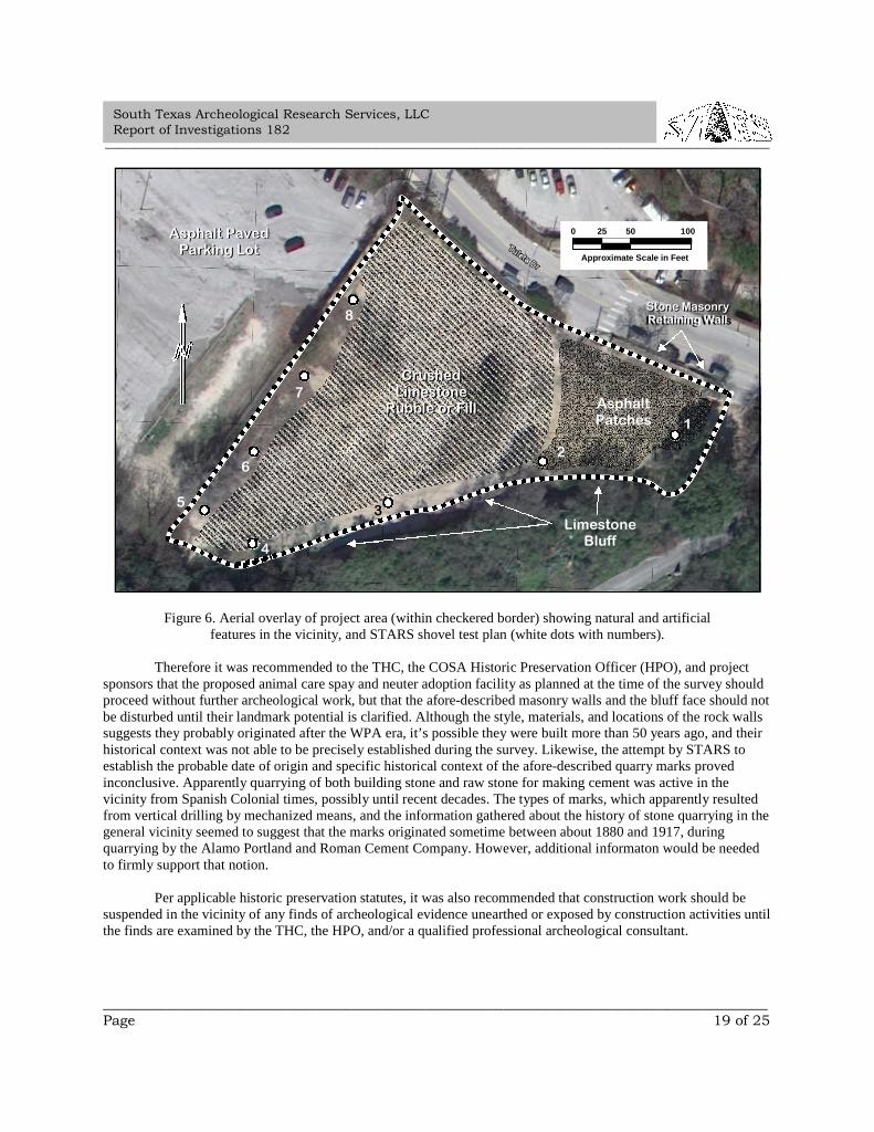
During fieldwork, a careful pedestrian visual inspection of virtually the entire project area revealed thatapparently only artificial fill was exposed at the surface throughout the area. In hopes that the fill was relatively thinalong the periphery where massive deposits of it weren’t obvious and native trees were standing, excavation of eightarcheological shovel tests was planned there and was attempted (Figures 6 and 7). Most encountered impenetrablepatches of asphalt or limestone rubble just beneath the ground surface. The rubble apparently resulted from pastquarrying in the vicinity of the bluff. Only two tests were able to penetrate to any appreciable depth below thesurface and the same rubble was encountered throughout those excavations.
Except for the remnants of modern improvements previously described, chain link fencing, stone masonryretaining wall remnants at the north and south borders, quarry chisel and platform marks in the face of the bluff,scattered modern trash on the ground, and the limestone rubble in shovel test excavations, no cultural evidence wasfound. Those items and other surface evidence of disturbance were photographically documented. Nothing wascollected or curated.
Survey-level background research was briefly conducted in local institutional and internet sources and inrelevant books and articles in an attempt to determine the approximate age and historic or cultural associations of thequarry marks in the bluff face. However, nothing was found that would firmly establish when and by whom thatparticular quarrying was done. Results of the search are summarized in the Appendix.
Interpretations and Recommendations
The survey revealed that apparently the entire project area had been severely disturbed and buried inlimestone rubble or similar modern fill in years past. Based on its findings, the Principal Investigator believed thatmost of the project area contained nothing worthy of further investigation, preservation, or landmarking at thefederal, state, or local levels. The only possible exceptions are the limestone masonry walls at the north and southends of the property and the bluff face along the east side that has quarry marks.
_____________________________________________________________________________________________
_____________________________________________________________________________________________Page 19 of 25
South Texas Archeological Research Services, LLCReport of Investigations 182
Figure 6. Aerial overlay of project area (within checkered border) showing natural and artificialfeatures in the vicinity, and STARS shovel test plan (white dots with numbers).
Therefore it was recommended to the THC, the COSA Historic Preservation Officer (HPO), and projectsponsors that the proposed animal care spay and neuter adoption facility as planned at the time of the survey shouldproceed without further archeological work, but that the afore-described masonry walls and the bluff face should notbe disturbed until their landmark potential is clarified. Although the style, materials, and locations of the rock wallssuggests they probably originated after the WPA era, it’s possible they were built more than 50 years ago, and theirhistorical context was not able to be precisely established during the survey. Likewise, the attempt by STARS toestablish the probable date of origin and specific historical context of the afore-described quarry marks provedinconclusive. Apparently quarrying of both building stone and raw stone for making cement was active in thevicinity from Spanish Colonial times, possibly until recent decades. The types of marks, which apparently resultedfrom vertical drilling by mechanized means, and the information gathered about the history of stone quarrying in thegeneral vicinity seemed to suggest that the marks originated sometime between about 1880 and 1917, duringquarrying by the Alamo Portland and Roman Cement Company. However, additional informaton would be neededto firmly support that notion.
Per applicable historic preservation statutes, it was also recommended that construction work should besuspended in the vicinity of any finds of archeological evidence unearthed or exposed by construction activities untilthe finds are examined by the THC, the HPO, and/or a qualified professional archeological consultant.
5
6
7
8
0 25 50 100
Approximate Scale in Feet
Asphalt PavedParking Lot
Asphalt PavedParking Lot
LimestoneBluff
AsphaltPatches
CrushedLimestone
Rubble or Fill
CrushedLimestone
Rubble or Fill1
2
4
3
Stone MasonryRetaining WallsStone MasonryRetaining Wall
_____________________________________________________________________________________________
_____________________________________________________________________________________________Page 20 of 25
South Texas Archeological Research Services, LLCReport of Investigations 182
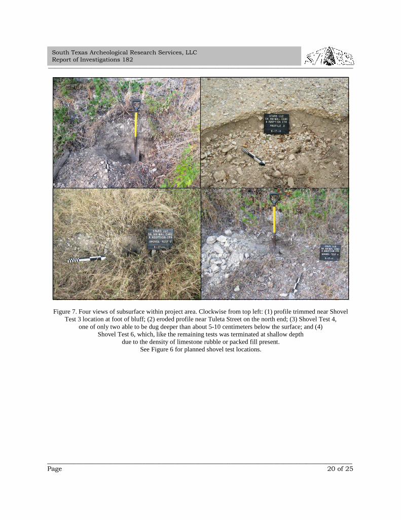
Figure 7. Four views of subsurface within project area. Clockwise from top left: (1) profile trimmed near ShovelTest 3 location at foot of bluff; (2) eroded profile near Tuleta Street on the north end; (3) Shovel Test 4,
one of only two able to be dug deeper than about 5-10 centimeters below the surface; and (4)Shovel Test 6, which, like the remaining tests was terminated at shallow depth
due to the density of limestone rubble or packed fill present.See Figure 6 for planned shovel test locations.
_____________________________________________________________________________________________
_____________________________________________________________________________________________Page 21 of 25
South Texas Archeological Research Services, LLCReport of Investigations 182
References Cited
Abbott, Patrick L. and C. M. Woodruff, Jr. (editors)1986 The Balcones Escarpment: Geology, Hydrology, Ecology and Social Development in Central Texas.
Published for the Geological Society of America Annual Meeting, San Antonio, Texas, November,1986. Printed by Comet Reproduction Service, Santa Fe Springs, California.
Biesele, R. L.1930 The History of the German Settlements in Texas 1831-1861. German Texan Heritage Society,
Department of Modern Languages, Southwest Texas State University, San Marcos, Texas.
Black, Stephen L.1989a Environmental Setting. In From the Gulf to the Rio Grande: Human Adaptation in Central, South, and
Lower Pecos Texas by Thomas R. Hester et al., pp. 5-16. Arkansas Archeological Survey, ResearchSeries 33. Fayetteville.
1989b Central Texas Plateau Prairie. In From the Gulf to the Rio Grande: Human Adaptation in Central,South, and Lower Pecos Texas by Thomas R. Hester et al., pp. 17-38. Arkansas Archeological Survey,Research Series 33. Fayetteville.
1989c South Texas Plains. In From the Gulf to the Rio Grande: Human Adaptation in Central, South, andLower Pecos Texas by Thomas R. Hester et al., pp. 39-62. Arkansas Archeological Survey, ResearchSeries 33. Fayetteville.
Black, Stephen L. and A. Joachim McGraw1985 The Panther Springs Creek Site: Cultural Change and Continuity within the Upper Salado Creek
Watershed, South-Central Texas. Center for Archaeological Research, The University of Texas at SanAntonio, Archaeological Survey Report 100.
Blair, W. F.1950 The Biotic Provinces of Texas. Texas Journal of Science 2:104.
Campbell, Thomas N.1979 Ethnohistoric Notes on Indian Groups Associated with Three Spanish Missions at Guerrero, Coahuila.
Center for Archaeological Research, The University of Texas at San Antonio, Archaeology and Historyof the San Juan Batista Mission Area Report 3.
1988 The Indians of Texas and Northeastern Mexico: Selected Writings of Thomas Nolan Campbell. TheUniversity of Texas at Austin.
Caran, S. Christopher and Victor R. Baker1986 Flooding Along the Balcones Escarpment, Central Texas. In The Balcones Escarpment: Geology,
Hydrology, Ecology, and Social Development in Central Texas, edited by P. L. Abbott and C. M.Woodruff, Jr., pp. 1-14. Published for the Geological Society of America Annual Meeting, San Antonio,Texas, November, 1986. Printed by Comet Reproduction Service, Santa Fe Springs, California.
Chabot, Frederick C.1936 San Antonio and Its Beginnings: 1691-1731. Artes Graficas Printing Company, San Antonio.
City of San Antonio Public Works Department2002 San Antonio Acequias [map]. City of San Antonio Public Works Department, Engineering Division.
_____________________________________________________________________________________________
_____________________________________________________________________________________________Page 22 of 25
South Texas Archeological Research Services, LLCReport of Investigations 182
Collins, Michael B.1995 Forty Years of Archeology in Central Texas. Bulletin of the Texas Archeological Society 66: 361-400.2004 Archeology in Central Texas. In The Prehistory of Texas, edited by Timothy K. Perttula, pp. 101-126.
Texas A & M University Press, College Station.
Corner, William1890 San Antonio de Bexar: A Guide and History. Bainbridge and Corner, San Antonio.
Cox, I. Waynne,1993 Excavation of a Portion of the San Pedro Acequia (41 BX 337): Via Metropolitan Transit System
Parking Lot, San Antonio, Bexar County, Texas. Center for Archaeological Research, The University ofTexas at San Antonio, Archaeological Survey Report 219.
1995 An Archival Search for the Alamo-Concepcion Aqueduct. Center for Archaeological Research, TheUniversity of Texas at San Antonio, Archaeological Survey Report 231.
1999 The Spanish Colonial Acequias of San Antonio. Bulletin of the Texas Archeological Society 70.2005 The Spanish Acequias of San Antonio. Maverick Publishing Company, San Antonio.
Davis, William B.1960 The Mammals of Texas. Texas Game and Fish Commission Bulletin 41, Austin.
Enquist, Marshall1987 Wildflowers of the Texas Hill Country. Lone Star Botanical, Austin.
Everitt, James H. and D. Lynn Drawe1993 Trees, Shrubs, & Cacti of South Texas. Texas Tech University Press, Lubbock.
Fehrenbach, T. R.1978 The San Antonio Story. Continental Heritage, Inc., Tulsa, Oklahoma.
Fox, Anne A.1985 Testing for the Location of the Alamo Acequia (41 BX 8) at Hemisfair Plaza, San Antonio, Texas.
Center for Archaeological Research, The University of Texas at San Antonio, Archaeological SurveyReport 142.
Fox, Anne A., and I. Waynne Cox1991 Testing of the San Jose Mission Acequia, San Antonio Missions National Historic Park, Bexar County,
Texas. Center for Archaeological Research, The University of Texas at San Antonio, ArchaeologicalSurvey Report 207.
Henderson, Jerry, and John W. Clark, Jr.1984 The Acequia and Other Features at Mission San José, Bexar County, Texas. Texas State Department of
Highways and Public Transportation Publications in Archaeology Report 25. Austin, Texas.
_____________________________________________________________________________________________
_____________________________________________________________________________________________Page 23 of 25
South Texas Archeological Research Services, LLCReport of Investigations 182
Hester, Thomas R.1980 Digging into South Texas Prehistory, A Guide for Amateur Archaeologists. Corona Publishing
Company, San Antonio.1985 UTSA Archeological Field School Excavations in Bandera and Victoria Counties, Texas. Friends of
Archeology Newsletter No. 2. Center for Archaeological Research, The University of Texas at SanAntonio.
1989 Historic Native American Populations. In From the Gulf Coast to the Rio Grande: Human Adaptationin Central, South, and Lower Pecos Texas, by Thomas R. Hester, Stephen L. Black, D. Gentry Steele,Ben W. Olive, Anne A. Fox, K. J. Reinhard, and Leland C. Bement, pp 39-62. Arkansas ArcheologicalSurvey, Research Series 33.
Houk, Brett A.2002 The Brackenridge Park Rehabilitation Project: Data Recovery at 41Bx323 and Testing at 41BX1425,
San Antonio, Bexar County, Texas. SWCA Cultural Resource Report 01-357. Austin.
Johnson, LeRoy., Jr.1997 The Lion Creek Site (41BT105): Aboriginal Houses and Other Remains at a Prehistoric Rancheria in
the Texas Hill Country (Burnet County). Office of the State Archeologist Report 41. Texas Departmentof Transportation and Texas Historical Commission, Austin.
Kutac, Edward A., and S. Christopher Caran1994 Birds & Other Wildlife of South Central Texas. University of Texas Press. Austin.
Lich, G. E.1986 The Federal Republic of Germany and Texas, A Sesquicentennial Tribute. Inter Nationes, Bonn, West
Germany.
Lukowski, Paul D.1988 Archaeological Investigations at 41BX1, Bexar County, Texas. Center for Archeological Research, The
University of Texas at San Antonio, Archaeological Survey Report 135.
Mercado-Allinger, Patricia A., Nancy A. Kenmotsu, and Timothy K. Perttula1996 Archeology in the Central and Southern Planning Region, Texas: A Planning Document. Texas
Historical Commission, Austin.
Nance, C. Roger1972 Cultural Evidence for the Altithermal in Texas and Mexico. Southwestern Journal of Anthropology
28:169-192.
Neck, Raymond W.1986 The Balcones Fault Zone as a Major Zoogeographic Feature. In The Balcones Escarpment: Geology,
Hydrology, Ecology, and Social Development in Central Texas, edited by P. L. Abbott and C. M.Woodruff, Jr., pp. 35-40. Published for the Geological Society of America Annual Meeting, SanAntonio, Texas, November, 1986. Printed by Comet Reproduction Service, Santa Fe Springs,California.
Newcomb, W. W., Jr.1961 The Indians of Texas from Prehistoric to Modern Times. University of Texas Press, Austin.
_____________________________________________________________________________________________
_____________________________________________________________________________________________Page 24 of 25
South Texas Archeological Research Services, LLCReport of Investigations 182
Nickels, David L., I. Waynne Cox, and Connie Gibson1996 Excavation of the San Pedro Acequia on the Grounds of the San Antonio Housing Authority. Center for
Archaeological Research, The University of Texas at San Antonio, Archaeological Survey Report 243.
Palmer, E. Charles1986 Land Use and Cultural Change Along the Balcones Escarpment: 1718-1986. In: The Balcones
Escarpment: Geology, Hydrology, Ecology and Social Development in Central Texas, pp. 153-161, ed.by Patrick L. Abbott and C. M. Woodruff, Jr. Published for the Geological Society of America AnnualMeeting, San Antonio, Texas, and printed by Comet Reproduction Service, Santa Fe Springs, Ca.
Riskind, David H., and David D. Diamond1986 Plant Communities of the Edwards Plateau of Texas: An Overview Emphasizing the Balcones
Escarpment Zone Between San Antonio and Austin with Special Attention to Landscape Contrasts andNatural Diversity. In The Balcones Escarpment: Geology, Hydrology, Ecology, and SocialDevelopment in Central Texas, edited by P. L. Abbott and C. M. Woodruff, Jr., pp. 21-32. Publishedfor the Geological Society of America Annual Meeting, San Antonio, Texas, November, 1986. Printedby Comet Reproduction Service, Santa Fe Springs, California.
Riskind, David H., and David D. Diamond [continued]1988 An Introduction to Environments and Vegetation. In Edwards Plateau Vegetation: Plant Ecological
Studies in Central Texas, edited by Bonnie B. Amos and Frederick R. Gehlbach, pp. 1-15. BaylorUniversity Press, Waco, Texas.
Rust, Joe Carroll2006 Historic Bexar County: An Illustrated History. Historical Publishing Network. San Antonio, Texas.
San Antonio Parks & Recreation2011 History of Brackenridge Park. Electronic document accessed July 18, 2011:
http://www.sanantonio.gov/parksandrec/directory_brackenridge.aspx#history.
San Antonio Zoo2011 All Aboard! Electronic document accessed July 18, 2011:
http://www.sazoo-aq.org/support/zootrain.html
Schuetz, Mardith K.1970 Excavation of a Section of the Acequia Madre in Bexar County, Texas. Texas Historical Survey
Committee Archeological Report 19. Austin, Texas.1976 Indians of the San Antonio Area. In San Antonio in the Eighteenth Century. San Antonio Bicentennial
Heritage Committee. Clarke Printing Company, San Antonio.
Sjoberg, A. F.1953 The Culture of the Tonkawa, A Texas Indian Tribe. Texas Journal of Science 5(3):280-304.
Simpson, Benny J.1988 Field Guide to Texas Trees. Texas Monthly Field Guide Series. Texas Monthly Press, Austin.
Southern Texas Archeological Association2006 Continuing Investigations at the Fools Rockshelter, 41CM294. Newsletter of the Southern Texas
Archeological Association 1: 3 (3-4).
_____________________________________________________________________________________________
_____________________________________________________________________________________________Page 25 of 25
South Texas Archeological Research Services, LLCReport of Investigations 182
Taylor, F. B., R. B. Hailey, and D. L. Richmond1966 Soil Survey of Bexar County, Texas. United States Department of Agriculture, Soil Conservation
Service. Produced in Cooperation with the Texas Agricultural Experiment Station. U. S. GovernmentPrinting Office, Washington, D. C.
Texas Historical Commission2011 Bexar County. Texas Historic Sites Atlas. Electronic document accessed March 25, 2011:
http://atlas.thc.state.tx.us/shell-desig.htm.
Texas State Historical Association2011 Work Projects Administration. Handbook of Texas Online. Electronic document accessed March 25,
2011: http://www.tshaonline.org/handbook/online/articles/WW/ncw1.html.
Turner, Ellen Sue, and Thomas R. Hester1993 A Field Guide to Stone Artifacts of Texas Indians. Gulf Publishing Co., Houston.
Uecker, Herbert G.2004 Archeological Monitoring and Documentation of an Acequia Remnant for San Antonio Water System’s
Eight-Inch Water Main Project, 700 Block of East Pyron Road at San José Drive, San Antonio, BexarCounty, Texas. South Texas Archeological Research Services, LLC, Report of Investigations 5.Bulverde, Texas.
Uecker, Herbert G., Douglas H. Molineu, and Janet K. Wagner2004 Archeological Investigations of the Former Brackenridge Polo Field for Golf San Antonio’s First Tee
Development Project, San Antonio, Bexar County, Texas. South Texas Archeological ResearchServices, LLC, Report of Investigations 1. Bulverde, Texas.
Veni, George1988 The Caves of Bexar County. The University of Texas at Austin, Texas Memorial Museum Speleological
Monographs 2.1998 Hydrogeologic, Biological, and Archeological Investigations of Caves and Karst Features, and
Continued Biological Monitoring of Four Edwards Limestone Caves, Camp Bullis, Texas. George Veni& Associates. San Antonio, Texas.
Vines, Robert A.1984 Trees of Central Texas. University of Texas Press, Austin.
_____________________________________________________________________________________________
_____________________________________________________________________________________________
South Texas Archeological Research Services, LLCReport of Investigations 182
Appendix
Limited Archival and Historical
Research Findings
Limited Archival and Historical Background Research on theHistory of Stone Quarrying in Brackenridge Park and Vicinity
Imogen R. Cooper, AICP
This report presents data gathered during preliminary archival and historical background research, andinterpretations of the research findings, made by South Texas Archeological Research Services, LLC (STARS), aspart of a cultural resources survey for the proposed San Antonio Animal Care Spay and Neuter Adoption Facilityproject. A broad target of the research was the history of stone quarrying in the vicinities of Brackenridge Park, theJapanese Sunken Gardens, and the San Antonio Zoological Gardens just north of the park. The research alsotargeted discovery of more specific information about the temporal and historical contexts of the quarry marks foundon the bluff face along the east side of the project area during the survey. A total of eight person hours was expendedsearching secondary sources on those topics.
The search revealed that quarrying within the main target areas occurred during two general time periodsand involved two basic uses. Quarries in those areas were apparently used for procurement of sizeable quantities ofbuilding stone starting in the Spanish Colonial period and continuing until about the early 1880s. Beginning in 1879,the City of San Antonio, which by then owned those quarries, leased them to Alamo Portland and Roman CementCompany for the purpose of extracting rock for cement production. From then until about 1907, the companyproduced increasing amounts of cement by burning limestone in large kilns built near the Sunken Gardens. Thequarries were then relocated to a new site with good railroad service later known as Cementville, near AlamoHeights, the location of the Quarry Market Shopping Center at the time of the STARS survey.
Apparently all quarrying ceased in the vicinity of Brackenridge Park after 1908. The San Antonio Zoo wasfounded in about 1914 just south of Brackenridge Park. Ray Lambert is credited with the idea of creating the zoousing the terraces of the old quarries. For Lambert, this was not just frugal. It was also a humanitarian gesturebecause both he and George Brackenridge were advocates of “cageless zoos.”1,2 Using prison labor at a cost of onlyabout $7,000.003, Lambert also created the stunningly beautiful Japanese Sunken Gardens in 1917 within the quarryjust vacated by the Alamo Portland and Roman Cement Company.
No direct association of any quarries in the vicinity with stone procurement during the Spanish Colonialperiod was discovered during the research reported here. However, in 1996, an archaeological team led by I.Waynne Cox investigated a diversionary dam in Brackenridge Park apparently linked to San Antonio’s acequiasbeginning in that era. In the introduction to the report of findings, Cox mentions old quarries: “The Upper LaborAcequia (Acequia de Labores de Arriba), last of the Spanish Colonial irrigation systems, was begun in July, 1776, toprovide irrigation for 600 acres of land between the old quarries and the San Antonio River”4.
Two other secondary sources consulted also reference use of the area by the Spaniards as quarries, perhapsto obtain the limestone used to build the missions and other major structures of the time.5 In his 1989 History of theSan Antonio Zoo, Wilber L. Matthews states that the limestone terraces of the zoo are the rock faces of ancientquarries from which “the settlers of San Antonio built the Alamo, San Fernando Cathedral, the Governor’s Palace,________________________________________________
1 “Zoo from Quarry,” San Antonio Light, January 21, 19172 National Register Nomination for Brackenridge Park, “Zoological Garden, 1914,” (February, 2011), 44.3 National Register Nomination for Alamo Portland and Roman Cement Company/Japanese Sunken Gardens(1976).4 I. Waynne Cox, Excavations for the Upper Labor Dam Site, Brackenridge Park, San Antonio, Bexar County,Texas, Archaeological survey report No. 268. Texas Antiquities Permit No. 1755,Archaeological Survey Report(UTSA Center for Archaeological Research, 1999), 75 It is well known that many houses of the Spanish Colonial period (and even later) were jacales not made of stone.
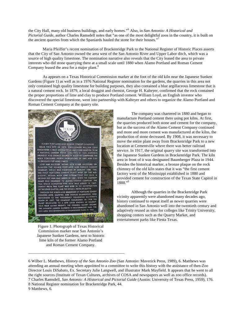
the City Hall, many old business buildings, and early homes.”6 Also, in San Antonio: A Historical andPictorial Guide, author Charles Ramsdell notes that “as one of the most delightful zoos in the country, it is built onthe ancient quarries from which the Spaniards hauled the stone for their houses.”7
Maria Pfeiffer’s recent nomination of Brackenridge Park to the National Register of Historic Places assertsthat the City of San Antonio owned the area west of the San Antonio River and Upper Labor ditch, which was asource of high quality limestone. The nomination narrative also reveals that the City leased the area to privateinterests who did stone quarrying there at a small scale until 1880 when Alamo Portland and Roman CementCompany leased the area for a major plant.8
As appears on a Texas Historical Commission marker at the foot of the old kiln near the Japanese SunkenGardens (Figure 1) as well as in a 1976 National Register nomination for the gardens, the quarries in this area notonly contained high quality limestone for building purposes, they also contained a blue argillaceous limestone that isa natural cement rock. In 1879, a local druggist and chemist, George H. Kalteyer, confirmed that the rock containedthe proper proportions of lime and clay to produce Portland cement. William Loyd, an English investor whodiscovered the special limestone, went into partnership with Kalteyer and others to organize the Alamo Portland andRoman Cement Company at the quarry site.
The company was chartered in 1880 and began tomanufacture Portland cement there using pot kilns. At first,the quarries produced both stone and cement for the company,but as the success of the Alamo Cement Company continuedand more and more cement was manufactured at the kilns, theproduction of stone decreased. By 1908, it was necessary tomove the entire plant away from Brackenridge Park to a newlocation at Cementville where there was better railroadservice. In 1917, the original quarry site was transformed intothe Japanese Sunken Gardens in Brackenridge Park. The kilnarea in front of it was designated Baumberger Plaza in 1944.Besides the historical marker, a bronze plaque on the rockchimney of the old kiln states that it was “the first cementfactory west of the Mississippi established in 1880 andprovided cement for construction of the Texas State Capitol in1888.”9
Although the quarries in the Brackenridge Parkvicinity apparently were abandoned many decades ago,history continued to repeat itself as newer quarries wereabandoned in San Antonio well into the twentieth century andadaptively reused as sites for colleges like Trinity University,shopping centers such as the Quarry Market, andentertainment parks like Fiesta Texas.
________________________________________________
6 Wilber L. Matthews, History of the San Antonio Zoo (San Antonio: Maverick Press, 1989), 6. Matthews wasattending an annual meeting when appointed to a committee to write this history with the assistance of then-ZooDirector Louis DiSabato, Ex. Secretary Julie Langwell, and illustrator Mark Mayfield. It appears that he went to allthe right sources (Institute of Texan Cultures, archives of COSA and newspapers as well as zoo office records).7 Charles Ramsdell, San Antonio: A Historical and Pictorial Guide (Austin: University of Texas Press, 1959), 176.8 National Register nomination for Brackenridge Park, 44.9 Matthews, 6.
Figure 1. Photograph of Texas HistoricalCommission marker near San Antonio’s
Japanese Sunken Gardens, next to historiclime kiln of the former Alamo Portland
and Roman Cement Company.