A 7th Millennium BC Late Neolithic Village at Mesa 4 in the Wadi al-Qattafi, Eastern Jordan....
12
Editorial Field Reports Miyake, Maeda, Tanno, Hongo, Gündem Hasankeyf Höyük Bahrami, Sabzi Doabi, Nikzad Pish-e Kuh Region, Central Zagros Wasse, Rowan, Rollefson Mesa 4, Wadi al-Qattifa Coşkun, Benz, Rössner, Deckers, Riehl, Alt, Özkaya Körtik Tepe Contribution Fujii Flint Bowlets Conferences Reviews New Website/Masthead NEO-LITHICS 1/12 The Newsletter of Southwest Asian Neolithic Research
Transcript of A 7th Millennium BC Late Neolithic Village at Mesa 4 in the Wadi al-Qattafi, Eastern Jordan....

Editorial
Field Reports Miyake, Maeda, Tanno, Hongo, Gündem Hasankeyf Höyük Bahrami, Sabzi Doabi, Nikzad Pish-e Kuh Region, Central Zagros Wasse, Rowan, Rollefson
Mesa 4, Wadi al-Qattifa Coşkun, Benz, Rössner, Deckers, Riehl, Alt, Özkaya Körtik Tepe
Contribution Fujii Flint Bowlets
ConferencesReviewsNew Website/Masthead
NEO-LITHICS 1/12The Newsletter ofSouthwest Asian Neolithic Research

2Neo-Lithics 1/12
Contents
Editorial
Editorial 2
Field Reports Yutaka Miyake, Osamu Maeda, Kenichi Tanno, Hitomi Hongo, and Can Y. Gündem New Excavations at Hasankeyf Höyük: A 10th millennium cal. BC site on the Upper Tigris, Southeast Anatolia 3 Mohammed Bahrami, Mousa Sabzi Doabi, and Meisam Nikzad Note on Three New Neolithic Sites in Pish-e Kuh Region, Central Zagros 8 Alexander Wasse, Yorke Rowan, and Gary O. Rollefson A7thMillenniumBCLateNeolithicVillageatMesa4inWadial-Qattafi,EasternJordan 15 Aytaç Coşkun, Marion Benz, Corinna Rössner, Katleen Deckers, Simone Riehl, Kurt W. Alt, and Vecihi Özkaya NewResultsontheYoungerDryasOccupationatKörtikTepe 25
Contribution Sumio Fujii FlintBowlets:ThreeAdditionalMaterialsfromWadiGhuwayr7andWadiNadiya2,al-JafrBasin 33
Conferences Joshua Wright,MessagefromtheFarEasternNeolithic:TheSessionʻPotteryandNeolithisationin EastAsia’oftheSocietyforEastAsianArchaeologyConferenceinFukuoka,Japan(June6th-10th,2012) 41 Trevor Watkins and Klaus Schmidt, Our Place: Our Place in the World: Workshop in Urfa Initiates a Three-Year Research Project on Göbekli Tepe and Contemporary Settlements in the Region 43 Book Review Benz M. (ed.), The Principle of Sharing. Segregation and Construction of Social Identities at the 47 Transition from Foraging to Farming. Studies in Early Near Eastern Production, Subsistence, and Environment 14. By Maria-Theresia Starzmann.
New Website 50 The Obsidian Use Project
Masthead 51
When we look in journals and other publications during the years of war and regional troubles in the past century, we find it strange that there is little to no mention of these impacts. Possibly volumes became thinner or several years were bound in one volume, editors changed, manuscript quality altered, etc., but academic fixation seems to have developed untouched by cataclysmic events. Many years later, we may identify thoughts in publications that possibly are related to, or must be the outcome of, recent historic learning, at the least. Today, in our research areas monstrous and outrageous developments and crimes against humanity take place while our prehistoric business goes on, in one way or another. Why this is? Are we historians immune against the historic events we are contemporary witnesses to? Is there a responsibility of us Near Eastern (pre-) historians to raise our voices, as was done by European cultural scientists in confronting nuclear armament in the later 1980s, which resulted for some colleagues in changing research perspectives and modified teaching attitudes?
This Neo-Lithics is delayed because a thematic issue on the Neolithization of NE-Africa was converted to be a SENEPSE volume of ex oriente.
Hans Georg K. Gebel & Gary O. Rollefson
Enclosure:LeafletonKlausSchmidt‘sbookonGöbekliTepe.AStoneAgeSanctuaryinSouth-EasternAnatolia,tobe published by ex oriente in Dec. 2012.

Wasse et al., Wadi al-Qattafi
Neo-Lithics 1/1215
Introduction
In 1927 Flight Lieutenant Percy Maitland photogra-phed the summit of one of the mesas he flew over fre-quently as a pilot on the airmail route between Cairo and Baghdad. Noticing what appeared to him to be a crenellated parapet along the southern edge, Maitland compared the mesa with Tre’r Ceiri, an Iron Age fort in Wales (Maitland 1927: 203), and the basalt-covered prominence became known as Maitland’s Hillfort.
This particular mesa is just one of approximately 30
mesas located on both sides of Wadi al-Qattafi about 60 km east of North Azraq in Jordan’s Black Desert (Figs. 1 and 2). Another chain of around 20 mesas lies some 5 km to the south, on the eastern side of Wadi Umm Nukhayla. The mesas are remnants of broken and eroded Miocene flood basalts (Rabba’ 2005). Wadi al-Qattafi evidently derives its name from the dense distribution of Atriplex sp. brush (known as qattaf in local Arabic) in the wadi bottom (Musil 1927: 608, where Musil spells the Arabic word “Ḳaṭaf”).
Fieldwork around Mesa 4 (hereafter M-4) began in
A 7th Millennium BC Late Neolithic Village at Mesa 4 in Wadi al-Qattafi, Eastern Jordan
Alexander Wasse, Yorke Rowan, and Gary O. Rollefson
Fig. 1 Location of the Wadi al-Qattafi mesas in the eastern badia of Jordan. (Map by Y. Rowan).

Field Reports
Neo-Lithics 1/1216
Fig. 2 Aerial view to the north showing several of the mesas along Wadi al-Qattafi in the eastern badia of Jordan. (Photo by David Kennedy, © APAAME, with permission).
Fig. 3 Aerial view to the east showing structures on the summit of Mesa 4. (Photo by David Kennedy, © APAAME, with permission).

Wasse et al., Wadi al-Qattafi
Neo-Lithics 1/1217
2008 with an initial season of surveying structures on top and around the base of the mesa, followed by ano-ther survey and mapping season in 2010 (Fig. 3; cf. Rowan et al. 2011). To date, including the results of continued survey in 2012, 478 structures and features have been identified, in addition to ten chipping sta-tions that date from the Early Epipaleolithic, Middle and Late PPNB, and Late Neolithic. For the 2012 fieldwork season, we decided to excavate several structures to investigate their function and determine their age. The following report describes the results of the excavation of one of these buildings.
Structure SS-11
Although we investigated two structures on the summit of M-41, our main focus was on buildings on the south-west slopes of the mesa (Fig. 4). Many of the buildings here were circular or oval, although the
Fig. 4 Aerial view of structures at the south-western foot of Mesa 4 (at lower right in Fig. 3). Black triangles: Location of other corbelled houses, identified during the 2012 season at M-4. (Photo by David Kennedy, © APAAME, with permission).
Fig. 5 Pre-excavation photos of structure SS-11 at M-4: (a) WSW-facing doorway (scale is 35 cm long), (b) View to the south-east showing how the roofing slabs had collapsed inward, indicating a corbelled structure. (Photos: G. Rollefson).

Field Reports
Neo-Lithics 1/1218
Fig. 6 Possible pillar to support the corbelled roof: (a) Oblique view, (b) Horizontal view clearly showing edge shaping, (c) Detail of chipping. (Photo: G. Rollefson).
Fig. 7 (a) Plan of initial phase of occupation of the dwelling (Drawing: A. Wasse and G. Rollefson); 012 refers to Locus 012, a reinforcing wall added to the original Locus 013 wall of the structure, (b) Aerial view of the initial phase of occupation of SS-11; wd = western door, ed = eastern door, sd? = possible southern door, f = fireplace, 011 = courtyard wall, 018 = corbelled storage facility, 028= later enclosure wall. (Photo: Y. Rowan).

Wasse et al., Wadi al-Qattafi
Neo-Lithics 1/1219
collapsed nature of the structural stones made it dif-ficult to determine their shape in many cases; earlier we had posited that they resembled nawamis excavated in the Sinai and Yemen (e.g. Rowan et al. 2011). One building - South Slope 11, or SS-11 - was particularly intriguing since in its collapsed state it preserved a doorway facing west-south-west, a feature similar to nawamis (e.g. Bar-Yosef et al. 1977; Braemer et al. 2001). The placement of the roofing slabs indicated a corbelled construction technique, again invoking Sinai tombs of the Chalcolithic / EB period (Fig. 5).
Because much of the fill inside the structure con-sisted of relatively large basalt slabs2, initial clearance of SS-11 proceeded rapidly. It rapidly became apparent that the structure was oval, not circular as was common for nawamis. Another aspect that argued against its identification as a namus3 was noted soon after we began to clear the interior fill: a second doorway was exposed on the eastern side of the structure, a feature that opened onto a walled courtyard with characteristic domestic features including a small hearth.
Phase 1: Construction and Occupation
Clearance of the interior fill of the building demons-trated that it was originally erected on a consolidated ‘bedrock’ surface of indurated silt / basalt gravel sloping gently down to the south and south-west. An intentional fill layer (Locus 017) leveled the surface inside the house, and there were several indications of sequential, expedient fire-places in the accumulated sediments above the lowest level of the building; ab-undant radiocarbon samples were collected from these hearth features. A curious feature of the construction was that the northern, eastern, and south-eastern walls consisted of relatively large slabs placed on edge, ele-vating the roof in large sections4. In many cases these upright slabs were stabilized by small basalt wedges
at their bases, a construction technique previously noted in Late Neolithic structures at Burqu’ (Betts et al. 1990: 11). The western wall, on the other hand, was different in detail, with walls elevated by stacking slabs horizontally rather than on edge, a difference in technique that is neither easy to explain nor understand. We suspect that the western wall may have been a later modification of the original, but there were no certain indications of any such transformation during the life of the structure.
The original dwelling was small (ca. 2 x 3 m) and probably very low in terms of the height of the roof over the floor; although pillars are not necessary to support a roof in a corbelled structure, they do provide added stability. A relatively long, slender potential pillar, measuring 79 x 20 x 6 cm, was found in the fill; the intentional shaping of the edges of this slab suggests it may have served as a support for the roof (Fig. 6)5. The low roof would have necessitated crouching to gain access to the structure, which at first sight seems counterintuitive for a semi-permanent dwelling. How-ever, as the inhabitants would most likely have used it during the winter rainy season, when temperatures would routinely have hovered at or below freezing, the smaller volume of the dwelling would have been more comfortable in terms of night-time heat retention.
A secondary wall was added to the north-eastern section of the structure as an ‘outer skin’ (Locus 012 in Fig. 7a). This appears to have been erected to protect the building from surface wash or rock-fall from the slope above it to the north and east.
A curious aspect of the building is the presence of at least two doorways: one trapezoidal (85 cm high, 46 cm wide at the top, 78 cm wide at the base) and facing downslope to the west-south-west, the other rectangular (89 cm high, 61 cm wide) and opening onto a courtyard to the east-north-east (Fig. 7). Both doorways incorporated vertical door-jamb slabs topped with a lintel. A third opening (ca. 75 cm high, 60 cm
Fig. 8 Opening in the southern wall of SS-11 (scale is 35 cm long); base of the large block at the left has fire damage to its base. (Photo: G. Rollefson).

Field Reports
Neo-Lithics 1/1220
Fig. 9 Floor plan of Locus 018 and Locus 020; P = central pillar supporting the corbelled roof, D = doorways, w = small wedging stones under stones set on edge. (Drawing: M. Perry and G. Rollefson).
Fig. 10 View to the west towards the eastern side of SS-11, showing the doorways into the various parts of the structures. (Photo: G. Rollefson).
Wasse et al., Wadi al-Qattafi
Neo-Lithics 1/1221
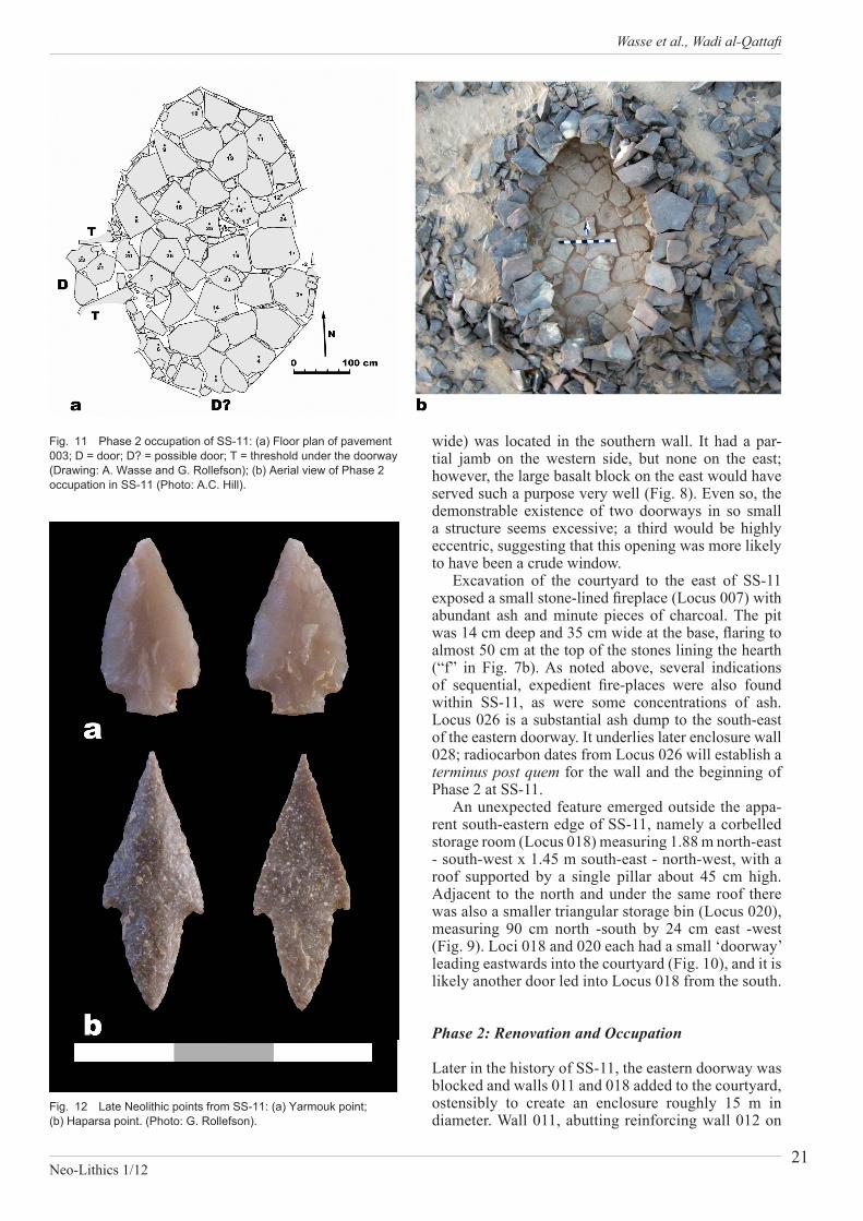
wide) was located in the southern wall. It had a par-tial jamb on the western side, but none on the east; however, the large basalt block on the east would have served such a purpose very well (Fig. 8). Even so, the demonstrable existence of two doorways in so small a structure seems excessive; a third would be highly eccentric, suggesting that this opening was more likely to have been a crude window.
Excavation of the courtyard to the east of SS-11 exposed a small stone-lined fireplace (Locus 007) with abundant ash and minute pieces of charcoal. The pit was 14 cm deep and 35 cm wide at the base, flaring to almost 50 cm at the top of the stones lining the hearth (“f” in Fig. 7b). As noted above, several indications of sequential, expedient fire-places were also found within SS-11, as were some concentrations of ash. Locus 026 is a substantial ash dump to the south-east of the eastern doorway. It underlies later enclosure wall 028; radiocarbon dates from Locus 026 will establish a terminus post quem for the wall and the beginning of Phase 2 at SS-11.
An unexpected feature emerged outside the appa-rent south-eastern edge of SS-11, namely a corbelled storage room (Locus 018) measuring 1.88 m north-east - south-west x 1.45 m south-east - north-west, with a roof supported by a single pillar about 45 cm high. Adjacent to the north and under the same roof there was also a smaller triangular storage bin (Locus 020), measuring 90 cm north -south by 24 cm east -west (Fig. 9). Loci 018 and 020 each had a small ‘doorway’ leading eastwards into the courtyard (Fig. 10), and it is likely another door led into Locus 018 from the south.
Phase 2: Renovation and Occupation
Later in the history of SS-11, the eastern doorway was blocked and walls 011 and 018 added to the courtyard, ostensibly to create an enclosure roughly 15 m in diameter. Wall 011, abutting reinforcing wall 012 on
Fig. 11 Phase 2 occupation of SS-11: (a) Floor plan of pavement 003; D = door; D? = possible door; T = threshold under the doorway (Drawing: A. Wasse and G. Rollefson); (b) Aerial view of Phase 2 occupation in SS-11 (Photo: A.C. Hill).
Fig. 12 Late Neolithic points from SS-11: (a) Yarmouk point; (b) Haparsa point. (Photo: G. Rollefson).
Field Reports
Neo-Lithics 1/1222
the north-eastern edge of SS-11, was excavated over 3.5 m of its length (not yet determined) in a north-easterly direction; it was constructed of a single row of basalt slabs set on edge, with a maximum preserved height of around 40 cm. At the same time a second wall (Locus 028, see also above) was erected towards the south-east. It was constructed of horizontally placed basalt blocks and was excavated for a length (total not yet determined) of 2.17 m; it had a width of around 50 cm and a preserved height of approximately 50 cm, consisting of four of five courses. Another re-inforcing wall (Locus 025) was built at the north-west end of Wall 028, seemingly to protect the 018 storage facility. Since this wall blocked the eastern, courtyard ‘doorways’ of Loci 018 and 020, it might have been at this time that the southern opening to Locus 018 was made.
The most stunning development occurred inside the main structure. The interior was leveled with fill, then paved completely using basalt blocks averaging around 30 - 40 cm x 50 cm in size (Fig. 11). Interstices between the pavers were often filled with small basalt ‘chinking stones’ set on edge. At Point 15 in the center of Fig. 11, there is a triangular opening that may have been a socket for the shaped pillar described above. Nearby is a paver with a small depression (Point 14 in Fig. 11) and evidence for burning, suggesting it may have served as a small hearth.
Artifacts and Dating
Before excavation began, we anticipated the recovery of Chalcolithic or Early Bronze artifacts in and around SS-11 on the basis of our assumption that the structure was a collapsed namus. Instead, we recovered diag-nostic material of the Late Neolithic period, including burin spalls (rare in post-Late Neolithic periods), a drill bit on a burin spall, a Haparsa point and a Yar-mouk point (Fig. 12); the tang of a broken (Haparsa?) point was also found. Other tools included two tabular knives, two bifacial knives, two unifacial knives, a concave truncation burin, a broken burin of unknown type, nine scrapers, eight denticulates and three not-ches. Conspicuously rare were grinding stones: only a basalt hand-stone and a grinding slab fragment were unearthed. This stands in stark contrast to the wealth of ground stone recovered from structure W-66 at Wisad Pools (Rollefson et al. 2011). Similarly, unlike the abundant faunal remains at W-66, animal bones were scarce at SS-11; it is however not unlikely that rubbish was discarded down the slope to the south of the structure.
The presence of Yarmouk and Haparsa points in-dicates a Late Neolithic date somewhere between c. 6,500 - 6,000 calBC, making SS-11 broadly contem-porary with structure W-66 at Wisad Pools. A more accurate comparison will be possible once assays of the abundant ash and charcoal samples from both sites have been completed.
Discussion
For the second time in as many years, the Eastern Badia Archaeological Project has been stunned by the presence of substantial, stone-built dwellings of Late Neolithic date that indicate semi-permanent occupation of areas which are now arid. Hitherto, we had surmised that camps of this period would most likely have con-sisted of flimsy, temporary huts or tents. Even more startling has been the realization that a significant pro-portion of the abundant substantial, stone structures on the slopes of the mesas of Wadi al-Qattafi and around the pools at Wisad are not burial features, but dwel-lings.
The results of the 2012 season at M-4 have led us to reassess the nature of the buildings on the southern slopes of M-4. It is now clear that SS-11 is not unique among the numerous structures here, but that it is only one of what must have been a settlement of at least 10 - 15 housing units, many directly associated with animal pens. The black triangles in Fig. 4 point to other corbelled structures, often connected to animal pens, and others may well be identified here in due course. Whether all are strictly contemporaneous is not pos-sible to determine at this time, but it appears we may be looking at a model whereby a group of co-operative family units exploited this environment during the rainy season, rather than a situation in which a few individuals or a restricted number of nuclear families operated essentially in isolation.
Such a scenario becomes all the more likely when one examines other concentrations of structures in the near vicinity of M-4. The concentration of structures in the drainage between M-5 and M-7 - just a kilometer or two north of M-4 - includes corbelled structures (Fig. 13) far more numerous than those at the settlement at M-4. At this point, we have not investigated these northern clusters at all; it is therefore not clear what temporal relationship they may have with M-4. Never-theless, even if they are earlier or later than each other or, indeed, M-4, it seems clear that circumstances once existed in the eastern badia which permitted significant population clusters to agglomerate in village-like sett-lements for some months at a time, perhaps for most of the rainy season.
The substantial nature of the dwellings at M-4 and Wisad Pools suggests that, at very least, the labor in-vested in their construction6 was justified by the expec-tation of recurrent visits to the same locations, season after season, rainfall permitting. Braemer has noted that the EB settlement at Khirbet al-Umbashi in the Black Desert of eastern Syria could not have supported its resident population under current climatic and soil conditions (Braemer and Échallier 2004). He describes how current soil conditions are most unlikely to reflect the situation 5,000 years ago. Rather than the silt and stone of today, which together ensure that precipitation either drains immediately into deep aquifers or ends up on mud-pans as surface-wash, prehistoric sediments are likely to have included a pervious topsoil. This

Wasse et al., Wadi al-Qattafi
Neo-Lithics 1/1223
would have soaked up water like a sponge during the rainy season, retaining it in the matrix for relatively long periods of time.
With such topsoil buffers, local vegetation may have resembled the dry grasslands of East Africa rather more than the bleak aspects that characterize the eastern badia today. With greater topsoil cover, local landscapes are likely to have been more luxuriantly ve-getated, varying - of course - with annual fluctuations in rainfall. Late Neolithic exploitation of the eastern badia may therefore have been characterized by perio-dically relocating village-based pastoral units, perhaps practicing some opportunistic agriculture, which would have been well placed to take advantage of the environ-mental conditions alluded to above. Kennedy’s archive of aerial photographs of archaeological features in the badia (e.g. http://www.flickr.com/photos/36925516@N05/ and http://www.apaame.org/) contains many examples of structure clusters, some of which could easily be Late Neolithic in age.
Another aspect of arid land exploitation to consider is the Early Neolithic capacity for water management that has been so convincingly demonstrated by Fujii’s work at PPNB Wadi Abu Tulayha at the north-wes-tern edge of the Jafr Basin (e.g. Fujii 2010; see also Gebel 2010). Mention has previously been made of a water management system at the PPNB camp at Ibn
al-Ghazzi, located approximately 25 km north-east of M-4. This included “rock-lined underground cisterns with roughly corbelled roofs” (Betts 1986: 147; cf. 1987: 225) with stone-lined canals leading into them (Helms 1984: 49). Such systems have not been noted yet in the mesas area, but future work here must focus more attention on this aspect.
Endnotes
1 These were small, single- and double-cell curvilinear stone alignments with ‘walls’ only one to two stones high. The deposits were shallow and produced very few artifacts, none of which were diagnostic. It is likely that they are Chalcolithic or Early Bronze Age based on scattered (albeit rare) fragments of cortical scrapers, but we cannot demonstrate that they are even as old as ‘Late Prehistoric’ on the basis of the excavations.
2 The basalt capping of the mesas has spalled naturally into rectangular blocks that provide abundant building material. These blocks vary in size, but there are abundant slabs of suitable size for construction.
3 namus is the singular of the plural form nawamis.
Fig. 13 Structure clusters between mesa M-7 (upper left) and M-5 (lower right); see FIG. 2; Wadi al-Qattafi at top of photo. (Photo by David Kennedy, © APAAME, with permission).

Field Reports
Neo-Lithics 1/1224
4 One of the basalt blocks of the southeastern wall was huge, measuring 117 cm wide, 74 cm high, and 19 cm thick, weighing around 165 kg.
5 In light of the relative shortness of this stone compared to the door openings, this “pillar” may be associated with the renovated second phase of occupation; see below).
References
Bar-Yosef O., Belfer A., Goren A., and Smith P. 1977 The Nawamis near ‘Ein Huderah (Eastern Sinai). Israel ExplorationJournal 27: 65-88.
Betts A.V.G.1986 The Prehistory of the Basalt Desert, Transjordan. An Analysis. Unpublished doctoral dissertation. University of London, Institute of Archaeology.1987 Recent Discoveries Relating to the Neolithic Periods in Eastern Jordan. Studies in the History and ArchaeologyofJordan: 225-230.
Betts, A.V.G., Helms S., Lancaster W., Jones E., Lupton A., Martin L., and Matsaert F.1990 The Burqu’/Ruweishid Project: Preliminary Report on the 1988 Field Season. Levant 22: 1-20.
Braemer F. and Échallier J.-C.2004 De la steppe vierge à la steppe dégradée. In F. Braemer, J.-C. Échallier and A. Taraqji, Khirbet al Umbashi. Villages et campements de pasteurs dans le “désert noir” (Syrie) à l’âge du Bronze : 245. Bibliothèque Archéologique et Historique, T. 171. Beirut, CNRS.
Fujii S.2010 Domestication of Surface Runoff Water: Current Evidence and New Perspectives from the Jafr Pastoral Neolithic. Neo-Lithics 2/10: 14-32.
Alexander WasseUniversity of East Anglia,[email protected]
Yorke RowanUniversity of Chicago, [email protected]
Gary O. RollefsonWhitman College, [email protected]
Gebel H.G.K.2010 The Commodification of Water. Neo-Lithics 2/10: 4-13.
Helms S.1985 Appendix II. Ibn el-Ghazzi: Water Storage System? In: A. Betts, Black Desert Survey, Jordan: Third Preliminary Report: 49-50. Levant 17: 29-52.
Maitland P.E.1927 The ‘Works of the Old Men’ in Arabia. Antiquity 1: 197-203.
Musil A.1927 Arabia Deserta. A Topographical Itinerary. New York, American Geographical Society.
Rabba‘ I.2005 TheGeologyofUmmNukhaylaandWadialQattafi Areas.MapSheetsNo.3453-IIand3453-I. Amman: Natural Resources Authority, Geology Directorate.
Rollefson G., Rowan Y. and Perry M.2011 A Late Neolithic Dwelling at Wisad Pools, Black Desert. Neo-Lithics 1/11: 35-43.
Rowan Y., Rollefson G. and Kersel M.2011 Maitland’s ‘Mesa’ reassessed: a late prehistoric cemetery in the eastern Badia, Jordan. Antiquity 85 (327): http://antiquity.ac.uk/projgall/rowan327/