
65 JANUARY 1998 - ISSUE 65 text under image.pdf - Urban ...
48
Urban Design Quarterly The Journal of the Urban Design Group Issue 65 January 1998 Topic Landscape Architecture and Urban Design Case studies The Manchester Higher Education Project Design Games in Tower Hamlets TfiTirrw
-
Upload
khangminh22 -
Category
Documents
-
view
0 -
download
0
Transcript of 65 JANUARY 1998 - ISSUE 65 text under image.pdf - Urban ...

U r b a n D e s i g n Q u a r t e r l y The Journal of the Urban Design Group
Issue 6 5 January 1998
Topic Landscape Archi tecture and Urban Design
Case studies The Mancheste r Higher Educat ion Project
Design G a m e s in Tower H a m l e t s
Tf iT i r rw

Forum for: architects • town planners • engineers • landscape architects and all those interested in the quality of the built environment
The Urban Design Group, founded nineteen years ago, has been established to provide high standards of performance and inter-professional cooperation in planning, architecture, urban design, and other related disciplines; and to educate the relevant professions and the public in matters relating to urban design. Membership is made up of architects, planners, landscape architects, engineers, surveyors, historians, lawyers, photographers, in fact anyone interested in the quality of our built environment. Local authorities, practices, and universities are also members. The U.D.G. runs a series of public lectures, workshops and other events which are valid for C.RD. The Kevin Lynch Memorial Lecture has attracted such speakers as Leon Krier, Peter Hall, Sir Roy Strong, and Sir Philip Dowson. Annual study tours are also organised. The U.D.G. publishes a quarterly magazine dealing with urban design issues and an Urban Design Source Book which identifies urban design practices, courses and members. The U.D.G. is working closely with the R.T.RI. to raise the profile of urban design. It has reciprocal membership with a number of complementary organisations including Vision for London, and the British Urban Regeneration Association (B.U.R.A.). The U.D.G. has set out an agenda aimed at explaining urban design and how, using urban design principles, the quality of the environment can be raised. The Urban Design Group continues to grow. Membership is national, and each region has its own convenor, who organises local events.
Ian Bentley Co-Chair of the Joint Centre for Urban Design, Oxford Brookes University.
John Biggs Urban Designer and Regional Coordinator for the South West.
Robert Brown Architect working for Levitt Bernstein Associates.
Hugh Cannings Architect and planner working for Austin -Smith:Lord
Michael Crilly UDG regional coordinator for Northern Ireland.
Rupert Kemplay Head of Landcare Landservices, a landscape design and build business based in Leeds.
Thomas Kvan and Just ina Karak iewicz Lecturers in the Department of Architecture of the University of Hong Kong.
Colen Lumley Architect in private practice.
John Pendlebury Lecturer in Town and Country Planning at the University of Newcastle upon Tyne specialising in conservation.
Monica Pidgeon Editor and architectural writer. She owns and directs Pidgeon audio visual.
Jennifer Ross Planner and urban designer. She is an Associate with Tibbalds Monro.
Ian Thompson Landscape architect and town planner. Lecturer in Landscape Architecture in the Department of Town and Country Planning, University of Newcastle upon Tyne.
Chris Wil l iamson Partner in Weston Williamson, architects and urban designers.
John Bil l ingham Architect and Planner, formerly Director of Design and Development Milton Keynes Development Corporation.
Bob Jarvis Senior Lecturer in Planning at South Bank University School of Urban Development and Policy.
Sebast ian Loew Architect and Planner, until recently Principal Lecturer at the School of Urban Development at South Bank University.
Marion Roberts Architect, writer and Senior Lecturer in the School of Urban Development at the University of Westminster.
Jon Rowland Architect and Urban Designer, previously technical Director of Llewelyn-Davies Planning. Former Chairman of the Urban Design Group.
Administrator Susie Turnbull Tel. 01235 851415 Fax. 01235 851410
Chairman Roger Evans Tel. 01865 377030

Contents
Enquiries and change of address: 6 Ashbrook Courtyard, Westbrook Street Blewbury, Oxon 0X11 9QH Tel: 01235-851415 Fax:01235-851410
Chairman Roger Evans 01865-377030
Patrons Alan Baxter Terry Farrell Peter Hall Richard MacCormac Les Sparks John Worthington
UDG Regional Activities Regional convenors: Scotland Leslie Forsyth 0131 221 6071 Northern Ireland Michael Crilly 01232 669384 North Alan Simpson 0191-2099099 Yorks/Humber Lindsay Smales 0113 283 2600 North West Andy Farrall 01244-402213 East Midlands Steve Tiesdell 0115-951 4874 West Midlands Peter Larkham 0121 -331 5152 South Wales Sam Romaya 01222-874000 South West John Biggs 01202 633633 East Anglia Alan Stones 01245-437642 South East Julie Witham 01865-377030
Editorial Board Derek Abbott John Billingham Matthew Carmona Tim Catchpole Bob Jarvis Sebastian Loew Tony Lloyd-Jones Francesca Morrison Marion Roberts Judith Ryser
Editors John Billingham Sebastian Loew
Editor for this issue Sebastian Loew
Book reviews Tim Catchpole
56 Gilpin Ave, London SW14 8QY
Art direction Simon Head
Print production Constable Printing
© Urban Design Group ISSN 0266 6480
Cover Arial view of Montpellier
News & Events Leader 4 Simon Rendel's Obituary Movement, Streets and Places 6 King's Cross Regeneration: Better Places 7 The Incredible Lightness of the Languedoc 8 Joint Conference RTPI-UDG Urban Design & Housing Provision 10 Bilbao Renaissance
Viewpoints Urban Design Al l iance John Biggs & Michael Crilly N e w Urban Design for London? Marion Roberts Urban Design as an Anti-Profession Ian Bentley
International Rec lamat ion in M a c a u Thomas Kvan & Justyna Karakiewicz
Topic Landscape Archi tecture and Urban Design Leader Ian Thompson Two Professions, One Purpose? Ian Thompson Grainger Town Landscapes John Pendlebury Trees Versus C a m e r a s Rupert Kempley Greening the City Jennifer Ross
Case Studies The Manches te r Higher Educat ion Project Austin-Smith:Lord Design G a m e s in Tower H a m l e t s Levitt Bernstein Associates
Book Reviews Reviews by John Billingham, Jon Rowland and Chris Williamson
Practice and Education Index
Endpiece Being There Bob Jarvis
Diary
Future issues 66 Urban Design and Conservation Topic Editor Stev 67 Conference Report. Public Places: People Places
11
12
14
15
16
2 0
21
23
26
29
36
3 9
4 2
4 4
47
Back Cover
'e Gould
Material for publication: This should be addressed to The Editor, 26 Park Road, Abingdon, Oxon 0X14 1DS
Subscriptions: The Quarterly is free to Urban Design group Members who also receive newsletters and the biennial Source Book at the time of printing. Annual rates: Individuals £30 Students £14. Corporate rates: Practices £40 Libraries £40 Local Authorities £75 (2 copies of UDQ) Overseas members pay a supplement of £3 for Europe and £8 for other locations. Individual issues of the journal cost £4.
The subscription charge for Practice and Education Index entries is £80 per year covering an inclusion in four issues if paid within one month of the renewal date.
Neither the Urban Design Group nor the editor is responsible for views expressed or statements made by individuals writing in this journal.

Leader
o 7
fi) 3
<D j £ i
< 5 ' 3
SB
a • o
( D
" 0 o • o
• o
U r b a n D e s i g n con t i nues to be f lavour of the
m o n t h a l t h o u g h not in the s a m e o b v i o u s
w a y as it w a s in the f inal s t a g e s of the
C o n s e r v a t i v e admin i s t ra t i on : J o h n Presco t t
d o e s not have the s a m e c r u s a d i n g a t t i tude
as J o h n G u m m e r a n d he has o ther pr ior i t ies
o n his a g e n d a . Never the less the cur ren t
d e b a t e s on reg iona l b o d i e s - wha teve r they
m a y eventua l ly be, on L o n d o n g o v e r n m e n t
a n d on t ranspo r t po l i cy have subs tan t ia l
bea r i ng on u rban des ign . The in f luence of
Europe , the w i s h to s h o w a N e w Bri tain
(exempl i f i ed by the set t ing of the F ranco-
Bri t ish s u m m i t in N o v e m b e r ) , the c o n c e r n
w i th cu l tu re as o p p o s e d to just her i tage, all
have an ef fect on the a t t i tudes t o w a r d s the
pub l i c rea lm. The Worlds Squares for All
s tudy by Foster a n d Partners is a typ ica l
e x a m p l e of t hese i ssues c o m i n g together . In
turn t hese are re f lec ted in c o n f e r e n c e s a n d
s e m i n a r s wh i ch , a l t h o u g h c o n c e r n e d w i th a
range of t op i cs , repea ted l y e n d u p
d i s c u s s i n g u r b a n d e s i g n .
No t su rp r i s ing l y p e r h a p s , t he c h a r t e r e d
p ro fess ions w i s h to have their share , w h i c h
exp la ins the l aunch ing of the U r b a n D e s i g n
Al l iance, UDAL . S ince its a i m s are very
s imi lar t o t h o s e of the U r b a n D e s i g n G r o u p ,
its c rea t ion pays a c o m p l i m e n t to the
fo res igh t of t h o s e w h o f o u n d e d the g r o u p
near ly twen ty yea rs ago . The potent ia l
pol i t ica l c lou t of s u c h an a l l iance c o u l d he lp
in ach iev ing our s h a r e d goa ls ; at the s a m e
t ime the interest a n d invo lvement of s o m e
of the par tners m a y d w i n d l e as o ther i ssues
c l i m b on their d i ve rse a g e n d a s . A f i gh t ing
spir i t , o r ig ina l a n d c h a l l e n g i n g t h o u g h t
m u s t con t i nue to be the con t r i bu t i on of th is
journa l whi ls t at the s a m e t ime, the
co l l abo ra t i on w i th the va r i ous p ro fess ions ,
as exemp l i f i ed by th is i ssue 's top ic , mus t
be s t r e n g t h e n e d even further. #
Sebastian Loew
Simon Rendel 1941 -1997
Simon, who died in September, was a long standing member of the UDG and had acted as treasurer for five years and an executive committee member prior to that. He had been seriously ill for a short time and died aged 56 on 24 September.
Simon originally trained as a civil engineer at Oxford University and his early professional work was in that capacity in this country and in Brazil. Through this work he realised the contribution that landscape design made to the environment, took a post-graduate course under Peter Youngman and embarked on his landscape career initially with RMJM. He then moved to the public sector, first working for Berkshire County Council and then at the GLC, where he was principal landscape architect in charge of the Landscape Division for the Department of Recreation and Arts.
When that body was wound up he founded a private practice, Rendel and Branch, and subsequently worked with the ASH Partnership heading their southern office in Didcot. Apart from his involvement with the UDG he was on the Landscape Institute International Committee and on the editorial committee of the journal Landscape Research.
Those who had the pleasure to visit Simon at his home alongside the water meadows in Blewbury will have experienced his approach to landscape using the natural characteristics to maximum benefit and adding elements totally in character with the idyllic location. His contribution to village life took many forms
including a hands-on approach to improving parts of the environment such as streams and wychert walls.
Within the UDG Simon had a relaxed approach to problems that arose and always gave wise counsel either in committees or at the UDG office which moved to Blewbury in 1995. His presence and friendship and contribution to UDG affairs will be sorely missed by all who knew him.
I feel that an appropriate way to celebrate Simon's life is to include a summary of some of the work he did with ASH for the CPRE on defining Tranquil Areas - a study wholly appropriate to the ways in which I knew Simon.
John Billingham
'Tranquil ' Areas
The Concept
'Tranquil' Areas are a new planning tool developed by Simon Rendel for the ASH Consulting Group. 'Tranquillity' is most simply described as representing the perception of 'unspoilt' countryside which is relatively free from eyesores and the disturbance caused by urbanisation and transport. It defines such areas at a regional scale.
Origin and purpose
The concept was originally developed to assist the planning of a new transport corridor through Bedfordshire, Hertfordshire and Essex where open, undisturbed countryside is at a premium and of vital importance for the amenity of the many local towns as well as a valuable countryside and recreational resource for the population of London. Although much local countryside is designated for landscape quality and/or Green Belt there are considerable tracts which are unprotected even though they are 'tranquil'. ASH recognised the need to identify

such less conspicuous areas along with designated landscape; a failure to do so would have led to an underestimate of the value of such areas to London and the local population.
Measuring loss of tranquil l i ty
'Tranquil' Areas are defined as being beyond the immediate influence of towns, roads, airports, overhead pylons and other detractors. They are particularly useful for demonstrating the erodibility of undisturbed countryside in highly populated areas and areas vulnerable to pressure from the motor vehicle. The south-east of England diagram commissioned by the Council for Protection of Rural England and the Countryside Commission, and produced by Simon, shows the change from a reasonably intact hinterland of 'tranquillity' surrounding the capital in c.1960 (just after the opening of the M1) to a highly fragmented pattern in c.1992. In this region the fourfold increase in road traffic over the period is the chief agent in fragmentation, though air traffic, new development and the construction of national grid power lines have also played their part.
Further development and applicat ions
'Tranquil' Areas demonstrate the cumulative effect of development on open countryside and the need for protection. The concept should form an essential component of Strategic Environmental Assessment (SEA).
Subsequently, in 1997, the regional methodology was developed further to suit less densely developed territory in Wales and Scotland. The Welsh map represents the state of the art at this scale, showing overprinted many kinds of intermittent disturbance such as noisy sports and military training areas.
In December 1995, Simon saw the need to develop a more
E A R L Y 1 9 6 0 s tranquil areas E N G L A N D
MAP
Semi-tranquil
Vulnerable
^••a* Less vulnerable
N
KMS 0 50
refined methodology for Tranquil Area mapping which could be used to illustrate local areas where mapping would be of interest, particularly areas used for recreation such as Areas of Outstanding Natural Beauty (AONB's). The refinements were fundamental in character because it meant bringing in three new concepts: (a) the idea of contoured mapping, ie several tranquillity zones of describable character; (b) a minimum mapping unit of 100m rather than 1km as used for England, or 0.5km used for Wales/ Scotland; and (c) introducing topography and woodland as determining factors. #
UDG's Treasurer
Arnold Linden has been acting as the group's Treasurer for some time. He has agreed to continue in this capacity until the next AGM in May 1998.

N e w s and Events
o
Movement , Street and P laces - a new Guide to a c c o m p a n y DB32
On Wednesday 15 October, a full house attended the Gallery for Robert Thome, David Taylor and Lynn Armishaw's presentation of A Companion Guide to Design Bulletin 32 produced by Alan Baxter & Associates for the Department of Environment and Transport.
Since for the past 25 years at least, highway engineering has had such a major and mostly negative impact on urban design, a fundamental change of approach was eagerly expected. David Taylor explained that the genesis of the new guide meant that it could not replace DB32 but as indicated by its title, would complement it. Nevertheless he hoped that it would be more than that and would be used as a new basis for design. He pointed out that DB32 was a code whilst the present report should stimulate creative thought.
The motivation for the study was the government's awareness of the damage caused by the unbridled use of the car and the need to control it. Consequently the report addresses not only highway design: it is part of a movement towards more sustainable forms of living. Key principles put forward are:
• look at the place, not the car;
• take care of the quality of the public realm, which includes mixed uses;
• respond to the character of the place which does not mean architectural detail;
• start with an agreed development brief relating land use to patterns to movement.
The report is based on a series of examples of good practice since it is meant to be used to support practitioners wanting to apply principles not universally accepted and to convince their opponents of their feasibility. Apparently the team had
difficulties in finding examples and relied extensively, though not exclusively, on previous work they had done in Poundbury. As a result the architecture shown on the slides was disappointingly pastiche or derivative. The most interesting part of the report is the practical information, the "how to do it", of which Andrew Cameron gave a few examples relating to tracking (the provision of the required carriageway width for vehicle movement within the overall width of the street), junctions (create the right kind of enclosure) and car parking (reduce its prominence). In all of these the space for the vehicle was subservient to the creation of a place with the right sense of enclosure.
David Taylor ended the presentation with a series of questions about the future, emphasising that the published report should be seen as a first step towards more sustainable development. A lively debate followed showing the attendants' concern about the guide not being innovative enough in that for instance it is still based on suburbia, a car-dominated environment and on current car designs. The authors acknowledged that since their work was based on DB32, its origins were suburban but they hoped that their recommendations would lead to different approaches, such as the abandonment of the cul-de-sac. Nevertheless everybody agreed that in the long term the goal must be the reduction in the need to travel, something not addressed by the report at present. Other questions related to details such as road surfaces, parking bays and landscaping. The point was made again that the case studies shown were not necessarily perfect but were the best that could be found and that the principles in the text encouraged more imaginative approaches. The exchange of ideas continued for a long time indicating the interest raised by the guide. #
Sebastian Loew
Top: Abbotsbury
Glebe - an example of
good practice. Ken
Morgan Architects.
Bottom: Carriageway
width checked by
plotting vehicle
tracking paths.
Alan Baxter &
Associates.
King's Cross Regenerat ion
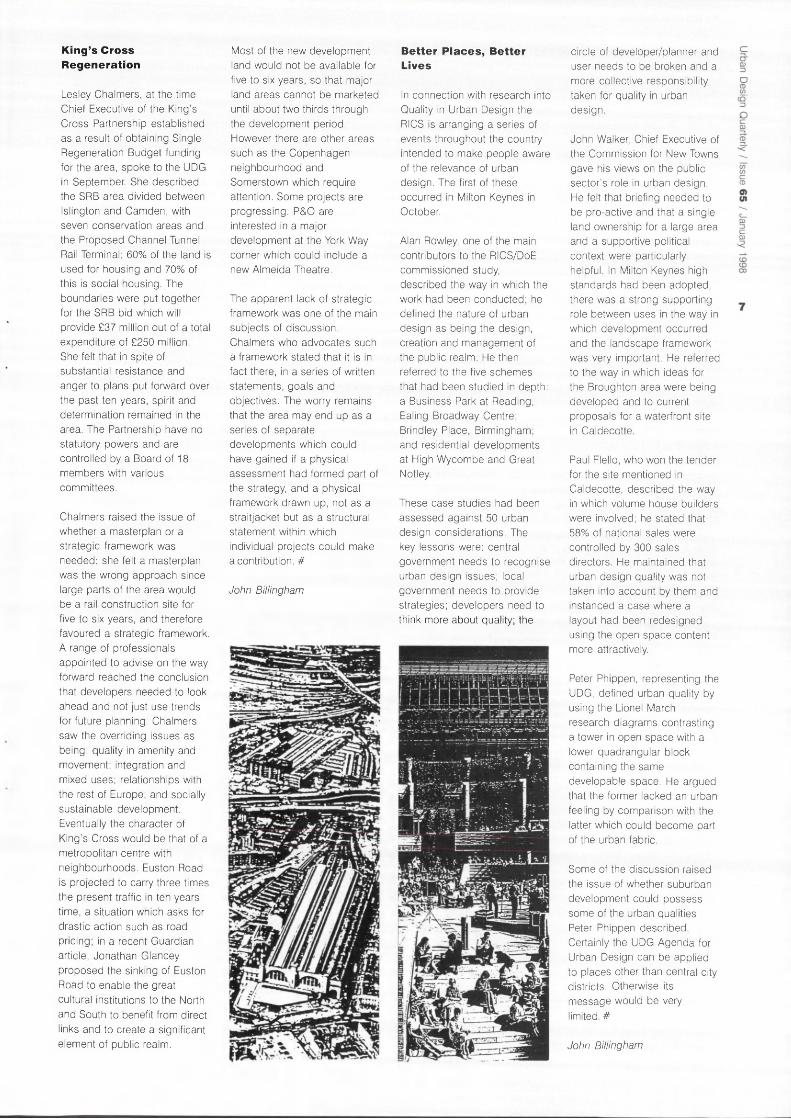
Lesley Chalmers, at the time Chief Executive of the King's Cross Partnership established as a result of obtaining Single Regeneration Budget funding for the area, spoke to the UDG in September. She described the SRB area divided between Islington and Camden, with seven conservation areas and the Proposed Channel Tunnel Rail Terminal; 60% of the land is used for housing and 70% of this is social housing. The boundaries were put together for the SRB bid which will provide £37 million out of a total expenditure of £250 million. She felt that in spite of substantial resistance and anger to plans put forward over the past ten years, spirit and determination remained in the area. The Partnership have no statutory powers and are controlled by a Board of 18 members with various committees.
Chalmers raised the issue of whether a masterplan or a strategic framework was needed: she felt a masterplan was the wrong approach since large parts of the area would be a rail construction site for five to six years, and therefore favoured a strategic framework. A range of professionals appointed to advise on the way forward reached the conclusion that developers needed to look ahead and not just use trends for future planning. Chalmers saw the overriding issues as being: quality in amenity and movement; integration and mixed uses; relationships with the rest of Europe; and socially sustainable development. Eventually the character of King's Cross would be that of a metropolitan centre with neighbourhoods. Euston Road is projected to carry three times the present traffic in ten years time, a situation which asks for drastic action such as road pricing; in a recent Guardian article, Jonathan Glancey proposed the sinking of Euston Road to enable the great cultural institutions to the North and South to benefit from direct links and to create a significant element of public realm.
Most of the new development land would not be available for five to six years, so that major land areas cannot be marketed until about two thirds through the development period. However there are other areas such as the Copenhagen neighbourhood and Somerstown which require attention. Some projects are progressing: P&O are interested in a major development at the York Way corner which could include a new Almeida Theatre.
The apparent lack of strategic framework was one of the main subjects of discussion. Chalmers who advocates such a framework stated that it is in fact there, in a series of written statements, goals and objectives. The worry remains that the area may end up as a series of separate developments which could have gained if a physical assessment had formed part of the strategy, and a physical framework drawn up, not as a straitjacket but as a structural statement within which individual projects could make a contribution. #
John Billingham
Better P laces, Bet ter Lives
In connection with research into Quality in Urban Design the RICS is arranging a series of events throughout the country intended to make people aware of the relevance of urban design. The first of these occurred in Milton Keynes in October.
Alan Rowley, one of the main contributors to the RICS/DoE commissioned study, described the way in which the work had been conducted; he defined the nature of urban design as being the design, creation and management of the public realm. He then referred to the five schemes that had been studied in depth: a Business Park at Reading; Ealing Broadway Centre; Brindley Place, Birmingham; and residential developments at High Wycombe and Great Not ley.
These case studies had been assessed against 50 urban design considerations. The key lessons were: central government needs to recognise urban design issues; local government needs to provide strategies; developers need to think more about quality; the
circle of developer/planner and user needs to be broken and a more collective responsibility taken for quality in urban design.
John Walker, Chief Executive of the Commission for New Towns gave his views on the public sector's role in urban design. He felt that briefing needed to be pro-active and that a single land ownership for a large area and a supportive political context were particularly helpful. In Milton Keynes high standards had been adopted, there was a strong supporting role between uses in the way in which development occurred and the landscape framework was very important. He referred to the way in which ideas for the Broughton area were being developed and to current proposals for a waterfront site in Caldecotte.
Paul Flello, who won the tender for the site mentioned in Caldecotte, described the way in which volume house builders were involved; he stated that 58% of national sales were controlled by 300 sales directors. He maintained that urban design quality was not taken into account by them and instanced a case where a layout had been redesigned using the open space content more attractively.
Peter Phippen, representing the UDG, defined urban quality by using the Lionel March research diagrams contrasting a tower in open space with a lower quadrangular block containing the same developable space. He argued that the former lacked an urban feeling by comparison with the latter which could become part of the urban fabric.
Some of the discussion raised the issue of whether suburban development could possess some of the urban qualities Peter Phippen described. Certainly the UDG Agenda for Urban Design can be applied to places other than central city districts. Otherwise its message would be very limited. #
John Billingham

N e w s and Events
The Incredible Lightness of The Languedoc
Twenty members of the Urban Design
group went on a study tour of
Montpellier and Nimes between 17
and 20 October. Here Colen Lumley
describes his impressions.
The dynamism of gallic urban regeneration in evidence at Euralille and Montpellier, subject of the two Urban Design Group tours this year, both admirably choreographed by Sebastian Loew, and its imminent relationship to the European project, stand in fluorescent contrast to UK practice; at least as seen from the perspectives of the Cambridge fen, where so many of the latent issues of urbanism are comparable and unrealised. The attraction of this dynamism is set against the repulsion of its realisation, its physical expression. Even if you do not accept it, Koolhaas at Euralille at least makes a case for the brash, bigness and glitz of modern living and its media and information dominated cultures. At Montpellier there is a different game, a crude and blatant political symbolism toying with an atavistic iconography to drive home its political agenda in the showcase element of its productions. What captures the Anglo Saxon imagination is the way the cultural milieu is exploited to package the endeavour. All development is coloured by concepts more cultural in origin than purely socio-economic concerns.
The striking impression of Montpellier is that amongst all this technologically-driven Euro excitement the original settlement from its founding in 985 as a station on the pilgrim's route to St Jacques de Compostelle stands intact, intra muros. The historic quarter is dissected by the hausmannisations of Rue Foch and Rue de la Loge, but the succeeding centuries have left their traces, added rather than superimposed, leaving the medieval core intact. The seventeenth and eighteenth century hotels particuliers inserted into this framework preserve the tight courtyard lit matrix of the old city, with its cellular plan form and narrow winding passages so redolent of Islamic city planning. The mansarded and blue slated bourgeois mansions surrounding the Secteur Sauvergarde, shoulder incongruously and disdainfully the low pitched orange vernacular tiles of the Languedoc. It is curious that Rob Krier in the development for Quartier Port-Marianne, leaden-footedly reproducing his classical revocations in quasi northern European mode, is similarly insensitive to the local character of the Languedoc.
Connections with the spirit of the old city and its historical traditions are observable in the Cite Judiciaire designed by Bernard Kohn, a disciple of Louis Kahn. One of the central grands chantiers not by Ricardo Bofill, it alone seems to reflect some sensitivity to regional inflexion and form. On the opposite side of the Promenade Royale du Peyrou, Richard Meier uncharacteristically cast in the Espace Pitot project, a modest mixed development, displays some respect for the genius loci. Could it be that the excesses of Antigone, Bofill's monstrous civic phantasmagoria had induced this ego-reducing reaction?
Antigone was the misbegotten daughter of the misalliance of Oedipus and his mother; but for Ricardo Bofill anti(poly)gone was a reproach and a statement of the true modernity. The "aberrant" town centre development of the 1960s and 70s produced the Polygone multi level shopping complex which extended the cross town promenade via the Place Comedie, the vibrant centre of all visible social life in Montpellier. This winding west-east axis across the old town provided the rationale for the new visions of grandeur visited on the town by Mayor Georges Freche. The 'axe' concept was in place before the Catalan architect was selected and his work is deliberately contained to Antigone to conserve the immaculate conception. The mixed development project elevates the commonplace to the monumental, extending the 'axe' to the infinity of the far bank of the river Lez and the excruciating arc de triomphe building for the administrative offices of the Regional Council. Today it is ameliorated by the bosque planting within its monstrous enclosures where a former chairman of the UDG was to be observed dementedly pacing in vain reconciliation of spatial comparison. One is only left in awe of Bofill's ineffable genius for inventing places in which one can no longer believe in anything.
Beyond the town centre the developments include Port Marianne, continuing the axial growth of the town westwards. The Littoral between the Mediterranean and the A9 is a continuous beach backed by lagoons inhabited principally by mosquitoes and flamingos. The beach and the Mediterranean setting must have imparted a Californian image in the minds of executives of IBM whose arrival in Montpellier in the 60s triggered the technopole explosion. It was probably the mosquitoes that eventually induced them to leave thirty years later. Undaunted, the academic turned politician, Raymond Dugrand, Deputy Mayor, introduced the UD group, in an appropriately tricolored and union flagged presentation, to the five pillars of Montpellier's continuing
development. One of these is Heliopolis, the tourist business sector which is planned to accommodate the burgeoning attractions of the area to retirement immigration and overspill from the overpopulated resorts further east.
In such a brief visit we managed to feel some rapport with the ecology of Montpellier and of the cultural crises in which it is enmeshed. It was odd that in a place that houses a university stemming from the thirteenth century with its school of medicine and the first botanic garden in France (for the cultivation of herbal medicines) at which Rabelais and Nostradamus studied, that the modern institutions have slight physical presence in the centre. 'Agropolis' and 'Euromedecine', vast enterprises of research, are another two pillars of Montpellier Eurocite and the tendency to segregate the town into functional zones is at the expense of the creation of heterogeneous and meaningful urban space. The empty symbolism of Antigone only underlines the brazen incapacity to understand and entrain the genius of the place. The new Fainsilber buildings for the Law Faculty somewhat redress this absence of presence .
The academic institutions in Montpellier have grown from 4,500 students in the 1920s to 60,000. The vibrancy and night life of the town centre is a testament to the existence of this youthful community. Efforts have been made to form links between the cultural sector and institutions engaged in advanced research in media and telecommunication technologies. Le Pole Informatique and Antenna, reflecting the media, information and communication age are the two other pillars of the town's strategy. The increased link between culture, leisure and economic growth are reflected in Espace Grammont a huge leisure complex with its Zenith, rock/ conference centre, a recreational adjunct of the new culture, glimpsed only in passing. Vasconi's Corum terminates and elevates the Esplanade providing panoramic views from its roof. Beneath, piranesian-like top lit spaces provide shared foyers for the international conference centre and the Opera Berlioz.
Although engaged in creative economic rivalry with the neighbouring town of Nimes, the municipalities have cultural co-operation agreements. Our impressions of Nimes were contained by the duration of visit, which precluded contact with local planners. The points of contact poignantly underlined the contrast of mentalities, roman history, echoed in Foster's temple of culture, the Carre d'Art, on whose rooftop terrace the group spent a long, consoling, sunny lunch, musing and gazing through the microcouliers at the prospect of the Maison Carre: a surge of Anglo-Saxon

Vers Lyon
Vers Barcelone
Top: Mr Dugrand,
Deputy Maire of
Montpellier and UDG
visitors.
Above: Montpellier
and surroundings.
Left: A gl impse of
Bofill's Antigone.
Below: Foster's Carre
dArt in NTmes.
chauvinism surfaced at this point, doubtless induced by access to the Languedoc nectar.
The super graphics and red flashes on the silver monoliths of Nemausus, like decals on racing cars, are the leitmotif of Jean Nouvel. A tough-minded perforated tin architecture, stylishly reinvoking the Corbusian unite apartments, but sited in a disaffected neighbourhood and abandoned by the professionals and those who could make it work as habitat, it stands in limbo awaiting treatment to render the site more secure.
The Philip Starck street furniture in the town centre; a visitation to the Hot Littre to sample restoration of the conservation area; the demountable covering of the roman amphitheatre; the buried car parking under the sculpture park of Place d'Assas; the palm tree and sculptured crocodile fountain in the Place du Marche, creating urban design out of the Town's heraldry; these snapshot visions were all that there was time for in a tour that ended in the delightful Jardin de la Fontaine, designed by Mareschal, the military engineer to Louis XV.
En route from Nimes our coach passed through, but mercifully did not stop, at La Grand Motte, the fanciful French answer to the Costa Brava. By comparison with Antigone, its environment, whilst again a caricature and a monstrous pastiche of architectural invention seems to offer a real space of sites and relations, relevant in this case to the 'authentic' life of vacation (if that's how you like it).
The resonances of these tours are enriched by the points of contact and continuities. The trip ended touchingly. with a visit to the College des Ecossais, still with the planted terraces and the prospect across Montpellier to the lagoons and Mediterranean littoral that was opened to the gaze of Patrick Geddes, in this last venture of his idiosyncratic career. And doubly evocative in the revisiting now within the EU project, of his beloved 'Regionalism', with its desetatism and privileging of the region. He must be glowing in his grave. #
Colen Lumley
Cit ies of the Plain Urban Design Group Study Tour 2 9 June - 7 July 1998
Alan Stones is organising a visit of the cities of the plain of Lombardy and the Veneto for next summer. See back page for details.
o

N e w s and Events
D
Urban Design and Housing Provision into the Next Century
The Annual Joint Conference of the Royal Town Planning Institute and the Urban Design Group was held on Friday 31 October. It offered an interesting variety of points of
privacy and density. Not surprisingly they found that by reducing car parking requirements, site capacities could be dramatically increased without losing quality. Their study also sees the need for a more pro-active and creative urban management approach to development.
10
The first speaker, Trevor Osborne, Chairman of the Urban Villages Forum sees those who still think 'suburb' as missing the point and advocates higher densities combined with better amenities and higher quality. He outlined some of the current problems (wasted space, entrenched poverty, mono-tenure, long term costs) and the reasons for so much bad building.The principles of Urban Villages aim to remedy these shortfalls: mixed development, inclusivity, flexibility, strong and coherent urban design, qualityof buildings and spaces, walkability. Osborne emphasized the need to adapt these principles to each area and signalled lack of ambition, a conservative market perception and lack of funding as some of the constraints to turn the principles into realities.
Patrick Clarke of Llewelyn Davies based his talk on the firm's study of Sustainable Residential Quality in London commissioned by LPAC and the Government Office for London. Their approach was both strategic and local; they saw housing as providing an opportunity to regenerate urban Britain and make it more sustainable. Six strategic principles were identified: intensification while
maintaining and enhancing quality; contribution of new housing development to urban regeneration; relating the intensity of development to accessibility to facilities and public transport; encouraging long term quality; reducing people's propensity to own cars; improving the quality of community facilities and the public realm.
They analysed 50 infill sites in relation to three options concerned with car parking,
Lee Shostack from EDAW presented a personal tale of two cities, Milton Keynes and Clerkenwell, each adapted to a particular lifestyle and in turn shaping that lifestyle. Like other speakers he suggested that urban areas contained far more housing capacity than was recorded and that solutions had to be site specific but within a strategic framework.
The morning session ended with Steve Coleman of Notting Hill Home Ownership addressing the problems of a large housing estate in West London. He outlined the problems that had to be tackled, the importance of the partnership involved (local authority, housing association, residents, developer, etc) and what he saw as the key to their success. From work on the estate the team learned inter alia that establishing trust with tenants takes time, that there is a need for clarity between the partners and that costs cannot be the sole determinant for judging a scheme. Coleman also stressed the need for mixed tenures, for a blending of new and existing housing and for providing high quality community facilities. He made the interesting point that whilst most other speakers were promoting an increase in densities, they were trying to reduce them.
Volume house building was represented at the start of the afternoon by Paul Davis of the Beazer Group PLC who emphasized the importance of the market. Surveys told them that the consumers liked their 'product' and that their concern for urban design was that places should be 'nice'. He complained that much too often local authorities brought issues of urban design at the end of
negotiations, and advocated for a clear but flexible design framework. His view of what urban design was concerned with did not augur well for what would be included in this framework; he seemed to have a far less flexible approach than any of the other speakers. On the other hand his willingness to have some of their schemes assessed so that successes could be replicated and mistakes avoided, was encouraging.
In contrast, Meredith Evans of Leicester District Council started by stating that people did not like most new housing developments and that their quality was poor. He first analysed the reasons for failure to design good quality housing: "Too much effort is put into controlling detail while the overall framework is abandoned to the highway engineer..." He then explained with specific examples, some of which are illustrated above, what was being done in Leicester to apply basic principles of urban design: emphasize edges and maximise interface between urban and rural environments, locate new settlements on
routes to and from somewhere, build the highest densities on busy routes, abandon the cul-de -sac and reinvent the street, foster mixed uses and, in order to allow for change, design with flexibility in mind.
Terry Farrell and Julian Tollast ended this full day with what Farrell called "a ramble through housing", focussing mostly on the work the firm is doing for Cambourne in Cambridgeshire where they have applied principles of sustainability to their design.
A number of issues reappeared throughout the day and are worth reiterating: design is area specific but a strategic framework is needed; a more sustainable city requires that people travel less; traffic, parking and highways engineering issues must be subservient to the creation of place; mixed uses and mixed tenures are essential to successful places; higher housing densities can be achieved but they must be accompanied by better quality. All speakers offered practical advice based on their own work and experience. #
Sebastian Loew
SAT6LUT6 VIUAAES
r s r e j x T u e e y '
VUX-Tl -
IDeWTI^yiNC, IVyULTI-U ^ Z O t f E S

Bilbao Rena issance
Monica Pidgeon attended
the opening of the new
Guggenheim Museum and
was impressed by the city.
With a population of barely a million and a past as a great centre of shipping, Bilbao is the least glamorous of Spanish regional capitals. Its heavy industry was left behind in the 80s by the emergence of the 'tiger economies' of the East. So a 1.5 billion dollar comprehensive development was launched. The public and private sectors of the region planned eight major projects to transform the city and make it a centre for 'European trade, tourism and culture. These included a new airport terminal (no. 5 on map), a new subway system (no. 10), a transport interchange (no. 11), expansion of the port and a number of 'grand projets' replacing the docks around the derelict river - a museum of art (no. 6), a leisure and commercial area, and a congress/concert hall (no. 7) on the south side and a new pedestrian bridge to reach the north bank (no. 2)'.
Santiago Calatrava is doing the airport terminal at Sandika with one of his bird-like structures, and he has already completed the footbridge over the river. Norman Foster has designed the metro system. Eleven stations have been in use since 1995, with 26 still to come, all standardised and minimalist; not even an advert on the pre-cast concrete wall lining panels which are treated with a transparent anti-graffiti coating. The two cut-and-cover stations (Sarriko and San Ignazio) are rectangular in section, the others in bored tunnels being tubular. At street level the latter are identified by shell-like glass enclosures, known locally as Fosteritos, sheltering the escalators.
The Stirling/Wilford transport interchange will replace the existing Abando railway station at the point where the old and new parts of the city meet by the river. There is no sign of life
as yet of the commercial/leisure area which Cesar Pelli is designing. The congress/ concert hall beyond, designed by Frederico Soriano and Dolores Palacios is in early construction.
The 'pearl in the crown' is the new Guggenheim Museum designed by Frank Gehry. At the beginning of the 90s the Guggenheim Foundation was having money problems. Thomas Krens, the director, decided that for $20 million the Guggenheim would lend its name and works from its collection to a foreign institution. Hearing that Bilbao was willing to commit that amount of money, he flew to the city: a site on the bend of the river was earmarked and, after a limited competition, Gehry was chosen.
Now, the Guggenheim Museum Bilbao is complete and open to the public. It is possibly the most astonishing building of our time. It has cost $100 million funded by the Basque administration, and has swallowed up the city's entire cultural budget. It has received enormous coverage in the world's press, justifiably, for it is a work of art.
From the top of the hill to the north, the building looks rather like a heap of old tin cans. But from near it is a knock-out no matter from which side you look at it. The site slopes down from the street level to the river. To the east the Salva bridge rises high above, so Gehry curves a spur gently down to meet the spacious museum forecourt. From here there is access to a public bar and the museum bookshop, or down a wide stepped ramp to the main entrance to the museum. More steps on the west side lead down to a cantilevered concrete promenade that sweeps round in a great curve, separating a water garden from the river.
The building is a monumental sculpture of extraordinary form, seemingly chaotic, with regular volumes clad in stone contrasted with curving shapes clad in titanium and large, variously inclined, steel and
glass walls. It is articulated around a soaring central atrium, top lit by Gehry's 'metallic flower' and overhung by one of Claes Oldenburg's 'soft sculptures', a huge shuttlecock. Around this space is a system of curved gangways, lifts, staircase towers, and galleries on three levels, some of classical rectangular shape (stone clad), others curvilinear (titanium clad). At the lowest level there is an enormously long gallery for exceptionally large works of art or temporary exhibitions. Its titanium form extends under the Salva bridge and culminates in a tower. At the very front end of the building, is a bright blue semi-circular block housing the administration office linked by a high glass porch to the galleries beyond.
But to go back to the city itself. Bilbao is surrounded by hills. The River Nervion flows through the city in a northerly curve, separating the 'new' part from the old city, the Casco Viejo. Whereas the new part has wide streets planned on a grid, with plazas and fountains,
big hotels and smart shops, the old part is hilly, has narrow streets, now pedestrianised, lined with 5-storey buildings, some in a sorry state of disrepair. A feature of the buildings is the 'miradores' or squared bay windows covering the facades. Here too are the historic monuments of the city -the cathedral, the Arriaga Theatre, museums, library, and the largest market building in Europe, the 3-level Ribera market - as well as some of the best eating places specialising in local cuisine. Inserted into the fabric of the area is the beautiful enclosed, classical Plaza Nueva, reminiscent of the Plaza Real in Barcelona but square in shape, with a railed central space for children's play, and cafes and a couple of shops round the outside. A riverside park and promenade lining the full length of the north bank from the market to the University completes the picture of this city which is gearing itself to attract new business and tourism and become a European capital. #
Monica Pidgeon
Bottom: Bilbao town
centre, showing the new
schemes (courtesy
Dennis Sharp
Architects).
Below: The Guggenheim
Museum.
The creation of an alliance between the RIBA, the RTPI, the RICS, the Landscape Institute, the Institution of Civil Engineers, the Civic Trust and the UDG was first announced during the autumn. Its aims are "to work with all parties concerned with the built environment, both in the public and private sectors, to foster both increased awareness and better standards of urban design". The launch took place on 1st December and will be reported in the next issue of UDQ. In the meantime we asked regional coordinators for their reactions and here are two of them.
From the South West
The launch of the Urban Design Alliance marks a welcome recognition by the Institutes that the philosophy and practice of urban design will be a vital factor in improving the quality of the built environment in the 21st century. There need be no fear that it will be a "short-run bright idea . . . extinguished after a few months of headlines" (Planning, 12/9/97), for the Urban Design group has, for nearly 20 years, been encouraging the co-operation of the building professions in the creation of quality places.
Since 1978, UDG has striven to influence hearts and minds of the value or urban design principles. We've finally achieved our main objective of persuading the professional bodies to recognise that urban design means working together. How can we take any issue with the aims and objectives of the Alliance when they correspond so closely with those of the Urban Design Group? It would surely be churlish and short-sighted to allow childish rivalries to cloud our vision and stop us from embracing the UDAL as a vital opportunity to further the beliefs of the UDG. The inclusion of the 'big guns' of the building profession can only enhance the chances of our beliefs and aspirations being taken up by government and the business community.
So, it's a hallelujah for the Urban Design Alliance. But a quiet hallelujah, with some pretty important qualifications. I can't help feeling some trepidation at being in the arena with so many large and powerful allies. Are we destined to become the juniors in this alliance, overwhelmed by the political, professional, financial and media muscle of the 'Institutes'?
It is not clear how the 'organisation' of UDAL will operate. The Institutes have announced their intention of establishing urban design steering groups, chapters and sections. Will each regional group in each Institute do the same, each one organising meetings and conferences? It is good to see the aspiration to spread out to the regions through branches and chapters etc., but how will duplication be avoided? Who will co-ordinate the actions of so many? We, in UDG, already have a lively membership or urban design enthusiasts in the regions, many of whom regard their role in promoting the ideas of urban design with 'evangelistic' zeal. We must be wary of underestimating the value of that enthusiasm and stifling it in the unwieldy mass of a larger organisation.
It seems we have two choices:
• accept that the aims of UDG are better served by subsuming ourselves into the new UDAL;
• or re-assess the role of UDG and seek the best ways to influence the philosophy and actions of UDAL.
If the first is chosen, it would deny the contribution that the UDG membership, particularly in the regions, could make to the forthcoming debate on urban design. It is essential, however, that we re-assess the role of UDG and how it can best contribute to ensuring the success of UDAL, whilst maintaining its independence. UDG among the groups in UDAL, free from the trammels of the professional Institutes, is strongest placed to take the role of upholding the principles
of urban design and acting for the benefit of the wider public domain.
Membership
If we are to play an influential role in the Alliance, it must be as an equal partner with an equal voice. Far from disband the membership we should take advantage of the interest generated by UDAL to increase our membership. Our contribution to regional development should be to offer our own regional database as a foundation and focus for those who wish to participate in urban design. UDG could become the membership arm of UDAL.
Secretariat
The RIBA has assumed the role of first Secretary. With Terry Farrel and David Rock at the helm we can be sure that they will be committed to uniting the disparate professions in the pursuit of UD philosophies and practice. It is essential, however, that the Secretariat should revolve on a regular yearly basis and that UDG should be early on the rota.
Research
UDG has become increasingly active in undertaking research projects with UD Schools and in the field of public participation. The extension of this role, with emphasis on specific urban design issues will be fundamental in raising the profile and informing public opinion. There should be the opportunity to take advantage of the influence of our richer partners to gain funding sources for such projects. UDG could be the research arm of UDAL.
More urban designers
Urban design will only make major incursions into the built environment when there is an urban designer in every local authority and every architect's office, when every little house infill and factory is designed

with an urban design input. The increase of urban design education into planning, architecture, engineering and surveying courses has to be the most important priority for the work of UDAL.
UDAL must take a stand in the Millennium dome! #
John Biggs
From Northern Ireland
"I'm leaning on a bus stop listening to the Lavery's din Bradbury Place Spring '93 old sensations rushing in and I'm talking to a lad from Craigavad about nothing in particular wondering what makes me me and him him and us individular" 1
Cities and song
In July last year Joe Holyoak,2
in a blatant attempt to sound like a typical Bob Jarvis's Endpiece, wrote a short road movie script about his trip across North Carolina. He suggested a soundtrack which celebrated in music and song the towns and places he passed through. He asked about the music celebrating British towns. Why do we not celebrate our well-loved places in modern song?
In partial answer to his questions, I suggest he listens to what is happening in the regions, particularly Northern Ireland. While Belfast is not a conventionally beautiful city, it is an interesting and exciting place to live in and hang out. It is a city that has an effect on your emotions through its inherited culture and traditions. It is most definitely unique. It is a city that inspires song.
My personal favourite artist, Andy White, sings about other cities he has lived in. In his lyrics, each part of London or Dublin has its own character and imprints its own memories about being in a certain place at a certain time I find it refreshing that new places and
experiences can inspire creativity. His songs express better than I ever could, the mix of urban heritage, culture and personal feelings, which produce a 'sense of place' that derives its uniqueness from a combination of people and environment. It is this sort of 'sense of place' which urban designers strive to create or contribute towards.
It is from this perspective I find it strange that while singers reminisce about places which hold memories and celebrate the distinctiveness of local towns and cities, the UK is being treated like some homogenous entity by groups of design professionals who should know better. This is where the Urban Design Alliance comes in with what appears to be an incredible amount of insensitivity. Firstly, insensitivity to the work of the Urban Design Group but more importantly, insensitivity to 'sense of place'.
UDAL's aims
The well-founded rationale is to change professional behaviour, to bring down barriers and to promote collaboration across the various disciplines. All this sounds very familiar and was part of the reason for joining the UDG at a personal level. It is difficult to find fault with these aims, but it is also difficult to see how this is substantially different from the Urban Design Group rationale. And if the initiative is nothing new, how will it attract professionals and individuals that are not already involved in the work of the UDG?
Of course, the UDG does not have a monopoly over urban design issues but it has been an independent and influential voice particularly following the higher profile given to urban quality and design by John Gummer. Will the UDAL actually add anything to this on-going debate?
I feel that any new contributions or efforts in promoting urban design should not reinvent existing groups but become focused on the local and
regional levels. And this is where I have problems with the UDAL and how it appears to be organised in a manner that seeks to establish a national agenda - one which is potentially insensitive to the local context and sense of place.
Sense of place and regions
The draft statement of objectives of the UDAL claims that sense of place can be reinforced by good urban design. Yet, one of the major omissions of this statement is the almost total lack of any regional dimension beyond London and the lack of any specific aims to protect and enhance local distinctiveness and sense of place. For example, the UDAL answers the questions 'What is Urban Design?' by quoting a definition contained in Planning Policy Guidance Note 1. Maybe it is a little obvious to state that PPG1 does not apply to Northern Ireland, as it operates under a different legislative and organisational context. Its equivalent is Planning Policy Statement (PPS) 1 which manages to quote almost verbatim, the PPG1 definition of urban design as concerned with ". . . the complex interrelationships between all the elements of built and unbuilt space"3 without actually mentioning urban design and being happy to leave this as a definition of material planning considerations.
The insensitivity to the regional context is also amply demonstrated by the name of the organisation and the potential disaster of having an acronym, which sounds like a paramilitary group and appears on gable wall murals throughout Northern Ireland. This is the trap the Urban Villages Forum fell into and I urge the UDAL not to do the same.
Conclusion
Overall, it is not what is included as part of the UDAL which causes me problems: raising the profile of good urban design, recognising the
"»«'«.>»»»,»»«, Urban Design Alliance
|
possible contribution to the wider debate surrounding compact sustainable cities and realising that urban design has to be a shared responsibility. The problems are the omissions from the UDAL objectives, concerning sense of place and sensitivity of regional problems, and the fear that these omissions were not made deliberately, bad as that might be, but that they were made through ignorance and lack of knowledge of regional issues.
The UDAL needs to be sensitive to the local and regional contexts and to listen to those who understand their locality and sense of place, such as the person who knows that Belfast City suits the rain.
"Now I'm standing writing this song on the classified ads pages of the evening paper Belfast city's in the rain lights are coming on it's Saturday evening and I'm ready to go drinking again."4 #
Michael Crilly
References
1. White, Andy. 1994. Extracts from 'Street Scenes from my Heart' on the Destination Beautiful album, Warner Music UK. 2. Holyoak, Joe. 1996. 'Songs About Towns'. Urban Design Quarterly July (59) p47. 3. Department for the Environment for Northern Ireland. 1997. Draft Planning Policy Statement 1: General Principles. Planning Service, Belfast. 4. White, Andy. 1992. Extracts from 'James Joyce's Grave' on the Out There album, Warner Music UK.

Marion Roberts wonders
what the proposed Mayor
for London will do for
Urban Design. Who do you
want for Mayor of London?
Richard Branson? Lord
Archer? Michael Cassidy?
Margaret Hodge? Ken
Livingstone? Does the
prospect of such a choice
exhilarate or appal you? Do
Londoners need a powerful
'voice' to represent them or
is such a concept obsolete
in the cultural melting pot
which constitutes the
present day metropolis?
In May 1998 Londoners will have the opportunity to vote on whether or not they want to have a full-time salaried Mayor and staff, together with the 'check and balance' of a part-time Assembly.
The commitment to a directly elected Mayor appeared in Labour's election manifesto last April. Consultation on the proposals for a Greater London Assembly closed on 24 October. So far, it appears that the Government is committed to the concept of the Mayor. The debate about the consultation document in the media focused almost exclusively on this issue. This left a whole series of other questions of interest to urban designers largely unexamined.
Whilst the Press might have portrayed a future mayor as a kind of urban saviour, it is clear from reading the consultation document1 that neither he nor she will be able to rival their oft quoted counterparts in Europe and North America. The new Mayor for London will not have any tax-raising powers, apart possibly, from the ability to
raise a 'congestion levy' or something similar. So a programme of similar scope and extent to match Barcelona's 160 new urban spaces would be out of the question.
In terms of the functions of the new Authority, urban design is conspicuous by its absence, either overtly as a term, or implicitly through the lack of any reference to visual quality. The functions of the Assembly have been set out and described as though they existed on a two-dimensional plan, or within the confines of a committee report. Planning is defined as land-use planning and the Mayor is responsible for setting out the strategic framework for it. The questions the consultation document asks are all concerned with the limits of strategic and Borough powers rather than asking the fundamental question whether land-use alone provides a broad enough set of parameters to define a new 'vision' for London.
This does seem an awful shame, given the efforts of even the last discredited Government to come to grips with the real visual and perceptual qualities of cities. Possibly it was inevitable that any cause espoused by the hamburger loving former Secretary of State for the Environment would be dropped by an incoming Labour administration.
This begs the question: what has happened to all those ideas bandied about in Urban Design Group conferences, in the Urban Design Campaign and by the architectural superstars? They ranged from revitalising the canal network, to revivifying London's arterial roads, to pedestrianising great swathes of central London, to providing sculpture trails, to defining a complete urban design strategy for the entire city. Just at a point when the ideas were beginning to flow, when it was actually possible to discuss the design qualities that make up real, exciting big cities (and which are huge earners in terms of income from tourism), the debate has been
hi-jacked back to the agenda of the late 1980's.
As the French urbanist Roland Castro has remarked, no-one can argue against the values of fresh air, or indeed of creating employment. But we know now that good cities are not just loose agglomerations of clean areas of employment, training and the cultural industries, which is the implication of Section 4 of the document. (Note, the new GLA will not deal with housing, even on a strategic level - tough luck, rough sleepers.) There can also be a magic hidden in the un-designed, in the lost and forgotten. Much has been written about the fragmentation of the postmodern city. London, in its entirety offers this experience, hauntingly described by the modernist poet TS Eliot as 'unreal'. A strategic authority for London could provide a chance to anchor this unreality, but in a design framework which was neither over-prescriptive nor all-encompassing. To do this would require a vision which is not present in the current proposals set out for consultation. Perhaps it is hoped that the new Mayor will provide the vision, somehow dramatically transformed from two-dimensions to three. If so, he or she will have their work cut out.
To conclude, the proposals as they stand are disappointing, firstly because the democratic accountability for forward thinking will be channelled through one person only, who may well be completely disinterested in urban design issues. Secondly, and most importantly, urban design is not included in the functions of the Authority. Finally, even if it were, should the Mayor have a bright idea, because of the lack of real funding, it will probably be difficult to carry it through with the panache of say, a Paris or a Barcelona. In my view, Londoners deserve better. #
Dr Marion Roberts
1. Secretary of State for the Environment, Transport and the Regions (Cm 3724) New Leadership for London: The Government's Proposals for a Greater London Authority. A Consultation Paper. London: HMSO. July 1997.

Urban Design as an Anti-Profession
Following the recent
conference on Bridging the
Gaps (see UDQ 64), Ian
Bentley argues against
what he perceives as some
members' wish to see
Urban design getting some
sort of professional status.
The idea that Urban Design should seek some sort of professional status, with entry regulations and exams to guarantee practitioners' competence, has rumbled on for as long as I can remember. I should like briefly to put the anti-professional view, which was clearly endorsed by a good number of those present.
My objection stems fundamentally from my understanding of Urban Design as a field of work. Urban Design is notoriously hard to define. Many of those who think they do it (me included) are subject to periodic minor identity crises, and spend lots of time trying to define it: reading back over my own published attempts, over the last twenty years, I find that they all contradict one another, and I think that is probably par for the course. Alan Rowley, who has grappled rather extensively with this issue, is on record as feeling that no short, clear definition is possible.
A recent heroically synoptic attempt by Ali Madanipour, who feels that there is "a pressing need for a clearer definition" illustrates the problems involved. He identifies seven key areas of ambiguity in the usage of the term 'urban design' and comes to a broad definition which, he feels, goes some way to dealing with the ambiguities which concern him:
"Urban design therefore can be defined as the multi-disciplinary activity of shaping and managing urban
environments, interested in both the process of this shaping and the spaces it helps to shape. Combining technical, social and expressive concerns, urban designers use both visual and verbal means of communication, and engage in all scales of the urban socio-spatial continuum."
The very breadth of this definition does point to something important about urban design, which only makes sense if we try to understand why urban design has come onto the design agenda as a whole in recent decades. There is a perception, widely shared amongst those who see themselves as urban designers, that one of the important reasons is because of gaps which have developed between the boundaries set up and institutionalised around the various actors involved in "shaping and managing urban environments", and particularly around the mainstream design professions.
The necessarily broad nature of definitions like Madanipour's can be seen as endemic to the whole project of urban design: it is entailed by the perceived need to bridge the various gaps, partly institutionalised through professional boundaries, through which fall so much of potential value in urban design terms.
Viewed from this perspective, the question raised by those of us who are against the idea of an urban design profession is a very simple one. If it is true that a significant part of what most urban designers see as the negative character of many recent urban transformations is due to the gaps and boundaries around the existing professions (as Jon Rowland argued at the Oxford conference) then how can it be a positive move to try to create yet another profession? Will this not inevitably lead to more gaps and boundaries?
The protagonists of the professionalisation view, on the other hand, might see questions like these as
betraying a very limited view of what professions might be like. Do professions have to be such limited and bounded institutions? In practice, I think, there is little chance of them escaping this fate.
The problem is linked to the relationship between designers and the market processes through which most urban form is currently produced. Designers find themselves in competition with other professionals in the market for construction services. Development agencies, buying in the market, choose the services which they believe to be cost effective in their own terms. They - like designers themselves - are subject to sanctions of unemployment and bankruptcy. In this situation, there is a constant pressure towards economic rationalisation of the professional services on offer, as innovators develop more cost effective ways of doing things.
One way of improving cost effectiveness is through a process of increasing specialisation, so that broad and complex tasks are split down into ever-narrowing parts. For a given cost, this enables a greater degree of specialised expertise to be applied to each given aspect of the development process, to the benefit of whoever is in a position to buy the services concerned. The market process therefore supports the emergence of an ever more complex and specialised division of professional labour in the production of urban space.
We can trace a historical change from a situation where all design services formed a single field of expertise -architecture, whether offered by a trained professional or not - to the more complex situation of today. In this process, architects have gradually reduced the scope of the service which they offer, relinquishing (whether willingly or not) more and more of their historical role to various sorts of engineers, surveyors, planners and managers. As each new
service is offered as an innovation in the marketplace, it has to develop its own 'unique selling point'. This means that the promoters of each innovative service have to emphasise the differences between that particular service and its possible competitors.
As town planning, for example, split off to form a separate profession, it did this by emphasising the rationality of its culture, drawing primarily on the social sciences for its theoretical underpinnings, and rejecting as far as possible all associations with the arts or with the physical aspects of the urban environment. Processes of this kind lie behind the gradual institutionalisation of the fragmented set of professions, with tight boundaries around them and gaps between them, which currently carve up the city between them.
If this picture is at all convincing, it raises serious questions as to how any putative urban design profession might hope to evade the pressures I have outlined. If it could not, then it could only exacerbate the pattern of gaps and boundaries which, in our muddled and ambiguous ways, we all currently try to bridge. Those of us who are against the idea of an urban design profession think that this is exactly what would happen.
This is not, however, an argument for a 'steady as she goes' complacency. It is not to say that urban design should not seek a higher profile. It is certainly not to mount some kind of attack on the established professions. It is merely to suggest that if we seriously want to challenge the status quo, to get better-loved urban places on the ground, then we have to debate ways of creating some more dynamic, broadly based movement, with a more subversive potential. A profession will not cut it. #
Ian Bentley
In ternat ional
D
16
( D < Q &> wmi
3 5' <fi
<D ( / ) CD 3 ( / ) <D
O
o •••
<D O
5> 3 £ H I
o 3
s &> o Q ) C
Introduct ion
Reclamation is commonly carried out in Asia as a means to expand city space, in part to provide public urban spaces that cannot be created within the existing fabric of dense cities and to provide other modern facilities. Reclamation is not new; such actions have been taken in the past in such diverse places as London (Greenwich / Plumstead), Boston, and Hong Kong among many others. A significant volume of reclamation is due to start or currently being undertaken in Asia; Malaysia alone has 1,214 hectares of coastal reclamation. It is timely, therefore, to look critically at a history of reclamation as a tool in improving urban space.
Macau offers an opportunity to observe reclamation over a long period of time from the first Portuguese settlement in the sixteenth century to today. It also offers an interesting confluence of two cultures each with its distinct urban planning characters.
The Evolution
Macau today is a city of 500,000 people consisting of three main areas: the peninsula of Macau and the islands of Taipa and Coloane. Most of the population lives on the peninsula itself. Primary industries are tourism, light manufacturing and some trans-shipment of goods from China.
Settled first by the Portuguese in 1557, Macau was a peninsula of approximately 3 sq. km. connected to the China mainland by a very narrow neck of sand that could be flooded at high tides. There were a few temples and farm houses but the
population was sparse. (Pires 1987). By 1583, a Municipal Senate was formed and in 1586 Macau was designated a City. Places of worship began to be erected almost immediately, with significant churches appearing from 1590 onwards. A protective wall was built in 1606 around the Jesuit settlement, a second fortress in 1629 and several more by 1638 (Duncan 1987).
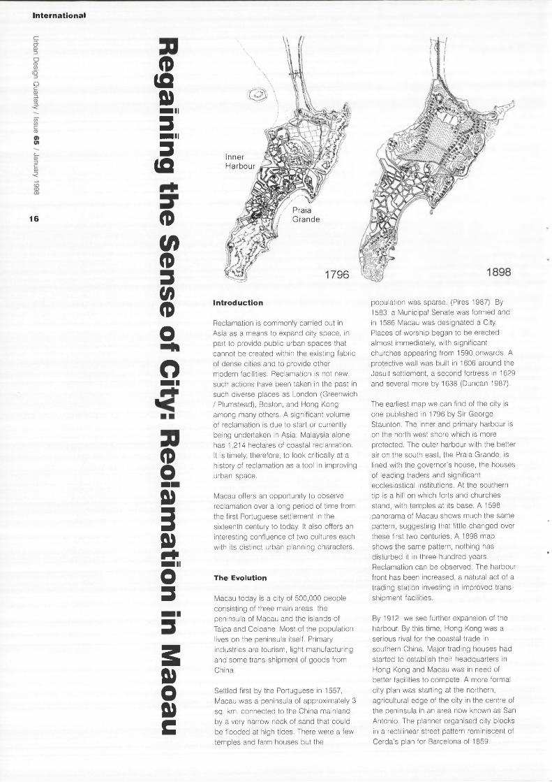
The earliest map we can find of the city is one published in 1796 by Sir George Staunton. The inner and primary harbour is on the north west shore which is more protected. The outer harbour with the better air on the south east, the Praia Grande, is lined with the governor's house, the houses of leading traders and significant ecclesiastical institutions. At the southern tip is a hill on which forts and churches stand, with temples at its base. A 1598 panorama of Macau shows much the same pattern, suggesting that little changed over these first two centuries. A 1898 map shows the same pattern, nothing has disturbed it in three hundred years. Reclamation can be observed. The harbour front has been increased, a natural act of a trading station investing in improved trans-shipment facilities.
By 1912 we see further expansion of the harbour. By this time, Hong Kong was a serious rival for the coastal trade in southern China. Major trading houses had started to establish their headquarters in Hong Kong and Macau was in need of better facilities to compete. A more formal city plan was starting at the northern, agricultural edge of the city in the centre of the peninsula in an area now known as San Antonio. The planner organised city blocks in a rectilinear street pattern reminiscent of Cerda's plan for Barcelona of 1859.
Inner Harbour
Praia Grande
1796

The map of 1927 shows the first dramatic intentions to grow: large sections of reclamation with indications of intended street patterns on strictly rectilinear forms. A large park in the centre provided a formal open space of a city scale. This is the section of town into which the growing middle class moved, traders without established trading houses. Many were members of the growing Eurasian community who now control much of the local economy.
By 1979, we find the planned expansion changed in nature from that intended in 1927. At the south eastern harbour front, we see a new area of tight streets with a few small urban spaces, reminiscent of the scale of the old city, although with a more rigid geometry. The bounding roads are wide and traffic fast, making this an island within the city, cut off from the rest of the city and the sea front.
park lies to the east.
The second stage was the reclamation of the outer harbour beside the Praia Grande. The winning scheme (by Manuel Vicente) proposed two large pools of water and an island created by a causeway in an arc which inverts the broad Praia Grande of the past and a second causeway linking around the Barra at the southern tip. Buildings on the north east edge of the ponds are to create a clear urban edge to the water. The Praia itself is to be widened by reclaiming some space along the water's edge, restoring the grandeur of the avenue. The aims of the "Reorganisation of the Praia Grande" are to reinforce the diverse economic base of Macau and to create an image of the city to attract investment and an environment attractive to scientific personnel, technicians and managers.
success: the area has a feel of isolation, long blocks leaving the pedestrian exposed to the noise and motion of the traffic. The few urban spaces which have been created are dominated by traffic. That the spaces work, however, can be seen by observing the business conducted and the social activities present. The feel in these small and isolated pockets is that of the older section of the city. We think this section is partially successful because it is small, close to the city and adjacent to the most popular casino.
The reclamation of 1984 by the P&T Group fails even to provide that. The central reserve is of a scale reminiscent of revolutionary societies needing to control the citizenry. The structures have been compared to the worst of 1960's council housing (Seurre 1996). Residents of Macau refuse to move in and the development remains largely vacant.
In 1982 the proposal was made to expand Macau again. The Macau government and leading business figures decided that a modern city could be created by reclaiming yet more land and building modern structures (Prescott 1993). Two public competitions were announced to guide the expansion of land area.
For the first stage, a team of the Hong Kong-based planning practice, P&T Group, with Siza Vieira and Fernando Tavora of Portugal, proposed a reclamation of the outer harbour. They submitted plans for a rectilinear urban grid of 144m by 72m: four blocks wide to the west and two wide to the east, six blocks deep on the north south axis. A central reserve separates the east and west sections and is continued on to the shore to provide a visual connection; a
Deformations of the City
Two aspects interest us in this review: urban spaces and the use of reclamation to create such spaces. The urban spaces of Macau have been used to create spaces for commerce and for social transactions (e.g. Praia Grande); to create a sense of place and identity, resolve a difficult geometry, and lately to regain Macau's international position.
Macau's early growth shows a distinctly European form as streets follow contours or natural phenomena, unlike the Chinese planned city based on geomantic rules. Initially, reclamation is undertaken in this organic method. Recent reclamation has done much to change the character of the city. The 1970s expansion is a mixed
The 1991 reclamation aims to create a sense of city and an urban space attractive to the cosmopolitan and more sophisticated technocrats. Vicente sets out a new agenda for urbanity and demonstrates how to achieve it. As such, this last reclamation is the clearest in its aims and one that addresses most directly the need for urban spaces in which to live.
Conclusions
We have described a series of reclamations that have all taken place in one small and clearly bounded city. Successful urban planning is difficult to define, except in specific facets: for instance success in financial terms resulting from good planning, as the city

fathers hoped. Or in the feeling of urbanity and well-being, a "cultured" result, again as the city fathers hoped. Another scale of success can be the popularity of the city -a large influx of inhabitants might indicate that the city is a well planned environment. From this point of view, intended by the planners, it has failed. Of course, all these measures are imprecise and subject to influence from many other factors. When evaluating the success of reclamation strategies, we need to consider these factors and speculate as to the sources of success.
The scale of expansion certainly affects success: a small reclamation intended to tidy up the urban edge and reduce erosion, as we see in the eighteenth century, provides better sites for commerce and social functions. This organic growth extends existing urban and social patterns without disturbing them. To take advantage of the economics of reclamation engineering, recent reclamation exercises define larger areas behind their barrier walls. These define a new environment, discrete and separate and creating a new character for the city. It is these new urban forms which are seen by the Mecanese citizenry and visitors to be unsuccessful.
Not all large expansions fail. Barcelona's expansion in the nineteenth century, for example, is of such strong character that it sets up a separate counterpoint to the existing older city, successfully creating a new city whose life enhances the old. In Macau, however, the schemes implemented from 1900 to 1984 have broken from the traditional urban patterns but not replaced it with a viable alternative.
Belatedly, the Macau city planners recognised the importance of quality of urban space and the last expansion attempts to introduce urban forms which enhance the urban experience, The reclamation provides not only room for more commerce and habitation, it sets out to create a better living environment based on current desires and principles. In this sense, it joins the established tradition of urban design that redefines the city through grand gestures rather than incremental growth.
If there is any one thing that determines success in Macau, it is the role of resultant public space. Where the reclamation sets out to establish a 'place' or to add incrementally to existing place, it has succeeded. Where the reclamation has been of sufficient mass to become a new neighbourhood and does not continue the fabric of the city, the reclamation is unsuccessful.
The most obvious example of a wrenching change of scale and discontinuity can be seen in the rectilinear expansion proposed in 1984 and completed in 1994. A generous review of the design notes that the plan is "characterised by a clarity of principles and geometric rigour but sufficiently flexible to ensure the survival of those few disciplining elements of the plan when confronted with eventual changes in programming of occupation for the area." (Prescott 1993). The reality is less kind - wide streets between the buildings prevent the spontaneous eruption of activity that fills the alleys and lanes of old Macau. The "geometric rigour" in the central public park
is too heavy handed, resulting in a large formal space which is disconnected from the surrounding structures. The result is that the district is unpopular, remaining largely empty.
The success of the latest reclamation remains to be seen. It is a remarkable piece of urban planning in that its major purpose is to restore a sense of urban focus. The additional land required was provided in the spaces created by the generous gestures of the two ponds. By this point, however, Macau is burdened by so much unoccupied and unsold property that it is not clear the new land will be used. Efforts may be made for political reasons to complete the project and put a semblance of success on this highly visible project before the resumption of sovereignty by China in 1999. The city needs something to tie it back together after being left ragged on this southern edge. The "reorganisation" of the Praia Grande might be the answer. #
Thomas Kvan and Justyna Karakiewicz

References
Brito, R. de S.: 1962, Imagens de Macau Agenda Geral do Ultramar, Lisboa. Duncan, C.: 1987, "Development of Macau's City Landscape" Macau, City of Commerce and Culture R. D. Cremer, ed. UEA Press, Hong Kong. Hong Kong Museum of Art: 1996, Views of the Pearl River Delta Urban Council of Hong Kong, Hong Kong. Hurley, R. C.: 1898, Tourist Guide to Canton and Macau Ch'eng Wen Publishing Company, Taipei, reprinted 1973. Pires, B. V.: 1987, "Origins and Early History of Macau" Macau, City of Commerce and Culture R. D. Cremer, ed. UEA Press, Hong Kong. Prescott J. A.: 1993, editor Macaensis Momentum Hewell Publications, Macau. Seurre, J.: 1996, "Macau 1996: the Die is Cast" China Perspectives No. 4, March/ April. Wang W. J.: 1997 "Is There A Plaza In Chinese Public Space" these proceedings Woodward, C.: 1992, Barcelona Manchester University Press, Manchester.
i ' J i r r j r I
; M u r - i i / i
>11 |9Ul a m i
A p ft w - i s E E y k - s i m _ _ f r o • Q O
_LlJ
Two urban spaces in
Macau.
O
_ 19

Topic
o
20
What is the difference between urban design and
landscape architecture? A glib answer would be that the
former is done by urban designers, generally with a
background in town planning or architecture, while the
latter is done by landscape architects, who belong to a
distinct profession with its own educational requirements
for qualification and practice. Another possible - but
potentially misleading - reply would be to say that
landscape architects are primarily concerned with the
open spaces within towns and cities, particularly those
which are vegetated, whereas urban designers are
principally interested in built form and development
processes. But this would underestimate the extent to
which the activities of landscape architects and urban
designers can overlap. In towns and cities landscape
architects and urban designers are united by a shared
concern for the quality of urban life and by the belief that
this can be enhanced by positive interventions in the
public realm.
The brief given to the contributors to this section was
simple and open-ended. They had to write something
which addressed the overlap between landscape and
urban design. All three chose to write about areas with
problems. Rupert Kempley and Jennifer Ross share a
concern about those alienated fragments of open space
which seem at best irrelevant to the communities in which
they are found, or at worst, as at King's Cross, are
colonised by drinkers, prostitutes and drugs dealers. How,
if not by surveillance cameras, might such areas be
rescued? John Pendlebury, on the other hand, writes about
Newcastle's Graingertown, an area which throbs with
pulsating nightlife (and already has its CCTV). The problem
here is not how to make spaces relevant to people, but
how to do it in a way which also respects the dignified
backdrop of late-Georgian architecture. #

s o
o ( D (A </> • • • O 3 (/>
v a
o 3 ( D
" 0 c o ( D - 0
Z3 —I zr O
" D
(7) O
This article looks at the overlap
between landscape architecture and
urban design. The purpose of
landscape architecture is to make
good places. I owe this definition to
Tom Turner who lectures at the
University of Greenwich.
There was a long period when most of these places were rural - landscape architects designed forests and country parks, reclaimed coal tips and quarries and helped to ameliorate the impact of new roads or power lines. These activities still go on, of course, but what is striking is the extent to which landscape architecture, at least in the UK, has, over the course of two decades, become a profession largely concerned with urban environments. This perception grew out of my own experiences working for planning departments in Glasgow and on Tyneside, but it has been confirmed, at least to my own satisfaction, by a series of twenty-seven interviews conducted with landscape practitioners over the summer of 1997.
Definitions
If you ask landscape architects to say what they mean by good design, they will often give you an explanation that involves spaces, scale and attention to detail. Here, for example, is Dougal Thornton, Principal Landscape Architect for Stirling District Council:
"I think the core of what we do is space and the hardest thing is scale. People can get all the components right and get the scale wrong. I think the movement through space is the most fascinating thing we deal with and how people interact with space and how they respond to it."
And here is Peter Fischer, a landscape architect based in Kingston-upon-Thames:
"To me scale of space.... a hobby horse of mine is that I think a lot of design work, particularly urban design work of late, is pattern for its own sake, circles and squares and diamonds, whatever. To my mind it's not what the design of urban space is about. It should be how it functions. It should be simply paved and very carefully detailed."
If you hadn't been told that these were landscape architects, you might have presumed that they were urban designers. The two professions have very much in
common. Nevil Farr, a principal in the Liverpool office of Donaldson Edwards, was explicit about the overlap:
"Good design to a client is getting it on time and within budget....good design to me is all those things, plus I feel there are ephemeral things like delight and enjoyment and tension and variety and colour of materials and invitation...all the variety of psychological reactions to that environment. I think this probably applies to something like urban design as well. I think the principles probably hold good"
Phil Moss, a landscape architectural partner of BDR put it even more strongly:
"Landscape architecture is not just about detailing spaces between buildings... landscape architects have got to be urban designers and appreciate how settlements, cities, landscapes are put together, what are the component parts and how they relate to one another."
Reticent vs. bombastic design
When landscape architects work in the countryside, their objective is often to be as self-effacing as possible. Far from making design statements, their work should be so attuned to its context that no one can tell that they have intervened. Some follow similar precepts when they come to the city. Peter McGuckin, consultant landscape architect for Newcastle's East Quayside redevelopment explained his philosophy:
"The cleverness is doing always, for each site, what is right. Imposing your will might be good, but it might be bad. Working with the grain might have been better. And in the case of the Quayside, the satisfying example I have in mind is where we worked with the grain of the vernacular in terms of materials and really decided that there was too much going on elsewhere and it was necessary to do this almost as a foil, to show that good design was not always about big statements."
An opposite view says that landscape architects have been too reticent. Tim Gale of London-based Edwards Gale was thinking of Barcelona when he said:
"I think some bolder, stronger statements, like the ones most of us have seen now in Southern Europe would be entirely appropriate and I'm sure we're going to get them, because the new generation of landscape architects who are emerging from college are interested and excited by all this."
This is a view shared by Rodney Beaumont of Gillespies who went as far as to advocate "bombastic" design, an

Topic / Landscape Arch i tec ture and Urban Design
Top: Pattern for
pattern's sake?
Centenary Square,
Birmingham.
Left: Two views of
Newcastle by Masie
Rowe.
Below: Pare de
I'Espanya Industrial,
Barcelona. An
example of
'bombastic ' design?
unfortunate choice of words perhaps; his point would have been better served by a word like "authoritative" or "arresting".
Collaboration or rivalry
So far I have not had the opportunity to interview any urban designers about their attitudes towards landscape architects. The relationship between the two professions can be co-operative or could become combative. Roger Kirk-Smith of ASH in Liverpool was only half joking when he told me that:
"There is a war going on between urban designers, architects - who want to dominate the world - and landscape architects. We've got to be very careful that we are perceived as being bona fide members of the urban regeneration school and not just the people "who do the fluffy bits."
Landscape architects are very sensitive about this. The thing they hate most is being brought into a project at a late stage and asked to do a planting plan. For many their planting skills are secondary to their real expertise, which is spatial design.
In the private sector there are almost certainly going to be occasions when urban designers and landscape architects become rivals, but we must hope that enlightened clients will put together multi-disciplinary teams for large urban projects. To end on an optimistic note, I will quote Peter Fischer who praises the virtues of a multi-dimensional approach:
"I've come to do other urban design work, townscape analysis with the Civic Trust and others, and I enjoy that sort of work. You're working with economists and people like Comedia/Demos, who are "lifestyle designers" almost, asking "how do people actually want to live in the urban fabric?" and "how do you create exciting or busy places where people want to be so that they're successful?"
"And I've been working in teams doing that sort of work. I get quite a lot out of it, and I think we produce things that are right for the client and help the sorts of places we've been working on . . ."
"And it's not something where you can say "Oh, I did that as a design". I was involved in something that was a process. There was a landscape element or urban design element.... not even that we did the detailed design. Somebody else has come along and done the detailed design but I think we set a framework. I enjoy the achievement of that." #
o 3 • i i
3 (fi <D
5" S 3 r -a> 3 a 0 ) o fi>
" O
( D < 0
c _ O
~ 0 CD ZD Q_
CD CT C
Those of you who know Newcastle,
but have not visited for a while, may
wonder as to the whereabouts of this
place called Grainger Town. It has
existed for less than ten years, and
represents the commodification of a
place, the centre of the city. It has
been commodified to sell to funders
such as English Heritage and English
Partnerships in an effort to revive and
revitalise a decaying large chunk of
late-Georgian city centre.
Richard Grainger was a nineteenth century entrepreneur; a speculative developer. He was responsible for a whole series of developments in Newcastle, especially in the 1830s.1 Some of these have been lost; for example, two thirds of the grandest square in Newcastle, Eldon Square, replaced by the 1970s shopping centre which bears the same name. But much remains and it is Grainger's stamp that created a series of dignified classical late-Georgian streets forming England's only planned commercial centre of this date.2
Most famous of these is Grey Street, described by Pevsner 'as one of the best streets in England'.2
The Birth of Grainger Town
By the late 1980s officers in the city council were very worried about this part of the city centre. The retail had moved north, and to the south the Quayside by the River Tyne was in the process of being regenerated for leisure uses, fuelled by the Tyne and Wear Development Corporation. Office users were relocating elsewhere, outside the city. As a consequence the planned Georgian town suffered. Vacancies were high, especially on upper floors and the condition of buildings poor. 'Grainger Town' was born and studies of the area began, culminating in a report by EDAW3 in October 1996 which produced a vision statement:
'Grainger Town will become a dynamic and competitive location in the heart of the City. Grainger Town will develop its role in the regional economy, within a high quality environment appropriate to a major European Regional Capital. Its reputation for excellence will be focused on leisure, culture, the arts and entrepreneurial
activity. Grainger Town will become a distinctive place, a safe and attractive location to work, live and visit.'
Beyond the aspirational rhetoric this recognised that the well-being of Grainger Town as a place relies on more than the fabric of the buildings; it is to do with the economy and the people of the area. It is also a vision which chimes with notions of cultural capital and production, espoused by, for example, Zukin.4 In discussing place-marketing initiatives, like Grainger Town, she emphasises the importance of cultural symbols to the material economy. Cities seek to survive now not through manufacturing but cultural production. Culture is both something visual and a product of the political-economy.
Culture occurs in urban space. To understand urban space we need to look from above and below; to link the understanding given by political economy of the way built environments are created through systems of money and power, to the perspectives given by everyday life, where disorder and spontaneity can take over.5 The landscapes of our cities encompass not only physical spaces and the buildings that define them but also the people who use those spaces and the associations and relationships they have with those places.
Two Walks
Two very different ways of experiencing the urban space of Grainger Town, two very different landscapes, are exemplified by the walking journeys through the area described by Robert Hollands6 and David Lovie.7 Lovie's text is designed as a companion to architectural walks around Newcastle and is produced as part of the Grainger Town Project. It is a model of its kind. Informative and well illustrated, it is the sort of guide non-specialists interested in architecture would find accessible in a way that might not be true of the 'Buildings of England' series. Despite its 'official' provenance it is not too afraid to make criticism of some of the less successful developments of recent years. Its four walks represent one way of experiencing Newcastle.
Hollands' text, by contrast, describes the Newcastle phenomenon of 'going out', a pulsating part of Zukin's symbolic economy. An American survey of 'world party cities' rated Newcastle as the world's number eight, only trailing the likes of New Orleans, Amsterdam and Rio.8 Hollands1
book is quite definitely not intended as a companion to a night out on the town, but describes an activity far more prevalent than that of the architectural tourist. He describes the youthful and extended
o
2 3
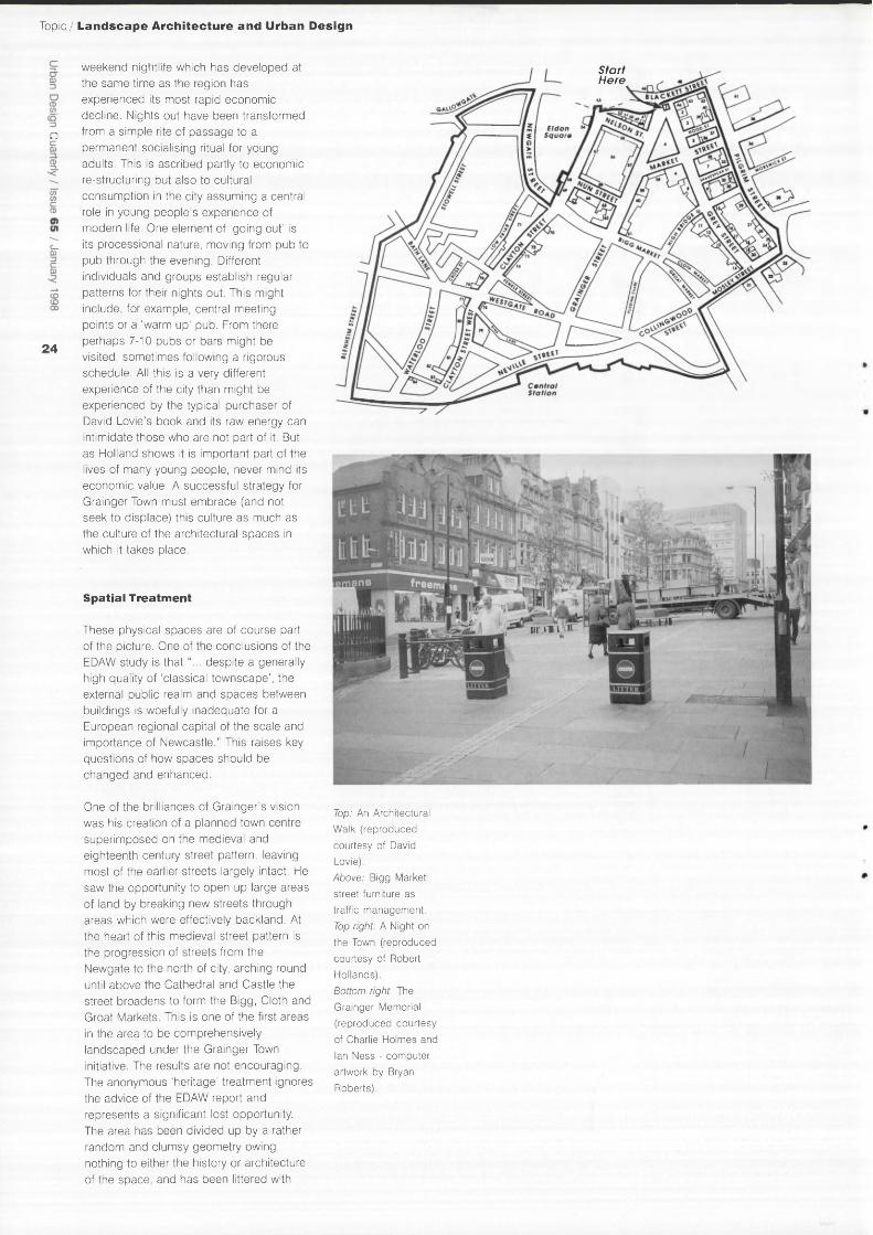
Topic / Landscape Archi tecture and Urban Design
D
2 4
weekend nightlife which has developed at the same time as the region has experienced its most rapid economic decline. Nights out have been transformed from a simple rite of passage to a permanent socialising ritual for young adults. This is ascribed partly to economic re-structuring but also to cultural consumption in the city assuming a central role in young people's experience of modern life. One element of 'going out' is its processional nature, moving from pub to pub through the evening. Different individuals and groups establish regular patterns for their nights out. This might include, for example, central meeting points or a 'warm up' pub. From there perhaps 7-10 pubs or bars might be visited, sometimes following a rigorous schedule. All this is a very different experience of the city than might be experienced by the typical purchaser of David Lovie's book and its raw energy can intimidate those who are not part of it. But as Holland shows it is important part of the lives of many young people, never mind its economic value. A successful strategy for Grainger Town must embrace (and not seek to displace) this culture as much as the culture of the architectural spaces in which it takes place.
Spatial Treatment
These physical spaces are of course part of the picture. One of the conclusions of the EDAW study is that"... despite a generally high quality of 'classical townscape', the external public realm and spaces between buildings is woefully inadequate for a European regional capital of the scale and importance of Newcastle." This raises key questions of how spaces should be changed and enhanced.
Start Here
One of the brilliances of Grainger's vision was his creation of a planned town centre superimposed on the medieval and eighteenth century street pattern, leaving most of the earlier streets largely intact. He saw the opportunity to open up large areas of land by breaking new streets through areas which were effectively backland. At the heart of this medieval street pattern is the progression of streets from the Newgate to the north of city, arching round until above the Cathedral and Castle the street broadens to form the Bigg, Cloth and Groat Markets. This is one of the first areas in the area to be comprehensively landscaped under the Grainger Town initiative. The results are not encouraging. The anonymous 'heritage' treatment ignores the advice of the EDAW report and represents a significant lost opportunity. The area has been divided up by a rather random and clumsy geometry owing nothing to either the history or architecture of the space, and has been littered with
Top: An Architectural
Walk (reproduced
courtesy of David
Lovie).
Above: Bigg Market:
street furniture as
traffic management.
Top right: A Night on
the Town (reproduced
courtesy of Robert
Hollands).
Bottom right: The
Grainger Memorial
(reproduced courtesy
of Charlie Holmes and
Ian Ness - computer
artwork by Bryan
Roberts).
Hi I ' l l .

Route and Description of Local Night Out (Dan L26)
As I say, w'always meet in the Trent about half seven to eight o'clock. We always stay there for about an hour, maybe two or three drinks if w' stay in, so we leave there about quarter to nine. Say we gan' to the Bigg Market and probably gan' to Legends. Have one in there, er, come out of there about quarter past nine, twenty past nine, then to the Adelphi, have one in there. Leave there about half past nine,and to Maceys, say come out there about ten to ten, er, Balmbra's, come out of there about quarter past ten. Then to Masters, come out of there about twenty-five to eleven, then go to the Empress or the Bridge for last orders, come out of there and then sometimes go to the nightclub.
street furniture which seems as much concerned with traffic management as environmental quality. It is a scheme that has nothing to do with any meaningful sense of place. The Bigg Market has been a venue for serious drinking for centuries, as a medieval market or as the focus now for the dynamic youthful celebration of 'going out'. It would have been far better to celebrate this excess through a treatment based on fun and panache; or if the City Fathers required something more sober, a simpler treatment which connected with the real space and its history as set out in the City's own assessment of the character of the area,9 rather than arbitrary catalogue 'heritage'.
In contrast the competition for a memorial to mark the bi-centenary of the birth of Richard Grainger seems to have had a happier outcome. The site chosen for the competition was a worrying one. Lying on a strong axis with the 135 foot high monument to Earl Grey a vertical statue or sculpture would have been in unhappy competition. Fortunately the winning team of Ian Ness (architect) and Charlie Holmes (sculptor) realised what not to do and designed a horizontal panel. Slightly raised, and set in the roadway, the panel is of cast iron.
Conclusion
In creating this place 'Grainger Town' it is important that the complexities of its landscapes are recognised. Grainger's 'City of Palaces' deserves to be rejuvenated but the landscapes for which these fine buildings are the backdrop are equally important. In part this is a landscape of physical spaces. These have evolved as part of the area's morphology from the time the Roman's chose this as the place to bridge the Tyne, and need to be understood and respected in formulating environmental works. In equal part this a landscape of social activity and relations (one part of which is the phenomenon of 'going out') which are equally deserving of their place in 'visions' of the city. Cultural production is rightly seen as part of the strategy for the promotion and economic rejuvenation of Grainger Town, but this should not be at the expense of those people, such as the young, who now use and enjoy these urban spaces. #
References
1. Ayris, I., A City of Palaces: Richard Grainger and the Making of Newcastle upon Tyne. 1997, Newcastle upon Tyne: Newcastle Libraries and Information Service. 2. Pevsner, N. And Richmond, I., Northumberland. 1st ed. The Buildings of
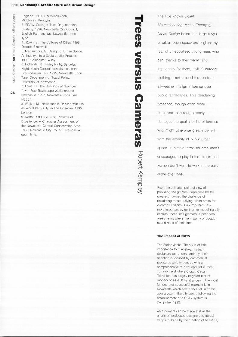
Topic / Landscape Architecture and Urban Design
o
26
England. 1957, Harmondsworth, Middlesex: Penguin. 3. EDAW, Grainger Town Regeneration Strategy. 1996, Newcastle City Council, English Partnerships: Newcastle upon Tyne. 4.. Zukin, S., The Cultures of Cities. 1995, Oxford: Blackwell. 5. Madanipour, A., Design of Urban Space: An Inquiry into a Socio-spatial Process. 1996, Chichester: Wiley. 6. Hollands, R., Friday Night, Saturday Night: Youth Cultural Identification in the Post-Industrial City. 1995, Newcastle upon Tyne: Department of Social Policy, University of Newcastle. 7. Lovie, D., The Buildings of Grainger Town: Four Townscape Walks around Newcastle. 1997, Newcastle upon Tyne: NEEEF. 8. Walker, M., Newcastle is Ranked with Rio as World Party City, in The Observer. 1995: London. 9. North East Civic Trust, Patterns of Experience: A Character Assessment of the Newcastle Central Conservation Area. 1996, Newcastle City Council: Newcastle upon Tyne.
<D <D < CD 3 C </> O o>
3 <D
3 JJ £Z
TD CD
CD
CD
The little known Stolen
Mountaineering Jacket Theory of
Urban Design holds that large tracts
of urban open space are blighted by
fear of un-socialised young men, who
can, thanks to their warm (and,
importantly for them, stylish) outdoor
clothing, exert around the clock an
all-weather malign influence over
public landscapes. This deadening
presence, though often more
perceived than real, severely
damages the quality of life of families
who might otherwise greatly benefit
from the amenity of public urban
space. In simple terms children aren't
encouraged to play in the streets and
women don't want to walk in the park
alone after dark.
From the utilitarian point of view of providing the greatest happiness for the greatest number, the challenge of reclaiming these outlying urban areas for everyday citizens is an important task, more important by far than re-modelling city centres, these less glamorous peripheral areas being where the majority of people spend most of their time.
The impact of CCTV
The Stolen Jacket Theory is of little importance to mainstream urban designers as, understandably, their attention is focused by commercial pressures on city centres where comprehensive re-development is most common and where Closed Circuit Television has largely negated fear of robbery or assault by strangers . The most famous and successful example is in Newcastle which saw a 35% fall in crime over a year in the city centre following the establishment of a CCTV system in December 1992.
An argument can be made that all the efforts of landscape designers to attract people outside by the creation of beautiful,

Top: The urban ideal rarely achieved in
peripheral un-
surveilled urban
areas.
Middle: The People's
Park, Halifax, as it
once was.
Bottom: The People's
Park, Halifax, now: a
threatening under-
used place, the
sculptures protected
from vandalism.
distinctive and functional spaces can potentially be superseded by the installation of surveillance systems, which in Newcastle and many other similar city centres, are now increasingly seen to be a proven method of providing security and which may begin to redefine what attractive urban space is. One of the reasons for the success of out of town shopping centres has been the ambience of security which they provide, deceptive though this has been shown to be.
CCTV systems have already been set up outside city centres in high crime residential areas, Chapeltown in Leeds being a recent example. The implications for urban design are significant; a new aesthetic of surveillance might supersede the traditional pursuit of a green urban Arcadia. Should, for instance, a local authority be forced to choose between a residential CCTV system or environmental improvement - to choose cameras before trees?
Safety and spatial quality
Space is the building block of landscape design and its manipulation is the entire point of the discipline. Spaces can be made permeable, semi-permeable or totally enclosing; they can be lightly punctuated, heavily punctuated, or made colourful or sombre. In fact landscape designers can do everything with space, except it would seem, the single most desired thing which is to make it around-the-clock comfortable and safe for all sections of society, something which cameras, expensive though they are, seem to promise to do.
It is surprising how little addressed, in terms of safety, spatial quality is at a landscape professional level, either educationally or in coverage within publications, with only the occasional honourable exception proving the point1. It is as if an (imaginary) Guild of Carpenters refused to consider the quality of timber their members were using and they went on constructing furniture, ornaments and houses without a great deal of thought for the strength and durability of the wood being used.
Various organisations have attempted to tackle this problem, broadly termed Community Safety, the most important current landscape issue and one which informs many others. If people, for instance, are afraid to walk the streets, it is inevitable that public transport will suffer and traffic congestion will increase. The Priority Estates Project (PEP), Youth Works, NACRO, and Crime Concern are the most prominent of the organisations involved in Community Safety some of which in turn

Topic / Landscape Archi tecture and Urban Design
Top left: Neglected
ungated rear access:
stolen jacket paradise.
Top right: CCTV is the
substitute for a moral
conscience.
/Above left: Close
spatial definition and
intense informal
surveillance: the
young men in stolen
jackets feel the cold.
Above right:
Libertarians may
quibble but for the
jacket this is trouble.
Middle left: Informal
surveillance makes
the cycle path
unfriendly to stolen
mountaineering
jackets.
Left: What you can do
with a tree if you don't
smash it up.
manage the DoE Safer Cities programme currently running in 14 locations. One of the difficulties of improving Community Safety is measuring the extent of the problem and assessing the results. Research shows the difficulty of reclaiming public space for everyday society once it has been lost and even with substantial expenditure this difficulty can not be under-estimated.
The Priority Estates Project
The Priority Estates Project (PEP), which has been sponsored by the DoE since 1979 to work on some of the country's more challenging housing estates, attempted to measure on a scientific, quantitative basis the effectiveness of its involvement in the improvement of two stressed housing estates located respectively in Kingston-upon-Hull and in the London Borough of Tower Hamlets. The results of this experiment illustrate the difficulty of returning value for money even with intensive environmental improvement.
PEP has a basic model for estate improvement, based on DoE guidelines2, the critical ingredients being : a local estate based office, a local repairs team, local control of rent collection and, most importantly for urban designers, a programme of small scale capital improvements.
As part of the experiment, PEP selected two socially similar control locations in the locality of the experimental estates to test whether their input had had a marked effect; these were located nearby in Hull and Lambeth. Environmental improvements played a significant part in both the PEP programmes. The Hull estate, for instance, was laid out on criminal-friendly Radburn grounds with pedestrians separated from traffic, in effect providing a network of convenient unmonitored escape routes for burglars. This layout was rectified and people were returned to walking alongside roads where informal traditional surveillance could operate and the old paths were blocked up. Many residents were also given improved defensible space around their houses through the creation of small but clearly defined gardens. In addition, an intensive programme of maintenance was implemented ensuring the speedy removal of graffiti and reversal of vandalism.
Despite all this and the expenditure of over £2m crime fell quicker on the London control estate than on the experimental site where the intensive programme of work had been carried out. In addition ethnographical research showed fear of crime had not fallen significantly. The London PEP follow up report3 admirably

makes the difficulty of achieving long term concrete gains clear: "on the estates studied during this research all of the successes were only partial - they occurred in either one or the other of the experimental estates, or only for particular areas or groups of residents in each estate."
Conclusion
The fundamental difficulty which the PEP project in London and Kingston upon Hull highlighted was that even the most sensitively designed environment on its own will not reduce crime and fear of crime, as landscapes which provide, for instance, defensible space still rely on a degree of neighbourliness to work. The greatest enemy of social cohesion is a demoralised mobile population which never puts down roots long enough to develop a self-supporting community which can control and set norms of behaviour for the minority of young men who make public space feel unsafe.
The reasons why particularly vulnerable low income families move on regularly are complex and relate mostly to social and market forces, but of significance to our debate concerning cameras versus trees a small contributory factor may be the placelessness of much of the city fabric which does not encourage a feeling of identity amongst those living within it. By providing this distinct sense of place through architecture and landscape design, something which CCTV cannot do, it may be possible to inculcate the sense of belonging in neighbourhoods which helps to reclaim them for society at large. #
References
1. Design for Community Safety, New Forest District Council, 1997. 2. Guide to Local Housing Management, Power, 1987. 3. Housing, community and crime, the impact of the Priority Estates Project. Home Office Research Study HMSO, 1993.
o ( D <D 3 ••• 3 <fi
<D O
c _ CD = 3
CD
XI O GO C/)
In 1996 the then Government
launched the "Greening the City
Initiative" to promote discussion and
ideas about the creation, protection,
management and maintenance of the
green spaces and places in our urban
areas, draw together examples of
good practice and encourage new
ideas about and approaches to
design.
Based on six seminars and 22 case studies, a Good Practice Guide was produced.1 Essentially aimed at policy makers, it examines the existing and potential roles that green networks play in supporting the economic, social and environmental sustainability of our cities and provides practical advice as to the planning, implementation and managing of physical environmental initiatives and projects. In selecting case studies emphasis was deliberately placed upon the informal networks of green space, where traditionally resources for implementing new and sustaining existing environmental projects have been scarce, for example, the road and river corridors, informal public spaces within housing estates, employment areas and town centres and despoiled and vacant land, rather than formal urban parks.
A strategic approach - the key to success
Nearly all of the successful projects examined either arose from or were clearly influenced by wider environmental strategies. Such a strategic approach was found to be essential to the long term protection of a sustainable physical environment in terms of:
O
2 9
• providing a comprehensive understanding of the operation of the green network and the valuable contribution it makes to the urban environment;
• identifying and providing an appropriate basis for protection;
• providing a basis to assess the implications of development schemes upon the wider environment and thus providing a basis for incorporating appropriate amelioration measures to minimise such impacts at the outset of

Topic / Landscape Archi tecture and Urban Design
o
3 0
the process rather than having to react to a situation when it arises i.e. a prevention rather than cure approach;
• resolving conflict and hence providing the opportunity to balance different needs i.e. conservation and public access;
• allowing for the effective integration of environmental and landscape issues into the wider land use planning system;
• providing a focus for obtaining, targeting and managing scarce financial resources;
• providing a mechanism to co-ordinate and accommodate disparate requirements of all sections of the community;
• providing a framework for decision-making and managing actions.
An essential pre-requisite for evolving effective area wide environmental strategies - where impacts can be assessed and changes measured -depends upon the availability of relevant and accurate information about all aspects of the environment. A number of local authorities produce state of the environment reports and use such information as a baseline against which to measure environmental change. Southampton, Leicester and the Black Country were found to have some of the most comprehensive and sophisticated data available. In the case of Southampton, such information is maintained on a GIS information system alongside all other land use planning data. This data collection is supplemented by regular consultation with the community, co-ordinated through a number of area based focus groups.
Making things happen
Within each area wide strategy a series of projects and initiatives were identified as being actively pursued, thus providing an effective means of channelling activity and resources towards particular priorities or opportunities. From the projects examined a number of key themes and lessons were identified for taking a project forward to implementation and for subsequently maintaining it.
Two prerequisites for 'getting things started' effectively were identified:
• the need for a person or community who will act as project 'animateurs';
• the provision of a vision and strategy by which the initiators' enthusiasm can be shared and resources channelled.
Almost every project and initiative depended at least in its early stages, on the energies and commitment of individuals or a group. In recognition of the importance of such support and involvement, in many cases project officers were appointed to build, nurture and sustain such support. For example as part of the King's Cross Estate Action Programme a significant amount of time was spent at the outset of the project building an effective tenant participation forum which ensured each residential block in the estate and every group had the opportunity to become involved and influence each stage of the process.
The cases showed however that participation by itself was not enough. A communicable vision that secures the co-operation and support from potential partners, funders, local politicians, and other key individuals and organisations is also necessary. Many of the projects examined took more than ten years to implement and had been developed in an incremental fashion, often in response to the availability of funding. The availability of a framework provided the basis upon which support could be enlisted, actions co-ordinated and changing circumstances absorbed. For example, again at Kings Cross, an overall master plan for enhancement of the public realm of the estate was drawn up in consultation with the resident community at the start of the process and was used as a basis for a successful Estates Action Bid. This then provided the framework for developing and implementing initiatives on a project by project basis with relevant interests in the community.
Effective Community Participation
A key objective of most of the cases was to improve the living and working conditions within urban areas. This objective was most effective when those directly affected were involved in the process. Community involvement was thus seen as essential to the process.
The research identified a number of different ways for involving the community, with a number of key procedures and activities essential to any process:
• consistent and long term involvement of project officers;
• consistent communication: all leaflets and publications circulated as part of the project adopting a consistent format;
• keep the community informed: every action and outcome from meetings should be reported back to the community, and a contact name provided so enquiries can be answered;
• local context: all meetings should be held at a local venue already well used by the community, and where possible should be associated with a well established local event;
• communication of ideas: the use of visual material to illustrate how a particular scheme will look provides an appropriate mechanism with which to engage the community and obtain a reaction;
• making relevant: to engage different sections of community, appropriate techniques and events relevant to the particular group should be employed. For example, Neighbourhood Nature, a project run in Walsall by the National Urban Forestry Unit involved an Asian Women's group in a tree planting campaign by transferring their traditional skills in garment production to the production of flags and banners to 'dress' trees. A tree dressing festival was run in association with the project.
• keep focused: involve only those groups that will be directly affected by the scheme;
• quick success: implement a series of preliminary projects to help initiate and sustain interest and enthusiasm;
• flexibility: be prepared to alter and respond to different ideas;
• identify champions: attempt to identify core groups or individuals to help organise events and disseminate information.

Key Regiona l Priori ty 1
• ^ren«*y re*4 tn4 r»il corriderc City Owttenfl* »te«s
OPPORTUNITIES FOR EXTENDING THE URBAN FOREST-regional priorities
Regiona l Priority 2 S«K ondary road and r«< conidon
Though such processes are time consuming and costly, where they have been effectively carried out, the projects enjoyed significant success.
Consideration of the numbers of potential beneficiaries either living, travelling or working in the vicinity of the site - isolated and infrequently used areas that are not already a focus of activity have little prospect of becoming so and should therefore be given low priority.
Marrying improvement works to the priorities of those living and working in the area.
o
Site Selection 5
Making best use of scarce resources is $ particularly relevant when considering environmental improvements. The cases ui demonstrated a number of important issues ^
CD in relation to site selection: g
QJ >2
• Targeting resources at the most evident £ CO
environmental problems first. 00
31
Source: The Black Country Urtoan Forest - A Strategy for it's Development
NURJ
The ability of a site to respond to the changing needs of the community.
The relationship and integration of environmental projects to wider improvement programmes.
Function and Use
Many of the projects were concerned with the regeneration of green spaces which despite being an integral part of a place had become alienated from and irrelevant to the community it served, leading to problems of neglect, vandalism, crime, drugs and prostitution. In the King's Cross Estate Action project, for example, the designers used the traditional, formal urban squares to accommodate contemporary uses and functions. The formal layout of mowed lawns and plane trees reflected the historic traditions of the area and the former status afforded to the squares provided the physical framework to introduce change. The needs of the residential community were diverse. Mothers with very young children wanted a secure and overlooked play area, older children wanted a kick-about area, the elderly wanted quiet and secure areas to sit, dog owners wanted to walk their dogs and everyone wanted to improve security and safety. The needs of the residents, however, conflicted with the uses made of the area by drug dealers, drinkers and prostitutes. Through detailed consultation and community involvement, sensitive design, police involvement and increased security and definition of public and private space, the designers managed
Above: A strategic approach is essential to the long term success of the green network.
Below: Overall masterplan used as framework for implementing each project.

Topic / Landscape Archi tecture and Urban Design
to incorporate multiple use areas, identify priority user areas and control usage by undesirable elements. The designers accept that as communities change, the open space environment will have to adapt if they are not to deteriorate again. The historic arrangement of the spaces and their location do, however, provide the appropriate framework within which such changes can be accommodated and a diverse range of uses supported.
In contrast, the Premier Business Park occupants were more concerned with issues of image and operational efficiency on their industrial estate. Thus accommodation of different user requirements was identified as an essential factor in the success of a project both in terms of implementation and aftercare. These two case studies demonstrate the importance of involving local people in the process.
Security and Safety
Sense of security was identified as one of the more critical elements in the maintenance and creation of urban spaces. A number of initiatives and measures were adopted involving the education of users, improving sightlines and the permeability of natural areas: 'designing out' overgrown shrubbery and other thick barriers; providing entrances and exits into safe high activity areas in order to improve permeability; reducing hiding and entrapment spots; grading vegetation at woodland/park edges; providing clear sight lines for long distances; providing paths of not less than 4 metres; improving lighting; using wardens and installing CCTV in particularly sensitive spots.
Access to all
The provision of environments which are accessible to all gives rise to a number of related issues concerned with education, policy and design. The case studies identified a number of physical solutions including the incorporation of wooden board walks as part of the Southampton Greenways project to provide continuous and uninterrupted wheelchair access to a range of naturalistic environments, and the use of interpretation material incorporating Braille in Coventry.
Response to Nature
Many of the projects examined involved devising solutions to large scale environmental problems with limited capital budgets and minimal revenue funding.

Top left: Inventive
techniques engage
the community.
Middle left: Uses
relevant to the
community
accommodated in
traditional urban
squares.
Bottom left: Shared
surface in courtyards.
Above: Spaces
between housing
blocks redefined as
private spaces and
courtyards.
In such cases a response that works with the natural conditions proved the most successful in terms of value for money, speed of establishment, sustainability, ease of maintenance and cost of aftercare. This has implications at the design stage in terms of devising planting regimes, ascertaining the use to be made of the site and the use of hard and soft landscapes. In the majority of cases the proposals adopted low maintenance, naturalistic responses which rely on the indigenous regeneration of the landscape.
Funding
All of the cases examined required public sector funding. Pulling resources together from a variety of different sources has been critical to the success of many projects. A critical problem identified by the cases was the ability of projects to obtain and sustain long term revenue support. There is no such thing as the "maintenance-free environment" although the cases demonstrated that the burden can be significantly reduced by careful thought during the design stages. The cases did, however, identify a number of ingenious ways of gathering resources from a variety of private and public sources in order to support the long-term management, maintenance and monitoring of green spaces. Examples included endowment payments or commuted sums associated with development schemes (Bedfont Lakes), Section 106 agreements, (Southampton Greenways); contributions from companies as part of packages which lead to energy savings and the reduction in waste (Business Environment Association) or from commercial spin-offs such as the production of wood by-products and wild flower seeds for commercial sale (The National Urban Forestry Unit).
The Establishment of Partnership
Most of the cases have been implemented or managed by some form of multi-sector partnership arrangement. A number of common themes emerged:
• one organisation is usually needed to start the ball rolling - independent voluntary arm's length organisations are well placed - as illustrated by the role played by local Groundwork Trusts in a variety of cases;
• successful partnerships are based around mutual gain;
• local authorities have a key role through projects, land reclamation, use of development control powers and land management practices;
o
3 3

Topic / Landscape Archi tecture and Urban Design
gi • successful partnerships must involve the § right individuals as well as the right ^ organisations; many of the case study c5" projects owe their origins to a q committed individual but projects S sustainable over time depend on a
careful blend of individuals; <
V> • back up support helps partnerships succeed; many of the case study
01 projects demonstrate the importance of o professional staff time to secure 05
g maximum value from partnerships and 3 volunteers.
3 4
Making Things Last
Equally important to the implementation of projects is ensuring that they last and that they continue to meet the objectives set and the needs of the users. Underpinning this task are three important factors that need recognition:
• landscape environments can be a fragile commodity, if not managed and maintained properly they will quickly deteriorate;
• landscapes evolve and change not only physically but also in terms of how they are used;
• expenditure focused upon capital rather than revenue requirement, coupled with the short termist nature of many funding regimes places a premium upon innovative and low cost approaches to maintaining such environments, designing projects which reduce maintenance requirements and adapt to the changing funding regimes.
These factors have implications for design, community involvement, employment of staff, the production of management and maintenance contracts and the potential to generate revenue.
The impact of inflexible maintenance contracts was felt by many of the landscapes identified. Many of the projects had opted to remove certain complex landscapes from CCT contracts and/or employ wardens alongside tendered maintenance contracts. Support given by volunteers helped foster the sense of environmental stewardship.
Monitoring
A common complaint was that the indicators identified by grant giving bodies were not appropriate or limited to numbers of trees or acres planted. Indicators devised for some case studies were:

• timber output
• incidents of vandalism
• community involvement
• atmospheric pollution
• biodiversity indicators
• capital and life cycle cost of different types of greening
• employment generation, direct and indirect
With the requirements of Local Agenda 21 local authorities are encouraged to develop sustainable development indicators for individual greening projects. In Leicester, experience of the Environment City project led to the identification of four key stages:
Top left:
Reinterpretation of the
streetscape gives
priority to
pedestr ians.
Middle left: Large
scale planting to
green large spaces in
short to long term.
Bottom left:
Maintenance needs to
be rethought to work
with the environment.
Top and above:
Naturalistic
approaches to
greening provide a
cost effective means
of regenerating
derelict sites.
• understanding "where we are now" gathering the baseline data;
• setting goals or targets for improvement;
• data gathering to illustrate progress towards targets;
• information on progress widely and effectively communicated,
The above could serve as a model of improved monitoring practice for any environmental improvement projects and as a basis for improved resource allocation decisions at central and local government levels.
Conclusions
Urban green space has a central role to play in the long term sustainability of the city. The potential benefits are significant but the processes of achieving long-term success are often complex and difficult. It is hoped that the lessons from these projects will contribute to the success of the greening schemes of the future. #
1. Greening the City: A Guide to Good Practice. A report for the Department of the Environment. 1996 HMSO (GFA Consulting in association with Tibbalds Monro).
The views expressed are the author's own.

Case Studies
D <D
m &>
" ( D 3 6 ( / )
( D
( f i
7
(D
a c o
Q )
5
o
o ' o
Background
The Manchester Higher Education Precinct (HEP), which forms the southern sector of the city centre, is a region and city-vital concentration of academic, cultural and health resources. UMIST, the Manchester Metropolitan University and the University of Manchester, together with the Royal Northern College of Music, a teaching hospital and a science park combine to form one of the largest urban higher education precincts in Europe.
The HEP is compactly developed on some 300 acres and importantly occupies about a third of the city centre local plan area. A number of key city cultural facilities are located there. The rapidly expanding knowledge-based business and commercial roles are crucial to both local and regional prosperity. The predicted expansion of the 'working population' to some 64,000 full time students by the Millennium can be accommodated within the existing precinct buildings and boundaries.
The constituent institutions recognised that it was the corporate strength of the HEP which offered the greatest potential for the success of all. Austin-Smith:Lord was appointed by Manchester City Council and the combined institutions to recommend a vision and implementation programme to improve precinct presence, in order to help realise this potential.
Major growth in the 70s and 80s and significant changes in patterns of teaching and inter institution working had occurred without the intended major improvements to the HEP's infrastructure. City centre and precinct-destined traffic shared the same central roads through the Precinct. Consequently, major deterrents to achieving its academic and business potential included congested and chaotic vehicular and pedestrian access to and circulation within the precinct, parking anarchy and issues of personal and property security. Lack of investment in the HEP's rapidly deteriorating public environment together with the minimum contribution that most buildings made to animating the street-level environment has resulted in an increasingly unattractive and unfriendly precinct character.
Aims and Approach
Crucial aspects of structure and character needed to be re-examined in order to provide a framework to build a new precinct 'presence' which matches the academic aims. A key aim was to create a unified sense of corporate place, providing surroundings of real quality for all users of the HEP Scare financial resources, both
city and educational, could then be targeted to achieve a five-year improvement programme aimed at a longer term corporate development concept and vision of HEP
The Practice adopted its place making, place marking urban design approach to define the future structure and character of the precinct. Priorities for improving access to and within the HEP included diverting city centre precinct-bound and service traffic to the peripheral roads, together with a new emphasis aimed at creating attractive precinct approaches. The roles of key spine routes within the Precinct (Oxford Road, Sackville Street) could then be changed to give priority to pedestrians, cyclists and public transport.
Proposals for a modest increase in off-street car parking and much reduced on-street parking were complemented by proposed policies aimed at giving priority to HEP's non-captive customers over the captive working population. Improving pedestrian access and the potential to deliver better public transport links to the nearby city centre rail stations were important concomitant policies designed to discourage car usage. The concentration and proximity of both university and private student accommodation would permit the development of student managed and operated bus services, to reduce user costs and the extensive student car pooling.
New and improved pedestrian routes aligned to the old street pattern of the precinct would take cognisance of increased inter-institution activity, changes in patterns of intra-institution movement arising from major changes in the location of learning resource centres, the modifications to car parking policy and the locations of existing or new entrances to public and academic functions. Pedestrian safety and orientation were paramount.
A New Precinct
While each of the institutions had their own main focus, priority was to be given to the creation of a new precinct focus at the junction of Oxford Road and Booth Street where, coincidentally, four of the key institutions share common boundaries. A location for federal initiatives, the precinct focus could also provide the opportunity to rationalise the remnants of the vertically segregated pedestrian network of the 60s plan, and help revitalise and sustain the recently improved Manchester University Precinct Centre. The focus would provide a location for precinct-wide events and an outdoor performance space for the Royal Northern College of Music.
Top right:
View of the
Manchester
Education precinct.
Below:
Booth Street Corridor
- proposed planning
potential.

THE UNIVERSITY OF MANCHESTER
Lloyd Street
HOSPITAL TRUST
MANCHESTER METROP0UTAN s^tkv.tte P^eadilly UNIVERSITY <«,,,, U M I S T Staum
U jwsf Biook S»re«
ROYAL NORTHERN COLLEGE OF MUSIC
Hu!m» M«ncuni*n Way
BOOtfc Slfeel
f/enue of 'ght &
Avenge oj
Proposed Extension
?n«rtnct IHntafeDP., ity Centre
RNCM Proposed: ^xtensiol
f/lajor gateway
Precinct Centre
Architectui
Oxford Rpai

Case Studies
The proposed precinct structure, based mainly on these radical changes to the access arrangements, provided the framework for enhancing the physical character and, thus, presence of the precinct. Central to a new place marking strategy was the proposal to create boulevards and avenues of 'light and green' aligned to the designated pedestrian priority routes. Key intersections between the new approaches and boulevards would provide opportunities to create new gateways to the Precinct.
Intersections of boulevards and avenues would give opportunities to emphasise the location of existing focal places and spaces and create new ones, such as the Precinct Centre. These important articulations of the structure would be highlighted by variations in street lighting intensity, and a much revamped landscape. The routes would provide vistas and views to important buildings within and outside of the precinct and greatly improve pedestrian security. The comprehensive relighting of the boulevards and avenues would incorporate dual light sources to create variations in intensity of light across the street to reflect the differences in use. Lighting of building facades was proposed to advertise precinct presence from the Mancunian Way and the key approach routes, and to animate the frontages to the new boulevards and avenues.
A new vocabulary of precinct street furnishings was proposed, aimed similarly at complementing the articulation of the new structure and satisfying the needs of the user. A comprehensive system of external and internal signage would assist access and orientation within the precinct.
Austin-Smith:Lord recognised that the HEP vision and federal programme of improvements could only be realised by a united approach to implementation. An independent Precinct Development Directorate was seen as essential for delivering the corporate improvement programme and focusing effort in the very competitive environment of fund raising.
Given a centrally directed effort, the vision of a corporate presence for the precinct could be achieved, based on Austin-Smith:Lord's strategy, to create a distinctive city centre located academic quarter. This would complement other regeneration initiatives in Hulme and around the Arndale Centre which are designed to sustain Manchester as England's second city. The contribution of the HEP in this respect must never be undervalued which, politically, may well currently be the case. #
Top: Booth Street
Boulevard from
Western Gateway.
Above: Precinct
space from Forum.
Right: Lyme Walk.
Hugh Cannings Austin-Smith:Lord

Introduction
A common criticism of bringing non-professionals into the decision-making process is that they lack the necessary skills and knowledge. (Ventriss, 1987) This perception is often one of the arguments against community involvement in design. Though such participation has on the whole been increasing, many in the community have never before been asked to make decisions of this nature or on this scale, and it can be a bewildering and overwhelming process. It should be no surprise then that their views may often be based on preconceived ideas without an awareness of all the available alternatives or of the constraints and limitations on any possibilities. Or that their views may be based on their own individual concerns, and not take into consideration those of the community as a whole.
Yet the benefits of community participation are well documented. These can include a design more responsive to the needs of the local community, the fostering of a sense of ownership, the acquiring of new skills and an enhanced sense of community spirit. (Hester, 1987) Apart from any moral right to do so, these benefits give credence to the participation of the community.
If the community then is to play a part in the decision making process, the problems noted above must be addressed. Only then will the community be able to participate fully and effectively.
This case study is about Levitt Bernstein Associates' experiences in Central Stepney, in London's East End, where residents were an integral part of the decision-making process. This article examines how this was achieved, and the role of participatory design in enabling them to make an informed decision.
Background
At the end of 1995 we were asked to work together with local residents, the local authority (the London Borough of Tower Hamlets) and other consultants to develop a masterplan. The study's focus was on the regeneration of two run-down local authority estates the Ocean Estate South and the Limehouse Fields Estate, and whether the estates should be refurbished, redeveloped or some measure of both.
Limehouse Fields is a large estate of 852 dwellings, most notable for two aspects: a lack of open space due to the density of the estate layout, and the range of housing types, serving almost as a built record of the varying physical solutions put forward over the last 60 years. These include both
pre-war and post-war five storey deck access blocks; terraced cottages of ^ traditional construction and appearance; and a pair of 1960s 16-storey tower § blocks. The Ocean Estate South is far simpler in terms of scale and character. ° It consists of three identical eight storey 1950's blocks of 74 dwellings each. <5-Their austere appearance and extensive size make them vaguely reminiscent 0
of housing blocks built in Eastern Europe. £ 05
Both estates are marked by a high degree of extensive and advanced physical deterioration and inherent design problems. These include: insulation; out-of- $ date services and fittings; rainwater penetration through roofs and faulty rainwater goods; decaying windows, external fabric and balconies; and w vandalised and insecure common areas. (Masterplan Report, 1996) These ^ conditions are coupled with severe social concerns, such as poor health ^ directly attributable to the deteriorating physical conditions and overcrowding ^ (Ambrose, 1996). An added problem is that these estates were built to a &
CO
notional density of 220 habitable rooms per acre, well over what would be co considered acceptable today.
3 9
The Project
Specifically, we were asked to carry out the following:
• a costed appraisal of options for refurbishment and redevelopment on the two estates;
• feasibility assessments for new housing on scattered council and privately-owned sites in the neighbourhood;
• an implementation plan for the above, addressing issues such as a timetable for decanting, demolition and construction.
In the case of the refurbishment options, the work was reduced by half due to the Council's prior decision to demolish the Ocean Estate South blocks and

Case Studies
o
4 0
redevelop the site. This left the buildings on the Limehouse Fields Estate. As they were found to be structurally sound, refurbishment was studied as an option. Development of options for this was relatively straightforward and included: identifying the problems and necessary remedial works; and establishing a programme for the works and temporary decanting of residents during refurbishment.
The process of developing new build options for the two estates and scattered sites was a far greater challenge (and is the focus of this article). Inherently more open to a greater range of possibilities, this placed added emphasis on the importance of enabling residents to make an informed decision. In order to make it more accessible to residents, and bearing in mind our own sequence of work, the course we pursued was phased, each increment building upon the previous one. This approach consisted of:
• examination of existing conditions of the estate;
• exploration of existing schemes as possible models;
• study of urban design principles; • "design game" played by residents; • development of alternative proposals; • assessment of the proposals and
selection of a preferred option.
The first step began by looking at the existing conditions of their estate. This tied in with our development of alternatives for the refurbishment, but here we took it a step further; through non-leading questions which we asked, the fundamental concerns underlying the problems were identified. From these concerns residents goals began to be defined.
This is illustrated by an example. Adjacent to the Limehouse Fields Estate runs a section of the Grand Union Canal. Tenants' initial comments were that they didn't like it, and that they did not want housing or even communal open space to be adjacent to it. What emerged through questioning was that a child on the estate had drowned recently playing in the canal. What was really needed was not complete separation from the canal; rather, the inherent problem was the lack of suitable play areas on the estate. Provision of this, together with a suitably safe landscape treatment of the canalside, dealt with residents' concerns. An enhanced canalside as a public amenity soon became one of their goals.
In the second stage, we examined alternative solutions, including both examples of traditional housing and recently built schemes. The examples were both ones suggested by residents and ones we knew of from our own experience.
Above: Example of
layout for new build
housing on one of the
scattered sites.
Top: View of the
same.
Right: Residents
participating in
design games.

Discussion of these examples was facilitated by photographs of built schemes and coach visits to other estates. During this stage residents (and we) not only broadened our knowledge of the range of possibilities, but also began to assess how each measured up against previously identified goals and priorities.
This discussion of alternative solutions was taken a step further by a slide presentation reviewing urban design principles. This included: a comparative analysis of streets, squares and cul-de-sacs; emphasis given to structures at corners and at the end of views down streets to create local landmarks; and the orientation of dwellings to circulation routes, open spaces and views. A significant and unexpected aspect of the discussion that followed was the examples raised by residents themselves where these principles (and others) could be seen.
The next stage was a design game, in which we asked the residents to try for themselves to design a layout for new houses and flats on a fictitious site. Each resident was given a site plan at 1:500 scale, similarly scaled models of houses and flats, and different sheets with coloured cut-outs for alternative road/parking/ footpath arrangements, front and rear garden layouts, and communal open space. They were then asked to develop, in teams of two or three, layouts for the site with the following objectives, taken from the client's Masterplan brief, in mind:
• provide as many dwellings as possible with a ratio of two houses for each flat;
• 1 car parking space for each dwelling; • front and rear gardens for all houses and
ground floor flats; • open communal space (the size based
in proportion to the number of dwellings).
Apart from providing the necessary instructions, we stood back to let residents have a go at it themselves and only had an input when asked specific questions. What followed was a rather boisterous exercise, marked by noisy and animated discussion, comparison of each other's layouts, a great deal of laughing, and a sense of disappointment when the session had to be drawn to a close.
In the discussion which followed we asked residents their reaction to the game. All agreed it was a great deal of fun, despite its difficulties. A comment repeated by all was how complex they found it, with each decision made impacting on another, and the limitations imposed by certain constraints such as the sizes required for each element, which made it difficult to get as many dwellings on the site as they first thought they might. What quickly emerged
from the game was that certain issues took prominence, such as the importance of overlooking for security. What also came across very clearly was residents' preferences on matters such as a layout based on streets or squares.
Following the game, we developed alternative layouts for each of the sites, based upon what had been discussed. These were then assessed together with residents. This in turn informed further development of the layouts, leading to a proposal fully supported by the residents.
Analysis
When it came time to examine potential masterplan layouts the residents were able to assess them from an informed basis. They understood the reasons behind various design decisions and were able to analyse them in an objective manner. Perhaps more importantly, they were able to recognise in the proposals some of the decisions (both good and bad) that they themselves had made, providing them with an even greater insight into and understanding of the proposals.
The approach provided for a non-committal atmosphere in which the residents own preferences and values emerged. It presented the opportunity for residents (and us) to expand their knowledge about the alternatives available, and to develop the skills necessary to assess the alternatives.
The most vital aspect of our approach was the design game: it was intended to be and was fun; this made it less threatening, and thus more accessible. By taking a lateral approach, looking at a fictitious site, residents were freed from defending the subjective (and personal) concerns they might have about a design for their own estate. Playing the game gave residents the opportunity to learn first hand the limitations and possibilities of their own preconceptions and ideas identified together. Moreover, playing the game illustrated far better than words spoken by either side ever could both the urban design principles discussed and residents' own preferences for the site layout.
When it came time to examine the alternatives, we were able to focus on the positive and negative aspects of each layout. No lengthy explanation was required to explain a complex concept. There was no sense of myopia influencing judgement nor shadowing consideration of the concerns of the greater community. Nor was there any sense of us and them, of us forcing a solution upon them.
For us this project was a success. The process we went through provided the opportunity for residents to identify their goals, and to expand their knowledge and skills. The key was the design game, where they learned by themselves what was involved in site design. The process can serve as model to others. It offers a way of enabling the community to participate fully and effectively and make an informed decision about their future. #
Robert Brown
References
Ambrose, Peter (1996). I Mustn't Laugh Too Much - Housing and
Health on the Limehouse Fields and Ocean Estates in Stepney. Centre for Urban and Regional Research, University of Sussex. Capital Action (1996). Central Stepney SRB Housing Masterplan Report. Hester Jr., Randolph T. (1987). 'Participatory Design And Environment Justice: Pas De Deux or Time to Change Partners?' The Journal of Architectural and Planning Research, Vol. 4, No. 4, December: 289-300. Ventriss, Curtis. (1987). The Enabling Practitioner and the Recovery of Creative Work. The Journal of Architectural and Planning Research, Vol. 4, No. 4, December: 281-288.
Book Reviews
o
4 2
World Cit ies: Tokyo Botond Bognar Academy Editions £75
When Isaiah Berlin put forward the idea of the disparity of cultural values and the lack of universality, he must have been thinking of Japan. We view Tokyo as chaos in concrete. Hajime Yatsuka describes the city as a patchwork: " . . . there is no organic relationship between neighbouring elements such as streets and buildings, and it is not possible to establish such a relationship . . . the tendency is to move from the texture to the patchwork, from the synthesised city to the city sans organes, from Ville Radieuse to the patchwork city of Anarchy."
To Western eyes this is all incomprehensible. One almost has to be an urban anthropologist and peel back the cultural layers to begin to understand concepts such as 'omote' - the public face of buildings on an avenue - or 'ura' - the back of buildings, where human scaled alleyways provide a more understandable sense - not of place - but of confusion.
Tokyo has twice been destroyed by earthquakes. This idea of transience and shock has shaped both the nature and form of development. There is no respect for history. Development is there to use the land to its utmost potential. The constant process of renewal still allows the teeming cultural life to continue, co-exist and somehow overcome the changing spatial structure, colonising it with gaudy messages that reflect the inexorable spirit of the Tokyo citizen to adapt.
To understand the city we have to throw out our text books. Forget Responsive EnvironmentsI Burn your Bacon and chuck your Kostof! There is a completely different vocabulary that this book tries to define and succeeds in illustrating. It sets about this task by first establishing the cultural, economic and physical contexts. It defines the city in terms of such aspects as its
gaps, its streets, its spirit and transport networks. It introduces the idea of the 'city of infinity', the abolition of urban space emptied of significance, rolled out over the surrounding hinterland in an intensity where, "there are no givens and constants, and where everything exists as its own opposite."
The last three sections of this sumptuous publication deal with a series of architectural projects defining Tokyo as it might have been, as it is, and as it will be. As an outsider looking in one is struck by the issues of calmness and fracture. In many places the calm and space is provided by blank walls, textured or coloured, whilst the plans seem to introduce abrupt changes of grid and dramatic spatial interventions. We can see this in a number of examples: Hasegawa's Shonandai Cultural Centre and Kitegawara's Rise Cinema Complex with its illusory collection of building shards represents the quintessential Japanese spirit; Aida's urban microcosm of a War Memorial Park and his Furusato Village Hall with its 'infinity of space' where public space is internalised and constrained; Hara's shiny, tumbling Yamato International Building, and Sejima's Y House.
I suppose it is the exuberance and sheer technical verve that allows these buildings to be part of the thread that holds the patchwork of the city together, sometimes unravelling to demonstrate designs that are more sculpture than fabric, sometimes holding space to create a moment of orderliness in chaos.
Botond Bognar has brought together this excellent record of the city and its parts with a series of essays and a commentary that is peppered with quotes. The price may seem high, but when one compares it to the transitory nature of a restaurant meal, this visual feast may offer more sustenance. #
Jon Rowland
Geo-Space Urban Design Gideon S Golany & Toshio Ojima John Wiley New York £50
This book investigates the possibility of providing urban growth into and below ground level - the use of geo-space. It is a collaboration between Gideon Golany, who wrote the introductory chapters and the conclusion, and Toshio Ojima, a professor in Tokyo, who writes about specific Japanese experience.
Golany's section refers to precedents for this type of development, categorises typologies and then examines the functional and environmental consequences. He believes that geo-space offers "a promising and realistic solution for some of the problems of our congested cities" citing scarcity of land, climate and the availability of appropriate technology.
One of Ojima's contributions concerns shopping centres in Japan and he refers to 19 available examples. One of these in Kawasaki is examined in detail and there are detailed surveys of temperature, humidity, pollution and wind, but by comparison there are very few useful illustrations. These are essential if one is to judge the benefits of such an approach.
The following chapter considers transportation facilities in terms of subways, parking lots and roadways. Ojima makes the point that, given this approach, a long term phased plan is needed for infrastructure before any superstructure is constructed. In the sixth chapter, Japanese Geo-Space and Infrastructure System, he examines the comprehensive infrastructure in cities and it becomes clear that Tokyo is not as far advanced as most West European cities although it has more examples of the use of geo-space. In the last chapter on international uses of geo-space, Golany gives a short and disappointing overview of examples in China, Cappadocia and India with scant reference, and no illustrations, to contemporary practice in Japan, USA, France, Canada and Sweden.
The book gives some useful quantitative backgrounds to environmental performance of geo-space solutions and categorises forms of development but fails, in my view, to assess qualitative aspects in any great depth. This is perhaps the danger of trying to cover too great an area in one book. Nevertheless, for those investigating the subject for the first time, it will provide a useful reference to available material. #
John Billingham

Civic Rea l ism Peter G Rowe MIT Press 1997 £25.50
Peter Rowe's latest book is about the creation of urban places that are civic in character - "which belong to everyone and yet to no one in particular". He investigates how such places came about and examines the social, political and cultural background that influenced them. He develops his thesis by analysing a range of factors in five sections of the book and in each examines places that exemplify these.
In the first section, Re-examining the Public Realm, he describes the historical development of Siena that resulted in the creation of the Campo, a place for collective expression as well as individual enjoyment. The second section, Civic Realms and Public Places, looks firstly at Barcelona and provides a more detailed background than is available in most comparable material on post-Franco developments, although excluding the work for the Olympics. This is followed by comments on the Parisian Grand Projets and he concludes that both cities exhibit pluralism and individuality within their particular social systems.
Realism and World Making investigates the use of the term "realism" in the figurative arts and then looks at the origins and development of Rockefeller Center, New York, seen as an aesthetic realist project. It also examines the post war Italian neo-realism movement and the impact on INA-Casa projects in Rome. He comments that the "crux of realism is a probing concern with everyday life".
Individual Spaces and Collective Places raises the issue being grappled with in the work on the UDG Good Places Guide. Rowe looks at SoHo and Central Park, Manhattan, and maintains that genuine social space accommodates social practices, is legible and imaginable, and is symbolic in terms of identity, ownership
and civic pride. The fifth section concerns Spatial meanings and examines the changing background to what was Yugoslavia and the redevelopment of Ljubljana planned by Plecnik (1928). The plans proposed that a water axis and a land axis should become organising spines for development and create places of "extraordinary civic amenity". Regionalism and civic pride were clearly conveyed by Plecnik's improvements; today they are visible symbols of Slovenia and civic life in the new state. The concluding section aims to define certain principles of civic realism whilst recognising that each of the examples in the book exhibit functions and attitudes that overlap. Rowe identifies five tests for defining and maintaining civic realism: expressing a pluralism of attitudes, a sense of common accord, a transcendental quality, concern with everyday life and providing for collective events.
This is a well researched and erudite book giving a depth of social background usually lacking in comparable texts. It gives particularly useful insights into Barcelona, Paris, Rome, New York and Ljubljana and historically into Siena and this is the strength of the book together with its development of views about the different qualities and characteristics of civic spaces. Unfortunately, it lacks the balance of illustrative material that would enliven the text and provide the connections made in words; at Harvard where the subject formed a course given by Peter Rowe he undoubtedly used more illustrations. Without these (which would have produced quite a different book and possibly simplified some of the arguments) it leaves one wishing for more. For a social historian/urban designer the book will be particularly useful but for a visual/morphologist/ urban designer it will identify rooms of incredible interest but without the furniture to make them collectively civic, real and outstanding. #
John Billingham
Structure and Style Conserving T w e n t i e t h Century Buildings Edited by Michael Stratton E & FN Spon ISBN 0419217401 £29.95 paperback
It would be untrue to say that interest in twentieth century buildings has never been so great. Any archive, footage or documentaries on the opening of almost any social housing scheme or indeed any civic building in the fifties and sixties shows unbounded enthusiasm for the ambitious modern designs. As we now know this quickly faded and it has taken some time to get to a position where good modern architecture is appreciated separately from the lesser works.
This book consists of papers presented to the Institute of Advanced Architectural Studies during a two-day conference in Autumn 1996. The choice of buildings generally avoids the well known icons of Modernism but draws from a wide range of innovative and interesting examples. Some of the papers do read as though they would make great conference material, stimulating lively debate and discussion but are not so satisfying in book format.
The publication is in four parts, ranging from discussions on the principle of conservation to practice accounts on the detail of refurbishment of modern, innovative and often troublesome materials. The majority of the chapters are very readable and informative. They do not demand that the reader be a technical boffin or political expert to understand.
Several chapters focus on the use of industrial materials and new forms which were intended to establish maintenance free buildings. Whilst this is often far from reality many twentieth century buildings have been treated by the construction industry equivalent of a wholesale butcher rather than those of a skilled surgeon. To demonstrate how this latter approach works there is an excellent chapter by Ken Powell on the work of the
Twentieth Century Society and their deliberations surrounding the alterations to several interesting examples.
The book also deals with users' changing demands from their buildings. We expect higher standards of comfort resulting in possible changes to fabric and structure without destroying the integrity of the architecture. Similarly owners and uses change, leading to major alterations in the way in which buildings work. Only a few buildings can be preserved by the National Trust; the remainder need to evolve and adapt to these new demands. This book helps establish how this should be done by reference to specific examples.
Although it may not be immediately apparent this publication can be a source of great inspiration. We may no longer live in an age where designers are encouraged to be quite so innovative on such a grand scale. There are those who argue that too much is listed now but my opinion is that this is not necessarily a bad thing. Listing, if properly considered, is merely saying that if anyone wants to alter, adapt or replace a building or composition, special consideration needs to be given. It is asking, can we design something better than that which we are replacing?
There is surprisingly little repetition or use of the same examples to illustrate the different topics which this book covers. I took it on holiday with me and (although I did leave it till after Martin Amis' new novel) I found it very readable and very informative on many aspects of twentieth century buildings. #
Chris Williamson

P r a c t i c e I n d e x
D
4 4
Directory of
practices and
urban design
courses
subscribing to
this index
This directory
provides a service
to potential clients
when they are
looking for
specialist
professional
advice on projects
involving urban
design and
related matters,
and to students
and professionals
considering taking
an urban design
course.
Those wishing to
be included in
future issues
should contact
01235 851415.
W S Atkins Planning Consultants Woodcote Grove, Ashley Road Epsom, Surrey KT18 5BW Tel: 01372 726140 Fax: 01372 743006 Contact: Joanna Chambers BA BTP MRTPI
Multi-disciplinary practice of urban planners, landscape designers, transport planners, urban designers, architects and environmental planners, specialising in Master Plans, Development Frameworks and Concepts, Development Briefs, Environmental Assessment, Environ-mental Improvements, Town Centre renewal, Traffic Management and Contaminated land.
Babtie Group Shinfield Park Reading, Berks. RG2 9XG Tel: 0118 975 8844 Fax: 0118 931 0268 Contact: Matthew Chard MAUD MU Mark Bulchin MRTPI Paul Townesend MICE MCIT MIHT
Multi-disciplinary practice with urban designers, architects, landscape architects, transportation and environmental planners, specialising in urban design strategies, urban regeneration, conservation, masterplanning, village, town and city centre environmental improvements, EIA, implementation and expert witness at public inquiries.
Alan Baxter & Associates Consulting Engineers 14-16 Cowcross Street London EC1M 6DR Tel: 0171 250 1555 Fax: 0171 250 3022 Contact: Alan Baxter FIStructE MICE MConsE
An engineering and urban design practice with wide experience of new and existing buildings and complex urban issues. Particularly concerned with the thoughtful integration of buildings, infrastructure and movement, and the creation of places which are capable of simple and flexible renewal.
Bell Fischer Landscape Architects 160 Chiltern Drive Surbiton, Surrey KT5 8LS Tel: 0181 390 6477 Fax: 0181 399 7903 Contact: Gordon Bell DipLA ALI
Landscape architects with specialisms including urban design, urban regeneration and environmental planning throughout the UK and overseas. Quality assured to BS EN ISO 9001.
Chris Blandford Associates Possingworth Craft Workshops Blackboys, Uckfield East Sussex TN22 5HE Tel: 01435 866488 Fax: 01435 864381 Contact: Chris Blandford/Philip Russell-Vick/ Geoff Smith
The skills of CBA's multi-disciplinary team embrace the core disciplines associated with development planning, urban design, landscape architecture, environmental assessment and management. Particular strengths include urban regeneration and enhancement, master planning, environmental strategies and implementation.
James Brebner Associates 6 West Hall Road, Kew Surrey TW9 4EE Tel: 0181 876 0405 Fax: 0181 332 2786 Contact: James Brebner MRTPI, Architect
Small practice dealing with urban design issues in SE England. In particular, proposals for new development, enhancement schemes and the design of public open space.
Trevor Bridge Associates 7-9 St Michaels Square Ashton-under-Lyne Lancashire OL6 6LF Tel: 0161 308 3765 Fax: 0161 343 3513 Contact: Trevor Bridge Dip LA DA FFB Ml Hort ALI
Landscape Architecture, Urban Design, Environmental Planning, Ecology, expert witness. From inception to completion the practice is committed to maintaining high standards and meeting the needs of the client.
Colin Buchanan & Partners 59 Queens Gardens London W2 3AF Tel: 0171 258 3799 Fax: 0171 258 0299 Contact: Neil Parkyn MA DipArch DipTP (Dist) RIBA MRTPI
Town planning, urban design, transport and traffic management and market research from offices in London, Edinburgh, Bristol and Manchester. Specialism in Town Centre projects, including public realm design.
Building Design Partnership PO Box 4WD 16 Gresse Street London W1A 4WD Tel: 0171 631 4733 Fax: 0171 631 0393 Contact: Richard Saxon BArch (Hons)(Lpool) MCD MBIM RIBA
Planning policy and area regeneration studies. Development frameworks for mixed-use, commercial, residential, sports, leisure, educational and industrial development. Transport and public realm design. International practice with offices in London, Manchester, Sheffield, Glasgow, Belfast, Dublin, Grenoble, Berlin, Frankfurt, Madrid.
Burrell Foley Fischer 15 Monmouth Street Covent Garden London WC2H 9DA Tel: 0171 836 5097 Fax: 0171 379 6619 Contact: John Burrell MA AADip RIBA FRSA
Specialisms: Urban regeneration and Arts and Cultural buildings - Museums, Galleries, Theatres, Cinemas. Redevelopment of Redundant Estate Land, Urban housing. New settlements. New design in Historic Contexts. Waterfront buildings and strategies. Innovative Urban Design and Planning approaches.
Philip Cave Associates 5 Dryden Street Covent Garden London WC2E 9NW Tel: 0171 829 8340 Fax: 0171 240 5800 Contact: Philip Cave BSc Hons MA (LD) ALI
Design led practice seeking innovative yet practical solutions. Large scale site planning through to small scale detailed design - from studies to constructed projects. Specialist experience in landscape architecture.
Civic Design Partnership 22 Sussex Street London SW1V 4RW Tel: 0171 233 7419 Fax: 0171 931 8431 Contact: Peter J. Heath Architect and Town Planner
Whether it's our strategy for the external areas of BAA pic's airports, presented to Sir John Egan, a Conservation Enhancement plan for Covent Garden, an application for Millennium funding for traffic management, Orpington Town Centre proposals or a landscaped square for Hove - our integrated service of architecture, planning, landscape, product and urban design gives our clients not only what they want, but also what they never dreamt they could have.
Edward Cullinan Architects 1 Baldwin Terrace London N1 7RU Tel: 0171 704 1975 Fax: 0171 354 2739 Contact: Karen Hughes
Designing buildings and groups of buildings within urban or rural contexts. The relationship to existing buildings and the making of spaces between buildings is of particular importance to us, in the struggle to re-establish the civic place.
EDAW Planning 80-82 Grays Inn Road Holborn, London WC1X 8NH Tel: 0171 404 6350 Fax: 0171 404 6337 Contact: David Keene BA Dip TP MRTPI Jason Prior BA Dip A ALI Also at Glasgow & Colmar, France
Part of the international EDAW Group providing urban design, land use planning, environmental planning and landscape architecture services throughout the UK and Europe. Particular expertise in market driven development frameworks, urban regeneration, masterplanning and implementation.
Roger Evans Associates 59-63 High Street Kidlington Oxford OX5 2DN Tel: 01865 377 030 Fax: 01865 377 050 Contact: Roger Evans MA DipArch DipUD RIBA MRTPI
A specialist urban design practice providing services throughout the UK. Expertise in urban regeneration, development frameworks, master planning, town centre improvement schemes and visual impact assessment.

Terry Farrell and Partners 17 Hatton Street London NW8 8PL Tel: 0171 258 3433 Fax: 0171 723 7059 Contact: Nick Birchall/Martin Sagar
Architectural, urban design and planning services. New buildings, refurbishment, restoration and interiors,masterplanning and town planning schemes. Retail, Conference Centres, Exhibition Halls, Offices, Railway infrastructure and Railway Development, Art Galleries, Museums. Cultural and Tourist buildings, Television Studios, Theatres, Housing, Industrial Buildings.
FaulknerBrowns Dobson House Northumbrian Way Newcastle upon Tyne NE12 OQW Tel: 0191 268 3007 Fax: 0191 268 5227 Contact: Neil F Taylor BA (Hons) DipArch (Dist) RIBA MBIM
Urban Design, Environmental and Economic Regeneration, Masterplanning, Development and Implementation Strategies.
Gillespies Environment by Design GLASGOW Tel: 0141 332 6742 Fax: 0141 332 3538 MANCHESTER Tel: 0161 928 7715 Fax: 0161 927 7680 OXFORD Tel: 01865 326789 Fax: 01865 327070
The Practice philosophy provides clients with creative and sustainable solutions and a commitment to excellence from inception to completion in Planning, Urban Design, Landscape Architecture, Architecture, Graphic Design and Ecology.
Greater London Consultants 127 Beulah Road Thornton Heath Surrey CR7 8JJ Tel: 0181 768 1417 Fax: 0181 771 9384 Contact: Dr John Parker DipArch ARIBA DipTP FRTPI FRSA
Services focus on architectural and urban design aspects of planning and environment including: photo-montage studies especially high building proposals, site investigation, traffic, applications, appeals, marinas, ElA's, feasibility, development schemes, conservation and security schemes.
Greig + Stephenson 4-5 Long Yard off Lamb's Conduit Street London WC1N 3LU Tel: 0171 405 6789 Fax: 0171 405 3999 Contact: Ken Greig / Nigel Stephenson
Architects, designers and planners specialising in retail-led urban infill and town centre repositioning. Wide-ranging international experience.
Halcrow Fox 44 Brook Green Hammersmith London W6 7BY Tel: 0171 603 1618 Fax: 0171 603 5783 Contact: Asad A Shaheed BA Arch MArch
Area and site planning, town centre renewal, waterfront regeneration, traffic calming studies, conceptual design, visual impact assessment.
Landscape Design Associates 17 Minster Precincts Peterborough PE1 1XX Tel: 01733 310471 Fax: 01733 53661 Contact: Roger Greenwood Dip LA ALI MILAM Robert Tregay BSc (Hons) Dip LD FLI
Urban and landscape design, landscape and development planning, masterplans, environmental strategies, urban regeneration, town and village studies and environmental improvements. Feasibility to implementation.
Derek Latham & Company St. Michael's, Queen St Derby DE1 3SU Tel: 01332 365777 Fax: 01332 290314 Contact: Derek Latham Dip Arch RIBA DipTP MRTPI
Specialists in the 'Creative Reuse of Land and Buildings', the Company brings its planning, landscape and architectural expertise to highlight both urban and rural opportunities in sensitive areas of change. Town and City Centres, National Parks, Conservation Areas, Listed Buildings, combining the new with the old. Master planning, development proposals, E.I.A.s.
LEITHGOE Landscape Architects and Environmental Planners 6 Southernhay West Exeter EX1 1JG Tel: 01392 210428 Fax: 01392 413290 (also London tel: 0171 229 6469) Contact: Andrew Leithgoe DipLA FLI
Landscape Assessment, Planning, Design and Maintenance. Hard and soft Landscape solutions. Experienced in working with Architects and Engineers. Clients include PSA/DoE, Local Authorities, Property Institutions, Universities, Private clients.
Gordon Lewis Associates Limited Westgate Court, Westgate St Cardiff CF1 1DD Tel: 01222 231401 Fax: 01222 399287 Contact: Gordon Lewis BSc, BArch, RIBA, FFB
Architecture, planning and urban design. Public and private sector. Development strategies, business plans and public realm studies. Business park, residential and health estate planning.
Nathaniel Lichfield & Partners Ltd 14 Regent's Wharf, All Saints St London N1 9RL Tel: 0171 837 4477 Fax: 0171 837 2277 (also in Newcastle upon Tyne) Contact: Nicholas Thompson BA BPI MA (UrbDes) MRTPI and lain Rhind BA MPhil DipUD (Dist) MRTPI
Independent planning, urban design and economics consultancy, combining analysis with creativity. Masterplans: all sites, all uses. Residential schemes. Urban regeneration. Town centres. Visual appraisal. Conservation.
Llewelyn-Davies Brook House 2 Torrington Place London WC1E 7HN Tel: 0171 637 0181 Fax: 0171 637 8740 Contact: David Walton BA MRTPI FIHT
Architecture, planning, urban design, development and masterplanning; urban regeneration, town centre and conservation studies; urban design briefs, landscape and public realm strategies.
David Lock Associates Ltd 50 North Thirteenth Street Central Milton Keynes Milton Keynes MK9 3BP Tel: 01908 666276 Fax: 01908 605747 Contact: Will Cousins DipArch DipUD RIBA
Strategic planning studies, public inquiries, urban regeneration projects, master plans, area development framework plans, environment statements.
Lyons + Sleeman + Hoare Nero Brewery Cricket Green Hartley Wintney Hampshire RG27 8QA Tel: 01252 844144 Fax: 01252 844800 Contact: Andrew Aldridge BA Dip Arch RIBA or Colin Darby BSc DipTP Dip Urban Design MRTPI
Architecture, planning, master planing, urban design - commercial practice covering broad spectrum of work - particularly design of buildings and spaces in urban and historic contexts.
MacCormac Jamieson Prichard 9 Heneage Street Spitalfields, London E1 5LJ Tel: 0171 377 9262 Fax: 0171 247 7854 Contact: David Prichard BSc DipArch (Lond) RIBA
Master-planning, development briefs, urban regeneration studies, land use studies, rural settlements. Planning in historic and sensitive sites.
Andrew Martin Associates Croxton's Mill, Little Waltham Chelmsford, Essex CM3 3PJ Tel: 01245 361611 Fax: 01245 362423 Contact: Andrew Martin MAUD DipTP (Distinction) FRICS FRTPI
Strategic, local and master planning, project co-ordination and facilitation, development briefs and detailed studies, historic buildings and conservation. Comprehensive and integrated planning of new and expanded communities, including housing, employment, shopping, recreation and leisure, transport and environmental considerations.
Peter McGowan Associates The Schoolhouse 4 Lochend Road Edinburgh EH6 8BR Tel: 0131 555 4949 Fax: 0131 555 4999 Contact: Peter McGowan DipLA MA (UD) ALI
Landscape architecture and urban design: planning and design. Highways, pedestrianisation and traffic calming. New town development. Urban parks and spaces. Sea fronts. Urban Renewal. Landscapes for housing and industry.
NFA Falcon House, 202 Old Brompton Rd London SW5 0BU Tel: 0171 259 2223 Fax: 0171 259 2242 (also at Bangkok, Beijing, Hong Kong, Kuala Lumpur, LA, Melbourne, Paris, Singapore, Vietnam) Contact: Peter Verity MArch MCP (Penn) RIBA
Architectural, Urban Design, Planning, Landscaping services internationally. Development Planning, Urban Regeneration, New Communities, Waterfront Regeneration, Tourism Planning and Design.
Terence O'Rourke pic Everdene House Wessex Fields, Deansleigh Road Bournemouth BH7 7DU Tel: 01202 421142 Fax: 01202 430055 Contact: Terence O'Rourke DipArch (Oxford) DipTP RIBA MRTPI
Planning and Design Consultancy specialising in land use planning, landscape architecture, ecology, environmental assessment and urban design. Development Briefs, Master Plans, Urban Regeneration, Town Studies, Conservation and Public Realm Strategies.
O
4 5

P r a c t i c e I n d e x E d u c a t i o n I n d e x
o
4 6
PRP Architects 82 Bridge Road, Hampton Court East Molesey, Surrey KT8 9HF Tel: 0181 481 8100 Fax: 0181 481 8111 Contact: Peter Phippen OBE DipArch (RWA) RIBA
Social and private housing development, special needs housing, including housing for elderly people, mentally handicapped and single people, healthcare, urban redevelopment.
Anthony Reddy Associates The Malt House Grand Canal Quay Dublin 2, Ireland Tel: 010 353 1 6704800 Fax: 00 353 1 6604801 Contact: Anthony Reddy BArch FRIAI RIBA DipPM MAPM Paul Duignan BArch FRIAI
Architecture, planning, urban design, project management. Project types: Masterplanning, Development Frameworks, Urban Regeneration Projects, Town Centre Renewal, Residential, Business Parks.
Rothermel Thomas 14-16 Cowcross Street London EC1M 6DR Tel: 0171 490 4255 Fax: 0171 490 1251 Contact: James Thomas BA (Arch) DipTP FRIBA FRTPI FRSA FIMgt
Urban design, conservation, historic buildings, planning, architecture. Expert witness at planning inquiries.
Shepheard Epstein and Hunter Architecture Planning and Landscape 14-22 Ganton Street London W1V 1LB Tel: 0171 734 0111 Fax: 0171 434 2690 Contact: Steven Pidwill Dip Arch RIBA Eugene Dreyer MA (City and Regional Planning)
Architecture, master-planning, landscape, urban design, computer modelling, environmental statements, planning-for-real, public consultation, development consultancy.
Skidmore, Owings & Merrill Inc. 46 Berkeley Street, London W1X 6NT Tel: 0171 930 9711 Fax: 0171 930 9108 (also Chicago, New York, Washington, San Francisco, LA, Hong Kong) Contact: Roger Kallman
International multi-disciplinary practice. Master Planning, Landscape Architecture, Civil Engineering and Urban Design. Project types: urban regeneration schemes, business park master plans, university campus design, transportation planning. Associated services: environmental impact assessments, design guidelines, infrastructure strategies.
Symonds Travers Morgan Environment 24-30 Holborn, London EC1N 2LX Tel: 0171 421 2000 Fax: 0171 421 2222 Also at Reading: 01734 573330 Contact: Marie Burns BA (Hons) MAUD Dip LA ALI
Multidisciplinary Practice of urban designers, landscape architects, planners, ecologists, noise and air pollution expertise - undertaking environmental and visual impact assessments, traffic calming studies; town centre and waterfront regeneration schemes, contamination remediation, new build housing and estate refurbishment.
Taylor Young Urban Design The Studio, 51 Brookfield Cheadle, Cheshire SK8 1DQ Tel: 0161 491 4530 Fax: 0161 491 0972 Contact: Stephen Gleave MA DipTP (Dist) DipUD MRTPI
Urban Design, Planning and Development. Public and Private Sectors. Town studies, housing, commercial, distribution, health and transportation are current 'live' projects. Specialist in Urban Design Training.
John Thompson and Partners 77 Cowcross Street, London EC1M 6BP Tel: 0171 251 5135 Fax: 0171 251 5136 Contact: John Thompson MA DipArch RIBA
Multidisciplinary practice, working throughout the UK and Europe, specialising in architecture, urban design and masterplanning, urban regeneration, new settlements and community consultation; addressing the problems of physical, social and economic regeneration through collaborative interdisciplinary community based planning.
Tibbalds Monro Ltd 31 Earl Street, London EC2A 2HR Tel: 0171 377 6688 Fax: 0171 247 9377 Contact: Andrew Karski BA (Hons) MSc (Econ) FRTPI
Multi-disciplinary practice of architects, planners, urban designers, landscape designers, tourism specialists and interior architects. The firm provides consultancy services to institutional, public sector and corporate clients.
Tweed Nuttall Warburton Chapel House City Road Chester CH1 3AE Tel: 01244 310388 Fax: 01244 325643 Contact: John Tweed B Arch RIBA FRSA
Architecture and Urban Design Masterplanning. Urban waterside environments. Community teamwork enablers. Design guidance and support for rural village appraisals. Visual impact assessments and design solutions within delicate conservation environments.
Urban Design Futures 97c West Bow Edinburgh EH1 2JR Scotland Tel: 0131 226 4505 Fax: 0131 226 4515 Contact: Selby Richardson DipArch DipTP MSc ARIAS
Land use planning, development feasibility and site layout studies, urban design strategies and appraisal, town centre and village studies, environmental improvements, traffic calming, design guidelines.
The Urban and Economic Development Group (URBED) 41 Old Birley Street Manchester M15 5 RF Tel: 0161 226 5078 Fax: 0161 226 7307 Contact: David Rudlin BA MTP
Urban regeneration / town centres / housing including health checks, environmental audits, urban design, master planning, analysis and strategy development.
Urban Initiatives 35 Heddon Street London W1R 7LL Tel: 0171 287 3644 Fax: 0171 287 9489 Contact: Kelvin Campbell BArch RIBA MRTPI MCIT FRSA
Urban design, transport planning, infrastructure and development planning to include master planning, town centre studies, conservation, environmental improvements, traffic calming and design guidelines.
Weston Williamson Architects and Urban Designers 70 Cowcross Street London EC1M 6BP Tel: 0171 608 0894 Fax: 0171 608 0896 Contact: Chris Williamson RIBA MAPM MRTPI FRSA
Weston Williamson consider all aspects of the urban environment integrating the smallest detail with the overall concept.
University of the West of England, Bristol Faculty of the Built Environment Frenchay Campus Coldharbour Lane, Bristol BS16 1QY Tel: 0117 965 6261 Fax: 0117 976 3895 Contact: Richard Guise MA/Postgraduate Diploma course in Urban Design. Part time 2 days per fortnight for 2 years, or individual programme of study. Project based course addressing urban design issues, abilities and environments.
University College Dublin School of Architecture and Department of Regional and Urban Planning Richview, Clonskeagh Dublin 14, Ireland Tel: 00 353 1 7062757 Fax: 00 353 1 2837778 Contact: Philip Geoghegan, Course Director MSc in Urban Design is an Interdepartmental Postgraduate Programme in Irish and European Design offering study within the framework of developing urban design policy at European level. 1 year full-time or 2 years part-time.
Edinburgh College of Art/Heriot Watt University School of Architecture Lauriston Place, Edinburgh EH3 9DF Tel: 0131 221 6071/6072 Fax: 0131 221 6606/6157 Contact: Robert Smart Diploma in Urban Design: 1 year full time or 3 years part time. MSc in Urban Design: 1 year full time or 3 years part time plus 1 year part time. Recognised by the RIBA for the RIBA Urban Design Diploma.
University of Greenwich School of Architecture and Landscape Oakfield Lane, Dartford DA1 2SZ Tel: 0181 316 9100 Fax: 0181 316 9105 Contact: Philip Stringer MA in Urban Design for postgraduate architecture and landscape students, full time and part time with credit accumulation transfer system.
Leeds Metropolitan University School of Art, Architecture and Design Brunswick Terrace, Leeds LS2 8BU Tel: 0113 283 2600 Fax: 0113 283 3190 Contact: Edwin Knighton Master of Arts in Urban Design consists of 1 year full time or 2 years part time or individual programme of study. Shorter programmes lead to Post Graduate Diploma/Certificate. Project based course focusing on the creation of sustainable environments through interdisciplinary design.
University of Manchester School of Planning & Landscape Manchester M13 9PL Tel: 0161 275 6914 Fax: 0161 275 6983 Contact: Dr Andrea Mageean/ Eamonn Canniffe. MA in Urban Design and Regeneration. Joint programme by Dept. Planning and Landscape and School of Architecture. 1 year full time or 2 years part time.

university ot Westminster School of Urban Development and Planning 35 Marylebone Rd London NW1 5LS Tel: 0171 911 5000 Fax: 0171 911 5171 Contact: Urban Design Unit on extns 3343 or 3108 MA or Diploma Course in Urban Design for postgraduate architects, town planners, landscape architects and related disciplines. 1 year full time or 2 years part time.
University of Newcastle upon Tyne Department of Architecture Claremont Tower University of Newcastle Newcastle upon Tyne NE1 7RU Tel: 0191 222 6024 Fax: 0191 222 6008 Contact: Dr Peter Kellett or Dr Ali Madani-Pour MA/Diploma in Urban Design. Joint programme in Dept of Architecture and Dept of Town and Country Planning. Full time or part time, integrating knowledge and skills from town planning, architecture, landscape.
University of Nottingham Department of Urban Planning University Park Nottingham NG7 2RD Tel: 0115 951 3886 Fax: 0115 951 4879 Contact: Matthew Carmona MA or Diploma in Urban Design, MA or Diploma in Urban Regeneration. Both MAs are 180 Credits, one year full time or two year part time courses. Diplomas are 120 Credits, nine months full time or eighteen month part time courses.
Oxford Brookes University (formerly Oxford Polytechnic) Joint Centre for Urban Design Headington Oxford 0X3 0BP Tel: 01865 483403 Fax: 01865 483298 Contact: Dr Georgia Butina or Ian Bentley Diploma in Urban Design 6 months full time or 18 months part time. MA in Urban Design 1 year full time or 3 years part time. MPhil/PhD by research (full time and part time).
University of Strathclyde Dept of Architecture and Building Science Urban Design Studies Unit 131 Rottenrow Glasgow G4 0NG Tel: 0141 552 4400 ext 3011 Fax: 0141 552 3997 Contact: Dr Hildebrand W Frey Urban Design Studies Unit offers its Postgraduate Course in Urban Design in CPD, Diploma and MSc modes. Topics range from the influence of the city's form and structure to the design of public spaces.
<D
3 <fi
<D
(D
Ninety years ago we were more robust, more preparea to talk about aitticuit and rather mysterious things. Here is Raymond Unwin. "As the designer walks over the ground to be planned, he will picture for himself what would be the natural growth of the town or district . . . as he tramps along there will arise in his imagination a picture of the future community . . . the main lines of his plan should thus take shape in his mind before he ever comes to put them on paper . . . the picture will grow . . . he will be finding spots of natural beauty . . . distant views from the town and views into it of the fine buildings he hopes one day to see." (Town Planning in Practice, p148-50) Christopher Alexander, in The Timeless Way of Building, describes a collective version of this creative exploration and meandering, of "letting the site speak", but for the most part we're more like the hapless Bureau of Land Management surveyor Reyner Banham satirises at the start of Scenes in America Deserta, who simply doesn't have a category for "Stop the car
[ j j and look at the scenery". Though we may advocate the importance of the O "spirit of the place", when challenged we deny our genus loci and prefer a
more rational answer, something with a bit of science in it, ideally a few CT
numbers. We may cite Heidegger, but the prospect of literally being there
< (ida-sein) is too scary to write into the reports, and so we become one C/5" dimensional. To quote George Steiner's gloss on Heidegger,
"to be human is to be immersed, implanted, rooted in the earth, in the quotidian matter and matter of factness of the world . . . Da sein is to be there and there is the world". (Heidegger, p81). Reflecting on my own education for a recent series of papers, what emerged was the most vital aspects were the first hand explorations of places, from the instructions to visit and make sense of on the basis that short visits to a series of unknown and unresearched places simply form the clues they offered, through a three-day winter walk from Blyth to North Shields, to my dissertation which acknowledges that it began and took shape as an extended musing upon my home town, as I walked its streets and alleyways in the winter mists. As a postgraduate student this was given more rigour, stairways were climbed and reclimbed, streets walked and run, corners waited upon until all sense of professional, exclusive knowledge and pre-eminence was worn away. In practice too it has been those extended topographical reveries that have shaped, somehow, the projects, the moments alone in the landscape, frozen between fragments of language and the ruins of place, trying to make creative sense against the exigencies of the service, talking in what sometimes seemed in tongues. And yet for all the poems, for all the ten foot scribbled diagrams, it did make sense, the projects did in some shape or form happen. Some of them have been written up in these columns from time to time. My more sober colleagues in Development Control used to tell me that even those supreme arbiters, The Inspectors, used to go quietly out to the site of public enquiries on their own, outside of the formal site visit even if it was not written into their reports. If we leave aside our connections with the business of development and all its machismo, and turn to a more contemplative mode, take on the mantle of the topographer, learn the arts of the flaneur and the skills of the derive we may be better equipped. The American geographer, Yi-Fu Tuan coined a word that has slipped out of fashion, topophilia: "the affective bond between people and place or setting. Diffuse as concept, vivid and concrete as personal experience" (Topophilia, p.4) which perhaps we should take to heart and begin to understand as something that underlies our own activity - and the lives of those we would design for. #
Being There is an abbreviated and revised version of a paper with slides and lyrics presented at the New Learning Environments Conference organised by UWE, Bristol in April 1997. The original presentation was sponsored by the Staff Development Fund of the School of Urban Development and Policy, South Bank University, London.

Wednesday 21 January 6.00 for 6 30 Body Movement in Urban Space
Experimentation from the Architectural Association with Julia Ward & Gaby Agis, who are involved in the Association's teaching programme. Venue: The Gallery, 77 Cowcross Street, EC1. Tickets: £3 non UDG members / £2 members /£1 concessions. All tickets purchased at the door.
Wednesday 18 February 6.00 for 6.30 Pedestr ian isat ion of London
Speaker: Richard MacCormac. Venue & tickets: as 21 January.
Wednesday 11 March 6.00 for 6.30 Oxford Street : The Future
Panel discussion with Jake Brown, Brian Avery, Sally Collinson from Oxford Street Traders Association and Malcolm Murray Clark from Westminster CC. Venue & tickets: as 21 January.
Wednesday 15 April An In tegra ted Transport Policy for London Panel discussion chaired by Peter Hall. Panellists to be announced in April UDQ. Venue: 77 Cowcross Street, London EC1.
Wednesday 13 May AGM & UDG 20 th Anniversary Celebrat ion Evening Boat Trip on the Thames. Details: to follow.
Regional Events Wednesday 14 January RICS Seminar in Glasgow
Better Spaces: Better Lives. Details: Faraz Baber on 0171 334 3873
Late Feb / early March Joint Meet ing w i t h RTPI & Belfast Civic Trust Urban Villages. Venue: Belfast. Details: Michael Crilly 01232 669384.
Wednesday 15 April Spat ia l St ructure and New Urban ism Speaker: Anthony Okoye. Venue: Grassmarket Campus, Edinburgh College of Art. Details: Leslie Forsyth 0131 221 6175.
Cit ies of the Plain Cities of the plain of Lombardy and Veneto. Travel by rail from London. Details: Alan Stones on 01245 437642. Cost: £450 inc. 8 nights' accommodation.
Urban Vi l lages Forum Events Study Visits 6 February - West Silvertown, London Docklands. 13 February - Hulme & Ancoats, Manchester 23 April - Poundbury, Dorchester. 12 June - Crown Street, Glasgow. Details: Amanda Sykes on 0171 490 2819.
Study Tour 29 June - 7 July
CITIES OF THE PLAIN
Cities of the Plain Urban Design Group Study Tour 29 June - 7 July 1998
The ci t ies of the p la in of L o m b a r d y a n d the Veneto share
a R o m a n her i tage in their p lan f o r m s bu t exhibi t a g rea t
var ie ty of med ieva l a n d R e n a i s s a n c e a rch i tec tu re a n d
t o w n s c a p e . Apa r t f r o m Pavia, Parma, C r e m o n a , M a n t u a ,
Padua, V i cenza a n d Verona, w e shal l visit Sabb ione ta , a
t o w n p l a n n e d a c c o r d i n g to A lbe r t i ' s p r inc ip les .
Travel wil l be by rail f r o m L o n d o n . A c c o m m o d a t i o n will
be in tour is t c lass hote ls , a n d the cos t of the tour wil l be
£ 4 5 0 i nc lud ing e igh t n igh ts ' a c c o m m o d a t i o n .
Further i n fo rma t ion f r o m A lan S tones , Ful ler thorne,
C h u r c h Street, Ke lvedon , Essex C 0 5 9 A H or p h o n e
01245 437642 . The last b o o k i n g d a t e is Fr iday 10 Apri l
1998 .