5.0 environmental and socio-economic setting
132
SemCAMS Redwillow ULC Supplemental ESA Redwillow Pipeline Project August 2008 / 5489 Page 5-1 5.0 ENVIRONMENTAL AND SOCIO-ECONOMIC SETTING The setting information provided in this document was compiled from similar sources and using the methods described in Section 5.0 of the as-filed ESA. The supplemental studies conducted in 2008 were also incorporated into the setting information provided in this Supplemental ESA. A brief description of the results of the supplemental studies is provided in Section 5.1 for each element. A summary of findings for the proposed reroutes, access, SCADA repeater towers and Heritage Highway Camp are provided in Section 5.2. Since the Wapiti Camp is located along the pipeline route, the setting information provided in Section 5.0 of the as-filed ESA is applicable and, therefore, is not repeated here. 5.1 Biophysical and Socio-Economic Elements 5.1.1 Physical Environment Geotechnical investigations were completed in spring 2008 by S&P Geo-engineering Ltd. at the proposed pipeline crossings of Calahoo Creek, the Wapiti River and Pinto Creek in Alberta, and the Murray River in BC. Preliminary results of the investigations indicate that the planned HDD and bored crossings of these watercourses are geotechnically feasible. Additional geotechnical investigations are planned for Flatbed Creek, Babcock Creek, Calamagrostis Creek, tributary to the Redwillow River, Redwillow River, South Redwillow River and Hiding Creek, upon receipt of the modified provincial Investigative Use Permits. These permits are anticipated in late summer/fall 2008. 5.1.2 Soils Soil investigations were conducted in June 2008 by Mentiga Pedology Consultants Ltd. (Mentiga) along the Wapiti River contingency route, Pinto Creek false right-of-way and the new permanent access road to ESD valve station 14 (A162). The detailed results and soil mapping are provided in Appendix 1 of this Supplemental ESA, and summarized in Tables 5.1 and 5.2. 5.1.3 Water Quality and Quantity Supplemental studies were not deemed warranted for the water quality and quantity element since the information provided in Section 5.3 of the as-filed ESA is applicable to the current Project. 5.1.4 GHG and Air Emissions The airborne emissions estimates were updated by Clearstone Engineering Ltd. to reflect modifications in the Project design since the Application was filed in December 2007. The detailed results are provided in Appendix 2 of this Supplemental ESA. GHG and Criteria Air Contaminant (CAC) emissions estimates during normal operation have decreased primarily due to decreased propane fuel consumption at ESD and SCADA repeater sites as a result of increased reliance on solar panels for electricity generation. Using nitrogen rather than sweet natural gas for purging at the pig launching facility also reduces the emissions. An updated design gas composition allowed a refinement of the airborne emissions studies completed in 2007, and resulted in a 22% increase in sulphur dioxide (SO 2 ) emissions during normal operation. Although fugitive emissions decreased due to changes in the ESD valve station design, the hydrogen sulphide (H 2 S) fugitive emissions did not decrease since there was a 5.5% increase in H 2 S in the gas composition (updated design gas composition, March 6, 2008). While under normal operations the GHG emissions estimates decrease, the estimated GHG and Hazardous Pollutant (HAP) emissions in a worst-case-scenario (i.e., pipeline rupture) are 4,019.7 tonnes carbon dioxide equivalent (CO 2 e) and 217.5 tonnes H 2 S (Appendix 2). These figures are larger than those originally assessed in the as-filed ESA, since the updated Project design includes the removal of one ESD valve. The largest segment length between the ESD valves (27.21 km) is longer (increased from 15.62 km in the as-filed ESA), therefore, the possible volume of gas released in the unlikely event of
-
Upload
khangminh22 -
Category
Documents
-
view
0 -
download
0
Transcript of 5.0 environmental and socio-economic setting

SemCAMS Redwillow ULC Supplemental ESA Redwillow Pipeline Project August 2008 / 5489
Page 5-1
5.0 ENVIRONMENTAL AND SOCIO-ECONOMIC SETTING The setting information provided in this document was compiled from similar sources and using the methods described in Section 5.0 of the as-filed ESA. The supplemental studies conducted in 2008 were also incorporated into the setting information provided in this Supplemental ESA. A brief description of the results of the supplemental studies is provided in Section 5.1 for each element. A summary of findings for the proposed reroutes, access, SCADA repeater towers and Heritage Highway Camp are provided in Section 5.2. Since the Wapiti Camp is located along the pipeline route, the setting information provided in Section 5.0 of the as-filed ESA is applicable and, therefore, is not repeated here.
5.1 Biophysical and Socio-Economic Elements
5.1.1 Physical Environment
Geotechnical investigations were completed in spring 2008 by S&P Geo-engineering Ltd. at the proposed pipeline crossings of Calahoo Creek, the Wapiti River and Pinto Creek in Alberta, and the Murray River in BC. Preliminary results of the investigations indicate that the planned HDD and bored crossings of these watercourses are geotechnically feasible. Additional geotechnical investigations are planned for Flatbed Creek, Babcock Creek, Calamagrostis Creek, tributary to the Redwillow River, Redwillow River, South Redwillow River and Hiding Creek, upon receipt of the modified provincial Investigative Use Permits. These permits are anticipated in late summer/fall 2008.
5.1.2 Soils
Soil investigations were conducted in June 2008 by Mentiga Pedology Consultants Ltd. (Mentiga) along the Wapiti River contingency route, Pinto Creek false right-of-way and the new permanent access road to ESD valve station 14 (A162). The detailed results and soil mapping are provided in Appendix 1 of this Supplemental ESA, and summarized in Tables 5.1 and 5.2.
5.1.3 Water Quality and Quantity
Supplemental studies were not deemed warranted for the water quality and quantity element since the information provided in Section 5.3 of the as-filed ESA is applicable to the current Project.
5.1.4 GHG and Air Emissions
The airborne emissions estimates were updated by Clearstone Engineering Ltd. to reflect modifications in the Project design since the Application was filed in December 2007. The detailed results are provided in Appendix 2 of this Supplemental ESA.
GHG and Criteria Air Contaminant (CAC) emissions estimates during normal operation have decreased primarily due to decreased propane fuel consumption at ESD and SCADA repeater sites as a result of increased reliance on solar panels for electricity generation. Using nitrogen rather than sweet natural gas for purging at the pig launching facility also reduces the emissions. An updated design gas composition allowed a refinement of the airborne emissions studies completed in 2007, and resulted in a 22% increase in sulphur dioxide (SO2) emissions during normal operation. Although fugitive emissions decreased due to changes in the ESD valve station design, the hydrogen sulphide (H2S) fugitive emissions did not decrease since there was a 5.5% increase in H2S in the gas composition (updated design gas composition, March 6, 2008).
While under normal operations the GHG emissions estimates decrease, the estimated GHG and Hazardous Pollutant (HAP) emissions in a worst-case-scenario (i.e., pipeline rupture) are 4,019.7 tonnes carbon dioxide equivalent (CO2e) and 217.5 tonnes H2S (Appendix 2). These figures are larger than those originally assessed in the as-filed ESA, since the updated Project design includes the removal of one ESD valve. The largest segment length between the ESD valves (27.21 km) is longer (increased from 15.62 km in the as-filed ESA), therefore, the possible volume of gas released in the unlikely event of

SemCAMS Redwillow ULC Supplemental ESA Redwillow Pipeline Project August 2008 / 5489
Page 5-2
a catastrophic rupture larger than in the as-filed ESA. However, the emissions remain comparatively small and do not exceed any threshold reporting emission rates or quantities for ongoing operations.
5.1.5 Acoustic Environment
Supplemental studies were not deemed warranted for the acoustic environment element since the information provided in Section 5.5 and Appendix IV of the as-filed ESA is applicable to the current Project.
5.1.6 Fish and Fish Habitat
Applied Aquatic Research Ltd. (AAR) investigated aquatic habitat in watercourses intersected by the vehicle access roads in late May and July 2008. The reroutes at Babcock Creek in BC (KP 24.4 to KP 25.4) and at KP 146.6 to KP 148.7 in Alberta were also investigated in the field. The tributary to Babcock Creek at approximately KP 25 (watercourse crossing ID 19 in Appendix 3 of this Supplemental ESA) was determined not to be crossed by the proposed route. All other reroutes were determined to either cross watercourses within the zone-of-influence previously sampled and assessed in 2007, or not to have watercourse crossings. There are the same numbers of watercourse crossings (57) along the updated pipeline alignment as in the as-filed ESA. The results of fish and fish habitat studies provided in Section 5.6 and Appendix V of the as-filed ESA for these crossings is relevant to the current Project.
There were 10 additional watercourses identified along the proposed new access roads during the fish and fish habitat field studies in 2008 (Appendix 3). Detailed results of the aquatic habitat investigations conducted in 2008 are provided in Appendix 3 of this Supplemental ESA and summarized in Tables 5.1 and 5.2.
5.1.7 Wetlands
TERA conducted a supplemental wetland study in late June/early July 2008 to address the items identified in Section 9.0 of the as-filed ESA and as a result of subsequent minor modifications in Project details. Approximately 18.4 km of wetland environment is encountered along the pipeline realignments. The updated pipeline alignment encounters a total of approximately 27.8 km of wetland habitat (1.1 km more than along the as-filed route). An additional 3.4 km of wetland environment will be encountered along the proposed access road alignments. When the pipeline route and access roads are considered, the total length traversing wetlands is 32.1 km. Detailed results of the wetland supplemental study are provided in Appendix 4 of this Supplemental ESA, and summarized in Tables 5.1 and 5.2.
5.1.8 Vegetation
TERA conducted supplemental vegetation surveys in 2008 to address the items identified in Section 9.0 of the as-filed ESA and as a result of subsequent minor modifications in Project details. Two seasons of surveys were conducted, spring and summer, in an effort to capture both early and late bloomers. Surveys included the route realignments, contingency crossings and undisturbed permanent and temporary facility locations (e.g., access roads, work space, ESD valve stations). In addition to these previously unsurveyed locations, supplemental surveys were conducted along select segments of the route where rare plants were observed in 2007 to verify the extent of the populations relative to the current Footprint.
No new rare plant species were observed during the supplemental surveys, however, 42 new occurrences of previously recorded rare plant species were observed. There is a total of 95 rare plant populations identified within the Footprint, which is 35 more occurrences than determined in the as-filed ESA. Some of the populations identified within the Footprint in the as-filed ESA were verified to be outside the Footprint during the 2008 field surveys.
Two new rare ecological community types and one new special ecological community type were observed within the Footprint during the supplemental surveys. There were four occurrences of rare and special ecological communities observed within the Footprint, and an additional community observed

SemCAMS Redwillow ULC Supplemental ESA Redwillow Pipeline Project August 2008 / 5489
Page 5-3
along the Wapiti River contingency crossing route. Additional findings during a subsequent survey are not uncommon, due in large part to natural variation in plant growth and development between seasons.
Timber volume estimates were re-calculated for the updated Project Footprint. Merchantable timber to be cleared from the Footprint is estimated at approximately 35,650 m3, with approximately 30,000 m3 estimated in BC and 5,650 m3 estimated within the Footprint in Alberta (Walsh pers. comm.). These estimates are higher than previously estimated for the as-filed ESA (17,720 m3 total merchantable timber, including 15,060 m3 in BC and 2,660 m3 in Alberta). The timber cruise to be completed prior to construction will verify the actual volumes to be cleared.
Detailed results of the vegetation supplemental study are provided in Appendix 5 of this Supplemental ESA, and summarized in Tables 5.1 and 5.2.
5.1.9 Forest Health
Supplemental studies were not deemed warranted for the forest health element since the information provided in Section 5.9 and Appendix VIII of the as-filed ESA is applicable to the current Project. Locations of mountain pine beetle infestations were noted during the supplemental vegetation surveys and are discussed in Appendix 5 of this Supplemental ESA, and summarized in Tables 5.1 and 5.2. Since the current mountain pine beetle epidemic is not static, a timber cruise will be conducted prior to construction, which will further delineate forest health concerns within and adjacent to the Footprint, and will be accurate at the time of construction. This information will be incorporated into a timber salvage plan.
5.1.10 Wildlife and Wildlife Habitat
TERA conducted a supplemental wildlife and wildlife habitat study in June 2008 to address the items identified in Section 9.0 of the as-filed ESA and as a result of subsequent minor modifications in Project details.
Based on the results, there are no further concerns with the lakes in 1-16-68-11 W6M, 10-24-68-11 W6M and 8-30-68-10 W6M in relation to trumpeter swan habitat. During the field survey of the pipeline route realignments, watercourse contingency crossing and access roads, three wildlife species of concern and/or their sign were observed (fisher, grizzly bear and western toad). The wildlife and wildlife habitat information provided for the LSA in Section 5.10 of the as-filed ESA is applicable to the updated Project.
The updated Footprint will involve approximately 220.8 ha of new forest clearing (0.1 ha more than in the as-filed ESA), including approximately 2.1 ha of mineral wetlands and peatlands with open water, and 76.3 ha of peatlands. The length of new linear corridor resulting from the Project has increased from 50.8 km in the as-filed ESA to 51.3 km, as a result of the minor pipeline reroutes and addition of access roads. The area of the Footprint within the low elevation winter range for caribou in BC is 121.5 ha (14.3 ha more than as-filed) and the area within Ungulate Winter Ranges (UWRs) in Alberta is 31.2 ha (1.0 ha more than as-filed). There is an additional 2.1 ha and 1.8 ha of disturbance in UWRs associated with the Wapiti River contingency route and Pinto Creek false right-of-way, respectively.
Detailed results of the wildlife and wildlife habitat supplemental study are provided in Appendix 6 of this Supplemental ESA, and summarized in Tables 5.1 and 5.2.
5.1.11 Species at Risk
Species at risk were evaluated during the supplemental fish and fish habitat, vegetation and wildlife studies. Refer to Sections 5.1.6, 5.1.8 and 5.1.9, as well as Appendices 5 and 6 for additional information.
5.1.12 Heritage Resources
TERA completed an Archaeological Impact Assessment (AIA) and Historical Resources Overview (HRO) to address the items identified in Section 9.0 of the as-filed ESA and as a result of subsequent minor modifications in Project details. No new sites were identified during the AIA. However, one previously

SemCAMS Redwillow ULC Supplemental ESA Redwillow Pipeline Project August 2008 / 5489
Page 5-4
recorded site was revisited and confirmed to be located outside of the Project Footprint. The HRO identified the areas of the reroutes and access roads in Alberta to be within areas of low topographic relief not associated with previously recorded sites. Therefore, these areas are considered to be of low archaeological potential. TERA Archaeological personnel visited the areas of the proposed reroutes and access roads in the field as part of the TLU study and confirmed that these areas are considered to be of low archaeological potential. Considering the ground reconnaissance conducted to date, the probability of identifying additional archaeological sites during construction of the Project is considered low.
Detailed results of the AIA and HRO are provided in Appendix 7 of this Supplemental ESA, and summarized in Tables 5.1 and 5.2.
5.1.13 Traditional Land and Resource Use
Commencing in the spring of 2008, a TLU Study was conducted on the entire proposed SemCAMS Redwillow Pipeline Project (Appendix 8). The TLU study was conducted with nine communities covering their Traditional Territory transected by the Redwillow Pipeline Project, including: Aseniwuche Winewak Nation; Grande Cache Métis Local 1994; Kelly Lake Cree First Nation; Kelly Lake First Nation; Kelly Lake Métis Settlement Society; McLeod Lake Indian Band; Nose Creek Community; Residents of Kelly Lake First Nation; and Saulteau First Nations. The studies were conducted through discussions with Elders and community representatives, and map reviews, helicopter overflights and inspection of the Project Footprint during site visits. In an effort to assess potential adverse impacts of the Project on TLU, information regarding TLU was requested from all Aboriginal communities whose traditional territory is transected by the Project.
During the conduct of the studies there were a total of 144 TLU locations identified. These included 31 trails, 48 habitation sites, 13 medicinal and food source plant locations, 16 hunting locales, 12 fishing locations, 5 trapping related locations, 6 gathering place locations and 13 sacred sites. Due to shared interests across traditional territories of the nine participating communities, many of these sites were repeatedly identified by different Aboriginal communities.
The majority of the 144 TLU locations identified are located outside of the Project Footprint and there were no concerns or mitigative measures recommended for these locations. Of the 144 identified TLU sites, there were 25 located within the Project Footprint. One of these locations is a habitation site, for which no mitigation is recommended by Elders since it is a modern camp site. The remaining 24 TLU sites within the Footprint where mitigation is recommended to avoid impacts include:
• 18 trails intersecting the Project Footprint;
• five medicinal plant gathering locales; and
• one sacred area (battleground).
Refer to Appendix 8 for detailed results of the TLU Study.
5.1.14 Human Occupancy and Resource Use
Supplemental studies were not deemed warranted for human occupancy and resource use element since the information provided in Section 5.14 and Appendix XI of the as-filed ESA is applicable to the current Project.
5.1.15 Social and Cultural Well-Being
Supplemental studies were not deemed warranted for the social and cultural well-being element since the information provided in Section 5.15 and Appendix XI of the as-filed ESA is applicable to the current Project.
SemCAMS Redwillow ULC Supplemental ESA Redwillow Pipeline Project August 2008 / 5489
Page 5-5
5.1.16 Human Health
TRIUM Environmental Solutions Inc. completed an updated Human Health Risk Study to evaluate the updated Project scope, including the removal of one ESD valve and the use of the updated design gas composition. Depending upon the pipeline segment, results indicated that anyone within 8-21 km downwind of the pipeline would be at risk of serious adverse health effects in the unlikely event of a catastrophic accidental release (i.e., pipeline rupture). The results of the risk evaluation identified the risk for individuals residing in the vicinity of the pipeline to range from 1 to 10 chances in a million for those residing 5.3-16.3 km from the pipeline, to greater than 100 chances in a million for those residing 1.0 to 2.7 km from the pipeline. The nearest residence is located approximately 1.0 km from the pipeline, and there are a total of 5 permanent residences within 2.7 km of the pipeline. Detailed results of the Human Health Risk Study are provided in Appendix 9 of this Supplemental ESA.
5.1.17 Infrastructure and Services
Supplemental studies were not deemed warranted for the infrastructure and services element since the information provided in Section 5.17 and Appendix XI of the as-filed ESA is applicable to the current Project.
5.1.18 Employment and Economy
The existing employment background information provided in Section 5.18 of the as-filed ESA is applicable to the current Project. An updated economic effects analysis was completed by Decision Economics Consulting Group (Decision Economics) resulting from an updated cost estimate provided for the Project, and is included in the effects assessment in Section 6.17 of this Supplemental ESA.
5.2 Summary of Supplemental Findings
5.2.1 Route Modifications
The minor reroutes are all within the LSA and deviate a maximum of 360 m from the as-filed route described in detail in Section 5.0 of the as-filed ESA. Therefore, the setting information provided in Section 5.0 of the as-filed ESA is applicable to these reroutes and is not repeated here. Site-specific information, where applicable, is provided in Table 5.1.

SemCAMS Redwillow ULC Supplemental ESA Redwillow Pipeline Project August 2008 / 5489
Page 5-6
TABLE 5.1
SUMMARY OF ROUTE REALIGNMENTS AND CONTINGENCY ROUTES FOR THE REDWILLOW PIPELINE PROJECT
Realignment Location Length Change and Description Key Environmental/Social Features
Studies Completed in 2008
KP 0.0 to KP 0.1
• Length change 0 km. • Route shifted to east side of existing right-of-
way to better access ESD valve station 0. • Maximum offset from as-filed route is 18 m.
• Stinkweed, pineapple weed and narrow-leaved hawk's beard (Northeast Invasive Plant Committee [NEIPC] category 3) and Canada thistle (NEIPC category 2) were observed on the adjacent right-of-way and regenerating cutblock located at (Appendix 5).
• Wetlands • Rare plants and
ecological communities
• Palaeontology • TLU
KP 7.7 to KP 10.2
• Length change increase + 0.3 km. • Route shifted north of new BG International
Ltd. (BGI) access road and proposed CNRL compressor site at a-87-A/93-P-03 (KP 7.7 to KP 7.9), then crosses existing pipeline right-of-way and new BGI road to parallel the existing corridor on the south side.
• Route traverses rolling terrain; steep sideslope on north side of existing corridor is avoided.
• Maximum offset from as-filed route is 45 m.
• No wetlands within 30 m (Appendix 4). • Evidence of pine beetle kill was noted at
KP 9.75 (Appendix 5). • The wildlife habitat field study from 2007 is
applicable. Supplemental wildlife field study not deemed warranted.
• Previously identified archaeological site GgRg-5 (subsurface artefact scatter) was confirmed to be outside the Project Footprint. No other archaeological sites identified during the AIA (Appendix 7).
• Wetlands • Rare plants and
ecological communities
• AIA • Palaeontology • TLU
KP 10.2 to KP 12.8
• Length change 0 km. • Route shifted to south side of existing Spectra
right-of-way. Facilitates preferred crossing of Murray River with fewer pipeline crossings.
• This reroute was identified following completion of field studies in 2007 but prior to the filing of the Application. Therefore, the reroute was assessed within the as-filed ESA, but is addressed here to incorporate the findings of the 2008 field studies.
• Refer to Section 5.0 of as-filed ESA. • Wetlands • Rare plants and
ecological communities
• Palaeontology • TLU
KP 12.8 to KP 13.6
• Length change 0 km. • Route shifted to south side of existing Spectra
right-of-way to reduce pipeline crossings. • This reroute was identified following
completion of field studies in 2007 but prior to the filing of the Application. Therefore, the reroute was assessed within the as-filed ESA, but is addressed here to incorporate the findings of the 2008 field studies.
• Canada thistle (Category 2) were observed on existing clearings adjacent to the Murray River at KP 13.1 and KP 13.3. Narrow-leaved hawk's beard (Category 3) was observed on the adjacent right-of-way at KP 13.1 (Appendix 5).
• Setting provided in Section 5.0 of as-filed ESA is applicable.
• Wetlands • Rare plants and
ecological communities
• Palaeontology • TLU
KP 13.6 to KP 15.2
• Length change decrease - 0.1 km. • Route shifted to south side of existing Spectra
right-of-way to reduce pipeline crossings. • This reroute was identified following
completion of field studies in 2007 but prior to the filing of the Application. Therefore, the reroute was assessed within the as-filed ESA, but is addressed here to incorporate the findings of the 2008 field studies.
• Narrow-leaved hawk's beard (Category 3) was observed along the adjacent right-of-way at KP 14.1, on the existing lease at KP 15.0 and on the old clear cut located at KP 15.2 (Appendix 5).
• Setting provided in Section 5.0 of as-filed ESA is applicable.
• Wetlands • Rare plants and
ecological communities
• Palaeontology • TLU
KP 15.2 to KP 16.5
• Length change 0 km. • Route shifted slightly south along BC Rail;
avoids rail siding. • This reroute was identified following
completion of field studies in 2007 but prior to the filing of the Application. Therefore, the reroute was assessed within the as-filed ESA, but is addressed here to incorporate the findings of the 2008 field studies.
• Evidence of pine beetle kill was noted at KP 15.3 (Appendix 5).
• Setting provided in Section 5.0 of as-filed ESA is applicable.
• Potential contamination concerns associated with rail siding alleviated.
• Wetlands • Rare plants and
ecological communities
• Palaeontology • TLU

SemCAMS Redwillow ULC Supplemental ESA Redwillow Pipeline Project August 2008 / 5489
Page 5-7
TABLE 5.1 Cont'd
Realignment Location Length Change and Description Key Environmental/Social Features
Studies Completed in 2008
KP 16.47 to KP 16.73
• Length change increase + 0.075 km. • Route adjusted to allow perpendicular crossing
of Highway 52. • Route remains adjacent to existing
pipeline/powerline/highway corridor. • Maximum offset from as-filed route is 90 m.
• Wetlands were assessed during the 2007 field survey and revisited during 2008 (Appendix 4). There is no change from the 2007 assessment (no wetlands within 30 m).
• The wildlife habitat field study from 2007 is applicable. Supplemental wildlife field study not deemed warranted.
• Archaeological field tests not deemed warranted due to level of existing disturbance (Appendix 7).
• Wetlands • Rare plants and
ecological communities
• AIA • Palaeontology • TLU
KP 24.37 to KP 25.45
• Length change decrease - 0.16 km. • Route adjusted to parallel existing CNRL and
Spectra pipeline rights-of-way. • Maximum offset from as-filed route is 125 m.
• New crossing of Babcock Creek located approximately 100 m downstream from as-filed crossing location. Avoids crossing of unnamed spring-fed tributary to Babcock Creek (located within the banks of Babcock Creek) [Appendix 3].
• No wetlands within 30 m (Appendix 4). • Oxeye daisy (NEIPC category 2) was
observed on the existing right-of-way (KP 25.2); scentless chamomile (NEIPC category 2) was observed on the existing right-of-way (KP 25.2 to KP 25.4) (Appendix 5).
• The wildlife habitat field study from 2007 is applicable. Supplemental wildlife field study not deemed warranted.
• No archaeological sites identified within Footprint (Appendix 7).
• Fish and fish habitat
• Wetlands • Rare plants and
ecological communities
• AIA • Palaeontology • TLU
KP 25.45 to KP 28.8
• Length change 0 km. • Route shifted to parallel south side of existing
Spectra right-of-way. • This reroute was identified following
completion of field studies in 2007 but prior to the filing of the Application. Therefore, the reroute was assessed within the as-filed ESA, but is addressed here to incorporate the findings of the 2008 field studies.
• Refer to Section 5.0 of as-filed ESA. • Wetlands • Rare plants and
ecological communities
• Palaeontology • TLU
KP 28.8 to KP 33.3
• Length change 0 km. • Route shifted south of the existing deactivated
Monkman forestry road to avoid need for grading bar ditch and multiple culvert installations that would be required to control surface water flow.
• This reroute was identified following completion of field studies in 2007 but prior to the filing of the Application. Therefore, the reroute was assessed within the as-filed ESA, but is addressed here to incorporate the findings of the 2008 field studies.
• Wetlands were assessed during the 2007 field survey and revisited during 2008. There is no change from the 2007 assessment (Appendix 4).
• A population of golden saxifrage (S2S3) was observed along a small creek flowing across the proposed right-of-way at KP 29.2. A population of northern bog bedstraw was observed at KP 32.38. A rare ecological community (S3; white spruce / red swamp currant / tall bluebells) was observed in a low area at KP 29.4 (Appendix 5).
• Numerous patches of scentless chamomile (NEIPC category 2) were observed in the existing cutblock located at KP 33.3 (Appendix 5).
• Evidence of pine beetle kill was noted at KP 28.9, KP 29.0, KP 30.7 and KP 30.93 (Appendix 5).
• No provincially identified wildlife habitat or site-specific habitat features of concern identified. Mature mixedwood forest habitat and game trails observed (Appendix 6).
• No archaeological sites identified within Footprint (Appendix 7).
• Wetlands • Rare plants and
ecological communities
• Wildlife and wildlife habitat
• AIA • Palaeontology • TLU

SemCAMS Redwillow ULC Supplemental ESA Redwillow Pipeline Project August 2008 / 5489
Page 5-8
TABLE 5.1 Cont'd
Realignment Location Length Change and Description Key Environmental/Social Features
Studies Completed in 2008
KP 33.3 to KP 36.0
• Length change decrease - 0.1 km. • Slight route adjustments to better facilitate
construction on rolling terrain. • Crossing locations of Flatbed Creek and its
tributaries are the same as originally proposed in the as-filed ESA.
• From KP 33.9 to KP 34.3, route is approximately 100-200 m from Grizzco Camp Services industrial camp, which is located adjacent to Highway 52.
• Maximum offset from as-filed route is 75 m.
• A treed fen (peatland) is encountered (approx. 100 m) at about KP 33.5. Black spruce and tamarack are dominant. The soils are saturated and standing water was present at the time of wetland field survey in 2008 (Appendix 4).
• Four dainty moonwort (S2S3) plants were observed at ESD valve station 4. A rare ecological community (S3; white spruce / red swamp currant / tall bluebells) was observed near Flatbed Creek at KP 35 (Appendix 5).
• Scentless chamomile (NEIPC category 2) was observed along a steep slope located at KP 34.6 and at KP 35.0. Narrow-leaved hawk's beard was observed on the existing cut line intersecting the proposed right-of-way at KP 33.5 (Appendix 5).
• Provincially identified caribou low elevation winter range extends east from KP 35.0. Potential amphibian habitat in treed fen (standing water at KP 33.5). Mature mixedwood forest habitat, cutblock (KP 33.4 to KP 33.6) and game trails observed (Appendix 6).
• Crossing of Flatbed Creek is the same as filed. Archaeological field tests not deemed warranted given proximity of adjusted route to previously investigated route.
• Wetlands • Rare plants and
ecological communities
• Wildlife and wildlife habitat
• AIA • Palaeontology • TLU
KP 36.1 to KP 42.2
• Length change 0 km. • Route adjusted to parallel existing Spectra
right-of-way on the north side to KP 41.1, where the route then deviates north along an old road.
• This reroute was identified following completion of field studies in 2007 but prior to the filing of the Application. Therefore, the reroute was assessed within the as-filed ESA, but is addressed here to incorporate the findings of the 2008 field studies.
• Populations of autumn willow (S2S3) were observed along the eastern edge of the existing pipeline right-of-way at KP 39.5 and between KP 39.97 and KP 40.6 (Appendix 5).
• Wetlands • Rare plants and
ecological communities
• Palaeontology • TLU
KP 42.2 to KP 42.8
• Length change decrease - 0.06 km. • Slight route adjustment north of existing
clearing to maintain setback from the surface development and worker housing in ILRR# 154453 in accordance with H2S calculated release volumes for the pipeline (equivalent to a Level 4 Category D pipeline under ERCB regulations).
• Maximum offset from as-filed route is 55 m.
• The route traverses the black spruce dominated margins (treed fen) of a large graminoid fen (peatland) located north of the proposed right-of-way between KP 42.2 and KP 42.7 (approx. 400 m) (Appendix 4).
• Provincially identified caribou low elevation winter range. The wildlife habitat field study from 2007 is applicable. Supplemental wildlife field study not deemed warranted.
• Archaeological field tests not deemed warranted given low potential for archaeological artifacts and proximity to previously investigated route.
• Wetlands • Rare plants and
ecological communities
• AIA • Palaeontology • TLU

SemCAMS Redwillow ULC Supplemental ESA Redwillow Pipeline Project August 2008 / 5489
Page 5-9
TABLE 5.1 Cont'd
Realignment Location Length Change and Description Key Environmental/Social Features
Studies Completed in 2008
KP 64.1 to KP 67.4
• Length change 0 km • Slight route adjustment to higher and more
favourable ground, to minimize length through peatland and line of sight along the corridor.
• Crossing of the Redwillow River is the same as originally proposed on the as-filed route.
• Maximum offset from as-filed route is 60 m
• No wetlands within 30 m (Appendix 4). • A population of autumn willow (S2S3) was
observed at KP 64.1. A population of northern bog bedstraw (S2S3) was observed along the edge of a fen at KP 65.25 (Appendix 5).
• Provincially identified caribou low elevation winter range. The wildlife habitat field study from 2007 is applicable. Supplemental wildlife field study not deemed warranted.
• Archaeological field tests not deemed warranted given low potential for archaeological artifacts and proximity to previously investigated route.
• Wetlands • Rare plants and
ecological communities
• AIA • Palaeontology • TLU
KP 68.0 to KP 69.0
• Length change 0 km • Route shifted to parallel north side of
Burlington pipeline rights-of-way (to be constructed).
• This reroute was identified following completion of field studies in 2007 but prior to the filing of the Application. Therefore, the reroute was assessed within the as-filed ESA, but is addressed here to incorporate the findings of the 2008 field studies.
• Refer to Section 5.0 of as-filed ESA. • Wetlands • Rare plants and
ecological communities
• Palaeontology • TLU
KP 71.5to KP 73.6
• Length change increase - 0.2 km • Route remains on north side of existing
Burlington Resources Canada (Hunter) Ltd. pipeline right-of-way and wellsite at a-74-F/93-I-16 rather than crossing to the south.
• Pipeline was realigned to higher and more favourable ground, to minimize length through muskeg, and to minimize line of sight along the corridor.
• Maximum offset from as-filed route is 140 m
• The route is adjacent to a black spruce dominant treed fen (peatland) located immediately north of the right-of-way between KP 72.7 and KP 73.0 (approx. 300 m) (Appendix 4).
• Two populations of northern bog bedstraw (S2S3) were observed at ESD valve station 6 and on the proposed log deck site located east of ESD valve station 6 at approx. KP 73.0 (Appendix 5).
• Evidence of pine beetle infestation was noted at KP 72.6 (Appendix 5).
• Provincially identified caribou low elevation winter range. The wildlife habitat field study from 2007 is applicable. Supplemental wildlife field study not deemed warranted.
• Archaeological field tests not deemed warranted given low potential for archaeological artifacts and proximity to previously investigated route.
• Wetlands • Rare plants and
ecological communities
• AIA • Palaeontology • TLU
KP 73.8 to KP 76.9
• Length change 0 km. • Slight route adjustments based on assessment
of the South Redwillow River crossing to facilitate the setup and completion of a HDD of the river. Change allows for crossing the river at a hydrological better location and allow for an improved drill path for the crossing.
• Crossing of the South Redwillow River is slightly south (approximately 35 m) of the as-filed crossing.
• Maximum offset from as-filed route is 70 m.
• No wetlands within 30 m (Appendix 4). • Provincially identified caribou low elevation
winter range. The wildlife habitat field study from 2007 is applicable. Supplemental wildlife field study not deemed warranted.
• No archaeological sites identified within Footprint (Appendix 7)
• Wetlands • Rare plants and
ecological communities
• Wildlife and wildlife habitat
• AIA • Palaeontology • TLU

SemCAMS Redwillow ULC Supplemental ESA Redwillow Pipeline Project August 2008 / 5489
Page 5-10
TABLE 5.1 Cont'd
Realignment Location Length Change and Description Key Environmental/Social Features
Studies Completed in 2008
KP 79.9 to KP 86.8
• Length change 0 km. • Route adjusted to parallel the existing
Burlington pipeline corridor on the north side. • This reroute was identified following
completion of field studies in 2007 but prior to the filing of the Application. Therefore, the reroute was assessed within the as-filed ESA, but is addressed here to incorporate the findings of the 2008 field studies.
• A population of golden saxifrage (S2S3) and a population of northern bog bedstraw (S2S3) were observed at KP 86.3. (Appendix 5).
• Mouse-eared chickweed and narrow-leaved hawk's beard (NEIPC category 3) were observed in the clear cut area located at KP 84.8. Patches of narrow-leaved hawk's beard were also observed between KP 85.5 and KP 86.8 (Appendix 5).
• Evidence of pine beetle infestation amongst balsam poplar was noted at KP 83.1 and evidence of pine beetle kill was noted at KP 83.8 (Appendix 5).
• Wetlands • Rare plants and
ecological communities
• Palaeontology • TLU
KP 86.8 to KP 87.4
• Length change increase + 0.03 km. • Slight route adjustment north of as-filed route
to avoid dug-out north of the Devon Canada Corporation well site at d-97-H/93-I-16.
• Maximum offset from as-filed route is 34 m.
• The route traverses gentle slopes interspersed with low-lying black spruce treed fens (peatlands) with visible surface drainage patterns between KP 86.8 and KP 87.7 (approx. 600 m) (Appendix 4).
• A population of northern bog bedstraw (S2S3) was observed at KP 87.4 (Appendix 5).
• Narrow-leaved hawk's beard (NEIPC category 3) was observed between KP 86.8 and KP 87.0 and at KP 87.05 (Appendix 5).
• Provincially identified caribou low elevation winter range. No site-specific habitat features of concern identified. Mixedwood forest habitat and riparian habitat along Hiding Creek crossing (Appendix 6).
• No archaeological sites identified within Footprint (Appendix 7)
• Wetlands • Rare plants and
ecological communities
• Wildlife and wildlife habitat
• AIA • Palaeontology • TLU
KP 87.4 to KP 89.2
• Length change 0 km. • Route stays north of existing pipeline corridor
and crosses to south of the corridor at KP 89.2. • This reroute was identified following
completion of field studies in 2007 but prior to the filing of the Application. Therefore, the reroute was assessed within the as-filed ESA, but is addressed here to incorporate the findings of the 2008 field studies.
• Wetlands were assessed during the 2007 field survey and revisited during 2008 (Appendix 4). There is no change from the 2007 assessment (treed fen traversed for approx. 1,750 m).
• One golden saxifrage (S2S3) plant was observed at KP 87.6 on the temporary workspace Footprint and a large population was observed at KP 87.8 (Appendix 5).
• Provincially identified caribou low elevation winter range. No site-specific habitat features of concern identified. Mixedwood forest habitat (Appendix 6).
• Archaeological field tests not deemed warranted given low potential for archaeological artifacts and proximity to previously investigated route.
• Wetlands • Rare plants and
ecological communities
• Wildlife and wildlife habitat
• AIA • Palaeontology • TLU
KP 100.6 to KP 102.0
• Length change 0 km. • Route shifted slightly north to cross existing
pipeline corridors sooner (results in less new cut).
• Crossing of Calahoo Creek is approximately 20 m downstream from as-filed crossing.
• Maximum offset from as-filed route is 120 m.
• The route traverses a black spruce dominated treed bog (peatland) between KP 101.4 and KP 102.0 (approx. 600 m) (Appendix 4).
• Calahoo Creek UWR. No site-specific habitat features of concern identified. Mixedwood forest habitat (Appendix 6).
• The HRO identified the reroute as having low archaeological potential (Appendix 7).
• Wetlands • Rare plants and
ecological communities
• Wildlife and wildlife habitat
• HRO • Palaeontology • TLU

SemCAMS Redwillow ULC Supplemental ESA Redwillow Pipeline Project August 2008 / 5489
Page 5-11
TABLE 5.1 Cont'd
Realignment Location Length Change and Description Key Environmental/Social Features
Studies Completed in 2008
KP 117.5 to KP 120.2
• Length change decrease - 0.3 km. • Slight route adjustments so route follows
existing Burlington pipeline right-of-way and access road on the south side, then crosses the Wapiti River valley at slightly different angle.
• Reroute rationale include: i) to facilitate the setup and completion of a HDD of the Wapiti River; and ii) to facilitate the construction of ESD valve station 12 and maximize the use of temporary workspace along the existing Burlington corridor.
• Maximum offset from as-filed route is 65 m.
• No wetlands within 30 m. • A population of Macloskey's violet (S2) was
observed between KP 120.17 and KP 120.2 (Appendix 5).
• The wildlife habitat field study from 2007 is applicable. Supplemental wildlife field study not deemed warranted.
• The HRO identified the reroute as having low archaeological potential (Appendix 7).
• High palaeontological potential (Appendix 7).
• Wetlands • Rare plants and
ecological communities
• HRO • Palaeontology • TLU
Wapiti River Contingency Crossing Route
• Length: 1.2 km. • The steep slope on the east valley wall of the
Wapiti River would be unsuitable for safe construction along the proposed route should the HDD fail and a trenched crossing is required.
• The contingency alignment traverses the steep slope to the south, which would enable trenched pipeline construction.
• Strong to extreme slopes (topography Classes 6 and 8) are traversed along the Wapiti River valley wall. Rough broken soils comprised of glaciolacustrine silts and clays occur on this slope. These soils are highly susceptible to erosion when the vegetation is disturbed (Appendix 1).
• Well-drained Blackmud soils occur on the undulating gentle slope on the eastern portion of the contingency route (Appendix 1). Given the sandy texture of these soils, trench instability is a concern when vertically ditched. Section 5.2 and Appendix II of the as-filed ESA provides additional details for this soil type.
• The contingency route traverses a cattail dominated mineral marsh wetland for approx. 100 m. Wetland is characterized by brown moss and sedge species, 45 cm of peat overlying mineral soils, and saturated ground with standing water in low areas (Appendix 4).
• A rare ecological community (S2S3; aspen / thimbleberry / wild sarsaparilla) was observed adjacent to the Footprint boundary (Appendix 5).
• Wapiti River UWR. No site-specific habitat features of concern identified. Mature mixedwood forest; steeply sloping terrain (Appendix 6).
• The HRO identified the reroute as having low archaeological potential (Appendix 7).
• High palaeontological potential (Appendix 7).
• Soils • Wetlands • Rare plants and
ecological communities
• Wildlife and wildlife habitat
• HRO • Palaeontology • TLU
KP 120.2 to KP 121.5
• Length change 0 km. • Slight route adjustments to follow existing
Burlington pipeline right-of-way and access road on the south side.
• This reroute was identified following completion of field studies in 2007 but prior to the filing of the Application. Therefore, the reroute was assessed within the as-filed ESA, but is addressed here to incorporate the findings of the 2008 field studies.
• Populations of Macloskey's violet (S2) were observed between KP 120.2 and KP 120.94 and at KP 121.31. A population of golden saxifrage (S3) was observed between KP 120.44 and KP 121.0 (Appendix 5).
• Wetlands • Rare plants and
ecological communities
• Palaeontology • TLU

SemCAMS Redwillow ULC Supplemental ESA Redwillow Pipeline Project August 2008 / 5489
Page 5-12
TABLE 5.1 Cont'd
Realignment Location Length Change and Description Key Environmental/Social Features
Studies Completed in 2008
KP 123.0 to KP 127.0
• Length change decrease - 0.2 km. • Route adjusted to follow east side of existing
Devon well site in 16-14-68-11 W6M (rather than west side as filed), and parallel segments of the existing Devon access roads between KP 125 and KP 127, in accordance with ASRD recommendations.
• Maximum offset from as-filed route is 360 m.
• The route traverses a black spruce dominated treed fen (peatland) between KP 126.6 and KP 127.0 (approx. 400 m). The large open water graminoid fen along the as-filed route is avoided (Appendix 4).
• Two populations of Macloskey's violet (S2) were observed on the Footprint in a wetland at KP 123.1 and along the edges of a fen at KP 125.4. One population of pinesap (S2) was observed at KP 126.7 (Appendix 5).
• Scentless chamomile (noxious) was observed along the edge of the existing lease located at KP 124.95. Two patches of narrow-leaved hawk's beard (nuisance) were observed at KP 125.48 and KP 126.1 (Appendix 5).
• No site-specific habitat features of concern identified. Mature mixedwood forest habitat (Appendix 6).
• The HRO identified the reroute as having low archaeological potential (Appendix 7).
• Wetlands • Rare plants and
ecological communities
• Wildlife and wildlife habitat
• HRO • Palaeontology • TLU
KP 133.0 to KP 133.7
• Length change 0 km. • Route adjusted north to parallel existing
Burlington pipeline right-of-way and access road.
• This reroute was identified following completion of field studies in 2007 but prior to the filing of the Application. Therefore, the reroute was assessed within the as-filed ESA, but is addressed here to incorporate the findings of the 2008 field studies.
• No wetlands within 30 m (Appendix 4). • Narrow-leaved hawk's beard (nuisance) was
observed on the existing trail located at KP 133.42 (Appendix 5).
• No site-specific habitat features of concern identified. Mature mixedwood forest habitat (Appendix 6).
• Wetlands • Rare plants and
ecological communities
• Wildlife and wildlife habitat
• Palaeontology • TLU
Pinto Creek Alternate HDD Route (False Right-of-Way)
• Length: 2.1 km. • A false right-of-way extending back from the
entry pad southeast of the Pinto Creek crossing (approx. KP 138) would be required to string pipe for an alternate HDD crossing from east to west (note a west to east crossing is currently proposed and does not require a false right-of-way).
• False right-of-way follows an existing seismic line.
• A steep slope (topography Class 7) is encountered for about 50 m approximately 120 m from the false right-of-way start point at KP 138.
• Lodge, Blackmud and Heart soils occur on well to rapidly drained upland segments of the false right-of-way. Kenzie 2 soils occur on low-lying poorly drained segments. These soils are described in detail in Section 5.2 and Appendix II of the as-filed ESA. Imperfectly drained low lying segments of the route consist of gleyed Blackmud soils (Appendix 1).
• Rough Broken soils occur on the steep slope segment near the start of the false right-of-way (Appendix 1).
• The false right-of-way route encounters a treed fen (peatland) dominated by black spruce, tamarack and Labrador tea (approx. 700 m). The soils are saturated in this area (Appendix 4).
• Two populations of yellow monkey flower (SU) were observed on the false right-of-way (Appendix 5).
• Pinto Creek UWR. No site-specific habitat features of concern identified. Peatland (treed fen) and upland mixedwood habitats. Abundance of blueberries provides food source for wildlife (Appendix 6).
• The HRO identified the reroute as having low archaeological potential.
• Soils • Wetlands • Rare plants and
ecological communities
• Wildlife and wildlife habitat
• HRO • Palaeontology • TLU

SemCAMS Redwillow ULC Supplemental ESA Redwillow Pipeline Project August 2008 / 5489
Page 5-13
TABLE 5.1 Cont'd
Realignment Location Length Change and Description Key Environmental/Social Features
Studies Completed in 2008
KP 139.7 to KP 141.8
• Length change 0 km. • Route shifted south of the existing trail and
wellsite to the base of a slope along a large ridge. New route avoids side slope of the original route.
• This reroute was identified following completion of field studies in 2007 but prior to the filing of the Application. Therefore, the reroute was assessed within the as-filed ESA, but is addressed here to incorporate the findings of the 2008 field studies.
• The route traverses a treed fen (peatland) between KP 138.0 and KP 142.4 (approx. 4,400 m). A shallow open water mineral wetland is located south of ESD valve station 16 at KP 139.5. The water is pooled from an abandoned beaver dam (Appendix 4).
• A population of red collar moss (S3) was observed on dung located at KP 140.44. A population of yellow monkey flower (SU) was observed at KP 141.69 (Appendix 5).
• No site-specific habitat features of concern identified. Black spruce/tamarack peatland habitat.
• Route was addressed in the Historical Resources Impact Assessment (HRIA) (Appendix X of as-filed ESA) and found to have low archaeological potential.
• Wetlands • Rare plants and
ecological communities
• Wildlife and wildlife habitat
• Palaeontology • TLU
KP 144.2 to KP 144.6
• Length change 0 km. • Route shifted slightly to the north avoid an
impassable beaver pond and to abut an existing disposition to the south based on advisement from the ASRD Forestry Officer, which allows for the use of the existing clearing for temporary workspace, thereby minimizing overall Footprint.
• Maximum offset from as-filed route is 30 m.
• No wetlands within 30 m (Appendix 4). • Shepard's purse and narrow-leaved hawk's
beard (nuisance) were observed in the cleared access at KP 144.5 (Appendix 5).
• The wildlife habitat field study from 2007 is applicable. Supplemental wildlife field study not deemed warranted.
• The HRO identified the reroute as having low archaeological potential (Appendix 7).
• Wetlands • Rare plants and
ecological communities
• Wildlife and wildlife habitat
• HRO • Palaeontology • TLU
KP 146.65 to KP 148.7
• Length change increase + 0.015 km. • Route shifted south to parallel unconstructed
BP Canada pipeline right-of-way to the 7-26-68-9 W6M well site and avoid beaver pond along northern (as-filed) route.
• Maximum offset from as-filed route is 230 m.
• The route traverses a shallow open water/marsh mineral wetland at KP 147.4 (approx. 50 m). The route avoids a treed fen along the as-filed route (Appendix 4).
• No fish were captured in the wetland; however fish are present in the adjacent dammed wetland to the south (Appendix 3).
• Two populations of golden saxifrage (S3) were observed along drainages at KP 146.77 and KP 147.1. A rare ecological community (not ranked; bluejoint - turned sedge) was observed at KP 147.45 (Appendix 5).
• Canada thistle (noxious) was observed along the edge of the existing lease adjacent to the Footprint between KP 147.45 and KP 147.56. Shepard's purse (nuisance) was observed on the cleared road at KP 146.875 (Appendix 5).
• Wetland at KPO 147.4 is a result of beaver activity (Appendix 6).
• The HRO identified the reroute as having low archaeological potential (Appendix 7).
• Fish and fish habitat
• Wetlands • Rare plants and
ecological communities
• Wildlife and wildlife habitat
• HRO • Palaeontology • TLU

SemCAMS Redwillow ULC Supplemental ESA Redwillow Pipeline Project August 2008 / 5489
Page 5-14
5.2.2 Access Roads
Site-specific environmental setting information pertaining to each proposed new access road is presented in Table 5.2. Refer to Section 5.0 of the as-filed ESA for additional detail, particularly related to those elements for which the baseline setting information has not changed from that presented in the as-filed ESA (e.g., acoustic environment [Section 5.5]; forest health [Section 5.9]; human occupancy and resource use [Section 5.14]; social and cultural well-being [Section 5.15]; infrastructure and services [Section 5.17]; and employment and economy [Section 5.18]). The setting information for the proposed new permanent and temporary access roads, SCADA repeater tower sites and Heritage Highway Camp is provided in Tables 5.2, 5.3 and 5.4, respectively. The setting information provided in Section 5.0 of the as-filed ESA is relevant to the Wapiti Camp since this camp is located along the pipeline route and ESD valve station site, which was assessed in the as-filed ESA. Therefore, the baseline setting for the Wapiti Camp is not repeated in this document.

SemCAMS Redwillow ULC Supplemental ESA Redwillow Pipeline Project August 2008 / 5489
Page 5-15
TABLE 5.2
SUMMARY OF BIOPHYSICAL AND SOCIO-ECONOMIC ELEMENTS FOR NEW ACCESS ROADS FOR THE REDWILLOW PIPELINE PROJECT
ID/Location2 Description Physical Environment Aquatic Environment1 Vegetation Wildlife and Wildlife Habitat Heritage Resources Land Use Studies
Conducted (2008) A20 KP 15.0 49-D/93-P-02
• Combination of new and existing permanent access from ESD valve station 2.
• ~90 m new access paralleling the Redwillow pipeline and ~100 m existing access requiring upgrades (from Redwillow pipeline to existing road)
• Within existing cutblock
Physiographic Region3 • Rocky Mountain Foothills subdivision of the Northern
and Central Plateaus and Mountains physiographic region (Valentine et al. 1978)
Bedrock Geology4 • Smoky Group; Dunvegan Formation; sandstone,
shale, siltstone, minor conglomerates (McMechan 1994)
Surficial Geology5 • Ridged morainal deposit consisting of 'CLI Classical'
Wisconsin Cordilleran till (Geological Survey of Canada 1980)
Soil Productivity6 • Canada Land Inventory (CLI) Class 5 to 6 due to
adverse topography, adverse climate, and stoniness; organic soils (IHS Inc. 2008)
Wetlands
• South Rocky Mountain Wetland Region (Natural Resources Canada [NRC] 2007a)7
• No wetlands within 30 m (Appendix 4)
Watercourse Crossings • None
Biogeoclimatic (BGC) Zone8 • Boreal White and Black Spruce (BWBS) BWBSmw1
(BC Ministry of Forests and Range [MOFR] 2008) Forestry Land Capability9 • CLI rating not available (CLI 2000) Forest Cover • Regenerating aspen, white spruce and pine; within
cutlblock. Non-Native and Invasive Species • No non-native or invasive species observed within
Footprint (Appendix 5). Rare Plants and Ecological Communities • No rare plant or ecological communities observed
within Footprint (Appendix 5).
Ungulate Land Capability10 • CLI Class 3 to 4 due to
excessive snow depth (CLI 1970a)
Waterfowl Land Capability11 • CLI Class 7 due to adverse
topography (CLI 1970b) Habitat12
• No provincially identified wildlife habitat or site-specific habitat features of concern. Regenerating cutblock (Appendix 6).
The AIA did not identify any archaeological sites within or adjacent to the Footprint (Appendix 7).
Trapper • TR0721T005 (IHS Inc. 2008) Pipelines • Parallel Spectra pipeline right-of-way
ILRR#193026 (IHS Inc. 2008) Regional District • Peace River Wildlife Management Unit (MU)13 • MU 7-20 (BC Ministry of Environment
[MOE] 2007a) Permitted Guide/Outfitter • 700183
• Wetlands • Rare plants and
ecological communities
• Wildlife and wildlife habitat
• TLU
A32 KP 22.1 02-D/93-P-02
• ~60 m permanent new access to ESD valve station 3 within existing disturbed pipeline/highway corridor
Physiographic Region3 • Rocky Mountain Foothills subdivision of the Northern
and Central Plateaus and Mountains physiographic region (Valentine et al. 1978)
Bedrock Geology4 • Smoky Group; Kaskapau Formation; dark grey shale,
locally calcareous sandstone (McMechan 1994) Surficial Geology5 • Ridged morainal deposit consisting of 'CLI Classical'
Wisconsin Cordilleran till (Geological Survey of Canada 1980)
Soil Productivity6 • CLI Class 5 to 6 due to adverse topography, adverse
climate, and stoniness; organic soils (IHS Inc. 2008)
Wetlands • South Rocky Mountain
Wetland Region (NRC 2007a)7
• No wetlands within 30 m (Appendix 4)
Watercourse Crossings • None
BGC Zone8 • BWBSmw1 (BC MOFR 2008) Forestry Land Capability9 • CLI rating not available (CLI 2000) Forest Cover/Clearing • Utilizes existing clearing within pipeline/highway
corridor • Some regenerating aspen, lodgepole pine and white
spruce Non-Native and Invasive Species • No non-native or invasive species observed within
Footprint (Appendix 5). Rare Plants and Ecological Communities • No rare plant or ecological communities observed
within Footprint (Appendix 5).
Ungulate Land Capability10 • CLI Class 3 to 4 due to
excessive snow depth (CLI 1970a)
Waterfowl Land Capability11 • CLI Class 6 due to fast or excess
water flow and insufficient nutrients in the soil and water (CLI 1970b)
Habitat12
• No provincially identified wildlife habitat or site-specific habitat features of concern. Previously disturbed area (Appendix 6).
The AIA did not identify any archaeological sites within or adjacent to the Footprint (Appendix 7).
Trapper • TR0721T005 (IHS Inc. 2008) Pipelines • Crosses Spectra pipeline right-of-way
ILRR#193026 (IHS Inc. 2008) Regional District • Peace River Wildlife Management Unit13 • MU 7-20 (BC MOE 2007a) Permitted Guide/Outfitter • 700183
• Wetlands • Rare plants and
ecological communities
• Wildlife and wildlife habitat
• TLU
A40 KP 24.8 89-K/93-I-15
• ~80 m temporary new access to access Babcock Creek crossing
• Existing clearing from highway and adjacent pipeline will be utilized
Physiographic Region3 • Rocky Mountain Foothills subdivision of the Northern
and Central Plateaus and Mountains physiographic region (Valentine et al. 1978)
Bedrock Geology4 • Smoky Group; Kaskapau Formation; dark grey shale,
locally calcareous sandstone (Stott and Taylor 1963) Surficial Geology5 • Steep undifferentiated deposits in equal proportion to
colluvial blanket veneer and level sand and gravel fluvial deposits (BC MOE 1977)
Soil Productivity6 • CLI rating not available (CLI 2000)
Wetlands • South Rocky Mountain
Wetland Region (NRC 2007a)7
• No wetlands within 30 m (Appendix 4)
Watercourse Crossings • None
BGC Zone8 • BWBSmw1 (BC MOFR 2008) Forestry Land Capability9 • CLI rating not available (CLI 2000) Forest Cover/Clearing • Utilizes existing clearing along highway and adjacent
pipeline. Non-Native and Invasive Species • No non-native or invasive species observed within
Footprint (Appendix 5). Rare Plants and Ecological Communities • No rare plant or ecological communities observed
within Footprint (Appendix 5).
Ungulate Land Capability10 • CLI Class 5 due to excessive
snow depth (CLI 1975) Waterfowl Land Capability11 • CLI Class 7 due to adverse
topography (CLI 1971a) Habitat12
• No provincially identified wildlife habitat or site-specific habitat features of concern. Previously disturbed and black spruce forested habitat (Appendix 6).
The AIA did not identify any archaeological sites within or adjacent to the Footprint (Appendix 7).
Trapper • TR0721T005 (IHS Inc. 2008) Pipelines • Crosses Spectra pipeline right-of-way
plan 26980 ILRR#193026 (IHS Inc. 2008)
• Crosses CNRL pipeline right-of-way ILRR#253109 (IHS Inc. 2008)
Regional District • Peace River Wildlife Management Unit13 • MU 7-20 (BC MOE 2007a) Permitted Guide/Outfitter • 700183
• Wetlands • Rare plants and
ecological communities
• Wildlife and wildlife habitat
• TLU

SemCAMS Redwillow ULC Supplemental ESA Redwillow Pipeline Project August 2008 / 5489
Page 5-16
TABLE 5.2 Cont'd
ID/Location2 Description Physical Environment Aquatic Environment1 Vegetation Wildlife and Wildlife Habitat Heritage Resources Land Use Studies
Conducted (2008) A48 KP 27 77-K/93-I-15
• ~190 m temporary new access along existing seismic line
Physiographic Region3 • Rocky Mountain Foothills subdivision of the Northern
and Central Plateaus and Mountains physiographic region (Valentine et al. 1978)
Bedrock Geology4 • Smoky Group; Kaskapau Formation; dark grey shale,
locally calcareous sandstone (Stott and Taylor 1963) Surficial Geology5 • Morainal blanket more extensive than morainal
veneer or glaciofluvial veneer deposits (BC MOE 1977)
Soil Productivity6 • CLI rating not available (CLI 2000)
Wetlands • South Rocky Mountain
Wetland Region (NRC 2007a)7
• No wetlands within 30 m (Appendix 4)
Watercourse Crossings • None
BGC Zone8 • BWBSwk1 (BC MOFR 2008) Forestry Land Capability9 • CLI rating not available (CLI 2000) Forest Cover/Clearing • Shrubby vegetation regenerating along seismic line. • Mature white spruce and pine along edges of
seismic line. Non-Native and Invasive Species • No non-native or invasive species observed within
Footprint (Appendix 5). Rare Plants and Ecological Communities • No rare plant or ecological communities observed
within Footprint (Appendix 5).
Ungulate Land Capability10 • CLI Class 5 due to excessive
snow depth (CLI 1975) Waterfowl Land Capability11 • CLI Class 7 due to adverse
topography (CLI 1971a) Habitat12
• No provincially identified wildlife habitat or site-specific habitat features of concern. Cleared seismic line (linear corridor) (Appendix 6).
The AIA did not identify any archaeological sites within or adjacent to the Footprint (Appendix 7).
Trapper • TR0721T005 (IHS Inc. 2008) Pipelines • Crosses Spectra pipeline right-of-way
plan 26980 ILRR#193026 (IHS Inc. 2008)
Regional District • Peace River Wildlife Management Unit13 • MU 7-20 (BC MOE 2007a) Permitted Guide/Outfitter • 700183
• Wetlands • Rare plants and
ecological communities
• Wildlife and wildlife habitat
• TLU
A50 KP 28.9 57-K/93-I-15
• ~225 m temporary new access along existing trail
Physiographic Region3 • Rocky Mountain Foothills subdivision of the Northern
and Central Plateaus and Mountains physiographic region (Valentine et al. 1978)
Bedrock Geology4 • Smoky Group; Kaskapau Formation; dark grey shale,
locally calcareous sandstone (Stott and Taylor 1963) Surficial Geology5 • Glaciofluvial blanket more extensive than morainal
blanket; kettled and channelled by glacial meltwater (BC MOE 1977)
Soil Productivity6 • CLI rating not available (CLI 2000)
Wetlands • South Rocky Mountain
Wetland Region (NRC 2007a)7
• Treed fen (peatland) encountered along access road; black spruce is dominant; visible surface drainage pattern; entire road is within locally expansive treed fen (Appendix 4)
Watercourse Crossings • None
BGC Zone8 • BWBSwk1 (BC MOFR 2008) Forestry Land Capability9 • CLI rating not available (CLI 2000) Forest Cover/Clearing • Regenerating aspen and spruce along existing trail.
Mature spruce and pine at edges. Non-Native and Invasive Species • No non-native or invasive species observed within
Footprint (Appendix 5). Rare Plants and Ecological Communities • No rare plant or ecological communities observed
within Footprint (Appendix 5).
Ungulate Land Capability10 • CLI Class 5 due to excessive
snow depth (CLI 1975) Waterfowl Land Capability11 • CLI Class 7 due to adverse
topography (CLI 1971a) Habitat12
• No provincially identified wildlife habitat or site-specific habitat features of concern. Regenerating trail (linear corridor) (Appendix 6).
The AIA did not identify any archaeological sites within or adjacent to the Footprint (Appendix 7).
Trapper • TR0721T005 (IHS Inc. 2008) Pipelines • Crosses Spectra pipeline right-of-way
ILRR#193026 (IHS Inc. 2008) Regional District • Peace River Wildlife Management Unit13 • MU 7-20 (BC MOE 2007a) Permitted Guide/Outfitter • 700183
• Wetlands • Rare plants and
ecological communities
• Wildlife and wildlife habitat
• TLU
A54 KP 30.6 45-K/93-I-15
• ~810 m temporary new access along deactivated Monkman forestry road
Physiographic Region3 • Rocky Mountain Foothills subdivision of the Northern
and Central Plateaus and Mountains physiographic region (Valentine et al. 1978)
Bedrock Geology4 • Smoky Group; Kaskapau Formation; dark grey shale,
locally calcareous sandstone (Stott and Taylor 1963) Surficial Geology5 • Morainal blanket more extensive than morainal
veneer; channelled by glacial meltwater (BC MOE 1977)
Soil Productivity6 • CLI rating not available (CLI 2000)
Wetlands • South Rocky Mountain
Wetland Region (NRC 2007a)7
• No wetlands within 30 m (Appendix 4)
Watercourse Crossings • None
BGC Zone8 • BWBSwk1 (BC MOFR 2008) Forestry Land Capability9 • CLI rating not available (CLI 2000) Forest Cover/Clearing • Regenerating aspen, spruce and pine; alder and
willow. Non-Native and Invasive Species • No non-native or invasive species observed within
Footprint (Appendix 5). Rare Plants and Ecological Communities • Two dainty moonwort plants (S2S3) were observed
on the existing seismic line located on the proposed access road (Appendix 5).
Ungulate Land Capability10 • CLI Class 5 due to excessive
snow depth (CLI 1975) Waterfowl Land Capability11 • CLI Class 7 due to adverse
topography (CLI 1971a) Habitat12
• No provincially identified wildlife habitat or site-specific habitat features of concern. Deciduous cover (aspen, willow, alder) at north end; coniferous forest at south end; adjacent low lying wet areas (Appendix 6).
The AIA did not identify any archaeological sites within or adjacent to the Footprint (Appendix 7).
Trapper • TR0721T005 (IHS Inc. 2008) Regional District • Peace River Wildlife Management Unit13 • MU 7-20 (BC MOE 2007a) Permitted Guide/Outfitter • 700183
• Wetlands • Rare plants and
ecological communities
• Wildlife and wildlife habitat
• TLU
A54a KP 33.3 22-K/93-I-15
• ~750 m permanent new access to ESD valve station 4 along existing trail
Physiographic Region3 • Rocky Mountain Foothills subdivision of the Northern
and Central Plateaus and Mountains physiographic region (Valentine et al. 1978)
Bedrock Geology4 • Fort St. John Group; Shaftesbury Formation; dark
grey sideritic shale (Stott and Taylor 1963) Surficial Geology5 • Morainal blanket more extensive than morainal
veneer; channelled by glacial meltwater (BC MOE 1977)
Soil Productivity6 • CLI rating not available (CLI 2000)
Wetlands • South Rocky Mountain
Wetland Region (NRC 2007a)7
• No wetlands within 30 m (Appendix 4)
Watercourse Crossings • Numerous ditches
crossing road requiring culverts; two watercourse crossings
BGC Zone8 • BWBSwk1 (BC MOFR 2008) Forestry Land Capability9 • CLI rating not available (CLI 2000) Forest Cover/Clearing • Well used trail; regenerating black spruce, aspen
and shrubs along edges. Non-Native and Invasive Species • Numerous patches of scentless chamomile (NEIPC
category 2) were observed on existing disturbances located on the proposed access road (Appendix 5).
Rare Plants and Ecological Communities • No rare plant or ecological communities observed
within Footprint (Appendix 5).
Ungulate Land Capability10 • CLI Class 3 to 4 due to
excessive snow depth (CLI 1975) Waterfowl Land Capability11 • CLI Class 7 due to adverse
topography (CLI 1971a) Habitat12
• No provincially identified wildlife habitat or site-specific habitat features of concern. Black spruce forest habitat with low lying wet areas and drainage crossings (Appendix 6).
The AIA did not identify any archaeological sites within or adjacent to the Footprint (Appendix 7).
Trapper • TR0721T005 (IHS Inc. 2008) Regional District • Peace River Wildlife Management Unit13 • MU 7-20 (BC MOE 2007a) Permitted Guide/Outfitter • 700183
• Wetlands • Rare plants and
ecological communities
• Wildlife and wildlife habitat
• TLU

SemCAMS Redwillow ULC Supplemental ESA Redwillow Pipeline Project August 2008 / 5489
Page 5-17
TABLE 5.2 Cont'd
ID/Location2 Description Physical Environment Aquatic Environment1 Vegetation Wildlife and Wildlife Habitat Heritage Resources Land Use Studies
Conducted (2008) A56
KP 34.6 21-K/93-I-15
• ~215 m temporary new access adjacent to the Redwillow pipeline right-of-way
• Provides access to Flatbed Creek
Physiographic Region3 • Rocky Mountain Foothills subdivision of the Northern
and Central Plateaus and Mountains physiographic region (Valentine et al. 1978)
Bedrock Geology4 • Fort St. John Group; Shaftesbury Formation; dark
grey sideritic shale (Stott and Taylor 1963) Surficial Geology5 • Gravely glaciofluvial terrace (BC MOE 1977) Soil Productivity6 • CLI rating not available (CLI 2000)
Wetlands • South Rocky Mountain
Wetland Region (NRC 2007a)7
• Treed fen (peatland); black spruce and tamarack are dominant; visible surface drainage pattern; entire road is within locally expansive treed fen (Appendix 4)
Watercourse Crossings • None
BGC Zone8 • BWBSmw1 (BC MOFR 2008) Forestry Land Capability9 • CLI rating not available (CLI 2000) Forest Cover/Clearing • Mature black spruce and tamarack. Non-Native and Invasive Species • No non-native or invasive species observed within
Footprint (Appendix 5). Rare Plants and Ecological Communities • A rare ecological community (S3; white spruce / red
swamp currant / tall bluebells) was observed around Flatbed Creek on the proposed access road (Appendix 5).
Ungulate Land Capability10 • CLI Class 3 to 4 due to
excessive snow depth (CLI 1975) Waterfowl Land Capability11 • CLI Class 7 due to adverse
topography (CLI 1971a) Habitat12
• No provincially identified wildlife habitat or site-specific habitat features of concern. Black spruce and pine forest habitat (Appendix 6).
The AIA did not identify any archaeological sites within or adjacent to the Footprint (Appendix 7).
Trapper • TR0721T005 (IHS Inc. 2008) Regional District • Peace River Wildlife Management Unit13 • MU 7-20 (BC MOE 2007a) Permitted Guide/Outfitter • 700183
• Wetlands • Rare plants and
ecological communities
• Wildlife and wildlife habitat
• TLU
A58 KP 35.5 30-J/93-I-15
• ~1,885 m temporary new access along existing trail
Physiographic Region3 • Rocky Mountain Foothills subdivision of the Northern
and Central Plateaus and Mountains physiographic region (Valentine et al. 1978)
Bedrock Geology4 • Fort St. John Group; Shaftesbury Formation; dark
grey sideritic shale (Stott and Taylor 1963) Surficial Geology5 • Morainal blanket in equal proportion to morainal and
colluvial veneers (BC MOE 1977) Soil Productivity6 • CLI rating not available (CLI 2000)
Wetlands • South Rocky Mountain
Wetland Region (NRC 2007a)7
• Treed fen (peatland); black spruce and tamarack are dominant; visible surface drainage pattern; entire road is within locally expansive treed fen (Appendix 4)
Watercourse Crossings • Two watercourse
crossings
BGC Zone8 • BWBSwk1 (BC MOFR 2008) Forestry Land Capability9 • CLI rating not available (CLI 2000) Forest Cover/Clearing • Mature black spruce and pine; tamarack in wetter
locations. Non-Native and Invasive Species • No non-native or invasive species observed within
Footprint (Appendix 5). Rare Plants and Ecological Communities • Six populations of dainty moonwort plants (S2S3)
were observed on the proposed access road (Appendix 5).
Ungulate Land Capability10 • CLI Class 3 to 4 due to
excessive snow depth (CLI 1975) Waterfowl Land Capability11 • CLI Class 7 due to adverse
topography (CLI 1971a) Habitat12
• Provincially identified caribou low elevation winter range (BC MOE 2006).
• No site-specific habitat features of concern. Mixedwood forest habitat (Appendix 6).
The AIA did not identify any archaeological sites within or adjacent to the Footprint (Appendix 7).
Trapper • TR0721T005 (IHS Inc. 2008) Regional District • Peace River Wildlife Management Unit13 • MU 7-20 BC MOE 2007a) Permitted Guide/Outfitter • 700183
• Wetlands • Rare plants and
ecological communities
• Wildlife and wildlife habitat
• TLU
A60 KP 36.7 19-J/93-I-15
• ~520 m temporary new access along regenerating seismic line
Physiographic Region3 • Rocky Mountain Foothills subdivision of the Northern
and Central Plateaus and Mountains physiographic region (Valentine et al. 1978)
Bedrock Geology4 • Fort St. John Group; Shaftesbury Formation; dark
grey sideritic shale (Stott and Taylor 1963) Surficial Geology5 • Morainal blanket in equal proportion to morainal and
colluvial veneers (BC MOE 1977) Soil Productivity6 • CLI rating not available (CLI 2000)
Wetlands • South Rocky Mountain
Wetland Region (NRC 2007a)7
• Treed fen (peatland); black spruce and tamarack are dominant; visible surface drainage pattern; entire road is within locally expansive treed fen (Appendix 4)
Watercourse Crossings • None
BGC Zone8 • BWBSwk1 (BC MOFR 2008) Forestry Land Capability9 • CLI rating not available (CLI 2000) Forest Cover/Clearing • Regenerating aspen, spruce,willows and alder.
Mature spruce and pine along edges. • Black spruce and tamarack in peatland segment. Non-Native and Invasive Species • No non-native or invasive species observed within
Footprint (Appendix 5). Rare Plants and Ecological Communities • No rare plant or ecological communities observed
within Footprint (Appendix 5).
Ungulate Land Capability10 • CLI Class 3 to 4 due to
excessive snow depth (CLI 1975) Waterfowl Land Capability11 • CLI Class 7 due to adverse
topography (CLI 1971a) Habitat12
• Provincially identified caribou low elevation winter range (BC MOE 2006).
• No site-specific habitat features of concern. Several low lying wet areas and standing water adjacent to existing linear corridor (seismic line) (Appendix 6).
The AIA did not identify any archaeological sites within or adjacent to the Footprint (Appendix 7).
Trapper • TR0721T005 (IHS Inc. 2008) Regional District • Peace River Wildlife Management Unit13 • MU 7-20 (BC MOE 2007a) Permitted Guide/Outfitter • 700183
• Wetlands • Rare plants and
ecological communities
• Wildlife and wildlife habitat
• TLU
A75 KP 44.8 62-G/93-I-15
• ~130 m temporary new access along existing trail/seismic line
Physiographic Region3 • Rocky Mountain Foothills subdivision of the Northern
and Central Plateaus and Mountains physiographic region (Valentine et al. 1978)
Bedrock Geology4 • Smoky Group; Kaskapau Formation; dark grey shale,
locally calcareous sandstone (Stott and Taylor 1963) Surficial Geology5 • sandy glaciofluvial veneer overlying subdued gravel
and fines; morainal blanket veneer and colluvial veneer; morainal deposits more extensive than gravel and fines (BC MOE 1977)
Soil Productivity6 • CLI rating not available (CLI 2000)
Wetlands • South Rocky Mountain
Wetland Region (NRC 2007a)7
• Treed fen (peatland); tamarack is dominant; saturated soils; entire road is within locally expansive treed fen (Appendix 4)
Watercourse Crossings • None
BGC Zone8 • BWBSwk1 (BC MOFR 2008) Forestry Land Capability9 • CLI rating not available (CLI 2000) Forest Cover/Clearing • Follows existing cleared trail with some low shrubs;
black spruce and tamarack at edges. Non-Native and Invasive Species • No non-native or invasive species observed within
Footprint (Appendix 5). Rare Plants and Ecological Communities • A population of autumn willow shrubs (S2S3) was
observed on the edge of an existing right-of-way on the proposed access (Appendix 5).
Ungulate Land Capability10 • CLI Class 3 to 4 due to
excessive snow depth (CLI 1975) Waterfowl Land Capability11 • CLI Class 7 due to adverse
topography (CLI 1971a) Habitat12
• Provincially identified caribou low elevation winter range (BC MOE 2006).
• No site-specific habitat features of concern. Very little revegetation along existing seismic line (linear corridor) (Appendix 6).
The AIA did not identify any archaeological sites within or adjacent to the Footprint (Appendix 7).
Trapper • TR0721T005 (IHS Inc. 2008) Regional District • Peace River Wildlife Management Unit13 • MU 7-20 (BC MOE 2007a) Permitted Guide/Outfitter • 700183
• Wetlands • Rare plants and
ecological communities
• Wildlife and wildlife habitat
• TLU

SemCAMS Redwillow ULC Supplemental ESA Redwillow Pipeline Project August 2008 / 5489
Page 5-18
TABLE 5.2 Cont'd
ID/Location2 Description Physical Environment Aquatic Environment1 Vegetation Wildlife and Wildlife Habitat Heritage Resources Land Use Studies
Conducted (2008) A79 KP 45.5 51-G/93-I-15
• ~145 m permanent and temporary new access to ESD valve station 5
Physiographic Region3 • Rocky Mountain Foothills subdivision of the Northern
and Central Plateaus and Mountains physiographic region (Valentine et al. 1978)
Bedrock Geology4 • Smoky Group; Kaskapau Formation; dark grey shale,
locally calcareous sandstone (Stott and Taylor 1963) Surficial Geology5 • sandy glaciofluvial veneer overlying subdued gravel
and fines; morainal blanket veneer and colluvial veneer; morainal deposits more extensive than gravel and fines (BC MOE 1977)
Soil Productivity6 • CLI rating not available (CLI 2000)
Wetlands • South Rocky Mountain
Wetland Region (NRC 2007a)7
• No wetlands within 30 m (Appendix 4)
Watercourse Crossings • None
BGC Zone8 • BWBSwk1 (BC MOFR 2008) Forestry Land Capability9 • CLI rating not available (CLI 2000) Forest Cover/Clearing • Mature pine and spruce. Non-Native and Invasive Species • No non-native or invasive species observed within
Footprint (Appendix 5). Rare Plants and Ecological Communities • No rare plant or ecological communities observed
within Footprint (Appendix 5).
Ungulate Land Capability10 • CLI Class 3 to 4 due to
excessive snow depth (CLI 1975) Waterfowl Land Capability11 • CLI Class 7 due to adverse
topography (CLI 1971a) Habitat12
• Provincially identified caribou low elevation winter range (BC MOE 2006).
• No site-specific habitat features of concern. Existing disturbance with little revegetation (Appendix 6).
The AIA did not identify any archaeological sites within or adjacent to the Footprint (Appendix 7).
Trapper • TR0720T005 (IHS Inc. 2008) Pipelines • Crosses CNRL pipeline right-of-way
plans 26858 and 26879 ILRR#193145 (IHS Inc. 2008)
• Crosses CNRL pipeline right-of-way ILRR#197625 (IHS Inc. 2008)
Regional District • Peace River Wildlife Management Unit13 • MU 7-20 (BC MOE 2007a) Permitted Guide/Outfitter • 700183
• Wetlands • Rare plants and
ecological communities
• Wildlife and wildlife habitat
• TLU
A81 KP 46.42 50-H/93-I-15
• ~166 m temporary new access along seismic line
Physiographic Region3 • Rocky Mountain Foothills subdivision of the Northern
and Central Plateaus and Mountains physiographic region (Valentine et al. 1978)
Bedrock Geology4 • Smoky Group; Kaskapau Formation; dark grey shale,
locally calcareous sandstone (Stott and Taylor 1963) Surficial Geology5 • sandy glaciofluvial veneer overlying subdued gravel
and fines; morainal blanket veneer and colluvial veneer; morainal deposits more extensive than gravel and fines (BC MOE 1977)
Soil Productivity6 • CLI rating not available (CLI 2000)
Wetlands • South Rocky Mountain
Wetland Region (NRC 2007)7
• No wetlands within 30 m (Appendix 4)
Watercourse Crossings • None
BGC Zone8 • BWBSwk1 (BC MOFR 2008) Forestry Land Capability9 • CLI rating not available (CLI 2000) Forest Cover/Clearing • Shrubs regenerating along seismic line, mature
black spruce and aspen along edges. Non-Native and Invasive Species • No non-native or invasive species observed within
Footprint (Appendix 5). Rare Plants and Ecological Communities • A population of northern bog beadstraw (S2S3) was
observed along the edge of the existing clearing on the west side of the proposed access road (Appendix 5).
Ungulate Land Capability10 • CLI Class 3 to 4 due to
excessive snow depth (CLI 1975) Waterfowl Land Capability11 • CLI Class 7 due to adverse
topography (CLI 1971a) Habitat12
• Provincially identified caribou low elevation winter range (BC MOE 2006).
• No site-specific habitat features of concern. Low lying wet areas within black spruce forest habitat (Appendix 6).
The AIA did not identify any archaeological sites within or adjacent to the Footprint (Appendix 7).
Trapper • TR0720T005 (IHS Inc. 2008) Regional District • Peace River Wildlife Management Unit13 • MU 7-20 (BC MOE 2007a) Permitted Guide/Outfitter • 701224
• Wetlands • Rare plants and
ecological communities
• Wildlife and wildlife habitat
• TLU
A116 KP 72.7 74-F/93-I-16
• ~38 m permanent new access to ESD6 (let off to existing high grade road)
Physiographic Region3 • Alberta Plateau subdivision of the Great Plains
physiographic region (Valentine et al. 1978) Bedrock Geology4 • Upper Wapiti Formation; grey, feldspathic, clayed
sandstone; grey bentonitic mudstone and carbonaceous shale; concretionary ironstone beds, scattered coal and bentonite beds of variable thickness; minor limestone beds; mainly non-marine (Stott and Taylor 1963)
Surficial Geology5 • subdued morainal blanket (fines) (BC MOE 1977) Soil Productivity6 • CLI rating not available (CLI 2000)
Wetlands • South Rocky Mountain
Wetland Region (NRC 2007a)7
• Treed fen (peatland); black spruce and tamarack are dominant; entire road is within locally expansive treed fen (Appendix 4)
Watercourse Crossings • None
BGC Zone8 • BWBSwk1 (BC MOFR 2008) Forestry Land Capability9 • CLI rating not available (CLI 2000) Forest Cover/Clearing • Dead/dying pine; regenerating shrubs along edge of
existing high grade road. Black spruce and tamarack in peatland to the north.
Non-Native and Invasive Species • No non-native or invasive species observed within
Footprint (Appendix 5). Rare Plants and Ecological Communities • No rare plant or ecological communities observed
within Footprint (Appendix 5).
Ungulate Land Capability10 • CLI Class 3 due to excessive
snow depth and poor soil moisture (CLI 1975)
Waterfowl Land Capability11 • CLI Class 7 due to adverse
topography (CLI 1971a) Habitat12
• Provincially identified caribou low elevation winter range (BC MOE 2006).
• No site-specific habitat features of concern. Dying black and white spruce forest; no active or occupied wildlife trees or nests observed (Appendix 6).
The AIA did not identify any archaeological sites within or adjacent to the Footprint (Appendix 7).
Trapper • TR0720T001 (IHS Inc. 2008) Pipelines • Parallel existing 20 m road,
ILRR#1183045, PDR 514 (IHS Inc. 2008)
Regional District • Peace River Wildlife Management Unit13 • MU 7-19 (BC MOE 2007a) Permitted Guide/Outfitter • 701224
• Wetlands • Rare plants and
ecological communities
• Wildlife and wildlife habitat
• TLU

SemCAMS Redwillow ULC Supplemental ESA Redwillow Pipeline Project August 2008 / 5489
Page 5-19
TABLE 5.2 Cont'd
ID/Location2 Description Physical Environment Aquatic Environment1 Vegetation Wildlife and Wildlife Habitat Heritage Resources Land Use Studies
Conducted (2008) A122 KP 79.8 06-J/93-I-16
• ~75 m temporary new access
Physiographic Region3 • Alberta Plateau subdivision of the Great Plains
physiographic region (Valentine et al. 1978) Bedrock Geology4 • Upper Wapiti Formation; grey, feldspathic, clayed
sandstone; grey bentonitic mudstone and carbonaceous shale; concretionary ironstone beds, scattered coal and bentonite beds of variable thickness; minor limestone beds; mainly non-marine (Stott and Taylor 1963)
Surficial Geology5 • subdued morainal blanket (fines) (BC MOE 1977) Soil Productivity6 • CLI rating not available (CLI 2000)
Wetlands • Continental Mid-Boreal
Wetland Region (NRC 2007a)7
• No wetlands within 30 m (Appendix 4)
Watercourse Crossings • None
BGC Zone8 • BWBSwk1 (BC MOFR 2008) Forestry Land Capability9 • CLI rating not available (CLI 2000) Forest Cover/Clearing • Mature black spruce and pine Non-Native and Invasive Species • No non-native or invasive species observed within
Footprint (Appendix 5) Rare Plants and Ecological Communities • No rare plant or ecological communities observed
within Footprint (Appendix 5).
Ungulate Land Capability10 • CLI Class 3 to 4 due to
excessive snow depth (CLI 1975) Waterfowl Land Capability11 • CLI Class 7 due to adverse
topography (CLI 1971a) Habitat12
• Provincially identified caribou low elevation winter range (BC MOE 2006).
• No site-specific habitat features of concern. Mature spruce forest habitat with low lying wet areas (Appendix 6).
The AIA did not identify any archaeological sites within or adjacent to the Footprint (Appendix 7).
Trapper • TR0720T002 (IHS Inc. 2008) Regional District • Peace River Wildlife Management Unit13 • MU 7-19 (BC MOE 2007a) Permitted Guide/Outfitter • 701224
• Wetlands • Rare plants and
ecological communities
• Wildlife and wildlife habitat
• TLU
A130 KP 100.6 22-68-13 W6M
• ~140 m temporary new access along existing trail within cutblock
Physiographic Region3 • Southern Alberta Upland Physiographic Region of the
Interior Plains Division (Pettapiece 1986) Bedrock Geology4 • Upper Wapiti Formation; grey, feldspathic, clayed
sandstone; grey bentonitic mudstone and carbonaceous shale; concretionary ironstone beds, scattered coal and bentonite beds of variable thickness; minor limestone beds; mainly non-marine (Hamilton et al. 1999)
Surficial Geology5 • Ground moraine (continental); undulating to gently
rolling (Andriashek 2001) Soil Productivity6 • CLI Class 7 due to undesirable soil structure and/or
low soil permeability (IHS Inc. 2008)
Wetlands • Continental Mid-Boreal
Wetland Region (NRC 2007a)7
• No wetlands within 30 m (Appendix 4)
Watercourse Crossings • None
Natural Region8
• Lower Foothills (ASRD 2005) Forestry Land Capability9 • CLI Class 4 to 6 due to deficient or excessive soil
moisture (CLI 1971b) Forest Cover/Clearing • Regenerating aspen, black and white spruce. Non-Native and Invasive Species • No non-native or invasive species observed within
Footprint (Appendix 5). Rare Plants and Ecological Communities • No rare plant or ecological communities observed
within Footprint (Appendix 5).
Ungulate Land Capability10 • CLI Class 3 to 5 due to lack of
soil nutrients and poor soil moisture (CLI 1974)
Waterfowl Land Capability11 • CLI Class 7 due to adverse
topography (CLI 1970c) Habitat12
• Calahoo Creek UWR (ASRD 2007)
• Key wildlife area for moose and elk (Alberta Fish and Wildlife Division 1985)
• No site-specific habitat features of concern. Previously disturbed area with little revegetation (Appendix 6).
• The HRO identified the reroute as having low archaeological potential (Appendix 7).
Forestry • Forest Management Area (FMA)
6900016 (Weyerhaeuser Company) (Alberta Energy 2008)
• Deciduous Timber Licence (DTL) G910003 (Ainsworth Lumber Co. Ltd. [Ainsworth]) (Alberta Energy 2008)
Trapper • Trapping Area (TPA) 2578 (B.W.
Neighbour) (Alberta Energy 2008) County / Municipal District (MD) • County of Grande Prairie No. 1 Wildlife Management Unit13 • WMU 357 (ASRD 2008) Permitted Guide/Outfitter • GOA - 701237
• Wetlands • Rare plants and
ecological communities
• Wildlife and wildlife habitat
• HRO • TLU
A138 KP 109.95 16-68-12 W6M
• ~50 m permanent new access (let off to existing high grade road)
Physiographic Region3 • Southern Alberta Upland Physiographic Region of the
Interior Plains Division (Pettapiece 1986) Bedrock Geology4 • Upper Wapiti Formation; grey, feldspathic, clayed
sandstone; grey bentonitic mudstone and carbonaceous shale; concretionary ironstone beds, scattered coal and bentonite beds of variable thickness; minor limestone beds; mainly non-marine (Hamilton et al.. 1999)
Surficial Geology5 • Glaciolacustrine; broad, undulating (Andriashek 2001) Soil Productivity6 • CLI Class 7 due to undesirable soil structure and/or
low soil permeability (IHS Inc. 2008)
Wetlands • Continental Mid-Boreal
Wetland Region (NRC 2007a)7
• No wetlands within 30 m (Appendix 4)
Watercourse Crossings • None
Natural Region8
• Central Mixedwood (ASRD 2005) Forestry Land Capability9 • CLI Class 4 to 6 due to deficient or excessive soil
moisture (CLI 1971b) Forest Cover/Clearing • Utilizes existing clearing in pipeline/road corridor. Non-Native and Invasive Species • No non-native or invasive species observed within
Footprint (Appendix 5). Rare Plants and Ecological Communities • No rare plant or ecological communities observed
within Footprint (Appendix 5).
Ungulate Land Capability10 • CLI Class 3 to 5 due to lack of
soil nutrients and poor soil moisture (CLI 1974)
Waterfowl Land Capability11 • CLI Class 7 due to adverse
topography (CLI 1970c) Habitat12
• Key wildlife area for moose and elk (Alberta Fish and Wildlife Division 1985)
• No site-specific habitat features of concern. Existing disturbed pipeline and road corridor (Appendix 6).
• Historical Resource Value (HRV) not listed (Alberta Culture and Community Spirit [ACCS] 2008)14. HRO not warranted given existing level of disturbance.
Forestry • FMA 6900016 (Weyerhaeuser
Company) (Alberta Energy 2008) • DTL G910003 (Ainsworth) (Alberta
Energy 2008) Trapper • TPA 1361 (C.G. Isley) (Alberta
Energy 2008) Pipelines • Crossing Burlington pipeline right-of-
way Pipeline Agreement (PLA)#021281
• Crossing Burlington pipeline right-of-way PLA#030370
County / MD • County of Grande Prairie No. 1 Wildlife Management Unit13 • WMU 357 (ASRD 2008) Permitted Guide/Outfitter • GOA - 700183
• Wetlands • Rare plants and
ecological communities
• Wildlife and wildlife habitat
• TLU

SemCAMS Redwillow ULC Supplemental ESA Redwillow Pipeline Project August 2008 / 5489
Page 5-20
TABLE 5.2 Cont'd
ID/Location2 Description Physical Environment Aquatic Environment1 Vegetation Wildlife and Wildlife Habitat Heritage Resources Land Use Studies
Conducted (2008) A143 KP 114.5 13-68-12 W6M
• ~35 m permanent new access to ESD valve station 11 (let off within existing clearing at edge of road)
Physiographic Region3 • Southern Alberta Upland Physiographic Region of the
Interior Plains Division (Pettapiece 1986) Bedrock Geology4 • Upper Wapiti Formation; grey, feldspathic, clayed
sandstone; grey bentonitic mudstone and carbonaceous shale; concretionary ironstone beds, scattered coal and bentonite beds of variable thickness; minor limestone beds; mainly non-marine (Hamilton et al.. 1999)
Surficial Geology5 • Undifferentiated glaciofluvial and eolian deposits;
veneer reflecting underlying landforms (Andriashek 2001)
Soil Productivity6 • CLI Class 7 due to undesirable soil structure and/or
low soil permeability (IHS Inc. 2008)
Wetlands • Continental Mid-Boreal
Wetland Region (NRC 2007a)7
• No wetlands within 30 m (Appendix 4)
Watercourse Crossings • None
Natural Region8
• Central Mixedwood (ASRD 2005) Forestry Land Capability9 • CLI Class 4 to 6 due to deficient or excessive soil
moisture (CLI 1971b) Forest Cover/Clearing • Mature aspen at edge of existing road. New road
utilizes existing clearing. Non-Native and Invasive Species • No non-native or invasive species observed within
Footprint (Appendix 5). Rare Plants and Ecological Communities • No rare plant or ecological communities observed
within Footprint (Appendix 5).
Ungulate Land Capability10 • CLI Class 3 to 5 due to lack of
soil nutrients and poor soil moisture (CLI 1974)
Waterfowl Land Capability11 • CLI Class 7 due to adverse
topography (CLI 1970c) Environmentally Significant Area (ESA)15
• Wapiti River ESA (Alberta Community Development [ACD] 2001, Geowest Environmental Consultants [Geowest] 1996, Sweetgrass Consultants Ltd [Sweetgrass] 1997)
Habitat12
• Wapiti River UWR (ASRD 2007) • Key wildlife area for moose and
elk (Alberta Fish and Wildlife Division 1985)
• No site-specific habitat features of concern. Existing disturbed pipeline and road corridor (Appendix 6).
• HRV not listed (ACCS 2008)14. HRO not warranted given existing level of disturbance.
Forestry • FMA 6900016 (Weyerhaeuser
Company) (Alberta Energy 2008) • DTL G910003 (Ainsworth) (Alberta
Energy 2008) Trapper • TPA 1361 (Alberta Energy 2008) Pipelines • Parallel Burlington pipeline right-of-
way PLA#040713 County / MD • County of Grande Prairie No. 1 Wildlife Management Unit13 • WMU 357 (ASRD 2008)
• Wetlands • Rare plants and
ecological communities
• Wildlife and wildlife habitat
• TLU
Wapiti Shoofly KP 118.0 8-68-11 W6M
• ~855 m temporary new access from KP 118.0 to west bank of Wapiti River
Physiographic Region3 • Southern Alberta Upland Physiographic Region of the
Interior Plains Division (Pettapiece 1986) Bedrock Geology4 • Upper Wapiti Formation; grey, feldspathic, clayed
sandstone; grey bentonitic mudstone and carbonaceous shale; concretionary ironstone beds, scattered coal and bentonite beds of variable thickness; minor limestone beds; mainly non-marine (Hamilton et al.. 1999)
Surficial Geology5 • Glaciofluvial; undulating on terraces (Andriashek
2001) Soil Productivity6 • CLI Class 6 to 7 due to adverse topography (IHS Inc.
2008)
Wetlands • Continental Mid-Boreal
Wetland Region (NRC 2007a)7
• No wetlands within 30 m (Appendix 4)
Watercourse Crossings • None
Natural Region8
• Central Mixedwood (ASRD 2005) Forestry Land Capability9 • CLI Class 5 to 6 due to deficient or excessive soil
moisture (CLI 1971b) Forest Cover/Clearing • Mature mixedwood forest; white spruce and aspen
are dominant. Non-Native and Invasive Species • No non-native or invasive species observed within
Footprint (Appendix 5). Rare Plants and Ecological Communities • No rare plant or ecological communities observed
within Footprint (Appendix 5).
Ungulate Land Capability10 • CLI Class 2(W) due to sun
exposure or aspect (CLI 1974) Waterfowl Land Capability11 • CLI Class 6 due to adverse
topography and fast or excess water flow (CLI 1970c)
Environmentally Significant Area (ESA)15
• Wapiti River ESA (ACD 2001, Geowest 1996, Sweetgrass Consultants Ltd 1997)
Habitat12
• Wapiti River UWR (ASRD 2007) • Key wildlife area for mule deer
and white-tailed deer (Alberta Fish and Wildlife Division 1985)
• No site-specific habitat features of concern. Mature pine and spruce forest habitat with abundant deadfall on steeply sloping terrain (Appendix 6).
• The HRO identified the reroute as having low archaeological potential (Appendix 7).
Forestry • FMA 6900016 (Weyerhaeuser
Company) (Alberta Energy 2008) • DTL G910004 (Ainsworth) (Alberta
Energy 2008) • DTL G910005 (Application status;
Ainsworth Engineered Canada Limited Partnership) (Alberta Energy 2008)
Trapper • TPA 1361 (Alberta Energy 2008) County / MD • MD of Greenview Wildlife Management Unit13 • WMU 357 (ASRD 2008)
• Wetlands • Rare plants and
ecological communities
• Wildlife and wildlife habitat
• HRO • TLU
A162 KP 130 30-68-10 W6M
• ~1,042 m permanent new access to ESD valve station 14 along seismic line
Physiographic Region3 • Southern Alberta Upland Physiographic Region of the
Interior Plains Division (Pettapiece 1986) Bedrock Geology4 • Upper Wapiti Formation; grey, feldspathic, clayed
sandstone; grey bentonitic mudstone and carbonaceous shale; concretionary ironstone beds, scattered coal and bentonite beds of variable thickness; minor limestone beds; mainly non-marine (Hamilton et al. 1999)
Surficial Geology5 • Eolian deposits; rolling to hummocky (Andriashek
2001) Soil Productivity6 • CLI Class 6 due to low moisture holding capacity;
organic soils (IHS Inc. 2008)
Wetlands • Continental Mid-Boreal
Wetland Region (NRC 2007a)7
• Graminoid fen (peatland); sedge is dominant with some black spruce; visible surface drainage pattern; entire road is within locally expansive treed fen (Appendix 4)
Watercourse Crossings • None
Natural Region8
• Central Mixedwood (ASRD 2005) Forestry Land Capability9 • CLI Class 7 due to excessive soil moisture (CLI
1971b) Forest Cover/Clearing • Black spruce, tamarack and aspen. Non-Native and Invasive Species • No non-native or invasive species observed within
Footprint (Appendix 5). Rare Plants and Ecological Communities • No rare plant or ecological communities observed
within Footprint (Appendix 5).
Ungulate Land Capability10 • CLI Class 3 to 5 due to lack of
soil nutrients, poor soil moisture, and adverse topography (CLI 1974)
Waterfowl Land Capability11 • CLI Class 6 due to adverse
topography (CLI 1970c) Habitat12
• No provincially identified wildlife habitat or site-specific habitat features of concern. Tamarack and black spruce forest habitat. Regenerating vegetation is well established (Appendix 6).
• The HRO identified the reroute as having low archaeological potential (Appendix 7).
Forestry • FMA 6900016 (Weyerhaeuser
Company) (Alberta Energy 2008) • DTL G910004 (Ainsworth) (Alberta
Energy 2008) Trapper • TPA 2773 (Alberta Energy 2008) County / MD • MD of Greenview Wildlife Management Unit13 • WMU 356 (ASRD 2008)
• Wetlands • Rare plants and
ecological communities
• Wildlife and wildlife habitat
• HRO • TLU

SemCAMS Redwillow ULC Supplemental ESA Redwillow Pipeline Project August 2008 / 5489
Page 5-21
TABLE 5.2 Cont'd
ID/Location2 Description Physical Environment Aquatic Environment1 Vegetation Wildlife and Wildlife Habitat Heritage Resources Land Use Studies
Conducted (2008) A168 KP 135.2 27-68-10 W6M
• ~10.5 m permanent new access to ESD valve station 15 (let off to existing road)
Physiographic Region3 • Southern Alberta Upland Physiographic Region of the
Interior Plains Division (Pettapiece 1986) Bedrock Geology4 • Upper Wapiti Formation; grey, feldspathic, clayed
sandstone; grey bentonitic mudstone and carbonaceous shale; concretionary ironstone beds, scattered coal and bentonite beds of variable thickness; minor limestone beds; mainly non-marine (Hamilton et al.. 1999)
Surficial Geology5 • Eolian deposits; rolling to hummocky (Andriashek
2001) Soil Productivity6 • CLI Class 6 due to low moisture holding capacity;
organic soils (IHS Inc. 2008)
Wetlands • Continental Mid-Boreal
Wetland Region (NRC 2007a)7
• Treed fen (peatland); black spruce and Labrador tea are dominant; saturated soils; entire road is within locally expansive treed fen (Appendix 4)
Watercourse Crossings • None
Natural Region8
• Central Mixedwood (ASRD 2005) Forestry Land Capability9 • CLI Class 5 to 7 due to deficient or excessive soil
moisture (CLI 1971b) Forest Cover/Clearing • Utilizes existing clearing along existing road. Mature
black spruce and aspen along edges of road. Non-Native and Invasive Species • No non-native or invasive species observed within
Footprint (Appendix 5). Rare Plants and Ecological Communities • No rare plant or ecological communities observed
within Footprint (Appendix 5).
Ungulate Land Capability10 • CLI Class 3 to 5 due to lack of
soil nutrients, poor soil moisture, and adverse topography (CLI 1974)
Waterfowl Land Capability11 • CLI Class 6 due to adverse
topography (CLI 1970c) Habitat12
• Pinto Creek UWR (ASRD 2007) • No site-specific habitat features
of concern. Habitat is previously disturbed (cutblock adjacent to existing road) (Appendix 6).
• HRV not listed (ACCS 2008)14. HRO not warranted given existing level of disturbance.
Forestry • FMA 6900016 (Weyerhaeuser
Company) (Alberta Energy 2008) • DTL G910004 (Ainsworth) (Alberta
Energy 2008) • DTL G910005 (Application status;
Ainsworth Engineered Canada Limited Partnership) (Alberta Energy 2008)
Trapper • TPA 2382 (Alberta Energy 2008 County / MD • MD of Greenview Wildlife Management Unit13 • WMU 356 (ASRD 2008)
• Wetlands • Rare plants and
ecological communities
• Wildlife and wildlife habitat
• TLU
Notes: 1. Aquatic Environment includes wetlands, water quantity and quality, and fish and fish habitat elements. 2. KP references reflect Revision 11 of the route mapping files. 3. Refer to Section 5.1.1 (Physiography) of the as-filed ESA (TERA 2007) 4. Refer to Section 5.1.2 (Geology) of the as-filed ESA (TERA 2007) 5. Refer to Section 5.1.3 (Surficial Geology) of the as-filed ESA (TERA 2007) 6. Refer to Section 5.2.2 (Soil Productivity) of the as-filed ESA (TERA 2007); 7. Refer to Section 5.7 (Wetlands) of the as-filed ESA (TERA 2007) 8. Refer to Sections 5.1.5 (Climate of BGC Zones and Natural Subregions) and 5.8.1 (Ecosystem Classification within the LSA) of the as-filed ESA (TERA 2007) 9. Refer to Section 5.8.5 (Land Capability for Vegetation) of the as-filed ESA (TERA 2007) 10. Refer to Section 5.10.6 (Wildlife of Ecological, Human and Economic Importance) of as-filed ESA (TERA 2007) 11. Refer to Section 5.10.1 (Land Capability for Ungulates and Waterfowl) of the as-filed ESA (TERA 2007) 12. Refer to Section 5.101.1 (Land Capability for Ungulates and Waterfowl) of the as-filed ESA (TERA 2007) 13. Refer to Section 5.10.3 (Identified Wildlife Habitat) of the as-filed ESA (TERA 2007) 14. HRV = Historical Resource Value in Alberta 15. Refer to Section 5.10.2 (Environmentally Significant Areas, Parks and Protected Areas) of the as-filed ESA (TERA 2007)

SemCAMS Redwillow ULC Supplemental ESA Redwillow Pipeline Project August 2008 / 5489
Page 5-22
TABLE 5.3
SUMMARY OF BIOPHYSICAL AND SOCIO-ECONOMIC ELEMENTS FOR THE SCADA REPEATER TOWER SITES
Biophysical and Socio-Economic Elements Summary of Considerations1
Physical Environment • The Perry Creek SCADA site is located at the crest of a moderately sloping hill approximately 500 m above the Wolverine River valley (BC MOE 2008a). Topography of the site is flat to gently sloping. The site elevation is about 1,336 m above sea level (asl).
• Topography of the Thunder Mountain SCADA site is flat to gently sloping. The site is located near the peak of Thunder Mountain at an elevation of approximately 1,480 m (BC MOE 2008a). The LSA contains some moderately steep slopes on the east side of the site (20◦-30◦ slopes).
• Isolated patches of permafrost occur across 0-10% of this region of BC, but no ground ice occurs in the upper 10-20 m (Geological Survey of Canada 1995). Permafrost at either the Perry Creek or Thunder Mountain sites would not be expected since they do not occur on north-facing slopes or in an area subject to cold air drainage.
• Large earthquakes do not occur in the area. Since 1985, 10 earthquakes were recorded within 10 km of the Perry Creek SCADA site but none exceeded magnitude 2.8 on the Richter scale (mean=2.26). In the immediate vicinity of the Thunder Mountain SCADA site (within 10 km), no earthquakes have been recorded. The largest earthquake recorded within 100 km of the sites measured 3.5 on the Richter scale with its epicentre in the mountains over 50 km west of the Perry Creek SCADA site and over 90 km northwest of the Thunder Mountain SCADA site (NRC 2007b).
• The maximum probability for soil liquefaction in the area both SCADA sites is less than 2% in 50 years for sites with highly susceptible soil types (Province of British Columbia 1998).
• There are no documented landslides, flooding events, or avalanches in the vicinity of the sites (NRC 2007c,d,e; BC MOE 2007b).
• Fire hazards in the area of the SCADA sites are not high based on the Canadian Forest Fire Weather Index System (NRC 2007f), although fire hazards are expected to vary with seasonal weather and precipitation fluctuations. No fires occurred in the LSAs in 2005, 2006 or 2007 (BC MOFR 2007a).
• Geology within the Perry Creek SCADA LSA is characterized by the Smoky Group of the Dunvegan Formation, which includes sandstone, shale, siltstone, and minor conglomerates (McMechan 1994).Geology at the Thunder Mountain site consists of the Upper Wapiti Formation, which is characterized by mostly non-marine grey feldspathic clayey sandstone; grey bentonitic mudstone and carbonaceous shale; concretionary ironstone beds, scattered coal and bentonite beds of variable thickness, and minor limestone beds (McMechan 1994).
• The LSAs of both SCADA sites are located within the Rocky Mountain foothills, which are comprised of Cretaceous sediments. The foothills rise abruptly above the plains and are mainly linear ridges, rolling plateau remnants, and broad valleys. Their summits range from 700-1,500 m asl. Surficial deposits on these strongly dissected uplands with local relief of 100-200 m are characterized by thin, discontinuous, loamy glacial till, some peat blankets, and clayey lacustrine and sandy fluvioglacial deposits (Environment Canada 2005).
• Both proposed communications sites are located within existing communications tower sites. Possible sources of contamination include any spot spills or leaks of gasoline, diesel fuel, lubricants or hydraulic fluids released during previous on-site construction and maintenance. Since no ground disturbance (i.e., no grading or excavations) is required for construction or operation of the SCADA equipment, any existing contamination is not expected to be encountered.
Soil Productivity • Soils in the region of the SCADA sites are generally dominated by Eutric Brunisols as well as Brunisolic Gray Luvisols (Lord & Valentine 1972). This is consistent with the soils recorded along the proposed pipeline route during field surveys in 2007 (Mentiga 2007). Detailed descriptions of these soil types are provided in Section 5.2 and Appendix II of the as-filed ESA.
• The Peace River Land Capability Analysis rates the capability for agriculture in the area of the Perry Creek SCADA site as Class 9 (Limited Yield Forest) due to restrictions inherent to the soil and climate (Canada Dept. of Agriculture 1972).
• A soil survey or other previously documented soils data are unavailable for the sites (BC Ministry of Energy, Mines and Petroleum Resources [MEMPR] 2007).
• The proposed SCADA infrastructure will be constructed within the existing disturbed CN Rail and TELUS communications facility sites, which have been cleared and graded. Although there are some residual trees on the TELUS Thunder Mountain site, the proposed SCADA installation will be entirely within the previously cleared area of the site. Portions of the existing sites are gravelled. Residual native surface soils (e.g., LFH horizons) are not expected to be encountered at either proposed SCADA site.
• See Physical Environment section above for additional information pertaining to potentially contaminated soils.

SemCAMS Redwillow ULC Supplemental ESA Redwillow Pipeline Project August 2008 / 5489
Page 5-23
TABLE 5.3 Cont'd
Biophysical and Socio-Economic Elements Summary of Considerations1
Vegetation • The LSAs of both SCADA sites are located in the Western Alberta Upland Ecoregion of the Boreal Plains Ecozone (Environment Canada 2005) and the Bullmoose variant of the Moist Very Cold Subzone in the Engelmann Spruce Subalpine Fir (ESSF) BGC Zone (ESSF mv2) (BC MOFR 2008). Refer to Sections 7.2.6 and 5.8.1.2, respectively, of the as-filed ESA for detailed descriptions of these ecosystems.
• The existing CN Rail Perry Creek communications site is cleared. The area within the site boundaries that is not gravelled for ongoing operations is occupied by young seral stage coniferous vegetation with patches of deciduous trees (Plate 1). Mature lodgepole pine and spruce forests occur within the LSA outside of the existing CN Rail site. No new clearing will be required for the proposed SCADA installation, although clearing of some of the regenerating trees is expected.
• The existing TELUS Thunder Mountain communications site is cleared, with some residual patches of mature spruce trees remaining within the site (Plate 2). The surrounding forest cover in the Thunder Mountain SCADA LSA is predominantly black and white spruce, and subalpine fir, with lesser amounts of lodgepole pine. No new clearing will be required for the SCADA installation since all equipment will be installed within the existing cleared facility site.
Water Quality and Quantity
• Both the Perry Creek and Thunder Mountain SCADA LSAs are within the Peace River basin (BC MOE 2007c). The Perry Creek LSA is within the Murray River sub-basin, which is part of the Pine/Murray system. The western half of the Thunder Mountain SCADA LSA is within the Murray River sub-basin, while the eastern half of the LSA is within the Wapiti River sub-basin.
• A tributary to Bullmoose Creek lies approximately 1 km north of the existing Perry Creek site, along the edge of the LSA. Bullmoose Creek is a tributary to the Wolverine River which joins the Murray River near the town of Tumbler Ridge.
• The nearest waterbody to the existing Thunder Mountain site is a tributary to Hambrook Creek, located approximately 300 m northwest from the site boundary. The tributary flows westwards for approximately 2.6 km to join Hambrook Creek, a tributary of Flatbed Creek. Flatbed Creek joins the Murray River near the town of Tumbler Ridge. North Thunder Creek originates approximately 370 m northeast from the existing site boundary. North Thunder Creek flows eastwards and enters Thunder Creek roughly 11.5 km downstream. Thunder Creek is part of the Wapiti River sub-basin, which drains into the Smoky River and eventually the Peace River (BC MOE 2007c).
• There are no identified springs in the LSA of either site, no community watersheds, no water licenses, no registered water wells, and no identified vulnerable aquifers (BC MOE 2007c).
Fish and Fish Habitat • The Perry Creek site is within the Bullmoose Creek watershed. The nearest watercourse is an unnamed tributary to Bullmoose Creek located along the north boundary of the LSA. The following fish species have been documented within the Bullmoose Creek watershed: Arctic grayling, bull trout, dolly varden, longnose sucker, mountain whitefish, rainbow trout and sculpin species (Freshwater Fisheries Society of British Columbia 2007, BC MOE 2007d).
• The nearest fish-bearing waterbody or fish habitat to the Thunder Mountain site is Hambrook Creek, located approximately 1.3 km southwest of the site. The following two fish species have been documented from surveys in Hambrook Creek: Dolly Varden and mountain whitefish (Freshwater Fisheries Society of British Columbia 2007, BC MOE 2007d). There are no available fish habitat studies in Thunder Creek or North Thunder Creek (Freshwater Fisheries Society of British Columbia 2007, BC MOE 2007d).
Wetlands • No wetlands have been mapped at 1:20,000 scale within the LSA of the Perry Creek SCADA site (BC MOE 2007c).
• A small open water wetland is identified approximately 950 m southeast of the existing Thunder Mountain site (BC MOE 2007c).
Wildlife and Wildlife Habitat
• The existing disturbed industrial sites may provide limited suitable wildlife habitat for some species that are adaptable to human disturbance and presence, or such habitat types including forest edge, small residual tree patches (which occur at the Thunder Mountain site) or young seral stage regenerating trees (which occur at the Perry Creek site).
• The surrounding coniferous forests in the Thunder Mountain SCADA LSA are predominantly lodgepole pine and subalpine fir, with some white and black spruce. Similar forest cover is present at the Perry Creek LSA, with lodgepole pine and white spruce being the dominant tree species. These forests are expected to provide suitable wildlife habitat for various wildlife species. Coniferous forests in the ESSF BGC Zone are known to provide habitat for a variety of birds, furbearers (e.g., marten, fisher, red squirrel and wolverine), ungulates (e.g., moose, elk, deer), as well as grizzly and black bear (Meidinger and Pojar 1991).
• The Thunder Mountain SCADA LSA is within a provincially identified low elevation winter range for woodland caribou (see Figure 5.5A in the as-filed ESA). No provincially identified wildlife habitats occur within the Perry Creek SCADA LSA.

SemCAMS Redwillow ULC Supplemental ESA Redwillow Pipeline Project August 2008 / 5489
Page 5-24
TABLE 5.3 Cont'd
Biophysical and Socio-Economic Elements Summary of Considerations1
Wildlife and Wildlife Habitat (cont'd)
• Land capability for ungulates has been rated as Class 4 (moderate limitations) due to excessive snow depth within both the Perry Creek and Thunder Mountain SCADA LSAs (CLI 1975).
• Land capability for waterfowl has been rates as Class 7 due to adverse topography within both SCADA LSAs (CLI 1971a).
• No National Wildlife Areas, Migratory Bird Sanctuaries, Important Bird Areas (IBAs), or Ducks Unlimited Canada (DUC) projects are located within the SCADA LSAs (Environment Canada 2008, Important Bird Areas of Canada 2004, DUC 2006).
• The wildlife species identified in the as-filed ESA to be of ecological, economic or human importance may also be found in the LSAs of the Perry Creek and Thunder Mountain SCADA sites. Detailed descriptions of these species are provided in Section 5.10.6 and Appendix IX (Section 3.9 and Appendix D) of the as-filed ESA.
Species at Risk or Species with Special Status
• There are no records of species at risk within the Perry Creek or Thunder Mountain SCADA LSAs (BC Conservation Data Centre [CDC] 2008). Given the disturbed nature of the existing facility sites, they are considered unlikely to provide suitable habitat for species at risk.
Air Quality and Greenhouse Gases
• The Peace region generally has favourable air quality index values compared to other parts of BC (BC MOE 2008b). Industrial point sources and open burning influence regional air quality (BC MOE 2007e).
Acoustic Environment • Existing sources of noise emissions in the vicinity of the Perry Creek site include Highway 52 and industrial road vehicle traffic, BC Rail, the District of Tumbler Ridge Airport, and the BC Hydro transformer station approximately 1.5 km south of the existing CN Rail communications site. Existing sources of noise in the vicinity of the TELUS Thunder Mountain site include the Quasar airfield 8 km to the south and vehicle traffic on industrial roads. Industrial construction (i.e., oil and gas development) and forest harvesting are also sources of noise in the region.
• There are no residences located near the site to act as receptors for noise emissions. Forest Health • Historic pest incidence records (from available forest health factor data for 1999 to 2006) indicate western
balsam bark beetle and spruce beetle occurrence north of the Perry Creek SCADA LSA, and mountain pine beetle south of the LSA. Historic pest incidence records indicate western balsam bark beetle occurrence west of the Thunder Mountain SCADA LSA near Hambrook Creek (see Appendix VIII of the as-filed ESA). There are no records of pest incidence within the LSA of either SCADA site.
• Since the proposed SCADA installation will be entirely within the existing clearings at the facility site, no clearing or resultant timber disposal is required.
Heritage Resources • The proposed SCADA infrastructure will be constructed on previously disturbed land and no new ground disturbance will be required. As a result, disturbance of heritage resources or archaeological or palaeontological artifacts is not anticipated.
Traditional Land and Resource Use
• Within the region, lands are currently used by Aboriginal communities for hunting, fishing, trapping, berry picking, medicinal or cultural plant collection and gathering, and cultural or spiritual ceremonies.
• Given that the proposed SCADA towers will be constructed within existing disturbed industrial sites, they are not considered to provide suitable opportunities for traditional land or resource use. However, traditional uses may occur within the LSAs of the sites.
Human Occupancy and Resource Use
• Both the Perry Creek and Thunder Mountain LSAs are located in the Alberta Plateau Resource Management Zone (RMZ) of the Dawson Creek Land and Resource Management Plan (LRMP) (BC ILMB 1999). Further land use planning information related to the LRMP is provided in Section 5.14.2 of the as-filed ESA.
• The Perry Creek SCADA LSA is within the District of Tumbler Ridge. The LSA is located in a portion of Tumbler Ridge's Official Community Plan (OCP) designated as 'Resource and Recreation' (District of Tumbler Ridge 2005). The Perry Creek SCADA LSA is also within the Rural Resource (RR1) zone designated under the Zoning Bylaw No. 517, 2006 (District of Tumbler Ridge 2006). Further land use planning information related to the Resource and Recreation and RR1 zones is provided in Section 5.14.2 of the as-filed ESA.
• Forestry, coal mining, and oil and gas are the main extractive resource activities in the region. The Perry Creek SCADA LSA is within the Canadian Forest Products Ltd. (Canfor) Tree Farm Licence (TFL) 48. The Thunder Mountain SCADA LSA is within the Dawson Creek Timber Supply Area in the Dawson Creek Forest District (BC MOFR 2007b). Additional information regarding natural resource use in the region is provided in Section 5.14.4 of the as-filed ESA.
• Recreational opportunities in the region include tent camping, trailer camping, biking, paddling, river boating, fishing, hunting, berry picking, all-terrain vehicles (ATVs), horseback riding, hiking, wildlife viewing, snowmobiling and skiing.
• No BC Forest Recreation Sites, hiking trails or snowmobile riding areas have been identified in the LSA of either SCADA site (Mussio et al. 2006, BC MTSA 2007, Wolverine Nordic and Mountain Society 2007).

SemCAMS Redwillow ULC Supplemental ESA Redwillow Pipeline Project August 2008 / 5489
Page 5-25
TABLE 5.3 Cont'd
Biophysical and Socio-Economic Elements Summary of Considerations1
Human Occupancy and Resource Use (cont'd)
• The Perry Creek SCADA LSA is within wildlife MU 7-21; the Thunder Mountain LSA is within MU 7-20 (BC MOE 2007a). The Perry Creek SCADA LSA is within TPA TR0721T007 and Outfitting Area 701237 (IHS Inc. 2008). The trapping and outfitting areas in the Thunder Mountain LSA are divided with the west half of the LSA within Trapping Area TR0721T005 and outfitting area 700183, and the east half of the LSA within Trapping Area TR0720T005 and outfitting area 701224 (IHS Inc. 2008). Refer to Figures 5.6A, B and C in the as-filed ESA.
• Neither SCADA LSA encounters: Indian Reserves or Aboriginal communities; agricultural areas; lands under Parks Canada's jurisdiction, conservation areas or International Biological Program sites; water reserves and license of water intakes. The Project is not located within or adjacent to any federal, provincial or regional parks, Ecological Reserves, or provincial recreation areas (BC MOE 2008a).
• Population and demographic information for the region is provided in Section 5.14.1 of the as-filed ESA. Social and Cultural Well-Being
• The issues and concerns related to social and cultural well-being discussed in Section 5.15 of the as-filed ESA are relevant to the entire Redwillow Pipeline Project, including the SCADA installations.
Human Health • There are no permanent residences within the LSAs of the SCADA sites that might act as receptors for human health impacts.
Infrastructure and Services
• Existing all-season gravel roads from Highway 52 will be used to access the SCADA facilities. No new access road construction or upgrades to the existing roads are required to facilitate construction and operation of the SCADA sites.
• Refer to Section 5.17 of the as-filed ESA for further detail regarding transportation and transmission, emergency and health care services, waste management, outdoor recreational uses and camping sites, recreational services, commercial accommodations and educational services relevant to the Project RSA.
Employment and Economy
• The employment and economic elements within the Project RSA are described in detail in Section 5.18 of the as-filed ESA.

SemCAMS Redwillow ULC Supplemental ESA Redwillow Pipeline Project August 2008 / 5489
Page 5-26
Plate 1 View northeast of CN Rail Perry Creek communications site (June 10, 2008). SCADA repeater will be
co-located within the existing site.
Plate 2 View northeast of TELUS Thunder Mountain communications site (June 28, 2008). SCADA repeater
will be co-located within the existing site.

SemCAMS Redwillow ULC Supplemental ESA Redwillow Pipeline Project August 2008 / 5489
Page 5-27
TABLE 5.4
SUMMARY OF BIOPHYSICAL AND SOCIO-ECONOMIC ELEMENTS FOR THE HERITAGE HIGHWAY CAMP
Biophysical and Socio-Economic Elements Summary of Considerations1
Physical Environment • The Heritage Highway Camp site is located in the Redwillow River valley, approximately 1.6 km north of the Redwillow River at an elevation of 1,070 m asl (BC MOE 2008a). Topography of the camp site is flat within a pre-existing cleared permitted camp site operated by ESS Support Services. Elevations in the LSA range from 1,035-1,110 m.
• Isolated patches of permafrost occur across 0-10% of this region of BC, but no ground ice occurs in the upper 10-20 m (Geological Survey of Canada 1995). Permafrost at the site would not be expected based on elevation, aspect, and proximity to areas with no recorded permafrost immediately to the east.
• Large earthquakes do not occur in the area. In the immediate vicinity of the proposed construction camp (within 10 km), no earthquakes have been recorded. The largest earthquake recorded within 100 km of the site measured 3.5 on the Richter scale with its epicentre in the mountains over 95 km northwest of the site (NRC 2007b).
• The maximum probability for soil liquefaction in the area of the site is less than 2% in 50 years for sites with highly susceptible soil types (Province of British Columbia 1998).
• There are no documented landslides, flooding events, or avalanches in the vicinity of the site (NRC 2005c,d,e; BC MOE 2007b).
• Fire hazards in the area of the proposed construction camp are not particularly high based on the Canadian Forest Fire Weather Index System (NRC 2007f), although fire hazards are expected to vary with seasonal weather and precipitation fluctuations. No fires occurred in the LSA in 2005, 2006, or 2007 (BC MOFR 2007a).
• Geology in the vicinity of the Heritage Highway construction camp is dominated by the Upper Wapiti Formation, which is characterized by non-marine grey feldspathic clayey sandstone; grey bentonitic mudstone and carbonaceous shale; concretionary ironstone beds, scattered coal and bentonite beds of variable thickness, and minor limestone beds (McMechan 1994).
• The LSA is located within the Rocky Mountain foothills, which is comprised of Cretaceous sediments. The foothills rise abruptly above the plains and are mainly linear ridges, rolling plateau remnants, and broad valleys. Their summits range from 700-1500 m asl. Surficial deposits on these strongly dissected uplands with local relief of 100-200 m are characterized by thin, discontinuous, loamy glacial till, some peat blankets, and clayey lacustrine and sandy fluvioglacial deposits (Environment Canada 2005).
• The proposed construction camp is located within an existing camp facility in c-74-E/93-I-16. Possible sources of contamination include any previous on-site waste storage or waste disposal, sewage lagoon leaks, or spot spills or leaks of gasoline, diesel fuel, lubricants or hydraulic fluids released during previous on-site construction and camp use. Since no ground disturbance (i.e., no grading or excavations) is required for construction of the camp site, any existing contamination is not expected to be encountered.
Soil Productivity • Soils in the region of the camp site are generally dominated by Eutric Brunisols as well as Brunisolic Gray Luvisols (Lord & Valentine 1972). This is consistent with the soils recorded along the proposed pipeline route during field surveys in 2007 (Mentiga 2007). Detailed descriptions of these soil types are provided in Section 5.2 and Appendix II of the as-filed ESA.
• A soil survey or other previously documented soils data are unavailable for the site (BC MEMPR 2007). • The proposed work camp will be constructed within the existing Footprint of the permitted camp site, which
has been cleared and graded. Residual native surface soils (e.g., LFH horizons) are not expected to be encountered.
• See Physical Environment section above for additional information pertaining to potentially contaminated soils. Vegetation • The LSA is located in the Western Alberta Upland Ecoregion of the Boreal Plains Ecozone (Environment
Canada 2005) and the Murray Wet Cool variant of the BWBS BGC Zone (BWBSwk1) (BC MOFR 2008). Refer to Sections 7.2.6 and 5.8.1.2, respectively, of the as-filed ESA for detailed descriptions of these ecosystems.
• The camp site has been previously cleared. Within the LSA outside of the existing camp site, a variety of stand types and seral stages exist, dominated by mixedwood forest types. Tree species are dominated by trembling aspen, lodgepole pine and black spruce. Some stands contain balsam poplar. Treed fens and swamps in the LSA are dominated by tamarack.
• No new clearing will be required for the Heritage Highway Camp.

SemCAMS Redwillow ULC Supplemental ESA Redwillow Pipeline Project August 2008 / 5489
Page 5-28
TABLE 5.4 Cont'd
Biophysical and Socio-Economic Elements Summary of Considerations1
Water Quality and Quantity
• The site is within the Peace River basin within the Redwillow River watershed, which is part of the Wapiti sub-basin system (BC MOE 2007c).
• A tributary to the Redwillow River lies approximately 450 m northwest of the existing camp site. This tributary flows northwards, then turns east to join the Redwillow River approximately 4.6 km downstream. A network of three interconnected ephemeral drainage systems also occur throughout the western half of the LSA and are connected to this tributary (BC MOE 2007c).
• An ephemeral drainage also occurs 600 m south of the site. This drainage joins the Redwillow River approximately 2 km downstream.
• There are no identified springs in the LSA, no community watersheds, no water licenses, no registered water wells, and no identified vulnerable aquifers (BC MOE 2007c).
• There is a potable water supply at the site which will be used by the proposed camp site. • The camp site will use the approved sewage lagoon system at this site.
Fish and Fish Habitat • The site is in the Redwillow River watershed. The nearest watercourse is an unnamed tributary to the Redwillow River approximately 450 m northwest of the existing camp site. The following fish species have been documented within the Redwillow River: burbot, longnose dace, longnose sucker and sculpin species (BC MOE 2007d).
Wetlands • Several wetlands occur within the LSA, including a 1.0 ha wetland 300 m northwest of the site, a 0.5 ha wetland 975 m north of the site, a 0.9 ha wetland 250 m south of the site, a 7.0 ha wetland 500 m south of the site, and a 6.2 ha wetland 880 m south of the site. Finally, the eastern margin of the LSA contains a portion of a 9.7 ha marsh 950 m east of the camp site (bearing 110◦), which is part of a larger 24 ha wetland complex extending south of the LSA (BC MOE 2007c).
Wildlife and Wildlife Habitat
• The existing disturbed industrial site may provide limited suitable wildlife habitat for some species adapted to human disturbance and presence.
• The surrounding mixedwood forests are dominated primarily by trembling aspen, lodgepole pine and black spruce. Some stands contain balsam poplar. Treed fens and swamps in the LSA are dominated by tamarack.
• Forests in the LSA are expected to provide suitable habitat for various wildlife species. Coniferous forests in the BWBS BGC Zone are known to provide habitat for a wide range of ungulates, including moose, caribou, mule deer, elk, white-tailed deer and wood bison. Large carnivores such as black bear and gray wolf are abundant, while grizzly bear are common in the mountainous regions. Stands dominated by deciduous trees provide productive habitat for ungulates, a wide selection of birds and a variety of small mammals (Meidinger and Pojar 1991).
• The LSA is within a provincially identified low elevation winter range for woodland caribou (see Figure 5.5A in the as-filed ESA).
• No National Wildlife Areas, Migratory Bird Sanctuaries, IBAs, or DUC projects are located within the LSA (Environment Canada 2008, Important Bird Areas of Canada 2004, DUC 2006).
• Wildlife species identified in the as-filed ESA as having ecological, economic or human importance may also be found in the LSA. Detailed descriptions of these species are provided in Section 5.10.6 and Appendix IX (Section 3.9 and Appendix D) of the as-filed ESA.
Species at Risk or Species with Special Status
• There are no records of species at risk within the LSA (BC CDC 2008). Given the disturbed nature of the existing site, they are considered unlikely to provide suitable habitat for species at risk.
Air Quality and Greenhouse Gases
• The Peace Region generally has favourable air quality index values compared to other parts of BC (BC MOE 2008b). Industrial point sources and open burning influence regional air quality (BC MOE 2007e).
• Power will be supplied to the camp by portable generators which will have some air emissions. Acoustic Environment • Existing sources of noise emissions in the vicinity of the Legal Subdivision (LSD) include Highway 52,
industrial road vehicle traffic, industrial construction (i.e., oil and gas development), and forest harvesting. • Portable generators used at the camp site may emit some noise. • There are no residences located near the site to act as receptors for noise emissions.
Forest Health • Historic pest incidence records (from available forest health factor data for 1999 to 2006) indicate spruce beetle occurrence south of the LSA (see Appendix VIII of the as-filed ESA). There are no records of pest incidence within the LSA.
• Since the proposed construction camp will be entirely within the existing cleared site, no clearing or timber disposal is required.
Heritage Resources • The proposed camp will be constructed on previously disturbed land and no new ground disturbance will be required. As a result, disturbance of heritage resources or archaeological or palaeontological artifacts is not anticipated.

SemCAMS Redwillow ULC Supplemental ESA Redwillow Pipeline Project August 2008 / 5489
Page 5-29
TABLE 5.4 Cont'd
Biophysical and Socio-Economic Elements Summary of Considerations1
Traditional Land and Resource Use
• Within the region, lands are currently used by Aboriginal communities for hunting, fishing, trapping, berry picking, medicinal or cultural plant collection and gathering, and cultural or spiritual ceremonies.
• Given that the proposed site will be constructed within an existing disturbed site, it is not considered to provide suitable opportunities for traditional land or resource use. However, traditional uses may occur within the LSA.
Human Occupancy and Resource Use
• The site is located in the Alberta Plateau RMZ of the Dawson Creek LRMP (BC ILMB 1999). Further land use planning information related to the LRMP is provided in Section 5.14.2 of the as-filed ESA.
• The LSA is within the Dawson Creek Timber Supply Area in the Dawson Creek Forest District (BC MOFR 2007b). Additional information regarding natural resource use in the region is provided in Section 5.14.4 of the as-filed ESA.
• Recreational opportunities in the region include tent camping, trailer camping, biking, paddling, river boating, fishing, hunting, berry picking, ATVs, horseback riding, hiking, wildlife viewing, snowmobiling and skiing.
• No BC Forest Recreation Sites, hiking trails, or snowmobile riding areas have been identified in the LSA (BC MTSA 2008).
• The LSA is within wildlife MU 7-19 (BC MOE 2007a), Trapping Area TR0720T001 and Outfitting Area 7012224 (IHS Inc. 2008). Refer to Figures 5.6A, B and C in the as-filed ESA.
• The LSA does not encounter Indian Reserves or Aboriginal communities; agricultural areas; lands under Parks Canada's jurisdiction, conservation areas or International Biological Program sites; water reserves or license of water intakes. The Project is not located within or adjacent to any federal, provincial or regional parks, Ecological Reserves, or provincial recreation areas (BC MOE 2008a).
• Population and demographic information for the region is provided in Section 5.14.1 of the as-filed ESA. Social and Cultural Well-Being
• The issues and concerns related to social and cultural well-being discussed in Section 5.15 of the as-filed ESA are relevant to the entire Redwillow Pipeline Project, including the Heritage Highway Camp.
Human Health • There are no permanent residences within the LSA that might act as receptors for human health impacts. Infrastructure and Services
• Highway 52 will be used to access the proposed camp. No new access road construction is required to facilitate construction and operation of the camp site. No substantial upgrades to existing access will be required other than maintenance such as grading.
• Refer to Section 5.17 of the as-filed ESA for further detail regarding transportation and transmission, emergency and health care services, waste management, outdoor recreational uses and camping sites, recreational services, commercial accommodations and educational services relevant to the Project RSA.
Employment and Economy
• The employment and economic elements within the Project RSA are described in detail in Section 5.18 of the as-filed ESA.

SemCAMS Redwillow ULC Supplemental ESA Redwillow Pipeline Project August 2008 / 5489
Page 6-1
6.0 ENVIRONMENTAL AND SOCIO-ECONOMIC EFFECTS ASSESSMENT The determination of significance of adverse residual effects followed the guidelines and principles of the NEB Filing Manual (2004), the Federal Environmental Assessment Review Office (1994), and the CEA Agency Cumulative Effects Assessment Practitioners Guide (Hegmann et al. 1999). The significance evaluation was based on the methods and definitions described in detail in Section 6.0 of the as-filed ESA, including the criteria set out in Table 6.1 of the as-filed ESA, and in consideration of the implementation of mitigation.
Elements potentially interacting with the Project have not changed from the as-filed ESA (Section 6.2). The potential environmental and socio-economic impacts associated with the construction and operations of the Project are consistent with those identified and described in Section 6.2 and Table 6.2 of the as-filed ESA. Where the identified residual effects are consistent with those described in the as-filed ESA, the assessment logic and conclusions outlined in the as-filed ESA (Section 6.2 and Table 6.3) are applicable to the updated Project. Comparisons of the quantitative components of the residual effects assessed that have changed between this Supplemental ESA and the as-filed ESA are provided for context, where applicable. The mitigative measures outlined in Table 6.2 and the EPP of the as-filed ESA to minimize these effects will be applied to construction and operation of the Project.
Some potential residual effects have been added or modified due to the nature of additional Project components being considered, or the environmental features within the updated Project Footprint. Rather than restating the evaluation of effects and mitigation associated with each element, the following subsections provide a summary of the potential residual effects and an assessment only for the identified effects that are different from those originally assessed in the as-filed ESA.
6.1 Physical Environment
The residual effects of Project construction and operation on the physical environment remain unchanged from those identified and evaluated in the as-filed ESA (Section 6.2.1). Geotechnical investigations have been completed at the proposed pipeline crossings of Calahoo Creek, the Wapiti River and Pinto Creek in Alberta and Murray River in BC. Preliminary results of the investigations indicate that the planned HDD crossing method at the Wapiti River and Pinto Creek are geotechnically feasible. Therefore, the likelihood of terrain instability occurring as a result of trenched crossings of the steep valleys along these watercourses is confirmed to be low.
The recommended mitigation provided in Table 6.2 and the EPP in the as-filed ESA for minimizing potential impacts related to the physical environment will be applied to the updated Project. The following examples illustrate how the commonly employed environmental protection measures recommended in the as-filed ESA have been shown in previous Projects in forested areas of the Foothills and Boreal Forest natural regions of northeast BC and northwest Alberta to minimize or prevent terrain instability and soil erosion, and support effective revegetation.
During construction of the Alliance Pipeline, the potential for surface water erosion was identified at Bald Mountain Creek (KP 217.8, Spread 2W). Environmental protection measures that included diversion berms, track packing and rollback were employed to mitigate these potential issues. The slopes adjacent to Bald Mountain Creek were stable and no erosion was noted during the post-construction monitoring program during summer 2000 (Alliance Pipeline Limited Partnership [Alliance], Post Construction Monitoring Report [PCMR] 2000, Table A1-2 [TERA 200a]).
Trench breakers and subdrains were used at various locations within forested areas during construction of the Alliance Pipeline. For example, at KP 300.3 - Spread 3W, a trench breaker and subdrain were installed at a site with potential trench erosion. During post-construction monitoring (PCM) in summer 2000, the right-of-way appeared stable and no concerns were noted (Alliance PCMR 2000, Table A1-3 [TERA 200b]).
Willow brush layering along with erosion control rollback and diversion berms were used at KP 382.1 - Spread 4W along the Alliance Pipeline route, to protect against surface water erosion at Fox Creek. During PCM in summer 2000, no vegetation growth or erosion problems were noted (Alliance PCMR 2000, Table A1-4 [TERA 200c]).

SemCAMS Redwillow ULC Supplemental ESA Redwillow Pipeline Project August 2008 / 5489
Page 6-2
The conclusions of the assessment of potential residual effects on the physical environment provided in Section 6.2.1 and Table 6.3 of the as-filed ESA are applicable to the updated Project. No significant residual impacts to the physical environment resulting from construction and operation of the Project are identified.
6.2 Soil Productivity
In addition to the residual effects of Project construction and operation on soil productivity that were identified and evaluated in the as-filed ESA (Section 6.2.2; Table 6.2), an additional residual effect associated with construction and operation of new permanent access roads has been identified:
• Reduced soil productivity along new permanent roads during construction and operation.
The winter construction schedule and associated mitigation (e.g., avoid disturbance of surface soils by restricting grubbing and grading to the extent practical; pack snow over roads and grade snow to create a smooth travel surface) will effectively avoid residual effects on soil productivity along the temporary roads where surface soils are present. These roads will be used during frozen conditions and snow will be packed down and graded over the frozen soils to prevent damaging the soil profile. Travel along these roads will be minimized during thawed and non-frozen conditions and the Wet/Thawed Soils Contingency Plan (Appendix 6C of the as-filed ESA) will be implemented. Should work along new temporary roads with residual natural surface soils (e.g., LFH) in upland areas (i.e., not within peatlands) be required, the soils will be salvaged, stored and replaced in a manner consistent with the recommendations for pipeline right-of-way preparation and reclamation (see Table 6.2 and the EPP in the as-filed ESA). No additional residual effects on soil productivity are associated with the route modifications (effects are consistent with those evaluated in the as-filed ESA) or other facilities (camps, SCADA repeater and other temporary facilities are within existing disturbances or the Footprint evaluated in the as-filed ESA).
The mitigative measures recommended in the as-filed ESA (Table 6.2 and the EPP) to maintain soil productivity are generally applicable to all Project components, including access roads. Where new permanent access roads will be constructed on undisturbed land where the natural surface soil horizons (e.g., LFH) are present, surface soils will be salvaged to a depth of 15-20 cm and stored alongside the permanent road or spread over the road ditch. The stored surface soils will be reseeded to stabilize the soil and prevent erosion, and will be used to reclaim the roads upon abandonment. The EPP will be updated prior to construction to reflect the addition of access road mitigation.
Considering the mitigation recommended to reclaim the roads following abandonment and restore the soil productivity, the residual effect of permanent road construction on soil productivity is reversible in the long-term. The magnitude of this effect is low, and the residual effect is considered to be not significant. The evaluation of significance is summarized in Table 6.1. The conclusions of the significance assessment of other identified potential residual effects on soil productivity (Table 6.1) provided in Section 6.2.2 and Table 6.3 of the as-filed ESA are applicable to the updated Project. No significant residual impacts to soil productivity resulting from construction and operation of the Project are identified.
TABLE 6.1
SIGNIFICANCE EVALUATION OF SOIL PRODUCTIVITY ALONG NEW ACCESS ROADS
Temporal Context
Adverse Residual Effects Impa
ct B
alan
ce
Spat
ial C
onte
xt
Dur
atio
n
Freq
uenc
y
Rev
ersi
bilit
y
Mag
nitu
de
Prob
abili
ty
Con
fiden
ce
Sign
ifica
nce
1
(a) Reduced soil productivity along new permanent roads during construction and operation.
negative Footprint short-term isolated long-term low high high not significant
Note: 1 Definition of a significant residual effect is provided in Section 6.1.5 of the as-filed ESA.

SemCAMS Redwillow ULC Supplemental ESA Redwillow Pipeline Project August 2008 / 5489
Page 6-3
6.3 Water Quality and Quantity
In addition to the residual effects of Project construction and operation on water quality and quantity that were identified and evaluated in the as-filed ESA (Section 6.2.3; Table 6.2), two residual effects associated with construction and operation of new access roads have been identified:
• localized alteration of natural drainage patterns where new access intersects drainages; and
• reduction in surface water quality due to suspended solids in run-off water along roads and ditches.
Drainages and watercourses along new temporary and permanent access roads will be clearly identified in the field and marked prior to road construction. Surface drainage along permanent all weather roads will be maintained by implementing one or more of the following mitigative options: install culverts; excavate cross ditches to divert surface water off the road; and/or install ditch blocks to prevent ditch flooding and erosion. Typical measures are provided in Details 1 through 3 in Section 6.22 of this Supplemental ESA. Specific locations and design of drainage control systems should be completed with the advice of an engineer. These recommendations and typical drawings will be incorporated into the EPP to be updated prior to construction.
The recommended mitigation is expected to effectively reduce or prevent residual impacts on surface water drainage patterns and quality such that the magnitude of the residual effects is low. The evaluation of significance is summarized in Table 6.2. The conclusions of the significance assessment of other identified potential residual effects on water quality and quantity (Table 6.1) provided in Section 6.2.3 and Table 6.3 of the as-filed ESA are applicable to the updated Project. There are no significant residual impacts to water quality and quantity resulting from construction and operation of the Project identified.
TABLE 6.2
SIGNIFICANCE EVALUATION OF WATER QUALITY AND QUANTITY ASSOCIATED WITH ACCESS ROADS
Temporal Context
Adverse Residual Effects Impa
ct B
alan
ce
Spat
ial C
onte
xt
Dur
atio
n
Freq
uenc
y
Rev
ersi
bilit
y
Mag
nitu
de
Prob
abili
ty
Con
fiden
ce
Sign
ifica
nce
1
(a) Localized alteration of natural drainage patterns where new access intersects drainages.
negative Footprint short-term isolated short to long-term
low high high not significant
(a) Reduction in surface water quality due to suspended solids in run-off water along roads and ditches.
negative Footprint short-term isolated short to long-term
low high high not significant
Note: 1 Definition of a significant residual effect is provided in Section 6.1.5 of the as-filed ESA.
6.4 GHGs and Air Quality
The potential residual effects and recommendations to reduce impacts of the Project on GHG and air quality remain unchanged from those identified in Section 6.2.4 and Table 6.2 of the as-filed ESA. Although the values of the emissions estimates have changed (see Section 5.1.4 and Appendix 2 of this Supplemental ESA), the conclusions of the significance evaluation of identified potential residual effects on GHG and Air Quality (Table 6.1) provided in Section 6.2.4 and Table 6.3 of the as-filed ESA are applicable to the updated Project. No significant residual impacts to GHGs and air quality resulting from construction and operation of the Project are identified.

SemCAMS Redwillow ULC Supplemental ESA Redwillow Pipeline Project August 2008 / 5489
Page 6-4
6.5 Acoustic Environment
The ambient noise levels from operation of ESD valve stations is expected to be reduced slightly due to decreased reliance on propane powered generators for electricity. The solar powered electricity supply is expected to produce less noise, however, the decrease is not expected to change the evaluation of effects provided in Section 6.2.5 and Table 6.3 of the as-filed ESA. No significant residual impacts to the acoustic environment resulting from construction and operation of the Project are identified.
Minor incremental increase in ambient noise levels at the existing CN Rail Perry Creek and TELUS Thunder Mountain communications sites will result from the propane powered heaters associated with the SCADA equipment installed for the Project. The heaters will be installed within a building at each site and noise generated from the heaters is expected to be minimal. Since there are no residences within the LSA of these sites to act as receptors for increased noise, there is no residual effect identified.
6.6 Fish and Fish Habitat
6.6.1 Reroutes
The watercourses crossed by the proposed reroutes were identified and evaluated during supplemental field studies in 2008 (Appendix 3). There were no new watercourses observed along the reroutes during field studies in 2008. The watercourses and recommended crossing methods and mitigation are provided in Table 6.3 of this Supplemental ESA, which has been included to reflect updates in the KP locations and recommended crossing methods that have been determined in continued consultation with applicable regulators. Table 6.3 of this document supersedes Table 6.4 of the as-filed ESA. Refer to Section 4.2 of Appendix 3 in this Supplemental ESA for a discussion of the proven effectiveness of the recommended measures on past projects.
The potential residual effects of the Project along the updated pipeline route are consistent with those identified in the as-filed ESA. There are no changes to the evaluation of significance of residual effects on fish and fish habitat as a result of the reroutes. Therefore, the conclusions of the assessment provided in Section 6.2.6 of the as-filed ESA are applicable to the updated Project. No significant residual impacts to fish and fish habitat resulting from construction and operation of the Project are identified.
6.6.2 Access Roads
There were nine watercourse crossings identified during supplemental field studies in 2008 associated with the proposed temporary and permanent access roads (Appendix 3). Of these, only two are on new access (A54a and A58); the others are on existing access roads that will be shared with the current disposition holders. The watercourse characteristics and proposed crossing methods along access roads are summarized in Table 6.4 of this Supplemental ESA and additional mitigation is provided in Appendix 3. With implementation of the recommended crossing measures and mitigation, the effects on fish and fish habitat resulting from construction and use of access roads will be minimized. The conclusions of the effects assessment of potential residual effects on riparian habitat (i.e., clearing of riparian vegetation) and alteration of instream habitat (i.e., alteration of watercourse bed and banks; sediment deposition and increased suspended solid concentration) that are described and evaluated in Section 6.2.6 and Table 6.3 of the as-filed ESA are also applicable to the construction and use of access roads for the Project. No significant residual impacts to fish and fish habitat resulting from construction and use of the proposed access roads are identified.
The EPP will be updated prior to construction to include additional mitigation related to watercourse crossings along the access roads.

SemCAMS Redwillow ULC Supplemental ESA Redwillow Pipeline Project August 2008 / 5489
Page 6-5
6.6.3 Facilities
There are no new residual effects associated with the temporary construction facilities (e.g., camps, construction offices), SCADA repeater sites, or modifications to the Project design. However, an additional residual effect has been identified as a result of the relocation of ESD valve station 16. The finalized location of ESD valve station 16 was shifted west from the as-filed location to avoid wet terrain. The new location is adjacent to an unnamed tributary to Pinto Creek, which flows along the southern boundary of the ESD valve station. The southern boundary of the ESD valve station coincides with the Footprint boundary of the pipeline. Since the ESD valve station is a permanent facility that will require ongoing vegetation control, a potential residual effect related to impacts on the riparian area has been identified in addition to those listed in Section 6.3 of the as-filed ESA:
• Alteration or loss of riparian vegetation within permanent valve station site during operation.
All of the ESD valve station sites will have vegetation control for the life of the Project. The riparian vegetation associated with the unnamed tributary to Pinto Creek will be periodically disturbed within the boundaries of the ESD valve station 16 as part of the regular site maintenance program. Recommendations to reduce the impacts of vegetation control in this riparian area include:
• Use mechanical methods (e.g., mowing) rather than herbicides to control vegetation within ESD valve station 16. Hand pull small patches of noxious weeds if the weeds are in seed and will be dispersed by mowing. Bag and dispose of pulled weeds at an approved landfill site.
• Store salvaged soil in the northeast corner of the site, furthest from the riparian area and tributary. Stabilize the soil storage pile to prevent erosion and deposition of sediment in the adjacent riparian area using one or more of the following measures: pack down the soil pile; apply tackifier; roll back small diameter slash and pack down). Seed with a native seed mix.
• Control surface drainage and prevent erosion and sedimentation by grading the site to prevent sediment laden surface water from flowing into the adjacent riparian area and tributary, and installing berms to control water flow where needed.
• Do not refuel vehicles or conduct vehicular maintenance (e.g., oil changes) on the site. Ensure all containers, equipment and vehicles on the site are checked and confirmed to be free of leaks.
The post-construction monitoring and ongoing monitoring during regular site visits of the ESD valve station will identify any erosion or sediment concerns. Should any concerns be identified, remedial measures will be implemented in a timely manner. The alteration or loss of riparian vegetation within the ESD valve station is reversible in the long-term (i.e., following abandonment and reclamation of the site). Compensation for loss of the riparian area is considered in the assessment of the residual effect, and reduces the magnitude to medium. Therefore, it is concluded that the residual effects of the construction and operation of the ESD valve station within the riparian area are not significant. The evaluation of significance is summarized in Table 6.5.

Page 6-6
TABLE 6.3
SUMMARY OF WATERCOURSE CROSSINGS ENCOUNTERED ALONG THE SEMCAMS REDWILLOW PIPELINE ROUTE
Watercourse, Location and KP
Stream Class1 and Instream Work Window / RAP2
Known Fish Presence3
Mean Channel Morphology
(m)
Proposed Construction
Date Proposed Pipeline Crossing Method
Proposed Vehicle Crossing Method
BRITISH COLUMBIA Unnamed Tributary to Wolverine River a-21-G/93-P-03 KP 2.7
S6 / Open
None Channel: 0.74 Wetted: 0.6 Depth: 0.32
Winter 2009/2010
Isolation, if flowing or Open cut, if dry or frozen to
bottom
Snow/ice fill
Unnamed Tributary to Wolverine River c-20-H/93-P-03 KP 3.5
S6 / Open
None Channel: 1.8 Wetted: 0.88 Depth: 0.47
Winter 2009/2010
Isolation, if flowing or Open cut, if dry or frozen to
bottom
Snow/ice fill
Unnamed Tributary to Murray River c-9-H/93-P-03 KP 4.5
S6 / Open
None Channel: 1.63 Wetted: 0.86 Depth: 0.28
Winter 2009/2010
Isolation, if flowing or Open cut, if dry or frozen to
bottom
Snow/ice fill
Unnamed Tributary to Murray River c-98-A/93-P-03 KP 5.7
S6 / Open
None Channel: 1.74 Wetted: 0.55 Depth: 0.45
Winter 2009/2010
Isolation, if flowing or Open cut, if dry or frozen to
bottom
Snow/ice fill
Unnamed Tributary to Murray River c-98-A/93-P-03 KP 5.9
S6 / Open
None Channel: 0.96 Wetted: 0.84 Depth: 0.4
Winter 2009/2010
Isolation, if flowing or Open cut, if dry or frozen to
bottom
Snow/ice fill
Unnamed Tributary to Murray River b-97-A/93-P-03 KP 6.8
S6 / Open
None Channel: 1.78 Wetted: 0.84 Depth: 0.34
Winter 2009/2010
Isolation, if flowing or Open cut, if dry or frozen to
bottom
Existing culvert upstream or snow/ice fill
Unnamed Tributary to Murray River c-76-A/93-P-03 KP 8.4
S6 / Open
None Channel: 1.2 Wetted: 0.58 Depth: 0.25
Winter 2009/2010
Isolation, if flowing or Open cut, if dry or frozen to
bottom
Existing culvert upstream or snow/ice fill
Unnamed Tributary to Murray River c-76-A/93-P-03 KP 8.5
S6 / Open
None Channel: 1.06 Wetted: 0.52
Depth:0.2
Winter 2009/2010
Isolation, if flowing or Open cut, if dry or frozen to
bottom
Existing culvert upstream or snow/ice fill
Unnamed Tributary to Murray River b-76-A/93-P-03 KP 9.2
S6 / Open
None Channel: 0.73 Wetted: 0.42 Depth: 0.1
Winter 2009/2010
Isolation, if flowing or Open cut, if dry or frozen to
bottom
Existing culvert upstream or snow/ice fill

Page 6-7
TABLE 6.3 Cont'd
Watercourse, Location and KP
Stream Class1 and Instream Work Window / RAP2
Known Fish Presence3
Mean Channel Morphology
(m)
Proposed Construction
Date Proposed Pipeline Crossing Method
Proposed Vehicle Crossing Method
Unnamed Tributary to Murray River c-65-A/93-P-03 KP 9.7
S6 / Open
None Channel: 0.76 Wetted: 0.72 Depth: 0.2
Winter 2009/2010
Isolation, if flowing or Open cut, if dry or frozen to
bottom
Existing culvert upstream or snow/ice fill
Unnamed Tributary to Murray River a-65-A/93-P-03 KP 10.6
S6 / Open
None Channel: 1.23 Wetted: 0.92 Depth: 0.48
Winter 2009/2010
Isolation, if flowing or Open cut, if dry or frozen to
bottom
Snow/ice fill
Unnamed Tributary to Murray River KP 11.1
S6 / Open
None Channel: 0.95 Wetted: 0.33 Depth: 0.37
Winter 2009/2010
Isolation, if flowing or Open cut, if dry or frozen to
bottom
Snow/ice fill
Unnamed Tributary to Murray River d-54-A/93-P-03 KP 12.6
S6 / Open
None Channel: 1.11 Wetted: 0.76 Depth: 0.48
Winter 2009/2010
Isolation, if flowing or Open cut, if dry or frozen to
bottom
Snow/ice fill
Murray River d-42-A/93-P-03 KP 13.1
S1 / July 15 - August 15
MW, GR, BT, NP, LSU
Channel: 95.8 Wetted: 95.8 Depth: 3.8
Winter 2009/2010
Trenchless (HDD) with water quality monitoring;
Contingency Open cut outside work window
Use existing bridge
Wetland (Unnamed Tributary to Murray River) a-38-D/93-P-02 KP 16.9
W04 / Open
None Channel: pond Wetted: pond
Winter 2009/2010
Isolation, if flowing or Open cut, if dry or frozen to
bottom
Use existing culvert at Highway 52, or
single span bridge, or ice bridge
Unnamed Tributary to Murray River a-26-D/93-P-02 KP 18.8
W01 / Open
None Channel: pond Wetted: pond
Winter 2009/2010
Isolation, if flowing or Open cut, if dry or frozen to
bottom
Use existing culvert at Highway 52, or
single span bridge, or ice bridge
Unnamed Tributary to Murray River d-15-D/93-P-02 KP 19.6
S6 / Open
None Channel: 2.60 Wetted: 2.15 Depth: 0.6
Winter 2009/2010
Isolation, if flowing or Open cut, if dry or frozen to
bottom
Use existing culvert upstream, or snow/ice fill
Babcock Creek c-89-K/93-I-15 KP 25.0
S1 / June 15 - August 15
BT, CRI Channel: 53.0 Wetted: 16.0 Depth: 3.0
Winter 2009/2010
Trenchless (HDD) with water quality monitoring;
Contingency Isolation with fish salvage outside work
window
Use existing bridge

Page 6-8
TABLE 6.3 Cont'd
Watercourse, Location and KP
Stream Class1 and Instream Work Window / RAP2
Known Fish Presence3
Mean Channel Morphology
(m)
Proposed Construction
Date Proposed Pipeline Crossing Method
Proposed Vehicle Crossing Method
Unnamed Tributary to Babcock Creek a-89-K/93-I-15 KP 25.4
S6 / Open
None Channel: 0.95 Wetted: 0.44 Depth: 0.17
Winter 2009/2010
Isolation, if flowing or Open cut, if dry or frozen to
bottom
Snow/ice fill
Wetland (Unnamed Tributary to Calamagrostis Creek) d-57-K/93-I-15 KP 28.4
W01 / Open
None Channel: pond Wetted: pond
Winter 2009/2010
Isolation, if flowing or Open cut, if dry or frozen to
bottom
Use existing culvert, or ice bridge if ice sufficiently
thick
Calamagrostis Creek c-46-K/93-I-15 KP 29.4
S3 / June 15 - August 15
BT Channel: 4.2 Wetted: 3.6 Depth: 0.59
Winter 2009/2010
Trenchless (bore) with water quality monitoring;
Contingency Isolation with fish salvage outside work
window
Single-span bridge, or use existing bridge
Unnamed Tributary to Calamagrostis Creek b-45-K/93-I-15 KP 30.4
S6 / Open
None Channel: 1.09 Wetted: 0.97 Depth: 0.44
Winter 2009/2010
Isolation, if flowing or Open cut, if dry or frozen to
bottom
Snow/ice fill
Unnamed Tributary to Flatbed Creek a-45-K/93-I-15 KP 30.9
S6 / Open
None Channel: 0.63 Wetted: 0.30 Depth: 0.29
Winter 2009/2010
Isolation, if flowing or Open cut, if dry or frozen to
bottom
Snow/ice fill
Unnamed Tributary to Flatbed Creek d-34-K/93-I-15 KP 31.7
S6 / Open
None Channel: 0.93 Wetted: 0.46 Depth: 0.15
Winter 2009/2010
Isolation, if flowing or Open cut, if dry or frozen to
bottom
Snow/ice fill
Unnamed Tributary to Flatbed Creek b-33-K/93-I-15 KP 32.6
S6 / Open
None Channel: 1.64 Wetted: 0.92 Depth: 1.16
Winter 2009/2010
Isolation, if flowing or Open cut, if dry or frozen to
bottom
Snow/ice fill
Unnamed Tributary to Flatbed Creek c-22-K/93-I-15 KP 33.0
S6 / Open
None Channel: 1.2 Wetted: 0.5 Depth: 0.52
Winter 2009/2010
Isolation, if flowing or Open cut, if dry or frozen to
bottom
Snow/ice fill
Flatbed Creek a-21-K/93-I-15 KP 35.0
S2 / June 1 - September 15
CCG, LKC, MW
Channel: 19.8 Wetted: 13.3 Depth: 1.7
Winter 2009/2010
Trenchless (HDD) with water quality monitoring;
Contingency Isolation with fish salvage outside work
window
Use existing bridge

Page 6-9
TABLE 6.3 Cont'd
Watercourse, Location and KP
Stream Class1 and Instream Work Window / RAP2
Known Fish Presence3
Mean Channel Morphology
(m)
Proposed Construction
Date Proposed Pipeline Crossing Method
Proposed Vehicle Crossing Method
Unnamed Tributary to Flatbed Creek a-18-J/93-I-15 KP 38.0
S6 / Open
None Channel: 0.9 Wetted: 0.6 Depth: 0.27
Winter 2009/2010
Isolation, if flowing or Open cut, if dry or frozen to
bottom
Snow/ice fill
Unnamed Tributary to Flatbed Creek a-84-G/93-I-15 KP 42.0
S3 / Open
LKC Channel: 2.0 Wetted: 1.6 Depth: 0.4
Winter 2009/2010
Isolation with fish salvage, if flowing or
Open cut, if dry or frozen to bottom
Use existing bridge, or snow/ice fill
Unnamed Creek b-50-H/93-I-15 KP 46.8
S6 / Open
None Channel: 0.9 Wetted: 0.3 Depth: 0.32
Winter 2009/2010
Isolation, if flowing or Open cut, if dry or frozen to
bottom
Use existing bridge, or snow/ice fill
Unnamed Creek d-40-H/93-I-15 KP 47.4
S6 / Open
None Channel: 1.6 Wetted: 1.5 Depth: 0.6
Winter 2009/2010
Isolation, if flowing or Open cut, if dry or frozen to
bottom
Use existing road, or snow/ice fill
Unnamed Tributary to Redwillow River4
c-39-E/93-I-16
KP 58.8
W01 / June 15 - January 15
LKC, LSU, BB
Channel: 54 Wetted: 54
Winter 2009/2010
Trenchless (HDD) with water quality monitoring,
Contingency - outside work window - Isolation with fish salvage if flowing, or Open
cut, if frozen to bottom
Use existing bridge
Unnamed Tributary to Redwillow River d-57-E/93-I-16 KP 61.3
S6 / Open
None Channel: 1.0 Wetted: 0.6 Depth: 0.5
Winter 2009/2010
Isolation, if flowing or Open cut, if dry or frozen to
bottom
Snow/ice fill
Unnamed Tributary to Redwillow River c-65-E/93-I-16 KP 61.9
S6 / Open
None Channel: 1.3 Wetted: 0.95 Depth: 0.4
Winter 2009/2010
Isolation, if flowing or Open cut, if dry or frozen to
bottom
Snow/ice fill
Unnamed Tributary to Redwillow River d-66-E/93-I-16 KP 62.8
S6 / Open
None Channel: 1.22 Wetted: 1.13 Depth: 0.42
Winter 2009/2010
Isolation, if flowing or Open cut, if dry or frozen to
bottom
Snow/ice fill
Redwillow River d-63-D/93-I-16 KP 65.0
S2 / June 1 - September 15
UN Channel: 11.4 Wetted: 8.65 Depth: 1.7
Winter 2009/2010
Isolation with fish salvage outside work window
Single-span bridge

Page 6-10
TABLE 6.3 Cont'd
Watercourse, Location and KP
Stream Class1 and Instream Work Window / RAP2
Known Fish Presence3
Mean Channel Morphology
(m)
Proposed Construction
Date Proposed Pipeline Crossing Method
Proposed Vehicle Crossing Method
Unnamed Tributary to Redwillow River d-70-F/93-I-16 KP 67.9
S2 / Open
LKC, LSU, BSB
Channel: 7.3 Wetted: 7.1 Depth: 1.2
Winter 2009/2010
Isolation with fish salvage, if flowing or
Open cut, if dry or frozen to bottom
Single-span bridge
South Redwillow River b-90-G/93-I-16 KP 76.0
S2 / June 1 - September 15
LKC, MW, WSU
Channel: 22.5 Wetted: 7.5 Depth: 1.1
Winter 2009/2010
Trenchless (HDD) with water quality monitoring;
Contingency Isolation with fish salvage outside work
window
Use existing bridge
Unnamed Tributary to Hiding Creek b-03-J/93-I-16 KP 82.0
S6 / Open
None Channel: 0.8 Wetted: 0.4 Depth: 0.15
Winter 2009/2010
Isolation, if flowing or Open cut, if dry or frozen to
bottom
Snow/ice fill
Unnamed Tributary to Hiding Creek a-03-J/93-I-16 KP 82.1
S3 / Open
BSB Channel: 2.9 Wetted: 1.8 Depth: 0.7
Winter 2009/2010
Isolation with fish salvage, if flowing or
Open cut, if dry or frozen to bottom
Single-span bridge, or snow/ice fill
Unnamed Tributary to Hiding Creek d-100-H/93-I-16 KP 84.9
S6 / Open
None Channel: 0.76 Wetted: 0.0 Depth: 0.0
Winter 2009/2010
Isolation, if flowing or Open cut, if dry or frozen to
bottom
Snow/ice fill
Hiding Creek d-96-H/93-I-16 KP 87.6
S2 / Open
BSB, LKC, LSU
Channel: 10.4 Wetted: 9.2 Depth: 0.9
Winter 2009/2010
Isolation with fish salvage, if flowing or
Open cut, if dry or frozen to bottom
Single-span bridge
ALBERTA Unnamed Creek 2-24-68-14 W6M KP 93.2
C / Open
None Channel: 1.17 Wetted: 0.87 Depth: 0.13
Winter 2009/2010
Isolation, if flowing or Open cut, if dry or frozen to
bottom
Type V snow/ice fill if ice sufficiently thick
Unnamed Creek 13-17-68-13 W6M KP 96.2
C / Open
None Channel: 1.21 Wetted: 0.2 Depth: 0.01
Winter 2009/2010
Isolation, if flowing or Open cut, if dry or frozen to
bottom
Type V snow/ice fill if ice sufficiently thick
Unnamed Creek 14-17-68-13 W6M KP 96.7
C / Open
None Channel: 1.0 Wetted: dry Depth: dry
Winter 2009/2010
Isolation, if flowing or Open cut, if dry or frozen to
bottom
Type V snow/ice fill if ice sufficiently thick
Calahoo Creek 8-22-68-13 W6M KP 100.8
C / August 1 - July 15
ARGR, LKCH, WHSC
Channel: 7.11 Wetted: 2.6 Depth: 0.2
Winter 2009/2010
Trenchless (bore) with water quality monitoring;
Contingency Isolation with fish salvage during the RAP
Type I single-span

Page 6-11
TABLE 6.3 Cont'd
Watercourse, Location and KP
Stream Class1 and Instream Work Window / RAP2
Known Fish Presence3
Mean Channel Morphology
(m)
Proposed Construction
Date Proposed Pipeline Crossing Method
Proposed Vehicle Crossing Method
Unnamed Tributary to Calahoo Creek 10-14-68-13 W6M KP 102.7
C / August 1 - July 15
None Channel: 2.41 Wetted: 1.7 Depth: 0.11
Winter 2009/2010
Isolation during RAP, if flowing, or Open cut, if dry or
frozen to bottom
Type V snow/ice fill if ice sufficiently thick
Unnamed Tributary to Calahoo Creek 8-14-68-13 W6M KP 103.3
C / August 1 - July 15
None Channel: 0.70 Wetted: dry Depth: dry
Winter 2009/2010
Isolation during RAP, if flowing, or Open cut, if dry or
frozen to bottom
Existing access or Type V snow/ice fill if ice
sufficiently thick
Unnamed Tributary to Calahoo Creek 8-13-68-13 W6M KP 105.0
C / August 1 - July 15
None Channel: 3.28 Wetted: 2.05 Depth: 0.23
Winter 2009/2010
Isolation during RAP, if flowing, or Open cut, if dry or
frozen to bottom
Existing access or Type I single-span or
Type V snow/ice fill if ice sufficiently thick
Unnamed Creek 9-16-68-12 W6M KP 109.9
C / Open
None Channel: 1.04 Wetted: dry Depth: dry
Winter 2009/2010
Isolation, if flowing or Open cut, if dry or frozen to
bottom
Type V snow/ice fill if ice sufficiently thick
Unnamed Creek 10-15-68-12 W6M KP 111.3
C / Open
None Channel: 1.12 Wetted: dry Depth: dry
Winter 2009/2010
Isolation, if flowing or Open cut, if dry or frozen to
bottom
Type V snow/ice fill if ice sufficiently thick
Wapiti River 16-8-68-11 W6M KP 118.8
C / August 1 - July 15
ARGR, BLTR,
MNWH, NRPK, RDSH
Channel: 245 Wetted: 103 Depth: 1.68
Winter 2009/2010
Trenchless (HDD) with water quality monitoring;
Contingency Open cut with water quality monitoring
during RAP
Use existing bridge
Unnamed Tributary to Pinto Creek 14-29-68-10 W6M KP 130.8
C / Open
None Channel: 1.53 Wetted: 1.17 Depth: 0.15
Winter 2009/2010
Isolation, if flowing or Open cut, if dry or frozen to
bottom
Type V snow/ice fill if ice sufficiently thick
Unnamed Tributary to Pinto Creek 11-28-68-10 W6M KP 132.6
C / Open
None Channel: 2.47 Wetted: 1.89 Depth: 0.24
Winter 2009/2010
Isolation, if flowing or Open cut, if dry or frozen to
bottom
Type V snow/ice fill if ice sufficiently thick
Unnamed Tributary to Pinto Creek 12-26-68-10 W6M KP 135.8
C / August 1 - July 15
None Channel: 1.65 Wetted: 0.76 Depth: 0.08
Winter 2009/2010
Isolation during RAP, if flowing or
Open cut, if dry or frozen to bottom
Type I single-span or Type V snow/ice fill if ice
sufficiently thick

Page 6-12
TABLE 6.3 Cont'd
Watercourse, Location and KP
Stream Class1 and Instream Work Window / RAP2
Known Fish Presence3
Mean Channel Morphology
(m)
Proposed Construction
Date Proposed Pipeline Crossing Method
Proposed Vehicle Crossing Method
Pinto Creek 2-26-68-10 W6M KP 137.2
C / August 1 - July 15
BURB, LKCH, LNDC, LRSC, RDSH
Channel: 33.17 Wetted: 22.5 Depth: 0.4
Winter 2009/2010
Trenchless (HDD) with water quality monitoring;
Contingency Open cut, if dry or frozen to bottom during RAP or isolated with fish
salvage during RAP
Use existing bridge
Unnamed Tributary to Pinto Creek 1-25-68-10 W6M KP 139.6
C / Aug 1 - July 15
None Channel: 2.02 Wetted: 1.89 Depth: 0.36
Winter 2009/2010
Isolation during RAP, if flowing or
Open cut, if dry or frozen to bottom
Type V snow/ice fill if ice sufficiently thick
Notes: 1. Stream class definitions: British Columbia Fish Streams Non-fish Streams Class S1 streams are >20 m wide Class S5 streams are >3 m wide Class S2 streams are >5 m but ≤20 m wide ` Class S6 streams are <3 m wide Class S3 streams are >1.5 m but ≤5 m wide Class S4 streams are <1.5 m wide
Wetlands Class W04 wetlands are fens that have a water table above the surface, seepage groundwater or open channels dominated by vegetation Class W01 wetlands have shallow (less than 2 m) open water between 1 and 5 ha in area. Alberta Watercourse classifications in Alberta are defined by AENV in the Code of Practice for Pipelines and Telecommunication Lines Crossing a Water Body
(2000). 2. Dates presented indicate the Instream Work Window within BC watercourses, and the restricted activity period (RAP) within Alberta watercourses. 3. Abbreviated fish identification codes: British Columbia Fish Species BB - burbot BSB - brook stickleback BT - bull trout CCG - spoonhead sculpin CRI - slimy sculpin GR - Arctic grayling LKC - lake chub LSU - longnose sucker MW - mountain whitefish NP - northern pike TR - unidentified trout UN - unidentified fish WSU - white sucker Alberta Fish Species ARGR - Arctic grayling BLTR - bull trout BURB - burbot LKCH - lake chub LNDC - longnose dace LNSC - longnose sucker LRSC - largescale sucker MNWH - mountain whitefish NRPK - northern pike RDSH - redside shiner WHSC - white sucker 4. If the Mt. Not alternate is used, crossing at Unnamed Tributary to Redwillow River (KP 58.8) will not be crossed.

Page 6-13
TABLE 6.4
SUMMARY OF WATERCOURSE CROSSINGS ENCOUNTERED ALONG THE SEMCAMS REDWILLOW PIPELINE ACCESS ROADS
Watercourse, Location and Access Road ID
Stream Class1 and Instream
Work Window / RAP2
Known Fish Presence
Mean Channel Morphology
(m) Proposed
Construction Date Proposed Vehicle Crossing Method
BRITISH COLUMBIA Unnamed Tributary to Wolverine River d-29-H/93-P-03 A8 (existing temporary access)
S33/ Yet to be
determined
None Channel: 2.60 Wetted: 2.01 Depth: 0.40
Winter 2009/2010 Snow/ice fill or single span bridge
Unnamed Channel d-19-H/93-P-03 A8 (existing temporary access)
S43/ Yet to be
determined
None Channel: 1.10 Wetted: 0.82 Depth: 0.30
Winter 2009/2010 Snow/ice fill or single span bridge
Unnamed Tributary to the Murray River a-19-H/93-P-03 A8 (existing temporary access)
S33/ Yet to be
determined
None Channel: 3.40 Wetted: 2.20 Depth: 0.80
Winter 2009/2010 Snow/ice fill or single span bridge
Unnamed Tributary to Flatbed Creek a-22-K/93-I-15 A54a (permanent new access)
S6 / Open
None Channel 0.77 Wetted: 0.63 Depth: 0.32
Winter 2009/2010 Snow/icefill, culvert or single span bridge
Unnamed Tributary to Flatbed Creek a-20-J/93-I-15 A58 (temporary new access)
S6 / Open
None Channel: 1.20 Wetted: 0.98 Depth: 0.50
Winter 2009/2010 Snow/icefill, culvert or single span bridge
Unnamed Channel b-07-J/93-I-15 A62 (existing temporary access)
S43/ Yet to be
determined
None Channel: 1.36 Wetted: 0 Depth: 0
Winter 2009/2010 Snow/icefill, culvert or single span bridge
Unnamed Tributary to Hiding Creek c-95-H/93-I-16 A126 (existing temporary access)
S43/ Yet to be
determined
None Channel: 0.73 Wetted: 1.04 Depth: 0.62
Winter 2009/2010 Snow/icefill, culvert or single span bridge
ALBERTA Unnamed Channel 2-15-68-11 W6M A151 (existing temporary access)
C / None
None Channel: 0.84 Wetted: 0.0 Depth: 0.0
Winter 2009/2010 Snow/icefill, culvert or single span bridge
Unnamed Tributary to Pinto Creek 3-28-68-10 W6M A166 (existing temporary access)
C / None
None Channel: 2.47 Wetted: 1.89 Depth: 0.24
Winter 2009/2010 Snow/ice fill or single span bridge
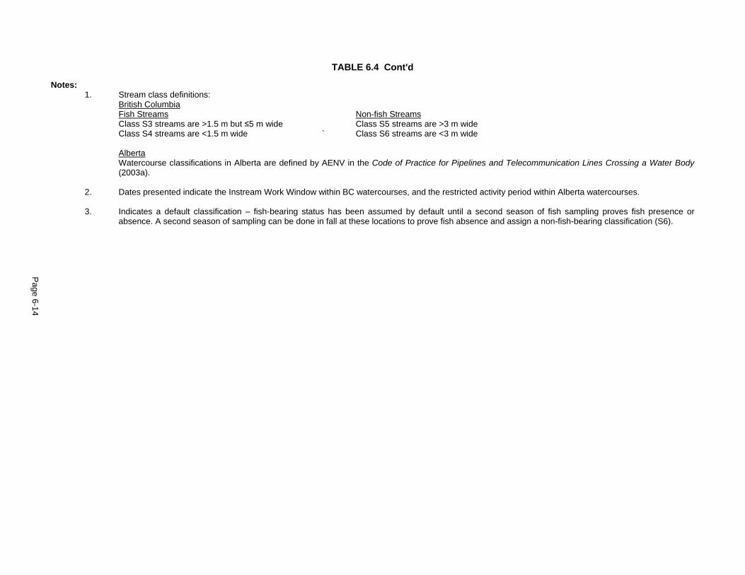
Page 6-14
TABLE 6.4 Cont'd
Notes: 1. Stream class definitions: British Columbia Fish Streams Non-fish Streams Class S3 streams are >1.5 m but ≤5 m wide Class S5 streams are >3 m wide Class S4 streams are <1.5 m wide ` Class S6 streams are <3 m wide Alberta Watercourse classifications in Alberta are defined by AENV in the Code of Practice for Pipelines and Telecommunication Lines Crossing a Water Body
(2003a). 2. Dates presented indicate the Instream Work Window within BC watercourses, and the restricted activity period within Alberta watercourses. 3. Indicates a default classification – fish-bearing status has been assumed by default until a second season of fish sampling proves fish presence or
absence. A second season of sampling can be done in fall at these locations to prove fish absence and assign a non-fish-bearing classification (S6).

SemCAMS Redwillow ULC Supplemental ESA Redwillow Pipeline Project August 2008 / 5489
Page 6-15
TABLE 6.5
SIGNIFICANCE EVALUATION OF RIPARIAN HABITAT
Temporal Context
Adverse Residual Effects Impa
ct B
alan
ce
Spat
ial C
onte
xt
Dur
atio
n
Freq
uenc
y
Rev
ersi
bilit
y
Mag
nitu
de
Prob
abili
ty
Con
fiden
ce
Sign
ifica
nce
1
(a) Alteration or loss of riparian vegetation within permanent valve station site during operation.2
negative Footprint long-term periodic long-term medium high high not significant
Note: 1 Definition of a significant residual effect is provided in Section 6.1.5 of the as-filed ESA. 2 The evaluation of significance has included compensation considerations. Refer to Section 6.0 of Appendix 3 in this
Supplemental ESA for information regarding the Conceptual Fish Habitat Compensation Plan.
6.7 Wetlands
The supplemental wetland study conducted along the proposed reroutes identified approximately 27.8 km of wetland habitat along the pipeline route, comprising approximately 18.5% of the proposed pipeline route (Appendix 4). Peatlands comprise approximately 27.3 km of the wetlands, and less than 500 m of wetland habitat traversed is classified as mineral. An additional 700 m of peatland is located along the Pinto Creek alternate HDD false right-of-way and another 100 m of marsh is traversed by the Wapiti River contingency crossing route. The conclusions of the effects assessment of potential residual effects on mineral wetland and peatland function relative to the pipeline right-of-way, temporary workspace and ESD valve stations (Section 6.2.7 and Table 6.3 of the as-filed ESA) are applicable to the same components of the updated Project. No significant residual impacts to mineral wetland and peatland function resulting from construction and operation of the pipeline and ESD valve stations are identified.
There are no identified wetland concerns associated with the additional temporary facilities (e.g., camps, construction offices) and permanent facilities (e.g., SCADA towers) for the Project. However, several wetlands were identified along the proposed new access for the Project. A total of 21 access road alignments were assessed for wetlands (Appendix 4). Of these, 13 access roads were determined to have no wetland related issues along their proposed alignments and 8 access roads were assessed to be situated within peatland environments. Since peatlands are large features on the landscape and often extend for kilometres in all directions, it is common for the entire length of the proposed access road to be located within an expansive peatland environment (fen or bog). Approximately 3.4 km of wetland environment will be encountered along the proposed access road alignments.
The following mitigation is recommended to maintain peatland habitat and hydrologic functions along access roads.
• On temporary roads where peatlands are encountered, limit clearing, construction and access to frozen conditions to alleviate soil compaction and rutting concerns.
• Do not use corduroy on temporary roads. Install swamp/rig mats in localized wet areas along temporary roads if insufficiently frozen to allow construction traffic without compaction or rutting of the peatland substrate.
• Restrict grading in peatlands along temporary access roads. Where grading is not required, cut, mow or walk down shrubs and small diameter trees in peatlands at ground level. Minimized grubbing will facilitate the restoration of shrub communities and avoid creation of bog holes. Pack snow on road surface to fill in depressions and protect ground surface. Blade off any additional snow to the sides of the Footprint.

SemCAMS Redwillow ULC Supplemental ESA Redwillow Pipeline Project August 2008 / 5489
Page 6-16
• Allow peatland segments of temporary access roads to naturally regenerate following construction. Do not reseed peatlands; natural regeneration is preferred.
• Where permanent access is required within peatlands (e.g., A162), implement one or more of the following options to maintain the hydrological function of the peatland and allow access during non-frozen conditions:
- Install swamp/rig mats over peatland segments of permanent roads.
- Install high strength geotextile fabric over peat before capping with corduroy and/or aggregate material to separate the peat from the aggregate/corduroy, reinforce the area by distributing weight over a wider area, and retain the aggregate while allowing the passage of water. Ensure fill is free of large boulders that may puncture the matting. Minimize depth of fill as much as possible (avoid fill >1 m deep).
- Construct swales or install box culverts (e.g., open bottomed culverts) at frequent intervals (e.g., every 100 m) through peatland segments of the road to allow water to flow under the road when the water levels are high. Place single span bridge over swales to facilitate travel over wet sections. Use high strength geotextile fabric under culverts to prevent them from sinking into the peat, or stabilize the culvert by installing piles through the peat and anchor into underlying mineral soil.
• Monitor peatlands for habitat, hydrologic and water quality function during the post-construction monitoring plan and implement remedial measures if there are indications of impeded peatland function.
Measures recommended to alleviate impacts on peatland water quality function as a result of construction and use of temporary and permanent access roads include:
• Prevent migration of aggregate fill from permanent access into peatlands (e.g., A162) by installing silt fencing or equivalent structures along the road edges.
• Implement the measures recommended above to maintain the hydrologic function of peatlands and avoid changes in nutrient regimes due to flow impedance.
• Avoid access during excessively wet conditions when tracking of mud from adjacent mineral soil segments of the access road into peatland segments is likely. If access is necessary, clean vehicles and equipment of excess mud build-up prior to travel on segments of road across peatlands.
• Monitor approaches of roads (from other roads and the pipeline right-of-way) to identify areas where movement of mineral soil/debris might be eroding and depositing within the peatland edges. Implement remedial measures (e.g., install silt fence or equivalent structure) should monitoring identify areas where sediment/debris is being deposited along peatland edges.
The EPP and Environmental Alignment Sheets will be updated prior to construction to include this mitigation and site-specific recommendations. Potential residual effects of construction and use of access roads on peatland habitat, hydrologic and water quality functions include:
• alteration or loss of peatland habitat function due to access roads;
• alteration of peatland hydrologic function due to permanent access roads; and
• alteration of peatland water quality function due to access roads.
Each of these potential residual effects is discussed and evaluated in the following subsections. The potential residual effects associated with spills along the access roads are consistent with those described and evaluated in Section 6.2.7.2 of the as-filed ESA (under Effects on Mineral Wetlands and Peatlands from Spills or Product Release) and are not repeated in this document.

SemCAMS Redwillow ULC Supplemental ESA Redwillow Pipeline Project August 2008 / 5489
Page 6-17
6.7.1 Peatland Habitat Function
As with pipeline construction (see Section 6.2.7.2 of as-filed ESA), construction and use of access roads within peatlands will likely result in some disruption to the habitat function of wetlands (e.g., potential changes in species composition; stress on rare plant species; interruption of wildlife movements; and fragmentation of natural habitats). With proper construction and the use of proven and effective mitigative measures described previously in Section 6.7 (also refer to Section 5.1.1 of Appendix 4), the adverse effects to peatland habitat function along the temporary access roads are expected to be similar or of lower magnitude to those for the pipeline right-of-way since the surface disturbance will be limited as a result of winter use and the roads will be allowed to regenerate following construction. No significant residual impacts to peatland habitat function resulting from construction and use of the proposed temporary access roads are identified.
Habitat function of peatlands impacted by permanent roads will be altered for a longer period of time, extending through the life of the Project until the road is abandoned and reclaimed. With the implementation of the proposed mitigation measures, the potential alteration of peatland habitat function is considered to be reversible in the short to medium-term for temporary roads and long-term for permanent roads. The magnitude of the residual impacts is low (temporary roads) to medium (permanent roads). Therefore, it is concluded that there are no significant residual effects on peatland habitat function as a result of construction and use of the proposed new permanent access roads. The evaluation of significance is summarized in Table 6.6.
6.7.2 Peatland Hydrologic Function
The vertical and horizontal water movements in wetlands are easily disrupted by any berm-like structure, therefore, the impacts of roads can be especially detrimental to wetland hydrology if not properly mitigated. The hydraulic conductivity of the wetland’s substrate can also be affected by compaction or mixing of the soil structure. Peatlands along the proposed access roads are typically unconsolidated, with large organic components, and consequently, application of mitigation to allow surface and subsurface water flow is necessary to maintain the hydrologic function of the peatlands. Refer to Section 6.2.7.2 of the as-filed ESA (under Alteration of Mineral Wetland and Peatland Hydrologic Function) for further discussion of potential effects associated with changes to hydrologic flow in wetlands.
Construction and use of temporary roads with a peatland component during winter (i.e., frozen) conditions are expected to alleviate compaction and rutting concerns, and potential impacts to the hydrologic function of the peatlands. However, where permanent roads are required within peatlands, additional measures are recommended to prevent the road from acting as a berm and interrupting the hydraulic flow of the peatland. With the implementation of the recommended mitigation described above in Section 6.7, and incorporating adaptive measures to remediate any impacts identified during PCM and ongoing monitoring during operation of the Project, the residual effect of the Project's access roads on peatland hydrologic function is expected to be reversible in the short to long-term and of low to medium magnitude (Table 6.6). Therefore, it is concluded that there are no significant residual effects on peatland hydrologic function as a result of construction and use of the proposed new permanent access roads.
6.7.3 Peatland Water Quality Function
With the implementation of recommended measures to prevent impacts to wetland water quality function as a result of spills (see Section 6.2.7.2 and Table 6.2 of the as-filed ESA), the potential residual effects on peatland water quality as a result of contamination are expected to be effectively mitigated. The conclusions of the assessment of potential residual effects associated with spills along the pipeline in or near wetlands (Section 6.2.7.2 of the as-filed ESA under Effects on Mineral Wetlands and Peatlands from Spills or Product Release) are applicable to the effects associated with potential spills along access roads within wetlands.
Construction of roads and travel along access roads in peatlands during Project construction and operation may result in increased sediment or debris deposition, thereby decreasing overall water quality function. Flow impedance can also result in impacts to water quality due to changes in nutrient levels.
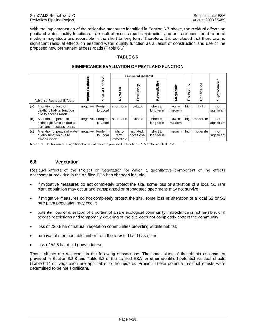
SemCAMS Redwillow ULC Supplemental ESA Redwillow Pipeline Project August 2008 / 5489
Page 6-18
With the implementation of the mitigative measures identified in Section 6.7 above, the residual effects on peatland water quality function as a result of access road construction and use are considered to be of medium magnitude and reversible in the short to long-term. Therefore, it is concluded that there are no significant residual effects on peatland water quality function as a result of construction and use of the proposed new permanent access roads (Table 6.6).
TABLE 6.6
SIGNIFICANCE EVALUATION OF PEATLAND FUNCTION
Temporal Context
Adverse Residual Effects Impa
ct B
alan
ce
Spat
ial C
onte
xt
Dur
atio
n
Freq
uenc
y
Rev
ersi
bilit
y
Mag
nitu
de
Prob
abili
ty
Con
fiden
ce
Sign
ifica
nce
1
(a) Alteration or loss of peatland habitat function due to access roads.
negative Footprint to Local
short-term isolated short to long-term
low to medium
high high not significant
(b) Alteration of peatland hydrologic function due to permanent access roads.
negative Footprint to Local
short-term isolated short to long-term
low to medium
high moderate not significant
(c) Alteration of peatland water quality function due to access roads.
negative Footprint to Local
short-term;
immediate
isolated; occasional
short to long-term
medium high moderate not significant
Note: 1 Definition of a significant residual effect is provided in Section 6.1.5 of the as-filed ESA.
6.8 Vegetation
Residual effects of the Project on vegetation for which a quantitative component of the effects assessment provided in the as-filed ESA has changed include:
• if mitigative measures do not completely protect the site, some loss or alteration of a local S1 rare plant population may occur and transplanted or propagated specimens may not survive;
• if mitigative measures do not completely protect the site, some loss or alteration of a local S2 or S3 rare plant population may occur;
• potential loss or alteration of a portion of a rare ecological community if avoidance is not feasible, or if access restrictions and temporarily covering of the site does not completely protect the community;
• loss of 220.8 ha of natural vegetation communities providing wildlife habitat;
• removal of merchantable timber from the forested land base; and
• loss of 62.5 ha of old growth forest.
These effects are assessed in the following subsections. The conclusions of the effects assessment provided in Section 6.2.8 and Table 6.3 of the as-filed ESA for other identified potential residual effects (Table 6.1) on vegetation are applicable to the updated Project. These potential residual effects were determined to be not significant.

SemCAMS Redwillow ULC Supplemental ESA Redwillow Pipeline Project August 2008 / 5489
Page 6-19
6.8.1 Loss or Alteration of Rare Plants or Rare Ecological Communities
During the supplemental studies conducted within the Project Footprint during spring and summer 2008, no new rare plant species were observed, but 42 new occurrences of previously recorded rare plant species were observed. In addition, four occurrences of two new rare ecological community types and one new special ecological community type were observed within the Footprint. An additional rare community observation was recorded along the Wapiti River contingency crossing route. The new rare ecological community types are: white spruce / red swamp currant / tall bluebells (Picea glauca / Ribes triste / Mertensia paniculata, S3) and aspen / thimbleberry / wild sarsaparilla (Populus tremuloides / Rubus parviflorus / Aralia nudicaulis, S2S3). The new special ecological community is bluejoint - turned sedge (Calamagrostis canadensis - Carex retrorsa, not currently ranked). A 'special ecological community' is 'a community that is unusual, uncommon or of limited extent and so could be considered for addition to the tracking or watch list' (Alberta Natural Heritage Information Centre [ANHIC] 2006). A community dominated by turned sedge has not been previously reported in Alberta, and so may well be considered rare (Allen pers. comm.). Details and proposed site-specific mitigative measures for these populations are provided in Appendix 5 of this Supplemental ESA.
In total, there are 95 rare plant populations (35 more than as-filed), and four occurrences of rare or special ecological communities within the Project Footprint, in addition to one rare community on the Wapiti River contingency crossing route). There were no rare or special communities identified within the Footprint in the as-filed ESA. There were 18 rare plant species observed during the 2008 field surveys, which has not changed from the as-filed ESA. Of the rare species observed, there is one S1 species, four S2 species, seven S2S3 species, four S3 species, one SU species and one species that was S2S3 in 2007 and is now S4. No Committee on the Status of Endangered Wildlife in Canada (COSEWIC) or Species at Risk Act (SARA)-listed species were observed during the surveys conducted in 2008. The rare plant populations and rare/special ecological communities observed within the Footprint are summarized in Tables 6.7 and 6.8. Site-specific mitigation recommendations are identified for each observation within these tables.
Some of the new observations of rare populations and rare communities were determined to be outside the proposed Footprint. These include 12 new populations of 6 rare species and 2 new rare ecological communities. Some of these populations are sufficiently close to the Footprint that they will need to be fenced off to protect them from incidental damage. Details of these populations and proposed mitigation are included in Appendix C of the 2008 Supplemental Vegetation Study (Appendix 5).
Site-specific mitigation has been determined for rare plant populations, where warranted, based on the current Project Footprint (Appendix 5). Refer to Section 6.2.8.2 of the as-filed ESA under S1, S2, S3 Rare Plants for a discussion of the proven effectiveness of the recommended measures on past projects. Should mitigative measures not protect the rare plant populations within the Project Footprint, or transplanted specimens fail to survive, there is potential for residual effects associated with loss of S1, S2 or S3 rare plant populations. There is no change to the classification of residual effects as presented in Section 6.2.8 and Table 6.3 of the as-filed ESA. Therefore, the conclusions of the assessment of potential residual effects on loss of S1, S2 or S3 rare plants provided in Section 6.2.8.2 and Table 6.3 of the as-filed ESA are applicable to the updated Project. Similarly, the conclusions of assessment of residual effects associated with loss or alteration of rare ecological communities provided in Section 6.2.8.2 of the as-filed ESA are applicable to the updated Project. No significant residual impacts to rare plants and ecological communities resulting from construction and operation of the Project are identified.

SemCAMS Redwillow ULC Supplemental ESA Redwillow Pipeline Project August 2008 / 5489
Page 6-20
TABLE 6.7
SUMMARY OF RARE PLANTS WITHIN THE PROPOSED FOOTPRINT AND RECOMMENDED MITIGATION
Legal Location KP Relation to Footprint Mitigative Measures
Macloskey's Violet (Viola pallens) (S2) N1/2 16-68-12 W6M 109.4 Population occurs in drainage that
parallels the proposed right-of-way for 900 m.
Return landscape to original contours in order to maintain similar hydrological function.
NE 16-68-12 W6M ESD10 Population occurs throughout a wetland that covers the proposed ESD 10 and extends to the north and east to the opposite side of an existing road.
Fence and avoid portion of population that is outside ESD 10. Install educational signage and do not spray herbicide.
NE 9 and NW 10-68-11 W6M
120.17 to 120.94
Population occurs over a very large area that overlaps with the proposed right-of-way.
Return landscape to original contours in order to maintain similar hydrological function.
NW 10-68-11 W6M 121.31 Population is 2 m south of proposed centre line.
Geotextile if under strippings/spoil piles, mat if on travel lane. Return landscape to original contours in order to maintain similar hydrological function.
NE 15-68-11 W6M 123.1 Population located 8 m south of proposed centre line in a wetland that parallels the right-of-way for 25 m.
Geotextile if under strippings/spoil piles, mat if on travel lane. Return landscape to original contours in order to maintain similar hydrological function.
SW 24-68-11 W6M 125.4 (and A157)
Population occurs along the edges of a fen, located on the proposed access road and right-of-way.
Geotextile if under strippings/spoil piles, mat if on travel lane.
Pinesap (Monotropa hypopithys) (S2) SE 24-68-11 W6M 126.7 Population occurs 8 m south of
proposed centre line. Geotextile if under strippings/spoil piles, mat if on travel lane.
Autumn Willow (Salix serissima) (S2S3) c-96-G/93-I-15 39.5 Population occurs along the existing
right-of-way for approximately 90 m. Therefore the population may extend onto the western edge of the proposed right-of-way.
Fence and avoid portion of the population that is off the right-of-way. Willow cuttings from plants off the right-of-way may be planted on the right-of-way following construction. Otherwise, clear the right-of-way during frozen conditions and restore original contours.
c-96-G/93-I-15 39.97 to
40.6
Approximately every 5 m a shrub occurs along the existing right-of-way for approximately 630 m. Therefore the population may extend onto the western edge of the proposed right-of-way.
Fence and avoid portion of the population that is off the right-of-way. Willow cuttings from plants off the right-of-way may be planted on the right-of-way following construction. Otherwise, clear the right-of-way during frozen conditions and restore original contours.
61 and 62-G/93-I-152 44.3 to 45
Population occurs along the proposed right-of-way for 480 m.
Fence and avoid portion of the population that is off the right-of-way. Willow cuttings from plants off the right-of-way may be planted on the right-of-way following construction. Otherwise, clear the right-of-way during frozen conditions and restore original contours.

SemCAMS Redwillow ULC Supplemental ESA Redwillow Pipeline Project August 2008 / 5489
Page 6-21
TABLE 6.7 Cont'd
Legal Location KP Relation to Footprint Mitigative Measures
a-62-G/93-I-15 A75 Population occurs on the edge of an existing right-of-way on the proposed access A75.
Willow cuttings from plants off the right-of-way may be planted on the right-of-way following construction. Otherwise, clear the right-of-way during frozen conditions and restore original contours.
d-64-E/93-I-16 64.1 Population spans proposed right-of-way, but does not continue north of right-of-way. Population does continue south of right-of-way.
Willow cuttings from plants off the right-of-way may be planted on the right-of-way following construction. Otherwise, clear the right-of-way during frozen conditions and restore original contours.
Dainty Moonwort (Botrychium crenulatum) (S2S3) c-45-K/93-I-15 A54 Population is on seismic line 40 m
south of Highway 52, and is on the proposed right-of-way.
Fence and avoid.
c-33-K/93-I-15 ESD 4 Population located at boundary stake for ESD 4 on an old access road.
Fence and avoid. Install educational signage and do not spray herbicide.
19, 20, 30J/93-I-15 A58 Population on access road and will be directly impacted.
Transplant with sod to appropriate location.
19, 20, 30J/93-I-15 A58 Population is on the access road and will be directly impacted.
Transplant with sod to appropriate location.
19, 20, 30J/93-I-15 A58 Population on access road and will be directly impacted.
No mitigation recommended. Plants may persist as road may not require grading and will be prepared and used in frozen conditions.
19, 20, 30J/93-I-15 A58 Population on access road and will be directly impacted.
Transplant with sod to appropriate location.
Golden Saxifrage (Chrysosplenium iowense) (S2S3 in BC, S3 in Alberta) a-38-D/93-P-03 17 Population north of proposed centre
line on proposed right-of-way. No mitigation recommended. The plants will likely recolonize.
d-57-K/93-I-15 29.2 Population located 10 m south of the proposed centre line, along a small creek that flows across the proposed right-of-way.
No mitigation recommended.
d-62-G/93-I-152 44.5 Population occurs on existing right-of-way and extends onto the south portion of the proposed right-of way.
No mitigation recommended.
d-28-H/93-I-15 49.7 Population occurs on existing right-of-way, 22 m south of proposed centre line.
No mitigation recommended.
d-98-H/93-I-16 86.28 Population occurs on the proposed right-of -way and continues north off of it.
No mitigation recommended.
c-96-H/93-I-16 87.6 On proposed temporary workspace No mitigation recommended. c-96-H/93-I-16 87.8 Population occurs along proposed
centre line for 82 m, most plants occur north of the centre line.
No mitigation recommended.

SemCAMS Redwillow ULC Supplemental ESA Redwillow Pipeline Project August 2008 / 5489
Page 6-22
TABLE 6.7 Cont'd
Legal Location KP Relation to Footprint Mitigative Measures
NE 9 and NW 10-68-11 W6M
120.44 to
121
Population occurs over a very large area that overlaps with the proposed right-of-way.
No mitigation recommended.
NE 30-68-10 W6M2 129.92 Population located approximately 5 m north of proposed centre line on proposed right-of-way for 17 m of its length.
No mitigation recommended.
SW 26-68-9 W6M 147.1 Population occurs in two patches along drainages that are 125 m apart. The western patch spans the proposed right-of-way, the eastern patch occurs on the south half of the proposed right-of-way.
No mitigation recommended.
SE 26-68-10 W6M 146.77 Population located either on the southwest half of the proposed right-of-way extending southwest off of the Footprint.
No mitigation recommended.
Northern Bog Bedstraw (Galium labradoricum) (S2S3) b-33-K/93-I-15 32.38 Population spans the proposed
centre line, though there are slightly more plants on the north side of the proposed right-of-way.
Return landscape to original contours in order to maintain similar hydrological function of the wetland.
c-50-H/93-I-11 A81 Population located on edge of existing clearing on the west side of the proposed access road.
Return landscape to original contours in order to maintain similar hydrological function of the wetland.
d-63-E/93-I-16 65.25 Population occurs along the edge of a fen, and is along the proposed right-of-way for 20 m.
Return landscape to original contours in order to maintain similar hydrological function of the fen.
d-74-F/93-I-16 ESD 6 and log deck
Population located on ESD 6 and the log deck to the east, and the population extends to the north off of the Footprint.
Fence and avoid population that is off the right-of-way. Install educational signage and do not spray herbicide. Return landscape to original contours in order to maintain similar hydrological function of the wetland.
d-98-H/93-I-16 86.28 Population occurs on the proposed right-of-way and continues north off of it.
Fence and avoid population that is off the right-of-way. Return landscape to original contours in order to maintain similar hydrological function of the wetland.
d-97-H/93-I-16 87.4 Population occurs along proposed centre line.
Return landscape to original contours in order to maintain similar hydrological function of the wetland.
Green Saxifrage (Chrysosplenium tetrandrum) (S3) NW 17-68-13 W6M 96.7 1 to 3 m south of proposed centre
line. Creek parallels proposed right-of-way, meandering across occasionally. Wherever the creek flows onto the right-of-way, this rare plant occurs.
No mitigation recommended.
Red Collar Moss (Splachnum rubrum) (S3) SE 30-68-9 W6M 140.44 Population occurs on dung 4 m south
half of proposed centre line. Move dung piles (those with the moss and piles without it) off the right-of-way to a similar location along a game trail.

SemCAMS Redwillow ULC Supplemental ESA Redwillow Pipeline Project August 2008 / 5489
Page 6-23
TABLE 6.7 Cont'd
Legal Location KP Relation to Footprint Mitigative Measures
Yellow Monkey Flower (Mimulus guttatus) (SU) SW 29-68-9 W6M 141.69 Population occurs on the north half of
the proposed right-of-way where a slash line intersects.
Geotextile if under strippings/spoil piles, mat if on travel lane.
SE 26-68-10 W6M Pinto Creek false right-
of-way1
Population located on the proposed right-of-way.
Geotextile if under strippings/spoil piles, mat if on travel lane.
SE 26-68-10 W6M Pinto Creek false right-
of-way1
Population located on the proposed right-of-way.
Avoid grading and grubbing over the rare plant population. Mow/cut vegetation near ground level. Pack snow over the surface and stumps; grade snow to create a smooth working surface.
Notes: 1 KPs have not been assigned to the Pinto Creek false right-of-way and the Wapiti River contingency crossing route.
2 These populations were recorded in 2008 during a revisit to another previously recorded rare plant population.
TABLE 6.8
SUMMARY OF RARE PLANT COMMUNITIES WITHIN THE PROPOSED FOOTPRINT AND RECOMMENDED MITIGATION
Legal Location KP Recommended Mitigation White Spruce / Red Swamp Currant / Tall Bluebells (Picea glauca / Ribes triste / Mertensia paniculata) (S3) d-57-K/93-I-15 29.4 Fence and avoid portion of the community that is off the right-of-way. Return
landscape to original contours in order to maintain similar hydrological function of the drainage. Do not clear more white spruce trees than is necessary.
a-21-K/93-I-15 35 and A56
Return landscape to original contours in order to maintain similar hydrological function of the drainage.
Aspen / Thimbleberry / Wild Sarsaparilla (Populus tremuloides / Rubus parviflorus / Aralia nudicaulis) (S2S3) NW 9-68-11 W6M Wapiti
Contingency1 Return landscape to original contours in order to maintain similar hydrological function. Do not clear more white aspen trees than is necessary.
Bluejoint - Turned Sedge (Calamagrostis canadensis - Carex retrorsa) (not currently ranked) SW 26-68-9 W6M 147.45 Return landscape to original contours in order to maintain similar hydrological
function of the wetland.
6.8.2 Loss or Alteration of Vegetation Important to Wildlife
As a result of clearing of shrubs and trees within the Footprint, the associated total loss or alteration of vegetation communities providing wildlife habitat is estimated to be approximately 220.8 ha. This is a minimal increase of 0.1 ha over the as-filed estimate, despite an increase in overall Project Footprint assessed of nearly 9.22%. There were no obvious site-specific vegetative habitat features of concern (e.g., wildlife trees) identified during supplemental field studies in 2008 where specific mitigation measures were deemed warranted. However, since it is not practical to carefully examine every tree and shrub potentially providing habitat in proximity to the Footprint, and because the current habitat use is not expected to be static and remain the same when construction commences in 2009, the potential for disruption of wildlife trees is considered high. In the event that a habitat feature of concern is identified during clearing or construction, the mitigative measures outlined in the Plant Species or Ecological Communities of Concern Discovery Contingency Plan and Wildlife Species of Concern Discovery Contingency Plan (Appendix 6C of the as-filed ESA) will be implemented. This effect is reversible in the long-term. Considering that these features are not considered to be of limited availability within the LSA,
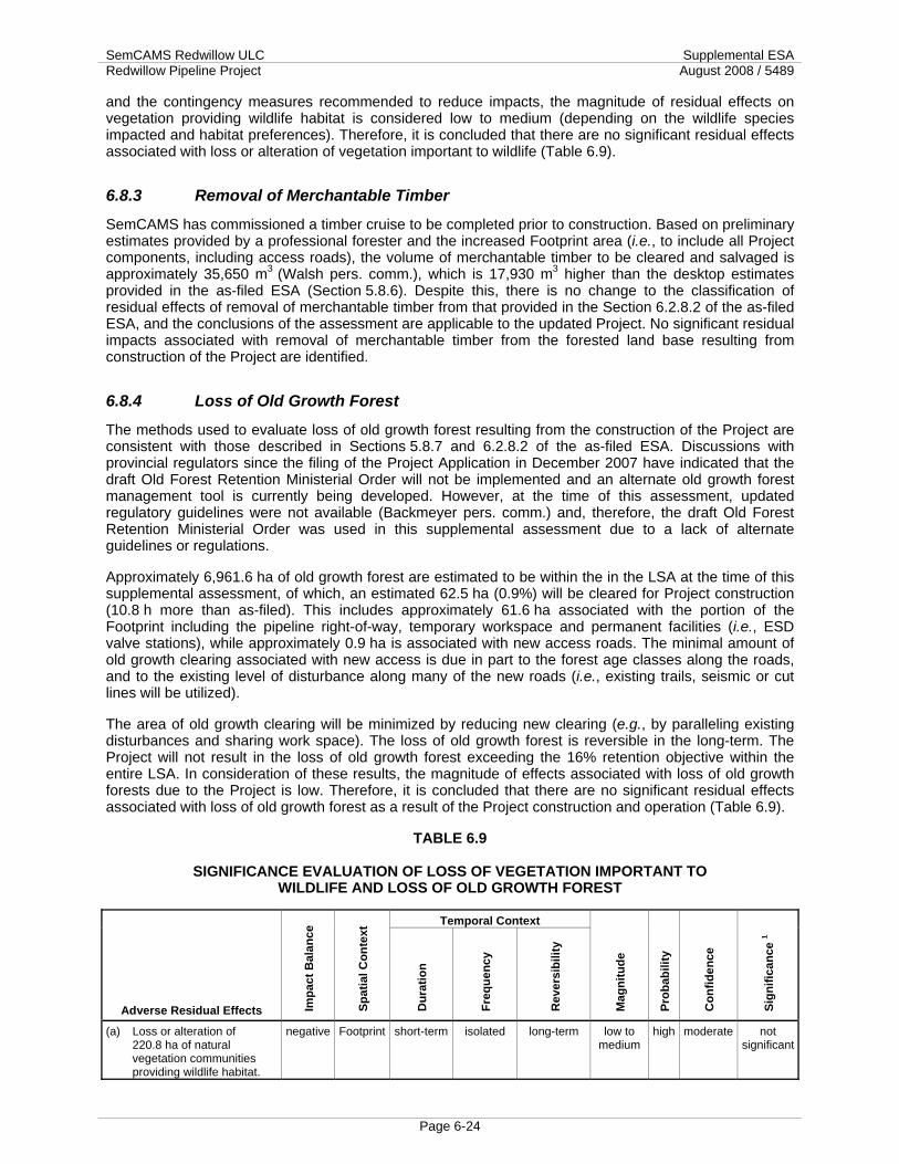
SemCAMS Redwillow ULC Supplemental ESA Redwillow Pipeline Project August 2008 / 5489
Page 6-24
and the contingency measures recommended to reduce impacts, the magnitude of residual effects on vegetation providing wildlife habitat is considered low to medium (depending on the wildlife species impacted and habitat preferences). Therefore, it is concluded that there are no significant residual effects associated with loss or alteration of vegetation important to wildlife (Table 6.9).
6.8.3 Removal of Merchantable Timber
SemCAMS has commissioned a timber cruise to be completed prior to construction. Based on preliminary estimates provided by a professional forester and the increased Footprint area (i.e., to include all Project components, including access roads), the volume of merchantable timber to be cleared and salvaged is approximately 35,650 m3 (Walsh pers. comm.), which is 17,930 m3 higher than the desktop estimates provided in the as-filed ESA (Section 5.8.6). Despite this, there is no change to the classification of residual effects of removal of merchantable timber from that provided in the Section 6.2.8.2 of the as-filed ESA, and the conclusions of the assessment are applicable to the updated Project. No significant residual impacts associated with removal of merchantable timber from the forested land base resulting from construction of the Project are identified.
6.8.4 Loss of Old Growth Forest
The methods used to evaluate loss of old growth forest resulting from the construction of the Project are consistent with those described in Sections 5.8.7 and 6.2.8.2 of the as-filed ESA. Discussions with provincial regulators since the filing of the Project Application in December 2007 have indicated that the draft Old Forest Retention Ministerial Order will not be implemented and an alternate old growth forest management tool is currently being developed. However, at the time of this assessment, updated regulatory guidelines were not available (Backmeyer pers. comm.) and, therefore, the draft Old Forest Retention Ministerial Order was used in this supplemental assessment due to a lack of alternate guidelines or regulations.
Approximately 6,961.6 ha of old growth forest are estimated to be within the in the LSA at the time of this supplemental assessment, of which, an estimated 62.5 ha (0.9%) will be cleared for Project construction (10.8 h more than as-filed). This includes approximately 61.6 ha associated with the portion of the Footprint including the pipeline right-of-way, temporary workspace and permanent facilities (i.e., ESD valve stations), while approximately 0.9 ha is associated with new access roads. The minimal amount of old growth clearing associated with new access is due in part to the forest age classes along the roads, and to the existing level of disturbance along many of the new roads (i.e., existing trails, seismic or cut lines will be utilized).
The area of old growth clearing will be minimized by reducing new clearing (e.g., by paralleling existing disturbances and sharing work space). The loss of old growth forest is reversible in the long-term. The Project will not result in the loss of old growth forest exceeding the 16% retention objective within the entire LSA. In consideration of these results, the magnitude of effects associated with loss of old growth forests due to the Project is low. Therefore, it is concluded that there are no significant residual effects associated with loss of old growth forest as a result of the Project construction and operation (Table 6.9).
TABLE 6.9
SIGNIFICANCE EVALUATION OF LOSS OF VEGETATION IMPORTANT TO WILDLIFE AND LOSS OF OLD GROWTH FOREST
Temporal Context
Adverse Residual Effects Impa
ct B
alan
ce
Spat
ial C
onte
xt
Dur
atio
n
Freq
uenc
y
Rev
ersi
bilit
y
Mag
nitu
de
Prob
abili
ty
Con
fiden
ce
Sign
ifica
nce
1
(a) Loss or alteration of 220.8 ha of natural vegetation communities providing wildlife habitat.
negative Footprint short-term isolated long-term low to medium
high moderate not significant

SemCAMS Redwillow ULC Supplemental ESA Redwillow Pipeline Project August 2008 / 5489
Page 6-25
TABLE 6.9 Cont'd
Temporal Context
Adverse Residual Effects Impa
ct B
alan
ce
Spat
ial C
onte
xt
Dur
atio
n
Freq
uenc
y
Rev
ersi
bilit
y
Mag
nitu
de
Prob
abili
ty
Con
fiden
ce
Sign
ifica
nce
1
(b) Loss of 62.5 ha of old growth forest.
negative Footprint short-term isolated long-term low high high not significant
Note: 1 Definition of a significant residual effect is provided in Section 6.1.5 of the as-filed ESA.
6.9 Wildlife and Wildlife Habitat
Residual effects of the Project on wildlife and wildlife habitat for which a quantitative component of the effects assessment provided in the as-filed ESA has changed include:
• alteration or loss of approximately 220.8 ha of forest cover;
• alteration of approximately 2.1 ha of mineral wetland and peatland with open water;
• alteration of approximately 76.3 ha of peatland habitat;
• alteration or loss of seasonally important habitats; and
• creation of new linear corridor (approximately 51.3 km).
6.9.1 Forest Clearing and Loss or Alteration of Mineral Wetlands and Peatlands
Project construction will result in a total of approximately 220.8 ha of new forest habitat clearing (an increase of 0.1 ha compared to as-filed ESA), including the alteration of approximately 2.1 ha of mineral wetlands/peatland with open water, and 76.3 ha of peatlands (see Appendix VI of the as-filed ESA and Appendix 4 of this Supplemental ESA for detailed description of wetland habitat types). Refer to Section 6.2.10.2 for a discussion pertaining to the potential effects of habitat alteration on wildlife and applicable regulatory guidelines. Refer to Wildlife Habitat Loss or Alteration in Section 6.2.10.2 of the as-filed ESA for further discussion of the effects of habitat loss/alteration on wildlife.
The total area of habitat disturbance will be minimized through the alignment of the pipeline route adjacent to existing disturbances to the extent practical, and shared workspace and access. Appropriate reclamation measures will be applied to disturbed areas within the Footprint as outlined in Table 6.2 and the EPP in the as-filed ESA (e.g., native seed on upland areas, natural regeneration in peatlands, planting of trees and shrubs at select locations). Consistent with the conclusions of the as-filed ESA, the residual effects associated with direct habitat loss or alteration of forest, mineral wetland and peatland wildlife habitat are considered reversible in the short to long-term and of low magnitude. Therefore, it is concluded that there are no significant residual effects on wildlife and wildlife habitat as a result of forest clearing and loss or alteration of wetlands and peatlands due to the Project construction and operation (Table 6.10).
6.9.2 Loss or Alteration of Seasonally Important Habitat
Provincially identified seasonally important habitats that will be directly impacted by the Project include the low elevation winter range for woodland caribou in BC and UWRs associated with Calahoo Creek, the Wapiti River and Pinto Creek in Alberta. Provided the appropriate planning, construction and reclamation measures are implemented to minimize habitat disturbance in these areas and promote rapid regeneration of natural vegetation cover, oil and gas developments are acceptable land uses in these seasonally important habitats. Refer to Section 6.2.10.2 under Loss or Alteration of Seasonally Important

SemCAMS Redwillow ULC Supplemental ESA Redwillow Pipeline Project August 2008 / 5489
Page 6-26
Habitat for further discussion of identified winter ranges and applicable regulatory guidelines and best practices.
Project construction will result in approximately 121.5 ha of direct habitat loss within the caribou low elevation winter range in BC (an increase of 14.3 ha compared to the as-filed ESA) and 31.2 ha within the UWRs along Calahoo Creek, Wapiti River and Pinto Creek in Alberta (an increase of 1.0 ha compared to the as-filed ESA). These figures are conservative estimates since they include lands that have been previously cleared or disturbed (e.g., temporary workspace from construction of existing adjacent rights-of-way), and because surface disturbance along approximately 2.6 km of the route will be avoided by trenchless crossings of watercourses within these identified habitats (i.e., HDD crossings of Flatbed Creek, tributary to Redwillow River, the South Redwillow River, the Wapiti River and Pinto Creek, and the horizontal bore of Calahoo Creek). However, should the contingency route be required to cross the Wapiti River, an additional 2.1 ha of habitat within the UWR would be impacted. Similarly, an additional 3.8 ha of habitat disruption (including approximately 1.8 ha within the UWR) is associated with the false right-of-way for the alternate crossing method at Pinto Creek. This would result in a total of 35.1 ha (4.9 ha more than the as-filed ESA) habitat loss or alteration within the UWRs in Alberta. Indirect habitat alteration can also be expected in areas adjacent to the Footprint as a result of windthrow and increased light penetration. This has not been calculated into the quantitative assessment, but is considered in the overall assessment of residual effects.
Refer to Section 6.2.10.2 of the as-filed ESA for a discussion of the potential for construction activities to disrupt overwintering sites for species such as small mammals and amphibians.
Considering the proposed mitigation and recommendations outlined in Table 6.2 and the EPP in the as-filed ESA, including caribou habitat restoration, the residual effect of alteration or loss of seasonally important habitat is reversible in the long-term and of medium magnitude. Therefore, it is concluded that there are no significant residual effects associated with loss or alteration of seasonally important wildlife habitat due to the Project construction and operation (Table 6.10). This is consistent with the conclusions of the as-filed ESA.
6.9.3 Creation of Linear Corridors
For the purpose of this assessment, new linear corridor resulting from the construction of the Project is defined as segments of the pipeline route and new access roads that are not paralleling or utilizing existing linear corridors. Existing linear corridors include: pipeline rights-of-way; all-weather and seasonal roads, seismic lines; and trails. This definition of new linear corridor is distinctly different from the CEA Act definition of "new cut," which is defined as segments of the pipeline route that are utilizing or adjacent to existing pipeline rights-of-way or all-weather roads.
Approximately 51.2 km of new linear corridor will be created as a result of the proposed pipeline right-of-way along the revised route. An additional 0.1 km of new linear corridor is associated with the new access roads. In total, approximately 51.3 km of new linear corridor will result from the construction of the Project (a 0.5 km increase from the as-filed ESA).
Refer to Creation of Linear Corridors in Section 6.2.10.1 of the as-filed ESA for a discussion of effects on wildlife resulting from linear corridors. With mitigation to reduce access, limit line-of-sight and restore native vegetation within the Footprint (see Table 6.2 of the as-filed ESA), the residual effects from linear corridor creation are of medium magnitude and reversible in the medium to long-term. Therefore, it is concluded that there are no significant residual effects associated with creation of new linear corridors due to the Project construction and operation (Table 6.10). This is consistent with the conclusions of the as-filed ESA.
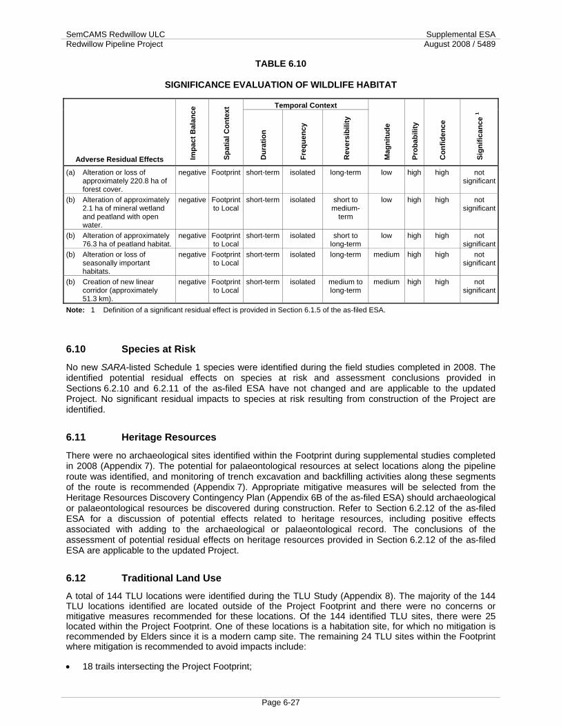
SemCAMS Redwillow ULC Supplemental ESA Redwillow Pipeline Project August 2008 / 5489
Page 6-27
TABLE 6.10
SIGNIFICANCE EVALUATION OF WILDLIFE HABITAT
Temporal Context
Adverse Residual Effects Impa
ct B
alan
ce
Spat
ial C
onte
xt
Dur
atio
n
Freq
uenc
y
Rev
ersi
bilit
y
Mag
nitu
de
Prob
abili
ty
Con
fiden
ce
Sign
ifica
nce
1
(a) Alteration or loss of approximately 220.8 ha of forest cover.
negative Footprint short-term isolated long-term low high high not significant
(b) Alteration of approximately 2.1 ha of mineral wetland and peatland with open water.
negative Footprint to Local
short-term isolated short to medium-
term
low high high not significant
(b) Alteration of approximately 76.3 ha of peatland habitat.
negative Footprint to Local
short-term isolated short to long-term
low high high not significant
(b) Alteration or loss of seasonally important habitats.
negative Footprint to Local
short-term isolated long-term medium high high not significant
(b) Creation of new linear corridor (approximately 51.3 km).
negative Footprint to Local
short-term isolated medium to long-term
medium high high not significant
Note: 1 Definition of a significant residual effect is provided in Section 6.1.5 of the as-filed ESA.
6.10 Species at Risk
No new SARA-listed Schedule 1 species were identified during the field studies completed in 2008. The identified potential residual effects on species at risk and assessment conclusions provided in Sections 6.2.10 and 6.2.11 of the as-filed ESA have not changed and are applicable to the updated Project. No significant residual impacts to species at risk resulting from construction of the Project are identified.
6.11 Heritage Resources
There were no archaeological sites identified within the Footprint during supplemental studies completed in 2008 (Appendix 7). The potential for palaeontological resources at select locations along the pipeline route was identified, and monitoring of trench excavation and backfilling activities along these segments of the route is recommended (Appendix 7). Appropriate mitigative measures will be selected from the Heritage Resources Discovery Contingency Plan (Appendix 6B of the as-filed ESA) should archaeological or palaeontological resources be discovered during construction. Refer to Section 6.2.12 of the as-filed ESA for a discussion of potential effects related to heritage resources, including positive effects associated with adding to the archaeological or palaeontological record. The conclusions of the assessment of potential residual effects on heritage resources provided in Section 6.2.12 of the as-filed ESA are applicable to the updated Project.
6.12 Traditional Land Use
A total of 144 TLU locations were identified during the TLU Study (Appendix 8). The majority of the 144 TLU locations identified are located outside of the Project Footprint and there were no concerns or mitigative measures recommended for these locations. Of the 144 identified TLU sites, there were 25 located within the Project Footprint. One of these locations is a habitation site, for which no mitigation is recommended by Elders since it is a modern camp site. The remaining 24 TLU sites within the Footprint where mitigation is recommended to avoid impacts include:
• 18 trails intersecting the Project Footprint;
SemCAMS Redwillow ULC Supplemental ESA Redwillow Pipeline Project August 2008 / 5489
Page 6-28
• five medicinal plant gathering locales; and
• one sacred area (battleground).
Mitigative measures developed with the participating Aboriginal communities to avoid or reduce impacts to these 24 TLU sites within the Project Footprint include:
• maintaining access along identified trails intersected by the Project Footprint by: leaving breaks in equipment, construction materials, snow piles and soil piles during construction; and leaving gaps in rollback during reclamation and operation of the Project;
• minor route adjustments in two locations to avoid medicinal plant harvesting areas;
• harvesting of medicinal plants by community Elders, following their cultural protocols, in the three locations where reroutes are not feasible due to engineering constraints;
• using mechanical weed suppression methods (e.g., mulching or mowing) in identified areas during operation of the Project, rather than chemical applications;
• use of native seed mixes that include potentially harvestable plant species to reseed select disturbed areas within the Project Footprint identified by Elders and/or community representatives as having importance to traditional plant harvesting; and
• avoiding the sacred battleground site by pursuing the Mt. Not reroute and utilizing alternate access routes so that the need for the A98 temporary access road is eliminated.
Should any other TLU sites be identified during construction activities, appropriate mitigation measures will be implemented following the Contingency Plan as outlined in Appendix A of the TLU study report (Appendix 8) to ensure no negative effects to TLU sites.
In the event that further information is identified through consultation with West Moberly First Nation or Horse Lake First Nations that changes the impacts or conclusions of the TLU Study or this Supplemental ESA, SemCAMS will provide an update to the Board.
The potential residual effects of construction and operation of the Mt. Not reroute segment of the Project on TLU include:
• disturbance of sacred area if the site is not avoided;
• disturbance of short segments of trails;
• alteration of vegetation traditionally used by Aboriginals communities (e.g., medicinal or food source plants); and
• some temporary disturbance of traditional hunting, fishing or trapping activities may occur during the construction phase of the Project.
The rationale used to evaluate the significance of these potential residual effects is provided in the following subsections and summarized in Table 6.11 of this Supplemental ESA.
6.12.1 Trails
Trails identified along the Project include: five pedestrian trails; six pack trails; the Lone Mountain wagon trail, its connection to Kelly Lake, and an old wagon trail that runs along the BC/Alberta border; the Monkman Pass (known by some as “katchimâsik”, or “shortcut”); the Rio Grande to Grande Cache trail; and one ATV trail and one seismic line (Appendix 8).

SemCAMS Redwillow ULC Supplemental ESA Redwillow Pipeline Project August 2008 / 5489
Page 6-29
The communities did not request any site-specific mitigation for trails identified during the TLU study to be intersected by the Project Footprint. Preference was expressed for maintenance of access along active travel corridors during construction and reclamation. Measures recommended to maintain access include:
• leaving breaks in equipment, construction materials, snow piles and soil piles during construction; and
• leaving gaps in rollback during reclamation and operation of the Project.
Should any other active trails be identified during construction, the Contingency Plan outlined in Appendix 8 will be implemented.
These mitigative measures are expected to reduce the magnitude of potential residual effects of the Project on trail use to low. The effects are reversible in the short-term. Therefore, it is concluded that there are no significant residual effects associated with disturbance of trails due to the Project construction and operation (Table 6.11).
6.12.2 Habitation Sites
The forty-eight habitation sites identified during the TLU Study included 5 settlements, 22 cabin sites, 18 camp sites and 3 stores (Appendix 8). Five Settlements were recorded within the Project area, the closest being 3 km south of the Footprint. Participants in the TLU studies reported 22 cabin sites, many with multiple cabins, within the Project area. The majority of the cabins recorded are more than 400 m from the Project Footprint, however, one is within 100 m and one within 60 m. Neither of these two cabin sites will be impacted by the Project and, therefore, no mitigation has been requested by the participating Aboriginal Group. Eighteen camp sites were recorded by participants in the TLU studies. These camp sites included both historic and modern locations. Three of the recorded camp sites are within 100 m of the development, one of which is directly within the Project Footprint. However, this site is a modern camp site and no mitigation was requested from participants. Since none of the remaining campsites will be impacted by the Project, no mitigation was requested. Three historic stores are located within the Project area, all 750 m or more from the development. As such, no mitigative measures have been requested with regard to the three stores recorded during the TLU studies. There are no identified residual effects of the Project on habitation sites.
6.12.3 Traditionally Used Vegetation
Both medicinal and food source plants are reported as being common throughout the general study area (Appendix 8). The specific food source plants harvested included blueberries, wild cranberries, huckleberries and wild onions. It was reported that most of the plants in the boreal forest have a medicinal use. The vast majority of these were common, and could be harvested in many places throughout the forest. There were 13 locations of medicinal and food source plant harvesting reported in relation to the Project, including nine medicinal plant harvesting areas and four food source plant harvesting areas. Of most concern were five medicinal harvesting areas located on or adjacent to the Project Footprint.
The medicinal plant harvesting areas identified during the TLU Study will be mitigated through minor reroutes of the Project at two locations. Where reroutes were not feasible due to engineering constraints, it was recommended by the communities that prior to construction the remaining three locations be harvested by community Elders, following their cultural protocols.
Additional mitigative recommendations regarding medicinal and food source plants include: use of mechanical weed suppression methods (e.g., mulching or mowing) at select areas of interest during operation of the Project, rather than chemical applications; and use of native seed mixes that include potentially harvestable plant species to reseed select disturbed areas within the Project Footprint identified by Elders and/or community representatives as having importance to traditional plant harvesting.
Should any previously-unrecorded medicinal or food source plant harvesting areas be identified during construction, the Contingency Plan outlined in Appendix A of this report will be implemented.

SemCAMS Redwillow ULC Supplemental ESA Redwillow Pipeline Project August 2008 / 5489
Page 6-30
In addition, the proposed mitigation measures outlined in Table 6.2 of the as-filed ESA (under Vegetation element 8) will minimize the amount of disturbance to native vegetation. Impacts to vegetation are reduced by routing adjacent to existing rights-of-way, utilizing shared workspace and access where feasible, using existing linear disturbance for new temporary access and reducing disturbance on the construction right-of-way by minimizing grubbing, grading and packing snow over undisturbed surface soils and root zone on the work and spoil storage areas.
Although the overall balance of the residual effects on traditionally used vegetation is considered negative, there may be some positive effects on traditionally used plants associated with the Project. Positive effects might occur as the cleared Footprint regenerates with higher densities of shrub vegetation, and as increased light penetration into forest edges along the Footprint boundaries may promote increased shrub and herbaceous plant growth. This increased understory vegetation growth could potentially increase productivity of berry-producing shrubs and gathering opportunities.
Implementing the proposed mitigation will reduce the magnitude of residual effects on traditionally used plants to medium. This effect is reversible in the short to long-term, depending on the nature of the medicinal plants of concern (i.e., some plant species may regenerate quickly following the construction and reclamation of the Footprint, while regeneration of other species might extend into the long-term). Therefore, it is concluded that there are no significant residual effects associated with disturbance of trails due to the Project construction and operation (Table 6.11).
6.12.4 Hunting, Fishing and Trapping
Hunting The TLU study area is described as being utilized for hunting and a number of specific hunting related locals were identified. The areas north and south of the Project Footprint were identified as containing good large game habitat that would provide good hunting locations throughout the region. These areas were also identified as good areas for hunting grouse. A number of game trails were identified as intersecting the Project Footprint. Mitigation to reduce impacts to wildlife movement along these trails during construction is provided in Table 6.2 of the as-filed ESA (under Wildlife and Wildlife Habitat element 10.2). Moose licks and springs were identified outside the Footprint and will not be impacted by the Project. No site-specific hunting locations or important game habitat features (e.g., mineral licks) were identified within or adjacent to the Project Footprint. However, 11 general locations along the Project Footprint were identified as providing good habitat for hunted species, and therefore, potential for hunting activities. Elders and community representatives have not requested any mitigative measures with regard to hunting activities in proximity to the Project Footprint; however, should any previously unrecorded site-specific hunting locations be identified during construction, the Contingency Plan outlined in Appendix 8 will be implemented.
Fishing Participating Aboriginal communities identified variation in present and past fishing activity, from little or no active fishing to a heavy reliance on fishing resources as a major subsistence component. Among the communities actively fishing, 12 waterbodies that are fished were identified in the RSA and nearby areas. Of these, the only water bodies within the LSA include the Redwillow River and Stony Lake. Participating members from Aboriginal communities with little to no active fishing within the RSA did not express any concerns regarding the proposed development. Individuals from Aboriginal communities utilizing local fishing resources did raise some concerns regarding the effects of construction on water quality.
No mitigative action was requested by Elders or community representatives related to fishing on watercourses crossed by the Project Footprint. Should any previously unrecorded site-specific fishing locations be identified during construction, the Contingency Plan outlined in Appendix 8 will be implemented.. The measures identified in Table 6.2 of the as-filed ESA (under Water Quality and Quantity element 3 and Fish and Fish Habitat element 6) will be implemented to reduce impacts to water quality and fish habitat.

SemCAMS Redwillow ULC Supplemental ESA Redwillow Pipeline Project August 2008 / 5489
Page 6-31
Trapping Trapping and snaring of animals for food and skins is an on-going Aboriginal activity. Traps and snares may or may not be located within registered traplines as Treaty and Aboriginal Rights provide Aboriginal communities with use of the land outside the bounds of registered traplines. Concerns expressed by both Aboriginal and non-Aboriginal trappers are generally identified and mitigated individually.
Trappers have reported trapping marten, beaver, muskrat and squirrel in the TLU Study Area. They have also trapped lynx in the past but stopped ten years ago to help the lynx population rebound. The presence of trappers in the TLU Study Area can be seen by the recording of the numerous trails and cabins being utilized (see Sections 4.1 and 4.2 in Appendix 8). Many trails recorded in the TLU Study Area can be attributed to a trapper through the distinctive tree-blazes, personalized to individual trappers. These tree-blazes have been recorded at five locations in the TLU Study Area, an indication that the area is being utilized by trappers. Of the five blazed trails identified in the TLU Study Area, four are intersected by the Project Footprint.
Trappers have requested maintenance of access along existing trails during pipeline construction and operation. Members of the Aboriginal communities involved in the TLU study did not request any further mitigative measures with regard to traplines within the TLU Study Area. Should any previously unrecorded trapping locales be identified along the Project Footprint during construction, the Contingency Plan outlined in Appendix 8 will be implemented.
Significance Evaluation Aboriginal hunters, fishers and trappers may experience some minor disturbance of their activities during the short-term construction period. Construction activities may overlap with hunting and trapping activities. Fishing mainly occurs during the open water season and there may be some overlap with clean-up and reclamation activities at watercourse crossings. Existing access routes will be maintained where requested by trappers. Project operation activities are not expected to affect hunting, fishing or trapping. Mitigation measures will avoid or minimize the effects (Table 6.2).
The disruption of hunting, fishing and trapping activities is considered to be reversible in the short-term and of medium magnitude since the effects are approaching the general standards of tolerance. Therefore, it is concluded that there are no significant residual effects on hunting, fishing and trapping due to the Project construction and operation (Table 6.11).
6.12.5 Gathering Places
There were a total of six gathering places identified within the TLU Study Area (Appendix 8). These gathering places often had economic, cultural and ceremonial importance, and at times have a sacred element assigned as well. The closest gathering place to the Project is approximately 500 m south and will not be impacted by the Project. There were no gathering places within or adjacent to the Project Footprint identified during the TLU study.
No request for mitigation was made by Elders with regard to gathering places in proximity to the Project Footprint. Should any previously unrecorded gathering areas be identified during construction, the Contingency Plan outlined in Appendix 8 will be implemented.
There are no identified residual effects of the Project on gathering sites.
6.12.6 Sacred Areas
Thirteen sacred sites were reported in the TLU Study Area during discussions with participating Aboriginal communities (Appendix 8). Of these 13 sites, 9 were individual or multiple burials. One of these burials is located at a historic battleground approximately 17 km from the Project Footprint, and is reported as being haunted. All nine of these burial locations are located outside of the Project Footprint, ranging from 500 m to 40 km from the Project Footprint. The burials range from older elevated ground repositories, to burials in log spirit houses and more recent white-fenced internments. Three of the

SemCAMS Redwillow ULC Supplemental ESA Redwillow Pipeline Project August 2008 / 5489
Page 6-32
identified sacred areas are located outside of the Project area, at distances of 4 km, 10 km and 45 km from the Project Footprint. There were no mitigative requests as these 12 sites since they are located outside of the Project Footprint.
In addition to the battleground/burial site discussed above (located 17 km from the Project Footprint), an additional battleground was identified. This second battleground is intersected by the as-filed pipeline route and the proposed A98 access road. The Project Footprint of the Mt. Not reroute avoids this sacred site. The recommended mitigation is to avoid the site by utilizing the proposed Mt. Not reroute and by utilizing alternate access routes to avoid the A98 access road.
Should any previously unrecorded sacred areas be identified during construction, the Contingency Plan outlined in Appendix 8 will be implemented.
Since the NEB has requested the Mt. Not reroute be evaluated separately from the remainder of the Project, the significance evaluation of residual effects on the sacred battleground, when the recommended mitigation to utilize that reroute and avoid the A98 access road are implemented, are provided in the Mt. Not ESA (TERA 2008a). To be complete, and to allow for comparison of the Mt. Not reroute with the corresponding segment of the as-filed route, the residual effects of the as-filed route on the sacred battleground are evaluated here.
The sacred battleground site identified near the Redwillow River would be directly impacted by the as-filed route. Aboriginal communities have communicated the development would harm the battleground. It is understood that sacred sites may, by their nature in the context of Aboriginal spirituality, be irreplaceable. Since the Mt. Not reroute was considered to be satisfactory, no alternative mitigation was identified by the Aboriginal communities, and potentially appropriate mitigative options were not discussed in detail with the communities. In the event that only the as-filed route is approved by the NEB, mitigative options identified in the Contingency Plan outlined in Appendix 8 and, if warranted, compensation would form the basis for additional consultation with Aboriginal communities and the selection of appropriate mitigation for the site.
The magnitude of the residual effect of the Project on this sacred area should the as-filed route be constructed is considered high, since no acceptable mitigative options were identified by the Aboriginal communities that would alleviate impacts to the site. This effect would be permanent. The spatial context of the effect extends to the Region, since the impacts would be considered to affect communities within the Region. Given the regional extent, high magnitude and irreversibility of the residual effect, there would be a significant impact to this sacred site should the as-filed route be constructed (Table 6.11).
Should the Mt. Not reroute be selected, the sacred battleground site will be avoided since the pipeline route is outside the sacred site and the A98 temporary access is no longer being considered, as requested by the communities. No residual effect on the sacred area is identified for the Mt. Not reroute (see Section 6.6 of the Mt. Not ESA [TERA 2008a]).
6.12.7 Summary of Effects on TLU
The Project will have a significant residual impact on TLU if the as-filed route is constructed since it impacts a sacred area. By constructing along the Mt. Not reroute and by not using the A98 access road, the residual impacts on this sacred area are eliminated. The other identified residual impacts on TLU (i.e., trails, vegetation, hunting, fishing and trapping) are not significant since they do not meet the criteria of a significant adverse residual effect (i.e., a high probability of occurrence of a permanent or long-term residual effect of high magnitude within any spatial context that cannot be technically mitigated or economically compensated).

SemCAMS Redwillow ULC Supplemental ESA Redwillow Pipeline Project August 2008 / 5489
Page 6-33
TABLE 6.11
SIGNIFICANCE EVALUATION OF TRADITIONAL LAND USE
Temporal Context
Adverse Residual Effects Impa
ct B
alan
ce
Spat
ial C
onte
xt
Dur
atio
n
Freq
uenc
y
Rev
ersi
bilit
y
Mag
nitu
de
Prob
abili
ty
Con
fiden
ce
Sign
ifica
nce
1
(a) Disturbance of short segments of trails.
negative Footprint to Local
short-term isolated short-term low high high not significant
(b) Alteration of vegetation traditionally used by Aboriginal communities (e.g., medicinal or food source plants).
negative Footprint short-term isolated short to long-term
medium high high not significant
(c) Some temporary disturbance of traditional hunting, fishing or trapping activities may occur during the construction phase of the Project.
negative Footprint to Local
short-term isolated short-term medium high high not significant
(d) Disturbance of sacred area if the site is not avoided.
negative Footprint to
Region
short-term isolated permanent high high high significant
Note: 1 Definition of a significant residual effect is provided in Section 6.1.5 of the as-filed ESA.
6.13 Human Occupancy and Resource Use
The identified potential residual effects of the Project on human occupancy and resource use have not changed from the as-filed ESA as a result of the updated Project Footprint, scheduling and design; although some minor modifications to the evaluation of effects have been considered. These modifications are noted below.
• In addition to the pipeline right-of-way, temporary work space and ESD valve stations, the proposed new access roads are also considered in the reduction in land base for timber harvest. The effect is reduced by following existing disturbances for 56% of the pipeline route length, utilizing shared access and work space where feasible, and reclaiming temporary access roads upon completion of construction (e.g., seed with native species in disturbed non-wetland areas; allow natural regeneration of vegetation).
• Since the updated schedule proposes to cross all watercourses during frozen conditions, the potential for interference with navigation on watercourses is alleviated, although user satisfaction may be reduced during clean-up and restoration activities planned for summer 2010.
• The addition of equipment and a new 3 m x 3 m building at the CN Rail Perry Creek and TELUS Thunder Mountain SCADA communications sites may have minor visual impacts, but is not expected to change the visual character of the existing communications sites.
These additional considerations do not substantially alter the evaluation of effects on human occupancy and resource use provided in Section 6.2.14 and Appendix XI of the as-filed ESA. The assessment conclusions provided in Section 6.2.14 of the as-filed ESA are applicable to the updated Project. No significant residual impacts on human occupancy and resources use resulting from construction and operation of the Project are identified.

SemCAMS Redwillow ULC Supplemental ESA Redwillow Pipeline Project August 2008 / 5489
Page 6-34
6.14 Social and Cultural Well-Being
The identified potential residual effects of the Project on social and cultural well-being have not changed from the as-filed ESA as a result of the updated Project Footprint, scheduling and design. The assessment conclusions provided in Section 6.2.15 of the as-filed ESA are applicable to the updated Project. No significant residual impacts on social and cultural well-being resulting from construction and operation of the Project are identified.
6.15 Human Health
Results of the updated Human Health Risk Study indicated that anyone within 8 - 21 km downwind of the pipeline would be at risk of serious adverse health effects in the event of an catastrophic accidental release (i.e., ruptures) (Appendix 9 of this Supplemental ESA). Since pipeline leaks and ruptures are very infrequent events (i.e., roughly 5.42 x 10⁻³ and 7.54 x 10⁻⁴ failures/km-year, respectively), risks for individuals residing in the vicinity of the pipeline ranged from 1 to 10 chances in a million for those residing 5.3 to 16.3 km from the pipeline to greater than 100 chances in a million for those residing 1.0 to 2.7 km from the pipeline (Appendix 9). Refer to Section 6.2.16 and Appendix XII of the as-filed ESA for a discussion of the potential human health effects associated with H2S.
During the operation and maintenance of the Project, a combination of incident prevention measures (including stringent design methods), safety devices and emergency response planning and procedures will be implemented to prevent a pipeline failure/rupture and ensure public safety (see Table 6.2 and Section 6.2.19 of the as-filed ESA). Although health impacts in the event of a pipeline failure/rupture are potentially significant, the probability of a pipeline failure/rupture and occurrence of health impacts are low. Therefore, it is concluded that there are no significant residual effects on human health due to the Project construction and operation (Table 6.12).
TABLE 6.12
SIGNIFICANCE EVALUATION OF HUMAN HEALTH RISK
Temporal Context
Adverse Residual Effects Impa
ct B
alan
ce
Spat
ial C
onte
xt
Dur
atio
n
Freq
uenc
y
Rev
ersi
bilit
y
Mag
nitu
de
Prob
abili
ty
Con
fiden
ce
Sign
ifica
nce
1
(a) Adverse human health effects could result in the event of a product release during operation.
negative Region immediate accidental immediate to
permanent
low to high
low moderate not significant
Note: 1 Definition of a significant residual effect is provided in Section 6.1.5 of the as-filed ESA.
6.16 Infrastructure and Services
The identified potential residual effects of the Project on infrastructure and services have not changed from the as-filed ESA as a result of the updated Project Footprint, scheduling and design. The assessment conclusions provided in Section 6.2.17 of the as-filed ESA are applicable to the updated Project.
6.17 Employment and Economy
An updated economic effects analysis was completed for the Project by Decision Economics (Appendix 10) because of updated Project cost estimates. Results of the analysis indicate that construction of the Project is expected to result in expenditures on goods and services in Canada of approximately $151.2 million. This expenditure is estimated to lead to increased gross domestic product

SemCAMS Redwillow ULC Supplemental ESA Redwillow Pipeline Project August 2008 / 5489
Page 6-35
of $107.6 million, labour income of $75.0 million and 1,574 direct and indirect person-years of employment (Appendix 10).
The economic activity is estimated to generate increased tax revenues of $17.0 million for the Government of Canada, $3.9 million for the Government of BC and $3.6 million for the Government of Alberta. Annual property taxes of approximately $393,000 would be paid to municipalities in BC and $109,000 would be paid to municipalities in Alberta (Appendix 10).
These economic effects are considered positive; therefore, no significance evaluation is required.
The other potential residual effects of the Project on procurement and employment opportunities identified in the as-filed ESA (Section 6.2.18) have not changed as a result of the updated Project Footprint, scheduling and design. The conclusions provided in Section 6.2.18 of the as-filed ESA are applicable to the updated Project.
6.18 Accidents and Malfunctions
The identified potential residual effects of the Project resulting from accidents and malfunctions have not changed from the as-filed ESA as a result of the updated Project Footprint, scheduling and design. The assessment conclusions provided in Section 6.2.19 of the as-filed ESA are applicable to the updated Project.
6.19 Decommissioning and Abandonment
Refer to Section 6.4 of the as-filed ESA for a discussion of effects resulting from decommissioning and abandonment of the Project. The updated Project Footprint, scheduling and design do not change the conclusions provided in Section 6.4 of the as-filed ESA.
6.20 Effects of the Environment on the Project
Refer to Section 6.5 of the as-filed ESA for a discussion of effects of the environment on the Project. The assessment conclusions provided in Section 6.5 of the as-filed ESA are applicable to the updated Project.
6.21 Summary of Supplemental Effects Assessment
All of the potential residual effects and significance evaluations provided in the as-filed ESA were re-evaluated to consider updates to the Project (including minor reroutes, schedule and design modifications), changes to regulatory standards (i.e., updated version of ERCBH2S dispersion model), and the results of supplemental studies completed in 2008. Most of the identified residual effects and assessments did not change from those presented in the as-filed ESA and the conclusions of the assessment of these effects provided in the as-filed ESA remain applicable to the updated Project.
Where a quantitative component to the assessment of residual effects changed as a result of the updated Project, the residual effect was reassessed in this Supplemental ESA. These quantitative changes are described in the evaluation of each residual effect to provide context. Some effects or elements (e.g., TLU) were not evaluated in the as-filed ESA and are also included in the supplemental assessment. This supplemental assessment evaluated the effects in the context of the entire Project, not just the change since the as-filed ESA.
The residual effects for which an updated or new effects assessment was conducted in this Supplemental ESA include:
• Reduced soil productivity along new permanent roads during construction and operation.
• Localized alteration of natural drainage patterns where new access intersects drainages.
• Reduction in surface water quality due to suspended solids in run-off water along roads and ditches.
SemCAMS Redwillow ULC Supplemental ESA Redwillow Pipeline Project August 2008 / 5489
Page 6-36
• Alteration or loss of riparian vegetation within permanent valve station site during operation.
• Alteration or loss of peatland habitat function due to access roads.
• Alteration of peatland hydrologic function due to permanent access roads.
• Alteration of peatland water quality function due to access roads.
• Loss or alteration of 220.8 ha of natural vegetation communities providing wildlife habitat.
• Loss of 62.5 ha of old growth forest.
• Alteration or loss of approximately 220.8 ha of forest cover.
• Alteration of approximately 2.1 ha of mineral wetland and peatland with open water.
• Alteration of approximately 76.3 ha of peatland habitat.
• Alteration or loss of seasonally important habitats.
• Creation of new linear corridor (approximately 51.3 km).
• Disturbance of short segments of trails.
• Alteration of vegetation traditionally used by Aboriginal communities (e.g., medicinal or food source plants).
• Some temporary disturbance of traditional hunting, fishing or trapping activities may occur during the construction phase of the Project.
• Disturbance of sacred area if the site is not avoided.
• Adverse human health effects could result in the event of a product release during operation.
Through the implementation of the recommended proven and effective mitigative measures, the residual effects associated with the construction and operation of the Project on biophysical and socio-economic elements were considered to be not significant for all elements except TLU. TLU was assessed in this Supplemental ESA and determined to have a significant residual impact on a sacred area should the as-filed route be constructed. This residual effect is avoided if the Mt. Not reroute is constructed and the A98 access road is not used.
6.22 Details
Detail 1 Typical Cross Drain Culvert
Detail 2 Typical Cross Ditch
Detail 3 Natural Drainage Path and Designed Road Drainage

Notes: 1. The above drawing is a schematic diagram. An engineer should be consulted for the detailed site specific drainage control
design, appropriate locations, and the installation of cross drain culverts. 2. Install clearly visible culvert markers on the ditch side for all plastic and metal cross drain culverts where the inlet is at risk due to
grading or snow removal. 3. Protect the inlet of culverts from encroachment of road embankment fill materials. 4. Where sedimentation is a problem, construct catch basins adjacent to the inlet of cross drain culverts. 5. Except where ditch water converges at the culvert, install ditch blocks immediately downstream of all cross drain culvert inlets. 6. Construct the crest of ditch blocks lower than the road shoulder. 7. Skew culvert to road centreline by 3° for each 1% that road grade exceeds 3%, to a maximum of 45°, with a minimum slope 2%.
Otherwise, provide suitable mitigative measures to minimize erosion. 8. Protect the outlet of culverts from encroachment of road embankment fill materials. 9. Protect unstable or erodible fill at culvert outlets with flumes, riprap or other erosion resistant materials. Adapted from BC Oil and Gas Guidelines (1995)
REDWILLOW PIPELINE PROJECT
TYPICAL CROSS DRAIN CULVERT
5489 August 2008 Detail 1

Notes: 1. The above drawing is a schematic diagram. An engineer should be consulted for the detailed site specific drainage control
design, appropriate locations, and the installation of cross ditches. 2. The purpose of a typical cross ditch is to capture and divert both road surface water and ditch water off and/or across the road. 3. Excavate a cross ditch to a depth that will allow a direct hydraulic connection to roadside ditch. 4. Construct cross ditch with minimum skew angle of 30° to the perpendicular of the road ditch line. 5. Install a berm on downgrade side of cross ditch. 6. Provide erosion protection as necessary at the outflow. 7. Flatten berm and widen ditch to accommodate vehicle traffic, as necessary.
REDWILLOW PIPELINE PROJECT
TYPICAL CROSS DITCH
5489 August 2008 Detail 2

Notes: 1. The above drawing is a schematic diagram. An engineer should be consulted for the detailed site specific drainage control
design, appropriate locations, and the installation of culverts and ditch blocks. 2. Ditch blocks are installed to ensure that runoff is caught at the small diameter culverts and drains away. If culverts B, C, D and E
were not in place with the ditch blocks, then large volumes of water would erode the ditch and could flood culvert A, resulting in a road washout. Construct ditch blocks so that the crest of the block is at least 0.3 m lower than the adjacent road grade to allow water flow to continue to the next section of ditchline rather than being directed onto the roadway surface if a culvert becomes plugged.
3. Drainage structure design should maintain the active width of the channel. 4. To protect the downslope side of the road, a downspout terminating in riprap is on the discharge of each culvert. The end result,
as illustrated above, is an example that follows the rule of restoring the natural drainage as near as possible to its original state. 5. Proper drainage from the culvert is important to ensure that water and silt exit away from the road grade but do not create
erosion problems. Drainage structures such as ditches, culverts and cross drains should not discharge directly into a watercourse.
6. Depending on the slope of the land, the culvert exit may be flush with original ground level or elevated from the original ground level.
7. Installation of culverts is not recommended at stream crossings where fish utilization is known to occur. Culverting a fish-bearing stream must receive approval from fisheries agencies. Culvert installation must then be carried out in such a manner that fish passage is accommodated during the period of fish utilization.
Adapted from BC Oil and Gas Guidelines (1995) and BC Ministry of Forests (2002)
REDWILLOW PIPELINE PROJECT
TYPICAL NATURAL DRAINAGE PATH AND DESIGNED ROAD DRAINAGE
5489 August 2008 Detail 3

SemCAMS Redwillow ULC Supplemental ESA Redwillow Pipeline Project August 2008 / 5489
Page 7-1
7.0 CUMULATIVE EFFECTS ASSESSMENT Potential cumulative environmental effects associated with the proposed reroutes and Project modifications (e.g., access) were assessed by Salmo Consulting Inc. (Salmo) using the numerical cumulative effect indicators identified in the Methodology section of the as-filed ESA (Section 7.2.6) (see Appendix 11 of this Supplemental ESA). The cumulative effects indicators used include:
• Total Cleared or Disturbed Area;
• Access Corridor Density;
• Core Area; and
• Riparian Disturbance.
The indicator results for the as-filed route and the updated results for the proposed reroute and other Project modifications are provided in Tables 1 through 7 in Appendix 11. The cumulative effects assessment methodology is consistent with that described in the as-filed ESA (Sections 7.2.6.1 to 7.2.6.6). Table 1 in Appendix 11 provides indicator results for the entire revised pipeline route, Tables 2 through 4 provide terrestrial indicator results for the Central Canadian Rockies, Western Boreal and Western Alberta Upland ecoregions, respectively, and aquatic indicators are provided in Tables 5 through 7 for the Wapiti, Murray, and Redwillow drainages, respectively.
The as-filed assessment revealed a high level of existing land use throughout the RSA (Section 7.3 in the as-filed ESA). The original route and proposed minor changes and access corridors are mainly within the direct and indirect Footprint of existing land use. Similar to the as-filed route, the proposed minor reroutes and associated facilities and access are generally contained within the direct and indirect Footprint of the existing land use. This is reflected in the negligible change in cumulative effect indicator results. At the regional scale (i.e., Appendix 11 Table 1, which presents indicator results for the entire revised route), there is no change in corridor density, stream crossing density, or core area using the 500 m zone-of-influence, when compared to the as-filed route indicator results. The proposed reroutes and associated facilities/access result in a slight increase in cleared area and a slight decrease in core area using the 250 m zone-of-influence, although neither results in changes at the RSA scale. At the subregional scale, either reported by ecoregion (Tables 2 through 4 in Appendix 11) or by watershed (Tables 5 through 7 in Appendix 11), changes in cleared area or core compared to the as-filed route, are generally spread across the route with negligible changes (e.g., <0.02% change) apparent in any subregion.
Given the negligible change in numerical cumulative effects indicators resulting from proposed reroutes and associated facilities and access, the conclusions provided for the route in the as-filed ESA, Section 7.4 are also applicable to the proposed changes. With the implementation of the recommended proven and effective mitigative measures, and compensation where warranted, there are no significant cumulative effects identified as a result of Project construction and operation.

SemCAMS Redwillow ULC Supplemental ESA Redwillow Pipeline Project August 2008 / 5489
Page 8-1
8.0 CONCLUSION This Supplemental ESA follows the requirements of the NEB Filing Manual (2004) and provides the results of the supplemental studies and assessment completed to address the items identified in Section 9.0 of the as-filed ESA and minor modifications in Project details that have occurred since the Application was filed in December 2007. Supplemental studies were undertaken for the following elements: geology; soil productivity; greenhouse gases (GHG) and air quality; fish and fish habitat; wetlands; vegetation; wildlife and wildlife habitat; heritage resources; traditional land use; human health; and economic impacts. Result of these studies and site-specific recommendations to mitigate potential impacts are provided in the Appendices and summarized in Sections 5 and 6 of this Supplemental ESA.
All of the potential residual effects and significance evaluations provided in the as-filed ESA were re-evaluated to consider updates to the Project (including minor reroutes, schedule and design modifications), changes to regulatory standards (i.e., updated version of ERCBH2S dispersion model), and the results of supplemental studies completed in 2008. Most of the identified residual effects and assessments did not change from those presented in the as-filed ESA.
Through the implementation of the recommended mitigative strategies, the residual effects associated with the construction and operations of the Project were considered to be not significant for all elements except TLU.
TLU was assessed in this Supplemental ESA and it was determined that construction of a short segment of the as-filed route west of the Redwillow River crossing would have a significant residual impact on a sacred area. This residual effect can be avoided if the Mt. Not reroute is constructed and the A98 access road is not used. Since the Mt. Not reroute is a viable and preferred routing option, and there is alternate access available to A98, no further alternatives have been evaluated.
Through the implementation of the recommended mitigative strategies, the residual effects associated with the construction and operation of the Project were considered to be not significant for all elements except TLU.
Similar to the as-filed route, the proposed minor reroutes and associated facilities and access are for the most part contained within the direct and indirect Footprint of the existing land use. This is reflected in the negligible change in cumulative effect indicator results. Given the negligible change in numerical cumulative effects indicators resulting from the proposed reroutes and associated facilities and access, the conclusions provided for the as-filed route in the as-filed ESA (Section 7.4) are also applicable to the proposed changes.
The mitigative strategy adopted for the Project and presented in the as-filed ESA is applied to the updated Project. The EPP and Environmental Alignment Sheets will be updated following completion of detailed design to incorporate the finalized Project details and appropriate mitigation. The completion of the updated EPP and Environmental Alignment Sheets is anticipated in early 2009. The key components developed to reduce the magnitude of potential environmental and socio-economic effects and enhance the reversibility of these residual effects are routing, consultation, mitigation, monitoring, and restoration or compensation where appropriate. Contingency measures have been developed in the event that site-specific environmental concerns are identified during construction (Appendix 6B of the as-filed ESA and Appendix 8 in this Supplemental ESA).
The implementation of the proposed mitigative measures will ensure the environmental and socio-economic effects associated with the construction and operation of the Project are minimized.
SemCAMS Redwillow ULC Supplemental ESA Redwillow Pipeline Project August 2008 / 5489
Page 9-1
9.0 REFERENCES
9.1 Personal Communications
Allen, L. Senior Vegetation Ecologist. Alberta Natural Heritage Information Centre. Edmonton, Alberta.
Backmeyer, R. Planning Officer (MKMA), BC Integrated Land Management Bureau, Fort St. John, BC.
Walsh, C. Professional Forest Technologist, Allterra Ltd. Grande Prairie, Alberta.
9.2 Literature Cited
Alberta Community Development. 2001. Environmentally Significant Areas of the Rocky Mountain Natural Region of Alberta. 1:1,000,000 map. Parks and Protected Areas Division. 1:1,000,000 map.
Alberta Culture and Community Spirit. 2008. Listing of Significant Historical Sites and Areas, Public Version. Edmonton 2008.
Alberta Energy. 2008. Land Status Automated System (LSAS). Project-specific search request completed May 2008.
Alberta Fish and Wildlife Division. 1985. Wildlife Key Area Map. Wapiti-83L. ASRD Fish and Wildlife Division.
Alberta Native Plant Council. 2006. Plant Collection Guidelines for Researchers, Students and Consultants. Website: http://www.anpc.ab.ca/assets/researchers_students.pdf.
Alberta Sustainable Resource Development. 2005. 2005 Natural Regions and Subregions of Alberta. Published with Alberta Environment, Alberta Community Development and Agriculture and Agri-Food Canada. Website: http://tprc.alberta.ca/parks/heritageinfocentre/docs/nsr2005_final_letter.pdf.
Alberta Sustainable Resource Development. 2008. 2008 Alberta Guide to Hunting Regulations. Website: http://www.albertaregulations.ca/huntingregs/. Accessed May 2008.
Alberta Sustainable Resource Development. 2007. NW1-Smoky Area Land Management Referral Map. 1:250,000 map. April 2007.
Andriashek, L.D. 2001. Surficial Geology of Wapiti Area, NTS 83L. 1:250,000 map.
British Columbia Conservation Data Centre. 2008. Conservation Data Centre Mapping Service. Victoria, British Columbia, Canada. Website: http://www.env.gov.bc.ca/atrisk/ims.htm. Accessed: May 2008.
BC Integrated Land Management Bureau. 1999. Dawson Creek Land and Resource Management Plan. Website: http://ilmbwww.gov.bc.ca/slrp/lrmp/fortstjohn/dawson_creek/plan/index.html Accessed: June 2008.
BC Ministry of Energy, Mines and Petroleum Resources. 1995. BC Oil and Gas Handbook. November 1995.
BC Ministry of Energy, Mines and Petroleum Resources. 2007. Digital Terrain and Soil Map Library. Website: http://www.em.gov.bc.ca/Mining/Geolsurv/Terrain&Soils/frbcguid.htm.
BC Ministry of Environment. 1977. Biophysical Soil Resources and Land Evaluation of the Northeast Coal Study Area 1976 - 1977. 93I15/E Surficial Geology map. 1: 50,000 map.
BC Ministry of Environment. 2006. South Peace Goat, Caribou and Sheep Ungulate Winter Range Polygons. June 20, 2006. 1:50,000 Scale.
BC Ministry of Environment. 2007a. Peace Region 7B: Management Units. Website: http://www.env.gov.bc.ca/fw/wildlife/hunting/regulations/0708/docs/Region_7B.pdf

SemCAMS Redwillow ULC Supplemental ESA Redwillow Pipeline Project August 2008 / 5489
Page 9-2
BC Ministry of Environment. 2007b. Floodplain Mapping. Website: http://www.env.gov.bc.ca/wsd/data_searches/fpm/index.html. Accessed: July 2008.
BC Ministry of Environment. 2007c. British Columbia Water Resources Atlas. Website: http://www.env.gov.bc.ca/wsd/data_searches/wrbc/. Accessed: July 2008.
BC Ministry of Environment. 2007d. Fisheries Inventory: Data Queries Tool. Website: www.env.gov.bc.ca/fish/fidq/index.html. Accessed: July 2008.
BC Ministry of Environment. 2007e. Peace Region Environmental Protection Division. Website: http://www.env.gov.bc.ca/epd/regions/peace/air/links.html. Accessed: July 2008.
BC Ministry of Environment. 2008a. Land and Resource Data Warehouse Catalogue. Online map. Website: http://maps.gov.bc.ca/imf50/imf.jsp?site=lrdw_catalog_ext.Accessed: July 2008.
BC Ministry of Environment. 2008b. Air Quality Online. Water, Air and Climate Change Branch. Website: http://a100.gov.bc.ca/pub/aqiis/air.summary. Accessed: July 2008.
BC Ministry of Forests. 2002. Forest Road Engineering Guidebook. Second edition. June 2002. Forest Practices Branch, BC Ministry of Forests, Victoria, BC. Forest Practices Code of British Columbia Guidebook. Website: http://www.for.gov.bc.ca/tasb/legsregs/fpc/FPCGUIDE/Road/FRE.pdf. Accessed: August 2008.
BC Ministry of Forests and Range. 2007a. Protection Branch. Fire Locations. Website: http://www.bcwildfire.ca/History/firelocations.htm. Accessed: July 2008.
BC Ministry of Forests and Range. 2007b. Peace Forest District. Website: http://www.for.gov.bc.ca/dpc/. Accessed: July 2008.
BC Ministry of Forests and Range. 2008. Biogeoclimatic Ecosystem Classification Subzone/Variant Map for the Peace Forest District, Dawson Creek Subunit, Northern Interior Forest Region. 1:250,000 scale map. Website: ftp://ftp.for.gov.bc.ca/HRE/external/!publish/becmaps/PaperMaps/field/ Accessed: May - July 2008
BC Ministry of Tourism, Sports, and Arts. Interactive Map of Recreation Sites. 2008. Website: http://www.tsa.gov.bc.ca/sites_trails/finding/launch_interactive_map.htm Accessed: July 2008.
Canada Department of Agriculture. 1972. Peace River Land Capability Analysis. Cartography by the Soil Research Institute, Research Branch, Canada Department of Agriculture, with the support of the Lands Directorate, Lands, Forests and Wildlife Service, Department of the Environment. Base map and printing by the Surveys and Mapping Branch, Department of Energy, Mines and Resources. Ottawa.
Canada Land Inventory. 1970a. Land Capability for Wildlife - Ungulates. Dawson Creek 93P. 1: 250,000 map.
Canada Land Inventory. 1970b. Land Capability for Wildlife - Waterfowl. Dawson Creek 93P. 1: 250,000 map.
Canada Land Inventory. 1970c. Land Capability for Wildlife - Waterfowl. Wapiti 83L. 1: 250,000 map.
Canada Land Inventory. 1971a. Land Capability for Wildlife - Waterfowl. Monkman Pass 93I. 1: 250,000 map.
Canada Land Inventory. 1971b. Land Capability for Forestry. Wapiti 83L. 1: 250,000 map.
Canada Land Inventory. 1974. Land Capability for Wildlife - Ungulates. Wapiti 83L. 1: 250,000 map.
Canada Land Inventory. 1975. Land Capability for Wildlife - Ungulates. Monkman Pass 93I. 1: 250,000 map.
Canada Land Inventory. 2000. Geogratis - Canada Land Inventory. Website: http://geogratis.cgdi.gc.ca/CLI/frames.html. Accessed: November 2007.

SemCAMS Redwillow ULC Supplemental ESA Redwillow Pipeline Project August 2008 / 5489
Page 9-3
District of Tumbler Ridge. 2005. District of Tumbler Ridge Official Community Plan. Website: http://www.tumblerridge.ca/mh/documents/OCP.pdf. Accessed: July 2008.
District of Tumbler Ridge. 2006. District of Tumbler Ridge Zoning Bylaw No. 517. Website: http://www.tumblerridge.ca/mh/documents/ZoningBylawTextFinal.pdf. Accessed: July 2008.
Ducks Unlimited Canada. 2006. Ducks Unlimited Canada Projects within Peace River Zone 2. Website: http://www.ducks.ca/province/bc/projects/summary/pdf/pr2.pdf. Accessed: July 2008.
Environment Canada. 2005. Narrative Descriptions of Terrestrial EcoZones and Ecoregions of Canada. Website: http://www.ec.gc.ca/soer-ree/English/Framework/Nardesc/borpln_e.cfm. Accessed: June 2008.
Environment Canada. 2008. Environment Canada's Protected Areas Network. Website: http://www.hww.ca/hww2.asp?id=231#sid79
Federal Environmental Assessment Review Office. 1994. A reference guide for the Canadian Environmental Assessment Act: Addressing cumulative environmental effects. Prepared by the Federal Environmental Assessment and Review Office. Hull, Quebec. 23 pp.
Freshwater Fisheries Society of British Columbia. 2007. FishWizard searchable online fish database. B.C. Ministry of Forestry & Freshwater Fisheries Society of British Columbia. Website: http://maps.gov.bc.ca/imf50/imf.jsp?site=libc_awiz
Geological Survey of Canada. 1980. Map 1467A Surficial Geology Dawson Creek West of the Sixth Meridian British Columbia. 1:250,000 map.
Geological Survey of Canada. 1995. Canada Permafrost online map. The Atlas of Canada, 5th Edition. Website: http://atlas.nrcan.gc.ca/site/english/maps/archives/5thedition/environment/land/mcr4177. Accessed: July 2008.
Geowest Environmental Consultants Ltd. 1996. Environmentally Significant Areas Inventory of Selected Portions of the Boreal Forest Natural Region, Alberta. 143 pp.
Hamilton, W.N, M.C. Price and C.W. Langenburg. 1999. Geological Map of Alberta. Alberta Geological Survey, Alberta Energy and Utilities Board, Map No. 236. 1:100,000 map.
Hegmann, G., C. Cocklin, R. Creasey, S. Dupuis, A. Kennedy, L. Kingsley, W. Ross, H. Spaling, and D. Stalker. 1999. Cumulative effects assessment practitioners guide. Prepared by AXYS Environmental Consulting Ltd. and the CEA Working Group for the Canadian Environmental Assessment Agency, Hull, Quebec.
IHS Incorporated. 2008. Project-specific data requests conducted by IHS Incorporated. May 2008.
Important Bird Areas of Canada. 2004. Canadian IBA On-Line Directory. Website: http://www.ibacanada.com/sites.html. Accessed: July 2008.
Lord, T.M. and K.W.G. Valentine. 1972. The Soil Map of British Columbia. Website: http://srmwww.gov.bc.ca/soils/landscape/3.2soilmap.html
McCann, T.J. 2000. 1998 Fossil Fuel and Derivative Factors, prepared for Environment Canada by T.J. McCann and Associates.
McMechan, M.E. 1994. Geology and structure cross-section, Dawson Creek, British Columbia. Geological Survey of Canada, Map 1858A. 1:250,000 map.
Meidinger, D.V. and J. Pojar. 1991. Ecosystems of British Columbia. BC Ministry of Forests. Victoria, BC.
Mentiga Pedology Consultants. 2007. Soils Assessment Report for the Proposed Redwillow ULS Redwillow Pipeline Project. Prepared for SemCAMS Redwillow ULC. Submitted to TERA Environmental Consultants.

SemCAMS Redwillow ULC Supplemental ESA Redwillow Pipeline Project August 2008 / 5489
Page 9-4
Mussio, Russell; Wesley Mussio, Penny Stinton-Mussio (Directors). 2006. Northern BC Backroad Mapbook – Outdoor Recreation Guide First Edition. Mussio Ventures Ltd, Burnaby, BC.
National Energy Board. 2004. Filing Manual. Calgary, Alberta.
NRC. 2007a. Canada's Wetlands. Website: http://wetlands.cfl.scf.rncan.gc.ca/regions/distribution-eng.asp. Accessed: July 10, 2007.
NRC. 2007b. Earthquake Database. Website: http://earthquakescanada.nrcan.gc.ca/stnsdata/nedb/bull_e.php Accessed: June, 2008
NRC. 2007c. Major Landslides in Canada. Online map. The Atlas of Canada. Website: http://atlas.nrcan.gc.ca/site/english/maps/environment/naturalhazards/majorlandslides. Accessed: June, 2008
NRC. 2007d.Major Floods in Canada. Online map. The Atlas of Canada. Website: http://atlas.nrcan.gc.ca/site/english/maps/environment/naturalhazards/#floods . Accessed: June, 2008
NRC. 2007e. Major Avalanches in Canada. Online map. The Atlas of Canada. Website: http://atlas.nrcan.gc.ca/site/english/maps/environment/naturalhazards/majoravalanches. Accessed: June, 2008
NRC. 2007f. Canadian Wildland Fire Information System. Website: http://cwfis.cfs.nrcan.gc.ca/en/historical/ha_fw_e.php
Pettapiece, W.W. 1986. Physiographic subdivisions of Alberta. Agriculture Canada. 1:1,500,000 map.
Province of British Columbia. 1998. Preliminary Seismic Microzonation Assessment for British Columbia. Prepared by Klohn-Crippen Consultants Ltd. for the Earth Sciences Task Force, Resources Inventory Committee. Version 1. February 1994. Published online in 1998. Website: http://ilmbwww.gov.bc.ca/risc/pubs/earthsci/seismic/index.htm
Stott, D.F. and G.C. Taylor. 1963. Geology of Monkman Pass map-area, northeastern British Columbia. Geological Survey of Canada. 1:125,000 map.
Sweetgrass Consultants Ltd. 1997. Environmentally Significant Areas of Alberta. Alberta Resource Data Division, Alberta Environmental Protection. 580 pp.
TERA Environmental Consultants. 2000a. Post Construction Monitoring Report 2000. Table A1-2 (Spread 2W). Prepared for Alliance Pipeline Limited Partnership, Calgary, Alberta.
TERA Environmental Consultants. 2000b. Post Construction Monitoring Report 2000. Table A1-3 (Spread 3W). Prepared for Alliance Pipeline Limited Partnership, Calgary, Alberta.
TERA Environmental Consultants. 2000c. Post Construction Monitoring Report 2000. Table A1-4 (Spread 4W). Prepared for Alliance Pipeline Limited Partnership, Calgary, Alberta.
TERA Environmental Consultants. 2007. Environmental and Socio-Economic Assessment for the Proposed SemCAMS Redwillow ULC Redwillow Pipeline Project. Prepared for SemCAMS Redwillow ULC. Calgary, Alberta.
TERA Environmental Consultants. 2008a. Environmental and Socio-Economic Assessment for the Proposed SemCAMS Redwillow ULC Redwillow Pipeline Project – Mount Notogosegunwatchi Reroute. Prepared for SemCAMS Redwillow ULC. Calgary, Alberta.
Valentine, K.W.G., P.N. Sprout, T.E. Baker , and L.M. Lavkulich. 1978. The Soil Landscape of British Columbia. 197 pp. BC Ministry of Environment. Victoria, BC.
Wolverine Nordic and Mountain Society. 2007. Hiking and Trail Brochures in the Tumbler Ridge Area. Website: http://www.pris.bc.ca/wnms/. Accessed: July 2008.

SemCAMS Redwillow ULC Supplemental ESA Redwillow Pipeline Project August 2008 / 5489
Page A1-1
APPENDIX 1
SOIL INVESTIGATIONS ALONG THE FALSE RIGHT-OF-WAY TO PINTO CREEK AND THE CONTINGENCY O/C PIPELINE ROUTE ON THE WAPITI RIVER ON THE REDWILLOW
PIPELINE PROJECT FOR SEMCAMS REDWILLOW ULC

Mentiga Pedology Consultants Ltd. #3, 9816 - 47 Avenue
Edmonton, Alberta T6E 5P3 Phone: (780) 414-0379
Fax: (780) 438-9236 E-mail: [email protected]
June 25, 2008 Project No.: 07001.5
Laura Selanders TERA Environmental Consultants Suite 1100, 815 – 8th Ave., S.W. Calgary, Alberta T2P 3P2 Re: Soil Investigations Along the False Right-of-Way to Pinto Creek and the Contingency O/C
Pipeline Route on the Wapiti River on the Redwillow Pipeline Project for SemCAMS Redwillow ULC
Soil investigations were carried out along the false right-of-way to Pinto Creek located in 24-68-
10 W6M and the contingency open cut pipeline route to the Wapiti River located in NW 9-68-11 W6M.
The proposed routes are shown on the accompanying Environmental Alignment Sheets.
Soil investigations along the two proposed routes were carried out on June 19, 2008. The soils
were inspected at 13 sites (eight sites on the false right-of-way to Pinto Creek and at five sites along the
contingency open cut pipeline to the Wapiti River). The location of the Inspection Sites (Sites 184 – 191,
inclusively on Pinto Creek and 192-196, inclusively on the Wapiti River) are shown on the accompanying
Environmental Alignment Sheets and inspection data are summarized in the attached Site Inspection List.
Soil investigations were carried out with a hand auger to a maximum depth of 1.2 m. No soil samples
were collected for laboratory analyses. Most of the soils encountered along the route were previously
described in detail in the main report (Mentiga, 2007), except for gleyed Blackmud (glBKM) soils, which
are described in the following text.
SITE INSPECTION LIST
SSiittee SSooiill UUnniitt CCllaassssiiffiiccaattiioonn
PPaarreenntt MMaatteerriiaall
DDeepptthh ooff TTooppssooiill
((ccmm)) DDoommiinnaanntt TTeexxttuurree
TTooppssooiill//SSuubbssooiill TTooppooggrraapphhiicc
CCllaassss DDrraaiinnaaggee
CCllaassss
SSuurrffaaccee SSttoonniinneessss
CCllaassss
DDoommiinnaanntt VVeeggeettaattiioonn CCoommmmeennttss
118844 LLDDGG BBRR..GGLL GGFF--EE//GGLL 00 --//((LLSS//CCLL--CC)) 33--44 WW SS00 AAww GGLL aatt 4400 ccmm
118855 ggllBBLLMM GGLLEE..EEBB GGFF--EE 00 --//LLSS 33 II SS00 SSbb--PPll
118866 HHRRTT EE..EEBB EE 00 LLSS//LLSS 44--55 RR SS00 PPll
118877 BBKKMM BBRR..GGLL GGFF 00 --//((LLSS//LL//SSLL--LLSS)) 33 WW SS00 PPll--SSbb
118888 KKNNZZ22 TTYY..MM OO 00 --//OO 11 VVPP SS00 SSbb >>112200 ccmm ooff ppeeaatt
118899 KKNNZZ22 TTYY..MM OO 00 --//OO 11 VVPP SS00 SSbb >>112200 ccmm ooff ppeeaatt
119900 ggllBBKKMM GGLLBBRR..GGLL GGFF 00 --//((LLSS//LL//LLSS)) 22--33 II SS00 SSbb--LLhh
119911 LLDDGG BBRR..GGLL EE--GGFF//GGLL 00 --//((LLSS//SSCCLL)) 55 WW SS00 AAww--SSww GGLL aatt 4433 ccmm
119922 BBKKMM BBRR..GGLL GGFF 00 --//((ffSSLL//LLffSS//LL)) 33 WW SS00 AAww--SSww
119933 BBKKMM BBRR..GGLL GGFF 00 --//((SSLL--LLSS//LL//SSLL)) 33 WW SS00 AAww
119944 DDVVSS OO..GGLL GGLL 00 --//SSiiLL--SSiiCCLL 66 WW SS00 AAww nnoo AAee hhoorriizzoonn
119955 DDVVSS OO..GGLL GGLL 00 --//SSiiLL--SSiiCCLL 66 MMWW SS00 AAww--SSww nnoo AAee hhoorriizzoonn
119966 DDVVSS OO..RR GGLL 00 --//CCLL 77--88 MMWW SS00 AAww--SSww nnoo AAee oorr BBtt hhoorriizzoonn

Mentiga Pedology Consultants Ltd.
22
Well- to rapidly-drained Eluviated Eutric Brunisols and Brunisolic Gray Luvisols developed on
glaciofluvial or eolian sands (Lodge [LDG], Blackmud [BKM] and Heart [HRT] soils) occur in well drained
upland areas along the false right-of-way to Pinto Creek. Low-lying poorly drained areas consist of Typic
Mesisols (Kenzie 2 [KNZ2] soils) developed on moss peat that is greater than 1.2 m thick. Imperfectly
drained low-lying landscape positions consist of Gleyed Eluviated Eutric Brunisols or Gleyed Brunisolic
Gray Luvisols developed on glaciofluvial sands (gleyed Blackmud [glBKM] soils). These soils are similar
to Blackmud (BKM) soils which were previously described in the Soils Report (Mentiga 2007). They only
differ with respect to drainage. Gleyed Blackmud soils are imperfectly to poorly-drained rather than well to
rapidly drained as described for Blackmud soils. The distribution and extent of the various soils as well as
Topographic Classes are shown on the accompanying Environmental Alignment Sheet for the Pinto
Creek area.
Well-drained Brunisolic Gray Luvisols developed on glaciofluvial sands (Blackmud [BKM] soils)
occur on the undulating northeastern portion of the contingency open cut pipeline route to the Wapiti
River. The remainder of the contingency route occurs on Rough Broken (RB) slopes that consist mainly of
glaciolacustrine silts and clays. The Rough Broken Slopes are highly susceptible to erosion when the
vegetation is disturbed. Vegetation consists mainly of aspen forest along the route. The distribution and
extent of the various soils as well as Topographic Classes are shown on the accompanying
Environmental Alignment Sheet for the Wapiti River area.
Root zone material (upper 15-20 cm) should be salvaged from all undisturbed areas that require
grading and from the proposed ditch-line areas (minimum of 3 m). No upper root zone material salvage is
recommended in areas of Kenzie 2 soils.
Yours truly, A. Twardy, M.Sc., P.Ag. Senior Soil Scientist AT/mm

!
!
!
!
!
!
D
D
D
D
D
D
D
D
TW
P.
68
, R
GE
. 8
W6
M
TW
P.
68
, R
GE
. 9
W6
M
P in to Cre e
k
RB(0)6-7
KP 142KP 141
KP 140
KP 139
KP 138
KP 137
RB(0)7
LDG(0)5
BKM(0)3
KNZ2(0)1
KNZ2(0)1
HRT(0)4-5
glBLM(0)
3
LDG(0)
3-4
glBKM(0)2-3
glBKM(0)2-3
KNZ2(0)
1
191
189
187
185
184
190
188
186
30
68-9-6 29
68-9-6
2068-9-6
19
68-9-6
18
68-9-6 17
68-9-6
25
68-10-6
13
68-10-6
5489_Pinto_false-ROW.mxd
Although there is no reason to believe that there are any errors associated with the data used to generatethis product or in the product itself, users of these data are advised that errors in the data may be present.
GRID: UTM Zone 11, NAD 83 - Route Revision 11 (June 12/08).Date of Photography: September 2003 - August 2007SPOT 5 Satellite Imagery © 2008 CNES, Licensed byIunctus Geomatics Corp., Lethbridge, Alberta, Canada.
B/W (1996-2001) Photography: Challenger Geomatics Ltd., 2007;Colour Photography (2005): Challenger Geomatics Ltd., 2007.
Existing Infrastructure, Hydrology & Geopolitical Boundaries: IHS Inc., 2008;Roads: GeoBase®, Government of Canada, 2007;
All other project infrastructure data: Challenger, May 7, 2008.
SCALE: 1: 20,000
(All Locations Approximate)
0 250 500m
August 2008
5489
REVISION 0
PROPOSED SemCAMS
REDWILLOW PIPELINE PROJECT
SOILS MAPPING FOR THE
PINTO CREEK
FALSE RIGHT-OF-WAY
? Soil Sample Site
D Soil Inspection Site
Soil Notations:
Soil Unit
Depth of Topsoil
Topography ClassglBLM(0)
3
Soil Phase
Soil BreakTopography Classes:
1 - 0 to 0.5% 2 - 0.5% to 2% 3 - 3 to 5 %4 - 6 to 9%5 - 10 to 15%6 - 16 to 30%7 - 31 to 45%8 - 46 to 70%
- level- nearly level- very gentle slopes- gentle slopes- moderate slopes- strong slopes- very strong slopes- extreme slopes
Proposed Route (Rev 11)
! Rev. 11 Kilometre Post
False Right-of-Way

D
D
D
DD
!
!
!
!
!
!
!
Wapi t i R
iver
Nose Creek
KP 121
KP 122
KP 123
KP 120
KP 119
KP 118
KP 117
193192
194
195
196
RB(0)6
RB(0)
8
BKM(0)3
DVS(0)
39
68-11-6
8
68-11-6
5
68-11-6 4
68-11-6 3
68-11-6
17
68-11-6 16
68-11-6 15
68-11-6
10
68-11-6
Although there is no reason to believe that there are any errors associated with the data used to generatethis product or in the product itself, users of these data are advised that errors in the data may be present.
GRID: UTM Zone 11, NAD 83 - Route Revision 11 (June 12/08).Date of Photography: September 2003 - August 2007SPOT 5 Satellite Imagery © 2008 CNES, Licensed byIunctus Geomatics Corp., Lethbridge, Alberta, Canada.
B/W (1996-2001) Photography: Challenger Geomatics Ltd., 2007;Colour Photography (2005): Challenger Geomatics Ltd., 2007.
Existing Infrastructure, Hydrology & Geopolitical Boundaries: IHS Inc., 2008;Roads: GeoBase®, Government of Canada, 2007;
All other project infrastructure data: Challenger, May 7, 2008.
SCALE: 1: 20,000
(All Locations Approximate)
0 250 500m
August 2008
5489
REVISION 0
PROPOSED SemCAMS
REDWILLOW PIPELINE PROJECT
SOILS MAPPING FOR THE
WAPITI RIVER HDD
CONTINGENCY ROUTE
5489_Wapiti-contingency-HDD.mxd
? Soil Sample Site
D Soil Inspection Site
Soil Notations:
Soil Unit
Depth of Topsoil
Topography ClassglBLM(0)
3
Soil Phase
Soil BreakTopography Classes:
1 - 0 to 0.5% 2 - 0.5% to 2% 3 - 3 to 5 %4 - 6 to 9%5 - 10 to 15%6 - 16 to 30%7 - 31 to 45%8 - 46 to 70%
- level- nearly level- very gentle slopes- gentle slopes- moderate slopes- strong slopes- very strong slopes- extreme slopes
Proposed Route (Rev 11)
! Rev. 11 Kilometre Post
HDD Contingency Route

SemCAMS Redwillow ULC Supplemental ESA Redwillow Pipeline Project August 2008 / 5489
Page A2-1
APPENDIX 2
AIRBORNE EMISSIONS STUDY FOR THE PROPOSED SEMCAMS REDWILLOW ULC REDWILLOW PIPELINE PROJECT

Prepared for:
SemCAMS Redwillow ULC (SemCAMS)
Calgary, Alberta
Prepared by:
Clearstone Engineering Ltd. 700, 900 - 6th Avenue S.W. Calgary, Alberta T2P 3K2
AIRBORNE EMISSIONS STUDY FOR THE PROPOSED SEMCAMS REDWILLOW ULC REDWILLOW PIPELINE PROJECT
Submitted by:
TERA Environmental Consultants Suite 1100, 815 - 8th Avenue S.W.
Calgary, Alberta T2P 3P2 Ph: 403-265-2885
August 2008
5489

SemCAMS Redwillow ULC Airborne Emissions Study Redwillow Pipeline Project August 2008 / 5489
Page i
DISCLAIMER: Clearstone Engineering has made every effort to assure the accuracy and reliability of the presented information and data; however, no representation, warranty or guarantee is made as to the legality, reliability or acceptability of the information contained herein. The use of this document or any information contained within will be at the user’s sole risk, regardless of any fault or negligence of Clearstone Engineering Ltd.

SemCAMS Redwillow ULC Airborne Emissions Study Redwillow Pipeline Project August 2008 / 5489
Page ii
EXECUTIVE SUMMARY
SemCAMS Redwillow ULC (SemCAMS) is proposing to construct and operate a pipeline to transport up to 1,982 103m3/d (70 MMscf/d) of dehydrated sour natural gas for processing from the Grizzly Valley area of British Columbia (BC) to an interconnect with the existing Northwest Wapiti Pipeline.
SemCAMS applied to the National Energy Board (NEB) in December 2007. The application and associated environmental and socio-economic assessment included an airborne emission study for the Project. The study herein is an update to the emissions study of 2007 for the Project, and accommodates Project scoping changes as a result of more detailed routing and design.
A summary of the air emissions is as follows:
Air Emissions (t/y) During Pipeline Operation Pollutant First Year Subsequent Years
Carbon dioxide equivalent CO2e 198.0 195.7 Oxides of nitrogen NOX 0.2 0.2 Sulphur dioxide SO2 3.2 1.9 Total particulate matter TPM 0.01 0.01 Volatile organic compound VOC 0.03 0.03 Carbon monoxide CO 0.04 0.04 Hydrogen sulphide H2S 1.3 1.3
Notes: t/y = tonnes per year
The estimated Greenhouse Gases (GHG) emissions are below the 100,000 t CO2e threshold required for reporting to Environment Canada. All Criteria Air Contaminants (CACs) emissions are below their respective National Pollution Release Inventory (NPRI) thresholds. Furthermore, the annual GHG and CAC emissions are below thresholds presented in the December 8, 2007 Canada Gazette pursuant to paragraph 71(1)(b) of the Canadian Environmental Protection Act, therefore the Redwillow Pipeline Facility is not subject to Environment Canada’s Regulatory Framework for Air Emissions (Environment Canada 2007).
In general, updates presented in the 2008 scoping document result in material emission reductions for most pollutants. During normal operation, the revised pipeline Project resulted in a decrease of GHG emissions by 70%, oxides of nitrogen (NOX) emissions by 94%, carbon monoxide (CO) emissions by 99%, particulate matter (PM) emissions by 81%, volatile organic compounds (VOC) emissions by 69%, and H2S emissions by 11%. Emissions of SO2 increased by 22%.

SemCAMS Redwillow ULC Airborne Emissions Study Redwillow Pipeline Project August 2008 / 5489
Page iii
TABLE OF CONTENTS Page
1.0 INTRODUCTION.............................................................................................................................. 1 1.1 Project Description.............................................................................................................. 2
2.0 SOURCES OF PROJECT EMISSIONS .......................................................................................... 3 2.1 Pipeline Construction .......................................................................................................... 3
2.1.1 Emission Sources .................................................................................................. 3 2.1.2 Emission Summary ................................................................................................ 4
2.2 The First Year and Subsequent Years of Pipeline Operation............................................. 4 2.2.1 Stationary Fuel Combustion................................................................................... 4 2.2.2 Flaring .................................................................................................................... 4 2.2.3 Venting ................................................................................................................... 5 2.2.4 Fugitive Emissions ................................................................................................. 5 2.2.5 Electricity Consumption ......................................................................................... 5
2.3 Pipeline Rupture (Worst Case Scenario) ............................................................................ 5 3.0 PROJECT AIR EMISSIONS ............................................................................................................ 6
3.1 Air Emissions during the First Year and Subsequent Years of Pipeline Operation............ 6 3.1.1 Detailed Calculations and Results ......................................................................... 6
3.2 Air Emissions during a Pipeline Rupture (Worst Case) ...................................................... 9 4.0 SEMCAMS HEALTH, ENVIRONMENTAL AND SAFETY POLICY .............................................. 10 5.0 EMISSIONS MANAGEMENT AT SEMCAMS ............................................................................... 11 6.0 SUMMARY..................................................................................................................................... 12 7.0 REFERENCES............................................................................................................................... 13
LIST OF APPENDICES Appendix A Input Activity Data for Calculation ..................................................................................... 14 Appendix B Sour Gas Compositions .................................................................................................... 15 Appendix C Emission Factors Utilized.................................................................................................. 16 Appendix D CO2 and SO2 Emission Factor Formula............................................................................ 17 Appendix E Fugitive Emission by Component ..................................................................................... 18
LIST OF FIGURES Figure 1 Proposed Redwillow Pipeline SemCAMS Borealis Project ................................................ 2
LIST OF TABLES Table 1 Summary of Activity Data Changes for the SemCAMS Redwillow Pipeline
Project ................................................................................................................................. 1 Table 2 Emission Changes According to Proposal Changes on SemCAMS Redwillow
Pipeline Project ................................................................................................................... 2 Table 3 Estimated GHG, CAC and HAP Emissions During Normal Operation of the
Proposed Redwillow Pipeline.............................................................................................. 6 Table 4 Combustion Emissions from Heaters Fuelled by Liquid Propane ...................................... 7 Table 5 GHG, CAC and HAP Emissions from Flaring ..................................................................... 7 Table 6 Fugitive Emission Component Counts and Leak Rates ..................................................... 8 Table 7 Fugitive GHG, CAC and HAP Emissions............................................................................ 8 Table 8 GHG, CAC and HAP Emissions from Electricity Consumption .......................................... 9 Table 9 Estimated GHG, CAC and HAP Emissions During Emergency Shutdown
Event ................................................................................................................................... 9

SemCAMS Redwillow ULC Airborne Emissions Study Redwillow Pipeline Project August 2008 / 5489
Page 1
1.0 INTRODUCTION This report is a supplemental study of the airborne emission estimates for the SemCAMS Redwillow ULC (SemCAMS) Redwillow Pipeline Project (the Project) Environmental and Socio-Economic Assessment (ESA) ("as-filed ESA") to the National Energy Board (NEB). Emission changes due to updates in the Project scoping document between 2007 and 2008 are delineated here.
Changes to the 2008 SemCAMS Redwillow scoping document resulted in material changes to Clearstone Engineering Ltd. (Clearstone) air emission estimates. The primary reason for the decrease in Greenhouse Gases (GHG) and Criteria Air Contaminants (CACs) emissions are decreased propane fuel consumption at emergency shutdown (ESD) valves and Supervisory Control and Data Acquisition (SCADA) repeater sites (due to increased reliance on solar panels for electricity generation). The secondary influence on decreased emissions was switching from sweet natural gas to nitrogen for purging at the pig launching facility. The increase in sulphur dioxide (SO2) emissions is due to changes in the gas composition of the sour pipeline gas. The hydrogen sulphide (H2S) concentration presented in the scoping document increased from 24.5% to 30% during 2007 to 2008. Total fugitive emissions decreased due to ESD valve station design changes identified on the piping and instrumentation diagram (P&ID) drawings. However, the decrease in total fugitive emissions did not result in a corresponding decrease in H2S fugitive emissions because of the increase in pipeline gas H2S concentration.
Table 1 provides a comparison of activity data utilized in the current study versus data used to complete the Redwillow Air Study filed with the NEB in November 2007. The impact of these changes is presented in Table 2 for all pollutants and emission sources.
In general, updates presented in the 2008 scoping document result in material emission reductions for most pollutants. During normal operation, the revised pipeline Project resulted in a decrease of GHG emissions by 70%, oxides of nitrogen (NOX) emissions by 94%, carbon monoxide (CO) emissions by 99%, particulate matter (PM) emissions by 81%, volatile organic compounds (VOC) emissions by 69%, and H2S emissions by 11%. Emissions of SO2 increased by 22%.
TABLE 1
SUMMARY OF ACTIVITY DATA CHANGES FOR THE SemCAMS REDWILLOW PIPELINE PROJECT
Original Report Submitted in Dec. 2007 Current Study
Emission Source Description of Proposed Changes Activity Data
Type Units Quantity Activity Data
Type Units Quantity The pig launcher purge gas was switched from natural gas to nitrogen for the first year of operation.
Sweet fuel gas m3 12,000 Nitrogen m3 12,000 Flaring
The pig launcher purge gas was switched from natural gas to Nitrogen for subsequent years of operation.
Sweet fuel gas m3 8,000 Nitrogen m3 8,000
The residual purge gas was switched from natural gas to Nitrogen for the first year of operation.
Vented sweet fuel gas
m3 20 Vented Nitrogen m3 20 Venting
The residual purge gas was switched from natural gas to Nitrogen for subsequent years of operation.
Vented sweet fuel gas
m3 12 Vented Nitrogen m3 12
Indirect Power consumption decreased at ESD valve 0. Electricity kWh/year 25,000 Electricity kWh/year 13,000 Propane consumption decreased at the SCADA repeater sites.
Propane powered generator
USG 6,000 Propane catalytic heater
USG 1,000
Propane consumption decreased at each intermediate ESD stations except 7 & 9.
Propane thermoelectric generator
USG 4,000 Propane catalytic heater
USG 1,000
Propane consumption decreased at each of intermediate ESD stations 7 & 9.
Propane powered generator
USG 6,000 Propane catalytic heater
USG 1,000
Combustion
Interconnection facility was beyond the inventory boundary, and no fuel consumption increment was identified at the interconnection facility.
Propane powered generator
USG 1,000 Propane powered generator
USG 0
Valves Count 333 Valves Count 261 The component counts decreased due to changes in the design of ESD stations. Connectors Count 544 Connectors Count 292
Fugitive
The pipeline gas composition changed. H2S concentration Mol Fraction
0.245 H2S concentration Mol Fraction
0.3

SemCAMS Redwillow ULC Airborne Emissions Study Redwillow Pipeline Project August 2008 / 5489
Page 2
TABLE 2
EMISSION CHANGES ACCORDING TO PROPOSAL CHANGES ON SemCAMS REDWILLOW PIPELINE PROJECT
Magnitude of Emission Change (t/y) 1 Facilities
Emission Source
Operation Duration Explanation for Change in Emissions Estimate N2O CH4 CO2 NOx SO2 TPM VOC CO H2S
Pig launching facility
Flaring First year The purge gas was switched from natural gas to Nitrogen.
0.00 0.01 -22.65 -0.01 0.58 -0.03 -0.01 -0.07 0.006
Pig launching facility
Flaring Subsequent year
The purge gas was switched from natural gas to Nitrogen.
0.00 0.00 -15.08 -0.01 0.35 -0.02 -0.01 -0.05 0.004
Pig launching facility
Venting First year The residual purge gas was switched from natural gas to Nitrogen.
0.00 -0.01 0.00 0.00 0.00 0.00 0.00 0.00 0.000
Pig launching facility
Venting Subsequent year
The residual purge gas was switched from natural gas to Nitrogen.
0.00 -0.01 0.00 0.00 0.00 0.00 0.00 0.00 0.000
Pig launching facilities
Electricity All Electrical power consumption decreased. 0.00 0.00 -0.38 0.00 0.00 0.00 0.00 0.00 0.000
SCADA repeater sites
Combustion All Propane fuel consumption at each SCADA repeater site decreased.
-0.01 -0.23 -114.23 -2.23 0.00 -0.01 -0.03 -3.48 0.000
Intermediate ESD stations
Combustion All Propane fuel consumption at each ESD station decreased due to more reliance on solar panels
-0.02 -0.06 -295.93 -0.86 0.00 -0.01 -0.01 -0.91 0.000
Interconnection facilities
Combustion All Interconnection facility was beyond the inventory boundary. No fuel consumption increment was identified at the facility.
0.00 -0.01 -5.71 -0.09 0.00 0.00 0.00 -0.15 0.000
All ESD stations
Fugitive All The design of ESD stations changed resulting in fewer connections contributing to fugitive emissions. Plus the pipeline gas composition changed.
0.00 -0.55 -0.31 0.00 0.00 0.00 -0.01 0.00 -0.16
Total emission changes during normal operation years -0.03 -0.86 -431.62 -3.19 0.35 -0.04 -0.06 -4.58 -0.15
Note: 1 Negative values correspond to emission decrease while positive values correspond to emission increase. N2O = nitrous oxide CH4 = methane CO2 = carbon dioxide
1.1 Project Description
SemCAMS is proposing to construct the Redwillow pipeline, involving installation of an approximately 150.0 km, 323.9 mm O.D. (NPS 12) pipeline and associated ancillary facilities to transport sour natural gas from the Grizzly Valley area southwest of Tumbler Ridge, British Columbia (BC) to existing Alberta regulated gathering and processing facilities (Figure 1). Pending regulatory approvals, construction of the Project will commence with clearing in October 2009. Construction is scheduled to extend through to April 2010, with Project start-up in May 2010. Final clean-up and reclamation will be completed in the summer/fall of 2010.
SemCAMS submitted an Application to the NEB for the Project on December 7, 2007. The Application included an ESA ("as-filed ESA"), for which supporting studies were conducted to support the assessment of biophysical and socio-economic elements potentially impacted by the Project. The ESA identified the need for supplemental studies to be conducted in 2008 (see Section 9.0 of the as-filed ESA).
Since the Application was filed, additional information was submitted to the NEB on March 6, 2008 to advise the Board of updated Project details and scheduling, as well as through the Information Request (IR) process in March and July 2008. These updates provided information regarding revisions in the Project details that have occurred during the ongoing detailed design phase of the Project, including route modifications and alterations to the proposed construction schedule. As a result of these changes, the need for some additional supporting studies was identified.
This report addresses the supplemental GHG and Airborne Emissions study completed to address the items identified in Section 9.0 of the as-filed ESA and as a result of subsequent minor modifications in Project details.

SemCAMS Redwillow ULC Airborne Emissions Study Redwillow Pipeline Project August 2008 / 5489
Page 3
Clearstone was contracted by TERA Environmental Consultants (TERA) to evaluate and report upon the potential annual airborne emissions associated with the Redwillow Pipeline Contiguous Facility. The control volume (or inventory boundary) applied by Clearstone includes the emissions sources associated with pipeline equipment located between emergency shutdown (ESD) valve 0 (KP 0.0) and ESD valve 18 (KP 150.0). The pilot flame for the flare at the pig launching facility at ESD valve 0 is excluded from the assessment because the flare is a part of the existing Shell dehydration facility, which maintains the pilot flame. The inventory boundary is presented in Figure 1. The potential airborne emissions assessed in this study include GHGs, CACs, and other Hazardous Pollutants (HAPs) as a result of construction and operation of the proposed Redwillow Pipeline Project. The study addresses the Air Quality filing requirements listed on page A4-52 of the NEB Filing Manual.
The three GHGs of concern are carbon dioxide (CO2), methane (CH4) and nitrous oxide (N2O). These greenhouse gases are aggregated to a common unit (i.e., CO2 Equivalent [CO2e]) using the Global Warming Potentials (GWP) identified in the Canadian Association of Petroleum Producers (CAPP) (2003). The five CACs of concern are CO, NOX, total particulate matter (TPM), VOC and SO2. The HAP of concern is H2S.

SemCAMS Redwillow ULC Airborne Emissions Study Redwillow Pipeline Project August 2008 / 5489
Page 2
Figure 1 Proposed Redwillow Pipeline SemCAMS Borealis Project

SemCAMS Redwillow ULC Airborne Emissions Study Redwillow Pipeline Project August 2008 / 5489
Page 3
2.0 SOURCES OF PROJECT EMISSIONS Project related air emissions are evaluated during the following four temporal conditions:
• Pipeline construction, commissioning and start-up.
• First year of pipeline operation.
• Subsequent years of normal operation.
• Pipeline rupture and release of sour gas to atmosphere (i.e., worst case scenario).
The following sections describe emissions sources for each of the four scenarios evaluated by this study.
2.1 Pipeline Construction
2.1.1 Emission Sources
Construction activities are proposed to commence in the fall of 2009 and continue until the spring of 2010. The pipeline starts near Tumbler Ridge, BC (b-33-G/93-P-03) and crosses rugged coniferous and mixed forest areas before ending near Grovedale, Alberta (12-30-68-8 W6M).
Related air emissions may be of concern to local residents and efforts should be made to minimize emissions when possible. The following discussion is limited to a qualitative assessment of air emission sources during construction. Construction emissions are a onetime occurrence and would be small compared to the ongoing emissions from operation of the pipeline. However, a pipeline is naturally an efficient method of transporting fuel gases as it is a closed system, and therefore the ongoing emissions from a pipeline in operation are also relatively small.
The primary sources of temporary air emissions will be from the transportation of work crews to and from construction sites along the pipeline corridor and from the operation of heavy machinery required for access road and pipeline construction. Portable diesel generators used to produce power for two personnel camps will contribute negligible GHG and CAC emissions during the construction phase.
Transportation of work crews will result in increased dust emissions along access roads. Dust emissions have the potential to impact local residents living in close proximity to unpaved access roads. Dust emissions often vary substantially from day to day, depending on the level of activity, the specific operations, and the prevailing meteorological conditions.
Construction of new access roads will be required to reach select ESD valve sites and the pig launching facility. The impacts associated with the construction of new access roads or the modification and upgrading of existing access are not quantitatively assessed within this report. However, it is known that an incremental increase in GHG and CAC emissions will result from the use of heavy vehicles and machines for road construction and resurfacing activities.
The operation of heavy equipment (typically powered by diesel engines) required to:
• cut trees in the right-of-way and ESD valve sites;
• clear trees debris and topsoil from the right-of-way and ESD valve sites;
• grade the right-of-way where necessary;
• excavate a trench for the pipe;
• directional drilling under watercourses;
• deliver, weld and install pipe;

SemCAMS Redwillow ULC Airborne Emissions Study Redwillow Pipeline Project August 2008 / 5489
Page 4
• back-fill trench line; and
• clean-up, restore and reclaim the right-of-way and ESD sites; and
will result in an incremental increase in GHG and CAC emissions due to the combustion of fuel.
The removal of trees on the right-of-way, ESD valve sites and new access road areas will adversely impact the natural sequestration of CO2 by the forest.
2.1.2 Emission Summary
Efforts should be made by construction companies to water access roads during dry months at times of high activity. Work crews should also endeavour to limit travel to the beginning and end of the work day. An incremental increase in GHG and CAC emissions will also result due to the combustion of fuel in truck engines. However, this increase is limited to the construction period.
While all GHG and CAC emission contributions are important and measures should be taken to reduce emissions wherever practicable, construction of the proposed Project does not contribute substantially to Canada’s total GHG emissions or local CAC emissions and does not offer any practicable opportunities to reduce emission reductions appreciably below those resulting from the proposed construction practices.
2.2 The First Year and Subsequent Years of Pipeline Operation
The pipeline is anticipated to begin operation in 2010 upon completion of construction and pressure safety testing. The first year of operation will require higher than normal pigging activity which will result in higher than normal flaring emissions.
Normal operation of the Redwillow pipeline will likely begin in 2010 and will result in transportation of up to 1,982 103m3/d (70 MMscf/d) of dehydrated sour gas for processing. There are five activities occurring during normal pipeline operations that contribute to airborne emissions, namely: stationary fuel combustion, flaring, venting, fugitive equipment leaks and electricity consumption. A brief description of each source is presented below.
2.2.1 Stationary Fuel Combustion
Airborne emissions result from the combustion of propane fuel in building heaters. The stationary combustion equipment for the proposed is limited to building space heaters at the pig launching facility, ESD stations and SCADA repeater sites.
Fuel consumption volumes have been estimated by the Project engineering design consultant, Chinook Engineering Ltd. (Chinook) and are presented in Appendix A. Emission calculations by Clearstone are based on the maximum estimated fuel consumption for each ESD valve station and SCADA repeater site.
2.2.2 Flaring
The proposed Redwillow pipeline requires a flare stack at the pig launching facility (KP 0.0) to safely dispose of sour pipeline gas during each blowdown of the pig launching chamber. Expected pigging frequency is twice per week for the first month of operation, once per week for the next five months and twice per month for the next six months. Subsequent year pigging frequency is twice per month.
Nitrogen is used as purge gas to sweep any residual sour gas in the pig launching chamber to the flare stack. The flare pilot flame at the pig launching facility (i.e., ESD valve 0) is excluded from the assessment because the flare is a part of the existing Shell facility, who maintains the pilot flame. Therefore only gas evacuation from the chamber is included in the emission assessment during the flaring process.
Sour gas flare and nitrogen purge gas volumes are presented in Appendix A.

SemCAMS Redwillow ULC Airborne Emissions Study Redwillow Pipeline Project August 2008 / 5489
Page 5
2.2.3 Venting
Nitrogen is used as purge gas at the pig launching facility and vented to the atmosphere. Because nitrogen is not a GHG, CAC or HAP emission and does not support combustion, venting emissions are zero.
2.2.4 Fugitive Emissions
Fugitive equipment leaks are emissions from equipment components that leak as a result of wear, damage, manufacturing flaws, poor design or improper installation. The primary types of equipment components encountered on the Redwillow pipeline may be classified as: threaded and flanged connections, valve stem packing leaks, leakage past valve seats to the atmosphere, and sampling prates. Fugitive emissions are determined by multiplying component counts obtained from Redwillow Pipeline P&ID drawings with fugitive emission factors for components in sour service (CAPP 2004).
2.2.5 Electricity Consumption
Electric power is supplied to the pig launching facilities located at KP 0.0 of the pipeline. While electric power consumption does not result in any direct GHG emission at the point of consumption, if the power is produced at fossil-fuel fired generating stations, there are GHG emissions emitted at the power plant. These “indirect emissions” are calculated based on the total electric power consumed by the facility and using the average BC emission factors for power generation. The estimated power consumption is presented in Appendix A.
2.3 Pipeline Rupture (Worst Case Scenario)
The worst case scenario is considered to be a pipeline rupture resulting in the release of sour gas directly to the atmosphere. During a rupture event, the ESD valves will close and sour process gas contained in the pipeline (at 14,600 kPa) between two ESD valves will be vented to the atmosphere. This scenario results in the largest release of GHG and HAP emissions.

SemCAMS Redwillow ULC Airborne Emissions Study Redwillow Pipeline Project August 2008 / 5489
Page 6
3.0 PROJECT AIR EMISSIONS Air emissions are estimated for the first year of pipeline operation, subsequent operational years and for the case of a pipeline rupture. Results are presented in the following sections.
3.1 Air Emissions during the First Year and Subsequent Years of Pipeline Operation
The first year of operation has only slightly higher emissions than subsequent years due to higher flaring activity. GHG emissions during the first year will be approximately 198 tonnes (approximately 1% higher than the subsequent years of operation). SO2 emissions will be 3.2 tonnes during the first year due to flaring but will decrease to 1.9 tonnes per year during subsequent years of operation. All other emissions are roughly the same.
Table 3 summarizes the total estimated GHG, CAC and HAP emissions from the Redwillow pipeline during subsequent years of pipeline operation. Overall, the Project is expected to increase total GHG emissions by 195.7 tonnes CO2e per year during normal operation.
Combustion of propane fuel by the heaters is the primary source of GHG and CAC emissions. The primary source of H2S emissions is from equipment leaks. Flaring activity at the pig launching facility is a secondary contributor to CAC emissions. Indirect emissions from electricity consumption are negligible.
TABLE 3
ESTIMATED GHG, CAC AND HAP EMISSIONS DURING NORMAL OPERATION OF THE PROPOSED REDWILLOW PIPELINE
Source Emissions (t/y) Emission
Type Component Stationary Fuel
Combustion Flaring Fugitive
Emissions Electricity
Consumption
Total Emissions
(t/y) CO2 165.0 3.1 0.8 0.4 169.3 CH4 0.003 0.02 1.1 8.8E-06 1.1 N2O 0.01 2.9E-05 0.0 1.2E-05 0.01
GHG
CO2e 168.7 3.5 23.0 0.4 195.7 NOX 0.2 0.002 0 0 0.2 SO2 4.1E-04 1.9 0 0 1.9 TPM 0.005 0.004 0 0 0.01 VOC 0.004 0.001 0.02 0 0.03
CAC
CO 0.03 0.01 0 0 0.04 HAP H2S 0 0.02 1.2 0 1.3
Emission factors used to determine fugitive emissions, combustion emissions, flaring emissions process, and electricity emissions are presented in Appendices C and E. The calculation of emission factors for CO2 and SO2 is described in Appendix D.
3.1.1 Detailed Calculations and Results
Air emissions were calculated by applying the volumetric activity data in Appendix A to the emission factors presented in Appendices C, D and E. The gas composition of the sour dehydrated natural gas transported by the Pipeline was provided by SemCAMS and is presented in Appendix B.

SemCAMS Redwillow ULC Airborne Emissions Study Redwillow Pipeline Project August 2008 / 5489
Page 7
3.1.1.1 Stationary Fuel Combustion Emissions
At the pig launching facilities, a total of 26,500 L (7 103 US gallons) per year of propane is estimated to be used for building heat. Solar panels and battery packs will be the primary power source for all ESD. All intermediate ESD valve stations are estimated to consume 3,785 L (1 103 US gallons) each per year of propane. Four SCADA repeater sites are each estimated to consume 3,785 L (1 103 US gallons) of propane per year. Using the emission factors for propane fuelled heaters in Appendix C, the combustion emissions at pig launching facilities, intermediate ESD stations and SCADA Repeater Sites were estimated and shown in Table 4.
TABLE 4
COMBUSTION EMISSIONS FROM HEATERS FUELLED BY LIQUID PROPANE1
Source N2O CH4 CO NOX TPM CO2 SO2 VOC Pig Launching Facilities (t/y) 0.0029 0.0006 0.0061 0.045 0.0013 39.82 0.0001 0.0010 Intermediate ESD stations (t/y) 0.0074 0.0016 0.016 0.11 0.0033 102.40 0.0003 0.0026 Emissions at SCADA Repeater Sites (t/y) 0.0017 0.0003 0.0035 0.025 0.0007 22.76 0.0001 0.0006 Total (t/y) 0.012 0.0025 0.025 0.18 0.0053 164.97 0.0004 0.0042
Note: 1 The gross heating value of the propane from CAPP - 2003 was used. HHV=25.4 GJ/m3
3.1.1.2 Flaring Emissions
At the end of the pigging process, the gas inside the pig launcher will be sent to flare. Estimated sour gas released to flare due to pigging activities is 4 103m3 for the first year, and 2.4 103m3 for subsequent years.
The pig chamber will be depressurized to a flare and then purged with nitrogen supplied by the producer at KP 0.0. Estimated annual consumption of purge gas at the pig launching facilities is 12x103m3 for the first year and 8x10³m3 for subsequent years. The use of nitrogen purge gas has zero contribution to GHG, CAC and HAP emissions.
Flare emission factors for CO2 and SO2 are calculated using the formula described in Appendix D. The default destruction efficiency for open flares (CAPP 2005) is 98%. The emission factors of other pollutants are listed in Appendix C. Accordingly, 2% of the flared gas is used to estimate emissions of unburned substances. Therefore, total flare emissions include combustion emissions of sour pigging gas and the emissions from 2% unburned sour gas. Total flare emissions are presented in Table 5.
TABLE 5
GHG, CAC AND HAP EMISSIONS FROM FLARING
Emission Type Component Emissions -
First Year (t/y) Emissions -
Subsequent Year (t/y) CO2 5.2 3.1 CH4 0.03 0.02 N2O 4.9E-05 2.9E-05
GHG
CO2e 5.8 3.5 NOX 0.003 0.002 SO2 3.2 1.9 TPM 0.006 0.004 VOC 0.002 0.001
CAC
CO 0.02 0.01 HAP H2S 0.03 0.02

SemCAMS Redwillow ULC Airborne Emissions Study Redwillow Pipeline Project August 2008 / 5489
Page 8
3.1.1.3 Fugitive Emissions
A total of 554 components that are likely to leak over their operational life cycle were counted. The emission factors presented in Appendix E were applied to calculate the emission amount. Table 6 presents the number of different leaking components counted, and the contribution of these components to the total gas loss. The component type that contributed most to fugitive GHG emissions was valve (84%).
Table 7 summarizes the fugitive emissions by type of pollutant: GHGs, criteria air contaminants and other hazardous pollutants. The results in Table 7 were based on the Total Emission Rate presented in Table 6 and the process gas composition presented in Appendix B. The total GHG emissions were estimated to be 23 t/y. The CAC emissions from fugitive leaking components were negligible, and the H2S emission from leaking components was estimated to be 1.2 t/y.
TABLE 6
FUGITIVE EMISSION COMPONENT COUNTS AND LEAK RATES
Valve Connector Pressure
Relief Valve Open
Ended Line Component Count 261 292 1 0 Gas Emission Factors (kg/h) 1.16E-03 1.36E-04 1.70E-02 1.89E-01 Fugitive Emissions (kg/h) 3.03E-01 3.97E-02 1.70E-02 0.00E+00 Total Gas Emissions (kg/h) 3.59E-01
TABLE 7
FUGITIVE GHG, CAC AND HAP EMISSIONS
Emission Type Component Emissions (t/y) CO2 0.8 CH4 1.1 N2O 0
GHG
CO2e 23.0 NOX 0 SO2 0 TPM 0 VOC 0.02
CAC
CO 0 HAP H2S 1.2
3.1.1.4 Electricity Consumption
Electrical power is used at the pig launching facilities for electrical instrumentation, yard light, remote terminal unit (RTU) panel, the electric drive chemical injection pump, and radio and antenna for continuous operations monitoring at Edson Gas Control Centre.
A total of 13,000 kWh/y of electrical power is supplied by the local utility at the Pig Launching Facility (KP 0.0). Only indirect GHG emissions were evaluated for electricity consumption using the Provincial emission factors listed in Appendix C. Table 8 presents the total indirect GHG emissions from electricity consumption at the pig launching facilities.
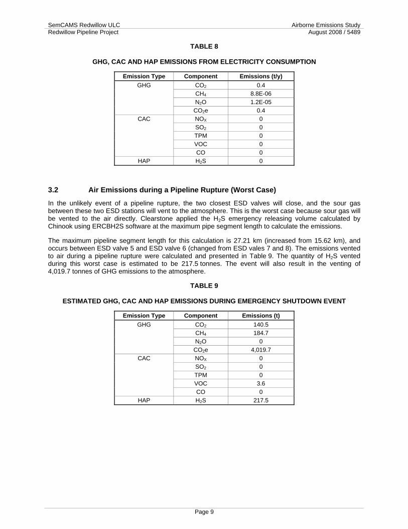
SemCAMS Redwillow ULC Airborne Emissions Study Redwillow Pipeline Project August 2008 / 5489
Page 9
TABLE 8
GHG, CAC AND HAP EMISSIONS FROM ELECTRICITY CONSUMPTION
Emission Type Component Emissions (t/y) CO2 0.4 CH4 8.8E-06 N2O 1.2E-05
GHG
CO2e 0.4 NOX 0 SO2 0 TPM 0 VOC 0
CAC
CO 0 HAP H2S 0
3.2 Air Emissions during a Pipeline Rupture (Worst Case)
In the unlikely event of a pipeline rupture, the two closest ESD valves will close, and the sour gas between these two ESD stations will vent to the atmosphere. This is the worst case because sour gas will be vented to the air directly. Clearstone applied the H2S emergency releasing volume calculated by Chinook using ERCBH2S software at the maximum pipe segment length to calculate the emissions.
The maximum pipeline segment length for this calculation is 27.21 km (increased from 15.62 km), and occurs between ESD valve 5 and ESD valve 6 (changed from ESD vales 7 and 8). The emissions vented to air during a pipeline rupture were calculated and presented in Table 9. The quantity of H2S vented during this worst case is estimated to be 217.5 tonnes. The event will also result in the venting of 4,019.7 tonnes of GHG emissions to the atmosphere.
TABLE 9
ESTIMATED GHG, CAC AND HAP EMISSIONS DURING EMERGENCY SHUTDOWN EVENT
Emission Type Component Emissions (t) CO2 140.5 CH4 184.7 N2O 0
GHG
CO2e 4,019.7 NOX 0 SO2 0 TPM 0 VOC 3.6
CAC
CO 0 HAP H2S 217.5

SemCAMS Redwillow ULC Airborne Emissions Study Redwillow Pipeline Project August 2008 / 5489
4.0 SEMCAMS HEALTH, ENVIRONMENTAL AND SAFETY POLICY
Page 10

SemCAMS Redwillow ULC Airborne Emissions Study Redwillow Pipeline Project August 2008 / 5489
Page 11
5.0 EMISSIONS MANAGEMENT AT SEMCAMS SemCAMS is committed to the long-term viability of enhanced life through sustainable development. SemCAMS recognizes that fossil fuel energy resources throughout the world are diminishing and that greenhouse gas emission, an end-result of burning fossil fuels, can lead to adverse changes in the global climate.
SemCAMS, recognizing its responsibility to the community, will identify sources of Halocarbons emissions and will eliminate their usage well ahead of international and national obligations. To achieve this goal all facilities owned or operated by SemCAMS, will adhere to the following requirements:
1. An inventory of all halocarbons currently in use by site, type, and quantity will be compiled for all facilities.
2. A list of emissions of the Halocarbons from all systems will be maintained, and will be utilized to develop preventive maintenance procedures to minimize future emissions.
3. All Halon 1211 portable fire extinguishers will be removed from existing facilities and/or replaced with alternatives.
4. All ‘non-critical’ halon system will be identified and decommissioned. ‘Critical’ applications will be decommissioned with new technology once the system is no longer deemed viable.
5. The use of the Halocarbons is prohibited in all new oil and gas processing facilities; for the expansion of existing facilities; or as a replacement alternative in existing systems.
6. New, non-process, low and medium temperature refrigeration systems will be designed such that refrigerant charges are minimized, and that non-ozone depleting refrigerants with the least environmental impact are utilized.
7. Screening procedures will be used to avoid the purchase of products containing Halocarbons wherever suitable alternatives are available.
8. All Halocarbon containing equipment will be disposed of responsibly when replaced, or at the end of its useful life, and any Halocarbons recovered for recycling or destruction.
Through initiatives like this, SemCAMS will endeavour to reduce its emissions and overall impact on the environment.

SemCAMS Redwillow ULC Airborne Emissions Study Redwillow Pipeline Project August 2008 / 5489
Page 12
6.0 SUMMARY Overall, the Project is expected to increase GHG emissions by 198 tonnes for the first year, and by 195.7 tonnes per year for the subsequent years of the pipeline normal operation. Based on data published by US Environmental Protection Agency (EPA) (www.epa.gov/climatechange/emissions/ind_calculator.html), the GHG emissions for the first year is roughly equivalent to the annual GHG emissions contributed by 35 personal automobiles or 11 two-person households. It represents approximately 0.000026% of Canada’s total GHG emissions in 2004 (www.ec.gc.ca/pdb/ghg/inventory_report/2004_report/ts_2_e.cfm).
The Project is expected to increase NOX emissions by 0.2 tonnes for both the first year and the subsequent years of the pipeline normal operation. It is expected to increase SO2 emissions by 3.2 tonnes for the first year, and 1.9 tonnes for the subsequent years of the pipeline normal operation. It is expected to increase TPM emissions by 0.01 tonnes for both the first year and the subsequent years of the pipeline normal operation. It is expected to increase VOC emissions by 0.03 tonnes for both the first year and the subsequent years of the pipeline normal operation. It is expected to increase CO emissions by 0.04 tonnes for both the first year and the subsequent years of the pipeline normal operation.
The Project is expected to increase H2S emissions by 1.3 tonnes for both the first year and the subsequent years of the pipeline normal operation.
The maximum H2S vented during the worst case scenario with original route was estimated to be 217.5 tonnes, while vented GHG emissions are estimated to be 4,019.7 tonnes of CO2e.
Updates presented in the 2008 scoping document result in material emission reductions for most pollutants. During normal operation, the revised pipeline Project resulted in a decrease of GHG emissions by 70 %, NOx emissions by 94%, CO emissions by 99%, PM emissions by 81%, VOC emissions by 69%, and H2S emissions by 11%; while the emissions of SO2 increased by 22%.

SemCAMS Redwillow ULC Airborne Emissions Study Redwillow Pipeline Project August 2008 / 5489
Page 13
7.0 REFERENCES Canadian Association of Petroleum Producers (CAPP). 1999. A Detailed Inventory of CH4 and VOC
Emissions from Upstream Oil and Gas Operations in Canada, Volume II: Development of the Upstream Emissions Inventory. Prepared by Clearstone Engineering Ltd. Calgary, Alberta. Publication No. 1999-0010.
Canadian Association of Petroleum Producers (CAPP). 2003. Calculating Greenhouse Gas Emissions. Calgary, Alberta. Publication No.2003-0003.
Canadian Association of Petroleum Producers (CAPP). 2004, A National Inventory of Greenhouse Gas (GHG), Criteria Air Contaminant (CAC) and Hydrogen Sulphide (H2S) Emissions by the Upstream Oil and Gas Industry, Draft Report. Prep. By Clearstone Engineering Ltd. Calgary, Alberta.
Canadian Association of Petroleum Producers (CAPP). 2005. A Recommended Approach to Completing the National Pollutant Release Inventory (NPRI) for the Upstream Oil and Gas Industry. Calgary, Alberta. Publication No. 2005-0001.
Environment Canada. 2007. Regulatory Framework on Air Emissions. Environment Canada. En84-53/2007. Available from http://www.ec.gc.ca/doc/media/m_124/toc_eng.htm.
U.S. Environmental Protection Agency. 1995a. Protocol for Equipment Leak Emission Estimates. Available through NTIA, Springfield, VA, Publication No. EPA-453/R-95-017, Section 2.
U.S. Environmental Protection Agency. 1995b. Compilation of Air Pollutant Emission Factors, Volume I: Stationary Point and Area Sources. Available through NTIA, Springfield, VA. Publication No. PB95-196028, Fifth Edition and Supplements.

SemCAMS Redwillow ULC Airborne Emissions Study Redwillow Pipeline Project August 2008 / 5489
Page 14
APPENDIX A
INPUT ACTIVITY DATA FOR CALCULATION1
Data Description Number Nitrogen purge gas consumed at pig launching facilities during first year of pipeline operation (Sm3/year)
12,000
Nitrogen purge gas consumed at pig launching facilities during subsequent years of pipeline operation (Sm3/year)
8,000
Sour gas released to flare at pig launching facilities during first year of pipeline operation (Sm3/year)
4,000
Sour gas released to flare at pig launching facilities during subsequent years of pipeline operation (Sm3/year)
2,400
Propane consumed for building heat at the pig launching facility (US gallons/year) 7,000 Propane consumed at each of the 18 Intermediate ESD Station (US gallons/year) 1,000 Propane consumed at each of the 4 SCADA Repeater Sites 1,000 Electric power consumed at the pig launching facility (kWh/year) 13,000
Notes: 1 Refer to “Borealis Project - Redwillow Pipeline Scope Summary Rev 2 (20080611).doc”

SemCAMS Redwillow ULC Airborne Emissions Study Redwillow Pipeline Project August 2008 / 5489
Page 15
APPENDIX B
SOUR GAS COMPOSITIONS
Gas Composition Data Component Mol Fraction of Sour Gas1
H2 0.0003 He 0.0001 N2 0.0044
CO2 0.1500 H2S 0.3000 C1 0.5411 C2 0.0017 C3 0.0005
I-C4 0.0002 n-C4 0.0004 I-C5 0.0002 n-C5 0.0003 C6 0.0003 C7 0
C7+ 0.0005 Note: 1 Provided by TERA.

SemCAMS Redwillow ULC Airborne Emissions Study Redwillow Pipeline Project August 2008 / 5489
Page 16
APPENDIX C
EMISSION FACTORS UTILIZED
Combustion Emission Factors for Estimating GHG and CAC Emissions Source Type Component Emission Factor Units Fuel Type Reference Reference Year
HEAT N2O 4.3 ng/J PROPANE U.S. EPA AP-42 Table 1.5-1 1996 HEAT CO2 59,166 ng/J PROPANE U.S. EPA AP-42 Table 1.5-1 1996 HEAT CO 9 ng/J PROPANE U.S. EPA AP-42 Table 1.5-1 1996 HEAT CH4 0.9 ng/J PROPANE U.S. EPA AP-42 Table 1.5-1 1996 HEAT SO2 0.147 ng/J PROPANE UNION GAS (typical 5.5 mg/m3) 2000 HEAT NOX 66.3 ng/J PROPANE U.S. EPA AP-42 Table 1.5-1 1996 HEAT TPM 1.9 ng/J PROPANE U.S. EPA AP-42 Table 1.5-1 1996 HEAT VOC 1.5 ng/J PROPANE U.S. EPA AP-42 Table 1.5-1 1996 HEAT TOC 2.4 ng/J PROPANE U.S. EPA AP-42 Table 1.5-1 1996
FL N2O 0.438 ng/J NGAS CAPP (2003) 2006 FL CO 159.1 ng/J NGAS U.S. EPA AP-42 Table 13.5-1 1991 FL CO2 46,005 ng/J NGAS Calculated using sour process
gas composition 2008
FL CH4 33.1 ng/J NGAS U.S. EPA AP-42 Table 13.5-1 (55% of THC)
1991
FL NOX 29.2 ng/J NGAS U.S. EPA AP-42 Table 13.5-1 1991 FL TPM 57 ng/J NGAS EPA Fire 6.22. Flaring landfill gas 1991 FL VOC 22.3 ng/J NGAS U.S. EPA AP-42 Table 13.5-1
(37% of THC) 1991
FL SO2 28420 ng/J NGAS Calculated using sour process gas composition
2007
EP-BC N2O 9.188E-07 kg/kWh ELEC BC Hydro VCR Report 2001 EP-BC CO2 0.0313 kg/kWh ELEC BC Hydro VCR Report 2003 EP-BC CH4 6.771E-07 kg/kWh ELEC BC Hydro VCR Report 2001

SemCAMS Redwillow ULC Airborne Emissions Study Redwillow Pipeline Project August 2008 / 5489
Page 17
APPENDIX D
CO2 and SO2 EMISSION FACTOR FORMULA
In the case of CO2 and SO2 emissions, the emission factors are calculated based on the carbon or sulphur content of the fuel or flared gas.
( ) 610×××= ∑ HHVCE
VMW
CYEFSTP
jiij
Where:
j = compound (CO2 or SO2)
Ci = Carbon or Sulphur number of element i (Dimensionless)
Yi = Mole fraction of element j (mole fraction)
MWj = Molecular weight of compound CO2 or SO2 (kg/kmol)
VSTP = volume occupied by 1 kmole of gas at 15˚C, 101.325 kPa (23.6449 m3/kmole)
CE = combustion efficiency of the equipment (assumed to be 98%)
HHV = Higher heating value of gas

SemCAMS Redwillow ULC Airborne Emissions Study Redwillow Pipeline Project August 2008 / 5489
Page 18
APPENDIX E
FUGITIVE EMISSION BY COMPONENT
Fugitive Emission Factors for Components in Sour Service Encountered at the Redwillow Pipeline Emission Factors (kg/h)1
Fuel type V C CS PRV PS OEL Gas Fittings 1.16E-03 1.36E-04 7.13E-01 1.70E-02 --- 1.89E-01
Note: 1 Refer to CAPP (2004)

SemCAMS Redwillow ULC Supplemental ESA Redwillow Pipeline Project August 2008 / 5489
Page A3-1
APPENDIX 3
FISH POPULATION AND AQUATIC HABITAT INVENTORIES AT WATERCOURSE CROSSINGS PROPOSED
SEMCAMS REDWILLOW PIPELINE PROJECT VEHICLE ACCESS ROADS AND MINOR REROUTES

FISH POPULATION AND AQUATIC HABITAT INVENTORIES AT WATERCOURSE CROSSINGS PROPOSED
SemCAMS Redwillow Pipeline Project Vehicle Access Roads and Minor Reroutes
Submitted to: TERA Environmental
Consultants Calgary, Alberta
for: SemCAMS
Redwillow ULC Calgary, Alberta
Submitted by: Applied Aquatic
Research Ltd. Calgary, Alberta
August 2008 File: AAR08-31

FISH POPULATION AND AQUATIC HABITAT INVENTORIES AT WATERCOURSE CROSSINGS PROPOSED
SemCAMS Redwillow Pipeline Project Vehicle Access Roads and Minor Reroutes
Submitted to: TERA Environmental Consultants
Calgary, Alberta
for: SemCAMS Redwillow ULC
Calgary, Alberta
Submitted by: A. Battistel and S. Johnston
Applied Aquatic Research Ltd. Calgary, Alberta
August 2008File: AAR08-31

Applied Aquatic Research Ltd. i
TABLE OF CONTENTS Page
EXECUTIVE SUMMARY.............................................................................................................................. 1 1.0 INTRODUCTION ............................................................................................................................. 3
1.1 Project Overview ................................................................................................................ 3 1.2 Regulatory Framework ....................................................................................................... 3 1.3 Known Distribution of Fishes and Their Habitat ................................................................. 7 1.4 Study Objectives................................................................................................................. 8
2.0 Methodology .................................................................................................................................... 9 2.1 Aquatic Habitat Inventory ................................................................................................... 9 2.2 Fish Population Inventory ................................................................................................. 10
3.0 RESULTS AND DISCUSSION...................................................................................................... 11 3.1 Vehicle Crossing Recommendations ............................................................................... 11 3.2 Drainages Not Defined as Channels................................................................................ 12
4.0 MITIGATION.................................................................................................................................. 13 4.1 Recommended Mitigation................................................................................................. 13 4.2 Effectiveness of Mitigation................................................................................................ 13
5.0 DRAWINGS................................................................................................................................... 17 6.0 SUMMARY OF CONCLUSIONS................................................................................................... 20 7.0 LITERATURE CITED .................................................................................................................... 21 8.0 CLOSURE ..................................................................................................................................... 23
LIST OF APPENDICES APPENDIX A DEFINED WATERCOURSES INVESTIGATED - SEMCAMS REDWILLOW PIPELINE
PROJECT VEHICLE ACCESS ROAD CROSSINGS....................................................................A-1 UNNAMED TRIBUTARY TO THE WOLVERINE RIVER (A8-1).....................................................A-2 UNNAMED CHANNEL (A8-2)................................................................................................A-3 UNNAMED TRIBUTARY TO THE MURRAY RIVER (A8-3)..........................................................A-4 UNNAMED TRIBUTARY TO FLATBED CREEK (A54A-1)...........................................................A-5 UNNAMED TRIBUTARY TO FLATBED CREEK (A58-1).............................................................A-6 UNNAMED CHANNEL (A62-1)..............................................................................................A-7 UNNAMED TRIBUTARY TO HIDING CREEK (A126-1)..............................................................A-8 UNNAMED CHANNEL (ID A151-1) .......................................................................................A-9 UNNAMED TRIBUTARY TO PINTO CREEK (ID A166-1) ........................................................A-10 APPENDIX B NON-CLASSIFIED DRAINAGES INVESTIGATED - SEMCAMS REDWILLOW PIPELINE
PROJECT VEHICLE ACCESS ROAD CROSSINGS....................................................................B-1
LIST OF FIGURES FIGURE 1 REDWILLOW PIPELINE PROJECT VEHICLE ACCESS ROAD CROSSING LOCATIONS
(SOURCE: SPECTRUM DIGITAL IMAGING) .................................................................................6
LIST OF TABLES TABLE 1 FISH TIMING WINDOWS FOR SELECTED SPECIES - OMINECA REGION (BC MWLAP
2004A)..................................................................................................................................4 TABLE 2 WATERCOURSE CROSSING SUMMARY FOR SEMCAMS REDWILLOW PIPELINE
PROJECT VEHICLE ACCESS ROAD CROSSINGS......................................................................14

Applied Aquatic Research Ltd. ii
TABLE 3 RECOMMENDED MITIGATION FOR THE TEMPORARY VEHICLE CROSSING TECHNIQUES PROPOSED......................................................................................................16
LIST OF DRAWINGS DRAWING 1 SNOW/ICE-FILL VEHICLE CROSSING .........................................................................................17 DRAWING 2 SINGLE-SPAN VEHICLE CROSSING ............................................................................................18 DRAWING 3 RAMP AND CULVERT VEHICLE CROSSING..................................................................................19

Applied Aquatic Research Ltd. 1
EXECUTIVE SUMMARY
SemCAMS Redwillow ULC (SemCAMS) applied to the National Energy Board (NEB) in December 2007 to construct and operate the Redwillow Pipeline Project (the Project). The Project involves the installation of approximately 150.0 km, 323.9 mm O.D. (NPS 12) pipeline and associated ancillary facilities to transport sour natural gas from the Grizzly Valley area southwest from Tumbler Ridge, British Columbia (BC) to existing Alberta-regulated gathering and processing facilities.
To meet provincial and federal regulatory requirements, TERA Environmental Consultants retained Applied Aquatic Research Ltd. (AAR) on behalf of SemCAMS to complete inventories of fish populations and their habitat in watercourses crossed by the pipeline and vehicle access roads proposed. In addition to recommended mitigation, this report presents information gathered at watercourses along the access roads proposed and three minor reroutes which are not located within the as-filed pipeline right-of-way. All other watercourse crossings occurring within the pipeline right-of-way (ROW) were discussed in the as-filed application (AAR 2007) and in the report prepared for the Mt. Notogosegunwatchi reroute (AAR 2008).
Information about fish species composition, relative abundance and distribution, the nature and extent of aquatic habitat, and its potential to support individual species and life-history stages at the watercourse crossing will be used to comply with regulatory requirements for habitat protection. Information was gathered in late May and July, 2008 so that:
a) appropriate crossing construction methods and timing are developed that protect aquatic habitat,
b) the BC Oil and Gas Commission (OGC) can be assured appropriate timing windows are set for crossings of fish-bearing streams,
c) Alberta Environment can be assured that the quantity and quality or productive capacity of the watercourses is maintained (Alberta Environment [AEVN] 2003a, b), and
d) Fisheries and Oceans Canada (DFO) can use the information to determine by case-specific review whether a harmful alteration, disruption, or destruction (HADD) of fish habitat is likely given the works proposed.
Additionally, information on aquatic habitat collected by AAR can be used by Transport Canada to help assess the navigability of watercourses investigated.
Roads will be comprised of temporarily reactivated existing roads, new temporary roads and permanent new roads. Of the proposed minor reroutes and vehicle access roads assessed outside of the pipeline ROW, access roads will be required over eight watercourses in BC, and two in Alberta. Nine non-classified drainages were also identified along the access roads investigated. No fish were captured in any of the watercourses investigated. Five crossings require a second season of sampling in fall 2008 to confirm their non-fish-bearing status. In the interim these watercourses are given a default fish-bearing classification until the correct classification can be confirmed with a second season of sampling. If fish are captured during the fall 2008 sampling, appropriate mitigation consistent with the measures identified for S3 and S4 streams in the as-filed Environmental and Socio-Economic Assessment will be implemented to alleviate impacts to fish and fish habitat.

Applied Aquatic Research Ltd. 2
Recommendations and crossing methods proposed are consistent with those presented in the Best Management Practices provided by the BC OGC (2004) and the AENV Code of Practice for Pipelines and Telecommunication Lines Crossing a Water Body (AENV 2003a) and Code of Practice for Watercourse Crossings (2003b), as well as Canadian Associated Petroleum Producers et al. (2005). Crossing methods proposed also adhere to Provincial timing windows to reduce adverse affects of construction-related disturbances to fish species during sensitive life-history stages. Methods proposed include the use of ice/snow fills, culverts and single-span bridges where appropriate, depending on permanency of the access road.
AAR is confident that the data collected to date, and the minor supplemental data to be collected in fall of 2008 to determine whether the conservative default classification as fish-bearing is justified at five crossings, will support the recommendations and conclusions outlined in this report. Furthermore, there should be no adverse affects to fishes and their habitat which cannot be avoided with the successful implementation of the recommended mitigation.
The following report was prepared to support submissions to appropriate federal and provincial regulatory agencies for regulatory approvals and/or notifications. It can be used by DFO during their case-specific review to determine if SemCAMS' proposed activities are likely to result in a HADD to fish or fish habitat. Our review, however, which indicates the potential adverse impacts to fish and fish habitat are mitigable suggests that a determination by DFO that HADD will occur is unlikely. However, in the event that HADD is anticipated, SemCAMS has been consulting with DFO with respect to compensation and a draft conceptual compensation plan is currently being finalized and will be submitted to DFO under separate cover. The Conceptual Fish Habitat Compensation Plan contains several compensation options that will be used to compensate for a loss of productive fish habitat capacity in the event that DFO determines that HADD is likely and that a Federal Fisheries Act Authorization is required.

Applied Aquatic Research Ltd. 3
1.0 INTRODUCTION
1.1 Project Overview SemCAMS Redwillow ULC (SemCAMS) applied to the National Energy Board (NEB) in December 2007 to construct and operate the Redwillow Pipeline Project (the Project). The Project involves the installation of an approximately 150.0 km long, 323.9 mm O.D. (NPS 12) pipeline and associated ancillary facilities to transport sour natural gas from the Grizzly Valley area southwest from Tumbler Ridge, British Columbia (BC) to existing Alberta-regulated gathering and processing facilities. Pending regulatory approvals, construction of the Project is scheduled to commence in October 2009, progressing through the winter of 2009/2010 to April 2010, with Project start-up in May 2010. Final clean-up and reclamation will be completed in the summer/fall of 2010. The Application included an Environmental and Socio-Economic Assessment ("as-filed ESA"), for which supporting studies were conducted to support the assessment of biophysical and socio-economic elements potentially impacted by the Project.
SemCAMS proposes to construct new and temporary access roads to allow vehicle and equipment access to the pipeline route during construction and to service the pipeline in the future (Figure 1). Roads will be comprised of existing roads, new temporary roads, and permanent new roads. This report presents the fish and aquatic habitat inventories completed for the proposed vehicle and equipment access roads which are not located within the pipeline right-of-way (ROW). Although SemCAMS will also need to construct some temporary vehicle crossings in the pipeline ROW to construct the pipeline proposed, information about access crossings located in the ROW are reported in Applied Aquatic Research Ltd. (AAR) (2007 and 2008).
1.2 Regulatory Framework In BC, the Provincial Water Act provides standards to reduce disturbance to aquatic habitat and fauna that may result from instream activity associated with petroleum roads, or other petroleum-related operations (BC Ministry of Water, Land and Air Protection [MWLAP] 2004a). In addition, timing windows set by the BC MWLAP (2004a) describe acceptable timing for oil and gas project works in fish-bearing streams and are used as a tool to reduce adverse affects of construction-related disturbances to fish species during sensitive life-history stages (Table 1). Best Management Practices (BMPs) provided by the BC Oil and Gas Commission (OGC) (2004) outline the most favorable construction methods. Although somewhat flexible, any requested variation to the timing windows or BMPs may require a site-specific review to determine the level of sensitivity related to any particular work instream. Provincial and federal agencies (e.g., BC Ministry of Environment [MOE]) may participate in such revisions or refinements.
Throughout the life histories of most fish species, there are critical stages of development during which fish are more sensitive to particular types of disturbance. Most species are more sensitive to disturbances during early life-history stages; however, others may be susceptible during migration, or while in winter habitat. The flexibility in timing windows and BMPs reflects a combination of influences, including the type of disturbance expected, species likely to be affected or present, habitat type, abundance of habitat, and its importance to a vulnerable stage of development for the individual species should instream works occur.

Applied Aquatic Research Ltd. 4
Provincial regulators may consider a request to supersede an identified timing window or an alternative to an identified BMP. However, any request for variance must be accompanied by a plan that demonstrates appropriate mitigation. Included in any strategy must be:
1. the rationale for choosing the alternative stream crossing method; 2. site-specific stream crossing information; 3. a description of the operational activities that will reduce impacts on the aquatic
environment; and 4. potentially, a fish habitat assessment (BC OGC 2004).
In Alberta, the Alberta Environment (AENV) Code of Practice (COP) for Pipelines and Telecommunication Lines Crossing a Water Body, and the Code of Practice for Watercourse Crossings present requirements to reduce disturbance to aquatic resources that may result from instream activity associated with linear development (AENV 2003a,b). These requirements include preferred construction methods and timing restrictions. Timing restrictions are intended to protect sensitive life-history stages of fishes (e.g., spawning, egg incubation, fry emergence) and are imposed through a restricted activity period (RAP). To ensure compliance with the COP, a Qualified Aquatic Environment Specialist (QAES) may undertake detailed fish population and aquatic habitat inventories at each road crossing proposed. Data collected help determine the nature, extent, and relative importance of aquatic habitat for fishes at each crossing and whether requirements under the COP are appropriate. In turn, best construction and mitigation practices can be developed by the QAES for application by the proponent.
TABLE 1 Fish Timing Windows for Selected Species - Omineca Region (BC MWLAP 2004a)
Species Jan Feb March April May June
July Aug Sept Oct Nov Dec
Arctic grayling 1 15 Rainbow trout 15 15 Steelhead Bull trout 15 15 Dolly Varden 15 15 31 Kokanee 31 1 Mountain whitefish 15 1 Spring and Fall spawners
15 15
Watercourses in Alberta that appear on COP maps are ‘mapped’, have classifications reflecting their sensitivity to work instream, and may have a RAP; watercourses not appearing on COP maps are ‘unmapped’, have classifications inherited from other mapped watercourses, and may have RAPs that are inherited or contingent on documented fish presence. For COP purposes, all watercourses crossed by access roads associated with the Project in Alberta are designated Class C; Class C water bodies contain habitat that is moderately sensitive to disturbance (AENV 2003a, b). The watercourses to be crossed may have a RAP from August 1 through July 15 to protect early life-history stages of spring-, fall-, and winter-spawning species known to occur in the area. According to the COP all crossing types may be used at Class C watercourses subject to required actions (AENV 2003b).

Applied Aquatic Research Ltd. 5
The Federal government, through Transport Canada and the Navigable Waters Protection Act (NWPA), provides for uninterrupted navigation of Canada’s waterways. Pipeline projects regulated by the NEB, such as the current Project spanning the provincial boundary, are subject to review under the NWPA.
The Federal government, through Fisheries and Oceans Canada (DFO), also has jurisdiction through the Fisheries Act over watercourses that may be affected temporarily or permanently, by crossing construction. The Fisheries Act prohibits: the destruction of fish; harmful alteration, disruption, or destruction (HADD) of fish habitat; and deposition of deleterious substances into water frequented by fish, or into places that may result in the deposition of deleterious substances into other water frequented by fish (sections 32, 35, and 36 of the Act, respectively). The Fisheries Act is a wide body of legislation that can, in principle, account for landscape-level disturbance resulting from cumulative stressors distributed across the watershed. That is, the protection of fishes and their habitat (e.g., stream morphology and hydrology) necessitates an understanding of processes occurring across a watershed.

Applied Aquatic Research Ltd. 6
Figure 1 Redwillow Pipeline Project Vehicle Access Road Crossing Locations (Source: Spectrum Digital Imaging) AAR08-31 August 2008

Applied Aquatic Research Ltd. 7
It is SemCAMS’ responsibility to provide sufficient data and information with respect to watercourses to be crossed such that DFO can determine whether HADD is likely given the works proposed. Where HADD is likely, works may proceed only if SemCAMS obtains Ministerial approval (i.e., Authorization under the Fisheries Act). Part of this approval process requires that any HADD be compensated for through enhancement and improvement of that already existing, to satisfy the “No Net Loss” guiding principle (DFO 1998).
To meet provincial and federal regulatory requirements, TERA Environmental Consultants (TERA) retained AAR on behalf of SemCAMS to complete inventories of fish populations and their habitat in watercourses crossed by the vehicle access roads proposed. This report presents information gathered at watercourses along the access roads proposed. All other watercourse crossings (including equipment and vehicle crossings) occur within the pipeline ROW are discussed in AAR (2007 and 2008). Information about fish species composition, relative abundance and distribution, the nature and extent of aquatic habitat, and its potential to support individual species and life-history stages at the watercourse crossing will be used to comply with regulatory requirements for habitat protection. Information was gathered so that:
a) appropriate crossing construction methods and timing are developed that protect aquatic habitat,
b) the BC OGC (2004) can be assured appropriate timing windows are set for crossings of fish-bearing streams and
c) AENV can be assured that the quantity and quality or productive capacity of the watercourses is maintained (AENV 2003a, b), and
d) DFO can use the information to determine by case-specific review whether HADD is likely given the works proposed.
Additionally, information on aquatic habitat collected by AAR can be used by Transport Canada to help assess the navigability of watercourses investigated. Although the Project occurs in Alberta and BC, the entire Project lies within the Peace River drainage. Major sub-basins affected include those of the Murray, Redwillow, and Wapiti rivers.
1.3 Known Distribution of Fishes and Their Habitat Detailed fish distribution and lake and stream information in BC is available from Fish Wizard (Freshwater Fisheries Society of BC 2008) and through Fisheries Inventory Data Queries (BC MOE 2008a). These data sources include known presence of fish species of particular conservation concern as well as other sport, coarse, and forage fishes. Site-specific data for the watercourse crossings investigated were not available.
The watercourses crossed in BC are tributaries to the Wolverine and Murray rivers, and Flatbed and Hiding creeks. The Wolverine River had documented presence of Arctic grayling (Thymallus arcticus), bull trout (Salvelinus confluentus), mountain whitefish (Prosopium williamsoni), rainbow trout (Oncorhynchus mykiss), slimy sculpin (Cottus cognatus), and spoonhead sculpin (Cottus ricei) (Freshwater Fisheries Society of BC 2005, BC MOE 2008a). Fish sampling by AAR in 2005 confirmed the presence of Arctic grayling, bull trout, and mountain whitefish, as well as longnose sucker (Catostomus catostomus), in the Wolverine River near Tumbler Ridge (AAR 2005).
AAR (2005 and 2007) documented mountain whitefish, Arctic grayling, bull trout, northern pike (Esox lucius), longnose sucker, lake chub (Couesius plumbeus), slimy sculpin, and brook

Applied Aquatic Research Ltd. 8
stickleback in BC watercourses that are within the Footprint of the proposed pipeline. Other species known to the BC watersheds are reported in AAR (2007).
Bull trout and pearl dace are two fish species of conservation concern in BC that are known to reside in sub-basins affected by this Project. Bull trout and pearl dace are provincially Blue-listed indicating that they are of special concern and may be particularly sensitive to human activities or natural events (BC MOE 2008b). Neither was captured in any of the watercourses investigated.
The watercourses crossed in Alberta are tributaries to Pinto Creek and the Wapiti River. The Alberta Fish Management Information System (FMIS) database (repository for fish capture data from fish inventories completed province-wide) has information documenting diverse fish communities in Pinto Creek. Pinto Creek has documented presence of Arctic grayling, bull trout, burbot, lake chub, longnose sucker, pearl dace, redside shiner, slimy sculpin, trout-perch (Percopsis omiscomaycus), and white sucker (Catostomus commersonii). AAR (2007) captured burbot, lake chub, longnose dace, largescale sucker (Catostomus macrocheilus), and redside shiner at Pinto Creek in the project area. Arctic grayling, bull trout, mountain whitefish, northern pike, and redside shiner were present in the Wapiti River (AAR 2007).
1.4 Study Objectives The specific objectives of this study were to:
• Determine whether crossings proposed are on fish-bearing streams as defined under the Forest Practices Code of BC in BC, and on watercourses as defined under the COP in Alberta.
• Determine fish presence (species composition, relative abundance, and distribution) in the watercourses near each crossing.
• Describe aquatic habitat at and adjacent to the crossings in terms of type, quantity, area, quality, and potential to support individual species and life-history stages.
• Identify appropriate vehicle crossing methods and timing restrictions for the watercourses.
• Assess the potential for HADD to fish habitat given resident populations, habitat available, timing of construction, and crossing methods proposed.
• Identify restoration and mitigation measures to reduce adverse effects of any instream activity on aquatic resources.

Applied Aquatic Research Ltd. 9
2.0 Methodology
2.1 Aquatic Habitat Inventory Fish biologists (QAES) and field assistants investigated aquatic habitat in watercourses intersected by the vehicle access roads in late May and July 2008. There were minor reroutes that were also assessed in May 2008, located at SE 26-68-9 W6M and c-89-K/93-I-15 (ID 19) a tributary to Babcock Creek. ID 19 has been documented previously in AAR (2007). The sections of channels sampled encompassed that which may be affected by instream construction also known as the zone-of-influence. The extent of this zone depends on various parameters that include channel gradient, width, depth, morphology (shape and roughness), water velocity, discharge, and instream vegetation. In Alberta, this zone represents ‘…the area of the water body where 90% of the sediment discharged as a result of the works will be deposited’ and requires investigation of at least 400 m of channel from 100 m upstream to 300 m downstream from the crossing (AENV 2003a). In BC, a minimum 100 m of channel must be investigated where the channel is less than 10 m wide, and where channels are wider than this a section of channel at least 10 times as long as the channel width must be investigated (Resources Inventory Committee of British Columbia [RIC] 1999). Assessment of crossing locations and existing information (Freshwater Fisheries Society of BC, 2008 and BC MOE 2008a) served to identify watercourses as either fish-bearing or non-fish-bearing.
Physical parameters including channel bankfull and wetted widths, bank height and water depth were quantified across transects spaced evenly throughout the zone-of-influence. Widths, bank height, and water depth were measured to the nearest 0.01 m. Water velocity was measured with a Swoffer™ digital current meter and wading rod at vertical stations across a single transect that exhibited laminar flow to calculate discharge. The floating chip method was used to measure velocity where water depth was insufficient for the digital current meter. Discharge was calculated using a mid-section method (Orth 1983). Water temperature, pH, conductivity, and dissolved oxygen (DO) concentration were measured at the ROW with a Multiline P4™ computerized multi-meter. Bank stability and shape, dominant and sub-dominant substrate, and embeddedness were described qualitatively. Percent substrate composition and its embeddedness were described at each transect. Substrate was classified into six categories using a modified Wentworth particle scale (fines <2 mm, small gravels 2-25 mm, large gravels 26-64 mm, cobbles 64-256 mm, boulders >256 mm, and bedrock) (Orth 1983). In BC, dominant and subdominant substrate types were noted, as well as the diameter of bed material larger than 95% of the substrate material (D95) as required (RIC 1999).
Watercourse and riparian vegetation characteristics that affect fish habitat potential were described. These included substrate composition, instream and overhead cover, riparian vegetation composition, and canopy closure. The presence of limiting factors or unique features such as beaver dams and ground water intrusion were mapped, photographed, and described. Fish habitat was rated as high (H), moderate (M), low (L), or none (N) according to its potential to support spawning, rearing, over-wintering, and migration of fish species present or documented previously. Photographic records of sites were compiled.

Applied Aquatic Research Ltd. 10
2.2 Fish Population Inventory Fish communities at the watercourse crossings proposed were sampled using a backpack electrofisher (BPEF) (Smith Root Inc., Type 12A POW) and baited “Gee”-type minnow traps except where there was insufficient water depth. Minnow traps were set in deeper sections of channel, and next to, or under, cover and banks. Electrofishing effort was distributed evenly across each habitat type throughout the zone–of-influence of each crossing, and was conducted before habitat inventory to avoid displacing fish. First season sampling was conducted between July 17 and July 21, 2008. Additional sampling as required in BC will commence in the fall of 2008. Although some sites were visited in May 2008, fish collection permits were not obtained and therefore fish sampling only occurred in July 2008.
Fish immobilized by electrofishing were retrieved with a dip net and placed in a bucket containing fresh water to recover. Catch-per-unit-effort (CPUE) is described as the number of fish caught per 100 seconds electrofished, or as the number of fish caught per trap-hour set. All fish captured were identified to species, measured to the nearest millimetre, and had their sex and life-history stage determined (if discernable externally). After sampling, all fish were returned unharmed to the watercourses from where they were captured.
Watercourses in BC where no fish were captured in the initial summer sampling season (July 2008) will be sampled again during a second season (fall 2008) to establish whether they can be classified as non-fish-bearing. In the interim these watercourses are given a default fish-bearing classification until the correct classification can be confirmed with a second season of sampling. These instances are indicated on their respective pages in Appendix A. A second season of sampling will not be carried out at watercourses where a biologist has determined there is no habitat suitable for fish and/or a barrier to fish migration precludes fish presence.

Applied Aquatic Research Ltd. 11
3.0 RESULTS AND DISCUSSION
Results of investigations conducted at stream crossings with defined bed and banks are presented in Appendix A (except for the tributary of Babcock Creek, ID 19, which is reported in AAR 2007), and discussed generally in the text that follows. Individual crossings are discussed on their respective atlas pages (Appendix A). At three crossing locations in BC (A8-1, A8-2, and A8-3), small culverts have recently been installed since the first season assessment (May 2008) at the watercourse crossings and may be adequate for vehicle and equipment access for this Project. These three watercourse crossings are included in this report as the culverts installed appear to be undersized for spring freshet and may need to be replaced by SemCAMS. All current reroutes since the field work for the as-filed ESA (see AAR 2007) was completed were visited and no new watercourses were identified on these reroutes.
3.1 Vehicle Crossing Recommendations BC guidelines provide details for installation of both open-bottom and closed-bottom culverts (BC Ministry of Forests 2002, BC OGC 2004). The Canadian Association of Petroleum Producers (CAPP), Canadian Energy Pipeline Association and Canadian Gas Association (2005) have guidelines in place for mitigating the installation of single-span bridges and icefills (Drawings 1, 2 and 3). DFO also has operational position statements (OPS) for both BC and Alberta that if followed will reduce the likelihood of HADD (DFO 2008a,b). There are operational statements for both single-span and ice bridges/snowfills.
Recommendations for crossings are made in accordance with best management practices outlined that aim ‘to protect fish and fish habitat values and maintain the functionality of aquatic and riparian ecosystems’ (BC OGC 2004) and for Alberta watercourses with the COP (AENV 2003b). These are included on respective atlas pages (Appendix A). Recommended crossing methods and mitigation proposed are based on the outcome of inventory data collected and its relevance to the time instream construction of crossings is planned.
Temporary and permanent access for vehicles and equipment may be by several methods (Table 2). Snow/ice-fills or ice bridges may be used where channels are dry, frozen-to-bottom, or ice is thick enough to support traffic; this is an appropriate method for the crossings investigated, but requires clean fill and removal before spring (BC Ministry of Forests 2002, BC OGC 2004, AENV 2003b) (Drawing 1). Single-span bridges may also be installed, and these could be made from swamp mats for narrower channels (Drawing 2). Ramp-and-culvert crossings may be installed on narrower watercourses based on provincial guidelines (Drawing 3). BC guidelines provide details for installation of both open-bottom and closed-bottom culverts (BC Ministry of Forests 2002, BC OGC 2004) and Alberta guidelines indicate when QAES input is required (AENV 2003b). However, culverts require case-specific review by DFO and therefore are not explicitly recommended for vehicle and equipment access for the access road crossings. Note that in Alberta snow/ice-fills (Drawing 1), single-span bridges (with no supporting structures within the ordinary high water mark) (Drawing 2), and culverts (Drawing 3) are referred to as Type V, Type I, and Type III crossings, respectively, as described in AENV (2003b).
In instances where construction of a vehicle crossing disturbs the channel bed and/or banks the channel must be restored, in keeping with best management practices (BC OGC 2004). Specifically, ‘the streambed must be re-contoured to its original state and left in a condition that

Applied Aquatic Research Ltd. 12
prevents scouring of the bed, erosion and/or siltation of the watercourse’ (BC OGC 2004). General recommendations for bank restoration are:
• banks must be restored to their original contour and height; • when possible banks should be re-contoured with salvaged duff if it can be removed
intact. • when salvaged duff is returned in place it should be protected with coconut matting if
necessary to stabilize, and the matting anchored with willow stakes; • riparian areas should be seeded with native grasses.
3.2 Drainages Not Defined as Channels Several locations were investigated to determine whether they are channels with defined bed and banks. Crossings at locations lacking defined bed or banks do not have a specified window for instream work or RAP because they are not fish-bearing streams. These locations are non-classified drainages (NCDs), and are compiled as photographic records in Appendix B. This includes the two reroute sites WX48 and WX58. Vehicle access at these drainages may be constructed using snow/icefill or culvert crossings. The contour of the terrain should be restored using salvaged duff so that natural drainage patterns are maintained. Vegetation may be salvaged or native grasses sown as is described for generic bank restoration techniques in Section 3.1.

Applied Aquatic Research Ltd. 13
4.0 MITIGATION
The recommended crossing techniques and mitigative measures in this report were developed in accordance with the construction standards outlined in CAPP et al. (2005). CAPP et al. (2005) includes an endorsement by DFO which indicates it is a compilation of modern planning considerations, ‘best practices’ for pipeline and vehicle crossing construction techniques, and current environmental protection methods that are used to meet regulatory requirements across Canada and to minimize fisheries habitat impacts associated with pipeline related water crossing activities.
4.1 Recommended Mitigation
Specific mitigative measures for temporary vehicle crossing techniques recommended in this report (i.e., snow fills, single span bridges, and culverts) report are summarized in Table 3 and Drawings 1 through 3 which follow. Additional site specific mitigation for each crossing is discussed in Appendix A.
The mitigative measures proposed are consistent with those proposed for similar crossing activities in AAR (2007) and AAR (2008), as well as the Environmental Protection Plan (EPP) provided in Appendix 6A of the as-filed ESA (TERA 2007) where details on additional mitigative measures being undertaken by SemCAMS are provided. For example, the EPP includes preventative measures to avoid introducing deleterious substances (e.g., sediments and hydrocarbons) into any water sources, and actions to ensure disturbances of the right-of-way approach to any watercourse related to the Project and associated activities are kept to a minimum and immediately stabilized and reclaimed to preconstruction conditions.
4.2 Effectiveness of Mitigation
In addition to being largely developed from CAPP et al. (2005), the mitigative/restoration measures proposed have been used previously on other major pipeline construction projects with good success. The following are two examples.
Bank restoration and the addition of instream cover on the Battle River were deemed successful by DFO (AAR 2003). Restoration included re-contouring and bank stabilization with soil wraps and willow staking. Post construction audits included the physical stability of the banks and their ability to withstand high water events, assess the survival of willow and grass plantings, record the extent of instream vegetation, and quantify fish usage within the area including quantity, species and life-history stages. Restoration work was completed for Husky Energy in 2002 and the audit was completed in 2003.
Successful restoration was completed on the Nordegg River for Suncor Energy (TERA 1999). Restoration included re-contouring and reclamation of the riverbed, approach slopes and workspace. Upland restoration included replacing subsoil and topsoil and planting of willow stakes. Instream work included tree revetments, river bank armoring, installing a V-weir and root wad. The audit was completed one year after construction and concluded that there was a net gain in spawning habitat and overhead cover for bull trout.

Applied Aquatic Research Ltd. 14
TABLE 2 Watercourse Crossing Summary for SemCAMS Redwillow Pipeline Project Vehicle Access Road Crossings
Outside the Work Window During the Work Window
ID Watercourse Location Class
Instream Work
Window
Fish Species
Captured
Fish Species Known to
Occur in the Waterbody*
Mean Channel and Wetted Width and
Channel Depth (m)
Vehicle Crossing
Primary Crossing Method
Contingency Crossing Method
Primary Crossing Method
Contingency Crossing Method Restoration
BC PORTION
A8-1
Unnamed Tributary to the Wolverine River
8-34-70-21
W6M
d-29-H/93-P-03
S3* *Yet to be determined None None
Channel: 2.60 Wetted: 2.01 Depth: 0.40
Snow/ice fill2 or single-span3
A8-1 Unnamed Tributary to the Wolverine River
A8-2 Unnamed Channel
4-35-70-21 W6M
d-19-H/93-P-03
S4* *Yet to be determined None None
Channel: 1.10 Wetted: 0.82 Depth: 0.30
Snow/ice fill2 or single-span3
A8-2 Unnamed Channel
A8-3 Unnamed Tributary to the Murray River
12-26-70-21 W6M
a-19-H/93-P-03
S3* *Yet to be determined None None
Channel: 3.40 Wetted: 2.20 Depth: 0.80
Snow/ice fill2 or single-span3
A8-3 Unnamed Tributary to the Murray River
A54a-1 Unnamed Tributary to Flatbed Creek
13-36-68-19 W6M
a-22-K/93-I-15
S6 Open None None Channel 0.77 Wetted: 0.63 Depth: 0.32
Culvert4 or single-span3 A54a-1 Unnamed Tributary to
Flatbed Creek
A58-1 Unnamed Tributary to Flatbed Creek
5-31-68-18 W6M
a-20-J/93-I-15
S6 Open None None Channel: 1.20 Wetted: 0.98 Depth: 0.50
Snow/ice fill2, culvert4 or single-span3
A58-1 Unnamed Tributary to Flatbed Creek
A62-1 Unnamed Channel
11-29-68-18 W6M
b-07-J/93-I-15
S4* *Yet to be determined None None
Channel: 1.36 Wetted: 0 Depth: 0
Snow/ice fill2, culvert4 or single-span3
A62-1 Unnamed Channel
A126-1 Unnamed Tributary to Hiding Creek
12-27-68-14 W6M
c-95-H/93-I-16
S4* *Yet to be determined None None
Channel: 0.73 Wetted: 1.04 Depth: 0.62
Snow/ice fill2, culvert4 or single-span3
A126-1 Unnamed Tributary to Hiding Creek
ID 19
Unnamed Tributary to Babcock Creek * No longer on alignment after re-route
11-20-69-19 W6M
c-89-K/93-I-15
S3 June 15 - Aug 15
BT CRI5
BT CRI5
Channel: 3.1 Wetted: 1.7 Depth: 0.55
NA ID 19
Unnamed Tributary to Babcock Creek
* No longer on alignment after re-route

Applied Aquatic Research Ltd. 15
TABLE 2 Cont'd Outside the Work Window During the Work Window
ID Watercourse Location Class
Instream Work
Window
Fish Species
Captured
Fish Species Known to
Occur in the Waterbody*
Mean Channel and Wetted Width and
Channel Depth (m)
Vehicle Crossing
Primary Crossing Method
Contingency Crossing Method
Primary Crossing Method
Contingency Crossing Method Restoration
BC PORTION ALBERTA PORTION
A151-1 Unnamed Channel
2-15-68-11 W6M C None None None
Channel: 0.84 Wetted: 0.0 Depth: 0.0
Snow/ice fill2, culvert 4or single-span3
A151-1 Unnamed Channel
A166-1 Unnamed Tributary to Pinto Creek
3-28-68-10 W6M C None None None
Channel: 2.47 Wetted: 1.89 Depth: 0.24
Snow/ice fill2 or single-span4
A166-1 Unnamed Tributary to Pinto Creek
* Indicates a default classification – fish-bearing status has been assumed by default until a second season of fish sampling proves fish presence or absence. A second season of sampling can be done in fall at these locations to prove fish absence and assign a non-fish-bearing classification (S6). Appropriate instream work windows will be determined once the stream classification is confirmed.
1 Historic fish presence data from Fish Wizard (Freshwater Fisheries Society of BC 2008) and Fisheries Inventory Data Queries (BC MOE 2008a) 2 See Drawing 1. 3 See Drawing 2. 4 See Drawing 3. 5 Bull trout (BT) and spoonhead sculpin (CRI) were captured during surveys conducted in 2007 (see AAR 2007). Abbreviations are according to Desrochers (1997). 6 Section 9(5) Where an unmapped water body enters a mapped Class C water body, (a) the restricted activity period of the mapped Class C water body is inherited in the unmapped waterbody for a distance of 2 kilometers
upstream from the mouth of the unmapped water body, and (b) for any other portion of the unmapped water body than that specified in clause (a), (i) where there is no documented evidence of fish presence in the unmapped water body, there is no restricted activity period, or (ii), where there is documented evidence of fish presence in the unmapped water body, the restricted activity period is the restricted activity period of the nearest mapped water body that enters the mapped Class C water body (AENV 2003a).

Applied Aquatic Research Ltd. 16
TABLE 3 Recommended Mitigation for the Temporary Vehicle Crossing Techniques Proposed
Vehicle Crossing Technique Recommended Mitigation
Install ice bridges on winter projects when a safe ice thickness can be maintained. Locate ice bridges at sites with gently sloping banks to minimize cuts in watercourse banks. Use snow and ice to slope approaches, rather than cut banks. Flood ice surface with water and cover with clean snow to increase load bearing capacity. Logs may be used as a base to strengthen the bridge. Ice bridge / snow fill should not impede flow of water. Maintain ice / snow regularly and remove all debris from the surface. Remove broken ice from trench area to prevent ice jamming against and under the ice bridge. Remove logs and breach ice bridge / snow bridge by physical means prior to spring break-up.
Snow Fill/Ice Bridge
Restore and stabilize banks and approaches prior to spring break-up. Install temporary bridge (e.g., log, pre-fabricated span) to allow vehicles to cross watercourses that are sensitive or have unstable bed and banks. Bridges are also used where watercourses are too deep, wide or fast to permit an alternative crossing structure. This method minimizes sedimentation of the watercourse, and bank and bed restoration work. Utilize approach fills rather than cuts in banks to minimize erosion potential. Do not constrict flow with approach fill or support structures. Ensure adequate free-board to handle anticipated streamflows. Use a geotextile liner to prevent fine material from entering watercourse. Remove bridge immediately after use. If bridge is to remain in place through spring break-up to access final clean-up, it must be designed for spring floods and ice jams. Remove support structures and approach fills. Restore and stabilize banks.
Temporary Single-Span Bridge
Install curb stringers of logs or plywood to ensure that fill material does not spill into the watercourse, where required. Install ramp and culverts to allow vehicles to cross relatively narrow watercourse where sedimentation must be minimized or fish passage allowed. Design culverts to handle 150% of maximum anticipated flows or to a five year flood level and according to specific guidelines where fish passage (i.e., migration) is required. Contact government authorities for minimum depth specifications, and maximum water vehicles. Ensure dam is impermeable. Place ends of culverts below the natural grade of watercourse at an angle that does not exceed normal watercourse gradient. Depth of placement is dependent upon bed type, culvert size and expected flow conditions. Remove temporary culverts and ramp materials when no longer required. Remove culvert and ramp prior to spring break-up.
Ramp and Culvert
Restore and stabilize bed and banks.

Applied Aquatic Research Ltd. 17
5.0 DRAWINGS
SemCAMS Redwillow Pipeline Project
Drawing 1 Snow/Ice-Fill Vehicle Crossing
AAR08-31 August 2008

Applied Aquatic Research Ltd. 18
SemCAMS Redwillow Pipeline Project
Drawing 2 Single-span Vehicle Crossing
AAR08-31 August 2008

Applied Aquatic Research Ltd. 19
SemCAMS Redwillow Pipeline Project
Drawing 3 Ramp and Culvert Vehicle Crossing
AAR08-31 August 2008

Applied Aquatic Research Ltd. 20
6.0 SUMMARY OF CONCLUSIONS
In May and July of 2008, biologists assessed all temporary and permanent roads that will provide access to the SemCAMS Redwillow Pipeline route proposed including minor reroutes. No fish were captured in any of the ten watercourses investigated specifically for temporary and permanent roads in 2008; however, bull trout and spoonhead sculpin were captured from the unnamed tributary to Babcock Creek during surveys conducted in 2007 (AAR 2007). A second season of sampling for fish will be conducted at five watercourse crossings in BC during fall 2008, as required by BC RIC standards.
AAR is confident that the data collected to date and the minor supplemental data to be collected in fall of 2008 will support the recommendations and conclusions outlined in this report. Furthermore, there should be no adverse affects to fishes and their habitat which cannot be avoided with the successful implementation of the recommended mitigation.
The following report was prepared to support submissions to appropriate federal and provincial regulatory agencies for regulatory approvals and/or notifications. It can be used by DFO during their case-specific review to determine if SemCAMS' activities proposed are likely to result in a HADD to fish or fish habitat. Our review, however, which indicates the potential adverse impacts to fish and fish habitat are mitigable suggests that a determination by DFO that HADD will occur is unlikely. However, in the event that HADD is anticipated, SemCAMS has been consulting with DFO with respect to compensation and a draft conceptual compensation plan is currently being finalized and will be submitted to DFO under separate cover. The Conceptual Fish Habitat Compensation Plan contains several compensation options that will be used to compensate for a loss of productive fish habitat capacity in the event that DFO determines that HADD is likely and that a Federal Fisheries Act Authorization is required.

Applied Aquatic Research Ltd. 21
7.0 LITERATURE CITED
Alberta Environment (AENV). 2003a. Code of Practice for Pipelines and Telecommunication Lines Crossing a Water Body. 24 pp.
Alberta Environment (AENV). 2003b. Code of Practice for Watercourse Crossings 24 pp.
Alberta Sustainable Resource Development (ASRD). 2005. The general status of Alberta wild species. Alberta Sustainable Resource Development, Fish and Wildlife Service, Edmonton, Alberta.
Applied Aquatic Research Ltd. (AAR) 2003. Post-construction Monitoring Following Pipeline Armouring on the Battle River, Alberta. Prepared for Husky Energy Inc.
Applied Aquatic Research (AAR). 2005. Fish Population and Aquatic Habitat Assessment at Watercourses Proposed Shell Canada Limited Bullmoose 5 to Junction, Junction to Dehydration Facility, and Dehydration Facility to Duke Pipeline. Submitted to TERA Environmental Consultants. Calgary, Alberta. 39 pp + Appendices.
Applied Aquatic Research (AAR). 2007. Fish Population and Aquatic Habitat at Watercourse Crossings Proposed SemCAMS Redwillow Pipeline Project. Submitted to TERA Environmental Consultants Calgary, Alberta. 22 pp + Appendices.
Applied Aquatic Research (AAR). 2008. Fish population and Aquatic Inventories at Watercourse Crossings Proposed SemCAMS Redwillow Pipeline Project Mount Notogosegunwatchi Route Alternative. Submitted to TERA Environmental Consultants. Calgary, Alberta. 9 pp + Appendices.
BC Ministry of Environment (MOE). 2008a. Fisheries Inventory Data Queries. Available online at http://a100.gov.bc.ca/pub/fidq/main.do
BC Ministry of Environment (MOE) 2008b. BC Species and Ecosystems Explorer. Available online at http://www.env.gov.bc.ca/atrisk/toolintro.html
BC Ministry of Forests. 2002. Fish-Stream Crossing Guidebook. Forest Practices Code of British Columbia, Ministry of Forests, Victoria, B.C. Forest Practices Code of British Columbia guidebook.
BC Ministry of Forests and BC Environment. 1998. Fish-Stream Identification Guidebook, 2nd ed. Forest Practices Code. Victoria, B.C. Forest Practices Code of British Columbia guidebook.
British Columbia Ministry of Water, Land and Air Protection (MWLAP). 2004a. Region 7 Omineca - Reduced Risk Timing Windows for Fish and Wildlife. Standards and Best Practices for Instream Works. Available at http://wlapwww.gov.bc.ca/omr/esd/eco/rrtw.html
British Columbia Oil and Gas Commission (BC OGC). 2004. Version 2.0. Stream Crossing Planning Guide. Informational Guide for St. John, British Columbia.
Canadian Association of Petroleum Producers, Canadian Energy Pipeline Association and Canadian Gas Association. 2005. Pipeline Associated Watercourse Crossings. Prepared by TERA Environmental Consultants and Salmo Consulting Inc. Calgary, Alberta.
Desrochers, B. 1997. Fisheries Information Summary System (FISS). Data compilation and mapping procedures. Prepared for British Columbia Ministry of Environment and Fisheries and Oceans Canada.

Applied Aquatic Research Ltd. 22
Fisheries and Oceans Canada (DFO). 1998. Decision framework for the determination and authorization of harmful alteration, disruption or destruction of fish habitat. Department of Fisheries and Oceans, Habitat Management and Environmental Science, Habitat Management Branch, Ottawa, Ontario.
Fisheries and Oceans Canada (DFO). 2008a. Pacific Region Operational statements. Available at http://www-heb.pac.dfo-mpo.gc.ca/decisionsupport/os/operational_statements_e.htm
Fisheries and Oceans Canada (DFO). 2008b. Prairies Arctic Region Operational statements. Available at http://www.dfo-mpo.gc.ca/regions/central/habitat/os-eo/prov-terr/ index_e.htm
Freshwater Fisheries Society of BC. 2008. Fish Wizard. Available online at http://www.fishwizard.com
Joynt, A. and M.G. Sullivan 2003. Fish of Alberta. Lone Pine Publishing, Edmonton Alberta. 176 pp.
Mackay, W.C., G.R. Ash, and H.J. Norris, editors. 1990. Fish Ageing Methods for Alberta. R.L. & L. Environmental Services Ltd., Edmonton, Alberta. 113 pp.
Nelson, J.S. and M.J. Paetz. 1992. The Fishes of Alberta, 2nd edition. University of Alberta Press, Edmonton, Alberta. 437 pp.
Orth, D.J. 1983. Aquatic habitat measurements. Pages 61-84 in L.A. Nielsen and D.L. Johnson, editors. Fisheries Techniques. American Fisheries Society, Bethesda, Maryland.
Post, J.R. and Johnston, F.D. 2002. Status of the Bull Trout (Salvelinus confluentus) in Alberta. Alberta Sustainable Resource Development, Fish and Wildlife Division and Alberta Conservation Association, Alberta Wildlife Status Report No. 39. Edmonton, Alberta. 40 pp.
Resources Inventory Committee of British Columbia (RIC). 1999. Reconnaissance (1:20,000) Fish and Fish Habitat Inventory: Standards and Procedures, version 1.1
Spectrum Digital Imaging. 2000. Canadian Digital Maps: British Columbia Index Map of the National Topographic System (NTS).
TERA Environmental Consultants Ltd. 1999. Pre- and Post-construction Monitoring at the Nordegg River Crossing for the Suncor Energy INC. Brown Creek-Blackstone Pipeline Project. Prepared for Suncor Energy Inc
TERA Environmental Consultants. 2007. Environmental and Socio-Economic Assessment for the Proposed SemCAMS Redwillow ULC Redwillow Pipeline Project. Prepared for SemCAMS, Calgary, Alberta, by TERA Environmental Consultants, Calgary, Alberta.
Walker, J. 2005. Status of Arctic Grayling (Thymallus arcticus) in Alberta. Prepared for Alberta Sustainable Resource Development, Fish and Wildlife Division, and Alberta Conservation Association, Alberta Wildlife Status Report No. 57.

Applied Aquatic Research Ltd. 23
8.0 CLOSURE
The statements and conclusions reported are accurate and address requirements of the Forest Practices Code (BC Ministry of Forests 2002), BC OGC (2004), and Alberta Environment’s Code of Practice for Watercourse Crossings (AENV 2003b).
Andrea Battistel, B.Sc., P.Biol. Fish Biologist Reviewed by
Shawn Johnston, RPBio., P.Biol. Senior Biologist