47100-004: Madhya Pradesh Power Transmission and ...
260
Initial Environment Examination This initial environmental examination report is a document of the borrower. The views expressed herein do not necessarily represent those of ADB's Board of Directors, Management, or staff, and may be preliminary in nature. This is an updated version of IEE posted in October 2018 available on https://www.adb.org/projects/documents/ind-47100-004-iee-2. In preparing any country program or strategy, financing any project, or by making any designation of or reference to a particular territory or geographic area in this document, the Asian Development Bank does not intend to make any judgments as to the legal or other status of any territory or area. Project Number: 47100-004 November 2019 Part B: Main Report (Pages 90 - 308) and Annexures IND: Madhya Pradesh Power Transmission and Distribution System Improvement Project Submitted by Madhya Pradesh Power Transmission Company Ltd., Jabalpur
-
Upload
khangminh22 -
Category
Documents
-
view
0 -
download
0
Transcript of 47100-004: Madhya Pradesh Power Transmission and ...
Initial Environment Examination
This initial environmental examination report is a document of the borrower. The views expressed herein do not necessarily represent those of ADB's Board of Directors, Management, or staff, and may be preliminary in nature. This is an updated version of IEE posted in October 2018 available on https://www.adb.org/projects/documents/ind-47100-004-iee-2.
In preparing any country program or strategy, financing any project, or by making any designation of or reference to a particular territory or geographic area in this document, the Asian Development Bank does not intend to make any judgments as to the legal or other status of any territory or area.
Project Number: 47100-004 November 2019 Part B: Main Report (Pages 90 - 308) and Annexures
IND: Madhya Pradesh Power Transmission and Distribution System Improvement Project
Submitted by Madhya Pradesh Power Transmission Company Ltd., Jabalpur

Loan No. 3066 INDIEE Madhya Pradesh Power Transmission ProjectImplementing Agency – Madhya Pradesh Power Transmission Corporation Limited 90
Figure 3.68: LILO of one circuit of Malanpur-Mehgaon line at 400 kvS/s (CWRTLAdani) Morena
107. The line LILO of one circuit of Malanpur- Mehgaon line at 400 KV S/s (CWRTLAdani) Morena was proposed with a route length of 20 kms. There are a number ofreserve and protected forest patches in the region and so to avoid them, the revisedlength was 8 kms (as per IEE report of May, 2017) and has now been revised to 7.396kms. This final route alignment avoids reserve forests altogether and large settlementsand other critical sensitive environmental areas.
Loan No. 3066 INDIEE Madhya Pradesh Power Transmission ProjectImplementing Agency – Madhya Pradesh Power Transmission Corporation Limited 91
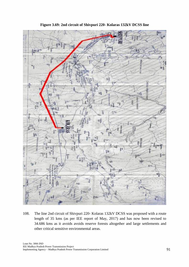
Figure 3.69: 2nd circuit of Shivpuri 220- Kolaras 132kV DCSS line
108. The line 2nd circuit of Shivpuri 220- Kolaras 132kV DCSS was proposed with a routelength of 35 kms (as per IEE report of May, 2017) and has now been revised to34.686 kms as it avoids avoids reserve forests altogether and large settlements andother critical sensitive environmental areas.
Loan No. 3066 INDIEE Madhya Pradesh Power Transmission ProjectImplementing Agency – Madhya Pradesh Power Transmission Corporation Limited 92
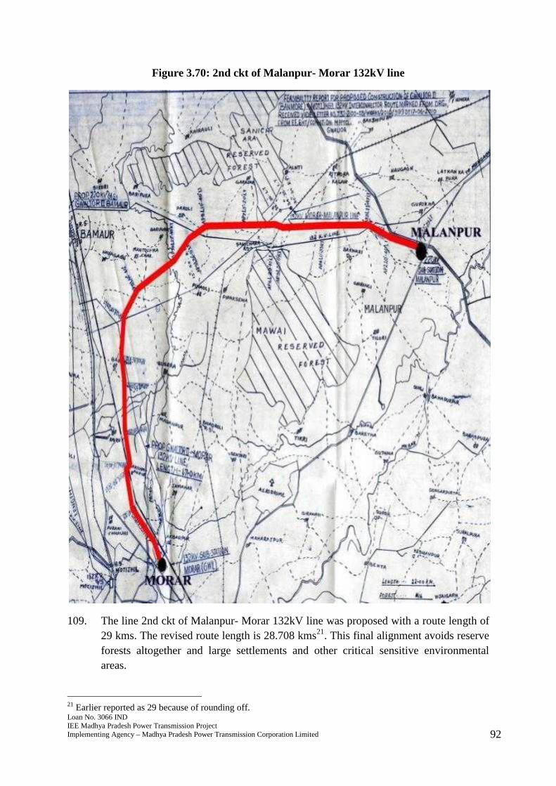
Figure 3.70: 2nd ckt of Malanpur- Morar 132kV line
109. The line 2nd ckt of Malanpur- Morar 132kV line was proposed with a route length of29 kms. The revised route length is 28.708 kms21. This final alignment avoids reserveforests altogether and large settlements and other critical sensitive environmentalareas.
21 Earlier reported as 29 because of rounding off.
Loan No. 3066 INDIEE Madhya Pradesh Power Transmission ProjectImplementing Agency – Madhya Pradesh Power Transmission Corporation Limited 93
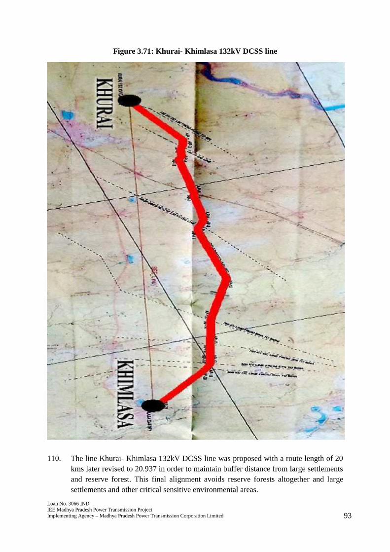
Figure 3.71: Khurai- Khimlasa 132kV DCSS line
110. The line Khurai- Khimlasa 132kV DCSS line was proposed with a route length of 20kms later revised to 20.937 in order to maintain buffer distance from large settlementsand reserve forest. This final alignment avoids reserve forests altogether and largesettlements and other critical sensitive environmental areas.
Loan No. 3066 INDIEE Madhya Pradesh Power Transmission ProjectImplementing Agency – Madhya Pradesh Power Transmission Corporation Limited 94
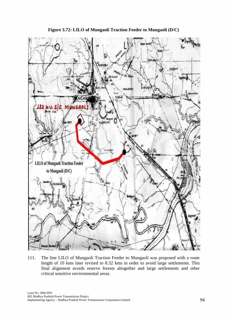
Figure 3.72: LILO of Mungaoli Traction Feeder to Mungaoli (D/C)
111. The line LILO of Mungaoli Traction Feeder to Mungaoli was proposed with a routelength of 10 kms later revised to 8.32 kms in order to avoid large settlements. Thisfinal alignment avoids reserve forests altogether and large settlements and othercritical sensitive environmental areas.
Loan No. 3066 INDIEE Madhya Pradesh Power Transmission ProjectImplementing Agency – Madhya Pradesh Power Transmission Corporation Limited 95
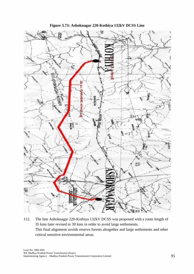
Figure 3.73: Ashoknagar 220-Kothiya 132kV DCSS Line
112. The line Ashoknagar 220-Kothiya 132kV DCSS was proposed with a route length of35 kms later revised to 30 kms in order to avoid large settlements.This final alignment avoids reserve forests altogether and large settlements and othercritical sensitive environmental areas.
Loan No. 3066 INDIEE Madhya Pradesh Power Transmission ProjectImplementing Agency – Madhya Pradesh Power Transmission Corporation Limited 96
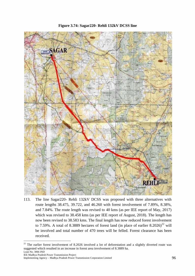
Figure 3.74: Sagar220- Rehli 132kV DCSS line
113. The line Sagar220- Rehli 132kV DCSS was proposed with three alternatives withroute lengths 38.475, 39.722, and 46.260 with forest involvement of 7.89%, 8.38%,and 7.84%. The route length was revised to 40 kms (as per IEE report of May, 2017)which was revised to 38.458 kms (as per IEE report of August, 2018). The length hasnow been revised to 38.583 kms. The final length has now reduced forest involvementto 7.59%. A total of 8.3889 hectares of forest land (in place of earlier 8.2026)22 willbe involved and total number of 470 trees will be felled. Forest clearance has beenreceived.
22 The earlier forest involvement of 8.2026 involved a lot of deforestation and a slightly diverted route wassuggested which resulted in an increase in forest area involvement of 8.3889 ha.
Loan No. 3066 INDIEE Madhya Pradesh Power Transmission ProjectImplementing Agency – Madhya Pradesh Power Transmission Corporation Limited 97
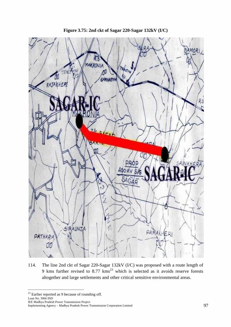
Figure 3.75: 2nd ckt of Sagar 220-Sagar 132kV (I/C)
114. The line 2nd ckt of Sagar 220-Sagar 132kV (I/C) was proposed with a route length of9 kms further revised to 8.77 kms23 which is selected as it avoids reserve forestsaltogether and large settlements and other critical sensitive environmental areas.
23 Earlier reported as 9 because of rounding off.
Loan No. 3066 INDIEE Madhya Pradesh Power Transmission ProjectImplementing Agency – Madhya Pradesh Power Transmission Corporation Limited 98
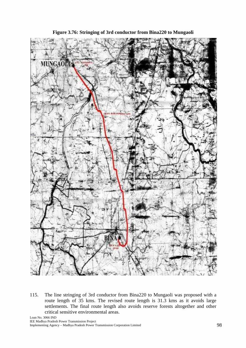
Figure 3.76: Stringing of 3rd conductor from Bina220 to Mungaoli
115. The line stringing of 3rd conductor from Bina220 to Mungaoli was proposed with aroute length of 35 kms. The revised route length is 31.3 kms as it avoids largesettlements. The final route length also avoids reserve forests altogether and othercritical sensitive environmental areas.
Loan No. 3066 INDIEE Madhya Pradesh Power Transmission ProjectImplementing Agency – Madhya Pradesh Power Transmission Corporation Limited 99
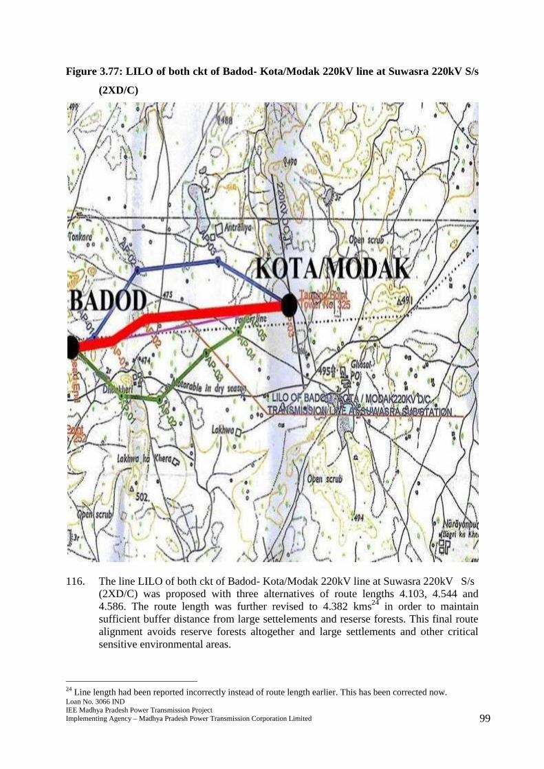
Figure 3.77: LILO of both ckt of Badod- Kota/Modak 220kV line at Suwasra 220kV S/s
(2XD/C)
116. The line LILO of both ckt of Badod- Kota/Modak 220kV line at Suwasra 220kV S/s(2XD/C) was proposed with three alternatives of route lengths 4.103, 4.544 and4.586. The route length was further revised to 4.382 kms24 in order to maintainsufficient buffer distance from large settelements and reserse forests. This final routealignment avoids reserve forests altogether and large settlements and other criticalsensitive environmental areas.
24 Line length had been reported incorrectly instead of route length earlier. This has been corrected now.
Loan No. 3066 INDIEE Madhya Pradesh Power Transmission ProjectImplementing Agency – Madhya Pradesh Power Transmission Corporation Limited 100
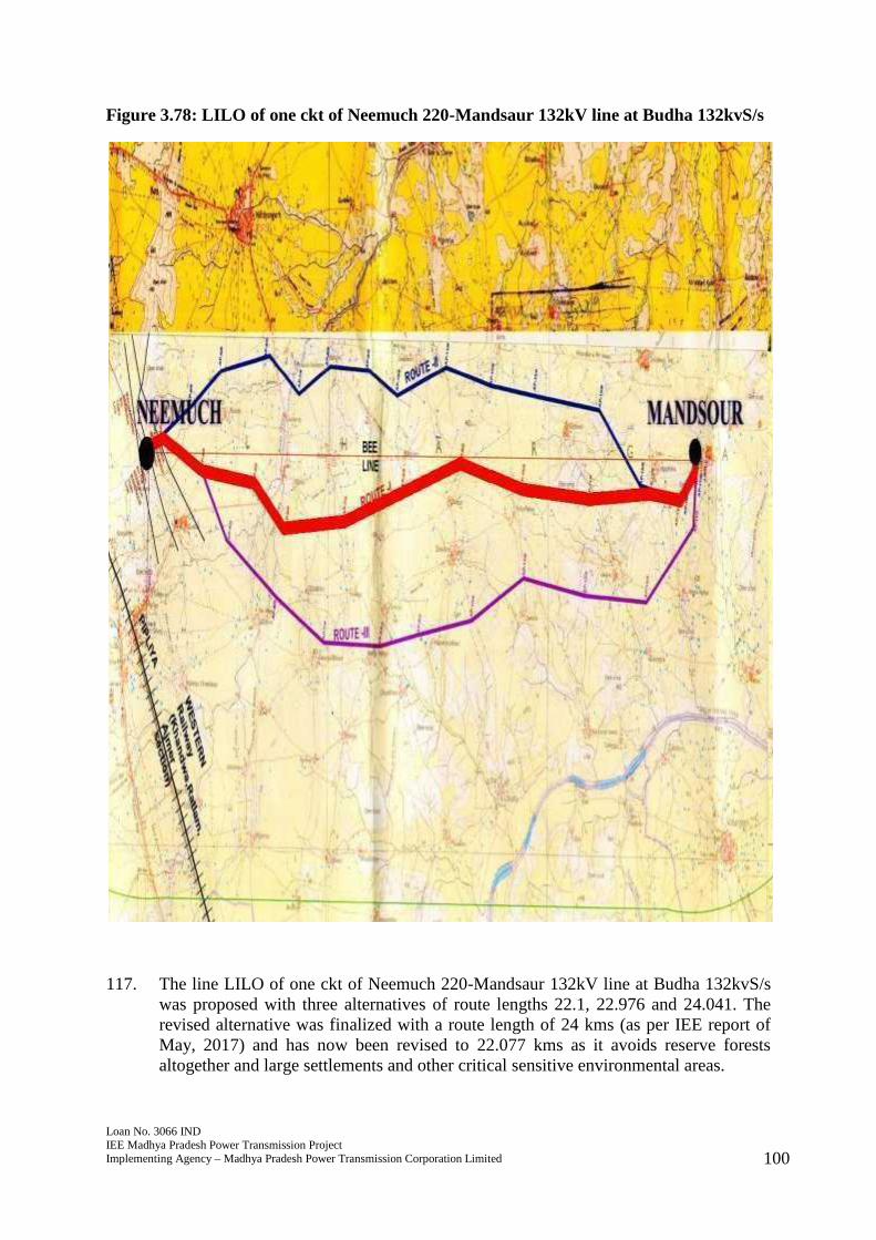
Figure 3.78: LILO of one ckt of Neemuch 220-Mandsaur 132kV line at Budha 132kvS/s
117. The line LILO of one ckt of Neemuch 220-Mandsaur 132kV line at Budha 132kvS/swas proposed with three alternatives of route lengths 22.1, 22.976 and 24.041. Therevised alternative was finalized with a route length of 24 kms (as per IEE report ofMay, 2017) and has now been revised to 22.077 kms as it avoids reserve forestsaltogether and large settlements and other critical sensitive environmental areas.
Loan No. 3066 INDIEE Madhya Pradesh Power Transmission ProjectImplementing Agency – Madhya Pradesh Power Transmission Corporation Limited 101
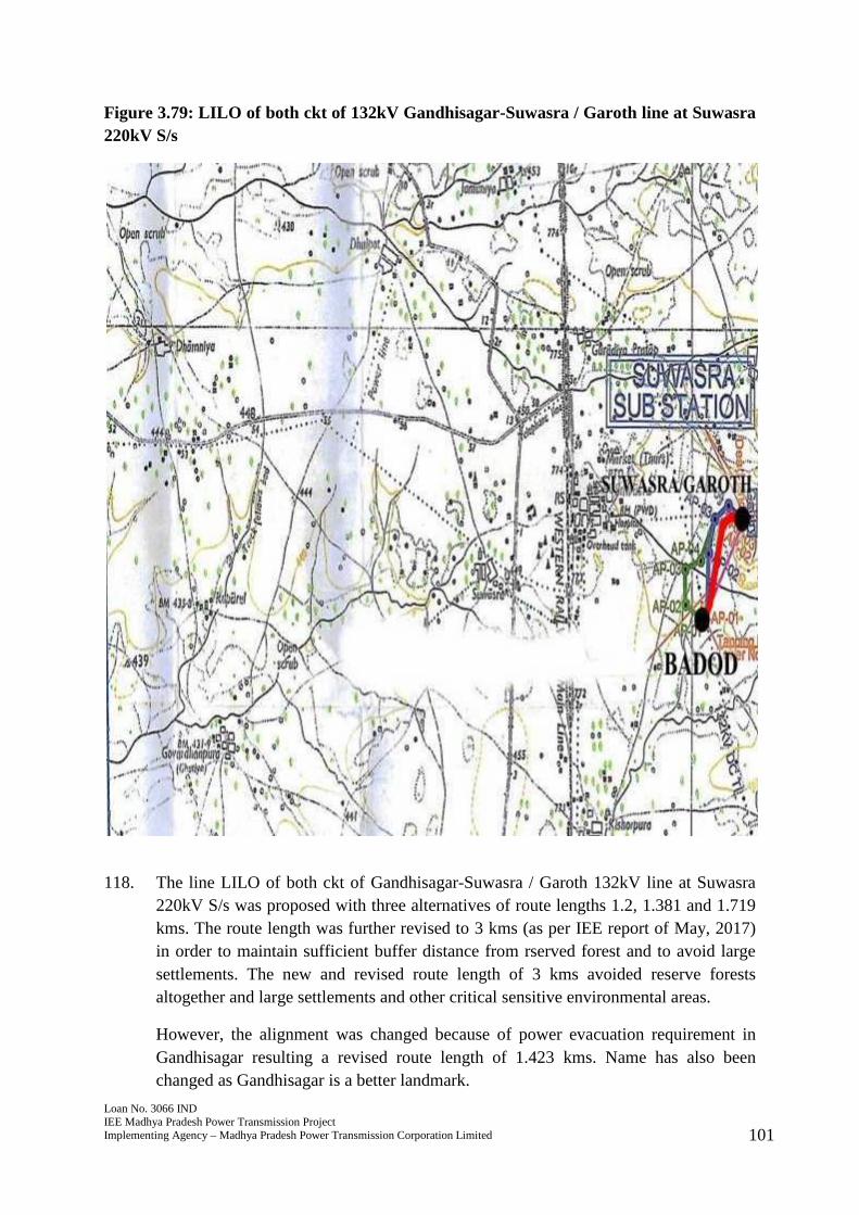
Figure 3.79: LILO of both ckt of 132kV Gandhisagar-Suwasra / Garoth line at Suwasra220kV S/s
118. The line LILO of both ckt of Gandhisagar-Suwasra / Garoth 132kV line at Suwasra220kV S/s was proposed with three alternatives of route lengths 1.2, 1.381 and 1.719kms. The route length was further revised to 3 kms (as per IEE report of May, 2017)in order to maintain sufficient buffer distance from rserved forest and to avoid largesettlements. The new and revised route length of 3 kms avoided reserve forestsaltogether and large settlements and other critical sensitive environmental areas.
However, the alignment was changed because of power evacuation requirement inGandhisagar resulting a revised route length of 1.423 kms. Name has also beenchanged as Gandhisagar is a better landmark.
Loan No. 3066 INDIEE Madhya Pradesh Power Transmission ProjectImplementing Agency – Madhya Pradesh Power Transmission Corporation Limited 102
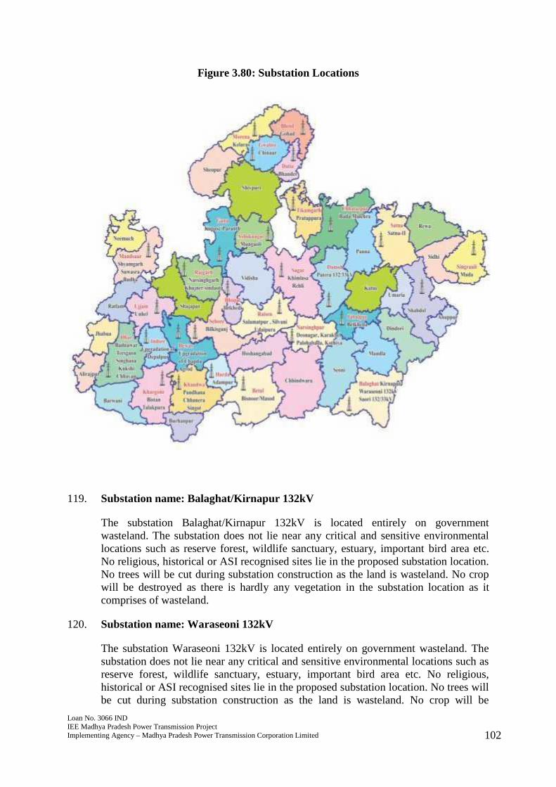
Figure 3.80: Substation Locations
119. Substation name: Balaghat/Kirnapur 132kV
The substation Balaghat/Kirnapur 132kV is located entirely on governmentwasteland. The substation does not lie near any critical and sensitive environmentallocations such as reserve forest, wildlife sanctuary, estuary, important bird area etc.No religious, historical or ASI recognised sites lie in the proposed substation location.No trees will be cut during substation construction as the land is wasteland. No cropwill be destroyed as there is hardly any vegetation in the substation location as itcomprises of wasteland.
120. Substation name: Waraseoni 132kV
The substation Waraseoni 132kV is located entirely on government wasteland. Thesubstation does not lie near any critical and sensitive environmental locations such asreserve forest, wildlife sanctuary, estuary, important bird area etc. No religious,historical or ASI recognised sites lie in the proposed substation location. No trees willbe cut during substation construction as the land is wasteland. No crop will be
Loan No. 3066 INDIEE Madhya Pradesh Power Transmission ProjectImplementing Agency – Madhya Pradesh Power Transmission Corporation Limited 103
destroyed as there is hardly any vegetation in the substation location as it comprises ofwasteland.
121. Substation name: Bada Malehra 132/33kV
The substation Bada Malehra 132/33kV is located entirely on government wasteland.The substation does not lie near any critical and sensitive environmental locationssuch as reserve forest, wildlife sanctuary, estuary, important bird area etc. Noreligious, historical or ASI recognised sites lie in the proposed substation location. Notrees will be cut during substation construction as the land is wasteland. No crop willbe destroyed as there is hardly any vegetation in the substation location as itcomprises of wasteland.
122. Substation name: Deonagar 132/33kV
The substation Deonagar 132/33kV is located entirely on government wasteland. Thesubstation does not lie near any critical and sensitive environmental locations such asreserve forest, wildlife sanctuary, estuary, important bird area etc. No religious,historical or ASI recognised sites lie in the proposed substation location. No trees willbe cut during substation construction as the land is wasteland. No crop will bedestroyed as there is hardly any vegetation in the substation location as it comprises ofwasteland.
123. Substation name: Belkheda 132/33kV
The substation Belkheda 132/33kV is located entirely on government wasteland. Thesubstation does not lie near any critical and sensitive environmental locations such asreserve forest, wildlife sanctuary, estuary, important bird area etc. No religious,historical or ASI recognised sites lie in the proposed substation location. No trees willbe cut during substation construction as the land is wasteland. No crop will bedestroyed as there is hardly any vegetation in the substation location as it comprises ofwasteland.
124. Substation name: Karakbel 132/33kV
The substation Karakbel 132/33kV is located entirely on government wasteland. Thesubstation does not lie near any critical and sensitive environmental locations such asreserve forest, wildlife sanctuary, estuary, important bird area etc. No religious,historical or ASI recognised sites lie in the proposed substation location. No trees willbe cut during substation construction as the land is wasteland. No crop will bedestroyed as there is hardly any vegetation in the substation location as it comprises ofwasteland.
125. Substation name: Saori 132/33kV
The substation Saori 132/33kV is located entirely on government wasteland. Thesubstation does not lie near any critical and sensitive environmental locations such asreserve forest, wildlife sanctuary, estuary, important bird area etc. No religious,historical or ASI recognised sites lie in the proposed substation location. No trees willbe cut during substation construction as the land is wasteland. No crop will bedestroyed as there is hardly any vegetation in the substation location as it comprises of
Loan No. 3066 INDIEE Madhya Pradesh Power Transmission ProjectImplementing Agency – Madhya Pradesh Power Transmission Corporation Limited 104
wasteland.
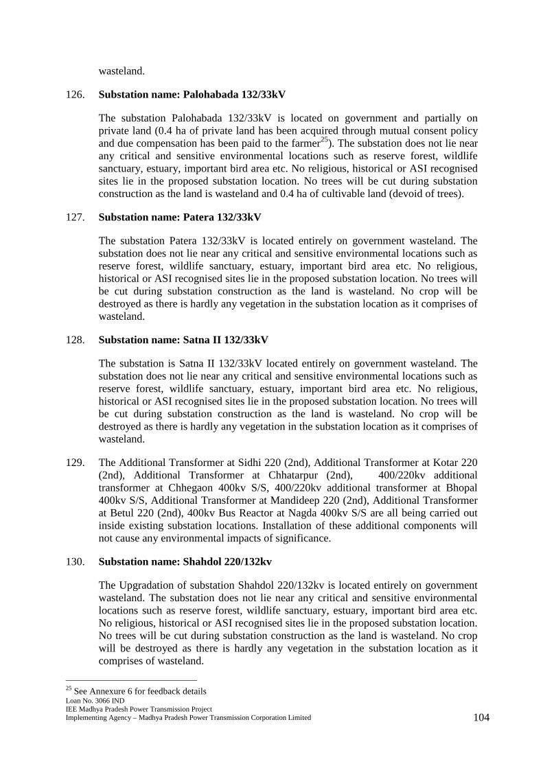
126. Substation name: Palohabada 132/33kV
The substation Palohabada 132/33kV is located on government and partially onprivate land (0.4 ha of private land has been acquired through mutual consent policyand due compensation has been paid to the farmer25). The substation does not lie nearany critical and sensitive environmental locations such as reserve forest, wildlifesanctuary, estuary, important bird area etc. No religious, historical or ASI recognisedsites lie in the proposed substation location. No trees will be cut during substationconstruction as the land is wasteland and 0.4 ha of cultivable land (devoid of trees).
127. Substation name: Patera 132/33kV
The substation Patera 132/33kV is located entirely on government wasteland. Thesubstation does not lie near any critical and sensitive environmental locations such asreserve forest, wildlife sanctuary, estuary, important bird area etc. No religious,historical or ASI recognised sites lie in the proposed substation location. No trees willbe cut during substation construction as the land is wasteland. No crop will bedestroyed as there is hardly any vegetation in the substation location as it comprises ofwasteland.
128. Substation name: Satna II 132/33kV
The substation is Satna II 132/33kV located entirely on government wasteland. Thesubstation does not lie near any critical and sensitive environmental locations such asreserve forest, wildlife sanctuary, estuary, important bird area etc. No religious,historical or ASI recognised sites lie in the proposed substation location. No trees willbe cut during substation construction as the land is wasteland. No crop will bedestroyed as there is hardly any vegetation in the substation location as it comprises ofwasteland.
129. The Additional Transformer at Sidhi 220 (2nd), Additional Transformer at Kotar 220(2nd), Additional Transformer at Chhatarpur (2nd), 400/220kv additionaltransformer at Chhegaon 400kv S/S, 400/220kv additional transformer at Bhopal400kv S/S, Additional Transformer at Mandideep 220 (2nd), Additional Transformerat Betul 220 (2nd), 400kv Bus Reactor at Nagda 400kv S/S are all being carried outinside existing substation locations. Installation of these additional components willnot cause any environmental impacts of significance.
130. Substation name: Shahdol 220/132kv
The Upgradation of substation Shahdol 220/132kv is located entirely on governmentwasteland. The substation does not lie near any critical and sensitive environmentallocations such as reserve forest, wildlife sanctuary, estuary, important bird area etc.No religious, historical or ASI recognised sites lie in the proposed substation location.No trees will be cut during substation construction as the land is wasteland. No cropwill be destroyed as there is hardly any vegetation in the substation location as itcomprises of wasteland.
25 See Annexure 6 for feedback details
Loan No. 3066 INDIEE Madhya Pradesh Power Transmission ProjectImplementing Agency – Madhya Pradesh Power Transmission Corporation Limited 105
131. Substation name: Badnawar 400/220kv
The substation Badnawar 400/220kv is located entirely on government wasteland.The substation does not lie near any critical and sensitive environmental locationssuch as reserve forest, wildlife sanctuary, estuary, important bird area etc. Noreligious, historical or ASI recognised sites lie in the proposed substation location. Notrees will be cut during substation construction as the land is wasteland. No crop willbe destroyed as there is hardly any vegetation in the substation location as itcomprises of wasteland.
132. Substation name: Chapda 132kv
The Upgradation of Chapda 132kv substation to 220kv is being done entirely ongovernment wasteland. The substation does not lie near any critical and sensitiveenvironmental locations such as reserve forest, wildlife sanctuary, estuary, importantbird area etc. No religious, historical or ASI recognised sites lie in the proposedsubstation location. No trees will be cut during substation construction as the land iswasteland. No crop will be destroyed as there is hardly any vegetation in thesubstation location as it comprises of wasteland.
133. Substation name: Depalpur 132kv
The Upgradation of Depalpur 132kv substation to 220kv is being done entirely ongovernment wasteland. The substation does not lie near any critical and sensitiveenvironmental locations such as reserve forest, wildlife sanctuary, estuary, importantbird area etc. No religious, historical or ASI recognised sites lie in the proposedsubstation location. No trees will be cut during substation construction as the land iswasteland. No crop will be destroyed as there is hardly any vegetation in thesubstation location as it comprises of wasteland.
134. Substation name: Agrod 132/33kV
The substation Agrod 132/33kV is located entirely on government wasteland. Thesubstation does not lie near any critical and sensitive environmental locations such asreserve forest, wildlife sanctuary, estuary, important bird area etc. No religious,historical or ASI recognised sites lie in the proposed substation location. No trees willbe cut during substation construction as the land is wasteland. No crop will bedestroyed as there is hardly any vegetation in the substation location as it comprises ofwasteland.
135. Substation name: Teesgaon 132/33kV
The substation Teesgaon 132/33kV is located entirely on government wasteland. Thesubstation does not lie near any critical and sensitive environmental locations such asreserve forest, wildlife sanctuary, estuary, important bird area etc. No religious,historical or ASI recognised sites lie in the proposed substation location. No trees willbe cut during substation construction as the land is wasteland. No crop will bedestroyed as there is hardly any vegetation in the substation location as it comprises ofwasteland.
136. Substation name: Bistan 132/33 kV
Loan No. 3066 INDIEE Madhya Pradesh Power Transmission ProjectImplementing Agency – Madhya Pradesh Power Transmission Corporation Limited 106
The substation Bistan 132/33 kV is located entirely on government wasteland. Thesubstation does not lie near any critical and sensitive environmental locations such asreserve forest, wildlife sanctuary, estuary, important bird area etc. No religious,historical or ASI recognised sites lie in the proposed substation location. No trees willbe cut during substation construction as the land is wasteland. No crop will bedestroyed as there is hardly any vegetation in the substation location as it comprises ofwasteland.
137. Substation name: Pandhana 132/33kV
The substation Pandhana 132/33kV is located entirely on government wasteland. Thesubstation does not lie near any critical and sensitive environmental locations such asreserve forest, wildlife sanctuary, estuary, important bird area etc. No religious,historical or ASI recognised sites lie in the proposed substation location. No trees willbe cut during substation construction as the land is wasteland. No crop will bedestroyed as there is hardly any vegetation in the substation location as it comprises ofwasteland.
138. Substation name: Singhana 132/33kV
The substation Singhana 132/33kV is located entirely on government wasteland. Thesubstation does not lie near any critical and sensitive environmental locations such asreserve forest, wildlife sanctuary, estuary, important bird area etc. No religious,historical or ASI recognised sites lie in the proposed substation location. No trees willbe cut during substation construction as the land is wasteland. No crop will bedestroyed as there is hardly any vegetation in the substation location as it comprises ofwasteland.
139. Substation name: Talakpura 132/33kV
The substation Talakpura 132/33kV is located entirely on government wasteland. Thesubstation does not lie near any critical and sensitive environmental locations such asreserve forest, wildlife sanctuary, estuary, important bird area etc. No religious,historical or ASI recognised sites lie in the proposed substation location. No trees willbe cut during substation construction as the land is wasteland. No crop will bedestroyed as there is hardly any vegetation in the substation location as it comprises ofwasteland.
140. Substation name: Kukshi 220/132kv
The substation Kukshi 220/132kv is located entirely on government wasteland. Thesubstation does not lie near any critical and sensitive environmental locations such asreserve forest, wildlife sanctuary, estuary, important bird area etc. No religious,historical or ASI recognised sites lie in the proposed substation location. No trees willbe cut during substation construction as the land is wasteland. No crop will bedestroyed as there is hardly any vegetation in the substation location as it comprises ofwasteland.
141. Substation name: Chhanera 220/132kV
The substation Chhanera 220/132kV is located entirely on government wasteland.
Loan No. 3066 INDIEE Madhya Pradesh Power Transmission ProjectImplementing Agency – Madhya Pradesh Power Transmission Corporation Limited 107
The substation does not lie near any critical and sensitive environmental locationssuch as reserve forest, wildlife sanctuary, estuary, important bird area etc. Noreligious, historical or ASI recognised sites lie in the proposed substation location. Notrees will be cut during substation construction as the land is wasteland. No crop willbe destroyed as there is hardly any vegetation in the substation location as itcomprises of wasteland.
142. Substation name: Singot 132/33kV
The substation Singot 132/33kV is located entirely on government wasteland. Thesubstation does not lie near any critical and sensitive environmental locations such asreserve forest, wildlife sanctuary, estuary, important bird area etc. No religious,historical or ASI recognised sites lie in the proposed substation location. No trees willbe cut during substation construction as the land is wasteland. No crop will bedestroyed as there is hardly any vegetation in the substation location as it comprises ofwasteland.
143. Substation name: Salamatpur 132/33kv
The substation Salamatpur 132/33kv is located entirely on government wasteland.The substation does not lie near any critical and sensitive environmental locationssuch as reserve forest, wildlife sanctuary, estuary, important bird area etc. Noreligious, historical or ASI recognised sites lie in the proposed substation location. Notrees will be cut during substation construction as the land is wasteland. No crop willbe destroyed as there is hardly any vegetation in the substation location as itcomprises of wasteland.
144. Substation name: Intkhedi 132/33kv
The substation Intkhedi 132/33kv is located entirely on government wasteland. Thesubstation does not lie near any critical and sensitive environmental locations such asreserve forest, wildlife sanctuary, estuary, important bird area etc. No religious,historical or ASI recognised sites lie in the proposed substation location. No trees willbe cut during substation construction as the land is wasteland. No crop will bedestroyed as there is hardly any vegetation in the substation location as it comprises ofwasteland.
145. Substation name: Narsinghgarh 132/33kv
The substation Narsinghgarh 132/33kv is located entirely on government wasteland.The substation does not lie near any critical and sensitive environmental locationssuch as reserve forest, wildlife sanctuary, estuary, important bird area etc. Noreligious, historical or ASI recognised sites lie in the proposed substation location. Notrees will be cut during substation construction as the land is wasteland. No crop willbe destroyed as there is hardly any vegetation in the substation location as itcomprises of wasteland.
146. Substation name: Adampur 220/33kv
The substation Adampur 220/33kv is located entirely on government wasteland. Thesubstation does not lie near any critical and sensitive environmental locations such as

Loan No. 3066 INDIEE Madhya Pradesh Power Transmission ProjectImplementing Agency – Madhya Pradesh Power Transmission Corporation Limited 108
reserve forest, wildlife sanctuary, estuary, important bird area etc. No religious,historical or ASI recognised sites lie in the proposed substation location. No trees willbe cut during substation construction as the land is wasteland. No crop will bedestroyed as there is hardly any vegetation in the substation location as it comprises ofwasteland.
147. Substation name: Bilkisganj 132/33kV
The substation Bilkisganj 132/33kV is located entirely on government wasteland. Thesubstation does not lie near any critical and sensitive environmental locations such asreserve forest, wildlife sanctuary, estuary, important bird area etc. No religious,historical or ASI recognised sites lie in the proposed substation location. No trees willbe cut during substation construction as the land is wasteland. No crop will bedestroyed as there is hardly any vegetation in the substation location as it comprises ofwasteland.
148. Substation name: Khujner/sindaota132/33kV
The substation Khujner/sindaota132/33kV is located entirely on governmentwasteland. The substation does not lie near any critical and sensitive environmentallocations such as reserve forest, wildlife sanctuary, estuary, important bird area etc.No religious, historical or ASI recognised sites lie in the proposed substation location.No trees will be cut during substation construction as the land is wasteland. No cropwill be destroyed as there is hardly any vegetation in the substation location as itcomprises of wasteland.
149. Substation name: Silvani 132kv /33kv
The substation Silvani 132kv /33kv is located entirely on government wasteland. Thesubstation does not lie near any critical and sensitive environmental locations such asreserve forest, wildlife sanctuary, estuary, important bird area etc. No religious,historical or ASI recognised sites lie in the proposed substation location. No trees willbe cut during substation construction as the land is wasteland. No crop will bedestroyed as there is hardly any vegetation in the substation location as it comprises ofwasteland.
150. Substation name: Udaipura 132/33kv
The substation Udaipura 132/33kv is located entirely on government wasteland. Thesubstation does not lie near any critical and sensitive environmental locations such asreserve forest, wildlife sanctuary, estuary, important bird area etc. No religious,historical or ASI recognised sites lie in the proposed substation location. No trees willbe cut during substation construction as the land is wasteland. No crop will bedestroyed as there is hardly any vegetation in the substation location as it comprises ofwasteland.
151. Substation name: Bisnoor/Masod 132/33kV
The substation Bisnoor/Masod 132/33kV is located entirely on governmentwasteland. The substation does not lie near any critical and sensitive environmentallocations such as reserve forest, wildlife sanctuary, estuary, important bird area etc.
Loan No. 3066 INDIEE Madhya Pradesh Power Transmission ProjectImplementing Agency – Madhya Pradesh Power Transmission Corporation Limited 109
No religious, historical or ASI recognised sites lie in the proposed substation location.No trees will be cut during substation construction as the land is wasteland. No cropwill be destroyed as there is hardly any vegetation in the substation location as itcomprises of wasteland.
152. Substation name: Chhayan 132/33kV
The substation Chhayan 132/33kV is located entirely on government wasteland. Thesubstation does not lie near any critical and sensitive environmental locations such asreserve forest, wildlife sanctuary, estuary, important bird area etc. No religious,historical or ASI recognised sites lie in the proposed substation location. No trees willbe cut during substation construction as the land is wasteland. No crop will bedestroyed as there is hardly any vegetation in the substation location as it comprises ofwasteland.
153. Substation name: Shyamgarh 132/33kV
The substation Shyamgarh 132/33kV is located entirely on government wasteland.The substation does not lie near any critical and sensitive environmental locationssuch as reserve forest, wildlife sanctuary, estuary, important bird area etc. Noreligious, historical or ASI recognised sites lie in the proposed substation location. Notrees will be cut during substation construction as the land is wasteland. No crop willbe destroyed as there is hardly any vegetation in the substation location as itcomprises of wasteland.
154. Substation name: Suwasra 220/132kV
The substation Suwasra 220/132kV is located entirely on government wasteland. Thesubstation does not lie near any critical and sensitive environmental locations such asreserve forest, wildlife sanctuary, estuary, important bird area etc. No religious,historical or ASI recognised sites lie in the proposed substation location. No trees willbe cut during substation construction as the land is wasteland. No crop will bedestroyed as there is hardly any vegetation in the substation location as it comprises ofwasteland.
155. Substation name: Unhel 132/33kV
The substation Unhel 132/33kV is located entirely on government wasteland. Thesubstation does not lie near any critical and sensitive environmental locations such asreserve forest, wildlife sanctuary, estuary, important bird area etc. No religious,historical or ASI recognised sites lie in the proposed substation location. No trees willbe cut during substation construction as the land is wasteland. No crop will bedestroyed as there is hardly any vegetation in the substation location as it comprises ofwasteland.
156. Substation name: Budha 132/33kV
The substation Budha 132/33kV is located entirely on government wasteland. Thesubstation does not lie near any critical and sensitive environmental locations such asreserve forest, wildlife sanctuary, estuary, important bird area etc. No religious,historical or ASI recognised sites lie in the proposed substation location. No trees will
Loan No. 3066 INDIEE Madhya Pradesh Power Transmission ProjectImplementing Agency – Madhya Pradesh Power Transmission Corporation Limited 110
be cut during substation construction as the land is wasteland. No crop will bedestroyed as there is hardly any vegetation in the substation location as it comprises ofwasteland.
157. Substation name: Chinaur 132/33kV
The substation Chinaur 132/33kV is located entirely on government wasteland. Thesubstation does not lie near any critical and sensitive environmental locations such asreserve forest, wildlife sanctuary, estuary, important bird area etc. No religious,historical or ASI recognised sites lie in the proposed substation location. No trees willbe cut during substation construction as the land is wasteland. No crop will bedestroyed as there is hardly any vegetation in the substation location as it comprises ofwasteland.
158. Substation name: Bhander 132/33kV
The substation Bhander 132/33kV is located entirely on government wasteland. Thesubstation does not lie near any critical and sensitive environmental locations such asreserve forest, wildlife sanctuary, estuary, important bird area etc. No religious,historical or ASI recognised sites lie in the proposed substation location. No trees willbe cut during substation construction as the land is wasteland. No crop will bedestroyed as there is hardly any vegetation in the substation location as it comprises ofwasteland.
159. Substation name: Pratappura 132/33kV
The substation Pratappura 132/33kV is located entirely on government wasteland.The substation does not lie near any critical and sensitive environmental locationssuch as reserve forest, wildlife sanctuary, estuary, important bird area etc. Noreligious, historical or ASI recognised sites lie in the proposed substation location. Notrees will be cut during substation construction as the land is wasteland. No crop willbe destroyed as there is hardly any vegetation in the substation location as itcomprises of wasteland.
160. Substation name: Kelaras 132/33kV
The substation Kelaras 132/33kV is located entirely on government wasteland. Thesubstation does not lie near any critical and sensitive environmental locations such asreserve forest, wildlife sanctuary, estuary, important bird area etc. No religious,historical or ASI recognised sites lie in the proposed substation location. No trees willbe cut during substation construction as the land is wasteland. No crop will bedestroyed as there is hardly any vegetation in the substation location as it comprises ofwasteland.
161. Substation name: Gohad 132/33kV
The substation Gohad 132/33kV is located entirely on government wasteland. Thesubstation does not lie near any critical and sensitive environmental locations such asreserve forest, wildlife sanctuary, estuary, important bird area etc. No religious,historical or ASI recognised sites lie in the proposed substation location. No trees willbe cut during substation construction as the land is wasteland. No crop will be
Loan No. 3066 INDIEE Madhya Pradesh Power Transmission ProjectImplementing Agency – Madhya Pradesh Power Transmission Corporation Limited 111
destroyed as there is hardly any vegetation in the substation location as it comprises ofwasteland.
162. Substation name: Kapasi/ Paranth 132/33kv
The substation Kapasi/ Paranth 132/33kv is located entirely on governmentwasteland. The substation does not lie near any critical and sensitive environmentallocations such as reserve forest, wildlife sanctuary, estuary, important bird area etc.No religious, historical or ASI recognised sites lie in the proposed substation location.No trees will be cut during substation construction as the land is wasteland. No cropwill be destroyed as there is hardly any vegetation in the substation location as itcomprises of wasteland.
163. Substation name: Mada132/33kV
The substation Mada132/33kV is located entirely on government wasteland. Thesubstation does not lie near any critical and sensitive environmental locations such asreserve forest, wildlife sanctuary, estuary, important bird area etc. No religious,historical or ASI recognised sites lie in the proposed substation location. No trees willbe cut during substation construction as the land is wasteland. No crop will bedestroyed as there is hardly any vegetation in the substation location as it comprises ofwasteland.
164. Substation name: Khimlasa 132/33kV
The substation Khimlasa 132/33kV is located entirely on government wasteland. Thesubstation does not lie near any critical and sensitive environmental locations such asreserve forest, wildlife sanctuary, estuary, important bird area etc. No religious,historical or ASI recognised sites lie in the proposed substation location. No trees willbe cut during substation construction as the land is wasteland. No crop will bedestroyed as there is hardly any vegetation in the substation location as it comprises ofwasteland.
165. Substation name: Mungaoli 132/33kV
The substation Mungaoli 132/33kV is located entirely on government wasteland. Thesubstation does not lie near any critical and sensitive environmental locations such asreserve forest, wildlife sanctuary, estuary, important bird area etc. No religious,historical or ASI recognised sites lie in the proposed substation location. No trees willbe cut during substation construction as the land is wasteland. No crop will bedestroyed as there is hardly any vegetation in the substation location as it comprises ofwasteland.
166. Substation name: Kothiya 132/33kV
The substation Kothiya 132/33kV is located entirely on government wasteland. Thesubstation does not lie near any critical and sensitive environmental locations such asreserve forest, wildlife sanctuary, estuary, important bird area etc. No religious,historical or ASI recognised sites lie in the proposed substation location. No trees willbe cut during substation construction as the land is wasteland. No crop will bedestroyed as there is hardly any vegetation in the substation location as it comprises of
Loan No. 3066 INDIEE Madhya Pradesh Power Transmission ProjectImplementing Agency – Madhya Pradesh Power Transmission Corporation Limited 112
wasteland.
167. Substation name: Rehli 132/33kV
The substation Rehli 132/33kV is located entirely on government wasteland. Thesubstation does not lie near any critical and sensitive environmental locations such asreserve forest, wildlife sanctuary, estuary, important bird area etc. No religious,historical or ASI recognised sites lie in the proposed substation location. No trees willbe cut during substation construction as the land is wasteland. No crop will bedestroyed as there is hardly any vegetation in the substation location as it comprises ofwasteland.
168. All the 56 new substations will be air insulated substation (AIS) which usesatmospheric air as the phase to ground insulation for the switchgear of the substation.Main disadvantage of the AIS substation is the overall size making it attractive tolocate in the rural areas and they are usually installed outdoor. Given the availablespace on Government land in MP and the cost of land transfer between Governmentagencies, using AIS will not be a constraint.
169. Land required for substations varies with capacity and in selecting a potentialsubstation site; MP Transco considers future growth and expansion of substations. Asa rule of thumb, MP Transco is guided by the following approximate landrequirements: (i) 36 ha for 440 kV substations, (ii) 9 ha for 220 kV substation, and(iii) 2.25 ha for 133 kV substation. All substations are located on governmentwasteland with little scrubland or no vegetation and thus, there will be negligibleenvironmental impacts from substation construction.
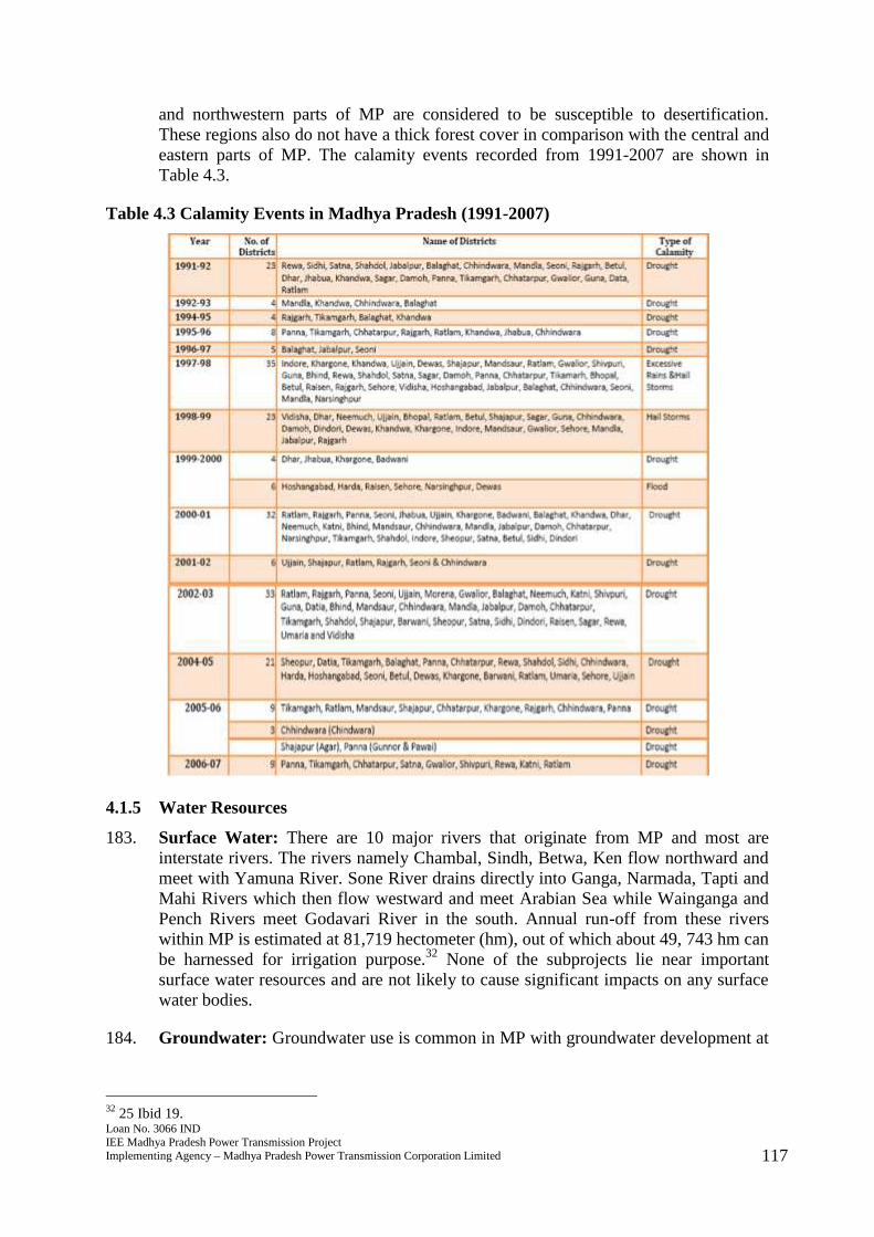
170. The conductors for the transmission line will be a mix of single ACSR double circuitand ACSR moose four (quad bundle) of aluminum alloy conductor material while thesupporting towers will be lattice steel structures of two types – tension andsuspension, double-circuit with bolted joints which is designed to carry the lineconductors with necessary insulators, earth wire, fittings and fixtures under all loadingconditions. Double circuit configuration allows for an increased long-term reliabilityand capacity of the transmission lines to evacuate power over long distances.
3.1.3 Implementation Activities
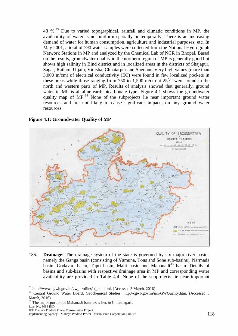
171. Broadly, the implementation of transmission system improvements includes detailedand check survey, excavation, tower site leveling, backfilling (if needed), constructionof substations, tower erection and assembly, stringing of conductors and earthwire,pre-commissioning and commissioning. For the erection of transmission lines andconstruction of substation, the following GoI standards/codes shown in Table 3.3 willbe complied with by MP Transco:
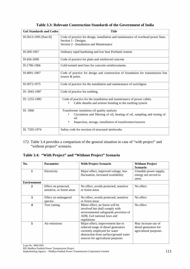
Loan No. 3066 INDIEE Madhya Pradesh Power Transmission ProjectImplementing Agency – Madhya Pradesh Power Transmission Corporation Limited 113
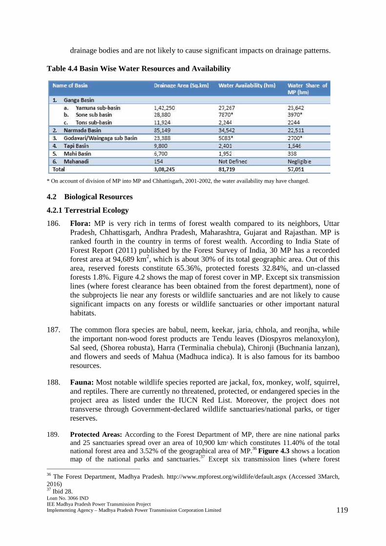
Table 3.3: Relevant Construction Standards of the Government of India
GoI Standards and Codes Title
IS:5613-1995 (Part-II) Code of practice for design, installation and maintenance of overhead power lines.Section 1 - Designs.Section 2 - Installation and Maintenance
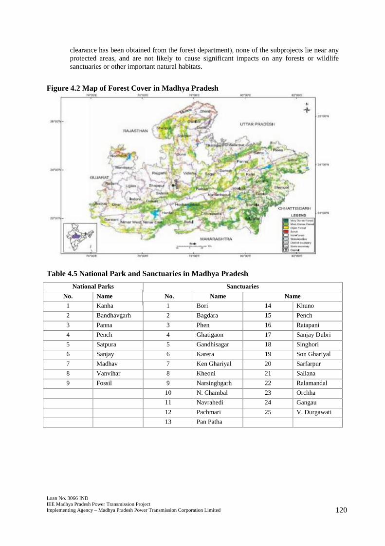
IS:269-1967 Ordinary rapid hardening and low heat Portland cement.
IS:456-2000 Code of practice for plain and reinforced concrete
IS:1786-1966 Cold twisted steel bars for concrete reinforcements.
IS:4091-1967 Code of practice for design and construction of foundation for transmission linetowers & poles.
IS:3072-1975 Code of practice for the installation and maintenance of switchgear.
IS: 3043-1987 Code of practice for earthing.
IS: 1255-1983 Code of practice for the installation and maintenance of power cables Cable sheaths and armour bonding to the earthing system
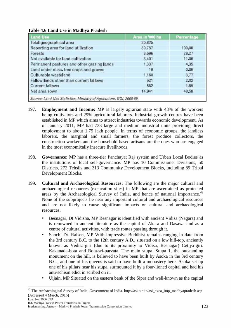
IS: 1866 Transformer insulation oil quality analysis Circulation and filtering of oil, heating of oil, sampling and testing of
oil Inspection, storage, installation of transformers/reactors
IS: 7205-1974 Safety code for erection of structural steelworks.
172. Table 3.4 provides a comparison of the general situation in case of “with project” and“without project” scenario.
Table 3.4: “With Project” and “Without Project” Scenario
No. Parameter With Project Scenario Without ProjectScenario
1 Electricity Major effect, improved voltage, lessfluctuation, increased availability
Unstable power supply,energy not served tousers
Environment2 Effect on protected,
sensitive, or forest areasNo effect, avoids protected, sensitiveor forest areas
No effect
3 Effect on endangeredspecies
No effect, avoids protected, sensitiveor forest areas
No effect
4 Tree cutting Minor effect, no forest will beinvolved but shall comply withenvironmental safeguards provision ofADB, GoI national laws andregulations
No effect
5 Air emissions Major effect; improvement due toreduced usage of diesel generatorscurrently employed for waterabstraction from surface/ground watersources for agricultural purposes
May increase use ofdiesel generators foragricultural purposes
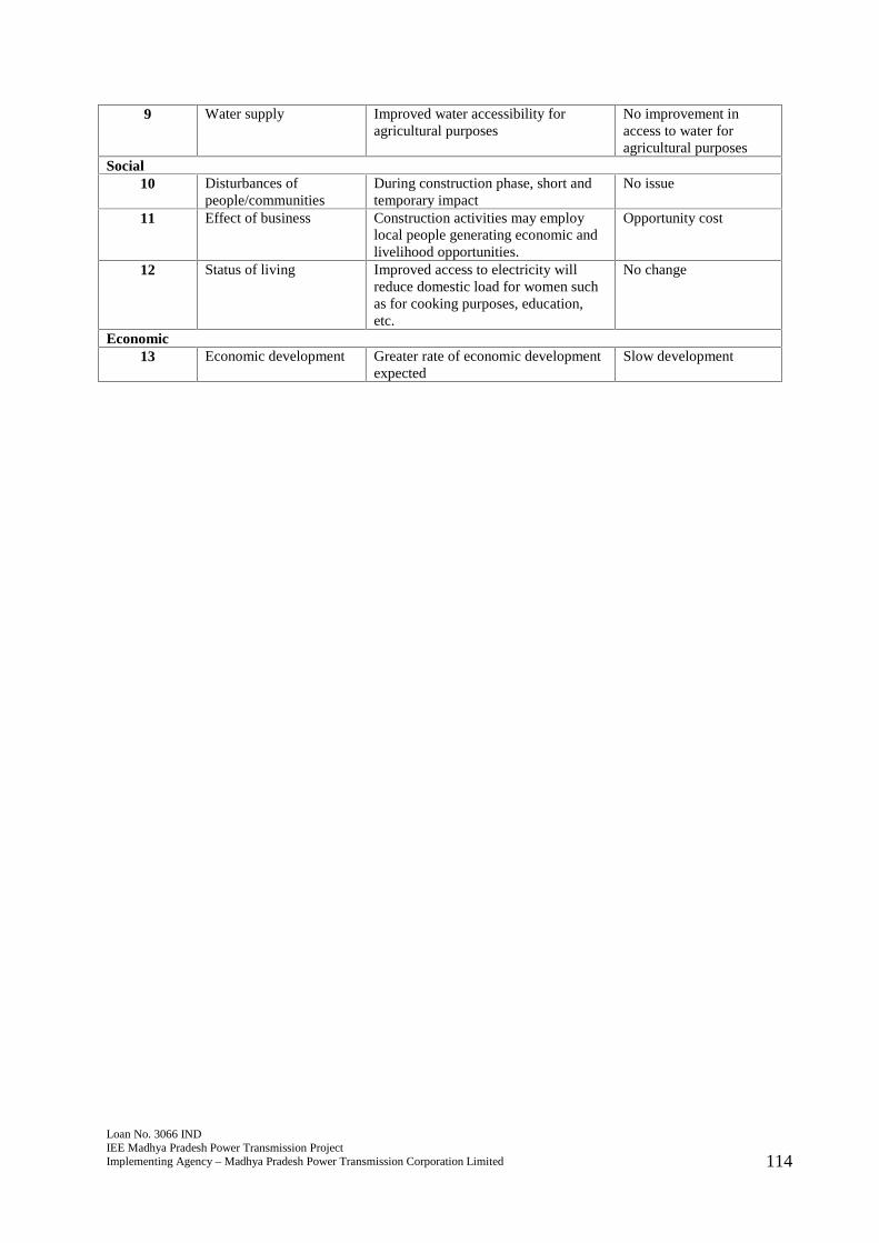
Loan No. 3066 INDIEE Madhya Pradesh Power Transmission ProjectImplementing Agency – Madhya Pradesh Power Transmission Corporation Limited 114
9 Water supply Improved water accessibility foragricultural purposes
No improvement inaccess to water foragricultural purposes
Social10 Disturbances of
people/communitiesDuring construction phase, short andtemporary impact
No issue
11 Effect of business Construction activities may employlocal people generating economic andlivelihood opportunities.
Opportunity cost
12 Status of living Improved access to electricity willreduce domestic load for women suchas for cooking purposes, education,etc.
No change
Economic13 Economic development Greater rate of economic development
expectedSlow development
Loan No. 3066 INDIEE Madhya Pradesh Power Transmission ProjectImplementing Agency – Madhya Pradesh Power Transmission Corporation Limited 115
4.0 DESCRIPTION OF ENVIRONMENT
4.1 Physical Resources
4.1.1 Topography, Geology, and Soils
173. The project and subprojects of MP Transco are located in various geographiclocations across MP, which lies between latitude 21o6' and 26o54'N and longitude 740
and 82047'E. MP covers a geographical area of 308,245 square km (km2) or about9.38% of the total area of India. MP is land-locked and surrounded by Uttar Pradesh,Chhattisgarh, Andhra Pradesh, Maharashtra, Gujarat and Rajasthan. MP is traversedby the Vindhya, Satpura and Maikal hill ranges running east-west. Most of MP has anelevation of between 305 to 610 meters above mean sea level. Low-lying areas are inthe narrow Narmada valley in the central southern parts. In general, MP stretchesacross a geographically elevated position.26 The area is part of peninsular plateauconsisting of sedimentary and metamorphic rocks and is structurally part of thepeninsular block.
174. MP has 5 crop zones, 11 agro climatic regions and 4 soil types, which add to itsbiodiversity and acts favorably for production of various agriculture and horticulturecrops. The soil of the region is rich and fertile and of variety ranging from rich clayeyto gravelly. The major groups of soils found in MP can be divided into 4 categoriesnamely; alluvial, medium and deep black, shallow and medium black, mixed red andblack.27
4.1.2 Meteorology and Climate
175. Climate: MP has a typically tropical climate varying from dry sub-humid to semi-arid,with three distinct seasons - winter, summer and monsoons.
176. Rainfall: Annual rainfall in the state varies from 600 mm to 1,600 mm while theaverage rainfall in MP is 1,200 mm. There is one distinct rainy season when MPreceives rains through the southwest monsoon in the months of June to October.Production in almost 70% of the agriculture area remains highly dependent onrainfall.
177. Temperature: MP has a tropical climate. The lowest temperature during the coolermonths of December and January is 10°C and in the summer months of May andJune, the temperature reaches 29°C.28 Most parts of MP in summer are hot and humid.
4.1.3 Air Quality and Noise
178. Air quality in MP is considered to be good except in few urban and industrial centerswhere air quality is poor due to industrial activities and transport sources. Ambient airquality measurements are conducted on a continuous basis by the Madhya PradeshState Pollution Control Board (MPPCB) in various cities in MP.29 Ambient air quality
26 The Department of Land Resources, GoI.http://dolr.nic.in/dolr/downloads/spsp/Madhya%20Pradesh_SPSP.pdf. (Accessed 3 March, 2016)27 Ibid 17.28 India – WRIS (Water Resources Information System of India).http://india-wris.nrsc.gov.in/wrpinfo/index.php?title=Madhya_Pradesh#Climate. (Accessed 3 March 2016)29 Madhya Pradesh State Pollution Control Board. Ambient air quality measurements (interactive).http://www.mppcb.nic.in/aaqm_data.htm. (Accessed 3 March, 2016)

Loan No. 3066 INDIEE Madhya Pradesh Power Transmission ProjectImplementing Agency – Madhya Pradesh Power Transmission Corporation Limited 116
measurements generally comply with Air Prevention and Control of Pollution Act1981 and the National Ambient Air Quality Standards.30 For the project, baseline datafor environmental parameters such as air and noise is not available but will be carriedout and recorded by contractor before commencement of civil works.
179. As of February 2013, MPPCB has come up with new guidelines for curbing air andnoise pollution associated with construction activities, with the implementation of theIndore Municipal Corporation. Under the new guidelines, all construction works willhave to be carried out between 7 am and 7 pm, and construction sites should becovered with acoustic screens and enclosures to control noise. Aside from this,contractors will have to enclose noisy machineries in acoustic enclosures. The noisestandards as given by the MoEFCC are:31
Table 4.1 Noise Standards, Ministry of Environment and ForestsNoise Standards
Code Day Time(6 am – 9 pm)
Night Time(9 pm – 9 am)
A Industrial 75 70B Commercial 65 55C Residential 55 45D Silence Zone 50 40
4.1.4 Natural Hazards
180. Seismicity: The Bureau of Indian Statistics (IS-1893 Part 1, 2002) classified India intofour seismic zones based on various scientific inputs including earthquake data fromIndia Meteorological Department (IMD). The seismic zones in India are given below:
Table 4.2 Seismic Zones of India
Seismic Zone Intensity on Modified MercalIi Scale % of total areaII (Low intensity zone) VI (or less) 43%III (Moderate intensity zone) VII 27%IV (Severe intensity zone) VIII 18%V (Very severe intensity zone) IX (and above) 12%
181. According to IMD, MP falls with Zones II and III (i.e., low to moderate damage riskseismic zone). Historically, parts of MP have experienced seismic activity in the rangeof intensity 5 to 6 of the Modified Mercalli Intensity (MMI) scale. Based on historicalrecords of earthquake events in India from 16 June 1819 to 18 September 2011, onlyone earthquake occurred in Madhya Pradesh on 22 May 1997 at intensity 6 based onMMI scale. IMD has an earthquake monitoring and a real time seismic monitoring forearly warning of tsunamis.
182. Drought and Floods: With its vast expanse, geographical features and varying climateconditions, different parts of MP have been perennially prone to drought conditions aswell as floods. During 2007-2008, 39 out of 50 districts (165 Tehsils and one cluster)of MP have been declared as drought affected. Additionally, district in the western
30 The Central Pollution Control Board. http://cpcb.nic.in/National_Ambient_Air_Quality_Standards.php.(Accessed 3 March, 2016)31 Ministry of Environment, Forest and Climate Change (MoEFCC).http://moef.gov.in/citizen/specinfo/noise.html. (Accessed 3 March, 2016)
Loan No. 3066 INDIEE Madhya Pradesh Power Transmission ProjectImplementing Agency – Madhya Pradesh Power Transmission Corporation Limited 117
and northwestern parts of MP are considered to be susceptible to desertification.These regions also do not have a thick forest cover in comparison with the central andeastern parts of MP. The calamity events recorded from 1991-2007 are shown inTable 4.3.
Table 4.3 Calamity Events in Madhya Pradesh (1991-2007)
4.1.5 Water Resources
183. Surface Water: There are 10 major rivers that originate from MP and most areinterstate rivers. The rivers namely Chambal, Sindh, Betwa, Ken flow northward andmeet with Yamuna River. Sone River drains directly into Ganga, Narmada, Tapti andMahi Rivers which then flow westward and meet Arabian Sea while Wainganga andPench Rivers meet Godavari River in the south. Annual run-off from these riverswithin MP is estimated at 81,719 hectometer (hm), out of which about 49, 743 hm canbe harnessed for irrigation purpose.32 None of the subprojects lie near importantsurface water resources and are not likely to cause significant impacts on any surfacewater bodies.
184. Groundwater: Groundwater use is common in MP with groundwater development at
32 25 Ibid 19.
Loan No. 3066 INDIEE Madhya Pradesh Power Transmission ProjectImplementing Agency – Madhya Pradesh Power Transmission Corporation Limited 118
48 %.33 Due to varied topographical, rainfall and climatic conditions in MP, theavailability of water is not uniform spatially or temporally. There is an increasingdemand of water for human consumption, agriculture and industrial purposes, etc. InMay 2001, a total of 790 water samples were collected from the National HydrographNetwork Stations in MP and analyzed by the Chemical Lab of NCR in Bhopal. Basedon the results, groundwater quality in the northern region of MP is generally good butshows high salinity in Bind district and in localized areas in the districts of Shajapur,Sagar, Ratlam, Ujjain, Vidisha, Chhatarpur and Sheopur. Very high values (more than3,000 m/cm) of electrical conductivity (EC) were found in few localized pockets inthese areas while those ranging from 750 to 1,500 m/cm at 25oC were found in thenorth and western parts of MP. Results of analysis showed that generally, groundwater in MP is alkaline-earth bicarbonate type. Figure 4.1 shows the groundwaterquality map of MP.34 None of the subprojects lie near important ground waterresources and are not likely to cause significant impacts on any ground waterresources.
Figure 4.1: Groundwater Quality of MP
185. Drainage: The drainage system of the state is governed by six major river basinsnamely the Ganga basin (consisting of Yamuna, Tons and Sone sub-basins), Narmadabasin, Godavari basin, Tapti basin, Mahi basin and Mahanadi35 basin. Details ofbasins and sub-basins with respective drainage area in MP and corresponding wateravailability are provided in Table 4.4. None of the subprojects lie near important
33 http://www.cgwb.gov.in/gw_profiles/st_mp.html. (Accessed 3 March, 2016)34 Central Ground Water Board, Geochemical Studies. http://cgwb.gov.in/ncr/GWQuality.htm. (Accessed 3March, 2016)35 The major portion of Mahanadi basin now lies in Chhattisgarh.
Loan No. 3066 INDIEE Madhya Pradesh Power Transmission ProjectImplementing Agency – Madhya Pradesh Power Transmission Corporation Limited 119
drainage bodies and are not likely to cause significant impacts on drainage patterns.
Table 4.4 Basin Wise Water Resources and Availability
* On account of division of MP into MP and Chhattisgarh, 2001-2002, the water availability may have changed.
4.2 Biological Resources
4.2.1 Terrestrial Ecology
186. Flora: MP is very rich in terms of forest wealth compared to its neighbors, UttarPradesh, Chhattisgarh, Andhra Pradesh, Maharashtra, Gujarat and Rajasthan. MP isranked fourth in the country in terms of forest wealth. According to India State ofForest Report (2011) published by the Forest Survey of India, 30 MP has a recordedforest area at 94,689 km2, which is about 30% of its total geographic area. Out of thisarea, reserved forests constitute 65.36%, protected forests 32.84%, and un-classedforests 1.8%. Figure 4.2 shows the map of forest cover in MP. Except six transmissionlines (where forest clearance has been obtained from the forest department), none ofthe subprojects lie near any forests or wildlife sanctuaries and are not likely to causesignificant impacts on any forests or wildlife sanctuaries or other important naturalhabitats.
187. The common flora species are babul, neem, keekar, jaria, chhola, and reonjha, whilethe important non-wood forest products are Tendu leaves (Diospyros melanoxylon),Sal seed, (Shorea robusta), Harra (Terminalia chebula), Chironji (Buchnania lanzan),and flowers and seeds of Mahua (Madhuca indica). It is also famous for its bambooresources.
188. Fauna: Most notable wildlife species reported are jackal, fox, monkey, wolf, squirrel,and reptiles. There are currently no threatened, protected, or endangered species in theproject area as listed under the IUCN Red List. Moreover, the project does nottransverse through Government-declared wildlife sanctuaries/national parks, or tigerreserves.
189. Protected Areas: According to the Forest Department of MP, there are nine national parksand 25 sanctuaries spread over an area of 10,900 km2 which constitutes 11.40% of the totalnational forest area and 3.52% of the geographical area of MP.36 Figure 4.3 shows a locationmap of the national parks and sanctuaries.37 Except six transmission lines (where forest
36 The Forest Department, Madhya Pradesh. http://www.mpforest.org/wildlife/default.aspx (Accessed 3March,2016)37 Ibid 28.
Loan No. 3066 INDIEE Madhya Pradesh Power Transmission ProjectImplementing Agency – Madhya Pradesh Power Transmission Corporation Limited 120
clearance has been obtained from the forest department), none of the subprojects lie near anyprotected areas, and are not likely to cause significant impacts on any forests or wildlifesanctuaries or other important natural habitats.
Figure 4.2 Map of Forest Cover in Madhya Pradesh
Table 4.5 National Park and Sanctuaries in Madhya Pradesh
National Parks Sanctuaries
No. Name No. Name Name
1 Kanha 1 Bori 14 Khuno
2 Bandhavgarh 2 Bagdara 15 Pench
3 Panna 3 Phen 16 Ratapani
4 Pench 4 Ghatigaon 17 Sanjay Dubri
5 Satpura 5 Gandhisagar 18 Singhori
6 Sanjay 6 Karera 19 Son Ghariyal
7 Madhav 7 Ken Ghariyal 20 Sarfarpur
8 Vanvihar 8 Kheoni 21 Sallana
9 Fossil 9 Narsinghgarh 22 Ralamandal
10 N. Chambal 23 Orchha
11 Navrahedi 24 Gangau
12 Pachmari 25 V. Durgawati
13 Pan Patha
Loan No. 3066 INDIEE Madhya Pradesh Power Transmission ProjectImplementing Agency – Madhya Pradesh Power Transmission Corporation Limited 121
Figure 4.3 Map of National Parks and Sanctuaries in Madhya Pradesh
190. The GoI and the World Wildlife Fund (WWF) launched the “Project Tiger” in 1973under which the Kanha National Park was one of the first nine protected areasselected. Currently, there are five Project Tiger areas in MP and these are Kanha,Panna, Bandhavgarh, Pench and Satpura.38
4.2.2 Aquatic Ecology
191. The aquatic ecology in MP in general terms, is in fair condition with extensivevegetation cover including riparian vegetation and seems to present a significantregulatory factor for high water quality and aquatic ecosystem integrity. Freshwaterfish and decapods crustacean (crabs, freshwater shrimp or prawns) faunas are highlydiverse in surface water.39 There are no species listed under the IUCN Red List.However, listed among the identified impacts on aquatic biodiversity aredeforestation, agriculture (including pesticides and irrigation), urban and industrialdevelopment, river regulation for water and hydropower production, mining,introduction of exotic species, dumping of solid wastes, and dredging andchannelization. None of the subprojects lie near any important aquatic resources andare not likely to cause significant impacts on any aquatic resources.
4.3 Socioeconomic Profile
192. Demography: MP is the second largest State in the country in terms of area, with apopulation of 72.6 million. Out of the total population, 26% reside in urban areas and74% in rural areas. MP is characterized by a variety of geographical, social andcultural variations. MP is home to the highest number of tribal population in India,
38 Ibid 28.39 Study of Aquatic Biodiversity and Water Resources of Rivers from Gujarat and Madhya Pradesh States, India.October 2012.Loan No. 3066 INDIEE Madhya Pradesh Power Transmission ProjectImplementing Agency – Madhya Pradesh Power Transmission Corporation Limited 121
Figure 4.3 Map of National Parks and Sanctuaries in Madhya Pradesh
190. The GoI and the World Wildlife Fund (WWF) launched the “Project Tiger” in 1973under which the Kanha National Park was one of the first nine protected areasselected. Currently, there are five Project Tiger areas in MP and these are Kanha,Panna, Bandhavgarh, Pench and Satpura.38
4.2.2 Aquatic Ecology
191. The aquatic ecology in MP in general terms, is in fair condition with extensivevegetation cover including riparian vegetation and seems to present a significantregulatory factor for high water quality and aquatic ecosystem integrity. Freshwaterfish and decapods crustacean (crabs, freshwater shrimp or prawns) faunas are highlydiverse in surface water.39 There are no species listed under the IUCN Red List.However, listed among the identified impacts on aquatic biodiversity aredeforestation, agriculture (including pesticides and irrigation), urban and industrialdevelopment, river regulation for water and hydropower production, mining,introduction of exotic species, dumping of solid wastes, and dredging andchannelization. None of the subprojects lie near any important aquatic resources andare not likely to cause significant impacts on any aquatic resources.
4.3 Socioeconomic Profile
192. Demography: MP is the second largest State in the country in terms of area, with apopulation of 72.6 million. Out of the total population, 26% reside in urban areas and74% in rural areas. MP is characterized by a variety of geographical, social andcultural variations. MP is home to the highest number of tribal population in India,
38 Ibid 28.39 Study of Aquatic Biodiversity and Water Resources of Rivers from Gujarat and Madhya Pradesh States, India.October 2012.

Loan No. 3066 INDIEE Madhya Pradesh Power Transmission ProjectImplementing Agency – Madhya Pradesh Power Transmission Corporation Limited 122
spread out in remote and sparsely populated areas. None of the subprojects lie neardensely populated regions and are not likely to cause significant impacts onsettlements.
193. Economy: MP continues to be predominately agrarian with agricultural sectorcontributing about 26% to its gross state domestic product (GSDP) in 2007-2008.40
The secondary sector comprising of mining, manufacturing, electricity, water supplyand construction contributes about 26.93% to GSDP and the tertiary sectorconstituting railways and other transport, communication, banking and allied services,public services, tourism development across MP contributes 46.1%. It is thesecondary and tertiary sectors which have seen substantial growth in MP whilegrowth in the primary sector being almost static. Major industries are cotton textiles,newsprint, pottery, cement, carpets, silk, rayon, jute, glass, steel, electricalengineering goods, electronics, telecommunications, petrochemicals, food processing,and automobiles. MP has also taken the lead in cement production and is famous forits traditional handicrafts and handlooms manufactured at Chanderi and Maheshwar.
194. Water Supply and Sanitation: MP ranks among the top states in accessibility andavailability of safe drinking water supply. Nearly 90% of the total population hasaccess to safe drinking water. Groundwater is primarily used for agricultural purposesin the project influence area. According to 2001 Census, majority of the people accessdrinking water near their premises (51%), around 25% have access within theirpremises, and 24% of households fetch their drinking water away from home. Interms of sanitation, MP is one of the five States (including Chhattisgarh, Jharkhandand Orissa) – largely rural that has less than 30% access to any sanitation source.
195. Public Health: Healthcare services network of MP comprises 50 district hospitals(13,400 beds), 333 community health centers, 1,155 primary health centers and 8,659sub-centers. MP is one of the top two States that have high infant mortality rates withPanna standing at 93. MP is next only to Uttar Pradesh in high neonatal mortalityrates (NNMR) standing at 44. NNMR is significantly high in rural areas than urban.41
Despite improvements in the coverage of antenatal care, only 4 in 10 women in MPreceive them.
196. Land Use: MP has 10 divisions and 51 districts. Nearly 44.33% of the land is utilizedfor agriculture with a few variations every year that largely depends upon the onset ofmonsoon and rainfall variability. MP has a total of 30.76 million hectares of land ofwhich about 150.78 lakh hectares is the net sown area under agriculture. Thisrepresents 49% of the total geographical area. Forestland covers around 30% of thetotal geographical area with total cultivable area estimated at about 18.704 million ha.
40 Draft Madhya Pradesh State Action Plan on Climate Change. April 2012. Government of Madhya Pradeshhttp://www.moef.nic.in/downloads/public-information/MP-SAPCC.pdf. (Accessed 3 March, 2016)41 The Ministry of Home Affairs. Government of India. Annual Health Survey 2010–2011.http://www.censusindia.gov.in/vital_statistics/AHSBulletins/AHS_Baseline_Factsheets/M_P.pdf. (Accessed 3March, 2016)
Loan No. 3066 INDIEE Madhya Pradesh Power Transmission ProjectImplementing Agency – Madhya Pradesh Power Transmission Corporation Limited 123
Table 4.6 Land Use in Madhya Pradesh
197. Employment and Income: MP is largely agrarian state with 43% of the workersbeing cultivators and 29% agricultural laborers. Industrial growth centres have beenestablished in MP which aims to attract industries towards economic development. Asof January 2011, MP had 733 large and medium industrial units providing directemployment to about 1.75 lakh people. In terms of economic groups, the landlesslaborers, the marginal and small farmers, the forest produce collectors, theconstruction workers and the household based artisans are the ones who are engagedin the most economically insecure livelihoods.
198. Governance: MP has a three-tier Panchayat Raj system and Urban Local Bodies asthe institutions of local self-governance. MP has 10 Commissioner Divisions, 50Districts, 272 Tehsils and 313 Community Development Blocks, including 89 TribalDevelopment Blocks.
199. Cultural and Archaeological Resources: The following are the major cultural andarchaeological resources (excavation sites) in MP that are ascertained as protectedareas by the Archaeological Survey of India, and hence of national importance.42
None of the subprojects lie near any important cultural and archaeological resourcesand are not likely to cause significant impacts on cultural and archaeologicalresources.
Besnagar, Dt Vidisha, MP Besnagar is identified with ancient Vidisa (Nagara) andis renowned in ancient literature as the capital of Akara and Dasawa and as acentre of cultural activities, with trade routes passing through it.
Sanchi Dt. Raisen, MP With impressive Buddhist remains ranging in date fromthe 3rd century B.C. to the 12th century A.D., situated on a low hill-top, ancientlyknown as Vedisa-giri (due to its proximity to Vidisa, Besnagar) Cetiya-giri.Kakanada-bota and Bota-sri-parvata. The main stupa, Stupa 1, the outstandingmonument on the hill, is believed to have been built by Asoka in the 3rd centuryB.C., and one of his queens is said to have built a monastery here. Asoka set upone of his pillars near his stupa, surmounted it by a four-lioned capital and had hisanti-schism edict in scribed on it.
Uijain, MP Situated on the eastern bank of the Sipra and well-known as the capital
42 The Archaeological Survey of India, Government of India. http://asi.nic.in/asi_exca_imp_madhyapradesh.asp.(Accessed 4 March, 2016)
Loan No. 3066 INDIEE Madhya Pradesh Power Transmission ProjectImplementing Agency – Madhya Pradesh Power Transmission Corporation Limited 124
of Avanti, one of the 16 mahajanapadas in die 6th century B.C. and as the seat of aviceroy (kumara) of the Mauryan empire during the rule of Asoka in the 3rdcentury B.C., as mentioned in his Dhauli separate Rock-edict I. It is hallowedtraditionally by its association with the jyotir-Linga of Mahakala and as one ofseven holy cities of India, and remembered through later history and literature,especially the Meghaduta of Kalidasa.
200. Climate change impacts: MP is highly dependent of agriculture for livelihood andthus, vulnerable to climate change. According to the MP State Action Plan on ClimateChange (draft report, April 2012),43 some of the projected climate risks for MP areincrease in maximum and minimum temperatures, changes in spatial and temporaldistribution of monsoon, increase in frequency and intensity of rains, loss of rainydays, extended summers etc. Climate change will not only affect the natural resourcesbut would also impact upon human health and availability of safe habitats in thefuture. These climate change risks may affect the envisioned sustainable developmentof MP.
43 Ibid 32.
Loan No. 3066 INDIEE Madhya Pradesh Power Transmission ProjectImplementing Agency – Madhya Pradesh Power Transmission Corporation Limited 125
5.0 Anticipated Environmental Impacts and Mitigation Measures
201. The Ministry of Environment, Forest and Climate Change (MoEFCC) of GoI, in itsnotification in September 2006, has exempted transmission projects fromenvironmental clearances due to the non-polluting nature of its activities.44 However,forest clearance under the Forest Conservation Act 1980 will be necessary in theevent the transmission line passes through forest areas.
202. One of the factors considered in selecting the best and optimum transmission lineroute is avoidance of potential significant environmental impacts. In powertransmission projects, potential environmental impacts are confined in the right ofway (ROW) for while substations, they are site specific.
203. Appropriate survey methods and good engineering practice have been used to selectthe best alignment but residual impacts associated with the project cannot be entirelyavoided resulting from varying topographical locations that will be traversed by thetransmission line. An environmental management plan (EMP) and an environmentalmonitoring plan (EMoP) will help ensure that these residual impacts are mitigatedand/or enhanced.
5.1.1 Pre-construction and Design Phase
5.1.1.1 Location of substations and transmission line routes
204. As discussed earlier, 25 criteria question checklist/questionnaire guide the selection oftransmission line route and substations, among others, to avoid significant adverseenvironmental impacts.
205. There are nine national parks and 25 wildlife sanctuaries in MP. Based on thesecriteria and checklist, forest, cultural and archaeological sites, sanctuary, protected,and other ecologically-sensitive areas such as Ratapani Wildlife Sanctuary in Sehoreand Raisen districts, Bandhavgarh National Park, Bhoj Wetland (known as the “UpperLake”, a Ramsar site) were avoided.
206. Aside from the criteria and checklist used by MP Transco, the walkoversurvey/transect, which involves setting up of temporary tracks, helps determine thetype and number of trees and plants that may be affected (if any), type of structuresand settlements within the ROW, and natural physical features and public utilities thatmay be traversed by the transmission line. Walkover surveys may cause short andtemporary disturbance to local people within the ROW.
207. Second circuit string works will not require erection of additional towers as theymainly involve stringing of conductors on already erected towers.
5.1.1.2 Choice of equipment and technology
208. All the substations will be air insulated and not gas insulated. Air insulated substation(AIS) uses atmospheric air as the phase to ground insulation for the switchgear of thesubstation while gas insulated substation (GIS) uses sulfur hexafluouride (SF6) gas.SF6 has a dielectric strength higher than air and the phase to phase spacing is reduced
44 Notification in the Gazette of India, Extra-ordinary part II and section 3, subsection II, 14 September 2006).
Loan No. 3066 INDIEE Madhya Pradesh Power Transmission ProjectImplementing Agency – Madhya Pradesh Power Transmission Corporation Limited 126
resulting to a more compact substation that is particularly advantageous in an urbanenvironment where space is expensive. However, SF6 is a potent greenhouse gas(GHG) with a global warming potential of 23,900 times compared to CO2. One of thedisadvantages of the AIS substation is the overall size making it more attractive tolocate in the rural areas and they are usually installed outdoor. Given the availablegovernment land in MP, the use of AIS will not be a major constraint.
5.1.1.3 Land acquisition for the substations
209. All the MP Transco substation sites (except Palohabada where land has been acquiredthrough mutual consent) are on government land, so there is no need for landacquisition from private owners.
5.1.2 Construction Phase
210. During this phase, some activities include clearing of ROW, setting up of temporaryaccess tracks, setting up of materials storage areas along the route and substation worksites, transport of material and equipment to the site, excavation for substations andtowers foundation, cementing/concreting of tower foundation, erection of the towers,and conductor stringing. MP Transco-PMU will ensure that the contract of theEngineering, Construction and Procurement (EPC) Contractor(s) will include theobligation to compensate for any temporary damage, loss or inconvenience as resultof the project during the construction phase.
5.1.2.1 Prepare construction management plan
211. The construction management plan (CMP) will help in avoiding the unplannedactivities of EPC Contractor(s) and will guide the smooth implementation of earth-moving works, civil and electrical works. The CMP will cover temporary pedestrianand traffic management, community and safety, spoils or muck disposal, noise anddust control, drainage and stormwater management, material management, and wastemanagement. The CMP will also include designate sites/areas for monitoring such asworkers facilities, work areas, and materials warehouse/storage.
5.1.2.2 Hiring of project staff and workers
212. The implementation of several subprojects will be opportunities for localemployment. While this is beneficial, it may also be a cause of conflict due tomigration of workers and dispute over transparency of hiring particularly if migrantworkers are recruited over local people. The EPC Contractor(s) will be required to uselocal labour for manual work and eligible local workforce for technical andadministrative jobs. MP Transco-PMU will monitor the compliance to priority oflocal hiring.
5.1.2.3 Orientation for EPC contractor(s) and workers
213. MP Transco-PMU will conduct briefing and/or orientation for EPC Contractor(s) onthe environmental management plan (EMP), grievance redress mechanism,consultation, and reporting. This will provide an understanding of their responsibilityin implementing and compliance to the EMP as well as agreement on critical areasthat needs monitoring. The briefing will also include strict compliance against childlabour, bonded or forced labour, and awareness about socially transmitted diseasesuch as HIV/AIDS to prevent potential incidence. Aside from relevant national and
Loan No. 3066 INDIEE Madhya Pradesh Power Transmission ProjectImplementing Agency – Madhya Pradesh Power Transmission Corporation Limited 127
state labour regulations, ADB’s core labour standards will provide guidance forcompliance. EPC Contractor(s) will provide training/drills on emergencypreparedness and exercises before start of work will be encouraged to maintain healthand fitness.
5.1.2.4 Presence of workers at construction sites
214. The presence of workers and staff at the construction sites may increase demand forservices such as housing, food, etc. This localized demand may be an opportunity forlocal people to have temporary small-scale business in providing services such asfood, temporary lodging, etc. This will be a beneficial impact to local economy.
5.1.2.5 Site preparation and construction of substations and transmission towers
Impacts on land and vegetation
215. Clearing of land and vegetation, excavation and earthmoving will be done and somemature trees (e.g., teak) of economic value (i.e., firewood, timber, furniture, etc.) willbe cleared in some cases. Cut trees owned by the Government will be sold andrevenue turned over to Revenue Authority.
216. Vegetation clearing may cause some loss of habitat. All substation sites are ongovernment wasteland and transmission line routes will traverse mainly agriculturalland. No protected area, sanctuary or forest will be affected except for six linesdiscussed earlier. Construction works will not be scheduled during harvest time tominimize damage to cash crops. The destruction and/or loss of habitat due to clearingof ROW and to stringing of conductors will naturally regenerate in about 2-3 years.Agricultural activities within the ROW will be allowed after construction but withrestrictions to height of vegetation.
217. Earthmoving works in substation sites may cause potential erosion and localizedflooding. Adequate erosion control measures will be provided in areas located insloping terrain (or as needed) and spoils disposal plan will be strictly implemented toprevent localized flooding. For transmission towers, earthworks will be isolated totower sites only. Tower foundations involve small-scale excavations and theexcavated topsoil will be used for backfilling. For substations, wherever necessary,downhill slopes will be provided with revetments, retaining walls or sow soil bindinggrass around the sites to contain soil erosion. Landscaping/replanting/revegetationwill be done as soon as earthworks are completed to stabilize the soil.
218. For transmission towers, only the exact amount of construction materials (i.e., sand,gravel, concrete, etc.) will be brought on-site to avoid stockpiling that may causelocalized flooding during the monsoon season and to minimize any inconvenience tolocal people. At substation sites, adequate storage for materials needed forconstruction works will be provided.
219. During the erection of transmission towers, a four- legged steel lattice type will beused. Following the Forest Conservation Act 1980 and the Indian Standard (IS) 5613-1993, the ROW for the 400 kV transmission line is 52 m from the centreline, 35 m for220 kV transmission line, and 27 m for 132 kV transmission line.
220. The subprojects that will involve 400 kV transmission line will require about 68
Loan No. 3066 INDIEE Madhya Pradesh Power Transmission ProjectImplementing Agency – Madhya Pradesh Power Transmission Corporation Limited 128
towers while the subprojects on 220 kV transmission line would need an approx. 1530towers. The subprojects on 132 kV transmission line will need about 3,720 towers.Therefore, the estimated total number of towers for transmission system improvementwill be about 5,318 towers. Second stringing subprojects do not require towers asthese will only involve stringing of conductors.
221. Crops and trees along the ROW that may be affected or damaged during the erectionof towers and stringing of conductors will be compensated based on entitlementsfollowing the national laws and SPS 2009. Payments to affected farmers cover at leastthree phases (i.e., if there are crops during each phase): (i) preparing the foundationfor towers, (ii) erection of towers, and (iii) stringing of conductors.
222. Based on the Schedule of Rates (2012-2013) of MP Transco for transmission line, thecrop/tree compensation for clearing of ROW in non-forest areas will be Rs 50,000 perlocation for construction of double circuit/single string (DCSS) and doublecircuit/double string (DCDS). For second circuiting of DCSS, the rate will be Rs80,000 per km.
223. Agricultural activities within the ROW will be allowed after construction but withrestrictions to the height of vegetation: (i) 5.5 m for the 400 kV, (ii) 4.6 m for the 220kV, and (iii) 4 m for the 132 kV. Thus, plants and crops that are less than 3 m tall likewheat, soybean, corn, rice, etc. will remain along the buffer area of the ROW.
224. There will be no access road construction for erection of towers and stringing ofconductors but access tracks will be created to reach the location of the towers. Theaccess tracks created for bringing in the tower components will remain tracks andwould just be wide enough to accommodate the machinery needed to erect the towersand to maintain them. Materials required for the erection of towers will be carriedmanually to minimize disturbance. In some substation sites such as Intkhedi andAdampur, existing approach roads may require upgrading and/or rehabilitation tofacilitate construction. This will benefit not only MP Transco operations but localpeople as well who will use the roads. Impacts on people
225. There will be some existing substations that will be upgraded which may requiredismantling of structures and equipment and/or installation of new transmissiontransformers Workers assigned to dismantling works will be provided with propersafety clothes and protection gear/equipment to avoid accidents. Debris and scrapmaterials from dismantling activities will be transported to MP Transco’s warehouseslocated in Jabalpur, where there are dedicated storage yards, for resale and auction toauthorized dealers. Similarly, servicing and/used transformer oil (if any) will bedisposed of/sold to Government-registered recyclers only as set forth by theHazardous Waste Management and Handling Rules 2008. MP has a commontreatment, storage and disposal facility located in Pitampur, Dhar District. EPCContractor(s) will be required to observe and implement the construction wastemanagement plan. MP Transco-PMU will monitor compliance.
226. The erection of towers and poles as well as stringing of conductors may potentiallyinterfere with road crossings that may pose safety risks to the public and constructionworkers. To minimize the risks, adequate danger and clearly visible warning signs
Loan No. 3066 INDIEE Madhya Pradesh Power Transmission ProjectImplementing Agency – Madhya Pradesh Power Transmission Corporation Limited 129
will be posted at designated sites while scaffoldings will be placed over road crossingpoints. EPC Contractor(s) will be required to instruct drivers of construction vehiclesto strictly follow road regulations and to implement the temporary pedestrian andtraffic management plan. Security personnel will be assigned to prevent trespassingand accidents at the substation sites.
227. Local hiring will be given priority so workers can come home after work every day.However, if required, EPC Contractor(s) will provide construction camps withsanitary facilities, wash areas, safe drinking water, garbage bins, and designatedsecurity personnel. Designated staff will be provided with communication device tofacilitate communication particularly during emergency.
228. Site engineers will find the location of the nearest hospital and will makearrangements in case of accidents in the worksites. First aid treatment will be set upwithin the construction sites and field offices. Workers will be provided with hardhats, safety shoes, and safety belts while designated staff will be provided withcommunication devices. Health personnel (or a nurse) will be assigned by EPCContractor(s) to visit the construction sites once a week to broadly check the sanitaryconditions of the construction sites and overall health condition of workers tominimize outbreak of diseases. Good housekeeping will be enforced at all times andwill be monitored by MP Transco-PMU. The Contractor(s) will comply with relevantsafety measures required by law and best engineering practices.
Impacts on air quality, noise and vibration
229. The use of heavy equipment and construction vehicles may increase vehicularemissions. Vehicular emissions, land clearing, earthmoving works and transport ofconstruction materials may increase levels of suspended particulate matter affectingair quality. Opened and exposed land areas at the substation sites and transmissiontowers will be sprayed with water to suppressed dust level particularly during thesummer season. Construction sites for substations will be temporarily enclosed tocontain dust dispersion. EPC Contractor(s) will be required to maintain constructionvehicles regularly to minimize the contribution of vehicular emissions to poor airquality. Warehouse for construction materials will be provided onsite to reduce thetrips of material delivery while construction vehicles transporting materials thatgenerate dusts will be covered.
230. Aside from vehicular emissions, the use of heavy equipment, construction vehiclesand civil works may increase the noise levels while excavation works at the substationsites may induce vibration. Increase in noise levels and potential vibration mayinconvenience local people living at and around these sites. As required by MPPCBguidelines (February 2013), noise-generating activities will be scheduled between7AM and 7PM while noise-generating machineries and construction areas will becovered with acoustic screens and/or temporary enclosures. Drivers will be requiredto observe low speed wherever necessary and no blowing of horns. EPC Contractor(s)will ensure that the traffic management plan as well as air quality and noise controlplans are implemented. MP Transco-PMU will monitor compliance.
Impacts on water quality231. Presence of workers at construction sites will generate sewage that may affect water
Loan No. 3066 INDIEE Madhya Pradesh Power Transmission ProjectImplementing Agency – Madhya Pradesh Power Transmission Corporation Limited 130
quality while earth moving works may cause localized flooding during monsoonseason and in other low-lying areas. EPC Contractor(s) will provide workers withsanitary facilities and safe drinking water. The site selection of subprojects avoidedwaterways to minimize the costs of mitigating the associated environmental impacts.To avoid localized flooding, construction works will be scheduled during summer inareas potential to flooding and during the monsoon season, drainage and stormwatermanagement plan will be implemented by EPC Contractor(s). MP Transco-PMU willmonitor compliance to these measures.
5.2.2 Operation Phase
5.2.2.1 Presence of transmission towers and substations
Impacts on land and vegetation
232. The presence of substations and transmission towers may lower the real estateproperty values near or adjacent to these facilities. However, the availability of astable and reliable power supply will attract and promote local economic developmentand thus, may actually enhance property values.
233. There will be restrictions on height of plants/crops that will be allowed within theROW to keep its integrity. This is to ensure that the required vertical spacing betweenthe conductors and the vegetation is maintained for safety reasons. Height restrictionson vegetation will be: (i) 5.5 m for the 400 kV, (ii) 4.6 m for the 220 kV, and (iii) 4 mfor the 132 kV. A budget for planting medicinal plants along the ROW is allocated atRs 457,200 per hectare.
234. A service road for vehicles will be set up under the transmission line but will be usedonly to maintain the towers and the conductors. The services road will not bemaintained and will remain access tracks to discourage encroachment andunauthorized public access.
235. Majority of subprojects (except six lines) are not located near or adjacent to the 9national parks and 25 wildlife sanctuaries, birds and other wildlife may be attracted tothe presence of substations and transmission towers particularly migratory birds.Transmission lines are designed to have ground wire spacing and lightning arrestersas safety features to generally protect the public (and birds). Spot checks/ocularinspection of wildlife crossing and bird electrocution (if any) will be included as partof maintenance work along the transmission line. Maintenance workers will be trainedto create awareness on this monitoring.
Impacts on noise
236. Substations may cause disturbance to settlements adjacent to it due to noise generatedby its operation. To minimize the impact, noise-generating equipment will beenclosed (if needed) and periodic maintenance of equipment such as transformers willbe conducted.
Impacts on people
237. The presence of transmission line and substation may pose potential hazards such aselectrocution, lightning strike, etc. due to accidental failure of power transmission. To
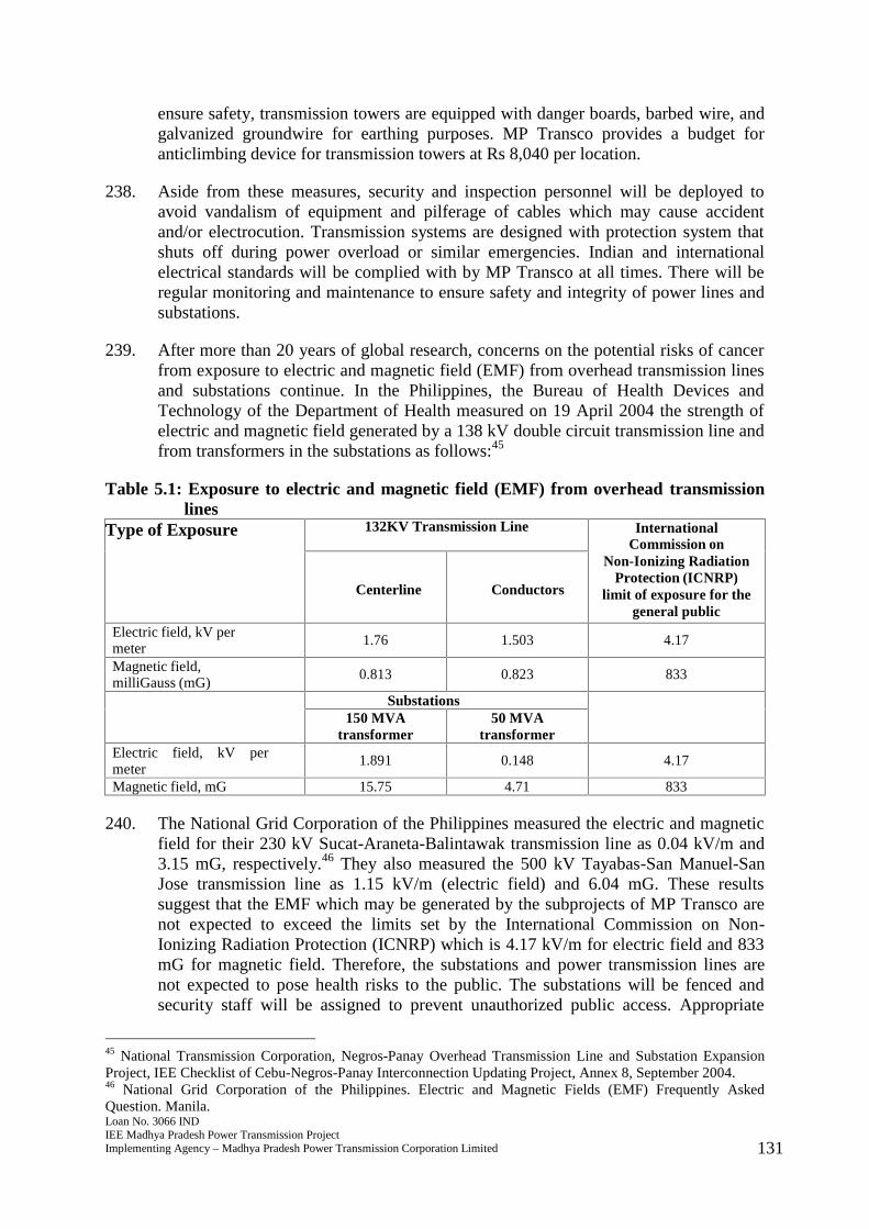
Loan No. 3066 INDIEE Madhya Pradesh Power Transmission ProjectImplementing Agency – Madhya Pradesh Power Transmission Corporation Limited 131
ensure safety, transmission towers are equipped with danger boards, barbed wire, andgalvanized groundwire for earthing purposes. MP Transco provides a budget foranticlimbing device for transmission towers at Rs 8,040 per location.
238. Aside from these measures, security and inspection personnel will be deployed toavoid vandalism of equipment and pilferage of cables which may cause accidentand/or electrocution. Transmission systems are designed with protection system thatshuts off during power overload or similar emergencies. Indian and internationalelectrical standards will be complied with by MP Transco at all times. There will beregular monitoring and maintenance to ensure safety and integrity of power lines andsubstations.
239. After more than 20 years of global research, concerns on the potential risks of cancerfrom exposure to electric and magnetic field (EMF) from overhead transmission linesand substations continue. In the Philippines, the Bureau of Health Devices andTechnology of the Department of Health measured on 19 April 2004 the strength ofelectric and magnetic field generated by a 138 kV double circuit transmission line andfrom transformers in the substations as follows:45
Table 5.1: Exposure to electric and magnetic field (EMF) from overhead transmissionlines
Type of Exposure 132KV Transmission Line InternationalCommission on
Non-Ionizing RadiationProtection (ICNRP)
limit of exposure for thegeneral public
Centerline Conductors
Electric field, kV permeter
1.76 1.503 4.17
Magnetic field,milliGauss (mG)
0.813 0.823 833
Substations150 MVA
transformer50 MVA
transformerElectric field, kV permeter
1.891 0.148 4.17
Magnetic field, mG 15.75 4.71 833
240. The National Grid Corporation of the Philippines measured the electric and magneticfield for their 230 kV Sucat-Araneta-Balintawak transmission line as 0.04 kV/m and3.15 mG, respectively.46 They also measured the 500 kV Tayabas-San Manuel-SanJose transmission line as 1.15 kV/m (electric field) and 6.04 mG. These resultssuggest that the EMF which may be generated by the subprojects of MP Transco arenot expected to exceed the limits set by the International Commission on Non-Ionizing Radiation Protection (ICNRP) which is 4.17 kV/m for electric field and 833mG for magnetic field. Therefore, the substations and power transmission lines arenot expected to pose health risks to the public. The substations will be fenced andsecurity staff will be assigned to prevent unauthorized public access. Appropriate
45 National Transmission Corporation, Negros-Panay Overhead Transmission Line and Substation ExpansionProject, IEE Checklist of Cebu-Negros-Panay Interconnection Updating Project, Annex 8, September 2004.46 National Grid Corporation of the Philippines. Electric and Magnetic Fields (EMF) Frequently AskedQuestion. Manila.
Loan No. 3066 INDIEE Madhya Pradesh Power Transmission ProjectImplementing Agency – Madhya Pradesh Power Transmission Corporation Limited 132
warning signs will be posted at designated areas. MP Transco will conductinformation and education campaign to local people to enhance awareness on livingsafely near the substations. Spot measurements of EMF will be conducted to have abaseline data.
241. Working on elevated position during maintenance of power transmission lines mayalso pose occupational and safety risks to workers. To minimize risks of accidents,maintenance workers/linemen will be provided with safety clothing and other workinggears for protection, provide training on safety and emergency preparedness, andimplement a safety plan.
242. The operation of the subprojects will create employment to local people. It isestimated that more than 200 positions will be created as a result of the project. Asidefrom employment, there will be a stable and reliable supply of power, and improveddelivery of service.
5.2.2.2 Use of mineral oil for transformers
Impacts on land and water
243. The use of transformers may cause potential accidental spillage that may contaminateland and water. The substations will have an oil-water separator and will have oil-containment structure/basin at the workshop areas.
Impacts on people
244. Use and handling of mineral oil for transformers may pose occupational and healthrisks to workers due to exposure. Delivery and acceptance of mineral oil will beaccompanied by material safety data sheets and/or be certified that it ispolychlorinated biphenyl-free. Fire extinguishers will be posted at designatedlocations in the storage areas for mineral oil. Workers will be provided with trainingon emergency preparedness.
Loan No. 3066 INDIEE Madhya Pradesh Power Transmission ProjectImplementing Agency – Madhya Pradesh Power Transmission Corporation Limited 133
6.0 Analysis of Alternatives
245. During the planning stage and preliminary design, alternatives were considered in theselection of the substation site and transmission line routes to ensure that they areeconomically and financially feasible, at the same time, potential environmentalimpacts are minimized. The following selection criteria guided MP Transco:
(i) Availability of a suitable right of way (ROW) and access to site by overheadtransmission and distribution circuits;
(ii) Location of existing transmission and distribution lines for potentialinterconnection;
(iii) Distance to all weather roads, accessibility of heavy equipment under allweather conditions and access roads to the site;
(iv) Site maintenance requirements, water supply and storage;
(v) Soil resistivity, drainage, and soil conditions;
(vi) Cost of earth removal, earth conditions and earth moving;
(vii) Atmospheric conditions and potential contamination from industry;
(viii) Available space for future expansion and current requirements;
(ix) Land ownership, avoidance of private land acquisition;
(x) Topographical features of the site, avoidance of flood plains, wetlands, forestsand other environment-sensitive areas;
(xi) Consideration of public safety and concern, avoidance of schools, playgrounds,hospitals, and structures of worship;
(xii) Avoidance of waterways and existing utilities, railway, road crossings, etc.;and,
(xiii) Total costs including transmission and distribution lines with due considerationof environmental factors.
246. Following the criteria above, a questionnaire/checklist with 25 critera questions isused during site planning. Some considerations include the following:
“Whether any Nallah, water tank, canal, etc. is within the proximity of theproposed land should be clearly mentioned. In case of the existence of the above,the extent of water spread during maximum flood level should be indicated.”
“In the detailed map, give the orientation of the EHT lines (existing or proposed)and the distance of lines from the proposed site.”
247. Preliminary site assessments conducted by MP Transco are based on the interpretationof available relevant maps of the area (i.e., topographic maps, vegetation maps, landuse, etc.) aided by existing satellite images, aerial photos, location of permanentwetlands, and other environmentally-sensitive areas, and walk-over survey. Duringfield works or walkover surveys, locations of forests, railways, schools, waterways,utilities, road crossings, structures of worship, etc. are identified along the alignmentsunder consideration (or a “bee-line”). Soil characterization and land use evaluation arealso carried out during the walk-over survey or inventorization.
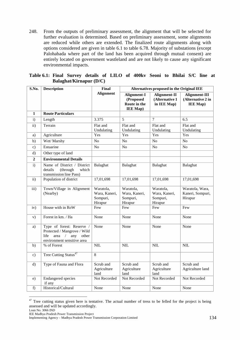
Loan No. 3066 INDIEE Madhya Pradesh Power Transmission ProjectImplementing Agency – Madhya Pradesh Power Transmission Corporation Limited 134
248. From the outputs of preliminary assessment, the alignment that will be selected forfurther evaluation is determined. Based on preliminary assessment, some alignmentsare reduced while others are extended. The finalized route alignments along withoptions considered are given in table 6.1 to table 6.78. Majority of substations (exceptPalohabada where part of the land has been acquired through mutual consent) areentirely located on government wastleland and are not likely to cause any significantenvironmental impacts.
Table 6.1: Final Survey details of LILO of 400kv Seoni to Bhilai S/C line atBalaghat/Kirnapur (D/C)
S.No. Description FinalAlignment
Alternatives proposed in the Original IEE
Alignment-I(Proposed
Route in theIEE Map)
Alignment-II(Alternative 1in IEE Map)
Alignment-III(Alternative 2 in
IEE Map)
1 Route Particulars
i) Length 3.375 5 7 6.5
ii) Terrain Flat andUndulating
Flat andUndulating
Flat andUndulating
Flat andUndulating
a) Agriculture Yes Yes Yes Yes
b) Wet/ Marshy No No No No
c) Estuarine No No No No
d) Other type of land
2 Environmental Details
i) Name of District / Districtdetails (through whichtransmission line Pass)
Balaghat Balaghat Balaghat Balaghat
ii) Population of district 17,01,698 17,01,698 17,01,698 17,01,698
iii) Town/Village in Alignment(Nearby)
Waratola,Wara, Kaneri,Sompuri,Hirapur
Waratola,Wara, Kaneri,Sompuri,Hirapur
Waratola,Wara, Kaneri,Sompuri,Hirapur
Waratola, Wara,Kaneri, Sompuri,Hirapur
iv) House with in RoW Few Few Few Few
v) Forest in km. / Ha None None None None
a) Type of forest: Reserve /Protected / Mangrove / Wildlife area / any otherenvironment sensitive area
None None None None
b) % of Forest NIL NIL NIL NIL
c) Tree Cutting Status47 8
d) Type of Fauna and Flora Scrub andAgricultureland
Scrub andAgricultureland
Scrub andAgricultureland
Scrub andAgriculture land
e) Endangered speciesif any
Not Recorded Not Recorded Not Recorded Not Recorded
f) Historical/Cultural None None None None
47 Tree cutting status given here is tentative. The actual number of tress to be felled for the project is beingassessed and will be updated accordingly.
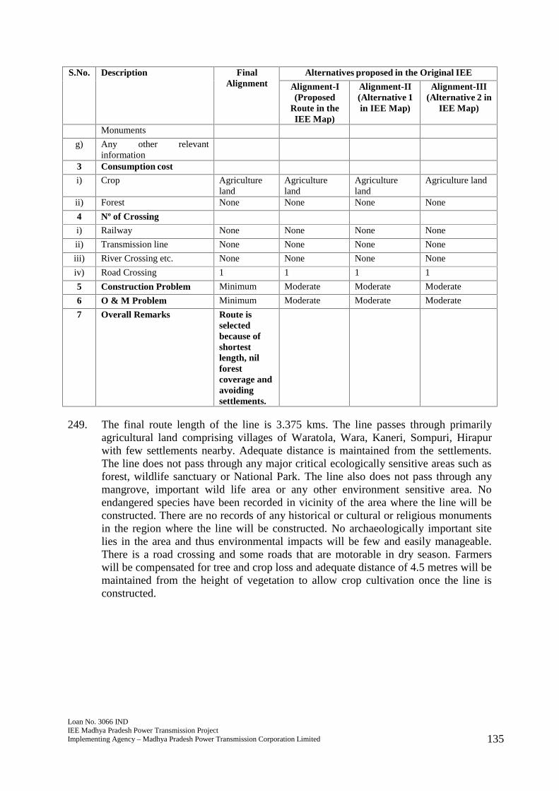
Loan No. 3066 INDIEE Madhya Pradesh Power Transmission ProjectImplementing Agency – Madhya Pradesh Power Transmission Corporation Limited 135
S.No. Description FinalAlignment
Alternatives proposed in the Original IEE
Alignment-I(Proposed
Route in theIEE Map)
Alignment-II(Alternative 1in IEE Map)
Alignment-III(Alternative 2 in
IEE Map)
Monuments
g) Any other relevantinformation
3 Consumption cost
i) Crop Agricultureland
Agricultureland
Agricultureland
Agriculture land
ii) Forest None None None None
4 Nº of Crossing
i) Railway None None None None
ii) Transmission line None None None None
iii) River Crossing etc. None None None None
iv) Road Crossing 1 1 1 1
5 Construction Problem Minimum Moderate Moderate Moderate
6 O & M Problem Minimum Moderate Moderate Moderate
7 Overall Remarks Route isselectedbecause ofshortestlength, nilforestcoverage andavoidingsettlements.
249. The final route length of the line is 3.375 kms. The line passes through primarilyagricultural land comprising villages of Waratola, Wara, Kaneri, Sompuri, Hirapurwith few settlements nearby. Adequate distance is maintained from the settlements.The line does not pass through any major critical ecologically sensitive areas such asforest, wildlife sanctuary or National Park. The line also does not pass through anymangrove, important wild life area or any other environment sensitive area. Noendangered species have been recorded in vicinity of the area where the line will beconstructed. There are no records of any historical or cultural or religious monumentsin the region where the line will be constructed. No archaeologically important sitelies in the area and thus environmental impacts will be few and easily manageable.There is a road crossing and some roads that are motorable in dry season. Farmerswill be compensated for tree and crop loss and adequate distance of 4.5 metres will bemaintained from the height of vegetation to allow crop cultivation once the line isconstructed.
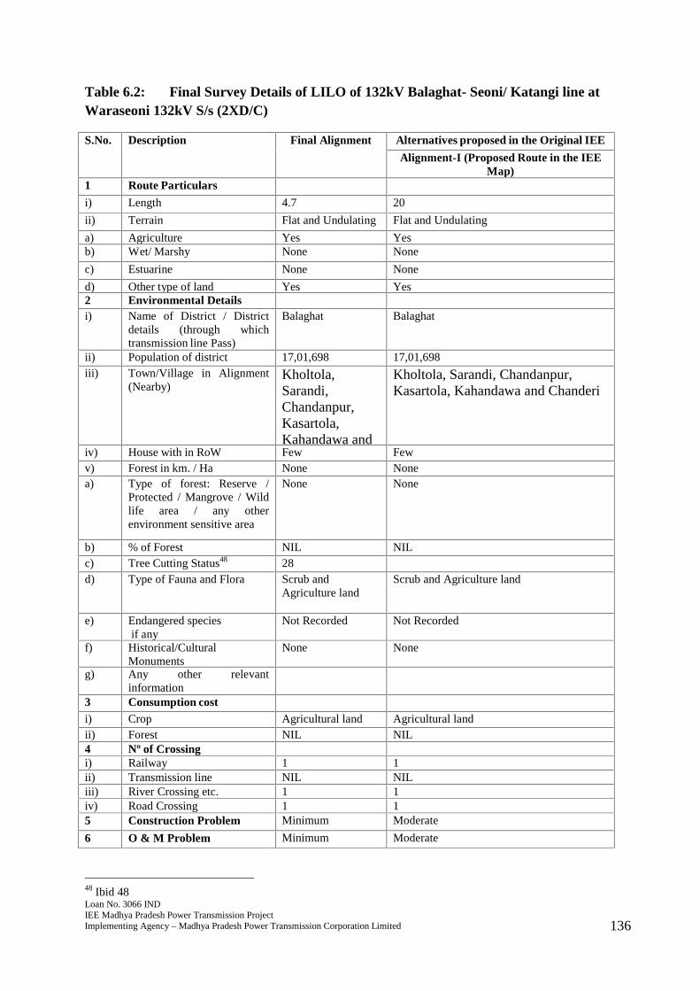
Loan No. 3066 INDIEE Madhya Pradesh Power Transmission ProjectImplementing Agency – Madhya Pradesh Power Transmission Corporation Limited 136
Table 6.2: Final Survey Details of LILO of 132kV Balaghat- Seoni/ Katangi line atWaraseoni 132kV S/s (2XD/C)
S.No. Description Final Alignment Alternatives proposed in the Original IEE
Alignment-I (Proposed Route in the IEEMap)
1 Route Particulars
i) Length 4.7 20
ii) Terrain Flat and Undulating Flat and Undulating
a) Agriculture Yes Yesb) Wet/ Marshy None None
c) Estuarine None None
d) Other type of land Yes Yes2 Environmental Detailsi) Name of District / District
details (through whichtransmission line Pass)
Balaghat Balaghat
ii) Population of district 17,01,698 17,01,698iii) Town/Village in Alignment
(Nearby)Kholtola,Sarandi,Chandanpur,Kasartola,Kahandawa andChanderi
Kholtola, Sarandi, Chandanpur,Kasartola, Kahandawa and Chanderi
iv) House with in RoW Few Fewv) Forest in km. / Ha None Nonea) Type of forest: Reserve /
Protected / Mangrove / Wildlife area / any otherenvironment sensitive area
None None
b) % of Forest NIL NILc) Tree Cutting Status48 28d) Type of Fauna and Flora Scrub and
Agriculture landScrub and Agriculture land
e) Endangered speciesif any
Not Recorded Not Recorded
f) Historical/CulturalMonuments
None None
g) Any other relevantinformation
3 Consumption costi) Crop Agricultural land Agricultural landii) Forest NIL NIL4 Nº of Crossingi) Railway 1 1ii) Transmission line NIL NILiii) River Crossing etc. 1 1iv) Road Crossing 1 15 Construction Problem Minimum Moderate
6 O & M Problem Minimum Moderate
48 Ibid 48

Loan No. 3066 INDIEE Madhya Pradesh Power Transmission ProjectImplementing Agency – Madhya Pradesh Power Transmission Corporation Limited 137
S.No. Description Final Alignment Alternatives proposed in the Original IEE
Alignment-I (Proposed Route in the IEEMap)
7 Overall Remarks Route is selectedbecause of shortestlength, nilforest coverage andavoidingsettlements.
250. The final route length of the line is 4.7 kms. The line passes through primarilyagricultural land comprising villages of Kholtola, Sarandi, Chandanpur, Kasartola,Kahandawa and Chanderi with few settlements nearby. Adequate distance ismaintained from the settlements. The line does not pass through any major criticalecologically sensitive areas such as forest, wildlife sanctuary or National Park. Theline also does not pass through any mangrove, important wild life area or any otherenvironment sensitive area. No endangered species have been recorded in vicinity ofthe area where the line will be constructed. There are no records of any historical orcultural or religious monuments in the region where the line will be constructed. Noarchaeologically important site lies in the area and thus environmental impacts will befew and easily manageable. There is a railway crossing, a road crossing and someroads that are motorable in dry season. Farmers will be compensated for tree and croploss and adequate distance of 4.5 metres will be maintained from the height ofvegetation to allow crop cultivation once the line is constructed.
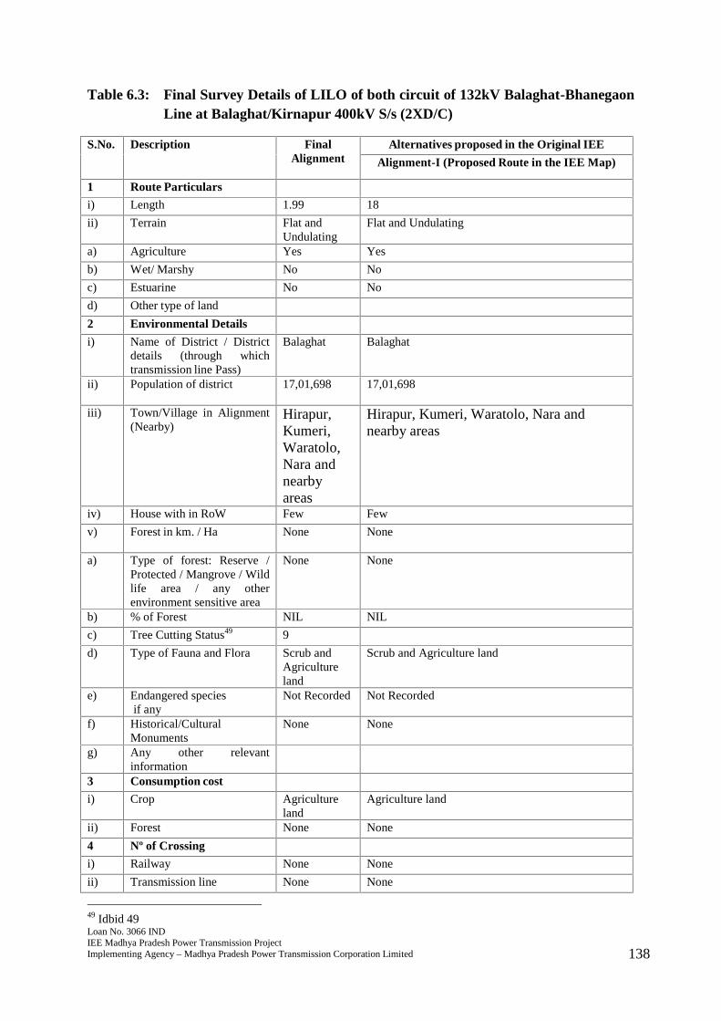
Loan No. 3066 INDIEE Madhya Pradesh Power Transmission ProjectImplementing Agency – Madhya Pradesh Power Transmission Corporation Limited 138
Table 6.3: Final Survey Details of LILO of both circuit of 132kV Balaghat-BhanegaonLine at Balaghat/Kirnapur 400kV S/s (2XD/C)
S.No. Description FinalAlignment
Alternatives proposed in the Original IEE
Alignment-I (Proposed Route in the IEE Map)
1 Route Particulars
i) Length 1.99 18
ii) Terrain Flat andUndulating
Flat and Undulating
a) Agriculture Yes Yes
b) Wet/ Marshy No No
c) Estuarine No No
d) Other type of land
2 Environmental Details
i) Name of District / Districtdetails (through whichtransmission line Pass)
Balaghat Balaghat
ii) Population of district 17,01,698 17,01,698
iii) Town/Village in Alignment(Nearby)
Hirapur,Kumeri,Waratolo,Nara andnearbyareas
Hirapur, Kumeri, Waratolo, Nara andnearby areas
iv) House with in RoW Few Few
v) Forest in km. / Ha None None
a) Type of forest: Reserve /Protected / Mangrove / Wildlife area / any otherenvironment sensitive area
None None
b) % of Forest NIL NIL
c) Tree Cutting Status49 9
d) Type of Fauna and Flora Scrub andAgricultureland
Scrub and Agriculture land
e) Endangered speciesif any
Not Recorded Not Recorded
f) Historical/CulturalMonuments
None None
g) Any other relevantinformation
3 Consumption cost
i) Crop Agricultureland
Agriculture land
ii) Forest None None
4 Nº of Crossing
i) Railway None None
ii) Transmission line None None
49 Idbid 49

Loan No. 3066 INDIEE Madhya Pradesh Power Transmission ProjectImplementing Agency – Madhya Pradesh Power Transmission Corporation Limited 139
S.No. Description FinalAlignment
Alternatives proposed in the Original IEE
Alignment-I (Proposed Route in the IEE Map)
iii) River Crossing etc. None None
iv) Road Crossing None None
5 Construction Problem Minimum Moderate
6 O & M Problem Minimum Moderate
7 Overall Remarks Route isselectedbecause ofshortestlength, nilforestcoverage andavoidingsettlements.
251. The final route length of the line is 1.99 kms. The line passes through primarilyagricultural land comprising villages of Hirapur, Kumeri, Waratolo, Nara with fewsettlements nearby. Adequate distance is maintained from the settlements. The linedoes not pass through any major critical ecologically sensitive areas such as forest,wildlife sanctuary or National Park. The line also does not pass through anymangrove, important wild life area or any other environment sensitive area. Noendangered species have been recorded in vicinity of the area where the line will beconstructed. There are no records of any historical or cultural or religious monumentsin the region where the line will be constructed. No archaeologically important sitelies in the area and thus environmental impacts will be few and easily manageable.There are some roads that are motorable in dry season. Farmers will be compensatedfor tree and crop loss and adequate distance of 4.5 metres will be maintained from theheight of vegetation to allow crop cultivation once the line is constructed.
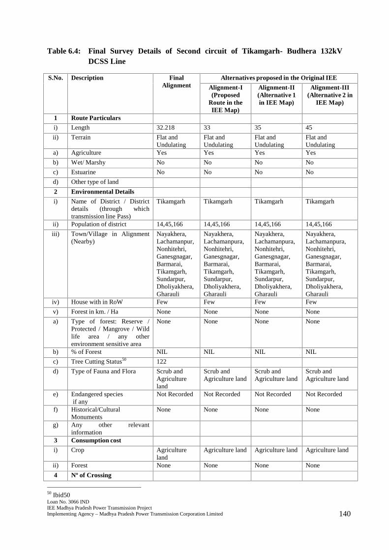
Loan No. 3066 INDIEE Madhya Pradesh Power Transmission ProjectImplementing Agency – Madhya Pradesh Power Transmission Corporation Limited 140
Table 6.4: Final Survey Details of Second circuit of Tikamgarh- Budhera 132kVDCSS Line
S.No. Description FinalAlignment
Alternatives proposed in the Original IEE
Alignment-I(Proposed
Route in theIEE Map)
Alignment-II(Alternative 1in IEE Map)
Alignment-III(Alternative 2 in
IEE Map)
1 Route Particulars
i) Length 32.218 33 35 45
ii) Terrain Flat andUndulating
Flat andUndulating
Flat andUndulating
Flat andUndulating
a) Agriculture Yes Yes Yes Yes
b) Wet/ Marshy No No No No
c) Estuarine No No No No
d) Other type of land
2 Environmental Details
i) Name of District / Districtdetails (through whichtransmission line Pass)
Tikamgarh Tikamgarh Tikamgarh Tikamgarh
ii) Population of district 14,45,166 14,45,166 14,45,166 14,45,166
iii) Town/Village in Alignment(Nearby)
Nayakhera,Lachamanpur,Nonhitehri,Ganesgnagar,Barmarai,Tikamgarh,Sundarpur,Dholiyakhera,Gharauli
Nayakhera,Lachamanpura,Nonhitehri,Ganesgnagar,Barmarai,Tikamgarh,Sundarpur,Dholiyakhera,Gharauli
Nayakhera,Lachamanpura,Nonhitehri,Ganesgnagar,Barmarai,Tikamgarh,Sundarpur,Dholiyakhera,Gharauli
Nayakhera,Lachamanpura,Nonhitehri,Ganesgnagar,Barmarai,Tikamgarh,Sundarpur,Dholiyakhera,Gharauli
iv) House with in RoW Few Few Few Few
v) Forest in km. / Ha None None None None
a) Type of forest: Reserve /Protected / Mangrove / Wildlife area / any otherenvironment sensitive area
None None None None
b) % of Forest NIL NIL NIL NIL
c) Tree Cutting Status50 122
d) Type of Fauna and Flora Scrub andAgricultureland
Scrub andAgriculture land
Scrub andAgriculture land
Scrub andAgriculture land
e) Endangered speciesif any
Not Recorded Not Recorded Not Recorded Not Recorded
f) Historical/CulturalMonuments
None None None None
g) Any other relevantinformation
3 Consumption cost
i) Crop Agricultureland
Agriculture land Agriculture land Agriculture land
ii) Forest None None None None
4 Nº of Crossing
50 Ibid50
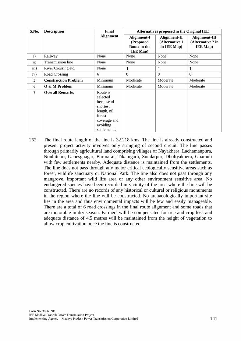
Loan No. 3066 INDIEE Madhya Pradesh Power Transmission ProjectImplementing Agency – Madhya Pradesh Power Transmission Corporation Limited 141
S.No. Description FinalAlignment
Alternatives proposed in the Original IEE
Alignment-I(Proposed
Route in theIEE Map)
Alignment-II(Alternative 1in IEE Map)
Alignment-III(Alternative 2 in
IEE Map)
i) Railway None None None None
ii) Transmission line None None None None
iii) River Crossing etc. None 1 1 1iv) Road Crossing 6 8 8 8
5 Construction Problem Minimum Moderate Moderate Moderate
6 O & M Problem Minimum Moderate Moderate Moderate
7 Overall Remarks Route isselectedbecause ofshortestlength, nilforestcoverage andavoidingsettlements.
252. The final route length of the line is 32.218 kms. The line is already constructed andpresent project activity involves only stringing of second circuit. The line passesthrough primarily agricultural land comprising villages of Nayakhera, Lachamanpura,Nonhitehri, Ganesgnagar, Barmarai, Tikamgarh, Sundarpur, Dholiyakhera, Gharauliwith few settlements nearby. Adequate distance is maintained from the settlements.The line does not pass through any major critical ecologically sensitive areas such asforest, wildlife sanctuary or National Park. The line also does not pass through anymangrove, important wild life area or any other environment sensitive area. Noendangered species have been recorded in vicinity of the area where the line will beconstructed. There are no records of any historical or cultural or religious monumentsin the region where the line will be constructed. No archaeologically important sitelies in the area and thus environmental impacts will be few and easily manageable.There are a total of 6 road crossings in the final route alignment and some roads thatare motorable in dry season. Farmers will be compensated for tree and crop loss andadequate distance of 4.5 metres will be maintained from the height of vegetation toallow crop cultivation once the line is constructed.

Loan No. 3066 INDIEE Madhya Pradesh Power Transmission ProjectImplementing Agency – Madhya Pradesh Power Transmission Corporation Limited 142
Table 6.5: Final Survey Details of Narsinghpur 220- Devnagar 132kV DCSS Line
S.No. Description FinalAlignment
Alternatives proposed in the Original IEE
Alignment-I(Proposed
Route in theIEE Map)
Alignment-II(Alternative 1in IEE Map)
Alignment-III(Alternative 2in IEE Map)
1 Route Particulars
i) Length 22.749 37.7 35.9 37.9
ii) Terrain Flat andUndulating
Flat andUndulating
Flat andUndulating
Flat andUndulating
a) Agriculture Yes Yes Yes Yes
b) Wet/ Marshy No No No No
c) Estuarine No No No No
d) Other type of land
2 Environmental Details
i) Name of District / Districtdetails (through whichtransmission line Pass)
Narsinghpur Narsinghpur Narsinghpur Narsinghpur
ii) Population of district 10,91,854 10,91,854 10,91,854 10,91,854
iii) Town/Village in Alignment(Nearby)
Magardha,Samnapur,Bhelpani,rohhata,Babriya,Kannerpani,Boriya,Samadhi,Bakori etc
Magardha,Samnapur,Bhelpani,rohhata,Babriya,Kannerpani,Boriya,Samadhi,Bakori etc
Magardha,Samnapur,Bhelpani,rohhata,Babriya,Kannerpani,Boriya,Samadhi,Bakori etc
Magardha,Samnapur,Bhelpani,rohhata,Babriya,Kannerpani,Boriya,Samadhi,Bakori etc
iv) House with in RoW Few Few Few Few
v) Forest in km. / Ha None None None 6
a) Type of forest: Reserve /Protected / Mangrove / Wildlife area / any otherenvironment sensitive area
None None None Reserve Forest
b) % of Forest NIL NIL ` NIL 15.83
c) Tree Cutting Status51 126
d) Type of Fauna and Flora Agricultureland
Agricultureland
Agriculture land Agriculture land
e) Endangered speciesif any
Not Recorded Not Recorded Not Recorded Not Recorded
f) Historical/CulturalMonuments
None None None None
g) Any other relevantinformation
3 Consumption cost
i) Crop Agricultureland
Agricultureland
Agriculture land Agriculture land
ii) Forest None None None None
4 Nº of Crossing
i) Railway None None None None
51 Ibid51
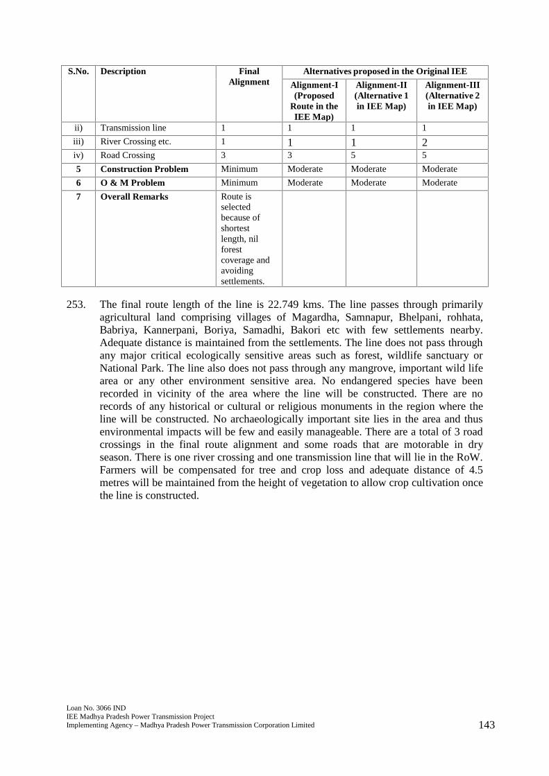
Loan No. 3066 INDIEE Madhya Pradesh Power Transmission ProjectImplementing Agency – Madhya Pradesh Power Transmission Corporation Limited 143
S.No. Description FinalAlignment
Alternatives proposed in the Original IEE
Alignment-I(Proposed
Route in theIEE Map)
Alignment-II(Alternative 1in IEE Map)
Alignment-III(Alternative 2in IEE Map)
ii) Transmission line 1 1 1 1
iii) River Crossing etc. 1 1 1 2iv) Road Crossing 3 3 5 5
5 Construction Problem Minimum Moderate Moderate Moderate
6 O & M Problem Minimum Moderate Moderate Moderate
7 Overall Remarks Route isselectedbecause ofshortestlength, nilforestcoverage andavoidingsettlements.
253. The final route length of the line is 22.749 kms. The line passes through primarilyagricultural land comprising villages of Magardha, Samnapur, Bhelpani, rohhata,Babriya, Kannerpani, Boriya, Samadhi, Bakori etc with few settlements nearby.Adequate distance is maintained from the settlements. The line does not pass throughany major critical ecologically sensitive areas such as forest, wildlife sanctuary orNational Park. The line also does not pass through any mangrove, important wild lifearea or any other environment sensitive area. No endangered species have beenrecorded in vicinity of the area where the line will be constructed. There are norecords of any historical or cultural or religious monuments in the region where theline will be constructed. No archaeologically important site lies in the area and thusenvironmental impacts will be few and easily manageable. There are a total of 3 roadcrossings in the final route alignment and some roads that are motorable in dryseason. There is one river crossing and one transmission line that will lie in the RoW.Farmers will be compensated for tree and crop loss and adequate distance of 4.5metres will be maintained from the height of vegetation to allow crop cultivation oncethe line is constructed.
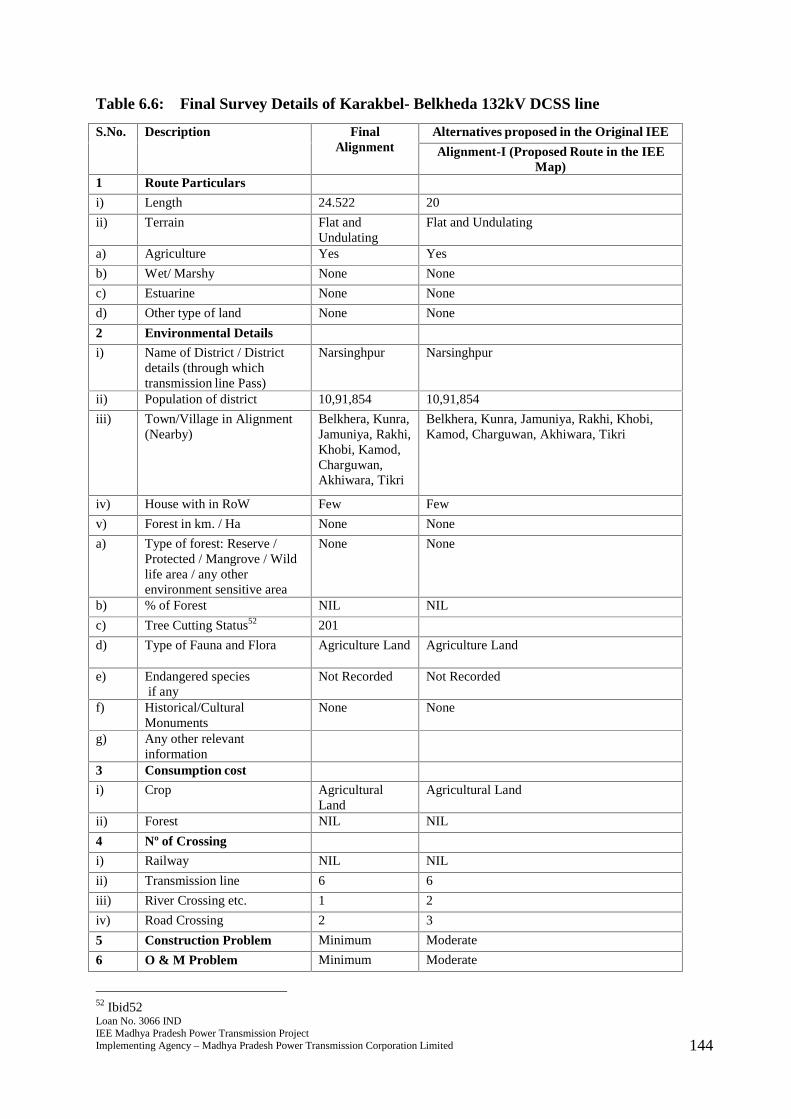
Loan No. 3066 INDIEE Madhya Pradesh Power Transmission ProjectImplementing Agency – Madhya Pradesh Power Transmission Corporation Limited 144
Table 6.6: Final Survey Details of Karakbel- Belkheda 132kV DCSS line
S.No. Description FinalAlignment
Alternatives proposed in the Original IEE
Alignment-I (Proposed Route in the IEEMap)
1 Route Particulars
i) Length 24.522 20
ii) Terrain Flat andUndulating
Flat and Undulating
a) Agriculture Yes Yes
b) Wet/ Marshy None None
c) Estuarine None None
d) Other type of land None None
2 Environmental Details
i) Name of District / Districtdetails (through whichtransmission line Pass)
Narsinghpur Narsinghpur
ii) Population of district 10,91,854 10,91,854
iii) Town/Village in Alignment(Nearby)
Belkhera, Kunra,Jamuniya, Rakhi,Khobi, Kamod,Charguwan,Akhiwara, Tikri
Belkhera, Kunra, Jamuniya, Rakhi, Khobi,Kamod, Charguwan, Akhiwara, Tikri
iv) House with in RoW Few Few
v) Forest in km. / Ha None None
a) Type of forest: Reserve /Protected / Mangrove / Wildlife area / any otherenvironment sensitive area
None None
b) % of Forest NIL NIL
c) Tree Cutting Status52 201
d) Type of Fauna and Flora Agriculture Land Agriculture Land
e) Endangered speciesif any
Not Recorded Not Recorded
f) Historical/CulturalMonuments
None None
g) Any other relevantinformation
3 Consumption cost
i) Crop AgriculturalLand
Agricultural Land
ii) Forest NIL NIL
4 Nº of Crossing
i) Railway NIL NIL
ii) Transmission line 6 6
iii) River Crossing etc. 1 2
iv) Road Crossing 2 3
5 Construction Problem Minimum Moderate
6 O & M Problem Minimum Moderate
52 Ibid52
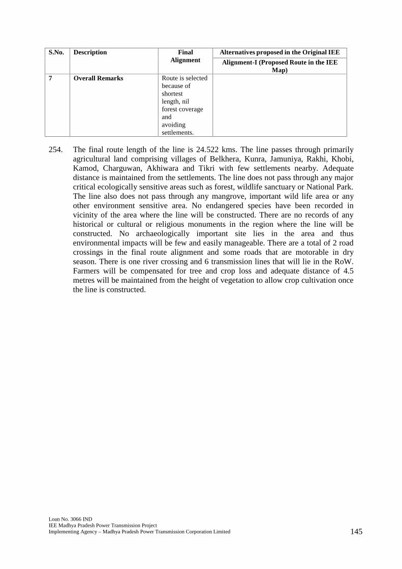
Loan No. 3066 INDIEE Madhya Pradesh Power Transmission ProjectImplementing Agency – Madhya Pradesh Power Transmission Corporation Limited 145
S.No. Description FinalAlignment
Alternatives proposed in the Original IEE
Alignment-I (Proposed Route in the IEEMap)
7 Overall Remarks Route is selectedbecause ofshortestlength, nilforest coverageandavoidingsettlements.
254. The final route length of the line is 24.522 kms. The line passes through primarilyagricultural land comprising villages of Belkhera, Kunra, Jamuniya, Rakhi, Khobi,Kamod, Charguwan, Akhiwara and Tikri with few settlements nearby. Adequatedistance is maintained from the settlements. The line does not pass through any majorcritical ecologically sensitive areas such as forest, wildlife sanctuary or National Park.The line also does not pass through any mangrove, important wild life area or anyother environment sensitive area. No endangered species have been recorded invicinity of the area where the line will be constructed. There are no records of anyhistorical or cultural or religious monuments in the region where the line will beconstructed. No archaeologically important site lies in the area and thusenvironmental impacts will be few and easily manageable. There are a total of 2 roadcrossings in the final route alignment and some roads that are motorable in dryseason. There is one river crossing and 6 transmission lines that will lie in the RoW.Farmers will be compensated for tree and crop loss and adequate distance of 4.5metres will be maintained from the height of vegetation to allow crop cultivation oncethe line is constructed.
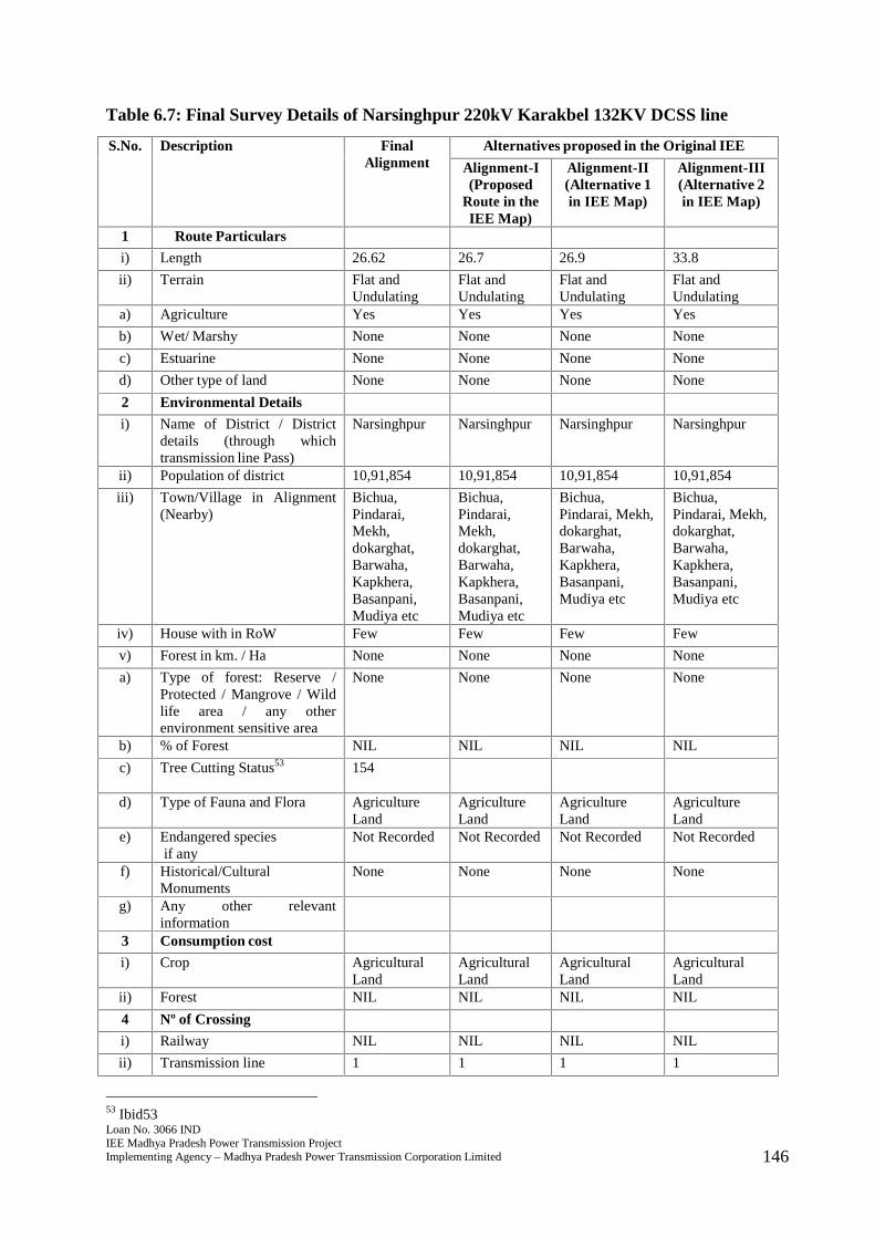
Loan No. 3066 INDIEE Madhya Pradesh Power Transmission ProjectImplementing Agency – Madhya Pradesh Power Transmission Corporation Limited 146
Table 6.7: Final Survey Details of Narsinghpur 220kV Karakbel 132KV DCSS line
S.No. Description FinalAlignment
Alternatives proposed in the Original IEE
Alignment-I(Proposed
Route in theIEE Map)
Alignment-II(Alternative 1in IEE Map)
Alignment-III(Alternative 2in IEE Map)
1 Route Particulars
i) Length 26.62 26.7 26.9 33.8
ii) Terrain Flat andUndulating
Flat andUndulating
Flat andUndulating
Flat andUndulating
a) Agriculture Yes Yes Yes Yes
b) Wet/ Marshy None None None None
c) Estuarine None None None None
d) Other type of land None None None None
2 Environmental Details
i) Name of District / Districtdetails (through whichtransmission line Pass)
Narsinghpur Narsinghpur Narsinghpur Narsinghpur
ii) Population of district 10,91,854 10,91,854 10,91,854 10,91,854
iii) Town/Village in Alignment(Nearby)
Bichua,Pindarai,Mekh,dokarghat,Barwaha,Kapkhera,Basanpani,Mudiya etc
Bichua,Pindarai,Mekh,dokarghat,Barwaha,Kapkhera,Basanpani,Mudiya etc
Bichua,Pindarai, Mekh,dokarghat,Barwaha,Kapkhera,Basanpani,Mudiya etc
Bichua,Pindarai, Mekh,dokarghat,Barwaha,Kapkhera,Basanpani,Mudiya etc
iv) House with in RoW Few Few Few Few
v) Forest in km. / Ha None None None None
a) Type of forest: Reserve /Protected / Mangrove / Wildlife area / any otherenvironment sensitive area
None None None None
b) % of Forest NIL NIL NIL NIL
c) Tree Cutting Status53 154
d) Type of Fauna and Flora AgricultureLand
AgricultureLand
AgricultureLand
AgricultureLand
e) Endangered speciesif any
Not Recorded Not Recorded Not Recorded Not Recorded
f) Historical/CulturalMonuments
None None None None
g) Any other relevantinformation
3 Consumption cost
i) Crop AgriculturalLand
AgriculturalLand
AgriculturalLand
AgriculturalLand
ii) Forest NIL NIL NIL NIL
4 Nº of Crossing
i) Railway NIL NIL NIL NIL
ii) Transmission line 1 1 1 1
53 Ibid53

Loan No. 3066 INDIEE Madhya Pradesh Power Transmission ProjectImplementing Agency – Madhya Pradesh Power Transmission Corporation Limited 147
S.No. Description FinalAlignment
Alternatives proposed in the Original IEE
Alignment-I(Proposed
Route in theIEE Map)
Alignment-II(Alternative 1in IEE Map)
Alignment-III(Alternative 2in IEE Map)
iii) River Crossing etc. 1 1 1 1
iv) Road Crossing 2 2 2 2
5 Construction Problem Minimum Moderate Moderate Moderate
6 O & M Problem Minimum Moderate Moderate Moderate
7 Overall Remarks Route isselectedbecause ofshortestlength, nilforestcoverage andavoidingsettlements.
255. The final route length of the line is 26.62 kms. The line passes through primarilyagricultural land comprising villages of Bichua, Pindarai, Mekh, dokarghat, Barwaha,Kapkhera, Basanpani, and Mudiya etc with few settlements nearby. Adequatedistance is maintained from the settlements. The line does not pass through any majorcritical ecologically sensitive areas such as forest, wildlife sanctuary or National Park.The line also does not pass through any mangrove, important wild life area or anyother environment sensitive area. No endangered species have been recorded invicinity of the area where the line will be constructed. There are no records of anyhistorical or cultural or religious monuments in the region where the line will beconstructed. No archaeologically important site lies in the area and thusenvironmental impacts will be few and easily manageable. There are a total of 2 roadcrossings in the final route alignment and some roads that are motorable in dryseason. There is one river crossing and 1 transmission line that will lie in the RoW.Farmers will be compensated for tree and crop loss and adequate distance of 4.5metres will be maintained from the height of vegetation to allow crop cultivation oncethe line is constructed.
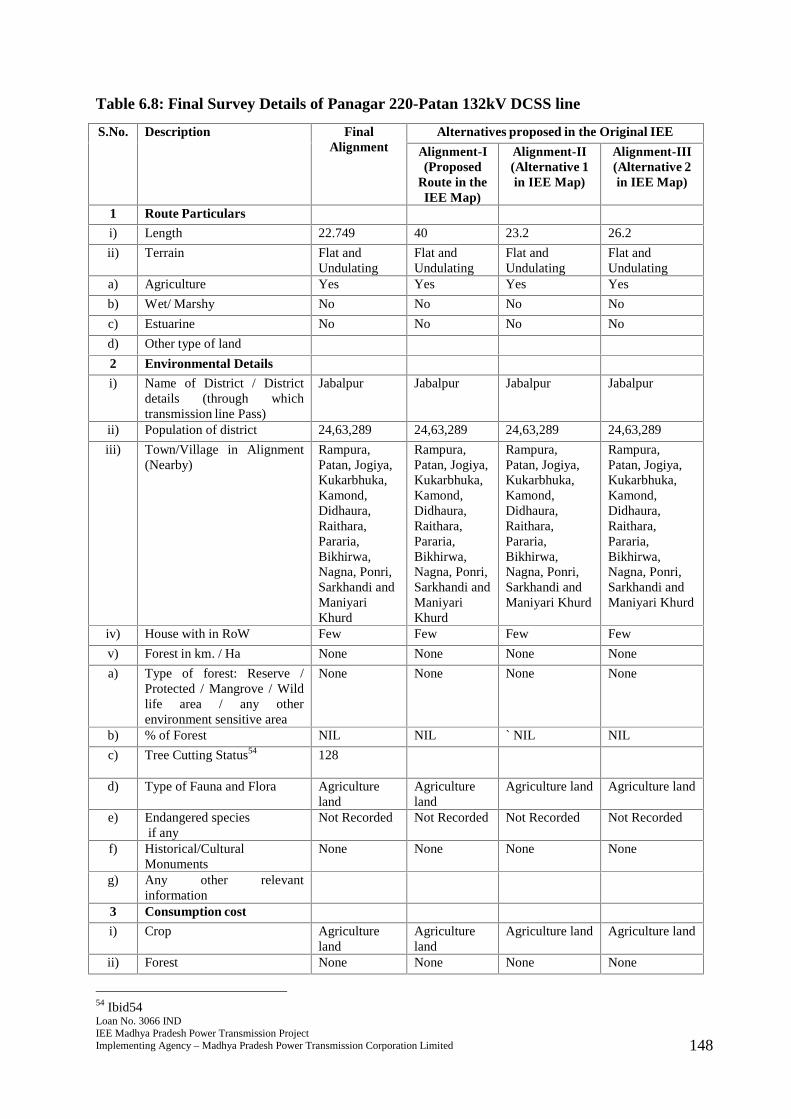
Loan No. 3066 INDIEE Madhya Pradesh Power Transmission ProjectImplementing Agency – Madhya Pradesh Power Transmission Corporation Limited 148
Table 6.8: Final Survey Details of Panagar 220-Patan 132kV DCSS line
S.No. Description FinalAlignment
Alternatives proposed in the Original IEE
Alignment-I(Proposed
Route in theIEE Map)
Alignment-II(Alternative 1in IEE Map)
Alignment-III(Alternative 2in IEE Map)
1 Route Particulars
i) Length 22.749 40 23.2 26.2
ii) Terrain Flat andUndulating
Flat andUndulating
Flat andUndulating
Flat andUndulating
a) Agriculture Yes Yes Yes Yes
b) Wet/ Marshy No No No No
c) Estuarine No No No No
d) Other type of land
2 Environmental Details
i) Name of District / Districtdetails (through whichtransmission line Pass)
Jabalpur Jabalpur Jabalpur Jabalpur
ii) Population of district 24,63,289 24,63,289 24,63,289 24,63,289
iii) Town/Village in Alignment(Nearby)
Rampura,Patan, Jogiya,Kukarbhuka,Kamond,Didhaura,Raithara,Pararia,Bikhirwa,Nagna, Ponri,Sarkhandi andManiyariKhurd
Rampura,Patan, Jogiya,Kukarbhuka,Kamond,Didhaura,Raithara,Pararia,Bikhirwa,Nagna, Ponri,Sarkhandi andManiyariKhurd
Rampura,Patan, Jogiya,Kukarbhuka,Kamond,Didhaura,Raithara,Pararia,Bikhirwa,Nagna, Ponri,Sarkhandi andManiyari Khurd
Rampura,Patan, Jogiya,Kukarbhuka,Kamond,Didhaura,Raithara,Pararia,Bikhirwa,Nagna, Ponri,Sarkhandi andManiyari Khurd
iv) House with in RoW Few Few Few Few
v) Forest in km. / Ha None None None None
a) Type of forest: Reserve /Protected / Mangrove / Wildlife area / any otherenvironment sensitive area
None None None None
b) % of Forest NIL NIL ` NIL NIL
c) Tree Cutting Status54 128
d) Type of Fauna and Flora Agricultureland
Agricultureland
Agriculture land Agriculture land
e) Endangered speciesif any
Not Recorded Not Recorded Not Recorded Not Recorded
f) Historical/CulturalMonuments
None None None None
g) Any other relevantinformation
3 Consumption cost
i) Crop Agricultureland
Agricultureland
Agriculture land Agriculture land
ii) Forest None None None None
54 Ibid54

Loan No. 3066 INDIEE Madhya Pradesh Power Transmission ProjectImplementing Agency – Madhya Pradesh Power Transmission Corporation Limited 149
S.No. Description FinalAlignment
Alternatives proposed in the Original IEE
Alignment-I(Proposed
Route in theIEE Map)
Alignment-II(Alternative 1in IEE Map)
Alignment-III(Alternative 2in IEE Map)
4 Nº of Crossing
i) Railway None None None None
ii) Transmission line 2 2 2 2
iii) River Crossing etc. 1 1 1 1iv) Road Crossing 4 4 5 5
5 Construction Problem Minimum Moderate Moderate Moderate
6 O & M Problem Minimum Moderate Moderate Moderate
7 Overall Remarks Route isselectedbecause ofshortestlength, nilforestcoverage andavoidingsettlements.
256. The final route length of the line is 22.749 kms. The line passes through primarilyagricultural land comprising villages of Rampura, Patan, Jogiya, Kukarbhuka,Kamond, Didhaura, Raithara, Pararia, Bikhirwa, Nagna, Ponri, Sarkhandi andManiyari Khurd with few settlements nearby. Adequate distance is maintained fromthe settlements. The line does not pass through any major critical ecologicallysensitive areas such as forest, wildlife sanctuary or National Park. The line also doesnot pass through any mangrove, important wild life area or any other environmentsensitive area. No endangered species have been recorded in vicinity of the areawhere the line will be constructed. There are no records of any historical or cultural orreligious monuments in the region where the line will be constructed. Noarchaeologically important site lies in the area and thus environmental impacts will befew and easily manageable. There are a total of 4 road crossings in the final routealignment and some roads that are motorable in dry season. There is one rivercrossing and 2 transmission lines that will lie in the RoW. Farmers will becompensated for tree and crop loss and adequate distance of 4.5 metres will bemaintained from the height of vegetation to allow crop cultivation once the line isconstructed.
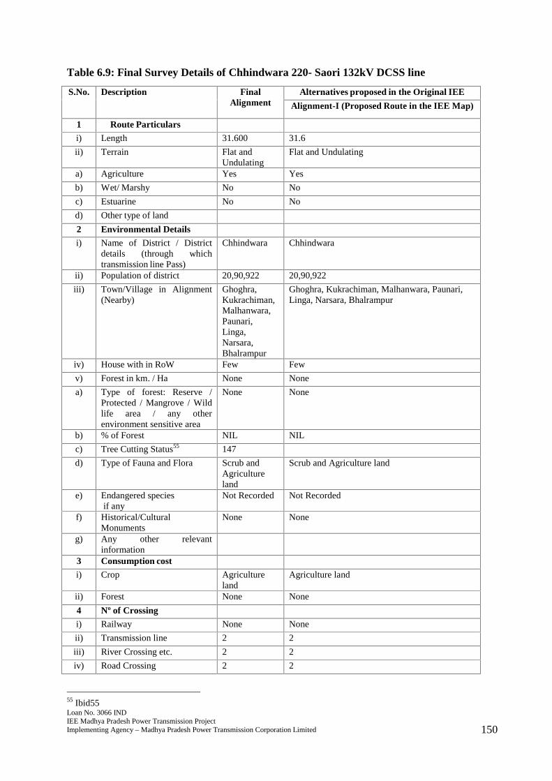
Loan No. 3066 INDIEE Madhya Pradesh Power Transmission ProjectImplementing Agency – Madhya Pradesh Power Transmission Corporation Limited 150
Table 6.9: Final Survey Details of Chhindwara 220- Saori 132kV DCSS line
S.No. Description FinalAlignment
Alternatives proposed in the Original IEE
Alignment-I (Proposed Route in the IEE Map)
1 Route Particulars
i) Length 31.600 31.6
ii) Terrain Flat andUndulating
Flat and Undulating
a) Agriculture Yes Yes
b) Wet/ Marshy No No
c) Estuarine No No
d) Other type of land
2 Environmental Details
i) Name of District / Districtdetails (through whichtransmission line Pass)
Chhindwara Chhindwara
ii) Population of district 20,90,922 20,90,922
iii) Town/Village in Alignment(Nearby)
Ghoghra,Kukrachiman,Malhanwara,Paunari,Linga,Narsara,Bhalrampur
Ghoghra, Kukrachiman, Malhanwara, Paunari,Linga, Narsara, Bhalrampur
iv) House with in RoW Few Few
v) Forest in km. / Ha None None
a) Type of forest: Reserve /Protected / Mangrove / Wildlife area / any otherenvironment sensitive area
None None
b) % of Forest NIL NIL
c) Tree Cutting Status55 147
d) Type of Fauna and Flora Scrub andAgricultureland
Scrub and Agriculture land
e) Endangered speciesif any
Not Recorded Not Recorded
f) Historical/CulturalMonuments
None None
g) Any other relevantinformation
3 Consumption cost
i) Crop Agricultureland
Agriculture land
ii) Forest None None
4 Nº of Crossing
i) Railway None None
ii) Transmission line 2 2
iii) River Crossing etc. 2 2
iv) Road Crossing 2 2
55 Ibid55

Loan No. 3066 INDIEE Madhya Pradesh Power Transmission ProjectImplementing Agency – Madhya Pradesh Power Transmission Corporation Limited 151
S.No. Description FinalAlignment
Alternatives proposed in the Original IEE
Alignment-I (Proposed Route in the IEE Map)
5 Construction Problem Minimum Moderate
6 O & M Problem Minimum Moderate
7 Overall Remarks Route isselectedbecause ofshortestlength, nilforestcoverage andavoidingsettlements.
257. The final route length of the line is 31.600 kms. The line passes through primarilyagricultural land comprising villages of Ghoghra, Kukrachiman, Malhanwara,Paunari, Linga, Narsara, and Bhalrampur with few settlements nearby. Adequatedistance is maintained from the settlements. The line does not pass through any majorcritical ecologically sensitive areas such as forest, wildlife sanctuary or National Park.The line also does not pass through any mangrove, important wild life area or anyother environment sensitive area. No endangered species have been recorded invicinity of the area where the line will be constructed. There are no records of anyhistorical or cultural or religious monuments in the region where the line will beconstructed. No archaeologically important site lies in the area and thusenvironmental impacts will be few and easily manageable. There are a total of 2 roadcrossings in the final route alignment and some roads that are motorable in dryseason. There are 2 river crossings and 2 transmission lines that will lie in the RoW.Farmers will be compensated for tree and crop loss and adequate distance of 4.5metres will be maintained from the height of vegetation to allow crop cultivation oncethe line is constructed.
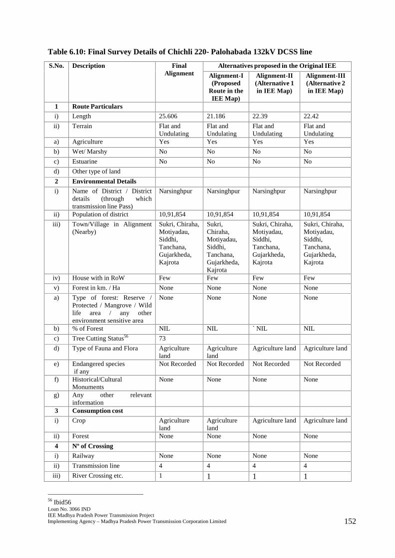
Loan No. 3066 INDIEE Madhya Pradesh Power Transmission ProjectImplementing Agency – Madhya Pradesh Power Transmission Corporation Limited 152
Table 6.10: Final Survey Details of Chichli 220- Palohabada 132kV DCSS line
S.No. Description FinalAlignment
Alternatives proposed in the Original IEE
Alignment-I(Proposed
Route in theIEE Map)
Alignment-II(Alternative 1in IEE Map)
Alignment-III(Alternative 2in IEE Map)
1 Route Particulars
i) Length 25.606 21.186 22.39 22.42
ii) Terrain Flat andUndulating
Flat andUndulating
Flat andUndulating
Flat andUndulating
a) Agriculture Yes Yes Yes Yes
b) Wet/ Marshy No No No No
c) Estuarine No No No No
d) Other type of land
2 Environmental Details
i) Name of District / Districtdetails (through whichtransmission line Pass)
Narsinghpur Narsinghpur Narsinghpur Narsinghpur
ii) Population of district 10,91,854 10,91,854 10,91,854 10,91,854
iii) Town/Village in Alignment(Nearby)
Sukri, Chiraha,Motiyadau,Siddhi,Tanchana,Gujarkheda,Kajrota
Sukri,Chiraha,Motiyadau,Siddhi,Tanchana,Gujarkheda,Kajrota
Sukri, Chiraha,Motiyadau,Siddhi,Tanchana,Gujarkheda,Kajrota
Sukri, Chiraha,Motiyadau,Siddhi,Tanchana,Gujarkheda,Kajrota
iv) House with in RoW Few Few Few Few
v) Forest in km. / Ha None None None None
a) Type of forest: Reserve /Protected / Mangrove / Wildlife area / any otherenvironment sensitive area
None None None None
b) % of Forest NIL NIL ` NIL NIL
c) Tree Cutting Status56 73
d) Type of Fauna and Flora Agricultureland
Agricultureland
Agriculture land Agriculture land
e) Endangered speciesif any
Not Recorded Not Recorded Not Recorded Not Recorded
f) Historical/CulturalMonuments
None None None None
g) Any other relevantinformation
3 Consumption cost
i) Crop Agricultureland
Agricultureland
Agriculture land Agriculture land
ii) Forest None None None None
4 Nº of Crossing
i) Railway None None None None
ii) Transmission line 4 4 4 4
iii) River Crossing etc. 1 1 1 1
56 Ibid56
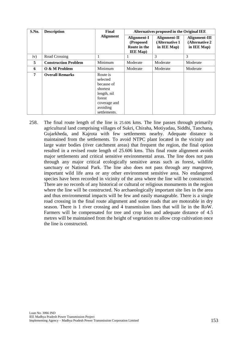
Loan No. 3066 INDIEE Madhya Pradesh Power Transmission ProjectImplementing Agency – Madhya Pradesh Power Transmission Corporation Limited 153
S.No. Description FinalAlignment
Alternatives proposed in the Original IEE
Alignment-I(Proposed
Route in theIEE Map)
Alignment-II(Alternative 1in IEE Map)
Alignment-III(Alternative 2in IEE Map)
iv) Road Crossing 1 1 3 3
5 Construction Problem Minimum Moderate Moderate Moderate
6 O & M Problem Minimum Moderate Moderate Moderate
7 Overall Remarks Route isselectedbecause ofshortestlength, nilforestcoverage andavoidingsettlements.
258. The final route length of the line is 25.606 kms. The line passes through primarilyagricultural land comprising villages of Sukri, Chiraha, Motiyadau, Siddhi, Tanchana,Gujarkheda, and Kajrota with few settlements nearby. Adequate distance ismaintained from the settlements. To avoid NTPC plant located in the vicinity andlarge water bodies (river catchment areas) that frequent the region, the final optionresulted in a revised route length of 25.606 kms. This final route alignment avoidsmajor settlements and critical sensitive environmental areas. The line does not passthrough any major critical ecologically sensitive areas such as forest, wildlifesanctuary or National Park. The line also does not pass through any mangrove,important wild life area or any other environment sensitive area. No endangeredspecies have been recorded in vicinity of the area where the line will be constructed.There are no records of any historical or cultural or religious monuments in the regionwhere the line will be constructed. No archaeologically important site lies in the areaand thus environmental impacts will be few and easily manageable. There is a singleroad crossing in the final route alignment and some roads that are motorable in dryseason. There is 1 river crossing and 4 transmission lines that will lie in the RoW.Farmers will be compensated for tree and crop loss and adequate distance of 4.5metres will be maintained from the height of vegetation to allow crop cultivation oncethe line is constructed.
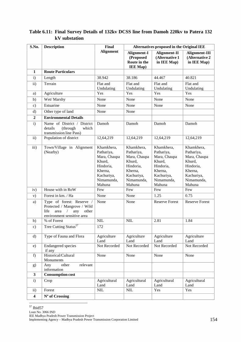
Loan No. 3066 INDIEE Madhya Pradesh Power Transmission ProjectImplementing Agency – Madhya Pradesh Power Transmission Corporation Limited 154
Table 6.11: Final Survey Details of 132kv DCSS line from Damoh 220kv to Patera 132kV substation
S.No. Description FinalAlignment
Alternatives proposed in the Original IEE
Alignment-I(Proposed
Route in theIEE Map)
Alignment-II(Alternative 1in IEE Map)
Alignment-III(Alternative 2in IEE Map)
1 Route Particulars
i) Length 38.942 38.186 44.467 40.821
ii) Terrain Flat andUndulating
Flat andUndulating
Flat andUndulating
Flat andUndulating
a) Agriculture Yes Yes Yes Yes
b) Wet/ Marshy None None None None
c) Estuarine None None None None
d) Other type of land None None
2 Environmental Details
i) Name of District / Districtdetails (through whichtransmission line Pass)
Damoh Damoh Damoh Damoh
ii) Population of district 12,64,219 12,64,219 12,64,219 12,64,219
iii) Town/Village in Alignment(Nearby)
Khamkhera,Pathariya,Mara, ChaupaKhurd,Hindoria,Kherna,Kachuriya,Nimamunda,Mahuna
Khamkhera,Pathariya,Mara, ChaupaKhurd,Hindoria,Kherna,Kachuriya,Nimamunda,Mahuna
Khamkhera,Pathariya,Mara, ChaupaKhurd,Hindoria,Kherna,Kachuriya,Nimamunda,Mahuna
Khamkhera,Pathariya,Mara, ChaupaKhurd,Hindoria,Kherna,Kachuriya,Nimamunda,Mahuna
iv) House with in RoW Few Few Few Few
v) Forest in km. / Ha None None 1.25 0.75
a) Type of forest: Reserve /Protected / Mangrove / Wildlife area / any otherenvironment sensitive area
None None Reserve Forest Reserve Forest
b) % of Forest NIL NIL 2.81 1.84
c) Tree Cutting Status57 172
d) Type of Fauna and Flora AgricultureLand
AgricultureLand
AgricultureLand
AgricultureLand
e) Endangered speciesif any
Not Recorded Not Recorded Not Recorded Not Recorded
f) Historical/CulturalMonuments
None None None None
g) Any other relevantinformation
3 Consumption cost
i) Crop AgriculturalLand
AgriculturalLand
AgriculturalLand
AgriculturalLand
ii) Forest NIL NIL Yes Yes
4 Nº of Crossing
57 Ibid57

Loan No. 3066 INDIEE Madhya Pradesh Power Transmission ProjectImplementing Agency – Madhya Pradesh Power Transmission Corporation Limited 155
S.No. Description FinalAlignment
Alternatives proposed in the Original IEE
Alignment-I(Proposed
Route in theIEE Map)
Alignment-II(Alternative 1in IEE Map)
Alignment-III(Alternative 2in IEE Map)
i) Railway NIL NIL NIL NIL
ii) Transmission line 1 1 1 2
iii) River Crossing etc. 1 1 2 2
iv) Road Crossing 2 2 2 2
5 Construction Problem Minimum Moderate Moderate Moderate
6 O & M Problem Minimum Moderate Moderate Moderate
7 Overall Remarks Route isselectedbecause ofshortestlength, nilforestcoverage andavoidingsettlements.
259. The final route length of the line is 38.942 kms. The line passes through primarilyagricultural land comprising villages of Khamkhera, Pathariya, Mara, Chaupa Khurd,Hindoria, Kherna, Kachuriya, Nimamunda and Mahuna with few settlements nearby.Adequate distance is maintained from the settlements. The line does not pass throughany major critical ecologically sensitive areas such as forest, wildlife sanctuary orNational Park. The line also does not pass through any mangrove, important wild lifearea or any other environment sensitive area. The finalized route length was revised to38.942 kms to establish adequate distance from reserve forest and criticalenvironmental areas. No endangered species have been recorded in vicinity of thearea where the line will be constructed. There are no records of any historical orcultural or religious monuments in the region where the line will be constructed. Noarchaeologically important site lies in the area and thus environmental impacts will befew and easily manageable. There are two road crossings in the final route alignmentand some roads that are motorable in dry season. There is 1 river crossing and 1transmission line that will lie in the RoW. Farmers will be compensated for tree andcrop loss and adequate distance of 4.5 metres will be maintained from the height ofvegetation to allow crop cultivation once the line is constructed.
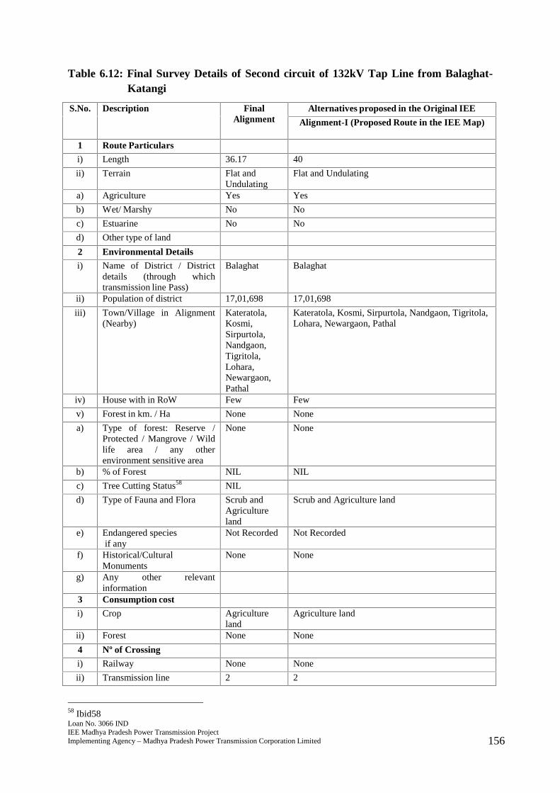
Loan No. 3066 INDIEE Madhya Pradesh Power Transmission ProjectImplementing Agency – Madhya Pradesh Power Transmission Corporation Limited 156
Table 6.12: Final Survey Details of Second circuit of 132kV Tap Line from Balaghat-Katangi
S.No. Description FinalAlignment
Alternatives proposed in the Original IEE
Alignment-I (Proposed Route in the IEE Map)
1 Route Particulars
i) Length 36.17 40
ii) Terrain Flat andUndulating
Flat and Undulating
a) Agriculture Yes Yes
b) Wet/ Marshy No No
c) Estuarine No No
d) Other type of land
2 Environmental Details
i) Name of District / Districtdetails (through whichtransmission line Pass)
Balaghat Balaghat
ii) Population of district 17,01,698 17,01,698
iii) Town/Village in Alignment(Nearby)
Kateratola,Kosmi,Sirpurtola,Nandgaon,Tigritola,Lohara,Newargaon,Pathal
Kateratola, Kosmi, Sirpurtola, Nandgaon, Tigritola,Lohara, Newargaon, Pathal
iv) House with in RoW Few Few
v) Forest in km. / Ha None None
a) Type of forest: Reserve /Protected / Mangrove / Wildlife area / any otherenvironment sensitive area
None None
b) % of Forest NIL NIL
c) Tree Cutting Status58 NIL
d) Type of Fauna and Flora Scrub andAgricultureland
Scrub and Agriculture land
e) Endangered speciesif any
Not Recorded Not Recorded
f) Historical/CulturalMonuments
None None
g) Any other relevantinformation
3 Consumption cost
i) Crop Agricultureland
Agriculture land
ii) Forest None None
4 Nº of Crossing
i) Railway None None
ii) Transmission line 2 2
58 Ibid58
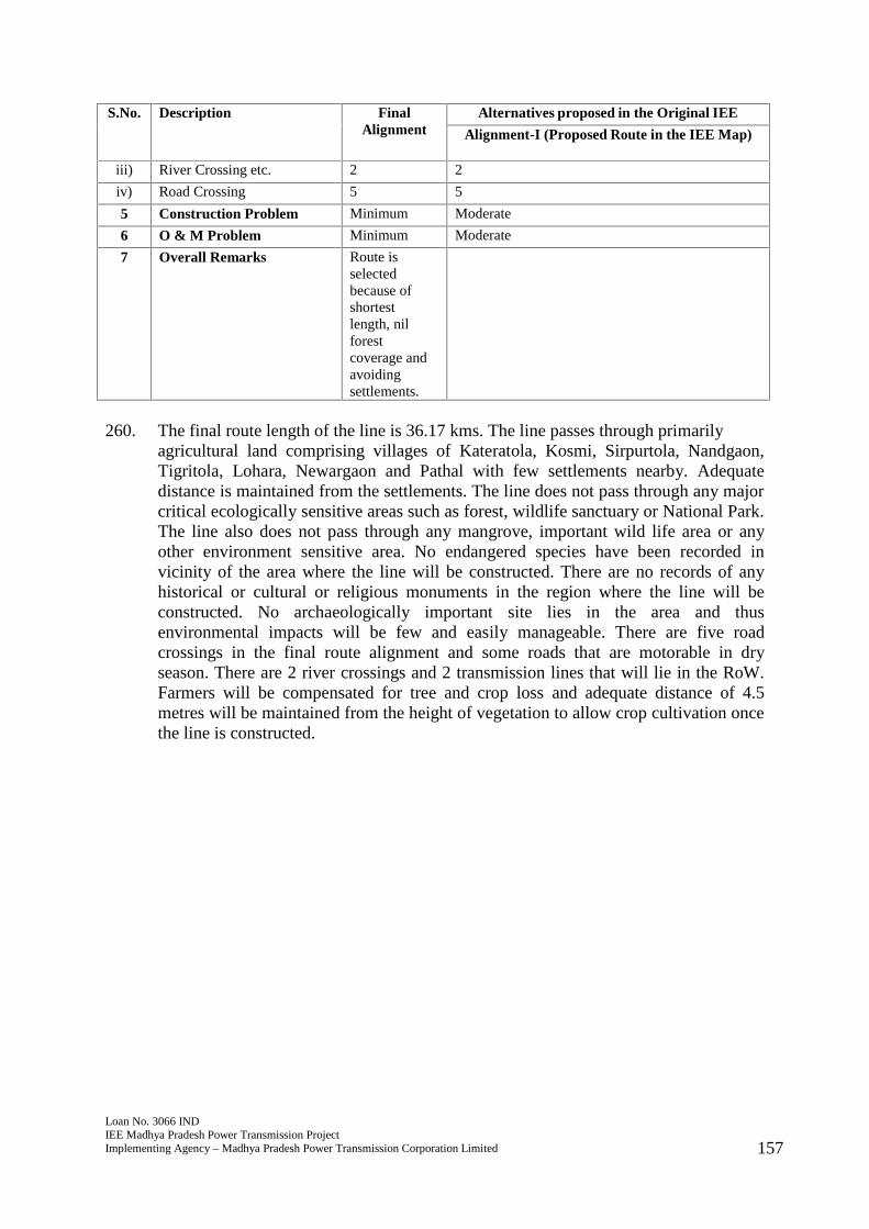
Loan No. 3066 INDIEE Madhya Pradesh Power Transmission ProjectImplementing Agency – Madhya Pradesh Power Transmission Corporation Limited 157
S.No. Description FinalAlignment
Alternatives proposed in the Original IEE
Alignment-I (Proposed Route in the IEE Map)
iii) River Crossing etc. 2 2
iv) Road Crossing 5 5
5 Construction Problem Minimum Moderate
6 O & M Problem Minimum Moderate
7 Overall Remarks Route isselectedbecause ofshortestlength, nilforestcoverage andavoidingsettlements.
260. The final route length of the line is 36.17 kms. The line passes through primarilyagricultural land comprising villages of Kateratola, Kosmi, Sirpurtola, Nandgaon,Tigritola, Lohara, Newargaon and Pathal with few settlements nearby. Adequatedistance is maintained from the settlements. The line does not pass through any majorcritical ecologically sensitive areas such as forest, wildlife sanctuary or National Park.The line also does not pass through any mangrove, important wild life area or anyother environment sensitive area. No endangered species have been recorded invicinity of the area where the line will be constructed. There are no records of anyhistorical or cultural or religious monuments in the region where the line will beconstructed. No archaeologically important site lies in the area and thusenvironmental impacts will be few and easily manageable. There are five roadcrossings in the final route alignment and some roads that are motorable in dryseason. There are 2 river crossings and 2 transmission lines that will lie in the RoW.Farmers will be compensated for tree and crop loss and adequate distance of 4.5metres will be maintained from the height of vegetation to allow crop cultivation oncethe line is constructed.
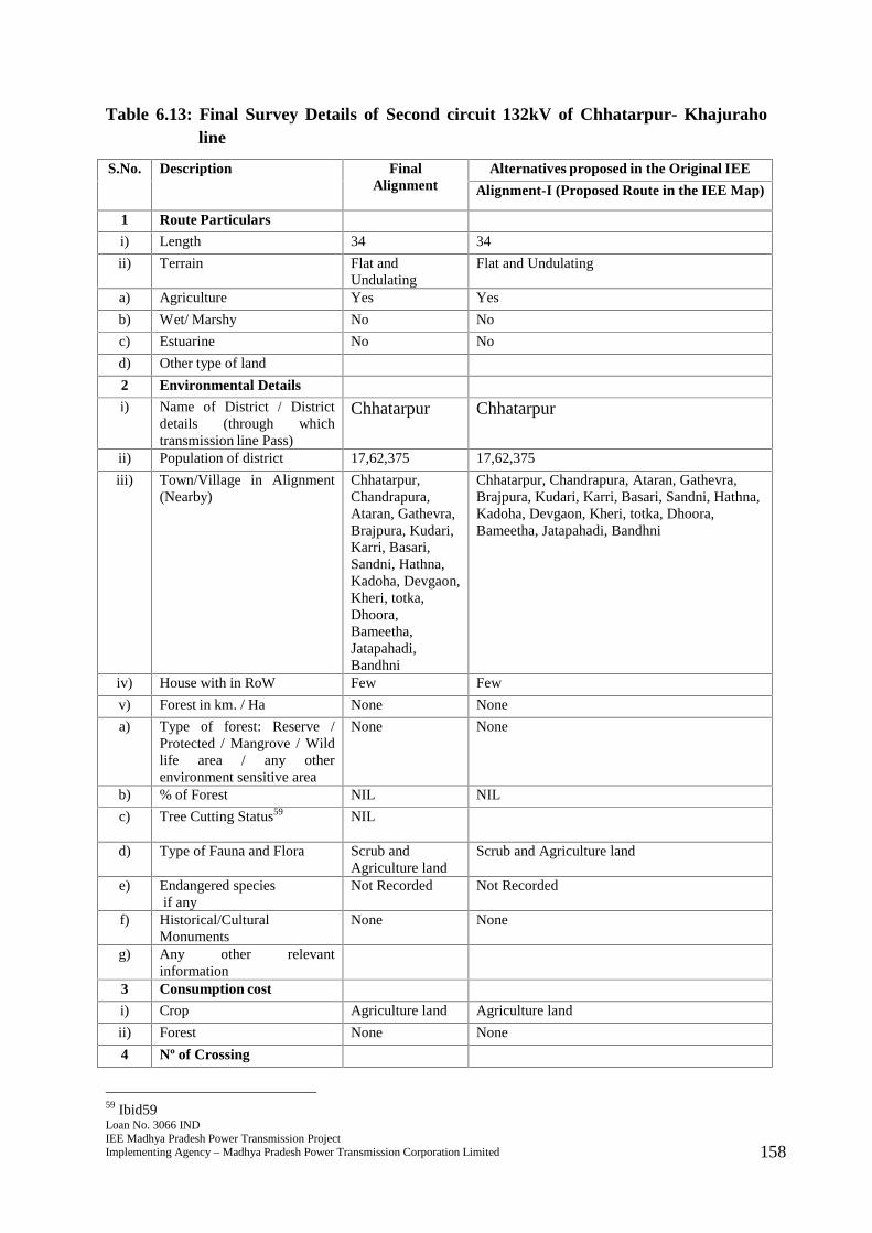
Loan No. 3066 INDIEE Madhya Pradesh Power Transmission ProjectImplementing Agency – Madhya Pradesh Power Transmission Corporation Limited 158
Table 6.13: Final Survey Details of Second circuit 132kV of Chhatarpur- Khajuraholine
S.No. Description FinalAlignment
Alternatives proposed in the Original IEE
Alignment-I (Proposed Route in the IEE Map)
1 Route Particulars
i) Length 34 34
ii) Terrain Flat andUndulating
Flat and Undulating
a) Agriculture Yes Yes
b) Wet/ Marshy No No
c) Estuarine No No
d) Other type of land
2 Environmental Details
i) Name of District / Districtdetails (through whichtransmission line Pass)
Chhatarpur Chhatarpur
ii) Population of district 17,62,375 17,62,375
iii) Town/Village in Alignment(Nearby)
Chhatarpur,Chandrapura,Ataran, Gathevra,Brajpura, Kudari,Karri, Basari,Sandni, Hathna,Kadoha, Devgaon,Kheri, totka,Dhoora,Bameetha,Jatapahadi,Bandhni
Chhatarpur, Chandrapura, Ataran, Gathevra,Brajpura, Kudari, Karri, Basari, Sandni, Hathna,Kadoha, Devgaon, Kheri, totka, Dhoora,Bameetha, Jatapahadi, Bandhni
iv) House with in RoW Few Few
v) Forest in km. / Ha None None
a) Type of forest: Reserve /Protected / Mangrove / Wildlife area / any otherenvironment sensitive area
None None
b) % of Forest NIL NIL
c) Tree Cutting Status59 NIL
d) Type of Fauna and Flora Scrub andAgriculture land
Scrub and Agriculture land
e) Endangered speciesif any
Not Recorded Not Recorded
f) Historical/CulturalMonuments
None None
g) Any other relevantinformation
3 Consumption cost
i) Crop Agriculture land Agriculture land
ii) Forest None None
4 Nº of Crossing
59 Ibid59
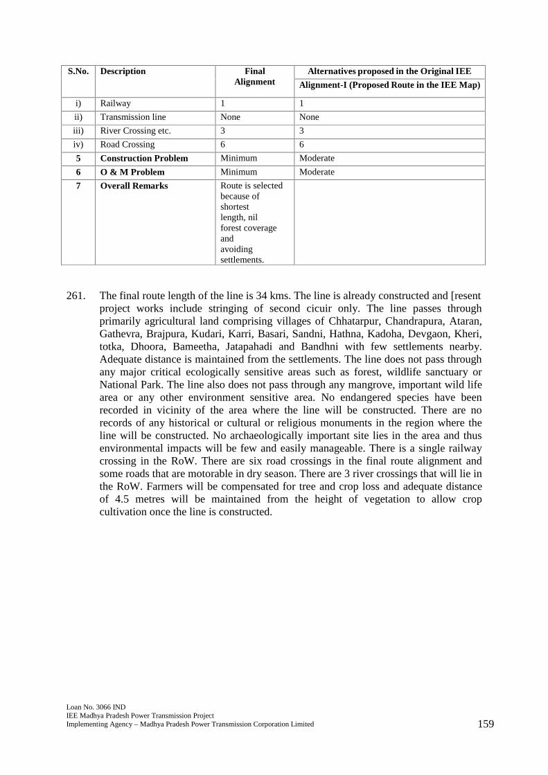
Loan No. 3066 INDIEE Madhya Pradesh Power Transmission ProjectImplementing Agency – Madhya Pradesh Power Transmission Corporation Limited 159
S.No. Description FinalAlignment
Alternatives proposed in the Original IEE
Alignment-I (Proposed Route in the IEE Map)
i) Railway 1 1
ii) Transmission line None None
iii) River Crossing etc. 3 3
iv) Road Crossing 6 6
5 Construction Problem Minimum Moderate
6 O & M Problem Minimum Moderate
7 Overall Remarks Route is selectedbecause ofshortestlength, nilforest coverageandavoidingsettlements.
261. The final route length of the line is 34 kms. The line is already constructed and [resentproject works include stringing of second cicuir only. The line passes throughprimarily agricultural land comprising villages of Chhatarpur, Chandrapura, Ataran,Gathevra, Brajpura, Kudari, Karri, Basari, Sandni, Hathna, Kadoha, Devgaon, Kheri,totka, Dhoora, Bameetha, Jatapahadi and Bandhni with few settlements nearby.Adequate distance is maintained from the settlements. The line does not pass throughany major critical ecologically sensitive areas such as forest, wildlife sanctuary orNational Park. The line also does not pass through any mangrove, important wild lifearea or any other environment sensitive area. No endangered species have beenrecorded in vicinity of the area where the line will be constructed. There are norecords of any historical or cultural or religious monuments in the region where theline will be constructed. No archaeologically important site lies in the area and thusenvironmental impacts will be few and easily manageable. There is a single railwaycrossing in the RoW. There are six road crossings in the final route alignment andsome roads that are motorable in dry season. There are 3 river crossings that will lie inthe RoW. Farmers will be compensated for tree and crop loss and adequate distanceof 4.5 metres will be maintained from the height of vegetation to allow cropcultivation once the line is constructed.
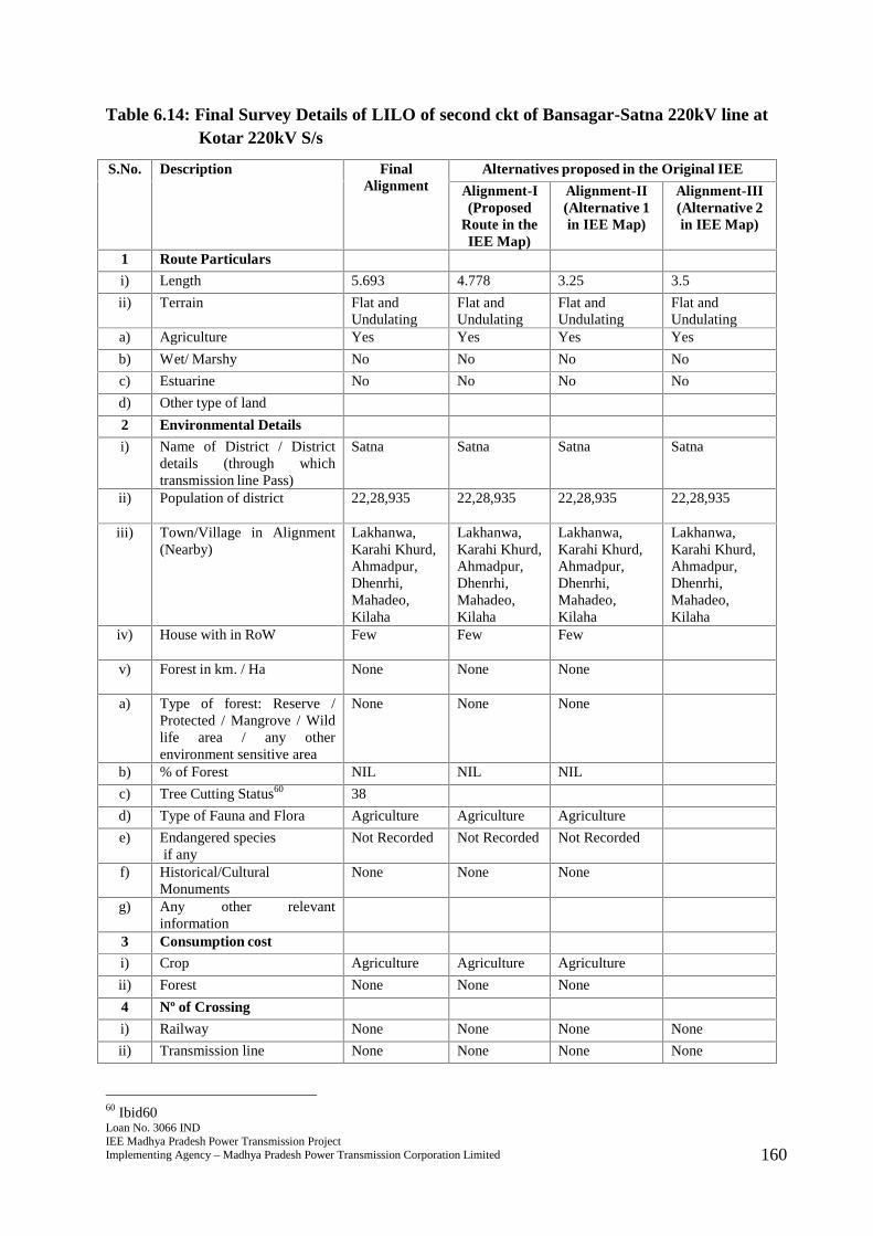
Loan No. 3066 INDIEE Madhya Pradesh Power Transmission ProjectImplementing Agency – Madhya Pradesh Power Transmission Corporation Limited 160
Table 6.14: Final Survey Details of LILO of second ckt of Bansagar-Satna 220kV line atKotar 220kV S/s
S.No. Description FinalAlignment
Alternatives proposed in the Original IEE
Alignment-I(Proposed
Route in theIEE Map)
Alignment-II(Alternative 1in IEE Map)
Alignment-III(Alternative 2in IEE Map)
1 Route Particulars
i) Length 5.693 4.778 3.25 3.5
ii) Terrain Flat andUndulating
Flat andUndulating
Flat andUndulating
Flat andUndulating
a) Agriculture Yes Yes Yes Yes
b) Wet/ Marshy No No No No
c) Estuarine No No No No
d) Other type of land
2 Environmental Details
i) Name of District / Districtdetails (through whichtransmission line Pass)
Satna Satna Satna Satna
ii) Population of district 22,28,935 22,28,935 22,28,935 22,28,935
iii) Town/Village in Alignment(Nearby)
Lakhanwa,Karahi Khurd,Ahmadpur,Dhenrhi,Mahadeo,Kilaha
Lakhanwa,Karahi Khurd,Ahmadpur,Dhenrhi,Mahadeo,Kilaha
Lakhanwa,Karahi Khurd,Ahmadpur,Dhenrhi,Mahadeo,Kilaha
Lakhanwa,Karahi Khurd,Ahmadpur,Dhenrhi,Mahadeo,Kilaha
iv) House with in RoW Few Few Few
v) Forest in km. / Ha None None None
a) Type of forest: Reserve /Protected / Mangrove / Wildlife area / any otherenvironment sensitive area
None None None
b) % of Forest NIL NIL NIL
c) Tree Cutting Status60 38
d) Type of Fauna and Flora Agriculture Agriculture Agriculture
e) Endangered speciesif any
Not Recorded Not Recorded Not Recorded
f) Historical/CulturalMonuments
None None None
g) Any other relevantinformation
3 Consumption cost
i) Crop Agriculture Agriculture Agriculture
ii) Forest None None None
4 Nº of Crossing
i) Railway None None None None
ii) Transmission line None None None None
60 Ibid60

Loan No. 3066 INDIEE Madhya Pradesh Power Transmission ProjectImplementing Agency – Madhya Pradesh Power Transmission Corporation Limited 161
S.No. Description FinalAlignment
Alternatives proposed in the Original IEE
Alignment-I(Proposed
Route in theIEE Map)
Alignment-II(Alternative 1in IEE Map)
Alignment-III(Alternative 2in IEE Map)
iii) River Crossing etc. None None None None
iv) Road Crossing 1 1 1 1
5 Construction Problem Minimum Moderate Moderate Moderate
6 O & M Problem Minimum Moderate Moderate Moderate
7 Overall Remarks Route isselectedbecause ofshortestlength, nilforestcoverage andavoidingsettlements.
262. The final route length of the line is 5.693 kms. The line passes through primarilyagricultural land comprising villages of Lakhanwa, Karahi Khurd, Ahmadpur,Dhenrhi, Mahadeo, and Kilaha with few settlements nearby. Adequate distance ismaintained from the settlements. The line does not pass through any major criticalecologically sensitive areas such as forest, wildlife sanctuary or National Park. Theline also does not pass through any mangrove, important wild life area or any otherenvironment sensitive area. No endangered species have been recorded in vicinity ofthe area where the line will be constructed. There are no records of any historical orcultural or religious monuments in the region where the line will be constructed. Noarchaeologically important site lies in the area and thus environmental impacts will befew and easily manageable. There is a single road crossing in the final routealignment and some roads that are motorable in dry season. Farmers will becompensated for tree and crop loss and adequate distance of 4.5 metres will bemaintained from the height of vegetation to allow crop cultivation once the line isconstructed.
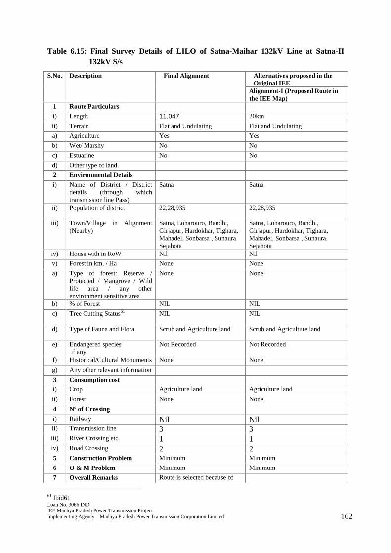
Loan No. 3066 INDIEE Madhya Pradesh Power Transmission ProjectImplementing Agency – Madhya Pradesh Power Transmission Corporation Limited 162
Table 6.15: Final Survey Details of LILO of Satna-Maihar 132kV Line at Satna-II132kV S/s
S.No. Description Final Alignment Alternatives proposed in theOriginal IEE
Alignment-I (Proposed Route inthe IEE Map)
1 Route Particulars
i) Length 11.047 20km
ii) Terrain Flat and Undulating Flat and Undulating
a) Agriculture Yes Yes
b) Wet/ Marshy No No
c) Estuarine No No
d) Other type of land
2 Environmental Details
i) Name of District / Districtdetails (through whichtransmission line Pass)
Satna Satna
ii) Population of district 22,28,935 22,28,935
iii) Town/Village in Alignment(Nearby)
Satna, Loharouro, Bandhi,Girjapur, Hardokhar, Tighara,Mahadel, Sonbarsa , Sunaura,Sejahota
Satna, Loharouro, Bandhi,Girjapur, Hardokhar, Tighara,Mahadel, Sonbarsa , Sunaura,Sejahota
iv) House with in RoW Nil Nil
v) Forest in km. / Ha None None
a) Type of forest: Reserve /Protected / Mangrove / Wildlife area / any otherenvironment sensitive area
None None
b) % of Forest NIL NIL
c) Tree Cutting Status61 NIL NIL
d) Type of Fauna and Flora Scrub and Agriculture land Scrub and Agriculture land
e) Endangered speciesif any
Not Recorded Not Recorded
f) Historical/Cultural Monuments None None
g) Any other relevant information
3 Consumption cost
i) Crop Agriculture land Agriculture land
ii) Forest None None
4 Nº of Crossing
i) Railway Nil Nilii) Transmission line 3 3iii) River Crossing etc. 1 1iv) Road Crossing 2 25 Construction Problem Minimum Minimum
6 O & M Problem Minimum Minimum
7 Overall Remarks Route is selected because of
61 Ibid61
Loan No. 3066 INDIEE Madhya Pradesh Power Transmission ProjectImplementing Agency – Madhya Pradesh Power Transmission Corporation Limited 163
S.No. Description Final Alignment Alternatives proposed in theOriginal IEE
Alignment-I (Proposed Route inthe IEE Map)
shortest length, nilforest coverage and avoidingsettlements.
263. The final route length of the line is 11.047 kms. The line passes through primarilyagricultural land comprising villages/towns of Satna, Loharouro, Bandhi, Girjapur,Hardokhar, Tighara, Mahadel, Sonbarsa, Sunaura, and Sejahota with few settlementsnearby. Adequate distance is maintained from the settlements. The line does not passthrough any major critical ecologically sensitive areas such as forest, wildlifesanctuary or National Park. The line also does not pass through any mangrove,important wild life area or any other environment sensitive area. No endangeredspecies have been recorded in vicinity of the area where the line will be constructed.There are no records of any historical or cultural or religious monuments in the regionwhere the line will be constructed. No archaeologically important site lies in the areaand thus environmental impacts will be few and easily manageable. There are tworoad crossings in the final route alignment and some roads that are motorable in dryseason. Farmers will be compensated for tree and crop loss and adequate distance of4.5 metres will be maintained from the height of vegetation to allow crop cultivationonce the line is constructed.
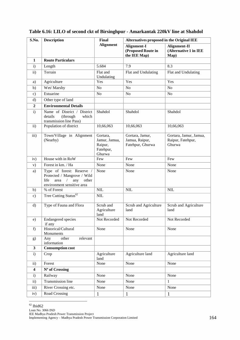
Loan No. 3066 INDIEE Madhya Pradesh Power Transmission ProjectImplementing Agency – Madhya Pradesh Power Transmission Corporation Limited 164
Table 6.16: LILO of second ckt of Birsinghpur - Amarkantak 220kV line at Shahdol
S.No. Description FinalAlignment
Alternatives proposed in the Original IEE
Alignment-I(Proposed Route inthe IEE Map)
Alignment-II(Alternative 1 in IEEMap)
1 Route Particulars
i) Length 5.684 7.9 8.3
ii) Terrain Flat andUndulating
Flat and Undulating Flat and Undulating
a) Agriculture Yes Yes Yes
b) Wet/ Marshy No No No
c) Estuarine No No No
d) Other type of land
2 Environmental Details
i) Name of District / Districtdetails (through whichtransmission line Pass)
Shahdol Shahdol Shahdol
ii) Population of district 10,66,063 10,66,063 10,66,063
iii) Town/Village in Alignment(Nearby)
Gortara,Jamur, Jamua,Raipur,Fatehpur,Ghurwa
Gortara, Jamur,Jamua, Raipur,Fatehpur, Ghurwa
Gortara, Jamur, Jamua,Raipur, Fatehpur,Ghurwa
iv) House with in RoW Few Few Few
v) Forest in km. / Ha None None None
a) Type of forest: Reserve /Protected / Mangrove / Wildlife area / any otherenvironment sensitive area
None None None
b) % of Forest NIL NIL NIL
c) Tree Cutting Status62 NIL
d) Type of Fauna and Flora Scrub andAgricultureland
Scrub and Agricultureland
Scrub and Agricultureland
e) Endangered speciesif any
Not Recorded Not Recorded Not Recorded
f) Historical/CulturalMonuments
None None None
g) Any other relevantinformation
3 Consumption cost
i) Crop Agricultureland
Agriculture land Agriculture land
ii) Forest None None None
4 Nº of Crossing
i) Railway None None None
ii) Transmission line None None 1
iii) River Crossing etc. None None None
iv) Road Crossing 1 1 1
62 Ibid62
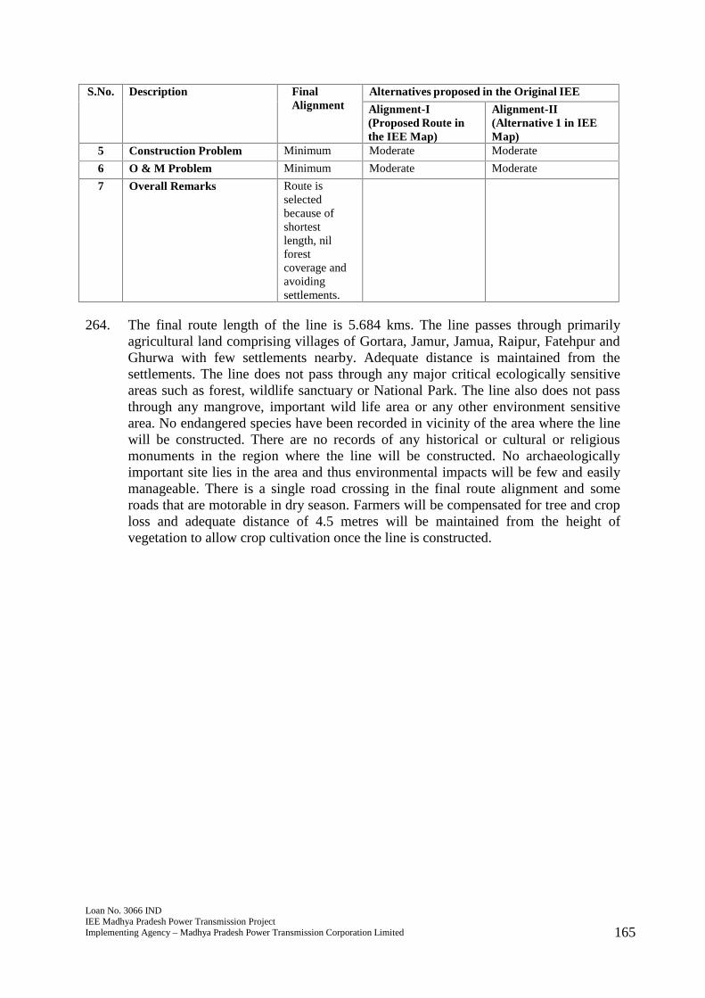
Loan No. 3066 INDIEE Madhya Pradesh Power Transmission ProjectImplementing Agency – Madhya Pradesh Power Transmission Corporation Limited 165
S.No. Description FinalAlignment
Alternatives proposed in the Original IEE
Alignment-I(Proposed Route inthe IEE Map)
Alignment-II(Alternative 1 in IEEMap)
5 Construction Problem Minimum Moderate Moderate
6 O & M Problem Minimum Moderate Moderate
7 Overall Remarks Route isselectedbecause ofshortestlength, nilforestcoverage andavoidingsettlements.
264. The final route length of the line is 5.684 kms. The line passes through primarilyagricultural land comprising villages of Gortara, Jamur, Jamua, Raipur, Fatehpur andGhurwa with few settlements nearby. Adequate distance is maintained from thesettlements. The line does not pass through any major critical ecologically sensitiveareas such as forest, wildlife sanctuary or National Park. The line also does not passthrough any mangrove, important wild life area or any other environment sensitivearea. No endangered species have been recorded in vicinity of the area where the linewill be constructed. There are no records of any historical or cultural or religiousmonuments in the region where the line will be constructed. No archaeologicallyimportant site lies in the area and thus environmental impacts will be few and easilymanageable. There is a single road crossing in the final route alignment and someroads that are motorable in dry season. Farmers will be compensated for tree and croploss and adequate distance of 4.5 metres will be maintained from the height ofvegetation to allow crop cultivation once the line is constructed.
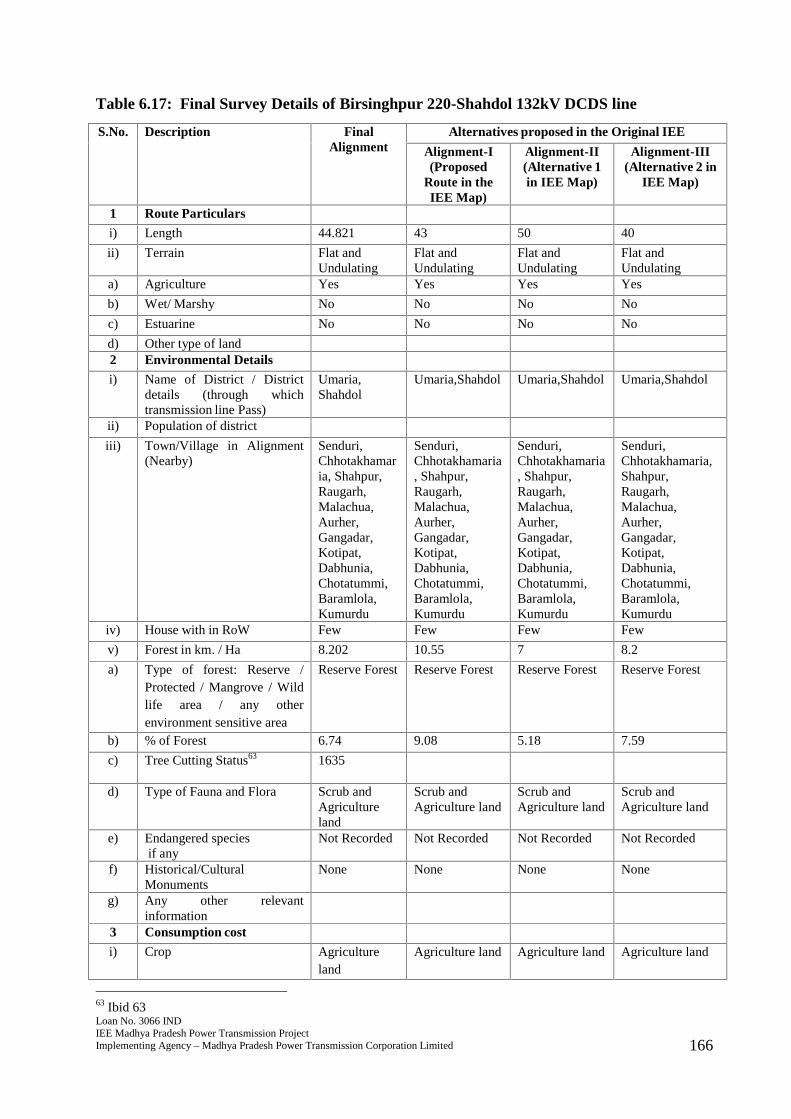
Loan No. 3066 INDIEE Madhya Pradesh Power Transmission ProjectImplementing Agency – Madhya Pradesh Power Transmission Corporation Limited 166
Table 6.17: Final Survey Details of Birsinghpur 220-Shahdol 132kV DCDS line
S.No. Description FinalAlignment
Alternatives proposed in the Original IEE
Alignment-I(Proposed
Route in theIEE Map)
Alignment-II(Alternative 1in IEE Map)
Alignment-III(Alternative 2 in
IEE Map)
1 Route Particulars
i) Length 44.821 43 50 40
ii) Terrain Flat andUndulating
Flat andUndulating
Flat andUndulating
Flat andUndulating
a) Agriculture Yes Yes Yes Yes
b) Wet/ Marshy No No No No
c) Estuarine No No No No
d) Other type of land2 Environmental Details
i) Name of District / Districtdetails (through whichtransmission line Pass)
Umaria,Shahdol
Umaria,Shahdol Umaria,Shahdol Umaria,Shahdol
ii) Population of district
iii) Town/Village in Alignment(Nearby)
Senduri,Chhotakhamaria, Shahpur,Raugarh,Malachua,Aurher,Gangadar,Kotipat,Dabhunia,Chotatummi,Baramlola,Kumurdu
Senduri,Chhotakhamaria, Shahpur,Raugarh,Malachua,Aurher,Gangadar,Kotipat,Dabhunia,Chotatummi,Baramlola,Kumurdu
Senduri,Chhotakhamaria, Shahpur,Raugarh,Malachua,Aurher,Gangadar,Kotipat,Dabhunia,Chotatummi,Baramlola,Kumurdu
Senduri,Chhotakhamaria,Shahpur,Raugarh,Malachua,Aurher,Gangadar,Kotipat,Dabhunia,Chotatummi,Baramlola,Kumurdu
iv) House with in RoW Few Few Few Few
v) Forest in km. / Ha 8.202 10.55 7 8.2
a) Type of forest: Reserve /Protected / Mangrove / Wildlife area / any otherenvironment sensitive area
Reserve Forest Reserve Forest Reserve Forest Reserve Forest
b) % of Forest 6.74 9.08 5.18 7.59
c) Tree Cutting Status63 1635
d) Type of Fauna and Flora Scrub andAgricultureland
Scrub andAgriculture land
Scrub andAgriculture land
Scrub andAgriculture land
e) Endangered speciesif any
Not Recorded Not Recorded Not Recorded Not Recorded
f) Historical/CulturalMonuments
None None None None
g) Any other relevantinformation
3 Consumption cost
i) Crop Agricultureland
Agriculture land Agriculture land Agriculture land
63 Ibid 63
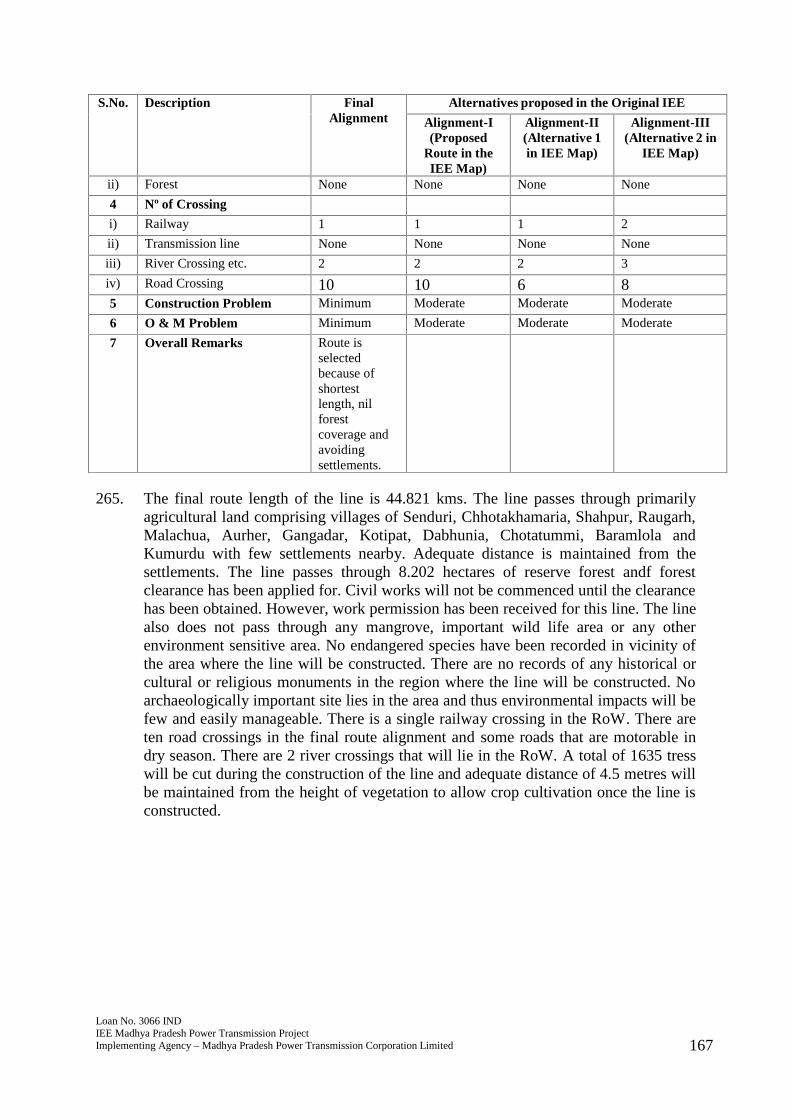
Loan No. 3066 INDIEE Madhya Pradesh Power Transmission ProjectImplementing Agency – Madhya Pradesh Power Transmission Corporation Limited 167
S.No. Description FinalAlignment
Alternatives proposed in the Original IEE
Alignment-I(Proposed
Route in theIEE Map)
Alignment-II(Alternative 1in IEE Map)
Alignment-III(Alternative 2 in
IEE Map)
ii) Forest None None None None
4 Nº of Crossing
i) Railway 1 1 1 2
ii) Transmission line None None None None
iii) River Crossing etc. 2 2 2 3
iv) Road Crossing 10 10 6 85 Construction Problem Minimum Moderate Moderate Moderate
6 O & M Problem Minimum Moderate Moderate Moderate
7 Overall Remarks Route isselectedbecause ofshortestlength, nilforestcoverage andavoidingsettlements.
265. The final route length of the line is 44.821 kms. The line passes through primarilyagricultural land comprising villages of Senduri, Chhotakhamaria, Shahpur, Raugarh,Malachua, Aurher, Gangadar, Kotipat, Dabhunia, Chotatummi, Baramlola andKumurdu with few settlements nearby. Adequate distance is maintained from thesettlements. The line passes through 8.202 hectares of reserve forest andf forestclearance has been applied for. Civil works will not be commenced until the clearancehas been obtained. However, work permission has been received for this line. The linealso does not pass through any mangrove, important wild life area or any otherenvironment sensitive area. No endangered species have been recorded in vicinity ofthe area where the line will be constructed. There are no records of any historical orcultural or religious monuments in the region where the line will be constructed. Noarchaeologically important site lies in the area and thus environmental impacts will befew and easily manageable. There is a single railway crossing in the RoW. There areten road crossings in the final route alignment and some roads that are motorable indry season. There are 2 river crossings that will lie in the RoW. A total of 1635 tresswill be cut during the construction of the line and adequate distance of 4.5 metres willbe maintained from the height of vegetation to allow crop cultivation once the line isconstructed.
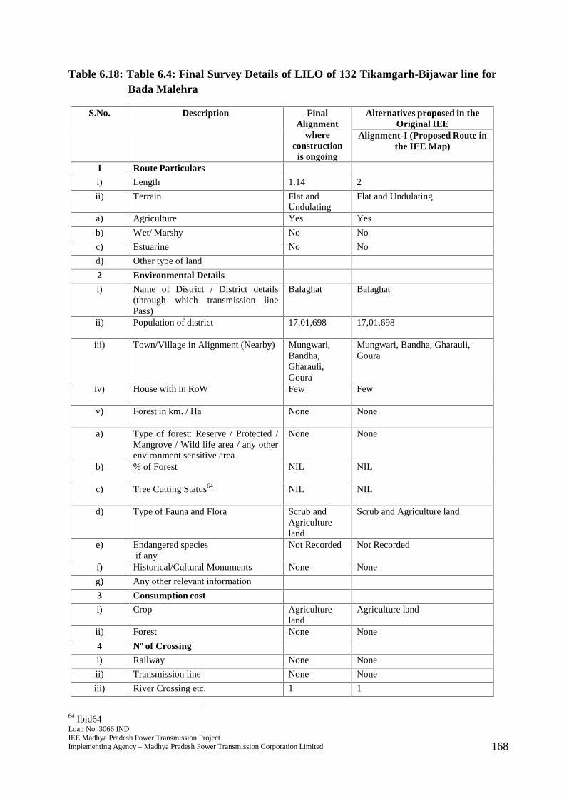
Loan No. 3066 INDIEE Madhya Pradesh Power Transmission ProjectImplementing Agency – Madhya Pradesh Power Transmission Corporation Limited 168
Table 6.18: Table 6.4: Final Survey Details of LILO of 132 Tikamgarh-Bijawar line forBada Malehra
S.No. Description FinalAlignment
whereconstruction
is ongoing
Alternatives proposed in theOriginal IEE
Alignment-I (Proposed Route inthe IEE Map)
1 Route Particulars
i) Length 1.14 2
ii) Terrain Flat andUndulating
Flat and Undulating
a) Agriculture Yes Yes
b) Wet/ Marshy No No
c) Estuarine No No
d) Other type of land
2 Environmental Details
i) Name of District / District details(through which transmission linePass)
Balaghat Balaghat
ii) Population of district 17,01,698 17,01,698
iii) Town/Village in Alignment (Nearby) Mungwari,Bandha,Gharauli,Goura
Mungwari, Bandha, Gharauli,Goura
iv) House with in RoW Few Few
v) Forest in km. / Ha None None
a) Type of forest: Reserve / Protected /Mangrove / Wild life area / any otherenvironment sensitive area
None None
b) % of Forest NIL NIL
c) Tree Cutting Status64 NIL NIL
d) Type of Fauna and Flora Scrub andAgricultureland
Scrub and Agriculture land
e) Endangered speciesif any
Not Recorded Not Recorded
f) Historical/Cultural Monuments None None
g) Any other relevant information
3 Consumption cost
i) Crop Agricultureland
Agriculture land
ii) Forest None None
4 Nº of Crossing
i) Railway None None
ii) Transmission line None None
iii) River Crossing etc. 1 1
64 Ibid64
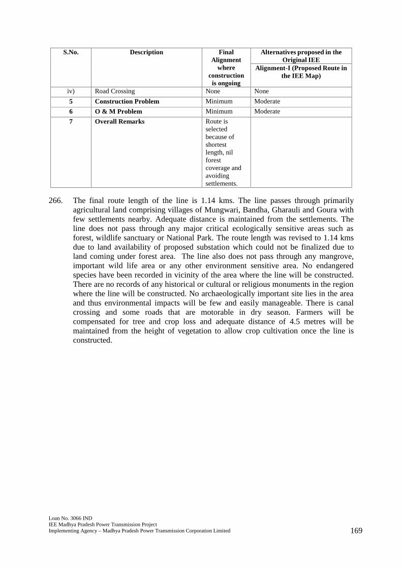
Loan No. 3066 INDIEE Madhya Pradesh Power Transmission ProjectImplementing Agency – Madhya Pradesh Power Transmission Corporation Limited 169
S.No. Description FinalAlignment
whereconstruction
is ongoing
Alternatives proposed in theOriginal IEE
Alignment-I (Proposed Route inthe IEE Map)
iv) Road Crossing None None
5 Construction Problem Minimum Moderate
6 O & M Problem Minimum Moderate
7 Overall Remarks Route isselectedbecause ofshortestlength, nilforestcoverage andavoidingsettlements.
266. The final route length of the line is 1.14 kms. The line passes through primarilyagricultural land comprising villages of Mungwari, Bandha, Gharauli and Goura withfew settlements nearby. Adequate distance is maintained from the settlements. Theline does not pass through any major critical ecologically sensitive areas such asforest, wildlife sanctuary or National Park. The route length was revised to 1.14 kmsdue to land availability of proposed substation which could not be finalized due toland coming under forest area. The line also does not pass through any mangrove,important wild life area or any other environment sensitive area. No endangeredspecies have been recorded in vicinity of the area where the line will be constructed.There are no records of any historical or cultural or religious monuments in the regionwhere the line will be constructed. No archaeologically important site lies in the areaand thus environmental impacts will be few and easily manageable. There is canalcrossing and some roads that are motorable in dry season. Farmers will becompensated for tree and crop loss and adequate distance of 4.5 metres will bemaintained from the height of vegetation to allow crop cultivation once the line isconstructed.
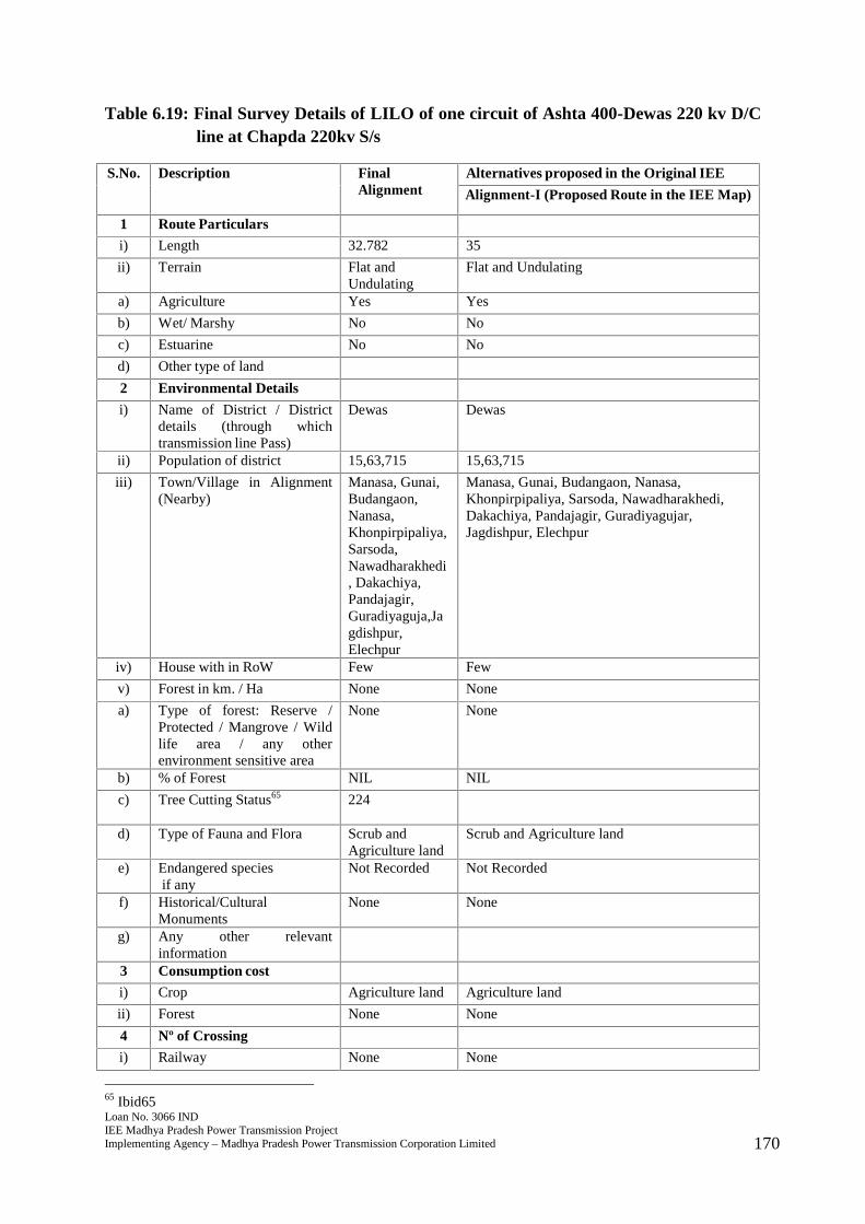
Loan No. 3066 INDIEE Madhya Pradesh Power Transmission ProjectImplementing Agency – Madhya Pradesh Power Transmission Corporation Limited 170
Table 6.19: Final Survey Details of LILO of one circuit of Ashta 400-Dewas 220 kv D/Cline at Chapda 220kv S/s
S.No. Description FinalAlignment
Alternatives proposed in the Original IEE
Alignment-I (Proposed Route in the IEE Map)
1 Route Particulars
i) Length 32.782 35
ii) Terrain Flat andUndulating
Flat and Undulating
a) Agriculture Yes Yes
b) Wet/ Marshy No No
c) Estuarine No No
d) Other type of land
2 Environmental Details
i) Name of District / Districtdetails (through whichtransmission line Pass)
Dewas Dewas
ii) Population of district 15,63,715 15,63,715
iii) Town/Village in Alignment(Nearby)
Manasa, Gunai,Budangaon,Nanasa,Khonpirpipaliya,Sarsoda,Nawadharakhedi, Dakachiya,Pandajagir,Guradiyaguja,Jagdishpur,Elechpur
Manasa, Gunai, Budangaon, Nanasa,Khonpirpipaliya, Sarsoda, Nawadharakhedi,Dakachiya, Pandajagir, Guradiyagujar,Jagdishpur, Elechpur
iv) House with in RoW Few Few
v) Forest in km. / Ha None None
a) Type of forest: Reserve /Protected / Mangrove / Wildlife area / any otherenvironment sensitive area
None None
b) % of Forest NIL NIL
c) Tree Cutting Status65 224
d) Type of Fauna and Flora Scrub andAgriculture land
Scrub and Agriculture land
e) Endangered speciesif any
Not Recorded Not Recorded
f) Historical/CulturalMonuments
None None
g) Any other relevantinformation
3 Consumption cost
i) Crop Agriculture land Agriculture land
ii) Forest None None
4 Nº of Crossing
i) Railway None None
65 Ibid65
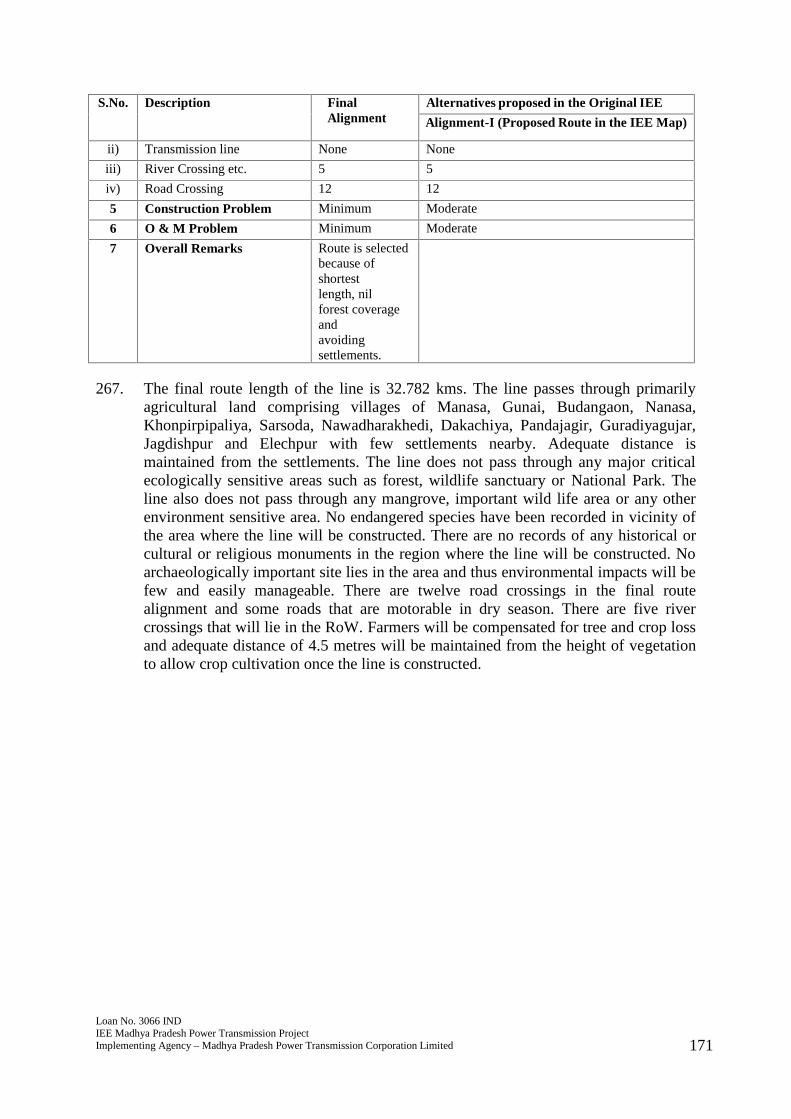
Loan No. 3066 INDIEE Madhya Pradesh Power Transmission ProjectImplementing Agency – Madhya Pradesh Power Transmission Corporation Limited 171
S.No. Description FinalAlignment
Alternatives proposed in the Original IEE
Alignment-I (Proposed Route in the IEE Map)
ii) Transmission line None None
iii) River Crossing etc. 5 5
iv) Road Crossing 12 12
5 Construction Problem Minimum Moderate
6 O & M Problem Minimum Moderate
7 Overall Remarks Route is selectedbecause ofshortestlength, nilforest coverageandavoidingsettlements.
267. The final route length of the line is 32.782 kms. The line passes through primarilyagricultural land comprising villages of Manasa, Gunai, Budangaon, Nanasa,Khonpirpipaliya, Sarsoda, Nawadharakhedi, Dakachiya, Pandajagir, Guradiyagujar,Jagdishpur and Elechpur with few settlements nearby. Adequate distance ismaintained from the settlements. The line does not pass through any major criticalecologically sensitive areas such as forest, wildlife sanctuary or National Park. Theline also does not pass through any mangrove, important wild life area or any otherenvironment sensitive area. No endangered species have been recorded in vicinity ofthe area where the line will be constructed. There are no records of any historical orcultural or religious monuments in the region where the line will be constructed. Noarchaeologically important site lies in the area and thus environmental impacts will befew and easily manageable. There are twelve road crossings in the final routealignment and some roads that are motorable in dry season. There are five rivercrossings that will lie in the RoW. Farmers will be compensated for tree and crop lossand adequate distance of 4.5 metres will be maintained from the height of vegetationto allow crop cultivation once the line is constructed.
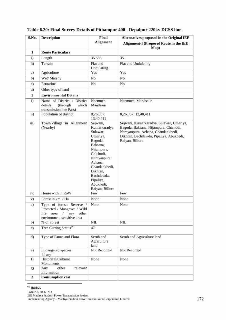
Loan No. 3066 INDIEE Madhya Pradesh Power Transmission ProjectImplementing Agency – Madhya Pradesh Power Transmission Corporation Limited 172
Table 6.20: Final Survey Details of Pithampur 400 - Depalpur 220kv DCSS line
S.No. Description FinalAlignment
Alternatives proposed in the Original IEE
Alignment-I (Proposed Route in the IEEMap)
1 Route Particulars
i) Length 35.583 35
ii) Terrain Flat andUndulating
Flat and Undulating
a) Agriculture Yes Yes
b) Wet/ Marshy No No
c) Estuarine No No
d) Other type of land
2 Environmental Details
i) Name of District / Districtdetails (through whichtransmission line Pass)
Neemuch,Mandsaur
Neemuch, Mandsaur
ii) Population of district 8,26,067;13,40,411
8,26,067; 13,40,411
iii) Town/Village in Alignment(Nearby)
Sejwani,Kumarkaradya,Sulawar,Umariya,Bagoda,Baksana,Nijampura,Chichodi,Narayanpura,Achana,Chandankhedi,Dikhtan,Bachdawda,Pipaliya,Abukhedi,Raiyan, Billore
Sejwani, Kumarkaradya, Sulawar, Umariya,Bagoda, Baksana, Nijampura, Chichodi,Narayanpura, Achana, Chandankhedi,Dikhtan, Bachdawda, Pipaliya, Abukhedi,Raiyan, Billore
iv) House with in RoW Few Few
v) Forest in km. / Ha None None
a) Type of forest: Reserve /Protected / Mangrove / Wildlife area / any otherenvironment sensitive area
None None
b) % of Forest NIL NIL
c) Tree Cutting Status66 47
d) Type of Fauna and Flora Scrub andAgricultureland
Scrub and Agriculture land
e) Endangered speciesif any
Not Recorded Not Recorded
f) Historical/CulturalMonuments
None None
g) Any other relevantinformation
3 Consumption cost
66 Ibid66

Loan No. 3066 INDIEE Madhya Pradesh Power Transmission ProjectImplementing Agency – Madhya Pradesh Power Transmission Corporation Limited 173
S.No. Description FinalAlignment
Alternatives proposed in the Original IEE
Alignment-I (Proposed Route in the IEEMap)
i) Crop Agricultureland
Agriculture land
ii) Forest None None
4 Nº of Crossing
i) Railway None None
ii) Transmission line 2 2
iii) River Crossing etc. 1 1
iv) Road Crossing 5 5
5 Construction Problem Minimum Moderate
6 O & M Problem Minimum Moderate
7 Overall Remarks Route isselectedbecause ofshortestlength, nilforest coverageandavoidingsettlements.
268. The final route length of the line is 35.583 kms. The line passes through primarilyagricultural land comprising villages of Sejwani, Kumarkaradya, Sulawar, Umariya,Bagoda, Baksana, Nijampura, Chichodi, Narayanpura, Achana, Chandankhedi,Dikhtan, Bachdawda, Pipaliya, Abukhedi, Raiyan, and Billore with few settlementsnearby. Adequate distance is maintained from the settlements. The line does not passthrough any major critical ecologically sensitive areas such as forest, wildlifesanctuary or National Park. The line also does not pass through any mangrove,important wild life area or any other environment sensitive area. No endangeredspecies have been recorded in vicinity of the area where the line will be constructed.There are no records of any historical or cultural or religious monuments in the regionwhere the line will be constructed. No archaeologically important site lies in the areaand thus environmental impacts will be few and easily manageable. There are fiveroad crossings in the final route alignment and some roads that are motorable in dryseason. There is a single river crossing and 2 transmission lines that will lie in theRoW. Farmers will be compensated for tree and crop loss and adequate distance of4.5 metres will be maintained from the height of vegetation to allow crop cultivationonce the line is constructed.
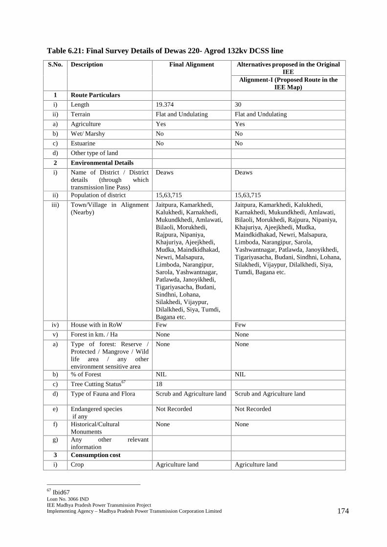
Loan No. 3066 INDIEE Madhya Pradesh Power Transmission ProjectImplementing Agency – Madhya Pradesh Power Transmission Corporation Limited 174
Table 6.21: Final Survey Details of Dewas 220- Agrod 132kv DCSS line
S.No. Description Final Alignment Alternatives proposed in the OriginalIEE
Alignment-I (Proposed Route in theIEE Map)
1 Route Particulars
i) Length 19.374 30
ii) Terrain Flat and Undulating Flat and Undulating
a) Agriculture Yes Yes
b) Wet/ Marshy No No
c) Estuarine No No
d) Other type of land
2 Environmental Details
i) Name of District / Districtdetails (through whichtransmission line Pass)
Deaws Deaws
ii) Population of district 15,63,715 15,63,715
iii) Town/Village in Alignment(Nearby)
Jaitpura, Kamarkhedi,Kalukhedi, Karnakhedi,Mukundkhedi, Amlawati,Bilaoli, Morukhedi,Rajpura, Nipaniya,Khajuriya, Ajeejkhedi,Mudka, Maindkidhakad,Newri, Malsapura,Limboda, Narangipur,Sarola, Yashwantnagar,Patlawda, Janoyikhedi,Tigariyasacha, Budani,Sindhni, Lohana,Silakhedi, Vijaypur,Dilalkhedi, Siya, Tumdi,Bagana etc.
Jaitpura, Kamarkhedi, Kalukhedi,Karnakhedi, Mukundkhedi, Amlawati,Bilaoli, Morukhedi, Rajpura, Nipaniya,Khajuriya, Ajeejkhedi, Mudka,Maindkidhakad, Newri, Malsapura,Limboda, Narangipur, Sarola,Yashwantnagar, Patlawda, Janoyikhedi,Tigariyasacha, Budani, Sindhni, Lohana,Silakhedi, Vijaypur, Dilalkhedi, Siya,Tumdi, Bagana etc.
iv) House with in RoW Few Few
v) Forest in km. / Ha None None
a) Type of forest: Reserve /Protected / Mangrove / Wildlife area / any otherenvironment sensitive area
None None
b) % of Forest NIL NIL
c) Tree Cutting Status67 18
d) Type of Fauna and Flora Scrub and Agriculture land Scrub and Agriculture land
e) Endangered speciesif any
Not Recorded Not Recorded
f) Historical/CulturalMonuments
None None
g) Any other relevantinformation
3 Consumption cost
i) Crop Agriculture land Agriculture land
67 Ibid67
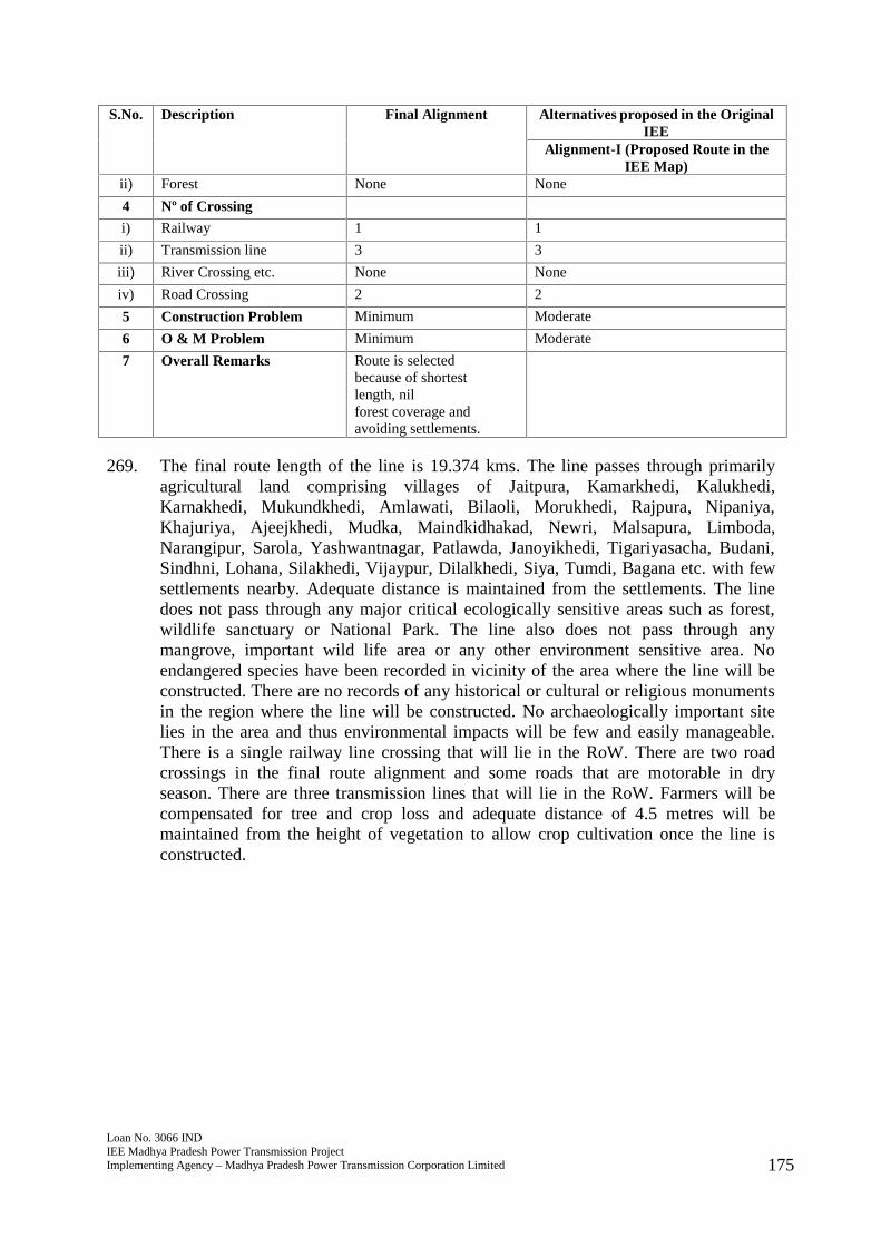
Loan No. 3066 INDIEE Madhya Pradesh Power Transmission ProjectImplementing Agency – Madhya Pradesh Power Transmission Corporation Limited 175
S.No. Description Final Alignment Alternatives proposed in the OriginalIEE
Alignment-I (Proposed Route in theIEE Map)
ii) Forest None None
4 Nº of Crossing
i) Railway 1 1
ii) Transmission line 3 3
iii) River Crossing etc. None None
iv) Road Crossing 2 2
5 Construction Problem Minimum Moderate
6 O & M Problem Minimum Moderate
7 Overall Remarks Route is selectedbecause of shortestlength, nilforest coverage andavoiding settlements.
269. The final route length of the line is 19.374 kms. The line passes through primarilyagricultural land comprising villages of Jaitpura, Kamarkhedi, Kalukhedi,Karnakhedi, Mukundkhedi, Amlawati, Bilaoli, Morukhedi, Rajpura, Nipaniya,Khajuriya, Ajeejkhedi, Mudka, Maindkidhakad, Newri, Malsapura, Limboda,Narangipur, Sarola, Yashwantnagar, Patlawda, Janoyikhedi, Tigariyasacha, Budani,Sindhni, Lohana, Silakhedi, Vijaypur, Dilalkhedi, Siya, Tumdi, Bagana etc. with fewsettlements nearby. Adequate distance is maintained from the settlements. The linedoes not pass through any major critical ecologically sensitive areas such as forest,wildlife sanctuary or National Park. The line also does not pass through anymangrove, important wild life area or any other environment sensitive area. Noendangered species have been recorded in vicinity of the area where the line will beconstructed. There are no records of any historical or cultural or religious monumentsin the region where the line will be constructed. No archaeologically important sitelies in the area and thus environmental impacts will be few and easily manageable.There is a single railway line crossing that will lie in the RoW. There are two roadcrossings in the final route alignment and some roads that are motorable in dryseason. There are three transmission lines that will lie in the RoW. Farmers will becompensated for tree and crop loss and adequate distance of 4.5 metres will bemaintained from the height of vegetation to allow crop cultivation once the line isconstructed.
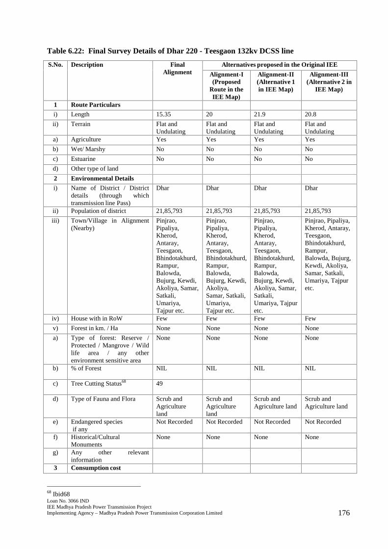
Loan No. 3066 INDIEE Madhya Pradesh Power Transmission ProjectImplementing Agency – Madhya Pradesh Power Transmission Corporation Limited 176
Table 6.22: Final Survey Details of Dhar 220 - Teesgaon 132kv DCSS line
S.No. Description FinalAlignment
Alternatives proposed in the Original IEE
Alignment-I(Proposed
Route in theIEE Map)
Alignment-II(Alternative 1in IEE Map)
Alignment-III(Alternative 2 in
IEE Map)
1 Route Particulars
i) Length 15.35 20 21.9 20.8
ii) Terrain Flat andUndulating
Flat andUndulating
Flat andUndulating
Flat andUndulating
a) Agriculture Yes Yes Yes Yes
b) Wet/ Marshy No No No No
c) Estuarine No No No No
d) Other type of land
2 Environmental Details
i) Name of District / Districtdetails (through whichtransmission line Pass)
Dhar Dhar Dhar Dhar
ii) Population of district 21,85,793 21,85,793 21,85,793 21,85,793
iii) Town/Village in Alignment(Nearby)
Pinjrao,Pipaliya,Kherod,Antaray,Teesgaon,Bhindotakhurd,Rampur,Balowda,Bujurg, Kewdi,Akoliya, Samar,Satkali,Umariya,Tajpur etc.
Pinjrao,Pipaliya,Kherod,Antaray,Teesgaon,Bhindotakhurd,Rampur,Balowda,Bujurg, Kewdi,Akoliya,Samar, Satkali,Umariya,Tajpur etc.
Pinjrao,Pipaliya,Kherod,Antaray,Teesgaon,Bhindotakhurd,Rampur,Balowda,Bujurg, Kewdi,Akoliya, Samar,Satkali,Umariya, Tajpuretc.
Pinjrao, Pipaliya,Kherod, Antaray,Teesgaon,Bhindotakhurd,Rampur,Balowda, Bujurg,Kewdi, Akoliya,Samar, Satkali,Umariya, Tajpuretc.
iv) House with in RoW Few Few Few Few
v) Forest in km. / Ha None None None None
a) Type of forest: Reserve /Protected / Mangrove / Wildlife area / any otherenvironment sensitive area
None None None None
b) % of Forest NIL NIL NIL NIL
c) Tree Cutting Status68 49
d) Type of Fauna and Flora Scrub andAgricultureland
Scrub andAgricultureland
Scrub andAgriculture land
Scrub andAgriculture land
e) Endangered speciesif any
Not Recorded Not Recorded Not Recorded Not Recorded
f) Historical/CulturalMonuments
None None None None
g) Any other relevantinformation
3 Consumption cost
68 Ibid68
Loan No. 3066 INDIEE Madhya Pradesh Power Transmission ProjectImplementing Agency – Madhya Pradesh Power Transmission Corporation Limited 177
S.No. Description FinalAlignment
Alternatives proposed in the Original IEE
Alignment-I(Proposed
Route in theIEE Map)
Alignment-II(Alternative 1in IEE Map)
Alignment-III(Alternative 2 in
IEE Map)
i) Crop Agricultureland
Agricultureland
Agriculture land Agriculture land
ii) Forest None None None None
4 Nº of Crossing
i) Railway Proposedrailway track
Proposedrailway track
Proposedrailway track
Proposed railwaytrack
ii) Transmission line None None None None
iii) River Crossing etc. None None None None
iv) Road Crossing 3 4 5 6
5 Construction Problem Minimum Moderate Moderate Moderate
6 O & M Problem Minimum Moderate Moderate Moderate
7 Overall Remarks Route isselectedbecause ofshortestlength, nilforest coverageandavoidingsettlements.
270. The final route length of the line is 15.35 kms. The line passes through primarilyagricultural land comprising villages of Pinjrao, Pipaliya, Kherod, Antaray, Teesgaon,Bhindotakhurd, Rampur, Balowda, Bujurg, Kewdi, Akoliya, Samar, Satkali, Umariya,and Tajpur etc. with few settlements nearby. Adequate distance is maintained fromthe settlements. The line does not pass through any major critical ecologicallysensitive areas such as forest, wildlife sanctuary or National Park. The line also doesnot pass through any mangrove, important wild life area or any other environmentsensitive area. No endangered species have been recorded in vicinity of the areawhere the line will be constructed. There are no records of any historical or cultural orreligious monuments in the region where the line will be constructed. Noarchaeologically important site lies in the area and thus environmental impacts will befew and easily manageable. There are three road crossings in the final route alignmentand some roads that are motorable in dry season. There is a proposed railway crossingin the RoW. Farmers will be compensated for tree and crop loss and adequate distanceof 4.5 metres will be maintained from the height of vegetation to allow cropcultivation once the line is constructed.
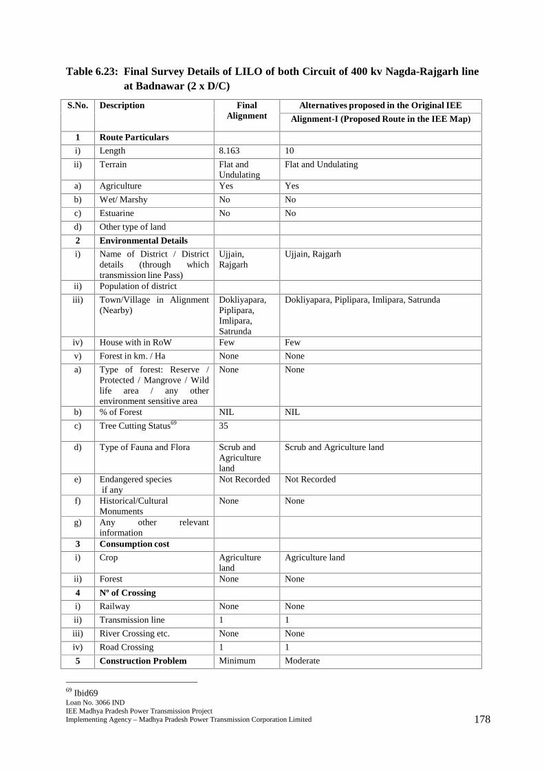
Loan No. 3066 INDIEE Madhya Pradesh Power Transmission ProjectImplementing Agency – Madhya Pradesh Power Transmission Corporation Limited 178
Table 6.23: Final Survey Details of LILO of both Circuit of 400 kv Nagda-Rajgarh lineat Badnawar (2 x D/C)
S.No. Description FinalAlignment
Alternatives proposed in the Original IEE
Alignment-I (Proposed Route in the IEE Map)
1 Route Particulars
i) Length 8.163 10
ii) Terrain Flat andUndulating
Flat and Undulating
a) Agriculture Yes Yes
b) Wet/ Marshy No No
c) Estuarine No No
d) Other type of land
2 Environmental Details
i) Name of District / Districtdetails (through whichtransmission line Pass)
Ujjain,Rajgarh
Ujjain, Rajgarh
ii) Population of district
iii) Town/Village in Alignment(Nearby)
Dokliyapara,Piplipara,Imlipara,Satrunda
Dokliyapara, Piplipara, Imlipara, Satrunda
iv) House with in RoW Few Few
v) Forest in km. / Ha None None
a) Type of forest: Reserve /Protected / Mangrove / Wildlife area / any otherenvironment sensitive area
None None
b) % of Forest NIL NIL
c) Tree Cutting Status69 35
d) Type of Fauna and Flora Scrub andAgricultureland
Scrub and Agriculture land
e) Endangered speciesif any
Not Recorded Not Recorded
f) Historical/CulturalMonuments
None None
g) Any other relevantinformation
3 Consumption cost
i) Crop Agricultureland
Agriculture land
ii) Forest None None
4 Nº of Crossing
i) Railway None None
ii) Transmission line 1 1
iii) River Crossing etc. None None
iv) Road Crossing 1 1
5 Construction Problem Minimum Moderate
69 Ibid69
Loan No. 3066 INDIEE Madhya Pradesh Power Transmission ProjectImplementing Agency – Madhya Pradesh Power Transmission Corporation Limited 179
S.No. Description FinalAlignment
Alternatives proposed in the Original IEE
Alignment-I (Proposed Route in the IEE Map)
6 O & M Problem Minimum Moderate
7 Overall Remarks Route isselectedbecause ofshortestlength, nilforestcoverage andavoidingsettlements.
271. The final route length of the line is 8.163 kms. The line passes through primarilyagricultural land comprising villages of Dokliyapara, Piplipara, Imlipara, andSatrunda with few settlements nearby. Adequate distance is maintained from thesettlements. The line does not pass through any major critical ecologically sensitiveareas such as forest, wildlife sanctuary or National Park. The line also does not passthrough any mangrove, important wild life area or any other environment sensitivearea. No endangered species have been recorded in vicinity of the area where the linewill be constructed. There are no records of any historical or cultural or religiousmonuments in the region where the line will be constructed. No archaeologicallyimportant site lies in the area and thus environmental impacts will be few and easilymanageable. There is a single road crossing in the final route alignment and someroads that are motorable in dry season. There is a single transmission line that will liein the RoW. Farmers will be compensated for tree and crop loss and adequate distanceof 4.5 metres will be maintained from the height of vegetation to allow cropcultivation once the line is constructed.
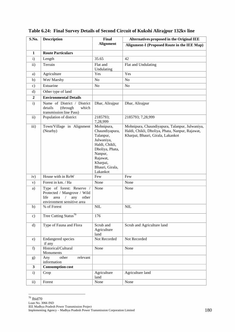
Loan No. 3066 INDIEE Madhya Pradesh Power Transmission ProjectImplementing Agency – Madhya Pradesh Power Transmission Corporation Limited 180
Table 6.24: Final Survey Details of Second Circuit of Kukshi Alirajpur 132kv line
S.No. Description FinalAlignment
Alternatives proposed in the Original IEE
Alignment-I (Proposed Route in the IEE Map)
1 Route Particulars
i) Length 35.65 42
ii) Terrain Flat andUndulating
Flat and Undulating
a) Agriculture Yes Yes
b) Wet/ Marshy No No
c) Estuarine No No
d) Other type of land
2 Environmental Details
i) Name of District / Districtdetails (through whichtransmission line Pass)
Dhar, Alirajpur Dhar, Alirajpur
ii) Population of district 2185793;7,28,999
2185793; 7,28,999
iii) Town/Village in Alignment(Nearby)
Mohnipura,Chaundiyapura,Talanpur,Julwaniya,Haldi, Chikli,Dholiya, Phata,Nanpur,Rajawat,Kharpai,Bhauri, Girala,Lakankot
Mohnipura, Chaundiyapura, Talanpur, Julwaniya,Haldi, Chikli, Dholiya, Phata, Nanpur, Rajawat,Kharpai, Bhauri, Girala, Lakankot
iv) House with in RoW Few Few
v) Forest in km. / Ha None None
a) Type of forest: Reserve /Protected / Mangrove / Wildlife area / any otherenvironment sensitive area
None None
b) % of Forest NIL NIL
c) Tree Cutting Status70 176
d) Type of Fauna and Flora Scrub andAgricultureland
Scrub and Agriculture land
e) Endangered speciesif any
Not Recorded Not Recorded
f) Historical/CulturalMonuments
None None
g) Any other relevantinformation
3 Consumption cost
i) Crop Agricultureland
Agriculture land
ii) Forest None None
70 Ibid70
Loan No. 3066 INDIEE Madhya Pradesh Power Transmission ProjectImplementing Agency – Madhya Pradesh Power Transmission Corporation Limited 181
S.No. Description FinalAlignment
Alternatives proposed in the Original IEE
Alignment-I (Proposed Route in the IEE Map)
4 Nº of Crossing
i) Railway None None
ii) Transmission line 2 2
iii) River Crossing etc. 2 2
iv) Road Crossing 2 2
5 Construction Problem Minimum Moderate
6 O & M Problem Minimum Moderate
7 Overall Remarks Route isselectedbecause ofshortestlength, nilforest coverageandavoidingsettlements.
272. The final route length of the line is 35.65 kms. The present project works comprise ofstrnging of second cicuit only. The line passes through primarily agricultural landcomprising villages of Mohnipura, Chaundiyapura, Talanpur, Julwaniya, Haldi,Chikli, Dholiya, Phata, Nanpur, Rajawat, Kharpai, Bhauri, Girala, and Lakankot withfew settlements nearby. Adequate distance is maintained from the settlements. Theline does not pass through any major critical ecologically sensitive areas such asforest, wildlife sanctuary or National Park. The line also does not pass through anymangrove, important wild life area or any other environment sensitive area. Noendangered species have been recorded in vicinity of the area where the line will beconstructed. There are no records of any historical or cultural or religious monumentsin the region where the line will be constructed. No archaeologically important sitelies in the area and thus environmental impacts will be few and easily manageable.There are two road crossings in the final route alignment and some roads that aremotorable in dry season. There are two river crossings and two transmission lines thatwill lie in the RoW. Farmers will be compensated for tree and crop loss and adequatedistance of 4.5 metres will be maintained from the height of vegetation to allow cropcultivation once the line is constructed.
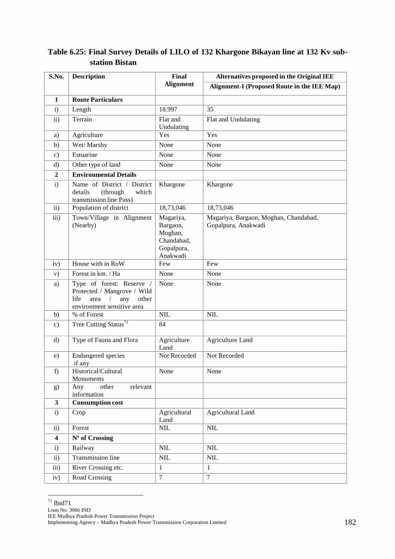
Loan No. 3066 INDIEE Madhya Pradesh Power Transmission ProjectImplementing Agency – Madhya Pradesh Power Transmission Corporation Limited 182
Table 6.25: Final Survey Details of LILO of 132 Khargone Bikayan line at 132 Kv sub-station Bistan
S.No. Description FinalAlignment
Alternatives proposed in the Original IEE
Alignment-I (Proposed Route in the IEE Map)
1 Route Particulars
i) Length 18.997 35
ii) Terrain Flat andUndulating
Flat and Undulating
a) Agriculture Yes Yes
b) Wet/ Marshy None None
c) Estuarine None None
d) Other type of land None None
2 Environmental Details
i) Name of District / Districtdetails (through whichtransmission line Pass)
Khargone Khargone
ii) Population of district 18,73,046 18,73,046
iii) Town/Village in Alignment(Nearby)
Magariya,Bargaon,Moghan,Chandabad,Gopalpura,Anakwadi
Magariya, Bargaon, Moghan, Chandabad,Gopalpura, Anakwadi
iv) House with in RoW Few Few
v) Forest in km. / Ha None None
a) Type of forest: Reserve /Protected / Mangrove / Wildlife area / any otherenvironment sensitive area
None None
b) % of Forest NIL NIL
c) Tree Cutting Status71 84
d) Type of Fauna and Flora AgricultureLand
Agriculture Land
e) Endangered speciesif any
Not Recorded Not Recorded
f) Historical/CulturalMonuments
None None
g) Any other relevantinformation
3 Consumption cost
i) Crop AgriculturalLand
Agricultural Land
ii) Forest NIL NIL
4 Nº of Crossing
i) Railway NIL NIL
ii) Transmission line NIL NIL
iii) River Crossing etc. 1 1
iv) Road Crossing 7 7
71 Ibid71
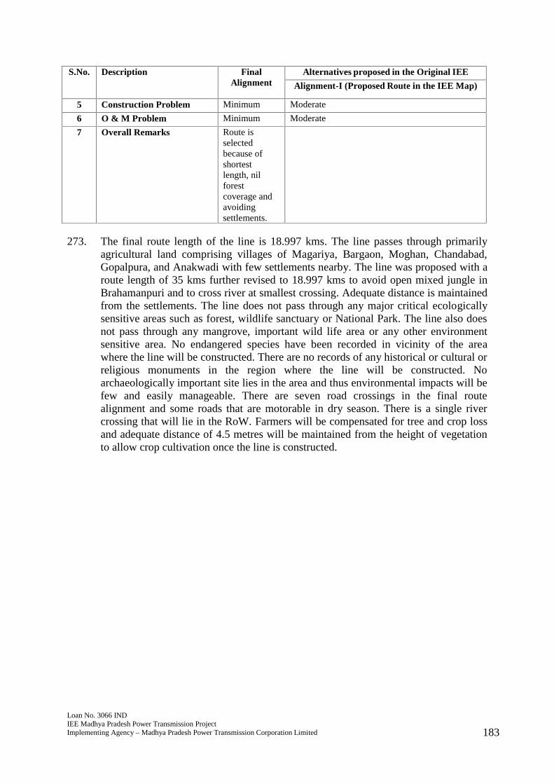
Loan No. 3066 INDIEE Madhya Pradesh Power Transmission ProjectImplementing Agency – Madhya Pradesh Power Transmission Corporation Limited 183
S.No. Description FinalAlignment
Alternatives proposed in the Original IEE
Alignment-I (Proposed Route in the IEE Map)
5 Construction Problem Minimum Moderate
6 O & M Problem Minimum Moderate
7 Overall Remarks Route isselectedbecause ofshortestlength, nilforestcoverage andavoidingsettlements.
273. The final route length of the line is 18.997 kms. The line passes through primarilyagricultural land comprising villages of Magariya, Bargaon, Moghan, Chandabad,Gopalpura, and Anakwadi with few settlements nearby. The line was proposed with aroute length of 35 kms further revised to 18.997 kms to avoid open mixed jungle inBrahamanpuri and to cross river at smallest crossing. Adequate distance is maintainedfrom the settlements. The line does not pass through any major critical ecologicallysensitive areas such as forest, wildlife sanctuary or National Park. The line also doesnot pass through any mangrove, important wild life area or any other environmentsensitive area. No endangered species have been recorded in vicinity of the areawhere the line will be constructed. There are no records of any historical or cultural orreligious monuments in the region where the line will be constructed. Noarchaeologically important site lies in the area and thus environmental impacts will befew and easily manageable. There are seven road crossings in the final routealignment and some roads that are motorable in dry season. There is a single rivercrossing that will lie in the RoW. Farmers will be compensated for tree and crop lossand adequate distance of 4.5 metres will be maintained from the height of vegetationto allow crop cultivation once the line is constructed.

Loan No. 3066 INDIEE Madhya Pradesh Power Transmission ProjectImplementing Agency – Madhya Pradesh Power Transmission Corporation Limited 184
Table 6.26: Final Survey Details of LILO of 132kv Chhegaon Nepanagar line atPandhana
S.No. Description FinalAlignment
Alternatives proposed in the Original IEE
Alignment-I(Proposed Route in
the IEE Map)
Alignment-II(Alternative 1 in IEE
Map)1 Route Particulars
i) Length 1.895 1.825 30
ii) Terrain Flat andUndulating
Flat and Undulating Flat and Undulating
a) Agriculture Yes Yes Yes
b) Wet/ Marshy None None None
c) Estuarine None None None
d) Other type of land None None None
2 Environmental Details
i) Name of District / Districtdetails (through whichtransmission line Pass)
Khandwa,Burhanpur
Khandwa, Burhanpur Khandwa, Burhanpur
ii) Population of district 13,10,061;7,57,847
13,10,061; 7,57,847 13,10,061; 7,57,847
iii) Town/Village in Alignment(Nearby)
Dulhar,Teela etc
Dulhar, Teela etc Dulhar, Teela etc
iv) House with in RoW None None None
v) Forest in km. / Ha None None None
a) Type of forest: Reserve /Protected / Mangrove / Wildlife area / any otherenvironment sensitive area
None None None
b) % of Forest NIL NIL NIL
c) Tree Cutting Status72 14
d) Type of Fauna and Flora AgricultureLand
Agriculture Land Agriculture Land
e) Endangered speciesif any
Not Recorded Not Recorded Not Recorded
f) Historical/CulturalMonuments
None None None
g) Any other relevantinformation
3 Consumption cost
i) Crop AgriculturalLand
Agricultural Land
ii) Forest NIL NIL NIL
4 Nº of Crossing
i) Railway NIL NIL NIL
ii) Transmission line NIL NIL NIL
iii) River Crossing etc. NIL NIL NIL
iv) Road Crossing NIL NIL NIL
5 Construction Problem Minimum Moderate Moderate
72 Ibid72
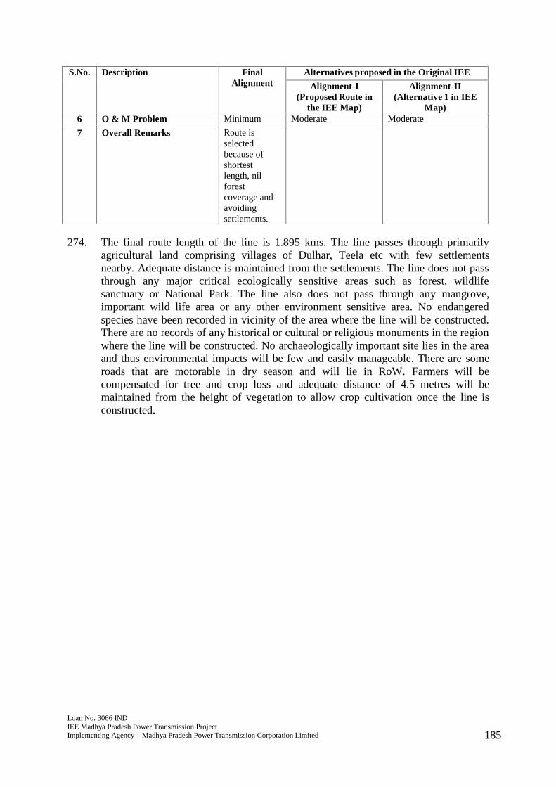
Loan No. 3066 INDIEE Madhya Pradesh Power Transmission ProjectImplementing Agency – Madhya Pradesh Power Transmission Corporation Limited 185
S.No. Description FinalAlignment
Alternatives proposed in the Original IEE
Alignment-I(Proposed Route in
the IEE Map)
Alignment-II(Alternative 1 in IEE
Map)6 O & M Problem Minimum Moderate Moderate
7 Overall Remarks Route isselectedbecause ofshortestlength, nilforestcoverage andavoidingsettlements.
274. The final route length of the line is 1.895 kms. The line passes through primarilyagricultural land comprising villages of Dulhar, Teela etc with few settlementsnearby. Adequate distance is maintained from the settlements. The line does not passthrough any major critical ecologically sensitive areas such as forest, wildlifesanctuary or National Park. The line also does not pass through any mangrove,important wild life area or any other environment sensitive area. No endangeredspecies have been recorded in vicinity of the area where the line will be constructed.There are no records of any historical or cultural or religious monuments in the regionwhere the line will be constructed. No archaeologically important site lies in the areaand thus environmental impacts will be few and easily manageable. There are someroads that are motorable in dry season and will lie in RoW. Farmers will becompensated for tree and crop loss and adequate distance of 4.5 metres will bemaintained from the height of vegetation to allow crop cultivation once the line isconstructed.
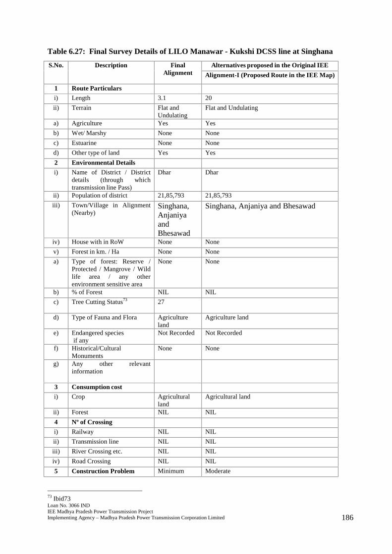
Loan No. 3066 INDIEE Madhya Pradesh Power Transmission ProjectImplementing Agency – Madhya Pradesh Power Transmission Corporation Limited 186
Table 6.27: Final Survey Details of LILO Manawar - Kukshi DCSS line at Singhana
S.No. Description FinalAlignment
Alternatives proposed in the Original IEE
Alignment-I (Proposed Route in the IEE Map)
1 Route Particulars
i) Length 3.1 20
ii) Terrain Flat andUndulating
Flat and Undulating
a) Agriculture Yes Yes
b) Wet/ Marshy None None
c) Estuarine None None
d) Other type of land Yes Yes
2 Environmental Details
i) Name of District / Districtdetails (through whichtransmission line Pass)
Dhar Dhar
ii) Population of district 21,85,793 21,85,793
iii) Town/Village in Alignment(Nearby)
Singhana,AnjaniyaandBhesawad
Singhana, Anjaniya and Bhesawad
iv) House with in RoW None None
v) Forest in km. / Ha None None
a) Type of forest: Reserve /Protected / Mangrove / Wildlife area / any otherenvironment sensitive area
None None
b) % of Forest NIL NIL
c) Tree Cutting Status73 27
d) Type of Fauna and Flora Agricultureland
Agriculture land
e) Endangered speciesif any
Not Recorded Not Recorded
f) Historical/CulturalMonuments
None None
g) Any other relevantinformation
3 Consumption cost
i) Crop Agriculturalland
Agricultural land
ii) Forest NIL NIL
4 Nº of Crossing
i) Railway NIL NIL
ii) Transmission line NIL NIL
iii) River Crossing etc. NIL NIL
iv) Road Crossing NIL NIL
5 Construction Problem Minimum Moderate
73 Ibid73
Loan No. 3066 INDIEE Madhya Pradesh Power Transmission ProjectImplementing Agency – Madhya Pradesh Power Transmission Corporation Limited 187
6 O & M Problem Minimum Moderate
7 Overall Remarks Route isselectedbecause ofshortestlength, nilforestcoverage andavoidingsettlements.
275. The final route length of the line is 3.1 kms. The line passes through primarilyagricultural land comprising villages of Singhana, Anjaniya and Bhesawad with fewsettlements nearby. Adequate distance is maintained from the settlements. The linedoes not pass through any major critical ecologically sensitive areas such as forest,wildlife sanctuary or National Park. The line also does not pass through anymangrove, important wild life area or any other environment sensitive area. Noendangered species have been recorded in vicinity of the area where the line will beconstructed. There are no records of any historical or cultural or religious monumentsin the region where the line will be constructed. No archaeologically important sitelies in the area and thus environmental impacts will be few and easily manageable.There are some roads that are motorable in dry season that will lie in RoW. Farmerswill be compensated for tree and crop loss and adequate distance of 4.5 metres will bemaintained from the height of vegetation to allow crop cultivation once the line isconstructed.
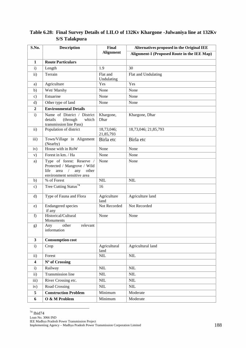
Loan No. 3066 INDIEE Madhya Pradesh Power Transmission ProjectImplementing Agency – Madhya Pradesh Power Transmission Corporation Limited 188
Table 6.28: Final Survey Details of LILO of 132Kv Khargone -Julwaniya line at 132KvS/S Talakpura
S.No. Description FinalAlignment
Alternatives proposed in the Original IEE
Alignment-I (Proposed Route in the IEE Map)
1 Route Particulars
i) Length 1.9 30
ii) Terrain Flat andUndulating
Flat and Undulating
a) Agriculture Yes Yes
b) Wet/ Marshy None None
c) Estuarine None None
d) Other type of land None None
2 Environmental Details
i) Name of District / Districtdetails (through whichtransmission line Pass)
Khargone,Dhar
Khargone, Dhar
ii) Population of district 18,73,046;21,85,793
18,73,046; 21,85,793
iii) Town/Village in Alignment(Nearby)
Birla etc Birla etc
iv) House with in RoW None None
v) Forest in km. / Ha None None
a) Type of forest: Reserve /Protected / Mangrove / Wildlife area / any otherenvironment sensitive area
None None
b) % of Forest NIL NIL
c) Tree Cutting Status74 16
d) Type of Fauna and Flora Agricultureland
Agriculture land
e) Endangered speciesif any
Not Recorded Not Recorded
f) Historical/CulturalMonuments
None None
g) Any other relevantinformation
3 Consumption cost
i) Crop Agriculturalland
Agricultural land
ii) Forest NIL NIL
4 Nº of Crossing
i) Railway NIL NIL
ii) Transmission line NIL NIL
iii) River Crossing etc. NIL NIL
iv) Road Crossing NIL NIL
5 Construction Problem Minimum Moderate
6 O & M Problem Minimum Moderate
74 Ibid74
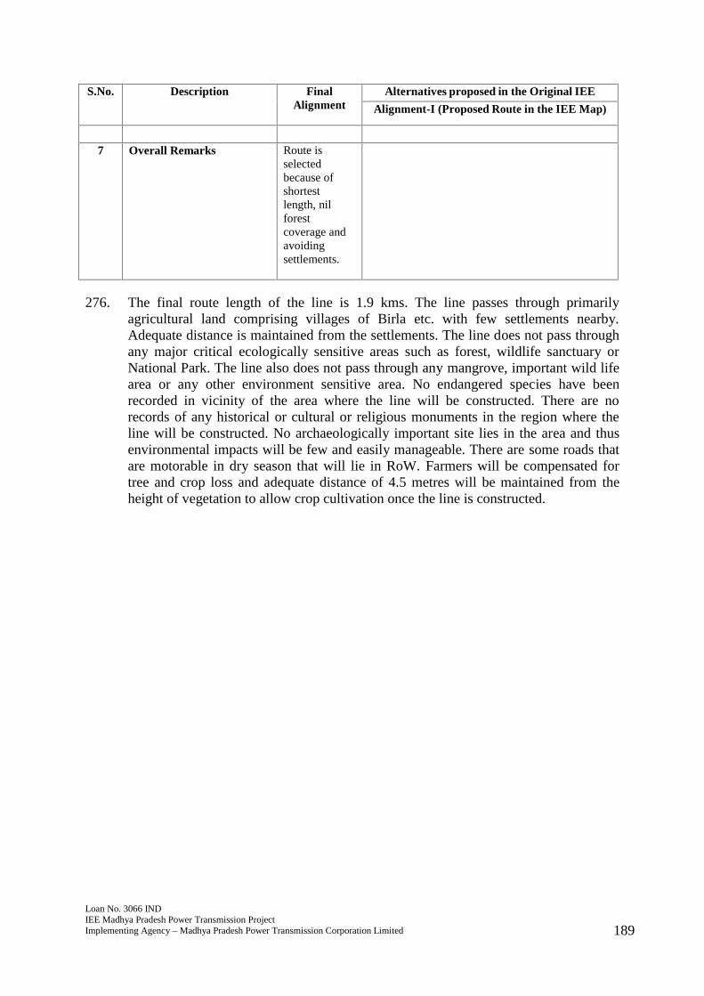
Loan No. 3066 INDIEE Madhya Pradesh Power Transmission ProjectImplementing Agency – Madhya Pradesh Power Transmission Corporation Limited 189
S.No. Description FinalAlignment
Alternatives proposed in the Original IEE
Alignment-I (Proposed Route in the IEE Map)
7 Overall Remarks Route isselectedbecause ofshortestlength, nilforestcoverage andavoidingsettlements.
276. The final route length of the line is 1.9 kms. The line passes through primarilyagricultural land comprising villages of Birla etc. with few settlements nearby.Adequate distance is maintained from the settlements. The line does not pass throughany major critical ecologically sensitive areas such as forest, wildlife sanctuary orNational Park. The line also does not pass through any mangrove, important wild lifearea or any other environment sensitive area. No endangered species have beenrecorded in vicinity of the area where the line will be constructed. There are norecords of any historical or cultural or religious monuments in the region where theline will be constructed. No archaeologically important site lies in the area and thusenvironmental impacts will be few and easily manageable. There are some roads thatare motorable in dry season that will lie in RoW. Farmers will be compensated fortree and crop loss and adequate distance of 4.5 metres will be maintained from theheight of vegetation to allow crop cultivation once the line is constructed.
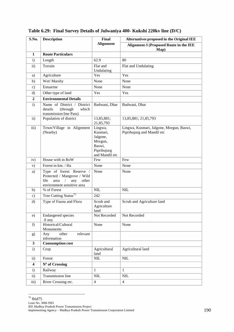
Loan No. 3066 INDIEE Madhya Pradesh Power Transmission ProjectImplementing Agency – Madhya Pradesh Power Transmission Corporation Limited 190
Table 6.29: Final Survey Details of Julwaniya 400- Kukshi 220kv line (D/C)
S.No. Description FinalAlignment
Alternatives proposed in the Original IEE
Alignment-I (Proposed Route in the IEEMap)
1 Route Particulars
i) Length 62.9 80
ii) Terrain Flat andUndulating
Flat and Undulating
a) Agriculture Yes Yes
b) Wet/ Marshy None None
c) Estuarine None None
d) Other type of land Yes Yes
2 Environmental Details
i) Name of District / Districtdetails (through whichtransmission line Pass)
Badwani, Dhar Badwani, Dhar
ii) Population of district 13,85,881;21,85,793
13,85,881; 21,85,793
iii) Town/Village in Alignment(Nearby)
Lingwa,Kusmari,Jalgone,Morgun,Baswi,Pipribujurgand Mandil etc
Lingwa, Kusmari, Jalgone, Morgun, Baswi,Pipribujurg and Mandil etc
iv) House with in RoW Few Few
v) Forest in km. / Ha None None
a) Type of forest: Reserve /Protected / Mangrove / Wildlife area / any otherenvironment sensitive area
None None
b) % of Forest NIL NIL
c) Tree Cutting Status75 242
d) Type of Fauna and Flora Scrub andAgricultureland
Scrub and Agriculture land
e) Endangered speciesif any
Not Recorded Not Recorded
f) Historical/CulturalMonuments
None None
g) Any other relevantinformation
3 Consumption cost
i) Crop Agriculturalland
Agricultural land
ii) Forest NIL NIL
4 Nº of Crossing
i) Railway 1 1
ii) Transmission line NIL NIL
iii) River Crossing etc. 4 4
75 Ibid75
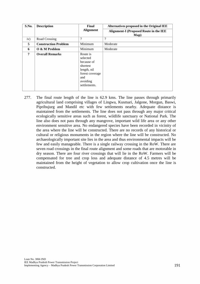
Loan No. 3066 INDIEE Madhya Pradesh Power Transmission ProjectImplementing Agency – Madhya Pradesh Power Transmission Corporation Limited 191
S.No. Description FinalAlignment
Alternatives proposed in the Original IEE
Alignment-I (Proposed Route in the IEEMap)
iv) Road Crossing 7 7
5 Construction Problem Minimum Moderate
6 O & M Problem Minimum Moderate
7 Overall Remarks Route isselectedbecause ofshortestlength, nilforest coverageandavoidingsettlements.
277. The final route length of the line is 62.9 kms. The line passes through primarilyagricultural land comprising villages of Lingwa, Kusmari, Jalgone, Morgun, Baswi,Pipribujurg and Mandil etc with few settlements nearby. Adequate distance ismaintained from the settlements. The line does not pass through any major criticalecologically sensitive areas such as forest, wildlife sanctuary or National Park. Theline also does not pass through any mangrove, important wild life area or any otherenvironment sensitive area. No endangered species have been recorded in vicinity ofthe area where the line will be constructed. There are no records of any historical orcultural or religious monuments in the region where the line will be constructed. Noarchaeologically important site lies in the area and thus environmental impacts will befew and easily manageable. There is a single railway crossing in the RoW. There areseven road crossings in the final route alignment and some roads that are motorable indry season. There are four river crossings that will lie in the RoW. Farmers will becompensated for tree and crop loss and adequate distance of 4.5 metres will bemaintained from the height of vegetation to allow crop cultivation once the line isconstructed.
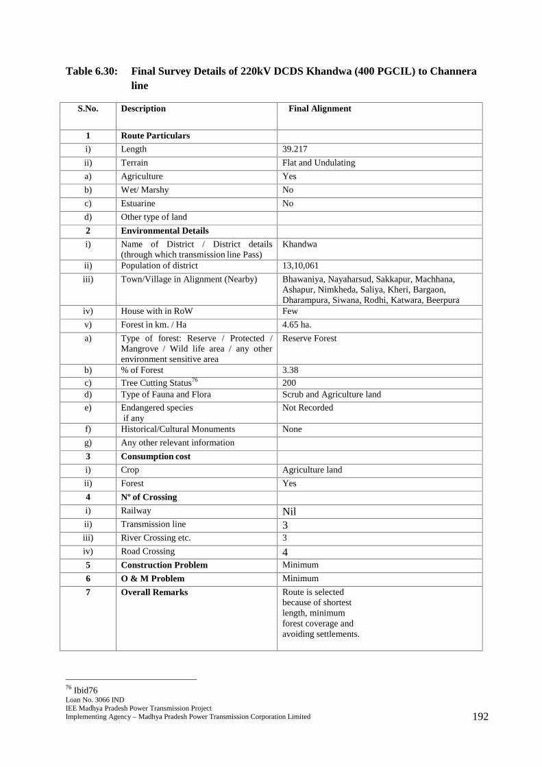
Loan No. 3066 INDIEE Madhya Pradesh Power Transmission ProjectImplementing Agency – Madhya Pradesh Power Transmission Corporation Limited 192
Table 6.30: Final Survey Details of 220kV DCDS Khandwa (400 PGCIL) to Channeraline
S.No. Description Final Alignment
1 Route Particulars
i) Length 39.217
ii) Terrain Flat and Undulating
a) Agriculture Yes
b) Wet/ Marshy No
c) Estuarine No
d) Other type of land
2 Environmental Details
i) Name of District / District details(through which transmission line Pass)
Khandwa
ii) Population of district 13,10,061
iii) Town/Village in Alignment (Nearby) Bhawaniya, Nayaharsud, Sakkapur, Machhana,Ashapur, Nimkheda, Saliya, Kheri, Bargaon,Dharampura, Siwana, Rodhi, Katwara, Beerpura
iv) House with in RoW Few
v) Forest in km. / Ha 4.65 ha.
a) Type of forest: Reserve / Protected /Mangrove / Wild life area / any otherenvironment sensitive area
Reserve Forest
b) % of Forest 3.38
c) Tree Cutting Status76 200d) Type of Fauna and Flora Scrub and Agriculture land
e) Endangered speciesif any
Not Recorded
f) Historical/Cultural Monuments None
g) Any other relevant information
3 Consumption cost
i) Crop Agriculture land
ii) Forest Yes
4 Nº of Crossing
i) Railway Nilii) Transmission line 3iii) River Crossing etc. 3
iv) Road Crossing 45 Construction Problem Minimum
6 O & M Problem Minimum
7 Overall Remarks Route is selectedbecause of shortestlength, minimumforest coverage andavoiding settlements.
76 Ibid76
Loan No. 3066 INDIEE Madhya Pradesh Power Transmission ProjectImplementing Agency – Madhya Pradesh Power Transmission Corporation Limited 193
278. The final route length of the line is 39.217 kms. The line passes through primarilyagricultural land comprising villages of Bhawaniya, Nayaharsud, Sakkapur,Machhana, Ashapur, Nimkheda, Saliya, Kheri, Bargaon, Dharampura, Siwana, Rodhi,Katwara and Beerpura with few settlements nearby. Adequate distance is maintainedfrom the settlements. The line passes through 4.65 hectares of reserve forest land andworking permission has been obtained77. The earlier route alignment from Malwa toChhanera was not feasible in light of power evacuation (space is not available for bayarea) hence the final route alignment selected is 39.217. No endangered species havebeen recorded in vicinity of the area where the line will be constructed. There are norecords of any historical or cultural or religious monuments in the region where theline will be constructed. No archaeologically important site lies in the area and thusenvironmental impacts will be few and easily manageable. There are four roadcrossings in the final route alignment and some roads that are motorable in dryseason. There are three river crossings that will lie in the RoW. Farmers will becompensated for tree and crop loss and adequate distance of 4.5 metres will bemaintained from the height of vegetation to allow crop cultivation once the line isconstructed.
77 See annexure 7
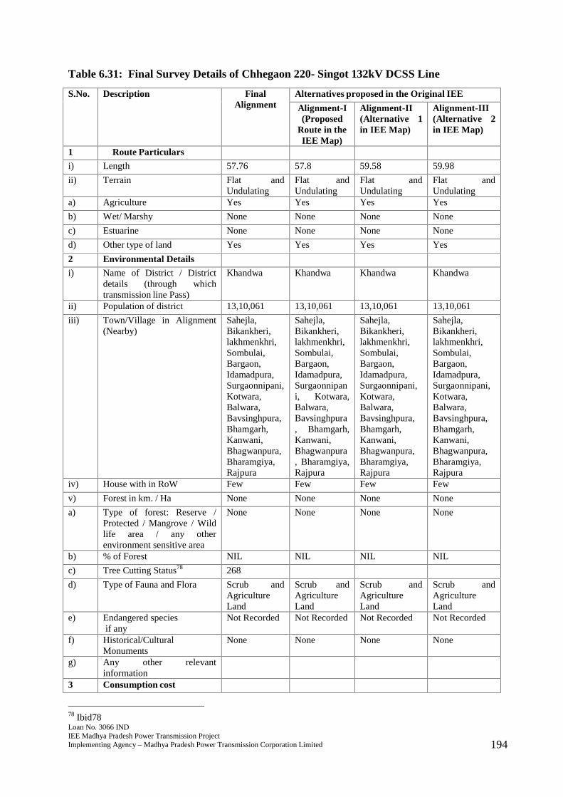
Loan No. 3066 INDIEE Madhya Pradesh Power Transmission ProjectImplementing Agency – Madhya Pradesh Power Transmission Corporation Limited 194
Table 6.31: Final Survey Details of Chhegaon 220- Singot 132kV DCSS Line
S.No. Description FinalAlignment
Alternatives proposed in the Original IEE
Alignment-I(Proposed
Route in theIEE Map)
Alignment-II(Alternative 1in IEE Map)
Alignment-III(Alternative 2in IEE Map)
1 Route Particulars
i) Length 57.76 57.8 59.58 59.98
ii) Terrain Flat andUndulating
Flat andUndulating
Flat andUndulating
Flat andUndulating
a) Agriculture Yes Yes Yes Yes
b) Wet/ Marshy None None None None
c) Estuarine None None None None
d) Other type of land Yes Yes Yes Yes
2 Environmental Details
i) Name of District / Districtdetails (through whichtransmission line Pass)
Khandwa Khandwa Khandwa Khandwa
ii) Population of district 13,10,061 13,10,061 13,10,061 13,10,061
iii) Town/Village in Alignment(Nearby)
Sahejla,Bikankheri,lakhmenkhri,Sombulai,Bargaon,Idamadpura,Surgaonnipani,Kotwara,Balwara,Bavsinghpura,Bhamgarh,Kanwani,Bhagwanpura,Bharamgiya,Rajpura
Sahejla,Bikankheri,lakhmenkhri,Sombulai,Bargaon,Idamadpura,Surgaonnipani, Kotwara,Balwara,Bavsinghpura, Bhamgarh,Kanwani,Bhagwanpura, Bharamgiya,Rajpura
Sahejla,Bikankheri,lakhmenkhri,Sombulai,Bargaon,Idamadpura,Surgaonnipani,Kotwara,Balwara,Bavsinghpura,Bhamgarh,Kanwani,Bhagwanpura,Bharamgiya,Rajpura
Sahejla,Bikankheri,lakhmenkhri,Sombulai,Bargaon,Idamadpura,Surgaonnipani,Kotwara,Balwara,Bavsinghpura,Bhamgarh,Kanwani,Bhagwanpura,Bharamgiya,Rajpura
iv) House with in RoW Few Few Few Few
v) Forest in km. / Ha None None None None
a) Type of forest: Reserve /Protected / Mangrove / Wildlife area / any otherenvironment sensitive area
None None None None
b) % of Forest NIL NIL NIL NIL
c) Tree Cutting Status78 268
d) Type of Fauna and Flora Scrub andAgricultureLand
Scrub andAgricultureLand
Scrub andAgricultureLand
Scrub andAgricultureLand
e) Endangered speciesif any
Not Recorded Not Recorded Not Recorded Not Recorded
f) Historical/CulturalMonuments
None None None None
g) Any other relevantinformation
3 Consumption cost
78 Ibid78

Loan No. 3066 INDIEE Madhya Pradesh Power Transmission ProjectImplementing Agency – Madhya Pradesh Power Transmission Corporation Limited 195
S.No. Description FinalAlignment
Alternatives proposed in the Original IEE
Alignment-I(Proposed
Route in theIEE Map)
Alignment-II(Alternative 1in IEE Map)
Alignment-III(Alternative 2in IEE Map)
i) Crop AgriculturalLand
AgriculturalLand
ii) Forest NIL NIL NIL NIL
4 Nº of Crossing
i) Railway NIL NIL NIL NIL
ii) Transmission line 2 2 4 4
iii) River Crossing etc. 3 3 3 3
iv) Road Crossing 4 4 10 12
5 Construction Problem Minimum Moderate Moderate Moderate
6 O & M Problem Minimum Moderate Moderate Moderate
7 Overall Remarks Route isselectedbecause ofshortestlength, nilforestcoverage andavoidingsettlements.
279. The final route length of the line is 57.76 kms. The line passes through primarilyagricultural land comprising villages of Sahejla, Bikankheri, lakhmenkhri, Sombulai,Bargaon, Idamadpura, Surgaonnipani, Kotwara, Balwara, Bavsinghpura, Bhamgarh,Kanwani, Bhagwanpura, Bharamgiya, and Rajpura with few settlements nearby.Adequate distance is maintained from the settlements. The line does not pass throughany major critical ecologically sensitive areas such as forest, wildlife sanctuary orNational Park. The line also does not pass through any mangrove, important wild lifearea or any other environment sensitive area. No endangered species have beenrecorded in vicinity of the area where the line will be constructed. There are norecords of any historical or cultural or religious monuments in the region where theline will be constructed. No archaeologically important site lies in the area and thusenvironmental impacts will be few and easily manageable. There are four roadcrossings in the final route alignment and some roads that are motorable in dryseason. There are three river crossings and two transmission lines that will lie in theRoW. Farmers will be compensated for tree and crop loss and adequate distance of4.5 metres will be maintained from the height of vegetation to allow crop cultivationonce the line is constructed.
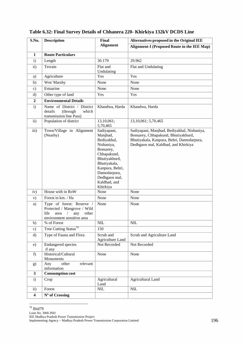
Loan No. 3066 INDIEE Madhya Pradesh Power Transmission ProjectImplementing Agency – Madhya Pradesh Power Transmission Corporation Limited 196
Table 6.32: Final Survey Details of Chhanera 220- Khirkiya 132kV DCDS Line
S.No. Description FinalAlignment
Alternatives proposed in the Original IEE
Alignment-I (Proposed Route in the IEE Map)
1 Route Particulars
i) Length 30.179 29.962
ii) Terrain Flat andUndulating
Flat and Undulating
a) Agriculture Yes Yes
b) Wet/ Marshy None None
c) Estuarine None None
d) Other type of land Yes Yes
2 Environmental Details
i) Name of District / Districtdetails (through whichtransmission line Pass)
Khandwa, Harda Khandwa, Harda
ii) Population of district 13,10,061;5,70,465
13,10,061; 5,70,465
iii) Town/Village in Alignment(Nearby)
Sadiyapani,Manjhad,Bediyakhal,Nishaniya,Bonsarey,Chhapakund,Bhutiyakhurd,Bhutiyakala,Kanpura, Behri,Damodarpura,Dedhgaon mal,Kaldhad, andKhirkiya
Sadiyapani, Manjhad, Bediyakhal, Nishaniya,Bonsarey, Chhapakund, Bhutiyakhurd,Bhutiyakala, Kanpura, Behri, Damodarpura,Dedhgaon mal, Kaldhad, and Khirkiya
iv) House with in RoW None None
v) Forest in km. / Ha None None
a) Type of forest: Reserve /Protected / Mangrove / Wildlife area / any otherenvironment sensitive area
None None
b) % of Forest NIL NIL
c) Tree Cutting Status79 150
d) Type of Fauna and Flora Scrub andAgriculture Land
Scrub and Agriculture Land
e) Endangered speciesif any
Not Recorded Not Recorded
f) Historical/CulturalMonuments
None None
g) Any other relevantinformation
3 Consumption cost
i) Crop AgriculturalLand
Agricultural Land
ii) Forest NIL NIL
4 Nº of Crossing
79 Ibid79
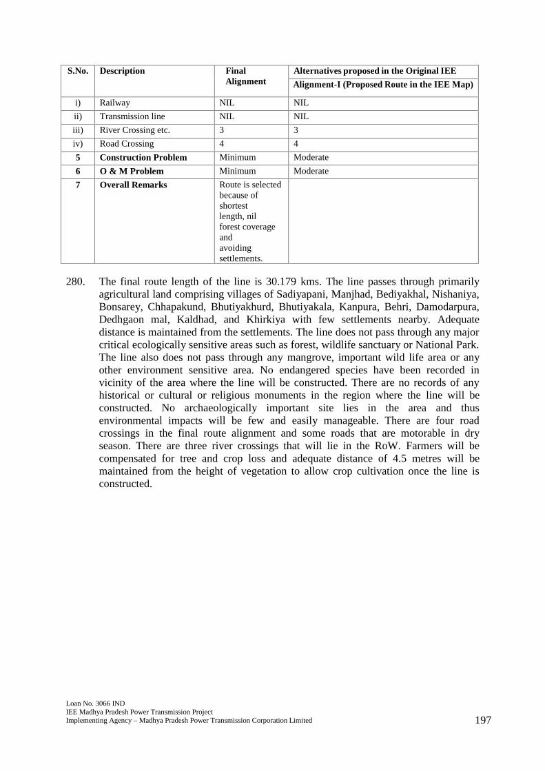
Loan No. 3066 INDIEE Madhya Pradesh Power Transmission ProjectImplementing Agency – Madhya Pradesh Power Transmission Corporation Limited 197
S.No. Description FinalAlignment
Alternatives proposed in the Original IEE
Alignment-I (Proposed Route in the IEE Map)
i) Railway NIL NIL
ii) Transmission line NIL NIL
iii) River Crossing etc. 3 3
iv) Road Crossing 4 4
5 Construction Problem Minimum Moderate
6 O & M Problem Minimum Moderate
7 Overall Remarks Route is selectedbecause ofshortestlength, nilforest coverageandavoidingsettlements.
280. The final route length of the line is 30.179 kms. The line passes through primarilyagricultural land comprising villages of Sadiyapani, Manjhad, Bediyakhal, Nishaniya,Bonsarey, Chhapakund, Bhutiyakhurd, Bhutiyakala, Kanpura, Behri, Damodarpura,Dedhgaon mal, Kaldhad, and Khirkiya with few settlements nearby. Adequatedistance is maintained from the settlements. The line does not pass through any majorcritical ecologically sensitive areas such as forest, wildlife sanctuary or National Park.The line also does not pass through any mangrove, important wild life area or anyother environment sensitive area. No endangered species have been recorded invicinity of the area where the line will be constructed. There are no records of anyhistorical or cultural or religious monuments in the region where the line will beconstructed. No archaeologically important site lies in the area and thusenvironmental impacts will be few and easily manageable. There are four roadcrossings in the final route alignment and some roads that are motorable in dryseason. There are three river crossings that will lie in the RoW. Farmers will becompensated for tree and crop loss and adequate distance of 4.5 metres will bemaintained from the height of vegetation to allow crop cultivation once the line isconstructed.
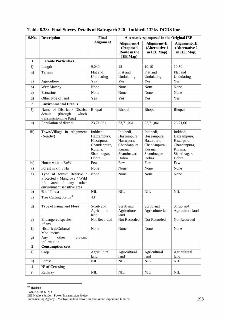
Loan No. 3066 INDIEE Madhya Pradesh Power Transmission ProjectImplementing Agency – Madhya Pradesh Power Transmission Corporation Limited 198
Table 6.33: Final Survey Details of Bairagarh 220 - Intkhedi 132kv DCDS line
S.No. Description FinalAlignment
Alternatives proposed in the Original IEE
Alignment-I(Proposed
Route in theIEE Map)
Alignment-II(Alternative 1in IEE Map)
Alignment-III(Alternative 2in IEE Map)
1 Route Particulars
i) Length 9.049 15 10.10 10.50
ii) Terrain Flat andUndulating
Flat andUndulating
Flat andUndulating
Flat andUndulating
a) Agriculture Yes Yes Yes Yes
b) Wet/ Marshy None None None None
c) Estuarine None None None None
d) Other type of land Yes Yes Yes Yes
2 Environmental Details
i) Name of District / Districtdetails (through whichtransmission line Pass)
Bhopal Bhopal Bhopal Bhopal
ii) Population of district 23,71,061 23,71,061 23,71,061 23,71,061
iii) Town/Village in Alignment(Nearby)
Intkhedi,Hazzampura,Hazarpura,Chandanpura,Kurana,Shantinagar,Dobra
Intkhedi,Hazzampura,Hazarpura,Chandanpura,Kurana,Shantinagar,Dobra
Intkhedi,Hazzampura,Hazarpura,Chandanpura,Kurana,Shantinagar,Dobra
Intkhedi,Hazzampura,Hazarpura,Chandanpura,Kurana,Shantinagar,Dobra
iv) House with in RoW Few Few Few Few
v) Forest in km. / Ha None None None None
a) Type of forest: Reserve /Protected / Mangrove / Wildlife area / any otherenvironment sensitive area
None None None None
b) % of Forest NIL NIL NIL NIL
c) Tree Cutting Status80 43
d) Type of Fauna and Flora Scrub andAgricultureland
Scrub andAgricultureland
Scrub andAgriculture land
Scrub andAgriculture land
e) Endangered speciesif any
Not Recorded Not Recorded Not Recorded Not Recorded
f) Historical/CulturalMonuments
None None None None
g) Any other relevantinformation
3 Consumption cost
i) Crop Agriculturalland
Agriculturalland
Agriculturalland
Agriculturalland
ii) Forest NIL NIL NIL NIL
4 Nº of Crossing
i) Railway NIL NIL NIL NIL
80 Ibid80
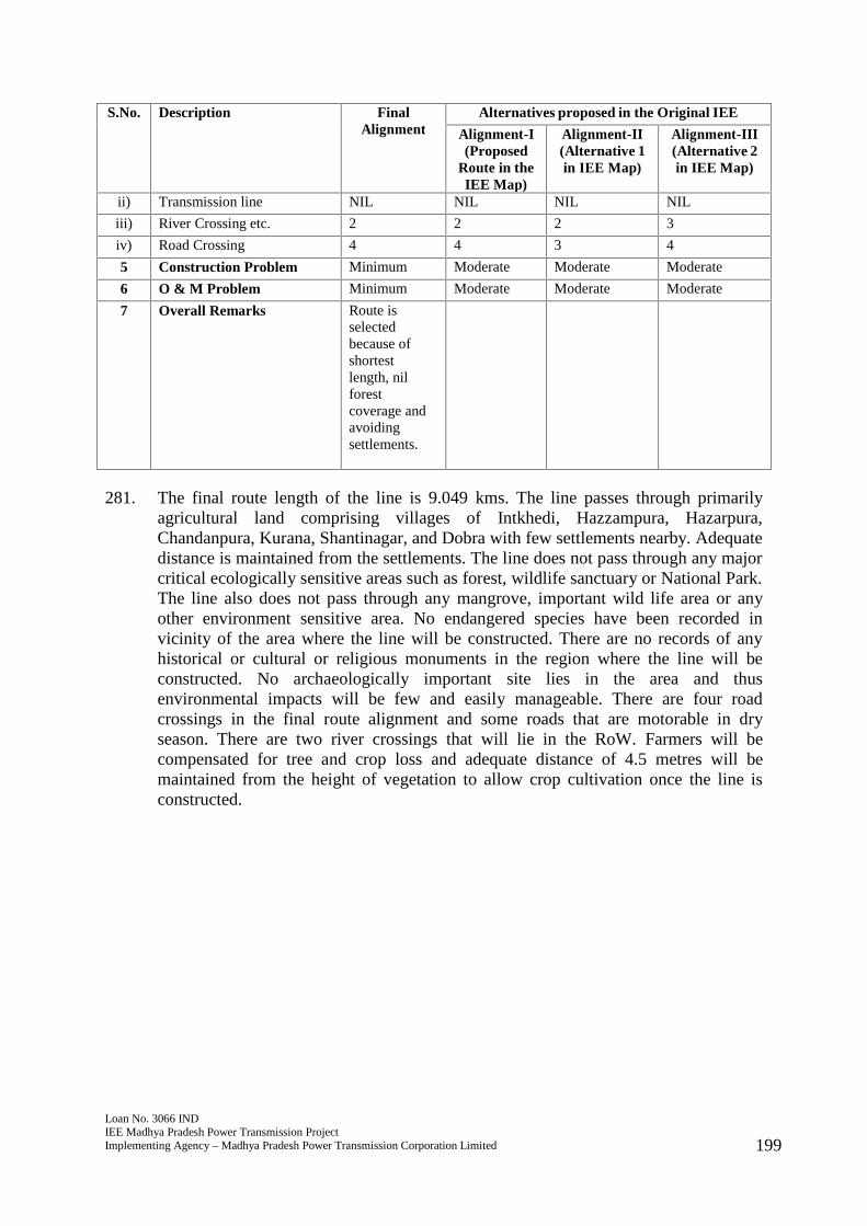
Loan No. 3066 INDIEE Madhya Pradesh Power Transmission ProjectImplementing Agency – Madhya Pradesh Power Transmission Corporation Limited 199
S.No. Description FinalAlignment
Alternatives proposed in the Original IEE
Alignment-I(Proposed
Route in theIEE Map)
Alignment-II(Alternative 1in IEE Map)
Alignment-III(Alternative 2in IEE Map)
ii) Transmission line NIL NIL NIL NIL
iii) River Crossing etc. 2 2 2 3
iv) Road Crossing 4 4 3 4
5 Construction Problem Minimum Moderate Moderate Moderate
6 O & M Problem Minimum Moderate Moderate Moderate
7 Overall Remarks Route isselectedbecause ofshortestlength, nilforestcoverage andavoidingsettlements.
281. The final route length of the line is 9.049 kms. The line passes through primarilyagricultural land comprising villages of Intkhedi, Hazzampura, Hazarpura,Chandanpura, Kurana, Shantinagar, and Dobra with few settlements nearby. Adequatedistance is maintained from the settlements. The line does not pass through any majorcritical ecologically sensitive areas such as forest, wildlife sanctuary or National Park.The line also does not pass through any mangrove, important wild life area or anyother environment sensitive area. No endangered species have been recorded invicinity of the area where the line will be constructed. There are no records of anyhistorical or cultural or religious monuments in the region where the line will beconstructed. No archaeologically important site lies in the area and thusenvironmental impacts will be few and easily manageable. There are four roadcrossings in the final route alignment and some roads that are motorable in dryseason. There are two river crossings that will lie in the RoW. Farmers will becompensated for tree and crop loss and adequate distance of 4.5 metres will bemaintained from the height of vegetation to allow crop cultivation once the line isconstructed.

Loan No. 3066 INDIEE Madhya Pradesh Power Transmission ProjectImplementing Agency – Madhya Pradesh Power Transmission Corporation Limited 200
Table 6.34: Final Survey Details of Second circuit of Bairagarh – Shyampur
S.No. Description FinalAlignment
Alternatives proposed in the Original IEE
Alignment-I(Proposed
Route in theIEE Map)
Alignment-II (Alternative 1 in IEEMap)
1 Route Particulars
i) Length 21.44 20 21.9
ii) Terrain Flat andUndulating
Flat andUndulating
Flat and Undulating
a) Agriculture Yes Yes Yes
b) Wet/ Marshy No No No
c) Estuarine No No No
d) Other type of land2 Environmental Detailsi) Name of District / District
details (through whichtransmission line Pass)
Bhopal Bhopal Bhopal
ii) Population of district 23,71,061 23,71,061 23,71,061
iii) Town/Village in Alignment(Nearby)
Bagoniya,Purachindwada,Tarasewaniyaetc
Bagoniya,Purachindwada, Tarasewaniyaetc
Bagoniya, Purachindwada,Tarasewaniya etc
iv) House with in RoW Few Few Fewv) Forest in km. / Ha None None Nonea) Type of forest: Reserve /
Protected / Mangrove / Wildlife area / any otherenvironment sensitive area
None None None
b) % of Forest NIL NIL NILc) Tree Cutting Status81 98d) Type of Fauna and Flora Scrub and
Agricultureland
Scrub andAgricultureland
Scrub and Agriculture land
e) Endangered speciesif any
Not Recorded Not Recorded Not Recorded
f) Historical/CulturalMonuments
None None None
g) Any other relevantinformation
3 Consumption costi) Crop Agriculture
landAgricultureland
Agriculture land
ii) Forest None None None4 Nº of Crossingi) Railway None None Noneii) Transmission line None None None
iii) River Crossing etc. 1 1 1iv) Road Crossing 1 3 45 Construction Problem Minimum Moderate Moderate
81 Ibid81
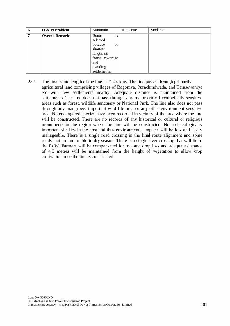
Loan No. 3066 INDIEE Madhya Pradesh Power Transmission ProjectImplementing Agency – Madhya Pradesh Power Transmission Corporation Limited 201
6 O & M Problem Minimum Moderate Moderate
7 Overall Remarks Route isselectedbecause ofshortestlength, nilforest coverageandavoidingsettlements.
282. The final route length of the line is 21.44 kms. The line passes through primarilyagricultural land comprising villages of Bagoniya, Purachindwada, and Tarasewaniyaetc with few settlements nearby. Adequate distance is maintained from thesettlements. The line does not pass through any major critical ecologically sensitiveareas such as forest, wildlife sanctuary or National Park. The line also does not passthrough any mangrove, important wild life area or any other environment sensitivearea. No endangered species have been recorded in vicinity of the area where the linewill be constructed. There are no records of any historical or cultural or religiousmonuments in the region where the line will be constructed. No archaeologicallyimportant site lies in the area and thus environmental impacts will be few and easilymanageable. There is a single road crossing in the final route alignment and someroads that are motorable in dry season. There is a single river crossing that will lie inthe RoW. Farmers will be compensated for tree and crop loss and adequate distanceof 4.5 metres will be maintained from the height of vegetation to allow cropcultivation once the line is constructed.
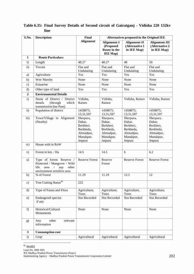
Loan No. 3066 INDIEE Madhya Pradesh Power Transmission ProjectImplementing Agency – Madhya Pradesh Power Transmission Corporation Limited 202
Table 6.35: Final Survey Details of Second circuit of Gairatganj - Vidisha 220 132kvline
S.No. Description FinalAlignment
Alternatives proposed in the Original IEE
Alignment-I(Proposed
Route in theIEE Map)
Alignment-II(Alternative 1in IEE Map)
Alignment-III(Alternative 2in IEE Map)
1 Route Particulars
i) Length 48.27 48.27 48 50
ii) Terrain Flat andUndulating
Flat andUndulating
Flat andUndulating
Flat andUndulating
a) Agriculture Yes Yes Yes Yes
b) Wet/ Marshy None None None None
c) Estuarine None None None None
d) Other type of land Yes Yes Yes Yes
2 Environmental Details
i) Name of District / Districtdetails (through whichtransmission line Pass)
Vidisha,Raisen
Vidisha,Raisen
Vidisha, Raisen Vidisha, Raisen
ii) Population of district 1458875;13,31,597
1458875;13,31,597
1458875;13,31,597
1458875;13,31,597
iii) Town/Village in Alignment(Nearby)
Sherpura,Dabar,Berkheri,Berkheda,Ahmadpur,Manakpur,Jetpura
Sherpura,Dabar,Berkheri,Berkheda,Ahmadpur,Manakpur,Jetpura
Sherpura,Dabar,Berkheri,Berkheda,Ahmadpur,Manakpur,Jetpura
Sherpura,Dabar,Berkheri,Berkheda,Ahmadpur,Manakpur,Jetpura
iv) House with in RoW
v) Forest in km. / Ha 14.5 14.5 6 6.2
a) Type of forest: Reserve /Protected / Mangrove / Wildlife area / any otherenvironment sensitive area
Reserve Forest ReserveForest
Reserve Forest Reserve Forest
b) % of Forest 11.19 11.19 12.5 12
c) Tree Cutting Status82 222
d) Type of Fauna and Flora Agriculture,Trees
Agriculture,Trees
Agriculture,Trees
Agriculture,Trees
e) Endangered speciesif any
Not Recorded Not Recorded Not Recorded Not Recorded
f) Historical/CulturalMonuments
None None None None
g) Any other relevantinformation
3 Consumption cost
i) Crop Agricultural Agricultural Agricultural Agricultural
82 Ibid82
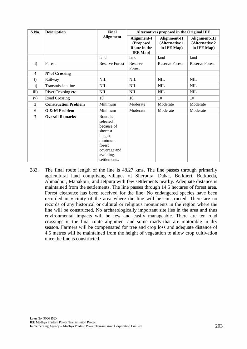
Loan No. 3066 INDIEE Madhya Pradesh Power Transmission ProjectImplementing Agency – Madhya Pradesh Power Transmission Corporation Limited 203
S.No. Description FinalAlignment
Alternatives proposed in the Original IEE
Alignment-I(Proposed
Route in theIEE Map)
Alignment-II(Alternative 1in IEE Map)
Alignment-III(Alternative 2in IEE Map)
land land land land
ii) Forest Reserve Forest ReserveForest
Reserve Forest Reserve Forest
4 Nº of Crossing
i) Railway NIL NIL NIL NIL
ii) Transmission line NIL NIL NIL NIL
iii) River Crossing etc. NIL NIL NIL NIL
iv) Road Crossing 10 10 10 10
5 Construction Problem Minimum Moderate Moderate Moderate
6 O & M Problem Minimum Moderate Moderate Moderate
7 Overall Remarks Route isselectedbecause ofshortestlength,minimumforestcoverage andavoidingsettlements.
283. The final route length of the line is 48.27 kms. The line passes through primarilyagricultural land comprising villages of Sherpura, Dabar, Berkheri, Berkheda,Ahmadpur, Manakpur, and Jetpura with few settlements nearby. Adequate distance ismaintained from the settlements. The line passes through 14.5 hectares of forest area.Forest clearance has been received for the line. No endangered species have beenrecorded in vicinity of the area where the line will be constructed. There are norecords of any historical or cultural or religious monuments in the region where theline will be constructed. No archaeologically important site lies in the area and thusenvironmental impacts will be few and easily manageable. There are ten roadcrossings in the final route alignment and some roads that are motorable in dryseason. Farmers will be compensated for tree and crop loss and adequate distance of4.5 metres will be maintained from the height of vegetation to allow crop cultivationonce the line is constructed.
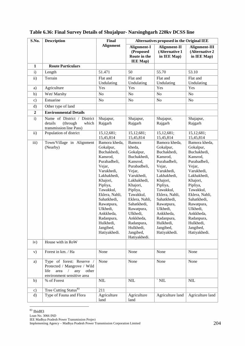
Loan No. 3066 INDIEE Madhya Pradesh Power Transmission ProjectImplementing Agency – Madhya Pradesh Power Transmission Corporation Limited 204
Table 6.36: Final Survey Details of Shujalpur- Narsinghgarh 220kv DCSS line
S.No. Description FinalAlignment
Alternatives proposed in the Original IEE
Alignment-I(Proposed
Route in theIEE Map)
Alignment-II(Alternative 1in IEE Map)
Alignment-III(Alternative 2in IEE Map)
1 Route Particulars
i) Length 51.471 50 55.70 53.10
ii) Terrain Flat andUndulating
Flat andUndulating
Flat andUndulating
Flat andUndulating
a) Agriculture Yes Yes Yes Yes
b) Wet/ Marshy No No No No
c) Estuarine No No No No
d) Other type of land
2 Environmental Details
i) Name of District / Districtdetails (through whichtransmission line Pass)
Shajapur,Rajgarh
Shajapur,Rajgarh
Shajapur,Rajgarh
Shajapur,Rajgarh
ii) Population of district 15,12,681;15,45,814
15,12,681;15,45,814
15,12,681;15,45,814
15,12,681;15,45,814
iii) Town/Village in Alignment(Nearby)
Bamora kheda,Gokalpur,Buchakhedi,Kansrod,Purabadbeli,Vejar,Varukhedi,Lakhakhedi,Khajori,Pipliya,Tawakkul,Eklera, Nahli,Sahatkhedi,Rawatpura,Ulkhedi,Ankkheda,Radanpura,Hulkhedi,Jangibed,Hatiyakhedi.
Bamorakheda,Gokalpur,Buchakhedi,Kansrod,Purabadbeli,Vejar,Varukhedi,Lakhakhedi,Khajori,Pipliya,Tawakkul,Eklera, Nahli,Sahatkhedi,Rawatpura,Ulkhedi,Ankkheda,Radanpura,Hulkhedi,Jangibed,Hatiyakhedi.
Bamora kheda,Gokalpur,Buchakhedi,Kansrod,Purabadbeli,Vejar,Varukhedi,Lakhakhedi,Khajori,Pipliya,Tawakkul,Eklera, Nahli,Sahatkhedi,Rawatpura,Ulkhedi,Ankkheda,Radanpura,Hulkhedi,Jangibed,Hatiyakhedi.
Bamora kheda,Gokalpur,Buchakhedi,Kansrod,Purabadbeli,Vejar,Varukhedi,Lakhakhedi,Khajori,Pipliya,Tawakkul,Eklera, Nahli,Sahatkhedi,Rawatpura,Ulkhedi,Ankkheda,Radanpura,Hulkhedi,Jangibed,Hatiyakhedi.
iv) House with in RoW
v) Forest in km. / Ha None None None None
a) Type of forest: Reserve /Protected / Mangrove / Wildlife area / any otherenvironment sensitive area
None None None None
b) % of Forest NIL NIL ` NIL NIL
c) Tree Cutting Status83 211d) Type of Fauna and Flora Agriculture
landAgricultureland
Agriculture land Agriculture land
83 Ibid83
Loan No. 3066 INDIEE Madhya Pradesh Power Transmission ProjectImplementing Agency – Madhya Pradesh Power Transmission Corporation Limited 205
S.No. Description FinalAlignment
Alternatives proposed in the Original IEE
Alignment-I(Proposed
Route in theIEE Map)
Alignment-II(Alternative 1in IEE Map)
Alignment-III(Alternative 2in IEE Map)
e) Endangered speciesif any
Not Recorded Not Recorded Not Recorded Not Recorded
f) Historical/CulturalMonuments
None None None None
g) Any other relevantinformation
3 Consumption cost
i) Crop Agricultureland
Agricultureland
Agriculture land Agriculture land
ii) Forest None None None None
4 Nº of Crossing
i) Railway None None None None
ii) Transmission line None None None None
iii) River Crossing etc. None None None None
iv) Road Crossing 3 3 4 5
5 Construction Problem Minimum Moderate Moderate Moderate
6 O & M Problem Minimum Moderate Moderate Moderate
7 Overall Remarks Route isselectedbecause ofshortestlength, nilforestcoverage andavoidingsettlements.
284. The final route length of the line is 51.471 kms. The line passes through primarilyagricultural land comprising villages of Bamora kheda, Gokalpur, Buchakhedi,Kansrod, Purabadbeli, Vejar, Varukhedi, Lakhakhedi, Khajori, Pipliya, Tawakkul,Eklera, Nahli, Sahatkhedi, Rawatpura, Ulkhedi, Ankkheda, Radanpura, Hulkhedi,Jangibed, and Hatiyakhedi with few settlements nearby. Adequate distance ismaintained from the settlements. The line does not pass through any major criticalecologically sensitive areas such as forest, wildlife sanctuary or National Park. Theline also does not pass through any mangrove, important wild life area or any otherenvironment sensitive area. No endangered species have been recorded in vicinity ofthe area where the line will be constructed. There are no records of any historical orcultural or religious monuments in the region where the line will be constructed. Noarchaeologically important site lies in the area and thus environmental impacts will befew and easily manageable. There are three road crossings in the final route alignmentand some roads that are motorable in dry season. Farmers will be compensated fortree and crop loss and adequate distance of 4.5 metres will be maintained from theheight of vegetation to allow crop cultivation once the line is constructed.
Loan No. 3066 INDIEE Madhya Pradesh Power Transmission ProjectImplementing Agency – Madhya Pradesh Power Transmission Corporation Limited 206
Table 6.37: Final Survey Details of LILO of one circuit of Bhopal - Hosangabad 220kvD/C line at Adampur 220kv S/s (D/C)
S.No. Description FinalAlignment
Alternatives proposed in the Original IEE
Alignment-I (Proposed Route in the IEE Map)
1 Route Particulars
i) Length 2.92 5
ii) Terrain Flat andUndulating
Flat and Undulating
a) Agriculture NIL NIL
b) Wet/ Marshy None None
c) Estuarine None None
d) Other type of land Open Scrub Open Scrub
2 Environmental Details
i) Name of District / Districtdetails (through whichtransmission line Pass)
Bhopal Bhopal
ii) Population of district 23,71,061 23,71,061
iii) Town/Village in Alignment(Nearby)
Hathikera Hathaikera
iv) House with in RoW
v) Forest in km. / Ha None None
a) Type of forest: Reserve /Protected / Mangrove / Wildlife area / any otherenvironment sensitive area
None None
b) % of Forest NIL NIL
c) Tree Cutting Status84 19
d) Type of Fauna and Flora None None
e) Endangered speciesif any
Not Recorded Not Recorded
f) Historical/CulturalMonuments
None None
g) Any other relevantinformation
3 Consumption cost
i) Crop None None
ii) Forest None None
4 Nº of Crossing
i) Railway None None
ii) Transmission line None None
84 Ibid84
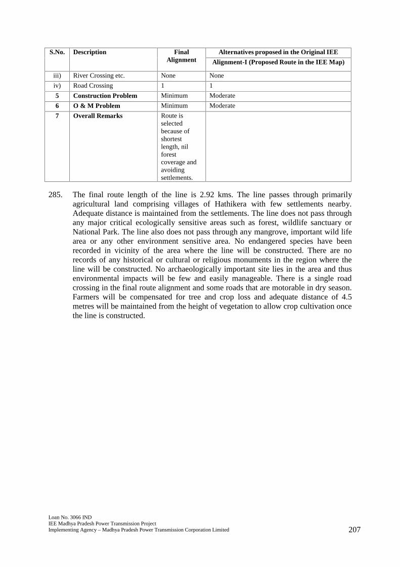
Loan No. 3066 INDIEE Madhya Pradesh Power Transmission ProjectImplementing Agency – Madhya Pradesh Power Transmission Corporation Limited 207
S.No. Description FinalAlignment
Alternatives proposed in the Original IEE
Alignment-I (Proposed Route in the IEE Map)
iii) River Crossing etc. None None
iv) Road Crossing 1 1
5 Construction Problem Minimum Moderate
6 O & M Problem Minimum Moderate
7 Overall Remarks Route isselectedbecause ofshortestlength, nilforestcoverage andavoidingsettlements.
285. The final route length of the line is 2.92 kms. The line passes through primarilyagricultural land comprising villages of Hathikera with few settlements nearby.Adequate distance is maintained from the settlements. The line does not pass throughany major critical ecologically sensitive areas such as forest, wildlife sanctuary orNational Park. The line also does not pass through any mangrove, important wild lifearea or any other environment sensitive area. No endangered species have beenrecorded in vicinity of the area where the line will be constructed. There are norecords of any historical or cultural or religious monuments in the region where theline will be constructed. No archaeologically important site lies in the area and thusenvironmental impacts will be few and easily manageable. There is a single roadcrossing in the final route alignment and some roads that are motorable in dry season.Farmers will be compensated for tree and crop loss and adequate distance of 4.5metres will be maintained from the height of vegetation to allow crop cultivation oncethe line is constructed.
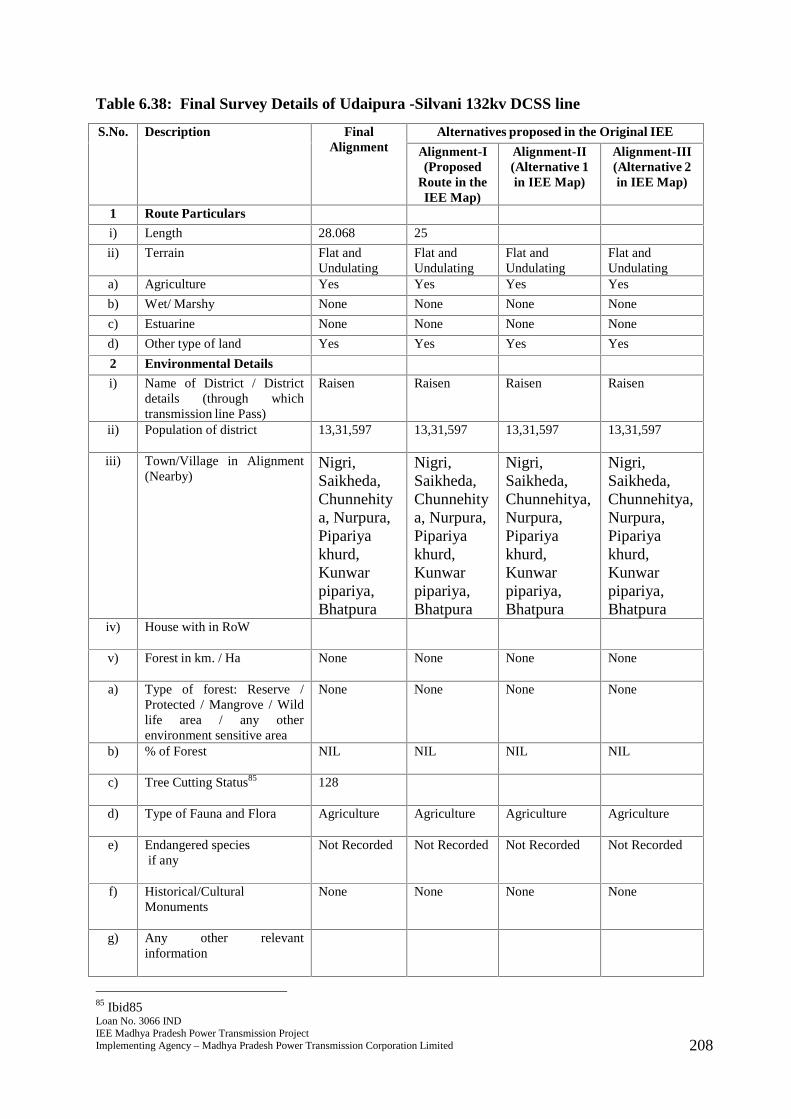
Loan No. 3066 INDIEE Madhya Pradesh Power Transmission ProjectImplementing Agency – Madhya Pradesh Power Transmission Corporation Limited 208
Table 6.38: Final Survey Details of Udaipura -Silvani 132kv DCSS line
S.No. Description FinalAlignment
Alternatives proposed in the Original IEE
Alignment-I(Proposed
Route in theIEE Map)
Alignment-II(Alternative 1in IEE Map)
Alignment-III(Alternative 2in IEE Map)
1 Route Particulars
i) Length 28.068 25
ii) Terrain Flat andUndulating
Flat andUndulating
Flat andUndulating
Flat andUndulating
a) Agriculture Yes Yes Yes Yes
b) Wet/ Marshy None None None None
c) Estuarine None None None None
d) Other type of land Yes Yes Yes Yes
2 Environmental Details
i) Name of District / Districtdetails (through whichtransmission line Pass)
Raisen Raisen Raisen Raisen
ii) Population of district 13,31,597 13,31,597 13,31,597 13,31,597
iii) Town/Village in Alignment(Nearby)
Nigri,Saikheda,Chunnehitya, Nurpura,Pipariyakhurd,Kunwarpipariya,Bhatpura
Nigri,Saikheda,Chunnehitya, Nurpura,Pipariyakhurd,Kunwarpipariya,Bhatpura
Nigri,Saikheda,Chunnehitya,Nurpura,Pipariyakhurd,Kunwarpipariya,Bhatpura
Nigri,Saikheda,Chunnehitya,Nurpura,Pipariyakhurd,Kunwarpipariya,Bhatpura
iv) House with in RoW
v) Forest in km. / Ha None None None None
a) Type of forest: Reserve /Protected / Mangrove / Wildlife area / any otherenvironment sensitive area
None None None None
b) % of Forest NIL NIL NIL NIL
c) Tree Cutting Status85 128
d) Type of Fauna and Flora Agriculture Agriculture Agriculture Agriculture
e) Endangered speciesif any
Not Recorded Not Recorded Not Recorded Not Recorded
f) Historical/CulturalMonuments
None None None None
g) Any other relevantinformation
85 Ibid85
Loan No. 3066 INDIEE Madhya Pradesh Power Transmission ProjectImplementing Agency – Madhya Pradesh Power Transmission Corporation Limited 209
S.No. Description FinalAlignment
Alternatives proposed in the Original IEE
Alignment-I(Proposed
Route in theIEE Map)
Alignment-II(Alternative 1in IEE Map)
Alignment-III(Alternative 2in IEE Map)
3 Consumption cost
i) Crop AgriculturalLand
AgriculturalLand
AgriculturalLand
AgriculturalLand
ii) Forest NIL NIL NIL NIL
4 Nº of Crossing
i) Railway NIL NIL NIL NIL
ii) Transmission line NIL NIL NIL NIL
iii) River Crossing etc. 1 1 1 1
iv) Road Crossing NIL NIL 2 2
5 Construction Problem Minimum Moderate Moderate Moderate
6 O & M Problem Minimum Moderate Moderate Moderate
7 Overall Remarks Route isselectedbecause ofshortestlength, nilforestcoverage andavoidingsettlements.
286. The final route length of the line is 28.068 kms. The line passes through primarilyagricultural land comprising villages of Nigri, Saikheda, Chunnehitya, Nurpura,Pipariya khurd, Kunwar pipariya, and Bhatpura with few settlements nearby.Adequate distance is maintained from the settlements. The line does not pass throughany major critical ecologically sensitive areas such as forest, wildlife sanctuary orNational Park. The line also does not pass through any mangrove, important wild lifearea or any other environment sensitive area. No endangered species have beenrecorded in vicinity of the area where the line will be constructed. There are norecords of any historical or cultural or religious monuments in the region where theline will be constructed. No archaeologically important site lies in the area and thusenvironmental impacts will be few and easily manageable. There are some roads thatare motorable in dry season that will lie in final Row. There is a single river crossingthat will lie in the RoW. Farmers will be compensated for tree and crop loss andadequate distance of 4.5 metres will be maintained from the height of vegetation toallow crop cultivation once the line is constructed.
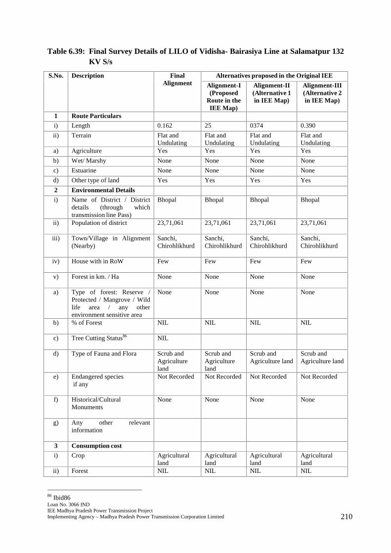
Loan No. 3066 INDIEE Madhya Pradesh Power Transmission ProjectImplementing Agency – Madhya Pradesh Power Transmission Corporation Limited 210
Table 6.39: Final Survey Details of LILO of Vidisha- Bairasiya Line at Salamatpur 132KV S/s
S.No. Description FinalAlignment
Alternatives proposed in the Original IEE
Alignment-I(Proposed
Route in theIEE Map)
Alignment-II(Alternative 1in IEE Map)
Alignment-III(Alternative 2in IEE Map)
1 Route Particulars
i) Length 0.162 25 0374 0.390
ii) Terrain Flat andUndulating
Flat andUndulating
Flat andUndulating
Flat andUndulating
a) Agriculture Yes Yes Yes Yes
b) Wet/ Marshy None None None None
c) Estuarine None None None None
d) Other type of land Yes Yes Yes Yes
2 Environmental Details
i) Name of District / Districtdetails (through whichtransmission line Pass)
Bhopal Bhopal Bhopal Bhopal
ii) Population of district 23,71,061 23,71,061 23,71,061 23,71,061
iii) Town/Village in Alignment(Nearby)
Sanchi,Chirohlikhurd
Sanchi,Chirohlikhurd
Sanchi,Chirohlikhurd
Sanchi,Chirohlikhurd
iv) House with in RoW Few Few Few Few
v) Forest in km. / Ha None None None None
a) Type of forest: Reserve /Protected / Mangrove / Wildlife area / any otherenvironment sensitive area
None None None None
b) % of Forest NIL NIL NIL NIL
c) Tree Cutting Status86 NIL
d) Type of Fauna and Flora Scrub andAgricultureland
Scrub andAgricultureland
Scrub andAgriculture land
Scrub andAgriculture land
e) Endangered speciesif any
Not Recorded Not Recorded Not Recorded Not Recorded
f) Historical/CulturalMonuments
None None None None
g) Any other relevantinformation
3 Consumption cost
i) Crop Agriculturalland
Agriculturalland
Agriculturalland
Agriculturalland
ii) Forest NIL NIL NIL NIL
86 Ibid86
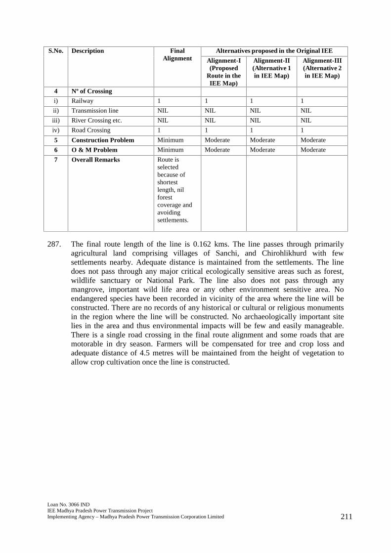
Loan No. 3066 INDIEE Madhya Pradesh Power Transmission ProjectImplementing Agency – Madhya Pradesh Power Transmission Corporation Limited 211
S.No. Description FinalAlignment
Alternatives proposed in the Original IEE
Alignment-I(Proposed
Route in theIEE Map)
Alignment-II(Alternative 1in IEE Map)
Alignment-III(Alternative 2in IEE Map)
4 Nº of Crossing
i) Railway 1 1 1 1
ii) Transmission line NIL NIL NIL NIL
iii) River Crossing etc. NIL NIL NIL NIL
iv) Road Crossing 1 1 1 1
5 Construction Problem Minimum Moderate Moderate Moderate
6 O & M Problem Minimum Moderate Moderate Moderate
7 Overall Remarks Route isselectedbecause ofshortestlength, nilforestcoverage andavoidingsettlements.
287. The final route length of the line is 0.162 kms. The line passes through primarilyagricultural land comprising villages of Sanchi, and Chirohlikhurd with fewsettlements nearby. Adequate distance is maintained from the settlements. The linedoes not pass through any major critical ecologically sensitive areas such as forest,wildlife sanctuary or National Park. The line also does not pass through anymangrove, important wild life area or any other environment sensitive area. Noendangered species have been recorded in vicinity of the area where the line will beconstructed. There are no records of any historical or cultural or religious monumentsin the region where the line will be constructed. No archaeologically important sitelies in the area and thus environmental impacts will be few and easily manageable.There is a single road crossing in the final route alignment and some roads that aremotorable in dry season. Farmers will be compensated for tree and crop loss andadequate distance of 4.5 metres will be maintained from the height of vegetation toallow crop cultivation once the line is constructed.
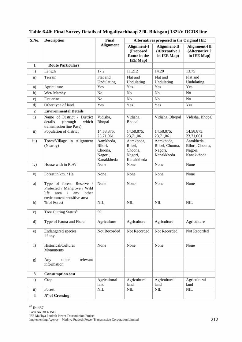
Loan No. 3066 INDIEE Madhya Pradesh Power Transmission ProjectImplementing Agency – Madhya Pradesh Power Transmission Corporation Limited 212
Table 6.40: Final Survey Details of Mugaliyachhaap 220- Bikisganj 132kV DCDS line
S.No. Description FinalAlignment
Alternatives proposed in the Original IEE
Alignment-I(Proposed
Route in theIEE Map)
Alignment-II(Alternative 1in IEE Map)
Alignment-III(Alternative 2in IEE Map)
1 Route Particulars
i) Length 17.2 11.212 14.20 13.75
ii) Terrain Flat andUndulating
Flat andUndulating
Flat andUndulating
Flat andUndulating
a) Agriculture Yes Yes Yes Yes
b) Wet/ Marshy No No No No
c) Estuarine No No No No
d) Other type of land Yes Yes Yes Yes
2 Environmental Details
i) Name of District / Districtdetails (through whichtransmission line Pass)
Vidisha,Bhopal
Vidisha,Bhopal
Vidisha, Bhopal Vidisha, Bhopal
ii) Population of district 14,58,875;23,71,061
14,58,875;23,71,061
14,58,875;23,71,061
14,58,875;23,71,061
iii) Town/Village in Alignment(Nearby)
Aamkheda,Bilori,Choona,Nagori,Kanakkheda
Aamkheda,Bilori,Choona,Nagori,Kanakkheda
Aamkheda,Bilori, Choona,Nagori,Kanakkheda
Aamkheda,Bilori, Choona,Nagori,Kanakkheda
iv) House with in RoW None None None None
v) Forest in km. / Ha None None None None
a) Type of forest: Reserve /Protected / Mangrove / Wildlife area / any otherenvironment sensitive area
None None None None
b) % of Forest NIL NIL NIL NIL
c) Tree Cutting Status87 59
d) Type of Fauna and Flora Agriculture Agriculture Agriculture Agriculture
e) Endangered speciesif any
Not Recorded Not Recorded Not Recorded Not Recorded
f) Historical/CulturalMonuments
None None None None
g) Any other relevantinformation
3 Consumption cost
i) Crop Agriculturalland
Agriculturalland
Agriculturalland
Agriculturalland
ii) Forest NIL NIL NIL NIL
4 Nº of Crossing
87 Ibid87
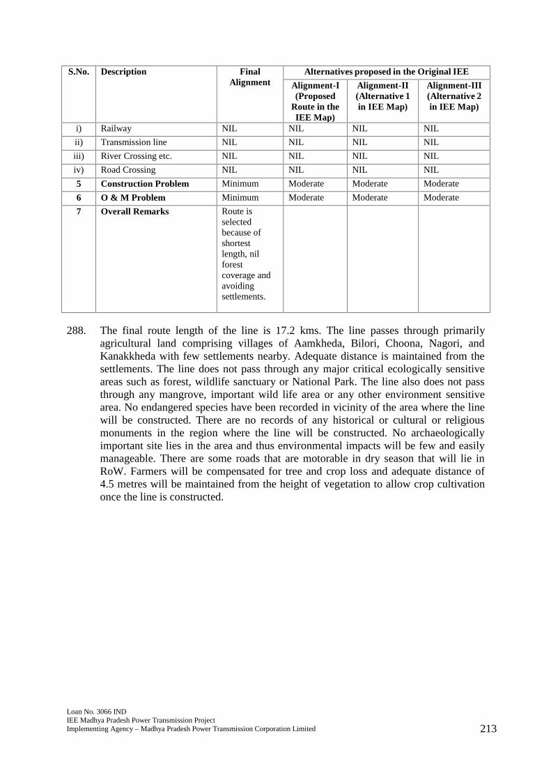
Loan No. 3066 INDIEE Madhya Pradesh Power Transmission ProjectImplementing Agency – Madhya Pradesh Power Transmission Corporation Limited 213
S.No. Description FinalAlignment
Alternatives proposed in the Original IEE
Alignment-I(Proposed
Route in theIEE Map)
Alignment-II(Alternative 1in IEE Map)
Alignment-III(Alternative 2in IEE Map)
i) Railway NIL NIL NIL NIL
ii) Transmission line NIL NIL NIL NIL
iii) River Crossing etc. NIL NIL NIL NIL
iv) Road Crossing NIL NIL NIL NIL
5 Construction Problem Minimum Moderate Moderate Moderate
6 O & M Problem Minimum Moderate Moderate Moderate
7 Overall Remarks Route isselectedbecause ofshortestlength, nilforestcoverage andavoidingsettlements.
288. The final route length of the line is 17.2 kms. The line passes through primarilyagricultural land comprising villages of Aamkheda, Bilori, Choona, Nagori, andKanakkheda with few settlements nearby. Adequate distance is maintained from thesettlements. The line does not pass through any major critical ecologically sensitiveareas such as forest, wildlife sanctuary or National Park. The line also does not passthrough any mangrove, important wild life area or any other environment sensitivearea. No endangered species have been recorded in vicinity of the area where the linewill be constructed. There are no records of any historical or cultural or religiousmonuments in the region where the line will be constructed. No archaeologicallyimportant site lies in the area and thus environmental impacts will be few and easilymanageable. There are some roads that are motorable in dry season that will lie inRoW. Farmers will be compensated for tree and crop loss and adequate distance of4.5 metres will be maintained from the height of vegetation to allow crop cultivationonce the line is constructed.
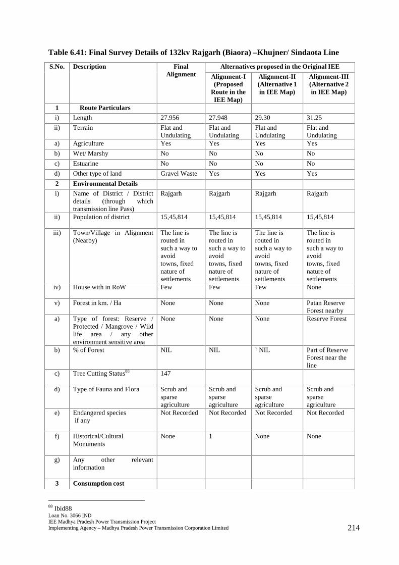
Loan No. 3066 INDIEE Madhya Pradesh Power Transmission ProjectImplementing Agency – Madhya Pradesh Power Transmission Corporation Limited 214
Table 6.41: Final Survey Details of 132kv Rajgarh (Biaora) –Khujner/ Sindaota Line
S.No. Description FinalAlignment
Alternatives proposed in the Original IEE
Alignment-I(Proposed
Route in theIEE Map)
Alignment-II(Alternative 1in IEE Map)
Alignment-III(Alternative 2in IEE Map)
1 Route Particulars
i) Length 27.956 27.948 29.30 31.25
ii) Terrain Flat andUndulating
Flat andUndulating
Flat andUndulating
Flat andUndulating
a) Agriculture Yes Yes Yes Yes
b) Wet/ Marshy No No No No
c) Estuarine No No No No
d) Other type of land Gravel Waste Yes Yes Yes
2 Environmental Details
i) Name of District / Districtdetails (through whichtransmission line Pass)
Rajgarh Rajgarh Rajgarh Rajgarh
ii) Population of district 15,45,814 15,45,814 15,45,814 15,45,814
iii) Town/Village in Alignment(Nearby)
The line isrouted insuch a way toavoidtowns, fixednature ofsettlements
The line isrouted insuch a way toavoidtowns, fixednature ofsettlements
The line isrouted insuch a way toavoidtowns, fixednature ofsettlements
The line isrouted insuch a way toavoidtowns, fixednature ofsettlements
iv) House with in RoW Few Few Few None
v) Forest in km. / Ha None None None Patan ReserveForest nearby
a) Type of forest: Reserve /Protected / Mangrove / Wildlife area / any otherenvironment sensitive area
None None None Reserve Forest
b) % of Forest NIL NIL ` NIL Part of ReserveForest near theline
c) Tree Cutting Status88 147
d) Type of Fauna and Flora Scrub andsparseagriculture
Scrub andsparseagriculture
Scrub andsparseagriculture
Scrub andsparseagriculture
e) Endangered speciesif any
Not Recorded Not Recorded Not Recorded Not Recorded
f) Historical/CulturalMonuments
None 1 None None
g) Any other relevantinformation
3 Consumption cost
88 Ibid88
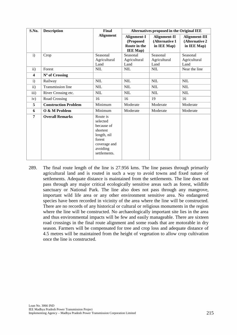
Loan No. 3066 INDIEE Madhya Pradesh Power Transmission ProjectImplementing Agency – Madhya Pradesh Power Transmission Corporation Limited 215
S.No. Description FinalAlignment
Alternatives proposed in the Original IEE
Alignment-I(Proposed
Route in theIEE Map)
Alignment-II(Alternative 1in IEE Map)
Alignment-III(Alternative 2in IEE Map)
i) Crop SeasonalAgriculturalLand
SeasonalAgriculturalLand
SeasonalAgriculturalLand
SeasonalAgriculturalLand
ii) Forest NIL NIL NIL Near the line
4 Nº of Crossing
i) Railway NIL NIL NIL NIL
ii) Transmission line NIL NIL NIL NIL
iii) River Crossing etc. NIL NIL NIL NIL
iv) Road Crossing 16 16 19 16
5 Construction Problem Minimum Moderate Moderate Moderate
6 O & M Problem Minimum Moderate Moderate Moderate
7 Overall Remarks Route isselectedbecause ofshortestlength, nilforestcoverage andavoidingsettlements.
289. The final route length of the line is 27.956 kms. The line passes through primarilyagricultural land and is routed in such a way to avoid towns and fixed nature ofsettlements. Adequate distance is maintained from the settlements. The line does notpass through any major critical ecologically sensitive areas such as forest, wildlifesanctuary or National Park. The line also does not pass through any mangrove,important wild life area or any other environment sensitive area. No endangeredspecies have been recorded in vicinity of the area where the line will be constructed.There are no records of any historical or cultural or religious monuments in the regionwhere the line will be constructed. No archaeologically important site lies in the areaand thus environmental impacts will be few and easily manageable. There are sixteenroad crossings in the final route alignment and some roads that are motorable in dryseason. Farmers will be compensated for tree and crop loss and adequate distance of4.5 metres will be maintained from the height of vegetation to allow crop cultivationonce the line is constructed.
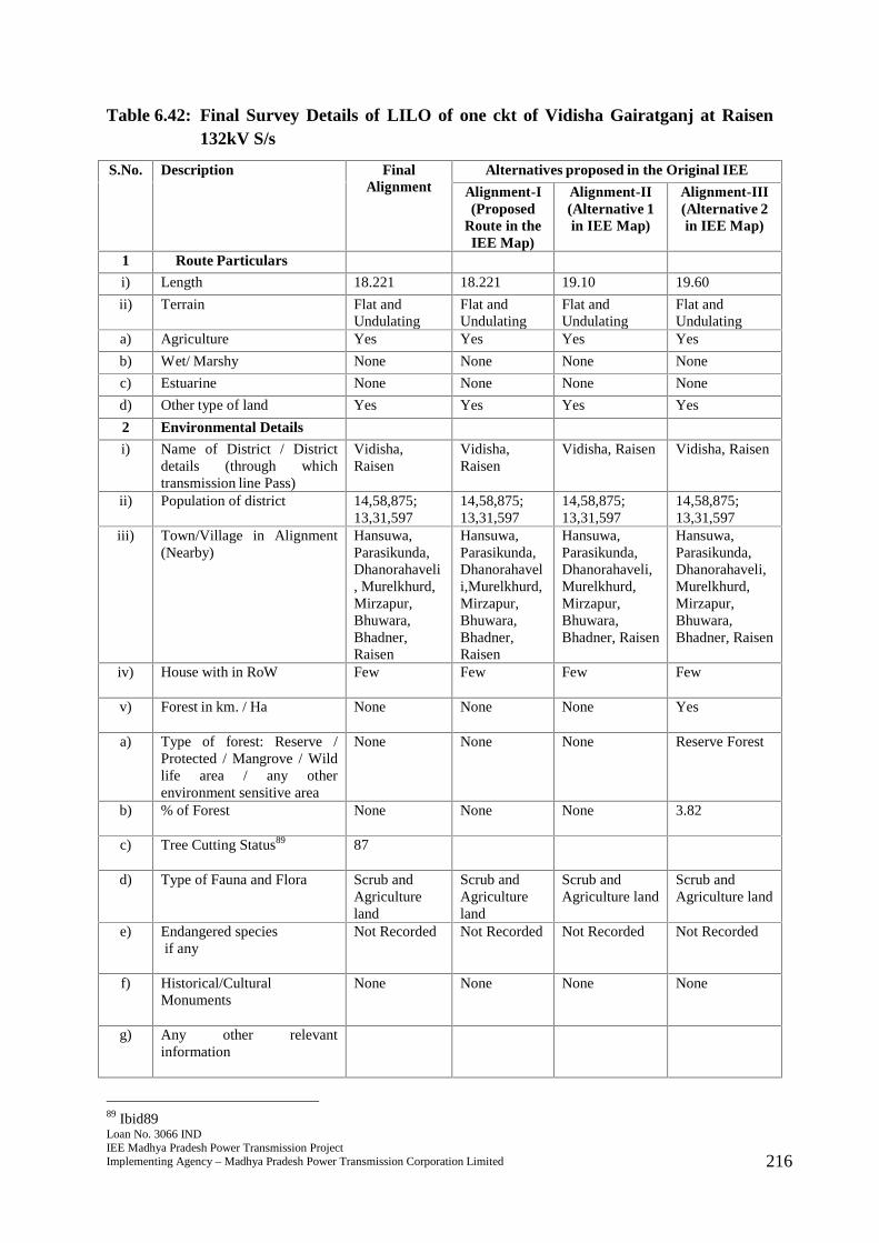
Loan No. 3066 INDIEE Madhya Pradesh Power Transmission ProjectImplementing Agency – Madhya Pradesh Power Transmission Corporation Limited 216
Table 6.42: Final Survey Details of LILO of one ckt of Vidisha Gairatganj at Raisen132kV S/s
S.No. Description FinalAlignment
Alternatives proposed in the Original IEE
Alignment-I(Proposed
Route in theIEE Map)
Alignment-II(Alternative 1in IEE Map)
Alignment-III(Alternative 2in IEE Map)
1 Route Particulars
i) Length 18.221 18.221 19.10 19.60
ii) Terrain Flat andUndulating
Flat andUndulating
Flat andUndulating
Flat andUndulating
a) Agriculture Yes Yes Yes Yes
b) Wet/ Marshy None None None None
c) Estuarine None None None None
d) Other type of land Yes Yes Yes Yes
2 Environmental Details
i) Name of District / Districtdetails (through whichtransmission line Pass)
Vidisha,Raisen
Vidisha,Raisen
Vidisha, Raisen Vidisha, Raisen
ii) Population of district 14,58,875;13,31,597
14,58,875;13,31,597
14,58,875;13,31,597
14,58,875;13,31,597
iii) Town/Village in Alignment(Nearby)
Hansuwa,Parasikunda,Dhanorahaveli, Murelkhurd,Mirzapur,Bhuwara,Bhadner,Raisen
Hansuwa,Parasikunda,Dhanorahaveli,Murelkhurd,Mirzapur,Bhuwara,Bhadner,Raisen
Hansuwa,Parasikunda,Dhanorahaveli,Murelkhurd,Mirzapur,Bhuwara,Bhadner, Raisen
Hansuwa,Parasikunda,Dhanorahaveli,Murelkhurd,Mirzapur,Bhuwara,Bhadner, Raisen
iv) House with in RoW Few Few Few Few
v) Forest in km. / Ha None None None Yes
a) Type of forest: Reserve /Protected / Mangrove / Wildlife area / any otherenvironment sensitive area
None None None Reserve Forest
b) % of Forest None None None 3.82
c) Tree Cutting Status89 87
d) Type of Fauna and Flora Scrub andAgricultureland
Scrub andAgricultureland
Scrub andAgriculture land
Scrub andAgriculture land
e) Endangered speciesif any
Not Recorded Not Recorded Not Recorded Not Recorded
f) Historical/CulturalMonuments
None None None None
g) Any other relevantinformation
89 Ibid89
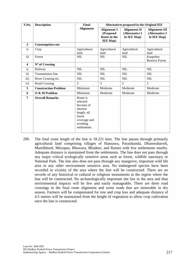
Loan No. 3066 INDIEE Madhya Pradesh Power Transmission ProjectImplementing Agency – Madhya Pradesh Power Transmission Corporation Limited 217
S.No. Description FinalAlignment
Alternatives proposed in the Original IEE
Alignment-I(Proposed
Route in theIEE Map)
Alignment-II(Alternative 1in IEE Map)
Alignment-III(Alternative 2in IEE Map)
3 Consumption cost
i) Crop Agriculturalland
Agriculturalland
Agriculturalland
Agriculturalland
ii) Forest NIL NIL NIL KanpohraReserve Forest
4 Nº of Crossing
i) Railway NIL NIL NIL NIL
ii) Transmission line NIL NIL NIL NIL
iii) River Crossing etc. NIL NIL NIL NIL
iv) Road Crossing 3 3 2 2
5 Construction Problem Minimum Moderate Moderate Moderate
6 O & M Problem Minimum Moderate Moderate Moderate
7 Overall Remarks Route isselectedbecause ofshortestlength, nilforestcoverage andavoidingsettlements.
290. The final route length of the line is 18.221 kms. The line passes through primarilyagricultural land comprising villages of Hansuwa, Parasikunda, Dhanorahaveli,Murelkhurd, Mirzapur, Bhuwara, Bhadner, and Raisen with few settlements nearby.Adequate distance is maintained from the settlements. The line does not pass throughany major critical ecologically sensitive areas such as forest, wildlife sanctuary orNational Park. The line also does not pass through any mangrove, important wild lifearea or any other environment sensitive area. No endangered species have beenrecorded in vicinity of the area where the line will be constructed. There are norecords of any historical or cultural or religious monuments in the region where theline will be constructed. No archaeologically important site lies in the area and thusenvironmental impacts will be few and easily manageable. There are three roadcrossings in the final route alignment and some roads that are motorable in dryseason. Farmers will be compensated for tree and crop loss and adequate distance of4.5 metres will be maintained from the height of vegetation to allow crop cultivationonce the line is constructed.
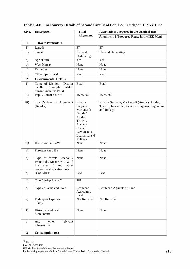
Loan No. 3066 INDIEE Madhya Pradesh Power Transmission ProjectImplementing Agency – Madhya Pradesh Power Transmission Corporation Limited 218
Table 6.43: Final Survey Details of Second Circuit of Betul 220 Gudgaon 132KV Line
S.No. Description FinalAlignment
Alternatives proposed in the Original IEE
Alignment-I (Proposed Route in the IEE Map)
1 Route Particulars
i) Length 57 57
ii) Terrain Flat andUndulating
Flat and Undulating
a) Agriculture Yes Yes
b) Wet/ Marshy None None
c) Estuarine None None
d) Other type of land Yes Yes
2 Environmental Details
i) Name of District / Districtdetails (through whichtransmission line Pass)
Betul Betul
ii) Population of district 15,75,362 15,75,362
iii) Town/Village in Alignment(Nearby)
Khadla,Surgaon,Markawadi(Amdar),Amdar,Thawdi,Junawani,Chata,Gawdigaula,Loghariya andJodkaya
Khadla, Surgaon, Markawadi (Amdar), Amdar,Thawdi, Junawani, Chata, Gawdigaula, Loghariyaand Jodkaya
iv) House with in RoW None None
v) Forest in km. / Ha None None
a) Type of forest: Reserve /Protected / Mangrove / Wildlife area / any otherenvironment sensitive area
None None
b) % of Forest Few Few
c) Tree Cutting Status90 287
d) Type of Fauna and Flora Scrub andAgricultureLand
Scrub and Agriculture Land
e) Endangered speciesif any
Not Recorded Not Recorded
f) Historical/CulturalMonuments
None None
g) Any other relevantinformation
3 Consumption cost
90 Ibid90

Loan No. 3066 INDIEE Madhya Pradesh Power Transmission ProjectImplementing Agency – Madhya Pradesh Power Transmission Corporation Limited 219
S.No. Description FinalAlignment
Alternatives proposed in the Original IEE
Alignment-I (Proposed Route in the IEE Map)
i) Crop AgriculturalLand
Agricultural Land
ii) Forest NIL NIL
4 Nº of Crossing
i) Railway NIL NIL
ii) Transmission line NIL NIL
iii) River Crossing etc. 2 2
iv) Road Crossing 7 7
5 Construction Problem Minimum Moderate
6 O & M Problem Minimum Moderate
7 Overall Remarks Route isselectedbecause ofshortestlength, nilforestcoverage andavoidingsettlements.
291. The final route length of the line is 57 kms. The line passes through primarilyagricultural land comprising villages of Khadla, Surgaon, Markawadi (Amdar),Amdar, Thawdi, Junawani, Chata, Gawdigaula, Loghariya and Jodkaya with fewsettlements nearby. Adequate distance is maintained from the settlements. The linedoes not pass through any major critical ecologically sensitive areas such as forest,wildlife sanctuary or National Park. The line also does not pass through anymangrove, important wild life area or any other environment sensitive area. Noendangered species have been recorded in vicinity of the area where the line will beconstructed. There are no records of any historical or cultural or religious monumentsin the region where the line will be constructed. No archaeologically important sitelies in the area and thus environmental impacts will be few and easily manageable.There are seven road crossings in the final route alignment and some roads that aremotorable in dry season. There are two river crossings that will lie in the RoW.Farmers will be compensated for tree and crop loss and adequate distance of 4.5metres will be maintained from the height of vegetation to allow crop cultivation oncethe line is constructed.
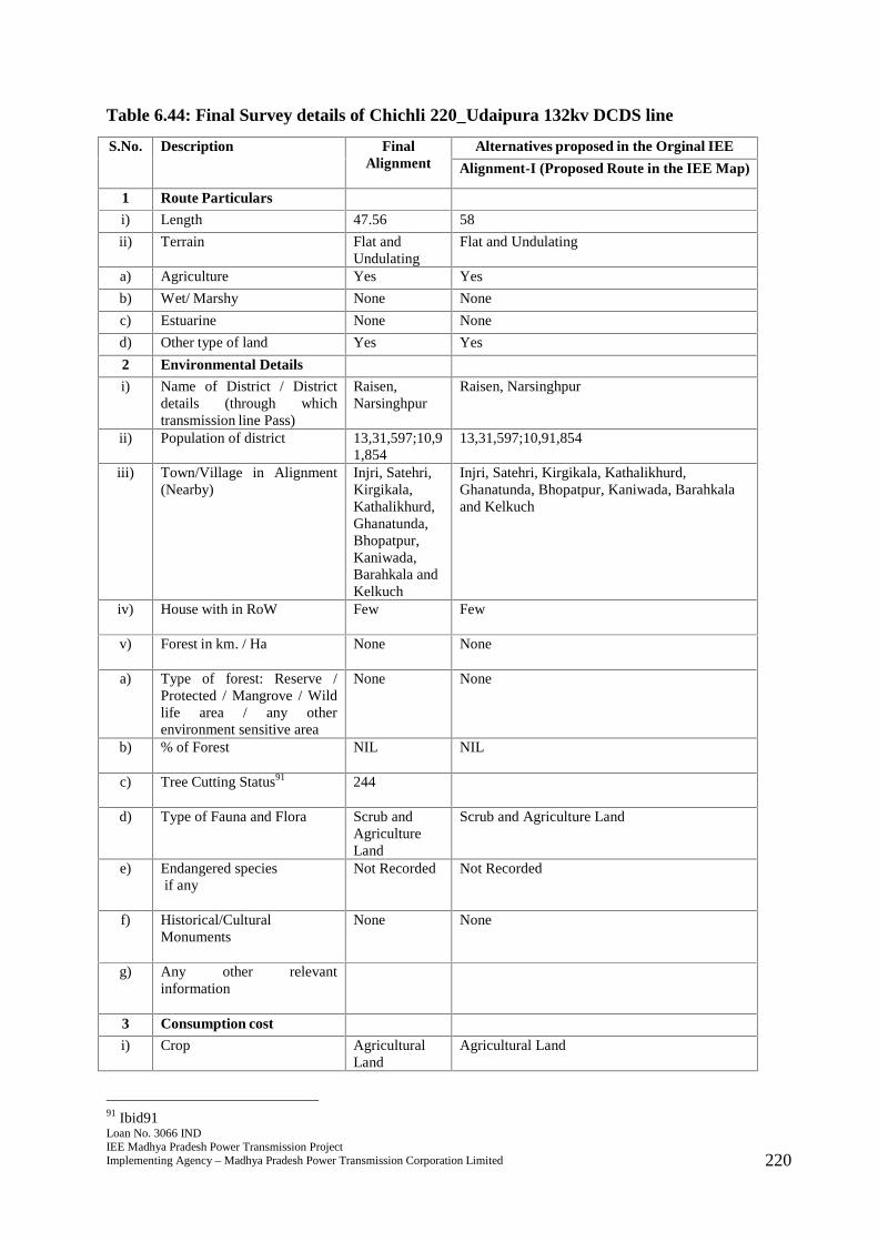
Loan No. 3066 INDIEE Madhya Pradesh Power Transmission ProjectImplementing Agency – Madhya Pradesh Power Transmission Corporation Limited 220
Table 6.44: Final Survey details of Chichli 220_Udaipura 132kv DCDS line
S.No. Description FinalAlignment
Alternatives proposed in the Orginal IEE
Alignment-I (Proposed Route in the IEE Map)
1 Route Particulars
i) Length 47.56 58
ii) Terrain Flat andUndulating
Flat and Undulating
a) Agriculture Yes Yes
b) Wet/ Marshy None None
c) Estuarine None None
d) Other type of land Yes Yes
2 Environmental Details
i) Name of District / Districtdetails (through whichtransmission line Pass)
Raisen,Narsinghpur
Raisen, Narsinghpur
ii) Population of district 13,31,597;10,91,854
13,31,597;10,91,854
iii) Town/Village in Alignment(Nearby)
Injri, Satehri,Kirgikala,Kathalikhurd,Ghanatunda,Bhopatpur,Kaniwada,Barahkala andKelkuch
Injri, Satehri, Kirgikala, Kathalikhurd,Ghanatunda, Bhopatpur, Kaniwada, Barahkalaand Kelkuch
iv) House with in RoW Few Few
v) Forest in km. / Ha None None
a) Type of forest: Reserve /Protected / Mangrove / Wildlife area / any otherenvironment sensitive area
None None
b) % of Forest NIL NIL
c) Tree Cutting Status91 244
d) Type of Fauna and Flora Scrub andAgricultureLand
Scrub and Agriculture Land
e) Endangered speciesif any
Not Recorded Not Recorded
f) Historical/CulturalMonuments
None None
g) Any other relevantinformation
3 Consumption cost
i) Crop AgriculturalLand
Agricultural Land
91 Ibid91
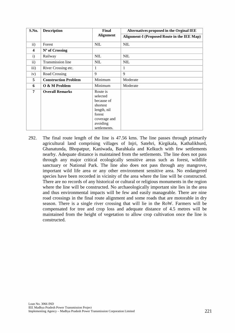
Loan No. 3066 INDIEE Madhya Pradesh Power Transmission ProjectImplementing Agency – Madhya Pradesh Power Transmission Corporation Limited 221
S.No. Description FinalAlignment
Alternatives proposed in the Orginal IEE
Alignment-I (Proposed Route in the IEE Map)
ii) Forest NIL NIL
4 Nº of Crossing
i) Railway NIL NIL
ii) Transmission line NIL NIL
iii) River Crossing etc. 1 1
iv) Road Crossing 9 9
5 Construction Problem Minimum Moderate
6 O & M Problem Minimum Moderate
7 Overall Remarks Route isselectedbecause ofshortestlength, nilforestcoverage andavoidingsettlements.
292. The final route length of the line is 47.56 kms. The line passes through primarilyagricultural land comprising villages of Injri, Satehri, Kirgikala, Kathalikhurd,Ghanatunda, Bhopatpur, Kaniwada, Barahkala and Kelkuch with few settlementsnearby. Adequate distance is maintained from the settlements. The line does not passthrough any major critical ecologically sensitive areas such as forest, wildlifesanctuary or National Park. The line also does not pass through any mangrove,important wild life area or any other environment sensitive area. No endangeredspecies have been recorded in vicinity of the area where the line will be constructed.There are no records of any historical or cultural or religious monuments in the regionwhere the line will be constructed. No archaeologically important site lies in the areaand thus environmental impacts will be few and easily manageable. There are nineroad crossings in the final route alignment and some roads that are motorable in dryseason. There is a single river crossing that will lie in the RoW. Farmers will becompensated for tree and crop loss and adequate distance of 4.5 metres will bemaintained from the height of vegetation to allow crop cultivation once the line isconstructed.

Loan No. 3066 INDIEE Madhya Pradesh Power Transmission ProjectImplementing Agency – Madhya Pradesh Power Transmission Corporation Limited 222
Table 6.45: Final Survey details of Betul 400 (PGCIL) -Betul 220 kv DCDS line
S.No. Description FinalAlignment
Alternatives proposed in the Original IEE
Alignment-I (Proposed Route in the IEE Map)
1 Route Particulars
i) Length 1.88 1.88
ii) Terrain Flat andUndulating
Flat and Undulating
a) Agriculture None None
b) Wet/ Marshy None None
c) Estuarine None None
d) Other type of land Yes Yes
2 Environmental Details
i) Name of District / Districtdetails (through whichtransmission line Pass)
Betul Betul
ii) Population of district 15,75,362 15,75,362
iii) Town/Village in Alignment(Nearby)
The line isrouted in sucha way that itavoids townsand fixednature ofsettlements.
The line is routed in such a way that it avoids townsand fixed nature of settlements.
iv) House with in RoW None None
v) Forest in km. / Ha None None
a) Type of forest: Reserve /Protected / Mangrove / Wildlife area / any otherenvironment sensitive area
None None
b) % of Forest NIL NIL
c) Tree Cutting Status92 14
d) Type of Fauna and Flora Nil Nil
e) Endangered speciesif any
Not Recorded Not Recorded
f) Historical/CulturalMonuments
None None
g) Any other relevantinformation
3 Consumption cost
i) Crop Nil Nil
ii) Forest NIL NIL
4 Nº of Crossing
92 Ibid92
Loan No. 3066 INDIEE Madhya Pradesh Power Transmission ProjectImplementing Agency – Madhya Pradesh Power Transmission Corporation Limited 223
S.No. Description FinalAlignment
Alternatives proposed in the Original IEE
Alignment-I (Proposed Route in the IEE Map)
i) Railway NIL NIL
ii) Transmission line 1 1
iii) River Crossing etc. NIL NIL
iv) Road Crossing NIL NIL
5 Construction Problem Minimum Moderate
6 O & M Problem Minimum Moderate
7 Overall Remarks Route isselectedbecause ofshortestlength, nilforestcoverage andavoidingsettlements.
293. The final route length of the line is 1.88 kms. The line passes through primarilyagricultural land and the line is routed in such a way that it avoids towns and fixednature of settlements.with few settlements nearby. Adequate distance is maintainedfrom the settlements. The line does not pass through any major critical ecologicallysensitive areas such as forest, wildlife sanctuary or National Park. The line also doesnot pass through any mangrove, important wild life area or any other environmentsensitive area. No endangered species have been recorded in vicinity of the areawhere the line will be constructed. There are no records of any historical or cultural orreligious monuments in the region where the line will be constructed. Noarchaeologically important site lies in the area and thus environmental impacts will befew and easily manageable. There are some roads that are motorable in dry seasonthat will lie in RoW. There is a single transmission line that will lie in the RoW.Farmers will be compensated for tree and crop loss and adequate distance of 4.5metres will be maintained from the height of vegetation to allow crop cultivation oncethe line is constructed.

Loan No. 3066 INDIEE Madhya Pradesh Power Transmission ProjectImplementing Agency – Madhya Pradesh Power Transmission Corporation Limited 224
Table 6.46: Final Survey details of LILO of 220kV Sarni-Pandhurna at 400kV (PGCIL)substation Betul
S.No. Description Final Alignment
1 Route Particulars
i) Length 38.864
ii) Terrain Flat and Undulating
a) Agriculture None
b) Wet/ Marshy None
c) Estuarine None
d) Other type of land Yes
2 Environmental Details
i) Name of District / Districtdetails (through whichtransmission line Pass)
Betul
ii) Population of district 15,75,362
iii) Town/Village in Alignment(Nearby)
Sabdi, Amdar, Jodkya, Junawani, Redwa, Chhata, Charban, Barbahi,Chhata, Gourakhar, Sehra, Kolgaon, Sunarkhapa,Yenus,Gondigoula, Joulkheda, Nirgud, Raybeda
iv) House with in RoW None
v) Forest in km. / Ha Nonea) Type of forest: Reserve /
Protected / Mangrove / Wildlife area / any otherenvironment sensitive area
None
b) % of Forest NIL
c) Tree Cutting Status93 Nild) Type of Fauna and Flora Nile) Endangered species
if anyNot Recorded
f) Historical/CulturalMonuments
None
g) Any other relevantinformation
3 Consumption cost
i) Crop Nil
ii) Forest NIL
4 Nº of Crossing
i) Railway 1
ii) Transmission line 5
iii) River Crossing etc. NIL
iv) Road Crossing 3
5 Construction Problem Minimum
6 O & M Problem Minimum
7 Overall Remarks Route is selectedbecause of shortestlength, nilforest coverage and avoiding settlements.
93 Ibid93
Loan No. 3066 INDIEE Madhya Pradesh Power Transmission ProjectImplementing Agency – Madhya Pradesh Power Transmission Corporation Limited 225
294 The final route length of the line is 38.864 kms. . It is a split section of original line-Betul400 (PGCIL)- Betul 220kV DCDS line. Initially, the substation for the subprojects was proposed to be constructed by PGCIL. However, under TBCB94 scheme,the substation contract was awarded to Adani. Also, the land allotment was not finalat the time of finalization of IEE report of May, 2017. Hence, once the land wasallotted and project awarded to Adani, the original subproject had to be split in to twolines for proper power evacuation. The line passes through Sabdi, Amdar, Jodkya,Junawani, Redwa, Chhata, Charban, Barbahi, Chhata, Gourakhar, Sehra, Kolgaon,Sunarkhapa,Yenus, Gondigoula, Joulkheda, Nirgud and Raybeda. Adequate distanceis maintained from the settlements. The line does not pass through any major criticalecologically sensitive areas such as forest, wildlife sanctuary or National Park. Theline also does not pass through any mangrove, important wild life area or any otherenvironment sensitive area. No endangered species have been recorded in vicinity ofthe area where the line will be constructed. There are no records of any historical orcultural or religious monuments in the region where the line will be constructed. Noarchaeologically important site lies in the area and thus environmental impacts will befew and easily manageable. There are three roads, one railway line and some that aremotorable in dry season that will lie in RoW. There are five transmission lines thatwill lie in the RoW. Farmers will be compensated for tree and crop loss and adequatedistance of 4.5 metres will be maintained from the height of vegetation to allow cropcultivation once the line is constructed.
94 Tariff Based Competitive Bidding
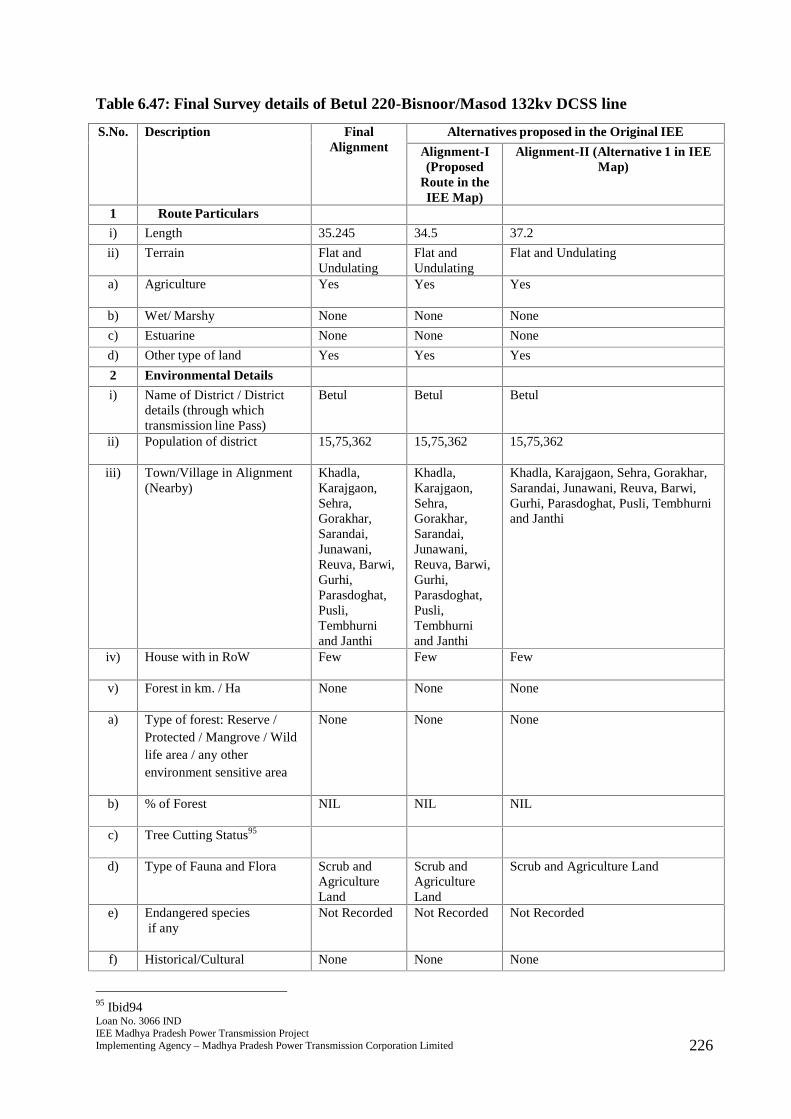
Loan No. 3066 INDIEE Madhya Pradesh Power Transmission ProjectImplementing Agency – Madhya Pradesh Power Transmission Corporation Limited 226
Table 6.47: Final Survey details of Betul 220-Bisnoor/Masod 132kv DCSS line
S.No. Description FinalAlignment
Alternatives proposed in the Original IEE
Alignment-I(Proposed
Route in theIEE Map)
Alignment-II (Alternative 1 in IEEMap)
1 Route Particulars
i) Length 35.245 34.5 37.2
ii) Terrain Flat andUndulating
Flat andUndulating
Flat and Undulating
a) Agriculture Yes Yes Yes
b) Wet/ Marshy None None None
c) Estuarine None None None
d) Other type of land Yes Yes Yes
2 Environmental Details
i) Name of District / Districtdetails (through whichtransmission line Pass)
Betul Betul Betul
ii) Population of district 15,75,362 15,75,362 15,75,362
iii) Town/Village in Alignment(Nearby)
Khadla,Karajgaon,Sehra,Gorakhar,Sarandai,Junawani,Reuva, Barwi,Gurhi,Parasdoghat,Pusli,Tembhurniand Janthi
Khadla,Karajgaon,Sehra,Gorakhar,Sarandai,Junawani,Reuva, Barwi,Gurhi,Parasdoghat,Pusli,Tembhurniand Janthi
Khadla, Karajgaon, Sehra, Gorakhar,Sarandai, Junawani, Reuva, Barwi,Gurhi, Parasdoghat, Pusli, Tembhurniand Janthi
iv) House with in RoW Few Few Few
v) Forest in km. / Ha None None None
a) Type of forest: Reserve /Protected / Mangrove / Wildlife area / any otherenvironment sensitive area
None None None
b) % of Forest NIL NIL NIL
c) Tree Cutting Status95
d) Type of Fauna and Flora Scrub andAgricultureLand
Scrub andAgricultureLand
Scrub and Agriculture Land
e) Endangered speciesif any
Not Recorded Not Recorded Not Recorded
f) Historical/Cultural None None None
95 Ibid94
Loan No. 3066 INDIEE Madhya Pradesh Power Transmission ProjectImplementing Agency – Madhya Pradesh Power Transmission Corporation Limited 227
S.No. Description FinalAlignment
Alternatives proposed in the Original IEE
Alignment-I(Proposed
Route in theIEE Map)
Alignment-II (Alternative 1 in IEEMap)
Monuments
g) Any other relevantinformation
3 Consumption cost
i) Crop AgriculturalLand
AgriculturalLand
Agricultural Land
ii) Forest NIL NIL NIL
4 Nº of Crossing
i) Railway NIL NIL NIL
ii) Transmission line NIL NIL 1
iii) River Crossing etc. 1 1 2
iv) Road Crossing 7 7 9
5 Construction Problem Minimum Moderate Moderate
6 O & M Problem Minimum Moderate Moderate
7 Overall Remarks Route isselectedbecause ofshortestlength, nilforestcoverage andavoidingsettlements.
295. The final route length of the line is 35.245 kms. The line passes through primarilyagricultural land comprising villages of Khadla, Karajgaon, Sehra, Gorakhar,Sarandai, Junawani, Reuva, Barwi, Gurhi, Parasdoghat, Pusli, Tembhurni and Janthiwith few settlements nearby. Adequate distance is maintained from the settlements.The line does not pass through any major critical ecologically sensitive areas such asforest, wildlife sanctuary or National Park. The line also does not pass through anymangrove, important wild life area or any other environment sensitive area. Noendangered species have been recorded in vicinity of the area where the line will beconstructed. There are no records of any historical or cultural or religious monumentsin the region where the line will be constructed. No archaeologically important sitelies in the area and thus environmental impacts will be few and easily manageable.There are seven road crossings in the final route alignment and some roads that aremotorable in dry season. There is a single river crossing that will lie in the RoWFarmers will be compensated for tree and crop loss and adequate distance of 4.5metres will be maintained from the height of vegetation to allow crop cultivation oncethe line is constructed.
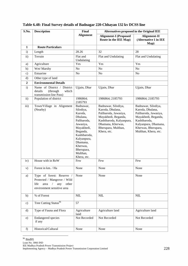
Loan No. 3066 INDIEE Madhya Pradesh Power Transmission ProjectImplementing Agency – Madhya Pradesh Power Transmission Corporation Limited 228
Table 6.48: Final Survey details of Badnagar 220-Chhayan 132 kv DCSS line
S.No. Description FinalAlignment
Alternatives proposed in the Original IEE
Alignment-I (ProposedRoute in the IEE Map)
Alignment-II(Alternative 1 in IEE
Map)1 Route Particulars
i) Length 28.26 32 28
ii) Terrain Flat andUndulating
Flat and Undulating Flat and Undulating
a) Agriculture Yes Yes Yes
b) Wet/ Marshy No No No
c) Estuarine No No No
d) Other type of land
2 Environmental Details
i) Name of District / Districtdetails (through whichtransmission line Pass)
Ujjain, Dhar Ujjain, Dhar Ujjain, Dhar
ii) Population of district 1986864;2185793
1986864; 2185793 1986864; 2185793
iii) Town/Village in Alignment(Nearby)
Badnawar,Silodiya,Karoda,Dhulana,Palibaroda,Jawasiya,Mayakhedi,Beganda,Kashibaroda,Kalyanpura,Dhamana,Kherwas,Bherupara,Multhan,Khera, etc.
Badnawar, Silodiya,Karoda, Dhulana,Palibaroda, Jawasiya,Mayakhedi, Beganda,Kashibaroda, Kalyanpura,Dhamana, Kherwas,Bherupara, Multhan,Khera, etc.
Badnawar, Silodiya,Karoda, Dhulana,Palibaroda, Jawasiya,Mayakhedi, Beganda,Kashibaroda,Kalyanpura, Dhamana,Kherwas, Bherupara,Multhan, Khera, etc.
iv) House with in RoW Few Few Few
v) Forest in km. / Ha None None None
a) Type of forest: Reserve /Protected / Mangrove / Wildlife area / any otherenvironment sensitive area
None None None
b) % of Forest NIL NIL NIL
c) Tree Cutting Status96 57
d) Type of Fauna and Flora Agricultureland
Agriculture land Agriculture land
e) Endangered speciesif any
Not Recorded Not Recorded Not Recorded
f) Historical/Cultural None None None
96 Ibid95
Loan No. 3066 INDIEE Madhya Pradesh Power Transmission ProjectImplementing Agency – Madhya Pradesh Power Transmission Corporation Limited 229
S.No. Description FinalAlignment
Alternatives proposed in the Original IEE
Alignment-I (ProposedRoute in the IEE Map)
Alignment-II(Alternative 1 in IEE
Map)Monuments
g) Any other relevantinformation
3 Consumption cost
i) Crop Agricultureland
Agriculture land Agriculture land
ii) Forest None None None
4 Nº of Crossing
i) Railway None None None
ii) Transmission line 3 3 3
iii) River Crossing etc. None None None
iv) Road Crossing 3 3 3
5 Construction Problem Minimum Moderate Moderate
6 O & M Problem Minimum Moderate Moderate
7 Overall Remarks Route isselectedbecause ofshortestlength, nilforestcoverage andavoidingsettlements.
296. The final route length of the line is 28.26 kms. The line passes through primarilyagricultural land comprising villages of Badnawar, Silodiya, Karoda, Dhulana,Palibaroda, Jawasiya, Mayakhedi, Beganda, Kashibaroda, Kalyanpura, Dhamana,Kherwas, Bherupara, Multhan, and Khera, etc. with few settlements nearby. Adequatedistance is maintained from the settlements. The line does not pass through any majorcritical ecologically sensitive areas such as forest, wildlife sanctuary or National Park.The line also does not pass through any mangrove, important wild life area or anyother environment sensitive area. No endangered species have been recorded invicinity of the area where the line will be constructed. There are no records of anyhistorical or cultural or religious monuments in the region where the line will beconstructed. No archaeologically important site lies in the area and thusenvironmental impacts will be few and easily manageable. There are three roadcrossings in the final route alignment and some roads that are motorable in dryseason. There are three transmission lines that will lie in the RoW. Farmers will becompensated for tree and crop loss and adequate distance of 4.5 metres will bemaintained from the height of vegetation to allow crop cultivation once the line isconstructed.
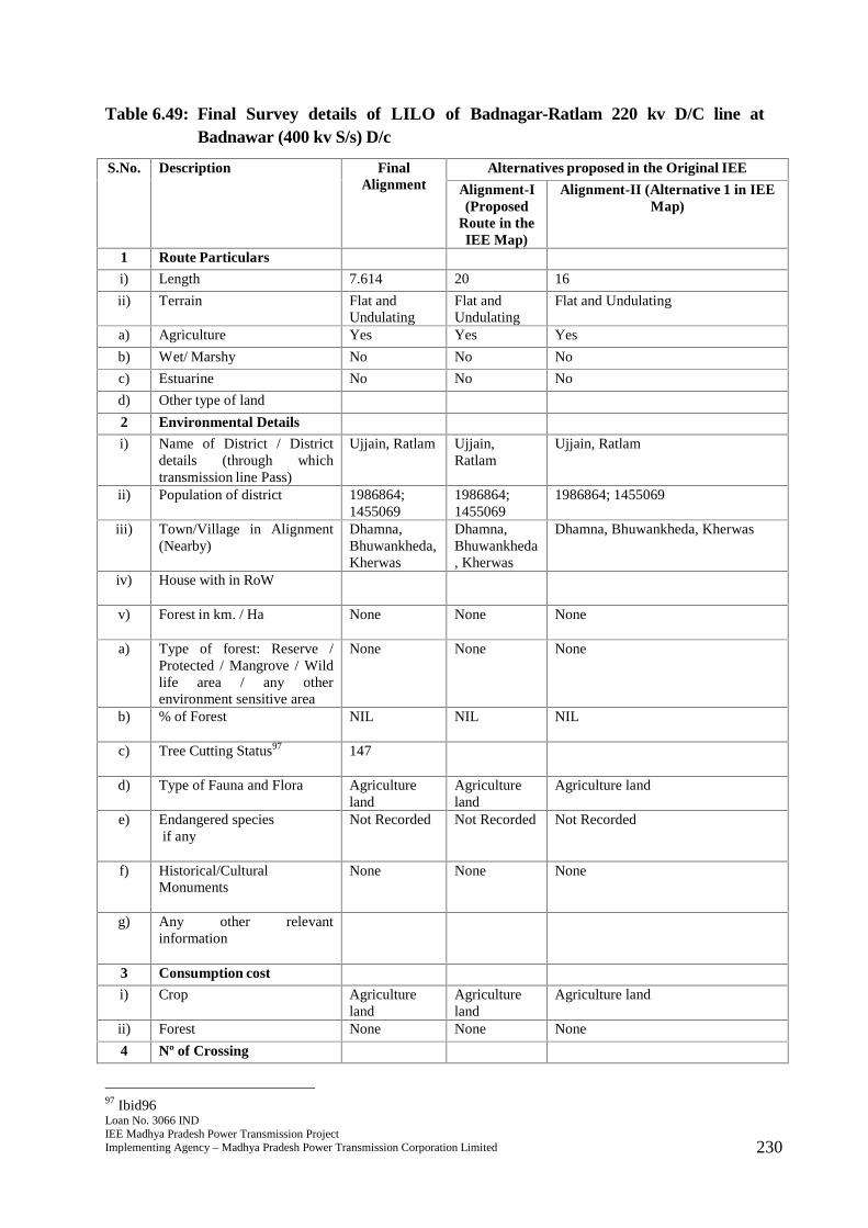
Loan No. 3066 INDIEE Madhya Pradesh Power Transmission ProjectImplementing Agency – Madhya Pradesh Power Transmission Corporation Limited 230
Table 6.49: Final Survey details of LILO of Badnagar-Ratlam 220 kv D/C line atBadnawar (400 kv S/s) D/c
S.No. Description FinalAlignment
Alternatives proposed in the Original IEE
Alignment-I(Proposed
Route in theIEE Map)
Alignment-II (Alternative 1 in IEEMap)
1 Route Particulars
i) Length 7.614 20 16
ii) Terrain Flat andUndulating
Flat andUndulating
Flat and Undulating
a) Agriculture Yes Yes Yes
b) Wet/ Marshy No No No
c) Estuarine No No No
d) Other type of land
2 Environmental Details
i) Name of District / Districtdetails (through whichtransmission line Pass)
Ujjain, Ratlam Ujjain,Ratlam
Ujjain, Ratlam
ii) Population of district 1986864;1455069
1986864;1455069
1986864; 1455069
iii) Town/Village in Alignment(Nearby)
Dhamna,Bhuwankheda,Kherwas
Dhamna,Bhuwankheda, Kherwas
Dhamna, Bhuwankheda, Kherwas
iv) House with in RoW
v) Forest in km. / Ha None None None
a) Type of forest: Reserve /Protected / Mangrove / Wildlife area / any otherenvironment sensitive area
None None None
b) % of Forest NIL NIL NIL
c) Tree Cutting Status97 147
d) Type of Fauna and Flora Agricultureland
Agricultureland
Agriculture land
e) Endangered speciesif any
Not Recorded Not Recorded Not Recorded
f) Historical/CulturalMonuments
None None None
g) Any other relevantinformation
3 Consumption cost
i) Crop Agricultureland
Agricultureland
Agriculture land
ii) Forest None None None
4 Nº of Crossing
97 Ibid96
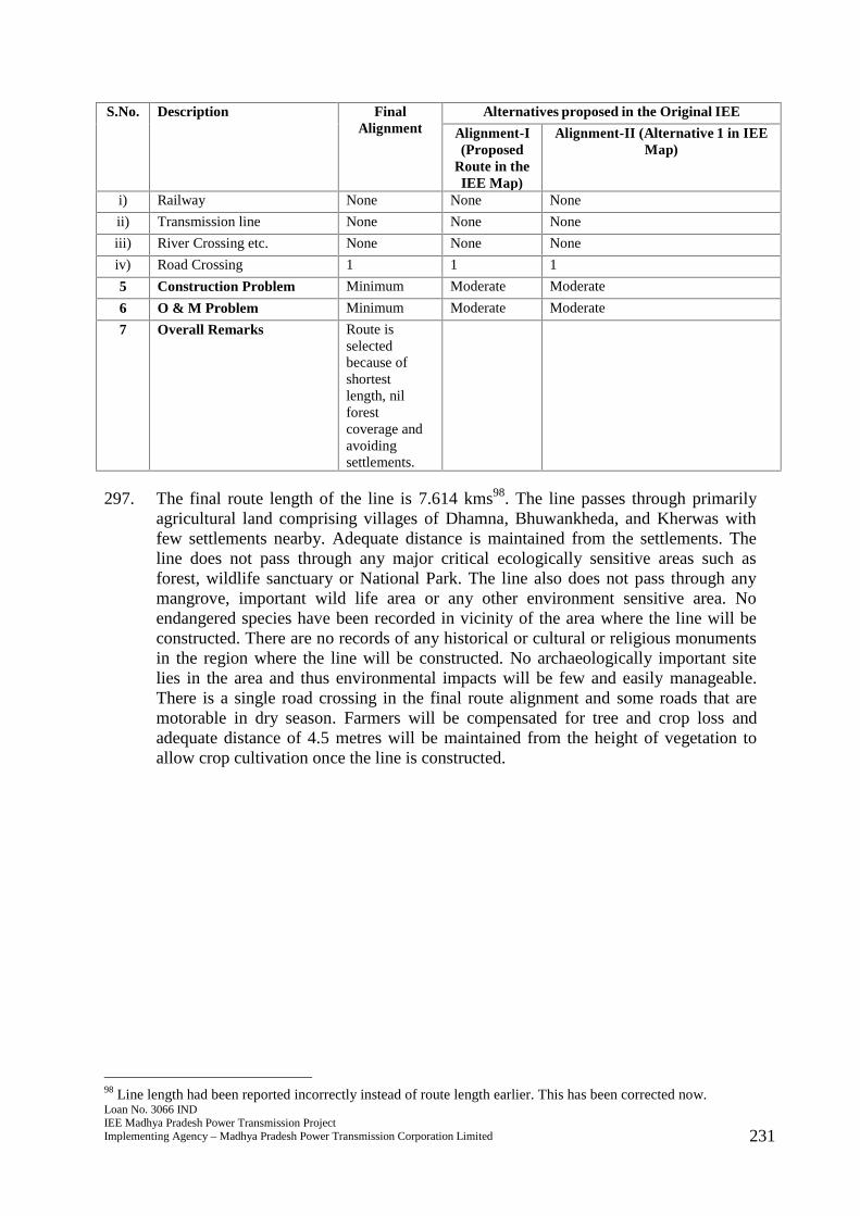
Loan No. 3066 INDIEE Madhya Pradesh Power Transmission ProjectImplementing Agency – Madhya Pradesh Power Transmission Corporation Limited 231
S.No. Description FinalAlignment
Alternatives proposed in the Original IEE
Alignment-I(Proposed
Route in theIEE Map)
Alignment-II (Alternative 1 in IEEMap)
i) Railway None None None
ii) Transmission line None None None
iii) River Crossing etc. None None None
iv) Road Crossing 1 1 1
5 Construction Problem Minimum Moderate Moderate
6 O & M Problem Minimum Moderate Moderate
7 Overall Remarks Route isselectedbecause ofshortestlength, nilforestcoverage andavoidingsettlements.
297. The final route length of the line is 7.614 kms98. The line passes through primarilyagricultural land comprising villages of Dhamna, Bhuwankheda, and Kherwas withfew settlements nearby. Adequate distance is maintained from the settlements. Theline does not pass through any major critical ecologically sensitive areas such asforest, wildlife sanctuary or National Park. The line also does not pass through anymangrove, important wild life area or any other environment sensitive area. Noendangered species have been recorded in vicinity of the area where the line will beconstructed. There are no records of any historical or cultural or religious monumentsin the region where the line will be constructed. No archaeologically important sitelies in the area and thus environmental impacts will be few and easily manageable.There is a single road crossing in the final route alignment and some roads that aremotorable in dry season. Farmers will be compensated for tree and crop loss andadequate distance of 4.5 metres will be maintained from the height of vegetation toallow crop cultivation once the line is constructed.
98 Line length had been reported incorrectly instead of route length earlier. This has been corrected now.
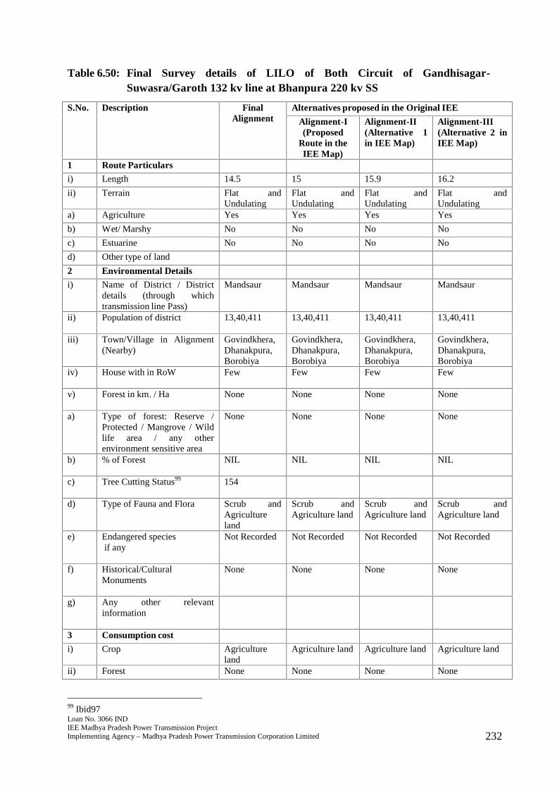
Loan No. 3066 INDIEE Madhya Pradesh Power Transmission ProjectImplementing Agency – Madhya Pradesh Power Transmission Corporation Limited 232
Table 6.50: Final Survey details of LILO of Both Circuit of Gandhisagar-Suwasra/Garoth 132 kv line at Bhanpura 220 kv SS
S.No. Description FinalAlignment
Alternatives proposed in the Original IEE
Alignment-I(Proposed
Route in theIEE Map)
Alignment-II(Alternative 1in IEE Map)
Alignment-III(Alternative 2 inIEE Map)
1 Route Particulars
i) Length 14.5 15 15.9 16.2
ii) Terrain Flat andUndulating
Flat andUndulating
Flat andUndulating
Flat andUndulating
a) Agriculture Yes Yes Yes Yes
b) Wet/ Marshy No No No No
c) Estuarine No No No No
d) Other type of land
2 Environmental Details
i) Name of District / Districtdetails (through whichtransmission line Pass)
Mandsaur Mandsaur Mandsaur Mandsaur
ii) Population of district 13,40,411 13,40,411 13,40,411 13,40,411
iii) Town/Village in Alignment(Nearby)
Govindkhera,Dhanakpura,Borobiya
Govindkhera,Dhanakpura,Borobiya
Govindkhera,Dhanakpura,Borobiya
Govindkhera,Dhanakpura,Borobiya
iv) House with in RoW Few Few Few Few
v) Forest in km. / Ha None None None None
a) Type of forest: Reserve /Protected / Mangrove / Wildlife area / any otherenvironment sensitive area
None None None None
b) % of Forest NIL NIL NIL NIL
c) Tree Cutting Status99 154
d) Type of Fauna and Flora Scrub andAgricultureland
Scrub andAgriculture land
Scrub andAgriculture land
Scrub andAgriculture land
e) Endangered speciesif any
Not Recorded Not Recorded Not Recorded Not Recorded
f) Historical/CulturalMonuments
None None None None
g) Any other relevantinformation
3 Consumption cost
i) Crop Agricultureland
Agriculture land Agriculture land Agriculture land
ii) Forest None None None None
99 Ibid97
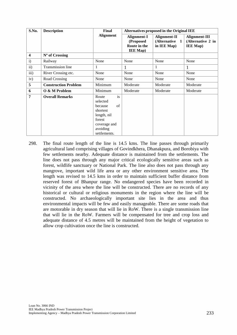
Loan No. 3066 INDIEE Madhya Pradesh Power Transmission ProjectImplementing Agency – Madhya Pradesh Power Transmission Corporation Limited 233
S.No. Description FinalAlignment
Alternatives proposed in the Original IEE
Alignment-I(Proposed
Route in theIEE Map)
Alignment-II(Alternative 1in IEE Map)
Alignment-III(Alternative 2 inIEE Map)
4 Nº of Crossing
i) Railway None None None None
ii) Transmission line 1 1 1 1iii) River Crossing etc. None None None None
iv) Road Crossing None None None None
5 Construction Problem Minimum Moderate Moderate Moderate
6 O & M Problem Minimum Moderate Moderate Moderate
7 Overall Remarks Route isselectedbecause ofshortestlength, nilforestcoverage andavoidingsettlements.
298. The final route length of the line is 14.5 kms. The line passes through primarilyagricultural land comprising villages of Govindkhera, Dhanakpura, and Borobiya withfew settlements nearby. Adequate distance is maintained from the settlements. Theline does not pass through any major critical ecologically sensitive areas such asforest, wildlife sanctuary or National Park. The line also does not pass through anymangrove, important wild life area or any other environment sensitive area. Thelength was revised to 14.5 kms in order to maintain sufficient buffer distance fromreserved forest of Bhanpur range. No endangered species have been recorded invicinity of the area where the line will be constructed. There are no records of anyhistorical or cultural or religious monuments in the region where the line will beconstructed. No archaeologically important site lies in the area and thusenvironmental impacts will be few and easily manageable. There are some roads thatare motorable in dry season that will lie in RoW. There is a single transmission linethat will lie in the RoW. Farmers will be compensated for tree and crop loss andadequate distance of 4.5 metres will be maintained from the height of vegetation toallow crop cultivation once the line is constructed.
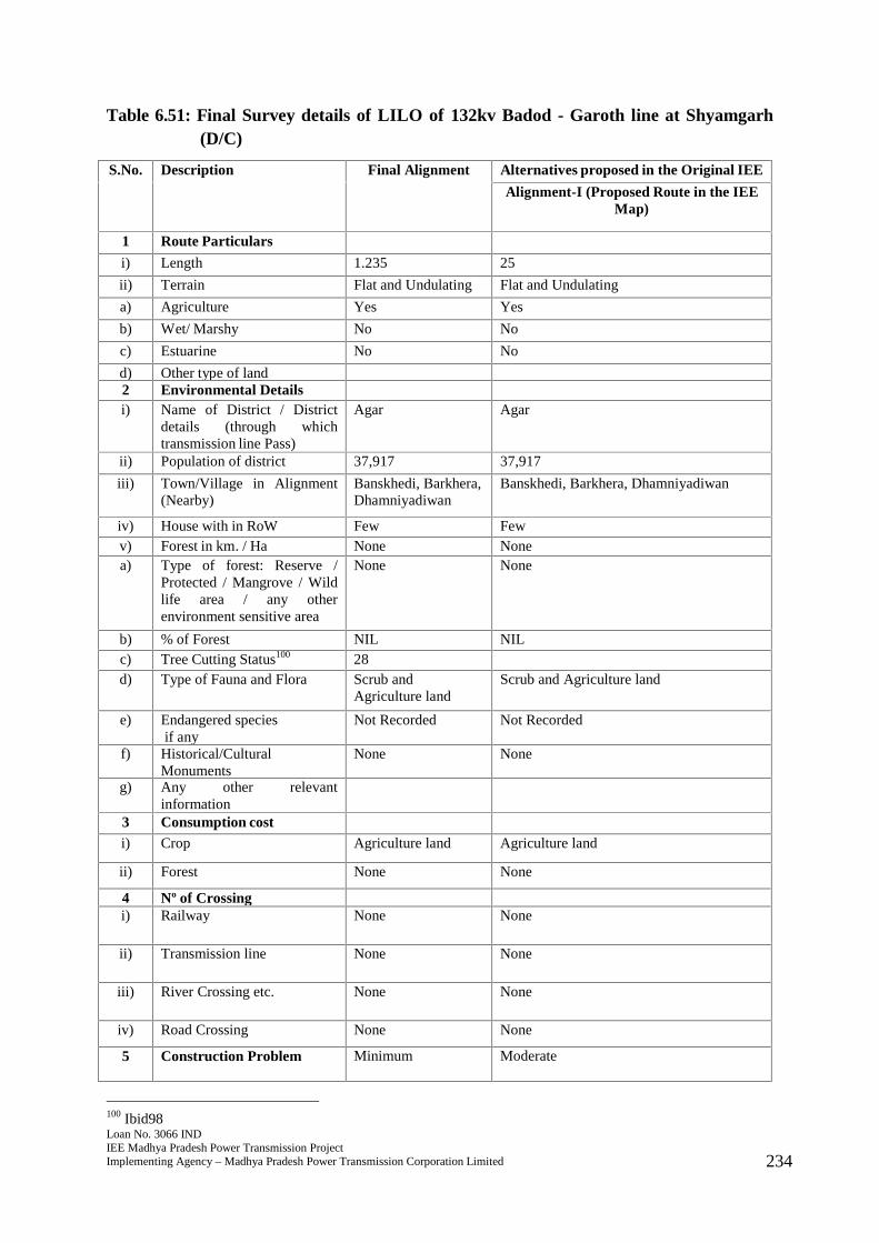
Loan No. 3066 INDIEE Madhya Pradesh Power Transmission ProjectImplementing Agency – Madhya Pradesh Power Transmission Corporation Limited 234
Table 6.51: Final Survey details of LILO of 132kv Badod - Garoth line at Shyamgarh(D/C)
S.No. Description Final Alignment Alternatives proposed in the Original IEE
Alignment-I (Proposed Route in the IEEMap)
1 Route Particulars
i) Length 1.235 25
ii) Terrain Flat and Undulating Flat and Undulating
a) Agriculture Yes Yes
b) Wet/ Marshy No No
c) Estuarine No No
d) Other type of land2 Environmental Detailsi) Name of District / District
details (through whichtransmission line Pass)
Agar Agar
ii) Population of district 37,917 37,917
iii) Town/Village in Alignment(Nearby)
Banskhedi, Barkhera,Dhamniyadiwan
Banskhedi, Barkhera, Dhamniyadiwan
iv) House with in RoW Few Fewv) Forest in km. / Ha None Nonea) Type of forest: Reserve /
Protected / Mangrove / Wildlife area / any otherenvironment sensitive area
None None
b) % of Forest NIL NILc) Tree Cutting Status100 28d) Type of Fauna and Flora Scrub and
Agriculture landScrub and Agriculture land
e) Endangered speciesif any
Not Recorded Not Recorded
f) Historical/CulturalMonuments
None None
g) Any other relevantinformation
3 Consumption costi) Crop Agriculture land Agriculture land
ii) Forest None None
4 Nº of Crossingi) Railway None None
ii) Transmission line None None
iii) River Crossing etc. None None
iv) Road Crossing None None
5 Construction Problem Minimum Moderate
100 Ibid98
Loan No. 3066 INDIEE Madhya Pradesh Power Transmission ProjectImplementing Agency – Madhya Pradesh Power Transmission Corporation Limited 235
6 O & M Problem Minimum Moderate
7 Overall Remarks Route is selectedbecause of shortestlength, nilforest coverage andavoiding settlements.
299. The final route length of the line is 1.235 kms. The line passes through primarilyagricultural land comprising villages of Banskhedi, Barkhera, and Dhamniyadiwanwith few settlements nearby. Adequate distance is maintained from the settlements.The line does not pass through any major critical ecologically sensitive areas such asforest, wildlife sanctuary or National Park. The line also does not pass through anymangrove, important wild life area or any other environment sensitive area. Noendangered species have been recorded in vicinity of the area where the line will beconstructed. There are no records of any historical or cultural or religious monumentsin the region where the line will be constructed. No archaeologically important sitelies in the area and thus environmental impacts will be few and easily manageable.There are some roads that are motorable in dry season that will lie in RoW. Farmerswill be compensated for tree and crop loss and adequate distance of 4.5 metres will bemaintained from the height of vegetation to allow crop cultivation once the line isconstructed.
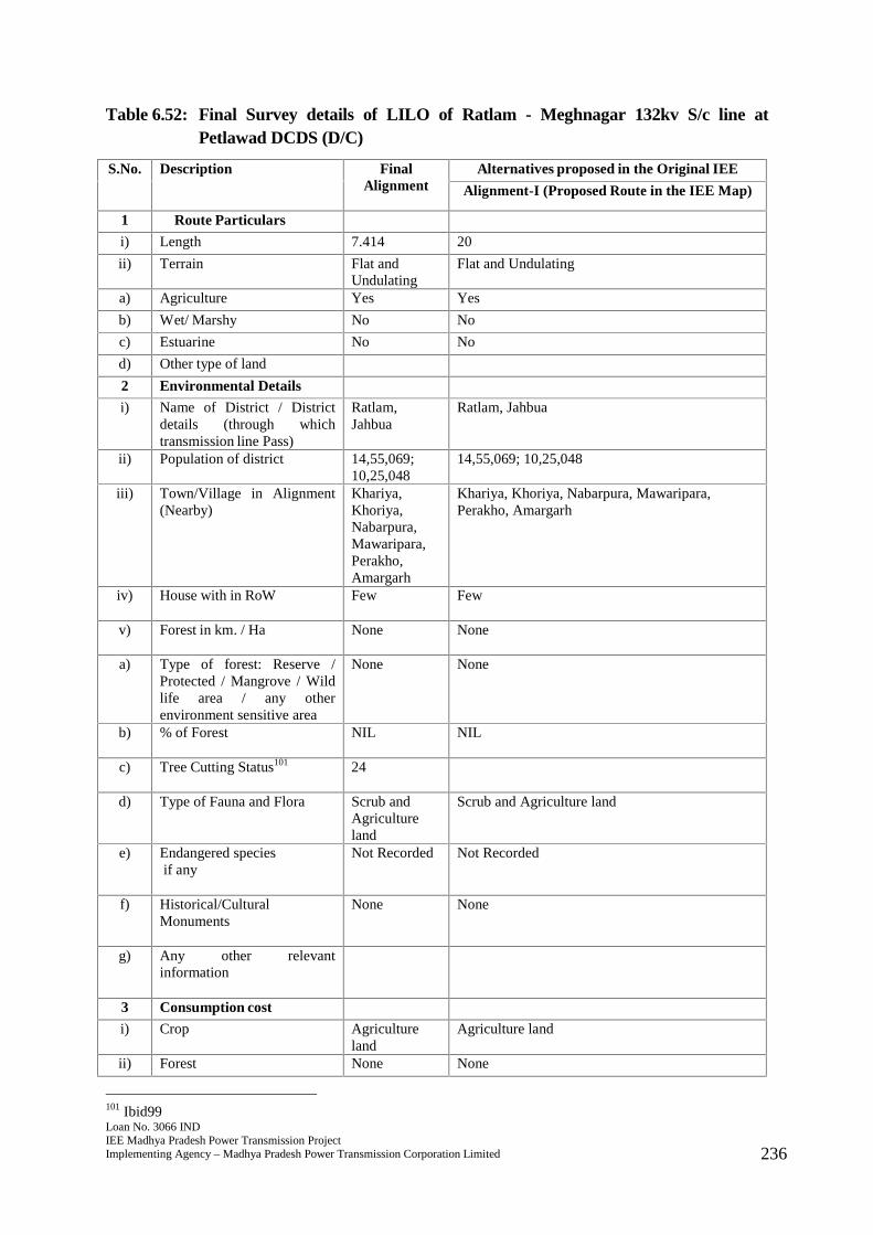
Loan No. 3066 INDIEE Madhya Pradesh Power Transmission ProjectImplementing Agency – Madhya Pradesh Power Transmission Corporation Limited 236
Table 6.52: Final Survey details of LILO of Ratlam - Meghnagar 132kv S/c line atPetlawad DCDS (D/C)
S.No. Description FinalAlignment
Alternatives proposed in the Original IEE
Alignment-I (Proposed Route in the IEE Map)
1 Route Particulars
i) Length 7.414 20
ii) Terrain Flat andUndulating
Flat and Undulating
a) Agriculture Yes Yes
b) Wet/ Marshy No No
c) Estuarine No No
d) Other type of land
2 Environmental Details
i) Name of District / Districtdetails (through whichtransmission line Pass)
Ratlam,Jahbua
Ratlam, Jahbua
ii) Population of district 14,55,069;10,25,048
14,55,069; 10,25,048
iii) Town/Village in Alignment(Nearby)
Khariya,Khoriya,Nabarpura,Mawaripara,Perakho,Amargarh
Khariya, Khoriya, Nabarpura, Mawaripara,Perakho, Amargarh
iv) House with in RoW Few Few
v) Forest in km. / Ha None None
a) Type of forest: Reserve /Protected / Mangrove / Wildlife area / any otherenvironment sensitive area
None None
b) % of Forest NIL NIL
c) Tree Cutting Status101 24
d) Type of Fauna and Flora Scrub andAgricultureland
Scrub and Agriculture land
e) Endangered speciesif any
Not Recorded Not Recorded
f) Historical/CulturalMonuments
None None
g) Any other relevantinformation
3 Consumption cost
i) Crop Agricultureland
Agriculture land
ii) Forest None None
101 Ibid99
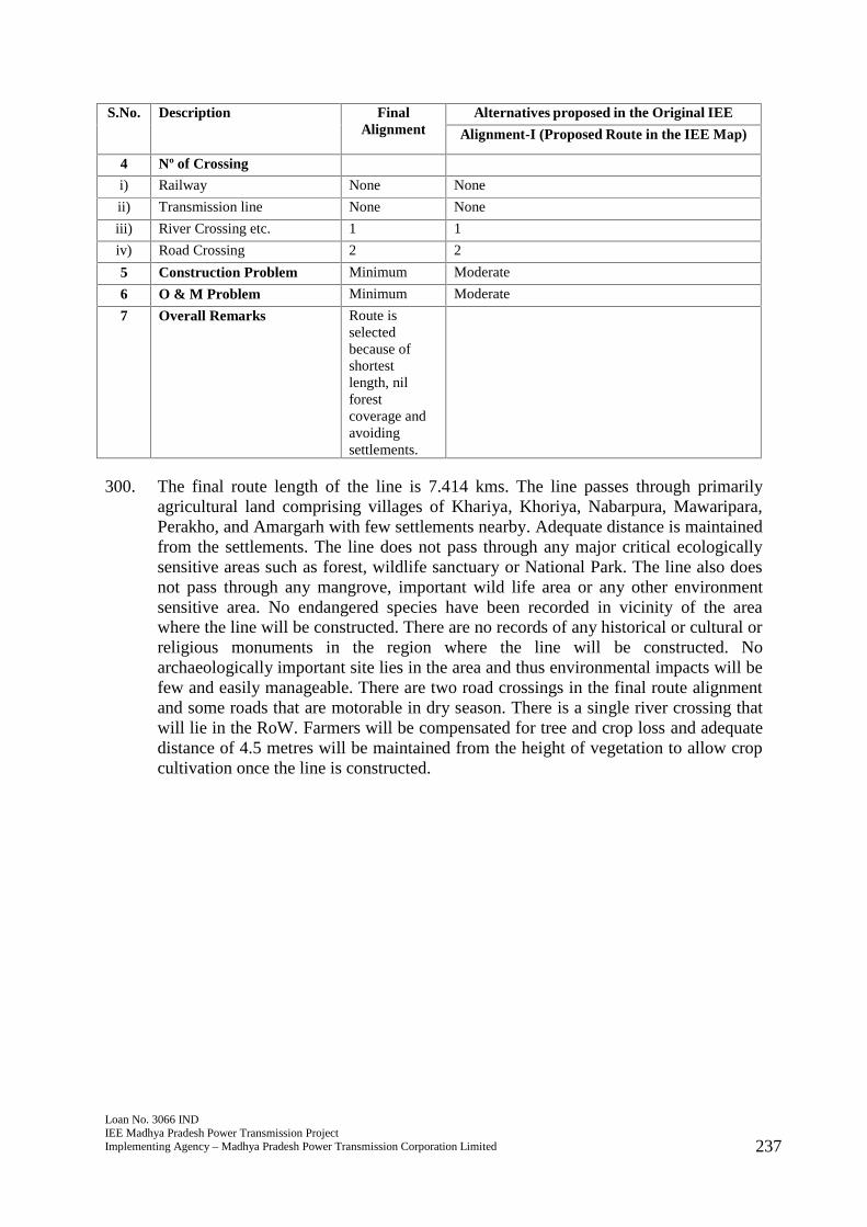
Loan No. 3066 INDIEE Madhya Pradesh Power Transmission ProjectImplementing Agency – Madhya Pradesh Power Transmission Corporation Limited 237
S.No. Description FinalAlignment
Alternatives proposed in the Original IEE
Alignment-I (Proposed Route in the IEE Map)
4 Nº of Crossing
i) Railway None None
ii) Transmission line None None
iii) River Crossing etc. 1 1
iv) Road Crossing 2 2
5 Construction Problem Minimum Moderate
6 O & M Problem Minimum Moderate
7 Overall Remarks Route isselectedbecause ofshortestlength, nilforestcoverage andavoidingsettlements.
300. The final route length of the line is 7.414 kms. The line passes through primarilyagricultural land comprising villages of Khariya, Khoriya, Nabarpura, Mawaripara,Perakho, and Amargarh with few settlements nearby. Adequate distance is maintainedfrom the settlements. The line does not pass through any major critical ecologicallysensitive areas such as forest, wildlife sanctuary or National Park. The line also doesnot pass through any mangrove, important wild life area or any other environmentsensitive area. No endangered species have been recorded in vicinity of the areawhere the line will be constructed. There are no records of any historical or cultural orreligious monuments in the region where the line will be constructed. Noarchaeologically important site lies in the area and thus environmental impacts will befew and easily manageable. There are two road crossings in the final route alignmentand some roads that are motorable in dry season. There is a single river crossing thatwill lie in the RoW. Farmers will be compensated for tree and crop loss and adequatedistance of 4.5 metres will be maintained from the height of vegetation to allow cropcultivation once the line is constructed.
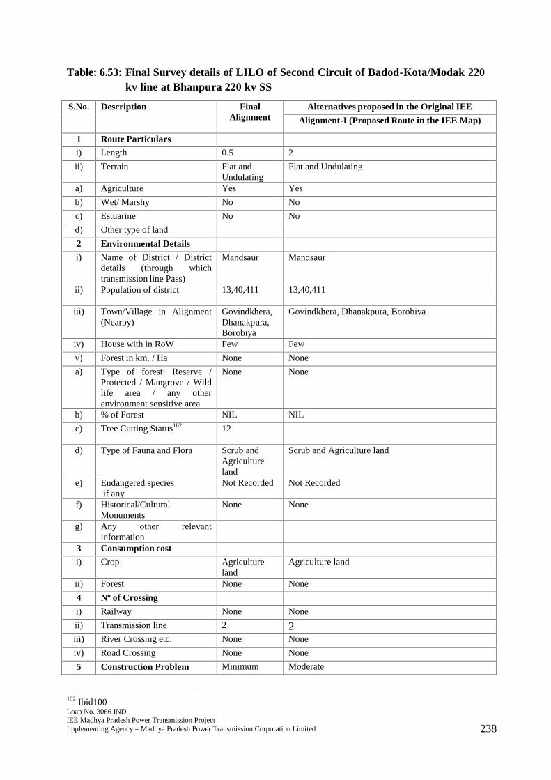
Loan No. 3066 INDIEE Madhya Pradesh Power Transmission ProjectImplementing Agency – Madhya Pradesh Power Transmission Corporation Limited 238
Table: 6.53: Final Survey details of LILO of Second Circuit of Badod-Kota/Modak 220kv line at Bhanpura 220 kv SS
S.No. Description FinalAlignment
Alternatives proposed in the Original IEE
Alignment-I (Proposed Route in the IEE Map)
1 Route Particulars
i) Length 0.5 2
ii) Terrain Flat andUndulating
Flat and Undulating
a) Agriculture Yes Yes
b) Wet/ Marshy No No
c) Estuarine No No
d) Other type of land
2 Environmental Details
i) Name of District / Districtdetails (through whichtransmission line Pass)
Mandsaur Mandsaur
ii) Population of district 13,40,411 13,40,411
iii) Town/Village in Alignment(Nearby)
Govindkhera,Dhanakpura,Borobiya
Govindkhera, Dhanakpura, Borobiya
iv) House with in RoW Few Few
v) Forest in km. / Ha None None
a) Type of forest: Reserve /Protected / Mangrove / Wildlife area / any otherenvironment sensitive area
None None
b) % of Forest NIL NIL
c) Tree Cutting Status102 12
d) Type of Fauna and Flora Scrub andAgricultureland
Scrub and Agriculture land
e) Endangered speciesif any
Not Recorded Not Recorded
f) Historical/CulturalMonuments
None None
g) Any other relevantinformation
3 Consumption cost
i) Crop Agricultureland
Agriculture land
ii) Forest None None
4 Nº of Crossing
i) Railway None None
ii) Transmission line 2 2iii) River Crossing etc. None None
iv) Road Crossing None None
5 Construction Problem Minimum Moderate
102 Ibid100
Loan No. 3066 INDIEE Madhya Pradesh Power Transmission ProjectImplementing Agency – Madhya Pradesh Power Transmission Corporation Limited 239
S.No. Description FinalAlignment
Alternatives proposed in the Original IEE
Alignment-I (Proposed Route in the IEE Map)
6 O & M Problem Minimum Moderate
7 Overall Remarks Route isselectedbecause ofshortestlength, nilforestcoverage andavoidingsettlements.
301. The final route length of the line is 0.5 kms. The line passes through primarilyagricultural land comprising villages of Govindkhera, Dhanakpura, and Borobiya withfew settlements nearby. Adequate distance is maintained from the settlements. Theline does not pass through any major critical ecologically sensitive areas such asforest, wildlife sanctuary or National Park. The line also does not pass through anymangrove, important wild life area or any other environment sensitive area. Noendangered species have been recorded in vicinity of the area where the line will beconstructed. There are no records of any historical or cultural or religious monumentsin the region where the line will be constructed. No archaeologically important sitelies in the area and thus environmental impacts will be few and easily manageable.There are some roads that are motorable in dry season that will lie in RoW. There aretwo transmission lines that will lie in the RoW. Farmers will be compensated for treeand crop loss and adequate distance of 4.5 metres will be maintained from the heightof vegetation to allow crop cultivation once the line is constructed.
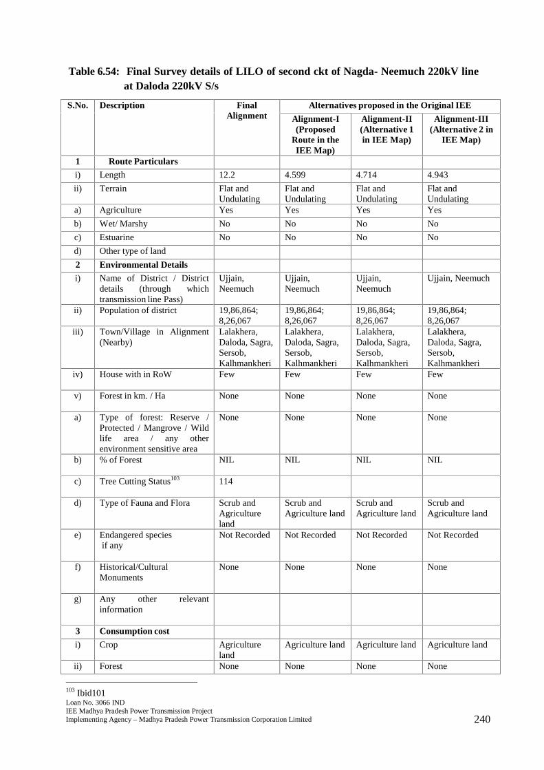
Loan No. 3066 INDIEE Madhya Pradesh Power Transmission ProjectImplementing Agency – Madhya Pradesh Power Transmission Corporation Limited 240
Table 6.54: Final Survey details of LILO of second ckt of Nagda- Neemuch 220kV lineat Daloda 220kV S/s
S.No. Description FinalAlignment
Alternatives proposed in the Original IEE
Alignment-I(Proposed
Route in theIEE Map)
Alignment-II(Alternative 1in IEE Map)
Alignment-III(Alternative 2 in
IEE Map)
1 Route Particulars
i) Length 12.2 4.599 4.714 4.943
ii) Terrain Flat andUndulating
Flat andUndulating
Flat andUndulating
Flat andUndulating
a) Agriculture Yes Yes Yes Yes
b) Wet/ Marshy No No No No
c) Estuarine No No No No
d) Other type of land
2 Environmental Details
i) Name of District / Districtdetails (through whichtransmission line Pass)
Ujjain,Neemuch
Ujjain,Neemuch
Ujjain,Neemuch
Ujjain, Neemuch
ii) Population of district 19,86,864;8,26,067
19,86,864;8,26,067
19,86,864;8,26,067
19,86,864;8,26,067
iii) Town/Village in Alignment(Nearby)
Lalakhera,Daloda, Sagra,Sersob,Kalhmankheri
Lalakhera,Daloda, Sagra,Sersob,Kalhmankheri
Lalakhera,Daloda, Sagra,Sersob,Kalhmankheri
Lalakhera,Daloda, Sagra,Sersob,Kalhmankheri
iv) House with in RoW Few Few Few Few
v) Forest in km. / Ha None None None None
a) Type of forest: Reserve /Protected / Mangrove / Wildlife area / any otherenvironment sensitive area
None None None None
b) % of Forest NIL NIL NIL NIL
c) Tree Cutting Status103 114
d) Type of Fauna and Flora Scrub andAgricultureland
Scrub andAgriculture land
Scrub andAgriculture land
Scrub andAgriculture land
e) Endangered speciesif any
Not Recorded Not Recorded Not Recorded Not Recorded
f) Historical/CulturalMonuments
None None None None
g) Any other relevantinformation
3 Consumption cost
i) Crop Agricultureland
Agriculture land Agriculture land Agriculture land
ii) Forest None None None None
103 Ibid101
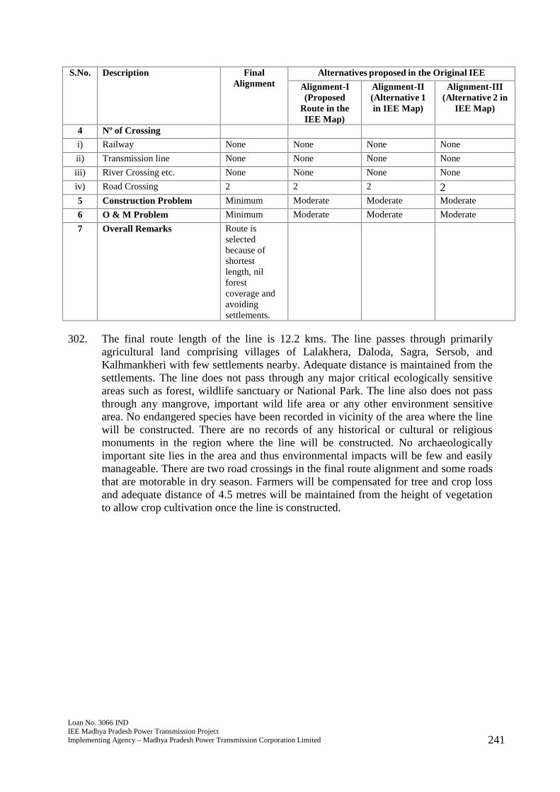
Loan No. 3066 INDIEE Madhya Pradesh Power Transmission ProjectImplementing Agency – Madhya Pradesh Power Transmission Corporation Limited 241
S.No. Description FinalAlignment
Alternatives proposed in the Original IEE
Alignment-I(Proposed
Route in theIEE Map)
Alignment-II(Alternative 1in IEE Map)
Alignment-III(Alternative 2 in
IEE Map)
4 Nº of Crossing
i) Railway None None None None
ii) Transmission line None None None None
iii) River Crossing etc. None None None None
iv) Road Crossing 2 2 2 25 Construction Problem Minimum Moderate Moderate Moderate
6 O & M Problem Minimum Moderate Moderate Moderate
7 Overall Remarks Route isselectedbecause ofshortestlength, nilforestcoverage andavoidingsettlements.
302. The final route length of the line is 12.2 kms. The line passes through primarilyagricultural land comprising villages of Lalakhera, Daloda, Sagra, Sersob, andKalhmankheri with few settlements nearby. Adequate distance is maintained from thesettlements. The line does not pass through any major critical ecologically sensitiveareas such as forest, wildlife sanctuary or National Park. The line also does not passthrough any mangrove, important wild life area or any other environment sensitivearea. No endangered species have been recorded in vicinity of the area where the linewill be constructed. There are no records of any historical or cultural or religiousmonuments in the region where the line will be constructed. No archaeologicallyimportant site lies in the area and thus environmental impacts will be few and easilymanageable. There are two road crossings in the final route alignment and some roadsthat are motorable in dry season. Farmers will be compensated for tree and crop lossand adequate distance of 4.5 metres will be maintained from the height of vegetationto allow crop cultivation once the line is constructed.
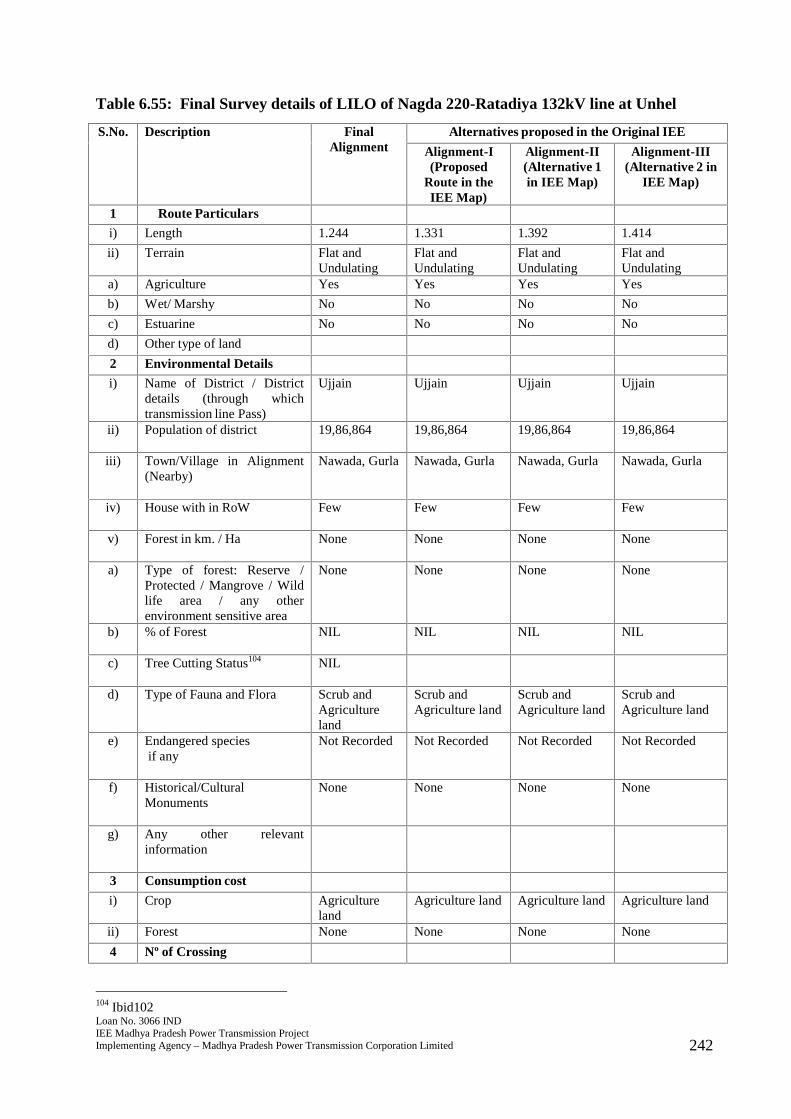
Loan No. 3066 INDIEE Madhya Pradesh Power Transmission ProjectImplementing Agency – Madhya Pradesh Power Transmission Corporation Limited 242
Table 6.55: Final Survey details of LILO of Nagda 220-Ratadiya 132kV line at Unhel
S.No. Description FinalAlignment
Alternatives proposed in the Original IEE
Alignment-I(Proposed
Route in theIEE Map)
Alignment-II(Alternative 1in IEE Map)
Alignment-III(Alternative 2 in
IEE Map)
1 Route Particulars
i) Length 1.244 1.331 1.392 1.414
ii) Terrain Flat andUndulating
Flat andUndulating
Flat andUndulating
Flat andUndulating
a) Agriculture Yes Yes Yes Yes
b) Wet/ Marshy No No No No
c) Estuarine No No No No
d) Other type of land
2 Environmental Details
i) Name of District / Districtdetails (through whichtransmission line Pass)
Ujjain Ujjain Ujjain Ujjain
ii) Population of district 19,86,864 19,86,864 19,86,864 19,86,864
iii) Town/Village in Alignment(Nearby)
Nawada, Gurla Nawada, Gurla Nawada, Gurla Nawada, Gurla
iv) House with in RoW Few Few Few Few
v) Forest in km. / Ha None None None None
a) Type of forest: Reserve /Protected / Mangrove / Wildlife area / any otherenvironment sensitive area
None None None None
b) % of Forest NIL NIL NIL NIL
c) Tree Cutting Status104 NIL
d) Type of Fauna and Flora Scrub andAgricultureland
Scrub andAgriculture land
Scrub andAgriculture land
Scrub andAgriculture land
e) Endangered speciesif any
Not Recorded Not Recorded Not Recorded Not Recorded
f) Historical/CulturalMonuments
None None None None
g) Any other relevantinformation
3 Consumption cost
i) Crop Agricultureland
Agriculture land Agriculture land Agriculture land
ii) Forest None None None None
4 Nº of Crossing
104 Ibid102
Loan No. 3066 INDIEE Madhya Pradesh Power Transmission ProjectImplementing Agency – Madhya Pradesh Power Transmission Corporation Limited 243
S.No. Description FinalAlignment
Alternatives proposed in the Original IEE
Alignment-I(Proposed
Route in theIEE Map)
Alignment-II(Alternative 1in IEE Map)
Alignment-III(Alternative 2 in
IEE Map)
i) Railway None None None None
ii) Transmission line None None None None
iii) River Crossing etc. None None None None
iv) Road Crossing None None None None
5 Construction Problem Minimum Moderate Moderate Moderate
6 O & M Problem Minimum Moderate Moderate Moderate
7 Overall Remarks Route isselectedbecause ofshortestlength, nilforestcoverage andavoidingsettlements.
303. The final route length of the line is 1.244 kms. The line passes through primarilyagricultural land comprising villages of Nawada and Gurla with few settlementsnearby. Adequate distance is maintained from the settlements. The line does not passthrough any major critical ecologically sensitive areas such as forest, wildlifesanctuary or National Park. The line also does not pass through any mangrove,important wild life area or any other environment sensitive area. No endangeredspecies have been recorded in vicinity of the area where the line will be constructed.There are no records of any historical or cultural or religious monuments in the regionwhere the line will be constructed. No archaeologically important site lies in the areaand thus environmental impacts will be few and easily manageable. There are someroads that are motorable in dry season that will lie in RoW. Farmers will becompensated for tree and crop loss and adequate distance of 4.5 metres will bemaintained from the height of vegetation to allow crop cultivation once the line isconstructed.
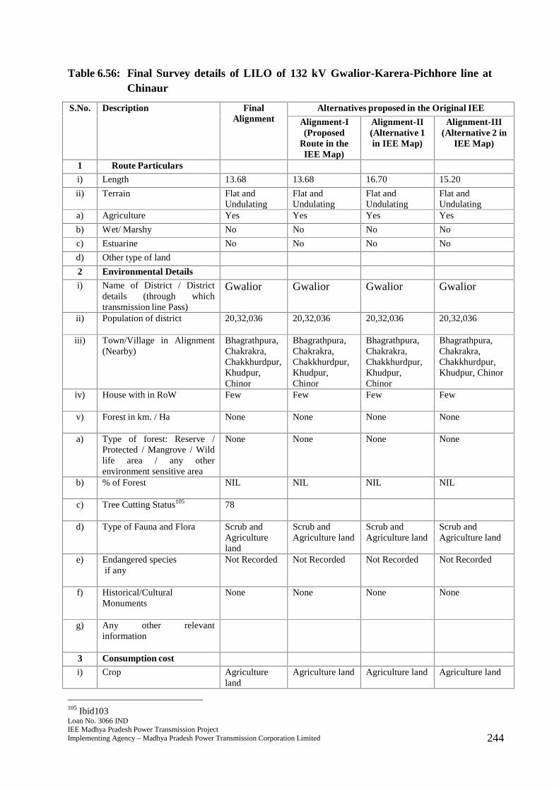
Loan No. 3066 INDIEE Madhya Pradesh Power Transmission ProjectImplementing Agency – Madhya Pradesh Power Transmission Corporation Limited 244
Table 6.56: Final Survey details of LILO of 132 kV Gwalior-Karera-Pichhore line atChinaur
S.No. Description FinalAlignment
Alternatives proposed in the Original IEE
Alignment-I(Proposed
Route in theIEE Map)
Alignment-II(Alternative 1in IEE Map)
Alignment-III(Alternative 2 in
IEE Map)
1 Route Particulars
i) Length 13.68 13.68 16.70 15.20
ii) Terrain Flat andUndulating
Flat andUndulating
Flat andUndulating
Flat andUndulating
a) Agriculture Yes Yes Yes Yes
b) Wet/ Marshy No No No No
c) Estuarine No No No No
d) Other type of land
2 Environmental Details
i) Name of District / Districtdetails (through whichtransmission line Pass)
Gwalior Gwalior Gwalior Gwalior
ii) Population of district 20,32,036 20,32,036 20,32,036 20,32,036
iii) Town/Village in Alignment(Nearby)
Bhagrathpura,Chakrakra,Chakkhurdpur,Khudpur,Chinor
Bhagrathpura,Chakrakra,Chakkhurdpur,Khudpur,Chinor
Bhagrathpura,Chakrakra,Chakkhurdpur,Khudpur,Chinor
Bhagrathpura,Chakrakra,Chakkhurdpur,Khudpur, Chinor
iv) House with in RoW Few Few Few Few
v) Forest in km. / Ha None None None None
a) Type of forest: Reserve /Protected / Mangrove / Wildlife area / any otherenvironment sensitive area
None None None None
b) % of Forest NIL NIL NIL NIL
c) Tree Cutting Status105 78
d) Type of Fauna and Flora Scrub andAgricultureland
Scrub andAgriculture land
Scrub andAgriculture land
Scrub andAgriculture land
e) Endangered speciesif any
Not Recorded Not Recorded Not Recorded Not Recorded
f) Historical/CulturalMonuments
None None None None
g) Any other relevantinformation
3 Consumption cost
i) Crop Agricultureland
Agriculture land Agriculture land Agriculture land
105 Ibid103
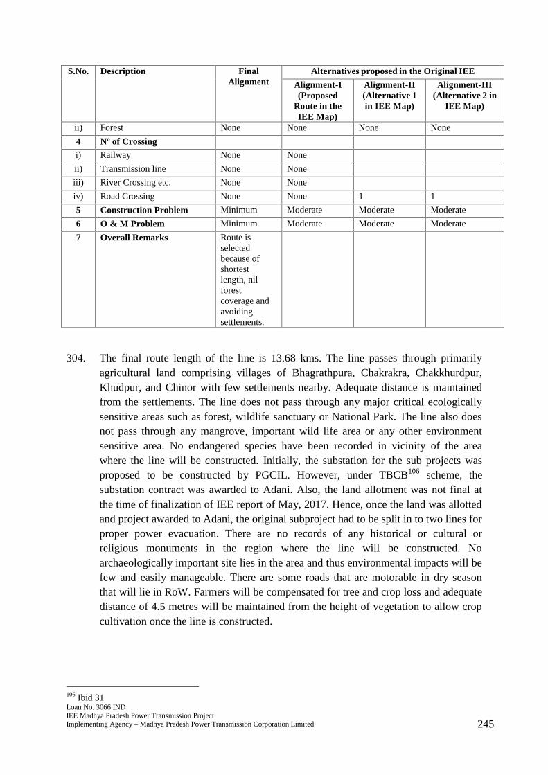
Loan No. 3066 INDIEE Madhya Pradesh Power Transmission ProjectImplementing Agency – Madhya Pradesh Power Transmission Corporation Limited 245
S.No. Description FinalAlignment
Alternatives proposed in the Original IEE
Alignment-I(Proposed
Route in theIEE Map)
Alignment-II(Alternative 1in IEE Map)
Alignment-III(Alternative 2 in
IEE Map)
ii) Forest None None None None
4 Nº of Crossing
i) Railway None None
ii) Transmission line None None
iii) River Crossing etc. None None
iv) Road Crossing None None 1 1
5 Construction Problem Minimum Moderate Moderate Moderate
6 O & M Problem Minimum Moderate Moderate Moderate
7 Overall Remarks Route isselectedbecause ofshortestlength, nilforestcoverage andavoidingsettlements.
304. The final route length of the line is 13.68 kms. The line passes through primarilyagricultural land comprising villages of Bhagrathpura, Chakrakra, Chakkhurdpur,Khudpur, and Chinor with few settlements nearby. Adequate distance is maintainedfrom the settlements. The line does not pass through any major critical ecologicallysensitive areas such as forest, wildlife sanctuary or National Park. The line also doesnot pass through any mangrove, important wild life area or any other environmentsensitive area. No endangered species have been recorded in vicinity of the areawhere the line will be constructed. Initially, the substation for the sub projects wasproposed to be constructed by PGCIL. However, under TBCB106 scheme, thesubstation contract was awarded to Adani. Also, the land allotment was not final atthe time of finalization of IEE report of May, 2017. Hence, once the land was allottedand project awarded to Adani, the original subproject had to be split in to two lines forproper power evacuation. There are no records of any historical or cultural orreligious monuments in the region where the line will be constructed. Noarchaeologically important site lies in the area and thus environmental impacts will befew and easily manageable. There are some roads that are motorable in dry seasonthat will lie in RoW. Farmers will be compensated for tree and crop loss and adequatedistance of 4.5 metres will be maintained from the height of vegetation to allow cropcultivation once the line is constructed.
106 Ibid 31
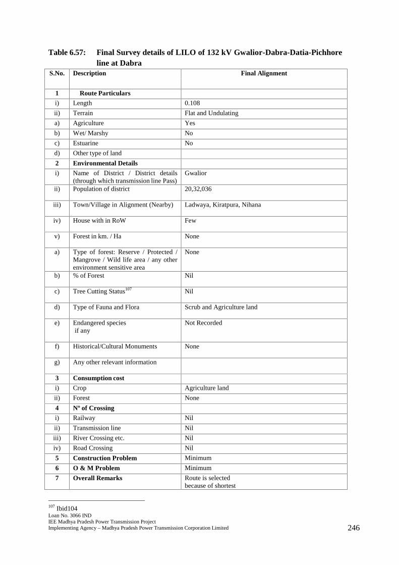
Loan No. 3066 INDIEE Madhya Pradesh Power Transmission ProjectImplementing Agency – Madhya Pradesh Power Transmission Corporation Limited 246
Table 6.57: Final Survey details of LILO of 132 kV Gwalior-Dabra-Datia-Pichhoreline at Dabra
S.No. Description Final Alignment
1 Route Particulars
i) Length 0.108
ii) Terrain Flat and Undulating
a) Agriculture Yes
b) Wet/ Marshy No
c) Estuarine No
d) Other type of land
2 Environmental Details
i) Name of District / District details(through which transmission line Pass)
Gwalior
ii) Population of district 20,32,036
iii) Town/Village in Alignment (Nearby) Ladwaya, Kiratpura, Nihana
iv) House with in RoW Few
v) Forest in km. / Ha None
a) Type of forest: Reserve / Protected /Mangrove / Wild life area / any otherenvironment sensitive area
None
b) % of Forest Nil
c) Tree Cutting Status107 Nil
d) Type of Fauna and Flora Scrub and Agriculture land
e) Endangered speciesif any
Not Recorded
f) Historical/Cultural Monuments None
g) Any other relevant information
3 Consumption cost
i) Crop Agriculture land
ii) Forest None
4 Nº of Crossing
i) Railway Nil
ii) Transmission line Nil
iii) River Crossing etc. Nil
iv) Road Crossing Nil
5 Construction Problem Minimum
6 O & M Problem Minimum
7 Overall Remarks Route is selectedbecause of shortest
107 Ibid104
Loan No. 3066 INDIEE Madhya Pradesh Power Transmission ProjectImplementing Agency – Madhya Pradesh Power Transmission Corporation Limited 247
S.No. Description Final Alignment
length, nilforest coverage andavoiding settlements.
305. The final route length of the line is 0.108 kms. The line passes through primarilyagricultural land comprising villages of Ladwaya, Kiratpura and Nihana with fewsettlements nearby. Adequate distance is maintained from the settlements. The linedoes not pass through any major critical ecologically sensitive areas such as forest,wildlife sanctuary or National Park. The line also does not pass through anymangrove, important wild life area or any other environment sensitive area. Noendangered species have been recorded in vicinity of the area where the line will beconstructed. Initially, the substation for the sub projects was proposed to beconstructed by PGCIL. However, under TBCB108 scheme, the substation contract wasawarded to Adani. Also, the land allotment was not final at the time of finalization ofIEE report of May, 2017. Hence, once the land was allotted and project awarded toAdani, the original subproject had to be split into two lines for proper powerevacuation. There are no records of any historical or cultural or religious monumentsin the region where the line will be constructed. No archaeologically important sitelies in the area and thus environmental impacts will be few and easily manageable.There are some roads that are motorable in dry season that will lie in RoW. Farmerswill be compensated for tree and crop loss and adequate distance of 4.5 metres will bemaintained from the height of vegetation to allow crop cultivation once the line isconstructed.
108 Ibid 33
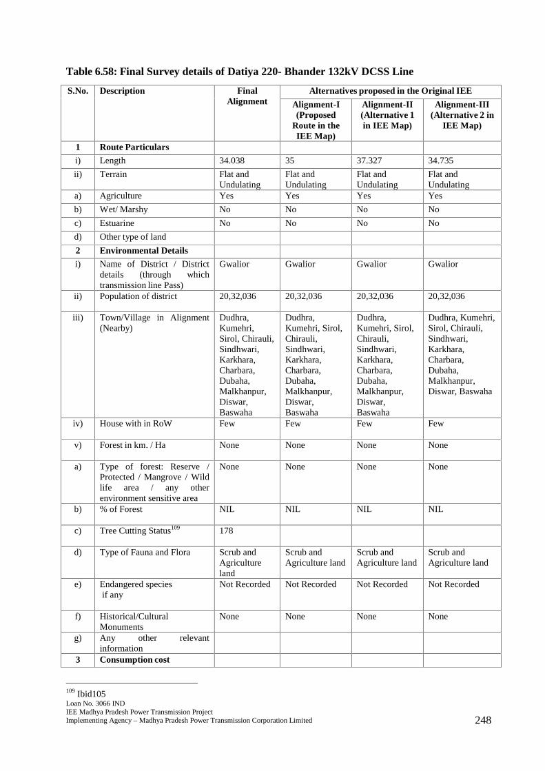
Loan No. 3066 INDIEE Madhya Pradesh Power Transmission ProjectImplementing Agency – Madhya Pradesh Power Transmission Corporation Limited 248
Table 6.58: Final Survey details of Datiya 220- Bhander 132kV DCSS Line
S.No. Description FinalAlignment
Alternatives proposed in the Original IEE
Alignment-I(Proposed
Route in theIEE Map)
Alignment-II(Alternative 1in IEE Map)
Alignment-III(Alternative 2 in
IEE Map)
1 Route Particulars
i) Length 34.038 35 37.327 34.735
ii) Terrain Flat andUndulating
Flat andUndulating
Flat andUndulating
Flat andUndulating
a) Agriculture Yes Yes Yes Yes
b) Wet/ Marshy No No No No
c) Estuarine No No No No
d) Other type of land
2 Environmental Details
i) Name of District / Districtdetails (through whichtransmission line Pass)
Gwalior Gwalior Gwalior Gwalior
ii) Population of district 20,32,036 20,32,036 20,32,036 20,32,036
iii) Town/Village in Alignment(Nearby)
Dudhra,Kumehri,Sirol, Chirauli,Sindhwari,Karkhara,Charbara,Dubaha,Malkhanpur,Diswar,Baswaha
Dudhra,Kumehri, Sirol,Chirauli,Sindhwari,Karkhara,Charbara,Dubaha,Malkhanpur,Diswar,Baswaha
Dudhra,Kumehri, Sirol,Chirauli,Sindhwari,Karkhara,Charbara,Dubaha,Malkhanpur,Diswar,Baswaha
Dudhra, Kumehri,Sirol, Chirauli,Sindhwari,Karkhara,Charbara,Dubaha,Malkhanpur,Diswar, Baswaha
iv) House with in RoW Few Few Few Few
v) Forest in km. / Ha None None None None
a) Type of forest: Reserve /Protected / Mangrove / Wildlife area / any otherenvironment sensitive area
None None None None
b) % of Forest NIL NIL NIL NIL
c) Tree Cutting Status109 178
d) Type of Fauna and Flora Scrub andAgricultureland
Scrub andAgriculture land
Scrub andAgriculture land
Scrub andAgriculture land
e) Endangered speciesif any
Not Recorded Not Recorded Not Recorded Not Recorded
f) Historical/CulturalMonuments
None None None None
g) Any other relevantinformation
3 Consumption cost
109 Ibid105
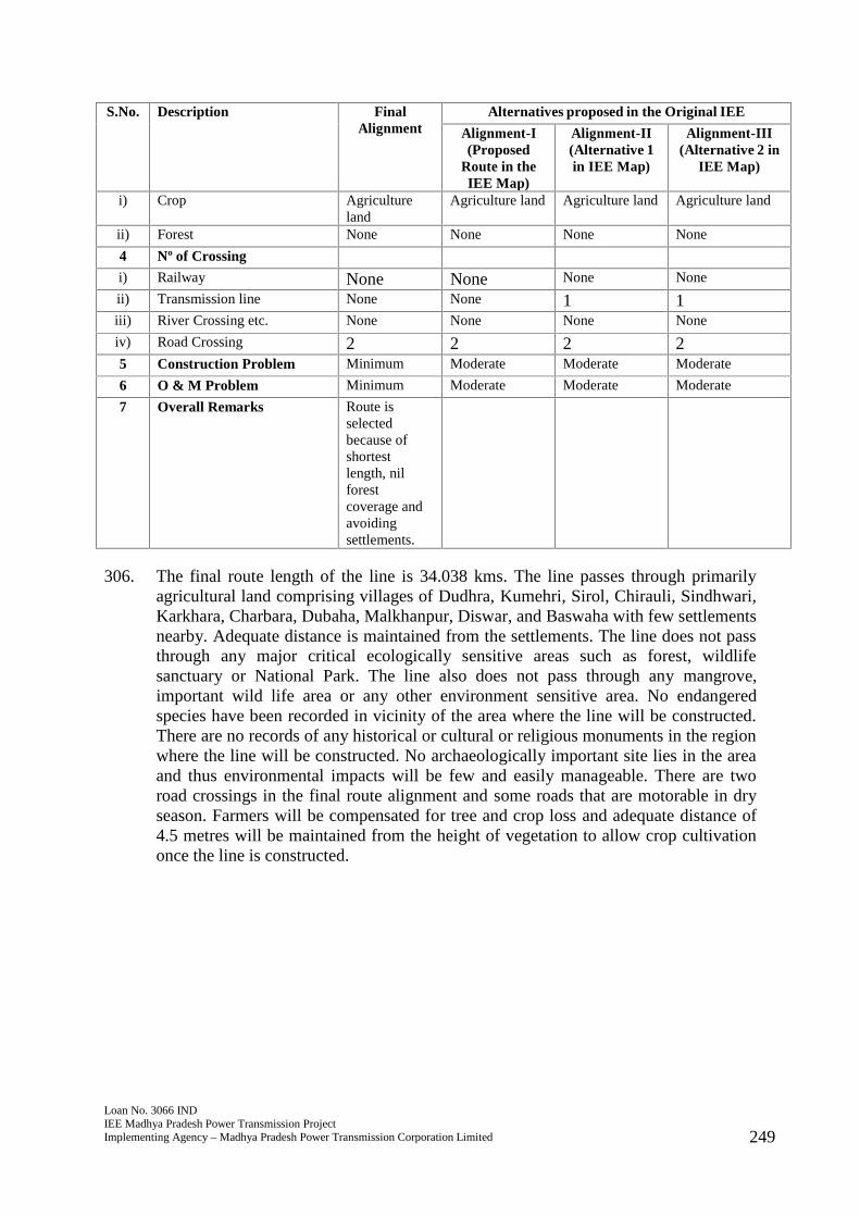
Loan No. 3066 INDIEE Madhya Pradesh Power Transmission ProjectImplementing Agency – Madhya Pradesh Power Transmission Corporation Limited 249
S.No. Description FinalAlignment
Alternatives proposed in the Original IEE
Alignment-I(Proposed
Route in theIEE Map)
Alignment-II(Alternative 1in IEE Map)
Alignment-III(Alternative 2 in
IEE Map)
i) Crop Agricultureland
Agriculture land Agriculture land Agriculture land
ii) Forest None None None None
4 Nº of Crossing
i) Railway None None None None
ii) Transmission line None None 1 1iii) River Crossing etc. None None None None
iv) Road Crossing 2 2 2 25 Construction Problem Minimum Moderate Moderate Moderate
6 O & M Problem Minimum Moderate Moderate Moderate
7 Overall Remarks Route isselectedbecause ofshortestlength, nilforestcoverage andavoidingsettlements.
306. The final route length of the line is 34.038 kms. The line passes through primarilyagricultural land comprising villages of Dudhra, Kumehri, Sirol, Chirauli, Sindhwari,Karkhara, Charbara, Dubaha, Malkhanpur, Diswar, and Baswaha with few settlementsnearby. Adequate distance is maintained from the settlements. The line does not passthrough any major critical ecologically sensitive areas such as forest, wildlifesanctuary or National Park. The line also does not pass through any mangrove,important wild life area or any other environment sensitive area. No endangeredspecies have been recorded in vicinity of the area where the line will be constructed.There are no records of any historical or cultural or religious monuments in the regionwhere the line will be constructed. No archaeologically important site lies in the areaand thus environmental impacts will be few and easily manageable. There are tworoad crossings in the final route alignment and some roads that are motorable in dryseason. Farmers will be compensated for tree and crop loss and adequate distance of4.5 metres will be maintained from the height of vegetation to allow crop cultivationonce the line is constructed.

Loan No. 3066 INDIEE Madhya Pradesh Power Transmission ProjectImplementing Agency – Madhya Pradesh Power Transmission Corporation Limited 250
Table 6.59: Final Survey details of Mehgaon 220-Pratappura 132kV DCSS line
S.No. Description FinalAlignment
Alternatives proposed in the Original IEE
Alignment-I(Proposed
Route in theIEE Map)
Alignment-II(Alternative 1in IEE Map)
Alignment-III(Alternative 2 in
IEE Map)
1 Route Particulars
i) Length 29.74 30 28 25.9
ii) Terrain Flat andUndulating
Flat andUndulating
Flat andUndulating
Flat andUndulating
a) Agriculture Yes Yes Yes Yes
b) Wet/ Marshy No No No No
c) Estuarine No No No No
d) Other type of land
2 Environmental Details
i) Name of District / Districtdetails (through whichtransmission line Pass)
Gwalior Gwalior Gwalior Gwalior
ii) Population of district 20,32,036 20,32,036 20,32,036 20,32,036
iii) Town/Village in Alignment(Nearby)
Kheriya,Devri, Maroli,Meghpura,Pali, Pawai,Sehpura,Ashokkahar,Goprikhurd,Goprikhurdkapura,Nayapura,Sohra etc.
Kheriya, Devri,Maroli,Meghpura, Pali,Pawai, Sehpura,Ashokkahar,Goprikhurd,Goprikhurdkapura,Nayapura,Sohra.
Kheriya, Devri,Maroli,Meghpura, Pali,Pawai, Sehpura,Ashokkahar,Goprikhurd,Goprikhurdkapura,Nayapura,Sohra.
Kheriya, Devri,Maroli,Meghpura, Pali,Pawai, Sehpura,Ashokkahar,Goprikhurd,Goprikhurdkapura, Nayapura,Sohra.
iv) House with in RoW Few Few Few Few
v) Forest in km. / Ha None None None None
a) Type of forest: Reserve /Protected / Mangrove / Wildlife area / any otherenvironment sensitive area
None None None None
b) % of Forest NIL NIL NIL NIL
c) Tree Cutting Status110 142
d) Type of Fauna and Flora Scrub andAgricultureland
Scrub andAgriculture land
Scrub andAgriculture land
Scrub andAgriculture land
e) Endangered speciesif any
Not Recorded Not Recorded Not Recorded Not Recorded
f) Historical/CulturalMonuments
None None None None
g) Any other relevantinformation
3 Consumption cost
i) Crop Agricultureland
Agriculture land Agriculture land Agriculture land
ii) Forest None None None None
110 Ibid106
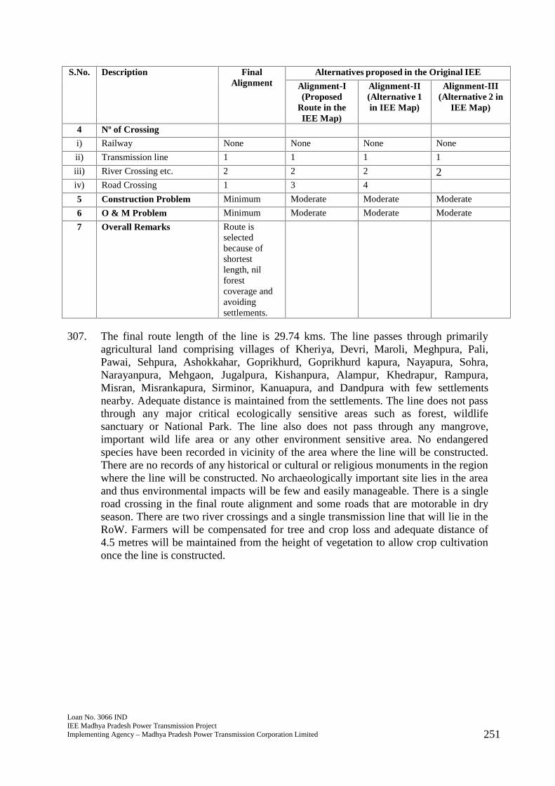
Loan No. 3066 INDIEE Madhya Pradesh Power Transmission ProjectImplementing Agency – Madhya Pradesh Power Transmission Corporation Limited 251
S.No. Description FinalAlignment
Alternatives proposed in the Original IEE
Alignment-I(Proposed
Route in theIEE Map)
Alignment-II(Alternative 1in IEE Map)
Alignment-III(Alternative 2 in
IEE Map)
4 Nº of Crossing
i) Railway None None None None
ii) Transmission line 1 1 1 1
iii) River Crossing etc. 2 2 2 2iv) Road Crossing 1 3 4
5 Construction Problem Minimum Moderate Moderate Moderate
6 O & M Problem Minimum Moderate Moderate Moderate
7 Overall Remarks Route isselectedbecause ofshortestlength, nilforestcoverage andavoidingsettlements.
307. The final route length of the line is 29.74 kms. The line passes through primarilyagricultural land comprising villages of Kheriya, Devri, Maroli, Meghpura, Pali,Pawai, Sehpura, Ashokkahar, Goprikhurd, Goprikhurd kapura, Nayapura, Sohra,Narayanpura, Mehgaon, Jugalpura, Kishanpura, Alampur, Khedrapur, Rampura,Misran, Misrankapura, Sirminor, Kanuapura, and Dandpura with few settlementsnearby. Adequate distance is maintained from the settlements. The line does not passthrough any major critical ecologically sensitive areas such as forest, wildlifesanctuary or National Park. The line also does not pass through any mangrove,important wild life area or any other environment sensitive area. No endangeredspecies have been recorded in vicinity of the area where the line will be constructed.There are no records of any historical or cultural or religious monuments in the regionwhere the line will be constructed. No archaeologically important site lies in the areaand thus environmental impacts will be few and easily manageable. There is a singleroad crossing in the final route alignment and some roads that are motorable in dryseason. There are two river crossings and a single transmission line that will lie in theRoW. Farmers will be compensated for tree and crop loss and adequate distance of4.5 metres will be maintained from the height of vegetation to allow crop cultivationonce the line is constructed.
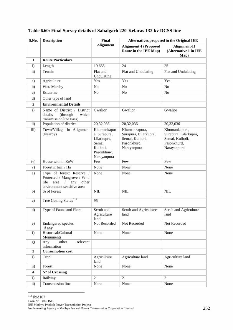
Loan No. 3066 INDIEE Madhya Pradesh Power Transmission ProjectImplementing Agency – Madhya Pradesh Power Transmission Corporation Limited 252
Table 6.60: Final Survey details of Sabalgarh 220-Kelaras 132 kv DCSS line
S.No. Description FinalAlignment
Alternatives proposed in the Original IEE
Alignment-I (ProposedRoute in the IEE Map)
Alignment-II(Alternative 1 in IEE
Map)1 Route Particulars
i) Length 19.655 24 25
ii) Terrain Flat andUndulating
Flat and Undulating Flat and Undulating
a) Agriculture Yes Yes Yes
b) Wet/ Marshy No No No
c) Estuarine No No No
d) Other type of land
2 Environmental Details
i) Name of District / Districtdetails (through whichtransmission line Pass)
Gwalior Gwalior Gwalior
ii) Population of district 20,32,036 20,32,036 20,32,036
iii) Town/Village in Alignment(Nearby)
Khumankapura, Surapura,Lilarkupra,Semai,Kulholi,Pasonkhurd,Narayanpura
Khumankapura,Surapura, Lilarkupra,Semai, Kulholi,Pasonkhurd,Narayanpura
Khumankapura,Surapura, Lilarkupra,Semai, Kulholi,Pasonkhurd,Narayanpura
iv) House with in RoW Few Few Few
v) Forest in km. / Ha None None None
a) Type of forest: Reserve /Protected / Mangrove / Wildlife area / any otherenvironment sensitive area
None None None
b) % of Forest NIL NIL NIL
c) Tree Cutting Status111 95
d) Type of Fauna and Flora Scrub andAgricultureland
Scrub and Agricultureland
Scrub and Agricultureland
e) Endangered speciesif any
Not Recorded Not Recorded Not Recorded
f) Historical/CulturalMonuments
None None None
g) Any other relevantinformation
3 Consumption cost
i) Crop Agricultureland
Agriculture land Agriculture land
ii) Forest None None None
4 Nº of Crossing
i) Railway 2 2 2
ii) Transmission line None None None
111 Ibid107
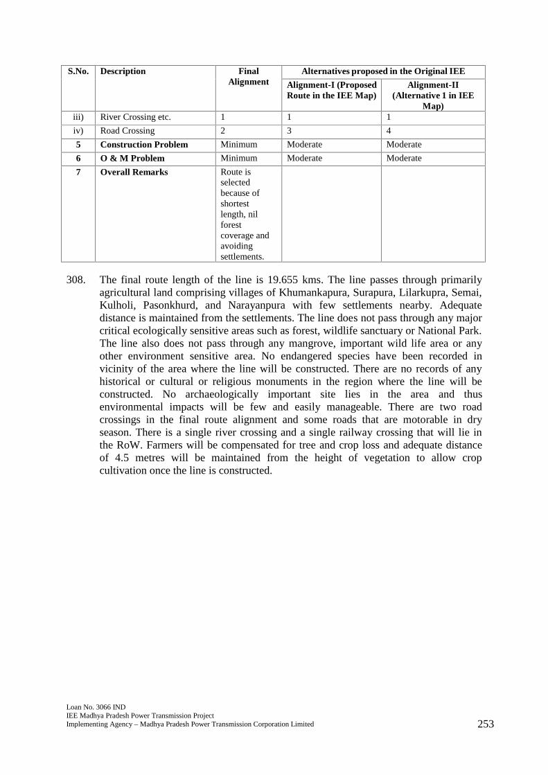
Loan No. 3066 INDIEE Madhya Pradesh Power Transmission ProjectImplementing Agency – Madhya Pradesh Power Transmission Corporation Limited 253
S.No. Description FinalAlignment
Alternatives proposed in the Original IEE
Alignment-I (ProposedRoute in the IEE Map)
Alignment-II(Alternative 1 in IEE
Map)iii) River Crossing etc. 1 1 1
iv) Road Crossing 2 3 4
5 Construction Problem Minimum Moderate Moderate
6 O & M Problem Minimum Moderate Moderate
7 Overall Remarks Route isselectedbecause ofshortestlength, nilforestcoverage andavoidingsettlements.
308. The final route length of the line is 19.655 kms. The line passes through primarilyagricultural land comprising villages of Khumankapura, Surapura, Lilarkupra, Semai,Kulholi, Pasonkhurd, and Narayanpura with few settlements nearby. Adequatedistance is maintained from the settlements. The line does not pass through any majorcritical ecologically sensitive areas such as forest, wildlife sanctuary or National Park.The line also does not pass through any mangrove, important wild life area or anyother environment sensitive area. No endangered species have been recorded invicinity of the area where the line will be constructed. There are no records of anyhistorical or cultural or religious monuments in the region where the line will beconstructed. No archaeologically important site lies in the area and thusenvironmental impacts will be few and easily manageable. There are two roadcrossings in the final route alignment and some roads that are motorable in dryseason. There is a single river crossing and a single railway crossing that will lie inthe RoW. Farmers will be compensated for tree and crop loss and adequate distanceof 4.5 metres will be maintained from the height of vegetation to allow cropcultivation once the line is constructed.
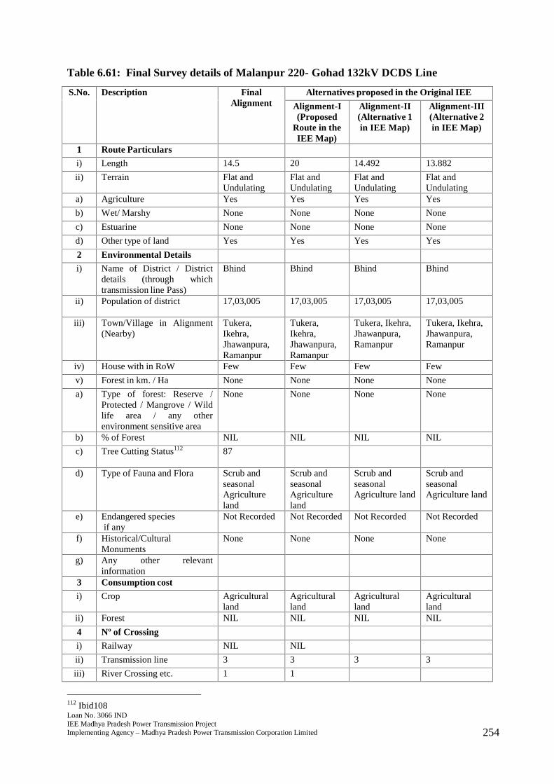
Loan No. 3066 INDIEE Madhya Pradesh Power Transmission ProjectImplementing Agency – Madhya Pradesh Power Transmission Corporation Limited 254
Table 6.61: Final Survey details of Malanpur 220- Gohad 132kV DCDS Line
S.No. Description FinalAlignment
Alternatives proposed in the Original IEE
Alignment-I(Proposed
Route in theIEE Map)
Alignment-II(Alternative 1in IEE Map)
Alignment-III(Alternative 2in IEE Map)
1 Route Particulars
i) Length 14.5 20 14.492 13.882
ii) Terrain Flat andUndulating
Flat andUndulating
Flat andUndulating
Flat andUndulating
a) Agriculture Yes Yes Yes Yes
b) Wet/ Marshy None None None None
c) Estuarine None None None None
d) Other type of land Yes Yes Yes Yes
2 Environmental Details
i) Name of District / Districtdetails (through whichtransmission line Pass)
Bhind Bhind Bhind Bhind
ii) Population of district 17,03,005 17,03,005 17,03,005 17,03,005
iii) Town/Village in Alignment(Nearby)
Tukera,Ikehra,Jhawanpura,Ramanpur
Tukera,Ikehra,Jhawanpura,Ramanpur
Tukera, Ikehra,Jhawanpura,Ramanpur
Tukera, Ikehra,Jhawanpura,Ramanpur
iv) House with in RoW Few Few Few Few
v) Forest in km. / Ha None None None None
a) Type of forest: Reserve /Protected / Mangrove / Wildlife area / any otherenvironment sensitive area
None None None None
b) % of Forest NIL NIL NIL NIL
c) Tree Cutting Status112 87
d) Type of Fauna and Flora Scrub andseasonalAgricultureland
Scrub andseasonalAgricultureland
Scrub andseasonalAgriculture land
Scrub andseasonalAgriculture land
e) Endangered speciesif any
Not Recorded Not Recorded Not Recorded Not Recorded
f) Historical/CulturalMonuments
None None None None
g) Any other relevantinformation
3 Consumption cost
i) Crop Agriculturalland
Agriculturalland
Agriculturalland
Agriculturalland
ii) Forest NIL NIL NIL NIL
4 Nº of Crossing
i) Railway NIL NIL
ii) Transmission line 3 3 3 3
iii) River Crossing etc. 1 1
112 Ibid108
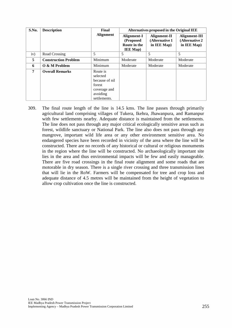
Loan No. 3066 INDIEE Madhya Pradesh Power Transmission ProjectImplementing Agency – Madhya Pradesh Power Transmission Corporation Limited 255
S.No. Description FinalAlignment
Alternatives proposed in the Original IEE
Alignment-I(Proposed
Route in theIEE Map)
Alignment-II(Alternative 1in IEE Map)
Alignment-III(Alternative 2in IEE Map)
iv) Road Crossing 5 5 5 5
5 Construction Problem Minimum Moderate Moderate Moderate
6 O & M Problem Minimum Moderate Moderate Moderate
7 Overall Remarks Route isselectedbecause of nilforestcoverage andavoidingsettlements.
309. The final route length of the line is 14.5 kms. The line passes through primarilyagricultural land comprising villages of Tukera, Ikehra, Jhawanpura, and Ramanpurwith few settlements nearby. Adequate distance is maintained from the settlements.The line does not pass through any major critical ecologically sensitive areas such asforest, wildlife sanctuary or National Park. The line also does not pass through anymangrove, important wild life area or any other environment sensitive area. Noendangered species have been recorded in vicinity of the area where the line will beconstructed. There are no records of any historical or cultural or religious monumentsin the region where the line will be constructed. No archaeologically important sitelies in the area and thus environmental impacts will be few and easily manageable.There are five road crossings in the final route alignment and some roads that aremotorable in dry season. There is a single river crossing and three transmission linesthat will lie in the RoW. Farmers will be compensated for tree and crop loss andadequate distance of 4.5 metres will be maintained from the height of vegetation toallow crop cultivation once the line is constructed.
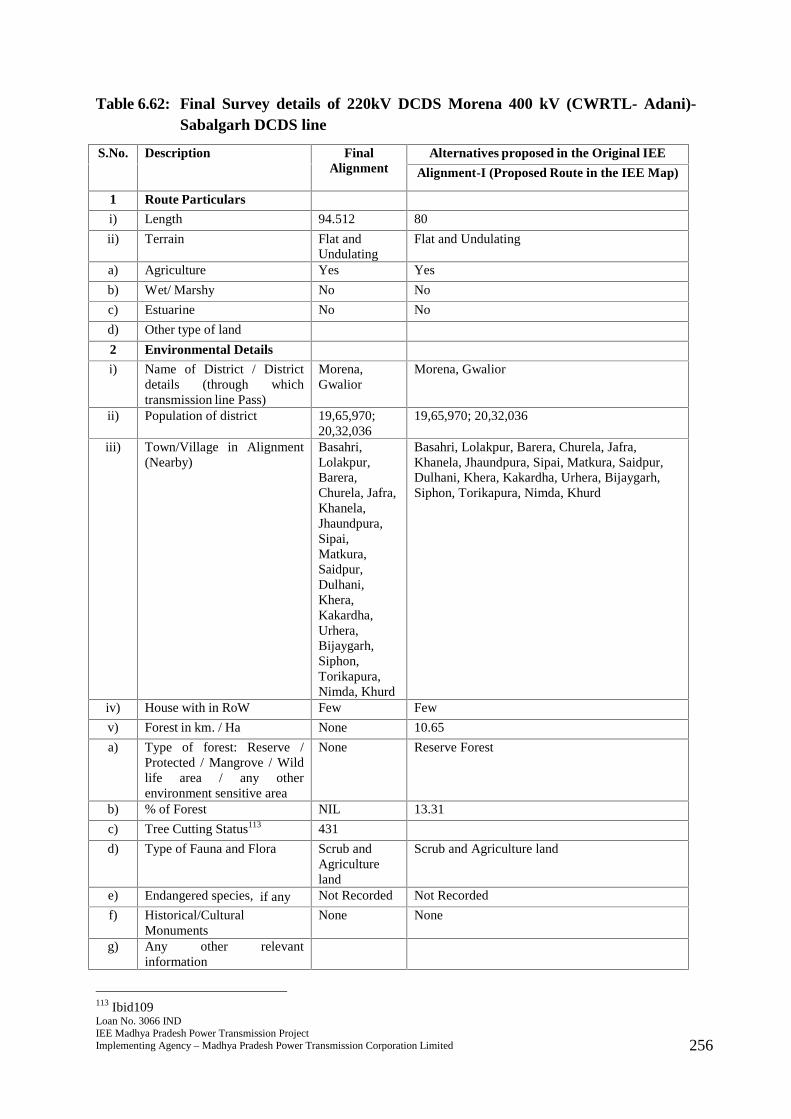
Loan No. 3066 INDIEE Madhya Pradesh Power Transmission ProjectImplementing Agency – Madhya Pradesh Power Transmission Corporation Limited 256
Table 6.62: Final Survey details of 220kV DCDS Morena 400 kV (CWRTL- Adani)-Sabalgarh DCDS line
S.No. Description FinalAlignment
Alternatives proposed in the Original IEE
Alignment-I (Proposed Route in the IEE Map)
1 Route Particulars
i) Length 94.512 80
ii) Terrain Flat andUndulating
Flat and Undulating
a) Agriculture Yes Yes
b) Wet/ Marshy No No
c) Estuarine No No
d) Other type of land
2 Environmental Details
i) Name of District / Districtdetails (through whichtransmission line Pass)
Morena,Gwalior
Morena, Gwalior
ii) Population of district 19,65,970;20,32,036
19,65,970; 20,32,036
iii) Town/Village in Alignment(Nearby)
Basahri,Lolakpur,Barera,Churela, Jafra,Khanela,Jhaundpura,Sipai,Matkura,Saidpur,Dulhani,Khera,Kakardha,Urhera,Bijaygarh,Siphon,Torikapura,Nimda, Khurd
Basahri, Lolakpur, Barera, Churela, Jafra,Khanela, Jhaundpura, Sipai, Matkura, Saidpur,Dulhani, Khera, Kakardha, Urhera, Bijaygarh,Siphon, Torikapura, Nimda, Khurd
iv) House with in RoW Few Few
v) Forest in km. / Ha None 10.65
a) Type of forest: Reserve /Protected / Mangrove / Wildlife area / any otherenvironment sensitive area
None Reserve Forest
b) % of Forest NIL 13.31
c) Tree Cutting Status113 431
d) Type of Fauna and Flora Scrub andAgricultureland
Scrub and Agriculture land
e) Endangered species, if any Not Recorded Not Recorded
f) Historical/CulturalMonuments
None None
g) Any other relevantinformation
113 Ibid109
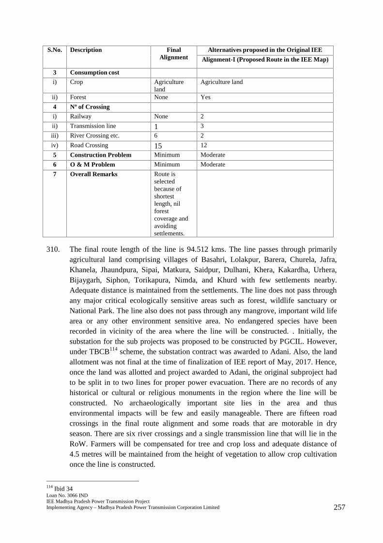
Loan No. 3066 INDIEE Madhya Pradesh Power Transmission ProjectImplementing Agency – Madhya Pradesh Power Transmission Corporation Limited 257
S.No. Description FinalAlignment
Alternatives proposed in the Original IEE
Alignment-I (Proposed Route in the IEE Map)
3 Consumption cost
i) Crop Agricultureland
Agriculture land
ii) Forest None Yes
4 Nº of Crossing
i) Railway None 2
ii) Transmission line 1 3
iii) River Crossing etc. 6 2
iv) Road Crossing 15 12
5 Construction Problem Minimum Moderate
6 O & M Problem Minimum Moderate
7 Overall Remarks Route isselectedbecause ofshortestlength, nilforestcoverage andavoidingsettlements.
310. The final route length of the line is 94.512 kms. The line passes through primarilyagricultural land comprising villages of Basahri, Lolakpur, Barera, Churela, Jafra,Khanela, Jhaundpura, Sipai, Matkura, Saidpur, Dulhani, Khera, Kakardha, Urhera,Bijaygarh, Siphon, Torikapura, Nimda, and Khurd with few settlements nearby.Adequate distance is maintained from the settlements. The line does not pass throughany major critical ecologically sensitive areas such as forest, wildlife sanctuary orNational Park. The line also does not pass through any mangrove, important wild lifearea or any other environment sensitive area. No endangered species have beenrecorded in vicinity of the area where the line will be constructed. . Initially, thesubstation for the sub projects was proposed to be constructed by PGCIL. However,under TBCB114 scheme, the substation contract was awarded to Adani. Also, the landallotment was not final at the time of finalization of IEE report of May, 2017. Hence,once the land was allotted and project awarded to Adani, the original subproject hadto be split in to two lines for proper power evacuation. There are no records of anyhistorical or cultural or religious monuments in the region where the line will beconstructed. No archaeologically important site lies in the area and thusenvironmental impacts will be few and easily manageable. There are fifteen roadcrossings in the final route alignment and some roads that are motorable in dryseason. There are six river crossings and a single transmission line that will lie in theRoW. Farmers will be compensated for tree and crop loss and adequate distance of4.5 metres will be maintained from the height of vegetation to allow crop cultivationonce the line is constructed.
114 Ibid 34
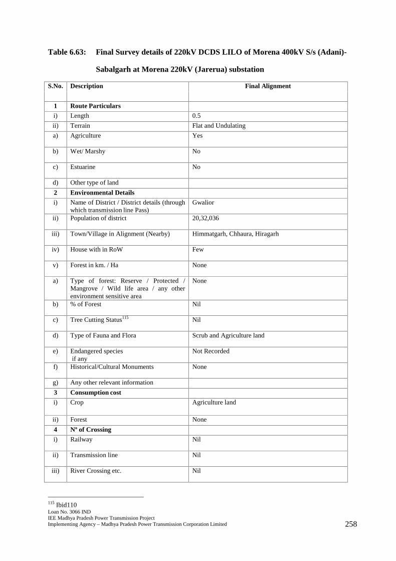
Loan No. 3066 INDIEE Madhya Pradesh Power Transmission ProjectImplementing Agency – Madhya Pradesh Power Transmission Corporation Limited 258
Table 6.63: Final Survey details of 220kV DCDS LILO of Morena 400kV S/s (Adani)-
Sabalgarh at Morena 220kV (Jarerua) substation
S.No. Description Final Alignment
1 Route Particulars
i) Length 0.5
ii) Terrain Flat and Undulating
a) Agriculture Yes
b) Wet/ Marshy No
c) Estuarine No
d) Other type of land
2 Environmental Details
i) Name of District / District details (throughwhich transmission line Pass)
Gwalior
ii) Population of district 20,32,036
iii) Town/Village in Alignment (Nearby) Himmatgarh, Chhaura, Hiragarh
iv) House with in RoW Few
v) Forest in km. / Ha None
a) Type of forest: Reserve / Protected /Mangrove / Wild life area / any otherenvironment sensitive area
None
b) % of Forest Nil
c) Tree Cutting Status115 Nil
d) Type of Fauna and Flora Scrub and Agriculture land
e) Endangered speciesif any
Not Recorded
f) Historical/Cultural Monuments None
g) Any other relevant information
3 Consumption cost
i) Crop Agriculture land
ii) Forest None
4 Nº of Crossing
i) Railway Nil
ii) Transmission line Nil
iii) River Crossing etc. Nil
115 Ibid110
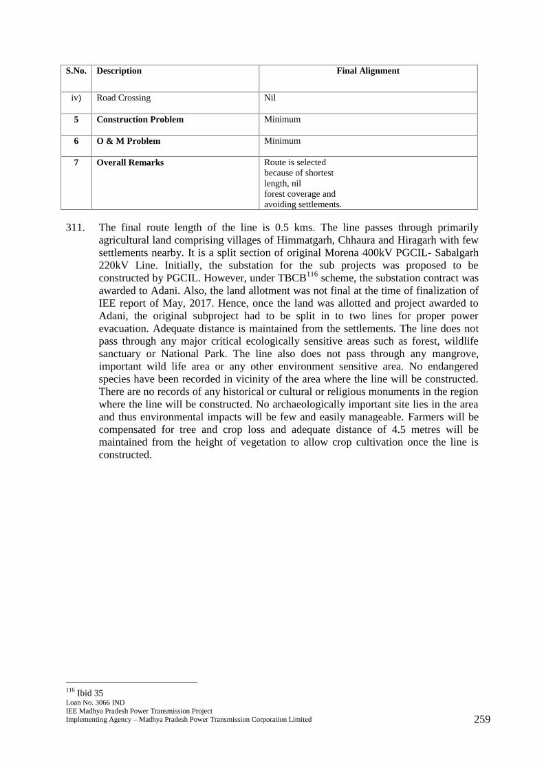
Loan No. 3066 INDIEE Madhya Pradesh Power Transmission ProjectImplementing Agency – Madhya Pradesh Power Transmission Corporation Limited 259
S.No. Description Final Alignment
iv) Road Crossing Nil
5 Construction Problem Minimum
6 O & M Problem Minimum
7 Overall Remarks Route is selectedbecause of shortestlength, nilforest coverage andavoiding settlements.
311. The final route length of the line is 0.5 kms. The line passes through primarilyagricultural land comprising villages of Himmatgarh, Chhaura and Hiragarh with fewsettlements nearby. It is a split section of original Morena 400kV PGCIL- Sabalgarh220kV Line. Initially, the substation for the sub projects was proposed to beconstructed by PGCIL. However, under TBCB116 scheme, the substation contract wasawarded to Adani. Also, the land allotment was not final at the time of finalization ofIEE report of May, 2017. Hence, once the land was allotted and project awarded toAdani, the original subproject had to be split in to two lines for proper powerevacuation. Adequate distance is maintained from the settlements. The line does notpass through any major critical ecologically sensitive areas such as forest, wildlifesanctuary or National Park. The line also does not pass through any mangrove,important wild life area or any other environment sensitive area. No endangeredspecies have been recorded in vicinity of the area where the line will be constructed.There are no records of any historical or cultural or religious monuments in the regionwhere the line will be constructed. No archaeologically important site lies in the areaand thus environmental impacts will be few and easily manageable. Farmers will becompensated for tree and crop loss and adequate distance of 4.5 metres will bemaintained from the height of vegetation to allow crop cultivation once the line isconstructed.
116 Ibid 35
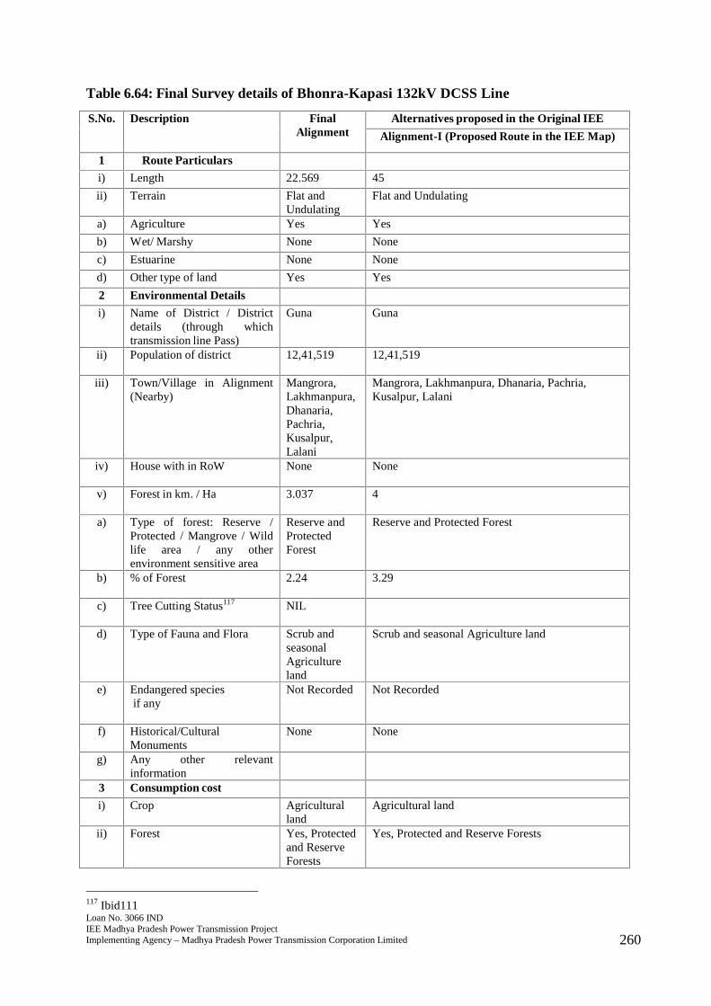
Loan No. 3066 INDIEE Madhya Pradesh Power Transmission ProjectImplementing Agency – Madhya Pradesh Power Transmission Corporation Limited 260
Table 6.64: Final Survey details of Bhonra-Kapasi 132kV DCSS Line
S.No. Description FinalAlignment
Alternatives proposed in the Original IEE
Alignment-I (Proposed Route in the IEE Map)
1 Route Particulars
i) Length 22.569 45
ii) Terrain Flat andUndulating
Flat and Undulating
a) Agriculture Yes Yes
b) Wet/ Marshy None None
c) Estuarine None None
d) Other type of land Yes Yes
2 Environmental Details
i) Name of District / Districtdetails (through whichtransmission line Pass)
Guna Guna
ii) Population of district 12,41,519 12,41,519
iii) Town/Village in Alignment(Nearby)
Mangrora,Lakhmanpura,Dhanaria,Pachria,Kusalpur,Lalani
Mangrora, Lakhmanpura, Dhanaria, Pachria,Kusalpur, Lalani
iv) House with in RoW None None
v) Forest in km. / Ha 3.037 4
a) Type of forest: Reserve /Protected / Mangrove / Wildlife area / any otherenvironment sensitive area
Reserve andProtectedForest
Reserve and Protected Forest
b) % of Forest 2.24 3.29
c) Tree Cutting Status117 NIL
d) Type of Fauna and Flora Scrub andseasonalAgricultureland
Scrub and seasonal Agriculture land
e) Endangered speciesif any
Not Recorded Not Recorded
f) Historical/CulturalMonuments
None None
g) Any other relevantinformation
3 Consumption cost
i) Crop Agriculturalland
Agricultural land
ii) Forest Yes, Protectedand ReserveForests
Yes, Protected and Reserve Forests
117 Ibid111

Loan No. 3066 INDIEE Madhya Pradesh Power Transmission ProjectImplementing Agency – Madhya Pradesh Power Transmission Corporation Limited 261
S.No. Description FinalAlignment
Alternatives proposed in the Original IEE
Alignment-I (Proposed Route in the IEE Map)
4 Nº of Crossing
i) Railway NIL NIL
ii) Transmission line NIL NIL
iii) River Crossing etc. 1 1
iv) Road Crossing 3 3
5 Construction Problem Minimum Moderate
6 O & M Problem Minimum Moderate
7 Overall Remarks Route isselectedbecause of lessforestcoverage andavoidingsettlements.
312. The final route length of the line is 22.569 kms. The line passes through primarilyagricultural land comprising villages of Mangrora, Lakhmanpura, Dhanaria, Pachria,Kusalpur, and Lalani with few settlements nearby. Adequate distance is maintainedfrom the settlements. The line passes through 3.037 hectares of reserve forest andfforest clearance has been applied for. The line was revised to a length of 22.569 kmsas this has ensured reduced forest involvement of 2.24%. Civil works will not becommenced until the clearance has been obtained. The line does not pass through anymangrove, important wild life area or any other environment sensitive area. Noendangered species have been recorded in vicinity of the area where the line will beconstructed. There are no records of any historical or cultural or religious monumentsin the region where the line will be constructed. No archaeologically important sitelies in the area and thus environmental impacts will be few and easily manageable.There are three road crossings in the final route alignment and some roads that aremotorable in dry season. There is a single river crossing that will lie in the RoW.Farmers will be compensated for tree and crop loss and adequate distance of 4.5metres will be maintained from the height of vegetation to allow crop cultivation oncethe line is constructed.

Loan No. 3066 INDIEE Madhya Pradesh Power Transmission ProjectImplementing Agency – Madhya Pradesh Power Transmission Corporation Limited 262
Table 6.65: Final Survey details of Kolaras-Mada 132 kV DCSS Line
S.No. Description FinalAlignment
Alternatives proposed in the Original IEE
Alignment-I (Proposed Route in the IEE Map)
1 Route Particulars
i) Length 20.293 20
ii) Terrain Flat andUndulating
Flat and Undulating
a) Agriculture Yes Yes
b) Wet/ Marshy None None
c) Estuarine None None
d) Other type of land Yes Yes
2 Environmental Details
i) Name of District / Districtdetails (through whichtransmission line Pass)
Shivpuri Shivpuri
ii) Population of district 17,26,050 17,26,050
iii) Town/Village in Alignment(Nearby)
Manipura,Mohral,Khairdi,Kharee
Manipura, Mohral, Khairdi, Kharee
iv) House with in RoW Few Few
v) Forest in km. / Ha None None
a) Type of forest: Reserve /Protected / Mangrove / Wildlife area / any otherenvironment sensitive area
None None
b) % of Forest NIL NIL
c) Tree Cutting Status118 98
d) Type of Fauna and Flora Scrub andseasonalAgricultureland
Scrub and seasonal Agriculture land
e) Endangered speciesif any
Not Recorded Not Recorded
f) Historical/CulturalMonuments
None None
g) Any other relevantinformation
3 Consumption cost
i) Crop Agriculturalland
Agricultural land
ii) Forest NIL NIL
4 Nº of Crossing
i) Railway NIL NIL
118 Ibid112

Loan No. 3066 INDIEE Madhya Pradesh Power Transmission ProjectImplementing Agency – Madhya Pradesh Power Transmission Corporation Limited 263
S.No. Description FinalAlignment
Alternatives proposed in the Original IEE
Alignment-I (Proposed Route in the IEE Map)
ii) Transmission line 1 1
iii) River Crossing etc. 1 1
iv) Road Crossing 2 2
5 Construction Problem Minimum Moderate
6 O & M Problem Minimum Moderate
7 Overall Remarks Route isselectedbecause ofshortestlength, nilforestcoverage andavoidingsettlements.
313. The final route length of the line is 20.293 kms. The line passes through primarilyagricultural land comprising villages of Manipura, Mohral, Khairdi, and Kharee withfew settlements nearby. Adequate distance is maintained from the settlements. Inorder to maintain sufficient buffer distance from Akoda reserve forest and Sarjapurand Ramrai protected forests, the route length was further revised to 20.293 kms.The line does not pass through any major critical ecologically sensitive areas such asforest, wildlife sanctuary or National Park. The line also does not pass through anymangrove, important wild life area or any other environment sensitive area. Noendangered species have been recorded in vicinity of the area where the line will beconstructed. There are no records of any historical or cultural or religious monumentsin the region where the line will be constructed. No archaeologically important sitelies in the area and thus environmental impacts will be few and easily manageable.There are two road crossings in the final route alignment and some roads that aremotorable in dry season. There is a single river crossing and a single transmission linethat will lie in the RoW. Farmers will be compensated for tree and crop loss andadequate distance of 4.5 metres will be maintained from the height of vegetation toallow crop cultivation once the line is constructed.

Loan No. 3066 INDIEE Madhya Pradesh Power Transmission ProjectImplementing Agency – Madhya Pradesh Power Transmission Corporation Limited 264
Table 6.66: Final Survey details of 132 kV DCDS Guna 220- Bhonra line
S.No. Description FinalAlignment
Alternatives proposed in the Original IEE
Alignment-I (Proposed Route in the IEEMap)
1 Route Particulars
i) Length 25.374 20
ii) Terrain Flat andUndulating
Flat and Undulating
a) Agriculture Yes Yes
b) Wet/ Marshy No No
c) Estuarine No No
d) Other type of land
2 Environmental Details
i) Name of District / Districtdetails (through whichtransmission line Pass)
Guna, Sehore Guna, Sehore
ii) Population of district 12,41,519;13,11,332
12,41,519; 13,11,332
iii) Town/Village in Alignment(Nearby)
Bhurakheri,Dhaneria,Khadakpurchak
Bhurakheri, Dhaneria, Khadakpurchak
iv) House with in RoW Few Few
v) Forest in km. / Ha 6.09 7.82
a) Type of forest: Reserve /Protected / Mangrove / Wildlife area / any otherenvironment sensitive area
Reserve Forest Reserve Forest
b) % of Forest 9 14.5
c) Tree Cutting Status119 2352
d) Type of Fauna and Flora Scrub andAgricultureland
Scrub and Agriculture land
e) Endangered speciesif any
Not Recorded Not Recorded
f) Historical/CulturalMonuments
None None
g) Any other relevantinformation
3 Consumption cost
i) Crop Agricultureland
Agriculture land
ii) Forest Yes Yes
4 Nº of Crossing
i) Railway None None
119 Ibid 113

Loan No. 3066 INDIEE Madhya Pradesh Power Transmission ProjectImplementing Agency – Madhya Pradesh Power Transmission Corporation Limited 265
S.No. Description FinalAlignment
Alternatives proposed in the Original IEE
Alignment-I (Proposed Route in the IEEMap)
ii) Transmission line None None
iii) River Crossing etc. 3 3
iv) Road Crossing 5 6
5 Construction Problem Minimum Moderate
6 O & M Problem Minimum Moderate
7 Overall Remarks Route isselectedbecause ofshortestlength, nilforestcoverage andavoidingsettlements.
314. The final route length of the line is 25.374 kms. The line passes through primarilyagricultural land comprising villages of Bhurakheri, Dhaneria, and Khadakpurchakwith few settlements nearby. Adequate distance is maintained from the settlements.The line passes through 6.09 hectares of reserve forest andf forest clearance has beenapplied for. However, in order to reduce the forest involvement to 9%, the lengthwas revised to 25.374 kms. Civil works will not be commenced until the clearance hasbeen obtained. The line does not pass through any mangrove, important wild life areaor any other environment sensitive area. No endangered species have been recorded invicinity of the area where the line will be constructed. There are no records of anyhistorical or cultural or religious monuments in the region where the line will beconstructed. No archaeologically important site lies in the area and thusenvironmental impacts will be few and easily manageable. There are five roadcrossings in the final route alignment and some roads that are motorable in dryseason. There are three river crossings that will lie in the RoW. A total of 2352 tresswill be cut during the construction of the line and adequate distance of 4.5 metres willbe maintained from the height of vegetation to allow crop cultivation once the line isconstructed.
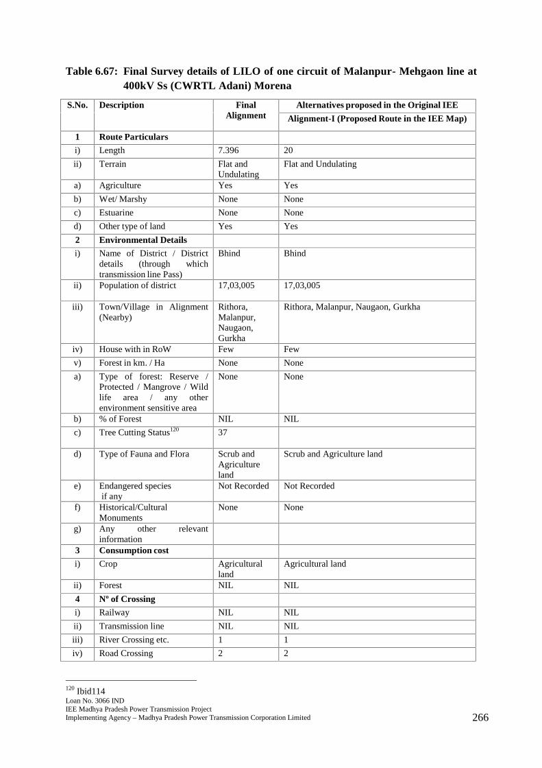
Loan No. 3066 INDIEE Madhya Pradesh Power Transmission ProjectImplementing Agency – Madhya Pradesh Power Transmission Corporation Limited 266
Table 6.67: Final Survey details of LILO of one circuit of Malanpur- Mehgaon line at400kV Ss (CWRTL Adani) Morena
S.No. Description FinalAlignment
Alternatives proposed in the Original IEE
Alignment-I (Proposed Route in the IEE Map)
1 Route Particulars
i) Length 7.396 20
ii) Terrain Flat andUndulating
Flat and Undulating
a) Agriculture Yes Yes
b) Wet/ Marshy None None
c) Estuarine None None
d) Other type of land Yes Yes
2 Environmental Details
i) Name of District / Districtdetails (through whichtransmission line Pass)
Bhind Bhind
ii) Population of district 17,03,005 17,03,005
iii) Town/Village in Alignment(Nearby)
Rithora,Malanpur,Naugaon,Gurkha
Rithora, Malanpur, Naugaon, Gurkha
iv) House with in RoW Few Few
v) Forest in km. / Ha None None
a) Type of forest: Reserve /Protected / Mangrove / Wildlife area / any otherenvironment sensitive area
None None
b) % of Forest NIL NIL
c) Tree Cutting Status120 37
d) Type of Fauna and Flora Scrub andAgricultureland
Scrub and Agriculture land
e) Endangered speciesif any
Not Recorded Not Recorded
f) Historical/CulturalMonuments
None None
g) Any other relevantinformation
3 Consumption cost
i) Crop Agriculturalland
Agricultural land
ii) Forest NIL NIL
4 Nº of Crossing
i) Railway NIL NIL
ii) Transmission line NIL NIL
iii) River Crossing etc. 1 1
iv) Road Crossing 2 2
120 Ibid114
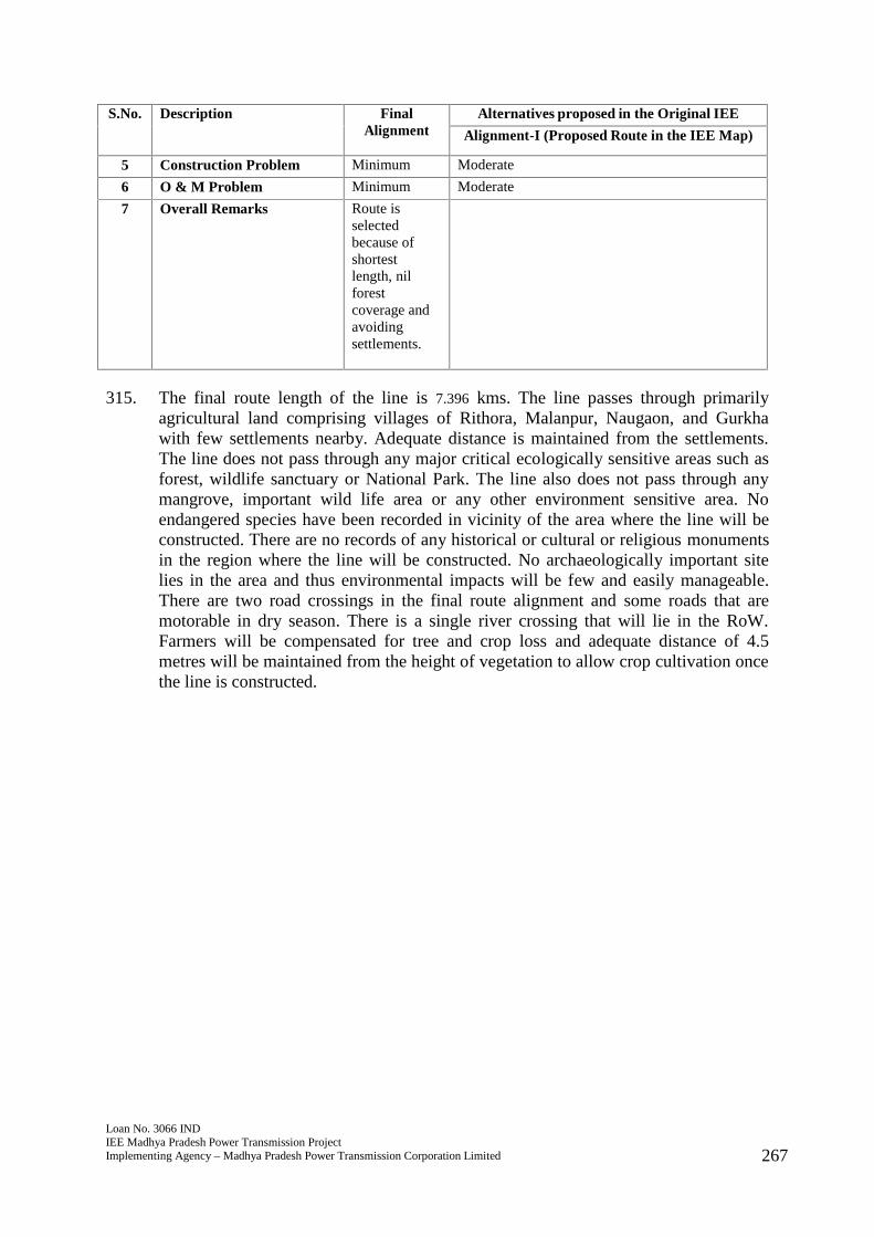
Loan No. 3066 INDIEE Madhya Pradesh Power Transmission ProjectImplementing Agency – Madhya Pradesh Power Transmission Corporation Limited 267
S.No. Description FinalAlignment
Alternatives proposed in the Original IEE
Alignment-I (Proposed Route in the IEE Map)
5 Construction Problem Minimum Moderate
6 O & M Problem Minimum Moderate
7 Overall Remarks Route isselectedbecause ofshortestlength, nilforestcoverage andavoidingsettlements.
315. The final route length of the line is 7.396 kms. The line passes through primarilyagricultural land comprising villages of Rithora, Malanpur, Naugaon, and Gurkhawith few settlements nearby. Adequate distance is maintained from the settlements.The line does not pass through any major critical ecologically sensitive areas such asforest, wildlife sanctuary or National Park. The line also does not pass through anymangrove, important wild life area or any other environment sensitive area. Noendangered species have been recorded in vicinity of the area where the line will beconstructed. There are no records of any historical or cultural or religious monumentsin the region where the line will be constructed. No archaeologically important sitelies in the area and thus environmental impacts will be few and easily manageable.There are two road crossings in the final route alignment and some roads that aremotorable in dry season. There is a single river crossing that will lie in the RoW.Farmers will be compensated for tree and crop loss and adequate distance of 4.5metres will be maintained from the height of vegetation to allow crop cultivation oncethe line is constructed.
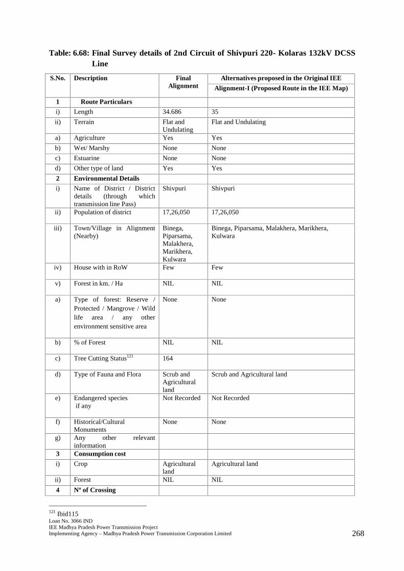
Loan No. 3066 INDIEE Madhya Pradesh Power Transmission ProjectImplementing Agency – Madhya Pradesh Power Transmission Corporation Limited 268
Table: 6.68: Final Survey details of 2nd Circuit of Shivpuri 220- Kolaras 132kV DCSSLine
S.No. Description FinalAlignment
Alternatives proposed in the Original IEE
Alignment-I (Proposed Route in the IEE Map)
1 Route Particulars
i) Length 34.686 35
ii) Terrain Flat andUndulating
Flat and Undulating
a) Agriculture Yes Yes
b) Wet/ Marshy None None
c) Estuarine None None
d) Other type of land Yes Yes
2 Environmental Details
i) Name of District / Districtdetails (through whichtransmission line Pass)
Shivpuri Shivpuri
ii) Population of district 17,26,050 17,26,050
iii) Town/Village in Alignment(Nearby)
Binega,Piparsama,Malakhera,Marikhera,Kulwara
Binega, Piparsama, Malakhera, Marikhera,Kulwara
iv) House with in RoW Few Few
v) Forest in km. / Ha NIL NIL
a) Type of forest: Reserve /Protected / Mangrove / Wildlife area / any otherenvironment sensitive area
None None
b) % of Forest NIL NIL
c) Tree Cutting Status121 164
d) Type of Fauna and Flora Scrub andAgriculturalland
Scrub and Agricultural land
e) Endangered speciesif any
Not Recorded Not Recorded
f) Historical/CulturalMonuments
None None
g) Any other relevantinformation
3 Consumption cost
i) Crop Agriculturalland
Agricultural land
ii) Forest NIL NIL
4 Nº of Crossing
121 Ibid115

Loan No. 3066 INDIEE Madhya Pradesh Power Transmission ProjectImplementing Agency – Madhya Pradesh Power Transmission Corporation Limited 269
S.No. Description FinalAlignment
Alternatives proposed in the Original IEE
Alignment-I (Proposed Route in the IEE Map)
i) Railway 1 1
ii) Transmission line NIL NIL
iii) River Crossing etc. NIL NIL
iv) Road Crossing 3 3
5 Construction Problem Minimum Minimum
6 O & M Problem Minimum Minimum
7 Overall Remarks Route isselectedbecause ofshortestlength, nilforestcoverage andavoidingsettlements.
Route is selectedbecause of shortestlength, nilforest coverage andavoiding settlements.
316. The final route length of the line is 34.686 kms. The line passes through primarilyagricultural land comprising villages of Binega, Piparsama, Malakhera, Marikhera,and Kulwara with few settlements nearby. Adequate distance is maintained from thesettlements. The line does not pass through any major critical ecologically sensitiveareas such as forest, wildlife sanctuary or National Park. The line also does not passthrough any mangrove, important wild life area or any other environment sensitivearea. No endangered species have been recorded in vicinity of the area where the linewill be constructed. There are no records of any historical or cultural or religiousmonuments in the region where the line will be constructed. No archaeologicallyimportant site lies in the area and thus environmental impacts will be few and easilymanageable. There are three road crossings in the final route alignment and someroads that are motorable in dry season. There is a single railway crossing that will liein the RoW. Farmers will be compensated for tree and crop loss and adequate distanceof 4.5 metres will be maintained from the height of vegetation to allow cropcultivation once the line is constructed.
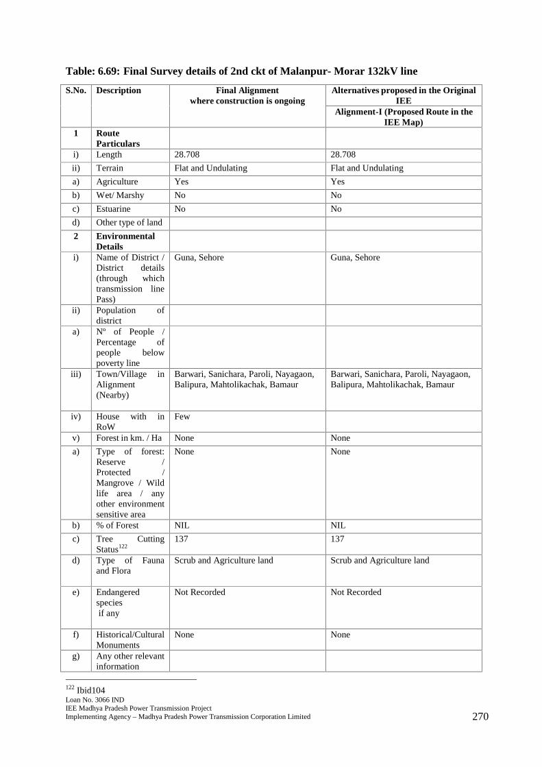
Loan No. 3066 INDIEE Madhya Pradesh Power Transmission ProjectImplementing Agency – Madhya Pradesh Power Transmission Corporation Limited 270
Table: 6.69: Final Survey details of 2nd ckt of Malanpur- Morar 132kV line
S.No. Description Final Alignmentwhere construction is ongoing
Alternatives proposed in the OriginalIEE
Alignment-I (Proposed Route in theIEE Map)
1 RouteParticulars
i) Length 28.708 28.708
ii) Terrain Flat and Undulating Flat and Undulating
a) Agriculture Yes Yes
b) Wet/ Marshy No No
c) Estuarine No No
d) Other type of land
2 EnvironmentalDetails
i) Name of District /District details(through whichtransmission linePass)
Guna, Sehore Guna, Sehore
ii) Population ofdistrict
a) Nº of People /Percentage ofpeople belowpoverty line
iii) Town/Village inAlignment(Nearby)
Barwari, Sanichara, Paroli, Nayagaon,Balipura, Mahtolikachak, Bamaur
Barwari, Sanichara, Paroli, Nayagaon,Balipura, Mahtolikachak, Bamaur
iv) House with inRoW
Few
v) Forest in km. / Ha None None
a) Type of forest:Reserve /Protected /Mangrove / Wildlife area / anyother environmentsensitive area
None None
b) % of Forest NIL NIL
c) Tree CuttingStatus122
137 137
d) Type of Faunaand Flora
Scrub and Agriculture land Scrub and Agriculture land
e) Endangeredspeciesif any
Not Recorded Not Recorded
f) Historical/CulturalMonuments
None None
g) Any other relevantinformation
122 Ibid104
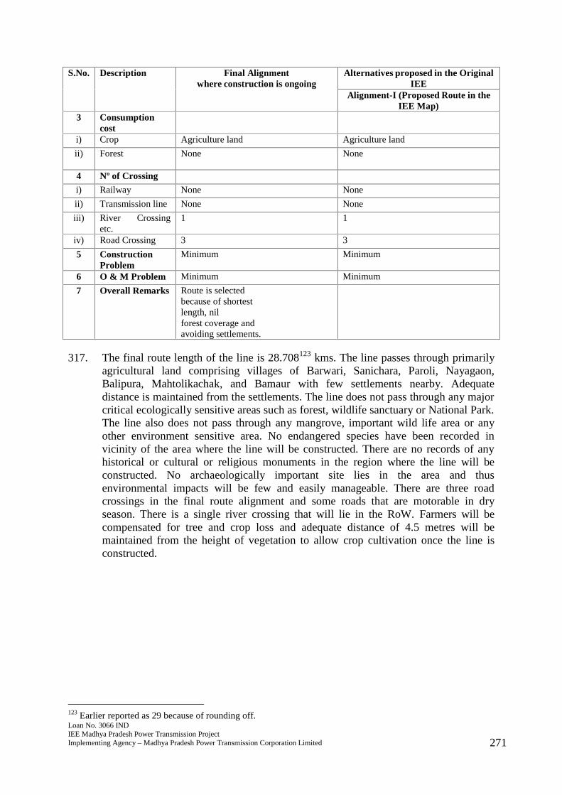
Loan No. 3066 INDIEE Madhya Pradesh Power Transmission ProjectImplementing Agency – Madhya Pradesh Power Transmission Corporation Limited 271
S.No. Description Final Alignmentwhere construction is ongoing
Alternatives proposed in the OriginalIEE
Alignment-I (Proposed Route in theIEE Map)
3 Consumptioncost
i) Crop Agriculture land Agriculture land
ii) Forest None None
4 Nº of Crossing
i) Railway None None
ii) Transmission line None None
iii) River Crossingetc.
1 1
iv) Road Crossing 3 3
5 ConstructionProblem
Minimum Minimum
6 O & M Problem Minimum Minimum
7 Overall Remarks Route is selectedbecause of shortestlength, nilforest coverage andavoiding settlements.
317. The final route length of the line is 28.708123 kms. The line passes through primarilyagricultural land comprising villages of Barwari, Sanichara, Paroli, Nayagaon,Balipura, Mahtolikachak, and Bamaur with few settlements nearby. Adequatedistance is maintained from the settlements. The line does not pass through any majorcritical ecologically sensitive areas such as forest, wildlife sanctuary or National Park.The line also does not pass through any mangrove, important wild life area or anyother environment sensitive area. No endangered species have been recorded invicinity of the area where the line will be constructed. There are no records of anyhistorical or cultural or religious monuments in the region where the line will beconstructed. No archaeologically important site lies in the area and thusenvironmental impacts will be few and easily manageable. There are three roadcrossings in the final route alignment and some roads that are motorable in dryseason. There is a single river crossing that will lie in the RoW. Farmers will becompensated for tree and crop loss and adequate distance of 4.5 metres will bemaintained from the height of vegetation to allow crop cultivation once the line isconstructed.
123 Earlier reported as 29 because of rounding off.

Loan No. 3066 INDIEE Madhya Pradesh Power Transmission ProjectImplementing Agency – Madhya Pradesh Power Transmission Corporation Limited 272
Table 6.70: Final Survey details Khurai-Khimlasa 132 kv DCSS line
S.No. Description FinalAlignment
Alternatives proposed in the Original IEE
Alignment-I (Proposed Route in the IEEMap)
1 Route Particulars
i) Length 20.937 20
ii) Terrain Flat andUndulating
Flat and Undulating
a) Agriculture Yes Yes
b) Wet/ Marshy No No
c) Estuarine No No
d) Other type of land
2 Environmental Details
i) Name of District / Districtdetails (through whichtransmission line Pass)
Sagar Sagar
ii) Population of district 23,78,458 23,78,458
iii) Town/Village in Alignment(Nearby)
Gamariyakhurd, Naukheda,Jagdishpura,Khejra Ijjat,Parsora,Vithor, Suneti,Nirtala,Lamethi,Sadarpur,Jangrayi,Bamorikhadera, Kapooriya,KapooriyaSemra
Gamariyakhurd, Naukheda, Jagdishpura,Khejra Ijjat, Parsora, Vithor, Suneti, Nirtala,Lamethi, Sadarpur, Jangrayi, Bamorikhadera,Kapooriya, Kapooriya Semra
iv) House with in RoW None Few
v) Forest in km. / Ha None None
a) Type of forest: Reserve /Protected / Mangrove / Wildlife area / any otherenvironment sensitive area
None None
b) % of Forest NIL NIL
c) Tree Cutting Status124 84
d) Type of Fauna and Flora Agricultureland
Agriculture land
e) Endangered speciesif any
Not Recorded Not Recorded
f) Historical/CulturalMonuments
None None
g) Any other relevantinformation
None None
124 Ibid117
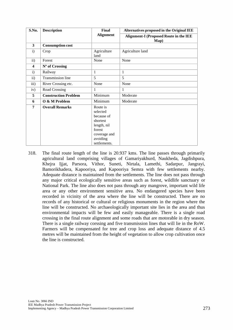
Loan No. 3066 INDIEE Madhya Pradesh Power Transmission ProjectImplementing Agency – Madhya Pradesh Power Transmission Corporation Limited 273
S.No. Description FinalAlignment
Alternatives proposed in the Original IEE
Alignment-I (Proposed Route in the IEEMap)
3 Consumption cost
i) Crop Agricultureland
Agriculture land
ii) Forest None None
4 Nº of Crossing
i) Railway 1 1
ii) Transmission line 5 5
iii) River Crossing etc. None None
iv) Road Crossing 1 1
5 Construction Problem Minimum Moderate
6 O & M Problem Minimum Moderate
7 Overall Remarks Route isselectedbecause ofshortestlength, nilforestcoverage andavoidingsettlements.
318. The final route length of the line is 20.937 kms. The line passes through primarilyagricultural land comprising villages of Gamariyakhurd, Naukheda, Jagdishpura,Khejra Ijjat, Parsora, Vithor, Suneti, Nirtala, Lamethi, Sadarpur, Jangrayi,Bamorikhadera, Kapooriya, and Kapooriya Semra with few settlements nearby.Adequate distance is maintained from the settlements. The line does not pass throughany major critical ecologically sensitive areas such as forest, wildlife sanctuary orNational Park. The line also does not pass through any mangrove, important wild lifearea or any other environment sensitive area. No endangered species have beenrecorded in vicinity of the area where the line will be constructed. There are norecords of any historical or cultural or religious monuments in the region where theline will be constructed. No archaeologically important site lies in the area and thusenvironmental impacts will be few and easily manageable. There is a single roadcrossing in the final route alignment and some roads that are motorable in dry season.There is a single railway corssing and five transmission lines that will lie in the RoW.Farmers will be compensated for tree and crop loss and adequate distance of 4.5metres will be maintained from the height of vegetation to allow crop cultivation oncethe line is constructed.

Loan No. 3066 INDIEE Madhya Pradesh Power Transmission ProjectImplementing Agency – Madhya Pradesh Power Transmission Corporation Limited 274
Table 6.71: Final Survey details of LILO of Mungaoli Traction Feeder to Mungaoli(D/C)
S.No. Description FinalAlignment
Alternatives proposed in the Original IEE
Alignment-I (Proposed Route in the IEE Map)
1 Route Particulars
i) Length 8.32 10
ii) Terrain Flat andUndulating
Flat and Undulating
a) Agriculture Yes Yes
b) Wet/ Marshy None None
c) Estuarine None None
d) Other type of land Yes Yes
2 Environmental Details
i) Name of District / Districtdetails (through whichtransmission line Pass)
Ashoknagar Ashoknagar
ii) Population of district 8,45,071 8,45,071
iii) Town/Village in Alignment(Nearby)
Semerkhedi,Belai, Nidar,Hureri,Niboda, Dehri,Barghura,Himnod,Futera,Hiranchipa,Bina Etawa,Jirol andLahatwas
Semerkhedi, Belai, Nidar, Hureri, Niboda, Dehri,Barghura, Himnod, Futera, Hiranchipa, BinaEtawa, Jirol and Lahatwas
iv) House with in RoW
v) Forest in km. / Ha None None
a) Type of forest: Reserve /Protected / Mangrove / Wildlife area / any otherenvironment sensitive area
None None
b) % of Forest NIL NIL
c) Tree Cutting Status125 40
d) Type of Fauna and Flora Agricultureland
Agriculture land
e) Endangered speciesif any
Not Recorded Not Recorded
f) Historical/CulturalMonuments
None None
g) Any other relevantinformation
3 Consumption cost
125 Ibid118
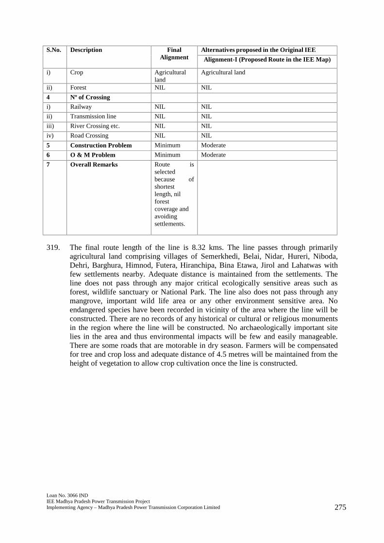
Loan No. 3066 INDIEE Madhya Pradesh Power Transmission ProjectImplementing Agency – Madhya Pradesh Power Transmission Corporation Limited 275
S.No. Description FinalAlignment
Alternatives proposed in the Original IEE
Alignment-I (Proposed Route in the IEE Map)
i) Crop Agriculturalland
Agricultural land
ii) Forest NIL NIL
4 Nº of Crossing
i) Railway NIL NIL
ii) Transmission line NIL NIL
iii) River Crossing etc. NIL NIL
iv) Road Crossing NIL NIL
5 Construction Problem Minimum Moderate
6 O & M Problem Minimum Moderate
7 Overall Remarks Route isselectedbecause ofshortestlength, nilforestcoverage andavoidingsettlements.
319. The final route length of the line is 8.32 kms. The line passes through primarilyagricultural land comprising villages of Semerkhedi, Belai, Nidar, Hureri, Niboda,Dehri, Barghura, Himnod, Futera, Hiranchipa, Bina Etawa, Jirol and Lahatwas withfew settlements nearby. Adequate distance is maintained from the settlements. Theline does not pass through any major critical ecologically sensitive areas such asforest, wildlife sanctuary or National Park. The line also does not pass through anymangrove, important wild life area or any other environment sensitive area. Noendangered species have been recorded in vicinity of the area where the line will beconstructed. There are no records of any historical or cultural or religious monumentsin the region where the line will be constructed. No archaeologically important sitelies in the area and thus environmental impacts will be few and easily manageable.There are some roads that are motorable in dry season. Farmers will be compensatedfor tree and crop loss and adequate distance of 4.5 metres will be maintained from theheight of vegetation to allow crop cultivation once the line is constructed.
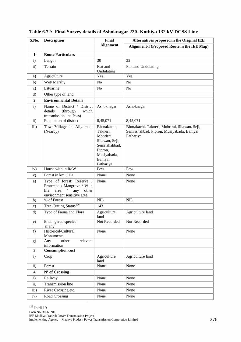
Loan No. 3066 INDIEE Madhya Pradesh Power Transmission ProjectImplementing Agency – Madhya Pradesh Power Transmission Corporation Limited 276
Table 6.72: Final Survey details of Ashoknagar 220- Kothiya 132 kV DCSS Line
S.No. Description FinalAlignment
Alternatives proposed in the Original IEE
Alignment-I (Proposed Route in the IEE Map)
1 Route Particulars
i) Length 30 35
ii) Terrain Flat andUndulating
Flat and Undulating
a) Agriculture Yes Yes
b) Wet/ Marshy No No
c) Estuarine No No
d) Other type of land
2 Environmental Details
i) Name of District / Districtdetails (through whichtransmission line Pass)
Ashoknagar Ashoknagar
ii) Population of district 8,45,071 8,45,071
iii) Town/Village in Alignment(Nearby)
Bhorakachi,Takneri,Mohrirai,Silawan, Seji,Semrishahbad,Pipron,Musiyabada,Baniyai,Pathariya
Bhorakachi, Takneri, Mohrirai, Silawan, Seji,Semrishahbad, Pipron, Musiyabada, Baniyai,Pathariya
iv) House with in RoW Few Few
v) Forest in km. / Ha None None
a) Type of forest: Reserve /Protected / Mangrove / Wildlife area / any otherenvironment sensitive area
None None
b) % of Forest NIL NIL
c) Tree Cutting Status126 143
d) Type of Fauna and Flora Agricultureland
Agriculture land
e) Endangered speciesif any
Not Recorded Not Recorded
f) Historical/CulturalMonuments
None None
g) Any other relevantinformation
3 Consumption cost
i) Crop Agricultureland
Agriculture land
ii) Forest None None
4 Nº of Crossing
i) Railway None None
ii) Transmission line None None
iii) River Crossing etc. None None
iv) Road Crossing None None
126 Ibid119

Loan No. 3066 INDIEE Madhya Pradesh Power Transmission ProjectImplementing Agency – Madhya Pradesh Power Transmission Corporation Limited 277
S.No. Description FinalAlignment
Alternatives proposed in the Original IEE
Alignment-I (Proposed Route in the IEE Map)
5 Construction Problem Minimum Moderate
6 O & M Problem Minimum Moderate
7 Overall Remarks Route isselectedbecause ofshortestlength, nilforestcoverage andavoidingsettlements.
320. The final route length of the line is 30 kms. The line passes through primarilyagricultural land comprising villages of Bhorakachi, Takneri, Mohrirai, Silawan, Seji,Semrishahbad, Pipron, Musiyabada, Baniyai, and Pathariya with few settlementsnearby. Adequate distance is maintained from the settlements. The line does not passthrough any major critical ecologically sensitive areas such as forest, wildlifesanctuary or National Park. The line also does not pass through any mangrove,important wild life area or any other environment sensitive area. No endangeredspecies have been recorded in vicinity of the area where the line will be constructed.There are no records of any historical or cultural or religious monuments in the regionwhere the line will be constructed. No archaeologically important site lies in the areaand thus environmental impacts will be few and easily manageable. There some roadsthat are motorable in dry season. Farmers will be compensated for tree and crop lossand adequate distance of 4.5 metres will be maintained from the height of vegetationto allow crop cultivation once the line is constructed.
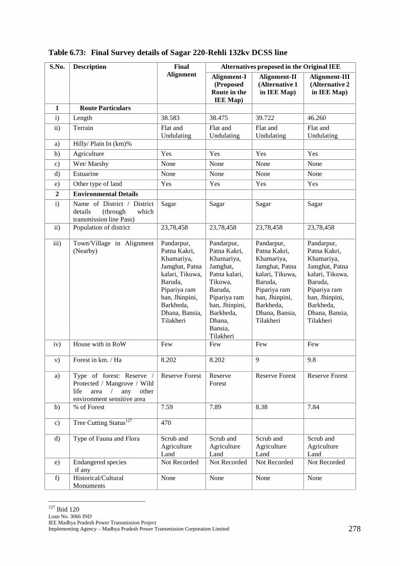
Loan No. 3066 INDIEE Madhya Pradesh Power Transmission ProjectImplementing Agency – Madhya Pradesh Power Transmission Corporation Limited 278
Table 6.73: Final Survey details of Sagar 220-Rehli 132kv DCSS line
S.No. Description FinalAlignment
Alternatives proposed in the Original IEE
Alignment-I(Proposed
Route in theIEE Map)
Alignment-II(Alternative 1in IEE Map)
Alignment-III(Alternative 2in IEE Map)
1 Route Particulars
i) Length 38.583 38.475 39.722 46.260
ii) Terrain Flat andUndulating
Flat andUndulating
Flat andUndulating
Flat andUndulating
a) Hilly/ Plain In (km)%
b) Agriculture Yes Yes Yes Yes
c) Wet/ Marshy None None None None
d) Estuarine None None None None
e) Other type of land Yes Yes Yes Yes
2 Environmental Details
i) Name of District / Districtdetails (through whichtransmission line Pass)
Sagar Sagar Sagar Sagar
ii) Population of district 23,78,458 23,78,458 23,78,458 23,78,458
iii) Town/Village in Alignment(Nearby)
Pandarpur,Patna Kakri,Khamariya,Jamghat, Patnakalari, Tikuwa,Baruda,Pipariya ramban, Jhinpini,Barkheda,Dhana, Bansia,Tilakheri
Pandarpur,Patna Kakri,Khamariya,Jamghat,Patna kalari,Tikuwa,Baruda,Pipariya ramban, Jhinpini,Barkheda,Dhana,Bansia,Tilakheri
Pandarpur,Patna Kakri,Khamariya,Jamghat, Patnakalari, Tikuwa,Baruda,Pipariya ramban, Jhinpini,Barkheda,Dhana, Bansia,Tilakheri
Pandarpur,Patna Kakri,Khamariya,Jamghat, Patnakalari, Tikuwa,Baruda,Pipariya ramban, Jhinpini,Barkheda,Dhana, Bansia,Tilakheri
iv) House with in RoW Few Few Few Few
v) Forest in km. / Ha 8.202 8.202 9 9.8
a) Type of forest: Reserve /Protected / Mangrove / Wildlife area / any otherenvironment sensitive area
Reserve Forest ReserveForest
Reserve Forest Reserve Forest
b) % of Forest 7.59 7.89 8.38 7.84
c) Tree Cutting Status127 470
d) Type of Fauna and Flora Scrub andAgricultureLand
Scrub andAgricultureLand
Scrub andAgricultureLand
Scrub andAgricultureLand
e) Endangered speciesif any
Not Recorded Not Recorded Not Recorded Not Recorded
f) Historical/CulturalMonuments
None None None None
127 Ibid 120
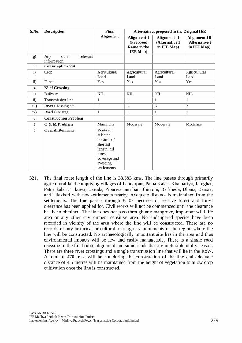
Loan No. 3066 INDIEE Madhya Pradesh Power Transmission ProjectImplementing Agency – Madhya Pradesh Power Transmission Corporation Limited 279
S.No. Description FinalAlignment
Alternatives proposed in the Original IEE
Alignment-I(Proposed
Route in theIEE Map)
Alignment-II(Alternative 1in IEE Map)
Alignment-III(Alternative 2in IEE Map)
g) Any other relevantinformation
3 Consumption cost
i) Crop AgriculturalLand
AgriculturalLand
AgriculturalLand
AgriculturalLand
ii) Forest Yes Yes Yes Yes
4 Nº of Crossing
i) Railway NIL NIL NIL NIL
ii) Transmission line 1 1 1 1
iii) River Crossing etc. 3 3 3 3
iv) Road Crossing 1 1 1 1
5 Construction Problem
6 O & M Problem Minimum Moderate Moderate Moderate
7 Overall Remarks Route isselectedbecause ofshortestlength, nilforestcoverage andavoidingsettlements.
321. The final route length of the line is 38.583 kms. The line passes through primarilyagricultural land comprising villages of Pandarpur, Patna Kakri, Khamariya, Jamghat,Patna kalari, Tikuwa, Baruda, Pipariya ram ban, Jhinpini, Barkheda, Dhana, Bansia,and Tilakheri with few settlements nearby. Adequate distance is maintained from thesettlements. The line passes through 8.202 hectares of reserve forest and forestclearance has been applied for. Civil works will not be commenced until the clearancehas been obtained. The line does not pass through any mangrove, important wild lifearea or any other environment sensitive area. No endangered species have beenrecorded in vicinity of the area where the line will be constructed. There are norecords of any historical or cultural or religious monuments in the region where theline will be constructed. No archaeologically important site lies in the area and thusenvironmental impacts will be few and easily manageable. There is a single roadcrossing in the final route alignment and some roads that are motorable in dry season.There are three river crossings and a single transmission line that will lie in the RoW.A total of 470 tress will be cut during the construction of the line and adequatedistance of 4.5 metres will be maintained from the height of vegetation to allow cropcultivation once the line is constructed.
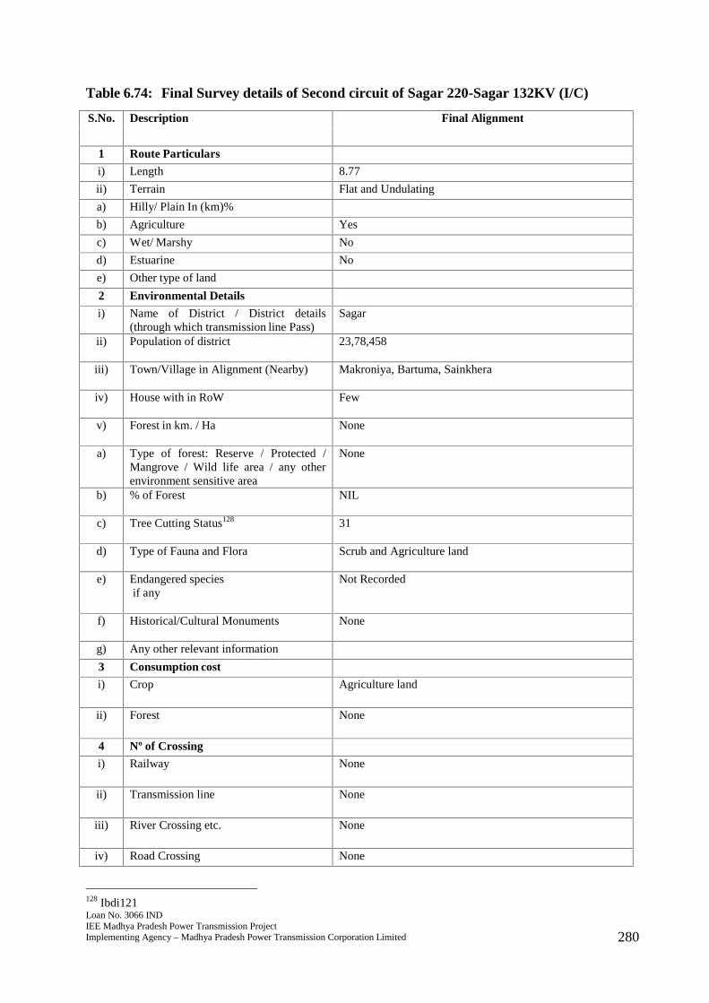
Loan No. 3066 INDIEE Madhya Pradesh Power Transmission ProjectImplementing Agency – Madhya Pradesh Power Transmission Corporation Limited 280
Table 6.74: Final Survey details of Second circuit of Sagar 220-Sagar 132KV (I/C)
S.No. Description Final Alignment
1 Route Particulars
i) Length 8.77
ii) Terrain Flat and Undulating
a) Hilly/ Plain In (km)%
b) Agriculture Yes
c) Wet/ Marshy No
d) Estuarine No
e) Other type of land
2 Environmental Details
i) Name of District / District details(through which transmission line Pass)
Sagar
ii) Population of district 23,78,458
iii) Town/Village in Alignment (Nearby) Makroniya, Bartuma, Sainkhera
iv) House with in RoW Few
v) Forest in km. / Ha None
a) Type of forest: Reserve / Protected /Mangrove / Wild life area / any otherenvironment sensitive area
None
b) % of Forest NIL
c) Tree Cutting Status128 31
d) Type of Fauna and Flora Scrub and Agriculture land
e) Endangered speciesif any
Not Recorded
f) Historical/Cultural Monuments None
g) Any other relevant information
3 Consumption cost
i) Crop Agriculture land
ii) Forest None
4 Nº of Crossing
i) Railway None
ii) Transmission line None
iii) River Crossing etc. None
iv) Road Crossing None
128 Ibdi121
Loan No. 3066 INDIEE Madhya Pradesh Power Transmission ProjectImplementing Agency – Madhya Pradesh Power Transmission Corporation Limited 281
S.No. Description Final Alignment
5 Construction Problem
6 O & M Problem Minimum
7 Overall Remarks Route is selectedbecause of shortestlength, nilforest coverage andavoiding settlements.
322. The final route length of the line is 8.77 kms129. The line passes through primarilyagricultural land comprising villages of Makroniya, Bartuma, Sainkhera with fewsettlements nearby. Adequate distance is maintained from the settlements. The linedoes not pass through any major critical ecologically sensitive areas such as forest,wildlife sanctuary or National Park. The line also does not pass through anymangrove, important wild life area or any other environment sensitive area. Noendangered species have been recorded in vicinity of the area where the line will beconstructed. There are no records of any historical or cultural or religious monumentsin the region where the line will be constructed. No archaeologically important sitelies in the area and thus environmental impacts will be few and easily manageable.There are some roads that are motorable in dry season. Farmers will be compensatedfor tree and crop loss and adequate distance of 4.5 metres will be maintained from theheight of vegetation to allow crop cultivation once the line is constructed.
129 Earlier reported as 9 because of rounding off.
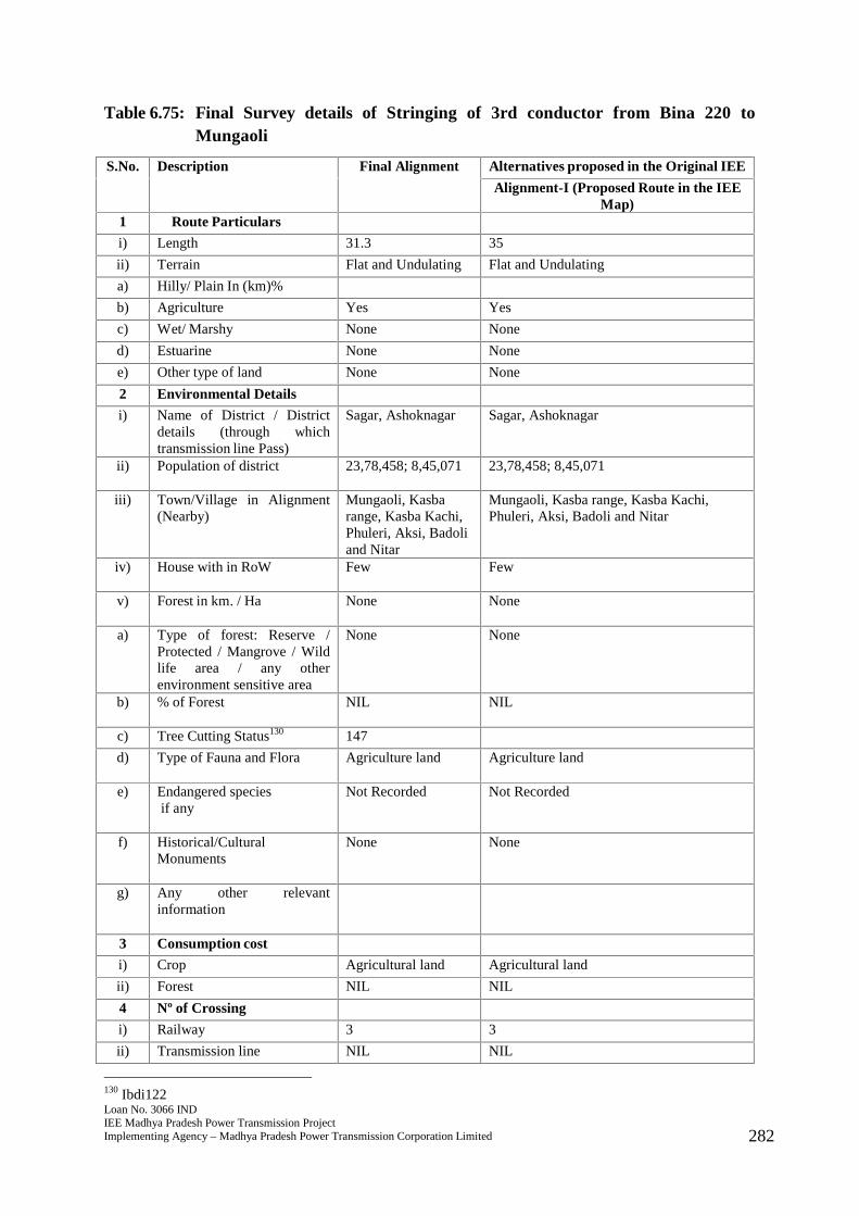
Loan No. 3066 INDIEE Madhya Pradesh Power Transmission ProjectImplementing Agency – Madhya Pradesh Power Transmission Corporation Limited 282
Table 6.75: Final Survey details of Stringing of 3rd conductor from Bina 220 toMungaoli
S.No. Description Final Alignment Alternatives proposed in the Original IEE
Alignment-I (Proposed Route in the IEEMap)
1 Route Particulars
i) Length 31.3 35
ii) Terrain Flat and Undulating Flat and Undulating
a) Hilly/ Plain In (km)%
b) Agriculture Yes Yes
c) Wet/ Marshy None None
d) Estuarine None None
e) Other type of land None None
2 Environmental Details
i) Name of District / Districtdetails (through whichtransmission line Pass)
Sagar, Ashoknagar Sagar, Ashoknagar
ii) Population of district 23,78,458; 8,45,071 23,78,458; 8,45,071
iii) Town/Village in Alignment(Nearby)
Mungaoli, Kasbarange, Kasba Kachi,Phuleri, Aksi, Badoliand Nitar
Mungaoli, Kasba range, Kasba Kachi,Phuleri, Aksi, Badoli and Nitar
iv) House with in RoW Few Few
v) Forest in km. / Ha None None
a) Type of forest: Reserve /Protected / Mangrove / Wildlife area / any otherenvironment sensitive area
None None
b) % of Forest NIL NIL
c) Tree Cutting Status130 147
d) Type of Fauna and Flora Agriculture land Agriculture land
e) Endangered speciesif any
Not Recorded Not Recorded
f) Historical/CulturalMonuments
None None
g) Any other relevantinformation
3 Consumption cost
i) Crop Agricultural land Agricultural land
ii) Forest NIL NIL
4 Nº of Crossing
i) Railway 3 3
ii) Transmission line NIL NIL
130 Ibdi122
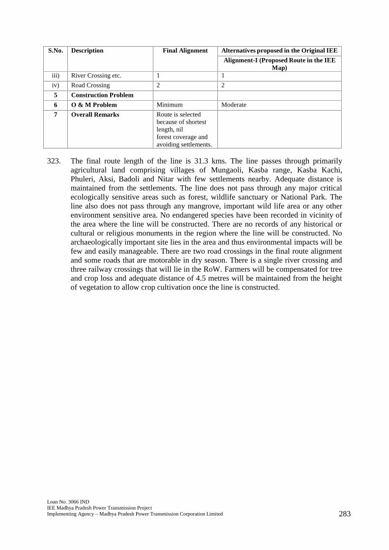
Loan No. 3066 INDIEE Madhya Pradesh Power Transmission ProjectImplementing Agency – Madhya Pradesh Power Transmission Corporation Limited 283
S.No. Description Final Alignment Alternatives proposed in the Original IEE
Alignment-I (Proposed Route in the IEEMap)
iii) River Crossing etc. 1 1
iv) Road Crossing 2 2
5 Construction Problem
6 O & M Problem Minimum Moderate
7 Overall Remarks Route is selectedbecause of shortestlength, nilforest coverage andavoiding settlements.
323. The final route length of the line is 31.3 kms. The line passes through primarilyagricultural land comprising villages of Mungaoli, Kasba range, Kasba Kachi,Phuleri, Aksi, Badoli and Nitar with few settlements nearby. Adequate distance ismaintained from the settlements. The line does not pass through any major criticalecologically sensitive areas such as forest, wildlife sanctuary or National Park. Theline also does not pass through any mangrove, important wild life area or any otherenvironment sensitive area. No endangered species have been recorded in vicinity ofthe area where the line will be constructed. There are no records of any historical orcultural or religious monuments in the region where the line will be constructed. Noarchaeologically important site lies in the area and thus environmental impacts will befew and easily manageable. There are two road crossings in the final route alignmentand some roads that are motorable in dry season. There is a single river crossing andthree railway crossings that will lie in the RoW. Farmers will be compensated for treeand crop loss and adequate distance of 4.5 metres will be maintained from the heightof vegetation to allow crop cultivation once the line is constructed.
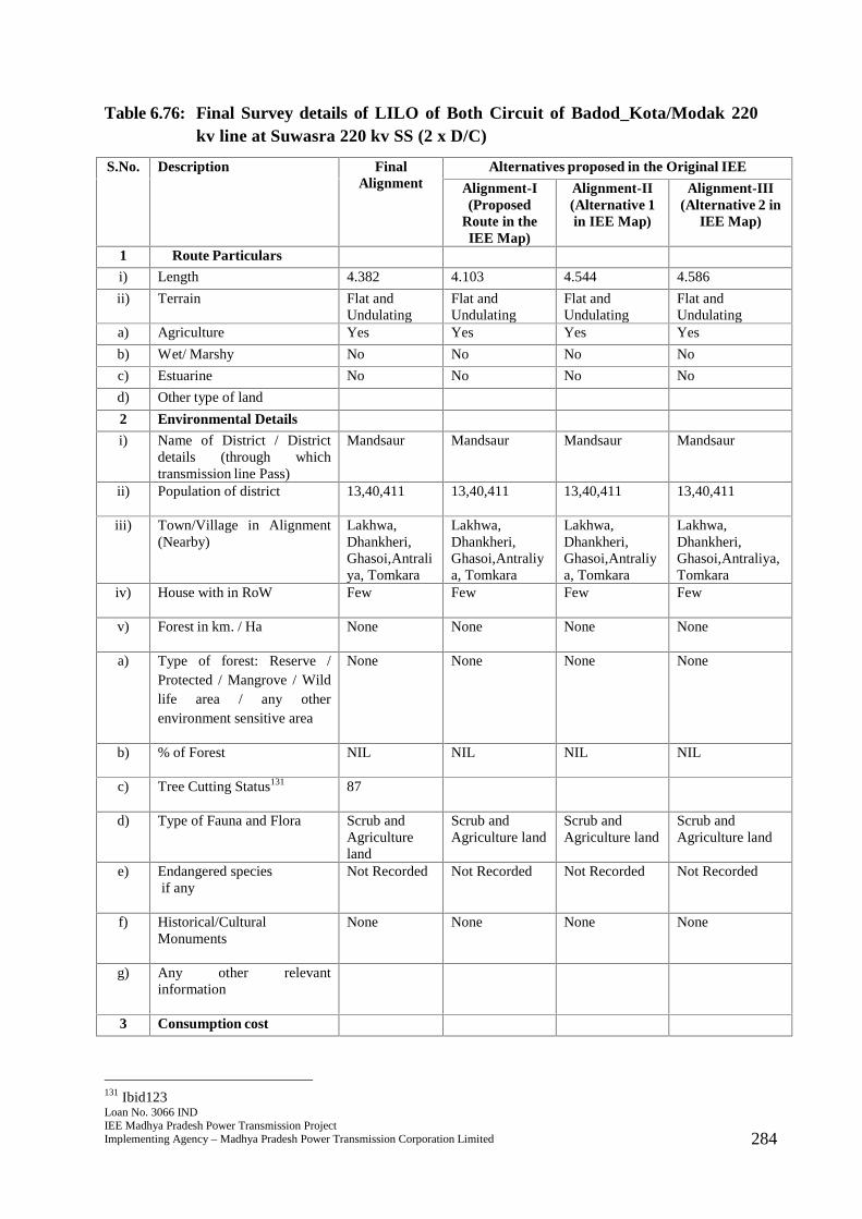
Loan No. 3066 INDIEE Madhya Pradesh Power Transmission ProjectImplementing Agency – Madhya Pradesh Power Transmission Corporation Limited 284
Table 6.76: Final Survey details of LILO of Both Circuit of Badod_Kota/Modak 220kv line at Suwasra 220 kv SS (2 x D/C)
S.No. Description FinalAlignment
Alternatives proposed in the Original IEE
Alignment-I(Proposed
Route in theIEE Map)
Alignment-II(Alternative 1in IEE Map)
Alignment-III(Alternative 2 in
IEE Map)
1 Route Particulars
i) Length 4.382 4.103 4.544 4.586
ii) Terrain Flat andUndulating
Flat andUndulating
Flat andUndulating
Flat andUndulating
a) Agriculture Yes Yes Yes Yes
b) Wet/ Marshy No No No No
c) Estuarine No No No No
d) Other type of land
2 Environmental Details
i) Name of District / Districtdetails (through whichtransmission line Pass)
Mandsaur Mandsaur Mandsaur Mandsaur
ii) Population of district 13,40,411 13,40,411 13,40,411 13,40,411
iii) Town/Village in Alignment(Nearby)
Lakhwa,Dhankheri,Ghasoi,Antraliya, Tomkara
Lakhwa,Dhankheri,Ghasoi,Antraliya, Tomkara
Lakhwa,Dhankheri,Ghasoi,Antraliya, Tomkara
Lakhwa,Dhankheri,Ghasoi,Antraliya,Tomkara
iv) House with in RoW Few Few Few Few
v) Forest in km. / Ha None None None None
a) Type of forest: Reserve /Protected / Mangrove / Wildlife area / any otherenvironment sensitive area
None None None None
b) % of Forest NIL NIL NIL NIL
c) Tree Cutting Status131 87
d) Type of Fauna and Flora Scrub andAgricultureland
Scrub andAgriculture land
Scrub andAgriculture land
Scrub andAgriculture land
e) Endangered speciesif any
Not Recorded Not Recorded Not Recorded Not Recorded
f) Historical/CulturalMonuments
None None None None
g) Any other relevantinformation
3 Consumption cost
131 Ibid123

Loan No. 3066 INDIEE Madhya Pradesh Power Transmission ProjectImplementing Agency – Madhya Pradesh Power Transmission Corporation Limited 285
S.No. Description FinalAlignment
Alternatives proposed in the Original IEE
Alignment-I(Proposed
Route in theIEE Map)
Alignment-II(Alternative 1in IEE Map)
Alignment-III(Alternative 2 in
IEE Map)
i) Crop Agricultureland
Agriculture land Agriculture land Agriculture land
ii) Forest None None None None
4 Nº of Crossing
i) Railway None None None None
ii) Transmission line 1 1 1 1
iii) River Crossing etc. None None None None
iv) Road Crossing 1 1 1 1
5 Construction Problem Minimum Moderate Moderate Moderate
6 O & M Problem Minimum Moderate Moderate Moderate
7 Overall Remarks Route isselectedbecause ofshortestlength, nilforestcoverage andavoidingsettlements.
324. The final route length of the line is 4.382 kms132. The line passes through primarilyagricultural land comprising villages of Lakhwa, Dhankheri, Ghasoi, Antraliya, andTomkara with few settlements nearby. Adequate distance is maintained from thesettlements. The line does not pass through any major critical ecologically sensitiveareas such as forest, wildlife sanctuary or National Park. The line also does not passthrough any mangrove, important wild life area or any other environment sensitivearea. No endangered species have been recorded in vicinity of the area where the linewill be constructed. There are no records of any historical or cultural or religiousmonuments in the region where the line will be constructed. No archaeologicallyimportant site lies in the area and thus environmental impacts will be few and easilymanageable. There is a single road crossing in the final route alignment and someroads that are motorable in dry season. There is a single transmission line that will liein the RoW. Farmers will be compensated for tree and crop loss and adequate distanceof 4.5 metres will be maintained from the height of vegetation to allow cropcultivation once the line is constructed.
132 Line length had been reported incorrectly instead of route length earlier. This has been corrected now.
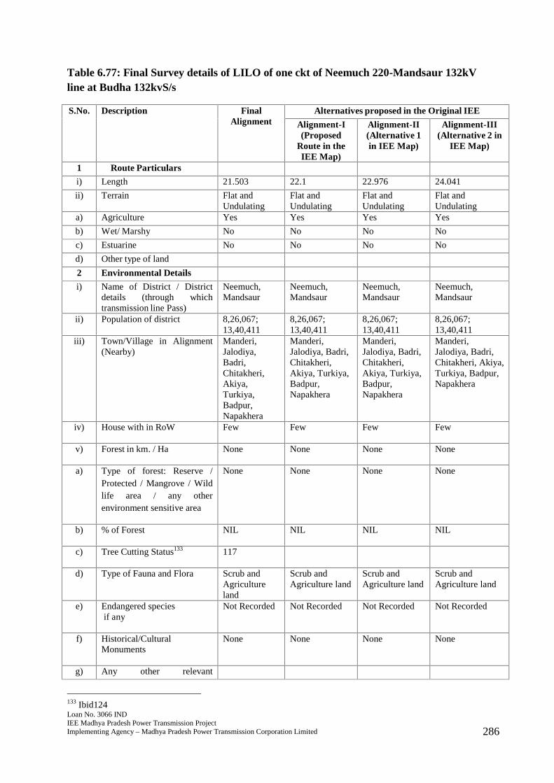
Loan No. 3066 INDIEE Madhya Pradesh Power Transmission ProjectImplementing Agency – Madhya Pradesh Power Transmission Corporation Limited 286
Table 6.77: Final Survey details of LILO of one ckt of Neemuch 220-Mandsaur 132kVline at Budha 132kvS/s
S.No. Description FinalAlignment
Alternatives proposed in the Original IEE
Alignment-I(Proposed
Route in theIEE Map)
Alignment-II(Alternative 1in IEE Map)
Alignment-III(Alternative 2 in
IEE Map)
1 Route Particulars
i) Length 21.503 22.1 22.976 24.041
ii) Terrain Flat andUndulating
Flat andUndulating
Flat andUndulating
Flat andUndulating
a) Agriculture Yes Yes Yes Yes
b) Wet/ Marshy No No No No
c) Estuarine No No No No
d) Other type of land
2 Environmental Details
i) Name of District / Districtdetails (through whichtransmission line Pass)
Neemuch,Mandsaur
Neemuch,Mandsaur
Neemuch,Mandsaur
Neemuch,Mandsaur
ii) Population of district 8,26,067;13,40,411
8,26,067;13,40,411
8,26,067;13,40,411
8,26,067;13,40,411
iii) Town/Village in Alignment(Nearby)
Manderi,Jalodiya,Badri,Chitakheri,Akiya,Turkiya,Badpur,Napakhera
Manderi,Jalodiya, Badri,Chitakheri,Akiya, Turkiya,Badpur,Napakhera
Manderi,Jalodiya, Badri,Chitakheri,Akiya, Turkiya,Badpur,Napakhera
Manderi,Jalodiya, Badri,Chitakheri, Akiya,Turkiya, Badpur,Napakhera
iv) House with in RoW Few Few Few Few
v) Forest in km. / Ha None None None None
a) Type of forest: Reserve /Protected / Mangrove / Wildlife area / any otherenvironment sensitive area
None None None None
b) % of Forest NIL NIL NIL NIL
c) Tree Cutting Status133 117
d) Type of Fauna and Flora Scrub andAgricultureland
Scrub andAgriculture land
Scrub andAgriculture land
Scrub andAgriculture land
e) Endangered speciesif any
Not Recorded Not Recorded Not Recorded Not Recorded
f) Historical/CulturalMonuments
None None None None
g) Any other relevant
133 Ibid124
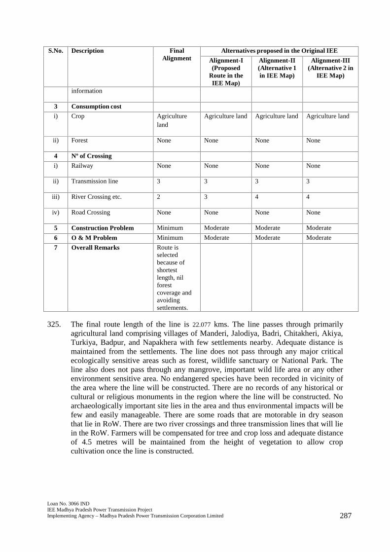
Loan No. 3066 INDIEE Madhya Pradesh Power Transmission ProjectImplementing Agency – Madhya Pradesh Power Transmission Corporation Limited 287
S.No. Description FinalAlignment
Alternatives proposed in the Original IEE
Alignment-I(Proposed
Route in theIEE Map)
Alignment-II(Alternative 1in IEE Map)
Alignment-III(Alternative 2 in
IEE Map)
information
3 Consumption cost
i) Crop Agricultureland
Agriculture land Agriculture land Agriculture land
ii) Forest None None None None
4 Nº of Crossing
i) Railway None None None None
ii) Transmission line 3 3 3 3
iii) River Crossing etc. 2 3 4 4
iv) Road Crossing None None None None
5 Construction Problem Minimum Moderate Moderate Moderate
6 O & M Problem Minimum Moderate Moderate Moderate
7 Overall Remarks Route isselectedbecause ofshortestlength, nilforestcoverage andavoidingsettlements.
325. The final route length of the line is 22.077 kms. The line passes through primarilyagricultural land comprising villages of Manderi, Jalodiya, Badri, Chitakheri, Akiya,Turkiya, Badpur, and Napakhera with few settlements nearby. Adequate distance ismaintained from the settlements. The line does not pass through any major criticalecologically sensitive areas such as forest, wildlife sanctuary or National Park. Theline also does not pass through any mangrove, important wild life area or any otherenvironment sensitive area. No endangered species have been recorded in vicinity ofthe area where the line will be constructed. There are no records of any historical orcultural or religious monuments in the region where the line will be constructed. Noarchaeologically important site lies in the area and thus environmental impacts will befew and easily manageable. There are some roads that are motorable in dry seasonthat lie in RoW. There are two river crossings and three transmission lines that will liein the RoW. Farmers will be compensated for tree and crop loss and adequate distanceof 4.5 metres will be maintained from the height of vegetation to allow cropcultivation once the line is constructed.
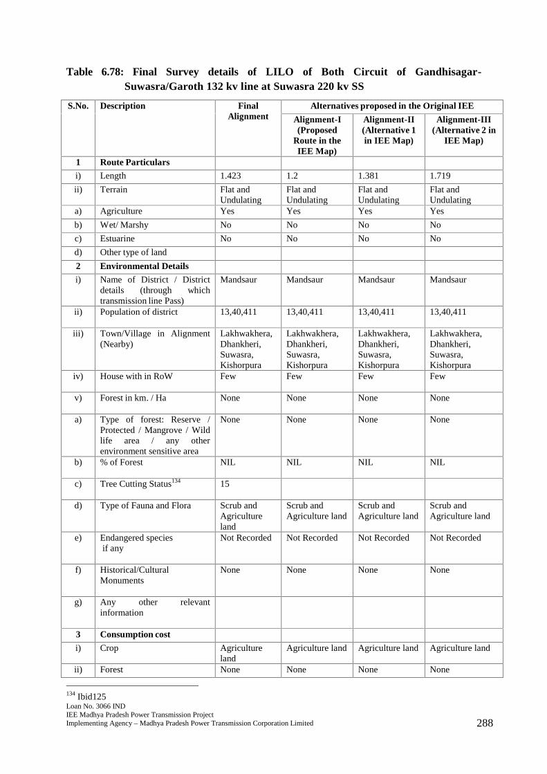
Loan No. 3066 INDIEE Madhya Pradesh Power Transmission ProjectImplementing Agency – Madhya Pradesh Power Transmission Corporation Limited 288
Table 6.78: Final Survey details of LILO of Both Circuit of Gandhisagar-Suwasra/Garoth 132 kv line at Suwasra 220 kv SS
S.No. Description FinalAlignment
Alternatives proposed in the Original IEE
Alignment-I(Proposed
Route in theIEE Map)
Alignment-II(Alternative 1in IEE Map)
Alignment-III(Alternative 2 in
IEE Map)
1 Route Particulars
i) Length 1.423 1.2 1.381 1.719
ii) Terrain Flat andUndulating
Flat andUndulating
Flat andUndulating
Flat andUndulating
a) Agriculture Yes Yes Yes Yes
b) Wet/ Marshy No No No No
c) Estuarine No No No No
d) Other type of land
2 Environmental Details
i) Name of District / Districtdetails (through whichtransmission line Pass)
Mandsaur Mandsaur Mandsaur Mandsaur
ii) Population of district 13,40,411 13,40,411 13,40,411 13,40,411
iii) Town/Village in Alignment(Nearby)
Lakhwakhera,Dhankheri,Suwasra,Kishorpura
Lakhwakhera,Dhankheri,Suwasra,Kishorpura
Lakhwakhera,Dhankheri,Suwasra,Kishorpura
Lakhwakhera,Dhankheri,Suwasra,Kishorpura
iv) House with in RoW Few Few Few Few
v) Forest in km. / Ha None None None None
a) Type of forest: Reserve /Protected / Mangrove / Wildlife area / any otherenvironment sensitive area
None None None None
b) % of Forest NIL NIL NIL NIL
c) Tree Cutting Status134 15
d) Type of Fauna and Flora Scrub andAgricultureland
Scrub andAgriculture land
Scrub andAgriculture land
Scrub andAgriculture land
e) Endangered speciesif any
Not Recorded Not Recorded Not Recorded Not Recorded
f) Historical/CulturalMonuments
None None None None
g) Any other relevantinformation
3 Consumption cost
i) Crop Agricultureland
Agriculture land Agriculture land Agriculture land
ii) Forest None None None None
134 Ibid125
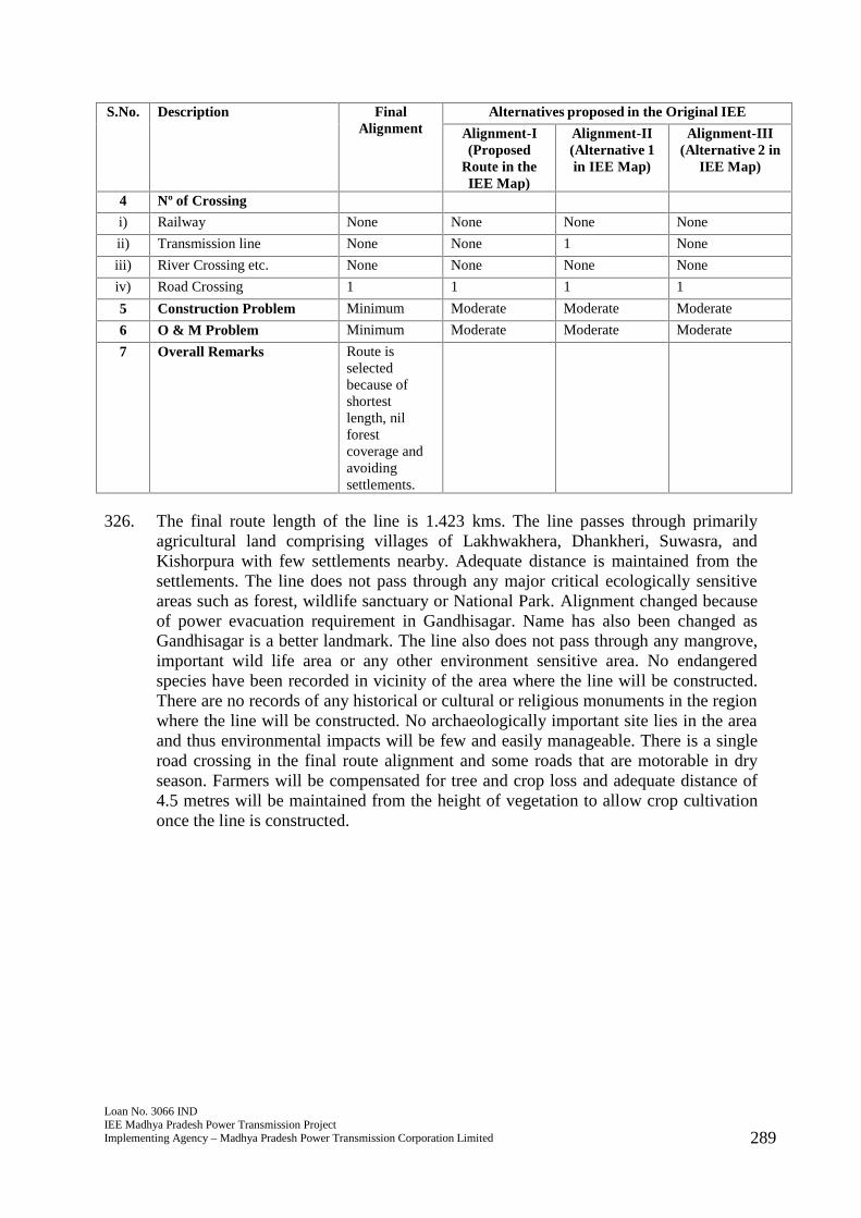
Loan No. 3066 INDIEE Madhya Pradesh Power Transmission ProjectImplementing Agency – Madhya Pradesh Power Transmission Corporation Limited 289
S.No. Description FinalAlignment
Alternatives proposed in the Original IEE
Alignment-I(Proposed
Route in theIEE Map)
Alignment-II(Alternative 1in IEE Map)
Alignment-III(Alternative 2 in
IEE Map)
4 Nº of Crossing
i) Railway None None None None
ii) Transmission line None None 1 None
iii) River Crossing etc. None None None None
iv) Road Crossing 1 1 1 1
5 Construction Problem Minimum Moderate Moderate Moderate
6 O & M Problem Minimum Moderate Moderate Moderate
7 Overall Remarks Route isselectedbecause ofshortestlength, nilforestcoverage andavoidingsettlements.
326. The final route length of the line is 1.423 kms. The line passes through primarilyagricultural land comprising villages of Lakhwakhera, Dhankheri, Suwasra, andKishorpura with few settlements nearby. Adequate distance is maintained from thesettlements. The line does not pass through any major critical ecologically sensitiveareas such as forest, wildlife sanctuary or National Park. Alignment changed becauseof power evacuation requirement in Gandhisagar. Name has also been changed asGandhisagar is a better landmark. The line also does not pass through any mangrove,important wild life area or any other environment sensitive area. No endangeredspecies have been recorded in vicinity of the area where the line will be constructed.There are no records of any historical or cultural or religious monuments in the regionwhere the line will be constructed. No archaeologically important site lies in the areaand thus environmental impacts will be few and easily manageable. There is a singleroad crossing in the final route alignment and some roads that are motorable in dryseason. Farmers will be compensated for tree and crop loss and adequate distance of4.5 metres will be maintained from the height of vegetation to allow crop cultivationonce the line is constructed.
Loan No. 3066 INDIEE Madhya Pradesh Power Transmission ProjectImplementing Agency – Madhya Pradesh Power Transmission Corporation Limited 290
7.0 Public Consultation and Information Disclosure
327. Initial consultations were done in September, 2013, then again for the updated IEEreport of May 2017 during the site visits in March, October and December 2016 andagain in December 2017 (for the new sections identified and as updated in this report)for transmission system improvement and project affected persons were consulted.Consultations were held at the transmission lines sites and near substation sites.Concerns of local people were common and they include: (i) load shedding and lackof reliable and stable supply of power affecting their produce and livelihood, and (ii)timely compensation to farmers affected during construction of substations, erectionof the transmission towers, and stringing of conductors. Consultation summary tableis given in Annexure 2. Photographs of public consultation are given in Annexure 3and 4 and sample attendance sheet for some transmission lines is given in Annexure5.
328. Local people are aware of the proposed project and are generally supportive due toexpected benefits. Consultations with project stakeholders in varying degrees willcontinue throughout the life of the project.
329. The updated IEE will be posted to the website of ADB as required by SPS 2009 andPublic Communications Policy 2011. A project factsheet or a frequently askedquestions flyer in Hindi will be made available to the public at the MP Transco-PMUfield office. The flyer will include among others, the information on grievance redressmechanism. Aside from these public disclosure requirements, the Right toInformation Act 2005 of GoI also provides for additional obligation to MP Transco toprovide information about the project. Hindi translation of IEE report’s executivesummary and EMP will be disclosed by the client which will provide relevantenvironmental information in a timely manner, in an accessible place and in a formand language(s) understandable to affected people and other stakeholders. Forilliterate people, other suitable communication methods will be used.
Loan No. 3066 INDIEE Madhya Pradesh Power Transmission ProjectImplementing Agency – Madhya Pradesh Power Transmission Corporation Limited 291
8.0 Grievance Redress Mechanism
330. Current Scenario MP Transco conducts “vigilance” through its cell which covers civiland electrical works only. There is no separate cell to address public grievance orcomplaint on environmental issues. Generally, public grievance is associated withland acquisition issues. In such a case, affected person(s) contacts the RevenueDepartment who will lodge the grievance on behalf of the affected person(s) to theSuperintendent Engineer (SE) of MP Transco. The SE under Engineering &Construction Department reviews the complaint and resolves the issue.
331. To ensure that public grievance and/or complaint on environmental (and social) issuesare addressed during the implementation of the transmission system improvementproject, the PMU of MP Transco will establish a grievance redress mechanism(GRM).
332. Goals: The GRM shall provide an accessible platform for receiving and facilitatingresolution of affected person’s grievances related to the project/ subproject.According to SPS 2009, the GRM will address concerns and complaints promptly,using an understandable and transparent process that is gender responsive, culturallyappropriate and readily accessible to the affected persons at no costs and withoutretribution. GRM is normally incorporated in the compensation process due to landacquisition and temporary damages to crops and lands during construction but willalso cover issues that may be raised on environmental issues such as increased levelof dust and noise causing inconvenience to local people, traffic, or other relevantissues.
333. Composition: The GRM will have a grievance redress committee (GRC) set up byMP Transco-PMU as soon as the project commence and will continue to functionfrom construction to operation phase. The GRC will consist of representatives fromthe local Panchayat Head, a District Revenue Commissioner, representative from theEPC Contractor(s) only during construction phase, designated staff of MP Transco-PMU on safeguards, Manager/Director of MP Transco-PMU, and a witness of thecomplainant/affected person. MP Transco-PMU will ensure that there isrepresentation of women in the GRC.
334. Responsibilities: The GRC is expected to: (i) resolve issues on land acquisition (ifany), compensation to temporary damages to crops and plants, and other use of landsuch as borrow areas for transmission towers and substations; (ii) convene twice amonth to review complaints lodged (if any), (iii) record the grievances and resolve theissues within a month (30 days) from the date the grievance was filed, (iv) report tothe complainant(s) the status of grievance resolution and the decisions made.
335. Procedures: Minor grievances on compensation or environmental issue duringconstruction will be resolved onsite through the EPC Contractor(s) Project SiteEngineer. As a formal process of grievance resolution, the procedure is given belowand described in Figure 8.1.
(i) Affected persons (APs) will be informed in writing by MP Transco-PMU (ordesignated representative) of the damages and entitlements for compensation. Ifthe APs are satisfied, compensation can be claimed from MP Transco-PMUthrough the EPC Contractor(s). If the APs are not satisfied, they can request for
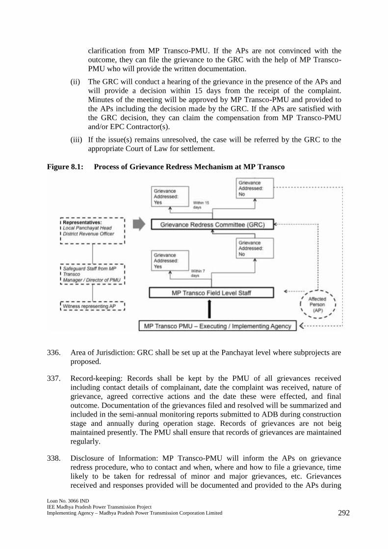
Loan No. 3066 INDIEE Madhya Pradesh Power Transmission ProjectImplementing Agency – Madhya Pradesh Power Transmission Corporation Limited 292
clarification from MP Transco-PMU. If the APs are not convinced with theoutcome, they can file the grievance to the GRC with the help of MP Transco-PMU who will provide the written documentation.
(ii) The GRC will conduct a hearing of the grievance in the presence of the APs andwill provide a decision within 15 days from the receipt of the complaint.Minutes of the meeting will be approved by MP Transco-PMU and provided tothe APs including the decision made by the GRC. If the APs are satisfied withthe GRC decision, they can claim the compensation from MP Transco-PMUand/or EPC Contractor(s).
(iii) If the issue(s) remains unresolved, the case will be referred by the GRC to theappropriate Court of Law for settlement.
Figure 8.1: Process of Grievance Redress Mechanism at MP Transco
336. Area of Jurisdiction: GRC shall be set up at the Panchayat level where subprojects areproposed.
337. Record-keeping: Records shall be kept by the PMU of all grievances receivedincluding contact details of complainant, date the complaint was received, nature ofgrievance, agreed corrective actions and the date these were effected, and finaloutcome. Documentation of the grievances filed and resolved will be summarized andincluded in the semi-annual monitoring reports submitted to ADB during constructionstage and annually during operation stage. Records of grievances are not beigmaintained presently. The PMU shall ensure that records of grievances are maintainedregularly.
338. Disclosure of Information: MP Transco-PMU will inform the APs on grievanceredress procedure, who to contact and when, where and how to file a grievance, timelikely to be taken for redressal of minor and major grievances, etc. Grievancesreceived and responses provided will be documented and provided to the APs during
Loan No. 3066 INDIEE Madhya Pradesh Power Transmission ProjectImplementing Agency – Madhya Pradesh Power Transmission Corporation Limited 293
the process. The number of grievances recorded and resolved and the outcomes willbe displayed/disclosed in the field offices of MP Transco-PMU and offices of theconcerned local Panchayat and District Revenue Office.
339. Review of the Process: MP Transco-PMU will periodically review theimplementation of the GRM and record information on the effectiveness of themechanism, especially on the project‘s ability to prevent and address grievances.
340. Cost of Implementation: Costs involved in resolving the complaints (meetings,consultations, communication and reporting/information dissemination) will be borneby MP Transco. The cost of implementation will be taken from the administrationcost included in the total cost of the Initial Environmental Examination (IEE) for theproject. If the administration cost is not adequate, the budget will be taken from thecontingency cost of the IEE.
Loan No. 3066 INDIEE Madhya Pradesh Power Transmission ProjectImplementing Agency – Madhya Pradesh Power Transmission Corporation Limited 294
9.0 Environmental Management Plan
9.1.1 Mitigation
341. The environmental management plan (EMP) presents a summary of theenvironmental impacts associated with subprojects for power transmission systemimprovement including the mitigation measures (Table 9.2). The EMP will beupdated before the start of civil works, and as needed, to accommodate any change inthe condition of the site or alignment of the transmission line after the contractorsurvey, performance of EPC Contractor(s), and feedback from local people or otherstakeholders.
9.1.2 Monitoring
342. During the construction stage, environmental monitoring will be a daily or weeklyprocess to ensure that non-compliance to the EMP by the EPC Contractor(s) if any,will be avoided and/or immediately addressed. The results of monitoring will besubmitted to ADB twice a year during construction and annually during operation asrequired by SPS 2009. Baseline data for environmental parameters such as air andnoise is not available but will be carried out and recorded by contractor beforecommencement of civil works.
343. Monitoring and maintenance of the power transmission system during operationensure the integrity and safety of the structures and components, thus, minimizingsafety risks to the public and damage to properties.
9.1.3 Institutional Arrangements
344. Currently, MP Transco has a PMU responsible for procurement, feasibilityassessments, and bid planning. PMU staff is aware of safeguards issues andcompliance but there is no staff designated to deal with these concerns. The MadhyaPradesh Power transmission Company (MP Transco will serve as the executingagencies (EAs) and implementing agencies (IAs) for the project. MP Transco hasestablished project management units (PMUs) to implement the ADB loans inMadhya Pradesh Power Sector Program. They will continue as PMUs of the proposedproject. Field level staff/engineer will be deputed at divisional level who will assumeprimary responsibility for the environmental and social assessment as well asimplementation of RPs for their respective components. Keeping in view the capacityof MP Transco and its existing PMU, it is proposed that each PMU will designate anenvironmental staff (or a Consultant), who will be primarily responsible for ensuringthat the EMP is properly implemented, will be recruited for the project prior to awardof the civil works contract. He/she will coordinate and interact with MP Transco-PMU on compliance to ADB requirements, relevant government agencies and localauthorities on permits (as needed), update and finalize the draft IEE, and will prepareenvironmental monitoring reports for submission to ADB at least twice a year duringconstruction and annually during operation. The PMUs will be responsible formanaging the site activities related to safeguards and will work closely with the fieldlevel staff. Overall implementation of the EMP will be carried out under thesupervision of the Head, MP Transco-PMU.
345. XIDAS has been appointed as an environmental consultant by MPPTCL forpreparing this updated IEE report. XIDAS or the Xavier Institute of Development
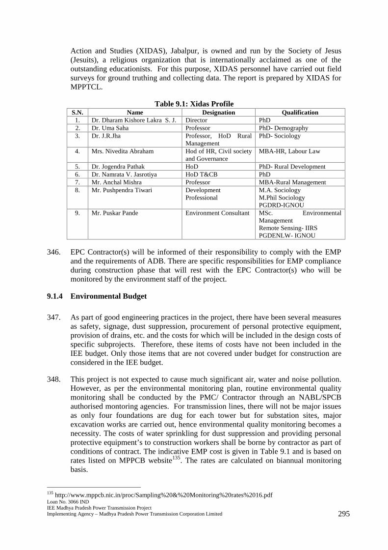
Loan No. 3066 INDIEE Madhya Pradesh Power Transmission ProjectImplementing Agency – Madhya Pradesh Power Transmission Corporation Limited 295
Action and Studies (XIDAS), Jabalpur, is owned and run by the Society of Jesus(Jesuits), a religious organization that is internationally acclaimed as one of theoutstanding educationists. For this purpose, XIDAS personnel have carried out fieldsurveys for ground truthing and collecting data. The report is prepared by XIDAS forMPPTCL.
Table 9.1: Xidas ProfileS.N. Name Designation Qualification
1. Dr. Dharam Kishore Lakra S. J. Director PhD2. Dr. Uma Saha Professor PhD- Demography3. Dr. J.R.Jha Professor, HoD Rural
ManagementPhD- Sociology
4. Mrs. Nivedita Abraham Hod of HR, Civil societyand Governance
MBA-HR, Labour Law
5. Dr. Jogendra Pathak HoD PhD- Rural Development6. Dr. Namrata V. Jasrotiya HoD T&CB PhD7. Mr. Anchal Mishra Professor MBA-Rural Management8. Mr. Pushpendra Tiwari Development
ProfessionalM.A. SociologyM.Phil SociologyPGDRD-IGNOU
9. Mr. Puskar Pande Environment Consultant MSc. EnvironmentalManagementRemote Sensing- IIRSPGDENLW- IGNOU
346. EPC Contractor(s) will be informed of their responsibility to comply with the EMPand the requirements of ADB. There are specific responsibilities for EMP complianceduring construction phase that will rest with the EPC Contractor(s) who will bemonitored by the environment staff of the project.
9.1.4 Environmental Budget
347. As part of good engineering practices in the project, there have been several measuresas safety, signage, dust suppression, procurement of personal protective equipment,provision of drains, etc. and the costs for which will be included in the design costs ofspecific subprojects. Therefore, these items of costs have not been included in theIEE budget. Only those items that are not covered under budget for construction areconsidered in the IEE budget.
348. This project is not expected to cause much significant air, water and noise pollution.However, as per the environmental monitoring plan, routine environmental qualitymonitoring shall be conducted by the PMC/ Contractor through an NABL/SPCBauthorised montoring agencies. For transmission lines, there will not be major issuesas only four foundations are dug for each tower but for substation sites, majorexcavation works are carried out, hence environmental quality monitoring becomes anecessity. The costs of water sprinkling for dust suppression and providing personalprotective equipment’s to construction workers shall be borne by contractor as part ofconditions of contract. The indicative EMP cost is given in Table 9.1 and is based onrates listed on MPPCB website135. The rates are calculated on biannual monitoringbasis.
135 http://www.mppcb.nic.in/proc/Sampling%20&%20Monitoring%20rates%2016.pdf
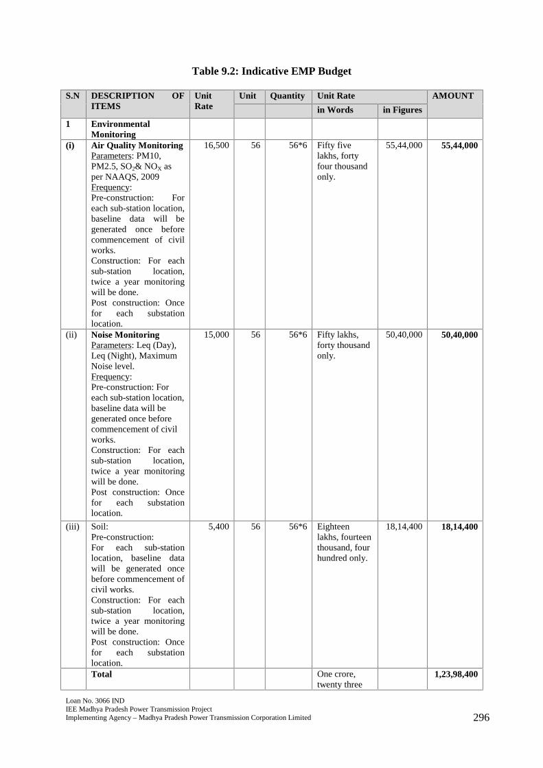
Loan No. 3066 INDIEE Madhya Pradesh Power Transmission ProjectImplementing Agency – Madhya Pradesh Power Transmission Corporation Limited 296
Table 9.2: Indicative EMP Budget
S.N DESCRIPTION OFITEMS
UnitRate
Unit Quantity Unit Rate AMOUNT
in Words in Figures
1 EnvironmentalMonitoring
(i) Air Quality MonitoringParameters: PM10,PM2.5, SO2& NOX asper NAAQS, 2009Frequency:Pre-construction: Foreach sub-station location,baseline data will begenerated once beforecommencement of civilworks.Construction: For eachsub-station location,twice a year monitoringwill be done.Post construction: Oncefor each substationlocation.
16,500 56 56*6 Fifty fivelakhs, fortyfour thousandonly.
55,44,000 55,44,000
(ii) Noise MonitoringParameters: Leq (Day),Leq (Night), MaximumNoise level.Frequency:Pre-construction: Foreach sub-station location,baseline data will begenerated once beforecommencement of civilworks.Construction: For eachsub-station location,twice a year monitoringwill be done.Post construction: Oncefor each substationlocation.
15,000 56 56*6 Fifty lakhs,forty thousandonly.
50,40,000 50,40,000
(iii) Soil:Pre-construction:For each sub-stationlocation, baseline datawill be generated oncebefore commencement ofcivil works.Construction: For eachsub-station location,twice a year monitoringwill be done.Post construction: Oncefor each substationlocation.
5,400 56 56*6 Eighteenlakhs, fourteenthousand, fourhundred only.
18,14,400 18,14,400
Total One crore,twenty three
1,23,98,400
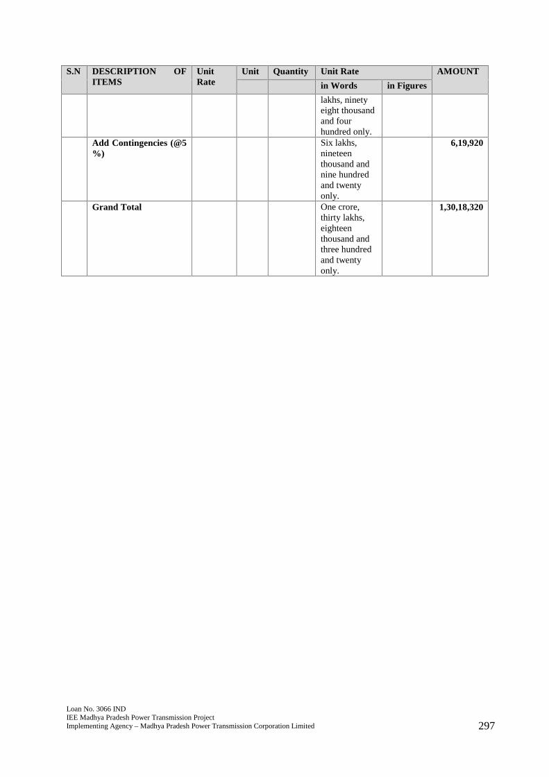
Loan No. 3066 INDIEE Madhya Pradesh Power Transmission ProjectImplementing Agency – Madhya Pradesh Power Transmission Corporation Limited 297
S.N DESCRIPTION OFITEMS
UnitRate
Unit Quantity Unit Rate AMOUNT
in Words in Figures
lakhs, ninetyeight thousandand fourhundred only.
Add Contingencies (@5%)
Six lakhs,nineteenthousand andnine hundredand twentyonly.
6,19,920
Grand Total One crore,thirty lakhs,eighteenthousand andthree hundredand twentyonly.
1,30,18,320
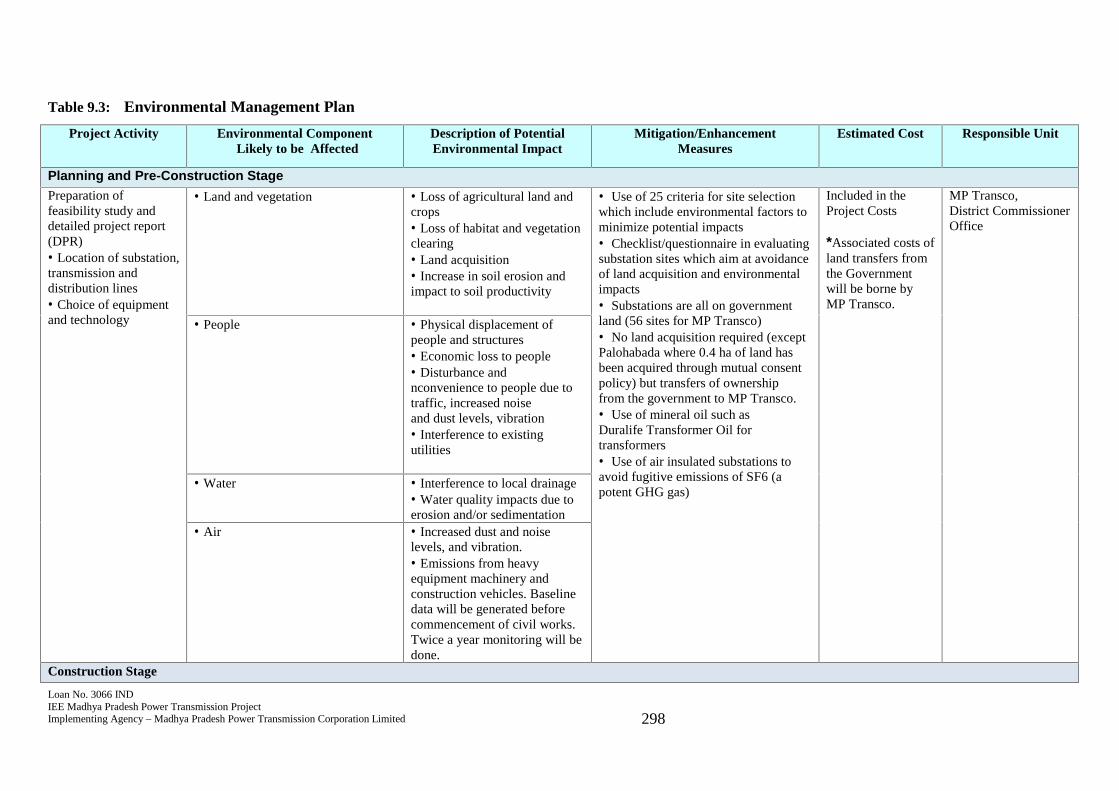
Loan No. 3066 INDIEE Madhya Pradesh Power Transmission ProjectImplementing Agency – Madhya Pradesh Power Transmission Corporation Limited 298
Table 9.3: Environmental Management Plan
Project Activity Environmental ComponentLikely to be Affected
Description of PotentialEnvironmental Impact
Mitigation/EnhancementMeasures
Estimated Cost Responsible Unit
Planning and Pre-Construction StagePreparation offeasibility study anddetailed project report(DPR) Location of substation,transmission anddistribution lines Choice of equipmentand technology
Land and vegetation Loss of agricultural land andcrops Loss of habitat and vegetationclearing Land acquisition Increase in soil erosion andimpact to soil productivity
Use of 25 criteria for site selectionwhich include environmental factors tominimize potential impacts Checklist/questionnaire in evaluatingsubstation sites which aim at avoidanceof land acquisition and environmentalimpacts Substations are all on governmentland (56 sites for MP Transco) No land acquisition required (exceptPalohabada where 0.4 ha of land hasbeen acquired through mutual consentpolicy) but transfers of ownershipfrom the government to MP Transco. Use of mineral oil such asDuralife Transformer Oil fortransformers Use of air insulated substations toavoid fugitive emissions of SF6 (apotent GHG gas)
Included in theProject Costs
*Associated costs ofland transfers fromthe Governmentwill be borne byMP Transco.
MP Transco,District CommissionerOffice
People Physical displacement ofpeople and structures Economic loss to people Disturbance andnconvenience to people due totraffic, increased noiseand dust levels, vibration Interference to existingutilities
Water Interference to local drainage Water quality impacts due toerosion and/or sedimentation Air Increased dust and noiselevels, and vibration. Emissions from heavyequipment machinery andconstruction vehicles. Baselinedata will be generated beforecommencement of civil works.Twice a year monitoring will bedone.
Construction Stage
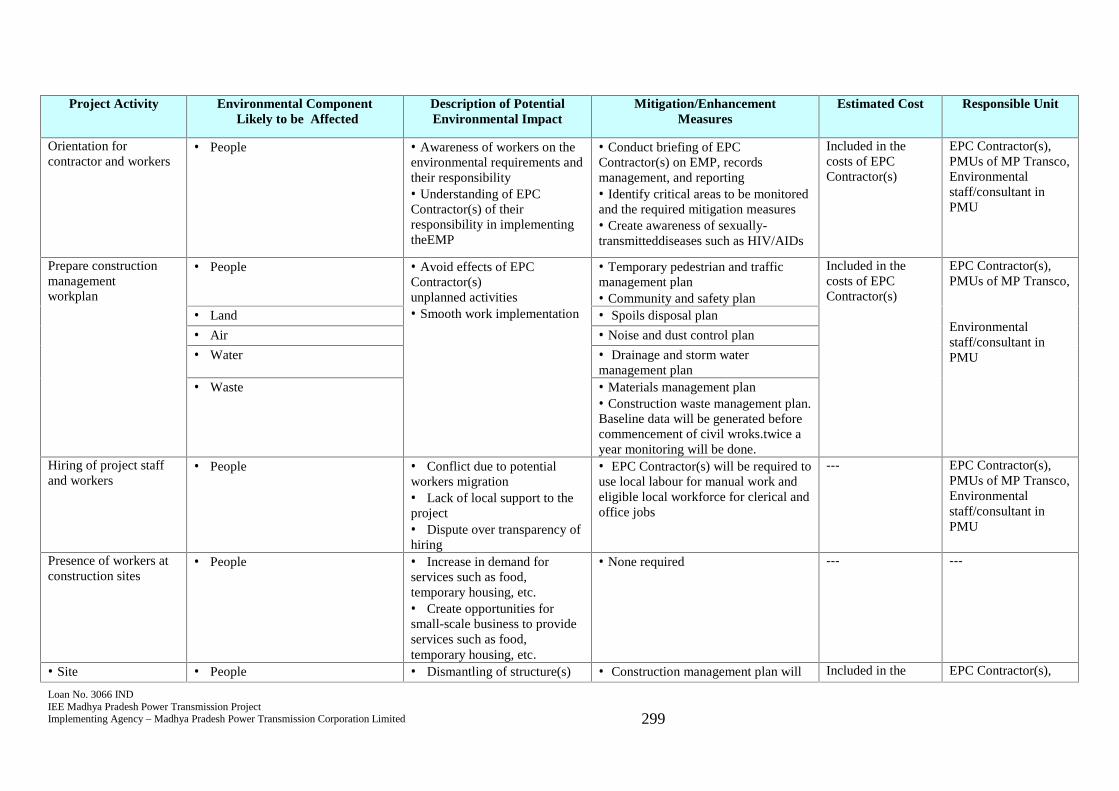
Loan No. 3066 INDIEE Madhya Pradesh Power Transmission ProjectImplementing Agency – Madhya Pradesh Power Transmission Corporation Limited 299
Project Activity Environmental ComponentLikely to be Affected
Description of PotentialEnvironmental Impact
Mitigation/EnhancementMeasures
Estimated Cost Responsible Unit
Orientation forcontractor and workers
People Awareness of workers on theenvironmental requirements andtheir responsibility Understanding of EPCContractor(s) of theirresponsibility in implementingtheEMP
Conduct briefing of EPCContractor(s) on EMP, recordsmanagement, and reporting Identify critical areas to be monitoredand the required mitigation measures Create awareness of sexually-transmitteddiseases such as HIV/AIDs
Included in thecosts of EPCContractor(s)
EPC Contractor(s),PMUs of MP Transco,Environmentalstaff/consultant inPMU
Prepare constructionmanagementworkplan
People Avoid effects of EPCContractor(s)unplanned activities Smooth work implementation
Temporary pedestrian and trafficmanagement plan Community and safety plan
Included in thecosts of EPCContractor(s)
EPC Contractor(s),PMUs of MP Transco,
Environmentalstaff/consultant inPMU
Land Spoils disposal plan Air Noise and dust control plan Water Drainage and storm water
management plan Waste Materials management plan
Construction waste management plan.Baseline data will be generated beforecommencement of civil wroks.twice ayear monitoring will be done.
Hiring of project staffand workers
People Conflict due to potentialworkers migration Lack of local support to theproject Dispute over transparency ofhiring
EPC Contractor(s) will be required touse local labour for manual work andeligible local workforce for clerical andoffice jobs
--- EPC Contractor(s),PMUs of MP Transco,Environmentalstaff/consultant inPMU
Presence of workers atconstruction sites
People Increase in demand forservices such as food,temporary housing, etc. Create opportunities forsmall-scale business to provideservices such as food,temporary housing, etc.
None required --- ---
Site People Dismantling of structure(s) Construction management plan will Included in the EPC Contractor(s),
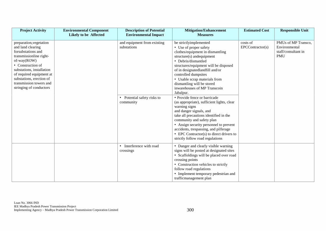
Loan No. 3066 INDIEE Madhya Pradesh Power Transmission ProjectImplementing Agency – Madhya Pradesh Power Transmission Corporation Limited 300
Project Activity Environmental ComponentLikely to be Affected
Description of PotentialEnvironmental Impact
Mitigation/EnhancementMeasures
Estimated Cost Responsible Unit
preparation,vegetationand land clearingforsubstations andtransmissionline right-of-way(ROW) Construction ofsubstations, installationof required equipment atsubstations, erection oftransmission towers andstringing of conductors
and equipment from existingsubstations
be strictlyimplemented Use of proper safetyclothes/equipment in dismantlingstructure(s) andequipment Debris/dismantledstructures/equipment will be disposedof in designatedlandfill and/orcontrolled dumpsites Usable scrap materials fromdismantling will be storedinwarehouses of MP TranscoinJabalpur.
costs ofEPCContractor(s)
PMUs of MP Transco,Environmentalstaff/consultant inPMU
Potential safety risks tocommunity
Provide fence or barricade(as appropriate), sufficient lights, clearwarning signsand danger signals, andtake all precautions identified in thecommunity and safety plan Assign security personnel to preventaccidents, trespassing, and pilferage EPC Contractor(s) to direct drivers tostrictly follow road regulations
Interference with roadcrossings
Danger and clearly visible warningsigns will be posted at designated sites Scaffoldings will be placed over roadcrossing points Construction vehicles to strictlyfollow road regulations Implement temporary pedestrian andtrafficmanagement plan

Loan No. 3066 INDIEE Madhya Pradesh Power Transmission ProjectImplementing Agency – Madhya Pradesh Power Transmission Corporation Limited 301
Project Activity Environmental ComponentLikely to be Affected
Description of PotentialEnvironmental Impact
Mitigation/EnhancementMeasures
Estimated Cost Responsible Unit
Potential health and safetyrisks to workers
Provide sanitary facilities and washareas Provide safe drinking water andgarbage bins Enforce good housekeeping at alltimes Provide workers with hard hat, safetyshoes and belts Coordinate with nearest hospital forarrangements in case of accidents Assign nurse or medicalstaff to make weekly rounds atsubstation sites Set up first aid treatment withinconstruction sites and field office Observance and compliance withrelevant safety measures required bylaw and best engineering practices Provide communication devices todesignated workers
Land and vegetation Erosion and localizedflooding Loss of habitat and somemature trees of economic valuesuch as teak
Compensation for temporary damagesto crops/plants along the ROW andsubstations Cut trees owned by the governmentwill be sold andrevenue turned overtoRevenue Authority Landscaping/replanting of trees atsubs-stations will bedone aftercompletion of construction works Erosion-control measures will beprovided (as needed) Implement spoils disposal plan andconstruction waste management plan
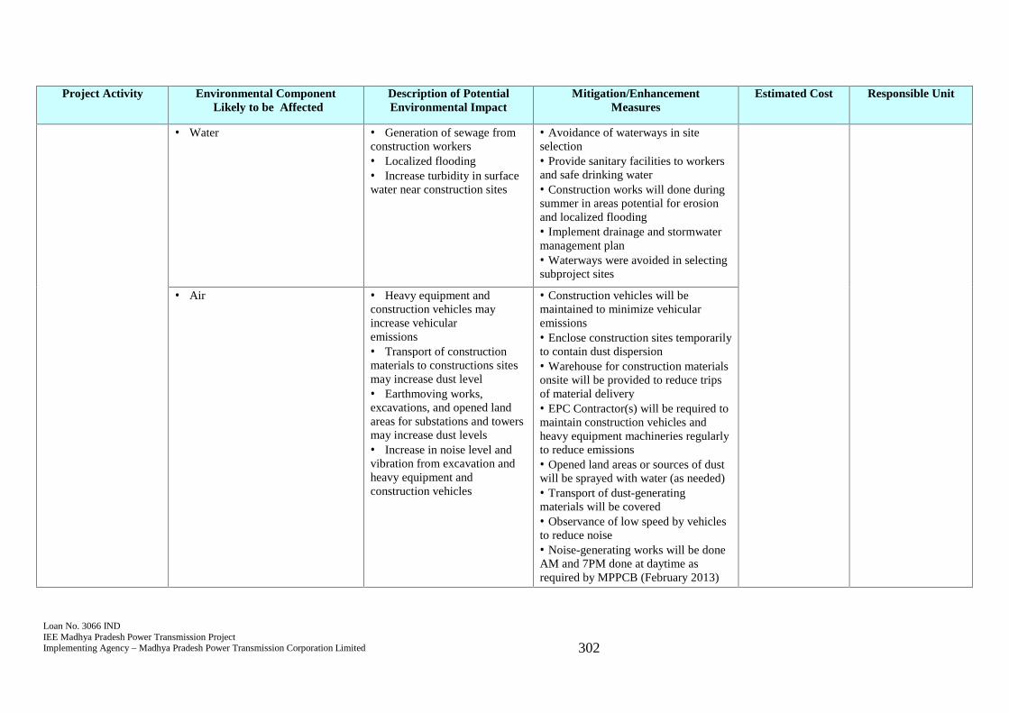
Loan No. 3066 INDIEE Madhya Pradesh Power Transmission ProjectImplementing Agency – Madhya Pradesh Power Transmission Corporation Limited 302
Project Activity Environmental ComponentLikely to be Affected
Description of PotentialEnvironmental Impact
Mitigation/EnhancementMeasures
Estimated Cost Responsible Unit
Water Generation of sewage fromconstruction workers Localized flooding Increase turbidity in surfacewater near construction sites
Avoidance of waterways in siteselection Provide sanitary facilities to workersand safe drinking water Construction works will done duringsummer in areas potential for erosionand localized flooding Implement drainage and stormwatermanagement plan Waterways were avoided in selectingsubproject sites
Air Heavy equipment andconstruction vehicles mayincrease vehicularemissions Transport of constructionmaterials to constructions sitesmay increase dust level Earthmoving works,excavations, and opened landareas for substations and towersmay increase dust levels Increase in noise level andvibration from excavation andheavy equipment andconstruction vehicles
Construction vehicles will bemaintained to minimize vehicularemissions Enclose construction sites temporarilyto contain dust dispersion Warehouse for construction materialsonsite will be provided to reduce tripsof material delivery EPC Contractor(s) will be required tomaintain construction vehicles andheavy equipment machineries regularlyto reduce emissions Opened land areas or sources of dustwill be sprayed with water (as needed) Transport of dust-generatingmaterials will be covered Observance of low speed by vehiclesto reduce noise Noise-generating works will be doneAM and 7PM done at daytime asrequired by MPPCB (February 2013)
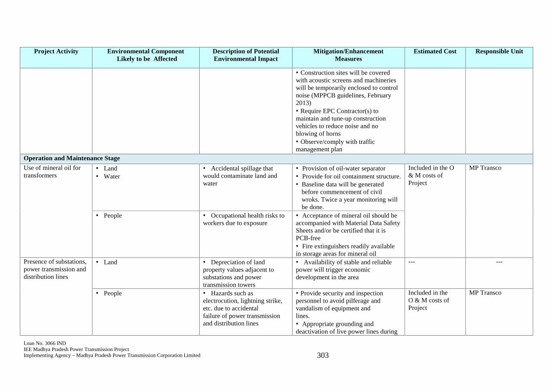
Loan No. 3066 INDIEE Madhya Pradesh Power Transmission ProjectImplementing Agency – Madhya Pradesh Power Transmission Corporation Limited 303
Project Activity Environmental ComponentLikely to be Affected
Description of PotentialEnvironmental Impact
Mitigation/EnhancementMeasures
Estimated Cost Responsible Unit
Construction sites will be coveredwith acoustic screens and machinerieswill be temporarily enclosed to controlnoise (MPPCB guidelines, February2013) Require EPC Contractor(s) tomaintain and tune-up constructionvehicles to reduce noise and noblowing of horns Observe/comply with trafficmanagement planOperation and Maintenance Stage
Use of mineral oil fortransformers
Land Water
Accidental spillage thatwould contaminate land andwater
Provision of oil-water separator Provide for oil containment structure. Baseline data will be generated
before commencement of civilwroks. Twice a year monitoring willbe done.
Included in the O& M costs ofProject
MP Transco
People Occupational health risks toworkers due to exposure
Acceptance of mineral oil should beaccompanied with Material Data SafetySheets and/or be certified that it isPCB-free Fire extinguishers readily availablein storage areas for mineral oil
Presence of substations,power transmission anddistribution lines
Land Depreciation of landproperty values adjacent tosubstations and powertransmission towers
Availability of stable and reliablepower will trigger economicdevelopment in the area
--- ---
People Hazards such aselectrocution, lightning strike,etc. due to accidentalfailure of power transmissionand distribution lines
Provide security and inspectionpersonnel to avoid pilferage andvandalism of equipment andlines. Appropriate grounding anddeactivation of live power lines during
Included in theO & M costs ofProject
MP Transco
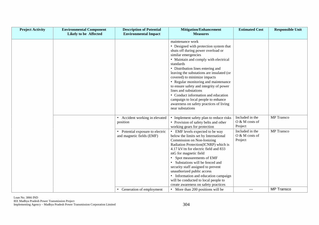
Loan No. 3066 INDIEE Madhya Pradesh Power Transmission ProjectImplementing Agency – Madhya Pradesh Power Transmission Corporation Limited 304
Project Activity Environmental ComponentLikely to be Affected
Description of PotentialEnvironmental Impact
Mitigation/EnhancementMeasures
Estimated Cost Responsible Unit
maintenance work Designed with protection system thatshuts off during power overload orsimilar emergencies Maintain and comply with electricalstandards Distribution lines entering andleaving the substations are insulated (orcovered) to minimize impacts Regular monitoring and maintenanceto ensure safety and integrity of powerlines and substations Conduct information and educationcampaign to local people to enhanceawareness on safety practices of livingnear substations
Accident working in elevatedposition
Implement safety plan to reduce risks Provision of safety belts and otherworking gears for protection
Included in theO & M costs ofProject
MP Transco
Potential exposure to electricand magnetic fields (EMF)
EMF levels expected to be waybelow the limits set by InternationalCommission on Non-IonizingRadiation Protection(ICNRP) which is4.17 kV/m for electric field and 833mG for magnetic field Spot measurements of EMF Substations will be fenced andsecurity staff assigned to preventunauthorized public access Information and education campaignwill be conducted to local people tocreate awareness on safety practices
Included in theO & M costs ofProject
MP Transco
Generation of employment More than 200 positions will be --- MP Transco
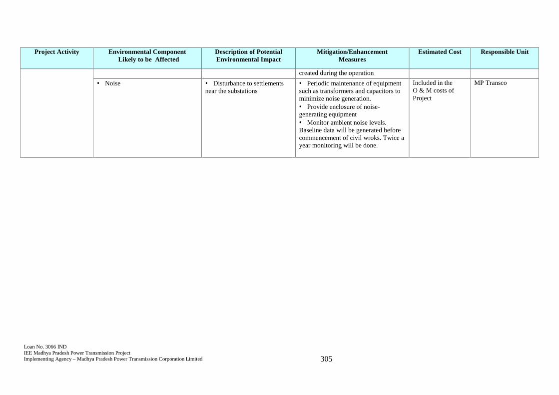
Loan No. 3066 INDIEE Madhya Pradesh Power Transmission ProjectImplementing Agency – Madhya Pradesh Power Transmission Corporation Limited 305
Project Activity Environmental ComponentLikely to be Affected
Description of PotentialEnvironmental Impact
Mitigation/EnhancementMeasures
Estimated Cost Responsible Unit
created during the operation
Noise Disturbance to settlementsnear the substations
Periodic maintenance of equipmentsuch as transformers and capacitors tominimize noise generation. Provide enclosure of noise-generating equipment Monitor ambient noise levels.Baseline data will be generated beforecommencement of civil wroks. Twice ayear monitoring will be done.
Included in theO & M costs ofProject
MP Transco
Loan No. 3066 INDIEE Madhya Pradesh Power Transmission ProjectImplementing Agency – Madhya Pradesh Power Transmission Corporation Limited 306
10.0 FIELD-BASED ENVIRONMENTAL DUE DILIGENCE
349. This chapter ascertains presence of any residual environmental impacts due toimplementation of works because changes in sub-station locations and otheradditional scope, and suggests appropriate, time-bound corrective measures to addressthose residual environmental impacts.
350. The various aspects that would be considered for such field-based environmental duediligence are elaborated below:
(a) Confirmation of EMP in contractor’s contract agreement: EMP is made part ofcontractor’s contractor agreement and the contractor’s compliance to EMP is beingmonitored by the environmental and social management unit established in projectmanagement unit by carrying out field visits from time to time during the projectimplementation.
(b) Compliance status during pre-construction and construction stage of the sub-project(s): Contractor is made mandate to submit the quarterly environmentalmanagement plan compliance report to keep a check on the EMP complianceactivities. Environmental management plan as provided in the original IEE report andthis updated IEE report is being followed by the contractor during the implementationstage.
(c) Status of statutory permission applicable for the sub-project(s), if any: Thesubprojects do not involve any major construction works except for the constructionof control room, foundation work for equipment’s and poles of 33kV and 11kV lines.Thus, no major environmental impact is anticipated due to the construction workinvolved in the subprojects.
The major statuary clearances applicable to the involved subprojects are labor license,pollution under control certificate, workman’s compensation and insurance policy,and permission of tree cuttings (if involved) for ROW clearance. The detailsregarding the submission of individual renewed documents is being provided insubsequent environmental safeguard monitoring reports. Contractor is suggested fromtime to time regarding obtaining all the renewed necessary statuary permissionsbefore commencing the work.
(d) Status on implementation of environmental mitigation measures, if any and testingof environmental parameters of ambient air quality and ambient noise levels along thesubprojects as per agreed monitoring plan, if any: environmental monitoring for airquality, water quality and noise level is carried out as per given environmentalmonitoring plan. No major impact on air quality, water quality and noise level isanticipated from the proposed project.
(e) Residual environmental impacts, if any with appropriate, time-bound correctivemeasures: Contactors are reminded from time to time, to follow the environmental
Loan No. 3066 INDIEE Madhya Pradesh Power Transmission ProjectImplementing Agency – Madhya Pradesh Power Transmission Corporation Limited 307
management plan and the mitigation measures as provided in the EMP. No majorenvironmental impact is noticed.
Thus, no added corrective measure is required/suggested.
(f) Public consultations during project implementation stages: Public consultation isbeing carried out as a part of continuous participation of public in the proposedproject during the implementation stage. The public consultations being carried outduring project implementation stage are being updated in the subsequentenvironmental safeguard monitoring reports.
(g) Status of grievances, if any, received due to implementation of the sub-projects:The grievance redressal committee are setup in all the concern electrical circles. Thedetails of GRC are provided in Chapter 8 of this updated IEE report. No grievancerelated to environmental issue for any subproject is recorded.
(h) Conclusions: No major environmental impact is predicted due to the proposedproject.
Loan No. 3066 INDIEE Madhya Pradesh Power Transmission ProjectImplementing Agency – Madhya Pradesh Power Transmission Corporation Limited 308
11.0 Conclusion and Recommendation
351. Aside from best engineering practice and survey approaches in selecting thetransmission lines, 25 criteria checklist/questionnaire was included to minimizeenvironmental impacts. For substations, one of the primary considerations in selectingthe sites is avoidance of land acquisition.
352. Majority of subprojects for transmission system improvement are not locatedanywhere near the 9 national parks and 25 wildlife sanctuaries or thecultural/archeological excavation sites. The impacts that are associated duringconstruction stage such as increased noise and dust level are temporary and of shortduration. Approach roads in some substation sites such as in Adampur and Intkhediwill require upgrading to facilitate construction but this will also benefit localresidents using the roads. Relevant Indian construction standards on the design,installation and maintenance of substations and transmission lines such as IS:5613(1995) Part II, IS:4091-1967 and IS:3072 (1975) will be complied with. Mitigationmeasures and monitoring to minimize environmental impacts have been incorporatedin the environmental management plan and monitoring plan. Environmentalmonitoring report will be submitted by MP Transco to ADB semi-annually duringconstruction and annually during operation. An environmental staff/consultant will berecruited by MP Transco to provide technical support to MP Transco-PMU inaddressing relevant environment issues and in complying the requirements of ADB.To ensure sustainability, a workshop/training on safeguards compliance will be part ofcapacity building provided by the project.
353. MP Transco conducts “vigilance” through its cell which covers civil and electricalworks only and do not include grievance on environmental issues. To address thislimitation, a grievance redress mechanism will be implemented as soon as the projectcommence. As part of this mechanism, a grievance redress committee will be createdand MP Transco-PMU will ensure the representation of women in the members. Thegrievance redress committee will function throughout the life of the project.
354. Consultations with local people were done as part of preliminary surveys andenvironmental assessment in March, October and December 2016 and December2017. There were concerns on the transparency and valuation of compensation totemporary damages for crops and plants during construction. Overall, local people aresupportive of the project due to the expected long-term benefit of a reliable and stablepower supply. Consultations will continue in varying degrees during construction andoperation. Local people will be informed of the grievance redress mechanism througha flyer/project brief that will be made available in Hindi at the field office of MPTransco-PMU. The IEE will be posted in the website of ADB as provided for by SPS2009 and Public Communications Policy 2011. Hindi translation of the report will bemade available by the client in easily accessible places. All the relevant permitsrequired by GoI will be obtained by MP Transco prior to construction works. For thenew sections, MPPTCL will put on hold all works until this updated report isapproved and disclosed by ADB to ensure safeguards compliance.
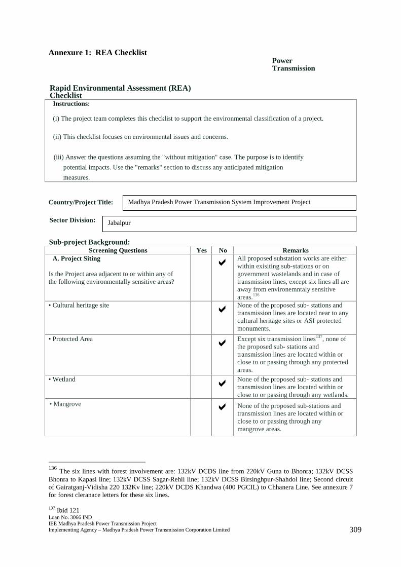
Loan No. 3066 INDIEE Madhya Pradesh Power Transmission ProjectImplementing Agency – Madhya Pradesh Power Transmission Corporation Limited 309
Annexure 1: REA ChecklistPowerTransmission
Rapid Environmental Assessment (REA)ChecklistInstructions:
(i) The project team completes this checklist to support the environmental classification of a project.
(ii) This checklist focuses on environmental issues and concerns.
(iii) Answer the questions assuming the "without mitigation" case. The purpose is to identify
potential impacts. Use the "remarks" section to discuss any anticipated mitigation
measures.
Country/Project Title:
Sector Division:
Sub-project Background:Screening Questions Yes No Remarks
A. Project Siting
Is the Project area adjacent to or within any ofthe following environmentally sensitive areas?
All proposed substation works are eitherwithin exisiting sub-stations or ongovernment wastelands and in case oftransmission lines, except six lines all areaway from environemntaly sensitiveareas.136
• Cultural heritage site None of the proposed sub- stations andtransmission lines are located near to anycultural heritage sites or ASI protectedmonuments.
• Protected Area Except six transmission lines137, none ofthe proposed sub- stations andtransmission lines are located within orclose to or passing through any protectedareas.
• Wetland None of the proposed sub- stations andtransmission lines are located within orclose to or passing through any wetlands.
• Mangrove None of the proposed sub-stations andtransmission lines are located within orclose to or passing through anymangrove areas.
136 The six lines with forest involvement are: 132kV DCDS line from 220kV Guna to Bhonra; 132kV DCSSBhonra to Kapasi line; 132kV DCSS Sagar-Rehli line; 132kV DCSS Birsinghpur-Shahdol line; Second circuitof Gairatganj-Vidisha 220 132Kv line; 220kV DCDS Khandwa (400 PGCIL) to Chhanera Line. See annexure 7for forest cleranace letters for these six lines.
137 Ibid 121
Madhya Pradesh Power Transmission System Improvement Project
Jabalpur
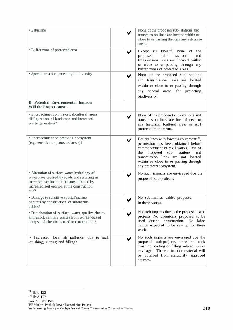
Loan No. 3066 INDIEE Madhya Pradesh Power Transmission ProjectImplementing Agency – Madhya Pradesh Power Transmission Corporation Limited 310
• Estuarine None of the proposed sub- stations andtransmission lines are located within orclose to or passing through any estuarineareas.
• Buffer zone of protected area Except six lines138, none of theproposed sub- stations andtransmission lines are located withinor close to or passing through anybuffer zones of protected areas.
• Special area for protecting biodiversity None of the proposed sub- stationsand transmission lines are locatedwithin or close to or passing throughany special areas for protectingbiodiversity.
B. Potential Environmental ImpactsWill the Project cause ...
• Encroachment on historical/cultural areas,disfiguration of landscape and increasedwaste generation?
None of the proposed sub- stations andtransmission lines are located near toany historical Icultural areas or ASIprotected monuments.
• Encroachment on precious ecosystem(e.g. sensitive or protected areas)? For six lines with forest involvement139,
permission has been obtained beforecommencement of civil works. Rest ofthe proposed sub- stations andtransmission lines are not locatedwithin or close to or passing throughany precious ecosystem.
• Alteration of surface water hydrology ofwaterways crossed by roads and resulting inincreased sediment in streams affected byincreased soil erosion at the constructionsite?
No such impacts are envisaged due theproposed sub-projects.
• Damage to sensitive coastal/marinehabitats by construction of submarinecables?
No submarines cables proposedin these works.
• Deterioration of surface water quality due tosilt runoff, sanitary wastes from worker-basedcamps and chemicals used in construction?
No such impacts due to the proposed sub-projects. No chemicals proposed to beused during construction. No laborcamps expected to be set- up for theseworks.
• I ncreased local air pollution due to rockcrushing, cutting and filling? No such impacts are envisaged due the
proposed sub-projects since no rockcrushing, cutting or filling related worksenvisaged. The construction material willbe obtained from statutorily approvedsources.
138 Ibid 122139 Ibid 123
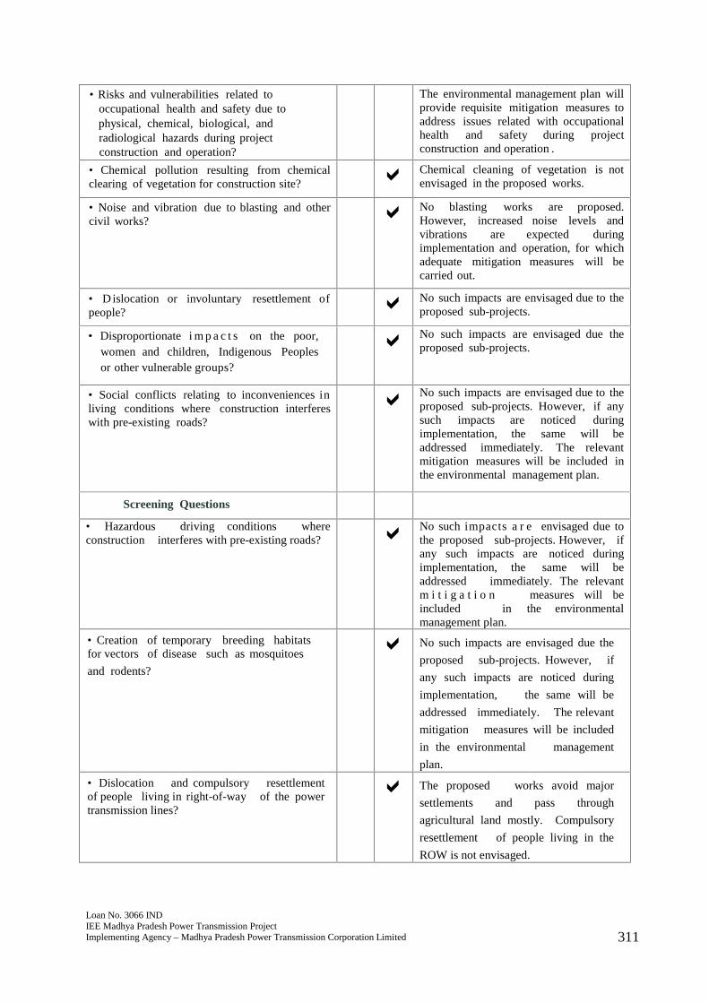
Loan No. 3066 INDIEE Madhya Pradesh Power Transmission ProjectImplementing Agency – Madhya Pradesh Power Transmission Corporation Limited 311
• Risks and vulnerabilities related tooccupational health and safety due tophysical, chemical, biological, andradiological hazards during projectconstruction and operation?
The environmental management plan willprovide requisite mitigation measures toaddress issues related with occupationalhealth and safety during projectconstruction and operation .
• Chemical pollution resulting from chemicalclearing of vegetation for construction site? Chemical cleaning of vegetation is not
envisaged in the proposed works.
• Noise and vibration due to blasting and othercivil works? No blasting works are proposed.
However, increased noise levels andvibrations are expected duringimplementation and operation, for whichadequate mitigation measures will becarried out.
• D islocation or involuntary resettlement ofpeople? No such impacts are envisaged due to the
proposed sub-projects.
• Disproportionate i m p a c t s on the poor,women and children, Indigenous Peoplesor other vulnerable groups?
No such impacts are envisaged due theproposed sub-projects.
• Social conflicts relating to inconveniences inliving conditions where construction interfereswith pre-existing roads?
No such impacts are envisaged due to theproposed sub-projects. However, if anysuch impacts are noticed duringimplementation, the same will beaddressed immediately. The relevantmitigation measures will be included inthe environmental management plan.
Screening Questions
• Hazardous driving conditions whereconstruction interferes with pre-existing roads? No such impacts a r e envisaged due to
the proposed sub-projects. However, ifany such impacts are noticed duringimplementation, the same will beaddressed immediately. The relevantm i t i g a t i o n measures will beincluded in the environmentalmanagement plan.
• Creation of temporary breeding habitatsfor vectors of disease such as mosquitoes
and rodents?
No such impacts are envisaged due the
proposed sub-projects. However, if
any such impacts are noticed during
implementation, the same will be
addressed immediately. The relevant
mitigation measures will be included
in the environmental management
plan.
• Dislocation and compulsory resettlementof people living in right-of-way of the powertransmission lines?
The proposed works avoid major
settlements and pass through
agricultural land mostly. Compulsory
resettlement of people living in the
ROW is not envisaged.
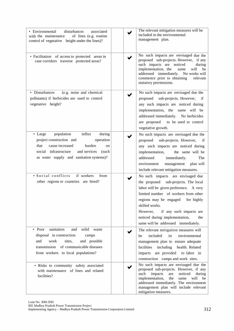
Loan No. 3066 INDIEE Madhya Pradesh Power Transmission ProjectImplementing Agency – Madhya Pradesh Power Transmission Corporation Limited 312
• Environmental disturbances associatedwith the maintenance of lines (e.g. routinecontrol of vegetative height under the lines)?
The relevant mitigation measures will beincluded in the environmentalmanagement plan.
• Facilitation of access to protected areas incase corridors traverse protected areas?
No such impacts are envisaged due theproposed sub-projects. However, if anysuch impacts are noticed duringimplementation, the same will beaddressed immediately. No works willcommence prior to obtaining relevantstatutory perrmssions.
• Disturbances (e.g. noise and chemical
pollutants) if herbicides are used to control
vegetative height?
No such impacts are envisaged due the
proposed sub-projects. However, if
any such impacts are noticed during
implementation, the same will be
addressed immediately. No herbicides
are proposed to be used to control
vegetative growth.
• Large population influx during
project construction and operation
that cause increased burden on
social infrastructure and services (such
as water supply and sanitation systems)?
No such impacts are envisaged due the
proposed sub-projects. However, if
any such impacts are noticed during
implementation, the same will be
addressed immediately. The
environment management plan will
include relevant mitigation measures.
• S o c i a l c o n f l i c t s if workers from
other regions or countries are hired? No such impacts are envisaged due
the proposed sub-projects. The local
labor will be given preference. A very
limited number of workers from other
regions may be engaged for highly
skilled works.
However, if any such impacts are
noticed during implementation, the
same will be addressed immediately.
• Poor sanitation and solid waste
disposal in construction camps
and work sites, and possible
transmission of communicable diseases
from workers to local populations?
The relevant mitigation measures will
be included in environmental
management plan to ensure adequate
facilities including health. Related
impacts are provided to labor in
construction camps and work sites.
• Risks to community safety associatedwith maintenance of lines and relatedfacilities?
No such impacts are envisaged due theproposed sub-projects. However, if anysuch impacts are noticed duringimplementation, the same will beaddressed immediately. The environmentmanagement plan will include relevantmitigation measures.
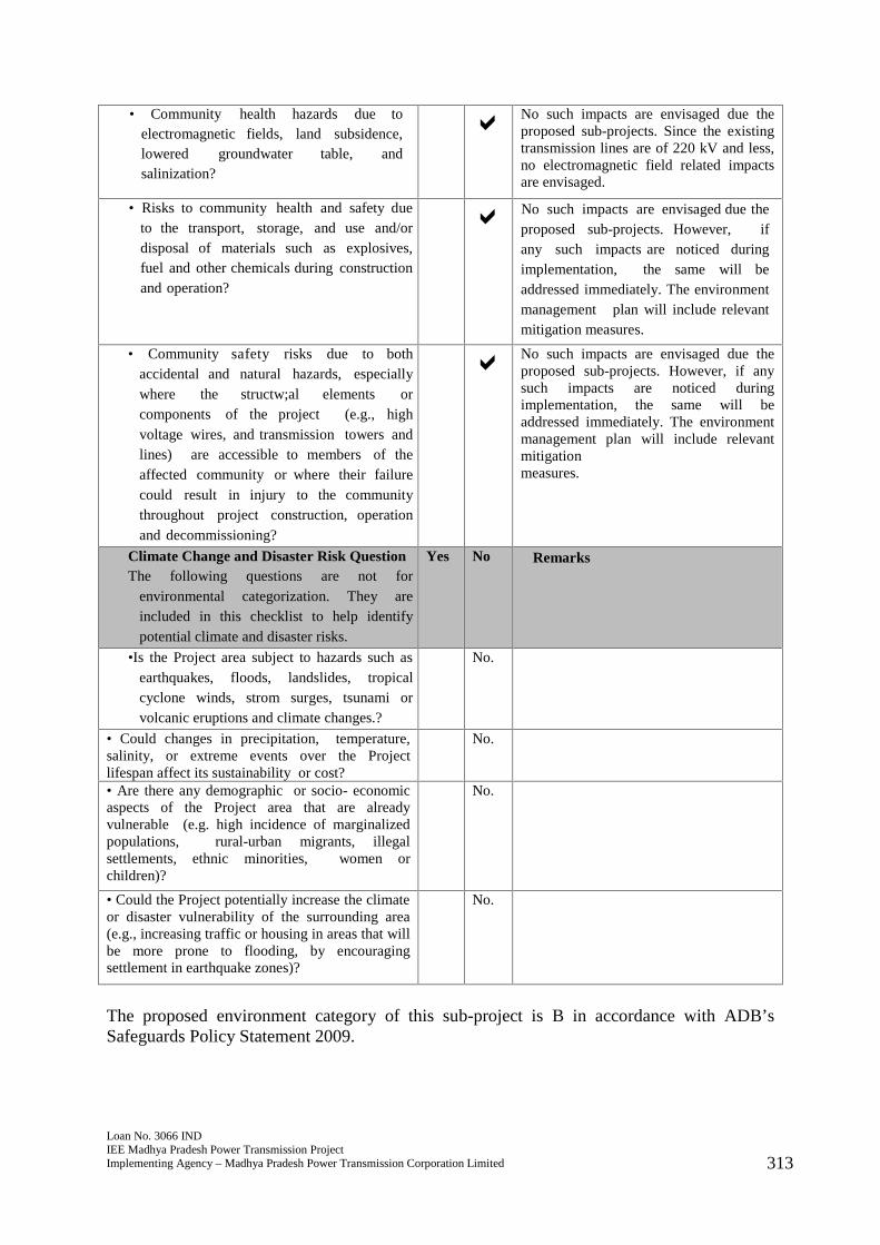
Loan No. 3066 INDIEE Madhya Pradesh Power Transmission ProjectImplementing Agency – Madhya Pradesh Power Transmission Corporation Limited 313
• Community health hazards due toelectromagnetic fields, land subsidence,lowered groundwater table, andsalinization?
No such impacts are envisaged due theproposed sub-projects. Since the existingtransmission lines are of 220 kV and less,no electromagnetic field related impactsare envisaged.
• Risks to community health and safety dueto the transport, storage, and use and/ordisposal of materials such as explosives,fuel and other chemicals during constructionand operation?
No such impacts are envisaged due theproposed sub-projects. However, ifany such impacts are noticed duringimplementation, the same will beaddressed immediately. The environmentmanagement plan will include relevantmitigation measures.
• Community safety risks due to bothaccidental and natural hazards, especiallywhere the structw;al elements orcomponents of the project (e.g., highvoltage wires, and transmission towers andlines) are accessible to members of theaffected community or where their failurecould result in injury to the communitythroughout project construction, operationand decommissioning?
No such impacts are envisaged due theproposed sub-projects. However, if anysuch impacts are noticed duringimplementation, the same will beaddressed immediately. The environmentmanagement plan will include relevantmitigationmeasures.
Climate Change and Disaster Risk QuestionThe following questions are not for
environmental categorization. They areincluded in this checklist to help identifypotential climate and disaster risks.
Yes No Remarks
•Is the Project area subject to hazards such asearthquakes, floods, landslides, tropicalcyclone winds, strom surges, tsunami orvolcanic eruptions and climate changes.?
No.
• Could changes in precipitation, temperature,salinity, or extreme events over the Projectlifespan affect its sustainability or cost?
No.
• Are there any demographic or socio- economicaspects of the Project area that are alreadyvulnerable (e.g. high incidence of marginalizedpopulations, rural-urban migrants, illegalsettlements, ethnic minorities, women orchildren)?
No.
• Could the Project potentially increase the climateor disaster vulnerability of the surrounding area(e.g., increasing traffic or housing in areas that willbe more prone to flooding, by encouragingsettlement in earthquake zones)?
No.
The proposed environment category of this sub-project is B in accordance with ADB’sSafeguards Policy Statement 2009.
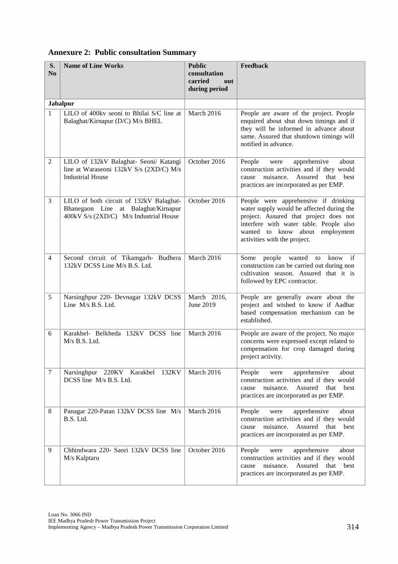
Loan No. 3066 INDIEE Madhya Pradesh Power Transmission ProjectImplementing Agency – Madhya Pradesh Power Transmission Corporation Limited 314
Annexure 2: Public consultation Summary
S.No
Name of Line Works Publicconsultationcarried outduring period
Feedback
Jabalpur
1 LILO of 400kv seoni to Bhilai S/C line atBalaghat/Kirnapur (D/C) M/s BHEL
March 2016 People are aware of the project. Peopleenquired about shut down timings and ifthey will be informed in advance aboutsame. Assured that shutdown timings willnotified in advance.
2 LILO of 132kV Balaghat- Seoni/ Katangiline at Waraseoni 132kV S/s (2XD/C) M/sIndustrial House
October 2016 People were apprehensive aboutconstruction activities and if they wouldcause nuisance. Assured that bestpractices are incorporated as per EMP.
3 LILO of both circuit of 132kV Balaghat-Bhanegaon Line at Balaghat/Kirnapur400kV S/s (2XD/C) M/s Industrial House
October 2016 People were apprehensive if drinkingwater supply would be affected during theproject. Assured that project does notinterfere with water table. People alsowanted to know about employmentactivities with the project.
4 Second circuit of Tikamgarh- Budhera132kV DCSS Line M/s B.S. Ltd.
March 2016 Some people wanted to know ifconstruction can be carried out during noncultivation season. Assured that it isfollowed by EPC contractor.
5 Narsinghpur 220- Devnagar 132kV DCSSLine M/s B.S. Ltd.
March 2016,June 2019
People are generally aware about theproject and wished to know if Aadharbased compensation mechanism can beestablished.
6 Karakbel- Belkheda 132kV DCSS lineM/s B.S. Ltd.
March 2016 People are aware of the project. No majorconcerns were expressed except related tocompensation for crop damaged duringproject activity.
7 Narsinghpur 220KV Karakbel 132KVDCSS line M/s B.S. Ltd.
March 2016 People were apprehensive aboutconstruction activities and if they wouldcause nuisance. Assured that bestpractices are incorporated as per EMP.
8 Panagar 220-Patan 132kV DCSS line M/sB.S. Ltd.
March 2016 People were apprehensive aboutconstruction activities and if they wouldcause nuisance. Assured that bestpractices are incorporated as per EMP.
9 Chhindwara 220- Saori 132kV DCSS lineM/s Kalptaru
October 2016 People were apprehensive aboutconstruction activities and if they wouldcause nuisance. Assured that bestpractices are incorporated as per EMP.
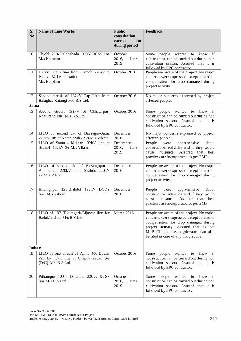
Loan No. 3066 INDIEE Madhya Pradesh Power Transmission ProjectImplementing Agency – Madhya Pradesh Power Transmission Corporation Limited 315
S.No
Name of Line Works Publicconsultationcarried outduring period
Feedback
10 Chichli 220- Palohabada 132kV DCSS lineM/s Kalptaru
October2016, June2019
Some people wanted to know ifconstruction can be carried out during noncultivation season. Assured that it isfollowed by EPC contractor.
11 132kv DCSS line from Damoh 220kv toPatera 132 kv substationM/s Kalptaru
October 2016 People are aware of the project. No majorconcerns were expressed except related tocompensation for crop damaged duringproject activity.
12 Second circuit of 132kV Tap Line fromBalaghat-Katangi M/s B.S.Ltd.
October 2016 No major concerns expressed by projectaffected people.
Satna
13 Second circuit 132kV of Chhatarpur-Khajuraho line M/s B.S.Ltd.
October 2016 Some people wanted to know ifconstruction can be carried out during noncultivation season. Assured that it isfollowed by EPC contractor.
14 LILO of second ckt of Bansagar-Satna220kV line at Kotar 220kV S/s M/s Vikran
December2016
No major concerns expressed by projectaffected people.
15 LILO of Satna - Maihar 132kV line atSatna-II 132kV S/s M/s Vikran
December2016, June2019
People were apprehensive aboutconstruction activities and if they wouldcause nuisance. Assured that bestpractices are incorporated as per EMP.
16 LILO of second ckt of Birsinghpur -Amarkantak 220kV line at Shahdol 220kVs/s M/s Vikran
December2016
People are aware of the project. No majorconcerns were expressed except related tocompensation for crop damaged duringproject activity.
17 Birsinghpur 220-shahdol 132kV DCDSline M/s Vikran
December2016
People were apprehensive aboutconstruction activities and if they wouldcause nuisance. Assured that bestpractices are incorporated as per EMP.
18 LILO of 132 Tikamgarh-Bijawar line forBadaMalehra M/s B.S.Ltd.
March 2016 People are aware of the project. No majorconcerns were expressed except related tocompensation for crop damaged duringproject activity. Assured that as perMPPTCL practise, a grievance can alsobe filed in case of any malpractice.
Indore
19 LILO of one circuit of Ashta 400-Dewas220 kv D/C line at Chapda 220kv S/s(D/C) M/s B.S.Ltd.
October 2016 Some people wanted to know ifconstruction can be carried out during noncultivation season. Assured that it isfollowed by EPC contractor.
20 Pithampur 400 - Depalpur 220kv DCSSline M/s B.S.Ltd.
October2016, June2019
Some people wanted to know ifconstruction can be carried out during noncultivation season. Assured that it isfollowed by EPC contractor.

Loan No. 3066 INDIEE Madhya Pradesh Power Transmission ProjectImplementing Agency – Madhya Pradesh Power Transmission Corporation Limited 316
S.No
Name of Line Works Publicconsultationcarried outduring period
Feedback
21 Dewas 220- Agrod 132kv DCSS line M/sSwastik Mechnical
October 2016 Some people wanted to know ifconstruction can be carried out during noncultivation season. Assured that it isfollowed by EPC contractor.
22 Dhar 220 - Teesgaon 132kv DCSS line M/sB.S.Ltd.
March 2016 People are aware of the project. No majorconcerns were expressed except related tocompensation for crop damaged duringproject activity.
23 LILO of both Circuit of 400 kv Nagda-Rajgarh line at Badnawar (2 x D/C) M/sBHEL
March 2016 No major concerns expressed by projectaffected people.
24 Second Circuit of Kukshi Alirajpur 132kvline M/s B.S.Ltd.
March 2016 Some people wanted to know ifconstruction can be carried out during noncultivation season. Assured that it isfollowed by EPC contractor.
Barwaha
25 LILO of 132 KhargoneBikayan line at 132Kv sub-station Bistan M/s B.S.Ltd.
March 2016 People are aware of the project. No majorconcerns were expressed except related tocompensation for crop damaged duringproject activity.
26 LILO of 132kv Chegaon Nepanagar line atPandhana M/s B.S.Ltd.
March 2016 People are aware of the project. No majorconcerns were expressed except related tonoise during construction activity andemployment opportunities.
27 LILO Manawar - Kukshi DCSS line atSinghana (D/C) M/s B.S.Ltd.
March 2016 People enquired about disruption of cropcultivation due to the project. Assuredthat regular cultivation can resume soonafter project is completed.
28 LILO of 132Kv Khargone -Julwaniya lineat 132Kv S/S Talakpura M/s B.S.Ltd.
March 2016 No major concerns expressed by projectaffected people.
29 Julwaniya 400- Kukshi 220kv line (D/C)M/s B.S.Ltd.
March 2016 People are aware of the project. No majorconcerns were expressed except related tonoise during construction activity andemployment opportunities.
30 220kV DCDS Khandwa(400 PGCIL) toChhanera line (Earlier 220kV DCDSMalwa TPS-Chhanera line)**Earlier Malwa TPS- Chhanera 220kVDCDS Line alignment Changed M/sKalptaru
December 2017 No major concerns expressed by projectaffected people.
31 Chhegaon 220- Singot 132kV DCSS LineM/s Kalptaru
March 2016 People are aware of the project. No majorconcerns were expressed except related tocompensation for crop damaged duringproject activity.
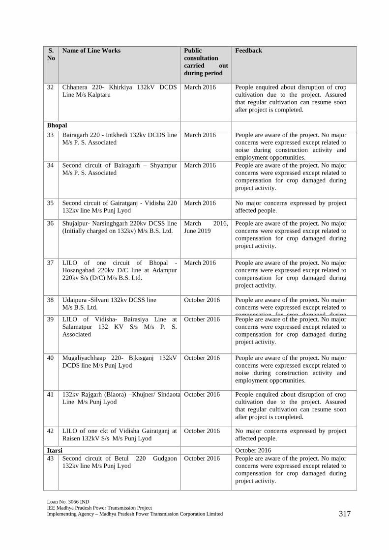
Loan No. 3066 INDIEE Madhya Pradesh Power Transmission ProjectImplementing Agency – Madhya Pradesh Power Transmission Corporation Limited 317
S.No
Name of Line Works Publicconsultationcarried outduring period
Feedback
32 Chhanera 220- Khirkiya 132kV DCDSLine M/s Kalptaru
March 2016 People enquired about disruption of cropcultivation due to the project. Assuredthat regular cultivation can resume soonafter project is completed.
Bhopal
33 Bairagarh 220 - Intkhedi 132kv DCDS lineM/s P. S. Associated
March 2016 People are aware of the project. No majorconcerns were expressed except related tonoise during construction activity andemployment opportunities.
34 Second circuit of Bairagarh – ShyampurM/s P. S. Associated
March 2016 People are aware of the project. No majorconcerns were expressed except related tocompensation for crop damaged duringproject activity.
35 Second circuit of Gairatganj - Vidisha 220132kv line M/s Punj Lyod
March 2016 No major concerns expressed by projectaffected people.
36 Shujalpur- Narsinghgarh 220kv DCSS line(Initially charged on 132kv) M/s B.S. Ltd.
March 2016,June 2019
People are aware of the project. No majorconcerns were expressed except related tocompensation for crop damaged duringproject activity.
37 LILO of one circuit of Bhopal -Hosangabad 220kv D/C line at Adampur220kv S/s (D/C) M/s B.S. Ltd.
March 2016 People are aware of the project. No majorconcerns were expressed except related tocompensation for crop damaged duringproject activity.
38 Udaipura -Silvani 132kv DCSS lineM/s B.S. Ltd.
October 2016 People are aware of the project. No majorconcerns were expressed except related tocompensation for crop damaged duringproject activity.39 LILO of Vidisha- Bairasiya Line at
Salamatpur 132 KV S/s M/s P. S.Associated
October 2016 People are aware of the project. No majorconcerns were expressed except related tocompensation for crop damaged duringproject activity.
40 Mugaliyachhaap 220- Bikisganj 132kVDCDS line M/s Punj Lyod
October 2016 People are aware of the project. No majorconcerns were expressed except related tonoise during construction activity andemployment opportunities.
41 132kv Rajgarh (Biaora) –Khujner/ SindaotaLine M/s Punj Lyod
October 2016 People enquired about disruption of cropcultivation due to the project. Assuredthat regular cultivation can resume soonafter project is completed.
42 LILO of one ckt of Vidisha Gairatganj atRaisen 132kV S/s M/s Punj Lyod
October 2016 No major concerns expressed by projectaffected people.
Itarsi October 201643 Second circuit of Betul 220 Gudgaon
132kv line M/s Punj LyodOctober 2016 People are aware of the project. No major
concerns were expressed except related tocompensation for crop damaged duringproject activity.
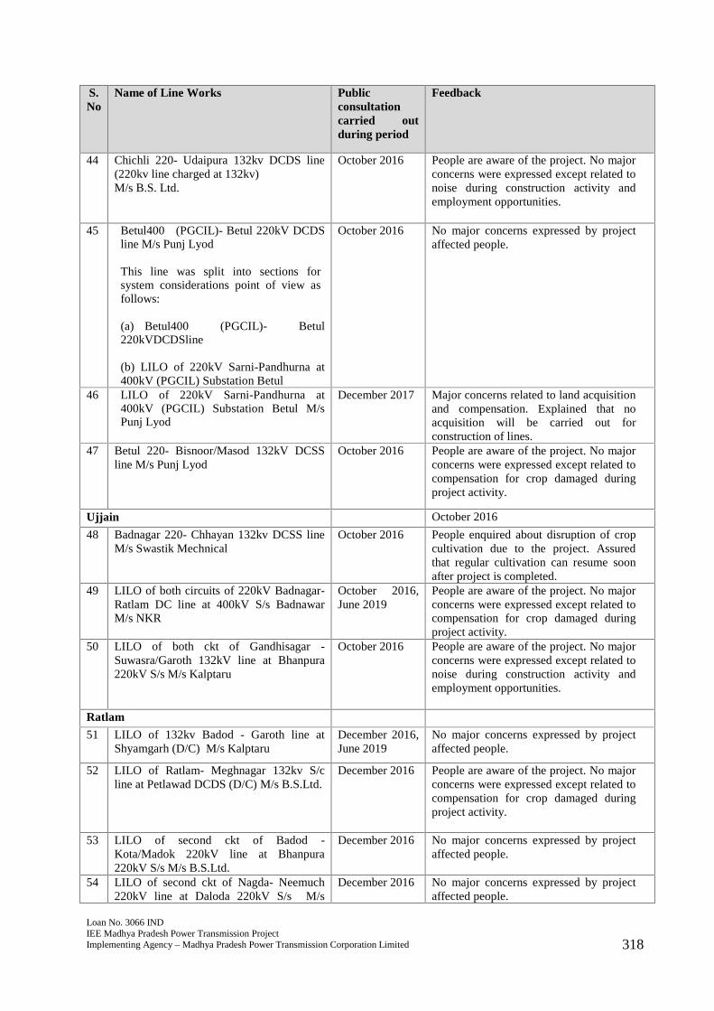
Loan No. 3066 INDIEE Madhya Pradesh Power Transmission ProjectImplementing Agency – Madhya Pradesh Power Transmission Corporation Limited 318
S.No
Name of Line Works Publicconsultationcarried outduring period
Feedback
44 Chichli 220- Udaipura 132kv DCDS line(220kv line charged at 132kv)M/s B.S. Ltd.
October 2016 People are aware of the project. No majorconcerns were expressed except related tonoise during construction activity andemployment opportunities.
45 Betul400 (PGCIL)- Betul 220kV DCDSline M/s Punj Lyod
This line was split into sections forsystem considerations point of view asfollows:
(a) Betul400 (PGCIL)- Betul220kVDCDSline
(b) LILO of 220kV Sarni-Pandhurna at400kV (PGCIL) Substation Betul
October 2016 No major concerns expressed by projectaffected people.
46 LILO of 220kV Sarni-Pandhurna at400kV (PGCIL) Substation Betul M/sPunj Lyod
December 2017 Major concerns related to land acquisitionand compensation. Explained that noacquisition will be carried out forconstruction of lines.
47 Betul 220- Bisnoor/Masod 132kV DCSSline M/s Punj Lyod
October 2016 People are aware of the project. No majorconcerns were expressed except related tocompensation for crop damaged duringproject activity.
Ujjain October 2016
48 Badnagar 220- Chhayan 132kv DCSS lineM/s Swastik Mechnical
October 2016 People enquired about disruption of cropcultivation due to the project. Assuredthat regular cultivation can resume soonafter project is completed.
49 LILO of both circuits of 220kV Badnagar-Ratlam DC line at 400kV S/s BadnawarM/s NKR
October 2016,June 2019
People are aware of the project. No majorconcerns were expressed except related tocompensation for crop damaged duringproject activity.
50 LILO of both ckt of Gandhisagar -Suwasra/Garoth 132kV line at Bhanpura220kV S/s M/s Kalptaru
October 2016 People are aware of the project. No majorconcerns were expressed except related tonoise during construction activity andemployment opportunities.
Ratlam
51 LILO of 132kv Badod - Garoth line atShyamgarh (D/C) M/s Kalptaru
December 2016,June 2019
No major concerns expressed by projectaffected people.
52 LILO of Ratlam- Meghnagar 132kv S/cline at Petlawad DCDS (D/C) M/s B.S.Ltd.
December 2016 People are aware of the project. No majorconcerns were expressed except related tocompensation for crop damaged duringproject activity.
53 LILO of second ckt of Badod -Kota/Madok 220kV line at Bhanpura220kV S/s M/s B.S.Ltd.
December 2016 No major concerns expressed by projectaffected people.
54 LILO of second ckt of Nagda- Neemuch220kV line at Daloda 220kV S/s M/s
December 2016 No major concerns expressed by projectaffected people.
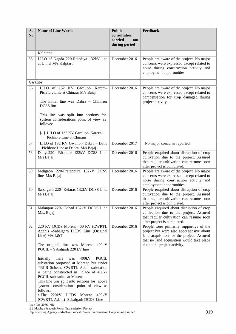
Loan No. 3066 INDIEE Madhya Pradesh Power Transmission ProjectImplementing Agency – Madhya Pradesh Power Transmission Corporation Limited 319
S.No
Name of Line Works Publicconsultationcarried outduring period
Feedback
Kalptaru
55 LILO of Nagda 220-Ratadiya 132kV lineat Unhel M/s Kalptaru
December 2016 People are aware of the project. No majorconcerns were expressed except related tonoise during construction activity andemployment opportunities.
Gwalior
56 LILO of 132 KV Gwalior- Karera–Pichhore Line at Chinaur M/s Bajaj
The initial line was Dabra – ChinnaurDCSS line
This line was split into sections forsystem considerations point of view asfollows:
(a) LILO of 132 KV Gwalior- Karera–Pichhore Line at Chinaur
December 2016 People are aware of the project. No majorconcerns were expressed except related tocompensation for crop damaged duringproject activity.
57 LILO of 132 KV Gwalior- Dabra – Datia–Pichhore Line at Dabra M/s Bajaj
December 2017 No major concerns reported.
58 Datiya220- Bhander 132kV DCSS LineM/s Bajaj
December 2016 People enquired about disruption of cropcultivation due to the project. Assuredthat regular cultivation can resume soonafter project is completed.
59 Mehgaon 220-Pratappura 132kV DCSSline M/s Bajaj
December 2016 People are aware of the project. No majorconcerns were expressed except related tonoise during construction activity andemployment opportunities.
60 Sabalgarh 220- Kelaras 132kV DCSS LineM/s Bajaj
December 2016 People enquired about disruption of cropcultivation due to the project. Assuredthat regular cultivation can resume soonafter project is completed.
61 Malanpur 220- Gohad 132kV DCDS LineM/s. Bajaj
December 2016 People enquired about disruption of cropcultivation due to the project. Assuredthat regular cultivation can resume soonafter project is completed.
62 220 KV DCDS Morena 400 KV (CWRTLAdani) –Sabalgarh DCDS Line (OriginalLine) M/s L&T
The original line was Morena 400kVPGCIL – Sabalgarh 220 kV line
Initially there was 400kV PGCILsubstation proposed at Morena but underTBCB Scheme CWRTL Adani substationis being constructed in place of 400kvPGCIL substation at Morena.This line was split into sections for abovesystem considerations point of view asfollows:a.The 220kV DCDS Morena 400kV(CWRTL Adani)- Sabalgarh DCDS Line
December 2016 People were primarily supportive of theproject but were also apprehensive aboutland acquisition for the project. Assuredthat no land acquisition would take placedue to the project activity.

Loan No. 3066 INDIEE Madhya Pradesh Power Transmission ProjectImplementing Agency – Madhya Pradesh Power Transmission Corporation Limited 320
S.No
Name of Line Works Publicconsultationcarried outduring period
Feedback
b.220 kV DCDS LILO Morena 400kV(CWRTL Adani) - Sabalgarh at Morena(Jarerua) 220kV S/s
63 220kv (Jarerua) DCDS LILO of Morena400kV S/s (Adani)-Sabalgarh at Morena220kV substation M/s L&T
December 2017 No major concerns expressed by projectaffected people.
64 Bhonra-Kapasi 132 kv DCSS line M/sL&T
December 2016 No major concerns expressed.
65 Kolaras-Mada 132kV DCSS line M/s L&T December 2016 No major concerns expressed.
66 132kv DCDS Guna 220-Bhonra line M/sL&T
December 2016,June 2019
No major concerns expressed.
67 LILO of one circuit of Malanpur-Mehgaon line at 400 KV S/s (CWRTLAdani) Morena M/s L&T
December 2016 People are aware of the project. No majorconcerns were expressed except related tonoise during construction activity andemployment opportunities.
68 2nd circuit of Shivpuri 220- Kolaras 132kVDCSS line M/s L&T
December 2016 No major concerns expressed by projectaffected people.
69 2nd ckt of Malanpur- Morar 132kV lineM/s L&T
December 2016 No major concerns expressed by projectaffected people.
Sagar
70 Khurai- Khimlasa 132kV DCSS lineM/s L&T
December 2016 People are aware of the project. No majorconcerns were expressed except related tonoise during construction activity andemployment opportunities.
71 LILO of Mungaoli Traction Feeder toMungaoli (D/C) M/s B.S. Ltd.
December 2016 People were primarily supportive of theproject but were also apprehensive aboutland acquisition for the project. Assuredthat no land acquisition would take placedue to the project activity.
72 Ashoknagar 220-Kothiya 132kV DCSSLine M/s Bajaj
December 2016 People enquired about disruption of cropcultivation due to the project. Assuredthat regular cultivation can resume soonafter project is completed.
73 Sagar220- Rehli 132kV DCSS lineM/s Kalptaru
December 2016 People were primarily supportive of theproject but were also apprehensive aboutland acquisition for the project. Assuredthat no land acquisition would take placedue to the project activity.
74 2nd ckt of Sagar 220-Sagar 132kV (I/C)M/s Kalptaru
December 2016 No major concerns expressed by projectaffected people.
75 Stringing of 3rd conductor from Bina220 toMungaoli M/s Kalptaru
December 2016 No major concerns expressed by projectaffected people.
Mandsaur
76 LILO of both ckt of Badod- Kota/Modak220kV line at Suwasra 220kV S/s (2XD/CM/s Kalptaru
December 2016 People are aware of the project. No majorconcerns were expressed except related tocompensation for crop damaged duringproject activity.

Loan No. 3066 INDIEE Madhya Pradesh Power Transmission ProjectImplementing Agency – Madhya Pradesh Power Transmission Corporation Limited 321
S.No
Name of Line Works Publicconsultationcarried outduring period
Feedback
77 LILO of one ckt of Neemuch 220-Mandsaur 132kV line at Budha 132kvS/sM/s Kalptaru
December 2016 People are aware of the project. No majorconcerns were expressed except related tocompensation for crop damaged duringproject activity.
78 LILO of both circuit of 132kVGandhisagar-Suwasara/Garoth line atSuwasara 220kV Sub-station**Earlier LILO of both ckt of Badod-Suwasra / Garoth 132kV line at Suwasra220kV S/s M/s Kalptaru
October 2016 No major concerns expressed by projectaffected people.
S.No
Substation Name Capacity andassociated FeederBays
Public Consultationcarried out duringperiod
Feedback
Jabalpur
1 Balaghat/Kirnapur400/132kv M/s BHEL
(2 x 100+40MVA)+400kv FB(2) +132kvFB(4)
March 2016 People were aware of theproject but were alsoapprehensive about landacquisition for the project.Assured that no landacquisition would take placedue to the project activity.
2 Waraseoni 132kV M/s BSLTD
40MVA+132kV FB(2) March 2016 No major concernsreported.
3 Bada Malehra 132/33kVM/s BS LTD
40 MVA+132kV FB(1) October 2016 People felt that roadconnectivity and electricitywill improve with theinitiation of this project.
4 Deonagar 132/33kV M/sBS LTD
40 MVA+132kV FB(1) October 2016 No major concernsreported.
5 Belkheda 132/33kV M/s BSLTD
40MVA+132kV FB(1) March 2016 No major concernsreported.
6 Karakbel 132/33kV M/s BSLTD
40MVA+132kV FB(2) March 2016 Few people want that theproject should offer labourjobs during and after theimplementation of theproject. Moreover, majorityof villagers perceive that theyouths are educated andthey will get jobs duringconstruction and after theconstruction of the project.
7 Saori 132/33kV S/s M/sKalptaru
(1X50) MVA; 132kVFB(1)
October 2016 People did not mentionabout any critical issuesrelated to the project.

Loan No. 3066 INDIEE Madhya Pradesh Power Transmission ProjectImplementing Agency – Madhya Pradesh Power Transmission Corporation Limited 322
S.No
Substation Name Capacity andassociated FeederBays
Public Consultationcarried out duringperiod
Feedback
8 Palohabada 132/33kV S/sM/s Kalptaru
(1X50) MVA; 132kVFB(1)
December 2017 People are supportive of theproject. The farmer whoseland has been acquiredexpressed satisfaction withthe compensation amount.
9 Patera 132/33kV S/s M/sKalptaru
(1X50) MVA; 132kVFB(1)
March 2016 People were apprehensiveabout land acquisitionrelated to the project.Assured that no acquisitionwould take place.
Satna
10 Additional Transformer atSidhi 220 (2nd) M/s BSLTD
+160 MVA March 2016 No major concernsreported.
11 Additional Transformer atKotar 220 (2nd) M/s BSLTD
+160 MVA March 2016 No major concernsreported.
12 Additional Transformer atChhatarpur (2nd) M/s BSLTD
+160 MVA March 2016 No major concernsreported.
13 Satna-II 132/33kV S/s M/sVikran
(2X50) MVA; 132kVFB(2)
Decmber 2017 People enquired aboutdisruption of cropcultivation due to theproject. Assured that projectis entirely on governmentland and would notencroach upon farmlands.
14 Shahdol 220/132kV S/s(Upgradation) M/s Vikran
(1X60) MVA; 220kVFB(2)+132kV FB(1)
March 2016 No major concernsreported.
Indore
15 Badnawar 400/220kv (M/SBHEL)
(2x315MVA) + 400kvFB (4) + 220kv FB (4)+125MVAR busReactor
Decemebr 2016 People enquired aboutdisruption of cropcultivation due to theproject. Assured that projectis entirely on governmentland and would notencroach upon farmlands.
16 Upgradation of Chapda132kv S/S to 220kv M/s BSLTD
(1x160MVA) + 220kvFB(2)
Decemebr 2016 No major concernsreported.
17 Upgradation of Depalpur132kv S/s to 220kv M/s BSLTD
(1x160MVA) + 220kvFB (1)
Decemebr 2016 No major concernsreported.
18 Agrod 132/33kV M/s BSLTD
40MVA+132kV FB(1) Decemebr 2016 People are aware of theproject and wanted to knowabout employmentopportunities associatedwith the project.
Barwaha
19 400/220kv additionaltransformer at Chhegaon400kv S/S M/s BS LTD
1x315 MVA March 2016 No major concernsreported.
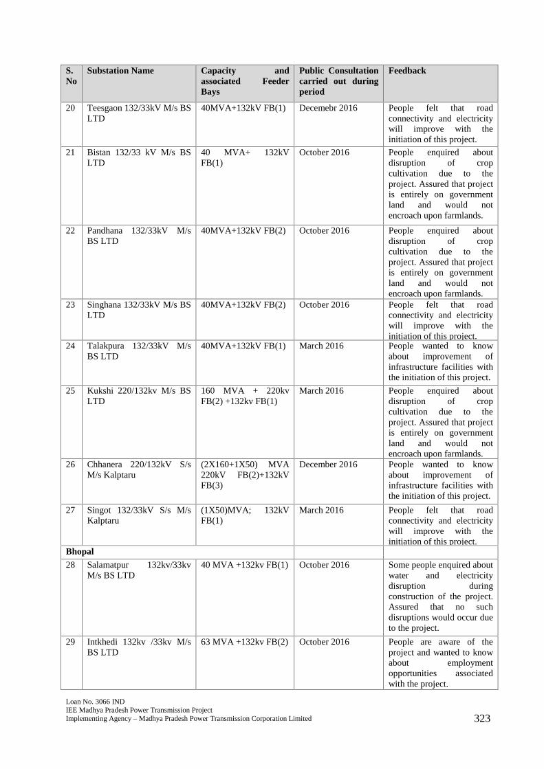
Loan No. 3066 INDIEE Madhya Pradesh Power Transmission ProjectImplementing Agency – Madhya Pradesh Power Transmission Corporation Limited 323
S.No
Substation Name Capacity andassociated FeederBays
Public Consultationcarried out duringperiod
Feedback
20 Teesgaon 132/33kV M/s BSLTD
40MVA+132kV FB(1) Decemebr 2016 People felt that roadconnectivity and electricitywill improve with theinitiation of this project.
21 Bistan 132/33 kV M/s BSLTD
40 MVA+ 132kVFB(1)
October 2016 People enquired aboutdisruption of cropcultivation due to theproject. Assured that projectis entirely on governmentland and would notencroach upon farmlands.
22 Pandhana 132/33kV M/sBS LTD
40MVA+132kV FB(2) October 2016 People enquired aboutdisruption of cropcultivation due to theproject. Assured that projectis entirely on governmentland and would notencroach upon farmlands.
23 Singhana 132/33kV M/s BSLTD
40MVA+132kV FB(2) October 2016 People felt that roadconnectivity and electricitywill improve with theinitiation of this project.
24 Talakpura 132/33kV M/sBS LTD
40MVA+132kV FB(1) March 2016 People wanted to knowabout improvement ofinfrastructure facilities withthe initiation of this project.
25 Kukshi 220/132kv M/s BSLTD
160 MVA + 220kvFB(2) +132kv FB(1)
March 2016 People enquired aboutdisruption of cropcultivation due to theproject. Assured that projectis entirely on governmentland and would notencroach upon farmlands.
26 Chhanera 220/132kV S/sM/s Kalptaru
(2X160+1X50) MVA220kV FB(2)+132kVFB(3)
December 2016 People wanted to knowabout improvement ofinfrastructure facilities withthe initiation of this project.
27 Singot 132/33kV S/s M/sKalptaru
(1X50)MVA; 132kVFB(1)
March 2016 People felt that roadconnectivity and electricitywill improve with theinitiation of this project.
Bhopal
28 Salamatpur 132kv/33kvM/s BS LTD
40 MVA +132kv FB(1) October 2016 Some people enquired aboutwater and electricitydisruption duringconstruction of the project.Assured that no suchdisruptions would occur dueto the project.
29 Intkhedi 132kv /33kv M/sBS LTD
63 MVA +132kv FB(2) October 2016 People are aware of theproject and wanted to knowabout employmentopportunities associatedwith the project.
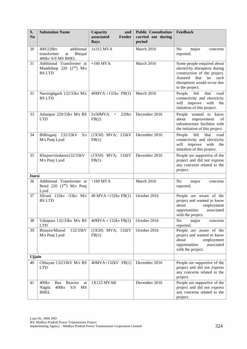
Loan No. 3066 INDIEE Madhya Pradesh Power Transmission ProjectImplementing Agency – Madhya Pradesh Power Transmission Corporation Limited 324
S.No
Substation Name Capacity andassociated FeederBays
Public Consultationcarried out duringperiod
Feedback
30 400/220kv additionaltransformer at Bhopal400kv S/S MS BHEL
1x315 MVA March 2016 No major concernsreported.
31 Additional Transformer atMandideep 220 (2nd) M/sBS LTD
+160 MVA March 2016 Some people enquired aboutelectricity disruption duringconstruction of the project.Assured that no suchdisruptions would occur dueto the project.
32 Narsinghgarh 132/33kv M/sBS LTD
40MVA +132kv FB(1) March 2016 People felt that roadconnectivity and electricitywill improve with theinitiation of this project.
33 Adampur 220/33kv M/s BSLTD
2x50MVA + 220kvFB(2)
December 2016 People wanted to knowabout improvement ofinfrastructure facilities withthe initiation of this project.
34 Bilkisganj 132/33kV S/sM/s Punj Lyod
(1X50) MVA; 132kVFB(1)
December 2016 People felt that roadconnectivity and electricitywill improve with theinitiation of this project.
35 Khujner/sindaota132/33kVM/s Punj Lyod
(1X50) MVA; 132kVFB(1)
December 2016 People are supportive of theproject and did not expressany concerns related to theproject.
Itarsi36 Additional Transformer at
Betul 220 (2nd) M/s PunjLyod
+160 MVA March 2016 No major concernsreported.
37 Silvani 132kv /33kv M/sBS LTD
40 MVA +132kv FB(1) October 2016 People are aware of theproject and wanted to knowabout employmentopportunities associatedwith the project.
38 Udaipura 132/33kv M/s BSLTD
40MVA + 132kv FB(2) October 2016 No major concernsreported.
39 Bisnoor/Masod 132/33kVM/s Punj Lyod
(1X50) MVA; 132kVFB(1)
October 2016 People are aware of theproject and wanted to knowabout employmentopportunities associatedwith the project.
Ujjain
40 Chhayan 132/33kV M/s BSLTD
40MVA+132kV FB(1) December 2016 People are supportive of theproject and did not expressany concerns related to theproject.
41 400kv Bus Reactor atNagda 400kv S/S MSBHEL
1X125 MVAR December 2016 People are supportive of theproject and did not expressany concerns related to theproject.
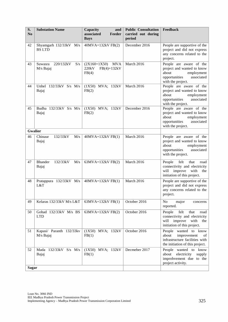
Loan No. 3066 INDIEE Madhya Pradesh Power Transmission ProjectImplementing Agency – Madhya Pradesh Power Transmission Corporation Limited 325
S.No
Substation Name Capacity andassociated FeederBays
Public Consultationcarried out duringperiod
Feedback
42 Shyamgarh 132/33kV M/sBS LTD
40MVA+132kV FB(2) December 2016 People are supportive of theproject and did not expressany concerns related to theproject.
43 Suwasra 220/132kV S/sM/s Bajaj
(2X160+1X50) MVA220kV FB(4)+132kVFB(4)
March 2016 People are aware of theproject and wanted to knowabout employmentopportunities associatedwith the project.
44 Unhel 132/33kV S/s M/sBajaj
(1X50) MVA; 132kVFB(2)
March 2016 People are aware of theproject and wanted to knowabout employmentopportunities associatedwith the project.
45 Budha 132/33kV S/s M/sBajaj
(1X50) MVA; 132kVFB(2)
December 2016 People are aware of theproject and wanted to knowabout employmentopportunities associatedwith the project.
Gwalior
46 Chinaur 132/33kV M/sBajaj
40MVA+132kV FB(1) March 2016 People are aware of theproject and wanted to knowabout employmentopportunities associatedwith the project.
47 Bhander 132/33kV M/sBajaj
63MVA+132kV FB(2) March 2016 People felt that roadconnectivity and electricitywill improve with theinitiation of this project.
48 Pratappura 132/33kV M/sL&T
40MVA+132kV FB(1) March 2016 People are supportive of theproject and did not expressany concerns related to theproject.
49 Kelaras 132/33kV M/s L&T 63MVA+132kV FB(1) October 2016 No major concernsreported.
50 Gohad 132/33kV M/s BSLTD
63MVA+132kV FB(2) October 2016 People felt that roadconnectivity and electricitywill improve with theinitiation of this project.
51 Kapasi/ Paranth 132/33kvM/s Bajaj
(1X50) MVA; 132kVFB(1)
October 2016 People wanted to knowabout improvement ofinfrastructure facilities withthe initiation of this project.
52 Mada 132/33kV S/s M/sBajaj
(1X50) MVA; 132kVFB(1)
Decmeber 2017 People wanted to knowabout electricity supplyimprobvement due to theproject activity.
Sagar

Loan No. 3066 INDIEE Madhya Pradesh Power Transmission ProjectImplementing Agency – Madhya Pradesh Power Transmission Corporation Limited 326
S.No
Substation Name Capacity andassociated FeederBays
Public Consultationcarried out duringperiod
Feedback
53 Khimlasa 132/33kV M/sKalptaru
40MVA+132kV FB(1) October 2016 People are aware of theproject and wanted to knowabout employmentopportunities associatedwith the project.
54 Mungaoli 132/33kV M/sKalptaru
63MVA+132kV FB(2) October 2016 People are aware andsupportive of the project.
55 Kothiya 132/33kV M/sKalptaru
40MVA+132kV FB(1) October 2016 People are aware of theproject and wanted to knowabout employmentopportunities associatedwith the project.
56 Rehli 132/33kV S/s M/sKalptaru
(1X50) MVA; 132kVFB(1)
December 2016 People are aware andsupportive of the project.
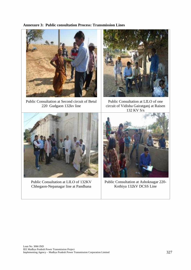
Loan No. 3066 INDIEE Madhya Pradesh Power Transmission ProjectImplementing Agency – Madhya Pradesh Power Transmission Corporation Limited 327
Annexure 3: Public consultation Process: Transmission Lines
Public Consultation at Second circuit of Betul220 Gudgaon 132kv line
Public Consultation at LILO of onecircuit of Vidisha Gairatganj at Raisen
132 KV S/s
Public Consultation at LILO of 132KVChhegaon-Nepanagar line at Pandhana
Public Consultation at Ashoknagar 220-Kothiya 132kV DCSS Line
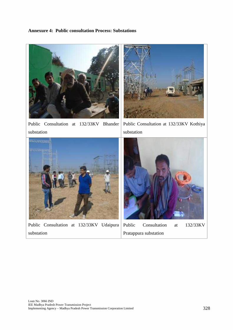
Loan No. 3066 INDIEE Madhya Pradesh Power Transmission ProjectImplementing Agency – Madhya Pradesh Power Transmission Corporation Limited 328
Annexure 4: Public consultation Process: Substations
Public Consultation at 132/33KV Bhander
substation
Public Consultation at 132/33KV Kothiya
substation
Public Consultation at 132/33KV Udaipura
substation
Public Consultation at 132/33KV
Pratappura substation
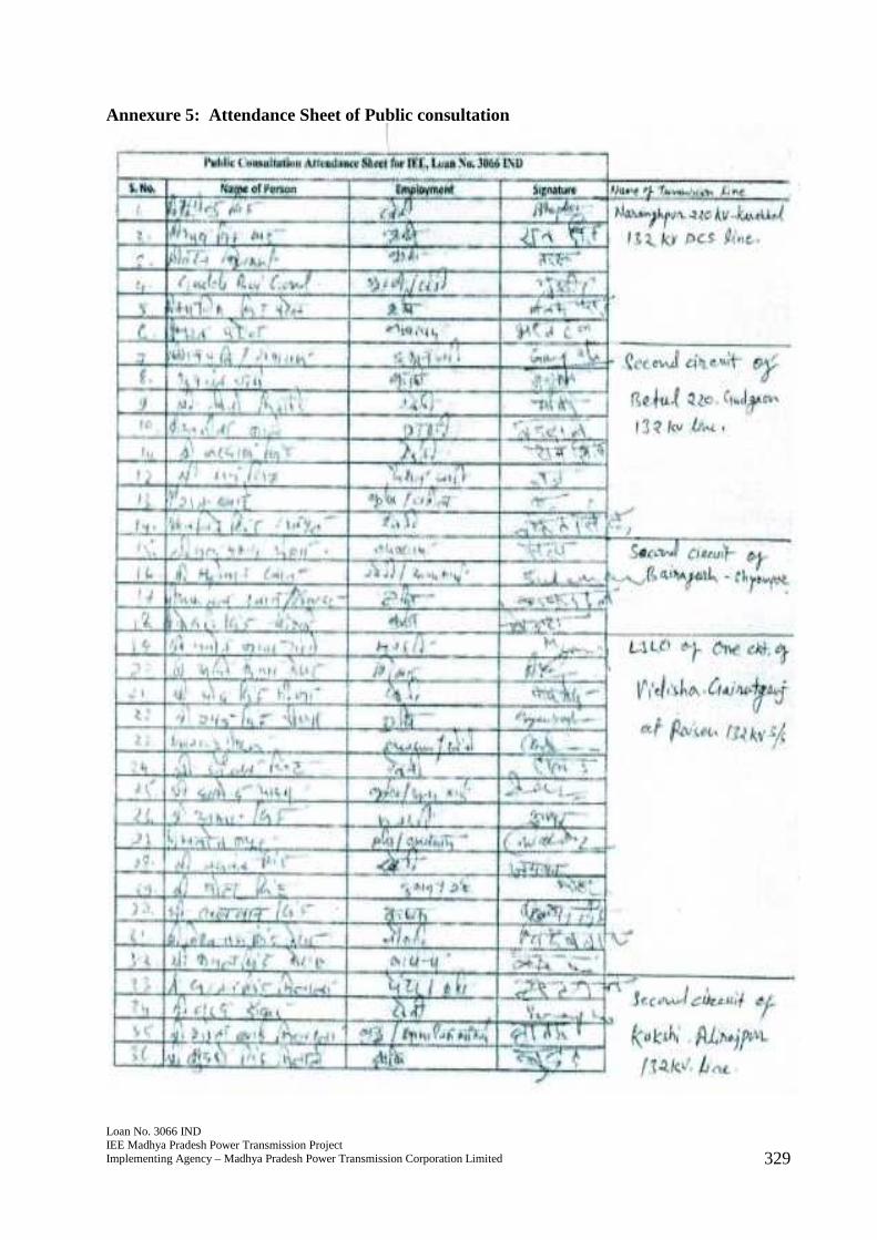
Loan No. 3066 INDIEE Madhya Pradesh Power Transmission ProjectImplementing Agency – Madhya Pradesh Power Transmission Corporation Limited 329
Annexure 5: Attendance Sheet of Public consultation
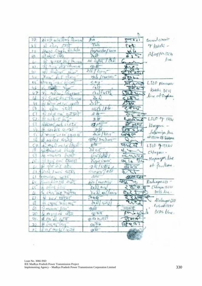
Loan No. 3066 INDIEE Madhya Pradesh Power Transmission ProjectImplementing Agency – Madhya Pradesh Power Transmission Corporation Limited 330
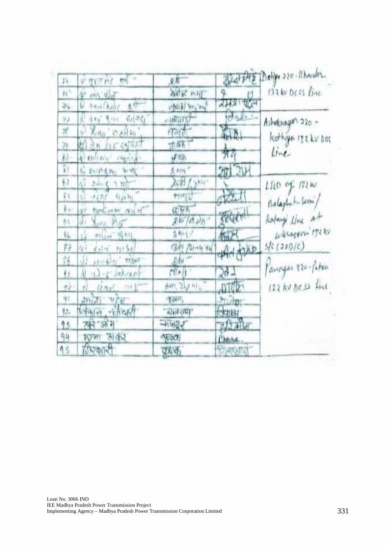
Loan No. 3066 INDIEE Madhya Pradesh Power Transmission ProjectImplementing Agency – Madhya Pradesh Power Transmission Corporation Limited 331
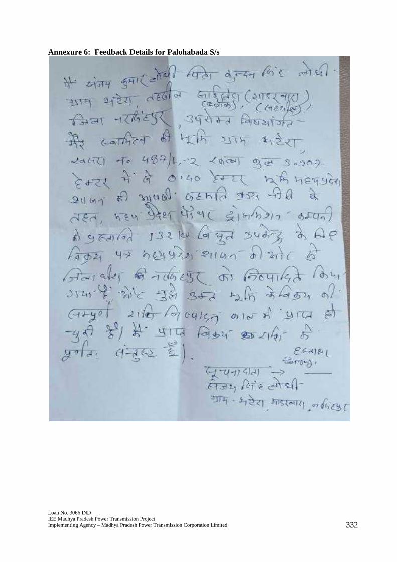
Loan No. 3066 INDIEE Madhya Pradesh Power Transmission ProjectImplementing Agency – Madhya Pradesh Power Transmission Corporation Limited 332
Annexure 6: Feedback Details for Palohabada S/s
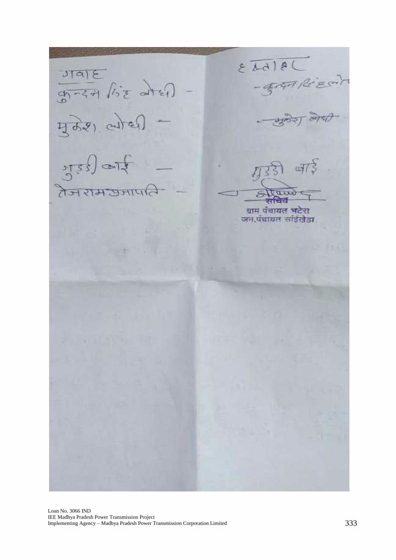
Loan No. 3066 INDIEE Madhya Pradesh Power Transmission ProjectImplementing Agency – Madhya Pradesh Power Transmission Corporation Limited 333
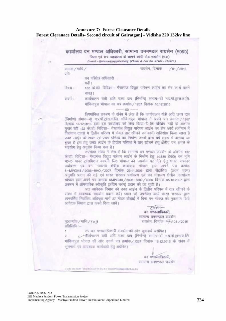
Loan No. 3066 INDIEE Madhya Pradesh Power Transmission ProjectImplementing Agency – Madhya Pradesh Power Transmission Corporation Limited 334
Annexure 7: Forest Clearance DetailsForest Cleranace Details- Second circuit of Gairatganj - Vidisha 220 132kv line
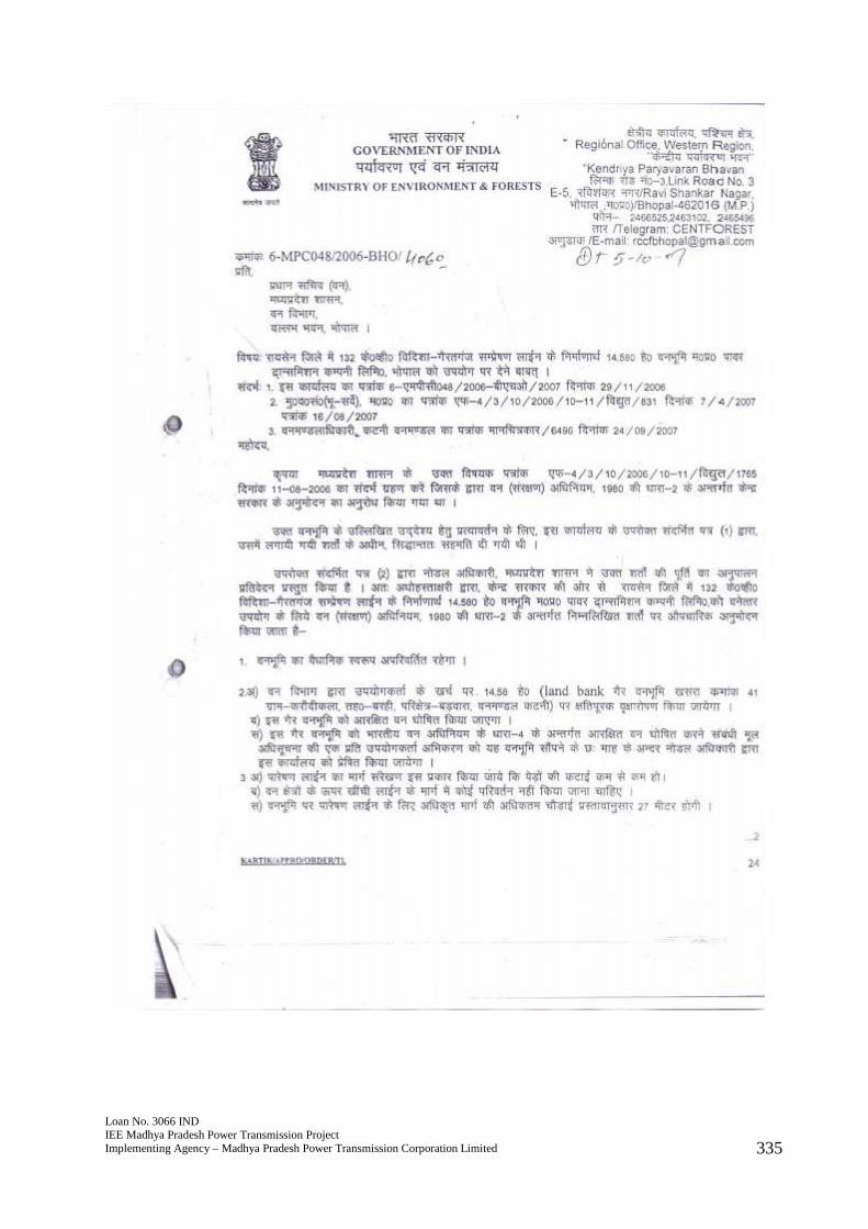
Loan No. 3066 INDIEE Madhya Pradesh Power Transmission ProjectImplementing Agency – Madhya Pradesh Power Transmission Corporation Limited 335
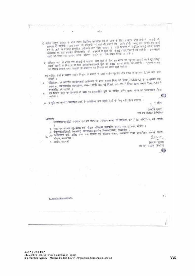
Loan No. 3066 INDIEE Madhya Pradesh Power Transmission ProjectImplementing Agency – Madhya Pradesh Power Transmission Corporation Limited 336
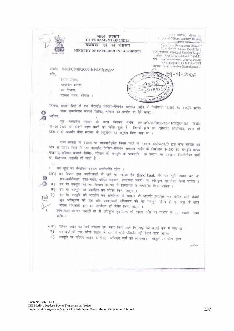
Loan No. 3066 INDIEE Madhya Pradesh Power Transmission ProjectImplementing Agency – Madhya Pradesh Power Transmission Corporation Limited 337
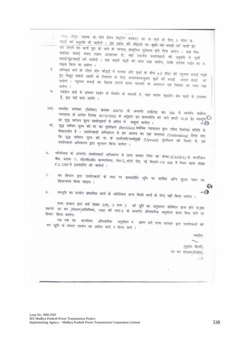
Loan No. 3066 INDIEE Madhya Pradesh Power Transmission ProjectImplementing Agency – Madhya Pradesh Power Transmission Corporation Limited 338
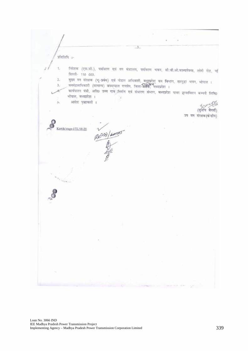
Loan No. 3066 INDIEE Madhya Pradesh Power Transmission ProjectImplementing Agency – Madhya Pradesh Power Transmission Corporation Limited 339
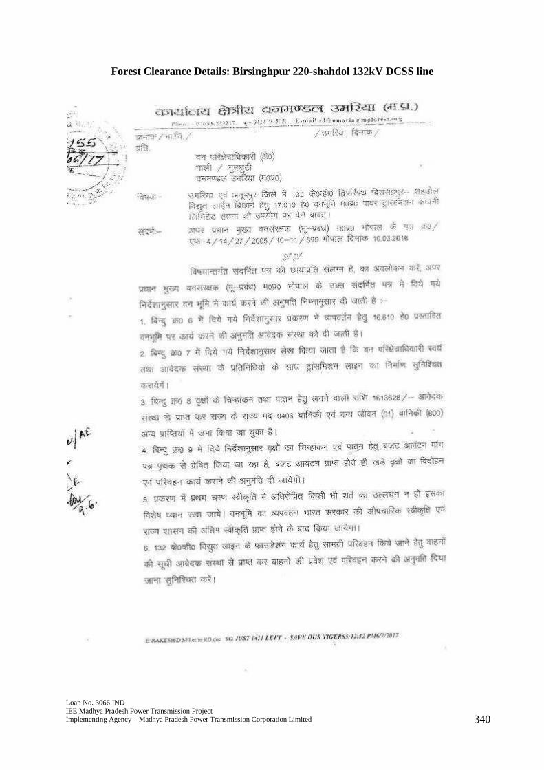
Loan No. 3066 INDIEE Madhya Pradesh Power Transmission ProjectImplementing Agency – Madhya Pradesh Power Transmission Corporation Limited 340
Forest Clearance Details: Birsinghpur 220-shahdol 132kV DCSS line
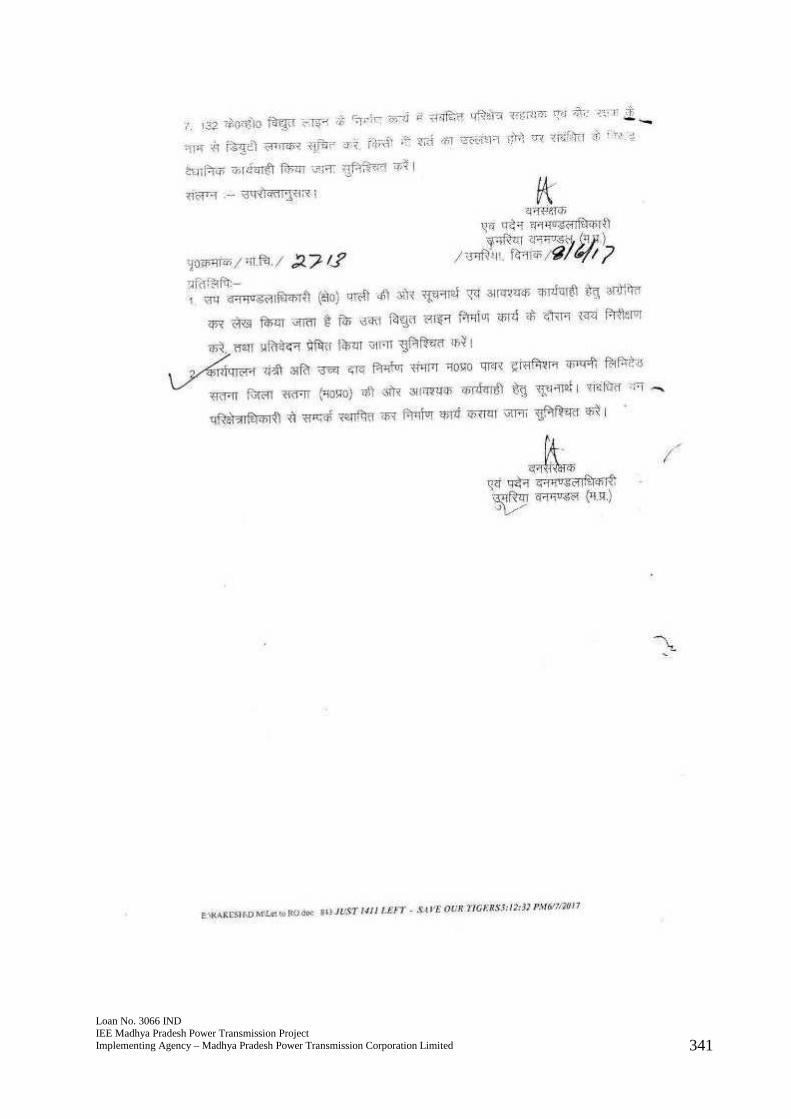
Loan No. 3066 INDIEE Madhya Pradesh Power Transmission ProjectImplementing Agency – Madhya Pradesh Power Transmission Corporation Limited 341
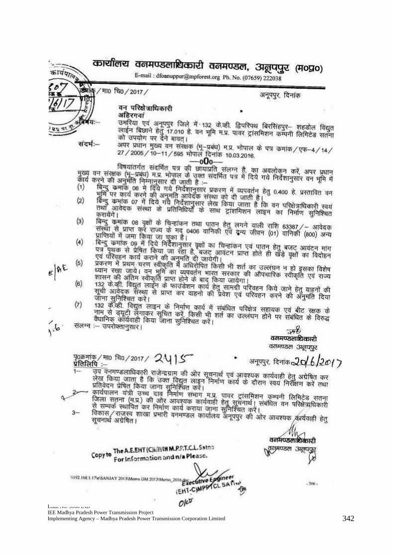
Loan No. 3066 INDIEE Madhya Pradesh Power Transmission ProjectImplementing Agency – Madhya Pradesh Power Transmission Corporation Limited 342
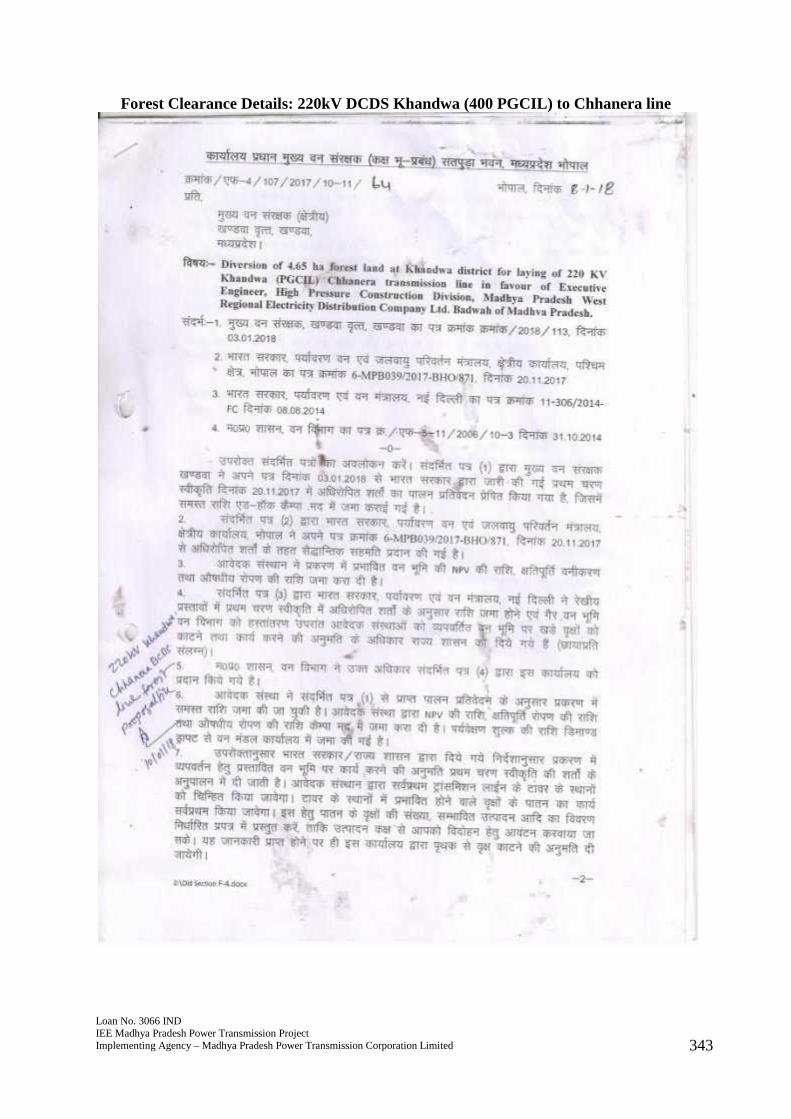
Loan No. 3066 INDIEE Madhya Pradesh Power Transmission ProjectImplementing Agency – Madhya Pradesh Power Transmission Corporation Limited 343
Forest Clearance Details: 220kV DCDS Khandwa (400 PGCIL) to Chhanera line
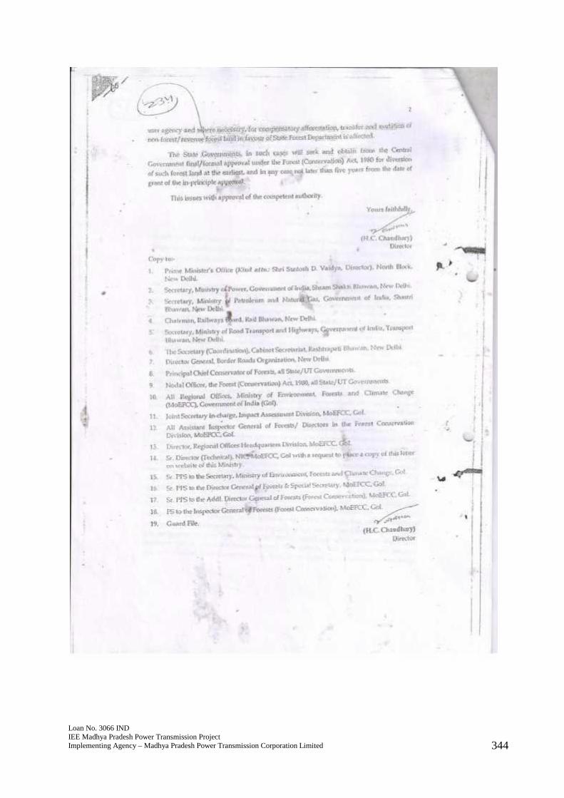
Loan No. 3066 INDIEE Madhya Pradesh Power Transmission ProjectImplementing Agency – Madhya Pradesh Power Transmission Corporation Limited 344
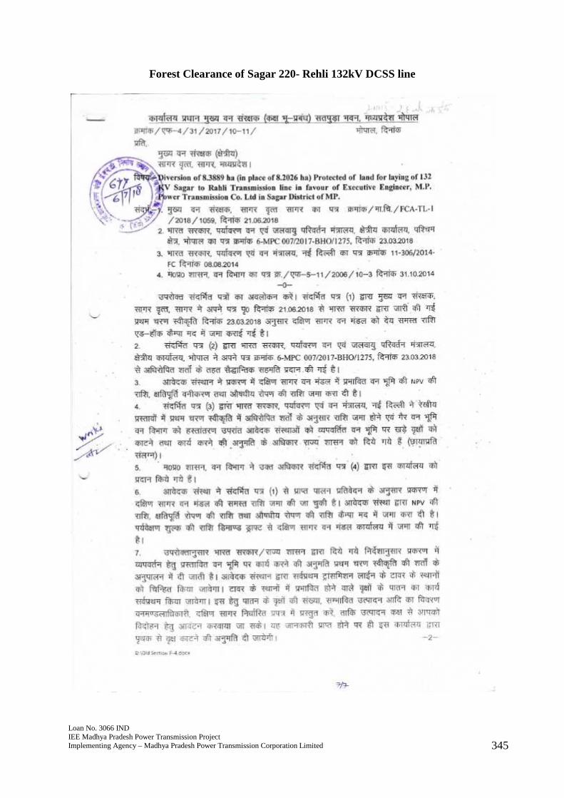
Loan No. 3066 INDIEE Madhya Pradesh Power Transmission ProjectImplementing Agency – Madhya Pradesh Power Transmission Corporation Limited 345
Forest Clearance of Sagar 220- Rehli 132kV DCSS line
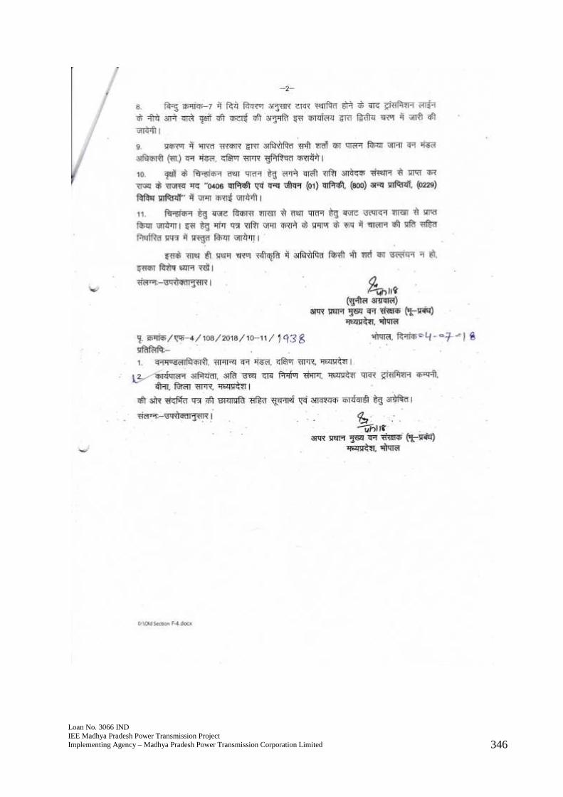
Loan No. 3066 INDIEE Madhya Pradesh Power Transmission ProjectImplementing Agency – Madhya Pradesh Power Transmission Corporation Limited 346
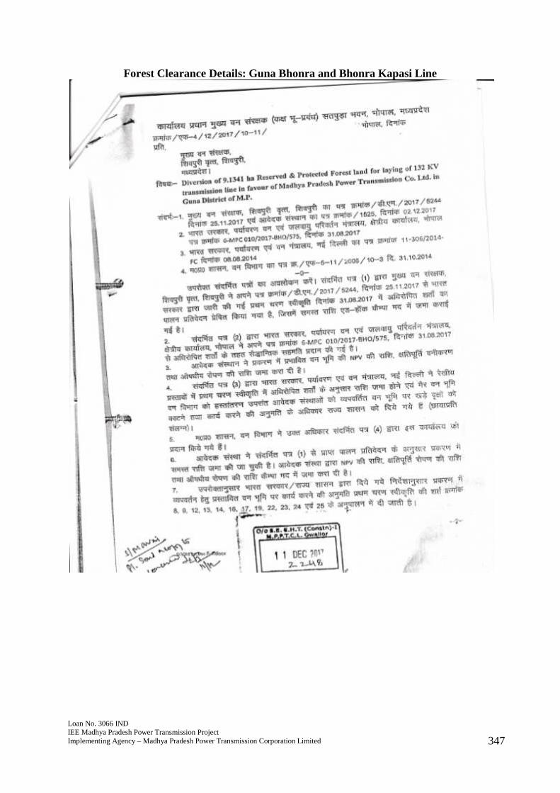
Loan No. 3066 INDIEE Madhya Pradesh Power Transmission ProjectImplementing Agency – Madhya Pradesh Power Transmission Corporation Limited 347
Forest Clearance Details: Guna Bhonra and Bhonra Kapasi Line
Loan No. 3066 INDIEE Madhya Pradesh Power Transmission ProjectImplementing Agency – Madhya Pradesh Power Transmission Corporation Limited 347
Forest Clearance Details: Guna Bhonra and Bhonra Kapasi Line
Loan No. 3066 INDIEE Madhya Pradesh Power Transmission ProjectImplementing Agency – Madhya Pradesh Power Transmission Corporation Limited 347
Forest Clearance Details: Guna Bhonra and Bhonra Kapasi Line
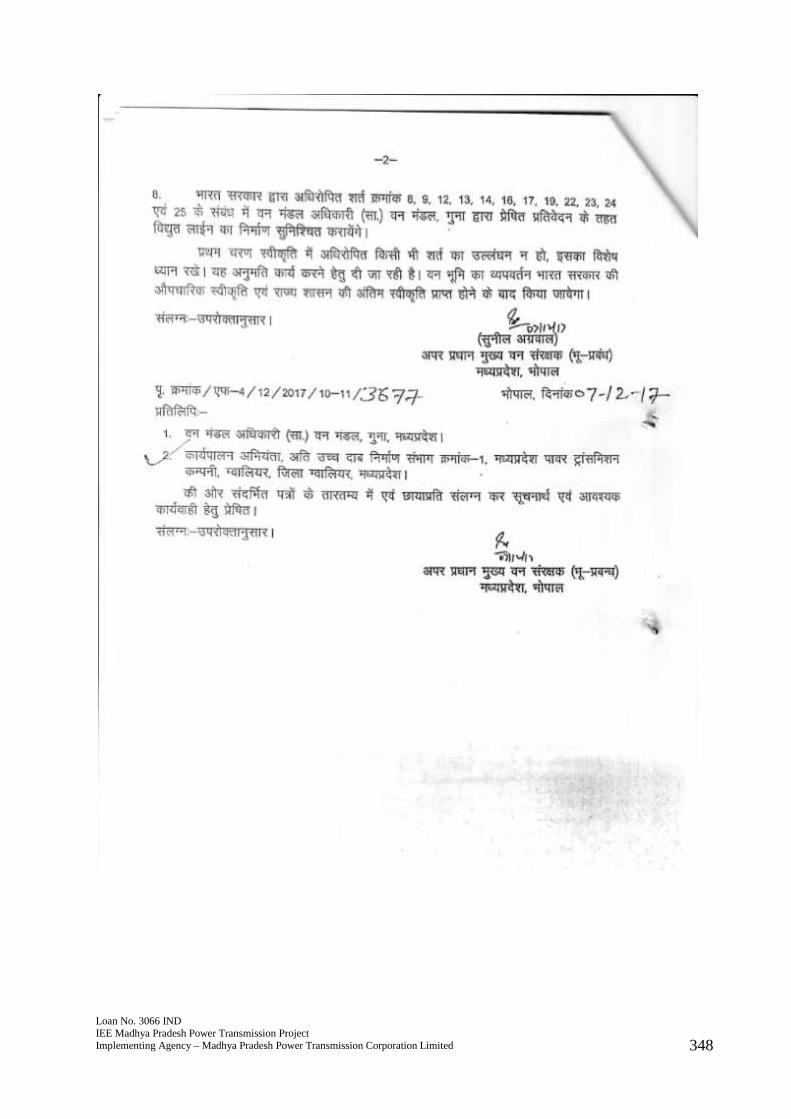
Loan No. 3066 INDIEE Madhya Pradesh Power Transmission ProjectImplementing Agency – Madhya Pradesh Power Transmission Corporation Limited 348
Loan No. 3066 INDIEE Madhya Pradesh Power Transmission ProjectImplementing Agency – Madhya Pradesh Power Transmission Corporation Limited 348
Loan No. 3066 INDIEE Madhya Pradesh Power Transmission ProjectImplementing Agency – Madhya Pradesh Power Transmission Corporation Limited 348