3D laser scanning for recording heritage areas in post-earthquake re-construction. The cases of...
61
a cura di S. Adorno, G. Cristina, A. Rotondo Catania, 12-14 settembre 2013 visibile visibile invisibile invisibile SCRI MM VI Congresso AISU VisibileInvisibile: percepire la città tra descrizioni e omissioni
-
Upload
nottinghamtrent -
Category
Documents
-
view
0 -
download
0
Transcript of 3D laser scanning for recording heritage areas in post-earthquake re-construction. The cases of...
a cura diS. Adorno, G. Cristina, A. Rotondo
Catania, 12-14 settembre 2013
visibilevisibile
invisibileinvisibile
SCRIMM
VI Co
ngresso A
ISUV
isibileInvisibile: pe
rcepire la città tra descrizio
ni e om
issioni
VI Congresso AISU
VisibileInvisibile:
percepire la città tra descrizioni e omissioni
Catania12-14 settembre 2013Monastero dei Benedettini
atti a cura di
Salvatore AdornoGiovanni CristinaArianna Rotondo
collana Collaborazioni - 2ISBN 978 88 98547 05 0
grafica e impaginazione
Ivano Mistretta
revisione testuale
Roberta CarusoChiara D’Amico
indicizzazione
Alessandro De Caro
© 2014 Scrimm Edizioni Catania
www.scrimmedizioni.com
Indice
Paola Lanaro Saluti/Addresses I
Guido Zucconi Prefazione/Foreword III
Salvatore Adorno, Giovanni Cristina, Arianna RotondoIl progetto dell’opera/The editorial project V
Salvatore AdornoVisibileInvisibile/VisibleInvisible IX
I. Identità urbane: narrazioni, retoriche, rappresentazioni
Giovanni CristinaIntroduzione/Introduction 22
Annastella CarrinoPer una tipologia delle scritture urbane nella Puglia di prima età moderna 27
Giuseppe GiugnoCaltanissetta tra Sei e Settecento: i volti della città tra descrizione dello
spazio urbano e nuove identità sociali 41
Simona LaudaniLa città de-scritta: Palermo e le narrazioni dei suoi riti 51
Elisabetta TodiscoIl vicus e la città: forme di autorappresentazione vicana e sistemazione
normativa nella documentazione di età romana 61
Clara Copeta, Carla TedescoProfili di città e nuovi strumenti delle politiche urbane
72
Marina MarengoSaint-Malo “ville de plume”: narrazioni asimmetriche fra realtà e finzione 84
Ida PorfidoUn livre blanc di Vasset, ovvero quello che le carte non dicono 95
Ömer Faruk GünençReading a City through Historical Documents: Dichotomy between
Textuality and Visuality 107
Aleksandra A. UzunovaL’articolazione dello spazio pubblico nella città post-socialista. I quartieri
residenziali di periferia a Sofia tra progetti di riqualificazione e
trasformazione bottom-up 115
Anna PellegrinoIl cuore nero di Firenze. San Frediano, un quartiere popolare ai margini
della legalità tra Otto e Novecento 125
Bassma Reda Abou El FadlThe Discursive Moments of Movement of Ramses II Colossal to Ramses
Square: new identity, new political manifestation and new symbolic
meanings 136
Gemma BelliLa modernizzazione delle città italiane: miti e stereotipi su «Il Mondo»
di Pannunzio 151
Liliana IugaThe old city and the rhetoric of urban modernization in Romania
(1950s-1970s) 161
Solange Rossi«Le cose nuove e belle di cui Genova si è arricchita». Genova Nuova, 1902:
metamorfosi della “Superba” a cavallo fra Otto e Novecento 176
Deborah SorrentiIl simbolo dell’arco di trionfo tra Francia e Italia 186
Costanza CalabrettaMemoria e identità. Fra Palast der Republik e Schloss (Berlino 1990-2008) 197
Roberto ParisiniGoverno dei consumi e dell’identità urbana a Bologna negli anni del boom 208
Fabrizio PedoneLe parole dell’identità nella pianificazione e nel governo delle trasfor-
mazioni urbane, il caso di Palermo 222
Christos BakalisMapping cities through memories. Some methodological issues 231
Carolina De FalcoCittà “negate”: gli ospedali psichiatrici di don Uva come testimonianza
di un impegno 242
Stefania PolloneL’Immacolatella nel Porto di Napoli: dall’abbandono alla riaffermazione
di un’identità “migrante” 252
Thomas RenardDante e i “luoghi della memoria” nell'Italia unita: stratificazione di
progetti e interventi nelle zone dantesche di Firenze e Ravenna 260
Lucía Solano FigueridoPropaganda e patrimonio urbano a Madrid nel Primo Franchismo 270
Felipe A. Lanuza RillingThe presence of the absent: erasure and memory in the site of the Heygate
Estate (1969-1974, Southwark, South London)
283
Martina MatozziDa J.M. de Macedo a R. Fonseca. Le rappresentazioni letterarie di Rio
de Janeiro e la presenza portoghese. Città portoghese, città brasiliana o città
informale? 294
Valeria RainoldiLe tracce della memoria: il ghetto ebraico, la sinagoga e i cimiteri
ebraici a Verona fra Ottocento e Novecento 304
Radhika SeshanConstructing Minorities: Historical Perspectives with reference to
Surat and Madras in the 17th
century 315
II. Visibilità dell’antico: patrimonio e istituzioni culturali
Arianna RotondoIntroduzione/Introduction 325
Maria Teresa ComoIl contesto urbano invisibile della Cappella Pontano 329
Teresa CollettaL’archeologia urbana degli anni Duemila. I diversi interventi di con-
servazione e recupero delle strutture antiche di Napoli greco-romana,
medievale e rinascimentale nel centro storico patrimonio del mondo 342

Beatrice Maria FracchiaLa descrizione della città attraverso le relazioni dell’ingegnere Pietro
Spurgazzi. Il dibattito sulla collocazione degli scali ferroviari a Torino
negli anni post unitari 352
Roberta VarrialeDalla storia urbana al futuro: un progetto per il Rione Sanità a Napoli 363
Cristina PalliniIl ruolo della Commissione d’Ornato nella ricostruzione di Alessandria
d’Egitto 375
Tiziana CasaburiArcheologia e reti metropolitane. L’esperienza di Roma, l’intuizione di
Atene, l’esempio di Napoli 389
Flavia ZelliScavo ipogeo e stratificazioni contemporanee: l’archeologia come stru-
mento di riqualificazione urbana. Esempi recenti 401
Flavia Campos Cerullo, Vanine Borges AmaralUnveiling the heritage in Brazil: a practical preservationist discourse 413
Ana Paula FarahIl rapporto tra antico e nuovo nel territorio brasiliano: l’operare
dell’architetto nell’ambiente costruito preesistente 423
Andrea Pane, Renata Campello CabralLe parole della tutela: «prospettiva», «luce» e «ambiente» nel dibattito
culturale e normativo per la salvaguardia a scala urbana in Italia, 1902-1939 432
Antonella Versaci, Alessio CardaciPatrimonio urbano e centri storici in Francia: il caso di Lione 448
Mariarosaria VillaniIl disvelamento dell’antico. “Isolamenti” e “Liberazioni” archeologiche
nella Roma di fine anni Trenta. Il ruolo di B.M. Apollonj Ghetti 459
Cristina Bobillo GarciaHow the awareness about the urban heritage evolved in Barcelona:
The Corresponsalías de Barrio (Neighborhood Correspondents) of the
City History Museum, 1960-1978 472
Cristina BorgioliSpazio pubblico e beni comuni a Sassari. La percezione del “patrimonio
culturale” negli Statuti cittadini 479
Alessandro CastagnaroIl Rione Terra a Pozzuoli: dalla storia alla rinascita. Contraddizioni
progettuali e scoperte di archeologia urbana 489
Giovanna CeniccolaBenevento francese: cultura del restauro e trasformazione della città
(1806-1815) 500
Manoela Rossinetti RufinoniDescrizioni e omissioni nella preservazione del patrimonio urbano
industriale: un caso studio a São Paulo/Brasile 510
Luigi VeroneseLa tutela dei quartieri di edilizia popolare del primo Novecento: il caso
di Napoli 521
Maria Angélica da Silva, Ana Cláudia Vasconcelos Magalhães, Érica Aprígio Albuquerque, Taciana Santiago de Melo, Louise Maria Martins CerqueiraThe Museum of Franciscanism and the city in Northeast Brazil 531
Emília FerreiraLisbon on stage: setting up a policy of seduction. Making way for the
National Fine Arts Museum 542
Davide Indelicato, Antonella Versaci, Alessio CardaciEcomusei e virtualità. Proposte per la conoscenza, la comprensione e la
comunicazione del paesaggio industriale dismesso. Il sito minerario di
Floristella-Grottacalda 553
Maria Helena Souto, Ana Cardoso de Matos From the extinguished Industrial Museum in Lisbon to a proposal of a
Virtual Portuguese Design Museum 565
Kali TzortziRecreation or transformation of the urban context? The case of the
new Acropolis Museum 577
Domenico CiccarelloEx pluribus unum, ex uno plura. Aggregazioni e dispersioni del patrimonio
librario-archivistico nelle città italiane con la soppressione degli
ordini religiosi dopo l’Unità 587
Simona InserraDalle librerie monastiche alle biblioteche civiche. Il caso esemplare
della biblioteca benedettina catanese tra aggregazione di fondi e
dispersione di beni, memoria e identità 597
Marcello ProiettoCultura e identità territoriale. Il canonico Vincenzo Raciti Romeo e la
Biblioteca Zelantea di Acireale 607
Michela Costantini, Giusi Andreina PerniolaLa dimensione musicale nella Torino napoleonica (1798-1814) 617
Maria Rosa De LucaHistory of Music and Urban History: a possible union 629
Laurence BassièresLa Commission du Vieux Paris e l’invenzione del patrimonio urbano
639
Melania NuciforaSul concetto di paesaggio urbano storico: una riflessione intorno al caso di
Siracusa 650
III. Città d’inchiostro
Arianna RotondoIntroduzione/Introduction 668
Isabella BalestreriMilano e il suo territorio. La «valanga» delle Guide ottocentesche 674
Massimo Galtarossa“Impressioni di viaggio” nelle narrazioni degli studenti. (Padova,
XVI-XVII) 684
Adriana Piccinini HigashinoKyoto by Christian eyes: Luis Frois tales of Japanese urban life and
descriptions of 16th
century Kyoto city 694
Monica VisioliImmagini di città nelle “lettere itinerarie” del conte cremonese Giam-
battista Biffi (1773-1777): osservazioni preliminari 708
Gabriella BolognaFrederic Leighton nelle città venete: diari, lettere, disegni e dipinti 722
Ela Çil, Ayşe Nur ŞenelCollage of a changing city: nineteenth century Istanbul through the
narratives of its administrators, travelers, and writers 732
Rosa Maria Delli QuadriL’editoria di viaggio nella Napoli dell’Ottocento 744
Ewa KawamuraL’inedito journal del viaggio in Italia negli anni 1838-1839 di Clara de
Constant Rebecque 753
Laura Sabrina PelissettiLa restituzione di Roma medievale nella letteratura e nelle fonti
iconografiche. La persistenza del modello dei Mirabilia Urbis Romae tra
immaginario e realtà 764
Federica ScibiliaLe città costiere di Sicilia e le loro architetture nella “memoria” di
viaggio di Giovan Battista Pacichelli (1685) 776
Alfredo Buccaro“Impressioni” di città nella storia del viaggio in Italia e dall’Italia 789
Salvatore Di LielloTorino, il ritratto di una capitale nel Grand Tour di Joseph-Jérôme de
Lalande 798
Daniela StroffolinoVedute di città italiane à vol d’oiseau nella produzione litografica
francese dell’Ottocento 809
Silvia GaigaL’Italia e il Regno di Napoli nei testi dell’atlante di Abramo Ortelio 819
Silvia CapotostoRomani e villani. Aspetti linguistici dell’interazione tra città e contado
nella letteratura dialettale 826
Marina Castiglione, Michele BurgioAuto ed eterorappresentazioni antroponimiche dei contesti urbani:
alcuni casi in Sicilia
836
Marina Castiglione, Marianna TrovatoRicostruire una città, reinventare un’odonomastica
849
Milena RomanoLeggere Catania nei giornali locali tra Otto e Novecento 865
Rossella SammartanoLe vie dei mestieri a Palermo tra passato e presente 874
Rosaria SardoLa città plurilingue. Assetti urbani e tradizioni discorsive nel Vicere-
gno Spagnolo 887
Pietro TrifoneVarietà linguistiche nella Roma del Cinquecento. Il caso del processo
per «stregarie» a Caterina siciliana 901
Beatrice SalettiFerrara nelle cronache rinascimentali: spazi urbani e paradigmi del
potere estense 911
Simonetta CirannaLondra e Parigi two cities of old world nelle pagine di «The Architectural
Review and American Builders’ Journal» (Philadelphia 1868-1870) 921
Francesca CapanoLe Neapolis di Friedrich Bernhard Werner 934
IV. Economie urbane
Giovanni CristinaIntroduzione/Introduction 945
Riccardo Cella, Maria Luisa FerrariL’immagine finalizzata. Verona agricola vs Verona industriale tra la fine
dell’Ottocento e gli inizi del Novecento
949
Maddalena ChimissoTermoli città industriale? Il Centro di studi e piani economici di Roma e
le prospettive economiche della regione molisana nel secondo Novecento 959
Alberto GuenziFonti e forme di rappresentazione del processo di industrializzazione.
Bologna dagli anni Trenta al miracolo economico 969
Guido MontanariTorino da “One Company Town” a “città degli eventi” 980
Maria Gabriella RienzoLo spazio urbano-industriale in Italia: percezioni e descrizioni 990
Fabio SalernoAutorappresentazione di Priolo. Da borgo agricolo a città industriale 1001
Ilaria SuffiaUna realtà ad alta concentrazione industriale: Sesto San Giovanni nel
corso del Novecento 1011
Sara De Maestri, Sonia Dellacasa, Alberto ManziniVillaggi e abitazioni operaie nella Liguria industriale: dallo spazio
pensato a quello percepito 1024
Luciana CaminitiLe città-porto. Identità urbane e portuali tra età moderna e contemporanea 1040
Daniele AndreozziLa Filadelfia d’Europa e il suo porto. Crescita, poteri e miti a Trieste 1046
Rosario BattagliaCittà-porto e sviluppo economico. Il caso di Marsiglia, Genova e
Trieste nel rapporto “privilegiato” con gli Stati Uniti nella prima metà
dell’Ottocento 1066
Salvatore BottariLe città portuali siciliane nel Settecento. Alcune considerazioni su
commercio, attori sociali e pratiche dello spazio urbano 1076
Luigi ChiaraCittà-porto e sviluppo economico in Sicilia: il caso di Messina
1085
Michela D’AngeloLivorno 1421-1606: da villaggio a città-porto mediterranea 1094
Christos Desyllas«Una popolazione piena di bisogni» and the Monte di Pietà of «Porto Franco» 1104
Mirella MafriciPorti franchi e compagnie di commercio meridionali nelle riflessioni
degli economisti napoletani del Settecento 1114
Carmelo G. SeverinoCrotone città-porto 1123
Francesca BonfanteLione e le “città bianche” 1132
Spiros Dimanopoulos“Remarkable monuments” and the development of tourism in the
prefecture of Heraklion, 1950-1965 1140
Josep-Maria García-FuentesThe construction of Barcelona’s “Barri Gòtic”: identity, tourism and the
authenticity of a fake 1150
Mar Loren, Ana B. QuesadaRe-imagining the Mediterranean city of Málaga. From the ephemeral
industrial dream to the construction of a touristic territory 1161
Pisana PosoccoL’uso dei modelli utopici nella pianificazione degli insediamenti turistici 1171
Carmen Rodríguez PedretLa città moderna: istruzioni per l’uso. La creazione di Barcellona nelle
guide turistiche (1839-1912) 1183
Sabrina CiprianiLa dematerializzazione della destinazione turistica: tra racconto,
esperienza e ricordo 1194
V. Abitare, amministrare e misurare la città
Giovanni CristinaIntroduzione/Introduction 1206
Elisabetta CapelliA partire dal social housing. Contraddizioni e prospettive per una nuova
cultura della casa (e per un ruolo della storia nelle politiche abitative) 1212
Roberto SammitoAbitare in grotta nel Novecento. Il caso Chiafura 1221
Irina SeitsSoviet Homes in Post-Soviet Reality: Moving from Leningrad to St.
Petersburg 1233
Rita D’AttorreI piani per quartieri residenziali presso una grande industria. Il villag-
gio Fiat a Settimo Torinese 1243
Anna Paola Di Risio, Emanuele TuccioLa fabbrica e la residenza: progetto globale e pratiche d’uso nella città
mediterranea. Il quartiere Macchitella a Gela 1254
Chiara Ingrosso“Le case degli Americani” per i senzatetto napoletani 1266
Lorenzo MingardiIl Villaggio Pilastro a Bologna, tra modello teorico e costruzione di una
comunità 1277
Irene RanaldiDagli alveari umani ai loft: mutamenti di identità e di uso nelle case
dell’Istituto Case Popolari del rione Testaccio a Roma 1290
Anna De PascalePopolazione e abitazioni 1299
Isabella FrescuraL’espansione urbana a Catania tra Otto e Novecento: piani regolatori e
speculazioni edilizie nella “Milano del Sud” 1310
Gianluigi SalvucciImmobili “instabili” nella ricostruzione della capitale
1325
Riccardo CellaCasa e bottega. Alcune note su affitto e subaffitto a Venezia a metà del
Settecento 1335
Preston PerlussPyramidal Tenancy and Landlord Hierarchies: a micro cosmos of
tenants and subtenants in a Parisian neighborhood 1347
Roberto BrunoAlle origini del welfare locale. Catania nell’Inchiesta Bonfadini, tra
realtà e rappresentazione 1359
Domenica La BancaCittà in trasformazione. I centri sociali nelle nuove periferie urbane
(1954-1971) 1370
Nicoletta Calapà, Blythe Alice Raviola«Cattolizzate» e forestieri: il sistema dotale a Torino fra Sei e Settecento.
Alcuni spunti di riflessione 1382
Salvatore SantuccioDalle valli alle intendenze, la rivoluzione amministrativa in Sicilia
nella prima metà del XIX secolo 1392
Giovanni CristinaInfrastructural geopolitics interviewed. Strategies, analyses and
perspectives in the Sicilian system through the Inchiesta Parlamentare
sulla Marina mercantile (1881-1882) 1402
Methiye Gül ÇöteliRedefining the Anatolian Urban Network of 19
th
Century: City
Networking of Urban Commercial Districts 1414
Eloisa BettiPolitica e statistica a Bologna nel secondo dopoguerra: due generazioni
di statistici in Consiglio comunale. Prime ipotesi di ricerca 1423
Daniele DieciLa misurazione dei Quartiers sensibles: breve storia di una categoria pubblica 1434
Gianluca BelliL’immagine della città nei censimenti. Il caso della Firenze cinquecentesca 1445
Dario Dell’OsaEvoluzione dell’assetto patrimoniale di un’azienda mercantile ragusea
nella seconda metà del XVI secolo 1456
Elena DoriaLa misura della città nel primo Ottocento: i casi di Venezia e Milano.
Fonti e strumenti per una lettura comparata della città 1468
Elina GugliuzzoThe Military Presence in Istanbul in the Early Modern Age 1479
Giancarlo MarchesiLa «Descrizione generale della popolazione della città e provincia di
Brescia» del 1764 1489
Paola Nestola«An testis sciat in qua provincia sita sit civitas?». Città a giudizio: fonti
processuali per un approccio multifocale di Storia Urbana
1499
Vilém ZábranskýRolls of Freemen – a quality of quantity. Research issue of urban migra-
tion and archival sources on example of Prague in pre-statistical period 1509
Idamaria FuscoIl “visibile” e l’“invisibile” in una importante fonte fiscale meridionale.
Le numerazioni dei fuochi seicentesche e la rappresentazione demo-
grafica delle realtà urbane 1515
VI. Città immaginate: sguardi sulla città contemporanea
Giovanni CristinaIntroduzione/Introduction 1530
Camilo Fernandez CortizoOn the streets and squares of the city: popular missions and penitential
processions in Galicia (Spain). 17th
-18th
centuries 1536
Roberto J. LópezTra realtà e utopia. L’immagine della città nella letteratura agiografica
spagnola dell’epoca moderna
1546
Fernando Suárez GolánGiubileo universale e reale patrocinio. Il culto di san Giacomo il Maggiore
nella Compostela dei secoli XVII e XVIII: tra desiderio e realtà 1556
Emma Luisa Cahill MarrónThe Transformation of London for the Legitimisation of the Tudor
Dynasty: Catherine of Aragon and Arthur Tudor’s Wedding in 1501
1566
Andrea LuccaroniAfasia della memoria. L’Ex Campo di Concentramento di Fossoli 1577
Bruno MussariEntrate trionfali e apparati effimeri a Siena in età moderna. La rappre-
sentazione della città e l’immagine rivisitata dei suoi luoghi simbolo 1588
Fernando Villaseñor SebastiánTriumphal Scenography and Transformation of the Pontifical Rome
Stemming from the Christian Triumphs in the Granada War (1482-1492) 1599
Rosa Maria GiustoLa città nei concorsi dell’Accademia di San Luca nel Settecento 1609
Matteo IannelloPalermo immaginata: progetti e proposte di una città possibile 1620
Ettore SessaIperbolica, multiforme e contraddittoria: la metafora della “metropoli
globale” attraverso l’effimero celebrativo delle esposizioni coloniali
della tarda “civiltà industriale” 1630
Stefano GuidariniProgettare la città dei non vedenti, un esempio concreto e alcune
riflessioni sull’architettura 1643
Maria Romeiras AmadoThe allowed cities: spaces and performances of blind citizens in the pre
and post-earthquake Lisbon (1755) 1653
Ornella CirilloL’ascesa in collina: nuovi sguardi sulla Napoli alta tra fine Ottocento e
primo Novecento 1661
Giuseppe DamoneI mezzi di trasporto e le ghost town: una nuova percezione del costruito 1672
Rosario del Caz EnjutoThe dehumanization of the city: the car and the invasion of public space 1679
Panayotis Pangalos, Vassiliki PetridouTrasformazioni infrastrutturali e viste di Patrasso nella sua storia 1693
Annarita TeodosioVolando sulla città: prospettive inedite e rinnovate percezioni dello spazio
urbano 1704
Paolo CornagliaCzernowitz. “Un ermellino a Cernopol” tra Impero, Romania e Ucraina 1715
Yan Wang, Da-Ping LiuHarbin: an Ideally Designed City by Russia 1726
Zhuang Wei, Liu JikeHarbin: Between Nationalism and Imperialism, c. 1898-1940 1736
Saverio CarilloPompei, la città del turismo religioso 1746
Danila Jacazzi«E le torri, e le case, e i teatri, e i templi si poteano quasi integri discernere».
Storia del paesaggio perduto della Valle di Pompei 1756
Lydia Sapounaki-Dracaki, Maria-Luisa Tzoya Moatsou, Olga MoatsouAtene Through the Looking-Glass 1767
Riccardo SerraglioIl mito di Hygeia nei progetti di riforma urbana nell’Italia meridionale
dopo l’Unità nazionale 1777
Ivano MistrettaLo sguardo in ascolto. Tarr, Akerman e Sokurov tra rilievo degli spazi
e rivelazione del vissuto 1787
Alessandra Acocella“Abitare la città”: il ruolo della fotografia nella ricerca di Ugo La Pietra,
1969-1979 1797
Carmen Díez Medina, Ricardo S. LampreaveBruno Morassutti: un’esperienza raccontata con immagini 1808
Daniele Vazquez PizziPratiche d’esplorazione degli spazi compatti e degli spazi dispersi 1824
Dragan DamjanovićPhoto Albums of the 1880 Zagreb Earthquake 1833
Tanja Scheffler“Old Dresden”: an entirely Baroque city? How Dresden is presented in
picture books from the early years of the G.D.R. 1846
Annie SchentagThe Picture Book of Earlier Buffalo: Envisioning Ruins during Renewal 1856
Harald R. StühlingerThe visual revival of Old Vienna. The photographs of the city wall of
Vienna in 1858 1864
William M. TaylorAssembling disaster and the urban imagination: collections of rubble
photography and the Messina (1908) earthquake 1878
Catherine De Lorenzo1920s Sydney: Public concerns, private obsessions 1888
Philip GoldswainAu Gaz: French Photographic Albums in the State Library of Victoria 1896
Douglas KlahrThe Stereoscopic Photo Album as Nazi Propaganda: Ephemerality of
Image in Vienna, The Pearl of the Reich 1903
Serena Bisogno, Federica ComesPrima di Gomorra: il paesaggio urbano napoletano tra gli albori del XX
secolo e il secondo dopoguerra raccontato attraverso il cinema. Realtà,
stereotipo e identità culturale 1912
Scott BudzynskiThe Cinematic High-Rise: Perspectives on Milan 1920
Claudia LambertiBerlino anni Venti: fascino e timori di una grande città 1930
Andrea MaglioCinema, storia e identità urbana: il caso di Napoli 1942
Antonello ScopacasaIl luogo invisibile. Berlino nella fotografia del dopoguerra 1953
VII. Ritratti di città: città restituite e città interpretate
Arianna RotondoIntroduzione/Introduction 1968
Francesca Anichini, Gabriele GattigliaPrevedere il passato. Strumenti predittivi per gestire il patrimonio
sepolto all’interno della città contemporanea 1974
Enza Emanuela Esposito, Marilena Di PrimaIndirizzi di tutela e conservazione dei «borghi rurali» di Sicilia come
rete sul territorio attraverso lo strumento GIS 1985
Massimiliano GravaFonti cartografiche di Toscana e Catalogna di età Moderna e Contem-
poranea. Ricostruire con il GIS, comunicare con WebGIS 1991
Ludovica Galeazzo, Marco PedronVisualizing Venice. Mappare e modellare la storia urbana: il caso dell’insula
dell’Accademia 2001
Bernadette Devilat Loustalot3D laser scanning for recording heritage areas in post-earthquake
re-construction. The cases of Lolol and Zúñiga in Chile 2013
Silvia Di SalvatoreRicerca storica urbana e restituzione cartografica come strumenti di
interpretazione della città contemporanea: il caso studio della città di
Alcobaça (Portogallo) 2025
Tullio AebischerArcheologia geodetica lungo l’Appia Antica (Roma) 2036
Raffaella Brigante, Fabio RadicioniGeoreferenziazione di cartografie storiche e loro utilizzo per la creazione
di GIS in aree a rischio sismico 2048
Mathieu FernandezThe ground of Paris and scientists during the 19
th century. Apparition
of an atlas of the underground. Application using GIS software 2058
João Paulo da Costa AmadoUrban sanitation in Lisbon during the 19
th
century 2074
Maria Ines Pascariello, Maria Rosaria TrinconeLe tracce dell’acqua: linee, reti, punti
2083
Eva J. Rodríguez Romero, Benito Jiménez AlcaláWater visibility, convents, monasteries and Madrid urban development
2093
Adriano Russo, Emanuele ForzeseTecnologie urbane dell’acqua tra visibilità e vivibilità. Valutazioni
ambientali e valore architettonico delle infrastrutture idriche nella città 2104
Francesco RuvoloLa Città dei Militari. Dalla difesa alla salvaguardia del territorio in
una piazzaforte siciliana del Settecento. Milazzo tra assedi e alluvioni
nella cartografia dell’epoca 2114
Teresa CollettaLa cartografia urbana pre-catastale. Strumenti per il governo della
città del XVII e XVIII secolo 2132
Daniela Barbieri, Isidoro ParodiTerra di Nove. Il Libro figurato di Giovanni Benedetto Zandrino, istantanea
di un territorio tra Piemonte e Liguria sul finire del Seicento 2142
Cristina Cuneo, Annalisa DameriControllo e misura. Strumenti per il governo della città di Torino nel
XVIII secolo: i “Capitani di Quartiere” 2154
Arturo GalliaLa Pianta dell’Isola di Ponza di Agostino Grasso. Indagini e prodotti
cartografici come strumento di conoscenza del territorio e di lettura
delle dinamiche insediative (XVIII secolo) 2163
Cristina IterarLa Platea settecentesca della “SS. Annunciata della Terra di Castello A
mare del Volturno”: un documento inedito per lo studio della storia
urbana di Castel Volturno in Campania 2174
Francesca ValensiseStati feudali e raffigurazioni urbane in un cabreo del XVIII secolo 2183
Ana Cláudia Vasconcellos Magalhães, Érica Aprígio AlbuquerqueThe urban dynamics of churchyards and churches: sacred spaces of the
former colonial village of Marechal Deodoro, Alagoas, Brazil 2190
Silvia BeltramoLa città dei frati: gli spazi della predicazione nelle iconografie tardo
medievali 2197
Ana María Jiménez JiménezArchitettura nella città occulta. Córdoba conventuale, una approssi-
mazione del patrimonio urbano 2207
Andrea LonghiPaesaggi del sacro e costruzione dello Stato sabaudo: poli della religio-
sità urbani e territoriali nel Theatrum Sabaudiae (1682) 2218
Taciana Santiago de MeloConfronting images and reality: the presence of religion in the urban
landscape of Igarassu, the oldest town in Northeast Brazil 2229
Elien Vernackt, Bram VannieuwenhuyzeMAGIS Brugge: a sixteenth-century bird’s-eye view on Bruges as starting
point for a dynamic database 2238
Giuseppe AntistaRealtà e retorica nei “ritratti” delle città siciliane di nuova fondazione:
Niscemi e Palma di Montechiaro 2246
Maria Angélica da Silva, Érica Aprígio Albuquerque, Taciana Santiago de MeloThe village as a fragment: Brazilian urban landscapes through Dutch
images in the 17th
century 2257
Serena BisognoStrategia dell’effimero barocco-rococò a Napoli. L’attività di Nicolò
Tagliacozzi Canale 2268
Sabina MontanaPalermo 1701-1720: la città nelle rappresentazioni del Senato di Palermo 2278
I
VI congresso AISU - VisibileInvisibile: percepire la città tra descrizioni e omissioni
Paola Lanaro*
Saluti
Care amiche e cari amici,è con grande piacere che accogliamo la pubblicazione degli atti
dell’ultimo convegno dell’AISU Visibile e invisibile: percepire la città tra
descrizioni e omissioni svoltosi presso l’Università di Catania tra il 12 e il 14 settembre 2013.
Il convegno ha avuto un grandissimo successo sia per numero di partecipanti sia per numero di nuovi soci iscritti alla nostra Associa-zione. Proprio in questa occasione, col rinnovo delle cariche sociali, ho avuto l’onore di essere eletta alla Presidenza dell’AISU, un compito che accolgo con emozione e con grande senso di responsabilità e impegno per continuare l’opera dei miei predecessori, gli amici Donatella Calabi e Guido Zucconi.
Non posso che complimentarmi ancora una volta con il comitato orga-nizzatore del convegno e in primis con Salvatore Adorno, che con grande capacità e calore ha reso l’appuntamento di Catania indimenticabile.
Lo spirito che ha animato il nostro incontro catanese ci accompagnerà anche nei futuri convegni, in particolare il prossimo che si terrà a Padova nel settembre 2015 e che sarà dedicato al tema “Food and the City”.
*Presidente AISU in carica
II
Paola Lanaro*
Addresses
Dear Colleagues and Friends,It gives me great pleasure to present this publication of the proceed-
ings of the last AISU conference entitled Visible and invisible: perceiving
the city through descriptions and omissions, held at the University of Catania from 12-14 September, 2013.
The conference proved a huge success both for the number of par-ticipants as well as the number of new members joining our association. On this occasion, with the appointment of the new board members, I had the honour of being elected chairman of AISU, a position I welcome with enthusiasm and with a great sense of responsibility and commit-ment to continuing the work of my predecessors, my colleagues and friends Donatella Calabi and Guido Zucconi.
I would once again like to complement the organizing committee of the conference, first and foremost Salvatore Adorno, who with great proficiency and kindness made this session in Catania unforgettable.
The spirit animating our meeting in Catania will surely accom-pany us also in future conferences, in particular the next one to be held in Padova in September 2015, to be devoted to the theme of “Food and the City”.
*AISU President in charge
III
VI congresso AISU - VisibileInvisibile: percepire la città tra descrizioni e omissioni
Guido Zucconi*
Prefazione
Devo riconoscere che, prima di Catania, nessuno aveva osato soltanto pensare a una pubblicazione onnicomprensiva degli interventi presen-tati a uno dei convegni dell’AISU; fin dagli inizi, la nostra associazione ha voluto offrire, a tutti gli studiosi di storia urbana, la possibilità di partecipare con un proprio paper a un consesso di carattere internazio-nale. Nessun filtro, né tanto meno nessuna censura, nei confronti delle proposta oltre a una verifica di legittimità dei contenuti necessariamente di carattere storico. La rivista «Città & Storia» aveva il compito di pub-blicarne una parte attraverso la creazione di numeri monografici.
Ma, ripeto, l’AISU non si era mai posta la questione nella sua globa-lità. Perché questo avvenisse ci volevano la tenacia di Salvatore Adorno, Giovanni Cristina e Arianna Rotondo e la generosa disponibilità della casa editrice Scrimm: perché si potesse passare, in altre parole, da una selezione di paper e di sezioni specifiche alla pubblicazione della quasi totalità degli atti.
Si tratta di uno sforzo eccezionale da parte dell’una e dell’altra, ripa-gato – speriamo – da un adeguato riconoscimento in campo sia nazionale che internazionale. Al di là del valore dei singoli interventi, credo che questa raccolta resterà come eccezionale documento dello stato dell’arte di un settore scientifico in espansione: la storia urbana.
*Presidente AISU dal 2009 al 2013
IV
Guido Zucconi*
Foreword
Before the Catania symposium, no one could have even thought of an all-encompassing publication of the hundreds of papers usually pre-sented at the AISU conferences. Actually, from the very beginning, our association wanted to offer, to all scholars of urban history, the oppor-tunity to participate with their own paper to a meeting of international character. No filter, nor any constraint in respect of the many proposals but the verification of the contents necessarily historical. Publishing was another matter, not available to everybody. Only our magazine «City & History» had traditionally the task to select a part of them through publishing special issues.
But again, the AISU had never raised the question in its entirety. The reason why this happened now is due to the tenacity of Salvatore Adorno, Giovanni Cristina and Arianna Rotondo and the generosity of the publisher Scrimm. Only through this, in other words, we can move at the moment from a selection of papers to the publication of nearly all the acts. This is an outstanding effort on the part of the one and the other, which will be repaid – so wish I – by a proper recognition in the fields both national and international. Beyond the value of individual actions, I think this collection will remain as an outstanding document of the état de l’art in such a now expanding area of studies, that is urban history.
*AISU President from 2009 to 2013
V
VI congresso AISU - VisibileInvisibile: percepire la città tra descrizioni e omissioni
Salvatore Adorno Giovanni Cristina Arianna Rotondo
Il progetto dell’opera
Dal 12 al 14 settembre 2013 si è svolto a Catania, preso il Monastero dei Benedettini, il VI congresso dell’Associazione Italiana di Storia Urbana dal titolo VisibileInvisibile. Percepire la città tra descrizioni e omis-
sioni. Strutturato in 19 cluster tematici suddivisi in 68 sessioni parallele, il congresso ha ospitato relatori provenienti da ogni parte d’Europa e del Mondo (Asia, Americhe, Australia) che hanno discusso, nei tre giorni di lavori, le circa 500 comunicazioni previste dal programma. Il congresso ha offerto una proficua e intensa occasione di incontro e di scambio tra gli storici che pongono al centro della propria riflessione il tema della città. L’obiettivo di questa pubblicazione è quello di custodire la ricchezza e la molteplicità di temi d’indagine, approcci metodologici, punti di vista e spunti per la ricerca, progetti e lavori in corso proposti nel congresso. Si è dunque pensato di costruire un contenitore che pre-servasse la memoria di quell’incontro, la varietà degli argomenti discussi nelle sessioni parallele, le poliedriche declinazioni del tema proposto. Occorreva non perdere i frutti di un momento così fecondo, lasciando un segno visibile e fruibile del lavoro intellettuale prodotto da quei giorni di discussione. Da qui l’idea di dare la possibilità a tutti i relatori di sintetizzare in un paper il loro apporto scientifico all’evento catanese. Il paper ci è sembrato lo strumento più appropriato a questa operazione: duttile, aperto, in progress, utile a lasciare la traccia di una riflessione scientifica, offrire spunti e alimentare il dibattito. Il contenitore scelto è
VI
stato la pubblicazione digitale, articolata in sette fascicoli, dei duecento paper pervenuti e sottoposti attraverso la lettura di revisori a un giudizio di pubblicabilità. L’ebook, per sua natura, interpreta pienamente il senso dato a quest’operazione scientifica ed editoriale: implementare una rete funzionale di comunicazione e di relazione della ricerca internazionale intorno alla storia urbana, offrendo uno strumento, che è anzitutto la valorizzazione di un’esperienza, attraverso cui gli studiosi siano in grado di confrontarsi e aggiornarsi alla velocità di un click. Confidiamo che questo intento possa tradursi in una felice e sempre più praticata realtà.
VII
Salvatore Adorno Giovanni Cristina Arianna Rotondo
The editorial project
The 6th Conference of the Italian Association of Urban History, entitled VisibleInvisible. Perceiving the city through descriptions and omissions was held in Catania at the Benedictine Monastery, from September 12 to 14, 2013. Organised in 19 theme sections and divided into 68 parallel sessions, roughly 500 communications were given by speakers from all over Europe and also from Asia, Australia and the Americas, following the work program over the three days. The conference was a fruitful and eventful opportunity to meet and exchange views among historians whose research and thinking on the city is central to their work. The aim of this publication is to preserve the wealth and variety of topics of investigation, methodological approaches, viewpoints and ideas for research, as well as projects and work in progress proposed during the conference. We thought it would be a good idea to create a “container” to store the memory of the meeting, the range of topics discussed in parallel sessions and the many sided facets of the subject in question. It was felt important not to lose the results of such a prolific occasion and leave a real and usable sign of the intellectual work produced during those days of discussion. Hence the idea to enable all the speakers to sum up their scientific contribution to the event in Catania within a paper. The paper seemed the most appropriate tool for the task: flexible, open, in progress, and useful to record scientific reflection, offer ideas and foster further debate. The format chosen was digital publishing, divided
VIII
into seven issues, to include the two hundred papers received and sub-mitted after reviewer readings based on their suitability for publication. The e-book, by its very nature, is a logical answer to the sense of this scientific and editorial endeavour: to implement a functional network of communication and connection of international research on urban history. It provides a tool, above all lending prestige to the experience, by which researchers may discuss and catch up by a simple click. We hope that this venture may in turn lead to a stimulating and wider application.
IX
VI congresso AISU - VisibileInvisibile: percepire la città tra descrizioni e omissioni
Salvatore Adorno
VisibileInvisibile
Per capire una città bisogna conoscere e studiare ciò che mostra e ciò che nasconde, ciò che è evidente e ciò che è opaco, ciò che è visibile e ciò che è invisibile.
La città risponde allo sguardo interno dei suoi abitanti – già vario per condizioni socioeconomiche e culturali – e a quello esterno di chi la visita per turismo, dei pendolari per lavoro o per studio, dei city users, degli immigrati.
Una pluralità di soggetti seleziona punti di vista diversi sui modi di utilizzare gli spazi della città, di fruire dei suoi servizi, di partecipare alla sua vita sociale, e definisce diverse modalità di valutarla, immaginarla, se si vuole di amarla. Ciò che è visibile allo sguardo di alcuni è escluso dall’orizzonte di quello di altri: c’è una città invisibile per molti e non tutti vedono la città allo stesso modo.
Le parole, le immagini e i numeri
Anche i linguaggi che ci parlano della città evidenziano questo scarto. Le parole e le immagini descrivono la città per com’è stata, com’è e come si vorrebbe che fosse, rappresentano la realtà e costruiscono l’im-maginario, i numeri misurano la sua grandezza fisica, la sua consistenza sociale e demografica, le sue prestazioni economiche.
Ma è anche vero che con le parole, le immagini e i numeri è possibile omettere e selezionare, occultare e manipolare parti importanti della città, che scompaiono e diventano invisibili.
X
Le statistiche riflettono i criteri con cui i dati seriali sulla città sono stati scelti. La costruzione degli indicatori economici è il prodotto di convenzioni socialmente determinate che misurano la sua ricchezza e il suo benessere. I numeri misurano anche lo spazio urbano a partire dalla dimensione che si sceglie di indagare escludendone altre.
Con le parole e le immagini si costruiscono discorsi sulle città che narrano ascese e declini, quotidiane fatiche ed eventi eccezionali, rivo-luzioni e reazioni, opportunità e rischi, attraverso punti di vista che ap-partengono a un’epoca, a una classe, a un ceto o a un semplice individuo. Si forgia così l’immaginario e nascono culture identitarie che, legando il passato al futuro, danno senso al presente e affezionano i cittadini ai luoghi in cui vivono.
Per questo studiare – con lo sguardo dello storico che vaglia ciò che cambia e ciò che permane – la molteplicità degli accessi alle cose che le parole, le immagini e i numeri rendono esplicite e a quelle che invece tengono nascoste, offre una chiave per entrare nel cuore delle città. Quattro sono infatti i livelli possibili di lettura della città: il sottosuolo, il costruito, la società, l’immaginario, di cui due sono visibili e gli altri due invisibili.
Antico e moderno
Invisibile è la città sottoterra: quella del passato, dell’archeologia e della stratigrafia storica. Ma ugualmente invisibile è la città della moder-nità, delle reti idriche e fognarie, delle infrastrutture sotterranee, delle fondamenta dei palazzi, della struttura geologica dei terreni, grazie alla quale la città visibile può reggersi e funzionare.
Spesso tra queste due realtà sotterranee c’è un rapporto di reci-procità che si manifesta sotto forma di conflitto o di cooperazione. A volte l’esistenza dell’antico blocca i lavori di costruzione del moderno. Più spesso la costruzione delle opere moderne svela la presenza di quelle antiche, i cui reperti, una volta venuti alla luce, sono esposti al pubblico nei musei, nelle aree archeologiche urbane e diventano visibili oggetti testimoniali della storia.
XI
In ogni epoca le radici nel passato e la tensione verso l’innovazione e verso il futuro hanno costituito i poli dell’identità urbana e hanno offerto i materiali su cui costruire l’immaginario dei cittadini. Oggi il futuro, che sta nel flusso delle informazioni che dalle città muove l’economia del pianeta, è invisibile e immateriale, il passato, che sta nel patrimonio artistico e monumentale dei centri urbani e rappresenta un’importante risorsa identitaria culturale e turistica, è invece visibile e materiale.
Pubblico e privato
La città è il prodotto di decisioni pubbliche e private. Ci sono moda-lità delle decisioni trasparenti e visibili: sono quelle prese nei luoghi delle istituzioni con le loro regole e le loro norme. Ma spesso le decisioni che riguardano la vita pubblica nascono in luoghi privati, con pratiche infor-mali, ufficiose e riservate. Si tratta di decisioni “segrete” che sfuggono al controllo pubblico, ma che incidono sulla vita e sulla forma della città che così appare il prodotto di scelte trasparenti e opache che si intrecciano, confliggono, a volte convergono.
La città è anche fatta dalle decisioni di migliaia di cittadini che individualmente, o associandosi tra loro, organizzano nello spazio ur-bano la loro vita: lavorano, studiano, mangiano, si curano, si spostano, pregano, amano.
Lo fanno seguendo codici sociali e norme etiche della loro cultura e condivise dalla loro epoca. I loro comportamenti possono essere descritti e misurati: creano mode, modelli e stereotipi.
Ma c’è un privato, anche nei comportamenti sociali, che spesso rimane invisibile perché è sconveniente, eversivo, marginale, non omo-logabile. A volte si nasconde e si autoesclude, più spesso è la città che preferisce tacere, segregare e dimenticare.
Questa marginalità diventa visibile quando si manifesta come emer-genza o come scandalo e solo allora viene descritta e misurata, per essere omologata e regolarizzata o definitivamente esclusa come pericolosa e relegata nel mondo invisibile e nascosto della pratiche sociali illegali e reiette. Includere ed escludere è un meccanismo tipico della città che usa
XII
i suoi spazi fisici e immaginari per segnare confini reali e virtuali. La città differenzia, distingue, separa, divide.
Confini
Visibili e invisibili sono i confini della città. I segni netti che un tempo distinguevano dove finiva la città e iniziava la campagna sono diventate oggi labili tracce. Dalla città storica a quella consolidata, alla periferia urbana, alla città diffusa, lo spazio si dilata e i confini ammini-strativi riescono a delimitare il raggio d’azione delle burocrazie ma non sono sufficienti a marcare la diversità degli spazi. Le aree rurali oggi si intrecciano e convivono con la città dentro spazi periurbani sempre più ampi, in attesa di valorizzazioni immobiliari, di trasformazioni infra-strutturali o di un cambiamento di destinazione d’uso.
I confini scompaiono non solo tra città e campagna, ma anche tra città e città. Dove finisce una città e ne inizia un’altra? Tutti i territori sono contendibili e spesso due città s’incontrano e si integrano in un continuum. La città più grande aggredisce i suoi dintorni e quella più piccola si lascia inglobare perdendo i segni della sua identità. La dimen-sione metropolitana omologa le culture e gli spazi e tende a eliminare le differenze fra i territori urbani. Pochi segni restano, indizi di distinzioni una volta più nette: le mura, i torrioni, le porte, i caselli del dazio, delle poste, della sanità che marcavano lo spazio delle difesa, dello scambio, della comunicazione e della salute.
In questi nuovi paesaggi della modernità c’è una dimensione sen-sibile e materiale e una culturale e simbolica. Nuovi confini sociali e immaginari si sommano a quelli amministrativi e fisici. Nelle città lo spazio religioso si sovrappone a quello laico. Se all’esterno i confini delle provincie s’intrecciano con quelli delle diocesi, all’interno quelli dei quartieri incrociano le parrocchie.
Confini invisibili reggono l’ordine delle pratiche quotidiane dei cittadini, sono norme e regole, divieti e permessi che orientano i movi-menti, sedimentano le abitudini, alimentano i conflitti.
XIII
Saperi
La città è il prodotto di saperi – tecnici, sociali, economici, giuridici, estetici – che operano su tre ambiti: la progettazione, la produzione e l’amministrazione dello spazio. In ciascuno di questi ambiti si muovono attori che cercano forme di legittimazione del proprio operato. A volte sono singoli professionisti o gruppi professionali che rispondono a lo-giche corporative e si muovono per ottenere riconoscibilità e ricchezza. Altre volte sono burocrati e burocrazie che cercano legittimazione utilizzando secondo norma i propri saperi, ma anche contrattando il po-tere che deriva dalla conoscenza con gli interessi e con la politica. Altre ancora sono élite politiche urbane, alla ricerca di potere e consenso, che decidono come orientare le risorse economiche e identitarie.
Le professioni, le burocrazie, le élite politiche urbane, progettando, costruendo e amministrando, attraverso i saperi non solo tentano di dare ordine alle pietre, ma vogliono regolare i comportamenti degli uomini sulla disposizione delle pietre.
Progettare, costruire, amministrare
Lo spazio costruito è l’esito di un progetto nei suoi diversi livelli di scala: dal territorio alla città, passando per brani di essa, per arrivare all’unità edilizia e al suo dettaglio. Ma il progetto, che appare come un prodotto finale e visibile che si concretizza in un piano, un estimativo, un elaborato grafico o cartografico da studiare dal punto di vista mor-fologico, tipologico o funzionale, è piuttosto l’espressione di un processo sociale e istituzionale fatto di contrattazioni e conflitti, intorno a valori tecnici, simbolici, economici e sociali, che plasma un’idea di spazio.
Inoltre non tutti i progetti elaborati diventano città. Lo spazio urbano è il risultato di progetti realizzati e non realizzati, o solo parzialmente realizzati, interrotti o abbandonati: una cattedrale incompiuta, una piazza che doveva essere un parco, un muro eretto al posto di una strada. Ciò che non si è realizzato a volte continua a vivere nell’immaginario della città, spesso scompare dalla memoria e rimane sepolto negli archivi in attesa di essere riscoperto, altre volte ancora ha la forza di dettare
XIV
le linee di successivi adattamenti e riprogettazioni. Di certo continua a conformare l’identità dei luoghi e fa emergere lo scarto tra lo spazio visibile, così come è stato e si è trasformato nel tempo, e quello invisibile che sarebbe potuto essere e che alimenta l’immaginario, le aspettative e i desideri dei cittadini. La città prima di diventare quello che è ha avuto altre forme possibili che non si sono realizzate.
Il momento del costruire – quando il progetto diventa manufatto – rimanda al dominio dell’economia e degli interessi, alla concretezza del lavoro degli uomini, all’oggettività delle forme, alla durezza dei materiali.
Tuttavia anche il costruire ha la sua parte soft e invisibile che sta nei saperi tradizionali o innovativi incorporati nei manufatti, che ne definiscono forma e sostanza.
Forma e sostanza si definiscono durante la costruzione anche quando entrano in gioco tutti gli elementi di contenzioso, secrezione di rapporti economici e istituzionali non sempre trasparenti – revisioni in corso d’opera, varianti, aggiornamenti – o quando emergono elementi corruttivi che sprecano le risorse e impoveriscono la qualità dell’opera realizzata: un ponte, un ospedale, una caserma, una scuola.
Dietro alla forma di una fontana, di un palazzo, di un mercato, alle funzioni che svolgono e all’uso che ne fanno i cittadini, c’è sempre un atto amministrativo che ne ha permesso la progettazione e la costruzione, che ne regola l’uso, che ne determina il valore. La città è amministrata e risponde alle logiche dettate dai regolamenti, dalle norme, dai bilanci deliberati dalle istituzioni che le governano. Autonomia e accentra-mento definiscono le due diverse modalità con cui la città è diretta, a seconda che prevalga la dipendenza dal centro statale o la sua capacità di autogoverno. Varie epoche e varie forme di stato hanno determinato il prevalere dell’una o dell’altra. La maggiore o minore autonomia delle città dagli stati e dagli imperi, e la loro capacità di intessere fitte reti di scambi di merci, idee, norme, fra loro o con un centro da cui dipendono, ne hanno forgiato la forma e il carattere.
XV
Salvatore Adorno
VisibleInvisible
In order to understand cities we need to know and study what they show and yet what they conceal, what is evident and also what is opaque, both what is visible and what is invisible.
The city responds to the inner gaze of its inhabitants – already highly diverse in socio-economic and cultural conditions – as well as the outward gaze of those visiting for tourism, of those commuting to work or for study purposes, of the city users and of immigrants.
A multiplicity of subjects chooses different viewpoints on how to use the space of the city, to make the best of its services and participate in its social life. They define various ways of evaluating it, of imagining it, indeed even loving it. What is visible to the eyes of some is excluded from sight by others: there is an invisible city for many and not everyone sees the city in the same way.
Words, images and numbers
The languages about the city also highlight such a gap. Words and images describe the city as it once was, as it is now and how one might like it to be in the future. They represent the reality and construct the imaginary, while numbers measure its physical size, its social and demo-graphic composition and its economic performance.
But it is equally true that it is possible to select and omit through words, images and numbers, to conceal and manipulate important parts of the city, which vanish and become invisible.
XVI
Statistics reflect the criteria by which the serial data of the city have been chosen. The construction of economic indicators is the outcome of certain social conventions that measure a city’s wealth and well-being. Numbers also measure the urban space, beginning with the very size selected to investigate, thereby excluding others.
Words and images contribute to create discourses on cities that tell of rises and falls, everyday endeavours and exceptional events, revolutions and reactions, opportunities and risks, from different viewpoints that belong to an era, to a class, to a certain group or a single individual. The social imaginary is shaped and cultural identities arise from binding the past with the future, making sense of the present and bringing citizens to grow fonder of the places that they live in.
For this reason, studying through the eyes of the historian – who scrutinises what changes and also what is permanent – the variety of approaches to things that words, images and numbers make explicit and to those they keep hidden, can provide a key to enter the heart of the city. There are four possible levels of interpreting the city: the underground city, the built up environment, the society and the social imaginary. Two of which are visible while the other two invisible.
Ancient and modern
The underground city is invisible: that of the past, of archaeology and historical stratigraphy. But equally invisible is the city of modernity, of the water and sewage networks, the underground infrastructure, the buildings foundations and the geological structure of the land, thanks to which the visible city may stand and function.
Often there is a reciprocal relationship between these two under-ground conditions that manifests in conflict or cooperation. Sometimes the existence of the ancient city hinders the construction of the modern one. More often, the building of modern works reveals the presence of older ones, whose relics, once brought to light, are displayed in museums and in archaeological sites to then become the visible evidence of history.
In every age the roots in the past and the thrust towards innovation and the future have shaped the focal points of urban identity and offered
XVII
the materials on which to build the social imaginary of the citizens. Today the future, residing in the flow of information coming from the cities to drive the economy of the planet, is invisible and intangible. The past, resulting from the artistic and monumental heritage of urban centres that represents an important resource for tourism and cultural identities, is instead visible and material.
Public and private
Cities are the product of both public and private decisions. There are the procedures and methods of transparent and visible decisions, made in the institutions with their rules and norms. But often the decisions con-cerning public life come about in private places, through informal, unof-ficial and confidential practices. These decisions are “secret” and elude any public monitoring. Nonetheless, they affect the lives of citizens and impact on the form of the city, so that it appears to be the outcome of transparent and obscure choices that interweave, clash and sometimes converge.
Cities are also made up of the decisions of thousands of citizens who individually, or by association with others, organize their lives in the urban space: they work, study, eat, care, move, pray and love.
They do so according to social codes and ethical standards of their culture, which are shared by the period that they live in. Their behav-iour can be described and measured: they create fashions, role models and stereotypes.
But there is a private dimension too, even in social behaviour, which often remains invisible because it is inconvenient, subversive, marginal and not standardised. Sometimes it hides and excludes itself, but more often it is the city that prefers to remain silent, segregate and forget.
This marginalization only becomes evident when it emerges as an emergency or scandal. Only then it is described and measured, to be approved and regulated or permanently excluded as dangerous and rele-gated to the world of the unseen and hidden behind illegal and marginal social practices. Including and excluding is a typical urban mechanism that uses its physical and imaginary spaces to mark both real and virtual boundaries. The city differentiates, distinguishes, separates and divides.
XVIII
Boundaries
Boundaries of cities are both visible and invisible. Clear signs that once distinguished where the city ended and the countryside began are now faint traces. From the historical to the established city, to the urban periphery, to the urban sprawl, the space expands. But while admin-istrative boundaries manage to delimit the reach of local powers, they prove insufficient in marking off the diversity of the spaces. The rural areas are today interwoven and coexist with the city in increasingly large hinterlands, awaiting real estate development, infrastructural transformation or changes in their use.
Boundaries vanish not only between town and country, but also between one city and the next. Where does the city end and another begin? All territories may be contested and often two towns come together and are integrated into a continuum. The larger town assails its surroundings and the smaller one becomes incorporated, thereby losing the signs of its identity. The metropolitan dimension standardises cultures and spaces and tends to eliminate differences between urban areas. A few traces still remain, the evidence of once more clear-cut distinctions: walls, towers, gateways, customs houses, post offices and hospital buildings that once marked the space of defence, of exchange, of communication and of health.
From these landscapes of modernity a tangible and material di-mension, being at the same time cultural and symbolic, arises. New social and imaginary boundaries are added to the administrative and physical ones. In the city the religious space is superimposed on the secular space. If the provincial boundaries are interwoven with those of the dioceses on the outside, those of the districts crossover with the parishes on the inside.
Invisible boundaries govern the order of the everyday activities of citizens: rules and regulations, prohibitions and permissions steer the movements, establish habits and fuel conflict.

XIX
Knowledge
The city is the outcome of know-how – technical, social, economic, legal, aesthetic – that operates in three main areas: design, production and management of urban space. In each of these areas there are players who seek forms of legitimacy for their own actions. Sometimes they are individual professionals or professional groups that respond to corporate logic and manoeuvre to gain recognition and wealth. Other times, they are bureaucratic bodies that seek legitimacy by using their knowledge according to law, but also through the bargaining power gained from knowledge with vested interests and politics. Others again are urban political elites, seeking power and consent, which decide how to direct the economic and identity resources.
By planning, building and managing and through their know-how, professional classes, bureaucratic bodies and urban political elites, not only attempt to bring order to the stones, but also seek to regulate the behaviour of men on the arrangement of those same stones.
Planning, building, managing
The built up space is the outcome of a project with different levels of scale: from the region to the city, proceeding through various sections of the latter, to arrive at the building and its particular features. But the project is rather the expression of a social and institutional process which appears as a final and visible product rendered concrete in a plan, a survey, a graphic design or a detailed map to be studied from the morphological, typological and functional viewpoint. Such a process involves negotiation and disagreement on technical, symbolic, economic and social values, finally shaping an idea of the space.
However not all design projects become cities. Urban space is the result of completed and unrealised projects, or perhaps only partly imple-mented, interrupted or abandoned: an unfinished cathedral, a square that was supposed to be a park, a wall erected in place of a road. The unfinished or non accomplished sometimes continues to live on in the imaginary of the city, but often disappears from memory and remains buried in
XX
the archives awaiting rediscovery. Other times it still has the power to determine later adaptations and redesigns of urban fabric. Undoubtedly it continues to shape the identity of places and reveals the gap between the visible space, as it was and has been transformed over time, and the invisible world that might have been and that feeds the social imaginary and expectations and desires of citizens. Before becoming what it is, the city had other possible forms that have not been implemented.
The moment of construction – when the project becomes a concrete realisation – must refer to the domain of the economy and of vested interests, to the actual work of men, to the objectivity of forms, to the hardness of materials.
Nonetheless, even building has its soft and invisible side that lies in traditional or innovative knowledge embedded in the structures that define their form and substance.
Form and substance become defined during the construction also when all the elements of litigation came into play. Controversies can be generated by not always transparent economic and institutional reports – area or use variances, modification during construction – or when corruption produces waste of appropriation or impoverishes the quality of the finished work: a bridge, a hospital, a police station, a school.
Behind the form of anything, a fountain, a building, a market, behind the functions they perform and the use citizens make of them, there is always an administrative act that has permitted its design and construction, which regulates its use and determines its value. Cities are managed and respond to the logic dictated by regulations, laws and budgets approved by the institutions governing them. Autonomy and centralisation define two different ways in which the city is headed, according to whether dependence on the central state or its capacity for self-governance prevails. Different eras and various forms of state have determined the prevalence of one or the other. Greater or lesser degrees of autonomy of the cities from states and empires, and their ability to weave close networks of the exchange of goods, ideas and laws between themselves or with a centre on which they depend, have shaped the city’s form and character.
VII.Ritratti di città:città restituite ecittà interpretate
a cura diS. Adorno, G. Cristina, A. Rotondo
visibilevisibile
invisibileinvisibile
SCRIMM
VI Co
ngresso A
ISUV
isibileInvisibile: pe
rcepire la città tra descrizio
ni e om
issioni
VII.
Ritratti di città:
città restituite e città interpretate
VI Congresso AISU
VisibileInvisibile:
percepire la città tra descrizioni e omissioni
Catania12-14 settembre 2013Monastero dei Benedettini
atti a cura di
Salvatore AdornoGiovanni CristinaArianna Rotondo
collana Collaborazioni - 2ISBN 978 88 98547 17 3
grafica e impaginazione
Ivano Mistretta
revisione testuale
Roberta CarusoChiara D’Amico
indicizzazione
Alessandro De Caro
© 2014 Scrimm Edizioni Catania
www.scrimmedizioni.com
1968
VI congresso AISU - VisibileInvisibile: percepire la città tra descrizioni e omissioni
VII. Ritratti di città: città restituite e città interpretate
Arianna Rotondo
Introduzione
In quest’ultimo fascicolo, come nel precedente, il carattere “visuale” della città – declinato attraverso la dicotomia visibile/invisibile – rappre-senta il filo conduttore che unisce i vari contributi.
La soggettività dello “sguardo”, che può essere un tratto fondamen-tale delle tecniche cinematografiche e fotografiche, lascia il passo a un altro punto di vista, anch’esso scaturente da tecniche complesse di ela-borazione dell’immagine, ma maggiormente finalizzato a obiettivi più “scientifici”, che mirano a sistematizzare graficamente le tappe di costru-zione stratificata del territorio e del tessuto urbano in chiave diacronica.
L’applicazione delle tecnologie informatiche alle scienze umane è un processo che risale ormai a trent’anni fa. Più recente è sicuramente l’uso dei GIS (Geographic information systems) da parte degli storici urbani di varia estrazione. Relativamente a questo fascicolo, da un lato si può sottolineare come in alcuni contributi prevalga ancora un’impostazione disciplinare non propriamente storiografica, ma piuttosto riconducibile all’archeologia e alle tecniche di conservazione e restauro del patrimonio storico-culturale: ciò emerge, ad esempio, nei saggi che illustrano come le tecnologie informatiche (GIS, Scanner 3D) possano favorire la preser-vazione dei resti archeologici, come nel caso pisano, o aiutare a quan-tificare i danni sul patrimonio storico-architettonico di un terremoto più o meno recente, come per i sismi umbri (1997) e cileni (2005-2010). Dall’altro, altri saggi, adottando un’impostazione che dà un resoconto di ricerche già sviluppate e delle varie fasi della loro costruzione, descrivono le applicazioni dei sistemi di georeferenziazione informatica a progetti di
1969
carattere più “culturale”, frutto di collaborazioni con istituzioni locali, come nei casi della mappa cinquecentesca di Bruges composta da Marcus Gheeraerts o della riproduzione tridimensionale dell’area dell’Insula a Venezia o ancora dell’evoluzione del tessuto urbano della cittadina por-toghese di Alcobaça nel Novecento.
L’uso di software di informazione geografica nelle ricerche di storia urbana presuppone tuttavia una costruzione di database numerici e car-tografici, a cui si giunge dopo lunghe e scrupolose ricerche d’archivio. Il carattere diacronico e stratificato della documentazione cartografica così accumulata si collega anche ai saperi e alle tecniche di rilevamento territoriale del passato: della genesi e dell’evoluzione di queste discipline – soprattutto a partire dal XVIII-XIX secolo – tengono conto, ad esempio, i contributi sul sistema fognario della Parigi ottocentesca e sulle rilevazioni geodetiche lungo l’Appia Antica, a Roma, nello stesso periodo.
I percorsi dell’acqua – sia sotterranei che di superficie – e la relazione tra sviluppo urbano e risorse idriche rappresentano invece le tematiche privilegiate da altri contributi che giocano anch’essi sulla rappresen-tazione visuale a dimensione urbana, come nel caso del saggio sulla disposizione dei conventi nella Madrid medievale e moderna. Altri saggi invece mantengono un’impostazione prettamente di storia locale – come nel caso della Milazzo “fortificata” nel secondo Settecento – o di storia urbana tout court, come nei contributi sulla gestione delle acque a Lisbona (XIX secolo) e a Napoli in età moderna.
Mappe, cartografie e catasti, tuttavia, possono rappresentare delle fonti per lo storico urbano, senza necessariamente essere rielaborate secondo tecniche informatiche. Nei contributi, tutti relativi al XVIII se-colo, sulle consegne dei Capitani di Quartiere di Torino, sulla mappatura di Ponza, precedente a una ri-colonizzazione, su un cabreo della Calabria Ulteriore e su un libro figurato di Novi Ligure, la trattazione delle fonti assume una valenza descrittiva, di critica interna del documento. Il rapporto tra spazi sacri e loro rappresentazione sia iconografica, come nel caso dei luoghi della predicazione nella Siena tardo-medievale, sia cartografica – come emerge dall’atlante del Theatrum Sabaudiae –, è invece preso in considerazione da altri contributi che si soffermano
1970
sulla dimensione religiosa degli spazi urbani, relativamente al contesto andaluso di Córdoba e dei villaggi coloniali del Brasile nord-occidentale.
La potenza retorica dell’immagine è infine sottolineata nei saggi che prendono in analisi la “città effimera” delle scenografie della Napoli barocca e del Rococò, i “ritratti” simbolici delle città di fondazione della Sicilia interna del XVII secolo e le rappresentazioni del potere, sia civile che religioso, durante le cerimonie di insediamento nella Palermo del primo Settecento.
1971
Arianna Rotondo
Introduction
In this last issue, as in the previous one, the “visual” character of the city – declined through the dichotomy visible/invisible – is the common thread that unites the various contributions.
The subjectivity of the “view”, which may be a fundamental feature of cinematographic and photographic techniques, here gives way to another point of view, also arising from complex techniques of image processing, but mostly focused on more “scientific” goals, aiming at graphically systematising the several stages of the stratified construction of the urban fabric in a diachronic way.
The application of information technology to the humanities is a process that goes back to thirty years ago. More recent is certainly the use of GIS (Geographic Information Systems) by urban historians from different backgrounds. As regards this seventh part, on the one hand it should be emphasised as in some contributions it still prevails an ap-proach not properly coming from historiography, but rather ascribable to archaeology and to conservation and restoration techniques of historical and cultural heritage. This is evident, for example, in the contributions illustrating how information technology (GIS, 3D scanner) can favour the preservation of the archaeological remains, as in the case of Pisa, or help to quantify the damage on the historical and architectural heritage of a more or less recent earthquake, such as the Umbrian (1997) and Chilean (2005-2010) ones. On the other hand, other papers, by adopting an approach that gives an account of some researches already developed and of the various stages of their construction, describe the applications
1972
of geo-referenced information systems to some, more “cultural”, projects, resulting from collaborations with local institutions, as in the cases of the 16th-century map of Bruges composed by Marcus Gheeraerts, of the three-dimensional reproduction of the Insula in Venice, or the evolution of the urban fabric of the Portuguese town of Alcobaça in the 20th cen-tury.
The use of GIS software in urban history studies, however, requires a construction of numerical and cartographic database, which is reached after long and painstaking archival researches. The diachronic and layered character of the cartographic documents so accumulated is also linked to the knowledge and techniques of land surveying in the past: for example, contributions on the sewerage system of 19th-century Paris and about geodetic surveys along the Appia Antica in Rome during the same period take into account the genesis and the evolution of these disciplines since the 18th-19th centuries.
The paths of water – both underground and in surface – and the relationship between urban development and water resource represent the themes analysed by other contributions that also resort to the visual representation of the city, as in the case of the paper on the layout of the monasteries in medieval and modern Madrid. While the essay about the “fortified” town of Milazzo in the late 18th century assumes the methods of local history, other papers – as in the contributions on water man-agement in 19th-century Lisbon or on Naples in early-modern age – are more oriented towards the urban history tout court.
Maps, cartographies and cadastres, however, may represent, for the historian of the city, a useful kind of sources, even if they have not been reworked according to computer techniques. In the contributions, all of them relating to the 18th century, about the reports of the Capitani di
Quartiere in Turin, on the mapping of Ponza, anticipating a process of re-colonisation, on a cabreo from southern Calabria and on a libro figurato from Novi Ligure, the analysis of the sources assumes a descriptive value, according to an internal critique of the document. The relationship between sacred spaces and their representation both iconographic, as in the case of places of preaching in late-medieval Siena, and cartographic
1973
– as it emerges from the Theatrum Sabaudiae atlas –, is instead taken into account by other contributions that deal with the religious dimension of urban spaces, with reference to the context of Córdoba and colonial villages of the north-western Brazil.
The rhetorical power of the image is finally highlighted in the es-says that analyse the “ephemeral city”, like in the urban sets of Baroque and Rococo Naples, in the symbolic “portraits” of planned cities of 17th century inland Sicily and in the representations of power during civil and religious inauguration ceremonies in early-18th-century Palermo.

2013
VI congresso AISU - VisibileInvisibile: percepire la città tra descrizioni e omissioni
VII. Ritratti di città: città restituite e città interpretate
Bernadette Devilat Loustalot
3D laser scanning for recording heritage areas in
post-earthquake re-construction. The cases of Lolol
and Zúñiga in Chile
Introduction
Chilean built heritage is and has been historically at risk due to earthquakes. Because of that, historic areas had been affected by de-struction and reconstruction many times. Houses within these areas have been built using vernacular building techniques as a cultural and social expression through generations. Despite their heritage value, emergency actions such as indiscriminate demolition make necessary to have a quick and comprehensive survey of historic buildings that can be done right after the earthquake. Post-disaster surveys that are currently carried out do not acquire all the information required for repair and re-construction purposes. In this context, accurate recording technologies such as 3D laser scanning become relevant.
This paper will explore the record done using this tool in two Chil-ean heritage areas, Lolol and Zúñiga, both affected by a major earthquake in 2010 occurred in the central and southern areas of Chile, which had a magnitude of 8.8 in Richter scale. By the time of the survey, Lolol was re-corded when several reconstruction projects were in progress and others finished, and Zúñiga when no reconstruction was taking place. The aim of this study is to examine whether 3D scanning could be an effective way of recording relatively small historic villages. By the description
2014
of the use of this tool in the aforementioned cases, the limits of this technology will be explored, showing how quickly the data collection was and how dense and accurate the gathered information is. This is of high relevance for a seismic country like Chile, with the potential of being applied in other similar cases. This paper is part of the author’s ongoing doctoral research titled: Re_construction alternatives for heritage
areas after earthquakes. Chile 2005, 2010, 20??, supervised by Prof. Stephen Gage and Dr. Camillo Boano.
Earthquakes and post-disaster surveys
As Chile is located in a high seismic area between the Nazca and the South American plates, earthquakes happen regularly. Because of that, even high magnitude seismic events produce low fatality rates, as regulations for safer constructions and other safety measures have been improved over time, which allow studies to focus in the built environment. In this context, heritage buildings are the most affected after earthquakes, not directly because of them, but mainly due to poor maintenance and scarce funding. In addition, applied reconstruction approaches for housing in historic areas have also produced a significant impact in the amount of preserved historic constructions, as they have been non-specifically created for them.
The survey of buildings primarily to evaluate the condition of the construction and to determine if they can be inhabited or not, and to gather social information as well, are among the main tasks to undertake after an earthquake. Professionals from local authorities and private in-stitutions, with the help of volunteers, usually carry out this work, using a data form for each house. That was the case after the 2010 earthquake, which had a magnitude of 8.8 in Richter scale.
However, a survey like that is not enough for historic buildings, as it needs to be complemented with more technical information in order to avoid irreparable decisions, such as demolition. Several times “inhabita-ble” buildings are set up to demolition, even when they can be repaired in the future, which happens even in historic areas, despite the fact they are protected by current regulations. This has happened because the scale of
2015
the destruction produced by the earthquake diminishes the possibility of supervising heritage regulations, and also because there are several historic areas and buildings that are not officially declared as such.
Surveys to historic buildings after an earthquake need to address not only the evaluation about the possibility of continuing its occupa-tion, but also the damages, cracks, distortions of walls and other onsite information for a further assessment in the repair and reconstruction processes, which might be even more useful when compared with previous records, to further understand the effects of the earthquake in a specific building. In addition, it is of high relevance that the survey task can be done as soon as possible, in order to set up emergency and consolidations strategies, to avoid progressive destruction of the historic building due to aftershocks and other emergency measures.
Another important issue is the amount and specificity of data col-lected, especially considering that the affected historic building might continue its destruction or even be demolished. Besides, the survey method have to be safe for those using it, considering that it would be applied in buildings that are partially collapsed or damaged due to the effects of the earthquake, thus leaving inaccessible features and spaces.
Therefore, after an earthquake, speed, specificity, amount of data collected and security are the main points needed for an historic build-ing survey. 3D recording and visualization methods of the built envi-ronment, including 3D terrestrial laser scanning, photogrammetry and stereo-photogrammetry can help achieving the aforementioned goals. Among these methods, the most relevant, in terms of accuracy of data obtained in relation to the time used, is 3D scanning, technology also known as LIDAR (Light Detection And Ranging). It allows scanning objects, buildings and spaces with a laser that, combined with photos, generates a three dimensional coloured point cloud that have an accuracy of millimetres, and that can be transformed into different outcomes later. The data obtained using 3D laser scanning can be measured, virtually cut and used as a basis for technical drawings and other studies. Because of that, this technology could be considered as a powerful method for intervention and reconstruction processes.
2016
3D scanning and onsite data capture
Among other applications, 3D scanning is currently being used in the world of built heritage since it can produce accurate records and improve conservation techniques. It can document cracks and deforma-tions as well, which is particularly useful when compared to previous records done before and after earthquakes. It has also being used as a means of surveying built conditions, so projects can be designed using an “as built” basis, which is less time consuming if the aim is to achieve high precision at inserting new features and/or retrofitting existing spaces, especially old structures. In addition, 3D scanning is being used as an active sensor for construction quality control, thus comparing the initial design with the built during the fabrication processes, with the possibility of relating that data with structural behaviour information and modelling as well.
In post-disaster contexts, it has being used as a recording method and as an assessment tool. «3D laser scanning technology provides a valuable tool to acquire perishable information and preserve the scene digitally for post-disaster assessment»1. The main difference from other record-ing and representation techniques is that 3D scanning can obtain huge amounts of accurate data in small periods of time, which can be crucial in post-earthquake circumstances. For example, after the February 2011 earthquake occurred in Christchurch, New Zealand, experts completed the record of the central business district in two days, although post-pro-cessing was much longer (Mortimer, 2012). This is important because after an earthquake a changing process starts, as emergency works to clear rubble and other tasks are usually done to ensure safety during the first couple of days after the sismic event.
Because of the aforementioned, three days were defined to scan Lolol
and the same for Zúñiga, in this study, as an experiment of how much data was possible to obtain using 3D scanning, in a period of time that could be similar as the time available after an earthquake before major changes occur. During that time, two persons scanned the area defined as Typical Zone in both locations from its streets, including some interior spaces. Typical Zone is a category assigned by the Council of National Mon-
2017
uments of Chile that recognizes the historical and cultural values of that area, which is a regulatory framework for the buildings inside it. Some house interior spaces were selected as representative of the conditions of each village, in addition to the church that is an important building within each heritage area. The same strategy of data capture was used in both heritage areas as part of the author’s PhD fieldwork.
Both Zúñiga and Lolol are located in the central zone of the country, in the VI Region. The 2010 earthquake produced a different level of damage in each village, so they are in different stages of the reconstruc-tion process. This paper is referring only to the reconstruction done by the Government using subsidies, as several inhabitants and private institutions have repaired or reconstructed their houses and buildings with their own funds. By 2013, both villages were in reconstruction as a part of the Heritage Reconstruction Programme of the Ministry of Housing and Urban Development of Chile, created specially after the 2010 earthquake, which includes repair projects and also new construc-tions to replace destroyed ones. The author of this paper worked from 2010 to 2011 in that programme, thus knowing practical information from that experience.
In order to cover the desired space to scan, the 3D scanner was set in different locations, while sphere and paper targets were placed as ref-erence points that remained still. After the onsite work, post-processing time is usually longer than the initial data capture, but it can be done away from the case study. «Moreover, this high-resolution data has ena-bled a unique avenue for virtual, post-visit analysis, providing additional insights that were not readily observable during the field visit»2.
Scans need to be put together and aligned to each other, using the reference targets. Then, they can be coloured using the photos taken in the same opportunity and exported as point clouds. This process may take a week of work, depending on the capacity of the computer used for this task and the expertise of the person processing the information. Once the point cloud is created, the rest of the processing time will de-pend on the outcome needed, i.e. architectural drawings such as plans, sections and elevations, or images, videos and others.
2018
Lolol
Lolol is a heritage area located in the Colchagua Province, VI region of Chile, declared Typical Zone in 2003. It was recognized as a village in 1903 although most of its houses have existed before that date (Council of National Monuments, 2010). Its houses are built as continuous fa-cades, but are also characterized by having continuous porticos, which generate a special spatiality to the public space, comprised into a major heritage set.
Lolol is the “in progress” case, as several reconstruction projects were already built there and others were in construction during the fieldwork. By that time, Lolol was the most advanced in the reconstruction process of all affected historic zones, and was used as an example to show the advances of the Reconstruction Programme aforementioned.
In Lolol, 195 scans were taken. The portico’s configuration was more difficult to record, as in order to get the full information of each building, scans were needed both from inside the porticos and from the streets. This is because the scanner’s laser will capture only the surfaces that are in front of it. If, for example, trees, columns, vegetation or other objects interfere with the laser, they will cast shadows over them. This is why changing the placement of the scanner is needed, as some scans will get some part of the scene, and then the rest can be complemented by other scans. Therefore, it was necessary to place the scanner inside the porticos as well, to get detailed information from the houses’ facades.
Zúñiga
It is a small heritage village located in the same region, but in the Cachapoal Province. Its houses grew around a chapel built in 1765 by the priest Antonio de Zúñiga. The dwellings have been built using adobe and other elements that are characteristic of the type of construction during the Spanish colonization period, such as the continuous façade to the main street. Because of all of this, Zúñiga was declared Typical Zone in the year 2005 (Council of National Monuments, 2010). By the time this paper was presented, the reconstruction through Government’s
2019
Programme in Zúñiga started, but it had not by the time of the survey (January 2013).
The main reconstruction approach in this area is planned for mainly reparations and reinforcements, as dwellings were affected but not to as badly as other historic areas of the country. In this case, the scans where taken from the sidewalks, from both sides of the road. As the trees cov-ered a lot of the facades, some scans where taken closely to them to avoid casted shadows. In three days of work, two persons took 169 scans. With that information, besides the 3D model, it is possible to obtain: the plan view of almost the totality of the heritage area, the specific dimensions of the facades and its elements, locations of trees, external cracks and deformations, etc., and also the architectural survey of four complete buildings from the interior: three houses and the church. To have an idea of the amount of data collected: only 31 scans covered an area of 6.500 m2 approximately.
Comparing survey techniques
Architectural plans of the houses that are part of Chilean historic ar-eas are usually not available, either because they have not been designed using technical drawings or because they are too old to be found in archives. Thus, most of the records and surveys have to be done after the earthquake. Following the 2010 earthquake, records and plans including as built dimensions were needed as a basis for any design of repair or reconstruction. Usually, dimensions are taken on site by hand and then transferred to a digital drawing, which tends to be a very slow process. Other techniques such as photogrammetry and 3D scanning were not massively used in houses after the earthquake – only in monumental buildings – as it was considered too expensive, even when concerning dwellings that are part of declared heritage areas.
It is interesting to compare the amount and quality of data obtained by using both methods. In the image it is possible to see the example of a dwelling measured using dimensions taken by hand (above) and the same one using 3D laser scanning (below). With the first method, two people during one day of work were needed to complete the elevations of
2020
this dwelling. For post processing, at least another day of work is needed to transfer this information into a digital basis. In addition, no cracks, deformations or other important information are possible to be obtained easily, so several other visits would be needed in order to complete the design projects. On the other hand, the 3D scan survey took considera-bly less time on site and recorded much more data. Using only five scans, process that took only 35 minutes on site, the exterior data to make that elevation was obtained. Post processing was only half a day. Besides, with those same scans it is also possible to obtain the plan view of the street and the information of the opposite façade as well. If we compare the accuracy, both techniques are practically the same, although there are some differences when comparing the most inaccessible measurements for a person, such as long distances and vertical dimensions. [Fig. 1]
As seen before, 3D laser scanning could be an important tool to study the context in which to insert a new architectural project, both for reconstructions purposes or in general. Although the equipment is expensive, once having or renting it, the speed and the small amount of people required to do the onsite survey, converts it in a non-expensive tool, compared to the huge amount of workforce and time that would be required to obtain and process the same amount of data. As with every new technology, it is a matter of knowledge and education, so if it is integrated to the curriculum at universities, it will become pro-gressively a commonly used tool. In addition, if the whole heritage area would had been considered, the application of 3D scanning would have signified a huge saving of time and effort in the short and the long term. Indeed, the time issue is particularly relevant as one of the causes for which the reconstruction of heritage areas has been such a slow process is the need for a survey of existing conditions in order to develop ac-curate designs of reparation and reconstruction of dwellings, which is currently being done using onsite measurements, digital drawing, and photographic record.
However, there are other authors that claim that this technology could be too expensive and slow to be applied in a bigger scale such as a complete heritage area. «Even the use of the 3D Laser Scanner, consid-

2021
ering the conditions described herewith, does not seem to be the best approach for the survey of minor historical villages, because of the many reference points needed to scan the examined context. The work could be too long and complex»3. Those authors propose an alternative system that can of use as well, because it can measure and create a model with individual editable elements. Although this might save some time in the post processing, even those authors recognise that is not the best method for capturing details, where the use of laser scanning should be included.
Projections
Through this short study, it has been demonstrated the importance of 3D scanning as a quick survey tool for post-earthquake contexts and its value as a basis for the design of repair and reconstruction projects. The application of it on two areas also allows thinking that it is possible to replicate the experience in similar cases. However, it is necessary to have in mind the limitations that can lead to problems in its further application, such as the information gaps due to cast shadows and shin-ing or transparent surfaces, as well as the moving elements – i.e. people crossing –, which affect the quality of the scan.
Furthermore, a 3D scanning survey should be complemented with other sources of information, which is why in this case the PhD field-work included two more days in each site for photographic record and the application of a questionnaire to the inhabitants, which aimed to obtain their perception of the reconstruction process.
Finally, it is interesting to question the role that such an accurate record might have in the design of reconstruction projects after earth-quakes in heritage areas, considering that some of them border issues of authenticity as they have tried to replicate the previous shape of historic dwellings without concerning a wider concept of heritage and sustaina-bility, which will be further addressed in the author’s PhD thesis4.
2022
Notes
1 M.J. Olsen, R. Kayen, Post-earthquake and tsunami 3D laser scanning forensic
investigations, ASCE Forensics Conference 2012, San Francisco, California, American Society of Civil Engineers, 2012, pp. 1-10: 1.2 M.J. Olsen, K.F. Cheung, Y. Yamazaki, S. Butcher, M. Garlock, S. Yim, S. McGarity, I. Robertson, L. Burgos, Y.L. Young, Damage Assessment of the 2010
Chile Earthquake and Tsunami Using Terrestrial Laser Scanning, «Earthquake Spec-tra», 28, 2012, S1, pp. 79-97: 79, <http://earthquakespectra.org/toc/eqsa/28/S1>.3 D. Di Mascio, P. Palka, From the 3D Survey ‘Ad Oggetto’ to the Technological
Representation of the Architecture, in Proceedings of the 29th Conference on Education
and Research in Computer Architectural Design in Europe, Slovenia, eCAADe, 2011, pp. 829-836: 831.4 B. Devilat, Re_construction strategies on heritage villages after earthquakes. Chile:
2005, 2010, 20??, in B. Devilat, F. Lanuza, V. Sandoval (eds.), Proceedings Book Encuen-
tros 2012 Conference Paris (4-6 July 2012), Spain, Bubok, 2013, pp. 137-150: 146.
Bibliography
Council of National Monuments, Corporación Patrimonio Cultural de Chile, Nuestro Patrimonio Hoy, Santiago, Chile, Ediciones Aidos Ltda., 2010Council of National Monuments, Lineamientos para la reconstrucción en Lolol, Santiago, Chile, CMN, 2011B. Devilat, Re_construction strategies on heritage villages after earthquakes. Chile: 2005,
2010, 20??, in B. Devilat, F. Lanuza, V. Sandoval (eds.), Proceedings Book Encuentros
2012 Conference Paris (4-6 July 2012), Spain, Bubok, 2013, pp. 137-150D. Di Mascio, P. Palka, From the 3D Survey ‘Ad Oggetto’ to the Technological Rep-
resentation of the Architecture, in Proceedings of the 29th Conference on Education and
Research in Computer Architectural Design in Europe, Slovenia, eCAADe, 2011, pp. 829-836F. Mortimer, Consistent Data for Unstable Ground, «Professional Surveyor Maga-zine», March 2012, <http://www.profsurv.com/magazine/article.aspx?i=71073> M.J. Olsen, K.F. Cheung, Y. Yamazaki, S. Butcher, M. Garlock, S. Yim, S. McGarity, I. Robertson, L. Burgos, Y.L. Young, Damage Assessment of the 2010
Chile Earthquake and Tsunami Using Terrestrial Laser Scanning, «Earthquake Spec-tra», 28, 2012, S1, pp. 79-97, <http://earthquakespectra.org/toc/eqsa/28/S1>
2023
M.J. Olsen, R. Kayen, Post-earthquake and tsunami 3D laser scanning forensic inves-
tigations, ASCE Forensics Conference 2012, San Francisco, California, American Society of Civil Engineers, 2012W. Trossell, M. Shaw, Scanlab, in R. Glynn, B. Sheil (eds.), Fabricate, Czech Republic, Riverside Architectural Press, 2011, pp. 62-69
Acknowledgements
Special thanks to Felipe Lanuza who helped in the onsite data capture in Lolol. Also, to Max Cruz, Fernanda Vargas and Francisca Carter who helped in the onsite data capture in Zúñiga (in different days). Finally, to Diego Ramírez, owner of GETARQ, who facilitated the 3D scanning equipment in Chile <www.getarq.cl>.
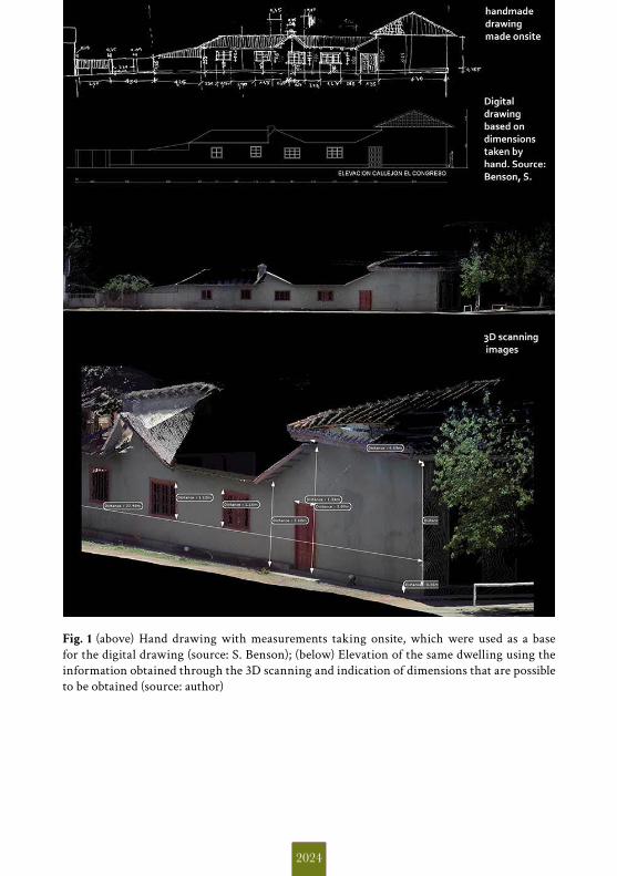
2024
Fig. 1 (above) Hand drawing with measurements taking onsite, which were used as a base for the digital drawing (source: S. Benson); (below) Elevation of the same dwelling using the information obtained through the 3D scanning and indication of dimensions that are possible to be obtained (source: author)
Per capire una città bisogna conoscere e studiare ciò che mostra e ciò che nasconde, ciò che è evidente e ciò che è opaco, ciò che è visibile e ciò che è invisibile.La città risponde allo sguardo interno dei suoi abitanti – già vario per condizioni socioeconomiche e culturali – e a quello esterno di chi la visita per turismo, dei pendolari per lavoro o per studio, dei city users, degli immigrati.Una pluralità di soggetti seleziona punti di vista diversi sui modi di utilizzare gli spazi della città, di fruire dei suoi servizi, di partecipare alla sua vita sociale, e definisce diverse modalità di valutarla, immaginarla, se si vuole di amarla. Ciò che è visibile allo sguardo di alcuni è escluso dall’orizzonte di quello di altri: c’è una città invisibile per molti e non tutti vedono la città allo stesso modo.
Dal 12 al 14 settembre 2013 si è svolto a Catania, presso il Monastero dei Benedettini, il VI congresso dell’Associazione Italiana di Storia Urbana dal titolo VisibileInvisibile. Percepire la città tra descrizioni e omissioni.Il congresso ha offerto una proficua e intensa occasione di incontro e di scambio tra gli storici che pongono al centro della propria riflessione il tema della città. L’obiettivo di questa pubblicazione è quello di custodire la ricchezza e la molteplicità di temi d’indagine, approcci metodologici, punti di vista e spunti per la ricerca, progetti e lavori in corso proposti nel congresso. Si è pensato allora di costruire un contenitore che preservasse la memoria di quell’incontro, la varietà degli argomenti discussi nelle sessioni parallele, le poliedriche declinazioni del tema proposto. Occorreva non perdere i frutti di un momento così fecondo, lasciando un segno visibile e fruibile del lavoro intellettuale prodotto da quei giorni di discussione.
SALVATORE ADORNOè professore associato di Storia contemporanea
presso il Dipartimento di Scienze Umanistichedell’Università di Catania.
GIOVANNI CRISTINAè attualmente “Marie Curie Post-doc Fellow”
al Centre de Recherches Historiquesall’EHESS di Parigi.
ARIANNA ROTONDOè ricercatrice di Storia del cristianesimo e delle chiese
presso il Dipartimento di Scienze Umanistichedell’Università di Catania.