3. The new capital - ANU Press
42
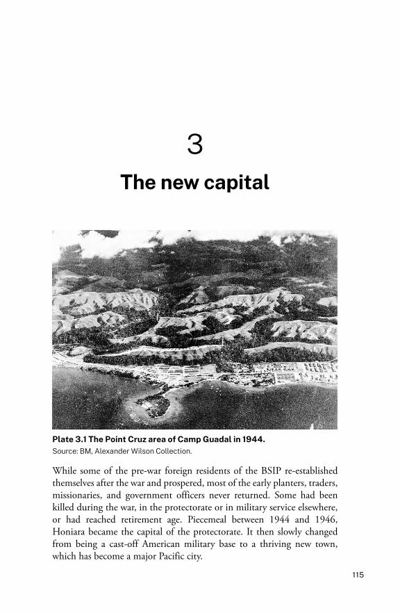
115 3 The new capital Plate 3.1 The Point Cruz area of Camp Guadal in 1944. Source: BM, Alexander Wilson Collection. While some of the pre-war foreign residents of the BSIP re-established themselves after the war and prospered, most of the early planters, traders, missionaries, and government officers never returned. Some had been killed during the war, in the protectorate or in military service elsewhere, or had reached retirement age. Piecemeal between 1944 and 1946, Honiara became the capital of the protectorate. It then slowly changed from being a cast-off American military base to a thriving new town, which has become a major Pacific city.
-
Upload
khangminh22 -
Category
Documents
-
view
3 -
download
0
Transcript of 3. The new capital - ANU Press
115
3The new capital
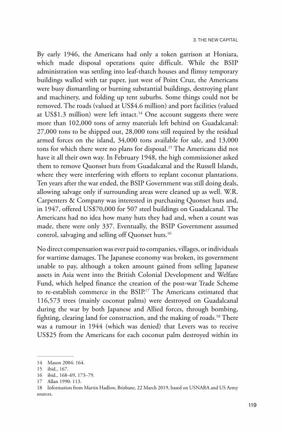
Plate 3.1 The Point Cruz area of Camp Guadal in 1944.Source: BM, Alexander Wilson Collection.
While some of the pre-war foreign residents of the BSIP re-established themselves after the war and prospered, most of the early planters, traders, missionaries, and government officers never returned. Some had been killed during the war, in the protectorate or in military service elsewhere, or had reached retirement age. Piecemeal between 1944 and 1946, Honiara became the capital of the protectorate. It then slowly changed from being a cast-off American military base to a thriving new town, which has become a major Pacific city.

HONIARA
116
The American legacyBetween late 1942 and 1945, Camp Guadal developed into the second-largest American military base in the south-west Pacific, exceeded in size only by the US base at Nouméa on New Caledonia. Once the Japanese withdrew from Guadalcanal in February 1943, the island became a major transit and supply base, sustaining operations elsewhere to drive the Japanese back north. The huge logistical operation was centred on Lungga. It spread along the Guadalcanal coast, east on to the plains, and west to Point Cruz and beyond to Rove.
Planning for the rehabilitation and post-war development of the BSIP began on 18 May 1944 at a conference held at Tenaru, attended by High Commissioner Mitchell, the new BSIP Military Governor Owen Noel, and eight administrative officials. Turning Camp Guadal into Honiara was a tempting proposition. The Tulagi enclave was wrecked and returning the BSIP headquarters to the island would have meant total rebuilding. As well, Tulagi was small with no space for expansion. If an airfield was to be constructed there, it would have to be on Ngela Sule Island across the passage—not ideal for a major airfield for a capital. The advantages of Tulagi—except for its safe harbour and excellent wartime wharves—had passed. However, the move from Tulagi to Honiara was vociferously opposed by many pre-war residents, particularly Anglican Bishop Walter Baddeley, aided by the Pacific Islands Monthly’s editor R.W. Robson.1 Eventually, even the doubters had to accept the inevitable. The British military administration ended on 31 March 1946. Until then, the wartime protectorate staff wore khaki uniforms. For some time afterwards, they did the same, minus badges of rank, as few had any civilian clothes.2
The Americans were vacating their Guadalcanal military base: a complex of roads, the wharves at Kukum, and a smaller wharf at Point Cruz, hundreds of Quonset huts (huge, curved-roof, galvanised ripple-iron buildings with low eaves and concrete floors),3 water and power supplies, five major airfields, and several hospitals. It was a readymade town. Lennox Barrow was a district officer in the BSIP between 1942 and 1947 and was stationed in Honiara in September 1944 and for a few other periods over the next few years. He could see the potential:
1 PIM, February 1946, 22.2 UQ FML, Wilson Papers, A.H. Wilson to J.A. Wilson, 6 February 1946.3 The World War I version was called a Nissen hut—the name sometimes carried over to World War II. They were metal prefabricated huts that varied in size, with larger versions produced late in the war.
117
3. THE NEW CAPITAL
It was not a pleasant place to live. It was dusty and ugly and seemed to be perpetually on the verge of a nervous breakdown, but at the same time you always felt that it might be the beginnings of something. You might scoff at the beautiful town plan of the Honiara of tomorrow which hung in the Resident Commissioner’s office, but at times you could not help picturing that ridge behind dotted with neat cheerful little bungalows, that derelict expanse of dusty ground as public gardens with a fountain and a bandstand and a children’s playground, that broken down camp around the corner as the commercial quarter with fine shops with plate glass windows, and that bit of reef at the end of Point Cruz as a pier at which your ship could tie up.4
The British Government gave little thought to rebuilding its Solomons protectorate, or constructing a new capital, and was churlish in dealing with the Americans, who offered to sell Camp Guadal for US$10.4 million.5 The WPHC could have purchased any of the American infrastructure at bargain prices. Britain wanted the main hospital, but aside from that, it was only willing to accept American infrastructure if it was free.6 The British ‘line’ was that it did not need charity and would not accept any ‘lend-lease’ arrangements. Commercial companies were less choosy: it is said that when Burns Philp took over the US cigarette supply at Tulagi, the profit repaid all its losses there from the war. In Honiara, the few early British residents were delighted when they were allowed to remove as much as they could carry from the PX (Post Exchange) stores on one vehicle each, piled high. No one worried too much about where leftover goods and buildings ended up, and both expatriates and Solomon Islanders helped themselves. Solomon Islanders fenced homes and pig yards with Marston matting, and used plywood and galvanised ripple-iron for house construction. Food, building materials, weapons, boats, jeeps, motors, and refrigerators found their way to plantations, Honiara houses, and villages on Guadalcanal and other islands.7
4 PMB 517, G. Lennox Barrow, 1942–47, An Account of Life in the British Solomon Islands Protectorate Where the Author was a District Officer, 1942–1947, 8.5 Bathgate 1977: 5.6 WPHC 7/II, File F.58/28/1, Military buildings in Honiara, Minute to Resident Commissioner from Secretary, WPHC, 26 July 1945; File F.58/28/13, United States Surplus Heavy Military Equipment other than buildings in BSIP. Reference courtesy of Martin Hadlow; see also Hadlow 2016: 215–16.7 Lindley 2011a.

HONIARA
118
Although the Japanese and Americans had clear-felled vegetation, used herbicide on gardens, and destroyed coconut plantations, neither nation felt any obligation to repair the damage it had caused. The Americans had sent mountains of supplies to the Pacific—more than 60 million tons. When the war ended, the United States had huge amounts of surplus supplies still at home, on top of the supplies overseas valued at US$12 billion. For instance, all the materials for the planned invasion of Japan were still stored on Guadalcanal Plains.8 By 1944, some buildings on Guadalcanal had been disassembled and shipped closer to the current war front. As well, small amounts of the supplies were shipped back to America.9 The usual policy was to try to sell or, failing that, destroy most of the property, bulldozing equipment into holes in the ground, or dumping it at sea. The Royal New Zealand Air Force (RNZAF), based in the Ngela Group and on Guadalcanal, did the same on a lesser scale. From a government point of view, selling meant they could recoup at least a small part of the costs of the war. Some of the American surplus on Guadalcanal eventually was sold to the British for use in Malaya, Hong Kong, and China, while other materials were donated to the United Nations. Both Australia and New Zealand blocked imports of war surplus materials from New Guinea and Solomon Islands, to stop competition with their reviving domestic production.10
The decision to rename Camp Guadal Honiara was made by May 1945. The Pacific Islands Monthly used the name that month, although the magazine was uncertain whether it was to be ‘Honiara’ or ‘Harira’.11 On 22 October 1945, at the first meeting of the BSIP Advisory Council at the end of the war, two sites were considered for the capital. Halavo Bay, the RNZAF No. 6 Flying Boat Squadron base opposite Tulagi on Ngela Sule Island, was a serious contender, although America’s Camp Guadal won the day.12 From December 1945, civilians were allowed to return to the protectorate without a special permit, although shipping services were limited and did not fully resume until 1946.13
8 Mason 2004: 137, 139.9 ibid., 140.10 ibid., 145–49.11 PIM, May 1945, 5.12 PIM, December 1945, 15.13 PIM, January 1946, 7.
119
3. THE NEW CAPITAL
By early 1946, the Americans had only a token garrison at Honiara, which made disposal operations quite difficult. While the BSIP administration was settling into leaf-thatch houses and flimsy temporary buildings walled with tar paper, just west of Point Cruz, the Americans were busy dismantling or burning substantial buildings, destroying plant and machinery, and folding up tent suburbs. Some things could not be removed. The roads (valued at US$4.6 million) and port facilities (valued at US$1.3 million) were left intact.14 One account suggests there were more than 102,000 tons of army materials left behind on Guadalcanal: 27,000 tons to be shipped out, 28,000 tons still required by the residual armed forces on the island, 34,000 tons available for sale, and 13,000 tons for which there were no plans for disposal.15 The Americans did not have it all their own way. In February 1948, the high commissioner asked them to remove Quonset huts from Guadalcanal and the Russell Islands, where they were interfering with efforts to replant coconut plantations. Ten years after the war ended, the BSIP Government was still doing deals, allowing salvage only if surrounding areas were cleaned up as well. W.R. Carpenters & Company was interested in purchasing Quonset huts and, in 1947, offered US$70,000 for 507 steel buildings on Guadalcanal. The Americans had no idea how many huts they had and, when a count was made, there were only 337. Eventually, the BSIP Government assumed control, salvaging and selling off Quonset huts.16
No direct compensation was ever paid to companies, villages, or individuals for wartime damages. The Japanese economy was broken, its government unable to pay, although a token amount gained from selling Japanese assets in Asia went into the British Colonial Development and Welfare Fund, which helped finance the creation of the post-war Trade Scheme to re-establish commerce in the BSIP.17 The Americans estimated that 116,573 trees (mainly coconut palms) were destroyed on Guadalcanal during the war by both Japanese and Allied forces, through bombing, fighting, clearing land for construction, and the making of roads.18 There was a rumour in 1944 (which was denied) that Levers was to receive US$25 from the Americans for each coconut palm destroyed within its
14 Mason 2004: 164.15 ibid., 167.16 ibid., 168–69, 173–79.17 Allan 1990: 113.18 Information from Martin Hadlow, Brisbane, 22 March 2019, based on USNARA and US Army sources.

HONIARA
120
Guadalcanal plantations.19 As soon as the war was over, residents who had lost assets began applying for compensation. After a drawn-out assessment of the huge damages, in 1949, the BSIP Government decided against offering any support. It has been suggested that Britain was unwilling to spend money on rehabilitation while there was the possibility that Solomon Islands could be transferred to the United Nations as a Trust Territory, or to Australia as a territory. Britain could barely repair its damages at home and left far-flung colonies and protectorates to recover by themselves.20 The small planters were ruined and the big companies like Levers, Carpenters, and Burns Philp wrote off their pre-war assets and never returned to their previous retail and merchant businesses. Although Burns Philp continued to run shipping services, it never reinvested in copra plantations.21 Levers and Fairymead22 restored only their best plantations, mainly in the Russells. In 1948, a nine-year deal was signed with the British Ministry of Food to take the entire BSIP copra crop at a low price, with the first exports in 1949, of only 494 tons.23 The Chinese merchants also suffered large losses, some of them returning to rebuild their business ventures in Honiara’s new Chinatown. The only compensation Solomon Islanders received was indirect, through purloining surplus American equipment.
Turning Camp Guadal into 1940s HoniaraSet on a mountainous tropical island just 8 degrees from the Equator, Honiara lies in a partial rain shadow. Compared with the old capital and most areas on neighbouring islands, the climate is drier and the humidity relatively low. Honiara receives about 2 metres of rain a year—the highest falls between December and April—with a temperature range (22º–31ºC) that is more diurnal than seasonal. From June to October, the Ara, the south-east trade winds, blow from the north-east, providing pleasant sea breezes, although from January to March, the Komburu, the reverse north-
19 PIM, June 1944, 7.20 PIM, October 1946, 12, May 1951, 10.21 Waters 2016; PIM, March 1951, 25. In Papua New Guinea, the Australian Government set up the War Damage Compensation Scheme that reimbursed people for losses. Downs 1980: 40.22 Fairymead Sugar Company Limited belonged to the Young family, who founded the South Sea Evangelical Mission and Church. Initially, their commercial arm was Malayta Company, which was sold in 1936 to the Fairymead company, their Bundaberg sugar plantation company. They never grew sugar cane in the Solomons.23 PIM, April 1951, 91; Bennett 1987: 303–4.

121
3. THE NEW CAPITAL
westerly winds, can be warmer. Honiara can be hot and dusty, although it is also capable of being wet and muddy, and periodically cyclones cause floods and damage.
The topography and physical characteristics have largely determined the shape of the city’s urban development. Early Honiara had no sheltered anchorage equivalent to that at Tulagi. The city grew in a long thin coastal strip spread over 15 kilometres between White River and Burns Creek (part of the mouth of the Lungga River), extending further inland in the east than the west. Greater Honiara has now extended well past the airport in the east, and past White River in the west, adding another 5 to 10 kilometres to the coastal front. The coastal strip is backed by a series of low coralline limestone ridges, the bases of which vary in width from 4 to less than 1 kilometres. Some of the ridge tops are barely wide enough to allow space for one house and a road. The subsoil contains coral debris. Guadalcanal is subject to minor earth tremors and occasional large earthquakes. The tidal range is about 1.25 metres. Although Honiara is on the north coast and does not face into the western Pacific, which limits its exposure to cross-ocean tsunamis, Savo Island, a dormant volcano, is within sight. Tsunamis and cyclones are always a possibility.
Plate 3.2 The main coastal highway heading towards Point Cruz, in 1944. The Americans called it the ‘Burma Highway’.Source: USNARA.
HONIARA
122
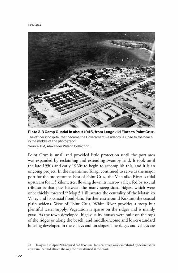
Plate 3.3 Camp Guadal in about 1945, from Lengakiki Flats to Point Cruz.The officers’ hospital that became the Government Residency is close to the beach in the middle of the photograph.Source: BM, Alexander Wilson Collection.
Point Cruz is small and provided little protection until the port area was expanded by reclaiming and extending swampy land. It took until the late 1950s and early 1960s to begin to accomplish this, and it is an ongoing project. In the meantime, Tulagi continued to serve as the major port for the protectorate. East of Point Cruz, the Mataniko River is tidal upstream for 1.5 kilometres, flowing down its narrow valley, fed by several tributaries that pass between the many steep-sided ridges, which were once thickly forested.24 Map 5.1 illustrates the centrality of the Mataniko Valley and its coastal floodplain. Further east around Kukum, the coastal plain widens. West of Point Cruz, White River provides a steep but plentiful water supply. Vegetation is sparse on the ridges and is mainly grass. As the town developed, high-quality houses were built on the tops of the ridges or along the beach, and middle-income and lower-standard housing developed in the valleys and on slopes. The ridges and valleys are
24 Heavy rain in April 2014 caused bad floods in Honiara, which were exacerbated by deforestation upstream that had altered the way the river drained at the coast.
123
3. THE NEW CAPITAL
suitable for residential zones, and the coastal strip has been used mainly for administrative, commercial, and industrial development, and for playing fields, which double as ceremonial sites.
Some areas of Honiara still bear American names. Stateside is the area around the Ministry of Works workshop on the western side of the bridges over the Mataniko in Mendana Avenue, opposite the roundabout at the city council building. Namba 9 is the colloquial name of the post-war Central Hospital, now the National Referral Hospital. Originally the 9th Casualty Clearing Station for the US forces, it consisted of 18 Quonset huts, some of which were still in use in the 1960s. The modern street plan of coastal Honiara still shows evidence of the design of the original American camp, which provided the airfield and the basic road structure. The east of the town is backed by a neglected national park created in 1954, then truncated in 1973, after it had largely been stripped of timber and turned into gardens for urban Honiarans. The unregulated urban sprawl spread on to unoccupied town council land and surrounding Guadalcanal customary land. How this occurred and the consequences of the development of the city of Honiara are a major subject of the remainder of this book.
Honiara grew slowly during its first five years. There was space for an extensive urban settlement and the area was close to the huge plains nearby to the east, which were suitable for agricultural development. There was also hope of future goldmining at Gold Ridge in the mountains nearby, although E.G. (Ted) Theodore, an Australian politician and mining magnate with investments in Fijian mining, withdrew his interest in 1946. In 1955, Placer Development Limited considered taking up a mining lease, but decided the reward was not sufficient, leaving the field to small-scale miners until the 1990s.25
A huge number of buildings left over from the war were converted for multiple uses. Aerial photographs of Honiara in 1945 show the extent of Camp Guadal. It would be another 40 years before the same density of buildings along the coast was re-created. No one thought about asking permission from the Tandai landowners, nor offering further compensation. Most of the land had already been alienated for more than half a century. The Tandai people moved inland and along the coast
25 UQ FML, Wilson Papers, 1945; Emberson-Bain 1994: 35, 76, 83, 86, 138, 149; PIM, November 1955, 18, March 1956, 25.
HONIARA
124
to the west on to customary land beyond the reach of the new urban settlement. For further financial compensation, the traditional owners were ‘persuaded’ to part permanently with their remaining coastal land between the Mataniko River and Rove Creek. No one thought to ask Solomon Islanders whether they would like a new capital perched on a narrow coastal strip backed by dry ridges—all very sunny, exposed, treeless, and infertile—with no harbour.
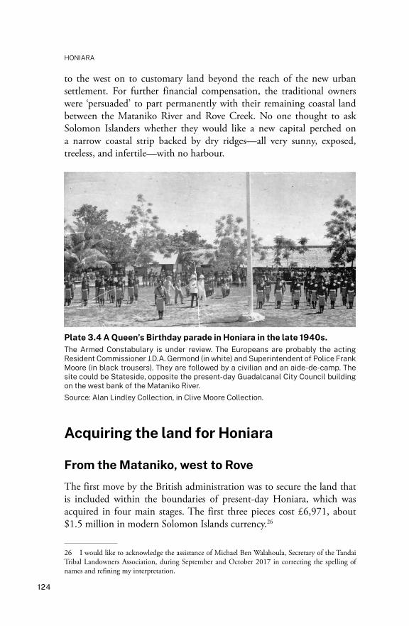
Plate 3.4 A Queen’s Birthday parade in Honiara in the late 1940s.The Armed Constabulary is under review. The Europeans are probably the acting Resident Commissioner J.D.A. Germond (in white) and Superintendent of Police Frank Moore (in black trousers). They are followed by a civilian and an aide-de-camp. The site could be Stateside, opposite the present-day Guadalcanal City Council building on the west bank of the Mataniko River.Source: Alan Lindley Collection, in Clive Moore Collection.
Acquiring the land for Honiara
From the Mataniko, west to Rove
The first move by the British administration was to secure the land that is included within the boundaries of present-day Honiara, which was acquired in four main stages. The first three pieces cost £6,971, about $1.5 million in modern Solomon Islands currency.26
26 I would like to acknowledge the assistance of Michael Ben Walahoula, Secretary of the Tandai Tribal Landowners Association, during September and October 2017 in correcting the spelling of names and refining my interpretation.

125
3. THE NEW CAPITAL
The first acquisition was the land from the west side of the Mataniko River, down as far as Rove. On Map 3.1 (from 1947), the western side of Honiara—the land between Mamara plantation and the west bank of the Mataniko River—is clearly marked ‘native land’, and not part of any plantation. The Tandai land west of Point Cruz begins at Nahona`ara, then includes Raqachaphau (the Solomon Islands Broadcasting Corporation area), Matavale (the Coral Sea Casino area), Parikukutu (St John’s area, and Iron Bottom Sound Hotel on the coast), and Rove Creek. Through a 21 January 1947 civil case in the High Commissioner’s Court for the Western Pacific, the government forced the landowners to relinquish this land, which was compulsorily acquired and incorporated into Honiara.27 The landowners were compensated with £4,495—a generous amount compared with what was paid to Levers for the Mataniko to Kukum land, or the money paid for Mamara plantation.
From the Mataniko, east to Kukum
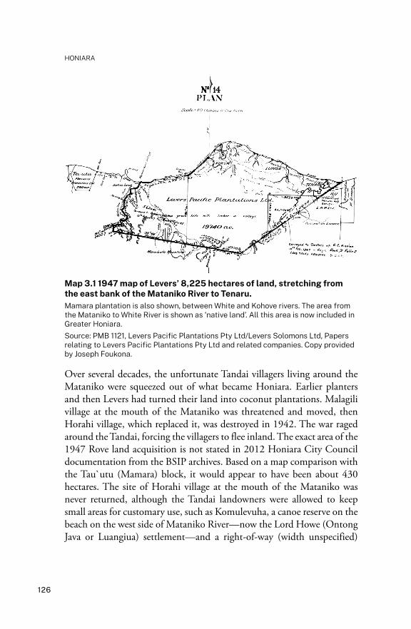
In 1947, Levers held 7,988 hectares between the Mataniko River and Tenaru (as well as more land further east on the plains). The second acquisition for Honiara was 2,274 hectares, the western end of which began on the east bank of the Mataniko River, including Kukum but stopping short of the Honiara Airfield (Fighter II) and Burns Creek. This land was acquired from Levers in February 1947 for £2,174. The Tandai continued to dispute Levers’ ownership and in 1964 took a case to court over the land, which they lost (Map 3.2).28 The area had been devastated by the war and then overtaken by the Americans’ construction of Camp Guadal. Levers must have been relieved to receive even this much money. Map 3.1 shows Levers’ east Honiara land in 1947 as far out as Tenaru. Map 3.2 shows the parcel of land still under dispute in 1964.
27 The defendants were Tsilivi, Kosi, and Lovanea on behalf of the landowners. Interestingly, Baranaba Hoai, the main Tandai chief, was not included. He had been jailed for spurious reasons relating to vele (destructive magic) visited on his daughter. This may have been deliberate manipulation and intimidation by the British, which is how the modern Tandai people interpret his imprisonment.28 WPHC 16/II/165/2/11, Great Britain, High Commission for Western Pacific Islands, Western Pacific Archives, 1875–1976; Indenture of Sale for Kukum–Lungga–Tenaru Plantation, 12 February 1947; Application to Purchase Land in BSIP 1954–59. Copy provided by Joseph Foukona.
HONIARA
126
Map 3.1 1947 map of Levers’ 8,225 hectares of land, stretching from the east bank of the Mataniko River to Tenaru.Mamara plantation is also shown, between White and Kohove rivers. The area from the Mataniko to White River is shown as ‘native land’. All this area is now included in Greater Honiara.Source: PMB 1121, Levers Pacific Plantations Pty Ltd/Levers Solomons Ltd, Papers relating to Levers Pacific Plantations Pty Ltd and related companies. Copy provided by Joseph Foukona.
Over several decades, the unfortunate Tandai villagers living around the Mataniko were squeezed out of what became Honiara. Earlier planters and then Levers had turned their land into coconut plantations. Malagili village at the mouth of the Mataniko was threatened and moved, then Horahi village, which replaced it, was destroyed in 1942. The war raged around the Tandai, forcing the villagers to flee inland. The exact area of the 1947 Rove land acquisition is not stated in 2012 Honiara City Council documentation from the BSIP archives. Based on a map comparison with the Tau`utu (Mamara) block, it would appear to have been about 430 hectares. The site of Horahi village at the mouth of the Mataniko was never returned, although the Tandai landowners were allowed to keep small areas for customary use, such as Komulevuha, a canoe reserve on the beach on the west side of Mataniko River—now the Lord Howe (Ontong Java or Luangiua) settlement—and a right-of-way (width unspecified)

127
3. THE NEW CAPITAL
along the west bank of the Mataniko River to a spring below the site of the present-day US War Memorial, within what is now the Koa Hill settlement (Map 10.1: #25).29
Map 3.2 The area contested by Baranaba Hoai in 1964 on behalf of the Tandai landowners.Marked from the east side of the mouth of the Mataniko River (approximately 833 hectares centred on the old village site), part of 2,341 hectares extends along the east bank of the river, which Levers and the Tandai both claimed. All spelling and wording are as they appear on the original map. Source: Case 3 of 1964, High Court of the Western Pacific. Copy provided by Joseph Foukona. Cartography by Vincent Verheyen.
The Americans had built on the Horahi village site on the west side of the Mataniko. In 1947, the BSIP Government negotiated to acquire the land. Agreement was reached that the village be shifted to its present site inland on the banks of the Mataniko River beyond the present-day southern Honiara City boundary.30 Other Horahi villagers moved to Kakabona and Vatamunu. Unlike other Melanesian urban areas—Port Moresby in Papua
29 R.L. Clark, Surveyor, BSIP document in A Report on the Claim by Landowners that West of Honiara Starting from Rove to the Western Town Boundary Has Not Been Properly Acquired, in SIG 2012a; Oram 1980: 140.30 SINA BSIP, Civil Case No. 3 of 1964, High Court of the Western Pacific.

HONIARA
128
New Guinea, for instance, where the Motu-Koita people still possess considerable areas of land within the city boundary—the customary owners of Honiara were stripped of their land and relocated away from the coast or pushed away to the east and west.31
The Tandai people continued to protest the unfair terms of the land acquisition. In 1964, on behalf of himself and the Kakau and Haubata descent groups, Baranaba Hoai claimed ownership of 2,341 hectares—the western third of Levers’ land (Map 3.2).32 As had also occurred in the 1910s and 1920s (Maps 1.3–1.6), they challenged Levers’ right to freehold ownership of the land from the east bank of the Mataniko River and along the coast as far as Tanakake. They alleged that £50 had been paid only as compensation for their moving from Malagili to Horahi village, not for the land. The inland section of their claim also extended into the Queen Elizabeth National Park surrounding east Honiara.
Chief Justice G.G. Briggs sat in judgement, basing his decision on the history of land alienation back to 1886. He noted that there were three indigenous groups involved: Simbo, Kakau, and Haubata (Habata). The High Court found in favour of Levers, ruling that the 1923–24 arrangements were still valid, denying any further rights to compensation. The Phillips Lands Commission had been validated by legislation passed in 1924, which made the decisions final. The Chief Justice found no new reliable evidence had been produced to support the 1964 claim.33
Rove to White River: Tau`utu
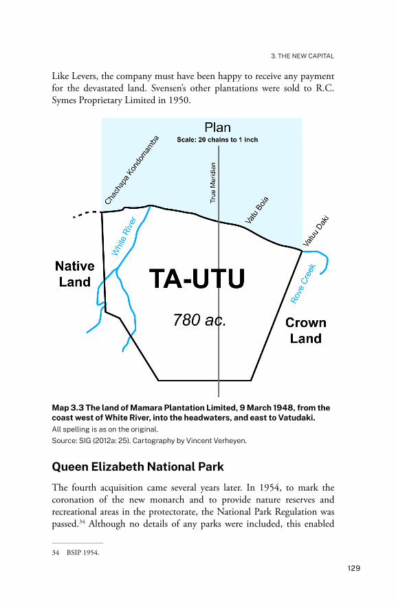
The third acquisition was 320 hectares of land known as Tau`utu (Ta-Utu; Map 3.3), which ran from Rove to the current western boundary of Honiara at White (Tau`utu) River. Purchased from Mamara Plantation Limited, this consisted of two parcels of land that had been sold to Oscar Svensen and Joseph T. d’Oliveyra in July 1911, although their occupation preceded this date (see Chapter 1). Just as it had with the Kukum–Lungga–Tenaru land, the war years turned Mamara plantation into a battle zone. Nothing much survived other than damaged vegetation. The Tau`utu land was sold to the government on 9 March 1948 for £302.
31 Golden 1993: 121, 146, 202–3; SINA BSIP, 18/II/5, 18/I/2.32 SINA BSIP, Civil Case No. 3 of 1964. See also Bellam 1970: 72; BSIP NS, 29 February 1964, 4–5.33 SINA BSIP, Civil Case No. 3 of 1964; Ruthven 1979b: 245; BSIP NS, 15 March 1964.
129
3. THE NEW CAPITAL
Like Levers, the company must have been happy to receive any payment for the devastated land. Svensen’s other plantations were sold to R.C. Symes Proprietary Limited in 1950.
Map 3.3 The land of Mamara Plantation Limited, 9 March 1948, from the coast west of White River, into the headwaters, and east to Vatudaki.All spelling is as on the original.Source: SIG (2012a: 25). Cartography by Vincent Verheyen.
Queen Elizabeth National Park
The fourth acquisition came several years later. In 1954, to mark the coronation of the new monarch and to provide nature reserves and recreational areas in the protectorate, the National Park Regulation was passed.34 Although no details of any parks were included, this enabled
34 BSIP 1954.
HONIARA
130
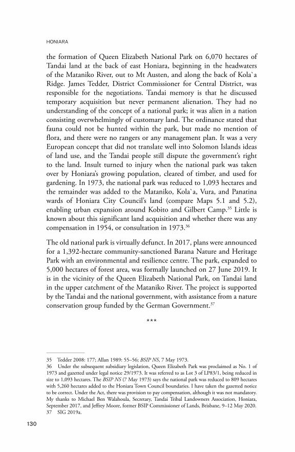
the formation of Queen Elizabeth National Park on 6,070 hectares of Tandai land at the back of east Honiara, beginning in the headwaters of the Mataniko River, out to Mt Austen, and along the back of Kola`a Ridge. James Tedder, District Commissioner for Central District, was responsible for the negotiations. Tandai memory is that he discussed temporary acquisition but never permanent alienation. They had no understanding of the concept of a national park; it was alien in a nation consisting overwhelmingly of customary land. The ordinance stated that fauna could not be hunted within the park, but made no mention of flora, and there were no rangers or any management plan. It was a very European concept that did not translate well into Solomon Islands ideas of land use, and the Tandai people still dispute the government’s right to the land. Insult turned to injury when the national park was taken over by Honiara’s growing population, cleared of timber, and used for gardening. In 1973, the national park was reduced to 1,093 hectares and the remainder was added to the Mataniko, Kola`a, Vura, and Panatina wards of Honiara City Council’s land (compare Maps 5.1 and 5.2), enabling urban expansion around Kobito and Gilbert Camp.35 Little is known about this significant land acquisition and whether there was any compensation in 1954, or consultation in 1973.36
The old national park is virtually defunct. In 2017, plans were announced for a 1,392-hectare community-sanctioned Barana Nature and Heritage Park with an environmental and resilience centre. The park, expanded to 5,000 hectares of forest area, was formally launched on 27 June 2019. It is in the vicinity of the Queen Elizabeth National Park, on Tandai land in the upper catchment of the Mataniko River. The project is supported by the Tandai and the national government, with assistance from a nature conservation group funded by the German Government.37
***
35 Tedder 2008: 177; Allan 1989: 55–56; BSIP NS, 7 May 1973.36 Under the subsequent subsidiary legislation, Queen Elizabeth Park was proclaimed as No. 1 of 1973 and gazetted under legal notice 29/1973. It was referred to as Lot 3 of LP83/1, being reduced in size to 1,093 hectares. The BSIP NS (7 May 1973) says the national park was reduced to 809 hectares with 5,260 hectares added to the Honiara Town Council boundaries. I have taken the gazetted notice to be correct. Under the Act, there was provision to pay compensation, although it was not mandatory. My thanks to Michael Ben Walahoula, Secretary, Tandai Tribal Landowners Association, Honiara, September 2017, and Jeffrey Moore, former BSIP Commissioner of Lands, Brisbane, 9–12 May 2020.37 SIG 2019a.

131
3. THE NEW CAPITAL
Having legally secured the land from White River to Kukum by 1948, then added the land inland to Mt Austen in 1954 (the national park), and extended the area along the coast east as far as Burns Creek in 1964,38 the government had control of almost all the area included within the boundaries of the modern Honiara City Council. Despite their early lack of interest, the British did purchase some of the American wartime equipment through the Foreign Liquidation Commission, including the waterpipe supply, generators, electric light and refrigeration plants, and bulldozers.
What eventually became the Government Secretariat (now the site of the cenotaph and Central Police Station in Mendana Avenue) began operating in plywood and tar-paper huts. Quonset huts of all sizes were scattered about in plentiful supply, as was Marston matting. A few of the Quonset huts remain—reminders of Honiara’s wartime beginnings. Thousands of Marston mats were used to create firm surfaces for planes to land on; they were also used on roads in boggy areas. The Americans decided there was too much work involved in removing the many hectares of Marston matting covering the airfields. Two businesses in particular, R.C. Symes and Ken Hay’s K.H. Dalrymple Hay Proprietary Limited, made substantial fortunes from onselling this scrap steel, as well as salvaging copper, brass, and lead.39 There was also money to be made in selling the many wrecks along the coast for scrap metal—some to Japanese companies between 1958 and 1960.
Coronation Gardens (the present National Museum enclave) was named on 4 July 1953, a few days after the coronation of Queen Elizabeth II. It had been an American vegetable garden on the banks of the small Cruz Creek, which still flows down its now polluted path between the National Museum and Central Police Station. There were other vegetable gardens near the end of Henderson Airfield and another area at Ilu.40 A small American force remained near Henderson Airfield until October 1949, surrounded by empty army huts, defunct open-air picture theatres, and basketball courts from the war years. The remaining Americans were charged with selling off as much wartime equipment as they could, and continued to provide antimalaria spraying of mosquitoes around Honiara.
38 BSIP NS, 29 February 1964, 6.39 Ken Hay’s full name was Kenneth H. Dalrymple-Hay. PIM, May 1953, 18; Lawson n.d. [c. 2000s]: 17–18.40 Tedder 1966: 36; BSIP NS, 31 March 1969.

HONIARA
132
They left in early 1950.41 Rusted landing barges dotted the shoreline, ammunition dumps in big underground ‘igloos’ were built into the foothills, and unexploded mortar bombs were a constant problem. The first automobiles were left-hand-drive American jeeps and trucks—to such an extent that it was 1947 before there were enough British right-hand-drive cars to make the change to driving on the left of the roads. During and after the war, land inland from Hell’s Point was used as a storage area for unexploded ordnance, which was placed there by the Americans and later by Australian bomb-disposal units. Solomon Islanders entered this ‘off-limits’ area to collect brass shells casings and to remove the explosive materials to use to dynamite fish—a dangerous pastime.42
Honiara in the 1940s was in transition from an American military base to a British colonial town. The last word on this early period goes to two famous individuals, James A. Michener and Sir Fred Osifelo. Osifelo, from Baegu, Malaita, joined the public service in Honiara at age 17 in 1945 as an orderly—an office messenger.43 Writing in the 1980s, he remembered his uniform as ‘a dark grey sulu with a red sash and a black canvas belt with a silver buckle’:
Honiara in April 1945 was very small. Its eastern boundary was the present road which goes down to the Yacht Club, between Solomon Motors and Quan Hong’s Store on Mendana Avenue. Its western boundary was between the Prime Minister’s Office and Government House’s western boundary. The Secretariat Office at that time was situated in the area now known as Mendana Garden where the Cenotaph now stands. It was T-shaped, its eastern wing occupied wholly by the Treasury. The western wing consisted of the Labour Office and Medical Office. The northern wing consisted of the Resident Commissioner’s Office and office of the Secretary to the Government, Chief Clerk, typist and general office occupied by Walter Togonu and Walter Kanaf, two local clerks from Reef Islands.44
He remembered some of the difficulties he had with communicating in Solomons Pijin, with some very funny results until he became fluent. Housed at Mataniko No. 3 ‘Labour Line’ (workers’ barracks) at Vara Creek (Map 8.1), he remembered his weekly rations from the Government Trade
41 BSIP NS, 31 January 1969; BSIP AR 1949–50.42 Lindley 2013: attachment to Map 4.43 Moore 2013c: entry on Osifelo.44 Osifelo 1985: 26.

133
3. THE NEW CAPITAL
Scheme store as 7 pounds (3 kilograms) of rice, 1 pound (500 grams) of sugar, three tins of Ox & Palm corned beef, a quarter-pound (100 grams) of tea, 21 hard navy biscuits, three sticks of tobacco, and 3 inches (7.6 centimetres) of washing soap.45
American novelist James A. Michener returned to Guadalcanal in 1948, retracing his wartime steps. He could see the future possibilities for Honiara:
Leave Henderson Field and go west along Highway 50 past Fighter One [he means Fighter II], past Kukum Docks, across the Matanikau, and on to Point Cruz, where the ammunition dump was [he means Hell’s Point]. At the base of Point Cruz, which forms the meagre semblance of a harbour, Honiara has been built. The word means ‘where the wind blows’, which, as the planter observed ‘is so perfect a name for a capital that any comment from me would be superfluous.’
Honiara will be a better town than Tulagi ever was. King-size Quonsets have been moved in for barracks, and grass shacks have been tucked away under broad trees to serve temporarily as government offices. Behind the town is a high ridge where lovely homes are being built in breezes that keep them permanently cool and mosquito-proof.46
UXBs: Cleaning up munitions dumps and unexploded bombsThe site of Honiara had been a huge battleground for the Japanese and Allied forces. Unexploded bombs (UXBs) and lesser munitions were everywhere. The Americans used land on the east bank of Alligator Creek between Henderson and Fighter I airfields to store unwanted munitions (as it was opposite Hell’s Point on the coast, the area was also known by this name). When Michener visited Honiara after the war, road graders were still uncovering unexploded shells in the main street, many of which he said were quietly covered over again. He claimed to have asked an official what would happen if one detonated and was told, with typically understated British humour, ‘There’d be a tremendous bang, I should think’.47
45 ibid., 25–28.46 Michener 1951: 131.47 ibid., 133.
HONIARA
134
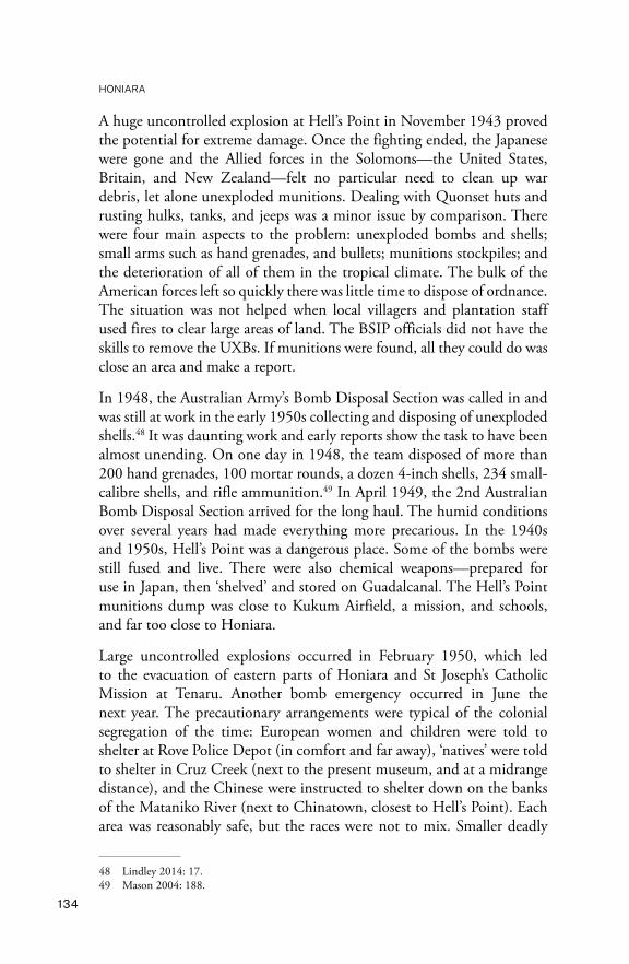
A huge uncontrolled explosion at Hell’s Point in November 1943 proved the potential for extreme damage. Once the fighting ended, the Japanese were gone and the Allied forces in the Solomons—the United States, Britain, and New Zealand—felt no particular need to clean up war debris, let alone unexploded munitions. Dealing with Quonset huts and rusting hulks, tanks, and jeeps was a minor issue by comparison. There were four main aspects to the problem: unexploded bombs and shells; small arms such as hand grenades, and bullets; munitions stockpiles; and the deterioration of all of them in the tropical climate. The bulk of the American forces left so quickly there was little time to dispose of ordnance. The situation was not helped when local villagers and plantation staff used fires to clear large areas of land. The BSIP officials did not have the skills to remove the UXBs. If munitions were found, all they could do was close an area and make a report.
In 1948, the Australian Army’s Bomb Disposal Section was called in and was still at work in the early 1950s collecting and disposing of unexploded shells.48 It was daunting work and early reports show the task to have been almost unending. On one day in 1948, the team disposed of more than 200 hand grenades, 100 mortar rounds, a dozen 4-inch shells, 234 small-calibre shells, and rifle ammunition.49 In April 1949, the 2nd Australian Bomb Disposal Section arrived for the long haul. The humid conditions over several years had made everything more precarious. In the 1940s and 1950s, Hell’s Point was a dangerous place. Some of the bombs were still fused and live. There were also chemical weapons—prepared for use in Japan, then ‘shelved’ and stored on Guadalcanal. The Hell’s Point munitions dump was close to Kukum Airfield, a mission, and schools, and far too close to Honiara.
Large uncontrolled explosions occurred in February 1950, which led to the evacuation of eastern parts of Honiara and St Joseph’s Catholic Mission at Tenaru. Another bomb emergency occurred in June the next year. The precautionary arrangements were typical of the colonial segregation of the time: European women and children were told to shelter at Rove Police Depot (in comfort and far away), ‘natives’ were told to shelter in Cruz Creek (next to the present museum, and at a midrange distance), and the Chinese were instructed to shelter down on the banks of the Mataniko River (next to Chinatown, closest to Hell’s Point). Each area was reasonably safe, but the races were not to mix. Smaller deadly
48 Lindley 2014: 17.49 Mason 2004: 188.
135
3. THE NEW CAPITAL
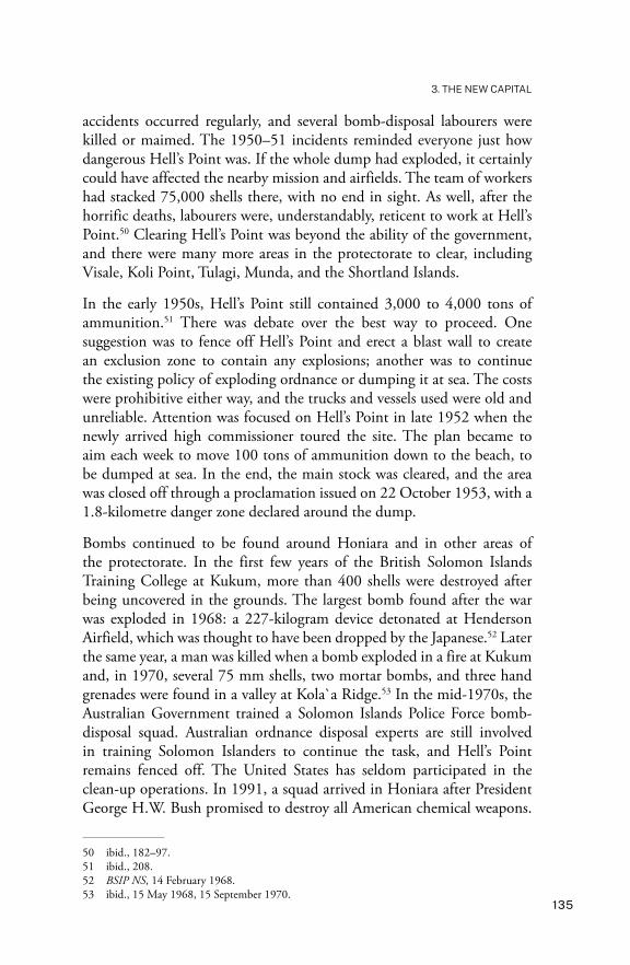
accidents occurred regularly, and several bomb-disposal labourers were killed or maimed. The 1950–51 incidents reminded everyone just how dangerous Hell’s Point was. If the whole dump had exploded, it certainly could have affected the nearby mission and airfields. The team of workers had stacked 75,000 shells there, with no end in sight. As well, after the horrific deaths, labourers were, understandably, reticent to work at Hell’s Point.50 Clearing Hell’s Point was beyond the ability of the government, and there were many more areas in the protectorate to clear, including Visale, Koli Point, Tulagi, Munda, and the Shortland Islands.
In the early 1950s, Hell’s Point still contained 3,000 to 4,000 tons of ammunition.51 There was debate over the best way to proceed. One suggestion was to fence off Hell’s Point and erect a blast wall to create an exclusion zone to contain any explosions; another was to continue the existing policy of exploding ordnance or dumping it at sea. The costs were prohibitive either way, and the trucks and vessels used were old and unreliable. Attention was focused on Hell’s Point in late 1952 when the newly arrived high commissioner toured the site. The plan became to aim each week to move 100 tons of ammunition down to the beach, to be dumped at sea. In the end, the main stock was cleared, and the area was closed off through a proclamation issued on 22 October 1953, with a 1.8-kilometre danger zone declared around the dump.
Bombs continued to be found around Honiara and in other areas of the protectorate. In the first few years of the British Solomon Islands Training College at Kukum, more than 400 shells were destroyed after being uncovered in the grounds. The largest bomb found after the war was exploded in 1968: a 227-kilogram device detonated at Henderson Airfield, which was thought to have been dropped by the Japanese.52 Later the same year, a man was killed when a bomb exploded in a fire at Kukum and, in 1970, several 75 mm shells, two mortar bombs, and three hand grenades were found in a valley at Kola`a Ridge.53 In the mid-1970s, the Australian Government trained a Solomon Islands Police Force bomb-disposal squad. Australian ordnance disposal experts are still involved in training Solomon Islanders to continue the task, and Hell’s Point remains fenced off. The United States has seldom participated in the clean-up operations. In 1991, a squad arrived in Honiara after President George H.W. Bush promised to destroy all American chemical weapons.
50 ibid., 182–97.51 ibid., 208.52 BSIP NS, 14 February 1968.53 ibid., 15 May 1968, 15 September 1970.

HONIARA
136
With much fanfare, they took away one hundred 155 mm artillery shells, each filled with 5.5 kilograms of mustard gas. The Japanese have totally ignored the issue.54
There can be no doubt that many pieces of ordnance are still buried around Honiara and, after 75 years, they must be in poor condition. In February 2018, a 135 mm shell was located near White River market—probably fired from a ship during the war. The Police Explosive Ordnance Disposal Unit transported the shell to Hell’s Point for destruction. Then, in September 2020, two expatriate ordnance disposal experts were killed when a bomb exploded in their apartment at Tasahe Ridge in west Honiara. Other munitions were found to be stored close by, raising many questions. In May 2021, a US 105 mm bomb exploded at Lengakiki after being inadvertently uncovered while a group was preparing a site for a stone oven, killing one man, and injuring three others.55 The Japanese and US governments must take responsibility for removing their decaying ordnance from around Honiara and other sites.
Creating urban and communication services Honiara began, slowly, to develop a full range of urban services. Once Burns, Philp & Company resumed regular shipping services in 1948; the Morinda, Muliama, or Malaita turned up every few weeks from Sydney and, beginning the next year, Bank Line ships arrived four times a year to export the protectorate’s copra to Britain. Air transport was easy to establish as Honiara was unusually well served by airfields. Kukum (Fighter II) Airfield became Honiara’s main civilian airfield between 1945 and 1957, although its position was too confined to meet international civil aviation standards. However, problems with access across the Lungga River between Henderson Airfield and Honiara kept the use of that airfield patchy until it was reopened permanently on 5 December 1960. Until the late 1960s, Kukum Airfield was brought back into service whenever the Lungga River was impassable, or while Henderson Airfield was being expanded. Honiara Golf Club was established alongside Kukum Airfield in 1957, with the original airport building converted into the club’s recreation building.56
54 Mason 2004: 182–223.55 Sei 2018; Wickham and Eremae 2020; Mamu 2021.56 PIM, November 1955, 23; Tedder 2008: 188; Information from Alan Lindley, Adelaide, 30 June 2011.
137
3. THE NEW CAPITAL
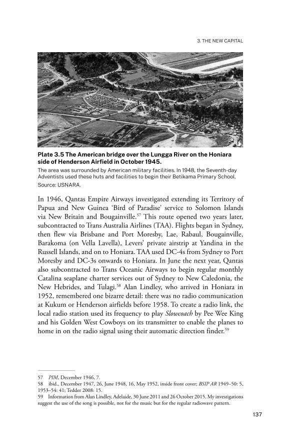
Plate 3.5 The American bridge over the Lungga River on the Honiara side of Henderson Airfield in October 1945.The area was surrounded by American military facilities. In 1948, the Seventh-day Adventists used these huts and facilities to begin their Betikama Primary School. Source: USNARA.
In 1946, Qantas Empire Airways investigated extending its Territory of Papua and New Guinea ‘Bird of Paradise’ service to Solomon Islands via New Britain and Bougainville.57 This route opened two years later, subcontracted to Trans Australia Airlines (TAA). Flights began in Sydney, then flew via Brisbane and Port Moresby, Lae, Rabaul, Bougainville, Barakoma (on Vella Lavella), Levers’ private airstrip at Yandina in the Russell Islands, and on to Honiara. TAA used DC-4s from Sydney to Port Moresby and DC-3s onwards to Honiara. In June the next year, Qantas also subcontracted to Trans Oceanic Airways to begin regular monthly Catalina seaplane charter services out of Sydney to New Caledonia, the New Hebrides, and Tulagi.58 Alan Lindley, who arrived in Honiara in 1952, remembered one bizarre detail: there was no radio communication at Kukum or Henderson airfields before 1958. To create a radio link, the local radio station used its frequency to play Slowcoach by Pee Wee King and his Golden West Cowboys on its transmitter to enable the planes to home in on the radio signal using their automatic direction finder.59
57 PIM, December 1946, 7.58 ibid., December 1947, 26, June 1948, 16, May 1952, inside front cover; BSIP AR 1949–50: 5, 1953–54: 41; Tedder 2008: 15.59 Information from Alan Lindley, Adelaide, 30 June 2011 and 26 October 2015. My investigations suggest the use of the song is possible, not for the music but for the regular radiowave pattern.
HONIARA
138
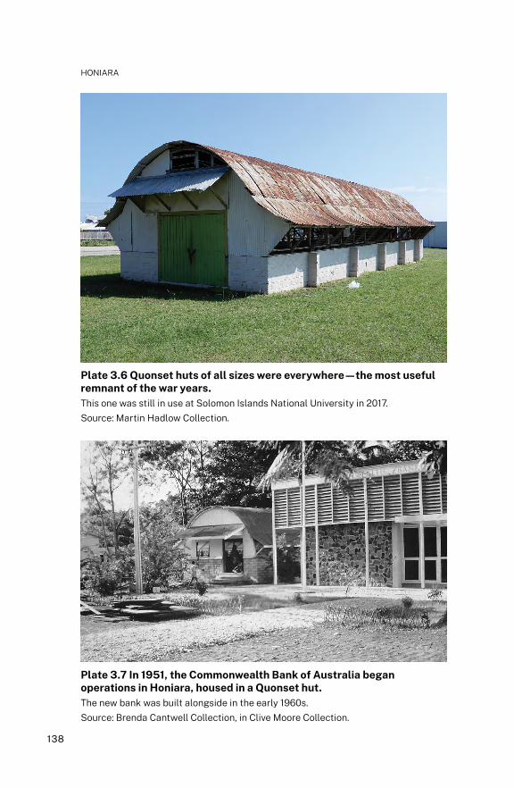
Plate 3.6 Quonset huts of all sizes were everywhere—the most useful remnant of the war years.This one was still in use at Solomon Islands National University in 2017. Source: Martin Hadlow Collection.
Plate 3.7 In 1951, the Commonwealth Bank of Australia began operations in Honiara, housed in a Quonset hut.The new bank was built alongside in the early 1960s.Source: Brenda Cantwell Collection, in Clive Moore Collection.

139
3. THE NEW CAPITAL
In 1945, once the decision was made to shift the capital to Honiara, a town plan was prepared, and £250,000 requested from the Western Pacific High Commissioner—only one-fifth of which was allocated.60 It took until well after 1953—the year the WPHC headquarters shifted from Suva to Honiara—for extra attention to be given to shaping the development of Honiara. More housing was needed for the increased number of public servants, and temporary government buildings had to be improved or replaced. The Americans left behind a rudimentary but extensive road system, although there were no permanent bridges over the rivers. In late 1947, five Bailey bridges were imported at a cost of £24,000 to replace dilapidated timber bridges on Guadalcanal. The first Bailey bridge erected was over the Mataniko River at Chinatown, which was completed in June 1950, replacing an American pontoon bridge.61 The Chinatown Bailey bridge lasted until floods in 2014, after which the original structure was replaced—with a new Bailey bridge.
In 1948–49, Honiara’s population consisted of about 80 Europeans (including 23 women and 18 children), 100 Chinese, living mainly in Chinatown, the workers in Fijian Quarter, Solomon Island labourers, and Maasina Rule prisoners. The initial labour supply for building Honiara came from rotated batches of 60 Fijian and Indo-Fijian workers from Suva, who were housed in the area still known as Fijian Quarter near Chinatown. There were also Solomon Islanders originally from the Labour Corps and the Defence Corps who remained after these units were disbanded. Although the exact number is unknown, there were thousands of Maasina Rule prisoners in Honiara between 1946 and 1952. At any one time, the number swung between 100 and 1,000. Some of the trials were held in Honiara; the town was used for the transit of prisoners being moved to Western District and, when the jails on Malaita overflowed, prisoners were sent to Honiara. These prisoners included the head chiefs and their co-defendants. They were kept isolated in a low-security lock-up, which enabled other Malaitans in Honiara to talk to them through the fence.62 Until 1948, Maasina Rule caused a severe labour shortage in Honiara because the movement’s policy was to not allow its supporters to work as labourers. The labour supply improved in 1949 and, by 1950, was adequate.
60 BSIP NS, 31 May 1969.61 A Bailey bridge is a portable, prefabricated truss bridge developed by the British during World War II. They have the advantage of not requiring heavy equipment in construction. PIM, February 1948, 24; BSIP AR 1953–54: 8.62 According to Jonathan Fifi`i, they were held somewhere near the present-day National Archives. Akin 2013: 283, 427 fn.64; Information from David Akin, 12 September 2017.
HONIARA
140
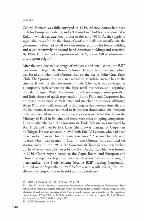
Central Honiara was fully surveyed in 1949, 24 new houses had been built for European residents, and a ‘Labour Line’ had been constructed at Kukum, which was extended further in the early 1960s. As the supply of sago palm leaves for the thatching of roofs and walls was insufficient, the government often had to fall back on timber and iron for house-building and relied extensively on second-hand American buildings and materials. By 1954, Honiara had a population of 1,400, about 150 of whom were of European origin.63
After the war, due to a shortage of wholesale and retail shops, the BSIP Government began the British Solomon Islands Trade Scheme, which was based at a wharf and Quonset hut on the site of Point Cruz Yacht Club. The Quonset hut was later moved to Mendana Avenue beside the cinema. Known as the Government Trade Scheme, it was envisaged as a temporary replacement for the large retail businesses, and organised the sale of copra. With plantations ruined, no compensation provided, and little chance of quick regeneration, Burns Philp and Carpenters had no reason to re-establish their retail and merchant businesses. Although Burns Philp eventually resumed its shipping service between Australia and the Solomons, it never returned to its pre-war dominance. Air transport took away its old mail-run subsidies, copra was marketed directly to the Ministry of Food in Britain, and there were other shipping competitors. Directly after the war, the Government Trade Scheme was managed by Bob Firth, and then by Jack Lotze (the pre-war manager of Carpenters on Tulagi). He was replaced in 1947 with Eric. V. Lawson, who had been merchandise manager for Carpenters in Suva.64 A second branch, with its own wharf, was opened in Gizo, in two Quonset huts also used for storing copra. In the 1950s, the Government Trade Scheme was broken up. Its wharves were taken over by the Ports Authority, which was formed in 1956. Copra buying passed to the Copra Board, and European and Chinese companies began to arrange their own overseas buying of merchandise. The Trade Scheme became BSIP Trading Corporation Limited on 29 September 1955,65 before a new regulation in July 1960 allowed the corporation to be sold to private industry.
63 BSIP AR 1949–50: 26, 1972: 2; Tudor 1953b: 75.64 Eric V. Lawson became a prominent businessman. After running the Government Trade Scheme in Honiara, he became manager of the Fairymead Sugar Company (which owned coconut plantations) and secretary-manager of the Copra Board. Lawson was a member of the Legislative Council from 1959 to 1966. In 1971, he sold his business to C. Sullivan (Export) Pty Ltd. ‘Honiara just a dump says “EV”’, SND, 11 July 1975.65 PIM, November 1955, 93.

141
3. THE NEW CAPITAL
Plate 3.8 The BSIP Trading Corporation Limited was housed in a large Quonset hut in Mendana Avenue, 1960s.Source: Brenda Cantwell Collection, in Clive Moore Collection.
Plate 3.9 The staff of the BSIP Trading Corporation Limited, 1960s.Source: Brenda Cantwell Collection, in Clive Moore Collection.
HONIARA
142
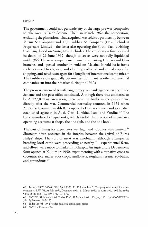
The government could not persuade any of the large pre-war companies to take over its Trade Scheme. Then, in March 1962, the corporation, excluding the plantations it had acquired, was sold to a partnership between Mitsui & Company and D.J. Gubbay & Company (New Hebrides) Proprietary Limited—the latter also operating the South Pacific Fishing Company, based on Santo, New Hebrides. The corporation finally closed its doors on 29 June 1962, though its assets were not fully liquidated until 1966. The new company maintained the existing Honiara and Gizo branches and opened another in Auki on Malaita. It sold basic items such as tinned foods, rice, and clothing, collected and stored copra for shipping, and acted as an agent for a long list of international companies.66 The Gubbay store gradually became less dominant as other commercial companies cut into their market during the 1960s.
The pre-war system of transferring money via bank agencies at the Trade Scheme and the post office continued. Although there was estimated to be A£227,020 in circulation, there were no banks in the protectorate directly after the war. Commercial normality returned in 1951 when Australia’s Commonwealth Bank opened a Honiara branch and soon after established agencies in Auki, Gizo, Kirakira, Lata, and Yandina.67 The bank introduced chequebooks, which ended the practice of expatriates operating accounts at shops, the one club, and the one hotel.
The cost of living for expatriates was high and supplies were limited.68 Shortages often occurred in the interim between the arrival of Burns Philps’ ships. The cost of meat was exorbitant, although attempts at breeding local cattle were proceeding at nearby Ilu experimental farm, and efforts were made to market fish cheaply. An Agriculture Department farm opened at Kukum in 1950, experimenting with alternative crops to coconuts: rice, maize, root crops, sunflowers, sorghum, sesame, soybeans, and groundnuts.69
66 Bennett 1987: 303–4; PIM, April 1953, 12. D.J. Gubbay & Company were agents for many companies. BSIP NS, 31 July 1960, December 1961, 31 March 1962, 15 April 1962, 30 May 1964; Close 2011: 112, 152, 169, 171, 173, 179.67 BSIP NS, 31 January 1969, 7 May 1966, 31 March 1969; PIM, July 1951, 35; BSIP AR 1951–52: 15; Bennett 1987: 257.68 Tudor (1953b: 70) provides domestic commodity prices.69 BSIP AR 1949–50: 22.
143
3. THE NEW CAPITAL
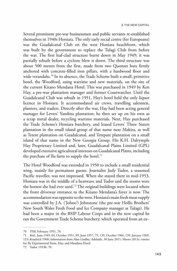
Several prominent pre-war businessmen and public servants re-established themselves in 1940s Honiara. The only early social centre (for Europeans) was the Guadalcanal Club on the west Honiara beachfront, which was built by the government to replace the Tulagi Club from before the war. The first leaf-clad structure burnt down in May 1949; it was partially rebuilt before a cyclone blew it down. The third structure was about 500 metres from the first, made from two Quonset huts firmly anchored with concrete-filled iron pillars, with a hardwood floor and wide verandahs.70 In its absence, the Trade Scheme built a small, primitive hotel, the Woodford, using wartime and new materials, on the site of the current Kitano Mendana Hotel. This was purchased in 1949 by Ken Hay, a pre-war plantation manager and former Coastwatcher. Until the Guadalcanal Club was rebuilt in 1951, Hay’s hotel held the only liquor licence in Honiara. It accommodated air crews, travelling salesmen, planters, and traders. Directly after the war, Hay had been acting general manager for Levers’ Yandina plantation; he then set up on his own as a scrap metal dealer, recycling wartime materials. Next, Hay purchased the Trade Scheme’s Honiara butchery, and leased Levers’ Three Sisters plantation in the small island group of that name near Makira, as well as Tetere plantation on Guadalcanal, and Tetepare plantation on a small island of that name in the New Georgia Group. His K.H. Dalrymple Hay Proprietary Limited and, later, Guadalcanal Plains Limited (GPL) developed extensive agricultural interests on Guadalcanal Plains, including the purchase of Ilu farm to supply the hotel.71
The Hotel Woodford was extended in 1950 to include a small residential wing, mainly for permanent guests. Journalist Judy Tudor, a seasoned Pacific traveller, was not impressed. When she stayed there in mid-1953, Honiara was in the middle of a heatwave and Tudor said the rooms were the hottest she had ever used.72 The original buildings were located where the front driveway entrance to the Kitano Mendana’s foyer is now. The accommodation was opposite to the west. Honiara’s main fresh meat supply was controlled by J.A. (‘Johno’) Johnstone (the pre-war Hollis Brothers’ New South Wales Fresh Food and Ice Company manager at Tulagi). He had been a major in the BSIP Labour Corps and in the new capital he ran the Government Trade Scheme butchery, which operated from an ex–
70 PIM, February 1951, 76.71 ibid., June 1949, 64, October 1951, 89, June 1957, 79, 139, October 1966, 139, January 1969, 123; Kendrick 1968; Information from Alan Lindley, Adelaide, 30 June 2011; Moore 2013c: entries for Ilu Experimental Farm, Hay, and Mendana Hotel.72 Tudor 1953b: 70.
HONIARA
144
US Marines walk-in refrigerator in the grounds of the Hotel Woodford. Meat and butter were rationed and distributed by Johnstone. By 1953, Johnstone—who had led a colourful career, including participation in the 1927 government attack on the Kwaio on Malaita—had been awarded an MBE and with Jacob Vuza was off to the coronation of Queen Elizabeth II as the two official BSIP representatives.73 Hay’s Mendana Enterprises Limited took over the butchery. The hotel’s dining and lounge area was in a ‘haus win’ (a thatched open structure) on the beach approximately where the front garden lounge is now situated. The hotel’s name changed to Mendana in 1958.
The other source of fresh meat was a farm near the Mataniko River bridge run by Geoffrey Kuper, the son of German-born planter Heinrich Kuper and his wife, Augusta Kafagamurironga, from Santa Ana. Trained in Fiji before the war as an NMP, Geoff Kuper bridled under British racism against mixed-race families. A Coastwatcher during the war, he began the farm soon after.74 Access to fresh food improved in about 1954 when Central Prison developed a large farm run by the prisoners, near the beach at Nggosi, which also supplied key government institutions and often government officers as well.
Government departments were slowly re-established in Honiara. The Lands and Survey Department was one of the first to be restaffed, under Spearline Wilson, its pre-war head. The land records, which had been evacuated to Sydney during the war, were all returned. Initially, the secretariat at Point Cruz housed the Resident Commissioner’s Office, the Departments of Lands, Labour, Health, Police, Justice, and the Treasury. The Public Works Department, the Government Stores, and the Armed Constabulary operated from Stateside, next to the Mataniko River. The Marine Department continued to operate from Tulagi and, in 1950, preparations began to build a slipway there to service the 14 ships in the government fleet. The largest, Kurimaru, was about 200 tons.75 Despite setbacks—such as cyclones in February 1951 and January 1952 that buffeted Honiara and demolished the Kukum wharves (reminding everyone of the exposed nature of the new town)—development progressed.76
73 PIM, May 1953, 16. Interestingly, Johnstone is mentioned but not Vuza, the decorated war hero who was clearly in Johnstone’s charge. By 1953, they had known each other for more than 30 years. See also Keesing and Corris 1980; Moore 2017: 227–43.74 Lindley 2014: 5; Moore 2013c: entries for Heinrich Kuper, and Augusta Kuper.75 BSIP NS, 31 January 1969; BSIP AR 1949–50: 34–35.76 PIM, March 1952, 122.
145
3. THE NEW CAPITAL
Accommodation and amenitiesExpatriate accommodation in the late 1940s and early 1950s was mainly in former American military buildings. When Spearline Wilson returned to Honiara in 1945, he was allocated living space in the secretariat compound, where an ex-Tulagi Chinese cook catered for the 24 occupants. Then Wilson moved to a building that he used as both his home and the department’s offices. His former Tulagi house servants Bennie Verali and Eric joined him. Wilson managed to scrounge a decent bed from the hospital, which enabled him to give up his camp stretcher. The government controlled all food supplies and initially did not distribute to individuals, only to the headquarters mess. Accommodation was scarce: Wilson had Anglican Bishop Walter Baddeley and Reverend John Goldie from the Methodist mission as his house guests during November 1945.77
Plate 3.10 Alan and Doreen Lindley’s house in Mud Alley, 1952.Source: Alan Lindley Collection, in Clive Moore Collection.
77 UQ FML, Wilson Papers, A.H. Wilson to M. Wilson, 9 October 1945, and A.H. Wilson to A. Wilson, 10 November 1945.

HONIARA
146
Plate 3.11 Arnold and Mary Cowmeadow’s thatched house with woven bamboo walls in the grounds of Government House, 1960s.Source: Mary Cowmeadow photograph, in Clive Moore Collection.
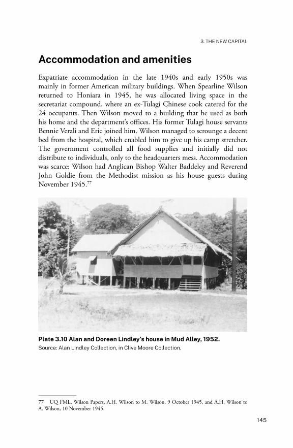
Soon after, one-bedroom ‘dongas’ were built for the single and married but childless government employees. They were situated in a coconut palm grove east of the secretariat and close to the Government Residency known as ‘Shickers Alley’ (slang for being drunk). Each had one small bedroom, a lounge/dining room, kitchen, and bathroom. The floors were concrete, the roofs consisted of sago palm thatch, and the walls were made from woven bamboo strips.78 By about 1953, there were three main types of housing for expatriates: the one-bedroom thatched cottages along the shore; converted Quonset huts with new linings and fittings, usually with two bedrooms; and new bungalows up on the ridges, which were usually ‘L’-shaped and clad in fibro sheeting, with push-out shutters and wide eaves. There were also a few unique creations that dated from the American years, with new interiors. In the early 1950s, Alan and Doreen Lindley lived on the corner of Mud Alley and Mendana Avenue in one of these, opposite the entrance to the Government Residency. Lindley described his house as ‘a very ordinary, roughly built, one-bedroom house with attached kitchen and storeroom’.79 The building was on short stumps with a galvanised ripple-iron roof over the bedroom, a thatched roof over the living room and kitchen, and a front door with no lock. It was typical
78 Lawson n.d. [c. 2000s]: 7–8; Email from Mary Cowmeadow, 14 April 2018.79 Lindley 2014: 5.
147
3. THE NEW CAPITAL
of houses in Honiara in these years. When Lindley returned to Honiara in 1960 as officer-in-charge of Central Police District, his accommodation for the first few weeks was worse—in Fijian Quarter. There, he was given a long room with a bed in one corner, a toilet, a shower, and wash basin in another, plus a small benchtop electric stove on one side. Next, he was given a house in Shickers Alley, although he considered this also below the standard of his Mud Alley home.80
Another early official, Dr J.D. Macgregor, was appointed to Central Hospital in 1957. His house was on the site of what is now the Anglican Cathedral, and had belonged to Romulus Dethridge, whom Macgregor described as a ‘crocodile hunter and entrepreneur’. The house next belonged to Ken Hay, who sold it to the government. It was built in ‘local style with a thatched roof, plaited and patterned pandanus leaf walls, and shutters to lower when the weather was stormy’.81 The house was surrounded by fruit trees and had two large ngali nut trees in the garden.
Electricity and water supplies were developed piecemeal as needs increased.82 The original power supply for the town was provided by a mixture of Japanese and American generators, three working at any one time, with two more as back-up. In early 1949, after new generators were purchased, electricity became available 24 hours a day. Even though the system was only 110 volts, this was enough to allow permanent refrigeration to be used. In October 1951, the ageing powerplant was about to expire and residents were given a choice: they could use either electric lighting or their refrigerator, not both. Sales of candles and hurricane lanterns skyrocketed. Two new engines and generators arrived late in the year and a completely new power station was erected. The entire town as far as Kukum was placed on the 240-volt system. Meters were installed in nongovernment higher-quality residences and commercial premises in 1963, with 200 meters in use at the end of 1964.83 Honiara’s power consumption more than doubled in the second half of the 1960s and continued to grow—by 9 per cent in 1970 alone. This necessitated developing Lungga power station, which was opened on 6 November 1971, adding 4 megawatts to the Honiara power grid. Establishing a water supply was (and still is) a
80 ibid., 10.81 Macgregor 2000.82 BSIP NS, 31 January 1969.83 PIM, November 1952, 66; BSIP AR 1963–64: 60.

HONIARA
148
problem in Honiara. Boreholes at Kukum and springs at Lengakiki were used, with the water fed into small dams and distributed by gravity.84 The higher areas were supplied by pumping stations.
A small telephone system was included with the American facilities handed over to the British. It was a manual exchange: users had to crank handles on their phone-sets to generate power before making a call. A new automatic 100-line telephone exchange was installed in 1954, with lines extending east to Kukum Airfield and west to Rove. In the same year, small local exchanges were installed at Gizo and Auki; calls could only be made between the three exchanges from the post offices. In 1963, a radio-telephone circuit was opened to Suva with a connection to New Zealand. Three years later, it was possible to call Gizo and Auki from Honiara homes. Until 1968, all local calls were free.85
Anglican priest Con L. Montford, who had been in the protectorate since the 1920s, was transferred to Honiara with his new wife in December 1955. They sailed from Sydney on BP’s Muliama:
At Honiara eight or nine days later we were not very impressed. All we could see from the ship was a small scattered place sprawling over several steep ridges. On landing it was not much better. There was no wharf, only a jetty for launches and small craft. First came the customs sheds, then the businesses consisting of two stores, a butcher’s shop, two garages, a picture theatre, and further back all the government administration buildings. Everything was housed in old military huts adapted for the purpose for which they were being used.
… Later on we were to discover China Town, a collection of some thirty or forty stores and shops, all of them made of old military huts of varying sizes. A little further on was the government Hospital with all its wards and administration buildings made from converted military huts.86
After its transfer from Suva to Honiara, the WPHC Secretariat occupied ramshackle wartime structures. Colin (later Sir Colin) Allan arrived as a district officer in 1946. He became a senior public servant and governor (1976–78):
84 BSIP AR 1951–52: 35–36; 1971: 4.85 See Moore 2013c: entry for Telephone Service; Lindley 2014: 10.86 Montford 1994: 80.

149
3. THE NEW CAPITAL
Constructed of poor-quality sago-palm leaf, wire-netting, tarred paper, rusty corrugated iron and riddled with termites, the buildings were unbelievably hot and unpleasant. In the hurricane season rain drove through by the bucket despite the rickety shutters. Only a few offices had ceiling or desk fans. Furniture had come from Suva, some of it dating back to the beginning of the century. File trays were of rusty metal or wood. Many of the typewriters would today fetch impressive sums at Christies [sic]. Tables were stabilised by ancient out-of-date legal volumes or government-issue loo paper … Distinguished visitors from Whitehall, were frankly appalled and some doubted the wisdom of even supporting such a Mickey Mouse outfit with cold hard development aid. Visitors from Fiji seemed to regard us with contempt. Those from Papua New Guinea took comfort—at least we were no better off.87
Allan noted one advantage: Solomon Islanders were not intimidated by the dilapidated secretariat buildings.
The population rose quickly; Honiara doubled its size during the 1950s. In 1959, the town was home to 3,534 of the total BSIP population of 124,000. By the early 1960s, Honiara had improved enormously, compared with 10 years earlier. Sir John Gutch was high commissioner between 1955 and 1961. He described the rapid expansion of Honiara, with new government bungalows built along the coast and on the hills behind. Mendana Avenue was still not sealed, except for a small section opposite the stores and the cinema in the centre of the town. As Sir John remembered:
Road improvements were under way in both directions from Honiara and bridges were under construction. Along the coast west of Honiara the shore was littered with the wrecks of Japanese cargo vessels which had been run ashore under naval bombardment. One of the first problems with which I had to deal was an application by Japanese interests to remove these wrecks and export the salvaged material to Japan for new ship construction. It was suggested in some quarters that Solomon Islanders might object actively to the presence of Japanese from whom they had suffered during the war. The application was granted and there were no untoward results.88
87 Allan 1990: 112.88 Gutch 1987: 114.
HONIARA
150
Gutch also described the leisure activities available to the 1950s expatriate residents, and the dangers:
We used to picnic at various spots along the coast, but unfortunately sharks were prevalent and crocodiles were also a danger in the rivers and were reputed to travel by sea from one river mouth to another. We did, however, bathe at one or two sheltered spots amongst the reefs and also in the rivers, particularly in a pool to the east of Honiara where one could swing out on a rope from a convenient tree and drop into the cool water.89
Despite Honiara Town Council’s valiant attempts at beautification, European residents who had lived in pre-war Tulagi were slow to call Honiara home, and in early years never called it ‘the Capital’, out of nostalgia for Tulagi, preferring ‘protectorate headquarters’. Ever so slowly, urban services developed enough to make Honiara into a comfortable public service posting. Honiara’s first coffee shop was begun in 1966 by Augustine Quan Hong (Guan Houyuan), a member of the Honiara Town Council and President of the British Solomon Islands Chinese Association.90 The first barber and women’s hairdressing shop was opened in 1967 by Kwok Hing Chung (Guo Xingzhong), who had trained at the Hong Kong School of Arts, Beauty and Fashion, and also ran an optical service.91 Girl Guides, Brownies, Scouts, and Cubs troops and packs began, and children made their own fun in the local creeks, rivers, and at the beaches.
Trips to the cinemas at Point Cruz and Kukum opened a world outside the Solomons.92 Reverend Montford, a member of the BSIP Censorship Board, remembered Point Cruz’s cinema well. It was built in 1953 from Quonset huts and operated until the 1980s. It was also used for theatrical performances and as a live music venue:
One of the delights for those who could afford it was the picture theatre which was a great thrill and ran to full houses. The walls were partly open and it never became unbearably hot. A back seat cost five shillings but the front seats only one shilling, so that the Melanesians very sensibly elected to sit in the front. Love scenes
89 ibid., 120.90 BSIP NS, 7 October 1966, 19 December 1966, 31 April 1969.91 ibid., 7 September 1967.92 ibid., 6 October 1967, 15 August 1970.

151
3. THE NEW CAPITAL
were not at all popular, fighting scenes were fully appreciated, but we the censors did not allow too much of that and we absolutely censored any brutality. The favourite picture was ‘Quo Vadis’ and had to be brought back time and again.93
During the 1960s, George Yee Fai owned the cinema. The films did not always run smoothly, as one resident complained in 1969:
[T]he audience has had to contend with a sound system which cannot be interpreted. Generally it is the case of the volume being turned to a pitch which renders the sound just as indecipherable as when it is scarcely audible … The showing of ‘The Sound of Music’ recently is a case in point. Any musical depends to a major extent on the quality of the sound track. This may not be the case with ‘westerns’ to which a less critical audience is attracted.94
By 1966, Honiara had 55 registered shops and stores, nine tailors, and three bakers. A substantial Chinatown had developed on the eastern bank of the Mataniko River, containing a non-residential hotel (just a rough bar) and 39 of the registered businesses in Honiara, drawing most of the Solomon Islander customers.95 The government administrative centre was concentrated around Point Cruz. Buildings varied from modified Quonset huts to modern airconditioned banks and a supermarket. Four businesses were registered at White River, two at Kukum, and three on Kola`a Ridge.
Urban associations began to form, more hotels were built, and main roads were given names. A Jaycees branch, a Masonic Lodge (see Map 7.1), a Chamber of Commerce, and a St Andrew’s Society were established.96 A multiracial Solomon Islands Club, later called the Honiara Club, was begun in July 1964 on the coastal side of Mendana Avenue, in a Quonset hut next to the Central District office and the first courthouse. Officially opened on 2 March 1965 by Chief Secretary Michael Gass, the club was granted a piece of land overlooking the Mataniko River for a permanent
93 Montford 1994: 44–45.94 BSIP NS, 30 September 1969.95 ibid., 7 April 1966.96 ibid., 19 December 1966, 31 January 1969; SND, 3 June 1977. A Rotary club was formed in Honiara in 1987.

HONIARA
152
building.97 In the club’s first year, membership grew from 17 to 80. Work began on the new structure in 1969.98 It was decorated with traditional motifs painted by King George VI School students, directed by their art teacher, Les Tickle.
The Guadalcanal Club was the early centre of expatriate entertainment. It revived one of the competitions from the Tulagi Club: the Five Events Cup (swimming, tennis, cricket, golf, and snooker), which was held annually. As on Tulagi, this was always followed by a dinner and a beer-guzzling finale.99 The club was expanded in the 1960s, using Honiara’s classic building material, Quonset huts, with an extra touch as they were lifted into place using derricks taken off Japanese wrecks.100 During the 1950s and 1960s, square dancing was in vogue, short plays and sketches were presented, and betting occurred on Saturday-night crab races. Europeans also flocked to the comfortable golf club, with its local-style sago-leaf thatch clubhouse. In 1959, plans were unveiled to extend the course to nine holes. Expatriates also congregated at the Mendana Hotel and the Point Cruz Yacht Club (from 1968)—neighbouring sites west of Point Cruz along the beach.
There were also cultural pursuits that did not include drinking alcohol. The more literate appreciated the opening of Honiara’s Public Library in mid-1968 with space for 12,000 books—a target almost achieved in 1970 when there were 10,000 volumes, and 782 expatriate and 403 indigenous borrowers.101 Musical expatriate residents joined or listened to the ‘Honiara Hotspots’, also called the ‘Honiara Deadbeats’—
97 It is interesting to see who members of the early executive were: Dr Gideon Zoleveke (a Choiseul-born medical practitioner and radio broadcaster, later knighted) was elected president, Albert Kuper (brother of Geoff, mentioned above) was vice-president, Bartholomew Buchanan (a senior public servant) was secretary, and Solomon Dakai (in charge of the x-ray department at Central Hospital, president of the Red Cross, and a famous singer) was treasurer. The trustees were Fred Osifelo (a Malaitan quickly making his way up in the public service), and Ron Lawson (a Honiara businessman and vice-president of the Honiara Town Council). By 1966, the Solomon Islander members of its committee were Zoleveke, Osifelo, Michael Musuota, Luke Dangopiru, Michael Rapasia (Member for Guadalcanal), Silas Sitai (a senior public servant from Santa Ana), Peter Naturanga, Joseph Molia (from north Malaita), Olle Torling (an ex-government cocoa officer who owned Tambea Resort), and Gerald Malkmus.98 BSIP NS, 15 August 1964, 15 March 1965, August 1965, 11 August 1966, 21 August 1967, 31 July 1969, 31 October 1972.99 Lawson n.d. [c. 2000s]: 20; Moore 2019: 208.100 Jock Stevenson, the senior architect of the Public Works Department, supervised the task. Information from Ann Stevenson, 28 July 2019.101 BSIP NS, 13 December 1967, 31 August 1968, 30 November 1968, 28 February 1970.

153
3. THE NEW CAPITAL
the ‘hottest jazz band in two million square miles of the Pacific’.102 Locals also performed in local repertory shows organised by the Honiara Hams. Others joined the British Solomon Islands Society for the Advancement of Science and Industry, formed in 1951, the Solomon Islands Museum Association, formed in 1972, or the chess club, and the film society. Scottish country dancing was taught by Jock Stevenson for the St Andrew’s Society, slightly incongruously at the Yacht Club, where he was commodore. Some of the best dancers were Solomon Islanders. The society celebrated St Andrew’s night in November and Burns Night in January—both formal occasions held at the Honiara Hotel, with haggis, and a Solomon Islander bagpiper borrowed from the police band. Each New Year’s Eve, a party was held at the Guadalcanal Club with the New Year’s Honours announced at midnight. The main public celebration each year was the Queen’s Birthday in June, when a ceremony was held, and decorations and awards were presented, followed by a garden party and ball at Government House.103
By the late 1960s, Honiara was a fully functioning small British Pacific settlement. The post-war public servants and colonists usually had quite different ideas and motivations from their pre-war equivalents. Most of the public servants belonged to a new generation of technocrats who were less colonial in their thinking and willing to embrace British Prime Minister Harold Macmillan’s 1960 ‘wind of change’ speech, which signalled a new British attitude to its dependencies. Although there were a few ‘old Africa hands’ seeing out their contracts and trying to hold back the tide, most of the expatriates were amenable to implementing change.
102 ibid., June 1966.103 Gutch 1987: 115–16; Russell 2003: 117; BSIP NS, June 1966, 31 January 1968, 16 October 1972.

HONIARA
154
Plate 3.12 The Mendana Hotel in the late 1950s.Source: BM, Patrick Barrett Collection.
Plate 3.13 The Honiara Club, showing murals created by King George VI School art students in 1971.Source: Les Tickle Collection.

155
3. THE NEW CAPITAL
Plate 3.14 The Point Cruz Cinema in Mendana Avenue in the late 1950s.The cinema was constructed from Quonset huts with open sides to enhance air flow.Source: BM, Patrick Barrett Collection.
Plate 3.15 West Honiara from the bottom of Lengakiki Ridge, 1956.Source: Peter Flahavin Collection, US CIA Photograph 221961 supplied to New Commonwealth, 14 May 1956.

This text is taken from Honiara: Village-City of Solomon Islands, by Clive Moore, published 2022, The Australian National
University, Canberra, Australia.
doi.org/10.22459/H.2022.03