2007, Geology and hazard implications of the Maraunot notch in the Pinatubo Caldera, Philippines....
13
RESEARCH ARTICLE Geology and hazard implications of the Maraunot notch in the Pinatubo Caldera, Philippines A. M. F. Lagmay & K. S. Rodolfo & F. P. Siringan & H. Uy & C. Remotigue & P. Zamora & M. Lapus & R. Rodolfo & J. Ong Received: 26 March 2004 / Accepted: 29 November 2006 / Published online: 5 January 2007 # Springer-Verlag 2007 Abstract The 1991 Pinatubo eruption left 5–6 km 3 of debris on the volcano slopes, much of which has been mobilized into large lahars in the following rainy seasons. Also during the eruption, collapse, localized in part along preexisting faults, left a caldera 2.5 km in diameter that almost immediately began to accumulate a 1.6×10 8 m 3 lake. By 2001, the water had risen to the fault-controlled Maraunot Notch, the lowest, northwestern portion of the caldera rim comprising the physiographic sill of the Caldera Lake. That year, a narrow artificial canal dug into an old volcanic breccia underlying the outlet channel failed to induce a deliberate lake breakout, but discharge from heavy rains in July 2002 rapidly deepened the notch by 23 m, releasing an estimated 6.5×10 7 m 3 of lake water that bulked up into lahars with a volume well in excess of 1.6×10 8 m 3 . Lakes in other volcanoes have experienced multiple breakouts, pro- viding practical motivation for this study. Fieldwork and high-resolution digital elevation models reveal andesites and ancient lacustrine deposits, strongly fractured and deformed along a segment of the Maraunot Fault, a prominent, steeply dipping, left-lateral fault zone that trends N35°–40°W within and parallel to the notch. Seismicity in 1991 demonstrated that the Maraunot Fault is still active. The fault zone appears to have previously been the erosional locus for a large channel, filled with avalanche or landslide deposits of an earlier eruption that were exhumed by the 2002 breakout floods. The deformed lacustrine sediments, with an uncali- brated 14 C age of 14,760±40 year BP from a single charcoal sample, attest to the existence of an earlier lake, possibly within the Tayawan Caldera, rim remnants of which survive as arcuate escarpments. That lake may well have experi- enced one or more ancient breakouts as well. The 2002 event greatly reduced the possibility of another such event by scouring away the erodible breccia, leaving less erodible fractured andesites and lacustrine rocks, and by enlarging the outlet channel and its discharge capacity. Several lines of evidence indicate, however, that future lahar-generating lake breakouts at the notch may keep populations of Botolan municipality downstream at risk: (1) a volume of 9.5× 10 7 m 3 of lake water remains perched 0.8 km above sea level; (2) seismicity in 1991 demonstrated that the Maraunot Fault is still active and movements of sufficient magnitude could enlarge the outlet and the discharge through it; (3) more likely, however, with or without earthquake activity, landslides from the steep to overhanging channel walls could block the channel again, and a major rainstorm could then cause a rise in lake level and sudden breakouts; (4) intrusion of a new dome into the bottom of the lake, possibly accompanied by phreatic explosions, could expel large volumes of lahar-generating water. Bull Volcanol (2007) 69:797–809 DOI 10.1007/s00445-006-0110-5 Editorial responsibility: J Donnelly-Nolan A. M. F. Lagmay (*) : K. S. Rodolfo : F. P. Siringan : H. Uy : C. Remotigue : P. Zamora : R. Rodolfo National Institute of Geological Sciences, College of Science, University of the Philippines Diliman, Quezon City 1101, Philippines e-mail: [email protected] K. S. Rodolfo Department of Earth and Environmental Sciences, University of Illinois at Chicago, 845 W. Taylor St., Chicago, IL 60607, USA M. Lapus Earthprobe Incorporated, 395 P. Guevarra St, San Juan, Metro Manila, Philippines J. Ong Manila Observatory, Ateneo de Manila University, Quezon City 1101, Philippines
Transcript of 2007, Geology and hazard implications of the Maraunot notch in the Pinatubo Caldera, Philippines....
RESEARCH ARTICLE
Geology and hazard implications of the Maraunot notchin the Pinatubo Caldera, Philippines
A. M. F. Lagmay & K. S. Rodolfo & F. P. Siringan &
H. Uy & C. Remotigue & P. Zamora & M. Lapus &
R. Rodolfo & J. Ong
Received: 26 March 2004 /Accepted: 29 November 2006 / Published online: 5 January 2007# Springer-Verlag 2007
Abstract The 1991 Pinatubo eruption left 5–6 km3 of debrison the volcano slopes, much of which has been mobilizedinto large lahars in the following rainy seasons. Also duringthe eruption, collapse, localized in part along preexistingfaults, left a caldera 2.5 km in diameter that almostimmediately began to accumulate a 1.6×10⁸ m3 lake. By2001, the water had risen to the fault-controlled MaraunotNotch, the lowest, northwestern portion of the caldera rimcomprising the physiographic sill of the Caldera Lake. Thatyear, a narrow artificial canal dug into an old volcanicbreccia underlying the outlet channel failed to induce adeliberate lake breakout, but discharge from heavy rains inJuly 2002 rapidly deepened the notch by 23 m, releasing anestimated 6.5×10⁷ m3 of lake water that bulked up intolahars with a volume well in excess of 1.6×10⁸ m3. Lakes in
other volcanoes have experienced multiple breakouts, pro-viding practical motivation for this study. Fieldwork andhigh-resolution digital elevation models reveal andesites andancient lacustrine deposits, strongly fractured and deformedalong a segment of the Maraunot Fault, a prominent, steeplydipping, left-lateral fault zone that trends N35°–40°W withinand parallel to the notch. Seismicity in 1991 demonstratedthat the Maraunot Fault is still active. The fault zone appearsto have previously been the erosional locus for a largechannel, filled with avalanche or landslide deposits of anearlier eruption that were exhumed by the 2002 breakoutfloods. The deformed lacustrine sediments, with an uncali-brated 14C age of 14,760±40 year BP from a single charcoalsample, attest to the existence of an earlier lake, possiblywithin the Tayawan Caldera, rim remnants of which surviveas arcuate escarpments. That lake may well have experi-enced one or more ancient breakouts as well. The 2002 eventgreatly reduced the possibility of another such event byscouring away the erodible breccia, leaving less erodiblefractured andesites and lacustrine rocks, and by enlarging theoutlet channel and its discharge capacity. Several lines ofevidence indicate, however, that future lahar-generating lakebreakouts at the notch may keep populations of Botolanmunicipality downstream at risk: (1) a volume of 9.5×10⁷ m3 of lake water remains perched 0.8 km above sealevel; (2) seismicity in 1991 demonstrated that the MaraunotFault is still active and movements of sufficient magnitudecould enlarge the outlet and the discharge through it; (3)more likely, however, with or without earthquake activity,landslides from the steep to overhanging channel walls couldblock the channel again, and a major rainstorm could thencause a rise in lake level and sudden breakouts; (4) intrusionof a new dome into the bottom of the lake, possiblyaccompanied by phreatic explosions, could expel largevolumes of lahar-generating water.
Bull Volcanol (2007) 69:797–809DOI 10.1007/s00445-006-0110-5
Editorial responsibility: J Donnelly-Nolan
A. M. F. Lagmay (*) :K. S. Rodolfo : F. P. Siringan :H. Uy :C. Remotigue : P. Zamora : R. RodolfoNational Institute of Geological Sciences, College of Science,University of the Philippines Diliman,Quezon City 1101, Philippinese-mail: [email protected]
K. S. RodolfoDepartment of Earth and Environmental Sciences,University of Illinois at Chicago,845 W. Taylor St.,Chicago, IL 60607, USA
M. LapusEarthprobe Incorporated,395 P. Guevarra St, San Juan,Metro Manila, Philippines
J. OngManila Observatory, Ateneo de Manila University,Quezon City 1101, Philippines

Keywords Maraunot notch .Maraunot Fault . Pinatubo .
Caldera lake . Lake breakout . Debris flows . Lahars
Introduction
In June 1991, Mount Pinatubo (Fig. 1) erupted cataclysmi-cally after five or six centuries of dormancy, depositing 5–6 km3 of pumiceous volcanic debris on the volcano flanks(Scott et al. 1996). In succeeding years, the runoff fromheavy monsoonal and typhoonal rainstorms has frequentlyremobilized much of the unconsolidated debris into lahars(Major et al. 1996; Pierson et al. 1996; Rodolfo et al. 1996;Umbal and Rodolfo 1996). These have run down thePinatubo valleys to inundate the lowlands, destroying thehomes of more than 100,000 people. By 1995, the annual
volume of Pinatubo lahars had decreased to less than aquarter of that mobilized in 1991, but the lahar threatcontinues to exist. Lahars have also dammed streamchannels and tributary valleys, and the breaching of thedams has generated “lake-breakout” lahars, includingextremely devastating events in 1991, 1992, and 1994(US Geol Surv 1997). Unlike rain-triggered lahars, thosegenerated by lake breakouts are difficult to predict, oftenhappen in good weather, and thus are especially dangerous.So also are flash floods suddenly released from lakes involcano craters and calderas (Bernard 1994).
Collapse of the Pinatubo edifice during the 1991eruption produced a caldera 2.5 km in diameter. In this5 km2 depression, a lake began to accumulate almostimmediately. By 2002, the lake volume was estimated at2.5×108 m3 by Stimac et al. (2004). A more recent estimate
Fig. 1 a Location and grossstructural setting of MountPinatubo b Overview of thecaldera and the western sector ofMount Pinatubo; note box inlower right corner indicatinglocation of Fig. 1c. c The cal-dera and summit area. The to-pography in the central grayarea is from Jones and Newhall1996; adjacent topography isfrom a 1:50,000 US DefenseMapping Agency map. TheMaraunot Notch is at the calderarim and southeast end of themapped Maraunot Fault trace.The hachured arcuate scarps areremnants of the ancient andlarger Tayawan Caldera namedby Newhall et al. 1996, firstmapped by Delfin (1984) andDelfin et al. 1996). The newcaldera rim is shown as shorthachured lines. The lakeshore asof 2003 is shown as a dotted line(see Fig. 2). The Sacobia linea-ment is from Newhall et al.(1996)
798 Bull Volcanol (2007) 69:797–809

of the volume, based on bathymetry (Fig. 2) and caldera-wall geometry, is 1.61×10⁸ m3. Thus, Pinatubo joined the16% of the world’s 714 active volcanoes that contain orhave contained a lake in a crater or caldera (Simkin andSiebert 1994), and which accordingly pose the specialhazards of large lake breakouts and the lahars they generate(McCall et al. 1992; Kusakabe 1996; Neall 1996; Varekampet al. 2000). For students of this type of volcano, our studyof the caldera, the geology of the breach in its rim, andevents in 2001 and 2002 may be instructive.
Delmelle and Bernard (2000) have reported that 17volcanic-lake calamities of the last two centuries have eachkilled more than a hundred people; in 14 of these, thedeaths were caused by debris flows. Indonesia, whichshares the humid tropical climate of the Philippines, hasexperienced most of these catastrophes (Badrudin 1992;Delmelle and Bernard 1994; Abdurachman et al. 1998; vanBergen et al. 2000). Debris flows generated by breakoutsfrom the lakes of Mts. Galunggung and Kaba, respectively,killed 4,000 people in 1822 and 126 in 1833. SomeIndonesian volcanic lakes have generated calamitous laharsmore than once: Three times each at Mts. Kelut (10,000killed in 1586; 5,110 in 1919; 282 in 1966) and Awu (3,200casualties in 1822; 3,000 in 1856; 1,530 in 1892); and twiceat Mt. Raung, where more than 1,000 people were killed in1638 and 3,000 in 1856. Thus, the potential for another
lake breakout from the Pinatubo caldera requires seriousattention.
Elsewhere in the world, lake-breakout lahars fromCotopaxi in Equador were reported to have killed morethan 1,000 people in 1741 (Mothes et al. 1998). More thana hundred were killed in 1870 by a breakout from LakeManaro Lakua at Aoba volcano in Vanuatu (Mastin andWitter 2000). Within decades following an ignimbrite-forming eruption ca. 1.8 ka, 20 km3 of water was releasedfrom the caldera lake of Taupo volcano in New Zealand(Manville et al. 1999). In 1953, debris flows generated by abreakout from Mt. Ruapehu’s Crater Lake in New Zealandhit a bridge over the Whangaehu River while a train wascrossing it, killing 151 passengers (Lecointre et al. 2004).
Background of the study
The Maraunot Notch is the lowest part of the caldera rim, thephysiographic sill that lake waters overtop to flow down theMaraunot River valley. It is the only outlet for the calderalake (Fig. 1c). As this report describes in detail, the notchand the valley are eroded portions of the Maraunot Faultthat was first mapped by Delfin (1984) and Delfin et al.(1996). The fault is active; it bisected a cluster ofearthquakes precursor to the 1991 Pinatubo eruption 5 to102 km northwest of the volcano, displaying left-lateralmotion (Bautista et al. 1996; Battaglia et al. 2004).Presently, the valley at the notch is about 60 m wide at itsbase and its relief is about 240 m. The fault and valleyterminate at the caldera where collapse was localized alonga part of the Tayawan Fault mapped by Delfin (1984).
Several arcuate scarps mapped by Delfin (1984) andDelfin et al. (1996) are interpreted as remnants of an oldcollapse depression that was named the Tayawan Calderaby Newhall et al. (1996), who made a strong case forPinatubo eruptive activity being cyclical: Repose ofcenturies or millennia, caldera-forming eruptive activity,dome-building, and long quiescence. The Tayawan Calderaapparently was a large, 3.5×4.5 km caldera that was mostlyfilled by dome-building that ultimately erected the pre-1991peak. Old lacustrine deposits are widespread and are wellexposed in the new caldera walls. Large prehistoric lakebreakouts may have contributed significantly to theprominent volcaniclastic apron with an area of 1.9×10⁸ m2 at the western Pinatubo flank. Figure 1c also showsthe western portion of the Sacobia lineament, which is ofuncertain history but possibly also tectonically and sedi-mentologically significant, having displayed seismic activ-ity of right-lateral character in 1991 (Bautista et al. 1996).
The possibility that a breach of the new caldera couldrelease large, lahar-generating floods was recognized bythe Philippine Institute of Volcanology and Seismology
Fig. 2 Elevation contours of the caldera lake in 2003, from 15 km(dotted lines) of coupled sonar and GPS mapping
Bull Volcanol (2007) 69:797–809 799

(Phivolcs) as early as 1992 (Campita et al. 1996). From1998 to 2000, the level of the caldera lake rose at anaverage annual rate of 13.3 m (Catane et al. 2003). By 30July 2001, the lake was only 6 m below the notch, and wasexpected to be overtopped that year. Government authori-ties regarded the breccia at and beneath the notch as anatural dam so erodible that overtopping waters wouldenlarge the breach in runaway fashion, causing flash floodsthat would erode and incorporate pyroclastic-flow debrisalong its path. These flows were expected to bulk up intomassive lahars that would flow down the Bucao River tolowland communities of Botolan Municipality (Fig. 1b).Accordingly, a canal was dug in the notch beginning inAugust, the plan being to deliberately induce a breakout ofthe lake after evacuating the threatened communities.Phivolcs announced that all the erodible material underthe notch would be quickly scoured away in runawayfashion by the induced flood, leaving only resistant dacitebedrock, thus eliminating the threat of massive breakoutlahars. The breaching was attempted at 0653 H on 6September 2001, after the 46,000 Botolan inhabitants hadbeen evacuated to safe areas. The resulting discharge ofwater was only about 0.1 m3/s, however, and did notinduce the anticipated runaway breach enlargement (Cataneet al. 2003). After several hours of waiting, the evacueesdecided to return to their homes. By November, after theend of the rainy season, discharge was still only about1 m3/s. Clearly, the breccia underlying the notch was muchmore resistant to erosion than had been anticipated.
Ten months later, from 1 to 9 July 2002, a typhoonpassing across Luzon intensified the southwest monsoon,which delivered 860 mm of rain to Pinatubo (Bornas et al.2002). The new canal was too small to accommodate thegreatly increased discharge, and thus the lake rose rapidly,increasing shear on the canal walls and floor. On themorning of 10 July, a runaway breaching began. Lastingabout a day, the breakout released 6.5×10⁷ m3 of waterlowering the lake level by about 23 m (Bornas et al. 2002).Unfortunately, the event was not observed and documentedat the notch or along the proximal outflow channel. Withoutwitnesses, it is hard to tell how high the water rose beforethe breaching initiated. Clearly, however, a substantialamount of head would have been needed to generatesufficient basal and sidewall friction. A very rough estimatecan be arrived at thusly: The 0.86 m of rainfall deliveredwithin 8 days on the 5.4 km2 caldera watershed is equal to4.64×106 m3. With an estimated lake area of 3×10⁶ m2, thelake would have risen by about 1.54 m without the artificialcanal. Data are lacking on how much of this delivery wasdischarged through the channel before breaching. All thatcan be said is that the depth of water on the channel floorwas less than 1.54 m, but significantly more than the one totwo decimeters during the abortive breaching of 2001.
The 2002 breakout flood bulked up into the largestPinatubo lahars since the eruption, larger than the 1993Typhoon Kadiang event (Remotigue 1995), which left 1.1×10⁸ m3 of debris flow and hyperconcentrated lahar deposits.Bornas et al. (2002) had observed only hyperconcentrated
Fig. 3 Debris-flow deposits ofthe 2002 lake breakout of thePinatubo caldera at the junctionof the Maraunot and Balin–Baquero rivers (see Fig. 1b). a Alarge boulder sits at the top ofthe debris flow deposit; b Lithicand pumice clasts in a matrix-rich debris flow deposit. Theoutcrop is the same as in Fig. 3.For scale, the GPS unit is 10 cmlong
800 Bull Volcanol (2007) 69:797–809

flows from the 2002 crater lake breakout, and by assumingthat the entire event consisted only of such, with asediment/water ratio of 3/2, initially estimated their volumeat 1.6×10⁸ m3. That estimate is undoubtedly too low.Hyperconcentrated flows indeed were the only onesobserved by scientists, but hours after peak flow, and lessthan 3 km from the Bucao River mouth. The 2002 breakoutlahars left spectacular debris flow deposits in the Bucao andBalin Baquero valleys (Fig. 1b) 16–26 km from the coast,including single layers over 10 m thick (Fig. 3).
From 1991 to 1993, many lahars, including those of theKadiang event, were observed at Malumboy, 13 km from thecoast (Fig. 1b), where the width of the Bucao River valleyis constricted to less than a kilometer, but from there widensto about 3 km only a kilometer downstream. Along with thechannel widening, its gradient decreases abruptly from 0.44to 0.19° (Rodolfo et al. 1996). Beyond the Malumboyconstriction, debris flows have never been observed toreach farther downstream than 1 or 2 km—more than10 km from the river mouth. As the largest, bank-to-banklahars descend past Malumboy, they spread out, experience
greatly enhanced basal shear, abruptly slow down, stop, anddewater, sending down to the coast hyperconcentratedflows such as those observed on 10 July 2002. Further-more, pre-1991 deposits extensively exposed along thesouthern wall of the Bucao River below Malumboy, studiedin 1992 before new lahars buried them, were exclusivelythose of hyperconcentrated and more normal stream flows(K. Rodolfo, 1992 field notes). Sediment/water volumeratios in Pinatubo debris-flow lahars can be as great as 6/1(Rodolfo et al. 1996). The actual volume of the 2002breakout is unknown but must be more than 1.6×10⁸ m3.
After the breaching, 9.5×10⁷ m3 of water, measuredbathymetrically in 2003 (Fig. 2), still remains inside thecaldera. The lake surface is slightly above the level of thephysiographic sill at the Maranunot Notch and continuouslydrains along the outlet at an elevation of 890 m. Any eventthat raises the water level dramatically in a short period oftime has the potential to generate another breaching eventand dangerous lahars. Thus, knowledge of the notchgeology is necessary for assessing and mitigating futurelahar hazards at Pinatubo.
Fig. 4 Geologic map of the Maraunot Notch area. The MaraunotFault zone is oriented N40°W and is shown shaded over the contactbetween the lacustrine deposits and fault breccia. The position of theoverhang in the second bend of the outflow is also indicated. Contours
near the channel below the second bend of the outflow have beenmanually interpreted. Mode I fractures have opening displacementsperpendicular to the fracture surface
Bull Volcanol (2007) 69:797–809 801

Methodology
Helicopter-borne digital photography and digital stereoimaging were conducted on the Maraunot Notch area togenerate a high-resolution (1:5,000) topographic mapbecause available contour maps of only 1:50,000 scaleprovided insufficient resolution for our detailed geologicand structural mapping. Ground control points for digitalphotogrammetry were determined using a differentialglobal positioning system (DGPS) and a total station.Lithologies were identified in the field and under thepetrographic microscope. The geometry and kinematics ofthe structures were also analyzed in the field. A digitalelevation model (DEM) derived from digital photogram-metry was draped with an orthorectified aerial photographand displayed for visualization and measurement of theslopes and thicknesses of the northwest caldera wall.
Results
Lithology
The rocks in the Maraunot Notch area are porphyriticandesite (fault-brecciated and sheared in part), intra-calderalacustrine deposits, and volcanic breccias (Fig. 4). Porphy-ritic andesite (An50–60 contents) comprises the oldest anddominant rocks. Amphibole phenocrysts with seriatetexture are also present. The phenocrysts dominantly rangein size from 4–7 mm. The groundmass, comprising 60% ofthe rock, is glassy and contains fine-grained plagioclaselaths, tabular amphibole, and accessory quartz. This darkgray porphyritic unit is massive but fractured, sheared andbrecciated. Along the area of greatest fault movement, thisrock is a well-indurated, monolithologic breccia withangular clasts that are self-similar in both megascopic andmicroscopic scales. Siltstone and sandstone dikes 3–6 cmwide intrude the breccia in stockwork fashion. The brecciais interpreted to represent brittle deformation in response tohigh strain during fault movement. Diminished straineastward from the fault is evidenced in the porphyriticandesite breccia by decreasing fracture spacing, fromcentimeters to decimeters apart.
The lacustrine deposits are in fault contact with the por-phyritic andesite and occupy the western part of theMaraunot outflow channel. Deformation obscured therelative ages of these rocks, but the lake deposits are sub-horizontal where exposed on the caldera wall near bothsides of the notch. Had the lake deposits been older, theycould be expected to have been bowed up when intruded bythe andesites. About 20 m thick, this unit is composed ofinterbedded layers of well-sorted tuffaceous sandstone,siltstone and mudstone (Fig. 5). Bed thicknesses range
from less than one to a few centimeters. In general, theindividual layers are normally graded. Some display soft-sediment structures such as folds, load casts and flamestructures. In some areas, the bedded layers are overlappedby massive, poorly sorted wedges of angular clasts intuffaceous matrix, much like the landslide fans that nowenter the lake around its margins. In the notch, an erosionalsurface truncates the top of the tuffaceous sedimentaryunits, which were deposited in an aqueous environment,most likely an ancient caldera lake. Charred wood (GIN-13278) within them yielded an uncalibrated age of 14,760±40 14C years BP.
Lying unconformably above the sedimentary deposits, amassive, poorly sorted breccia composed of angularvolcanic blocks, crops out on the west side of the Maraunotchannel. It apparently constituted the fill of an ancientchannel, in the same general position as the 1991 MaraunotRiver headwaters that was removed by the 2002 breakoutflood. It is matrix-supported, with clasts ranging greatly insize from less than 1 cm to about 1 m (Fig. 6). The
Fig. 5 a Deformed lacustrine deposits capped by younger volcanicbreccia in the outflow region of the Maraunot Notch. An unconfor-mity (white dashed line) separates the two lithologic units. Beds areflexure-folded and show associated reverse faulting in more competentbeds that have undergone layer shortening. b Close-up view of theboxed portion in A
802 Bull Volcanol (2007) 69:797–809

unexpected resistance of the breccia to erosion during theattempted induced breaching in 2001 may be due in part tohigh internal friction arising from the angularity of itsvolcaniclastic fragments, compaction over at least 500 years,and incipient weathering to clay (K. Marsaglia, personalcommunication, 2002).
Structures
Two main structures were identified in the notch. TheMaraunot Fault (Fig. 1c), first mapped by Delfin in 1984,dips steeply and trends N35°–40°W, nearly parallel to theoutflow channel. This fault cuts through all rocks in the
notch. The other structure is a N30°E-striking set ofextensional fractures.
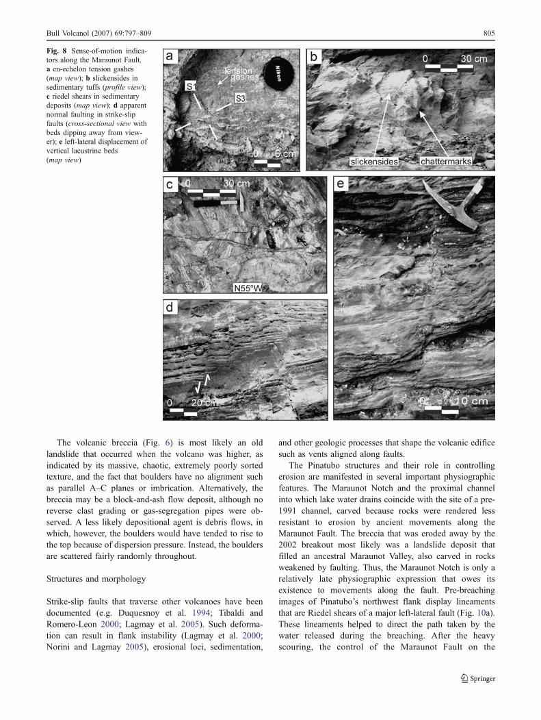
The Maraunot Fault zone is more than 15 m wide(Fig. 4) and consists of tight- and closely-spacedfractures in the porphyritic andesite and lacustrinedeposits (Fig. 7). Left-lateral motion along the fault isdocumented by en-echelon tension gashes, slickensides,Riedel shears, thrust-faulting and left-lateral displacementof vertical beds. There is also apparent normal displacementof tilted beds (Fig. 8).
The en-echelon tension gashes occur in the sedimentarytuffs, from which they are distinguished by their lightercolor. In map view (Fig. 8a), they define the axes of
Fig. 6 The volcanic breccia at the notch before removal by the 2002 breakout. a A cliff during the rainy season on 30 July 2001; b The same cliffafter the rainy season on 15 November 2001; c Close up of the breccia in the canal wall, 15 November 2001
Bull Volcanol (2007) 69:797–809 803

maximum and minimum stretch (S1 and S3), which definethe sense-of-shear plane of the fault.
Slickensides are found in both the tuffaceous sedimen-tary deposits and sheared andesites. The orientation of thechatter marks and slickenlines in Fig. 8b indicate left-lateralstrike-slip motion with a slight oblique-slip component. Themaximum pitch is 15° to the south. Riedel shears on thesense-of-shear plane of the fault trend N55°W, at an acuteangle to the main shear (Fig. 8c).
Apparent normal faulting can be seen in northwest-dipping beds cut by steeply dipping faults that strikenorthwest (Fig. 8d). This apparent normal displacement isdue primarily to left-lateral movement and not from dip-slipmotion. Vertical lacustrine beds are displaced left-laterally(Fig. 8e). Axes of fold structures, present only in the intra-caldera sedimentary deposits, generally trend N20°E. Onthe west side of the channel, a 20 m-high isoclinal,overturned anticline is bisected by a hinge fault that strikesN30°E and dips 80°SE. Microfolds are abundant and havethe same geometry as the larger deformation structures.Thrust faults strike northeast through ash-rich beds of theintra-caldera sedimentary deposits.
All the structures in the Maraunot Notch define the localstress field, which is oriented with the maximum principalstress σ1 aligned approximately N75°W. The minimumprincipal stress σ3 trends N15°E, and the intermediateprincipal stress σ2 is vertical. Thus, the indicated sense ofmotion along the Maraunot Fault is left-lateral strike-slip.
In 1991 a cluster of pre-eruption seismic epicentersextended 5–10 km west–northwest of the caldera, bisectedby the Maraunot Fault. Focal mechanism solutions of theearthquakes (Bautista et al. 1996 and Battaglia et al. 2004)corroborate the left-lateral sense of movement deduced fromthe structural data. Both lines of evidence establish that thefault that passes through the Maraunot Notch is active.
The northeast-trending set of fractures is extensional,with apertures of about 1–15 cm. They increase in densitytowards the caldera wall and dip very steeply to thesoutheast, towards the caldera lake (Fig. 9). These areprobably normal faults associated with the caldera collapseof 1991. The east–northeast trending Tayawan Fault inFig. 1c, mapped by Delfin et al. (1984, 1996), is locatedalong the northwest caldera wall near the notch. This pre-eruption zone of weakness may have served as a locus ofcollapse faulting during formation of the caldera in 1991.
Discussion
Lithology
The lithologic units are of three types: porphyritic andesiteis overlain by lacustrine deposits which are in turnunconformably overlain by volcanic breccia.
In six porphyritic andesite samples collected over7,000 m2 in the Maraunot Notch and contiguous valley,modal mineralogy is very similar, indicating that it is a singlelava flow or dome. It is possible, of course, that they wereformed from several distinct magmatic events, but lackingcorroborative evidence for this, the simplest conclusion isthat they were produced by a single event. In the notch, theporphyritic andesite displays variable appearances that areeasily explained as resulting from various degrees of brittledeformation and subsequent weathering, causing them tovary texturally from dark colored and massive, through graycolored and increasingly sheared, to light gray-coloredbreccia closest to the zone of greatest fault movement. Theabsence of chilled margins and baking indicate that the con-tact between these variably colored andesitic rocks in thenotch are structural rather than intrusive.
The lacustrine deposits most likely formed in the lake ofan ancient caldera that was produced by a large pre-historiceruption of Mt. Pinatubo, which might be the TayawanCaldera (Newhall et al. 1996) delineated by the largearcuate scarps shown in Fig. 1c (Delfin 1984; Delfin et al.1996). Breakout from that caldera may have contributeddeposits to the large aprons of Pinatubo. The uncalibratedradiocarbon date of 14,760±40 14C years BP may or maynot be associated with the Sacobia eruptive episodeestablished by Newhall et al. (1996) with a singleuncalibrated 14C date of 14,480±130 years.
Fig. 7 Northwestward view from within the Maraunot Notch of amajor slip plane of the Maraunot Fault, which trends N35°–40°W anddips steeply, separating the intra-caldera sedimentary deposits (leftblock) from the brecciated andesitic unit (right block). For scale,encircled is a man, 1.53 m tall, standing near the trace of the Maraunotfault at the center, right portion of the image
804 Bull Volcanol (2007) 69:797–809
The volcanic breccia (Fig. 6) is most likely an oldlandslide that occurred when the volcano was higher, asindicated by its massive, chaotic, extremely poorly sortedtexture, and the fact that boulders have no alignment suchas parallel A–C planes or imbrication. Alternatively, thebreccia may be a block-and-ash flow deposit, although noreverse clast grading or gas-segregation pipes were ob-served. A less likely depositional agent is debris flows, inwhich, however, the boulders would have tended to rise tothe top because of dispersion pressure. Instead, the bouldersare scattered fairly randomly throughout.
Structures and morphology
Strike-slip faults that traverse other volcanoes have beendocumented (e.g. Duquesnoy et al. 1994; Tibaldi andRomero-Leon 2000; Lagmay et al. 2005). Such deforma-tion can result in flank instability (Lagmay et al. 2000;Norini and Lagmay 2005), erosional loci, sedimentation,
and other geologic processes that shape the volcanic edificesuch as vents aligned along faults.
The Pinatubo structures and their role in controllingerosion are manifested in several important physiographicfeatures. The Maraunot Notch and the proximal channelinto which lake water drains coincide with the site of a pre-1991 channel, carved because rocks were rendered lessresistant to erosion by ancient movements along theMaraunot Fault. The breccia that was eroded away by the2002 breakout most likely was a landslide deposit thatfilled an ancestral Maraunot Valley, also carved in rocksweakened by faulting. Thus, the Maraunot Notch is only arelatively late physiographic expression that owes itsexistence to movements along the fault. Pre-breachingimages of Pinatubo’s northwest flank display lineamentsthat are Riedel shears of a major left-lateral fault (Fig. 10a).These lineaments helped to direct the path taken by thewater released during the breaching. After the heavyscouring, the control of the Maraunot Fault on the
Fig. 8 Sense-of-motion indica-tors along the Maraunot Fault.a en-echelon tension gashes(map view); b slickensides insedimentary tuffs (profile view);c riedel shears in sedimentarydeposits (map view); d apparentnormal faulting in strike-slipfaults (cross-sectional view withbeds dipping away from view-er); e left-lateral displacement ofvertical lacustrine beds(map view)
Bull Volcanol (2007) 69:797–809 805

morphology and structural character of the northwest flankhas been rendered even more obvious (Fig. 10b).
The channel downstream of the notch follows two sharpbends. At the second bend, the outer bank undercuts a wallin apparently fractured rocks and has created a prominentoverhang, shown on the map in Fig. 4. As of 2004, theoverhang had retreated about 10 m toward the caldera.
Implications for future hazards
The immediate danger of another lake breakout as large asthe 2002 flood has been greatly reduced by that event,which, however, has not totally eliminated the possibility offuture disasters. The 2002 breakout eroded the volcanicbreccia that filled the channel and incised about 8–9 m intothe fractured porphyritic andesite which, although it iserodible enough to have localized runoff and erosion for along time, is less so than the breccia. The increasedresistance to erosion and consequent drastic reduction ofhydraulic head by the released flood as well as the cessationof rainfall probably combined to finally terminate theincision. Nevertheless, the capacity of the lake remainsabout 108 m3, and the water is perched almost a kilometerabove sea level, and thus must still be regarded as a flashflood and lahar hazard. The control of the Maraunot Faulton the morphology and structure of the notch also hasmajor implications for such eventualities.
Foremost among the hazards is the potential for blockageof the outlet channel by landslides from the steeply slopingfractured rocks near the notch and adjacent Maraunotheadwater valley. The walls of the channel are alignedparallel to the Maraunot Fault and are very steep, and thussusceptible to toppling and rock falls that could block theoutflow channel. Unlike the surprisingly resistant breccia
Fig. 10 Aerial views of the Maraunot Notch. a Before the 2002breaching event, the traces of the riedel shears (dotted lines) of theMaraunot Fault (solid heavy lines) are evident in the Ikonos and aerialphotos. b The post-breach image shows scouring of the river channel,coincident in part with the traces of the riedel shears in the pre-breachimage
Fig. 9 Northeastward view ofextensional faults parallel to thenorthwest caldera rim wall. Thedensity of faults increase to-wards the caldera lake. Forscale, encircled is a man, 1.53 mtall, standing at the top portionof the image, above the fractures
806 Bull Volcanol (2007) 69:797–809

that filled the channel before 2002, this material would bevery loose, and could more easily give way in runawayfashion. A similar natural dam of fresh debris from the 1980debris avalanche of Mount St. Helens that had impounded alake at Elk Rock was breached and emptied in only an hour(Christopher G. Newhall, personal communication).
Such mass movements could be initiated by seismicityalong the Maraunot Fault, which was active before andafter the 1991 eruption; however even an earthquakelocated farther away, if it has sufficient intensity atPinatubo, could serve to trigger landslides. Even withoutearthquakes, however, landslides can be induced by waterfrom exceptionally heavy and prolonged rains seeping intothe fractures. Such an event in February 2006 killed morethan 1,000 people at the village of Guinsaugon, close to theleft-lateral Philippine Fault on the island of Leyte (Lagmayet al. 2006). The large overhang at the second bend of theMaraunot outflow channel deserves close attention.
At present, small rockslides from the steep, fracturedwalls of the caldera continue to slump frequently into thelake. An earthquake of sufficient magnitude, whether alongthe Maraunot Fault or elsewhere, conceivably could triggera large rockslide into the lake. Even if such a movementoccurred away from the Maraunot Notch, it could generatelarge lake seiches that could overtop the notch.
The possibility that a major movement with significantphysiographic effects on the outlet channel aligned along thefault near the Maraunot Notch could liberate a large volumeof water is probably less likely, but cannot be dismissedentirely. If such an event did occur, especially if on a clear,sunny day, its effects could be catastrophic because the timingof an earthquake cannot be predicted, unlike typhoons thatallow lead time to monitor the lake and prepare for a possiblebreaching. That hazard is compounded by the isolated,uninhabited location of the notch and proximal outlet valley.
Finally, it is a matter of concern that a phase of caldera-filling, dome-building eruptions is believed to have followedPinatubo’s prehistoric calderagenic eruptions (Newhall et al.1996), but the timing and magnitudes of such dome-building eruptions are virtually unknown. The possibilitythat even small eruptions into the lake floor could generatephreatic explosions expelling large volumes of water needsto be evaluated, and research into prehistoric dome-buildingat Pinatubo deserves high priority.
Summary and conclusions
The fault-controlled physiographic sill and outflow channelin the northwest sector of Mount Pinatubo demonstratestructural control not only on volcanic processes, but also onhydrologic behavior on volcanoes. Lithologies in the notchare variably sheared and brecciated porphyritic andesite,
intra-caldera lacustrine and talus deposits, and volcanicbreccia, mostly deformed by the same stress field thatcontrols the Maraunot Fault. Contact relationships of therocks are also dominantly controlled by subvertical slipplanes and fractures characteristic of lateral fault zones.Detailed geologic data from the Maraunot Notch affirm theleft-lateral, active character of the Maraunot Fault, corrob-orating first-motion studies of seismicity associated with the1991 eruption, to which the notch outlet channel, and calderabreaching are related. Prehistoric stream flow, and possiblyalso ancient lake breakouts, took advantage of this zone ofweakness, eroding and re-filling it and shaping the channel.
A future breakout of some of the 108 m3 remaining inthe lake about a kilometer above sea level could beinduced, but does not require, significant motion along theMaraunot Fault. The planes of the Maraunot Fault, likethose of other strike-slip faults, by their very nature aresteep. Governed by that tectonic fabric and accompanyingstructural weakness, the slopes of the outlet channel aresteep and, along with many subvertical fractures, extend farabove the channel floor, where lateral scour by stream flowis also a consideration. This situation enhances thelikelihood of channel-blocking landslides, lake rises, andbreakouts. The notch and outlet channel owe their existenceto weakness caused by past activity along the fault.
The effects of the 2002 lake breakout greatly diminishedthe potential for a repeat event by scouring out the brecciain the channel, leaving less erodible fractured rocks at its floor,and greatly increasing its channel cross-section and dischargecapacity. Expanded geological and engineering studies,however, are needed to evaluate the slope stability of thefault-controlled area, especially the potential for large land-slides into the channel. Any research into the timing andmagnitudes of Pinatubo’s past dome-building eruptionswould be valuable. More immediately needed are appropri-ately detailed monitoring and hydrologic studies of the lakeand caldera outlet. The advent of a channel blockage near theMaraunot Notch should be anticipated, and in such an event alake water gauge and a stream flow gauge should immediatelybe installed at the notch and carefully monitored.
The results of this study and the baseline information itgenerated may be of interest to students of other volcanoeswhere faults play an important role. All our data and imagesare available upon request.
Acknowledgements Funding for this project was provided by OxfamGreat Britain. Facilities for generating the topogrophic map werefurnished by the Philippine Council for Advanced Science andTechnology Research Development, Department of Science andTechnology (PCASTRD-DOST) and the British Council, Philippines.We thank Leah Soria for drafting assistance. Comments and reviews byVern Manville, Chris Newhall and Barry Voight improved themanuscript. Editorial review by Julie Donnelly-Nolan was especiallyvaluable and appreciated.
Bull Volcanol (2007) 69:797–809 807
References
Abdurachman K, Bourdier J, Bronto S (1998) Origin, characteristics,and behavior of lahars following the 1990 eruption of KeludVolcano, Eastern Java (Indonesia). Bull Volcanol 59:460–480
Badrudin M (1992) Geochemistry of Kelut crater lake East Java,Indonesia. International symposium on hazardous crater lakes:program and abstracts 33
Battaglia J, Thurber C, Got J, Rowe C, White R (2004) Preciserelocation of earthquakes following the 15 June 1991 eruption ofMount Pinatubo (Philippines). J Geophysical Res 109:B07302.DOI 10.1029/2003JB002959
Bautista B, Bautista M, Stein R, Barcelona E, Punongbayan R,Laguerta E, Rasdas A, Ambubuyog G, Amin E (1996)Relationship of regional and local structures to Mount Pinatuboactivity. In: Newhall CG, Punongbayan RS (eds) Fire and mud:eruptions and lahars of Mount Pinatubo. Philippines. PhilippineInstitute of Volcanology and Seismology, Quezon City, andUniversity of Washington Press, Seattle, pp 351–370
Bernard A (1994) Geochemical survey of Gulunggung and Kelutcraterlakes in Java, Indonesia, Current research on volcanic lakes.Newsletter of the IAVCEI Commission on Volcanic Lakes 7:23–26
Bornas M, Tungol N, Maximo R, Melosantos M, Mirabueno M, JavierD (2002) The 10 July 2002 Pinatubo Crater Lake breakout:Preliminary fieldwork results. GEOCON 2002 programme andabstract volume
Campita N, Daag A, Newhall C, Rowe G, Solidum R (1996)Evolution of a small caldera lake at Mount Pinatubo. In: NewhallC, Punongbayan R (eds) Fire and mud: eruptions and lahars ofMount Pinatubo. Philippine Institute of Volcanology and Seis-mology, Quezon City, and University of Washington Press,Seattle, pp 435–442
Catane S, Listanco E, Corpuz E, Lagmay AMF, Bornas M, Cabria H,Panol A (2003) IUGG 2003 A5 fieldtrip guidebook. VolcanolSoc Japan: 95
Delfin F (1984) Geology of the Mt. Pinatubo area. Philippine NationalOil Company technical report
Delfin F, Villarosa H, Laguyan D, Clemente V, Candelaria M, Ruaya J(1996) Geothermal exploration of the pre-1991 Mount Pinatubohydrothermal system. In: Newhall C, Punongbayan R (eds) Fireand mud: eruptions and lahars of Mount Pinatubo. PhilippineInstitute of Volcanology and Seismology, Quezon City, andUniversity of Washington Press, Seattle, pp 197–212
Delmelle P, Bernard A (1994) Geochemistry, mineralogy andchemical modeling of the acid crater lake of Kawah Ijen Volcano,Indonesia. Geochim Cosmochim Acta 58:2445–2460
Delmelle P, Bernard A (2000) Volcanic lakes. In: Sigurdsson H,Houghton B, McNutt S, Rymer H, Stix J (eds) Encyclopedia ofvolcanoes. Academic, San Diego, CA, pp 877–895
Duquesnoy T, Barrier E, Kasser M, Aurelio M, Gaulon R,Punongbayan R, Rangin C, The French–Filipino CooperationTeam (1994) Detection of creep along the Philippine Fault: firstresults of geodetic measurements on Leyte Island, CentralPhilippines. Geophys Res Lett 21:975–978
Jones JW, Newhall C (1996) Preeruption and posteruption digital-terrain models of Mount Pinatubo In: Newhall C, PunongbayanR (eds) Fire and mud: eruptions and lahars of Mount Pinatubo.Philippine Institute of Volcanology and Seismology, QuezonCity, and University of Washington Press, Seattle, pp 571–582
Kusakabe M (1996) Hazardous crater lakes. In: Scarpa R, Tilling RI(eds) Monitoring and mitigation of volcanic hazards. Springer-Verlag, Berlin, Heidelberg, New York, pp 573–598
Lagmay AMF, van Wyk de Vries B, Kerle N, Pyle D (2000)Volcano instability induced by strike-slip faulting. Bull Volcanol62:331–346
Lagmay AMF, Tengonciang A, Uy H (2005) Structural setting of theBicol Basin and kinematic analysis of fractures in MayonVolcano, Philippines. J Volcanol Geotherm Res 144:23–36
Lagmay AMF, Ong J, Fernandez D, Lapus M, Rodolfo R,Tengonciang A, Soria L, Baliatan E, Quimba Z, Uichangco C,Paguican E, Remedio A, Lorenzo G, Valdivia W, Avila F (2006)Scientists investigate recent Philippine landslide. Eos. 87(12):121–128
Lecointre J, Hodgson K, Neall V, Cronin S (2004) Lahar-triggeringmechanisms and hazard at Ruapehu Volcano, New Zealand. NatHaz 31:85–109
Major J, Janda R, Daag A (1996) Watershed disturbance and lahars onthe east side of Mount Pinatubo during the mid-June 1991eruptions. In: Newhall C, Punongbayan R (eds) Fire and mud:eruptions and lahars of Mount Pinatubo. Philippine Institute ofVolcanology and Seismology, Quezon City, and University ofWashington, Press, Seattle, pp 895–919
Manville V, White J, Houghton B, Wilson C (1999) Paleohydrologyand sedimentology of a post-1800 breakout flood from intra-caldera Lake Taupo, North Island, New Zealand. Geol Soc AmBull 111:1435–1447
Mastin V, Witter J (2000) The hazards of eruptions through lakes andseawater. J Volcanol Geotherm Res 97:195–214
McCall GJH, Laming DJC, Scott SC (eds) (1992) Geohazards: naturaland man-made. Chapman & Hall
Mothes P, Hall M, Janda R (1998) The enormous Chillos valley lahar:an ashflow-generated debris flow from Cotopaxi Volcano,Ecuador. Bull Volcanol 59:233–244
Neall VE (1996) Hydrological disasters associated with volcanoes. In:Singh VP (ed) Hydrology of disasters. Kluwer Academic Publish-ers, London, pp 395–425
Newhall C, Daag A, Delfin FD Jr, Hoblitt R, McGeehin J, PallisterJ, Regalado M, Rubin M, Tubianosa B Jr, Tamayo R Jr,Umbal J (1996) Eruptive history of Mount Pinatubo. In:Newhall C, Punongbayan R (eds) Fire and mud: eruptions andlahars of Mount Pinatubo. Philippine Institute of Volcanology,Quezon City, and University of Washington Press, Seattle,pp 165–196
Norini G, Lagmay AMF (2005) Deformed symmetrical volcanoes.Geology 33:605–608
Pierson TC, Daag A, Reyes PD, Regalado TM, Solidum RU,Tubianosa B (1996) Flow and deposition of post eruption hotlahars on the east side of Mount Pinatubo, July–October 1991.In: Newhall C, Punongbayan R (eds) Fire and mud: eruptionsand lahars of Mount Pinatubo. Philippine Institute of Volcanol-ogy and Seismology, Quezon City, and University of WashingtonPress, Seattle, pp 921–951
Remotigue C (1995) The 5–6 October 1993 lahar event on the BucaoRiver, Zambales: Observed dynamics, effects and telemetreddata. MSC thesis, National Institute of Geological Sciences,University of the Philippines
Rodolfo K, Umbal J, Alonso R, Remotigue M, Paladio M, Salvador J,Evangelista D, Miller Y (1996) Two years of lahars on thewestern flank of Mount Pinatubo, Philippines: initiation, flowprocesses, deposits, and attendant geomorphic and hydraulicchanges. In: Newhall C, Punongbayan R (eds) Fire and mud:eruptions and lahars of Mount Pinatubo. Philippine Institute ofVolcanology and Seismology, Quezon City, and University ofWashington Press, Seattle, pp 989–1013
Scott W, Hoblitt R, Torres R, Self S, Martinez M, Nillos T (1996)Pyroclastic flows of the June 15, 1991, climactic eruption of
808 Bull Volcanol (2007) 69:797–809

Mount Pinatubo. In: Newhall C, Punongbayan R (eds) Fire andmud: eruptions and lahars of Mount Pinatubo. Philippine Instituteof Volcanology, Quezon City, and University of WashingtonPress, Seattle, pp 545–570
Simkin T, Siebert L (1994) Volcanoes of the World, 2nd edn.Geoscience Press, Tucson
Stimac J, Goff F, Counce D, Larocque A, Hilton D, Morgenstern U(2004) The crater lake and hydrothermal system of MountPinatubo, Philippines: evolution in the decade after the eruption.Bull Volcanol 66:149–167
Tibaldi A, Romero-Leon J (2000) Morphometry of late Pleistocene–Holocene faulting and volcano-tectonic relationship in thesouthern Andes, Colombia. Tectonics 19:358–377
Umbal J, Rodolfo K (1996) The 1991 lahars of southwestern MountPinatubo and evolution of the lahar-dammed Mapanuepe Lake.In: Newhall C, Punongbayan R (eds) Fire and mud: eruptionsand lahars of Mount Pinatubo. Philippine Institute of Volcanol-ogy and Seismology, Quezon City, and University of WashingtonPress, Seattle, pp 951–971
US Geol Surv (1997) Lahars of Mount Pinatubo fact sheet 114–97.http://wrgis.wr.usgs.gov/fact-sheet/fs114-97/
van Bergen M, Bernard A, Sumarti S, Sriwana T, Sitorus K (2000)Crater lakes of Java: Dieng, Kelud, Ijen. IAVCEI GeneralAssembly, Bali 2000 Excursion Guide, 42
Varekamp JC, Pasternack GB, Rowe GL Jr (2000) Volcanic lake systema-tics II. Chemical constraints. J Volcanol Geotherm Res 97:161–179
Bull Volcanol (2007) 69:797–809 809


![La continuidad ecológico-ambiental como estrategia de ordenación del territorio [CyTET XLV (178) 2013, 789-797]](https://static.fdokumen.com/doc/165x107/632331c664690856e1098091/la-continuidad-ecologico-ambiental-como-estrategia-de-ordenacion-del-territorio.jpg)