1990 SUMMARY REPORT, BEAUCHASTEL PROPERTY
313
GM 50621 1990 SUMMARY REPORT, BEAUCHASTEL PROPERTY
-
Upload
khangminh22 -
Category
Documents
-
view
4 -
download
0
Transcript of 1990 SUMMARY REPORT, BEAUCHASTEL PROPERTY

GM 506211990 SUMMARY REPORT, BEAUCHASTEL PROPERTY

Mlnlstire de PÉnerple et des Ressoec:.::s Division dos dormies giosciontifiques
DATE 1 7 SEP 1991
No am. 950621
ME" - SYSTEMES DE GESTION DES LOIS
QUEBEC
`91 FIRI 27 13 _- 12
1990 SUMMARY REPORT BEAUCHASTEL PROPERTY
BEAUCHASTEL AND DUPRAT TOWNSHIPS QUEBEC
NTS 32D/6
PART I
R. Fraser Inco Exploration and Technical Services Inc. Val d'Or (Quebec) January 1991
TABLE OF CONTENTS Page
IN PART I
1.0 SUMMARY 1
2.0 INTRODUCTION 1
3.0 PROPERTY LOCATION AND ACCESS 2
4.0 PREVIOUS WORK 6
5.0 REGIONAL GEOLOGY 11
6.0 PROPERTY GEOLOGY 13
6.1 STRATIGRAPHY 13 6.2 ALTERATION 16 6.3 STRUCTURE 17 6.4 MINERALIZATION 17
7.0 1990 EXPLORATION PROGRAM AND RESULTS 19
8.0 CONCLUSIONS AND RECOMMENDATIONS 32
REFERENCES 34
FIGURES
FIGURE 1 PROPERTY LOCATION MAP 3
FIGURE 2 DETAILED LOCATION MAP 4
FIGURE 3 CLAIM LOCATION MAP 5
FIGURE 4 REGIONAL GEOLOGY 12
FIGURE 5 GENERALIZED PROPERTY GEOLOGY 14
FIGURE 6 1990 GRID 20
i

TABLE OF CONTENTS (Cont'n)
Page
TABLES
TABLE I SUMMARY OF PREVIOUS WORK 7
TABLE II DESCRIPTION OF STRIPPING SITES 18
TABLE III SUMMARY OF RESULTS FROM PROSPECTING 21
TABLE IV SUMMARY OF WORK PERFORMED ON STRIPPING 25
TABLE V SUMMARY OF RESULTS FROM STRIPPING 26
TABLE VI GEOLOGICAL MAPPING SAMPLES WITH SIGNIFICANT RESULTS 31
IN POCKET SAMPLE LOCATION MAP
IN PART II
APPENDICES
11
APPENDIX 1
APPENDIX 2
APPENDIX 3
APPENDIX 4
APPENDIX 5
APPENDIX 6
CLAIM LIST
RX FORMS (SAMPLE NUMBERS, LOCATIONS, DESCRIPTIONS AND ASSAY RESULTS)
CERTIFICATES OF LABORATORY ANALYSES
LITHOGEOCHEMICAL ASSAY RESULTS
THIN SECTION AND POLISHED SECTION PETROGRAPHIC ANALYSES
STRIPPING SITES, SAMPLE LOCATION MAPS AND DETAILED GEOLOGY MAPS

1
1.0 SUMMARY
The Beauchastel property is located in the northwestern part of Beauchastel Township and southwestern part of Duprat Township, approximately 15 km due west of Rouyn-Noranda. It consists of 19 contiguous claims covering an area of 680 hectares (Figures 1 and 2).
The Archean bedrock which underlies the property is composed predominantly of volcanics of the Blake River Group intruded by gabbro, diorite and granite.
The volcanic formations consist mostly of felsic to intermediate units oriented NE-SW to E-W and dipping approximately 45-600 to the south.
Several structural trends are observed on the property. However, the most important structure is the ENE to NE Quesabe fault and its sub-parallel associated faults and/or shears. All the units are
-- generally very fractured.
Prospecting in the eastern portion of the property led to the location of five highly anomalous auriferous zones, one of which was not reported in the previous work. Mechanical stripping in these areas has resulted in a good understanding of the sources and controlling factors of the mineralization and their possible extensions.
More exploration work is recommended, including completion of — prospecting, completion of systematic sampling of stripping sites
and a detailed structural geology study of the stripped areas. Extension of the gridding northward followed by magnetic and prospecting surveys is also recommended. A limited Induced Polarization survey is recommended in order to better define depth and lateral extensions of disseminated sulfide horizons.
2.0 INTRODUCTION
-- Inco has the option to acquire 100% interest in an Aunore property located in Beauchastel and Duprat Townships, Quebec, with Aunore retaining 1% NSR and Y. Vezina or his estate retaining 1% royalty.
The claims are underlain by mafic to felsic flows of the Blake River Group which have been intruded by diorite and quartz-feldspar porphyry plugs and dykes. The rocks are cut by numerous northeast and northwest striking fault zones which have a spatial relation-ship to several Au, Mo, Cu, Ag and Zn showings located on the property. The 070° trending Quesabe Fault, host to the Quesabe Mine 2.5 km east of the property, cuts across the central part of the property.

2
During mid to late summer 1990, staking, line cutting, a magnetics survey, prospecting, mechanical stripping, a geological mapping survey, and thin section work, were performed on the Beauchastel property. This work was performed by various contractors under the supervision of Inco Exploration and Technical Services (IETS), of Val d'Or, Quebec. Results and conclusions from these activities are included and a list of recommendations based on this and previous work is given.
3.0 PROPERTY LOCATION AND ACCESS
The Beauchastel property consists of fifteen full-lots and four half-lots covering 680 hectares in Beauchastel and Duprat Townships (Figure 3). Sufficient credits are available to hold the claims from November 1992 through August 1993.
The property is located approximately 15 km due west of Rouyn-Noranda, Quebec (Figures 1 and 2) and may be reached from the east by highway 117 from Rouyn, then by a secondary road, north of Evain to the old Quesabe Mine ( Figure 2). A dirt trail suitable to all terrain vehicles provides access from Quesabe Mine to the property. The property can also be reached from the west by another secondary road, from the town of Arntfieid.
The property consists of the southern halves of lots 10 to 13 and of lots 14 to 16 of Range I of Duprat Township; lots 9 to 17 of Range X and lots 8 to 10 of Range IX of Beauchastel Township, Noranda district.
The major part of the property is occupied by a forest of birch, aspen as well as some grey and red pine. Swampy low ground is locally present. The topography shows more relief in the west part of the property where some mountains dominate. Outcrops make approximately 40% of the whole property.
Twin Lake crosses the south-east part of the property and other small lakes, ponds and creeks occur throughout the property.

Matagami •
• LaSarre
Rouyn •
Val d'Or
•Chibougamau
3
0 200
Km
QUÉBEC .,
~-. ., . ,.. f .., • r
, ,~. Schefferville ,
LABRADOR
i•
'•• , . - ,-. , . , .. -: . • -.:
Québec
Montréal
Sept—Îles
BEAUCHASTEL PROJECT
INCO EXPLORATION AND TECHNICAL SERVICES INC.
QUÉBEC LOCATION MAP
FIGURE 1

Quesabe Mine 103,100 tonnes 0 8.45 g/t Au
BEAUCHASTEL
ac Hébécourt
Duparquet
DESTOR
• Lac
Dufresnoy
0 5
Km
Lac Duparquet
DUPARQUET
BEAUCHASTEL I PROJECT
Lac Flavrian
0 MINE (PAST
AND PRESENT)
MONTBRAY
DUPRAT
LEGEND
PROPERTY OUTLINE
DUFRESNOY
Lac Dasserat
DASSERAT
Lac Arnoux
ROUYN LI
Rouyn—Noranda
INCO EXPLORATION AND TECHNICAL SERVICES INC.
QUÉBEC BEAUCHASTEL PROJECT
PROPERTY LOCATION FIGURE 2

DUPRAT TWP.
1 I 1 20 1 1 1
-I- 1 20~- r ~
BEAUCHASTEL TWP.
RANG X
15
15
RANG IX
I PROPERTY OUTLINE
0 500
m
I I I I I I I I
INCO EXPLORATION AND TECHNICAL SERVICES INC.
QUÉBEC BEAUCHASTEL PROJECT CLAIM LOCATION MAP
FIGURE 3
15 2

6
4.0 PREVIOUS WORK
Reconnaissance geology of the area began in 1872 when McOuat conducted a traverse of the Abitibi district (Cooke & Al, 1931). During the construction of the Canadian National Railway, additional work was carried out by M.E. Wilson, resulting in the publication of his report on the Kewagama Lake Area (Wilson, 1913).
With the discovery of promising mineral showings on the north shore of Lake Tremoy (Osisko Lake) by Edmund Horne in the early 1920's, geological exploration in the area increased. Innumerable workers have contributed to the understanding of the geology of the Noranda area since the first prospecting efforts began.
Several exploration works have been accomplished on the property since the gold discovery by John and Elie Rainville in 1945. These works are summarized in Table I.

I I I I I I I i I I I I I I
Page 1 of 4
Company Ref. Year
TABLE 1
Twp Range
- PREVIOUS WORKS LIST
Lot Type of work Remarks
Noris Gold Mines
GM-36 1946 Beauchastel X 14-17 Summary of the geological report and drilling holes I to 8
#1: 0.056 oz/t Au/9.6' #3: 0.09 oz/t/Au/10' #6: 0.05 oz/t Au/11.9' #8: 0.212 oz/t Au/10'
Golconda GM-143 1938 Duprat I 15-32 Geology & Prospec-ting Report
Channel samples $43.00/t & $34.00/t
Consolidated GM-552 1949 Duprat I ? Information Ansley Mines Report
Reynolds GM-664 1949 Duprat I 18 Drill Logs #13: 0.18 oz/t Au/0.6'
Claims #14: 0.08 oz/t Au/0.25'
Consolidated GM-822 1949 Duprat I 18,19 Drill Logs #16: 0.09 oz/t Au/1.5' Ansley Mines #18: 0.08 oz/t Au/2.0'
#21: 0.09 oz/t Au/0.8' #22: 0.082 oz/t Au/14.3' #24: 0.125 oz/t Au/10.5' #26: 0.08 oz/t Au/0.5'
Noris Gold GM-917 1950 Duprat I 16,17 Drill Logs #13: 0.07 oz/t Au/1.0'
Mines
Noris Gold GM-924 1950 Beauchastel X 16,17 Drill Logs #21: 0.079 oz/t Au/9.5'
Mines
Noris Gold GM-1165 1950 Beauchastel X 14-24 Mining Property Mines Duprat I 13-18 Report

I I I I I I 1 I I 1 I I I I I I I I I
Page 2 of 4 TABLE 1 Cont'n - PREVIOUS WORKS LIST
Company Ref. Year Twp Range Lot Type of work Remarks
Mespi Mines GM-4553 1956 Beauchastel X 14-16 Airborne Ltd. Geophysical HEM One weak conductor
Survey 060"
Rainville GM-15662 1964 Beauchastel X 13-17 Evaluation report Location of Rainville Property Duprat I 7-15 on the Rainville
property
showings.
Chipman Lake GM-17066 1965 Duprat I 16,17 Diamond Drill Logs Si: 0.223% MOS2/67.7' Mines S4: 0.345% MoS2/11.8'
Dasson Cu GM-17154 1965 Beauchastel X 14,16 Diamond Drill Logs #13: 0.18 oz/t Au/0.6' Corp.
Dasson Cu GM-17181 1966 Beauchastel X 13-17 Report on Rainville 5 DDH section W Corp. Duprat I 7-14 0.35% MoS2 across 15'
down dip length = 500'
Dasson Cu GM-17182 1965 Beauchastel X 13-17 Report on results East & West Mo Zones Corp. Duprat I 7-14
Dasson Cu GM-17347 1966 Duprat I 14 Diamond Drill Logs DDH #127, 128 Corp.
Dasson Cu GM-17581 1965 Beauchastel X 16,14 Diamond Drill Logs Moly Zone Corp. R114 to R124
Soquem GM-21178 1967 Beauchastel X 13-17 EM Turam Some anomalies Duprat I 7-15
00

I I I
Page 3 of 4
Company Ref. Year
TABLE
Twp
1 Cont'n -
Range Lot
PREVIOUS WORKS LIST
Type of work Remarks
Noranda GM-26878 1971 Beauchastel X 2-13 Ground Mag & Some anomalies in west
IX 5-10 EM surveys portion of property
Sunburst GM-27393 1971 Beauchastel X 18-28 Airborne EM survey No anomalies Exploration GM-27511 Duprat I 10-21
Noranda GM-32171 1976 Beauchastel X 9-13 Ground Mag & EM No anomalies on the
Dup rat I 10-21 property.
Noranda GM-34784 1979 Duprat I 16,15 Diamond Drill Log D-1-75
Claim Bedard GM-35556 1979 Beauchastel X 14 1 DDH No significant assay results.
Lac Minerals GM-35553 1979 Beauchastel X 16,17 Geological report Vezina Option (Noris)
Noranda GM-36465 1980 Beauchastel X 9-13 Report on technical Mapping in the west side
Duprat I 10-16 evaluation of Twin Lake
Lac Minerals GM-37915 1981 Beauchastel X 16,17 Linecutting, Mag & Some anomalies EM-16 surveys
Lac Minerals GM-39692 1982 Beauchastel X 16,17 I.P. survey 3 anomalies (045-)
Claim Vezina GM-39810 1982 Duprat I 10-16 Evaluation report of the property
Lac Minerals GM-40113 1983 Beauchastel X 16,17 Geological report 83-01:, 2.2 g/t Au/1.18 m
DDH's 83-01 to 83-10 83-07: 2.06 g/t Au/1.5 rn

1 1 I 1 I I I I
Page 4 of 4 TABLE 1 Cont'n - PREVIOUJS WORKS LIST
Company Ref. Year Twp Range Lot Type of work Remarks
Falconbridge
GM-40988 1983 Beauchastel IX
1-10 Geological report
West of the property
Corp. and lithogeo- chemical sampling
Res. Aunore Inc.
Res. Aunore GM-42341 1984 Beauchastel Duprat
GM-41379 1984 Beauchastel Duprat
X 9-17 Report on soil and I 10-16 humus sampling
X 9-17
Statistical evalua- I 10-16
tion report of geo- chemical survey
343 humus samples
No significant anomaly. The best concentration of gold in "B" soil horizon above dacite & rhyolite units.

11
5.0 REGIONAL GEOLOGY (Gaudreault, Nov. 1990)
The base and precious metal deposits of the Noranda Camp are situated in the Abitibi Greenstone Belt within the Archean age Superior Province of the Canadian Shield. This productive mineral
_ rich greenstone belt is 24U kilometres wide, stretching for 800 kilometres from Chibougamau, Quebec to Timmins, Ontario.
_ Geological mapping in the district has led to the identification of important felsic centres. These centres, such as the ones seen in the Noranda area, are regionally recognized by the thickening of the volcanic pile, an increase in felsic pyroclastic rocks and more importantly, the presence of numerous mineral occurrences.
The area is underlain by a volcanic assemblage composed of gently east-dipping submarine andesitic and rhyolitic volcanic rocks intruded by "granitic" stocks and diorite dykes. Metamorphic grade ranges from sub-greenshist facies to amphibolite facies.
Volcanic rocks of the Noranda area form the uppermost division of the Noranda subgroup, a division of the Blake River group, which is itself part of the extensive Abitibi Greenstone Belt.
Beauchastel Township area is mainly underlain by Archean andesitic to rhyolitic volcanics, belonging to the Duprat-Montbray tholeiitic to calc-alkali unit. They occur interspersed with granitic to granodioritic intrusions, most of which occur as concordant sills. The diorite may represent a more coarsely-grained facies of intermediate to mafic flows. Diabase dykes are also present.
The Flavrian and Powell granite stocks are subconcordant with the volcanics. The Lake Dufauit granodiorite is discordant with respect to the extrusive units. The last units to be emplaced were the north and northeast trending Proterozoic diabase dykes.
The rocks have been folded about east-west. axes that plunge gently to tige east. The Lake Dufault anticlinorium is the major fold element present and has associated minor anticlinal and synclinal folds superimposed on its flanks.
In the central part of the anticlinorium, the volcanics strike approximately north-south, dip east at 20"-45', and have been intruded by the Flavrian Lake, Powell, and Lake Dufault granitic masses.

r
- ~.- _ -~ .r ~~s,,• ~•♦•
DUPARQUET
FIGURE 4
o; o°~~ ~;~~°
0 0
.00°r 0•°0~000000ôo âoo•o•0 000°000 °o°o°o°o°0°0°0°°°°° 0 0 0°
iiittttitiiIIiiiitIII1ÏII °°°° ° ° °°°°°°°°°°,° ° °°°°,°°o°o o° oo°°°°°°°°°°o°o°o°o° o°o°o°oo°o°o°o°o°o°o°on°n~°~o~°~°~o~o~o~o~o~°~°~°~o~°~O~°~° °~°~o~°~°~°~°~°~°~°~°~°~°~°~°~°~o~o~n
BEAUCHASTEL
` — -101111'
11;41t 'Rouyn-lloranda
/ Lac / Arnoux
•• i
INCO EXPLORATION AND TECHNICAL SERVICES INC.
QUEBEC
~
• =a
• . 7 • 7 • 7 • • • • • • • • • • •7•••: • 7 7• • ..•.
::-:: •:• :.-..;777 -'11,"10 ....... ... • . . . . • • • .7","7.777","7.7.7777777777777777 . . . ............................. ...
HEBECOURT
Lac ebecou
'7777777777777717W.7 Î 7.7'7'7 '77• 7 7 . 7 • •
777•7777777,7,',7•777770777777717777777777777•7•7
. .•_•_,7,17•7,7,7,7•71,7•7117,7•74171177777777777777 7 7 7 7 7 7 7 7 7 7 7 7 7 7• 7 7 7 7 7 7 7 7••
. • 7771177777777777777777777777777777777777777777:7 : : : : : : : : : : 77: : .7•7: : : : : : : : 7
7 • 7 7 7 7 7 • • 7 . . . . . . . . . . . . . . . . . . . . . . . . . . . . . . . . . . . . . . . 7 • . . . . . . . . . . . . . . . . • • • • • • ....V.V.' . • . • . ♦ . • . . . . . . . . . . . . . . . • 7 • • • 7 - 7 7 • • • • • • • •; : 7•: 7•• .•.•: : 7•: : : : : : : : : ••♦•7•: : : : : 7•: : : . ................ . . • . . . . • . . . • . . . . . • 7 . 7 7 • • : . 7 . . . 7 . . . . . . . . . . . . . . . . . . ...................... ....................... . ....••. _ ..... ... ........................ • ••••.7..~Duparquet • •••....°.t......•
• • • W7•7•74,71,7•7•71.7,71,7•7,77•7•77.7%•
7•7•: : : :7•: : :: ••::: 7• • • 7.7.777,7•7117,7••••• 777.7 • .' .... •• • • • • • • 7 • • 777"7.7.7. • 7.7.7.7.7.7.7"7"7"7"777.777.7.7" • •• 7 • • • e • • ~ - - • 7 • 7 • 7 • • 7 • 7 • 7 • • 7 • • • - - • • • • • 7 • • 7 • • • • • • • • • • •
• • •' 77•7777777777777777777777777770 •
7V7,7,7,7,7•
• ~.. 4Z... .A;,:. . - _ .........
• • • . . 7777,7077:77077777.27_777777777777777
V V Y V V V V
~ ;DEST ...... ........ ~...: ......•. .......
. ....~.....'............ ........•V.V..... `M ~•.• ~ ♦•De - . • . • . • • • ~~ s or,po ' •-•: •• ~•~•.•.•~-.••• ~.•1 cbpin 7 • • 7 7• V
~:~ •~•~•~ ~ ~'~'~•••I '~~::.: :~;:~•
~ ~•• '•~1.y-1• • • ~
~•~•~•~•.
0 Skm 1
lIONTBRA LEGEND
lRGTEROSOIC
Cobalt Group (conglomerate, arkose and argillits)
ARCHRAR
Lac Dasssrat
DASSERAT/
1777-1 Temiskaming Group (conglomerate, grsywacka) Rewagama Group (conglomerate, grsywacka)
Blake River Group
Basaltic to Andesitic flows Andesitic volcanoclastics Rhyolitic volcanoclastics (includes Quarts-feldspar porphyries) Granite, Granodlorite and Syenits intrusive•
Rinojevis Group ]basalt• with some rhyolites)
BE A U C HA S T E L PROJECT /LGeological contact
REGIONAL GEOLOGY ~ ~syncline, anticline
Fault
r N

13
6.0 PROPERTY GEOLOGY (Gaudreault, Nov. 1990)
Outcrops are relatively abundant on the property, 40-50% east of Twin Lake and 20-25% west of the same lake.
— During geological mapping, generally no attempt was made to distinguish basalt from andesite, or dacite and rhyodacite from rhyolite because widespread alteration makes such distinctions difficult in the field.
6.1 Stratigraphv
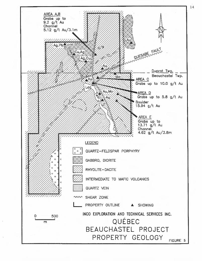
The stratigraphy is defined by NE to E-trending intermediate to felsic flow sequences dipping approximately 45-60 degrees to the south, intruded by felsic to mafic intrusives (diorite, granodiorite, QFP and some lamprophyre) (figure 5).
The rocks have been subdivided into the following major units of volcanic sequences to intrusive units.
Volcanic Sequences
1) Andesite - This unit was observed in the northern and southern parts of the grid. The rock is medium to dark green, aphanitic to medium grained. Locally, it is pillowed and amygdular and/or porphyritic. Anygdules consist of quartz- carbonate-epidote. Generally, this unit has a massive texture.
2) Silicified and carbonatized andesite - This unit is the same rock as above, but more altered. The colour is dark grey to
—
dark green, generally with a sugary to sub-conchoidal fracture. This unit was observed nearby the major faults, around felsic flow sequences and felsic intrusive rocks.
3) Fractured felsic flow - This unit was mapped in the eastern part of the grid and in some small areas in the western part near Twin Lake. This rock is generally black to dark green on fresh fractures and beige on weathered surfaces. It is locally porphyritic with feldspar porphyries and quartz "eyes" and it generally has a sub-conchoidal to conchoidal fracture.
--
Vesicles and flow-banding textures are also observed. Generally, it contains trace to 1% disseminated magnetite and traces of pyrite. Near the major faults, this rock shows an increase in hematization and up to 10% pyrite can be observed.
14
v\-1
Duprat Twp„
Beauchastel Twp. AREA C Grabs up to 10.0 g/t Au
AREA D Grabs up to 5.8 g/t Au
Boulder 15.94 g/t Au
AREA A,B Grabs up to 9.2 g/t Au Channel 5.12 g/t Au/3.1 m
~~////w j~Ag Pb
AREA E Grabs up to 13.71 g/t Au Channel 4.62 g/t Au/3.8m
LEGEND
QUARTZ—FELDSPAR PORPHYRY
GABBRO, DIORITE
RHYOLITE—DACITE
INTERMEDIATE TO MAFIC VOLCANICS
QUARTZ VEIN
'vi' SHEAR ZONE
PROPERTY OUTLINE
INCO EXPLORATION AND TECHNICAL SERVICES INC.
QUÉBEC BEAUCHASTEL PROJECT
PROPERTY GEOLOGY
///

15
Intrusive Units
1)
Magnetic Diorite - This unit is massive and homogeneous. Its colour is medium to dark green. It is composed of up to 40% feldspar and 60% pyroxene and actinolite, and is generally medium (1-3 mm) grained. The mineralization consists of pyrite (tr-1%), magnetite (1-2%) and pyrrhotite (tr) giving the rock an appreciable magnetic intensity. The previous works (diamond drilling) undertaken by Nordis Gold Mines Ltd. show that the magnetic diorite dips to the north at 30-40° (GM-97, 924 and 40113).
— 2) Lamprophyre - This unit is dark green and fine-grained. It is composed of chlorite and 15-20% biotite. It was only observed on stripping sites "B" and "C", once the stripping
_ was completed. This dyke trends 080° and dips 88- to the south.
3) Quartz - Feldspar Porphyry - On the Beauchastel property, this unit was mapped as thin dykes and as a large stock in the western part of the grid. This unit was identified as "Twin Lake Alkali Granite" in past works. The rock is medium to coarse-grained with a pinkish white color. It is characterized by 5-20=x, 3-5 mm euhedral quartz phenocrysts and 50-80`x, 2 cm well-zoned, euhedral potassium feldspar
._ phenocrysts. This unit becomes finer-grained toward its margins, and has partially assimilated the country rock. There are numerous quartz veins (up to 0.5 m) within the intrusion.
4) Granodiorite - This unit was observed at only three locations on the property: along Twin Lake, north of the Giant Quartz Vein ("GQV"), in the central part of the eastern section of the grid, and on stripping site "A". This rock is medium grained with a grey-green to beige-green color. It is characterized by an equigranular texture with 2-5% anhedral quartz grains (1-2 mm), 30-40% anhedral feldspar grains (2 mm), and 45-50% pyroxene (2 mm). This unit was recognized by Dasson Copper Corp. Ltd. in 1964-67, it contains the quartz vein with good values of molybdenite and some values of gold (see Summarized Previous Works, Table I).
5) Aplite - This unit appears as thin (5-20 cm), fine grained (<0.5 mm) dykes of granitic composition (40% quartz, 60% potassium feldspar and plagioclase). The mineralization consists of 1-2% magnetite-hematite-pyrite. The trend of these dykes is quite variable but the preferential trend is 015" with a 70" dip to locally sub-horizontal.

16
6) "Giant Quartz Vein" - This vein crosses all the property, from NE to SW and lies just north of and runs sub-parallel to the base line of the grid. Another wide quartz vein was mapped in the south-central part of the grid and it is parallel to the Giant Quartz Vein, (GQV). They are commonly clear to white in colour, and apparently barren. Specularite occasionally occurs in the veins, and pyrite is rare.
The wall rock adjacent to these veins is often intensely silicified. The "GQV" contains fragments which have been transported and pseudo fragments which have been formed by intense veining. It is believed to be the western extension of the Quesabe fault.
6.2 Alteration
Two major types of alteration were recognized in the field: pervasive silicification-carbonatization and hematization (pink alternation).
Pervasive silicification-carbonatization involves the addition of silica and carbonate in sufficient quantities to consis-tently silicify the host rock. This occurs more commonly (or at least is more frequently recognized) in andesites. With the exception of an elongated zone related to the "Giant Quartz Vein" and around the felsic sequence, silicification and carbonatization are very erratic.
In the thin section work, potassic alteration is often described. This appears to correspond to what is described in hand specimens, (field work), as pervasive silicification. This potassic alteration is described as very fine grained secondary K-feldspar, mainly distributed in envelopes along fractures and locally forming pervasive alteration. Locally this K-spar alteration is intimately associated with sulfide mineralization and appears to be unrelated to the secondary quartz, (thin section RX-193043).
Pink alteration refers to the addition of disseminated hematite throughout the rock, in fractures, lining quartz veinlets, or in amygdules. Magnetite was commonly added during this alteration. Parry and Hutchinson (1981) explain pink alteration as the addition of extremely fine-grained hematite, whereas Comba & al. (1981) suggest that pink alteration is fenitization-alkali metasomatism related to intrusion of under-saturated alkalic bodies into the supracrustal rocks. Pink alteration appears to be related to the Quartz-Feldspar Porphyry intrusion (QFP) or the Granodiorite intrusion because the alteration increases toward it and near the combined fractures.

17
6.3 Structure
-- The presumed contact between tne intermediate and felsic units is oriented on average 080°, but is locally variable (045 to 060°).
This orientation (045" to 060°) is closely associated to the trace of the mineralized zone on the surface (showings "B" and "E") and to the elongation of the magnetite diorite intrusion (063°),
The schistosity (S2) has not affected the rocks of the property to a great extent. It is observed in some places to be 305°- 310° with a subverticai dip.
The prolongation of the Quesabe Fault (225°/75') crosses the property from the NE to the SW. It was recognized by diamond drilling in the past and its signature on the surface is marked by a swampy depression and the "Giant Quartz Vein". It has been suggested that the Quesabe Fault is a normal fault, with the NW portion lowered in comparison with the SE portion (C. Hubert et al. 1983).
Other fault systems were identified on the property either on the surface during the geological reconnaissance and/or interpreted from geophysics.
The first system is oriented 030°. The second system is oriented 330° to 350° and corresponds to the Twin Lake fault system. This system is important. It transects the first system and the Quesabe Fault system causing a sinistral or locally dextral displacement (centimetric to metric). The third system is oriented at 240° to 260' and transects locally the first and the second system with a dextral displacement.
Jointing is often well-developed and observed on outcrops. It occurs mainly in the felsic volcanic unit, as well as in the silicified and carbonatized andesite. These joint patterns reflect orientations similar to the fault systems.
6.4 Mineralization
Pyrite occurs in all rock types examined during the prospecting arid geological mapping surveys. It generally occurs as fine grained disseminated subhedral to anhedral grains. Almost all rocks examined contained at least traces of pyrite, and samples were generally taken at locations showing slight to moderate, (< 5%), pyritisation. This pyrite enrichment generally occurs in areas showing carbonatization and what has been described as silicification in hand samples. Hematization seems to have an irregular relationship to the pyrite mineralization.

18
The mineralized zones seem to be confined along structures sub-parallel to the Quesabe Fault, which are oriented 045= to 0600.
-- The best Au results were obtained where the pyritisation is more intense. These gold concentrations are associated with 045= to 060° fault and/or shear zones. Previous works and the recent prospecting by I.E.T.S. has identified four auriferous showings in the eastern part of the property, (see Table II below).
TABLE II
Showing/ Location Mineralization Best results stripping site Au g/t
A & B
C
D
5+80E/ 4+40N
1+40E/ 2+5(.1N
1+50E, 1-80N
< 5% pyrite, 9.23 (Grabs) f-vfg diss. XL's & & blebs associated with 5.12/3.05m silica & carbonate altn's and irreg. hematite aitn.
1-2% pyrite, fg diss. 10.00 (Grabs) XL's and blebs and asso- & ciated with silica & 4.50 carbonate altn's.
tr-1% py to locally 5.90 (Grabs) gossan, locally strongly & silicified 2.60
E 2+40E/b+40S 2-10% pyrite diss. XL's & 11.57 (Grabs) blebs, associated with & silica & carbonate altn's 4.62/3.75m and locally hematite altn.
Magnetite mineralization is quite common on the property. It can -~ occur in all rock types mapped on the property, generally as very
fine grained disseminated crystals. It imparts weak to moderate magnetism and a dark color to the rocks in which it is found. Areas rich in magnetite, (< 4%), generally show an increase in hematite alteration as well.
Other sulfide minerals occurring on the property include pyrrhotite and chaicopvrite, but no significant concentrations of these minerais is described by the present work. Molybdenite has been describes( as occurring in several quartz veins, especially in close

19
proximity to the Giant Quartz Vein. It generally occurs as fine to coarse grained aggregates and crystals which are fracture coating and void filling. Several anomalous molybdenum zones are reported to occur on the property in the previous works.
7.0 1990 EXPLORATION PROGRAM AND RESULTS
In early June 1989, Compagnie de Nickel du Canada Ltd. added 3 full lot claims to the Beauchastel Property, Lots 8, 9 and 10, Range 9, Beauchastel Township. These claims cover the southwestern extension of the Giant Quartz Vein.
In November 1989, Sam J. Bosum of Chibougamau was contracted to cut 41.3 kilometres of grid line over the central portion of the property. The 3.5 kilometre long base line is at 045° Az and runs from the northeastern to the southwestern boundaries, approximately overlying the Giant Quartz Vein (figure 6).
In August 1990 Val d'Or Geophysique of Val d'Or preformed for IETS a total magnetic field and gradient survey over the 41.3 kilometres of grid line. This survey indicates a dominant strike direction
-- for the property to be roughly 060° - 240° Az.
Between May and October 1990 I.E.T.S. personnel conducted prospecting over the eastern portion of the grid. Systematic coverage of the ground and a semi-selective sampling policy was used in this campaign in the hopes of discovering structural
_ features hosting economic quantities of gold. A total of 581 samples was collected and analysed for Au content by either Bourlamaque Assay Laboratories Ltd. of Val d'Or or Assayers Laboratories Ltd. of Rouyn-Noranda. Of this total, 57 samples returned values greater than 300 ppb Au and these are briefly described in table III. As a result of this prospecting, several anomalous Au zones were delimited and of these, 5 areas were selected for a stripping campaign.

OX °oF fox
DUPRAT TWP.
BEAUCHASTEL TWP.
I PROPERTY OUTLINE
0 500
m
INGO EXPLORATION AND TECHNICAL SERVICES INC.
QUÉBEC BEAUCHASTEL PROJECT
GRID LOCATION MAP
FIGURE 6

I I I I I 1 I I 1 I I i I I I I I I
TABLE III
Prospecting Samples with Results > 300 ppb Au
1/4
Sample number
Sample Type
Sample Location
Sample Description
Results Au ppb Au g/t
RX 127950 outcrop 0+00 / 2+75 N Quartz vein with Dacite inclusions, 2% Py diss 560
RX 127951 outcrop 2+00 E / 2+00 N Altered dacite 5% py fine 1050
RX 127952 outcrop 2+00 E / 2+00 N Dacite with 2 cm q.v. diss py 300
RX 127953 outcrop 2+00 E / 2+00 N Dacite, 1% py fine 830
RX 127955 chip/ 2+00 E / 2+00 N Rhyo-dacite, 2% py fine 820 4.3m
RX 127956 outcrop 2+00 E / 2+00 N Rhyo-dacite, 1% py fine 10000
RX 127987 outcrop 1 +00 E / 1+25 N Dacite, qtz carb veining, 3% py diss 360
RX 149244 outcrop 7+25 E / 0+83 N Altered gabbro, 1-2% py fg diss 890
RX 149245 outcrop 7+65 E / 0+70 N Altered gabbro, 5% py fg diss 420
RX 149248 outcrop 6+40 E / 4+90 N Altered mafic volcanic, 1-2% py fg diss 1000
RX 149254 outcrop 5+70 E / 3+80 N Altered mafic volcanic, 2-3% py vfg to mg diss 300
RX 149255 outcrop 5+70 E / 3+80 N Altered mafic volcanic, 5% qv's, 1-2% py fg diss 360
RX 149256 outcrop 5+70 E / 3+80 N Altered mafic volcanic, 1-2% py fg diss 4200
RX 149257 outcrop 5+70 E / 3+80 N Altered mafic volcanic, 1-2% fg diss 2200
RX 149258 outcrop 5+70 E / 3+80 N Quartz vein, 5% py fg diss 520
RX 149267 outcrop 4+59 E / 4+73 N Quartz vein, tr-1% py m-cg aggregates 430
NJ I-.

I I I I I I I I I I I I
TABLE Ill
Prospecting Samples with Results > 300 ppb Au
2/4
Sample #
Sample Type
Sample Location
Sample Description
Results Au ppb Au g/t
RX 149268 subcrop 3+63 E / 2+45 N Altered mafic volcanic, 5% py f-mg diss 340
RX 149271 outcrop 3+63 E / 2+45 N Altered mafic volcanic, 5% qtz stringers, 5% py diss 440
RX 149281 outcrop 1+95 E / 1 +18 N Giant quartz vein, 1-2% py fg diss in frgm's 800
RX 149288 subcrop 1 +60 E / 1 +70 N Altered mafic volcanic, 2-3% py fg diss 900
RX 149289 outcrop 1 +60 E / 1 +70 N Gossan 1300
RX 149290 outcrop 1 +60 E / 1 +70 N Gossan 2600
RX 149299 outcrop 0+01 E / 2+91 N Gossan qtz vein, 5-10% py f-mg diss 300
RX 149337 outcrop 5+78 E / 4+58 N Altered mafic volcanic, 1% py diss 1800
RX 149348 outcrop 1+35 E / 1 +90 N Altered mafic volcanic, 1% py diss 5900
RX 149350 subcrop 0+98 E / 1 +76 N Altered mafic volcanic, 1% py diss 1700
RX 149351 outcrop 1 +30 E / 2+50 N Altered mafic volcanic/gabbro, 5% py fg diss 1400
RX 149355 outcrop 0+24 E / 1 +95 N Altered granodiorite, 2-3% py fg diss 560
RX 149357 subcrop 0+75 E / 1+55 N Altered mafic volcanic, 1% py fg diss 3200
RX 149501 outcrop 0+01 E / 2+93 N Quartz vein, rusty, 1-2% py fg diss 400
RX 149505 outcrop 1+80 E / 3+10 N Altered mafic volcanic, 1-2% py fg diss 4500
RX 149506 outcrop 1+80 E / 3+10 N Altered mafic volcanic, 1-2% py fg diss 580

I I I
TABLE Ill
Prospecting Samples with Results Z 300 ppb Au
3/4 Sample #
Sample Type
Sample Location
Sample Description
Results Au ppb Au g/t
RX 149508 outcrop 1 +86 E / 3+10 N Altered gabbro,tr-1% py fg diss 400
RX 149510 outcrop 0+57 E / 0+61 N Gabbro, tr-1% py f-mg diss 1800
RX 149514 subcrop 0+45 E / 0+36 S Quartz (vein ?), tr-1% py fg diss, tr cpy & Mo 400
RX 149516 subcrop 0+45 E / 0+36 S Gossan, tr py 1300
RX 149525 outcrop 6+32 E / 4+87 N Altered mafic volcanic, 1-2% py fg diss 350
RX 149536 outcrop 2+37 E / 6+07 S Altered dacite, 1-2% py f-mg diss 343
RX 149538 subcrop 2+32 E / 6+30 S Altered dacite, 5% py fg diss * 3.94
RX 149542 subcrop 2+45 E / 6+38 S Altered dacite, 5% py fg diss 2091 2.23
RX 149543 subcrop 2+42 E / 6+30 S Altered dacite, 2-3% py fg diss 1406 1.03
RX 149544 subcrop 2+42 E / 6+30 S Altered dacite, 1-2% py f-mg diss 620
RX 149545 subcrop 2+42 E / 6+30 S Altered dacite, 1-2% py fg diss + fg stringers * 5.83
RX 149546 subcrop 2+42 E / 6+30 S Altered dacite, 5% py fg diss * 7.54
RX 149547 outcrop 2+42 E / 6+30 S Altered dacite, 2-3% py fg diss 2263 1.89
RX 149548 outcrop 2+42 E / 6+30 S Silicified dacite, 5% py fg diss 1023 1.03
RX 149549 subcrop 2+42 E / 6+22 S Altered (andisite ?) 1-2% py f-mg frac. 1303 1.03
RX 149550 subcrop 2+45 E / 6+22 S Altered dacite, 1-2% qv's, 5% py fg diss * 13.71

I I i I 1 1 1 I I I I I I I i I I I I
TABLE Ill
Prospecting Samples with Results > 300 ppb Au
4/4 Sample #
Sample Type
Sample Location
Sample Description
Results Au ppb Au g/t
RX 149555 talus 5+00 E / 2+68 S Quartz vein, tr rusty spots, 2-3% py f-mg diss 343
RX 149557 subcrop 2+42 E / 6+30 S Altered dacite, 5% py fg diss * 5.49
RX 149558 subcrop 2+42 E / 6+30 S Highly altered (dacite), 5% py f-mg diss * 7.03
RX 149561 subcrop 2+12 E / 4+22 S Altered dacite, 5% py f-mg diss, tr cpy 301
RX 149565 talus 1+00 E / 4+70 S Rusty quartz vein, 5% py f-mg in w.r. * 15.94
RX 149566 subcrop 1+30 E / 5+13 S Altered mafic volcanic, 1-2% py f-mg clusters 408
RX 149903 outcrop 1+85 E / 3+70 S Altered mafic volcanic, 3% py fg diss * 3.43
RX 149925 outcrop 2+15 E / 4+20 S Altered mafic volcanic, 1% py fg diss in hem. altn. 411
RX 149926 outcrop 2+80 E / 4+05 S Altered mafic volcanic, 1% py fg diss in hem. altn. * 1.54
N .P

25
In September 1990 René Sigouin of Val d'Or was contracted to conduct an outcrop stripping and washing campaign over selected sites on the property. A John Deer 490 shovel was used to strip up to 1-2 meters of overburden from outcrops, after which these exposed areas were washed with high-pressure water. An approximate total of 2925 m2 of outcrop area was stripped and washed in five separate sites (figure 5). Three of these stripping sites were sampled (grab and channel samples) by I.E.T.S. personnel during October 1990. A total of 128 grab samples and 220 channel samples were analysed for Au content by Assayers Laboratories Ltd. of Rouyn-Noranda, (see table IV). Of these totals, 64 samples returned values greater than 1000 ppb. These are briefly described in table V.
Site Area stripped # and washed
TABLE IV
of grab # of channel samples samples
Total length of channel sampling
A 175m2 33 19 7.8m
B 350m2 46 117 66.2m
C 300m2 0 0 0
D 1500m2 0 0 0
E 600m2 49 84 55.7m
Total 2925m2 128 220 129.7m
Detailed maps including geology and sample locations, at 1:200 scale have been made for each of the five sites (Appendix 6).
During September and October 1990, Geologica of Val d'Or carried out a reconnaissance geological mapping survey over the entire gridded area. Detailed geological mapping was also preformed over the 5 stripping sites. A total of 47 samples was collected and analysed for Au content, and also 20 samples were collected and analysed for major elements, the analysis of these samples was
- preformed by Assayers Laboratory of Rouyn-Noranda.
—
_.

I I I I I I i I
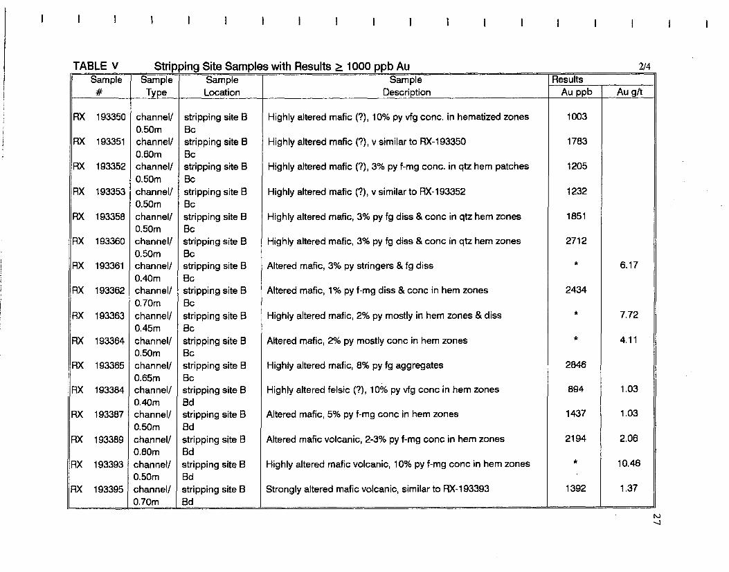
TABLE V
Stripping Site Samples with Results >_ 1000 ppb Au
1/4 Sample #
Sample Type
Sample Location
Sample Description
Results Au ppb Au g/t
RX 149569 grab stripping site A Altered gabbro, 2-3% py vfg-fg diss XL's * 8.23
RX 149573 grab stripping site A Highly altered gabbro, 5% py f-mg diss 1126 1.10
RX 149579 grab stripping site A Altered mafic volcanic, 2-3% py diss 1147 1.03
RX 149582 grab stripping site A Strongly altered (mafic volcanic), 5% py vfg-fg diss * 9.23
RX 149583 grab stripping site A Quartz hematite specularite vein, 1-2% py fg aggregates * 5.76
RX 149586 grab stripping site A Strongly altered mafic volcanic, S 10% f-vfg diss 1611 1.30
RX 149588 grab stripping site A Quartz hematite specularite vein, 5% py f-vfg diss * 4.58
RX 193311 channel/ stripping site A Altered mafic volcanic, 2% py fg diss & conc. in hem. zones 997 0.30m Aa
RX 193013 grab stripping site B Quartz vein, 20-30% (semi massive) py in wall rock * 1.89
RX 193017 grab stripping site B Altered mafic intrusive, 5-10% py mg diss blebs * 4.63
RX 193018 grab stripping site B Altered mafic volcanic, 5% py f-mg specks & blebs asoc. w hem. * 4.97
RX 193021 grab stripping site B Highly altered rock, 10% py f-mg loose stringers * 2.40
RX 193022 grab stripping site B Semi-massive pyrite w 5-10% qv's, tr cpy * 6.80
RX 193039 grab stripping site B Altered mafic volcanic/intrusive, 5% py aggregates & diss blebs * 3.18
RX 193043 grab stripping site B Altered mafic volcanic, 5% py mg blebs diss 1311
RX 193046 grab stripping site B Altered mafic volcanic, 1-2% py f-vfg diss * 7.63
N
I I I
I 1 I I I I I I I I I I I I I
TABLE v
Stripping Site Samples with Results 1000 ppb Au
2/4 Sample #
Sample Type
Sample Location
Sample Description
Results Au ppb Au g/t
RX 193350 channel/ stripping site B Highly altered mafic (?), 10% py vfg conc. in hematized zones 1003 0.50m Bc
RX 193351 channel/ stripping site B Highly altered mafic (?), y similar to RX-193350 1783 0.60m Bc
RX 193352 channel/ stripping site B Highly altered mafic (?), 3% py f-mg conc. in qtz hem patches 1205 0.50m Bc
RX 193353 channel/ stripping site B Highly altered mafic (?), v similar to RX-193352 1232 0.50m Bc
RX 193358 channel/ stripping site B Highly altered mafic, 3% py fg diss & conc in qtz hem zones 1851 0.50m Bc
RX 193360 channel/ stripping site B Highly altered mafic, 3% py fg diss & conc in qtz hem zones 2712 0.50m Bc
RX 193361 channel/ stripping site B Altered mafic, 3% py stringers & fg diss * 6.17 0.40m Bc
RX 193362 channel/ stripping site B Altered mafic, 1% py f-mg diss & conc in hem zones 2434 0.70m Bc
RX 193363 channel/ stripping site B Highly altered mafic, 2% py mostly in hem zones & diss * 7.72 0.45m Bc
RX 193364 channel/ stripping site B Altered mafic, 2% py mostly conc in hem zones * 4.11 0.50m Bc
RX 193365 channel/ stripping site B Highly altered mafic, 8% py fg aggregates 2846 0.65m Bc
RX 193384 channel/ stripping site B Highly altered felsic (?), 10% py vfg conc in hem zones 894 1.03 0.40m Bd
RX 193387 channel/ stripping site B Altered mafic, 5% py f-mg conc in hem zones 1437 1.03 0.50m Bd
RX 193389 channel/ stripping site B Altered mafic volcanic, 2-3% py f-mg conc in hem zones 2194 2.06 0.80m Bd
RX 193393 channel/ stripping site B Highly altered mafic volcanic, 10% py f-mg conc in hem zones * 10.46 0.50m Bd
RX 193395 channel/ stripping site B Strongly altered mafic volcanic, similar to RX-193393 1392 1.37 0.70m Bd
N J

I I I I I I I I I I
TABLE V
Stripping Site Samples with Results > 1000 ppb Au
3/4 Sample #
Sample Type
Sample Location
Sample Description
Results Au ppb Au g/t
RX 193423 channel/ stripping site B Highly altered mafic (?), 5% py fg diss & aggregates 998 1.20 0.70m Bg
RX 193432 channel/ stripping site B Moderately altered mafic volcanic, 3% py fg aggregates 1180 1.12 0.60m Bg
RX 193433 channel/ stripping site B Highly altered mafic volcanic, 2% py fg diss 1338 1.37 0.60m Bh
RX 193434 channel/ 0.60m
stripping site B Bh
Highly altered mafic volcanic, 7% py f-mg diss & fg strgs & aggregates
2537 2.23
RX 193059 grab stripping site E Altered dacite, 7-8% py fg diss specks & aggregates * 3.26
RX 193060 grab stripping site E Altered dacite, 5% py fg blebs * 3.86
RX 193061 grab stripping site E Altered dacite, 5-10% py fg diss blebs & XL's * 11.57
RX 193062 grab stripping site E Altered dacite, 3-4% py f-mg diss blebs & XL's * 10.12
RX 193087 grab stripping site E Altered dacite, 1-2% py f-mg frac coating 1988
RX 193089 grab stripping site E Altered dacite, 5% py f-mg diss blebs 2929
RX 193515 channel/ stripping site E Altered dacite, 1-2% py f-mg diss blebs 1230 1.35 1.00m Eb
RX 193516 channel/ stripping site E Altered dacite, 5% py fg diss aggregates 2331 2.23 0.50m Eb
RX 193517 channel/ stripping site E Altered dacite, tr-1% py fg diss & frac coating 1146 1.37 1.10m Eb
RX 193518 channel/ stripping site E Altered dacite, tr-1% py f-mg diss blebs & XL's 1361 1.37 0.85m Eb
RX 193519 channel/ stripping site E 2 cm quartz vein, 1-2% py diss in w.r. 2060 1.89 0.15m Eb
RX 193520 channel/ stripping site E Dacite, tr py fg diss blebs 1040 1.03 0.40m Ea

I I I 1 I 1 I I I I I 1 I I I I I 1 I
TABLE v
Stripping Site Samples with Results >_ 1000 ppb Au
4/4 Sample #
Sample Type
Sample Location
Sample Description
Results Au ppb Au g/t
RX 193529 channel/ stripping site E Altered dacite, 1-2% py fg diss blebs & XL's * 3.26 0.60m Ea
RX 193530 channel/ stripping site E Altered & brecciated dacite, 1-2% py loose aggregates 2674 2.74 0.60m EA
RX 193531 channel/ stripping site E Altered & brecciated dacite, 2-3% py fg diss 2880 2.74 0.55m Ea
RX 193532 channel/ stripping site E Altered dacite, 5% py f-mg diss asoc w qtr veinlets 1886 1.37 0.45m Ea
RX 193533 channel/ stripping site E Highly altered dacite, 10% py f-mg diss blebs & XL's * 16.46 0.50m Ea
RX 193534 channel/ stripping site E Altered dacite, 3-4% py f-mg diss blebs & XL's * 8.23 0.45m Ea
RX 193535 channel/ stripping site E Altered dacite, 1-2% py fg diss blebs & XL's 1373 1.37 0.60m Ea
RX 193545 channel/ stripping site E Altered dacite, 2-3% py f-mg XL's & blebs asoc w qtz veinlets 1172 1.03 0.90m Ec
RX 193553 channel/ stripping site E Brecciated altered dacite, 3-4% py f-mg blebs & XL's, tr cpy 2777 2.91 0.50m Eb
RX 193559 channel/ stripping site E Altered dacite, 2-3% py in clusters & asoc w altn. * 3.09 0.50m Eb
RX 193560 channel/ stripping site E Highly altered dacite, 3-4% py f-mg diss blebs 2605 2.40 0.50m Eb
RX 193561 channel/ stripping site E Altered dacite, 1-2% py f-mg diss blebs & XL's 2229 2.40 0.70m Eb
RX 193562 channel! stripping site E Highly altered, locally brecciated dacite, 5% py f-mg diss blebs 2331 2.06 0.55m Eb & XL's
RX 193563 channel/ stripping site E Altered dacite, 3-4% py f-mg diss blebs 1002 1.20 0.85m Eb
RX 193570 channel! stripping site E Highly altered dacite, 5-10% py fg diss & frac coating 1817 1.37 0.50m Eb ,
RX 193571 channel/ stripping site E Highly altered dacite, similar to RX-193570 2366 2.74 0.25m Eb

30
The results of the lithogeochemical sampling confirms the presence of felsic volcanic rocks (rhyolitic composition) on the property.
-- Samples collected from the geological survey with Au results > 300 ppb are briefly described in table VI.
In October, Vancouver Petrographics Ltd. of Fort Langley, B.C. was contracted to perform thin section analysis of 16 samples, 10 of which represented the stratigraphic series of the geology on the property, and the other 6 samples represented anomalous Au samples. The stratigraphic series is described as variably altered volcanic rocks and the anomalous Au samples are highly altered rocks that have some affinities to the rocks in the stratigraphic section (see
-, appendix 5).

I I I 1 I I I I I I I I 1 I I I I I
TABLE vi
Geological Mapping Samples with Results ... ppb Au
1/1
Sample #
Sample Type
Sample Location
Sample Description
Results Au ppb Au g/t
RX 148924 outcrop 7+75 E / 0+70 N Silicified & carbonater andesite, 5-7% py 627
RX 148943 outcrop 6+00 W / 1+50 S Silicified & carbonated andesite, 1-3% py 458
w I-.

32
8.0 CONCLUSIONS AND RECOMMENDATIONS
-- Conclusions
Claim staking has extended the southwestern boundary of the property to cover the southern extension of an important structural feature, the Giant Quartz Vein.
A grid with a base line at 045° Az and approximately overlying the Giant Quartz Vein has been cut in the central portion of this property to assist in geophysical, geological, and prospecting surveys.
A magnetic survey has been performed over the grid, and it indicates a dominant strike direction to be roughly 060° - 240°, in a fairly active magnetic relief.
Prospecting of the eastern (east of Twin Lake) portion of the grid has outlined several moderately to highly auriferous zones of which at least two have not been reported in previous works. Five anomalous auriferous areas were selected for mechanical stripping, washing and detail geological mapping. Three of these areas were
— systematically grab and channel sampled. The assay results show that the gold mineralization consists of discontinuous lens shaped envelopes along 045' - 060° faults and/or shear zones with dips
— between 045° and 060° south.
A reconnaissance geological mapping survey was preformed over the gridded area of the property.
The Beauchastel property is located within a geological environment mainly composed of tholeitic intermediate volcanics with some
-- rhyolitic and intermediate flows. These were displaced, altered and deformed by several felsic intrusives, which were observed within the limits of the property.
The dominant structural fault systems trending across the property are the Quesabe Fault which is oriented NE-SW, its subsidiaries oriented NNE-SSW (030°), the NNW-SSE to N-S (varying between 330°
— and 350°) faults, as well as E-W (240° to 260°) faults. Fracture cleavages, joints and small-scale slip cleavages (kink-bands) are related to these fault systems and to displacements which probably
-- resulted from the felsic intrusions, (Gaudreault, Nov. 1990).
Thin section description of the highly auriferous samples from the — property has highlighted the fact that potassic alteration and
dolomitization is locally associated with pyritisation.
33
Recommendations
1. Systematic sampling of stripping sites "C" and "D" including channel and grab sampling.
2. Complete prospecting of gridded area, including area between L4E - L9E south of base line and west of Twin Lake.
3. Follow-up prospecting in the area of samples, RX-149565 (bolder at 1+00E, 4+70S 15.94 g/t Au), RX-149903 (outcrop at 1+85E, 3+70S 3.43 g/t Au).
4. Extension of grid lines north to the northern property boundary to cover areas of reported Au (4.5 g/t) , Cu (12.98%) , Ag (9.3 oz/t), and Pb (36.1 oz/t) anomalies. Linecutting should be followed by a systematic magnetometer survey, prospecting, and geological mapping with emphasis on structural features.
5. An Induced Polarization survey (x = 50m; n = 5) on NW-SE oriented grid lines, in order to better define depth and lateral extension of disseminated sulfide horizons, previously recognized on stripped outcrops.
6. A detailed structural study of the stripped zones to determine the source and the controlling factors of the mineralization and their possible extensions.

34
REFERENCES
GAUDREAULT, D., "Into Exploration and Technical Services Inc., Beauchastel Project (60217), Geological Survey" November 1990.
HINSE, G.J., "A Report on the Twin Lake Gold - Molybdenum Property, for Aunore Resources Inc." August, 1984.
LAMBERT, G. & TURCOTTE, R., "Magnetic Survey, Property of Inco Exploration and Technical Services Inc., Beauchastel Property", November 1990.

N' fi ' û i S IEMES DE
C ES7ION DES LOIS QUEBEC
'91 flfll 2? 13 .12
1990 SUMMARY REPORT BEAUCHASTEL PROPERTY
BEAUCHASTEL AND DUPRAT TOWNSHIPS QUEBEC
NTS 32D/6
PART II - APPENDICES
Iftiondacknftw Ildinlatime de r nsr& st dos Rsssourcas
oldimapes
DATE 17 SEP 1991
NO QUA, O 0'321
t I/to_ --ac)
R. Fraser Inco Exploration and Technical Services Inc. Val d'Or (Quebec) January 1991

TABLE OF CONTENTS
IN PART II
APPENDICES
APPENDIX 1 CLAIM LIST
APPENDIX 2 RX FORMS (SAMPLE NUMBERS, LOCATIONS, DESCRIPTIONS AND ASSAY RESULTS)
APPENDIX 3 CERTIFICATES OF LABORATORY ANALYSES
APPENDIX 4 LITHOGEOCHEMICAL ASSAY RESULTS
APPENDIX 5 THIN SECTION AND POLISHED SECTION - PETROGRAPHIC ANALYSES
APPENDIX 6
STRIPPING SITES, SAMPLE LOCATION MAPS AND DETAILED GEOLOGY MAPS

APPENDIX 1
CLAIM LIST

—
—
_
—
—
—
—
APPENDIX I: CLAIM LIST
CLAIM # TOWNSHIP RANGE LOT AREA (hectares)
EXPIRY DA l'E
3732991 Beauchastel X 15 40 92-12-08 3732992 Beauchastel X 14 40 92-12-08 3733141 Beauchastel X 17 40 92-12-10 3733281 Beauchastel X 16 40 92-12-08 4094731 Beauchastel X 9 40 91-08-08 4094732 Beauchastel X 10 40 91-08-08 4094741 Beauchastel X 11 40 91-08-08 4094742 Beauchastel X 12 40 91-08-08 4094751 Beauchastel X 13 40 91-08-08 4112661 Duprat I 16 40 92-11-15 4125631 Duprat I 15 40 92-11-15 4125632 Duprat I 14 40 92-11-15 4175111 Duprat I 1/2S 10 20 91-06-10 4175112 Duprat I 1/2S 11 20 91-06-10 4175113 Duprat I 1/2S 12 20 91-08-14 4175114 Duprat I 1/2S 13 20 91-08-14 5018034 Beauchastel LX 8 40 91-06-01 5018035 Beauchastel IX 9 40 91-06-01 5018036 Beauchastel IX 10 40 91-06-01

APPENDIX 2
RX FORMS (SAMPLE NUMBERS, LOCATIONS, DESCRIPTIONS AND ASSAY RESULTS)

SAMPLE NO. LOCATION DESCRIPTION ASSAY RESULTS Au (ppb)
148901 148902 148903 148904 148905
L-0/2+55N L-0/2+55N 0+25E/2+32N L-2E/4+50N L-1E/5+50N
Quartz vein 1D, 2-5% Py Q.V. +1% Py V6 r1 , 2% Py Q.V.
52 19 23 45 6
148906 L-1E/5+50N Q.V. 5 148907 L-1E/5+50N Q.V. 10 148908 L-1E/5+50N V6#, i'l ,cr 11 148909 1+50E/5+65N V6 rt , 2-5% Py 108 148910 L-1E/6+30N Felsic dyke 7 148911 L-1E/6+33N 2D, 1-2% Py 33 148912 L-1E/6+33N Q.V. 7 148913 BL-0/9+00E V6 Q' , r~ 10 148914 BL-0/9+00E Q.V. 10 148915 L-9E/1+OOS Q.V., 2-5% Py 6 148916 L-9E/1+705 Q.V. 6 148917 L-8E/3+25S V60- , q , 5-7% Py 37 148918 L-8E/0+10N Q.V. 45 148919 L-8E/0+105 Q.V. <5 148920 L-8E/0+505 Q.V. <5 148921 L-10E/4+20S Q.V. <5 148922 L-7E/3+805 V6 0' , 1 , 1-2% Py 49 148923 L-7E/1+50N V2-V4#, q.v. 28 148924 7+75E/0+70N V6 #6,43- , , 5-10% Py
~0% 627
148925 L-7E/0+155 V6 iii, rt , Py # 24 148926 6+25E/2+205 V60", 7 ,E ,4k, q.v.
2-10% Py 99 148927 7+15E/5+55S V2-V4#, 5-10% Py 18 148928 5+85E/6+75N Q.V., 2-5% Py 16 148929 L-5E/6+OON V4-V6 /, hem, #, q.v.
1-5% Py 8 148930 3-90E/0+205 Q.V. 5 148931 L-3E/9+75S Aplite <5 148932 L -1E/6+75S V4-V6, 1-5% 15 148933 L-1W/0+00 1m qf, q.v. 12 148934 L-3W/6+25S Q.V. 8 148935 L-3W/7+75S V6Q', 1% Py 29 148936 3+15W/0+00 Q.V. 6 148937 L-3W/0+50N V6 (2D?), 1-5% Py 53
-
GEOLOGICAL SURVEY OF THE BEAUCHASTEL PROPERTY INCO EXPLORATION INC.
APPENDIX : LIST OF SAMPLE NUMBERS, COORDINATES, DESCRIPTION AND ASSAY RESULTS

--- SAMPLE NO.
GEOLOGICAL SURVEY OF THE BEAUCHASTEL PROPERTY
ASSAY RESULTS Au (ppb)
INCO EXPLORATION INC.
LOCATION DESCRIPTION
148938 L-4W/4+25N V2, q.v., 1-2% Py 19 148939 L-7W/3+20N 2D, 1-2% Py 13 148940 L-5+05W/2+50S V4 cr, 5% Py 15 148941 L-5W/3+205 V4, 2-5% Py 10 148942 L-6W/9+505 V6 v- , Î , 1-2% Py 20 148943 L-6W/1+505 V6 cr , n, 1-3% Py 458 148944 BL-0/10+25W 2D 7 , 2% Q.V. 168 148945 L-16W/1+75S V6, tr-2% Py 31 148946 L-20W/6+80S Q.V. - rusty zone 29 148947 L-22W/1+805 Giant Quartz Vein 5

GEOLOGICAL SURVEY OF THE BEAUCHASTEL PROPERTY INCO EXPLORATION INC.
APPENDIX : LITHOGEOCHEMICAL ASSAY RESULTS
SAMPLE NUMBER LOCATION DESCRIPTION
Rx-148948 8E/5+OOS V2, Tr Py, Hem Rx-148949 8E/4+605 V6 _ Rx-148950 8E/3+65S V2 Rx-148951 8E/3+255 V6 0- Rx-148952 8E/2+90S V2 or V40-
- Rx-148953 8E/2+505 V2 Rx-148954 8E/1+805 V6 Rx-148955 8E/1+235 V2 or V4tr Rx-148956 8E/0+505 V6 Rx-148957 8E/0+00 V4 or VGa+ Rx-148958 7E/0+55N V2 or V4 ar Rx-148959 7E/1+75N V2
~ Rx-148960 7E/2+25N V2 or V4 6" Rx-148961 7E/2+75N V6 ti Rx-148962 7E/3+50N V4 or V6a-
-- Rx-148963 7E/4+25N V6 a- Rx-148964 6E/5+OON V6 Rx-148965 6E/5+50N V6
_ Rx-148966 6E/6+OON V2 or V4a- Rx-148967 6E/7+OON 2D Mt or 3G

I I 1 1 1 1 1 1 I
1 1 NCO GOLD
TRAVERSE NUMBER PR.Spre-r.-Tt►-3 , PROJECT viP‘-%1/4%-) GhaT~
N.T. S. -1-1 b C.. DATE M PN1 IZ ( at) GEOLOGIST(S) 1aLS RAr-~
AREA > v 1
SAMPLE
NUMBER
SAMPLE TYPE SAMPLE LATITUDE, LONGITUDE and / or
U.T.M.
SAMPLE DESCRIPTION RESULTS (p.wn. / a/o /ot. or ton) RX
Rock, Talus
IL( Stream
Silt, Soil
Grab, Chip, Channel
LENGTH, WIDTH, AREA
Rock type, litholopy, charocter of soil, streom silt,etc. Formation Mineralization, etc.
U 0)
12 Ca. jCl' ✓ C12-79Qa1 F,..aAT , . l4 1+15 tJ , lb,. - (7A L,. t T ~E i) t SS P-1 ~ ' ' '45
11(0"‹..g. ./(IYi$~p~ o/L (+ iZhys•_t-rtr- S► oZ- ?051. QTz.-t.A,Q.1. .- '5 vt: ta%a6-- r✓1_ ._.>o% P-+
1 Z t•-3goi , ✓ (iY1911ttb.) OR— 4 ('r•s_— LAk 15 •..../ tis,,J — 0 ,._. OR P1 .... 6 5
I -2.(,-5-7,3 .i C \ I~1993 ICek.p+> o/c- 1% Limn.. TTe 12t.3("1 ..•- `s
1 Z L3Z 1 ,/ , ( 1).~994 ~(DRA4 O 1 [_ 11 C.Q.-r? ._)z t,---) I 0
11(...1-n_ (rqp, 01 c, u kt-r1fb 1)A. I- Ti-E - '3 8) o flt -,s )'y 8o
12t„ 13 ✓ ( I-ffif1 t ic,, k.p.b o fl-- 1k a-rZ ....)~ th..% -- 1.--3. Sv V P rltp l=••S -." 15 r
11(.3'111(.3'1 4- t./ (1 , rffn .,eP.ab okL 1% k- t-tl. bAr 1t-t= - CAsZ cA116 .... z
\1. --- . 4.) 1,J (.2 .'"" OW e - INA ..s aR., Arl
I 2 ce15 ./ (t i~. ts ol r " (flsZ v e t..-)- R t,/e. AA t. rr ....- AS 1 -7Q Pi
1210 (0 ✓ (j1.1g9qy-H tA 2.3r/t " 62T 2__ J E tr,.), ---2:1 t-1 ..$ tIlE' ia0 t..► ,1.• s1.)1.-P r11 115
I 14'51 ‘/ s-4P4S ol1- I t P--H-1., - pR_t_ t ~ -- 3(3) . P (Dtbs). go
-It _1).63 ..i (4A. t,/(- tt SL-vE S. 1'1-- 4 Ga. 4..) — -2.s 0 PI 00
p..(,3-)q, ./ C-141,13 ti t' .D ~T~-~ j ZC~31~6 ~ As -
I 2c.V)t, s/ çk~~. -f:21- _ t` _-- -.Q7 1- .-) a t,- ,"- P S. -1,016-- nr 5 , ~ --- 45
-7 124.1)1.,_,/ r-~ - -- -- ph- IEj It25tJ D ► -~--~ ~ t 2.c. 3,U> 70

I I 1 I t I I I 1NCO GOLD
TRAVERSE NUMBER tipSLTL,.n.,
N.T.S.
PROJECT ~ Atr? LN AST E~--
GEOLOGIST(S) })01, ~1ZAS~
DATE tAi1/41 (( 1 9c)
AREA E V
SAMPLE
NUMBER
SAMPLE TYPE SAMPLE LATITUDE, LONGITUDE
or and / U.T.M.
SAMPLE DESCRIPTION RESULTS (p.pm. 1% /ot. per tan)
RX Rock, Talus
,âZ Stream
Silt, Soil
Grob, Chip, Channel
LENGTH, WIDTH, AREA
Rock type, lithology, character of soil, stream silt,etc. Formation Mineralitation,etc.
A~
PPb pk
*0
.1): 41S4 (.0,s.% o! L oo! .+lstJ (471- V ûs . i.d -- Îa A L. T Lc i...) L1.11 , o.-) s 660 z). etss 1•1
-7-IS % S,Oz I1.1951 ✓ CoBA13 nit, ZE='Z.toeo b!'•L ►i-E - AL-Z-s,Ae.- SS/0 1t•-•1E 050
Î'y GSo
IZVISZ. ✓ Z.,~Aa3 oIc. it . AAL. ►TE .....$_11" t4 2..cwl G1-z.\.)41 sr..) 300 , Lt s•-• pi ,
LSo _ , ► , IZ-r953 ✓ &RpNIA, C t1 b►tLLT - II) o PLNf= P,j 83o
L5o 1").-445 4- \/ Z.1-1 IA . J.Sa,•n It itH10 - DA4lrE, - 2 bs P.p., Pi 60
LS.. 1.-iciSs ✓ c_t-+ •A 4-11-4 It k(t-i d - n.P. `LT E - n o p.tam. P-1 e10
L5d i-1.-0140 ✓ C.iZP03 of L. ti 0.41-o — pAL tTE t J-ta )1 moo _ 0.292
Lse 11:VÎS% g/ (.010431 ~ C1 L t. . 70
- R,11-10 -- bAL lTte• - Mt.loD►a1-• QL SS
P1 ► L5t.5... a •
VZN1611 t/ 1.k143 oft. . Qt-t-r — DA1-►T-a- - bl 5s PI ~ too L Se
41-49Sq ✓ 6RA13 , olG. P..1il — Df►..-LT SIS). (.oWJt~%, Ay 160 L S%.%
r2;14(oQ_,_,t__ Cokr4S . © ft_ biok i -rE —~, 1:4 - L S , ► L ç o
q (Zî 1% ~ J wt~ S2_~~ `~-Z_ o I c-. t IT. Ca+J T1% ►-T k (,+„ -I:4.4_ 1-r Et h 1 ol 100 ~
-, -2:47 4. LoPA P1kvT .
— Lt o -- -- 11:1 Gila, LAPS 01 L + 2.t~~ t .\___=____M A1._, tgE. S4 t.-A 41to~ - Rr+1e 170
~,P, e_ tT g- 5 2 no P y - — L So ----

I I I I 1 i I I 1 1 I I I 1 1 I 1 I I 1 NCO GOLD
TRAVERSE NUMBER pk•SAS± .T ‘l-ite, N.T.S. 3Z D
PROJECT 1Pb•N) `h ATE L_
GEOLOGIST(S) )?•o71::b 1.271kAVR
DATE t.AA-( lo / I I I 144
AREA J
SAMPLE
NUMBER
SAMPLE TYPE SAMPLE LATITUDE, LONGITUDE
U.T.M. WIDTH,and/or
SAMPLE DESCRIPTION RESULTS (ppm. 1% /oz. per ton)
RX Rock, Talus
IL Stream
Silt, Soil
Grab, Chip, Channel
LENGTH,
AREA
Rock type, lithology, character of soil, stream silt ,etc. Formation Mineralization, etc.
~u
~ b
1-2.141 ✓ coR]••b 01c. I+coe4 P1,--3 v_ Qrt,ro- DAt_vr AiSS PI 80
t401.J 4 5#2 ~/~ c 07 .
!tom l 1).-)9.4 (.v.AI. olL 3t4-o.J iZ.H`lo tA`vre - Ic.ts‘ Co-z_. \.?E~.....) 2o
DI bS P-i 150
1Z:)a6S ✓ 6,kt,ts o! L. 'G+iotG jot4OJ R.t-t-(o L 1TQ - I-' ‘4.71-P V! tDES - L5- h s
1).--st Lt... ./ fAP•11. O%[. 0+2o404-40r) P.,H-lo L vTE - at SS py - 5 LSo
IZIgL'+ ✓ (>kA.R) olc. 0-04 4-4,,,J t2t.)5T -i ail, `1gs ►►..) - 1-2410 t,4.‘.. -- ~S PRp. as- talle 1\..1. % v-3 (40
1Z1q(..$ V ti?.~ otL 1( A $r te_ P37,10 - bp. /.. cra- - 2A0Al 10 , ,
IZ)"I(e6I %l a 14 Ic. K A,rrfl ►Z11_(--4- Iao
Izi'no d (0).t43 ~~
~ 4:DI1.1 t. i F1Ei' ' iHyo -bp.1.1T& - Zv)• 10 Lop.A.,=t:e A-i L-75 "7 $n
11--)III ,/ (.~~ ~)L , Il b,TT'o 1>.1°IV~ ~c' Mo..y) L
bo
11'11'41.✓ x.11. MI. a P 1.oP.T ~~ I.A ~ -r - 2 1.), Q i S S "P-I ,r2,.)_01.. Iro !37r- L- 1-,,.)LA v ,,,-.3•NL> •
1.5 1 1-)11-b ✓ 1211.$ szé.s. o+1b4o+1-41).___DA L- \ T - A t 5 5 P1 LS. fig--
~i7 q- ✓ G QAAa vlc.._ ? - h-Ie - AA V 11- -- Z. 1i o P-1 MI 5 - --~
12.-131S_~
-----
- --~wAo- 1~j+2S.J~_ _GkTz. Lso0•-DE1P-_, - --) -t5 -
--
I I I I
i isTCv G VLD
TRAVERSE NUMBER :k-Q Qt-T►-1(0" N b N.T.S. - (r
PROJECT t?e t_H AT~ l~-
GEOLOGIST(S) Rol) DATE N1><i'l tel 1 l i( 1q1 C)
AREA a v
SAMPLE
NUMBER
SAMPLE TYPE SAMPLE LATITUDE, LONGITUDE and/or
U.T.M.
SAMPLE DESCRIPTION RESULTS (p.pm. 1% /os. eer ton)
RX Rock, Talus
SI_ Stream
Silt, Soil
Grob, Chip, Channel
LENGTH, WIDTH, AREA
Rock type, Iithology, character of soil, stream silt, etc. Formation Mineralization, etc.
AG
frl' . I21 91(. .7 ! RPJ3 .c, i tE Vil- Sr.i ~.— LAC. 1TC — 1NI SS PY I- So- H-1 x5
1Z19IR- ./ 4P.A)•2, O/(_ " aTz ...)ft se.) - e...) ...I Sa1.A4-1411•ES — 45
111q1ô ✓ PLoA~- 'i khi - ,QA4.r-rE - Li %S .i P)- 120
1Z7ci1`l ✓ Calo p/f... ii ‘1‘.,1LI` tImb Atiyn — DA~►rC -- CS1,A.i , 110
I Z1 clap ✓ pwiper I► P ma DA L we ay) .....)0.‘1-1 -- NA w e% b0 Ay
1Z14$I ✓ -PLom- " L.rIRT T kill a rls0.i- ► ta -PC t!.Air-lb 00
Q I Sc,. ,PY
I r16110. f FL.oA it . H'f — bA V 1T E— 11./e' -- •c r ? 1e•) b, ► SS P•y
IZ.19ôb ✓ kAB ca/t ii Siv.i[.ittiG.L- DR41-1- E - 1110 bISS - A5
P -I ,
I~.l°I$ 4 :/ G>,Ab oh_ ►I t_-1-2. ~ ii,) - r+ a. cc»,.Dri tbE'S_ w 45 ,
IZ.7ms5 ./ C.phikb 01 c-II LA t- t, i -- t~,-z ~~-,t) oa,.-),Nv - , <5. 1 9 A t S S PI
~ )ZIQâL ./ `pAlt~ oiL it D ► i-ro i1, '32-S - 15
0-1983- .J ~L.ka__ o%c, it hITTo 1.i.,1 c1 1.S 360
12-1 9 8t, ‘,/ Cv1? iQt__ OTC- `( A.1T -i-k 1-1.1 9gS -- „ ~
12:19 ilV1 ✓ Y _ C~~,AB 01(- u 3‘1_1(..‘P-le.". )] 12 t-r1 e— AA L IT E 70
.FE (._,D.,R ) - %-2, si. 11)1 s P-j

1 1 1 ! 1 I ! ! ! 1 I I I I
INCO GOLD
TRAVERSE NUMBER F- ICoSp6(.T'IN(,7
N T. S. (..c• PROJECT NP") N ACT E ~.--
GEOLOGIST(S.)
DATE ~ A~l t)... C °t o
AREA t
SAMPLE
NUMBER SAMPLE TYPE SAMPLE LATITUDE,
LONGITUDE and/or
U.T.M.
SAMPLE DESCRIPTION RESULTS (p.wn. / °Jô /os. Sre ton)
EX Rock, Talus
liC Stream
Silt, Soil
Grob, Chip, Channel
LENGTH, WIDTH, AREA
Rock type, Iithology,character of soil, strom silt ,etc. Formation Mineralization, etc.
Att
~ b
1Z`lcl6lo J L.-4).b o l (._ )...o , 1*eo7 X2-F9-Io -DAc.t.vt= - ktISS %i -' ~5 ~ AL. G.
1.-a iL.
(-)Hbk.~
1~1 gig I ✓ [-RAP, kH-I b tr t'T M - L-o"•►RSIM t hr-^ P1 -- ~5
ST) , rJ C:Q.)Q.5
121911- ✓ 4o11A31) It-. II iZvS-r--1 cS1.1-7... OR 1rJ -_ps,~ PI ` ~s
12-1gg3 ✓ C.-4ab %) it_.- tt i›-At-fit. 1.. ITa - Sot-AN teES
1zI9A4-,/ h.RAB c. il__.. tt QH'lo LtTfe - S 3o. QT2.Llé~u.r1►sCs 10 Nt ..-• o R Ay
t11P1RM ✓ L,Rp.b 1C, t' jzH-idt..tr>` - I17, pL_S )`y — 5
IZiAT. V (rRb►b b/L- It R11-10 (- IiE - SI elZ.- 1 -"La). bIi:Is - .15
p.,r — t.BS
1 )1q9-+ ‘i iZAA O /L tt 111-r T p 121 019 (.- - '15
12l atgg J CaA% sa IL tt j2 M. (r t ie w tT M 13 t-v E 14-Ti__ - c S
.Lm t_...),/-,` - Sae >u-Si.
171.- t 999 y4b s:3_1 ‘./ P`1 tl dl-r rO 111 A °l â — ~5
,—
- -r — -- - ,

I I 1
INCO GOLD
TRAVERSE NUMBER
PROJECT fAU C 1-{ A Sfi r L
GEOLOGIST(S) FNA 5F- k
DATE `SuN~
N.T.S. AREA 1990 a? -6
SAMPLE
NUMBER
SAMPLE TYPE SAMPLE LATITUDE, LONGITUDE and / or
U.T.M.
SAMPLE DESCRIPTION RESULTS I 1% /os. or ton)
RX Rock, Talus
Stream Silt, Soil
IX_ LENGTH,
Grob, Chip, Channel
WIDTH,
AREA
Rock type, litholopy,character of soil, stream silt,etc. Formation
Mineralisation, etc. ro `{ b
K•I ' 2.49 K G 10* .,UF;I.TFP_F.,l, mow l; - ,b L• ? 20 74 i 11111MME.•.M ' s -I'... ► ~n(biA_ ~~
,. ; RI / • ,
MUM=~ I!'a . ., ,, ~.
iS~1~~ ~ QJ .. • • ', . 7 i " ~WWI _ ' 4.1 Lr __ •
/ 4,
0 .." • _ 0445-E.. !~ff►T!Y` ~ f~ l.' 1 i xJ ,. 0 ~ l( 3t i l lA) • • • a , " /4 ~ / 0 r /.' .... ,a., • I
1w.10 J . Q.. • i . 2..
l" ,/O r, l, „r, I_,. i`
MOM II • / / ~ ~ JIA~ ~ L,
1)',. 0 -.1 _
,L~1~~~.~'V7"u~ ..~~•1...
(~'~ Zo :. - a . 0 ~-ooE ANN, E ~ . h._ ;' (':R • i,: Ç L i ~
t .. r mizir . ►11 ' • i .. • r~: _Iissom
q' Z mig! mummgpaimmiri ~ + I S 10Ç
LTk' J~ G L i.; F. r.,.. s . Gf141,,,jr.,,G . , , r li , i .. [rzf204,1.1,_
• / t b t!( w, , % • ul. _ .~- . ,
t!i J. •, , s: Or Q 6 .
r.]• * br., _111111101Millir . • .
U J

per ton) (ppm. RESULTS / % /ot
1 1 1 1
1 I 1 I I I I I
INCO GOLD
TRAVERSE NUMBER
N.T.S.
PROJECT %EAucti n `3 i F ~--AREA A%O (Ri L
GEOLOGISTIS) ' -~' FpA-s.~>r~
DATE S SuNE. SAMPLE
NUMBER
SAMPLE TYPE
RR Sx
Rock, Stream Grab,
Talus
Silt, Chip,
Soil
Channel
SAMPLE LENGTH, WIDTH,
AREA
LATITUDE, LONGITUDE and/or
U.T.M.
SAMPLE DESCRIPTION
Rock type, lithology, character of soil, streom silt,etc. Formation
Mineralization, etc.
pep Y;x- VII LOS i' RA t 1047-30E_
33 ) .~5~7f
~~~ a~ ~ Lc Rib)~.a.~~G a
.M ~,~,x,,,~
t
~ S 12Ac,,krA P&P IA' /4411,1'1, 1A ( lbn~y,~ Al
n Srkltx(;JtndN ?--) a, A ~~~r-, ~~ L 0.0 b ~n~-1, ~Dl~tUc.~~+l~Q h ~ N/x. a.+~G , 3l'-1~~^ ''~ `'-M°~.
~n~ Q~ 4J, AM _Mat
~ ~ C~éR,if C â
Y,‘4- 1a120y knuk T rah la+ l2 11 .qr2_ UEiN Aix. 6B88R0/ 1W FLazi• I{+ 62N
t,O
~ks m6,,.i, d ~.~ r Â.rl..;~ illQ.., . 4i•
t) O
Q n f~,
~X- 1 q9207 Rock Cra 6 4 5`t L7,E D.E L Gyl3(3R ~f 473N z1;k.5\4, Qtpr.
. - 4 QilJU . r a no
~ ~ (Teo
Lu 14J•
h
it A !3 L/J •
:..00r . nnAI,tko~L~,
1tfi2o0~ %. G ra5 So E A 14,
1-TF Li ~ L11~ nJ ~~,` ~
~ _DAGA
, 1 . !
• . #
AS -ruFF/Ft42o r,~;nr~ ~ u r„ kwOc~,i.4~~~
a ►2~
~
— ~' -P a~ .~. ' ~~a~~ ~°u '►~ . — -----e-.-` r d~oo

1 I I 1
INCO GOLD
1 1 1 1 I 1 I I I I
TRAVERSE NUMBER
N.T.S.
PROJECT rr"-AcaC(In cgEL
GEOLOG151T(S) ~ F LK,
DATE F —SU NF--- •
AREA 1990 GRia
SAMPLE
NUMBER
SAMPLE TYPE SAMPLE LATITUDE, LONGITUDE and/ or
U.T.M.
SAMPLE DESCRIPTION RESULTS (ppm. 1% /oz. er toe)
RX Rock, Tolus
SX Stream
Silt, Soil
Grob, Chip, Channel
LENGTH, WIDTH,
AREA
Rock type, litholoOy, character of soil, stream silt ,etc. Forma tion Mineralization, etc.
U 11-~
feD 14n2oct koc,1z 6 r br ` F:2) E- ALTFLPE ,!', r11 (`1'_.(j ,7 6 1,4 PiC. LOcJ. L5
L1 -i 35 /N A :IA .1.)P124 ponr,,) • 1,... J,.t`n i O~ • .
ci ~-
► e'.01.~r,l►, r~ I.~,i ~.r imam ~
~~ ~~~Ca~n~ D ~ , MrM „.1. ~~ . 1
, C' i~ ~
- 49 10 I , Crab " #(3 a ALTEREL Ii1AF ic Ft. Ls
y>r 20 Ata. : ~ 'r ~..ir- - t10 r - rs.r M
) hi, •
v 1~~ .
~ d, ' cow,ôQ`
e , I ~ v~ ,Jv~ ~~ 0 aAdegtatato, ~-
-14921I Rrcr,k Grab 9-4 21E jILTERf1 1014)._•c. F1.0~) L5 114 29 N ~►~,,;,Q~ ~ ~x-J N9 20
,-Iag212 Ïalus Grab 84951. AI.TERF UASZiOLiTic. IhAN. VoLGANic. JO a ~/~ 3•+GSN 1~ 2
~ .
~& ~ • • ° ;,r 1-2 4, ~y „~~
` Al.,,,,,Al.,,,,,, coa,,..o weglivett.b. .
(-14923 RO,,k Gia . 8+ 4 5E fi IT E RE b VARioLi Tic_ Iw-iV-iL ttoL. L5 -Si (Log N Liett.p to!),„.c,,.. 1~192 %20/~ Jb.Q 0., ~,.JR. w. s .
costs -2 '4, ln~ É Imo'1 ~
-A`i21i l', i,•b 8-teilF„ ALTERED VAQioLiTic_ iinAVaL VOL. z 5 34 .8 ►' N _ _. x- N. 3
,,,
Ro 7111 . ~~ ' , ..~ ,~ J~~~,~E1_ , ~.. ..,
_ ME_
~
_
.. ("t2Q~j t,. ~ %I.... ► i ! L.b II, . ' . . I ~ . _
--------
---
_
--- ---- ---- —
-----
I • 4 --~_
---
allial- —
------- ~_ ——

I 1 I )
I I I I I I I I I I I
1
~ 1.4Cu GvLD
TRAVERSE NUMBER
N.T.S.
PROJECT Ak.CRST EL._
GEOLOGIST(S) FRASER_
AREA (RS o GR.' L
DATE 1 0 Su 10 F_.
NUMBER
SAMPLE SAMPLE TYPE SAMPLE LATITUDE, LONGITUDE and / or
U.T.M.
SAMPLE DESCRIPTION RESULTS (p.pm. 1% /oz. sr ton)
RX Rock, Talus
ç~X
Stream Silt, Soil
Grab, Chip, Channel
LENGTH, WIDTH, AREA
Rock type, lithology, choracter of soil, stream silt ,etc. Formation Mineralization, etc.
U
ppnnff~
;x-1 q Lis Voc.k GRab 9+ooF IIAQ io~~ Trc. ÂNDESi•-rr_ ~5 `S t `3o n) .i.•,. %_ i n R%. list.WN ? ( 116.5n C14
` o or. ~.x~ o i,i tx. n~r ,. , o~ cj ~' m. 1 e,.,. 1-?_r ~c A •
~~-,
a~ 1 xP,. ~ a~À . / ~
l• ~1 ~j„~ n~ ~ .,~~.... S ; • - rgUbliA•à 9 ! , ;91
Ifillet. tnh, ~ ~ 1
I % P.( M O.~ ~ £ QA
~w4
~ •
x- IL1a 21C:, Rpck GrGIN ci} is-E.(Y1AFiL UOI.LAIUiL FLo4..) /5 3+0(.0 ~ ~â
,~So 4~~~ nr s~n A- ,
i°10 V
ch.nn È s . . nnt . c~i~,t. ~ s r
X-1119111 TaltAs GRia 39c,„. E ~ +i
30 MOIL UDLCANit~, (~x. t
C.ere VI ft) mn~}!
C1
io ~,..w.- - (AA-. 1llu.,~a -crut S - l~1MM • V v
I D/Q (~/ - M0. dJ~D, •
X' 111921€3 T41u5 Gra SocA... VIDE. ;IZANcTE- LS Core 3.12 .0 .y,, % •
pills. r cnls- ~ 0
, 1 % r
U. ~y
Iis üA1~A
--,~,~_~(9~Ta1u, Grt& 15cp.-- 9430F_ URP,-rz i ~s Core ^ 3} ~2 °w ! . ~ , . ! :~~~ E~~~~
~ _ ;- I~N ( ~ D alu s Gr g1D .So c,„,_q t 3oE_
~t1`LL~ VOLC ~ÂEi C. RN i G Rik? •c 5
111__ ~
,Core '~ a~ • i
~~ -_-_-___-- t-~'~ 1246 - ~ dit...b.
IIIi
-------- -- — - 1

I I I ! ! ) ! INCO GOLD
TRAVERSE NUMBER
N.T.S.
PROJECT REAu c1a AST EL
GEOLOGISTIS1 ' 9"P‘SER-
AREA 19pto G1Zi1~
DATE l0 11 5u NE
SAMPLE
NUMBER
SAMPLE TYPE SAMPLE LATITUDE, LONGITUDE and/or
U.T.M.
SAMPLE DESCRIPTION RESULTS (p.pm. 1% /os. per ton)
RX Rock, Talus
12.1 Stream
Silt, Soil
Grab, Chip, Channel
LENGTH, WIDTH,
AREA
Rock type, lithology, character of soil, stream silt,etc. Formation
Mineralisation, etc. AU
POD
,x- till 22t 7A1us a rab so ,,,. cit 3o E /11A Î-i• C, Volt Anl ic F1_00 100 Cart , 3t 120 . iv. s'/„ S .~,n~,, n~ . ~.
- l. - . ,
;x-IUi2L2 70,1us Grc.6 • `i+SOEF4C . UDL. FI.o~J ~5 5v.6 % 2{%~ IL) Ar1~ hull trkasw
S'',S`' ~ ~,_,,, . _ _:. l . • ,...~._ • • • '._ • ~, ~t fr
£ a~~ _
w. (~ t. e Veù..a• . r 7 ~
;X-1,19223 Rnc G k, 94 12E : MAF;C, Vol_ FL.oW ~5 2+82N °Y,. ikat.4- AAA r) w•S.
~ lSoÏs.O, S.' ,
SL ~~v~
•f3~~%
" n 1-2w.«.,
,X- ILO22A Ttc1 u s G fa1D , 1406E- Ai,-r EIZF IIIJf EIZn\ELi Po t, 1 {U-au Si VE. Rx • ~ 5 7+110 ► . ' , '_ n1~c~ ID r,...," 4- ~ ,
........„ I . ,.,~n 0 0y1 ~r'.\ S. :{ n4
' +2 `.Q} or_ 1~`(~ /~Q~+~l~ t~A. , ~
ic, ~~1
v f r ► ci' . ~ 1 . .
c-'P225 — _ -~
Rock iyrab &+30 eu'RiZ. Li F_.N 5
-- 3 -ly~ t ' _ ~ 2â`'dcsa, ~ N O3s/s~d, ~ J ~ . w ,r. M cat. ap~ f S, D2,
I k ~ }- é~ y.,., t,.,. f . 1 `
-- ----------
—

I 1 I
1 NCO GOLD I I {
I I I
TRAVERSE NUMBER
N T S
PROJECT V- RU.C-\\ I~S i EL
GEOLOGIST(S) "1 RASEIZ
AREA 1990 G ;i
DATE Li `9u NF
SAMPLE
NUMBER
SAMPLE TYPE SAMPLE LATITUDE, LONGITUDE and / or
U.T.M.
SAMPLE DESCRIPTION RESULTS (p.pm. 1% /oz. ter ten)
qX Rock, Talus
.12L Stream
Silt, Soil
Grob, Chip, Channel
WIDTH, AREA
Rock type, litholopy, character of soil, stream silt, etc. Rock Formation Mineralization, etc.
l,1
I Pb 1
x-149226 Rock G>ztb C:I~~(3~O ~yitE + 29,0
L 5 41,:_ t. ~lcL M~R.. ,r~ . S;Op
~ ~Q~A . ~~ ~~Qa~ , f~l'~i,ttArV n; ~ a
fo ~ d:~ ~l~ i A1e~. ,~-1 P~
g-11497.21 QilLk (;rc► h gi13E. GAW32o Ls *33it) 21;-...-31A,., A° Nt.~49Z.?..
wk - PM03 )rn, i -2% ~.~
d ~.a ~~ .
K-144 `ZB ❑ OC.1~ Grab -, ~r E. (S ALTFQFD G ►~C3~ Pp ~S ÎCcb~ + C.,1-1 N ~ • yt.,0 ,-
~~~. 44
~.c,:.tn,.~ ( ~ o,tlbl~nbx •'~ ~a~ dimk i% FA-6
po~j `~ Ai4z ~ ~ ~. cFA
;x- Iu9229 gôCk Grab Si 08E. QuRQTZ SwRtZrN_ ~s `3+91N io-1S',o 2-10 r,
~ ~~ D2ox Qgf , ,
mock_t ~
XLAtti6 g . ' &I-0-D ezAir .
AP 144,- . Q If I. Nat . _Zaino •
;X- 9 .!, - a g-, OS E PnAF~~ Uolc AN►c FLakJ ~5 ` 3t20 _A4.) ~ I~ ,-- —kor•-141.D c, _ ,
) 11.A. M VP ?It- av
_ jS.J. ~~ • , I _. ,
s .. _ .
~ , ► :&
- -~ --
- - ~
.
-- - -
----._
-- -- -- --- ,

1 1 1 1
i INCu GOLD
TRAVERSE NUMBER
NT S
PROJECT NUIUCAASr EL
GEOLOGISTIS) ' F` `'EZ
AREA \OO 0 GR,
DATE 11- 12-
SAMPLE
NUMBER
SAMPLE TYPE SAMPLE LATITUDE,
U.T.M.
LENGTH,LONGITUDE WIDTH,and/Or
SAMPLE DESCRIPTION RESULTS Ip.pm. 1% /oz. ter ton
RX Rock, Talus
51 Stream
Silt, Soil
Grob, Chip, Channel
AREA
Rock type, lithology, character of soil, stream silt ,etc. Formation Mineralization, etc.
Au
I~ b
E )(-1 14923C ' G r~b ' gY~i C /~f,Tt~. /hAFI~L VOLCANI~L I~ LO~J L S ~ ~
?. f CO/If éumssnx - a - rbrre) nle;..0 0)U, In at. 14 :n ~ S;Q~ ~ Si ~ • _
~S~ Ay .~, ~,r "AV-- .
d'w 6' In( a ~S /! On ~ ~ ~~`" ~
l.>, a
kJ, '+n3 cl.ib.a .1jka1S-
iX'I L-FinfL KQc1L ()lab (1;5-, oOE acTER.Eb KtF;C, 11olCANiC- Fl-nui LS
o+3)10 Vf>o,e) A 0 S;O~ ~ . r,.lr - c~ ~~. i , d
~ 5. O . . Al ~t0 s% ,yk: ti Jln P~^
, G~ ~ni,r•' ~ t~r~
d I~ h. ji tt
Tu <J,},~_ 1 a fp U ~ ~,;~ , ~
iY- iu`I Z33 Roe(C ara6 S•OvE- _ALTUEL MAF:C, Unt..CANi FLQLJ 45
© + DS S 10 )4, n>~.A E.m ~ 5
fel?~1. 10 020/5, J. t J
~j~~
1 ç,~•..~
F9.a~
~-~C~~.3~u.~:,~~ ~i~e.r~K~i~t~V
`'~U 11 in,' 1 vk, ti 8.4).b 1 - M.g . _Ro,,,)& p
t x-1119'2311 Talus Grab g 3.3E- l R~D t,~.Ec- U0 Le AA) ~C:~ FI-o~
b %.. O-I D6 il) Ho
S. 'vA.t„ ZZ~..~ r c1,_~9~.. ~ -'1,i-t9233 Akio. di. _
l-2)44,tt .
x= ~T1-3s la10,5 _ a Alb S' i.,._ 25 I^ 4 eafil
'—
s
--
A,
—
T
Z Q s.
R
tM.Z '`' l Q .
—
~O~
11~b-
cJAO .4 ,S - I e/n
, . _,_ . r, kJ_ .. _~
.a — -- -- -._---------- - --- — -, - —

I I I
i ivCu GOLD
i I i
GEOLOGIST(S) .FVASER
TRAVERSE NUMBER PROJECT RE Au c PASTEL AREA 1990 GRit DATE i 2 -3-1). E_
N.T.S. 1% ton) !Of RESULTS (ppm• SAMPLE TYPE
SAMPLE DESCRIPTION LATITUDE, LONGITUDE and / or
U.T.M.
SAMPLE LENGTH, WIDTH,
AREA
Rock type, lithology , character of soil, stream silt ,etc.
Formation
Mineralization, etc.
SAMPLE
NUMBER pU
P(6
RX Rock, Talus
Grob, Chip, Channel
Stream Silt, Soil
03E- L(+22N
4x- I14923a ,vlo1.CANic.
Rx= if_17-t(6 ,Rock~ ~ ~1L U KT61, ~.~ . t L. ~ 1
w Ifr17I,I , B i ~. G
!f:,'9115!%,~~ c .' -' . . ►
*~ -~ ~ ~) _ 1 , Ir_..b) _ _ ,
CV ~,pet~~_!~ jaio ~
( 4 ‘14; ~1~

I 1 1
1 NCO GOLD
TRAVERSE NUMBER
N T S
I I i i I I I I
PROJECT REAUk tkPtST LL AREA tgclo GRi
I I I
GEOLOGIST(S) F (2.115E"
DATE I 2" 13 -SLl1I*- . SAMPLE
NUMBER
SAMPLE TYPE SAMPLE LATITUDE, LONGITUDE and / or
U.T.M.
SAMPLE DESCRIPTION RESULTS (Rpm. 1% /o:. or ton)
RX Rock, Talus
SX Stream
Silt, Soil
Grab, Chip, Channel
LENGTH, WIDTH, AREA
Rock type, Iilhology, character of soil, stream silt ,etc. Formation Mineralization, etc.
U ppb 1
;1C- T4 I.1u G . b +. ' L E' ► : IG cQ,. L5 7.-4 nn ) ~ 4,~ nwc~4n. ni r ~ c, nxr)- • n{~
a T al -
91.1 , 1 j • i • i lu • • _ll a .
M~ G.c-•. ' Ai~ii•~ari 1 dl~ nll, / •
~, ~•- Cn n tr. /l )Pt,u..t\ ~i Qs 1 r1-7°4 t'
/~i ii-tq .k`' 413c1~A
QJsS~G W• 9' C Jv s . J
;X- N`'2.92. Tallas Grab 1,00E AtTEREiD GA(3(3Ro Su D DA_
11k) ~1JrM~l.u4A . tn 2A-11 497-111
I%?G v's ~ ~% Qi T- ~~. S,. cv
~s/
;x- 1492t13 Qoc.k Crab 6-11s E- ALTE(ZEt GABBRO ~ 5 ©+i SO S-6Y £' t,~.jt. jilt
~~/~o J
. ô ipioYA
n_ - l 3/ iA6
.( )3 Qviutaiiu, d;ez. 5 t-IfIni-1 Roc* Grab 7t A I T EREl~ GA(3~Ro ~
O
S3tU ~ 5,~~_ aQl~, ~ c
4x~ : ~~~1 t .
Q25/Sr . ~ - Za ' ~-- ........ , U J
Hqcos Grab 4(05E -7ï7-ERE 6 GA811'o 120 I i oIU , ._ .. • ,r. ~.y e_! ►~ . ' .► ... .A L
WA., ( 0-r d .1 , . , . r '~L~ ,~ ~~.~J!'~~~~
012- V• • 0 , Î r., I. s . i 4•-4' ! ' //.~ i_ I , t1 r~.
0/0 ' k L... • (h
111111 it) • ~ 0.A1116\41'~•T.1 • - l
-- -
---
--
--
--^ 1
•
•
II
-
. -
1 I I i i I 1 NCO GOLD
I I I
TRAVERSE NUMBER
N.T.S.
PROJECT a ha CAI AST E t—
GEOLOGIST(S) ~ • F 1c/1 S0—
AREA 1°t°IO GQii~
DATE i3 - SuNE
SAMPLE
NUMBER
SAMPLE TYPE SAMPLE LATITUDE, LONGITUDE and
U.T.M.
SAMPLE DESCRIPTION RESULTS (gpm. / a/o lot. ter ton)
RX Rock, Talus
12S. Stream
Silt, Soil
Grab, Chip, Channel
LENGTH, WIDTH, AREA
Rock type, litholopy,character of soil, stream silt ,etc. Formation Mineralization, etc. Au
PPb
;x-1 1-192t1G T41t4S Gab, , 1+ SoE N ~N(.~l A~TE1zEA Glac3c~czo 15 • o ^~
Q ~ ~/V -•
Ws /~. Uki.,,_ It). ~ - Zo Lb.,' ‘o At, S ;~..a a~ ~fa, I U►...- at} .
Sv/o , —k_.. . . , ' - • ~kLY l4~ • sv/o Qti
4 . ô !
X-1119 /111 Tqius Gra6 LIO c.w. 4108F % DOT Z VE;iÛ is- exc. p +l1il) (3a. cm, • ,. _ . ~ ~- -~ •' r
I --~ ~ ~~ (1 %~_' I J" t ~-iJ~~ I 1
,-lu`12,I0 j. 6_013 ~illoE. fLTEKED jWaFi'C, VOLCg)UiC. I iaAo
LI+90 it) ,i;„,nt4 b . S,O? a.A~..0. kwe~.cl 6 a s A ! J17.IJlOId.~M.•
1 f
- 1 /~ ,v nYt1:
I - 2 ~ )°~ k ,v ,.6~ Â~ ~~.~. kid. . 5 .it
t A d k È ' k,tn C.~. S 1
. ill:MNIMIX t. , , 53 E ;I 1~caffire» F c, , Al • 00 3+-/o10 1-3°i~ ~~~ Alibi:, .±) A
11.151‘%.0.n~. .~n.... v ~ . L~.1.
~~! •O _ ` 11 I
c
~.
~
.. I- -`~. ~' G ) i - ç ' l ' . .
a
-Ill 29 Rn Gi-ab 4-t 1°1 ALT.EQEib GA(3c3R0 ; 14
-- ~ 2t `~ N t -^ Rr~~. Q
-;z,—akk L2-% h)a;,,,,e, . _ )--r . fiLtet . _.
_.. I-2lo v .- ~~- —
- ----- F-- - --- ►- — ... , , ---

I I 1 i I I
1 NCO GuLD
TRAVERSE NUMBER PROJECT 1y:--Ru,CAk A
GEOLOGIST(S) ~ ' PRPtSEP--
DATE (L~-I% Uj) 1 ,
NT S AREA IViD GR%
SAMPLE
NUMBER
SAMPLE TYPE SAMPLE LATITUDE, LONGITUDE and/or
U.T.M.
SAMPLE DESCRIPTION RESULTS (p.pm. 1% /ot. tor 1on)
RX Rock, Talus
IL Stream
Silt, Soil
Grob, Chip, Channel
LENGTH, WIDTH,
AREA
Rock type, litholopy, character of soil, stream silt, etc. Formation
Minerolication,etc. U
p b i P
- (119251 R k. Grub S t SPA- Qt RR T Z tlEMN L5
+ o S /Û _f) ~ At.Irn. j,.., 4i5u.aritift..to ? . mn 01._ d:,P ^ckno
-1 149 2-S2-131E4.5 15Ar.ar. 5t8S E ALTiERE.S IHAF:C, VDLC,.A10► C, 10 bAl VG 3+0 S (v . ~ 10 e.,v.~ A•~r~ ~~ ~
, ~'
n~G ' I
, ...-,..... 1.. . . ~. .. ~ . /L►-e - .\.,., . •
1 ItA/T ,
1 ' 7.'/n QAni)t~
Q~.Ôt.. • ~ • /"l ,,:;QAvk •
. jj v o tt77 .
ix-141253 Qack s}-;SE. f 1re446 M(}FiL VOLCANiC, 31-2-60 il,,.. % li)„..bs,," -t. Kx- (Ng 2sZ
: WZsL1 Rock silo E; A l.rERE1> F; c, VoLCA MI- C, 3oo
3+ SON 'Au, Tn.o.e.L._ ciLALI.o,
eagKt
;02 Af30-V,Av.4, -
Lvkik'T
~ Iltafr.„. nv k P ,~ . ~~, w
0,1. 0 , etAn 2-3a/ P~
e 1 n'L55 Roc.k Grail 5+1Ca E. A L-re_QF.il F;L UoLCANic. 3(.0 3: Pon) ~~
~ ~
x- ►~ ~ .,~.
v~ v~ ,A.A. .~~, 1-1a4, r~ âl~
"~L5Iv Q.k Gallo__ Si loc. ptTEnC6 AAF. VOLaA ► ci ~Za .z ~A~ 3~ ~ ~ ~ ~► ,. , , ,.
-
— - -- . ~, . ~ . r . ' _• ' xi__— _
4 — ~.--. ---'— _ C : a 1 . . J ~
j
Y • t '_./1 _ . I O l) _.3~_J— -
— ~ I _ rl o ~ 1 O~tD-~t
~

I I I 1
i 1vCÛ GOLD I I I I I I I I I I I I I I
GEOLOGIST(S) ' FRAS~ DATE ~~ 311f1)F
PROJECT BEAuCHASrEL AREA 1990 GR.;I'
TRAVERSE NUMBER
N.T. S.
SAMPLE
NUMBER
SAMPLE TYPE SAMPLE LATITUDE, LONGITUDE and/or
U.T.N.
SAMPLE DESCRIPTION RESULTS Ip.pm. /°1ô /oz. ter ton)
RX Rock, Tolus
SX Stream
Silt, Soil
Grob, Chip, Channel
LENGTH, WIDTH, AREA
Rock type, lithology, character of soil, stream sill ,etc. Formation
Mineralization, etc.
Au ?PI'
L- 149 ZS I RDc.IC A.A,lr' 5+ 30 E.-ALTEILF.h F~C, VOLGPNi(. ~, _22_00. 3+ OW) ,z... T Ana_
,. • *An Roc- NS 2 SG:,
0.-149258 ToQka Gfah St 10E 0u ARIL UfrSl) 6-to Raun 3 +30 IÛ yt T
f\J /`SD
411. ii, _ o r ►~ J _7r
aACa.
/, 44K ' • Ir.. I w . III;
i) ! • ' . !_ ~ à J . ~t.l~r~ Q. '
~~
► i ~ _ r
1 S ~ ft -is cii),.b.
x-149251 Ill(., GE 1, Si loE I LT E,, ~ 1 (HpF;c_ voLCBN;C. so _ 2.
Itx 100 t %+ L .1i1y. ' . ' I., .. I _ _ ' 0 i . __ ~ I D% I ~ Ar JUu.~Gt~ £ _A.31‘..10~
- ~,~a Rt ~3 . dhA ,
(-1u92eo .k Grab (4433E---71L-rEKE6 (hPtPi-L voLC An) ic, ?. r Zoo s,-0 .a.st,„,.. - (AA • ~
Ak ca, /sd, • lJ., . nIIno s?) É enlr.
• ~ .
~üCt,h~a' ~ ~ 3 !~ ~ , . ~ . Z liaOttA"k w . M . ..
,, - _1:~.
' '—'i'--14 0
n.c
i. IL~ 5 ~ A 1~ ~ ~~r I'ZIo2 DLk gal-, f~t23E
1-404v11Z. —
~LT~~ ~FIL ~%~C/tA% L 1b I~.,At,,,.. Rx-14°>2‘D Alt, 41 I I ' -2r~~~~.._ 0
► . ------ -
- --- - -t--- ---
Ax...~ 0_• . , . . . ~
i. - - - -

I I 1
1 NCO GOLD
PROJECT 1EAu C.-WASTE-L. GEOLOGIST(S► R FRASE~ TRAVERSE NUMBER
N.T.S. AREAf O GR;t DATE 1 b M-1-11W---- SAMPLE SAMPLE TYPE SAMPLE LATITUDE, SAMPLE DESCRIPTION RESULTS (ppm. 1% /oz• or ton)
NUMBER RX LENGTH, LONGITUDE Rock type, Iithology,character of soil, stream silt,etc. WIDTH, and/or Formation AREA U.T.M. Mineralization, etc.
~c14
(1)(-1r19`LIA
9x-v-1926
I I
'NCO GuLD I I I
TRAVERSE NUMBER
N.T.S.
PROJECT R REActCRASTE L
GEOLOGISTIS) ~' SF RA
DATE I- "S k(UE
AREA 19qO C;-R i L>
SAMPLE
NUMBER
~;,~,~ ,
SAMPLE TYPE SAMPLE LATITUDE, LONGITUDE and/or
U.T.M.
SAMPLE DESCRIPTION RESULTS_ (m. 1% /oz. ter ton)
RX Rock, Talus
IX_ Stream
Silt, Soil
Grob, Chip, Channel
LENGTH, WIDTH, AREA
Rock type, Iitholopy, character of soil, stream silt, etc. Formation Mineralization, etc.
AA.4
PPb _
K=j~ 7 G(c(Q G 114 5 ltrab ~4 6 O~~Ï~T7. VF i /i~ 26n le .nu~ tl + ;~N c-.S. ~ }; ~.rl.~ko i. n.040 pan lr. ..~a~ , ~ ,
t; mu>~ i W . i, •u~ %~Id~r~ - ' V~c~l.~c ~ ? Tiia..e,►~.~~ (G) v
J-a-1 °4 plj, m- et Jill aitee. ,
1-1412o Ror.k Grab titS°1 E atA RTZ. 1hdIN 93o 3 ~ ~to Al.,11+ lb(-, 1417a, 1.... Tilix•44..
, -1 't rv,- C rs ,1
x-149 26B Ta us G~6 tyls,O.E,/ ~
~ 111~F~ r✓
~,l ~ ~ 3M0
) ~~L ~ 2~N ~D~.l' ITo1;
~ a 1
; r~ Tna~1.. Q ,~~- ~ ~ ~
pea 5 k-1~92h q~ Ro~ Grab 3*~3E ALt~r~.~ I►~4F,t, 1/oLCJ~n)il✓ N So
2 15lI~) s ~ j- 5 m ~ 5 ~ ~2. ~Mg~~~
A~1~~ ~
~- ILl9Z3D ~,~,k Grab 3 4-1~' 3E...11 OuA k't'z OF iN 30 ~ 2+ `15 N ~~ n Cg 130./.0o 111 ~ UFdAv 1 . . ~ ~ ► hj
1- [2~l ~[~ ~ d M lÿ (pl., ~lIIe, G/, %. '
„ ' - 2-3 iQ 1j' ,.. U CIu1~,~ i,. ►
w.c
- leifff;1xk GCar - `3i (o3E liziERE ' FiC, VOLCRIUiL /611(3f3Ro '• Hyo 22J./5N ..4,.‘_T a .,, .. . 1, .
~' v
~o .ir 1_ • w. ~ 1...~ .'. ~ I Sa/e ► A ~ . ~ ,. _~_ •. ► , , .
— -- ---- — — , —

EL-1/19 2/2 a.k Grab
SAMPLE DESCRIPTION
Rock type, lithology, character of soil, stream sill ,etc. Formation Mineralization, etc.
LATITUDE, LONGITUDE and/or
U.T.M.
SAMPLE LENGTH, WIDTH, AREA
Rv I49fP3 Rai Grab 3+ SoF ALTERED VOLC,ANiL 10 2}
3"3n.) S v/~ i'~k U~ ~S ~, ,. ti 1 F3o /5,V.
I-26/, pf 4)- v..5 LAIN.
Rock RX- ti u9 21 i-
Si (03E. ALTERIrD fWAFiC.sol.cANi ( 2.+ 4510 S; , ct, OS) ~ d/o Qk. U i~ ( -10 ry.~. Ju►0
~3a~ ~5 e ~G:M,~~
N
J/P AQh A,31Z v
~ ~i n
;oz, n4~ mfr.,
QAALb n
,1-7 ~,M
pt.
Rx-11g23s nc,k GrQlo 2+ 914. ALTE.R.F.A voLCAhUIL, ~S p+ /cn) ~P?k~ . dnn~ ~Qr~~1,.. ~ , .~.o~ a.~.
M~c ,
ci4
a`ilu-ck . ü ~
1.1_42, 1 dkb.,
ock GI~~ 3t ~---— ~t~ _.
I I I INCU GOLD
TRAVERSE NUMBER
N.T.S.
SAMPLE
NUMBER Stream
Silt, Soil
Grob, Chip, Channel
SAMPLE TYPE
RX Rock, Talus
PROJECT RE-AUC1AST EL. AREA icno GRiD
GEOLOGIST(S) A' FKAsEIz DATE Y ŒJ E .
RESULTS (p.pm. /% /oz. ter ton)
01-U
P~b
200

I 1 I l l t l
i NCU GuLD
S;Oz fi
0r... e,
TRAVERSE NUMBER
N.T.S.
PROJECT REAU C Acz;Î AREA 1990 G-Ri L
GEOLOGIST(S) OJ FRASER- DATE r - i 9 3A A)E
SAMPLE SAMPLE TYPE
ALTE.R.ELF~ UoI~.~N i L
Je ~'~i~ _►_ - ~l' ~ t -2 ~~ ~g ~~ ~ n, - c 5 4.~ac.. c4.1
r ~ PiVr QuART UEi 1L1 ►~. ►_... ,~ F _. Dd • ► , pfirwirm
~~~ . ME11111
- . urzE I Fru Lr ZoiuF.~--
•tel-4 111 ►! ~- _~~ .L .1..~ M I~S ~SV_ ~
~ 1 W.~ • ___ ~ ' -
1
&IAN MINIM
LT L: +G Sig?
.osuk aSa 2-V/p fat)
LTEP.Lb (hAl✓►(, 0-oL.0 \‘ o T1— ~ S:o, ~
d~ m,wc).. ~no~
oGCAtiEc
~ P
Y,X P19 2-45a~us
RESULTS lapin. 1% /oz. er ten ) SAMPLE LATITUDE, SAMPLE DESCRIPTION LENGTH, LONGITUDE Rock type, lithology , character of soil, stream silt, etc. WIDTH, and / or Formation
AREA U. T.M. Minerolization, etc.
TFSE I114F1- oLL
NUMBER RX Rock, Stream Grob,
Talus Silt, Chip,
Rock Soil Channel
4-14(113 7 Rock Crûb GS

I I I I I I I I I I I I
iNCv GOLD
e, :timaameami r w t .--- !mintt~l~.l 1 ,
ti •~ • 1~~ .. 1 1_ — . - ,
J 0 a 1 •. ~ . • A I ~ ~
_ . . ~i
NV
_ i d, - ~ •..I M
L • ~~u~3~Ca~in~: f
as T s
111111111111rOft. E ( f b.► l~Ir. • •14 -~ •,M,'
1 14MI . 1► 1 u.,
1 1 "VIM.
Al 4 22
NUMBER RX Rock, Stream Grab, Tolus Silt, Chip,
Soil Channel
e ~ 1 r ~ ~~ ~ ~ v : ~..► fil:
fit• 1 . ;.. -AN r OF
TRAVERSE NUMBER PROJECT Pilu C u AST E L.
N.T.S. AREA 1g90 Cy-Rib SAMPLE LATITUDE, LENGTH, LONGITUDE WIDTH, and/or AREA U.T.M.
S'. 7 e
..
i_., r
~ ~ 9~v.. J1~~ v.. ~N L À n~ °' 4~,~ D M,>,►1-, laAtIc. I.J,
n~
2-3% D.~ q ctiab -xi_' s.
Rock type, Iithology, character of soil, stream silt,etc. Formation Mineralization, etc.
SAMPLE DESCRIPTION
GEOLOGIST(S) ~ '
DATE l9 -"S-U11)----
O .
RESULTS (4p+n. /% /os. per ton)
'19/1.i'1:.~311111111111,.. 11111: Y t SoN
SAMPLE SAMPLE TYPE
~ ~• (L a ~_ r _ .. 1,1 ~_. 20 . -- iiiM RMINIV• M 71,5'r ~ ~~ ~ P . t
~ . .. "Emma r,r~

I I I I I i I1NLO CJVLDI
GEOLOGIST(S) ' F"' `S ER- AREA 1950 GRi D DATE 20 3uNE,
TRAVERSE NUMBER
N.T.S.
PROJECT >EU COI S î El-
SAMPLE
NUMBER RX Rock, Stream Grab, Tolus Silt, Chip,
Soil Channel
Grab
SAMPLE TYPE LATITUDE, LONGITUDE and/or
U.T.M.
Rock type, lithology, character of soil, stream silt ,etc. Formation Mineralization, etc.
SAMPLE DESCRIPTION
Grab X-1 'Pr ~ ?n\
150,0 I } r.00E +-1oN
Ra.k GM& Goss R ~)
,~,,,~T
~ la~A..,~.. ~ ~ ~no -~. S n2
~,`'_.__`"~ _°. .
26ob 1 ~ cpoE ott)
a.k Grab GossAN 11-1...11,,
p
a1~.t1~P.... tSX' 1ql 2 ffl
L 13'o
~ + fiE I trErz,✓6 (►~Frc Vrx.CAn~ir_ +cnN au-T., Sic), a.St- dDuûLr .
5 /~ /(~ J
5~
SAMPLE LENGTH, WIDTH, AREA
l-2 ino cr -1 °~
`,,
I + C,vE L+ "Ion)
LTER2Eb NAP C q op
All\ t 4c..
?)X-- 11-14 211 Talk 0iE. old I f S12A.) 10'4
n~eha,
~ha/ e.an 1
~,L I -1 ro pt 4-10 7.9z ,~oc k Gra b ~ 1+ STE
Sin 41) l~RT2 V~, N
c ~
RESULTS (ppim. 1% /01 per ton)
1.s
20

S; alN ~•~ I n .. ,
Aa,p
ü
Acn—i. 1
S • 1
Ala ilA
~
~
- 2 °/ n ~
yr rD :Orfy
ni j c "b"t'
r• ['Jalo.
~ •
A~i e _t,
It-t I
riw n w
M I PQ n~~ S
~-44R-1r
I 1 I ) 1 NCO GOLD
TRAVERSE NUMBER
PROJECT QEAu [ .41 A ST EL- GEOLOGISTIS) Q ' FRASF IZ N.T.S.
AREA Igai 0 CA ;L
DATE 2a 3140E-
SAMPLE SAMPLE TYPE
SAMPLE LATITUDE, SAMPLE DESCRIPTION
RESULTS Ippm. /% /oz. per ton) LENGTH, LONGITUDE Rock type, lithology , character of soil, stream sitt,etc. WIDTH, and/or Formation AREA U.T.M. Mineralization, etc.
I+ VI-E. LTEREL NWaFir VOLCANi C
NUMBER RX Rock, Stream Grob, Talus Silt, Chip,
Ç-1)(- Mg293 -I'alus
Soil Channel
RX-1.1q2`N Knr.k Gra h
ç),k-1 yy2cis R ab 0E. AI.YER GRIM. RQ~~L o2n)
Qonttr', S;0/ Q~J~
p.46
+Ale:v.6 ) I --2, )/0 ~,2- S
d.s~
/5.v', 7aa«r1ti`~ ~/ ~ ~ wat.
~ne~~„
()10Rzcr-lt of ~~
~0
r 42/ /
1
I a,l')n I I MOAN') P >; . r. ,. u~.~: D1~r-~. .Vn.t. T., I I
1 1 I .1.. __ 1

i I I I {
INCO GOLD ! t ! I ! I I t t I t I
GEOLOGIST( S) A. "AS ER- DATE 20- 21 S j
TRAVERSE NUMBER PROJECT ""`--RuCHAST EI" N.T.S. AREA 1990 GRu
1-1 —%i.n VlX' ILM)p
)(-114429e Rock Grab pf30k. (~j U11RTZ, tiEi ft.) 3+cxliÛ /►stNL_ k).1:
_..LAI:- Iirt 2q 4 , -3~i~ ~ ~as ~~ •
0 W E,ossh/J _ )+`1 i Ai , Î 1 (0.1.PA~A p.p."
VO., . 1735°)1z.
S: o, ana,.r~ ~
1~~~ A LOA . nU~.
DioIF_ ,GossAr0• ?
4q I n) P h~ ~~
`~ ~D
,cm ~X- _i Ye)
SAMPLE ' LATITUDE, LENGTH, LONGITUDE WIDTH, and / or
AREA U.T.M.
SAMPLE DESCRIPTION Rock type, lithology, character of soil, stream silt , etc. Formation
Mineralization, etc.
SAMPLE SAMPLE TYPE RESULTS (p.pm. 1% /or. per ten)
Nx-► ig294 Ro.k
NUMBER RX SSXX Rock, Stream Grab, Tolus Silt, Chip,
Soil Channel
GIcib (9f18F_ 01)ART2.• Utïill) ~f00/0 ~,/~ ~X'~. n~ ortt
A ! ,V `r
'~ ) Y.
A~A
Pon
loo
3o0

SAMPLE
NUMBER
~u-1~t9 ~01
11-11 W22
11;ai2r33
ZX -
~ -~~iQ3aS
K. .,
c 5
IS
LS
cs
C7. 5 °fti
1 I 1 1 1
!NCO GOLD
TRAVERSE NUMBER
PROJECT s'J..Pt (-) L GEOLOGIST(S) ~• 414sc.oTr N.T.S. AREA l'-P1O
DATE -"EunE
SAMPLE DESCRIPTION Rock type, Iithology, character of soil, stream silt, etc. Formation Mineralisation, etc.
RESULTS (Ppm. /% /oz. ter ton)
pU ppb
V,1416 L E, ? AY Qt klAttkuLLAAr ~__1vllta. A ts,4.,
• D Q rtkh v (- v '414sZ°~b • ~ <{;ay., c~
~ ~rtUde~
lD~~r)E k S+ 12 rm 0 ni~ ~UP
~) 2''/0 ~ ~ Mg
(1I-?U E- FaS.' "") . e.J 1-1-1-16I~ Si nrir`.y.d ~-~ ~â l ~1gZ1C7
1% RI \- ~
a wf,!,
Q++40 e. k I L.-re NktA F lC . C
K+ 20 f.j Ss cvi ika v^ 1{97 .vO ► ~ - ? °let~.( k- a
VLAck
q ~Wo F w\ 1-4- 40 41 Lac- vNgzAb
vAcLas-coAr y s~ l~c~: -eol .I. \NointeLLia C~t u
WNSAk4 IDAS1 %1:4 Çfllt
S.5%,' ~`~ ~Â~Ÿ9 -r t41_
katV-s"?._- j F L~s~a~ N/6- LI.N L5 (r)$Keio Ek Cn.►Y\9. "An
. ne\1L?f 1.4 rxryrna ►n~S 4 ~•l~s ~~,ed ~ C.
SAMPLE LATITUDE, LENGTH, LONGITUDE WIDTH, and / or AREA U.T.M.
10-1,5(-)k. S+i2 N
lnSA~?Ce,S

I I 1
1 NCO GOLD I I I
TRAVERSE NUMBER
N.T.S.
PROJECT --2-)F- A iTF L- AREA Ick.ckn (4AD
GEOLOGIST(S ) ~• ~`'~~
DATE (YNae- \C) '-\\
SAMPLE
NUMBER
SAMPLE TYPE ' SAMPLE LATITUDE, LONGITUDE and/or
U.T.M.
SAMPLE DESCRIPTION RESULTS (p.pm. 1% /oz. tor ton)
RX Rock, Tolus
~ Stream
Silt, Soil
Grab, Chip, Channel
LENGTH, WIDTH, AREA
Rock type, lifholopy, character of soil, stream silt, etc. Formation Minerolisotion,etc.
A UI
PPÔ 1 .n \LA30`7 Pod/ ~,.r ez IC>+lKç ~
'S11 )C .‘Fl,G )7) Mva‘r r=i r-u 1 L~ r144'15 ..i h h.,\- -k-n ? Ct ..I \ r,> >.d. -*-,C a Y-r \T\
!'~-LRC..n rZt 1114 <_.c.6 ri4N-z - s~ -4.01hlnA-S
--k-d',? ~.J !Î ïS~
X wt3os Q G2aex E.. la- iE2E 1\Aa,91c }~-, f]L,J 2iY1O 11 'i, r -'1 .\ii ( \rh Q 'L \13°\2\O
L e ~.~ rh:;s5 1Y,
?( 1443or1 Pia-k (:,.(ab Ig*?,-F"i F f:11-cçPr4-_1> k\-A,PrFiL. ~LC‘(..\ ~5 7 -1,4,15 r..1 ~11N/j1 \Lcar -k-r) 12,,c _Y-\q7_lCl
L.: \ °(-. m . et . V. a %c qryAeh .
.K II-IqlO iZoce ~~,e,a2, P~1,t_o E P-i.-r,<Azg M~1!" Tr L_c,LLN ZS 7 -v15 ?N\ 64-r \.( 5 t l `,,c-,~.e a -t e_VicKA : 2~
_4(Nn.i&i, s\-L vli \clnkcd.1 l]g\s) ca{vzv~ c~~lt5kt~
V{o~`~ L~~,r~Û OXI-,4,_ Y.
~ I1-lG31I Kfxi2 IâtZ+RCi 8+1uSE- 1A1.6.IQç IAA. r--\c_ sç----unt_~ ~5 7.485 tA'' ~n:kt',.r ~a V-.4 11-l°‘7.\Q
~ Aci~~ \y .4V~~~-k ~~ -3 °l~ P.( a(c3gcerc.~e5. ,
~-1H2 Rock,~i?Rock, GQp6 8-i (n E IaL.-rFcF- b 1~~UF‘c. É-t_rn,--1 ,
Z4R 5 t'\ ', tv' ~ ~!G t -~ a ~. \R"
10 ~~- \ °/h . • .. ' _
, ç-rekc-4k,,ceA
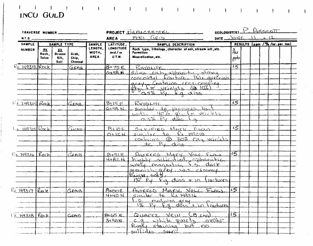
1 1 I I 1 1 I 1 I 1 I I I I 1 I 1 I 1 i NCO GOLD
TRAVERSE NUMBER
NT S
PROJECT ~~ F A‘-k GA-‘ ►q
GEOLOGIST(S) ~
AREA VlA[) ac
DATE ,V..\aF 1 ` 1-2-
SAMPLE
NUMBER
SAMPLE TYPE SAMPLE LATITUDE, LONGITUDE and/or
U.T.M.
SAMPLE DESCRIPTION RESULTS (ppm. 1% /ot. etr ton)
RX Rock, Talus
.§.E Stream
Silt, Soil
Grab, Chip, Channel
LENGTH, WIDTH, AREA
Rock type, lithology, character of soil, stream silt ,etc. Formation Mineralitotion,etc.
Au fP6
4, 0-1q .311), kock 6.,,ini2, 8+-15 E ~~-1,---(o Lx-c-E- L S ' . _ r344S ..1 -4 k ~. Ac r‘ r;c h o1\-r:,r,~~-~r -SA-rnnrt T
`
((nr
k„\rP ~fPcJ1„1~\~,, rpr
ic n1C
iii
/
t V
)r\a
A ~% i /"1 Y\ ~Fi A A, ” f 1 r.... 5 - c (iY - 1 11\,~ ; K-b .,1rL ~ (C{~ 1910 11 -
c'~ 5 A )e .(. cA. ci, ~~.<-.. ~
11-16131`) gcxk Cn4wR 8-t-15 F= E_ ~inLl-t-c - LS
O.) WŸ, N 5.,,s0,l,i,..{ 4 i1 IA c.(,0,l`~ ( ,.-,:k. '; i , r.{ c_-)70c_-)70 n ~ ~ s ( S' Jo ; \c \ -.
C7. rl"fo pv 6o-_,-, ~' 1
.,. 11,1q`2,1 ; P(c4_ (--i,rt RSl, Qi-i- IQ Vi. ~ 11 tr~F\F L1 !-AA--1r 1( 1- Li -1 ,1 L5
0+ 17 t.i 5‘k rn. r. r --\--c-) Q,K krt 7_ l O
COArl. t“, Z.O"IO t%\-,, .1els' \.5.-\ s , iy-_
P1
~ ~S_'7S'
X 1uq~ls~ 006-z, ~Q.1A.f3 e-tl F I~-s-F ~,F ~ F N.C. ~c,-c . ~, r„ ~ <<J ~-1-1-g7 t4 >/\Sin1p i,, ti 1Uf~- i e GA . c-~,~~k-ir ,
~`,l11z y i.,..~
,J\+
c, ~.. ~. c, I~
/~~
~ I~,
` Cç
tJ1\ Qv 1n -~ ~, ~ — l ~iC.!` -'~1.~ •l _ C ( 4'( \ f~ 1[ , J
la SQ~$ • /T 1
"( (aciiic.2.5 rt._ A--).i ç.r
U
~ Cki-_,S -+- .tr1
; \I-1 617)17 erck Gat ,(2, 113+c-x-) e fl-L-r PE1 [~,A-,f ‘L \io\.-L. Ft_o6,1 - LS , I-I i-L-{ 0 N ~ ; ~',-~ r 4,7)Qg 1~~g31b
~ ~•5. rnc(I~',. M c RI kf~ PI 1,~
ar-;~ (Ph . __
o •
_Il{q31S (;©c }2 — ,.SaQAf ~3~5~~ a L ,F1~T7 \I E_ 1n Lt c ~ IS , ?r+qnN C . ~.~~'.~~.~ ~vO,( ~-~ c~--tô/h7`
---,-----
— — — ----- - ----
---
---------^----
, .~~
t4, 5~-a-~r ,~~v.r~ 1~v~- Yr.c~
— -
---- ---- -- - — — — \ t 13 ~i fl j 1i 4S2JrJ

1 ï 1 I
i 1VC0 GOLD 1
TRAVERSE NUMBER PROJECT _ ' )E'11-
GEOLOGIST(S) -P•
N.T. S. AREA c\ (1 C. 2,r)
DATE ~ k ~~~ \ 2
SAMPLE
NUMBER
SAMPLE TYPE ~ SAMPLE LATITUDE, LONGITUDE and/or
U.T.M.
SAMPLE DESCRIPTION RESULTS (p.per_ /% /oz. tor ton)
RX Rock, Talus
..alL Stream
Silt, Soil
Grab, Chip, Channel
LENGTH, WIDTH, AREA
Rock type, Iilhology, character of soil, stream silt, etc. Formation Mineralization, etc.
A PPe I
~ 1I1931a Qt7rl2, C'a¢ra--=, -7t+R7_F rz), ,ta-v-c7 .i. -- it.) ( g: c.rr)~ HA- Z? L J t.,, ~~e b . A.\ 1 it 3 ., v-\ C+ ~.V\-vt
o; ohgoo
14(1321) GQA.R i-o-1CîF 6,4741,111-t C 1nl-r0,l, ...,>>je z5 1-1+nS_14. Paf.t -0r\b',.IN1‘ ç.ck - ,M. ~(e)-/
PA i re-tilt J\t 1\C1-. C (-5,'). ..r., 11r
(~ -c^s~S ('n( ) a 1~~Q
C~l T~ (~. '--;-' '7v n,n..) I-i Clio yo ,j~j~
~ } 11-1q 32) eQc_l~ Gexa~3 -r-1-P~n F (J / w ele/021 at-rEff-- -)j\ k tNF,c V.)-A, (,, Z 5 %tÎ0 IJ OTŸ MI. n,,-,-',! ‘1. \-‘nf , ~A.1y2..lfvnc n,(30;lik T
C CG ( 4t----)r c2.. _ ~ , l w f~ ~~d.l V-7- ` lrl.Gke_ ~.~(~, r.,~ . „„r9 . -, ae b\.~ . 1(-1 .t,-- ~ %%1(-1-t,--
0 , b % ..-k„ ~. ;
ç {r c A U co Z , ~
141 -2,z7 (çRf-I--) 7470 F P~~-F LC EIl,p,~ IC_ 4--;_01.4r 1,-A'AAILJ ~S 2+i7~ N i ,,.ti\rt.( ~ ~fcD , ►,o.l~
C~ ~n_.~
5 ~o ~,./ ci:", ae--. a', (, Li,cA Lc s
11-11:2)23 Qne:V2 G,Rc4s 7-;-(30E P.r 1..rF Ce_v) 4•-~•A-Çxc }-t_c),„1. 10 Q+773 N 5,l',,, c ',-1,. «,*,,-,0_,16(ti-cf,"co.dg k'
(t-4d,r`o,1 ' t lar-(P Mo(k,vr-NeN Ç:j t'' 1 Gi-OL"\S~,~1L ,
‘19.1‘A (~'1i\Rl le
.s,nl,y ~ S
~\3 . n_ s1t, ~.r, ~-~.14-, _
1ÿa32 ~cl~ (~2~ 14-1S l= .41...-rFC~s) I`i~Fc i------; r)(..-3 .30 +
D+f3r) il 5-Ar~ .1.0.,-- ~ --)(.‹.,.4 '-kok. ,...., ~~ \y . ,fMr'ry.o . ,L --`
z1~~.1 ~ ~~j~, k- -3 - —

I I I I
1 NCO GULD
TRAVERSE NUMBER PROJECT
GEOLOGIST(S) '(~ - ‘C\02-4)CL:)`Ç7
NT S AREA 1x90 ('n(Z\ç\
DATE 0 \ k`A.r \~J
SAMPLE
NUMBER
SAMPLE TYPE SAMPLE LATITUDE, LONGITUDE and/or
U.T.M.
SAMPLE DESCRIPTION RESULTS (p.pm. 1% /oz. sr ton)
RX Rock, Talus
3.15_ Stream
Silt, Soil
Chip, Channel
LENGTH, WIDTH, AREA
Grob, U
Rock type, litholoOy,character of soil, stream silt,etc. Formation Mineralization, etc. ~
1 1 lick 32S QcacK G't210,3 . . 7-f67 E ~~o5sr~r.1 ZnNE ~--,rQ,nr .\,. 01-‘5 ~ 7...+640 t.4 7 o~1 S c ..itr'~.a
, ~~-c ~ ~
.~o„n~ coV , GYN.,. t hA-,l , b..3,1-4 ( n(`Y`? ~
` 1~, r\lz.,,~ h r~dd f 60 M 9 i ~~~ e}Q.- q-1- V e i V\S . IA( 1 .,l„c-g14d . u c,Jeak kg rYl C? a`4-; 1- z°~o ?~ .„eN P.g. c„.01(41.
~-
~~/._ {s... .~,tI
lt-t9's26- P.tic,k_ 6,20R A --7-44.7 F C ,f)-r.l ?sD~E , x5 ~Ÿi 0 NiT,rAx.c ÇG 1n ps f\ r) V' -A - N.-. cA._
1 -1Y,11 G%1- +a' .21 1~a3z5- 1:2A,,.-~ Sf4, ? \/
~ !
►icl327 &.1Z 6,a. er.B • -7-k (.1 L , 6. .0 i2 .N. '7 o 'L\E __ [ S 24 t ,n 1J —\--Ye Y\I \ ~ -5c-)..c ~\ `•. cti f 4, )
6, tv„\c-! \„ ~~ 11-t.cvZr~ AAA , ~t- f:;5"//e, ? 1
\tia328 _ kor.k C ti,:, p 3.0 ,,,, 14 h f E 61 n Ss-12.,l•f --7o 1,3, ,L 5 , 1,+r3 D 11 ll \
—1- Y-p~1( Ÿ~ i--t y no t'L. ~ c,_(..n CA.i3t-5 A- V\ f4,)\--,Ct,Q~_i.2casYl' e.., 14S _
-1-- CIAk-c( eck ~ y.,-.0,k ~c.._ \IQ\ c . 1- 5 °c li)y
WA3Zc1 QoG1,2,.. 61~.:417 I.BrYl . -1+ (r ( E (1; c--r5<,f)14 "an,,,r ~S 2+f3o ►.I
r ~~-4 ~,nc \.`
~ -e.• v~-`-, \ a,c_ C _ (1 ~ -1-h~ t1. )(:-.\,-..„ ~~ r.:"_/"") l c t ~ C C ~C Y1- I
— - -- CCe'~=~, c r. +'~; r1h Y' o c 1: J n.._ ‘ - Z "1b T. 1.~ _ ~f~~.,1)--D
a VIt it V jr So tV\Q . L[
_ a- ~ +

1 1 1 1 i l l 1 1 1 1 1 1 1 1
!INC() GOLD
TRAVERSE NUMBER
N T S
PROJECT 1ï, 1=
GEOLOGIST(S) I. r4t
AREA
DATE e 1L ) 1,A
SAMPLE
NUMBER
SAMPLE TYPE SAMPLE LATITUDE, LONGITUDE and / or
U.T.M.
SAMPLE DESCRIPTION RESULTS (p.pm- 1% /oz. sr ton)
RX Rock, Talus
ILC Stream
Silt, Soil
Grab, Chip, Channel
LENGTH, WIDTH, AREA
Rock type, Iilhology, character of soil, stream silt, etc. Formation Mineralization, etc.
U b
f ~
X I tia30 (Zoc12 C,Ii..3,3 s3 —1-4H1F ~,,0 -1,-.-, An1 7,c, t,).c S 7 +Ro 1.1 ired\, ,u. A
+ .-..e.->,.\-\ A-, ç-,-, r e.._,
,
? ~ f -r] ~z y 1I-Vn~7 ~ b! ~-~- --;-i nn~ l i
i (~ °ld T.( rn . q nu- --,5 nFy ,~TCf~ __`~_
/ I,-IQyw kecYL G24$ -[-!-(a e n-'rZ- "Fç.►_D`~~-AC \ic 4t 02 Qts 7nnIF LS 7_*`,:-',(-) F,(
ii 7',(\"v ,- N__, (- -F(>\ o \c\----)~~, ( G.<~./r.,r
lrq,~ ,i• .1'.•\ c- i.:‘ÿ-1~ i, \\.\1:\ 3rAtiA-, .A in
r 1. r.\ -A kr V-- ___IE, I \la < { --',Air i \.. t ,_:\ S ,
~ .
. — O11
l.7\I ckC~. CAC ` In.b`-:A,' ck,`,,..,
y W033Z _Roch G,g.a?.3 - 1+65E Pt t2I-F-f'1= C.\ kr-~kL. \((-, _c . ~S c~ + 1 ~ 1st \'\. , r, l~ ~', / -s i t ~ r ' ~ `~ . ~ c C~ (l c r~'l r-~ ~ \
, . ~«~ k ,,ce ~a.. ~~( F, / ~\-,c.~,-4<<- ~~ r V 3 ~e:,~~ ç 1~~- ~ i s~ c)...
1u0332> eocle_ C'aewg -i455 E A ~-s-FILE MNA F V qot...c . ~S . O+-7 0 14 t..,;, rn a ~ ~ r -1-13 1 `-~ct 33 2_ 1Q.x_,,
-1 r
- (`r1n re_ c}. ~ J e, 1 i oA A f W1O\~ . ~ ~ n. ~ % ~ A., 5~ .~. ~i. . ~
- --- - -- L_— -- ..__

I I I 1 I 1
IINCO GOLD
TRAVERSE NUMBER
N.T.S.
PROJECT 1 ~ ~UC.... ~ ~ V=~ ,: \ 1 —
AREA 1 c1 (.\ Q~~`> GEOLOGIST(S)
DATE ~ LLD\ 1r \ IA- ) ~ 1(~ Vi'1 D
SAMPLE
NUMBER
SAMPLE TYPE SAMPLE LATITUDE, LONGITUDE and /or
U.T.M.
SAMPLE DESCRIPTION RESULTS (ppm. 1% /os. per ton)
RX Rock, Tolus
II Stream
Silt, Soil
Grob, Chip, Channel
LENGTH, WIDTH, AREA
Rock type, Iithology,chorocter of soil, strewn silt ,etc. Formation Mineralizotion, etc.
AU q~b I r
>( 1i-1933W ► c1rS.t„s CaQA~
f( a- ~.-t ~ 2~F ù ~ ~ ~~~ ~L I c~ ~C. ~ ~J ~ t L5 r..
ÿ.~, ~/( (0+25 E
` , I-~+1~, tJ 1~ (
\ 1 -1 1~(\i7~~Â (OA ~
PP\! ~ l\~f 1 t ..e f l ~ ~P ,l\CA~\l~ I
rY~.Qri.O dn~..f_l W\G1C"~rs Al. C C~,lAor~
r C- (-e~c~ \ ~i`~-)v, ~~p o ~~~s~a~( k. o
~.
). ~SS 4-- ~ \ \ e . C). î ,/
'ç j)gi\~,1{Zti il .s
107)215 1ZorYz (2,, (2.12Q3 G, -V\$C tf- L't-F_e, f i\ 6.Y3-ti,r,C C) ~S IA4 f ~
1 ---0, \t~y~~Q-/\ `} i ~ h,l'.tC l~t e (~ ,....flf~.Y_S1L_
( „TT 1_. l
. V. (r l'a V• 4 (i, C`~\ ('‘ ,t' ~C QSL-f\ ~
V~ ~( h
.\ ~ ,t rA ~ ~ ., c { ~A ~ ~111
1 ~~q ~. C~ 3-1- !~,\5r`, ~ ~ J1 (c~ c~Jl, , ,
, ► y~3?>6 pit,.„,, 60..(3 .f~-~-a?, F ~-tFQvF~j ~u~Ç\t \%a~L. 10
Vs e~._ 45.) 2-1 ~S t~~ ~e ~ 1 V , r G -i-,,,A4 r^ \./ ~, :~t✓~\ dv~ . ) 't
It-..“ ~`Y\~N.it~ \L~ c J Y\ r17 1 ( A/ k ~.. {il i~ 1-V ( ~ . . 1 ~
bn.Aris (6, a f n '%1- ~/z`
y,C>' r~ 1,,
4.9 \ ~~ , ~ v~C4\~`\ c. ‘..1"V., \!,! ~u C A LP,` w
v l • _ I • ` ~ ~ . .A . •• •' •
1 II-11631 Rock C~aP,~ ~J -k i ~i E ` ,~ ~ÿ L..-#'-E(Z F I.1~\ AF \C— \l
/o, r . MOO
, 8 k u . . . . . . ` . . '
,l~~ ~5 . , \A A,ls (1, 1L'i," h(bL1 f\ k-,,. V, ~`'~~ l \~ ~
1 \ it >i i o1I) ~~ , ~ fb Cktr,', (
-1~~- ~,oC.12 ~ " ~,~
Z ~ u ~i ~- ~~ 01 ~ ~S ~ T7 ~ ~ Lt.s fsr C,v~^ oi-n1t,1 'IA ..t, . 8. ; .1 . • . ► . . _
~-. ~ _ ~ 1111. • ---1- l °n 65-
~ ..
,
O

I~
I 1 1 i I i I I I I I I I I I I_ I !NCO GULD
TRAVERSE NUMBER
N.T.S.
PROJECT -E4(-1 G1--I ~-
GEOLOGIST(S) - ~~ ~ 1\
DATE \1.V1~ i.. t`f rl
AREA
SAMPLE
NUMBER
SAMPLE TYPE SAMPLE LATITUDE, LONGITUDE and/or
U.T.M.
SAMPLE DESCRIPTION RESULTS ( pm. 1% /oz or ton
RX Rock , Tolus
~ Stream
Silt, Soil
Grob, Chip, Channel
LENGTH, WIDTH, AREA
Rock type, lithology,character of soil, stream silt ,etc. Formation Mineralization, etc.
A-LA
?0?
1< 11-1tN39 Roch 6,11Prii, rVMIIII (-4i.-r-ç_cv,- 1 C-VA~~~.‘: ~
? ~S.
O ~i-2`1 5 11
s ~vy~ \SA T D `0\~ n'`--14-')\'\
~ \~~e QÎe,~r - ~`,\n0 n.1\'- ///
P-{.v.~. (.\ -% v+^‘.~~
-K1~jj2 tQf-Q G\,y~n \f V 1 , iJ. J, 1-2° %\ C1k ,► 4 ~ N \I ~S r - 1 C %\.-. \ ✓ Y\ ~ r~t: r , ~n ~Y~ s k f,
•-br- y.( (k-i55 ,
.•$ 1.-1qQ-,tio Ÿ,06z Gr1,..Q . 3t-z_DF eFt, G(:)n,P •t'r) 7 _RA.,rt(- ~5 0+15 S Pk., "k- 1?...( kt-“\ .3 R
-re- - 1.°/b ...f dL\ ~i t 4 ~ Ilr„1
>< \''AC1H k B \`? Gast 4 1? F A 1--1- .eÇ IN is-A tA-F t/ \jr,t...L. - <5 ,ak-[ - ~NjV.RaAP,LY -6i k,;r t Ç',a (A 3\n ~J~,
~
~, i 1 p,1Lp r' ,eyh-: ~-L~l- k r
, / cr r~~ \z; ~ ~ _
t)~ - rrr t;,~ I. ~~ Lriljt- (l~L~1~ t.] ~ ~ * 'r. ir
1
IW1392 i~txYt %.Q ,9Z) 3;-2"Ç E (N 1-`t- E 12„E-t) I.Atiktc 1L 0 4 L. - t60
14-601.1 rab -j~(Qvi~~s (K~ IHg3~1) la~~- ~ _ .
P.,1
1961343 QooZ_ 64.g.4$ 2+(2r) t' Ka d.,..am (",•R r~ t_r,..)€.il C., fl_h i'>C-1) LS - . . . ' 6 ' .. ~I , • • - - -
Di l \ r ,4 . erj, ‘,-)R (17' V.(w1r ..L\ , P Ir\
/)\c rh Ck ~, vv\ (r; •^
, j~. l ~ AAO4 ~ ~ i A c~~]L2 ~, w ~ r` —L°~~ / J
, al3 i-19 _ocb —__C,414S 2-\-`1ro~ L--1~~~ .\
1`.-4 1;F lc_ \14,t c . 45 _
1+- Da .a— ~
h I. a ouc_t /A .. . .. , c._ , ,.0~ ._ , ; .~ •G~ r VI ;~t i ,C , 4~ i
•,_.11., - CC,Ir> t c; tri r, ~it.`4 1..L „iP - 't,/ -17,----17,--
~ / - ~ Fo rn . k.~.1 ~r ( n G`t .l t-v
— — — — 1
~ \ ~ ~-àt- —

I I 1 I
I I 1
1 NCU GOLD
TRAVERSE NUMBER
N.T S
PROJECT FE-tc'tu (x A t.Et
GEOLOGIST(S) ~. ~~~C.O~~ 1
DATE s\ ti 1 ni F \CA 4r 2~7
AREA V\° o a
SAMPLE
NUMBER
SAMPLE TYPE SAMPLE LATITUDE, LONGITUDE and /or
U.T.M.
SAMPLE DESCRIPTION RESULTS (p.pm. 1% /oz. ter ton
RX Rock, Talus
IA Stream
Silt, Soil
Grob, Chip, Channel
LENGTH, WIDTH, AREA
Rock type, lithology, character of soil, stream silt,etc. Formation
Mineralization, etc.
P y
??1' 7(._ 14g?l'i5 Qo31, C.Q..A.R. 74 -",SG cJ3, C'r.,f 1r)nn~ ~--e ~o',v~ l,1i (vr,), 4 b 1
9•+00 1,(, i v1 ~ r,.1.l,ra . 1 9,z-1 ?c~' ~ . ~)~ ~ g'~ ~o
144Vilo Zioû2 ~1-14.6 Z-0i3,0 F G,r~tk l~en C34 r7S ~
~L.-rF,2 .,1 - rJl
r~ ~ n1r , r Cr~r
Vv.~~.U T
K.v~ ~tY\ (~ .a, r: v t~ ~S n,n ~~ a r, e}.i ~ 1 0 1
I'lLe3 t.....3 vs: p.~\i-N.gfx ,L Mr->d,,,( a ,l 1 t Ma U &ne itic ,
-FY - lYr% Ty, e-A .,--A. 4- 7\~\tr:Lrofot ,
( 103H7 ?oc.12 4/-4%i!) l+ -So F 4\---VER~~ ~VaÇ,c_ ~r>< < . 45 I+F,51~1
• b~{.~ n~1 ~~ 1'.e- j~.Palt A- rnrrlorr,l e~
t 1r, o •rv, (--,_1 N. -~ n,l ) 'rid is A~1 r L % .,n ~~ y.~~ , c c) (.1 ~ çl~.u. { C11,1`Ac. s > > ~ t r +rC,~t
, J ,~ 1 ~1 ~ j' ~ ~ c c/J\. i~ ~f f? v-~ ✓\ ln r ~
1 f - 10/
V`1 C~i<.1 t-- i +n 1l~c~Vfti
N1...-~rF e
.
~( D i`-A.v; F 1C- Nic,L.L• ~ 1Wa3~1 S 'R.-,rie r~Q,c~a 14- 3 6" E 59oo 1-V• qD a r1 b 41 V1 AA-~- .32 ""
~~ ~~i _C.,
Cl ~ ~ .
110'2Y-14 LrIL G ro~j 14- 2 ç .__ f: ~~ u KA ç t c___ V O t. c._ . .~~-c 20 1+-to 4 r..b 3~ 1Kc(?)47
T,r- 1~ 4 Y./ _
IiirLi5D "~,1,.x4 61cn.‘') 04-c1R E n 1..-rc re l\ As--} f Ic_ ~o 11120
-- — 1 -47k.__. ") ê . • . . • c~ av1~., ~r„r — 12~f-~ v crA rx1-,11 /4 locn-1 • )
-- -- -- _ n.~. __ ~ ~X. \ ~ 1 ~~ ~~ _1~° ? fk \S-~~(nc~~Q t'.~tjv1 — ---
--- r
~ ~” ~ . c, ri ~r t . ~lln~~t _ -
-- ~

{ I I I 1 I 1 I { 1 I
{ i ivCO GULD
TRAVERSE NUMBER
N.T. S.
PROJECT ?>--AL-\-1,1 Ast £&_
GEOLOGISTIS) - ke-,Lr n ~r-
AREA lqc (-) Get
DATE ç % 1,4-F ZD
SAMPLE
NUMBER
SAMPLE TYPE SAMPLE LATITUDE, LONGITUDE and/or
U.T.M.
SAMPLE DESCRIPTION RESULTS (ppm. 1% /oz. per ton)
RX Rock, Talus
5.11 Stream
Silt, Soil
Grob, Chip, Channel
LENGTH, WIDTH, AREA
Rock type, lithology, character of soil, stream silt,etc. Formation Mineralisation, etc.
A-LI
lib
,y( 144b51 e.cclz <0.1'46 14-?DOE P, .:1 Ffa_c:. J((< \ ft, u- /G.,c(-,f--{ n 1`Ib0
-,i k. c1 ç- a + \%.% tIN t ',(- i ~ l
(-le- rk,{ / r.(j~t'- t c J -p
f. 114(17&2- 'Oct GaA-, h4 ,. , C1.1.11,1:1,..-.5 -z.. -Ni \‘.\ ( 1 O c_w,) < 5 t-l- 0 Ni t ,
-, I,.., A o
\)M\\ v\ iv, V.

I I I I
i 1VCU GOLD
TRAVERSE NUMBER
N T S
PROJECT 'v F PL1 c4AST-F-C-
GEOLOGIST(S) P- TT~SGU~~
AREA lctcr
DATE c,uÇ\C_ 25
SAMPLE
NUMBER
SAMPLE TYPE ~ SAMPLE ~ LATITUDE, LONGITUDE and/or
U.T.M.
SAMPLE DESCRIPTION ~ RESULTS (p.pm. 1% /oz. per ton)
RX Rock, Talus
SX Stream
Silt, Soil
Grab, Chip, Channel
LENGTH, WIDTH, AREA
Rock type, litholopy, character of soil, stream silt,stc. Formation Mineralization, etc.
RU
~~b I
'4 141363 Rode. GAR t''' 0490 r: (4 L.rr-~_fl hka~,e. \Iv► _< ANA c_ L5 ' 2_,t 6L3 a P,- 4.r,~~: ~ "5"\-Cbr\i \. ‘-'7A AC .,1,.,X , ,
N.4 d~.~ e.A y ON t ,.)~Ÿ-4n f.Prk- bco, ....\(‘....\(‘
çU • ./4. a& . I ' ► .. I
. Y~ F1 r ,P ~►~ nt
~e S L., b - C c~ y el, i e ~ ` S 1V~~1p ~-? 4p AN.` t X ~rtÇ .~-i NI ~ ~ i . T ~
f' ~ 1-2 ~. <I,\~~ ~Cac~Cl, ~
~~,~5
~ \~‘\1lGc_ ~,p C4,-'j ~r~\O,nnatt~Sts .
1~936~1 Qoc IZ Ca rah n+7(a E ~ _~5tL \t.1Tl2Ll 4A1~(E~l. JO ~ ~ tan NI F ~,,~. ~r v - rPhd,~~ ~ . c
`1, 1
v.~,.\A!' , %
} . ~r,~ ~ cSnSpo,(~ rnr-l~ ,~,),`~ Vf/. '
~J'MG ; rn-vnoC ~ 1»,:.`0\19.54,
1~~ Ç . ?1 d"~5 -
14436s Rocl¢. 6ra.4a 0424 E (1lsefç GizAisi eâ ~ Q n~~► . 5(o0
1-F61 S 14 v ,-1,-{) .i 0 G,~~}v Y..~ i~ - r~ (1A. Z,bv1 /4 O, ~ n l
, .J. ~ - ~ml
r~d
l. c3 n~i Q~ ~ f , ~ t'2 \
(1n~Aa,c.O r- -A,
( / ? t . . dA51) t rarl,nlc~~cs
Uu 11{4 356 2oC,12 G,aAb 42.CI fl1_-t Ir. g~ r) V.A.0: c_ \intLr . ~IAr-P,rn Ls
1
1+g5 u p ..) 21( \Wg363 M~nnr NI-6 i'fPrvra,/lCh ..iP.l Yl`4l'S
C O r\\-Ci, (\ c -41- C ?~ ~~J1
-,-- ~ Tr via - J P,f e.-:,5.54.. ',,~ ,,,Rl‘ 1\3 ~
1ya3.67 S01.6,6 GarE el______ 6+15 E_-- ., Pi~.Tr{z£1) Nlrt- ~ c_ YhLL 3200
riC _.5.4-1, ‘i-55..1%1 __ r , . .. • - .. t • • . _ .. ,.. . •,47 ( . ., ~d,
--
-- ~ r-
- - -
TX. - nr\ - c~ G,r~ e,y ~ C- y„n/~
.,~
~ ~!~~--p~ ~ d,'.~~ - -I ,,,\ -614', v\c~Çr •-•- ;~~{a

I I I I
i 1vCU GULD
TRAVERSE NUMBER
NT S
PROJECT '. C..(-10 c, Acs, L. AREA \Gqn GILtt
GEOLOGIST(S) A-e+-T-o-Tr
DATE J( Q \~ Z
SAMPLE
NUMBER
SAMPLE TYPE SAMPLE LATITUDE, LONGITUDE and/or
U.T.M.
SAMPLE DESCRIPTION RESULTS (p.pm. 1% /os. per ton)
RX Rotk, Talus
ILC Stream
Silt, Soil
Grob, Chip, Channel
LENGTH, WIDTH, AREA
Rock type, lilhology, character of soil, stream silt ,etc. Formation Minerolisation,etc.
n AU
0 _
Nei 358 TA-wo, ~az.a~ _ D4- S E SI-mgszE ~ IJIaFAce V o3.L,ia►~~c .• 15
s.sb o, _ j +a o N. A-,, vi Zx kw4 21 ‹ ~ 1 — 2 Yo . . ?Y SA ,•,sS
. HA 359 Roct a12Ag_, 0+7 S E C: t•i-U012 t-t- •G41-1_15T L5
Q+25}.1 25' rY,n t-, zr11t r%1o ri k-ir. v~R,1k- ~rol ;r~c.d ~Q~ ~~ 19°jo ~~~___ v:. , . . . ' ... L.c:V.ed
. . . l „c4:40A 31oC)~ S 2 ,
P oo ~iz_. AN.
I Ki3(ab I n.tik. t~a¢.~( Q+46 E (A-t..-r QF n MIA-P tL \i t> 4.G . L 5
..,1,o/i e)-+ -.c,.5 A5 *- Qx ►tia~s -~
t-~~rQ (N4.5 / ok-i----,s _
N9Vo1 gocÉZ G9,4.0) , 0466 E. Pt %_._--r -, t•Aw-c:tr_ ID L • . '~ ch-+5n 5 .At,. 4 X 1`14353 _
1 I r Pq tA, , \Vl ihr(t~ 0.(OIiJI (A A ~ -a ~! e a YL 1 ~ 15 !
► -
--- I
}--.1
r
--- r — -- --

AREA «q13 GQ~n N.T.S.
Grob, Chip, Channel
SAMPLE - SAMPLE TYPE NUMBER RX ~X
Rock, Stream Talus Silt,
Soil
GiZprR 1L1(1362 QoLfz
Is ~~rtu5 6„b9/~
GIzffi3 Ih} IiaSF Cr4~~~ 1+75 5 As tze. vA,4-)36„s
>>e_ï_In\6 -ir 1J1a% î
5
1 1 1 1
'NCO GULD
TRAVERSE NUMBER PROJECT -C-)F,at1Ck•k-et'bTE ( GEOLOGIST(S) Pk. tZ.c.--e-'Q~-T
DATE
LATITUDE, SAMPLE DESCRIPTION Rock type, lithology, character of soil, stream silt, etc. Formation Mineralisation, etc.
(2+ct) E.. A tz-v_g_v h G,iV?,Rk(
\-11-uto rvv"). '1\11A-i< / ,
v.)/ ~1tilt.w► /n,.,n1t..? coeŸ-,n,n MCÂÂuM i % Q~--aJV ~)Q~+~~ t.~1~ '( T. ~,n?►~.f
cri sS
RESULTS (p.m'. /% /os. ter ton)
ALA
~ 5 _
LONGITUDE and / or
U.T.M.
z
oa-[.,sE P4 -raP„_el Ç-~ G~$ec~ / ~a(c . 15 ►+77 4 4j~~~ ~I 5i (. c~~~~(a rnrc,i cr
/pt. ‘10(c_
rvll►!'A r~~ Kilt C___, a~~ 4.
~~ ~A . c . ~ \I ~.o~ YvSgl1 ~ L,M fP ►/ lJ/ S~ ~ r,~E'~ oS £i o rv~ n . r~ ~
/1S
(v\,r‘ e~r V (~
~- P~dt~r ~eàr.kc,is Tr - 1o<0 1~ .c _ ~~/ C~,~S~
13 1
~ ~ a\~ 'o~,
i? K Iy 41363 Ebck
aà•ik` ~~nl.. ai~~-• -re,lcc.0,74 %.'l
. ~iv~r -}a . ~
a +ck_S
1 +(Go ,ZIAL -1-
Gtuke. Ric kliQM05 1Zoct
SAMPLE LENGTH, WIDTH, AREA

!INC() GULL)
TRAVERSE NUMBER PROJECT i,c_WflI.,I F L
GEOLOGIST(S)
AREA MO O G e-- ~
DATE ~ U
SAMPLE
NUMBER
SAMPLE TYPE SAMPLE LATITUDE, LONGITUDE and/or
U.T.M.
SAMPLE DESCRIPTION RESULTS (Em. /% /oz. ter ton)
vi Roek, Tolus
s Stream
Silt, Soil
Grob, Chip, Channel
LENGTH, WIDTH, AREA
Rock type, lithology, character of soil, stream silt, etc. Formation Minerolizotion, etc.
A u Wpb
ili9 3C,6 Qw-12- Garry n
11-0+ 55 v.1 Ç . (T7 - Fa A~wr N~a= 0.1 \ go'/R< <5 ?, +1 o S 9 0 Yr,n t ..~ ;dIL i " r.. c (Z. A-14144-
,,. J L rei Qrs.lt I r 4det t=.1,.. cars„{ INA -Onr)r p ('1 A¢ 1 T~ - 1° .4-~ t'. ( d'....-$ _
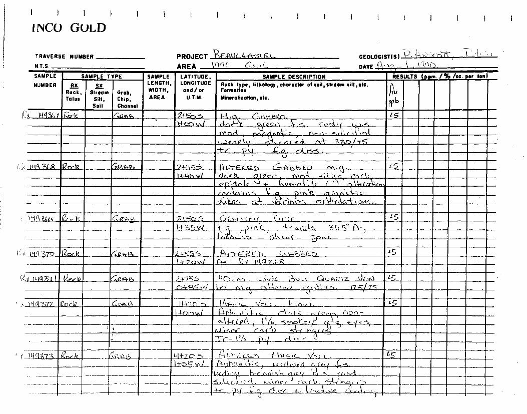
I i 1 I I ► I I ! I I I i I i I t I
1NCO GOLD
TRAVERSE NUMBER
N.T. S.
PROJECT 4-4q(-kl 5t
GEOLOGIST(S) f~ ~ ~ r"1". ,
AREA 1(1r ~,
DATE ~\,' \ \ ,
SAMPLE
NUMBER
SAMPLE TYPE SAMPLE LATITUDE, LONGITUDE and/or
U.T.M.
SAMPLE DESCRIPTION RESULTS (p.pm. 1% lot. sr ton
RX Rock, Tolus
IL( Stream
Silt, Soil
Grab, Chip, Channel
LENGTH, LENGTH, WIDTH,
AREA
Rock type, Iithology, character of soil, stream silt ,etc. Formation
Mineralization, etc. pp lo
: 141367 ;; t (aar2.As 24-:":i t-Ar-,I~~-',e,~. l s-
1•+-00 .(~~ CV .;2x1 C,,;,a..4 t ,_~. ~; ¢ Y~~1r)r% Ctnr. nQ C rlhr'~- ~~A.r 1t~.P'(1,
t ,.._ art)e l,.( ,,,,7 el r-e ri rx-k- I,.3tV7 S -t-e- .
?>I ç f). ,---A •i-s
!yq?)C,R fZaca2 ~CZA4, 2+Kç3 Po....t-e. 1-, <-7.-,AF.i=SCO rn-c. ~5 L+1-(l1vc/ (jl f. It -s,l ',cc r'{~a!'i) { ~(F~c.n
pp- r1l 4.0 + l'tszYy, rt , g ( ? ) r,. la-e r~x•l,r,r rnr\~'.nt> ~q.p.kr012,_ , cAlf.k,k--.7%c
(--KA sz.4, ri kin r' . ~tti.Z-, o ( f>AaTLeviS .
\ LA (,-,G. er,„ Y: 6 - 74Sb:eD (›.,r,ir‘c \>>tcc.. ~5
1-t?, -)\nI
~. ~ ~~ " c-l. -4-teY1(~., s {- -
j1',nlL i
i1i_1•-, ~1,,, s ,] L.i c --Ep1h).
L~i (1 371) Ror 12 4:e it+(3 224-~.Ç 5 A-LT6=` _257 T. (,,,,a-,--t--4,._(-) 1.+7oW f)S RK !liGiZ,6r,
:x P-1q3 I I 42enf.)? ~0a24-13 ?-0.5 yrir .;_krk`s i?-)Lit-i- C,1~ras~ 1 Z- )~ 0 L~
()+ f~S .r% ~ ✓l Oil c:1 c>.,`+-cd.A. Q r .1 ~' c~ t~ . 1 ~.~75
\`ia'2)77 i^oc12 GRra !H->>0 -~ Ikr--.1 L V # c . 4- ‘--.Ô,,,.1. 15
L li-Ot']µ/ 1-t0'[10 t T iC_., cAr.i_I 1` r r'c,4~ ( \dr\- L. \ '
ç-"1 r - , 0.1 4 -o c o cl, l '/h 5 ►Y,n1Lc , , (
C ~--r I YVA.c 1 &-Li nS:1C- n~ b~4 ° -rc-- \ ld
•f~~~ r~~~-~,~ . ~
lti9~Z3 ~~r ►Z ~z~~ ~- I~ ?~S— ..Lq5.Yq
'~I,>- e-~~K-~> f Ag ~< < . 1 ~ ._ ~ P421 r»C,A1ç) I..scil;v.sA r~ie,.( ,~s.
i1,4.C~,ti~~ },res..-11c~\~ ~a , ~. (v ~ n~k. ~1~'_*
-----
r-
I ---.-- ~\:Cs ~c(
(k I nCcr~n( rc.
r(1). -54ii+~c~. .`~
— 4 ~ ~~~ ~ ~a~_ i(~.r ~.)(~ L~ c,~ ~1 . , ~~c~~\

i I I I
11VCO GOLD I I I I I I I I I I I I
TRAVERSE NUMBER
N.T.S.
PROJECT FEE= LIC 1-11-i --,`r f.L
GEOLOGIST(S)
AREA r‘6.0 ( to
DATE P„r~
SAMPLE
NUMBER
SAMPLE TYPE SAMPLE LATITUDE, LONGITUDE and/or
U.T.M.
SAMPLE DESCRIPTION RESULTS (ppm. 1% /oz. per ton)
RX Rock, Talus
IL Stream
Silt, Soil
Grob, • Chip,
Channel
LENGTH, WIDTH,
AREA
Rock type, lithology,choracter ofsoil,stream silt,etc. Formation Mineralization, etc.
n lA
A' b
Q1C iNr{ r37 Q t r,:CtAze, 44--( OS a LI-v-„,„__1_:_;, rA,,,,v \c 1e-, t__.c__- - s 1.1,-Z4D.1,/ (-1-5 ----73
T',r 1 v ..0 .Û
pl ~5-4"1, \ l a rk ol.e r 04 _.. ,
Rtc 1144?,-7Ç pP y-k-5ô i~ 1--p r_G.-1 {.11►3v<< \/r> ~ - ~5 1~4-k5~ \1,~q art_r h ,--,► iov~ r,nnrZ _ -Stil~cs 'rPd
M ~(v.nl% ,M (~~r O `,~~ 4 w f1 n ~ r'r. d b `2~-1 t v\Cl
1% ~Y ~t c~-....5 ~{vr~,li4, rntk`!-,nC~
IuG ~ Ib 1~zY}2 00.AB ,1n-1-n.-',
S r ~_ ~~e~ n j~ ~,L ~p .
14-1-(s- j[X i4-.., Qt 1,44-2,15 air- yl.,, i nu, ti_ -4A:1. l I , <
r1, (4-) 1.-st? -4.e a r 111,6 C24s- 2/F7f7/R ti T~- Ib/, f V ri 1- ,`, ~-(Go -1-,lCe ('oG\-'„nSl. r\ 3 L
ç 1 in 377 >2~ Gc,A I3 A-1- -00 S ,-3 c_.-z, 4^,1 ,rk>ï v u t i i_ (7},- 7 V f- ti, 1 CD S3 Si 7 15
14-4ov./ ~ ~ I A ç/r-.C'Iu[O4. fv1,— ç
. • f c4ÿ„c .
r r C 1J-16M-78 2 k /iik, 4r1-gOS _tut Ic, Ynr r_A u1L 1~
14-q6 vJ q,ç .c._. r-Ir.f k Le +-: r-, (1,r,ci.1~L,✓ c.~ .
<)r s% n ~~
r ` - r . 1 ~/ pt-, t (ac ~,i~F
' Ç het ,~ Y1 c~ r ~ I ~- Lk_::, r~I„ ~~ u. (c1,• . •ti ~ `
-
1a3ZqSrriC C14P-~-2 ny-Ein---; 1i) .....-r ir c.i v.> 1,-1+-4 ç vc- Vr-3 c - 1~-<gSvÿ 0.5 R)(14-K12,75 '
rn •t poi r'. cC ~~ 1"\---s~~-r't ~_ t -Ir -~.~ r,l '~~~'~,
\14q -2--:Sa k (3,g...az._ g+~~s 6 .6.L— __L*
-aI~~f,s.E.... , v„ _11,-,,c 14. ~ ~_~3 - ~ n, r { e'(J
~i ~}Z k '•(
Ik
/ .~(S) C5-~1 C 2Ck -ÇA-r.t ~ , i ~ C ~\ P r~ ) -- -- r ---
_1,~1 rtCL e K->', a n ~Q 1 r'Vs r?"},, Vln Or 13 -k r - 1'J ,
--- ------- -1-r - I% P, ( ~ ! ,s

1 ivCO GULD
I I I 1 I I I I I I i I
TRAVERSE NUMBER
N.T.S.
PROJECT ~ "c' .0 1 Ç-L—
(~ .~
GEOLOGIST(S) 7- `~r~~ n ~ ~ ~' t `•
AREA lctcUQ (\C
DATE )' \ 4- Z
SAMPLE
NUMBER
SAMPLE TYPE SAMPLE LATITUDE, LONGITUDE and/or
U.T.M.
SAMPLE DESCRIPTION RESULTS (pwn• 1% /o:. ear ton)
RX Rock, Talus
çx Stream
Silt, Soil
Grob, Chip, Channel
LENGTH, WIDTH, AREA
Rock type, litholopy, character of soil, stream silt,atc. Formation Mineralization, etc.
n /411
Po43 1 ff
-I< 144'281 ^koLk_ ~izS‘f4-, F'rv9oS 1 Nu, etL -t 0 1L)- N- . \ir < < . 5,
1-4-7?-,vkf (4-0\r.+:0-\ C..., I`A4A (t~t p ,I rr,t1I .tt1•--,
V r. rk) -4- "r`i Yl. - ~ ~~' i i n r t~ ~ ` f ~-i-r rv1< r,.\ ~~t "."1(- c i l,p~~
IQ
r-( ~-.'',
P\(
'A IH(l3Rz~rrYz ~x4-'fl4a, ct-4 70.5 (,-Ly (.-- i_r- , , i,-~ i-1 ~ 1c— V,-,/ C. l5 1+Llb~/ (`1 0, t ' c ,a ,• ) i 1 c>t . Y s c: ~; (
,r~ ,✓. 1 ~y ~t,r 4 --..~;` 1: ~. ~ .,F s. ~1. l ~ ~. . .1
r I ~ r-~ t u , . r ~ u ~a n-) .~
V. -,1-~. ~ (~< l t ) ~.1 , i~n9A r~f-c , ,,A, ), c' p00 tc
l ~~ ~ ~~ r ~ ,,4 c rr ,~ ,~,. cl~ ~
C~ 1 ~
r 1t-1q3R3 Co( k s:;(,n , - 2, 1l.}70 1 Lî ,.F u 1A,_L, lc_ v!a,
14-1{O.1v1 (5( , P.41. lyc{" . S-7 k) A- V. S'~ c tn r
9-- j(f -.1" ( eilc1,-) 1-e G~ I - 2.:70 ri-;s5 PY
/ 1-Î()i,311 S2-0(12_ /
{S3- "42j 5 t" Lc: s) 4 " 1C V[• i [ lat)- ',,1z1, 1_.aL i1d,L / ,1i6't 1J
to+5o\i(! Gp4,-ûyA àr _42kc.4 L r'( ,_ .~ wir 1.f
' ..:, ( '4,c,\ '0' II d- cti\k-L, ( fo F- . C~. nÂ`l ~ Y ~ (r C ~LL4f ( C2ci~ ,rlt. ~l/ (( J ~
41 3as: TiAa 5 ig.a.5._ -2,4_15.5 f-) L_Tfc_._b RA{ 1C- V_b_t_
+ 07ovt/ ~1 \- tl?e__ r n- i~•
~ u6of
~ 1A~.— ~~-~,1'~,~, P A,~ ~'1\1,1
p ( . (-3 C4l-v--6 (Lr^,, a % A f r ~„6) . ,1'la , —
~~i _ ~r ±2 ( w ~ L-r-f ~RA-~- . ?i ~i-GO 5 ~ e e_.ti 1-4 i9 F 1C- \I(. 1.. C.,. _ <S -
---+ n4-.210W ~,~s~( 1i~1~,ji~4 - - -- ' —r--
-r-

1 1 1
i 'NCO GULD
I I I I I I f I I I I I I
TRAVERSE NUMBER
N.T.S.
PROJECT 1-"F E4k- 1 (
GEOLOGIST(S) P ~r `~c ~~'
AREA (tr(r ,
DATE (\ -1")
SAMPLE SA
NUMBER
SAMPLE TYPE SAMPLE LATITUDE,
/ or U.T.M.
LENGTH,LONGITUDE SAMPLE DESCRIPTION RESULTS (p.• . /a/o /oz. ter ton)
RX Rock, Talus
5A Stream
Sill, Soil
Grab, Chip, Channel
WIDTH,and AREA
Rock type, lithology, character of soil, stream sill ,etc. Formation
Mineralization, etc. l~ 4
Wb
4 IM, 387 Vex- k' Ca • Pk-i--1- V=- t, M t4- IC qc~ I C. 15 h-A-~c-m4 P -, 112 i 1 UQ`~ et-,
f 1,-.38,5 _gc.Lik (;,'g N., -2,4-7`~, 1`%Ç1t VLayL • 2s
CD* nvkl apl, -An( lo._ (3t~tj nr-7n m&c.. rio Y\ , r "5 I 1: r ,4,n A , P C,I.,--,1` [L~~ 0eklv`VS ,s,-4-kr~ S~lop y
_ tO62_1?4_ nkin1r,V1.
( wq381 Pe-Nct GQtQkg 3-PRO._ (â_.~2T-P,rFÇ) r~1A; V \/f., e . 2 5
O-i-1bvv/ ç-
A \ ÇlC,r,~ -..Q ~ ,~ • {r cl ~vr.1 ~~
‘r ~~Y~c'~C~
~rr \ 7 rV~C~ /v1~C ~lT Î )~! , o l~~
j YS t ^-., ~ ~ , ~j
r\ A-- tE,~'l3~ I T r ?NI/ OZ ~ ~:'~
►1-I.y 3qn eiock , 4b 3-4-P/15 114Lr ED t,--711-I F,L. \io, c . pn--,<iln1y s‘ tAer_i,,_ 15
cn -if--fl va (41---,\,\a ,A Ÿ
- 1 c *-~a ~ r t' f v"' mr~ ~
, ~l~Ai ,l `Qf/'\ , ~~ ~C
6 ~ . CD . cÎ~ S ~ ~ C.iJ (r C LtiG ~~ ✓1 l
PY As r ~1
, ~
( 1-ci3a i_ ?Q le 0.~~ 3+\ 53 3 rnnl ,") 'irlz_ -. .A\k(( i~-s-z ,J~ .µl A5 ,_ii`i-(~1p% 1~~ ~1~ t Q t~C~ :c i,7,r,a-.-::&l., !{
t r Ze r d.c ' 0 b l c
-P4w52, 121A 61 IA4i '5V7_st,rj TRE N C-.\A C1 ' _1•4kA- ( I C-- sib t C . 15 -+S
h Ce/C %\b ifa0+4;3:ÇQ r,a.rL,- 0.1 4-e [o rii Ca.1„,_b ark t t2 r
~ q rot ,A1~ ~t~~r, Y~raC1 ~
°l )o ~~ ~ ~ ~; sd"'
_114qM-2k Qj-,k _,G111333._ 4-1,-.2_,65 cJ tL,c \F\Ft, ~I~F`IG_ \IDLC . 45
— — , C'} 7o j►./ II
S~9 r 3 GM w ,~L -fi-~-r. -', ~1 . - JG NS) SAD 1 n. nkv,,(gr%cil-,\,c1n 1< 104.-5aJ I- (4., o4- ► y5i.1N-,~ __

INC() GOLD
TRAVERSE NUMBER
PROJECT P& c-4-, s EL GEOLOGIST(S) ~ ARt./-r,..
~ Ii ~" r'
N.T.S.
AREA IC14( C t~t1
DATE AMC', 3 SAMPLE SAMPLE TYPE
NUMBER RX Rock, Stream Grob, Talus Silt, Chip,
Soil Channel
V1( lAa°Icki{ e
~x IN939~ 12n etke,
SAMPLE LATITUDE, SAMPLE DESCRIPTION LENGTH, LONGITUDE Rock type, lithology, character of soil, stream silt, etc. WIDTH, and/or Formation AREA U.T.M. Mineralization, etc.
p N.) li~, ~ (-no, pvr,sp,-, `ka
11.4q Al
4-a t..tcd '► 12-• 41-4
tC14iV. L ` ~+ n f ~ ~ DA" n.çAYcld,a-kn`trk
~FLAW f 'i I taP „-L , -r„ aG
RESULTS (Rpm. 1% /o: tot ton)
Pp)
S
A5
7 4:-; S 0+70 v\
_
y..Ak
co-}-7,r v►1 , V ;,Q% ~vapftrva6--,1-\ 1,4 ~~ , ~e rtclh ro
T~~t+,.on C
1`/,.- I r .~~
`-- M► ha1r p~/" 1 A ( tf
~Q?-/ ~ r2Q1c~rJ6
T ~~ i +!1 ~n C
Q x ~-~y ~ S
44
4 meiNt3 c
I►,l.g31 y Crc_AN~
►~.~ mq t9R (Zc)cJc , .C.~-
GIL-1-F}5.s Z-riELS IC Jo Zi-Z.Z V./ Pi-One n d~ .C,~ ►AAA-L.
,}- ( o (
5 , l;tücr~5, ~ ~1z~Y %r ~ ~`c~. ~[ar~t Tr - 1 % ‘~~ lax~ s (2 c~- s A~
1 O -6 , s, ~ Vs_u_r_ 7+4 Q+el ,s.Aaci - ~,-(- 1,,,,~, ut
.5 . lâ c 1 ~ ~ c.. V2- ot ~ A-,r. . ~- -5 ..p~{ a t, i- 17r i~`r~D ~n L,r Y ~l S
e- ~~~ py ,
~: ~. '
Zf -ro SS __ t`A rAa tc Vint r,Awl 1 r A_0,, dg (12- ÇA.to°+~ 1 ~d• ~~`i
_~-.~k;; ~__Si l► c; Wed, d ii,p00,,r ,
_ trpvly~ ,~r e,~ 1 q~-N R rs~ r: 5 7)
h~- •— -- - erl~ Q p, dlfl 4 ,-~ ~ C,O S e 4> - Un~i - A py
--- 6-63S) aS~sGtiC t.-1/t.-1/G4J Zd,~e
~ ~

! 1 I !
'NCO GOLD I I I I I I I I I I ! I
TRAVERSE NUMBER
N.T.S.
PROJECT G-141 IC * ~ —L-AREA PA c CAS►t
GEOLOGIST(S)
DATE 4-t-i1n I4C11.1
SAMPLE
NUMBER
SAMPLE TYPE SAMPLE LATITUDE, LONGITUDE and/or
U.T.M.
SAMPLE DESCRIPTION RESULTS Ippm. 1% /os. Per tool
RX Rock, Talus
Stream Silt, Soil
Grob, Chip, Channel
LENGTH, WIDTH, AREA
Rock type, lithology, character of soil, stream silt, etc. Formation
Minerolizotion, etc. RID
r I4434R e rnpm, 6,`i_5-0 s EIcr VOL.C_ Fr_~ A5 Qtr?c o~ 1. 1A L 1 i 5 Y\ 1 F ~✓ 1 ^
1.1„. 3)~. . LI? fily S (lkc lbt) ~ t..A FA, — k1. tA-Ve 4\bw V(GcLtlo
k YI" j 15•a51%, tSLIVl j I
X ' 4 900 ter h, agAs y+-hn S A c ‘c_ -to \ wt-F,Q M. N I a-1_,4. Vb Lt _ 5 4-24 V./ I> 14 1.k1 IA YQSLA- ray
` • •.. • ` • 0. u V ..I. v , • I
orrric6ifld gren./1 g vkor1 IN ~7~no ,nrxc,r y4 _ ü -re r l~l0 94 4 vvy (c, _01 d,5,-,
•
r--rt

i i I 1 I I 1
'NCO GULD I I I i I I I I I I
~ .A~Q►E I~`~
~{or
TRAVERS NUMBER `
IS N`I(~ N T S ~~AS I~~
N Z I~AS S
I
SAMPLE
NUMBER
SAMPLE TYPE SAMPLE LATITUDE, LONGITUDE and/or
U.T.M.
SAMPLE DESCRIPTION RESULTS (p.pum. 1% lot . per ton)
RX
Talus
_S% Stream
Silt, Soil
Grob, Chip, Channel
LENGTH, WIDTH,
AREA
Rock type, lithology, character of soil, stream silt, etc. PbRoek, Formation
Mineralization, etc.
~N
Pt b Torn
,~}g GV
PP rh
Z,n
?1'''‘ P P rh
A- I tniIOI 'r fX.14, , I' Q 340a E rnn NZ0 <S G) GO 2o L 2n
. Soft) ___C7t xL ~ti t,~. ar.- . iftl . 'a ~~.t..' ~R
y-1(1°i11o2 Rock- 'Gob 34-v~fl E, CrfD <s ~ 4.22,0 2 y o 4 2a
iln+ ``
f y t'v ab~ ~c7 PS yo r
,- L-111103 GI 60b 3-foo E C A 1313R 0 <s L i 190 bo 47,0 a 4 6e40 ' yv ~ LI
J i ,► o ~ r o ~A.•.n /~,14~ f - • ~ililk-to-
A 1,-P-1911011 KocTt (;fab FiPic,. ~JOLCA~UtG ~ FL 46 4.1 zio 90 4.2.0a -+o
'14"
E
~~ 3N ~ ~~ - .~ ~' ~
~ 7 -3w..w ~~ ~`~ j-2 ~i ~~ ~~~ d.~
~ ~ ~~
(- (ti°jtlo5 Qoct Grab f-Of, E 1(14Fi(. OLC MA( ~LocJ ~
~ 41 90 10 L2.0 6-
le $ fi iU 1 - Zo . . . - u ~ A
~u~ ?' ~A► 1, • tap ,ps d-.,j
X- (`rittcy, o ~f~ ~ 3 fdv~ _ ~-~ L ~lo i C ELOc~ S5 4 ► Go » Lao 7~~1. ,,,, ~j-rl~ at~jl ~y,' I ' 0 t g2a/4 1114,61,,. ALL
4 ► l 2 1 1 ~. . 1 ' .. . . ~ ../ 4 . •,- a, ~~, Ay À.
! . - r! . . cvatecolit) '
•
w
GEOLOGIST(S) 'J Q . ~'v' ~ /A•- ~~~ u/ ) DATE /ti ZWIX.
PROJECT
AREA L 3.-tœ p moRTN (DP rtl, S+a i3 G3ERuc 41157-E L_

TRAVERSE NUMBER
N.T.S.
GEOLOGIST(S) h1 frAsvla A' PNE'v'' u~ DATE ((0 `Srk NE•-
SAMPLE TYPE (ppm. / a/o /oz. Per ton) RESULTS SAMPLE DESCRIPTION
Zn Pb
PP M 1 P M
f}g CU
v-b PPM
Fab R. ~1(• I~fl4o~b 6p 4►O LZo 4S
b,X-i~l`1`~D4 Qa k G
Nx. 419 Li i
I I I I 1 I I
i NCO GOLD
Rock type, Iithology, character of soil, stream silt, etc. Formation
Mineralization, etc.
3 OAFic. Voi.~ANï ~~ f Lc7t~) 46- L I i on 60: Lzo 8-000B~N } a~ - 06. w • ► . . ~ ~ . ~ n
LATITUDE, LONGITUDE and / or
U.T.M.
e 's IC
(itn4)4a.o
teo E OI1NK. Of-i0 f.3c)lÛ
F.. F( OCC~V►~. r~/~jA o? GS Z. leD Ito z- 2_0 N ~ dank. ~, ,►e~. • ~ _ ~ ~l+~µ- ~-Sa. . ~ ~
(,- 2 , 45tSO 5o. ~-7.c~ I- n,a. 11 m,~„t
PO
~a. ~ , l~~ ~
~ -~~ cG ea £
~ n 60 co AV tiA. :
h
3ôE —10'c VOI,00iG flou) q+ 6,9i0 - c(04. , ~,~~ . Awe
d _ __ _~~=~~~ ~ ~ ~b
PROJECT x-nuC- S 5
AREA I_ 3tao4 ,noz- i OF TLs-+O0o
,45 c) 3ID L2D
SAMPLE
NUMBER
4Iy91lo1
RX Rock, Stream Grab, Talus Silt, Chip,
Soil Channel
SAMPLE LENGTH, WIDTH,
AREA
Ro ctAb
~1 .
é d+ ~~~
ktiaza

LATITUDE, LONGITUDE and / or
U.T.M.
Rock type, lithology, character of soil, stream silt ,etc. Formation
Mineralization, etc.
DESCRIPTION SAMPLE ( p.pm. / % /oz. per ton) RESULTS
Au A c3 co,
QPI) ~~M ~~µ
<5 41 9 a
Z
PROJECT Aur.\AST E 1, AREA L 3tovo , 11)02T41 dF -sL S-0 oft)
Zt °10 E. A l tE-12E.L (1. F,'L VoVt AA1;G FlDw ?, jD+0610 h„,-A- tsiiim, \ :O Ai. 4%04 ~.+r. 2.1:11610j“, , ~~. v ~ ?APOo~nan.r.,
~9Q< ~.~.. ~ /Ilk&~ _
PjtRIr, Alb c S LI 100. 10a L2.0
2410E. Gg (W. ra '
l; 100- ~~ ~ ç ~- - ~~~+~~ ~~ ~ x~ AM1~ OC) PAP .
` ~~ ^n ~ ~~~~
3x-11-1941q Roc k Gra 6
2fo0E 12a .3OIL)
(4-4 -~1(~4 gbck Grq_b_
NUMBER RX 51. Rock, Stream Grob,
Tolus Silt, Chip, Soil Channel
Iif t1IZ Rock Gra)
SAMPLE LENGTH, WIDTH, AREA
Rx-11-19Lii5 Lk, G ruk <S"
410 420
GEOLOGIST(S) R--•~5~ ~`` _A- N A. R ~`m DATE Î~
~~r 4 _1~.lNF—
L5 2~.3r2a2__..~ s0•!.
,, .>L r.
3 a~
2+0DE 1L7-,EgE
I I I 1
1INCU GOLD
TRAVERSE NUMBER
N.T.S.
SAMPLE
SAMPLE TYPE

I I I i 1
!NCO GOLD
TRAVERSE NUMBER PROJECT IlEAuC14 FIST EC
AREA L 3,c - NORTH O F -TL S4ocati N.T.S.
SAMPLE SAMPLE TYPE
NUMBER RX
Rock, Talus
L
Stream Grab, Silt, Chip, Soil Channel
r treb 9,1,I1_
Rx- ► y~~~& Rod
Grab
416,0 ÇLi
Crab
Gra
Grnb
eA r.
~i0 i/o
~ ~ ~, ~~ ~ . ~
3
Z 4..3o~ . NRE-(1,' ~ ~ b~~.v !~.. .~- ,
RlaoEF ~ /CUM) F ,-
► ~ 11 ~vN ~. crib
~ Q
11,4424 10
w.~. ptikim) r'ot 0_,S6 .
a~L
GEOLOGIST(S) FRA5ER-/ RJ4u(.) DATE 1'7
SAMPLE LATITUDE, SAMPLE DESCRIPTION LENGTH, LONGITUDE Rock type, lithology, character of toil, stream silt ,etc. WIDTH, and / or Formation
AREA U.T.M. Mineralization, etc.
tt~E, MYl DuLA~ jhAFIC. doLLANi[. FKJ(w) ,
».xu ,.. 8r l' r~ , ~,.c~ tit14, .
ri ,.I~x~U
.k ov E c_AN I( . f trx.J ~~~~ o
l }~ N ' ► e o • ,w.trl Adt
' `''~ PAi4~ : 1-2►,.....
~ ~ V / C1
i ya fAlD. C~e.liMt‘ 43
I WOE-, 1*lC Litt C AN) Gt to 41)/ Tl1Wo 10A)l n~-!t..
t ~~
~~n~ dm~ ~
4 cf:thi.
RESULTS (p.pm. /% /oz for ton)
G5
< 5
~ ~_
(6141r112Z I~_k

PROJECT P-Iflut, OASTEL AREA I- 34 ont. ~)~~~ oF TL S+oa1t.)
Rx-
a b
LATITUDE, LONGITUDE and / or
U.T.M.
Rock type, lithology, character of soil, stream silt, etc. Formation Mineralisation, etc.
SAMPLE DESCRIPTION
1 1 1 I i 1 I I iivCU GULD
TL-I<D E, i A- 1 1.14--on) 1 ,ir Alff,l 4.r~iQA.< ~ ( n r ~,~
t:eYëri ~ k AQ► n
~P1,w It,.f . Dr. will,. 1r
Awl'
-kvit4A41&~
I+ SDE A~
t~.P Jv1E}F;C. UpLCAN~ C. 2 (G,t9D1V ~ o q~,u„ ~ ►. .... S:•
~>L 2'f? no~,
ck;i,
+ So E. S*6onOc~tizt AV:
(hoc p.ao
~
46 tin AR
d~ •
RESULTS (ppm. 1% lot. per Ion)
I{ 2.5 E ALTtra. ucx.c.AAc-
Sai — r ~ ~5 ~, `~~ ~v 9&--
JA- pio ~ cioth ,
+ 1 E atli -r Z f9o/0 x E-
~
x- IT-125 &tar
f7PI1711-126 14&D ae~?' ► 1 i Q7 iU Apittts crtnia.)
# 9 ,
4.5
TRAVERSE NUMBER
N.T.S.
GEOLOGIST(S) I,V'c f-g-/ l1 . er NAa~~
DATE 11-2o -RA NE- SAMPLE SAMPLE TYPE SAMPLE
NUMBER RX DI LENGTH,
Rock, Stream Grob, WIDTH,
Talus Silt, Chip, AREA
Soil Channel
t, 4-ILI`1gn 7Q~~~ Nuifow

SAMPLE TYPE
Rock, Talus
Roc K
Stream Grob, Silt, Chip, Soil Channel
SAMPLE
NUMBER
2~
SAMPLE LENGTH, WIDTH, AREA
x-141430
Rx- tqqq31 RacJK
Rx- ly`iW32 eck
RESULTS (p.pm• 1% /o:. per tan )
~+ ~o ~ Arab Q~tF c. VO(.cAIJI ~- /C1zo f/OA1 - a ~ 1 ~ `°' >~ ~ .. ~` ~ ~l
~S. ~°~1~~C~R
~~ • '
p S+ 2D~ H LTERE( %im.
n.~ ~ q ae 1~a~N
1D'~ ~~~r~ ~`
i trs % ~ p.46 d Am roAr.)
1
1 I I 1
I I I I I I I I I
1 NCC) GOLD
TRAVERSE NUMBER PROJECT ÇE1LLC.. WASTE L N.T.S. AREA L. 3+ooF I NoRTN 8F T(-. s"+vo ll)
GEOLOGIST(S) N'FQktg/ A. hob~
DATE 24 ~NF
•••••
LATITUDE, SAMPLE DESCRIPTION
x.(q9 1129 ~ 45-
Ls"
LONGITUDE and/or
U.T.M.
Rock type, lithology, character of soil, stream silt ,etc. Formation
Mineralization, etc.
3+ 2oE MAF,T. U ~I
.CA 1►c. FLoJ (14 3/ AJ n daa ~ ~n
g
A ti
/,n~e. i s% inor Pa~-,l~~qvkit,
Jn
,43 Pln /~ • ~
a
A
3+)g ~Mic huAR I~iL V mi-c., *gat) ~4,11? oe,-
~
P~ ~a00 1-s%
~ , t ~~ f1S1tA4 ,
Wû .~to?,
14{~~oE , ANic, o j C (~
+ Solt~ ~ d . ~ , .
H~c, , x SE ?
A4.4 7' 0 l. t ctia-
d.a2N

GEOLOGISTIS) JR F/21)SOY ~ gErtmU L DATE ZD MINE_
PROJECT 1E-hu cÀU\ -T El--- AREA I_ ~4rcoçz No2.1-4\ ?L DO /0
SAMPLE LATITUDE, SAMPLE DESCRIPTION
LENGTH, LONGITUDE. Rock type, lithology, character of soil, stream silt, etc. WIDTH, and/or Formation AREA U.T.M. Mineralization, etc.
Ma-
54SoF G~ssP,n) iD a 2 o n) -5 7.~..e~ -~,,~„
~~lio ~~%~ ~} `c~~c~b ~ -`)/c, V
z ~
Q .ti s
~A~►noa . n~~# ~ s ~, ~ - ~~~~~ ray
~XI49if%, iLk fin AI. 5450f_ 0e.72.,ItF.iN ) r7 4 ZOO x~ cA•--
c,Te-t.n' _ r~
'. 1.1+
f24/3 ~ •
stsoE Gos5tto 01 Do _ ~ m,., ~.~ ~x- li l~ r(3t j
, 09 c I iS •J ~ )10~.Dl114
45.
1
iit"L\ l►.ua-
— --r------
I I I I
i I.vCO GIULD
TRAVERSE NUMBER
N.T.S.
SAMPLE SAMPLE TYPE
NUMBER RX ,~ Rock, Stream Grob, Talus Silt, Chip,
Soil Channel
Y-- 1 1-19 /NI Tzt,k : , anti h- .
RX-I1-19435 ~~k ')J.ka ~.
RESULTS (p.pm. /96 /oz. esr tool
cc" N3/ stsoE- GAi3c3?-o Nay In t 2.0O
1)4, F.46
Y- x- '438PFOY— stS0F,_l ~ _.z ~~ ,(7fi2on) • :t . : 1 • ~ + 4
tAJ. alai%
~. Qcl f; iFCC.~-~ ..

I I I I
iivCi) GULD I I i I I I I I
TRAVERSE NUMBER PROJECT .AUC VAST) L N.T.S. AREA G 3+0.oE , niOR~lt aF 7L co)*o
GEOLOGISTIS I g.FRASEg- / A, KE(uqUA u 20 `3NE. DATE
- a~ .
~. .► u: •
or ton) RESULTS Ippin. 1% /ot.
• ck ara
•.~.,. •
- •~. .__
SAMPLE SAMPLE TYPE SAMPLE LATITUDE, SAMPLE DESCRIPTION
NUMBER RX ,- Rock, Stream Grob, Tolus Silt, Chip,
Soil Channel
Rx- w11-1S9
N4,
LENGTH, LONGITUDE Rock type, lithology, chorocter of soil, stream silt ,etc. WIDTH, and/or Formation AREA U.T.M. Mineralization, etc.
tc4-)F U(' ~LA~ R-F;C. u~I ('RIU~(. ~
~f?n(li ~ A ]aD
- /s
I . , . 14
' 0 I%).
• a~oM
,
°~~~ l>d i~ l al~~. . e
T Y~~ - ✓
■ti~ ~ ~
o// ``„~.,,
-` 41A
.~~ L. ~
— ~ -~,~T2 ~rt) • , % lî?!~~ — 11! . ~ . *
A__•: ~
ctu
&IA
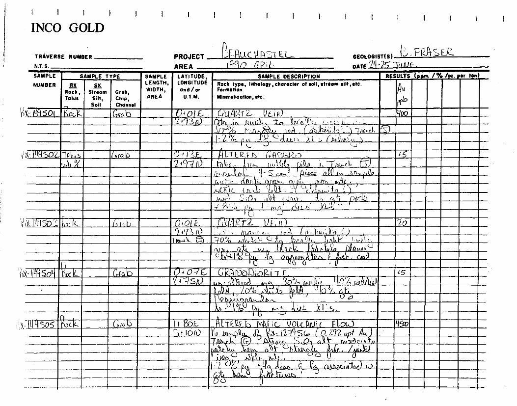
TRAVERSE NUMBER
N.T. S.
PROJECT AREA
GEOLOGIST(S) 1 ✓ ' I FIUPt ~
-26" `ira ME- DATE
_TAU(lahJï CL_
i INCO GOLD
SAMPLE
NUMBER
SAMPLE TYPE SAMPLE LATITUDE, LONGITUDE and/or
U.T.M.
SAMPLE DESCRIPTION RESULTS (Rp+n• 1% /os. per ton)
RX Rock, Talus
.ELI Stream
Silt, Soil
Grob, Chip, Channel
LENGTH, WIDTH, AREA
Rock type, Iitholopy,character of soil, stream silt ,oft. Formation Mineralization, etc.
pU ~
X- 0iso1 Rock Grub 040lE (x1u Ai VLiti) Tyoo 2+1:3 0 , ~~r P:1), , ;;: ' r .--r , ~ . . . ()~ i,, hta1,`~ 1r> Q
>r )A r•': .n , noa~ ( ii~i~:-~~' ) -1ne.. e l,, ~ )r L ( n
- 4 ~n .y -1 ~ld r.i :~ ~ 1 ~ ~ ia ~•M' N~'~ , ~ ~, ( ~, J - ~ ))k - V11502- rtAI1 Js ~Gra b ~~~~ 3~. p Li ,~.IZE r, (~ N~ ~r~l~ 1~ ~5
,,.I, / . 2 r~ n) xn~(; ~~,t,,., J, t t1~GC~ fa, n 1,. `r~..~ 1~ - ~ t fe ~.• ~ r. , Q r ' t ~ r ~.. 3 l~ c2te C~~~ d.... 1,.f5 w l ~ ~o
- (if)Ji 1c._ f Rll2ti, Ott '„ rin, - twiG -_Atr , ✓
'-(1/1,,,z,;„;r ,
) i ~5 J `
n~~fn~~ (~~It ,~~ ~ ~~„ ,,.~in ~ /)
E.; (~~r ~,Di (1~f ~;~nr~r. ~~) t~t; ~0d~1.C)
7 • ~) f
~ io 1 e}. 4 1+, C', er~e -~ )(1.---_, ~
~ (..) ...;
))1,11I 115ni, k,, iz c9r,lii 0 0 E. (i'li~q1~. fil, tl~ , r~) 20
~+~~~Lili '~ C1 ~ ~^ n ~ . Y~ - L(4ti, ~~. nr •. A ~ 1«,, n • )
~..r~ 11,. l-~J 3 0d/o M~: ~~Iv (--)~i~ef1l~~1, ~~t~~~ 1, \.;~.`,i‘. -A (9 t w ?~,~a. iiJl n r ~Z ~ P L An
fr
~0(~ 11
~~n~ ~ IQ (ltà kq Q1~~~0 ta ~ . ~~
. ins, /,'„. e_ cri-Œb 0f o~E 2
~ G DC.7(~i~('`i -t F_
~ . I SA) ~~ QJ{5~~10
ppo 30, ~n.1L~t ~ ~ l~ 14 -l~1`~lC~ J b
- 1~4r~ , ~ '~.\1,, xo ))0M . ~ ~ ~
. , r, Q~,, 0 a
k , - . ~ ~,i~.. ~l ' s . ~~~ 1
1~ ~
<< so5 'RDc k GrG VY '+ Bop_ AL FP~ ~:F• vo !~ I. 3i IpN
1-1932
-- , ~( 292 opt A~, ,Q _1o,,pi . ~ X1
-2:a9(... n. ).0__1(),,p1. .__
~ ~7 , ~ (~ ,~, ~
~, ç O ~ ~ Am-00)11, ~ ;
, , . ~. .; .. .~~ . . ~ _ 4 , .
~ A
_ - - ~~ -7,„
a ~ ~ ~ ~,~A~~) w. -- -- — ~_— i .1... . .•+_ , '.
-------------------- ,

I I I ! 1 I II I 1 I 1
INCO GOLD
TRAVERSE NUMBER
NT S
PROJECT 9 iAt l C II I\ L.'L_
GEOLOGIST(S) f r r``
AREA 1990 (14:).,11,:,
DATE - 3 NE-
SAMPLE
NUMBER
SAMPLE TYPE SAMPLE LATITUDE, LONGITUDE and/ or
U.T.M.
SAMPLE DESCRIPTION RESULTS (ppm. 1% /oz. per ton
RX Rock, Talus
çX Stream
Silt, Soil
Grob, Chip, Channel
LENGTH, WIDTH, AREA
Rock type, lithology, chorocter of soil, stream silt,etc. Formation Mineralization, etc.
Au ?PI'
K- I rI ç So (o ~~oc. ÎZ , Grc, yj i{Px) E, ii LT E R.Ep ilk, C. Vo L ,v, ( . 5~Q 34 IDA) ~A,+u`QA ti • t. . f1 x- p( SO `~ s- --ram?l
I - Z. J/o et ~r` (45.b n 4 ~~o1C i ALP) 4-,-) •
~• rw—• -' .Cn01CI-0A aA 4 '---
k- i ll So3 ia ~ (,r ID a C.1kinV1-r F. :_)C N i'i i ~5
~* 10A) lo c,v _ tnxt ' t~h.-s. r A• : ~! I; 1n (6[J' \ () 11An~ C QDI. . v pID o, ~.dna.s_ Ci .P , l
in-1 J/~
~~c~ 441.13,0,41A . ~ n~~iN .
K- It-Frsab ~~.k G rob 4 8 (,,,, L ik LTEQE b GDWo ? ' (100 + )O0 _DnrrAoA. ~„s~ ~ (tits y
I • cio`aZ ~ 00- jAl~o rQrn1 ~
3S-.1‘. 1.1. - V(o ?a3 -
ALT EzEp GitLt'zo
(- tit Sou( Rock GrGll) , D a 8 5 E I~N 2 { ` ~XAA, ~~~, ~x~~~ • .~, o 2 a f ,rx ~,~~~ c~% .
AAA) »1)h a j~P f ' r ~.4.~
. . 9b Jl n r.~ pu. r.~~ e,~n~ X et, ~. ~,.
~
,1j1~
1 ~,~v " ~~ L ~~ t~Ah.D L~u A Q~1 ~`~..~ 4) . k~~,~,~.~ ~~o~.
~ ~ c- Insi il,x,lz r, v., .> n~c)- F UA~~ -1~
' O ~ GI ~ '),,,\111„. ~ ~1,~, , 1 ~.~~ ~r,~. ~ ~><•. ~~a ~,., ilA• . 1,. IAA . kn 'i
• lo F.
11 ► t ~ r~ck GfGI~ o a ~~ L 1 ~ R . L s —
p ~ 1-41\) . ~~ a ►, ~ . . 1~~ _,70 --- — 4_n ~ ; ' - ~ . -► 3 . - -- - -
~ % • _ L A t S I, 1'1 + , r. ,.) A"i +~A
U

I I I INCO GOLD
TRAVERSE NUMBER
N.T.S.
SAMPLE SAMPLE TYPE
GEOLOGIST(S) r2)' r"~J E-2"" 25 - 2-4 aIJUE_ DATE
Grab I49 -rcl~5 %
o+LIS Dt 3G,S
Gtab -
PROJECT 4-nu E. L. AREA IT\ r,12:16
SAMPLE LATITUDE, LENGTH, LONGITUDE WIDTH, and/or AREA U.T.M.
aid,qlnZ c1E 11) `lnu,,,e1, }~~ ~ ,~zi~~ ,~~.n~. ~Q ~. I~A~4 h P n~
U+11SE. ni 3(7s
Gos c,A 10
~
1300
D -+ `I s Qi
NUMBER RX Rock, Stream Talus Silt,
Soil
Grob, Chip, Channel
Sle IG1l.tS
\)41"
0+ `Y-1 D-ri3N
©4 L)SF_
r)i3(„5
RESULTS (p.pm. /% /oz. or ton)
PU 13136
S
2o
VX-149 512 Rlx
SAMPLE DESCRIPTION
Rock type, lithology , character of soil, stream silt ,etc. Formation
Mineralization, etc.
`...~ ID u,,..)
A~PA N
~
~~ ~5
DD1~inLcAN~c. /6746U2.1)4F.,,7
~6l~ IJ~~•n. 1„n P..~TO ~ x G e k.. ÎnU.~.t~Z an V (~-AQA 9 it, 1w-~~~Q
~,~'K'n %~ UP.iti.,~.
R >9 fie.) ALL,./)~_ s
O R-r2. (Vt. N ?) ~ x• 7s^R. n nAZ
54,
-fitT~1~ l; r~r~p 111~►t>, r, ~ , ~ [i~
~
a.,,,~ ~~ ~k-, E . (' .~ /- w.
rP Ybt i) A
pr~u.s. F
~r .;
9 ~~n ~ ~1~ ~ ~-~u 3 S J '
`-' ~ ~ o,~n~ ~n~: ~
ha~..~ n) S ~ I n r~ 4 I ~/a ,~ .~5 'd,h,a ~ cP'I ,,,, rtit,n .

I 1 l I I I I I i I 1 i I I ! I I ! I
INCO GOLD
TRAVERSE NUMBER
NT S
PROJECT
AREA
(.:.i41u C GEOLOGIST(S) ~ ' " r ~l:1
Iq90 (;Rb DATE 74 7U11-)
SAMPLE
NUMBER
SAMPLE TYPE SAMPLE LATITUDE, LONGITUDE and/or
U.T.M.
SAMPLE DESCRIPTION RESULTS (p.pue. /% /oz• per fen)
Ri( Rock, Talus
SiX Stream
Silt, Soil
Grab, Chip, Channel
LENGTH, WIDTH, AREA
Rock f e, lithology, character of soil, stream silt,etc. type, Formation Mineralization, etc.
il u
0)6
,X- (i{11SIi Ta us Grah r)-+ 116,E I M16 LI. IV F iC. IIQI.CANiC ~ I I~
1.5
-+ ~~tiar)I~
~ a n o
allor~, ,Dül \. r' CAnkt. • , 6~ ~~ t
Q',Ga~ ~,. -2_ ~...„~ j, i~ . ~ . ~.,
0-i- Uco aI . -~~ .~>~,,- J ~
~ , rit,
rh J i ~~r,,.. iv, xi s ,,--- F ~f~ ,~ ,.►-,~
~ (.). /2:4-n f1}.J1, (Po 1,l'1ri ', ,ll~
11 J L!:.
X - I1I151f3, ock GAL b4 ID E- .71F717o ~ 4 5 (.'. (,),, e 1 .A.
` Ji1. J. c AT. I .
Ar)1~4mi D ~~`~ nork . .NN. ' n 11, ' .
. . ~ ll1I11
_ C, /v 1,,t c. ~{~ AAA Yi . S . -T/1d.•ci.- 0 , (-2..P, ~ ~ cI.tn.o AAA
l- Îq s 19 Talus 6 m b 04 1 0E_ GV l'42, n ~ 5 kA,- % 1 -+ Li 8S .1., 1'01)A, ~a~.~ iro AN ~..1t~l~. 6)
I -2~ % 0 y U n.J. - S r,w; ~
cC_n 41 1111d
Mkt . ► 1 .l•1 1.... AlliaJl~
.. c- •' -ih. ..__ •
(- IifiS20 RnC C GraiD 04 3 5 E f1_? Fu_.-b iivFiC. UQLCflNiL zs ~ 2i -4.s S 4~ . ,,, •.•- : E. t . . l : • .
1 ( 1• • J~I • mar,. ♦ I .•
01 . ._ , ••• lb% .71T, - Z •' V
~• ~~ VI , 1 . . . xn N'7 t.) .
..(11.Q.
.
• J ~
t
i

I I I INCO GOLD
I ) I I 1 I I I I I I I I ) I
Stream Silt, Soil
Grob, Chip, Channel
Rock type, litholooy, character of soil, stream silt, etc. Formation Mineralization, etc.
SAMPLE DESCRIPTION SAMPLE LATITUDE, LENGTH, LONGITUDE WIDTH, and / or AREA U.T.M.
~ (,of_. CT MC.I~ PA- 1149 521
1nCk Y)x-11-lci523
oC,k —77,1 6 6(71-qcrTit
TRAVERSE NUMBER
N.T.S.
SAMPLE
NUMBER
PROJECT 13U c-tk kST IE U AREA 1c t0 GRAD
GEOLOGISTIS) F^"SEia. DATE 27 - 2STCLUOP
RESULTS W.p.m. /% /os. ter ton)
Ru eeb
SAMPLE TYPE
RX Rock, Talus
1<Yt-CCi AzFb ~I,TF~fl ,~F;( uaf.cAN~c' n ,i ~ A
ILbm p ,,,. - Di ~ orr.e A An~ ~Ao,►,~
RD
/ ~
~~ ~ • _ j
~ I~f~A,~ , o y lYw1C ~ ► t , (11~ r
D+FtF 34-9 C,
A.oM ( ~ 32E,
c~+ SW
3Z>ü y+S'W
plAF;( — o All c- ~``,J~.A~9 a► (X21.. ~~nR~ h~EZ fY~ nnn A ~` , -~~~ea M~ ` t ~~.t D1~ ~ ~y
R 4 /`.n../~ I. . Q~1 . A ~ 1~n• ~u ~-~nA..c , PEoi,;,.n p 1.1-0
k' A 0A 4A6),
~n ~DLS. ~ -0
~~
~4~~ ~ ,J~`,, p~ ~ ca.~~
o~... por~ ~~Q~ Las ',~.~ ~oer.~~ ~. ,t,1,312 c~..lr. a' r i , ç T
~ r. . 4_10q.. A.1:-\\.4-4 ~~ ~ ~ ~~~~~ 0 ,
cL_t, Ac lu4O aitt
LTE-KEh 1/ L
~
U
J
C AAA C- u,..34,2 Kx- < <(9` s 23
tc k L5
AL EIZEb û~R~;c, ~ioLC ]IIUiL :A,. ~x- I 119 2 ~ ~ (nm
•n5L . ,c2~ev . 'S
ZSo
1)17G.S

TRAVERSE NUMBER
N.T.S.
SAMPLE SAMPLE TYPE
NUMBER
ALC Rock, Stream Grob, Talus Silt, Chip,
Soil
Channel
SAMPLE LENGTH, WIDTH, AREA
- Iya 525
Qa,. 119Ats I I ~AlAt ,‘3 ~ n~ ïtt. ~~k. 6
RESULTS (Nun. 1% /os. ter ton)
Pu P
b
3sn
c s
15
pm7r) D, n
f nT . f Ati,11A,a, . 1-7 Ji„ b C-3
Rak 1q962:1 (;1-c,10
LATITUDE, LONGITUDE and / or
U.T.M.
( + ~~ E. - ~{a-70
'-1 4- 8(13
G"4 21/ E. 1-1+ k)
n RR`r 2l U-C; t~ - ~-4IR 2 Lill. cLAs>e, U , ,.
U.2 1111.tt^
1~
4-►(1952e 6,+ `SZ-l~
~ I11~$~ -4o
KO 030 / 5•J, 7-
`1l5?9 jn1(a5 G~~b ' _ _0,4_4 ~ 24 5J S
IzZ. E~ I 3o '/on^~~
~ ~ .
c.~,9r n~ _ l.l: ~tn
.,, _
d; ca l -.,mAr.l ly-~-
__As;) MPRti Ml c -~ r -10,6 (;,_,,a
e 1~n
I I I I
INCO GOLD
SAMPLE DESCRIPTION Rock type, lithology, character of soil, stream silt, etc. Formation Mineralization, etc.
ALrs.f4E-I') UnL( An)i~-_ ~ o DI`, n~ ~ n d ~p
U 2i,.,A 1 - 7, f w.~ .,11,,Jk;1 to • '11
PROJECT %1F R I-( C i~ ~ ~~ EL
GEOLOGIST(S) ~ ~' r"~ '51-R-
AREA + rri o (Ri-t DATE 2 Su NL
. c,
~ fLED ) t Gi
„..1„. s; Y
(
s;(?)., Oo
.~C o,
, M~r ~
~~ ~
~lyl• • Ic'~t,~•J♦
~~uAfz7 U E; Ii.) ~ A111 110; PI, a~ kx- I 'l) 52G,
SO /:~V 3- —11A. ~,ua ~ir.h
~.~ _0, ,114-z. ~S,~l. ~ - nrv o
;r Rx1cl97.yg
i
IA pa, c.)
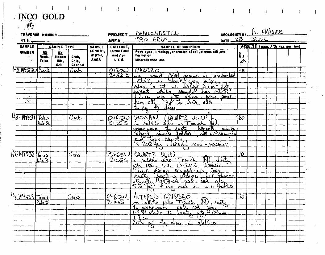
0i200 GABfw-o 2a 52. ,
r
G rab
LA a
JA.
G rob
- lit.414.1)4c
1 5 4). 11o•ra
I I I t I
INCO GOLD . ~tr
TRAVERSE NUMBER N.T.S.
SAMPLE
SAMPLE TYPE NUMBER
TO ~i4s 1~3( 14%.
Rx-114953o R~Gk
Rock, Stream Grob, Talus Silt, Chip,
Soil Channel
t t I
SAMPLE LATITUDE, SAMPLE DESCRIPTION RESULTS (Dim 1% /oz. ter ion) LENGTH, LONGITUDE Rock type, lithology, character of soil, stream silt, etc. WIDTH, and/ or Formation AREA U.T.M. Mineralization, etc.
PROJECT aA--Ptu,C-‘1, AS ► El• GEOLOGIST(S) i* ' 05 ER- AREA 19,q o GR b DATE ZS '31..k r~
PP6
Vx_149533 T4`U 5 C~~rab )`1...4r °~
(31-C,S0 UF ► Il) /0 ss~ nalVo ~ Tn4r r~b. ~)
0 2'/ riQ~~ir _. , e ,~
~~9ao1~~. ► • A.b.a .••••-. W .C ~
7Jt 6,51.J LTE D G U3U.fl -► L` i i _ . .► i,
IA M-aL.3- 9 i . Ir
t--1-:2--" A . 4, `L
R -11-1755z11.5 G rat)
~ . r, Vat

I I I
INCO GOLD
TRAVERSE NUMBER
N.T.S.
PROJECT BEAUCAA STU-L-
GEOLOGIST(S1 ~ ' / RI S~
AREA II%) 6g1-6
DATE Ii SraL`/ qo
SAMPLE
NUMBER SAMPLE TYPE SAMPLE LATITUDE,
LONGITUDE and / or
U.T.M.
SAMPLE DESCRIPTION RESULTS (Nun. 1% /oz. per Ion
RX Roch , Tolus
Stream Silt, Soil
Grob, Chip, Channel
,~ LENGTH, WIDTH, AREA
Rock type,litholo character of loll stream silt etc. 91►, Formation Mineralization, etc.
U
Dab fix-11-14531- +alun Arab -' 3E. ' diLT ER.E.
N INTF,2f NiA-rF (ANIL, ZO~
{ 05 I V )1 J 1. 01A~ 4,...(npn ~~
 5 ORltp allgDw.. ✓ltiCALAal • 114r Aar; jhn.t . (- 12.1r- r rxAri 0 nAr.•~
~_._..x,.~r .

l I I i ivC° GOLD
1 I 1 I 1 I 1 I I 1
i TRAVERSE NUMBER
N.T.S.
PROJECT Mk 1057E1- AREA 11 i/ERTicAL, 6614's
GEOLOGIST(S) F"" Sf-k DATE /ss~ 90
~;x ►y' S3rn
RK- I495 31
pAGi71✓
R~ , 3113
M
IV& A[.rE1ZEb ►'Ici-rE.- ~1i ~MI A , ~ . . ~ ► , . . s • o~ Q Q-t,,..
1 . , .I •r 1.
.011 MM_ ., ~ , •
~ 1 R )(- 1117ffla- ~
0
WW1. it
SAMPLE DESCRIPTION SAMPLE TYPE RESULTS (p.pm. 1% /oz ter ton) SAMPLE LENGTH, WIDTH,
AREA
LATITUDE, LONGITUDE and / or
U.T.M.
Rock type, lithology , choracter of soil, stream silt, etc. Formation
Mineralization, etc.
RX Rock, Talus
Stream Silt, Soil
Grob, Chip, Channel
SAMPLE
NUMBER
Rx ► 1535 Kor k
AU p ks cN Ÿ,s 9%t 9i't 9 /t
43 E AGTE,Pgd AAGi TE
..~..~o,~ ]2 ~, ~iB
~
~.~r~.Q 9
i1~tA .
(.,tlj3 ~.. a ~
oo~.~_

(J cl.iLt, IA lCua ~ L 's Atai
%ylly\.Q
I, 0.)
/% /oz. per ton) RESULTS (Rpm.
Atx
Vt
A u PPb
31ô
NUMBER RX SX Rock , Stream Grob, Tolus Silt, Chip,
Soil Channel
.J)1n 1, . , ~ CT ERE h ( IT E? J NAPA ~li~o
r~ t ~lD 5 "tar •Jd . IIGtitil~nz) , it,nj.)-- . 1,1 /pi XC's
1 i, ,,.~7) I . :.~..~ ~
. -
a r.III. , I.M â AIMMIMPEffliI __ . . L ' , ...LA
1 I 1 1 I I I I
L-► 201✓
PROJECT 1? EJ U C ill) ~~ E L GEOLOGISTIS) R"" Fi Asfk AREA Ii VERT.cAL_ fl414' DATE /S SEPT• 90
SAMPLE LATITUDE, SAMPLE DESCRIPTION LENGTH, LONGITUDE Rock type, lithology,character ot soil, stream silt, etc. WIDTH, and/or Formation
AREA U.T.M. Mineralization, etc.
1 1 1 1 I
I NNC° GOLD
TRAVERSE NUMBER
N.T.S.
SAMPLE SAMPLE TYPE
x-Igloo la-. )1111r %.
u , , "
241156 A! -rER4D bA rr~ c,/q3 s
~._
"4:1
A - 1 % , ~~ d ~ z~~~ ►
P~ Rx-M95112 b1,01 24 Vs E.- 4l -7 EREfl pip .2011 Ter 3.2.0(,,; DI4
itAlto ~ 5 ANWD PQ11n2 41" Q~
IPPJ,
S,•ca1
% . 671 -OS ibittpla
4 )ll=10 ~3 SA. /c,
pi 5~ I itp
. p~/01c3
?2
-~.~.
5`)
Co r •.. : to
►_.3! .~~,1
111111 ~
an. t
• ~ • — 1.~.n,~ ,UE~P.I~y ,_,
2a4/E.._.. __ALTEZEL____ UGr'TE
Z4

I 11 I 1 NCO GOLD
I I I
N.T. S. '
TRAVERSE NUMBER PROJECT GEALI (-OAST E-1-- AREA ARLA of li \IF2-[i(gL i\NN's
1N9 slit( 1:;1'
Al's ~ ~n
Z10 ~ ,~o ~
~
GEOLOGIST(S) An(3 Haag. DATE IS' /bit 190
SAMPLE TYPE SAMPLE LATITUDE,
RX SX LENGTH, LONGITUDE Rock type, Iithology, choracter of soil, stream silt, etc.
Rock, Stream Grab, WIDTH, and/or Formation
Talus Silt, Chip, AREA U.T.M. Mineralization, etc.
Soil Channel
SAMPLE
NUMBER
tI2 E ALTERE-A dAGTE ,iM naro 62n ~` + 30 S oy►~~1~. o~o.~ ~n d knth.),
o4~o„n~(, .,~a IM dolt.
+
J161 ! m÷ TJ Ar
L /0
vi‘
~L~ERE,D AAGi-r~
P,smi,ctina+
~ ~ ~ • ~ 1w,,r~r i ~
_~~a ~~
7 A LrER.EL 6Ac i TE 1;,,. nJj-tred ` ~ ~ -7.4 15y -1.54 Cei`30S Oa
P)X .~~1 `~_ t-T o3
La 426 I I.rEKEh ci rE /C- •. Irdi,Ati-/ 2263~ Cot 3oS 5:oz
Zi y2~ 6•1 3o S
~ ra
SAMPLE DESCRIPTION RESULTS ((spm. 1% /oz.eer ton)
~ u Au ~u CNks cu'Ks
/-12e, 3o S
~X- II-I9 5 "ha rce
u 41.1 Ru CN'4 C~ics
PfJ
9/t g/t 9/e M n,4114 5.83 5.83 5.83
nXr. t in., cat... oh` 5q5

Sar ~`.1ReN r. Rx~tiq st{9 Jo+ 22 S
241-12-E *TE o(A C,+ IOS
.AgstNatult., ~ L' mitt, ~
ctEL:—.3
J~r. 4-lu9ss2 Z+ ~ ~ ~,T~REL Î~ ~.s i T ~ ~ U~ t~tJ4,-, U to 3
~~ co(10-,&
- 11-1gSSi
1 I I I I 1 I I I I 11vCC1 GOLD
TRAVERSE NUMBER PROJECT & I(A C NISI E•L GEOLOGIST(S ) 18 FgftFR. N.T.S. f AREA 11 tr1RTicrAL %DN's DATE I S SEPT/ 9ï7
Au ~u I~ u
Hu , Cfr'ks ergs
, Pe 5/1- 3/t 4,17-E 7 . »Ana tleurin, 130.3 3,03 IeD3 403
oQ~~ fir,A y. .00n,rlltj
LATITUDE, SAMPLE DESCRIPTION RESULTS (p.pun. 1% /ot. Srf LONGITUDE Rock type, lithology, character of soil, stream silt, etc.
and / or Formation
U.T.M. Mineralization, etc.
. In
2+ SE AticzEL [rte.. E
22 s l : ~ /~ ),01 ~,„A, ~ ~ ail, ~ o Q~ a
titia
_3
ton)
RX-110550 13,3113.1/ .13,71
o,
c't
SAMPLE
NUMBER Stream
Silt, Soil
Grab, Chip, Channel
SAMPLE LENGTH, WIDTH, AREA
SAMPLE TYPE
RX Rock, Talus
2 42E. A t-Tr2>`L
Mien S-ln"r ~., U l ity ir4 S,o,. C► Qkr1. N
),A. tif2A4i, N >?~
•-------

3
nuat Fe alit- ~
Liaz XI-'s
7EREL irE_ ~ ~~
(6, ~ 1E31.4 ]2aA.,
• d/
" mes
Q0
2-3Ji
~ i~E Z~tal~~Z-rZ V~~~ i 68s
n~JIIA JU.4+~~ iy~~
-cri tItao ? 1~\J QÇ),hnnr~ 6
,
I I i I I i
1 INC() GVLD
TRAVERSE NUMBER PROJECT BEAU C t4gSTEIr GEOLOGIST(S) (7Dd F~ N.T.S.
~ AREA (1 VE1ZT;c AL Nb 14' DATE 15-16/ SEPT/ 90
SAMPLE SAMPLE TYPE
SAMPLE LATITUDE, SAMPLE DESCRIPTION
RESULTS (Fpm. /% lot. or ton)
NUMBER RX SjX Rock, Stream Grob, Talus Silt, Chip,
Soil Channel
LENGTH, LONGITUDE Rock type, lithology, character of soil, stream silt, ate. WIDTH, and/or Formation AREA U.T.M. Mineralisation, etc.
t -' lrJ/a
M:7 V// a In
. /.'.l -r~ ► ► lci r~ t "455 :0i ~~~
,IAo~ d
~~,n ~" ~ ~ I ~~ icre~i'pe 2 / ~~►c- ~,j~t, a~) ~f .n~
XI.', tk,„ itkok
Au A AU Au U (FP Cis
PPb g/t 9/l: 5/E )1X- 1141553 11.3/' Z1nlr. 24 6.3E 1L7"EREib iTF~)}- ~,~~ ~ ~m~ ~ . I ~
rp-1~5 S riOn.A~D~i Mn~.P. 11MitiP Jio
1— - n,,.~ . ~~a r, ' ~ ~ ~-
/MAP) . anOt: . Mc ,.,e, w. n„nr~o~l .~o
WEVim, 1_,,` -r AMR 5,: — n _ „-- esst ♦~ssiss~rs+ ~ , t _~
. .~ ~ 1~.lr~~t1R/=i7.E I..l .... ~
. 1 1 .G .. , ►,~ ~ ~ td, • ~ •~~1► . illiMi ~1! . 11_`~L r. ` ~~/ 1 ~► t ..~ ._ e 0 t d_.. . L IS . ~ " • ll

I I I I 1
i ivCO GI~LD
TRAVERSE NUMBER
N T S
PROJECT ~-Î4XCV\ ~i
GEOLOGIST(S)c~r~ 'V '~ l~ r
J~ DATE 1b PT / ~(~
AREA I~
SAMPLE
NUMBER
SAMPLE TYPE SAMPLE LATITUDE, LONGITUDE and/or
U.T.M.
SAMPLE DESCRIPTION RESULTS (a•pm• 1% /oz. sr ton)
RX Rock , Talus
SX Stream
Silt, Soil
Grob, Chip, Channel
LENGTH, WIDTH, AREA
Rock type, lithology, character of soil, stream silt,stc. Formotion Mineralization, etc.
Ru +_
PP
A~
g
Au
l g/ç
N'KsCN'KS Au
g / Jla;
>1X I495s8 ALA,. !.f T12 E.. HA k`( kt NW ti T E._ ) 111tittf G IF 10 151 4.51 VY 6,43o S A n xv.r, . S: O, i ~p n IN T• , VQl,,,, • Q 1
~1..1'Q n l. S% ~ 4)--••••• .~l,)10kt x~'4 ~~~ • V
\ T-. ----.
~OSPCC7i NG-.
Ili 55. lia- . G6 ? 12 E A L E RE MC i rE ~ ~ P. ~ . I di %, a~ ZZ S M.,,6 • Ibn~lt, . `n [*it
AI iQrus. S,Dq trr~~ ~1
~V\~~O~w.
. iM.[~ne ~ -10 e,.. ~,ri..JIQ ('dh. Atiu.h .
. Ù,..11~ ,e -I~o 1-1~.~ s ~ iv ~J . I
1 4a.~~\►~~n. ' It? ~- ~ d~~ ~ x>r' S ~ ~; . ~~ .
x-► 5r00 ItAT 2 I2F_ ALT gs_h_ pRc ► YE .i~ ,,,~~ p~ 1 i3 i'c, ~1+22s ~ ~ Ka
gqc mass/
W_. Sd~o ~
Li., r C1 ,~ar~ . I ~ ►.. ûu~nr`~ " . , •_.. 2"3a!„ k ~~ • ~t. (~ . L.1.
~~'~ ~ ~ ~~
P
~~ ~ d I O
ki..S E
(ffirZE. ink 2 ; i E. ZE ► 1 ~ T L •% tA4 i 2s , !~~ e~ ~: . f` • w .
~°h ~ 1 !..__-• ~ - „ ,z.~~
- ~A~
~~~~
Inr -----
_ 1 . . , , ~ • S~ ~
- - - __-----
-- - --- ---- —

SAMPLE TYPE / % /os. eer ton) (awn-
11" Au Au H'K5 c•H'1c5 94 g/t
I I I 1NCO GOLD
PROJECT 1EIi.tc N~1 S I E L, AREA 1490 G R;b PRosPEc ► i NCr
acerb l+ 08E. kiGOW ~*coS . ~o
TWA L ALT ga DAci TE ?~ ! 3 -1J/~
Q Sr
A1c.
RX 1/1 Rock, Stream Grob,
Talus Silt, Chip, Soil Channel
SAMPLE LENGTH, WIDTH, AREA
LATITUDE, LONGITUDE and / or
U.T.M.
SAMPLE DESCRIPTION
Rock type, litholopy, character of soil, stream silt ,etc. Formation Mineralisation, etc.
SAMPLE
NUMBER
RESULTS
pp6 %
ss E lagc i rf, LpcAc.Ly, Fitts/A2 lii6LF9's. Sc' pf 9 B s l ' w.s, 1V1( ~n ..i.,.~l~,,~►.,s~~
~ .~~ U~. ~,,~ ,
~R r , J~ }.} -~'~
(~ J
gjlro►._ o • L 2- 1hf~ ~~~`'
~0+ do J i • I
G Mar
hiaggsliruk- ----~-__ z. ~1S. os~_~ ..r ..
~.,. n.,~ ~46 0 O a
ItAbj l'
P,x- \ti9 5c,z
15.1-q.ïs4-iKi1
TRAVERSE NUMBER
N.T.S.
GEOLOGIST(,SI lJCla
DATE !a f, 20 WO

SAMPLE SAMPLE TYPE RESULTS (Nun. 1% /oz ;tor ton)
Rock type, litholopy, character of soil, stream silt ,etc. Formation
LENGTH, LONGITUDE WIDTH, and/or AREA U.T.M. Mineralization, etc.
aio 1-2
~,x-Iiti561 Zaka. 1a25F 6,1COs
J\Jnc•JJ .
NUMBER RX Rock, Talus
Stream Grob, Silt, Chip, Soil Channel
Au bu P u
cN 'MS cd'I45
54 5A. g/6
PU
ppb
)4 10.,V) . 1 -1- 0E- t trial) MAFIC. I/ t-atJi 3S
It . .
x-1`I956(6, 7~r
k x-iq9569
GossFl>t) i n) AI:TEREn G AI3BRo ~3 n, I • • - .....~
eu ~ '~„~
Î-2 ~ p-P-43l'%3%~`"~~'Yc~1
LTERE6 GAE3RRo
2.
3_ ~~0 ~+~
, , ; ~A1-TE.PLL GN36tZ
G l, 8,23 SrScei 8,05
G fAb
~x tLnsci,o~~~
\X- ILNID
I I I
PROJECT 1 3 ryu CN1\S1r E
AREA 1(190 Giki SAMPLE LATITUDE, SAMPLE DESCRIPTION
I I I i NCO GOLD
TRAVERSE NUMBER
N.T. S.
I I I
GEOLOGIST(S) FasFk DATE 2ot 2GSEP'r / 9a
EREIL Roik
ad. , 1 ~
~, QiiCQGQ,i (1ti:L. NA. R d,ii~
165 I.

I I I I
l ivCO CiULD I ( 1
PROJECT --A ASZ AREA 1q9 o acAPA6 E. 6e35
TRAVERSE NUMBER
N.T.S.
GEOLOGIST( S)
DATE ~- SEP->" / o SAMPLE SAMPLE TYPE SAMPLE LATITUDE, SAMPLE DESCRIPTION
NUMBER RX SX LENGTH, LONGITUDE Rock type, Iithology, character of soil, stream silt * etc.
Rock, Stream Grob, WIDTH, and/ or Formation
Talus Silt, Chip, AREA U.T.M. Mineralization, etc.
KY-`~ 1' Soil Channel
11i`~`~iI hoc. i'ata. flub • .. T r A ~ ~ ~53o w. 5''n .1.4e. .
RC- Iti9sTi Lk
flay N ~GaLy (ALT><Ps.h G113R S:o~__ n.,r~a
t,,-i,r , yvÎQ
93 (Lit ~
(Lit
Islo i.10
R)(11195.q4 GO, ~Q
il"%7 is-43 Lc.k ~4h
Rx~ —
~ .~~_^ ~~~ ~uA~,7z vE; ~
Y u ~
-111M ►_ i . {~~.
y9 L
11
IA-
E (3(3(L v !~ ,,, .,
. ~ ~~,~.~~,%; ..--~-~~--
Gwb
RESULTS (ppm. 1% /ox. per ton)
Au A" A" Au p" A4
cFF'KS cN~K~ 9~
tU'KS cH' kS
~pb ppb Ppb ~ 5/e g/t
r,qro/1
2.1

(104 FRASEIZ GEOLOGISTIS)
DATE 27 SE Pr /% /oz. esr ton) RESULTS (APIs.
4-vI`' S33 R~.k
4-1'495/(9 RfkK
NUMBER RX SX Rock, Stream Grab, Talus Silt, Chip,
Soil Channel
SAMPLE SAMPLE TYPE
Rx 1,-19518. R«k Grctb
SAMPLE LATITUDE, SAMPLE DESCRIPTION LENGTH, LONGITUDE Rock type, lilhology, character of soil, stream silt, etc. WIDTH, and/or Formation AREA U.T.M. Mineralization, etc.
Au ~pb
Hrac~.~ P~.l
~lo .i. a"'j~-I.s
~O ,.1.... .') ! ~ . •. ..4
s Ac 1. a
rossA
AJZF,"c"c, /A
~ ~ ~ ~D
~~,,~ Ale _A.t.
in" ~la S- 10
Arid n? 3/ rt , ► '~,0''~ j ~-
nr"
33
1t.1.I~
P~~~ .
~,~,, 1°A. f.
ï3 )0 AAA Am& ~._.
,tm xL's om.A
I I 1 i 1vC0 G
TRAVERSE NUMBER
N.T.S.
I i I
PROJECT JEPuc 1111S"r E L AREA 19°t10 GR',L) t cAPAGr` GPRfS

I I I I I I i NCO GOLD
SAMPLE LENGTH, WIDTH,
AREA
SAMPLE SAMPLE TYPE
NUMBER RX Rock, Stream Grob, Talus Silt, Chip,
Soil Channel
~x I119sa9 k am b _
LONGITUDE and/or
U.T.M.
Rock type, lithology, character of soil, stream silt, etc. Formation
Mineralization, etc.
Grab ix- 1 119 560 ROC.k
In
Grab
TRAVERSE NUMBER PROJECT 4-'uC-Or51 EL— GEOLOGIST(S)
AREA e t° G R ‘t. .-ADAGE- GRAII, DATE 27 a P'T q n Roa RME_R_
N.T.S.
LATITUDE, SAMPLE DESCRIPTION
,~ t1Dt.cANI ~, ,
Q1.A. QUA,. . :.~ . L~. AAAPr • ! IG
9/
RESULTS ( pm. /% /ot. ter ton)
~k Alt k Aks C1111(5 Cd
t t 9/t
1.03 03b, 1. 10
(TIL t)(
A ~~ A ~ ~` 1~,~: . TS J~ v
2.-14
lp
~3~% pt ~l,à,,. a 4'r • . „A.).
,ulte,->~.~EizEr Faunik 1\ s;z
owatorGA
r~°~ 4 / -3. ~ ~ (~~ s à0 ~ ~ • ~I~ i . l'1,
-23
i~ ~~~ ^~
~ • ~w. a~ 46,. M.~t
~:1119.s~9 ~ w - • ~~ , ~ ~ ai) • ~ ~ • ~~
. ,~ ~ 1 . ~ ~. .. ~ • . 4 • 1 .
~ ♦ . • .• . • ~
'O~ w. Salvo
~°~ 4)c
~~?) J
~~X-11 RoGk
1 ppb
1141
ILTatt, PF ~i~5PÀS~ % ' h • ~ ~-2 .. , °3P~~i1.
~.. rp • \1 y.. •
/IOW ✓~~~
~-~~•
,, E ~ A 1
, t~~. ►. • . ._ I 6. • ~ _A.
L~na,~4~A
~ g
q

I I I I 'NCO GuLD
I I I I I I
PROJECT ! uc ST~~-- TRAVERSE NUMBER GEOLOGIST(S) \\1')\:1)
AREA 1c c O EdiPPC E DATE 7:4 SEPT/ 90 SAMPLE
NUMBER
N.T. S. /% /oz. per ton) RESULTS ( SAMPLE DESCRIPTION p.pm. SAMPLE TYPE
RX Rock, Talus
SAMPLE LATITUDE, LENGTH, LONGITUDE WIDTH, and / or AREA U.T.M.
Grob, Chip, Channel
Ak4 pu
PPb 54 Rock type, lithology, character of soil, stream silt , etc. Formation Minerolizotion, etc.
515. Stream
Silt, Soil
9-,23 l,►g 9,40 t ItI°Iss2- S~ YOLk golU LX ALTEgd MpF► N •
w. r .
p1 10-5o d i,,t„r.~,~ t-1a~
GrGb 4-I119s50oLk Fkr~ u, .n
nt D11~S.V
1 • .. • • ~V ,1.. (~ ►
i .~ __ ~.• eI _~. ► ~ .
t 4, •
~11 __A,TERE Gr 9q
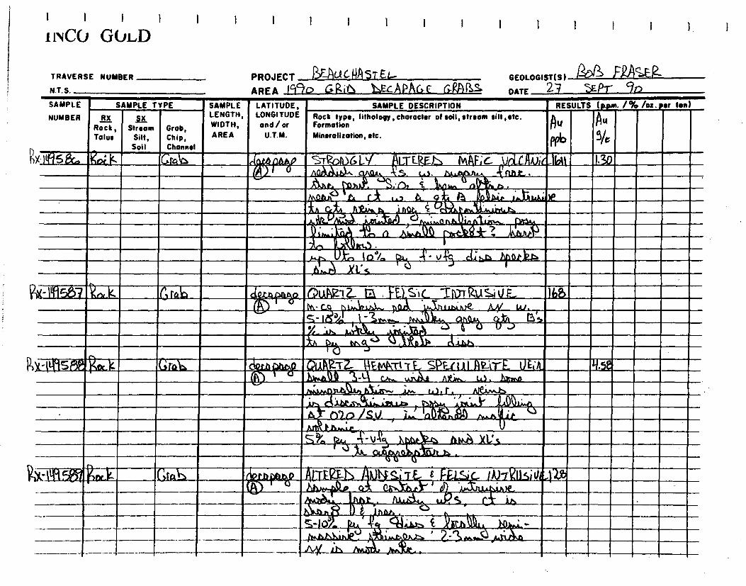
DATE 2-4 EP-r 9n
I I > I !NCO GOLD
TRAVERSE NUMBER
N.T.S.
PROJECT ~--Ali NA 5T Et- AREA jrlc/o 1,F-CAPAGC GgAr3.1
GEOLOGIST(S) afJl
G ra,D ci
gx'IIR58c. Ra I<'
NUMBER RX ~X Rock, Stream Grob, Talus Silt, Chip,
Soil Channel
SAMPLE SAMPLE TYPE
GtQ~ .
Et~~~SPFt uI AIz'~tt Ask. .. ~~ ~- ~: ~
,zm
. .`,.
~~ [i.~J.1 • .l • n ►f ~
,ht~ Y 1 ~ .
l J L~ / .~. ~ ~. ~ 1 ,~. '~
SAMPLE LATITUDE, SAMPLE DESCRIPTION LENGTH, LONGITUDE Rock type, lithology, character of soil, stream silt, etc. WIDTH, and/or Formation AREA U.T.M. Mineralization, etc.
Q E) S'► C T117r RU Si U F M- c
P'~~ ~p~, re Ivy w.
S441 cytt Wt'S n5
~
• 1)1
1I .
►i8d
MS rstt
d~
11N~ .k~S
I RESULTS (ppm. /% /oz. ter ton)
Au
5/c
Ibâ
At,
696
px-Iifl557
Pot-ttf15m ?Nock
Grab
riftS 1 L A .
&r~ ~r~ n r4
S.•, j INC k+.‘ ~ ~ + , . c A 1 ._
A ~ f.< 0.? il 4
~w. . ~T ,ti,' .
.r, !1 Ak,Ati t (~cQ#- kilt»
S-r NG Ly s
E(tEl~ MI~F~ c, U~ FA);L1bU1
noe
~ x ~
tr<.1 . 100/, h 4t- x t..n .brIk)z..
.30

e
if, LY FN_TL1PF FEt,SiC- Tli)rkUSiVf_~5 . 1)1.44A -J-44) ,
~ Q p~i~ ~~. A ~~ ~, i ~ ~ , _X. 1,1.1, ' , l~n,~ ~ë}10 V A...115,
~.d l A iGf~ xtr11«., pi,
~ ~ . 14;h" `-'~~ ~f.e n.
11+1
PROJECT EAU CIASTEt, AREA 090 >Q; htCAPAGE- GQA1 s
SAMPLE LATITUDE, LENGTH, LONGITUDE WIDTH, and/or AREA U.T.M.
► ~ ~4 MAN UnLC AN~ ~ ~ ~,
~~a • .- ~ , - co. s.
4 ,~ ,
~ ~
Fein hu,
.- k a.
. ' ~O
53
Atr ) ~ .~~. ~
etb
SAMPLE
NUMBER R X Rock, Stream Tolus Silt,
Soil
Grob, Chip, Channel
Grab
SAMPLE TYPE
[ 1 1 ! !
i iNCC, Gl►LD
TRAVERSE NUMBER
N.T.S.
Rx-N°j592 V.k Gra~
RA S c13
&Mai' Rot k
L-rES.Eb~~ V t~c Atii ~ . . • . • ' .~.
~ ~. 11tQ1iL Ir~ ~
~
199
~
V ' .~,.. `~ ~
D 415C~1r
• 1-2Jio
`rk. 1Ib QicAQTZ ES FELSiC. 1/IITeUSit/F,-
1
•
GEOLOGIST(S)&313 u
DATE 2t y sEPT- r~
RESULTS (P.Orn. /To /os• tot ton) SAMPLE DESCRIPTION
Rock type, lithology, character of soil, stream silt,etc. Formation
Mineralization, etc.

FA
I I I I
i ivCO GOLD
TRAVERSE NUMBER
N.T.S.
I I 1
PROJECT tAuc uAST EL- GEOLOGIST(S) A/
AREA Tick) Gw% I cAPPr, Orrzia DATE 26 / SEPT ( 90 SAMPLE
NUMBER
X-1.4°159 5
SAMPLE TYPE SAMPLE LATITUDE,
RX LENGTH, LONGITUDE
Rock, Stream Grab, WIDTH, and/or
Tolus Silt, Chip, AREA U.T.M.
Soil Channel
gaLK b elefeire
SAMPLE DESCRIPTION RESULTS (Rpm. /% /oz. eer Ion) Rock type, lithology,chorocter of soil, stream siH,tfc.
A14 Formation I Mineralization, etc.
PPb
ALTFP,~p y►~fir'I% (10TKUSI‘e/VOLCJINIti:2o an,~
A. ~ -rn A.t~ rw.)lr !.
~ ; i71 ~ N~ G. nM~`,. z ~ 'AA"Q e~~c n~ Pi ,►•,~ v X-14~5~~A1riet~ h>>astp
~-s•o ~ ~ ajab É max . .., nn.•~nn
WIAx6
4-11.114L Rock Groh
~~- it11511 RoLk Grab
YLLSic- ïluTKuSiV ~,. ies
2
~
° •
iok a
l
h fM i V01?-4,
01?-4,
n,~~ jIdiala S v
r
1.)4 ~
.t
FELS •C, 7 orRU Si U~ 12,x--t 49 5g
-
V I- -k' ~. ...Et.• caloc- P-')-11F
IZ
Rx- lN94la4t,k
(2) 0-1hirvo-ils
Grab

I 1 I 1
i 1vCCJ GVLD 1
TRAVERSE NUMBER
N.T.S.
PROJECT 2t.1 C-111 S T EU
AREA IgCtO G12,I\ APAGc (~RPJ3S GEOLOGIST(S) /118 FRASER.
DATE Za / SE Pr/ lo
SAMPLE
NUMBER
SAMPLE TYPE SAMPLE LATITUDE, LONGITUDE and / or
U.T.M.
SAMPLE DESCRIPTION RESULTS (p.pm. 1% lot. Sr ton
RX Rock, Talus
_a Stream
Silt, soil
Grob, Chip, Channel
LENGTH, WIDTH, AREA
Rock type, Iithology,character of soil,stream silt,etc. Formation Mineralisation, etc.
y
ppb X" Igil WO ak GIPJ1 .► nfiA,lp T
li ERM Fi(. VnIfitn); i '' / 11.,
Spi„,ArAA S°ye b . v~~ uu
sk lit, -P5 it ' . Par
•
MI IS O _ •1__
--
---
111211111

I 1 1
INCO GOLD I i I
TRAVERSE NUMBER
N.T.S.
PROJECT 1?F AU( 0A`>ç
GEOLOGISTIS)V vit
DATE Rl . i 1(1(10
AREA a—in (7.
SAMPLE SAMPL
NUMBER
SAMPLE TYPE SAMPLE LATITUDE, LONGITUDE and/ or
U.T.M.
SAMPLE DESCRIPTION RESULTS 1e.e• 1% /oz. ter lonl
RX Rock, Talus
1E Stream
Silt, Soil
Grab, Chip, Channel
LENGTH, WIDTH, AREA
Rock type, lithology, choracter of soil, stream silt, etc. Formation Mineralization, etc.
!1 G
D f '
1`~lG,rli 7
K~JC,~ ~S=Ah (9.1-i -~i `J : tA61F (1, ti ti.Ai- s . i'1 ~'1
~1(-,c-:t- 2 5 .
~`l+ 2 (l~Ai t \
~(`l/7Q1fa\c1‘ 4 Iti,('
,.r0h-tC t`Ihtd` ~-..
1\A C 1`i-~P A l,.
en çnh! k, - - t-'it' \IP'An1 4 t~ !it .2,riYSti J
~r l.g. Co[ÎZ(oo Ç. ftl l t
4-e-~~r{
r,
r k À ..<, -
IqŸbV TnlA.A.", t Qt4Q 2-f50 5 190 1 ar_ik.1C tt t\l ~2t1~- 19 +-
n~+--rK.~ ~ • . ~ ~,~ t ~ ;1~1 ': , 1 ~? °/ ~ .:~3 A(~ ~(
')~ ~ ~ ~ -\ fÿ T~\ (~i v (& i
4-~'n
CA/31j ~ I ~o ~ J\/1 , V ri.~ (~~ ~'~ ~~ ~~
~ ~
1Ha6o3 ~k~., C,k~, 7 + ~v~ A~ ~ ~~ci v.-lG r„a7 2Ro.
Q3--15 ‘<k!
, V1q6nq Z6.rh _ G,a.prs, .7-4-c OS Pi I -r-Et c-- GP(56Co t5 1-1-1016% . do. r12. rrQ 1._ vlCl.~l ~ •,'j.L
~rl~, r '`~.PA 1
4. \\_s: ~a'V•r% I-7)
+~Oc~ C ~ C U 4~•l ô.nVC ~ ,
2.14 O ,Lr.4,2.C7~
-}-~--- 1~~a 9.i Ci:A -s•-, . ,
: i4 9i-,p5 iZdrk n Q,P02) '74 SO 4 A» F r2 v-:-'ç, C_vAe,v,~? ~ 15
1-4-n5 v1 QS E Is Wthoy kz_vki- rnnd, , -4t1I.~ ~,Pd ,
-l- .,~ > ~ ~n~ r \10-,...i..\.(1 A-----, ~V3 .~- ‘7, p.r Ci~ S .
Het 4*, Qrr12 a(2A-. 7-4/05 RLT~~ F \) C..~{l4'1\6ALD 15
14 IO CtS kK IUGhQ$ t , \r .. ► .& . _
P.~.. 1N6i1[4:37
- -- -I- - --_
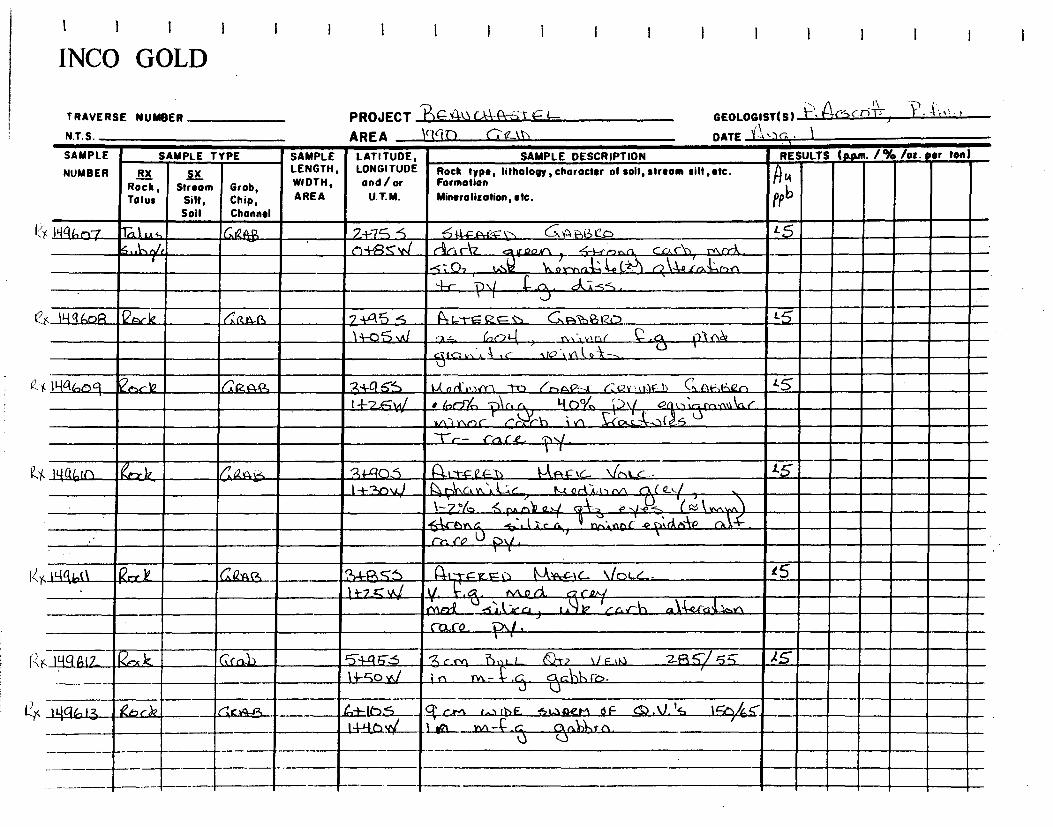
PROJECT 'Bo 4u i-- AREA 1ggn
TRAVERSE NUMBER
N T S
GEOLOGISTlS1 f~ ~7(4)c:riT
~,s ~)~ • -ç'3)'• •'
DATE I1 `lr; • SAMPLE
NUMBER
SAMPLE TYPE ~ SAMPLE LATITUDE, LONGITUDE and/or
U.T.M.
SAMPLE DESCRIPTION RESULTS lp.pr►. /% /os. ter ton
RX Rock, Talus
51( Stream
Silf, Soil
Grob, Chip, Channel
LENGTH, WIDTH, AREA
Rock type, litholopy,character of soil, stream silt ,etc. Formation Mineralisation, etc.
A 4
PPb
c Iyu,o7 -rat s, _6121}ii 7+7 5 4,1-ç-(4,-0-.-- \:> 6,44 ,i3k1cD _s5 ~/~ _..5..1, s..h n-435 \t,i cin (Az_ Y Jawrk •S-Ii-.r1
~ Y. (Lk ~`c~ rnrrf.. .5"; O7 te.~4~ lti o rv,ni~, ~e ~.~ n~~~4 ..raŸ-,hrl.
1 \(
C--(),
AI"'
( IKq(.,oR Q le da o64,1 7 A.41 ATL-t-E tz 's) Gp;-,9,12o 14-o5 J W 2,- (,01--( i1--( I .. ..A3-4..
A .~ U ~l vYlio~- - ~(c',v,`A
Ilia%Oq L~6 ~1Q / ~w Rf~ 3~46s l.,i n(l'0-)lY\ TO K.nAP',F (.VY , k11F_1) C,‘[\i-,,Ij.fLn S l +2.5W ♦ 6,r}'lt, -Or, r`` ti{b%, )1( Q ,~ '70-,,,q\..(- ,,
,~, n~C Cr,~r~h i ,n S-co ~~-~r~5 `t-,-- rat-x- ,r/
11-01,KI 6,GL4~-~ • afc105 A-t-t-ç?~3j 4-J4r*-Ç tL VrNt,.c.. I+'2,D4 1- 1.0if\C',.V‘i. -c 1L-i.4ritil,(NA ( 0-1/4-r
1-?'/u s rU •-4 a._.( A--- p y...e s rs'eo vv‘ .6-V ~~ A .c ry,~npf -eP,r~ir,~ r~, '~v~c~ -6. l .1".c r,~ ~ re: ea U y .
1`Iqbt1 R 6iz4Q -. 34-f3S5 ~. 0 lvl~tL Le.— 14 -~~ A 1 i--7_,Ç Vs/ V, ~1-_. +vuLci CI./ . ~
-s,i,k~cu) ►~t LG.J'io tef-ct4_1c..,A _1~~
c a.ro
. PH E12 k _p Cfa1) `51-1-4 5-5 3 c rn -71s ),L_ ~? \ / F IQ Zî~~/ 5~i l4-ço ,1J i r, rn- ~~ .c cGUh rb.
i Liq : 13 kit) â? r c,v4-43 e,i- (b5_---► =-ir- - ► _ ,..- r . 406 6 _
---1-41441Y1 1-121-- m- .ç gn11,Cc\. _
44,
t INCO GOLD

1 I
INCO GOLD
1 1 1 f I l i I i 1 1 1
TRAVERSE NUMBER PROJECT N T S
AREA 11ck O tz t~7
GEOLOGIST(S) 1'3' ra"f d',c t"14
DATE l'-1 • ) r. 1
SAMPLE
NUMBER
SAMPLE TYPE SAMPLE LATITUDE, LONGITUDE and/or
U.T.M.
SAMPLE DESCRIPTION RESULTS (p.pm. 1% /oz. per ton)
RX Rock, Talus
11,L Stream
Silt, Soil
Grob, Chip, Channel
LENGTH, WIDTH,
AREA
Rock type, Iithology,character of soil, stream silt ,etc. Formation
Mineralization, etc.
n U
I f V _ .
f ' .1 Qex k. (:12A-T4 Gi~-f0 -; 1--A04 V- ~/ni.c • IS
7--A-t) V,1 Ni . f::. r`&rt )(Iz c, roQ11 ; 0,: art/.:
Ant-. ?\I ~-r ,~5 , ~ c ~.~1Q c ,~~;p y
F•
114%14- IG--Y-n -;04.12, (,,+RÇ-"-) MP0= (.._ Ve--)< <.. L5 14-u v./ i4--, K,s_11~rt~ ► (y+
~,.A-~ , \ttc\\( ~ti.4ç,God ,
Y`n 111Or" f~l'~ - }li U~.t(\~e \-~
a f p~— d ',~~
. . !a ~~ ~ GK.Rj~ ~~4-1~5 A.~LTF Ltr 1J 1~~Ii1F1 (. ~fi~ G• L✓ .
1-~1.,5'0 4r-,..~,b•,n n((,
~~l{L
`` ~ \l•t., ~rrtz 3r~,f
,.~1,/ arf/lc ~al ,OGl~ ~j~^t
S,tnr I~P~
Tvl t t`~r L~ ~‘c~c1~F rV‘ ~ ~\ Twit C_
1- ? Y. .it ( .1_-,,s ry _3,
ii{4( I7 . ehC!'/ r âats.fi~j ' 7j,A:rsS I~~.i1n..ctc 1-_ -r~ ~~r N/c,< c. " .tS
'kin 1 4-n I -] 4)h t lcA -t Oil ,, ~ . c c- A-YCl'iv~" ::, I \
1 ynCJ v- ~t/\ t+nricl `./ \ il~
SA` !
-r- rn~;c t._17 IN( -i ~ ` ; c ~t , o ~j 1
z~~ p,\._(' l- - rk.î--.
ly4h•la, kin-k v2..11-E, 14-45-... flr.mF tiT~1) ZI\ AF .L \lbA..c_ - L5
gz-Ko,d/ )n• mp.1 Q h1o~ l.ort ~ ~rQQ,n—
VC. i !!
~' 1n 4 ~ ~~1 _ ~~i ~ .i ~~_ 4~ c.. ]s it r~7 ~
~ 1 ~
e.~ CLkr~`~ e n, !~ rv~ INA ~ i V-:‘
J + - r - 1~~A L\f -1fQl~~~l11L rM~_ t~C:~ '} `~U''g. .
~T M~ ~ (C- ~a ~~ . - ,11-19,12,15_. ~ - t c •• T. ~+ 2~C?S ,~~T•E,c~ L5 t -
1-1-5-c-W .__.il- J ~Y. \I-VV.,lg iQfAi Yltl rnf \) 3..t-k--,
)=1QG, 2e, F v 6: &A4-13 ~~+-651- aLrr.<t 1. I -A A ,r 1c, v,,_c . 2.4-Llov,I i'l . g 1C t N q k 1$

It III INCO GOLD
TRAVERSE NUMBER PROJECT -RF.A&Ic _ NTS AREA \ÔGD ( 2 U7
GEOLOGISTIS) (''4Z4'c_6 ït ~ "4 '-
DATE (-4' Z
SAMPLE
NUMBER
SAMPLE TYPE SAMPLE LATITUDE, LONGITUDE and/or
U.T.M.
SAMPLE DESCRIPTION RESULTS (p.pm 1% /o:. ter ton)
RX Rock,
ps Stream
Silt, Soil
Grab, Chip, Channel
LENGTH, WIDTH,
AREA
Rock type, lithology, character of soil, stream silt,etc. Formation
Mineralization, etc. R4)Tolus
J~ U
c Iyrt6Zl Pock Qa~~, Z +%S f , r~ los;-71., (`A,A g \C.._ \/n, c . s Ci-I-7O,4 -4j,-,•n.a--: ~v.ad. {llni-~r..
1S-~ ~lo,l~
/..< %r-!~ ~► k w l~ en ~ T/C,~ IsA Tr~ V. i t1 ÏÏ.~
4No.rna_A2t -32 a_ (Z.) 4 r 1, kl .a! •; -4,S
( I9Q6Z.2 Rhck ‘KA(1, --6-}-(QSS 141.$rFaçt-) IV`aF1K ~nL.c
t")-4-5 v./ A-0,... r~, a hsrh~ r',.--A- n ~r g y ( , `~~. -5 il À c ; ! ~ -o ~ J~ 0- ~ ~~~ -S~tY ,
C'rn
it0 r,An~+ nl (') ~, r!- ( i ) 'C n (n rpl~,c
~0.10/~(~~
~ l$ "-)1\./ (VA< r~~ ‹N
ILICt6C2:2N k' k 6rcc443 g+(95_5 R.~ i" -V te.--\/oL~ . ///~~~A-L,--I~ L5
C7~ -'J`~ V.Î ~s v,-, r--1 rn ~ b( DLJnnj~ c, .(Q % ( ) , g +^ -g< <', < < i o C,i k -\\.2k---( ~ EsL)
~
KA n:K V\ SLAM Ca..~
1- 2,'lti ck:, 5~ P
.141:462.3-1 (Lark ~,.a14-ti) -2A-4 6 .S A-i t-ç- et= ~ Prk IN, F1r \(o, c__. . LS
o-4--,, NA./ ifkil ;rVaA AA-, ~, a el >2 {Q.j, &L.C14,- A-C • 5_1 [às-2&- ; .er~ MnA #.&._,s- , tA 1
6.1,a_ELt.vd ri, py (kJ .s-e,
ilq67 _cc.)1_ Gap-.P, 3-1--t3 6 (~L:1-c-it-.):3 kos- v \ib, c _ , L 0-i-S 1 Zv
. Ft ~n( (o ~ t~ln ~~-ln 5,1►u~
~jL fnr ~od~~ -i~ —
_1.1-7..-7/9 I •5 _ ~~.ss
_
~
~ 7
— - - -- -- I

IS
LS
4 liqti-7 7
(&\/ ti-141,9 $ enc1t
>°x ILO H-7 q ec-y-k 2Atk
t4 11446-6
ca-A-(5
,
13z' »1 Ga417
I I I I
INCO GOLD I I 1
TRAVERSE NUMBER
PROJECT -- 6--14-Q1 N.T.S.
AREA lc%4b Ct VZ )
SAMPLE SAMPLE TYPE SAMPLE — LATITUDE, SAMPLE DESCRIPTION
GEOLOGIST(S)? • DATE :I--
RESULTS (Rim / % /oz • Per ton)
Q4,,C-5T ~•~~-. ~~~.,
NUMBER RX /LC Rock, Stroom Grab,
Talus Silt, Chip, Soil Channel
LENGTH, LONGITUDE WIDTH, and / or AREA U.T.M. Minerolizotion, etc.
RU Rock type, litholopy , character of soil, stream silt, etc. Formation
tiab21,~r,ck C'~RA ►3 ?r4-PYO~ L..~ F.rLF,.r-) .MAP tc \fo► c... ~S
C14 la v\I`^~ 4C ~ ~ Q)
`.~
( _Y~.,
f î 7 44-e ~n ~ ~ .~Y laiI~ ~ + k- i .Qarrf nn ,l\ - 044"
en raj ~r~ ~5~ /LA t vv\sL ke c dsz I.n ~ vt gr n t_t ~,cr). ?~b .10%.
e r~~ ~,~J
a~ o.o\n ~.
~gQ S ,•& o orr V 6;7; nk 17 .nl Pt-e---
3i-,P)D 1A14-rL IC-, Z ‘1.,4 0.4. 41/4 j4qtn 7
?1+1 SS ~LTt-~ G~ ~,~ ~L ~o► c e)3-6S llig(PZ
-6+7-4 s TQc>.sc a- b : Ge00,1:,i,► o2x-t-r t)( 4- . t5 ry-02 v/ . 17 La►.\ t,.s icd4 t.k.. . .o ~pLi a ~v .~ (
. 4-r p\( ,V- ~- ~,s~ . Y
~ ~
T~ O 3+-zt~~ ~~~~ ~le,(r -pe„,.;s►G,\.( IA .24 fo, Qa_ AS o-4,-,Ps.,y t•.b.. a1 _ idltv f è
Owl ,r~.51~ C3~ C , t'~E1Q-r.t
~ "~ C\~l, t C~n`t-e►.{v\~j ac ~~u..~n ~~Sï-~.
.~'`b kx,~ ~ - O~À ~~ ~ r- 4.,1r,
T~~j és~~O ~ ~ IR 5 M~_IC__._/Qtl
LOG S

I I I INCO GOLD
TRAVERSE NUMBER
N.T.S.
SAMPLE
NUMBER Stream
Silt, Soil
Grob, Chip, Channel
SAMPLE TYPE
RX Rock, Talus
2..47 Grc~
I I I
PROJECT h4A-LIC-ki- j1€-L- AREA 1ctao r..
GEOLOGISTIS) . 1'rs~~~t • .--‘t,4~a T ~
DATE k(- vrs. ~ <aqa
SAMPLE DESCRIPTION
Rock type, lithology, character of soil, stream silt, etc. Formation Mineralization, etc.
ij1 /ni c •
/ r p \nnl' ~~1'~, "T-r- I °~n .~ . t-- ~'.
RESULTS (p.p.m. /% /oz. ter ton)
Au ppb
L5
LA14-riC~c, <
ILA bYi ~j~â,or -51.A n r0k
L5
15
Is ÎLx ► iu b~h 'War k G,e,ara,
~d+r~ ;.Q ora
Kt, it-01,2g enck ak40,
9+146 r3+ SS v,l
stt--ySNs"
4 N4 6gR Reck
SAMPLE LATITUDE, LENGTH, LONGITUDE WIDTH, and / or AREA U.T.M.
yt-1o~
~ ~slc_ c.;) la.P 11-, ► `a-,.FF
O Zg"l ~S 4 ~r~D YV+O 1~k! ~ !' i c ~.. I v C t,~-'l,ti..c . ~( ~,n' 15 OA -,r4.n, 4tiA... i+rlmr
- 1i 5~ g}3 r v,~an,~ C lr~ -) c ~~~
~~ r3 e ~1~0. ~~ ~.,' c ~ •S% ~i~ ri t~
i~ t~l,nm[ r.L-t~ .Ioin~ cn,r,- :,d .1. tYo ~ i', c. cA:k.s.
IA A-7 R5 6-1,-1-L5 v<C
1.-klza- \Ic c
-
74o 5.S e‘r v_S,r Val C . ( ,)
C44--v./; „ A-pINvn i -44~ V ck.Jr J~r
q'- ~
5.‘k
--,Gn'a~..tr.e)d' • alt : -zon, /7(.1 Ty
r_f__ ~Y`~
~ ,~- •.i.ss
1.,14.P 1L -1* Ar
r as 1A Q ‘1,6 AS
L5

x_11-1,46tb9_ 1Zn,-
Cx 1H96,10 Coot
gX 144642 etNt_k_
4_-LNC4b43
I I 1 I i
1 i'4C0 GOLD I I I
SAMPLE LENGTH, WIDTH,
AREA
TRAVERSE NUMBER
N.T.S.
NUMBER Stream Grob,
Silt, Chip, Soil
Channel
PROJECT tRF_-4 A tlt-N1 (: L
AREA lcleM LATITUDE, LONGITUDE and/or
U.T.M.
~ GEOLOGIST(Sl~ ~~~ n ► f ' "11'
DATE ._tki ;.. 7-1 +
RESULTS (to. /% /os. ear ton)
.7)U
FPb
SAMPLE SAMPLE TYPE
RX Rock, Tolus
SAMPLE DESCRIPTION
Rock type, lithology, character of soil, stream silt ,etc. Formation
Mineralization, etc.
►~tF 4-c= t-"VAGNc. c,c c -1+t ~s ~-+-ARNAJ 0.,n ',L'e, ,. Q~~ ~ C o~~..,~\,,
r~ ~. ~ i ~~~P ri t- li", f1 in/Nn 41.-c. v~~~ ~ ►..Nb1\~ -~r.CA.,(o d ~ ~
C1,1
-i ► 'q7 i:f c [
1p~n Îii\L ~^YJ~~ ~1~ i ~yA~YIÎ~~, ce--v-itlA(
1.5
LS
15
_ G,aorb
G>z+4e,,
lQl-c-+F-ve,t,..b H..P tc Yr,t r ,
1+ la t-) vti/ ~~k n J>z p~f Nn -1 ~ t ,` r ► ~ .f. t \ 1~.
Annwt~c
1n o .iltar' r S
Tr p - f ,
RA-4-c( \(o i c*
I±QSvLf tk 1404n0 0.1,nnt J eà r~l~~~
3
J o -k" 1 S'y4 61
I — 2 6/b ÎY I-, sik 7,34. çfn c ~ . ►(t_ Ç er..
15
1~5~rf ~ 5 1 Li9b 41:2
9447 <, Vai-Ynt_.►
~or hpnv..r crAoo 12-A-pr.ar c Snv\1~.nr ? ) ~r,®cy ~(s
N ahs~
2.5 _I +Hi ‘4,1 4p)A.c~ ~ (4- ~ 1~~ n~
tAs_
T
T

~
i ivCO GOLD
TRAVERSE NUMBER PROJECT B ,&CA-A I-€L_
GEOLOGISTIS)P
DATE AuS>
N T S AREA t440 rein
SAMPLE
NUMBER
SAMPLE TYPE SAMPLE LATITUDE, LONGITUDE and/ or
U.T.M.
SAMPLE DESCRIPTION RESULTS (Mum /% /os. ter ton)
Rx Rock, Tolus
Stream Silt, Soil
Groh, Chip,
LENGTH, WIDTH, AREA
Channel
Rock type, lithology,character of soil, stream silt, etc. Formation Mineralization,etc.
4 ppb
c 144iON y 'o Cif_ r-4 A-B,_, • 1 +73s FF i IL. Vne c . .1- 5 -4,1-2.7, vi I woad - (L ~~y 1 1~`,C,~1y .
`noJ Te-- `% d i-S, wit., qi_. Cnn~ FY , K l}{Q6NS (idek tir q4-lo7S
ln# 7.y,~J f= ~(L vm, A5 f- 14Q 6 ~IL4
r 4
4 N

SEPr GEOLOGIST S)
DATE Î
mSerz. / R.612EAL Fg.
per len) RESULTS t apm• / % /os
Grob, Chip, Channel
NUMBER RX iX Rock, Stream Talus Silt,
Soil
~6
LENGTH, LONGITUDE Rock type, lilhology, attracts!' of soil, stream silt, etc. WIDTH, and/or Formation AREA U.T.M. Mineralisation, etc.
iflETANIIIIIRMLIM1111111111.111111111111111111111111111111 _ ~.. •~ C ► i-./l' ~ '
,~~ ~ E , , , 4111?~ ~... , , , _ ~ , ~ ► ► ,_..~. —
, .4a_j7z s~..A[~d7~~►~~ • xL'S ~ e
wte tgl A) MSZIL'
3- . ~.
' ;• ta► âr!
) e ~ ~ . a~i~~ i
~~1~' ~Ei~ll,a .. W
=
EBNIMII
~~ . ~ ~ . IT 1~ . 1 ~r=
e. l."~)~l', ~ 1 i 1 L~? .. .MINCE ! ~ ~ A .• ~ • .. ~ r i,. :
..~~~uram:.. na11i71s1il •
F. y o ~f.►~ m1,11y.1. 1 . . .. e. 11,•— • 1 , .iMIEFfDINI
A.~~tii ! i~1\mS!J '~ 1 ~~ . _~.+.2n.r,n .. . ~
i ~. L. - ~L
' .. , .~~~~! ,1 /
~
SAMPLE LATITUDE, SAMPLE DESCRIPTION
f goE r
1 I I
iiiCu LllviiTLu
TRAVERSE NUMBER
N.T.S.
SAMPLE SAMPLE TYPE
I I I
PROJECT ~?~F_flL LI.IA STE
AREA 090 6R1G

TRAVERSE NUMBER
N.T.S.
SAMPLE
NUMBER
RX Rock, Talus
Yx-1141 0;05.aar %
Grob, Chip, Channel
~r.
SAMPLE LENGTH, WIDTH, AREA
SAMPLE TYPE
Stream Sill, Soil
AU
PPb lb
~►
I I I I I
iivCu LIIvi~TLu
GEOLOGIST(S) B. 5 ~~ U 1` E~i ~rC
DATE 20 23 SG- Pr 90 SAMPLE DESCRIPTION
Rock type, lithology, character of soil, stream silt ,etc. Formation Mineralization, etc.
1+ in ~ ~ 1.7O~ MA F~c- Vot,c~iul t. t~ I S tu. r/~ 4 Vita )1\
-Vs ct.a.k. Jti.~ . ~ ~`~ntM ~n~. S:0►~ ~~ ) 11)4)
YA~ ,,_U
c.f
Va_cll)ViL
D • 20d/o ~r~// U~~
"~ d~ ~
ti 1.-rEy5_,L ~~~;~ ÙQ1 c~rv►~ 5-r f3 I S JIa,,,I,
PROJECT RERUCIS \STEL AREA (cfl G-Ri
-1-19004
LATITUDE, LONGITUDE ana / or U.T.M.
~ E,
RESULTS (pprn- /% /oz ter ton)
NeIi-IC 690
~D E aA13L~I~o
~ lah_l,),,we
5,~ ,.t, (Ad) •
Zj 85F VDLCNJVi G 0 r '3 75
~ .))_
gst. Y 1 f
":45411)1192L-15. 6 . ) . ~ .11.. _♦
l a,~ , ~ . (
1,11 ~„N.,V,a, _
1
TU FF

I I I I
iivCu LllviiTEu
TRAVERSE NUMBER
N.T.S.
PROJECT 1?)S AuC AS i ty
GEOLOGIST(S) V'. vv,P6F-P- DATE 27) SEP-r 90
AREA 090 (;Ri4
SAMPLE
NUMBER
SAMPLE TYPE r SAMPLE LATITUDE, LONGITUDE and /or
U.T.M.
SAMPLE DESCRIPTION RESULTS (t.pm. 1% /o:. ter ton)
R% Rock, Talus
_sx Stream
Silt, Soi l
Grab, Chip, Channel
LENGTH, WIDTH, AREA
Rock type, lithology, character of soil, stream silt ,etc. Formation Mineralization, etc.
Au pi)6
,X-1 1f1810 TO(1/- &jab %+SSE ' f--(c Vo(,cfNiL Ÿ-LOcJ. 222 -..
Ot ( ZS L .. ,,, 4,_- / ._ ~~ IN. a ~~. " At A~ . ~ ~sti. ,
~ ~ p.t. 1 v%n L'4i? ~ i~
~t ~
,y-1~`~Il 1._,,k__ , ~1 ~~ ~~Ss E CiC. FGOcJ ~'s~-iG ~~oJLAAI h 717 Ot(o2S • ' ► . gX-1/198to 1,1___L _
.' ► 1 '~ i,
,k11-19, 81'L hat % (.",lb b 2{9IE, UoLc An) ► c, ~ LOt.J ~o
I t 2$S ~ a m~ a a r o , i ~ ~~r, ' ~ ~~, ~_ tniUt ç .a~ ~ , Z-3% ~ ~ A.,~
(I4412Tt" {),*~
X jw B13 % ' l t+~SS
i-GOcJ ~4~,,,,
1Z , r.cpoic~ Y 9Sl
~
-13/ ~ ° a
►
IT
, ~
--
_, -o-- ,
_ _ P-- 0

1 NCO GuLD
TRAVERSE NUMBER
PROJECT?) t
GEOLOGIST(S) N'Sc tit\ Ç ,G\ o
DATE ": ;(' 1 .1 2.-Ç.
NT S AREA lgq(
SAMPLE
NUMBER
SAMPLE TYPE SAMPLE LATITUDE, LONGITUDE and/or
U.T.M.
SAMPLE DESCRIPTION RESULTS (p.prn. 1% /oz, per ton)
RX Rock, Talus
SX Stream
Silt, Soil
Grob, Chip, Channel
LENGTH, WIDTH, AREA
Rock type, lithology,choracter of soil, stream silt , etc. Formation Mineralization, etc.
ALL_
Pf4
AA- Sit
l< 114i8I4 T...b.,...- 6g-ti6 3400 4 14.tC Vocc ,'IC 3 (Cce,d) 24to3 i-E4:/?,i(r--,., •
L7 I' 1: r- i..) , • i / .1, ' ::. ‘• ,L .C- I '''' C. mill
(t le
?S1, fy 4- et_c
3l (nILkt
( me, 5- Tojk) 6e)41), r.i eve! 6;e4'i t. i. L1 iclitpri i'e, ,'Ic 19 /
,...t.p
2 -`2)`4 '-• - . e - -9 41..el. j2V• illfs'-• ...
\ ,I it 1 Ct crie." r C.?, • / a r ,
•J(..)
K tilq8(4 it k 6i44!i _f4114 DJ - r 19 C r /-24( 7 t) Itt , t (c._ k 42.4, __ro
1 Al 6 r vai 11-y(r. 4 e7,,f1
i‘e.._. pp /144 4 t 't
" a''.4 r t Li if c c ' e t
esCy (2-51-e) vt_ci t3,14s1kgy
4 it.0/ /41, . it_ p (6 - ke_rtifl_t
ig 0
/-op f5• cliis 4
/419817 Ark el 446 -C _...Z485 4/ ,KKI X-4$4,e cc Vo c-c-.
1/C- _,34-03.5 //Levi P-ea_rt...ic,L. tf cy/ 9 1
/ eN r C cti 5 r-' r GL I pk....1, 0 :\
pi/ _ 5 0.1iiiituieei.ted _ly,
-- 01809 Ad 6 4.M ±%E 444.Teetcl1 it4,4,6( l(6c..c .
Si-VZ 14. 0- 1 Liq &-t , ep ;pt.° ste_. pait.(1. I—'% p‘( 4-3 . di <512_14-6 qa —

! I I ! i iNCU GOLD
TRAVERSE NUMBER
NT S
PROJECT i / 4 tic (r3Srtr-
,-1 22.11 ~ ~ r GEOLOGIST(S)) • V.14.3( ~ 1 ~' t•`
DATE 6 i' z-
AREA lQ?o ( ~r)
SAMPLE
NUMBER
SAMPLE TYPE SAMPLE LATITUDE, LONGITUDE and/or
U.T.M.
SAMPLE DESCRIPTION RESULTS (plum. 1% lot. ter ton)
RX Rock, Tolus
5.X Stream
Silt, Soil
Grob, Chip, Channel
LENGTH, WIDTH, AREA
Rock type, lithology, character of soil, stream silt,etc. Formation Mineralization, etc. iy,`
At.. Sir
/Kf8t9 koE4 ' - ,,,(d z-}-11. ,q /s; c. ✓o lr S . clam 345-05 .t- I TT ria 115 (t 1~r~ /. 5
,/ bt%
// a 4f?AAa~ ,*c U 'fi (.i'cirai;~,
f • 77. ~ / I . v7 f .PIVLÂH r...Li ei ! v f-
/fr.(/-v/-2 k (111 .
'Y4820 C IA ,7+8S6 it. r>E)e 4 , 11 î14F/c. 1/oc_c- . CS At•-4Y 5 an )16 . 4 i24 4./...tYI..,S i. 4 , h
r~ lgi.t../
._I ! , e c "fAi/)Vtd,( î1A c r7S . ~îL1.e Ca A r 4 I I 1 e ti % r:s+
PV. pt../. r 9. Qu... ; 0ii.•4 , 64 a 'cc1
t<<YP82! /lock a/1n03 2t-Ife FA* z_sec ‘/,t_c . S /(- 3i-455 A-5 Iff t tt rtgt1
.
`— --- --,

1 ( I I
11VC(J GOLD
TRAVERSE NUMBER
PROJECT 11 FL( -t-f-r15`r--‘. ~-- GEOLOGIST(S) T'~~~ ) V' Cve€ ‘c;
NT S
AREA
DATE "6 ?"1-- 7--47
SAMPLE
NUMBER
SAMPLE TYPE SAMPLE LATITUDE, LONGITUDE and/or
U.T.M.
SAMPLE DESCRIPTION RESULTS Ip.pm. 1% /o:. er ton
RX Rock, Talus
ILC Stream
Silt, Soil
Grob, Chip, Channel
LENGTH, WIDTH, AREA
Rock type, Iitholooy, character of soil, stream silt,etc. Formation Mineralization, etc.
076
/44A(4. 9,t
V14ia tZ î ttt4...s 6.0-471-01 1...t etCi e- 1,l +044 v r, l_c_ v a t c__ 9 Pi4-1435 ~c~d C~2~ } c, i,1,.(-1 vt ~ -ic
L1 N [i P C~j ~ ci-)'‘` C'i. a ~ ~ i ~ l-+
~
lNA.Ci4-45 t. `iQ 1'6 . k - rn _q ~~ SRv-k.:v1.e, a-c ci ~ ~ _
.+- R c3._~ rJ. O._ `~; ,, et k...., ..n.
I4ç~3 i2~k (443 244%56~ )~~.~ `lrp~~~.1~ `% eii- « Atj 12 q~CP3. -cve..} at ~ c, t~1 805
c• t~ ~ d~ - 0 ~ lrs~a.c~se.en , ' 1tLia, ~/r
~~c:~- ) b d ~5 1- ~~~ ^ f 's.
~ _ . .a • 'a~~ w~~~ ~ I~ • li \IQLt 14101(~ _ ~ ~
u :1,-4-r„ O 5 'Nit ', ' — i Ak_ t_ Ai.... .
, - la, , Ain't .. _ V AI PC. 1 _
- . a
7~ isom~ . in Q i. • ._ . C: -f. 1 . ~ . -- a
,titcu3is- )eock G .s,AIy.> z-I- SE5C µopFeta,i-, y ►)crc I':L;, Ntk\-ir 1e \L, e A5 ,
4/_ CO4o5 D,Nit_lr o¢ A ty~ Lo,vu ( ~ u; , ~1 ~.. ~ ~ ~; ' ~ D_ ✓~ ~ ~)~ ~ f, ~
~ A r l%p " ~ ° !~
Y\Z1~ ~ ~~ ?.k it ~ G1 ~ ~ t✓1.~~
' J 9Ci ~~ç e.5,,,..1,,,1n~2~~1.`x .lt'L (~~ ~ ~ . & ,i .t ~g>I
ca~ ~ ~ 0 p~% (+ . 1~ ~6~~a ti. \ Y` C~L.~'rd ~ ~ ~~CÇ~c. c.lc{{ C F1~v~ 1 ,Nol . 4
J
1 ~i q.~2~ ~z _ -~-~--. _ -2._t_13_6€ _ t\l+aa C ~.~Tt-c ~, ( -i~,.-Ç F R-v,P D Mw-ç lc _.1EL o~ ------- -- Q-i3g) _0, 4\ 124 1441‘ 9,7-5
... .
--- - t`
!
f .N Q\ e V( CJ~f~~ ~.iC!I\C~U`

1 1 1 I
INC() GOLD
i I I I i i I 1
TRAVERSE NUMBER
PROJECT FAA v Ctk-1A41 r L
AREA
f GEOLOGIST(S)? I(,<'r ~-~ ~ ~ '' r,, e' ' "' DATE -5 7.‘ 2 1
NT S
SAMPLE
NUMBER SAMPLE TYPE SAMPLE LATITUDE,
LONGITUDE and/or
U.T.M.
SAMPLE DESCRIPTION RESULTS (p.pm. /% /oz. per ton)
RX Rock Talus
~ Stream
Silt, Soil
Grab, Chip, Channel
LENGTH, WIDTH, AREA
Rock type, litholopy, character of soil, stream silt ,etc. Formation Mineralization, etc.
~~
OA
fit
,v 9~
4, W q PSZ? IgruS 6046 • ai-75.5 /l tl•/oc.► r)( 132 (l/e4 ../i_e5F phAn, >laG (,< ~rQ.~ L_,, ~-1. ~ . r Pd
, . /
/N !]GS ~ /l.( (j ~O /Q.. '/ O ✓J PY ja A f\/ t~. V,
2%) v.1- . Oti55 ty• 9.
C~c
84613 4,ck 64►M at 5g5 i 14_ \/oi.cn4tilrL (t.1•1G Iciocl) 1/ . . [~L hi-67E j/. rip 1 IL ( Q c r> ,(v1a ~-1 . ~C
~ ~~1:~. I r. c~ F~-' "Q-,. I -2-°~e ~ . aJ a ~ ~ ~ r%~ ~,~ i , ~J
'
Ictctgzq "exit- e_444, !f - S 1) r /414f, ( Vx C 4^/(c /3 ► t 5? 7S5 (in ,L'' a y t` -~ i~c r
~~ ~,
1.) it t~ ! tfannfr r- Î :1, ` [',' ,/ II.4 t 'IC t ]rlC.a f - jn‘ c .~ (rQ) p LS z.! c.~ /7
- 1 % ~ V ~ ,~. c( 4 ; ~r ,t 1 Wn ~~ ICI, / / r~C 1, t_g-~ C. n rtE~Y'v‘ r
.
/y7,830 /~Qce 6,106 2+00Z: /uf}Fcc OoLc74/0e c / / 7 •
ofc E. -1-7 4/S ctGf k Irv(~ /f~ri 9~f\GrtJ f-/~C.1 ~ M<< ~~1 Q ~ t ILi 41,FI`i/
,1~ ~ - rvj et( 1 ~ Q rt~,'è I w ~ CI _l_°~ ~ V" 4 ' ' 4 r tJ /e. ~,~ % vt ,
• , . 3 /Lb? g 3 / ~rx.t C•Qd.3 /4-7//g: ~. _-__mittol Î~b LGIg-itJ f L ~Qy
~~c 13_11.75 ~ l y g8~ a ___x~-,
,lq`I8,52 TQG.43:
d ___6M _ LGliK3 ►Lte. Act i1r%)tL. _ Lcr
---------I4-6--aA-•— - /I5 # /h'9 63a

1 I I I I 1 1 I I I
INCO GOLD
TRAVERSE NUMBER
PROJECT, . 4(I( I-r35TI L GEOLOGIST( S) ' SC427 , CV6A-10" '
N.T.S.
AREA
DATE 6/)-r• 27 SAMPLE
NUMBER
SAMPLE TYPE SAMPLE LATITUDE, LONGITUDE
and / or U.T.M.
SAMPLE DESCRIPTION RESULTS (p:pm. 1% /os. per ton
RX Rock , Tolus
SX Stream
Silt, Soil
Grab, Chip, Channel
LENGTH, WIDTH, AREA
Rock type, litholopy, character of soil, stream silt ,etc. Formation Minerolitotion, etc.
/► /Lt
03
1114_
91f
k (1112333. #erpc-t f 20/3 l i-g$E 1y % G5t375
too@ é1 ./ a gCr Ll /-4i4 F/c 1/r~
s ,a,0
/c. doe /cq can v~..^1 .5,
.) r, 4AneR -'L.0
,ti( .,,Y4, 7 l7 ✓, .^.4id.5 • %~
I- 2_ /J~~ cl;--.-) , rlà r ~,it.v ~,f~;~3 / r-- ii40 .
Iy?83y lock 4api45 li• fl i~ MdD~.41-7-‘4-Y AT ir.v J(-4-.6,,c_ )44!<. „ We_ .1'4 3`i5 oS -11 /itÇR9S.-
42A-c.-I- / l p/ d,i s S ir, Glvl•e r oa
(063S LA l ;'Q,4r.3 q 4. go 6- 124_d,L ~or_c.fivfc-- 29 " ra/_ /OfO1 5 0,~ "I'lf /yi?8 83
/5 ~ Îr ' !/" ~Y fig qr ~~ P A,/
C~~,.4,_,.).
/119836 Koc& ~ Frj Qt2z5 A~is7c.]n/1/C 6~ ~V~, ~~ r ~ ,ff:l~~C "~ .-~
e7/c. 3fPSE A1j, i/ a !% , ,- r (AliciaT Y ;
( ) _ f/lsti ►/nl/C . -
; r , r ~ ,-~, ,-,/ f1
/ ,; ~ . 1;~.~
.
,o
c4 ~
vfvf
~!1`)/;()(_‘r
~ pi • (l~-6; /',(, 17/ .t (7Q1rf 7(.
I_Y9R37 Xty- GOd tnf-2 ç5 /9-c.T),,cCr~ ~=`,G4r~ ;'~t 7yE
907c-o~ ./.44,/,,, Ll ,
/
c.l` ~L /L(DGt!.t 11 i/llii /•P~t~<•~, L, ~ /
co [ t / (n ~ J
I 1~-- În S/L<QC L ÿ~ 1" 5 -é' l/-f S
, %
4-_ oc { rr - ;l P1 N C~ / I r~r;~~II
-` •G ~ '' rI r Q ~Lollr l 0 vit
I`~ /l.fal ii Y,i ~ ~i MI r, ~ ,'~i"G(, /2 6/U ~j J r-/ r• c.- - 7 y
.- --- - - ---- -- . ••.-

1 1 1 1 1 1 I I 1 1 I I 1 1 1 1 1 i 1 INCO GOLD
.K: +
TRAVERSE NUMBER
N.T.S.
~ PROJECT /~~ f)(/‘Nrl ~7 ~ 4--
GEOLOGISTIS) t7rL4atit . /G- Ga-V4/1/
AREA /7To C;41D
DATE j -1-37- • Z
SAMPLE
NUMBER
SAMPLE TYPE SAMPLE LATITUDE, LONGITUDE and/or
U.T.M.
SAMPLE DESCRIPTION RESULTS IRP" 1% /os . ter ton)
RX Rock, Talus
ILC Stream
Silt, Soil
Grab, Chip, Channel
LENGTH, WIDTH, AREA
Rock type, litholooy, charocter of soil, stream silt ,etc. Formation Mineralisation, etc.
ilt4_
s/ 6 _
A. 9~
X 1{19836 ~tr1' r.Qar, OtZiS -r tc4 n (r-'€ C \Ali_ c-. .41 lei
4/4- - -1-10 /= .s li /99,q37 . / r1
' 1 /-2`/0 E- .44.). G~ s 57, d- fl r ~u~~:ipsi f-*it q .
14/9839 g0C4 (4iP/1.44 .0/-tin 5 ~EL5 r c. Vo i,. c, Pi 07G- _3i7,,Sr_ 4 h/.ha~rl, LAGii`Z
T 9,1,..7
l{~ L.1//~
Q~ ~2 y-P,~ f- TP~IJ{</ rr / ~h 1Nll S . ' ll
/! d ea .! r G2 f~c l l/ r r' /t0 ~ C r , ~/- / °~n ~I/t / ~ C~ co i ~,.5
J li
IyQRYO IQa,h (;411-A 1-4-/O 5 1/r~cc , ti►q 04. 3~I-~6 ~
.~/nir.rrt~i-+' C-~ ~s.Lk (~~, -cif SnMr
/f/14•0 ?L/
~~ ~~+ { /Z/~/114xx4.5 lr. III' G. i~ -/(.(n not/ r ~ G l Co r
.S i/ rtl r<I/ il d ii{r 74--c / -2 °~ J t~
~~~ dlA~s5 4r14" ,71 ~~ .
C /18/65/% Ac-, ~~.6 /4 30.5 s r il~C . pt. 11 , s~/~ 3470 e Lt yù I-I s, ~ L,~- ~`'~/ ; ►%in ,
G'rrn•StntL~ ~(J' ~ ~V~S 4 ~~~~ ~o~9r~S ._ /,,./ /,i
rr(4,1,rrc,JS_.
g % • di ,•5:-> ~ . 1. y ~ G~. ~C ML/4 rOCt i-.• Ai
~ •-

I 1 1 1
11VC(J GULD
TRAVERSE NUMBER
N T S
PROJECT &tli(C ARE A
GEOLOGISTS
DATE
~
~Az, <,7t11 ~r ,r•
SAMPLE
NUMBER
SAMPLE TYPE SAMPLE LATITUDE, LONGITUDE and/or
U.T.M.
SAMPLE DESCRIPTION RESULTS (p.pm. / a1• /ot.per ton)
RX Rock, Talus
5.21. Stream
Silt, Soil
Chip, Channel
Grab,WIDTH,
LENGTH,
AREA
Rock type, lithology, character of soil, streom sill,etc. Formation Mineralization,etc.
Q Att.
e i~Tl(,
Sit
)( N~p
a dcr-
o
L (7e./V, 34 az E IL.:;. S/C y7~A fL
3n°/ ~!r/j~i
.tl?5 /h ~ PI
lc 24~s y~~.
(7[ G ✓ ~ f e y --el ✓ ~ .I.0 I ~ r,r a ~ ; X
v
u~ta ~~i,od a ~~Jd
/ K F,, . ~r, :s~ 0- 1~r 7~~ ~pa ~A rj
c /YQ$tr5 feCk. 6;4003 34-4yE p lt2flc Ve5/.0 . 3S ► e~tr Z4105
/r,' f 1 ff~l,nti
/T~I /-rG c~ il t'!
/z l ,.o r?
~P d 7
r ~/c ~rjr /~ ~It.l_ .~ i VA-1 Ai[ hl 0) / Q •/-- i/,P i dl & ><S fJ /-2.`d }/. A.t.5. G6s 1,
''?( AIR yY,,etck. 6Ae/S Be 67e if.1-‘,/c Vnzr '44-JIG IC)
o/c- % 21-935 -et- Ai? B 1Zl t
7/
t Ic, t1o/./ ./ ;e• icscl-'. •
JI...LG 1-r ~~C
Ç/4/913yS /2or.k 41206 34_ 67E fG L.~/c Vo c rlN /c /6 0/c, 2.4-1'2.4-2.4-1'3_S{-~ a 5 1 y9 SYY .
1i+ 6 VFj ~eyd 6,6¢6 1443tF /14sWlG IALG/}NrC ) LS _3f--Dc15 ()ark.- -~/ P i 1 .4 /trr.•i' ~fc~ • ~t
J.i}~ o u 1 , j~C
7 l ~1 ~Jer.~- /?Gv rt c Cr y~.
- , ~Lo~~~,. al:ry ifs( ,L, . l~. C~C~~4
--- ---_ ____— )
------- -- — 1

SAMPLE TYPE
Grab, Chip, Channel
G'A,4r5
444n, ~G
SAMPLE LATITUDE, LENGTH, LONGITUDE WIDTH, and/or AREA U.T.M.
3/-?) Lis "3+73 E
RX Rock, Talus
!tt
Stream Silt, Soil
SAMPLE
NUMBER
Qx AfQ8f8
RESULTS ( Wprn. / % /oz . ter ton)
rEXEn A/ti¢/ te_ C7/ 3fiSy _am ill r'r rn.!; •I nrt1 c~ ,.. r ak
--.- ~ Q[~s~ [,~ /!{ (cell r 5t~ir'~Gj,S.
/ G
i(rv7gs/ AC,k_
_Co ~Lé _ /xe e~
1 I I
tI~tCO : ~ GOLD .x .~:..
I I I
TRAVERSE NUMBER PROJECT 13144¢11 c it ST .L
AREA
GEOLOGIST(S) 7 ...^Sr--D%r/- ^` ~~~~~oe
DATE dC4-• 21 S. SAMPLE DESCRIPTION
Rock type, lithology, character of soil, stream silt , etc. Formation
Mineralization, etc.
/~~4 s<K_ ✓b c-c ,4aJ [ C S fin' y48 zS
11- /~ ~~ ~K ,
tee It/1,4L,
A; 4 <1(3~~ (pa le-.X+..1
% ~o~rr~ „o Awl Geist ~iv r PlAi ,A-•Q 1t~~7y 2 Qd
5><rjrt f~/ d~ t _s'~7orr.AG~fr‘ l/~.
~16/►- c~rl~~n 4.~ 1.9,
-T -/'o ~/
„ d¢<~N~;~~~ ~- r ~t,j/P C d
h ✓
04005 ii-L7 t'i.µ /J /1/474< . 3/6S4 40//Laria!
/J~/C~ de-41 `~
`~ i .Oc' .1 ,%-.1.
t g/f tJ r
I~loGi2/làl~Q/S! ,~ r" ( i :`f rat 5-ct~” / Cr^i.tC~ idc / 1 r ~C~/ 1 c no.~- ~ G'I p
p~'c . p ~irC. ii 4) 4 ^ o` .2dil - C`- r i/ a{ l~ ~
" d r`~5 ~a~cr r4 i1~ ~ n hi" 7
76
S7
,Cx /VBSo Cat ~~ ~l 1~ ~~~t/rC 3+-65E ~/,~ p(cr iC ~. ~crt~ iLaf~~x~
~•.. ,t'yi ~~~ ~
~
' _2 cO Q 5 ci dot Q s -~
L,

I I I I
INCO GOLD
TRAVERSE NUMBER
N.T.S.
PROJECT g4.1-,«(Nr157 F. /
GEOLOGIST(S) 1P/Of, T 4c„fitj.,
DATE el) CI- • ..2‘ 4- g
AREA /i790 (74/e-)
SAMPLE
NUMBER
SAMPLE TYPE SAMPLE LATITUDE, LONGITUDE and/or
U.T.M.
SAMPLE DESCRIPTION RESULTS (ppm. 1% /oz. per ton)
RX Rock, Tolus
.aX Stream
Silt, Soil
Grab, Chip, Channel
LENGTH, WIDTH, AREA
Rock type, Iitholopr, character of soil, stream silt,etc. Formation ~7~. Mineralization, etc.
d~~
,~L
~+
44. ,,,y
~/L,
(11/9R52 ~ G.402i3 54 3 y5 /9-i -rFx "e=n ti•is1ie • ,e-- /9 c A 345y - C7 5 '~ /yg 5/ ~1L~ nn,,1- Carlo .r ~ -
(OLD 7~tN~~ ~ v- E~s ~_n ~,r. oL,'~ozc,ta.~Q~~ , Fiac~//!cr~G pC,~
/<,/9853 0~~ (4/241(3 71-/S5 t.,lor,if.( 4177:447) L .44i/c. 7 6(c- ~t5ÇE 4ihax.+4 i'c A •. i: : a c
/., t 2th ri --»n /1h0- —St li r 171;Qd ____re or (-ci/ ho AI I, ZS d• G 1F'n.y' l(
I10/~ (ri ~ir? [(( ,~./i~r~0%(1~ ~~[ Ail~/~tr'~tc^ . I 8l° /~ `j F.~.~
e( ~-sS, 1 4 c /l v..0 ~~c. J~~.
lyr(85V ~.,144 .,<kg A _ 64 F65 r,.1Qn .t' t Q /-4ecr( /t/~',ifir YotrAtli,- _ 73 3t36 (Is /y9 34,..,~~ ~ n.co~t.q✓~/,~,
..ri %' c ;Vac,/ f ca /1 n rta ~j3,,of.
Kr{4'8S5 7-q-Lu5 Ciqa4 "7+oas 4rrA'r"/- ~r,-scc fill altcho/ c 37,-~-clF ~Acr,c c r1.t- ,ii r( - /•'u.,c c ( c.~/ led ~c~,
, iu~ 4 l / Sf(`ic.0t) . 5 ~a~e y
, -CIA ( ( (j• CI
`3/1'2) ~I„©i/ l
Qr~/~ , 1~( 73 l/P~ ,i l 1 L5. ( l~l`JC,~-i/c2 a`~'~ I~C~Gl11(J+
!v~- /11a i r, )~y'3c /rn.a - ca. O/(C ~ - ~~.
• ~, . i~ a/,~ ~2!' 1/~ 4 " ~r~ ~, ` .~ _ JT 9
~~9BS6 ,~vrS C~/{Ar~ . 7~2S.S L.~KFIi /V,/ f •/c ~Lc _ 2 ~ -07c- ~f35E }~~1Lsv1/•.c a6 r 6 ,~.~/ ~}1/-G,
c G~~ RCC)G~,r ~_r, ~~ ~ !! ~~h l~/ s1' r' f~ c~ ~)i `~Q `r.~ a.~ d •~ ~o~; c_ . -s~ n 6, 3c • 1M~cr ~ Rif âaq. a ~1. (i ~ _
-- 2% PY - .9. ~~; r 5 ,f 4,-6-,9 ~

} 1
Ç('19Ç('19~ ~i (' .'l l • .. GEOLOGIST(S) / •
DATE OrT. q PROJECT 1jFs~l/C~ T,L_ AREA /9'O "<a)
TRAVERSE NUMBER
N.T.S.
Grob, Chip, Channel
RX 5X Rock, Stream
Talus Silt, Soil
ton) RESULTS (Rwr►• /% /o:. eer
I/. IArs 4K-r G ~ ~n/ G.
~`L Qf75.5 ey .4L7.-é4k,6, A/A.r/L Yo1 C 3112E /Is # Ng s8
I 1 1 INCO GOLD
SAMPLE TYPE SAMPLE LATITUDE, LENGTH, LONGITUDE WIDTH, and / or AREA U.T.M. Mineralization, etc.
Att PP6
742-5- o ry. I y ->->sɕen A.L . G /u c . aCc.r.f
S rfj'r Ad t il.ft2 r n~ 6 c~rh .4' d4f
~G~ >^ ,~~,/.m ~< <a
~ , O ,l r~ P ~
3~k , •/!p.[~- ~1.~.rn fyt .~r.(
PY ~' Jo Di'.d ~5 Az.e euiQ ~o~ ,
44-~ _F-2Z-S« 3 l4o.SE L ~~, o1le", ~ r~/iQ cy
Lt.. cJ [D'~ ~ 4 •~e 5_~ _ e ldT .
)2t25. ~a,vtf ~0 ~1~a~' ~s~
~1,1y s~l /
1y ~ ~ycl t A iCiGA Q ~1 c rla,- • 1, 2(-cf
~ -41
SAMPLE
NUMBER
/ex 1y48 58
f'3456,.s Tfr2,= I) 4-df <-
~. t) r7Cr/Y lnn~
A.frcie✓n ire (kit rC,r4nh 1eAs -5 r9 el .l Il
31/ f,..l fQ 3
~
z!Xy t ~,.Irs
~
se_ r [t A
d.Y~ 4'0c ~ hr.P Cc9or,X,~',c .5
SAMPLE DESCRIPTION
Rock type, litholoyy, character of soil, stream silt ,etc. Formation
a ~ ~ r,~ f ra R r~vY ,!a!
J lO~i ~ rl,e4

/~1~1F63 iQ~ C~~r~ ~bQr
/~~ IN1Q~ 1- , cus "/Z~
1 1 1 1 i NCO GULD
TRAVERSE NUMBER
N.T.S.
1 1 1 1 I 1
PROJECT î2 uial4s `=t- AREA /4'40 ad(,n
? 1 i
GEOLOGISTI S ) ~ 41/14s1I5 7 ,#). Ci0<Nil ' DATE () C.T ~ $ / Q
SAMPLE SAMPLE TYPE SAMPLE
NUMBER RX Et LENGTH,
Rock, Stream Grob, WIDTH,
Talus Silt, Chip, AREA
Soil Channel
LATITUDE, LONGITUDE ana/or
U.T.M.
SAMPLE DESCRIPTION
Rock type, lithology, character of soil, stream silt,etc. Formation
Minerolisotion, etc.
RESULTS 1p.prn. /% /oz. ear ton)
A~ ~
11/986f grk G,r,4~
, %. gfY/5 _&-r,4,F~} ic~l~,~ 1~ 223 ,~~5~ 4140,1,i,4,-(- dot), ralorl'
cJr ~-c~~~~ c.lr4~-(.. ~
~: L~ /o~.os per, ~Z.YSI avvnEly
=I
-s:'t.' r i~,?'d, A~rL - o.ua ,~ü-~.oi e( ~~O~a~~ ,1VIr A0~'r
v T 5 I r1 D~ .4.p/~~~11s~1 . t ~
~Ar/7f7~4 .7-/ fT~J
VD 9y ~nr~,vl0 Cf~ml-~ AIL
4 64z,
C7~q(~fC~ra`1-PS IJ1 D~71ci" .
>>>< iyq~6z ~olo.
~a~ s ,gt 1(4 4.4, c_ 112 Xlpl►c.u.;)1rL~ .Irrk grp,~/- /rZ2rt
cn ~e/tk l~/ ;i f ! e~~fG( A IV" ~Q~ nkS /.1(
1-.240rhn itr ~ . n[ _ n,6 CV /L/ad is E.14 c np
p\.I ~l5Se• ADr It/re roa i: .r
/2
~ 74-755 l~aL C_
~
✓ f L, c i
S y a ~ r .
4: c _LA
. 4. G
9 1:2)4e-
ni, ~Nt. w/ e
Y 5rLtir us
sd~ }/ CrLfe ra 1 ~nn - i6166 Ai 14C r ~ ~cCt_4'
o/ .P p , dâ ~; ~ d~ / l ~ ~~. ~~ .
~ J
r ►
s Z),4 ,,-E 53 3416_e ~n; 41'c , ~Cc tPd_ab AlnT_~n
~r 61, 6cu.'4k RR 4 4e.5 ~A,f ~3 ,e.Yr`~ au i.nru
5T Qc^ r 7lst/ik. ro
--- pL11.et D5, c y mG 'Llï Car / ✓ .► ., . ,
--t- Aiodefo-4~y
4 . .. • b

I0
d
D~L
R,c 1 fQc5A7 /~och aga-p, p/G
-4
Ac1Y9$68 At.iç GR,46 f34.265
C/G T_“
1
I I I f i i i I ! I 1 i I i
t NCv GOLD
TRAVERSE NUMBER PROJECT 8,4-Air GEOLOGIST(S) 4R5COT 67/i<-;J'//
N.T.S. AREA /4/0 (;)'in DATE (VT-. /0/ SAMPLE
NUMBER
SAMPLE TYPE
RX Rock, Stream Grob, Talus Silt, Chip,
Soil Channel
SAMPLE LATITUDE, SAMPLE DESCRIPTION LENGTH, LONGITUDE Rock type, lithology, character of soil, stream silt, etc. WIDTH, and/or Formation AREA U.T.M. Mineralization, etc.
RESULTS (p.pm. /% /oz. ter ton)
()Pb
9-f/0. 5 /VlAL rl 14-C .F__ f)e.-b ( /Pon is ll /~10tA GI~7Jir~r(~.i -i', c /
5..i.4115..i.411- rr7.'!r'Oir1r: ,1c -JPYIiC:h//z, A1PIiÎ' lll
! Mr: At ~7i rinr?- X i R A r.' 11. ~3~e ~ A/ C~0lhn n><n 1 V
' / , 7J r/ - 1. .- Xrat I. ,a rev-.4,1,3
4N9R46 foci, ra,m 0-
6 fiR866 firer t - — - 7:7/4,1A 6]4-71.s 1? u,4aeT Z 1.4 • iiVt rc r 4kT. S
C M G. 1) j1I Q C.G. r_ 11 4 t /t/
~- +/r;„lof i J Mnr/n
SNn/ :/
~Od %- 00( Ad
T ~
Gir
•
~ q
ilen5)14/ a 4
P3t SOS 4l-T,EZPD A414,‘ t L St0o6 C~n l >t,Y , n(c ~/
~
,~ c~/~r~C E rL ;r. ~ r V t~~
htiLG~ nr ri 5 ;i0 put ~, ~r f .P~ t1rq~ /[~~
/ /
%.«J`./
~~s VP ; i1(_r~-~. S .( t6` = r'r~/~o._ c/ L
~ ~~ÿ It-144- Ali ,r
Ll ,~ ~ ~ 1, ~r
~t.C~Cln SI/ _IA f, ~
(,;_c 4..02.d.~
. k2°,dr_ M, 005S+ cozier .211~~~ ~ rric1,21Ii ~ ~ ~
o d~,~ -4 J . . , -,
i)A c tT __ (?) dar eLtLA ~ 1.
11F! ] t• •
,.~141,. ,. . - rc~1~~-k.. 0.te~
n T-Y
~
q
t

1;v
pPb lE
LENGTH, LONGITUDE Rock type, lithology, character of soil, stream silt, etc. WIDTH, and/or Formation AREA U.T.M. Minerolizotion, etc.
C 2{t4 O(L
_ %i-OO`J~ !AL?~~~~Ql~~ Lry ~ ~Ot_[ A-K.1 l L. . .
1+ _ L ttfrd,
b5 -~e.rer~ NA4~r n . v~.~Ilc 101 2t-oSr ~(
~`~~r.vta~i[~
3+I rd t o •\( .e us~
1 Q
11 earl. x~j1n ~ ,~ Îc.St !' A~r P] ~ oJi
~(a e rf . '531-Ca • 1OLI ~.. - tka c>L w
F
77~~• -~~ ~~i~
^~ _—
3+-.Z45 I-7LTet2r_? \ALLAe\tC.. 1+`tor int5 rLx l kict~tal 10(.01- weQk.t.r
~4-j[a c 2.2.5715. 5. ,
. 1Z
°
~` q
c~ ~~_
~~~ 0,14 n ~~n ~
ki( 149(103 , kot h C V.34.b 31--7o5 A >A—r EttEO PAC ► c. \101-c Pon) ‘C..- — 3,43
o1/4. 1+-85r cv5 ►2t. 4(o I'Mot h--& .k-A- p go/. py
Aex6t ,`\
l3
3.143
.10,w›,...1.1
~-F 20 ç~ P g a~t"~,.1~ ~~ 1ù%
1-10°Î~ 9th - Or. l;cik r5 (pito$
b+505 6 2A/U ►TIC. ~4,Qc.~}, 32 c„yRst~ lr ~ .
2 °lo H , d_Ati~
12.Qc Tackk5 64z4a
r'?1- 19qgbZ 12.0c _k oft-
SAMPLE LATITUDE, SAMPLE DESCRIPTION NUMBER •.
Rock, Stream Grab, Tolus Silt, Chip,
Soil Channel
Q.1 1W9q01 T4,4" Ga,ar;
)2 t,
~
1 1 1 I
1NCU GOLD
TRAVERSE NUMBER
N.T.S.
SAMPLE SAMPLE TYPE
I i 1
PROJECT 7G A.tkr STEL
AREA \C \0 GEC >>
1
GEOIOGIST(S )
DATE '"-) e-\* 2-0 I Iq1.O
RESULTS (14$1. /% /o:. per ton)

RESULTS (Own. 1% lot per ten)
A,1
(0 7
►°t i i-tggoB oz,c)2 51-ti15 AI..TF_v.,Ep M,A-f^LC. V%LC 14NLC. L I+aSF Rp~,lLA. z r~d~Uta ey.R.,,4-g(s~~
• ~~ s~ i'sA
é4o r~.sl.( r~1~~tiW~: c. / 11)1a nn -A~ . 9./ d-i,9~p,~11.1. ~- Qr,,~~oiirlSt~1c4.5
6%tEA
1 ) I I
1 NCO GOLD
TRAVERSE NUMBER PROJECT~ CA4TF_L GEOLOGISTS) T`—SC- r
1
N.T.S. AREA l \O Ccn,C‘o DATE 6F...r. r. SAMPLE LATITUDE, SAMPLE DESCRIPTION LENGTH, LONGITUDE Rock type, Iithology, character of soil, stream silt, etc. WIDTH, and / or Formation AREA U.T.M. Mineralization, etc.
4 .•. .. 4.• ( - _ k
lï. ~i~ ,aLL
ti~ p ~ r,. ~t~~ ~
131.1Ad . . . ~lid©~.. a► ~ f.a~c~:~Ca~1~ Mci t~t;
~~ t7 ry‘~'Lv~n N-S. ~[ondJ J . ~ . 4-C CA
Z% ,c1 v.n .o. d. .i.ceS4.,nn . P,
SAMPLE SAMPLE TYPE
NUMBER _BA Rock, Stream Grab, Talus Silt, Chip,
Soil Channel
12X Iqg`Io6 (b,x 6eag F~t1.SS P~►_-rt~2~s~' ►~wF1r. ~iOLr~1t~ 1+90 E ~ r, ecs t ~d.~ ~, P o aft, %Apr
.`_ s
Q( iL-04n? IQras.Je r..T'F_teF fl MAaFY Vnt_c.apo (L. ItqoE rrJ-~ ~x 1,4:141.0c
1+75_6. ! , . • 91_ V:1- t.a. ~. Ct û , 4-( n,nsk...6.u,,Aik—
Q ..~~.~. /
..
—..__ Q. 5'i!i Y•C. Pti~r ~l, ~i iz#-t •

1 1 1 1 I 1
1 NCO GOLD I I I I i I I 1 1 1
TRAVERSE NUMBER
N.T.S.
PROJECT
AREA IeQ4 GEOLOGIST(S)
DATE 4 E tri . Z~, SAMPLE
NUMBER
SAMPLE TYPE SAMPLE LATITUDE, LONGITUDE and/ or
U.T.M.
SAMPLE DESCRIPTION ' RESULTS (p.Wn. /% %t. per ton)
RX Rock, Tolus
,gx Stream
Silt, Soil
Grob, Chip, Channel
LENGTH, WIDTH, AREA
Rock type, lithology, character of soil, stream silt ,etc. Formation Mineralization, etc.
(-jv
?Pb
(c(qqlb Tc~1W,5 Gk.A.-a O+1S.5 t_-rE_Qr:D Hir LtiV' Vitf_r iAt, \tr . ll
5v6 c/% 4•55 E „2 t~o, {edl,~À51~ c~,1 r~ ,[ . 'Ç. • , , p~tr. ~s (1 t ...1',1 A.~ ~j r1n Or 0, / ~~ tbo ► '9~ fol~. i q~ r~-k--s eteS ~ t.ti
\llh nf ~
\rp~► nL 1 ~l /a '~ ~Q tvl n 4Y 1n ~ ~ C 11~
Itiw ~ 0 > N\flf~ r c.~ ky +vw.gv,g , c 4 ksrir.e.14 r1, - AD A''''
etC. CÎn 0 K d .
~ M , p~p, ~~ , Î ~ ~lb p ~
p c ~ ~,1 ~jQ.►,1, i r~ ~
1 -1-- r ft-,A1/1.. \V l VI K _ ir'l
1LICO[t ,r°or k Câ24-6 D-f 9S5 g 14-eLe d V . CZ r3,g
~~
i►,er)_ C7.) t 1 b 0,- 2f-IŸ~E l'~4.C!_ Â v ~-1 PP 14 .1.•_\”. qCt~~ ..J ti~4-t-
fl 1;;Li--• -. e Via r1l- l0a1C.:\ n ..~.5 . Fcc4 . (r-).\As1 7,1_v\S ,4...1 plc.
~l ~~Q,Af nS
ol< r ,T•j I .t~~ ~~ lo ~.~V
C t\.-t--,\A- G~ (~1' ~Ÿ ^/ ( v~A 'LC_ _ y1 ~ Q} ~ ( x 1~vty1[.) )( __)..,,C fiJ~%i~S,-0A~ CJt, I CsY\ ~ 4~1d1 l iC
-?
~L;C ,~,%
i a~ v VIVA: rt ~ , M1 ~t 1~3 ,A IA IPA, O/,4 `J
_Q • 1% nit .t.. P~{ ~~5~f ~c~~.lIQ Cowl -t il, ,
1ctg12 P-oc k Câd ►4-6 . 0tSd5 f-li-sf cs r .9 . r'", A-¢~ ►Gcl ( ~
.~5c- 2.41-Z
e14,.. +5 ~ . M ~ l~ 40 11Ge111 ~31 ZSo 1-9°(t, ~q.
),:v ~3__ ~i~-x k C,r-a6 1+ 2_0_6_______I% - I I ___:(p_ ,
, ri/c, 2-i S SC r4 \ ON l, ,:,‘ k, .. • . - • + ti. _____ L.N.-c vv a ,f. o o t L.6,3 1, I 4..47._ o S - iz, t p1--.Q tik CI '5 S, , , t' Or cabïc\ho✓` i. _ .._._ , .
-~ - ~ ~ •• - u ~ . . ~. . . h o ~~+ I. ~_. ~C_~,_ __
----- — — r
1..od, . 5~âc; t 2Cil. - ,
— j
1 Y. ~ \,(, ~.,.~.-r~ t to ~JS~ CCCL! .v.. _~.~

I 1 1 i NCO GOLD
TRAVERSE NUMBER
N.T.S.
PROJECT Y-)F ~avc hl J1~ZEL
GEOLOGIST( S ) ~l •
AREA Ago 6,4-A)\
DATE
SAMPLE
NUMBER
SAMPLE TYPE SAMPLE LATITUDE, LONGITUDE and/or
U.T.M.
SAMPLE DESCRIPTION RESULTS (p.pm. /% /ot. per ton)
RX Rock, Talus
§./1 Stream
Silt, Soil
Grob, Chip, Channel
LENGTH, WIDTH, AREA
Rock type, litholopy, character of soil, stream silt,ete. Formation Mineralization, etc.
(IN
PP
. 1`lCii1H ,en c k ~S,4f}C3 AL 505 /z, F .' ) rFV >lc YOLcJ !' ( Tc~ i alc 2+/a l-
Rrr /-2,v►rv, f ï./ c, i~ an ~~3 ~/n
~
~
A ~, r Si ; cr t o v ~, c~r ~ .~/ MC. If ,f /tir .T-1~ iT n r~ l /n) r t- (•. C .P c i pU Y r Jt c •', .
F -1.2)
P1ri (o !~ QSj%$ °. ~— ✓►'l. q. ~~~ ~l 1-4,,,,, ~(a..0 talc ("not { ._H o~
`1 /yQQ/J! la 6r5 (~Q/~R /1-1/7S ~N~ f: r ) C~-r Z ,t' h. IL f~7 1 el t;, St 4~jh~ ~~-7Sr (tCl~[!?l
L.l2~/~' r 2fG1 L' c_ _~
)1-in i nslPy" A t C r>' i ra c ✓Q be a Bi i c ~/iff ) Tr-l% ~ / D ✓Pd yt f/ (c ro~ d gIo,t i i~~p R~i of6Z• l l.~
~G
( /0.1Z ,eor 6-- 4-(j l fyS S 4 cy-Fr..e-r, lrvrFr'r // .i)iel 7 F (.') 1/oE.c . 6 - ale. 2t766 /-fc~ 1 t~r f Ç ► Cr/ t„]r;/ lt / r,e-,i ~l
/u+i r ~e..
r ✓I ~~z1~ ' -~~} l(3 ~Q Z-f.;,)< ii: ta- ~~}'t~.:C
~l cv11~ (.') ,./ ~~ t~~/I~c .~ c c, ~e~~ acl 5 n.,t a .irti y.
NQQ/7 Lpc 64-6 toSS Aar,: 'Kt, T éL•e it- vi11?F Vo ix ._ 77_
~L -f yS,6 ,2 /t-fs fl ' P rt 2' < , r ; - . ' < < fr s '/ f
~-
' Ct~i1 ~fL~ - t• 5_ - 11 /4-L3, ` r i,_ fil- a(fi ez nog ~ P (elf l I- Cc.; n S i ~L a fayz
~ . ~lr Al~ ~. ~nG~
~ I~ (LC_ ç
fr „ ,~ 0 . 6: IlB
VPirt I1,/6 /40° QA' . '
-- -- Tr- /°l 12 y, t d. %s S-e8-t '4-114.140' g . 14(9W8 (:),c,f a ______ , IfBQs -14.EF_t1f/216/T4i.( j/~ T fï \ic,« _ _34,
n/c 7-*_5_ae_._ 05 14 lei-, 6/.4" AD Q•v '5 . •
— - - - —_- ---,----- — - —

PROJECT (CP./1-w F L AREA /9f ? 6; at.?
GEOLOGIST(S) r` DATE .) T. 2y 2`c"
TRAVERSE NUMBER
N T S
SAMPLE
NUMBER
SAMPLE TYPE SAMPLE LATITUDE, LONGITUDE and/or
U.T.M.
SAMPLE DESCRIPTION RESULTS (p.prn. 1% lot . p.. sr ton)
RX Rock, Talus
~
Stream Silt, Soil
Grob, Chip, Channel
LENGTH, WIDTH, AREA
Rock type, litholopy, character of soit, stream silt ,etc. Formation Mineralisation, etc.
A. FY1 â
•
K /1(9119 Ar;.F 6KA8 21-3 65 F7ct.firc_ Vo_i cjaN.Ç 31 o/c- 71-h(5 J- T? .Ppl1 fi it r iir (','S ~, ~F gYp~f r, ~ i
S~ Sn10~.~/ JQ J C J4~~ es. . ~~I,lY r Licrr~ rl5, M (,i!n~ ir !(~~ rt,l~c .
L ✓ " 1 %ô pY, ~Q G~ ,>~ ~~j( r
/4r9 9,2Q ~~r k G~ p/3 2-d5-5 ~s~7FiL ~ ~~ ~Ft -7fr c Yo c. c r1 A.Jl1CJc 3 y Off i_ ..i71-/5" plt ~~ ~ ~~C s~2(.,.r;r~ ri . ) /4'iG l~r t jr
~a _: n ~ r rv~f* -~~r j r r 1(~ al ~tc~ok t~ os .~v// .i~ ~~~
c~riG~ 1r1lr'144.c 1 4- O pS Irtrla. k P /t.t ~.t.t 3f c _1
IA Pk / I M.5 n( fr-4 /6 r ore eyzal~
/y992/ /1oc Ggo6 2t 7o5 /947-r•err) r.~csr( 1r'oc.c . 12S /L Z t 20 F 5 /qQ9.7c3 Ezu f 5-1/0.,c~~ 51 ii4 iixa/
c_._11Y 1\iiik.46 -I, .,,r,(.
/4/9Q.71 k<k G'2m 2-f-B 55 ~ .,c5cc Voz_cAiu r~ ty q e .2415-6: ~ ~ /y97/9 ~
/v - // ~.g . ~ °~ ~ ~o r ~1.~ ~~ L~
7),698 34353 Ir2, _5_611_5_5_611941_ ".
(i• 2+,75E
F ovLnFC(.0 5 6 0 ©( Cri¢rl y, very pa f, Q3 L.)i/4._
___Co 5~ r..].s~ cJ
i.c/
P y, ~5.
a; f-4_,„t,t.; Yt Q41e.d . 4---_
ta~
/IN VII ? ,.VG ....._____C2igka 31-8Q5._.1 1Yi=_-rf_ F Q ~-fp,F(C. 1y a ~ii7~i~[/ } 24-3n ~ alt.; ~-i G' Al 2 6,);t4,.
/pG'S5r
j .~ v (?a / .C''.~ rt G~ li à Itt $ 4k5.
.. -- N~oct.Q r ct~ _I;t b cc~ ..~ /iQ,c, f6.4~~ <.d / I — - $-/-,-a~ L
-----`
— ----- -- ~~ C ~=--~.i5— j t~,/~ ~
/.6
%n
1 1 1 1
i NCO GOLD

III!
INC° GOLD
I I I
TRAVERSE NUMBER
N.T.S.
PROJECT 8ri<kirAiti--17
GEOLOGIST(S)
AREA /796 G1',
DATE
SAMPLE
NUMBER
SAMPLE TYPE SAMPLE LATITUDE, LONGITUDE and/or
U.T.M.
SAMPLE DESCRIPTION RESULTS (p.p.m. PYo lot, per ton)
RX Rock, Talus
5 Stream
Silt, Soil
Grob, Chip, Channel
LENGTH, WIDTH, AREA
Rock type, lithology , character of soil, stream silt , etc. Formation Mineralization, etc.
'AO
PO
AO ,
70125- lode 6;465 411205 &T# 0 A 1 t4 ftc_ 41) irnzy 4...t.Ait )-re,if/ i•Vbci,._
ei- oucif ;5; (k_r A ; e i 1-- XI 1k/a i_i d tj 3 $ 3
mod r / a_ ( dt.i a r kt, r. . /IX c2( iss e 14.c.ittcLykd 4- , ; ni kg oca a / ve-..s vtd
ATI74 _,4r4 ( 446 i.AL 0 53 01...7fagE2)MkiZIS.• — i•S`k 1+8 0 f 61.6 ii /4/9 12 5- 1.37
1 .1%
K fitgq27 ei,c, r,ata A .534- 3 5-.5 »t6t‘ec. VoLcigN rc 5- ,
o/c 2+10 6.- 3/ C12 r) wi ( Lot- /R 11 _t--04' 6-
Ir 4 L.5_ 60e.ert, 4 fictri c. 5- 17) 1Z 0 fri.iiTAL tivla 1-c'
/Kn. "2 y 66--,,_5, , L1
N997 g' „410, rxt46 81755 5-c- AA (..._, iC(S (11-1-7 - r7-r- voi /I (as-As O/c 2i-it in PO 1)4c I" od A-1c41 1 C VOtC
il n ty
fir1921 ock diztte, Z34-9o5 ' Mnfec Vor_ce44fr elt 24 3g'6 it),,,catv -s, c il; no(
it a9 7 7. 'Tr- l% / V, F.:
/x,W3r) Ace Ggiha 0 ' 4- 7c:".5 it-114,4'1c- Voc_c . oA...- 11Ys-t-- as #4/Q9z7 h , -1 ),4// .5.,?;?Zrii/
Li 0 pv ot;., i • —___ _____,__ )
..___

I I I I
'NCO GULD
TRAVERSE NUMBER
N T S
PROJECT & /C[-IF ). £ L
GEOLOGIST(S)
AREA (??O C /r)
DATE af- 177 • Z61 Z 7
SAMPLE
NUMBER
SAMPLE TYPE SAMPLE LATITUDE, LONGITUDE and / or
U.T.M.
SAMPLE DESCRIPTION RESULTS (p.Wr. 1% /oz. per ton)
RX Rock , Talus
SX Stream
Silt, Soil
Grob, Chip, Channel
LENGTH, WIDTH,
AREA
Rock type, lithology, character of soil, stream silt, etc. Formation
Mineralization, etc.
A u
i> ?6
' /6/1I3/ 0e0C-i 6416 . 911-Z5-5 7 Citi1 ,ijuLL r~ VFi~l (/2S1zL~ _1,..Ji0(R ~S al` E _Z4-10 ir! vela l4.,~.od A.tr,~~c. vo /c.. .
: 14/932 AcrE (:).L46 /Of-o3,5 Iv14fcC_ VOL-C__ _ 1~ G . 1 in80 E
11s '# /y94Z7.S~.s.~ e.,)~d y ~s,(,<<-il1-2-Vo/
~- py, ~~ ~ s ~~
/Y493,5_ "co( ~,14A /01-0 Z._5 S /L. ir_LZ(eD Ai( 414.1c OA._ : , .. t. . i Gl
, ~
at~~ 2~ ~nn a i c( cr~'d 4 f~~ /A
~c _.6.-t7D ~
Py ~SS oot,,~,'~ ~/a r ~/ .e
S1G ~ -
-fI
n /Y Çp~~ /a.L ,.5 6/4413 9'42 5 s /G~ta<n I` llf Ir . _ 10
é ,,/ eikt /fgo g s /Yr1 3 Ir. A-/
z ~ .5. p4/36s , 1y
/yq9'3 ~rx.ic..5 644r3 8f005 c N/r . 'l 1.rbolc i><2E
•~L.-r,c~f .i) /L W.4/` YOL ►4 TÎ~t/ c~tue~iic ~ic G- rorv( &JI~
r„ )Gi , F2 ~70 7 s,`J v j_lzellet cj ~~~ i ~ l-~~ li~i
J-i.'Ly ~i
Ç.~ctti ad.
Gv p~ /`'.p y ~~ ci <<.5
~ ~ y t9 3ti ,/a,uS,
âuâ of 6z,q3 E34-01 5 FfL5 rG qOc.cfaN ► C. (s
lfDi,0 0 IA aatil 1C, czCc -,/n( c.,1; II, /~r~d -~ c ,
re)/1 '/ S' A c . A.
._ ~~ t rz(d5~ / Pl~rinS a $ ~3 •— ~2~►2 l ~ f s U _ ,
itd_cud ri^, / h, ti.f "( c /,)k1 ~°( /
-~ ,- - — /% 5 d+5~ ~ %~ ~~~ ,~y ,

I I I 1 1 1 i 1 1 i
!NCO GOLD
TRAVERSE NUMBER
N.T.S.
PROJECT /CI-4-k)/ ~L
AREA m4 61< ,'')
GEOLOGIST(S) P '
DATE ?T • ZÎ SAMPLE
NUMBER
SAMPLE TYPE SAMPLE LATITUDE, LONGITUDE
U.T.M.
WIDTH,and/or
SAMPLE DESCRIPTION RESULTS (Awn. 1% /oz. ter ton
FM Rock, Talus
51( Stream
Silt, Soil
Grab, Chip, Channel
LENGTH,
AREA
Rock type, lithology, character of soil, stream silt ,etc. Formation
Minerolilation, etc.
A q
~
pp6
ic /W737 ,~ock 6444 , b~+(O 5 :t/ C77VF/i05 .n Q /Ie✓a d .W)/)
/~c/ ~ <S Olc- /14(0 E'" /UrfF~C ~nc.c AA) ,c . <S
h05/- :6. A.t_AGlr r,Ar__04li7rlei- (76 4.5
A 2,5 A Iy/ ,ÉE✓a A.S e./ ~~_~`-, ticor~( J /L,p. UA r'4_ / t $'LlcC. td l rr~ti rpP/1 I'YID/'~ .,./ Cc yl04 led r ,cge.,1in/Ict Tr. py ~/,*- 5 , (rci c t4 ,le cr?a k' Ac r
~~
x lqc19~1~ krirk ~%~/?g 19-{20 ri"[ ~l< lioc_r . 1 9t, b/G /-( (O L ii -6 -a /qqi.it
; l41937 A-}ocs~ ~;~h(i gl AD7 /•21r'., '. !) A../;)r"rc 45". d/~ [f3OE tit e(Live-1 far'a1 ., )iS( 'U► 5ret•.4_
el; q (. ~ c~ ; en y\ a eta 1 i ~ 5 F /4 te~i.a
r uJa~{ ~ LJ kit.: -F- f/ , /f it-•3 leyltf~! , <3 ,1 ;r~ ~,~r (
c..s ~ %r ~ nF F r~_r l~fDcÛrcattfc/ f râr~~..IYI l,rÎ. 7 ~l ~,g ~;s5 ;p,/ ,_ ~
, /4/994/D Ar 4 r, g;Q-t3 P f 2R5 I)I„, 7- ✓-"s. e.- MAF'r c 4 S o/c, o t gQ E /4-2
// rtn n~ ~a 4- Pxr1 i/1_ a An
A r~[ C' ~~ [ Mali X,„ r ~' t ,
~Curt r
(E . c •t_cl 4- /lc ;3_ed _LAILr 10
vaS 11~ c.r1 alto .p(1~ ..6_ei.4.4dt ,) 11 k(. ' S (.6,-. Z /~/'5
— Z WI M J " pÎ ~ 5 Sr Q , L 3 ~y ~9
l 49y1 ,
Zark 612e 6 8-r-3 8_5 ----4rf KF n Ith1 ►e, ( ' -8 —
O/C , - 1f_q~.., # / 41 '11'3? iz 4 tt ~f? ~luci~ . " ,_i, y ~.5 , dtss, ca~~/, S~~: 2~
---
--4---t- â~ _
----------- - - - ,

INCO GOLD
TRAVERSE NUMBER PROJECT F gc..tcEFAST ILL
AREA /990 c 1D N.T. S. DATE 6-V- tg
GEOLOGIST(S) i• "(;) SC..d77-
SAMPLE
NUMBER
SAMPLE TYPE SAMPLE LATITUDE, LONGITUDE and/ or
U.T.M.
SAMPLE DESCRIPTION RESULTS (p•p,m. /% /oi• Ver ton)
RX Rock, Talus
~
j_X_ Stream
Silt, Soil
Grob, Chip, Channel
LENGTH, WIDTH, AREA
~
Rock type, Iithology, character of soil, stream silt ,etc. Formation Mineralization, etc.
Au Pb
1
(yQ /y2 ,t'cck KN' ,r4/3 a-1 P)05 A_T-~,e~9 ~~►/Frc ~` /~~{D ~ ~f ~ ~+re,~, .trih: Z L,„ i--1". ~C~~ (?~
! • i A Y • 40 , d • 1 . .
04ocLQrGale L,cc gn;del o Q I71- Ad
pû ~ ~r ,
2% d;be çJ31, 1,),,L-try. ? / 3,
C (~4?N3 .Por.4 GQA-(~ /1) +o 35 ~~LStr lines- . S - 5V
G 3+25 G ZelUtlt/T/~
G►: i'y t~ cie heyCa ~'~ "4, ~^r~ Qp~> &nal.r'A.5
~ / % f•~ 4i,s, c ./~ • ,pye
O 04/9v/ii . 44 6',446 of- ~5 F-7.,_.,,/6._ .1/04.6 . LD~L/rr ) DA , , 3f LC) E .41)~f~vcrtLi r(.<c/',/t »►1-r -ji`
I 1yl Fu fdS ~J' ~
/3 ~~s 4-
~ 7 ~tPr(r)5. /`a /~/ P ,~ ' --SorLJ(rj4 /; / ii" A' r .. ~t .
/5/9Q95 ~1l5 6.a6 17t963 _F---e 1-6rt_ Viac.4- ./ /77on?~j i 3 tPSE ~/tr~[u~ ~, 'r Cri' /"~t~y, c r r' K~~ /3 ~
, /On I ( , ,~5, !i1 1, Iy Jr((1`1c ;of)
/-7 yo dr Q 4,/5•S . r T•
/Y9ft Rock 6,143 61-6'0 5 ~ ~~•L C ~-[~(~i~~ti( /fFCfr Cd -i~ /~Q.
5 — F~L , 3f6v~
Z..r.~,ee~ ~L~L5!(
, / y p// .__ret~2~ - ~~ ~j it /ivI~p ~j? T -r ~/=r 5 •~ ~ y 3
Q.CSci~.rC', n2!((/ f/ e l~('~/l.sr/ J? cl t rt0 ./ ~ 1t ~ h/r r i r/r' I/ ,t /• P/L ! 7 i ~- ~- rG t j Zf d ,
-- /-2%
(,(r l~
Jc io~/' ~ oC.r -- i D

C,, ,, GEOLOGIST(S) ~. ARs~rr
DATE 28
/C
1 1 I I I 1 1
INC0 GOLD
ff:AUERSE NUMBER PROJECT V1✓n(4C u R ST E C_, AREA rq4o 6R;6
SAMPLE
NUMBER SAMPLE TYPE ' SAMPLE LATITUDE, '
LONGITUDE and/or
U.T.M.
SAMPLE DESCRIPTION RESULTS (ppm. /%/os.till ton)
AA Rock, Talus
.ax Stream
Silt, Soil
Grab, Chip, Channel
LENGTH, WIDTH, AREA
Rock type, iithology,character of soil,strsam siit,stc. Formation Mineralisation, etc.
/j M
Wpb
/4/7 ?9y ,7)c go r-,4 6lli~i pz '5-5 S , #C6- (i ac-Sa- kkc..c , 4LrE 9 i
`• ' q4 31-7E,9 s -* 2f 9 / 1-2V> F-.al ,)11 n1.13s, -4-
j( lof 9.194 44 (erra 1,-256 / -",cLs» lao L. 44- k 3+'7z f v Ari44ù,>4e_ c .t I," û.t, f
n ,Î VÀ fines 4 Id5Po7 nr c to ri â l J1+i, v1f75. s h v 5,7, r ,,c105,
7 I--7 °Z1 1 p;t s 1p t l 3 /

1 1 1 I
Eva) GuLD
TRAVERSE NUMBER
N.T.S.
PROJECT gF_pi L(C q4 57- -
GEOLOGIST(S) P
AREA /'9rŸ0 D
DATE rk-T. • -
SAMPLE
NUMBER
SAMPLE TYPE SAMPLE LATITUDE, LONGITUDE and / or
U.T.M.
SAMPLE DESCRIPTION RESULTS (p.pm. 1% /o:. per ton)
RX Rock, Talus
SX Stream
Silt, Soil
Grob, Chip, Channel
LENGTH, WIDTH, AREA
Rock type, lithology,character of soil, stream silt,etc. Formation Minerali:otion, etc.
fl e U Fri'
t /‘<,771/9 4.',,,a ~n,z.¢6 2--27 .3 FEt_scC 145GC. (7() -r‘. J <
I /3 qA 3 Eo S E WS Cnrir~/-- of - /auvtAtd ~
ç ts 3
( /-ZraA. ii Q/l 4pitcK4 ~-ic ~i~;~ - gS
; , Zoo
r
/ LJ~ P /LIn ~ 1C ~CA I S , (i ivtJ ✓✓ /164- ~Q 4 :~, d, S.k%/ laT o ,c
4..)4E /Y Ca4 ,z ; 5,. d /l F-.H cz(r55, L r tecii.>z rrkx 4-.< Py 5 ,
/yQ 4S0 ~~4_ (-k fie) . 14z7.5 E.4.5/C. VOL. C., 87
ti(c11~ 3frS~ / t~~A ~- te-,x ~rQ~t ~fo~~:1-co
Q~~ nS (-lad .J hi~Î .Q ICI
1,,.► %4--1, ✓oUiil4Pd Lz.l.u,. ~-
✓
-e. y
f
a ~
/~ 0.1 ~ . MlI1nue• ¢11--~/oifte1/
cg~(°~~ . a-s~ //ac ~~,dQl!Yt
/.
PY :~
(ILIyv ~,~a ?i 3o s t~s~~ Vat- cr;~v/c et_,/>1 3f 2 Sr" TjG r k c, nG,l n : ~ , •. c - it/la ,!.r>/ r ~/
w, 1-~, ~ 1"77-
QnQs
NAa r' y S , (i r , a OS /(--lnr~i . ti0~5,. _I ~ - ~. ,. . •. .e. • ,
14q95Z. ./1ne.f, GR161Q .2-71SSS 41.7-F.44o f=fi 5tc ~ S
qfr 3~r'~n6 ~ o~D~ ~`e.a~l, a~J1.-,~ ',~ ~Q~~,n—~ ~ ~ p j 3 .~ I-, TT ,~
Q %o COr't ~f 1 ~ eP Ala . ,to ~ ve. oirLas .. d+ i _ . .. ..,
__,. • !•• , A.4 /ra-_..,*___. pVkQ,lu,( •

i ! 1 1
i NCO GOLD 1 1 i
TRAVERSE NUMBER
N T S
PROJECT
AREA
GEOLOGIST( S
DATE
SAMPLE
NUMBER
SAMPLE TYPE SAMPLE LATITUDE, LONGITUDE
and / or U.T.M.
SAMPLE DESCRIPTION RESULTS (p.pm. 1% /oz. Per ton
RX Rock, Talus
~ Stream
Silt, Soil
Grob, Chip, Chonnel
LENGTH, WIDTH, AREA
Rock type, litholopy,character of soil, stream silt ,etc. Formation Mineralization, etc.
•
,A0
FP ~
/5195.3 ~r.~ G,KA~i .._7,1-6a5 S(~ 1/o~.r . <5.- ~ o/c-
~~
~Y ~,~~,, ~1/,~ ~ ~,~►,r ,
~, ,
'
z...)/ ~, t f ay/ ..e T 3, 4- w hi iv
in-- ld-e !~S ~~~~ ~~ ,:(4. c t ,Cr tI 5.
rtb.i! M6cr rra ✓7- I l Ky /5 . !J ri rÔ~ /0. r L.)/ C epa y ~/ ~ ,,~
J ~
c lf~S~dr ~r_
ZvP,?,t3 2-165 S Ac.rf4f n r_ec-Stc. ,.nc. c . ~ 3f-l~E ~-1(d /PcFG~~~ln ► C~ 'rx~c~i 6 ~
// !!//
+ (1Pdl~ri 11lC~_ Alfa 1~ri W~~ 73l +- FZl' T~ 4 n r2D5 tnjl
J(~/ ~, (t ~iOV,,
gioci /~c/nv t c t % '2 _O 4 ~f ; 4<r ~~ ! r'or{ .c,[an.f ,, ~r~;~. tf .4rY r c>s~y c.i.g m,c '1 ©I 1 Ly, 7"/ p Y - ~ 4 r~5 -r f lj r 4)./e ! C'Cv2 I, ror .
' /4/~9'.iS. Ack 6'2/96 Q 755 .
// GS.-
Df .-FI/rP-- r« s r~ /o~
c
qtirG- PCr-IlLIaf 44'42Co"7- le 4' ,/ 4jlC«t i Y
,
. et2. -
y iJ,V V-1, ~1 T !r f J~ !/// co,k cpk), l , cd ,uG~,r rrx.;r~ -
dû, ,i.
;~,~_ ~ PK y ~ss . 4,- rC]/ÎQ.~~~QD1 0/dthq ,o
'
/`r'qQ5-b ACk Ga.64 A . 3 t.2 56 FfL-5 l‘__ ~aL.0 4AtC L 5
~ 34 3 f
j //~
tor C 1(-~cJNi jC ~/~r tQ~g[.vl_e~~s c.J .4/.L ~ -r c~y pt/ -42 yes 11- 3
-r t~l ~ ~ ti 4-4_yt-(ra 44,7 / Li.L a u 5_, r_.,-1 E l~ ,q_ ___,_t_.
"5:4_~-rdj d,s5 f fÆr py
__._ - — t-
---- — -- --,---

I I { {
HNC() U VLD
TRAVERSE NUMBER
NT S
PROJECT /37,9u(11,9S7`c-
GEDLOGIST( S 1 P dlA< r-3-71
AREA if4760 c;Jc //7
DATE Oc .
SAMPLE
NUMBER
SAMPLE TYPE SAMPLE LATITUDE, LONGITUDE and / or
U.T.M.
SAMPLE DESCRIPTION RESULTS (Ppm. 1% /oz. or ton)
RX Rock, Talus
It Stream
Silt, Soil
Grob, Chip, Channel
LENGTH, WIDTH,
AREA
Rock type, lithology, character of soil, stream silt,etc. Formation Mineralization, etc.
IL}s)
p14"
K /y~95T Ark ~~t~.S • 1 f y~ 5 ,Q~7-~ ,i( F. n )14 Al <<<- 9 9 /Vc. 31-?Ae I* ✓ .L ~D1-t Ctvlw /-.'c e...)/(1..L. . ~!-4 ,/
k .; ~ aitic y 06, . et, ~ . 4-.~>.~v (c Sl *11,2.4) .~✓o.,,.r O /5"cwf w i di._ laeak fy 5 4.6 Pd ~~ L (dy `f4D')
~/,r,G ~ik i aJ~ly S.lici~:ec(. Tr/-// ~5 y eie-5s .
?( /11958 58 QQr. ClatfQ yfOSS !n 1l'é)fi.L,Y___4_rKL/ca /- 5 lC 7
O~L 7f~C J
/A%.l.li_~.f Y.C.~~ Cy~7l'ICi<Z +~.C_ /~ 4(:, Ti(I f
r,~; t' ~ 9 ~R ,/ .e,,.~~_ ti;~ ~ry ri~ 5 . i; o ~ s 4-5c) .t ~ fel'I ~/00-ftS ~ cJ,t.c y , t
`t . AA n._ 1. Pr % ~t,! /1~ . /Lt ~C :
6/ /
/ r -~!D - ~C` ~.i~a ~~. c -~.1/'Q ' cc~e, i '., ~y~ ~, ~
~
: fiIQYS`! le0C E a2e1-/3 414035 G,1,ey Pk,' eel FZ4stc. VOL-c . 25
C.- 3tQl' r as 41 /et4458
/Y446n ~oc% 4►g4 ~/><yn 5 P1-7 r-ter; ) ~"r'r Rsie ~c-{ . 1-1 ô`~ 31-t3DiE gici r,1 / ~ y. c~a; ~ : L, (cd j,i Lls 1•n ,,, ~l~
; . ~. ~ ~,r y i-J, >c,>,.~cy 813 4 phait .
. Q.r~ . 1y 1r~~5, e.~y, it-t.f c rt {'r~
/ ~4_d_1a ~1 ~ . , ~
I C/ ?~ty - h c5_. cii_ss `
"-(PQ6r 6146 /41 Z4 k-.7-f:/(r) A-fty_A-cL Ver.._c . 5 O/c_ 3-1-D rl_E 00a/ ~ 6-On 4- G'r a (.....01-4., le p( n . i el ►
ii~ ~/F yJ C/ çe.~..os- ~plt~y'~à~+r / ~ ~ly Si l,' r ; kJ2C1~ k l,{- it,{erl .V tty
_ bl3 ' o . ' .. . . .o
-- -- - --
- ~t' , .i • 55 .. • .- :.. .
-fr eOAlPr),~- i / el Q cc( le._ -

1 1 1 1 1 1 1 1 1 1 1 1 1 1 1 1
'NCO GOLD
TRAVERSE NUMBER
N.T.S.
PROJECT 196+4-c /C 1/'4-57i I--
GEOLOGIST(S1 P , Tt
AREA / €ô li 410
DATE ro c T f
SAMPLE
NUMBER
SAMPLE TYPE SAMPLE LATITUDE, LONGITUDE
and/or U.T.M.
SAMPLE DESCRIPTION RESULTS (p.pm. 1% /oz. ter ton)
gX Rock, Talus
kx Stream
Silt, Soil
Grob, Chip, Channel
LENGTH,
AREA WIDTH,
u Rock type, lithology, chorocter of soil, stream silt ,etc. Formation
Mineralization, etc.
• 19P143 . .
/5/9462 la.J'1.t ~dr48 54-476HLTE.ZF_~-) n
• . <dL51c Uoc.c.. 23
/ka~ 1f4N/ K.r 4~1tio K A,~ . r AR'd^
e
1
~I;~
~, ~✓c..~_ Jc~.aQ~l /1 \ /W.l IY / ~ (A, I ~ ~/ 4~i.y ~ .t..~ f l
~4 5 _ M/ i ~nf / /o~ ~i ~ Ma~~~c / /l~// ~
~~.G o~S /1.IsC~ ~ ! r+, (e. f I/11 c J ~ I~.AnI ~i.~
r
~
/-..vg, f• .r (J~1~ cI.iSS
ly4 t63 lock 6,~4g 5-~-81`36 `/ ,¢L7E,CKr) r~fseL k/nt_e- . H to/c_ Afy8 F_ a s # /4H4612
:~/q496ÿ ,6:44 a.(46 Sf-9,5 ~~1...1ie• 7 _147--67,47f472 I Z o/c, 2,4- 1 S' \/-9e 1uA/n.~ i/ ► 4~ /c n co 5
~ /y~ ~i~E .6.A .1 /1 n/- o .~ 5 t
~:r 1 ¢-! I.7 A ~ft,rq,~a~, ~ - ` /"ii it r2 / Q ✓. cA-k/
Py~~JPrü.ü F-.vt.~y oG~s5 ~
~-IX a c 4/~v Fc~u ~..~ - J
_ ~ 11(49'6S 4c) K);(4 6 .5 _5":?/ 417 r -,0- n. f iL.51i'C 32
olc 3-f376."- A V'` /y99Ay ~ci 4 6),V . , 2-3/
P
/"I,I.L ce,,,,, rG
/.r.C' rr~ .,c3
• 1(4466 Act g e,aa -.i Oil ~~k.if___KiCti Nl/4<,c 1
Ole- -tee f'1 E rlC . /e0,1 r7 /,E , !N ii A / IC (. 1 .1 V L, .A , dii- I ' 1' 7Îr u f
ii.4:61,Al
Sr(r'c, i,;- , r,.1/z- 4-1 el
~ ~P.t-<nI,c ~ c.lkl~f r; ~
-- -- - 7r _ ~~l ~ .; 4, 5. ,, r n C ~i )/ E r'cAIj rT
_ -,,-
IF-- --'-

(ppm. RESULTS /% /oz. per ton) SAMPLE DESCRIPTION
GEOLOGIST(S)
DATE Dc T Lr -/ g
Rock type, lithology, character of soil, stream silt , etc. Formation
Mineralization, etc.
TRAVERSE NUMBER
N.T.S.
PPb Ss ~tR ch tee- r'X /1.1996 7 i~s
rQo( 7lee4~~ t ill 5
LATITUDE, LONGITUDE and / or
U.T.M.
PROJECT
AREA SAMPLE SAMPLE TYPE
NUMBER RX Rock, Stream Grob, Tolus Silt, Chip,
Soil Channel
SAMPLE LENGTH, WIDTH,
AREA
,t4IA 5 ~~ ~~Q Nl4Ffc_ . r 5 % /eci t.i I`itqn
Cirr , gea • e 1 615 {. .1 ç neos2 Pp,.a4r114
in! .,~ J i • 9 • .
'34 q4
18
6- tw_ 4C4
I I 1 I I 1 1
'NCO GOLD I I I I 1 I I I I I
#4,16-c.. T.-/l PY~ ,. 4-ac CQQ:A.,~
pci mod ¢- d.l ,,. ~ n /~ ~
f ArRA-: _
4, /4/996? ~~.4s 6a4-6 S,4 ,h4/L
kà ~.(y ~► :c, ~,~-r ~
7^r
rvt3Zs 4-7-6e4a til+9~r~ 3><-S 7 F Qa/'.é i e/ ~. I~ f cif-f- ~I nr/ CLl (~ d' VO 15
V.F met", - SX/e 1/ ~t.lG CNo ~~ ~ MAq~ ~,fLoG~ ~ G~l~~ -Ql~. Xll,i('~/ 1,.1 <<L
kilt. A~,l~ p '
d c i
J 7 1 w.•i.g. cLéS~
/ln /iLfQ6A
GI(L
~K P19470 ~ie.¢6 ~nf535 rFdZ~r~ /u~ytLf c ~ubo~ . 3f£~]7.G_ hGn.j-+ c ~ flat f~r pt/ (. ,i(!-'~j prG
ar'
.PG( i q reoat ~~
f~r , .
s~ s-~~;~~~ ~ ,ued .~d ~~f
~ d . ~ad ,~.~ 6
(~ _ _ 3.45cc~6 ~ i~9971~ ~~.,~ rror< eprclo434. ,e,ZL(y rc.il.6erl d. ► . TT
aC >` e^Z~~c~~ Qfdel zsi L'f~. n.•~ 2a', .

I I I ►
!NCO GVLD I I I
TRAVERSE NUMBER
N.T.S.
PROJECT .,4611,iir fitI57P L.
AREA /9'96 61z
GEOLOGIST(S) P Orr
DATE 6c-T- P3) 9
SAMPLE
NUMBER
SAMPLE TYPE SAMPLE LATITUDE, LONGITUDE and / or
U.T.M.
SAMPLE DESCRIPTION RESULTS (p.pa►. 1% /oz. per ton)
RX Roek, Talus
/LC Stream
Silt, Soil
Grob, Chip, Channel
LENGTH, WIDTH, AREA
Rock type, Iilhology,thornier ot soil, stream silt ,etc. Formation Mineralization, etc.
fl 1.4
j ~" PP
c WY72 Qak G~►ati ("f6 ~s 44_1 r.der'é? /1-1/1 <« 1 E3 o%• It-66,5 ('i ~~ N" l~f~~ 7/ ,6vc,l / h2ocic • ~ XlorlGj
j l_K..g Lira- A'Gv1 .
~, 7 ~ . ! :.G ., . Ii n a 4;[~_ 1
al 3 f-7o F cos w /1-1947/
x Pi g7y T li~.~.t5 ,~4046 647R 5 - /44.TF_: 4r6 /1 /i'•/1 4- G'<< Sub 4,4 3t76 F g5 41 /ygarz
.(149175" Ta.LcAS (4 ,Z4-6 ,671f•3o.s - e.r r feF e /Ll r!<' ,C il '-tA. 6 o/c. 3+7f3 F ct c, b` N4 Q ?z_
~ /y~q7~ ~a ~ ~.r1 ~~3 1426-S /r~}/j
J~i T' ~ d 6 /
/T, /L'l
./A9G r
/c (00 ,
~~ 75 ~ /SF ~~ ~, l~' l~ l .~~-f/~~fd.fl;~'L~ (.fLfr'/L( ~.
LJ 5' ~•S ~ ~ /c=- _,-Lad d,LY ~ r ~ ~ ~~~ ~ r
Ci it-tlei /c-- f; n q! . 1 .
5 71-ir its r-Ctit l J y cil o •
.a . . I / „ " t . 00, ~ , C . I
M97 rert r)R4b 14 4/(95 4I, r~..Rz1/~ f~1FIC ~ti
~ / o~ 31-8S6 Oak ?IC ~ (~SShc% ~4cA`i f.PCf-ci/ -fy
(.J~ • • , t
. r i — . •i i'
IIi .4/ !`G4- : ,[a kw) ,2,10(01 - .o( / i,(;,10,- ®.1/. ~/ fy co 'fail /~ed
_ Milawad 44 N id+-C is - _ _T-l-/o % p / j~f 1~dsf
/J
f _ ~1 ! l qy! / _ ~ n Y Q' ✓±~/Q~ / t•t ~!-'~MI"!' `
_ - !
//

~~ 74 ~i!S - .if _7-66 '11
4A.K4.
~x l~l99B2 4,4
QQ i 'vied' 5' ( -5 ,C,l^ tQ
•
1 I I I I I i (NCO GOLD
TRAVERSE NUMBER PROJECT gf UCr7 eT ST61-^ GEOLOGIST(S) 2 /59,-,s6;47/.--- N.T.S. AREA /ŸY() e DATE 00- 9
SAMPLE SAMPLE TYPE
SAMPLE LATITUDE, SAMPLE DESCRIPTION
RESULTS (ppm. 1% /as per ton)
aer
LENGTH, LONGITUDE Rock type, Iithology,character of soil,stream sill,etc. WIDTH, and/or Formation AREA U.T.M. Mineralization, etc.
7+53 5 44t...-rEAe..0 o t-1 'AC ‘r- E ~p%C~xl w ~ ~ [ (Jac k_ 1 7!. Fr ~..~~ ('Rd-~fo~
ok,
NUMBER RX SiX Rock, Stream Grob,
Talus Silt, Chip, Soil Channel
rove Ad Gbig l
1..1c.. qy.SL- 1 kX ck._1 f : ki:. .Q d
l °!o P. 4 ~ . .5. d ,c-,5Ç--(,
r2x lY49 19 10,1,,s C-~,eA$ 1-r-6,n5 //i
~h,Q~~« ec . 8 ie~cc I 44
/~d11f . ~ -1-76 t- (~ ~ l6 (4 -C f G LJ ki ~4 i o/)~a rt.; +~ f 4-.,,
CZ 15 d lA/ , t e✓ /dsnu.~T"/t.. c el Ate r1 1..i/i J G1 lfC ~74 J►4, ir.crd . ~ r1...I o? Aanà -<< ~M~.l~Cr~
~ 5% ,~y q CiÎ~~.S + ng343.11. Ae/1010ts(
/2x /419494 Act CtilP yrh WA.75 /tip57-Ly , soi-w 1.41-,e VD/ t 8Q°A 3t ~
7oE ~ ~ ' 46-z_4g$/ f 4g iLrd«
dthx;i1) /' a Ay ervP,a.L 1-,44 g Per t l.2 C' Cam( Q f S Tr es
eoyffoi , ~~ qaz B`G
7f593 CkYSTA_ 1 ~e,e 34~8 6 S© u b- an4 cJ (0,-- ~44-Cn✓itritid
/ t-`42- /'O►'A6 t
Li t t3 .QY s i n 41 Midis) .44
qa lt t n Aztn. st % ~ 1(. V (-lc/ /t.t ~ _ (Ma / o pl .
/Dl P~ I~~. p[43..5
9

1 I I 1 I I I 1 I I I I I I 'NCO GOLD
TRAVERSE NUMBER
N.T.S.
PROJECT
AREA
GEOLOGIST( S l
DATE ûc---r • ( b
SAMPLE
NUMBER
SAMPLE TYPE SAMPLE LATITUDE, LONGITUDE and / or
U.T.M.
SAMPLE DESCRIPTION RESULTS Ip.pm. / a/o /ot. per ton)
RX Rock , Talus
§_x_ Stream
Silt, Soil
Grob, Chip, Channel
LENGTH, WIDTH, AREA
Rock type, litholopy, character of soil, stream silt, etc. Formation Mineralization, etc.
i1 4 ~t ,^
()f)1u
~r
C lY9?B3 lQock ‘Agid 0f07 5 i 1._r~~n ~.E1-src V g...c_ . LIS o~G , .
% / 4 ~ ` ~I l . , i LS
6,.,i}ii1-1 r-~. gI- r. A 4a5 1301 i?orl- .Lrfc r ~; ;ed ~'74 X 1 4t.,.0 14'~ vp/Y s11,1o,2 l ,St/4-C1 J. yle
,~. . ~ al,s < <o.1 cp,z~G~~1 a/nr~n~ qf~ ~.~4.._s•
X /QQ-48 Ac 4 ~/eftel 7fr185 ~i reiFa/ fee 1-'5/6 ~Q L. C- . 10 a/c_ 3tQ8E Q5 # /W983 42,f-f-
!'/ -, 1 .
,, n
/y4~8S ~~ t ~,Q~~3 ~fpB,~S r,,.i .i. 1y 4Lr~,e.°I`/7 /v!/5i ~eCÿ/bt c . ~ I
o/c- qiQ~,e" S.,,,, .k. lacsL.i A hiOc,urlv . É rJ~
OCCQsr ildi M. 12;_61-,i4 •44.
/Yi Dl.t Ada ç At r ilki ii-4 r ? , G_i! lY ~ / i ,od /1a.4- S,L,•c~ 1% Py
..oz: s -
/W986 A~ Ga46 8,1/ 2/24 L2 14 iPr/N ] 1:l14/iC "4 arc yr!/Of ~ 1-._ca a ii, c da/ ,i !Q yt- rea Y
S ~e4h-~ " _
, .• , - ,F. ,F. . / Ja • ,
_ . ,~ I -, L
/ '_ J ~~,~~ pp
-
~/L' _kind ~ ! ~ r i
- r ~ rd~ ~y ~ ~~~, ,~~ ~_ ~~o ~,',~ ~ ~ 5
/~QQB7 .630( ~~~ g f1.S~ aae. ____1/4
~~~f46,) ~1~ f,c, ~ c? .s # /179 fg 6
- ~ -- ------ —

N.T. S.
TRAVERSE NUMBER PROJECT 1g14f-1Ct1-rg-Tge- AREA /`(Q'Û C/A,t DATE Côc7—• /a
GEOLOGIST(S)
I I I I I I IINCO GOLD
SAMPLE
NUMBER
SAMPLE TYPE SAMPLE LATITUDE, LONGITUDE and/or
U.T.M.
SAMPLE DESCRIPTION RESULTS (Rpm• 1% /oi. per ton)
RX Rock, Talus
Stream Silt, Soil
Grob, Chip, Channel
LENGTH, WIDTH, AREA
Rock type, Iitholopy,character of soil, stream silt,etc. Formation Mineralisation, etc.
Al'i p (( ff ~~
'K /M88 ~nCi 64,446 1-fsA 5 :12e:A gf t b.e. 10 alp yt3'(E ~1,0Jta /-1 f G re,/ w .' , ,,,,9~
Sart.t 0 t .6 <t,4 M * ner'n %i11 n, 9 TT
LL~~ -f- rt otzi _ a 16r. mFV-4 A t et.t t t fret4
sSt (.i r .~ ►~ 4,04— 4-4 i e o4. S/ A.j.(.,`. o~~ ait rnn ~ {JX PA 1y (UJ
L_ ,
r— .-_

1 1 I 1
1 NCO GOLD
TRAVERSE NUMBER
N.T.S.
PROJECT AEA UC « A S7 EL-
GEOLOGIST(S) I
o~ ~ r~~~
DATE 2 O(.7 99
AREA 14` 1O GR;L B. SAMPLES
SAMPLE
NUMBER
SAMPLE TYPE SAMPLE LATITUDE, LONGITUDE
and / or U.T.M.
SAMPLE DESCRIPTION RESULTS (p.pm. / °Yo /ot. per ton)
RX Rock , Tolus
sx. Stream
Silt, Soil
Grob, Chip, Channel
LENGTH, WIDTH,
AREA
Rock type, lithology, chorocter of soil, stream silt ,etc. Formation
Mineralisation, etc. u
PPb
x- Ig3c:7 I k.AL erik !1. .,%:a ~T E.R.Eu 14\F - ~. ocu a> ~ £5
~ towel I b 1-4•10} I .LiO . i.~ - ) 3 ~ ~ PtJ~rrl~~r
An ~~~&,~ ~.~ 5l, t At b. Ajp..-0.nak,D ~~-~L~ Ç Alf; r~Q ~ 0 ti..
. ' ~, ~- ,✓n~ MS_ d'ALIN iTQQilta bultAni 65
J ; )(l, s . `
1 k-19`3Co2 Eprk ~ Aar rfn.cyny 4,1101,_ U1F_~(l)
~c
y; /01119 •>< U3L ~.1/, I
-~ ` 'f ► Î .)~,~a MJ~~}}J~9 _to
l~~+' ^~ / ilsNA~ { ,w, 4..., Li- / ~
~
i' ,1)~ `, At', 0 ~ r~t;n ~r.~.~¢ ~,tp -~1n`l~ [~~N&1~ /f f I.J • v -f
,t~_ P~ Ar ~,tAz .oPed'D ~ alibe,
- A5o0 3 fy,k clon
~
?
a
[J, PvJ‘ V
ic ~cRR)L ,
1~~E ~-~~~X. ptf. Av+7 ~
o
t, k'~
P
.nr S O f MkunOn-(A LL a/L 2%'> 49194 n C'A1Pi e
Ant, ~ VOA,- an~
~ nJGo,,G 9 ~,~~~aA, ~ •
M~~ w• ~S ~ ~~ i " ~ i ~~ ~ ' x~'s - ~~dd.v~.a
19 OD ~ , LAAx CI RI~ ► : ; V A i~) ,c, f3 G VI
,►~~ , x- IR` a.33 .) . ,nttc .
v
, 3:_a
OA. .~ >~ ~~~
l ~nt G ~~„ --1 o~~ d ~ V IA
_ n ~ . ~
---- ► •
--- ,

E4) a 11 z J-1) a.
claw APT- (pat .11 to
SAMPLE LENGTH, WIDTH, AREA
LATITUDE, LONGITUDE
and/or U.T.M.
RESULTS (p.pm. / °1ô /oz. Per ton) SAMPLE DESCRIPTION
Rock type, lithology , character of soil, stream silt ,etc. Formation
Mineralization, Ste.
Ls
tr ee f1L'/ ALTELE,b _AnLk r~y ,
o. sII - L • ,4.4o / ~I J/i
Abb. A~ ~~ Mgt)) A"~1F,c. I/C7LCIiiViG- ~Li
~a16 ~ t ~ w s cJ inL aM -Plz ~•-4 AA. .
~ ~ 1,91 , A~ ~ of~r~ ~a-D SAuAli p ~ Qv~ ,
itileunt f ~ .. 2.r. .i~r) ~,,~~n.f~ );31,:1"
LAAc 5
j.l.r. ,A s S;OZ É laivL AU.
(Carleb NWT Z VC; fl) / VOL .
/~
''/02. 064-., ~ .i.-0-Me ,
n
i? X L'.s.
V\x tgco Rhrk
I I I I
i INCU GOLD
TRAVERSE NUMBER
N.T.S.
I I I
GEOLOGIST(S) ~J ®~ RAS E~
DATE 2 rx T 9/9 SAMPLE
NUMBER RX Rock, Stream Talus Silt,
Soil
Grob, Chip, Channel
r.
SAMPLE TYPE
fi SC0 Rok_
\)A-Mm`r
I I I
PROJECT (4 AUCU R U- AREA Nip GR;E (.;RA13 SAh,PU-S lyl) (e)
«x-63co& R,.0K , ,tti) 167

i /-10a© h
/2 I2SX (Is o 1 l t)n .~ Ar►r.,r• q RTZ,_ k!F,k A-T ► TE, UF iN P,x-193_DDa è
p..t5 sns 41,n1` ld1.
Atr ~ 1
PNAFic. Uri.cA ru 194 I TE.RE-1 1o11Pf4r. /mAymwe ~
S; 14, t~
o_.x_~ Iti
Y,x-tr-S0t2 AAar.
I I I i
i NrCu GULD
TRAVERSE NUMBER
N.T.S.
I I I i I I I I I I
GEOLOGIST(S) rM)/)Q FRAsFk AREA ITO GP,ib iRAb SAMPI-1 II DATE 2- OLT qo PROJECT BEAU diASTEL,
SAMPLE LATITUDE, SAMPLE DESCRIPTION LENGTH, LONGITUDE Rock type, [Maim ,character of soil, stream silt, etc. WIDTH, and/ or Formation AREA U.T.M. Mineralization, etc.
LTE2EZ 110\aFiG UoI.C~NIL h Inv
~~L~ c ~ M,u~tnQst~
a.r, anora, .
Y►x-193oI 3 Lid) n c(vop~
t O ~4 I i "3 Oa- --,..- L
,n>nn~ ~_ - h.~: ''C
a. ~ c. ~
N uLEI z A)
Y)(.l a , Grab Akn~r.G. ~ D
SAMPLE SAMPLE TYPE
NUMBER RX Rock, Stream Grab, Tolus Silt, Chip, p~ Soil Channel
r4oc_ aar.
RESULTS (ppm. 1% /ot. for ion)
Ppb
36
%
342 ~~... .

GEOLOGIST(S) C3d.3 Î~-
DATE 5 - 1 OCT- / 9r) PROJECT V)EAU CIA AST 11--- AREA MO GF iL f,I&A13 SA ) G~
SAMPLE DESCRIPTION RESULTS (ppm. /% Att. per ton)
Rock type, lithology, character of soil, stream silt, etc. Formation
Mineralization, etc.
SAMPLE TYPE SAMPLE
NUMBER
RX SX Rock, Stream
Talus Silt, Soil
Grab, Chip, Channel
6rab 01 5 Rock_ TZ 11F iN).F,T" A7 t3 ~~
~ ~~s~ ~z ~ r~.t • .to
'Sc:,
ilio:/—)10-7-p25-7_ •AL...6.
~
dw~ poiy /~l j ~.1?k. ~ ~ fFfA F i c, ~ 10-1t [ill L; di:.. (~ ~:~;. !y8
dnor. ~n0~ i" •
ff``~.
r
(6X-113 D 1(o Rock.' 1~~ S;oL
D^ t n~.nC~ 1.04,,
_.171 4 °~ ~ 45 ° (Lux . w. t
Noc6011 R(aa. l'tab
12,X 19So1p, rt \l_ .%,n.a~Y -
TE.RE,p MAF;r, i11)-v 1aS.‘ 4( ' L apt,
463
RA /Jos_ S pL
. E .
r ~.r.~ ..~ ►
/93—
~x ~ ~ ~~ - (n,,. -1) 1 àt•.l'
~ . ' ~~iu~.ouoP •t~ r
,l Ar .In N r -~
(~rl~
J~,A,~~ JAR ~ .
~ ><lf (r~ . ~
~ d N
1 1 1 1 i NCO GOLD
TRAVERSE NUMBER
N.T. S.
SAMPLE LATITUDE, LENGTH, LONGITUDE WIDTH, and/or
AREA U.T.M.
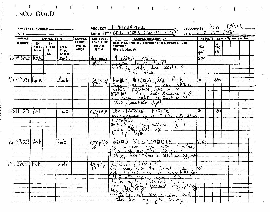
,
11.1a1 IHMElSIII:INTS121j11111109111111'tlf_7_ ' L~~]i1111
.•~ r✓I~w
• . 4
-~
-_
IIVMIMMIRMIMMIIIIIN ~ ►~ 1 ~ ~ IMMM ~I.
- ~~
~
rti ~ ,•, ►
1 i 1, A
=MIME
--
IMMRIIIMIIIIIIMIIIMINNIIIIII~ .~~MM.1RI ~=
. ~
MEIIIMENIMMIll ie.IMININ~ MI~
Di
` •
~P n. -An • i a~~ ~ • . ► •
~:
~~ ~.. ►9.~lr~ - ~ ~ - 11,11 1
\4- .40
. • Ii~11r~~iT;i1~~4LeLa.!
,PA .'~ ~.li • i
~b I'~L~'41111MOl1►:MIIIIMI i i RV:ÎM~t 1fI d IIM C RE E
MI_ r . .M N :, ►. .i Lg.. r
.. ..'~
-
EM
i
i i
.0
., ...!-
41
SAMPLE LATITUDE, LENGTH, LONGITUDE WIDTH, and/or
AREA U.T.M.
SAMPLE
NUMBER
SAMPLE TYPE
RX SX Rock, Stream Grob, Talus Silt, Chip,
Soil Channel
SAMPLE DESCRIPTION
Rock type, lifhology,character of soil, stream silt ,etc. Formation
Mineralisation, etc.
I 1 I 1
'NCO GOLD
TRAVERSE NUMBER
N.T.S.
PROJECT READ GUA`T EL- AREA i` 10 (,Fib) aRIAR SAr,FIE n)
GEOLOGIST(S) L" V F` " ' st_ g_ DATE 6' QCT" / 1940
RESULTS ( . /% /oz er fen)
frb
lrbirmitimmor ieuxamm 1111i [aM UME 1.!REMIUM
C , ► . , . .6., .•~~~~~5

.0~ I►0
6`3o25 Soil Channel
Rock arab (t~~ ~ ~ 11/1A-F i L~.
h k L~ S r V E ~n ~ .
R /) M. L
I 1 I 1
i INC() GVLD
N.T.S.
I I I
GEOLOGIST(S) J108 r"q/'S E
gib
!~
AREA J990 ~~ G~ sS~A1VlPLF ~ l~,) DATE I ocr l Iq /O TRAVERSE NUMBER PROJECT l E UL- l 1 EL
SAMPLE TYPE SAMPLE LATITUDE, SAMPLE DESCRIPTION
RX SX LENGTH, LONGITUDE Rock type, lithology, character of soil, stream silt,etc.
Rock, Stream Grab, WIDTH, and /or Formation
Tolus Silt, Chip, AREA U.T.M. Mineralization, etc.
RESULTS (p.pm. 1% /oz. per ton)
A~ A~
pP6 91t !I
SAMPLE
NUMBER
EkD M C, 7 fl)FAa ( A v.E„ . 18 X -193026, W. 1%
JUeu..
,
J I- 2 cm.. ~ (LIZ 4:S
Gro~D , &WO _ G)11A~-[Z ~~ill l~,kJ~, r_~ v~ $~ w. a1~~ t d ~,r~tr~Ar,,.~~,_~
h I ~nbl, ' 4 ~' X•l_g3o21,
1P.
~ ~ a ~l.TE RE D gl4~IoL iT~ ,' ~ 1,..0p,n
Gro b
'4- ►T3àZ8
Yix n3o21

1 I 1 1 I I I
i NCO GuLD I I I I 1 I 1 ï i 1
uQ.k fx-193 030
~ R4 tfr6 91t
Rock type, Iithology , character of soil, stream silt ' etc. Formation
Mineralization, etc.
TRAVERSE NUMBER PROJECT I ]FAUC nJ7 E GEOLOGIST(S) t?)
AREA MD 6V; RRL~ SRInPLF t, a) (î) DATE '4 no— 1190 N.T. S.
RESULTS (gym. /% /oz. ter ton)
ALTER.EL, 1,(44. voLCA n>; C. ?Yy
0 3,.6 ?.o ai rit1•: n,,,IX cv. /-2 '/, °
~u ~,k~b 1
- It, ~' 15 di~ l4rl.b
~ w. ~~ . a~
RX Rock, Tolus
r• ' ü , (A.--,..4? -~ *0~Q1'I'. . 7 f4J~- 1h~7
A GT F-P.F b 114 F, c, nl ( A rl )i c. IICQrf. /' - ~e A ~ t. .li~ S: o,
A n 1[ i ~ i q Ale i I...~ .Mo~ U 1-) ~~ ~~ ~ ~ nn ~~,.A w, r ,
1'4> !1 ^ ` i.~lii~~A 4~l.p.wR.~) CtJPap~
~~ iA/+n}~~1 (-i~ U c~fv , Q
~, S~j6, ~
M3~
Vo~(.i~1'~i•(.
"3-s3 ~ ,ç) A ,ù. rL .,~ pAti. W6a, c: _14.3 ~~
- Pt 0 cp.
LT E424.b Ott AU‘ c. 2$7 _ Qnur. Si a ~\Q,4~ a .kfrs: 6/0
dta
S-7
~~ di% n E XL '5 A. cp. ~~~~c li~• ~ u
kIES11) PNp`F UnLc N►c. S-o I 11.. I~
---._ 1 ~ ► i 1 ! r p~r
-~3 d.t4A.___Iffy ~r~c w. ~~~M .
G,Glb 4 re,
SAMPLE TYPE SAMPLE LATITUDE, _
SAMPLE DESCRIPTION r.~
SAMPLE
NUMBER LENGTH, LONGITUDE
Stream Grob, WIDTH, and / or
Silt, Chip, AREA U.T.M.
Soil Channel
Grab cie.„
10-
V,x- fia31

AREA icon PROJECT TRAVERSE NUMBER
N.T. S.
GEOLOGIST(S) RASF 2 DATE oc.r 70 GR(h CRAB snMFc E OA.) ie,
SAMPLE
NUMBER
KK-
RX SX Rock, Stream
Talus Silt, Soil
Grab, Chip, Channel
SAMPLE LENGTH, WIDTH, AREA
LATITUDE, LONGITUDE and / or
U.T.M.
SAMPLE DESCRIPTION Rock type, lithology, character of soil, stream silt, etc. Formation Mineralization, etc.
RESULTS ( /% /oz sr ton) SAMPLE TYPE
S;C7
, _ ,.
' , ~. ►r
, ► ► ~, ~~ . â~ . c~ • .
\?)x 1`03°1
[FAuc PSTEL
CAPRar>80~
1 1 1 1 1
1 I
I I I
NCO GOLD

NUMBER AX Rock, Stream Grob,
Tolus Silt, Chip, Soil Channel
i4(- f9 3OO) )29(.1( Grab A riff A LT
LENGTH, LONGITUDE Rock type, lithology, character of soil, stream silt,etc. WIDTH, and/or Formation AREA U.T.M. Mineralization, etc.
a 0, ►
~~ P £
~RF~c, I1n1 r^Au ►c._ D 1~ L_
n.0 S°1,
Z
1..! . ~ ,< , ,7J
. ♦l1â ~
!' i/. b ►~
Ur. ( i o A.' l I;,r~ It), L.~
a,5-1,14. tapt t1e 7,lpA' Q.d
, 4 • r 1, 1,
aâ 3110.14,
1311,
1
i I I I I 1
I 1 I I 1 1 1 1 IINCU GOLD
PROJECT &Su Cg AST E L AREA POD GRiL M ,sANPLF S (') ((
GEOLOGIST(S) 1 )Q ~'S~~
DATE '4 ()el- MD TRAVERSE NUMBER
N.T.S.
SAMPLE SAMPLE TYPE
SAMPLE LATITUDE, SAMPLE DESCRIPTION RESULTS (p.p,r. 1% /oz. or ton)
A4 Rtt pek 9/t Z7X
rS-20°~ 4
c(,~ 3 ~ . ~
~1•P xi £ xL'5
V'x- I930q2 PoLk arc,h
-4
11:'"°
F;c, VoL~Ar,~,c..
, ~ ~~i`I~t n~e~:.,p~.o ~ por~b I ny .~o rn~,4.
pc, ) ~ ~x~ 1 ' ~ ~- ~ , p pre . k14,w. ~ a ~m 1 . ~=~ 11 n~.n s.0., r~ .i)
M)1e, Ct~,zlr. ~ .0 Alit .~~n~~ '
fat) ilL.TfkiEl~ (M{~viC. VoLC1ln) ic, s% ~.o , ~,~ p 3n1 se; ~ N~( j~ DP". a ~ ~
~ Q ~. r . ~e, 1 ~ ~
D
~ f S L ~ ~_~.L.. ,L,. .1
— S!% 111 , 1 k1 .. • n pol 1 _.A —M .i 1i . I I
1-------~-~— -~ ~ -- -L1 '"`"
1n~
~ --
1 i>l.-1(13oll?) 6fQ6
L

~x \gSoL16 763
1
L-r e ,~ e►~AF~c. you ~
~ ~ . d,l< a/o
~ J.. 10 -- Zo% ~e-0
~. I ,i I,
3- ~~~. ..... C 3
1 I I } ! ! ! 1 } I I ! I ! !
} i NCU GuLD
TRAVERSE NUMBER
N.T.S.
PROJECT (~-EfuGt1A~TEL
AREA l9°ff) 6Ril1 (411Q SAmPLES on) ~ GEOLOGIST(S) I " p
DATE ~ OCT /99°
LENGTH, LONGITUDE Rock type, Iitholopy , character of soil, stream silt,etc.
Stream Grob, WIDTH, and/or Formation
Silt, Chip, AREA U.T.M. Mineralization, etc.
Soil Channel
rifIlV ALT .Y.F.+D IMFFrC— ! ~-
N,C. ~ - ~1. . Jh;•sti, • ~,~r. ~~ na1 c LAO
QnR(nor, . ~~~~~ nVT `-'' COI
P ~~ JAN" M r172:90 ~ C)44,621 ~jPa }l .
SAMPLE
NUMBER
4 IT3o11N
RX Rock, Talus
101):
Ati gct Ppb s/t 26A
SAMPLE TYPE SAMPLE LATITUDE, SAMPLE DESCRIPTION
RESULTS (p.pm. 1% /o=. per ton)
tile/ htT~~ i FRACTUfa M~Fr•~ ~~D,
, 0~, a nN, ~ ,w...
~ )1Df1,/i.,~ta..r • Ov~ r ~' 1(~d~n ~QP~ ,
1 .IAQI A ~ U
CJ' ~ez,0yo6_ '~. 1
'5 _ ~.è~ Lr~ , Y~hU -.0,---. ~
(x,k AA&

1 1 1
INCO GOLD I 1 1 I 1 I 1 I I I I i I I I
DATE A nrr 1iqo
Att_
036
33
raL~.
Sit"
I i . II
2- -4 ~ ?I/1m, c.;af 3% ~-'s
~ ~A~
PROJECT f3EL1C U115TEt-- AREA MO GAIL 6R44 sAMPas oiU
GEOLOGIST(S) " f-445E1— TRAVERSE NUMBER
N.T.S.
SAMPLE DESCRIPTION
Rock type, Iithology, Character of soil, stream silt, etc. Formation Mineralization, etc.
Of,►ÂIZT z IJE '3~J ~ Ç51). ;,.. Î1norP~ ,' .~At'm G`fl~ ~ '/dip 411•
L.ùi¢ ~M ti~, 7;t1n/
Ay "Minn.', /11i ~~VI 0~ ~~ .A~1 z1t .t/t~ A~ l' ;to Q
~ `I ~o t,
(ti
~
6ra lo dub
RTZ U6i N Auts cg ~~ w ~.i~ ~
. ~,c 63 j311
A.a.t. , (l rat,
A LTEJZE% UEC.CiPt 1 any ~ , . /liktt e"f
()i,tf
~~;~. ~~. r
~3.
~c ~ ~ 2 %
51, A faer 2/
_6
~ ~ L a
N-19RDsa
SAMPLE LATITUDE, LENGTH, LONGITUDE WIDTH, and / or AREA U.T.M.
rotr~~p4
Y V
RESULTS ( wpm. / % /o:. ter ton )
Rwk
Rx-113o49
SAMPLE TYPE
R M Rock, Stream Talus Silt,
Soil
SAMPLE
NUMBER
6Ig3atll
Grab, Chip, Channel
(rrah

I I ► I I I 1
INCO GOLD I I 1 i I I 1 I 1
(ppm. /% /oz. per ton) RESULTS SAMPLE
NUMBER
TYPE SAMPLE
dA
R>L19osti tr.k
TRAVERSE NUMBER
N.T.S.
PROJECT c AST E-L~ AREA ~I ► G'
GEOLOGISTIS) 1\o6 F SE-R. DATE or"' /990 rL. SAm'
SAMPLE DESCRIPTION
Rock type, lithology, character of soil, stream silt, etc. Formation Mineralization, etc.
frog) LTF~F ~ Fi(. UÂ~(Zi Or, YG FLrxn i 6 J~o ~~ ~ ~ 1100M . ~a % - / WK.
NORA iïf Lto .6 ?
LATITUDE, LONGITUDE and/or
U.T.M.
nr~
~
R)(- F 3052 ('grab d ptaô° ~ ~~ ~ ~ ~ ► 7
~.~ ~~
•4A~ a► 0~ ~ XI; rv, o
„I1aol,..1‘
c6(116 aAkbee`.j"
ock 16
/V1.C, 4 - 1,1,kt6 , 1/44 4g, I^xa~.
É XL's
? ~
3 e~... So
apAty (;oSSAluou S Z~N ~ ~..Q , , - _&6k a~ ~Zx ribs 3 , 20)&1-~, . •! ~ Q AA, kc 4h-dg ~
10 -1' `~ é ~u.~. ~ .,;o
~r-- - — ~ _ ~ . .. • .~t. . 14) M ) .4.4..4.4.lo !, t -~~ -- -
Groh
~ A,A 91t
SAMPLE LENGTH, WIDTH, AREA
Rock, Stream Grob, Talus Silt, Chip,
Soif Channel
(9 rah Rx-193o5I Rny,x
1 ► 1 0 ~
6oSS A nnt S FA( Z,00 E '442 RK- 931)53 .R0 k Grob
~-
-
+ • Jq
vl -n-
~11 ~. . ,r,
A E d,_..-
.~
rAr r C.» wt./ )JJA À
t,
~, Ax 2~ ~- a ~~.' IIA.Wr\
)a °M-.1,19 ,1~
R .3 9
2
o

I 1 1 1 I _. I 1 I 1 1 I I I I 1 1 I 1- I
i NCO GuLD
r, ~J 7 ~l ~ii 1.5.:......,) N.I.S. AREA ~/1i~ J~t rni• t ~1 C. c.+a ' DATE ~/c.. L / IV -
NUMBER RX 5_LC LENGTH, LONGITUDE Rock type, tithology, character ot soil, stream silt ,etc.
SAMPLE SAMPLE TYPE SAMPLE LATITUDE, SAMPLE DESCRIPTION RESULTS lp.pun. 1% /oz. eer ten
Rock, Stream Grab, WIDTH, and/or Formation 4 4~
Talus Silt, Chip, AREA U.T.M. Mineralization, etc. 9Îr
Soil Channel PPb ;x-(ciSn55 Rock GI-ah c~ ~ G~l L tX,K - OItJ 6nSSAMU5 7_vNF. 32
~ , . ) F ~ô,l"~ C A4y _.
P 1 J,,, ri, nt, t ) ~.1 1 ~s~ "~ 0
~.~~~ ~,,XR.~ ~t~ Ow SO, ;~~ ~ n at,~ ~.~ (mph- . r. a P
5 %, A~
u4. n~.4non,~a~a4 z ~ ~el~ b~Or~ O
))K-kq.3oS(q pa k a«6 ~ ~
~id-liq GnsS A/UouS Pock. lot
~ rni /war) . ,piy,iCx.. 1 AL 111AA 3.4.)
$9'
. s. lanha. ro ab Q53 ,5~ 40~
`f-5% 1~r, -t L~.✓,.L~
,x 1`~'os7 R~ 4 G«>~ ~! ~~~ ~r7~1(j
Il~k. %~ ►~`~G, ZIU'£ vDL~NC llti) ~ ~ a~~.~ r ~
,A1,..0 r• so,
J. r_Olir• piArL,. 4 JiCr.. itx )L/\ M^NA.,
~ •
n,j
l 1Q c~
,n ~ iI ~ W
{> /
n .
X -1`~~5~ R~ ~ /fu IJ) tl~ara - n./~.~ ~~TE ~FL LAC. 17E. /2 a ~ n~.~ Qha wq ~ ),..ALL AM_ ~i It. ,~-
r~~` U -' ~rptAL _ - ~ A t,r1.O u nipQt,. ~uor~9l).~~~.'~ . I. i . ~k~~: , ~ s % frt,~ fb, ç V. • ~ . oh. a , ~
l ((11 J ~ , . ► ._, ._.~' . , ~ , ,, : ,.
, .~ .
sa3as~- , ►o< GNU— : ~.~ : T -
~I,j~
— .. r,, S'I 1C .► ,. . i~ sC~' , ,~ .1.—..L. 711. '1 l . ~ ~ .. ~ .. . IJ~!~~_7 ' . .
t I i• ~~ Ah1.~ ------- , — --
' a . . • i 1 I: .2',..A" ° e A t _ _!..f. / 1 , 4 i
------------ ---
TRAVERSE NUMBER PROJECT RFAUC I1f YTLt-- r. GEOLOGIST( 4) 'w~~ ~' `'~`„
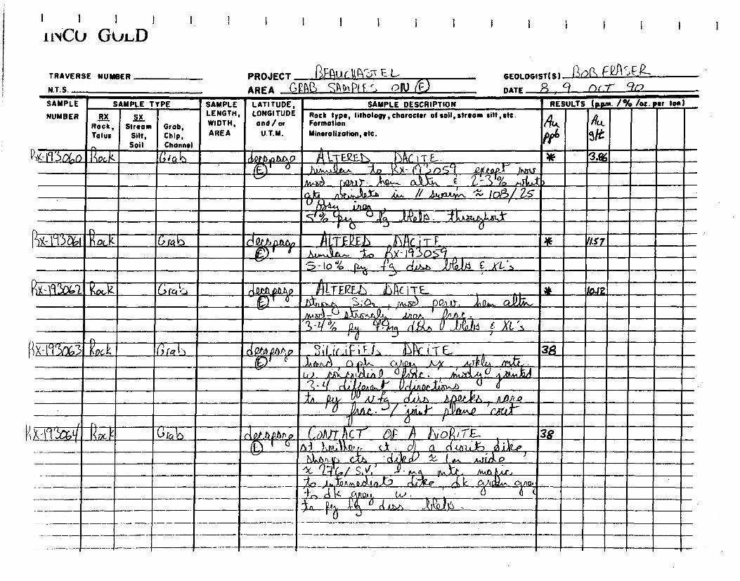
'A 1`mA Roc -1( G rab de,
U~X I ~DG,D L E(L-Ljj )Ar.~T rr .
~ P f4uxt~ `f 117 ~ Cikah OA
// d4pu
X
lof3/ Zs
1 AL Att4,t-
S -Io 114a F rl ~ ~I~u,~l~ c XL ~s ~
!/.s7
I I I I
IN GIJLD 1 I I I
~.:.~
TRAVERSE NUMBER
N.T.S. NM.
PROJECT I?l'Auc t1y5v E
AREA G!?A4 SA n,pl F, â oN GEOLOGIST(S) AO(') F l~l
DATE R , g oc7" 90 SAMPLE SAMPLE TYPE
SAMPLE LATITUDE, SAMPLE DESCRIPTION
RESULTS (ppm. /% /oz. per Ion)
NUMBER RX Rock, Talus
SX LENGTH, LONGITUDE Rock type, lithology, character of soil, stream silt, etc.
Stream Grob, WIDTH, and/or Formation
Silt, Chip, AREA U.T.M. Mineralization, etc.
Soil Channel
~ ILl
P
RX- 1`1 R cÎ. fc{ ICJ rely }~ZTF2~ d~ Ac iTE {~L ~J fn,,~ ~ P1i Ar, O w CAN,
8
3 F~ No)16 r(~ E Xt ~
10.12
clOth~.0~~v ~e~
~«. ~ i ~ 1, G b~ i T E- rnti.~.
38
~~- ~~~~ y ~~ . ,_J ` L
I ci ~~ ri Of~ Al- 4:5 ~~ 2. .~~i?d r Al~/~ p
~ A~~. ~ ~ ~
r~~ 7~ ~
G ra 6 ciA ~,~o~~ C,vArr ~
c 7' a d'~i a~ / ; .E. 3,g ~ .
Al ?~s.~~ p, , c_t_ . ~ a wit-to Ike (
113()63t Kock Grab
no,
-- ------- ~—

1 1 1 1
i ivC° GVLD 1 1 I ! I I 1 i I 1 1
TRAVERSE NUMBER
NT S
PROJECT &AU d Uhl T L L-
GEOLOGIST(S) A01.3 FasFI-
AREA 0 PPP, JA(11RL[ S C,1\.)
DATE I /(x-r 227
SAMPLE
NUMBER
SAMPLE TYPE SAMPLE LATITUDE, LONGITUDE and/or
U.T.M.
SAMPLE DESCRIPTION RESULTS (Nun. 1% /oz• sr ton)
Rock, Talu:
Streom Silt,
Soil
Grob, Chip, Channel
LENGTH, WIDTH, AREA
Rock type, litholoOy, character of soil, stream silt, etc. Formation
Mineralization, etc. .
~
.6
~
f'.t , /L
L
P4- iç3c65 Rid ub T AF.~I ~ OA(rT F1' 1~,
tyyta? ) ' 1•0.r,.,.nf Lip 1 .~,r ;(r ,,~ ~
~~~i ,
< Ar
B-Çw
I - > 04> - vv., C' iikll E /ÎL:S
AD)) o AI . r . i d46)1 t,io...a
, ,z,~ ,
1X -'{{-)~i ~(Jlo(~ ? fk [ 6(a~ I2. QJa9 ~ Y.( _K.0 ~ j (, I T F . Y
(7~J A JLfi^.C, n, ; û'. /'v , FA., 4 27 (o n h P.~ I. l,/ ;IA ~~~+ or If ~
1 r>) I l ~ ~ Ch Qa ~~ . In. ~ 14~
~(-ç ~~~ ~
~ ~J ' - ~Q )Jl~rd l~ r_{.cb~ , 1
X- ~`~ A~ Rock ~,ra~~ ~T .5~ , ~ Ï~C i T ~ ~
13 httt&b, Z ~. . ~ ~r c~,aif~..~ 9
.77 (2 ~ — L~ d/ iyp ,~~.Q~ ~ TA t_, .10 C. t - 21~ ~~ . 1 ~_ ~i.e3l ..D Jl~~ , CA ~ ' ~ [~ t r ' , ,Q,,,,_,
~ ~>a,~r~nba~ l~In~~ c.) 25~ ~
•~ n I - 2 `~ _ .,1:,,, APv- , ~4
" ci ..it.. ~~CA ~~ rtJ~l • II AC)
V , I
j
t-1 306S ° é at, , ,_ . L EQE - I C i Ili ~ (18 1 .. . -4 >7 ~ G. . ~ ~
_~_ ~ • ~, ► . ~ . . t ~ v MI
~ . hJr(~
ii( ` ~ _ . ...q- •.. A , ~ _ ~ L t N _ _ - ~ •
ll _■_~

1 i I i I I 1 1
i NCO GULD
/ % /oz.per ton) RESULTS (Alum
TRAVERSE NUMBER
N.T.S.
SAMPLE SAMPLE TYPE
NUMBER FIX Rock, Stream Grob, Tolus Silt, Chip,
Soil Channel
SAMPLE LATITUDE, LENGTH, LONGITUDE WIDTH, and/or
AREA U.T.M.
SAMPLE DESCRIPTION
Rock type, lithology, character of soil,strsom silt, etc. Formation Mineralization, etc.
r
► a ..~~_. ... 4 A. OIL
(1,)(495632 Roc-,k
PROJECT ~N1C_r\c_.}--r F L.-
AREA v Cl F; 0 ( F_
GEOLOGISTIS) )~0('' I-k1Î:r l~
DATE rfi I f0 OC (%!ÎO

TRAVERSE NUMBER PROJECT PINK AS-T
N.T.S. AREA GRA13 SAJmPL.cs o,o GEOLOGISTIS) f~~ f DATE In /OCT ! /D
~
3 lo / - 2 !:3 ,rvi ng
8 ~
OA-e+-.a
b Ra it Gra T~2E~ Ll<< i aft
I 1 ï 1
1 NCU GOLD
SAMPLE TYPE
RX ~X
Rock, Stream Grab, Talus Silt, Chip,
-~j Soil Channel
15r~k Crab
RO f.k r%ab
SAMPLE LATITUDE, LENGTH, LONGITUDE WIDTH, and /or AREA U.T.M.
SAMPLE DESCRIPTION RESULTS Ipwn /96
A
6 N t- if l .-t-MN Bin( I+E-1\ `{
1/43- aWatal" Tf.0,,D Ur 'T.&
S roz .,~r12 Rx-193035
Rock type, Iithology, character of soil, stream silt ,etc. Formation Mineralisation, etc.
` \)-)Y, ~~~a~-
ton) . ter SAMPLE
NUMBER
Rx- I`1~4'1 IT E. 22 ,
( IT
\~
çk2AA r°~-~--- S.; WAD
c,~ .
6 o~lt ' •. ~
__. _~ °~~ _~~ • dà : '
G Ia~
1;x-0307 he, LTE~E~ TaLf AC Nr T'l l
Àrim?
~i . ~:O,
-C 4~C • .
ra b

R k \4-11'sof3o
I t I t NCU GuLD
TRAVERSE NUMBER
N.T.S.
PROJECT A -Auc ASTEL AREA ON% SAMPLES ON
GEOLOGIST(S) fp~
DATE (D /f)f_T / 961
SAMPLE TYPE SAMPLE LATITUDE,
f Ix LENGTH, LONGITUDE Rock type, lithology, character of soil, stream silt, etc.
Rock , Stream Grob, WIDTH, and / or Formation
Tolus Silt, Chip, AREA U.T.M. Minerolitotion,etc.
Soil Channel
k
SAMPLE
NUMBER
SAMPLE DESCRIPTION RESULTS (ppm. 1% ton)
Rx-rt3039
Prn~4sty, ALTE(LE& bNt iT E •
t)2~~~jj,n,~~oa S~Y Jn Ql)g
/i f
~ U
+u 1~5 .i~ .( tW13
d~r~~ A (.TE~iD ~ FRAcTUI~L
? ~ ar.~ ~ P~
_I 11 ,,,,~
CJ~t ~~ ~ -3 U r, AN ~~>s 1 )a_ 'A f~ 00,11,
- J_~ Q1ul ~
1 ( ADa )4_1
o'r> ~
tO.
Pei 6 L-r ~ f~.~11~;_.. J~Ac i ~i F_
~ „A ~o ht„,„, )Q!rnJ.
)\-1r,.,s.~ s;0,1, ~ D 7~., _ 4~ ~~ ~ a.pt\ .
)U}t:.àon+~"~ ~ I a av. .QB2.~1z ~r ~A~ ~
~
-2~, P~~, ~~ - 1.4,,2tb ~
Grab
.10 if
~~.

PROJECT F.AU c 11A F L
AREA GRAS :f PI.E_S Or) (D
LATITUDE, LONGITUDE and/or
U.T.M.
GEOLOGISTIS) ~ FN
DATE ID) rx r /90 RESULTS I • . /% /oz sr ton)
~
SAMPLE DESCRIPTION Rock type, lithology,character of soil, stream silt, etc. Formation Mineralization, etc.
~G1Î ►TiT/J~ ~ 4 y , s ~ ►_ r r i l'-- _
~J • nall51 , r '
_ riff.) i . S ',
.
I 1 •
~A..~~~).t ►f
4.~7L•a:
• . I .
i I I 1 I
1 NCO GOLD
TRAVERSE NUMBER
N.T.S.
SAMPLE LENGTH, WIDTH, AREA
SAMPLE
NUMBER SX Stream
Silt, Soil
Grob, Chip, Channel
SAMPLE TYPE
BLC Rock, Talus
,àtn]Nkt4
2- "/
TWOMMINi i r T
r .1111. ~ • L It' r , M. ~~ ~
I I I ► )j'I; ~.i .. D.►_ a i~'.~-~ 1 - I_ . -..- . ~
,~ ~ ~fi~IL1~1►:I~A~I ~ ` ~.~11Yf.1'~~~ ~~ ' ' m- :, ~~~irr~r~~ , . . , . _ . Mill , ! /~%1111
►ti• al ;x- g rf3 a c, a 1.1=1MM Nill
1,1 ah... AT„ M `~/. . ~ ~.. ' ~- =
►_~, ~~ ~±~ ~ .. ? ~ ► - L- - • ., ~ . ,h,
I
. ►/~ / . 11_
12,x-nsosf R Gfe.6
f, 1,►►►
lb • •1~ ~~~ in.~s+~_7~►~~ ~ ,~
~
► ~. .-
. 1•~1' ~ j~~ _ ► ~ , .wi~y ~ .~~ ,_ _ • UT o I
:
,
~►
MILi~. ~~EIN 4 .. Ell.
41,1 1111M :
MO tj?1•111111111111111111r

I I I
GEOLOGISTIS) '~0 /2-, { fit~~~- r 2 0(7- reno DATE
SAMPLE SAMPLE TYPE
NUMBER RX Rock, Talus
oB(6, ~r.k
Stream Grob, Silt, Chip, Soil Channel
D rab dornpauy , ~ ~TF..R.E.6 !~ CC i TE V %~t fI►
-PAjo.. , 1~Qo)w..n t-, )IC, Z CJI, ,A 4 Alris •
/00'4/00'4 z ~,,m~; Q A n lmi '-',, 2o - Q ° ~ roo ~z , .
~~+~ ~r~iCi~, x 60- ~~o ~ ~n Qsh X- Ig 1ca~ h 1~h~O1A tA~~ve m.) ~-~ IliAtit°)% 10- 2o"
1S nnr'
_ ~DIn ~ ~ ¢IA,A io, r. T 04 Q„ , 61f-4 _. I -2 ~..,,.-~ 1 ~din., 1.5, o+,J,nn 4.~ ~ ~~ ~~ n~ x.,~ .D~ii,tx u rite,
~o, ~ )~ p~f,~t < ~, 14 )1 ~,,.,ôi
Arm, ~ ~ (7'.., ~ ,~,eU::1~10. d~,~ .)
c JM
~~.
1 L
9t?
I I
dQcn_~an~~ ~~ T~ ~ ~
I ) V _11,6 ~ . ,
tat . , ~~
4 k ~, ,.r ~,~U , j, ~m.~ ono.
~ ano~/o ~ w. ~, ~~ ~ J~. 1z+~
1-D ~~ ~v~ ~ ~. ~- ~ •
,nAn 5
~~1 . ~"..., ~~ ~I
VI?
q ~3
r
-r € 101 ► ~ ► ► !1• r ..
• IR1
20
__1&=_J ~ GUit7C. ~
I I I I
!NCO GOLD
TRAVERSE NUMBER PROJECT ARID ( I.IIITEL AREA GM, SAMPLES ©N 0 N.T.S.
SAMPLE LATITUDE, SAMPLE DESCRIPTION LENGTH, LONGITUDE Rock type, lithology, character of soil, stream silt, etc. WIDTH, and/or Formation AREA U.T.M. Mineralization,etc.
RESULTS (p.Drn. 1% lee . ear ton)
44 A. 094 9ft
~X (93053 ~oc
'Crab

PROJECT i AualASI F L AREA (RAR SAMPLES /')AO
GEOLOGISTIS) P-0( 2) DATE ~ Z /OcT / n1~
TRAVERSE NUMBER
N.T.S.
SAMPLE LENGTH, WIDTH, AREA
LATITUDE, LONGITUDE and / or
U.T.M.
RX Rock, Talus
/11 Stream Grob,
Silt, Chip, Soil Channel
SAMPLE DESCRIPTION
katl A,aI D 4' ~
~~X, ►~30°l I R,xk al b
I I I
1NCO GOLD
SAMPLE TYPE Rock type, litholooy,character of soil, stream silt, etc. Formation Mineralisation, etc.
RESULTS (Rpjn• / % /oc. ter
/4U rl t1
(Pit ale
SAMPLE
NUMBER
ton)
d " , ~ - ~~n f,,.r `~ . O.~ . n~ ~~< a ~sa2+~._ ~ ~ ~ ► ~ fut..r
4193010 Rack ~ra b
P ^
pty _AD;
A LT~~1 D C. i T - Wnr, a
?eiz
..~ T E~ N I
LAC i T F s;ot AL ~
~~ ~
eL-P‘ at ~

N.T.S.
TRAVERSE NUMBER PROJECT /3 "sr--` AREA ~,4A,6 3;41r,tPGE s ii1/4/ (g) DATE --A
GEOLOGIST(S) f31°6 F~e/456°Ie
1 1
I [NC° GOLD
SAMPLE
NUMBER
SAMPLE TYPE SAMPLE LATITUDE, LONGITUDE and/or
U.T.M.
SAMPLE DESCRIPTION RESULTS (p.pm. 1% /oi. eer ton
RX Rock, Talus
Ix Stream
Silt, Soil
Grob, Chip, Channel
LENGTH, WIDTH, AREA
Rock type, Iithology,character of soil, stream silt,etc. Formation
Minerolizotion, etc.
444
Pb
71c/9;092 ,c.t 4.e4a oil 01 Ar,E,QFf) J).9-412F~i Rr vSeC-S / re 37 Apo 4, A dA,--4 ef Keen- et%%P~rr -5„AZ1
grey
til ~ mod 5;02_ 0_ ff`dt7 , . Al > 6 ~ l~l Fins • ~
7;-,2y ~S
. ,, 5 66.6s.
)(/Qa0Q3 .Q~cF 4 4,fe3 O121A 4 /7L.rlEz~n 1Z,4r ,r'i~ 16 fi"; ie¢/I i ari G? 'W41 q ~ ~~__~ ~
..~- i ..s (J 0 CJ.
Ti - /% p y . ~C~.SS -t Qc MO ,. &coci' trrpj _ raL_ .
'/?30911 ~ocJl ~~„Qiitlj ~Otgfl~Gp A...rB,4fo ,~Fc4S,siRil4 D.4-ci re 166
4 DC4. ,-4 Q ze e . I v~ cVl,,
v
.r/wfl Ad ~-
~
(J2-3f~~P~ !~ z 3,,.4.i ,
~// 57z4 s a ld~„% 12r0_v46,02e!✓44;/
y
y-i
✓I~
e5,.6),
/93091 5" 7e cfii pttf .j'✓J EQE4 P.2c l re ~
/07 , (V1
'
A 4, ~, ~ ~ l
y /
-f ~ 3• a rta s - /0 /Lt/
,i.(tc _ Aced- 6 Ira /9, ~/✓çi v _.4 $: 0_s._ a /~'ri J T/ ~y F~. Ret35 /2/6.44. •
- - --- , - - .
- - , ~~-- - — -- --- ,

INCO GOLD
TRAVERSE NUMBER
PROJECT 6irp1/Ct01-6TE
GEOLOGIST(S) P /4g,--,«Tr— N.T.S.
AREA DEr 4.0/96 ()
DATE OcT.7
SAMPLE
NUMBER
SAMPLE TYPE
RX Rock, Stream Grob, Talus Silt, Chip,
Soil Channel
SAMPLE LENGTH, WIDTH, AREA
LATITUDE, LONGITUDE and/or
U.T.M.
SAMPLE DESCRIPTION
Rock type, lithology , character of soil, stream silt, etc. Formation Mineralization, etc.
1% lot . ter ton) RESULTS (alum
Qic /933o1 Qor D,9ai Gil .' 4 ,,. ALr,rk'rr.n,q,c/ f, 1/n c.0 rt,v /r D --Z1,91) ..p Atlyl,i 1-,ra~ I/, f 9 1it2/fl !Ogee 1i iS 1,
9 rL/ w; 4 red 1)4 }4-X..ç.(/
rtdrl- S; G7- ../,,Pd / M,~r.t'trG s~ ,4 /f.cz.ra It' ra
o ,bp~p 14 ~o/ 'j f- 4,.(aa~r,~c~ \ ~ ~
'"J { 2rr~ r~
) - M.~.
^~ LJ~z~.SO~M4O
+ }{p r~tlf•v C on.r~1-, ri
0.25..1 ch A.. 44 Mal) M 4-,e Lee f9470.. -/./cS.K
/-2 {~~7
'% ~y,
(mat 16, ec~11-1 nq.
. ~ _ r Z. r Aar Pyo:.
(~,~/cM r.1;oGc , (2~- /f~, n_y ~~1 /1154-1 I~ (OA Q/hA~/ 4L ~ , GU k; 4e
, ~~ dq ~,/ /u
.L,,t "Lc,/ 7 -
r'~r~,~ rarbdna / 1 .l~ s . 'r~~ P¢~ -f- liii,cr~ .•3 p
~ !.à cJ~S~.MGc. f Is Sn ".4 c'z , V
Tr y ~ r .~.1 ~a ~e/l ~~d
1 l~
~~
'x /933o,P ~ock
/6X 1330
l.ed ~
I et 330 if ,eni./z CR1t j/4l~tlr [ ~~.30w► ch /tilA,c/c_ /7
.571A,15 .(_cit.ta j-; 3, 1S'ri et 046 ri r 4,c,, n.tpniil~
/ Ally Si%rn A el~
— ~ raf~, a,tA~; ~t~ j. J _ — _ -SC~12/a- Dl/. 7 .q. (31 ii 4 i7;etr`{rl/2 cnaT-.-t $

GEOLOGIST(S) g,(GO YÏ
DATE ne--r. 7
TRAVERSE NUMBER
N.T.S.
PROJECT RF- iefirl5T6
AREA DFc RG
SAMPLE
NUMBER
SAMPLE TYPE
Ds IL Rock, Stream Grob, Talus Silt, Chip,
Soil Channel
SAMPLE LATITUDE, LENGTH, LONGITUDE WIDTH, and/or AREA U.T.M.
SAMPLE DESCRIPTION RESULTS (ppm. 1% /os. per ton) Rock type, lithology, character of soil, stream silt ,etc. Formation Mineralisation, etc.
AL- fekt
PP6 R)(/133a5" n y0 .i f;h At 4 TF.QŸ
I%: I~t~/e V I( IQ/l/f r 33
Ar4rt-~,J1ri! ~.f✓., 'f7'tF7~`~ ~r i lil o~ nf1%!~n
e,.~a ~dr/,`i l, /.O _
~ ~pea l4- i /~
~~ .r~
AA of +- eri /n.i ? 14 d ~
} 01.1c4 (rho* 51—:‘ Nt-•
syL.re)Ac I..leQli,.(
rF n
r
tt
n —e °/C yq. ~ ~,,ic
1-27. r ~tQ~uL-~ .M[ Qo
/ark Cl.o4.e/Af~~/
Rev 1. 6-ilk-ANAL o~x /93ssi4, ~ 6n.Y 29 (ti N /14 ~a-,c, r .Z;/~tlarA4i.. ~~3ka.„g,~ic J.{ ~
4, t.,:~~, ~a.~e~A.i„ 1,,,Q~. ••• et. AAA v‘ . ~4-: L~ 0,106k--- !a 1.f0 rtt( ~ ^4~d
kè._ ~ ~~ ~Sy3I Qd1 + t~-+~VttLi,d. I ~
,, /N3307 4c4 CijAWA,[62.. o. ifs", .l.'h 21.4.4.-
Lt )e G~~ ~~E~frN /Vltl-f1L ~ô iiiii/R1)-/ ~,Q P~ ~FG i[1~ Ç~~D~l i~
ts~E~-GY DCL~ f~/'~ (/ rac All ir a lic- f- .CDAu ILIi ite•
//__ , .N D/a's~r, Ile
~n- g1•llr•.
1,2~ J• ,~, ~ . .,, ,. .'~,',. _
r.., er~.rr~ . . 3 '.-• ,`~ ~fOw,va ~:~.'~
(5°0111.4,
d k; r

~ [NUJ OULD
TRAVERSE NUMBER PROJECT 8r-4((LEir95T~L-
N.T. S.
AREA I),ri4! (v
GEOLOGIST( S ) ~' Of 'SC de.
DATE çrt•
SAMPLE
NUMBER
'
SAMPLE TYPE SAMPLE LATITUDE,
and / or
U.T.M.
LENGTH,LONGITUDE SAMPLE DESCRIPTION RESULTS (p.pm. /% /o: per ton)
RX Rock, Talus
SX Stream
Silt, Soil
Grob, Chip, Channel
WIDTH,
AREA
Rock type, Iitholo character of soil stream silt etc. 1P ~ 91r, ~ ~ Formation
Minerolization, etc. ALL
'lob Ati._
gq j/ 5/
K N3.3D9 l~ed ' r.4/.¢.~rvz_ 11.7n4.4 ('h 6, , i-T,<V V- ., /C%< I/nLL4 Avi C.- JNY 6,ô6.2ft r3_A6.,4-
r'({/ ) / red Olr 1 / ~P/
~
1 0
r
• / LdLL~ ~i`Prî;° ;li~
1-es /
~T
9 n~ eoo~itY >< a~~
~
,.
,jc'~ ~, v/ M ild/rake 4r/ r i.ar•. -
,~ (G /r iiC ,
e-, ;rim 4 d ., _L-C- g % Y, r (- , • PI t ,tAe/
1 rr7 c1 ,1,-ire qr.; ~~ ► . l.; L' C,
`` ,,
/ / % /93510 1~[x~ (~ r/ifN~/É / 6.30 ,..f
~~^^ c. /l ~~ ,. 7~Jt,9K/_ ~ i~l ~,"r°.Er"~) /~-~/f, r" ( r ((ol--1 ~'N/ ~L _
(~/ `G~
3.ss•.,- y.is.~ ~n7 .f1/, / ~1 / ', ,, )P<r!" .42.6_±..2_26.2
_ . _ ,. ,>•t,/.>(~.5 ,~.,i~~, ,~~~, .,.," f ./n
ZJr>
,/?~
rnr,/T. c: f ~,? ~ /~~5~ îc1 fit) ~ A
n3.5- U3 7 n/~/ 3 ! yJ v `
/933/t' ,~1ak L°a,~,~r~ 4. 3r7nr ~h ~G ~.r~,ct<o //i /fr/6 vi,Lc g„,,,,c . 997 y/S.r - Al f5.ti I/Pv f~} r./rc/t ~ 7.-..: - it ~~, 1, ( Gt1/
/„..);.1 ~ /'~fI -5\( ,--,7 1 /4t..,. j
/ ) ~~/a t e/ (./ NIGc~.r o ~, C r r,r~nit~X 1~
•t ~~ l~Sh 41; % fZei~ f (, )Pa ~ ~1~ > , i ~ r ai • —
~ pY,cl . ~AF~~~ - -t- ,'
. C/2~/1'ti( ~/`G )~C- t' ✓L lkoLLl a PUL --, KP~
/933/1 I aa„nv 4.25 ,,4 - Ck 6:42b /7~-,-7,- U /vr-1Fi, k/nr r,9iJ/r 102 4.0OM- 0-2SH _ ~' r I_ c.--.., ,
.G~! t. ~ ~ c é ~ I.0
/ Q r~
~ ~f CA ~ S
QCZL~ ~C < 5 , d1 / P ,~i --_le_IQI~L
! ~~ ~ f L~6Lr~P cL
/ , -t itDti( Cc. , • --..--
~Q ~,Ci • t . f , e / e •
P) _6 , 'i U t / I f • 4 '
.
-----`--.~
---~- --'--'----------'-------_--ni
~
~ 40 /I ,
Tf - . v _Y
t---_dr5~ it..f i r1Gi Ft ,• .

!NCO bULb
TRAVERSE NUMBER PROJECT 8,4-A ek96/`FI-
N.T.s. AREA 06/01)/966: (4 )
GEOLOGIST(S) ~ Af-SC q-*
DATE O c'C , -7
SAMPLE
NUMBER
SAMPLE TYPE ' SAMPLE LATITUDE, LONGITUDE and/or
U.T.M.
SAMPLE DESCRIPTION ' RESULTS (p.pm. /% /oz. •e► ton)
RX Rock, Talus
_SA Stream
Silt, Soil
Chip, Channel
LENGTH, WIDTH, AREA
Grob, ~
Rock type, Iitholopy,character of soil, stream silt,etc. - Forma tion Mineralization, etc. / eel,
A n All
lit
/M/3 ,62r.é :!/,Oa/NLe. ~A 6 Z2LTrc F 42 IkiFI t 1! 02,_celdl, [s 3a:, 6 2 S$t - n yo., p S‘ /9,15 3Pi km 1 w ii M //Q,A ,~a
~3 V p ; 0 (.~ ~ ~n.t,( 6.7.q M to (1,24.4 _ ~ 4- /)y/0,113 / AO°
/9330( ,~or_F ~i,/,o44tlf-i- 6• yS11 Li? {~)b 2.:rh,~C,~ /414,4-,c, ViTc_c ~,✓1c ,t~ 32S
a.yv~.t-U.~S,u 1/017 -c_ (-10d Irr. /Qrf / 9i.cv~",; i6___ Q dot •C C G5 i c~ ✓I ~ / .,11-fPC, _.63.4f
/r/ef, y~~QN __/2a /..lr1, A(.V vir.yn 63rd -1• tii (.ir (7:rGe
/1-~rn/art , e 4 A /~.Q ><, /i ti-/c~~ n a,1r c Y- 415%1rrg / /I a~
n 3r~
/ 1 g J~ s ~55 oA.~,'l GZ.~ Gt / 14' -a~I<-( ~ /e ~c cf)c.L.f ,ne- -51l14 ~~ 5 .
! /933( .- 4c.4. fAIi4Addf ` Q. .5-;v44 C/., 0.)17 f,4È 9 /f/l4-f76- I/lr r rt A i. L .4.7- / S7
6B4- /. fa,t i/vr, 7 ! ~ 70 ~Ao (AA ~ f-(1'~~r le , y
r /v!
f.~J i~ IrPd 57-i-05K~ -f- ~l2` lhf. y e,/ ~s~orl ly kema},4- 3,1c ~, ~ ., a~-s,~Y
_kœ~, 1a1 ea ~ 1KPl j.~,~-t'c~ -. ~,6d f- ~; tc1 ~d , 11DCI - r4fb~r~_~. Q[..
. 00 , , - - • ~. t..r
_ rr.7rcii -NSW /I I t ..; O _ c:- -
--W-- r ~-

boLb
TRAVERSE NUMBER
h, fit §
PROJECT kCano1 /4,4;1-
GEOLOGIST(S) P.
AREA "1" -c--"P4PCAÇ (4)
DATE CD <-71-
SAMPLE
NUAletit '?. " er- '
SAMPLE TYPE SAMPLE LATITUDE, LONGITUDE and/or
U.T.M.
SAMPLE DESCRIPTION RESULTS (Nun. /% lot. per Ion)
RX Rock, Talus
SX Stream
Sill, Soil
Grob, Chip, Channel
LENGTH, WIDTH, AREA
Rock type, lithology , character of soll, stream silt , etc. Formation Mineralization, etc.
1 16
At At-
9 it
06%316 12a,L1t, 6,-ANtAsx- 0.,--15#A C,‘A 4 • -. .. • - nob ''...L .. • AP f
pl& 41/4A—C-Li‘-•N .4- 4 ( .2c.V.-S V\x06\—L.1
i-f ox_A-0 tRA, cLit- zod IA gs. ex nai
. • • • \ • A b.& 0 S . 0 ..
-Tr. e3., ci...ik,•-•Acyr,A;ve\cdt-eek. 4- V- crx,.41,,ti t
( W-331-1 001, Cv4.6,0M“.. 0.1-100A cl, A J i..A l2hg.i2Lisa..E\ c„___ P .(3_0v--,
•-k• k..;;,.-\\..).\ I Wec.„•1,-)-, stf.ea1 4- 61,:iç
A-t--) Ç--- t 2,rk" Ir. -
1 / ri .(-- , c-j 0L-vs-, 4- ç (At &Ali& côc.....
t4 03'6 le gcgck C4-40dOlJbç I 0 -6,-;.,,A CIA A r Ai-n-F-,(2_r- Ivlpic ir iii7 0,,0 Pfyi(v-AvC..ti r Cliik (ea.{ ‘,, ..lie),...AtiN
t".1 , \\-k\.. V-A.c , ce ( .Tor.tji r., r ., 4) 1)2 ,.5 -1-142 cc0Aoti qç+3 61 ticY,
racrko(R_ . 1,4i 1.A,{ IviLmoi,-; , g_ U • pa
•..,.. ,.. ,-, - .46. 0 ... •
01
. cs\IIII 0.1 t ( 'JAL,. -1-d... t aç — -5.0_,Kki - %Act s.,- t 4 e... Pi' QV-,n
r-ki- y, t(a., A.,1 [0 co,. I., iv)
1q3Slet CAI-AA t.NEJ CO CV, Pic.,_ qu-sr_c_cp N.A.0,c_.. /6/ is-,, Is .
e.o, c_______ ----

INCO bOLb
TRAVERSE NUMBER
N.T.S.
PROJECT -T)F- v~ t \ïl'.il ~
GEOLOGIST(S) t".- ' 11 iL`->c r~1T
AREA ri.
DATE he - A L.
SAMPLE
NUMBER
SAMPLE TYPE SAMPLE LATITUDE, LONGITUDE and/ or
U.T.M.
SAMPLE DESCRIPTION RESULTS (RWn• 1% /oz. ter ton)
RX Rock, Talus
SX Stream
Silt, Soil
Grob, Chip, Channel
LENGTH, WIDTH,
AREA
Rock type, Iitholo character of soil, stream silt etc. I<p ~ 91► , , Formation
Mineralization, etc. /914... ~
1 0)6
~~
zit I`10.3320 a.ock C4.4Nu6l.- I,00M (1, 1~0. Si
~.[)tl-1 00 un
_-c rc Ç-)~(.tz 1✓Lw f•-•t~
~/~ q &E-,.f\2, ( o,, l, ),~4}
J1,. ( erA
1 -, ~.r
i1-(vcAkp <... ~,A-(c,r\~. ),14.4. r1,
1( (cç,J c.f t (c~~ -it ( F1~iol1 t~l,~rr,(
61 .\(. / o-~`t
f) 'iv rv.~ 1 .~r1n,N0 - r
tr~rlc o tC~c\ \ , ~
i~~l e. r ~!-~.l ( Q , /T! !) i~ e k/`-~ h f 0,..„ ra >t-e16 Ol
t-~1 c,fi► ir..1e1.~ ~.U(~,~-tr,d ~,Ze~\c.VQy ` ~
\V.(\C\ ti.4 ~ <,C -4 CO Y C •~C? v. 0.-‘',-)( ~.
n Sj(),.‘ 55 .CfQt-4. c o
la~k. ~`r c cP1 61-.(St?" r~ r Toil
•_
~ Iq332i (Zoch rNNE.I-. WF~ h.2ow . i-
C. 7 1~iT.) h 7-Na
~z \I( ‘1,)t-4-‘1,)‘1,)t-4-,- 5t' ÇUS=i 1"~ZS" 11~ Y~
‘.0004- 1,10e( 1Y\ r1`'Yr iv(i y ~..n- ,3~Zo~~ f \n~ rr ~ ~~
0/a ~ _ \` 1\,/ , r~.%\bSV .,~ r~-1 n , , ,'1 l r [. l~~
rt \'`, o r1,.~~A1 1 (c- çk.l l( ( c., -k. , V\ r, .
(s1.613322 ~oc~t C. a~4NN~ L 1•D~)m Cl-, -tc.. ~-i13 ~~v \, I.~`~\ c %(• V t17 1.20,.r2.20rc -5``1~ r
tn_, 1c
.
.c( ~ e -',~ kc133~4i
Si-, \~ /A-i01/~. ,/ f c N' C,~ t"% f'. i', ~' ~.l"L —i ~(
<< <,-1 1-1' ry r', % 1.603:1?7 a
2 ! o/ ~ pq. t _O~ c.l i-f. -! ~~a'iC c'
{c'ri~ •~.tc~
~iC,C
- - ‘.1_,, C~, JC.c?~l_C~/~~4 -C'i.'t,0A IV 1~Cii._(s1~~ Zia ~
~i Y\1,5O v\~
•
i~i33z3 r i~~ck (-!{4A-t\vt,1f> l_. 1,0nr.p l'1„ 12_,,-+ 1l 1..i-Lf ,_:.i 0 ( -\,,, vc._ 92.
2,20m- a.% :t\ 143'.-)7 0 Y4A.A e( J. -,:\t,.12 -.) 4 `
~A~CI1~4'~ .9,,::_,'") 0 y~,i~l'~10Y\ 4 OCC 0.-S1 ~~~1 4 } 1
~
.-A, (` { Lc ..W1 Yl `t 1 1 ~~T
Li Li rxie J,,y La I r. 4 t 2 (.~
-.- 1,1P C.~ J — c'~), ( .I (, ,'<S Lk, • — ' -Y
T I .
-- -- ~--- - T

bOL`D .,~ ~.~
~. .
'HIM/ERSE NUMBER PROJECT —6r-Ak kr,4 GEOLOGIST(S)
AREA bF-..C.,F17^~C,~ (F~
i
DATE C)c- ' VS
SAMPLE
iVUM~Eq ~~` z. -
SAMPLE TYPE SAMPLE LATITUDE, LONGITUDE and/or U.T.M.
SAMPLE DESCRIPTION RESULTS (p.pm. /% /ot. esr ton)
RX Rock * Tolus
SX Stream
Silt, Soil
Grab, Chip, Channel
LENGTH, WIDTH, AREA
Rock type, Iitholo character of soil stream silt etc. 1'P ~ OtI, , ~ Formation Minerolitotion, etc.
n A. ~~/
O
Q-
' A{
sit M9332y- 17nck cu,a~~F 1— 0.10 M t~, A G 4 ~ ~ ~ ii.i'
,... a 32A.„- 3 `io.0 ~r'q~i(i ~-rne/~!-eC~ t- ~, ,~v~ ~(.errc~r nC.i~,~~c~ l~ ~r, F, AA P ~
/ / ~/~1tGv1 ;l1-rt r f7~i r~c`iA5 of /~~~i C.,'q4.~ Qf-F~v~~
iG dark ;',1-, i rG~f ir7 .r,.ra~1 4 f f~S~ ~~rcrrl , o+N.r~-, ~3/YIP~!`>l,'on,5, r)rrcisi0i1A1 r..14..~c
hi, /~ 5 ~
f3
~~o~, tL~ A vnra ~i,~ec~ r~„iln/,,~~~d t 3i(.c i~iPd.
. )Gg1cL~/ M<t~nx1:c_ n -ri/ -.tirr.(
~i% a yAjra !"l : V•~~ ~ o ,~~rn 1ia~ari
~ V1 /11//11-4Gi /14 36,1 V1.7 f ~q . GÛ ~s f
~YQ/':`4 4 l /G lI cnn, Y.r1q. tJ
J Z4 /93325 ,C'~r k G~' ~n1,(/ F ~. %). 3 Sr-1 r E, 1.'~G f-~t'_r~ ~°r,p N1r~F/~ l/o~c . 7?
3.qD -~ y 2 Si 7a,1A.-,,, i 1 ,c, r,r . I , L ~,,~. ,I , 1, I,i) L z -Z, .~~l.c•. -I J iv.~A~G~.
' //
/.//
.-t
IU~LleY- !'!~/ f~0 iNG.1L ji Y l, /.. iw-1,'.~ .! ~ f
/Lfnn~! /C 7r r(C/ !V}/~c N L~r! r
• //
I fit 1.' l -S ~ ~ II~/ ~ .c~i~G'~ /lorl- /-~lY ~~nriG Yl ^L~lc1
F
Fl
.['l'L 1-( !7 ‘1 _I ~ ~s~ r
S`l f - tu, ~Zi -~~ ~~~' ~~o CECL .t]c -f [ï • ,,'., ., i ~ ,
rti 6~, 4.°c/it L.f t? vNE.L d.5dM q,'1SM-1/.76M 4.76W60 44614i~ •
\ \ {-,S9 — /~~/1/t ~, r, r1'~,r k ~, E/ wi 51r, C~ 1 ct.f w ,
~`i~ ~Jh,.~ic c.l-V_) ? Cd,d, -4Y e4L S. ~7 t S ~ .5,
~"~ ~ i 5 th- ~ 5 "A3s .h V,3 - , ; ~~~~ 4 — I I ,
YQL ,: . .,, e,_ • -. ! /- Cç~r4,•4 • .. . . •i- . I i ., _
111 19t,/ M.• DiiaVI,r YaCI.thIF coca'%'~
----- --- - .--____ j`._— lPQa 5 . __,_ • CJ
-- -------- -- -- __

INCO bULb
TRAVERSE NUMBER PROJECT %56-40(
GEOLOGIST(S) 1-1„sc(3 -r
N.T.S. AREA Mgt') (,:f 1)
DATE ()C! i -
SAMPLE
NUMBER
~
SAMPLE TYPE ~ SAMPLE LATITUDE, LONGITUDE
and / or U.T.M.
SAMPLE DESCRIPTION RESULTS (Nun- 1% /oz. Eer ton)
RX Rock, Tolus
SX Stream
Silt, Soil
Grob, Chip, Channel
LENGTH, WIDTH, AREA
Rock type, lifholopy, character of soil, stream silt,etc. Formation Mineralization, etc.
Au. tlP 0b
/9t.~
sit
'
~ ~/9.3327 ~Qoc'.i _ CrfR-,t~/G'L_ f~: 55n4 Ch !~ 7~-t1=l' [~. 1~~
~ t1✓ 4.c C~. .~': (./ c~ucr,( ) 10
y.7‘,,,,-6.30... ti/, q. dot t' g ikctl i51irf4/ i.v r OA
Sn "LA v 6'i...1'4 „II C.J ~ao,~? 4- ~ ~,'4teva~ aeva~s
:5/14., 2 /P~ -5711,G ./s S
_,f
!n aPQ,~ li/ A e,r,/~ ~ ~ .<.l^r1~>4 p~r r~ln~'2vnl , ,-2 pia // co,-~1~nf a~ ~OJ ~ 5o.~l.
1--inv-Lerrt )I( fy it la i; r . jAe ,. / %r-/~~~~r. (J . (-)/ ,.•,, ~✓ac.~u/c~ coa~.~.,~ , !3 .
'/93328 >~oryi f'/1,1a(,VF,J 0,70 4k4 01 5.3o..4- 6.00,4 4 1,-rF ~ ~F~ 17
-I(?! K'/~l//4FiG.
LLl (c/ h! -~• ~dt.1 XI-fr (;{ , ' ~ ~
l.iY'f" , ~,
/'•P(~ pa ir.C..t~ 4- '5 ~c-r, .~S• V ?-2, 7t; I j /164/1645,, ( (3_ JPirlt C /
t.y?C ~1 ~{~rr`;<~/ta ~f
/ A ,~ ~/~ 1{7-4n11, / 1C..e'K-(a
l/,.)C(1~ it(G?Ic
1(~f r,
i.(npPf ~qY-~iy g. C~
Y
r ~~inrl I- C'CJ, /^~7~i' / S fi" ~. /
.~ ~ ][7y - ,(d. t~ G~.i~S ~ ~/a c 7~u~f r('+c~ ys~t S.
a1 J
1
~
(`j,l3.Q~ f or.fC cf: - +'~f~l,V. L l. QC)M ~~1 /,3~ bJ-p 41Z l,{ ✓i17- / - /~r=r) ti1,a / IC Q Q
6.60.,r-7odg, Q5 # 193.3?7 bL, -1 /_2 r ),_1,
~
~1,~ ~2cl 4)<~ 01'
~ fi J1C /J - ~ l11%?I 1 C~1~`.i . l C
l • I / 7 y. l ,4• C-4L5S_ ~ ~r_c f fil < 4. ci,--)_ Ti rIJ . y
143330 Ax.k ( t?NA/iFL 0,80 4,4 & rCGt Lig-tifJ)k'OC'z<(%' (- /.>I M (045'/)j,65) 1 1 loom- 78aM _ Vey • / cA ci ' y cif C..c. r) . ,I\ .i 1L f i (...)(-• c, 'iI. , ( F d
1 ~ ~r 7:n7i~b -- C~ Int ~ r.ii ,~ 4 1C~~ . '~P
—~ `C>
— ~~ n-Î GL 9 e S, C'C t (1 --i ; C' r' AI /Ll - C.
~ia- L?/C / (L- ~ _ c < 1~.1 DCl t, it YC / 4 1et ~1 n C 7 i J
, 1
~ :St., /! ` 7 1 cis.-... .
C
4 ~ T

'NU) bULb
I I I
TRAVERSE NUMBER PROJECT / -_5,64(/( ,4, -
-//-, ,
GEOLOGIST(S) 7. ~~4~ '~!(
N.T.S. AREA D, c r1Pr 2 ('; /-• , 2T)
DATE (TN 7 i
SAMPLE
NUMBER
SAMPLE TYPE
Chip, Channel
SAMPLE LENGTH, WIDTH d AREA
LATITUDE, LONGITUDE
/ U.T.M.
SAMPLE DESCRIPTION RESULTS (p.pn• /% /oz. per ton)
RX ck,
Talus
SX Stream
Silt, Soil
Grob, A,Llr"i(.l
Rock type, litholopy,chorocter of soil, stream silt,etc. Formation QQ~~
Mineralization, etc.
~U p ~ d L .J/C
/9333/ Aci C 1 4,vMF - /. /0 ► Ch 8r /4/_7~-r ~ l~ / ' ~ "f'' ' , „ ', ~ ,.J ( -~ [ 1( ( 1••r-~~ , / <, ~ ~1
7.800,A-8.q0.41 Ch,-d. r~pnr. ,~~ ~L( l ~' c~ crr<<5rnn.4' / /...,J;41,
E'O.C' +
1-~C/ 5?'-Yea ic; 4- ,~b i é t;ç,4.;ll, fCc, )
i"),-,l / ct!c j. L.h'Yr IC ~/' J`L (iC,.~P~ Cftr'/k)11r,17 . r t 1rL.s
1 il -
4 and Li • Li, Otr%{l./ AdG~Q/rz 4~,/ r
({ ! I /
~
I(- G- I(,CLIY-~~ ~~ C'~ r ✓i', -1-c- y »tv 11 c; ,!L(l' ,~ o c ?i. (- rti d '1 ~; 5 -f- I r ~, c, ~t!, r Çc21 f ~' M
3 1y.1 l 11 Y//tki i rt -
, ~ AIGI-1CL Y t1
/ ~ ~~,,//
rC )[7,1 Gi'=,
/93332 k n' rk l'4()_aJLtIFz o•aoa i"!1 1,,k /.= r" .1._: r c . ,____/-jk2 29 o.n()-0.'1,0.,.1_ tl, E f; , v.r r 1 ;) I' r ,s', , f , ; ;i,~' 1 1
. ~c , I ( j I
_ C '~ .~, .-~ ~ ~ ~ •~~.,-/- -'il L fC(L. ~l-" i~i ll'/
4 i . ~
, / ✓6 r 1c1. .c r1, ` ' ~
/~r+~sin ",,•,'/ ., j;7 r#,',. s.,,- ,t ~~ ,c ~i !.~;-1 1`- - ~
Cr,r~~, rl'l,In fi..;.;.1
; - C%/
5.j1r4t'.E'ca, _ `/ /1! i1.1 v ;-t / / v, t_= ' cc,,-, . î , 4', d
~f 1 rt f{ T 1
I" .A,,rIG>17/rc -:...,DX - ,, I c4l;o 7~.~
. c~i_,3 4- ~.nc' ~I, ec<^cti i',.-1 r,
/93333 ,i)brk r:UAr141/~L 046w1 <~ A 6'b 57k'n,;i"c,;~_'! IîL7(L{ig'i) /(f;,- /c~ 281
Q 3oti4 - CL.9Pw- 1),,v%idEt.i 4 r G hi,C ,L f. e. i ,•.. ,; l ! r cit. ri , , A
_
1 J
( .~/1'tJ'; i - . /t °1IC'i~ ~ ~~,~< ~l0•,. ~~~l/ /~,f(/r~Q~• I
~1~~.Y ~ ~int^~ly ~i r(/,-, 1; nc. /, J-~~~~rtr ~1/ ~
f -~~,r lr~n,, ,/,~~,,L.(
Ad~ar~tlr,_Y< !1 11(-~-t ~, e(i ,-
,- C11(r)i ,1 // Q-5 9 ~j ~?<P!~'-', f -~-I!i~,.•yF,`,~),
-- `l' ~ r_t r / ~ c ~ -
~
__
1 /<,,
~
c) ,
_5°X_ar & ,;.(f5~y?le, V. . g
co,,s~~,.. L. 4-7,,N
~ —
_ i_c_.1L i .t./a 54 a ~/ ~ âim e.:; a 1.15a /.a, at;--15 -r , _ /' f1'1a
,C 1urP ccnc.z..",_, ,
(J
--------,-----.__----- -

INC° boil
TRAVERSE NUMBER
Id T S
PROJECT 23,61Legyei-17-e-e-
GEOLOGIST(S)
AREA Dçe-pi,046) (P)
DATE Ocr.
SAMPLE
NUMBER
SAMPLE TYPE SAMPLE LATITUDE, LONGITUDE and/or
U.T.M.
SAMPLE DESCRIPTION RESULTS (p.pen. 1% /oz. Sr ton)
RX
Talus
SX Stream
Silt, Soil
Grab, Chip, Channel
LENGTH, WIDTH, AREA
Rock type, lithology , character of soil, stream silt , etc. Formation Mineralization, etc.
Rock, /ILL
Pei
A 14
ilt ,
?td€13.3,v ,ock 01 4A/AIÇ.2- 0.50i ('Ii gb 23
6,90,4-.1. 11(2 04 14? t 4 r i (-71 kiii414 i c.-__
A,,,..,, 1 f c (71 r. e' 1/ ri-,1 i s ) y
, ev A é II 1 4 A 6,y -7,- ry,k3 „,„ ,) 4irif r(44 ./?v j ,
..: -
(/93,536— 64 (1./74,diVitifi-i- A 40...4 C/, B ii 14 ez#11„y 447-6.42(41) i(AttFi G. / 7? i - r Z 4Ad - 2 .00m Ace, 74 _stersz.A.L.,20,/x-y. ai
i fitÀ6 1-i if -
V4 !r Lt iw i (irc,r u(cf f .14, iN 7 /3 ))
(me/ do, ever el , 41 v 41-4.,4
All 141-- it-fa 7f4 6
) v,
7, tk y -Sin A o Kin 4 7L :5 .; ( 4 r ; i , P((. yd jli ,
ICit)Of P (ri 41 e (1,4 .5)11-0 /1 47/ ro ( kCilri--4-Z7t c. 1 f
( tif-icd- klian i ly it-fekei e .
/D O/ ,\I/ , (; fiyArl_tAi vri di C.) , 3, Ai e/r-c,,/ e_L-t,i7 'L.', V • r . C r, 4. rt el I/A l' Cate , jr
• (4 A.( ; - A..tass; dP iii ÀO.Kia_iilç c 5a4i2.‘-x, atia.._ ati•55 -9- ta_r_Atz, coo.
./93336 ‘ock Ch AAA162-. 6.'2) /A a, 6 L. W.6.1 XL \i/ 4-1 6-64.0 411 c--. ,11.1_,Ç - 2.00,a- Z."3b4 ,,.. _it.t; leiz In W K3/ J' ( 7 C‘J •• '1‘ 1
' Oc co 4,/ ,T/Ict 1 f -cc(- /;J/ 'flit- i't_c- _,/ 1 I
5 A 1 • / , ‘,,,,li - / //) i'Let'Ajf, A I '1 Y(.1. _ !:g 71 _
j21 tfejl I3. d -, ...i5 -* 7 /- riciic CrY1 Li rij
/913 A 7 44 Cq'il/V4/A.-.L el.251v1 (A /3 A II *LAIL/ hiL7 r A.' f 1) ,L,I i-1 11 lc `77 2. A, a /q3-. 3 s .

INCO GOLD
TRAVERSE NUMBER
N.T.S.
PROJECT 1)2 L1u457i4
GEOLOGISTIS) rl•
47,r ,0-1-r
AREA i),4-6-4Pi9( (Z
DATE Oc.r !-2)
SAMPLE
NUMBER
SAMPLE TYPE , SAMPLE LATITUDE, LONGITUDE and /or
U.T.M.
SAMPLE DESCRIPTION RESULTS (p• prn- /% /oz. per ton)
RX Rock, Talus
SX Stream
Silt, Soil
Grob, Chip, Channel
LENGTH, WIDTH, AREA
Rock type, litholo character of soil strewn silt etc. fP ~ Yr + r + Formation Mineralization, etc.
~
rei
A~ 11
~C
X /9333B I~ock ( /JtlrliV/-L. r•
0, ,/,;,,, :~/ ii /~ /F re-- . , v 8 (11 j46 ~~4.rr
2.5.5-3.SQwt V. q. OiCi) Cr'Cf it,-r';1, c.1i V_Ÿ k ).'c /
ftcj el II ,•"( „)/ (1 .1( 1?s7 -17-,
ti10G~— Jl ///~/?~li~~r /
r ~rnr<
//<it~` -I 1.1Crr, C? ~~Fl1 ir T
~~fn(/r/ r:Y•CIs/ A (lir~/1( t~%(
/ trv!(1./ ÎY,/'%:'f/.i ,l,' ri ~rGr r , '/F5~ ?.se
7-f-/ % CO c, ,,I ,''- ~V-~~~~<c->%/,t"
( /9333y Ach (-444i1/aiL U,'s-Or4 c 6l /2)6 41 rrk?f 1) b/rlr(c _ 20
15Z)•4-1).00,4 /-?5 /r /2-i3"., - __,__
r /Ÿ33ya eock ()/tiIA/ki,'-L 0.,-/ -5...4 C:ll R/, /1/c,2.7 t'-+_ 7 F.Z1.- r ) 1=i/-/ L. 7/ 4•6O,vr - 4 Y5M /44 f 1,-7 -73‹ •
q33q/ ,1<OCK c ''+ /it, ., O•S.Snt CA (-rih 11 11;7 t'./,i/ ,r 11 t/(.... ST/
,4 ,Y.5-«.1.- /.-)12itcL'4.i ir '{ Of 11' 1; C, , ; /, , ,,, , f`
r:(";,/ pc- L-1 ti[. _ ,'4' :, .._- . f/, /Y ,
/%nC1-0/r,:1 CCCeI-,ri'e1-1/ f~ rt,/.~
(''j5 ii.(Ode /'cl-T t (\/ A P 61 I; ~Gl~ 4 /r -L (i ~ t /t r 1 i FT J (t)ea) 1 ~ -1 ;Z. r red',
/ j-- L
~7 ~/ %.~ i /'~Q -i~/ / q-5 f.,4 j , i)' t , t' :!,C err
• J
/ ~ f ~ f o~ C.~ PJ _ /( (%{. G l c-~•cE~c-, t ~~7 _ , C~
_ /f ~
v{.r `~_ ~- ~r Q c J~(~ Cc,LS ! t lJ ' f .
('433~/r5, '0c,,,: L . /-', S;v ( 4-- v, 'l cl t L) 6 !, /( Fih ,1 d: a F 41- i) /(-/r.; t IC- a
5.00w1"'.•`I:'.,, t t/?'r.r•; . / !c, brrr 1 (it ç(/t r t r , f ,: /
— ,---- _
cnt.. t-r1,rn tic; i (rr i 'SI/ r(i/Z
.
5 ti fo r
-
l r/ i-e 1 / r2lA'<lr
' :.--L-4-111_~ A [ ( 1,-)i ~e r i 1 .-•I•ttrf.r. ~,
, ~ , <~ ç~f
~
Tr -2/ ,t ,--/>
r J /~ ~<
(
~
-- — - --- - -- -- - --_ ~:~&Lli i Y // tr . •( ( r c., (''>,' ~ )( i-.- r ~ 7r —
--------
1
[P
a I Y.•) t 1 r ' r L- /-t ( f , 1 ~ T _ ~ --- - i
/
r

ifvo boL'D
TRAVERSE NUMBER PROJECT 14 /
-1". is\ GEOLOGIST(S) *t 1
N.T.S. AREA )7? ()
DATE (-) r -r • \
SAMPLE
NUMBER
SAMPLE TYPE SAMPLE LATITUDE, LONGITUDE
U.T.M.
SAMPLE DESCRIPTION RESULTS WM. / % /02 . or Ion)
RX Rock, Talus
SX Stream
Silt, Soil
Grob, Chip, Channel
LENGTH, WIDTH, AREA
and/or ALL Rock type, lithology,charocter of soil,stream silt,etc. Formation Mineralization, etc.
0
Ack.
3/t.
.t \ASV-V6 alsc, n.A.-A.4.\N F.L.- 0 t.) ON A 'c-I .1'1)\-) 41( 4r1 si r , - Illi-,F ir /S2
6,4of4- to nût.4 a 6 14V2, 3Yr laj, .-4 kzNij47...1,112_(44 is,v4 r 1,...t1 (..— . > V 1 /417( ..p
p i -le!, 4 t 02 C‘.,/ (A --"" \ 1 C) N' ri, . j (Ci f /tie C44 l '4 't ,
1.2 . ki .. ai,r-iri 4 1C... CL)(i C.(9,..A. '")
. IcOSSLI 2r,( k c k A...1MC L.. 0 . fl't) e,A rk bv, v./ 1, ,,, • \\A\ 6kA,4r -')k:ki, \-H v QNsA
4-
Z% f y. Mr\-A,•)( (\A, çs il. Cnner#ACrA4-10e\ S
in \NI ni4,, 1AC .-1 A (V. a \i n • c) .
A cS-5 +
F. kc\"$'-‘6" kbck C kilt.\ IJÇ L 0, 'So r.-1 bki A L...-r E ‘‘:2 C• )) 1.--4 Pr ( 1 c '77 1
0,,,4,,,,-. i 'AI. ,, • y ....). J
.4 --, \ ,/, e ' ( i .--, (2k
1 -r--
,ICV 3k-t(0 g nck L4ikiqr461- 0, Li0 IN1 ( 1'1 PA) Ai -r- %<.(2,E-N.) i'd'\ )fs.F ‘ C_ So
1.3004 -1.70,4 AO No_i•k k -t c.- (4•j3j \‘...._ C i c' •_.,-2 '-, 1 I. ; . )
re ck '_)c, ‘ e_ka •,-,. n. (r-viil k,..11-....„\tej° . • 6A • r .\1\EAti -s 4,- pa 1' Lk 5 ( TA - cc
- ,,k,,,,, r • 01,-1__I C,.... I, (2
4 c Li ) \ / • -5-L Or CA \ • V\ (Pi tCkA l 0 s -", A ç, A f . Nfk.10(, 0,V,,C7k_ (
-4--
113Sr( gsock C414.0t- 6-36m. OA 16 Atzt f - v ç ' IsA ( I •L 3 -7, 10.4-8._9N., -51,-- f ':1 .z, 11 1C -53 14 i, V, k k-15 \IOW '--/ —.—
kiryAi •{(ç4 ';- çiir:a_ k .'"/ • if
1 . r'' AV- ,'-.. VA CV A C.r. C ( , ) j
O.-

N~U 1G-012D` I I I I I I I I I I I i I I
TRAVERSE NUMBER PROJECT e-Ak XC\t-A GEOLOGIST(S) ~~ 11A-422S(-6A—
Nt S AREA ÎX C r\c' Y\ 0-53'N
DATE ('7cT V7-
SAMPLE
NUMBER
SAMPLE TYPE SAMPLE LATITUDE, LONGITUDE and/or
U.T.M.
SAMPLE DESCRIPTION RESULTS 40-Pm. /%/otter ton)
RX
Tolus
~x Stream
Silt, Soil
Chip, Channel
LENGTH , WIDTH, AREA
Grob,
Rock type, lithol character of soil stream silt etc. rp . oar ~ ~ ~ Forma tion
Mineralization, etc. R.k..Rock, 414..
l ,,/ ~.l lit 4, taIA413 12 <y,4y.11.1Fr 0.-4~i.► r v, b t..-rF.Qv-: 1,J1‘3.4. t c. 10
R.00,,.-1;1.'454,1 J. .r1~. dr,,tie 3rr r .n ~. ~i~\ l-. ~ 0 ti 4,61. -i~A ~:Pf'' .~ ~ ï ► e.lr},( y-T 4 1~~i21 ÎgAAk-
it — I1/4IDr~,.aT4k...( I.I NArAi .-icr{
Ia3yg (2,. k, .att-gMv41EL 0.2Ç-0y Ch t?j5 S,,tta 2r, \A ~-~-Fv~F c7 i~1,w•P i 9
13.3S►.t' $, bo r, 1~~1~ztt,:L~ c Ckli, t It ..`AC
~
60C- ï ~~
~ ` (Qy\f~
l~ yL- 11ov..ta,~. ty\A!-. 7._%71, 3.03.0 rt
1.4.*: ., • ... ..s.‘ 0 . . /i ...1 . ..
~ 4,~1sa,~t,lyt
p 'Oa r,%, ~
~
—re- ?‘i, v . a-,,,,-,r_4 -'cCescL(G c'nns ~~
)1 S350 ~oc12 rN AK) ts.)F- 1.._ o, S(-) ..., CI., Rc_ 1-ti 'AL-rf: rZ(---1 ) (U1NA_F \ c. cl.) b\N\n fi x.7 S 0.00-0.5o ,H avkti IAN ~T-tL r~lG ,d ~L (`Qe 'A \...1., •r C./ , W
rer~ rand cti~l.,. k ( Q~4--.~r - ~3~ p 0.4--c.1-,..v, u1, 4-4, -..Ln., A— I.AC\-04.1ue p,/ c,.)sc,k.\ -far ,t4)02. •
If *le •( -5~r7w ,( ~ k cG~ i l: r~.-, ••••( NA]) J1 l
r.,_~►,~.d~-r6 ~ CGk laop_riki-~~ rnn- ~c~ ~.~~-~c
• o
1 ~" fo fx4,_ I,..1,----;-1-101 0.5 c,.1 f~. ~.4 _
t~c+55~ J~ Cc~vcc4 v~l a~~~r~ t v. 1tQMnajt:~„1,
3o,..R.ti . 1
( Iq3361 12ocik C}-44,.1 t1/4)g4. (ILA) .4 CA. fiL-J ` ~~ k i A La Ciz4- U (-Air f z.). /783 ; ri. ~nM-1.10,1, a5 1ci. -2.a.ço .
---------
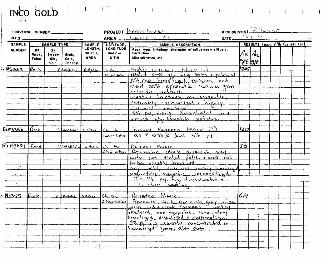
INCO GOLD
TRAVERSE NUMBER PROJECT 1-)F444 e‘-isr
GEOLOGIST(S) ' 1 1 ~'` (-'
NTS AREA 1>Çc%.{ I '1
DATE t -\ ' '
SAMPLE
NUMBER
SAMPLE TYPE SAMPLE LATITUDE, LONGITUDE and/ or
U.T.M.
SAMPLE DESCRIPTION RESULTS (p.p,m. 1% /oz. Sr ton)
RX Rock, Tolus
Sx Stream
Silt, Soil
Grob, Chip, Channel
LENGTH, WIDTH, AREA
Rock type, lilhology, character ot soil, stream silt ,etc. Formatio
n Mineralization, etc.
k
PQpL
V
ill/`fi[_
1, :~%L
/~ 1a 3352 ~ nrk~ ~,~Aih~Fl 0,60,
64i~ ~,
j ~'t`1 C~~~1 (? ,._ , I.-r~ f~ f . ~~ 1, k 1 1 '1 '4 i 20.1"
1.1A1,10.4-1 Go., R-19A -~ l~,!"~~., Q~~ 4f ~. lpkch~ + pa-~C4.4 S~
ml~ u . r- d .... It c., c4. , - ..
A~oUt4 '2.1) /e. a0lAv\:e.\-+_e__ t\k.oCi.'A,1t.1L 01,If 0n
(' Mor‘, A-, c, ~c-A. `,I.AaVe!
ln~Pr~l! 1,1l.1
~r,c~tit ed nt~,yt ,titQgr`yak--ic
r'aJ ~fYti-i + \n~.1ç~1. Ni .Ml1r.lQ~rr~4.e`q ~r%
V f bllr~,k
S~~~1~ -_ - __11_1/6.121..1_214.d .
\ $°/Q ç-N1-q. Col1 C¢.Aa /atak in +
f 1 i
n fc7,l hri, V- --,3- hQ.t,kA-t,Ÿ-t. 1-,A1, t,1-,ts.
.1.637153 _aoc.ls rt„0,t,\1.1gi._ n .S'O ,.,t r,‘-. 12.c 4-1(04y‘-{ A1---"VF(ZF1_ .1 -)\ 0%‘--t,... C?) )232
1.60M- 1_,low 0,5 \a-1)-2>Ç7-- ‘cl-,A. s°lo I),4_.
4.1°135t-( 17y-,c!2 CyAlakw_t_. o•yo,, C1„ 1'-)r. Pi-L-TE t2rT, MaFIc, ~a 2.10m- Z.ÿOr. '4-v3\o.rn,, a . r Cl),r.0 YL qi e~r.è: .,\-. Dut ~
;`~-t^ c.a. 4-', u~ÿ c.âl >~J&I t~.-. + ~o ~t ~j leG~
}Ad h-,, us e_a12~.( lTratf ~, t-ed •
\trr,f u.., ortihL( 5;1;,r ii',Pçjl ,..Aca..6l,t( 1~I-v.d -4î-~~~
I_-lD~ ,.r a4 el~ ~F, (-t c a t t7 o P û~ t -~ d ,
Tr - \ Vo p~ ~. ~~,_~~.r.~ ~~~~1 --t~c.A~te c~~,v,,,y
19335 S 120c,k r lAr1IJF.L_ p;SO M Cl-.. ï c. (4l•,TFiL£S> Mrty# 1C - en
4.5-b„4-3.00,A Pi pinswïk.‘-tc_1 act C11 ✓\ -%--)\•, f t.,,.tAls, 5.ui 31k. Îr~ .- l.Jk ,nit_ 5~(eAiZS . W_24~ti (
i~~
~iA0(
~I~wC.~11CcA hD t1- TA t1~ t. \--% C Y~A_na~l_(11a~ ~n/ 1 ( ,
-_ ~S Y.t~
d,, 5 iVlCi~'►~ 4 [~lba+131 tit.
51a $# - - - • I. .•. • .. ... .~ ~ 1-
L;,Nn o It-v -.1,44 '2JDA.c_5)___Q.N5 0 0•%055 .
— - --
._

1N~a bOLb ~~~:l .
+RAVERSE NUMBER
N.T.S. PROJECT ~g V~CAA-AST~F_t—
GEOLOGIST(S) P.
AREA b 5 P4 k
DATE cr•V ,
SAMPLE
NUMBER ';i'
SAMPLE TYPE SAMPLE LATITUDE, LONGITUDE and / or
U.T.M.
SAMPLE DESCRIPTION RESULTS (Nun. /% /oz. ter ton)
RX Rock, Talus
~x Stream
Silt, Soil
Chip, Channel
LENGTH, WIDTH, AREA
Grob, 4k Rock type, litholo charocter of soil stream silt etc. rp , vr, ~ . Formation
Mineralization, etc. L ~Pb
~ g /l .!!L
C 3Q3315_fo [ZscaC C',_ •. 1136 t n. 5D ~.1 l; ln Ar i~ / -fvs e?~rh ~r4,c/r. 343
3.ao-.A. sa .~, S,i,~,,.;, lar ~o ~. 1 A~~5 b.,~..k 4.,Pa1~u ~ n.~a .~ i A-i c, avid ,.s <<la., ~ r~w.~yd{ roo.~n C.\n~,~-ic... to 4.1-0--, (~
Tr p~. V~, t~l~.,;ti~ ~-tac~.tf~ cot,- '
; ig3357 Ark ("'il 1 ,c/~~ a-?,o.0 c(-I !~~ I~L-r~~`n M~4-~tc 14? 3.s,,e- .3.8o nS /93356
ro /i 33513 ~ ~,5o.~ r1., P,~ ~c.,l~~ lY'4T?~r.Ql~n Hl~-<~ LW/
?,.fill.-1• 4l•.~Dr+ /-~ liun.i tCi~ (~Grr 1Z CarFrn(j% qre~/ c,i i'~f-, a l,,,r /Ti 60% q ~-3 - ti t r~r a il . la ~y Ir
1, , s
i^ 1rrvcf t%fr,~ llri r7 (r .1~. Mlil~/ Gfard
III~~N~cla~~
0 // // / ,U'(1 ( fi~nl , f I L ~n ,~C <,l. . (t7flL kj./ in r ~cJ/0O( t/CI~~/ f ado, k ( ( /~ fi,r i tt ï '~~L,
A/.Cnrf e«/~jtf rcarbn/l ,;J, -,),€ (1, ~1Yei,g 1~~
• J -,1,I
/( f - ! ! rt l''' (
/~ `
/,
, G-/t1~-1(., ~..,1<._ r ~
/_ ,
lll~~~~
~
~. 14-c,4,4 . O~ . I`-"0~ ly U i ✓
/~ cc1~ ~ÿ
f ~
/ •. • .V e F - ti2 ~-1 a. Y-.r le -3,0 /Lp ~
/ .
~ / Q • ~ e.. : . ~ ~. o ffirinilligrAPAERZ ,. . - . I/ / c 9 9
, . ~:l~!1 1 l.nrirc.., acar/r 9re«,%t, y(ey w;~ a 6 0 t./ t iY V/ re (~.i v p -y r ;, r ;
'5 4fn,i .61 /LCl ua, 11 3 (I tit od~r~ L1 ~ ,~ 1/.(' 1- r f-r ed l n./ i,rr7~ ~,~;rr ,f-`, e fx 1 rt je/5
C ~
/ . . . : . . , , ~. t Ca 1i-yd , t. 1 all .=i~n.rAr t..
—.5 °.1° p ,9 . ,uA 57/Q ,,, ~~; , ~Eaill,
T _ ~~S,LI e ',IA Xf/ J
'tt, /~.t 5 c? AO i~.f n G( . J
--- -- t -

INCO GOLD !
TRAVERSE NUMBER PROJECT ;,'
GEOLOGIST(S)
N.T.S. AREA r) t/t'il();!:
DATE ( )(1 • Al
SAMPLE
NUMBER
SAMPLE TYPE SAMPLE LATITUDE, LONGITUDE and/or
U.T.M.
SAMPLE DESCRIPTION RESULTS (pp/11 1% /oz • ter ton)
RX Rock, Talus
SX Stream
Silt, Soil
Grob, Chip, Channel
LENGTH, WIDTH,
AREA
Rock type, lithology,character of soil, stream silt,etc. Formation
Mineralization, etc. A.A.
PA
44.-
3ft p' K /933/.0 & • (-2» 4M/'L- 6.1"m-4 (7 6 g.e. I i / / 42&r ,./2". P -lm'/ 2712
4 80,4- '2,66s, 06 191•35,1 12,,,L.e A ); ic: L 7cci C r)., f )-i 6.
3Y. y iyi k 6-1;1,‘._ - to imr-,-/t1 .1/4n 1.( ()/AS
if316/ ye aitiAtAii_ 6,0,1 (PI 6, /91_77er I) A4te._ <go,1 /44-s.-1om 61,-,'.7,1 3 --',51 ),T2,f k t.0; IA, c A It-) f t
÷ (IA') .trit.4. II 7 rune/ wed e / f in rr, /-, ,Ze (1 Zit./;,, )
'9% p y r- i 0-5.41i 1 It r. r .4.1 7L- lrY (-14 i OA I g oo hd 1,1 kr it b; /1 IC, c -:)) - r • .., ak0 k a_i sis AAA A. 0 ea, iryi.
< / 93342 kor k el - ,deVitif 2- e).10 ..-i (h 8c 41_7 Kett .0 114 4 I 1 r 21.31,i 5.10.04 -6.1/04.4 4D4aiti id c.. act,- i'L qi /7 , -, 2, Ç.J I
, 4„), ./.,1 f cej 4 „, y!,/,_,L) pa -, t ke Occt6i5Loeci
./D6,45 ea , 61 ,-61, 4 r-ex_14 (-Lipid, r y13 LI
• r
6--. ) eak / y A ,Y.,,--, r r -/ .i -, -;/k:ecil.;4, (
L A(0 0/C/ ca Iii ia 1 • " If / f t:' I CI>, 9,10,01,1 .1_1 led i j j G i ) ;
- I Z1) 1) -A4 • ' Al t's / / o--)14± r I, At 6 7-,zy;f _l_n__ • - 'a c C r^
03%3 4c-k (..,:ti4AZti6,(- 61154 L'ii /-. 77(6— ,71Ly A, eied-r, /1-..''» I, /L.. 7.7z 6.,yoit4- 6,6 im 05 li /93 3 çq k'-c4 4-. z.---)c• ly 1; ,
, ,, Lly,d nil,'" z /0 p y •
__ ..__. _ .
._ _ --- ------ — ---- ----
- -

fNICO G0IiD I
TRAVERSE NUMBER PROJECT L2) ,-- 41/c /-/ fk,- /
AREA De•-( / 1/ N.T.S.
GEOLOGIST(S) S)
DATE ()CI .
4
SAMPLE
NUMBER
SAMPLE TYPE SAMPLE LATITUDE, LONGITUDE
and/ or U.T.M.
WIDTH,
SAMPLE DESCRIPTION RESULTS ( p.gun. 1% Am . Et, eon)
RX Rock, Talus
SX Stream
Silt, Soil
Grob, Chip, Channel
LENGTH, ,
AREA
Rock type, lithology , character of soil, streom silt etc. Formation Mineralization, etc.
4f.k.
Pc 4,
91e 161/ krIc (../.642,4/Azçe_ 0. sop-, c ki iqc -r-Fki( f) 1/4/A7 f C.-- 44/
g 91,1- 7:560.4 v 4 (W>:. i 11 4 i I ( Clav" /. / ,'( / e • .11
,/ GI /,,,, /c,..1 /1( / /r /t, - .1-( , /
li -f (.1) 4; / , -", / .. • , .,"/ 5 e
1r It 1,...01. f (1 . I ic-.? f 7. ( e.4-' (.0 ). • j .-5. „ , t i /
', f " ', td 1/) "Z.(/' 1.4 2ii (-Jr (11 1/ A,I ( I c , jii y 0 1), /
•
r t.,( 1) ,»! ) 7/ 'O/)j, -. .: r { i (110r., 11 ,4 j 411' 14 2It il r c ,' r >
1
Ir3365 /nr k ' ti )Abt/ÉL ("),A'; 1 , -;( (71111-Y' 1,--Wri/e."4 1-'7;7 • f r
7: 'i Sit f - 8 .00 a .; 44 /,-/ - .32;,y i!.„ i /..),-,,,,.. / / //i L.. I, ,. o' • _,, - , • .), ; ,i • , i',, ,i1 .((r,-; ,-, ,, ,
FY''//,-, Air'. / a ' r "..1 ct ,,,,,y y pr
/ ;,-,(5
e,- t>1 ,-? rirt c-000ttAl )0(1_,, 4 4.c
,..)
75'7\3 Ad, /',4,40,16 z- 114, 9'(i..4 ( 6 c i i K.. 14 Ly /711..--T- ) A/h-bet , s•-.2 500,,,-,A1.0,-, 06 4 /Q33 5 ki-L. i- /...0 ,/ ii oct203.in l
k/o5517/ • % /9z, Man 44( co/1(0211J- 0 a 1.4
/ti iv a if if Li C_ "1>o n11_ (eff-i.<,_ 4- or • . (._
f ?39,41 oc l -114WA I EL- 6. 90,./ (31 6,- 4./yigea44,..r_-.6119_,__rsc.... /36 8•764- 9.80 V..1,_ A, /-2,ehcul ; i; e da,- I: (7, C'( ,. 1 .'- ,
r . (11-._._ .5:, (IPA I -IC'i_pp a f2('c,f\st ç 7.a IA 4 6 3e)° A3 tits ,j/ .5-(jcisit6;ctil, ,A)-
‘ri° — /0-- A _ 1 . 1 -.• .. . ' _________
AtallQ11114 A itt ti- 11 d" Co, Xst
- CaL4 '5A,I a I ( 14 .4 4- b.) Celli wr44_,Iy_ -1lod 0,.;4frgai L1,44, I i 3.14,
&Side ir 611-4, ly kfut54,,34 C -4- C.4117 0,14
------- -- ----
..._7/ /:, ye f.
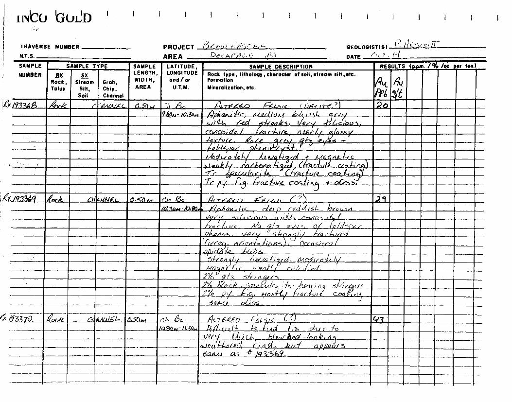
1 wCU bUIJD I I I I I I I I I I I I i
TRAVERSE NUMBER PROJECT /;3K »of. `+
GEOLOGIST(S) P. 1)r.:6( 0 /7
N.T.S. AREA f_ (P))
DATE ('‘L 7 • 11I
SAMPLE
NUMBER
SAMPLE TYIT SAMPLE LATITUDE, LONGITUDE ond / or
U.T.U.
SAMPLE DESCRIPTION RESULTS (p.pin. 1% /oz. er ton)
RX Rock, Talus
/~
Stream Silt, Soil
Grob, Chip, Channel
,~x LENGTH, WIDTH,
AREA
Rock type,lilholo character of soil, stream silt etc. ar, ~ ~ Formation
Mineralization, etc. / rlk ~~~
hlu
~~ I '
[9336Ÿ~ Ark ~ '~/iLitLÉ C C~. sfi n.1 ,n
ii !~c n7 ~i/ ~~L `
N~~~~ .S/ C . ( / )F~-c 17-~ - ~ 1 0 980.4- /ago,. A Qni~-r-c, .t,rf/'/,iu...4 ,:2-1c tiSl, ro~/
. ; .~ 1"- !fey,/_ . -, . ~~,-y .~Gcrp0_5_, _~- • / ~ / r; 5 • L ' 00G SS ~/
A~~ic. ,I~ gr cY ,f-`
i~~J~ . 1r.e
ic~r/r,}7G~ 7l ortr ✓ S•~-. L
~r, d t ✓ rx ~-0. i'~~ ~(, ~.c ~l .. ~( 4• tt,~a ~ cII'.t a,. ~+ t ' on A %y re I'l~orte
~ ~ (WO c~vYe- Cn~ i,' ,
L ~znu.11rif~ ti C~i'aau/e rev-k f4 4~ Tr Py ~S. ~lac-liJ/Q r oc.Li iv f- e7Css.
(/43aq AohrIG l'~{ AlNlrl 0.<6 n4 ('.h I& 4/r/</14.1) -Pi cc.xic (-'5 .2 9 /Uio.V'hJ.1~0
1- ~Aam ~iS de)/-) /'/ ✓oi. ~~/T '
~~///'Glia! {i~•
✓ r' 5t1,t CiC)J,S , ii. lrY~-~~~1 ~.1r, •N ;01,-;,,- IV
a a r , r/ è AjO ( / q e‘/( , . 0 fE' I/(/ `-)1~
p4.o,4n4.,_ \/,c)r y 5 0~~1~/ ,~râc~Le~ci /
(i/K-2[9. rnlr cri .S,trnrl•S). /(k-cn 4,in✓trzI
__
41)1;661 4 _hL[U.se
• I. •, l, I/.. . .. /1C (VI ra It /S/ .....;~ <, (. / . , ( ~
' .
Â~ ~
• ÿe~~
r7il[Z~~f'~.~1 _ r • s A C, '114'; N / 5 - _ - l o . • • r. C . ~
5 D R-f A GGc 55 . (
. r V _ /r1 I! ~~ ., ~ ... fit.T>çkFn /~e..- G (. / . ~~ 43 :.. -if. 0.. Ad/ c1 c /4-- 4 d~ ,/o
~Q1'~ ~1.iI:i-,1 ij(pr.t;Jed -/nO%r /Z. ~
'/
c, ~eu_ )14-n r.ecj ~ ,Ld l k.1,c ~ ~ ~ ~
~e~ #r ~
al ,re QS
_ '

I1N20 bUIJD
TRAVERSE NUMBER
NT S
PROJECT );,..
GEOLOGIST(S) i )"(
AREA i)Fc fi »
DATE (r)ç- T /4/
SAMPLE
NUMBER
SAMPLE TYPE SAMPLE LATITUDE, LONGITUDE and/ or
U.T.M.
SAMPLE DESCRIPTION RESULTS (ppm. 1% lot. sr ton)
RX Rock, Tolus
SX Stream
Silt, Soil
Chip, Channel
LENGTH, WIDTH, AREA
Grob, & Rock type, litholooy , character of soil, stream silt ,etc. Formation Mineralization, etc.
06 ec.k /6
, /93A7/ eoc k C4- AVA/A-L. 0.9) Ct, I•e 4l--rr---,71- -n 1 - -- y e /,- ( 1) 12 IMt4-11,0v1 J,).5 *I ic?4t1 ; 4 4 I- -'; Vc. (.:(,.". f i < ,po,.
12_,2a V ii Cf ' I'k ift I i _. A., X (i i / V /L /CC) KLI 1 C • Ae .,
-1`• (--)fa /./.. 7-1c.. .0,6(70-1-ely ci/(,1;ro‘ l °X py
X /93372_ 4)(4 r/ 4A/,V,' : L a So .4 C J., e c , ,..,..\
4/ -r-EG6( f") / (-- L-'5/ c (-, : / 20 fq 71 k,,,c/ c-.1/ Tr C.pki
1%
K 1'13373 koriz_ Ct t fiAlAir-- c_ ci,gF,A CA 1; 4i_ 'I y 1.:.: P .' . L / 12:3e4 -12,9..-1 /1 / 6'i 330
/q3 311 'of i r r 4 ey,L0,- L_ p . e; ',A ( it 12 ), _
1' - L.:7 K <_, c) I te 1-- --_,I , 17.3m-13.104 4)-- .41 31f ki-t i.,) , !LI
EOC- , . . ..
: '/- .,, •
, .
• i
. _
1 — —
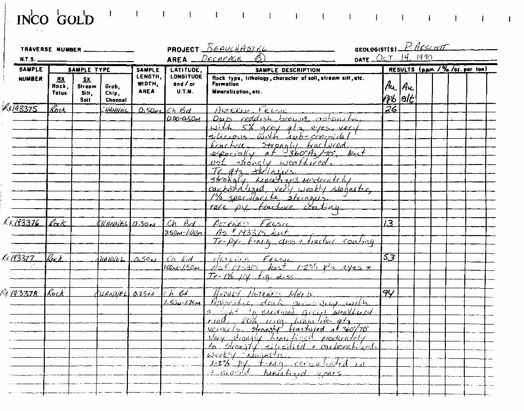
LNCO GOLD I I i I I I I I I I I I
TRAVERSE NUMBER PROJECT 73 1-1C44 57
GEOLOGIST(S) P 1/14~r r~~T
NT S AREA tc,e7f,466 6
DATE o)cT . ( LI, (I in
SAMPLE
NUMBER
SAMPLE TYPE SAMPLE LATITUDE, LONGITUDE and/ or
U.T.M.
SAMPLE DESCRIPTION RESULTS (p.pm. /% /oz. per ton)
RX Rock, Talus
SX Stream
Silt, Soil
Grab, Chip, Channel
LENGTH, WIDTH, AREA
Rock type, Iilholo character of soil streom sill etc. yP , V>I, ~ ~ Formation Mineralization, etc. t ~~1.
Pp6
/I~ ~T
9/6
(I43375 /67r.k ..'26,4INN6"C. O,SOw, L'4, /ir F' 'r'w 1-- Lr,rc 26 U.DO,açOrlI. / QdGl,r-,,l, 1-2/o, )4 r"7o)sf,st f }-,rt:..,
w;11-4_ Ç/ •ces , v.Pr oie,./ 71--4,~r
.4,66rir9a14, rA1,44-1 1. rAI'1-- r'riYlr ; 04/
rC' i ,l/Onf, ilr4r I.,/< , '5 on nll,/ .4 a ‘,05)9r,‘,05)9r,‘,05)9r,0 r t'Yl //y A/ ZZ , ho°I1 / in.. k~•s ,
I10 ( <,4a., c; ly k)ec_%1, r00ti.
724t__ ....1Cr1 r1 c .c.✓ 5 . -Sk-o It. /..car -i-z,rr',C et.lrlcCni~ie f / 3ly
// rav~jr7rtGt /iyG~' r_lorr,~ls, rl.(Ca~nF ri r, / ✓P~.l
5, /!0 5/2.Q r ,J/a/i F-a- .r ~ n I 5 raL~.
rrP/-0 !~ VT _ (70 c ~~,~// r ? v 1~ x , , t~
>` /~t337G 11rXk Cr~~rllrliFL (~•50..A Ch AdAd ~-~-E~;r"~ ~ v7 /~F,c..;,rr l3
50,,,t - / Uvr, 4 4' H3 7 7i 4 71- ..L 7.-- - py, f -Ad'. d.i-,,----, / f rarIte r/ cra et. lf•t~ j.
/f3377. ,Qpl%1 r' PA,VNL-L p,50 &I Cll, k>r1 FA 1! t,r -,'.1 FF. e--vc 5.3
I.oP...l -1,5o.w /2-1-e" j;7-;•-;ï'°; ,b,,.,,4 /-i%'> . -e -e. -1- . T✓ - /1 / :
'l ><,9, o(., s5.
/9'337$ 44 6..ayt~itlhL. 0,25,.4 ( h Ca I rr,'1)GV //i_7rAri"1 /1/ly,'r !c Qy
/.4-0,475,4 ,,
ill c r~c~r r< <1, ,'.. -- ,:,3 I'c/ w l in „1-1,),,Q , ,.
~ 4 ~•• r_~rr f 'UM Cie i~i~.) (~JPc ~Cc~ 1t1~ ~f • ;10/5trrC5. it1 TL G-1 /nit- 73 ______t- ;10/5
c ~.rr" /
36fl' ~n, ~fa C7-U[P9I 4~ 110- lie r/1a1~7, SŸ ,~~
t/erY l.rt,t~ w!,' , c(, /r.(0dCt•a nr/
4-
-•~
j "~
-5-~rr,ttq ~/ 1<r> _ ~jy
`~`~-' ~/ S ;( f r i Li Q rl - rai .GOC ~rrI '1 rc (. , T
- —,---- -.-----. G..)(`r~4 - k.41_,..),?<-4IL. . 0
! "Z -~ f~'~ ~7" 1, r ,i_ t
~~L(•~
/ c- ~?, ' , . r l ~, c,:~~-r~ .
--- LL-
- <îr(s'''lG1 /UKlîi7t~eCi • z ~rt~ =- . -- -- -r

tNto t3OLb
TRAVERSE NUMBER PROJECT
GEOLOGIST(S) ' ~'"~'
N.T.S. AREA /)ç(1',':"1=C-,
DATE ()c-4
SAMPLE
NUMBER SAMPLE TYPE SAMPLE LATITUDE,
LONGITUDE and/or
U.T.M.
SAMPLE DESCRIPTION RESULTS (p.p,n. 1% /oz. sr ton)
RX
Talus
SX Stream
Silt, Soil
Grob, Chip, Channel
LENGTH, WIDTH,
AREA
Rock type, Iitholopy, character of soil, stream silt ,etc. Formation
Mineralization, etc.
/90Rock,
~
PP 5/6
'(19337? ,/~-k ~/r✓tGifL 6.3~w/ C!7 Ad lliGili,V. Ar 4',0> F:4 1.....o.- (? ~ I-tg / 7JM- t,/or/ 41/t d,u.( f'f G-,g~t~ Ye y (,~) , )11,r~ i, lb ,
,/r c p /c.~r 1t.e.u~,4~- er13 1/4,1 A 1. 1 S.
Mn .'a 4_ 14e r• IPLJ6Iy K-/r<9it(Se-i V-Cy y S)1•,/o H (I ~ a~~a-, t i.e/ y
.~i / Uric. i75.'-' /L) % y r1 Je/ a rl ,...0, ~7 ~~
t., 1 . G~P , IY/~'. ✓
--?./t4( - N~~ ~ ~e 5o c Y~ iOr"! hYOA.( /•Ÿ~ 3.N
fa /.g() ,ti.r .• . .
/43380 Ar .k !b'AWAXC 0.70e t CA icl . . : r"64 c Sic- • tzA, 2,10,4-?.F9O04 rl 4-~ ,, < '1
P.7.- py-PS - ~,l
k17~rLiciO,S - ? f~
4A1NA/rr.~ r-e
Very ~~prt~1•/ 1,Cr,i<, /, rG, jiPa~ L/
pG ~
4
r
S
i
J
y
Mri. h1 J,[~/n,9- caihoit~ 1,
g ~o p,, ~G. . c6ncr✓ 7 /a X.e i/ d'adGb ~rGf
/e
3rtn an a4..4.....,..d i/lc<rl
.
19338/ ec,,k /'/ /~rt/~t/eG r1. 0.H r l, .%gol ><l+r tzt 1 l9-t.rrx,e 0,-D F6L ~ c { ? ) q Zz. .v.00.4- 3.2n,, V-e4 ti / S r:ii.,t; /crl kt # If 3 35Q 122.4f
Cn,,/I,/1qi n 5 ✓'a /11- f~-~ ,eyt,•<
/s_L/n// Pl/y sill ✓ ,ç- c.crlr12liZr4 fiOAS / d,/n y
} vi /Lit ALLA_ l i l4 G. "511 14_12,5. _ ,
/4,3Ati2 ~ali 0~~6t- o,yv,c,r Ci ► $a r'46,y~y 6, ,-,,,,e6 r~~5,c <?) ~ 7 g6 AO'
5T.vM -3.bor+ pi Lk I~i3381 _., ~ k_
•1.13383 AA (timoE. p,2064 C'k 6sL ia_a_t_— OT-2_ Pnp. , 172 3b0at 1,800 _
— --- a — ----- -- - --------- ---- -_,_ - . ►
,

INICO bOL/D I
TRAVERSE NUMBER
N.T.S.
PROJECT t),4_4(ic://,1-')r
GEOLOGIST( S) c'
AREA )r-, -;)
DATE ( )(. 7 1
SAMPLE
NUMBER
SAMPLE TYPE SAMPLE LATITUDE, LONGITUDE
and/or
U.T.M.
SAMPLE DESCRIPTION RESULTS (Assn'. 1% /oz. sr ton)
RX Rock, Talus
k
SX Stream
Silt, Soil
Chip, Channel
LENGTH, WIDTH,
AREA Grob,
o Rock type, lithology , choracter of soil, stream silt ,sitc. Formation
Mineralization, etc.
40
ppb P
)16
VS 3):3/ jeerA iirig,v4xi_ o • lio /-4 C,A Rd /46/%21 /0-7 i<Kr:/, f fr f i k- (..' ) 894 1,03
1.Flor-c- 420,4 As *- N335-0 aii;1. 2o4 Ale 11 - , dl,
el ,.; 1-c_ -77 )0 -1/ ; --) 2 Cr N ( l?, f, `. eii I'l l:" -".ALLLCA ' . ." /'• 'O) 440 --- . •
• i 4 . ... ' h-
i") /illl 1 ,.. 3o 4te <fs.
/78,Ç ArA 0-14MVFL 6.46,4 CA /34/ - feoiL7 di Tr t'1":1\ 1- r/-;1(..-
20 fri- 4.4/564. e.ey I, i I) I,/ I I re r ..-I , )1 , , •Ç 1., , . ,,.- I. ct t. Lk , 93Z 0.84 DA ,c.A_k_k4 -- 4-t, 61A-00 A .
0:02-Qd:LY -5 "ACA 'Pc\ o tv.--", 14 1C1-2,-.2)431)1-1 88 j 049
t• 1'1 3386 ' 1,,,-.. cNA,v,t/Az.. 0.31 .4 CA 4,/ 4.-r 6,2' 1) hliq if tc 1/95-.4- no ti ii )3 4 // ,4 a ( I, ; t, ,r,i, ,..exp;.- 4 17$"
qtr./ 6-I f V-- -1 C' nth )/ ' 5-10 : A. , r . gl--) ii.i,eal J(af vei. A (LIS
1.(0' e•- c / ;.i. ' le 4 6-4'n (Wit/ ri Arsindra 14,7,60(,
• k ,21- XI A4 //' la A,ttifetrifeit 71.2_ 51
(ve i 4.1._i ri c wt.. <>,.) -f- .epc6-)1; fr., q_c4ite s 5 snA_Ce 11 love itly oiloMo'
t /. f cf— c oetce A .4•_)Le ir'i
ItiA, 1,,' 44. 0 #1..e., 1 •
(I 7 ,,e -2M tr_k_ ^14ildi4a_ OSOA.4 CA ed I- h-re:et-':1) Mi-terr ii.,00144- 5-1$0.1 tii c A ( 6s Iv fed a 12 1-,r4.44.1- - , C Wilit1 , /MI
• -ID ° : /..ed 0- c,J)._; i.t_iv f. v. jpix.,-- 403
F3_ 64 hç e ye •sp_o f_I-1 fat; L.R._ ( Heft..4.) fr f /.0,3
_ - )1- .114.0 4r, f kiluaLlt ._. •
- # '
3-2 py -t-1.5 rn4 co. V/ jed ;,, Lliata 1,, jt e ,
_ ,•••— __ ___-- / 1/ occa4fro4al vt 'V )n- -, ,

INCO boLb I
I I
I I I I I I I I I I I I I
TRAVERSE NUMBER
N.T.S.
PROJECT (tip-,rir (-F4 7 r_'.c_
AREA /)Kc/// 1 (/- (i l
GEOLOGIST(S) ' .1 (ZS~ 11
DATE L c . 1LI + S
SAMPLE
NUMBER
SAMPLE TYPE SAMPLE LATITUDE, LONGITUDE and/or
U.T.M.
SAMPLE DESCRIPTION RESULTS (pprn. 1% /ot. ter ton)
RX Rock, Tolus
SX Stream
Silt, Soil
Grob, Chip, Channel
LENGTH, WIDTH, AREA
Rock type, IilholoQy, character of soil, stream silt, etc. Formation Mineralization, etc.
/,/1~ ray
PP6 ~ `"
U /6
204338$ 4..0, „wvna.F._ a.so,.+ c4 12,61 1A1 , •
z.3,4- 5. 8r-t Agr-,64-0 M41c ,r 1/04- c .
Is. 143302 Lo.0 1 /19 ~ r - a-ta Ss i ,k
~y 5o, o •Ç 3 i ~,,e ~c,r,r ,-1 r~F-,.+-g f flrC.Cg/j~fa~cot i/) r( //:;/-, nvu, S
r..l is/-G+ /.S l py ' t'kl, ra. relal <:71 'A - ‹ Li
/93389 ,~o~1t CNe,vnrez. A. 8DM Cia Bd 421...-r15.4:64 .161,4 le llnc r- 2r4Y 2•0b { 064--6,40 a5 # /l33f37 d24.t f .70 _12.14.i-1-4a5„,,~ 206 ,
36,Ac.s .//
1-ob
2.-3"4F-M•Q
J
. ~7\ / rn/Iro/I1[I-d ~d , rt ~
At ,~.ta Al-; ~c 5oi~n4
( 633ÿn retyk attiu,#:t. D4.3c).•-t OA ki I /t 7-64f.D Ni4 re.. 1 ()c.c. A3
. i l, ..,c f d ,;,/r ç o/a / kf Ia
J Q2/) r~1 J.r+ ~t' i In1 14-4-. 2 ~lo A LN,,A ►-1 K - ; / •
113 if r , tnli. rS
r~fa~a~~cly ~,-er'c,'(i4q‘ red,- ;_i; Pd Il.lr: A p ~C . ~,,J Pa k l'Y ~µ-cr~~i~ d • ~ ~ pYe f.5. .6. S5
! : , . __.0._. , C. , i c- ,c d : . e_.c . 594 ~ .
-
~lon,-B.ta - 7 ,~r ~~<
trL lQ3 D . Ai ~ [ .aii-,c/A/ l 116_ 44- -ryg cu ~ y retQ Afs 1 A ~-+'+`~ ~.—CLtis,Qi
a-~°1o . G . A,;~.
e /43342 /., 1 ...... .... CA &I /~ ►~ cT ,2e ;? Ftc Vô~.c . . Y4 ~ ~ :,?v.. -8 :o . 45 4 /43390 ,
--- -- ----- - — — — - ~
—
---T -
-- — — — ------- -- T —

Y NCU boL`D I
TRAVERSE NUMBER PROJECT 844-a c /P
GEOLOGISTISI P.
NTS AREA D4c4P44 F-. 6?
DATE OL? • 1 5-
SAMPLE
NUMBER
SAMPLE TYPE SAMPLE LATITUDE, LONGITUDE ond/or
U.T.M.
' SAMPLE DESCRIPTION RESULTS (ppm. 1% /oz. ter ton)
RX Rock, Talus
SX Stream
Silt, Soil
Grob, Chip, Channel
LENGTH, WIDTH, AREA
Rock type, lithology, charocler of soil, stream silt ,etc. Formation
Mineralization, etc.
ig-U
P/i6
A-N ~ q
U
f)(14 5343 Aaa-4 ;:::y.ideA644.- 0.5-0.ta lh 6d //J r/ir'/ Ly<giei) jt/4, lc ~/r,,c . ~- 10 Hk ~sn4-4.~ v.i /laQh // ta (.1t Ii r , el l f)Â // a)2n -hlreoÎ, _, lo.a
7/.i,-h,)/,r, (ire, 4' 9 rep /n,5h fey ra]/ia, 10.2$
?r7/ i(/O ,I41( ¢//-/ OA.i/7 7,~,~iw
.lJ/P ~~/l~r~S
/1 ;Siff) el (~ /]~/.
r ~I.In lY td A/f ~~%! rl~ }1F ~t1 ' (t r, i= j rOCi ir
/l
~Q,r (,~[ ,`r'I XdlL~
/rll~,tw r
2 0hn
2 ~~~ C/'~o/~~~ it r /~f~d Y,- /t-~C7 ~t r 1 rc
/ J~~ ~ r2_~-~T•~~ rr~.~t CO ~r~t fPG~I ,cil ,
A slL.Ir ><1~ c v ~/~ito ,
( /9334V 4 rN,g.vnffL n. so,t.) C6, gd 4! 7--r.~,eri) /14,-V ,c Vo / c
9.30,4- 9.eo,4 4 piir,/1,i >'<:(~ (:Irl/P C /ePd,i54 re( SOS OA/
/._)i~-G) lSl he/e,n ak- ~if-; -1 c_,, I.03
4- l~
/
c ~. ~r 5 ( UUU ~i Q. SO
lI[yy /APP/ PI/ M7:(") tAQ>1 iC, &JA ail~%
ra/hne'uk LÎ /t-Lr~~r ,i a. (A % / ,!r /l.Lc.a1S ~~[ri fr O
f ~
~ ` i 1 c 1 , e G1 ~
S% Py, /( / o gÎ/iit/ r r, )4-f„arZ a4ef i e-1 4.,4 lc! e, lc I i G. !~ n A O •i .
d!'Ÿ 7):719<7):719<r~ ,~Ock (164AA1<_L (S.7OM Ch 601 `7'7/C0 '1' , ' f 4 e_11 .4' h ~'/a r CC V 11 . I3iL 1.11
I436,ti -10,5a., •► 4 9" . Q . ,
1•37
A31.4__________
4-0._1. '10 f t ai .
/3.396 Act ~1,y(,4/GlF ) 0.'5- o M rh Piol /41(ç 6 /u1w f A.-. ~/(, c. r - ~ 1 /0.50.4-/i,~M-
) J,1/ rf (O1fi/50~-f /" ~~,,./ -;~, ,~p ~~•/ t/Q ('1(~ 2.q(n
t. Icy. ~~.or,~ i!/v5/y)r f /J%/lst"~
--- — — — .~~_ J uJo N, , c.l i` ~~ - ~,cy, ~U% .
1 ~ 1.C I e~
/~~
L)P It' ii is"' -;<- bfrb6 /
Î~ ,,(ân !`-i 4 / 3/
, r n cC~,r r)[~r~ ( '}}/oo ' --
C/i A/ r/1)Gr 4P4 >'S. S/ia„ a(./ irk/<, ll y~ — .-. ~ / 1, —~
------ — ~
Ir
<~-ILr/~rvr midi . - ~ . , / . ~ ,3 ~
/' v .. , . ~ ' !L rt - - ~ et),-.!
3;~
1" L~~._~ ~ y, M0 5~" ~ ~i , pi r~.‘ M Cs1rr J~~= ?, r 7_..0011s2/1~a rLC

INCO boLb I I I I I I I I I I
TRAVERSE NUMBER
NT S
PROJECT BK./P/0 /767 I: I—
GEOLOGIST(S)
AREA l7fc r)P/c; r (7)
DATE (Dc7 • P"-ç-
SAMPLE
NUMBER
SAMPLE TYPE SAMPLE LATITUDE, LONGITUDE and/or U.T.M.
SAMPLE DESCRIPTION RESULTS lµpm. /% lot. per ton)
RX Rock, Talus
IL( Stream
Silt, Soil
Grab, Chip, Channel
LENGTH, WIDTH,
AREA
Rock type, litholooy, character of soil, stream silt, etc. Formation
Mineralization, etc.
flta
ppb AO
3I6
,• iro. .. ._. _ :... 1. A .. C I 6d I ~ L/ I l / I Ai/ YL[G ` iq
am-//• ,lM ii ûsa%><,C' da/,E G{ ✓IvrI 451. /Cy~ A,04/
% % ~]
Cj
~
~'(jC !Q`JS W/ié.A6 -r~rn,sa'~ / ~a r 4/e -in
6rf//Cirf 5 /0/0 /
/~(6.h/e Cw Deis At- .
ha a fedGCi54 24,'441L 7~roiyo✓ -/".
V`D3y ;vi )-7ra C.L5. 1 , wea~I ,t.tarq./I~ + Cr~r.'' oG(/ ~,~ - pd f- .sr~~ r.1~/Lr' d. ~ -~ ti(os7~(y rn,Lrr,i~,ra-41-a . ~
/ / n /.eA-f/~ 7-~ L. e LS cf)r)n
C /93848 Ar .k f 7t[Ao_LuEi 4.5-0,u Ch kW >4/,rA/L1 4/L4rlFtic.O 141-7-44 4/ 60 1Vl26e-",L. 2~
/l.5,4-/z.00.r Q5 # 397 k.ti- ;sirQngly ,uaAo',
e~1iL, t
v J~MJ L /~_ aT— A~t .0 L Î~t Or c 4l . ,~P011
N3399 Am- t.'fmdl/.✓/LL. a SC) Ni C 14 I~d %71/4/41.1 5 /L!( 1F/F1) 49-L7`%e_ Me4fLG_. 130
12.0m-12.1-4A4 !`fpA arl ., )1.i c, atop, 44 no_cru 7,k r.e/j V ,/~
i~ Zly sr~frl .r7 ! 5~ .{~i -rovlroi Of'et / • u. r h1a. ir►
/ plac_a.sj 4Ce.6:s t ~
, S_kt n el aF Q / red ~i i 4a 1]c+ /--C.: S .
/ L+1~Pat1~ ~jA fÿ I G t rLt L[ [ ~e~,4i ..1.' - . ✓ . .. 1 /,
, i- °o rt~.(.r• . it( n,-..--71 r•oA rlrl lic, ><td
~j I rl -f (led tl ,'1~ fi oNAQ i 11cOr.<<.
~
~ , .. _
-------- ------ — --
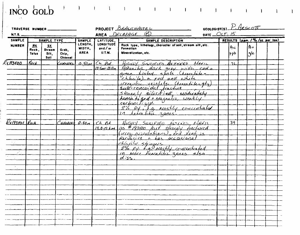
I I I INCO GOLD
1 I 1
TRAVERSE NUMBER PROJECT 8,-6-4(--/c 11(45745- L-
GEOLOGIST(S) -
N.T. S. AREA Dc - ,1M c +~
DATE C7 c r• 15-
SAMPLE
NUMBER
SAMPLE TYPE SAMPLE LATITUDE, LONGITUDE and / or
U.T.M.
SAMPLE DESCRIPTION RESULTS (RPm• /% /oz . ear Ion)
RX Rock , Tolus
SX Stream
Silt, Soil
Grob, Chip, Channel
LENGTH, WIDTH, AREA
Rock type, tilholopy, character of soil, stream silt, etc. Formation Mineralisation, etc.
(3“ pp)
fl qfg u
%/40.3NoD Qork (444.ev~rlA` r7. S)~, C>7 Ad ~%k'i y l(~rrrE= ,~n 4i, y-~-~Yr~ It~~~,r `tI IF•5.,.~-13.0rs ~)14s4-; a4Z rJUJi~ a,ii j-~L, r.vpr s- %rn~/
-el, r¢n n 1-4-',-;14-e4 ~/1 ~) ! S ( A i ti,r i 4+. 11 ..- 5 i
C l, A r, ' I-a> Y- y.PG( a.g GY 6.)4,..; 4.- Irrr 0 lc,. J_e; n b - . 4/j) .0.rawn_24.'k- / 1..c,( F3'- c C,rl co,' o~c. l a G-~, lt ~ ~ 5 ~h rt c} l,1 5i'%i ~ r~ '1.Q0~(' . ~,pdc.<as~tt~_
A.LYtic.Lt - ~j~ ri ~ MG t x 4,4 'r G./ en 47.1 `~
Cc1 r ~?~r(Gl. V
^/,
/~dnrlç
J ;1 (u fi7l% ) ~ }-.3. I~-1 n S ~ C~/ C'r`+ rt l r rt 7~rGt ifii
1 1 Cl-4t% l;a-,c ru , Jo
A/93frol enok rNa4N~v'fc. D•60., « ,t3•( EF-I r1k/ i/LIr_I FIFI) 1;LTr K ''j<il ~-'r's4/ic 3q
13.013.6 I'd G?fi /53Y00 Ze,t il
(/
rf LEc'I ./'^i I Er1i~`ft 6~ ► 5 ~i( ~ n~n~l
~r~ r i S 1 / r 1 JE - ~S GrGQSr'OriG,1 ~,'Vq{ + LI
Ï
rnt44n///i .4c -Ç rr~a/S.
.Cn !~ /9 y• A-10 c/ ("n r1c1'iij ><irLL.d %9P 1 Gj ft.t r)!r hfA,1,4 ~rr4 t o.•ta 5 ~5-a
. 3 d•'ss , .
-
__________ —

• INCO GOLD I I i I 1 I I I
TRAVERSE NUMBER PROJECT 8164e CH-4 .
GEOLOGIST(S1 P
, N.T.S. AREA 1))cCAA4 --
DATE Oc r. /
SAMPLE
NUMBER
SAMPLE TYPE SAMPLE LATITUDE, LONGITUDE and/or
U.T.M.
SAMPLE DESCRIPTION RESULTS f • /°Yo /oz. ter ton)
RX Rock, Talus
1.1i Stream
Silt, Soil
Grob, Chip, Channel
LENGTH, WIDTH, AREA
Rock type, litholopy,character of soil, stream silt,etc. Formation Mineralization, etc.
R ïy t)
10
~ 0
a1i y
QX /93 yDl 44 ~r},S4vAmc. A. Sn ,u Ch /3 c 9 L r r'. h,• r ) A- 61-./ IC ~/c~ u. a 1 0.0 - D, 5 M A t~ ~.e ~-t( ✓h r ,r. .1-1.1_1-, c / clf
a ~ ,/ • ,,. .. ~ >~; • .
/c.t0(.1rra .e l\(
a c 1-urr49 5;14 ra 17 eai ~ } en»4orlG~r. ri1P4; i~/ %n/G 4~ac 4-
1.1..a y
r( c .L.
/~ ~ y. ~ a,' . '-',21 C1 po ç-1 ~.. . Fiï , . . ! .. _
le.'i i1~ Li 5 .
~~ 14303 ,F'or/C rrM.tlnl~/ 0, ~M Cl,, itit Y r',Crh» ~- rt L SI C—
//~~i , Z7
r1,~Hr-l.Uv.i (3.rt,1ic:..~ ,~~ /~~tô<_ ,°;~ /'c y ./`{;y( r ` ~iir~ l~ S~ C,r,'ouS G",r i.tA`)- rnnfn, dn.r
ii2c ~ A-;/i:E _t <%~~. ~~a r>!t>i r. 1 tarp l > ~1,(.0 i4~ ~ 3 .r te .Tr•arQ ,r}rc,~ -s~ï.r.~ /Gt Yi' 1-e_( ~lci l' 1L✓rC.- Co 441"1.i ty
5~onc~L.{ ~Q a,~~ ,
t~r~de1\ ~
r•~ t,l Cad' }~nr~~ y newt- tuisk l,\_tik-1-
?1( /931/Dy Roek ~pJssl,tlq/,ti 0.5-M CA At tliGiily /¢1Trc..C~I> ~r=.r 5rc 7)
.r l.OA - I,5 et ~,anw ~ v c doi~ _Ar os.J Ars 1, rf¢ o~ 1
-5A (`l s;G, c_,'o0'5, ,sub-00 Aco~aLcd
. f -fa r 1-J ic } h,i 5 % ~/ "You' 44Ar-P 4?f - /'e %Ct/- 4 Ic..tt 7 P rS ~
~` f'ot! 1 1 r~ ( _L-11 r ~;~t CO~Xt~ ~ 1 ~
. - 5~ Q t l
' . . L ,~~ o/i o ¢1~ bl~ d- S ;rW~,S
_,2.- a[1 ~Y /(.( DS it/ ~~JJS.S -Sn~Q.
_5~. ,
~_r_ .....

INCO boLD 1 1 I I I I
TRAVERSE NUMBER PROJECT F)F2I/Cfl//57 «u
GEOLOGIST(S) P
N.T. S. AREA &Cr4,2,4'(; /:/(7)
DATE (c
SAMPLE
NUMBER
SAMPLE TYPE SAMPLE LATITUDE, LONGITUDE and/ or
U.T.M.
SAMPLE DESCRIPTION RESULTS (p.prn. 1% /oz. sr ton)
RX Rock, Talus
SX Stream
Silt, Soil
Grob, Chip,
LENGTH, WIDTH,
AREA
Rock type, lithology, character of soil, stream silt ,etc. Formation
Mineralization, etc.
AO
plb A
51b
ex /9~DS ,~
,Cr?c~ ~r~n/Ne,-
Channel
b,75,4 Ch B~ 1-1-i 1
9,U _4 G1 ‘~c.l~gdk r(- L!,1 C_
Î S~•9.7.5,4 (a~ -t!' 14-2,‘Aoci 1,,,,,,A- "Ç°~n Cj~ J JPe 0c i~
ç°/ G- yy IJ ~
~ /~93.yo Z12r,Fr ('.FA41(f l di 95-M Ch 11L !y t 1. I~~ ~.~-,G >Q it n 4- Ni{ u F KA I 1.r ~ IN TF.r 'St L C . 15o 2.25,u-3.2..~ 1~~~n v~,', L( rl,a t C-rt_r14 ti ~Nn 11•Can,sC\ P CoFF-sc r~ w AAA 30°l cia,,Cà%. (eq ) _.b.nti.s\--,
(Q • • • o - 5Akrintv5r tiy a,kh-roincn,cllntA wc•kv(e , ç°70
(.lte,a4-e- q.k s .Ç-)-(, . ~~tteo(. ~~,IN~
~l~► , Ai~ertgl~i ~xa~t ~i-~ w~ectle.l1 NLA~~jnt~-+c. +UUCGi• ~mr‘0~ -i ~CcA •
o 15,41-,),4. N
11I
__-f~c~ C'.~e1CoIb, G 0I14 \ h .
1 ( II kt ~ r,~ ~-1 1- -; G son,' S .
? 143L1Q1 ‹ock C1•.c.nv.o.l 0 .40 ru CL g. tr tCa G(.31c. C? 11-‘ ~ 1\ 1 A Li- f,,~r-b -F P\ t k.4 ~~ ZC, ) 28S 3.).A.- 3, 1,,,,,t ( --,..i gC ~1- ~o~0 41--41-- ~ U(.~ b,k-~ ,)05/o ~ 19 3I ,t 29/
(.M).r 12_ _1, Î,n.,.a,,\h cy.[y lGk C1.,,,,. ~]~nI 2/~i
J ~
~ 3 ~1 Q,~Az.,~- .- -1---tt,r~a~lr ( ` '36'A ciff~
1 i>~la u.ç~c( roil cErl~l~a 1 ✓ 7
IIpl~ i
~ ~r',tr`1 Alt" .45c,r‘Q‘-.,
,2jc /73649R ,,eork CMv+~)3s1, o•~'+..t _ CA Ba AL-t-rie-+E..b 1 1 •,ctc 40 c
.(n ►..t- -‘,I wt d ro 1•.a .-1 5~
r~.rn 5U~ 1. ly ~ofYw.jj1 ~P` /
i 1~L` 1 4- ' Q. YC ii, /\~'e~
~rL° s. )Y
S`ICY ► ~ ~ ...4 I e . . . i•-. -__nd;
.1r ~ r ~gA.As_i___ ___ _. ~.) Prx} . , .n (C
._-
--
1—Z1,_ ~\I . ci;15,.+ Cc,A kinc_. _Iar1JIL ti
-- ------

i ivt° IGULD I I I I I I I I
TRAVERSE NUMBER
N.T.S.
PROJECT e_5444/6 a-4sr
AREA 1)Fc19,M01(a4 ( )
11
GEOLOGIST(S) f"
DATE • f~
SAMPLE
NUMBER
SAMPLE TYPE: SAMPLE LATITUDE, LONGITUDE ond / or
U.T.M.
SAMPLE DESCRIPTION RESULTS (p.pm. /% /oz. •er ton)
RX Rock, Talus
SX Stream
Silt, Soil
Grob, Chip, Channel
LENGTH, WIDTH,
AREA
Rock type, lilholopy, character of soil, stream silt, etc. Formation
Mineralization, etc.
Iq U
, PO'cJ q ~t .
A
. ,,/ 1p~ nb r ! 13'107 KOc~
/J ~i1~4,S~.~/FL c. ?i w l rLI 7)2_, A-1,-,,, ~~/L,I4L' ~ » LT F✓'!~) "~ !
)c: ( ) 15-i
l%/M-ç:~NI ~allr 4' rrlif4/ i✓a(4/(CÎf (~j7(rluttY,l rift »
%,-o, lil.i -sl. red perlfcl.v ion ~rrlr~.
. 'I ' -F . _ i , fl 1Ler,r A ror\q L~ ka i.na • '‘ (A. , Ail ria. or r~~.1cU~ ~2 ► I;{,.r.i~"1 PQ1, U u)e[1iI..( CU{~t~,nL~~ i~t7l )
no n- ~-{G~
/v~J`~ P:~
IQ~~O ]~Y
1 ~.~j~ , ~~J')r
'>( 194'rû Z~ ~~~~~- a.4'M C~1 ~° - /44-7-I)c-fc✓ 0 Nt.EiF /c aLc_. 37 q diM Al /75 # /4'3i/0S
' /1.SI(/~ .QnrE r>{ianl.Vf IOM On !3F A [.TFi4F_D F-61.,-),c.
r~.0 - l.11 N1 4 6lr~r ~ ~2, IT/ i!Pn, )r r G~Cry,l q,r~,~ a,~1. 82-.
/aS°l ✓ed i.kxlr/Li5 i --,?4irl !`c/j. .~ p klFf' i »Ye: h/4._0p
-~~,/y. 9~3
ti~5~1~ 5, l.Zr1, n.15 (..Al r'nnrrI Lc! ~
r as A, f Tr- •S?.a~,jl a f 'At (Lac lac k, l l o C oo,AAy.
n Rci ~ , ,.~.. ~ ~ ,~r~~
1~1s~.~otc ~c i`~ r..lCxrmA VC. _ er~`ç 1✓~t wk
r ~ o y(ckç
C~ G~. \S`) ~ C
Pk ~
(
,/93 yl2 r. .:.. , P. .. A 1..7_F_,Q t< D f=e 1-, r e. C?) 142- . pk4 -. . ,r y S' , r 11 I ra r 6 -k~ Ici-7,411 j2ut ~-~
S_ -s. ~ ~A C,()1~s CSA ,17'I'Q,~$1 COCOv
.1(r A . I Ql/ 5. ,-
Z°lo pi ç . f. al.is~ -F a r~r.ir~a/ tes . .
I--

1Nb0 bOLb
TRAVERSE NUMBER
N.T.S. PROJECT
AREA
GEOLOGIST(S)
DATE
SAMPLE
NUMBER
SAMPLE TYPE SAMPLE LATITUDE, LONGITUDE
and/ or
U.T.M.
SAMPLE DESCRIPTION RESULTS (p.prn. /% /ot.Eu ton)
RX Rock, Tolus
Stream Silt, Soil
11C
Grob, Chip, Channel
LENGTH, WIDTH,
AREA
Rock type, lithology, character of soil, stream silt ,etc. ~ Formation
Minerolitotion, etc.
O
p~b
AO Q J
'~
i~IL~. n Qr9Gk C1+ANuG.L 0.q5►i PA $I' /-FIGYI/ tr A-7rr,4.D ,R- ,tifhu<.e/It, iz,cn 1<,e2s,r 1'} 256
/,5#4.4- /./S «I a<., *' 19Z ein7
40‘341q R,►,r-k CAiAtilNf-I 9,2s4.t Ch 12,_, - 4LYF.rz.f t) MA F 1e 72,
1 Q S- 7.7 .n ~- .14-111--VD1 R 12.2,...:71- \ti , t,~ 0 0,12.tn. (
~!`!-t1l Or'A 4- t..14/1.,~k! i 1 C k,!]1RAl.+S
G•f (IQ I\ 6\ }\ trncik-k, -1-, < •••1r'l Are,
4 ~~' v.(0,le.r co. V
.x 19905 gork '-'0$NN6L 1.4, IA <h ?-vç 4-,r'1Zt-\-( Pt t_-"C i''•.-.112-f---) Mw,(- IL NIA c . ill 3.S.,n-(i.1vA l,4.o~,~-l/ ~-3- ~~nt0.(-a k ve.,,nf,.si s
4 ,....N'(\ ?.Qo (PRN~S~. CS t.,•1IA..SS a. 44..4 uk 1?.-,tri, ,..- . t.1e,; 671.( 4l Ac. (..... 4 cc..f b() v., 0.1 t
-~._,( ot ~h,A-t )
siPr .t 5I-4-o,,j,.( I~ rV.IG~ k ,.~>~ Gt } r-,1 \itC't(',1J1.
f
\('% p\%, ç ,e-3 r71.î S._, -Ii- \J . vi SR V`n t, -- d\dlG.e--,Fjt ..1 e. Irk A L. > t rl h,r,tr-.1't1,1c œajnrti.S,
'.)( IG31411,, kn t.k °Nanle)f~ _ OZr-i r1-, I3F wEickv,_Li Ait. -rEtkr >,7~l\~ 1r._ \lots.. 149 . .
. ~/. /.a - t/8.,.* Vt-.i rr_ca r*kt iitir \l . ,r~ d~c 1~ 51°1 I ~ d\ i~~ eiV' ~4 wt Y,~n i c_r ~\ 11ti~
~$
-~ • . d ~7Gt~4i o~tt1 ~ ~t ~~ ~~ .
~
1 Sô Îr (~~] ( ~ ~ 1(~~4 &~ ~1_
~ ~ M UU I r ~%
_
_le..l e cl~l-y 1 c ~`
IQ ul A rx `F-. ~ C J- `J t U. C ~t t i ~ C/1 --i.
_A -f 1~. ~~~e.~~~ 4 ce-i r ~f _i.'~ ~ C' ,3, cAA 55 A- CcokL~N~
.
l
..ç 4-.( ,.tild_i_j_ l' ~~ t, A A v01~..1 p , k42.-7, g~.s
- ----- — — ------ --- - -- - ,

GEOLOGIST(S) ~. ~~ Sc c~ ~T
DATE eD cT • 15
PROJECT 56-AN~c~~SI-- AREA 1)F c 1,\PY4S. F
+RAVERSE NUMBER
N.T. §.
164 ~,~.~~~~~1--► Q,,r LJLfliIINfiL 0.8,~.~ t^1ti Rç Zcd 2oArA iIJ j(117Ç,4eD ki4-74iG
/ `` ''s'o ,~~-~P9../~~.• VP Q ,~n,~ (too )73 lily 30o.hlon>L 13 i %A,nU. ~ , d G /~ ~ .t.ra k
•4 Ag 193449 erD0c. CµafavNiL _ 1.0 pa C,h
1N~U bULb
SAMPLE LENGTH, WIDTH, AREA
LATITUDE, LONGITUDE and/or U.T.M.
SAMPLE DESCRIPTION Rock type, lithology, character of soil, stream silt, etc. Formation Mineralization, etc.
RESULTS (Nun. 1% lot. Per ton)
PO)
~ OP-el a,~c d ga~c ~! r.t. o ;b`
lc~r + r_r_ar5ldrt r-er.(j- ,,11.; r~
Oulu ,q ~ ~o: 40 Is ~,~.~. d .rs5 4- ~.+~~
~'/'orlrtlf 14-3 VP Ljr 'N 4- iti-~
-%-ltM ~S~r~d/5•+--
/'' /o/ ~~vc~,
impel /Y-; ~A ly ~~a.f.11t//➢rl D I-- kid ~.c,~,
~ , ~, ~~ ~ l>~ 4 e h-iG ; n /
t~ 5 ~~ — ~SiraAA kin rt~,~t d.rncçi.r~~[Q~
e~ ✓br i4r.,}; ~ t- S , l.,-C rJ, er/ (5_,(A4-cof7Çoi f~a r144 kit/ 1h 1,(1 Â. 2-31 ~ ki05~ ~•5 ,`'°.p2.,.cliz(
Sz(z.N - ti 4#4_ -
/'
epv.,.f 11$.4 r¢~/ 1/4.)/'
, JP1,14-6 f5
RA6Y4,. o . SM r~ [G j4,60,-7.1w , AjJAke; c , ola/Q gl~~ ell -~~ ~1,rL
red/~U~.f L1q~r~o~,/J 5CI1/d,1Cl.~
~lo~U~iL~~
Qce-QS jn 14
34-fonq MGr1 D ~!
~ d s.,
,ex/93y/'9 494
A18-44/__—T r'a r 5~ ~ ✓oc~ :
r e t b - coo rniGlc~~
..Itiat42„4 iLi c. 30^Z 5 A i C41.5€ oC;
SAMPLE
rvukinkli SX Stream
Silt, Soil
Grob, Chip, Channel
SAMPLE TYPE
RX Rock, Talus
2.2
12y 111

GEOLOGIST(S) 7 ~~-(c1T
DATE nuT. I~
RESULTS (pp" /% laz. or ton)
Stream Silt, Soil
UlIsEN ' AX Rocks Talus
4[213,20; . l?c:c1c
r+i+ •r~
t.
.n.:t:F.. .
Rock type, lithology , character of soil, stream silt, etc. Formation Mineralization, etc.
/LR[ L.) Y3VL2. Ore. i/FrNI iN A1,414 /c-
.<11- rnrk L,s ;sart.4..a._ a5 /9 Sy/ 9 c~,,t~t.~~~
_ n, r t. 367) ( .J/4,4-14-tad
17, p)/, r914.-4, "mu .i rt a .1- 4+ ~ Al— l7 f
ttl eOrlioGfS.
fl~
pp)
Nia
PROJECT Tc4u c } 4 4.
AREA 1) -7•9,46-06- . C~ SAMPLE " LATITUDE,
LENGTH, LONGITUDE
Grob, Chip, WIDTH, and/or
AREA U.T.M.
Channel
tii!AVkRsE NUMBER
~; SAMPLE TYPE
I I I I I I
SAMPLE DESCRIPTION
CM¢ANrL. _ O. 3.4 Ch f34 718.4- 7yM
er,:ffat/a, ebri-.,
ovum . AormE
A/,t-8.().4 /2t5 /4 LQ311/9 eta/ e.lggky 'tic; ,oâ .f7 G0 .c. Du d fitScC ct Sic)/t41.1
/fp,ccG'
Pti/ ,c,, a,54.1 Ac. "try l~/'a ~d ~ln,,R
I'
/ ~ ~4.i It 5)16 n f13
~ v..S~.c t~ 1..1~K~ .o f D N%,~i.~ %~i~c.F.tlf c-. 1~3
SM /.tJGa f l,y i~C+ [J4//v 4 r]~ ~ PL;%rC 0/6/
i.~ 0, rid ,4e /rd 1;j6 ,ucG6r ~cl/ ,~~ 14~ l• ,e~c~ ~
I~ L ~t.(g,J~Z,! L>; 3, li~r~ PQ' l'~ "An ,fa ~~0/1 ~•!/~ / Az ~ly~ :n ~L►~E~:O~
34 ~5 a/s`i 1

1 NCV IGuiID I
I I I I I I I I I I
TRAVERSE NUMBER PROJECT gi4cJ W,1STe.-_,-
GEOLOGIST(S)
NT S AREA ,Fit ARC F
DATE QcT
SAMPLE
NUMBER
SAMPLE TYPE SAMPLE LATITUDE, LONGITUDE and/or
U.T.M.
SAMPLE DESCRIPTION RESULTS (ppm. /% lot. •er ton)
RX Rock, Talus
SX Stream
Silt, Soil
Grob, Chip,
LENGTH, WIDTH,
AREA
Channel
Rock type, tilholopy, character of soil, stream silt, etc. Formation
Mineralization, etc. AU
pPh
~ u
J'~6
fi3y.?3 Li_ h4estegp` el 7.0 ~~e ~~y 4a~~~ IV/ 04 <,L < 7) 146/146/141~~ Cgs 1.20
.sM-/.~ ~w S-. »hrUirA/. r, hr /I'd/I'd;; ~ ~ ,l ,; 1:1--,/n'/ I. 3~
~ ~3 ✓C i rl /iS (, ri / (41As/ v.4);/ P// 1 opA *- 1-03
t ). r104 - Ma- a./,G, nr,•/~6-3 /t~
~A/6„na ~- v ✓P/y 5 0AL51y, /i,a.tc1:2:ie , ~G/i i- 5 ./.ri • P/ ► T Afinri~ K
~~i 4c a41 /Q. crxi I; rti ~ / 1-~^
/ L5. di.-6 -ir ,,,L, /1,1 ,Fc cf f /,y ri/~ c (OC„ic5.
V
i
/13y.Py ~ri (~~r4,try~ (1..~ C~ ~9 ~ G)JLi4KAi 41~-r6e.e,) 147-‘__LC-- Ir ed. .4.v„ lb
/..2A4 - 1, 5,-1.„g. /p 1,tit//i l /, / ?<r> if /g . S/ZZ lo.c+ y ft(r)/4P
/a r trl /Q d a ell 1.1 aj it1 /O d . ~( ~ j 14
/ ' ° ... • 7-j
~ 5 . 6_756 .S~ R fa f.,G~ a C/c.(,ria~f.e 11.1 "-fa // i
2 ~
' /93‘125- Qock 0 .h .,,r / S.0 - 2. /rt KIE,•tT r•~-a D vr 2n,tlE . A6 LS . 24 -
d,.:51, /y Ai Ae L icJ/ed -f rJS~d • / OdJ~Jn r o fi* lpr11 , - s 177444; Ac, ~ICc.~
e.er7 P v ~~- ~.~~`r t G~/GK /Y > JLJGrYiPd I Q -~I~C~D /la 4-344
• 4 Drj - 1O c12A k Lc 1/>ile___ctt2i c ( i- ~ / r- / 0(..'S~,,,LA,.ng~d._ fi% i5._
1f3y26 ~ 0~ . -. : ' 4, . . . 1° /93y_ • r I/O:n 671/S -- _
Al,~n 5~ / r~1°i P 4y ~-- ~,~,~'/ ~:~
~
~

'NU) buLb I
TRAVERSE NUMBER
N T S
PROJECT ge 4~/K/M57-61-- AREA ~,~(,11A-C1e ~
GEOLOGIST(S) ~ 44, 5 C Q~[T
DATE 0c_1- . 1 (o
SAMPLE
NUMBER
SAMPLE TYPE SAMPLE LATITUDE, LONGITUDE ond / or
U.T.M.
SAMPLE DESCRIPTION RESULTS (p.pm. /% /o:. ter ton)
RX Rock, Talus
SX Stream
Silt, Soil
Grob, Chip , Channel
LENGTH, WIDTH, AREA
Rock type, litholopy,character of soil, stream silt,etc. Formation
Mineralization, etc.
Au
01) t~
A
~
(a3 if? ]' ~i~r /.1,<,nna.l /Om (761 ltiJeAk- Li/ ~c. ri.C~~ ~~ 9e I< ~o<<rl.urc loq 3 /wf - y. /rg -ç}
J i< -/-6/
OA ~ (~~ ~ l~ /n /~i 3'/9i/ +sz4+. /, -
I~
41./e_41./e_ %t oiur h~~ iii- i- q .r~li/ , _~.1-!.,h r<a.4e-re,tY6 / ira (11-.iiQ, /'/v. U~~ , G 1eak ~ ~aG~ ~ tr. cg f %uu~~r'
--?- a (k~a ~rc~.^- ~ ~ 1~0 ~Ya f ,C~,/~d -f- An/-d ✓o ~ 5 f s. ~v
/r ,~r7 /(~,.6 j~~d ~-~—~~I/
30415 Q ~D ,s,/.: 65 , ,~"
43q2B Ark CA/nKoi D•R,i CA q_s (n l AAla_ y 4-4r6-",e,7 /L4.î‘l< Vlli Lanlm. 2'11 y/A4-N 9,4 a A /y;3s/.?1/ .d .f,( f /,‘ ,ff v/or
ad.'s ,6 -rn et r- -ri LIcI(e , .!' ._,I:. • . 1
5~ ,. .3 v~ /7/ Qgç/P a. 55n~f . J.
I mat Cr~!(IQ~~X ✓ i /iraa Ga ~nv( A~r~ ~ 3 /9.3,Y2 f .~or,¢ (AGArtLl Q. 6.-t rGt f~~¢r f~ y /~zrr`d'ED /~i4Ff~ 'SI (-.446.1.c- . i `i Z`L
yl,~,+ s~ ~.0 Ail,/ f~i'Grl~/p!, aa phavcsy4c 14-3()
~Cl r %,' C{ /e t f G•~l gg $ l [l1PII.v~ii y~-`i , ii.,,„4.k / /3 vQ.; 4 f., /s ,- ie_d At XeL{ k L[-_ffd A 2 f f/~Al~/S . , ~ll~ - e< c'L l,i
`a ( !J fia C/ïtit/ .
i/rlrh (R ><P hll! ~ X!'/LfG ii 21'a,_ ,3 i %[r ' I--; P~ 4
-
____c,i ~at .. . C'J ' ( /l /
~r- ~< /a/,K! 1f2< ~q ~2C~ -+--
-- -~— _____e 5~v ;nA J
_ --,0;o y- el/iii i e" rZ1 e.s e.5/ .)_01-e~5~ ill
/l7 IC
J ,
, ,_ ~tn."4.e/ Â e.r,c" i 4.5. 304

1NbU bULb ' I 1 1 I 1 1 1 I I I
TRAVERSE NUMBER PROJECT gf_<4(tr/lATe AREA 1)5(14,146 K- tJ
GEOLOGIST(S 194Sc o%r DATE Oc--r. /4 N.T.S.
SAMPLE
NUMBER
SAMPLE TYPE SAMPLE LATITUDE, LONGITUDE and/or
U.T.M.
SAMPLE DESCRIPTION RESULTS (p.p" 1% /o:. eer ten
RX Roek, Talus
Sx Stream
Silt, Soil
Grob, Chip, Channel
LENGTH, WIDTH, AREA
Rock type, Iithology, character of soil, stream silt ,etc. Formation Mineralization, etc.
pp
AO As)
~~
l'93'./36 jock `,~,au,lF L n.6m S. 5-r.4 - 6. am~-~TF.,,-i) N/%~,</G. 1 /occ R~//v
ic_ 3~ ~ , // // .'
.5 ~ M.t (GJ l`'C) /43 ~~ RAA ~ ! 1 r K.~. ,S'/, 0. ,l (50,44, !'J 3l as #r4,w7n) .0-
I 3 ~Ln~r~ <p
Mo~~
a o✓4 d ~~ c
/s o /-1G r ~,c ~1,1; A Y ,-14,sPita i ..4x. rr~ 5
r LL /3)5 ( ~935131 %r ,t f~tnnn( / 6.6 b.64 ti.0.~r-~j -6.v
,~ / f1,jO~b L~/ p4 1~/o~l /~CGL.L ~occfivrr_ 4,5- ,
/~s It 43 </Z Z
/ 1 o ~ f 9 ,uas ~i ~, i? lv~ua,~; ~t , ryn,s ~.IX h et,s ss &MIKa ~~• 3 ,
, N ("kV, X /93y32 Aak (Aoitle/ O,A"t 4•4,,.t-1. 2.ti It( nnF ,eArF/y' .4-t-rf.dc'fn /L 645e.« i%Dt_. 1(Bp 1.17-
F .r, c a 51*/1's4/21 1.03
3% /0y'
f3. av ~ 'r3 /' 4 4 ,. a s~ty 1.1.-Z
a
~<1t 1/If{ X o dlr~
. / OrLtS also ,
(i,~.~ ~i ~d v- re.,,fu„ ran Ai 1Q ~
0 . 1 J
/93431 Krx.,t ChcenQ/ J.6.4 CA OA /~/4 AIL di-re/eel) !V%/< ~Otr.Q~/I c 1338 I.^, 1 aa -O.rQ.A.l /l/~li 1 Aa ~/~d f f f~Qa Ulf-4:1d. 1.37
~ r~% 1~ ~'.~ o( ~ 15 1.3 7 •
~ipAciA ~<</ k i.ey ~,1 4 ~~
1 ~ ~c ,
~ rno~ 3C7°lD L'F/~~.1.c.r 5li _,on( +
, h l, a i/e_/ ,d . ~-cn :da (50•1-g_ 1
ijf_a_4,_ AL/4~ne i e. ~Q~~~1
~ IA I,~~~ 4 l ve.^
/~~ . •~ ~ ( . . _ . . , ,
~ ~ ~~ ., -r c9-0 kS1't~ ~~ e 1"- --
/a /n[,„. i. ME / « . 'yri a.tes . 3
-- -------- ► f -

livCV buiJD I I I I I I I I I I I I I
TRAVERSE NUMBER PROJECT gF.4[Jcit?6-7-1 1— AREA 1)/_f-Ada/9-6 /4-
GEOLOGIST(S) P. . 10 1. DATE nc G. N.T.S.
SAMPLE
NUMBER
SAMPLE TYPE SAMPLE LATITUDE, LONGITUDE and/or
U.T.M.
SAMPLE DESCRIPTION RESULTS (p.pm. 1% /oz. sr ton)
RX Roek, Tolus
Sx
Streom Silt, Soil
Grob, Chip, Channel
LENGTH, WIDTH, AREA
Rock type, lithology, chorocter of soil, stream silt ,etc. Formation
Mineralization, etc. 60
PPh
Au
5/&
MI/3V 64 ( ltGiKa~ 0. 6.4 ~ti ~{, /146.A.Y____Ak i‘«/) MAfIr ~o4~4 1. d1//l 2531 Z.z3
r 6,N - l. 2,~ f )d-11-. S°! •-• /3. 2.4 v _
0614 /Q~~/33 .b., G
t/P.i (1 4, n d. s %,% (/ f, 4'5 41 /4:21/j[71if• eit/Î 2A6
7 %
y F- M 5 di As t ?
-i-ri .n /.5 -I- crJ~ v .--../.6 .4. j
: 1931/35 br,I ~.~6,1,,m / 6.F3.N _ /il 1.4.4,r14/ N'T.7-#,..Q0 n /(i/44e /r IA. r ilis//L 273 a # /4 31/27 / ~ ~ .. 0.111 a 1 I t r iv,/
/
/t.C.S n A (114.55 ~q .
/93'/36 e G,IAol , n.7.K ( •% ~ A )p E (,/ A_-r--14,eF.n /ll%rale/c ✓OLI,ox 1/G 10
ZOwI - 2 7,w /)S # Qi/2Z~~ /!Q /1 y A./045F-t ~ 1 it l~G .~ o d
Y r
,'lD ~ c~ ~5 U c6 J5 ~) . •
<J
---- ---- ---'---' '-- --- H
___

llv'Cu 'GULD
I I I I I I I I I I I I i I I
TRAVERSE NUMBER
N.T.S.
PROJECT L~ Au c R1\ r-
GEOLOGIST( ) 1 c) h
DATE ( I Oc 0'70
)
AREA CA-Mf`At)EL P!xS
)
SAMPLE
NUMBER
SAMPLE TYPE ' SAMPLE LAT; ï UDÉ- LONGITUDE and/ or
U.T.M.
SAMPLE DESCRIPTION RESULTS (Rpm. 1% /o:. t.er ten)
RX Rock, Talus
SX • Stream
Silt, Soil
Grob, Chip, Channel
LENGTH, WIDTH,
AREA
Rock type, Iithology, character of soil, stream silt ,etc. Forma fion Mineralization, etc.
17.6
Q t '~/~~
1x-n3sol `kix.k attrutlm ri,.cv Ch LE, Il' L-rf ll b I~(1< i -r ~~~ w . s
~ l, 0,x- " ,~o ,~~; ~ ~1 l - Z 4, ,cAn~ 1-1,,:‘,.-W,-- /
~ Mrn u /' ~i~i~, n. ilm3 5 ~ ~ t<~ C (~ (710v. rr
~ )~ ~~ ~ ~, vial l~ ~..,~r~ • 1~n ~n ~, ~z .li111tL: ~
rIÇU I1 z>C, t-filA 6:1/1,.0 D ~~~/^ . ,
j ` r„_~~~,~~~ ( ►Mw.1 rt,~ to
~~ ~~,~n~ 01 h1 ~J I, f,. '~) ~
-•~=h—~ ^ r.r~, r. ►~ _ ~ f. .. _44 a
r,N .- 70 CI d16i1~ ~ .cJ;) f ~A C). . CtJ~ n, l~
_IAA
J l p.+ nn_( . 'L. 1
iil( - `~~~vZ~oc.k LlIAN1Ub1 /.w.... ( U (De, ~ t:' f G -r. C.) ~'( l 7 ~ r7 lop r 1_,,fl) »,., P. ~ -~ k, 19 .~ so ! A.4)1 ) !A/1 -c
',0.,„ L ~v,,n.. 1 r ~• . P_Qa .
Y1T
U
Ua i' /l~ QpA1. n~ G ~/ „_ J re.
- 2 On— - ~" - S f/),-, .. ~ j~l~~~6r.. gun ~4 ~ Î=, , A~it ~~. r, (~0 ~y , L,1 ~ ~~ 4
n~n
~,I~Q7 i
v ( 1~ 0 /~J • ~ C'A~~1J A~C1J..
. ,M'c~ d~.~ ~ f;74f
1
Cyl,~r, ~. ~ U ~~ ~ q- ff3w R (AtNorx.' /i .al, r 60.,, A (.Tt Fr- t, 1\11)( I T f . ?7
j_612._: 3., p /1) . ,11v.,,.,' )1) , 1, k x - () 3 sol. w . dt4_
~ ° J_P~ c Co fi~~1, ~, A) :,, ~. N c
r ~Z i (a.L rj ~iL .~nQ,,,,. eot _
~
(~ c)
,

TRAVERSE NUMBER
NT S AREA C U MIT (-)1, ) I(~ GEOLOGIST(S )
DATE ( / O PROJECT r-'f E~U (- 4 '11
1 ivICU rG~,l iD
I I I I I I I I I 1
SAMPLE
NUMBER
SAMPLE TYPE SAMPLE LATITUDE, LONGITUDE and/or
U.T.M.
SAMPLE DESCRIPTION RESULTS (p.pm. /% /oz. ter ton)
RX Rock, Talus
SX Stream
Silt, Soil
Grob, Chip,
_
LENGTH, WIDTH,
AREA
Rock type, lithology, character of soil, stream silt ,etc. Formation
Mineralization, etc. e~~ A714_ A. A
1/t ) J ~X'~i35i~{
o Rock-
Channel(~~~ coma. /0,1-10., co rr
pp 11 _9 ~,
(~i~ii~ . EII
lD4lf~inQlÎ (.. IT ~
~~ `` } ~~~l
~ h111; ~ CAA • i 71_
~~
, U nOL . 1' A,~g .51~ Ai , r . P~vU"~
~r,Nil-. ~©~ . D 1 ~ ~. A~r . 1 A 4, li, .9h.. II Y 1 • 1 1.....!'' 0 •
.. nn n~. P. ~ ) / • , Cla Q4Jy~ Q ~ ~ ~
n ~oi Q A .0 6K G ~ ~p IS ,~~,, ,~ fn.r.~~~ . A X- ~v, M ris so °~h
t •.. 1 1 . ~ I 1 (1p zi . ,
A-yR~tM ~r\ n! MC 1• r~ k Cy OA", ld~hD.d
I -0Qr 2 1~ ~ Q~`t~v` ~ ~.c~c. ~c,~G ~(1.0 ôri-
I - 2'4 ‘ -:.os . C.Z4.11.
))X- r C351n )i')L k CNANNF.( /0.(5(34 C 4 (Ca hL7E k'.L G PA i 7L. /3J 3,0---ti ,j0 ri k1
,i,,()~z,. <,lo,. a si_ W~ Lr ~~ ~~y) ri ~
i•C~J` D w• 1. fd, 1~ i ltY
pt ~ , )
~, F n~~VÙ~~~,r 1~ r /h~rr).
~~ lt P • Jli1 1n . .CI~C;1'Pg~l ( `~t~)cJ~ 1 w r )
• ..) ,,,, .in r . , (1.~
1.1-)N, • 1 Y ) . J\ Ç ~ ! ^ ,,`^_ 151t rr- _/.:1CA ~ ~?
' _ P- 1°C-) 01
1444 ~C1 ~T f~.~~L~ . (' ,%!} -I~(•,_./~L . LI
---- 1~ -li55o(o `)nt t< C. (~frJf.)El /O.~C~( ~~ g1.-rF.R~,~ F Li 4't. l t 'e~' ç' Ç, ('-~~ ~ _ VA 1- C__,
4,(~- ~? ) ~,, I~i - 1 ~ c~'i— ~j~(L f-.Atl')ri .v,. )',1J! - ~~ r ~ '),,~ e ~
~G~ ~ Is ~ r . (....611)......, • 7)~~ — .T__' --_
~ J L
---
_ a
____ - ~ ----{'----------- —

,t nit() bvi!D I I I I 1 I 1 I 1 1 I 1 I
TRAVERSE NUMBER PROJECT &A l C 1AS-1 £ L NT S
AREA CPANNE,I, SAKIF S (')p)
GEOLOGIST(S) I: "" 31:1" DATE 14 Or-r--
SAMPLE
NUMBER
' SAMPLE TYPE SAMPLE LATITUDE, LONGITUDE and / or U.T.M.
SAMPLE DESCRIPTION RESULTS (p.pm• 1% /oz. ter ten)
RX Rock, Talus
SX Stream
Silt, Soil
Grob, Chip, Channel
LENGTH, WIDTH, AREA
Rock type, litholopy, character of soil, stream silt ,etc. Formation Mineralization, etc.
Ac(,
n!D h
11A.
Ilt )4-193sol J4 k CItA1UYuE- A, s5. c
'T14 ~~ ~ I--L~~ Ac ~ ~ .
p~. 6~
~,30''~65 ~„~nr~ Pa~k ~ / C, i)) W•5. ÔZ®M n X • 1.4.. . •1 ► • { I I~_~~ •
M1T6.` 4nn1• S,~.~e
I ~ ~ 1 )
~ = A.l.R .- • ~ . {L 1 ~ , . ► ~ I 1 .s.. - . l
{ ► _ ~ ~, u .~_. ~ ~ ~ 1 ( • ~1 1~1~}tÿtJV r f ,,,,,, ‘,......i ~(~C
f. 1 J• iM~ (UAL.~~
r~ '..
i , r~ - , ►
)))(- 1qaSce9ck C4kANNE,L~,15~„~ /`~,l ~ ~I/_
a/~t~
AL-rt 0~6 l~/~~
R
~~
c
,.
i
`
t" f`},.
/~
c 7yS ~1,~~ ~fl,4N new., 1 1~~`ilLl ~ Alt, ~ViL~ ~ .~1 O t~,~ a-
I \ - 111
0 ~ ~ ~n ~,c~,a.~ ç, At U ,~ nt~n~ D1i
la,
~ . .1
**
.
))
1L _ ,.. .. ~, ` h tit . ~~ ~~SZ JU_~rl
~ ' Lbin~ 1 ~
N~ %
~ti - IT ~ d .~.r~ ~~- ~t, ~1'~,~~. i~ c-1935o°i Yook ac, 3 4, 55 Cil b /O
0,00 . ~, 5 {{: duA u. tr.r U4tA/( /f ta
)nC MG
tM~ r'' .07 t ry", jk~,F~ .M
(/
GAIT_Ro / pd
~
,-r~~ (.:.,f,... ~
C ,f+... Cy1,.
C p.C frt.
il 11 . '' '.A. 3 0_' ii+
• . ~
• ' .(. • ~ t
(.f11' ~ ~•
0
_.11390 (Louie 1 0, (00 T~J~~~~ 1 E a). ~U~I~72 I~E i Ilf — ,3s- ,l~ .065-
f0r.w.. t~, iuein, n~)~~fr i- 1lir,~ .Da ,
/ 1; , { ,,
---- _.
Jl.l IM.k,Sri L,'.~[ JCN NLl 1 .Y . ♦ . ~~..{:..t- , 1P er ~~- 1 ~ ~ /'. ,AJ,~O J-, X 2 r.~,. .. ,
li ei,~.
— — — --- ---- — — _ — -
— --------------
--- ----- iT' 1
cc, op.,, r„l c~ ~~ /ly~ f uJ . 1` Z~ ~~
--- _ — ___ l~ ~~ 1:.,6)0A,, I, ~nbwh DNA,. ~,,OL ~ ~
-- — — -------- -- --- ~ 1113/ ` --- ~~ — -- ~ '~ Tâi..

1 NCO G0121) ~ ~ ' ' ' ' ' ' ' ' ' ~ ~ ~ ► e
TRAVERSE NUMBER PROJECT VF.Nu (. V.
GEOLOGIST(S) Fa)~~_I_
N T S AREA ( I11•in)M I 1 +; ! .1. n/) (Éi
DATE it/ Our 90
SAMPLE
NUMBER
SAMPLE TYPE SAMPLE LATITUDE, LONGITUDE and / or
U.T.M.
SAMPLE DESCRIPTION RESULTS (p.pm. /%/oz. •er ton)
RX Rock, Talus
~ Sfreom
Silt, Soil
Grab, Chip, Channel
LENGTH, WIDTH, AREA
V~
Rock type,Iitholopy, character of soil, stream silt,etc. Formation Minerolization,etc.
',x-03511
AA,
.16
At
51e- hak ChGnr► P.! /.a6- co 0 b ALrE-4ZEL Atiz hfic.l 0 . t::r, J,,,. ,_r q?
1,15- 2,019 a o,,, a .ti. À. n o n ma,., r~ Qra
~ ~ ~
kV ~~ . ~~~. ~ P~~-A ~P r~~
a ,0/',. nC] tka07 R.rhJ~ /rJ ~2 ~ ~ -K),, ~i Ai~.~. ~ ~ ~77 r;P~ ~~ ~~ i F,u, < 4 ~~t —, P. /; A r . f~~~~~ ~~~ ir n nil 1~~~ hi P.~; 4 ,rL, t(`' a) leil ~ ~ j. 2- .. / , ~n. A ~ . (- ) V/1. ~ ~~
~,. ,I,, ~f~i~.~ ~ ~, - 3 n..~,, d~p ./.,(6_1 , we
~ tt ~ _~ : 11 t..r1 À L, 5 ~~?'1', !-. f,, ~ ~ ,, r, '-it . ,{%lJ 4
<<d~ ~;, - i ((LA(' ,1f ,
iX- r i r S1'L P ( ),Gs,1nP / ,[X) LO ~L ,. All k.,(1- t.) % f iii-:i;I~ J ; /•~ . "1 gg , , L.%Î',1' ..J.(~
l F ~ (~ 1 1
` ` ~ii,,'/'_,1.~1...r. f'i~))f; ~..C~ (t.0) 4:... ~ k ~~llfA, ,. ~
( I I
k1 r, ~ ~, r.T•.4, (~ p.~i•`. . ILIA, n. pod'. ) ,
J ~ ~ G ~ v,,.,~.... ,)1~Qh. ) !1P._ U ~~;~rL, (~ !~ . ~ J ~ . r~ 7
~r,s.~Jr:~,~;J•-L' 1N[•'M A ), ,n A.~
[~f,
• d P~' L
I/,1h
r
11.~ ' IJL~iD ~,v ~f~ f ~)1TAlf~lin '~1f~~ ,
~ x ~~ u ; LJ~
u ~~. ~ ),,u., ,V&
S
(- \ %s\3 RDA- 7'hCfNkA AVCO L 1 . ..CAL _a~-r- za,.)~J \ç~} 3.a' `~,~,o ~V.~ M~, ~~o~. ~ ,
')°~ ~ Ai • ; C~ Z ~.~ `' r.~so. ~ ~
70
~. ~- c , tFr I, r
i~ • 7 t ~.r.6v n.Qi-. 1 r ~ u ~' ~ I J • ~ .A ~~ ( é!s.S I~. fl flJ~, ~ t ) ,~i j V
t` __
r - r A. ~11G). l .t~ , 1 —
1
,
- - -- ----
--
-- ----- -----
1
-- ,
— - - ---- ---- r
4

inkv bruLb
GEOLOGIST( s) ILO iJ ~fjI`'F~ TRAVERSE NUMBER PROJECT Pa CIRA:t E.L
N.T. S. AREA CIIAA)11)E.L r)1',) f) DATE (11 Ocr 90 SAMPLE
NUMBER
SAMPLE TYPE SAMPLE LATITUDE, LONGITUDE and / or
U.T.M.
SAMPLE DESCRIPTION RESULTS (Nun- 1% /Oz•eer ion)
RX Rock, Tolus
Sx Stream
Silt, Soil
Grob, Chip, Channel
LENGTH, WIDTH,
AREA
Rock type, Iithology,character of soil, stream silt ,etc. Formation
Mineralization, etc.
A(
P~
At)
~l E
)~-Iq351~ ~jpc,~ 1bG1~neI ,/
/0,40 ~Ii'~Fke~., ,U~( 17 F 639 CN EJI L ~ ,ti% " ~
` %an,, n-- f~.r, lX' (9. :5-11 /w~.Y) - .LiN' t - r.
~
k. n-iA.A al,.. e7rr, I-1.d4, .9.1,... ~.
~nIJ , A
lI~A.~ ~ 1C9.1~ ~
X113515 l.1..c,eHel /,i`lll N 6. Îic.-rt5.,le_, , [hir ,•t ->r• /23o /3S
./9,9 - S, Q7 ki.^/'(•- -s•/~ ~
a ✓ ,A .ç,',/f.3:(1, n ii.rlrt /r v✓! ,r, 431
.1a ill - 1 ~. 1 , A p. ~ , /. 33
~~ /
/(0 IL.Î(/f Q72 tie- tr;, ( ) O( t✓r.r.5 , j t.iPli In -5
((,++ Olt tf(,7 //
n•~~:-
/V~)l~ ~ ! ~. ,°:,t i`~ r,.1r1~ ~15 f
/1 /
/ 1A in))
a1 rr1 it « AN t f yj
/
[
!' //I/ ~)irr: ✓ Jo` ~ r!r"( /3ICit l ~/c, , LlA rt/1~1~ // /- Z% pi (- A,,. -,, hL,h.s a.•t~ ~,
I. 3_
-54-54.d /~ ~Xsr/ra / / ,Cl 4 ( .. r r*Y-, LrtJ •
) x /93574 ~Qack (l..c, nnt/ T .50 6riC5 :b 4 Lrt.de_r-I) /Mc irG ,g331., 2.23
1".00-s.so 4p4 frrrdi;,IN 9/r/, wezztl
a7L. ;pQ6 z•40 _ $ ~✓o~n ~'t /~/l ~-" r/P. ~-.1.~/i z- Ctl~ ttad , 2.OG
~~n i rJÀ ,( a /to', /.or~ R IL ' f Mai l /rr~ iraC, JOin iin
5 ~p--~`,. i! • nJ. _ 01 ,.56 r{~r 0~ ~ / t pa.~•si 6/y
. ~/a~ c0a.ti~, i /15I1 11C0—c k
---T--
044a1,1 L I U a_04L_ ~47 ek,r d) 1)yK 17Ic- J/Yb 131 5SO-6./co Azh xa(
_~ ~ 1, ,r✓r~ .li~~4 r/a~f
~Il~j/er: ✓~ ~f~.~ 1.~1 _
5~ e~~~~~5~ RPM J~~rngc ~A~`tl . , , /~~` --
-~ -- -4- -- ----- N-4 - / oca ll~~ ,~~cti y ~ ! r 41 - e /64_01____
_ ' , t~a — - .
~L~.~~
Q.~~L7-
//r•~~.-~~ / Dc~ llt./ ~L . d r X o • d .~ —
L. , Ù5C~~~ a" %
7 Ls, - 1 `'n f . , , . i 54~1aC. r 2a.~ ~ Y
— —
- --- - —_ /'' ?flit
(r')Ca.l~ i. o1-vc/i15 ~"~ ,

11Vt(J ~GI~LID 1 1 i I I 1 1 1 I 1 I 1 I I I I
TRAVERSE NUMBER
N.T.S.
PROJECT ---i r.+(-rase E L
GEOLOGIST(S) )z)u
AREA ncOw7c lt.a rts r. DATE )IA (1 r.)
SAMPLE
NUMBER
SAMPLE TYPg SAMPLE LATITUDE, LONGITUDE and/or
U.T.M.
SAMPLE DESCRIPTION RESULTS (p.pm. /% /oz. per ton)
RX Rock, Tolus
SX Stream
Silt, Soil
Grab, Chip, Channel
LENGTH, WIDTH,
AREA
Rock type, Iithology, character of soil, stream silt ,etc. Formation
Mineralisation, etc. Ai Ph
Au a/E
lr/
143S18 k9or_A cnL,ritn[.il ~oSS" 01 ~~t, 4 LT,c-,Qi,D /),9C ITtE .— . , -7,y5 _6•L0 ApG, gr'Ce.✓t -9/4.- lA)ir_rY tU c_ ipaû 136/ l37
W1ly /-o a.cod - iiierie_#‘• 1.37
1,,k- 4-.0 nand p,ri ✓aS,JL 1;0 i_ alt.,. 1.37
L1 k 4. Lim [Rd__ 4✓/
r6 5~~p s _4_, J[
-ca /
—Ir - L'~ 1 t M 1i J55 Cj~7 r rD~ ,.vbladra.i X/6.
: /935/4 ~oc~ /l,oLnt./ _ /S ,62. CI>< e/6____ ,r2 cu.f l'J,c i///''~r2 VIA' i Al ,It.relL<,~ %~i9c ,,c___ Zoo ,J$y
7~yS-7.laa 0 J, i 5 o7q/z0 d;:.rnrt'irru.~;,s -r , 1•71 di. re,-/ n
/- lo/t3~~r~i/! ~ ~ a f.
15 . 2.06
~.t/ a){~ATP .Q ç-,,, f1 f1. 3~ ,~~il' ~l
l.lr~I~/
/ P~aR ~t~%rG i~oi?~L7 5 Ort ( I le i .5 5; /Un-. (G / / 0 7 5 /d _11
/ /--.i /4-/ - M
p~. li 1'4 ~ 5 / C4,41 l' / ~
(x:.~ 5 ..1 c, la / /or ~ IV /1-2D,-5 ,-,,,
a ~50s 1.i; ~ti, . v.
~._ftrl,J /CI crrlly" /icirc , ~I.
/q332n Jrk cti/,Aal /0.0) r.>'f b Dik_ /T f /ago 1.03
%(j0- e.Lx~ ~
1ri~l. (I/°'~, G)/':y p1.1r- c(T10t r1.)/1- /03 • '»rvo~-1 dP •'0z nl7'/7 bJ ,'l;(:~ i.03
La< q/J n;.'11<d r., t t` h f ,,,f _a 11 'r a 41,4 yl ,
~ia i __ /?,,l i rt r>l i; 4 A ty r; S. ,7—,-
✓
•—_
/q3SIL-- 1~Ik ,0,64,14 ! 7 00.__ 0/ (F),4 0/1c r rF 3S —
iL a~~a 0 a 474,11,_ (4_,:_,-,/ I ) ; rY e. c1.c_r 1.", i~ - M~ r _ kr~'/n 'f '/ st / v, 0 L cr II- ri r,~ k ~/~L , • , con ~{,?lo( I /1/v4 ~+ 11 '✓1 _, _
-- — - ---- - - ------,------------- --- - _1.1(_ .._.AL

' ' 'NCO GOLD ' ' D I I I I I I I I I i I I I
TRAVERSE NUMBER
NT S
PROJECT fi4t-/(-4117-6~- AREA ni ✓'n// f
GEOLOGIST(S) 1J017-3 t-
DATE I7 t //2 ().-t'. r(70
SAMPLE
NUMBER
SAMPLE TYPE SAMPLE LATITUDE, LONGITUDE and/or
U.T.M.
SAMPLE DESCRIPTION RESULTS (p-pm. / °Yo /o=. er ton)
RX Roek, Tolus
SX Streom
Silt, Soil
Grob, Chip, Channel
LENGTH, WIDTH, AREA
Rock type, lithology, character of soil, stream silt ,etc. Formation Minerolitofion, etc.
✓1 , H~
PA
n~ if 9/6
;( /9352g kcr,k ~h6r,ne,l 0•, SO G# 0b 1),9<.r rt' 3cl .00- 9. So 61/td.i. ti. e 4, 4 ?o t 57 I
/~►' py /O - 04-56h(~{j5 0,, ~oca,/l(,/
i . q .G/bLV l' if:._iir! cr . /
03525 K (1,~hnr.F' // co (//Ou. 4-4._TieliFZI f).tlf- /TL 5-23
6, o0- 7. D7 _5 i r.n ,,1c.( to -° StDS ~~c, ~ ✓\~ e) ~ -~ ~..r. i Vuo., r
/O/C P /44,d. d~~s h~ -1-- //y
c - 1/. dA 5s. 3
' /93S24/ /C k] r1/14 / ti /.D?) .G171/4),1 1-+1-Tr..,(fv I)/}c.tTE 726 049
7D0-8.0?) ~:n.L lrt/ A 71 5-23 ~ 0.69
~,l 074 Q,32/ 5• ✓ pu i l~e ~~/ofàv/1~~ ~OiAf o.69
/!a Y el" , n,fAitt/ 54.) ii 5 2 3.
( /93525 /C'or.i ~irrnvt.L / /00 (N~
IILTfK.✓. L 1)446 i7f a3L B.ov-?no a „,,,,: rct ( /n * z7,
/% f,/
Ai9. /44a ; ; bads f - u.>l~ d,r.çA n%eh a556r /..1/ / r-wf ,621 c _
f~.~52b Kt7r/' nnRQ./ , /r ).i I . 41,
,,~/I /-- r Içf ;' •K/7/. 5/6
/Bd-92 5 45 i1`+~r, / /t) 523 1-'7% ~/ "
TO ,~ara~:-~ f ~9 - ~.~ 4/.-4,
y - .
, - -- --- - --.--
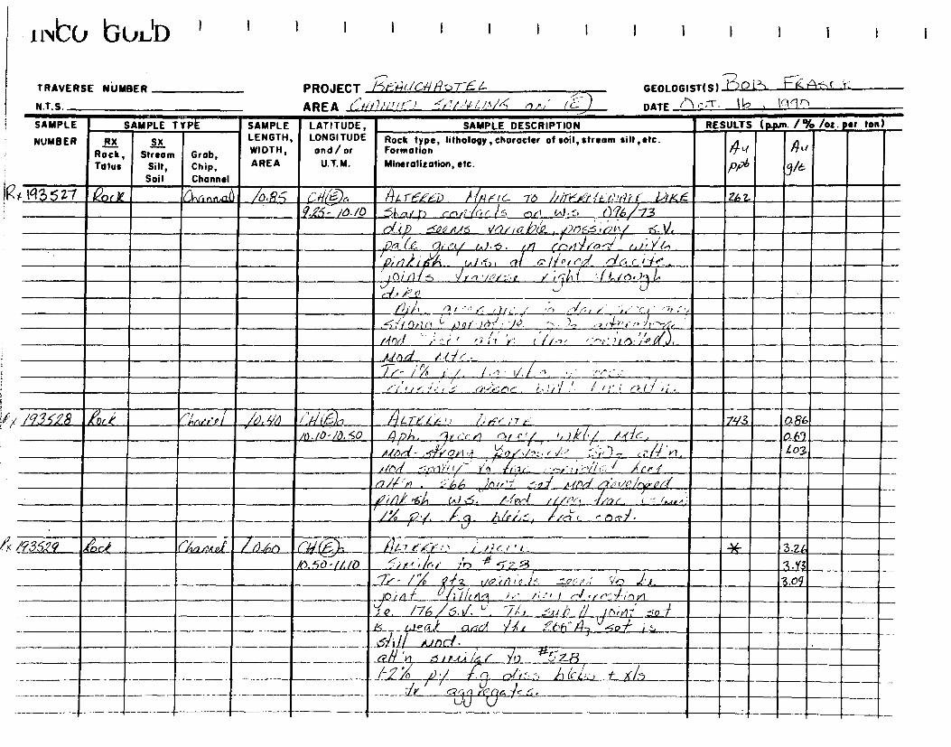
N.T.S. L.)AREA r',~/~1,<< i~:-, ~/'/,>~,1' ~ /A/4 t)
GEOLOGIST(S) 1 J°1) ~~ t417-•( r-
DATE ('') r:1-- 16 ,
TRAVERSE NUMBER PROJECT /5644(/G/4A T e-
Ink° bULID
I I I I I I I I
SAMPLE
NUMBER
SAMPLE TYPÉ SAMPLE LATITUDE, LONGITUDE and/or
U.T.M.
SAMPLE DESCRIPTION RESULTS (Rp+n• /% /Oz. ter ton)
RX Rock Tolus
SX Stream
Silt, Soil
Grab, Chip, Channel
LENGTH, WIDTH, AREA
Rock type, litholopy, character of soil, stream silt ,etc. Formation Mineralization, etc.
n 7N /pRb
. .
Au
3/6
)( Iq3527 le('rk CŸ1fi r,rtaaU ~D.RS L40< 144 1-6-12 :i) ~ ~--1F/~ 7a /rirr<~,/ .t,' , ~~r~iKf ze z Q.25- /O./0 5Lrc/p <el.' or /_, oft W • ~ _C76/73 1
dip ~Q/ r16 ✓o!/2P(~ /N3~ ,rÎi'•' K.1% , ~/7€.1 (
/ C- (ï/ c'(/ /,./. -5 . {/l (Pt1~ fo --./ /,1; Y:./..f7i/1%'r A / ),û J7` ~ i (~~ iI' n1~ r_i/~.
o/ f) ...<,~,-, '/I,/:';, ✓ r? ll f "•~1,/e30, L, J //
#4:- , V ci
/z1:i 7-1 I ,-,. r ()l :,l -;, ,--1A. , ; :: .r~ . : ,, .- _Li
~is~.fOrlr+ L 1~Il , /rr.i , I /1 -, ,- )-, 7r`F(>/~ t+,-~
, / r /PO ,: 5, r, 'J , r r fi-~' . ' -e-.7 .11I') ro Gf
tilf)d r':lf .
_
[f
~~- / /X G; j. 1..1 ~./ ,, %+,- /,.
/i /'!!! , f i IÂ:!fe)r , L • 1 I/ .' # I;' i 17' I / ii.
• /932.6 A i ,,,%~~/ r~ rf l di 40 e/:f7(F)n 44Te/~ ~i l'%1,`(- % 7 k` ,N3 0.86 /0./0-/0, 50 ~/?A. ')r (fr /7 (11 et/, ) / /I -16, 0.69
,c/[nd - ,-f~'i' o` i r~ 1.-/‘~~A ~ i .12 :.:- :),1-- ti:/-7/ 'Y1. 1.03
fiOd ~.,,nZ/y 1/e fra_( --,-,dtz;`'/l('. I tep L
/7 /71'M . .1;'A 6 %Oi,,/ ',oT - A gt 'I/P i . t
~ - / . ~~~~ ~~ (AI~. /-'~f /ilv~, - /"(3_C_ -
/Xp y. /0. f,/rL.:1, /,- ~ OCT.]-
:
• /f3529 ,,Éôa Z~inzirzt d,1✓n 661 (.:::),, 7 tf-li' I ,, ! ii r r • r - ___114 3.24 ~ _
/c>. ~0 -/!.!0 ~i r.T 4,f / :) 1 5-7 r3 _ 11.5,_ i A
%i- l 2 vo ?.17 (.r7/ _fro ,1.: r/?-7,
.~ '~ ~9
ICL/ f 6 J471(4 / ir' /,;', J r-) :f~ 1il , V
o. /7b /S.I/. `'. %/, .-ai C1 8 :.9 ✓
n:ry f---
..15._ ",,,L.16.1:___. arrf /7i ,..?-66-' 43 -,512 71- ,;~ ~iI I___ALnd • . _Q-11___~1r-t,i «l Y0 r z-B
— /,2/ /- off L ., A ' 41~ t it, I-, _/2./ 0 -
— — — —
— — ----------
~ ~~ - - c_730 ,i94 1'7 ~ .
— — — — r — _ — --- — — — - —

ffito bULb I I 1 I I I I I
Y . P .; • GEOLOGIST( S ) TRAVERSE NUMBER PROJECT Zr ( /f • ) .
DATE ' N.T.S. AREA
SAMPLE
NUMBER RX SX LENGTH, LONGITUDE Rock type, lithology , chorocter of soil, streans silt , etc. SAMPLE SAMPLE TYPE SAMPLE LATITUDE, SAMPLE DESCRIPTION RESULTS (p4un. 1% /oz. tar ton)
Soil Channel
Rock, Stream Grob, WIDTH, and/or Formation Talus Silt, Chip, AREA U.T.M. Mineralization, etc.
P/4 Ye )?e 21560 £-,k Ovi fm of /4. h0 /IF (1;-.1 c, 4F'0 Y--- /4).<.,'"e" e" hi? f L, I.) h'e 17 f 26-fy zm
//la- /1/U 7 6a ip ( otl/ezt- 6 .611 4 /no, a r-i. 240 6 - h 7 i7 c:r lc ;P'05 .._,Q.c zt-1 rsi,ni-0 3.09
b)r-p— -siiii.' / a (7;7 toW--11 pi-6 n/ey reccia ed ir_f v.-1 nei
(-I ff ,,/ P , A - r a' --4 C}1
1._/ C., • 11.6-1,1 '''r 12.1 / ;Y2 ' ; r .
4, ); 64)cv 4/71 i 4. 743 ve..;,•7 (Ç/,
; ( ( .r) Y 6,(fr 2A.,' 'A z -, () 2°4j oi/11
.SVA ./-2''./ fy ' i/1 Ar").3
Cii,t -,'S. i4- LI
./L' (.._,
/9.1.1/ A (7170/7/1 53 C1/(E), 1(17--e.(-',‘ r) tf).< e_.(- /67 e ,-, i' 2,5- c I _T-F
(0. / / 0 e SO 2.-N
-0 Y. Fri- .. -7-)X I ('' 4 i L.-- Z. yo If- / a r - / c r-0j- f 74- a.-7-ir'lr _a -t 3.05
U
N35132 An4 /1/0/34/1- // 5- 0/0:- -4.7-e-/ f t Z.)4( f - T /37 4_ /2.2 1/2.7O• ()„1/./c,..ii ' ly i 7 e t r le" 4-1 c.,it: Y 1, tier/ r lk ‘ 1,37
.121,12_r/ ;iv, 5.1,toe ? i/o<)07 !,. (1,7 0 N . A31 a i
. /.e. I ' -1- a / A Pl.') ill Q
a . d LI 4. 4 a i e r ai _ •I.. - 2I/a1 .toe'-,50 . eiy. ri/8 y/ 0 AN- `44,-7, .
. 1/0/::•_/_..11.2(d_10 /-(00 -_)// CtiPy /./>1<%•,,, 4t&/ f fer — _______ ,______ _ _ 3 ize.ill&kr ,,-- 51,402ii Aowe fuf., -
.aol --? 0 .
• - ''rt >'/,/ l'er Ile_ /0 V- 0 - Toc. r....i .., l ie i A (e I 0
77-
4

i niCv IGuLD I I I I I I I I I I I I I
TRAVERSE NUMBER PROJECT l /ri(/((r!.:" %(' GEOLOGIST(S)
N.T. S.
AREA <N4'i///
DATE T SAMPLE
NUMBER
SAMPLE TYPE ' SAMPLE LATITUDE, LONGITUDE a nd / or
U.T.M.
SAMPLE DESCRIPTION _ RESULTS (ppm. /% /ot. eer ton)
RX
Tolus
SX
Stream Silt, Soil
Grob, Chip,
/C
-
hannel
LENGTH, WIDTH,
AREA
Rock type, lithology, choracter of soil, stream silt, etc. Formation
Mineralization, etc.
AIRock, 4a p~
J~
' /935,3,3 44 G/HAD / Aso G//0r, el-k ~~i. y 4,7e~-Ki, 4.),,, ,Tic ~- /c.yb
, /2 70 - /g. 2:O /Wee; ! ,l id ft. z .(~ (,, )A ., 4<-_, 4 /-P~J /6y6
0-/j,-7,,,/ ; S /x C- -M1',/r /6.6
Y/0 Sid/P -. O 0 ~ '14 . VP.✓-,. / 7/4t
T
I
~ t ~
101 ~.f< `r ~nd ~66°f3 ~r . /l) /9 ~ M ~, .r~s Z~ •s~ a~d
i.l h4w r,
,k% lc .
/Q3631 ,~Q- ~ '~~h,r eil Al yS (*On X 2L-rr-:-.441) r~ jf _T]r4G 8.23
120 -/3.6-5" ,S~n tS/t~ ~ ~ / y- a~i/ÿL C Li.a r1 .'n , _24) 8.23
~,ru,/n/ 7"6 714 - ' -.2!Z a233
/-lnC e- 5.71:iO4/ Pr,/,..q ✓t ✓~' : ~) 2 ~ ~~ yz / ,
1% /~lQ ri O ~ 70 ~i ? l/nJs' 1/P 1 S
-, •S~s', o, i `/ `] (cc.Y? /Y1 ~~~ SJ ' ,--7_,-,7 / Y" • 5 ~ ,~ J //n r ~ Lh t/~ c rc7r' / /n~,~ 101(.4
Cl /71'0 h-L~° o j, i/ . yi,,- ,/,,,,,,-,
~.4 h/ o67/rr' r~1,5 ViiirQr/_rj l (1 rl 1-
/9:i S.3 - ~if74 "/rCi✓;!v>' n
/0,60 ('i Z)-, /41.7-p.efi) Like- (7r: /37
-/1/25- 137
/1.65- /. 37
~ r',• ,, ~ct~ //) t 3 . ,j %:/ /~ rl /l/r9C( / 0 f t •, ~j '1 ' 6(!; /37 /--2 ^ ,~ r,r:r N / /lr.r• // ( /irrJ ,
c..ln//~ t}./ //r7, r 1-4 ii,lv~(~ ,;o..1 — ~ •~~
1,/ ✓
l- ' n .i , n/, .•, L,(~ ~ .', . -1 ,t/ /5.
v
— — -- ___
— — ~-
___ — —
— -
—.—..______
— ~
-- -----------------
- - — -
-- - ....--- -
--------
---------
-- ---- •. -- t _
-~- J
_
-----4

iiNLÛ bULi ~ I I I I I I I I
TRAVERSE NUMBER
N.T.S.
PROJECT Pf/Y
11vC(l bOLD ~ I I I I I I I I I I I I 1
TRAVERSE NUMBER PROJECT Rrrat r'7".t - r r ,
GEOLOGIST(S)
N.T.S. AREA rXAAi , /r'' • ,'< ,ul = j DATE /fit 1 ) 7 "/7.1 /.7
SAMPLE
NUMBER
SAMPLE TYPE
Grob, Chip, Channel
~ SAMPLE
WIDTH,
AREA
LENGTH,LONGITUDE LATITUDE,
and/or
U.T.M.
SAMPLE DESCRIPTION RESULTS (Rim 1% /ot• Sr lon)
RX Rotk, Tolus
SX Stream
Silt, Soil
Rock type, litholo character of soil stream silt etc. yP , 4>r ~ . ~ Formation
Mineralization, etc.
.n ~~/
PP6
~~
YE
/9353 g ,eirk , (;76 r,nÀ /0.40 r t>< (6) c /)1_7/4/),'r,, 'Jilt' 17 rr 1-7S. n 0o-6.60 , )),-1ç) 1, r'r ✓1 .-le <. / n;:I ii , • t C 1 1
1/i~7 r <,✓lo„ ~ o It /~C- /.}40d
)";./_), ~
laJ.41,7 //,-,K -
74-• pl -
~ /935V) ~o<h ~~cnr~,~.i ~(1.7~) ('~~1 ~ ~~tTr' -/r û /Jfl~ %ï ✓ 9Z3 0.86
(.2(70- r.'.> P <'v n,' - . ~ ;, 1 i 7/1 i . , . ; , /Ÿ l . - .1112- _Z/7, 1- 03
(-14-)/-M OT~(-14-) ~-,-,.`<or; ? ; '" .r), ~ %i :-i 0.69 _
L~~ ^ ~~, 1 ✓ / r~ '~ /,~ ~ ✓~ r l? ( (' r ~ " f i 7~'
r✓/-Z C~-f , rtYCy.!
r
/•-.ti ~~ if ~.r ! (7 Lr ' p--7r
l.
~' G
/n :>. 1 1l -01~i ( ""'/O/1r.--(T /.I/' Or /1 /i i9 / j r] 7 /0)5-72 .\ ~j . V.
~
/ , ~J t ~ ~" /
7 0 !~f' U . / -,
1
~ ~
/~. Cr. L.'.i: i,, .rri Y~'. r:',' r9r' . e._,.)/ CJ J.(-1
/9356// ,e)c.¢ ~l,<y3r~r/. f0. ço (1-/- 4. 442 -.16--i'J /);ic K ' ; F 26a. /30 -t. f3r-7. 6 i 44. 4 i[, f ''v ;--' ,.- y'0
~ 2(Q fl/ . n.{,',S ;if.p< C~
Ti 0 --,!or . (r.,V 171 3 .
/9. 33*2 lôr k _/:1,G.Q/ /i).2 ç c/{ (') 7;< 7.6..f r l > DA-_-_ /7 E ~y3
% i~30'~•0.5.-r ,7 ~ ~ / Ct l f )îi /~E^ . ', n ,~ /.r ./✓ ---;>././.0,..-) ~ J. () ~ -i ~i3
✓ ~~,, ~
~ ~Jra ~ ,,/,' 3 Y3
f~
<7 /r! ',n 1~r7r1 u-r) -5Vr a r
/~ ~rr i r~ ~ ,Cc~jrr i ~,~/ ~~ 5. l
✓
nr - ~l' ;5,0.1, L,.~ _A.i,'__ ~, . ,_ _____6_X) ,~) r,/ F-; 2,6i---,s
T _.
----,
~- 1 J _.

TRAVERSE NUMBER PROJECT NT S
AREA C/4-4A/.k/F S.rfi / //II of ! of )
GEOLOGIST(S) %'r,(-~
DATE /7Y 7. /1:, ' 7t;2O
EVl:o bUL'D 1
SAMPLE
NUMBER
SAMPLE TYPE SAMPLE LATITUDE, LONGITUDE ond/or
U.T.M.
SAMPLE DESCRIPTION RESULTS (p.prn. /% /os. per ton)
RX Rock, Talus
Sx Stream
Silt, Soil
Grob, Chip, Channel
LENGTH, WIDTH, AREA
Rock type, lithology, character of soil, stream silt, etc. Formation Mineralisation, etc.
~f
0
~~
°>< /435Y3 rec-7c. f1a~,A;0/ /6.95 (l - t74-Trkw4.,' f),/,' (,7 1/// .705 -1) .00_ ,6_4.(d./ 1-, c; ,l,
/,~ ~,0/ _Ai
/P~~/~i ~ 5 /, r, 1 . `I, 57/ynH~ :~l ~7 rA 4/ in
~/ 4(67/i lez SYYn4~ pa Ir X. f;,;1/0 ~ a~ ~~ ~ ~A ,port/e7
~7 ~ !~~ f I L i'f r , ÿ"~ ~ r7 r. inrr ~, n e
~~ir/Q jp ti‹.. C,~~ (~/~ .(rzG7`tl/a(%.
v~/ (./ I °,) /-~r/ r irl Z76 t //.:i
A%n.ir, /7 Xis" r^ne; T :"f f /a'/P /.Y,i:: )S g
( /93s'',# Ai 1G.0tfe.i 6).50 (77, (Dc_ ii:"6. it_"1F)) //f1C rT J4 zZs
5,00- 5. ;0 __,-,_-ir+-( 1/111 Ÿe)• -2,V-1- ‘-.'/.0/i ÿ, / 1 ,::1(.---it , , ( )--S . ,:5;.--'a
'K /93.SvS ,6r,h !'km.toj /o.Qn ir# (6)L /VG rr f //. 1J/1c /~r‘ , .117z 403 3.50-r~4~0. ,~ (v ?//LCr -is n,% 1°0 ~•l~e -~•~l.`-L, ,J.D.'1
1 l/ Jr/el 4 %1t2~ 2✓'-i' r r_.i ;. ~i4/ :LSG, 1,03rP~ G/•5, Gilily Irir1/iG( a~ /O[s1S.IR
)1-1- nil cj ~P/i/Cl •./ ~/1~ J. V0_z__ ~ fr ♦ ✓1 /f (nf~t
:pc if 4 (I
~ ~: (t ✓Q:~+ '/~' / /,0 !+~ a /1 vl. ~.. 7 °l
n (~./.~. ,-.,(i ;S t a 650c- (.4
' 1 1
r~.,~ 4i//6/~ f b(e~~. j `/
/9354, ~~c~ ,(~iG/)1(p1 /D. O CfF (-_.Dr /147 t_c_4( - /.) 1.49G 17 -f ~o/i/
'V. y0- ..00 ~a ~1 /-~c/~ -,1, ~i k A -S;.~r~ /1n/ jn 617/5-
.41".,~ 71 /7i1. 7`3 /?% . .s f2o Cc, /~/, 1L ~/~ r'(~n ~; ~a , .
:.~..~.~ ,~~ , ✓~ -.___t_ — / 1 1-2°T "y' ,.r. c2f;,s ,~1~ -/- !]fP65. 4

TRAVERSE NUMBER
N.T.S.
PROJECT /?//t/(fir')-- ,7 --
AREA r//4/(/7/7,. ,K7/
GEOLOGIST(S) Y"\ . "~ "
DATE OCT l `7, / /'7()
I t NCU 1GULD i 1 I I 1 t 1 1 1 1 1
SAMPLE
NUMBER
SAMPLE TYPE SAMPLE LATITUDE, LONGITUDE and/or
U.T.M.
SAMPLE DESCRIPTION RESULTS (p.pm. /'/o /oz. er ton)
RX Rock, Talus
Sx Stream
Silt, Soil
Grob, Chip, Channel
LENGTH, WIDTH,
AREA
Rock type, lilhology, character of soil, stream silt, etc. Formation
Mineralization, etc.
nn ~t~
P/ hQ/6 4,4
J
'?< /9350 fock F1anr',,,f //- orJ (if e)e 5/4 ic irl~v !)r9c /Tic 1ç---., S. 0o: ti.ot7 AQti, dGrr.i likveA /e` /,L1 ~ /r`/ ,,
5 i4 (.1ro ~ ~or✓~IS ~/ ~ ~ e. S;U 7 r // IM 7-2- -to,/ . /-ro di-,,, /11a5.
k /193~y11 La f6Cm,td Jo. SQ 0>< ,g4.r_/1<0 l74-(1T-F 9 A.00 -_,4,50 /15 - a c,/~(y ,r,t~4
~o/p/1/,, ~ 0},/,
~Cd .I r r T ,~-~ %/- /°/a .~ P•~, Lslrba, ge-65 a- X 7S•
U935~ 2 r~f .. . .1_, i • , /~ ~ ,~ r. r ti6 /. .50 - 7. Sn /-2% o /'cise,r p ,r Rn -:, -Sir-Q»..3
; 0 2 c. 1h_ /L< fi. 4 0 11 '4 d -1_ 6. 1,/ <-1
/- Z °40 ~i' y v ~~ - .~ or, .~ s ~G 6 5
' /73 56-0 /ock !'lonrty, 0.7S (f/ (4) , ,L .T__/4" ,(,/)~c II" 1. 71 150-8.7S.~+M~ ~~~ ~f, 5 ii _
5~Ni tA), /0/u JJ•/ 64 Y____ ~. Zti ~-12(7_1-(5
7/0
.lo Ç2 -7 (Y),' '17 r j c~ ~ it•fai< _.1-0/12 i/ n/rivz-~'r Y" iy ŸIJf..; . i,- .:5 ACr/ /2.) ~
gie /i~ /'J r~. L5-0/.,e
06 -5„,c L 1~ G~.l) , ~ 3 . ~ ~ n a.2err~ .4,/ Ts - l~ ti,/ 0✓<, ( I')/;' ,t, _ — ._
/b /Q35-5( ~rh
— fk, iv11/ /n.60 CA(c~~ 1%,F1 !.1/7I,.Fit7v//; re /f % 7 /{.1:://JE _7.n
- — - 8~ 25 -B.PS ~11i~ . ~~~ / .S/ra.l or, /Ow /'~z .
---
M r 7/ (7,2_/) 7:'F / , it>' f~ /~ I?,
t9—(?/('t 1 ~i.~5`JdD1 5. f ,(/ ~~ —
‘.,

1 NIC0 IGULD I
I I I I I I I I
TRAVERSE NUMBER PROJECT 4((Glfr9 fs) 64— AREA C,g4A/,c/ k. / 40440 yil'< n, l CIO
GEOLOGIST(S) hDxg,
DATE () C-r. l-7/ /19C) N.T.S.
SAMPLE
NUMBER
SAMPLE TYPE SAMPLE LATITUDE, LONGITUDE and /or
U.T.M.
SAMPLE DESCRIPTION RESULTS (p.pm. / a/o /oz. per ton)
RX Rock, Talus
S% Stream
Silt, Soil
Grob, Chip, Channel
LENGTH, WIDTH,
AREA
Rock type, lithology, character of soil, stream silt ,etc. Formation
Mineralization, etc.
AO
p~~
Au ~/~
~ 835'52 .4904 (kaki /6, 40 <,f( Oc. 114 F,c, ~n/ rk'lls w F ~ z ) 2 S A3.SS- q 2S ~(~r~ q.1)1\a/Li. ><, c, m,tc.., ~D,l~4,y
Q.de./.r1-,o✓I. ~ort! 5 l)~ a lf' . h /-.7 a4 , I.,~~u~ri5 . Ivy_ ►~
( /93553 ,Qo~ f ('/vnAi./. /0.5o L h [, . ,6i,_, cA .~-T,<1l fkrtc,PF~ ,1~, ~ 4c i tr 2:777 _ Z91
9.5~1)-/O.On A .jn y h/ar~r /.1f( ~/cj 1-7 0-gr~ ?.01
. i► t~_ . ~.T_ If-614 Q ~. J , ,i-rrvc}. z 7.11 n g ' 1~ MOO( ~za Q
km ~~a/f',~OZ
y 3' 4/% p Al. , A- 1~<, ( ~ t X/S dis~l ~i; ~
~_46,A ~ A .
( /9,355 /G% (~~n47//d /D•5o r7/(-0b BJ0. , i47 F.ri ~c-rF!•t` () Zi1,9~17 F_- 3S`1 /0.00- /o. 50 I I' AA it, 17 14 553 h, ,9)1
/-2 ~ r'- tr. //5 f- 1)(474.
~- % .. -. . y grFA . ,ran011irr L , ":7 •C f - K. /7— _ 1/ 43 /v. So'/l- CO a, -P1~_/7 ~/ c'/` rn-,1a ~.r--2 e o , 1 s ~r~a c /ir~
~.. /" ~ , c - .-. - u CJ /
. - 1/ / D /
7-2- p /J y f rj• l~~C%.-. ` . i;i'>Y1 ~ /cel j. ✓ ~J
/ /1 ~_ ~/~3556 ~o(. %L ~Xn~t nPl /D.30 (~%~~h H~.-r ~QFI`, ~.Y~c t:,-/, 4w/
/l -OU- l/. 3p B~or ci'4n( t.~ r-0 /1~( , • ;,, .~ r• ,•.~ ~nj .")--1-10,1 ,1 . , 7 ( /~l1 ~f t, •/~ ~~ ~~lR_. 1 '
,_1-2~~ J' ~.y/ ~, . G! Ail) 1 ` + ,— r --
- ,,,,,,j ___ /~4 < 5
/ ~ ~%
- T— ~ --

1lVtO bUL'D I
TRAVERSE NUMBER
NT S
PROJECT ??,),'" aril.!' : t" . _/
GEOLOGIST(S) IL) nG"' /-;4'~~'W
AREA (/f^, /A/f L. 15-1 it(
DATE O' 'r -. / % / 4'10
SAMPLE
NUMBER
SAMPLE TYPE SAMPLE LATITUDE, LONGITUDE
and/or
U.T.M.
SAMPLE DESCRIPTION RESULTS (p.p+n• 1% /oz• er ton)
RX Rock, Talus
SX Stream
Silt, Soil
Grob, Chip, Channel
LENGTH, WIDTH,
AREA
Rock type, litholopy, charocter of soil, stream silt,etc. Formation
Mineralization, etc. Pp6
AmAc,
_3/6
>/ /935Ç -7 .c,4 00r1rld J0.7o CG, r .-1.6 gl.rr-, 7: 0 PA"- /7 -f 4- zig /// 2)/1-/Z.Pt7 23 Zvi; ( X o/C r/.P<izLf ,/ j --,ri eg /:,
, ~ ( 1
(7 /op q /1'7,~"j 4.; /' -7. (l`7_-~ t-tr-)
77 i /p0 >1 • ► C'~ ~` 71-6---71-6---
, ~.c ~ , 5 'r f., r/
~--.Y'7‘ ~ P - _ M.r. t,tnl, o n~~( X/s s,.~o ~ w~ a/~N ~-~ ~iar~. u
'K/93.558 Ark (.'~nrlrtcl /v•Sc7 r (4 .-_ --)1) ~
11 4- 1/1 •/ /`!"L,'FG'f-r' L»f ' 7,1. 55`1 '2.Ov- 2.50 r / / ., L~/.~Cf1~.~ 6/:<(_( /i;- ) ç , 2 //l ~~/-f ~-~
) ~ (~< /%77 , /r %~ ~ r r r ~;/ ~ ~ ;1 ~ ~ // 7~ff/1r~
~l r ;/ 1 , a ~7~'iÎ n(r C.'/ •' Y. ~r~/L'1 I/~~f ~~ ) r'.. • . ~
nd 73 7rZ%f~r .:, ~~Jr/i (c !~ _
"-Ito r/ ~ A~. ~i. •_.;,. , ~'-, • r ,~ ,:-71: -
.~55Oc- uJ/ et /71171 4- fY~~ _
' /355-9 feoci rk,,7np~ a• 50 ('^h 4),b ~~ re" CC_..i> 11)19-e. i -rE:- 3 01
42.5o -j,5.0Q pa. r.~
✓rr./l~i •- Z, . / r 3:09,
ir7 ir r~~ 2' 3 /> >~~ / 111 ~Gct4~1t ~ _n17 3.09 OF OcAArl~la.~ ~.Cl, (~6SdL L.~ ~// +'l ~- ~t1 _
: /93~/~ ~~i:k ,('~Lln.~/ ~Q So CGr C 6) ~ 1li6Jrl/ / ~ti i<~~ L> 1)4<- r ,—F 26oS 2.yo, 13.D0-/3.'ç0 r.:( /i 114'r S' S5- ci Q! f~ 07 0 2.7~jr
_(/!/ ,C~f ✓1(2 (3~ 6/.'r.cia riDo. 2.06
frrt 6 /.-Pr/V,i 5 /^ / O c / /-2Y) L/l~ P/ V.--;;11./
~ / / /
/ Pr( 7 lo , sr,~~ti rX;~,,.„ <~ >le 7Lr9- ~~,'
-- - ~. L./ 3-1/D/ . r~L~> ~Ze ii 3-~/~ ~/
-- ____i_
--------r -- - —

J N'CU 'GULD '
1 1 I I I I I 1 I I
TRAVERSE NUMBER PROJECT
.,
GEOLOGIST(S) ~/3
NTS AREA 4 /1/1W- L- .5/^ r' /,';?_.',41--z
DATE nr 7 • / 7, (r/'70
SAMPLE
NUMBER
~,~,
SAMPLE TYPE SAMPLE LATITUDE, LONGITUDE and/or
U.T.M.
SAMPLE DESCRIPTION RESULTS (p.pm. /% /os. ter ton)
RX Rock Talus
Sx
Stream Silt, Soil
Grob, Chip, Channel
LENGTH, WIDTH,
AREA
Rock type, Iithology,character of soil, stream silt,etc. Formation
Mineralization, etc.
n `+ fi'
ppb I
AA
3/t
/CX /93;561 ,PA(. ~~,.,., ,,,/ /'a 71J Ch b gir-F Xe l) 1~,2 C tri u2g 2.yo /.3 5-0 -/4/.20 pa re /'flrirf .5 G. r" C. 2.7'(
-Liss r~.r.~i t61e6 4 /-?`/ ly / AdJ ` _r2 2.06
► Ar/9356k 4U4 C'/,t,,,,v/ Jn.s r4doz, L~iG,11 y/ ~~r, ,~ Lor !ÿXef-Cigrk7,N 233? Z-ob
/h/ o-1y7e /),gcrrE 2-o6 llt,c I Cf.t/ 4 6-5:8 Zob
/-7°/, -~~~ vP%a rlfs faLt SDo}t- 4. 40 /. /l/Pg. / 5 ~ "/ ~M (Y;is• iii- 6.5 ~ i<s j
c/f.?~ti.3 ,Qc 0,1,71f fl /!).8S ch e)b ATe.fKt, G7~/T 6 /002 / 20
N75- /5-60 pa 6 t.17 ,c4rd/62.___ AoCac.(.r,D4 3 f1( 1.37 55/DO/S - S r~rt ? ~j, Da /~,/a d A l 03
S~/( -o ~u~ ~~
ali ,4.
3-9' ~!l,~ f -~ rV~ ~•Ss ,4Z6.65.. / /
1
-
~ .
T
~

1 NICu IGuLD ' I I I I I I I I I i
TRAVERSE NUMBER
N.T.S.
PROJECT ReA JC f~Y9ST t- A R E A (1,44A/A16-4_ •549.c./14 Ah , D/✓
GEOLOGISTIS) ,80/ ' 45ek
DATE (7cr. Z-, , /990
SAMPLE
NUMBER
SAMPLE TYPE SAMPLE LATITUDE, LONGITUDE and/or
U.T.M.
SAMPLE DESCRIPTION RESULTS (p.pm. /% /oz. eer Ion)
RX Rock, Talus
SX Stream
Silt, Soil
Grob, Chip, Channel
LENGTH, WIDTH, AREA
Rock type, litholopy, character of soil, stream silt ,etc. Formation Mineralization, etc.
~ Pab
Au rl g/b
7)( /9,3564/ Ark [~~nA/I 11 ~----. / D.5/0 ('h b ALTta• kFn 04e" rr~ Zy
/5,6n - /6.06 , ,(90 -. ,-,I rPr9di 5/i G'i'PV w/ A.!,
n~nc L5 /'us~/ ,d, G~i.?d,C4~ ~rc >l/~Q - ~
C-4- ~ A4) . . 5s~revr~ ,2_0,-../,/ ii-e/12, 5;01
1 1 A . rJ~l Ac101(
~ f'!_5; de ~- roc e-04 6/4 of ~c,c+-f
. ~ 4 #114, Éod~,/s ti ri A ✓d , 2- 370 p,
- ~ - . , , - ~ .s~~~
~,~
i /s
/up ~A !' on voiG(1/ [,r ~1 ~ ,
/933'45 ,Qoc.' ~~a4.t.f./ ,/ Co CA Oh 4. r6‘.Ea Ji31c iTE 106 ' -1700 ./6.00 6/ec .ir / e~, c~d o/ n ,2y~ 5 % ~/ -t- ~ ~
/Jr, 1,. G, 4, Ol a./71 ,.t, ,c./()c1 n,l r/.- y
t -~drr;l('y /72 °X ~
r'J/i.~ /c/a~4`/.
,e ~ Il,y /27 ' p65546, ~l, r" Cri7YçnI/~ Gr be01
()id( n ~M •,..K.-, ~A
~ e~y A~
~ T4 /_~ ~ ~~~~P ~ ~ s~
~ ~3 ~y~~~ / b9 ,
/935-66 en- ~1ca/1c / ,D. 60 , ri? OA 1
CÈ(1 ./ r~ (~/ 4LrF ~9r' 7; y J7oo-/7,6n P055/Q41 lf47e'.eE/) /~i-?f /r ))i/{.6 65"
____C • 4 G Or ., Ili .. Q r0 ~ _ /10 ~ 1 5 /D°~ f✓t~G rX,;.~ /~iUr/a 1/C~• -
, ,J
C - Ale lap / Vey); ✓e 5,0z. )40j /.r.y 1
~ ,
o1f n.
~ 76_ i / ~ fJl At r . ~
7,y _
~~ • ~ _1
~
~ L~[A//r' /.YF /" 4<, ) 7-_12_ .172/ - ------ — — -- - -- ----- - / 7 '.~-> ci/t4L- /QLf/?IF f /1k f F~/~N
----- - ~

I>.vCv bOLD I
1
TRAVERSE NUMBER
NT S
PROJECT 8# "v/K-11/1-',7-61.- AREA ('fl4AV~c/ L '5Ar4/4/AJG oiJ
GEOLOGIST(S) Aos iekrlszic
DATE Q(7 23 , /440
SAMPLE
NUMBER
SAMPLE TYPE SAMPLE LATITUDE, LONGITUDE and/or
U.T.M.
SAMPLE DESCRIPTION RESULTS (ppon• 1% /oz. r ton)
RX Rock, Talus
SX Stream
Silt, Soil
Grob, Chip, Channel
LENGTH, WIDTH, AREA
Rock type, Iitholopy,character of soil, stream silt,etc. Formation
Mineralization, etc.
,/~ ►}`t
QPb
4-,-1
q~6 J
: 43667 .QocE 44,1tic/ /• 60 -f h 06~~TFeF/) /.)/ 7", Zor~ I 0,710 _11.40- 6.; /1,G Wake a#'Q .tlo .d S6 A
/-,Zl .1$¢(-1.(,(4/; k f-M~.~Q ~ 0~5 //red 6,(.6~ o,,5 ~ .~ ~q-4/°„ py A r. e nn 4
/Q35-6,9 A ana~ / /• DO C1, 66 s 1947-66Q) /TE b.1 roil %/r, we./ /51LTodE11 _2704G 411 /810- /9./iI ja,g-rr,ffF.
4/,lorp(t doe-) ~e 5-id,fe/c~/ 7/0 `* {67 ii / Or Ci //~/ y /y 6I~Pi► red a)// r51vc4 P
A/5/y 4/'Qr iL.Q5 5o ,./twit ~C_r cl/ Q6 ï//G~f n✓P/ ~/Sce.I s ~?4~r~iG.S .67111 /A ~sJ(1G.t/~j JArcc Co,116-o/%Gt. So/ Ai Ala,/ a// '.2 f4
~ ~ le ~ s ~a
141 ,r,~/c J` A 110 Q ~ a(2 Gi k rlorJ- .uEG 14 Ai / f/ /2 /11 da.u~c 3-/ ,pV
Tr- /% i.1 Q// C[ÆGrlP 5% ,-ri A (117' ~ ~s ~ Jhly
AL,_ rx;~ 4-~1~ ,S~ocs
/Q,~s~y ,6c ûefitt/ 4-so Cii Ob §/6h14 y ifedx,t, ~c.T~ /s /10
aa~/f/o- pd (4_1,4 , )4:5 irr/t -3 ey _e~at.4 r 6 103 ,
5' knit 0r✓ra5i ✓2 S.Oz -/'-P 049 —1 /-
o P ( -2A.44 ✓ug)Iy 4G Id Soticl /Ltr-( -r¢c.r -f z Vo,/irra / • . /. . R #f . t/
VX{{,,
~~ O~odQra (~i~ ~ MI P mil ~ ~ _ le4.11~r IL . ~ . . / •-• ,
, . 1
-- -- - `_
i

1 NICU IGUI!D
TRAVERSE NUMBER
N.T.S.
PROJECT /'3,6ge l/1RTeL
AREA CN,4A/Nj L '514 'L /,kfiÇ OA i (É) GEOLOGIST(S) R06 re195F rC
DATE Oc- T• 2~~ / g14o
SAMPLE
NUMBER
SAMPLE TYPE SAMPLE LATITUDE, LONGITUDE and / or
U.T.M.
SAMPLE DESCRIPTION RESULTS (awn• /% /o:. ter ton)
RX Rock, Talus
SX Stream
Silt, Soil
Grob, Chip, Channel
LENGTH, WIDTH,
AREA
Rock type, litholopy, character of soil, stream sitt,etc. Formation
Minerolitotion, etc. ~
PO' N./
5/L-
7( AiS7o f C%Crl/I _ /0•So r h ~~h 1lf/ 4.v Az.T</eJ G/T7.6 Jeri 1-37 ' .i_ r. o .. - .• 0 .' rJ~ 3PD16/ 1.37
__- 1..t.. . ' • 1.37
- o° . C, i „s~r- ~-r. J.
GIG~ ~f re: r.e r~.-f.J
ei(;Ss ,h(c4s
K /935 -71 44 aarl,cpf /o.zc C!, ~b I/ /ti .4z •/ 11E--r,' r,c n 000,1c, , r1, 2366 214
20, iQ- 20.3S ~; w.c4:.la..r 10 "ti 570. z'7f Z-7y
IA /93572 17oG.f ("AG4n.~) /0.95 r /'->ZL rr 4'f i) /~i~~ / r,e• 31q 20.3S-Z1.31 5 / b(çar %or l- ~Ai".4 /ac
et 7,0c rt - r t~ /-0/-0 c~(c, . ,( /too/toor► t / ~~' A1~ A 44 o~
1c- AA nr a ç '5-1 A-Li la / A7 6-66 • 5 /o/~
!1/ a~ ,,LC 5; D ~ /~r tiutp-r ~ ~~ a ll 'r1 .
/-2 ° , - . . - -- c~. .~, All. ss.
_~~ 41=1M
__ . . .. r ~ IVT,_~~.~WL. F.-F _ Z87,
•' . i I ~ /Q I AS ton 7t L f i
_
/ 1
i ' % • ~ l i' // ro C t/ ~~/ r
M ~o i ?~ r_ • / p- ~ir ' . v7_ ~
/ T ~ ✓~/Q ~r
~~
n~C
~. f ~
~ , ...1 A /,- s. / ~ , -~ _. I. • . .1 —, — t
i_ --i ---

YPE
Grob, Chip, Channel
SAMPLE LENGTH, WIDTH, AREA
,,.('.4nn.ral /17.1-0
PROJECT REAL(G/MS7-4 I-- GEOLOGISTISI 8006 ~.69-<_,c
AREA C, ,JA/.4L 64p,/PG./AA; coi tie-) DATE OCT-. , / 4q{~
LATITUDE,
SAMPLE DESCRIPTION RESULTS Ip.pm. /%/oz.ter tool
Rock type, lithology,character ofsoil,stream silt,etc. Formation Mineralization, etc.
cecri• j/iQ1,16
r /n ~.-ey
1i -7~ A f ~ S °~ / ►"✓P /~ l i il r~t n/~
~n ! S. ~n /i S/n 5 J4-'o y(~ ~?r /JC~ ï ✓O '~i1 n 1 ~F `r~ !. Y. f/ ~,~JJJ ~ ~n
~.~,n~o/~o~ .t ~~~y ~fA.r a.//1H y-3°o p/ 4~ ~i~ s~r .Es —~~15• ~%6~i~ ~ a des f- ~~~ r. ~oa f. ~y ~
LONGITUDE and/or
U.T.M.
2230-92.90 (,'A € ) ,/~.4G / rr~
4at
g/t 4,4 ppb
202-
1z IZ
d Lieu/4 S~n~ )43mad a a~.s ~ie,
kw a /122_____ ~
t
/-2 ;
---
I 1 I I 11VCU GOLD
TRAVERSE NUMBER
N.T.S.
SAMPLE SAMPLE T
NUMBER RX SiX Rock, Stream Talus Silt,
Soil
/9q5-71/
. r ^ti . eh 6ZS4 A.0 / 8...,~('r iQ Sie 22.9o-23.8fl~i.f.Li/r.r .1-'O e 71i -SnrY)/r•Ç #r'JS3 -F SY
~F-i~4l/ r~/5>~ /0 Q S.ri /11,?cl5 ~vQ~.
gc~t e i.5 Sr~OI/~Cdl i~ J/YI Q~ 7iGQF
~i r,Anr~kp,l. ✓~ry T~a/ YO .no(
5 cSe.c.c~ C' (eat- f 3 ~Ya Is / - i~n.i~, ✓uc~~ y rv5~ ""`' a'-' /c.
, , -Soo 4.
4c/Q3s76 Ax.F ln.iaArl11 J6.6$ MI-c.../re_ • '925 -971) 455/64y 4:1.-rfRE4 1,14 ~ 0i~
~~fy 10 cark.ern ilvey
, s ~ /rf.a3 vmd;, r,4 t /.tet4 . LLie_GS /:_cQ !lv
yI
•
; 4 i935-7s

i NCU GuLD I I I I I I I I I I I I I
GEOLOGIST(S) ge)6 DATE f)(-7 . Z a7 /4ç0
TRAVERSE NUMBER PROJECT jt4-1 /4 TF~
N.T.S. AREA Ci{i0✓4/6-/_ :5r ,G(1).~1n/r>. (1.&I
SAMPLE SAMPLE TYPE
NUMBER RX SX Rock, Stream Grob, Tolus Silt, Chip,
Soil Channel
SAMPLE LATITUDE, SAMPLE DESCRIPTION RESULTS (ppm. 1% /os. ter ton► LENGTH, LONGITUDE Rock type, lithology,character of soil, stream silt, etc. WIDTH, and / or Formation r f4 4,A AREA U.T.M. Mineralization, etc. PP60./6
114( /93 577~~.~ . Cknm.p./ D. ....0 Ch Os 41...7 Aeé-z) 1/i3[.l T.~' _ J -15- - 000 -O. SO 5 "4'0~20 /i/R 5 i 1/2 .~i Û t. Q t/lt 'Al
~eX) /~rQ /-?al~u 6(p~ r.~d f l ~~~~ ~~o~., lt~rr~ly ~,! ~,, yu ~
~
rug~ r ~fly dt-tnn(v ~o4 r
/-2~! 7Ir ~G. or,~ 4-.6..cb x~ , , el _r s 5 . v ~
/9351B A9,14 (7/0 nM,l 6. 80 ('k V n1 NJ.tieiG l).16- 22- a so- /A0 M.4 ,,,dc_ lXa t. ~ ~. ~,25C/,.God
~€',4-1 r' ,~ /f3 3-42 art G) (0. 50,4 ip7 /-e! ps o VI c~ _-so~.t i — ~(d~ss~ v e lay: Ail, -s it.. ► h.-) ~g1a~~ /ly ,io,-~,t,tp ~~r
1, rQ~,f ô d Ac., )a_l(}i /. SO .4, ri .0 ot-a AyhQ. q
/~ tt,f.c Gar
/ c?,D~G2 !Q 4ClL lb i~i /X!'lG~r.{~ (-)/a c; 1e 6, iG44 C $ cite c^/oaz- /y S12L7rr ai►
~
(item/id , 4-LT -iQ~J~ 0,4e n- ~. 4 4
/.AZP I~ 'ri 1/ i r_Tr /.Teii
. I! i / • /
~=- py
17. 665 &45.
elc /9 lap ley) l~aa~ / ► 4.50 . Ch d 41,Tf"JeD Î)~r-c r r f ~—`_—,1 ?ÿ - 2•~~ . _86eA4.404.. ?orvr ,s; Je 5;0-1_ ~1~, f ~ n►
k/ r ~/ ~ ~ n r1 o/led- I- 4-% _ af ~/ f • s. ar4~~~1nGi i ~Q .
-- __ ~- — — --- â rs_ /il
a-~ G /~'n (o
,~J ~,ra ~ . --
- rz°l py >< ,~~. r~rSS ~~s ~- _ --~------- --- - ~--- -_— — — -- ----~a_c coal-
/9.ss7g ,eccsk

CVCt_) N bud) I
GEOLOGIST(S) êt)d /'~.f}wF/Ir. TRAVERSE NUMBER PROJECT RF 4*/6.kr64— N.T.S. AREA (.01-4 /Viçe_ ,)1A1 DATE OC-r• 23, /`q°
NUMBER RX RX Rock, Stream Grob, Talus Silt, Chip,
Soil Channel
LENGTH, LONGITUDE Rock type, lithology, character of soil, stream silt ,etc. WIDTH, and / or Formation AREA U.T.M. Mineralization, etc.
SAMPLE SAMPLE TYPE
SAMPLE LATITUDE, SAMPLE DESCRIPTION RESULTS (Rpr^• /% /oz. ear ton)
4flairs9r _ieoch (hZd 4.r07,EJ) a4G/ rrc / Del 2.25- 3.Lo Dar-.4 yte¢.4
/wad 1/o IrJj
Il r-45 r a
cI~ . ?r- l/ef•.cLo,f,
rpagYZ~2~ .
~Ji~si vc S~ 0 L ,d7 'n
~ /93.582 ~ear.F t>1 itK.~ ~.007 l,'>k~l i¢L,T7~IlF1~ 1%4c ~Tf~~iV17,F~JT~
/ar r !931
Tr py it9. czas ,66.6s.
110 /r3se3 ,Por.E _Cistkon el ~a,So ~ C6 Z)44, "gi.rE.eE/) ~i¢,/D.4-srre
5/ 20- y. r0~,4,~.r.t.i lo l,~ # 5'B
4193s4 .ecrÀ. ~~n,.//~0.60 7-
4.70- 5:30 5V40~~ ?Lei .aS:i~P -2~ .rl.pq 6laes .G .4(
j epic-AA /~ ~~o~s , ~/Apo,~.
Mod- 3 472.f. re ~ir
T✓- /°/v ~ 7/ Çj . r,~,s5 s~c~s s 61P~s
APPENDIX 3
CERTIFICATES OF LABORATORY ANALYSES

r-- • - cda / 7 VAL D'OR (QUEBEC) J9P 4P5 TEL.: (819) 824-4337
FAX: 1819) 824-4745
/kWu4iTZ
LABORATOI RE D'ANALYSE BOURLAMAQUE LIÉE
BOURLAMAQUE ASSAY LABORATORIES LTD.
—. C.P. / P.O. 550 148, AVENUE PERREAULT
INCO EXPLORATION & TECHNICAL SERVICES INC.
-- Projet # 60217
CERTIFICAT D'ANALYSES
CERTIFICATE OF ANALYSIS
54/b2 N°
ÉCHANTILLONS Core SAMPLES
Brian Booth RECEIVED FROM
le 17 mai
90 VAL D'OR (QUÉBEC) 19
ANALYSES 73 Au + 4 Au ASSAYS
REÇU DE
Echantillon Au ppb
126367 N.D. 126368 N.D. 126369 N.D. 126370 N.D. 126371 10 126372 80 126373 N.D. 126374 N.D. 126375 N.D. 126376 60 126377 80 126378 80 126379 N.D. 126380 N.D. 126381 90
127950
560 127951
G.1000 127952
300 127953
830 127954
60 127955
820
Echantillon Au ppb
127956* G.1000 127957 70 127958 100 127959 180 127960 N.D. 127961 100 127962 170 127963 80 127964 20 127965 N.D. 127966 N.D. 127967 N.D. 127968 10 127969 180 127970 10 127971 60 127972 110 127973 N.D. 127974 N.D. 127975 N.D. 127976 N.D. 127977 N.D. 127978 120 127979 110 127980 60 127981 110 127982 N.D. 127983 N.D. 127984 N.D. 127985 N.D.
Echantillon Au ppb
127986 N.D. 127987 360 127988 N.D. 127989 70 127990 N.D. 127991 N.D. 127992 N.D. 127993 N.D. 127994 10 127995 N.D. 127996 N.D. 127997 N.D. 127998 N.D. 127999 N.D.
* Au ppm
127948
34.2 127949
597.2 127951
1.05 127956
10.0
REÇU le '
1 8 MAI 1990
Rép• For Au N.D. means less than 5 ppb. G.1000 means "greater than".
aNALYSTE

C.P. / P.O. 550 148, AVENUE. PERREAULT VAL D'OR (QUEBEC) J9P 4P5 TEL.: (819) 824-4337 FAX: (819) 824-4745
LABORATOIRE D'ANALYSE BOURLAMAQUE LTÉE
BOURLAMAQUE ASSAY LABORATORIES LTD.
INCO EXPLORATION & TECHNICAL SERVICES INC.
Projet 60217
CERTIFICAT D'ANALYSES
CERTIFICATE OF ANALYSIS
55016 N°
pg 1/2
ÉCHANTILLONS Rock SAMPLES
R. Fraser RECEIVED FROM
90 VAL D'OR (QUEBEC) 19
ANALYSES 106 Au } 8 Au ASSAYS
REÇU DE
le 26 juin
Echantillon Au ppb Echantillon Au ppb Echantillon Au ppb
149254 300 149284 N.D. 149350 G.1000 149255 360 149285 N.D. 149351 G.1000 149256 G.1000 149286 N.D. 149352 N.D. 149257 G.1000 149287 N.D. 149258 520 149288 900 149401 N.D. 149259 280 149289 G.1000 149402 N.D. 149260 N.D. 149290 G.1000 149403 N.D. 149261 10 149291 100 149404 N.D. 149262 10 149292 N.D. 149405 N.D. 149263 20 149293 N.D. 149406 N.D. 149264 N.D. 149294 N.D. 149407 N.D. 149265 80 149295 N.D. 149408 N.D. 149266 260 149296 N.D. 149409 N.D. 149267 430 149297 200 149410 N.D. 149268 340 149298 N.D. 149411 N.D. 149269 150 149412 N.D. 149270 30 149336 10 149413 N.D. 149271 440 149337 G.1000 149414 N.D. 149272 200 149338 N.D. 149415 N.D. 149273 10 149339 N.D. 149416 N.D. 149274 N.D. 149340 N.D. 149417 N.D. 149275 N.D. 149341 N.D. 149418 N.D. 149276 N.D. 149342 150 149419 N.D. 149277 N.D. 149343 N.D. 149420 N.D. 149278 80 149344 N.D. 149421 N.D. 149279 110 149345 N.D. 149422 N.D. 149280 10 149346 N.D. 149423 N.D. 149281 800 149347 N.D. 149424 N.D. 149282 N.D. 149348 G.1000 149425 N.D. 149283 N.D. 149349 20 149426 N.D.
~

n Na- SL a$S=
C. P. / P.O. 550 148, AVENUE PERREAULT VAL D'OR (QUEBEC) J9P 4P5 TEL: (819) 824-4337 FAX: (819) 824-4745
L,y ; .4TCl,RE D'ANALYSE BOURLAMAQUE LTÉE
BOURLAMAQUE ASSAY LABORATORIES LTD.
INCO EXPLORATION & TECHNICAL SERVICES INC.
-- Projet 60217
CERTIFICAT D'ANALYSES CERTIFICATE OF ANALYSIS
N° 55018 pg 2/2
ECHANTILLONS SAMPLES
Rock VAL D'OR (QUEBEC)
le 26 juin 19 90
RECU DE R. Fraser ANALYSES 106 Au + 8 Au RECEIVED FROM ASSAYS
Echantillon Au ppb
149427 N.D. 149428 N.D. 149429 N.D. 149430 N.D. 149431 N.D. 149432 N.D. 149433 N.D. 149434 N.D. 149435 N.D. 149436 N.D. 149437 N.D. 149438 N.D. 149439 N.D. 149440 N.D. 149441 N.D. 149442 N.D. 149443 N.D. 149444 N.D.
Echantillon Au ppm
149256 4.20 149257 2.20 149289 1.30 149290 2.60 149337 1.80 149348 5.90 149350 1.70 149351 1.40
Pour Au N.D. veut dire moins que 5 ppb. For Au N.D. means less than 5 ppb.
REÇU le
29 JUIN 1000
Rép : ................

C.P. / P.O. 550 148, AVENUE PERREAULT VAL D'OR (QUEBEC) J9P 4P5 TÉL.: (819) 824-4337 FAX: (819) 824-4745
LABORATOIRE D'ANALYSE BOURLAMAQUE LTÉE
BOURLAMAQUE ASSAY LABORATORIES LTD.
INCO EXPLORATION & TECHNICAL SERVICES INC.
Projet 60217
CERTIFICAT D'ANALYSES
CERTIFICATE OF ANALYSIS
N° 55u3b
ÉCHANTILLONS Rock; réf:55018 le 28 juin 90 SAMPLES VAL D'OR (QUÉBEC) 19
REÇU DE R. Fraser ANALYSES 15 Ag, 15 Cu, 15 Zn 15 Pb RECEIVED FROM ASSAYS Oeochemlcal
Echantillon Ag ppm Cu ppm Zn ppm Pb ppm
N.D. 60 20 N.D. N.D. 220 40 N.D. N.D. 190 60 N.D. N.D. 210 90 N.D. N.D. 90 70 N.D. N.D. 60 10 N.D. N.D. 100 60 N.D. N.D. 50 N.D. N.D. N.D. 180 210 N.D. N.D. 150 50 N.D. N.D. 310 40 N.D. N.D. 20 N.D. N.D. N.D. 100 100 N.D.
149415 N.D. 20 N.D. N.D.
149291 N.D. 20 80 N.D.
Pour Ag N.D. veut dire moins que 1 g/tonne. For Ag N.D. means less than 1 g/tonne.
Pour Cu & Zn N.D. veut dire moins que 10 ppm. ,For Cu & Zn N.D. means less than 10 ppm
Pour Pb N.D. veut dire moins que 20 ppm. For Pb N.D. means less than 20 ppm.
_ 149401 149402 149403 149404 — 149405 149406 149407
— 149408 149409 149410
._ 149411 149412 149413

C.P. / P.O. 550 148, AVENUE. PERREAULT VAL D'OR (QUÉBEC) J9P 4P5 TEL.: (819 ) 824.4337 FAX: (819) 824-4745
LAS ORATOIRE D'ANALYSE BOURLAMAQUE LTÉE
BOURLAMAQUE ASSAY LABORATORIES LTD.
INCO EXPLORATION & TECHNICAL SERVICES INC. CERTIFICAT D'ANALYSES
CERTIFICATE OF ANALYSIS
Projet 60217 N°
55U 113
ÉCHANTILLONS ROCk le 04 juillet VAL D'OR (QUEBEC)
t9 9, SAMPLES
REÇU DE ANALYSES 49 Au + 4 Au RECEIVED FROM ASSAYS
Echantillon Au ppb Echantillon Au ppb *Echantillon Au ppm
149299 300 149515 149300 100 149516
149517 149353 N.D. 149518 149354 10 149519 149355 560 149520 149356 N.D. 149521
90 149357 3.2
*G.1000 149505 4.5
N.D. 149510 1.8
N.D. 149516 1.3 N.D. N.D. N.D.
149357 * G.1000 149522 N.D. 149358 N.D. 149523 140 149359 N.D. 149524 280 149360 N.D. 149525 350 149361 N.D. 149526 N.D. 149362 N.D. 149527 N.D. 149363 N.D. 149528 70 149364 N.D. 149529 10 149365 N.D. 149530 N.D. 149366 N.D. 149531 60
149532 10 149501 400 149533 70 149502 N.D. 149503 20 149504 N.D. 149505 * G.1000 149506 580 149507 N.D. 149508 400 149509 N.D. 149510 * G.1000 149511 N.D.
REÇU le 149512 N.D. 149513 20 - 6 JUL 1990 149514 400
Pour Au N.D. veut dire moins que 5 ppb. Rép• For Au N.D. means less than 5 ppb.

Projet
ÉCHANTILLONS SAMPLES
REÇU DE RECEIVED FROM
60217
Rock
Brian Booth
VAL D'OR (QUEBEC)
ANALYSES 1 ASSAYS
19 90
N° 5200
le
Au
19 juillet _
C. P. / P.O. 550 148, AVENUE PERREAULT VAL D'OR (QUEBEC) J9P 4P5 L G.
TEL.: (819) (819) 824-4337 FAX: (819) 824-4745
LABORATOIRE D'ANALYSE BOURLAMAQUE LTÉE
BOURLAMAQUE ASSAY LABORATORIES LTD.
INCO EXPLORATION & TECHNICAL SERVICES INC. CERTIFICAT D'ANALYSES
CERTIFICATE OF ANALYSIS
Echantillon Au ppb
149534 20
R~Çv ,e
25 A1'0
Rép: -. . - - •• -

N° 55348
VAL D'OR (QUEBEC) le 9 aout 19 90
C.P. / P.O. 550 148, AVENUE PERREAULT VAL D'OR (QUEBEC) J9P 4P5 i-L
TEL.: (819) 824-4337 FAX: (819) 824-4745
LÀ3ORATOIRE D'ANALYSE BOURLAMAQUE LTÉE
BOURLAMAQUE ASSAY LABORATORIES LTD.
INCO EXPLORATION & TECHNICAL SERVICES INC.
Projet 60217 2-44l6.-(14 Z ÉCHANTILLONS Roche SAMPLES ......................... ..................... .
CERTIFICAT D'ANALYSES
CERTIFICATE OF ANALYSIS
For Au: N.D. means Pour Au: N.D. veut
Booth ANALYSES 79 ASSAYS Au
Au ppb Echantillon Au ppb Echantillon Au ppb
N.D. 149397 N.D. 149627 N.D. N.D. 149398 N.D. 149628 N.D. N.D. 149399 N.D. 149629 N.D. N.D. 149400 N.D. 149630 N.D. N.D. 149631 N.D. N.D. 149601 N.D. 149632 N.D. N.D. 149602 190 149633 N.D. N.D. 149603 290 149634 N.D. N.D. 149604 N.D. 149635 N.D. N.D. 149605 N.D. 149636 N.D. N.D. 149606 N.D. 149637 N.D. N.D. 149607 N.D. 149638 N.D. N.D. 149608 N.D. 149639 N.D. N.D. 149609 N.D. 149640 N.D. N.D. 149610 N.D. 149641 N.D. N.D. 149611 N.D. 149642 N.D. N.D. 149612 N.D. 149643 N.D. N.D. 149613 N.D. 149644 N.D. N.D. 149614 N.D. 149645 N.D. N.D. 149615 N.D. N.D. 149616 N.D. N.D. 149617 N.D. N.D. 149618 N.D. N.D. 149619 N.D. N.D. 149620 N.D. N.D. 149621 N.D. N.D. 149622 N.D. N.D. 149623 N.D. N.D. N.D.
149624 149625 ~ N.D.
N.D. REÇU le
149626 N.D. i 0 A011T 1990 less than 5 ppb. dire moins que 5 ppb. Rf3p'
Echantillon
149367 149368 149369 149370 149371 149372 149373 149374 149375 149376 149377 149378 149379 149380 149381 149382 149383 149384 149385 149386 149387 149388 149389 149390 149391 149392 149393 149394 149395 149396
REÇU DE RECEIVED FROM Brian
-~ ,• F~L~'~STF SSAsr"FiL

Certificat/Certificate
Comp: INCO EXPL. Proj: 60217 Attn: R. LAMBERT
Nombre D'Echantillons/No. of Samples:
Soumis le/Submitted: SEP-17-90
No. D'Echantillon Sample Number
� FX-149535 FX-149536 FX-149537 FX-149538
- FX-149539
FX-149540 FX-149541 FX-149542 FX-149543 FX-149544
— FX-149545 FX-149546 FX-149547
✓ FX-149548 FX-149549
FX-149550 _ FX-149551
FX-149552 FX-149553 FX-149554
FX-149555 FX-149556
OR-1129-RG1
Date: SEP-19-90
acv.:/?C
ASSAYERS LABORATOIRES/LABORATORIES DIVISION DE/OF ASSAYERS CORPORATION LTD. 780, AV. DU CUIVRE, C.P. 665, ROUYN-NORANDA (QUEBEC) J9X 5C6 TEL.: 1819) 797-4653 FAX: (819) 797-4501
AU PPB
116
AU OH' KS PPB
AU 03' KS PPB
AU g/ tonne
AU CH'KS g/ tonne
AU O1' KS g/ tonne
343 343 343 80 * 3.94 3.77 4.11 36
32 27
2091 2.23 2.06 2.40 1406 1.03 1.03 1.03 620 549 690
* 5.83 5.83 5.83 * 7.54 7.54 7.54
2263 1.89 2.06 1.71 1023 1.03 1.03 1.03 1303 1.03 1.03 1.03
* 13.71 13.71 13.71 189 18 16 34
343 61
* TOO HIGH FOR A.A. READING
Certifie par/Certified by
REçu l
2 1 SEP, 1990
Réo•
"AU SERVICE DE L'INDUSTRIE DEPUIS PLUS DE 50 ANS"
"SERVING INDUSTRY FOR OVER 50 YEARS"

ASSAYERS LABORATOIRES/LABORATORIES DIVISION DE/OF ASSAYERS CORPORATION LTD. 780, AV. DU CUIVRE, C.P. 665, ROUYN-NORANDA (QUEBEC) J9X 5C6 TEL: (819) 797-4653 FAX: (819) 797.4501
Certificat/Certificate
Comp: INCO EXPL. Proj: 60217 Attn: R. LAMBERT
Nombre D'Echantillons/No. of Samples:
Soumis le/Submitted: SEP-17-90
OR 1129-RG2
Date: SEP-19-90
No. D'Echantillon Sample Number
AU PPB
AU g/tonne
AU Q3'KS g/tonne
AU CH' KS g/tonne
FX-149557 * 5.49 5.14 5.83 FX-149558 * 7.03 7.54 6.51 FX-149559 109 FX-149560 113 FX-149561 301
* TOO HIGH FOR A.A. READING
REÇU le
; 2 1 SEP. 1990
~ R ep.
Certifie par/Certified by
"AU SERVICE DE L'INDUSTRIE DEPUIS PLUS DE 50 ANS"
"SERVING INDUSTRY FOR OVER 50 YEARS"

C', C, r.• C..,
ASSAYERS LABORATOIRES/LABORATORIES DIVISION DE/OF ASSAYERS CORPORATION LTD. 780, AV. DU CUIVRE, C.P. 665, ROUYN-NORANDA (QUEBEC) J9X 5C6 TEL.: (819) 797-4653 FAX: (819) 797-4501
Certificat/Certificate
Comp: INCO EXPLORATION Proj: 60-217 Attn: BOB FRASER
Nombre D'Echantillons/No. of Samples:
Soumis le/Submitted: OCT-03-90
OR-1180-RG1
Date: OCT-10-90
No. D'Echantillon Sample Number
AU PPB
AU CKS PPB
AU Q{S PPB
AU g/ tonne
AU CH' KS g/ tonne
AU CH' KS g/ tonne
RX-148922 49 RX-148923 28 RX-148924 627 RX-148925 24 RX-148926 99
RX-148927 18 RX-148928 16 RX-148929 8 RX-148930 5 RX-148931 <5
RX-148932 15 RX-149568 13 RX-149569 * 8.23 8.36 8.09 RX-149570 268 RX-149571 67 69 64
RX-149572 21 RX-149573 1126 1.10 1.10 1.10 RX-149574 34 RX-149575 11 RX-149576 40
RX- 149577 692 RX- 149578 33
* TOO HIGH FOR A.A.
Certifie par/Certified by
"AU SERVICE DE L'INDUSTRIE DEPUIS PLUS DE 50 ANS"
"SERVING INDUSTRY FOR OVER 50 YEARS"
CTA
—

—
—
~
—
--
—
ASSAYERS LABORATOIRES/LABORATORIES DIVISION DE/OF ASSAYERS CORPORATION LTD. 780, AV. DU CUIVRE, C.P. 665, ROUYN-NORANDA (QUÉBEC) J9X 5C6 TEL: (819) 797-4653 FAX: (819) 797-4501
Certificat/Certificate
Comp: INCO EXPLORATION Proj: 60-217 Ann: BOB FRASER
Nombre D'Echantillons/No. of Samples:
Soumis le/Submitted: OCT-03-90
OR 1180-RG2
Date: OCT-10-90
No. D'Echantillon Sample Number
AU PPB
AU C'KS PPB
AU CS{S PPB
AU g/tonne
AU CH' ES g/tonne
AU CH' KS g/tonne
RX-149579 1147 1.03 0.96 1.10 RX-149580 23 RX-149581 9 RX-149582 * 9.23 9.19 9.26 RX-149583 * 5.76 5.83 5.69
RX-149584 692 RX-149585 562 RX-149586 1611 1.30 1.30 1.30 RX-149587 168 RX-149588 * 4.58 4.63 4.53
RX-149589 128 RX-149590 75 RX-149591 53 RX-149592 116 RX-149593 199 205 193
RX-149594 149 RX-149595 20 RX-149596 347 RX-149597 12 RX-149598 87
RX-149599 25 RX-149600 16
* TOO HIGH FOR A.A.
Certifie par/Certified by
"AU SERVICE DE L'INDUSTRIE DEPUIS PLUS DE 50 ANS"
"SERVING INDUSTRY FOR OVER 50 YEARS"

ASSAYERS LABORATOIRES/LABORATORIES DIVISION DE/OF ASSAYERS CORPORATION LTD. 780, AV. DU CUIVRE, C.P. 665, ROUYN-NORANDA (QUEBEC) J9X 5C6 TEL.: (819) 797-4653 FAX: (819) 797-4501
~
—
Certificat/Certificate
Comp: INCO EXPLORATION Proj: 60-217 Attn: BOB FRASER
Nombre D'Echantillons/No. of Samples:
Soumis le/Submitted: OCT-03-90
No. D'Echantillon S amp 1e Number
AU PPB
AU CH'KS PPB
AU CH 'KS PPB
RX-149822 9 RX-149823 9 RX-149824 5 RX-149825 <5 RX-149826 18 21 15
RX-149827 132 RX-149828 11 RX-149829 13 RX-149830 7 RX-149831 10
RX-149832 <5 RX-149833 14 RX-149834 11 RX-149835 29 RX-149836 24
RX-149837 93 RX-149838 19 RX-149839 89 RX-149840 49 RX-149841 19
RX- 149842 14 RX- 149843 35
OR-1180-RG3
Date: OCT-10-90
Certifie par/Certified by
"AU SERVICE DE L'INDUSTRIE DEPUIS PLUS DE 50 ANS"
"SERVING INDUSTRY FOR OVER 50 YEARS"

0 ASSAYERS LABORATOIRES/LABORATORIES DIVISION DE/OF ASSAYERS CORPORATION LTD. 780, AV. DU CUIVRE, C.P. 665, ROUYN-NORANDA (QUEBEC) J9X 5C6 TEL: (819) 797-4653 FAX: (819) 797-4501
~
--
._
Certificatt/Certificate
Comp: INCO EXPLORATION Proj: 60-217 Attn: BOB FRASER
Nombre D'Echantillons/No. of Samples:
Soumis le/Submitted: OCT-03-90
No. D'Echantillon SamP 1 e Number
AU PPB
AU CH' KS PPB
AU CH'KS PPB
RX-149844 10 RX-149845 10 RX-149846 <5 RX-149847 <5 RX-149927 5 5 <5
RX-149928 76 RX-149929 11 RX-149930 6 RX-149931 <5 RX-149932 <5
RX-149933 <5 RX-149934 10 RX-149935 7 RX-149936 18 RX-149937 <5 <5 <5
RX-149938 146 RX-149939 5 RX-149940 <5 RX-149941 8 RX-149942 6
RX- 149943 5 RX- 149944 6
OR-1180-RG4
Date: OCT-10-90
Certifie par/Certified by"7'
"AU SERVICE DE L'INDUSTRIE DEPUIS PLUS DE 50 ANS"
"SERVING INDUSTRY FOR OVER 50 YEARS"

ASSAYERS LABORATOIRES/LABORATORIES DIVISION DE/OF ASSAYERS CORPORATION LTD. 780, AV. DU CUIVRE, C.P. 665, ROUYN-NORANDA (QUEBEC) J9X 5C6 TEL.: (819) 797-4653 FAX: (819) 797-4501
Certificat/Certificate
Comp: INCO EXPLORATION Proj: 60-217 Attn: BOB FRASER
Nombre D'Echantillons/No. of Samples:
Soumis le/Submitted: OCT-03-90
No. D'Echantillon AU AU CH'KS AU Gi'KS
OR-1180-RG5
Date: OCT-10-90
Sample Number PPB PPB PPB
~ FOC- 149945 11 RX-149946 5 RX-149947 47 RX-149948 294
� RX-149949 173 145 200
RX-149950 87 RX-149951 6 RX-149952 15 RX-149953 <5 RX-149954 6
✓ RX-149955 <5 RX-149956 <5 RX-149957 9
_ RX-193001 <5 RX-193002 <5 <5 <5
RX-193003 <5 _. RX-193004 <5
RX-193005 <5 RX-193006 167 RX-193007 106
RX- 193008
102 RX- 193009
<5
Certifie par/Certified by
"AU SERVICE DE L'INDUSTRIE DEPUIS PLUS DE 50 ANS"
"SERVING INDUSTRY FOR OVER 50 YEARS"

0 ASSAYERS LABORATOIRES/LABORATORIES DIVISION DE/OF ASSAYERS CORPORATION LTD. 780, AV. DU CUIVRE, C.P. 665, ROUYN-NORANDA (QUEBEC) J9X 5C6 TEL.: (819) 797-4653 FAX: (819) 797-4501
Certificat/Certificate
Comp: INCO EXPLORATION Proj: 60-217 Attn: BOB FRASER
Nombre D'Echantillons/No. of Samples:
Soumis le/Submitted: OCT-03-90
No. D'Echantillon AU AU AU CH' KS AU CH' KS Sample Number PPB g/ tonne g/ tonne g/ tonne
OR-118O-RG6
Date: OCT-10-90
RX- 193010
36 RX- 193011
121 RX-193012
184 RX- 193013
1.89
1.99 1.78
* TOO HIGH FOR A.A.
Certifie par/Certified by
._ "AU SERVICE DE L'INDUSTRIE DEPUIS PLUS DE 50 ANS"
"SERVING INDUSTRY FOR OVER 50 YEARS"

0 ASSAYERS LABORATOIRES/LABORATORIES DIVISION DE/OF ASSAYERS CORPORATION LTD. 780, AV. DU CUIVRE, C.P. 665, ROUYN-NORANDA (QUEBEC) J9X 5C6 TEL.: (819) 797-4653 FAX: (819) 797-4501
Certifie par/Certified by
R ~ 2~ 2 3 OCi. 1990
R é P:.-.------------ _
~. ~. P.C.
Certificat/Certificate OR-1242-RG1
Comp: INCO Date: OCT-18-90 Proj: 60217 Attn: ROGER LAMBERT
Nombre D'Echantillons/No. of Samples:
Soumis le/Submitted: OCT-15-90
No. D'Echantillon S an>Q 1 e Ntm1b e r
AU PPB
AU CH'KS PPB
AU CH' KS PPB
AU g/ tonne
AU CH' KS g/ tonne
AU CH'KS g/ tonne
~ RX-149983 45 RX-149984 10 RX-149985 11 RX- 149986 17 ~ RX-149987 19
RX-149988 10 RX-193071 34
-` RX-193072 116 RX-193073 12 RX-193074 22 26 18
~ RX-193075 9 RX-193076 18 RX-193077 8
— RX-193078 7 RX-193079 6
RX-193080 6 -- RX-193081 19
RX-193082 7 RX-193083 36 RX-193084 411 445 376
RX-193085 941 1.37 1.37 1.37 RX-193086 952 0.86 0.69 1.03
"AU SERVICE DE L'INDUSTRIE DEPUIS PLUS DE 50 ANS"
"SERVING INDUSTRY FOR OVER 50 YEARS"

ASSAYERS LABORATOIRES/LABORATORIES DIVISION DE/OF ASSAYERS CORPORATION LTD. 780, AV. DU CUIVRE, C.P. 665, ROUYN-NORANDA (QUEBEC) J9X 5C6 TEL.: (819) 797-4653 FAX: (819) 797-4501
Certificat/Certificate
Comp: INCO Proj: 60217
Attn: ROGER LAMBERT
Nombre D'Echantillons/No. of Samples:
Soumis le/Submitted: OCT-15-90
No. D'Échantillon Sample Number
OR-1242-RG2
Date: OCT-18-90
AU AU Q3' KS AU CH' KS AU AU QH' KS AU CH' KS PPB PPB PPB g/tonne g/tonne g/tonne
_ RX-193087 1988 RX-193088 268 RX-193089 2925 RX-193090 315 ~ RX-193091 82
1.71
2.92
1.71 1.71
3.09 2.74
RX-193307 116 RX-193308 142 RX-193309 144 160 128 RX-193310 46 RX-193311 997 0.86 0.69 1.03
~ EX-193312 102 EX-193313 303 RX-193314 325
— RX-193315 159 RX-193316 26
RX-193317 28 31 25 — RX-193318 181
RX-193319 161 RX-193320 81 RX-193321 43
RX-193322
47 RX- 193323
42
Certifie par/Certified by
"AU SERVICE DE L'INDUSTRIE DEPUIS PLUS DE 50 ANS"
"SERVING INDUSTRY FOR OVER 50 YEARS"

ASSAYERS LABORATOIRES/LABORATORIES DIVISION DE/OF ASSAYERS CORPORATION LTD. 780, AV. DU CUIVRE, C.P. 665, ROUYN-NORANDA (QUEBEC) J9X 5C6 TEL.: (819) 797-4653 FAX: (819) 797-4501
—
—
—
Certificat/Certificate
Comp: INCO Proj: 60217 Attn: ROGER LAMBERT
Nombre D'Echantillons/No. of Samples:
Soumis le/Submitted: OCT-15-90
No. D'Echantillon San1Q1e Number
AU PPB
AU CH' KS PPB
AU CH'KS PPB
RX-193324 45 RX-193325 73 RX-193326 59 RX-193327 10 RX-193328 17 21 13
RX-193329 8 RX-193330 11 RX-193331 11 RX-193332 29 RX-193333 281
RX-193334 23 RX-193335 173 RX-193336 145 RX-193337 99 RX-193338 8
RX-193339 20 RX- 193340 71 RX-193341 51 RX-193342 40 RX-193343 152 112 192
RX- 193344 95 RX- 193345 97
OR-1242-RG3
Date: OCT-18-90
Certifie par/Certified by )T
"AU SERVICE DE L'INDUSTRIE DEPUIS PLUS DE 50 ANS"
"SERVING NDUSTRY t--OR OVER 50 YEARS"

ASSAYERS LABORATOIRES/LABORATORIES DIVISION DE/OF ASSAYERS CORPORATION LTD. 780, AV. DU CUIVRE, C.P. 665, ROUYN-NORANDA (QUEBEC) J9X 5C6 TÉL.: (819) 797-4653 FAX: (819) 797-4501
Certificat/Certificate OR-1242-RG4
Comp: INCO
Date: OCT-18-90 Proj: 60217 Attn: ROGER LAMBERT
-
Nombre D'Echantillons/No. of Samples:
Soumis le/Submitted: OCT-15-90
No. D'Echantillon Sample Number
RX-193346 RX-193347 RX-193348 RX-193349
AU PPB
50 23 10 9
AU QH'KS PPB
AU (3-I' KS PPB
AU g/ tonne
AU (H' KS g/ tonne
AU GI' KS g/ tonne
` RX-193350 1003 1.03 1.03 1.03
RX-193351 1783 2.23 2.06 2.40 RX-193352 1205 1.37 1.37 1.37
` RX-193353 1232 1.03 1.03 1.03 RX-193354 80 RX-193355 674 658 690
RX-193356 343 RX-193357 199 RX-193358 1851 1.71 2.06 1.37
- RX-193359 * 9.29 9.32 9.26 RX-193360 2712 2.56 2.71 2.40
RX-193361 * 6.17 6.17 6.17 - RX-193362 2434 2.40 2.40 2.40
RX-193363 * 7.72 7.89 7.54 RX-193364 * 4.11 4.11 4.11 RX-193365 2846 2.74 2.74 2.74
RX- 193366 257 RX- 193367 136
*TOO HIGH FOR A.A.
Certifie par/Certified by t i
"AU SERVICE DE L'INDUSTRIE DEPUIS PLUS DE 50 ANS"
"SERVING INDUSTRY FOR OVER 50 YEARS"

ASSAYERS LABORATOIRES/LABORATORIES DIVISION DE/OF ASSAYERS CORPORATION LTD. 780, AV. DU CUIVRE, C.P. 665, ROUYN-NORANDA (QUÉBEC) J9X 5C6 TEL.: (819) 797-4653 FAX: (819) 797-4501
--
—
—
Certificat/Certificate
Comp: INCO Proj: 60217 Ann: ROGER LAMBERT
Nombre D'Echantillons/No. of Samples:
Soumis le/Submitted: OCT-15-90
No. D'Echant i 11on Same 1 e Numb e r
AU PPB
AU QH'KS PPB
AU CH'KS PPB
RX-193368 20 RX-193369 29 RX-193370 43 EX-193371 18 RX-193372 20
RX-193373 21 RX-193374 10 RX-193375 26 RX-193376 13 RX-193377 53 60 45
RX-193378 94 RX-193379 179 RX-193501 11 RX-193502 62 RX-193503 77
RX-193504 479 RX-193505 137 RX-193506 74 RX-193507 672 RX-193508 745 713 776
RX- 193509 10 RX- 193510 35
OR-1242-RG5
Date: OCT-18-90
Certifie par/Certified by
"AU SERVICE DE L'INDUSTRIE DEPUIS PLUS DE 50 ANS"
"SERVING INDUSTRY FOR OVER 50 YEARS"

__
ASSAYERS LABORATOIRES/LABORATORIES DIVISION DE/OF ASSAYERS CORPORATION LTD. 780, AV. DU CUIVRE, C.P. 665, ROUYN-NORANDA (QUEBEC) J9X 5C6 TEL.: (8191 797-4653 FAX: (819) 797-4501
Certificat/Certificate
Comp: NCO Proj: 60217 Attn: ROGER LAMBERT
Nombre D'Echantillons/No. of Samples:
Soumis le/Submitted: OCT-15-90
OR-1242-RG6
Date: OCT-18-90
No. D'Echantillon Sample Number
AU PPB
AU g/tonne
AU Q3' KS g/tonne
AU CH' KS g/tonne
RX-193511 92 RX-193512 99 RX-193513 70 RX-193514 639 RX-193515 1230 1.35 1.37 1.33
RX-193516 2331 2.23 2.40 2.06 RX-193517 1146 1.37 1.37 1.37 RX-193518 1361 1.37 1.37 1.37 RX-193519 2060 1.89 1.71 2.06 RX-193520 1040 1.03 1.03 1.03 •
Certifie par/Certified by 'I
"AU SERVICE DE L'INDUSTRIE DEPUIS PLUS DE 50 ANS"
"SERVING INDUSTRY FOR OVER 50 YEARS"

ASSAYERS LABORATOIRES/LABORATORIES DIVISION DE/OF ASSAYERS CORPORATION LTD. 780, AV. DU CUIVRE, C.P. 665, ROUYN-NORANDA (QUEBEC) J9X 5C6 TEL.: (819) 797-4653 FAX: (819) 797-4501
OR 1152-RG1
Date: SEP-27-90 Cop i e /Copy 1. B. FRASER
Certificat/Cern fie carte
comp: INCO EXPLORATION Proj: 60217 Attn: P. CASHIN
Nombre D'Echantillons/No. of Samples:
Soumis le/Submitted: SEP-24-90
No. D'Echantillon Sample Number
AU PPB
AU Qi'KS PPB
AU oi'KS PPB
AU g/tonne
AU CH'KS g/ tonne
AU CH 'KS g/tonne
RX149562 50 RX149563 13 RX149564 124 RX149565 * 15.94 15.77 16.11 RX149566 408
RX149567 165 RX149801 124 RX149802 66 RX149803 220 RX149804 13
RX149805 16 RX149806 61 58 63 RX149807 171 171 171 RX149808 8 RX149901 101
RX149902 126 RX149903 * 3.43 3.43 3.43 RX149904 32 RX149905 8 RX149906 67
RX149907 7 RX149908 6 RX149909 9
*TOO HIGH FOR A.A.
Certifie par/Certified by
"AU SERVICE DE L'INDUSTRIE DEPUIS PLUS DE 50 ANS"
"SERVING INDUSTRY FOR OVER 50 YEARS"
r
_
—
—
—
CTA

—
—
—
—
c.c. P.C.
0 LABORATOIRES/LABORATORIES DIVISION DE/OF ASSAYERS CORPORATION LTD. 780, AV. DU CUIVRE, C.P. 665, ROUYN-NORANDA (QUEBEC) J9X 5C6 TEL.: (819) 797-4653 FAX: (819) 797-4501
Certi~cat/Certificate OR-1163-RG1
Comp: INCO EXPL. Date: OCT-01-90
Proj: 60-217
Copie/Copy 1. BOBFRASER
Attn: ROGER LAMBERT
Nombre D'Echantillons/No. of Samples:
Soumis le/Submitted: SEP-26-90
No. D'Echantillon Sample Number
AU PPB
AU GH'KS PPB
AU G-i'KS PPB
RX148901 52 RX148902 19 RX148903 23 RX148904 45 RX148905 6
RX148906 5 RX148907 10 RX148908 11 RX148909 108 RX148910 7 7 7
RX148911 33 RX148912 7 RX148913 10 RX148914 10 RX148915 6
RX148916 6 RX148917 37 RX148918 <5 RX148919 <5 RX148920 <5 <5 <5
RX148921 <5
Certifie par/Certified by
REÇU le
- 4 OCT. 1990
Rép•
"AU SERVICE DE L'INDUSTRIE DEPUIS PLUS DE 50 ANS"
"SERVING INDUSTRY FOR OVER 50 YEARS"
ASSAYERS
CTA
J

ASSAYERS LABORATOIRES/LABORATORIES DIVISION DE/OF ASSAYERS CORPORATION LTD. 780, AV. DU CUIVRE, C.P. 665, ROUYN-NORANDA (QUEBEC) J9X 5C6 TEL.: (819) 797-4653 FAX: (819) 797-4501
^
Certificat/Certificate
Comp: INCO EXPL. Proj: 60217 Attn: ROGER LAMBERT
Nombre D'Echantillons/No. of Samples:
Soumis le/Submitted: SEP-26-90
Cop i e /Copy 1. BOB FRASER
OR-1163-RG2
Date: OCT-02-90
No. D'Echantillon Sample Number
AU PPB
AU CH'KS PPB
AU CH'KS PPB
RX149809 9 RX149810 223 RX149811 277 266 287 RX149812 30 RX149813 12
RX149814 13 RX149815 19 RX149816 6 RX149817 7 RX149818 6
RX149819 5 RX149820 <5 RX149821 5 RX149910 11 RX149911 16
RX149912 242 234 250 RX149913 6 RX149914 7 RX149915 6 RX149916 6
RX149917 77 RX149918 36
REÇU le
- 4 OCT. 1990
Rép.
Certifie par/Certified by L
"AU SERVICE DE L'INDUSTRIE DEPUIS PLUS DE 50 ANS"
"SERVING INDUSTRY FOR OVER 50 YEARS"

REÇU le
- 1 OCT. 1990
Réa.
Certifie par/Certified by
C.C.P.C,
ASSAYERS LABORATOIRES/LABORATORIES DIVISION DE/OF ASSAYERS CORPORATION LTD. 780, AV. DU CUIVRE, C.P. 665, ROUYN-NORANDA (QUEBEC) J9X 5C6 TEL.: (819) 797-4653 FAX: (819) 797-4501
Certificat/Certiflcate
Comp: INCO EXPL. Proj: 60217 Attn: ROGER LAMBERT
Cop i e /Copy 1. BOB FRASER
OR-1163-RG3
Date: OCT-02-90
._
Nombre D'Echantillons/No. of Samples:
Soumis le/Submitted: SEP-26-90
No. D'Échantillon Sample Number
RX149919 RX149920
AU PPB
31 34
AU CH'KS PPB
AU CH'KS PPB
AU g/ tonne
AU CH'KS g/ tonne
AU CH'KS g/ tonne
RX149921 125 103 147 RX149922 11 ^ RX149923 112
RX149924 5 RX149925 411 439 383
~ RX149926 1.54 1.37 1.71
"AU SERVICE DE L'INDUSTRIE DEPUIS PLUS DE 50 ANS"
"SERVING INDUSTRY FOR OVER 50 YEARS"

ASSAYERS 0 LABORATOIRES/LABORATORIES DIVISION DE/OF ASSAYERS CORPORATION LTD. 780, AV. DU CUIVRE, C.P. 665, ROUYN-NORANDA (QUEBEC) J9X 5C6 TEL.: (819) 797-4653 FAX: (819) 797-4501
Certificat/Certificate OR-1224-RG1
Comp: INCO EXPLORATION Date: OCT-15-90 Pro j : 60217 Attn: PETER CASHIN
~
Nombre D'Echantillons/No. of Samples:
Soumis te/Submitted: OCT-10-90
No. D'Echantillon AU Sample Number PPB
149848 76 149849 57 149850 20 149851 9 149852 14
149853 7 149854 13 149855 40
AU CKS PPB
AU CKS PPB
149856 8 149857 7
149858 10 149859 59 149860 17
~ 149861 123 149862 12 14 9
149863 6 149958 7 149959 25 149960 17 149961 5
149962 23 149963 11
~
Certifie par/Certified by
"AU SERVICE DE L'INDUSTRIE DEPUIS PLUS DE 50 ANS"
"SERVING INDUSTRY FOR OVER 50 YEARS"
CTA
J

ASSAYERS 0 LABORATOIRES/LABORATORIES DIVISION DE/OF ASSAYERS CORPORATION LTD. 780, AV. DU CUIVRE, C.P. 665, ROUYN-NORANDA (QUEBEC) J9X 5C6 TEL.: (819) 797-4653 FAX: (819) 797-4501
Certificat/Certificate OR-1224-RG2
Comp: INCO EXPLORATION Date: OCT-15-90 Pro j : 60217 Attn: PETER CASHIN
~
Nombre D'Echantillons/No. of Samples:
Soumis le/Submitted: OCT-10-90
No. D'Echantillon AU Sample Number PPB
149964 12
149965 32
149966 11
149967 5
AU CKS PPB
AU CKS PPB
149968 7 9 5
149969 18
149970 5
-~ 149971 7
149972 8 149973 18
149974 7
149975 12
149976 60
149977 9
149978 8 8 7
149979 7 149980 16
149981 9 149982 11 193014 342
193015 87 193016 148
Certifie par/Certified by
"AU SERVICE DE L'INDUSTRIE DEPUIS PLUS DE 50 ANS"
"SERVING INDUSTRY FOR OVER 50 YEARS"

ASSAYERS LABORATOIRES/LABORATORIES DIVISION DE/OF ASSAYERS CORPORATION LTD. 780, AV. DU CUIVRE, C.P. 665, ROUYN-NORANDA (QUEBEC) J9X 5C6 TEL.: (819) 797-4653 FAX: (819) 797-4501
Certificat/Certificate
OR-1224-RG3
Comp: INCO EXPLORATION
Date: OCT-16-90 Proj: 60217 Attn: PETER CASHIN
Nombre D'Echantillons/No. of Samples:
Soumis le/Submitted: OCT-10-90
No. D'Echantillon Sample limber
RX-193017 RX-193018 RX-193019 RX-193020 RX-193021
RX-193022 RX-193023 RX-193024 RX-193025 RX-193026
~ RX-193027 RX-193028 RX-193029
-- RX-193030 RX-193031
RX-193032 -- RX-193033
RX-193034 RX-193035 RX-193036
RX-193037 RX-193038
AU PPB
AU CES PPB
AU CKS PPB
AU g/tonne
AU CKS g/tonne
AUCBrS g/tonne
* 4.63 4.63 4.63 * 4.97 5.14 4.80
193 275
* 2.40 2.40 2.40
* 6.08 6.17 6.00 436 66 11 80
18 30 57 244 84 84 84
57 287 166 58 150
146 12
*Too High for A.A.
Cerne par/Certified by
"AU SERVICE DE L'INDUSTRIE DEPUIS PLUS DE 50 ANS"
"SERVING INDUSTRY FOR OVER 50 YEARS"

ASSAYERS 0 LABORATOIRES/LABORATORIES DIVISION DE/OF ASSAYERS CORPORATION LTD. 780, AV. DU CUIVRE, C.P. 665, ROUYN-NORANDA (QUEBEC) J9X 5C6 TEL.: (819) 797-4653 FAX: (819) 797-4501
Certificat/Certificate
OR-1224-RG4
comp: INCO EXPLORATION
Date: OCT-16-90 Proj: 60217 Attn: PETER CASHIN
Nombre D'Echantillons/No. of Samples:
Soumis le/Submitted: OCT-10-90
No. D'Echantillon Sample Number
AU PPB
AU CKS PPB
AU CKS PPB
AU g/ tonne
AU CKS g/ tonne
AU CKS g/ tonne
~ RX-193039 * 3.18 3.09 3.26
RX-193040 274 RX-193041 20 RX-193042 94
® RX-193043 1311 1.54 1.54 1.54
RX-193044 268 RX-193045 664
-- RX-193046 * 7.63 7.54 7.71 RX-193047 33 RX-193048 24
-- RX-193049 21 RX-193050 6 RX-193051 6
_ RX-193052 16 RX-193053 22
RX-193054 141 _ RX- 193055 32 28 36
RX-193056 104 RX-193057 11 RX-193058 12
RX- 193059 RX- 193060 *
3.26 3.86
3.26 3.77
3.26 3.94
*Too High for A.A.
Certifie par/Certified by
"AU SERVICE DE L'INDUSTRIE DEPUIS PLUS DE 50 ANS"
"SERVING INDUSTRY FOR OVER 50 YEARS"
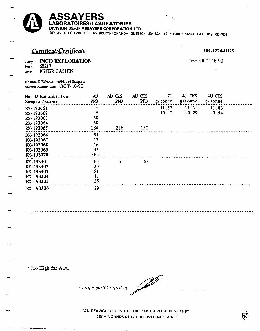
—
_
T
—
ASSAYERS LABORATOIRES/LABORATORIES DIVISION DE/OF ASSAYERS CORPORATION LTD. 780, AV. DU CUIVRE, C.P. 665, ROUYN-NORANDA (QUEBEC) J9X 5C6 TEL: (819) 797-4653 FAX: (819) 797-4601
Certificat/Certificate
comp: INCO EXPLORATION Proj: 60217 Attn: PETER CASHIN
Nombre D'Echantillons/No. of Samples:
Soumis le/Submitted: OCT-10-90
OR-1224-RG5
Date: OCT-16-90
No. D'EchantilIon Sample Number
AU PPB
AU CBS PPB
AU CKS PPB
AU g/ tonne
AU (XS g/ tonne
AU CKS g/ tonne
RX-193061 * 11.57 11.31 11.83 RX-193062 * 10.12 10.29 9.94 RX-193063 38 RX-193064 38 RX-193065 184 216 152
RX-193066 54 RX- 193067 13 RX-193068 16 RX-193069 35 RX-193070 566
RX-193301 60 55 65 RX-193302 30 RX-193303 81 RX-193304 17 RX-193305 35
RX-193306 29
*Too High for A.A.
Certifie par/Certified by 2,5"
"AU SERVICE DE L'INDUSTRIE DEPUIS PLUS DE 50 ANS"
"SERVING INDUSTRY FOR OVER 50 YEARS"

Certifie par/Certified by
0. c.
ASSAYERS LABORATOIRES/ LABORATORIES DIVISION DE/OF ASSAYERS CORPORATION LTD. 780, AV. DU CUIVRE, C.P. 665, ROUYN-NORANDA (QUEBEC) J9X 5C6 TEL.: (819) 797-4653 FAX: (819) 797-4501
Certificat/Cergy ficate OR-1225-RG1
Date: OCT-15-90 Comp: INCO EXPLORATION Proj: 60-217 Attn: ROGER LAMBERT
Nombre D'Echantillons/No. of Samples:
Soumis le/Submitted: OCT-10-90
No. D'Echantillon
AU Sample Minter
PPB
^ 148933 12 148934 8 148935 29 148936 6
� 148937 53
148938 19 148939 13 148940 15 148941 10 148942 20
� 148943 458
REÇU le
1 7 OCT, 1990
Rép•
"AU SERVICE DE L'INDUSTRIE DEPUIS PLUS DE 50 ANS"
"SERVING INDUSTRY FOR OVER 50 YEARS"
CTA
J

ASSAYERS LABORATOIRES/LABORATORIES DIVISION DE/OF ASSAYERS CORPORATION LTD. 780, AV. DU CUIVRE, C.P. 665, ROUYN-NORANDA (QUEBEC) J9X 5C6 TEL.: (819) 797-4653 FAX: (819) 797-4501
Certificat/Certificate
Comp: INCO EXPLORATION Proj: 60-217 Attn: ROGER LAMBERT
Nombre D'Echantillons/No. of Samples:
Soumis le/Submitted: OCT-17-90
OR 1263-RG1
Date: OCT-23-90
No. D'Echantillon Sample Number
RX-148944 RX-148945 RX-148946 RX-148947
AU PPB
168 31 29
5
AU CH'KS PPB
AU CH'KS PPB
AU g/tonne
AU CH'KS g/tonne
AU CH'KS g/tonne
RX-149864 53 57 48
RX-149865 10 RX-149866 8 RX-149867 6 RX-149868 9 RX-193380 228
RX-193381 422 RX-193382 786 0.69 0.69 0.69 RX-193383 172 RX-193384 894 1.03 1.03 1.03 RX-193385 932 982 881 0.86 1.03 0.69
RX-193386 175 RX-193387 1437 1.03 1.03 1.03 RX-193388 361 RX-193389 2194 2.06 2.06 2.06 RX-193390 63
RX-193391 599 RX-193392 49
REÇU le
2 9 OCT. 1990 , 1;E:,;,.
Certifie par/Certified by
-- "AU SERVICE DE L'INDUSTRIE DEPUIS PLUS DE 50 ANS" CTA
"SERVING INDUSTRY FOR OVER 50 YEARS"
—
_
_
—
—
_

ASSAYERS LABORATOIRES/ LABORATORIES DIVISION DE/OF ASSAYERS CORPORATION LTD. 780, AV. DU CUIVRE, C.P. 665, ROUYN-NORANDA (QUEBEC) J9X 5C6 TÉL.: (819) 797-4653 FAX: (819) 797-4501
Certificat/Certificate
OR-1263-RG2
comp: INCO EXPLORATION
Date: OCT-23-90 Proj: 60-217 Attn: ROGER LAMBERT
—
Nombre D'Echantillons/No. of Samples:
Soumis le/Submitted: OCT-17-90
No. D'Échantillon Sample Numb e r
RX-193393 RX-193394 RX-193395 RX-193396
AU PPB
* 803 1392 296
AU CH'KS PPB
AU CH' KS AU AU CH' KS
PPB g/ tonne g/ tonne
10.46 10.63
0.92 1.03
1.37 1.37
^ RX-193397 49 57 40
RX-193398 122 RX-193399 130 ~ RX-193400 71 RX-193401 34 RX-193402 31
_ RX-193403 37 RX-193404 71 RX-193405 60
— RX-193406 150 RX-193407 285 297 273
RX-193408 55 RX-193409 153 RX-193410 37 RX-193411 82 RX-193412 192
RX-193413 256 RX-193414 72
AU CH' KS g/ tonne
10.28 0.80 1.37
* TOO HIGH FOR A.A.
Ra-ÇV te
\ 2.9 3C. 1995
Q é Q :.. ... ...... ..
Certifie par/Certified by
-- "AU SERVICE DE L'INDUSTRIE DEPUIS PLUS DE 50 ANS"
"SERVING ?NDUSTY COR OVER 50 YEARS"

—
®
._
ASSAYERS LABORATOIRES/LABORATORIES DIVISION DE/OF ASSAYERS CORPORATION LTD.
780, AV. DU CUIVRE, C.P. 665, ROUYN-NORANDA (QUEBEC) J9X 5C6 TEL.: (819) 797-4653 FAX: (819) 797-4501
Certificat/Certificate
Comp: INCO EXPLORATION Proj: 60-217 Ann: ROGER LAMBERT
Nombre D'Echantillons/No. of Samples:
Soumis le/Submitted: OCT-17-90
OR-1263-RG3
Date: OCT-23-90
No. D'Echantillon S amp 1e Number
RX-193415 RX-193416 RX-193417 RX-193418
AU PPB
121 149 164 95
AU CH'KS PPB
AU CH'KS PPB
AU g/tonne
AU CH'KS g/tonne
AU CH'KS g/tonne
RX-193419 122 124 119
RX-193420 46 RX-193421 75 RX-193422 133 RX-193423 998 1.20 1.37 1.03 RX-193424 165
RX-193425 246 RX-193426 121 RX-193427 109 RX-193428 247 RX-193429 427 430 424
RX-193430 34 RX-193431 65 RX-193432 1180 1.12 1.03 1.20 RX-193433 1338 1.37 1.37 1.37 RX-193434 2537 2.23 2.40 2.06 RX- 193435 273 RX- 193436 70
Çv ~e
21 OCï . 1g90 ~
.. .. .. ... .
Certifie par/Certified by
"AU SERVICE DE L'INDUSTRIE DEPUIS PLUS DE 50 ANS"
"SERVING INDUSTRY FOR OVER 50 YEARS"
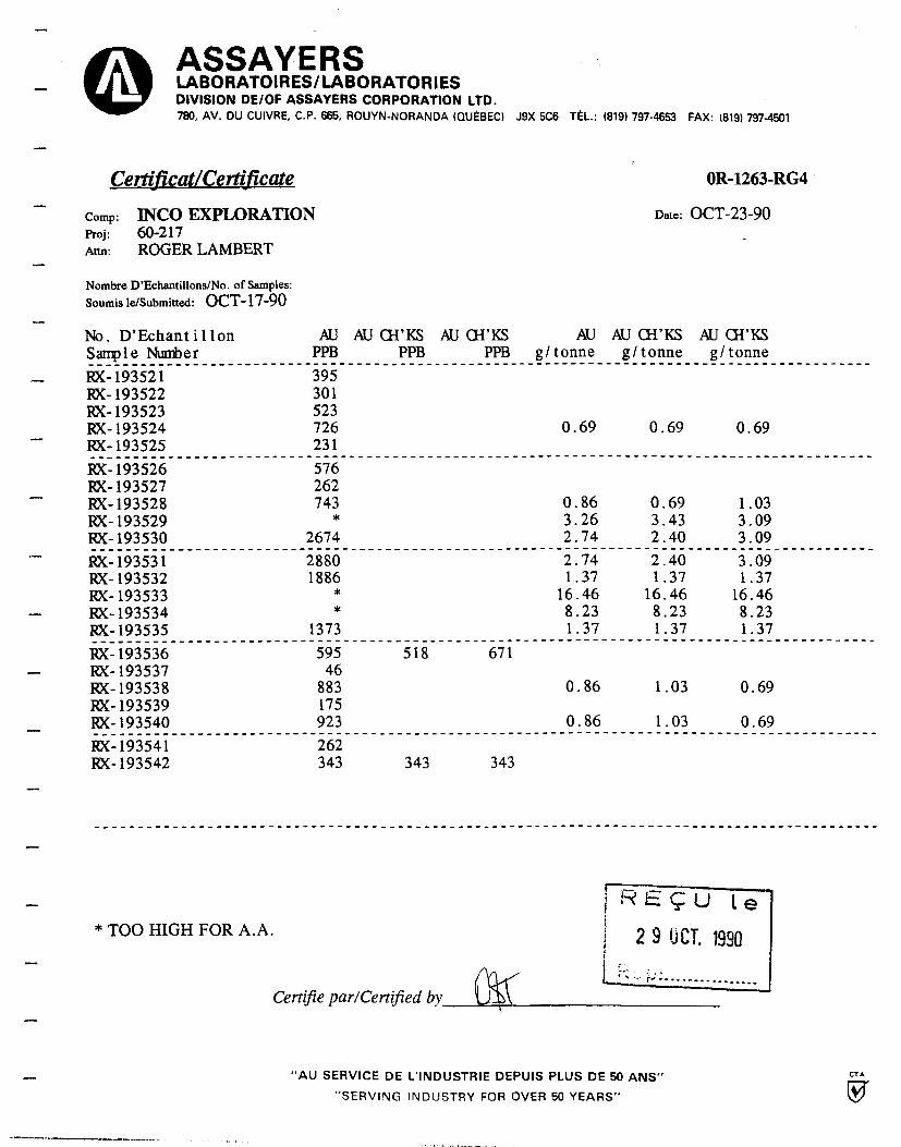
ASSAYERS LABORATOIRES/LABORATORIES DIVISION DE/OF ASSAYERS CORPORATION LTD. 780, AV. DU CUIVRE, C.P. 665, ROUYN-NORANDA (QUEBEC) J9X 5C6 TEL.: (819) 797-4653 FAX: (819) 797-4501
Certificat/Certificate
Comp: INCO EXPLORATION Proj: 60-217 Attn: ROGER LAMBERT
Nombre D'Echantillons/No. of Samples:
Soumis le/Submitted: OCT-17-90
OR-1263-RG4
Date: OCT-23-90
AU PPB
395 301 523
AU CH' KS PPB
AU CH'KS PPB
AU g/ tonne
AU CH' KS g/ tonne
AU CH'KS g/ tonne
726 0.69 0.69 0.69 231
576 262 743 0.86 0.69 1.03 * 3.26 3.43 3.09
2674 2.74 2.40 3.09 2880 2.74 2.40 3.09 1886 1.37 1.37 1.37
* 16.46 16.46 16.46 * 8.23 8.23 8.23
1373 1.37 1.37 1.37
595 518 671 46
883 0.86 1.03 0.69 175 923 0.86 1.03 0.69 262 343 343 343
No. D'Echantillon Sample Number
RX-193521 RX-193522 RX-193523 RX-193524 RX-193525
RX-193526 RX-193527 RX-193528 RX-193529 RX-193530
`" RX-193531 RX-193532 RX-193533
-- RX-193534 RX-193535
RX-193536 - RX-193537
RX-193538 RX-193539 RX-193540
RX-193541 RX-193542
* TOO HIGH FOR A.A.
He ÇU le
+ 2 9 JCT. 1990
Certifie par/Certified by
"AU SERVICE DE L'INDUSTRIE DEPUIS PLUS DE 50 ANS"
"SERVING INDUSTRY FOR OVER 50 YEARS"

ASSAYERS LABORATOIRES/LABORATORIES DIVISION DE/OF ASSAYERS CORPORATION LTD. 780, AV. DU CUIVRE, C.P. 665, ROUYN-NORANDA (QUEBEC) J9X 5C6 TEL.: (819) 797-4653 FAX: (819) 797-4501
Certificat/Certificate
OR-1263-RG5
Comp: INCO EXPLORATION
Date: OCT-23-90 Proj: 60-217 Attn: ROGER LAMBERT
--
Nombre D'Echantillons/No. of Samples:
Soumis le/Submitted: OCT-17-90
No. D'Echantillon Sample Number
RX-193543 RX-193544
AU PPB
411 225
AU g/tonne
AU CH' KS g/tonne
AU CH' KS g/tonne
RX-193545 1172 1.03 1.03 1.03
^ RX-193546 614 RX-193547 15
RX-193548 9
~ RX-193549 RX-193550
66 71
RX-193551 10 RX-193552 25
RX-193553 2777 2.91 3.09 2.74 RX-193554 354 RX-193555 463
— RX-193556 604 RX-193557 218
RX-193558 554 -- RX-193559 * 3.09 3.09 3.09
RX-193560 2605 2.40 2.74 2.06 RX-193561 2229 2.40 2.74 2.06 RX-193562 2331 2.06 2.06 2.06
RX-193563 1002 1.20 1.37 1.03
Certifie par/Certified by
"AU SERVICE DE L'INDUSTRIE DEPUIS PLUS DE 50 ANS"
"SERVING INDUSTRY FOR OVER 50 YEARS"

ASSAYERS 0 LABORATOIRES/LABORATORIES DIVISION DE/OF ASSAYERS CORPORATION LTD. 780, AV. DU CUIVRE, C.P. 665, ROUYN-NORANDA (QUEBEC) J9X 5C6 TEL.: (819) 797-4653 FAX: (819) 797-4501
Certificat/Certificate
Comp: INCO Proj: 60217 Attn: ROGER LAMBERT
Nombre D'Echantillons/No. of Samples:
Soumis le/Submitted: OCT-24-90
No. D'Echantillon Sample Number
OR-1304-RA1
Date: OCT-31-90
AU AU CH'KS AU CH'KS AU AU CH'KS AU CH'KS PPB PPB PPB g/ tonne g/ tonne g/ tonne
RX 193092 37 RX 193093 16 RX 193094 166 RX 193095 107 RX 193564 24
RX 193565 106 RX 193566 69 73 65 RX 193567 200 RX 193568 413 RX 193569 615
RX 193570 1817 RX 193571 2366 RX 193572 314
o RX 193573 287 RX 193574 202
0.86 1.03 0.69
1.37 1.37 1.37 2.74 2.74 2.74
RX 193575 12 12 12 RX 193576 41 RX 193577 175 RX 193578 22 RX 193579 339
RX 193580
441 RX 193581
146
Certifie par/Certified by
J. LANDERS GERANT/MANAGER
.~ "AU SERVICE DE L'INDUSTRIE DEPUIS PLUS DE 50 ANS"
"SERVING INDUSTRY FOR OVER 50 YEARS"

ASSAYERS LABORATOIRES/LABORATORIES DIVISION DE/OF ASSAYERS CORPORATION LTD. 780, AV. DU CUIVRE, C.P. 665, ROUYN-NORANDA (QUEBEC) J9X 5C6 TEL.: (819) 797-4653 FAX: (819) 797-4501
OR-1304-RA2
Date: OCT-31-90
Certificat/Certificate
Comp: INCO Proj: 60217 Attn: ROGER LAMBERT
Nombre D'Echantillons/No. of Samples:
Soumis le/Submitted: OCT-24-90
No. D'Echantillon Sample Nii her
RX 193582 8 RX 193583 6 RX 193584 10
AU PPB
Certifie par/Certified by
J.LANDERS GERANT/MANAGER
"AU SERVICE DE L'INDUSTRIE DEPUIS PLUS DE 50 ANS"
"SERVING INDUSTRY FOR OVER 50 YEARS"

APPENDIX 4
LITHOGEOCHEMICAL ASSAY RESULTS

No. D'Echantillon
- RX-148948 RX-148949 RX-148950 RX-148951
- RX-148952
RX-148953 RX-148954
- RX-148955 RX-148956 RX-148957
RX-148958 RX-148959 RX-148960
- RX-148961 RX-148962
RX-148963 -- RX-148964
RX-148965 RX-148966 RX-148967
ASSAYERS LABORATOIRES/LABORATORIES DIVISION DE/OF ASSAYERS CORPORATION LTD. 780, AV. DU CUIVRE, C.P. 665, ROUYN-NORANDA (QUEBEC) J9X 5C6 TEL.: (819) 797-4653 FAX: (819) 797-4501
Certificat/Certificate OR-1262-RG1
Camp: INCO EXPLORATION Date: NOV-02-90 Pro j : 60-217
Attn: ROGER LAMBERT
Nombre D'Echanti lions/No. of Samples: 20 WHOLE ROCK Soumis le/Submitted: OCT-17-90
AL203 BA CAO FE203 Sample Number
MGO MNO2 NA20 SR K20 P205 5102 1102
11.16 0.015 2.28 5.23 0.79 0.10 4.89 0.010 0.71 0.01 72.97 0.29 14.38 0.020 7.65 6.56 1.34 0.11 5.18 0.020 0.67 0.01 60.91 0.94 11.38 0.015 1.48 2.23 0.27 0.04 6.29 0.005 1.00 0.01 75.89 0.29 14.00 0.015 4.10 5.80 1.27 0.11 6.01 0.020 0.67 0.01 65.84 0.77 11.76 0.005 0.43 2.40 0.59 0.05 6.72 0.005 0.24 0.01 76.21 0.31
12.04 0.020 2.02 4.10 0.40 0.08 5.17 0.010 1.28 0.01 73.47 0.30 15.35 0.030 5.24 7.82 3.26 0.23 5.47 0.020 1.06 0.03 58.45 1.07 12.26 0.050 0.94 4.91 0.86 0.10 4.31 0.010 2.61 0.01 72.12 0.32 15.13 0.040 4.83 7.55 3.70 0.18 5.04 0.015 1.54 0.03 58.85 1.02 13.96 0.010 0.90 7.54 3.74 0.15 4.94 0.010 0.79 .06 63.45 1.10
11.14 0.035 0.55 4.06 1.05 0.06 4.81 0.005 1.82 0.01 74.53 0.31 12.83 0.105 1.85 5.22 0.98 0.09 4.32 0.015 1.81 0.01 71.16 0.35 11.87 0.030 2.66 4.57 0.32 0.10 4.55 0.010 1.36 0.01 72.46 0.30 15.06 0.020 8.63 8.15 3.78 0.13 4.56 0.030 0.99 0.06 55.14 1.10 13.35 0.015 2.95 5.80 1.37 0.08 7.98 0.020 1.25 0.01 64.94 0.83
11.43 0.010 3.74 4.42 1.19 0.07 6.05 0.015 0.69 0.01 70.69 0.37 15.03 0.020 9.49 8.86 4.48 0.15 3.45 0.025 1.49 0.14 53.47 1.27 14.60 0.025 9.38 8.73 3.74 0.19 4.36 0.025 1.17 0.09 54.46 1.14 9.65 0.010 2.57 4.17 1.12 0.07 5.17 0.010 0.47 0.01 75.12 0.29 15.16 0.025 10.00 9.01 5.14 0.19 2.85 0.025 1.71 0.05 51.73 1.29
Certifie par/Certified by
J.LANDERS GERANT/MANAGER
-- "AU SERVICE DE L'INDUSTRIE DEPUIS PLUS DE 50 ANS"
"SERVING INDUSTRY FOR OVER 50 YEARS"
C
•~
TA
J

ASSAYERS LABORATOIRES/LABORATORIES DIVISION DE/OF ASSAYERS CORPORATION LTD. 780, AV. DU CUIVRE, C.P. 665, ROUYN-NORANDA (QUEBEC) J9X 5C6 TEL.: (819) 797-4653 FAX: (819) 797-4501
Certificat/Certificate OR-1262-RG2
Comp: INCO EXPLORATION Date: NOV-02-90 Pro j : 60-217
Attn: ROGER LAMBERT
Nombre D'Echantillons/No. of Samples: 20 WHOLE ROCK\ Souris Le/Submitted: OCT-17-90
No. D'Echantillon
SL.O.I. Sample Number
$ $
~ FX-148948 0.14 0.15 FX-148949 0.02 1.00 FX-148950 0.06 0.15 FX-148951 0.02 0.30
- FX-148952 0.02 0.10
FX-148953 0.01 0.20 FX-148954 0.02 1.00 FX-148955 0.04 0.30 FX-148956 0.09 1.10 FX-148957 0.02 2.40
- FX-148958 0.29 0.30 FX-148959 0.06 0.25 FX-148960 0.04 0.50
w FX-148961 0.07 1.60 FX-148962 0.01 0.30
FX-148963 0.20 0.20 FX-148964 0.15 1.40 FX-148965 0.22 1.10 FX-148966 0.53 0.55 FX-148967 0.03 1.80 r.
Certifie par/Certified by ,Ç
J.LANDERS GERANT/MANAGER
_ "AU SERVICE DE L'INDUSTRIE DEPUIS PLUS DE 50 ANS"
"SERVING INDUSTRY FOR OVER 50 YEARS"

(oD ét / -f . r ,G~t
ASSAYERS LABORATOIREStLABORATORIES DIVISION DE/OF ASSAYERS CORPORATION LTD. 780, AV. DU CUIVRE, C.P. 665, ROUYN-NORANDA (QUEBEC) J9X 5C6 TEL: (819) 797-4653 FAX: (819) 797-4501
Certificat/Certificate
1R-0012-RA1 ,
Comp: INCO GOLD
Date: JANV/JAN-07-90 Proj: Attn: PETER CASHIN
Nombre D'Echantillons/No. of Samples:
Soumis le/Submitted: DEC-10-90 6 WHOLE ROCK ANALYSIS
No. D'EchantilIon A1203 Cao Fe200 IVgO Nh0 Na20 Si02 K20 TiO2 P205 L.O.I. TOTAL
Sample Nuizber % %
193043 12.45 3.39 8.31 1.08 0.12 4.42 63.31 2.86 0.97 0.30 0.97 98.16
193046 11.45 1.77 7.66 1.34 0.09 1.06 65.49 7.62 0.93 0.26 1.50 99.15
193061 11.58 1.49 5.02 0.85 0.10 3.95 69.50 3.74 0.29 m.02 1.37 97.80
149582 10.11 0.57 3.91 0.06 0.05 0.98 75.15 7.24 0.26 m.02 0.94 99.26
149583 10.86 0.18 3.76 0.12 0.03 0.81 72.57 8.42 0.23 <0.02 0.96 97.91
148569 14.98 6.94 8.71 4.16 0.16 5.18 53.35 2.06 1.21 0.14 0.95 97.86
CORRECTED COPY
Certifie par/Certified by
J. J. LANDERS GERANT/MANAGER
"AU SERVICE DE L'INDUSTRIE DEPUIS PLUS DE 50 ANS"
"SERVING INDUSTRY FOR OVER 50 YEARS"

I I I I I I I I I I I
Carpany: Inco Gold Project: 60217 Attn Peter Cashin
LABORATOIRE ASSAYERS- ICP REPORT 780, ave du Cuivre Rouyn-Noranda, Qc.
File No: OV-1612-PJ1
Date Rec'd: 12/10/90
SAMPLE NUMBER
AG PPM
AL PPM
AS B
PPM PPM BA
PPM BE BI PPM PPM
CA PPM
CD PPM
DO PPM
CU PPM
1E PPM
K PPM
LI PPM
MG MN
PPM PPM MD
PPM NA PPM
NI PPM
P PPM
PB PPM
SR PPM
SR PPM
TN PPM
U PPM
V PPM
ZN GA SR V PPM PPH PPM PPM
CA PPM
149542 149543 149545 149546 149548
1.0 .7 .9 1.2 .7
1430 2840 3400 1330 2320
222 6 153 2 178 1 252 1 277 1
19 16 22 13 48
.2
.2
.2
.1
.2
1 1 1 1 1
8990 8030 9550 11370 4800
.1
.1
.1
.1
.1
26 20 22 28 27
87 79 62 80 62
28120 23570 23290 29370 17710
1120 1980 1480 720
1850
3 4 3 1 1
2660 1016 2240 603 2990 554 3520 542 1420 312
4 5 4 6 6
510 510 540 400 580
45 23 22 36 44
100 60 40 70 80
24 15 18 56 17
1 1 1 1 1
8 6 7 8 4
1 1 1 1 1
1 1 1 1 1
26.0 21.3 21.6 28.1 30.9
80 61 66 69 41
1 1 1 1 1
1 1 1 1 1
9 6 7 10 11
929 627 705 1000 1147_
149550 149569 149573 149579 149582
.8 2.4 3.1 1.7 3.1
1840 18560 15500 3710 1960
295 1
1 1
1 1
88 1
119 1
12 36 17 27 21
.2
.1
.3
.3
.1
1 3 5 1 1
10040 29550 22130 1150 4510
.1
.1
.1
.1
.1
27 34 38 17 18
53 106 91 36 21
24530 55760 58530 30110 24540
760 5280 850 1400 1770
1 22 14 2 1
3330 604 22830 986 20060 1158 1790 270 350 365
8 1 1
11 118
850 860 430 450 170
40 51 27 9 15
90 680 870 180 110
16 23 27 11 18
1 1 1 1 1
8 3 1 1 1
1 1 1 1 1
1 1 1 1 1
32.3 152.9 167.1 40.4 27.4
78 148 152 24 19
1 2 3 1 1
1 1 1 1 1
1.1 .2 2 5 6
1126 126 122 485 575
149583 149588
3.2 4.4
2130 3310
47 1 70 1
27 30
.1
.8 5 1
750 480
.1
.1 13 15
46 44
23790 34770
1520 1680
1 2
490 229 1000 221
140 3
120 470
6 8
90 140
37 12
1 1
1 1
1 1
1 1
18.4 43.5
11 13
1 1
1 1
3 4
318 424
I October 22,1990 Certifié par/Certified by

APPENDIX 5
THIN SECTION AND POLISHED SECTION PETROGRAPHIC ANALYSES

\ea - JAMES VINNELL, Manager
JOHN G. PAYNE, Ph.D. Geologist
CRAIG LEITCH, into. Geologist
.— JEFF HARRIS, Ph.D. Geologist
KEN E. NORTHCOTE, Ph.D. Geologist
Vn couve r Petrographics Ltd. PA. BOX 39 8080 GLOVER ROAD, FORT LANGLEY, B.C.
VOX 1J0 PHONE (604) 888-1323
FAX. (604) 688-3642
PETROGRAPHIC REPORT ON 16 SAMPLES FROM BEAUCHASTEL PROJECT, QUEBEC
Report for: Peter J. Cashin
Invoice CL-28-90 Project Geologist
Job # 796 Inco Exploration & Tech. Serv. Ltd. 460, avenue Centrale Val d'Or, Quebec J9P 1P5. Nov. 8, 1990
Sample submitted: 148948, 148962, 148963, 148967-73, 149582, 149583, 149569, 193043, 193046, 193061.
SUMMARY: This is a stratigraphic series of variably altered
volcanic rocks from 148948 at the base to 148973 at the top (all seen in thin section only). The polished thin sections examine highly altered rocks that have some affinities to the rocks in the stratigraphic section. The primary rock types may be divided into fine intermediate-felsic volcanic (148948, 963, 968, with the latter containing prominent quartz-epidote-K-spar amygdules, and possibly 193061 as a highly altered equivalent); diabase-fine gabbro (148962, 967, and possibly 149569 as an altered equivalent); fine quartz diorite (148969, and possibly 193043 as an altered equivalent); fine quartz-feldspar dacite porphyry (148972 and possibly 148973); and coarse quartz-K-feldspar megacrystic, quartz latite porphyry (148970).
Alteration in these rocks ranges from propylitic (albite-epidote-chlorite-actinolite-hydrobiotite are prominent in the altered intermediate to mafic rocks) to rare phyllic (149569, also possibly altered diabase), but the bulk of the alteration (especially 148971, 193046, 149582 and 583) is moderate to intense potassic (secondary K-feldspar-quartz-carbonate-chlorite-pyrite-magnetite) which starts along fractures or quartz vein margins and becomes pervasive; 193046 is such a rock that is brecciated also. Carbonate is mainly calcite, with ?dolomite in 148963 and 968 and ?ankerite in 193601. Traces of chalcopyrite and sphalerite occur in the most altered rocks, and the magnetite is largely oxidized to hematite.
Craig H.B. Leitch, h.D, P.Eng. (604) 921-8780 or 666-4902
SAMPLE PREPARATION FOR MICROSTUDIES • PETROGRAPHIC REPO R78 • GEOàOG' FIELD STUDIES _ 1

Page 2
149948: QUARTZ-EPIDOTE-HYDROBIOTITE-SERICITE ALTERED INTERMEDIATE VOLCANIC ROCK VEINED BY K-SPAR-PYRRHOTITE
Dark green, mafic-intermediate volcanic rock characterized by pale grey-green altered patches and 2 mm long ?relict phenocrysts or amygdules. The rock is magnetic but does not react to cold dilute HC1. K-feldspar is restricted to a thin 0.5 mm veiniet with pyrrhotite. -In thin section, the mineralogy is as follows:
Plagioclase (?albite-oligoclase) 45% Quartz (partly secondary) 20% Epidote 15% Hydrobiotite (green biotite) 10% Sericite (muscovite) 5 Chlorite 3% Opaque (?pyrrhotite, magnetite) 2. Sphene <1% K-feldspar (secondary) 1
The framework of the rock is formed by an interlocking mesh of anhedral plagioclase grains that range from needle-like and 0.1 mm long to rounded and 0.25 mm in diameter. The grains are too small to determine the composition of directly, but their general appearance and refractive index about that of quartz suggests it is oligoclase-albite. The smaller lath-shaped grains are like microliter in the groundmass of a former volcanic rock; the. larger grains have a secondary appearance. There is minor alteration to fine sericite and epidote.
Included in the feldspar are irregular rounded to elliptical shaped patches of quartz, up to 1 mm long. They are comp=osed of fine-grained (0.03 to 0.1 mm) quartz and are rimmed by very fine (i-10 micron) epidote grains. They may have been amygdules.
Areas of green "hydrobiotite" and epidote are up to 1.5 mm long and may represent former mafic phenocrysts. They are now shapeless and the original mafic cannot be identified. Epidote crystals are subhedral and up to 0.05 mm diameter, lacking yellow pleo+_hroism and therefore Fe-poor; the hydrobiotite is of similar size but more euhedral. The same minerals are sprinkled throughout the rock, replacing what may have formerly been groundmass material. In places, there is minor chlorite (with low and weakly anomoalous birefringence) mixed with the hydorbicitite. Fine (0.1 mm) subhedral opaques, possibly magnetite, are found scattered through the rock. There are rare euhedral grains of sphene up to 0.05 mm long.
The vein is made up of opaque (?pyrrhotite-it is magnetic), minor quartz and feldspar (which is very clear, and likely micrccline), muscovite, epidote and chlorite.
In summary, this appears to have been an intermediate volcanic rock, possibly about dacite or andesite in composition, that has undergone alteration to quartz--spidote-sericite-hydrobiotite-?albite, and been veined ty later quart. --K--spar-sericite-chlorite-pyrr-hctibe.

Page 3
148962: AMPHIBOLE-PLAGIOCLASE QUARTZ DIABASE ?DYKE OR SILL, ALTERED TO ALBITE-EPIDOTE-CHLORITE-MINOR PYRITE
Fine-grained, dark green volcanic or diabasic rock consisting of fine plagioclase crystals in a dark matrix. There are scattered grains of sulfide (-'pyrite); the rock is not magnetic. In thin section, the mineralogy is:
Plagioclase (relict) 30.- Amphibole (hornblende) 207 Quartz (partly secondary?) 20%= Chlorite 10% Epidote (after plagioclase) 107 Sericite (muscovite, after plagioclase) 5% Opaque (Fe-Ti oxides, pyrite) 5%
Plagioclase forms subhedral to euhedral crystals up tri 1 mm long. They have random orientations (diabasic texture) and are strongly altered to fine anhedral epidote and lesser chlorite and sericite (muscovite) grains of about 0.025 mm diameter or less. The original composition of the plagioclase is indeterminable; it appears as if most of it is now albite, based on relief less than that of adjacent quartz-
Amphibole forms small (up to 1 mm long) subhedral to euhedral crystals that are intergrown with the plagioclase. They have strong green pleochrcism and an extinction angle of 14 degrees; they are probably hornblende. In places they show minor alteration to epidote as subhedral grains up to 0.1 mm diameter with pale yellow ploechrcism, and fine-grained (up to 00.05 mm) chlorite that has purple anomalous interference colours, indicating moderate iron contents in both alteration minerals.
Quartz grains are anhedral to subhedral and up to 0.5 mm across. Although most are interstitial to the plagioclase-amphibole, some appear to be secondary, replacing plagioclase.
Opaque grains are fine (0.25 mm or less in diameter) and are composed of coarser pyrite and aggregates of finer (10-20 micron) Fe-Ti oxides such as ?ilmenite or leucoxene. They are associated with the mafic minerals.
In summary, this appears to be a fine diabasic rock such as a sill or dyke, but with unusually high quartz content making it a quartz diabase (although some of the quartz may be secondary). Alteration is to typical greenschist facies or prripylitic minerals, albite-chlorite-epidote-sericite + quartz. The amphibole could be primary, late magmatic or the result of prcgrade amphibolite facies metamorphism.

Page 4
148963: ALBITE-EPIDOTE-PYRITE+K-SPAR ALTERED, PLAGIOCLASE PORPHYRITIC INTERMEDIATE-FELSIC VOLCANIC
Very fine-grained, conchoidally-fractured, purplish-brown ?hornfelsed rock with patches of yellow-green epidote. There is minor sulfide (non-magnetic pyrite) associated with the epidote and with thin (0.5 mm) K-feldspar veins. In
?polished thin section, the mineralogy is as follows: Plagioclase (albitic?, matrix) 40%
(phenocrysts) 10% Amphibole (?hornblende) 257. Quartz (partly secondary) 107. Epidote 7% Pyrite 3. K-feldspar (secondary; veins and matrix) 3% Magnetite 1% Carbonate (dolomite?) 1%
The bulk: of this rack is made up of fine (0.1 mm or less) feathery interlocking plagioclase laths to anhedral rounded grains, with lesser needle-like amphibole of similar or smaller size. Phenocrysts are plagioclase, as euhedral crystals up to 2.5 mm long; these are not visible in the hand specimen but may be seen in the etched slab. The composition of the phenocryst (and matrix) feldspar is difficult to determine, but may be about albite, Anl° (Y'010=13 degrees, and relief of bath phenocrysts and matrix is less than quartz).
Amphibole is similar to that in 14896, with bright green to pale yellow-green pleochroism and an extinction angle of 16 degrees; it may be hornblende, or actincilitic hornblende. Some of the grains are altered to epidote, which forms subhedral grains up to 0.03 mm across. In the veins and patches, the epidote is massively developed with grains up to 0.3 mm across and variable (occasionally intense) pleochroism indicating moderate Fe contents.
The veins (and occasional small alteration patches) are composed of fine (0.1 mm) very clear secondary K-feldspar, pale (actinc'litic) amphibole, epidote, quartz, subhedral carbonate, and cubic pyrite. The carbonate does not react to cold dilute HC1, and so may be dolomite. Cubic pyrite grains up to 0.3 mm across are also scattered through the rock. Rare rounded to subhedral quartz grains to 1 mm across are found in the matrix, some with associated euhedral to subhedral grains of magnetite to 1 mm.
The mineralogical' composition of this rock is similar to that of 14896, but the texture is significantly different (this one is much finer-grained and perrphyritic, implying a magmatic affiliation with 148962 but possibly. from an associated flow). It is not clear whether the amphibole in this rock is primary or is associated with the alteration (since a similar amphibole is found in the veins). The fine-grained amphibole may be causing the hornfelsic appearance of this rock. In any case, the alteration is to .albite-epidote-pyrite-minor K--spar-carbonate. Pyrite may have replaced magnetite.

Page 5
148967: AMPHIBOLE-EPIDOTE-SERICITE-QUARTZ ALTERED DIABASE Dark green, relatively coarse diabase or fine gabbro
characterized by large white ?relict feldspar phenocrysts in a matrix of intergrown relict plagioclase and mafic laths. There is minor pyrite; the rock is not magnetic. In thin section, the modal mineralogy is approximately:
Amphibole (actinolitic, secondary) 35. Epidote (after plagioclase) 1'5% Sericite-(muscovite, after plagioclase) 15% Relict plagioclase 10% Quartz (mostly secondary) 10% Sphene, leuc xene 5% Chlorite - <1% Pyrite tr
The large white phenocrysts in this rock were originally plagioclase, as subhedral crystals up to 0.5 gy=m long; they are now completely replaced by fine-grained epidote and sericite (muscovite). Both form subhedral grains of about 0.01 to 0.1 mm diameter, and there is a little chlorite mixed in places. The chlorite shows green pleochr._'ism but does not have anomalous birefringence.
Most of the rest of the former plagioclase in this rock is also pseudomorphed by epidote and sericite. Epidote forms fine (0.05 mm diameter) subhedral girains that are often semi-opaque due to their fine grain size and possible minor alteration. There are minor amounts of relict feldspar, probably albitized, particularly around the rims of the former crystals, which were about 1-2 mm long and subhedral. The rims are also replaced by anhedral grains of quartz up to 0.2 mm in diameter. Some quartz is interstitial in nature and may have been primary, as in 148962.
The mafic mineral is an amphibole, forming subhedral grains up to 1 mm across with relatively high birefringence (0.025) and an extinction angle of 14 degrees. Pleochrc:ism is strong, from bright sea-green to pale yellowish, suggesting actinolite, probably secondary after former ?cl inopyrclxene.
In this mafic rock, abundant former ?ilmenite grains are pseudc'morphed by skeletal sphene-leucoxene grains up to 1 mm in diameter. There is also minor pyrite, as subhedral to euhedral grains up to 0.5 mm across. A 1 mm thick vein of massive epidote cuts the rock.
There is an apparent relationship between 149962 and 967: both have diabasic texture and may have had similar original mineralogical make-up, although 967 is less rich in quartz and is more altered to epidote and sericite.

Page 6
148968: QUARTZ PORPHYRITIC, AMYGDULAR INTERMEDIATE VOLCANIC Dark green to black, fine-grained volcanic rock
characterized by coarse quartz phenocrysts and large amygdules containing epidc'te, K-feldspar (yellow stain) and quartz. In thin section, the mineralogy is similar to 148963:
Amphibole (Tactinc'litic hornblende) 35`!. Relict plagioclase 25'!. Quartz (?partly secondary) 15'i
(phenocrysts) Green "hydre'biotite" 5% Opaque (Fe-Ti oxides, pyrite) i. Epidote =:amygdules? 3i. K-feldspar (amygdules) 2'. Chlorite 2% Sericite (muscovite) 2% Carbonate (?dolomite) <1
The texture of this rock is similar to that of 148963, with a fine network of interlocked amphibole needles of 0.1 to 0.2 mm length in relict plagioclase of twice that length. However, the pheno"=ryst phase in this rock is quartz, forming subhedral ?crystals up to 6 mm long (they are rounded enough to admit the possiblity that they are really amygdules; however they do not contain the other minerals found in the amygdules: they are made up of finely granular subhedral quartz of 0.1 to 0.2 mm diameter). The amygdules, which contain coarse radiating sprays of epidote (':'possibly pumpellyite) with grains up to 1 mm long, needle-like amphibole up to 2 mm long, subhedral K-feldspar up to i mm across (altered to sericite), anhedral quartz up to 0.5 mm in diameter, subhedral opaques (?pyrite) up to 1 mm across and traces of fine anhedral carbonate (no reaction to cold dilute HCl) and chlorite 'anomalous blue birefringence).
The amphibole throughout the rock has similar c=haracteristics to the actinolitic hornblende seen in 148963. In places it is mixed with flakey "hydrobic'tite" of up to 0.05 mm diameter with greenish-brown plec'chrc'ism. Opaque grains include very fine (10 micron) subhedral Fe-Ti oxides and larger (0.2 mm) cubic ?pyrite, both scattered throughout the rock.
Plagioclase forms subhedral to anhedral grains up 0.2 mm long through which the amphibole needles grow, suggesting the amphibole could be metamorphic in origin (or secondary?). The composition of the plagioclase is not determinable on such fine grains, but the general lack of relief against quartz suggests oligoclase; if so, this rock could have been metamorphosed to amphibolite facies. It would then be difficult, however, to explain the assemblage in the amygdules unless it was retrograde. Perhaps a better explanation would be that she amphibole and c'liqoclasse are secondary after clinopyrc'xene and more calcic plagioclase in an ai'e''ed in-termer-Nate volcanic rock.

Page 7
148969: ALBITE-CHLORITE-CALCITE ALTERED FINE QUARTZ DIORITE Pink, fine to medium grained high-level intrusive rock
characterized by 1-2 mm plagioclase phenc;crysts in a dark green matrix and cut by thin green fractures. A yellow stain along some fractures and interstitially indicates miner, probably secondary, K-feldspar. There is minor sulfide visible; the rock is not magnetic. In thin section, the modal mineralogy is:
Relict plagioclase (albitized) 50% Quartz (mainly primary) 20% 5ericite (after plagioclase) 107 K-feldspar (':'secondary) 57. Chlorite 5% Carbonate (calcite) 5%
Opaque (Fe-Ti oxides, trace pyrite) 5%
Plagioclase forms euhedral to subhedral crystals up to 2 mm long. They form the framework of the rock. They have been altered to albite, Ano (Y'010 = 15 degrees, z'oo1 = 12 degrees, relief distinctly less than quartz) and moderately flecked by fine (0.025 mm) sericite (muscovite) and minor chlorite. Also, at the edges, the plagioclase is attacked by quartz. The pink colour of the rock is caused by minute particles (1-2 microns) of dusty clay and hematite, leading to the term "hematite-stained albite" alt6raticin.
Quartz forms anhedral to subhedral grains up to 1.5 mm diameter that are interstitial to the plagioclase. They have rounded outlines and spread crut in places to replace some of the adjacent plagioclase. In and around these boundary areas are minor amounts of fine-grained (up t« 0.2 mm) K-feldspar as anhedral to subhedral crystals. Similar material is found along a few fractures, suggesting at least part of the K-spar is secondary.
There is very little mafic in this rock (it is leucc'•cratic). The little there is, is confined to a network of fine fractures and interstitial patches between the quartz and feldspar. The chlorite forms fine flakes up to 0.05 mm diameter with strong green colour and very low, partly anomalous birefringence; it is probably moderately Fe-rich. It is mixed with a little fine (0.03 mm) carbonate (calcite), suggesting that they are both part of an stockwork of alteration. Minor amounts of anhedral, fine opaques associated with the chlorite are Fe-Ti oxides after former ilmenite, and scattered cubic grains up to 0.25 mm diameter are pyrite.
This is a high-level felsic intrusive rock of about quartz diorite (t_'nalite) composition, that has been mildly propylitically altered to albite, sericite, chlorite, calcite and miner quartz and pyrite.

Page 8
148970: K-FELDSPAR MEGACRYSTIC. QUARTZ-FELDSPAR PORPHYRY This is a very coarse, quartz-feldspar porphyry
characterized by large K-feldspar megacrysts up to 2 cm in diameter. It is not magnetic, and is extremely leococratic (colour index below 5). In thin section, the modal mineralogy is as follows:
K-feldspar (primary, groundmass) 5% (megacrysts) 10%
Quartz (primary, groundmass) 20% (phenocrysts) 10%
Plagioclase (albite) 30% Clay (after K-feldspar) Chlorite, hydrobiotite 27. Opaque (Fe-Ti oxides, limonite) 1% Apatite ;1%
The coarse K-spar megacrysts are euhedral and are strongly zoned with rows of" inclusions parallel to the rims. The inclusions are both quartz and plagioclase, as subhedral to euhedral crystals up to 0.15 mm long (near the center of the megacryst, larger inclusions are up to 0.75 mm long). Plagioclase inclusions are the same as plagioclase in the matrix of the rock: albite, and are unaltered compared to the K-feldspar which shows minor dusting by minute particles of clay. The optic angle, 2V, of the h-spar appears to be large, so it may be orthoclase rather than sanidine.
Quartz phenocrysts are subhedral and up to 7 mm long.. They show overgrowths around their margins, after a layer of fine inclusions of plagioclase and K-feldspar. The quartz is strongly stained, with undulose extinction and minor fracturing.
Plagioclase forms 1 mm subhedral grains with well developed spindle shaped twinning characteristic of "chessboard" albite; the composition is about Ano, based on extinction angles of 12 and 16 degrees for Y^010 and Z'001, respectively, and refractive index less than quarts.
The matrix is made up of fine (0.05 to 0.1 mm) anhedral K-spar grains mixed with lesser quartz of similar size. There is minor green chlorite or hydrobiotite, as subhedral flakes up to 0.05 rrJm diameter, and very minor opaques as euhedral to subhedral grains up to 0.2 mm diameter. Traces cif apatite, as subhedral crystals up to 0.05 mm across, are also seen associated with the opaques and chlorite, indicating sites of former mafia_ minerals.
The composition of this rocs:: is about that of a quartz : tea-; 1-e (i.e. monzonitic composition) . It does not appear to have underdone any significant hydrothermal alteration; all the effects seen (quartz overgrowth, clay after K-spar) are typical of late-magmatic or deuteric processes. This is a felsic, acid roc ::: that probably represents a high-level. int•.-usi "re porphyry in the volcanic pile.

Page 9
148971: K-FELDSPAR.-QUARTZ-CALCITE-CHLORITE-PYRITE ALTERED, SHEARED AND STOCKWORKED ?FELSIC VOLCANIC ROCK
Bright brick-red, quartz veined and pyritized rock rich in K-feldspar (abundant yellow stain). As in the previous slide, there is virtually no mafic material in this rock; the colour index is very low. the rock is not magnetic, but reacts to cold dilute HCl. In the thin section, the mineralogy is approximately:
K-feldspar (partly secondary) 40% Quartz (partly secondary) 30% Carbonate (calcite) 10% Chlorite, hydrobiotite 10% Clay, sericite 5% Pyrite 5% Hematite (in K-feldspar) <1%
Most of the K-feldspar in this rock is extremely fine:- grained (10-20 micron diameter) and anhedral, forming what appear to be seni-massive replacements up to several millimeters across. In places, it is also found in veins up to 1 mm thick composed of subhedral grains up to 0.5 mm across.. • These grains have the "grid" twinning characteristic of microcline. These two textures suggest that the bulk of the K-spar is probably secondary, although the precursor mineralogy cannot be guessed at. All the K-sapr has a bright red colour caused by minute particles of hematite and clay
Mixed with the fine K-spar is slightly coarser (up to 0.05 mm) quartz and lesser carbonate, plus minor pyrite and sericite (muscovite).
Quartz forms anhedral grains up to 0.25 mm diameter in the matrix of the rock and larger anhedral grains (up to 1.5 mm long) in the irregular, 1-3 mm thick quartz veins traversing the rock. The quartz is strongly strained and fractured; bladed forms are common in the veins.
Carbonate as patches up to 1 mm across (composed of anhedral grains of up to 0.05 mm diameter) is found throghout the rock, and in irregular masses in the quartz and feldspar veins. Muscovite (sericite) is found along sheared fractures as fine (0.05 mm) subhedral flakes, often with lesser green hydrobiotite of similar character. These fractures are folded or crenluated into a weakly developed foliation developed at right angles to them. Straight fractures up to 0.1 mm thick, filled with bright green, anomalous birefringent chlorite and lesser quartz, are post-deformation.
Pyrite is associated with the K-feldspar veins and as micr ofractures to coarse blebs up to 3 mm across, but is not found with the quartz veins. This suggests that the quartz veins may be metamorphic "sweats" rather than hydrothermal. There is very little remnant texture in this roc:::, but it may have been a felsio volcanic, or even ana acid porphyry similar to 148970. It would appear to be a good host for bald mineralization.

Page 10
148972: FINE QUARTZ-FELDSPAR PORPHYRY ACID VOLCANIC ROCK Purplish brown, finely porphyritic felsic volcanic or
high-level intrusive rock. It is not magnetic and does not react to cold dilute HCI. In thin section, the modal mineralogy is:
Quartz (phenocrysts and matrix) 40% K-feldspar (primary, phenocrysts) 30% Plagioclase (albite) 20% Opaque (Fe-Ti oxides, hematite, limonite) 77. Clay (after K-spar) 7. Trem>>lite (-') <1% Sphene <1 Zircon tr
Quartz forms subhedral to euhedral phenocrysts up to 3 mm across. They are relatively unstrained, and often have a sieve-like texture due to inclusions, mainly of plagioclase and lesser K-feldspar as euhedral crystals up to 0.25 mm diameter.
K-feldspar is found only as fine euhedral phenocrysts up to 1.mm in diameter. They have inclusions of euhedral plagioclase and rare quartz up to 0.1 mm long. The 2V is large, about 65 degrees, suggesting it is orthoclase or microcline (some have "grid" twinning) rather than sanidine. There is minor alteration to cloudy clay and dusty hematite particles.
Plagioclase forms small euhedral to subhedral crystals up to 0.5 mm long with fine spindly twinning similar to that in 148970. It is albite similar to that in 970 (Z.-.001=13 degrees, Y--.010=15 degrees, relief less than quartz). Plagioclase is unaltered.
The matrix is composed of fine quartz with interstitial opaques as subhedral grains up to 0.05 mm diameter. The opaques are probably mostly hematite (red at thin edges) but there is some limonite (gc'ethite) with brown colour, and probably some leuccixe.n.e as well.
Sphene, as euhedral crystals up to 0.15 mm long, and zircon as euhedral prisms up to 0.05 mm long, are found included in some quartz phenocrysts; the zircons are particularly concentrated at the rims, oriented parilel to the rims. Here they are accompanied by abundant needle-like laths of 7tremolite up to 0.1 mm long.
This is an unaltered acid volcanic rock of about quartz latite (monzonitic) composition. It could be a flow or crystal tuff; although the crystals are not noticeably broken (shards), there is one 1 cm fragment visible in the hand specimen. There is a distinct mineralogical resemblance to the coarse K-spar megacrystic rock (148970), suggesting that this specimen may represent a flew higher in the section but related tri 148970. There is no hydrothermal alteration as found in the intervening 148971 or the overlying 148973, although both these rocks could have originally been l:.ka 148970 or 972.

Page 11
148573: K-SPAR-QUART-MINOR CALCITE-CHLORITE-PYRITE- MA► NETITE ALTERED, DACITIC QUARTZ-FELDSPAR PORPHYRY
Purplish-brown, fine-grained volcanic that is cut by thin to major (up to 1.5 cm) grey quartz veins. The veins have discontinuous envelopes of orangey-red secondary K-feldspar, and contain magnetite and pyrite. The rock r-eacts along fractures to cold dilute HCI; in the thin section, the mineralogy is approximately:
Quartz (vein) 25% (groundmass) 15% (phenocrysts) 5%
Plagioclase (?albite) 25% K-feldspar (secondary) 15% Carbonate (calcite) 5% Opaque (magnetite, pyrite) 5% Chlorite 37. Sericite (muscovite) 2% Sphene, rutile <1%
This is a highly altered rock, but enough texture remains away from the veins to show that it was a quartz-feldspar porphyry. It contains small Cl mm) phenocrysts of gUartz and relict plagioclase in a fine--grained matrix of the same minerals. There is very little mafic material (a very leucocratic rock). Quartz phenocrysts are euhedral to subhedral and up to 1.5 mm long; they may be single grains, or composites of 0.5 mm rounded subhedral grains, with traces of absorption by the matrix evident. Plagioclase phenocrysts, are subhedral, with rounded outlines due to strong alteration to albite (only rare twinning is observed, but they do not stain yellow, so this is alkali feldspar of about Ab9 Or5). They contain the fine flecks of sericite (muscovite) characteristic of such alkali feldspar, as well as fine dusty hematite and clay giving it its red colour.
The matrix, which also does not stain for K-spar, is made up of fine anhedral tightly interlocking grains of plagioclase (hematite-clay dusted as for the phencicrysts) and quartz. The grain size (0.025 mm) and interlocking preclude accurate estimation of their relative abundances.
The alteration takes the form of an intense stcckwcirk of quartz-minor plagioclase (albite)-trace K-feldspar veins, occasionally with chlorite, magnetite and pyrite. The chlorite is an iron-rich variety, with strong green pleochroism and anomalous birefringence, forming flakes up to 0.1 mm diameter. Magnetite forms subhedral grains up to 2 mm across, and pyrite euhedral grains up to 0.5 mm; both are associated with the chlorite and some carbonate. Most of the carbonate is in the form of later reopenings of the veins and fractures, and most of it is calcite. Envelopes to the veins- have well-developed secondary K-feldspar {bright orangey-red) up to 2 mm thick. This alteration in such a felsic rock is prospective for gold mie'ralization.
This is not 1 he same :ÿ"..+.cir;z-feldspar porphyry =is 14E3970 nc3 t ices not ._ _.-. ....._ : _ is _ --"_ _ it S _ L'acitic

100- Page 12
149582: INTENSELY K-SPAR-QUARTZ-CALCITE-MINOR CHLORITE ALTERED, PYRITIZED FELSIC VOLCANIC ROCK
Brick red, intensely K-spar altered and pyritized fine- grained volcanic rock similar to 148971, but not quartz veined. The rock is not magnetic, but reacts strongly to cold dilute HC1. In polished thin section, the mineralogy is approximately as follows:
K-feldspar (mainly secondary) 60% Quartz (?partly secondary) 15% Pyrite 10% Carbonate (calcite) 107. Chlorite 3% Hematite, clay 2% Epi dcite <1% Sphene tr Sphalerite, chalcopyrite tr
The bulk of the rack is made up of' very fine-grained, tightly intergrown secondary K-feldspar and quartz with an average grain size of about 0.03 mm and 0.01 mm respectively. In places, the quartz is coarser (up to 0.3 mm), forming vaguely vein-like zones that are not apparent in the hand specimen. The K-spar is strongly red stained due to minut particles of hematite and clay.
The original texture of this rock is no longer visible; coarser patches of euhedral to subhedral calcite up to 0.5 mm across may possibly represent the sites of former phenocrysts,.but this is not certain since calcite also forms massive replacements and occurs along fractures. Mafic minerals are chlorite as fine flakes up to 0.05 mm diameter and intnse yellow to green pleochrc+ism (not seen in other samples. The chlorite is restricted to fractures, where it is associated with calcite, pyrite and minor sphene as euhedral crystals up to 0.1 mm long; rare subhedral epidote up to 0.1 mm is noted.
Pyrite forms euhedral cubes to subhedral grains up to 0.5 mm across, mainly associated with calcite or coarser quartz and feldspar up to 0.25 mm across. The quartz around the pyrite is often bladed, arranged perpendicular to the margin of the sulfide grain. In reflected light, most of the opaque mineral is pyrite, but there is also minor subhedral hematite up to 0.1 mm diameter; this may be after magnetite, which is seen in some of the other samples. There are also rare very fine (20 micron) inclusions of chalccipyrite and Sphalerite in the pyrite.
Thin, late fractures of a very low relief mineral may contain K-feldspar or possibly a ?zeolite. They are parallel tc' fractures containing pyrite. Again, the intense K-feldspar and pyrite alteration, with incipient quartz veining, looks favourable for gold mineralization.

f ~U~
1;12 ~ J~
Page 13
149583: K-SPAR-QUARTZ-CALCITE-CHLORITE-HEMATITE-PYRITE ALTERED ?FELSIC VOLCANIC ROCK
Dark purplish-brown to bright brick-red, intensely K-spar altered fine-grained ?volcanic rock. There is also abundant pyrite (as in 149583). The rock shows only traces of magnetism but reacts strongly to cold dilute HC1. In polished thin-section, the mineralogy is approximately:
K-feldspar (mainly secondary) 407 Quartz (partly secondary) 30% Carbonate (calcite) 157. Relict plagioclase (albite) 10% Chlorite 37. Hematite 3% Pyrite 37. Sericite (muscovite) 27.
This specimen is not quite as thoroughly altered as 149582; there is a visible gradation from the red areas which are strongly K-spar altered to the dark purplish-brown area which contains relict albite (actually an alkali feldspar lacking. twinning and probably some orthoclase molecule - see CIM Bull. July 1981, v.74, no.831, p. 83-88). The albite forms subhedral to i anhedral grains up to 0.25 mm across that contain minor to moderate amounts of fine'(20 micron) sericite and carbonate. The K-spar forms fine (0.05 mm diameter) anhedral grains with a secondary aspect replacing former plagioclase. It is mainly mixed with finer (0.01 mm) quartz as in 582.
Quartz also forms coarser grains up to 1.5 mm long in irregular veins up to 1 mm thick. This quartz is strongly strained (undulose extinction) and fractured. The quartz veins are not noticeably rich in pyrite, but nhedral grains of K-spar up to 0.25 mm across are found in the veins and in the intensely altered immediate envelopes. Carbonate (calcite) forms subhedral grains up to 0.5 mm across throughout the rock and in thin stringers that contain abundant hematite, implying that oxide mineralization is later than quartz, and accompanied calcite; pyrite may have been between quartz and calcite (it appears to accompany fine quartz-K-spar alteration).
As in 582, 971 and 973, chlorite is found as rare flakey aggregates up to 0.1 mm across, with deep green to yellow plec»:hroism and very weak birefringence.
Opaques are mainly hematite, as anhedral to subhedral grains up to 0.3 mm across with bright red internal reflections, and pyrite as cubic to subhedral grains up to 0.5 mm across. Pyrite tends to be disseminated rather than with hematite along veinlets. Base-metal sulfides and gold were not seen in the polished surface_
It is difficult to be sure of the protolith of this strongly pctassic altered rock, but a fine acid volcanic rock such as 148963 would be a possi bl i ty.

Page 14
149569: SERICITE-AMPHIBOLE-EPIDOTE-PYRITE ALTERED DIABASE CUT BY ENVELOPES OF SECONDARY K-SPAR
Dark green, strongly phyllic altered fine gabbro or diabasic rock similar to 962 and 967. There are irregular areas (?veins) with envelopes of secondary K-feldsapr - (yellow stain). There are also fractures with secondary K-spar, but in general this is much less altered than 149582 and 583. Thëre is minor pyrite, and very weak magnetism. In polished thin section, the mineralogy is:
Sericite (muscovite) 30% Secondary amphibole (?actinolitic) 25% Qaurtz (partly secondary) 15% Epidote 15% Secondary K-feldspar 5% Pyrite, trace chalcopyrite, sphalerite 5% Sphene, trace-rutile 5% Hematite, magnetite <1%
This is a thoroughly altered rock, although of lower grade (phyllic) than the potassic altered 582-583. It clearly has the texture of the diabase samples:former plagioclase crystals up to 1 mm long are pseudomorphed by fine (20 micron) sericite, and former mafic grains of similar size are pseudomorphed by amphibole and epidote. The amphibole forms subhedral grains up to 0.75 mm long with deep sea-green to light yellow-green pleochroism and extinction angle of about 15 degrees. It is possibly an actinolitic amphibole similar to that seen in the fresher diabase samples. The secondary nature of the amphibole is shown by a massive vein of it with pyrite.
Clots of epidote up to 1 mm across are made up of subhedral grains up to 0.3 mm in diameter with very pale yellow pleochroism indicating moderate Fe content. Sphene is noticeably abundant in this sample, replacing the same skeltal Fe-Ti oxide grains seen in 962 and 967 that may have originally been ilmenite. The sphene forms subhedral grains aggregating up to 0.5 mm across, with minor minute inclusions of rutile to 20 microns long.
Quartz forms subhedral to anhedral grains up to 0.3 mm across that occupy the same interstitial sites as in the less altered diabases, but appear to have been added to slightly (increased in size) indicating minor silicification accompanying the sericitization. K-feldspar forms fine (0.1 mm or less) anhedral grains around the margin of a crude coarse quartz lense with coarser amphibole and along fine fractrues cutting the rock.
In reflected light, the main opaque phase is pyrite as cubic to subhedral grains up to 0.5 mm in diameter. There are rare subhedral grains of chalcopyrite and sphalerite up to 30 microns across associated with the pyrite. In places there is minor magnetite as anhedra up to 0.1 mm enclosing (?hosting) pyrite, and hematite as plates up to 0.1 mm long or as fine dust in the K-feldspar grains.

Page 15
193043: K-SPAR-QUARTZ-CALCITE-CHLORITE-PYRITE-MAGNETITE ALTERED FELSIC VOLCANIC OR HIGH-LEVEL INTRUSIVE ROCK
Purplish-brown, stockworked and K-spar altered fine- grained ?volcanic rock, with abundant pyrite that is not found in the quartz veins. There is minor magnetite (t-he rock attracts a magnet), and calcite is common (it reacts readily to cold dilute HC1). In polished thin section, the mineralogy is approximately:
Secondary K-feldspar 25% Albite (secondary alkali feldspar) 207. Quartz (partly secondary, veins) 15%. Carbonate (calcite) 157. Chlorite 10% Pyrite 10% Sericite 3% Magnetite, hematite 2% Sphene, apatite <1
The framework of this rock is made up of medium-grained (0.3 to 0.5 mm diameter) subhedral intergrown feldspars and lesser quartz. Interstices are filled by chlorite and opaques. The feldspar is difficult to determine in thin section, since all alkali feldspars are similar (untwinned and relief less than quartz). However, the stained slab shows that there is abundant secondary K-feldspar, mainly distributed along envelopes to fractures that in places coalesce to form pervasive alteration. Note that they are not found along the quartz veins, which may therefore not be a part of the important K-spar/sul fide alteration. Where best developed, the K-spar forms anhedral grains of 0.25 mm diameter with moderate dusting by minute clay-hematite particles. Albitic alkali feldspar, on the other hand, forms subhedral lath-like grains up to 0.3 mm long that retain rare twinning and are altered to 0.025 mm flecks of carbonate and minor sericite (muscovite).
Quartz is also found in the matris as anhedral grains up to 0.3 mm across that may be partly secondary. In the veins the quartz is sheared and strained, forming elongated grains up to 0.5 mm long.
Chlorite forms patches up to 0.25 mm diameter of flakes up to 0.05 mm across, with pale yellow to green pleochroism and purplish anomalous interference colours (moderate Fe content). Carbonate, mainly calcite, forms fine anhedral grains mainly less than 0.1 mm across, rarely subhedral and up to 0.5 mm across. Sulfides, mainly pyrite as euhedral cubes up to 1 mm across, and magnetite (locally altered to hematite) as subhedral grains up to 0.5 mm, are closely associated with the carbonate and chlorite (which probably represent the sites of former mafic minerals). The lath-like texture of this rock in places is reminiscent of the diabase seen in 148967, but elsewhere it is similar to 148969. It may have been a high-level intrusive rock of felsic composition similar to the latter. The pc'tassic alteration is thorough and well-developed.

Page 16
~^~
193046: INTENSELY K-SPAR-CALCITE-CHLORITE-QUARTZ-PYRITE-HEMATITE ALTERED BRECCIA OF VOLCANIC ROCKS
Brecciated rock consisting of mixed purple-brown and brick-red ?clasts up to about 2 cm across. Both types are intensely K-feldspar altered, and are similar to rocks already described (brick-red = 149582/583; purplish-brown = 193406). There is abundant, very fine pyrite; the rock is not magnetic, but reacts strongly to cold dilute HCl. In polished thin section, the mineralogy is approximately:
Secondary K-feldspar 45% Carbonate (calcite) 15% Chlorite 15% Pyrite' trace chalcopyrite 13% Secondary quartz 10% Hematite, trace magnetite 2%
K-feldspar forms intergrown subhedral laths to anhedral grains up to 0.5 mm long. They are quite clear compared to secondary K-spar seen in other specimens, implying very strong alteration that has completely recrystallized this rock. The hematite has also been recrystallized, forming anhedral grains up to 0.1 mm across rather than the fine hematite characteristic of the other samples. There is no albitic alkali feldspar left in this sample.
Quartz forms clots (not veins) up to several mm across composed of anhedral grains up to 0.3 mm across. It also forms very fine (0.01 to 0.02 mm) anhedral grains intergrown with K-feldspar in the body of the rock.
Chlorite forms clots up to 0.2 mm across of subhedral flakes of 0.03 mm diameter with light green colour and purplish anomalous interference, but little pleochroism. It appears to have high relief, but this may be due to the surrounding K-feldspar. The form of the chlorite in places is suggestive of its having formed after the secondary amphibole seen in some rocks of this suite.
Carbonate forms anhedral patches replacing feldspars and/or intergrown with chlorite (therefore perhaps after mafics also). Pyrite forms fine (up to 0.2 mm) cubic grains disseminated throughout the rock and concentrated along shears or fragment boundaries; it is commonly associated with carbonate and chlorite. There is rare chalcopyrite as anhedral grains up to 0.1 mm across. Hematite forms fine subhedral grains up to 0.05 mm across, commonly concentrated in thin veinlets or fractures up to 0.5 mm thick. In places, hematite can be seen to be replacihg former magnetite as anhedral grains up to 0.1 mm across.
What little remains of the original texture of this rock is characterized by fine laths of feldspar similar to that of 193403 (this would correspond to the purplish-brown areas). Elsewhere (brick-red areas), the rock has only a secondary texture of interlocked secondary K-feldspar, chlorite, carbonate, pyrite and minor quartz. The rock is intensely potassic altered and pyritized; chlorite is also abundant, perhaps implying a more mafic protolith.

•
193061: FINE-GRAINED INTERMEDIATE VOLCANIC ROCK. ALTERED ALONG FRACTURES TO K-SPAR-QUARTZ-ANKERITE-PYRITE
Mottled, grey-green to black, strongly fractured, very fine-grained rock with strong K-spar alteration along hairline fractures show by yellow stain in the etched slab. It is not magnetic and does not react to cold dilute HC1r In the polished thin section, the mineralogy is approximately as follows:
Relict plagioclase (albitic alkali feldspar) 20% Quartz (partly secondary) 20% Green hydrobiotite 20% Secondary K-feldspar 15% Carbonate (dolomite or ankerite?) 15% Pyrite 5% Sericite (muscovite) 5% Hematite, limonite <1%
The dark green to black areas are the least altered, with some remnant texture preserved. They have a very finely felted texture due to former ?plagioclase and intergrown mafic laths up to about 0.1 mm long, somewhat like 148948 or 148968 but without amygdules or phenocrysts. There are rare euhedral microphenocrysts up to 0.2 mm long. All the feldspar appears to be an secondary alkali variety probably close to albite in composition but too fine to determine properly; it is untwinned. Greenish brown hydrobiotite as fine (0.025 mm or less) subhedral flakes makes up the bulk of the rest of the less altered rock and causes the dark colour. There may be some very fine (0.01-0.02 mm) quartz, but there is relatively little carbonate and virtually no pyrite in this less altered portion of the rock.
As alteration increases along fractures, the most widespread effect is development of fine secondary K-feldspar and quartz as anhedral interlocking 0.01 to 0.05 mm grains. There is also some bleaching of hydrobiotite to sericite (muscovite), and introduction of carbonate. This alteration causes the light green, grey, and buff colours; some areas look in hand specimen as if they contain epidote but none is seen in the thin section.
Where most developed, the carbonate forms euhedral crystals up to 0.25 mm across that have high relief and may be ankerite.. These zones have the form of irregular, discontinu us_veinlets up to 0.5 mm thick, and are associated with coarser K-feldspar and quartz up to 0.2 mm across, plus cubic pyrite up to 1 mm in diameter. There is rare magnetite intergrown with the pyrite in places, and it is-oxidized to hematite elsewhere. One of the veins shows hematite rather than pyrite, and there is also one with moderate oxidation of the sulfides to limonite. There is no base metal sulfide visible, in contrast to the more altered sample 193046.

APPENDIX 6
STRIPPING SITES, SAMPLE LOCATION MAPS AND DETAILED GEOLOGY MAPS

11111=111101MNI Main geological contact / Contact giologique majeur
al C,;.•` b) X. c)® c) BOULDER BLOC ERRATIQUE
a) OUTCROP AREA b) SMALL OUTCROP AIRE D'AFFLEURENT AFFLEUREMENT ISOL E
a) / bl P STRATIFICATIONS undetermined dip with dip
a) sorti non-diternrni b) arec pendage
al /r bl ~
a) X b) >'
b) with dip mac pendage
SCHISTOSITIES undetermined dip
SCHISTOSITES saws.er non-ditermini
DIACLASES al vertical b) inclined verticale incl;hîe
JOINT SYSTEM SYSTEMS DE JOINTURE
1 FELSIC INTRUSIVE ROCK ROCHE INTRUSIVE FELSIOUE
V VOLCANIC ROCK ROCHE VOLCANIQUE
IX APLITE V2 RHVOLITE
2D DIORITE V4 DACITE
3G GABBRO V6 ANDESITE /ANDESITE
1D GRANODIORITE V7 BASALT / BASALT
1G GRANITE
3L LAMPROPHYRE
Ask. Anlerite/AnAirite h or. Horizon m PORPHYRE Cpy Chalcopyrite loc. Locally /Loco/omen, PORPHYRITIC
- f Feldspar / Fe/dsparh Tr. Traces PORPNYRIOUE
Hew
j
Hematifs /Himotite
Carbonate
~ Vein/ Vaine BRECCIATED A dRÉCHIFORME
Mt Magnetite /Magnitite
Py Pyrite * FRACTURED / FRACTURÉ A F B dRÈCHE
LOW DE
RECCIA COULÉE
Oh Quartz 1 SHEARED /CISAILLÉ EXPLOSIVE BRECCIA
® BRÈCHE EXPLOSIVE O AMYGDALOIDAL /AMYGDALAIRE
m PILLOW ED /COUSS/NÉ
LEGEND / L EGENDE
T1 CARBONATED /CARBONATISÉE
a. SILICIFIED / SILICIFIÉE
e EPIDOTIZED / ÉPIOOTISEE
~ b)j /
GEOLOGICAL CONTACT al known/connu b) presumed/probabl. CONTACT GÉOLOGIQUE
QUARTZ VEIN VEINE DE QUARTZ
•
a•1 undetermined dip b) with dip . nan-dirermie& arec pendage

4.i 75 N
BEAUCHASTEL OPTION
SAMPLE LOCATION MAP
STRIPPING SITE A
LEGEND
• 568 Grab sample (complete sample number is RX149568)
Channel sample (complete sample 4+50N number is RX 193301)
Rubble
O Puddle
r
l: 200

1D,gtz v.,Cpy (1-2'/.)
Vg6ti v 110-15'/.)
00
V6# loc.:o',r],H ern ,Py
1 q z Z•► Cpy
V64,77,0-, Hem, Py
V6 4- Ioc. : Hem, Py
398 4
0 1:200
(from D. Gaudreault, 1990)
GIO1LOGIICA INC. DETAILED GEOLOGY SHOWING 'A"
BEAUCHASTEL OPTION
FIGURE N°
N T1
LEGEND: See legend on geological compilation mop

10 m
DETAILED GEOLOGY SHOWING "C"
BEAUCHASTEL OPTION
FIGURE N°
(from D. Gaudreault, 1990)
GIOILOGIICA HNC.
1: 200 0
O /~ I
f V2t Ioc: Herrfj~J
/,% .~ yfI
~~`'
~ ~ /.r~
S~
shear zo+
(V6#, a:,i1
rusty fractures 215' 10°
2D,Mt
~
~
I
/I ff horizon Py (5-10Y.)
~'' /fjf tz ~.~If
/
/~1
V6# tz~l
byy
t~
LEGEND: See legend on geological compilation map
2D,Mt