1987leis.pdf - US Fish and Wildlife Service
227
............. ....... ........... Ix a Ethiopia...,* Room-= telex,: Haiti" T: . . .......... W
-
Upload
khangminh22 -
Category
Documents
-
view
1 -
download
0
Transcript of 1987leis.pdf - US Fish and Wildlife Service

....................
......
....
.Ix
a
Ethiopia...,*
Room-=
telex,:
Haiti"
T:
............
W

UNITED STATES
DEPARTMENT OF THE INTERIOR
ARCTIC NATIONAL WILDLIFE REFUGE, ALASKA,
COASTAL PLAIN RESOURCE ASSESSMENT
REPORT AND RECOMMENDATION TO THE CONGRESS OF THE UNITED STATES
AND FINAL LEGISLATIVE ENVIRONMENTAL IMPACT STATEMENT
0AA
APRIL- 1987
In accordance with Section"1002 of the
Alaska National Interest Lands Conservation Act,
and the National Environmental PolicyAct
Prepared by the U.S, Fish and WildlifeService
in cooperation with U.S. Geological Survey
and the Bureau of Land Management

ARCTIC NATIONAL WILDLIFE REFUGE, ALASKA,COASTAL PLAIN RESOURCE ASSESSMENT
Report and recommendation to the Congress of the United Statesand finallegislativeenvironmental impact statement,1987
Volume 1--ReportVolume 2-Appendix (Publiccomments and responses)
Copies areavailablefrom:
U.S.Fishand WildlifeService U.S.Fishand WildlifeServiceDivisionofRefuge Management Divisionof Planning18th& C Streets,NW., Room 2343 1011 E.Tudor RoadWashington,D.C. 20240 Anchorage,Alaska 99503
Copiescan be seen at:
Anchorage PublicLibrades ArcticVillageCommunity LibraryFairbanksPublicLibraries KenaiCommunity LibraryJuneau PublicLibraries NorthSlope Borough SchoolLibrary
ArcticSlopeRegionalCorporationLibrary
Copies can alsobe seen atthefollowingU.S.GeologicalSurveyLibrariesand PublicInquiriesOffices:
USGS Libraries:Reston,VA NationalCenter,12201SunriseValleyDriveFlagstaff,AZ 2255 NorthGeminiDdveMenlo Park,CA 345 MiddlefieldRoadGolden,CO 1526 Cole BoulevardatWest Colfax
USGS PublicInquiriesOffices:Anchorage,AK Room 101,4230 UniversityDriveLos Angeles,CA Room 7638,FederalBuilding,300 NorthLos AngelesStreetSan Francisco,CA Room 504, Customhouse, 555 BatteryStreetDenver,CO Room 169,FederalBuilding,1961 StoutStreetDallas,TX Room IC45, FederalBuilding,1100 Commerce StreetSaltLake City,UT Room 8105,FederalBuilding,125 South StateStreetSpokane, WA Room 678,U.S.Courthouse,West 920 RiversideAvenue
Recommended citationforthisreport:
Clough,N. K.:Patton,P. C.;and Christiansen,A. C.,editors,1987,ArcticNationalWildlifeRefuge,Alaska,coastalplainresourceassessment--Reportand recommendationto theCongress ofthe UnitedStatesand finallegislativeenvironmentalimpactstatement:Washington,D. C.,U.S.Fishand WildlifeService,U.S.GeologicalSurvey,and Bureau ofLand Management,v.1 (Report)--xviii+ 208 p.,5 pis.,32 figs.,26 tables;v.2 (Appendix--Publiccomments and responses)--ii+ 998 p.
COVER PHOTOGRAPH
A typicalviewsouthwardacrossthecoastalplaintowardthe foothillsand the BrooksRange.

THE SECRETARY OF THE INTERIOR
WASHINGTON
April21, 1987
Dear Reader:
The Alaska NationalInterestLands ConservationAct (ANILCA) of 1980 set asidemore than 100 millionacres of land in Alaska as nationalparks,preserves,wildliferefuges,and wilderness areas. At thattime, the Congress specificallyleftopen thequestion of futuremanagement of the 1.5-million-acrecoastalplainof the 19-million-acre ArcticNationalWildlifeRefuge because of the area'spotentiallyenormous oiland gas resources and itsimportantwildlifevalues.
ANILCA directed the Department of the Interiorto conduct biologicalandgeologicalstudies of the ArcticRefuge coastalplain,and to provide the Congresswith the resultsof those studiesand a recommendation on future management of thearea. The following report culminates more than 5 years of biologicalbaselinestudies,surface geologicalstudies,and two seasons of seismic explorationsurveys.The ArcticRefuge coastalplainisrated by geologistsas the most promising onshoreoiland gas explorationarea in the United States. Itis estimatedto containmorethan 9 billionbarrelsof recoverableoil,an amount approximatelyequal to PrudhoeBay, which currentlyprovides one-fifthof U.S. domestic oilproduction.
In 1986, U.S. domestic oilproduction dropped 9 to 10 percent;production ispredictedto drop an additional4 to 5 percent in 1987, ifprices do not drop thisyear. At the same time, U.S. oil consumption, which has exceeded domesticproductionsince the 1960's,is expected to increase. Our oilimports are projectedto exceed 50 percent of consumption in the 1990's. America's growing relianceonimported oilfor the rest of the century could have potentiallyserious ramificationsforour nationalsecurity.
The followingreportanalyzes the potentialenvironmental consequences of fivemanagement alternativesforthe coastalplain,ranging from opening for lease of theentirearea for oiland gas development, to wilderness designation. A legislativeenvironmental impact statement has been integratedintothe report.
Public hearings were held in January 1987 on a draft report andrecommendation. These hearings were attended by representatives of theGovernments of Canada and Alaska,Alaska Natives,other interestedparties,and thegeneral public. Seven thousand of the 11,000 comments received favored openingthe ArcticRefuge coastalplainforoiland gas leasingand development.
Based on the analyses conducted, public comment on the draftreport,thenationalneed fordomestic sources of oiland gas, and the Nation'sabilityto developsuch resources in an environmentally sensitivemanner as demonstrated by twodecades of success at Prudhoe Bay and elsewhere, I have selectedas my preferredalternative,making availablefor considerationthe entireArcticRefuge coastalplainfor oiland gas leasing. Although the entirearea should be considered for leasing,only a percentage would actuallybe leased,an even smaller percentage would beexplored,and--ifoilisdiscovered--astillsmallerpercentage would be developed.

2
The step-by-stepenvironmental planning, review, and evaluationproceduresincluded in a leasing program provide the best opportunityfor the Department todecide what areas to lease,based on the most accurate and advanced informationavailableat each step of the leasingprocess. Although the exact process dependsupon the leasingprogram establishedby the Congress, compliance with the NationalEnvironmental Policy Act is required for each lease sale,explorationplan,anddevelopment and production plan.
The followingreportprovides informationcriticalforthe Congress to consider indetermining the future management of the Arctic Refuge coastalplain. TheCongress must enact legislationto authorizean oiland gas leasingprogram for thearea. We willwork with the Congress to ensure thatany leasingprogram developedwillavoid unnecessary adverse effectson the environment.
Legislativeproposals are currentlyin the Congress to establishthe formula forsharingwith the Stateof Alaska any revenues from an oiland gas leasingprogram inthe ArcticRefuge coastalplain.There also isa proposalthatwould directa portionof the Federal share of such revenues to conservationactivities.We look forward toworking with the Congress on such matters as well as in determining futuremanagement of the Arctic Refuge coastalplain. My preliminaryrecommendation(Chapter Vill)will become finalupon formal transmittalto the Congress of thefollowingreport.
Sincerely,
@DONALD PAUL HODEL

SUMMARYARCTIC NATIONAL WILDLIFE REFUGE, ALASKA, COASTAL PLAIN RESOURCE ASSESSMENTReport and Recommendation to the Congress/FinalLegislativeEnvironmental Impact Statement
APRIL 1987Preparedby the U.S.Fishand WildlifeService,incooperationwiththe U.S.GeologicalSurveyand
the Bureau of Land Management, Departmentofthe Interior,Washington,D.C. 20240.TYPE OF ACTION The Porcupinecaribouherd has shown some
Recommendation forlegislativeactionconcerning preferenceforcalvingon the 1002 areaincludingthe upper
futuremanagement of the 1.5-million-acrecoastalplainof Jago Riverarea (84,000acresor 5.4percentof the1002
the 19-million-acreArcticNationalWildlifeRefuge(referredto area).A potentialconsequencewould be displacementof
hereinas the "1002area"),locatedinnortheasternAlaska. portionsof the herd seekingto calveinthe upper JagoRiverarea-thecase onlyifthe areawere the siteof a
DESCRIPTION OF THE PROPOSED ACTION majorproducingoilfield.Itisunlikely,though possible,The Secretaryof the Interiorrecommends to the thatsuch displacementwould resultin any appreciable
Congress of the UnitedStatesthatitenact legislation declineinherdsize.directingthe Secretaryto conductan orderlyoiland gasleasingprogramforthe 1002 areaat such pace and in The potentialeffectsofoiland gas activitieson thesuch circumstances as he determineswillavoid area'smuskoxen are unknown, althoughbiologistspredictunnecessaryadverseeffecton the environment. thatmajoreffectscould be: (1)substantialdisplacement
fromcurrentlyused habitatand (2)a slowingoftheherd'sThe 1002 area isthe Nation'sbestsingleopportunity growthrate,as distinguishedfroma diminutioninherdsize.
to increasesignificantlydomesticoilproduction.Itisratedby geologistsas the most outstandingpetroleum Potentialeffectson Nativesubsistencefallintotwoexplorationtargetinthe onshoreUnitedStates.Data from categories:the villageof Kaktovikand villagesoutsidethenearbywellsin the Prudhoe Bay areaand in the Canadian 1002 area. Inthecase ofKaktovik,a majorrestrictionofBeaufortSea and Mackenzie Delta,combined with subsistenceactivitiescouldoccur. Thiswould likelyresultpromisingseismicdatagatheredon the 1002 area,indicate from the physicalchanges proximateto Kaktovikwhichextensionsof producingtrendsand othergeologic couldinterferewithtraditionalactivities.Subsistenceeffectsconditionsexceptionallyfavorablefordiscoveryof one or on villagesoutsidethe 1002 area,includingthose inmore supergiantfields(largerthan500 millionbarrels). Canada, areexpectedto be minimal.
ALTERNATIVES TO THE PROPOSED ACTIONThere is a 19-percentchance thateconomically
Alternativesforthe Congressthatwere discussedinrecoverableoiloccurson the 1002area.The averageofallthe reportand legislativeenvironmentalimpactstatementestimatesof conditionaleconomicallyrecoverableoilinclude:(1)Authorizeleasinglimitedto a partofthe1002resources(the'mean")is3.2billionbarrels.Based on thisareabased on environmentalconsiderations(AlternativeB):estimate,1002 area productionby the year2005 could(2)authorizefurtherexplorationonly,includingexploratoryprovide4 percentof totalU.S.demand: provide8 percentdrilling(AlternativeC); (3)continuecurrentrefugestatusof U.S.production(about660,000barrels/day);and reducewithno furtheroiland gas activityallowed(AlternativeD);importsby nearly9 percent.Thisproductioncouldprovideand (4)designatethe areaas wilderness(AlternativeQ.net nationaleconomic benefitsof $79.4billion,includingFor purposes of environmentalimpactstatementanalysis,Federalrevenuesof$38.0billion. AlternativeD isconsideredthe 'no action"alternative.
ENVIRONMENTAL EFFECTSCONTACTS
Potentialimpactswere assessed for exploration, Noreen Clough 202-343-4313developmentdrilling,and production.impactspredictedfor Divisionof Refugesexplorationand developmentdrillingwere minoror negligible U.S.Fishand WildlifeServiceon allwildliferesourceson the 1002area. Productionofoil 18thand C Street,NWisexpectedto directlyaffectonly12,650acres or 0.8 Washington,D.C. 20240percentofthe 1002 area. Consequenceson speciessuchas brown bears.snow geese,wolves,moose, and the Oswald Girard 703-648-4428CentralArcticcaribouherd are expectedto be negligible, DeputyAssistantDirectorforEngineeringGeologyminor,or moderate. U.S.GeologicalSurveyM.S. 109
`12201SunriseValleyDrivePotentialmajor effectson wildlifefromproductionare Reston,Virginia22092
limitedto the Porcupinecaribouherd and reintroducedmuskoxen. "Majorbiologicaleffects"were definedas: RobertSchrott 202-653-2263
.'widespread,long-termchange in habitatavailabilityor Divisionof Geologyand MineralResources
qualitywhich would likelymodifynaturalabundance or Bureau of Land Management
distributionof species.Modificationwillpersistat leastas 18thand C Streets,NW
longas modifyinginfluencesexist." Washington,D.C. 20240
SUMMARY V11

ARCTIC NATIONAL WILDLIFE REFUGE, ALASKA, COASTAL PLAIN RESOURCE ASSESSMENTFinalreportand legislativeenvironmental impact statement,1987
CONTRIBUTORS TO THE REPORT
MEMBERS OF INTERAGENCY ADVISORY WORK GROUPNoreen CLOUGH, FWS, IAWG leader
ClaytonHARDY, FWS, IAWG Regionalco-leader
Fishand WildlifeService: U.S.GeologicalSurvey: Bureau of Land Management:Glenn W. ELISON Max C. BREWER James E. CALLAHANEmilT. HEUER, Jr. Oswald GIRARD ArlanH. KOHL
DudleyD. RICE Robert0. SCHROTTJulesV. TILESTON
EDITORSNoreen K. CLOUGH, FWS, Wildlifebiologist
PriscillaC. PATTON, BLM, GeologistAnn Coe CHRISTIANSEN, USGS, Geologist
CHAPTER 1. INTRODUCTION
ClaytonHARDY FWS Chiefofplanning Anchorage,AKEmilT. HEUER, Jr. FWS Wildlifebiologist Anchorage,AKStephen S. WILSON FWS Fishand wildlifebiologist Anchorage,AK
CHAPTER II.EXISTING ENVIRONMENT
MichaelJ.AMARAL FWS Wildlifebiologist Anchorage,AKStevenC. AMSTRUP FWS Wildlifebiologist Anchorage,AKAlanW. BRACKNEY FWS Wildlifebiologist Fairbanks,AKMax C. BREWER USGS Geologist/geophysicist Anchorage,AKCharlesE. DIETERS FWS Archeologist Anchorage,AKGlenn W. ELISON FWS Wildlifebiologist Fairbanks,AKNancy A. FELIX FWS Botanist Fairbanks,AKDouglasJ.FRUGE FWS Zoologist Fairbanks,AKGeraldW. GARNER FWS Wildlifebiologist Fairbanks,AK
Donald P.GARRETT FWS Wildlifebiologist Fairbanks,AKLibbyHALPIN FWS Wildlifebiologist Anchorage,AKEmilT. HEUER, Jr. FWS Wildlifebiologist Anchorage,AKMary HOGAN FWS Wildlifebiologist Anchorage,AKWilliamL.KIRK FWS Botanist Anchorage,AKDanielJ. LaPLANT FWS Wildlifebiologist Fairbanks,AKRobertR. LEEDY FWS Wildlifebiologist Anchorage,AKWilliamH. MATTICE FWS Realtyspecialist Anchorage,AKFrancesJ. MAUER FWS Wildlifebiologist Fairbanks,AK
RussellM. OATES FWS Wildlifebiologist Fairbanks,AKLarryW. PANK FWS Research biologist Fairbanks,AKAnn G. RAPPOPORT FWS Wildlifebiologist Anchorage,AKGeraldREID FWS Wildlifebiologist Anchorage,AKPatriciaE. REYNOLDS FWS Wildlifebiologist Fairbanks,AKScottL.SCHLIEBE FWS Biologist Anchorage,AKRonaldG. THUMA FWS Socloeconomist Anchorage,AKJulesV. TILESTON BLM Resource specialist Anchorage,AKGregoryJ.WEILER FWS Wildlifebiologist Fairbanks,AKRobin L.WEST FWS Fisheriesbiologist Fairbanks,AK
Vill ARCTIC REFUGE RESOURCE ASSESSMENT

CHAPTER Ill.ASSESSMENT OF OIL AND GAS POTENTIALAND PETROLEUM GEOLOGY OF THE 1002 AREA
Donald E.ANDERS USGS Chemist Denver, CO
JeffreyW. BADER LISGS Geologist Menlo Park,CA
ArthurC. BANET, Jr. BLM Geologist Anchorage, AK
Robert J.BASCLE BLM Geologist Anchorage, AK
Kenneth J. BIRD LISGS Geologist Menlo Park,CA
Gary W. BROUGHAM BLM Geophysicist Anchorage, AKTerryR. BRUNS LISGS Geophysicist Menlo Park,CA
James E. CALLAHAN BLM Geologist Anchorage, AK
Robert A. CROVELLI USGS Mathematicalstatistician Denver, CO
Raymond C. CUL017A USGS Seismicdataprocessor Menlo Park,CA
Kimberly1.CUNNINGHAM USGS Geologist Denver, CO
Theodore A. DAWS USGS Chemist Denver, CO
David A. DINTER LISGS Geophysicist Menlo Park.CA
Gordon L.DOLTON LISGS Geologist Denver, CO
Michael A. FISHER LISGS Geophysicist Menlo Park,CA
Richard L.FOLAND BLM Geophysicist Anchorage. AK
Donald L.GAUTIER LISGS Geologist Denver, CO
ArthurGRANTZ LISGS Geologist Menlo Park,CA
Sarah B. GRISCOM LISGS Geologist Woods Hole,MA
WilliamS. HAUSER BLM Petroleumengineer Anchorage, AK
John S. KELLEY LISGS Geologist Anchorage, AK
Douglas J. LALLA BLM Geophysicist Anchorage, AKLeslieB. MAGOON LISGS Geologist Menlo Park,CA
Michael L.MENGE BLM Geologist Anchorage, AK
CorneliusM. MOLENAAR LISGS Geologist Denver,CO
Stephen L.ROBBINS LISGS Geophysicist Denver, COAlan A. ROBERTS USGS* Chemist Denver, COCharles N. THRELKELD USGS Physicalsciencetechnician Denver, CO
PhilipV. WOODWARD USGS Geologist Menlo Park,CA
John S.YOUNG BLM Mineraleconomist Cheyenne, WY
CHAPTER IV. DEVELOPMENT AND TRANSPORTATION INFRASTRUCTURE
PerryG. FRANCIS BLM Generalengineer Anchorage, AK
WilliamS. HAUSER BLM Petroleumengineer Anchorage, AK
Aden L.SEIDLITZ BLM Petroleumengineer Anchorage, AK
Chester ZENONE USGS Hydrologist Anchorage, AK
CHAPTER V. ALTERNATIVES
Glenn W. ELISON FWS Wildlifebiologist Fairbanks,AK
Oswald GIRARD LISGS Geologist Reston, VA
EmilT. HEUER, Jr. FWS Wildlifebiologist Anchorage,AK
Robert 0. SCHROTT BLM Supervisorygeologist Washington,DC
Jules V. TILESTON BLM Resource specialist Anchorage, AK
CONTRIBUTORS IX

CHAPTER VI. ENVIRONMENTAL CONSEQUENCES
Max C. BREWER USGS Geologist/Geophysicist Anchorage, AK
Glenn W. ELISON FWS Wildlifebiologist Fairbanks,AK
David E. McGILLIVARY FWS Wildlifebiologist Anchorage, AK
Ann G. RAPPOPORT FWS Wildlifebiologist Anchorage, AK
Gerald REID FWS Wildlifebiologist Anchorage, AK
Ronald G. THUMA FWS Socioeconornist Anchorage, AK
Jules V. TILESTON BLM Resource specialist Anchorage, AK
Robin L.WEST FWS Fisheriesbiologist Fairbanks,AK
Richard WILDERMANN MMS Environmentalspecialist Washington, DC
Stephen S. WILSON FWS Fishand wildlifebiologist Anchorage, AK
Chester ZENONE USGS Hydrologist Anchorage, AK
CHAPTER VII. OIL AND GAS--NATIONAL NEED FOR DOMESTIC SOURCES AND
THE 1002 AREA'S POTENTIAL CONTRIBUTION
Max TAVES BLM Petroleum engineer Washington, DC
DanielH. WEDDERBURN BLM Economist Washington, DC
John S. YOUNG BLM Mineraleconomist Cheyenne, WY
CARTOGRAPHY: USGS, Denver UnitsA and B of the Thematic Mapping Section,NationalMapping
Division,Rocky Mountain Area, U.S. GeologicalSurvey
CLERICAL SUPPORT: FWS, Anchorage Karen Edwards, TaulinePeppers
FWS, Denver Retah Bailey,Lynne Dickinson,Margaret Grenvik,Sharon Rose,
Barbara Smith,Gail Starnes,VickiTilden
VOLUME 2 LAYOUT: FWS, Anchorage PattiGallagher
GEOGRAPHIC COMPUTER
ANALYSES: FWS, Anchorage Frank D'Erchia,Jean Maloney
PUBLIC COMMENT
STATISTICS: FWS, Washington Nancy Marx, Kathryn McCloskey
* Now with privateindustry.
X ARCTIC REFUGE RESOURCE ASSESSMENT

ARCTIC NATIONAL WILDLIFE REFUGE, ALASKA,COASTAL PLAIN RESOURCE ASSESSMENT
CONTENTS
CHAPTER 1. INTRODUCTION .............................I CHAPTERII.EXISTINGENVIRONMENT--ContinuedBiologicalenvironment--Continued
Background ...........................................................................1 Terrestrialand fresh-waterenvironments--ContinuedPurposeand need forthisreport......................................2 Terraintypes--ContinuedBaselinestudyof fishand wildliferesources...................3 Hillycoastalplains....................................................19Oiland gas explorationprograms......................................3 Flatthaw-lakeplains.................................................19Reportpreparation................................................................4 Mountains ..................................................................19Publicinvolvement................................................................5 Specialterrestrialand aquaticenvironments.................19Depictionof civilboundaries...............................................6 SadlerochitSpringSpecialArea...................................19Referencescited...................................................................6 Kongakut River-BeaufortLagoon ..................................20
Angun Plains...................................................................20CHAPTER II. EXISTING ENVIRONMENT ..... 7 Jago River.......................................................................20
Coastaland marineenvironment.....................................20Introduction............................................................................7 Fishand wildliferesources..............................................21Physicalgeography and processes...................................7 Terrestrialmammals .......................................................21Physicalgeography...........................................................7 Caribou ........................................................................21Climate................................................................................9 Muskoxen ....................................................................26Permafrost..........................................................................11 Moose ..........................................................................27Soilsand othermaterials.................................................13 Dallsheep ...................................................................27Water resources................................................................13 Wolves..........................................................................28Erosionand mass movement ..........................................14 Arcticfoxes..................................................................28Seismicity............................................................................15 Wolverines...................................................................28Airquality..........................................................................15 Brown bears................................................................29Noise...................................................................................16 Arcticground squirrelsand otherrodents..............29
Biologicalenvironment.........................................................16 Marine mammals ............................................................30Terrestrialand fresh-waterenvironments........................16 Polarbears ..................................................................30
Vegetation......................................................................16 Seals and whales .......................................................31Wetlands........................................................................18 Birds................................................................................31Terraintypes.................................................................18 Swans, geese,and ducl(s.........................................32Foothills......................................................................18 Seabirdsand shorebirds...........................................33Riverfloodplains.....................................................18
CONTENTS Xi

CHAPTER 11.EXISTING ENVIRONMENT-Continued CHAPTER 111.ASSESSMENT OF OIL AND GAS
Biologicalenvironment--Continued POTENTIAL AND PETROLEUM GEOLOGY OF
Fishand wildliferesources--Continued THE 1002 AREA--Continued
Birds--Continued Assessment ofthe oiland gas potential-Continued
Raptors.........................................................................33 Economicallyrecoverableoilresources.........................76
Ptarmigan.....................................................................33 Methods ..........................................................................76
Passerines...................................................................33 PRESTO model inputs...................................................78
Fish..................................................................................34 Prospects.....................................................................78
Threatenedand endangered species..........................35 Zones ...........................................................................78
Bowhead and graywhales .......................................35 Volumetricparameters................................................78
Arcticperegrinefalcon...............................................35 Geologicrisk...............................................................78
Human environment..............................................................35 Economic inputs.........................................................79
Population...........................................................................35 PRESTO analysisresults...............................................80
Socioculturalsystem .........................................................36 Marginalprobability........................................................80
Existinglanduse...............................................................36 Resources by block.......................................................80
Subsistenceuse.............................................................36 Naturalgas economics .................................................80
Kaktovik........................................................................36 Referencescited...................................................................81
Other communities......................................................40
Land status.....................................................................43 CHAPTER IV. DEVELOPMENT AND
Nativeallotments............................................................43 TRANSPORTATION INFRASTRUCTURE ...... 83
Industrialuse..................................................................43
Government and militaryuse........................................43 Introduction............................................................................83
Stateand localpoliticaland economic systems ..........44 Exploration,development,and production........................83
Publicservicesand facilities.........................................45 Exploration..........................................................................83
Archeology.........................................................................45 Additionalgeologicaland geophysicalexploration.... 83
Recreation...........................................................................46 Exploratorydrilling..........................................................84
Wildernessand esthetics.................................................46 Development.......................................................................85
Referencescited...................................................................47 Production..........................................................................86
Physicalgeography and processes...............................47 Centralproductionfacility.............................................87
Biologicaland human environments...............................48 Drillingpads and wells..................................................88Airstrip.............................................................................89Fieldroads and pipelines.............................................89
CHAPTER 111.ASSESSMENT OF OIL AND Marine facility..................................................................89
GAS POTENTIAL AND PETROLEUM Transportationoptionsforoiland gas production..........90
GEOLOGY OF THE 1002 AREA .......................55 Pipelines.............................................................................90
Surge and storagetanks..............................................91
Introduction............................................................................55 Valves..............................................................................91
Significantfindingsand perspectives.................................56 Communications .............................................................91
Summary ofmethods ...........................................................57 Roads ..............................................................................92
Petroleumgeology................................................................58 Airfieldsforconstructioncamps ..................................92
Sedimentaryrocks.............................................................58 Constructioncamps forroads and pipelines............92
Pre-Mississippianrocks (basement complex)............58 Oil-spillcontingency,includingleakdetection............92
Ellesmeriansequence ....................................................61 Pipelinerouting...............................................................92
Depositionalhistory....................................................62 Inlandroutes...............................................................92
Brookiansequence ........................................................63 Coastalroutes............................................................93
Depositionalhistory....................................................63 Subsea marine routes................................................93
Structure.............................................................................67 Tankers...............................................................................94
Petroleumgeochemistry...................................................67 Other transportationmethods .........................................94
Assessment ofthe oiland gas potential..........................71 Naturalgas transportationsystem..................................94
In-placeoiland gas resources........................................71 References Cited...................................................................95
Descriptionof plays.......................................................71
Topset play..................................................................72 CHAPTER V. ALTERNATIVES .............................97
Turbiditeplay...............................................................72
Thomson-Kemik play..................................................72 Introduction............................................................................97
Undeformed Pre-Mississippianplay.........................73 AlternativeA--Fullleasingofthe 1002 area......................97
ImbricateFold Beltplay.............................................73 AlternativeB-Limftedleasingofthe 1002 area................100
Folded Ellesmerian/Pre-Mississippianplay..............74 AlternativeC-Furtherexploration........................................101
Undeformed Ellesmerianplay....................................74 AlternativeD--No action.......................................................102
Estimatesas distributions.............................................75 AlternativeE--Wildemess designation.................................103
Estimatedin-placeresources.......................................75 Referencecited.....................................................................104
X11 ARCTIC REFUGE RESOURCE ASSESSMENT

CHAPTER VI. ENVIRONMENTAL CHAPTER VI. ENVIRONMENTAL CONSEQUENCES---CONSEQUENCES .......................................................105 Continued
Alternative13--l-imiltedleasing...............................................145Introduction............................................................................105 Effectson physicalgeographyand processes............145Developingthe assessment.............................................106 Effectson biologicalenvironment...................................145Mitigationmeasures ..........................................................108 Vegetation,wetlands,and terraintypes......................145Assumptions......................................................................109 Specialterrestrialand aquaticenvironments..............146
AlternativeX-Fullleasing.....................................................110 Coastaland marineenvironment.................................146Effectsan physicalgeographyand processes............110 Terrestrialmammals .......................................................146Geologicaland geophysicalexploration.....................110 Caribou........................................................................146Exploratorydrilling..........................................................111 Muskoxen ....................................................................147Developmentand production.......................................111 Moose ..........................................................................147
Effectson biologicalenvironment...................................113 Dailsheep ...................................................................148Vegetation,wetlands,and terraintypes......................114 Wolves..........................................................................148Geologicaland geophysicalexploration..................114 Arcticfoxes..................................................................148Exploratorydrilling,developmentand production.. 114 Wolverines...................................................................148
Specialterrestrialand aquaticenvironments..............116 Brown bears................................................................148SadlerochitSpringSpecialArea...............................116 Arcticground squirrelsand otherrodents..............149Kongakut River-BeaufortLagoon ..............................117 Marine mammals ............................................................149Angun Plains...............................................................117 Polarbears..................................................................149Jago River....................................................................117 Sealsand whales.......................................................149
Coastaland marineenvironment.................................117 Birds................................................................................149Terrestrialmammals .......................................................118 Swans, geese,and ducks.........................................149Caribou.......................................................................118 Seabirdsand shorebirds...........................................149Muskoxen ....................................................................124 Raptors.........................................................................150Moose ..........................................................................126 Ptarmigan.....................................................................150Dailsheep ..................................................................126 Passerines...................................................................150Wolves ..........................................................................126 Fish..................................................................................150Arcticfoxes..................................................................127 Threatenedand endangeredspecies..........................150Wolverines...................................................................127 Bowhead and graywhales.......................................150Brown bears...............................................................128 Arcticperegrinefalcon...............................................150Arcticground squirrelsand otherrodents..............129 Effectson human environment........................................151
Marine mammals ............................................................129 Population.......................................................................151Polarbears..................................................................129 Socioculturalsystem......................................................151Sealsand whales.......................................................131 Existingland use............................................................151
Birds................................................................................131 Subsistenceuse .........................................................151Swans, geese,and ducks.........................................132 Land statusand militaryand industrialuse............151Seabirdsand shorebirds...........................................134 Nativeallotments.........................................................151Raptors.........................................................................135 Stateand localpoliticaland economic systems.......151Ptarmigan.....................................................................136 Publicservicesand facilities.....................................152Passerines...................................................................136 Archeology......................................................................152
Fish..................................................................................136 Recreation,wilderness,and esthetics.......................152Fresh-waterfish..........................................................136 Summary of unavoidableimpacts,AlternativeB ...........152Coastalfish.................................................................137 AlternativeC--Furtherexploration........................................153
Threatenedand endangeredspecies..........................138 Effectson physicalgeographyand processes............153Bowhead and graywhales.......................................138 Effectson biologicalenvironment...................................153Arcticperegrinefalcon...............................................138 Vegetation,wetlands,and terraintypes......................153
Effectson human environment........................................138 Specialterrestrialand aquaticenvironments..............153Population.......................................................................138 Coastaland marineenvironment.................................153Socioculturalsystem......................................................139 Fishand wildliferesources...........................................153Existinglanduse............................................................139 Effectson human environment........................................154Subsistenceuse .........................................................139 Summary of unavoidableimpacts,AlternativeC ...........154Land statusand militaryand industrialuse............142 AlternativeD--No action.......................................................154Nativeallotments.........................................................142 Altemative-energysources inlieuof development
Stateand localpoliticaland economic systems.......142 ofthe 1002 area................................................................155Publicservicesand facilities.....................................143 Alternative&-Wildernessdesignation.................................160
Archeology......................................................................143 Cumulativeeffects................................................................161Recreation,wilderness,and esthetics.........................143
Summary ofunavoidableimpacts.AlternativeA ...........144
CONTENTS XIII

CHAPTER VI. ENVIRONMENTAL CONSEQUENCES--- SUMMARY OF CONSULTATION
Continued AND PUBLIC COMMENTS ....................................193
Irreversibleand irretrievablecommitments ofresources.............................................................................164 Background ...........................................................................193Oiland gas resources......................................................164 Results...................................................................................194Biologicalresources..........................................................164 Responses to comments .....................................................194Socialand historicalresources.......................................164 Environmentalissues........................................................194
Comparison of short-termuses and Caribou............................................................................194
long-termproductivity........................................................164 PCH corecalvingarea...............................................194
Summary of effectsforAlternativesA, B, C. D, and E PCH displacementvs.decrease inpopulation......195
on the physical,biological,and human Area of displacement.................................................195
environmentsofthe 1002 area.........................................166 Mapping areas of PCH concentration.....................195Summary of recommended mitigation................................167 Caribouinsectrelief...................................................196
Referencescited...................................................................170 Polarbears.....................................................................196
Carryingcapacity...........................................................196
Transboundary consequences .....................................196
CHAPTER Vil. OIL AND GAS--NATIONAL Baselinereport...............................................................196
NEED FOR DOMESTIC SOURCES AND Regulatoryprocesses....................................................197THE 1002 AREA'S POTENTIAL Mitigation.........................................................................197
CONTRIBUTION ..........................................................177 Water availabilityand development..............................198Airquality........................................................................198
Introduction............................................................................177 Gravel..............................................................................199The 1002 area'spotentialcontributionto U.S.needs.....177 Energy conservation......................................................199
Contributionto domesticoildemand and supply........178 Use of "worstcase" analysis......................................199
Contributionto nationalobjectives.................................180 Cumulativeeffects..........................................................200Fosteringadequate energy suppliesat Oilspills..........................................................................200
reasonablecosts.........................................................180 Socioeconomic issues......................................................200
Reducing dependence on importedoil.......................180 Socioculturalconcerns..................................................200
Enhancing nationalsecurity..........................................181 Recreationaluse.............................................................201
Achievinga more favorablebalanceof - Wildernessreview..........................................................201
internationaltrade.........................................................181 Compliance withTitleVill.............................................201
Providingeconomic benefitsto the Nation................181 Oiland gas resourceassessment issues.....................201
ProvidingFederal,State,and localrevenues.............182 Marginalprobabilitiesforcommercial
Continued use of the Trans-AlaskaPipeline hydrocarbonoccurrence............................................201
System ........................................................................182 Smalland unidentifiedprospects.................................201
The 1002 area'soilpotentialcompared to U.S. Probabilitydistributions.................................................202
proved oilreserves............................................................182 Geologicrisk.....................:.............................................
202Anticipatedmarketsforthe 1002 area'soil......................183 Existenceofthe Ellesmeriansequence ......................202
Conclusion.............................................................................183 Table 111-1(OCS planningareas).................................202
Referencescited...................................................................183 Figure111-2(prospectsizes)..........................................203Data confidentiality.........................................................203
CHAPTER Vill. SECRETARY'S Oilprices.........................................................................203
RECOMMENDATION ..............................................185 Oilpricegrowth rate.....................................................203Naturalgas .....................................................................204
Introduction............................................................................185 Economic scenarios......................................................204
Discussion.............................................................................185 Nationalneed issue..........................................................204
1002 areaoiland gas resources....................................185 Marginalprobabilitiesand the nationalneed .............204
Environmentalconsequences ofdevelopment..............187 Otherissues......................................................................204
Porcupineand CentralArcticcaribouherds..............187 Consultationand coordination.....................................204
Muskoxen ........................................................................188 Consultationwith Canada ............................................205
Environmentalsafeguardsand the leasingprocess.....188 Publichearings...............................................................205
Secretary'srecommendation ...............................................188 Submerged lands...........................................................205
Selectionof preferredalternative(AlternativeA) ...........189 ArcticRefuge landexchange........................................206
AlternativeE--Wildernessdesignation.............................189 Development and transportationscenarios................206
AlternativeD--No action....................................................190 Distributionoffinalreport/LEIS...........................................206
AlternativeC--Furtherexploration....................................191
AlternativeB-1imitedleasing...........................................191
ConsultationswithCanada .................................................191
Conclusion.............................................................................192
XIV ARCTIC REFUGE RESOURCE ASSESSMENT

ILLUSTRATIONS
[Platesinpocket]
Plate 1. Maps ofarcheologicaland naturalareas, Figure111-1.Map showing seismicallymappedfishery,moose, brown bear,and polarbear prospectsand resourceblocksinresourcesinthe 1002area,ArcticNational the1002 area............................................55WildlifeRefuge,Alaska. 111-2.Bar graph:Conditional,economically
2. Maps ofcaribouand muskoxen resourcesin recoverableoilresourcesoftheeightthe 1002 area,ArcticNationalWildlife largestprospectsinthe 1002areaRefuge,Alaska. compared withestimatedultimate
3. Maps ofbirdresourcesinthe1002 area, recoverablereservesoffiveknownArcticNationalWildlifeRefuge,Alaska. producingfields.........................................57
4. Wellcorrelationsectionsshowingselected 111-3.Map ofthe 1002areashowingloca-testdata,northeasternAlaska. tionsof Cretaceousand Tertiary
5. Selectedseismiclinesacrossthe1002 area, outcrops.....................................................59ArcticNationalWildlifeRefuge,Alaska. 111-4. Generalizedstratigraphiccolumn for
the 1002 area showing significantgeologicevents,oil-bearingformationswest ofthe ArcticRefuge,and potentialsourcerocks.............................................60
111-5.Diagrammaticsectionshowing strati-graphicrelationsof theEllesmeriansequence alongthe mountainfrontsouth ofthe1002 area............................61
111-6.Map summarizingthe northernlimitsFigure 1-1. Indexmap ofnorthernAlaskashowing ofthe Ellesmerianpotentialreservoir
locationof the1002 areainrelation rockspreservedunder theLowertothe ArcticNationalWildlifeRefuge, Cretaceousunconformity.........................62the NationalPetroleumReservein 111-7.Maps summarizingtheregionalandAlaska,and Prudhoe Bay........................2 localgeologictrendsof theLisburne
Group,Ledge Sandstone MemberFigure 11-1.Map of northeasternAlaskashowing ofthe IvishakFormation,and
the 1002 areaand importantnearby Kemik Sandstone and Thomson sand... 64geographicfeatures..................................7 111-8. Diagrammaticsectionshowing strati-
11-2.Map showing generalizedsurficial graphicrelationsofthe Brooklandepositsof the1002 area.......................8 sequence betweenthe MobilWest
11-3.Schematicdiagramof theeffectof StainesState2 welland the north-surfacefeatureson the distributionof west comer of the1002 area................66permafrost..................................................12 111-9. Generalizednear-surfacestructural
11-4.Map showing generalrange,migration trendsinBrookianrocks,basedroutes,and winterrangeofthe on seismicdata........................................68Porcupinecaribouherd...........................21 111-10. Map of the1002 areashowingtrends
11-5.Totalcalvingareasand concentrated of structuralculminationsinhighlyareasofthe Porcupinecaribouherd,by deformed Mesozoicand Tertiaryyear,for1972-66(15maps);and rocksthatmay have petroleumcompositeofconcentratedcalving potential......................................................68areasfor1972-86,includingmaximum 111-11.Generalizedstratigraphiccolumnextentof scatteredcalving(1 map).......22 forthe northernpartofthe 1002
11-6.Graph showing estimatednumbers of areashowingintervalsofassessedmuskoxen inpostcalvingpopulations plays...........................................................70inthe ArcticRefuge,1972-84..................26 111-12.Maps and schematicsectionshowing
11-7.Diagramshowingyearlycycleofsubsis- thesevenassessedplaysinthetenceuse by Kaktovikresidents............37 1002 area...................................................71
11-8.Map showingextremeextentof 111-13. Graphs of probabilitycurvesshowingthesubsistenceuse by Kaktovik estimatedin-placeoiland totalgasresidentsintheyears1923-83...............38 resourcesofthe 1002 area.....................75
ILLUSTRATIONS XV

Figure111-14.Map showing resource blocks A-D of the Table 111-1.Estimatesof undiscovered,conditional,
1002 area and diagram showing the economicallyrecoverableoilresources
in the 1002 area and in OCS planningapproximate distributionof mean values
of in-placeoiland gas resources..........76 areas (unleasedlands).............................56
111-15.Graph and diagram:estimatedin-place 111-2.Data on seismicallymapped petroleum
oilforplays inthe 1002 area,showing prospectsin the 1002 area shown in
individualprobabilitycurves and figure 111-1...................................................69
relativecontributionsof the plays..........77 111-3.Undiscovered,conditional,economically
111-16.Graph and diagram:estimatedin-place recoverableoilresources in the 1002
totalgas forplaysin the 1002 area, area.............................................................79
showing individualprobabilitycurves 111-4.Distribution,by block,of estimated
and relativecontributionsof the plays.. 77 unconditionalmean recoverable
oilresources inthe 1002 area................80
Figure IVA. Diagram showing directionaldrillingfrom
a singledrillinglocation...........................86 Table IV-1. Winterwater depths at selectedloca-
IV-2. Diagram showing horizontaldeviation tionson the 1002 area............................88
versus welldepth .....................................86
IV-3. Diagram showing production-well Table V-1. Number and area ofin-placeoil-related
design .........................................................89 facilitiesassumed to be associatedwith
IV-4. Typicalcross sectionof pipeline ultimatedevelopment of estimatedmean
and road development .............................91 conditionalrecoverableoilresources
IV-5. Graph showing land-pipelinepipe made availableby fullleasingor
diameterversus pumping rate.................91 limitedleasingof the 1002 area.............99
Figure V-1. Map showing hypotheticalgeneralized Table VIA. Definitionsof environmentaleffects...........107
development of threemain prospects VI-2. Evaluationspecies forthe 1002 area
in the 1002 area under fullleasing resource assessment ...............................108
ifeconomic quantitiesof oilare VI-3. Resource categoriesand mitigation
discovered..................................................98 goals...........................................................109
V-2. Map showing hypotheticalgeneralized VI-4. Porcupine caribou herd concentrated
development of two major prospects calvingarea potentiallyaffected
inthe 1002 area under limitedleasingif by development under fullleasing
economic quantitiesof oilare or limitedleasing.......................................120
discovered..................................................100 VI-5. CentralArcticcaribouherd population,
calvingin Prudhoe Bay area,and
Prudhoe Bay development activities,
1969-85 .......................................................121
VI-6. Observed muskox range potentially
affectedby development under full
TABLESleasingor limitedleasing.........................125
VI-7. Snow goose staginghabitatpotentially
Table 11-1. Ambient airconcentrationsmeasuredaffectedby development under full
at Prudhoe Bay, April1979-Marchleasingor limitedleasing.........................134
1980, compared with nationalambient VI-8. Major projectsconsideredin cumulative-
airqualitystandards................................16 effectsassessment ...................................162
11-2. Landsat-identifiedvegetationcover
classesand correlationwith FWS Table VII-1. U.S. oilfieldshaving ultimaterecovery
welland classifications,1002 area..........17exceeding 1 billionbarrelsof oil.............178
11-3. Observed muskox range withintheV11-2. The 1002 area'spotentialcontribution
ArcticNationalWildlifeRefugeto U.S.oildemand, production,
and withinthe 1002 area,1982-85.........27and imports...............................................179
11-4. Kaktovikparticipationin subsistenceuseVII-3. HistoricalrecoverableU.S.oiland
according to resource harvested............37naturalgas findingrates..........................180
11-5.Estimated Canadian harvestfrom the VII-4. Estimated revenues from fullleasing
Porcupine caribou herd,1963-86............41 and limitedleasingof the 1002 area .....182
11-6. Spring and fallsubsistenceharvestof VII-5. The 1002 area'sconditional,economically
snow geese in the Northwest Territories,recoverableoilresources compared
Canada .......................................................42 with totalU.S. proved crude oil
11-7.Alaska BeaufortSea harvestof polar reserves......................................................182
bears,1980-87...........................................42
XVI ARCTIC REFUGE RESOURCE ASSESSMENT

ACRONYMS AND ABBREVIATIONS
ADEC Alaska Department of Environmental MOU memorandum of understandingConservation mph milesper hour
ADF&G Alaska Department of Fishand Game MPHC marginalprobabilityfor hydrocarbonsAGL above ground level NAAQS nationalambient airqualitystandardsAMRAP Alaska MineralResource Assessment Program NARL Naval ArcticResearch Laboratory(Barrow)
ANCSA Alaska Native Claims SettlementAct of 1971 NEPA NationalEnvironmentalPolicyAct of 1969ANGTS Alaska NaturalGas TransportationSystem NEPP NationalEnergy PolicyPlanANILCA Alaska NationalInterestLands Conservation NNEB net nationaleconomic benefit
Act of 1980 NNSDC Newport News Shipbuildingand DrydockANS Alaskan North Slope Company
AS Alaska Statute NOAA NationalOceanic and Atmospheric AdministrationASRC ArcticSlope Regional Corporation NPRA NationalPetroleum Reserve in AlaskaBBO billionbarrelsof oil NSB North Slope BoroughBLM Bureau of Land Management
03 ozoneCAH CentralArcticcaribouherd OCS Outer ContinentalShelf
CCP Comprehensive conservationplan OPEC Organizationof Petroleum ExportingCountriesCEO Council on EnvironmentalQuality Members:CFR Code of FederalRegulations Algeria LibyaCOST ContinentalOffshoreStratigraphicTest Ecuador NigeriaCPF centralproductionfacility Gabon Qatar
Indonesia Saudi ArabiaDCF discountedcash flow Iran United Arab EmiratesDEIS draftenvironmentalimpact statement Iraq VenezuelaDEW Line DistantEarlyWarning Line KuwaitDO dissolvedoxygenDOE U.S.Department of Energy PCH Porcupine caribou herd
P.L. publiclawEIA Energy InformationAdministration PM particulatematterEIS environmentalimpact statement ppm partsper millionEOR enhanced oilrecovery
FASP Fast AppraisalSystem for Petroleum ppt partsper thousandFEIS finalenvironmentalimpact statement PRESTO ProbabilisticResource Estimates--Offshore
PSD preventionof significantdeteriorationof airFR FederalRegister qualityprogramFWS U.S. Fish and WildlifeService Stat. StatuteGS U.S. GeologicalSurveyha hectare TAGS Trans-AlaskaGas SystemKIC KaktovikInupiatCorporation TAPS Trans-Alaska PipelineSystem
TCFG trillioncubic feetof gaskg kilogram TIAS Treatiesand other InternationalActs SeriesLEIS legislativeenvironmentalimpact statement TS Treaty SeriesLNG liquefiednaturalgasMBO millionbarrelsof oil TSP totalsuspended particulatesMBO/D millionbarrelsof oilper day U.S.C. United States Code
U.S.T. United StatesTreatyMB01Y millionbarrelsof oilper year VSM verticalsupport memberMCF thousand cubic feet(ofgas) YPC Yukon PacificCorporationMEFS minimum economic fieldsize
ACRONYMS AND ABBREVIATIONS XVII

XVIII ARCTIC REFUGE RESOURCE ASSESSMENT

ARCTIC NATIONAL WILDLIFE REFUGE, ALASKA,COASTAL PLAIN RESOURCE ASSESSMENT
CHAPTER I
INTRODUCTION
BACKGROUND
The Arctic National WildlifeRefuge, in the (II) To fulfillthe internationaltreatyobligationsof the
northeasterncomer of Alaska,was firstestablishedas the United Stateswith respectto fishand wildlifeand
ArcticNationalWildlifeRange by PublicLand Order 2214 in theirhabitats;
1960, for the purpose of preserving unique wildlife,wilderness,and recreationalvalues. The original8.9-million- (111) To provide, in a manner consistentwith the
acre Range was withdrawn from allforms of appropriation purposes set forthin subparagraphs (1)and (!Q.
under the publicland laws, includingmining laws but not the opportunityforcontinuedsubsistenceuses by
including mineral leasing laws. This order culminated localresidents;and
extensiveeffortsbegun more than a decade earlierto
preservethisunique partof Alaska. (IV) To ensure,to the maximum extentpracticableand
in a manner consistentwith the purposes set
The Alaska NationalInterestLands ConservationAct forthin paragraph (I),water qualityand necessary
(ANILCA), passed in 1980, established16 NationalWildlife water quantitywithinthe refuge.
Refuges in Alaska. among them the 19-million-acreArctic
NationalWildlifeRefuge, hereafterreferredto as Arctic The Arctic Refuge offers wildlife,scientific,
Refuge. The ArcticRefuge today encompasses the existing recreational,and estheticvalues unique to the Arctic
8.9-million-acrewildliferange and approximately10 million coastalecosystem. In the ArcticRefuge,a person traveling
additionalacres of adjoininglands west toward the Trans- on footor by boat can traversea fullrange of North Slope
Alaska PipelineSystem (TAPS) and south to the Yukon landscapes and habitats,because of the proximityof the
Flats. Approximately8 millionacres,comprisingmost of Arcticcoast to the mountains. Mt. Chamberlin,9,020 feet;
the originalArcticNationalWildlifeRange, was designated Mt. Isto,8,975 feet; Mt. Hubley, 8,915 feet;and Mt.
wilderness. Michelson,8,855 feet-thefour tallestpeaks in the Brooks
Range-are inthe ArcticRefuge. The ArcticRefuge contains
ANILCA also redefinedthe purposes of the Arctic the only extensive activeglaciersin the Brooks Range.
Refuge: Found on the refugeis a fullcomplement of arcticfloraand
fauna, includingthe calvinggrounds for the Porcupine
(I) To conserve fishand wildlifepopulationsand caribou herd, one of the largestIn Alaska (approximately
habitatsin theirnaturaldiversityincluding,but not 180,000 caribou),and habitatforthe threatened arctic
limitedto,the Porcupine caribou herd (including peregrinefalcon,lessersnow goose, and other migratory
participationin coordinatedecologicalstudiesand birdspecies,and reintroducedmuskoxen.management of thisherd and the Western Arctic
caribou herd), polar bears, grizzlybears, During the 1970's the Alaskan arcticcoastalplain
muskoxen, Dail sheep, wolves, wolverines,snow was the siteof severalstudieson oiland gas potential,
geese, peregrine falcons and other migratory possibleoiland gas transportationcorridors,and biological
birds,and Arcticchar and grayling; resources (U.S. Department of the Interior,1972, 1976).
INTRODUCTION-BACKGROUND 1

The Alaska NaturalGas TransportationSystem studieson adequate informationand the fullparticipationof the
the Range includedextensivebiologicalstudies,as did Congress.' [Senate Report 413, 96th Cong. liststudiesforthe planningand developmentof the TAPS to Sess.at241(1979)).
the west of the Range.Therefore,the Congress created section1002 of
Duringthe 7 yearsANILCA was beingconsideredin ANILCA to dealwiththe issue.the Congress,and particularlyduring1977-80,the issueof
oiland gas explorationand development on the 1.55-million-
acre ArcticRefuge coastalplainwas fullydebated. Some
members wanted the coastal plain designated aswilderness,and some favoredopening itto oiland gasleasing.As explainedinthe 1979 Senate Report:
PURPOSE AND NEED FOR
'The Committee was particularlyconcerned withtheTHIS REPORT
ANWR [ArcticNationalWildlifeRange]. In hearings Specifically,section1002 of ANILCA requirestheand in markup, conflictingand uncertaininformation Secretaryofthe Interior:
was presentedto the committeeabout the extentofoiland gas resourceson the Range and the effect 1. To conduct a comprehensive,continuingbaselinedevelopment and productionof those resources study of the fishand wildliferesourcesof the Arctic
would have on the wildlifeinhabitingthe Range and Refuge 1002 area (fig.1-1).[Throughoutthisreport
the Range itself.The nationallyand internationally the term '1002 area"refersto thatpartof theArcticrecognized wildlifeand wildernessvaluesof the Refuge definedas the "coastalplain"by sectionRange are describedin the discussionof the 1002(b)oftheANILCA];Committee amendments to Title111.The Committeewas determined that a decision as to the 2. To developguidelinesfor,initiate,and monitoran oil
development of the Range be made only with and gas explorationprogram;and
166' 162' 158' 154' 150' 146' 142' 138'
-Area illustrated
ALA KA A R C T I C 0 C E A N
BEAUFORT SEA
Prudhoe70.
SWRive
CY, NATIONAL PETROLEUM
RESERVE IN ALASKA av X(NPRA) %Kern
CIO u
IC In,I
vt
TI`iiOUGI14fo,
68- NO
old
frontIlk
L-------------
8 R 0CT0111
CoNTMENTAL-- REFUGE
0 100 MILESN
II 0 Van
100 KILOMETERS
Figure I-1.-Indexmap of northernAlaskashowing locationof 1002 areainrelationto theArcticNationalWildlifeRefuge(ArcticRefuge),the NationalPetroleumReserveinAlaska (NPRA),and Prudhoe Bay. Four highestpeaks intheBrooks Range: C, Mt. Chamberlin;1,Mt. Isto;H, Mt. Hubley;M, Mt. Michelson.
2 ARCTIC REFUGE RESOURCE ASSESSMENT

3. To preparea "Reportto Congress" which describes OIL AND GAS EXPLORATION PROGRAMSthe fishand wildliferesourcesof the 1002 area;identifiesand estimatesthe volume and arealextent Section 1002(a)of ANILCA authorizedoiland gas
of potentialhydrocarbon resources;assesses the explorationon the 1002 area ina manner thatwould avoid
potentialimpacts of development; discusses significantadverse effectson fish,wildlife,and other
transportationof oiland gas; discussesthe national resources. Explorationincludedsurface geologicaland
need for domestic sources of oiland gas; and geophysicalwork but not exploratorydrilling.
recommends whether further exploration,development,and productionof oiland gas should The FWS published an environmentalimpact
be allowed.statementin February1983, and finalregulationsgoverningexplorationon the 1002 areawere publishedinthe Federal
The U.S. Fishand WildlifeService(FWS) has lead Registeon April19, 1983 (48FederalRegiste16838-16872:
responsibilityfor meeting these Congressionalmandates. 50 CFR 37). As requiredby section1002(d),the
Under an interagencymemorandum ofunderstanding(MOU) regulationswere developed to ensure that exploratory
dated June 1983,the Bureau of Land Management (BLM) activitiesdid not have a significantadverse effecton fish
and the GeologicalSurvey (GS) have assistedthe FWS by and wildlife,theirhabitats,or the environment(FWS and
providingtechnicalexpertisein reviewingindustry-proposed others,1982,1983).
explorationplans, conducting geologicstudies andassessingthe hydrocarbonpotentialof the 1002 area.as - During the summers of 1983-85,explorationcrews
wellas developingthisreport. The statusof these from 15 companies visitedthe 1002 area. No surface
activitiesisreportedherein. vehicleswere allowed;access was by helicopter.The workinvolvedfieldobservations,surfacemeasurements, mapping,
BASELINE STUDY OF FISH AND and collectionofrock samples. Samples were analyzedforWILDLIFE RESOURCES age and geochemistry (hydrocarbon-generationpotential)
The FWS began biologicalbaselinestudiesofand porosityand permeability(hydrocarbon-reservoir
selectedfishand wildlifespecies of the 1002 area duringpotential).The FWS carefullymonitoredallactivities,andno adverse effectsan fishor wildlifewere observedfrom
the springof 1981. An initialbaselinereportthatdescribed helicopter-supportedsurface explorationduring summerthe 1981 fieldseason (spring-fall)and reviewedexisting months. -1literaturewas publishedin April1982. The resultsofsubsequent fieldseasons (1982-85)were documented in The FWS issued one permitfor a helicopter-four annual baselineupdate reportsand a finalbaseline supportedgravitysurveythatwas conducted duringthe latereport. (See "Referencescited"forthe listingof these summer of 1983. The permittee(internationalTechnologypublications.)The finalbaselinereportwas publishedin Ltd.)collectedapproximately1,300gravityreadingsfrom theDecember 1986. ground along a 1x2-milegridcoveringthe entire1002 area.
The 1002 area baselinestudiesrepresentmore than Duringthe wintermonths, when most wildlifespecies60 staff-yearsof researcheffort(thatis,data collection, were absent or were presentin lessernumbers, seismicanalysis,and synthesis).Fifty-sevenseparatefieldstudies operationswere permitted.More than 1,300 linemilesofdefined(1)the ecology,distribution,and abundance of fish seismicdatawas acquiredduringthe wintersof 1983-1984and wildlifespecies.(2) wildlifehabitatswithinthe 1002 and 1984-1985. The seismicprogram providedsubsurfacearea.and (3)the impactsof seismicexplorationon tundra data on the area'soiland gas potential.As the onlyvegetation. explorationtechnique involvingmechanized surface
Section303 of ANILCA, which reestablishedexistingtransportation,itposed the greatestpossibilityof adverse
refuges,specifiedthata purpose of the ArcticRefuge wasenvironmentaleffects. Therefore,to avoid significant
to conserve fishand wildlifepopulations.Among theadverseimpacts,the FWS:
species or groups of species mentioned in section 1. Allowed only one permittee(GeophysicalService303(2)(B)(i)that were studiedon the 1002 area were Inc.),representingan industrygroup of 23-25caribou,muskoxen, wolves, brown bear, wolverines, companies,to collectseismicdata,migratorybirds,and fish,as wellas the vegetation.TheFish and WildlifeServicestaffwas assistedby the Stateof 2. Restrictedactivitiesinsensitivewildlifeareas (such asAlaska Department of Fish and Game, Canadian Wildlife near bear dens)or where snow coverwas insufficientService,Yukon Department of Renewable Resources, to protectthe tundra,researchersfrom the CooperativeWildlifeResearch Unitatthe Universityof Alaska,and volunteers. Investigative
techniques includedvisualobservations,aerialcensuses,radio telemetry,and satellitetracking. These baselinestudiesofthe 1002 areaare the basisforthe descriptionofthe biologicalenvironmentinChapter 11and the analysisof isymbol indicatesmodificationof draftreport.See
environmentalconsequences inChapter V1. page 6 forfullexplanationof symbols.
INTRODUCTION--BASELINE STUDY 3

3. Limitedthe number of linemilesof seismicsurveyto 6. The recommendations of the Secretarywith respect
onlythatamount necessaryto yielddata from which to whether furtherexplorationfor,and the
to develop a credibleoiland gas resource development and productionof,oiland gas within
assessment,and the coastalplainshould be permittedand, Ifso,whatadditionallegalauthorityisnecessaryto ensure that
4. Placed full-timeFWS monitorson each seismiccrew. adverseeffectsof such activitieson fishand wildlife,theirhabitats,and otherresourcesare avoidedor
By restrictingor reroutingoverlandtravelinareas of minimized(ChapterVill).inadequatesnow cover or sensitivevegetation,the monitors
effectivelylimitedadverse environmentalimpacts. They also - The firstseven chaptersofthisreportalsoconstitute
collecteddata on the severityof the seismicsurveys' a legislativeenvironmentalimpactstatement(LEIS)pursuantsurfaceimpact in relationto snow depth,topography,and to section1506.8of the Councilon EnvironmentalQuality's
vegetationtype. Severalmore seasons of followupstudies (CEO) regulationsto implementNEPA (40CFR 1500-1508).
on long-term impacts, ifany, willsupplement their Chapters V and VI in particulardiscuss and evaluatefive
observationsof short-termsurfacedisturbance. major alternativesfrom which the Secretary'srecommendation (ChapterVill)has been derived. Those
REPORT PREPARATIONalternativesare forthe Congress to: (A)authorizefullleasingofthe entire1002 area:(B)authorizeleasinglimited
Under provisionsof the MOU, an 'Interagency to a partofthe 1002 area;(C)authorizefurtherexploration,
Advisory Work Group' was formed in March 1984 to includingexploratorydrilling,only:(D) continuecurrent
oversee the preparationof thisreport. The work group, refugestatuswith no furtheroiland gas activityallowed;
headed by the FWS, comprised FWS, GS, and BLIVI and (E)designatethe area as wilderness.For the purpose
representatives. The group calledon more than 50 of EIS (environmentalimpact statement)analysis,alternative
technicalexpertswithinthe threebureaus to contributeto A is consideredthe "proposedaction"and AlternativeD is
varioussectionsof thisreport.Contributorsare listedat consideredthe 'no action'or baselinealternative.-
the frontof thisreport.Estimates of conditionaleconomicallyrecoverable
This document providesthe basisforthe Secretary resources describedin Chapter IIIform the basis for
of the Interior'srecommendation to the Congress hypotheticaloilexploration,development,production,and
concerningfuturemanagement of the 1002 area. The transportationscenariosoutlinedin Chapter IV which are
document fulfillsthe requirementsof both section1002(h)of used in the LEIS to determineand measure environmental
ANILCA and section102(2)(C)ofthe NationalEnvironmental impacts,and to discussthe nationalneed in ChapterVII.
PolicyAct (NEPA) of1969.- Any Congressionallyauthorizedoiland gas program
Section1002(h)ofANILCA mandates thatthe report on the 1002 area would have some degree of cumulative
must contain:effectwith other existingand potentialactivitieson theNorthSlope of Alaska,includingStateand Federaloffshore
1. The identification,by means otherthan drillingof leasingprograms,oiland gas explorationprogramsto the
exploratorywells,of those areas withinthe coastal east in the Canadian Arctic,and furtherFederalor State
plainthathave oiland gas productionpotentialand leasingon the North Slope. Also possibleis the further
an estimateof the volume of the oiland gas expansionof oiland gas activitiesinand around Prudhoe
concerned (Chapter111). Bay. Chapter VI includesa generaldiscussionof thepotentialfor cumulativeeffects.Where informationis
2. The descriptionof the fishand wildlife,theirhabitats, availablefor a particularspecies,cumulativeeffectsare
and other resources thatare withinthe areas added to the individualimpactdiscussions.-
identifiedunder paragraph(1)(Chapter11).- Leasingand operationswould be subjectto all
3. An evaluationof the adverseeffectsthatthe carryingappropriateFederal and State regulationsand further
out of furtherexplorationfor,and the developmentenvironmentalevaluationat appropriatestages of the
and productionof,oiland gas withinsuch areasmay development.Depending on the decisionof the Congress,
have on the resourcesreferredto in paragraph(2) this programmatic LEIS may sufficefor initialleasing.
(ChapterVI).However, explorationproposalsnormallyrequireshe-specificNEPA evaluations,and a development and production
4. A descriptionof how such oiland gas,Ifproduced proposalwould requirea site-specificEIS. Any futureEIS
withinsuch area,may be transportedto processing on development of the 1002 area would, to the extent
facilities(ChapterIV). appropriate,be tieredon thisprogrammaticLEIS.-
5. An evaluationof how such oiland gas relatesto thenationalneed foradditionaldomesticsources of oiland gas (ChapterVill.
4 ARCTIC REFUGE RESOURCE ASSESSMENT

Itleasesare eventuallydeveloped,allapplicable - PUBLIC INVOLVEMENT -Federaland Stateregulationswould apply to oilexploration, During the earlystages of preparinga preliminarydevelopment,production,and transportationunlessthey draftreportand detailedLEIS fordepartmentalreview,legalwere superseded by the legislationenacted by the actionwas takenagainstthe Departmentand the FishandCongress to open the 1002 area to leasing,and any WildlifeServiceby Trustees for Alaska and otherimplementingregulations.Currentlymore than 36 Federal environmentalgroups inTrusteesfor Alaska,et al,Civ.No.and 5 Stateof Alaska laws,and 111 separateregulations A85-551 (D.AK. Feb. 25, 1986). The plaintiffscontendedfound in 6 separatetitlesin the Code of Federal thatthe Department'splans (thatis,to circulatetheRegulationsapplyto oiland gas activitiesinAlaska. Some report/LEISfor publiccomment concurrentlywith itsexamples are the NationalWildlifeRefuge System submittalto Congress and to forward any commentsAdministrationAct; Fish and WildlifeCoordinationAct; receivedand the Department'sresponses subsequently)Endangered Species Act; Clean Water Act; CoastalZone failedto fullycomply with NEPA, and thatthe DepartmentManagement Act; Alaska NativeClaims SettlementAct; must providean opportunityfor publicparticipationinAlaskaEnvironmentalConservationAct,Title46; Alaska Oil preparationof the reportILEISinadvance of itssubmittaltoPollutionControl Law; and Alaska Coastal Management Congress. The courtruledinfavorof the plaintiffs.ByAct.- courtorder dated February25, 1986,the Departmentwas
- Section303 of ANILCA, which establishesadditionsdirectedto prepareboth a draftand a finalreport/LEIS,and
to existingrefuges,requiresthatthe ArcticRefuge bepermitpublicreviewand comment on the draftreport/LEIS.
managed 'tofulfillthe internationaltreatyobligationsoftheThe courtfurtherdirectedthatpublicmeetingson the draft
United States with respectto fishand wildlifeand theirreport/LEISbe held inAlaskaand elsewhereand thatthe
habitats* * *` [Section303(2)(B)(ii)].InternationaltreatiesDepartment'sresponses to publiccomments be published
and agreements relatedto fishand wildlifespeciesthatarelocallybeforeor at the time the finalreport/LEISis
eitherresident,transient,or occasionallyfound in the 1002submittedto the Congress. Itwas the positionof the
area,include:Department and the Servicethat a draftreport/LEISneednot be circulatedin advance and thata singledetailed
1. Convention on Nature Protectionand Wildlifereport/LEIS,as providedforin 40 CFR 1506.8(b)(2),fully
Preservationinthe Western Hemisphere,October 12,complieswiththe requirementsof NEPA.
1940 (56 Stat.1354,TS 081),ArticleVII,Migratory Even though the government feltthatthe districtBirds. court'srulingwas incorrect,the Departmentof the Interior
began the administrativeprocess laiddown by the district2. Convention between the United States and Great courtbecause a finalreport/LEIShad alreadybeen delayed
Britain(forCanada) for the Protectionof Migratory beyond the September 1986 deadline establishedbyBirds(39Stat.1702;TS 628),as amended. ANILCA. Subsequently,the Department unsuccessfully
argued an appealofthe decision.3. Conventionwiththe Union ofSovietSocialistRepublics
on the Conservationof MigratoryBirdsand Their On November 24, 1986, the draftreport/LEISwasEnvironment(TIAS9073). made availableforpublicreviewand comment. Originally
scheduledto close January23, 1987,the comment period4. Conventionbetween the UnitedStatesof Americaand was extendedto February6, 1987,at the requestof the
Japan for the Protectionof Birds and Their Governorof Alaskaand others. Publicmeetingswere heldEnvironment(25 U.S.T.3329,TIAS 7990). January 5, 1987, in Anchorage, Alaska,January6 in
Kaktovik,Alaska,and January 9 in Washington,D.C.5. Agreement on the Conservationof PolarBears (TIAS Copies of the report/LEISwere sent to allFederal,State
8409). and localagencieswith jurisdictionby law or specialexpertise;to the Government of Canada and the Yukon and
6. InternationalConventionforthe Regulationof Whaling, Northwest Territories;to conservationorganizations;toWhaling Convention Act of 1949 [16 U.S.C. 916- affectedNativeregionaland villagecorporationsand other916(1)]. ArticleIIIof the act establishedthe organizations;and to the oiland gas industry.InternationalWhaling Commission.
During the comment period,11,361letterswere
7. Convention on InternationalTrade in Endangered received.The vast majorityof these letterswere generallySpeciesof WildFauna and Flora(TIAS8249). a statementas to either(1)make the 1002 area available
for oiland gas leasing,or (2)make the 1002 area a
designated wilderness. Of those letters,7,491 favoredleasingand 3,707 favoredwildernessdesignation.Letters
were receivedfrom individualsin everyStatein the Unionand Canada. Organizations,withsuch diversepositionsasthe Wilderness Society and the Alaska Oil and GasAssociation,were responsiblefor821 ofthe comments.
INTRODUCTIOW-REPORT PREPARATION 5

Substantivecomments on the contentof the report U.S. Department of the Interior,1976,Alaska naturalgas
itselfwere receivedfrom 117 respondents. To facilitate transportationsystem-Final environmentalimpact
analyses,the comments were broken down intothe statement:Washington, DC, 9 unnumbered volumes,
followingcategories:Federalgovernments,Stateand local variouslypaginated.
governments,industry,organizations,and privateindividuals. U.S. Fish and WildlifeService,1982,Initialreport,baseline
Each of the 1,651 substantivecomments was reviewed. study of the fish,wildlife,and theirhabitats,Section
General responses are containedin the 'Summary of 1002(c) of the Alaska NationalInterestLands
Consultationand PublicComments" sectionof thisreport ConservationAct: Anchorage, U.S. Fishand Wildlife
and and duplicatedin the appendixto thisreport(v.2). Service,Region 7, 507 p.
The reportwas modified as appropriatebased on U.S. Fish and WildlifeService,1983, 1982 update report,
comments received.Throughout the report,the symbol - baselinestudy of the fish,wildlife,and theirhabitats,
indicates(1)passages thathave been significantlymodified Section1002(c)of the Alaska NationalInterestLands
from the draftLEIS publishedin November 1986 and (2) ConservationAct (G.W. Garner and P. E. Reynolds,
new material. editors):Anchorage,U.S. Fish and WildlifeService,Region 7,379 p.
U.S. Fish and WildlifeService,1984, 1983 update report,baselinestudy of fish,wildlife,and theirhabitats,
DEPICTION OF CIVIL BOUNDARIESSection1002(c)of theAlaska NationalInterestLandsConservationAct (G.W. Garner and P. E. Reynolds,
"Civilboundariesare the limitinglinesofjurisdictionaleditors):Anchorage, U.S. Fish and WildlifeService,
authorityfor the variouslevelsof government. TheseRegion 7, 614 p.
boundaries are shown on topographicquadrangle(andU.S. Fish and WildlifeService,1985, 1984 update report,
other]maps of the GeologicalSurvey,but they arebaselinestudy ofthe fish,wildlife,and theirhabitats,
invariablyderivedfrom anothersource. The Survey doesSection1002(c)of theAlaska NationalInterestLands
not make originalboundary surveys,and the boundariesConservationAct (G.W. Garner and P. E. Reynolds,
shown on the maps are not intended as conclusiveeditors):Anchorage, U.S. Fish and WildlifeService,
evidenceof land ownershipor jurisdictionallimits.OriginalRegion 7,v. 1--p.1-361;v.2--p.362-777.
boundary surveysexecuted by the appropriateorganizationU.S. Fish and WildlifeService,1986, Finalreport,baseline
providethe definitiveevidence for settlingboundarystudyof the fish,wildlife,and theirhabitats,Section
questions. Nevertheless,the boundariesshown on Survey1002(c) of the Alaska NationalInterestLands
quadranglemaps are oftenregardedby the generalpublicConservationAct (G.W. Garner and P. E. Reynolds,
and localauthoritiesas representingauthoritativelocations.editors):Anchorage, U.S. Fish and WildlifeService,
For thisreason,boundariesare delineatedon these mapsRegion 7, v.1--p.1-392;v.2--p.393-695.
as carefullyas possiblefrom availablesource documents;U.S. Fish and WildlifeService,1987, 1985 update report,
but the factremainsthatthe source documents,not thebaselinestudy of the fish,wildlife,and theirhabitats,
topographicmaps, have primarylegalsignificancewithSection1002(c)of the AlaskaNationalInterestLands
respectto boundaries."From Thompson (1981,p.73).ConservationAct (G.W. Garner and P. E. Reynolds,editors):Anchorage, U.S. Fish and WildlifeService,Region 7,inpress.
U.S.Fish and WildlifeService,U.S. GeologicalSurvey,andBureau of Land Management, 1982, Proposed oiland
REFERENCES CITED gas explorationwithinthe coastalplainof the ArcticNationalWildlifeRefuge, Alaska--Draftenvironmental
FWS and others,1982, 1983--SeeU.S. Fish and Wildlife impactstatementand draftregulations:Washington,
Service,U.S. GeologicalSurvey,and Bureau of Land DC, chapterspaginatedseparately.
Management, 1982, 1983. U.S.Fish and WildlifeService,U.S.GeologicalSurvey,and
Thompson, M. M., 1981,Maps forAmerica-Cartographic Bureau of Land Management, 1983,Proposed oiland
productsof the U.S. GeologicalSurvey [2d edition]: gas explorationwithinthe coastalplainof the Arctic
U.S.GeologicalSurvey,265 p. NationalWildlifeRefuge,Alaska-Finalenvironmental
U.S. Department of the Interior,1972, Proposed Trans- impact statementand preliminaryfinalregulations:
Alaska Pipeline-Finalenvironmentalimpact statement: Washington,DC, chapterspaginatedseparately.
Washington, DC, prepared by SpecialInteragency U.S. Fish and WildlifeService,U.S. GeologicalSurvey,and
Task Force forthe FederalTask Force on Alaskan oil Bureau of Land Management, 1986,ArcticNational
development,6 volumes,variouslypaginated;v. 1-- WildlifeRefuge, Alaska,coastal plainresource
Introductionand summary: v.2--Environmentalsetting assessment-Draftreportand recommendation to the
of the proposed Trans-AlaskaPipeline;V. 3-- Congress of the United States and legislative
EnvironmentalSettingbetween Port Valdez,Alaska, environmentalimpact statement(N. K. Clough,P. C.
and west coast ports;v.4--Evaluationofenvironmental Patton,and A. C. Christiansen,editors):Washington,
impact;v. 5--Alternativesto the proposed action;v. D.C.,XIV + 172 p.,5 p1s.,34 figs.,23 tables,
6-Consultationand coordinationwithothers. November 1986.
6 ARCTIC REFUGE RESOURCE ASSESSMENT

CHAPTER 11
EXISTING ENVIRONMENT
INTRODUCTION PHYSICAL GEOGRAPHY AND PROCESSES
The existingenvironment(thischapter)and PhysicalGeographysubsequent analysisof environmentalconsequences(ChapterVI)aredescribedinterms ofthreecomponents: The 1.55-million-acre1002 area,locatedIn thephysical,biological,and human. northernmostpartof theArcticRefugebetweenthe Brooks
1471 146- 1451 1441 143' 1421 1411
EXPLANATIONAboodosoiloilmW Ps lostbob
B E A U F 0 R T S E A Suipoodedps mlSnoontiodoilad in well
SuspoodedwellCAMDEN BAY
70, -
..............I.....I
69'30'
/*Vzspd
AN
Inv*&W
0-P,
R A@N G EB R 0 0 K S .71 "'MI-6Aft.
69-@- NO Smith Mts
0 10 20 30 MILES
0 ID 20 30 KILOMETERS
Figure II-1.-MapofnortheasternAlaskashowingthe1002areaandimportantnearbygeographicfeatures.
EXISTING ENVIRONMENT-PHYSICAL 7

Range and the BeaufortSea (fig.11-1),more than 250 miles Except for about 4 percent of scatteredbedrock
above the ArcticCircle,is in the tundra-coveredArctic outcrops,the 1002 area is covered by a thinmantle of
Coastal PlainProvince,the only extensionof the Interior unconsolidated,frozen sediments of Cenozoic age that
Plainsof North America inAlaska (Wahrhaftig,1965). Itis range in thicknessfrom a few feetto about 100 feet(fig.
bounded on the north by the BeaufortSea, and on the 11-2).The outcrops are mainlypoorlyconsolidatedTertiary
east by the northeast-flowingAichilikRiver. The south siltstone,mudstone, sandstone, and conglomerate in the
boundary follows township lines and approximates the Marsh Creek and middle Jago Riverareas;a few minor
1,000-footelevationcontour. The north-flowingCanning outcrops of Cretaceous and Jurassic shales along the
and StainesRiversare the west boundary of the 1002 area lower Jago River;and Cretaceous and Jurassicshale,near
and the ArcticRefuge. The 1002 area constitutesabout 75 the Niguanak Riverand in the SadlerochitSpring area.
percent of the totalcoastalplainof the ArcticRefuge.Oil seeps have been found in the Manning Point
The 1002 area is about 104 miles in lengthat latitude area,about 6 miles north of the 1002 area,and near Angun
69051'N. Maximum width is about 34 miles;minimum is 16 Point,withinthe 1002 area. Oil-stainedsandstones crop
miles,south of Camden Bay. The area has 10 major out near the middle reaches of the KatakturukRiver;and
northward-flowingriversand 14 smallerriversor named oil-bearingsands and shales havingan odor of oilcrop out
creeks. The majorityof largeriversare braided;nearlyall along the lower Jago River,about 10 milessouth of Barter
the creeks, even the many small unnamed ones, have Island.
extensivetributarysystems.
146, 145' 144' 143' 142'
Chevron USAsm "-.,IncKIC-1
-Iffsgm,
701- m gm (@_sm
SQSY
m s
MR] 1!,MUS b
-7-LT--T-1-T-A !i M I' ?HK110MMRS m
69.30,
EXPLANATION
Graveland sand Consistsofriverfloodplainsand terraces, Morainaldeposits-Composedofcompact,silty,boulderytilluplandsurfacesthatlacka siltcover Irm
E471 Siltand veryfinesand overgravel- Fine-grainedcovergeneral E-S] Sloperdeposits-Variablecomposition,rangingfrom siltto
lymore than6.6-10ftthickand ice-rich@commonlycontains bed ock rubbledisseminatedfine-grainedorganicdebris b Bedrock
L
sm Siltandveryfinesand overmarinesiltand clay-Icerich@containsboulders
sgm Sandand gravelovermarinesand,silt,and clay Contact
Gravelovermarinesand,silt,and clay Anticlinaltold
Figure 11-2.--Generalized surficialdeposits of the 1002 area. Map indicatessurfacematerialsonly
and not what could be borrowed forfill.Geology by Carter,Ferrians,and Galloway (1986).
8 ARCTIC REFUGE RESOURCE ASSESSMENT

Despite the arcticclimate prevailingduring the The average monthly temperatures, however, can
Pleistoceneepoch, about 90 percentof the 1002 area is markedly affectthe environment and man's activities.From
unglaciated. A largevalleyglacierextended northeastward year to year,the average monthly temperatures,especially
approximately12 milesintothe area and probablyabout 7 in winter,vary widely. At BarterIsland,the average January
milesalong the Tamayariak River(southwestcorner of 1002 temperaturewas +4.50F in 1981, -21.80Fin 1983. At Umiat,
area,map unitm on fig.11-2).Smaller valleyglaciers the average January temperature was -11.20F in 1982,
extended about 4 miles intothe area along the Hulahula -42.10Fin 1984. In summer, variationsare lesspronounced
River,just across the 1002 area boundary along the Jago but more important because the accumulationof degree
River,and 2 milesalong the AichilikRiver. Glacialfluvial days above freezing(thaw index) greatlyinfluencesthe
deposits and eolianmaterialsare widespread, even in depth of thaw inthe soiland the rateofthe meltingof ice
unglaciatedareas. on water bodies. Some of the importantaverage monthly
temperature data and temperature-relatedthaw indicesareThe BeaufortSea coastline,with itsnarrow beaches, tabulated below. The thaw indicesshow that usually
is low-lying,graduallyreceding,and irregularin shape. It approximatelythree times as much heat energy is received
has numerous points,many offshoreshoals,mudflats,spits, at the ground surfaceinthe Umiat area duringthe summer
bars,and low-lyingbarrierislandsbehind which are shallow months, but that the effectof an unusuallywarm summer
lagoons. The coast is punctuated by deltas,the most can be relativelymuch greaterat BarterIsland.
pronounced being those of the Canning, Hulahula-Okpilak,Jago, and AichilikRivers. Tides are small;the dailytide Average temperatures and thaw index,
rarelyexceeds 1 foot,and the maximum annual tideisless BarterIslandand Umiat,1976-84
than 3 feet. Wind tidesoccasionallyexceed the maximum
lunartides duringperiods of open water,particularlyin late
September-early October. The coast is characterizedbyBarter Umiatbluffscommonly 4-5 feet high,locallyas high as 25 feet.Island
The 50-toottopographic contour is generally2-3 miles
inland,except at BarterIsland,which isonly about 3 miles
wide but ishigherthan 50 feetinthe centralarea. Inthe Average temperature(OF):
low-lyingCanning River delta a comparable elevationis Coldest month ..........................-33.1 -42.1
found about 8 milesinland.Warmest month ........................+42.9 +58.0
Thaw index (degreedays aboveLagoons and bays are generallyshallow,3-12 feet freezing):
deep, except forthe greater-than-15-footdepths in Camden Maximum (summer)..................793 2183Bay, where the 18-footdepth contour iswithinabout 200 Minimum (summer)...................456 1371yards of shore. Camden Bay offersthe best reasonably Average (summer) ....................549 1671deep, protected harborage along the coast of the 1002
area.- In the Arctic,chillfactoris more importantthan air
temperaturein evaluatingtemperature'seffect.Strong winds
coupled with cold temperaturesproduce chilltemperaturessometimes colder than -100OF (-35OFand a 30-mph wind)
(Selkregg,1975). The average wind-chillfactorat Barter
Climate IslandduringFebruary 1984 was -80OF (-33.10Fand 15.5-
mph wind). The combinationof darkness and extreme cold
The climateof the 1002 area is arcticmarine, in winter makes outdoor work difficultand often
characterizedby extremely low winter temperatures and hazardous.-
short,cool summers. Winds are persistentthroughoutthe
year. Blizzardsoccur frequentlyduring the long, dark Precipitationon the 1002 area is lightbut frequent,
winter. Along the coast the climateis moderated by the occurringas drizzlein the summer and as lightsnow inthe
sea and is less extreme. Meteorologicaldata are limited; winter. Published summaries indicatethat the annual
those of most valueforthisstudy are the marine data from precipitationat Barter Islandaverages 6.28 inches and
Barter Island(Kaktovik)and the data from Umiat (tothe ranged from 2.93 inches in 1974 to 12.22 inches in 1955.
west and about 75 miles inland,fig.1-1),which has more of Average summer precipitationis 0.52 inch in June, 1.01
an arcticcontinentalclimate. Umiat is the closestarea for inches in July,and 1.09 inches in August. The reported
which inlandclimaterecords exist.The recorded minimum remaining 3.66 inches generallyfallsas snow throughout
forBarterIslandwas -59OF in February 1950; the maximum the restofthe year. Rainfallrarelyexceeds 0.5 inch inany
was +780F, July 1978. For Umiat the minimum was -65OF one day (threetimes inthe last15 years). On the North
in February 1977 and the maximum 850F in July 1977. Slope, relativehumidity is generallyhigh during the
The maximum and minimum temperatureslastonly briefly, summer--80-95 percent along the coast. During winterit
oftenonly minutes,and thus do not reallyaffecteitherthe fallsto about 60 percent. Absolute humidityin winteris
environment or man's activities. generallylow, often5-20 percent.
EXISTING ENVIRONMENT--PHYSICAL 9

Snow can fallat any time inthe 1002 area,although In the winter,blowing snow and whiteoutscan create
snowfall is greatest during September-November and conditionsin which neithershadows, nor horizon,nor
January,with a lesserfallinMay. Melting begins in late clouds are discernible,and depth perceptionand orientation
May and is largelycompleted in earlyJune. Winds are lost. At BarterIsland,blowingsnow reduces visibility
continuallyredistributesnowdrifts,baring inlandridgetops to 6 milesor less about 10-22percentofthe winter.This
and driftingin the valleys,with driftsadjacentto stream is in additionto lossof visibilitycaused by fog.
cutbanks sometimes 20 feetdeep. Higher microsites,such
as tussock tops and high-centerpolygons,are frequently At Barter Island,the sun is continuouslyabove the
exposed, with hard-packed snow driftedbetween them. horizonfrom May 15 to July27, and continuouslybelow
Felixand others (1987),travelingwith the seismiccrews in the horizonfrom November 24 to January 17. In winter,
the spring of 1985, noted thatthe area west of the when the sun is not more than 60 below the horizon,
SadlerochitRiver had significantlyless snow than the twilightpermits many activities;at that latitudemoonlight
eastern part of the 1002 area. According to numerous can be an important source of illumination.Twilight
measurements taken throughout the 1002 area from January amounts to 6 or 7 hours in lateNovember and isreduced
to May, average depths of snow actuallyaccumulated on to about 3 hours by December 21.
the ground were 12 inches in 1984 and 9 inches in 1985;
measured depths ranged from 0 inches to at least32 The arctic winter is characterizedby frequent
inches (Felixand others,1987). temperatureinversions.Whereas the airtemperaturein the
lower atmosphere normally decreases with increasing
- During 1955-84, the recorded average seasonal altitude,in a temperatureinversion,colderairis overlainby
snowfallat BarterIslandwas 42.1 inches;the minimum was a warmer layer of air. During the summer, surface
19.9 inches in 1980-81,and the maximum 71.4 inches in temperaturesare warmer and fewer inversionsoccur.
1961-62. Because the wind blows almost continuously,the
snow crystalsbreak up and pack much likefinesand;the Freezeup normallybegins in earlyto mid-September.
snow often develops a densityof about 0.4. As a result Drierareas freezefirst,sometimes cyclingbetween freeze
the actualwinterprecipitationmay be about fourtimes the and thaw forseveraldays. Wet tundra and ponds freeze
3.66 inches officiallyreported(Black,1954). Wyoming-type over next, then lakes and riversand protected shallow
snow gauges indicatethatsnowfallis somewhat less at lagoons. Inwet areas as long as 8 weeks may be required
Barter(an average of 5.4inches of moistuteover the last6 to completelyfreezethe "activelayer"(thatlayerabove the
years)than at Deadhorse (an average of 6.2 inches of permafrostwhich annuallyfreezesand thaws). A sudden
moistureover the last 10 years) (George Clagett,Soil cold snap, particularlyifaccompanied by wind, can freeze
ConservationService,unpublished data).- over allthe areas withina day or two. Freezeup inthe sea
depends on latesummer water temperatures,nearness of
Easterly winds predominate most of the year. the ocean icepack,winds, and prevailingairtemperatures.
However, during January-Aprilwesterly winds are often Generally,at leastthe nearshore sea is iced over by early
associated with storms. The windiest month usuallyis to mid-October.
January (mean 15.0 mph) and the calryiestmonth, July
(mean 10.7 mph). The peak gust (westerly)recordedat Thickness of the iceon the sea, lakes,and riversis
BarterIslandwas 75 mph in January 1980. Ice storms,or determined by numerous factors,includinginsulatingvalue
occasionallyheavy rains,occur in October and January. and thickness of the snow cover. Data from the Arctic
The coast of the 1002 area can be subjectedto storms coast indicateice thicknesses of 2 feetin mid- to late
rollingin from the Beaufort Sea during the open-water November, 3 feetin mid- to lateDecember, and 4 feetby
season. Even though BarterIsland,the barrierislands,the mid- to lateJanuary. At the end of winter,the average
shallow lagoons,and often nearby sea ice providesome maximum thickness of seasonal sea ice and fresh-water
shelter,these storms can severelyerode the coastline. lakeice isabout 6 feet. Near the cutbank of a riveror a
sea bluffwhere snowdriftsmay be deep, the ice may be
In the 1002 area,particularlyalong the coastlineand only 15-20 inchesthick,whereas in the middle of the riverit
up to 5 milesinland,fog frequentlyreduces visibility.Along may be 6 feet thick. Similarly,should the winter
the coast,fog occurs most frequentlyduring summer. At temperaturesbe average or even mildand the snowpack be
BarterIsland,itreduces visibilityto 6 milesor less about verylight,the icemay be as much as 7.5-8feetthick.
27 percent of the time during May-September, reachinga
maximum of 31.5 percent in August. Fog occurs an The ground is frozen untilJune. Rivers fed by
average of 10 percent of the time duringthe restof the meltingsnow inthe foothillsmay startto flow as earlyas
year. Inland,Umiat has fog about 15 percentof the time mid-May. Ponds, lakes,lagoons,and nearshore sea ice
during September-May, and less than 10 percent during begin to meft in earlyJune. Ice on deeper lakesmay not
June-August. completelymelt untilearlyto mid-July. Ice breakup in
coastal lagoons and nearshore areas depends on runoff
Stratusclouds are prevalentin the Arcticduring from the land, offshore grounding,and ocean currents.
summer months, oftenpersistingforweeks. The base of Where runoffis negligible,meltingfollowsa patternsimilar
these clouds isoftenbelow 700 feet.At BarterIslandand to that in deeper lakes. Meltingof iceoffrivermouths is
Umiat,clouds cover the sky 54 percentof the year. markedly different:fresh-waterrunoffbegins in lateMay,
10 ARCTIC REFUGE RESOURCE ASSESSMENT

depositingriversediments on top of the ice;channels are Permafrost thickness decreases markedly in alldirectionsoften cut both on top and intobottom ice surfaces,and withina few miles. In the NPRA, the maximum knownlargeholes may be cut through by riverwaters drainingin thicknessis 1,330 feet,inlandnear Barrow (Brewer,1955b).a swiding,fast-cuttingmanner. Nearshore,land-fastsea ice At Umiat the thicknessranges approximatelyfrom 700 tooften does not completelymelt in place but floatsaway, 960 feet. No wells have been drilledthrough thebeginningas earlyas lateJune. permafrostin the 1002 area;about 9 miles south of the
southwest corner of the 1002 area,at the Exxon CanningPermafrost River well,the measured thickness of permafrostis 928
feet.Thickness of the activelayerinthe 1002 area rangesPermafrostisdefinedas a thicknessof soilor other from lessthan 1 footto 5 feetand averages about 2 feet.
superficialdeposit,or even of bedrock,at a variabledepth
beneath the surface of the earth in which a temperature Depending on theirdepth and arealextent,lakes andbelow freezing(320F)has existedcontinuouslyfor a long riversinfluencethe shape ofthe permafrosttable. Shallowtime (from2 years to tens of thousands of years)(Muller, lakes freezeto the bottom and are directlyundedain by1947). Itmay includesoil,rock,minerals,interstitialand permafrost. Deep lakes (7+ feetdeep) typicallydo notsegregated ice (the latteras wedges or, lessfrequently, freezeto the bottom and consequentlyare underlainby alenses),organic matter,or other materialsboth naturally thaw bulb in the permafrosttable (Brewer,1958a, b).occurringand those buried by man. Permafrostis often Shallow riversand creeks freezeto the bottom,with theconsidered to be synonymous with "perenniallyfrozen permafrosttableusuallya few inches to a few feetbeneath.ground"; however, itneed not be "frozenhard,"because Some deeper rivers,such as the Canning, may havethe materialcould containwater having an elevatedsalinity, unfrozenpockets of water in deeper parts(7 feetor moreas is often found in the National Petroleum Reserve in atfreezeup),but may be frozento the bottom inshallowerAlaska (NPRA), or could containliquidhydrocarbons,such areas. Thus, the permafrosttablebeneath a rivermay beas oilseeps found in northern Alaska. Because of very irregular. The effects of surface featuresonconfiningpressures,such as at the base of permafrost,the distributionof permafrostare shown infigure11-3.containedwater could have a depressed freezingpoint. Or,
because of low water content and particle-surfaceforces, Studies of sea-water temperatures,seismic surveys,the materialcould be unfrozen. The volume of ice in and boreholes in the Mackenzie Bay, Flaxman Island,permafrostsoils,particularlyin the firstfew tens of feet Prudhoe Bay, Harrison Bay, and Barrow areas (figs.1-1,II-below the ground surface,can be severaltimes the volume 1) indicatethat subsea permafrostoccurs nearshore intheof the mineralcomponents; itcan even approximate pure BeaufortSea and probablyextends in a thinlayerout toice. At the otherextreme some gravelmay containlittle,if water depths approximating500 feet. Subsea temperaturesany, ice. range between the fresh-waterfreezingpointand the sea-
water freezingpoint,that is,from approximately30.10F atExcept fora small area at SadlerochitSpring,which 15.0 feetbelow sea bottom inthe Chukchi Sea offBarrow
flows year round, the 1002 area is believedto be (Brewer,1955a, 1958a) to 29.50F at 22.3 feetin Harrisoncompletely underlainby permafrost(Ferriansand others, Bay offAtigaruPoint,to 29.30F at 17.7feetin Prudhoe Bay1969). off Reindeer Island (the lattertwo temperaturesfrom
Osterkamp and Harrison,1985). PermafrosttemperaturesinThe minimal permafrost-temperaturedata availablefor the nearshore BeaufortSea parallelmean annual bottom-
BarterIslandsuggest an average permafrosttemperatureof water temperatures (Selkregg,1975),approximately31.10F+17.80F to +15.80F. Similartemperatures have been found to 30.80F for the Chukchi Sea, and 30.OOF to 29.70F forin a seriesof shotholesextendingfrom the coast inland20 the Beaufort Sea. Where the water in the shallowmiles on the 1002 area (T. E. Osterkamp, oral nearshore areas freezes to bottom, the permafrostcommunication to Max Brewer, 1986). Temperatures also temperatures decrease markedly, and the permafrost-
vary with season and depth (Brewer,1958a, fig.3). Near temperature profilesare similarto those found on land
Barrow permafrost temperatures range from about 31OF (Osterkamp and Harrison,1985). Farther east, eroded
under the ocean at a depth of 70 feet,where annual pingos,with the remains of theircores of ice,occur well
change is negligible(Brewer,1958a),to about 18.50F offshorein Mackenzie Bay.
beneath sandy unvegetated beaches, to about 15OF underdry tundra,to a minimum of about 13OF under very wet, Few data are availableconcerning(1)amounts oficelow-centered polygonaltundra (Brewer, 1976). Similar in subsea sediments, (2) whether the ice is mostlytemperaturesand variationsin temperatureare believedto interstitial,and (3)whether,at leastnearshore,a significantoccur throughout the 1002 area. portionof itis segregatedas ice wedges. Informationis
also lackingregardingnear-surfacevariabilityin icecontent
resultingfrom shorelineregression(about3.3 feetper year),
The greatestreported thickness of permafrost in because of migratingspits,bars,and barrierislands,and
Alaska isabout 2,250 feetnear Prudhoe Bay; thisthickness because of inflowof warmer water from maj.or rivers.
is betievedto resultfrom an anomalous thermalconductivity
because of the unusually thick gravel in that area.
EXISTING ENVIRONMENT--PHYSICAL 11

Permafrost-relatedstream data forthe 1002 area are a verticalstringerof ice. This ice limitsexpansion of
sparse. But data from the ShaviovikRiver.35 mileswest of warming permafrost in summer and the adjacentmineral
the ArcticRefuge, are pertinentbecause the Shaviovikhas soilsare displacedupward; repeated crackingand widening
many characteristicscommon to most riversinthe 1002 of the ice wedges over many years eventuallyresultsin
area except the Canning and Aichilik.The Shaviovikis elevated ridges of materialon each side of the wedges
shallow and has many bars,few potholes,heavy spring (Lachenbruch and others,1962). Polygonalground isthe
runoff,summer low- and high-waterperiods,and low water common surfacefeaturein the 1002 area. Most polygons
at freezeup. The average annual temperature in shallow range in diameterfrom 30 to 200 feet and are easily
sediments beneath the over (Brewer,1958a) is about 5.40F recognized;some in the southern partof the 1002 area are
warmer than beneath the adjacent well-drainedtundra, masked by tussock-typetundra. Usuallyeach polygon is
though well below the freezingpoint of fresh water. separatedfrom the adjacentpolygons by icewedges a few
Measurements from the upper partof the geothermalprofile inches to severalfeetwide at the permafrosttable, These
beneath a narrow sand bar in midriverdo not indicatean ice wedges are 10-18 feet deep and are interconnected.
unfrozenzone in the riverchannel on eitherside of the bar Some small streams may have originatedby the meltingof
in latewinter. Temperature data from the 15- and 25-foot a long seriesof ice wedges. Beaded streams,the beads
depths suggest thatwater is presentinthe channel at the located at the intersectionsof ice wedges, followthis
time of freezeup, which delays the freezingprocess. pattern.
Temperature profilesthrough and beneath shallowlakes are
similar. Apparently,shallow liversfreezeto the bottom; Most polygonal areas contain "low-centered'
sands and gravelsinthe riverbottoms rest on permafrost polygons, characterizedat the outer edges by upthrust
and, by earlyNovember, are alsofrozen. ridges that impede drainagefrom the polygon, givingthe
enclosed area a rice-paddyappearance.
Icewedges form when the upper few feetof ground,
exposed to temperatureswell below freezing,contractsand Where slopes near streams or some lakebanks allow
cracks,usuallyin a polygonalpattern. Hoarfrostforms in drainage, "high-centered"polygons may occur, These
these cracks and is cemented by spring meltwater,leaving polygons originatedin the same manner as low-centered
HillShallow S all
Creekcleeplake Large
Ocean deeplake
C_
J
Figure 11-3.-Schematic diagram showing the effectof surface features on the distributionof
permafrostinthe continuouspermafrostzone. Modifiedfrom Lachenbruch, Brewer, Greene,
and Marshall(1962).
12 ARCTIC REFUGE RESOURCE ASSESSMENT

polygons, but during exceptionallywarm summers with overlyinga fibrouslayer containingsand, sift,and smalldeeper thaw, the tops of the icewedges melt,water drains cobbles. That fibrouslayer,inturn,overliesmineralsoilsofoff,and the soiland tundra slump intothe voids. The loam, silt,or sand. In well-drainedareas thaw progressesslumping, when continued over tens of years,produces to greaterdepths,and mineralsoilsnear the base of the
ditchesbetween the polygons,thus leavingthe polygons ..active layer" may have a pronounced brownish
as erosionalremnants separated by partlyfilledvoids. appearance, owing to an accumulation of well-hurnifiedorganic matter.
Soilsand Other MaterialsWater Resources
The 1002 area is crossed by numerous north-flowingriversthat head inthe glaciatedmountains risingabout 6-12 - Despitethe factthat 99 percentof the 1002 area ismiles south of the area'sboundary. Outwash plains,active classifiedas wetlands,freewater is limitedand confinedto
flood plains,riverterraces,and eoliandepositsthatresulted the shallow zone above permafrost.The estimated800- to
from winds during glaciationhave covered much of the 1,000-foot-thickimpermeable permafrost precludes obtaining
1002 area with a thin mantle of unconsolidated,though nonsalinewater from withinthiszone. Although no wells
frozen,sediments a few feetto about 100 feetthick. have penetratedthe permafrostzone inthe 1002 area,anywater that might occur beneath that zone probably would
The valleysof largerstreams are underlainby large be brackishor at leastmoderately saline(Cederstrom and
quantitiesof coarse sand and gravel(fig.11-2,map unitgs). others,1953; Hopkins and others,1955; Brewer, 1958a, b,
The Tamayariak, Katakturuk, Okpilak,Okerokovik,and 1974;Williams,1970).-
Kogotpak Rivers,and especiallythe Canning, Sadlerochit,
Hulahula,Jago, and AichilikRivers,are heavilybraided and Only a few largelakesare present inthe 1002 area.
have extensiveunvegetated gravelbars. Gravelalso occurs A few shallow thaw lakesare found near the coast east of
in the south part of the 1002 area between the Canning the Canning River delta,and east of the Hulahula-Okpilak
River and Marsh Creek, along tops and flanksof ridges Riverdeltas,the latterbeing on Nativeland and outsidethe
between the Katakturuk and SadlerochitRivers,and on 1002 area. Except for two near the Canning delta,the
spitsand bars along the coastline.On the spitsand bars lakes each cover less than 1 square mile;most have
the deposits range from fineto medium sandy gravelto basins less than 7 feet deep and freezeto bottom by late
sand. Granulardepositstypicallypresent in stream valleys winter.
range from coarse to medium sandy gravelscontaining
cobbles, along the south boundary of the 1002 area. Rapid spring snownrielt(10-14days) causes water toDownstream toward the Beaufort Sea the materialsare accumulate on and flow over the riverice,fracturingandprogressivelyfinergrained;in the deltaicareas they range rapidlyeroding it. Large chunks of ice break loose fromfrom fineto medium sand. Sand dunes occur in the the banks and bottoms of the river,and floatdownriverandCanning, Hulahula-Okpilak, and Jago River deltas. may lodge in constrictedareas,causing jams and extensiveNumerous sizablesandy shoals are prominent between the springflooding,particularlyinthe deltas. Even ifthisdoesdeltasof the Sadlerochitand OkpilakRivers. not occur, the riversrun very fullbecause of the rapid
snownrielt. Surface runoff often resembles sheetflow,Soils are poorly developed and frequentlywater because of the frozen ground. Suspended-sediment
saturated,and can generallybe classed as tundra soils, content is very high, perhaps 75 percent of annualwetland soils,or sand dunes. They tend to be stickyand transport (Walker, 1973), and riverbanksare severelyclaylikeand are in the beginningprocess of leaching,even eroded, highercutbanks oftenbeing undercut. By the thirdin better drained areas, because of cold ground or fourthweek inJune, riversmay subside to summer low-temperatures,the presence of permafrost,and the thinness water stage. Late summer or fallrainsrapidlybringtheof the "activelayer." Polygonal patterningis well riversto one or more floodstages. Warm weather maydeveloped, although surface expressiontends to be more also cause the rapid riseof glacialriverssuch as thepronounced adjacentto breaks in slope,especiallythose Hulahula, Jago, and Okpilak. Low water prevailsat theassociated with drainage. A soilsstudy in the valleysof time of freezeup;by midwinter,most riversgo dry or freezethe upper Okpilak and Jago Rivers(Brown and Tedrow, to bottom throughoutmost of theirlength,with the possible1964) reportedmineraluniformityin the soils,with quartz exceptionof a few basins or 'potholes"near the mouth ofand feldspareach amounting to 40-50 percentin the sands, the Canning and perhaps one or two other major rivers.and heavy-mineralsuitesconsistingof opaques, epidote, Even earlyinthe freezeupperiod,ifthe basins,or potholes,tourmaline,chlorite,actinolite,zircon,and minor amounts of in the lower Canning are connected to the sea, water mayother minerals. In view of the geomorphic historyof the be brackishbecause of sea-waterintrusion.The Canning1002 area, this type of mineral composition may be Riverhas not been intensivelystudied. Long-term studiesassumed to prevailthere. of the much-largerColvilleRiver(having3.5timesthe length
and approximately11 times the drainage basin of the
Except in the sand dunes, on ridgetops,and in Canning) show that streamflowceases duringwinter,and
unvegetatedgravelareas, much of the 1002 area is covered salt-waterintrusionseventuallyreach as far as 58 km (35
by a 1- to 2-inch-thickorganic mat of livingvegetation miles)upstream (Walker,1973).
EXISTING ENVIRONMENT--PHYSICAL 13

Severalsprings occur along the north edge of the than about 6 feetdeep),the ice isoftenfrozento bottom,
easternBrooks Range. The largestof these isSadlerochit and water may puddle on top untilthe ice becomes free
Spring,justinsidethe south boundary of the 1002 area (fig. and floats.Moats form along the shore inearlyJune,and
11-2). The springflows year round; rate of dischargeand by earlyto mid-Julythe lagoons are generallyice free.
water temperatureare variable.Variousdischargesreported Freezeup begins in lateSeptember-earlyOctober. -
forthe springrange from 21.2 cubic feetper second (cfs)
(Craigand McCart, 1974) to 35-53 cfs (Craig,1977),and By the time the lagoons are ice free,the influxof
88.3 cfs (Williams,1970). Warm termperaturesof between fresh water, coupled with some ocean current-flushingof
43OF (Craigand McCart, 1974) and 50-58OF (Craig,1977) hypersalinebrinesformed beneath the iceduringthe winter,
have been measured. - drasticallyreduces salinity,oftenfrom as much as 32-33
parts per thousand (ppt)to <10 ppt. Salinitygradually
Numerous small springs have been found on rivers increasesduringthe balance of the summer owing to the
or in valleyssouth of the 1002 area where largeicingshave influxof marine water through inletsand lowered discharges
been observed (FEIS, 1983; Williams,1970). Selected of freshwater.
physicalparameters have been measured for some springs
(U.S.Fish and WildlifeService,1982). Icings(aufeis),
especiallythose reportedon rivers,requireinvestigationto
determine whether they resultfrom discharge from true Erosion and Mass Movement
springs or from freezingof meltwater in areas having
relativelysteep gradient. Water and wind are the major shapers of the
landscape because permafrost often is susceptibleto
Turbidityfrom suspended sediment impairs water erosion,as are the unconsolidatedsediments suppliedby
quality.Suspended-sediment concentrationsare highestin earliernearby glaciers,and exposed riverchannels,deltas,
the major streams and riversduringspring breakup and late and offshorebars and barrierislands. Water causes the
summer and fallhigh-flowperiods. During low-flowperiods most erosion,especiallyduring breakup. Itflushesheavy
most streams are almost clear. However, the Canning, sediment loads onto the sea ice;itundercuts high banks
Hulahula,Okpilak,Jago, and AichilikRiversare somewhat and ice-richterraces,causing frozen blocks of soilto fall
turbid,owing to glacialinflowfrom tributaries.Some into the rivers;and itbuildsdeltasand mudflats. Even
shallow lakes are turbidduring summer, when wind and though the resultsof lateralerosionare obvious in the
wave actiondisturbbottom sediments. Aside from periods multi-channelbraidingof the major rivers,the gradientsof
of turbidity,the water in most riversand lakesis virtually streams crossingthe 1002 area demonstrate the potential
colorless. Tea-colored water, resultingfrom high forverticalerosion. Gradientsrange from approximately12
concentrationsof dissolvedorganic materials,is found in feet per mile on the Canning River,to 30 feet on the
some smallertundra streams and ponds. Hulahula and Aichilik,to 40 feeton the Katakturukand
Sadlerochit,to about 50 feetper mileon Marsh Creek,
- Water qualityof lakes and streams is lessened in which cuts through ridges of Tertiarysandstone and
winter because salts and dissolved organicmaterialare conglomerate.
excluded from the downward-growing ice, Dissolved
oxygen levelscan be depressed in the water thatremains Erosion along the coast and offshoreduringopen
unfrozen owing to lack of aerationand the extended water is less obvious. Leffingwell(1919)and MacCarthy
darkness that limitsphotosynthesis. The concentrationof (1953) suggested that bluffsand beaches erode
those materialsdepends on the ratioof waterto iceas the approximately3 feet per year;Leffingwellalso reportedan
ice thickens. Water in lakes and riverpools thatfreezes extreme shorelinerecession rate of more than 30 feetper
nearlyto the bottom is usuallyunpotableby latewinter. year. Wiseman and others (1973)measured 164 feetof
During summer, however, dissolvedoxygen (DO) is at or blufferosion on the east end of Pingok Island,west of
near saturationinlakesand streams. - Prudhoe Bay, during3 weeks in 1972; thiswas also an
extreme. Beach erosion variesgreatlydepending on storm
Coliform-bacteriacounts in lakes and ponds peakin intensityand nearness of pack ice from place-to-placeand
earlyJune because of the "washing action"of surface year-to-yearalong the entireBeaufortcoast. Three to 6
runoff.A secondary peak followsinmid- to latesummer in feetof erosionper year may be the average. Erosionand
areas where large concentrationsof waterfowlarrivefordeposition of eroded sands and gravelproduces barrier-
moltingand staging(Boyd and Boyd, 1963). islandor spit migration,especiallywhere no vegetationis
established.Such migrationcan introducemajor variations
- Icein lagoons begins breakup inearlyJune with anin the temperatureand thicknessof subsea permafrost.
influxof fresh,silt-laden,relativelywarm water from riverand
stream runoffand snowmelt. Much water initiallyflows over Thaw lakes elongated north-southare characteristic
the top of the sea ice;silt,as thickas 4-6 inches and of the Arctic coastal plain fartherwest, but are not a
thinningseaward, has been deposited on the ice (Walker, pronounced featurein the 1002 area,where the few small
1973). Overflows can continue for severalmiles offshore, lakes,except in the Canning-Tamayarialkdelta,are oriented
untilmeeting cracks in the ice. In shallowlagoons (less eitherrandomly or somewhat east-west. Because prevailing
14 ARCTIC REFUGE RESOURCE ASSESSMENT

Table II-I.--Ambientair concentrationsmeasured at BIOLOGICAL ENVIRONMENTPrudhoe Bay, April1979-March 1980, compared with
nationalambient airqualitystandards. Terrestrialand Fresh-Water Environments
[Data from Crow and others (1981). Concentrations in VEGETATION
micrograms/cubic meter. Monitoring data collectedby
Radian Corporationon behalfof ARCO. Alaska'sambient The ArcticRefuge coastal plainis in the tundra
air qualitystandards are identicalwith the national region (Aleksandrova,1980),where moderatelywet to dry
standards,except thatthe Statehas an annual standardfor habitatsare mostly continuouslyvegetatedwith low-growing
totalsuspended particulates(TSP) at 60 ug/rn3i (generallyless than 1 foot high)plantssuch as sedges,
grasses,mosses, lichens,small herbs, and dwarf shrubs.
Tallershrubs are restrictedto drainagesand to south-facing
slopes. Soils are underlainby permafrost having thaw
NAAOS Measured concentration-- depths of less than 6 inches in coldercoastalareas to
Pollu- Time Concen- Site1 Site2 more than 36 inches in some riverbeds.
tant period tration High 2d high High 2d high
Early classificationscategorizingthe ArcticRefuge
soils,landforms,vegetation,and land cover were developed
N02 .............Annual 100 4 3.5 from interpreted,color-infraredphotographs (scale1:60,000)
and from a ground-truthreconnaissancesurvey in1981. A
CO ...............Annual 17.1 13.3 preliminaryLandsat land cover map based on high-altitude
6-hr 110,000 86 70 95 75 satellitephotography and a derived simplificationwere
1 -hr 140,000 312 303 343 307 produced in October 1981 (Walkerand others,1982). A
second revisedland-covermap was produced in 1984; field
S02 ..............Annual 80 0.5 0.4 verificationof that revisionis ongoing. For example,
24-hr 1365 9 7 verificationshows that willows are not easilyvisibleon
3-hr 11,300 25 18 13 11 Landsat photographs and may be underrepresentedon
currentmaps. The 17 cover classes identifiedinthe 1002
03 ................Annual 47.5 51.0 area are one forest,three scrub, four herbaceous,four
1-hr 1235 113 105 113 113 scarcely vegetated, and fiveother types (table11-2).
Dominant vegetationwithineach 1002 area terraintype is
TSP ..............Annual 75 11.4 6.7 discussed under that terraintype. Each vegetationtype
24-hr+ 1260 3294 3119 3112 64 and correlationsamong classificationsystems are described
1,2150+ in the finalbaselinereport(Garnerand Reynolds,1986).
- The FWS is currentlyexaminingthe statusof 30 plant
1May be exceeded once per year. taxa inAlaska that may be threatenedor endangered with
21260 ug/m3 is primarystandard; 150 Ug/m3 extinction.This listwas publishedDecember 15, 1980 (45
issecondary standard. FR 82480), with supplements published in 1983 (48 FR
3Surface winds: at site1, 45 mph, with gusts 53640) and 1985 (50 FR 39526). One candidate plant
to 60 mph; atsite2,47 mph. species,Thlaspiarcticum,occurs in the 1002 area (Murray,
1980b; Felix,Lipkin,and others,1985). An endemic of the
Alaska-Yukon region,T. arcticurnis known from several
widely disjunctareas. Within the ArcticRefuge scattered
populationshave been found in eightlocationsrangingfrom
alpinesiteson the upper Okpilak,Sadlerochit,and Canning
Riversto gravelbars,riverterraces,and dry bluffson the
Noise 1002 area along Marsh Creek and the KatakturukRiver(pi.
1N. Itis also found in shrub tundra,dwarf heath, and
Ambient noise levelsover most of the 1002 area are occasionallyin tussock tundra. At leastthree of these
low and resultpredominantly from naturalsources orsites (OkpilakLake, Katakturuk River,and Marsh Creek)
processes. During the winter,the principalsounds arecontainmore than 100 plantseach. This small,white to
those associatedwith the wind. Noise carriesconsiderable lilac-coloredmustard plantflowersvery earlyand is easily
distances(but not upwind), especiallyduringcalm,coldoverlookedwhen past flowering.-
(-400F) conditionsbecause of the increasedairdensity.
Water noises,includingthose ofwave action,occur during
the summer. Manmade sounds are confinedto villageactivitiesand to some isolatedactivities,such as hunting.Othermanmade sourcesare aircraft,vehicle,and equipmentoperations.
16 ARCTIC REFUGE RESOURCE ASSESSMENT

winds are not greatlydifferent,the general absence of - Air Qualitynorth-southorientationsuggests thatthe smallthaw lakes
found there are enlargedmore by freezingand thawing than Human activitycurrentlyaffectsair qualityin Arctic
by mechanical (current)erosion. Alaska only near villagesand the Prudhoe Bay/Kuparuk
development area. Air qualityis stronglydependent onAlthough precipitationis light,in summer the soilsare localmeteorologicalconditionsand topography.
frequentlywater-saturatedbecause (1)evaporationratesare
low, (2) the permafrostbarrierprevents water loss to Strong temperature inversionson the coastalplain,underground aquifers,and (3)irregularitiesin the permafrost particularlyduringthe winter,often begin near ground leveltable impede surface drainage. Despite the fact that and hinderverticalaircirculationand mixing. An inversion,saturationisusuallyconducive to solifluctionand creep or ifcoupled with low,near-surfacewind speeds, can produceslump in areas of steeper terrain,the surfaceimpact of prolonged stagnantairconditions,especiallyinareas having
these processes is not widespread because of the topographic obstructionssuch as hillsand mountains.
generallycoarse materialinvolved.But once the surfaceis Although inversions are common in the 1002 area,
disturbed,these processes can become active,especially persistentsurfacewinds tend to preventairstagnation.along coastalbluffs,terraceescarpments, lakemargins,and
ridge slopes. Locallyalong a stretchof the Katakturuk In recentyears Arctichaze has been reported,withRiverand near Marsh and CarterCreeks, landslideshave the suggestionthat some pollutantsoriginatefrom the Ural
occurred in weathered and poorlyinduratedTertiaryshale, Mountains (USSR) industrialcomplex (Rahn and Lowenthal,
siltstone,and sandstone. In allareas having any 1984). In April1986, the NationalOceanographic and
appreciable slope and exposed mineral soil,the soil Atmospheric Administration(NOAA) made one flightto
migrates graduallydownslope because of seasonal frost- investigateArctichaze over Prudhoe Bay. At the time of
jackingof individualsoilgrains. the flight,there was a pervasive haze from severalthousand feet to 20,000 feet in elevation,with clean air
Wind erosion is generallyconfinedto the Canning, between that layerand the ground (RussellSchnell,NOAA,
Hulahula,Okpilak,and Jago River deltas (where active unpublisheddata). At higheraltitudes,the sulfurdioxide,
dunes are found along theirwestern banks) and to sandy nitrousoxides, nitricacids,and ozone typicallyfound in
riverbluffs,exposed bars in braided rivers,and exposed haze from the USSR were present. Lower levelsof the
spitsand barrierislands. Though considered to be a haze were relativelyclean, indicatingthatthere was no
summer phenomenon, wind erosion occurs during much of contributionto Arctichaze from Prudhoe Bay activities.
the year,in exposed areas along riverbluffsand on barrier
islands. Carbon-dioxideconcentrationsin the Arcticnaturally
Seismicityshow an annual cycle (Kelleyand Weaver, 1966; NOAA,
1975). Concentrations are higher during the winterandThere has been some earthquakeactivityin the 1002 under the snow (Kelleyand Weaver, 1966);they are attheir
area, but historicallythe levelof thisactivityis low. minimum in August, corresponding closelyto the maximumEarthquakes of magnitude 6 and largeron the Richterscale vegetativebloom on the tundra.of intensityare potentiallydestructive;earthquakes of
magnitude 5 could cause localdamage. Since the mid- Data on airqualityin the 1002 area have not been1960's epicentersof at least6 shocks (5 of them offsnore) acquired. However, because human activityis low, airhaving magnitude greaterthan 4.0 have been locatedwithin qualityin the 1002 area and the restof the ArcticRefuge isabout 40 miles of the 1002 area between longitudes143OW expected to be generallyvery good, with ambientand 1460W. Uncertaintiesin epicenterlocationsare concentrationsforairpollutantsnearlyat background levels.estimatedto be about 25 miles. Current airpollutantconcentrationsare expected to result
No active faultsare known through surfacefrom a combinationof naturalsources and the residueof
reconnaissance, but more detailedgeologicinvestigations Arctic haze. Particulatematter(PM) can occur at high
might reveal evidence of geologicallyrecent movements.concentrationseven in remote areas and in the absence of
There is evidence of offshore seismic activityin thehuman activitydue to windblown dust,soilor other surface
Beaufort Sea. The area historicallyis one of the least cover.
seismicallyactivein the State (U.S.Department of theSome data are availablefrom Alaska'sNorth Slope.
Interior,1976, "Alaska"volume, map on p. 84).Table 11-1summarizes monitoringdata collectedat Prudhoe
Seismically active faultsmay occur; accordingly, Bay for a fullyear. The EnvironmentalProtectionAgency
earthquake potentialwithinor adjacentto the 1002 area (EPA) reviewedthese data and accepted them as meeting
may be specifiedas a maximum expectableearthquake of itssiting,qualityassurance,and other monitoringguidelines.
magnitude 5.5 (U.S. Department of the Interior,1976, During the data-collectionperiod,North Slope production
"Alaska" volume, p. 86; Page and others,1972). The averaged about 1.5 millionbarrelsper day. ArcticRefuge
maximum expectable earthquake is the largestearthquake airqualityis assumed to be at leastas good as the
that may reasonablybe expected to occur. The probability ambient concentrationsshown in table11-1.
of such an earthquake islow.
EXISTING ENVIRONMENT-PHYSICAL 15

Table 11-2.--Landsat-identifiedvegetationcoverclassesandcorrelationwiththeU.S.FishandWildlifeServicewetlandclassifications,1002 areaofthe ArcticNat;onalWildlifeRefuge.
[Becauseofrounding,does notadd to 100 percent.Classnames were developedduringmapping forArcticNationalWildlifeRefugecomprehensiveconservationplanand arenotidenticalwithearlierclassnames byD. A.Walkerand others(1982).WetlandtypesfromCowardinand others(1979)]
Wetlands
Cover class Acres Percent Classification Acres
Deciduousforesttallscrub.. 20 <0.1 Palustrine,forested,broad-leaveddeciduous, 20temporarilyflooded.
Totalforest.......................... <.1
Dry prostratedwarfscrub.... 10,330 0.7 Non-wetland...............................................................-Moistprostratedwarf 389,180 25.2 Palustrine,scrub-shrub,broad-leaveddeciduous, 389,180scrub. saturated.
Mesic erectdwarfscrub......113,000 7.3 Palustrine,scrub-shrub,broad-leaveddeciduous 113,000emergent,persistent,saturated.
Totalscrub..........................33.2
Verywet graminoid................3,910 0.3 Palustrine,emergent,permanentlyflooded.............3,910Wet graminoid........................211,430 13.7 Palustrine,emergent,semipermanently 211,430
floodedor seasonallyflooded.Moist/wettundracomplex.... 238,660 15.4 Palustrine,emergent/scrub-shrub,broad-leaved 238,660
deciduous,semipermanentlyfloodedorseasonallyflooded.
Moist graminoidtussock 465,350 30.1 Palustrine,emergent/scrub-shrub,broad- 465,350tundra. leaveddeciduous,saturated.Totalherbaceous............... 59.5
Scarcelyvegetatedscree..... 430 <0.1 Non-wetland...............................................................Scarcelyvegetatedflood 21,100 1.4 Palustrine,scrub-shrub,broad-leaveddeciduous, 21,100plain. temporarilyflooded.
Barrenfloodplain..................30,350 2.0 Riverine,unconsolidatedshore,temporarily 30,350floodedor seasonallyflooded.
Barrenscree...........................230 <.1 Non-wetland...............................................................Totalscarcelyvegetatedareas.................................3.4
Clearwater(lakes, 17,290 1.1 Palustrine,open water,permanentlyflooded;or 17,290ponds,rivers). lacustrine,limnetic,open water,permanently
flooded;or riverine,open water,permanentlyflooded.
Clouds-snow-ice....................2,530 .2 Non-wetland...............................................................Shallowwater.........................450 <.1 Riverine,unconsolidatedshore/openwater........... 450Offshorewater.......................40,880 2.6 Marine,subtidal,open water;or estuarine, 40,880
subtidal,open water.Shadow ...................................1,160 .1 Not applicable............................................................Totalother...........................4.0
TOTAL ..................................1,546,300 100.1 .....................................................................................1,531,620
EXISTING ENVIRONMENT--BIOLOGICAL 17

WETLANDS Frost-scarsare oftena component of tussock tundra and
can constituteas much as 80 percent of the surface.
Approximately99 percent (1.53millionacres)of the Paralleland subparallelwater tracks,commonly present,
1002 area is classifiedas wetland accordingto the FWS give the slopes a ribbedappearance. These water tracks
Classificationof Wetlands and Deep-water Habitatsof the are shallow,vegetated drainage channels that conduct
U.S. (Cowardin and others,1979) (table11-2).The FWS snowmelt waters, and perhaps subsurfacewaters,during
defineswetlands as lands transitionalbetween terrestrial the thaw season. Stringbogs are oftenfound in the
and aquaticsystems where the water tableisusuallyat or channels,suggestingslow mass movement of the saturated
near the surfaceor the land iscovered by shallowwater. soil. Vegetation in the water tracksis commonly dwarf
Wetlands must have one of the followingthree attributes shrubs, mainly dwarf birchand diamond-leafedwillow.
(1) at least periodically,the land supports predominantly
hydrophytes;(2)the substrateis predominantlyundrained
hydricsoils;(3)the substrateis nonsoiland is saturated RIVER FLOOD PLAINS
with water or covered by shallowwater at some time during
the growing season of each year. (Note: The FWS has - River environments (about25 percent of the 1002
prepared a preliminarylistof hydrophytes and other plants area) are among the most complex terrains.They include
occurring in wetlands of the United States in this the barren deltasand braided channels of the largerrivers,
classificationsystem. The U.S. Soil ConservationService the terracesand alluvialareas associatedwith old river
has prepared a listof hydric soilsfor use in this channels, and the deltaicformationsat the base of the
classificationsystem.) foothillsthat possibly represent an ancient sea level
(Instituteof Arcticand Alpine Research, Universityof
Non-wetland, upland habitatin the 1002 area is Colorado, unpublished data, 1982). Riverinesystems
generallyrestrictedto sparsely vegetated sites outside consist of an activechannel and one or more terraces.
activefloodplainswhere the depth to permafrostis great Most major rivershave braidedchannels about 0.6 to 2.5
enough to allow for well-drainedsoils. Areas having a mileswide. Most of the diamond-shaped islandsbetween
dense vegetativecover are characterizedby permafrost channels are inundated sporadicallyeach year during
occurringat shallow depth due to the insulatingeffectof snowmelt from lateMay to earlyJune. These islandsmay
the organicmat. The soilin these areas remains saturated be eitherunvegetated or vegetated. Unvegetated islands
at or near the surfacethroughout most of the growing are subjectto intensivewater and icescouring,and consist
season. The vegetationis composed mainlyof species of gravelwith littlesoildevelopment. Vegetated islandsare
typicallyadapted forlifein saturatedsoilconditions. elevatedslightlyabove the normal high water mark because
of channel cuttingand have a wide range of vegetation
coverage, depending upon the extent and frequency of
TERRAIN TYPES inundation.Ifpresent,soilsconsistof variousthicknesses
of siltloam, loam, and finesandy loam over graveland
Six regionallysignificantterraintypes (Walkerand gravellysands. -
others,1982) occur withinthe 1002 area. Five are
discussed below. The sixthis the 131 square miles of Land cover associatedwith riversystems ranges from
ocean water withinthe 1002 boundary (5 percent). totallybarren rivergravels and mud to tundra
indistinguishablefrom thatin nonalluvialareas. The braided
FOOTHILLS channels are subjected to intensedisturbanceduringspring
breakup. In addition,meandering streams and braidedFoothillscover about 45 percentof the 1002 area. riversare constantlychanging theirchannels. Slightlymore
Between the Canning and SadlerochitRivers,an east-west stableareas are often only partiallyvegetated but maydistanceof about 47 miles,low foothillsrisefrom Camden contain a wide varietyof taxa, making them among the
Bay to the base of the SadlerochitMountains, 18-34miles most floristicallyrich sitesin the region. Willows are
from the seacoast. The hillsare as high as 1,250feetand common on vegetatedgravelbars and may form extensive
are interspersedwith the drainages of the Tamayariak River, thickets;however, these thicketsare not nearly so
Katakturuk River,Marsh Creek, Carter Creek, Itkilyariak extensiveas the riparianwillowcommunities found farther
Creek, and the SadlerochitRiver (fig.11-2).Barren gravel west along the Sagavanirktok,Kuparuk, and ColvilleRivers
crops out on the crestsof severalhills,particularlynear the (fig.1-1). The relativelylimitedsupply of riverinewillow
KatakturukRiver. East of the SadlerochitRiverthe foothills withinthe 1002 area is of significanceto severalwildlife
arefartherfrom the coast. species,as are riparianareas that are often snow4ree
earlierthan other parts of the coastalplain. Smaller
Vegetationis dominated by sedges and tussock- streams and quiet interchannelareas of the largerrivers
forming sedges. Dwarf willowor birch are common but have lush sedge and willowstands. Willow heightvaries
sparsely distributed. Mosses and lichensare important with the amount of winter snow cover and summer
components of tundravegetation.The main Landsat cover temperature regime. Willows near the coast are mostly
classes in the foothillsare moist graminoidtussock tundra, prostrate,whereas near the south boundary of the 1002
mesic erectdwarf scrub,and moist prostratedwarf scrub. area,shrubs occasionallyexceed 6 feetin height.
18 ARCTIC REFUGE RESOURCE ASSESSMENT

Land-cover categoriesfor thisarea include clear MOUNTAINS
water, barren and scarcely vegetated flood plain,wet
graminoid, moist/wet tundra complex, dry prostratedwarf Alpine terrainreprese
'nts onlya few square milesin
scrub, and moist graminoidtussock tundra. the 1002 area (about 0.05 percent),mostly above 1,970 feet
elevationwest of SadlerochitSpring. SadlerochitSpring is
of specialinterestbecause poplar and other distinctplant
HILLY COASTAL PLAINSspeciesoccur there (Murray,1980a).
Extensive areas of gentlyrollingtopography coverVegetation communities in these areas are complex
more than 22 percent of the 1002 area. East of the and are interspersedwith unvegetated rocks and talus
Hulahula River and parallelto the coast are numerousslopes. The characterof the well-vegetatedslopes varies
considerably,but the more completelyvegetatedareas haveslightlyelevatedridgesand depressions,most having less
extensivemoss mats with numerous prostrateshrubs, suchthan 100 feetof relief.Flat,gentlysloping(5 percentor
as mountain avens, prostratewillow,and small forbs.less) interfluveareas contain complexes of moist/wet
Limestone areas are of particularinterestbecause uniquetussock tundra associated with poorly developed flat-
assemblages of plants,such as the bryophytes associatedcentered ice-wedge polygons. Ridges are mainlyvegetatedwith seeps in limestone,are present (Brown and Berg,with moist prostratedwarf scrub, moist graminoidtussock,1980; Steere and Murray, 1976). The main land-coverand moist/wettundra complex, Frostboilsand hummockyclasses includebarren and scarcelyvegetatedscree and
ground are common. The depressions between ridgesdry prostratedwarf scrub.
containthaw-lakesof clearwater and wet graminoidtundra.
Stream drainages are well definedand have largeexpanses
of relativelywelldrained terrain.
- Special Terrestrial and AquaticEnvironments
FLAT THAW-LAKE PLAINS
Within the 1002 area,four distinctareas have been
Thaw-lakes, drained lake basins,and expanses of identifiedfortheirspecialnaturalcharacteristics.
low-centered ice-wedge polygons occur locally,primarily
near the flatbraided-riverdeltas,and cover 3 percentof the SAIDLEROCHIT SPRING SPECIAL AREA1002 area. Thaw-lakes are generallyelliptical,shallow (2 to
6 ft),and geornorphologicallyshort-lived.They form as a - Sadlerochit Spring and the immediate area (640
resultof disruptionof the vegetationand organiccover of acres),inthe southern partof the 1002 area west of the
the polygonizedtundra. Thaw of the ice-rich,near-surface SadlerochitRiver (pi.1A), have been nominated as a
materialsand meltingof icewedges can resultina pool of NationalNatural Landmark (Blissand Gustafson, 1981).
standing water and development of a shallow pond that The NationalNaturalLandmark program was establishedtoeventuallybecomes a thaw lake. The best examples of encourage the preservationof areas illustratingthe diverse
thaw-lake topography are: (1)at the confluenceof the ecologicaland geologic character of the United States.
Canning and Tamayariak Rivers,(2)a narrow coastalbeft Areas qualifyingas NationalNaturalLandmarks must be
extendingeast of the Canning and Tamayariak Rivers,and free of disturbance and capable of retainingand
(3)a narrow zone between the deltaofthe HulahulaRiver perpetuatingtheirinherentnaturalqualities,as well as
and a pointa few miles east of the Jago River. having exceptionalscientificresearch and education values.
SadlerochitSpring is unique on the coastal plainbecause
Except for the vegetated basins of relativelyrecently of its large discharge and almost constanttemperature,
drainedlakes,some form of microrelief,mostly low-centered which maintains an open channel for nearly5 miles
polygons and stringbogs, is nearlyalways presenton downstream during the coldestpart of the year. Located
thaw-lakeplains. on the coastal plainnear the foothills,itis one of the
largestperennialsprings on the North Slope of Alaska.
The microtopography of thaw-lakeplains(elevation Reported dischargesrange from 21.2 to 88.3 cfs (Craigand
variationsof only a few feet)isthe major influenceon the McCart, 1974; Craig,1977; Williams,1970); itswaters are
distributionof plant communities, and small elevation warm (500-580F)and support a dense populationof tiny
differencescreatedistinctpatternsof plantcommunities and organisms (macro-invertebrates)(400 to 500 per cubic foot)
soilassociations (Wiggins,1951; Cantlon,1961; Britton, and populationsof arcticchar and arcticgrayling(Craig,
1957; D. A. Walker,1981). The perched watertableisvery 1977; Craig and McCart, 1974; Williams,1970). Sadierochit
closeto the surface,or slightlyabove, formost ofthe area Springisa winteringarea forfish(pi.1PJ; such placesare
except forpolygon rims and lakebluffs.The Landsat land- extremely limitedon the 1002 area and are generally
cover categoriesin the thaw-lakeplainsincludemoist/wet associatedwith the largersprings. Severalplantand bird
tundra complex, moist prostratedwarf scrub,wet and very species not found anywhere else this far north are
wet graminoid,clearwater,dry prostratedwarf scrub,and associated with this spring, Muskoxen use the area
moist graminoidtussock. throughoutthe year.-
EXISTING ENVIRONMENT--BIOLOGICAL 19

The SadlerochitSpring Special Area, as designated suggested that specificareas for inclusionin the natural
by regulations for exploration in the 1002 area, area system (thatis,Research NaturalArea)be selectedby
encompasses an approximately4,000-acrearea within112 refugepersonnel. No selectionshave been made.
mileofthe springoutletand extends 1/4mileon each side
ofthe riverdownstream 5 milesto the aufeisfield[50 CFR
37.32(g)].The springand itssurroundingarea have been
identifiedas a specialarea primarilyfor the unusual plant
communities and associated diverse wildlife(pl.1A).
Because of the spring'sspecialvalues,explorationactivities
have been prohibited.The SadlerochitSpring area is used Coastal and Marine Environmentfor traditionalsubsistence harvest, particularlyin winter,
when people from Kaktovikcamp at the springand hunt Coastal-marine habitatsin the 1002 area includeand fish(Jacobson and Wentworth, 1982). offshore, nearshore, open coast, delta,and barrier
island/lagoon-mainiandshore areas,and those parts of the- KONGAKUT RIVER--BEAUFORT LAGOON - coastal uplands directlyaffectedby storm surges and
marine saline intrusions. These areas provide essentialAn area of approximately133,700 acres at the mouth shelter,stagingareas,and other lifesupports to resident
of the Kongakut River,and extendingalong the coast from and migratoryfishand wildlifepopulations. Beaches, spits,Demarcation Bay to Angun Lagoon, was identifiedas a and bars occur throughoutthe area. Although permafrostpotentialNationalNatural Landmark (Koranda and Evans, probablyunderliesthese sites,itdoes not enter intothe1975). Most of this proposed NationalNaturalLandmark soiltaxonomy. The inlandextent of coastal habitats,lieseast of the 1002 area within the Arctic Refuge biologicallydefinedas the maximum inlandreach of stormWilderness. However, about 25,000 acres extends intothe surges,is identifiedin many areas by the "strandline"ofextreme northeastcornerof the 1002 area. The area was largedriftlogs and other debris,and by the extenttorecommended for designation as a National Natural which saltspray and ingressof salinewater affectstheLandmark because itcontains: vegetativecover along the coast.
1. An offshore bar and lagoon ecosystem which The North Slope Borough (NSB) Coastalsupports a relativelydiverse marine biota and Management boundary includesState lands withinthe 3-terrestrialbiota using the area for nesting and nautical-mileoffshore territoriallimit,extending inlandmigrationrests. approximately25 miles,and State lands up certainstreams
2. An Arcticriverwhich flows from the mountain frontto includeanadromous fishspawning and fishoverwintering
and enters the lagoon ecosystem, perpetuatingthehabitat. The NSI3 developed a Coastal Management
marine conditionsof freshwater throughout most ofProgram approved by the Stateon April17, 1985, under the
the summer, and the presence of spruce treesin theframework of the FederalCoastal Zone Management Act
upper course of the river,accompanied by elementsand the Alaska Coastal Management Act of 1977 (AS
of the borealflora(Koranda and Evans, 1975).44.19.891-894 and 46.40).However, the FederalOfficeof
Ocean and Coastal Resource Management in the
- ANGUN PLAINS -Development of Commerce denied approval on August 8,
1986. The Program was not approved because the Federalofficialsfeltitdid not provideadequate considerationof the
On the eastern end of the 1002 area,one complete nationalinterestin energy facilitysitingas requiredbytownship (T.6 N., R. 38 E.)was identifiedas a potential Section306(c)(8)of the Coastal Zone Management Act. ItNationalNaturalLandmark primarilybecause of itsspecial did not provide an adequate balance between energygeologic features. The area servesas " * * * a good development and subsistence use, but insteadundulyexample of the glacialgraveloutwash plainsfound near the restrictedenergy facilitysiting.areas of maximum Pleistoceneglaciation"(Detterman,1974).
Concurrent with the Coastal Management Program,
the NSI3 initiatedplanningprograms and socioculturaland
- JAGO RIVER - economic studies. The NSB Comprehensive Planand Land
Management Regulationsbecame effectiveJanuary 1, 1983.
Ithas been proposed (Viereckand Zasada, 1972)
that parts of the Jago River drainage be includedin a Under section307(c)l of the FederalCoastal Zone
system of "EcologicalReserves" in Alaska. The area Management Act, Federal activitiesdirectlyaffectingthe
contains a complete array of tundra and flood-plain coastalzone must be consistentwith the approved State
vegetationtypes and provideshabitatfora cross-sectionof Coastal Management localprogram to the " * * * maximum
allArcticSlope wildlifespecies. The drainage containsa extent practicable."The NSB Coastal Management Plan
glacierand outwash, an arcticriversystem, deltasand noted that the Hulahula,Okpilak,and AichilikRiverswithin
dunes, an arcticcoastallagoon system, smalltundra lakes the 1002 area had values warrantingspecialattention(NSB,
and streams, and offshore islands. The proposals 1984a).
20 ARCTIC REFUGE RESOURCE ASSESSMENT

Goals of the State-approved NSI3 Coastal The traditionalcalvinggrounds of the PCH extendManagement Program relevantto government and economic throughout the Arcticfoothillsand coastalplainfrom theactivitiesin the area are described at the end of this Canning Riverin Alaska to the Babbage Riverin Canada.chapter under "State and Local Politicaland Economic Includingthe entire1002. area, the calving groundsSystems." Most applicableto the coastaland marine encompass nearly8.9 millionacres (pi.2A and fig.11-5).environmentis the program goal of protectingthe natural From year-to-year,the distributionof caribou on theseenvironment and itscapacity to support subsistence calving grounds varies considerably,with most calvingactivities. usuallytakingplace in the area between the HulahulaRiver
and the Canadian border (fig.11-5).- During the recent seismic and surface geologic
explorationprograms on the 1002 area,the FWS consulted Spring migrationsto the calvinggrounds startincloselywith the Stateof Alaska,Divisionof Govemmental April-Mayfrom winterranges,which are usuallysouth ofCoordination,to ensure thatthe explorationproposalswere the ContinentalDivide in Alaska and in centralYukon
consistentwith the State'sCoastal Management Program. Territoryand adjacentNorthwest Territoriesin Canada (fig.
Ifdevelopment is allowed on the 1002 area,the FWS would 11-4). Timing and routes of PCH migrationsvary annually
continue thiscoordination. The State would reviewall depending on winterdistributions,snow conditions,and the
projectsand development plans for consistencywith onset of spring weather. Most PCH cariboumigratefromcoastalzone management standards.- Canada, moving westward along the northernfoothillsof
the Brooks Range to reach theircalvinggrounds. In some
years caribou also pass through the firstsnow-free
mountain valleyseast of the AichilikRiverin Alaska. As
Fish and Wildlife Resources springprogresses,caribou inthe foothillsspread northward
along a broad front,mostly followingthe major river
The fishand wildlifeon the 1002 area are discussed corridorsand associated terraceswhere snowmelt has
by species,in fivecategories:terrestrialmammals, marine advanced.
mammals, birds,fish,and threatened and endangered
species.
TERRESTRIAL MAMMALS
- CARIBOU -
148, 144- 140- 136, 1321The Porcupineand part of the CentralArcticcaribou 1
herds are found withinthe 1002 area duringvarioustimes SE,
of the year. Each herd has specificdistributions,movement patterns,and herd dynamics.
NORTHWESTThe Porcupine caribou herd (PCH) is an international
68' -11C TERRITORIES
resource, estimated by the Alaska Department of Fish and
Game (ADF&G) to contain180,000 animals in 1986. The d C'.rMherd is increasingand is the sixthlargestherd in North
America (Whitten,1987). The Western Arctic herd
(population220,000-240,000)is the only herd in Alaska
largerthan the PCH (Williamsand Heard, 1986). Earlier 661-
estimatesof the PCH populationswere as low as 101,000
(LeResche, 1972). The most currentphotocensus of the
herd was for135,000 animalsin 1983 (Whitten,1984);more a IDO MILES
Irecent estimates are projectionsusing productivityand a 100 KILOMETERS TERRITORYmortality estimates. The lower levelsof earlierestimates I
I
may reflecteithera trulysmallerpopulationor lessaccurateor less complete surveytechniques,or a combinationof
these factors. Caribou populationsfluctuateunpredictably Figure 11-4.--Generalrange, migrationroutes (arrows),
over the long term. The long-termmaximum and minimum and winter range (shaded) of the Porcupine caribou
populationof the PCH and the carryingcapacityof the herd. Solidcirclesindicateexploratorydrillholes.
area are unknown.
The PCH ranges over 96,100 square miles of
northeastAlaska and northwest Canada (figs.11-4and 11-5),
and constitutesthe largestpopulationof largemammals
shared by the two nations.
EXISTING ENVIRONMENT--BIOLOGICAL 21

146' 142' 138' 146' 142' 138'
B E
70'q
070' 0
AREA 21
C@ C@
69'RCTIC NATIONAL
69'-ARCTIC NATIONAL
71 WILDLIFE REFUGEWILDLIFE REFUGE V17>a
M 19731972 (r,- --------------
146' 142' 138' 146' 142. 138'
70- o70' P
041
C@ G@,
rl69' 691
ARCTIC NATIONAL RCTIC NATIONAL
WILDLIFE REFUGE rr > WILDLIFE REFUGE >12 a 2
> >
71 rn19 76 Cr 1977 (P
146' 14 2' 138' 146' 142' 138'
70'
4
070' 0
AREA AREA
C@ C@
69' 69' ZRCTIC NATIONAL RCTIC NATIONAL --q
WILDLIFE REFUGE M > WILDLIFE REFUGE rn
Cr >X > .4 a4 a > >> > --43 MM 19811980 Cr
-L- - ------------L---j
146' 142' 138' 146' 142' 138'
70'P
070' 0
AREA REA
C@ C@,
69' - 69' z
ARCTIC NATIONAL ARCTIC NATIONAL -.j
WILDLIFE REFUGE MWILDLIFE REFUGE Ulz
z C'n >> -4 Va > >>
rn1984 cc 1985 Cr
------------
Figure11-5.--Totalcalvingareasandconcentratedareasof the Porcupinecaribouherd by yearfor1972-86 (15maps)
and composite map of allconcentrated calving areas for 1972-86, including maximum extent of scattered calving (1 map).
22 ARCTIC REFUGE RESOURCE ASSESSMENT

14 6' 142' 138' 146' 142' 138'T I 1
70'0
- 70'I jj
0
G@,
C:Iz 691
ARCTIC NATIONAL ARCTIC NATIONAL
WILDLIFE REFUGE rrl> WILDLIFE REFUGE >
> >C;
1974 1975
146' 142' 138' 146' 142' 138'
70' 70'0
AREA
C@
69'-RCTIC NATIONAL
z 691 -ARCTIC NATIONAL
WILDLIFE REFUGE I'M > WILDLIFE REFUGE MI >a 2 C; 2
rp > ce) >
IT Mr1978 1979 Cr)
I I /_@,
146' 142' 1381 146' 142' 138'
70' 70' 00 "? 41AREA 1002 AR
C@
C:I C:1
69' 7 691RCI IC NATK :; r)
ARCTIC NATIONALr" > rr >WILDLIFE REF'LJGEC
WILDLIFE REFUGE a Z
> >
1982 1983ryi
146' 142' 138' 146' 142' 138'
B E 1 3 ears E
70'p
0 70' 0
AREA A
years q
69' :z 691RCI IC NATIONAL ARC IC NATIONAL =j
WILDLIFE REFUGE WILDLIFE REFUGE rn >C; Z
> Maximum range >.-ila 0> > ofcalving >
1986 1972 86
L___j -I-
EXPLANATION
Concentrated calving area Total calving area
EXISTING ENVIRONMENT--BIOLOGICAL 23

PCH caribou have calved on the 1002 area every Calculateddensitiesranged from 46 to 128 caribou
year for which detailedrecords have been kept (1972-86). (includingcows, calves,and yearlings)/squaremileforeach
(See fig.11-5.)Usuallythey begin to arriveon theircalving calving concentrationarea, 1983-85 (FWS, unpublished
grounds duringmid- to lateMay. The firstcalvesare born data). Priorto 1983,cariboudensitiesinareas identifiedas
duringthe lastweek of May; peak calvingoccurs during concentrationareas are largelyunknown. However, limited
June 4-8. Although calvinghas been observed ina variety measurements made in 1972 near the Jago Rivershowed
of terrains,most calves are born in snow-freeareas of densitiesrangingfrom 8.2 to 375 caribou/squaremileduring
sedge tussock uplands. Vegetation provides camouflage; June 10-17 (McCourt and others,1974). As the differencethis background presumably reduces predationon calves. between high densityconcentrated calvingareas,and low
Also,predatordensitiesare apparentlylower in these areas density peripheralor scatteredcalving areas is readilyand, subsequently,calfsurvivalis better(U.S.Fish and apparent, use of the term "concentrated"by previous
WildlifeService,1982; Mauer and others,1983; Whittenand observers was assumed to reflectdensitiesof similar
others,1984, 1985). magnitude.
Detailedobservationsof the PCH calvingareas were On the basis of intensivecounts using helicopters,
made during 1972-86. The earlierinformation,1972-77,was as well as radio-telemetrysurveys, calvingconcentration
gathered as part ofthe ArcticGas studiesfora proposed areas were found to containpredominantlyadultfemales
gas pipelinefrom Prudhoe Bay across the ArcticRefuge to and theircalves,and peripheralareas had proportionately
Canada. The Canadian WildlifeServiceand Yukon Wildlife more barren females,yearlings,and young males (Whitten
Branch conducted studies of the PCH during 1978-81 and others,1984; FWS, unpublisheddata). Consequently,
because of their concerns with potentialoiland gas the concentratedcalvingareas have been deemed to be
developments in the Yukon and Northwest Territories.The the most importantcalvingareas because (1)they support
most detailedstudies were part of the section 1002 most ofthe parturientfemalesand theircalves,and (2)they
baselinestudy, 1981-85,by the FWS in cooperationwith are the areas having the highestcariboudensities.
the ADF&G and Canadian wildlifebiologists.As a resultof
these studies,areas have been delineatedwhere caribou
were most abundant (concentrationareas)at the peak of
calvingactivity(pi.2A and fig.11-5). The open rollinghillsand adjacentthaw-lakeplains
between the Hulahula and AichilikRivershave supported
calvingconcentrationsduring 10 of the 15 years,1972-86.
Precise boundaries of concentrations vary annually.
Densitiesfor entirecalvingconcentrationareas in However, there has been a consistentand continuedfocus
each year, 1983-85,were calculatedusing data collected on thisarea by calvingcaribouforseveralgenerations(fig.
from radio-collaredfemales and with the followingsix 11-5). The repeated use of certainportions of the
assumptions. concentrated calving area and the generally high
reproductivesuccess of cows calvingin or near the area
1. The distributionof radio-collaredadultfemale caribou impliespreferenceand value over other areas. Thus, these
are representativeof thatsegment of the herd at the areas are considered valuableand importantto the PCH.
timeof calving. Of the 3 millionacres identifiedas concentratedcalving
areas,828,000 acres (28percent)are withinthe 1002 area.
2. The population of the PCH was 135,000,149,000,
and 165,000 in 1983, 1984, and 1985, respectively
(Whitten,1987).During years when snowmelt on the coastalplainis
3. Adult females (thoseat least3 years old)make up early,a broad zone north of the foothillsis used for
35 percent of the totalpopulation(Whittenand calving. In such years calvingconcentrationstend to be
Cameron, 1981). more northerlyand scatteredcalvingextends to the coast.
In years when calvingis skewed to the east,usuallydue to
4. The natalityrateis80 percent (Bergerud,1980). latesnowmelt on the coastalplainand/or deep snow on
migrationroutes,there has been a distinct,consistent
5. Yearlings make up approximately12 percentof the westward movement to the coastalplainaftercalving.The
totalPCH population(Whittenand Cameron, 1981). annual variabilityin concentratedcalvingareas is illustrated
in figure11-5. Directionalmovement lessens once caribou
6. One-thirdof the yearlingsare on the calvinggrounds have reached the calvinggrounds. During and immediately
at calvingtime;up to 60 percentof these are in aftercalving,foraging caribou use vegetated riparian
peripheralareas and the remaining 40 percent in habitatsas well as tussock uplands. Riparianareas (pl.
concentrationareas (Whittenand others,1984; FWS, 2N are used as travelcorridorsand feedingareas inboth
unpublished data). springand summer (Garnerand Reynolds,1986).
24 ARCTIC REFUGE RESOURCE ASSESSMENT

In allyears of study,1972-86,a majorityof the PCH The postcalving season is the low point of theused the 1002 area forcalvingand/or postcalv'Ingactivities. annual physiologicalcycle when energy reserves of
Recentlythe percentage of PCH cows using the 1002 area parturientcows are especiallylow. The stressesof winter,
for calvingwas estimatedto be 74 percentin 1983, 35 pregnancy, migration,birth,lactation,hairmolt,antler
percent in 1984, 82 percent in 1985, and 24 percent in growth, and insect harassment draw heavilyupon this
1986. The 1983-86 estimates were extrapolatedfrom segment of the population (Dauphine, 1976; White and
locationaldata from radio-collaredcows (Garner and others,1975). Access to insect-reliefhabitatand forage
Reynolds, 1984, 1985, 1987; FWS, unpublished data). In duringthisperiod may be criticalto herd productivity.In1984, 38 percentof the PCH calved adjacentto the 1002 earlyJuly the herd usuallymoves east and south,vacating
area,east of the AichilikRiver,then withina week moved the 1002 area by mid-July. Insome years,residualgroups
with theircalvesonto the 1002 area to jointhe 35 percent numbering as many as 15,000 animals have remained on
thatcalved on the area. Although only 24 percent of the the 1002 area and adjacentfoothillsand mountains throughPCH calved in the 1002 area in 1986, essentiallythe entire August. Occasionally,remnants of such groups (up to
herd moved intothe 1002 area afterthe calvingperiod. 2,000 animals) have wintered in northernmountains and
foothills.
In Arcticareas, caribou reproductionis highly
synchronous. The majorityof calvingoccurs withina 2- to A draftinternationalagreement formanagement of the3-week period,when a singlecalfis born to most adult PCH has been negotiatedbetween the Governments of the
females(3 years old). Caribou calvesare precocious,able United States and Canada, The State of Alaska and
to stand and nurse within1 hour afterbirth.They are Canadian Territorialgovernments, as well as localusers,
capable of travelwith adultswithina week. The first24 participatedin the negotiations.Other interestedparties
hours of lifeiscritical,when a behavioralbond is formed also attended the meetings. The purpose of the draftbetween the calfand its mother (Bergerud,1974; Lent, agreement is to facilitateU.S./Canadiancooperationand
1964). coordinationof programs and activitiesaimed at long-term
conservationof the PCH. The agreement willensure that
the PCH, itshabitat,and interestsof users ofthe PCH are
Aftercalving,small bands of cows with newborn giveneffectiveconsiderationin evaluatingproposed activities
calvesgraduallymerge intolargergroups. Yearlings,barren within the range of the herd. All activitieshaving a
females,and bullsoccupying the southern and eastern potentialimpact on the conservationof the PCH or its
peripheryof the calvinggrounds begin to mix with the habitatwillbe subjectto impact assessment and review
cows and calves, ultimatelyforming huge postcalving and may requiremitigationunder the agreement. The
aggregations. By lateJune or earlyJuly aggregationsof agreement would establish an eight-member International
80,000 or more caribou are common. Postcalving Porcupine Caribou Board, made up of four members from
movements and aggregations show considerableannual each country,to make recommendations and provideadvice
variation. on those aspects of conservationof the PCH that require
internationalcoordination. The Board would serve as a
means of exchanging informationon and facilitating
Although rathersmall in proportionto the herd's cooperative planning for the PCH throughout itsrange.
entirerange, the calving/postcalvingarea is an important, The draftagreement,initialedby the principalnegotiatorsin
identifiablehabitatrepeatedlyused by the PCH during Seattle,Washington, December 3, 1986, is being reviewed
these criticallifestages. The reason forrepeatedcaribou and discussed through public informationalmeetings in
use of thisarea is unclear.Varyingcombinationsof several both countriesbefore signing.
factorsin any givenyear--forexample, advanced emergence
of new vegetation,scarcityof predators,earlysnowmelt,topography, and/or proximityto insect-reliefhabitat The PCH is harvestedin both the UnitedStatesand
(Cameron, 1983)--areprobably responsiblefor the annual Canada. The harvestby individualNativevillagesis highly
variationsin use. variable,depending upon herd movements. Recent annual
harvests from the PCH by Kaktovik,the only village
adjacent to the 1002 area, have ranged from 25 to 75
As temperaturesriseinmid- to lateJune, swarms of animals (Pedersen and Coffing,1984). Annual harvest of
mosquitoes emerge in the 1002 area. Harassment on the PCH throughout itsrange was estimatedat 3,000-5,000
warm, calm days by these insectsdrivesthe caribouinto animals (LeBlond,1979). The harvest variesgreatlyfrom
dense aggregationsand resultsin theirmovement to areas villageto villageand from year to year withinthe same
of relief.The groups usuallymove intothe wind,seeking village.The annual harvestat ArcticVillage,Alaska,ranges
reliefon points,riverdeltas,mudflats.aufeis,largegravel from 200 to 1,000 (LeBlond,1979). During 1963-86 annual
bars, barrierislands,shallows of lagoons, and higher harvest of the PCH withinCanada averaged approximately
elevationsin the mountains (pl.2@@). In some years there 1,800 animalsfor the years in which data were available
can be a gradualwestward shiftacross the coastalplain (Yukon TerritoryWildlifeBranch, Canadian WildlifeService,
and northernfoothills. unpublished data).
EXISTING ENVIRONMENT--BIOLOGICAL 25

0co
cn0
0x
-x.0
CC
CE
O3-
>0
UT
CD.0
03:
0w
cocq
00
C6O
>C
r-'O
'@O
UC
0C
0)co
=3
'E
-co,:3
E>1
-(L)`
-1
>,
00.2)
00C
-0r-
coa)LO
Ox
T,
co
@?%
-C
C9
C-r
ECZ
0a
O>
J-5C9
00
>-C
0c
0E
'60
02
-0O
C0
cog
Cr
Ea)
m:s
-cn>,
r)ID
216c-c'
w>x
0E
a)w
-6O
O-
cIr
0'a
la76
3:>,
a)C
0.co
0_2
>,'a
0co
:30
W0
co0
C@C
0w
xO
8WD
CO
O0
r-
co
@r=3
>W
V--
00
.r-a.
AU
Ocn
U)(O
'a-O
coC
Cw
.0-6
0CL
2-a
oco
cocis
0co
0W
0E
uw
'n0
EC
oEL
com
Ca-
VO
C0
-0O
EO
0x
Ox
.20
EM
a)cc,
CaC
C.8
0>,
C-5@-
-Z@W
W3:
a)2
>>
Oa
Z-0.
-@aw
coCL
O-0
w0
c@0
3:u
0T
EO
O0
0'L
fl,Co
CL0
CL>,
cjco
r-al
U)O
-E
0(n
a)Z;
m0
>M
CCL
CC-
EO
cJa)
co0
a)CL
0@p
0'r-
2a)
75O
c@
xE
@o0
0C
tm0
U3L
-,-
O0
Z0
O:3
a)--
16CL
C0
OCZ
CL)-6
:30)
C-'4
Wa)
0)
16U)
Cm
r--C
xFz
>O
coC
0w
0C
CE
CC
02
CLO
<0
:3U,
coa)
CDco
C0
>En
Co.0
coI
WE-2)E
CT2i
2%
0-
@30
0-C
a)O
0co
U)'D
MO
Wco
U)-ja
0C
>M
MCL
CLU)
LLJ0
C>
'a15
0CL
-0cm
U)O
EO
cm0
-0E
coCI
W0-
I1)
0U)
(1)
0U)
CC
-(/)
C-,"o
(1)
CL
qco0
=3
U)
CW-a-M
a)
Xrr,
cmC
Ox
CCD
MOL
m0
cox
0E
CE
0M
-',C0
co)a<)
0CL
C0
U')0
-@cC
.;.-0
3:X0
au)-X
co-
COO
CZ-0
CZ
CC
U)M
WO
LUC
-@e-0
a)Ca
X(n-
I--
00
a)0
0=3
(9-le
20
x0
.0x
Cco
a)0
-0CL
0cts
5<co
Eli0
cc$0
CDM
0W
E:3
,cn
E-6
_Xco
E0
0O
L6E
CLa)
coto
'n0)
E>
0Z
C:3
mr,
E'6
E-E
@2-E
CL-
'14'O
U)co
coU)
-0O
0-x
C16
tC
viCD
W0
LrQ_12
CC
C%
O>
-0
L6:3U=
0m
I=:
0C>a)O
CC
:E1:5-r-<
:E-@-C
co3
W2
>co
C,$0E
O-
Od
OE0
>-ia
-0.0
0)
CmE
O<
COa
E-6
ccZ
w-
-L
CU)
2E
c6a)
C'iy
3:M
C0
E2
F-=
0)
a)a)
CoI
CD-
O4
Cco
C,
Octl
coco
Oin
-E
En>
=-
c)
:3
co
0-
00W
CM
0CaW
CD
wrtn
CE
-0
C:3
0E
a)cm
0O
0C,
U)@;
cuC
CLO
0C
0LZ
-CE
-0q
a)O
m0
0-C
CC
CLU)
coC
CC
0ct%
U)0
OCO
CO0
.0-0
a)CD
(U0
50
E0
CE
OCO
CDU)
070
0)-0
Om
3:E
3:co
Za)
coC
LD0
a)0
3:C)
WC
0.U,
U)
w2
2a)
-0
LU
L6
-0LcC
0a
-0
EE
c\jO
cjE
M0)-00
03M
0)
co-.F=
0O
CC
co
-E
U)
FE
O-O
C,
(U
0CD
r7-
(U
0C
O-0
8r-
:E
CO
co0
-C
co
COa)
>M
-0
0L).2
cu
u)
i'-t-
o-a
--
-0
-0
a'O
U)
Ca)
-aO
0-0
SO
a)
CZ
Or
O-0
00
U)
C>
I0
E0
Om
@aa)
a)
C0
Cm
MCO
00
CD
OC
MC
Wco
-6
LUU)
0.0
0>
CES
0(i)
c.
lon2
coCCU
cm0
coa)
a(U
CISM
U)
0cc,
C@a
<0
Cco
tM:
-CL
'O-0
0co
C":C
0C
COO,
ECO
C.7
aE
In
m0
<-
CD
O-Q
WCM
LU
CD
00)O
(U
'5:c'
CE
3:a)
tm
O0
Q-
mco
C0
=1:
0O
2@5
m=
coU)
:E
>,
-E
-'@z
0M
>'a
>'n
O@o
a)
L)-0
-0I
Z)-
-0
(nC
cr
m-
.9;
EU)=
C15
E6
U;
M(U
-0
mE
-0
U)
c,,mm
cm
2cn
mU)
Ca)
0C
:3
EE
cc
coC
-C
<m
C.0
com
InNC
2,1
a)-0
coQ'I
a,0
O-0
00
=3-q-
C)O
3:U)
CL
C-
C-0
00
CU)
75
>,
IC
co
0C
05,
CZO
(U0
-0U)
LLJ0)
00
L)C
>C/)
M0
>W
=:0.
O0,
Cj5
<w
C0
Z=3
-q
En
C0
C)
WM
Ca)
<0
mcc
-C
Cco
->
00
co3:
-c
LE
>-0
co
0E
r-
Np)
cn
cu-E
-0
mC,
-.5C
O2
-00
a)
C0
CZ::3
ECD
Ct
m0
a)
M>
(a
CO0
-0
m73
m
0t@
00.
11m
co
Cu)
CE
20
-0
:3
O0
-C
0)
-O
cn
(U-
a)
co<
.0
-ca-0
0m
Oa)
com
a)E
OE
-C
m0
0m
LUC-)
-0a)cn
0
0)
>0
0)
a)
60
a)0
E>
LL-
0-
'n
U)
-r
:3
2N
-.5;
C6
CCZ
Wco
00)
ELO
:EIn
ZE-
CC.
(U
mco
U)
0C
O>
0<
00
00
L)
>0
m>
O0
Ca)
0cm
a)
coC
0F-
-0
m3:
m0
m0
r-
Cju-0-
cr
1E0
OC
m-6
UO
>IL
L)
CO
>2!,
mCa
O'E
mO
:E-:m
coEL
0m
O0
-0C
WCD
ccoO,
Om
mco
co-.;-
mU)
0CO
0co
r)C
C)
U)
=Co
Ccd
:t!C
-CU)
a)
C-C
O0)
<0
(:::!C
3-
-L,
(co
0>,
U)
:s
-0
EC
Co
Co
a)
nO
':
PZ
0cd
CD
(U
OCZ
0=3
@5
E<
C-E@
O<
0C)
o2
O>
11
co
m0
OO
00)-0
0w
03
-0
0E
Cco
co
O-2E
3@-
MCO
'mO
0E
>2
E>
0.6
Eco
03:.>2
0WEOcoc
_CO,
-Co0
00)
ma.
coC
Ca0
0M
@6>
C(O
20
0m
=
.a
?:cc
T-
=W
OaC
C)
C)
C0
cm-0
:5i2
cc
a.
§0
U)
aZ
mm

Table 11-3.--ObservedmuskoxrangewithintheArctic MOOSENationalWildlifeRefuge and withinthe 1002 area,1982-85.
- Patternsof moose distributionnorth of the BrooksRange vary seasonally(pl.1g. Winter concentrationsoccur south of the 1002 area where as many as 203 and
Within Within Percentof 239 moose have been counted in the Canning andArctic 1002 area totaluse Kongakut River drainages,respectively(Garner andRefuge (acres) area within Reynolds,1986). A few moose are scatteredinotherriver(acres) 1002 area drainages(U.S.Fish and WildlifeService,1982;Martinand
Garner,1984,1985). -
High seasonalor year- In lateMay or earlyJune smallwidely dispersedround use with groups of moose move northwardalong ripariansystems.calving.......................251,000 207,000 82 Moose using the 1002 area have dispersed from
High seasonalor year- populationsto the south and use a varietyof habitatsinround use without Julyand earlyAugust. The number of moose at any onecalving.......................211,000 158,000 75 time probablydoes not exceed 25. In lateAugust,moose
Totalobserved range, beginto aggregate;the largestgroups are found south ofincludinghigh-use the 1002 area in October duringthe rut. Most mooseareas........................1,116,000 760,000 68 usingthe 1002 area move southwardto winterinvalleysof
the Brooks Range. Riparianwillowspecies compriseamajor part of the forageused by moose; mountainalder,
Though not migratory,muskoxen apparentlymove in where available,isan importantwinterfood.
response to seasonal changes in snow cover andSubsistencehuntersfrom Kaktoviktake one or twovegetation. In summer and fall,they are oftenfound in
moose annually(Jacobson and Wentworth,1982). Otherriparianhabitatsalong major drainages,where they feedonhunters harvest a few moose, generallylessthan 10willowsand forbs. Inwinterand springmany animalsmoveannually,from the North Slope ofthe ArcticRefuge. Mostto adjacentuplands havinglesssnow coverin ordertoof this harvestis in the Canning Riverand Kongakutfeed on tussock sedges (Reynoldsand others,1985).drainages,and nearlyallisoutsidethe 1002 area.PreliminaryFWS data indicatethat muskoxen apparently
reduce both theirmovements and activityduringwinter,probablyas an adaptationto conserveenergy. Table 11-3and plate2C show the extentof muskoxen habitatwithinthe ArcticRefuge and 1002 area and delineatethoseseasonal or year-rounduse areas where muskoxen havebeen observed most frequently,yearafteryear.
Hunting of muskoxen on the ArcticRefuge underpermit from the Alaska Department of Fish and Gamestartedin 1983. Fivebull-onlypermitshave been issuedannually;the 1983,1984,1985,and 1986 harvestswere 4,5,4,and 3,respectively.
DALL SHEEP
Althoughthe estimatedtotalpopulationof Dailsheepwithin the original8.9-million-acreArcticRefuge isapproximately6,800,Dailsheep are rareon the 1002 area,because suitablehabitatis lacking. The SadlerochitMountainscontainan estimated270 sheep, and constitutethe northernmostextentof theirrangein NorthAmerica (T.G. Smith,1979).
Traditionalsummer range consistsmainlyof alpineslopes and meadows. Winter range,limitedmostly bytopography,consists of usuallysouth-facingwindblownslopes and ridges. FWS surveysindicatethatDallsheephave used the lowerfoothillterrainnear SadlerochitSpring,
17
mostlyinwinter;in summer, they cross thistundraarea inmoving to other habitats(D. Ross and M. A. Spindler,unpublisheddata,1981).
EXISTING ENVIRONMENT--BIOLOGICAL 27

ARCTIC FOXES
Arctic foxes move seasonally between summer
breeding habitatsin tundra and winter habitatsalong the
northernAlaska coast and onto the sea ice (Chesemore,
1967). Their range is limitedby habitatand interspecific
competitionwith red foxes. Periodicoutbreaks of rabies
can reduce fox populations.Productivityof foxes is related
to abundance of microtines(smallrodents).Foxes regulate
theirfood supply, despite fluctuatingprey availability,by
caching food in earlysummer when prey is abundant and
utilizingthese food caches and carrionin latesummerwhen fewer prey are available.At Demarcation Bay arctic
foxes spent most of theirtime in medium-relief,low-center
polygon and meadow habitats,preying on smallmammals
and bird nests (Burgess,1984). In 1979 when rodents
WOLVESwere at low populationlevels,foxes at Demarcation Bay
depended mainly on birds and eggs. No pups were
Wolves are found throughout Alaska'sNorth Slope.produced thatyear (Burgess,1984).
The populationdensityis lower on the 1002 area than in Arcticfoxes are trapped in the winterby Kaktovikareasfarthersouth. Wolves occupy largehome ranges. In residentsfor fur. The number taken annuallyfluctuateswinterwolves tend to congregate in areas of overwintering accordingto theirabundance. In years of abundance morecaribou and possibly moose or Dall sheep. Daily than 100 foxes may be taken. Most trappingiswithin15movement depends on availabilityof prey. Estimates of miles of the coast, mainly on or near Barter Islanddensity for restrictedgeographic areas vary widely,but (Jacobson and Wentworth, 1982).most fallwithinthe range of 6 to 200 square milesper wolf
(Mech, 1970). Wolves mate inMarch, and pups (usually4-
7 per litter)are born indens 2 months later.Althoughthe
1002 area appears to containsuitabledenning habitat,no WOLVERINES
dens have been found. Dens have been found in
mountainous terrain10 to 40 milessouth of the 1002 area. Wolverinesfrequentalltypes of terrainfound in Arctic
The number of wolves using the 1002 area on a seasonal areas,as evidentfrom observationsand tracks. Riversand
basis islow and apparentlydoes not exceed 5-10 animals mountains are frequently associated with territorial
annually. boundaries. Snowdrifts are importantfor wolverineden
sites,and, in the tundra,remnant snowdriftsin small
- Populations in or adjacentto the 1002 area were drainages are used by females for rearingtheiroffspring
depressed inthe late1970'sby an outbreakof rabies.A (Magoun, 1985).
similaroutbreak occurred in 1985 when nine dead wolves,includingsixradio-collaredanimals,were found. Fiveof the A few wolverines inhabitthe 1002 area. Accurate
animals were confirmed as rabid. Historicalden siteson populationfiguresare unavailable,but a rough estimateof
the Kongakut, Hulahula,and AichilikRiverswere deserted in the 1002 area populationcan be made from the wolverine
1985, and the death from rabiesof breedingwolves was densitiesand assumptions used by Magoun (1985)for
suspected as the reason. However, four new dens were estimatingthe population in the Western Arctic. Using
found, three occupied by wolves which were remnants of Magoun's assumptions,the estimateddensityforthe 1002
earlierpacks. -area is 90 wolverines. This figuremay not be accurate:
Magoun's area and the 1002 area are not identical;Magoun
Wolves on the North Slope prey on caribou,moose, studied a virtuallyunexploited population whereas
sheep, ground squirrels,smallrodents,and birds. Wolveswolverines in the 1002 area and environsare routinely
are typicallyassociatedwith drainage systems which they harvested by Kaktovik residents. Furthermore, sighting
use as travelcorridors.They are also attractedto riparian records forthe 1002 area are sparse;recent FWS studies
areas because of the abundance of prey,includingground have resultedinvery few sightings.
squirrels.Duringthe summer when prey is most abundant,
wolves are distributedthroughout all1002 area habitatWolverines feed opportunisticallyand have been
types (U.S.Fish and WildlifeService,1982; Haugen, 1984,reportedpursuing largeungulatessuch as caribou,moose,
1985: Weiler and others,1985). Wolves are hunted and and Dall sheep, though they are more commonly
trapped by Kaktovik residents,who harvestmost in the scavengers than predators. In the Arctic,ground squirrels
Hulahula, Sadlerochit,and Okpilak Riverareas (Jacobson are an important food (Rausch and Pearson, 1972).
and Wentworth, 1982;Weilerand others,1987). Generally, Caribou are scavenged, particularlyduring May and June
fewer than 10 wolves are harvestedannually,usuallysouthwhen they are numerous. DuringJune and July,wolverines
of the 1002 area. prey on birdsand eggs.
28 ARCTIC REFUGE RESOURCE ASSESSMENT

Kaktovikresidentshunt wolverinesmost frequentlyin Denning occurs in lateSeptember and October,the foothillsand northern mountainous areas of the depending on soilconditions(thetop soilmust be frozenSadlerochit,Hulahula,and OkpilakRivers. ADF&G records to support den excavation)and weather (Pearson,1976;indicatethatan average of about one wolverineper year is Reynolds and others,1976; Garner and others,1983, 1984,harvested; this may be an underestimatebecause of 1985). Most dens are inthe foothillsand mountains southincomplete reporting. Magoun (1985)believedthat harvest of the 1002 area;only seven of 199 (3.5percent)knownin Game Management Unit26A (Western Arctic)was 2 to den siteswithinthe northeastportionof the ArcticRefuge10 times greaterthan reported. During the winterof 1980- have been found on the 1002 area (Garnerand others,81, seven wolverines were taken by Kaktovik residents 1983, 1984, 1985; Garner and Reynolds, 1986). Cubs are(Jacobson and Wentworth, 1982). Wolverines are born in January and earlyFebruary. Littersrange from onesometimes harvested by trappers near the villageof to three;the average litterforbears usingthe 1002 area isKaktovik.These animals are mostly subadultsthatmay be 1.9 (Garner and others,1984). Brown bears emerge fromdispersingonto the 1002 area from the foothillsto the winterdens in lateAprilthrough May. On the 1002 areasouth. Itis not known whether the 1002 area wolverine the survivalrateamong cubs and yearlingsranges frompopulationis residentor transient. zero to 100 percent. Causes of juvenilemortalityare not
well known, but a major cause is probablythe killingofjuvenilesby mature males such as occurs in other brown
bear populations(Stringham,1983).
BROWN BEARSKaktovik residentsharvest an average of 2 brown
bears annually. The bears are taken opportunisticallyon
Brown bears seasonallyuse the 1002 area. Brownthe 1002 area or farthersouth inthe foothillsor mountains
bears northof the Brooks Range are at the northernlimitof(Jacobson and Wentworth, 1982). The sportharvestwithin
theirrange. At periods of greatestabundance (in June) the ArcticRefuge north of the Brooks Range averages 2-4
use is estimated at one bear per 30 square miles,or brown bears annually.Virtuallyallsport harvestis south of
approximately108 bears (Garner and others,1984). These the 1002 area.
populations are characterizedas having low reproductive
ratesas a resultof shortperiods of food availability,large
individualhome ranges (95 to 520 square miles),and
habitatsthat provide littleprotectivecover (Reynolds and
others, 1976; Reynolds, 1979; Garner, Weiler,and Martin, ARCTIC GROUND SQUIRRELS AND OTHER RODENTS
1983).Arcticground squirrelsare found throughoutthe 1002
Brown bears are found throughout the entire1002 area in colonies restrictedto well-drainedsoilsfree of
area. They appear in lateMay and are generallymost permafrost. Ground squirrelshibernatefrom lateSeptember
abundant during June and July when caribou are most through May (Garner and Reynolds, 1986). Activity
plentiful.The bears breed duringthissame period.There resumes in the spring, before the snow begins to
are two known high-useareas. One, used by 50-70 adult disappear. Mating is followedby a 25-day gestationperiod.
bears and cubs, is in the southeasternpartof the 1002 Young ground squirrelsgrow rapidlyin preparationfor
area where caribou calvingis concentrated. The second, winterhibernation.
used by 15-20 bears,is a much smallerarea along the
upper reaches of the KatakturukRiver(pl.1P). Moderate- Ground squirrelsare a subsistencefood forKaktovik
use areas (30-80bears) are locatedbetween and around residents. They are also importantin the dietsof snowy
the high-use areas and are generallyused for a shorter owls, rough-legged hawks, brown bears, golden eagles,
period(June-July).(Notethatbear numbers from each use arcticfoxes,red foxes,and wolves.
area cannot be added because they representdifferent
times of residency. Each bear may use more than one or Other rodents found on the 1002 area includethe
allareas delineated.)Aftercaribouleavethe 1002 area in collaredlemming, brown lemming, and tundra vole. Red-
earlyJuly,brown bears graduallymove south intothe backed voles and tundra voles may occur in the foothillsin
foothillsand mountains (Garner and others,1983, 1984, the southernpart of the 1002 area. The brown lemming is
1985). Riparianareas are used as travelcorridors.Brown the leading herbivorealong the coast, and in high
bear habitat changes seasonally according to food populationyears can account for more plantconsumption
availability(U.S.Fish and WildlifeService,1982). Spring than ungulates(Batzliand others,1980). Theirimpacton
foods includevegetation,carrion,caribou,ground squirrels, the vegetationiscyclicand corresponds to the 3- to 5-year
and rodents. River courses frequentlycontain abundant populationcycle. Lemmings and voles are activeallyear,
prey as well as preferredvegetation.During mid- to late grazingfrozen plantmaterialand breeding under the snow.
summer, brown bears shiftto eatinghorsetail,grasses,and Maximum populationdensitiesoccur aftersuccessfulwinter
sedges. In the fall,they eat wild sweetpea roots, reproduction. Shallow snow depths resultin low
crowberries,blueberries,bearberries,and ground squirrels temperatures under the snow, creatingan energy stress
and other rodents (Phillips,1984). thatcan reduce winterreproductivesuccess.
EXISTING ENVIRONIVIENT--BIOLOGICAL 29

MARINE MAMMALS Three differentparts of the 1002 area (pi.1g) have
Fourteen species of marine mammals may occur off been generallydelineatedas confirmed clenningareas,that
the coast of the ArcticRefuge. Some ofthese-4he spotted is,areas in which polar bear dens and clenningactivity
seal and walrus--areoccasionalvisitors.Others such as have been observed duringmore than one winter. Dens or
the killerwhale, gray whale, humpback whale, finwhale, clenningactivitieshave also been observed in other1002
narwhal,harbor porpoise,and hooded seal are rarelyseen area locations,but data are inadequateto confirmrecurrent
because thispartof the BeaufortSea is at the extreme use. Ten of the 12 land dens found through radio
margin of theirranges. Fiveofthe species were evaluated: telemetrystudies(1981-86)have been locatedon the Arctic
polarbear,ringedseal,bearded seal,beluga whale, and theRefuge;the othertwo were on Hershel Island,Canada. -
endangered bowhead whale.Female polarbears that den on land move onshore
- All marine mammals in U.S. waters are protected to seek out den sitesin October and November, depending
under the Marine Mammal ProtectionAct of 1972 (16 U.S.C. on ice movement and ice buildup (Lentferand Hensel,
1361). The goal of thatAct is to restoreand maintain 1980). Denning females give birthto 1 or 2 cubs in
marine mammal populations at theiroptimum sustainable December or January,and bears emerge in lateMarch or
population levels,as well as to protect subsistence earlyApril,depending upon weather conditions.The female
opportunitiesfor Alaska Natives. The Act establishesa and cubs generallyremain near the den, making short
moratorium on the taking (includingharassment) and foraysfor 1 to 2 weeks untilthe cubs gain strengthand
importationof marine mammals except by Alaska Nativesfor become acclimatedto outside conditions.Soon thereafter,
nonwastefulsubsistence or handicraftpurposes. Required they move to the sea iceto feed on seals. Many females
negotiationsto encourage internationalarrangements for with new cubs concentratetheirforagingon the shore-fast
research and conservation of allmarine mammals have ice,which can extend out to 30 miles.
resultedin the 1976 internationalagreement on polarbears
as discussed inthatsection.
POLAR BEARS
-
Polarbears are closelyassociatedwith pack ice of
the Arctic Ocean throughout most of the year. The
BeaufortSea populationof polarbears isestimatedto be
1,300-2,500(Amstrup and others, 1986). Some females
move to coastal areas,and occasionallyfartherinland,
duringOctober and November to seek maternityden sites.
Pregnant polar bears,and latertheircubs, probably spend When the nearshore ice breaks up inthe spring,the
more time on the 1002 area than other segments of the bears move with the sea ice and many concentrateat the
polar bear population. Other groups of polar bears south edge of the pack ice. This positionvariesseasonally
seasonally frequentthe coastal peripheryof the area. but usuallyis between the coast and latitude720N.
Recapture of polar bears marked by the FWS in recent
years indicatesthat an influxof females accompanied by Except for a shore lead,the Beaufort Sea is ice
cubs as old as 20 months and subadultanimals coincides covered year-round. Nearshore open water begins to
withthe fallice-edgeadvance to the shoreline.- freeze in September or October, and nearshore ice does
not melt untilMay or earlyJune. Male and nondenning
- Polarbear dens have been found as faras 250 miles female polar bears inhabitthe sea ice throughout the
offshoreand 32 milesinland. Eighty-fivepercent of dens winter. The distributionof polarbears isinfluencedby the
located in 1983-86 were offshore. The onshore area from availabilityof theirmajor prey species,ringed and bearded
the Colvilledeltato the Canadian border is used by the seals,which concentratein areas of driftingpack ice
BeaufortSea populationfor denning. However, the most (Lentfer,1971; Stirlingand others,1975). Ringed seals
consistentlyused land clenningareas were on and adjacent probably constitute95 percent of the polarbear's diet
to the 1002 area where 1-2 dens were found by radio (Burnsand Eley,1978).
telemetryin 5 of the 6 years between winter1981-82,when
the FWS began a continuingstudy of North Slope polar Polarbears are protectedunder the provisionsof the
bears, and winter 1986-87 (Amstrup, 1986; FWS, Marine Mammal ProtectionAct of 1972. Additionally,an
unpublisheddata). The idealclenningsitesare riverbanks, internationalagreement forthe conservationof polarbears
draws, and the leeward side of bluffsand hillswhere snow was ratifiedin 1976 by the governments of Canada,
accumulation is sufficientto support den construction. Denmark, Norway, the Union of SovietSocialistRepublics,
Sixteendens were found in the 1002 area between 1951 and the United States of America. The treatyrequires
and 1986 through FWS radiotelemetrystudiesand Native management of shared populationsby consultation.Article
reports (pl.IIE;Garner and Reynolds,1986, table15, p. 11requiresthat appropriateactions be taken to protect
293; FWS, unpublished data). Another fivedens have been ecosystems of which polar bears are a part,especially
locatedon icenear the 1002 area. - clenningand feeding sites.
30 ARCTIC REFUGE RESOURCE ASSESSMENT

Large numbers of polar bears have concentrated Bowhead whales are taken for subsistence byseasonally in some years along the coast of the Arctic Kaktovikresidents,During 1981-85 the annual harvesthasRefuge near the villageof Kaktovikwhere whale carcasses averaged one whale, with an average of one additionalcan be scavenged (Amstrup and others,1986). Each year whale struckand losteach year.many bears are availableto localsubsistencehunters,but
in most recent years the killhas been small (FWS, BIRDSunpublished data). Annual subsistence harvestof polar - One hundred thirty-fivespecies of birds have beenbears by localresidentswas as high as 23 to 28 in 1980- recorded on the ArcticRefuge coastalplain(Garnerand81;at leastone polarbear was confirmedas being taken in Reynolds,1986, 1987). The majorityare migratory,presenteach of the following6 years,with two bears being taken only from May to September. Six species are consideredin 1984-85 and three in 1985-86 (table11-7)(Schliebe,1985; permanent residents--rockand willow ptarmigan,snowy owl,Jacobson and Wentworth, 1982; FWS, unpublished data). common raven, gyrfalcon,and American dipper. TheRestrictingthe take of females and familygroups to ensure common and hoary redpoll,ivorygull,and Ross' gullarepopulationstabilitywas a purpose of the November 1986 occasionallyseen inwinteron the 1002 area. Twenty-oneagreement between the North Slope Borough Fish and species are found offshore,mostly from lateJuly to mid-Game Management Committee and the InuvialuitGame September, with distributiongenerallylimitedto within35Council in Canada. - miles of shore. Sixteenoffshorespeciesbreed locallyon
coastal tundra or barrierislands (Bartels,1973; Divoky,SEALS AND WHALES 1978). Greatest concentrations of summer resident
waterbirds on the ArcticRefuge occur in two generalRinged seals, bearded seals and, occasionally, habitats: shallow coastal waters and tundra wetlands
spotted sealsare found inthe BeaufortSea and alongthe (pl.3, A and
coast north of the coastalplain,includingthe lagoons of
the 1002 area (Garnerand Reynolds, 1986; U.S. Fish and - Birds begin using coastallagoons when the snowWildlifeService,1982). Although thereissome evidenceof melts in lateMay and riveroverflowscover lagoon deltas,ringed seals withinthe refuge in summer and fall,their providingthe firstopen water of the season. Habitatuseprimary habitats are generallyoutside the 1002 area. duringthe breedingseason (mainlyJune and July)variesRinged seals use stable,shore-fastice as theirprimary with birdspecies. Peak numbers ofbirdsare oftenseen inpupping habitat(T.G. Smith,1980). To improve chances August and September duringstagingand earlymigration.of successfullyrearingpups, older,more-dominant female Smaller numbers are present untilfreezeup in lateringedseals selectand activelydefend territorieson stable September or early October,when most birds leavetheshore-fasticefor pupping. Subadult and younger females area. -
are forced to constructlairson activepack ice,increasingthe chances of predationby polar bears. Bearded seals - Lagoon areas are importantduringallphases of theare chieflyassociatedwith the pack-iceedge throughout avian lifecycle. More than 35,000 waterbirdsof up to 33the year. Primary breeding and pupping habitat is species (primarilyoldsquaw) may use the coastallagoonsassociatedwith the ice edge. A smallnumber of bearded duringthe open-water period (July-September)(Garnerandseals remain in northernice-bound areas. The extentof Reynolds,1986). As many as 11,000 birdsmay be presentactivepack ice use by seals withinthe 1002 area is not ina lagoon at one time. Some birdsmove from terrestrialwell understood. However, seals in Canada do occupy nestinghabitatsintoshallowlagoons, bays, and sand spitsactivepack ice,a preferredhuntingarea forpolarbears (T. to molt, finding protectionfrom predationduring thisG. Smith, 1980). flightlessstage. The lagoons are also importantfeeding
areas for oldsquaw, eiders,scoters,and other ducks,Kaktovik residents harvest spotted, ringed,and loons,phalaropes,terns,gulls,jaegers,and black guillemots
bearded seals for subsistence,though relativelyfew are (Divoky,1978). -taken (Jacobson and Wentworth, 1982).
Migratory birds range internationally;nesting andBowhead and gray whales are listedas endangered winteringgrounds and migrationroutesmay occur not only
species. Gray whales are occasionallyfound in the in differentcountriesbut on differentcontinents. Inter-BeaufortSea northof the 1002 area (U.S.Fish and Wildlife nationaltreatiesforthe protectionof migratorybirdshaveService, 1982). The bowhead whale inhabitswaters been ratifiedbetween the United Statesand the Union of
offshorefrom the ArcticRefuge in September and October SovietSocialistRepublics,Japan, Canada, and Mexico. In
duringitsfallmigrationalong the BeaufortSea coast. The addition,measures forthe protectionof migratorybirdsare
southern boundary of the bowheads' fallmigrationcorridor contained in the Convention on Nature Protectionandis generallythe 66-foot isobath,although they are WildlifePreservationin the Western Hemisphere, anoccasionallyseen in shallowerwater. These whales feed in agreement to which the United States isa party.Demarcation Bay east of the 1002 area;they also may use
waters offthe 1002 area (NationalMarine FisheriesService, Species-specificinformationfollows,under five1983). Belukha (beluga)whales also migratethrough categories: swans, geese, and ducks; seabirdsandwaters north of the 1002 area. shorebirds;raptors;ptarmigan;and passerines.
EXISTING ENVIRONMENT--BIOLOGICAL 31

SWANS, GEESE, AND DUCKS the 400- and 1,000-footcontours. Staginggeese move as
faras 225 mileswest of theirsouthward migrationcorridor
- Tundra swans are common breeding birds of the on the Mackenzie Riverto take advantage of the food
thaw-lakeplains. As many as 100 nests and 280 to 485 resources on the Yukon and the ArcticRefuge coastal
adultswans have been counted on the 1002 area during plain. The geese feed heavilyto accumulate fatreserves
annual surveys (Garnerand Reynolds,1986). Swans arrive forthe fallmigrationflight.Significantweight gains have
in lateMay and early June and concentrate on the been reported in fallstagingsnow geese on the North
Canning-Tamayariak delta,the Hulahula-Okpilakdelta,Barter Slope (Patterson,1974; Brackney,Masteller,and Morton,
Islandlakes,Jago River wetlands, the Aichilik-Egaksrak 1985a).-
deltas,and lakes in the Demarcation Bay area (pi.3N.
Spring surveys in 1982-85 showed an average densityof 1 As many as 10,000 greaterwhite-frontedgeese and
swan per 0.67 square mile in concentrationareas. These 10,000 black brantuse the ArcticRefuge coastalplainfor
areas apparently offerhighlydesirableswan nestingand fallstaging and migrationfrom lateAugust through mid-
feeding habitat. Average densityfor the overall2,960- September. The white-frontedgeese congregate with snow
square-milearea studiedwas 1 swan per 7.7 square miles. geese and move east duringmigration(Martinand Moitoret,
Swans depart the breeding grounds from lateAugust to late 1981) to the Mackenzie River,then south through the
September, those swans with young being lastto leave Mackenzie Rivervalleyand intothe Canadian Provincesand
(U.S. Fish and WildlifeService,1982; Bartelsand Doyle, the western U.S. (Koski,1977a, b; Bellrose,1980; Barry,
1984a, b; Bartelsand others,1984; Brackney and others, 1967). Coastal salt marshes and mudflats in the river
1985a,b). - deltasare especiallyimportanthabitatfor the westward-
migratingblack brant at thistime (pi.3P). During spring
Four species of geese regularlyuse the 1002 area: migration,reported arrivaldates for geese range from mid-
Canada geese, black brant,greaterwhite-frontedgeese, and May to earlyJune (Martinand Moitoret,1981; Garner and
lessersnow geese. Canada geese and black brant may Reynolds, 1987). Brant rely heavilyon vegetated coastal
breed there each year; however, the size of the breeding mudflats during spring migrationwhen the availabilityof
populationis unknown, and the coastalplainis not a major suitableforagingareas is criticalto ensure healthyarrivalon
nesting area. Geese nest on islands and peninsulas the breeding grounds.
associatedwith the drained-basinwetlands of the thaw-lake
plainsand riverflood plains. Canada geese with broods Several species of ducks use the 1002 area,theseek lakes and lagoons for protectionshortlyaftertheir coastallagoons, and nearshore BeaufortSea waters during
goslings hatch. Brant breeding areas are usuallyfound summer. Ducks arriveduring springmigrationin lateMaynear the mouths of largerivers.In lateJune, nonbreeding and early June (Martin and Moitoret,1981; Garner and
and failedbreeding pairsbegin to molt. Some of these Reynolds, 1986). Early-arrivingducks are attractedto
individualsmay move west priorto molting(pi.3D). Several overflowwater at rivermouths untilopen water becomeshundred molting Canada geese and brant have been availablein nearby lakes and wetlands. Northern pintail,
observed in lateJuly and earlyAugust along the Arctic American wigeon, greaterscaup, oldsquaw, common eider,Refuge coastline. and kingeiderbreed on the 1002 area;the oldsquaw isthe
most numerous breeder. Nesting densitythroughout the
- Staging lessersnow geese congregate on the Arctic 1002 area is generallylow; locally,nesting densitiesin
Refuge coastalplainin mid-August and may remain through wetland complexes around riverdeltasand other coastal
lateSepiember (pi.3P). These geese nest chieflyon areas may be higher.
Banks Island(200,000breeding birds),Anderson Riverdelta
(10,000breeding birds),and KendallIsland(1,000breeding Probably more importantthan breeding habitat,the
birds)(Krebs,1983) in Canada and, priorto fallmigration, lakes and wetlands, coastal lagoons, and nearshore
most move westward intothe 1002 area only as faras the BeaufortSea waters provideimportantmoltingand staging
Hulahula River. Severalhundred snow geese may use the areas for severalduck species. Oldsquaw are the vast
Canning River delta and Katakturuk Plateau during fall majorityof waterbirdsusing the 1002 area. As many as
staging. More than 595,000 birdswere estimatedfor the 33,000 postbreeding oldsquaw congregate in coastal
entirestagingarea on the coastalplaininAlaska and the lagoons,nearshore waters,and largeopen lakes duringthe
Yukon Territory,Canada in 1985 (FWS, unpublisheddata). midsummer molt period and remain throughoutthe summer.
The maximum estimatedforthe ArcticRefuge coastalplain The movement of oldsquaw and common and king eider
(the1002 area plus adjacentWilderness coastalplain)was continuesto latesummer. Fallmigrationincludesmovement
325,760 in 1978 (Spindler,1978),with an 11-yearaverage of of females,juveniles,and late-moltingindividualsalong the
136,000. The average number of geese using the 1002 Beaufort seacoast. Many ducks that breed outsidethe
area is 105,000,an approximate average of 22 percent of 1002 area use coastallagoons and nearshore waters as
the Western Arcticpopulation.Distributionof stagingsnow stagingareas duringmolt and fallmigration.In midsummer,
geese on the 1002 area is highlyvariable. Preferred scoters (especiallysurf scoters)and eiders(especially
stagingareas shiftannuallyamong the Niguanak-Okerokovik common eiders) move westward along shorelinesand
area,the Jago-Bitty-Okerokovikarea, the Jago-Bitty-Okpilak lagoons. At the same time,pintailsmigrateeastward over
Riverarea,and the lower Aichilikand Angun Riversbetween the coastaltundra.
32 ARCTIC REFUGE RESOURCE ASSESSMENT

Waterfowl and theireggs are taken forsubsistence. the foothillsand mountains of the Brooks Range; gyrfalcons
The largestharvest occurs from May through earlyJune, nest on the cliffsalong riversor on isolatedupland cliffs;
though birdsare taken throughoutthe summer (Jacobson and owls nest on the open tundra (pi.3P). These birdsand Wentworth, 1982). From July 1985 to July 1986, use the coastal plainmostly as a feedingarea. Raptors
Kaktovik residents harvested approximately513 geese, generallyarrivein mid-May, except for gyrfalconswhich aremostly brant,and 251 ducks (S. Pedersen, ADF&G, residentand begin nestingas earlyas March. Raptorsunpublished data).Virtuallyallspecies of waterfowlare prey upon small rodents,ptarmigan,waterfowl,and other
used, oldsquaw being the most abundant and geese the birds,and so theirpopulationsand distributionsvary withmost prized.- the availabilityof prey. Snowy owl and short-earedowl
populationpeaks are directlyrelatedto the microtinecycle.
SEABIRDS AND SHOREBIRDS Concentrations of 25-75 golden eagles (mostlyimmaturebirds) are found on the PCH calvinggrounds and
Seven species of seabirdsare known to breed inthe postcalvingareas,where they prey on young calves and
1002 area: three jaegers(pomarine,parasitic,and long- scavenge cariboucarcasses (Mauer,1985). -
tailed),two gulls(glaucousand Sabine's),arctictern,and
black guillemot. Jaegers are widely distributedover all PTARMIGAN
habitattypes, but theirbreedingpopulationis comparatively
small except in years of high microtinepopulations. Willow ptarmigan and rock ptarmiganare common
Glaucous gullsand arcticterns are widely distributed, breeders and fairlycommon winterresidentsof the 1002
reaching greatestdensitiesin tundra wetlands near the area. Both species are less common near the coast than
coast,but they occur in limitednumbers on the 1002 area. inland,but rock ptarmiganare more common than willow
Sabine's gullsand black guillemotsare highlylocalized. ptarmiganat coastalsites. Littleis known of the wintering
The only known nestingareas of Sabine'sgullin the 1002 statusof these species on the 1002 area,althoughthey
area are on the Canning Riverdelta. Black guillemotsnest are present. A general northward migrationof willowonly on the coastalbeaches and shorelines,Gulls,terns, ptarmiganoccurs in Apriland earlyMay as flockstotaling
and jaegersfeed and nest along the coastlineand major severalthousand birds move from the Brooks Range north
coastal rivers. Jaegers feed on small birds,eggs, insects toward the 1002 area. In the spring,ptarmigan arelemmings, and carrion(U.S.Fishand WildlifeService,1982). commonly observed in riparianwillowor on exposed ridges
and bluffswhere the earliestsnowmelt occurs; laterthey- Shorebirdsare present on the coastalplainfrom mid- move elsewherefor nesting. Rock ptarmigannest in nearly
May through the end of September inallhabitats(pi.3g. allhabitatsexcept the very wet sites;willowptarmigan
Tundra habitatswithinriverdeltaareas and riparianhabitats preferdrierupland siteswith moist sedge shrub or tussockare particularlyimportantto nestingand stagingshorebirds. habitat.Inthe postbreedingseason, flocksand broods ofEighteen species of shorebirds have been recorded as both species usuallymove intoriparianwillowhabitat.breedingon the coastalplain. Most abundant are pectoral
and sernipalmatedsandpipers,lessergolden plovers,red- Willow and rock ptarmigan are frequentlyhunted fornecked and red phalaropes,ruddy turnstones,and long- subsistence by Kaktovik residents. In midwinter,willowbilleddowitchers. Other common breeders are Baird's,stilt, ptarmigan are hunted on the 1002 area. Rock ptarmiganand buff-breastedsandpipers; dunlin;black-belliedand are hunted mostly inthe spring(April-May).
semipalmated plovers;and wandering tattlers.Occasionally
snipes and whimbrels nest on the coastalplain.Along the
coast, seasonal fluctuationsin shorebird numbers are PASSERINEScharacterizedby highs each year in mid-June (arriving
birds),earlyJuly (nonbreedingtransients),and lateAugust Many passerines,or perchingbirds,use the 1002(departingbirds). More than 2 millionshorebirdsare area duringsummer (pi.3g. Erect riparianwillowstandsestimatedto be presenton the coastalplainfrom mid-June support the highest nesting density and diversityofto mid-July(U.S.Fish and WildlifeService,1982). Mudflats passerinespecies. The common and hoary redpolls,white-on riverdeltas,particularlythe Canning, Okpilak/Hulahula, crowned sparrow, yellow wagtail,and American treeand Jago, and thaw-lake ponds along the coast are sparrow are largelyrestrictedto riparianwillowthicketsorimportantstopping pointsfor severalspecies of migratory adjacentriparianDryas terraceor gravelbars which alsoshorebirds.- support willow growth. Savannah sparrows use similar
habitats,but are also found in uplands, tussocks,and
RAPTORS coastalareas. Snow buntingsseem to be limitedto bluffs
near the coast and around buildings.Lapland longspurs- Rough-legged hawks, golden eagles, gyrfalcons, are the most abundant species nestinginalltundra types.
merlins,snowy and short-earedowls, as wellas the Only two passerinespecies are resident,the common raven
threatenedarcticperegrinefalconare found on the coastal and the American dipper. Some raven nestingareas are
plain. (Additionaldetailsare in the subsequent sectionon shown on plate 3D. American dippers are probably
the peregrinefalcon.) Rough-legged hawks nest on river restrictedin winterto the only open water available,which
bluffsand near steep foothillslopes;golden eaglesnest in is near Sadlerochitand ShublikSprings.
EXISTING ENVIRONMENT--BIOLOGICAL 33

FISH The drainagesthat originatein or transectthe 1002
area range from smallintermittent-flowtundra streams to the
Fish in the Arctic have developed extreme Canning River which has an estimated 50-year flood
adaptations to a harsh environment. There is a limited discharge of 13,500 efs (Childersand others,1977).The
period in which food is availableto fishand generallya integrityof riparianareas is importantfor maintenance of
limitedarea in which they can surviveduring the long waterqualityand fishstocks on the coastalplain.Most of
winter.- the water resultsfrom precipitation,surfacepermafrost-thawprocesses, deep-lake drain,or springs. Peak flows are
Coastalwaters of the BeaufortSea inAlaska contain associatedwith snowmelt in earlysummer or with rainfall
62 marine and anadromous species,includingarcticchar, during latesummer and fall.By lateOctober,most rivers
arcticcisco,arcticflounder,arcticcod, borealsmelt,and have no measurable flow. As riffleareas freezeto the
fourhornsculpin(Craig,1984). Nearshore waters and the bottom, overwinteringfishbecome isolatedin deeper pools,
brackish lagoons provide migrationalcorridorsfor spring areas, or brackish riverdeltas. Substantial
anadromous fishand are extremelyimportantfeedingareas movement from summer feedingareas to smalloverwintering
forthese species. areas has been recorded (West and Wiswar, 1985). Ice
accumulationis thickestfrom lateMarch through earlyMay.
Marine nearshore waters are importantspawning and
overwinteringareas for some marine fishessuch as arctic Availablefish overwinteringhabitat,such as deeper
cod, arcticflounder,and fourhornsculpin. Riverdeltasare pools, is greatlyreduced in earlyspring. Although pool
also believed to be important overwinteringareas. depth is important,severalother factorsaffectsuitabilityfor
Suitabilityof deltasforoverwinteringdepends largelyon the overwintering. These factors,which ultimatelyaffect
salinitytolerancesof species using the areas. dissolved oxygen concentration,include density of
organisms in the pool area, species' physiological
- The Canning Riverhas been studied more than any tolerances,volume of the pool, temperature,amount of
other fresh-watersystem in the 1002 area. Species organic matter,and the influenceof springs. Overwintering
reportedincludearcticchar, arcticgrayling,round whitefish, habitatis probably the greatestfactor limitingArctic
ninespinestickleback,and burbot. Arcticflounder,fourhom anadromous and fresh-waterfishpopulations(pi.1E).sculpin,broad whitefish,arcticcisco,and leastciscohave
been reported in the lower rivernear the mouth. Pink, Springs supply most, ifnot all,of the free-flowing
chum, and sockeye salmon have been reported in the water during latewinter. The importance of springsfor
Canning Riverbut are thought to be straysfrom other spawning, rearing,and overwinteringarcticfishpopulations
systems. Lake troutare found inseverallakes withinthe has been well documented in the ArcticRefuge and other
Canning Riverdrainage but outsidethe 1002 area. Other Arctic areas. Macro-invertebrates (aquatic insects
streams in the 1002 area (pi.1D thatsupport major fish consumed by fish)are generallymuch more abundant and
populationsare listedbelow. - diverse in springs and spring-fedsections of stream
channels than in other ArcticRefuge stream habitats
Articchar(Glesne and Deschermeier,1984).
Lakes are uncommon in the 1002 area. The few thatArctic existare generallythaw lakes located along the coast.
Riversystem grayling Resident Anadromous Lakes less than 6 or 7 feetdeep generallylackfish over-
winteringcapabilities:they eitherfreezeto the bottom by
latewinteror theirwater qualityis poor due to freeze
Tamayariak River......... Xconcentrationsof dissolvedsolidsand low dissolved-oxygen
ItkilyariakCreek .......... X Xlevels. Lakes near the coast may be brackish,owing to
SadlerochitRiver......... X Xsaltwaterintrusionor windblown ocean spray. In contrast
Hulahula River............. X Xto lakesfurtherinland,some shallow coastallakesmay be
Akutoktak River........... Ximportantsummer feeding areas for anadromous and marine
OkpilakRiver ............. Xfish,depending on access.
AichilikRiver................X X Coastal lakes near the Canning Riverdelta,sampled
during summer, have contained arcticchar, arcticgrayling,
These and many other smallerstreams and coastal arcticflounder,round whitefish,and broad whitefish(Ward
takes have populations of ninespine sticklebacks. The and Craig,1974). In deeper mountain and foothilllakes
other major streams (KatakturukRiver,Marsh Creek, Carter south of the 1002 area,arcticchar,arcticgrayling,and/or
Creek, Jago Riverand tributaries,Niguanak River,Sikrelurak laketroutmay be found. The lakesbest known and most
River,Angun River,and Kogotpak River)apparentlydo not widelyused forrecreationand subsistenceare Lake Peters
support major fish populations. They may support fish and Lake Schrader in the headwaters of the Sadlerochit
locallyand serve as summer feedingareas fora few fish River. These containallthree of the aforementionedfish
but seemingly lackadequate overwinteringhabitat. species.
34 ARCTIC REFUGE RESOURCE ASSESSMENT

Most Nativesubsistenceuse of fishoccurs along the Peregrinefalcons are highlymigratoryand spend acoast. Arcticchar and arcticciscoare the primaryspecies relativelyshorttime in Alaska. Arcticperegrinesgenerallycaught during summer when they are present in large arriveat theirNorth Slope eyriesbetween April21 and Maynumbers inthe ArcticRefuge lagoons. The arcticciscois 7, layand incubate eggs between May 15 and July21, andan internationalresource believed to originatein the young fledge(leavethe nest)duringAugust (U.S.Fish andMackenzie River in Canada. Some subsistence use of WildlifeService,1982). Generally,the breeding season is
arcticcod occurs in winterin apparent response to its definedas the periodfrom April15 to August 31.
increasedabundance duringthattime, Arcticcod (Lowry
and others,1978) also constitutemore than 95 percentof There appears to be a significantmovement of arctic
the dietof ringedseals which, in turn,are the major prey peregrinefalconsthrough the 1002 area from lateAugust to
of polar bears. Some winter subsistence fishingalso mid-September (Martinand Moiteret,1981; U.S. Fish and
occurs at fresh-wateroverwinteringsites.The most notable WildlifeService,1982). The number and timing of these
of these are Fish hole 1 and Fish hole 2 on the Hulahula observationssuggest that at leastsome North Slope arctic
River (pl.1B) where arcticchar and arcticgraylingare peregrines migrate along the coast of the BeaufortSea.caught through holes in the riverice. The lagoons,rivermouths, and bays concentrateshorebirds
and waterfowl,which are favoredprey of the peregrine.
Sport fishingis currentlyminimalbecause of difficulty
in access and seasonal limitationson fishabundance. Nesting of peregrinesin the ArcticRefuge north of
the ContinentalDivide was documented in 1972-73 when
three sitesnear the confluence of the Marsh Fork and
THREATENED AND ENDANGERED SPECIES Canning River40 miles south of the 1002 boundary were
occupied (Roseneau, 1974),and in 1984 and 1985, when
- The Endangered Species Act of 1973 (16 U.S.C. pairsnested along the Canning and AichilikRiversoutside
1531) provides for the conservationof endangered and the 1002 area. SeveralsightingsduringJune and July have
threatened species. Taking, importing,transporting,or been reportedfrom the 1002 area (U.S.Fish and Wildlife
sellingendangered and threatened species is prohibited Service,1982; Amaral, 1985; Amaral and Benfield,1985;
under the Act, except fornonwastefulsubsistencepurposes Oates and others, 1986). The significanceof these
by Alaskan Natives or non-Natives who are permanent observationsis unclear,as the birdsdid not appear to be
residents of Alaskan villages. Federal agencies are associatedwith nest sites,yetthe observationsdo indicate
prohibitedfrom any action that would jeopardizethe that,in additionto those present duringmigration,a few
continuedexistenceof listedspecies.- scatteredperegrines(possiblynonbreeders)can be found
inthe 1002 area during the breeding season.
BOWHEAD AND GRAY WHALES
Bowhead and gray whales are listedas endangered HUMAN ENVIRONMENTunder the Endangered Species Act of 1973, as amended.
Both species migrate into or through the BeaufortSea, Population
north of the 1002 area, although sightings of gray whales
are rare. In-migrations of bowheads occur after spring The North Slope Census Region comprises the entire
breakup, and out-migrations take place before fallfreezeup. 88,281-square-mile northern coast of Alaska. The region is
sparsely populated, having a density of one person per 220
ARCTIC PEREGRINE FALCON square miles. With the exception of Anaktuvak Pass, the
human population liveson or near the coast. The majority
Listed as a threatened species under the Endangered of residents are Inupiat Eskimo, but about 6,200
Species Act of 1973, the arctic peregrine falcon is the only nonresidents are employed in isolated,self-sufficientlarge to
terrestrialthreatened or endangered species found in the medium-sized industrialor militaryenclaves (NSB, 1984a).
1002 area. In Alaska, most peregrine falcons nest on
ledges of cliffsor bluffs along rivercourses, but cliffhabitat Population figures for the Census Region are derived
is not abundant in the Arctic Refuge north of the Brooks for several purposes and must be checked to see which
Range. But a few peregrines have been reported nesting data are used. For example, the U.S. Census 1980
there in past years (Cade, 1960; Roseneau and others, population was 4,199 but did not include workers at
1976; Amaral, 1985; Amaral and Benfield, 1985). Prudhoe Bay as "residents"; the 1980 population including
Historically,peregrines occupied eyries along the Canning, both residents and the nonresident workforce was 9,234
Katakturuk, Sadlerochit, Hulahula, Jago, Aichilik,and (NSB, 1984b). In comparison, the 1970 population of
Kongakut Rivers (U.S. Fish and Wildlife Service, 1982). Prudhoe Bay was 217.
Among the eyries formerly or potentially occupied by
peregrines within the Arctic Refuge, only two are within the The NSB Comprehensive Plan uses an annual
1002 area. These sites are on bluffs along the Sadlerochit population growth rate of 2 percent and assumes a
River near the spring and at Bitty Benchmark on the Jago doubling of the Eskimo population for the region in 35
River (pl.3Q). years (3,034 in 1980 to 6,000 by 2015).
EXISTING ENVIRONMENT--HUMAN 35

Kaktovikis the only settlementnear the 1002 area. Existing Land Use
The 1980 U.S. Census listedKaktovik'spopulationas 165,
a 34-percentincreaseover the 1970 population,The 1983 SUBSISTENCE USE
population shows another increase, although counts
differed:185, accordingto an April1983 populationcount - Responsibilitiesforsubsistencemanagement and use
by Pedersen, Coffing,and Thompson (1985),and 203 on Federal lands are derived from TitleVIIIof ANILCA.
according to the North Slope Borough (NSI3,1984b). Under section803, "subsistenceuses" are definedas "the
Nearly 90 percent of the populationis of NativeInupiat customary and traditionaluses by ruralAlaska residentsof
Eskimo descent. The populationincreasesince 1970 has wild,renewable resources for directpersonal or family
primarilyresultedfrom the returnof residentsformerlyliving consumption as food, shelter,fuel,clothing,tools,or
in Barrow to the villagebecause of improved housing and transportation;for the making and sellingof handicraft
employment opportunities.Key featuresof the community articlesout of nonedible byproducts of fishand wildlife
are familyand culturalties,tiesto the land,and economic resources taken for personal or familyconsumption;for
opportunityfor both jobs and subsistence. Community barter,or sharing for personalor familyconsumption; and
growth willprobably continueifcurrenttrendsfor services for customary trade."Under the Marine Mammal Protection
and other villageimprovements continue (U.S.Bureau of Act of 1972, and the Endangered Species Act of 1973,
Land Management, 1978). Alaska Natives are also permitted,under certain
circumstances,to harvest marine mammals and endangered
- Sociocultural Systemor threatenedspecies when such harvestisforsubsistence
purposes. -
In both the Inupiatand the Athabascan culturesof- Fish and wildlifepopulationsin or adjacentto the
the Arctic,subsistenceproductionis closelyand intricately
tiedto a largerculturalframework of values The harvestof1002 area are utilizedfor subsistence by communities in
renewable resourcesforlocalconsumption isthe culturalas northern Alaska and in the northernYukon. Because itis
wellas economic foundationof human lifeformany of thelocated adjacent to the 1002 area,the community of
people inthisregion. Embodied inthe subsistenceway ofKaktovikis of primaryconcern relativeto subsistenceuses
lifeis harvestingof the resources to meet nutritionalneeds,withinthe 1002 area.-
development of a self-image,transferof Culturalvalues to
offspringduring harvestingactivities,and weaving of theKAKTOVIK
socialfabricthrough resources distributionto the extendedThe ADF&G Division of Subsistence recently
familyand beyond.completed a detailedinvestigation,begun in 1980, of
Western culturewith itscash-based economy hasKaktovik subsistence use (Pedersen and others, 1985).
already had a significanteffecton the traditionalNativeThat study elaboratedupon the previouswork by Jacobson
culture,and the rate of change has acceleratedin recentand Wentworth (1982)and Wentworth (1978).The 1981-82,
decades. There are benefitsin the form of increased1962-83,and 1983-84 caribou harvestby Kaktovikresidents
material well-being,education and health services.was also reportedby ADF&G (Pedersen and Coffing,1984).
Nonetheless, alcoholism,drug abuse, and mental illnessFigure11-7displaysKaktovik'ssubsistence species use by
have increased dramaticallyduring this period of intenseseason.
culturalchange.Approximately 68 percent of Kaktovik'spresent
The present subsistence way of lifecontinuestosubsistenceuse area is withinthe ArcticRefuge (Pedersen
support the materialand emotional well-beingof theand others,1985). This area extendsas farsouth as the
villages. But severe strainsare being placed on theheadwaters of the Hulahula Riverand includesthe entire
adaptabilityof the cultureby such recentmajor events as1002 area (23 percentof the totalsubsistenceland use
ANSCA, ANILCA, and economic developments.area)(fig.11-8).The Statelands along the coast west of
Subsistence activitieshave served as an anchor forNativethe refuge are used during summer, oftento BullenPoint
culturesinthese times of change and willcontinueto doand occasionallyas faras Foggy IslandBay. Those and
so as long as adequate resourcesareavailable.The abilityother State lands,though lightlyused, account for 30
of the villagersto maintaintheirpresent way of lifeinpercent of the Kaktoviksubsistenceuse area. Kaktovik
combination with a mixed cash/subsisterceeconomy willInupiatCorporation(KIC)lands adjacentto Kaktovikare the
depend on severalfactors,among them the manner inremaining 2 percent.
which resources are developed; regional,localand
individualeffortsto manage socioculturalimpacts;and the
healthof subsistence resources. - Participationin subsistence activitiesis a major
aspect of Kaktovikresidents'life.In 1978, 85 percentof
The Native culturein the area is not weaning itself Kaktovik households obtained allor most of theirfood
from a subsistenceway of lifeand purposefullyconverting supply from hunting,fishing,and gathering(J.W. Peterson,
to a cash economy; rather,itisusing each forthe support 1978,as summarized inPedersen and others,1985). More
of the otherto providea balance. recent studies,also summarized by Pedersen and others
36 ARCTIC REFUGE RESOURCE ASSESSMENT

(1985),found that 80 percentof Kaktovikhouseholds daily
consumed meats that were obtained from hunting and
fishing.
Kaktovik residentsdepend mainly on caribou,Dall
sheep, bowhead whales, fish,waterfowl,and otherbirdsforsubsistence(table11-4).Seals,polarbears,furbearers,and
small game are also widely used, althoughthey are not
major components of the localdiet. Brown bears and
moose are occasionallytaken. Many residentsharvest
berries,wild rhubarb, and roots. Driftwoodis gathered
from the beach and used to supplement oilheat,and
willowsare used forheatingand cooking whilecamping.
Subsistence activitiesare most intensiveduringspring
and summer months--the time of long hours of daylight,
relativelymildweather, and species abundance. During the
snow-free months, usually mid-June through September,overland travelis difficult.Shallow water prevents access
to inland areas by river;however, by earlyJuly,coastal
areas are accessibleby smallmotorboats. From October
through May, snow cover and frozenground greatlyexpand
the area used for subsistence hunting. Longer days,
adequate snow cover,and milderweather make Apriland
May the best months for snowmachine travel.Travelthen
extends across the tundra and to hunting camps along the Table 11-4.--Kaktovikparticipationin subsistenceuse,Hulahula and SadlerochitRivers. During winter,foothills accordingto resource harvested.and mountain valleysare the most importantplaces for
subsistence hunting. [Of Kaktovik's46 households, 21 were surveyed. Ten of
the households not surveyed were teachers,or short-
Summer Fall Winter Springterm residents,or without active hunters. NA, not
Jun.-Aug. Sep.-Oct. Nov.-Mar. Apr.-May available.Adapted from Pedersen and others,1985]
Whale
Seal/UgrukParticipation(total21)
Polarbear Resource harvested
House- Percent
Birds/Eggs holds
Caribou Fish ..................................................21 100Caribou ...........................................20 95
Moose Sheep ..............................................20 95
GrizzlybearWildfowl...........................................20 95
Furbearers Seals................................................19 90(hunt/trap)
Polar bears .....................................18 86Small
mammals Small mammals ...............................18 86Trapping furbearers.......................16 76
SheepMoose .............................................16 76
Fresh-water Vegetation.......................................15 71fish
Ocean Whales ............................................14 67fish Hunting furbearers.........................12 57
Grizzlybear....................................11 52
Figure 11-7.--Yearlycycle of subsistence use by Kaktovilk Walrus .............................................6 29
residents.Patternsindicateperiodsforpursuitof each Wood, fuel,and structural
species,based on abundance, hunter access, seasonal materials.......................................5 24
needs, and desirability.Modifiedfrom Jacobson and Invertebrates...................................NA
Wentworth (1982,p.29).
EXISTING ENVIRONMENT--HUMAN 37

Caribou is the stapleland mammal in the Kaktovik more than 80 percent of Kaktovik'scaribou harvestwas
subsistence diet. Itis a source of freshmeat throughout from the PCH; in 1982-83,about 70 percent was from the
the year,and is also frozenand dried. Itisimportantin PCH; and in 1983-84,approximatelyhalfthe community's
holidayfeasts. Caribou hidesare used forgarments,boot harvestcame from each herd (Pedersen and Coffing,1984;
soles,and blankets. Coffingand Pedersen, 1985).
Caribou huntingand harvestare usuallygreatestfrom Most wintercaribouhuntingoccurs along rivervalleys
earlyJuly to lateAugust, when they are hunted primarily in the mountains. Occasional hunting occurs on the
along the coast from outboard-powered boats (pl.2PJ. coastal plain,especiallyat favored locationssuch as
Other major hunting periods are lateOctober to late Konganevik Point. The HulahulaRivervalleyisone of the
November, when there is enough snow for overlandtravel most intenselyused areas forwintercaribou hunting;the
by snowmachine and daylightis not too brief,and from late Okpilak River and Okpirourak Creek drainages are alsoFebruarythrough March and April,when daylightislonger important winter-huntingareas. The Jago and Niguanak
and weather conditionsare better. Rivers,the Niguanak Hills,and the Niguanak Ridge area
immediatelysouth are otherwinter-huntingareas.
Availabilityof the PCH to localhunters is highly
variable.During the summers of 1978-81,the PCH migrated In spring,caribou are hunted along the Hulahula,
past BarterIslandand intoCanada before breakup of sea Sadlerochit,Okpilak, and Jago Rivers. The greatest
iceallowed Kaktovikpeople to travelby boat. Caribou from expanse of huntingterritoryis covered atthat time.Somethe CAH in the vicinityof the Canning River deltaare tripsare made up the OkerokovikRiverand to the foothill
especiallyimportantduring such years. For 1972-84 the country of the AichilikRiver. Occasionally,inlatewinterorannual harvestwas estimatedat 40-300 cariboutotal,from earlyspring,people travelto the Canning Riverin theboth herds. More detailedstudiesinrecentyears show an vicinityof Ignek Valleyand ShublikIslandand hunt caribouannual harvestlevelof about 100 animals. The proportions as farupriveras the Marsh Fork.of caribouharvestedfrom the two herds varies:in 1981-82,
148, 147, 1461 1451 144o 143, 1421 141,
70'
69130'
691 - B R 0 0 K S R A N G E
a 10 20 30MILES
0 10 20 30 40 KILOMFERS
Figure 11-B.--Extremeextent(patterned)ofsubsistenceuse by Kaktovikresidentsinthe years 1923-83.
Data from Pedersen, Coffing,and Thompson (1985).
38 ARCTIC REFUGE RESOURCE ASSESSMENT
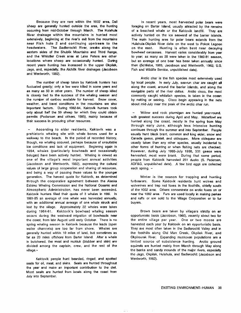
Because they are rare withinthe 1002 area, Dail In recent years, most harvested polarbears weresheep are generallyhunted outsidethe area,the hunting foragingon BarterIsland,usuallyattractedby the remainsoccurringfrom mid-October through March. The Hulahula of a beached whale or the Kaktoviklandfill.They are
River drainage within the mountains is hunted most activelyhunted on the ice seaward of the barrierislands.extensively,beginningat the Over'sexitfrom the mountains The main hunting area for polar bears extends from thenear Fish hole 2 and continuing upstream to the Hulahula-OkpilakRiver deltaon the west to Pokok Lagoonheadwaters. The SadlerochitRiver,creeks along the on the east. Hunting is often best near decayingeasternsides of the Shublik Mountains and Third Range, bowhead carcasses. Harvest variesconsiderablyfrom yearand the WhistlerCreek area at Lake Peters are other to year;as many as 28 were taken in the 1980-81 season,locationswhere sheep are occasionallyhunted. During but an average of one bear has been takenannuallysincerecentyears hunting has increasedin the upper Okpilak, then (Schliebe,1985; Jacobson and Wentworth, 1982; U.S.Jago, and, especially,the AichilikRiverdrainages(Jacobson Fishand WildlifeService,unpublished data).and Wentworth, 1982).
Arcticchar isthe fishspecies most extensivelyusedThe number of sheep taken by Kaktovikhunters has by localpeople. In earlyJuly,sea-runchar are caught all
fluctuatedgreatly;only a few were killedin some years and along the coast,around the barrierislands,and along the
as many as 50 inotheryears. The number of sheep killed navigableparts of the riverdeltas. Arcticcisco,the mostis closelytiedto the success of the whaling season and commonly caught whitefishspecies,istaken inthe oceanthe number of caribouavailablefor harvest. Snow cover, by nettingor seining. Cisco begin appearinginthe netsweather, and travelconditionsin the mountains are also about mid-Julynear the peak of the arcticchar run.important factors. During 1982-84, Kaktovik hunters took
only about halfthe 50 sheep forwhich they could obtain - Willow and rock ptarmigan are hunted year-round,permits (Pedersen and others,1985),mainlybecause of with greatestsuccess duringApriland May. Waterfowlaretheirsuccess in procuringother resources. hunted along the coast, mostly in the springfrom May
through early June, although less Intensivehunting- According to older residents,Kaktovik was a continuesthrough the summer and intoSeptember. Peopleprehistoricwhaling sitewith whale bones used for a usuallyhunt black brant,common and king elder,snow andwalkway to the beach. In the periodof recordedhistory, Canada geese, pintail,and oldsquaw. More oldsquaw arethough, no whaling occured, perhaps because of unsuitable usuallytaken than any other species,usuallyincidentaltoice conditionsand lack of equipment. Beginning again in other forms of huntingor when fishingnets are checked.1964, whales (particularlybowheads and occasionally However, during July 1985-July 1986, 531 geese werebelugas)have been activelyhunted. Whaling isviewed as harvested; most were brant. During that same period,one of the village'smost important annual activities people from Kaktovik harvested251 ducks (S. Pedersen,(Jacobson and Wentworth, 1982),expressingthe cultural ADF&G, unpublished data). A few birdeggs are collectedvalues of largegroup cooperationand sharingof resources, each spring.-
and being a way of passing these valuesto the younger
generation.The harvestquota for Kaktovik,as determined Winter is the season for trappingand hunting
through the cooperative agreement between the Alaska furbearers. Some Kaktovik residentshunt wolves and
Eskimo Whaling Commission and the NationalOceanic and Wolverinesand trap red foxes inthe foothills,chieflysouthAtmospheric Administration,has never been exceeded. of the 1002 area. Others concentrateon arcticfoxes on orKaktovikhuntersfilledtheirquota of 3 whales in 1981. In near the 1002 area. Furs are used locallyin making parkas
1981-85 an average of one whale was harvested annually, and ruffsor are sold to the VillageCorporationor to fur
with an additionalannual average of one whale struckand buyers.
lostby the village.Approximately22 whales were taken
during 1964-81. Kaktovik's bowhead whaling season Brown bears are taken by villagersstrictlyon an
occurs during the westward migrationof bowheads near opportunisticbasis(Jacobson, 1980),recentlyabout two for
the coast,from lateAugust untilearlyOctober. There is no the entirevillageper year. One or two moose are
springwhaling season in Kaktovikbecause the leads (open harvestedeach year by Kaktovikon an opportunisticbasis.
water channels) are too far from shore. Whales are They are most oftentaken in the SadlerochitValleyand ingenerallyhunted within10 miles of land,but sometimes as the foothillsalong Old Man Creek, Okpilak River,andfaras 20 milesoffshorefrom BarterIsland.Aftera whale Okpirourak River. Expanding muskoxen populationsare ais butchered,the meat and muktuk (blubberand skin)are limitedsource of subsistence hunting. Arctic grounddivided among the captain,crew, and the restof the squirrelsare hunted mainlyfrom March through May along
village.- the banks and sandy mounds of the major rivers,especially
the Jago, Okpilak,Hulahula,and Sadlerochit(Jacobson and
Kaktovik people hunt bearded, ringed,and spotted Wentworth, 1982).
sealsforoil,meat, and skins. Seals are hunted throughout
the year and make an importantcontributionto the diet.
Most seals are hunted from boats along the coast from
July intoSeptember.
EXISTING ENVIRONMENT-HUMAN 39

Several goals of the State-approved North Slope
Borough Coastal Management Program (see "Coastaland
Marine Environment") relateto subsistence resources.
These goalsare: (1)to protectthe naturalenvironmentand
itscapacityto support subsistenceactivities;(2)to protect
and enhance subsistence resources;(3)to preservetheInupiatculture;and (4)to maintainand enhance access to
subsistence resources.
- OTHER COMMUNITIES - Approximatelyhalfthe food consumed by people in
Old Crow comes from the land;of this,caribou isthe
Several communities located relativelyfar from the most important. The major hunt for caribouisin the fall;
Arctic Refuge utilizemigratoryspecies which may spend some huntingoccurs inwinterand inspringdepending on
partof theirlifecyclesin or near the 1002 area. Caribou the year. In September, largenumbers of caribou pass
are of particularsignificance,as well as snow geese, polar through the Old Crow flatsand cross the PorcupineRiver
bears, and bowhead and beluga whales. Use of these en routeto winteringareas. At thistime they can be taken
migratory populationsby othercommunities inAlaska and on land or by boat. Annual harvestof the PCH by Old
Canada is discussed below. Crow ranged from 250 to 1,000 between 1963 and 1986
(table11-5).People of Old Crow also harvestfishduring
Caribou the summer; moose, muskrats and waterfowlduringspring;
and rabbitsand ptarmiganwhen available.
Archaeologicalevidence indicatesthat people have
been using caribouforat least27,000 years,beforethe last Other villagesutilizingcaribou from the PCH are
glaciationin northernAlaska and Canada. Work done at locatedon the edge of the PCH range,and take caribou
sitesoccupied up to 1500 years ago near Old Crow, Yukon only inyears when animals are available(U.S.Department
Territory,documented a subsistenceeconomy centered on of State,1980). The estimatedannual caribouharvestin
the interceptionof spring and fallmigrationsof caribou Aklavik,Inuvik,ArcticRed River,and Fort McPherson,
(Garnerand Reynolds,1986). Canada, ranged from less than 100 to over 2,000 during
1963-86 (table11-5).Most of these animals are taken by
Today, harvest of caribouby communities in both the two communities of Aklavikand Fort McPherson (B.
Alaska and Canada depends largelyon the variable Pelchat,Yukon WildlifeBranch, and Don Russell,Canadian
distributionof the PCH from year to year. In some years, WildlifeService,unpublished data). Alaskan villagesof
migrationroutes or winteringareas may not bringcaribou Venetie,Fort Yukon, and Chalkyitsikharvested 300-400
near enough to a villageto make huntingfeasible.Still,the caribou in 1980-1981 (Pedersen and Caulfield,1981).
largeamount of resources sharing and tradingwhich Sharing and tradingof resources occurs between villages.
occurs between villagesreduces yearlyvariationbetween Ifcaribou are not availablein Fort Yukon, for example,
communities. The two villagesotherthan Kaktovikthatare residentsmay trade salmon for caribouwith residentsof
most dependent on caribou using the 1002 area are Arctic ArcticVillage. Because of the well-establishednetwork of
Village,Alaska, and Old Crow, Yukon Territory;both are exchange, those who are unable to obtain subsistence
inland villageshaving littleor no access to marine resourcesforthemselves are able to procure itfrom friends
resources. Other communities whose residentshunt or relatives(Berger,1977).
Porcupine caribou include Venetie,Fort Yukon, andChalkyitsikin Alaska and Fort McPherson, Inuvik,Aklavik, Use of CentralArctic Herd (CAH) cariboualso
ArcticRed River,and Tuktoyaktuk in the Northwest occurs in communities other than Kaktovik. Residents of
Territories. Nuiqsut,and some Barrow residentswho travelto Nuiqsut
for hunting, harvest caribou from both the CAH and
Caribou isthe most importantfood source forArctic Teshekpuk herd. The portion of the harvestfrom these
Village. Caribou from the PCH are usuallyavailablefrom respective herds is unknown (S. Pedersen, ADF&G,
August to April.Fallhuntingisconducted near the village; unpublished data). Residents from Anaktuvuk Pass harvest
winterhunting occurs fartheraway because snowmachines severalhundred caribou annuallyfrom the Western Arctic
can be used. In the 1970's,the hat-vestat ArcticVillage herd,as well as some CAH animals. Through the harvest
was reported to be 200-1,000animals (LeBlond,1979). composition from each herd is not wellknown, itis
Moose, fish,Dailsheep, waterfowl,and small mammals are believedthat Anaktuvuk Pass residentsrelyprimarilyon
also important, with an estimated 50 to 90 percent of all Western Arctic herd animals. and harvest from the CAH is
food consumed in the community derived from local wild less than 100 animals (K. R. Whitten, ADF&G, unpublished
resources (Caulfield,1983). data).
40 ARCTIC REFUGE RESOURCE ASSESSMENT

- Table 11-5.--EstimatedCanadianharvestfromthePorcupinecaribouherd,1963-86.-
[Most ofthe estimateswere obtainedby conservationofficersor biologistsinthe communitiesor by door-to-doorinterviews.Many figuresareprobablyunderestimatesandreflectproblemsinherentinthe data-collectionmethods.NA, not available]
Harvest Yukon Territory NorthwestTerritoriesTotalyear Old Dempster TotalAkla-FortMc- Total Canada
(12mo) Crow Southl vik Pherson
1963-64 706 0 706 621 395 1,016 1,7221964-65 769 0 769 774 492 1,266 2,0351965-66 ? 0 ? 647 479 1,126 ?1966-67 592 0 592 477 479 956 1,5481967-68 590 0 590 996 1,130 2,126 2,7161968-69 557 0 557 541 742 1,283 1,8401969-70 478 300+ 778+ 465 363 828 1,306
1970-71 450 300+ 750 414 723 1,137 1,8871971-72 485 250 735 616 250 866 1,6011972-73 297 61 358 NA NA 1,331 NA1973-74 607 184 791 1,300 500 2,000 2,7911974-75 382 24 406 NA NA 1,331 NA1975-76 785 29 814 NA NA NA NA1976-77 NA 239 NA NA NA NA NA1977-78 537 29 556 114 350 564 1,1201978-79 900 11 911 187 12 199 1,1101979-80 Boo 44 844 147 168 315 1,159
1980-81 558 107 665 9 40 120 7851981-82 1,000 42 1,115 300 1,500 1,800 2,9151982-83 500 29 529 500 1,141 1,641 1,6701983-84 1,000 100 1,100 NA 584 584 1,6841984-85 250 37 287 ----1,500---- 1,700 1,9871985-86 349 543 892 ---1,570--- 1,570 2,462
1From Dempster Highway game check station.Accordingto DonRussell(CanadianWildlifeService,Whitehorse,Yukon Territory,March1987),onlya smallproportionofthisharvestisconsideredto besubsistenceharvest.
EXISTING ENVIRONMENT--HUMAN 41

Snow Geese - Table 11-7.-AlaskaBeaufortSea harvestofpolarbears,1980-87.-
Birdsfrom the Western Arcticsnow geese populationoccur as fallmigrantson the 1002 area. The major [From Schliebe(1987). Harvestyear is July1-June 30.subsistenceuse of thisspeciesis inthe coastalareas of 1986-87 data through January 1987, Only partof thethe NorthwestTerritoriesof Canada near the major nesting PortLay harvestisbelievedto be derivedfrom Beaufortcoloniesand fallstagingareas,and along the Mackenzie Sea stock]River, a major spring and fallmigrationcorridor.Subsistenceharvestin springand fallis importantto thecoastalcommunitiesof Aklavik,Inuvik,Tuktoyaktuk,SachsHarbor,and Paulatuk,and the Mackenzie Rivercommunities Year .............1980- 1981- 1982- 1983- 1984- 1985- 1986-of Fort McPherson, Fort Good Hope, ArcticRed River, 81 82 63 84 85 86 87Norman Wells,and Fort Norman (T.W. Barryand W.Spencer, Canadian WildlifeService,unpublished data).Scanty data are availablefrom some of these communities Kaktovik....... 23 1 1 1 2 3 1(table11-6).Snow geese do not appear to be an important Nuiqsut........ I 0 0 0 0 2 1subsistenceresourcein the northernYukon community of Barrow......... 6 4 13 27 31 12 14Old Crow because they are not easilyaccessiblethere(J. Wainwright.. 3 16 16 32 18 4 6Hawkings,Canadian WildlifeService,unpublisheddata). PointLay..... 1 4 1 9 0 7 0
Table 11-6.-Springand fallsubsistenceharvestofsnow geese inthe NorthwestTerritories,Canada. Harvest estimatesforcommunitiesin Alaska utilizing
the BeaufortSea stock of bears are shown forthe years[Dataavailableintermittentlyfor1967-85. From 1980 through January 1987 (table11-7).HarvestinCanada
Barry(1985)]- is accordingto a quota system. Communities of Inuvik,
Aklavik,and Tuktoyaktukhave a combined quota of 32
polar bears. The combined quota for communities of
Community 1967 1968 1978 1985 Paulatukand Sachs Harbor,of which onlya portionapplySpring Fall Spring FallSpring Spring to the BeaufortSea stock,is39 (Taylorand others,1987).
& Fall Polar bears representa substantialcomponent of theculturaland economic base of the Inuitpeople of the
Tuktoyaktuk.........2,162 1,158 --- --- 4,348 3,500 Canadian Western Arctic. Hides have directeconomic
Aklavik/Kendall value,and inrecentyearsthe principalmotivationforpolar
Islandl..............144 280 --- 845 -- -- bear huntinghas been the sale of hides (Stirlingand
Sachs Harbor.....1,055 45 --- --- others,1975). Fur exportsarean importantsource of cash
Paulatuk...............--- --- 335 56 in the economies of Mackenzie and 'rim"villages.
FortMcPherson . 4 10 --- Accordingto Brackel(1977),marinefurs(whitefox,polar
ArcticRedbear,and ringedseal)provided5 percentand 19 percentof
River..................--- 0 0 --- the earned income inthe Mackenzie and "rim"economies,
respectively.
KendallIslandisa huntingcamp primarilyused by
Aklavikresidents.
Whales
Inupiatresidentsof the community of Nulqsut also
Polar Bears harvestbowhead and beluga whales near the 1002 area.Althoughthe community itselfis not locatedon the coast,
In additionto harvestin or near the 1002 area by marine mammals are an importantsubsistenceresource.
residentsof Kaktovik,the BeaufortSea populationof polar Nuiqsut hunters in company with Kaktovikhunters
bearsis harvestedby InupiatEskimos of otherNorthSlope sometimes hunt bowhead and beluga whales. Bowhead
communitiesin Alaska as wellas by communitiesin the whaling usuallyoccurs between lateAugust and early
coastalareas of Canada's NorthwestTerritories.These October, the exact timingand length of the season
communities includeNuiqsut, Barrow,Wainwright,and depending on ice and weather conditions.The season
probablyPointLay inAlaska,and Tuktoyaktuk,Aklavik,and may lastbetween 2 weeks and 2 months. The bowhead is
Inuvikin the Northwest Territories.Sachs Harbor and shared extensivelywithother North Slope communitiesand
Paulatuk,NorthwestTerritories,may harvesta smallpercent peopleas faraway as Fairbanksand Anchorage. Whale
of theirkillfrom bearsof the BeaufortSea stock,according baleen is barteredin traditionalnetworksand is used in
to currentsatellitetelemetrydata (S. L. Schliebe,FWS, making traditionalhandicrafts(U.S.MineralsManagement
unpublisheddata). Service,1986).
42 ARCTIC REFUGE RESOURCE ASSESSMENT

Beluga whales are harvestedduringthe periodof The Stateof Alaska has solicitedcomments and isopen water and are taken incidentallyto the bowhead developinga preliminaryanalysisforStateoffshoreoilandwhale harvest in Nuiqsut (U.S. MineralsManagement gas leasesales,includingsubmerged lands. ApproximatelyService,1986). Communities of the Mackenzie Riverdelta 127,000acres immediatelyoffshorefrom the 1002 area(Inuvik,Aklavik,and Tuktoyaktuk)and Amundsen Gulf between the Canning and Hulahula Rivershas been(Sachs Harbour,Holman, and Paulatuk),are also partially identifiedfora May 1987 Statesale;about 300,000acresdependent on subsistenceuses of belugawhales. Beluga offshorefrom the ArcticRefuge between the mouth ofthewhales are presentinthe BeaufortSea northof the Arctic Hulahula River and the Canadian border has beenRefuge during spring and fallmigrationswhere they proposed fora May 1988 Statesale.generallyfollowthe pack ice edge (Seaman and others,1981). They are harvestedin the Mackenzie partof the - Nativeallotmentsare scatteredthroughoutthe 1002BeaufortSea, where whales enterwarmer watersof the area, and are largelytraditionaluse sites,such asbays near the Mackenzie RiverdeltaduringearlyJulyand campsites,remainuntilthe middleof August. Whalingforbeluganearthe Mackenzie deltaisnot regulated,and approximately120 NATIVE ALLOTMENTSwhales aretakenper year (Brackel,1977). Whale productsare primarilyused locally,althoughsome productssuch as - Withinthe 1002 area,the FederalGovernment hasmuktuk are occasionallysold. Beluga mukluk is often begun to process toward conveyances some 25shared with relativesin Kaktovikand otherAlaskanand applications,involving34 parcelsfor Nativeallotments.Canadianvillages.A variationin diet,and the sportand None of these parcelshad been issued a certificateofrecreationof the hunt,with opportunitiesforsocializing,are allotmentas of January 1987. Intotal,these applicationsallimportantfactorsinwhaling(Brackel,1977). coverapproximately2,315 acres. A Nativeallotmentisa
parcelof land,containing160 acres or less,which can beLAND STATUS conveyed to a Nativebased on thatindividual'suse and
- Land ownership withinand adjacentto the 1002 area occupancy of the land under the authorityof the Native
is a complex of Federal,State,and privateinterests. AllotmentAct,May 17, 1906 (43 U.S.C.270-1),as amended
Federallyowned landto the south and eastismanaged as August 2, 1956,and repealedby the Alaska NativeClaims
the ArcticNationalWildlifeRefuge. Oiland gas exploration SettlementAct of December 18,1971 (43U.S.C.1617). -has occurredon State landswest of the Canning River.Leases on 119 tractstotaling592,142acresof Statelands Subsurface ownership under an allotmentwillbewest of the Canning Riverwere offeredJanuary 27,1987. reservedto the governmentifitis determinedthat itmay
Bids were receivedby the State on 26 tractstotaling be valuableforcoal,oil,or gas. The government or Rs100,632acres.- lessee would then have the rightto enterand use the
lands forthe developmentof the reservedminerals,subject- The KaktovikInupiatCorporation(KIC)has statutory to the duty to pay the allotmentowner for damages toentitlementto ownership of 92,160surfaceacreswithinthe surface improvements and a bond to guaranteesuch
ArcticRefuge north of the 1002 area. Subsurface payments. Ifthe allotmentarea isknown to be valuablefor
ownershipofthese landswas conveyed to the ArcticSlope mineralsotherthan coal,oil,and gas, an allotmentis not
RegionalCorporation(ASRC) by the UnitedStatesunder granted.
the terms of an August 9, 1983,agreement. The KIC/ASRCholdingsare privatelands;however,in accordancewith INDUSTRIAL USEsection22(g)of the ANCSA, theselands remainsubjecttothe laws and regulationsgoverningdevelopment of the There has been no industriallanduse of the 1002
Arctic Refuge. As such, oiland gas leasingand area otherthan oiland gas explorationunderthe 1002
development cannot occur on the KIC/ASRC lands until program.
authorizedby an Act of the Congress (Section1003 ofANILCA). - GOVERNMENT AND MILITARY USE
Submerged lands beneaththe coastallagoonsinthe ArcticContractors(PET-4 Contractor)establishedan
area between the mainlandand the offshorebarrierislands explorationcamp at BarterIslandin1947. The camp also
from Brownlow Pointto the mouth of the AlchilikRiver(with supported the U.S. Coast and Geodetic Survey coastal
the exceptionof lagoonsnorthof KIC lands)were included surveying parties. ArcticContractorsconstructedthe
withinthe area of explorationauthorizedby section airstripin1947.
1002(b)(1).The United Statesand the Stateof Alaskadisputeownershipof theselandsand have presentedtheir - The U.S. Air Force constructeda DistantEarlyarguments to a SpecialMaster appointedby the United Warning (DEW) LineStation(DEW LineSiteBAR MAIN) onStatesSupreme Court. A finaldecisionhas not been BarterIslandin 1955 as part of a largernetwork of radarrendered. Untilthisdecisionismade, allactivityon these installationsacrossthe NorthAmericanArctic.In1956 theysubmerged lands requiresconcurrentFederaland State builtthe DEW Line hangar adjacentto the airstrip.Theapproval. establishmentand expansionof the siteforcedthe village
EXISTING ENVIRONMENT--HUMAN 43

of Kaktovikto relocatethree times,but also brought KIC isa villagecorporation;itwas formed under the
employment opportunitiesto villagers.The siteisabout 1/2 provisionsof ANCSA in1972 to manage surfaceresources
milefrom the presentvillageand is largelyself-contained, surroundingthe villageof Kaktovikthatwere transferred
functioningas an entityseparatefrom the village.As many under the provisionsofANCSA and ANILCA.
as 70 DEW Lineemployees liveat the site,most ofwhomare hiredfrom outsidethe North Slope. In 1986 the site - Employment in the NSB increasedfrom 977 jobs to
employed three Inupiatand two non-Inupiatresidentsof 5,598 between 1970 and 1979. By September 1985,9,234
Kaktovik. Modernizationof the Bar Main DEW Line site workers were employed in the North Slope Borough; 86
startedin 1986 when a new pad and tower were percentof thisemployment was in the followingmajor
constructed.Testingnew equipmentwillrun through1988, categories:mining,includingoildevelopment,4,150 (45
afterwhich minor facilitymodificationmay be necessary. percent);Stateand localgovernment,1,409 (15 percent);
The Bar Main DEW Linesitewillcontinueto be staffedfor construction,1,258 (14 percent);and services,1,110(12
at leastthe next20 years.- percent).The remaining14 percentwere scatteredinothersmalleremployment sectors (NSB PlanningDepartment,
The Alaskan DEW Line also includedintermediate 1986). The majorityofjobs,principallyat Prudhoe Bay and
sitesat Camden Bay (POWD) and BeaufortLagoon the militaryenclaves,are held by non-Nativeworkers.
(Humphrey Point,BAR A), which were constructedfor However, participationby Inupiatsin the labormarkethas
communications relays. Advanced communications been encouraged through NSB and ASRC programs.-
technologyresultedintheirdeactivationin 1963. The lands(approximately876 acres)formerlywithdrawnforthe two The economy recentlymade a majortransitionfrom
sitesbecame a partof the ArcticRefuge on December 28, largelysubsistenceto mixed subsistenceand cash.
1982.Through local-hirepolicies,the NSB has providedsomeemployment for more than 50 percentof the resident
State and Local PoliticalInupiatadultsand has contributedsignificantlyto increased
and Economic Systemsper capitaincome. A majorfactorcontributingto increasedNativeemployment is the capitalimprovement program.
Four levelsof governmentoperatewithinor affecttheHowever, long-termInupiatemployment opportunities
1002 area: Federal,Stateof Alaska,NorthSlope Borough,depend on: (1) NSB's continuingabilityto providejobs;
and the villageof Kaktovik.Two corporations,ASRC andand (2)abilityand desireof Nativesto work at sitesaway
KIC, have a major influenceon privatelands adjacenttofrom theirhomes.
the1002 area. Many Nativeresidentsbelongto and have The region has been isolatedfrom the periodicdirectinputto the NSB, ASRC, KIC,and KaktovikVillage. boom-and-bust economic cycles of forest/fishery/gold
The State (1)establisheslaws and regulationsextractiontypicalof other partsof Alaska. Except for
governingcertainlocalactivities,(2)providesfinancialandwhalingitremained virtuallyunchanged untilafterWorld War
technicalassistance,(3)exercisescertainpoliceand11.The primarydrivingforcethen became nationaldefense
regulatorypowers such as huntingand fishingbag limits(researchat the Naval ArcticResearch Laboratoryat
and subsistence and commercial harvestof naturalBarrow,and DEW radarsitesalongthe coast).Today,the
resources,and (4)setsstandardsforwaterquality.productionof oilat Prudhoe Bay is the basiceconomic
influence.
The NSB was organizedin 1972; in 1973 itwasconvertedto a home-rulecharter--thestrongestform of
The State-approved NSB Coastal Management
localgovernment underAlaskalaw (NSB, 1984a).The NSBProgram was described under "Coastal and Marine
has an electedmayor and an electedseven-memberEnvironment.' Of the goals relatingto economic and
assembly. Itis responsible(among otherfunctions)forgovernment activitiesthose particularlypertinentto this
borough-wide planningsuch as the coastalmanagementreportare:
program,and itoverseesthe capitalimprovementsprogram.Preserve opportunitiesfor traditionalactivitiesand the
Kaktovikwas incorporatedas a second-classcityinInupiatway of lifeinthe North Slope,regardlessof
1972,and has a council-mayorform of government. Theownership and jurisdictionalboundaries,
mayor isappointedfromthe electedseven-member council.Increaseeconomic opportunityinvillages,
The ASRC is the regionalprofit-makingNativeCreate employment forNSB residentswhich willprovide
organizationformed in 1972 under the provisionsof theflexibilityfortraditionalInupiatculturaland subsistence
Alaska Native Claims SettlementAct (ANCSA). Itisactivities,
responsibleto nearly4,000 Inupiatstockholdersformanagement of 5.6 millionacres and $75 million(ASRC, Develop new industriesbased on the Inupiatculture,1985;NSB, 1984b). ASRC owns subsurfacerightsfortheentire5.6-million-acrearea and about 4.8 millionsurfaceacres scatteredacrossthe North Slope ofAlaska.
44 ARCTIC REFUGE RESOURCE ASSESSMENT

Protectlifeand propertyfrom naturalhazards and The Trans-AlaskaPipelineSystem (TAPS) connectsphenomena, Prudhoe Bay and associatedoilfieldsto a marinetanker
terminalat Valdez,Alaska. Recent offshoresalesbyProvideguidance and directionfor presentand potential Federaland StateGovernments have been based on the
resource development,onshore and offshore,including assumption thatfeeder pipelineswillconnect any newexploration,extraction,and processingand related commercialdiscoveriesto the existingoilpipelineand thatfacilities, halfthose pipelineswould be locatedonshore. Many
factorsincludingpotentiallocationsof productionplatformsCooperate and coordinatewithprivatedevelopment, and size of commerciallydevelopablefieldsare unknown.
Possibleoffshorepipelineroutesand landfallsincludethoseImproveenergy supplyforlocalcommunities,and suggestedforSales71,87,and 97. Of significanceto the
1002 area isan assumed landfallat BullenPoint,west ofDevelop localenergy resources. the Canning River(Roberts,1987).
- The NSB provides water,sewage, sanitary,light-power-heating,public housing, education,health,andpublic-safetyfacilitiesin Kaktovik. At Kaktovikthe school
PUBLIC SERVICES AND FACILITIES complex consistsof a two-room elementaryschool and ahigh school with four classrooms,library,gymnasium,
- Existingpublicservicesand facilitiesare describedin swimming pool, and kitchen. A vocationaleducation
the semiannualeconomic profile(NSB PlanningDepartment, buildingwas completed in 1981. Juniorand seniorhigh
1986). New oiland gas facilitiesassumed to resultfrom schoolenrollmentwas 45 studentsas of January1987. -
existingoffshoreFederalleasingare describedinscenariosforoildevelopmentinthe BeaufortSea (Roberts,1987). - Kaktovikhas a healthclinicstaffedby a healthaide.
Two NSB Departmentof PublicSafetyOfficersare stationed
Airtransportationis the singlemost extensiveall- at Kaktovik. Federalfacilitiesincludethe Post Office,the
season form of travelinthe region.Airfacilitiesrangefrom ArcticRefuge fieldoffice,and the Bar Main DEW site.
long,well-maintainedpaved runways to unimproved strips,sand bars,and locallargelakes. Duringthe winteroilandgas explorationissupportedby artificiallycreatedicestrips.Commercial airtransportationfacilitiesare locatedat allcommunitiesin the NSB. Except forBarrow and PrudhoeBay, most lack sophisticatednavigationaids,lighting,andsnow-removal equipment. The only militaryairfacilityof Archeologysignificanceto the 1002 area isat BarterIsland(Kaklovik),and is shared by the NSB and U.S.Air Force (NSB, Approximately100 archeologicalsitesare known
1984b). Originallyconstructedby the military,airstrips withinthe 1002 area (pl.1N. Dated sitesappear to be
locatedat Camden Bay,DemarcationBay, BeaufortLagoon, comparativelyrecent and of eitherHistoricInupiat
and BullenPointhave been abandoned. (approximatelyAD 1838-present)or Western Thule (aboutAD 900-1838)origin.Severalsmallersiteson the 1002
Marine transportationis controlledby iceconditions area--mostlyscattersof lithicdebrisfrom the manufacture,
and shallow nearshore waters. Major portfacilitiesare maintenance,and use of stone tools--arenot yet datable
locatedat Prudhoe Bay. At BarterIsland,shallow-draft but may be considerablyolder.
vesselslanddirectlyupon thebeach. Militarysiteshave inthe past been served by marine transportation.Most Near the 1002 area siteshave been dated to be as
portsof embarkationare inWashington and California;only oldas 6,000years(U.S.Fishand WildlifeService,1982). A
a smallpartof ocean freightis shippedfrom Alaskaports. fairlywidelyaccepted date from the Old Crow area of the
The riversinthe 1002 area are too smalland shallowfor Yukon Territory(about 150 milessoutheastof the 1002
inlandcommercialnavigation. area)indicatesthat people have been presentin thegeneralarea forthe last27,000years. Even though sites
The Dalton Highway is an all-weatherroad of such an earlyperiodare few,sites5,000-6,000yearsold
connectingPrudhoe Bay to the Alaska highway system. may occur on the 1002 area,but are yetto be discovered.
No road networkconnects populationcentersinthe NSB.
Cross-countrytransportationto and from the 1002 area is Archeologicalsitesmay occur almostanywhere inthe
limitedto winter,using specialequipmenton the snow or 1002 area. However,some areasare much more likelyto
sea ice. Nearlyevery community and militarysitein the have sites,especiallycoastalareas and barrierislands.
NSB has an internalgravelor dirtroad system linkingairor Most identifiedsitesconsistof the remainsof sod houses,marine transportationfacilities.Villageresidentsuse log cabins,burials,caches, lookouttowers,and relatedmotorbikes,three-wheeledall-terrainvehicles,cars,ortrucks features. Older sitesmay be buriedunder considerableinsummer, and snowmachines inwinter. sediment.
EXISTING ENVIRONMENT--HUMAN 45

Archeologicalsitesare also likelyalong riversand Wilderness and Estheticsstreams that cross the 1002 area from the PhilipSmith The ArcticRefuge is the only conservationsystemMountains. These riverscould have providedfishingand unitthat protects,in an undisturbedcondition,a completewould have been naturaltravelroutes between the coast spectrum of the arcticecosystems in North America.and the foothills.Sitesknown from the rivercourses are Approximately8 millionacres of the refugeis designatedaschieflytent rings,although two interiorsiteshave sod wildernessby ANILCA section702(3),and adjoinsthe 1002houses. Points of particularpossibilityare high,well- area on the south and east,includingthe coastalplainfromdrained banks, especiallynear stream confluences. the eastern1002 area boundary to the Canadian border.
Undiscovered sitesmay also be on high pointsof Wilderness is described by the WildernessAct ofland that provide overlooksabove the surroundingmoist 1964 (PublicLaw 88-557) as " * * * an area oftundra;such spots are known to containarcheologicalsites undeveloped Federal lands retainingRs primevalcharacterthroughout most of northernAlaska and Canada. There and influence,without permanent improvements or humanare relativelyfew such locationson the 1002 area,and habitation,which is protectedand managed so as tosites that have been identifiedin such locationsare preserveitsnaturalconditionsand which (1)generallyuniformlysmallscattersof lithicmaterial. appears to have been affectedprimarilyby the forces of
Archeological sites are even less likelyon thenature,with the imprintof man's work substantiallyunnoticeable;(2)has outstandingopportunitiesfor solitude
relativelystablesandy areas in riverdeltas. As with the or a primitiveand unconfinedtype of recreation;(3)has atoverlook sites,materialfrom blowouts in deltasis currently leastfivethousand acres of land of sufficientsizeas tolimitedto lithicremains. make practicableitspreservationand use in an unimpaired
The remainderof the 1002 area consistslargelyofcondition;and (4)may also containecological,geological,
flatto gentlyrollingtundra,now very wet. Such areas areor other features of scientific,educational,scenic,or
historicalvalue." With the exceptionofthe two abandonedleastlikelyto containsites,or to containsitesthat are DEW Line siteson the coast,the entire1002 area meetssusceptibleto discovery. these criteria(Gamer and Reynolds,1986). The coastal
plain in its present state has outstandingwildernessRecreation qualities: scenic vistas,varied wildlife,excellent
Recreationaluse of the ArcticRefuge is variedand is opportunitiesfor solitude,recreationalchallenges,andrelatedto wildlifeor wildernessvalues. Types and amount scientificand historicvalues.of recreationare limitedby the refuge'sremoteness, harsh
climate,and poor access. Fewer than 3,000 visitsoccur - The 1002 area isthe most biologicallyproductivepartannually. Wet and moist ground conditionsin the short ofthe ArcticRefuge forwildlifeand isthe centerof wildlifesummer season make surfacetraveldifficult,and extended activity. Itserves as an importantcalvingground fortheperiods of cold and darkness during the winterreduce Porcupine caribou herd; itcontains a high percentage ofrecreationaluses at thattime. Access is almost exclusively the refuge'sobserved muskoxen range; itis an important
by aircraftand iscostly. Nonetheless,recreationaluse of fallstagingarea forlessersnow geese; itprovidesnestingthe 1002 area is slowlyincreasingas itbecomes better habitatfor waterfowland shorebirds;and itis frequentlyknown and as scheduled airlineservicesto BarterIsland used by denning polar bears from the BeaufortSea
improve. population. Migratingcaribou and the postcalvingcaribou
aggregation offeran extraordinaryspectacle. The area
The most common forms of recreationarea are presents many opportunitiesfor scientificstudy of a
hunting,backpacking,and floattripson the largerrivers relativelyundisturbedecosystem. -
such as the Canning, Hulahula, and Aichilik.Other
recreationalpursuitsare wildlifeobservation,photography, Visualresources of the 1002 area encompass diverse
sightseeing,cross-countryskiing,fishing,and naturestudy. ecotypes and landforms. The irregularcoastlineof the
Most recreationistspursue severalof these activities. Beaufort Sea--characterizedby itsbarrierislands,lagoons,
Kaktovikresidentsalso engage in snowmobiling. beaches, submerged bars,spits,and riverdeltas--givesway
to the south to the gently risingcoastalplain. The
- In 1986, 14 hunting guides operated on the refuge, backdrop of the steeplyrisingBrooks Range, with itsdeep
though none guided on the 1002 area. Another 9 rivervalleysand glacier-cladpeaks, accents the abruptness
recreationalguides conducted group floator backpack trips and rugged beauty of the area.
on the refuge. One or two guides operated recreational
trips,at leastin part,on the 1002 area duringthe past 5 - Although the estheticvalue of the 1002 area had
years. Float-tripgroups average 6-12 people. Figureson been temporarilyreduced as a resultof seismic exploration,
nonguided recreationistsare unavailable,but probably fewer the area remains noteworthy and itswildernessvalues have
than 100 unguided visitsoccur annuallyon the ground in not been diminished. Recent botanicalstudiesshow that
the 1002 area. Several hundred visitorsflyover the 1002 recovery on the 1002 area is starting,with seismictrails
area annuallyto sightseeor en routeto otherpartsofthe less visibleinthe second year afterdisturbance(Felixand
ArcticRefuge. - others,1987).
46 ARCTIC REFUGE RESOURCE ASSESSMENT

REFERENCES CITED FEIS, 1983---seeU.S. Fish and WildlifeService,U.S.GeologicalSurvey,and Bureau of Land Management,
PhysicalGeography and Processes 1983.Felix,N. A.,Jorgenson,M. T.,Raynolds,M. K.,Lipkin,R.,
Blank,0. L.,and Lance,B. K. 1987,Snow distributionBlack,R. F.,1954, Precipitationat Barrow,Alaska,greater on the Arcticcoastalplainand itsrelationshipto
than recorded: Transactionsof the American disturbancecaused by winterseismicexploration,ArcticGeophysicalUnion,v.35,no. 2,p.203-206. NationalWildlifeRefuge,inGarner,G. W., and Reynolds,
Boyd,W. L.,and Boyd,J.W., 1963,A bacteriologicalstudy P. E.,editors,1985 updatereport,baselinestudyoftheofan Arcticcoastallake:Ecology,v.44,no.4,p.705- fish,wildlife,and theirhabitats,Section1002(c)ofthe710. ArcticNationalInterestLands ConservationAct:
Brewer,M. C.,1955a,Preliminaryinterpretationsof icewater Anchorage,U.S.Fishand WildlifeService,Region 7, inand bottom temperaturedata intheArcticOcean near press.Barrow,Alaska [abs.]:Transactionsof the American Ferrians,0. J.,Jr.,Kachadoorian,Reuben,and Greene,G.GeophysicalUnion,v.36,no.3, p.503. W., 1969,Permafrostand relatedengineeringproblemsin
1955b, Geothermalinvestigationsof permafrostin Alaska: U.S.GeologicalSurvey ProfessionalPaper678,northernAlaska[abs.]:Transactionsof the American 37 p.GeophysicalUnion,v.36,no.3,p. 503. Hopkins,D. M., Karlstrom,T. N. V.,and others,1955,
- 1958a,Some resultsof geothermalinvestigationsof Permafrostand ground waterinAlaska: U.S.Geologicalpermafrostin northernAlaska: Transactionsof the Survey ProfessionalPaper 264-F,p.113-146.AmericanGeophysicalUnion,v.39,no.1,p. 19-26. Kelley,J. J.,Jr.,and Weaver,D. F.,1966,Carbon dioxide
1958b, The thermalregime of an Arcticlake: and ozone in the arcticatmosphere,p. 151-167inTransactionsof the AmericanGeophysicalUnion,v. 39, Viereck,Eleanor,editor,ScienceinAlaska1965-Selectedno.2,p.278-284. papersof the 16thAlaskanScienceConferenceofthe
- 1974,Permafrost,itsimpacton development,inMan's NationalAcademy of Sciences,Proceedings:Fairbanks,impact on arcticand subarcticenvironments: UniversityofAlaska.Washington,DC, ArcticInstituteof NorthAmerica,p.19- Lachenbruch,A. H.,Brewer,M. C.,Greene,G. W., and27. Marshall,B. V.,1962,Temperaturein permafrost,in
- 1976,The seawardextensionof permafrostoffthe Herzfeld,C. M., editor,Temperature--itsmeasurementnorthernAlaskancoast [expandedabstract],p. 987-988, and controlinscienceand industry;Proceedingsofthein Proceedingsof the 3d InternationalConferenceon 4th Symposium on Temperature(1961): New York,Port and ocean engineeringunder arcticconditions ReinholdPublishingCo.,v.3,no.1,p. 791-803.(August1975),v.2: Fairbanks,UniversityofAlaska. Leffingwell,E. de K.,1919,The Canning Riverregion,
Brown,J.,and Tedrow,J. C. F.,1964,Soilsofthe northern northernAlaska:U.S. GeologicalSurvey ProfessionalBrooks Range, Alaska--4,Well-drainedsoilsof the Paper 109,251 p.glaciatedvalleys:SoilScience,v.97,no.3,p.187-195. MacCarthy,G. R.,1953,Recent changes inthe shoreline
Carter,L.D.,Ferrians,0. J.,Jr.,and Galloway,J. P.,1986, nearPointBarrow,Alaska:Arctic,v.6,no.1,p. 44-51.Engineering-geologicmaps of northernAlaskacoastal Muller,S. W., 1947,Permafrostor permanentlyfrozenplainand foothillsof the ArcticNationalWildlifeRefuge: ground and relatedengineeringproblems: Ann Arbor,U.S. GeologicalSurvey Open-FileReport 86-334,scale MI, Edwards Brothers,230 p, [Originallypublishedin1:250,000. 1943 by U.S.Army Corps of Engineers]
Cederstrom,D. J.,Johnston,P. M.,and Subitsky,Seymour, NationalOceanic and Atmospheric Administration,1975,1953,Occurrenceand developmentof ground waterin Geophysicalmonitoringforclimaticchange: NOAA,permafrostregions:U.S.GeologicalSurveyCircular275, Summary ReportNo. 3,1974.49 p. NOAA, 1975--seeabove reference.
Craig,P. C.,1984,Fishuse ofcoastalwatersoftheAlaska Osterkamp, T. E.,and Harrison,W. D.,1985,SubseaBeaufortSea--A review:Transactionsof the Amedcan permafrost--Probing,thermalregimeand data analysis,FisheriesSociety,v.113,no.3,p. 265-282. 1975-81: Fairbanks,Universityof AlaskaGeophysical
Craig,P. C.,and McCart,P.,1974,Classificationofstreams Institute,108 p.in BeaufortSea and drainagesbetween Prudhoe Bay, Page,R.A.,Boore,D. M., Joyner,W. B.,and Coulter,H.Alaska,and the MackenzieDelta:CanadianArcticGas W., 1972,Ground motionvaluesforuse inthe seismicStudy Ltd.(CAGSL) and AlaskanArcticGas Study design of the Trans-AlaskaPipelineSystem: U.S.Company (AAGSC) BiologicalReportSeries,v.17,no.1. GeologicalSurveyCircular672,23 p.[Quotedin U.S.Departmentof the Interior,1976,Alaska Rahn,K. A.,and Lowenthal,D. H.,1984,Elementaltracersnaturalgas transportationsystem--Finalenvironmental of distantregionalpollutionaerosols:Science,v.223,p.impactstatement,"Alaska"volume,p. 102.] 132-139.
Crow, W., Lambeth,B.,Evans,R.,and Radian Staff,1981, Selkregg,L. L.,1975,Alaskaregionalprofiles--Arcticregion:Airqualityand meteorologicalmonitoringstudy,April1, Anchorage, Universityof Alaska ArcticEnvironmental1979-March 31, 1980: Radian Corporationstudyfor Informationand Data Center,218 p.Prudhoe Bay Unitoperators,January1981.
EXISTING ENVIRONMENT--REFERENCES 47

U.S. Department of the Interior,1976,Alaska naturalgas Bartels,R. F.,1973, Birdsurveytechniqueson Alaska's
transportationsystem--Finalenvironmentalimpact north coast: Ames, Iowa, Iowa State University
statement:Washington, DC, 9 unnumbered volumes, unpublishedM.S.thesis,47 p.
variouslypaginated. Bartels,R. F.,and Doyle,T. J.,1964a,Migratorybirduse ofU.S.Fish and WildlifeService,1982, Initialreport,baseline the coastallagoon system of the BeaufortSea coastline
study of the fish,wildlife,and theirhabitats,Section withinthe ArcticNationalWildlifeRefuge,Alaska,1983,
1002(c) of the Alaska National InterestLands p. 169-199inGarner,and Reynolds (1984).ConservationAct:Anchorage, U.S. Fish and Wildlife Bartels,R. F.,and Doyle, T. J.,1984b, Distribution,
Service,Region 7,507 p. abundance, and productivityof tundra swans in the
U.S. Fish and WildlifeService,U.S.GeologicalSurvey,and coastalwetlands of the ArcticNationalWildlifeRefuge,
Bureau of Land Management, 1983, Proposed oiland Alaska,1983,p.200-208inGarnerand Reynolds (1984).
gas explorationwithinthe coastalplainof the Arctic Bartels,R. F.,Doyle,T. J.,and Wilmers,T. J.,1984,
NationalWildlifeRefuge, Alaska--Finalenvironmental Movement of moltingoldsquaw withinthe BeaufortSea
impact statement and preliminaryfinalregulations: coastallagoons of ArcticNationalWildlifeRefuge,
Washington,DC. Alaska,1983,p. 156-168inGarnerand Reynolds (1984).
Walker, H. J.,1973, Morphology of the NorthSlope,in Batzli,G. O.,White,R. G.,MacLean, S. F.,Jr.,Pitelka,F.
Britton,M. E.,editor,Alaskan Arctictundra: Arctic A.,and Collier,B. D.,1980,The herbivore-basedtrophic
Instituteof North AmericaTechnicalPaper 25,p.49-92. system,p. 335-410,in Brown, J.,Miller,P. G., Tieszen,
Wahrhaftig,Clyde,1965 [1966],Physiographicdivisionsof L. L.,and Bunnel,F. G., editors,An Arcticecosystem--
Alaska:U.S. GeologicalSurvey ProfessionalPaper 482, The coastaltundraat Barrow,Alaska: Stroudsburg,PA,
52 p. Dowden, Hutchinson,and Ross Inc.,571 p.
Williams,J. R.,1970, Ground water in the permafrost Bellrose,F. C., 1980, Duck, geese, and swans of North
regionsof Alaska: U.S. GeologicalSurvey Professional America:Harrisburg,PA, StackpoleBooks, 490 p.
Paper 696,83 p. Berger,T. R.,1977, Northernfrontier,northernhomeland;
Wiseman, W. J.,Jr.,Coleman, J. M., Gregory,A.,Hsu, S. the reportof the MacKenzie Valleypipelineinquiry,Vol.
A.,and others,1973,Alaskan arcticcoastalprocesses 1, MinistrySupply Service,Queens Printer,Ottawa,
and morphology: Baton Rouge, LouisianaState Canada, 213 p.UniversityCoastalStudiesInstituteTechnicalReport 149, Bergerud,A. T.,1974,Declineof caribouin NorthAmerica
171 p. followingsettlement:Journalof WildlifeManagement, v.
38, p. 757-770.
Biologicaland HumanBergerud,A. T.,1980,A reviewof the populationdynamics
Environmentsof caribouand wildreindeerin North America,p. 556-581 in Reimers, E.,Gaare, E., and Skjenneberg,S.,editors, Proceedings Second International
Aleksandrova,V. D., 1960,The Arcticand Antarctic--TheirReindeer/CaribouSymposium, Roros, Norway, 799 p.
divisioninto geobotanicalareas [translatedfromBliss,L. C., and Gustafson, K. M., 1981, Proposed
Russian]: New York,Cambridge UniversityPress,247 p.ecologicalnaturallandmarks in the Brooks Range,
Amaral, M. J.,1985,A raptorsurvey of selectedNorthAlaska: Preparedforthe Divisionof NaturalLandmarks,
Slope riversin the ArcticNationalWildlifeRefuge,1985:HeritageConservationand RecreationService,175 p.
Anchorage, U.S. Fish and WildlifeServiceDivisionofBrackel,W. D., 1977, The socioeconomic importanceof
Endangered Species.wildliferesourceutilizationinthe southernBeaufortSea:
Amaral,M. J.,and Benfield,D.,1985,A raptorsurveyoftheVictoria,BritishColumbia Departmentof Fisheriesand
Canning and Kongakut Rivers,ArcticNationalWildlifeEnvironmentTechnicalReport 32, BeaufortSea project,
Refuge,Alaska,1984: Anchorage, U.S.Fishand Wildlife91 P.
Serviceunpublishedreport,13 p.Brackney,A. W., Masteller,M. A., and Morton,J. M.,
Amstrup, S. C., 1986, Minutes of Canadian Federal-1985a, Ecology of lessersnow geese stagingon the
Provincialpolar bear technicalcommittee meeting,coastalplainof the ArcticNationalWildlifeRefuge,
January28-30,1986,Edmonton, Alberta,55 p. total.Alaska,fall1984, p. 245-262 in Garner and Reynolds
Amstrup,S. C.,Stirling,I.,and Lentfer,J. W., 1986, Past(1985).
and presentstatusof polarbears in Alaska:WildlifeBrackney,A. W., Morton,J. M., Noll,J.M., and Masteller,
SocietyBulletin,v.14,no. 3,p. 241-254.M. A.,1985b, Distribution,abundance, and productivity
ArcticSlope Regional Corporation,1985, 1985 annualof tundra swans in the coastalwetlands of the Arctic
report:Barrow,34 p.NationalWildlifeRefuge, Alaska, 1984, p. 297-308 in
ASRC, 1985--SeeArcticSlope RegionalCorporation,1985.Garnerand Reynolds (1985).
Barry,T. W., 1967, Geese of the Anderson Riverdelta,Britton,M. E., 1957, Vegetationof the Arctictundra,in
Northwest Territories:Edmonton, Universityof Alberta,Hansen, H. P.,editor,Arcticbiology:Corvallis,Oregon
Ph.D.thesis,212 p.StateUniversityPress,p. 67-130.
Barry,T. W., 1985,Birdsinthe subsistenceeconomy ofthe
MacKenzie River Delta: Edmonton, Alberta,CanadianWildlifeService,unpublishedreport.
48 ARCTIC REFUGE RESOURCE ASSESSMENT
7-

Brown, J., and Berg, R., editors,1980, Environmental Craig,P. C.,and McCart, P.,1974, Classificationof streamsengineeringand ecologicalbaselineinvestigationsalong in BeaufortSea and drainagesbetween Prudhoe Bay,the Yukon River-PrudhoeBay haul road: Hanover, NH, Alaska,and the Mackenzie Delta: Canadian ArcticGasU.S. Army Corps of Engineers Cold Regions Research Study Ltd. (CAGSL) and Alaskan ArcticGas Studyand EngineeringLaboratoryCRREL Report 80-19. Company (AAGSC) BiologicalReportSeries,v. 17,no. 1.
Burgess, R. M., 1984, Investigationsof patterns of (Quoted in U.S. Department of the Interior,1976, Alaskavegetation,distributionand abundance of smallmammals natural gas transportationsystem--Finalenvironmentaland nestingbirds,and behavioralecology of arcticfoxes impact statement,"Alaska"volume, p. 102.]
at Demarcation Bay, Alaska: Fairbanks,Universityof Curatolo,J. A., and Murphy, S. M., 1986, The effectsof
Alaska M.S. thesis,191 p. pipelines,roads, and trafficon the movements of
Burns,J. J.,and Eley,T. J.,1978, The naturalhistoryand caribou, Rangife tarandus: The Canadian Field-ecology of the bearded seal (Erignathusbarbatus and Naturalist,v. 100, no. 2, p. 218-224.the ringed seal (Phoc hispida),p. 226-302, in Dauphine, T. C., Jr.,1976, Biology of the KaminuriakEnvironmental assessment of the Alaskan Continental population of barren-ground caribou,Part 4--Growth,Shelf: Annual reportsof principalinvestigatorsof the reproduction,and energy reserve: Canadian Wildlifeyear ending March 1977, U.S. Bureau of Land ServiceReport Series No. 38, 71 p.Management Outer Continental Shelf Environmental Detterman,R. L.,1974, The arcticlowland region;potentialAssessment Program Report,RU 230, v. 1, 773 p. landform and fifeformnaturallandmarks: Administrative
Cade, T. J.,1960, Ecology of the peregrineand gyrfalcon reportprepared forthe NationalPark Serviceby the U.S.populations in Alaska: Universityof California GeologicalSurvey, 411 p.
PublicationsinZoology, v. 63,no. 3, p. 151-290. Divoky, G. J., 1978, The distribution,abundance, andCameron, R. D., 1983, Issue--Caribouand petroleum feeding ecology of birds associatedwith pack ice,p.
development in ArcticAlaska:Arctic,v.36, p. 227-231. 167-509, in Annual Report of Principal Investigators,Cantlon,J. E.,1961, Plantcover in relationto macro-, 1978: Boulder,CO, U.S. Bureau of Land Management
meso-, and micro-relief:U.S. Officeof Naval Research, Outer Continental Shelf Environmental AssessmentGrant Nos. ONR-208 and 216. Finalreport,128 p. Program, v. 2.
Caulfield,R. A., 1983, Subsistence land use in upper Felix,N. A.,Jorgenson, M. T.,Raynolds, M. K., Lipkin,R.,Yukon-Porcupine communities, Alaska: Fairbanks,Alaska Blank,D. L.,and Lance, B. K.,1987, Effectsof winter
Department of Fish and Game, Divisionof Subsistence seismic explorationon visualresources,vegetation,andTechnicalPaper 16, 231 p. subsurface stabilityof the coastalplainof the Arctic
Chesemore, D. L.,1967, Ecology of the arcticfox in NationalWildlifeRefuge, Alaska,-inGarner and Reynoldsnorthern and western Alaska: Fairbanks,Universityof (1987).Alaska M.S. thesis,148 p. Felix,N. A., Lipkin,R., Raynolds,M. K.,Blank,D. L.,and
Childers,J. M., Sloan,C. E.,Meckel, J. P.,and Naumann, Dashevsky, S.,1985, Fieldreportson Salixovalifoliavar.J. W., 1977, Hydrologic reconnaissanceof the eastern glacialis,Thlaspi arcticum: Fairbanks,U.S. Fish andNorth Slope, Alaska, 1975: U.S. Geological Survey WildlifeServiceunpublished report,18 p.Open-FileReport 77-492,77 p. Garner, G. W., and Reynolds, P. E., editors,1983, 1982
Coffing,M., and Pedersen, S., 1985, Caribou hunting--Land update report,baselinestudy of the fish,wildlife,and
use dimensions, harvestleveland selectedaspects of theirhabitats,Section 1002(c) of the Alaska National
the hunt during regulatoryyear 1983-84 in Kaktovik, InterestLands ConservationAct: Anchorage, U.S. FishAlaska: Fairbanks,Alaska Department of Fish and and WildlifeService,Region 7, 379 p.
Game, Divisionof Subsistence,TechnicalPaper 120, 38 Garner, G. W., and Reynolds, P. E., editors,1984, 1983
P. update report,baselinestudy of the fish,wildlife,and
Cowardin, L. M., Carter,Virginia,Golet,F. C., and LaRoe, theirhabitats,Section 1002(c)of the Alaski National
E. T., 1979, Classificationof wetlands and deepwater InterestLands Conservation Act: Anchorage, U.S. Fish
habitatsof the United States: Washington, DC, U.S. and WildlifeService,Region 7, 614 p.
Fish and WildlifeServiceFWS/OBS-79/31, 103 p. Garner, G. W., and Reynolds, P. E., editors,1985, 1984
Craig,P. C., 1977, Arcticchar in SadlerochitSpring,Arctic update report,baselinestudy of the fish,wildlife,and
National WildlifeRange, Chapter 11in ArcticGas, theirhabitats,Section 1002(c) of the Alaska National
BiologicalReport Series,v. 41, Aquatic Environments InterestLands ConservationAct: Anchorage, U.S. Fish
Limited,28 p. and WildlifeService,Region 7, v. 1--p.1-361;v. 2--p.
Craig,P. C., 1984, Fish use of coastalwaters of the Alaska 362-777.
Beaufort Sea--A review:Transactionsof the American Garner, G. W., and Reynolds, P. E., editors,1986, Final
FisheriesSociety,v. 113,no. 3, p. 265-282. report,baselinestudy of the fish,wildlife,and theirhabitats,Section 1002(c)of the Alaska NationalInterest
Lands Conservation Act: Anchorage, U.S. Fish and
WildlifeService,Region 7, v. 1-p. 1-392;v.2--p.343-695.
EXISTING ENVIRONMENT--REFERENCES 49

Garner, G. W., and Reynolds, P. E., editors,1987, 1985 Koski, W. R., 1977a, A study of the distributionand
update report,baselinestudy of the fish,wildlife,and movement of snow geese, other geese, and whistling
theirhabitats,Section 1002(c) of the Alaska National swans on the Mackenzie Delta,Yukon north slope and
InterestLands Conservation Act: Anchorage, U.S. Fish Alaskan north slope in August and September 1975,
and WildlifeService,Region 7. [Inpress.] Chapter 11,90 p. in W. W. H. Gunn, Tull,C. E.,andGarner,G. W., Reynolds, H. V.,Martin,L. D.,Weiler,G. J., Wright,T. D., editors,Ornithologicalstudiesconducted
Morton, J. M., and Noll,J.M., 1985,Ecology of brown inthe area ofthe proposed gas pipelineroute, northern
bears inhabitingthe coastalplainand adjacentfoothills Alberta, Northwest Territories,Yukon Territory,and
and mountains of the northeasternportionof the Arctic Alaska 1975: ArcticGas BiologicalReport Seriesv. 35,
National WildlifeRefuge, p. 268-296 in Garner and 348 p.Reynolds (1985). Koski, W. R., 1977b, A study of the distributionand
Garner,G. W., Reynolds, H. V.,Martin,L. D.,Wilmers,T. J., movements of snow geese and other geese, and
and Doyle, T. J.,1984, Ecology of brown bears whistlingswans on the Mackenzie Delta,Yukon north
inhabitingthe coastalplainand adjacentfoothillsand slope,and easternAlaskan north slope in August and
mountains of the northeasternportionof the Arctic September 1976: Canadian ArcticGas Study Limited.National WildlifeRefuge, p. 330-358 in Garner and L.G.L.Limited,Calgary,Alberta,69 p.
Reynolds (1984). Krebs, R. H., 1983, Lesser snow goose coloniesin the
Garner, G. W., Weiler,G. J.,and Martin,L. D.,1983, western Canadian arctic:Journal of WildlifeManagement,
Ecology of brown bears inhabitingthe coastalplainand v. 47, p. 523-526.
adjacent foothillsand mountains of the northeastern LeBlond, N. R., 1979, Porcupine caribou herd: Canadian
portionof the ArcticNationalWildlifeRefuge,p. 275-290 Arctic Research Commission Research Monograph 3,
in Garner and Reynolds (1983). Yukon Series,156 p.
Glesne, R. S.,and Deschermeier,S. J.,1984, Abundance, Lent,P. C., 1964, Calvingand relatedsocialbehaviorin the
distributionand diversityof aquatic macroinvertebrates barren-groundcaribou: Edmonton, Universityof Alberta,
on the north slope of the ArcticNationalWildlifeRefuge, Ph.D. thesis,220 p.
1982 and 1983, p. 523-552 in Garner and Reynolds Lentfer,J. W., 1971,The effectsof ocean currentsand ice
(1984). movement on polarbear activity:Federal Aid Wildlife
Haugen, H. S., 1984, Prey utilizationby wolves and a RestorationProjectsW-17-2 and W-17-3, Job 5.2R,11 p.
preliminaryassessment of wolf and prey densitiesin Lentler,J. W., and Hensel, R. J.,1980, Alaskan polarbear
three drainages withinthe ArcticNationalWildlifeRefuge, denning, p. 101-108,in Martinka,C. J.,and McArthur, K.p. 133-152 in Garner and Reynolds (1984). L.,editors,Bears-Theirbiologyand management: Bear
Haugen, H. S., 1985, Prey utilizationby wolves in two Biology AssociationFourth InternationalConference on
drainageswithinthe ArcticNationalWildlifeRefuge, and Bear Research and Management, Kalispell,MT, February
a preliminarydescriptionof wolf pack behavioraround 1977: Washington, DC, U.S.Government PrintingOffice.
the den in the Kongakut Riverdrainage,p. 145-172 in LeResche, R. E., 1972, The internationalherds--Present
Garner and Reynolds (1985). knowledge of the Fortyrrilleand Porcupine caribouherds,Hinman, R. A., 1985, Annual reportof survey-inventory p. 127-134,in Luick,J. R.,Lent, P. C.,Klein,D. R.,and
activities,in Caribou survey-inventoryprogress report,v. White, R. G., editors:Proceedings of the FirstXVI: Juneau, Alaska Department of Fish and Game, Aid InternationalReindeer and Caribou Symposium:
in wildliferestorationprogress report,projectW-224, Fairbanks,Universityof Alaska.
56 p. Lowry, L. F.,Frost,K. J.,and Bums, J. J.,1976, Food of
Jacobson, M. J., 1980, Grizzlybear management plan, ringed seals and bowhead whales near Point Barrow,William0. Douglas ArcticWildlifeRange: Fairbanks,U.S. Alaska: Canadian Field-Naturalist,v. 92, p. 67-70.
Fish and WildlifeServiceunpublished report,23 p. Magoun, A. J., 1985, Populationcharacteristics,ecology,
Jacobson, M. J.,and Wentworth, Cynthia,1982, Kaktovik and management of wolverinesin northwesternAlaska:
subsistence--Landuse values through time in the Arctic Fairbanks,Universityof Alaska Ph. D. thesis,197 p.
NationalWildlifeRefuge area: U.S. Fish and Wildlife Martin, L. D., and Garner,G. W., 1984, Populationsize,
Service,142 p. composition, and distributionof moose along the
Koranda, J. J.,and Evans, C. D., 1975, A discussionof Canning and Kongakut Riverswithinthe ArcticNational
sitesrecommended as potentialnaturallandmarks inthe WildlifeRefuge, Alaska, fall1983, p. 119-132 in Garner
arcticlowland naturalregion,northernAlaska: Report and Reynolds (1984).
prepared for the NationalPark Serviceby the Tundra Martin,L. D., and Garner,G. W., 1985, Populationsize,
Biome Center, Universityof Alaska,Fairbanks,189 p. composition, and distributionof moose along theCanning and Kongakut Riverswithinthe ArcticNational
WildlifeRefuge,Alaska,spring and fall,1984, p. 207-217
inGarner and Reynolds (1985).
Marlin,P. D., and Moiteret,C. S., 1981, Bird populations
and habitatuse, Canning Riverdelta,Alaska: Fairbanks,
U.S. Fish and WildlifeService unpublished report.
50 ARCTIC REFUGE RESOURCE ASSESSMENT

Mauer, F. J.,1985, Distributionand relativeabundance of Pedersen, S.,and Coffing,M., 1984, Caribou hunting-Landgolden eagles in relationto the Porcupine caribou herd use dimensions and recentharvestpatternsin Kaktovik,during calvingand post-calvingperiods,1984, p. 114-144 Northeast Alaska: Fairbanks,Alaska Department of Fishin Garner and Reynolds (1985). and Game, Divisionof Subsistence,57 p.
Mauer, F. J.,Garner,G. W., Martin,L. D.,and Weiler,G. J., Pedersen, S., Coffing,M., and Thompson, J., 1965,1983, Evaluation of techniques for assessing neonatal Subsistence land use and place names maps forcaribou calfmortalityin the Porcupine caribouherd,p. Kaktovik,Alaska: Fairbanks,Alaska Department of Fish201-245 in Garner and Reynolds (1983). and Game Technical Paper 109, 140 p.
McCourt, K. H., Feist,J. D., Doll,D.,and Russell,J. J., Pelton,M., Lentfer,J.,and Fold,E.,editors,1976, Bears-1974, Disturbancestudiesof caribouand othermammals Their biologyand management: InternationalUnion forin the Yukon and Alaska,1972: ArcticGas Biological the Conservationof Nature Publications,New SeriesNo.Report Series5, 246 p. 40, 467 p.
Mech, L. D,. 1970, The wolf-The ecology and behaviorof Peterson,J. W., 1978, A study ofthe effectof the limitonan endangered species: New York, Natural History bowhead whale take by the Eskimo of ArcticAlaska:Press, 364 p. Anchorage, U.S. Bureau of IndianAffairs.[Summarized
Murray, D. F., 1980a, Balsam poplar in arcticAlaska: in Pedersen and others,1985.]Canadian Journalof Anthropology,v. 1, no. 1, p. 29-32. Phillips,M. K., 1984, Habitatuse and behaviorof grizzly
Murray, D. F.,1980b, Threatened and endangered plantsof bears inthe ArcticNationalWildlifeRefuge, p. 45-73 inAlaska: Anchorage, U.S. Department of Agriculture, Garner and Reynolds (1984).Forest Service,and U.S. Department of the Interior, Rausch, R. A., 1967, Some aspects of the populationBureau of Land Management, 59 p. ecology of wolves, Alaska: American Zoologist,v.7, p.
NationalMarine FisheriesService,1983, Letterfrom Robed 263-265.W. McVey, Director,Alaska Region, NationalMarine Rausch, R. A., and Pearson,A. M. 1972, Notes on theFisheriesService,to Keith Schreiner,Regional Director, wolverine in Alaska and Yukon Territory:Journal ofU.S. Fish and WildlifeService,p. C-11, in U.S. Fish and WildlifeManagement, v. 36, no. 2, p. 249-268.WildlifeService,U.S. GeologicalSurvey,and Bureau of Reynolds, H. V., 1979, Population,biology,movements,Land Management (1983). distributionand habitatutilizationof a grizzlybear
NSB, 1984a, North Slope Borough Coastal Management populationin NPRA, p. 129-182,in NPRA Work Group
Program-Concept approved: Alaska Coastal 3-Fieldstudy,v.1, Studiesof selectedwildlifeand fish
Management Program, Maynard and Partch,Woodward- and theiruse of habitatson and adjacentto theClyde Consultants,310 p. NationalPetroleum Reserve in Alaska 1977-1978: U.S.
NSB, 1984b, North Slope Borough Coastal Management Department of the Interior,105(c)Land Use Study,Program-Background report: Alaska Coastal Bureau of Land Management, Anchorage.Management Program, Maynard and Partch,Woodward- Reynolds, H. V., Curatolo,J. A., and Quimby, R., 1976,Clyde Consultants,578 p. Denning ecology of grizzlybears in northeasternAlaska,
NSI3 Planning Department, 1986, Semi-annual economic p. 403-409 in Peltonand others (1976).profile,summer 1986:v. 2, no. 1, July1986, 40 p. Reynolds,P. E.,Martin,L. D.,Weiler,G. J.,Noll,J. M., and
Oates, R. M., McWhorter, M., and Douglas, D., 1966, Morton, J. M., 1985, Populationand herd dynamics,
Species accounts of migratorybirdsat eightstudy areas distribution,movements, and habitatuse of muskoxen in
on the coastal plainof the ArcticNationalWildlife the ArcticNationalWildlifeRefuge,Alaska,1982-1984,p.
Refuge,Alaska,1985, in Garner and Reynolds (1987). 42-95 inGarner and Reynolds (1985).
Patterson,L. A., 1974, An assessment of the energetic Roberts,R. W., 1987, Scenariosfor oildevelopment inthe
importance of the North Slope to snow geese (Chen Beaufort Sea: Anchorage, U.S. Minerals Management
caerulescens)during the stagingperiodin September Service,Alaska OCS region,report[inpress].1973, in Gunn, W. W. H., Richardson, W. J., Roby, D. D., 1978, Behavioralpattems of barren-groundSchweinsburg, R. E.,and Wright,T. D.,editors,Studies caribouof the CentralArcticherd adjacentto the Trans-on snow geese and waterfowl in the Northwest Alaska Oil Pipeline:Fairbanks,Universityof Alaska M.S.Territories,Yukon Territoryand Alaska 1973: Canadian thesis,200 p.Arctic Gas Study Ltd.,BiologicalReport Series,v. 27, Roseneau, D. G., 1974, A continuationof studiesofchap. 4, p. 1-44. raptorialbird nesting sitesalong proposed pipeline
Pearson, A. M., 1976, Populationcharacteristicsof the routes in Alaska: Unpublished reportsubmitted toArcticmountain grizzlybear, p. 247-260 in Peltonand Northern Engineering Service Company, Ltd.,andothers(1976). Canadian ArcticGas Study Company, Ltd.,Calgary,
Pedersen, S.,and Caulfield,R. A.,1981, Some elements of Alberta,68 p.
subsistenceland and resource use withinthe range of Roseneau, D. G., Reynolds, H., and White, C. M., 1976,
the Porcupine caribou herd in Alaska:Fairbanks,Alaska NortheasternAlaska,p. 243-245,in Fyfe,R. W., Temple,Department of Fish and Game Divisionof Subsistence S. A., and Cade, T. J., editors, The 1975 Northinterimreport. American peregrine falcon survey: Canadian Field-
Naturalist,v. 90,no. 3, p. 228-273.
EXISTING ENVIRONMENT-REFERENCES 51

Roseneau, D. G., and Stern,P. M., 1974a, Distributionof U.S. Fish and WildlifeService,U.S. GeologicalSurvey,and
moose, muskox, and sheep in northeasternAlaska, Bureau of Land Management, 1983, Proposed oiland
1972: ArcticGas BiologicalReport Series,v. 6, p. 42- gas explorationwithin the coastal plainof the Arctic
58, National WildlifeRefuge, Alaska--Finalenvironmental
Roseneau, D. G., and Stern,P. M., 1974b, Distributionand impact statement and preliminaryfinalregulations:
movements of the Porcupine caribou herd in Washington, DC.
northeasternAlaska,1972: ArcticGas BiologicalSeries, U.S. Minerals Management Service,1986, Proposed
v. 7, 209 p. Beaufort Sea Lease Sale 97, draftenvironmentalimpact
Schliebe,S. L.,1985, Summary of Alaskan polarbear native statement: Anchorage, OCS EIS/EA, MMS 86-0042.
subsistence harvest:Anchorage, U.S. Fish and Wildlife [Issued November 1986; title-pageimprintdate of
ServiceMarine Mammal Project,unpublished report,15 January 1988 is incorrect]
P- Viereck,L. A.,and Zasada, J. C.,1972, A proposalforan
Schliebe,S. L.,1987, Management studiesof polarbears in ecologicalreserve system for the taigaand tundra of
Alaska: Anchorage, U.S. Fish and WildlifeService, Alaska: Report prepared by the Instituteof Northern
Divisionof WildlifeManagement unpublished report,4 p. Forestry, U.S. Forest Service, College, Alaska,
Seaman, G. A.,Tande, G. F.,Clausen, D, L.,and Trasky,L. unnumbered.
L.,1981, Mid-Beaufortcoastal habitatevaluationstudy, Walker, D. A., 1981, The vegetationand environmental
ColvilleRiver to Kuparuk River:Alaska Department of gradientsof the Prudhoe Bay region,Alaska: Boulder,
Fish and Game, 199 p. Universityof Colorado Ph.D. thesis,129 p.
Smith, T. G., 1979, Distributionand abundance of Dall Walker, D. A., Acevedo, W., Everett,K. R., Gaydos, L.,
sheep in the ArcticNationalWildlifeRange: Fairbanks, Brown, J.,and Webber, P. J.,1982, Landsat-assisted
U.S. Fish and WildlifeService,unpublished reporton file, environmentalmapping in the ArcticNationalWildlife
12 p. Refuge, Alaska: Hanover, NH, U.S. Army Corps of
Smith, T. G., 1980, Polar bear predationof ringedand Engineers Cold Regions Research and Engineeringbearded seals in the land-fastsea icehabitat:Canadian Laboratory,CAREL Report 82-37,68 p.
Journalof Zoology, v. 58,no. 12,p. 2201-2209. Ward, D. L.,and Craig,P. C., 1974, Catalogue of streams,
Spindler,M. A., 1978, Bird populationsutilizingthe coastal lakes,and coastalareas in Alaska along routes of the
tundra, coastal lagoons,and nearshore waters of the proposed gas pipelinefrom Prudhoe Bay, Alaska to the
ArcticNationalWildlifeRange: Fairbanks,U.S. Fish and Alaska/Canadian border: Canadian ArcticGas Study
WildlifeServicemimeographed report,23 p. Ltd.,BiologicalReport,v. 19,381 p.
Steere, W. C., and Murray, B., 1976, Andreaebryum Weiler,G. J.,Garner,G. W., Martin,L.D.,and Regein, W.
macrosporum--A new genus and species of Musci from L.,1985, Wolves of the ArcticNationalWildlifeRefuge-
NorthernAlaska and Canada: Corvallis,OR, Phytologia, Their seasonal movements and prey relationships,p.
v. 33, p. 407-410. 173-206 in Garner and Reynolds (1985).
Stirling,I.,Andriashek,D.,Latour,P.,and Calvert,W., 1975, Weiler,G. J., Garner, G. W., and Regelin,Wayne, 1987,
Distributionand abundance of polar bears inthe eastern Wolves of the Arctic NationalWildlifeRefuge--Their
BeaufortSea: Canadian WildlifeServiceTechnicalReport seasonal movements and prey relationships,in Garner
2, 59 p. and Reynolds (1987).
Stringham,S. F.,1983, Roles of adultmales in grizzlybear Wentworth, C. J., 1978, Kaktovik Community biography
population biology: FifthInternationalConference on maps: Barrow, North Slope Borough.
Bear Research and Management, v. 5, p. 140-151. West, R. L., and Wiswar, D. W., 1985, Fisheries
Taylor,M., Lee, J.,and Lunn, N., 1987, Summary of polar investigationson the ArcticNationalWildlifeRefuge,
bear killin Northwest Territoriesduringthe period1 July Alaska,1984, p. 729-777 in Garner and Reynolds (1985).
1985 to 30 June 1986: Paper presented to Canadian White, R. G., Thomson, B. R., Skoland,T., Person,S. J.,
PolarBear Technicalcommittee,Quebec City,Quebec. Russell,D. E., Holleman D. F.,and Luick,J. R.,1975,
U.S. Bureau of Land Management, 1978, BeaufortSea Ecology of caribou at Prudhoe Bay, Alaska,p. 151-201,
region socioeconomic baseline: Alaska Outer in Brown, J.,editor,Ecologicalinvestigationsof the
Continental Shelf Socio-Economic Studies Program, tundra biome in the Prudhoe Bay Region, Alaska:
TechnicalReport 11, 636 p. Fairbanks,BiologicalPapers of the Universityof Alaska,
U.S. Department of State,1980, Draftenvironmentalimpact SpecialReport 2, 215 p.
statementfor the agreement between the United States Whitten,K. R.,1984, Studiesof the Porcupine caribouherd,
and Canada for the conservationof migratorycaribou, 1982-1983,p. 609-614 in Garner and Reynolds (1984).
Washington, D.C.,March 1980, 105 p. Whitten, K. R., 1987, Populationstatusand trend of the
U.S. Fish and WildlifeService,1982, Initialreport,baseline Porcupine caribou herd, 1982-1985 update report,in
study of the fish,wildlife,and theirhabitats,Section Garner and Reynolds (1987).
1002(c) of the Alaska National InterestLands
Conservation Act: Anchorage, U.S. Fish and Wildlife
Service,Region 7, 507 p.
52 ARCTIC REFUGE RESOURCE ASSESSMENT

Whitten,K. R., and Cameron, R. D., 1981, Caribou survey- Whitten,K. R.,Mauer, F. J.,and Garner, G. W., 1985,
inventoryreport,in Hinman, R. A.,editor,Annual report Calving distribution,initialproductivity,and neonatal
of survey and inventoryactivities,Alaska Department of mortalityof the Porcupine caribouherd, 1964, p. 527-621
Fish and Game, Federal Aid in WildlifeRestoration in Garner and Reynolds (1@85).
Report,ProjectW-19-1 and W-19-2,Job No. 3.0,1.0and Wiggins,1.L.,1951, The distributionof vascularplantson
12.0,Juneau, Alaska. polygonalground near PointBarrow, Alaska: Palo Alto,
Whitten,K. R., and Cameron, R. D., 1985, Distributionof CA, Stanford University,Contributionsof the Dudley
cariboucalvingin relationto the Prudhoe Bay oilfield,p. Herbarium,v. 4, p. 41-56.
35-39, in Martell,A. M., and Russell,D. E.,editors, Williams,J. R., 1970, Ground water in the permafrost
Caribou and human activity:Ottawa,Proceedings of the regions of Alaska: U.S. GeologicalSurvey Professional
FirstNorth American Caribou Workshop, Whitehorse, Paper 696, 83 p.
Sept. 28-29, 1983, Canadian WildlifeServiceSpecial Williams,T. M., and Heard, D. C., 1986, World statusof
Publication,68 p. wild Rangifertarandus populations:Rangifer,Special
Whitten, K. R., Garner, G. W., and Mauer, F. J.,1984, Issue No. 1, p. 19-28.
Calving distribution,initialproductivityand neonatal
mortalityof the Porcupine caribouherd,1983, p. 359-420
inGarner and Reynolds (1984).
BRAIDED RIVER OF THE COASTAL PLAIN
EXISTING ENVIRONMENT--REFERENCES 53

. ........ ........T v Q
LOW-CENTERED POLYGONS
54 ARGTIC REFUGI RFSOURCIF A,'-',SE.@SMENT

CHAPTER III
ASSESSMENT OF OIL AND GAS POTENTIALAND PETROLEUM GEOLOGY OF THE 1002 AREA
INTRODUCTION This chapter isorganizedas follows:first,significant
resultsof the resource assessment are summarized;
This chapter presentsthe assessment ofthe oiland second, the geology of the 1002 area is brieflydescribed,
gas potentialof the 1002 area of the ArcticRefuge. This indicatingthe types of rocks and structureswhich might be
assessment and the discussionof the petroleumgeology of present; third,the likelihoodthatoiland gas resourcesare
the 1002 area are based on surfacegeology studiesand present is assessed through the use of geological"play"
1,336 linemiles of seismicsurveys (approximatelya 34-mile analysiswhich leads to estimates of the amount of
grid)conducted by industryand the Department of the resource potentiallybeneath the surfaceof the 1002 area,
Interior. Although allseismic data were collectedby without reference to itsrecoverability;and fourth,the
industry,the analyses presented here are based on possibilityof recovering these potentialresources is
interpretationsof that informationby the U.S. Geological assessed by including technologicaland economic
Survey (GS) and the Bureau of Land Management (BLIVI). considerations.
146, 145, 1440 1430
Raman B E A U F 0 R T S E AIsjand,t-,@Brownlow
PointKa n USA
CAMDEN BA70'00,
Angunnt
A R E
I*1_7 B
4@
dill-hSP-
Sadlemchi mountains Australia//,,,
6\e
69,30,
0 10 20 30 MILES
0 10 20 30 KILOMEFERS
Figure III-l.--Seismically mapped prospects (1-26) and resource blocks (A-D) in the 1002 area.
(Preparedby the Bureau of Land Management,)
OIL AND GAS POTENTIAL--INTRODUCTION 55
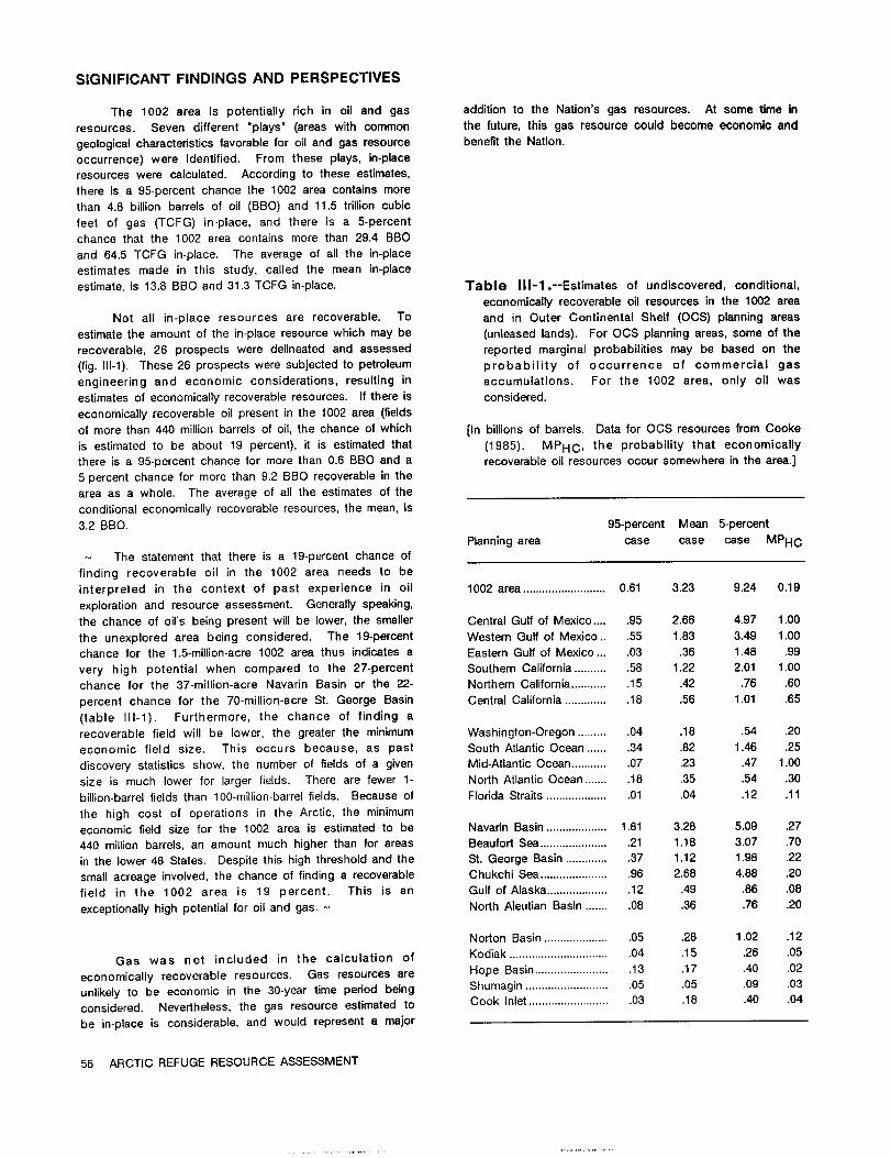
SIGNIFICANT FINDINGS AND PERSPECTIVES
The 1002 area is potentiallyrichin oiland gas additionto the Nation'sgas resources, At some time in
resources. Seven different"plays"(areaswith common the future,thisgas resource could become economic and
geologicalcharacteristicsfavorablefor oiland gas resource benefitthe Nation.
occurrence) were identified.From these plays,in-place
resources were calculated.According to these estimates,
thereis a 95-percentchance the 1002 area containsmore
than 4.8 billionbarrelsof oil(BBO) and 11.5trillioncubic
feet of gas (TCFG) in-place,and there is a 5-percent
chance that the 1002 area containsmore than 29.4 BBO
and 64.5 TCFG in-place.The average of allthe in-place
estimates made in this study, calledthe mean in-place
estimate,is 13.8 BBO and 31.3TCFG in-place. Table III-l.--Estimatesof undiscovered,conditional,economicallyrecoverableoilresources in the 1002 area
Not allin-place resources are recoverable. To and in Outer ContinentalShelf (OCS) planningareas
estimatethe amount of the in-placeresource which may be (unleasedlands). For OCS planningareas,some of the
recoverable,26 prospects were delineatedand assessed reported marginal probabilitiesmay be based on the
(fig.111-1).These 26 prospects were subjectedto petroleum probability of occurrence of commercial gas
engineering and economic considerations,resultingin accumulations. For the 1002 area, only oilwas
estimatesof economicallyrecoverableresources. Ifthere is considered.
economicallyrecoverableoilpresentin the 1002 area (fields
of more than 440 millionbarrelsof oil,the chance of which [In billionsof barrels.Data for OGS resources from Cooke
is estimatedto be about 19 percent),itis estimatedthat (1985). MPHC, the probabilitythat economically
thereisa 95-percentchance formore than 0.6 BBO and a recoverableoilresources occur somewhere inthe area.]
5-percentchance for more than 9.2 BBO recoverableinthe
areaas a whole. The average of allthe estimatesofthe
conditionaleconomicallyrecoverableresources,the mean, is
3.2 BBO. 95-percent Mean 5-percent
Planningarea case case case MPHC- The statementthat there isa 19-percentchance of
findingrecoverable oilin the 1002 area needs to be
interpretedin the context of past experience in oil 1002 area..........................0.61 3.23 9.24 0.19
explorationand resource assessment. Generallyspeaking,
the chance of oil'sbeing presentwillbe lower,the smaller CentralGulfof Mexico .... .95 2.66 4.97 1.00
the unexplored area being considered. The 19-percent Western Gulfof Mexico.. .55 1.83 3.49 1.00
chance for the 1.5-million-acre1002 area thus indicatesa Eastern Gulfof Mexico ... .03 .36 1.48 .99
very high potentialwhen compared to the 27-percent Southern California...........58 1.22 2.01 1.00
chance for the 37-million-acreNavarin Basin or the 22- Northern California............15 .42 .76 .60
percent chance for the 70-million-acreSt. George Basin CentralCalifornia..............18 .56 1.01 .65
(table 111-1). Furthermore,the chance of findinga
recoverablefieldwillbe lower,the greaterthe minimum Washington-Oregon ..........04 .18 .54 .20
economic fieldsize. This occurs because, as past South AtlanticOcean ...... .34 .82 1.46 .25
discoverystatisticsshow, the number of fieldsof a given Mid-AtlanticOcean ............07 .23 .47 1.00
size is much lower for largerfields.There are fewer 1- North AtlanticOcean ....... .18 .35 .54 .30
billion-barrelfieldsthan 100-million-barrellfields.Because of FloridaStraits....................01 .04 .12 .11
the high cost of operationsin the Arctic,the minimum
economic fieldsize for the 1002 area is estimatedto be Navarin Basin ...................1.81 3.28 5.09 .27
440 millionbarrels,an amount much higherthan forareas BeaufortSea ......................21 1.18 3.07 .70
inthe lower48 States. Despitethishigh thresholdand the St.George Basin ..............37 1.12 1.98 .22
small acreage involved,the chance of findinga recoverable Chukchi Sea ......................96 2.68 4.88 .20
fieldin the 1002 area is 19 percent. This is an Gulfof Alaska....................12 .49 .86 .08
exceptionallyhigh potentialforoiland gas. - North AleutianBasin ....... .08 .36 .76 .20
Norton Basin.....................05 .28 1.02 .12
Gas was not included in the calculationof Kodiak ................................04 .15 .26 .05
economically recoverable resources. Gas resources are Hope Basin........................13 .17 .40 .02
unlikelyto be economic in the 30-yeartime period being Shumagin ...........................05 .05 .09 .03
considered. Nevertheless,the gas resource estimatedto Cook Inlet..........................03 .18 .40 .04
be in-placeis considerable,and would representa major
56 ARCTIC REFUGE RESOURCE ASSESSMENT

cooU2
00
n0)a
CDCD
00
--
@13
);K
Co
0C3
-0
0)
77
CD.
21Q
-013)
Y)-
--
(D
00
0cn
Uj-X
:3:3
=r'0
W,
:3C
0)
:r
M@
D(O
a'D
so,
,T'-=
CC)
A)
-0
02
MCD
0=r
MM
C)
0N
0'D
0(A
W0
1<
-0
0ID
-0
-0
CD-
(D.
M0
OCD
MCD
30
0)
C)a
00
::r
0-
=r
:3
cr-0
A)
:T
D0
;-YC,
(D
(A
0=r
=r
Al
-'O
rW.;
(a
w-
(D
<3
0M
-0CD
5'a
aC)
M-
50
0CD
M0
'O
a0
CD
=C
=r
MM
(aET,
u:)0
0io0
M=
Fa
=r-
(D:3
>M
Er0
aC)
00
0SU
'2
(D
G)
F),
-CD(DU@
WM.
C0
(DCDM
2'7'00
M0
Mr-
En0
0CD
tn
M-
3:3(A
U)
FD(a
M'n
IIn
M0
MD-CD
CD
M<
0CD0
Mr@)Q
0:30
00
CD-
<co
(D
0M
CD
D:)-:3
2,.0CD
cn=rAl
CD-'a
a0)M.MMf
oCD
0):5,:r-
COCL
0U)
FD@E
-w
>E;
CDC,
0-
-SD
0CD
SDQ)
aCL
0O'
<X
C,0
:M
MM
(A00
-a-
wW
(AM
mM
EO
CD(D
a:can
0-
3M
30
00
5'
0r,.)D-
0(D
00
0co
15
PD
C-
Ma
(D
=r
5:@
5'C
MCD
SDM
00
0)CD
(D-n
C<)0
wCo
(D
5N
C/)0.
U)
0(D
U)
=r
00
=r
:3
r-
(ACD
00
M0
00
D-0
MA)
3=r
=t
:3
acn
CD
0)
O-
-0.a
0co0
ft,C,
CD
CD-0CD
M0
(D
(D
C-
.0
0)
0::
ECD
-SD
X)-
-0m
MW
0(D
Ca
0a
(D
IDE
0=r=r0
-M
so
01
coa
SD
M0
0CA
00
M0
C>
0CD
=r
vu0
aCD
0M
Cn
00
,M
0=
I-
0co
w3
U)
a=
-(D
'CO-
D'E-
CM
CD
-0
00
C)
CD
rCD
-0
-.00
00
(D
CO)
co
0CD
MM
0CD
(D
-D
to
0M
M=r
M0
0CD
CD(D
CD
=M
,
0-
cn
MC
CD-
M0
0=1
MCD
00)
U)En
(DLI
00
cn0
-0
-8
5)
00
00
0a
0CDU)
0SDM
00
00
0zr
CD
C0
C<
w3
0M
W-
021
ID
5;
--
-3
CD
MM
W<
=r>
(D(n
00
MCD.0
00)
MM
M0
X-0
CD
soaSD
CC"
EKo
41E
M0
M0
00
00
0=r
CT
IM
C0
0M
;w
EM
-@
C0
0=r
CD=
M0
0M
<-
0(O
'aCo
0CA
:30
0CO)
CDto
00
--
-U)
ZCD
=j-(D
CD-
E:CD
,-
0)ID
--
0-
:3=
=.=
=.CD
MCD
00
-M
(7-
-09)
'..2
PC)
0CD
03
a-,
soM
-C)
mM
C:C)
nCo
A)=r
0M
r)O
to
'a
=r
(n
00
M5'
to
:ECD
.En
ET.
0CD
-0
0CD-
-0
0CD
CD
a--ID
SD
-a
-M
-5
'a
M-0
D=8
-CD
=(D
03,
'a-
MC.
=(n
M:3
WC)
CDj3
C:t
02.
CA0.
CD
co
CD-
=r
M0
M:;
D0
a'
(A
MCD
(D
00
0-
0cn
=ft
CD=r
00
-M
0M
(10
--.co
0CD
'n
N3
cn0
CD
MI
cr-
M(-D
M0
<M
aM
ch@
9;
--ob
3'=
-r'
=rM
00
00
Mcr
FD'
C)=
IDID
0E
Mto
0M
=0
<=r
0M
MM
i3sD
mlG
ErM
0=r
2)
03
3c
U)
:E
M-8
!@M
0ZT
-0'a
00)
(D
<0)
iq,w
::E
cr
05'
0CD
Mj;
-P.
MC)
--
'a
9.
F).0
(D
aM
0r)-
=r
-M.
<CD
0;W
0)
CA
=r0
CD0
Cq,Co
00
5.CZ=
=3
-IDa
-0
-FD'
(D=r
ErEr
0(D
ro8
zrcb
C)0)
00
00
0-
U)M
r-0
(Da
QM
00
MSD
MM
05f
fiM
co0
LO0
CDOD
0-
MW
M0.
0
D)0
mM
MCD
%DM
0U
4Ln
00
M@t
@;E
MCo
aCD
chi;
chI
0M
0.
W@
MCD
30
00
0=r
ID
'0
2cr
M.
-C
@5,
M9)
0<
M0
F0
M0
(OD
00
(D
OD
0CD
so
0)
CD
-Er
C1
0CT
nCD
=rM
2.
0.
ID
5D
_0
a
0cr
0)
M.
.S:5
&51I
Ma
=ro
:3(D
00
(ncr
i@3'
0w-
M5:
0ID
r0.
(D
--
CMA
OM
(T)
Ma
M<
U)
UV
M5'1<
to
M=r
MM
00
MM
0.
RECOVERABLEOIL,INBILLIONSOFBARRELS
-a
cocr
EK0
0(D
M0
(D0
-n(D
=C
sD0
3'0
CD
M-
=
-
(D
00
V)
(D
>0
CO
0M
00
0
z0
iD
(D
<(D
002
M Co(a
0co
M-0
o(D
aCD
Ww
M0
Ccr0
00
..............
>0
...........
0-0
CD
7M
00
0En
ic
W0
@D
CD
...................
00
............
............
.......
..................
........
0=r
0..........
............
'D3
(OW
CD(D
CM
CD
0........
CD
(D
zCD(a
CD
CD
......
aCD
CD
,;.z-
a.......
00.
aM
0=
=r
(D.;4:
....................
0FT0
030
co
.............
a-:E
0)0
:E.................
..........
.........
.....................
...
CD
--4
.........................
.................
-.1...
11...............
............
....
...
......................
I.........
12.
ID@r
D<
=0
0......
.................................
0..........
..I..................
....
..0
3.........
777q
(D5j,0
...........................
0=r
0................................
...............
......
........
co0
3(D
......
0(D
aSD
OM
CDo
MCD
Z;,D
>MCD
-CD-0
aa-
0a
-05'
'0=
C-)
(cDL3
0C
-O
'<Z
00
00
00
03
-'
co
0M
(M0
u@
3'D
PrudhoeBay,
Alaska
0,:-
E.O-
co0
aM
CD3
0(D
Er
00
East
Texa
sC)
CD
rw
0 <M
00
upar
uk,Al
aska
O0
CD0
0 <m
20
we-
CD
Hills,
California
MM
0a
<R
0
:3
03
MC
C)
CD
0,
O'
cn
0@
A8
=P)
IDID8)
CO)
M=
M0.M

The separate methods used meet specific Sedimentary Rocksrequirementsofthe1002 areastudy.First,assessmentofthe naturalendowment of hydrocarbonresourcesismet by The area in and adjacentto the 1002 area is
asssessingwhat isin-place,employinga broad-basedview underlainby sedimentaryrocks severaltens of thousands
without economic constraints.Second, a site-specific of feetthick. These rocks range inage from Precambrian
evaluationof what may be a recoverableresourceat a (greaterthan 570 millionyearsold)to Quaternary(Bader
given prospect is made, taking into consideration and Bird,1986). In northernAlaska,rocksprospectivefor
economics, technology,and transportationunder various petroleum(oiland gas)are mostlyMississippianto Tertiary
assumptions. This recoverableestimateis then used to in age and overliefoldedand truncatedpre-Mississippian
develop scenarios,impact assessment and nationalneed rocks. These rocks are dividedintotwo sequences: the
determinations.- Ellesmeriansequence of Mississippianto EarlyCretaceousage, and the Brookiansequence of EarlyCretaceousand
Assessment of in-placeresources used a "play younger age. Depositionof the Ellesmeriansequence
analysis"method whereby prospects(potentialpetroleum occurredwhen the land area was to the northand the
accumulations)are grouped accordingto theirgeologic seaway was to the south. During depositionof the
characteristicsinto"plays"or naturalassociationshaving Brookiansequence, the geography was reversed--theland
common characteristics.Inthe assessment of recoverable areawas to the south (theancestralBrooks Range) and
resources,a site-specificanalysisof largerindividual the seaway was to the north,much as itistoday. The
prospectswas used in orderto model the elementswhich differentiationof these two sequences is importantin
determine recoverabilityand determine exploration, understandingdepositionalhistory,and inprojectingtrends
development,production,and transportationatthatlevel. of reservoirrocks. Furthermore,reservoirpropertiesof theEllesmeriansandstones are generallybetterthan those of
- Estimatingeitheroilor gas in-placeor the extentto the Brookiansequence.
which itisrecoverableinan undrilledfrontierarea isdifficultbecause of the uncertaintiesinherentinthe process. The Figure 111-4is a generalizedstratigraphiccolumn of
existenceof potentialhydrocarbonformationsor prospects the rocks inthe area,showing oil-bearingformationswest
is not known with certaintypriorto exploratorydrilling. of the 1002 area, potentialsource rocks,and significant
Informationconcerningthe existenceof potentialproducing geologicevents. The followingdiscussionsummarizes
fieldsis derivedfrom inferences,extrapolationsand pertinentinformationon the sedimentaryrocks relatingto
subjectivejudgments. Geophysicaldata providecluesas the oiland gas assessment and reviewstheirdepositional
to the existenceand locationof possibletrapsand their history.
generaldimensions,but geologicdata on the qualityofpotentialreservoirrocks are usuallyabsent or limited.No PRE-MISSISSIPPIAN ROCKS (BASEMENT COMPLEX)dataare availableon the natureand distributionof includedhydrocarbonsor whether hydrocarbonsare presentat all. Pre-Mississippianrocks inthe mountainsadjacenttoAn exact predictionof resourcequantitiesunder such the 1002 areaconsistofmore than 20,000feetofa variety
conditionsof uncertaintyis impossiblebecause the ofrock types such as phyllite,argillite,quartzite,chert,and
uncertaintiesin the inputdata translateto uncertaintiesin volcanic and carbonate rocks, and are mostly of Pre-
theanswers.- cambrian age. Because most of these rocks are weakly
metamorphosed and are not prospectiveforpetroleum,theyare considered to be economic basement and are notdiscussedfurther.However, the carbonaterocks--limestoneand dolomite-mightcontainporous zones thatcouldserveas reservoirsforoilor gas thatmay have been generated
PETROLEUM GEOLOGYin overlyingyounger rocks. These conditionsapparentlyexistinthe Exxon AlaskaStateF-1 and Sohio AlaskaIsland
The 1002 area of the ArcticRefuge liesalong the1 wellson the barrierislandsnorthof PointThomson (fig.
foothillsand coastalplainnorthof the Brooks Range (fig,111-3),where oiland gas have been recovered from
111-3).Much of thisarea iscovered by soilor vegetation,carbonaterocks in the basement. Similarsituationsmay
and the few outcropsthatare presentare mostlyof theoccur in the 1002 area,and these rocks are importantto
youngerpartofthe stratigraphicsequence. Our knowledgethe petroleumassessment.
of the geologyof the area isbased on thesefew outcrops,extrapolatingknown geology of adjacentareas, and Atleast6,500feetofcarbonaterocks,ranginginage
integratingthiswith the geophysicaldata (mainlyseismic from Precambrian(?)to Devonian and known as the
surveys)acquiredwithinthe 1002 area. This section KatakturukDolomiteand Nanook Limestone,crops out in
reviewsthe overallgeology,emphasizingthose aspects that the Sadlerochitand Shublik Mountains. Unnamed
relateto petroleumgeology. More detailedand technical carbonaterocks as much as 200 feetthickhave been
discussionsof the geology,geophysics,and assessment penetratedina few wellsinthe PointThomson area.Their
methods are containedin GS Bulletin1778 (Birdand distributioninthe subsurfaceof the 1002 area isunknown,
Magoon, 1987). because they had been foldedand eroded priorto
58 ARCTIC REFUGE RESOURCE ASSESSMENT

147' 146' 1450 1440 1431
AlaskaAlaskaIslandIW.W
point Z.F1
laskaStateF-1 B E A V F 0 R T S E AThomson
BrownlowPoint
Plat X kt VikWest Staines2 U
rea of f u nd ot KIC-1
CAMDEN BAYa n s,
701 -
T s KssPlate4
S
0 2 A R E AK
JMARSHCREEK
ANTICLINESs s
1.0 abbaths Creek
KavikgaTK
S 1--h sectionfield Ksc; K sp,m
"s mouprains \11K
TKsc: TKss
691
K
K ctio30' Z S b S rcticCreek
K areaK
1,@l1,, Thid Ra@ge5MP,
K\HAITI-,/
L.k,=P
B R 0 0 K S'300cy's
R A N( IS E'%laceo @ q0
Fa,klnMo.ntains
0 10 20 30 MILES
0 10 20 30 40 50 KILOMETERS
EXPLANATION
Tertiarysedimentary rocks
Figure 111-3.--map of the 1002 area and adjacent Paleocene and uppermost Cretaceous sedimentary rocks
mountains showing locations of Cretaceous and Shallow marine and nonmarine sedimentary rocks and conglomerateTertiary outcrops and lines of sections of figure 111-8
and plate 4. (Prepared by the U.S. Geological Survey.) Deep-water marine sandstone and shale
Cretaceous sedimentary rocks
0 Drillhole
OIL AND GAS POTENTIAL--GEOLOGY 59
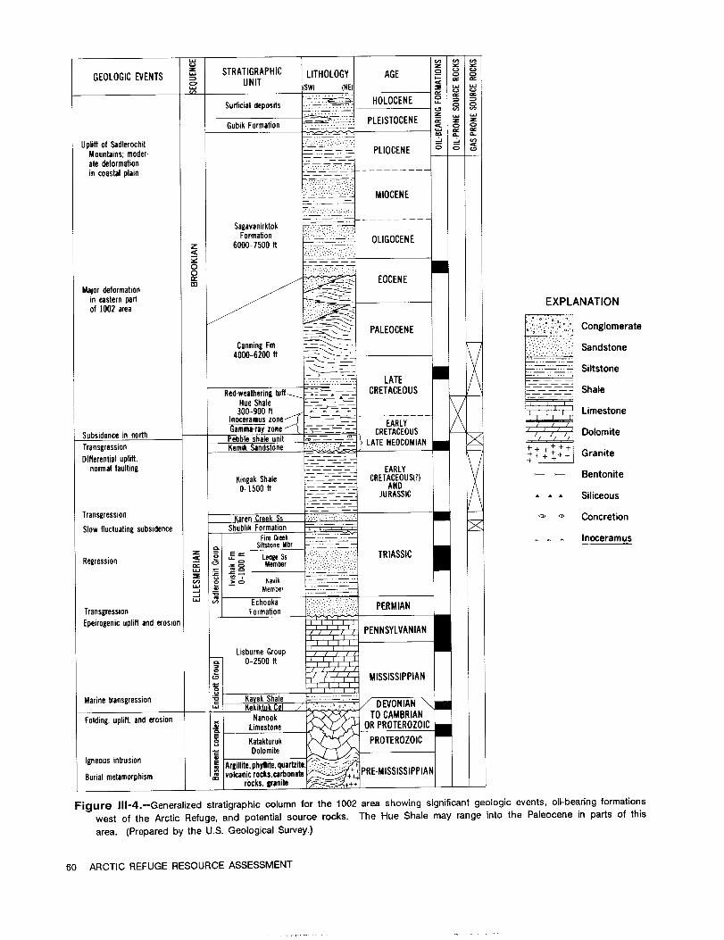
UJQ@
CD C.@STRATIGRAPHIC LITHOLOGY AGE CD CDGEOLOGIC EVENTSUNIT (Sw@ (NE)
HOLOCENESurficialdeposits
..............
PLEISTOCENEGubik Formation CD
Upliftof SadlerochitMountains;moder- PLIOCENE CD
0
7_ 7--=-ate deformationin coastalplain
MIOCENE
- - - - - - - - - - -
SagavanirktokFormation
Z 6000-7500 ItOLIGOCENE
<
0EOCENECD
Majordeformationineasternpart EXPLANATIONof 1002 area
PALEOCENE Conglomerate
Canning I'm Sandstone4000-6200 It
Siltstone. ......... LATE
Red-weatheringtuff CRETACEOUS Shale
Hue Shale300-900 It Limestone
Inoceramuszone-Ga-mma-rayzone
EARLY
Subsidenceinnorth CRETACEOUS x DolomitePebbleshaleunit x
Transgression Kemik SandstoneLATE NEOCOMIAN + +
GraniteDifferentialuplift, 14 + + +
normalfaulting EARLYBentonite
KingalkShale CRETACEOUS(?)0-1500it AND
JURASSIC Siliceous
Transgression Ka Concretion
Slow fluctuatingsubsidence ShublikFormationFireCreek Inoceramus
SiftstoneMbr_E RIASSIC
Regression< LedgeSs T
Member
Kavik
Member
Ec`hooka@ PERMIANTransgression Formationtion
Epeirogenicupliftand erosionPENNSYLVANIAN
LisburneGroup0-2500 It
C.0 MISSISSIPPIAN
Marinetransgression ak Shale_. ":'--: EVK kiktukCM
TO CAMBRIANFolding,uplift.and erosion Nanook
OR PROTEROZOneLimeslo.E
Katakturuk PROTERDolomite
igneousintrusion 0E Argillite,phyllite,quartz
Burialmetamorphism volcanicrocks.carbrocks.granite
Figure 111-4.--Generalizedstratigraphiccolumn for the 1002 area showing significantgeologic events, oil-bearingformations
west of the ArcticRefuge, and potentialsource rocks. The Hue Shale may range into the Paleocene in partsof this
area. (Prepared by the U.S. Geological Survey.)
60 ARCTIC REFUGE RESOURCE ASSESSMENT

depositionof Mississippianand younger strata.Seismic In and adjacent to the 1002 area,the Ellesmerianreflectionsbeneath these younger strataare not adequate sequence ranges in thicknessfrom a few hundred feettoformapping these oldercarbonaterockswithoutcloserwell about 5,000 feet. This wide range is due to a regionalcontrol. Hence, theirpresenceas possiblereservoirsfor unconformityin the upper partof the sequence in whichpetroleumisriskedaccordinglyinthe assessment. progressivelymore of the sequence had been removed by
erosion in a north or northeastward directionpriortodeposition of the uppermost part of the Ellesmerian
ELLESMERIAN SEQUENCE sequence (fig.111-5;pi.4). This unconformityis of great
importanceto the petroleumpotentialof the 1002 areaRocks of the Ellesmeriansequence recordmarine because itcontrolsthe northern distributionof most
and nonmarine depositionalong a slowly subsiding Ellesmerianrocks. In addition,the porosityof reservoirscontinentalmargin inwhich the landarea was to the north directlyunderlyingthe truncatedsurfacemay be enhancedand the seaway to the south. These rocks consist owing to solutionof calcitecement,and the shaleoverlyingdominantlyof limestone,shale,and sandstonethatrange in the unconformitymay providea seal and sourcerock forage from Mississippianto earliestCretaceous(fig.111-4),a truncatedreservoirs.Well controlwest of the 1002 areatimespan of about210 millionyears. Allthe oilproduction and seismicdata indicatethatmost of the Ellesmerianinthe Prudhoe Bay-KuparukRiverfieldareas isfrom rocks sequence is missingin the northwesternquadrantof theof the Ellesmeriansequence. By farthe greatest 1002 area (fig.111-6),but seismicdata suggest thataproductionis from the Ledge SandstoneMember of the significantpartof the sequence may be presentin theIvishakFormation,but almostallthe sandstoneunitsof the easternpartof the area (pi.5). The presenceor absenceEllesmeriansequence and some of the carbonatesof the of these rocks in thatarea greatlyaffectsthe petroleumLisburneGroup arepotentiallyproductiveinsome fields(fig. potentialbecause verylargestructuresoccur inthe eastern111-4). and southeasternpartsofthe 1002 area.
SOUTH NORTHSHUBLIKMOUNTAINS SADLEROCHITMOUNTAINS 1002AREA
Pebbleshaleunit emikSandstoneLCU
.CC., Sall Hill
-00-:.;Fso@@ serosion,P I rocks are probabl@no h of the northwestpa 1002 area
10
s o in o d roter-to Devonian carbonate rocks
ruk Dolomite and Nanook METERS FEET8)
2000600-
EXPLANATION 400 -
Shale Siltstone 1090
200 -i7; Limestone Sandstone
Dolomite 0, Conglomerate 0-- 0
-Approximately30miles
Figure 111-5.-DiagrammaticsectionshowingstratigraphicrelationsoftheEllesmeriansequence alongthe mountainfrontsouth of the 1002 area. (Preparedby the U.S.GeologicalSurvey.)
OIL AND GAS POTENTIAL--GEOLOGY 61

X@ilM
M0
0to
0-
C0
0)IX
0E
wA
Ca)
0a)
Zto
-C
0)C
0O
>U)
=W
3:r-
--co
ui4)
U)0
L6CD
0a)
-0a)
coCL
>O
O0
(DO
Oa
LE
c-
=to
coco
coE
O-C
O-0,
cmO
LuA
-Oco
C)-0
3:'a
co-y
-60.
Z0
at0
coa)
-00
-0O
coV)
0E
Q)0
OC
00
CD0
coco
co(D
co0
a.9
3:16
cFco
CMCD
U)-
CE
E2
CIq
Ow
20
3:8
:E
0a)--r-
a)0
CL0
ME
COCo
:6-
0>
C-a
=.2
>,4)
U)'a
CLto
CD0
0.0
-0M
-0M
CD0
00
co'O
0LL
'O0
aC
Ov
0.(D
Mto
16:E:
CLw
co-Z.
0C0
Wa
coa)
inCL
co0
EE
toE
Er-
4)-0
100
'a4)
-r
0C)
toLiz-
'aC
0CO
coE
E0
4mw
'a
fn
00
00
0a)0
..-
a)M
ico
04)
O-r-
0.
5O
-iZ
Eco
(U0
E0
oE
>0
wco
L)3:
-0
7:)4)
00
U)0
00
UU
coa
91'a
3:co$
50
-0.
COO
Op
IDo
E00.-
-.le
N.
r-
a)
L)4)U)
4)
OCO0
-cc
a-
E-0
L)=
0-.;--
a)
co
-O
4)
to
to
(v
C0
aLU
0w
co
>(D
CU
EE
'a
0i:->
CL
CD
E0
>r
q)
0S
F-
co
co-0
U-
-0
C4
cmLU4)D
1616
co0
@o
U)t:
IC
.2ci
0
coC
0co
0J--
0'id
a.
O
0
0)
U).0
C/)
39.0
4)co
-a)
0U)
O
10-
0CL
C%l
4)
00
CE
CL
-0
co
0U)d,
2C
0_ry-
E
cis0
CDCO
(D-0
-co
a0
E0
CL
(D
to0
cd
CD
>
M0
CCD
0M
0a)
CO
-r-cO
0E
E0
uj
00
00)
M
Eo
00
cis
U)
a)
mO
a-CD
0LU
co
a)
d)
Ow
'a-2
M
CAr
U)U)
CL-Y
co-0
O
a
0<
CLIm
rE
EOZ!
coC
LU
0A
-6.0
cd0 E
E
(Dto
'a
.)91@-
OC
w-
E0
@e
0:3-
-5
Eco
cc
00
0)
E
Z:3
Z)
E0
M0
o.2
cuco
0)
CO(D
C
CLa)
00
U)
3:-0
a)
0
co
-0
75E
CDLLI
:30
co0)
0E
cnM
'CZ
cr
co
3:,
Co'a
00
LU
0M(co:03
3:>
W>
Ma
coM
0
(D
ME
-OM
U)E
co
ICD
C-0,
.O
-0
2@r
co<
(Uv
0>
r-0
3:LL
C)
0w
Z3:
toA
ZCL
wr
'O
w2)
P--S
E
CLto
00
>,0
C)M
cow
Z3:
Ecd
C)C)
cu
0
F-
4)
0.4-M
E0
0
C)
E
0)
EL
CD
LL
15
LU
0u)
ctsE
0U)
<to
CO
a)
El
LLJ
CL
.0
<O
.00
0wcn
CM(D

Member (formed from the upper offshoremuds). The Potentialreservoirsin the Brookian sequence would
Ledge Member is 200 to more than 400 feetthick(fig111-7pj be primarilylenticularturbidite(deep-water)sandstone beds
and is the main producing reservoirat the Prudhoe Bay in the lower partof the Canning Formation. These beds
field.The Ivishakand Echooka Formations togethermake are generallythin,but locallythickerbeds are present.
up the SadlerochitGroup. They are potentiallyproductiveof oiland gas in several
wells in the Point Thomson area west of the northwest
Continued subsidence of the basin followed corner of the 1002 area (pi.4). Sandstones and
Sadlerochitdeposition,and offshoremuds and chemical conglomerates of the SagavanirktokFormation also would
sedimentationpredominated ina sea rich in organisms in be good reservoirsforpetroleum. However, because of the
Middle and Late Triassictime. This formed the black dominance of sandstone in the section,effectivepetroleum
shales, siftstones,and dark phosphatic fossiliferous sealsfortrapsmay be limited.Rich oil-pronesource rocks
limestonesof the ShublikFormation,which is 150 to 500 occur inthe lower halfofthe Hue Shale. These rocks are
feet thick adjacent to the 1002 area. The Shublik is consideredto be the main potentialsource for oilin the
consideredto be an importantsource rock forPrudhoe Bay 1002 area.
oil.A minor regressionor increaseinclasticinputfrom the
northern source resultedin depositionof widespread sift DEPOSITIONAL HISTORY
and finesand on a broad shelf,which formed the 10- to
125-foot-thickKaren Creek Sandstone. Mountain buildingof the ancestralBrooks Range mayhave startedin Jurassictime,and the mountain beltwas a
The basin subsided during Jurassicand earliest dominant source of sediment during earliestCretaceous
Cretaceous time and thickdepositsof mud accumulated on time. But,as the formerland area to the northsubsided,
the shelf,basin slope,and basin bottom. These muds initialdepositionfrom the risingmountain beltto the south
make up the Kingak Shale,which, aftersubsequent erosion, and southwest was very slow in the 1002 area because a
is0-1,200feetthickadjacentto the 1002 area. Partsof the deep trough (theColvilletrough of the centralNorth Slope,
Kingak are thought to containenough organicmatterto be fig.1-1)that developed immediatelynorth of the mountain
a source rock forsome of the Prudhoe Bay oiland gas. belt(which then was much farthersouth than the presentmountain front)had to be filledfirst.Consequently,initial
Upliftof northernmost Alaska and the offshorearea Brooklan depositionin the 1002 area consistedof clayand
to the north in EarlyCretaceous time resultedin removal by volcanicash that settledout of suspension,probablyin
erosion of progressivelymore of the Ellesmeriansectionto deep water, These depositsformed the Hue Shale,which
the north. This was followedby subsidence of the area is500 to 1,000feetthick. Because of poor circulationand
and northward inundationby the seaway again. Lenticular low oxygen contentof the bottom water duringdeposition
sands were deposited along the advancing shorelineand of the lower halfof the Hue Shale,pelagicorganisms that
offshore shelf,and mud was deposited fartheroffshore. also settledwith the clay were preserved inthe sediments
These depositsformed the Kemik Sandstone, as much as to eventuallyform an organic-richshale,a good oilsource
too feetthick,the Thomson sand, as much as 345 feet rock.
thick(fig.111-7g,and the pebble shale unit,200-300 feet
thick. Deposition of the Ellesmeriansequence ended as Depositionbecame more rapidas delta4rontdeposits
the northernland area subsided and was never again a prograded intothe area from the southwest. Initially,deep-
sediment source. water mud and sand that slumped or flowed down the
basin slope as turbiditycurrentsfrom the frontof shallow-
water deltasto the southwest were depositedat the base
of the slope. Concurrently,thickdeposits of mud were
accumulatingon the northeastward-progradingbasin slope.
BROOKIAN SEQUENCEThese deposits formed the Canning Formation,vvh6 is
4,000-6,000feetthickinwellsadjacentto the 1002 area (fig.
The Brookian sequence consists of thick 111-8;pi. 4). In much of the 1002 area, however,
northeasterlyprograding basinal,basin-slope,and marine compressional forces folded and faultedthe strataduring
and nonmarine shelf deposits derivedfrom the ancestral latePaleocene and earlyEocene time,resultingin upliftand
Brooks Range to the south and southwest. These erosion of some earlierdeposited Brookian sediments and
deposits consist dominantly of shale, sandstone, more depositionin adjacent low areas. Deformation and
conglomerate,and bentonite (consolidatedvolcanicash) associated deposition continued during middle and late
that range in age from lateEarlyCretaceous to Quaternary Tertiarytime in the eastern part of the 1002 area but the
(fig.111-4),a time span of about 120 millionyears. Inwells depositionalpatterns are poorly understood. In the
immediatelywest of the 1002 area,the sequence is as southeasternpart of the 1002 area (fig.111-3),a 10,000-toot-
much as 13,000 feetthick(fig.111-8;pi.4),but seismicdata thick section of nonmarine sandstone, conglomerate,and
indicatethat Brookian rocks may be as thickas 26,000 feet shale containingthin beds of coal,which is latest
in the centralpart of the 1002 area. However, this Cretaceous to Paleocene in age and is known as the Jago
thickeningcould be due in partto duplicationcaused by River Formation,probably was displaced northward by
thrustfaulting. thrustfaulting.
OIL AND GAS POTENTIAL--GEOLOGY 63

1481 147' 146' 145' 144' 1430 142o
0
0 0A-.
F 0 R T S E AB f A
A@A
AM DE! A70'-
A
0n9 ARE
Northernextentof Prooks Range, Itinginvolvingthe @isburneGroui
69130'
517Akk 0or
4",
A
69+ ti
0
-b@T
B E A U F
0 0 00
70- -
N ern extei inI g in 2 R E
Wembeu,..mation f
6911"--aid...
30' ..........
Z
R A N G
691,
64 ARCTIC REFUGE RESOURCE ASSESSMENT

148' 147' J4EP 145' 1440 1431 142't I
Thmm and of@151"4
701
R E A10 2
Kemi ndstone fl,
00 A_4
69, h30, 7 X
EXPL
?OD- Thicknessof Kemik Sandstoneor Thomson sand of localusage infeet-Dashed where approximatelylocated
WellpenetratesintervalofKemik Sandstoneor Thomson sand of localusage
Outcropsectionof Kemik Sandstone
B R 0 0 K S R A N G E69, I I I -1
EXPLANATION
A BZone of truncationof LisburneGroupby Lower Cretaceousuncon- Zone of truncationof Ledge SandstoneMember of lvishakFormation
formity by Lower Cretaceousunconformily
Outcropof LisburneGroup Outcrop ofLedge SandstoneMember
Unconformity-Queriedwhere uncertain -?- Unconformity-Queriedwhere uncertain
Thrustfauft-Sawteethon upperplate Thrustfauh-Sawtefton upperplate
Normalfault-Hachuresindicatedownthrown side Normalfault-Hachuresindicateclownthrownside
_2000- Thicknessof LisburneGroup in feet 300- ThicknessofLedge SandstoneMember infeet-Dashed where approx-imatelylocated
Wells Wells
LisburneGroup present 0 Ledge Sandstone Member present
LisburneGroup absent 0 Ledge Sandstone Member absent
Figure 111-7.-Maps (facingand above) summarizing regionaland local geologic trends of the Lisburne Group UA,
Ledge Sandstone Member of the IvishakFormation UB ,and KernikSandstone and Thomson sand UQ . (Prepared by
the U.S. Geological Survey.)
OIL AND GAS POTENTIAL-GEOLOGY 65

WEST EAST
i 25 miles
WEST STAINESSTATE-2 1002 AREA
FEET0
ENE(?)Gamma ray
PLIOCENEAND
MIOCENE
MIOCENEAND
OLIGOCENE
5000 -
EOCENE
shalefaciesale)
Canning Formation 1\
Progradingbasinslopeo,-> \1
PALEOCENE &0000--
Turbiditesandstonefaciesshaleand interbeddedsandstone)
UPPERCRETACEOUS
VerticalexaligerationXIO
Figure III-B.-Diagrammatic section showing stratigraphicrelationsof the Brookian sequence between the Mobil West
Staines State 2 well and the northwest comer of the 1002 area. Dashed linesrepresent time linesas inferredfrom
seismic reflections.Depths on well logs are in feet. Ages based on micropaleontologicdata. See figure111-3for
locationof section. (Prepared by the U.S. Geological Survey.)
66 ARCTIC REFUGE RESOURCE ASSESSMENT
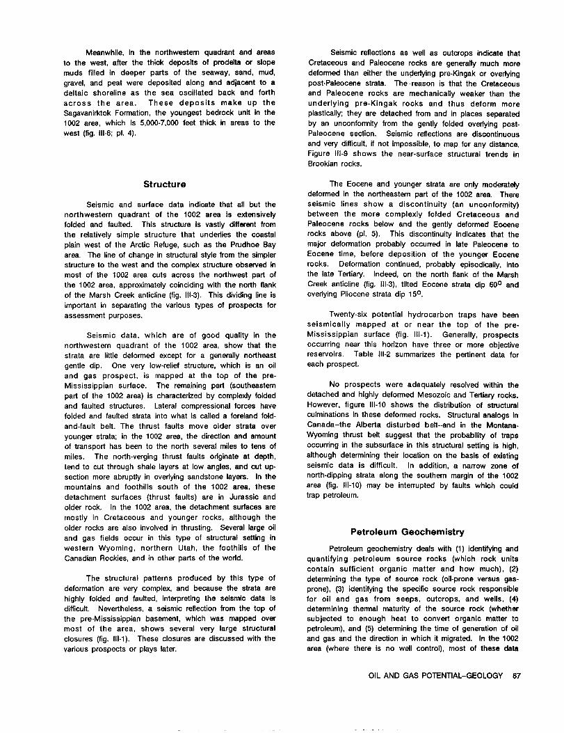
Meanwhile,in the northwesternquadrantand areas Seismicreflectionsas wellas outcropsindicatethatto the west,afterthe thickdepositsof prodeltaor slope Cretaceousand Paleocenerocks are generallymuch moremuds filledin deeper partsof the seaway, sand, mud, deformed than eitherthe underlyingpre-Kingakor overlyinggravel,and peat were depositedalong and adjacentto a post-Paleocenestrata.The-reason isthatthe Cretaceousdeltaicshorelineas the sea oscillatedback and forth and Paleocene rocks are mechanicallyweaker than theacross the area. These deposits make up the underlying pre-Kingak rocks and thus deform moreSagavanirktokFormation,the youngest bedrock unitin the plastically;they are detached from and inplacesseparated1002 area,which is5,000-7,000feetthickin areas to the by an unconformityfrom the gentlyfoldedoverlyingpost-west (fig.111-8;pi.4). Paleocene section. Seismicreflectionsare discontinuous
and verydifficult,ifnot impossible,to map forany distance.Figure111-9shows the near-surfacestructuraltrends inBrookianrocks.
Structure The Eocene and younger strataare only moderatelydeformedin the northeasternpartof the 1002 area. There
Seismicand surfacedata indicatethatallbut the seismiclinesshow a discontinuity(an unconformity)northwesternquadrant of the 1002 area is extensively between the more complexly folded Cretaceous andfoldedand faulted.This structureis vastlydifferentfrom Paleocene rocks below and the gentlydeformed Eocenethe relativelysimple structurethat underliesthe coastal rocks above (pi.5). This discontinuityindicatesthattheplainwest of the ArcticRefuge,such as the Prudhoe Bay major deformationprobablyoccurredin latePaleoceneto
area. The lineof change in structuralstylefrom the simpler Eocene time,before depositionof the younger Eocenestructureto the west and the complex structureobservedin rocks. Deformationcontinued,probablyepisodically,intomost of the 1002 area cutsacross the northwestpartof the lateTertiary.Indeed,on the northflankof the Marshthe 1002 area,approximatelycoincidingwiththe north flank Creek anticline(fig.111-3),tiltedEocene stratadip600 and
ofthe Marsh Creek anticline(fig.111-3).This dividinglineis overlyingPliocenestratadip 150.
importantin separatingthe varioustypes of prospectsforassessment purposes. Twenty-sixpotentialhydrocarbon traps have been
seismicallymapped at or near the top of the pre-
Seismic data,which are of good qualityin the Mississippiansurface (fig.111-1).Generally,prospectsnorthwesternquadrant of the 1002 area,show thatthe occurringnear thishorizonhave threeor more objectivestrataare littledeformed exceptfor a generallynortheast reservoirs. Table 111-2summarizes the pertinentdata for
gentledip. One very low-reliefstructure,which is an oil each prospect.
and gas prospect,is mapped at the top of the pre-Mississippiansurface. The remainingpart (southeastern No prospects were adequatelyresolvedwithinthe
partof the 1002 area)ischaracterizedby complexlyfolded detached and highlydeformed Mesozoic and Tertiaryrocks.
and faultedstructures.Lateralcompressionalforces have However, figure111-10shows the distributionof structuralfoldedand faultedstrataintowhat iscalleda forelandfold- culminationsinthese deformed rocks. Structuralanalogsin
and-faultbelt.The thrustfaultsmove olderstrataover Canada-the Albertadisturbedbelt--andin the Montana-
younger strata;in the 1002 area,the directionand amount Wyoming thrustbeltsuggestthatthe probabilityof traps
oftransporthas been to the northseveralmilesto tens of occurringinthe subsurfaceinthisstructuralsettingishigh,
miles. The north-vergingthrustfaultsoriginateat depth, althoughdeterminingtheirlocationon the basisof existing
tend to cutthroughshalelayersat low angles,and cut up- seismicdata is difficult.In addition,a narrow zone of
sectionmore abruptlyin overlyingsandstonelayers.In the north-dippingstrataalongthe southernmarginof the 1002
mountainsand foothillssouth of the 1002 area,these area (fig.111-10)may be interruptedby faultswhich could
detachment surfaces(thrustfaults)are in Jurassicand trappetroleum.
olderrock. In the 1002 area,the detachmentsurfacesaremostly in Cretaceous and younger rocks,althoughtheolderrocksare also involvedinthrusting.Severallargeoil
Petroleum Geochemistryand gas fieldsoccur in thistype of structuralsettinginwestern Wyoming, northern Utah, the foothillsof the Petroleumgeochemistrydealswith (1)identifyingandCanadian Rockies,and inotherpartsofthe world. quantifyingpetroleum source rocks (which rock units
containsufficientorganicmatterand how much), (2)The structuralpatternsproduced by thistype of determiningthe type of source rock (oil-proneversus gas-
deformationare very complex,and because the strataare prone),(3)identifyingthe specificsource rockresponsiblehighlyfoldedand faulted,interpretingthe seismicdata is for oiland gas from seeps, outcrops,and wells,(4)difficult.Nevertheless,a seismicreflectionfrom the top of determiningthen-nalmaturityof the source rock (whetherthe pre-Mississippianbasement, which was mapped over subjectedto enough heat to convertorganicmattertomost of the area, shows severalvery largestructural petroleum),and (5)determiningthe timeof generationof oilclosures(fig.111-1).These closuresare discussedwiththe and gas and the directioninwhich R migrated.Inthe 1002variousprospectsor playslater. area (wherethereis no wellcontrol),most of thesedata
OIL AND GAS POTENTIAL-GEOLOGY 67
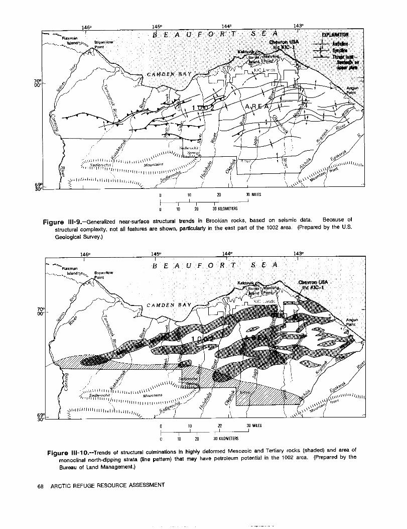
1460 1450 144' 143'
'IFlaxrnao
Islandle-1 BrownlowPoint
6.441>ihiHAYKI
10F
Q@
00,able Mountains
69030'
20 30 MILES
10 20 30 KILOMETERS
Figure 111-9.-Generalized near-surface structural trends in Brookian rocks, based on seismic data. Because of
structuralcomplexity,not allfeaturesare shown, particularlyinthe eastpartofthe 1002 area. (Preparedby the U.S.
GeologicalSurvey.)
1460 1450 1440 1430I I I
Haman B E A U F 0 R T S E AIsland't,@ Brownlow
int
CAMDEN BAYI Lan
70000,
illinWSadlemch mountains
111111flIflf11
\\\\ifo
690-3
0 10 20 30 MILESI
0 10 20 30 KILOMETERS
Figure 111-10.-Trends of structural culminations in highly deformed Mesozoic and Tertiary rocks (shaded) and area ofmonoclinal north-dipping strata (line pattern) that may have petroleum potential in the 1002 area. (Prepared by the
Bureau ofLand Management.)
68 ARCTIC REFUGE RESOURCE ASSESSMENT

Table 111-2.--Dataon seismicallymapped petroleumprospectsinthe1002 areashown infigure111-1.
[Depthsarebelow mean sea level.Potentialobjectives:1,pre-Mississippiancarbonaterocks;2a,Ellesmerianclasticrocks;2b,Ellesmeriancarbonaterocks;3,Thomson/Kemik sandstones;4,turbidites;5, lowerNeogene(?)topsets.Data from Bureau of Land Management, 1986.]
Prospect Area Size Crestal Lowest Potential Number(acres) (miles) depth closing objectives of
(feet) contour seismic(feet) 1 2a 2b 3 4 5 lines
1 48,5121 18 X 6 14,000 15,000 X X X X X 52 11,793 8 X 3 14,820 15,000 X X X X 23 13,120 12 X 3 13,000 14,200 X X X X X 34 12,922 8 X 3.5 14,900 15,500 X X X 45 34,234 16 X 4 12,700 15,000 X X X X 6
6 11,940 10 X 3 11,500 13,800 X X X 37 18,970 16 X 2 8,500 10,500 X X X X X 68 4,880 4 X 2 16,300 17,000 X X X - 29 2,200 4 X 1 12,500 13,200 X X X - 110 6,291 11 X 1 11,900 12,500 X X X 3
11 9,4301 8 X 3 5,200 6,000 X X X X 212 3,950 6 X 1 19,000 21,000 X X X 213 1,344 4 X 0.8 10,900 11,500 X X X X 114 4,9151 5 X 2 5,640 6,000 X X X X 115 42,5001 13 X 10 22,500 23,000 X X X 6
16 6,720 6.3X 2.4 1,230 2,300 X X 317 3,170 3 X 2 21,600 22,000 X X X 118 226,8221 27 X 15 13,500 >24,000 X X X 1619 129,587 22 X 13 9,790 17,000 X X X X X 1020 79,738 30 X 7 11,900 17,500 X X X 10
21 65,3001 21 X 4 7,500 14,500 X X X 722 4,5601 5 X 2 11,600 12,000 X X X 123 3,706 5 X 1.5 16,300 16,500 X X X 124 11,8721 8 X 3 10,400 12,000 X X X 425 2,3601 4 X 1 11,950 12,000 X X X 1
26 4,954 5 X 3 16,500 17,000 X X X X X 2
lProspectareaincludesextensionsor projectionsoutsidethe 1002 area as shown infigure111-1.
OIL AND GAS POTENTIAL--GEOLOGY 69

come from surfacesamples and seismicshot-holesamplesor the data must be projectedfrom wellsor outcropsin STRATIGRAPHIC LITHOLOGY AGE PLAYS
UNITadjacent areas. Because of the differentand complex (SW) ME)
structuralhistoryof most of the 1002 area compared with Surficilldeposits HOLOCENE
thatofadjacentareas to thewest,some of the projections..........
PLEISTOCENEG.bikFormationare tenuous.
PLIOCENEAnalyses of different rock units throughout ................
northeasternAlaska indicatethat the ShublikFormation,Kingak Shale,pebble shaleunit,Hue Shale,and shalesin MIOCENEthe Canning Formationmay be potentialoilor gas sourcerocks(fig.111-4).The firstthreeunitsare consideredto be Sagavanirktok
- - - - - - - - - -
the source forthe oilinthe Prudhoe Bay field.However, FormationZ 6000-7500II OLIGOCENE
analyticaldata on a limitednumber of samples of someunits in or adjacent to the 1002 area indicatethat alltheabove unitsexceptthe Hue Shale are gas-pronesource ....... EOCENE
rocks of fairto good quality and that the Hue Shale is agood to excellent oil-prone source rock. In addition,the
5distributionof the Shublikand Kingakis not known and, @': PALED CENE 2because of pre-pebbleshaleerosion,these rocksmay not CanningI'mbe presentinmuch of the1002 area. 4000-6200It
Analyses of oilscollectedfrom seeps and stained LATERed-w"edng CRETACEOUS
outcrops in or adjacentto the 1002 area, and of the HueShaledifferentpotentialsource rocks,suggestthatthe Hue Shale 300-900It
Inoceramuszone -- - - ---- -EARLY
isthe most likelyoilsource rock inthe 1002 area. None Ti-mm"Ayzone CRETACEOUSPebbleholeuni
ofthe sampled oilsare similarto Prudhoe Bay oil. KemikSandstone LATENEOCOMIAN
EARLYKingakShale CRETACEOUSM
Maturationstudiesindicatethat,in the outcrop beft 0-1500ft ANDJURASSIC
South of the 1002 area, allpotentialsource rocks arematureto overmature,the latterhavingbeen overheatedby KarenCreekSs
ShublikFormationdeep burialand so petroleumhad alreadybeen generated FireCreek
SHIstaneMbo
and expelled. In wellsin the PointThomson area,where I L=SS TRIASSICtherocksarenowatorneartheirmaximumburialdepths,
Zthe Hue Shale and pebble shaleunitare at the beginning
Member 7of hydrocarbon generation. Accordingto maturationdata @ftho-,k,
and downward-extrapolatedtemperaturegradientsfrom Formation PERMIAN
these wells. the maturity thresholds of oil, condensate, and PENNSYLVANIANthermal gas are about 12,000, 22,500, and 28,000 feet
LisburneGroupdepth, respectively. These threshold values can be 0-2500Itextrapolated into the northwestern quadrant of the 1002 e
MISSISSIPPIANarea with a fairdegree of confidence, but in the structurally -rL7LrLr-Lr
complex area to the east thereare complications.WhereV - le
KeiktkTthe Hue Shaleisat or nearthe surface,itisimmature,but Nanook TOCAMBRIANseismicdata indicatethat itcould be as deep as 25,000 Limestone ORPROTEROZOIC
rEfeet in nearby areas. Thus, depending on itsstructural Katakturuk PROTEROZOIC
position,the Hue Shaleranges from immatureto mature orDolomite 4
Argillite.phyllite,quartzitc..overmature. vokanicracks,csrb PRE-MISSISSIPPIAN
rocks,granite
In the deformed easternpartof the 1002 area,dataare insufficientto determinethe time of oilgenerationwithrespectto the formationof petroleumtraps. Itseems likely,however, the generationoccurred before,during,and after EXPLANATION
formationof the trapsbecause the Hue Shale,the main ConglomeratePEP Limestone Bentonitesource rock,occurs insuch a wide range of burialdepths
Sandstone Dolomite Siliceousand maturationstages. The time range of oilgenerationwas probablylong enough forreservoirsin early-formedas siltstone Granite Concretion
well as late-formedtraps to be charged by migrating Shale Inoceramuspetroleum.
70 ARCTIC REFUGE RESOURCE ASSESSMENT

ASSESSMENT OF THE OIL AND DESCRIPTION OF PLAYS
GAS POTENTIALBriefdescriptionsof the seven plays follow,including
In-PlaceOil and Gas Resources a cross section showing geologic relationsand maps
showing the play limits(fig.111-12).Some playsare similar
The method employed for estimatingin-placeoiland or equivalentto oiland gas plays havingknown petroleum
gas resourcesfor the 1002 area is a modifiedversionof inadjoiningareas. The plays are presentedin the order
the play analysistechnique developed by the Geological that they were assessed ratherthan accordingto their
Survey of Canada to assess Canada's oiland gas estimatedoiland gas potential.
resources (Canada Department of Energy, Mines and
Resources, 1977) and used in earlierassessments of the 146' 145' 1440 1430
NationalPetroleum Reserve in Alaska (NPRA) and the 1002 PointI I
B E A U
I
F 0 R TThomson Alaskaarea (U.S. Department of the InteriorOfficeof Minerals StateA-1 Locationof
Policyand Research Analysis,1979; Mast and others,1980; cross section Better Manning
lFig.111-12) Island
Miller,1981; Bird,1986). But the presentassessment uses CAMDE
a more efficientcomputer program (FastAppraisalSystem 70'- B A Y ngunnt
for Petroleum--FASP),utilizingprobabilitytheory ratherthan I
Monte Carlo simulation(Crovelli,1985, 1986).
In this method, geologicsettingsof oiland gas ......
occurrence are modeled, risks are assigned to geologic 10"I..W 7attributesof the model necessary for generationand EXPLANATION a 10 MILES
accumulation of petroleum, and ranges of values are Explorato wellA 1 I
assessed for the geologic characteristicsof traps and7 1 1 10 10 KILOMETERS
146o 145o 1440 143'reservoirswhich controlpetroleum volumes withinthe Alaska I I Istar PoIntThomson B E A U F 0 R T S Emodeled accumulations of each play. The volumes of F-e / Alaska
petroleum in the hypotheticaltrapsare determined usingState A-1 Locationof
cross section Better Manning
reservoirengineeringformulas,and summed forthe play as lFig.111-12) Island
CAMDENa whole. Consequently, a play can be viewed as an
70o B A Y Angun
aggregate of prospects which are conceived as having int
similargeologic characteristicsand sharing common
geologic elements. They are definedby a known or
suspected trapping condition,which may be structural,
stratigraphic,or combination incharacter.
In thisappraisalmethod, geologistsmake judgmentsEXPLANATION 0 10 MILES
. Exploratorywellabout the geologicfactorsnecessary forformationof an oil
II 0 10 KILOMETERS,
or gas deposit and quantitativelyassess those geologic NW
propertieswhich determineitssize. The computer program SE 1002 AREA KM
FT Sadlerochir 2(FASP) then does the resource calculationbased on that 5000 - Mountains
MARSH CREEK B E A U F 0 R T -1Minformation. This arrangement utilizesthe geologist's ANTICLINE 0 S E A
expertisewith geologicfactorsand the computer'sfacilityin 0 - -5 0
manipulation of numbers. The method provides for a 1too Ian. . .systematicanalysisand integrationof the geologicfactors 5000 -
ki
sequ nce.
essentialfor the occurrence of oiland gas, a thorough 6 2
documentation of the analysis,and an assessment which 510,000- Pre-M
I
-3
'P"'S"'sP -3 - -providesinformationon the size,distribution,and number of basement omp
petroleumaccumulations as wellas theirsum. 15,000-
C ssissippian 5
In this assessment, seven plays were identified, 20,000_L_ nt4 F
encompassing Precambrian to Cenozoic rocks (fig.111-11), EXPLANATION
and in-placeoiland gas resourceswere estimatedforeach - - Playboundary Faull-Arrowsindicatedirection Unconformity
play. Estimates for each of the seven plays wereofrelativemovement
aggregated using probabilitytheory to produce estimatesfor Figure 111-12.--Maps and schematic sectionshowing the
the 1002 area. seven assessed plays in the 1002 area:1, Topset; 2,
Turbidite;3, Thomson-Kemik; 4, Undeformed Pre-
Figure 111-1l.--Generalizedstratigraphiccolumn (facing Mississippian; 5, Imbricate Fold Belt;6, Folded
page) forthe 1002 area showing intervalsof assessed Ellesmerian/Pre-Mississippian;and 7, Undeformed
plays. (Preparedby the U.S. GeologicalSurvey and the Ellesmerian. (Preparedby the U.S. GeologicalSurvey
Bureau of Land Management.) and the Bureau of Land Management.)
OIL AND GAS POTENTIAL--ASSESSMENT 71

TOPSET PLAY TURBIDITE PLAY
The Topset play consistsof stratigraphictrapsin The Turbiditeplay consistsof stratigraphictrapsin
sandstone reservoirsof Tertiaryage and includesthose deep-marinesandstone reservoirsof Late Cretaceous and
rocks representedon the seismicrecordsin the topset Tertiaryage which occur inthe foresetand bottomsetunits
positionin a topset-foreset-bottomsetsequence. This play of the Canning Formationas shown by seismicreflectors.
islimitedto the northwesternpartof the 1002 area and is The play is limitedto the northwesternpartof the 1002
generallyunaffectedby Brooks Range foldingand faulting area that is generallyunaffectedby Brooks Range folding
(fig.111-12A,C). The southeasternboundary is the line and faulting(fig.111-12A.C). The southeasternplay
marking the northflankof the Marsh Creek anticline. boundary is a linemarking the boundary between folded
These rocks,on the basisof wellpenetrationsimmediately and faultedrocks of the Marsh Creek anticlineand the
west of the 1002 area,are assignedto the Sagavanirktok adjacent undeformed rocks. On the basis of well
Formationand consistof marine and nonmarine deltaic penetrationsadjacentto the 1002 area,theserocksconsist
sandstone, siltstone,shale,conglomerate, and minor of relativelydeep-marine shale,siltstone,and turbidite
amounts of coal. A maximum thicknessof 10,000feet, sandstone. Maximum thicknessfor rocks in thisplay is
estimatedfrom the seismicrecords,occurs in the eastern about 5,000 feet. Drillingdepths range from 4,000 to
partof the play;the sequence thinswestward to about 22,000 feet.
7,000feetinwellsjustwest of the ArcticRefuge. Drilling
depths range from 100 to 10,000feet. Reservoirrocks,which are turblditesandstones,mayoccur anywhere withinthe play interval,but inwellsadjacentto the 1002 areathey occur mostlyin the lower
The reservoirrocks are composed of sandstone andthirdas toe-of-slopeor basin-plainturbidites.Sandstone
conglomeratewhich may constituteas much as halfthebodies are expected to be laterallydiscontinuousand to
totalthicknessof the play interval,even though individualhave an aggregate thicknessof severalhundred feet,
reservoirbeds seldom exceed 50 feet. Fairto goodalthoughindividualbeds are expectedto be lessthan 50
reservoircontinuityin sand bodies is expected paralleltofeetthick.Abnormallyhighfluidpressuresareexpectedin
depositionalstrike(northwestward),but marked changesthe lowerpartof the playintervalas inwellswest of the
may occur over short distancesperpendicularto strike.ArcticRefuge, and so porositiesshould be betterthan
Porosityof reservoirrocks is expected to be excellent,normallyencountered for turbiditesandstones at these
averaging 10-32 percent,and permeabilityis in thedepths.
hundreds of millidarcies. Potentialsource rocks includedeep-marineshaleadjacentto the reservoirs(theCanning Formation)and
Potentialsource rocks immediatelyassociatedwithbelow the reservoirs(theHue Shaleand pebbleshaleunit).
the reservoirsare deltaicshalesand mudstones which areThese shales are gas prone (CanningFormationand
immatureand probablybiogenicgas prone. The underlyingpebble shaleunit)and oilprone (Hue Shale)and are
marine shalesare both oilprone (Hue Shale)and gasmature below about 12,000feet. Oiland gas have been
prone (CanningFormationand pebble shaleunit),and arerecoveredfrom turbiditereservoirsin severalwellsadjacent
mature below about 12,000feetin the play area. As ato the ArcticRefuge. The oil,generally210 to 270API
consequence, oilaccumulationsinthisplayare likelyto begravity,but as highas 440 in one occurrence,has been
the resultof verticalmigrationalong faultsor inclinedrecoveredon drillstemtestsat ratesof as much as 2,500
foresetbeds in the underlyingCanning Formation. Oilbarrelsper day. Gas flows of 2.25 millioncubicfeetper
shows are reportedin severalwellsin the PointThomsonday were also measured in the Alaska StateA-1 well
area from the lower partof the rock sequence includedinadjacentto the northwestcornerofthe 1002 area.
this play. The multi-billion-barrelheavy oiland tar Postulatedtrapsin thisplayare mostlystratigraphicaccumulationsjustwest ofthe Prudhoe Bay fieldCNest Sak
and are relatedto facieschanges or trapsformed againstand Ugnu fields)and the smalloilaccumulationsin
small-displacementnormal faults;threebroad, low-amplitudenortheasternNPRA (Simpson and Fish Creek fields)are structureshave been identifiedseismically.Faultsand theconsideredto be analogsforpotentialaccumulationsinthis
surroundingthickmarineshalesare expectedto providefairplay. to good seals.
Postulatedtrapsinthisplayare mostly stratigraphic, THOMSON-KEMIK PLAY
relatedto facieschanges, or combinationstructuralandstratigraphictrapsformed againstsmall-displacementnormal The Thomson-Kemik play consists of stratigraphic
faults. Faults,interbedded shales,facieschanges, traps in sandstone reservoirsof Early Cretaceous
permafrost,and asphalticpetroleumare expectedto provide (Neocomian)age inthe Kemik Sandstone or the equivalent
only fairto poor seals. Poor seals--thatis,barriersto Thomson sand. This playis limitedto the northwestern
petroleum migration--mayhave allowedpreferentialescape partof the 1002 area thatisgenerallyunaffectedby Brooks
of gas,leavingmostlyoilaccumulationsinthisplay. Range foldingand faulting(fig.111-12B, C). The
72 ARCTIC REFUGE RESOURCE ASSESSMENT
southeasternplay boundary is a linemarking the boundary Potentialreservoirrocks may be dolomite,limestone,between folded and faultedrocks of the Marsh Creek and sandstone. Dolomitesmay be vuggy as observed in
anticlineand the adjacent undeformed rocks. Sandstone in outcropping KatakturukDolomite. Sandstone may also be
this play overlies the Lower Cretaceous regional present. Under favorableconditions,leachingof calcareousunconformity,was deposited under shallow marine to cements may have improved the reservoircharacter.possibly nonmarine conditions,and is expected to be Although carbonaterocks may locallyhave porosityof asdiscontinuous. Drillingdepths range from 12,000to 25,000 much as 25 percent,the average porosityis expected to be
feet. less than 10 percent. Fracturesare expected in these
rocks and should enhance the observed low permeabilities
The reservoirrock may range from fine-grained,well- of the matrices. Flow ratesfrom basement rocks inthe
sortedquartzosesandstone (Kemik)to detritaldolomiteand Alaska State F-1wellwere about 3 millioncubic feetof gasquartzconglomeraticsandstone (Thomson). Thicknesses of and 150 barrelsof 350API gravityoilper day. Saltwateras much as 345 feet have been penetratedby wells,but was recoveredfrom the Alaska StateA-1 wellat a rateofthe distributionof sandstone is unpredictableand appears 6,800 barrelsper day and freshwater was recoveredfromto be seismicallyundetectable. Average porosity is the KatakturukDolomitein the Canning RiverA-1 wellat aexpected to be about 12 percent. Abnormally high fluid rateof 4,800 barrelsper day. Abnormally high formationpressuresare expected inthisplay as inwellswest ofthe pressuresare presentin the basement rocks in some PointArcticRefuge in these same units. Owing to abnormal Thomson wells.pressures,porositiesare expected to be betterthan normal
forsimilarsandstone at these depths. Source rocks withinthe pre-Mississippianbasement
are unlikelybecause of the regionalmetamorphic characterPotentialsource rocks includethe overlyingCanning of these rocks. Hence, juxtapositionof younger
Formation,Hue Shale,and pebble shale unitand, possibly, (Cretaceous or Tertiary)source rocks with basementthe Kingak Shale and Shublik Formation where these reservoirrocks is criticalforpetroleumaccumulationsin thisformationsare present beneath the regionalunconformity. play. The Hue Shale is expected to be a mature oil-proneGeochemical data indicatethat the Hue Shale isoilprone source rock,and the Canning Formation and pebble shaleand the other unitsare gas prone and, in the play area, unit,gas-prone source rocks. Possibleasphalticpetroleummay be marginallymature to mature. Both oiland gas are is describedfrom the KatakturukDolomite inthe Canningpresentin the Thomson sand in the PointThomson field, RiverA-1 well,and oiland gas have been recoveredfromwhich is reported by the Exxon Corporationto contain PointThomson wells.
reservesof 5 trillioncubic feet of gas and 375 million
barrelsof condensate. Flow ratesare reportedto be as Postulatedtraps in thisplayare stratigraphicand are
much as 13 millioncubic feetof gas and 2,283 barrelsof located in areas where truncationplaced Cretaceous or
oilper day. Oil gravitygenerallyranges from 350 to Tertiarysource rocks in contact with reservoirsin the
450API.but some oilas low as 180API has been reported. basement.
Postulatedtrapsin this play are mostly stratigraphic IMBRICATE FOLD BELT PLAY
and are relatedto facieschanges or trapsformed againstsmall-displacementnormal faults;threebroad, low-amplitude The Imbricate Fold Belt play consistschieflyof
structureshave also been identifiedseismically.Faultsand structuraltrapsin sandstone reservoirsof Cretaceous and
the overlyingthickmarine shales are expected to provide Tertiaryage. Structuraltraps are the resultof Brooks
fairto good seals. Range foldingand faulting.This play encompasses thatpart of the area southeast of a linemarking the limitof
UNDEFORMED PRE-MISSISSIPPIAN PLAY deformationof rocks along the north flankof the Marsh
The Undeformed Pre-Mississippianplay consistsof Creek anticline(fig.111-12A,g. Rocks includedinthisplay
stratigraphictraps in carbonate or sandstone reservoirsin are bounded below by a major structuraldetachment zone,
the pre-Mississippianbasement complex. Inthisplay,itis which inthe area of the SadlerochitMountains lieswithin
criticalthat the reservoirrocks be charged and sealed by the Kingak Shale,and in the subsurfaceto the north is
source rocks in the overlyingEllesmerianor Brookian believedto cut stratigraphicallyup-sectionand eventuallyto
sequences. Pre-Mississippianrocks were metamorphosed, die out withinrocks of the Marsh Creek anticline.
folded,faulted,uplifted,and eroded priorto depositionof
younger rocks. The occurrence of reservoirrocks inthe Sandstone reservoirsin this play may includethe
basement complex is unpredictable.This play islimitedto Kemik Sandstone, Canning Formation turbidites,and
the northwesternpartof the 1002 area thatis unaffectedby SagavanirktokFormation deltaicdeposits. Drillingdepths in
Brooks Range foldingand faulting(fig.111-12B,g. The thisplay range from 100 to about 26,000 feet.The turbidite
southeasternplay boundary is a linemarking the boundary reservoirsare expected to be most prospectiveinthisplay.
between folded and faultedrocks justnorth of the Marsh Distributionof the Kemik is expected to be unpredictableasCreek anticlineand the adjacent undeformed basement in the Thomson-Kemik play. Deltaic sandstones are
rocks. Drillingdepths are expected to be 12,000 to 25,000 generallyexpected to have the same excellentreservoirbut
feet. poor sealingcharacteristicsas described in the Topset
OIL AND GAS POTENTIAL--ASSESSMENT 73

play;also includedare the very poor reservoirsandstones which erosion has removed an undeterminedamount of
and conglomeratesthatcrop out along Igilatvik(Sabbath) underlying strata. The IvishakFormation and Lisburne
Creek east of the Jago Riverin the southeasternpart of Group can be projected eastward from the Sadlerochit
the area (fig.111-3).The distributionof thisthicksectionof Mountains intothe subsurface of the southernmost partof
rocks (Jago RiverFormation)beyond the area of surface the 1002 area with a relativelyhigh degree of confidence,
exposure is unknown. North of this area,the characterof seismic reflections
offersthe possibilityof theirpresence. However, their
Potentialsource rocks include the Kingak Shale, northernextentdepends on severalfactors,such as the
pebble shale unit,Hue Shale, and Canning Formation. rate of truncationon the unconformity,the amount of
These shales may be presentwithinthisplay or below the northward transportby thrustfaulting,and the possible
detachment zone in the subjacent Folded Ellesmerian/Pre- existence of downdropped faultblocks north of the
Mississippianplay. The Canning Formation isexpected to truncationedge, about which we have littledirect
be a poor, submature source rock,whereas Cretaceous information.Drillingdepths range from 2,000to 25,000 feet.
and Jurassicshales are expected to be fairto good source
rocks in the submature to mature range. Oil seeps at Potentialsource rocks includemarine shales in the
Manning Point and Angun Point are thought to be from Kayak Shale, IvishakFormation,Shublik Formation,Kingak
rocks assigned to this play. In addition,oil-stained Shale,pebble shaleunit,and possiblythe Hue Shale. The
sandstone is known from many outcrops of these rocks. Hue Shale is expected to be the best oil-pronesource rock
where itoccurs at depths shallowerthan the thermalgas
Traps in this play are mainlystructuraland are threshold (about 22,000 feet). The other shales are all
expected to consistof relativelysmallbut numerous fault- apparently gas-prone source rocks. They are generally
cored anticlines. Stratigraphictraps,such as updip mature to possibly overmature. As with reservoirrock
pinchouts on the flanksof anticlines,may also be present. describedabove, truncationisexpected to reduce the areal
Shales withinthe play are expected to providefairto good extent of allpre-pebble shale unitsource rocks by an
sealsforthese traps,althoughfaultingand relatedfracturing unknown amount.
may reduce theireffectiveness.Traps in thisplay are mostly structuraland are
FOLDED ELLESIVIERIAN/PRE-MISSISSIPPIAN PLAY expected to consist of a relativelyfew large,broad
anticlinesand faulttraps. A significantnumber of structures
The Folded Ellesmerian/Pre-Mississippianplay smallerthan the present3- by 6-mileseismicgridis also
Consists mostly of structuraltraps in sandstone or expected to be present. Stratigraphictraps relatedto
carbonate reservoirsof earliestCretaceous to pre- truncationby the EarlyCretaceous unconformityare also
Mississippianage. The structuresare the resultof Brooks possible. The pebble shale unitand younger shales are
Range foldingand faulting.This play underliesnearlythe expected to providegood to excellentseals.
same area as the ImbricateFold Beltplay. The play arealiessoutheast of a linemarking the approximatenorthern Withinthis play area,two extremelylargestructures
limitof deep basement faultingwhich liesjustnorth ofthe were seismicallyidentified(prospects18 and 19 shown on
surfacetrace of the Marsh Creek anticline(fig.111-12,B, g. figure111-1and table 111-2).These two structureswere each
Rocks in this play liebeneath the major structural assessed independently from the other structures
detachment zone which marks the base of the overlying composing this play,and specialconsiderationwas given
ImbricateFold Belt play,and reservoirsconsistmainly of to theirpositionrelativeto the Ellesmeriantruncationedge
Ellesmerlanand pre-Ellesmerianrocks. Depending on the and the relationof trapfillto petroleum-columnheight.
stratigraphiclevelof the main structuraldetachment zone,
some Brooklan rocks may also be included. UNDEFORMED ELLESMERIAN PLAY
Reservoirsin this play consistof both carbonate The Undeformed Ellesmerian play consists of
rocks and sandstone. Potential carbonate reservoirs stratigraphictraps in carbonate or sandstone reservoirsin
includethe KatakturukDolomite,Nanook Limestone,other the Ellesmerian sequence. The play is limitedto the
unnamed pre-Mississippiancarbonate rocks, Lisburne northwesternpart of the area thatis unaffectedby Brooks
Group, and Shublik Formation. Potentialsandstone Range folding and faulting(fig.111-12B,C). The
reservoirsinclude pre-Mississippiansandstone, KekIktuk southeasternplay boundary is a linemarking the boundary
Conglomerate, Echooka Formation,IvishakFormation,Karen between foldedand faultedrocks and adjacentundeformed
Creek Sandstone, Kemik Sandstone, and possiblyturbidite Ellesmerian rocks. This boundary coincideswith the
sandstones in the basal part of the Brookian sequence. northwest boundary of the Folded Ellesmerian/Pre-
The most importantsandstone reservoiris expected to be Mississippian play. A wedge of Ellesmerianrocks is
the IvishakFormation (Ledge Sandstone Member) and the selsmically mapped beneath the Lower Cretaceous
most important carbonate reservoirs,the LisburneGroup unconformity only in the southwesternmost comer of the
and Katakturuk Dolomite. The areal distributionof playarea. Elsewhere in the play area,theremay be one or
reservoirsin this play is uncertain. The uncertaintyis more fault-bounded,downdropped blocks which preserve
caused by the Lower Cretaceous regionalunconformityin Ellesmerian rocks. Such fault-bounded blocks are well
74 ARCTIC REFUGE RESOURCE ASSESSMENT

known in the Prudhoe Bay area but have not beenidentifiedthus far on the seismicdatain the 1002 area. ESTIMATESDrillingdepths to Ellesmerianrocks are 12,000to 25,000 Z Mean 13.8
Median 11.9feet. 0.75 Mode 8.8
F95 4.8F75 8.2cr F50 11.90Potential reservoirs consist of both sandstone and 2 F25 17.2
carbonate rocks. The most importantreservoirsare LL- F05 29.4
00.50-expected to be dolomite in the Lisburne Group andsandstone inthe Ledge Sandstone Member of the lvishalkFormation. Reservoirpropertiesmay be improved by <
WO.25-proximityto the unconformity,as at Prudhoe Bay. Average 0a:carbonateporosityisexpectedto be about 4 percentand CL
averagesandstoneporosity,about 15 percent. or0 10 20 30 40 50
Potential source rocks include marine shales within IN-PLACE OIL, IN BILLION BARRELSthe Kayak Shale, IvishakFormation,ShublikFormation,Kingak Shale,and the overlyingpebble shaleunitand HueShale. These shales are expected to be submaturetomature. Only the Hue Shaleisexpectedto be an oil-pronesource rock.
Postulatedtraps in this play are stratigraphicand ESTIMATES
Z Mean, 31.3depend for seals on the pebble shale unitor younger < Median 27.3X0.75 Mode 20
,8shales. F95 11.5Uj F75 19.2M F50 27.30
F25 38.8M.ESTIMATES AS DISTRIBUTIONSLL
F05 64.500.5
The estimates of in-placeoiland gas resourcesincludedin thisreportare in the form of complementarycumulativeprobabilitydistributions,as shown infigure111-13. MO.25-
0 -These distributionssummarize the range of estimates a:
CL -generated by the FASP computer program as a single
01 Iprobabilitycurvein a "greaterthan"mode. Because oftheuncertaintyattached to the many geologicvariables,no 0 20 40 60 80 100 120
single answer is possible to the question of how much oil IN-PLACE GAS, IN TRILLION CUBIC FEET
and gas are present;instead,an infinitenumber ofanswersare possible,each with itsown confidencelevel.There isa 100-percentprobabilityof occurrenceofsome oiland gassomewhere inthe 1002 area. Innature,onlyone realvalue Figure 111-13.--Probabilitycurvesshowing the estimated
existsand the curve is an expressionof the uncertainty in-placeoiland totalgas resourcesofthe 1002 area.Oil
about itssize. The degree of uncertaintyisexpressed in in billionsof barrels;gas intrillionsof cubicfeet.F,
the "spread"or varianceofthe distribution.The curvefor fractile.(Preparedby the U.S.GeologicalSurvey.)
in-placeoilis read as: thereis a 50-percentchance that
the resourceisgreaterthat11.9billionbarrels,and thereisa 5-percentprobabilitythatthe resourceis greaterthan may be no exploitablepetroleum resourcesinthe 1002
29.4 billionbarrels. Large quantitiescorrespond to lower area. For perspective,the Prudhoe Bay fieldiscalculatedprobabilities--thatis,there is lessconfidencethatthose to have initiallycontainedabout 23 BBO in-placeand morequantitiesare present. Our estimatesare reportedat the than 35 TCFG in-placein Triassicreservoirs.Furthermore,mean and at the 95th and 5th probabilitylevels,considered an area similarin size and shape to the 1002 area,
by us to be "reasonable"minimum and maximum values. centered at Prudhoe Bay, encompasses 10 oiland gasaccumulations,both economic and subeconomic,containing
ESTIMATED IN-PLACE RESOURCES nearly60 BBO and 45 TCFG in-place.Mean estimatesforthe 1002 area are calculatedto be 13.8BBO in-placeand
In-placeoiland gas resourcescontainedwithinthe 31.3TCFG in-place;these mean valueshave probabilitiesof1002 area are estimatedto range from 4.8 billionto 29.4 40 percentor lessof beingexceeded.
BBO and from 11.5to 64.5 TCFG, at the 0.95and 0.05probabilitylevels,respectively(fig.111-13).Though indicating To facilitateweighingof land-usevalueswithinthea relativelyhigh degree of uncertaintyregardingthe true 1002 area,the mean values of in-placeoiland gas
value,thiswide range of valuesdoes indicatethe potential resources were assessed forfour separate geographicforunusuallylargeresources,or the possibilitythatthere blocks as shown infigure111-14.
OIL AND GAS POTENTIAL--ASSESSMENT 75

This assessment of oiland gas in-placerepresents However, in these and severalotherplays,the estimated
those depositswhich constitutethe resourcebase without accumulationsizes,though perhaps substantial,are oftenof
referenceto recoverability.Includedare accumulations such sizeas to be of littleor no currenteconomic interest
estimatedto range in sizefrom very small(farlessthan 1 ifoccurringsingly,and are oftenmapped with great
millionbarrelsof oilin-placeor equivalent)to very large difficulty.Ifoccurringabove deeper and largerdepositsor
(greaterthan I billionbarrelsin-place).Includedare both closeto them, such accumulationsmay be ofinterest.
stratigraphictraps and structuraltraps,not only trapsunequivocallyidentifiedand measured by seismicdata,butalso trapsinferredto existon the basis of framework
geology. Clearly,thisin-placeresource includesmanydepositswellbelow any economic sizelimitwhich may Economically Recoverablecurrentlybe assumed forthe Arctic,and includesdeposits Oil Resourceswhich have reservoircharacteristicsthatprecludethem frombeingeconomic (see sectionon EconomicallyRecoverable - The estimateof economicallyrecoverableoilOilResources). resourcesforthe 1002 area representsan assessment of
onlythe structuralprospectswhich were identifiedon theEstimatedin-placeresourcesof individualplays are basis of the seismic interpretation(fig.111-1).As noted
shown infigures111-15and 111-16.The most significantplay above,the 1002 area is expected to containa very largein terms of contributionis the Folded Ellesmerian/Pre- additionalvolume of oiland gas in numerous smallerMississippianplay,containingapproximately50 percentof structurallycontrolledaccumulations(forexample, thethe area'sestimatedin-placeoiland 60 percentof the Imbricate Fold Belt play) and largestratigraphicestimatedtotalgas. This play has severalunusuallylarge accumulations(Topsetplay).The economicallyrecoverablestructuralprospectsand isestimatedto containlarge resourceestimateshould be viewed as an "Identifiableaccumulations.Next in orderof decreasingimportanceare minimum" volume,which is constrainedby economic andthe ImbricateFold Beltplay and the Turbiditeplay. technicalrecoverabilityconsiderations.-
Conditionalestimates of potentialeconomically
1461 145' 144' 143'recoverableoilresourceswere calculatedforuse inenviron-mentalanalysesand to assess the potentialcontributionof
B E A U F 0 R TS E A
the 1002 area to the Nation'sdomestic energy supply.These estimatesare conditionalupon the occurrenceof atleastone economic-sizeoilaccumulationin the area,theprobabilityof which isabout 19 percent.The estimatesare
700 reportedas a range ofvalues,which reflectsthe uncertaintyinherentinsuch estimates.The conditionalmean estimatewas used to providea singlepointvalueforthe indicated
purposes.
METHODS
0 10 MILES The estimateof economically recoverableoili I I0 10 KILOMETERS resourcesforthe 1002 area is the resultof a prospect-
APPROXIMATE DISTRIBUTIONspecificanalysisusing the computer simulationmodel
OF IN-PLACEOIL PRESTO 11. PRESTO is an acronym for Probabilistic
MEAN ESTIMATEResource Estimates--Offshore,developed and currentlyused
OIL IN PLACE GAS INPLACE Bl. by the U.S. MineralsManagement Serviceforgenerating
JBBO) (TCFG) petroleum resource estimatesfor Outer ContinentalShelf
BLOCK A 5.5 12.7 planning areas. The PRESTO process is describedbyBLOCK B 1.5 2.9BLOCK C 5.1 11.5 Bl.
BL Cooke (1985).
BLOCK D 1.6 4.2PRESTO 11 uses prospect-specificgeologicand
DISTRIBUTION OF GAS ISVER geophysicalvolumetricinputdata foridentifiableprospectsSIMILARTO THAT OF OIL and produces prospect-specificand areawide resource
estimates.The uncertaintyin a frontierarea isaddressedby allowingthe userto inputgeologicriskfactorsand a
Figure 111--14.-ResourceblocksA-D ofthe 1002 area range of valuesforeach volumetricinputparameter. The
(shaded) and the approximatedistributionof mean PRESTO model also allows for inputof a minimum
valuesof in-placeoiland gas resources. (Preparedby economic-fieldsize. Any fieldsmallerthan thiseconomic
the U.S. GeologicalSurvey and the Bureau of Land fieldsizeis not counted in eitherthe prospector area
Management.) conditionalresourceestimates.
76 ARCTIC REFUGE RESOURCE ASSESSMENT

1.0
Mean estimate 3.4.7
(BBO)
Play 1. Topset 0.6Play 2. Turbidite 2.5
Play 3. Thomson/Kemik 0.3
0.75 Play 4. Undeformed Pre-Mississippian <01
< Play 5. Imbricate Fold Belt 3.3Play 6. Forded Ellesmerian/Pre-Mississippian 6.9
UJ Play 7. Undeformed Ellesmerian 0.2
ix02LL 0.500
Relative contribution basedon mean value
co
R 6iL 0.25
5
-.I--
0 5 10 15 20 25 30 35 40 45
TOTAL IN-PLACE OIL, IN BILLION BARRELS
Figure 111-15.-Estimated in-place oil for plays in the 1002 area, showing individual probability curves and relative
contributions of the plays. Triangles show mean values on principal distribution curves. (Prepared by the U.S.
Geological Survey.)
1.0
Mean estimate(TCFG) 1,4.7
Play 1. Topset 0.2Play 2. Turbidite 5.4Play 3. Thomson/Kemik 1.5Play 4. Undeformed Pre-Mississippian 0.1
z0.75 Play 5. ImbricateFold Belt 3.5
< play 6. Folded Ellesmerian/Pre-Mississippian 19.3Play 7. Undeformed Ellesmerian 1.1
LLJ6a:
0
LL 0.500
Relativecontributionbased< on mean valueco
R 0.25 20-
00 10 20 30 40 50 60 .70 so 90
TOTAL IN-PLACE GAS, IN TRILLION CUBIC FEET
Figure 111-16.-Estimated in-place total gas for plays in the 1002 area, showing individual probability curves and
relative contributions of the plays. Triangles show mean values on principal distribution curves. (Prepared by the
U.S. Geological Survey.)
OIL AND GAS POTENTIAL-ASSESSMENT 77
PRESTO uses a "Monte-Carlo" random sampling ZONES
technique. The model repetitivelysimulatesan exploratory
drillingprogram forthe area, 'finding"variouscombinations Each prospect is modeled as having one or more
of prospectsand variouscombinationsof valuesforvolume prospectivereservoirzones. For the purpose of the 1002
parameters in the prospects for each simulation"pass." area recoverable resource assessment, the number and
This process, ifrepeated enough times,resultsin a range geologic characteristicsof zones withinprospects were
of values which represents allpossiblecombinationsof based on the arealdistributionof the equivalentgeologic
subsurface conditions that affecthydrocarbon volumes. playsused forthe in-placeassessment. The major partof
Similarmodels and the Monte-Carlo method are described the economically recoverable estimate is modeled as
more fullyby Newendorp (1975).occurringin Ellesmerianclasticand carbonate reservoirs.
Afterallinput data are entered,PRESTO startsits VOLUMETRIC PARAMETERS
simulation,drillingeach prospect in the area based onprospect and area risks. Afterthe area has been 'dolled" Each reservoirzone in a prospect requiresinputof
a sufficientnumber of times,PRESTO then computes the hydrocarbon volumetricparameters,includingthe productive
prospect-specificresource volumes foreach trialwhere, by area, pay thickness,and a barrel/acre-footoilrecovery
sampling from the inputdistributions,a prospectwas found factor.Gas recoveryfactorsand the associatedgas input
to be economically productive. The average of these parameter(gas-oilratio)were "zeroed out" forpurposes of
productive trialsfor each individualprospect is the the 1002 area assessment. Allvolumetricparameters are
conditionalmean prospect resource. For each trialwhere a ranges of values,with an associatedprobabilitydistribution
prospect is found to be productive,prospect resourcesareto account for uncertainty.The ranges and distributions
added to give areawide resourcesfor thattrial.The areaused for recovery factors were derived directlyfrom
conditionalmean is the average of these area-wide equivalentparameters developed for the in-placeresource
resources. The resultsof allthe productivetrialsare then assessment.
arranged in ascending order to give the cumulative
frequency of the conditionalarea resources,that is,the GEOLOGIC RISK
percentage chance of findingresourcesgreaterthan a given
value. The resultsof alltrials(includingzero, non- The probabilityof occurrence of hydrocarbons inan
economic, and productivetrials)are used to generateriskedarea or prospect isnormallyexpressed as a geologicrisk
resource estimates and an economic riskfactor(Cooke,factorwhich is the complement of the probabilityof
1985, p. 11).occurrence (1 minus probabilityof occurrence). Itis the
probabilitythathydrocarbons willnot be found.
The PRESTO model requires user input of
unconditionalriskfactorsfor the area and for each
prospect and each zone beingassessed. At the prospect
and zone levels,these riskfactorsare internallyadjustedby
the model to a conditionalbasis,and these conditionalrisk
PRESTO MODEL INPUTSfactorscontrolthe frequency with which prospects and
zones are found productiveduringa PRESTO "run"(Cooke,
The PRESTO model requiresthe development of user1985, p. 9). This sampling frequencydeterminesthe relative
inputvaluesin much the same way as describedforthe in-contributionof each prospect to the area resourceestimate.
place resource assessment. The major differenceisthat
volumetricparameters and riskfactorsare developed for - Prospect riskfactorswere assessed on the basisof
specific,identifiedprospects,and thattechnologicaland the probabilityof occurrence of significantquantitiesof oil,
economic factorsaffectingrecoverabilityare considered. taking into considerationprobabilitiesassociatedwith the
Specificvariablesare discussed inthissection. occurrence of minimum values and probabilitydistributions
forthe reservoirparameters used forthe variousplays in
PROSPECTS the in-placeresource assessment. New fieldwildcat
success ratesforthe U.S. and forAlaska were considered.
Twenty-six structuralprospects, identifiedand Prospect riskfactorsused range from 90 to about 98
delineatedas a resultof interpretationof seismicdata,were percent,depending on such prospect specificfactorsas
considered in the 1002 area recoverable resource data coverage and quality,confidencein the interpretation,
assessment (fig.111-1;table 111-2).The minimum arealsize confidence inthe existenceof reservoirhorizons,and type
of prospects isa functionof the seismicgriddensityand of trap. The average prospectriskvalueused forthe 1002
the resolution(quality)of the data on seismic record area prospects was about 95 percent. For perspective,the
sections,which isvariablewithinthe area. A largevolume reportednationalaverage fornew fielddiscoverywells has
of additional,possiblyeconomicallyrecoverableresources in been about 16 percent forthe years 1972-1985,but the
small structuraltraps and stratigraphictraps may also be average size of discoveriesincludedin these statisticshas
present,as reflectedinthe in-placeresourceassessment. probably been less than 1 millionbarrels,while the
78 ARCTIC REFUGE RESOURCE ASSESSMENT

conditionalmean size of the smallestprospect assessed in Sensitivityanalyses were conducted to determinethisanalysiswas about 20 millionbarrels(recoverable).For effectsof variationsin several economic parameters,Alaska,from 1982 through 1985, two new fielddiscoveries including oil prices,on the economics of "typical"have been announced for 106 exploratorywellsdrilled,or prospects in the western and easternparts of the 1002about 2 percent(Jones, 1983; Jones and Hiles,1984; Boyd area. The lowest oilprice modeled was $22 (year2000and Hiles,1985; Steenblock,1986; Johnston, 1983, 1984, price,1984 dollars). The MEFS for the eastern Arctic
1985, 1986). The Alaska statisticsreflectthe economic Refuge prospect using this priceis more than 2 billion
realitiesof a high-costenvironment.- barrels(recoverable).For western ArcticRefuge,the MEFS
would be about 1.4 billionbarrels.Minimum fieldsizesfor- As generallydefined foruse inthe PRESTO model,. actualprospects in the 1002 area,using thisprice,were
area risk is based on the probabilitythat at leastone not estimated,but itis likelythatthe minimum forthe area
accumulation existsas modeled in the area. For this would be close to that forthe "typicalwestern Arctic
analysis,the area riskwas based on the probabilitythatat Refuge" prospect (1.4 BBO). All else being equal,the
leastone of the fivelargestprospects existsas modeled. effectofthiswould be to lowerthe marginalprobabilityfor
Based on individualprospect riskfactors,this probability commercial hydrocarbons from the 19 percent most likely
was 30 percent (70 percentarea risk).The rationalefor case. -
using thisapproach isthattheremust be atleastone fieldin the area largeenough to bear the cost of a regional Table 111-3.--Undiscovered,conditional,economicallytransportation infrastructurein order for commercial recoverableoilresources in the 1002 area.development to occur. This may be considered overly
conservative,in that itdoes not take into account the [BBO, billionbarrelsof oil.Prepared by
possibilityof offshore development. Commercial the Bureau of Land Management]
development in the eastern BeaufortSea would lower
regionaltransportationcosts,resultingin a lower minimum
economic fieldsize. However, itis beyond the scope of Greater Economic scenario-thisanalysisto speculate on the probabilityof commercial than Most likelyMost favor-
development inthe easternBeaufortSea. - case able case
ECONOMIC INPUTS A. Conditional,economicallyrecoverableoil
The economics of petroleum development for the Probability............................99% 0.49 BBO 0.18 BBO
area and for each prospect are appliedin the PRESTO 95% .59 .23
analysis.This isaccomplished by means ofan estimateof 75% 1.12 .67
the volume of recoverableresourcesthat would be required 50% 2.21 1.49
for a prospect to be economically successful. This 25% 4.24 3.67
estimate,referredto as the minimum economic fieldsize 5% 9.24 7.85
(MEFS), is based on estimateddevelopment,production, 1% 17.19 15.73
and transportationcosts, and various forecasts and Maximum simulated oil......... 22.34 22.34
estimates of futureeconomic factors,such as oilprices,Mean (arithmeticaverage).... 3.23 2.66inflation,and discountrates. Pertinentassumptions used inMarginalprobabilityl............. 19.0% 26.0%the derivationof IVIEFSfor prospects inthe 1002 area are
shown in table111-3and are discussed at greaterlengthbyMinimum economic field....... 0.44 BBO 0.15 BBOYoung and Hauser (1986).
Under the most likelycase economic scenario,theB. Significanteconomic assumptions
minimum economic fieldsize forthe 1002 area as a whole
is about 440 millionbarrelsof economicallyrecoverableoil.
For individualprospects,the IVIEFSvaries,depending onCrude oilmarket price(1984 dollars/
prospect-specificcharacteristicssuch as drillingdepths,well barrelin year 2000) .........................$33.00 $40.00spacing,and pipelinedistance. The areawide minimum is Annual inflationrate............................6.0% 3.5%equal to the MEFS for the prospect with the lowest Discount rate:
development costs. Real ....................................................10.0% 8.0%Nominal .............................................16.6% 11.78%
Minimum economic fieldsizes were also calculatedFederalroyaltyrate.............................16.67% 12.5%
using alternative,more optimisticeconomic assumptions.Development cost multipliei................ 1.0 0.75
Under these assumptions, the areawide minimum economicfieldsize (thatis,leastcostlyprospect)isabout 155 million 1The marginal probabilityis the probabilityof
barrelsof technicallyrecoverableoil.This isreferredto as occurrence of economicallyrecoverableoilsomewhere in
the "most favorablecase MEFS." the 1002 area.
OIL AND GAS POTENTIAL-ASSESSMENT 79

PRESTO ANALYSIS RESULTS percentprobabilityfor the 70-million-acreSt. George Basin(table111-1).Furthermore,the marginalprobabilityof finding
Economicallyrecoverableestimatesof oilresources a recoverablefieldwillbe lower,the greaterthe minimum
were calculatedusingtwo economic scenarios.The results economic fieldsize,because, as discoverystatisticsshow,
and economic variablesthatsignificantlyaffectthe estimate the number offieldsof a givensizeismuch lowerforlarger
ofthe minimum economic fieldsizeare shown intable111-3. fields.There are fewer 1-billion-barrelfieldsthan 100-million-barrelfields.Because ofthe high cost ofoperationsinthe
The most favorablecase resourceestimatewas made Arctic,the minimum economic fieldsize is 440 million
to assess the effectsof differenteconomic conditionsor barrels,which is much higherthan forareas in the lower
projectionson the estimate. Except for economic inputs 48 States. Despitethis high threshold,the chance of
(theminimum economic fieldsize),allothervariableswere findinga recoverablefieldin the 1002 area is 19 percent.
held constant.On a conditionalbasis,the area resource This shows an exceptionallyhigh potentialforoiland gas.
estimate is lower because the prospect resources For perspective,in 1982, 1,402new-fielddiscoverieswere
contributingto the area resourceare lower. The range of reportedforthe United States,but only652 millionbarrels
valuesforeach prospectmodeled istruncatedat a lower of hydrocarbonliquidswere discoveredinthe new fields.
levelby the lower minimum economic fieldsize,resultingina widerrange ofconditionalvaluescontaininglowervalues. RESOURCES BY BLOCK
This is offsetby the increasedmarginalprobabilityofoccurrenceassociatedwith the widerrange of values, To providea basisforassessingthe consequences
because prospectsand the area are found economic more of management decisionsin terms of the oilresource
oftenduringthe Monte Carlosimulation(Cooke, 1985,p. potentialof the 1002 area,the unconditionalresource
11). potentialforthe area was allocatedon a percentagebasisto the blocks shown in figure111-14.This allocationis
To assess the effectof variationsin geologicrisk, based on the unconditionalresourcepotentialof the
PRESTO runswere made at differentlevelsof unconditional individualprospectscontainedineach block. See figureIII-
risk.These runs produced no significantvariationsin the I and table 111-4.A similarresource allocation,by
conditionalarearesourceestimate. percentage,was made to "activityareas"in Section105(b)Economic and PolicyAnalysisforthe NationalPetroleum
- MARGINAL PROBABILITY - Reserve inAlaska (U.S.Departmentofthe Interior,1979).
The marginalprobabilityisan outputof the PRESTO Table 111-4.--Distribution,by block,of estimateduncondi-
model thatindicatesthe chance thatan area havingthe tionalmean recoverableoilresourcesinthe 1002 area.
characteristicsspecifiedby the inputswillcontainat least (Preparedby the Bureau of Land Management.)
one fieldwith economicallyrecoverableresources. The
inputparameterswhich most directlyaffectthisoutputarethearea geologicrisk(afunctionofthe individualprospect Block Locationin Resource Number of
geologicrisks)and the minimum economic fieldsize 1002 area distribution prospects
estimatedfor each prospect(see "Economic inputs,"this (percent) inblock
chapter).
As a consequence of the area geologicrisk,the A ........................West 9 14
resultsshow a 30-percentchance thatan exploratory B ........................Central 3 3
drillingprogram would findhydrocarbons. There is a 63- C .......................East 63 4
percentchance that,ifhydrocarbonsare found,the amount D ........................South 25 5
would exceed the minimum economic fieldsizeforat leastone prospect,resultingin the marginalprobabilityof 19percent. Statedanotherway, assuming 1,000areassimilar NATURAL GAS ECONOMICSto the 1002 area,300 would have hydrocarbonsand 190 ofthese would have at leastone prospect containing - For thisanalysis,crudeoilisassumed to be the onlyresourcesexceedingthe minimum economic fieldsize. potentiallyeconomic hydrocarbon in the 1002 area which
would attractdevelopmentinterestinthe mid-to late-1990's,
The statementthat thereis a 19-percentchance of and which could be exploredfor,developed,and marketed
findingrecoverableoilin the 1002 area needs to bewithinthe 30-yeartimeframeat expected costsand prices.
interpretedin lightof past experienceinoilexplorationand This studyrecognizedfourfactors:(1)the high costsof
resource assessment. Generallyspeaking,the marginal North Slope naturalgas at market,(2)uncertaintythatany
probabilityof findingoilwillbe lower,the smallerthe gas transportationsystem willbe developedforthe North
unexplored area being considered. The 19-percent Slope,(3) additionalcosts of transportinggas from the
probabilityforthe 1.5-million-acre1002 areathus indicatesa1002 area to the northernterminusof such a pipeline,and
very high potentialwhen compared to the 27-percent(4)the quantityof known reserveselsewhereon the North
probabilityforthe 37-million-acreNavarinBasin or the 22- Slope thatwould presumably be developedbeforethe 11002
80 ARCTIC REFUGE RESOURCE ASSESSMENT

10'O
ItC
U)r-
9116
c6CL
Co-
cdE
OM-0
E>1I=
-E
U)'16
r-r-
r-2
.U3
CDco
0=
0co
co=
-=
w:3
'@5A2
TOro-
:30
1.0co
aU)
U)w
U).0
cvi
'DCO
a)
3-CD
cn-
0)
a)D
-r_
cr-
i..0
,U)
-M
a)
>tM
0)
U)
0)
0)
0-0
a)
O-,V
00
a.
-6
w:L
0O
Co
0o
M'FsMOcr
a:0
a:0
.2:0
00
---
-6
LU
-r-
Zw
z0
EQC)
DU)
'6O
O'6
O0
ra)CL
0M
O.2
CO
0)
wa)ci
0co
0>
CO>,
a)CD
M(D
a)<
to0
CL0
C)to
CLE
z3:
80
0CD
c-7
ca
0r-
cc
EE
Ea)
-c
w-
LL
0o
0E
LU
co
p6
c-L
0)t
E'E
c"(D
co0
-=0
coE
EE
co-0
<cr
c0
0.2
C0
0w
am
0@q
2,
w75
:aa
AeCL
S;i@
EM
SLuc"
to
(D
LL
>1
.2co
E
16co
0a)
CD-0
Q)(D
4).t
Cco
Eco
U)CO
00
U.
,CL
ZC
CLa)
2w
6E
-6
co
>L@-
.0
0F
20
0co
co>,=
ccCL
--M
'a-M
0a)
:EC6
0>
EL
U)a)
C)co
OE
i>-
.0a)
COa)
LV4)
Co(D
00)
co
a:3a)
a)
a)r
a)
0(n
0c;
.2>
co0
C0
<CO
:3-
c6.2
m6
.2m
i.2
rL6
zrL
ciE
Mo
CL
U)
-CO
C)=
co-a
(U
co-
<0)
:3
a)
cli
to
OD
ci
>CS
<0
00
-0
Eu)
clc\jo
C,c
ci0
CDU)
a0
CUco
U.)ci
-LU
Eo
!9E
ZE
-0LO
E-0
N--0
Lo0
zo
<7
Cl). 0
0(D
coCo
cisLO
<4
<<
co0
a)
coa
04
U)
cn
F-
U')
clo
CO
cc)-
00)
.0
-E
a,M
aLO
MCtl
C@
.-
2CQ
C)0
<'D-
4)
00
CO
00
0M
03X
r-
U0
N0
0CD
C\1
Mo
(D-YW
ZE
L)
cr
-0
MLO
CLco
-a
cis0
(L0
co0
co0
co0
rco
coa
U)ctsCL
:7:(vi
0z
'i
<0
0)
Z0
rLz
(3)C'LZ
ZCL
Z0
CL
r-0
CLa)
0<
-x
MO0
00)
00
00
co0
E5?,
'i@Z
52
coC)
I;icoC5L6-CT(d-
(5-
-:
.2o
0)
60
C:=:
cocr
CL0)
=to
-<
Q)(n
0U)
0co
2tp
co
U)
<<
<<
<CL
0-0co
m-co
co
v'a
:3co
CD
-0M
wCO
Cw
-"dI
-r
0C-CO-
ECT)
0cr)
CD0)
m-0
CF4)
-60
0=
U,.r-
14--0
00
00
0r-
U)CD
co6
Ew
zc
cc
cc
-a)
ccC-
r-,-
-c
0<
c0
cM
Om
jo
0)0
IME
<c
C)
Cc
@e
wCo
COco
coco
co
-<
Coa)
(D
22
0@2
o0
r-cm<
Ecc.0
r-
ccco
cr-w
.2.2
r-
-L)
CCE
0C
0CO
co0
O0
:3--
(DC)
aco
0U
C<
toco
cor@
(D
00
.4)
(D
4)
w0
M(A0
0)
0_0
'a
Q)
<E
co
a6
c0
EcL
:3E
0>
=0
coQ)
IM
EU)
EFO
>:cc
Ecc
E>:
(jE
>'E
0EL-
coual)
0>
0E
E<
C@co
cQ<
<<
<cd
":3
cr
0:3
0(Ma)W
oE
Cd0
4;a)a)
00
co0.
cca
oP@z
0Lo
wN
Q)
(D
2C-@
CC0
00,
CL5,
2,
60
>6
I=M
.2.2
@;CO
=>
-r@
CO0
c0
'O!=
aZ
0-D
0E
0co
coco
"i
COU;
a)
cm
coco
0(D
XC
r0
>'a
cr-
-c
-6-,vj
imc6
m75
10m
mm
m:3
a)w
c:3
w>1
3:w
(Dco
co-
c4r,co
Z<
coM
MM
MM
ra.
@20
wa.
rL0
C6p
coa)
CD0
00
00
0z
0)
>1U)
>10
>1'a
FEz
-0-
a)
-0cv
-00
QC6
--U)
(Dc
-U)
r->1
E'R
oCL
'ar-
OC"
tow
a-
c0
00
c0
cco
M0
'-0
coco
0)
mc
CaE
0.0
0)c
0M
a)
4)la
->,,
Q)
ol0
-5
CD0
Co
0)Co
-6
>W
co
;--
0r,
,w
-RCD
4)0
.20
-0'a
0t60
0CL
r_
0o
Q)
'D-
0>
(D
0w
4)
Mc
ID
0.10
00
00
0to
ul
E0
Z0
cA
00
co0
ar-co'r
CL
co
CD
w0
a)
0>
CD
E0
U)-
0)
:3--
U)
>,
-<
a)
co
CL
(D
Wci
0'a
0rz
tr
0@6
co
U)
-U
C-
>E
co
U)
=r-
-,
E'5
co-a
.0E
10.2
-a
r-
oM
rU)
wco
0).
Q0
coa)
m0
a<
Ew
0t5
c6C6
00
00
oco
a0
cr
<a)
co0
'a-
0E
0E
c0
_0
co
'=
Q,
05
ciL
co0
0cc
ci
0n
(D
2--z-
a-0
M-
a)
a)
CD-
co
,0
0CL
5r
co
lu:0)
co
0'OM
Ln.0>
0)
00
toU)
co
M-
0M
>--
CO
>0
r-
cr_-
-I@r
co0
C>
U)
9,
U)
co
,0,
'8
co
co.c
(DU)
C).5
a)E
LLIE
wcr
U)
:3
:3
CD
0CL
Q)
CL
-C,
2@
cmo
coa)
:3
oLV
a.
_0
16
<r-
0a
cd
r-
C0)
COU)
c0
cto5)
Er
co
lz
;jt
"-
o0
0c
6o
t0
U)
00
0c
00
0-
-=
w0)
oM
.100
--0
0c
ui
coco
U)
ct
>c6
cu
In
-L6
aC
0'.p.6,
0@5
E6
-r-
co
Q)
0.
>Ca
0c
a,
Wv
(OD, cc
co
-Q)
-Z
co
wI
-o
'-
-W
co
O5,
2w
0U)-
0)
VU)
in
coZ
&-
0)D
Ww
0C
MO
co4)
EE
0E
Zco
00
-0
-U)
co
>a)
qu3
E(D
(U
kV
0E
z0-
-'a
D=
=s
4)
coCD
0Z
D0
o-a
CDt5
r.,O
aLO
co0
r@o
0CD
co
to
LU
Co
0w
ow
a)
.c
co
co
CC
<a
<0
00
COCO
CO-<
LO
co-x
'o
co
CD--
'a
-M
0o
16
U)
CDCo
>0
00
w(>
Lu
Cd
>,
0co
<CL
>,co
DN
co
m0)
rl
r-
-0
-6
cou,E
0w
CL
to
D.
cu
U.
Lo
(6
w0
cc
Qc
V-
a)
co'a
COU
U)
IDco
coCZ
M0
0)
CD
O2@
ow
>O
C)
LLI
'a
CL
'N
co
coW
co7
(D
:3
CL
a0
CL-0-
U,-r-
D.r
cc
.2E
Z
(D
CV
:3
CD
Q'
xo
0E
4)
cCo
16
co
c0
0co
a.0
coW
'a
a)
r-uE
-co
--
0,
co
U)
C>
c)
E0
<Q)
Mco
cli
<E
(D
Ec
rM
(D
LLj
0Q)
IE
0(O
:3M
CL
Cco
.2
0CD
Co
if
E(
a-
-0@
U)
U1T
0-
OLQ)
0Q)
2o
coU)
00
0co
0=
WM
Ma0)
0)
-C
c0
0co
U30
Z@0
CO0
0r
mz
oE
0)
coa)
-@c
C4
a)
o0
c0
a)
cor
-5CL
01
@,e-6
aa
6CL
EO
u)
u)
6co
0w
>0
0)
cocu
0a
=3
w(D
U)
0z
CL
coO
C)
x8
0>
a!0
co
co
-C
0w
m0
co
0co<
co<
CD
U)
00
Cd
E-C
0
p(D
ECD
>co
0co
-Q)
co
-a
.2
52r-
.2'a
com
2!
Mco
MO
00

OIL-FIELDDEVELOPMENT
82 ARCTIC REFUGE RESOURCE ASSESSMENT

CHAPTER IV
DEVELOPMENT AND TRANSPORTATION
INFRASTRUCTURE
INTRODUCTION EXPLORATION, DEVELOPMENT,AND PRODUCTION
Section 1002(h)(3)requiresan evaluationof the - The explorationand development of an oilfieldoneffectsof furtheroiland gas exploration,development,and the North Slope of Alaska and the transportationof oiltoproduction,should itbe permittedon the 1002 area. markets entailseveralactivitiesand the constructionofSection 1002(h)(4)requiresa descriptionof oiland gas many types of facilities.The various activitiesincludetransportationfacilities.To meet these requirements, seismic exploration;drillingof exploration,confirmation,scenarios were needed to describepossibleoiland gas delineation,and production wells;and the planning,development withinthe ArcticRefuge coastalplain,and engineering,and constructionof fieldproductionfacilities,transportationof the oiland gas to processing facilities. support facilities,and transportationsystems. FollowingisThe scenarios in this chapter are based on general a general descriptionof the activitiesand facilitiesthatconcepts germane to oildevelopment and productionin an would normallybe requiredto transportNorth Slope oilarcticenvironment. Advances in arcticengineeringand oil- from the 1002 area to market. The exploration,fielddevelopment and/or sitespecificfactorsin the 1002 development, and constructionscenarios presented hereinarea may allow for the constructionof smallerpads and are generalconcepts and must not be consideredto beroads requiringless gravelthan those describedin the finalengineeringsolutionsfor oiland gas productionfromfollowingscenarios.Determiningthe possible magnitude of the 1002 area.-such development in the 1002 area requiredan estimateof
Explorationthe amount of potentiallyrecoverable hydrocarbon
resources. Chapter IIIdescribes how these recoverableADDITIONAL GEOLOGICAL AND
resource estimates were derived,and the limitationsGEOPHYSICAL EXPLORATION
connected with theiruse. -
Additional surface geology work would probably
Gas was not considered in the recoverableresource occur priorto drillingexploratorywells. This would consist
assessment; at presentcrude oilisassumed to be the only of hand sampling of rock and furtherstudy and
potentiallyeconomic hydrocarbon which would attract measurement of geologic sections. Access would be by
leasinginterestifthe 1002 area were opened to leasing. helicopter,and actualtime on the ground would be only a
Conceivably,at some futuredate,gas as wellas oilcould few hours foreach survey.
be economically produced from the Arctic Refuge.
Therefore,a general discussionof gas development and Additionalseismic explorationwould also take place
transportationis presentedat the end of thischapter. to obtainmore detailedinformationon subsurfacegeology.
Use of vibratorequipment would probably be the preferred
- For this chapter and Chapter VI, the recoverable method, based on the resultsof seismicactivitiesalready
estimates used are those attributedto the mapped conducted inthe 1002 area. Although the totallinemiles
structures(fig.111-1).This isnot to implythatthese are the of new surveys might not differmuch from the cumulative
only areas of oiland gas potentialon the 1002 area. It totalof about 1,300 linemilesalreadycollected,more crews
merely provides a less speculativetool from which to may be on the area for two reasons: (1) different
projectpotentialdevelopment activityand from which to companies have differentideas as to where to concentrate
evaluate possible environmental impacts. Areas outside detailedsurveys (closergrid spacing);and (2)different
mapped structuresmay prove to be of greater,lesser,or types of data and parametersare usefulto companies in
equal potential. Without exploratory drillingas a theirinterpretationsof subsurface geologicalstructuresor
confirmationand delineationtool,allestimatesmust be style. Thus, there could be requestsforauthorizationsto
considered uncertain.Of course,ifno oilispresent,there run '3-D surveys,'which use closelyspaced, parallel
willbe no impacts from development and production. survey lines.
INFRASTRUCTURE-41NITRODUCTION 83

EXPLORATORY DRILLING averaging 2 feet deep over the tundra surface. Thismaterialis used to backfillthe reservepitupon pad
Exploratorydrillingis a large-scaleoperationusing abandonment. -heavy equipment,but itis usuallyconfinedto a localized
area. For environmental,engineering,and economic The drillingpad is connectedto the airstripand the
reasons,exploratorydrillingon the North Slope istypically camp watersource by iceroads. Initiallya sourceofwater
conducted during the winter. Ifexploratorydrilling sufficientfor ice-roadand airstripconstructionand camp
operations,includingconstruction,drilling,and testing,can and drillinguses must be located.Water inthe 1002 area
be completed withinapproximately170 days,a wellcan isconfinedto surfaceresources,and thereare few lakesof
probablybe completed ina singlewinterseason (Mitchell, appreciablesizewithinthe area. The water requirements
1983b). On the North Slope, exploratorywellsto a for drillingan exploratorywellare approximately:(1)1.7
moderate depth Gan usuallybe drilledin a singleseason, millionto 2.0 milliongallonsforthe drillingoperationsand
whereas most deep wells(deeperthan 10,000feet)would domesticuse, (2)1.2millionto 1.5milliongallonsper milerequiretwo seasons. Decisionsto allowyear-rounddrilling for constructionand maintenanceof ice roads,and (3)7
activitywillbe made on a case-by-casebasis.- millionto 8 milliongallonsforconstructionand maintenanceof an airstripon the tundra. Therefore,as much as 15
A single-winter-seasonoperation involvesthe milliongallonsof water may be needed to drillonemobilizationof constructioncrews and equipment,followed exploratorywell.by the mobilizationof the drillingrig. Afterthe rigand
supportequipment are deliveredto the siteand assembled, - The limitedavailabilityof freshwater on the Arctic
drillingbegins,and continuesuntilthe desireddepth is CoastalPlain,particularlyinwinter,isnot a problemunique
reached. Afterdrilling,testing,and suspension or to the 1002 area. The varioussources used and methods
abandonment of the well,the rig,supportequipment,and developedto satisfywater requirementsin otherareas incamp are demobilizedand the pad areaisrehabilitated. the Arctic(the Prudhoe Bay developmentarea near the
mouths of the Sagavanirktokand Kuparuk Riversto the
Constructionequipmentis hauledcross-countryby west) willbe applicableto activitiesin the ArcticRefuge.
low-ground-pressurevehiclesto the exploratorywell site. Just as water availabilityvariesby location,solutionstoOnce the equipment and crew arriveon site,construction providing/obtainingwater willhave to be consideredon abeginsforiceroads,an iceairstrip,and the drillingpad. site-by-sitebasis. The severalsources and methods used
The drillingrigand the ancillaryequipment can be to obtain winterwater suppliesin earlierexploratorytransportedoverland by low-groundpressurevehiclesor development and productionactivitiesin ArcticAlaska are
flowninby C-130 aircraft. mentionedelsewhereinthisreport.These includeexistingnaturallydeep lakesand deep pools along riversthatdo
- The drillingpad can be constructedof ice,excavated not freezeto bottom in winter;meltinglake and riverice,
material,gravel-foam-timber,or otherpossiblecombinations. includinglargeaufeisdepositsdownstream from the several
The pad is largeenough to holdthe rig,camp, and largespringssouth of the 1002 area (Childersand others,support equipment,and to providestoragefor drilling 1977),trappingand meltingsnow; creatingwaterreservoirs
supplies(drillpipe,casing,drillingmud, cement,etc.).A by excavatingdeep pools inlakesor along streamchannels
typicalpad (includingreservepit)covers5-10 acresof in conjunction with gravelremoval operations:and
ground surface. The constructionand drillingcamps desalinatingmarine waters obtainedbeyond the barrier
contain sleeping and eating accommodations, islands.-
communication equipment,power generatorunits,storagespace, shops, and offices.An initialconstructioncamp Ifa suitablewater source can be found,iceroadscontainsfacilitiesfor50-75peopleand the drillingcamp for would probablybe constructed,typicallyby applyinga layer
50-60people. The actualnumber of peoplevarieswiththe of water over snow cover along the desiredroute,using
type ofactivity.- speciallydesignedwatertrucks. This process isrepeateduntilan icelayerof sufficientthicknessis created. One
- A reservepitis excavatedat the edge of the pad mile of ice road generallyrequiresabout 1.5 acre-feetof
immediatelyadjacentto the well.The purpose ofa reserve water. Iceairstripsare usuallyplacedon nearbylakesif
pitis twofold:(1)to containthe used drillingmuds and they are of sufficientsize;otherwise,the airstripis
..cuttings"from the well,and (2)to containformationfluids constructedon leveltundrain a manner similarto an ice
originatingfrom a "kick."- road except witha minimum icethicknessof 12 inches.The airstripmay be as longas 5,000-6,000feetand about150 feetwide, usuallyto accommodate Hercules C-130
- Reservepitsgenerallycover0.5to 2.0 acres(parallel aircraft.
to the drillingpad);theyare 10 to 20 feetdeep. A smallflarepitis excavatedat the cornermost distantfromthe Drillingoperationsbegin by augeringa hole typically
drillingrig,in case itis needed forgas flaringduring 50-100 feetdeep for the conductor casing. Then the
testing.The materialexcavatedfrom the reserveand flare drillingrigisplacedon the pad. To prevent differential
pitsis used to levelthe drillpad, providinga cover settlingduringdrilling,the rigis placed on pilingsor
84 ARCTIC REFUGE RESOURCE ASSESSMENT

timbers. The conductor casingis run and cemented in the same winter. Ifso, the airstrip,roads,and pad forplaceand the wellisspudded. Drillingbeginsand the hole support of the drillingrigscould be shared. Iftheis drilledto a competent geologicformation,usuallyto a discoveryis significantand appears to be economicallydepth of about 2,000 feet. Test logs are run and the developable,some of the-roads and delineation-drillpadssurfacecasingis run intothe holeand cemented witha may be constructedwith gravelso they could be usedspecialarcticcement. This casing passes throughthe duringproduction.entirepermafrostzone and providesan anchor forblowout-preventionequipment untilthe next casingstringis set. From time of discovery through delineation,Drillingcontinuesto the nextcasingpointwhere the wellis evaluation,and engineering,the lesseeor lesseesconductlogged and intermediatecasing is run and cemented. environmentalstudiesand plan forthe developmentandDrillingcontinuesuntilthe targetzone is reached and productionof the reservoir.Once the studiesand planstested. Afterfinaltestingand logging,the wellis are completed, the lessee'splans for construction,suspended or abandoned by placingseveralcement plugs development,and productionare submittedto appropriateinthe wellbore and casing. Federaland Stateagenciesforreview,possiblemodification,
and approval.Usually demobilizationof the drillingrigand camp
startsimmediatelyafterthe wellis abandoned. Within Assuming that the decisionis to proceed withseveralweeks, the equipmentand most of the debriswill developmentand thatplansof operationare approved,thehave been removed or the equipment made secure for firston-the-groundactivityisestablishmentof a temporarymovement to the nextwellsite.A final-cleanupcrew returns constructioncamp forworkers. This camp providestheto the siteinthe summer to pickup any remainingdebris necessitiesforlivingand working on the North Slope andor garbage and to check on the rehabilitation. may house as many as 1,500 workers during peak
constructionand development. Gravel extractionandFor wellsthatcannot be completedina singlewinter constructionof roads, drillingpads, and airstripare
season two optionsexist: (1)year-rounddrillingor (2) priorities,because these facilitiesreceiveimmediateandinterrupteddrillingduringtwo or more winterseasons continuoususe. Firstto be constructedisthe airstripto(Mitchell,1983a). Year-roundexploratorydrillinguses the handle the heavy supply loads. With connectingroads,same facilitiesas the wintermethod, but the pad, roads, such an airstripcould serveseveraloilfields,were othersand airstripare usuallyconstructedwith gravelinsteadof to be discoverednearby. Next would be gravelroads toice. Therefore,a source of gravelforconstructionmaterial planned drillingpads, and then all-seasonpads.must be available. Constructionwould begin at the main camp, againwithan
all-seasongravelpad. Once each pad iscompleted,drilling- Mufti-winterdrillingis similarto single-winterdrilling, rigscan be moved on locationand productiondrillingcanexceptthata portionof the drillingpad isconstructedwith begin.enough gravelto providea stableand suitablesurfaceonwhich to storethe drillingequipmentand camp duringthe
summer. A wood and timberdrillingplatformor base may The buildingsand engineeringequipment for thebe an alternativeto using gravel.At the end of the first permanent camp and most of the productionfacilitiesaredrillingseason the wellis freezeprotectedwith a low- usuallyconstructedas largemodular unitselsewhere(lower-freeze-pointfluidand suspended, At the beginningof the 48 States,Anchorage,etc.).The modules, oftenseveralsecond or subsequent winterdrillingseasons,the roads, storieshigh,are sent by barge on an annual sealiftduringairstrip,and drillingpad are rebuiltto the extentnecessary the open-waterseason to a suitableportsitehavinglarge-with ice,the low-freeze-pointfluidin the upper partof the scaledock facilities.From there,they are eithertruckedorwellisremoved,and drillingisresumed. - moved by trackedvehiclesto the projectlocation.On-site
the modules are assembled and functionallytested. The
Development actualyears of constructionmay depend on the overallscope of the fielddevelopmentand is usuallya continuing
Followinga discoveryof oilfrom explorationdrilling,a operation. For example,constructionwas begun on the
confirmationor delineationwellis drilled.Thiswelltests Prudhoe Bay fieldduring the early1970's,yet major
the same prospectand isdrilledina similarmanner as an constructionsupported by annual sealiftshas continued
explorationwell. Ifthe well resultsare positive,further intothe 1980'swithexpansionof the initialproductionfield
delineationdrillingoccurs. The purpose fordelineation and improved technology for extractionof additional
drillingis to determinethe sizeof the discoveryand the petroleumresources. Constructionmay continueformany
geologiccharacteristicsof the reservoir.Delineationdrilling more years.continuesuntilenough informationhas been collectedto
determinewhether or notthe reservoircould be produced Constructionof a hot-oiltransmissionpipeline
economically. The actualnumber and schedulingof presumablyto TAPS (Trans-AlaskaPipelineSystem) Pump
delineationwellsare tailoredto each reservoir.The drilling Station1 at Prudhoe Bay would proceed concurrentlywith
method is similarto thatfor discoveryand confirmation constructionof productionfacilities(see "Transportation
wellsexceptthattwo or more wellsmightbe drilledduring optionsforoiland gas production,"thischapter).
INFRASTRUCTURE--DEVELOPMENT 85

Once the major productionfacilities,includinggatheringpipelinesand main pipeline,are in place,productionbegins. The initialproductionratedepends DrillingPa -,Wellheads
Groundsurfaceupon the number of productionwellsdrilledand connectedto productionfacilities;peak productionisprobablyattainedin2 to 5 years,and expectedto be 5-10percentof totalrecoverableresourcesannually.Productionmay remain at Kickoffpoint
thatlevelfor3-8yearsand then decline10-12percentperyear. The productivelifeof an oilfieldis usually20-30 Angleofyears (NationalPetroleumCouncil,1981). Afterproduction deviation
from the reservoiris no longereconomic,the fieldwouldpresumably be abandoned, althoughthis has not yetoccurred on the North Slope. Most facilities,buildings,structures,equipment,and above-groundpipelineswould beremoved to permitrehabilitationofthe surface.
vilreservoir Horizontaldeviation'
The time period from lease acquisitionto initialoilproductionfrom a new reservoiron the NorthSlope isdifficultto determine. Even under optimum circumstances, Figure IV-1.--Directionaldrillingfrom aabout 10 years willelapsebeforeproductionstartsfrom a singlelocation.new lease.
- Unless advances in technology dictateotherwise,
most developmentwellsforthe 1002 area would likelybeProduction drilledwithan angleof deviationbetween 00 and 600 from
an assumed kickoffpointas shallowas 500 feet. TheThe physicalcharacteristics(size,shape,depth)and actualkickoffpointdepends upon geologicconditionsand
performance (spacingand productionrateof wells)of a reservoirdepths. The maximum practicalangle forfielddeterminethe number and locationof surfacefacilities directionaldrillingon the North Slope is now about 900,needed fordevelopment and production. withthe horizontaldeviationreachinga possibledistanceof
more than 12,000 feetin some of the deeper reservoirsThe sizeand shape of the productivefieldroughly (thatis,deeper than 10,000 feet)(U.S.Army Corps of
define the areal extent of surface disturbance from Engineers,1984).-production-relatedfacilities.The lateraldimensionsof thereservoir,projectedto the surface,would typically Reservoirdepth alsoinfluencesthe number of drillingencompass allor most of the productionfacilitiessuch as pads requiredfordevelopment and production. A deepdrillingpads, reservepits,infieldroads,and gatheringlines. reservoircan be produced from fewerdrillingpads becauseThe camp, airstrip,or otherfacilitiesnot directlyrelatedto more wells can be drilledfrom a singlepad (fig.IV-2).actual production could be positionedto best suit Conversely,a shallowreservoirrequiresmore drillingpads,environmentaland engineeringconcerns. because fewer wellscan be drilledfrom each pad.
For environmentalor technicalreasons,itmay bedesirableto shiftthe locationofthe drillingpad. Directionaldrillingallows multiplewells to be drilledfrom a singlegravelpad (fig.IV-1).This typicalNorth Slope practice Wellheads
reflectseconomics, engineering considerations,andenvironmentalimpactmitigation.A verticalhole isdrilledto ,,Kickoffpoina predetermined"kickoff'pointwhere a controlleddeviation(drift)from verticalis begun. The angle of deviationincreaseswith depth untilitreaches the necessaryangleforthe wellto reach a specificbottom-holelocationintheproducing geologicformation. The horizontaldeviation 'Oilreservo'lHorizontaldevia(horizontaldistance between surface and bottom-holelocations)depends upon the angle of deviationand theverticaldepth of the hole. The amount of horizontaldeviationthatispossiblefora group ofwellsdrilledfrom asinglepad determinesthe degree of flexibilityin choosing "Oilreservoir
the surface locationof that drillingpad. Increasedtrueverticaldepth of a reservoirincreasesthe degree of
flexibilityinpad location. Figure IV-2.--Horizontaldeviationversus welldepth.
86 ARCTIC REFUGE RESOURCE ASSESSMENT
Reservoirtype and performance influencethe spacing depends on the amount of insulationnecessary to protectof productionwells,which in turn affectsthe number of the permafrostfrom thawing,but a 5-footthicknessshoulddrillingpads requiredfor development and production. The providethe needed insulationfor most of the 1002 area.wellspacing for a producing fieldis designed to effectively Structureswould be builton pilingsand elevatedabove thedraina specificarea surroundingthe well bore. On the pad surfaceto ensure foundationintegrityfor the projectNorth Slope, well spacing,or well density,ranges from 1 life.per 5 acres (West Sak PilotProject)to 1 per 320 acres
(initialPrudhoe Bay development),depending on production Living quarters must provide sleepingperformance and needs (Williams,1982; Petroleum accommodations, kitchens,food storage.dining areas,InformationCorporation,1985).- sanitarystations,and recreationfacilitiesforallproduction,
maintenance, and administrativepersonnel at the CPF,Production drillingon the 1002 area isassumed to about 200-500 people depending on the magnitude of
be on 160-acrespacing,the presentpracticein portionsof operations. Support services,administration,engineering,producingfieldson the North Slope and the spacing herein communications,and projectmanagement would be housedassumed forthe development scenariosand the minimum in an adjacentadministrativeofficecenter. The workshop,economic fieldsize determinations. Each productionwell maintenance center,and main garage would be locatedwould then drain 160 acres. This spacing is "reservoir nearby,for fire,safety,and oil-spillequipment as well asspacing" in the subsurface and should not be confused partsand supplies.with surface well spacing. Also, ifgas were to be
produced, reservoirspacing would probably be greater(320 Productionfacilitiesincludethe equipment necessaryor 640 acres). Injectionwells are requiredfor fluid to process hydrocarbons from the producing wells,disposal,gas reinjectionfor storage and pressure beginning with a seriesof three-phaseseparatorswhichmaintenance, and waterfloodingforpressure maintenance. resultin threeproducts--oil,gas, and water. Each product
is run through additionalseparators untilthe required- Infrastructureforany oilproductionon the 1002 area separationisobtained. Oilispiped through a salesmeterrequiresmany facilities,likethose forthe Kuparuk Riverand and then to the pipelinepump station.The gas isavailablePrudhoe Bay oilfields(U.S.Army Corps of Engineers, for on-sitefuelrequirementsor is used for producing1984; Andrews, 1984). These major facilitiesincludecentral additionaloil(enhanced oilrecoveryor gas lift).Ingas lift,productionfacilities,drillingpads, roads, airstrips,pipelines, the separated gas is compressed, returned to thewater and gravelsources, base camps, constructioncamps, productionwell,and injectedinto the space between thestorage pads, powerlines, powerplants,support facilities, casing and tubing,where itentersthe tubingthrough aand possibly a coastal marine facility.Allwould be of gas-liftvalve. The oilinthe tubing mixes withthe gas andpermanent constructionand have a usefullifeof 30-50 is raisedto the surfaceby the expanding gas (American
years. The airstrips,roads,pads, and dock facilitieswould Petroleum Institute,1976). In enhanced oilrecovery,any
typicallybe constructedof gravelmined from nearby upland excess gas is injectedback intothe reservoirthrough gassites,terraces,or streambeds. Most structuresand injectionwellsto maintainreservoirpressure.productionfacilitieswould be builtoff-siteas modules and
transportedto and assembled on location.- The separated water is pumped to water injection
wellsforsubsurface disposalor reservoirwaterflooding.ACENTRAL PRODUCTION FACILITY waterflood system for secondary oilproduction would
probably be necessary for developinga reservoirin the- The centralproductionfacility(CPF) is the primary 1002 area. Waterflooding involvesthe injectionof largeoperationcenterfor productionactivitiesand may possibly amounts of water intothe reservoir(400,000barrelsper daybe the headquartersfor each field. Typicallythe CPF forthe Kuparuk Riverfield,and up to 2 millionbarrelsperincludes: production facilities;livingquartersand day forthe Prudhoe Bay field),and servesto sweep the oil
administrativeoffice center;workshops, maintenance toward producing wells and to maintainreservoirpressure
buildings,and garages; fueland water storage;electric- (Lynch and others,1985). This process increasesthepower-generation unit; solid-wasteand water-treatment recoverablereservesof the reservoir.facilities;and a crude-oiltoppingunit,ifneeded. -
Sea water is the likelychoicefora waterfloodproject
Ifthe fieldbeing developed is small,allfacilitiesmay ifsufficientquantitiesof produced water are not available.
be locatedon a singlegravelpad. However, fieldsizesin A sea-waterwaterfloodsystem includesa sea-waterintakethe 1002 area may be on a scalesimilarto Prudhoe Bay or structureand treatmentplant,an insulatedpipelinefrom the
Kuparuk River. This would requirelocatingsome facilities plantto each CPF, and heat generatorsspaced at intervals
on separate pads, and additionalCPF's could be along the pipelineto preventthe water from freezing.The
necessary. Pad sizevades accordingto the magnitude of sea-watertreatmentplant probablywould be locatedat thethe field,good arctic engineering practice, and coast as in Prudhoe Bay (Williams,1982). For the Prudhoeenvironmentalconcerns. Each pad would be about 5 feet Bay facilitythe entireplantwas builtin a singlebarge unit
thick and could cover 20-100 acres, requiring180,000- towed up duringthe open-water periodand grounded at
900,000 cubic yards of gravel. Actual pad thickness the prepared coastalsite. The treated-sea-waterpipeline
INFRASTRUCTURE--PRODUCTION 87
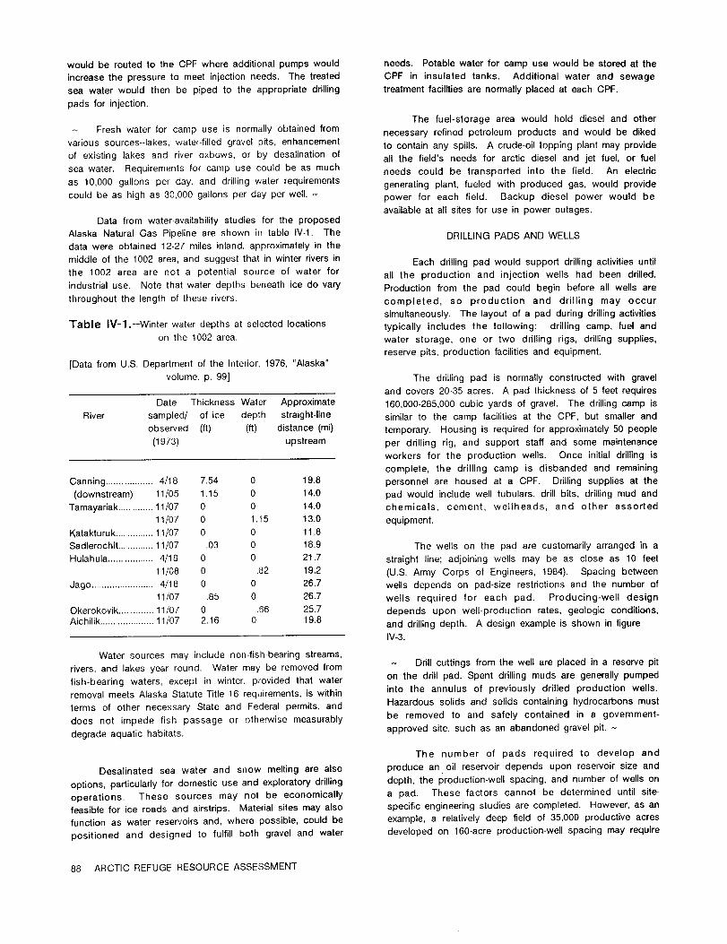
would be routedto the CPF where additionalpumps would needs. Potablewater forcamp use would be storedatthe
increasethe pressure to meet injectionneeds. The treated CPF in insulatedtanks. Additionalwater and sewage
sea water would then be piped to the appropriatedrilling treatmentfacilitiesare normallyplaced at each CPF.
pads for injection.
The fuel-storagearea would hold dieseland other- Fresh water for camp use is normallyobtainedfrom necessary refinedpetroleum products and would be dikedvarious sources--lakes,water-filledgravelpits,enhancement to containany spills.A crude-oiltopping plantmay provideof existinglakes and riveroxbows, or by clesalinationof allthe field'sneeds for arcticdieseland jetfuel,or fuelsea water. Requirements forcamp use could be as much needs could be transportedintothe field. An electricas 10,000 gallonsper day, and drillingwater requirements generatingplant,fueledwith produced gas, would providecould be as high as 30.000 gallonsper day per well.- power for each field. Backup dieselpower would be
availableat allsitesforuse in power outages.Data from water-availabilitystudies forthe proposed
Alaska NaturalGas Pipelineare shown in tableIV-1. The DRILLING PADS AND WELLSdata were obtained 12-27 miles inland,approximatelyin themiddle of the 1002 area,and suggest thatinwinterriversin Each drillingpad would support drillingactivitiesuntilthe 1002 area are not a potentialsource of water for allthe production and injectionwells had been drilled.industrialuse. Note thatwater depths beneath ice do vary Productionfrom the pad could begin beforeallwellsarethroughout the lengthof these rivers. completed, so production and drillingmay occur
simultaneously.The layoutof a pad duringdrillingactivitiesTable IV-1.--Winterwater depths atselectedlocations typicallyincludesthe following: drillingcamp, fueland
on the 1002 area. water storage, one or two drillingrigs,drillingsupplies,reservepits,productionfacilitiesand equipment.
[Data from U.S. Department of the Interior,1976, "Alaska"
volume, p. 99] The drillingpad is normallyconstructedwith gravel
and covers 20-35 acres. A pad thicknessof 5 feetrequiresDale Thickness Water Approximate 160,000-285,000cubic yards of gravel.The drillingcamp is
River sampled/ of ice depth straight-line similarto the camp facilitiesat the CPF, but smallerandobserved (ft) (ft) distance(mi) temporary. Housing is requiredforapproximately50 people
(1973) upstream per drillingrig,and support staffand some maintenance
workers for the production wells. Once initialdrillingis
complete, the drillingcamp is disbanded and remaining
Canning ..................4/18 7.54 0 19.8 personnelare housed at a CPF. Drillingsuppliesat the
(downstream) 1 1J05 1.15 0 14.0 pad would includewelltubulars,drillbits,drillingmud and
Tamayariak.............11/07 0 0 14.0 chemicals, cement, wellheads, and other assorted
11/07 0 1.15 13.0 equipment.
Katakturuk..............11/07 0 0 11.8
Sadlerochit.............11/07 .03 0 18.9 The wellson the pad are customarilyarranged in a
Hulahula.................4/18 0 0 21.7 straightline;adjoiningwells may be as close as 10 feet11/08 0 .82 19.2 (U.S.Army Corps of Engineers,1984). Spacing between
Jago ........................4/18 0 0 26.7 wellsdepends on pad-sizerestrictionsand the number of11/07 .85 0 26.7 wells required for each pad. Producing-well design
Okerokovik.............11/07 0 .56 25.7 depends upon well-productionrates,geologicconditions,Aichilik....................11/07 2.16 0 19.8 and drillingdepth. A design example is shown infigure
IV-3.
Water sources may includenon-fish-bearingstreams,- Drillcuttingsfrom the wellare placed ina reservepit
rivers,and lakesyear round. Water may be removed fromon the drillpad. Spent drillingmuds are generallypumpedfish-bearingwaters, except in winter,providedthat waterintothe annulus of previouslydrilledproductionwells.removal meets Alaska StatuteTitle16 requirements,iswithinHazardous solidsand solidscontaininghydrocarbons mustterms of other necessary State and Federalpermits,andbe removed to and safelycontained in a government-does not impede fishpassage or otherwisemeasurably
degrade aquatichabitats.approved site,such as an abandoned gravelpit.-
The number of pads requiredto develop and
Desalinated sea water and snow meltingare also produce an oilreservoirdepends upon reservoirsize and
options,particularlyfordomestic use and exploratorydrilling depth,the prqduction-wellspacing,and number of wellson
operations. These sources may not be economically a pad. These factorscannot be determined untilsite-
feasibleforiceroads and airstrips.Materialsitesmay also specificengineeringstudiesare completed. However, as an
functionas water reservoirsand, where possible,could be example, a relativelydeep fieldof 35,000 productiveacres
positionedand designed to fulfillboth graveland water developed on 160-acre production-wellspacing may require
88 ARCTIC REFUGE RESOURCE ASSESSMENT

approximately220 productionwellsand 90 injectionwells. In-fieldpipelinesor gatheringlineswould run from
Ifthe wellsdrilledfrom a singlepad could effectivelydrain each drillingpad to the CPF. Parallelpipelinescarry gas
5,000 acres, seven drillpads would be necessary;40 to 50 and water from the CPF to the drillingpads forfuel,
wellscould be drilledfrom each pad. injection,or disposal. The pipelineswould probablybe 8-
24 inches in diameterand be builtparallelto the roads
connecting the drillingpads and the CPF. They are
AIRSTRIPcommonly placed on elevated steelverticalsupport
members (VSM). Pipelines,pump stations,and the VSIVI's
An airstripto support each major fielddevelopmentare discussed in more detaillaterinthischapter.
and production area in the 1002 area would be a
permanent, year-round structureused forthe entirelifetime
of that field. The airstrip(s)would be designed to
accommodate alltypes of fixed-wingaircraftand helicopters,
and have a length of 5,000-6,000feetand a width of 150
feet. The airstrip(s)would cover approximately20 acresMARINE FACILITYeach; the adjacent taxiway,apron, terminal,and other
airportsupport facilitiescould requireanother 10 acres.A marine facilitywould be requiredfor majorAirstrip(s)and pad(s) for support facilitieswould be
constructedof graveland be about 5 feetthick. The equipment sealifis.The facilitybuilton the coast would
estimated gravel requirementfor each is approximately take into considerationthe locationsof the proposed
250,000 cubic yards. developments and environmentaland engineeringconcerns.
As needed, detailedengineeringstudieswould be prepared
FIELD ROADS AND PIPELINES forthe marine facilitysize,design,and location.
Gravel roads would connect allpermanent facilitiesin The facilitywould contain sea-watertreatmentfacilities
the field(thatis,alldrillingpads, CPF's,airportcomplex, and various supportingoperations. Itwould be designed
water and gravel sources, and waterflocidand marine to receivebarges loaded with the annualsealiftof supplies,
facilities).These roads would have a crown width of other cargo, and production/supportmodules used in the
approximately35 feetand a thicknessof 5 feet.Each mile oilfield'sdevelopment and production. Barging these
of road occupies about 5 acres and requiresapproximately goods with an annual sealiftis the most economical
40,000cubic yards of gravel.The number of milesof roads method of transportationand the only practicalmethod of
constructedwould depend upon the size and physical deliveringvery largemodules to the North Slope. Barge
settingof the field.routes and timingwould be similarto the currentannual
sealiftused by North Slope operators,
The facilitywould requireone or more docks and
Wellheadsufficientacreage in storagepads to facilitateorderlyand
valve To production timely unloading of barges. A temporary camp andassembly-
Surface associated support facilitieswould be requiredduring
unloading periods ifthe main camp were too distanttoprovide necessary livingquartersformarine facilityworkers.
Conductor A transportationcorridorwould be requiredto connect the
marine facilitywith the development site.
-Surfacecasingc o point(startof Camden Bay and Pokok were selected as twobuilduptoangleof possible sites for marine facilities,given the development
True deviationscenarioderived under the Chapter IIIresource assessmentver:ical Buildupcompletion
depth point(angleof (fig.V-11).There may be other potentialmarinefacilitysites.viationachieved) Allpotentialsiteswould be analyzed in detailbefore final
Angleof Productiontubingselection.Camden Bay and Pokok were selectedbecause
deviation Intermediatecasingthey are similarto Prudhoe Bay in having sufficientwater
depth seaward of the siteso as not to requiredredging.
They also have open-ice periods similarto those atPrudhoe Bay (ArcticEnvironmental Informationand Data
Center,1983). These siteswere not selectedon the basis
Horizontal of detailedengineeringstudiesand the locationsmay provedeviation lessdesirableaftersuch studiesare conducted,should the
area be opened for development. However, Camden Bay
and Pokok were used to assess environmentalimpacts
Figure IV-3.--Production-welldesign. under the variousscenarios.-
INFRASTRUCTURE--PRODUCTION 89

TRANSPORTATION OPTIONS FOR A conceptused inthe KuparukRiverfieldpipeline,OIL AND GAS PRODUCTION but notincorporatedinTAPS, was constructionofonlyone
roadforuse as both a main transportationarteryand aThissectionassessesthe technologyinvolvedinthe pipeline-maintenanceroad. A temporaryiceroadwas used
majorelementsof oiltransportationmethods. Pipelinesare duringconstructionof the pipeline,eliminatingthe need foremphasized as the most reasonabletransportationmethod a constructionwork pad. That constructionplacedthebecause the TAPS is in place and operating.As pipelineon the uphillsideof thegravelroad fill,enablingproductionof the Prudhoe Bay oilfielddeclines,TAPS theroad to actas a dam in the eventof an oilspill.should have adequate capacityto accommodate Arctic Cross drainageforwaterwas providedby culverts,whichRefugeoilby the 1990's.However,ifTAPS capacity(about couldbe quicklypluggedifan oilspilloccurred.Insofaras2.2millionbarrelsper day,accordingto W. Witten,Alyeska possible,a similardesigncouldbe proposed acrosslevelPipelineServiceCompany, Jan.9, 1986)were inadequate, terrainin the 1002 area. Where the terrainis irregular,capacitymightbe increasedby loopingor by improving engineeringand environmentalconstraintswould requirepipelinehydraulics,The ultimatemethod to increase adjustmentsso the pipelinecouldbe continuedin atransmissioncapacitysignificantlyisto constructa second straightlinebuttheroad couldfollowthecontoursofthepipelineparallelto TAPS between Prudhoe Bay and Valdez. land.Major elementsof othersystems arealso describedandevaluated. Gas transportationis consideredseparately,laterinthischapter.
Pipelines
Because ofthe existenceofTAPS, themost probable Severalalternativepipelineroutesfortransportingmethod is assumed to be transportationof crudeoil crude oilfrom the 1002 area to processingfacilitieswereproduced on the 1002 area by pipelineto TAPS Pump considered:Station1, thenceto the ice-freeportof Valdezon thesoutherncoastofAlaska. 1. An elevatedpipelinefollowingan east-westinland
routefrom the 1002 area,acrossStatelands,to
Priorto TAPS, littlewas known about constructingoilTAPS Pump Station1.
pipelinesinan arcticenvironment.Designand construction 2. An elevatedeast-westpipeline(onshore)fromthetechniquesused duringTAPS construction(1974-77)and in 1002 area alongthe BeaufortSea coastto TAPSthe ensuingyearsof developmentof the Prudhoe Bay and Pump Station1.Kuparuk Riveroilfieldshave advanced the stateof thetechnologyand have provedthathot-oilpipelinescan be 3. A marine pipelineeast-west(offshore)alongtheconstructed,and reliablyand safelyoperated. BeaufortSea coast to TAPS Pump Station1. This
pipelinewould requirenorth-southfeederlinesfrom
Because of ice-richpermafrostconditionsthroughout producingfieldson the 1002 areato the coastalsite.
the area,an elevatedpipelineisthe most probablesystemfortransportingoilproducedfromthe 1002 areawest to 4. An elevatedeast-westpipelinefrom the 1002 area
TAPS Pump Station1. To preventthawing,elevated acrossStatelandsto TAPS Pump Station1,then a
pipelinessupportedby VSM's placedintothe frozen new pipelineparallelingTAPS to Valdez.
groundaremost effective.5. An inlandpipelinefrom the 1002 areaeastto the
Canadian border,thence southeastwardthroughtheExperiencefrom the operationand maintenanceof Yukon and NorthwestTerritories,to connectwiththe
TAPS has shown thatunacceptablesettlingand stressin existingoilpipelinesystems in the Provinceofburiedpipe may occur despitesystematicgeotechnical Alberta.investigations.Even insoilsthoughttobe thaw stable,icemay be presentand go unnoticedduringconstruction,anditmay createproblems in lateryearsas the icemelts,causingdifferentialsettlinginthe pipelines. The most probableroutefora pipelinewas
determinedto be an inlandroute,which roughlybisectsthe
The hot-oil,24-inchpipelinefrom the KuparukRiver 1002areafromeastto west (fig.V-11)and isthe routeused
fieldto Pump Station1 isentirelyelevatedon VSM's and forthe assessmentof environmentaleffects(ChapterVIof
supportbeams. A minimum 5-footclearanceisprovidedfor thisreport).The exactroutewould be determinedprimarily
cariboucrossing;varyingterrainfeaturesallowgreater by the locationof hydrocarbondiscoveries;itwould be
clearancein places. Also,caribouramps (relativelyshort adjustedto minimizeimpactto surfaceresourcesand tosectionsof gravelfillplacedoverthe pipe)are provided. meet engineeringrequirements.The existingTAPS is
The Kuparuk Riverfieldpipelinesupport beams are believedto havethe capacityto carryoilproducedfromthe
constructedto carrymore thanone pipe. 1002 area by the earliestdate productionwould start.
90 ARCTIC REFUGE RESOURCE ASSESSMENT

Spaceforfutureexpansion VALVESGAS 01
35'Federalregulations(49CFR 195.260)providecriteriaNominal
forthe locationsand number of valvesrequiredforpipelinesystems. For example,valvesmust be placedon each side
5'of a watercrossingmore than 100 feetwide. A mainlineMinimum nal5'valve system can be used to reduce the potentialsize of
A an oilspill. Valve locations are selected so that a spillatany pointis limitedto a predeterminedmaximum quantity
-Steelvertical-supportmember (50,000barrelson TAPS).(depthvaries)
On TAPS, remotelyoperatedgate valvescloserapidlyunder emergency conditionsto protectpump stationsand
Figure IV-4.--Typicalcrosssectionof pipelineand environmentallysensitiveareas. Check valvesare usedroad development. No scale. where the terrainslope allowsthe valveto effectivelystop
reverseoilflowand block potentialoilspills.
Figure IV-4shows a typicalpipelineinstallation,in cross COMMUNICATIONSsection.The pipelinecould be designedlikethe KuparukRiverfieldpipeline,with supportbeams largeenough to Maintainingcontinuouscontrolof the pipelinefromaccommodate additionalpipelines,depending on future the ArcticRefuge to Prudhoe Bay would requireaneeds foroilor gas,or possiblywater. A road constructed communicationcontrolsystem. The primarysystem couldon at leasta 5-footgravelfillwould be needed to supply be a seriesof permanent microwave stationswhich linkallthe oil-fieldfacilitiesand give access for pipeline pump stations,remotelycontrolledgatevalves,and pipeline-maintenance. Unless otherwisenecessaryfor minimizing maintenance centerswith a controlcenter. Each remoteimpacts on caribou migrationor to accommodate stationtypicallyincludesa self-supportingsteelantennaengineeringconstraints,the pipelinecouldbe builtcloseto tower,two smallbuildings,2 to 4 fueltanks,a heliport,the upslope shoulderof the road to precludean additional backup generators,and a batterysystem. Such stations,ifmaintenance road, Access to valves,which require patternedafterTAPS, could be backed up by a satellitefrequentmaintenance,would probably callfora special system and would be locatedon relativelyhigh groundwork road connectingthe valvesiteto the main road. In about 40 milesapart. Common-carriercircuits,telephone,criticalcaribouhabitat,the pipelineand main road might and mobileradiosystems would be incorporatedintotherequireseparation.Ifso, a gravelmaintenancework road overallpipelinecommunication system.might have to be constructedalong the pipelineforsegments where the pipelineand roadare separated.
FigureIV-5shows pipelinediametersrequiredforvariouspumping rates.A pump stationisrequiredevery50to 100 miles depending on desiredpumping rateandtopography. Therefore,two to threepump stationsprobablywould be requiredforan inlandrouteacross the
30 1 1 1 11002 area. The firstwould be locatednearthe oilfieldorfieldsand the second and thirdbetween the oilfield(s)andPump Station 1. Each pump stationwould contain ui
pumping, oil-storage,power. pipelineequipment and repair, Z20-
and communication facilities,livingquartersfor about 30 Zpeople,and environmental-supportsystems; the stationwould be constructedon a 7-acre(approximately)gravel
pad. Other relatedfacilitiesare described below< 10 -
(MechanicsResearch,Inc.,1977). aLU
SURGE AND STORAGE TANKS 0.
Pipelinehydraulicdesign analyzesnormal hydraulic o 100 200 300 400 500
gradients and the effects of pressure surges, which are PUMPING RATE, IN THOUSANDS OF BARRELS PER DAYcontrolled by means of suction and discharge reliefprotectionat each pump station.Tanks at each station
collectoilthat is dischargedthroughreliefvalveswhen Figure IV-5.-Land-pipelinepipediameterversuspumpingsurges occur;the collectedoilis laterreturnedto the rate.Modifiedfrom Han-PadronAssociates(1985,pipeline. fig.7.2-1).
INFRASTRUCTURE--TRANSPORTATION 91

ROADS two additionaltemporarycamps might be required.Thesesitescould be used for2 yearsand would be rehabilitated
As noted previously,a road would roughlyparallel when no longerneeded or be used forroad maintenance
the pipelineacross the 1002 area and continueacross camps.
Statelandsto Pump Station1. This permanent all-seasongravelroad would be builtin accordancewithacceptedarcticengineeringpracticeson 5-footgravelfill,with a 35-foot-widedrivingsurface,and would supportconstructionofthe pipelineand linkcentralproductionand marinefacilities.
OIL-SPILLCONTINGENCY,
The pipelinecould be constructedduringwinterfrom aINCLUDING LEAK DETECTION
snow pad or iceroad. Ifsnow or waterwere notavailablein sufficientquantities,a gravelwork road could be built.
The firstlinesof defenseagainstoilspillsare design
Gravelaccess roadswould connectthe main road to pumpand operationalprocedures (includingpersonnel-training
stations,valves,and maintenance stations.Emergencyprograms), properlydesigned and maintainedequipment,
access to the pipelineduring the summer would beadequate alarm systems,and strictadherence to industry
accomplishedby rolligonor similarvehicles.The availabilityand Stateand Federalgovernment codes and regulationsin
of adequate gravelsupplieson the 1002 area isuncertain.constructionand operation. Itmust be recognized,
Gravel could be mined from inactivestreambeds,buthowever, that even with the most comprehensive
additionalpitswould have to be opened to obtainthe largeprecautions,oilspillswilloccur. Operatorsof a pipeline
quantitiesrequiredforroads,pump stations,airports,andacross the 1002 area would be requiredto have an oil-spill
maintenance-supportfacilities.Gravelmight have to becontingencyplan that,as a minimum, includesprovisions
mined from upland sites,riverterraces,streambeds,for oil-spillcontrol,which consistof (1)leak-detection
lagoons,or othersites.Siteselectionswould be based onsystems;(2)methods forlocating,confining,and cleaning
environmentaland engineeringconsiderationsas wellasup spills;(3)notificationproceduresforlocal,State,and
availability.No gravelwould be removed from the activeFederalagencies:(4)correctiveactionforthe affectedarea;
stream channels of majorfish-bearingriversor from barrier(5)varioustypes of oil-spillequipment;and (6)site-specific
islands.Allgravelremovalwould followthe guidelinesforcleanup techniques.
arcticand sub-arcticflood plains(Woodward Clyde
Consultants,1980a, b). Siteswould be designed toA leak-detectionsystem would includeautomatic
providefishand wildlifehabitatafterthey are abandoned.instrumenteddetectionsystems and periodicground and
For example,gravel-removalsitescouldbe filledwithwateraerialsurveillance.For best visualground surveillance,
and provideareas for migratory-birdnestingand restingeitherthe all-seasonroad or a gravelwork road should be
habitat,littoralzones for migratorybird and fishfeeding,close to the pipeline.Aerialsurveillanceby helicopteror
and deep water forfishoverwintering.Thus, these gravelfixed-wingaircraftcoversthe greatestamount of area inthe
pitscan also be potentialwater reservoirs.Bridgesandshortesttime,but couldbe restrictedby weather,hours of
culvertswould be designed and constructedto providedaylight,and wildlifeconsiderations.
cross drainageforroads ina manner thatpreventserosionor adverse effectson the fisheries.
AIRFIELDS FOR CONSTRUCTION CAMPS PIPELINE ROUTING
Airfieldsmay be requiredat pipelineconstruction The 1002 area'swidelydiversifiedlocalenvironments
camps and pump stationsor airstripsmay be shared with requirenumerous engineeringconstraintsregardinglocation
oildevelopment facilities.The typicalairfieldforthese and routingof pipelines,roads,and airstrips.This appliescamps would be similarto those supportingairfield particularlyto stream and ravinecrossingswhere, todevelopment,that is,5,000-6,000feetlong,150 feetwide, minimize environmentalproblems,cutbanks and braided
and 5 feetthick. streams must be avoided,especiallyby road crossings.
CONSTRUCTION CAMPS FOR INLAND ROUTES
ROADS AND PIPELINESThe southernpartof the 1002 area providesmore
Camp buildingswould be portableself-contained feasiblestream crossings,relativelymore stablesoils,better
modules, equipped with functionalfurnishingsfor sleeping, drainage,and more sources of gravelthan a routenearer
eating,recreation,and with sanitationfacilities.A typical the coastline.The actualavailabilityof gravelisunknown,
camp houses 150-300 people. To minimize surface but at least16 potentialborrow pitsiteslocatedin active
disturbance,these temporarycamps should be locatedat floodplainswere identifiedby the Alaskan ArcticGas
the sites chosen for the permanent pump station. PipelineCompany as possiblesources of about 2.4 million
Productionand transportationon the 1002 area would cubic yards of sand and gravelforthe ANGTS (Alaska
probably requiretwo or three pump stations.Therefore, NaturalGas TransportationSystem--U.S.Departmentof the
two or threecamps would occupy the pump stationsites; Interior,1976, "Alaska"volume,p. 10).
92 ARCTIC REFUGE RESOURCE ASSESSMENT

An inland pipelinefrom the 1002 area east into lengthof the constructionseason, the natureof the seabedCanada was discussed in the TAPS and ANGTS reports soil,seabed ice scouring,and, in the permafrostzones,(U.S.Department of the Interior,1972,1976). Construction prevention of permafrost degradation. Marine-pipeline
of the pipelinewould requirea cooperative agreement design,installation,and cost considerationsare described
between Canada and the United States, as well as below,
Congressionalauthorityto cross the designatedwilderness
area eastof the AichilikRiver.A major considerationin designinga marine pipeline
forarcticwaters isplacement ofthe linewith regardto iceand permafrost. Shorefastice includesalltypes of ice,
COASTAL ROUTES broken or unbroken, attached to the shore, beached,stranded,or attachedto the bottom inshallowwater. The
A coastline route would cross more ice-rich fast-icezone of the 1002 area extends from shore outward
permafrost than an inlandroute (U.S.Department of the to water depths of approximately10 to 66 feet. Intense
Interior,1976, "Alaska"volume, p. 491). More of the route interactionbetween moving pack ice and shorefast ice
would be on thaw-unstablematerial;such materialand the forms a shear zone of ice ridges,which oftenground on
braided-stream crossings would complicate pipeline the seabed. The keels of these ice pressure ridgesand
constructionand could compromise pipelineintegrity.A occasionalpieces of iceislandsscour deep gouges inthe
coastalroutewould have fewer stream crossings,but more subsea floor during subsequent movement of the ice.
of the route would be on activefloodplainsand cross Grounded ridges may extend outward to a depth of
widerdeltaareas. Work pads and roads inthatflat,poorly approximately 150 feet. From shore to 50-footseabed
drained area could result in water-ponding problems. depth,ice scour isfrequentbut relativelyshallow.Scour is
Construction costs of an elevatedoilpipelinewould be greatestat seabed depths of 65 to 100 feet.The deepest
expected to be slightlyhigherfora coastalonshore route recorded scour is 18 feetat a seabed depth of 125 feet.
than foran inlandroutebecause of (1)extralength,(2)
higher gravelrequirements,(3) poor drainage,and (4)In nearshore areas, ice-bonded permafrost is
poorer soilsfor construction. The earlierANGTS studyprobablypresent and must be consideredin the design of
(U.S.Department of the Interior,1972) fora buried naturalan offshore pipeline(Heuer and others,1983). But
gas linealong coastal and inlandroutesalso estimated nearshore ice-wedge permafrost under shallow water,slightlyhighercosts forthe coastalonshore route.
particularlyalong a rapidlyrecedingcoastline,is even more
criticalfordesign. A hot-oilpipelineplaced inareasof ice-
bonded or ice-wedge permafrostmust be heavilyinsulated
to limitthawing of permafrost. The best locationfor anSUBSEA MARINE ROUTES offshorepipelineis at water depths of 6.5-65feet,to
minimizeice gouging. Beyond the 6.5-footwater depth theFor the past 15 years,the petroleumindustryhas top of the ice-bonded permafrostgenerallyis below the
been activelyengaged in research and development of surfaceof the seabed. Inshoreof the 18-footbottom-depthtechnology forthe design and constructionof subsea oil contour,ice gouging istypicallyless than 1.6 feet (Mellor,pipelinesin the Arctic, Large-diameter marine-pipeline 1978).construction in the BeaufortSea is considered to be
technicallyfeasibleby some authorities(Han-Padron
Associates,198'5). However, to date no marine pipelines An arcticmarine pipelinemust be laidina trenchto
have been constructedin the Arctic. ensure that the top of the pipe is below maximum ice-
gouging depth. Several subsea trenchingmethods are
In general,the continentalshelfof the BeaufortSea availablebut have never been used inthe Arctic. Because
of the Alaska coast is not more than 50 mileswide,and the constructionseason is short,fast-movingcutter-suction
breaks at a water depth of 225 to 250 feet. The average dredges or subsea plows would be required. Under
durationof open-water conditions,duringwhich a pipeline development are self-propelledseabed plows, rippers,or
could be constructed,isapproximately50 days. A marine cuttingdevices.
pipelinepresents higher environmentalrisksthan does an
onshore pipeline.Wherever a hot-oilpipelineis buriedin - Maintenance and repairwork on a marine pipelineinpermafrost,differentialsettlingis to be expected. Any the Arcticwould be difficultduringthe iceseason (normallysignificantsettlingcould rupturethe pipe,causing an oil October through July).The only way to assure continuousspill. Repair and maintenance of a marine pipelineunder operationisto have a loop line(a second pipelineparallelice would impose almost impossibleengineeringproblems to the existingline)or similarbuilt-inredundancy. -formuch of the year.
Marine pipelinesmust be waterproofedand weighed
Criticalenvironmentalfactorsaffectingthe design and down with a concrete coatingto give negativebuoyancy.
constructionof marine pipelinesincludeice and weather They also must be cathodicallyprotectedfrom corrosionby
conditions,theireffecton constructionequipment and the sea water,in accordance with industrystandards.
INFRASTRUCTURE--TRANSPORTATION 93

Tankers rollingstock.Potentialenvironmentalimpactsareairandnoisepollution,oilspills,and degradationof fishand
Transportationof petroleumproductsby icebreakerwildlifehabitatcaused by roadbed constructionthrough
tankerinthe BeaufortSea has been consideredformore mountainousterrain.
than 15 years. However, no offshoreloadingterminalssuitableforthe area exist,nor do designsexistfor
Possible,but not practical,isoperatinga largefleet
icebreakertankers,theirsupportvessels,or loadingof trucksto haul oilto a southernAlaskaport,for
terminals. Presumably,icebreakertankerswould transport transshipmentto West Coast ports,or tothe north-central
crude oilto an ice-freetransshipmentterminalin the United Statesvia a trans-Alaska-Canadaroute. High
AleutianIslandsor on the AlaskaPeninsula.Severalotheroperatingcosts,airand noisepollution,and the high
concepts have been considered,withor withoutinternal potentialforoilspillagemake trucktransportimpractical.
storagecapacity(Han-PadronAssociates,1985,p. 7-30). The existingTAPS haulroad (DaltonHighway)would not
Greaterknowledgeoficeconditionsand icedynamics north be adequateforsuch high-volumetraffic,which would
of the BeringStraitisneeded beforethe requirementsand requirealmostbumper-to-bumpertrucks.
risksof operationinthe Chukchiand BeaufortSeas can beadequatelyappraised. Natural Gas Transportation
A study on usingsubmarinetankers,preparedby a System
team headed by the Newport News ShipbuildingandDrydock Company (NNSDC, 1975) forthe U.S.Marine Sincethe early1970's,industryhas givenserious
Administration,was updated by Han-Padron Associatesconsiderationto developinga transportationsystem to
(1985,p. 7-53). Han-Padron escalatedthe capitaland deliverAlaskanNorthSlope(ANS)naturalgas to the market
operatingcosts to compare transportationcosts forplace.Gas producedatPrudhoeBay iscurrentlyused on-
submarinetankerswiththoseforicebreakersurfacetankers. siteforpower generation,enhanced oilrecovery,or is
A submarinetankerdesignedto operateunder theArctic reinjected,inasmuchas itisnot yeteconomicalto produce
icepackis limitedas to propulsionmethods and overall formarketing.
size. Currenttechnologylimitsthe power sourceto anuclearreactor,althoughfuel-cellpowerplantsmightpropel In December 1981, the Secretaryof the Interior
smallersubmarines. The originalstudy (NNSDC, 1975) issueda right-of-wayto the NorthwestAlaska Pipeline
indicatedthatno existingshipyardcould constructor Company to constructa large-diameter,chilled,buriedgas
maintaina submarineofsufficientsize(200,000-300,000tons pipelineand relatedfacilitiesfrom Prudhoe Bay to domestic
deadweight)to be efficientin such an operation.The marketsin the lower-48States. However, by 1985 the
updatedstudysuggeststhatthe unit-transportationcostof projectsponsorshad reducedtheireffortstocompletethe
a submarinetankerwould not differsignificantlyfrom that AlaskaArcticGas PipelineuntilmarketconditionsforANS
providedby an icebreakertankerof similarcapacity. naturalgas improved, A timeframeforremobilizingthe
Technicalproblems associatedwithloading,construction, projecthas notbeen identified.
and operationhaveyetto be solved.- In 1986,the Yukon PacificCorporation(YPC)amended itsapplicationto the BLM forFederalpermitsto
Other Transportation Methods constructand operatea buriedgas pipelinefrom PrudhoeBay to a tidewaterliquidnaturalgas (LNG)terminalat
Severalothertransportationsystems have been Valdez. That pipelineproject,calledthe Trans-AlaskaGas
proposedand discussedindetail(U.S.Departmentofthe System (TAGS),would exportANS naturalgas to markets
Interior,1972,1976). Only a few are discussedhere,as inPacificRim nations,such as Japan and Korea. Export
none is a realisticalternativeto a pipelinein termsofof AlaskaNorth Slope naturalgas outsidethe UnitedStates
safety,economics,and environmentalimpact. The reader would requireapprovalof the Presidentof the United
shouldreferto thecitedreportsforfurtherinformation. States,pursuantto the AlaskaNaturalGas TransportationAct of1976.-
Two railrouteshave been consideredfortransportingNorth Slope oil. The shorter,intermsof new railroad
Accordingly,itis likelythata gas deliverysystem
construction,isan extensionoftheAlaskaRailroad.Thisfrom Prudhoe Bay would providereadymarketaccessfor
railroadisState-ownedand has 470 milesof trackfromany gas discoveredin the 1002 area,shoulditbecome
Seward to Fairbanks.The extensionwould be northwardeconomicallyrecoverable.
acrossthe Yukon Riverand the BrooksRange to theNorthSlopeoilfieldsnearPrudhoe Bay. The otherroutecrosses
The environmentalimpactstatementforthe Alaska
Alaska and Canada from Prudhoe Bay to Whitefish, ArcticGas Pipelineproject(U.S.Departmentof the Interior,
Montana,viaDawson, Yukon Territory.Eitherroutewould1976) describedthe overalleffectsthatwould resultfrom
encountermajor constructionconstraintsand operationalconstructionand operationof a gas pipelinetransportation
problems in accommodating, handling,loadingandsystem throughthe ArcticNationalWildlifeRefuge. This
unloading,marshalingtrains,and maintainingtrackandpipelinesystem proposedconstructionofa buried,chilled
94 ARCTIC REFUGE RESOURCE ASSESSMENT

gas pipelinethrough the coastalplainof the ArcticRefuge Lynch, C., Siltor,D. L., and Rudolf,R. W., 1985, Arcticto the Canadian border,to facilitateproductionof gas from summary report:Reston, VA, U.S. MineralsManagementthe Mackenzie Delta region of Canada. However, for Service,84 p.purposes of thisreport,itis presumed thatcommercial Mechanics Research, Inc.,1977, Technicalservicesupportquantitiesof naturalgas discoveredin the 1002 area would for the Trans-Alaska PipelineProject--Finalreport,6be processed and transportedwest to Prudhoe Bay using volumes.facilitiesshared with oildevelopment and transportationon Mellor,Malcolm, 1978, Undersea pipelinesand cables inthe 1002 area. Ideally,the verticalsupport members forthe polar waters: Hanover, NH, U.S. Army Corps ofoildeliverysystem to TAPS could be designed so that Engineers Cold Regions Research and Engineeringconstruction,operation,and maintenance of both oiland LaboratoryCRREL Report 78-22.gas systems could be collocated.Itisalso assumed that Mitchell,D. W., 1983a, Design and constructionof thegas productionand transportationsystems would not be Inigolkwellsite:Anchorage, AK, Husky Oil Co. NPRconstructeduntila naturalgas transportationsystem was Operations,Inc.,18 p.operationalbetween Prudhoe Bay and markets outside 1983b, Design and constructionof the North InigokAlaska,now speculatednot to occur beforethe middle to wellsite: Anchorage, AK, Husky Oil Co. NPRlate1990's. Operations,Inc.,11 p.
NationalPetroleum Council,1981, Transportation,chapter V,Constructionof an oiltransportationsystem from the p. 63-78,in U.S.Arcticoiland gas: Washington, DC.
ArcticRefuge would have a higher prioritythan a gas Newport News Shipbuildingand Dryclock Company, 1975,transportationsystem due to the anticipateddeclinein oil Maritime submarine transportationsystem conceptualfrom Prudhoe Bay which would make availableoilcapacity design study: Contract reportfor U.S. Department ofin the TAPS duringthe late1990's. Therefore,construction Commerce, MaritimeAdministration,Officeof Commercialof the oiland naturalgas transportationsystems would be Development.sequentialon the ArcticRefuge. The timingforthe natural Petroleum InformationCorporation,1985, Arco begins Westgas transportationsystem would depend upon the final Sak pilotoilrecoveryproject:Alaska Report,v. 30, no.design and deliverycapabilityof the gas pipelinesystem 44, 3 p.south from Prudhoe Bay, combined with the consideration U.S.Army Corps of Engineers,1984, Endicottdevelopmentof economic factorsin both domestic U.S. and foreign project,Alaska, [final]environmentalimpact statement:naturalgas markets. Anchorage, AK, 3 volumes, separatelypaginated,August
1984.
U.S. Department of the Interior,1972, Proposed Trans-
Alaska Pipeline--Finalenvironmental impact statement:
Washington, DC, prepared by SpecialInteragencyTask
Force for the Federal Task Force on Alaskan oil
development, 6 volumes, variouslypaginated;v. 1--
REFERENCES CITED Introductionand summary; v. 2--Environmentalsettingofthe proposed Trans-Alaska Pipeline;v. 3--Environmental
American Petroleum Institute,1976, Primer of oiland gas settingbetween Port Valdez, Alaska,and west coast
production(3d edition;10th printing,1981): Dallas,TX, ports;v. 4--Evaluationof environmentalimpact;v. 5--
81 P. Alternativesto the proposed action;v. 6--Consultation
Andrews, S., 1984, Welcome to the North Slope: Los and coordinationwith others.
Angeles, CA, AtlanticRichfieldCo. U.S. Department of the Interior,1976, Alaska naturalgas
Arctic Environmental Informationand Data Center,1983, transportation system--Final environmental impact
Alaska Marine IceAtlas: Fairbanks,Universityof Alaska. statement:Washington, DC, 9 unnumbered volumes,
Childers,J. M., Sloan,C. E.,Meckel, J. P.,and Naumann, variouslypaginated.
J. W., 1977, Hydrologic reconnaissance of the eastern Williams,B., 1982, Vast $10.5 billionprogram to maintain
North Slope, Alaska, 1975: U.S. Geological Survey production,hikerecoveryat Prudhoe Bay: Oiland Gas
Open-File Report 77-492,77 p. Journal,v.80,no. 28,p.76-80 (July12 issue).
Han-Padron Associates, 1965, Beaufort Sea petroleum Woodward Clyde Consultants, 1980a, Gravel removal
technology assessment: Contractreportfor Minerals studies in arcticand subarcticflood plainsin Alaska:
Management Service;TechnicalReport 112, chapter 7-- Anchorage, U.S. Fish and WildlifeServiceFWS/OBS-80-
Transportationtechnology assessment, 54 p. Available 08, 403 p.
from NationalTechnical InformationService,Springfield, 1980b, Gravel removal guidelinesmanual forarctic
VA 22161. and subarcticflood plains: Anchorage, U.S. Fish and
Heuer, C. E.,Coldwell,J. B.,and Zamsky, R.,1983, Design WildlifeServiceFWS/OBS-80-09, 169 p.
of buried seafloor pipelinesfor permafrost thaw
settlement,p. 486-491,in Permafrost--FourthInternational
Conference sponsored by Universityof Alaska and
National Academy of Sciences: Washington, DC,
NationalAcademy Press.
INFRASTRUCTURE-REFERiENCES 95

,,, .XI -
4MmamiI I f g 3
-1@1
RIPARIAN HABITAT
96 ARCTIC REFUGE RESOURCE ASSESSMENT

CHAPTER V
ALTERNATIVES
INTRODUCTION The 1002 area contains a combination of identified
potentialpetroleum prospects having a mean conditional
This chapter identifiesand evaluatesfivealternatives estimated totalof 3.2 billionbarrels of economically
which are considered to be representativeof the full recoverableoilunder currentand foreseeableeconomicspectrum of possible actionsthat could be taken with conditions(Chapter 111).These prospects are grouped intorespectto a decisionto open the 1002 area to oiland gas 4 geographic areas (blocks)ofthe 1002 area to facilitateanexplorationand development. analysis of the effectsof oil development on the
environment. The four blocks are depictedin Chapter IIIAlternativeA: FullLeasing (fig.111-14).AlternativeB: LimitedLeasingAlternativeC: FurtherExplorationAlternativeD: No Action AlternativeA assumes that:
AlternativeE: Wilderness Designation1. Although both oiland gas would be leased,initially
These five options are all technicallyand only oilwillbe developed and transportedto market.
economically feasible. They are distinctlydifferentfrom Associated gas willbe reinjectedand/orused forfield
each other and lend themselves to independent analysis, operationsin a manner similarto other North Slope
thus permittingconcentrationon those issuesthatare truly fields,untilgas productionbecomes economical and
significantto the decisionto be made. Comparisons ofthe adequate markets are identified.
effectsof each alternativeare providedat the conclusionof
the assessments in Chapter VI. 2. - Development would be sequentialon the area,andoilproductionwillstartabout the year 2000. -
ALTERNATIVE A-FULL LEASINGOF THE 1002 AREA 3. Development willbe unitizedwithinthe 1002 area and
on privatelyowned subsurface resources.- Under the alternativeof fullleasing,itis assumed
that Congressional action would allow all Federal 4. A singletrunk oilpipelinewilltransportoilfromsubsurface ownerships of the 1002 area to be availablefor Federalleases and from any privatelands in.the1002development through a leasingprogram administeredby the area to Pump Station1 of the Trans-AlaskaPipelineDepartment of the Interior.This actionwould also open to System (TAPS).oiland gas development and productionthe privatelands
withinthe refuge. This is the preferredalternative,as more 5. Development, production,and transportationof oilfullydiscussed in Chapter VIH, the Secretary's from the 1002 area are consideredto be independentrecommendation. The exact terms of the leasingprogram of any offshore production;however, productionwould be developed in response to specificlegislation infrastructurecould be shared.passed by the Congress, and in considerationof the
recommendation of the Secretaryof the Interior.- 6. The Stateof Alaska willallow a trunk oilpipelinetocross State lands between the western boundary of
Presumably, major portionsof the 1002 area would the 1002 area and TAPS Pump Station1 at Prudhoe
be leased and additionalgeophysical exploratorywork Bay (a distanceofabout 50 miles).
would take place on all leased areas beforeexploration
wells are drilled.Leaseholderswould likelyfocus firston 7. Once the Congress approves leasing,but priortothose areas and geologic structuresbelievedto have the lease sales,industrywillbe allowed to conduct
highestprobabilityof containingcommercialquantitiesof oil. additional geophysical and surface geological
Itis feasibleforphased development to occur. explorationwork.
ALTERNATIVES--FULL LEASING 97

Accordingto the size,number, and characteristicsof only aftera specificprospect has been drilled,and a
prospects describedin Chapter 111,and the productionand discoverymade and confirmed.
transportationscenarios described in Chapter IV,thenumber and types of facilitieslikelyto be requiredfor Chapter IV describes the types and numbers ofdevelopment and productionof oilresources in the 1002 facilitiesthatmight be necessary for oilproductionin the
area are listedin tableV-1. For the sake of maintaining 1002 area. Typically,these includefor each developeddata confidentiality,figureV-1 shows a highlygeneralized prospect: centralproductionfacility(CPF) and initialpumpplacement of productionand transportationfacilitiesbased stationfor the oilpipeline,all-weatherairfield,consolidatedon typicalNorth Slope prospect characteristicsfor three production and reinjectionwell pads, and an internal
localitieswithinthe 1002 area. This assumes successful network of roads and gatheringlinesconnectingpads and
explorationin allthreelocalities.- the CPF. A trunk oilpipelinewould connect the CPF to
Pump Station1. From Pump Station1, oilfrom the 1002Actual placement of oilproductionfacilitiesand area would move through the existingTAPS to Valdez and
marine facilitieson the 1002 area,or locationof the trunk then by tankerto market. Depending on the amount ofpipelinefrom producing fieldsto TAPS Pump Station1, finalthrough-put,one or severaladditionalpump stationsdepends upon site-specificgeotechnical, engineering, may be required.
environmental,and economic data that can be determined
1461 145- 1440 1431
I A k A U FJslevwt,,;@ efownlow
701
R
S
d"
mountains
MENWOCYO-
69130, ShublikMo.,,ta,,s
C
a 10 20 30 MILES
i II
I II I
0 in 20 30 KILOMETERS
EXPLANATIONCentral
productionfacility Drillpad-23 acres Connecting road
0 90 acres Airstrips-30 and 130 Seawater treatment
a 40 acresacres plant
FigureV-1.--Hypothetical generalized development of three major prospects within the 1002 area
under fullleasing ifeconomic quantitiesof oilare discovered. Numbers indicate three localities
(shaded) having typical prospect characteristics.
98 ARCTIC REFUGE RESOURCE ASSESSMENT

MAN
"CAT TRAIN" FOR SEISMIC EXPLORATION
Table V-1.--Number and area of in-placeoil-relatedfacilitiesassumed to be associated with ultimatedevelopment of
estimatedmean conditionalrecoverableoilresources made availableby fullleasingor limitedleasingof the 1002 area.
[mi,miles;cu yds, cubic yards;ac, acres]
Approximate unitsi
Facility Fullleasing Limitedleasing
Main oilpipelinewithinthe 1002 area2 .....................................................................100 mi (610ac) 80 mi (490ac)
Main road parallelingmain pipelineand from marine facilities2.............................120 mi (730ac) 100 mi (610ac)
Spur roads with collectinglineswithinproductionfields.......................................160 mi (980ac) 120 mi (730ac)
Marine and salt-water-treatmentfacilities...................................................................2 (200ac) 2 (200ac)
Large centralproductionfacilities...............................................................................7 (630ac) 6 (540ac)
Small centralproductionfacilities...............................................................................4 (160 ac) 3 (120 ac)
Large permanent airfields.............................................................................................2 (260ac) 2 (260ac)
Small permanent airfields.............................................................................................2 (60ac) 1 (30ac)
Permanent drillingpads ...............................................................................................50-60 30-40(1,200-1,600ac) (700-1,000ac)
Borrow sites..................................................................................................................10-15 B-13(500-750ac) (400-650ac)
Gravelfor construction,operation,and maintenance................................................40 million- 35 million-50 millioncu yds 40 millioncu yds
Major riveror stream crossings...................................................................................Maximum 25 Maximum 15
lFiguresgiven in milesreferto linearmilesof the facilities.Areas were calculatedon the basis of 50-footwidths each
forthe main oilpipelineand main road,totalinga 100-footright-of-wayforthe main transportationcorridor.A 50-footright-
of-waywas assumed forspur roads with collectinglines.The numbers of nonlinearunitsare also provided.
2The distancefrom the 1002 western boundary to TAPS Pump Station1 is approximately50 miles,across Stateof
Alaska land. This 50 milesis not includedinthe mileageestimates.
ALTERNATIVES--FULL LEASING OR LIMITED LEASING 99

ALTERNATIVE B--LIMITED LEASINGOF THE 1002 AREA -
The assumptionsinthisalternativeare the same asThis alternativediscussesa leasingprogram that forfullleasing,includingthe openingof theKaktovikInupiat
would developifthe Congress chose to pass legislation, Corporation/ArcticSlope RegionalCorporation(KIC/ASRC)based on environmentalconsiderations,thatwould limitthe lands.Approximately2.4 billionbarrels(800millionbarrelsamount ofthe 1002 areaavailableforleasing.Therewould lessthan in AlternativeA) of economicallyrecoverableoilbe no leasing,exploration,development,or transportationof are estimatedas themean conditionalresourcewhich mightoilfrom or throughthatportionof the Porcupinecaribou be availablefordevelopmentunderthisalternative.herd (PCH) concentratedcalvingarea (asdefinedinChapter11)which has been most frequentlyused (fig.11-5; A highlygeneralizedplacementof productionandpi.2N. The exactsizeofthisareawouldbe equalto the transportationfacilitiesunderthe limitedleasingalternativeisareaused forconcentratedcalvingin approximately50 shown on figureV-2.percentof the yearsforwhich calvingdataareavailable,atthetimelegislationispassed. Thiscouldeliminateallor Productionand transportationfacilitieswere describedpartof BlockD from leasing,based on atleast7 yearsof inthe fullleasingalternative.Under limitedleasing,nomost frequentconcentrateduse inthe 15 yearsforwhich infrastructurewould be extendedintothe southeasterndataarecurrentlyavailable(pi.2A). The remainderofthe portionof the1002 area,based on theareamost frequently1002 area would be offeredforleasing;presumably,all used forconcentratedcalving,as describedabove. Allpotentiallyeconomic prospectswould be leased,explored, otherfacilityrequirementswould be virtuallythe same (tableand developed. V-1).
1461 145- 144- 143-
Flaman E A U F 0 RI S E ABrownlow
Hakto
CA MDEN RA Y
Port70'
S
'0C
691D)30' Shubhk MV1J11tWZ
0 ID 20 30 MILES
0 10 20 30 KILOMETERS
EXPLANATIONCentral
productionfacility e Drillpad-23acres Connectingroad
E 90 acres Airstrips-30and 130 Seawatertreatmento 40 acres acres plant
Figure V-2.-Hypotheticalgeneralizeddevelopmentoftwo majorprospectswithinthe 1002areaunder limitedleasingifeconomic quantitiesof oilarediscovered.Numbers indicatethreelocalities(shaded)havingtypicalprospectcharacteristics.
100 ARCTIC REFUGE RESOURCE ASSESSMENT

ALTERNATIVE C-FURTHER EXPLORATION
Under this alternative,the Secretary would
recommend additionalexploration,includingexploratory
drilling,to permitacquisitionof more data to aid the
Secretaryand the Congress intheirdecisionof whether or
not to authorizeleasingof the 1002 area. Acquisitionof
additionaldata could be by the Government, or industry,or
both.
Section 1002 of ANILCA (Alaska NationalInterest
Lands Conservation Act of 1980) has afforded the
Department of the Interiorthe opportunityto acquirea
substantialamount of explorationdata in the 1002 area.
During two winterfieldseasons, privateindustryobtained
more than 1,300 linemiles of seismic data on a 3x6-mile
seismic grid over a large part of the 1002 area. A
substantialamount of gravity,magnetic, geochernical,
paleontological,and shallow stratigraphicdata was alsocollected.The Bureau of Land Management and Geological
Survey acquired additionaldata through in-house researchand fieldinvestigationsover severalfieldseasons.
Analysisof the availablegeologicaland geophysical
data has revealedthat the 1002 area is a very complex
geological terrane,and additionalgeologicaland geo-
physicaldata might providea basis for a betterdefined
assessment of itsoiland gas potential.Additionalseismic
data could better define some of the more complex
geologicstructuresthathave been identified.Itis expected
thatifa decisionis made to allowleasingof the 1002 area,industrywould want to obtain more detailedseismicdata
over particularareas of interestin order to make a more
accuratedeterminationof oiland gas potentialpriorto a
lease sale. These data would also be made availableto
the Department for itsuse in determiningthe fairmarket
value of tractsto be leased.
The locationand size of geologicstructureshave geophysics,and geochemistryof the rock formations. Core
been generallydefined. However, the nature of the rocks samples would be taken to determinethe qualityof thepresentremains virtuallyunknown owing to a lack of deep source rocks,the characteristicsof the reservoirrocks,andstratigraphic,paleontological,and geochemical data specific the availabilityof seals to trap hydrocarbons. Possibleto the 1002 area. Therefore,only indirectinferencesbased locationsforstratigraphictestwellsare:on surface and near-surfacegeologicaldata and on well
data from outsidethe 1002 area can be made as to the 1. East of the Canning River in the northwestblocknature of source and reservoirrocks and the type of (Block A, fig.111-1)to test primarilyfor geologichydrocarbon present. A program to drilloff-structuretest conditionssimilarto those of the Prudhoe Bay field.wells would provide subsurface geologicalinformationon
the 1002 area and eliminatesome of the uncertaintiesin the 2. Near the Hulahula River (Block B, fig.111-1)betweenoiland gas assessment such as the probabilityof the the Marsh Creek anticlineto the west and largeroccurrence of adequate source and reservoirrocks, and mapped geologicstructuresto the east (Block C, fig.also the probable mix of hydrocarbons. This type of
informationmight betterdefinethe more prospectivepans
of the 1002 area thatshould be consideredforleasing. 3. In the northeasternpartof the 1002 area north of the
large mapped geologic structureand south of the
Four deep test wells could be drilledoff-structure KIC lands (Block C, fig.111-1).
similarto the stratigraphictestwells(COST wells)drilledin
the Outer ContinentalShelf. These wellswould provide 4. Near the large mapped geologic structuresin the
more definitivedata on the stratigraphy,paleontology, southern foothills(BlockD, fig.111-1).
ALTERNATIVES--LIMITED LEASING OR FURTHER EXPLORATION 101

ALTERNATIVE D--NO ACTION planning,at leastthe CCP, and perhaps some step-down
management plans, would need to be amended or
This alternativedescribes the probable future supplemented to includemanagement of the 1002 area.
management of the 1002 area ifthe Congress chose to
take no furtherlegislativeactionregardingthe 1002 area of Under section 1008 of ANILCA, a policy was
the ArcticRefuge. Accordingto the provisionsof sections establishedto permitcertainoiland gas activities,including
1002 and 1003 of ANILCA, an act of the Congress would leasingand development, on Alaska refugesin areas where
be prerequisiteto leasingor other development leadingto such activitiesare deemed to be compatiblewith the major
oiland gas production on the ArcticRefuge. Ifthe purposes for which a particularrefugewas established.
Congress chose instead to designateallor partof the Because of the provisionsof sections 1002 and 1003,
1002 area as wilderness,that too would take legislative section1008 does not apply to any part of the Arctic
action. If,instead,the Congress chose to allow the Refuge. Selection of AlternativeD would preclude
management of the 1002 area to continue under existing production of oiland gas from the ArcticRefuge,and
legalauthoritiesguided by the ArcticRefuge comprehensive leasing or other developments leadingto oiland gas
conservationplan (CCP) outlinedby section304(g) of products.
ANILCA, no additionalCongressional action would be
required. Step-down management plans forthe ArcticRefuge
would be developed for specificactivitiesonce the CCP
was completed. These management plans might address
The management goals of the ArcticNationalWildlife activitiessuch as publicuse, wildlifeinventoriesand other
Refuge, untilfurtherdefinedby the CCP, are to maintain scientificresearch, wild and scenic rivers,wilderness
the existingavailabilityand qualityof refugehabitatswith management, and firemanagement. Harvest of fishand
naturalforces governing fluctuationsin fishand wildlife wildlifewould generallybe conducted in accordance with
populationsand habitatchange; to providethe opportunity the State of Alaska Department of Fish and Game
for continued subsistenceharvest of naturalresources by regulations,and subsistenceuse of the refugewould
localresidentsin a manner consistentwith sound natural continue.
resource management; and to provide recreationalandeconomic opportunitiescompatiblewith the purposes for The ArcticRefuge would be managed under the legal
which the refuge was established. authoritiesfound in ANILCA and the NationalWildlife
Refuge System AdministrationAct of 1966 (PublicLaw 89-
Section304(g)of ANILCA mandates thatmanagement669). Other laws and theiramendments that affectthe
of the 16 NationalWildlifeRefuges in Alaska,includingthemanagement of the 1002 area and the ArcticRefuge in
ArcticRefuge, be assessed through the CCP. Thisgeneral includebut are not limitedto the MigratoryBird
requiresthat the plan: (1)designate areas withintheTreatyAct, Endangered Species Act, AntiquitiesAct, Clean
refuge according to theirrespectiveresourcesand values;AirAct, Clean Water Act, Coastal Zone Management Act,
(2)specifythe programs proposed forconservingfishandFish and WildlifeAct of 1956, Marine Mammal Protection
wildlifeand maintainingthe valuesforwhich the refugewasAct, National Environmental Policy Act, NationalHistoric
established;and (3)specifyuses which may be compatiblePreservationAct, Refuge RecreationAct, Refuge Revenue
with the major purposes of the refuge. The preferredSharing Act, and the State of Alaska Fish and Game
alternativesidentifiedin this process would establishtheRegulations.Provisionsof the Wilderness Act would apply
long-termbasic management directionforeach refuge.Thisto those 8 millionacres of the ArcticRefuge outsidethe
planningallows forthe evaluationof a range of alternatives1002 area.
for refuge management and consultation with the
appropriateState agencies and Native Corporations. The
Fish and WildlifeService(FWS) is using the environmental Under AlternativeD, activitiesproposed forthe 1002
impact statement (EIS)process to implement the CCP's. area would be subjectto a compatibilitydeterminationas
Followinga seriesof publichearingsand comments on a required by ANILCA section 304(b) and the Refuge
draftEIS, a preferredalternativewould be chosen by the AdministrationAct, as isthe case forthe remainderof the
Alaska FWS RegionalDirector,described in a finalEIS,and ArcticRefuge. Permissibleactivitiescould includehunting,
documented by a Record of Decision. fishing,subsistenceharvest,rivertrips,hiking,photography,
and certain other forms of recreationand compatible
scientificresearch. Guiding for recreationalactivities,
Currently,the CCP for the ArcticRefuge is in the trapping,and other commercial activitiesdeterminedto be
firstor review and data-collectionphase and callsfor compatible with refugepurposes also would be allowed.
completionof the CCP by the springof 1988. The 1002 These commercial activitiescould conceivably include
area has been omitted from this planning,pending the activitiesas diverseas onshore support and transportation
decisionof the Congress as to itsfuturemanagement. If facilitiesfor offshoreoiland gas drillingand production.
this no-actionalternativewere selectedby the Congress, Any proposed activitywould be reviewedfor compatibility
the 1002 area would be added to the CCP as an integral before it could be permitted. Because compatibility
part of the ArcticRefuge. Depending on the stage of determinationsare site-specific,and the listof probable
102 ARCTIC REFUGE RESOURCE ASSESSMENT

activitiesislong and speculative,effectsof specificactivities The draftreportresultingfrom the originalwilderness
are not assessed in Chapter VI. study recommended thatthe original8.9millionacres of theArcticRefuge be designated as wilderness,with the
The establishmentof aids to navigationand facilities exceptionof 74,516 acres consistingof tractsat Camden
for nationaldefense would be authorizedunder ANILCA Bay (456 acres),BeaufortLagoon (420 acres),Demarcation
section 1310. Weather. climate,and research facilities Point (10 acres),Lake Peters (10 acres),the villageof
could alsobe permitted. Kaktovik(141 acres),the militarywithdrawalon BarterIsland
(4,359acres),and land inthe vicinityof BarterIslandthat
TitleXi of ANILCA governs access on Federallands was to be selectedby the KIC under the Alaska NativeinAlaska. Authorizedforms of access on the ArcticRefuge Claims SettlementAct (ANCSA) (69,120acres). Sectioninclude snowmachines during periodsof adequate snow 702(3) of ANILCA ultimatelydesignated approximately8
cover, aircraft,motorboats, and other means iffound millionacres of wilderness on the ArcticRefuge which
compatible. encompassed allthe pre-ANILCA refugewith the exception
of the 1002 area.
Refuge management could includeactivitiessuch as
wildlifesurveys, reintroductionof nativefishand wildlife This alternativewould resultin wildernessdesignation
species, fisheriesmanagement, prescribedburning for of the entire1.55-million-acre1002 area, except for the
habitatenhancement, and constructionof publicfacilities abandoned DEW linesitesat BeaufortLagoon and Camden
where appropriate.Although these activitiesare allowed by Bay, nativeallotments,and land owned by the KIC. The
law, their actual implementation and the extent of 1002 area would stillbe includedin the CCP, as described
implementationwould be decided through the CCP and in AlternativeD, but would be managed as wilderness
subsequent management plans. under the provisionsof the Wilderness Act,the National
WildlifeRefuge System AdministrationAct,and ANILCA.
Other energy alternatives.including energy
conservation,would have to be pursued to compensate for Permitteduses in wildernessincludehunting,fishing,
the opportunityforproductionof oiland gas from the 1002 backpacking, rivertrips,and photography. Commercial
area which would be forgone ifAlternativeD was activitywould be restrictedto commercial guidingfor such
implemented. activities.These activitiesmay be restrictedor eliminatedif
necessary in designated wilderness areas under the
provisions of other laws or regulations. Motorized
equipment would generallybe prohibited. Wilderness
designation would not affectthe airspace over the area.
The use of motorboats and snowmachines (duringperiods
ALTERNATIVE E--WILDERNESS DESIGNATION of adequate snow cover)would be authorizedfortraditional
activities--forexample, subsistence harvestor access to
Under thisalternative,the Congress would designate inholdingssuch as nativeallotments. Cabins could be
the 1.55-million-acre1002 area as wilderness,withinthe constructedin wildernessareas ifthey were necessary for
meaning of the 1964 Wilderness Act (PublicLaw 88-577). subsistencetrapping,publicsafety,or administrationof the
area.
No furtherstudy or publicreviewisnecessary forthe
Congress to designate the 1002 area as wilderness. In contrastto the "no-action"alternative,use ofPreviousstudiesand publicdebate have sufficientlycovered motorized equipment by the FWS in administeringthe areathe issue. A wildernessreview of the ArcticRefuge was would only be allowed consistentwith the minimum-toolconducted in the early1970's pursuantto the provisionsof concept. (Minimum-toolconcept is use of the minimumthe Wilderness Act. A draftreportwas prepared in 1973; actionor instrumentnecessary to successfully,safely,andhowever, the draftwas never made finalnor was public economically accomplish wilderness management
comment obtained. objectives.) Situationsforwhich motorized access might
be used include emergencies involvingpublic healthor
The issueof wildernessdesignationforallthe Arctic safety and search-and-rescue operations. Landing of
Refuge, includingthe 1002 area,was debated extensivelyby aircraftwould be permitted. Other government agencies
the Congress and the publicin widelyheld hearingsfrom (local,State,Federal)would be allowedto use motorized
1976 through 1980 duringthe development and passage of equipment in carryingout legitimateactivitiesin wilderness
ANILCA (Eastin,1984). The House of Representatives consistent with the minimum-tool concept. An example
generally favored designation of the 1002 area as would be the use of helicoptersby the Department of the
wilderness,whereas the Senate generallydid not. The Interiorto carry out the ANILCA section1010 Alaska
Senate view was that designatingthe area as wilderness MineralResource Assessment Program (AMRAP). Manage-
was premature untila resource assessment of the oiland ment activitiessuch as wildlifecontrol,prescribedburning,
gas potentialwas completed and reviewed by the habitatrehabilitation,predator control,reintroductionof
Congress. The Senate view prevailedand became section nativefishand wildlifespecies,and wildlifesurveys would
1002 of TitleX of ANILCA. be permissible,though not necessarilypracticed,in the
ALTERNATIVES--NO ACTION OR WILDERNESS 103
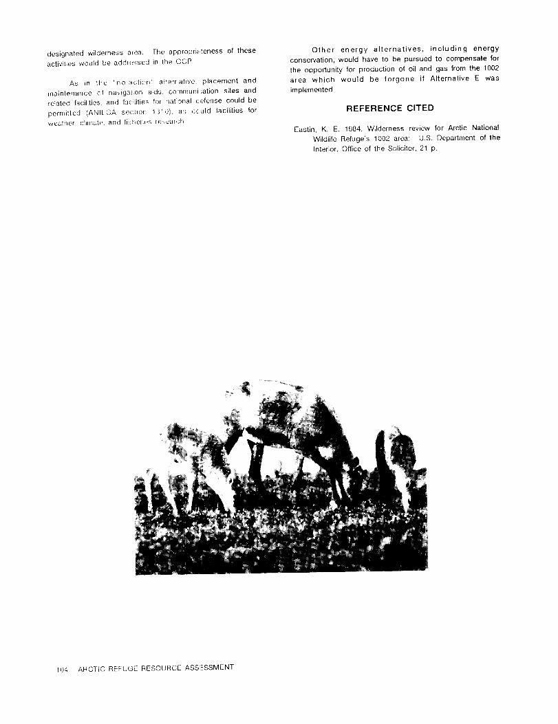
designated wildernessatea. The appropriatenessof these Other energy alternatives,including energy
activitieswould be addiessed in the CGP. conservation,would have to be pursued to compensate for
the opportunityforproductionof oiland gas from the 1002
As in the 'no action alternative,placement and area which would be forgone if AlternativeE was
maintenance of navigationaids.communi ;ationsitesand implemented.
relatedfacilities,and facilitiesfornationalcefense could be
permitted (ANIL.CA sedion 1310) as cculd facilitiesfor REFERENCE CITED
weather,climate.and fishorieire@7ear(;hEastin,K. E. 1984, Wilderness review for ArcticNational
WildlifeRefuge's 1002 area: U.S. Department of the
Interior,Officeof the Solicitor,21 p.
104 ARCTiC REFUGE RESOURCE ASS,--SSMENT

CHAPTER VI
ENVIRONMENTAL CONSEQUENCES
- INTRODUCTION -
This chapter analyzes and discusses the potential with this 5-percent case would likelyresultfrom the
environmentaleffectsof activitiesthat could occur from extended development of 2 or 3 of the largestprospects if
implementingthe alternativesdescribed in Chapter V: they containa much largervolume of oilthan expected.
AlternativeA: FullLeasing The effectswould not increaseproportionallywithincreased
AlternativeB: LimitedLeasing production.AlternativeC: FurtherExploration
Based on development of the oilfieldat PrudhoeAlternativeD: No Action
Bay, wellspacing for prospectus)contributingto the 9.2-AlternativeE: Wilderness Designation.
billion-barrelcase would be assumed to be the same asThe impacts of AlternativesA through E are summarized
that forthe 3.2-billion-barrelcase. For eithercase,fieldlifeand compared at the end of thischapter.
would be about 30 years. Most additionalsurfaceimpacts
Development, ifitoccurs, may differsomewhat fromwould be due to expansion and modificationof the
the scenarios assessed here. The analysisof oilinfrastructureused to develop the individualoilfields.This
development is based on best availableinformationas tocould mean construction of additional drillingand
possiblelocationand size of the prospects delineatedbyproduction pads, additionalproduction facilities,and
the seismicsurveys (fig.111-1).Additionalexplorationwouldconnecting lines. These facilitieswillstillbe concentrated
furtherrefinethese data. Oiland gas may be discoveredinwithinthe boundaries of a field,so impacts would be
other partsof the 1002 area or the areas now delineatedlargelyconfinedto the same surfacearea as assessed at
may be nonproductive. The magnitude and types of effectsthe 3.2-billion-barrelmean recoverablecase, although they
resultingfrom development should be essentiallythe samewould modify some additionalacreage.
for alldevelopment scenarios. Ifoilis not present in The additionalproductionfrom the 5-percentcase iseconomicallyrecoverablequantities,then the environmental not likelyto significantlychange the impacts of a main oil
effectsof AlternativesA and B would be reduced,possibly pipeline,haul road, airstrips,ports,and supportingroads
to those described forAlternativeC. and infrastructurefrom that requiredto develop the 3.2-
billion-barrelcase. A largerdiameteroilpipelinecould be
This programmatic legislativeenvironmentalimpact used to accommodate increasedoilproduction. Additional
statement (LEIS) discusses the overalloiland gas disturbanceand displacementof wildlifemight occur as a
development programs which might OCCUr on the 1002 area. resultof more intenseactivitiesand increasedor prolonged
Without site-specificinformation,precise effectscannot be trafficon the roads and at the ports.The roads and port
predicted. Ifthe area is opened to leasing,this facilitiesanticipatedforthe mean case development should
programmatic LEIS could sufficeforthe initiallease sale if be capable of handlingthatincreasedtraffic.
the Congress so stated in the enabling legislation.Whether or not the development of potentialgasHowever, environmentaleffectswould be reassessed at all
resources becomes economic, gas development and theappropriatestages for each subsequent lease saleand allinfrastructuresto support itwould be expected to share oildevelopment stages, as the requiredauthorizationsaredevelopment and transportationfacilities.Therefore,no
obtained.appreciable increase in the intensityof environmental
The environmentaleffectsdescribedin thischapter impacts is anticipated,althoughthe lifeof a fieldmay be
are based on scenariosdeveloped for the mean estimated extended by gas production. Development of gas would
recoverableresourceof 3.2 billionbarrelsof oil.There isa require separate administrativeapproval and would be
5-percentchance that more than 9.2 billionbarrelsof oil subjectto appropriateenvironmentalreview priorto such
could be recovered. The environmentaleffectsassociated approval.
CONSEQUENCES--INTRODUCTION 105

- Developing the Assessment Corporation/ArcticSlopeRegionalCorporation(KIC/ASRC)lands which would be availablefor oiland gas
To determine the potentialenvironmental development,production,and transportation,should the
consequences of the variousalternatives,a Fish and Congress choose to open the 1002 area. An exploration
WildlifeService(FWS) environmentalassessment team of wellhas alreadybeen drilledon the KIC/ASRC landsbut all
biologists,formed in February1985, met with Bureau of welldata have been held confidential.Ifhydrocarbon
Land Management (BLIVI)and GeologicalSurvey (GS) resources are present,development, production,and
scientiststo determinethe extentand probablesurface transportationwould (1)be expectedto proceed on a much
modificationsrequiredforoildevelopment on the 1002 area. more rapidschedule,absent the need fora leasesale,and
Maps of fishand wildlifeuse areas(p1s.1-3)were overlaid (2)be expected to influenceleasingand development
withfulland limiteddevelopmentscenarios(figs.V-1 and V- patternson the 1002 area itself.This could influence
2),allowingmeasurement ofdirecthabitatlossor alteration. constructionof a pipelinesystem as well,should any
The natureand magnitude of directand indirecthabitat reservesbe found inthe KIC/ASRC landsthatcould,as a
losses,disturbance,mortality,and other potentialeffects single"stand-alone"prospect,supportthe cost of a
were then determined. Effectsare characterizedas major, transportationsystem to the Trans-AlaskaPipelineSystem
moderate,minor,or negligible(tableVI-1)forthe physical, (TAPS)forproduced oil.
biological,and human environmentsof the 1002 area thatwould be affected.Effectsthatcouldlikelypersistat least Therefore, as required by the Council on
as long as the fieldlifewere considered"long-term"and EnvironmentalQuality(CEQ) regulations(40 CFR 1502.22),
those likelyto persistlessthan thefieldlife(30years;see oil-relatedactivitiesreasonablyforeseeableat some pointin
Chapter IV)were considered"short-term." time throughoutthe 1002 area were evaluatedfor thepurposes ofimpact assessment.
The scenariosfor developmentin AlternativesA andB depicthypotheticalinfrastructuresbased on a projected Experiencesat Prudhoe Bay and surroundingoil
hydrocarbonpotentialat the mean economicallyrecoverable fields,and on the NationalPetroleumReserve in Alaska
resource estimate. Ifthe 5-percent-probabilityproduction (NPRA), have provided much valuableinformationwhich
occurs,the effectsremainbasicallythe same, as explained assistedin many of the analysesand conclusionsin this
earlier. report. As furtherrequiredby the CEO's regulatoryamendments (40 CFR 1502.22(b)(3)and (4)),thischapter
Leasing and development, from fieldexploration summarizes existingcrediblescientificevidencerelevantto
through oilproduction,transportation,rehabilitation,and evaluatingreasonably foreseeable significantadverse
abandonment, would be sequentialon the 1002 area. For impacts,based upon theoreticalapproaches or research
purposes of impact assessment, itwas assumed that methods generallyaccepted in the scientificcommunity.
BlocksA, C, and D (forAlternativeA) were leasedand that There is substantialuncertaintyabout the abilityof wildlife
explorationwas successful. Itwas furtherassumed that in the 1002 area to adapt to oilactivityand about the
each of these blocks,plus Block B which would be availabilityof suitablealternativehabitats.Furtherpotential
crossed by the main pipeline,would at some pointintime problems existwith drawing directconclusionsfrom the
concurrentlyhave some phase of activityoccurringinthem, Prudhoe Bay developments,at leastin the case of the
whether itbe winterseismicinvestigations;explorationwell Porcupine caribou herd (PCH). Nonetheless, the
drilling:constructionof airstrips,port developments, developmentsat Prudhoe Bay over a sustainedperiodof
pipelines;rehabilitation;and so forth. Ifsome of the time have not been adverseformost species. The FWS
currentlyprospectiveareas contain no economically has taken specialcareto identifyin the reportareas of
recoverableoil(ofwhich there is an 81 percentchance), biologicaluncertainty.Biologicalconclusionsthat cannot
then predictedimpacts would be substantiallyless, be drawn with certaintyhave been noted as speculative.
probablylimitedto those associatedonlywith exploratory This is generallyachievedby use of the word "could"or
welldrillingand cleanup as describedunder AlternativeC. similarqualifiers.
This decreaseinadverseeffectswould be particularlytrueifdelineatedprospects in Blocks C and D produced 'dry A high degree of interestand concernforeffectson
holes`@notonlywould developmentofthE@ fieldsnotoccur, caribou,specifically,the PCH, exists.Given the strong
but the main pipelinecould be shortenedby a significant publicinterestand extensiveinteractionslikelyfrom oil
amount, and the Pokok port sitewould be unnecessary. developmenton the 1002 area forthisspecies,the report
Such speculation,however,precludesmeaningfulanalysis. includesa particularlydetailedassessment of caribou. Asdescribedin a subsequent section,caribouis one of fiveevaluationspecieschosen forthe resourceassessment.
Untila leasingprogram isactuallydevelopedforthearea and explorationoccurs,itwould be speculativeas to Because informationdirectlyrelevantto probable
which tractswould be leasedfirst,which areas would reactionsof the PCH to oildevelopmentis generally
prove to containeconomicallyrecoverableoil,and which lacking,the FWS assessment team consultedwithcaribou
areas would be the firstdeveloped. This uncertaintyis biologistsfrom the Stateof Alaska,the oilindustry,
compounded by the existenceof the KaktovikInupiat universities,Canada, and withinthe FWS itself.In
106 ARCTIC REFUGE RESOURCE ASSESSMENT

Table VI-l.--Definitionsofenvironmentaleffects.
Effectlevel Definition
Physicalenvironment
Major............................Widespread modificationof considerableseverityinlandforms,surfaceappearance,ordistributionof physicalresources,or contaminationof those resources.lastingseveraltensofyears. Modificationcould occur duringdevelopment/productionphase.
Moderate .....................Localmodificationof considerableseverityinlandform,or surfaceappearance,or contam-inationof physicalresources,lastingseveraltensof years;or widespreadmodificationoflesserseverityin surfaceappearance or other characteristicsof physicalresources,lastingfrom a few yearsto severaltens of years. Modificationcouldoccur duringthe
explorationphase.Minor............................Localized,relativelyisolatedchange lastingfrom lessthan 1 yearto no more than 10
years,with no observableresidualmodificationin surfaceappearance,distribution,orothercharacteristicsofphysicalresources.
Negligible.....................Littleor no change inthe surfaceappearance,distribution,or othercharacteristicsofphysicalresources.
Biologicalenvironment
Major............................Widespread,long-termchange inhabitatavailabilityor qualitywhich would likelymodifynaturalabundance or distributionof species.Modificationwillpersistatleastas longasmodifyinginfluencesexist,thatis,forthe fieldlife.
Moderate.....................Widespread,short-term(forlessthan the fieldlife)change inhabitatavailabilityorqualitywhich would likelymodify naturalabundance or distributionof species;or localmodificationin habitatavailabilityor qualitywhich would likelymodifynaturalabundanceor distributionatleastas longas modifyinginfluencesexist.
Minor............................Short-term(thatis,forsubstantiallylessthan the fieldlife),localchange ofspeciesabundance, distribution,habitatavailability,or habitatquality.
Negligible.....................Littleor no change inpopulation,habitatavailability,or habitatquality.
Human environment
Major............................Requiressubstantialchanges ingovernmentalpolicies,planning,or budgeting,or islikelyto affectthe economic or socialwell-beingofresidents.
Moderate.....................Requiressome modificationof governmentalpolicies,planning,or budgeting,or may affectthe economic or socialwell-beingof residents.
Minor............................Requiresmarginalchange ingovernmentalpolicies,planning,or budgeting,or may margin-allyaffectthe economic or socialwell-beingof residents.
Negligible.....................Not sufficientto have any measurableeffecton governmentalpolicies,planningor budget-ing,or any measurableeffecton the economic or socialwell-beingof residents.
CONSEQUENCESANTRODUCTION 107
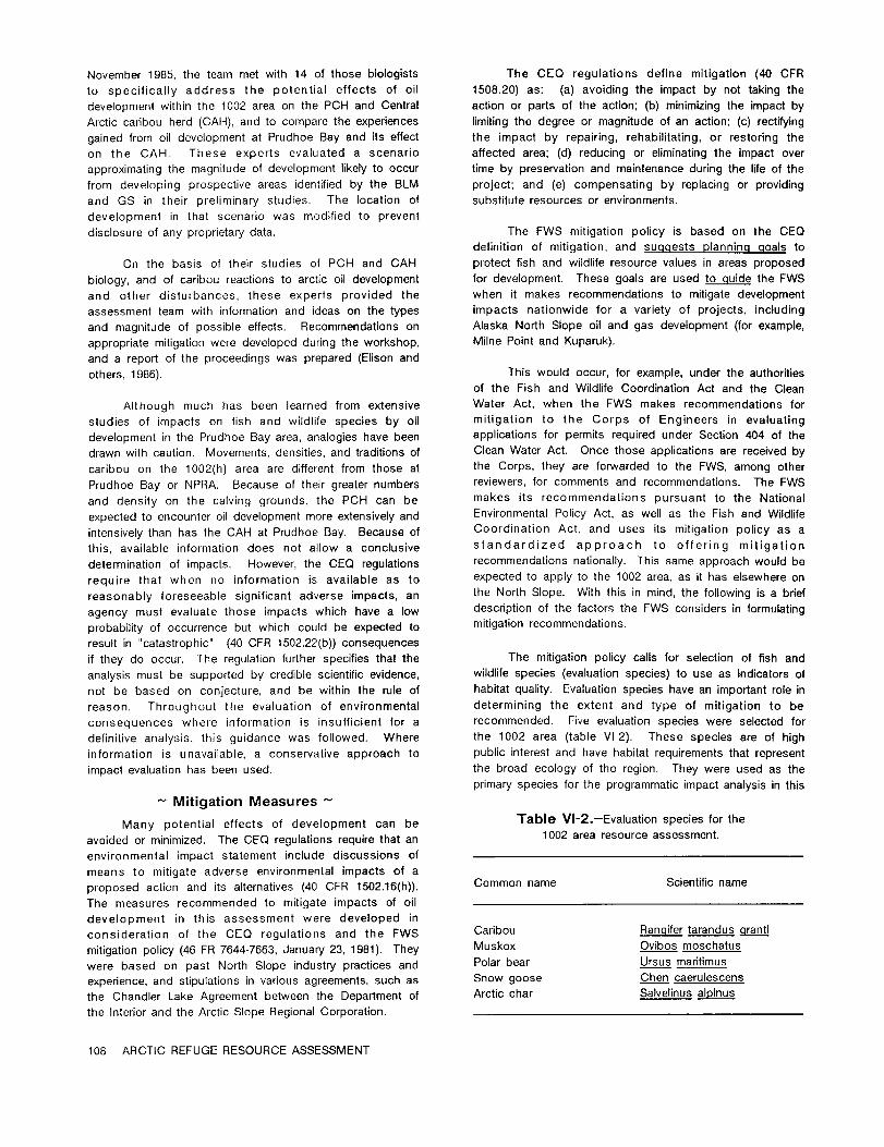
November 1985, the team met with 14 of those biologists The CEQ regulationsdefine mitigation(40 CFR
to specificallyaddress the potentialeffectsof oil 1508.20) as: (a)avoidingthe impact by not takingthe
development withinthe 1002 area on the PCH and Central actionor partsof the action;lb) minimizingthe impactby
Arcticcaribou herd (CAH), and to compare the experiences limitingthe degree or magnitude of an action:(c)rectifying
gained from oildevelopment at Prudhoe Bay and itseffect the impact by repairing,rehabilitating,or restoringthe
on the CAH. These experts evaluated a scenario affectedarea; (d) reducingor eliminatingthe impact over
approximatingthe magnitude of development likelyto occur time by preservationand maintenance duringthe lifeof the
from developing prospectiveareas identifiedby the BLM project;and (e)compensating by replacingor providing
and GS in theirpreliminarystudies. The locationof substituteresources or environments.development in that scenario was modifiedto prevent
disclosureof any proprietarydata, The FWS mitigationpolicyis based on the CEQ
definitionof mitigation,and suggests planning goals to
On the basis of theirstudies of PCH and CAH protectfishand wildliferesourcevalues in areas proposed
biology,and of caribou reactionsto arcticoildevelopment fordevelopment. These goals are used to guide the FWS
and other disturbances,these experts provided the when itmakes recommendations to mitigatedevelopment
assessment team with informationand ideas on the types impacts nationwide for a varietyof projects,including
and magnitude of possibleeffects. Recommendations on Alaska North Slope oiland gas development (forexample,
appropriatemitigationwere developed duringthe workshop, Milne Pointand Kuparuk).
and a reportof the proceedings was prepared (Elisonand
others,1986). This would occur, forexample, under the authoritiesof the Fish and WildlifeCoordinationAct and the Clean
Although much has been learned from extensive Water Act, when the FWS makes recommendations for
studies of impacts on fishand wildlifespecies by oil mitigationto the Corps of Engineers in evaluating
development inthe Prudhoe Bay area,analogieshave been applicationsfor permits requiredunder Section 404 of the
drawn with caution. Movements, densities,and traditionsof Clean Water Act. Once those applicationsare receivedby
caribou on the 1002(h) area are differentfrom those at the Corps, they are forwarded to the FWS, among other
Prudhoe Bay or NPRA. Because of theirgreaternumbers reviewers,for comments and recommendations. The FWS
and density on the calvinggrounds, the PCH can be makes its recommendations pursuant to the National
expected to encounter oildevelopment more extensivelyand EnvironmentalPolicyAct, as well as the Fish and Wildlife
intensivelythan has the CAH at Prudhoe Bay. Because of Coordination Act, and uses itsmitigationpolicyas a
this,availableinformationdoes not allow a conclusive standardized approach to offering mitigation
determinationof impacts. However, the CEQ regulations recommendations nationally.This same approach would be
requirethat when no informationis availableas to expected to apply to the 1002 area,as ithas elsewhereon
reasonably foreseeable significantadverse impacts, an the North Slope. With thisin mind,the followingisa brief
agency must evaluatethose impacts which have a low descriptionof the factorsthe FWS considersin formulating
probabilityof occurrence but which could be expected to mitigationrecommendations.
resultin "catastrophic"(40 CFR 1502.22(b))consequences
ifthey do occur. The regulationfurtherspecifiesthatthe The mitigationpolicycallsfor selectionof fishand
analysismust be supported by crediblescientificevidence, wildlifespecies (evaluationspecies)to use as indicatorsof
not be based on conjecture,and be withinthe ruleof habitatquality.Evaluationspecies have an importantrolein
reason. Throughout the evaluation of environmental determiningthe extent and type of mitigationto be
consequences where informationis insufficientfor a recommended. Five evaluationspecies were selectedfor
definitiveanalysis,thisguidance was followed. Where the 1002 area (tableVI-2). These species are of high
information is unavailable,a conservativeapproach to publicinterestand have habitatrequirementsthatrepresent
impact evaluationhas been used. the broad ecology of the region. They were used as the
primaryspecies forthe programmatic impact analysisinthis
- Mitigation Measures -
Many potential effects of development can be Table VI-2.--Evaluationspecies forthe
avoided or minimized. The CEQ regulationsrequirethatan 1002 area resource assessment.
environmental impact statement include discussions of
means to mitigateadverse environmentalimpacts of aproposed actionand itsalternatives(40 CFR 1502.16(h)). Common name Scientificname
The measures recommended to mitigateimpacts of oil
development in this assessment were developed in
consideration of the CEQ regulationsand the FWS Caribou Rangife tarandus g[a[]@
mitigationpolicy(46 FIR7644-7663,January 23,1981). They Muskox Ovibos moschatus
were based on past North Slope industrypracticesand Polarbear Ursus maritimus
experience,and stipulationsin variousagreements,such as Snow goose Chen caerulescens
the Chandler Lake Agreement between the Department of Arcticchar Salvelinusalpinus
the Interiorand the ArcticSlope RegionalCorporation.
108 ARCTIC REFUGE RESOURCE ASSESSMENT

chapter;however, the otherspecies and resource concerns Table VI-3.--Resource categoriesand mitigationgoals.describedin Chapter 11have also been considered. Ifthe
Congress chooses to open allor a part of the 1002 area [FWS MitigationPolicy:FR, v.46, no. 15, January 23,for oiland gas development, site-specificevaluationof 1981, Habitatvalue:a measure of the suitabilityofleasedtractscould resultin selectionof differentevaluation an area to support a given evaluationspecies]species which reflectthe habitatvalues of thatspecificarea.
Designationof resource categoriesis based upon the Resource Designationcriteria Mitigationvalueof the habitatto the evaluationspecies. Table VI-3 category of habitatto planninglistsresource categoriesoutlinedin the mitigationpolicy. be affected goalThe policy recommends thatlegallydesignatedareas such
as NationalWildlifeRefuges be given considerationas
eitherResource Category 1 or 2, in recognitionof thespecialvalues for which an area was set aside. As 1 Habitatof high valuefor No loss of existingdescribed in Chapter 11,high-valuehabitatoccurs on the evaluationspecies. habitatvalue.1002 area foreach of the fiveevaluationspecies selected Unique and irreplace-for this assessment. Therefore, for this broad, able on a nationalprogrammatic analysis,the 1002 area has been designated basis or in the eco-overallas Resource Category 2 habitat. Itis probable, region.however, that as site-specificdevelopment proceeds and
the 1.5-million-acrearea is broken into leasabletracts, 2 Habitatof highvaluefor No net loss of in-differentcategory designationswillresult.For example, on evaluationspecies, kind habitata site-specificbasis, itwould be expected thatspecific Relativelyscarce or be- value.areas of habitatused mainlyby shorebirdscould be coming scarce on adesignatedas Category 3 habitat. Conversely,ifthe plant nationalbasis or inThlaspiarcticum is eventuallylistedas eitherthreatenedor the ecoregion.endangered, the specificallydefined areas in which it
occurs would probably be elevated to Resource 3 Habitatof high to medium Minimizeloss of in-Category 1. value for evaluation kind habitat
species. Relatively value. NoItshould be understood that ifthe Congress directs abundant on a national net lossof
the Secretaryof the Interiorto leaseallor a partof the basis. value.coastalplainof the ArcticRefuge,the mitigationpolicyof
the FWS willbe used as only one of the mechanisms 4 Habitatof medium to low Minimizelossofavailableto ensure that development of the area proceeds valuefor evaluation habitatvalue.in the most environmentallysound manner practicable.The species.listof recommended mitigationat the end of thischapter
provides suggested environmentalmeasures that could be
used as appropriatethroughout allphases of development.They have been based on applicationof CEQ's five
elements of mitigation--avoiding,minimizing,rectifying, environmental requirements. Site-specificmitigationreducing or eliminating,and/or compensating for impacts. measures, including design and constructionThese, or other site-specificmeasures developed through techniques, would be addressed earlyin planning.earlyconsultation,can ensure thatno unnecessary adverse These measures would be institutedin contractsandeffectsoccur and that resultsof oildevelopment are held stipulationsrequired in permits and in otherwithinacceptable limitsof loss to habitatvalues on the authorizationsrequiredfrom regulatoryagencies.area.
2. The Secretary of the Interiorwould be authorized to
develop guidelinesthrough regulationsthat would- Assumptions ensure the environmentalintegrityof the area.
Assumptions used in the assessments include: 3. Planning, design, construction, operation,
maintenance, and rehabilitationwould be
accomplished using the most current available
1. The Secretaryof the Interiorwould undertakeearly technology and practices. Itis assumed that,asand continuous consultationand coordinationwith appropriate,the mitigationmeasures at the end ofleaseholders,permittees, and State and Federal thischapter,or measures at leastas effective,would
agencies from the startof planning. Performance be included in plans for development,construction,
standards would be developed for safety and and operation,and would be implemented.
CONSEQUENCES--INTRODUCTION 109

4. Any authorized oiland gas operationsand related Although the totallinemiles of new surveys might
activitieswould comply withallapplicableFederaland not differmuch from the 1,336 linemilesrun previouslyon
State laws and regulations,as well as with any the 1002 area,more crews may be on the area. Different
speciallaws the Congress passes or regulations companies have differentideas as to where to concentrate
promulgated by the Secretary of the Interiorto detailedsurveys (closergrid spacing);differenttypes of
govern activitieson the 1002 area. data are useful to companies in theirinterpretationsof
subsurface geologicalstructuresor style. Additionalcrews
5. Special protections for terrestrialand aquatic could increase the overallimpact,mainly from increased
environments and culturalresources,and designation travelto and from the 1002 area.-
of specialareas such as SadlerochitSpring,found in
guidelinesgoverning the seismic explorationprogram The physicaleffectsof seismic explorationgenerally
on the 1002 area and the land-usestipulationsfor resultfrom overland movement of seismic vehicles. The
explorationdrillingon the KIC/ASRC lands (August 9, effectis on the tundra which, ifbroken or scarred,can
1983, agreement between ASRC and the United cause thawing of the upper ice-richpermafrostduringthe
States)would continueto be ineffectforoiland gas succeeding summers. Such thawing in flatareas willcause
activitiesin the 1002 area. These stipulationsmay ponding at the junctionof ice-wedge polygons,alteringthe
duplicate some of the mitigation measures appearance ofthe tundra landscape. Ifthe thawing occurs
recommended in thisanalysis,but they also include on slopingground, erosioncan occur. Ifthat erosionand
specificreferencesto the handlingand disposalof itsproducts terminateat a stream,localsiltingmay result.
garbage, combustible and noncombustible solid
wastes, used equipment,sewage and graywater,fuel
and hazardous or toxicmaterials,and provisionfor
hazardous substance controland contingencyplans.Mitigation
6. The recent interimconveyance to KIC/ASRC has
been includedon allmaps used inthisreport.ThisSurlace effectsof seismic surveys can be minimized
20,000-acrearea was assessed in the draftLEIS andby confiningoperationsto the winterafterthe activesoil
has been assessed in the finalimpact analysis.layeris frozento a depth of at least12 inches and the
Although itsremoval from the analysismay resultin aaverage snow depth is about 6 inches. Seismic trainsare
lower degree of impact assessment in a few cases,generallyrouted through terrainwhere itis easierto move
development activitieswhich might occur ifthe areaequipment, so potentialfor surfacedamage is minimized
isopened can indicatepart ofthe cumulativeeffectseven though the routingmay not providethe shortesttravel
likelyfor the entirearea. Consequently, inclusionofdistance. Gently slopingbanks would be selectedforthe
these lands inthe analysisis reasonable.entryto and exitfrom allstream crossings,to reduce
equipment strainand avertbank damage which could causeerosion and stream siltation.This isimportanton the 1002
area where, even though the topographic reliefis not great,
ALTERNATIVE A--FULL LEASINGstreambanks are steep along many drainages.
No ice roads or airstripswould be constructedtoEffectson PhysicalGeography support seismic operations. Light,fixed-wingaircraftwould
and Processes be used forresupply,landingon 2,000-foot-longiceairstrips
Potentialimpacts on the physicalenvironment(air,scraped on the nearestlakeor pond. Ski-equippedaircraft
can be landed on the snow-covered tundra ifthereare nowater, gravel,permafrost,and so forth)from a leasing lakes nearby.program on the entire1002 area would be generatedfrom
geologicaland geophysical (principallyseismic)exploration;
exploratorydrilling;constructionof all-seasonroads,oil
transmission pipelines,and marine and other facilities
requiredto support production.Conclusion
GEOLOGICAL AND GEOPHYSICAL EXPLORATIONThe effectof seismic operationson water resources
Additionalsurface geologicalsurveys during the would be negligible.Seismic trainsuse about 2,000 gallons
snow-free months would not be expected to affectthe of water per day for domestic purposes. Where available,
physicalenvironment on the 1002 area. These surveysare water is obtainedfrom lakesthat do not freezeto bottom.
brief: the investigatorsarriveby helicopter,study and Where such lakes are not available,a smallsnow or ice
measure geologicsections,perhaps take a few hand-sized melteris used to obtain domestic water supplies. Local
samples of rock,and, at most, remain on the ground fora noise and minor air pollutionresultfrom equipment
few hours. The principaleffectis noise generated by the operation;these effectsare briefand transitory.Minor fuel
helicopterduringarrivaland departure. spillsmay also occur.
110 ARCTIC REFUGE RESOURCE ASSESSMENT

- EXPLORATORY DRILLING - The accepted method for abandoning an exploratory
well reserve pitis to injectthe unfrozenfluiddown the
Exploratorydrillingrequires heavy construction annulus of the wellat the time drillingis completed and
equipment to prepare a stabledrillingpad, reservepit,road then fillthe reservepitwith enough materialso thatthe
to the water source(s),and airstrip.When the wellsiteis drillingmud and frozen fluidbecome a part of the
completed, the drillingrig and support equipment are permafrost. On the North Slope about 5 feetof cover
transported by Hercules C-130 aircraftor low-ground- materialis required. Ifrevegetationcan be accomplished
pressure vehicles,depending on distancesbetween well over the reservepit,less fillisrequiredto insulatethe pit
locations.The area disturbedby activityat the wellsiteis contents,due to the insulatingpropertiesof vegetation.
usuallyabout 10 acres,includingthe area for the reserve Constructionequipment is usuallyrequiredto blade or haul
(mud) pit. fillmaterialintothe pit. The most successfultechniquefor
revegetationinvolvessaving the top organiclayerof the
On the 1002 area, obtainingwater for drillingand tundra when the reservepitis excavated. This layeris
ancillaryneeds such as iceroads and airstripconstruction then replacedwhen the pitis filledand abandoned.
has the potentialfor major adverse effects. Water is
confined to surface areas; there are few lakes of any Conclusion
appreciablesize.Temporary minor contaminationof the tundra could
As much as 15 milliongallonsof water may be occur in the depressions) where the treatedgray water
needed to drillone exploratorywell. Potentialsources and and other effluentis dischargedfrom the camp's waste
methods to develop requiredwater supplieswere discussed treatmentplant.
in Chapter [V. Many streams containingdeep pools that
do not freezecompletelyinwintersupport overwinteringfish Minor oilleaks and spillsfrom operatingequipment
populations.However, some riversin the 1002 area do not could occur. Human errorand mechanical breakdown ina
support significantfishpopulationsand there should be no rigorous arctic environment create the potentialfor
need to disturbcriticalfishhabitat. accidentalspillsof oiland other hazardous materials.
Off-streamreservoirscould be createdin conjunction Short-term(one or two winterseasons) minor noise
with gravel-removaloperations. They would be filled disturbancewould be associated with operations. The
primarilyby high (excess) streamflow during snow-melt visualeffectof the drillingrig,constructioncamp, and
periods (from about lateMay to mid-June) or summer transportationactivitieswould similarlybe a short-term,
rainstorms. These reservoirswould ideallybe constructed minor effectin the 1002 area.
in the unvegetatedflood plainborderingthe activestream
channel. Depending on theirsize,theirpresence could Because of the temporary,highlylocalizednature of
have a visualimpact insofaras they would contrastwith exploratorydrilling,air-qualityimpacts would be negligible.
naturallyoccurringfeatures.
Mitigation- DEVELOPMENT AND PRODUCTION -
The use of double linersin reservepitsfor both
explorationand development wells is advantageous in Usually severalmillioncubic yards of gravelare
adequately containing pit materials. When drillingis requiredto develop an oilfield.In a tundra environment,
completed,the reservepitcould containformationcuttings; adverse effectscan be minimized by obtaininggravelfrom
drillingmuds composed of barium,bentonite,and heavy exposed and unvegetatedbars along streams that are not
metals (particularlyiron,manganese, zinc,chromium, lead); fish-bearing. As long as the removal is limitedto gravel
salts(principallysodium chlorideand potassium chloride): exposed above the riverice or above the streambed (in
alkali(mainly calcium and magnesium bicarbonates);and those cases where the stream runs dry in winter),the
possibly some liquidhydrocarbons. Detergents,biocides, watercourse would remain unchanged and no siltingwould
and defoarningagents may also be present in the reserve occur because the gravelstend to be clean. In addition,
pits,together with fillers,such as ground walnut shells. the riversin the 1002 area completelyflushduringthe
The amount of water introducedfrom snow thathas blown spring runoff.
into the pit depends on snow and fluidmanagement
practices. The next places from which to obtaingravelwiththe
least disruptionare terracesimmediatelyadjacent to river
- Alaska solidwaste regulationsrequirethe closeoutof beds, using carefulmining practices. Gravel may also be
reserve pits at abandoned exploratoryand development removed from cutbanks of a riverwith minimal disruption.
sites.Effectiveclosureof these pitsrequiresstabilizingthe The State of Alaska has been approving upland sitesin
waste material(by drying),freezeback,filling,and providing recentyears to preventerosion,alterationsof riverfeatures,
an impermeable gravelcap to preventleaching,as well as and otherphysicalproblems,althoughthistends to create
monitoring. long-lastingvisualeffects.
CONSEQUENCES--FULL LEASING 111

Gravel,and sand in the absence of gravel,were but stillminimizethe lengthsof the spur linesto centralobtained from riverbars, riverterraces,and cutbanks,in productionfacilities(CPF's). Thus, the distancebetweenthat order,during the constructionof permanent airstrips the pipelineand the work road could vary and occasionallyand access roads for the deep explorationwells on the the two might even cross,as with TAPS and the haul roadNPRA. Placing geosynthetics material(forexample, (J.W. Dalton Highway) where they pass through similarstyrofoam)and insulationbelow the gravelprovidespartof topography. Itis furtherassumed that the pipelinemightthe insulationnecessary forpads, and reduces the depth cross some streams on verticalsupport members; in otherand overallgravelrequirements. instancesthe pipelinemight be attached to the road bridge
over the stream.The FWS has investigatedthe effectsof reserve-pit
fluiddischargeson water qualityand the fresh-watermacro- A pump stationand feeder pipelineswould beinvertebratecommunity of tundra ponds. The aquatic requiredat each CPF, and one or two booster pump
macro-invertebratesstudiedwere indicatororganisms for a stationswould be positionedsomewhere withinthe 1002
wide varietyof environmentalpollutantsand are important area, allof which are described in Chapter [V. CPF's,food sources forbirdsusing the North Slope. marine facilities,pump stations,and power-generation
facilitiesto heat water linesrunningtreatedsea water to the
Preliminaryresults of the investigationsshow CPF's would allbe constructedon 5-foot-thickgravelpads.significantlyhigher alkalinity,hardness, and turbidityin Pad areas would vary considerably,depending on theponds adjacentto reservepitsthan incontrolponds (R.L. planned use, but consequences to the physicalenvironmentWest and E. Snyder-Conn, unpublished data). Significantly would vary mainly in degree.higher levelsof heavy metals such as nickel,barium,
chromium, and arsenicwere found in ponds receiving Construction requirementscould include5-foot-thickeffluentthan incontrolponds. There were also decreases drillingpads and 200-300 linearmiles of all-seasongravelin totaltaxa,taxa diversity,and invertebrateabundance in roads withinseveral oilfields,assuming discovery of
tundra ponds associatedwith reservepits Introductionsof multiplecommerciaf-grade oilfields. The totalnumber ofbaritemay have physicallysmothered benthicorganisms as pads and miles of road would depend on fieldsdeveloped.
wellas benthicstages of otherorganisms The qualityand Approximately100 milesof road would be necessary east
quantityof organisms used as food by North Slope bird from the Canning River to the Pokok marine facilities.
species may be decreasing with deteriorationin water Construction of four,year-round,5-foot-thickgravelC-130
quality. airstripscould also be necessary.
Impacts from use of reservepitscan also stem from Solidwastes generated from oildevelopment in the
the practiceof using reservepitfluidsfor "watering"roads 1002 area willprobably requirean incinerationunit,a landfill,
to keep down the dust. The bariteand heavy metals in and an oilywaste pitsuch as those operated by the North
these fluidslead to dust which is high in barium,chromium, Slope Borough at Prudhoe Bay. The North Slope Borough
lead, and possibly other metals (E. Snyder-Conn, FWS, landfillcovers approximately22 acres;the oilywaste pit
unpublisheddata). The barium is inthe form of veryfine covers lessthan 10 acres. Itmay be possibleto minimize
particulatematterwhich can be detected at elevatedlevels losses due to a landfillby using an upland gravelpitfor
more than halfa mile from roads and during summer that site.Operations of solidwastes treatmentfacilitiesare
months isapt to be far more predominant than dust from regulated by the Alaska Department of Environmental
beaches, sand bars,and the like.Other metals occur at Conservation.
high concentrationsin sediments nearer roads. Dust from
these fluidsalso contributeto gradientsof increased Limiteddata availablefor the Prudhoe Bay area do
alkalinity,pH, and salinitydepending on distancefrom the not allow predictionof air-qualityconsequences of oil
roads. development withinthe 1002 area. The degree and kinds
of air pollutionwillprimarilydepend on the chemical
Possible effectsof wateringroads with reservepit composition of the crude oilobtainedand on combustion
fluidsare adverse impacts on invertebratesand on acid- equipment design.
lovingplants. This could eventuallyaffectgrazingmammals
and/or waterfowland other birds. Inasmuch as the 1002 - Airemissionswillbe generated by exploration,drilling,area is considerablydrierthan the Prudhoe Bay area,itis construction,excavation,vehicularand airtraffic,pipelines,more likelythat reservepitfluidscould be used on roads, electricalgeneration,and oilproduction and associatedbecause otherlocalwater sources are limited. facilities.The maximum annual emissions from the 1002
area would probably be analogous with present North
Chapter IV describes many of the sitingand Slope operations. Measurements inthe Prudhoe Bay area
constructionaspects of a pipelineto transportoilfrom the forthe periodApril1979-March 1980 showed thatthe 24-
1002 area to the Trans-AlaskaPipelineSystem (TAPS) Pump hour maximum for totalsuspended particulatesis
Station1. An above-ground oilpipelinewould not be as sometimes violatedand the 6-9 a.m. maximum for non-
topographicallyconfinedin itsroutingas would the main methane hydrocarbons was above NationalAmbient Air
road,and would be expected to be as straightas possible Quality and Alaska Department of Environmental
112 ARCTIC REFUGE RESOURCE ASSESSMENT

Conservation standards, However, the data show no Section 165 standards forNationalWildlifeRefuge areas. If
violationsin nitrogendioxide,ozone, carbon monoxide, or itis determined that deteriorationwillexceed these
sulfurdioxide.- standards using proposed
'
emission equipment,a permitis
not issued. The PSID permitprocess thus guards against- With the exception of one recent Lisburne unacceptable levelsof adverse airqualityimpacts.development well,allPrudhoe Bay/Kuparuk wells contain
..sweet"crude oil low in hydrogen sulfide and, ARCO's recentlyinstalledCentral Gas Facilityinconsequently,low in sulfurdioxide. Thus, acidificationin Prudhoe Bay contains improved flareequipment and hasthe Prudhoe area isunlikely.The FWS has monitoredthe resultedin greatlyimproved combustion at that facility.pH at numerous ponds and lakes in the Prudhoe Bay These recent improvements in flaredesign should reducevicinitysince1983. The pH of most ponds and lakes and potentialair-qualitydegradationduring emergency gas-flaringof snow inthe Prudhoe fieldhas been shown to be near activities.pH 7 or higher,oftenabove pH 8. The data clearlyshow
thatacidificationhas not occurred in the Prudhoe area. - Conclusion
Mitigation Moderate effects would be expected from
translocationof gravelfrom naturalsitesto construction
Gravel requirementswould be reduced by use of areas. This would change topography at borrow areas andgravel-foam-timberpads where feasible. Gravel removal at placement areas. Impacts at borrow areas would lastshould be prohibitedfrom activefish-bearingwatercourses wellbeyond the lifeof the project.and their tributaries.Proper insulationshould reduce
permafrostdegradation. Localizedremoval or destructionof tundra vegetation
resultingfrom the constructionof gravelpads, gravelroads,
To ensure maintenance of water qualityin the vicinity and gravel mines could occur. Some thermokarsting
of drillingand productionpads, drillingmuds, cuttingsand (caused by the meltingof ground iceand settlingor caving
other wastes should be reinjectedwhere geologically of the ground surfaceso thatpits,hummocks, depressions,
feasible.Reserve pitsshould be double-linedor otherwise and small ponds result)of the tundra would be expected.
rendered impermeable. Constructionof "reservoirs"as a Permafrost may melt under borrow sites and under
byproduct of gravel extractioncould augment fresh-water vegetationdisturbedby other development activities.This
availability. would resultin sloughing, erosion,and stream pollution
lastingbeyond the lifeof the project. Minor erosion in
Because reserve pitfluidswould be minimized connection with culvertsfor in-fieldroads crossingminor
through water conservation,reuse, and reinjection,large drainages,some ponclingupslope of airstrips,roads, and
quantitiesof these fluidswould not be availableforroad pads, and dryingclownslopeof such pads would also be
wateringto controldust. This willminimize contamination expected.
of adjacent tundra vegetationby the chemicalsfound in
such fluids. The dedicated industrialuse of the limitednatural
fresh-watersources of the 1002 area would be a major
To reduce stream pollution,transportationcrossings effect.
should be limitedand permanent facilitiesshould not be
placed within3/4 mile of the high-watermark of specified At work sitesduring both the productivelifeof the
watercourses,determined on a site-specificbasis. fieldsand at restoration,noise generated by aircraft
operations,drillingoperations(especiallythat arisingfrom
Allsources of airpollutioninthe 1002 area,whether power generation),and trafficwould be majorand continue
or not they are relatedto oiland gas activities,must throughout the fieldlife.Similarly,the visualeffectof such
comply with applicableEnvironmental ProtectionAgency activitieswould be a major,long-termconsequence of full
(EPA) and Stateof Alaska airpollutioncontrolrequirements. leasing.
It is,therefore,expected that these requirementsare
sufficientto ensure thatany emissions generatedin the Current EPA and Alaska procedures and regulations
1002 area (or from relatedactivitieselsewhere)willnot are adequate to ensure no significantdeteriorationof air
cause a significantdeteriorationof airquality. quality.
Priorto any development, air-qualitybackground data,
chemicalcomposition data on the crude oilto be produced, Effects on Biological Environment
and data on sensitivevegetationshould be gathered.
These data together with air-qualitymodeling data are Although thisanalysistreatsspecies individually,thepresented by unitproducers to obtaina PSID (preventionof dynamic interrelationshipsexistingamong species andsignificantdeteriorationof air quality)permit. Under a between species and theirenvironments are recognized.cooperativeagreement with the FWS, the NationalPark Vegetation is a key component of the environment;it
Serviceevaluatestechnicaldata in relationto Clean AirAct providesfood and cover essentialto allwildlife.Therefore,
CONSEQUENCES--FULL LEASING 113

a thorough discussion is presented under "Vegetation, EXPLORATORY DRILLING, DEVELOPMENT, AND
Wetlands,and TerrainTypes" regardingthe effectsof full PRODUCTION
development on that foundationof wildlifehabitat.This
forms the basis forlaterdiscussionsof effectson individual Ifthe entire1002 area were leased,subsequent oil
species. development, production,and transportationactivities,andassociated infrastructurewould eventuallyresultin
VEGETATION, WETLANDS, ANDapproximately5,000 acres of vegetationbeing covered by
TERRAIN TYPESgravelfor roads, pipelines,airstrips,and other facilities
(tableV-1),assuming allexplorationissuccessful.Physical
GEOLOGICAL AND GEOPHYSICAL EXPLORATIONdisturbances such as erosion and sedimentation,
thermokarst,impoundments, clearing,gravelspray, dust,
More detailedseismicsurveys would createa closelysnowdrifts,and pollutionwould alterthe habitatvalues of
spaced (2x2-mileor closer)network of temporarilyvisible many more acres.
trailsover partsof the 1002 area. The effectsof winterEffectson vegetationfrom iceroads and airstripsare
seismictrailswould be similarto those from the 1984 and
1985 seismicoperations--decreasesin plantcover, changesnot well-documented. Itis generallythought that properly
in plantspecies composition,patches of exposed peat andbuiltice roads protectvegetationfrom adverse impacts. Ice
mineral soil,destruction of hummocky microrelief,roads delay plantgrowth in the firstyear afteruse, and
compression of the vegetativemat, deepening of the activemay appear as green trailsfor severalyears. Higher sites,
soillayer,and surface depression of trails(Felixandcommon in the 1002 area, may be scraped duringroad
Jorgenson, 1985; Felixand others,1986a, b).constructionor duringuse ifthe ice isnot sufficientlythick
(Adam, 1981). On Alaska Statelands,ice roads are not
Trailsthrough wet graminoid tundra and moistallowed in the same location2 years in a row to avoid
prostrateshrub scrub appear greener due to compressioncompounding impacts on vegetation.
of standing dead leaves. Green trailsmay persistas a- Well pads may be builtof ice,gravel-timber-insulation,
resultof increasedplantproductivityand nutrientlevelsoror gravel. Ice well pads have the leastimpact on
changes in species composition in futureyears (Challinorvegetation,similarto that for ice roads and airstrips.
and Gersper, 1975; Chapin and Shaver, 1981; EnvirosphereGravel-timber-insulationpads use timber/insulationin place
Company, 1985; Felixand others,1986a, b).of some graveland oftenuse reservepitmaterialsforany
On heavilydisturbedtrails,surfacedepression couldremaininggravelneeds. This minimizesthe need forgravel
occur due to compression and possibly subsidence.borrow pits and, thus, loss of vegetation. One
Standingwater may be presenton these trails.In moistdisadvantage of the gravel-timber-insulationpads is that
graminoid tussock tundra or other vegetationtypes withfoam insulationcan break down or erode into smaller
hummocky microrelief,moundtops could be scraped orpieces that can be very difficultto effectivelyremove from
crushed. Trailshere appear brown because of thethe tundra. When the timberand insulationare removed, a
exposed peat or increasedlitterfrom dead plants.The thin much thinnerlayerof materialremains,oftencontainingsoil
vegetationmat on dry prostrateshrub riverterracesis as wellas gravel.-
easilydisturbed,and largedecreases in plantcover wouldRehabilitationis more successful for gravel4imber-
be expected. Trafficthrough riparianareas could break
shrubs,at some sitesnearlyto ground level.Most effects insulationpads. Pioneer species are slow to colonizeall-
occur on narrow trailswith multiplevehiclepasses, and gravel pads because of limitednutrients,limitedwater
occur more oftenon trailsmade by mobile camp unitsandavailability,and lack of fine-grainedmaterials(Everettand
fuelor supply sleighs. others,1985).
- Mitigation-- To reduce the possibilityof negativeeffectson
vegetation,and eliminatethe need for largereservepits,
Itis assumed thatsummer seismicexplorationwould subsurfacedisposalof drillingmuds by reinjectionshould
not be permitted,and ice-roadplacement would continueto be used. This method is currentlybeing used in some
be prohibitedin the same location2 years in a row.Alaskan oilfieldsand provides permanent disposal of
Multiplevehicle passes over the same route should be contaminants. Overflow from reservepits,breaching,or
avoided in allcases. Stipulationsgoverning surfaceleachingmay killsurroundingvegetation(Frenchand Smith,
activitiesforthe seismic programs in 1983-84 and 1984-851980). Drillingmuds may containdieselfuel,solublesalts,
(50 CFR Part 37) would also resultin avoidance orheavy metals,and ethyleneglycol,allof which can be toxic
minimizationof impacts to vegetation.to vegetation(D. W. Smith and James, 1980). Improper
closure of reserve pitscan resultin leaks or erosion
- Conclusion -(French,1980).-
Overalleffectsfrom additionalseismic exploration Spillsof diesel fuel,gasoline,crankcase oil,
would be minor or negligible. antifreeze,and hydraulicfluidcould affectmany smallareas
114 ARCTIC REFUGE RESOURCE ASSESSMENT

of vegetation. During the 1984 and 1985 seismic constitutingnearly halfthe reportedspills,with otherexplorationprograms, reportedspillsincludetwo spillsof petroleumproducts accountingforfewer spills.Most spills50-100 gallons,23 spillsof 1-20 gallonsand 46 spillsof were small;51 percent of spillswere no more than 10lessthan 1 gallonor of undetermined quantity. gallons,yet those spillsequaled only 1 percentof the
volume spilledin 1985. The most common causes of spillsinasmuch as exploratorydrillingrequires large were leaks,rupturedlines,and tank overtopping. Effects
amounts of fuel,spillsof much greatermagnitude than have generallybeen localized. To date,the cumulativethose that occur duringseismicexplorationcould occur. effectof spillshas not been significant.-The extentof vegetationdamage would depend on the time
of year,type of material,size of spill,and vegetationtype. - Culvertswould need to be designed to ensure thatDieselfuelis highlytoxicand killsallplantson contact;it slumpingfrom roadcuts and erosiondid not occur. Alteredmay penetratedeeply intosoil,killingroots and rhizomes drainagepatternscaused by roads and pads would resultand remainingtoxicfordecades (D.A. Walker and others, in some ponding, a generallywetterenvironmenton the1978; Lawson and others,1978; Mackay and others,1980). nearby upslope side of a road or pad, and a drierSpillsin the winterare less toxicthan summer spills. environmenton the nearby downslope side. ImpoundmentsWinter spillsare easierto containand clean up, do not caused by blockingdrainages could cause changes in plantpenetratethe soilas deeply,and lose some of theirtoxicity speciescomposition or eliminatesome plantsdepending on
by evaporation. the depth and durationof flooding. Thermokarst, which
commonly occurs on the edges of roads and pads,Crude oilcan cause severe decreases invegetative extends the affectedarea offthe facilitysiteand causes
cover but may not killallvegetation,even in heavily long-termchanges in moisture conditionsand plantspeciessaturatedareas (Johnson and others,1981). Mackay and composition(Walkerand others,1984).-others (1980)noted that crude oildegraded much faster
than diesel,especiallyifithad not penetrateddeeply into - Gravel,dust, and changes in snow accumulation
the soil. Revegetation sometimes began in less than 3 patterns would affect areas surrounding petroleum
years. Areas where oilhad penetrateddeepest (20-30mm) development facilities.Changes noted inthe Prudhoe Bay
remained toxicformore than 4 years. Large spillsInhibited oilfieldinclude:
recovery by alteringthe physicalpropertiesof the soils,1. Depositionof gravelspray 100 feeton eitherside of
making them drier,thus reducing or preventingseed the road (Klingerand others,1983; Envirosphere,germinationand vegetativegrowth. Deep spillsmay also
1@64; Walker and others,1984).resurfacein lateryears with toxiceffectson the vegetation.
Because oil penetrationis relatedto soilmoisture,2. Dust depositionas faras 250 feetfrom the roadside
wet vegetationtypes undergo less initialdamage. Standingwith heavy dust out to 80 feet(Everett,1980; Klinger,
water or saturatedsoilspreventfuelfrom penetratingto the1983; Walker and others,1984).
roots or rhizomes. Wet sitesalso usuallyrecoverfaster. 3. Earlysnowmelt along heavilytraveledroads (BensonIn addition,those species most resistantto oilspills and others,1975).(sedges and deciduous shrubs) are the best recolonizers
followingdisturbance(Walkerand others,1978). On the basis of thisinformation,secondary effectsfrom
Directcontact with oiloften resultsin immediategraveland dust spray were assumed to extend 100 feeton
damage to above-ground vegetation. Injuryto the rooteach side of allroads. Impoundments and altered
system may not be immediatelyobvious,but can cause asnowmelt patternswere also assumed to occur withinthis
same 100-footarea,as the terrainin the 1002 area hasslow deteriorationof plantsand a high degree ofwinterkill greaterreliefand impoundments are not expected to be asin futureyears (Deneke and others, 1975; Mackay and extensiveas those measured in the Prudhoe Bay oilfieldothers,1980). (Walkerand others,1984). Similarmodificationswould be
expected adjacent to drillpads and other facilities.
- Accidentalspillsof crude oiland refinedpetroleum Therefore,approximately7,000 acres of existingvegetation
products are an inevitableconsequence of oil-field could be modifiedby these secondary effects.-
development. Throughout the operationof Prudhoe Bay,
the very largespills(on the orderofat least10,000 gallons) An additional500 to 750 acres may be mined for
have been of crude oil,gasoline,and diesel. Larger spills gravel at as many as 15 differentlocations,or by creating
not only cover a largerarea,but they alsopenetratedeeper 20 to 30 deep holes for use as water reservoirs.The
intothe soil.An indicationof the frequencyand volume of effectsof gravel mines on vegetationdepend on the
potentialspillsis provided by recent records for Prudhoe locationof the borrow pits,amount of gravelremoved, and
Bay. According to 1985 records (the firstfullyear of the vegetationtype. Vegetationwould not be directly
computerized oil-spilldata) there were 521 reportedspills affectedifgravelwere mined from unvegetatedriverbars,
totaling82,216 gallons(AlaskaDepartment of Environmental unvegetated coastal beaches, coastal lagoons, or lake
Conservation, Fairbanks,unpublished data). Diesel and bottoms. Borrow pitson partiallyvegetatedriverbars or
crude oilwere the most commonly spilledproducts, vegetated riverterraceswould cause losses of alluvial
CONSEOUENCES--FULL LEASING 115

deciduous shrub and dry prostrateshrub riverterraces, distributionof Thlaspiarcticumin the ArcticRefuge is along
which cover only a smallpartof the 1002 area. In upland the KatakturukRiver(pl.1N, adjacentto potentialeconomic
areas,vegetationwould be lostin the area of the borrow prospects in Block A. Furtherstudy to betterdefinethe
pit,the area covered by overburden,and any area affected locationsand numbers of Thlaspiarcticumplantsoccurring
by erosion. Gravel removal inupland areas would be the on the 1002 area,in conjunctionwith carefulsitingofpads
most visuallydisruptiveand would be extremelydifficultto and routingof collectinglinesand associated roads in
rehabilitateto pre-projectnaturalconditions. Block A, would avoid most impacts to thatspecies.
Pipelinesmay transport sea water from coastal - Conclusion-
marine facilitiesinlandfor waterfloodor other purposes.The effectsof sea-water spillson tundravegetationare An overallloss of approximately5,650 acres (0.4
poorlyunderstood,but depend on the spillsize,season of percentof the 1002 area)of existingvegetationcould result,
occurrence,moisture,pH levelof the site,and vegetation based on the estimatedfacilityneeds for developingthe
type. Sea-water spillsaffectdry sitesmore severelythan entire1002 area. Habitatvalueswould be lostwhen these
wet sites.Sea water rapidlypenetratesdry soil,resultingin habitatsare covered by pads, airstrips,roads,and other
high saltconcentrationsnear the rootingzone. Recovery support facilities.
can take many years (Simmons and others,1983). Sea
water would be dilutedand more rapidlyflushedaway at Additionally,at least7,000 acres could be modified
wet sites.Many wetland sedge and grass species are salt by the secondary effectsof gravel spray and dust
tolerant,but largesea-waterspillsthat inundatethe tundra deposition, altered snowmelt and erosion patterns,
could severelydisturbvegetation,even in wet tundra sites. thermokarst,impoundments, and pollution.Habitatvalues
Major storm surges have killedallvegetationon flooded would decrease to varyingdegrees.
sites(Reimnitzand Maurer, 1979).The modificationof approximately12,650 acres (0.8
- Mitigation- percent ofthe 1002 area)would be a minor effect(tableVl-1) on area vegetationand wetlands.
Effects on vegetation could be reduced by
appropriatefacilitydesign and operation. Facilitiesshould- SPECIAL TERRESTRIAL AND AQUATIC
be consolidatedas inuch as possibleto avoid unnecessaryENVIRONMENTS -
directloss of acreage. Culverts should be carefully
designed to precludeimpoundment problems. TrafficspeedSADLEROCHIT SPRING SPECIAL AREA
controlswillreduce dust deposition. Reinjectionof drilling
muds and other fluids,and carefulconstructionwillhelp Withinthe 1002 area, the SadlerochitSpring Special
reduce toxic spills. Appropriate containment procedures Area (approximately4,000 acres)was the only area which
and absorbent pads must be used to minimizeand clean was closed year-roundto explorationactivitiesduringthe
up any fuel,sea-water,or other spillswhich did occur. previousexplorationprogram. This was due to the spring's
Effectivecleanup procedures for spillsand subsequent unique continuous flow of warm water,the only major flow
revegetationeffortscan reduce the amount of vegetation of warm water in the 1002 area during the winter,
originallyaffectedand the length of time needed for Prohibitingsurfaceoccupancy and certainother activitiesin
recovery (McKendrick and Mitchell,1978@ Johnson, 1981; the SadlerochitSpring Special Area would preventmost
Pope and others,1982: Brendel,1985). negativeeffectsfrom oildevelopment.
Rehabilitationof disturbedsitesmay partiallyrestore The increasedhuman populationexpected under full
lost habitat. Complete restorationmay not be possible, leasingcould increaseuse of the SadlerochitSpring area,
inasmuch as constructionactivitiesdramaticallyaltersurface particularlyby workers from adjacent Block D. The
featureswhich determine plantspecies compositioninthe resultingincreasein disturbancecould cause muskoxen to
naturalhabitat. Severalliteraturereviews of revegetationin avoidthe area (pl.2g or could affectbirds.Inwinter,the
Alaska have concluded that areas north of the Brooks open water inthe SadlerochitSpring area provideshabitat
Range are the most difficultto revegetate,and successful forthe American dipper,one of only two passerinespecies
rehabilitationtechniques have not yet been developed for residentyear-roundon the 1002 area (pl.3g. Fishing
these areas (Johnson and VanCleve, 1976; Johnson, 1981; pressure could also increase,competing with and disturbing
Kubanis, 1982; Oakley, 1984). Native subsistence users in the SadlerochitSpring area
W. 110.
Careful siting of petroleum explorationandMitigation
development facilitiesand activitieswould be requiredto
prevent disturbance of Thlaspi arcticumplantsand their The existing"no surfaceoccupancy" restrictionforoil
habitat. Some indirectplantloss might resultfrom dust explorationand development should remain ineffect.This
deposition. This species is currentlyunder review to precludes surface development and disturbance,thereby
determine ifitqualifiesas a threatenedor endangered plant maintainingthe area'sphysicalfeaturesand importantfish,
(category2 candidate--45FR 82480). The widest known wildlife,and subsistence resourcevalues.
116 ARCTIC REFUGE RESOURCE ASSESSMENT

Conclusion JAGO RIVER
Under current protectivemanagement regulations, Under AlternativeA the fullrange of development
development as a resultof leasingthe entire1002 area activitiescould be expected to occur withinthis general
would have negligibleeffectson the SadlerochitSpring area (such as geologicaland geophysical exploration,
Special Area. exploratorydrilling,developmental drilling,constructionof
roads,and pipelines).The environmentalconsequences of
these activitieshave been describedelsewhere.
KONGAKUT RIVER-BEAUFORT LAGOON Mitigation
Based on the hypotheticaldevelopment scenario, Itis recommended that the need for establishingexploratorydrillingand development activitiesare not "Research NaturalAreas" on the North Slope be reviewedexpected, so there would be no impacts in this area. and specificlocations(ifany) withinthe Jago RiverFurtherseismicexplorationin thisarea could resultinminor drainagethatmeet these needs be identified.adverse impacts on vegetationand estheticvalues. Minor
amounts of localnoise and airpollutionwould resultfrom Conclusionequipment operation. Temporary disturbance and/or
displacementof wildlifecould occur;these effectswould be Specificareas withinthe Jago Riverdrainagehaveshort-term.Minor fuelspillscould also be expected. not yet been identifiedfor inclusionin an "Ecological
MitigationReserve System," and so itis not possibleto assess the
projecteddevelopment's effectson the proposed Jago River
Limitingsurface occupancy in the zone from theecologicalreserve.
coastlineinland3 mileswould effectivelymitigateimpacts
withinthisarea.
Conclusion
AlternativeA isexpected to have negligibleeffectsonCOASTAL AND MARINE ENVIRONMENT
the proposed Kongakut River-BeaufortLagoon National
NaturalLandmark.Petroleum development and production in the 1002
area and associated transportationat both onshore and
offshoresiteswould have a varietyof effects.Docks andcauseways can affect dispersion, nutrienttransfer,
ANGUN PLAINS temperatures, salinities,invertebrateabundance and
diversity,fishpassage, and other uses of those areas by
Furtherseismicexplorationcould be expected in this fishand wildlife.Disruptionof naturalnearshore currents
area,resultingin minor adverse impacts on vegetationand can resultin sea-water intrusionsinto lagoons,causing
estheticvalues,temporary disturbanceand/or displacement lower water temperaturesand highersalinities.Salinityand
of wildlife,and minor fuelspills.Impacts on thisarea by temperature changes could alterinvertebrateabundance;
exploratorydrillingand development are expected to be decreases in invertebrateswould mean lower coastalarea
negligible.Ifdevelopment activitiesdo occur,the geologic valuesforfishand wildlife.Such intrusionsmay also alter
featuresfor which thisarea was identifiedas a potential fish movements by reducing existingfavorablehabitat
NationalNaturalLandmark would probably only be affected conditionsin nearshore zones.
by gravelextraction.Noise created by constructionand other operations
Mitigation in coastal areas could be a disturbance,sufficiently
reducingthe qualityof the coastaland marine habitatsto
Gravelextractionshould be limited.Any proposal for cause avoidance by some marine birdsand mammals.
gravelextractionwithinthisarea would be evaluatedfor
possible adverse impacts on the geologicfeatureswhich Debris washing ashore from transportand offshore
make thisarea unique. activitiescould increasewith increasedhuman activitiesin
the area. The driftlineis used fornestinghabitatby several
Conclusion species of waterfowl and seabirds (pl.3A, B, C).
Disruptionand physicalalterationof the driftlineby activities
Given the recommended mitigation,development as a associated with oildevelopment could affectbird nesting
resultof fullyleasingthe 1002 area would have negligible success by disturbingnesting birdsor alteringtheirnests.
effectson the proposed Angun Plains NationalNatural Debris and disruptionof driftlineswould also affect
Landmark because itwould not alteror disturbthe area's esthetics. Occasional fish and wildlifemortalitiescould
naturalcharacteristics. occur where animalsbecome entangled inor ingestdebris.
CONSEQUENCES--FLILL LEASING 117

-0
I>,
=U)
U)
LO
U)
C(L)
--
'gr-
cW
a)_;-
-W
a)O
-r-
4)CF)U)M
CIn
-.Z,0
(D
WEn
U)
C0)
0Q)
,-
OCO
r-
r0
--
4)
coa
MOe
-0w
C0
0co
0)
a)
M.0
C:3
LL
0(1)cl)-
CM
C-
al
co
co.0
'C-0
OC
EE
p0
CO-0
a)O
.2Co
0a)
00
CL
EE
cuC)
EE
EM=
-0E
0CD
0a)
oW
4)
:3
0
.0a
Q)
s'-75
:EQ)-:3
4)
-5CL
.0:3
aW
0o
'a-r
076
rC
-0)
O0)0
.00
Ca)
CL
0cr@
.-,
co0
E-C
E0
E0
>0
coM
coM
0-
75en
--
w.2
'DIM
:3a)
=C
3:5
a)0
C6>
<LL
>E
M16
-6:E
.a)
0-0
o-C
-c@-C
CDQ)
Ecm
E>
CD0
cnE
wIn
-za<
M0
"kCM
Q)a)
Mw
3:0
CR
a)
CD
00
cc:
-5Q)
0)
0co0
EEL
oO
QC
wI
-0)co0
<c
_0
ch
00)
z-0
.->,r
.-
co75
a)c\j
o0
-E
00
0E
:5z-0
C\jC)
rCD
-00
WW
0<
-0C
CE6
0a)
0CL
-Q)
(U
17-al
-0
<w
0Z
EU
0CL
a0
U0
oC
-3@
!@!0
-0C
coM
c-a
aco
Q)0
Wzr-
UE=
MW
Ca
(D
co<
=3CL
(D
-0
-;_7
-C
cclCD
0
0)U
04-)
'a
aCL
<Co
(U
W0
EU
CaC
CO(U
Co
U2)
0)O
Q)
Ca)a)
cts
co
coco
0C
0co
wE
00
a)
CM
a)
0M
C0
U)r
C0
PLa
bC)
:3_c
a).0
0EL
0M
=
cl)Q)o
E:E
wC
-?:
:3
't@cd
0M
.0
,0
03'
wM
cU
:3-0
m-0
EE
M'a
00
0a)
_-0
CU-
8E
U)w
0-0
Q)0
-5cn
-CW
>,C
MEn
=30
0)@a
=3--C
0-<
@:c:
EZ)
-00
CCD
W0
coC)
(D
ff
3.-
co0
:3
a)
x0
0:3
E0
0X-
Qo)E
Or_wo-
=;__
'aW
oco
-a)
3:-
a)
cl,O
u
C_@C
Uco
co6)
Ea0
C@5
C0
-3
(D
>0c
cm:t--
w0
co0
0)M
0E
c>$E
L)a)
CQ)
nCL
0-
-
U)"I
In0
co0
0o
co0
Ko
(D
o=
-0
-.0
-N
.-
@L__
CD
E.2
00
0c"
EM
-M
-0
E-m
EE
oo
CD
WCL
0
r_
So
=EL-5=
--
xU-
0M
0w
0E
a)
0a)
-14
MX
-C
a)75
WC
00
CL
EL
0w-
-Q)
ow
-0.-
a)
,-
Q)
a)
CL
>E
0M
.0
0M
w0
-0
MW
U)0)
.0
-0
CL
0.0
00)CjQ)o
0m
co
.0EL
@5q
=C
a)X
0M
0o
0U
Z0
0.
a)
mE
>'7Z
0x
WM
o-z-
(D>1
CL0
ra)
C)
-0
=)
->,
C-
70
co,
CL
co
-0
ocn
=1L:
0)
,L
2=
-UOIw
-=
M-0
0)
w>
o0,Z,
a)
a)
-LE:c=n
(D
-0
0co
=Ca
E
C-
-7
CF-0
M-0
-0
Wn
00
E-.s
E.0
0C
COM
@2-a
co(v
CC
Z0
'o-8
ww
0-0
00
cozB
ob
O0
M-0-
CL
0a;
a)
CLO
0C
9:wE
ox
Z6C
=3a)
M"T
Uc-70
0I-
.0
co
pC
LI
w-0
wa)
oCI-
0E
-0
Cc
EO
mcc
co-6
-.!EC
0)
.0
M0
Mj;@
-E
co<
Ew
00
-0-0
U)
.0
-0
0)
7@N
CLUi
>U
M
0t
(UCL
a)(D
,
rC
'a
(i
M0
c,z
p'a
L)
Ex
D_0
@0CU
>:3
0)co
af
00
E;:@,
0=3
0
-6
2x
(D
><
Q)
-0
:E
0CL
@=
'r
a)
-a
Ela
.0
0M
Mw
Z;=3
V)co
>w
CM
xcw:
mub,
E-co
M<
03:
coU)
3)V')M
o3io
E
-0
0CL
LLI0
@20
CL
0r-
cor
00
0M
wLLJ
00.
-=
-0
MQ)
_ca)
-0Q)
WW
6C6
-FUU
.2
Q)
2:,15
M-0
c0
w-0
(D
Q)
--.,e5D
W0
Z-r-
-FU-0
wCD
-Cw
c0
Cco
CU0
0:E
-M
0U
0w
0.
co
o:5'5@8
::,
i->>@
.-
M0
0O
=to
-0
-0
0(U
E3:
3CD
MQ)
0)O
Cco
a)4--
0)U)
0a,
M0
C'a
CLCL
-0
U):3
0N
:5.0
00
00
o0
CLCL
0O
w
60
(D(U
EM
=U)
=C
a)
0.
Ew
.-2
L.F
0)
0..a
-0
(U>
coU
>-0
w-0
CDU)
Cco
>fn
0U
-=
-co
0co
M'E
C0.-
rC
Q)'r-
:3M
00
0U
='o
(UM
Ca
MU
00
UCD
M-0
-0N
w0
Q=)M
LU
-0-5
CDCD
00
L)w
wC
CCQ)
U)W
-0
--M
00
Q)0
0,
Q)CL
mE
-0
-0
CEn
cn
(Ua)
0
a)
>U)
M0
co<
c:>
WV)
a)
0
-C
w13)
g
Zt-.-
-a
0>
w0
-@6w
>,
w.2
_0U)
C6
coI
0In
:3
U-
-:3
co
0-0
0CO
0M
a)
>,
Co
'ao)75
16w
U)
02
Ca
0o
cm<
0.
Z3
6O
0w
=-
WE
0w
tM0
E
EC
co2
M0
Q)-IZ
C-
CL.>
CL
coc)
ocL
coco
w
Ca
>,
00.
U)CO
Q)W
W-0
;_-z
0w
3,=
-_-
2c@
-r--
<E
ww
>0
oN
co
o0
wcn
E0
co2
>1-
Mr-
DM
C)
a)
W0
U)
ID
c-0
a)
co0
0.
r-
>E
0-C
a)
M0
<M
-0
0
Q,
0-0
:E-.0
U)C
Co
Eu
E0
wU5
coM
No
>w
=a)-C
rM
-E
-0
E7b
EE
cow
0(U
Qx
8-c-
U-
,Q)
(Uo
03)
E-x
L)
-i
LOE
.16
0Ca
.2
-E
E0
CL
M0
0-
-Z
wC)
0)C
co
0
M-
E(U
co<
-0
Ca)
U)
=3
2w
v(U-0
0)
00
O0
C0
00
-0
.2
0>
Ww
ccO
fE
w
0-5
c.0
TU-
oE
Lij
Ea)
E@3
0cj
coo
Q)
wE
Q)
Q)
C)
co
>-
-0
=C
a)
Q)
CO
0CD
a)
EE
0>
0'FhC
am
EE
WLU
05
oco
co0
C@:
.6-
C-10
Z@=-0
co
=3E
coCO
00
M0-
--
.0
Co0
a)
MW
-.-.0
0(U
ti->
-0-_
-.-
.-D
15U)
=L)
w-0
=3(U
Q)'.6
_rLU
a)(U
Q)Ir
coa)
-5
CC
3:0
==
co0.
'a
w-
-0
w7i
V)W
w
'a
cd0
-0
0C
?:
M-5
"o_E
>>
>,t
-0
(UN
C(U
tt---Fa
0w
Co
EM
cc
o:3
E>
00
EE
FCa-
CL
Ca)
co0.
CL
-0T)
UW
a'o"
-0
0M
co0
-5r
Q)
UCD-00
00
00
CC
(1)
=3
L)M
-Z
C-0
Q_
F-
Cw
Cco'a
6ru
M-
r_0
->
CL
(U
t,
00
EO
cco
Ca0
Ecu
Cw
Ux
C>
CaiI
>2
cr
I--
.0
MI
<a)
LU
U)
_r
-5
EU)
O2
:3
0o
.2,
o>
0)
00
oai
-M
@=M
75
>co
NC
w0
U-0
CD
>w
MC
U>
216
C0
as-0
:3C
Cco
wco
2C
C)CD
0U)
CZ0
oa,
3=.2!,
wE
M70
-aU
w0
00
UCL
0E
Cz
0C
2M
0-
C0
>Co-
CO
MC
'5
co
U0
'L
0w
wCY)

The kev determinantof impacts on caribouwillbe Results of disturbanceincludeavoidingdevelopmentwhere development occurs,not necessarilyhow much. If areas which can displacecaribou from historicallyusedadverse effectsresult,development in the southeastpartof habitats. Disturbanceis generallybelievedto resultmorethe 1002 area willhave substantiallygreatereffectson from human activity(noise,traffic,presence of people),thancaribou than development elsewhere. Calving and insect from the mere physicalpresence of the roads, pipelines,reliefwere considered importantfunctionswhich could be and buildings.disruptedby activityin the 1002 area Forage availability,predatoravoidance,and free access to these habitatsare
other key factorsconsideredin thisassessment. Caribou avoidance of development and human activity
has been reported by numerous investigators(Dau and
Cameron, 1985; Fancy, 1983; Urquhart,1973; Wright andEffects of HabitatModification-Ifallprospective Fancy, 1980). The extentof displacement or decreased
regions of the 1002 area were leased, successfully habitatuse varies. Displacementof the CAH from historicexplored,and subsequently developed, directlymodified calvinggrounds in response to oildevelopment at Prudhoecaribou habitat--thatis,the actualarea covered by roads, Bay has been documented (Dau and Cameron, 1985;airstrips,well pads, and other structures--couldtotal Cameron and Whitten,1979).approximately5,650 acres. About 3,650 acres of this,eastof the SadlerochitRiver,would be used by the PCH; the
remaining 2,000 acres west of the SadlerochitRiverare Aircraftdisturbance of caribou has also beenused by the CAH. Direct and secondary habitat documented. For example, Calef and others (1976)modificationsdue to changes in surfacewater flow,snow reportedthat helicopterswhich hazed cariboufrom the rearaccumulation,roadside dust deposition,and so forth,as caused a severe panic reaction. Large numbers (up todescribed in the previoussectionon impacts on vegetation, 60,000animals)could be herded by flyingataltitudesofupwould reduce the habitatvalue of approximately7,000 to 2,000feetabove ground level(AGL). Calves were moreadditionalacres. Therefore,totalmodificationof caribou sensitivethan other age classes and caribouon calvinghabitatwould occur on about 12,650 acres,or 0.8 percent grounds reactedthe most.of the 1002 area. This would representlosses in calving,
insect-relief,foraging.and predator-avoidancehabitats.
Effectsof disturbanceand displacementon caribou
calving,insect-relief,and other activitiesare detailedbelow.
Mitigationof Effectsof HabitatModification-These
acreage figures were developed in considerationofEffects on Calving from,Displacement/Disturbance.--Plates
mitigationmeasures thatwould requireconsolidatedfacilities2A and 2B show substantialoverlap of potentialoil
sitingand other measures to reduce the amount of actual development facilitieson the 1002 area with PCH calvingacreage required. Carefulroad design and adequate culvert
areas, and a smalleroverlapwith CAH calvingareas. Itplacement should amelioratechanges in surfacewater flow.
has been hypothesized that caribou selectcalvingareasEnforcement of speed limitsand other trafficcontrols
because of earlysnowmelt, advanced emergence of newshould reduce gravelspray and roadside dust deposition. vegetation,relativeabsence of predators,proximitytoProper road maintenance should furtherminimize gravel insect-reliefhabitat,lack of disturbance, or somespray and effects of alteredsnowmelt on adjacent combination of these and other factors(Cameron, 1983).vegetation. Maternal cows and theircalves are most sensitiveduring
calvingand immediatelythereafter(Calefand others,1976;
Effectsof Displacement and Disturbance-BiologistsMillerand Gunn, 1979; Elison and others, 1986).
Disturbance to cow-calfgroups on the calvinggroundsparticipatingin the FWS caribou assessment workshop
could interferewith bond formationand increasecalfagreed that displacementof PCH and CAH from areas of
mortality.oil-relatedactivitieswould occur (Elisonand others,1986).
Historicallythe entire1002 area has been used by caribou
with minimal disturbance. Disturbanceisunavoidableifoil
development occurs on the 1002 area. Itcan resultfrom a Concentrated calving areas depicted on figure11-5varietyof causes--presenceof pipelinesand roads,aircraft and plate2A have been used by caribou in densitiesoperations,general construction,routinefieldoperations, rangingfrom 46 to 128 caribouper square mile (1983-86).and the presence of humans. Reactions to disturbance As described in Chapter 11,densitiesof simlarmagnitudedepend on severalfactorsincludingcaribou age and sex, are assumed for earlieryears. Oil development in theseaggregationsize, presence of calves,and the nature of areas is of particularconcern. Twenty-seven percent of thedisturbance.Cows with newborn calvesare most sensitive concentratedcalvingareas used by the PCH (1972-86)areto disturbance;bulls,barren cows, and yearlingsare the withinthe 1002 area. When compared with the CAH, theleastsensitive.In Prudhoe Bay, as many as 4,000 bulls, PCH ismuch more crowded on itscalvinggrounds,but ofbarren cows, and yearlingsof the CAH remain near the greater importance is that substantiallymore of itsdevelopment area. concentrated calvingarea may be developed.
CONSEQUENCES--FULL LEASING 119

Dau and Cameron (1986)reportedthat maternal post-constructionstudy. Under fullleasing,most roads in
groups of CAH caribou showed declinesin habitatuse the 1002 area would be expected to have much greater
within3 kilometers(km) of eitherside of the road inthe traffic.There would be more drillrigsand otherfacilitiesin
North Slope's Milne Pointoilfield.Furtherreview of the many areas. Thus, predicted resultsin the 1002 area,Dau and Cameron data shows that statisticallysignificant using the Milne Pointstudy as a basis,are likelyto bedeclinesin use occurred out to 1 km (P=0.05)and 2 km conservative.
(P=0.1). Dau and Cameron compared the distributionof
caribouduringthe 4 years (1978-81)before constructionof For thisassessment, a 3-krnsphere of influencewasthe 29-km-long road and the 4 years (1982-85)after assumed, on the basis of the Milne Pointstudy. Ifthisisconstruction,which occurred duringthe winterof 1981-82. appliedto the development scenarioforAlternativeA, aboutThe road was constructedthrough one ofthe two reported 303,000 acres of PCH concentratedcalvinghabitat(tableVI-CAH concentratedcalvingareas (Shideler,1986).
4) could be affected.This representsabout 37 percentof
For allcaribou and for calves,linearrelationshipstotalconcentratedcalvinghabitatwithinthe 1002 area,of
between cariboudensityand distancefrom the Milne Pointwhich approximately 130,000 acres are within the
road differedsignificantlyfor the two periods. Afterroadstatisticallysignificant(P=0.05)1-km area and an additional
construction,fewer adultcaribouand calveswere in the 3104,000 acres are withinthe statisticallysignificant(P=0.1)
km closestto the road. Greater numbers of adultsand1- to 2-krnarea. These areas would mainlybe avoided by
calves than normally expected were in the area 3-6 kmpregnant or parturientcows and calves. Total avoidance
away from the road. The data show thatthe area within3up to 3 km from the Milne Pointroad did not occur,and
km of the road had about 50 percentof the number oftotalavoidance of the 303,000 acres within3 km of the
caribou that used the area priorto construction.MostAlternativeA development scenariowould not be expected.
adult caribouin the study area were maternalcows; theirCalvingwould occur throughout the area at reduced levels
displacement and that of calves were most noticeable.with the decline in habitatuse varyinginverselywith
Effectsdecreased as the distancefrom the road increased,distancefrom the road or other development.
Itisimportantto note thatthe MilnePointfieldisthe Pank and others(1987)estimatedthe extentto which
smallestdevelopment area on the North Slope. Activity individualcaribou could come in contactwith developmentlevelswere low (fewerthan 10 vehicletripsper day) and activities.They analyzed dailymovements of 10 adult
therewas one activedrillrigduring2 of the 4 years of caribou cows relativeto the AlternativeA scenario(fig.V-1
- Table VI-4.-- Porcupinecaribouherd concentratedcalvingarea potentiallyaffectedby development under full
leasingor limitedleasing,assuming a 3-kilometersphere of influence.-
Acres
Totalconcentratedcalvingarea in the UnitedStates and Canada ........................3,046,000
Totalconcentratedcalvingarea withinthe 1002 area..............................................828,000
Sphere of influence
0-1 km 1-2 km 0-3 km
Area (acres)potentiallyinfluencedby development:
Fullleasing.....................................................................................................130,000 104,000 303,000
Limitedleasing...............................................................................................96,000 72,000 214,000
Percent of 1002 calvingarea potentiallyinfluencedby development:
Fullleasing.....................................................................................................16 13 37
Limitedleasing..............................................................................................12 9 26
Percent of totalU.S. and Canada area potentiallyinfluenced
by development:Fullleasing....................................................._ ............................................ 4 3 10
Limitedleasing............................r ................I..."..'.........................................3 2 7
120 ARCTIC REFUGE RESOURCE ASSESSMENT

and tableV-11).The caribou--twofrom the CAH and eight established,or restrictionson activitiesand accessfrom the PCH--had been radio-collaredon winterrange in imposed, during criticalperiods in areas of caribouthe Arctic Refuge. Assuming no facilitiescompletely concentration--forcalving,approximatelyMay 15-June 20.
obstruct caribou movements, the satellite-telemetrydata Off-roadvehicleuse should be prohibitedwithin5 milesofshowed that 34 percent of routes taken by collaredPCH allpipelines,pads, roads,and other facilities,except forcaribou were within 3 km of possible development traditionaluse by local subsistenceusers. Methods toinfrastructure. The two CAH caribou would have facilitatecaribou passage at pipelines(as discussed intheencountered development on 83 percent of theirroutes. insect-reliefsectionbelow) would also facilitateaccess toAnnual variationsin movement patternsand the limited calvinghabitats.sample size and timeframe of the analysis must be
recognizedinreviewingthese findings.Still,theyprovidea
preliminaryindicationof the extentto which activitypatterns- Table VI-5.--CentralArcticcaribouherd population,
of some cariboucould interactwith development.calving in Prudhoe Bay area, and Prudhoe Bay
Although there is no evidence thatthe initialPrudhoedevelopment activities,1969-85.-
Bay development area was ever a concentratedor highly[Informationfrom Shideler(1986);some variationexists
preferredCAH calvingarea (Shideler,1986),some calvingin calvingareas surveyed. Long-term investigations
occurred there when development began (Child,1973;of the CAH begun in 1974 by the Alaska Department
White and others,1975). Laterstudiesindicatean absenceof Fish and Game. N.A.,not available]
of calvingnear the coast at Prudhoe Bay during 1976-85,
possiblydue to avoidance of development activity(Cameron
and Whitten, 1979, 1980; Whitten and Cameron, 1985).
Table VI-5 compares calvingin the Prudhoe Bay area and Year Total Number Developmentthe population size of the CAH to development of the CAH cows and activitiesPrudhoe Bay oilfield. population calves
As evidenced by the dramatic increasein CAH
numbers, displacementappears to have had no significant 1969-70 (1) (1) Oildiscovered.adverse effect. In consideringeffectsof displacementof 1972 N.A. 13 Deadhorse airport,roadthe CAH from calvinggrounds. Whitten and Cameron
system, severaldrill(1985) contend that the CAH has not experienceda 1973 N.A. 42 pads developed.reduction in productivityor a consequent population
decline,because: (1)suitablealternativehigh-qualityhabitat 1974 N.A. 51 Constructionof TAPS;appears available;(2) the CAH has been displacedfrom rapidarea growthonly a part ofitscalvinggrounds to areas alreadyused for inroads, facilities,calving;and (3) overalldensityof CAH caribouon their and drillpads.calvinggrounds (even afterdisplacement)is much lower
than the densityof otherAlaskan Arcticcaribouherds. 1976 N.A. (2) Oilproduction begins.
1978 6,000 (3) Drillsitesand roadBecause CAH calvingdensityis low, overcrowding connecting Kuparuk
and consequent habitatstressthat might resultinreduced with Prudhoe Bayproductivityand survivalhave not yet occurred,despitethe developed.herd's populationincrease. Nor have CAH caribou been
displacedto areas of apparentlyreduced habitatvalue or 1981 9,000 N.A. Kuparuk pipelineconnect-increased predation. The CAH has been exposed to ing to TAPS completed.minimal predation in recent years. With the influxof
workers and use of the Dalton Highway for Prudhoe Bay 1983 13,000 (4) 0 Expansion of Kuparukdevelopment, the wolf populationin the centralArctic oilfield.decreased in the mid-1970'sas a resultof illegalhunting.
At that time CAH numbers began increasing.The wolf 1985 15,000 (5) N.A. Pipelineto MilnePointpopulationhas remained low and brown bears,which also constructed.prey on caribou,are only moderatelyabundant inthe area.
Mitigationfor Effectson Caribou Calving-Nonessential lReportsof area used for calvingby the 3,000 ordevelopment facilitiesshould be located outside so caribouresidingin Prudhoe Bay area,early1970's.
concentrated calvingareas and riparianhabitats(pl.2N. 2A handful.
Essentialfacilities(drillpads and associatedpipelines/roads) 3About 10.
should be consolidated so as to minimize acreage 4From photocensus (Smith,1985).requirements,and should be constructedand maintainedto 5Extrapolatedfrom photocensus based on mortality
minimize disturbance. Time and area closuresshould be and productivityestimate.
CONSEQUENCES--FULL LEASING 121

Recommendations for aircraftrestrictionsdiffer. and others,1982; Smith and Cameron, 19135a,b; Klein,
According to Calefand others(1976),flightelevationsof 1980). This is of concern in the 1002 area because the
500 feet AGL would prevent most injury-causingcaribou probable main pipeline/haulroad route would bisectthe
reactions(forexample, stampedes). Altitudesof 1,000 feet area,ratherthan run parallelto cariboumovements as it
AGL would avoid mild escape responses. These does in the Prudhoe Bay development. The probabilityof
investigatorsrecommended aircraftaltitudesof 1,000 feet avoidance, though unknown, is anticipatedto be low for
AGL during calving,rut,and earlywinter. Davis and bachelor bullsand high for maternal cows and calves
Valkenburg (1979),who also noted an inverserelationship (Elisonand others,1986).
between the altitudeof aircraftand severityof caribou
reactions,recommended altitudesof 2,000 feetAGL from Studies at Prudhoe Bay show varyingsuccesses of
May to August. Caribou of the Peary herd in Canada caribou in crossing roads and pipelines (Fancy, 1983;
reacted similarlyto helicopters(Millerand Gunn, 1979); Curatolo,1984; Curatolo and Murphy, 1983; Smith and
altitudesof 2,000 feetAGL were recommended for May to Cameron, 1985a, b). Crossing success appears to depend
November and 1,000 feet AGL at othertimes. The FWS on factorssuch as trafficand other activity,pipelinedesign,
does not have authorityto regulateminimum flightaltitudes, season, and insect harassment. Caribou usuallycross
but can enforce aircraftharassment prohibitions. roads freelyiftrafficlevelsare low and avoid heavy traffic
(Curatoloand others,1982). In summarizing the 1981-83
Effectson Other Activitiesfrom Displacement/Disturbance.- studies of caribou crossing in the Prudhoe Bay and
Dau (1986) recentlyinvestigatedthe distributionand Kuparuk oilfields,Curatoloand Murphy (1986)attributed
behaviorof caribouon Alaska'sNorth Slope in relationto lower crossing frequenciesat pipeline/roadsitesto the
weather and parasiticinsects. During the briefsummer combined stimulusof vehicletrafficand a pipeline.In
season caribou attemptto optimizeforagingto meet the studiesinvolvingeffectsof the Kuparuk pipelinesand roads,
needs of lactationand growth, and to buildbody reserves Curatoloand others (1982)found thatfoi roads with no
forthe coming winter. Abundant high-qualityforageoccurs traffic,cariboureactionsranged from no observablereaction
inlandfrom the coast. Nonetheless, during warm, calm to actuallyselectingthe road foroestridflyrelief.
days which favorinsectactivity,largenumbers of caribou
seek insectreliefby moving to the cooler,breeziercoast. During the oestrid (nose bot and warble) fly
Summer activitypatternsare characterizedby pulsating harassment period from lateJuly to earlyAugust caribou
movements between coastalinsect-reliefareas and optimal seek reliefon gravelroads and well pads or inthe shade
inlandforagingareas,in response to the frequentweather of pipelinesand buildings(Curatolo,1983: Fancy, 1983).
changes. The insectharassment periodfor the PCH while on the1002 area is brief,and the majorityof the PCH is usually
In the absence of availableinsect-reliefhabitat, gone from the 1002 area before oestridflyseason peaks.
caribou aggregate intolargegroups or continueto move The primarysource of insectharassment forthe PCH while
intothe wind without feeding. Ifthe period of insect on the 1002 area is generallythe swarms of mosquitoes
harassment is extensive,weight loss ensues. This earlyin the summer season. Large groups of mosquito-
detrimentaleffectisin additionto the lossof blood (up to harassed caribou do not readilypass beneath elevated
125 grams/day)to mosquitoes and the increasedparasitism pipelines(Curatoloand Murphy, 1983; Smith and Cameron,
from skin warbles and nasal bot flies.Investigationsof 1985b). Deflectionsofup to 20 miles,duringwhich caribou
caribou-insectrelationshipsindicatethat in a typicalJuly in ran or trotted,have been observed in the centralArctic.
the Kuparuk oilfield,conditions for severe insect
harassment occur on 10 days and mild harassment occurs Smith and Cameron (1985a, b) and Curatoloandan additional12 days. Murphy (1983) documented reduced crossing success
where caribouhave been exposed annuallyto major oiland
Ifcaribou are delayed or preventedfrom freeaccess gas development for extended periods since the early
to insect-reliefhabitat,the resultmay be deteriorationin 1970's. Because some habituationwould presumably have
body conditionwith consequences of decreased growth, occurred,the CAH may be more likelyto cross an oil-field
increased winter mortality,and lowered herd productivity development inthe 1002 area than would the PCH. Elison
(Dau,1986). and others (1986)agreed they did not know how much
habituationwould occur over time. Even large groups
Reduced access to importantinsect-relief,forage,and (1,000 animals)in the CAH that successfullynegotiate
predator-avoidancehabitatscould resultfrom development structureslikepipelinesare much smallerthan the PCH
on the 1002 area. Postcalvingaggregations could be postcalvingaggregations(up to 80,000). Ifthe largerPCH
inhibitedfrom moving between inlandfeedingareas and groups react negatively,as Smith and Cameron suggest,
coastalor mountainous insect-reliefhabitatswithinand to there could be significantexclusionof PCH cariboufrom
the south of the 1002 area as a resultof development. coastalareas.
Several investigators have described inhibited The amount of PCH insect-reliefhabitatwhich could
passage of caribou through developed areas due to linear be avoided may be quantifiedin two ways. Eighteen
oil-developmentfacilitiesand associated activities(Curatolo percent (294,000 acres) of the 1002 area and adjacent
122 ARCTIC REFUGE RESOURCE ASSESSMENT

KIC/ASRC lands liesnorth of the proposed pipeline/road Ifthis major effectoccurred,itwould manifestitselfcorridoranalyzed forAlternativeA. Ifcaribou are inhibited as a widespread, long-termchange in habitatavailabilityorby road/pipelinedevelopment,then use of 52 percentof qualitywhich would likelymodify naturalabundance orestimated insect-reliefhabitats(includingas much as 80 distributionof the PCH inthe 1002 area. This modificationpercent of the coastal habitat)could be reduced. could persistat leastas long as modifyinginfluencesof oilAlternatively,by using the 3-km zone of influencedescribed productionexist(tableVI-1). "Catastrophic"consequencesfor calving,habitatuse on as many as 72,000acres (29 (40 CFR 1502.22(b)(4))are not expected to occur; but ifpercent) of insect-reliefhabitatwithinthe 1002 area and significantadverse effectscoincidedwith a populationlowKIC/ASRC lands could be reduced (Pank and others,1987). in the naturalfluctuations,theireffectswould be greaterDecreased use of the insect-reliefareas would be greatest than at a populationhigh.for cows with calves. Ifcaribouavoid coastalinsect-relief
habitat,they may compensate by using the foothillssouth There is riskthatdisplacingthe PCH from historicallyof the 1002 area,although thisarea may be lessfavorable used habitatscould resultin significantlong-termchangesdue to higherpredatordensities. in distribution,adverselyaffectinghabitatuse and behavior
patterns.The main oilpipelinewould bisectthe 1002 areaMitigationfor Effectson Other Activities-Timeand area between the western and northeastern boundaries.closures should be established,restrictionson activities Disturbancewould occur from the presence and activitiesofand access imposed, or trafficcontrolledduringperiods up to 6,000 people, many vehicles,and major constructionwhen caribou activelyseek out insect-relief,forage,and and production activitiesthroughout the 1002 area,predator-avoidance habitats--approximatelyJune 20-August including sensitive,repeatedlyused, concentratedcalving15. Curatoloand Murphy (1983)suggested thatcaribou areas.passage could be facilitatedby separatingpipelinesfrom
heavilytraveledroads and constructingramps at strategic Approximately 37 percent of PCH concentratedlocationsover elevated pipelines. Other researchers have calvinghabitatcould be affected. Sixteenpercent of thisconcurred (Curatoloand others,1982; Robus and Curatolo, area is within1 km of the fulldevelopment scenario,an1983; Elisonand others,1986). The optimum separation additional12 percent is within1 to 2 km and another 9depends upon terrain.Preliminaryinformationindicatesthat percentis within2 to 3 km (tableVI-5). A declineina separation of 400-800 feet improves crossingsuccess caribouuse of the area within3 km of fulldevelopment is(Curatoloand Reges, 1986).To permit use of coastal expected. Significantdeclinesin use by maternalcows andinsect-reliefhabitats,allmethods to facilitatecaribou calvescould occur withinat leastthe 2-km zone,passage should be used, as appropriateand feasible(that
is,elevating,ramping or burying pipelines;separatingA significantportion of the most repeatedlyused
pipelinesand roads; and implementingtime and areaconcentratedcalvingarea in the upper Jago Riverdrainage
closures,as well as access restrictions,for vehiclesandis within the 1-, 2-, and 3-km zones adjacent to
activities).development. Ifthe area used for concentratedcalvingin
approximatelyhalfthe years forwhich detailedobservationsFrom the coastlineinland3 miles,surfaceoccupancy
exist(7 of the 15 years,1972-86)is considered(fig.11-5andshould be restrictedto marine facilitiesand other
pl.2N, then caribou avoidance could occur within48infrastructureessentialto support inlandactivities.Drill percent of the most repeatedlyused PCH calvingarea (18pads and productionfacilitiescould be allowed withinthe percentat 1 km, an additional18 percentfrom 1 to 2 km,zone 1.5to 3 milesfrom the coast,on a site-specific,case- and another 12 percentfrom 2 to 3 km).by-case basis only.
Use of 29-52 percent of estimated insect-relief
habitatswithinthe 1002 area and KIC/ASRC lands also
could be substantiallyreduced. Failureto obtaininsect-reliefcould lead to poor physical condition,increased
Conclusion susceptibilityto predationifinsect-reliefareas south ofthe
1002 area are sought out as an alternative,and reducedMajor effectson the PCH could resultifthe entire over-wintersurvival. This could disproportionallyaffect
1002 area were leased and alloil prospects contained cows with calves,which could be expected to reduceeconomicallyrecoverableoil. Leasing and developingthe recruitment. Reduced habitatvalues on the 1002 areasoutheast quadrant of the 1002 area could resultin the because of obstaclesto free movements forforagingandgreatestdegree of effecton the PCH. This conclusion predatoravoidance could similarlyaffectcaribou.assumes allrecommended mitigationmeasures are in place
and effective,and considers peak levelsof activity.The
effectsof oildevelopment on caribouwould need to bemonitored and studiesof caribou populations,productivity,
movements, distributions,and generalhealthwould need to
continue,to ensure thatmitigationmeasures were effectivelyappliedand to ascertainactualeffectsof development.
CONSEQUENCES--FULL LEASING 123

Although no recognizablelong-termeffectupon the Muskoxen are present on the 1002 area throughout
CAH as a resultof displacementby oildevelopment inthe the winterwhen most explorationand constructionactivities
centralArctichas been demonstrated to date, loss of would take place. Dailymuskox activitydecreases during
important habitat has been shown to directlyimpact winter(Reynolds,1987) as part of theirbehavioralstrategy
ungulatepopulations(Wolfe,1978; SkovIin,1982). forenergy conservation. Repeated disturbanceduring the
winter causing increased or prolonged muskox activity
Reductions in calvinghabitatvalues,reduced access would resultin energy drainswhich could adverselyaffect
to insect-reliefareas,obstaclesto freemovement required survivalof individualsand productivityof pregnantfemales.
for foraging and predator avoidance, increased energy
expenditureas a resultof disturbance,higherlevelsofEffectsof stresson muskoxen have been difficultto
stress,and otherfactorscould cumulativelyaffectcariboumeasure. Millerand Gunn (1979)concluded that lackof
physiology.visibleresponse does not necessarilymean the absence of
physiologicalchanges or energy drainwhich may have a
A change in distributionof the PCH could reasonablymajor effecton the populationover time. The amount of
be expected. The potentialforoccurrence of a populationphysiologicalstress required to increase mortalityor
declineresultingfrom loss of habitatand reductionindecrease productivityis not known,
habitatvaluescannot be predictednor the sizeof a decline In theirextensivestudy of muskoxen reactionto
estimated. Nevertheless,there is a riskthata decline helicopter disturbance on Banks Island,Northwestcould occur. However, no appreciablepopulationdeclineis Territories,Canada, Millerand Gunn (1979)reportedthatexpected as a resultof oildevelopment. cows and calves and solitarybullswere the most
For the CAH, the change intheirdistributionon theresponsive;the reactionwas similarto response to a
1002 area could be moderate. However, the effecton thepredator;and the degree of reactionwas generallyinversely
entireCAH populationthroughoutitsrange would be minor.relatedto the distanceof the helicopter.The presence of
The effectson the segment of the CAH withinthe 1002people on the ground in associationwith helicoptersthat
area would be generated from disturbance,displacementhad landed increasedthe disturbance.Although muskoxen
and obstructionsto freemovement.disturbedby helicoptersusuallymoved less than 0.2 mile,
Millerand Gunn (1979)recommended minimum altitudesof
2,000 feetAGL during May-November and 1,000 feetAGL
duringDecember-April. Muskox reactionto helicopterscan
depend on a wide number of variables--sexand age of
animals,group size,number of calves in a group, thepositionof the sun and directionof the wind relativeto the
disturbance,what the animals are doing at the time of
disturbance, and terrain(Millerand Gunn, 1979).
Harassment may resultin a net energy drainifitoccurs
during the criticalwinterperiod,and can thereby reduce
survival.
Muskoxen also respond to seismic vehicles.
Experiencein the 1002 area from winterseismicexploration
in 1984 and 1985 and summer surfaceexplorationin 1983,
1984, and 1985 indicatesthat these activitieshad only
minor disturbanceeffects.One herd was reportedto have
run about 0.6mileafterbeing disturbedby seismicvehicles
MUSKOXEN -1.9 milesaway (Reynoldsand LaPlant,1985).They reported
no long-termor widespread changes in distributionor use
Recentlyreintroducedto the ArcticRefuge,muskoxenof traditionalareas in response to this disturbance.
are rapidlyexpanding theirrange and pioneeringnew areas.Jingforsand Lassen (1984) also found that muskoxen
The population has grown from the 64 muskoxendisturbedby seismicvehicleseitherran or graduallymoved
introducedin 1969-70 to 476 in 1985. Carrying capacityaway. Other investigators(Carruthers,1976;Russell,1977)
has apparentlynot been reached.reported similarresponses in Canada. Temporary
displacementof up to 2 mileshas been observed on both
Directloss of muskoxen habitatfrom oildevelopmentsides of seismic lines(Russell,1977). Although oil-field
could totalapproximately2,700 acres (pi.2g. informationdevelopment and operationwould be much more intrusive
is scanty regarding the reactionof muskoxen to oil-fieldand sustained than seismic exploration,the increased
development and operation. Disturbancecaused by routinedisturbancemay be partiallyoffsetby habituationwhich has
oil-fieldoperation and associated infrastructurecould bebeen observed by Millerand Gunn (1979) during
expected to exclude or reduce muskoxen from use oftheirexperimentalhelicopterharassment.
preferred habitats. Muskoxen residenton the 1002 area Muskoxen frequent riparianareas which could be
would be exposed to year-roundactivity.major sources forgravelneeded forconstruction.Important
124 ARCTIC REFUGE RESOURCE ASSESSMENT

forageareas may be lostdue to displacementand habitat valuablecalvinghabitatcould have a negativeinfluenceondestruction. herd productivity,
As describedin the previoussectionon caribou,loss Directmortalitycould resultfrom hunting,vehicleof important habitat has been shown to have major collisions,and other accidents associated withnegative effectson ungulates. Muskoxen have a high development. Muskoxen are highlyvulnerableto hunting,fidelityto relativelysmallareas and presumably selectthem and directmortalitywould be expected to increaseoverbecause of factorsfavorableto herd productivityand time as access into previously undeveloped areassurvival: availabilityof preferredforage,betterweather or increased.snow conditions,relativeabsence of predators,lack of
disturbance,or some combination of these and other Mitigation
factors. Displacement from high-useareas could have a
negative effecton muskox production. The magnitude of Negative effectson muskoxen could be mitigatedbythat effectis difficultto accuratelypredict,particularlyin prohibitingdisturbance and implementingnecessary timeview of the expanding natureof the population,but would and area closures similarto the measures describedforlikelybe related to the magnitude and duration of caribou. Continued monitoringof the population'sgrowth,displacement, No informationisavailableon the reactionof distribution,movements, and behavioralresponses wouldmuskoxen to sustained oil-developmentand production detect changes and determine what, ifany, additionalactivities. mitigationmay be needed.
Based on the displacement observed by Russell Because riparianareas are favored habitats,closure(1977)and Reynolds and LaPlant(1985)resultingfrom of importantriparianareas to sitingof permanent facilitiesseismicactivities,a 2-milesphere of influencewas assumed and limitingcrossings of those areas by transportationin calculatingthe muskox range which could be affectedby facilitieswould minimize Potential interactionsandfullleasing. Given the much lower levelof activitiesand disturbance,which would reduce effectson muskoxen (pf.resultantdisturbancefrom seismic explorationas compared 2g .to constructionand production phases of oildevelopment,thisassumption may be conservative.Consequently,table Increased hunting regulationand enforcement wouldVI-6 shows that habitatvalues could be lostor greatly be requiredto regulateharvest.reduced throughoutabout one-third(256,000acres)of the
muskox range withinthe 1002 area. Habitatsused forhigh
seasonal or year-round use, includingcalving,would be Conclusion
disproportionatelyaffected;habitatvalues could be reduced
in up to 53 percentof those habitats.Habitatvaluescould Major negative effectson the 1002 area muskoxbe lostor reduced on nearly75 percentof the high-use populationcould occur from oildevelopment,based on thecalving habitats. Such a large percentage of loss in possibledisplacement from preferredhabitats.
Table VI-6.--Observed muskox range potentiallyaffectedby development under fullleasing
or limitedleasing,assuming a 2-milesphere of influence.
High-use range seasonally Other Totalor year-round range range
Without calvingWith calving
Totalmuskox range (acres)withinArcticRefuge..................251,000 211,000 654,000 1,116,000
Area (acres)withindevelopment sphere of influence:Fullleasing..............................................................................46,000 112,000 98,000 256,000Limitedleasing........................................................................46,000 110,000 98,000 254,000
Percent of ArcticRefuge range influencedby development:
Fullleasing..............................................................................18 53 15 23Limitedleasing........................................................................18 52 15 23
Totalmuskox range (acres)within1002 area........................207,000 158,000 395,000 760,000
Percent of 1002 area influencedby development:
Fullleasing.............................................................................22 71 25 34Limitedleasing.........................................................................22 70 25 33
CONSEQUENCES-FULL LEASING 125

Muskoxen could be displacedfrom a significant Mitigationportion of high-use habitatsused year-round and for
calving,with a probable declinein productivity.This, - Mitigationwould includeprotectionof riparianwillow
coupled with any directmortalityand the unavoidable habitats,limitinguse of transportationcorridorsand closing
disturbances expected, could cause a declinein the the area within5 milesof projectfacilitiesto the discharge
population rate of growth and a change in distribution. of firearms. Moose harvest on the ArcticRefuge is
Effectswould be most pronounced on the small isolated regulatedby the State of Alaska in cooperationwith the
subpopulation of approximately 80 animals using the FWS, and could be kept within sustainablelimitsby
Niguanak-Okerokovik-AngunRiver area, in the eastern part modifyingharvestseasons and bag limits.-
of the 1002 area.Conclusion
Predictingchanges in muskox numbers as a resultof
petroleumdevelopment would be highlyspeculative.There Effectson the regionalmoose populationfrom habitat
are no referencesin the literatureto analogous activitiesin loss and mortalitydue to oildevelopment would be minor.
othermuskox ranges.DALL SHEEP
As noted elsewhere in this report,muskoxen are
being reestablishedin Alaska. Oildevelopment on the 1002 Dailsheep are rarelyfound north of the Sadlerochit
area is unlikelyto affectthisoverallre-establishmenteffort. Mountains, although they are common in the Brooks
Range, south of the 1002 area. Increased hunting
MOOSE pressure,air traffic,and harassment by sightseerscould
The 1002 area is not high-qualitymoose habitat.cause some indirectadverse effectsto Dailsheep.
Peak use is during the summer when the populationprobably is less than 25; duringthe winter,moose are rare Mitigation
on the area. The portionof the totalrefugepopulation
representedby thisfigureis not known.More restrictivehunting regulationscould be required
ifincreased harvest affectsthe health of Dailsheep
Directloss of habitatis expected to be about 140 populations or reduces the qualityof hunting and
acres out of the 96,000 acres of the 1002 area identifiedas associated recreationaluse.
moose-use areas. Affectedareas are low-densityhabitats
(lessthan one moose per 26 square miles),mainlyinBlock Conclusion
D (pl.1g.Indirecteffectson sheep outside the 1002 area
Moose adapt readilyand habituateto the presence would be minor. Fullleasingwould have a negligibleeffect
of human activity;they are not easilydisturbed(Denniston, on Dail sheep in the 1002 area; average age and,
1956; Peterson,1955). They have expanded theirrange in consequently,horn size of rams may declinesomewhat as
North America at the same time that human disturbance hunting pressure increases.
has spread (Davisand Franzmann, 1979). On the Kenai
NationalWildlifeRefuge in Alaska, helicopter-supported WOLVES
winter seismic surveys using explosivesdid not modify
moose distributionpatterns,movements, or behavior(Bangs Five to ten wolves seasonally use the 1002 area
and Bailey,1982). Most studieshave dealtwith moose in (Weilerand others,1985),mainlyinthe summer forhunting
forestedareas. The response of moose to disturbancein when prey is most abundant. Wolf dens have not been
tundra areas has not been demonstrated. documented. Wolves have denned infrequentlyon the
coastalplaineast and west of the 1002 area. Although
Increased human development on the Kenai wolves occur throughout the ArcticRefuge, totalnumbers
Peninsula,Alaska, has resultedinincreasedmoose mortality forthe refugeare not known.
from hunting,collisionswith vehicles,poaching, and other
causes (Bangs and others,1982). Moose mortalityon the The effectsof directhabitatloss to wolves would be
1002 area could occur as a resultof huntingor accidental negligible. Reduction of prey species (primarilycaribou)
death,especiallycollisionswith vehicles. Because so few caused by oildevelopment could reduce wolfvigor and,
moose use the area and because of the area'sopen consequently, productivity.The abundance of wolves is
nature,the number killedwould probably be very low. ultimatelydetermined by the biomass of ungulate prey
(Keith,1983). Harringtonand others (1983)reporteda
Moose populations south of the 1002 area would positivecorrelationbetween prey availabilityand survivalof
come under increasedhuntingpressure due to the influxof young wolves. Abilityof adultsto readilyprovidefood isa
workers to the area. Declines in the populationage key determinantin wolf-pup survival(Van Ballenbergheand
structureand average antlersizewould probablyoccur. Mech, 1975). Reduction of prey species would be greatest
Moose concentratein riparianhabitatssouth of the 1002 inthe area east of the HulahulaRiverwhere caribouactivity
area where they are highlyvisibleand vulnerableto hunting. and, consequently,wolf use have been the greatest.
126 ARCTIC REFUGE RESOURCE ASSESSMENT

Development activityisnot expected to cause wolves Arcticfoxes regularlyfed in dumps around constructionto avoid the area. During constructionof the Dalton camps durino constructionof TAPS (Eberhardt,1977).Highway and TAPS, instances of wolves becoming Foxes have high fecundity rates which are directlyhabituated to human activitywere recorded. In some influencedby food availability.MacPherson (1969)reportedcases, wolves readilyaccepted handouts from construction an average littersize of 10.6 at Demarcation Bay. Underworkers (Eberhardt,1977; Follmann and others,1980). naturalconditionsproductionand survivalof arcticfoxes
are directlylinkedto oscillationsin rodent abundanceShooting or trapping,which may be the most likely (Speller,1972). Consequently,arcticfox populationscan
causes of directmortalityto wolves, could increasewith increaserapidlywhen rodents are abundant. The effectofincreased human access. Zimen and Boitani(1979)and increasedartificialfeeding may resultin increased densityMech (1970)reviewedthe drasticreductionof the former and, subsequently,increasedexposure to rabiesand otherrange of wolves,not justin North America but throughout diseases.the Northern Hemisphere. The declinein wolves has
largelybeen a resultof human effortto reduce wolf Mitigationpopulations.
No mitigationbeyond that already outlinedforotherMitigation species is recommended.
Measures designed forprey species such as caribou Conclusionwill also help reduce adverse effectsto wolves.
Enforcement of existingregulationsby the Stateand the The effectson the arcticfox populationare uncertain.FWS would reduce potentialeffectsof hunting. A few Populationcould increase because of the potentialforwolves might be killedforpublicsafety(tocombat rabies), increasedartificialfood supplies,or decrease as a resultofwith a minor effecton the population.Strictenforcementof directmortalityfrom shooting,accidents,or rabies. Anyprohibitionsagainstfeedingwildlifeand providingadequate effectisexpected to be minor.garbage handling would prevent wolves from becoming
nuisances around camps, decreasing the probabilityof WOLVERINESthese animalsbeing shot or trapped.
The wolverinepopulationis scatteredthroughout theConclusion 1002 area at low density(Mauer, 1985a). Recent wolverine
observationson the 1002 area (Mauer, 1985a) relativetoA moderate declineof the wolf populationusing the levelsreportedat other siteson the North Slope (Magoun,
1002 and surroundingarea could resultfrom the cumulative 1979) suggest that current1002 area wolverinenumberseffectsof directmortalityand reduced productionor survival may be at a low levelin relationshipto habitatquality.of young caused by reduced prey availability. Data regardingwolverineuse at specificlocationswithinthe
1002 area are lackingas are populationestimatesfortheARCTIC FOXES entireArcticRefuge.
Arcticfoxes are common and widespread on and Throughout theircircumpolardistribution,wolverinesaround coastalareas. Winterfox habitatisprimarilyalong occur exclusivelyin remote regionswhere human activityisthe coast and on the sea ice outsidethe 1002 area; low (van Zyllde Jong, 1975; Myhre, 1967). The wolverinedenning occurs up to 15 miles inland. Habitat loss has been displacedfrom southernportionsof itshistoricassociated with oildevelopment would be negligible. range in Eurasiaand North America (Myhre, 1967) and isExperienceon the North Slope has demonstrated thatfoxes known to be cautiousand wary of humans (Kroft,1960).are not greatlydisplaced. One fox den was reported Wolverinedistributionsand movements would be alteredbyabandoned when a seismic camp parked next to it the presence of human activityassociated with oil(Eberhardt,1977),but foxes readilyused culvertsand other development. Displacement of wolverinesfrom localareasconstructionmaterialsaround activeTAPS construction of development is very likely. In considering potentialcamp sitesfordenning. populationeffectson wolverinesby the proposed Susitna
hydroelectricproject,Whitman and Ballard(1984)thought
Directmortalityas a resultof shootingand trapping that localavoidance of work camps would not significantly
would cause a minor population reduction. Regulations influencewolverinemovements or productivity.
would limitmost of thiseffect.Some foxes would be shot
forpublicsafetyreasons (rabies).Once habituatedto Because wolverines are primarilyscavengers,their
people,foxes become very bold which may increasetheir abundance isrelatedto the biomass and turnoverof large
vulnerabilityto shooting or trapping. Accidents such as herbivorepopulations(van Zyllde Jong, 1975). Thus, the
road killswould annuallyclaima few individuals.Improper magnitude of anticipatedeffectson populationsof cadbou,
garbage handlingand illegalfeeding of foxes could provide muskox, and moose upon which wolverinesdepend willan unnatural supplementary food source which could directlyaffectthe degree of effectson wolverines. Major
enhance overwinter survivaland production of young. effects have been projected for caribou and muskox
CONSEQUENCES--FULL LEASING 127

populations,minor effectsfor moose. Magoun (1985) Brown bears use the 1002 area mainlyforfeeding
statedthatsuccessfulmanagement of wolverinesin Game from lateMay throughJulywhen caribouarepresent.The
Management Unit26A on the North Slope was directly potentialdeclinein cariboupopulationand change in
relatedto successfulmanagement of the Western Arctic distributionprobablewithfullleasing(majorforthe PCH
and Teshekpuk Lake caribouherds. She furtherstatedthat and moderatefor the CAH) could cause a declinein an
a declinein these herds could resultin a declinein importantfood source forbrown bears. This couldresult
wolverineproductivity.Whitman and Ballard(1984)believed in decreased bear productivityand survivalof young in
thata decrease in the populationsof moose and other years when alternatefood sources,such as rodents,are
prey as a resultof the proposed Susitnahydroelectric scarce.
projectcould eventuallyaffectwolverinedensities,populationsize,and movements. Reductionin abundance Brown bears are not readilydisplacedby human
of the primarypredators(wolvesand brown bears,for presenceor activity.Brown bears alongtheTAPS corridor
which moderate and minor effectsare predicted, became so habituated to development that they
respectively)could also decrease the abundance of prey occasionallyenteredoccupied buildingsin search of food
carcassesavailableforscavengingby wolverines. (Follmannand others,1980),routinelyfed at garbagedumps, and waited along roads and otherareas for
- During the winter,wolverineson the tundraare handouts. Electrifiedfencing successfullyeliminated
vulnerableto hunting from snowmobiles and aircraft. problemswithboth brown and blackbears intwo summer
Increasedhuntingand trappingcould occur as a resultof camps of 100 people each inthe Brooks Range (Follmann
the greatlyimprovedaccess providedby the roads,trails, and Hechtel,1983).and airstripsassociatedwith oiland gas development,andthe increasedhuman populationsinthe region.Van Zyllde - Disturbanceto brown bears denning on the 1002
Jong (1975)feltthat human predationwas the factormost area could occur,particularlyfrom winterseismicexploration
likelyto affectwolverinenumbers. - because such activityoccurs afterbrown bears havedenned and den sitesmay not be known. Disturbanceof
Mitigation denning bears,once development is complete,should benegligiblebecause bears would likelyavoiddenninginareas
Measures designedforpreyspeciessuch as caribou, where activitywas occurring.Reynoldsand others(1983)
muskox, and moose willalso benefitwolverines.Controlof found thatradio-collaredbrown bears in theirdens were
access and harvestto minimizedirectmortalitywould be disturbedby seismicvehiclesor shot detonation1.2miles
the most importantdeterminantof effects.This controlis away, as demonstrated by increased heartrateand
recommended as mitigationforeffectson severalspecies. movement withinthe den, but no negativeeffectsuch asden abandonment was documented. Harding and Nagy
Conclusion (1980)reportedbrown bearssuccessfullywinteringwithin1to 4 milesof oilexplorationcamps. Conversely,they
The cumulativeeffectsof displacement,avoidance, reporteda den being abandoned when a seismicvehicle
and reduced food resourcescouldresultin localized,long- drove overit,and alsoden destructionduringgravelmining.
term changes (a moderate effect)inwolverinedistribution. Quimby (1974) reportedthat 5 of 10 brown bears
Inadequatecontrolson access and harvestcouldpossibly apparentlyabandoned dens in earlyOctober afterbeing
reduce by halfor more the 1002 area wolverinepopulation. followedto theirdens by helicopters.-
Ifthisoccurred,itcouldresultin a majoreffecton that
population.- Only 7 of 149 (3.5percent)den sitesdocumented
duringthe ArcticRefuge baselinestudieswere locatedonthe 1002 area (Garnerand others,1984,1985). Therefore,
BROWN BEARS the potentialto disturbdenning habitatand disruptdenningactivitiesof the regionalbrown bear populationby oil
Brown bears are common on the 1002 area during explorationand developmentwould be low, and impacts
May-September when they forageand range widely. The would be expectedto be minor.-1002 area contains habitatused seasonallyby bears atmoderate or high density(pl.1D). Habitatuse and Aircraftdisturbanceofbears isunavoidable.Dolland
populationsthroughoutthe ArcticRefuge have not been others(1974)and McCourt and others(1974)reported
similarlydelineated. variablereactionsby bears to aircraftdisturbanceat 1,000
feetAGL or less. Douglass and others(1980)reported
Under fullleasing,directloss of brown bear habitatbears reactedstronglyto hazingby vehiclesand aircraft.
would totalabout 3,500acres. Oil-fieldactivitieswould takeplace throughoutapproximately17 percentof brown bear - Directbear mortalitieswilloccur from accidentsor
high-and moderate-use areas. Quantifyingthe number of theirbeing shot in defense of human lifeand property.
animalsinvolvedisdifficult.Seasonal densityaveragesoneDrug-induceddeath of bears occasionallyoccurs when
bear/30 square miles,but localdensitiescan range from nuisancebears are immobilizedforrelocation.Accidents,
one bear/18.5square milesto one bear/2,200square miles. such as collisionswithvehicles,could alsoreduce bear
128 ARCTIC REFUGE RESOURCE ASSESSMENT

numbers. Follmann and others (19801)reported13 brown Mitigation
bears killedin conjunction with TAPS constructionand
operation during 1971-79. The BLM (1983)estimatedthat No additionalmeasures are recommended.
oildevelopment on the NPRA in an area havinga bear
densitysimilarto thatof the 1002 area would produce a Conclusion
loss of approximatelyone bear annuallyas a resultof
confrontationbetween bears and oil-developmentpersonnel. Developing oilresourcesthroughout the 1002 area
The rate of mortalitywould presumably be similaron the would cause minor to moderate effectson squirrel
1002 area. Most deaths would probably resultfrom bears' populationsbecause of habitatloss and alteration.Effects
being attractedby improper garbage or food handling,or on lemmings and voles should be minor.
illegalfeeding.-
Bears that seasonallyuse the 1002 area are part of MARINE MAMMALSthe same regionalpopulationinhabitingthe mountains and
foothillsof the Brooks Range. Hunting pressure on this Fourteen species of marine mammals may occur offpopulation could increaseifoilworkers remained on the the coast of the ArcticRefuge. The fivespecies most1002 area during off-dutyperiods to pursue recreational common to the coastal plainor nearshore area wereactivities.Increased harvest of bears occurred during evaluated: polar bear, ringed and bearded seals,andconstructionof TAPS (Follmann and Hechtel, 1983). beluga and bowhead whales.
Schallenberger(1980)similarlyreportedan increasein bear
harvest as a result of increased human presenceassociated with oildevelopment. Further regulationof POLAR BEARShunting by the State and the FWS would probably be
required. Polarbears are one of the few largemammal species
presenton the 1002 area duringwinter.Mitigation
- Polar bears are particularlysensitiveto human
In additionto those measures listedearlierin the activitiesduringthe denning period. Belikov(1976)reported
chapter, strictenforcement of prohibitionson feeding that females willusuallyabandon theirdens prematurelyif
wildlife,adequate food storage,controlof harvest,and disturbed. Earlyden abandonment can be fatalto cubs
controlof aircraftflightaltitudesand corridorswould lessen unable to fend for themselves or travelwith theirmother.adverse effectsof development resultingfrom fullleasing. Development of potentialpetroleum prospects in Block CAn activeprogram monitoringbrown bears during seismic could have a moderate adverse effecton the continuedexploration,construction,and other development would help suitabilityof the eastern portionof the 1002 area foravoid disturbance of denning bears. Bufferzones of at denning polar bears, substantiallydecreasingthe habitatleast1/2 milewould be establishedaround any known dens values. Between 1951 and 1987, 16 maternitydens wereas requiredforpreviousexploration(50 CFR 37.32 (c)). found on land withinthe 1002 area and 3 confirmeddens
and 2 possible dens have been found justnorthof the
Conclusion study area on the shorefastice(pl.1E).-
A moderate decline in number or change in Factors that may influenceresponses of clenning
distributionof brown bears using the 1002 area could result female polar bears to disturbanceincludefrequencyand
from the additiveeffectsof directmortality,decreased prey levelof disturbance,distanceof disturbancefrom the den,
availability,harassment, and disturbancein clenningareas. and stage of denning at time of disturbance. Pregnant
females beginning to den in the fallare especiallyARCTIC GROUND SQUIRRELS AND OTHER RODENTS vulnerable. A radio-collaredfemale polar bear clenningin
the 1002 area emerged from her den in earlyFebruary1985Arctic ground squirrelsare commonly found (Amstrup, 1986), the suspected resultof repeated
throughoutmuch of the 1002 area. Moderate effectswould disturbance by motorized explorationsupport equipmentresultfrom localizedhabitatalterationssuch as placement within1,600feetofthe den site.The bear was suspectedof gravelpads over squirrelcolonies.Minor effectswould of being pregnantwhen she enteredher den in December.be expected from road kills.
Pipelinesand roadways may prevent female polar
Other rodents,primarilylemmings and voles,aro bears from moving to and from inlanddenning areas
naturallycyclicin abundance but can be affectedsomewhat (Amstrup and others,1986; Lentferand Hensel, 1980).
by development. Some effectsmay be positive--structures Disturbanceby oilexploration,construction,and production
and debris would provide protectivecover from hawks, inthe immediatevicinityof polarbear dens could cause the
owls, or other predators @!egativeeffectscould include bears to abandon dens. Productionactivitiescould create
localizeddestruction of nesting sties and increased disturbancesthatwould likelykeep bears from returningto
mortalitiesfrom entrapment and traffic. those preferreddenning areas.
CONSEQUENCES--FULL LEASING 129

Development and production facilitiesin confirmed - Mitigation-coastalclenningareas could produce a major reductionin
the availabilityof denning habitat.Although the number of Some adverse effectson polar bears could be
bears returningeach year variesdepending on ice,snow, reduced by documenting den locationsand use areas so
and weather conditions,some researchersbelievefemale that oil-developmentactivitiesavoid them to the maximum
polar bears show fidelityto birthsitesand tryto reach extent possible. Avoidance of suitabledenning habitatis
areas previouslyused for derming (Lentferand Hensel, most important.To preventdisturbancewhich could cause
1980). Recent analyses suggest that mortalitiesof female earlyden abandonment, bufferzones of at least112 mile
polarbears are now about the maximum the BeaufortSea should be establishedaround known dens, such as the
populationcan sustain(Amstrup and others,1986) without zones described for brown bears (50 CFR 37.32 (c)).
a decrease inpopulationlevels.Thus, undisturbedonshore Conflictswith bears thatdo den on the 1002 area along
denning habitatis importantforthe 12 to 15 percent of the coast could be minimized by limitingconstruction
femalesdenning on land. Moreover,the coastalland of the activitiesduring the denning period. Where possible,
1002 area and the refugelands to the east are especially orientingseismic lines,pipelines,and roads at rightangles
significantareas for denning on land in Alaska (U.S.Fish to the coast in coastal areas could furtherminimize
and WildlifeService,unpublished data).- interferencewith bears coming ashore to den. Also, ice
qualityand movement data collectedby industryshould be
made availableto the FWS to augment researchattemptsto- Additionallosses and reduction of habitatvalue understand polar bear movements and behavior. Such datawould resultfrom development of marine facilities.The would be invaluablein learninghow to predictand minimizepotentialPokok port sitewould be ina confirmedcoastal adverse effectsof industrialactivitieson polarbears.denning area; polar bears were known to have denned
withinapproximately1 mile ofthe potentialsiteforat least Ifattractedby garbage,polarbears could become a3 years. The Camden Bay area has also been used by nuisance or threatto personnel and would need to bedenning polar bears; one radio-collaredbear denned there relocated. Proper garbage controland fencingof campsin 1986-87. The cumulative effectsof additionalhuman would reduce this problem. Except for purposes ofactivitylevelsand expansion of facilitiesoffshoreor other scientificresearch or otherauthorizedtakings,such as bypotentialdevelopments could resultin changes in bear Alaskan Natives,nuisance bears would have to be trappeddistributionand prey distribution.Possiblecontaminationof and relocatedas requiredby the Marine Mammal Protectionprey species (due to such thingsas a catastrophicoilspill) Act of 1972. The exceptionwould be extreme situationscould furtherreduce habitatvalues inthe 1002 and offshore where other methods of humane takingare necessary forareas.- eitherthe welfareof the animalor protectionof the public
healthand welfare.
The effectsof oildevelopment on nondenning
segments of polar bear populationsare not wellknown.
These segments generallyinhabitpack ice throughout theyear, although in the falla number of animals,primarily - Conclusion -
familygroups composed of females and juveniles,are seen
along the coast (Amstrup and others,1986). Potential Recent studies of radio-collaredfemale polar bears
adverse effectson bears inhabitingpack ice could be have documented the consistentuse of the 1002 area for
caused by shippingtrafficand concomitantdisturbanceof denning. However, they do not indicatethe fullextentof
water and ice,or by an accidentaloilspillfrom a shipor denning in thisarea because radio-collaredbears constitute
loadingfacility. approximately5-20 percent of the denning segment of the
Beaufort Sea polar bear population. Exclusion of these
bears from areas consistentlyused fordenning would have
Disturbancealone may not greatlyaffectnondenning a moderate impact on that segment of the BeaufortSea
bears. Directeffectsof oilcontaminationare not well populationbecause some declinein the reproductionrate
known. Initialresultsof a study conducted in Canada could result. Given the apparently stableBeaufortSea
(Hurstand others,1982)indicatethat bearsforcedto enter population of approximately1,300-2,500polar bears, such
an oilslickand then subjectedto cold temperaturesand exclusionand declinein natalitywould likelynot affectthe
wind willdie;thatstudy did not determineifpolarbears will species' overallsurvival,so long as similarintensive
voluntarilyenteran oilslick. developments did not occur along the entirenortherncoast
of Alaska and Canada. However, the cumulativeeffectsof
such potentialdevelopments are a concern with the
Polar bears are attractedby garbage dumps and population. Biologistsbelieve that the Beaufort Sea
could become a nuisance or threatto personnelin camps. populationcan sustainlittle,ifany, increasein mortalityof
Because bears are sometimes attractedto the BarterIsland females because populationsurveys and calculationsshow
area to scavenge on whale carcasses,nearby oilfacilities that the number of animals dying each year is
could experience a higher occurrence of nuisance bears approximately equal to the population increase from
than other facilitiesreport. reproduction(Amstrup and others,1986).
130 ARCTIC REFUGE RESOURCE ASSESSMENT

SEALS AND WHALES migrationof bowheads is seaward from the coastline.Ificebreaking vessels are used to supply 1002 area
Oil-development activitieshaving the greatestpotential development needs, artificialleads may be created. These
for affectingseals and whales would be those occurring leads could altermigrationchronology,encouraging early
along the immediate coast or just offshore. Under full movement into northerlyareas before safe open-water
leasingany oildevelopment and productionwould probably conditionsexist.
occur farenough inlandto have no directeffecton either
seals or whales. Marine and air support facilitiescould Short-term behavioralmodificationcould occur near
affectsome marine mammals, because noise-producing proposed marine facilities:changes in migrationalrouting,
activitiesgenerallydisturbmarine mammals. decreased time spent at the surface,concentrationor
dispersion of aggregations, or changes in swimming
Major sources of noise are low-flyingaircraftor speeds. These changes would probably not preclude
equipment that produces high-frequency,high-pitched successfulmigration.But,the ultimateeffectof disturbance
sounds. Low-flyingaircraftare known to panic hauled-out may be abandonment of a particulararea,and possibly
seals. Ifthe disturbance is frequentduring molting, reduced productivityand population size. Long-term
successfulregrowth of skin and haircellscan be retarded, behavioraleffectsfrom noise and vessel disturbancehave
increasingphysiologicalstresson seals during a normally not been demonstrated or measured.
stressfulperiod (U.S. MineralsManagement Service,1984).
Another source of noise isvehiculartrafficon coastalice Dredging or graveldeposition during construction
roads, of concern because noise transmittedthrough the could affectmarine mammals through disturbance,habitat
ice may be loud enough to displacedenning and pupping alterations,and changes in availabilityof food sources.
ringed seals to a degree sufficientto reduce reproductive Noise and other disturbances by dredging,causeway
success (U.S. Minerals Management Service,1984). construction,and support trafficcould displace marine
Underwater noise from boats and from aircraftflyingat mammals up to approximately2 miles from the activitysite
altitudesof less than 2,000 feethas been recorded (Fraker during operations (U.S. Minerals Management Service,
and Richardson, 1980; Greene, 1982; Ford, 1977; Fraker 1983). Dredging could also temporarilydisruptor remove
and others,1981). Such noise may disturbor alarmmarine prey species for severalmiles downstream from dredging
mammals, causing them to flee. sites,as could graveldepositionnear the port construction
sites. Short-term,site-specificincreasesin turbidityin the
Frakerand others (1978)reporteda startleresponse coastalarea would not adverselyaffectseals,whales, or
by beluga whales and flightfrom barges and boats traveling theirhabitats. Sediments associated with causeway
through a whale concentrationarea. Flightor avoidance constructionwould be less than, but additionalto,that
could displace whales from important habitatareas. naturallyoccurringduring springbreakup or storms (Lowry
However, monitoringof beluga behavior and distributionfor and Frost,1981).
10 years did not show any long-term or permanent
displacement of whales from Mackenzie Delta development Mitigationareas (Fraker,1982).
No mitigationbeyond that alreadyoutlinedfor other
Vessel operations(boats,barges, icebreakers)would species is recommended.
increasewith development of marine facilitiesat eitherCamden Bay or Pokok. Associated noise and disturbance Conclusionwould be the activitymost likelyto affectbowhead whales
in the area. Preliminaryfieldexperiments on bowhead The continued presence of dolphins,porpoises,and
whales showed statisticallysignificantdifferencesin seals in coastalmarine habitatshaving high levelsof
behavior as a resultof nearby boat activity,including industrialactivityand continuous marine trafficstrongly
decreased time spent at the surface,decreased number of suggests that at leastsome marine mammals are able to
blows per surfacing,increasedspreadingout of grouped adjust to manmade noise and disturbance(U.S.Minerals
animals,and significantchanges in directionof movement Management Service,1984). Knowledge of marine mammal
(Frakerand others,1981). Bowheads in summer feeding behavior associated with industrialdisturbanceelsewhere
areas have been observed to move away from boats when suggests that any behavioralchanges in animals using the
approached to within0.6 mile,and sometimes to within1.9 Arcticcoast would be minor as a resultof petroleum
miles (Frakerand others,1982). There was no evidence development.thatbowheads abandoned any area where they have been
disturbedby a boat;theirflightresponses seemed to be BIRDS
brief. Whether frequent or continuous boat operations
would ultimatelycause bowheads to vacate an area or Factors that may directlyaffectbirds using the 1002
would lower theirreproductivefitnessis unknown (Fraker area include shorelinealteration;facilitysiting;gravelmining;
and others,1982). Conclusive evidence of effectsof boat dredge and filloperations;contaminantsfrom reservepits,
trafficon bowhead migrationpatternsor behavior during drillmuds, and fluids;pipelineand road construction;and
migrationdoes not exist.East of Barrow, traditionalspring associated developments. The responses of birdsto
CONSEQUENCES--FULL LEASING 131

human disturbancessuch as road traffic,aircraftflights,and were taken by predators,mostly arcticfoxes. Disturbance
other development-relatedactivitiesare highlyvariableand that causes adultsto temporarilyabandon theirnest or
depend on factors such as species;physiologicalor young can also increasepredation.
reproductivestate;season; distancefrom disturbance;and
type,intensity,and durationof disturbance.
Oiland other contaminantspillscould killwaterfowl,Adverse effectsof furtherexplorationon birdsare particularlyin lagoons where waterfowlcongregate in large
likelyto be minor. Habitatmodificationand disturbancewill numbers. The effecton 1002 area populationscould behave theirgreatesteffectduring oil-fielddevelopment and major ifa spilloccurred in lagoons duringpeak molting,production. Of primary concern would be permanent staging,or migrationperiods. Effectscould also extend tohabitat loss from facilitysitings,roads, and pipelines. other bird populationswhich migrate along the ArcticApproximately 5,650 acres of tundra habitatwould be Refuge coast.destroyedand at leastan additional7,000 acres would be
modifieddue to dust and gravelspray,differentratesof The alterationof habitatand food chains by oilorsnowmelt, and changes in water draina(e. Effectsof other contaminant spillsmay affectbirdsthrough direct.1habitatmodificationand disturbanceare discussed in terms ingestionor contact. These effectsare apt to be moreof the fivebird categoriesused in Chapter II: swans, subtleand prolonged. Because most breeding and manygeese, and ducks: seabirds and shorebirds;raptors; nonbreeding birds depend on invertebratefood sourcesptarmigan;and passerines. duringat leasta portionof theirstay on the North Slope,
pollution-induceddepression of invertebratepopulationsmaySWANS, GEESE, AND DUCKS influencesurvivaland reproduction.
- Disturbance associated with explorationand Oil spillscan affectinvertebratesthrough direct
development, especiallyfrom air trafficnear nesting mortalityby smothering,contact toxicity,toxicityof soluble
waterfowl,could reduce productivityof waterfowland may compounds, and destructionof sensitiveeggs and larvae.cause abandonment of important nesting,feeding,and Spillscan also have sublethaleffectssuch as destruction
staging areas. Studies in the Arcticindicatethatblack of food sources, reduced toleranceto stress,interferencebrant and common eider had lower nesting success in with behavioral and integrativemechanisms, anddisturbed areas (Gollop, Davis, and others,1974). concentrationof carcinogensor othertoxiccompounds in
Schweinsburg (1972) reported that snow geese were the food chain (Percy and Mullin,1975). A closer
particularlysensitiveto aircraftdisturbance duning pre- examination of sublethal effectsupon physiological
migratorystaging. Conversely,studiesby Ward and Sharp functioningshows that over an extended period such
(1973) and Gollop,Goldsberry,and Davis (1974)indicate effectsmay cause death of an organism. Mortalitymay
the unlikelihoodof long-termdisplacementor abandonment resultfrom a combination of behavioraland physiological
by o1clsquaw of importantmoltingand feedingareas as a disfunction,reduced feeding and stress,increased
resultof occasionalaircraftdisturbance. Recent work near predation,and long-termincreasesin metabolicrate(Percy
Prudhoe Bay has shown increasedhabitatuse by northern and Mullin,1975).
pintailsin impoundments near roads (Troy and others,
1983;Troy, 1984). In theirstudy of major oilspills,Teal and Howarth(1984) concluded thatthe effecton aquaticinvertebrates
A small increasein directwaterfowlmortalitywould ranged from massive killsand total eradicationof
be possible. Road killsof hens and flightlessbroods could microbenthos communities to eliminationof only the
occur, as well as some aircraft-birdcollisions.Several sensitivespecies. Effects on phytoplanktonpopulations
investigators(Sopuck and others, 1979@ Blokpoel and included changes in species dominance, depression of
Hatch, 1976; Cornwell and Hackbaum, 1971; Anderson, biomass, or increased biomass brought about by the
1978) have reported mortalitieswhen waterfowl strike reduction of zooplankton grazers. In some cases,
manmade objects,particularlypowerlines. Some poaching invertebratepopulationswere stilldepressed 6 to 7 years
could also occur. afterthe spill.In other spills,recoveryoccurred withina
year. Recovery of aquaticsystems inArcticwaters would
Nest predationappears to be a significantsource ofbe much slower(Percyand Mullin,1975).
naturalmortalityforwaterbirdson the North Slope. ShouldAn experimentalspillof Prudhoe Bay crude oilon a
raven,gull,or arcticfox populationsincreaseas a resultoftundra pond by Barsdale and others (1980) eliminated
poor housekeeping practicesat facilitysites(uncontrolledseveralinvertebratespecies from the pond for at least6
garbage dumps or feeding),predationon waterfowlnestsyears. These included fresh-wateraquatic invertebrates
and young could increase. Wright and Fancy (1980),utilizedby breedingtundra birds.
studyingthe effectsof an exploratorydrillingoperationat
Point Thomson, Alaska,found thata largeproportionofwaterfowlnests were lostto predatorsat both the drillsite The effecton North Slope bird populationsfrom
and the controlarea. At least50 percentof loon clutches changes in water qualityof tundra ponds as a resultof
failedpriorto hatchingand fiveof eightwaterfowlclutches reservepitdischarges has not been studied. But, along
132 ARCTIC REFUGE RESOURCE ASSESSMENT

with deteriorationsinwater quality,the qualityand quantity Disturbance by vehicle traffic,drilling,human
of aquaticorganisms used as food by waterfowlmay be presence,or othercauses could extend up to 3 milesfrom
considered as also decreasing, thereby reducing habitat the source. Gollop and Davis (1974)reportedthat the
values (R.L.West and E. Snyder-Conn, unpublished data). noise from a gas-compressor-simulatordisturbedstaging
snow geese 3 miles away from the source at Komakuk
Sources of directwaterfowl mortalitywould include: Beach, Yukon Territory.Some birdseventuallyreturnedto
shooting;strikeswith towers, transmissionlines,antennas, within1.5 miles of the noise. Wiseley (1974) reported
and other structures(particularlyduringthe frequentfoggy similarnoise disturbance which displaced snow geese
weather):predation;and environmentalcontaminants. The within0.5 mile. Hampton and Joyce (1985)reportedthat
annual loss would be highlyvariable,depending on the snow geese were disturbedby general activityassociated
number of waterfowlusing the area and weather. with oildevelopment at Prudhoe Bay. Wiseley (1974)did
reportlimitedhabituationto disturbanceover time.
Tundra swans concentratein the 1002 area in the
Canning-Tamayariak delta,Hulahula-Okpilakdelta,Aichilik- Existingdata on the degree of displacementare
Egaksrak-Kongakut delta,and Jago River wetlands inconclusive.Table VI-7shows the amount of habitatthat
(Brackneyand others,1985a). Up to 100 nests have been could be affectedby development resultingfrom fullleasing,
found,and 280 to 485 swans have used the ArcticRefuge assuming snow geese are displaced1.5 and 3 miles as
coastalplain;most of thisuse ison the 1002 area. observed by Gollopand Davis (1974). With an assumed 3-
mile displacement,habitatvalues could be reduced on as
Directloss oftundra swan habitatwould be relatively much as 45 percentof the preferredstagingarea on the
limited(pl.3N. An area of low-densityswan use could be 1002 area and 27 percentof the totalpreferredstagingarea
affectedby development in Block C. Marine facilitiesat in the ArcticRefuge. A 1.5-miledisplacementwould result
Camden Bay or Pokok would also adverselyaffectswan in reduced habitatvalues on nearly 31 percent of the
habitat.Transportationcorridorswould have littleeffecton preferredstagingarea withinthe 1002 area and up to 18
tundra swan nestingand stagingareas, because they are percent of the totalpreferredstagingarea withinthe Arctic
positioned away from coastalareas where most nesting Refuge.
occurs. Repeated disturbanceby airor surfacetraffic,orby other activitiesassociated with development, might - An average of 105,000 snow geese stage on the
cause nest abandonment where nests and those activities 1002 area (22 percent of the Western Arcticpopulation),
occur inthe same area. Nevertheless,swan nests and use buildingenergy reserves priorto theirsouthward migration.
areas have been observed less than 2 miles from the As many as 326,000 snow geese have staged on the 1002
villageof Kaktovik(Brackneyand others,1985). area and adjacent Wilderness coastal plain. Patterson
(1974)reportedan increaseof 7.2 ounces of fatand 1.7
Snow geese would directlylose more than 2,900 ounces of muscle (wet weight)injuvenilesnow geese while
acres of theirhistoricallyused staginghabitatinBlocks B, they were on the 1002 area. Brackney and others (1987)
C, and D (pl.3PJ as a resultof facilitiesplacement and found an average dailygain of 0.7 ounce of fat(dryweight)
infrastructure.Nearly 2,000 acres of thisis considered for adult snow geese and 0.35 ounce/day for juveniles.
preferredstaginghabitatused by approximately75 percent Reduced time spent feeding and losthabitatin which to
of the snow geese that use the 1002 area in any given feed would resultfrom petroleum development,adversely
year. Because thishabitatrepresentsless than 1 percent affectingaccumulation of the energy reservesessentialfor
of the totalpreferredstaging habitatavailablein the 1002 migration.Davis and Wiseley (1974)estimatedthat staging
area, this directloss of habitatwould resultin minor juvenilesnow geese unable to adjustto aircraftdisturbance
effects. accumulated 20.4 percent less energy reserves as a result
of lostfeeding time. Energy reductionsof thismagnitude
Disturbance which would resultin indirecthabitatcould reduce the survivalof migratinggeese. -
loss could have a greatereffecton snow geese. They areMitigation
highly sensitiveto aircraftdisturbance. Investigationsin
northeastAlaska and northwest Canada reportedthatsnow Measures outlinedfor other species also apply to
geese flush in response to fixed-wingaircraftand waterfowl:carefulfacilitiessitingand controlson surface
helicopters passing by at 100-10,000 feet AGL and activities,airtransportation,and hunting.Reserve pitfluid
distancesof 0.5 to 9 milesaway (Salterand Davis,1974; discharges and other contaminantsshould be adequately
Davis and Wiseley, 1974; Barry and Spencer, 1976; controlled. Powerlines should be designed to minimize
Spindler,1984). Spindler(1984) found that fixed-wing losses from bird strikesby burying,attachingto pipelines,
aircraftflyingat low altitudesproduced less disturbance or otherwise eliminatingthe need for poles. Increased
than at higher altitudes.He attributedthisto reduced huntingby workers inthe area willoccur but willbe kept to
lateraldispersionof sound. Davis and Wiseley (1974) a minimum levelby the assumed prohibitionof firearms
reported limitedhabituationto aircraftdisturbance;flushing discharge around development areas. The judicious
distance decreased afterseveralpasses by a helicopter. placement of transportationcorridorssouth of coastal
Flightdistanceof the geese decreased afterseveralpasses nesting areas would be particularlyimportantfor tundra
of a fixed-wingaircraft. swans.
CONSEQUENCES--FULL LEASING 133

Conclusion due to disturbance,and directmortality.Disturbance willcause subsequent loss of feeding areas and feedingtime,
A declinein waterfowl use could occur. Indirect as wellas energy drain,and would be the singlelargestmortalitywould resultfrom the cumulativeloss of nesting negativeforce causing losses in habitatvalue. This isand feeding habitat,persistentdisturbanceby development based upon historicaluse ofthe 1002 area by some of theactivities,and spillsor contaminantsfrom reservepitsand Western Arcticsnow goose populationand the assumedotherfacilities.Directmortalityfrom road kills,aircraft,bird 1.5 mile displacement of these geese from 31 percent ofcollisionswith structures,and poaching is expected to be theirpreferredstaging habitat. Maximum displacement(3-minor. With effectiveimplementationof mitigationand use mile influence)could be as much as 45 percent. Anof knowledge gained during previous oildevelopment on average 5-10 percent change in distributioncould occur.the North Slope,the overalleffectis expected to be minor Because annual use of the 1002 area is highlyvariable,on ducks, tundra swans, and geese other than snow actualeffectscould vary widelyfrom year to year.gees e. Operational needs, weather, and safety of
personnel and equipment may limitthe effectivenessof
aircraftaltitudeand corridorrestrictionsas wellas some SEABIRDS AND SHOREBIRDS
time and area closures.
Development would have widely varyingeffectsonA moderate reduction or change in distributionof seabirdand shorebirdspecies,depending on time of year,
snow geese using the 1002 area could occur through the location,and type and intensityof disturbance. Nestingcumulativeeffectsof directhabitatloss,indirecthabitatloss seabirdsare likelyto be more susceptibleto development
Table VI-7.--Snow goose staginghabitatpotentiallyaffectedby development under fullleasingor limited
leasing,assuming 1.5-and 3-milespheres of influence.(Gollopand Davis,1974)
[Preferredstagingis definedhereinas the area used by approximately75 percentof the stagingsnow geese on the
refugein any givenyear. Peripheralstagingis definedhereinas the area used by stagingsnow geese,
excludingthe preferredstagingarea.]
Total
Preferred Peripheral staging
staging staging area
Staginghabitatwithinthe ArcticRefuge (acres).................................888,000 460,000 1,348,000
Staginghabitatwithin1002 area (acres)..............................................529,000 307,000 837,000
Assuming a 1.5-milesphere of influence:
Staginghabitataffected(acres)
Fullleasing......................................................................................162,000 101,000 263,000
Limitedleasing................................................................................95,000 67,000 162,000Percent of staginghabitatwithin1002 area
Fullleasing.......................................................................................31 33 31
Limitedleasing................................................................................18 22 19
Percentof staginghabitatwithinArcticRefuge
Fullleasing.......................................................................................18 22 20
Limitedleasing.................................................................................11 15 12
Assuming a 3-milesphere of influence:
Staginghabitataffected(acres)
Fullleasing.......................................................................................236,000 155,000 391,000
Limitedleasing.................................................................................135,000 104,000 239,000
Percentof staginghabitatwithin1002 area
Fullleasing......................................................................................45 50 47
Limitedleasing.................................................................................26 34 29
Percentof staginghabitatwithinArcticRefuge
Fullleasing......................................................................................27 34 29Limitedleasing.................................................................................15 23 18
134 ARCTIC REFUGE RESOURCE ASSESSMENT

than nonbreeders and can be expected to avoid nesting Mitigationcloseto areas havingvisualor noise disturbances.Nesting
attempts in disturbedareas may be less successful,as has Careful placement of facilities,restrictionofbeen observed with Arcticterns (Gollop,Davis,and others, transportation,and controlof pollutantswould minimize1974). adverse effectson seabirdsand shorebirds.
Coastal development sitesin Block C and at theConclusionPokok and Camden Bay sites,as well as development
inlandwhere gulls,terns,and jaegersoften nest,could
cause locallymoderate effectson some nestingseabird Overalleffectson seabird and shorebirdpopulations
populations. Spilledor leached contaminantsfrom reserve would be minor iffacilitiesand activitieswere minimizedin
pitsor othersources could enterthe food chain,reducing the riparianand coastalhabitatswhere nestingand staging
invertebratefoods or resultingin accumulation of toxic are most concentrated. Moderate effectscould occur in
substances. areas having high seabirdand shorebirduse where local
development is intensive.- Populationincreasesin some seabirdspecies can be
expected. A certainamount of debrisresultseven from the RAPTORSbest of operations. Black guillemotsare known to nest in
old oildrums and other debrisand may respond favorably The gentlyrollingterrainprovides limitedhabitatforin some instancesifmore nestingsitesare inadvertently cliff-nestingraptorspecies,primarilywhere rivershave cutmade available. Local glaucous gull numbers could steep banks or exposed rock cliffs.The 1002 area isincreaseconsiderablyaround sanitarylandfillsbecause of importantforaginghabitatforthe few cliff-nestingbirdsofthe artificialfood source. Over time,other gullspecies prey thatnest thereand forthose thatnest farthersouth incould also be expected to use such areas. Possiblelong-
the foothillsand mountains. Short-earedand snowy owlsterm increases in gullpopulationscould be moderate to
nest in the open tundraand feed throughout the 1002 areamajor as a resultof increasedfood. Because gullseat
and, inyears when prey isabundant, owls are common.eggs and young of other birds,a populationincreasecould
negativelyaffectother seabird species. Glaucous gullRaptors,likemost birds,are sensitiveto disturbance
predationon Canada goose and Pacificbrant eggs inthe duringtheirnestingperiod. Ifdisturbedrepeatedly,raptorsLisburneoilfieldwas documented by Murphy and others
typicallyabandon nests. During constructionof the Terror(1986),who noted thatpredationupon goose eggs may be
Lake hydroelectricprojecton Kodiak Islandin 1983, rough-exacerbatedby "an unnaturallyhigh gullpopulationinthe
legged hawks were absent from areas where they hadPrudhoe Bay area." A nearby open clump issuspected as
successfullynested in 1980 and 1982 (Zwiefelhofer,1985).being the cause ofthe high gullpopulation.-
With completion of the dam and eliminationof a
Because of widespread and intensiveuse of the 1002 constructioncamp in thatarea,three of four hawk nests
area by shorebirds,there is a potentialfora varietyof were again activein 1984. In contrast,gyrfalconsnested
adverse effectsfrom petroleum development activities.As successfullywithin1 mile of an airstripbuiltto support an
with seabirds,these effectsincludedisturbanceof nesting exploratorywell in the NPRA. The nest was occupied
birds,ingestionof contaminants,or reductionof food duringconstructionactivitiesand was locatedon the flight
resources because of contaminantspills.Shorebirdnesting path used by approaching aircraft(P. E. Reynolds,
and stagingconcentrationsoccur primarilyalong the coast unpublished data).
and in riparianhabitats(pl.3C). Wet tundra and river- Potentialconflictsin known high-densityraptordeltas are important to migratoryand staging birds.
Habitatshavinga good mix of wet and dry terrainare ideal nesting habitatused by rough-leggedhawks, gyrfalcons,
nestingsitesformost shorebirdspecies. and peregrinefalcons (see section on Threatened and
Endangered Species) could resultfrom road, collecting-line,- Recent work near Prudhoe Bay has shown reduced and drill-padsystems locatedin BlocksA and D (pi.3Q).
numbers of shorebirds and increased densitiesof However, the highestdensityraptornesting habitatoccursphalaropes near roads in the oilfield(Troyand others, south of the 1002 area and through carefulsitingof access
1983; Troy, 1984). Overalldiversityof shorebirds was and development facilities,conflictswould be minor or
reduced. Directhabitatloss by gravelplacement and negligible.Short-earedand snowy owls which nest on the
impoundments as wellas effectsfrom dust and noise could open tundra could experiencesome reductionof nesting
occur. Other potentialeffects,includingoccasional habitat.-
mortalitiesfrom traffic,collisionswith towers and
communications equipment, and contaminant spills,could Once nesting habitatneeds are met, raptor
occur to a lesserdegree. The thaw-lakeplainsin the lower populations and distributionvary with prey availability.
Okpilak,Jago, and Niguanak Riversystems are high-use There would be limitedconflictbetween most raptornesting
areas that would be affectedby development of potentially habitatand potentialdevelopment. Adverse effectswouldeconomic prospects in Block C. Any development on KIC be directlyrelatedto the adverse effectson the prey base,
coastalhabitatswould increasepotentialnegativeeffectson such as rodents, ptarmigan,and waterfowl. These effectscoastalbirds.- are generallyexpected to be minor.
CONSEQUENCES--FULL LEASING 135

In 1984, the most common cliff-nestingraptorusing PASSERINES
the 1002 area was the golden eagle(Amaral,1985; Mauer,
1985b). Golden eagle distributionappears to be positively Several passerine, or perching,bird species are
correlatedwith caribou calvingand postcalvingareas found throughoutthe 1002 area. Riparianwillowhabitatis
(Mauer, 1985b). The effectson the PCH anticipatedfrom used by many passerinesfor nestingand otheractivities
development could resultin a change in golden eagle (pl.3g. A bufferzone 3/4 mileout from the high-water
distributionbecause of decreased numbers of caribou. mark of streams would protectmost of the riparianwillow
This effectwould be minor because other prey species habitat. Coastal areas are also important,especiallyfor
exist.- stagingpriorto migration.Rivercrossings,marinefacilities,
and development of economic prospects in Block C could
Directmortalityof raptors resultingfrom collisions cause minor reductionsin habitatavailabilityor suitability,
withtowers,planes,or electricalwires would be minor. and nestingsuccess of passerines.
Mitigation Contaminant spillscould have major localeffectsof
directmortalityand contaminationof foods.
Measures designed to reduce adverse effectson
caribou during calvingand postcalvingcould lessen effects Lapland longspurs are the most common passerine
of reduced prey for golden eagles. Sitingand designing species in the 1002 area. They nest outsideriparianzones
powerlines and towers to minimize potentialstrikes,as and are often abundant in a varietyof tundra habitats.
discussed forwaterbirds,willreduce directmortalityto a Most proposed surfacedevelopment inthe 1002 area could
minor effect. Restrictingactivitiesin known high-density be expected to affectsome longspurnesting,mainlyby
nestingareas near SadlerochitSprings and BittyBenchmark coveringvegetated habitatwith gravel. Only a minor effect
would furtherminimizeadverse effectsof oildevelopment. is anticipatedbecause of the abundance of the species
Specificmitigationmeasures are listedin the summary at and itsabilityto use many common habitattypes found in
the end of thischapter. the 1002 area.
Conclusion Minor to moderate positiveeffectsmay occur fortwo
other passerinespecies. Snow buntingsfrequentlynest in
- The subadult golden eagle population could be buildingsand could find increased nestingopportunities
expected to change distributionas a resultof adverse with the constructionof oilfacilities,Ravens, being
effectson the PCH, an importantprey species. A minor scavengers, might find increased food availabilityaround
decline in nesting success of other raptorscould result landfillsand constructioncamps, as well as from carrion
from disturbance.- along roadways.
PTARMIGAN Mitigation
Some ptarmigan habitatwould be covered by The 3/4-milebufferzone for caribouwould protectstructuresand gravelfill.Habitatlosses would be most most of the riparianwillowhabitatimportantto manynoticeablewhere facilitieswere placed in high-use riparian passerine species.willowareas. Some increasein mortalitycould be expected
from hunting and traffic.Disturbance of nesting or Conclusionbrooding ptarmigancould occur ifpeople or vehiclescame
too close to nestingbirds,scaringoff hens or scattering Restricting development in riparianareas and
the young flocks. Predators take advantage of such controllingcontaminants would help minimize negativedisturbanceto prey upon eggs and young. Jaegers have effectsof habitatloss and mortalityso thatthe overallbeen observed to hover over people hikingacross the effectwould range from a minor adverse effectfor mosttundra,waitingforthem to flushpossibleprey (R.L.West, passerinesto a minor positiveeffecton snow buntingandunpublished data). ravens.
Mitigation
To minimizehabitatlosses and disturbanceinareas FISH
particularlyimportantto ptarmigan, permanent facilities
should not be locatedwithina 3/4-milebufferzone around FRESH-WATER FISH
identifiedriparianareas,as alreadyrecommended forother
species.Arctic char are the most-sought-aftersport and
subsistence fishspecies in the 1002 area;arcticgrayling
Conclusion rank second. Graylingare found in more riversystems
than char but are in largeconcentrationsat only a few
The effecton rock and willowptarmiganwould be locations.They are not as tolerantof salinityas char and
negligible.spend most of theirlivesinfreshwater. Other fresh-water
136 ARCTIC REFUGE RESOURCE ASSESSMENT

fish (whitefish,burbot,salmon, smelt,and laketrout)are Development of potentialprospects and associated
not discussed indetailbecause they are not common nor transportationcorridorsin Blocks A and B could create
taken regularlyin the 1002 area by sport or subsistence localminor adverse effectson fish populationsin the
fishing. Canning and Tamayariak Rivers. Arcticchar, grayling,and
otherfish use these riversforspawning, rearing,feeding,
Aspects of oil development that could negatively and overwintering.Development in Block A would require
affectfishare directmortalityor reduced invertebratefood both water and gravel. Ifthese materialswere taken from
resources resultingfrom oilor other contaminantspills, the TarnayariakRiver,moderate adverse effectson grayling
failureof sewage and waste-water disposal systems, would result.
blasting,and problems from channelization,culverts,and
barriersto migration. Increased turbidityfrom construction The Canning River isthe only system in the area
and toxiceffectsof drillingmuds could have an adverse known to have other fresh-waterspecies, excluding
effect. Overharvest could resultfrom sportfishingby the ninespinesticklebackswhich are common in many coastal
largenumbers of people brought in to work in the 1002 streams and lakes. Sticklebacks,though having no
area. importanceas a sport or subsistencefish,are an important
food source forother fishand birds. Culvertsand other- Itis likelythat the best largefresh-watersources crossingscould strandsticklebacksin areas thatdo not
during a development phase would be from largepits provideoverwinteringhabitat.
excavatedina riverfloodplain. Such pitswould produce
graveland then act as storagereservoirsfor water. The
1002 area also containsshallow riversthatdo not support COASTAL FISHsignificantfishpopulations. Therefore,there should be no
need to disturbcriticalfishhabitatin the constructionof - There are 62 species offishthatuse coastalwatersthe pits. Water withdrawalin criticalareas and/or during
offthe 1002 area (Craig,1984). Docks, causeways, andcriticaltime periods,and gravelremoval from fish-bearing
other facilitiesat the Camden Bay and Pokok port sitesstream systems would not be permitted.-
could become physicalbarriers,causing changes in water
- Fish could be swept intostorage reservoirsduringchemistry and directmortalityat water-intakestructures.
high riverstages,being trapped as stream levelsreturnedEffectson coastalfishcould be compounded ifoffshore
to normal or when water ispumped out. The isolationofand adjacent onshore development occurred,or coastal
fishin sloughs and shallowoff-streamponds does occurdevelopment near Prudhoe Bay expanded, inasmuch as
naturally,however. The reservoirsmay ultimatelyaid fishmany anadromous species exhibit major east-west
populationsby providingadditionaloverwinteringhabitatinnearshore movements. Oil spillsin coastalareas could
a regionwhere such habitatis extremelyscarce.-resultin major populationreductions depending on the
location,time,amount, and type of materialspilled.-
Individualpopulationsor year classes of anadromous
arcticchar could be adverselyaffectedover a wide rangeMitigationof fresh-waterand brackish-waterhabitatsin which they
migrate. Major migrationcorridorsare the Canning andImpacts on fishcan be minimized by properly
AichilikRivers,which form the western and easternlocatingand designing road and pipelinecrossingsand
boundaries,respectively,of the 1002 area,and the Hulahulaconstructingthose facilitieswhen fishare not concentrated
River,roughly midway between them. Fhe Canning Riverin the area. Further mitigationshould include carefully
probably has the largestchar run;the HulahulaRiverislocatingand constructingdocks, causeways, and other
likelythe greatestcontributorto the subsistencecatch ofwater-based structures. Allfeasiblemethods to maintain
char.water qualityand quantityinfish-bearingriversand streams
Development near any of these three riverscouldshould be used. Gravel removal and other stream
adversely affectarcticchar. The pipelineand haul roadalterationsinimportantfishhabitatsshould be restricted.
would probably cross the Hulahula Riverto accommodate
development inthe easternpart of the 1002 area. More Appropriate containment procedures and spillthan one crossingwould increasethe potentialforadverse contingency plans for oiland other contaminantswillalsoeffects. reduce potentialeffectsby minimizingdirectmortalityor
reductionsin invertebrateor aquatic plantfood resources.
Grayling make extensive migrationsto and from Mitigationmeasures designed to adequately protectarctic
spawning, rearing,feeding,and overwinteringsites. Major char and arcticgraylingwillprotectother fresh-water
arcticgraylingpopulations are found in the Canning, species. Proper culvertingof road systems willreduce the
Tamayariak, Sadlerochit,Hulahula,Okpilak, and Aichilik potentialto trap sticklebacksand otherfishin areas that
Rivers(pl.1D. Because individualriverstocks occur,the do not provide overwinteringhabitat. Season and creel
1002 area populationisvulnerableto impacts over a wide limitsmay be adjusted to protectsportfishfrom overharvest
area. ifpopulationsbecome stressed.
CONSEQUENCES--FULL LEASING 137

Conclusion (shorebirdsand waterfowl)are displacedor reduced in
number as a resultof development. Some peregrine
Effectsof oildevelopment on arcticchar should be mortalitymight resultfrom collisionswith towers,planes,or
minor. Arcticgraylingmay be moderatelyaffectedlocallyin electricalwires.
upper reaches of the Tamayariak River,but would otherwiseexperienceonly minor impacts. Effectson otherfresh-water Petrochemical or other toxic materialscould be
fishpopulationswould also be localand minor. accumulated ifperegrinesingest prey contaminatedas a
resultof spillsor leaksfrom reservepits.- The cumulative effectsof development of the
KIC/ASRC lands or offshoreareas could resultin moderate Mitigation
effectson coastalfishthrough lostor reduced habitat
values, inhibitedmovements, and direclmortality.This Mitigationwould include controllingaircraft,noise,
could have a transboundary effectif impacts affect surfaceactivities,and other disturbanceswithin1-2 milesof
populationsthat range intoCanadian waters. Development active nest sitesApril15-August 31. Construction of
would have minor effectson coastalfishpopulationsnear permanent facilitiesor other long-termhabitatalterations
port sites. Elsewhere,the effectson coastalfishwillbe (materielsites,roads, and airstrips)within1 mileof historic
negligible.Ifa major oilspilloccurs alongthe coast or in nest siteswould requirespecialauthorizationby the FWS.
fresh-waterfish habitats,the effecton fishcould become
major. This major effectcould adverselyaffectspeciesthat Approved handling procedures for chemicals and
range into Canadian coastalareas,but such a probability toxicantswillpermit few or no adverse effectsfrom
would be low. - contaminants. As discussed for other bird species,
transmission lineswould be designed to minimize the
THREATENED AND ENDANGERED SPECIES potentialfor collisions.
BOWHEAD AND GRAY WHALES Conclusion
See previousdiscussionunder Seals and Whales. Mitigationwillreduce effectson peregrinefalconsto
minor as concluded in the July28, 1982, biologicalopinion
ARCTIC PEREGRINE FALCON appended to the Environmental Impact Statement and
regulationsfor the explorationprogram in the 1002 area
- Arcticperegrinesare absent from the 1002 area from (FEIS,1983). Protectiverestrictions(a 2-milearea closure)
mid-September untilApril.Oiland gas activitiesduringthe for the historicnest sitesat SadlerochitSprings and Bitty
summer when peregrines are present could have some Benchmark on the Jago River(pl.3PJ, and any occupied
minor adverse effects.- eyrieslocatedthrough futuresurveys,should resultin only
minor adverse effectsfrom disturbanceand displacement.
- Habitatsuitablefor cliff-nestingbirdsof prey isnot Prey reductionsare generallyexpected to be no more than
abundant on the 1002 area. No directloss oralterationof minor. Consequently, no reduction in the peregrine
historicperegrineeyriesis anticipated.Formal consultation populationwould be expected. Explorationbetween June 1
with the FWS under Section 7 of the Endangered Species (ifa nest remainsinactive)or August 31 (ifa nest becomes
Act may be required once a development proposal is active)and April15 each year could be allowed with
prepared.- negligibleeffectson peregrines.
Humans, airtraffic,and constructionnear peregrine
eyriesmay disturbnestingbirds. Type, distance,frequency, Effects on Human Environmentand intensityof disturbanceaffecthow peregrinesreact.
Frightenedadultsflushedfrom an eyriecan injureor kill POPULATIONyoung. Peregrinesmay temporarilydesertan eyrieaftera
disturbance,resultingin overcooling,overheating,or excess Oildevelopment in the 1002 area would increasethemoisture loss from eggs; chilling,heat prostration,or local populationdue to an influxof transientworkers andmalnutritionof the young; or predationon both eggs and support service personnel. Additionally,North Slopeyoung (Alaska PeregrineFalcon Recovery Team; Roseneau Borough job opportunitieswould probably be createdand others, 1980). Disturbance may also resultin through tax benefitsto the CapitalImprovement Program aspremature fledging,causing injuryor death of nestlings has occurred from Prudhoe Bay development. Many jobs(Roseneau and others, 1980). The firstsitesto be would be generated as a directresultof oilexploration,deserted in areas studied in Alaska were those eyries production, and transportation.Each exploratoryandclosestto human activity(Haugh and Halperin,1976). confirmationdrillingoperationcould require50-75 people
during constructionof the airfieldand drillpad, and 50-60
Peregrines could be adversely affected during people during drilling.Drillingduring production phases
migrationthrough the 1002 area from lateAugust to mid- would use slightlysmallerconstructionand drillingcrews
September. Their food supply could be reduced ifprey because much of the needed infrastructure(roads,airfields,
138 ARCTIC REFUGE RESOURCE ASSESSMENT

and so forth)would alreadybe inplace. Employment levels influxof people, primarilyin Kaktovik,who have differentwould be highestduringthe initialconstruction.As noted value systems. Possiblythe most negativeculturalimpact
on figure111-1(see alsofigureV-1),mapped prospects inthe would be a fee-lingamong villagersof losingcontrolover
1002 area may be grouped intothree general"regions." theirlives.
During peak construction,an estimated 1,500 people would
be employed per region. Operation and maintenance for The greatesteffectswould be on Kaktovik,the village
each region would require200-500 people. An additional closestto potentialdevelopment and whose residentsmost
450-900 people would be employed for 2-3 years to use the 1002 area for subsistence activities(see
constructthe primaryroad network and pipelinein each Subsistence Use section). Some disturbances of
region. Rehabilitationcould requireas many as 1,500 subsistence harvest areas,as well as economic benefits,
people forseveralyears. could affectothervillagesin Alaska and Canada.
Although highlyunlikely,ifpeak constructionoccurred Mitigation
throughout the 1002 area at one time,as many as 6,000
jobs (drillingand constructionof oil-fieldand main trunk Socioculturalimpacts are very difficultto mitigate
pipelines)could be created. During the 30-yearfieldlife, completely,but some steps can be taken to minimizethem.
200-500 permanent jobs would be located withineach The oilindustryhas developed plansin otherareas of the
prospectiveoilregion,or 600-1,500permanent jobs in the Nation,inconjunctionwith residentsof communities to be
1002 area. affected,to manage developmental impacts in the most
desirablemanner. An example would be providingchemical
The year-roundpopulationat Kaktovikwould probably dependency and mental illnesscounselingto individuals.In
not increasedramatically.Most oil-fieldworkers would have addition,villageand regionalentitiescould be providedwith
permanent residences elsewhere, as do workers at the professional guidance for actions to alleviatethese
Prudhoe Bay complex and at militaryDEW-Line facilities.A problems.
few small support industriesmight locateat Kaktovik,
resultingin increasedemployment opportunitiesand some Conclusion
smallpopulationincreases.This alternativecould have a major affecton the
Conclusion socioculturalsystem in Kaktovik,and possiblyother villages.
Activitiesrelatedto oildevelopment could significantlyalter
Although a major increase in transientpopulation the traditionalNative culture. On the other hand
would occur on the 1002 area,only a minor increasein the development could be viewed as a net economic benefitto
permanent populationat Kaktovikwould occur. Elsewhere the villages.
on the North Slope,and in Fairbanks,Anchorage, or south-
centralAlaska,the increasewould be negligibleto minor. EXISTING LAND USE
SUBSISTENCE USE
- SOCIOCULTURAL SYSTEM -- Most effectson subsistenceare directlyrelatedto
This fullleasingalternativehas the greatestpotential changes in the availabilityof subsistence resources.
to affectthe socioculturalsystems of the area. The number Reductions in fishand wildlifepopulations,displacementof
of new residentswould increasethe most and adverse fish and wildlifefrom areas of traditionalharvest,and
effectson the subsistence harvestof resources would be reduced access to those resources willadverselyaffect
the most substantial. Development near subsistence subsistence uses. Kaktovikwould be the villagemost
harvest areas may disturbpeople accustomed to both directlyaffected. More distant communities whose
geographic and culturalisolation.Increased airtrafficand residentsrelyon migratorypopulationsof fishand wildlife
human activityare viewed as an aggravationand diminish could be indirectlyaffectedby oiland gas activitieson the
the estheticintegrityof the harvestingexperience. 1002 area. These includeArcticVillage,Alaska, and Old
Crow, Yukon Territory,whose residentsdepend heavilyon
The economic stimulus from oiland gas activities use of PCH caribou,as well as severalothercommunities
would increasethe importanceof cash inthe existingmixed inAlaska and the Northwest Territoriesas discussed inthis
economy. This would acceleratethe rate of cultural section.
change. The favorableaspects of thisimpact would be
more money availableforthe villagersto buy items such as Effectsof oildevelopment on fish,wildlife,and their
guns, snow machines, boats, and fuel. Inaddition,certain habitatswere previouslydescribed. The severityof those
nativeorganizationsand publicendeavors, such as health effectsis summarized at the end of this chapter.
and education, could benefiteconomically. The negative Resources of greatestconcern relativeto theirimportance
impacts could be unfavorablechanges in the villagessuch in localsubsistence use and likelyseverityof adverse
as:a diminishingof traditionalnativeculture;an increasein effectsfrom fullleasingare the PCH and CAH. Waterfowl,
alcoholism,drug abuse and mental illness;and a possible fish,whales, and polarbears are also of some concern.
CONSEQUENCES--FULL LEASING 139

Oildevelopment would reduce access to subsistence The cumulativeeffectsof development offshoreor onharvestareas. The transportationinfrastructurecould affect adjacentKIC/ASRC Lands would presentadditionalconflictsthe availabilityof subsistenceresources or the abilityof with subsistence users. Those coastalareas have beenlocal people to reach traditionalharvest areas. The intensivelyused forcaribouhuntingsince 1923, and harvestpresence of severalthousand oil-relatedworkers could concentrationshave been locatedthere inrecentyears (pi.resultin competitionfor localresources,particularlyifany 2!)J.Based on the 1981-83 harvestsof caribouduringJulyworkers become residentsof Kaktovikand thus spend only,the availabilityofand easy access to the PCH duringmore free time in or near the 1002 area. Subsistence postcalvingmay be an importantfactorin determininghuntingwould be restrictedby safetyrequirementsor for annual harvestlevels(Pedersen and Coffing,1984). Thepipelinesecurity. Loss of traditionalharvestsiteswould July 1981 caribou harvest was three because postcalvingoccur near oil-developmentfacilitiesor where facilities caribouwere not found close to Kaktovik. But, in 1982,disturbor displacefishand wildliferesources. postcalvingcaribouwere numerous along the coast east of
the SadlerochitRiverand even came onto BarterIslandin
- Caribou is the stapleland mammal in the Kaktovik largenumbers; the July harvestthen was 82. With post-
subsistencediet. They are hunted nearlyyear-round,with calvingcaribou in moderate numbers along the coast east
most Kaktovikhouseholds participatingin the harvest(table of the Hulahula in 1983, the July harvestwas 29. -
11-4). Overall,83 percent of Kaktovik's1983-84 caribouharvestwas withinthe 1002 area (Coffingand Pedersen, Another potentialimpact to subsistence is the
1985). Consequently, caribou are of primary concern avoidance of industrializedareas by villagehunters. At
because of the potentialadverse effectson the PCH and present,partof the North Slope subsistence huntingrange
CAH anticipatedunder fullleasing. Ifmajor changes in is withinthe rapidlyindustrializingcentralportionof the
caribou distributionor populationoccurred,itwould result North Slope. Caribou hunting activitythere by Kaktovik
in a major restrictionof subsistenceuse forthe villageof residentshas declinedin recent years. Pedersen and
Kaktovikbecause of the reduced availabilityof thisspecies Coffing (1984) suggested that confusion over special
at preferredharvestlocations,as wellas throughoutthe harvest regulationsassociated with the industrializedarea,
1002 area.- lack of caribou inthe area,disruptionof access routes,or
other reasons may have deterredKaktovikcaribouhunters.
Such avoidance could occur on parts of the 1002 area that- Residents of ArcticVillage,Alaska,and Old Crow, were developed. Given the nearness and greateruse ofFort McPherson, and Aklavik,Canada, could experience the 1002 area by Kaktovikresidents,such avoidance wouldsome reduced subsistenceharvestas a resultof potential severely limitthe area and resources availableforeffectson PCH cariboudistributionsor possiblepopulation subsistence harvest.declines. The Canadian communities of Inuvik,Tuktoyaktuk,
and ArcticRed River,whose residentsoccasionallyharvest - Waterfowl are also harvested by residentsofPCH animals,may in some years experiencesome reduced Kaktovik. Effectson major waterfowl species used forharvest.- subsistenceare expected to be minor. Moderate effectson
snow geese, a species present during fallstaging,are- Decreased opportunitiesto harvestthe CAH would predicted. Due to the difficultyof access to snow geese
primarilyaffectKaktovik,the villageclosestto the CAH use areas at thattime,and because whaling activitiesoccur
segment which will be adversely affectedby oil then,snow geese are currentlynot a major component of
development. However, residentsof Nuiqsut also relyon the subsistence diet. Subsistence harvestof snow geese
the CAH fora portionof theirharvestand could experience by communities of the Northwest Territories,however, is
some negativeeffects.- substantial.(See Chapter 11.)-
- Development of any potentiallyeconomic prospects- Effectsof oildevelopment on the Western Arctic
found in the Canning Riverdeltawithin Block A would snow goose populationare expected to be moderate, given
conflictwith a winter and summer harvest area used the factthat22 percentof thatpopulationstages on the
intensivelyby Kaktovik residents. Because caribou are 1002 area. Canadian residentsof the Mackenzie Delta
likelyto reduce theiruse of traditionalcalvinggrounds or communities of Aklavik,Inuvik,Tuktoyaktuk,Panlatok,and
theirmovements may be inhibitedby development in Blocks Sachs Harbor could experience some negativeeffectson
C and D, loss of traditionalharvestsitesis of significant theirharvestof snow geese, but the magnitude of such
concern. Any inhibitionto free travelduring postcalving effectswould be speculative.-
when caribou move back and forthto insect-reliefareas
along the coast and foragewithinthe 1002 area could be
particularlydetrimental,because most subsistence harvest Fishing was pursued by all Kaktovik householdsoccurs along the coast duringJuly and August. Marine surveyed in 1984 (table11-4).Adverse effectson fishcould
facilitiesat Camden Bay and Pokok, as well as reduce the catch,although those effectswould be minor.development of any oilprospects which extend to the Locallymoderate effectson graylingin the Tamayariak Rivercoast in Block C, would have the greatestprobabilityof could resultwith development in Block A, which is not andirectconflictwith subsistenceusers.- important subsistence harvest area. The moderately
140 ARCTIC REFUGE RESOURCE ASSESSMENT

negativeeffecton coastalfishlikelyifoilis developed on (Jacobson and Wentworth, 1982). These sitesmay or mayKIC/ASRC lands or offshore areas would be the most not contain tangibleremains, and in many cases theirnoticeableeffecton subsistenceuse of those species. If boundaries cannot be easilydelimited. Knowledge of anany oilspillsoccur,effectson fishtaken for subsistence area and how to hunt itare skillsgainedand passed downcould be major. Even in small quantities,spilled through years of experience. These skillscannot behydrocarbons can taintfish, making them inedible quicklyacquired ifsubsistenceusers are forced to hunt in(Crutchfield,1979). new areas. Displacement of subsistence users from
traditionaluse areas is expected to resultin a reducedThe overalllow levelof adverse effectsexpected on harvest.
fishsuggests minor adverse effectson subsistenceuses.
However, potentialfordisturbanceof traditionalfishingsites A policythat prohibitsthe dischargeof allfirearmsexistsand access may be modified. The main haul and hunting and trappingwithin5 miles of developmentsroad/pipelinewould have to be crossed to reach both Fish could resultin major adverse effectsby limitingKaktovikhole 1 and Fish hole 2 on the HulahulaRiver(pl.IPJ, residentsfrom resources and areas traditionallyharvestedinwhich isthe most importantwinterfishingriverforKaktovik over halfof the 1002 area. Measures to prohibitoff-roadresidents(Jacobson and Wentworth, 1982). Fish hole 1 is vehicleuse do not extend to localresidentsengaging innear potentiallyprospective areas and the airstrip traditionaluses, but subsistence users would not beassociated with development in Blocks C and D. The allowed to use access corridorsor aircraftfacilities.access road and pipelineto those areas could cross the Consequently, subsistenceuse willbe neitherfacilitatednorHulahula Rivernear Fish hole 1. Adverse effectswould be restrictedby these measures.compounded by increasedcompetitionfor fishby oil-field
workers. - Other resultsof development on Kaktoviksubsistence
use are more difficultto quantify. Development nearThe taking of bowhead whales has been subsistence harvestareas may cause people as wellas
characterizedas one of Kaktovik'smost importantannual animals to avoid these areas. Noise from airplanesandactivities(Jacobson and Wentworth, 1982),particularlyfrom helicoptersflyingover and landingin the area could reducea culturalstandpoint. Subsistence harvest of bowhead hunting success. Frequent disturbancesalso cause gamewhales in Kaktovikand Nuiqsut should not be affectedby to become more wary and more difficultforhunterstocoastaldevelopment, in lightof the expected minor adverse approach. -effectson whales (inthe absence of oilspills).Noticeable
effectson villagesin Alaska and Canada thattake beluga In some instances,the impact may be lessened bywhales are not expected because only minor,localeffects the availabilityof alternativeresources or harvestareas.on thatspecies are anticipated. Because of the size of the area and number of species
which could be affectedby fulldevelopment,alternative- Although generallyonly one or two are taken,polar subsistenceresources and areas forKaktovikresidentsmaybears are used by most Kaktovikhouseholds because of not exist.community sharingof resources. Although the effectsof oil
development on nondenning segments of the polar bear Development could substantiallyincreaseemploymentpopulation are not well known, development may exclude and cash flow in Kaktovik, Therefore,alternativestofemale polar bears from denning in preferredonshore subsistence may become availableand/or localresidents'habitatsin the easternand coastalportionsof the 1002 abilitiesto purchase equipment forsubsistenceharvestmay
area, Consequently thereissome potentialfora decrease increase.Such effectswould be unevenly distributedwithin
in the availabilityof polarbears for subsistenceharvestin the community.
Kaktovik as well as other coastalcommunities along the
North Slope of Alaska and Western Canada whose Mitigation
residents are known to harvest polar bears from the
BeaufortSea stock.- - Measures previously recommended for fishand
wildlifeand theirhabitatswillalso mitigateadverse effects
Specificsubsistencehuntingareas vary with season. to subsistenceharvestby Alaskan and Canadian villagesby
For example, although inlandhunting by Kaktovikresidents minimizingthe directloss and displacementof subsistence
occurs much less during summer than during winter, species.-
subsistenceharvest on the coast greatlyincreasesduring
the summer. Thereforesummer operationsalong the coast Effectson Kaktoviksubsistenceuses can furtherbe
could temporarilydisruptsubsistence hunting.Development minimizedby facilitysitingand design. Seasonal closures
of permanent portfacilitiesand associatedaccess corridors to prevent wildlifedisturbances and other mitigation
would be a permanent disruption. measures willalso minimizeadverse effectsto subsistence.
Development may physicallyimpact TraditionalLand Changes in policyregarding access and harvests
Use Inventorysitesof the 1002 area,many of which have near development siteswould greatlymitigateadverse
values as subsistence use sitesfor Kaktovik villagers effectson Kaktoviksubsistenceuses. IfKaktovikresidents
CONSEQUENCES--FULL LEASING 141

were permitted to use the development infrastructure, Ifthe Congress enacts legislationto authorizethe
includingroads and airports,to increaseaccessibilityto Department of the Interiorto lease a portionof the 1002
subsistenceresources,the effectwould be positiveon their area,then the Secretaryof the Interiormust, priorto actual
abilityto harvest subsistence resources. Excluding lease sales,determinethe effectson subsistence of such
development from traditionalharvest areas and not an actionin compliance with section810 of ANILCA. -
restrictinglocalresidents'abilitiesto harvestresources fromthose areas would minimizeadverse effectson continued LAND STATUS AND MILITARY AND
subsistence use. INDUSTRIAL USE
Restrictions to subsistence use resultingfrom Land use on and offArcticRefuge lands would
reductionsin species availabilityor altered distributions change, although no change in existingmilitaryactivities
could be offsetifaccess to other areas and resources would be expected. Fullleasing,however, would eventually
were allowed. introduceindustrialdevelopment to an area now devoted to
Native subsistence, Federal fishand wildlifemanagement
Conclusion activities,and wilderness-orientedrecreationaluses. The
The cumulativeeffectof reduced availabilityof caribouscope of likelyindustrialdevelopment has been described
and other subsistenceresources through displacementofin Chapters IV and V.
animals,reductionsin populations,lessened access to or NATIVE ALLOTMENTSclosure of traditionalharvest areas, and potential
psychological effectsof development on subsistence Accordingto the fulldevelopmentscenario(fig.V-1),practicesare considered in determiningthe impact of four NativeAllotmentparcelsoccur in areas of petroleumdevelopment on subsistence. potentialin Block C. Six Native parcelscomprising 240
Effectsof furtherexplorationon fishand wildlifeareacres could be in the area that may be developed as a
expected to be no greaterthan minor, includingthoseportfacilityat Camden Bay and two parcelstotaling120
associated with drillingexploratorywells;therefore,noacres are inthe area at Pokok, also a potentialportsite.
significantrestrictionof subsistenceuses islikely. Because of the relativelysmall size, scattered
Because oil-developmentactivitiesthroughout thelocation,and general lack of overlap with potential
1002 area could resultin major or moderate adverse effectsprospects,allotmentsgenerallywould not conflictwith their
on fishand wildliferesources importantto subsistence,asdevelopment.
well as on access to those resources,restrictionsto Subsurface ownership under an allotmentis reservedsubsistence huntingwould be expected to occur. Most to the government. The allotmentowner issubjectto theimportantwould be the possiblechanges in distributionor rightof the government or itslessee to enterand use theriskof declinesin populationfor the PCH and CAH, and lands forthe development of the reserved minerals,subjectresultingeffectson communities in Alaska and Canada to the duty to pay for damages to surfaceimprovementswhich depend on harvest of these caribou. Effectson and a bond to guarantee such payments.other subsistence use species,disruptionof traditional
subsistenceuse sites,and likelypsychologicaleffectson
people accustomed to isolationwillresultin a major
adverse effecton subsistence lifestylesand a significant
restrictionon subsistenceforthe residentsof Kaktovik.STATE AND LOCAL POLITICAL
- Competition for resources and the potentialfor AND ECONOMIC SYSTEMS
restrictivehunting regulationsmay add to the severityof
impacts on these villagers.The residentsof ArcticVillage, Full leasing of the 1002 area would produce State
Alaska, and those in the Canadian villagesmentioned and localeconomic benefits.Effectson nationaleconomics
should experience only minor restrictionsin theiruse of are discussed in Chapter VIL Income from the State's
cariboufrom the PCH, even ifa change in distributionor share of revenues derivedfrom Federaloilleases on the
decline in numbers occurred. ArcticVillageand the coastal plainand from corporatetaxes leviedon the oil
Canadian villageshave traditionallyreliedon caribou as a industrycould produce major economic benefitsto the
staple in theirdiets,even during years when the PCH State of Alaska. The Statewould also receiveadditional
population was substantiallylower (forexample,in 1972 revenues through corporatetaxes from any oildevelopment
when the herd numbered 101,000) and in years when on Native-ownedareas adjacentto the 1002 area. Some
caribouwere eithernear the villagesin reduced numbers or minor secondary economic effects could resultfrom
not present at all. UnlikeKaktovik,none of these areas employment and population increases in Anchorage,
would be subjected to the presence of oiland gas Fairbanks,and south-centralAlaska. These effectswould
infrastructure,the increasein transienthuman population, be similarto those described inthe Beaufortoffshoresale
and the other restrictionsand disturbancesdiscussed evaluations (U.S. Minerals Management Service,1984),
above. - which estimateda 3-percentincrease.
142 ARCTIC REFUGE RESOURCE ASSESSMENT

As is common at Prudhoe Bay, almost allthe Conclusion
permanent jobs would be expected to be filledby
commuters who would be present at worksites Restrictinguses of the transportationinfrastructureto
approximatelyhalfthe time each year Oob sharingon a 24- those directlyassociated with oildevelopment,as required
hour basis)but who would not resideon the North Slope. to minimize effectson fishand wildlifespecies,willlimit
The number of jobs filledby permanent residentsof the increased transportation opportunitieswhich would
North Slope,most of whom are Inupiat,would be expected otherwiseresultfrom fullleasing. Additionalborough and
to be small,based upon experienceat the Endicottand localrevenues willlikelyresultin overallmajor increasesin
Prudhoe Bay oildevelopments. According to the U.S. availablepublicservices.
MineralsManagement Service(1984),a surveyof workers at
Prudhoe Bay showed thatof 6,306 workers, only178 (fewer ARCHEOLOGY
than 3 percent)claimed eitherno permanent residencyor a
North Slope residency. According to informationprovided More than 100 archeological sites have been
by ARCO, most of theirPrudhoe Bay employees residein identifiedon the 1002 area. Thirty-fourof these sitesare
the greaterAnchorage area.- recognizablestructuressuch as cabins,caches, or graves,
allbut two of them on the coastline.The other sites,
There willbe an overallbeneficialeconomic effecton mainlytentrings,are situatedalong the primaryrivers2 to
the North Slope Borough through substantialincreasesin 33 milesupstream from the coast.
tax collectionsand other revenue generated from
development and production on the 1002 area. The Conflictbetween known archeologicalsitesand
Borough would increaseitstax base to the extentNative- projectedoil-fielddevelopment might occur at Camden Bay
owned lands were placed in commercial development and Pokok due to constructionof marine and waterflood
status. ASRC would obtain substantialrevenues through facilitiesat these locations(pl.1A). Four known sites
lease,exploration,and productionof oilfrom itslands. occur at Camden Bay and threeat Pokok.
Local economic benefitsto Kaktovikwould resultfrom Mitigation
establishmentof some support industriesthere,purchase of
goods and servicesby oil-fieldworkers who visitKaktovik, Because known archeologicalsitesare smalland
and income from those local residentswho obtain preciselylocated,they can be easilyavoided during
employment in the oilfields.constructionand operation of nearby facilities.Before
explorationor development work, contractorswould be
Conclusionrequiredto conduct archeologicalsurveys in allareas thatmay be affected.Most, ifnot all,sitesdiscoveredinthis
Major positiveState and localeconomic effectswould process could be protected by avoidance. The
be expected from subsequent revenue from leasesand preponderance of known sitesand most likelythe majority
taxes, increased local populationand employment base, of undiscovered sitesoccur along the coast and major
and otheraspects of oildevelopment. rivers,in areas that willbe avoided for other reasons.Nonetheless, contractors willbe requiredto exercise
cautionin theiroperations,and to cease activitywhen an
PUBLIC SERVICES AND FACILITIESarcheologicalsiteis encountered untilappropriateprotective
measures are adopted.
Transportationfacilitiesassociated with fullleasingConclusion
could resultin increasedand betterconnections between
Kaktovikand Prudhoe Bay, as wellas with TAPS and the Impacts on archeologicalresources of the 1002 arearest of Alaska. The existingDalton Highway, adjacentto
TAPS and connecting Prudhoe Bay with Fairbanksandshould be negligible.A minor positivebenefitmay occur
other highways in Alaska,has sufficientcapabilityto handlethrough the discovery, evaluation,and protectionof
increased trafficduring exploration,construction,operation,additionalarcheologicalsites during oilexplorationand
and rehabilitationwith only negligibleeffect.Similarly,thedevelopment.
capacity to handle increased movement of goods and
suppliesthrough Valdez,Whittier,Anchorage, and FairbanksRECREATION, WILDERNESS, AND ESTHETICS
would only negligiblyaffectthe existingtransportation
infrastructure.Most recreationistscurrentlyvisitthe 1002 area fora
wilderness experience and would likelyperceive the
The long-term capitalimprovement program of theexistenceof oilfacilitiesin the area as lesseningthe quality
North Slope Borough would be beneficiallyaffectedinsofar of that experience. Fewer than 150 recreationistsof all
as oil-fieldfacilitiesin the 1002 area increased thetypes (exclusiveof localresidentsfrom Kaktovik)currently
Borough's tax base. This positiveeffecton the Borough's visitthe 1002 area annually. Several hundred visitorsfly
economy would increase itsabilityto provide improvedover the area to sightseeor enrouteto other destinations
publicservices.on the refuge.
CONSEQUENCES--FULL LEASING 143

Effects on recreationwould resultfrom activities plainof the ArcticRefuge would be eliminated,except foraffectingestheticsand access. The visualaspect of the the area of the refuge east of the 1002 boundary between1002 area as a broad tracklesswildernesswould be the AichilikRiver and the Canadian border which isdestroyedby the additionofoilfacilities.Those individuals designatedwilderness.desiringto flyover,photograph, or otherwisepartake of a
pristineArcticwildernessexperiencemay considerthis aSummary of Unavoidable Impacts,
major adverse effect.Similarly,those floatingdown riversAlternative A
such as the Canning, Hulahula, and Aichilikmay be
estheticallydisturbedby the sightof bridges,pipelines,orTranslocationof gravelfrom naturalsitesto oilactivityareas
otherfacilitycrossings. For recreationistsotherthan thoseresultingin localchanges in topography.
seeking a wilderness experience,increasedease of entrywould be considered an improvement. The additionof
Use of limitednaturalfresh-watersources for industrialroads,pipelines,airfields,and other infrastructurewithinthe
uses.1002 area willundoubtedly improve access. Of course,use
of thataccess willgenerallybe restrictedso as to minimizeSome thermokarsting,erosion,and meltingof permafrost.
negative effectsof development on fish and wildlife
resources. Access also may be limitedfor safetyandCompaction, destructionand delayed growth of vegetation
securityreasons. Notwithstandingthatlimitation,experiencein areas of furthergeophysicalexploration(greenand
on the Dalton Highway has shown that unauthorizedpublicbrown trails).
use isdifficultto curtail.
Oil development and the associated infrastructureDirectloss of approximately5,650 acres of coastalplain
may displacesome hunted and trapped species,adverselyhabitatto road and pad constructionand gravelborrow
affectingrecreationalhunting and trappingopportunities.sites.
Because much of thatdisplacementwould be from the areaModificationof about 7,000 additionalacres of coastalplain
in which discharge of firearmswould be prohibitedandhabitatdue to secondary effectsof gravelspray,dust
access would be restricted,the net effecton hunterswoulddeposition,and alteredsnowmelt and erosionpatterns.
be negligible.
Because of the negativestimulusconditioningonIncreased noise and other disturbancefactors.
some species, such as caribou,the qualityof wildlifeAn unknown number (possiblyhundreds) of minor spills
observation,a popular recreationalactivityon the refuge,(dieselfuel,oil,antifreeze,etc.)resultingfrom vehicleandwould be reduced.equipment operation,causing some destructionof
Noise and presence of oil-developmentfacilitiesvegetation,contamination of waters, and mortalityof
would not only eliminatethe wildernesscharacterin thesmallfood organisms.
1002 area,but therecould also be some visualand sound- Reduced use by caribouof up to 37 percent (303,000
intrusionsin the designatedWilderness by activitiesandacres)of concentratedcalvingareas.-
developments inthe adjacent1002 area. The existenceof
oilfacilitiesand activitieswould eliminatethe opportunityforPossiblereduced use through avoidance of approximately
furtherscientificstudy of an undisturbedecosystem.72,000 acres of insect-reliefhabitatfor caribou.
MitigationDirect loss of approximately2,700 acres of muskoxen
With carefulplanning and coordinationfor otherhabitatdue to placement of facilitiesand pipelines.
reasons,each rivershould generallyhave only one crossingDisturbance and possible avoidance by muskoxen of 71
facilitythroughout its length. Negative effects on percent of theirhigh-use,year-round habitats,resultingrecreationistsin the adjacentwildernesscould be mitigated in a change in distribution,population decline,orsomewhat if,wherever possible,no facilitieswere placed limitationon expansion of the 1002 area population.within5 milesof designatedwilderness.Loss ofthe area'swilderness character cannot be mitigatedwhere oil
Directloss of approximately140 acres of moose habitat.explorationand development occur.
Moderate declinein the wolf populationdue to cumulative
increase in mortalityand decrease in production or
Conclusion survivalresultingfrom reduced prey availability.
The expected displacementand reductionof wildlife Displacement and increased harvestof wolverines.
populationsand naturalprocesses would cause a major
reductionin the value of the area as a pristine,natural Directloss of 3,500 acres of brown bear high- and
scientificlaboratory. The wildernessvalue of the coastal moderate-use habitats,
144 ARCTIC REFUGE RESOURCE ASSESSMENT

Probable loss of approximatelyone brown bear per year discussions willbe summarized. Ifthere is a change infrom accidentsor from being shot in defense of lifeor levelor type of effectanticipatedbetween fulldevelopment
property. and limiteddevelopment, itwillbe emphasized at the end
of the appropriatediscussion.
Direct and indirectsmall mammal loss due to habitat
destruction,road kills,etc. Effects on Physical Geography
and Processes- Probable loss of the eastern part of the 1002 area as
denning habitatforpolarbears,ifa marine/portfacilityis Effectson the physicalenvironmentresultingfrom a
locatedthere.- limitedleasingprogram would be similarto those resultingfrom fullleasing,but to a lesserdegree, Most importantis
Directloss of 2,000 acres of snow goose preferredstaging the factthatby not developingeconomic prospectsin allor
habitat. part of Block D, water and gravelrequirementscould be
reduced by up to one-third.Some of thisreductionwould
Decreased habitatvalues on 162,000 to 236,000 acres of occur outside Block D ifwater and gravelsources that
snow goose preferredstaginghabitat. would support development in that area were located
elsewhere. Additionally,expected increasesin noise levelsDirectmortalityof an unquantifiablenumber of birdsdue to would not occur in the portionof the 1002 area which is
collisionswith towers, antennas, wires,and other notleased.
structures.- As noted inthe discussionon the fullleasingoption,
- Minor declineor change in distributionof golden eagles currentEPA and Alaska regulationsare sufficientto ensure
as a resultof decreased caribouprey.- thatthere willbe no significantdeteriorationof airquality.-
Moderate loss of arcticgraylinghabitatin Block A due to
stream alterations.Effects on Biological Environment
Accelerated rate of change in traditionalNative cultureVEGETATION, WETLANDS, AND
and probablysome culturaldisorientation.-TERRAIN TYPES
Loss of subsistencehunting opportunitiesthroughoutThe explorationassociatedwith limitedleasingwould
approximately one-halfthe 1002 area and possiblerequireadditionalseismicsurveys and explorationwells. As
reductionin subsistence opportunitiesto communities described for fullleasing,these activitieswould resultinoutsidethe 1002 area thatare dependent on harvestof visibletrails,toxic materialspills,soilcompaction, andmigratoryfishand wildlifepopulationsthat spend partof delayed plant growth under ice roads,airstdps,and drilltheirtime on the 1002 area.- pads. With the restrictionon surfaceoccupancy of the
Unquantifiableloss of wilderness values throughout thesoutheasternportionof the 1002 area,approximatelyone-
fifthless area than under fullleasingwould be subjecttoentire1002 area. these effects.
Approximately3,800 acres,compared to 5,000 acres
ALTERNATIVE B--LIMITED LEASING under AlternativeA, would be covered with gravelforroads,
drillpads, airstripsand other facilities.This decrease in
gravelneeds would resultin 400-650 acres of gravelsites,a
- Under limitedleasingthe area designated as the reductionof 100 acres from AlternativeA.
repeatedly used concentrated calvingarea for the PCHwould not be leased. This would includeallor partof Secondary habitatmodificationsresultingfrom gravel
Block D. The analysisforthis alternativeis based on the spray, dust,and changes in snow accumulationpatterns
same methods and assumptions used forAlternativeA and would affectnearly5,200 acres,1,800acres less than under
describedinthe introductionto thischapter. As depicted fullleasing. The possibilityof habitatdestructionor
in figureV-2, the development scenario has no surface degradationfrom toxicmaterialsand sea-waterspillswould
occupancy in the southeasternpartof the 1002 area (that be eliminatedin the repeatedly used concentratedPCH
is,no access road extendingsouth from the main east-west calving habitat,and reduced in snow goose staging
road nor other support infrastructure,drillpads, exploration, habitats.
or productionfacilities).-The candidateplantThlaspiarcticumis not known to
Both the effectsand mitigationmeasures described occur in the area deletedfrom leasingunder thisalternative.
by species under the fullleasingalternativeapply withinthe Consequently,effectswould be the same as forfullleasing:
scope of development likelyfor leasinga portionof the potentialloss of plantsand habitatfrom gravelplacement,
1002 area. In this discussion these referencesand dust deposition,or other development activities.
CONSEQUENCES--LIMITED LEASING 145

Mitigation No attempt has been made to assess the levelof
effects on the proposed Jago River Ecological
As for AlternativeA, consolidationof facilities, Reserve/Research NaturalArea because specificareas for
environmentallysensitiveengineering,and controlof toxic inclusionin thisreservehave not been identified.
materialsas described under fullleasingcould help reducethe area and magnitude of effectsto vegetationand COASTAL AND MARINE ENVIRONMENT
wetlands.Limited leasing would affectcoastal and marine
Conclusion environments at nearly the same levelas fullleasing.
Although support requirementsmay decrease because of
The expected totalmodificationof existingvegetation reduced inlanddevelopment and use of coastalareas,two
and wetlands, both primary and secondary, because of port sitesare stillrecommended to support the limited
gravel placement and associated secondary modifications development program, justas they were for fullleasing,
for drillpads, roads,and other oildevelopment facilities, because of development in Block C. Spillsof oilor other
would be nearly9,600 acres (over0.6 percent ofthe 1002 hazardous materialsalong the coast could severelyaffect
area)or 3,000 acres less than the area to be modifiedby coastaland marine habitatsand fishand wildlife,
fulldevelopment. The effectwould remain minor.Mitigation
Environmentallysensitiveconstructionof docks and
causeways as wellas proper management of fueland other
hazardous substances willminimizemost adverse effects.
- SPECIAL TERRESTRIAL AND AQUATIC
ENVIRONMENTS -Conclusion
The prohibitionon activitiesin the SadlerochitSpringBecause coastalactivitieswould only be slightlyless
area would prevent most negative effects.With noin magnitude but not area,a minor effectwould resultfrom
development in the southeasternportionof the 1002 area,limitedleasing. Again, the cumulativeeffectsof future
oildevelopment and personnel would be located muchdevelopments or an oilspillcould be major.
farther from the Sadlerochit Spring Special Area.
Consequently,the likelihoodof increasedvisitoruse would
be greatlyreduced, preventingdisturbance,any noticeable TERRESTRIAL MAMMALS
increasein fishingpressure,or competitionwith localNative
subsistenceuse in that area. Impacts to the two other - CARIBOU -
potentialNational Natural Landmarks (Kongakut River-BeaufortLagoon and Angun Plains)and the proposed Jago With limitedleasing,directmodificationof caribou
River Ecological Reserve/Research Natural Area are habitatwould be 4,400 acres.Secondary habitatchanges
expected to be the same as in AlternativeA. due to dust and gravelspray would be 5,200acres. This
could resultin totalhabitatmodificationof approximately
Mitigation 9,600 acres. Reduction in habitat modificationand
decreased human activitieswould be withinareas used by
Limitingsurface occupancy in the zone from the the PCH. Effectson the CAH, which occupies the western
coastlineinland3 mileswould effectivelymitigateimpacts in portionof the 1002 area,would be the same as forfull
the Kongakut River-BeaufortLagoon area. Gravel extraction development.
should be limitedin the Angun Plains. Any proposal for
gravel extractionwithin this potentialNationalNatural Much of the PCH's repeatedlyused concentrated
Landmark should be evaluatedforpossibleadverse impacts calvingareas, as determined from historicalinformation,
to the geologicfeatureswhich make thisarea unique. The would not be leased (pl.2N. The finaldeterminationofthe
need for Research NaturalAreas on the North Slope excluded area would be based on the area thatrepresented
should be reviewedand specificlocations(ifany)withinthe repeated use in approximatelyhalfof the years for which
Jago River drainage that meet these needs should be data were available,
identified.In additionto reductionsof directhabitatloss,the
Conclusion absence of human disturbancewould signficantlyreduce
behavioralavoidance of and obstaclesto freemovements
Under currentprotectivemanagement stipulationsand among insect-relief,foraging,and predator-avoidance
proposed mitigation,effectswould be negligibleto the habitats,particularlyby maternalcows and calves. The 3-
SadlerochitSpring SpecialArea, proposed Kongakut River- km sphere of influence(Dau and Cameron, 1986) used to
Beaufort Lagoon National Natural Landmark, and the assess effectsas described in AlternativeA would mean
proposed Angun PlainsNationalNaturalLandmark. reduced habitatuse on up to approximately214,000 acres
146 ARCTIC REFUGE RESOURCE ASSESSMENT

(26 percent)of the PCH's concentratedcalvingarea within declineis not possible,but no appreciabledeclinewould
the 1002 area (tableVI-4).This would affect69,000 acres be expected.
less than the area of reduced use projectedunder full
development. Some 96,000 of those acres (12 percent) Obstacles to accessing insect-reliefhabitatswould
would be withinthe 0- to 1-km zone and 72,000acres (9 not be significantlydifferentin this alternative.As
percent)would be withinthe 1- to 2-krnzone. discussed in AlternativeA, failureto obtain insect-relief
could lead to poor physical condition,increased
Not leasingthe southeasternportionof the 1002 area susceptibilityto predationifinsect-reliefareas south of the
would eliminateobstaclesto free movement of caribouin 1002 area are sought out as an alternative,and reduced
Block D. This would allow caribou freeaccess to the overwintersurvival.This could disproportionallyaffectcows
calvingareas of greatestsustaineduse (Elisonand others, with calves,which could be expected to reduce recruitment.
1986),as well as to some areas used forforaging.and
predator avoidance. Access to coastalinsect-reliefareas MUSKOXENcould still be inhibited as the east-west
transportation/pipelinecorridorwould not be changed, Limited leasing would reduce the effectsof oilalthoughtrafficlevelsmay be somewhat reduced. The 3- development on the small subpopulationof muskoxen inkm sphere of influencesuggested for assessing effects the Niguanak-Okerokovik-AngunRiverarea (pl.2g. Effectsrelativeto caribou use of insect-reliefhabitatswould mean upon muskoxen elsewhere on the 1002 area would remainreduced use of up to 68,000 acres of insect-reliefhabitat. the same as those for fulldevelopment. Direct habitatOver 80 percent of coastalinsect-reliefhabitatscould modificationwould be approximately2,400 acres (0.3remain unavailableunder limitedleasingifcaribou do not percent of muskox habitats). Assuming muskoxen arecross the main pipeline/roadsystem. displaced 2 miles away from alldevelopment facilities
(Russell,1977; Reynolds and LaPlant,1985),then habitatEffectsof disturbancefrom aircraftand otheractivities value losses would occur on 254,000 acres of muskox
would be similarto but somewhat lessintensethan those habitat(tableVI-6).This loss in habitatvaluesrepresentsdescribedfor AlternativeA. approximatelyone-thirdof the muskoxen range, Habitats
used forhigh seasonal or year-rounduse, includingcalving,
Mitigation would be disproportionatelyaffected;muskoxen could be
displacedfrom approximately52 percent of those habitats--
All measures recommended for AlternativeA (for a 1 percent decrease from the loss expected under full
example, pipelinedesign,limitinguse of the infrastructureto development. Mortalityfrom hunting,collisionswith
development, environmentallysensitivesitingof allfacilities, vehicles,and other accidents would be littlechanged
time and area closures,access restrictions)would apply in because development would occur throughout most of the
avoiding,minimizing,or otherwise mitigatingpotential same muskoxen habitats.
adverse effectsto caribou.Mitigation
ConclusionBecause essentiallythe same muskoxen habitats
Only negligibleeffectson the PCH and minor effects would be affected by limiteddevelopment, mitigation
on the CAH would be expected from furtherexploration recommendations would be identicalto those for full
withwelldrillingand seismicactivitiesconfinedto the winter development.
season.Conclusion
The same amount of disturbance,barriersto free
movement, and other adverse effectsof oildevelopment - Effects of limiteddevelopment could be major.
could affectthe CAH as under AlternativeA, because the Although a major populationdeclineis unlikely,the muskox
levelof activitywould be the same in the portionof the herd is not likelyto continue increasingin numbers or
1002 area they use. Effectson CAH caribouby petroleum expanding itsrange at the currentrate. Muskoxen and
development would remain minor under the limited theirhabitatswould be adverselyaffectedto essentiallythe
development probable inAlternativeB. same degree by eitherfullor limiteddevelopment.-
Effectson the PCH could be moderate as a resultof MOOSE
oil-relatedactivitiesoccurringin allbut theirrepeatedlyused
concentratedcalvingarea (Block D). Disruptionof calving Effectsof limitedleasingupon the moose population
activityand foragingcould stilloccur withinother partsof would be substantiallyreduced, because most moose
the 1002 area used by the PCH. As with AlternativeA, habitataffectedunder fullleasingis in Block D, which
some change in distributionand populationcould be would not be leased. Directhabitatloss would be reduced
expected to occur: it can be assumed to be lessthan to 10 acres from 140, The reduced numbers and proximity
changes resultingfrom disturbance in highlypreferred of the workforce to moose would lessenthe potentialfor
calving habitat. Nonetheless, predictinga population directmortality,the primaryadverse effect,
CONSEQUENCES--LIMITED LEASING 147

Mitigation Conclusion
No mitigationis necessary beyond those measures Effectson arcticfoxwould be minor.
recommended under fullleasing.WOLVERINES
ConclusionLimiteddevelopment would resultin localized,long-
Under limitedleasing,the overalleffecton the moose term displacement of a few wolverinesin allbut the
populationwould be reduced from minor to negligible,with southeasternpart of the 1002 area. Reduction of wolverine
eliminationof nearlyallhabitatloss and vehiclemovement displacementand of adverse effectson prey species and
in moose habitats. theirpredatorswould resultin somewhat lesssevere effects
on wolverinesunder the limitedas compared with the full
DALL SHEEPleasingalternative.Increased human activitiescould leadto
increased harvest.
Few effectson Dall sheep are anticipatedunder Mitigationlimitedleasing. Aircraftharassment and huntingpressurein
areas adjacentto the 1002 area might be slightlyreduced if Minimizing adverse effectson prey species andfewer personnelare in the area,particularlyin those areas controllingaccess and harvestwillhelp minimizethe effectclosestto Dailsheep habitats. on wolverines.
Mitigation Conclusion
As forfullleasing,more restrictivehuntingregulations Although the area affectedis reduced from fullcould be required. leasing,the cumulativeeffectsof displacement or avoidance,
Conclusionreduced food resources,and increasedharvestwould still
result in localized,long-term changes in wolverine
Effectson Dailsheep would be negligible.distribution,affectinga few individuals.Because wolverines
are sensitiveto disturbanceand human predation,the
effectson them could be moderate.
WOLVESBROWN BEARS
Directhabitatloss would be negligible.Protectionof Development of potentiallyeconomic prospects withina portionof the PCH concentratedcalvingarea would help Blocks A, B, and most of C would affectareas usedensure the availabilityof an important prey species for seasonallyby brown bears atmoderate to high density(pl.wolves. Intrusionof development into some wolf habitat
1D). Directhabitatloss would be approximately2,600and directmortalitywould be reduced from that expected
from fulldevelopment.acres. Oil-fielddevelopment would take place in 11 percent
of brown bear high-and moderate-use areas (compared to
Mitigation17 percent under fulldevelopment). The limitedleasing
alternativewould reduce adverse effectsby protectinga
Measures for adequate garbage control andportionof the concentratedcalvingarea of the PCH, an
enforcementof huntingregulationswould be requiredas forimportant prey species for brown bears. Encounters
fulldevelopment.between humans and bears may also be somewhatreduced, but some directmortalityof nuisance bears would
Conclusionbe expected to occur throughoutthe remainderof the 1002
area.
The effecton the wolfpopulationwould be minor.Mitigation
ARCTIC FOXESControls on handling garbage, on harvest,and
aircraftoverflights;fencing;monitoring;and one-halfmile
Directmortality,habitatloss, and artificialfeedingbufferzones of no activityaround dens (describedunder
would occur in allbut the undeveloped areas in Block D.AlternativeA) would mitigateadverse effects.
MitigationConclusion
No additionalmitigationbeyond that recommended
for other specieswould be needed to reduce or eliminate The overallpopulation reduction or change in
effectson fox. distributionof brown bears as a resultof directmortality,
148 ARCTIC REFUGE RESOURCE ASSESSMENT
harassment, loss of feeding habitat,and disturbancein Pokok area were not developed, the adverse effectsofdenning areas would be reduced from moderate to minor, disturbance,noise,lostfood resources,and alteredhabitatsbecause theiruse of the Block D area concentratedcalving would be furtherreduced.area as an importantfeedingsitewould not be disrupted.
Conclusion
ARCTIC GROUND SQUIRRELS AND OTHER RODENTS
Effectson sealand whales would be minor.Localized habitatalterationsand road killswould
resultfrom this alternative.Potentialpositiveeffectsof
protectivecover in and under structuresand debriscould BIRDS
similarlyresult.SWANS, GEESE, AND DUCKS
MitigationDirectand indirecthabitatloss would be reduced
No additionalmitigationisrecommended. somewhat as a resultof limitingthe development area.
However, with the exception of snow geese, the area
Conclusion eliminatedfrom leasingis not heavilyused by waterfowl.
Effectson these species would be minor due to local For snow geese, the directloss of use areas would
habitatlosses and road kills. be 1,970 acres. A loss of 1,200acres of preferredhabitat
is expected,nearly800 acres less than expected from full
MARINE MAMMALS development. The primaryadverse effect,indirecthabitat
loss due to displacement,would also be substantially
POLAR BEARS reduced.
Areas deleted under limitedleasinghave generallynot Potentialdisplacementwould be reduced to between
been used by denning polar bears. The reduced overall 95,000 and 135,000 acres, or as much as 26 percent (as
activity(lessvehicle,sealift,and air-supporttraffic)would compared with 45 percent under fulldevelopment) of
not appreciablyreduce potentialdisturbanceof polarbears, preferred snow goose staging habitats,resultingin
because the more highlyused areas around the coast and moderate effectson populationdistributionand numbers
in Block C would be open to potentialdevelopment. (tableVI-7).
Mitigation Mitigation
No additionalmitigationmeasures are recommended Mitigationof impacts on swans, geese, and ducks
beyond those forAlternativeA. Development of a marine would be the same as forAlternativeA.
facilityat Pokok and itssubsequent use would resultin the
loss of repeatedlyused denning habitat. Conclusion
Conclusion For waterfowl species other than snow geese, the
cumulative effectsof disturbance,habitatalteration,direct
The overalleffectof limitedleasingwould be mortality,and contaminants would be minor. Disturbance
moderate, mainly arisingfrom the adverse effectsassociated could cause a moderate reductioninpopulationor change
with proposed marine facilities.particularlythose at Pokok. in distributionfor as much as 26 percent of the snow
geese using the 1002 area (5 percentof the Western Arctic
SEALS AND WHALES snow goose population).
Activity,noise, alteredhabitats,and changes in SEABIRDS AND SHOREBIRDSavailabilityof food sources from dredging and causeway
constructionand operation,ships and barges, and aircraft Under limiteddevelopment, activitiesin coastalareascould adverselyaffectseals and whales. The effectsmay would be littlereduced from those under fulldevelopment.be somewhat less than forfullleasingbecause the reduced Consequently,effectson seabirdsand shorebirdswould benumber of oilfacilitiescould reduce the levelof coastal littlechanged. The potentialfor contaminant spillsinlogisticalactivities. developed areas would remain. Although the areas which
would be deletedfrom leasingare not sitesof high seabird
and shorebirddensity,severalspecies,such as jaegersand
Mitigation plovers,nest and feed there. These birds would be
unaffectedby construction,traffic,noise,gravelplacement,
Recommended measures for fulldevelopment would and other disturbances associated with development in
also applyto limiteddevelopment. Ifmarine facilitiesinthe other partsof the 1002 area.
CONSEQUENCES--LIMITED LEASING 149
Mitigation Mitigation
Recommended measures would be the same as for Measures would be as recommended under full
AlternativeA. leasing.
Conclusion Conclusion
Overallpopulationchanges and habitatlosswould be Effectson passerineswould be minor.
minor. Moderate effectsmay resultfrom development in
areas of high use by seabirds and shorebirds. Bird FISHmortalityand reduced food resources could occur in the
event of spillsof oilor other contaminants, Effectson fishunder limitedleasingwould be similar
to those under fullleasing,although access corridorsalongthe Hulahula Riverto development in the southeasternpart
RAPTORS of the 1002 area would no longer be required.
Consequently, effectson arcticchar and arcticgrayling
- Development could conflictwith raptornestinghabitat using the Hulahula River system would be eliminated,with
in Block A but would not with nestinghabitatsin the the exceptionof some fishingpressure and one crossing
southeasternportionof the 1002 area. The reductionin by the main east-west pipeline-roadcorridor. Reduced
golden eagle prey expected from adverse effectson the graveland water needs, fewer stream crossings,elimination
PCH concentrated calvingarea caused by development of some potentialforoilspills,and reduced human access
would not occur with reductionor eliminationof activitiesin and fishingpressure would reduce effectson arcticgrayling
BlockD. - inthe Okpilak Riverdrainage.
Mitigation Mitigation
Mitigationmeasures designed for fulldevelopment The same measures as those recommended for
would apply,includingactivityrestrictionsnear nest sites. AlternativeA would be appropriateforthisalternative.
- Conclusion- Conclusion
Because of a relativelyprotected prey base, changes Effectson fishshould be minor. An oilspillin a
in populationand distributionof golden eagleswould be waterway or along the coast could have a major effecton
decreased, although they would remain minor. Effectson fishpopulations.
other raptorswould also be minor,and the potentialfor
conflictswith nestinghabitatwould be somewhat reduced. THREATENED AND ENDANGERED SPECIES
BOWHEAD AND GRAY WHALES
PTARMIGANSee discussionunder Seals and Whales.
Not leasingthe southern partof the 1002 area would
reduce potentiallosses of some ptarmigan habitat.ARCTIC PEREGRINE FALCON
MitigationDisturbanceand reductionsor displacementof prey
would adverselyaffectperegrinefalcons. The potentialfor
Recommendations under fullleasingwould apply.conflictsbetween development and historicperegrinenest
siteswould be eliminated,because there would be no
Conclusiondevelopment, and probably no water withdrawal,near either
known nest sitesor much of the cliff-nestinghabitat.
The effectof limitedoildevelopment on ptarmiganMitigation
would be negligible.
Measures would be the same as those
PASSERINES recommended for AlternativeA.
Adverse effects(habitatloss and disturbance, Conclusion
contaminants,and possiblydecreased nestingopportunities
or food availabilityfor some species)would occur for Effectsof development, disturbance,and reduced
passerinebirdspecies exceptthose using habitatsin Block prey throughout the 1002 area except in Block D would
D. Those effectsare describedin AlternativeA. have negligibleimpacts on peregrines.
150 ARCTIC REFUGE RESOURCE ASSESSMENT

Effectson Human Environment With much of the PCH's repeatedlyusedconcentratedcalvingareaprotectedfromleasing,impactsto
POPULATION subsistenceharvestof PCH caribouby residentsofKaktovik,ArcticVillage,and Old Crow, as wellas other
Development would requireapproximatelyone-third Alaskaand Western Canada communitieswhose residentsfewerworkersand supportpersonnelunder limitedleasing use thisherd,would be reduced,ifnot largelyeliminated.than under fullleasing.Employment opportunitiesduringconstructionand restorationphases would total Mitigationapproximately4,000jobs. Permanent employment duringproductionwould rangefrom 400 to 1,000jobsduringthe As forfullleasing,mitigationapplicableto species30-yearlifetimeofthe oilfields. used for subsistencewould also lesseneffectson
subsistenceharvest.However,policiesdesignedto reduceThe year-roundpopulationat Kaktovikwould increase disturbanceand otheradverseeffectson fishand wildlife
somewhat, but lessthanforfullleasing.Most workers speciesby restrictingaccess and harvestin some areaswould stillbe expectedto maintainpermanentresidences would adverselyaffectsubsistenceuse,mainlyforresidentselsewhere,similarto workersat PrudhoeBay. forKaktovik.
Conclusion Conclusion
The expectedpopulationincreasewould be minorin UnlikeAlternativeA, limitedleasingunder Alternative
Kaktovikand negligibleto minor in otherAlaska B shouldsignificantlyreduceimpactsto subsistenceuses
communities. outsidethe 1002 area--suchas inthe communitiesofArcticVillageand Old Crow, and otherAlaska and WesternCanada communities dependent on both migratoryPCHcaribouand waterfowl.
- SOCIOCULTURAL SYSTEM - However, petroleumdevelopmentin the 1002 area,exceptinthe repeatedlyused concentratedcalvingareaof
The socioculturalchanges discussedinAlternativeA the PCH, would stillhave adverse effectson thewould existunder thisalternative,althoughpossiblyto a subsistenceactivitiesof the residentsof Kaktovik.For
lesserextent. Subsistenceharvestwould not be as them,a significantrestrictionof subsistencehuntingwould
adverselyaffected;one-thirdfewerworkerswillbe inthe be expectedtoresult.-
area and the economic stimulusto the areawillbesomewhat less. Allthe impactsmentionedinAlternativeA Ifthe Congress enactslegislationto authorizethe
are likelyinthisalternative,butto a lesserdegree.- Departmentof the Interiorto leasea portionof the 1002area,then the Secretaryof the Interiormust,priorto actualleasesales,determinethe effectson subsistenceof such
Mitigation an actionincompliancewithsection810 ofANILCA.
Allthe mitigationmeasures mentionedinAlternativeA LAND STATUS AND MILITARY AND INDUSTRIAL USE
shouldbe consideredforthisalternative.Land ownership would not change under this
Conclusion alternative,nor would any change in existingmilitaryactivitiesbe expected. Industrialdevelopmentwould occur
Major socioculturalchanges couldbe anticipated,as inan areacurrentlydevotedto Nativesubsistence,fishand
describedinAlternativeA. wildlifemanagement,and recreationaluses.
NATIVE ALLOTMENTS
EXISTING LAND USENone of the 1002 area parcelsforwhich Native
allotmentapplicationshave been made are in the area
- SUBSISTENCE USE -deletedfrom leasing;therefore,theareasaffectedwould bethesame as forAlternativeA.
Under AlternativeB, villagersfrom Kaktovikcouldcontinueto pursue subsistencehuntingof caribouinthesoutheasternpartofthe 1002 area. Competitionwithoil- STATE AND LOCAL POLITICALfieldworkersforharvestoffishand wildliferesourceswould AND ECONOMIC SYSTEMSstilloccur, Intrusionof developmentactivitiesintotraditionalharvestareas couldoccur inallbut the southeasternpart Economic benefitsat the Federal,State,and local
ofthe 1002 area. levelswould stilloccuras describedunderAlternativeA
CONSEQUENCES--LIMITED LEASING 151

and in Chapter VII. These benefitscould be one-thirdless Summary of Unavoidable Impacts,than those for fullleasingand development because the Alternative Bdevelopment of revenue-producing oil resources may
possiblybe thatmuch less. Translocationof gravelfrom naturalsitesto oilactivity
areas,resultingin localchanges intopography.Conclusion
Use of limitednaturalfresh-watersources for industrialAlthough the overallbenefitsmight be smallerthan purposes.
those expected to resultfrom fullleasingand development,
limitedleasingwould be a major positivebenefitto State Some thermokarsting,erosion,and meltingof permafrost.and localpoliticaland economic systems.
Compaction and destruction or delayed growth ofPUBLIC SERVICES AND FACILITIES vegetationin areas of furthergeophysical exploration
(greenand brown trails).The tax base and employment opportunitieswould be
approximatelyone-thirdlessthan forAlternativeA. Loss of nearly 4,400 acres of habitatto road and pad
constructionand gravelborrow sites.
Conclusion
Modificationof about 5,200 additionalacres of habitatdueThe overalleffectof increasedpublicservicesand to secondary effectssuch as gravel spray, dust
facilitieswould be a major benefit. deposition,and alteredsnowmelt and erosionpatterns.
ARCHEOLOGY Increased noise and other disturbancesdisplacingwildlife
throughout allbut the southeasternpart of the 1002Potentialconflictbetween known archeologicalsites area.
and projected oil-fielddevelopment might occur in four
instancesat Camden Bay and threeat Pokok as a resultof An unknown number of small spills(dieselfuel,oil,constructionof marine facilities.Development would take antifreeze,and so forth)resultingfrom vehicleandplace at nearlythe same levelin coastaland riverareas equipment operation and causing destructionofwhere undiscovered archeologicalsitesare most likelyto vegetation,contaminationof waters,or mortalityof small
occur. food organisms.
Mitigation - Reduced use of cariboufrom 26 percent (214,000acres)
of the concentrated calving areas, causing someSurveys inareas to be developed and avoidance of distributionchange forthe PCH. -
known or discoveredarcheologicalsiteswillminimizethe
potentialforsitedestruction. Reduced use or avoidance of approximately68,000 acres of
insect-reliefhabitatfor caribou.Conclusion
Directloss of approximately2,400 acres of muskox habitat.Effectswould be negligible.
Increaseddisturbanceand possibleavoidance by muskoxen
of 70 percent of calvingand other high-use,year-round
RECREATION, WILDERNESS, AND ESTHETICS habitats,resultingin a change in distribution,population
decline,or no furtherexpansion of the 1002 area
The wildernesscharacterwould be destroyedexcept muskox population.
inthe southeasternpart of the 1002 area and immediately
adjacentwildernessareas. Directloss of approximately10 acres of moose habitat.
Mitigation Minor decline in the wolf population mainly due to
increased mortality.
Limitingnumbers of riverand stream crossingsand
not sitingdevelopment facilitieswithin5 milesof designated Displacement and increased harvestof wolverines.
wildernessareas would reduce adverse visualeffectswithinthe 1002 area and in adjacentdesignatedwildernessareas. Directhabitatloss of 2,600acres of brown bear high-and
moderate-use areas.
ConclusionPossible loss of approximatelyone brown bear per year
A major loss of the wildernesscharacterwould from accidentsor from being shot in defense of lifeor
occur. property.
152 ARCTIC REFUGE RESOURCE ASSESSMENT
Directand indirectsmall mammal loss due to habitat Effects on Biological Environmentdestruction,road kills,and so on.
VEGETATION, WETLANDS, ANDProbableloss of the easternportionof the 1002 area as TERRAIN TYPES
denning habitatforpolarbears.
Effects would be similarto those describedforDirectloss of 1,200 acres of snow goose preferredstaging explorationunder AlternativeA. The generallytemporary
habitat. nature of explorationactivitiesand the possiblelocationof
testwells (ChapterV) would resultina negligibleeffecton
Reduced use of 95,000-135,000acres of snow goose the vegetation,wetlands,and terraintypes of the 1002 area.
preferredstaging habitat.
- SPECIAL TERRESTRIAL AND AQUATIC
Directmortalityof an unquantifiablenumber of birdsdue to ENVIRONMENTS -collisionswith towers, antennas, wires,and other
structures. Given current management regulations,no impacts
would occur withinthe SadlerochitSpring SpecialArea.
Moderate loss of arcticgraylinghabitatin Block A owing to Impacts on the other two proposed NationalNatural
stream alterationsand directmortality. Landmarks would be negligible.Effectson the proposed
Jago River EcologicalReserve/Research NaturalArea are
- Accelerated rate of change in traditionalNativeculture not assessed inasmuch as specificareas for inclusionin
and probably some culturaldisorientation.- thisreservehave not been identified.
- Loss of subsistence hunting opportunitiesin 40-50 COASTAL AND MARINE ENVIRONMENTpercent of the 1002 area and possiblereductionin
subsistenceopportunitiesto those communities outside Effects would be negligiblebecause exploration
the 1002 area that are dependent on harvest of activitiescausing debrisand disturbancewould be minimal
migratoryfishand wildlifepopulationsthat spend partof and of a temporary nature. No greaterthan local,small
theirtime on the 1002 area.- contaminant spillsare likely.
Unquantifiableloss of wildernessvalues in approximately FISH AND WILDLIFE RESOURCES80 percentof the 1002 area.
Further exploration,includingthe constructionand
drillingof single-season or winter only multi-season
exploratorywells,would resultin only minor or negligible
ALTERNATIVE C--FURTHER EXPLORATION effectson the fishand wildliferesources,as assessed in
AlternativeA. Fish and wildlifespecies which would be
The firstactivitiesassociated with furtherexploration most affectedby explorationactivitiesare generallyabsent
would be additionalseismic work and surface geology from the 1002 area duringthe winterwhen these operations
studies. The effectsof these explorationactivitiesare fully would take place. Further explorationinvolvesshort-term,
described under AlternativeA. AlternativeC providesan localactivitieswhich would disturbor displaceonly wildlife
opportunity.to collectfurtherinformationregardingpossible in the immediate vicinity.Although surface geology work
impacts of oildevelopment, because explorationwellsnot would take place duringthe summer when fishand wildlife
previouslypermittedon the 1002 area would be allowed. use is greatest,such work is very short-term,extremely
This would assist in more accurately predicting localized,and resultsin almost no noticeableimpacts.
environmental impacts and planningmitigation,should
leasingbe consideredat some futuredate. The only species on which minor rather than
negligibleeffectsmight occur are those few CAH caribou
Effects and mitigationpreviouslydescribed for that use the 1002 area during the winter,muskoxen, and
AlternativesA and B are referenced. Previouslydiscussed polar bears. Short-term,localizeddisplacementsof CAH
literatureon effectsof explorationactivitiesis also caribou and muskoxen could occur near exploration
applicable. activities.Polarbears could be disruptedfrom denning,as
was suspected to be the case forone bear duringthe
Effects on Physical Geography 1984-85seismicprogram on the 1002 area.
and ProcessesMitigationmeasures applicableto furtherexploration
The physicaleffectsto be expected from additional would be those in the regulationsand specialuse permits
surfacegeology and seismicexplorationas wellas from the governing the previous explorationprograms in the 1002
drillingof severalstratigraphictestwells would be identical area and the stipulationsin the Chandler Lake Agreement
to those described in the seismic explorationand forthe exploratorywellon the KIC/ASRC lands. Additional
exploratorydrillingdiscussionsunder AlternativeA. measures applicable to explorationare detailedunder
CONSEQUENCES--FURTHER EXPLORATION 153

AlternativeA (time and area closures;aircraftaltitude ALTERNATIVE D--NO ACTION
restrictions;controlof access, harvest,and contaminants',and activelymonitoringallexplorationactivitiesas wellas Under AlternativeD, the general physicaland
wildlifeactivities). environmentalconditionsan the 1002 areawould essentiallycontinueas they are at present. Fish,wildlife,and their
habitatswould respond to naturalforces.The FWS would
- Effectson Human Environment amend the comprehensive conservationplan (CCP) and,depending on the stage of refugeplanning,the individual
A moderate effecton wildernesscould be expected management plansforthe entirerefugeto includethe 1002
from furtherexploration.Seismic trailsand wellpads are area,which would be treatedas an integralpartof the
visualremnants of explorationwhich may persistforseveral entireArcticNationalWildlifeRefuge.
years,reducingthe wildernessvalueofareasinwhich theyoccur. Rehabilitationof wellpads would be slow,and the Refuge planninghas not been completed,so itis
effectson thewildernessvaluesof the area inand around impossibleto predictexactlywhat willbe containedinthe
pads would be moderate. Adequate snow coverto protect CCP and resultantmanagement plans. The 1002 area has
the surface,environmentallysensitiveroutingof trails,and not yet been includedas a partof thisplanningprocess,
othermitigationstipulationsdescribedforAlternativeA and pendinga management decisionby the Congress. To fulfill
used in the previous1002 area and KIC/ASRC exploration the purposes forwhich the ArcticRefuge was established
programs would minimize effectson recreationand as outlinedinANILCA (sec.302(2)),themanagement goals,
subsistenceuse,and archeology. at leastuntilfurtherdefinedby the CCP, would be: to
maintainthe existingavailabilityand qualityof refuge
Reduction and displacementof fishand wildlife habitatswith naturalforcesgoverningfluctuationsin fish
populationsused forsubsistencewould be no more than and wildlifepopulationsand habitatchange;to providethe
minor;access to traditionalharvestareas would generally opportunityfor continued subsistence use of natural
not be inhibited;and potentialpsychologicaleffectswould resourcesby localresidents,in a manner consistentwith
be greatlyreduced as a resultof the local,temporary sound naturalresource management; and to provide
activitiesinvolvedinfurtherexploration.As describedunder recreationaland economic opportunitiescompatiblewiththe
AlternativeA, previousevaluationsof the effecton purposes forwhich the refugewas established.
subsistencefrom 1983-85 surfacegeology and seismicexplorationprograms have concluded that effectson Planningthatwould includethe 1002 area could
subsistenceuse would be minimaland therewould be no resultin an increasein commercialactivities,iffound
significantrestrictionof subsistenceuse (U.S.Fish and compatible,in the 1002 area as wellas the restof the
WildlifeService,1983a, b; 1984a, b; 1985). Other ArcticRefuge. Publicdebate on petroleumrelatedissues
socioculturalsystems ofthe areawould not be significantly as a resultof the ANILCA section1002 program willresult
affectedby thisalternative. in greaterawareness of the naturalresourcevaluesof the
ArcticRefuge. Thus, recreationaluse of the 1002 areawould probablyincrease.The FWS permitsactivitiesonNationalWildlifeRefuges insofaras theyare compatiblewiththe purposes forwhich each refugewas established(the
Summary of Unavoidable Impacts,NationalWildlifeRefuge AdministrationAct PublicLaw 89-
AlternativeC669, 16 U.S.C.668 dd-ee and ANILCA section304(b)).Infrastructureassociatedwith offshoredevelopmentscould
Compaction and destructionor delayed growth ofbe permittedwithinthe 1002 area providedit(1)did not
vegetation in areas of furthergeophysicalexplorationlead to development and productionfrom the 1002 area
(greenand brown trails).and (2)was found compatiblewithrefugepurposes. Someminor compatible surface geology studiescould be
Use of limitedfresh-waterresourcesforindustrialpurposes.possible.
An unknown number of small spills(dieselfuel,oilMajor long-termbenefitswould accrue to fishand
antifreeze,and so forth)resultingfrom vehicleandwildlifeas wellas theirhabitatsfrom management of the
equipment operation and causing destructionof1002 area under thisalternative.Activitiessuch as sport
vegetation,contaminationof waters,or mortalityof smallhuntingand fishingor otherrecreationaluses,or activities
food organisms,conducted for scientificstudies,would resultin negligibleadverseeffectson allspeciesand resourcesdiscussedin
Short-term,localincreasesin noiseand otherdisturbancespreviousalternatives.
causingshort4erm,localdisplacementof some wildlifein
areaswithexplorationactivities.- In accordance with the terms of ANILCA Section1003 and the Chandler Lake Agreement,developmentand
Short-term,localdisturbanceof subsistence users from productioncould not occur anywhere on the ArcticRefuge
Kaktovik.or on thoselandsowned by KIC/ASRC which liewithinthe
154 ARCTIC REFUGE RESOURCE ASSESSMENT

refugeboundariesunless the Congress enacted legislation of livingand yet use 30-50 percentless energy thanspecificallydesigned to open ASRC lands to these currentlybeing consumed. Existingconservationprogramsactivities. Furtherexplorationcould not occur withinthe includeeducation,research and development,regulation,1002 areawithoutactionfrom the Congress. Productionof and subsidies.the estimatedrecoverable3.2billionbarrelsof oilwould notoccur.-
Residentialand commercialsectorsof the economy
- Socioeconomic and socioculturalchanges would beare often characterizedas inefficientenergy consumers.
expectedto continueinthe manner and pace inwhich they Inadequate insulation,inefficientheatingand cooling
now occur. There would be no (orfew) new job systems,poorlydesignedappliances,and excessivelighting
opportunities,littleincreasedcash flow,and littlechange in areoftencited.Reductionsin consumptionbeyond those
subsistenceuse so long as no infrastructureassociated induced by fuel-priceincreasescould be achievedby new
withoffshoredevelopmentwere builton the 1002 area.-standards on products and buildingmethods and/orsubsidiesand incentives.Excessiveconsumption is alsoevidentinindustry,where energy-inefficientwork schedules,poorlymaintainedequipment,equipment with extremelylowheat-transferefficiencies,and unrecycledheat and waste
- Alternative-EnergySources in Lieu ofmaterialsare commonplace.
Development of the 1002 Area -Transportationaccounts forapproximately25 percent
Ifthe Congress took no actionto open allor a part of nationwideenergy use. Automobilesaccount forthe
of the 1002 areato oiland gas leasing,futuredomesticoil bulk of allpassenger movement in the Nation,and use
productionwould be reduced. This could necessitate more than twice as much energy per passengermileas
escalated imports of oiland gas, and/or require buses do. Short-termand midterm conservationmeasures--
development of alternate-energysources to replacethe consumer education,lower speed limits,lower faresand
energy resourcesexpected from the 1002 area. service improvements on publictransit,and rail-freighttransit--mayachieve considerableenergy savings.
The hydrocarbon potentialof the 1002 area couldcontributesignificantlyto the region'sand the Nation's Other policieswhich could encourage fuelenergy supply; ifthe 1002 area were unavailablefor conservationin transportationincludestandardsformoredevelopment,the followingactionsor energy sources might efficientautomobilesand incentivesto reduce milestraveled.be used as substitutes: An importantdevelopment in fuel economy could be
modificationof the standard internal-combustionengine.Energy conservation Although such an engine is inthe advanced stagesofConventionaloiland gas supplies development, furtherstudy is necessary before anCoal acceptableengine can be designed.NuclearpowerOilshale
The environmentaleffectsof a vigorousenergyTar sands
conservationprogram willbe primarilybeneficial.TheHydroelectricpowernatureand magnitudeof these effectsdepend on whether
Solarenergythereis a net reductionin energy use or whetherthe
Importsreductionis accomplished through technologicalchange
Geothermalenergyand substitutions.For the former,the net effectswillmean
Other energy sourcesfewer pollutantssuch as carbon dioxide,hydrocarbons,Combination ofalternativesnitrousoxides,sulfuroxides,and particulates.Even with
The followingdiscussionof thesealternativesourcesprojectedincreasesin conservation,the Department of
isexcerptedand adapted from standardappendix matterinEnergy (DOE) estimatesthat energy demand willremain
U.S. Minerals Management Service(MMS) ElSs onstablethroughthiscentury.Thus, some means isneeded
proposed Outer ContinentalShelf(OCS) oiland gas lease to compensate forprojecteddecreasesinproduction(DOE,
sales. For more detailedinformation,see "Energy 1987).
alternatives--Acomparative analysis"(UniversityofOklahoma, 1975; prepared forBLM by the Scienceand Conventionaloiland gas supplies.Between 1955andPublic PolicyProgram, Universityof Oklahoma) and 1969,the UnitedStatesslightlyincreasedamounts of proven'Energy security--Areportto the Presidentof the United oilreservesto about 30 billionbarrels.The Prudhoe BayStates"(DOE, 1987). discoveryin1970raisedthe amount to 40 billionbarrels,but
reserveshave been decliningever since, Since1970,new
Energy conservation. Vigorous energy conservation oildiscoverieshave replacedless than halfof production.
warrants serious consideration.Several studies have Current estimatesof U.S. oiland gas reservesare
suggested thatAmericans could enjoythe same standard presentedin ChapterVIIof thisreport/LEIS.
CONSEQUENCES-NO ACTION 155

Substitutingdirectlyforpossibleproductionfrom the Although U.S.coalresourcesare verylarge,thereis1002 area would requirea combinationof other onshore some geographic dislocation,as with other extractableand OCS productionand increasedforeignimports. mineral fuels. Most low-sulfurcoal is west of the
MississippiRiver or in Alaska,far from industrialareas.Onshore oilproductioninthe lower-48Stateswould Also,much of the westerncoalisinand or semiaridareas
entailenvironmentalimpactssuch as land subsidence,soil where scarcityof watercouldconstraindevelopment. Ifansterilization,and disruptionof existingland-usepattems. alternativeto oilproductionfrom the 1002 area is greaterEquipment failure,human error,and blowouts also may relianceon coal,mining might increasein the Westernimpair environmental quality. Moreover, poor well States.construction,particularlyin olderwells,and oilspillscanpolluteground and surfacewater.
Combustion of coal resultsin variousemissions,
Given the factthat onshore suppliesare dwindling,notablysulfurdioxideand particulates.Using coal instead
users ofhydrocarbonswould have to continuetheirrelianceof oilproduced from the 1002 area would increasethese
on the OCS and foreignimportsfor needed oiland gas.pollutants. Technology to controlthese emissionsis
The decline in these supplies,even with energy availablebut isnot widelyapplied,because emission-control
conservation,could mean industrialshutdowns, increased devicesfor coal-burningplantsare expensiveto installand
unemployment, higherconsumer prices,and a loweredmaintain. The sulfurcontent of eastern coal varies
standardof living. considerably,but approximately65 percentofthe developedresourceshave a sulfurcontentexceedingI percent. Anylarge-scaleshiftto coalwould requirerelaxationof emission
Coal. Coal isthemost abundant energyresourceinregulationsor improvementof technologiesto convertcoal
the UnitedStates;proven domestic reservesare estimatedto gaseous or liquidfuels.
at 438 billionshorttons. This constitutesmore than one-quarterof the known world supply,80 percentof provenU.S.fuelreserves,and 130 timesthe energy consumed in The primaryeffectofsurfacecoalminingisdisruption1980. Ultimatelyrecoverablereservesare estimatedat 3.9 of the land. This affectslocalfloraand fauna and water
trillionshorttons. Since 1974,domesticcoalconsumption qualitybecause of erosionand mine runoff.Reclamationis
has increasedby almost 50 percent,or the energy difficultinthe Western States,where water forrevegetation
equivalentof almost2.3 millionbarrelsofoilper day (DOE, is scarce. Other problems are acid-mine-waterdrainage,1987, p. 167). U.S. coal consumption is expectedto Teachingsfrom spoil piles,processing waste, andcontinueexpanding. disturbancescaused by access and transportation.Surface
mining conflictswith other uses such as agriculture,
Due to itsrelativepriceadvantageover otherfuels,recreation,water,and fishand wildlifehabitat.
competitivemarket structure,and largeresourcebase, coalconsumptionand productionare expected to increase;but Underground mining also affectsland and waterthe rate of increaseis uncertainmainlybecause there is quality.Impactson the landresultfrom subsidence,wasteconsiderableuncertaintyabout the volume of U.S.coal disposal,access, and transportation.Subsidence canexports(DOE, 1987,p. 168). Coal may once again become destroystructures,cause landslidesand earthquakes,andthe primary domestic-energysource. Synfuelsfrom coal disruptground-watercirculation.The amount of subsidencealsowillbe important. and potentialsurfacedisruptioncan be controlledby mining
methods.
Although domesticcoal reservescould easilyreplacethe energy expected to be realizedfrom developingthe Water qualityis diminishedby processingwaste and1002 area,seriouslimitationsto coaldevelopmentexist.In drainageof acid-mine-waterintosurroundingareas. Wastemany uses,coal isan imperfectsubstituteforoilor natural pilescan be replacedinthe mine and entrancessealed,agas. In othercases,coalproductionand use are restricted practicewhich also minimizessubsidence. Other pollutionby government constraints;limitedavailabilityof low-sulfur problems,associatedwithroad and coal dust and the like,deposits;inadequate mining,conversionand pollution- are minimaland easilycontrolled.abatement technology;and the hazardous environmentaleffectsassociatedwith coal extractionand coal-fired The major coal transportationsystems (rail,truck,generationofelectricity.
barge, conveyor,and pipeline)allhave some adverseenvironmentaleffects: airand noise pollution,safety
The Powerplantand IndustrialFuel Use Act of 1978 hazards,land-use conflicts,trash-disposalproblemsandwas designed to reduce petroleum and naturalgas estheticdamage. A coal slurrypipelinerequireslargeconsumption and to encourage greateruse of coaland suppliesof water thatmust adequatelybe disposed of atalternativefuels.The Act prohibitsnew electricpowerplants the deliveryend. Water availabilityis a problem inmanyand largeindustrialboilers(and existingones after1990) areas of the UnitedStates,especiallyin the West wherefrom consuming oilor naturalgas as a primaryfuelsource energy resource requirementscompete with existingunlessan exemptionisgranted. commercialand privateusers.
156 ARCTIC REFUGE RESOURCE ASSESSMENT

Coal conversion. Technologyto convertcoalinto NuclearPowe . The predominantnuclearsystem ingaseous and liquidhydrocarbons exists,and several the UnitedStatesisthe nuclearfissionprocess thatusesrelativelylow-capacitycommercial plantsexistin various uranium-dioxide-fueled,light-water-moderatedand cooledparts of the world. But few cost-effectiveadvanced nuclearpowerplants.technologiesare beyond the pilot-plantstage. Numerousproblems must be solvedbeforecommercialdevelopmentof Nuclear-powerdevelopment has encountereddelayssyntheticfuels from coal can proceed. The cost inlicensing,siting,and environmentalconstraintsas wellaseffectivenesswilldepend on pricesof otherfuels,primarily manufacturingand technicalproblems. Futurecapacitywilloiland naturalgas. be influencedby the availabilityof plantsites,licensing
considerations,environmentalfactors,nuclear-fuelcosts,The Energy SecurityAct of 1980 createdthe U.S. rateof developmentof reactors,and capitalcosts.
SyntheticFuelCorporationto providefinancialassistancetothe privatesectorfor commercialsyntheticfuelprojects. Domestic uranium resources are probablyplentiful.Syntheticoiland gas could contributesubstantiallyto Ultimatelyrecoverablereservesare estimatedto exceedenergy suppliesby the year 2000. The most important 6,600 millionshorttons,and largeareas are unexplored.contributionswould be high-BTU gas from coal,synthetic Twenty-one millionshorttons were consumed in 1960crudeoilfrom oilshale,and coalliquefaction.The success domestic nuclear-energyproduction. Nuclear energy mayof these sources willdepend on developingtechnology, provide up to 13 percent of totaldomestic energyenvironmentaleffects,and the cost of conventionaloiland consumption in 2020. Nuclearenergy isnow second onlygas. to coal insupplyingelectricity.Withoutnuclearenergy,the
demand foroiland othersubstituteswould be tarhigher.Coal gasification. Gaseous fuels with low, Reducing oildemand has lessenedupward pricepressures
intermediate,or highenergy contentcan be produced. The and limitedOPEC's influenceon the globaloilmarket. Ifoilenvironmentaleffectsof coal gasificationare those of alonehad to replaceexistingnuclearcapacity,most of theminingplusthose from production.Gasificationprocesses world'sexcess oilproductioncapacitywould vanish(DOE,have lower primaryefficiencythan directcoal combustion; 1987,p. 183).more coal has to be gasifiedto reach an equivalentBTUoutput.Effectson waterfrom processingcan be minimized Although nuclearplantsdo not emit particulatesorby recyclingand evaporation. The largeinputsof water gaseous pollutants,the potentialfor seriousenvironmentalrequiredforsome of the technologiescreatepotentialfor problems exists. Some airborneand liquidradioactiveconflictsin water-shortareas. For example,one process materialsare releasedduringnormal operation;the amounts(Koppers-Totzekgasifier)requires463,000gallonsper day are very small,and potentialexposure is lessthan theto process10,570tons of coal. averagelevelof naturalradiationexposure. The probability
of harmfulradioactivityreleasedfrom accidentsisverylow.Airpollutioncouldincludeemissionsof sulfurdioxide,
particulates,nitrousoxides,hydrocarbons and carbon Nuclear plants use essentiallythe same coolingmonoxides. Land effectsresultfrom solid-wastedisposal process as fossil-fuelplantsand thus sharethe problem ofplus land use forthe plant,coal storage,and cooling heat dissipationfrom coolingwater. Light-waterreactorssands, and so forth.Solidwastes includeash, sulfur,and requirelargeramounts of coolingwater and dischargeminute quantitiesof some radioactiveisotopes. greateramounts of waste heat to the water than
comparably sized fossil-fuelplants. Effectsare often
Coal liquefaction.Liquefiedcoal is expected to mitigatedby usingponds or coolingtowers.
replaceconventionalcrude oilas the majorsource of liquidLow-levelradioactivewastes from operationof afueland provide 10 percentof totaldomesticenergy
nuclear plant must be collected,placed in protectiveconsumptionby 2020. As withcoalgasification,productionof liquidfuelsfrom coal requireseitheradditionof hydrogen containers,and shippedto a federallylicensedstoragesite
or removal of carbon from the compounds in the coal. for burial. High-levelwastes createdwithinthe fuel
Catalyticconversionis in commercialoperation;other elements remain untilthe fuelelements are processed.
processes are under development. The available Currently,spentfuelisstoredatNRC-licensedfacilities.
technologieshave a recoveryrateof 0.5 barrelto 3 barrelsUranium mining affectsland,water,and airquality.of oilper ton ofcoalprocessed.
Mining operationsforuraniumand coalare similar,but the
Again,the effectsof liquefactionwillbe those natureand distributionof uranium depositsmean 'lesser'
resultingfrom mining and from processingplants. Waste effects,although radioactivetailingscause unusual
effluentsfrom liquefactionplantscould containphenols, problems fordisposal,the environment,and human heafth.
solids,oil,ammonia, phosphates, and so forth. Airpollutioncould resultfrom particulates,nitrousoxides,sulfur Oil shale. Oil shale is a fine-grained,sedimentaryoxides,and othergases. Solidwastes would be mostly rock which,when heated,releasesa heavy oilthatcan beash. Ifliquefactionplantswere sitednear mine openings, upgraded to syntheticcrude oil. The technologyexists,residuecould be buriedinthe mines withlittleeffect. and the resourcebase forshaleisvery large,perhaps as
CONSEQUENCES--NO ACTION 157

much as 360 billionbarrels. Large areas of the United of aquifers,surface spills,surface-earthmovements, noise
Statesare known to containoil-shaledeposits,but those in pollution,and emission of gases.
the Green RiverFormation in Colorado, Wyoming, and Utah
have the greatestcommercial potential.Hydroelectricpower. Many of the major hydroelectric
sites operatingtoday were developed in the early1950's.
Oil-shaledevelopment poses serious environmental Then, hydroelectricplantssuppliedas much as 30 percent
problems. With surface or conventionalunderground of the electricityproduced in the United States. From 1970
mining,the extracted("spent")shale occupies a largerto 1980, hydroelectric-powerproductionfluctuatedbetween
volume than the originalin-placematerial.Disposingof the 220 billionand 300 billionkilowatt-hours,about 4 percentof
huge quantitiesof spent shale isvery difficult.Revegetation totalU.S. energy production. Hydroelectricpower will
in an area of oil-shaledevelopment isdifficultand may take representa decliningpercentageof totalU.S. energy mix for
more than 10 years. In-placeprocessing avoids many these reasons: high capitalcosts, land-use conflicts,
environmentalhazards.environmentaleffects,competitivewater use, and flood-
controlconstraints. Sites with the greatestproduction
Air pollutantsfrom mining come from dust and capacityand lowest development costs have alreadybeen
vehiculartraffic.These willbe predominantlyparticulates, exploited.
followedby nitrousoxidesand carbon dioxide,with minimal
amounts of hydrocarbons, sulfuroxides,and aldehydes.Construction of a hydroelectricdam representsan
Air pollutantsfrom processing vary with the technology irreversiblecommitment of the land resource beneath the
used.dam and lake. Flooding eliminateswildlifehabitatand
preventsother uses such as agriculture,mining,and river
Mining oilshale requireslittlewater, eitherfor recreation.
operationsor forreclaimingsolidwastes. Water pollutants
are considered to be negligibleunless salinewater isHydroelectricprojects do not consume fuelor
encounteredand has to be disposed of. The processinggenerallycause airpollution.Water releasedfrom reservoirs
(retorting)operationsof oilshale consume largequantitiesduring summer months may change ambient water
of water and generate largeamounts of waste water whichtemperatureand lower the oxygen content of the river
can be treatedand reused. Therefore,water pollution downstream, adversely affectingfish. Fluctuatingreservoir
presumably is not a problem outsidethe complex. Thereleases during peak-load operation may also adversely
limitedavailabilityof inputwater could lead to resource-useaffectfisheriesand downstream recreation.
conflicts. Screens placed over turbineintakesreduce fishkill,
Solid waste comprises the greatestproblem in oil-but not killof smallorganisms. Fish may diefrom nitrogen
shale processing. The volume of waste isgreaterthan the supersaturation,which resultswhen excess water escapes
volume of inputoilshale. Therefore,backfillingdoes not from the drainingreservoir. High nitrogenlevelsin the
providesufficientdisposalspace.Columbia and Snake Riverspose a threatto the salmon
and steelhead resourcesof these rivers. Other adverse
Tar sands. Tar sands are depositsof porous rockeffectsto water qualityinclude possible saline-water
or sediments thatcontainhydrocarbon oils(tar)too viscousintrusionintowaterways and decreased abilityof the waters
to be extractedby conventionalmethods. Canada has to accommodate waste discharges.
developed large-scaleproduction efforts,but U.S. ventureshave been minor. U.S.resources are concentratedinUtah; Solarenergy. Applicationof solarenergy must take
some potentiallycommercial quantitiesoccur in California, intoaccount severalfactors. Solar energy isa diffuse,low-
Kentucky,New Mexico, and Texas. Tar can be recovered intensitysource;only a smallportionof the potentialenergy
eitherfrom sands mined on the surfaceor underground,or is used. Itsintensityvariescontinuouslywith time of day,
by directunderground extractionof the oilwithout mining. weather, season, and geographic location. Among the
Recovery is followed by processing,upgradingto synthetic potentialapplicationsof solarenergy are thermalenergy for
crude,and refining.Ultimatelyrecoverablereservesmay be buildings,renewable clean fuelsources, and electricpower
100 billionbarrels,includingother heavy oils. generation. Solar-energy-collectionsystems are now
commercially availablenationwide. In some locations
Surface mining produces residuals,modifiespassivesolarsystems can supply up to 40 percentof the
topography, moves largeamounts of overburden,createsheating requirementsfor residences and small commercial
dust and vehicleemissions, and causes water pollution. buildings. Active solar systems are not yet able to
Reclamation can minimize some effects. Residuals arecompete broadlywith conventionalenergy systems.
similarto those of coal. The effectsof processing tar
sands are similarto those of oilshale: solidtailingsfromEffectsof solar energy are relativelyminimal,except
extraction,coolingwater and blowdown streams,thermal for wide-scale land-use commitments. Due to the low
discharges, and off-gases. Under controlledconditions, density of energy, large areas are necessary for the
these residualscan be minimized. Underground extraction collectors. The only other area of concern is thermal
withoutmining can resultinthermaladditions,contaminationpollutionfrom solar-electric-powergeneration,where heat
158 ARCTIC REFUGE RESOURCE ASSESSMENT

has to be collectedand transferredto a generator.Some handlingLNG is the possibilityof fireor explosionduringlocalizedthermal pollutionmay result. Because solar transportation,transfer,or storage. Receiving andcollectorsoperate only intermittently,the energy must be regasificationfacilitiesrequire shorelinelocationsandstored,or backup fossil-fuelplantsmust be built. channel dredging.
Oil imports' OPEC probablywillcontrolmost ofthe Geothermal Energ . Geothermal energy is primarily
world'soilproductionforthe remainderof the century,due heat energy from the interiorof the Earth. The majortypes
mainly to the short-term inelasticityof the supply of of geothermal systems are hot-water,vapor-dominated or
substitutes;itmay set pricesbased on factorsbesides geopressured reservoirs,and hot-dry-rocksystems.
price/costrelationships.Thus, the less dependent the U.S. Geothermal energy can be used for space heating,ison OPEC, the less vulnerableitisto large,erraticprice industrialprocessing, and other nonelectric uses.swings. Imports from the Middle East also bringproblems Geothermal-electricgenerating plantsare smaller thanof stabilityof supply,balance of payments, and currency- conventionalplantsand requirea greateramount of steamexchange rates. to generatean equal amount of energy. Geothermal energy
currentlyaccounts for lessthan 1 percent of totalUnited
The United Stateswillprobably remain dependent on States energy production.
imported energy throughout this century. As the 1970's
showed, politicalsituationsin the Middle East could leadto The greatestpotentialfor geothermal energy in the
major disruptionsinsupply or huge priceincreases. Under United States is found in the Rocky Mountain and Pacific
the threatof renewed embargo, American productivityand regions;some potentialexistsin the Gulf Coastal Plainof
policycould become subservientto foreigninfluence,having Texas and Louisiana. The Geysers fieldin California,theboth economic and securityimplications.On a more subtle most extensivelydeveloped source of geothermal energy inlevel,politicalalignmentsand policiesof the United States the United States,has been producing power since 1969.
could become tiedto those of foreignoilpowers. Explorationis underway in the ImperialValley,Mono Lake,
and Modoc County, California.The primary environmental hazard of increasedoil
imports is the possibilityof oilspills.Worldwide, an Various gases are associated with geothermalinsignificantamount of the totalvolume of transportedoilis systems. These gases includeammonia, boricacid,carbonspilledin tankeraccidents. But a singleincidentsuch as dioxide,carbon monoxide, and hydrogen sulfide.They maythe breakup of the Torrey Canyon in 1967 or the Amoco pose healthand pollutionproblems; but adverse air-qualityCadiz in 1978 can have disastrousresults.Spillratesare effectsare generallylessthan those associatedwith fossill-higherforforeigntankers than for U.S. tankers. Petroleum fuelplants. Associated salinewaters must be disposed ofimports tend to be refinedproduct,which is more toxic and isolatedfrom ground water. Land-qualityproblemsthan crude. stem from disturbance due to constructionof related
facilitiesand possibleground subsidence which, in turn,
Natural-gas imports Imports of naturalgas via can cause structuralfailuresand loss of ground-water
pipelinehave come mainly from Canada, smallamounts storage capacity.come from Mexico. In 1980, importsfrom Canada were
881 billioncubic feet,about 4.4 percent of the totalnatural Other energy sources' The high cost and rapidly
gas used inthe United States,and about 33 percent of shrinking reserves of traditionalenergy fuels have
Canada's natural-gasproduction. The natural-gasimport encouraged researchinto new and differentsources, such
situationis uncertainowing to the disparitybetween prices as tidalpower, wind power, and ocean thermal-gradients.
for naturalgas and alternativefuelsin thiscountry,the Some of these sources have been known fordecades, but
priceof crude oilin world markets,and overregulationof high costs and technicalproblems have preventedtheir
domestic naturalgas production,transport,and use. widespread use. By 2020 these sources may account for13 percent of totaldomestic energy consumption.
The environmental effectsof gas imports derive Environmentaleffectsare difficultto assess, because much
mainlyfrom the possibleincreaseduse of land forpipeline research and development must precede operational-scale
construction.A furthereffectisthe riskof explosionsand systems fortestingand evaluation.
fires.Combination of alternatives.A combinationof energy
Liquefied-natural-gas(LNG) import . Large-scale sources could be used to attainan energy equivalent
shippingof LNG is relativelynew. SeveralLNG projects comparable to the estimatedcrude oilproductionfrom the
are now under considerationon the Pacific,Atlantic,and 1002 area. Assuming favorabletechnology and economics,
Gulf Coasts. The costs of liquefyingand transporting the most likelydomesticallyavailableenergy afternativesfor
naturalgas, otherthan overlandby pipe,are high. oilare probably: coal,oilshale,tarsands, and biomass to
produce syntheticliquids;nuclear energy and coal to
The environmentaleffectsof the LNG importsarise compete for the utilitymarket;and renewables to supply
mainly from tankers; terminal,transfer,and regasification partof totalenergy requirements. The mix willdepend on
facilities;and land transportation.The major hazard of multiplefactors: identificationof resources;research and
CONSEQUENCES-NO ACTION 159

development; technology advances; rateof economic The 1002 area offersthe greatestpotentialto add to
growth;economic climate;changes inlifestyleand priorities; our Nation'soiland gas production.Intimeof crisisthere
capitalinvestmentdecisions;energy prices;world oilprices; may be no opportunityto plan and conduct orderly,
environmentalpriorities;government policies;and availability environmentallysound explorationand development of the
ofimports. 1002 area. Pressurefor rapiddevelopment would be
extreme.
ALTERNATIVE E-WILDERNESS
Conclusion.The energysystem of the UnitedStatesDESIGNATION
isverycomplex,and itsenergy mix isdifficultto projectin Ifthe Congress were to designatethe 1002 area asthe long term. Coal and nuclearenergy are the only Wilderness,an extensivecontinuum of undisturbedarctictechnicallyproven,large-scalesources of futureelectricity environment in the United States would be preserved,supply today thatare viablealternativesto oiland natural extendingfrom the crestof the Brooks Range to theArcticgas (DOE, 1987, p. 187). No singlechoice among Ocean. Under the WildernessAct (P.L.88-577),the FWSalternativeenergy sources stands out, nor does would manage thisarea to maintainwildernessresourcesdevelopmentof one source that precludesdevelopmentof and values,preserve the wildernesscharacterof theothers. Understanding the extentto which alternate biologicaland physicalfeatures,and provideopportunitiessourcesthey may replaceor complement productionfrom for research,subsistence,and recreation. Loss orthe 1002 area requiresreferenceto the totalnational-energy alterationof fishand wildlifehabitatswould occur inpicture.Relevantfactorsare: response to naturalforces (populationcycles,weather,
(1) Historicalrelationshipsindicatethat energypredators,disease,etc.).None of the explorationand oil
requirementswillgrow in proportionto the grossdevelopment, production,or transportationactivities
nationalproduct.describedin AlternativesA, B, and C could occur.Government research concerning the Alaska Mineral
(2) Energy requirementscan be constrainedto someResource Assessment Program (ANILCA section1010)
degree through the pricemechanisms in a freecould continue. In accordance with the terms of the
marketor by more directconstraints.One importantWildernessAct and ANILCA, futurepetroleumdevelopment
type of directconstraintoperatingto reduce energywould be prohibitedanywhere on the ArcticRefuge,as well
requirementsis through the substitutionof capitalas withinthe KIC/ASRC lands. Productionof the estimated
investmentin lieuof energy(insulationto save fuel).recoverable3.2 billionbarrelsof oilwould be forgone.
Other potentialsforlowerenergy use have more far- Previoussurfacegeologyactivitieshad no apparentreachingeffectsand may be long range in their adverse effectson fish,wildlife,and wildernessvalues.implementation--rationing,alteredtransportation Such activitieswould be permittedas a priorexistingusemodes, and major changes in livingconditionsand for scientificpurposes ifthe 1002 area were designatedaslifestyles.Even severeconstraintson energy use can wilderness.By using similarprotectivestipulations,effectsbe expected to onlyslow,not halt,the growthin on fish,wildlife,and wildernessvalueswould be negligible.energy requirements. The opportunityforeconomic change relatedto petroleum
(3) Energy sources are not completelyinterchangeable.revenues,jobs,and otherstimulidescribedin Alternatives
For example,solidfuelscannot be used directlyinA, B, and C would be lost.
internalcombustion engines. - Hunting,fishing,and trappingwould be allowed.Traditionalmodes of access used forsubsistencewillbe
(4) The principalcompetitiveinterfacebetween fuelsisin permitted. Itwillbe necessaryto determinewhat these
electricpowerplants. The fullrange of flexibilityin modes of transportationare by communitiesusingthe 1002
energy use islimitedby environmentalconsiderations. area forsubsistence. Presentsocioculturalchanges wouldnotbe affectedby thisalternative.-
(5) Regulationof oiland gas pricesloweredthe pricebelow the productlevelthatrefiners(and consumers) Except for exploration,furtherpetroleumdevelopment
paid for domestic oil,and preventeddomestically on lands owned by KIC and ASRC would be precluded
produced oilfrom competingwith importedoil.This under the provisionsof section1003 of ANILCA and the
Nation'sinabilityto adjustto worldenergy priceshas Chandler Lake Land Exchange Agreement between the
led to underproduction of domestic oil, UnitedStatesof America and ASRC, unlessthe Congress
overconsumption of imports,and disincentivesto made specialprovisionsinitswildernessdesignationforthe
alternativeenergy. 1002 area.
(6) Much of the researchand developmentis directed The environmentaleffectsof obtainingenergy from
toward energy conversion--moreefficientnuclear substitutesources,ratherthan from the ArcticRefuge,
reactors,coal gasificationand liquefaction,liquefied would be the same as those discussedunder Alternative
naturalgas (LNG),and shaleretorting,among others. D.
160 ARCTIC REFUGE RESOURCE ASSESSMENT

- CUMULATIVE EFFECTS - Some developmenthas occurred in neighboringareas.
The CEQ regulationsforimplementingthe National Most notableare the oilproductionfacilitiesat Prudhoe
EnvironmentalPolicyAct (NEPA) requirethatconsideration Bay,locatedwithin50 milesofthe northwestboundaryof
be giveninan environmentalimpactstatement(EIS)tothe the 1002 area. Anott@eroperation,the Endicott
cumulativeeffects"on the environmentwhich resultfrom DevelopmentProject,iscurrentunderconstruction2.5miles
the incrementalimpactsof the (proposed]actionwhen offs.horebetween Prudhoe Bay and the ArcticRefuge.This
added to otherpast,present,and reasonablyforeseeable project,which isexpectedto yieldabout100,000barrelsof
futureactionsregardlessof what agency (Federalor non- oilper day beginningin1988,involvesthe constructionof
Federal)or personundertakessuch otheractions"(40CFR extensivefacilitiesincludinga causeway,TAPS pump
1508.7). station,and base camp for600 people. Other oilexplorationactivitieshave occurredon the NorthSlopeand
Severalelementsshouldbe presentbeforea potential withinthe NPRA furtherto the west;however,hydrocarbon
actionisconsideredinan assessmentof cumulativeeffects: resourcesin these areas have not proved commercially
(1)theproposedactionincludesapplications)fora license, recoverable.
permit,or otherregulatoryapproval;(2)the proposedactionhas been determinedto be a projectwhich may Oilexplorationand othertypesof developmenthavesignificantlyaffectthe environment;(3)the proposedaction taken placein nearbyareas of Canada. Duringthe lateis sufficientlydefinedin terms of constructionand 1970's,the DempsterHighway was builtthroughthe Yukonoperationscharacteristicsfrom which potentialeffectscan Territoryto Inuvik.Severalexploratorywellswere drilledbe determinedin the absence of NEPA review;(4)the withinthe Canadianpartof the coastalplain,and extensivegeographicarea of influenceof the proposedactionis explorationactivityhas occurredwithinthe Canadiancontiguousto oroverlapstheregionthatisthesubjectof BeaufortSea and Mackenzie Deltaregion. The Gulfenvironmentalassessmentinthisproposal;and (5)thereis Canada Corporationrecentlyproposedto startseasonaloila substantialcommitmentto executethe proposed action. productionin the BeaufortSea by 1988 (Oiland Gas
Journal,Feb.2, 1987,p.20). ThisdevelopmentisexpectedProjectsdescribedintableVI-8rangefromthosethat to deliver20,000-40,000barrelsof oilper day, witha
alreadyexistto thosethatcouldoccurat some pointinthe minimum work scheduleof 120 days peryear. Ice-breakingmore distantfuture.Only existingprojectsconformtothe bargeswould carrythisinitialproductionalongthe Alaskacriterialistedabove. The cumulativeeffectsof those coastto a tankertransshipmentpoint. Eventually,theprojectshave been consideredthroughoutthisassessment. company may propose an expanded year-roundproductionThe Chukchi Sea regionincludesonshorelandswest of schedule,which would involveconstructionof a newthe ColvilleRiverand offshoreareasbetween the Beaufort MackenzieValleypipelineto Alberta.Sea OCS (OuterContinentalShelf)PlanningArea and theBering Strait.Althoughdevelopmentin thisregionis Furtherleasingof oiland gas resourceswithinthesomewhat removed fromthe 1002 area,itmay affectsome U.S.OuterContinentalShelfadjacentto the ArcticRefugeofthe resourcesanalyzedinthisLEIS. The mid-Beaufort isunder consideration(tableVI-8).The DepartmentoftheSea regionincludesthe onshoreareasbetweenthe Colville Interiorhas proposed additionalareaswithinthe Beaufortand Canning Rivers,allStatesubmerged landsbetween and Chukchi Seas be made availablefor oiland gasBarrowand the Canning River,and the BeaufortSea OCS development(Sale97, U.S.MineralsManagement Service,PlanningArea. The easternBeaufortSea regionisdefined 1986;Sale 109, U.S.MineralsManagement Service,1987).as theareaeastofthe CanningRiver. Development of these areas couldpotentiallyinvolvethe
constructionof extensiveoffshoreand coastalsupportOne considerationin determiningwhetherto open facilities.
the 1002 areaforoiland gas leasingisthe potentialforregionaladverse effectsrelatedto cumulativeincremental In additionto Federalleasingactivity,the Stateoflossesand disturbanceofarctichabitat.As describedin Alaskahas had inthe past,and expectsto have intheChapter 11,the 1002 area,which comprises1.55 million future,substantialleasingin northernAlaska(tableVI-8).acres,ispartof the largerArcticCoastalPlainProvince. Since1964 the Statehas leased3.6millionacreson theSome of the wildlifepopulationswithinthe refuge,including NorthSlope,in the Prudhoe Bay,Kuparuk,MilnePoint,caribou,muskoxen, marinemammals, and migratorybirds, Endicott,and Lisburneareas. The Statehas alsoleasedhave rangesthatextendbeyond the 1002 area. This areasadjacentto the ArcticRefugeinthe PointThomsonsectionsummarizes the potentialcumulativeeffectsof and Flaxman Islandareas.development withinthe coastalplainregionfrom aprogrammaticaspect. Detailedanalyses of potential The State has proposed leasingan additional34.9cumulativeeffectsgenerallyare carded out as partof millionacresin its5-yearoiland gas leasingprogramenvironmentalassessmentsforspecificleasesales. between 1987and 1991. Sale50,proposedforJune 1987,
would lease123,000acresin Camden Bay adjacentto theHuman activitieswithinthe 1(02 area have been ArcticRefuge. Sale55 would lease300,000acresin1988
restrictedto subsistenceuses by localnativecommunities, northofthe ArcticRefugeand to thewest of Camden Bay.and limitedmilitaryoperationsand naturalresourcesurveys. Sale64 would lease772,000acres of the Statelands
CONSEQUENCES--WILDERNESS AND CUMULATIVE EFFECTS 161

- Table VI-8.--Majorprojectsconsideredincumulative-effectsassessment,-
[Adaptedfrom U.S.MineralsManagement Service(1987).]
Projectname Generallocation Developmental Currentstatustimeframe
ChukchiSea region
NorthSlopeBorough NorthSlope Borough...... 1983-1985+ Includesprojectsatvillages,PrudhoeCapitalImprove- Bay and Kuparuk.ments Program.
NationalPetroleum NorthwestAlaska,west 1944-1991 No commercialreserveshave beenReserve-Alaska. of ColvilleRiver. discovered.In1985,drillingbegan
on areasleasedunder theDOIprogram. Annual leasesalesarescheduled.
ArcticSlope Regional Primarilynorthwestern 1973 and Low-levelexplorationongoing;no discoveries.Corporation. Alaska,southand west thereafter. Drillingup tothree wellsinArcticRefuge.
of NPRA.FutureStateof 35 km southof Barrow 1987 and StateLease Safes45,53,58 and 60 wereAlaskaLeasing. to Cape Beaufortand in thereafter. includedon the1986 leaseschedule.The
KotzebueSound. Statedroppedtheseareasfromthe 1987 5-year leaseschedulependingmore favorableleasingconditions.
FutureOCS Leasinga. ChukchiSea .................OffshoreChukchiSea..... 1990 and InformationforSale109 alsowould applyto
thereafter. futureSale126 proposed for1991.b. Hope Basin...................KotzebueSound and 1991 and OCS Sale133 isa frontier-explorationsale
ChukchiSea. thereafter. proposed for1992.
Mid-BeaufortSea region
Trans-AlaskaPipeline.........Prudhoe Bay to Valdez... 1973-1977 The 800-milepipelineand relatedfacilitiesoccupy 42.4km2. Currentflowrateis1.7millionbbIs/day.
Prudhoe Bay Unit Prudhoe Bay onshore. 1965-2006 Peak productionongoing until1987;decliningoilproduction. thereafter.
Lisburnefield.......................Prudhoe Bay Unit............1968-2017 Developmentof onshoreportionisunderway.Kuparuk Riverfield.............Approx.40 km west of 1970-2002 Phase Iproductionbegan December 1981.
Prudhoe Bay, onshore. Full-fieldwaterfloodingbegan in1986.West Sak .............................WithinKuparuk River 1970-2015+ Pilotprojectcompleted.Development
Unit. willnotoccuruntiloilpricesimproveandbecome more stable.
Endicott................................19.3km eastof Prudhoe 1977-2000+ Roads and islandsareconstructed.PipelineBay offshore. shouldbe completedby 1987.
162 ARCTIC REFUGE RESOURCE ASSESSMENT

Projectname Generallocation Developmental Currentstatustimeframe
Mid-BeaufortSea region--Continued
MilnePoint...........................North of KuparulkRiver 1970-2000+ Productionbegan in1985 and was suspendedUnit. in1986. Milnepipelinetiesintothe Kuparuk
pipeline.Discoveredresources Mid-BeaufortSea ..................................Untilgas infrastructureisavailable,gas(oilfieldsand fieldssuch as PointThomson and Gubik willgas fields). not be developed. Others such as Gwydyr Bay,
Ugnu Sands, and Simpson Lagoon need eithertechnologicaladvances or increasesinoilpricesbeforethey can be developed.
Seal Island...........................BeaufortSea .....................1981-2014 Additionalwellsplanned.PreviousStateSales..........Uplands and offshorein 1983-2014 Seal Islandand Endicottare primarily
Mid-BeaufortSea region. on State-leasedland.PreviousFederal Barrow to Canada within 1981-2014 Explorationdrillingunderway.OffshoreLease 200-m isobath.Sales.
FutureOCS Leasing OffshoreBeaufortSea ..... 1990 and InformationforSale97 appliestofutureBeaufortSea. thereafter. BeaufortSea sales.
FutureStateof OffshoreBeaufortSea; 1986 and StateLease Sales 51, 52,54,57, 64 and 65Alaska Leasing. onshore eastof Prudhoe thereafter. are both onshore and offshore.Littleinfor-
Bay Unit. mationisavailable.Sales57 and 61 weredropped from the 5-yearleasescheduleinNovember 1986.
EasternBeaufortSea region
Canadian Beaufort OffshoreMackenzie Bay, 1973-2000+ Major discoveriessubjectto delineation.Sea (ESSO, Dome, Canada. EIS on developmentand productioncompleted,Gulfacreage). but no developmentannounced yet.
FutureStateof Submerged landsbetween 1987 and StateLease Sales 50 and 55.Alaska Leasing. the Canning Riverand thereafter.
Demarcation Point.
between the Sagavanirklokand Canning Rivers,justto the the sum of likelyimpactsineach of these areas. On thewest of the ArcticRefuge. otherhand, the probabilitythattherewillbe a reductionin
activityin areas on the North Slope which currentlyThe activitiesdescribedabove could eventuallylead produce,or areabout to produce oil,ismuch higher.This
to a wide rangeof environmentaleffects,The construction would leadto partialcancellationofsome ofthe impacts.
of transportation,drilling,processing,and residentialfacilities,use oflargevolumes of water,and management ofwaste materialsinvolvelocalizedalterationoflandcoverand Habitatloss and modificationassociatedwithpast
attendantlosses in plantproductionand animalhabitat. and potentialdevelopment withinthe regioncouldaffecta
Some directlosses of residentanimals,particularlyamong number of wildlifepopulationsof nationalinterest.Of
less mobile species,are likely.Habitatmodificationand particularinterestare potentialcumulativeeffectson the
loss or reductionof valuein conjunctionwith noiseand Porcupinecaribouherd and the CentralArcticherd,both of
other disturbancesare linkedto changes in localhabitat which range beyond the boundariesof the 1002 area.
use patternsby some migratoryspecies. Some regionaldevelopment activities,includingthose atPrudhoe Bay, have occurredwithinareas historicallyused
The cumulativeimpacts ofpossibleactivitiesinallthe for cariboucalving. As discussedearlierin thischapter,
offshoreareas and the 1002 areacannot be assumed to be post-developmentstudiesindicatean absence of calving
CONSEQUENCES--CUMULATIVE EFFECTS 163

near the coast at Prudhoe Bay during 1976-85,possiblyirretrievableloss,because rehabilitationcould take as much
due to avoidance of the area by caribou.Despite apparentas 100 years in the harsh arcticenvironment.An additional
changes in distribution,the populationsof both caribou500 to 750 acres of the coastal plainmay also be
herds have been increasing. At some point,however, permanently alteredas a resultof gravelmining.
incrementalloss and modificationof suitablecalvinghabitat
could be expected to resultin population declines. - Longer oilproductiontimes would also increasethe
Similarly,at some time, cumulativehabitatloss withinthepotentialforoilspillsand othertoxic/contaminantaccidents,
regionpotentiallycould resultin changes in distributionorthe resultsof which are detailedin AlternativesA and B.
populationreductionsof other species includingmuskoxen,
wolves, wolverines,polar bears,snow geese, and arcticApproximately 20 acres of shallow subtidalmarine
grayling.bottom could be permanently alteredby constructionof
docks and causeways at each part site, A causeway
The potentialfor and extentof specificadversecould also have permanent effectson nearshore
cumulativeeffectswould have to be determined by futuretemperatureand salinityregimes and circulation,which in
studies. The FWS has carriedout an extensiveprogram ofturn could alterspecies composition of planktonicand
baseline investigationson the biologicalresources of thebenthicorganisms in the area affectedor influencedby the
1002 area. In the event of oilexplorationand development,causeway. Whether these populationswould returnto pre-
followupareawide studiesby the FWS and targetedstudiesprojectlevelsand composition followingeitherdeliberate
relatedto specificoil operationscould be useful inremoval of the causeway or naturalerosionis problematical.
identifyingchanges inregionalfishand wildlifepopulations.- Social and Historical Resources -
Irretrievableproducts of prehistoricculturesuch as
IRREVERSIBLE AND IRRETRIEVABLE
archeological sites might be lost from looting and
COMMITMENTS OF RESOURCES
indiscriminateor accidentalactivityon known and unknown
sites. Training of personnel and stipulationsfor the
- Oil and Gas Resourcesprotectionof such resources would reduce the levelof
those losses.
The recoverableoilresource estimateused for the Traditionalsubsistencelifestyleswould be irreversibly
assessment in this chapter and for the scenarios in and irretrievablylost or alteredwith the introductionofChapter IV is the conditionalmean recoverablefigureof 3.2 widespread industrialactivityand greateropportunitiesfora
billionbarrelsof oil(BBO). The estimatesrange from a low cash-based economy.of 0.6 BBO at the 95-percent chance to a high of more
than 9.2 BBO at the 5-percentchance. Itthe Congress The wilderness characterof the coastalplainwould
electsto permitoiland gas development and productionon be irretrievablylost.the 1002 area of the ArcticRefuge and ifexplorationefforts
are successful,the amount of development would be COMPARISON OF SHORT-TERM USES
directlydependent upon the actualamount of economically AND LONG-TERM PRODUCTIVITY
recoverable reserves discovered. Those resources
discovered and economically producible would be Geologicaland geophysicalinvestigationscarriedout
irreversiblycommitted to development. in 1983-85,and other availableinformation,have revealed
geologic structureshaving the potentialfor containingoil
Biological Resources and gas resources. Ifthe Congress allows oiland gas
- Ifspecies such as caribou and muskox did notproductionfrom the 1002 area,explorationwillproceed and,
readilyhabituateto development facilitiesand activities,and
ifoiland gas resourcesare found in economic quantities,
ifsuitablealternativehabitatsare not available,the expected
productionwillresult.Though the structuresappear highly
impacts could be in terms of declinesin populationand
favorable,there is no assurance that they do containoil
overallherd vigor,and major changes in behavioralpatternsand gas. Nevertheless,based on favorableexploration
due to disturbance and displacement. Many of theseresultsfrom the Prudhoe Bay oilfieldto the west and the
effects,though very long-term,would not be considered
Canadian BeaufortSea and Mackenzie Delta oilfieldsto
irreversibleonce the lifeof the producingfieldsinthe 1002
the east, the prospects are encouraging. Even with
negativeresults,mid- to short-termchanges caused by 10-
area was over.- 15 years of explorationcould occur beforethe area would
Placement of gravelpads for roadways, pipelines,be abandoned.
airfields,processing facilities,housing, and other
infrastructureunder fullleasingwillcover slightlymore thanThe short-term activitiesassociated with further
5,000 acres of naturalvegetation.Although there can beexplorationof the 1002 area willlead to generallyshort-term
some flexibilityin sitingso thathighervalue habitatscan bedisplacementand disturbanceof fishand wildliferesources
avoided,the affectedvegetation may be considered anand subsistenceusers as describedin thischapter. If
164 ARCTIC REFUGE RESOURCE ASSESSMENT
furtherexplorationindicatesthat the delineatedstructures The wildernesscharacterof the 1002 area would beare barren,production and transportationsystems willnot lost,leavingthe designated ArcticRefuge wildernessareabe needed--development effortscan be terminated,the east of the AlchilikRiverto the Canadian border,and the 3-lands reclaimed,and the area allowedto returnas closely millionacre North Yukon NationalPark in Canada as theas possibleto Rs currentcondition.Inthiscase,few orno only remaining areas of preserved Arcticcoastal plainresidualor long-termeffectson wildlifepopulationsof the ecosystems in NorthAmerica. -area are expected. The wildernessattributesof the 1002
area willbe affectedfor a longertime,but are eventually - Industrialdevelopment willalso have a profoundexpected to generallyrecover. effecton the Nativeculture.Although itmay providejobs
- Losses in fish and wildliferesources,subsistencefora few members of the Kaktovikcommunity, itwillconflict
uses, and wildernessvalueson the 1002 area would be thewith or hasten changes in lifestylefrom one of subsistence
consequence of a long-term commitment to oiland gasuse dependent on the land to an industrialsocietywith a
development in the area. Ifeconomic prospectsexist,thecash-based economy. Increased educational and
area would be committed to petroleum operationsforaemployment opportunitiesand greaterhealthservicesmay
period of 30-90 years withan estimated3.2billionbarrelsofbe benefitsbut only at the expense of traditionalways of
oilbeing produced duringthatperiod. Itis expectedthatlife,community bonds, and culturaldisorientation.-
gas productionfrom thisarea would be economic withinWith authorizationof oiland gas development,KIC
two to three decades. However, successfuloiland gasand ASRC willhave the opportunityto develop theiroiland
explorationwould lead to industrialdevelopment having angas resources adjacentto the 1002 area,furtherspeeding
infrastructureas depictedinChapters IV and V. Also to bethe modernizationof locallifestyles.The tradeoffsinvolved
expected are pressure to use this area as a base forare a subjectiveassessment: lost opportunitiesto pursue
servicing explorationand development of the Outertraditionalculturalactivitiesand subsistencelifestylesfor
ContinentalShelfarea to the north,and pressure on theemployment opportunitiesand economic gains which may
Congress to open areas designatedas wildernessin thebe unevenly distributedthroughout the community.
ArcticRefuge to oiland gas exploration,depending on the Acceptabilityof these potentialchanges willonlybe partlyalocationof actual discoveries.Moreover, an oiland gas
local decision, relativeto the extentto which thedevelopment infrastructurein the 1002 area would be an
development of an industrial-commercialbase in Kaktovikisimpetus to development of State lands between the
pursued.Canning River and the TAPS to the west. If the
infrastructurealso served potentialoffshoreor other fields,Local people can eitherencourage or discourage
itwilladd to the long-termcommitment of thisarea toancillarydevelopment servicingthe oiland gas industry.
industrialuse based on oiland gas development.-During hearings for the previous 1002 area exploration
Commitment of the 1002 area to oiland gasprogram, Kaktovikresidentsexpressed concerns thattheir
development would providethe opportunityto extracttheopportunitiesto pursue a subsistence lifestylenot be
recoverablereservesto help meet projectednationalenergydiminished,includingdesiresthatfishand wildliferesources
needs as fullydescribedin Chapter V11.not be reduced or displaced,yet thatthey be allowedto
benefitfrom jobs or other economic opportunitiesavailable.
- Oil and gas development would resultin long-term Residents of ArcticVillageand other Native communities
changes inthe wildernessenvironment,wildlifehabitats,and utilizingcariboufrom the highlymigratoryPCH were critical
Native community activitiescurrentlyexisting,resulting of any impacts to theirsubsistenceresources which could
insteadinan area governed by industrialactivities.These be caused by exploration. Views of Kaktovikor other
changes could includedisplacementand reductionin the villagesregardingfulldevelopment are unknown. The ASRC
size of the Porcupine caribou herd ifintensiveactivities has publicly expressed its support for oiland gas
occur in itsrepeatedlyused concentratedcalvingarea,as development on both KIC/ASRC lands and the 1002 area.
well as throughout a largepart of Rs postcalving,insect- Congressional authorizationof development would include
relief,and foraginghabitats.The amount of herd reduction, authorizationto develop oiland gas resources on the
ifany, and its long-termsignificanceto herd viabilityis KIC/ASRC lands,which willadd to effectson subsistence
highly speculative. Relevant experience regarding the users and traditionallifestyles.
responses or adaptabilityof the PCH to such intensive
activitiesis lacking. However, geography apparentlylimits
the availabilityof suitablealternativecalvingor insect-relief - A decisionto pursue oiland gas development on the
habitats.The abilityof the herd to calve successfullyat 1002 area willresultin tradeoffs.As much as 9.2 billion
even greaterconcentrationsthan at present in calvingareas barrelsof oilwould become availableto contributeto thewhich would remain unaffectedby oiland gas activitiesis Nation'senergy needs and offsetoilimports. On the other
unknown. Mitigationmeasures such as environmentally hand there could be a loss of a significantpartofthe PCH
sensitivesitingof facilities,time and area closures,and calvinggrounds and other habitats,continued expansion of
harvestrestrictionscan minimizesome adverse effectson muskoxen herds, staging habitatsfor internationally
the PCH as wellas on otherfish,wildlife,and subsistence importantmigratorysnow geese, and numerous other fish
resources. and wildlifehabitats. Additionaltradeoffsinvolvedin
CONSEQUENCES-SHORT TERM AND LONG TERM 165

SUMMARY OF EFFECTS FOR ALTERNATIVES A, B, C, D, AND E ON THE PHYSICAL,BIOLOGICAL, AND HUMAN ENVIRONMENTS OF THE 1002 AREA
Alternative
A 131 C D2 E
Physicalenvironment
Water .....................................................................Major Major Minor None None
Gravel ....................................................................Moderate Moderate Minor None
Air...........................................................................Minor Minor Minor None None
Permafrost.............................................................Moderate Moderate Neg. None
Ambient noise.......................................................Major Major Minor None None
Biologicalenvironment
Vegetation,wetlands,and terraintypes............Minor Minor Neg. Neg. Neg.Specialterrestrialand aquatic environments.... Neg. Neg. Neg. Neg. Neg.Coastal/marineenvironment................................Minor3 Minor3 Neg. Neg. Neg.
Caribou (PCH)......................................................Major Moderate Neg. Neg. Neg.
(CAH)......................................................Minor Minor Minor Neg. Neg.
Muskox ..................................................................Major Major Minor Neg. Neg.Moose ...................................................................Minor Neg. Neg. Neg. Neg.
Dallsheep .............................................................Neg. Neg. Neg. Neg. Neg.
Wolf........................................................................Moderate Minor Neg. Neg. Neg.
Arcticfox...............................................................Minor Minor Neg. Neg. Neg.
Wolverine...............................................................Moderate Moderate Neg. Neg. Neg.
Brown bear...........................................................Moderate Minor Neg. Neg. Neg.
Polarbear .............................................................Moderate Moderate Minor Neg. Neg.
Seals/whales.........................................................Minor Minor Neg. Neg. Neg.
Ground squirrel/otherrodents............................Minor Minor Neg. Neg. Neg.
Snow goose .........................................................Moderate Moderate Neg. Neg. Neg.
Tundra swan .........................................................Minor Minor Neg. Neg. Neg.
Other geese/ducks ...............................................Minor Minor Neg. Neg. Neg.
Seabirds/shorebirds.....................I.......................Minor4 Minor4 Neg. Neg. Neg.
Peregrinefalcon....................................................Minor Neg. Neg. Neg. Neg.
Raptors..................................................................Minor Minor Neg. Neg. Neg.
Ptarmigan ..............................................................Neg. Neg. Neg. Neg. Neg.
Passerines.............................................................Minor Minor Neg. Neg. Neg.
Fresh-waterfish5..................................................Minor Minor Neg. Neg. Neg.
Coastal fish..........................................................Minor6 Minor6 Neg. Neg. Neg.
Human environment
Human population................................................Moderate Moderate Neg. Neg. Neg.
Sociocultural.........................................................Major Major Minor Neg. Neg.
Subsistence ..........................................................Major7 Major7 Minor Neg. Neg.
Nativeallotments..................................................Major Major Minor Neg. Neg.
Land statusand military......................................Neg. Neg. Neg. Neg. Neg.
Industrial................................................................Major Major Minor Neg. Neg.
State/localpoliticaland economic....................Major Major Minor Neg. Neg.
Publicservices/facilities.....................................Major Major Minor Neg. Neg.
Archeology ............................................................Neg. Neg. Neg. Neg. Neg.
Recreation,wilderness,and esthetics...............Major Major Moderate Neg. Neg.
166 ARCTIC REFUGE RESOURCE ASSESSMENT

FOOTNOTES FOR TABLE ON FACING PAGE developing coastal plainoiland gas resources includereduced airand water qualityand industrialcommitment of
lEffectswillgenerallybe the same as forfullleasing graveland water resources.-but over lessarea.
2Depending on finalCCP. - Development willalso significantlyrestrictthe30il spillsand (or)cumulativedevelopments could continuationof subsistence hunting by residents of
cause major impacts. Kaktovik. ArcticVillageand other communities in Alaska4Some localeffectscould be moderate. and Western Canada dependent on migratoryfishand5includesArcticchar and grayling. wildlifepopulationsof the 1002 area could experiencesome6Could be moderate with development of KIC/ASFIC declinein subsistenceopportunities.Finally,the wilderness
or offshoreareas. Other than minor effectsexpected in value of the fragileand limitedArctic coastal plainvicinityof port sites,effectson coastal fishwillbe ecosystem would be gone fora centuryor more. -negligible.Effectscould be major with an oilspillinfish
habitats. - Conversely,a decisionto designatethe 1002 area as7For residentsof Kaktovik. wilderness while maintainingthe long-termfish,wildlife,
subsistence,and wildernessvalues would be done at a
cost of a potential,but unconfirmed,estimatedmean value
of 3.2 billionbarrelsof oiland the economic and security
benefitsthe Nation could achieve from productionof that
oil.-
SUMMARY OF RECOMMENDED MITIGATION FOR THE 1002 AREA
Followingisa summary ofsafetyand environmentalmitigationmeasuresthatcouldbe recommendedforvariousphasesoiland gas exploration,development,production,and transportationactivitieson the 1002 area.
Mitigationmeasure Results
1. Limitoilexploration,except surface geology studies, Willlimitdisturbanceto periodswhen most fishandto November 1-May 1 (exactdates to be determined wildlifespecies are absent.
by Refuge Manager). Cease explorationactivitiesand
remove or storeequipment at an approved siteby
May 15. Local exceptionsmay be made.
2. Consolidate,site,construct,and maintainfacilities Willavoid or minimizedisturbancein,or loss of,
and pipelinesto minimizeeffectson sensitivefish environmentallysensitiveareas and allow freepassage
and wildlifehabitatsand species. Locate and naturalmovement of fishand wildlife.
nonessentialfacilitiesoutside concentratedcaribou
calvingareas.
3. Design allbridgesand culvertsto handle at least50- Willpreventdamage and disturbanceof fishhabitats.year floodevents.
4. Use ice or gravel-foam-timberpads, where feasible. Willreduce gravelrequirementsand acres of habitat
modified.
5. Prohibit:gravelremoval from activestream channels Willminimizedisturbanceto fishand degradationof fish
on major fish-bearingrivers;winterwater removal habitats.from fish-bearingwaters,or springsand tributaries
feedingintofish-bearingwaters;spring,summer, or
fallwater removal from fish-bearingwaters to levelsthatwillnot easilypass fishor maintainquality
rearinghabitat.
6. Elevatepipelinesto allowfreepassage of caribouor Willallowmigrationand other movements of caribouand
place ramps or bury as feasible. largemammals.
7. Separate roads and pipelines400-800 feet,depending Willenhance crossingof linearstructuresby caribouand
on terrain,inareas used forcariboucrossing. other mammals.
CONSEQUENCES-SUMMARY 167

Mitigationmeasure Results
8. Constructdocks and causeways so thatfish Willprovide forfishand marine mammal movement and
movements are not impeded and lagoon water lessen degradationof near-shoremarine habitat.
chemistryis basicallyunchanged.
9. Avoid constructionin coastalareas near river Willreduce disturbanceto polar bears,and prevent
systems with topographicreliefor bluffs;otherwise, destructionof potentialbear den and raptornest sites.
minimizeconstructionactivitiesalong the coast
through the denning period,approximatelymid-March.
Minimize activitiesalong the coast during late
October-earlyNovember when polarbears come
ashore to den.
10. Restrictsurfaceoccupancy inthe zone from the Willpermitcaribouuse of coastalinsect-reliefhabitatand
coastlineinland3 milesto marine facilitiesand reduce disturbanceof nestingwaterfowland other
infrastructureessentialto move inlandbeyond the species.
restrictedzone; drillpads and productionfacilities
could be allowedwithinthe zone 1.5to 3 milesfrom
the coast on a site-specificbasis.
11. Prohibitsurfaceoccupancy in the SadlerochitSpring Willpreventdegradationof a unique environmentand
SpecialArea (pi.1N. preventloss of water essentialforfishoverwintering.
12. Minimizesurfaceoccupancy in immediatevicinityof Willpreventdestructionof Thlaspiarcticum.
areas identifiedas supportingThlaspiarcticum.
Includeinformationon identificationand need for
avoidance of Thlaspiarcticumin allenvironmental
orientationbriefings.
13. Use bear-prooffencingaround certainfacilities; Willminimizebear/human confrontations,and reduce
develop solidwaste management plans;incinerate attractionof and increasesin scavenger populations.
putresciblewaste daily;prohibitwildlifefeeding;
instituteemployee education programs as appropriate.
14. Inventoryprojectareas forculturalresources,evaluate Willpreserveculturalresources (archeologicaland historic
resources,and implement mitigationto avoid or sites)to the maximum extentpossible.
minimize impact.
15. Prohibitoff-roadvehicleuse within5 milesof all Willminimizedisturbanceto wildlife,reduce destructionof
pipelines,pads, roads,and otherfacilities,except by vegetation,and permitmigrationof largemammals.
localresidentsengaged in traditionaluses or if
otherwise specificallypermitted.
16. Establishtime and area closuresor restrictionson Willprotectspeciesfrom disturbanceduring critical
certainsurfaceactivitysuch as exploration,vehicle periods.
movements, and otheractivitythatcan be reasonablyrescheduled,in areas of wildlifeconcentrationduring
muskox calving,April15-June 5; cariboucalving,May
15-June 20; caribou insectharassment, June 20-Aug.
15; snow goose staging,Aug. 20-Sept.27; and fish
overwinteringand spawning.
17. Limituse of development infrastructure,roads, and Willreduce disturbanceand human/wildlifeinteraction.
airstripsto persons on officialbusiness.
18. Reinjectdrillingmuds, cuttings,and other wastes Willminimizeareas needed forreservepitsand reduce
where geologicallyfeasible.Remove hazardous potentialfor contaminant spills.
wastes offrefugeto an approved disposalsite.
168 ARCTIC REFUGE RESOURCE ASSESSMENT

Mitigationmeasure Results
19. Close areaswithin3/4mileof high-watermark of Willprotectriparianhabitatand reduce streampollutionspecifiedwater coursesto permanent facilitiesand and disturbanceinan importantand limitedhabitat.limittransportationcrossings.Gravelremovalmayoccur on a site-specificbasis.
20, Prohibituse ofexplosivesor othernoisyactivities Willprotectnestingperegrinefalconsand otherraptorswithin2 milesof raptornestsitesApril15-August31 from disturbance.(June1 ifnestisunoccupied),unlessspecificallyauthorizedby the FWS.
21. Prohibitground levelactivity,permanentfacilities,and Willprotectnestingperegrinefalconsand otherraptors
long-termhabitatalterations(materialsites,roads,and from disturbance.
airstrips)within1 mileof known peregrineor otherraptornestsitesApril15-August31 (June1 ifnest is
unoccupied)unlessspecificallyauthorized.
22. Survey suitablehabitatannuallyto locatenesting Willavoidconflictsbetween developmentand nesting
peregrinesand otherraptors. raptors.
23. Establishno-activityzone ofat least1/2milearound Willpreventdisturbanceduringdenning.
any confirmedpolarbear den.
24. Close areawithin5 milesof developmentand Willincreasepublicsafetyand reduce directmortalityofassociatedinfrastructureto hunting,trapping,and caribou,muskoxen, bears,and waterfowl;lowerdischargeof firearms,exceptforsubsistenceuses disturbanceand increasethe likelihoodof habituationbyonly,on a site-specificbasis,where therewillbe speciesencounteringdevelopment;however,willresultinmajor effectson those uses. negativeeffectsto subsistenceuses of some areas.
25. Develop and implementplansforcontrol,use,and Willreduce potentialforcontaminantspills.disposalof fueland hazardous wastes.
26. Monitorpopulations,productivity,movements, and Willallowearlyidentificationofproblems andgeneralhealthof key species.Research measures to implementationofcorrectivemeasures forcaribou,furtherminimizeadverseeffectsofdevelopment. muskoxen, polarbears,snow geese,arcticchar,andImplement correctiveactions. others.
27. Provide:environmentalorientationbriefingsfor Willincreaseenvironmentalawareness ofworkers;give
workers;program formonitoringdevelopment managers continuingbaselineinformationto analyzeactivities;continuationoffishand wildlifepopulation effectsof developmentand improve protectivemeasures;monitoring;follow-upprograms to evaluateeffects. helpto ensure effectivenessof mitigation.
28. Develop plans inconjunctionwitharea residentsand Willminimizeundesirablesocioculturaland socioeconomicorganizationsto properlymanage impactson impacts,such as chemicaldependency,boom-and-bust
communities. cycle,and culturaldisorientation.
29. Develop and implementan approved rehabilitation May providetotalor partialrestorationof habitatvaluesinplanas partof the appropriatepermitstages. affectedarea.
CONSEQUENCES--SUMMARY 169

REFERENCES CITED Barsdale,R.J.,Miller,M. C.,Alexander,V.,Vestal,J. R.,and Hobbie,J.E.,1980,Oilspilleffects,p.388-406,in
Adam, K. M., 1981,Travelover snow,p. 521-561,inGray, Hobble, J. E.,editor,Limnologyof tundraponds,D. M., and Nale,D. H.,editors,Handbook of snow-- Barrow, Alaska;U.S. InternationalBiologyProgramPrinciples,processes,management and uses:Toronto, Synthesis Series 13: Stroudsburg,PA, Dowden,Canada, Pergamon Press. Hutchinson,and Ross.
Amaral,M. J.,1985,A raptorsurveyof selectedNorth Belikov,S. E., 1976,Behavioralaspectsofthe polarbear,Slope riversin theArcticNationalWildlifeRefuge,1985: Ursus maritimus;InternationalUnion forConservationofAnchorage,U.S. Fish and WildlifeServiceDivisionof Natureand NaturalResources: PublicNews Service,v.Endangered Species. 40,p. 37-40.
Amstrup,S. C., 1986,Researchon polarbearsinAlaska, Blokpoel,H., and Hatch, D. R. M., 1976,Snow geese,1983-1985,p.85-117,inProceedingsofWorking Meeting disturbedby aircraft,crash intopowerlines:CanadianIUCN polarbear specialistgroup. August 9-11, Field-Naturalist,v.90,no.2,p. 195.Edmonton, Alberta:Switzerland,publicationof Brackney,A. W., Masteller,M. A.,and Morton,J. M.,1985,InternationalUnion forConservationof Natureand Ecologyof lessersnow geese stagingon the coastalNaturalResources. plainof the ArcticNationalWildlifeRefuge,Alaska,fall
Amstrup,S. C.,Stirling,I.,and Lentfer,J.W., 1986,Past 1984,p.245-262-inGarnerand Reynolds(1985).and presentstatusof polarbearsin Alaska:Wildlife Brackney,A. W., Masteller,M.A.,and Whiting,D.,1987,SocietyBulletin,v.14,no.3,p.241-254. Ecology of lessersnow geese stagingon the coastal
Anderson,W. L.,1978,Waterfowlcollisionswithpower lines plainof the ArcticNationalWildlifeRefuge,Alaska,fallat a coal firedplant: Lawrence,KS, WildlifeSociety 1985,inGarnerand Reynolds(1987).Bulletin,v.5,no.2,p. 77-83. Brendel,J., 1985, Revegetationof arctictundraafteran oil
Bangs, E. E.,and Bailey,T. N.,1982,Moose movement spill--Acase history,p. 315-318-inProceedingsoftheand distributionin responseto winterseismological 1985 oilspillconference(prevention,behavior,control,explorationon the KenaiNationalWildlifeRefuge,Alaska: cleanup),February25-28,1985:Los Angeles,CA.Anchorage,U.S.Fish and WildlifeServiceunpublished Calef,G. W., DeBock, E. A.,and Lortie,G. M., 1976,ThefinalreportforARCO, Alaska,Inc.,46 p, reactionof barrenground caribouto aircraft:Arctic,v.
Bangs,E. E.,Spraker,T.H.,Bailey,T. N.,and Berns,V. D., 29,no.4, p.201-212.1982,Effectsof increasedhuman populationon wildlife Cameron, R. D., 1983, Issue--Caribouand petroleumresourcesof the KenaiPeninsula,Alaska: Transactions developmentinArcticAlaska:Arctic,v.36,p.227-231.of the North AmericanWildlifeand NaturalResources Cameron, R. D.,and Whitten,K. R.,1979,SeasonalConference,v.47,p.605-616, movements and sexual segregationof caribou
Barry,T.W., and Spencer,R.,1976,Wildliferesponseto oil determinedby aerialsurveys: Journalof Wildlifewell drilling:Edmonton, Alberta,Canadian Wildlife Management, v.43,p. 626-633.ServiceProgressNotes No. 67,15 p.
PIPELINE CONSTRUCTION
170 ARCTIC REFUGE RESOURCE ASSESSMENT

Cameron, R. D.,and Whitten,K. R.,1980, Influenceof the Curatolo, J. A., and Murphy, S. M., 1983, CaribouTrans-AlaskaPipelinecorridoron the localdistributionof responses to the pipline/roadcomplex in the Kuparuk oilcaribou,p. 475-484 in Reimers and others (1980). field,Alaska, 1982: Fairbanks, Alaska Biological
Cameron, R. D., Whitten,K. R., and Smith, W. T., 1981, Research reportto ARCO Alaska,Inc.,81 p.Distributionand movements of caribouin relationto the Curatolo,J. A., and Murphy, S. M., 1986, The effectsofKuparuk development area:Fairbanks,Alaska Department pipelines,roads, and trafficon the movements ofof Fish and Game Third InternationalReport to ARCO, caribou,Rangifertarandus:The Canadian Field-Naturalist,EXXON, and SOHIO. v. 100, no. 2, p. 218-224
'Cameron, R. D.,Whitten,K. R.,Smith,W. T.,and Roby, D. Curatolo,J. A., Murphy, S. M., and Robus, M. A., 1982,D., 1979, Caribou distributionand group composition Caribou responses to the pipeline/roadcomplex intheassociated with constructionof the Trans-Alaska Kuparuk oil field,Alaska, 1982: Fairbanks, AlaskaPipeline:Canadian Field-Naturalist,v.,93,no. 2, p. 155- BiologicalResearch reportto ARCO Alaska,Inc.,64 p.162. Curatolo,J. A., and Reges, A. E., 1986, Caribou use of
Carruthers,D. R.,1976, A study of the influenceof seismic pipeline/roadseparations and ramps for crossingexplorationon muskoxen and caribou on Banks Island, pipeline/roadcomplexes in the Kuparuk oilfield,Alaska,NW.T.: Calgary,Alberta,Beak ConsultantsLtd.,80 p. 1985: Prepared for ARCO Alaska, Inc.,by Alaska
Challinor,J. L., and Gersper, P. L., 1975, Vehicle BiologicalResearch, Fairbanks,AK, 106 p.perturbationeffectsupon a tundra soil-plantsystem--II, Dau, J. R.,1986, Distributionand behaviorof barren groundEffectson the chemical regime:SoilScience Society of caribou in relationto weather and parasiticinsects:America Proceedings,v. 39, p. 689-695. Fairbanks,Universityof Alaska,M. S. thesis,149 p.
Chapin, F. S., and Shaver, G. R.,1981, Changes in soil Dau, J. R., and Cameron, R. D., 1986, Effectsof a roadpropertiesand vegetation followingdisturbanceof system on caribou distributionduring calving: RangiferAlaskan arctictundra: Journalof AppliedEcology,v. 18, (SpecialIssueNo. 1),p.95-101.no. 2, p. 605-607. Davis, J. C., and Franzmann, A. W., 1979, Fire-moose-
Child,K. N., 1973, The reactionsof barren-groundcaribou caribou interrelationships--Areview and assessment:(Rangife tarandus gLaojj)to simulatedpipelineand Proceedings North American Moose Conferencepipelinecrossing structuresat Prudhoe Bay, Alaska: Workshop, v. 15, p. 80-118.Fairbanks,Alaska, Cooperative WildlifeResearch Unit, Davis, J. L.,and Valkenburg, Patrick,1979, CaribouUniversityof Alaska,completionreport,51 p. distribution,population characteristics,mortality,and
Coffing,M., and Pedersen, S.,1985, Caribou hunting--Land responses to disturbancein Northwest Alaska,v. 1, p.use dimensions,harvestleveland selectedaspects of 13-52,in Lent,P.,editor,Studiesof selectedwildlifeandthe hunt during regulatoryyear 1983-84 in Kaktovik, fishand theiruse of habitatson and adjacentto theAlaska: Fairbanks, Alaska Department of Fish and National Petroleum Reserve in Alaska 1977-1978:Game, Divisionof Subsistence, Technical Paper 120, Anchorage, U.S.Department of the Interior,226 p.38 p. Davis,R. A.,and Wiseley,A. N., 1974, Normal behavior of
Cornwell,G., and Hackbaum, H. A., 1971, Collisionswith snow geese on the Yukon-Alaska North Slope and thewires--Asource of anatidmortality:Wilson Ornithological effectsof aircraft-induceddisturbanceon thisbehavior,Society,Toronto,Wilson Bulletin,v. 83, no. 3, p. 305- p. 1-85 inGunn and others (1974).306. Deneke, F. J.,McCown, B. H., Coyne, P. I.,Rickard,W.,
Craig,P. C.,1984, Fish use of coastalwaters of the Alaska and Brown, J.,1975, Biologicalaspects of terrestrialoilBeaufort Sea--A review:Transactions of the American spills--U.S.Army CRREL oilresearchin Alaska,1970-FisheriesSociety,v. 113, no. 3, p. 265-282. 1974: Hanover, NH, U.S.Army Corps of EngineersCold
Crutchfield,F. A., Jr.,1979, A definitionof issues and Regions Research and EngineeringLaboratoryCRRELsearch for consensus on multipleuses, p. 235-242,in Report 346, 66 p.Simonett,D. S., editor,Symposium on Marine sciences Denniston, R. H., 1956, Ecology, behavior and populationand ocean policy--Adefinitionof the issuesand search dynamics of the Wyoming or Rocky Mountain moose:for a consensus on multipleuses: Santa Barbara, New York, Zoologica,v. 41, p. 105-118.Universityof California,318 p. DOE, 1987--See U.S. Department of Energy, 1987.
Curatolo,J. A., 1983, Caribou movements, behavior,and Doll,D., McCrory, W. P., and Feist,J. D., 1974,interactionswith oilfielddevelopment--Asynthesisof Observations of moose, wolf,and grizzlybear in thepertinentresearch and unpublished 1982 fieldwork in northern Yukon Territory,in McCourt, K. H., andthe Eileen West End, Kuparuk oil field,Alaska: Horstman, L. P., editors,Studies of largemammalAnchorage, prepared for Sohio Alaska Petroleum populations in northeasternAlaska, Yukon, and the
Company, 74 p. Northwest Territories,1973: ArcticGas BiologicalReport
Curatolo,J. A., 1984, A study of caribou response to Series,v. 22, chap. 3.
pipelinesin and near the EileenWest End, 1983:
Fairbanks,Alaska BiologicalResearch finalreportto
SOH10 Alaska Petroleum Co.,32 p.
CONSEQUENCES--REFERENCES 171

Douglass,R. J.,Wright,J. M., Fancy, S G., Follmann,E.Ford, J., 1977, White whale--Offshoreexplorationacoustic
H., and Hechtel, J. L., 1980, Assessment of the study [unpublished]: Represented by F.F.Slaney and
knowledge of potentialeffectsof the Northwest AlaskanCompany Ltd.,Vancouver, for ImperialOilLtd.,Calgary,
Pipeline Project on mammals--Literaturereview and 21 p.
agency input: Finalreportprepared by LGIL Ecological Fraker, M. A., 1982, White whale monitoringprogram,
Research Associates,Inc.and the Universityof Alaska Mackenzie Estuary, part 1--Migration,distributionand
forNorthwest Alaskan PipelineCompany, 150 p. abundance of whales and effectsof industryactivitieson
Eberhardt,W. L.,1977,The biologyof arcticand red foxes whales: LGL Limited, Environmental Research
on the North Slope: Fairbanks, Universityof Alaska Associates, Sidney, BC, for Esso-Resources-Canacla,
M.S. thesis,125 p.Dome Petroleum and Gulf-Canada.
Elison,G. W., Rappoport, A. G., and Reid,G. M., 1986,Fraker,M. A., and Richardson, W. J.,1980, Bowhead
Report of the caribouimpact analysisworkshop, Arcticwhales in the BeaufortSea--A summary of theirseasonal
National WildlifeRefuge, November 19-20, 1985:distributionand activities,and potentialdisturbanceby
Fairbanks,U.S. Fish and WildlifeService,39 p.offshore oiland gas explorationand development,
Envirosphere Company, 1984, Chapter 1-Synthesis,PrudhoePrepared forU.S. Bureau of Land Management, by LGL
Bay Waterflood ProjectenvironmentalmonitoringprogramLimited,EcologicalResearch Associates,Inc.,Bryan,TX,
1983: Department of the Army, Alaska District,Corps of 85 p.
Engineers,Anchorage, Alaska,46 p.Fraker,M. A., Richardson,W. J.,and Wursig, B., 1982,
Envirosphere Company, 1985, Effectsof dynamite andDisturbance responses of bowheads, p. 145-248 in
vibratorseismic explorationon visualquality,soils,and Richardson (1982).
vegetationof the Alaskan North Slope: Finalreport Fraker,M. A.,Sergeant,D.,and Hock, W., 1978, Bowhead
prepared for Geophysical Service,Inc.,Anchorage,and white whales in the southern BeaufortSea, Beaufort
Alaska,82 p. and appendices.Sea project: Sidney, BC, Department of Fisheriesand
Everett,K. R., Murray, B. M., Murray, D. F.,Johnson, A.the Environment.
W., Lipkins, A. E., and Webber, P. J., 1985,Fraker, M. A., Wursig, B., and Greene, C. R., 1981,
Reconnaissance observations of long-term naturalDisturbance responses of bowheads and characteristics
vegetationrecoveryinthe Cape Thomson region,Alaska,of waterborne noise,p. 91-195 in Richardson,W. J.,
and additionsto the checklistof flora:Hanover, NH, editor,1981, Behavior disturbance responses and
U.S. Army Cold Regions Research and Engineering feeding of bowhead whales inthe BeaufortSea, 1980:
Laboratory CRREL Report 85-11.Unpublished report for U.S. Bureau of Land
Fancy, S. G., 1983, Movements and activitybudgets of Management, Washington, DC, by LGL Limited,
caribou near oildrillingsitesinthe SagavanirktokRiverEcologicalResearch Associates,Inc.,Bryan,TX, p. 91-
floodplain,Alaska:Arctic,v. 36, no. 2, p. 193-197. 195.
Felix,N. A.. and Jorgenson, M. T., 1985,Effectsof winterFrench, H. M., 1980, Terrain,land use and waste drilling
seismic explorationon the coastalplainof the Arctic fluiddisposalproblems,arcticCanada: Arctic,v. 33, no.
NationalWildlifeRefuge, Alaska, p. 622-699 in Garner4, p. 794-806.
and Reynolds (1985).French, H. M., and Smith, M. W., 1980, Geothermal
Felix,N. A., Jorgenson, M. T.,Raynolds, M. K.,Lipkin,R.,disturbanceresultingfrom sump constructionand use in
Blank,D. L.,and Lance, B. K.,1986a, Effectsof winterpermafrost terrain,arcticCanada, p. 139-165, in
seismicexplorationon visualresources,vegetation,andResearch on environmentalfate and effectsof drilling
subsurface stabilityof the coastalplainof the Arcticfluidsand cuttings,Proceedings--2v.:Symposium held
NationalWildlifeRefuge, Alaska,in Garner and ReynoldsJanuary 1980 at Lake Buena Vista,FL; sponsored by
(1987).American Petroleum Institute,Bureau of Land
Felix,N. A,, Jorgenson, M. T.,Raynolds, M. K.,Lipkin,R.,Management, and other U.S./Canada organizations
Blank,D. L.,and Lance, B. K. 1986b, Snow distribution[Libraryof Congress no. 80-69804],1122 p.
on the Arctic coastal plain and itsrelationshiptoFrost,K. J.,and Lowry, L. F.,1981, Feeding and trophic
disturbancecaused by winterseismicexploration,Arcticrelationshipof bowhead whales and other vertebrate
NationalWildlifeRefuge,inGarner and Reynolds (1987).consumers inthe BeaufortSea: Draftreportsubmitted
Follmann,E. H., Dietrich,R. A., and Hechtel,J. L.,1980,to the NationalMarine FisheriesService,NationalMarine
Recommended carnivore control program for the Mammal Laboratory,Seattle,WA.
Northwest Alaskan pipelineprojectincludinga reviewofGarner, G. W., and Reynolds,P. E.,editors,1984, 1983
human-carnivore encounter problems and animal update report,baselinestudy of the fish,wildlife,and
deterrentmethodology: Fairbanks,Instituteof Arctic theirhabitats,Section 1002(c) of the Alaska National
Biology,Universityof Alaska,113 p,InterestLands ConservationAct (G.W. Garner and P. E.
Follmann, E. H., and Hechtel,J. L.,1983, Bears and Reynolds, editors):Anchorage, U.S. Fish and Wildlife
pipelineconstructionin the far north: Draft paper Service,Region 7, 614 p.
presented at the Bear Biology AssociationSixth
InternationalConference on Bear Research and
Management, Grand Canyon, AZ, February 1983.
172 ARCTIC REFUGE RESOURCE ASSESSMENT

Garner, G. W., and Reynolds,P. E., editors,1985, 1984 Harding,L.,and Nagy, J. A., 1980, Responses of grizzlyupdate report,baselinestudy of the fish,wildlife,and bears to hydrocarbon explorationon Richards Island,theirhabitats,Section 1002(c) of the Alaska National Northwest Territories,Canada, p. 277-280 in MartinkaInterestLands ConservationAct: Anchorage, U.S. Fish and McArthur (1980).
and WildlifeService,Region 7, v. 1--p.1-361;v. 2--p. Harrington,F. H., Mech, L. D.,and Fritts,S. T.,1983, Pack
362-777. size and wolf pup survival--Theirrelationshipunder
Garner, G. W., and Reynolds, P. E., editors,1986, Final varying ecologicalconditions:Behavior Ecology and
report,baselinestudy of the fish,wildlife,and their Sociobiology,v. 13, no. 1, p. 19-26.
habitats,Section 1002(c)of the Alaska NationalInterest Haugh, J.,and Halperin,K. C., 1976, Evaluationof raptorLands Conservation Act: Anchorage, U.S. Fish and populations--PortageGlacierarea, Denali Highway area,WildlifeService,Region 7, in press. Yukon Riverpipelinecrossingarea,and Yukon Riverand
Garner, G. W., and Reynolds,P. E., editors,1987, 1985 Porcupine Rivertributaries:Anchorage, U.S. Bureau ofupdate report,baselinestudy of the fish,wildlife,and Land Management, 58 p.theirhabitats,Section 1002(c) of the Alaska National Hurst, R. J.,Oritsiand,N. A.,and Watts, P. D., 1982,Interestlands ConservationAct: Anchorage, U.S. Fish Metabolic and temperatureresponses of polarbears toand WildlifeService,Region 7, in press. crude oil,p. 263-280,in Rand, P. J.,editor,Land and
Garner,G. W., Reynolds, H. V.,Martin,L. D.,Weiler,G. J., water issues relatedto energy development:Ann Arbor,Morton, J. M., and Noll,J.M., 1985,Ecology of brown Ml, Ann Arbor Science,469 p.bears inhabitingthe coastalplainand adjacentfoothills Jacobson, M. J.,and Wentworth, Cynthia,1982, Kaktovikand mountains of the northeasternportionof the Arctic subsistence-Land use values through time inthe ArcticNational WildlifeRefuge, p. 268-296 in Garner and NationalWildlifeRefuge area: U.S. Fish and WildlifeReynolds (1985). Service,142 p.
Garner,G. W., Reynolds, H. V.,Martin,L. D.,Wilmers,T. J., Jingfors,K. T.,and Lassen, P.,1984, Muskox responses toand Doyle, T. J.,1984, Ecology of brown bears the seismic test operation--Preliminaryobservations,p.inhabitingthe coastalplainand adjacentfoothillsand 127, in Klein,D. R.,White, R. G., and Keller,S.,editors,mountains of the northeasternportionof the Arctic Biologicalpapers: Fairbanks,Universityof Alaska SpecialNational WildlifeRefuge, p. 330-358 in Garner and Report 4, 218 p.Reynolds (1984). Johnson, L. A., 1981, Revegetation and selectedterrain
Gollop, M. A., and Davis, R. A., 1974, Gas compressor disturbance along the Trans-Alaska Pipeline,1975-1978:noise simulatordisturbanceto snow geese, Komakuk Hanover, NH, U.S. Army Cold Regions Research andBeach, Yukon Territory,September 1972, p. 280-304 in EngineeringLaboratory,CRREL Report 81-12,115 p.Gunn and Livingston(1974). Johnson, L.A., and VanCleve, K., 1976, Revegetationin
Gollop,M. A.,Davis,R. A.,Prevett,J. P.,and Felske,B. E., arcticand subarcticNorth America--A literaturereview:1974, Disturbance studies of terrestrialbreedingbird Hanover, NH, U.S. Army Cold Regions Research andpopulations,FirthRiver,Yukon Territory,June 1972, EngineeringLaboratory,CRREL Report 76-15,32 p.chap. 3 inGunn and Livingston(1974). Johnson, L. A., Rindge,S. D., and Gaskin, D. A., 1981,
Gollop,M. A., Goldsberry,J.,and Davis, R. A., 1974, Chena River Lakes project revegetation--ThreeyearAircraftdisturbance to molting sea ducks, Herschel summary: Hanover, NH, U.S. Army Corps of EngineersIsland, Yukon Territory,p. 202-231 in Gunn and Cold Regions Research and Engineering LaboratoryLivingston(1974). Report 81-18,59 p.
Greene, C. R.,1982, Characteristicsof waterbome industrial Keith,L. B., 1983, Populationdynamics in wolves, innoise,p. 249-346 in Richardson(1982). Carbyn, L. W., editor,Wolves in Canada and Alaska:
Gunn, W. W. H., and Livingston,J. A.,editors,1974, Canadian WildlifeServiceReport Series,No. 45, 135 p.Disturbance to birds by gas compressor noise Klein,D. R., 1980, Reactionsof caribouand reindeertosimulators,aircraft,and human activityin the Mackenzie obstructions-Areassessment, p. 519-527 in Reimers andValleyand the North Slope,1972: Canadian ArcticGas others(1980).Study Ltd.,BiologicalReport Series,v. 14. Klinger,L. F.,Walker, D. A.,Walker, M. D.,and Webber, P.
Gunn, W. W. H.,Richardson,W. J.,Schweinsburg, R. E., J.,1983, The effectsof a gravelroad on adjacenttundraand Wright,T. D.,editors,1974, Studieson snow geese vegetation, Prudhoe Bay Waterflood Projectand waterfowl in the Northwest Territories,Yukon environmental monitoring program, U.S. Army, AlaskaTerritory,and Alaska,1973: Canadian ArcticGas Study DistrictCorps of Engineers,Anchorage, Alaska 99510.
Ltd.,BiologicalReport Series,v. 27. Krott,P.,1960, Ways of the wolverine: NaturalHistory,v.
Hampton, P. D.,and Joyce, M. R.,1985, Birds,in Lisburne 69, no. 2, p. 16-29.development environmentalstudies,1984, Final report-- Kubanis,S. A.,1982, Revegetationtechniquesin arcticand
Caribou, birds, and oceanography: Anchorage, subarctic environments: Anchorage, AK, Officeof the
Woodward-Clyde Consultantsand Entrix,Inc.,forARCO Federal Inspector,Alaska NaturalGas Transportation
Alaska,Inc.,v. 2, chapter2. Systems, 40 p.
CONSEQUENCES--REFERENCES 173

Lawson, D. E.,Brown, J.,Everett,K. R.,Johnson, A. W., Mech, L. D.,1970,The wolf--Theecologyand behaviorof
Komarkova, V.,Murray, B. M., Murray,D. F.,and an endangered species: New York, NaturalHistory
Webber, P. J.,1978,Tundra disturbancesand recovery Press,384 p.
followingthe 1949 exploratorydrilling,Fish Creek, Miller,F. L.,and Gunn, A., 1979, Responses of PearynorthernAlaska: Hanover,NH, U.S.Army Cold Regions caribou and muskoxen to turbo-helicopterharassment,Research and EngineeringLaboratoryCRREL Report 78- Prince of Wales Island,NorthwestTerritories,1976-77:
28,81 p. Ottawa, Canadian WildlifeServiceOccasionalPaper No.
Lentfer,J. W., and Hensel,R. J.,1980,Alaskanpolarbear 40,90 p.
denning,p.101-108 inMartinkaand McArthur(1980). Murphy, S. M., Anderson,B. A.,and Craynor,C. L.,1986,
Lowry, L. F.,and Frost,K. J.,1981,Ecologicalprocesses, The effectsof the LisburneDevelopment Projecton
sensitivities,and issuesofthe Sale71 region,chapter4, geese and swans: Firstannual reportprepared for
p. 115-136,in Norton,D. W., and Sackinger,W. M., ARCO Alaska, Inc. by Alaska BiologicalResearch,
editors,BeaufortSea-Sale71 synthesisreport:Juneau, Fairbanks,AK, 152 p.
NationalOceanic and Atmospheric Administrationand Myhre, R.,1967,The wolverine:Fauna,v.20, no. 2,p. 51-
U.S. Bureau of Land Management OCS Environmental 63.
Assessment Program,178 p. Oakley,K. L.,1984, Revegetationin arcticand subarctic
Mackay, D., Ng, T. W., Shiu,W. Y.,and Reuber,B.,1980, North America--Aliteraturereview relevantto the
The degradationof crude oilin northernsoils:Canada, rehabilitationof abandoned oiland gas fieldsin Alaska:
NorthernAffairsProgram,EnvironmentalStudiesNo. 18, Anchorage,AK, Alaska Departmentof Fish and Game,
39 p. unpublishedreport,37 p.
MacPherson, A. H., 1969, The dynamics of a Canadian Pank,L. F.,Regelin,W. L.,Curby,C. H.,and Fancy,S. G.,
arcticfox population:Queen's Printer,Ottawa, Canadian 1987,Caribou use of potentialoiland gas development
WildlifeReportSeriesNo. 8, 52 p. areas in the 1002 regionof the ArcticNationalWildlife
Magoun, A. J.,1979,Studiesofwolverineon and adjacent Refuge,inGarnerand Reynolds (1987).
to NPRA, p. 89-128,inWork Group 3,v. 1, Studiesof Patterson,L. A., 1974, An assessment of the energetic
selectedwildlifeand fishand theiruse of habitatson importanceof the NorthSlope to snow geese (Chen
and adjacent to the NationalPetroleumReserve in caerulescens)duringthe stagingperiodin September
Alaska 1977-78: Anchorage, U.S. Departmentof the 1973,p. 1-44inGunn and others(1974).
InteriorNationalPetroleumReserve inAlaska Land Use Pedersen,S.,and Coffing,M., 1984, Caribou hunting--Land
Study,226 p. use dimensionsand recentharvestpatternsinKaktovik,
Magoun, A. J.,1985, Populationcharacteristics,ecology NortheastAlaska: Fairbanks,Alaska Departmentof Fish
and management of wolverinesin northwesternAlaska: and Game, DivisionofSubsistence,57 p.
Fairbanks,Universityof Alaska Ph. D. thesis,197 p. Percy,J.A.,and Mullin,T. C.,1975,Effectsofcrude oilon
Martell,A. M., and Russell,D. E.,editors,1985, Caribou Arcticmarine invertebrates:Quebec, Canada Department
and human activity:Ottawa, Proceedingsof the First of the Environment,BeaufortSea Project,BeaufortSea
North American Caribou Workshop, Whitehorse,Sept. TechnicalReport 11,187 p.
28-29, 1983, Canadian WildlifeService Special Peterson, R. L.,1955, The North American Moose:
Publication,68 p. UniversityofToronto Press,280 p.
Martinka,C. J.,and McArthur,K. L.,editors,1980,Bears-- Pope, P. R.,Hillman,S. O., and Safford,L.,1982,Arctic
Their biology and management: Bear Biology coastalplainstundra restoration--Anew application,p.
AssociationFourth InternationalConference on Bear 93-109 -inProceedingsof the arcticmarine oilspill
Research and Management, Kalispell,MT, February1977, program technicalseminar,June 15-17,1982: Edmonton,
Conference Series No. 3: Washington, D.C., U.S. Alberta,Canada.
Government PrintingOffice. Quimby, R.,1974, Grizzlybear,-inJakimchuk,R. D., editor,
Mauer, F. J.,1985a, Distributionand abundance of Mammal studiesin northeasternAlaska with emphasis
wolverinesinthe northernportionof the ArcticNational withinthe Canning Riverdrainage:ArcticGas Biological
WildlifeRefuge, p. 501-514 in Garner and Reynolds Report Series,v.24,chap. 2.
(1985). Reimers,E.,Gaare, E.,and Skjenneberg,S., editors,1980,
Mauer, F. J.,1985b, Distributionand relativeabundance of Proceedings of the 2d InternationalReindeer/Caribou
golden eaglesin relationto the Porcupinecaribouherd Symposium, Roros,Norway, 1979: Direktorateforviltogduringcalvingand post-calvingperiods,1984,p. 114-144 ferskannsfisk,Trondheim,799 p.
inGarnerand Reynolds (1985). Reimnitz,Erk, and Maurer,D. K.,1979,Effectsof storm
McCourt, K. H., Feist,J. D.,Doll,D.,and Russell,J. J., surges on the BeaufortSea coast,northernAlaska:
1974,Disturbancestudiesof caribouand othermammals Arctic,v.32,no. 4,p.329-344.
in the Yukon and Alaska,1972: ArcticGas Biological Reynolds,P. E.,1987,Movement and activitypatternsof a
Report Series,v.5. satellite-collaredmuskox in the ArcticNationalWildlife
McKendrick,J. D.,and Mitchell,W. W., 1978, Fertilizing Refuge,Alaska,1984-85,-inGarner and Reynolds (1987).
and seeding oil-damaged arctictundra to effectvegetationrecovery,Prudhoe Bay, Alaska: Arctic,v.31,
p. 296-304.
174 ARCTIC REFUGE RESOURCE ASSESSMENT

Reynolds,P. E.,and LaPlant,D. J.,1985,Effectsofwinter Smith,D. W., and James, T. D. W., 1980,Sump studiesIII-seismicexplorationactivitieson muskoxen in the Arctic Biologicalchanges in permafrostterrainadjacentto highNationalWildlifeRefuge, January-May 1984, p, 96-113 in arcticoiland gas wellsites:Canada, NorthernAffairsGarnerand Reynolds (1985). Program,EnvironmentalStudiesNo. 16,150 p.
Reynolds,P.,Reynolds,H. V. 111,and Follmann,E. H.,1983, Smith,W. R.,and Cameron, R. D.,1985a,FactorsaffectingEffectsof seismicsurveys on denning grizzlybears in pipelinecrossingsuccess of caribou,p. 40-46inMartellnorthernAlaska: Draftpaper presentedat the Sixth and Russell(1985).InternationalConference on Bear Research and Smith,W. R., and Cameron, R. D., 1985b,ReactionsofManagement, Bear BiologyAssociation,Grand Canyon, largegroups of caribouto a pipelinecorridoron the
AZ, February1983. ArcticcoastalplainofAlaska: Arctic,v.38,no.1,p.53-Richardson,W. J., editor,1982, Behaviordisturbance 57.
responses and breedingof bowhead whales (Balaen Sopuck, L.G.,Tull,C. E.,Green, J. E.,and Salter,R. W.,mysticetusinthe BeaufortSea, 1980-81: Unpublished 1979,Impacts of development on wildlife-Areviewfromreport,for U.S. Bureau of Land Management, by LGL the perspectiveof the Cold Lake project:Edmonton,Limited,EcologicalResearch Associates,Inc.,Bryan,TX. Alta,LGL Limited,preparedfor Esso Resources Canada
Robus, M. A., and Curatolo,J. A., 1983, Caribou Limited.Calgary,Alta,400 p.movements along the OliktokRoad inthe KalubilkCreek Speller,S. W., 1972,Food ecologyand hostingbehaviorofregion,Kuparuk oilfield,Alaska,1983: Fairbanks,Alaska denning arcticfoxes at Aberdeen Lake, NorthwestBiologicalResearch,finalreportto ARCO Alaska,Inc,, Territories: Universityof Saskatchewan, Canadian61 P. WildlifeService,Edmonton, Alberta.
Roseneau, D. G,, Bente,P. J.,and Springer,A. M., 1980, Spindler,M. A., 1984, Distribution,abundance, andNumbers and statusof peregrinefalconson the middle productivityoffallstaginglessersnow geese on coastalYukon River,lowerYukon, inselectedareas ofthe Arctic habitatsof northeastAlaska and northwest Canada,NationalWildlifeRefuge, Alaska, 1980: Unpublished 1983,p.74-101inGarnerand Reynolds (1984).reportsubmitted to U.S. Fish and WildlifeService, Teal,J. M., and Howarth,R. W., 1984,Oilspillstudies-AAnchorage,54 p. reviewof ecologicaleffects:EnvironmentalManagement,
Roseneau, D. G., and Stern,P. M., 1974,Distributionof v.8, p.27-44.moose, muskox, and sheep in northeasternAlaska, Troy,D. M., 1984,Tundra birdmonitoringprogram: U.S.1972,p. 42-58,in Jakimchuk,R. D.,editor,ArcticGas Army Corps of Engineers,Alaska District,Anchorage,BiologicalReport Series,v.6,101 p. annual reportof the Prudhoe Bay MonitoringProgram,
Russell,J.,1977,Some overtresponses of muskoxen and 51 P.caribouto seismicactivities,northeasternBanks Island: Troy,D. M., Herter,D. R., and Burgess,R. M., 1983,Yellowknife,NorthwestTerritoriesWildlifeService,85 p. Tundra bird monitoringprogram: U.S. Army Corps of
Salter,R.,and Davis,R. A.,1974,Snow geese disturbance Engineers,Alaska District,Anchorage, annual reportofby aircrafton the North Slope,September,1972,p. 258- the Prudhoe Bay MonitoringProgram,86 p.279 inGunn and Livingston(1974). U.S.Bureau of Land Management, 1983,Finalenvironmental
Schallenberger,A.,1980, Review of oiland gas exploitation impact statementon oiland gas leasinginthe Nationalimpacts on grizzlybears,p. 271-276in Martinka.and PetroleumReserve inAlaska:Anchorage,U.S.Bureau ofMcArthur(1980). Land Management Alaska StateOffice,154 p.
Schweinsburg, R. E.,1974, Snow geese disturbanceby U.S.Department of Energy,1987,Energy security-Areportaircrafton the North Slope,in Gunn, W. W. H.,and to the Presidentof the UnitedStates:Washington D.C.,Livingston,J. A.,editors:ArcticGas BiologicalReport U.S. Department of Energy DOE/S-0057, 240 p. +Series,v.14 [2d edition].Preparedby LGL Limited. appendix,March 1987.
Shideler,R. T.,1986,Impacts of human developmentsand U.S.Fish and WildlifeService,1981,U.S. Fishand Wildlifeland use on caribou--Aliteraturereview;Impactsof oil Service mitigationpolicy-Noticeof finalpolicy:Federaland gas developmenton the CentralArcticHerd,v. 2: Register,v.46,no. 15, p.7644-7663,January 23,1981.Juneau, Alaska Departmentof Fish and Game Technical U.S. Fish and WildlifeService,1982,Initialreport,baselineReport 86-3,128 p. study of the fish,wildlife,and theirhabitats,Section
Simmons, C. L.,Everett,K. R.,Walker,D. A.,Upkins,A. E., 1002(c) of the Alaska National InterestLandsand Webber, P. J.,1983, Sensitivityofplantcommunities Conservation Act: Anchorage, U.S. Fish and Wildlifeand soilflorato sea-waterspills,Prudhoe Bay, Alaska: Service,Region 7,507 p.Hanover, NH, U.S. Army Cold Regions Research and U.S.Fish and WildlifeService,1983a, Evaluationof effectsEngineeringLaboratoryCRREL Report 83-24,35 p. on subsistence,oiland gas explorationplansforsurface
Skovlin,J. M., 1982, Habitatrequirementsand evaluations, geologyand gravityinvestigationson the coastalplainofp. 369-414,in Thomas, J. W., and Toweill,D. E., the ArcticNationalWildlifeRefuge,July 15, 1983,andcompilers/editors,Elk of NorthAmerica: Harrisburg,PA, subsequent findingof July 20, 1983: Anchorage,U.S.StackpoleBooks, 698 p. Fishand WildlifeService,12 p.
CONSEQUENCES--REFERENCES 175

U.S. Fish and WildlifeService,1983b, Evaluationof effects Walker,D. A.,Walker,M. A.,Lederer,N. D.,and Webber,
on subsistence uses resultingfrom proposed seismic P. J., 1984, The use of geobotanicalmaps and
explorationforoiland gas on the coastalplainof the automated mapping techniquesto study the historical
ArcticNationalWildlifeRefuge,September 13, 1983,and changes inthe Prudhoe Bay oilfield,Alaska: Boulder,
subsequent findingof September 15, 1983: Anchorage, Universityof Colorado,Instituteof Arcticand Alpine
U.S.Fishand WildlifeService,17 p. Research,63 p.
U.S. Fish and WildlifeService,1984a,Evaluationof effects Walker,D. A.,Webber, P. J.,Everett,K. R.,and Brown, J.,
on subsistenceuses resultingfrom proposed surface 1978,Effectsof crude and dieseloilspillson plant
geology and gravityinvestigationson the coastalplainof communitiesat Prudhoe Bay, Alaska,and the derivation
the ArcticNationalWildlifeRefuge,June 29, 1984,and ofoilsensitivitymaps: Arctic,v.31, no. 3A, p.242-259.
subsequent findingof July 10, 1984: Anchorage, U.S. Ward, J.,and Sharp, P., 1973, Effectsof aircraft
Fishand WildlifeService,11 p. disturbanceon moltingsea ducks at Herschel Island,
U.S.Fish and WildlifeService,1984b, Evaluationof effects Yukon Territory,inGunn, W. W. H.,Schweinsburg,R. E.,
on subsistence-Proposedseismicplansforoiland gas and Wright,J.M., editors:ArcticGas BiologicalReport
explorationon the coastalplainof the ArcticNational Series,v.29: Preparedby LGL Limited.
WildlifeRefuge, September 30, 1984,and subsequent Weiler,G. J.,Garner,G. W., Martin,L.D.,and Regelin,W.
findingof October 2, 1984:Anchorage, U.S. Fish and L.,1985,Wolves of the ArcticNationalWildlifeRefuge-
WildlifeService,18 P. Their seasonal movements and prey relationships,p.
U.S. Fish and WildlifeService,1985, Finalsubsistence 173-206inGarnerand Reynolds (1985).
management and use, Implementationof TitleVillof White,R. G.,Thomson, B. R.,Skoland,T.,Person,S. J.,
ANILCA: Anchorage, U.S. Fish and WildlifeService,8 Russell,D. E.,Holleman,D. F.,and Luick,J. R.,1975,
chaptersand appendixes,March 1985. Ecologyof caribouat Prudhoe Bay, Alaska,p. 151-201,
U.S.Fish and WildlifeService,U.S. GeologicalSurvey,and in Brown, J.,editor,Ecologicalinvestigationsof the
Bureau of Land Management, 1983, Proposed oiland tundra biome in the Prudhoe Bay Region,Alaska:
gas explorationwithinthe coastalplainof the Arctic Fairbanks,BiologicalPapers of the Universityof Alaska,
NationalWildlifeRefuge, Alaska--Finalenvironnmental SpecialReport 2,215 p.
impact statement and preliminaryfinalregulations: Whitman, J. S., and Ballard,W. B., 1984, Susitna
Washington,DC. hydroelectricproject,phase I finalreport,Big game
U.S. GeologicalSurvey,1979, An environmentalevaluation studies,v.7,Wolverines:Anchorage,AlaskaDepartment
of potentialpetroleumdevelopment on the National of Fishand Game, 25 p.
Petroleum Reserve in Alaska [underSection105(b)of Whitten,K. R.,and Cameron, R. D., 1985,Distributionof
the Naval PetroleumReserves ProductionAct of 1976]: cariboucalvingin relationto the Prudhoe Bay oilfield,
238 p. p.35-39inMartelland Russell(1985).
U.S. Minerals Management Service, 1983, Final Wiseley,A. N.,1974,Disturbanceto snow geese and other
environmental impact statement,Proposed Outer largewaterfowl species by gas-compressor sound
Continental Shelf sand and gravel lease sale: simulation,Komakuk, Yukon Territory,August-September,
Anchorage, 140 p. 1973,p. 1-36inGunn and others(1974).
U.S. MineralsManagement Service,1984,Proposed Diapir Wolfe,M. L.,1978, Habitatchanges and management, p.
fieldlease offering-Finalenvironmentalimpact statement: 349-368inSchmidt,J. L.,and Gilbert,D. L.,editors,Big
Anchorage,MMS Alaska OCS Region,MMS 84-0009,2 game of North America: Harrisburg,PA, Stackpole
volumes. Books, 698 p.
U.S. Minerals Management Service,1986, Proposed Wright,J. M., and Fancy,S. G., 1980,The response of
BeaufortSea leaseSale 97, draftenvironmentalimpact birdsand caribouto the 1980 drillingoperationat Point
statement:Anchorage, OCS EIS/EA,MMS 86-0042. Thomson #4 Well--finalreport: LGL EcologicalResearch
U.S. Minerals Management Service,1987, Proposed Associates,Inc.,forExxon USA, 62 p.
Chukchi Sea Lease Sale 109, draftenvironmentalimact Zimen, E.,and Boitani,L.,1979, Status of the wolf in
statement: Anchorage, OCS EIS/EA, MMS 67-0009, Europe and the possibilitiesof conservationand
March 1987.reintroduction,p. 43-83,in KlInghammer,E.,editor,The
VanBallenberghe,V., and Mech, L. D., 1975, Weight, behavior and ecology of wolves: New York, Garland
growth,and survivalof timberwolf pups in Minnesota: Press,588 p.
Journalof Mammology, v.56,no. 1,p. 44-63. Zwiefelhofer,D., 1985, Raptor observationsassociatedwith
van Zyllde Jong, G. G.,1975,Distributionand abundance TerrorLake hydroelectricproject,1984 annual progress
of thewolverine(Guloguljoin Canada: Canadian Field- report:Kodiak,U.S.Fishand WildlifeService,7 p.
Naturalist,v.89, p.431-437.
176 ARCTIC REFUGE RESOURCE ASSESSMENT

CHAPTER VII
OIL AND GAS--NATIONAL NEED FOR DOMESTIC SOURCES
AND THE 1002 AREA'S POTENTIAL CONTRIBUTION
INTRODUCTION - THE 1002 AREA'S POTENTIALCONTRIBUTION TO U.S. NEEDS
Section1002(h)(5)of the Alaska National InterestLands ConservationAct of 1980 (ANILCA) requiresan - The unique geologic featuresunderlyingthe 1002evaluationof the relationshipof hydrocarbon resources in
area createthe potentialfor discoverieswhich would makethe 1002 area of the ArcticRefuge to the nationalneed for
a very substantialcontributionto domestic oilreserves.additionaldomestic sources of oiland gas. This chapter
Despite the area'sremote locationand hostileenvironment,describesthe nationalneed and the potentialcontribution
itis the petroleum explorationtargetin the onshore U.S.of oilfrom the 1002 area. Benefitswhich would accrue to
having the greatestpotential.Data from outcroppingrocksthe Nation include gains in nationalincome, reduced
withinthe area and from nearby wells,combined withvulnerabilityto disruptionsin the world market, and
seismic informationgathered from 1983 to 1985, indicateimprovements in the balance of payments and national
geologic conditions which are exceptionallyfavorableforsecurity.The analysisfocuses only on oilbecause natural
major discoveries.-gas from the 1002 area may not become economic toproduce and transportto market within the 30-year
There is a 30-percent chance that an exploratorytimeframe considered.
drillingprogram on the 1002 area would findhydrocarbons.
The estimatesused in thischapter depend on manyThere is a 63-percent chance that,ifhydrocarbons are
variables.Ifthe 1002 area were opened and leasedin afound, the amount would exceed the minimum economic
timelymanner, production would not be expected untilfieldsizefor at leastone prospect,resultingin the marginal
about the year 2000. Therefore, the 1002 area'sprobabilityof 19 percent. The 19-percentprobabilityforthe
contributionto U.S. energy needs has been determined by1.5-million-acre1002 area indicatesa very high potentialas
comparing its production potentialwith projectedenergydiscussed in Chapter Ill.
needs beginning about 15 years from now and extending30 - The billionsof barrelsof oilthat may existin theyears out to the year 2030 and possiblybeyond.
1002 area could make an important contributionto the
Itis difficultto anticipateeitherworld oilpricesnationalneed for domestic sources of oil. Alaska North
beyond the year 2000 or the rateof realgrowth of the U.S.Slope crude oil,especiallythat from Prudhoe Bay, now
economy--two importantdeterminantsof the futuredemandcontributesalmost 20 percent of domestic production.
for energy. Nevertheless,potentialproductionfrom theHowever, productionfrom Prudhoe Bay has peaked and a
1002 area can be compared with variousforecastsof futuredeclineis expected no laterthan 1988. The Kuparuk River
U.S. energy demand and supply. This chapter reliesmainlyand other fieldsare stillbeing developed. They willbegin
on the U.S. Department of Energy's (DOE) long-termto declinein the 1990's. Oil from the 1002 area could
referencecase projectionscontainedin its1985 National help moderate these declinesin supply and substantially
Energy PolicyPlan,but also considerslaterDOE Energyreduce the need forincreasedimports (Riva,1986,1987).-
InformationAdministrationestimates(DOE, 1986a, b; 1987a,
b) and severalprivateforecasts(Chevron,1986; Conoco, The oilresources and possibleproductioncapability1986; Nehring, 1981). More recent forecastsdo not of the larger potentialoilfieldsin the 1002 area areconsiderthe period afterthe year 2000. substantialby U.S. standards. Estimatesof resources in
NATIONAL NEED--POTENTIAL CONTRIBUTION 177

placerange from 4.8 billionbarrelsof oil(BBO) to more Contribution to Domestic Oilthan 29.4 BBO. Recoverableresourceestimatesrangefrom Demand and Supply0.6 BBO to 9.2 BBO. The potentialrecoverableresourcesof some fieldsinthe 1002 area may sizablyexceed I 13130. The 1002 area'spotentialcontributionto the nationalOnly 13 domesticfieldshavingtotalreservesgreaterthan 1 need for domestic oilproductionis assessed in lightofBBO have been discovered. Their originalreserves, supply and demand conditions.Oilconsumptionin theremainingreserves,currentproductionrate,and year of UnitedStateshas exceeded domesticproductionformorediscoveryare displayedintableVII-11. than 20 years. Using the dailyproductionestimatesforthe
1002 area, table VII-2compares the area's potentialIfproductive,the 1002 area'sfieldscouldbe the contributionwiththe Departmentof Energy'sreferencecase
largestdomesticfieldsdiscoveredsincePrudhoe Bay and projectionsfor domestic oilsupply and demand POE,Kuparuk Riverin1968 and 1969. Except forthese,no U.S. 1985) to illustratethe magnitudeof the contribution1002fieldwith reservesexceeding1 BBO has been discovered area oilproductioncould make in the face of increasingsince 1948. The sizeof the 1002 area'sstructuresand demand and steadilydecliningdomesticproduction.theirpotentialfor oilaccumulationsare geologicallytheNation'sbest onshore targetsfor the discoveryof very The United States has stabilizeditsoilproductionlargeoilfields.Ifproductive,the largefieldswould jointhe capabilityand temporarilymoderated the declineinlistof 'giant"oilfieldswhich have contributedmore than domestic reserves since 1974. This is largelydue totwo-thirdsof totaldomesticoilproduction.The previously successfulexplorationand intensiveexploitationof knowndiscoveredgiants,exceptforthe two Alaskanfields,are fields,includingthe use of improved and enhanced oilmore than 75 percentdepleted(tableV11-11),and even the recovery(EOR) technology,and to the 1.5 millionbarrelsPrudhoe Bay fieldisalmosthalfdepleted. per day produced atAlaska'sPrudhoe Bay.
For purposes of assessingthe 1002 area'spossible- UnitedStatescrude production(excludingnaturalgascontribution,the conditionalmean recoverableresource
estimateof 3.2 BBO has been used. The estimatefor liquids)peaked at 9.64 millionbarrelsof oilper day
limitedleasingis2.4BBO. These figuresdo not consider(MBO/D) in1970 and has remainedrelativelyconstantover
resources that may occur in undefined but potential the lastdecade, amounting to 8.7 MBO/D in 1986. In
stratigraphictraps(seeChapter 111). February1986,the Energy InformationAdministration(EIA)of the Departmentof Energy (DOE, 1986b) predictedthat
Table VIII-11-U.S.oilfieldshavingultimaterecoverydomestic crude productionwould decrease by about 3
exceeding1 billionbarrelsof oil.percentper year beginningin 1987,decliningto about 8.05IVIBO/Din 1990 and to 6.53 IVIBO/Dby 1995. InFebruary
[BBO, billionbarrelsof oil;IVIBO/Y,millionbarrelsof oil1987,however,the EIA'sbase case estimate(DOE, 1967a)
peryear. From Oiland Gas Journal(1986)and Roadiferwas only 6.0 IVIBO/Dfor1995 and 5.4 MBO/D forthe year
(1986)]2000. Both estimatesrepresenta substantialreductionfrom previousDOE forecasts,includingthe referencecaseinthe NationalEnergy PolicyPlan(DOE, 1985).-
Field Year OriginalRemaining Current
discov-reservesreserves production - In June 1986,the Chevron Corporationpredictedthatered (BBO) (BBO) (MBO1Y) productionwould decrease to 8.8 MBO/D in 1986 and
steadilydeclineto 6.2 MBO/D by the year 2000 (Chevron,
Prudhoe Bay, AK .....1968 9.47 5.10 5681986). In November 1986,J.P. Rive,ofthe SciencePolicy
East Texas................1930 6.00 1.11 48Research Divisionofthe Libraryof Congress,predictedthat
Wilmington,CA ........1932 2.55 .36 41productionwilldecreaseto 6.9 MBO/D in 2000 ifthe low
Midway-Sunset,CA. 1894 2.16 .45 54drillingactivityof 1986 continues. Other recentestimates
suggestproductionlevelsas low as 4.0MBO/D by the year
Kern River,CA .........1899 1.99 .92 512000. The lowerforecastsare largelythe resultof reduced
Yates,TX ..................1926 1.95 .90 45oiland gas prices,priceuncertainty,consequent reduced
Wasson, TX ..............1936 1.68 .57 33drillinglevelsand discoveryrates,higherannual production
Kuparuk River,AK ...1969 1.59 1.30 79declinesin known fields,and decreased emphasis onproductionstimulationprojects(Spaulding,1986: Doscher
Elk Hills,CA .............1911 1.47 .70 47and Kostura, 1986; Kuuskraa, 1986; Ray and others,
Panhandle,TX ..........1921 1.46 .07 111986).-
Kelly-Snyder,TX .......1948 1.35 .15 19
HuntingtonBeach, Crude oilreservesdecreased more than 27 percent,
CA ..........................1920 1.12 .07 8 about 11 BBO from 1970 to 1985 and declinedannually
Slaughter,TX ............1936 1.03 .06 24 during14 of these 15 years despiteextensiveexploration
- and activefieldexploitationprograms.
178 ARCTIC REFUGE RESOURCE ASSESSMENT

TableV11-2.-The1002 area'spotentialcontributionto U.S. Riva (Riva,1984; Riva and others,1985; Gall,1986),
oildemand, production,and imports. predictsthat shrinkingAmerican oilreserveswillplunge by
1990 to theirlowest levelssince shortlyafterWorld War 11.
[Inthousands of barrelsper day. U.S. demand, production, On the basis of currentlow drillingrates,Riva (1986,1987)
and importdata from U.S. Department of Energy,1985, predictsa declinefrom the 1985 reservefigureof 28.4 BBO
table3-10] to 25.1 BBO in 1990, to 23.0 BBO in 1995, and to 21.7
BBO in 2000. The most significantdeclinesin reserveswill
occur in the older,traditionaloil-producingareas of the
western United States,Texas, the Gulf Coast, and the
Year...............................................2000 2005 2010 Midcontinent. In the frontierregionsof Alaska and offshore
California,prospects are betterfor substantialreserve
additions.
U.S. OIL DEMANDI .................16,400 16,000 15,900
1002 AREA OIL PRODUCTION:
Fullleasing.............................147 659 404- The data previouslysummarized demonstrate thatthe
Percent of U.S.totaltrend of decliningdomestic oilproductionand reservesis
demand ..............................9 4.0 2.5accelerating.Explorationand development well drillinghave
decreased to less than halfof 1985 levelsand reservesare
Limitedleasing.......................105 473 300 not being adequately replaced. This situationhas very
Percent of U.S.total seriouslong-termconsequences. -
demand .............................6 2.9 1.8
U.S. OIL PRODUCTION2 ........ 9,000 8,400 7,600Ifcurrentproductionand reservesin known fieldsare
assumed (the reserves/productionratio),theoreticallythe
1002 AREA OIL PRODUCTION:Nation'soilreserveswould be exhausted in about 9 years.
Fullleasing.............................147 659 404But because oil-fieldproduction conventionallydeclines
Percent of U.S.totalabout 10 percentper year compounded, in practiceitwill
production.......................1.6 7.9 5.3take about 30 years to exhaust known reserves.
Limitedleasing.......................105 473 300
Percent of U.S.total Production capabilityand reserves can be increased
production.......................1.2 5.6 4.0 by (1)exploringfornew fields;(2)extendingor findingnew
reservoirsin known fields;(3) producingmore of the total
oil-in-placeby EOR methods, in-filldrilling,well stimulation,
U.S. OIL IMPORTS (net)......... 7,400 7,600 8,300 etc.;and (4) developingimproved productiontechnology.
Use of each techniquedepends on projectedpricesof oil
1002 AREA OIL PRODUCTION: and gas, economics, and relativecosts of the technique.
Fullleasing.............................147 659 404
Percent of U.S. total
imports.............................2.0 8.7 4.9 From 1977 through 1985, a period of high oilpricesand the greatestboom in domestic explorationhistory,an
Limitedleasing.......................105 473 300 average of 930 millionbarrels of new reserves were
Percent of U.S. total discoveredeach year (MBO/Y). Revisionsand adjustments
imports.............................1.4 6.2 3.6 added an average of 1483 MBO/Y. Consumption during
the same period averaged almost 3000 MBO/Y. Reserves
therefore decreased by an average of 565 MBO/Y.
Excludes refinerygains. Approximately 7 percent of the increase resultedfrom
21ncludesnaturalgas liquids,enhanced oilrecovery,and discoveryof new fields,31 percentfrom the discoveryof
shale oil.Figuresfor1002 area productionnot includedin extensionsand new zones in known fields,and 62 percent
DOE data. from EOR, other increasedrecoverymethods, and statistical
revisions. Oil is being consumed fasterthan itis being
discovered,and the Nation is reducingRs oilinventory.
The historicalquantitiesof petroleum discovered per
foot of exploratorydrillingdramaticallydemonstrate the
increasingdifficultyinfindinglargeoiland gas fields(table
VII-3).The downward trend has not reversedsince 1979.
NATIONAL NEED--POTENTIAL CONTRIBUTION 179

Table V11-3.-HistoricalrecoverableU.S.oiland natural Not only might discoveryof supergiantfieldsgas findingrates. significantlycontributeto domesticreservesand production,
itcoulddo so ata relativelyloweraveragecostper barrel[MCF, thousand cubicfeet. becauseof economiesofscale.The combinationof high
Modifiedfrom U.S.GeologicalSurvey] productionand low averagecostsmakes the totalneteconomic valuemuch higherforlargefields.Moreover,
Periodduring Incrementfeet Findingrateperfoot because averagecosts are lower,largerfieldscan be
which footage of exploratory ofexplorationd!2@ produced more economicallyand can contributeto the
was drilled drilling Oil Gas economy evenwhen worldoilpricesarelower.(billions) (barrels) (MCF)
Contributionto NationalObjectives
1859-1949 0.0-0.5 236 916 The potentialcontributionfrom 1002 areaproduction1949-1958 0.5-1.0 51 347 goes wellbeyond thatofsimplyprovidinga percentageof1958-1967 1.0-1.5 21 252 U.S.domesticoilneeds thatmight otherwisehave to be1967-1977 1.5-2.0 20 186 obtainedfromforeignsourcesof supply.Productionofoil1977-1979 2.0-2.1 9 134 fromthe 1002 areacan helpachievethisNation'snational
economic and securityobjectivesas well.
FOSTERING ADEQUATE ENERGY SUPPLIESAT REASONABLE COSTS
DOE's 1985 NationalEnergyPolicyPlan has as RsFieldshaving recoverablereservesexceeding100 generalgoal fosteringadequate energysuppliesat
millionbarrelsof oil(MBO) are frequentlydescribedas reasonablecosts. Adequate supply requires"a flexiblenationalclass giants. Giant fieldshaving reserves energy system thatavoidsundue dependence on anyexceeding500 MBO aresupergiantsor worldclassgiants. singlesourceof supply,foreignor domestic,and therebyGiantsand supergiantsare few in number,but contribute contributesto nationalsecurity[and]impliesfreedom ofthe bulkof the world'soilproduction;fewerthan 300 choiceaboutthe mixand measure ofenergyneeds to meetsupergiantoilfields(ou@tof 30,000oilfieldsworldwide) our industrial,commercial,and personalrequirements."Thecontainmore than 80 percentof the world'sknown oil NationalEnergy PolicyPlan alsorecognizesthatleasingreserves.More than 40 supergiantshave been discovered Federallandsisimportantinthe Nation'seffortto ensureinthe UnitedStates,almostallpriorto 1939. Significantly, long-termenergysupplies.onlyfivehave been discoveredsince1951: McArthurRiver(1965),PrudhoeBay (1968),and KuparukRiver(1969),allin REDUCING DEPENDENCE ON IMPORTED OILAlaska;Jay inFlorida(1970);and EastAnschutzRanch intheOverthrustBeltinWyoming (1981).Onlyone ofthese - Since1970 thisNationhas depended heavilyonwas discoveredfrom 1977 to 1985.PointArguellointhe foreignpetroleumsupplies.The prospectisforcontinuedOuterContinentalShelf(OCS) offCaliforniamay be added U.S.dependence. Importsin1986 averaged6.1MBO/D, toto thislistonce thereservesarefullydefined. supply37 percentofdomesticoilneeds. During1986,net
oilimportsrose 23 percent;oildemand increased2.5percentdespitea sluggisheconomy; oiland gas drilling
Discoverypatternsforgiantoilfieldsareonlyslightly activityfell50 percent;and directindustryemployment
more favorable.About two-thirdsofthe 270 giantswere droppedmore than26 percent.The latestforecastsshowfound before1940,94 since,and the number of such thatU.S.dependence on foreignoilisexpectedto increasediscoveriesdecreasesineach successivedecade. significantlyby and beyond the end of the century.The
NationalPetroleumCouncil(1987,table4) estimatedthatintheyear2000 the UnitedStateswillimport52 percentofits
Almostallthe onshorebasinsinthe UnitedStates oildemand ifthe priceof oilincreasesto $36 per barrelthathold the greatestpotentialforverylargediscoveries, and willimport68 percentof itsoildemand ifthe priceexceptforthe 1002 area,have alreadybeen explored. increasesto only$21 perbarrel.TableV11-2compares theAlthoughsome veryattractiveoffshoreareasareyetto be percentof the 1002 areacontributionwithU.S.oilimports,explored,the 1002 areaisparticularlypromisingbecause it based on the estimatesinthe DOE 1985 NationalEnergycontainsextensionsofotherproducingtrends,and wellson PolicyPlan.-adjacentpropertiesshow highlyfavorableevidenceofpetroleumdeposits.These evidences,combined withthe The Nation'soilimportscome from two generalstructuraltrapsmapped or inferredforthe area,indicate sources: members of the Organizationof Petroleumthatthe 1002 area iscurrentlythe unexploredareainthe ExportingCountries(OPEC), such as Saudi Arabia,UnitedStateswiththe greatestpotentialto containgiant Venezuela,and Indonesia,and non-OPEC nations,such asand supergiantfields(Riva,1987). Mexico,Canada, and the UnitedKingdom.
180 ARCTIC REFUGE RESOURCE ASSESSMENT

Because of decreasing production in the United ACHIEVING A MORE FAVORABLE BALANCE
Statesand other non-OPEC nations,this Nation willlikely OF INTERNATIONAL TRADE
become significantlymore dependent on imports from the
oil-richPersianGulf OPEC nationsno laterthan the mid- - The deficitin the U.S. internationaltrade balance has
1990's. Ifso, oilpriceswillincreaseas supply competition increased significantlyin the last decade. For 1985, oil
decreases and the Persian Gulf OPEC nations regain imports represented the single largestitem in U.S.
market leverageand controlof the internationaloilmarket. internationaltrade accounts. In 1986, the merchandise
trade deficittotaled $170 billion(U.S. Department of
As imports have increased,the United Stateshas Commerce, 1987). In that same year,the gross cost of
again become vulnerableto the actions of oil-exporting importing crude oiland refinedpetroleum products
countries.The cost of importedoilto the economy is not amounted to $38 billion,or 22 percentofthe deficit.ifoil
only the price paid for the oilbut also the potential imports increase as currentlyprojected,achieving a
economic losses caused by a disruptionin supply,should favorabletrade balance willbe even more difficult.This
one occur. Because domestic productionsubstitutesforoil problem becomes more severe as the priceof imported oil
imports,the Nation benefitsboth from the savingsthat increases. The deficittradebalance has meant that more
resultwhen the costs of producing additionaldomestic oil U.S. dollarsare spent on foreigngoods, leavingfewer
are less than the world price,and from a reductionin dollarsavailableto U.S. consumers and businessesforU.S.
vulnerabilityto disruptionsof supply. The contributionof goods and services.Productionfrom the 1002 area would
the 1002 area'soilresources should be gauged as a reduce not only the need for importedoilbut also the
displacementof potentiallycostlyand insecure imported oil amount of foreignexchange requiredto pay for imports,
by less costly,more secure production from domestic resultingin a more favorabletrade balance. Using the
fields.The costs of a pricechange or a supply disruption mean estimateof the anticipatedproduction,oilfrom the
willbe lessto the extentthat the economy reliesmore on 1002 area could resultin U.S. dollarsavings spent on
less expensive domestic supplies than on imported oil. imports of $1.8 billionin the year 2000, $8.3 billionin 2005,
U.S. oilreserveand production trends suggest a shift and $5.4 billionin 2010. -
toward greatervulnerability,possiblyexacerbatedby the
declinesof explorationand production in 1985-86. Thus,
the 1002 area'soilmay be able to significantlyreduce the
economy's vulnerabilityto world oilmarket changes.
PROVIDING ECONOMIC BENEFITS
TO THE NATION
ENHANCING NATIONAL SECURITY- The importance of oilin the economy is widely
Continued dependence on imports for a substantial recognized. In 1986,37 percent ofthe energy used inthe
part of U.S. oilconsumption createsmany nationalsecurity United States came from oil,of which approximately10
concerns. The potentialfor a supply disruptionlimitsthe MBO/D was produced domestically(crude and petroleum
flexibilityof U.S. foreign/nationalsecuritypolicy,including products)and 6.1 MBO/D was imported(DOE, 1987a).-
the abilityto respond to threats.The UnitedStates could
also potentiallybe drawn into dangerous politicaland Ifoilcan be produced from the 1002 area at a cost
militarysituationsinvolvingexportingnations. Dependence lower than itssale price,a net increaseinnationalincome
on oilimportsentailsdependence on extended supply lines willresultand a net economic benefitwillbe realized.The
(tankerroutes),which are targetsfor attack;thisadds to net nationaleconomic benefit"(NNEB) isthe expected net
the defense burden. Key weapons systems inthe Nation's value of oilproduction,or the differencebetween revenues
arsenal,and under development, use hydrocarbon fuel. from sale of oiland the costs of exploration,development,
Clearlythe most secure sources of supplyforsuch fuelare production, and transportation. The NNEB includes
domestic sources. economic benefits expected to accrue as bonuses,
royalties,rentalfees,taxes,and after-taxbusiness profits.
Secure oilsupply linescan have a directbearingon The NNEB expected from the mean potentialproductionof
the achievement of nationaleconomic goalsthatdepend on 3.2BBO from the 1002 area under fullleasingis79.4 billion
uninterrupted economic activity.Interruptionof these undiscounted 1984 dollars,and 14.6 billiondiscounted (10
supply lines,on the other hand, disruptsthe production percentreal)dollars,Assuming productionof9.2 BBO and
and consumption of goods and reduces economic activity. an oilpriceof $40 per barrel(a more optimisticeconomic
This occurred,for example, in the aftermathof the OPEC assumption),the undiscounted NNEB would exceed $325
oilembargo in 1973 when a recession resulted. billion(1984 dollars).Potentialoilproductionunder limited
leasingwould contribute$54.0 billionundiscounted,and
DOE's recentlyissued report(1987c)entitled"Energy $9.4 billiondiscounted. (The discounted valuewas derived
security"underscores the economic and nationalsecurity by using a discountedcash flowsimulationmodel, inwhich
consquences of relyingon importsfora substantialpartof annual revenues and annual costs for projectedyears of
our oilneeds. productionare discountedto the present.)
NATIONAL NEED--POTENTIAL CONTRIBUTION 181
PROVIDING FEDERAL, STATE, AND
LOCAL REVENUES
Production from leases in the 1002 area could
generaterevenues to the publicas lease bonus payments
and rentals,royalties,Federal corporate income taxes,
severance tax payments to the State of Alaska,and Statecorporate income taxes. The revenues expected from
providingthisreturnto the publicare shown intableVII-4
forthe fullleasingand limitedleasingalternatives.Federal
revenues consist of bonuses, royalties,lease rental
payments, and corporateincome taxes. State and local
revenues include property,severance, conservation,and
corporate income taxes. Transferpayments from the THE 1002 AREA'S OIL POTENTIALFederalGovernment are not included,and the figuresdo COMPARED TO U.S. PROVEDnot includeFederalrevenue sharing. OIL RESERVES
- Table VII-5shows, for 1986 and 2000, (1) U.S.
proved crude oilreserves,for 1986 and projectedto the
Table VII-4.--Estimatedrevenues,inbillionsof dollars, year 2000, and (2) the 1002 area'sestimatedrecoverable
under fullleasingand limitedleasing. resources,under fullleasingand limitedleasing. "Provedreserves" are those that have been demonstrated with
[Bonuses, royalties,lease rentalpayments, and corporate reasonablecertaintyto be recoverablefrom known sources,
income taxes are shown as Federal revenues. whereas the 1002 area's economically "recoverable
Portionsof some of the seismicallymapped structures resources" are,by definition,speculativeand less precise.
lieoutside the 1002 area. Ifthese non-Federal Notwithstandingthe differencesbetween the categories,the
subsurface areas are leased by others (forexample, U.S. totalsrepresenta benchmark againstwhich to display
the State of Alaska or NativeCorporations),portionsof the magnitude of the 1002 area'spotentialincremental
bonus, rent,and royaltyincome shown here as Federal additionto U.S. reserves,in terms of both quantityand
revenue would accrue to those organizations] percentage.-
Table VII-5.--The 1002 area'sconditional,economi-
Full Limited callyrecoverableoilresources compared with total
leasing leasing U.S. proved crude oilreserves.
(inbillionsof barrels.Year 1986 data from Department
FEDERAL REVENUES of Energy (1986a,p.6);year 2000 data from
Undiscounted 1984 dollars....... $ 38.0 $ 25.9 Department of Energy (1987a,p. 7)]
Discounted dollars(10% real)... 8.0 5.1
STATE AND LOCAL REVENUESUndiscounted 1984 dollars....... 16.1 11.0 Year
Discounted dollars(10% real)... 3.6 2.4 1986 2000
U.S. PROVED RESERVES ........................28.4 19.5
1002 AREA RECOVERABLE RESOURCES
CONTINUED USE OF THE TRANS-ALASKA Fullleasing(mean resource level)....... 3.2 3.2PIPELINE SYSTEM Potentialaddition(percent)
to U.S. total.....................................11.3 16.4The Trans-AlaskaPipelineSystem (TAPS) isin place
and has been assumed to be availableto transportoilfrom Fullleasing(5% probabilitylevel)........ 9.2 9.2the 1002 area. Such oilcould play an importantrolein Potentialaddition(percent)helpingto offsetthe declinesin productionslatedforthe to U.S.total.....................................32.4 47.2Alaska North Slope, thereby reducing the per-barrel
transportation costs for oil from existingfields. Limitedleasing(mean resourceTransportationof the 1002 area'soilis,therefore,likelyto level).................................................2.4 2.4prolong the usefullifeof TAPS and to permitadditional Potentialaddition(percent)
productionfrom North Slope fieldswhich would otherwise to U.S. total.....................................8.5 12.3be uneconomical.
182 ARCTIC REFUGE RESOURCE ASSESSMENT
ANTICIPATED MARKETS REFERENCES CITEDFOR THE 1002 AREA'S OIL
AlaskaDepartmentof Revenue,1985,PetroleumproductionAssuming thatpotentialoilproductionfrom the 1002 revenueforecast,quarterlyreport:Alaska Departmentof
areaissimilarinqualityto currentNorthSlopeproduction, Revenue, PetroleumRevenue Division.the marketsforthe 1002 area'soilcouldbe expectedto Chevron,1986,World energyoutlook,forecastthroughthefollowsimilarmarket patterns.Crude oilmarketsare year 2000:San Francisco,CA, Chevron Corporationalreadyestablishedforproductionfromthe AlaskanNorth Economics Department,16 p.,June 1986.Slope(ANS),and thesemarketscouldprobablybe used for Conoco, 1986,World energy outlookthrough 2000:oilfrom the 1002 area. Oilproduced from Prudhoe Bay Wilmington,DE, Conoco Inc.,Coordinatingand Planningand Kuparuk istransportedviaTAPS to Valdezand from Department,11 p.,September 1986.Valdezby tankersto portson the West,Gulf,and East DOE--see U.S.Departmentof Energy.coasts. The Trans-PanamaPipelineparallelingthe Panama Doscher, T. M., and Kostura,J. A., 1986, Enhanced oilCanal isused extensivelyto transportcrude oilfrom the recoveryand domestic oilreserves10 years later:PacificOcean to the Atlantic.Crude oilisoff-loadedon Societyof PetroleumEngineers/U.S.Departmentofthe Pacificsideand loaded ontotankerson the Atlantic Energy Paper 14881,p. 7-10.sideforshipmentto Gulfof Mexico,East Coast,Puerto Gall,Norman,1986,We are livingoffour capital(interviewRico,and VirginIslandsports. withJoseph P. Riva):Forbes magazine,v.138,no.6,p.
62-66(September22 issue).Significantdiscoverieshave been made inCalifornia's Kuuskraa,V. A.,1986, The statusand potentialof
Outer ContinentalShelfareasintheSanta BarbaraChannel enhanced oilrecovery:Societyof Petroleumand Santa Maria Basin,and elsewhere. This potential Engineers/U.S.Departmentof Energy Paper 14951,p.productioncould effectivelyback-outa portionof future 367-374.ANS productionthatwould otherwisebe marketedon the NationalPetroleumCouncil,1987,U.S.oil& gas outlook--AWest Coast. However,productionfrom known ANS fields reportof the NationalPetroleumCouncil:Washington,is projectedto begindecliningin 1987 and fallto D.C.,NationalPetroleumCouncil,Committeeon U.S.Oilapproximately29 percentof 1984 productionby theyear & Gas Outlook,James L.Ketelsen,chairman,179 p.+2000 (AlaskaDepartmentofRevenue,1985). At the same appendices,February1987.time,crude oilproductionfrom the 1002 area is not Nehring,Richard,1981,The discoveryof significantoilandprojectedto be on-lineuntilthe late1990'sor afterthe year gas fieldsinthe UnitedStates:The Rand Corporation,2000. Therefore,the market opportunitiesforthe 1002 reportR-2654/1-USGS/DOE,2 volumes,preparedforthearea'soilcould conceivablybe availableinroughlythe U.S.Departmentsof Energyand the Interior.same proportionsas currentANS markets. Oiland Gas Journal,1986,OGJ report--U.S.fieldswith
reservesexceeding100 millionbb]:Oiland Gas Journal,Because of the statutoryban on exportof U.S.oil, v.84,no.4,p.104-105(January27 issue).
the West Coast marketiswellestablishedas the primary Ray, R. M., Kuuskraa,V. A.,and Godec, M. L.,1986,area forANS crude;thisislogicalifviewedsolelyon the Potentialcrude oilproductionfrom enhanced oilbasisoftransportationcost, Shipmentstothe West Coast recovery:Washington,D.C.,NationalPetroleumCouncil,increasrHt a (!eakof klr")/Din1980. During1980- p.,September 16,1986.84, art peicentof ANS crude oilwas marketed Riva,J. P., Jr.,1984,Domestic crude oilproductionon the _,oast. Alaskancrude oilinexcessofWest projectedto the year2000 on the basisof resourceCoast demand is transportedto the Panama Canalfor capability:Washington,D.C.,The Libraryof Congressshipmentto othermarkets. CongressionalResearch ServiceReport84-129SPR.
Riva,J.P.,Jr.,1986,Domesticoilproductionprojectedtoyear2000 on the basisof continued,low drillingactivity:Washington, D.C., The Libraryof CongressCongressionalResearch ServiceReport66-177SPR, 15p.,November 1986.
Riva,J. P.,Jr.,1987,Futuredomesticoilproduction
CONCLUSION projectedunder conditionsof continuedlow drillingactivity:Washington,D.C.,The Libraryof Congress
In summary, the 1002 area has a verysignificant CongressionalResearch Service,9 p.,February18,
potentialto contributeto the nationalneed foroil.Despite 1987.
the degreeofuncertainty,some chance existsthatthe1002 Riva,J.P.,Jr.,Schanz,J.J.,and Ellis,J.G.,1985,U.S.
area may containa fieldthesizeof PrudhoeBay;and an conventionaloiland gas production--Prospectsto the
evenbetterchance existsof one or more smallerfields,still year2000:Boulder,CO, WestviewPress.
supergiants,totalingmore than 3 billionbarrels.Only Roadifer,R. E.,1986,Size distributionsofworld'slargest
explorationcan providethe informationneeded to determine known oil,taraccumulations:Oiland Gas Journal,v.
the extentand distributionofthe resourcesand, therefore, 84,no.8,p. 93-98,100 (February24 issue).
thepotentialbenefitto theeconomy.
NATIONAL NEED--CONCLUSION 183

Spaulding,A. O., 1986, The looming energy crisis:Oiland U.S. Department of Energy, Energy InformationGas Journal,v.84, no. 20,p. 89-90 (May 19 issue). Administration,1987a, Annual energy outlook,1986, with
U.S. Department of Commerce, 1987, Summary of the U.S. projectionsto 2000: U.S. Department of Energyexport and import merchandise trade: U.S. Department DOE/EIA-0383(86),70 p.,February 1987.of Commerce, Bureau of the Census, FT900 supplement, U.S. Department of Energy, Energy Information7 p.,January 30, 1987. Administration,1987b, Monthly energy review:U.S.
U.S. Department of Energy, 1985, Nationalenergy policy Department of Energy DOE/EIA-0035 (86/11),Marchplan projectionsto 2010--Atechnicalreportin support of 1987.
the Nationalenergy policyplan:Washington, D.C., U.S. U.S. Department of Energy, 1987c, Energy security--Areport
Department of Energy Officeof Policy,Planning,and to the Presidentof the United States: Washington,AnalysisDOE/PE-0029/3 (December). D.C., U.S. Department of Energy DOE/S-0057, 240 p. +
U.S. Department of Energy, Energy Information appendix,March 1987.
Administration,1986a, U.S. crude oil,naturalgas, andnaturalgas liquidsreserves:October 1986.
U.S. Department of Energy, Energy Information
Administration,1986b, Annual energy outlook 1985, with
projections to 1995: U.S. Department of Energy
DOE/EIA-0383(85),February1986.
PRODUCTION FACILITY
184 ARCTIC REFUGE RESOURCE ASSESSMENT
CHAPTER Vill
SECRETARY'S RECOMMENDATION
INTRODUCTION outstandingpetroleumexplorationtargetintheonshoreUnitedStates. Data from nearby wellsinthe Prudhoe Bay
The ArcticNationalWildlifeRefuge in Northeastern area and in the Canadian BeaufortSea and Mackenzie
Alaska is a 19-million-acreunitof the NationalWildlife Delta,combined with promisingseismicdata gatheredon
Refuge System. Section1002(h)of the Alaska National the 1002 area,indicateextensionsof producingtrendsand
InterestLands ConservationAct (ANILCA) of 1980 directed other geologicconditionsexceptionallyfavorablefor
the Secretaryofthe Interiorto: discoveryof one or more supergiantfields(largerthan 500millionbarrels).
o conduct biologicaland geologicalstudiesof the 1.5-million-acrecoastalplainportionof the ArcticRefuge The area could containpotentiallyrecoverableoil
(the"1002area"); resourcesof more than 9.2 billionbarrels,an amount nearlyequalto the Prudhoe Bay oilfield,which currentlyprovides
o reportthe resultsof those studiestothe Congress;and almost one-fifthof U.S. domestic production. Ifthisestimateproves to be correct,developmentof the 1002
o recommend to the Congress whether the 1002 area arearesourceswould add significantlyto domesticreserves.
should be made availableforoiland gas explorationand
development. Productionfrom the 1002 area could beginat a timewhen a declineinproductionis expectedat Prudhoe Bay.
During Congressionaldeliberationsin 1977-80about Alaska North Slope crude oilproduction,mostlyfrom
management of lands in Alaska,the Congress expressed Prudhoe Bay, currentlyaverages1.8millionbarrelsper day.
particularinterestin the possibilityof significantoiland gas But,Prudhoe Bay productionisexpectedto peak thisyear
depositsinthe 1002 area and inthe effectof development and declineto 680,000barrelsper day in the year 2000,
of such resources on the area'sfish,wildlife,and and to 250,000barrelsper day in2010. Productionofthe
wildernessresources.The Congress setfortha deliberate 1002 area'spotentialresourcescould substantiallyoffset
process forthe Departmentof the Interiorto study,analyze thissignificantand certaindecline.
and reporton allof these resource@vand to providearecommendation on futuremanagement )fthe 1002 area. The proximityof the 1002 area to Prudhoe Bay and
the Trans-AlaskaPipelineSystem also is an importantfactor. Prudhoe Bay providesa fullydevelopedstagingarea to support explorationand developmentactivitiesin
DISCUSSION the 1002 area. Technologiesemployed at Prudhoe Bay arereadilyapplicablefor the 1002 area. The Trans-Alaska
1002 Area Oil and Gas Resources PipelineSystem providesa ready means for bringing1002area oilto U.S.markets. In addition,transportationof1002
The 1002 area isthe Nation'sbest singleopportunity area oillikelywould prolongthe usefullifeof the pipeline
to increasesignificantlydomestic oilproductionover the system and permitcontinuedproductionfrom North Slope
next 40 years. Itis ratedby geologistsas the most fieldswhich otherwisewould be uneconomical.
RECOMMENDATION--DISCUSSION 185

Based on the mean conditionalrecoverable oil Oilproductionfrom the 1002 area would reduce not
estimateof 3.2 billionbarrels,1002 area productionby the only the need for imported oilbut also the amount of
year 2005 could provide4 percent of totalU.S. demand; foreignexchange requiredto pay for petroleum imports,
provide8 percent of U.S. production(about660,000 barrels thereby bringingabout a more favorablebalance of trade.per day); and reduce importsby nearly9 percent(table In 1984, the gross cost of importingcrude oiland refined
below). This production could provide net national petroleum products was more than $59 billion,an amount
economic benefitsof $79.4 billion,includingFederal approximatelyequal to 50 percent of the U.S. trade deficit.
revenues of $38.0 billion. The cost of importsin 1986 was $28 billionas a resultof
lower oilprices. However, the Department of Energy has
Discovery of 9.2 billionbarrelsof oilcould yield predictedthat by 1995, oilimports may cost the equivalent
production of more than 1.5 millionbarrelsper day. of $80 billion.
Estimatesof net nationaleconomic benefitsbased on 9.2
billionbarrels of oilproduction, and other economic Production from the 1002 area also would reduce
assumptions, are as high as $325 billion. U.S. vulnerabilityto disruptionsinthe world oilmarket and
contributeto our nationalsecurity,particularlyin lightof the
followingtrends highlightedinthe March 1987 Department
of Energy reportto the Presidenton Energy Securi :
o U.S. oilreservesand production capacityare declining
The 1002 area's potential contribution to U.S.and are expected to decline furtherover the next
oil demand, production, and imports.decade. The domestic production rate fellabout
800,000 barrelsper day (9-10percent drop)in 1986 and
[Inthousands of barrelsper day. U.S. demand, production,isexpected to declinean additional400,000 barrelsper
and import data from U.S. Department of Energy,1985, day (drop of 4-5 percentmore) in 1987. Clearly,should
table3-10.]pricescontinueto fall,productionwilldrop further.
o U.S. oil consumption, which has exceeded U.S.
productionsincethe 1960's,is expected to increase.
Year ...............................................2000 2005 2010o U.S. oilimportsincreasedalmost 1 millionbarrelsper
day, to an average of 5.3 millionbarrelsper day for
U.S. OIL DEMAND1 .................16,400 16,000 15,9001986. Between 1990 and 1995, importsare projectedto
increase to 50 percent of consumption, reaching 8
1002 AREA OIL PRODUCTIONmillionto 10 millionbarrelsper day.
Fullleasing.............................147 659 404o Persian Gulf countries are expected to supply 30-45
Percent of U.S.total
demand ............................ .9 4.0 2.5percent of the world'soilby 1995,at which time all
OPEC countriescombined are projectedto provide45-
60 percentof world oilsupplies.
U.S. OIL PRODUCTION2 ........ 9,000 8,400 7.600o Reduced U.S. oilexplorationand productionwillincrease
1002 AREA OIL PRODUCTIONU.S. relianceon oilfrom the unstable Persian Gulf
Fullleasing.............................147 659 404region,
Percent of U.S.totalAmerica's growing relianceon importedoilfor the
production.......................1.6 7.9 5.3rest of the century could have potentiallyserious
implicationsforour nationalsecurity.
U.S.OIL IMPORTS (net)......... 7,400 7,600 8,300
1002 AREA OIL PRODUCTION
Fullleasing.............................147 659 404
Percent of U.S. total The economic and politicalconsequences of such
imports.............................2.0 8.7 4.9 trends are adverse to U.S. interests.Because the 1002
area is the best domestic opportunityto help reverseorreduce the declinein U.S. oilreservesand production,the
Excludes refinerygains. publicinterestdemands thatthe area be made availablefor
21ncludes natural gas liquids,enhanced oilrecovery, and oil and gas exploration and development, conducted in an
shale oil. Figures for 1002 area production not included in orderly and sensitive manner to avoid unnecessary adverse
DOE data. effects on the environment.
186 ARCTIC REFUGE RESOURCE ASSESSMENT

Environmental Consequences of Development Substantialempiricalevidence has been gathered
over the years regardingthe interactionof the CentralArctic
The 1002 area providesa varietyof outstandingarctic herd with the Prudhoe Bay complex. Althoughthatherd
habitatswhich support fishand wildlifespecies of national has had a considerableportionof itsrange, including
and internationalsignificance,including muskoxen calvingareas,occupied by oil-productionfacilities,the herd
(reintroduced),snow geese, and the Porcupine caribou has prospered and, in fact,tripledin size since oilactivities
herd--thesixthlargestcaribouherd in North America. began inthe area in1968.
More than 50 separate biologicalstudiesconductedThe factthat billionsof barrelsof oilhave beenin the 1002 area since 1980 have been documented in a
seriesof biologicalbaselinestudies. These data have been produced and transportedfrom Prudhoe Bay while the
synthesizedin the finalreportand legislativeenvironmental area'sfishand wildliferesources continueto thriveindicates
impact statement(finalreport/LEIS)and used to providethe thateffectiveenvironmentaltechniques and technologiesare
best assessment of the potential environmental availablefor use inthe 1002 area,a shortdistanceto the
consequences of oildevelopment in the 1002 area. east.
Potentialimpacts were assessed at three stages of Biologicalstudies have found that the Porcupineoil activity: exploration,development drilling,and caribouherd calves in differentareas each year--throughoutproduction. The impact analyses predictedthatexploration the 1002 area, elsewhere in the ArcticRefuge, and inand development drillingactivitieswould generateonly minor Canada--on an area totalingapproximately8.9 millionacres.or negligibleeffectson allwildliferesources on the 1002 Moreover, the Porcupine caribou herd is present in thearea. Therefore,the focus of potentialimpacts is on 1002 area forcalving,postcalving,and insect-reliefactivitiesproductionand assumes the discoveryof 3.2 billionbarrels only 6 to 8 weeks annually,primarilyfrom mid-May to mid-of producible oil (mean conditionalrecoverableestimate). July.The impact analyses concluded that in factmore than 9.2
billionbarrels could be produced with no significant
additionalenvironmentalimpacts than would resultfrom The Porcupine caribou herd has shown some
productionof 3.2 billionbarrels. preferencefor calvingon the ArcticRefuge coastalplain,
includingthe upper Jago Riverarea (84,000acres or 5.4
Productionof billionsof barrelsof oilisexpected to percentof the 1002 area)where portionsof the herd have
directlyaffectonly 12,650 acres or 0.8 percentof the 1002 calved inapproximatelyhalfof the last15 years. Thus, a
area. The consequences of thislevelof productionon potential"major" consequence would be the displacement
important species such as brown bears, snow geese, ofthose portionsof the herd seekingto calveinthe upper
wolves,and moose, as wellas the CentralArcticcaribou Jago Riverarea. This would be the case only ifthe area
herd,are expected to be negligible,minor,or moderate. were the siteof a major producing oilfield.Itis unlikely,
though possible,that such displacementwould resultin
The only potential"major"effectsare attendantto oil any appreciabledeclinein herd size.
productionand are limitedto the Porcupine caribouherd
and the reintroducedmuskox herd. "Major biologicalItisimportantto note thatthisissueof displacement
effects,"for purposes of the analysis,were definedas:
.'widespread,long-term change in habitatavailabilityoris a primary matter of concern regardingthe Porcupine
qualitywhich would likelymodify naturalabundance orcaribou herd. Although itis not known whether
distributionof species.Modificationwillpersistat leastasdevelopment,includingroads and oilpipelines,could affect
long as modifying influencesexist." Therefore,"major" isthe migratoryhabitsof the herd, italreadyencountersthe
not synonymous with adverse. Eitherof two conditions,Dempster Highway in Canada during itsannual migrations
change in species distributionor population dynamics,and crosses the road with no measured adverse effects.
Similarly,other caribou herds in Alaska and Canada (i.e.,would resultin a ratingof "major."
Nelchina,Fortymile,and CentralArctic)routinelycross
highway and road systems. Both the CentralArcticand
Nelchina herds also routinelycross the Trans-AlaskaPipelinewith no adverse effects.This patternof successful
PORCUPINE AND CENTRAL ARCTIC CARIBOU HERDSinteractionwith roads and pipelinesduring migrationis
expected forthe Porcupine caribouherd.
Although comparing the effectsof Prudhoe Bay
development on the CentralArcticcaribou herd with the In addition,the Porcupine caribou herd should not
potentialeffectsof similaractivitiesin the 1002 area on the be affectedadverselyduringthe short-termperiod (6to 10
Porcupine caribou herd must be done with caution, days) that they use 1002 area habitatsfor insectrelief
experiences at Prudhoe Bay provide a strong measure of following calving. The abilityof the herd to move to insect-
assurance that caribou can coexist successfully with oil reliefareas along the coast is unlikely to be significantly
development. affected by pipeline/road corridors crossing the 1002 area.
RECOMMENDATIOW-DISCUSSION 187

Furthermore,the long periodof timerequiredto bring o Compliance by each operator/lessee,or the Department
commercial fieldsintoproductionwould provideample ofthe Interior,as appropriatewithsuch laws as NEPA,
opportunityto develop any additionalmitigationmeasures the Clean AirAct,Clean Water Act,Endangered Species
as may be needed to address unexpectedimpacts. Act, NationalHistoricPreservationAct,and ANILCA.The leasealso would be governed by Departmental
Biologicalpredictionsnecessarilyare cautious.Inthe regulations.
1972 environmentalevaluationfor the Trans-AlaskaPipelineSystem,the followingpossibleeffectson the CentralArctic o Compliance with NEPA for each operator/lessee
herd were predicted:"The combined barriereffectsof the developmentand productionplan.
highwayand pipelinemightverywellreduce the number ofanimalsusing the winterrange eastof the highway." Asevents have demonstrated, however, these concernssubsequentlywere resolvedcompletelywithenvironmentallysensitivetechniques and technologies. Biological SECRETARY'S RECOMMENDATION
predictionsin the finalreport/LEISforthe 1002 areanaturallyare cautiousas well. I recommend thatthe Congress directthe Secretary
ofthe Interior(Secretary)to conduct an orderlyoiland gas
MUSKOXEN leasingprogram forthe entire1.5-million-acre1002 area atsuch pace and insuch circumstancesas he determineswill
Muskoxen disappearedfrom the 1002 area at the avoidunnecessaryadverse effectson the environment.
turnof the century.Those thatnow occupy the areaarethe resultof a successfulreintroductionprogram. The o The Secretaryshould be given authorityto establish
potentialeffectsof oiland gas activitieson the area's requirementsforoiland gas operationsthatallowthemmuskoxen also are unknown, althoughbiologistspredict to proceed in an economicallyreasonablemanner butthat"major"effectscould be: (1)substantialdisplacement avoid unnecessary adverse effectson the 1002 area'sfrom currentlyused habitatand (2)a slowingof the herd's wildlife,habitat,and environment.growth rate,as distinguishedfroma diminutioninherd size.
o Competitiveleasingauthorityshould be grantedto the
Secretaryto delegateas he believesproper,and shouldbe similarto thatused to leasethe NationalPetroleum
Reserve in Alaska. The Secretaryshould also haveauthorityto decide such issuesas unitization,drainage,diligence,and leaseterms and management.
Environmental Safeguards o The Secretaryshould be grantedauthorityto suspend
and the Leasing Process or terminateany leasesinthe 1002 area at any time,inthe same manner prescribedby the Outer Continental
The potentialeffectspredictedabove have been ShelfLands Act as amended. Ifleasesare terminated
consideredfullythroughoutthe finalreport/LEISand inthe for reasons.beyondthe controlof the operators/lessees,
development of my recommendations. I also have operators/lesseesshould be compensated in a manner
recognizedthat site-specificmeasures can be takento similarto thatprescribedby the Outer ContinentalShelf
avoid unnecessaryadverse effectson the environmentfrom Lands Act as amended.
oilproductioninthe 1002 area.o The Secretaryshould have the authorityto require
The step-by-stepenvironmentalplanning,review,and lessees to restorethe leased tractto protect
evaluationproceduresincludedina leasingprogram provide environmentalvalues to the extentreasonablypossible
the best opportunityforthe Departmentof the Interiorto and desirable.
make decisionsbased on the most accurateand advanced
informationavailableateach stepof the process, o The Secretaryshould be granted authority,whichsupersedesANILCA TitleXI,to grantrights-of-wayand
The followingsteps might be includedin such a easements across 1002 area lands for oil-and gas-
leasingprogram,althoughthe exactprocesswould depend relatedactivitiesand facilities.This authoritymust allow
upon the leasingprogram establishedby the Congress: the Secretaryto requiresitingand modificationsofproposed facilitiesto avoid unnecessaryduplicationof
o Compliance with the NationalEnvironmentalPolicyAct roads and pipelines.
(NEPA) foreach lease sale. Lease stipulationsand
mitigationmeasures are identifiedat thisstageand are o Allgeologicaland geophysicaldata acquiredwith
ineffectforthe entireterm ofthe specifiedlease. respect to the 1002 area should be shared,uponrequest,with the Secretarywho should ensure its
o CompliancewithNEPA foreach explorationplan. confidentiality.
188 ARCTIC REFUGE RESOURCE ASSESSMENT

In lightof the extensiveenvironmentalanalysisdone I have consideredthe 1002 area'sunique opportunityto prepare the finalreport/LEIS,I recommend that itbe to providepotentiallyenormous quantitiesof domestic oil,inadopted statutorilyas the programmaticEIS for a leasing lightof America's increasingdependence on imports. Oilprogram forthe 1002 area. productionfrom the 1002 area could begin at a time when
America's largestproducing field,Prudhoe Bay, willbediminishing.I also have consideredthe potential$79 billion
Because Section 1002(i)of ANILCA withdrew the to $325 billioncontributionto the Nation'seconomy from1002 area from operationof the mineralleasinglaws,and development of the 1002 area'sestimatedoilresources,asSection 1003 prohibited"leasingor other development wellas the favorableeffectson our balance of trade andleadingto the productionof oiland gas" inthe area "until nationalsecurity.authorizedby an Act of Congress," specificlegislationmust
be enacted to implement my recommendations, In addition,I evaluated the potentialeffectsof
developing these potentialhydrocarbon resourceson the
In recommending that Congress enact legislationto wilderness,wildlife,and subsistencevalues of the coastalopen the 1002 area for oiland gas leasing,I also plain. Many commenters indicatedthe need and desiretorecommend that Congress enact legislationto open the conserve the significantenvironmentalvalues of the 1002KaktovikInupiatCorporation (KIC)/ArcticSlope Regional area. Public comment also overwhelmingly supportedCorporation(ASRC) lands withinthe ArcticRefuge to similar opening the area for oiland gas development. Myactivities. recommendation reflectsmy firm belief,based on
demonstrated success at Prudhoe Bay and elsewhere,that
The ASRC's rightto develop and produce any oil oiland gas activitiescan be conducted inthe 1002 area in
and gas which may underliethe KIC/ASRC lands withinthe a manner consistentwith the need and desireto conserve
ArcticRefuge is,by virtueof the 1983 Chandler Lake the area'ssignificantenvironmentalvalues.
Exchange Agreement, expressly contingent upon
Congressional authorizationof oiland gas leasingor Our abilityto conduct oilexploration,development,
development and productionwithinthe 1002 area,or on the and production in a carefuland environmentallysound
KIC/ASRC lands specifically) manner is a factorleadingme to designateAlternativeA as
the environmentallypreferredalternative.This conclusionis
Selection Of Preferred Alternative based on the environmentalimpacts of substitutesources
(Alternative A) of energy. The Department of the Interior'sanalysisofthese impacts, described in Chapter VI of the final
I have selectedAlternativeA, FullLeasing,as my report/LEIS,concludes that each of the availablesubstitute
preferredalternativefor management of the 1002 area,after possibilitiesinvolvesa largemeasure of environmentalharm.
evaluatingcarefullythe fivealternativesin Chapter V of the Also,inthe eventof a futureenergy crisis,therewould be
finalreport/LEIS,pursuant to the requirementsof the strong pressure to develop rapidly,promisingareas likethe
NationalEnvironmentalPolicyAct. I believethatAlternative 1002 area,without regardfor environmentalfactors.
A best meets the Nation'sgoals and responsibilities.
Before selectingthis alternative,I considered the Alternative E--Wilderness Designationinformationpresented in the finalreport/LEIS,the draft
recommendation of the AssistantSecretaryfor Fish and Several commenters supported AlternativeE, whichWildlifeand Parks, comments and Informationreceived calls for designationof the 1002 area as wilderness2during the public-comment period,and consultationswith pursuant to the 1964 Wilderness Act and ANILCA. I amthe Government of Canada. persuaded that such designationis not necessary to
protectthe 1002 area environmentand is not in the best
interestof the Nation.
1KIC selected and receivedconveyance of surface
estatein these lands pursuant to the Alaska NativeClaims
SettlementAct (ANCSA) and ANILCA. In passing ANILCA,
Congress gave ASRC the option of acquiringsubsurface 2The Wilderness Act providesthat "thereshallbe no
estatein these lands if,in the future,itopened the 1002 commercial enterpriseand no permanent road withinany
area to commercial oiland gas development. By entering wildernessarea and, except as necessary to meet minimum
intothe Chandler Lake Agreement pursuantto ANILCA and requirementsforthe administrationof the area * * * there
ANCSA, the Department of the Interiorin effectallowed shallbe no temporary roads, no use of motor vehicles,
ASRC to accelerateexercisingthisoption in returnfor motorized equipment, or motorboats, no landingof aircraft,
conveying to the Federal government valuableASRC park no otherform of mechanical transport,and no structureor
inholdingsthe Department would not have obtained installationwithin any such area" 16 U.S.C. 113(c).
otherwise. ASRC also agreed that development and Congress has recognized some specialuses allowablein
productionof oiland gas on the ArcticRefuge lands would Alaskan wildernessareas which are describedin Chapter V
be contingentupon a subsequent act of the Congress. of the finalreport/LEIS.
RECOMMENDATION 189

A criterionused in determiningwhether certainlands The Department of the Interioris committedto
should be designatedwildernessis uniqueness. InAlaska, working with the villageof Kaktovik,the North Slope
thereare approximately55 millionacres of Federallandset Borough,and the Stateof Alaskato minimizethe effectsof
asideby statuteas wildernessand another80 millionacres oilactivitieson the subsistenceactivitiesof Kaktovik
managed as nationalparks,preserves,wildliferefuges,wild residents.and scenicrivers,and conservationor recreationareas. Inaddition,there are millionsof acres in Alaskawhich Subsistenceeffectson villagesoutsidethe 1002 area,
constitutenonstatutorywilderness. Moreover, the 1.5- includingthose in Canada, are expectedto be minimal.million-acre1002 area (about 8 percentof the Arctic Because itismost probablethatoilactivitieswillnot createRefuge) isborderedto the south and eastby more than 8 adversepopulationchanges inthe Porcupinecaribouherd,
millionacres of designatedwilderness. (Forreference,8 othervillageswhich annuallyuse these caribouresources
millionacres isequalto the combined sizeofthe Statesof should notbe affected.Migratorypatternsoftheherd also
Connecticutand Massachusetts;55 millionacres is equal are likelyto be unaffectedby oilactivities.Accordingly,theto the combined acreage of the sixNew England States, herd is expectedto adhere to itstraditionalpatternswhichDelaware,Maryland,and New Jersey.)To the east of the make itavailableannuallyto these villages.1002 area is Canada's 3-million-acreNorthern YukonNationalPark. I recognizethe importanceof ensuringthe continued
customaryand traditionaluse of thisinternationallyshared
Given the existenceof extensivelandsset asidefor resource.Iam committedto effortsthatwillconservethe
wildernessand otherpreservationpurposes inthisareaand Porcupine caribou herd for futuregenerationsof people
inAlaska,the 1002 area'svalueas statutorywildernessis who relyon thisresourcefornutritional,cultural,and other
not unique.essentialneeds. The Porcupinecaribouagreement we arepursuingwithCanada willenhance internationalcooperationand coordinationon management of the Porcupinecaribou
On the otherhand,the enormous oilpotentialofthe herd so that both countriescan effectivelysecure the1002 area,believedto be America'slastonshore area with availabilityofthisresource.such potential,providesa unique opportunityto contributeto the Nation'senergy,economic, and nationalsecurity. Some proponents of AlternativeE have suggestedBecause environmentallysensitivemanagement techniques thatthe 1-in-5probabilityof findingeconomicallyrecoverableand technologiesare availableand can be employed to oilresources inthe 1002 area does not outweigh theprotectthe importantfishand wildlifevaluesofthe coastal potentialenvironmentalrisks.plain,we need not forgothe opportunityto developthe1002 area'spotentialenergy resources. First,the chances offindingoilinthe 1002 area are
ratedby geologiststo be excellentcompared to other
The fishand wildlifespeciesthatmight be affected frontierregions. Second, biologicalassessments have
by oiland gas activitiesinthe 1002 area are veryimportant concluded that exploratorydrillingfollowingleasingwould
but are neitherthreatenednor endangered. In fact,they have minor or negligibleenvironmentaleffects.Finally,ffno
are relativelyabundant inAlaska and North America. As oilis discovered,effectson the 1002 area environment
noted earlier,the Porcupinecaribouherd isthe sixthlargest would be negligibleand the area would not likelybe an
caribouherd in NorthAmerica. The muskox reintroduction explorationtarget in the event of futureoil-supply
efforthas been so successfulthatsome huntingis now disruptions.
permitted. Once again,the potentialeffectsof oilproductionon other wildlifevaluesare expected to bemoderate to negligible.Constant monitoringof oilactivities
islikelyto ensurethatthiscontinuesto be thecase, Most AlternativeID--NoActioneffectsofany development would disappearwfthtime,onceactivitiescease and reclamationrequirementsare fulfilled. For many ofthe reasons describedabove,Alternative
D, No Action,isalsonot the preferablechoice.
With regardto subsistence,potentialeffectsof 1002area oilproductionfallintotwo categories:effectson the Authorityto leasethe 1002 area is needed now in
villageof Kaktovikand effectson villagesfarremoved from order to determine whether economicallyrecoverable
the1002 area. Inthe case of Kaktovik,itispossiblethata reserves existand to produce those resourcesfor
..major"restrictionof subsistenceactivitiescould occur. America'sfuture.Even ifexplorationresultedincommercial
These consequences would not likelyresultfrom reduced findstoday,itcould be as longas 10 to 15 years before
wildliferesourcesbut rathercould resultfrom the physical those resourceswould be broughtintoproduction.Ifwe
changes proximateto Kaktovikwhich could interferewith delay,our inactionwould serveto blindfoldAmericato its
traditionalactivities.Moreover, distributionpatternsof abilityto increasedomesticproduction.Italsowould send
wildliferesourceslikelyto be affectedby oilproduction a dangerous signalto the world oilmarketthatAmerica is
would necessitatesome alterationsintraditionalsubsistence not willingto helpitselfavoidincreaseddependence on the
patterns. MiddleEast'ssubstantialconcentrationof world oilsupply.
190 ARCTIC REFUGE RESOURCE ASSESSMENT

AlternativeC--FurtherExploration Given the proven recordthatpotentialenvironmentaleffectsof oilproductioncan be avoidedsubstantially,and
AlternativeC, which would provideforfurther givenAmerica'sneed for additionaldomestic energyexplorationbeforethe Congress enactsleasingauthority, resources,itisessentialthatthe Congress enactlegislationwas rejectedforseveralreasons. to authorizethe Secretaryofthe Interiorto conductan
orderlyoiland gas leasingprogramfortheentire1002 area.Without authorizationfora leasingprogram,the
privatesectorcannot be expectedto investfinancialresourcesin exploringthe 1002 area. Incentiveforadditionalexplorationcan be providedonlyby expectedreturnsif'commerciallyproducibleoilisdiscovered.Thisincentiveexistsonly when leasescan be acquiredandsubsequentlydeveloped.
CONSULTATIONS WITH CANADALackingproper economic incentives,AlternativeC
could necessitatea Federalexplorationprogram forthe In conductingbiologicalstudiesforthe 1002 area1002 area. Such an approachhas seriousdisadvantages. relatedto the Porcupinecaribouherd,the U.S.FishandA federallyfunded explorationprogram would require WildlifeServiceworked closelywith biologistsfromthesubstantialoutlaysat a time of severeFederalbudget Stateof Alaska and the CanadianWildlifeService.Theconstraint.Moreover,historyshows thatitisunlikelythat Canadian WildlifeServiceand itsYukon WildlifeBranchthe Federalgovernment couldconduct an effectiveand conducted independentstudiesof the Porcupinecariboutimelyexplorationprogram. Government agenciesare not herd during1978-81relativeto potentialoiland gasgearedto make large,high-riskinvestmentdecisions.The developmentin Canada'sYukon and NorthwestTerritories.Federalgovernmenthas been harshlycriticizedforitslack Priorto assessingpotentialenvironmentalconsequencesofof success inmanaging a federalexplorationprogramfor oiland gas developmentinthe 1002 area,the Fishandthe NationalPetroleumReserveinAlaska. WildlifeServiceconducted a CaribouImpactAnalysis
Workshop inwhich Canadianbiologistsparticipatedatourinvitation.
In additionto these technicalconsultations,representativesof the Fish and WildlifeServiceandCanadianWildlifeServiceforthe past severalyears havebeen negotiatinga separatePorcupinecaribouherdagreement. The finaldraftagreement,now beingreviewedby the Departmentofthe Interior,callsforbothcountriesto
AlternativeB--LimitedLeasing take appropriatesteps to ensureinternationalcooperationand coordinationofactionsthatmightaffectthe Porcupine
AlternativeB would limittheamount ofthe 1002 area caribouherd in orderto conservethe speciesand Itsavailableforexplorationand developmentby excludingthe habitat.The agreementwould establishan advisoryboardupperJago Riverarea. Thisalternativewould lowerthe oil to make recommendationsand provideadviceto eachresourceestimateforthe 1002 area by 25 percentand governmentto assistinthismanagement effort.Such anreducethe mean expectednet nationaleconomic benefits agreement willenhance the consultativemechanismsby about 30 percent. between Canada and the UnitedStateson futureactivities
thatmay be conductedon eithersideofthe border.The primarydifferencein environmentalconcerns
betweenAlternativesA and B isthe unlikelybut potential When the draft1002(h)reportwas made availabletoriskto the Porcupinecaribouherd from oilproduction the Congress and publicforreviewinNovember 1986,theactivitiesinthe upper Jago Riverarea. Departmentofthe Interior'sAssistantSecretaryforFishand
Wildlifeand Parksalsoinvitedthe Governmentof CanadaSuch activitiesare likelyto displaceportionsofthe to comment on the draft.To date,threeconsultation
Porcupinecaribouherd from thatarea,but itisprobable sessionshave been held,two in Ottawa and one inthat such displacementwould take place without Washington,D.C. These sessionsprovidedboth countriesconsequentialadverse populationeffects.The mere the opportunityto discussthe biologicaland geologicalpresenceof such a riskmakes no compellingcase for data upon which thisfinalreport/LEISisbased and toforgoingthe potentialforbillionsof barrelsof oiland the address the assessment of impactson the Porcupineattendantnationaleconomic and energysecuritybenefits. caribouherd and otherwildliferesourcesby possibleIn addition,as noted earlier,the longperiodof time development activities.Consultationswillcontinueuponrequiredto bringoilintoproductionprovidesample requestby eithercountry,and the Departmentof theopportunityto developany additionalmitigationmeasures Interiorlooksforwardto futureopportunitiesto discusswithas may be necessaryto addressunexpectedimpacts. Canada resourceissuesofmutualconcern.
RECOMMENDATIOW-CONSULTATION WITH CANADA 191

CONCLUSION
The Secretary of the Interiorshould seek both to
protectthe Nation'swildliferesources and to enhanceAmerica's abilityto meet itsenergy needs with domestic
energy resources on Federallands. For the ArcticNational
WildlifeRefuge coastalplain,these goals affectnot only the
Stateof Alaska but also all240 millionAmerican citizensto
whom the 1002 area belongs.
This Nation has proven that itneed not choose
between an improvingenvironment on the one hand, and
explorationand development of the energy resources
requiredfor growth and survivalon the other. We can
have both. Itis my firmbeliefthat an orderlyoiland gas
leasingprogram for the entire1002 area can be conductedinconcert with America's environmentalgoals.
MAI
GEESE
192 ARCTIC REFUGE RESOURCE ASSESSMENT

SUMMARY OF CONSULTATION ANDPUBLIC COMMENTS -
BACKGROUND StatisticsforResponses to ProposedRecommendation inthe DraftLEIS.
DuringpreparationofthepreliminarydraftreportanddetailedLEIS for departmentalreview,TrusteesforAlaska State/Country Yes No Totaland otherenvironmentalgroups took legalactionagainstthe Departmentand the Fishand WildlifeService(TrusteesforAlaska,eta[.,v.Donald P. Hodeletal,February25, Alabama 18 2 201986). Plaintiffscontendedthatthe Departmentfailedto Alaska 1,311 407 1,718fullycomply with the provisionsof the National Arizona 90 28 118
Arkansas 21 1 22Environmental Policy Act (NEPA) and must providean California 564 839 1,403opportunityforpublicparticipationin preparationof the Colorado 138 43 181report/LEISin advance of itssubmittalto the Congress. Connecticut 98 46 144
Delaware 27 6 33They took exceptionto the Department'splansto circulate DistrictofColumbia 16 5 21the report/LEISfor publiccomment concurrentlywith Florida 258 124 382submittalof the reportto the Congress,and to forward
Georgia 42 33 75comments and Departmentalresponsessubsequentlytothe Hawaii 4 4 8Congress. By courtorder,the Departmentwas directedto Idaho 13 7 20prepare both a draftand a finalreport/LEIS,and to permit Illinois 230 130 360
Indiana 86 140 226publicreviewand comment on the draftLEIS. The court Iowa 27 21 48furtherdirectedthatpublicmeetingson the draftbe heldin Kansas 134 7 141Alaskaand elsewhere,and thatthe Department'sresponses Kentucky 35 4 39
Louisiana 181 21 202to comments be published locally before or at the time the Maine 13 9 22finalreport/LEISis submittedto the Congress. The NinthCircuitCourtofAppealsaffirmedthedistrictcourtorder. Maryland 53 50 103
Massachusetts 53 118 171Michigan 62 105 167
On November 24, 1986, the draftreport/LEISwas Minnesota 55 57 112made availableforpublicreviewand comment. Originally Mississippi 26 4 30
Missouri 94 46 140scheduledto closeJanuary23,1987,the comment period Montana 84 33 117was extendedto February6, 1987,althe requestofthe Nebraska 55 7 62GovernorofAlaskaand others.Publicmeetingswere held Nevada 21 11 32January 5, 1987, in Anchorage,Alaska;January6, in New Hampshire 10 14 24
Kaktovik,Alaska;and January9 inWashington,D.C. New Jersey 156 67 223New Mexico 66 19 85
More than 200 individualsparticipatedinthe public New York 169 289 458NorthCarolina 41 28 69meetingsand submittedoralor writtenstatements,or both. North Dakota 42 1 43
Transcriptsof thesethreehearingsare availableforpublic Ohio 142 50 192Oklahoma 609 17 626reviewinthefollowinglocations: Oregon 34 44 78Pennyslvania 547 128 675Rhode Island 13 12 25
South Carolina 15 48 63U.S.Fishand WildlifeService South Dakota 18 2 20Divisionof Refuges Tennessee 35 19 54Room 2343,Main InteriorBuilding Texas 1,192 64 1,25618thand C Streets,NW. Utah 25 3 28
Vermont 4 34 38Washington,D.C. 20240 Virginia 90 41 131Washington 128 422 550
and West Virginia 208 7 215Wisconsin 58 74 132Wyoming 51 7 58
U.S.Fishand WildlifeServiceAlaskaRegionalOffice- Planning Canada 1 5 6
1011 EastTudor Road Total 7,491 3,707 11,198Anchorage,Alaska99503
COMMENTS AND RESPONSES--BACKGROUND 193

Copies of the draftreport/LEISwere sent to all Over 1,650 individualcomments were containedin the
Federal,State,and localagencies with jurisdictionby law or 117 letters. These substantive comments have been
special expertise,to the Government of Canada and the summarized by major topic or issue, and detailed
Yukon and Northwest Territories,to conservation responses are included below. The finalreport/LEIShas
organizations,oiland gas industry,selectedlibraries,the been modifiedas appropriatebased on comments received.
media, and others who requested copies. Distributionof Throughout the report,the symbol - indicates:(1)
the finalreportis describedat the end of thissection. passages that have been significantlymodifiedfrom the
draftLEIS;or (2)new materialthat has been added.
RESULTS
During the comment period, 11,361 letterswere
received. The vast majorityof these letters(11,244)were
generallya statement eitherthatthe area should be opened RESPONSES TO COMMENTSto furtheroiland gas activityor thatthe area should be
designated as wilderness. Of these letters,7,491 favored Environmental Issuesleasingand 3,707 favoredwildernessdesignation.Forty-six (Chapters 11and VI)lettersexpressed no definiteopinion. Statisticalsummaries
by Stateand positionare presented inthe table(preceding CARIBOU
page).The anticipatedeffectson the Porcupine caribouherd
Many of the letterswere the resultsof variousmail-in (PCH) and, to a lesserextent,the CentralArcticHerd
campaigns inspired by industry and conservation (CAH), generated more public comment than any other
organizations. A varietyof these comment lettershave aspect of possibleoiland gas activityin the 1002 area.
been reproduced in the Appendix (volume 2). They are This topic has been extensivelyrevisedin both Chapters 11
representativesamples of the pro and con statements, and VI based on these comments. Additionalinformation
petitions,individuallythought-out responses, and mail-in has become availablesince the draftLEIS/reportwas
campaigns. All these comment lettersare availablefor prepared, and has been reflectedin the analysisin the
publicreviewinthe Washington Officeof the U.S. Fish and final.Although the comments were numerous, most were
WildlifeService,address providedabove. Writtencomments repetitiveof a few major concerns, which have been
provided at the three publichearingsare includedin that summarized and responded to below.
public record, unless they contained substantiveissues
concerning the content of the report(see discussion PCH CORE CALVING AREA
below). Includedinthe 11,244 letterswere responses from
821 organizations,industries,associations,etc.;and 10,423 On the basis of respondents'comments, itwas
privateindividuals. obvious that the draftreport'sdesignationof a "core"
calvingarea was being misinterpretedas a very specific
Substantive comments on the contentsof the report area absolutelyessentialto the viabilityof the PCH.
itselfwere receivedfrom the remaining117 respondents and
are publishedintheirentiretyinthe Appendix. To facilitate The term "core" was used to identifyareas
analyses, the comments were broken down intothe repeatedly used by large numbers of calvingcaribou
followingcategories: (densityof at least50 animals/squaremileas describedinthe draftLEIS/report).Areas were identifiedas core calving
Federalgovernments and agencies (9 letters) areas in the draft report where surveys indicated
Stateand localgovernments (10letters) concentrateduse in at least5 of the 14 years forwhich
Industry(16 letters) detailed observations have been made. Information
Organizations(42 letters) receivedsincethe draftreportwas prepared added another
Privateindividuals(40 letters) year of calvingdistributioninformationto thisdata base.
Ifwritten testimony filedat the public meetings Data leave littledoubt that there are important
contained substantivecomments, such testimonyisalso birthingareas in spiteof some broad variationsfrom year
addressed inthissection,and has been reproduced inthe to year (fig.11-5and pi.2N. Based on furtherreviewand
Appendix.consultationswith Canada, itis questionableto conclude
that the repeatedlyused concentratedcalvinghabitaton
Each of the 117 letterswas analyzed and substantive the Jago Riveris "uniqueand irreplaceableon a national
issues or additional informationwere delineated,and basis or in the ecoregion" (Resource Category 1
considered both individuallyand collectively.Oral designation,FWS mitigationpolicy),or that displacement
testimoniespresented at the hearingsand documented in would be sufficientto threatenthe viabilityof the PCH.
the transcriptshave also been reviewed,and the concerns Accordingly,designationsof a "core" calvingarea and
and issues raisedthere have been addressed in the report Resource Category 1 habitathave been deletedfrom the
and responses as appropriate. finalreport.
194 ARCTIC REFUGE RESOURCE ASSESSMENT

We believethat the documentation of PCH calving and Cameron report. Oil industryrepresentativesagreedwithinthe 1002 area and additionsto the discussionof the thatdisplacementof cariboufrom the Milne Point road hadimportance of calvingin the caribou lifecycle adequately occurred even though the Dau and Cameron study wasaddress this issue without using strictlysubjective conducted during periodsof very low trafficactivity.Onmeasures for impact analysis. February 27, 1987, the ADF&G and oil industry
representativespresented the clarifieddata to FWS. ThePCH DISPLACEMENT VS. DECREASE IN POPULATION analysisin Chapter VI has been revisedto reflectthis
clarification.
Several commenters, includingthose from Canada,
were concerned with what seemed to be a 20 to 40
percent projectedpopulationdeclineforthe PCH.
The draftreportdid not predicta 20 to 40 percent
decrease in herd size. The percentage was relatedto MAPPING AREAS OF PCH CONCENTRATIONdistributionchanges, but through an editingerrorin
punctuation,the relationshipwas obscured. However, this A few commenters suggested that the maps andprompted the FWS to conduct furtheranalysisand calculationsconcerningareas of concentrationand densitiesconsiderationof concentratedcalvingpatternswhich has of PCH on theircalvinggrounds did not reflectallavailablesuggested that quantifyinga percentage in change of information.distribution(thatis,percent displaced)would be highly
speculative.Therefore,such informationhas been dropped Further informationon the caribou densitiesinfrom the textand clarificationprovided. observed concentrationareas has been providedin the
report,includingthe assumptions used to calculatedensitiesof between 46 and 128 caribou/squaremilefor
AREA OF DISPLACEMENT each concentrationarea in 1983 and in 1984. Limited
measurements made in 1972 near the Jago Rivershowed
One of the more controversialaspects of the densitiesranging from 8.2 to 375 caribou/squaremile.
environmental analysis for caribou concerned the Because the differencebetween high densityconcentrated
assumption thatcaribouwould be displaced3 km out from and low-densityscatteredcalvingareas is readilyapparent,
eitherside of development,roads,and associatedfacilities. use of the term "concentrated"by previousobserverswas
The draftLEIS describedthisarea as 2 miles(3 km = 1.86 assumed to reflectdensitiesof similarmagnitude.
mi)in conformance with use of Englishunitsthroughoutthe
report. However, allcomputer analyses of areas which Since preparationof the draftreport,additional
would be affectedon the basis of thisdisplacementused 3 informationhas been made availableto the FWS concerning
km, as reportedin the literature(Dau and Cameron, 1986). the distributionof PCH calving. This has permitted
Because severalcommenters expressed confusion over the refinementin mapping and analyzingcalvingdistributionsin
use of 2 miles,the referencesand discussionin the final Alaska and Canada for 1972-81. Some of these
LEIS were changed to 3 km to be consistentwith the refinementshave been made possiblethrough the recent
literature. preparationof large-scalemaps of calvingdistributionfor
the years 1978-81 by the Yukon WildlifeBranch. The
The texthas been modifiedto correctthe implication Yukon WildlifeBranch maps were based on fieldnotes and
thattherewould be a complete loss of habitatvalueswithin maps prepared by the originalinvestigator,and are more
this 3-km area. There would be a reductionin habitat accurate than the small-scalemaps used by the FWS for
values in varyingdegrees throughout the area within3 km preparationof the draftreport.
of development,with significantdeclinesmost likely2 km
outward from the development facilities.This isbased on For the years 1972-77,large-scalemaps prepared by
the Dau and Cameron study which showed such the originalinvestigatorswere destroyed in a fire,leaving
decreases in use from disturbancelevelsmuch lower than only small-scalemaps for use in preparingthe draftreport.
are likelyto occur under the fulland limitedleasing Working with the FWS, D. G. Roseneau, one of the field
scenarios. Furtherinformationon the Dau and Cameron investigatorsworking on the ArcticRefuge duringthe Arctic
(1986) study, which was the basis for the 3-km Gas studies,identifiedand correctedinaccuraciesin the
displacementzone, has been provided. maps in the draftreportfor calvingdistributionfor1972-77.
Earlierinaccuraciesresultedfrom the FWS interpretationand
Because of concerns over use of the Dau and transformationof small-scalemaps to a largerscale. The
Cameron data,the Alaska Department of Fish and Game refinementsare based upon Roseneau's fieldnotes and
(ADF&G) met with representativesof the oilindustry recollection.
February 13, 1987, to clarifydata collectionand analysis
procedures. Additionalstatisticaltestswere appliedtothe The refinedconcentrationareas are depicted infigure
data; reanalyses confirmed displacement,and consistently 11-5and plate 2A of the finalLEIS and included in all
supported the resultsand conclusions of the originalDau quantificationsof calvingareas.
COMMENTS AND RESPONSES--ENVIRONMENTAL ISSUES 195

CARIBOU INSECT RELIEFCARRYING CAPACITY
Numerous comments addressed the issue of insect A few commenters noted that carryingcapacitiesof
relief,the areas and conditionssought by caribouforrelief, the ArcticRefuge coastalplainare not presented in the
and the significanceof insectavoidance behaviorin relation BaselineStudy,as was requiredby Section1002(c)(b),or in
to the effectsof possibledevelopment. The reporthas the draft LEIS/report. Despite the extensivebaseline
been revisedto clarifyor expand the discussionof insect studies that have been conducted, currentknowledge is
reliefphenomenon.inadequateto address the concept of carryingcapacityon
the 1002 area forthe variousfishand wildlifespecies that
Insectreliefis generallymeant to includeavoidance seasonallyoccupy the coastalplain.This factisnoted in
of both mosquitoes and oestridflies.On the 1002 area the finalBaselineReport and throughout Chapters 11and VI
oestridfliesare not believedto be the nuisance to the PCH of the report.
thatthey are to the CAH. The majorityofthe PCH have
generallyleftthe area by peak oestridflyemergence, The use of primary productivity(annualgrowth of
although some fliesmay be present in earlyJuly. vegetation) by the various secondary consumers
Generally, PCH movements to insect-reliefhabitats appear(herbivores) is not well documented for the Arctic. Similarty,
to be in response to mosquitoes.the role of interspecific and intraspecificcompetition of
herbivores in altering the biotic carrying capacity of the
Evidence suggests that insects play a very strongcoastal plain of the Arctic Refuge has not been quantified.
role in influencing caribou behavior, activityand movements.Also, nonhabitat factors (predation, disease, behavior,
The text in Chapter VI has been expanded to reflectthisweather, etc.) that can modify the carrying capacity of the
fact.area are not well understood. Carrying capacity of tertiary
consumers (predators and omnivores) is dependent upon
Some commenters suggested that use of coastalthe distribution and abundance of their prey species.
areas for insect reliefwas inconsistent. The FWS Therefore, carrying capacity of tertiaryconsumers can only
disagrees. During the last 15 years, coastal insect reliefbe established afterthe carrying capacity of theirprey has
was used on the average of every other year by extremelybeen established. Until data are available to address these
large numbers of PCH caribou (Garner and Reynolds, 1982,information gaps, valid estimates of carrying capacity of the
1983, 1984, and 1985).1002 area are not possible.
These and other commenters pointed out that the
main oil pipeline should present no obstacle to PCH inTRANSBOUNDARY CONSEQUENCES
their movements to coastal reliefhabitats, based on CAH
crossing success in the Prudhoe Bay area. Even largeThe Government of the Yukon feltthat there was
groups (a few thousand) in the CAH that successfullyinadequate treatment of the transboundary consequences of
negotiate pipelines, roads, and other developments are those direct impacts on wildlifethat use the coastal plainmuch smaller than postcalving aggregations of the PCH (up
and Canadian habitats or are important constituents of a
to 80,000). If these large groups of PCH caribou reactlarger regional population. This point is well taken, and
negatively to disturbance as some observations suggest,
there could be large-scale exclusion of caribou from coastalChapters 11 and VI have been expanded to address the
areas.
effects on transboundary wildlifespecies: caribou, waterfowl,
and marine mammals.
POLAR BEARS
There were numerous comments that loss of the oneBASELINE REPORT
or two bears known to den on the 1002 area each year did
not indicate a moderate impact to the Beaufort Sea polarA few organizations commented that the finalbaseline
bear population. This section in Chapter VI has beenreport was unavailable at the time the draft report/LEIS was
clarified.Figures presented in the text are for known dens,made public. This was true due to printingdifficulties;
based on radio-telemetrystudies of only a fraction of thehowever, the finalbaseline was available by January 1987,
total denning bears within the Beaufort Sea population.allowing sufficienttime for review. Despite itslength, that
Only 5 to 20 percent of the approximately 150 femalesreport provides updates and summaries of previous annual
which den each year are radio tagged. Thus, there are baseline reports published and publicly available since April
probably numerous other bears denning on the 1002 area1982. The reports were prepared by those who also
which could also be adversely affected by development.contributed to the preparation of the 1002 report, so,
These numbers are even more important when consideringinevitably,the report reflectsinformation in allthe baseline
that 10 of the 12 land dens found during the 1981-86 radio studies. In fact,these baseline studies have provided the
telemetry studies were located on the Arctic Refuge. Sevenbasis for the biological and socioeconomic portions of
of those dens were within the 1002 area.Chapters 11and VI, as they were intended to do.
196 ARCTIC REFUGE RESOURCE ASSESSMENT

The finalreport/LEISalso has been updated to developingmitigationrecommendations. But the use
includethe 1985 baselineinformation.The 1985 baselineis of populationinformationis not foreclosed. Infact,
inpress,and the entirebaselineserieswillbe availablefor concern for potentialpopulationlosses led to the
the Congress and the publicwhen the Congress begins formulationof the generalpolicyto seek to mitigate
consideration of the report and the Secretary's alllosses to fish,wildlife,theirhabitat,and uses
recommendation. thereof.The FWS believesthatmitigationof potential
population losses is a necessary aspect of this
policy.
REGULATORY PROCESSESThe FWS mitigationpolicymirrorsthe consideration
The EnvironmentalProtectionAgency concluded that of mitigationas requiredby the CEO regulations(40
the discussion of the regulatoryprocess and its CFR 1502.14, 1502.16,1505.2(c)and 1508.20). It
relationshipsto the alternativesneeded to be expanded. sets out goals and planning guidance for the
The focus of theircomments was on: development of FWS mitigationrecommendations.
The policydoes not requireabsolutestrictadherence
0 The existingregulatoryprocess includingexamples of to a requiredstandard.
how existingregulationsare appliedon the North Slope for
oiland gas development. The discussion of mitigationin Chapter VI has been
revisedand expanded to clarifythe use of the FWS
0 The Section404 program, inparticularthe success of mitigationpolicyin establishingmitigationgoals and
AbbreviatedPermit Process, designed to expediteoiland developingmitigationrecommendations.
gas development on the North Slope.2. Concern was expressed that many mitigation
0 The potentialapplicabilityand use of the advanced measures imposed on industryat Prudhoe Bay were
Identificationprocess for advanced planning. found to be unnecessary, ineffective,or, in some
cases, detrimentalto the environment. Blanket
Department of the Army Section 10/404 permitsare restrictionswere viewed as inefficientand less
the primary basis for currentFWS involvementin existing desirablethan mitigationmeasures based on case-by-
North Slope oiland gas developments. The FWS does not case evaluations.
believethat the effectivenessof thisprocess has been
impairedby development of the Abbreviated PermitProcess. Some mitigationmeasures originallyimposed on
Also, the FWS has supported the advanced identification frontieroiland gas development activitiesat Prudhoe
process, and considersitto be usefulformaking concerns Bay eitherhave been ineffectiveor have been found
known earlyin the decisionmakingprocess. to be unwarranted. Preventivetechniques are
continuallybeing improved with advances in state-of-
the-arttechnology and additionalbiologicaldata on
the effectsto fish and wildlifefrom various
MITIGATION development activitiesin the Alaskan Arctic.
Mitigationmeasures must be viewed in the lightof
Comments relevantto mitigation,ranging from past experienceand present technology. Flexibility
criticismthat ameliorativemeasures were too stringentto should also be maintained to rescind or add
complaints that they were totallyinadequate,revolved mitigativemeasures as determined necessary on the
generallyaround the followingissues: basis of day-to-dayexperience. This approach was
reflectedin the draftreport/LEISand is reaffirmedin
1. Some reviewerscriticizedthe FWS mitigationpolicy the final.
and its habitat-based evaluation system. They
contended that animal populationsin the Arctichave 3. A number of comments expressed concern that,in
not been shown to be regulated by habitat evaluatingpotentialimpacts of oildevelopment in the
availability.They furthercontended thatthe most 1002 area,the reportreliedtoo heavilyon mitigation
biologicallyeffectiveapproach to assessing and techniques used in the Prudhoe Bay area. The
mitigatingeffectsisto determinehow oildevelopment generaltheme of these comments was that serious
willadverselyaffectgiven populationsand then apply impacts have occurred at Prudhoe Bay, in spiteof
mitigativemeasures thatavoid or minimizeimpacts. mitigationmeasures, and that impacts of similar
activitiesmight be greaterinthe 1002 area.
Animal populationsare considered by many experts
to providean unreliablebasisforevaluatingfishand
wildlifeimpacts. Sampling errors,cyclicfluctuations Experience gained at Prudhoe Bay has been relied
of populations and the lack of time-seriesdata all on as a basis for evaluatingimpacts where
contributeto the problem. Therefore,FWS feelsthat appropriate. Parallelsrelativeto certaintypes of
determininghabitatvalue providesa betterbasis for activitiesare obvious; that is,many studiescontain
COMMENTS AND RESPONSES--ENVIRONMENTAL ISSUES 197

conclusiveevidence of impacts that willoccur under As statedin Chapter 1,more than 36 Federallaws,5
certainconditions or circumstances, regardlessof State of Alaska laws, and 111 separate regulations
location. On the other hand, there are dangers in currentlyapply to oiland gas activitiesin Alaska.
drawing analogies where conditions,potential The FWS believesthat these laws and regulationsscenarios, or habits of affected species are provide ample guarantee for protectionof thesignificantlydifferent.The textin Chapter VI has resources of the 1002 area. Laws such as ANILCAbeen modifiedto emphasize this pointand to more and the National Wildlife Refuge System
clearlyexplainthe rationalefor the use of FWS AdministrationAct give additionalcontrolsto FWS
mitigationpolicyas a means fordeterminingpotential which are lackingon nonrefuge lands.loss of habitatvalues as a basis for impact
measurement and evaluation.
WATER AVAILABILITY AND DEVELOPMENTItis unrealisticto expect that allimpacts willbe
amelioratedor that there may not be unavoidable A varietyof comments were receivedregarding1002impacts having significantadverse effects. For area water supplieslargeenough to support oiland gasexample, potentialimpact on wilderness values is explorationand development. The followinginformationisperhaps the most significantadverse impact likelyto expanded on inthe finalreport.occur, as well as the leastpossibleto effectively
mitigate. The limitedavailabilityof freshwater on the Arctic
coastalplainis not unique to the 1002 area,nor has itSection 1002(h) of ANILCA does not require"no precluded development. Sources used and methodssignificantadverse impact" as a standard forfurther developed to satisfywater requirementsin other areas inoilexplorationand development,as was used inthe the Arcticwould apply to activitiesin the 1002 area.previous seismic explorationprogram on the 1002 Solutionsto providing/obtainingwater would be consideredarea. Itdoes require"an evaluationof the adverse on a site-by-sitebasis. Sources and methods used toeffectsthatthe carryingout of furtherexplorationfor, obtain winter water supplies in earlierexploratoryand the development and productionof,oiland gas development and production activitiesin ArcticAlaska arewithin such areas willhave on the resources." discussed in Chapter 11of the report.Although there is a risk of significantpopulation
declines for PCH caribou and muskoxen, the
likelihoodof these "catastrophicconsequences" is AIR QUALITYvery low. Also, such consequences would not be
permanent, because most perturbationswould Many commenters criticizedthe lack of informationdisappear with depletionand shutdown of oil and analysisof effectsregardingairqualityin the draftactivitiesand the restorationof the coastalplain report. Additionalinformationhas been made availableto(primarilyremoval of infrastructure). the Department, and expanded discussions have been
includedin Chapters 11and VI. Severalissues were raised:
4. A number of respondents feltthatthe draftreportdid 1. one commenter indicatedthatthe draftLEIS shouldnot adequately acknowledge the mitigativeeffectsof includea discussionofthe process forregulatingairexistingregulatoryprograms of Federal,State,and qualityin the 1002 area. Another commenterlocalgovernments having jurisdictionover the 1002 expressed confidence in the currentprocess for
area. regulatingair qualityin Alaska and suggested that
changes were not needed in the regulatoryWe believethat the importanceof these controlsis framework.adequately recognized in the report,although some
additionalinformationhas been provided. We Itis difficultto predictthe impacts on airqualityingenerallybelieveit(1)unnecessary to belaborwell- the 1002 area withoutknowing the scope, timing,andknown regulatoryprocesses and (2)more important locationof oildevelopment. However, the existingto focus on areas where additionalmitigationmay be regulatorystructureis designed to assess thenecessary to ensure that refugeresourcesare not potentialeffectsof oil development on air qualitysubject to unnecessary adverse effects. once such criticalvariablesare known. Under this
structure,the State of Alaska Department of
EnvironmentalConservation must grant permits prior
5. Although a number of comments were criticalof the to any constructionon the 1002 area. For significant
draftLEIS/reportin not adequatelyacknowledging the activities,permits requirethat major sources of
mitigativeeffectsof existingregulatoryprograms, an pollutionapply best availablecontroltechnology,that
almost equal number voiced concern thatexisting minor sources apply new source performance
regulations, standards, and stipulationsare standards,and thatAlaska's controlrequirementsbe
inadequate to ensure mitigation. writtenintoStateimplementationplans.
198 ARCTIC REFUGE RESOURCE ASSESSMENT

2. Several commenters suggested that the finalLEIS Chapter VI deals with this issue explicitly,Sulfate
includeresultsfrom modeling emissions estimatesfor depositionis expected to be relativelylow even under
the 1002 area. the 5-percent-probabilitycase. Moreover, data from
the Prudhoe Bay vicinity,where the FWS has been
The Department does not believethat current measuring pH values of ponds and lakessince 1983,
informationpermitsreliablemodeling of the impact of show that these surface waters are neutralor
1002 area oildevelopment on airquality.Moreover, alkaline.
given that the currentregulatorystructureand themitigationmeasures that itrequiresare adequate,
such modeling is unnecessary at thistime. Air- GRAVEL
qualitymodeling would be an importantcomponent of
subsequent deliberationsby the State on whether to Several commenters found the impliedshortage of
grantpermitsforactivitiesinthe 1002 area. gravel inthe 1002 area to be somewhat overstatedinlight
of the difficultiesencountered with gravelin drillingseismic
shotholes during the 1983 explorationseason. Also3. Several commenters expressed concern about the pointedout was the factthat shotholelogs and samples
potentialcontributionof oildevelopment on the 1002 from the entirearea were made availableto the Department.area to a buildup of carbon dioxide (CO2) The drillers'logs are not adequate for a detailedconcentrationlevelsinthe Earth'satmosphere. geotechnicalanalysis,but they do indicatethe presence of
widespread, thick upland and channel graveldeposits.Development in the 1002 area would not lead to a Even though the gravelmay not be optimallylocatedforallsignificantincreaseinthe C02 concentrationin the possible developments in the 1002 area, generalizationsatmosphere, which could, in turn, via the about gravel shortages are inappropriate.The text has..greenhouse effect,"raise the earth'stemperature. been revisedaccordingly.This is true for several reasons. First,C02
concentrationis a globalphenomenon. The potential
resources on the 1002 area, though sizable,are ENERGY CONSERVATIONrelativelyinsignificantin relationto worldwide fossil
fuel consumption. Second, ifthe 1002 area'soil Many comments noted the importance ofresources are not developed, itis likelythat other conservation in meeting nationalenergy goals. Thefossilfuelresources would be developed in their Department of Energy is responsibleforthe development ofplace. Some fossilfuels,such as coal,can have nationalenergy policy,including means of achievinggreaterair-qualityimpacts than oil, Third,fossilfuel conservation.The Department of the Interior'sroleinthiscombustion is only one of the ways which energy policyis to comply withitslegalmandate to managecontributesto C02 buildup.Fourth,C02 isonlyone the development of energy resources on Federal lands inof several gases contributingto the "greenhouse an environmentallyacceptable manner. The focus of thiseffect."Some investigatorsbelievethat,over the next report/LEISis to respond to the statutoryquestionsabout50 years,these other gases may play an equally the potentialpetroleum and biologicalresources in the 1002important role in C02 buildup. Finally,there is area,not to reviewthe fullscope of nationalenergy policy.substantialuncertaintyabout the likelihoodof global Conservation and increased domestic productionare, ofwarming. course, complementary components of a broader national
energy policy.
4. Some commenters expressed concern thatthe impact
of oil production on ambient ozone concentrations
could be significantand that itshould be dealtwith USE OF "WORST CASE" ANALYSIS
inthe finalreport.Many commenters, especiallythose from industry,
Ozone isformed by a complex seriesof atmospheric criticizedthe FWS for using a "worst case" analysisin
reactionsbetween volatileorganiccompounds and determiningenvironmentaleffects.
nitrogen oxides in the presence of sunlight.
Generally,ozone formation is not expected to besignificantin Alaska,and especiallyin the 1002 area, Leasing and development, from fieldexploration
because the intensityof sunlightand temperatures-- through oilproduction,transportation,rehabilitationand
two criticalfactorsinthe formationof ozone--isquite abandonment, would be sequentialon the 1002 area. For
low. purposes of impact assessment, itwas assumed that
Blocks A, C, and D (forAlternativeA) were leasedand that
explorationwas successful. Itwas furtherassumed that
5. There was some concern that there could be each of these blocks, plus Block B which would be
significanteffectsfrom acid rainand that thisissue crossed by the main pipeline,would at some pointintime
was ignoredin the draftLEIS. have some concurrentactivity,whether itbe winterseismic
COMMENTS AND RESPONSES--ENVIRONMENTAL ISSUES 199

work; explorationand developmentwelldrilling;construction CUMULATIVE EFFECTS
of airstrips,portdevelopments,pipelines;or rehabilitation.
Ifsome of the currentlyprospectiveareasthatwere A number of individualscommented thatthe potential
assessed containno economicallyrecoverableoil(ofwhich cumulativeeffectsof oiland gas leasingand other
thereis an 81-percentchance),then predictedimpacts development activitieswithinthe Canadian and Alaskan
would be substantiallyless,probablylimitedto those Arcticregionshad not been fullyaddressed. In response
associatedonly with exploratorywell drillingand cleanup. to these concerns,a sectionon cumulativeeffectshas
This would be particularlytrueifdelineatedprospectsin been added to Chapter VI. The discussionofthisissueis
Blocks C and D produced "dryholes." Not only would brief,because the programmaticLEIS/reportis intendedto
developmentof the fieldsnot occur,but the main pipeline focus on the 1002 area and the specificnaturalresource
could be shortenedby a significantamount,and the Pokok questionsraisedby the Congress. The issueof cumulative
port sitewould be unnecessary. Such speculation, effectswould be addressed in detailas partof the
however,precludesmeaningfulanalysis. comprehensive environmentalreviews that would berequiredifthe Congress authorizesthe leasingof oil
Therefore, as required by the Council on resourceswithinthe 1002 area.
EnvironmentalQuality(CEO) regulations(40 CFR 1502.22)for purposes of impact assessment, oil-relatedactivitiesreasonablyforeseeableat some pointin time in the 1002 OIL SPILLS
area were assessed.The Alaska Oil and Gas Association,by telegram,
The lands under considerationare NationalWildlife expressed itsconcern about the 23,000oilspillsreferenced
Refuge System lands,landsthatby theirdesignationand in the draftreport. They contended that thisnumber of
through the legislativehistoryhave been deservingof spillsappeared to be erroneouslyattributedto the North
special resource protection. Therefore,the impact Slope alone,and asked thatthe informationin ChapterVI
assessment must clearlyprovidethe Secretaryof the be verified. The figurewas obtained through staff
Interiorthe informationnecessaryfor hisdecisionas to the communications between the FWS and the Alaska
recommendation to the Congress. Through such an Department of EnvironmentalConservation,which advises
analysishe can understandand answer the question, now that the informationcannot be verifiedwithout
"What is the most that can reasonablybe expectedto extensiverecord reviews.Therefore,the referenceto 23,000
happen ifthe 1002 area is opened to furtheroiland gas spillshas been removed from the finalreport,and the
activity;what naturalresourcerisksand tradeoffsare discussionclarified.
involved?" Itdoes not presentanalysisand probableconclusionsas to what istheworstthatcan happen. Thetexthas been clarifiedaccordingly.
As furtherrequired by the CEO's regulatoryamendments (40 CFR 1502.22(b)(3)and (4)),ChapterVI
summarizes existingcrediblescientificevidence relevanttoevaluatingreasonably foreseeablesignificantadverseimpacts,based upon theoreticalapproaches or researchmethods generallyaccepted in the scientificcommunity. Socioeconomic IssuesThere is substantialuncertaintyabout the abilityof wildlife (Chapters 11and VI)inthe 1002 areato adaptto oilactivityor to seek out otherappropriatehabitats.In the report,the FWS has taken SOCIOCULTURAL CONCERNSspecialcare to identifyareas of biologicaluncertainty.Biologicalconclusionsthatcan not be drawn withcertainty Concerns thatthe socioculturalissues were ignoredhave been noted as speculative. in the drafthave been addressed. A sectionon
"SocioculturalSystem" has been added to Chapters11andVI,and the "Socioeconomic"environmenthas been retitled
The reportalso recognizes,and infactplacessome the "Human" environment. The importance of cultural
assurance on,the abilityand willingnessofthe oilindustry values from activitiessuch as subsistence,accelerating
to work with Stateand Federalregulatoryand management changes to traditionalNativeactivities,and potentialbenefits
agencies in consolidatingfacilitiesand developingother of increasingsocialservicesare discussed inthe new
mitigatingtechnology and techniques for environmentally sections.
acceptableAlaska North Slope operations.Even withthisassurance itcannot be assumed thatoiland gas activities Canadian government entitiesand some villageswere
on the 1002 area willnot resultin populationdeclines, concerned thatthe potentialimpacts on Canadian Native
changes in distribution,or behavioralchanges in certain subsistence opportunitieshad not been adequately
wildlifespecies which use the 1002 area for critical considered. The discussionshave been expanded in
segments oftheirlifecycles. Chapters 11and VI.
200 ARCTIC REFUGE RESOURCE ASSESSMENT
1.I-I--11- - I..........
RECREATIONAL USE significantrestrictionto subsistenceuses and needs,publichearingswould be conducted in the vicinityof the 1002
A few commenters wanted precise statistics area. Iffurtherdeterminationis made thatthe significantconcerningrecreationaluse of the area. Precisedata on restrictionis necessary,the statuterequiresthat thethe average number of recreationalvisitsto the 1002 area minimum amount of publiclandsmust be considered,andare not available.Best estimatesfor recreationaluse are stepsto minimizeadverse impactsto subsistencemust bepresentedin Chapter 11.As statedin the report,data on assured.the number of unguided recreationalusersisnot available.A comparisonwithotherareasofthe Statewould have littlemeaning, Special-usepermits are issued only forcommercialactivitiesor "nonprogram' uses (50 CFR 27.97 Oil and Gas Resource Assessment Issuesand 29.3). They do not reflectthe number of recreational (Chapters IIIand VII)users visitingthe coastal plain,because recreationalhunters,fishermen,backpackers,hikers,rafters,etc.,do not MARGINAL PROBABILITIES FOR COMMERCIALneed permits.A summary of the number of permitsissued HYDROCARBON OCCURRENCEper year would be a poor indexto the actualrecreationaluse of the 1002 area. Several comments indicateda misunderstandingof
the term marginalprobability,as definedas an output ofthe PRESTO model. The textof Chapter IIIhas been
WILDERNESS REVIEW revisedand expanded at severalpointsto clarifythedefinitiongenerally,and the derivationand significanceof
A few commenters were concerned about a perceived the marginalprobabilityreportedforthe 1002 area. Thelackof wildernessreviewas a partof thereport/LEIS. effectof the minimum economic fieldsizeon the marginal
probabilitiesofoccurrencegeneratedby the PRESTO modelSection1002(h)does not requirea wildernessreview cannot be overemphasized,particularlyforremote,high-cost
pursuantto the WildernessAct. The publiclandorderthat frontierareas such as the 1002 area.establishedthe ArcticNationalWildlifeRange recognizedthe wildernessvaluesofthe range,includingthe1002 area. As noted inthe revisedtext,the reported19 percentThe Congress recognizedthisagain in 1980 when it ora "one infive"chance forthe 1002 areacan hardlybepassed ANILCA, as wellas recognizingthepossibilitythat characterizedas a "highrisk'when viewedinthecontextlargequantitiesof oiland gas may existon the 1002 area. ofthe statisticalsuccess ratesfordiscoveriesof significantItexcludedthe coastalplainfrom the areawithinthe Arctic size,to say nothingof the fieldsizesexpectedinthe 1002Refuge that itdid designateas wilderness,pending area. The statementthatthereisa 19-percentchance ofconsiderationof the 1002 area study and further findingrecoverableoilin the 1002 area needs to becongressionalaction. Nonetheless, this report/LEIS interpretedin the contextof past experiencein oilevaluatesa wildernessalternativeto comply withNEPA. explorationand resourceassessment. Generallyspeaking,
the chance of oil'sbeingpresentwillbe lower,the smallerthe unexplored area being considered. The 19-percent
COMPLIANCE WITH TITLE Vill chance for the 1.5-million-acre1002 area thus indicatesavery high potential when compared to the 27-percent
Section810 ofANILCA requires,priorto any Federal chance for the 37-million-acreNavarin Basin or the 22-agency determinationto withdraw,reserve,lease,or percent chance for the 70-million-acreSt.George Basinotherwisepermitthe use, occupancy, or dispositionof (table111-1).public lands under any of the provisions of the lawauthorizingsuch actions,thatthe head of the Federal The textin ChapterIIIhas been revisedto includeagency evaluatethe effectson subsistenceuses and referencesto probabilityof occurrencewhere appropriate,needs. Although subsistence uses and needs wereidentified,and the impactsassessed as partof the draftLEIS/report,the Department of the Interiordid not conduct SMALL AND UNIDENTIFIED PROSPECTSa formal810 evaluation.
Several commenters expressed concern that the
economicallyrecoverable resource estimatedoes not
This finalLEIS/reportrepresentsrecommendations for adequatelyaccount for potentialresourcesin unidentified
legislativeaction,ratherthan a determinationunder existing prospects,and inthe smalleridentifiedprospects.
provisionsof law. Formal proceduralrequirementspursuantto Section810 are not requiredto be met at thispointin With respectto unidentifiedprospects(stratigraphic
time. If,however,the Congress decidesto open allor part trapsand structuressmallerthan the seismicgrid),the text
of the 1002 area to oiland gas leasing,formal 810 has been expanded to emphasize the conceptthatthe
Evaluationsand Findingswould be conducted. The statute recoverableestimaterepresentsan "identifiedminimum'
requiresthatifsuch an evaluationresultedin a findingof volume.
COMMENTS AND RESPONSES--ASSESSMENT ISSUES 201

The PRESTO model does include resources from partsof the area,paralleland locallycontinuous reflectorssmall,apparentlysubeconomic, prospects on those Monte are associated with the mapped horizon,indicatingCarlo simulation passes where optimum values for substantialthicknesses of stratifiedrocks which havevolumetric parameters are sampled from the distributions. differentstructuralcharacteristicsfrom the overlying,Naturally,thisoccurs less oftenfor smallerprospects,and intensely deformed Brookian rocks. Some limitedso theirrelativecontributionto the aggregate area resource reprocessingand detailedanalyses of seismicdatafrom theislessthan forlargerprospects. Also,the "most favorable eastern part of the 1002 area indicatea similarityincase" economic scenario(table111-3)providessome idea of characterto reflectorsknown to be associated withthe effectof lower costs and lower minimum fieldsizes. Ellesmerianrocks west of the Canning River.
PROBABILITY DISTRIBUTIONS Uncertaintyabout the existenceof the Ellesmerian
sequence was accounted for in riskfactorsappliedtoSome comments indicatea lack of understandingof pertinentplay and prospect attributes.Uncertaintyabout
the manner in which both the in-placeand recoverable quantitativeattributeswas accounted for in the ranges ofresourceestimatesare presented. values used forvolumetricparameters,and reflectedin the
range of resource estimates.
Owing to the uncertaintyinherentin alloiland gasresource estimates,currentand almost universalpracticeis
to use ranges of values for many of the inputvariablesTABLE 111-1(OCS PLANNING AREAS)
which affectthe volume of resources ina geologicplayor
prospect,and to reportthe resultsas a range of valuesSeveral comments suggested that marginal
withan associatedprobabilitydistribution.probabilitiesfor commercial hydrocarbon occurrences for
OCS planningareas and for the 1002 area be added toThree "measures of centraltendency" are associated table 111-1. The table has been modified to show
with probabilitydistributions.These are the mode, the conditionalresource estimatesforunleased areas only,andmedian, and the mean. For the purposes of characterizing the marginalprobabilitieshave been added. The source fora resource distributioncurve,the mean is considered most OCS estimatesisCooke (1985).appropriate,because ittakes intoaccount the size,as well
as frequency of occurrence, of values in the range. The informationin table 111-1,as revised,may beTechnically,the "most likely"value,or mode, isthe value subject to misinterpretationunless certainconsiderationswhich occurs most frequentlyinthe range,not the lowest are kept in mind:value as suggested by one commenter. The median issimplythe midpointinthe range. 1. For areas where a commercial discovery has
occurred, no matter how small, the marginal
probability for occurrence of commercialGEOLOGIC RISK hydrocarbons isby definition100 percent.
The discussion of area,prospect,and zone risk 2. For OCS planning areas, some of the reportedfactorsused for the Recoverable Resource analysishas marginal probabilitiesmay be based on thebeen revisedand expanded, as has the discussion of
probabilityof occurrence of commercial gasmarginalprobabilities.This willclarifythe crucialdifferences accumulations. For the 1002 area, only oilwasbetween prospect and area riskfactors,and between input considered.riskfactorsand output marginalprobabilities.
3. The relativelyhigh marginal probabilityfor the
BeaufortSea planningarea may be a consequence ofEXISTENCE OF THE ELLESMERIAN SEQUENCE a "potentiallycommercial accumulation"at Seal Island
(Cooke, 1985,p. 33),which extends intothe planningA number of comments focused on the questionof
area. Ifthe planningarea were subdivided,ftisverythe presence or absence of Ellesmeriansequence rocks,
unlikelythat the eastern BeaufortSea offshorefromparticularlythe IvishakFormation,in the subsurface inthe
the 1002 area would have such a high probabilityfor1002 area. Certainly,as has been pointedout by several commercial hydrocarbons.commenters, the seismic data alone cannot conclusively
resolvethis question. Nevertheless,the data do provide 4. In making comparisons between the areas shown insome basis for considering the possibilityin a more table 111-1,both the volume of resource and thefavorablelightthan in the 1980 resourceassessment.
probabilityof occurrence should be considered (seeCooke, 1985, p. 13).
As noted in the descriptionof structurein Chapter
111,the only horizon which can be mapped with any 5. Planningareas are differentsizes;the largerthe area,semblance of continuityacross the entire1002 area isthe the greaterthe likelihoodthat hydrocarbons willbetop of the pre-Mississippianbasement complex. In many present.
202 ARCTIC REFUGE RESOURCE ASSESSMENT
FIGURE 111-2(PROSPECT SIZES) members of the GSI participantgroup, the Departmentthoroughly reviewed itsdata confidentialitypolicyduring
A number of comments indicatesome confusion 1986, and the regulationsimplementing the explorationabout the intentand proper interpretationof the graphic program (50 CFR Part 37). The review ledthe Departmentfieldsize comparisons shown infigure111-2. to reaffirmits previous decisionthat the government-
processed data (government seismic record sections)areFigure 111-2is not intended to imply that undrilled not requiredto be withheldpursuantto 50 CFR 37.54(a).
prospects in the ArcticRefuge are directlycomparable to Data in the report are based entirelyon government-proven fields.The purpose of figure111-2isto illustratethe acquired information,and raw data (seismictapes)acquiredrange of possibleprospect resources interms of known by GSI.quantitiesthata layman can relateto. The captionforthe
illustrationhas been revisedto reflectprobabilitiesassociatedwiththe 1002 prospect resources.
Some commenters apparentlyhave equated the solid OIL PRICESblack pattern (95-percentprobabilityrange)for the 1002
prospects with the same patternfor proven fields.The Many commenters questioned the assumptionspatternhas been changed to avoid thisconfusion. regardingoilprices used foreconomic analyseswhich are
the basis forthe minimum economic fieldsize estimatesinThe textdiscussion of prospects shown infigure111-2 Chapter 111.
has also been revisedto reflectprobabilitiesof occurrence.
Oil price assumptions used in the economically
recoverableresource analysiswere developed for the yearDATA CONFIDENTIALITY 2000 and beyond, when crude oilproductionfrom the 1002
area was forecastto begin. Therefore,these pricesare notA few commenters were concerned by what they directlycomparable to currentcrude oilprices. The $33
perceivedto be a failureto releasefor publicreview and per barrel(1984 dollars)oilpriceassumed inthe most likelycomment the geologicinformationcriticalto the assessment case analysisfor 1002 area crude oilwas set at anprocess. The subsurfaceseismicinformationwas collected intermediatelevelfrom the range of futureoilpricesby a permittee--GeophysicalService Inc. (GSI)--and projected in numerous priceforecasts. These forecastssubmitted to the U.S. Government under 50 CFR Part 37. were conducted by the Department of Energy (DOE);Itis protectedunder the these regulationswhich require private research firms, such as Data Resourcesthe Government to hold confidentialor proprietarythe Incorporated;and severaloilcompanies such as Chevrongeologicdata collectedby a permitteeon the 1002 area. Corporation,Texaco, Conoco, and Ashland Oil,and were
the latestavailableat the time the analysiswas completed.Analysis in the reportis based on government- Recent, unpublished DOE projectionsindicatean 8-percent
processed data resultingfrom processing industry'sraw reductionfrom DOE estimates availableat the time thedata (seismictapes). The Department willmake raw data analysiswas completed.availableto the publicafterthe reportis formallysubmitted
to the Congress, pursuant to regulations(50 CFR Part A complete and thorough discussion of the sources37.54). Industry-processed,analyzed,and interpreteddata of oilpriceforecastsand relatedassumptions is includedinobtained as a resultof explorationactivitiesby the Young and Hauser (1986).permitteeor a thirdpartywillnot be releasedto the public
until10 years afterthe submission of such data or
information,or until2 years afterany lease sale,whichever
period is longer,in accordance with the regulations.
OIL PRICE GROWTH RATEThe volume of geologic data and the proprietary
nature of the seismicdata precludedincludingalldata inSeveral comments suggest that the rate of increase
the Chapter IIIsummary of the geology of the 1002 area.in oilprices used in the reportshould be the same as
Scientistsof the GS and BLM reviewedallthe data toused by the U.S.MineralsManagement Service(MMS).
presentthiscondensed reportforthe government and thepublic. A more comprehensive technicalreport (USGS
In the recently published MMS 5-year OuterBulletin1778) willfollowlaterthisyear.
ContinentalShelfOil and Gas Leasing Program for 1987,
the startingoilpricesranged from $9 to $34, in 1987
dollars.The year 2000 pricesranged from $10 to $45, inConversely,GSI's comments focused on what they 1987 dollars. The $33/barrelprice(1984 dollars)used in
perceived to be a breach of the regulationsconcerning this LEIS clearlyfallswithinthat range when the MMSsome of the data and levelof detailin Chapter IIIand the figuresare adjusted to 1984 dollars.The figuresusedaccompanying plates. Because of continuedconcern from hereinare thus consistentwith the MMS figures.
COMMENTS AND RESPONSES--ASSESSMENT ISSUES 203

NATURAL GAS 2 billionbarrels(recoverable).For the western 1002 area
prospect,the minimum fieldsizewould be about 1.4 billionComments on the subjectof naturalgas resourcesin barrels. Minimum fieldsizes for actualprospects in the
the 1002 area fallintotwo categories 1002 area, using thisprice,were not estimated,but itis
likelythat the minimum forthe area would be close to that
1. Section 1002, NEPA, and CEO requirean assessment for the "typical'western prospect (1.4BBO). Allelsebeingof the environmental effectsof explorationfor and equal,the effectof thiswould be to lower the marginaldevelopment of naturalgas, as wellas oil. probabilityforcommercial hydrocarbons from the 19-percent
'.mostlikely"case.
2. The potentialsignificanceand futurevalue of natural
gas depositsare not adequatelyaddressed.National Need Issue
With respectto the firstconcern, exploratorywells in(Chapter VII)
the 1002 area could encounter dry gas, oil,oilwith MARGINAL PROBABILITIES ANDassociated gas, or water. The impacts of exploratory THE NATIONAL NEEDdrillingwould be the same regardlessof what isfound.
The effectsof naturalgas development and production Many commenters suggested thatthe NationalNeedwould be somewhat less intensivethan foroil,due to wider analysisin Chapter VII is misleading,and that projectedwell spacing and smallerproduction facilities,but would economic benefitsare overstated,because the analyses areinvolvevirtuallythe same surfacearea. That is,for the based on conditionalrecoverableresource estimates.purposes of impact analysis,the same prospects would beconsidered. In the unlikelyeventthat onlygas would be The economic and domestic supply benefitsproduced from the 1002 area,impactsassociatedwitha
described in Chapter VII (and the environmentaltrunk pipelinewould likewisebe less,inasmuch as "hot consequences of development describedin Chapter VI)areoil"/permafrostengineeringproblems would not be a factor. conditionalon the discoveryof commercial quantitiesof oilItmight be possibleto bury a gas pipelineover most of its in the 1002 area.length. Concurrent development and productionof oiland
gas from the same prospect and the area would have The purpose of estimatingeconomicallyrecoverableroughlythe same impacts as foroilalone,as was pointed hydrocarbon resources was to provide a basis forout in the draftreport. assessing possible environmental and socioeconomic
With respect to the second concern, the methodeffects of development, and for projectingpotential
used for the estimation of economically recoverableeconomic benefitsof developing. For the 1002 area,the
resources in the 1002 area requiresthe estimationof aCongress specificallyrequiresan evaluationof how the
minimum economic fieldsize for each prospect,which inpotentialresourcesof the area relateto domestic oiland
turn,requiresdemonstrationof a positivenet presentvalue.gas supply-and-demand projects. None of these types of
Given the currenteconomics of North Slope naturalgas,analyses can be conducted using risked resource
and the immense proven gas reserve base elsewhere,estimates.
naturalgas from the 1002 area simply cannot be Otherlssuesdemonstratedas havingany presenteconomic valueusing
standard discounted cash flow procedures. See Young CONSULTATION AND COORDINATIONand Hauser (1986)fora complete discussionof naturalgas
economics forthe 1002 area. The North Slope Borough and a few other
commenters expressed concern that thereappeared to be
no specificmechanisms outlinedin the reportto ensurepublic involvement in Federal decisionmakingconcerning
ECONOMIC SCENARIOS development of the 1002 area.
Several commenters expressed the opinionthata Chapters 1,IV,V, and VI recognize the existing
..pessimistic"or low-side recoverableresource assessment statutesthat requirecoordinationand considerationduring
should be includedbased on lower oilprices,as wellas the various stages of development, ifthe 1002 area is
the "optimistic"or "most favorable"case. opened for oilleasing. Itwould be prematureto outline
specificmeasures at thispoint in the process. The final
Sensitivityanalyses were conducted to determine LEIS/reportprovidesa broad, programmatic discussion of
effectsof variationsin several economic parameters, management optionsforthe Congress to consider.
including oil prices,on the economics of 'typical"
prospectsin the westernand easternpartsof the 1002 This reportis not intendedto be, nor should itbe
area. The lowest oilpricemodeled was $22/barrel(year used as, a localplanningdocument by potentiallyaffected
2000 price,1984 dollars).The minimum economic fieldsize communities. The facilitylocationsand transportation
forthe eastern 1002 area prospect usingthispriceis over scenarios described in this LEIS representvery broad
204 ARCTIC REFUGE RESOURCE ASSESSMENT

assumptions that were made as a basis for identifying Parks sent the Embassy of Canada a letterof invitationtocharacteristicactivitiesand any resultingenvironmental consult on the draftreport. To date,three consultationeffects.These assumptions do not representa Department sessions have been held--two in Ottawa and one inof the Interiorrecommendation, preference,or endorsement Washington, D.C. The Government of Canada submittedof any facility,site,or development plan. Local controlof writtencomments on the report. The consultationshaveevents may be exercised through planning,zoning,land furtherprovided both countriesthe opportunityto discussownership, and applicableState and local laws and the biologicaland geologicaldata upon which theregulations. assessments are based, and to address the assessment of
potentialimpacts on the PCH and other internationally-Ifthe area is eventuallymade availablefor further shared wildliferesources from possible development
explorationor leasing,site-specificNEPA compliance,and activities.Eithercountrymay initiatefurtherconsultations.compliance with sections of ANILCA and numerous other
Federal,State and local requirements,would ensure fullcoordinationwith allentitiesthatwould be affected.
PUBLIC HEARINGS
The Department was criticizedfor the number of
CONSULTATION WITH CANADApublichearings scheduled. As noted elsewherein this
section,public hearings were held in Anchorage and
The Canadian Government was concerned thatKaktovik,Alaska, and Washington, D.C. The hearings
consultations had not been adequate. The followingsatisfiedthe requirements of the NationalEnvironmental
informationleads the Department of the Interiorto concludePolicyAct, and the court'sorderinTrusteesforAlaska,
al.,v. Donald P. Hodel that public hearingsbe held indifferently:
Alaska and elsewhere. Furthermore,the reportwas widely
The Canadian WildlifeService(CWS) and ItsYukondistributedand receivedinternationalmedia coverage. Most
WildlifeBranch independentlyconducted studies of theof the media used Interior-preparedpress releasesand
Porcupine caribou herd (PCH) during1978-81 relativetoemphasis was placed on the factthat oraltestimonyand
potentialoiland gas developments in the Yukon Territorylettersof comment submitted through the mailwere given
and Northwest Territories.In conductingthe studiesforequal consideration.
preparationof the baselinereportsand the Report toBecause the concerns expressed at the three
Congress, the FWS worked closelywith biologistsfrom thehearingswere comprehensive and substantiallythe same asCWS, and the Stateof Alaska as well.writtencomments received,additionalhearingswould have
Before assessing the effectsof oiland gasprovideda forum for people to express theiropinions,but
development, production,and transportationin the 1002probablywould not have raisedany new matterswarranting
area, the FWS conducted a Caribou Impact Analysisfurtherrevisionof the report. The Department believes,as
Workshop, as explainedin Chapter VI of both the draftandwas itsintentwith an LEIS,thatthe proper forum forthis
finalLEIS/reports.Canadian biologistsparticipatedat FWS;debate is the Congress. The Congress willmake the
invitation.The forum provided the opportunityfor FWSactualdecision,afterthe Secretary'srole of analysisand
biologiststo compare research resultsand gain valuablerecommendation. There willbe ample opportunityforpublic
information on what impacts the Canadian's owninputduringcongressionalconsiderationof thisreport.
transportationand explorationactivitiesmay have had in
and near the PCH's migrationroutes and concentrated
calvingand winteringareas.
SUBMERGED LANDS
In additionto the technicalconsultationsthat have
occurred independent of the 1002 process, representatives The State of Alaska criticizedthe reportfor not
of the FWS and CWS had been negotiatinga PCH addressing the ownership statusof the beds of nonticlal
agreement forthe past severalyears. This agreement calls navigable waters. The State asserts ownership of the
for both countriesto take appropriatesteps to ensure submerged lands underlyingthe Aichilik,Jago, Okpilak,
internationalcooperationand coordinationof actionsthat Hulahula, Sadlerochit,Staines,and Canning Riverswithin
may affectthisinternationallyshared resource,in order to the 1002 area. The FWS does not recognizethe Stateof
conserve the speciesand itshabitat.The agreement would Alaska's claim to these submerged lands. Although the
establishan advisoryboard to assistin management. Such State usually has ownership status for the beds of
an agreement willenhance consultationon futureactivities. navigablewaterways, the Federal Government claims lands
submerged under navigablewaters that were reservedto
Once the draft1002(h) LEIS/reportwas made the Federal Government priorto statehood (January 3,
availableto the Congress and the publicfor review,the 1959). The ArcticRefuge landswere withdrawn formilitaryAssistantSecretaryof the Interiorfor Fish and Wildlifeand purposes priorto thisdate (PublicLand Order 82, 1943).
COMMENTS AND RESPONSES--NATIONAL NEED AND OTHER ISSUES 205

ARCTIC REFUGE LAND EXCHANGE DEVELOPMENT AND TRANSPORTATION SCENARIOS
Severalcommenters expressed concern about the(CHAPTER IV)
Department'sparticipationin negotiationswiththe StateofAlaska and with a number of AlaskaNativecorporations
Much of the original(draft)descriptionof facilities,
regardingthe possibleexchange of limitedoiland gasequipment,procedures,and practicesincludedin Chapter
interestson the 1002 area for Nativeand StateownedIV was obtainedthrough consultationwith oilcompanies,
inholdingswithinotherNationalWildlifeRefuges in Alaska.from trade publications,or from explorationand
Of primaryconcernwas the lackof discussionof andevelopmentplansand proposals. Most of the comments
exchange and itsassociatedenvironmentaland economicreceivedon Chapter IV are likewisefrom oilcompanies or
impactsinthe draftreport.trade associationsand concern recentadvancements intechnology or alternativetechnologicalapproaches not
The determinationas to whether the Departmentconsideredin the draftLEIS. These comments have been
would propose such an exchange could notbe made untilaccommodated by minor changes in the text. However,
afterthe Secretaryhad decidedupon his recommendationwhere there is some question as to the universal
to the Congress regardingfuturemanagement of the 1002applicabilityof an improvedor alternativetechnologycited
area. A discussionof the exchange was not includedinfrom the Prudhoe Bay area, the technology is
the draftor finalreports.Explorationand development ofacknowledged in the textas a possibility,but not
Stateor privateoiland gas interestswithinthe 1002 areanecessarilyendorsed as being applicableforthe 1002 area.
would be subject to the same regulationsandenvironmentalcontrolsas Federallandsinthe area,and sothe draftand finalreportsdo ineffectdescribethe potential
impactsof such operationson ArcticRefugeresourcesandsubsistenceuse. DISTRIBUTION OF FINAL REPORT/LEIS
Although section910 of ANILCA exempts land The followinghave receivedcopiesofthisfinalArctic
exchanges with Alaska Nativesfrom compliancewith the NationalWildlifeRefuge, Alaska, CoastalPlainResourceNationalEnvironmentalPolicyAct, the FWS ascertainment Assessment.
reportswhich would accompany any exchange proposalthatmay be submittedto the Congress would specifically All Members of the United States Congress
address impactsof any land exchange on the 1002 lands,as wellas on the refugeinholdingsto be acquired,and Federal Government and Agencies
would discussthe economic effectsof exchanginglimited1002 area oiland gas interests.The ascertainmentreports AdvisoryCouncilon HistoricPreservation
would also discuss otheroptionsconsideredand the AlaskaLand Use Council
rationaleforselectinga land exchange as the means of Departmentof Agriculture
acquiringAlaska refugeinholdings. CooperativeExtensionServiceForestService
The Department'seffortsrelatedto a possibleland SoilConservationService
exchange have been independent of those aimed at Department of Commerce
preparingand submittingthe 1002 report,and have InternationalTrade Commission
therefore,not compromised the objectivityof the reportor NationalMarine FisheriesService
the Secretary'srecommendation. An exchange agreement NationalOceanic and AtmosphericAdministration
willbe submittedto the Congress only ifthe Secretary U.S.Weather Service
determines the exchange to be in the publicinterest. Department of Defense
Furthermore,implementationof a land exchange willbe Alaska AirCommand
contingentupon Congress opening the 1002 areato oiland Departmentof MilitaryAffairs
gas exploration,development,and production,and upon NavalArcticResearch Laboratory
congressionalapprovalofany exchange agreement. U.S.Army, Corps ofEngineersU.S.Army, Cold Regions Research and Engineering
Although an exchange of thisnaturewould create Laboratory
privateinterestson the ArcticRefuge, itwould actually Department of Energy
resultin a net reductionof privateinholdingson Alaska Department ofHealthand Human Services
refugesdue to the multiplereturnexpectedforeach acre Department ofHousing and Urban Development
exchanged on the 1002 area. Also,onlysubsurfaceoiland Department ofthe Interior
gas interestsin the ArcticRefuge would be exchanged. Bureau of IndianAffairs
Surfaceownershipand controlwould remainvested inthe Bureau ofMines
Federal Government. Any exchange agreement would MineralsManagement Service
containsuch surfaceuse provisionsas are necessaryto NationalPark Service
ensure protectionof refugeresources and maintainthe Officeofthe Solicitor
integrityofthe area. Department ofState
206 ARCTIC REFUGE RESOURCE ASSESSMENT

Department ofTransportation Cityof KaktovilkFederalAviationAdministration FairbanksNorth StarBoroughU.S.Coast Guard Kenai Chamber of CommerceU.S.Coast Guard Madne Safety MunicipalityofAnchorage
EnvironmentalProtectionAgency NativeVillageof EagleFederalInformationCenter NativeVillageof FortYukonGeneralAccounting Office NativeVillageof VenetieMarine Mammal Commission North Slope BoroughOfficeof Management and Budget Rampart VillageCouncilOfficeof Technology Assessment Stevens VillageCouncil
VenetieVillageCouncil
Government of CanadaAlaska Native Groups
Embassy ofCanada, Washington, D.C.Ministryofthe Environment Alaska Federationof Natives
MinistryofIndianand NorthernAffairs AleutCorporation
Department of Energy,Mines & Resources, ArcticSlope RegionalCorporation
Canadian Oiland Gas Lands Administration: BeringStraitsNativeCorporation
Headquarters,Ottawa BristolBay NativeCorporation
Northwest Territories,Yellowknife CalistaCorporation
Canadian WildlifeService Chugach Natives,Incorporated
DirectorGeneral,Ottawa Cook InletRegion,Incorporated
Pacificand Yukon RegionalDirector,Delta,B. C. Doyon Limited
SecretaryofStateforExternalAffairs,Ottawa Koniag,Incorporated
Northwest Territories NANA RegionalCorporation
Department ofRenewable Resources,Yellowknife Sealaska Corporation
Yukon Territory The 13thRegionalCorporation
Department ofRenewable Resources,WhitehorsePorcupineCaribou Management Board, Councilfor OrganizationsYukon Indians
Akhiok-KaguyakVillageCorporationAlaska Centerforthe Environment
Alaska State Government and Agencies Alaska CoalitionforAmedcan Energy SecudtyAlaska ConservationSociety
Alaska StateLegislature Alaska Friendsofthe EarthOfficeofthe Governor (Clearinghouse) Alaska Oiland Gas Association
Alaska Oiland Gas ConservationCommission Alaska StateDistrictCouncilof LaborersAlaska StateGeologicalSurvey Alaska Wildemess CouncilAlaska StateHistoricPreservationOffice Alaska WildlifeAllianceAttomey Generalforthe StateofAlaska American PetroleumInstituteDepartment of Commerce and Economic Development American Wildemess AllianceDepartment of Community and RegionalAffairs Anchorage Audubon SocietyDepartment of EnvironmentalConservation Anchorage Chamber of CommerceDepartment of Fishand Game ArcticAudubon SocietyDepartment of Healthand SocialServices ArcticSlope RegionalCorporationDepartment of NaturalResources ArcticCoastalZone ManagerDepartment of PolicyDevelopment and Planning Audubon Society,Alaska Region
Department of Transportationand PublicFacilities Canadian WildlifeFederationUniversityofAlaska,GeophysicalInstitute CentreforNorthernStudies
Defenders ofWildlifeDucks Unlimited
Alaska Communities Dunes Calumet Audubon Society(Indiana)EnvironmentalDefense Program
BeaverVillageCouncil FairbanksChamber of Commerce
BirchCreek VillageCouncil Fdends ofthe EarthChalkyitsikVillageCouncil Fund forAnimalsCityofAnaktuvuk Pass GreenpeaceCityofArcticVillage IntemationalAssociationofFishand WildlifeCityof Barrow InternationalPorcupineCaribou Commission (Alaska)
CityofFairbanks IntemationalNorth PacificFishCommission
COMMENTS AND RESPONSES--DISTRIBUTION OF FINAL REPORT 207

InterseaResearch Corporation N.L.Baroid Petroleum
IzaakWalton League NorthernTechnicalServices
Kachemak Bay ConservationSociety ocean Technology,Limited
Kenai ConservationSociety OilPatch ofAlaska,Incorporated
NationalAcademy ofSciences PettyRay Geophysical,Inc.
NationalAudubon Society PhillipsPetroleum
NationalParkand ConservationAssociation PlacidOilCompany
NationalRifleAssociation ShellOilCompany
NationalWildlifeFederation ShellWestern E&P Inc.
NationalWildlifeRefuge Association Sohio BP Alaska
NationalWildlifeRefuge Association,Anchorage Chapter Standard Alaska ProductionCo.
NaturalResources Defense Council Standard Oilof California
Nature Conservancy TAM Engineers
North PacificFisheries Tenneco
NorthernAlaska EnvironmentalCenter Tesoro Alaska PetroleumCorp.
PacificLegalFoundation TetraTech.,Incorporated
PacificSeabirdGroup Texaco,Incorporated
Resource Development CouncilforAlaska Union OilCompany
Renewable Resources,Inc.VarianceCorporation
Rocky Mountain Institute Western GeophysicalCompany
RuralAlaska Community ActionProgram, Inc. Woodward-Clyde Consultants
SierraClubSoutheastRegionalResource CenterSteeringCouncilforAlaska Lands News Media
The RealAlaska CoalitionTrusteesforAlaska Alaska JournalofCommerce
U.S.Chamber of Commerce Alaska Magazine
WildernessSociety--Alaska Alaska Radio Network
WildernessSociety(National) Alaska Report
WildlifeFederationof Alaska Alaska Review
WildlifeManagement Institute All-AlaskaWeeklyAnchorage DailyNewsAnchorage Times
Industry and CompaniesAssociatedPress
Cheechako News
Alaska BiologicalResearchChristianScienceMonitor
AMOCO ProductionCompany Cook InletChronicles
ARCO Alaska DistrictMedia Resource Center
ArcticAdventurers FairbanksDailyNews Miner
BritishPetroleumAlaska Juneau SE Empire
BritishPetroleumAlaska Exploration New York Times
BritishPetroleumNorth America Nome Nugget
Chevron USA, Inc. NorthwestArcticSchool District
CitiesServiceCompany Oiland Gas Journal
CONOCO Outdoor WritersAssociation
Dames and Moore PeninsulaClarion
DrillingServices,Inc. PetroleumEngineer International
Esca Tech Corporation Tundra Times
Exxon Company, USA USA Today
Geodata Corporation WallStreetJournal
Geodigit Washington Post
Geo. Co. of Northway,Inc.GeophysicalCorporationofAlaskaGeophysicalServiceInc. Others
IMCO ServicesInternationalAssociationofGeophysicalContractors Copies were alsosentto Stategovernments,groups,
Marathon OilCompany and individualswho made substantivecomments on the
Mobil OilCorporation draftLEIS and to otherswho had requestedto be placed
Nissho-lwaiAmerican Corporation on the mailinglist.These recipientsare too numerous tolisthere.
208 ARCTIC REFUGE RESOURCE ASSESSMENT

NOTES

As the Nation'sprincipalconservationagency.the Department oftheInteriorhas responsibilityformost ofour nationallyowned publiclandsand naturalresources.This includes,fosteringthe wisestuseof ourlandand water resources.protectingour fishand wildlife,preservingtheenvironmentaland culturalvaluesof our nationalparks and historicalplaces,and providingfor the enjoyment of lifethrough outdoorrecreation.The Department assessesour energy and mineral resourcesand works toassurethat theirdevelopment isin thebestinterestsof allour people.The Department alsohas a major responsibilityforAmericanIndian reservationcommunities and for peoplewho livein islandterritoriesunder U.S. administration.
S. DEPARTMENTU.S. BUREAU Of LAND 0
&WI1 IM FESERVICE 4L
UNITED STATESDEPARTMENT OF THE INTERIOR
FISH AND WILDLIFE SERVICE
DIVISION OF REFUGE MANAGEMENTPOSTAGE AND FEES PAID
MAIN INTERIOR BLDG., ROOM 2343 U.S.DEPARTMENT OF THE INTERIOR18TH & C STREETS, N.W.
INT 423 U&NIAILWASHINGTON, D.C.20240