
12027.pdf - Durham Research Online
68
• • •
-
Upload
khangminh22 -
Category
Documents
-
view
0 -
download
0
Transcript of 12027.pdf - Durham Research Online
Durham Research Online
Deposited in DRO:
22 April 2014
Version of attached �le:
Published Version
Peer-review status of attached �le:
Peer-reviewed
Citation for published item:
Wilkinson, Tony and Philip, Graham and Bradbury, Jenny and Dunford, Robert and Donoghue, Danny andGaliatsatos, Nikolaos and Lawrence, Dan and Ricci, Andrea and Smith, Stefan (2014) 'Contextualizing earlyurbanization : settlement cores, early states and agro-pastoral strategies in the fertile crescent during thefourth and third millennia BC.', Journal of world prehistory., 27 (1). pp. 43-109.
Further information on publisher's website:
http://dx.doi.org/10.1007/s10963-014-9072-2
Publisher's copyright statement:
This article is distributed under the terms of the Creative Commons Attribution License which permits any use,distribution, and reproduction in any medium, provided the original author(s) and the source are credited.
Additional information:
Use policy
The full-text may be used and/or reproduced, and given to third parties in any format or medium, without prior permission or charge, forpersonal research or study, educational, or not-for-pro�t purposes provided that:
• a full bibliographic reference is made to the original source
• a link is made to the metadata record in DRO
• the full-text is not changed in any way
The full-text must not be sold in any format or medium without the formal permission of the copyright holders.
Please consult the full DRO policy for further details.
Durham University Library, Stockton Road, Durham DH1 3LY, United KingdomTel : +44 (0)191 334 3042 | Fax : +44 (0)191 334 2971
https://dro.dur.ac.uk

Contextualizing Early Urbanization: Settlement Cores,Early States and Agro-pastoral Strategies in the FertileCrescent During the Fourth and Third Millennia BC
T. J. Wilkinson • Graham Philip • J. Bradbury • R. Dunford •
D. Donoghue • N. Galiatsatos • D. Lawrence • A. Ricci •
S. L. Smith
Published online: 16 April 2014� The Author(s) 2014. This article is published with open access at Springerlink.com
Abstract This paper employs data from selected sample survey areas in the northern
Fertile Crescent to demonstrate how initial urbanization developed along several pathways.
The first, during the Late Chalcolithic period, was within a dense pattern of rural settle-
ment. There followed a profound shift in settlement pattern that resulted in the formation of
large walled or ramparted sites (‘citadel cities’) associated with a more dynamic phase of
urbanization exemplified by short cycles of growth and collapse. By the later third mil-
lennium BC, the distribution of larger centres had expanded to include the drier agro-
pastoral zone of northern and central Syria, termed here the ‘zone of uncertainty’. This
configuration, in turn, formed the context for Middle Bronze Age settlement, and the
pattern of political rivalries and alliances that typified the second millennium BC. Evidence
is marshalled from archaeological surveys and landscape analyses to examine these mul-
tiple paths to urbanization from the perspectives of (a) staple production within major
T. J. Wilkinson (&) � G. Philip � J. Bradbury � D. Lawrence � S. L. SmithDepartment of Archaeology, Durham University, Durham DH1 3LE, UKe-mail: [email protected]
G. Philipe-mail: [email protected]
J. Bradburye-mail: [email protected]
D. Lawrencee-mail: [email protected]
S. L. Smithe-mail: [email protected]
R. DunfordOUCE, Environmental Change Unit, Oxford University, South Parks Road, Oxford OX1 3QY, UKe-mail: [email protected]
D. Donoghue � N. GaliatsatosDepartment of Geography, Durham University, Durham DH1 3LE, UKe-mail: [email protected]
123
J World Prehist (2014) 27:43–109DOI 10.1007/s10963-014-9072-2
agricultural lowlands; (b) the shift towards higher risk animal husbandry within climati-
cally marginal regions; (c) changes in local and inter-regional networks (connectivity); and
(d) ties and rights to the land. Textile production forms the core of the proposed model,
which emphasizes how the demand for wool and associated pasture lands opened up new
landscapes for agro-pastoral production and settlement. The resultant landscapes of set-
tlement are then compared with the picture in the southern Levant where a more restricted
zone of uncertainty may have limited the opportunities for agro-pastoral production.
Keywords Cities � Landscape � Agro-pastoral � Late Chalcolithic � Bronze
Age � Wool � Urbanization
Introduction
Urbanization and state formation have formed a central pillar of the discussion of the
development of ancient Near Eastern civilizations, but this debate has frequently become
polarised between evolutionary models (e.g. Flannery 1999) and more historically con-
tingent models of processes of development (e.g. Yoffee 2005; Yoffee et al. 2005). City
and state development are inherently regional phenomena, and more recent discussions of
North Mesopotamian urbanism, in addition to focusing upon excavation, cuneiform texts
and material culture, also include the increasing evidence of settlement patterns from
regional surveys throughout the northern Fertile Crescent (Wilkinson 2000a; Casana 2007;
Ur 2010a; Matney 2012; McMahon 2013, pp. 464–465; Philip 2007). The primary aim of
this paper is to supplement these earlier summaries with data drawn from the Fragile
Crescent Project (FCP) to produce a broad synthesis of regional settlement throughout
North Mesopotamia and the Levant. These FCP data sources contextualize the develop-
ment of early urbanization and help identify and explain the distinct settlement trajectories
of different sub-regions of the northern and western Fertile Crescent. Emphasis is placed
upon bringing together the landscape evidence from such surveys with the substantial
record of agro-pastoral activities, textile production and archaeological evidence from sites
ranging in size from 0.5 to 120 ha. Specifically, we examine the context of rural settlement
within which proto-urban settlements developed, in order to draw a distinction between
those major centres which grew up in regions where populations were already dense and
those which did not.
The FCP has employed archaeological survey data from the Northern Fertile Crescent,
and re-interrogated these data using remote sensing and supplementary ground-based data
sources in order to check and improve the quality of the original surveys (Galiatsatos et al.
2009). The resultant enhanced data set has then been analyzed within a GIS-linked
N. Galiatsatose-mail: [email protected]
A. RicciGraduate School ‘Human Development in Landscapes’, Christian Albrecht Universitat zur Kiel, Kiel,Germanye-mail: [email protected]
A. RicciEurasia Department, German Archaeological Institute, Berlin, Germany
44 J World Prehist (2014) 27:43–109
123

database to identify long-term settlement trends extending from northwestern Iraq to
western Syria. Because variations in regional chronologies have impeded our ability to
make comparisons between the various phases of urbanization, the FCP has developed
database and temporal modelling techniques which make it possible to compare trends in
settlement between regions.
Although this discussion relies upon three main classes of evidence—excavation,
ancient texts, and surveys—here we focus on the last named source. Evidence is mar-
shalled from a series of archaeological surveys and landscape analyses to examine phases
of urbanization from the three perspectives (loosely based on those employed by Horden
and Purcell) of, first, a historical–ecological approach based around micro-regions; second,
perceptions and strategies for coping with risk and uncertainty; and, third, connectivity
(Horden and Purcell 2000, p. 10). In addition, our chosen framework builds upon the
concept of the ‘three-sector economy.’ Whereas the original three-sector model (Wilkinson
2000b, pp. 6–14) subdivided the economy of North Mesopotamia into (a) the staple
economy; (b) the pastoral economy and wealth based upon it; and (c) networks and the
trade and wealth that moved along them, the proposed analytical framework is underpinned
by variations of the ecological regions and their different exploitation through time. The
four themes framing the following narrative are:
1. The physical and socio-economic landscapes. Specifically, we highlight agricultural
lowlands (‘cores’) which developed into ‘landscapes of tells’; river valley networks; a
range of ‘sub-optimal landscapes’; and climatically marginal agro-pastoral areas
adjacent to the main cores (referred to as the ‘zone of uncertainty’: see definition
below).
2. The changing role of the agricultural economy and perceptions of risk, especially in
driving change in the agro-pastoral zone (Stein 2004).
3. The role of ‘connectivity’, namely the way in which change in any one area may have
a significant impact upon developments in physically discrete, even distant regions,
through specific social, political or economic connections (Horden and Purcell 2000,
pp. 123). Here we summarize both empirical evidence of communication networks and
more abstract notions of connectivity that tie regions together via localized
movements.
4. The ways in which ties to the landscape were manifest, either through functional
relationships to the land through agriculture and settlement, including fortifications
(Rey 2012), or by the marking of rights over the land through the construction of
monuments for burial or other purposes (Philip 2003; Bradbury and Philip 2011).
The above perspectives are employed to describe and contextualize the two main phases
of urbanization recognized for the Fertile Crescent (Akkermans and Schwartz 2003; Ur
2010a):
1. In the north, an initial phase of Late Chalcolithic urbanism in the fourth millennium
BC consisted of the development of high and bulky mounds (Algaze 2008, p. 118).
2. This was followed by a later phase of what is frequently referred to as secondary
urbanization in the mid–late third millennium. This later phase was characterized by
the development of extensive and usually walled cities, which grew rapidly and then
collapsed back to their central tells (Akkermans and Schwartz 2003; Ur 2010a; Matney
2012; Cooper 2006, pp. 74–78). Cities of this later phase ranged in extent between 30
and 120 ha (Wilkinson 1994; Stein 2004, table 5.1; Pfalzner 2010).
J World Prehist (2014) 27:43–109 45
123
In the southern Levant, following expansion of settlement into the uplands in the later
fifth and fourth millennia BC, the late fourth millennium BC witnessed the development of
large (20 ha?) settlements in key lowlands, followed by an early–mid third millennium
BC expansion of settlement into a range of less reliable zones. The failure of this southern
system around the middle of the third millennium BC serves to underline the very par-
ticular and contrasting character of the landscape of North Mesopotamia, where the mid
third millennium BC was a period of marked settlement expansion. The direct comparison
between the southern and northern Fertile Crescent has been facilitated by the publication
of new radiometric and palaeoenvironmental frameworks (Bar-Matthews and Ayalon
2011; Regev et al. 2012).
Quantified data from the multiple survey areas help define these two distinct phases of
urbanization in the northern Fertile Crescent, by enabling the analysis of data from all
regions within a single diachronic framework. Emphasis here is upon the definition of what
we term core settlement regions of early urbanization, in addition to more sparsely settled
regions and valley networks which presented a different trajectory of urbanization. Rather
than define a single explanatory model, this paper emphasizes local variations as well as
inter-regional trends in settlement (Algaze 1999; Wilkinson 2000a, b). The results from the
northern Fertile Crescent are then compared with a more general synopsis of settlement
trends from the southern Levant in order to contextualize them, provide a degree of
comparison, and explore some of the resultant opportunities for furthering our under-
standing of developing inter-regional connectivity.
Phases and Circumstances of Urbanization
Striking differences between the settlement trajectories of different parts of North Meso-
potamia have become clear over the past decade (Algaze 1999; Wilkinson 2000a; Ur
2010a). For example, recent publications demonstrate that urbanization in the Khabur
drainage basin of northeastern Syria exhibits deep roots, which extended well back into the
fourth and fifth millennia BC (Ur et al. 2011; al-Quntar et al. 2011; Stein 2012), whereas in
the environmentally marginal steppe between the Balikh and Khabur Rivers, urban-scale
settlement did not develop until the early third millennium BC (Meyer 2010b; Table 1). In
western Syria, while the ‘Second Urban Revolution’ of the mid third millennium BC is
well documented at Ebla, Qatna and sites in the Amuq (Fig. 1; Akkermans and Schwartz
2003, pp. 233–246), an early florescence is more elusive. For example, fieldwork around
Homs suggests that while there was a significant increase in settlement during the fourth
millennium BC in the marl landscapes east of the Orontes, this was not associated with the
development of urban-scale sites. This expansion was followed by a phase of settlement
agglomeration during the earlier third millennium BC (Philip and Bradbury 2010, p. 161),
whereas in the climatically marginal steppe to the east (that is, within central Syria),
settlement expansion was even later, namely during the later third millennium BC (Early
Bronze Age [EB] IV) (Geyer et al. 2007; Morandi Bonacossi 2007; Philip and Bradbury
2010, p. 162). In fact, the largest site in the region, Qatna, although perhaps 25 ha in area
in EB IV (Table 1), did not attain its maximum size of 100 ha until the Middle Bronze Age
(Morandi Bonacossi 2007, pp. 70–71). Therefore, in contrast to the apparent stability of the
Late Chalcolithic landscape, the pattern of settlement and landscape development of the
third millennium BC across the entire region was remarkably dynamic, with the explosive
growth and collapse of cities, the settlement of climatically marginal lands, and an
apparent increase in connectivity over the entire region. Whereas the collapse of parts of
46 J World Prehist (2014) 27:43–109
123

the settlement system has been discussed from numerous perspectives (Weiss et al. 1993;
Zettler 2003; Kuzucuoglu and Marro 2007; Wossink 2009; Pfalzner 2010; McMahon
2012), the growth part of the cycle has received less attention. As discussed below, such
cycles are, in part, dependent upon the size of the settlements being discussed.
In northern Syria, by the earlier fourth millennium BC (Late Chalcolithic [LC] 2),
monumental architecture, formalized long-distance trade, specialized craft production and
large population aggregates were in evidence in northern Mesopotamia (Algaze 1993;
2008, pp. 68–73, 99; Schwartz 2001; Ur 2010a, p. 394). These features were supplemented
Table 1 Chronological table from c. 4700–1800 (Color table online)
Years (BC) NJS/THS/TBS
Balikh–KhaburSteppe
KHS TS SS/LCP SHR South Amuq (AVRP)
1800Khabur Khabur MBA MBA MBA MBA MBA
1900
2000
Late 3rd Mill.
EJ 4–5
EB–MB Transition
EB–MB Transition LEBA
EB IV
Am
uq G–J (Plain Sim
ple Ware)
2100
2200
2300
MEBA/LEBA
LEBA2400
EJ 3 MEBAKhirbet Kerak Ware
2500MEBA
EB I–III
2600
Ninevite V Early 3rd Mill.
2700
EJ 1–2
EEBA EEBA EEBA
2800
2900
3000
Generic 4th M
ill.
3100
LC
3–5 Local
LC 4–5 Uruk L
ate Chalcolithic (L
C 1 –5)
Uruk
3200L
ate Chalcolithic (L
C 1–5)
Uruk
Late C
halcolithic (LC
1– 5)
Uruk
Late C
halcolithic(L
C 1 –5)
Uruk
3300
3400
3500
Late C
halcolithic (LC
1– 5)
3600
3700
3800
3900
4000
LC 1–2
4100
4200
4300
4400
4500
Ubaid UbaidMiddle
ChalcolithicMiddle
ChalcolithicUbaid
Middle Chalcolithic
4600 Middle Chalcolithic4700
From east (left) to west (right): NJS North Jazira Survey (Iraq), THS Hamoukar Survey (NE Syria), TBS TellBeydar Survey (Syria), KHS Kurban Hoyuk survey, TS Titris survey, SS/LCP Sweyhat/Land of Carchemishsurveys, SHR Homs region, AVRP Amuq Valley Regional Project, EJ Early Jazira sequence used in the text
J World Prehist (2014) 27:43–109 47
123

in LC 3–4 by evidence for religious institutions, feasting, mass production of ceramics,
glyptic with leadership symbols, organized violence and urban-scale settlement (Algaze
1993; McMahon et al. 2011; Stein 1999; Schwartz 2001; Ur 2010a, p. 394; Stein 2012,
p. 146). Unlike in southern Mesopotamia and southwestern Iran, evidence for writing is
minimal until around the mid third millennium BC.
The emergence of urbanization at the key fourth millennium centre of Tell Brak (Fig. 1)
appears to have been an indigenous phenomenon, contemporary with or even preceding the
development of cities in southern Mesopotamia (Oates et al. 2007; Ur et al. 2007, p. 1188;
Emberling 2003). In contrast, urbanization within the third millennium states not only
occurred in the context of the use of writing, and the existence of complex social and
economic organization, but also witnessed the construction of monumental buildings
within public quarters as at Tells Beydar, Leilan, Mozan and Brak (Lebeau 2003; Weiss
1989; Pfalzner 2010; Oates et al. 2001). The latter are exemplified by the systematically
laid-out public buildings sector on the high mound at Tell Beydar, a development which
must have limited the amount of available space for domestic dwellings (Lebeau and
Suleiman 2007). By the mid third millennium BC, three or four tier settlement hierarchies
are in evidence, although these appear to show rapid restructuring every few centuries
(Stein and Wattenmaker 1990; Wilkinson and Tucker 1995). Elite sectors of society are
also evident from the appearance of high status graves, often within or adjacent to the
settlements (Porter 2002; Schwartz et al. 2006; Akkermans and Schwartz 2003, p. 233;
Stein 2004, p. 72; Zettler 1997, pp. 51–72).
The social context of urbanization can be inferred from both the settlements themselves
and, for the third millennium BC, from cuneiform texts. During the late fifth and the fourth
millennium BC (LC 1–2 and 3–4), for example, Tell Brak was surrounded by a cluster of
smaller satellite communities that extended to at least 1 km from the edge of the main
mound (Ur et al. 2011, fig. 3). On the other hand, in the Early Bronze Age most settlements
formed distinctly bounded and nucleated communities, surrounded by cultivated areas that,
in general, lacked minor settlements in the immediate vicinity (Wilkinson 2003,
pp. 108–122). This nucleation implies that the social and political conditions favoured the
grouping together of communities into some form of corporate structure (Philip 2008;
Chesson 2003; Wilkinson 2010). Evidence of such a corporate structure can be inferred
from textual records from early second millennium BC Mari, which suggest that many
communities were administered under a group of elders, or a local king, or perhaps both
(Fleming 2004, pp. 190–191). Whether this Middle Bronze Age model also operated for
the EBA is unclear, but other texts from northern Syria suggest that the settlement and the
surrounding lands were held as a unit, and that sometimes kings actually exchanged sites
and their lands, which went together as an indivisible unit (Schloen 2001; Wilkinson
2010). In addition to their economic power, members of the royal household made ritual
journeys that cemented their political authority and, in turn, enabled the economic wheels
to turn (Ristvet 2011, p. 3; Jans and Bretschneider 1998, p. 156).
For the southern Levant in the late fourth and early third millennium BC, significant
changes in the perceived value of agricultural products and intensification of production
appear to have been associated with revised relations to that land (Philip 2003). That this
process is broadly contemporaneous with the first well-dated fortifications in the area in the
final centuries of the fourth millennium BC (Bourke et al. 2009) is probably not fortuitous.
Fig. 1 a Location of project areas and the main sites and geographical features discussed in the text fromthe Mediterranean Sea to the Tigris River. b Inset map indicates the location of the sites in the southernLevant. Note that black stars indicate the climate proxy records at Soreq Cave (to S) and Lake Van (to N)
c
48 J World Prehist (2014) 27:43–109
123
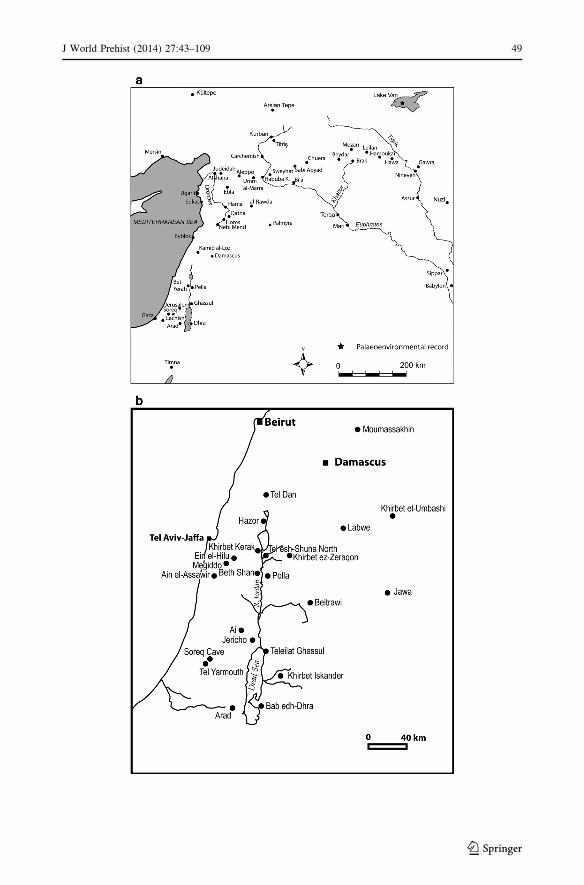
J World Prehist (2014) 27:43–109 49
123
Similarly, connections to the land marked by monuments may also have contributed new
ways of cementing relations to that land and affirming continuing rights of access, espe-
cially in areas in which permanent settlements were few. Continued access would have
been of particular importance in a situation in which control of land was increasingly
contested (Bradbury and Philip 2011, p. 176).
The Key Landscape Categories
Before discussing the results from specific archaeological surveys, we lay out the broad
elements of the physical landscape that structured the development of the economies of the
fourth and third millennia BC. Whereas in the Mediterranean the microecologies were a
conspicuous element in the development of the way of life, such infinitely complex local
landscapes (Horden and Purcell 2000, pp. 53–54) are less evident in much of the northern
Fertile Crescent. Nevertheless, they are evident to the careful observer, and the territory of
every EBA city comprised minor sub-regions—basalt plateaus, salt flats, relict marshes,
flood plain and uplands—which not only supplied a diversity of opportunities and domains,
but also formed a mosaic of inter-connected ecologies.
Within this framework of broad landscape units and diversified ecologies, EBA agri-
cultural production can be classified into the following sectors (Wilkinson 2000b; Stein
2004, p. 67), each of which offered rather different possibilities according to the local
landscape category:
1. The staple economy, particularly dry-farming of wheat, barley and lentils.
2. Production of olives and grapes in the wetter north and west, and the upland regions of
the southern Levant.
3. Animal husbandry, including draft animals, pigs and, increasingly, sheep and goat
herding. The last-named allowed for the growth in production of textiles from local
wool.
In addition, the production of metal goods from copper, and overland trade, contributed
to the growing strength of the palatial economies (Stein 2004, p. 67).
Agricultural Plains
The great agricultural plains and rolling hills of the northern Fertile Crescent, which stretch
from northern Mesopotamia through to western Syria, appear to have formed the ‘bread
basket’ of the region (Fig. 2). Although they receive only a modicum of rainfall, their large
area compensated for the relatively low yields, allowing large aggregate production that
rivalled that of southern Mesopotamia (Weiss 1986). These lowlands, which range from
800 km2 (Amuq) to some 7,000 km2 (upper Khabur plains: Fig. 2), form a classic ‘land-
scape of tells’, and are associated with the ‘staple economy’ of cereal production described
above. These semi-arid plains are dissected by smaller valleys, some of which, such as the
Jaghjagh near Brak, during the mid fourth millennium BC, were remarkably verdant with a
rich riverine vegetation of Populus (poplar) and Salix (willow), alongside slow flowing
cool waters (Riehl 2011, p. 104). Although alluviation is limited across much of their
extent, the flood plains themselves show significant but varying degrees of sedimentation,
resulting in localized burial of settlements (Kuzucuoglu et al. 2004; Casana and Wilkinson
2005; Deckers 2011; Deckers and Riehl 2007).
50 J World Prehist (2014) 27:43–109
123

These extensive fertile plains are ideally suited for rain-fed cultivation, and although
capable of massive aggregate production of cereals, are also susceptible to large scale crop
failures due to periodic drought (Jas 2000, pp. 250–251). The largest of these plains is
Fig. 2 Core agricultural lowlands as defined by slopes derived from SRTM imagery and key archaeologicalsurveys (in yellow outline). The FCP survey areas referred to in text are shaded (Color figure online)
J World Prehist (2014) 27:43–109 51
123

centred on the upper Khabur drainage basin and spreads well beyond the headwaters of the
Khabur in Syria into southern Turkey and northwestern Iraq (Fig. 2), to form one of the
key loci of early urbanism. It is flanked by the Taurus Mountains and Tur Abd-Din
mountains to the north and the Jebels Abd al-Aziz and Sinjar to the south; soil, hydro-
logical and geological conditions are summarized in Weiss (1986); Wilkinson and Tucker
(1995); Ur (2010b); and Wilkinson (2003).
For this study, the agricultural lowlands are expediently defined by slopes created from
Digital Elevation Models (Fig. 2), aided by the vegetation signature of crop lands on
LANDSAT images and the distinctive pattern of fields on flat alluvial soils. These plains
have been densely populated since at least the Aceramic Neolithic (Wilkinson 2003,
pp. 100–123). Although only sample areas have been surveyed in the field, much broader
areas have been mapped using remote sensing (Menze and Ur 2012; Deckers and Riehl
2008), demonstrating both the extent and the continuity of the tell-based landscape. The
Tell Beydar and North Jazira surveys (NJS) provide exemplars (Case 1).
Additional agricultural plains include the upland plains west of the Euphrates, specif-
ically the Gazientep/Quwayq upland plains (Wilkinson 2007); the Jabbul plain to the east
of Aleppo; agricultural plains of the Harran/Balikh and Saruj; the Amuq, Orontes and Ghab
valleys; and the western parts of the marl and limestone landscapes east of the Orontes
(Fig. 2).
Alluvial Valleys
The valleys of the Tigris, Euphrates, Orontes, and Afrin Rivers and their tributaries have
been eroded through Tertiary and Cretaceous limestone with occasional igneous rocks and
are in-filled with deep alluvial sediments flanked by Pleistocene terraces (Bridgland et al.
2012; Demir et al. 2008; Wilkinson 1999). The fragmented landscapes drained by these
riverine corridors provide smaller-scale landscapes of tells with more muted hierarchies
than the extensive agricultural plains. Particularly common are small tells (1–3 ha), which
dominate these cultural landscapes from the LC onwards (Schwartz and Falconer 1994;
Philip 2007; Casana 2007; Schwartz et al. 2000; Wilkinson et al. 2012). However, where
the valleys open up, or are flanked by broader plains, Bronze Age cities attained some
50–60 ha in area. This landscape type is represented by case studies from the Middle
Euphrates Valley and the Homs area (Cases 3 and 4, below).
Uplands
In contrast to the agricultural plains and alluvial valleys, where the main medium of
construction was mud-brick, the inhabitants of the uplands also employed stone and
sometimes wood. The resultant low rubbly mounds and enclosures are less conspicuous
than the tells and are sometimes associated with the place names khirba or rujm: these can
be elusive archaeologically.
The mountains of western Syria and southern Turkey, which include limestone uplands
and basalt plateaus, constitute a large, relatively under-explored area in which the extent of
Chalcolithic and Bronze Age settlement is little known (but see Casana and Wilkinson
2005). Elsewhere, hill masses such as the Jebel Bishri and the plateau basalts west of Homs
feature an archaeological landscape dominated by burial cairns and stone enclosures
(Nakano and Ishida 2010; Lonnqvist 2010; Bradbury and Philip 2011). Philip and Brad-
bury (2010, p. 138) apply the term ‘sub-optimal’ to regions that, although by no means
prime agricultural land, can offer considerable economic potential under certain
52 J World Prehist (2014) 27:43–109
123

circumstances. A case in point is the stony basalt terrain west of Homs, an area that was
settled episodically and provides insights into the role of terrain beyond the alluvial cor-
ridors and plains (Case 4; Philip and Bradbury 2010).
Climatically Marginal Lands
Less distinctive geographically are extensive semi-arid plains such as those between the
Balikh and Khabur Rivers, including the plains around Tell Chuera and the Jebel Abd al-
Aziz (Case 2, below). Although these relatively unforgiving lands seem to offer little
potential for cultivation, they do supply extensive areas of grazing, which in the twentieth
century AD were progressively turned over to high-risk barley cultivation (Lewis 1987).
During the third millennium BC these plains were extensively settled by the occupants of
Kranzhugel mounds and citadel cities. Here citadel cities are regarded as consisting of a
central citadel mound based upon an earlier tell, surrounded by a walled or ramparted
lower town; they differ from Kranzhugel sites, which have ramparts and inner mounds that
are circular. The plains of central Syria to the east of Homs and Hama have a similar
history to those of the Balikh–Khabur plains, although settlement occurred somewhat later,
between around 2400 and 2000 BC (EB IV: Geyer and Calvet 2001; al-Maqdissi 2010;
Castel and Peltenburg 2007). This region shows clear evidence for horizontal fluctuations
in the limits of settlement through time as well as the careful management of seasonal
water sources (Geyer and Calvet 2001; Geyer et al. 2006; Geyer 2009).
The Zone of Uncertainty and Ecologies of Risk
The Zone of Uncertainty Defined
The above physical landscape types are cut across by a series of climate zones, which
range from a belt receiving roughly 600 mm rainfall per annum in the north and west, to a
semi-arid zone in the south and east which receives less than 200 mm (Fig. 3). As a result,
the landscape offers several zones of rather different affordance. Insight into the way in
which this landscape was utilized in the past can be gained from both historic and con-
temporary accounts (Lewis 1987; Jas 2000; van Driel 2000; Wilkinson 2000b). Such
sources indicate that the moister belt featured a diversified land-use of wheat/barley and
lentils with vineyards (and in western Syria, olives), whereas the dry zone to the east and
southeast has traditionally been given over to semi-arid pasture dominated by nomadic and
semi-nomadic pastoralists, superseded in more recent times by barley mono-cropping
(Cocks 1988; Wilkinson 2000b). Where mean annual rainfall exceeds 300 mm, local
village flocks can be grazed on the village lands or taken to nearby sub-optimal areas as
parts of a simple seasonal round (Philip and Bradbury 2010). On the other hand, in the
semi-arid climatically marginal belt pasture lands are more extensive and flocks can range
more widely.
Within the zone of marginal cultivation, that is, between the rainfall isohyets of c. 300
and 200/180 mm per annum, and where rainfall is erratic, cereal cultivation is much riskier
and agro-pastoral practices have been the norm in recent times (Wachholtz 1996, pp. 5–8;
Kalaycı 2013). This is the area defined here as the zone of uncertainty, and today, because
of the high risk of crop failure, this zone is used primarily for a closely integrated system of
sheep and goat husbandry with rain-fed cereals (Wachholtz 1996, pp. 5–9). As Wirth has
pointed out, there is no clear-cut limit to rain-fed cultivation; rather, as the mean annual
J World Prehist (2014) 27:43–109 53
123
rainfall decreases the risk of crop failure increases (Wirth 1971; Jas 2000, pp. 250–257).
Consequently, agro-pastoral practices must deal with high levels of uncertainty and
incorporate considerable degrees of risk.
Fig. 3 a The zone of uncertainty within Syria (based on Wachholtz 1996). Dotted lines indicate rainfallisohyets; b the entire Fertile Crescent indicating the area with mean annual rainfall between 200 and300 mm p.a. used as a proxy for the zone of uncertainty (simplified from Sanlaville 2000, fig. 21)
54 J World Prehist (2014) 27:43–109
123

Agro-pastoral Developments in the Syrian Steppe
In the twentieth century AD, central Syria experienced the expansion of both barley and
sheep husbandry (Treacher 2000, p. 190; Cooper and Bailey 1990). As sheep production
has become more dependent on fodder inputs from agricultural areas, farmers in these
areas have responded by substituting barley for other crops as well as opening up more
fallowed land. Flock owners have greatly extended barley growing into semi-arid range-
lands, even into areas where rainfall is\200 mm (Treacher 2000, p. 191), which is ‘both
the result of and concomitant with an intensification of sheep-rearing and an increase in
flock sizes’ (Metral 2000, p. 123). In other words, in these climatically marginal lands,
increased sheep rearing and increased cultivation appear to have been closely correlated,
ultimately supporting an increase in the human population, much of it sedentary or semi-
sedentary.
Such economic growth in a zone that is today extremely marginal in terms of ‘normal’
agricultural subsistence is accompanied by a wide range of risks, which are played with
considerable acumen by the local population (Metral 2000). Moreover, greater risk by
farmers and herders is considered to lead to higher average returns (Hazell et al. 2001,
p. 16).
In studies of the ancient world, risk is usually seen from the perspective of subsistence
societies and as something that would have been minimized. Strategies such as diversifi-
cation of crop types or intensification (including irrigation) are regarded as ways of reducing
risk (Marston 2011, p. 191). However, this approach is not appropriate for Bronze Age
states in the Near East, such as Ebla, that were benefiting economically from large-scale
manufacture of textiles, metal trading and other activities (Pettinato 1981, pp. 166–167;
Bachhuber 2013, p. 500), and can hardly be regarded as subsistence economies. Further-
more, this was a period in which aggressive states showed evidence for growth to such a
degree as to suggest that they controlled a much wider range of physical landscapes and
resources, which not only increased economic opportunities but also made the risk–benefit
equation radically different from that which pertained in more self-sufficient communities.
As a result of such shifts, the king, his household and other members of the elite had the
ability to balance risk in one area against more predictable outcomes in another, and so had
the potential capacity to invest in strategies such as large-scale sheep husbandry that
resulted in huge profits, but also could lead to substantial losses (see below).
The Plant and Animal Economy
Animal bones recovered from excavated sites suggest that most Early Bronze Age com-
munities in the moister north and west pursued relatively low-risk subsistence strategies of
sheep/goat husbandry (the examples in this study being from the mid Euphrates Valley,
below). However, these strategies changed through the third millennium BC, and Stein
demonstrates that zooarchaeological evidence from sites in the Euphrates valley and North
Mesopotamia show that in the mid third millennium BC the sedentary pastoral economy
shifted from diversified herding of cattle, pigs, sheep and goats to a highly specialized
economy dominated by sheep and goats (Stein 2004, p. 70; Zeder 1995, p. 29). For
example, in the Khabur, mid–late EBA (2600–2000 BC) animal husbandry was dominated
by sheep and goat, pigs, and significant numbers of cattle used for traction (Doll 2010,
fig. 5). Analysis of multiple sites throughout the Khabur region by Zeder suggests a trend
towards increased keeping of caprines in the third and second millennia BC, specifically in
the southern steppe of the Khabur Valley (Zeder 1998, tables 1–4; see also Rufolo 2011).
J World Prehist (2014) 27:43–109 55
123

However, trends in the moister north, where rainfall exceeds 300 mm per annum, are less
clear. At Mozan, caprines form between one half and two-thirds of the animal assemblages
(Doll 2010, table 5), and at Brak they appear to decline in importance between the fourth
and second millennium BC (Dobney et al. 2003, p. 428). Evidence that the caprines were
used for supplying wool derives from the faunal samples from Tell Mozan in the north,
where the lack of butchery marks on bones might be explained by the rearing of sheep for
wool production (Doll 2010, p. 280), and at Brak age at death data suggest that animals
were kept for their secondary products, probably wool (Dobney et al. 2003, p. 428). Zeder
has therefore argued that the increase in caprines in the steppe of the southern Khabur
indicates the development of an animal economy by pastoral specialists (Zeder 1998,
p. 64). These enhanced herd management practices, which were first evident at Uruk sites
of the later fourth millennium BC (Algaze 2008, pp. 77–92), are consistent with the so-
called commodification of textile production associated with many third millennium states
in the region (Stein 2004, p. 70; Kouchoukos 1998; McCorriston 1997; Zeder 2003; Porter
2012, pp. 19–21).
Although many smaller scale communities of the northern Middle Euphrates were
engaged in a diversified economy, there was considerable variation depending upon local
ecology or the scale of settlements. For example, at Gritille on the Turkish Euphrates, all
age groups of sheep and goat were present, implying a relatively self-sufficient community
(Stein 1987). This compares with the nearby and slightly larger site of Kurban Hoyuk,
where the low percentage of prime age caprines during the main phase of mid-EBA
settlement is interpreted as resulting from a system in which small towns such as Kurban
supplied prime animals as tribute to growing centres (Wattenmaker 1998, p. 184). At the
apex of this system, Titris Hoyuk was arguably a centre of power and food distribution
(Algaze et al. 2001; Allentuck 2004; Hald 2010). Broader regional trends are also evident,
with sites in the Turkish Euphrates region showing a spread of domestic sheep, goat, pig
and cattle, whereas southern sites like Sweyhat in Syria were characterized by a pre-
dominance of sheep and goat, fewer cattle, virtually no pig and many more wild species
(Weber 1997, p. 142). Whereas increased sheep and goat appear to typify the zone of
uncertainty, the belt of sustained settlement further north is approximately delimited by the
southern limit of significant numbers of pigs (i.e. the 300 mm isohyet). While this is
particularly evident for the fifth and fourth millennia BC (Grigson 2007, figs. 5.1 and 5.2),
during the third millennium BC, very low proportions of pigs appear at citadel cities, many
located within the zone of uncertainty (Grigson 2007, figs 5.4 and 5.6). In short, the
distinction between areas with high proportions of pig and those with high proportions of
caprines provides a rough guide to the northern boundary of the zone of uncertainty.
These tendencies are paralleled in the palaeobotanical record of the Middle Euphrates,
with barley being less common in the north and dominant in the south (Miller 1997; Weber
1997; Riehl 2010, p. 68). Similar patterns are evident within the Khabur plains, where
McCorriston and Weisberg demonstrate that there was a clear increase in barley in the
southern Khabur steppe during the third millennium BC, for example (McCorriston and
Weisberg 2002, pp. 493–495; Riehl 2010). Rainfall differences between the moister
northern drainage basin and locations to the south are reflected in different proportions of
crops, with higher proportions of free-threshing wheat at Mozan, to the north, and more
barley at Brak in the south (Riehl 2010, p. 65; Riehl 2012, p. 117). Despite these regional
variations, it appears that crop procurement strategies were quite resilient; for example,
during the fourth millennium BC, although Tell Brak experienced several climatic fluc-
tuations, the site’s inhabitants adapted their strategies of crop production (Charles et al.
2010). Overall, the risk of crop failure increased towards the arid central area of Syria, so
56 J World Prehist (2014) 27:43–109
123
that, in theory, long-term sedentary settlement and its associated staple economies were
more sustainable in the north and west.
However, communities, or perhaps the elites of such communities, within and around
the zone of uncertainty, may have perceived the land less as a resource to be nurtured and
more as an opportunity. This is in part because different communities may have different
perceptions of risk. Therefore instead of using the landscape of the zone of uncertainty to
produce a diversified range of staple crops and livestock (for which it was not really
suited), they may have regarded it as ideal for agro-pastoral activity, specifically the
‘opportunistic stocking’ of sheep and goats. Such a herding strategy allows the number of
livestock to increase in accordance with the availability of forage so that the growing herd
can then be converted into ‘capital’ in years of good rainfall, whereas bad years can entail
herd numbers being reduced as necessary (Sandford 1983; Stein 2005, p. 143). Such
variations are a common feature of nomadic pastoral economies, which are inherently
unstable (Khazanov 1984, pp. 75–83) and which have even been described as ‘boom and
bust’ economies (Cribb 1991, p. 24). Similarly, West African examples see livestock
numbers crashing during dry years with the result that range lands do not suffer from over-
grazing (Mortimore 1998, pp. 66, 73; Behnke and Scoones 1993; Vetter 2005). In such
non-equilibrium systems, pastoralists take advantage of the good times, but bear the loss
during dry periods. Because episodic droughts can reduce stocking levels, or can encourage
pastoralists to seek grazing elsewhere, instability can be regarded as an intrinsic part of this
practice. For the Middle Euphrates, the southern areas within the zone of uncertainty, such
as those around Tell es-Sweyhat, held the potential for great rewards, but presented sig-
nificant levels of risk. This contrasts with the moister northern zone where more conser-
vative strategies appear to have prevailed. Such challenges appear to have been acceptable
for certain types of pastoral nomads, who have to accept higher levels of instability and
therefore risk than many sedentary communities (Cribb 1991, p. 24). This may also have
been the case for the aggrandizing polities of the Syrian plains, such as Ebla, which
although largely sedentary were sufficiently prosperous to offset considerable losses from
some areas of activity against successes in others. It is therefore significant that similar
surplus-oriented strategies were harnessed to supply the non-food-producing temple and
palace sectors of Mesopotamian cities (Stein 2005, p.147; Adams 2006).
In sum, when economies and states became sufficiently large in scale (as was arguably
the case during the ‘second urban revolution’ of the EBA), elites or royal households could
invest in animals and absorb risks in ways that more localized economies could not.
Moreover, if yields were sufficient (in this case in the form of large quantities of high
quality wool) and there were institutions which could absorb the risk (e.g. the Ebla palace),
these otherwise marginal landscapes could become very productive. However, this will
only work within a certain range of political-economic niches.
Ebla and the Bronze Age Agro-pastoral Economy
Ebla, located on the Syrian plains quite close to the western edge of the zone of uncertainty
(Figs. 1, 17), occupies a central position in this narrative because, rather than simply being
supported by cultivated cereals supplemented by flocks of sheep, goat or cattle, the Eblaite
state was arguably founded, in part, upon an agro-pastoral economy. Ebla, the dominant
capital city of northwestern Syria during the third quarter of the third millennium BC, ruled
over a state extending from near Hama, or Homs [if the Tres Long Mur (Geyer et al. 2010)
J World Prehist (2014) 27:43–109 57
123

is related to the Ebla state] in the southwest, to near Carchemish on the Euphrates in the
northeast (Cooper 2010; Fig. 1).
It is well known that sheep-rearing formed a major pillar of the Eblaite economy (Gelb
1986, p. 158), although as argued by Porter, the quotation below may rather over-simplify
a potentially complex system of animal herding (Porter 2012, p. 19):
Sheep raising was the mainstay of the local economy; thousands of sheep were
raised, supplying the wool for the production of textiles, the main export product of
Ebla. Thus wool was the basis of Ebla’s commercial prosperity and political power
… But Ebla, as these extraordinary tablets make clear, was an empire built on the
backs of simple shepherds. (Gelb 1986, p. 158)
It would appear from the archives of Palace G at Ebla that textile production was, at least
in part, under the control of the palace, and the Ebla texts refer to the delivery of textiles
(many specifically of wool) to individuals or cities, or their use as offerings to the gods
(Sollberger 1986, p. 6; Biga 2010; Andersson et al. 2010, p. 160; Bachhuber 2013, p. 500).
Estimates of the number of sheep held by the city of Ebla range from 2 million, according to
Butz (cited by Pettinato 1991, p. 82) to a more modest 670,000, according to Milano (1995).
At relatively modest rates of stocking of 4.5 ha per animal (McCorriston 1997, p. 524, after
Thalen 1979, p. 265), it would appear that the entire state of Ebla might have formed sheep
pasture, or agricultural lands devoted to producing feed for such sheep. Using the above
stocking figures by way of indication, 700,000 sheep would have required a grazing range of
around 31,500 km2 (roughly equivalent to a circle of radius 100 km). This is a substantial
area, even allowing for the possibility of grazing in agricultural land out of season, and
would have required flocks to be grazed at locations some distance from the central territory
of Ebla. Large flocks of sheep would have needed to be accommodated in the villages
surrounding Ebla (Porter 2012, p. 19, citing Archi 1990), and, according to Milano (1995),
pasturing would also have taken place in, for example, the Kur (hill country) to the north and
south of the city, or, as noted by Castel and Peltenburg (2007, p. 613), around al-Rawda (and
related cities) in the zone of uncertainty in the central Syrian steppe.
It is difficult to estimate the spatial extent of this sheep-rearing, but one area discussed
here, the Sweyhat region, is close to the borders of the Eblaite state, and could have been a
direct or indirect beneficiary of the state’s herding strategies. Moreover, the Ebla texts
indicate that large quantities of wool were purchased from Armi, which although not
identified securely, may be at Tell Bazi-Banat on the Middle Euphrates (Biga 2010,
pp. 149–150, 152, citing Otto 2006) or perhaps near Samsat to the northeast (Archi 2011).
Because Armi appears to have been on one of the routes between Ebla and Tell Brak (Nagar)
(Archi and Biga 2003, p. 13; Otto 2006, p. 21), large quantities of wool were being supplied
to Ebla from a city/polity located on the route between Ebla and Nagar. In the same region,
Harran is recorded as a source of sheep for Ebla, and Carchemish as both a source and
recipient of textiles (Pettinato 1976, pp. 147–148; Pettinato 1981, p. 209; Bachhuber 2013,
p. 500). In contrast, however, the Homs basalt, although a probable venue for small-scale
pastoral activity, lacks convincing evidence for large-scale activity during EB IV (Philip and
Bradbury 2010, p. 155), suggesting that certain localities or types of landscape, such as the
steppe of central Syria, were favoured over others for large-scale livestock herding.
Although the actual numbers of livestock may have varied dramatically through time,
the raising of sheep was evidently a major part of the Ebla economy, and the Eblaite
administration would therefore have required access to large areas of steppe grazing. The
appearance of such huge holdings of sheep must have formed part of ‘a major transfor-
mation of ancient Mesopotamia’ that entailed a shift from plant fibres, particularly flax, to
58 J World Prehist (2014) 27:43–109
123
wool for the manufacture of textiles during the third millennium BC, or slightly earlier
(McCorriston 1997, p. 517; also Kouchoukos 1998; Zeder 2003, p. 162; Algaze 2008,
p. 79; Porter 2012). However, the roots of such textile production extend back to probably
the fifth millennium BC, as exemplified by the size of spindle whorls, which suggests that
this transition occurred within the Chalcolithic (Sudo 2010, p. 176). The switch from flax
to wool would have ‘freed prime agricultural land for alternative crops, including pre-
sumably cereal crops’ so that more fibre (i.e. wool) could have been raised on the ‘vast
tracts of marginal land using less labour than flax cultivation’ (McCorriston 1997, p. 525).
Certainly the scale of the wool industry of Ebla was extraordinary, and would not be
matched until the Ur III state (Milano 1995). Although it appears that the use of sheep for
wool has a long history in the Middle East, it is the scale of both the demand for, and
production of, this highly desired product that became significant in the fourth millennium
BC and, even more so, in the third millennium (Algaze 2008, pp. 77–92; Wright 2013,
p. 397, pp. 407–410). It is therefore a central aim of this paper to examine the landscape
evidence for this major economic transformation.
Connectivity and Networks
Evidence for changing degrees of ‘connectivity’ through time is both direct and indirect, as
discussed for the Mediterranean by Horden and Purcell (2000). Here evidence of con-
nectivity is only summarized and will be discussed in more detail in a future paper. For
southern Mesopotamia, enhanced connectivity is evident in terms of the increased effi-
ciency of canal and riverine transport, in contrast with ‘high friction’ overland transport
(Algaze 2001, pp. 224–225; Algaze 2008, pp. 50–63; Wilkinson 2000b, p. 6). Although
probably the most common way of inferring route systems in the ancient world is through
topography, aided by ‘least-cost’ analysis (Witcher 1999), such approaches—as well as
being somewhat deterministic—are difficult to apply to topographically level plains. More
problematically, cuneiform documents suggest that such physically ‘logical’ routes were
frequently unfeasible because for sociopolitical reasons it was sometimes necessary for
travelling ‘officials’ to carry particular documents to allow themselves free passage
through certain areas (Wattenmaker 2009, p. 119). An analogous situation can be observed
today where state control is weak and it is necessary (as well as courteous) when travelling
through a region to visit each minor chief or ruler in turn, with the result that the actual
route followed zigzags across the landscape between major settlements rather than fol-
lowing a straight line. In other words, social and political factors often outweigh the
opportunities offered by the physical landscape.
In parts of northern Syria and northwestern Iraq, tangible evidence of early routes is
provided by networks of hollow ways etched into the landscape by the passage of humans
and their livestock (Van Liere and Lauffray 1954–1955; Wilkinson 1993; Wilkinson et al.
2010; Ur 2003, 2012; Casana 2013). The relationship between settlement and connectivity
is eloquently demonstrated by some 6,025 km of hollow ways mapped over much of the
upper Khabur plains (Ur 2010b, 2012). These features demonstrate that radial movements
from central tells were mainly confined within local catchments of 3–5 km radius (Kalaycı2013, pp. 149–171). Such local routes were probably more important than cross country
hollow-way networks—which, although recognizable, are less pronounced and have left
less evidence—in part because most overland movements were probably from one set-
tlement to the next in order to conform with social norms as noted above (Ur 2012,
pp. 172–175; Wilkinson and Tucker 1995, p. 54).
J World Prehist (2014) 27:43–109 59
123
In addition, paired settlements on opposite banks of major rivers (Burghardt 1959;
Wilkinson et al. 2004) sometimes align with and link to routes leading away from such
crossing points. Similarly, gaps through the Bronze Age Tres Long Mur in the steppe east
of Hama, imply the existence of passageways that concentrated the movement of humans
and animals (Geyer et al. 2010). Alignments of Bronze Age tells that are independent of
obvious topographic or hydrological features also suggest that sites had developed along
pre-existing routes (e.g. Philip 2007).
Finally, inferences can be made from the human ecology of local landscapes or textual
sources. In the former case, contemporary activity in neighbouring landscapes of con-
trasting geology or topography which show different archaeological signatures may imply
that the two landscapes formed a semi-integrated system of land-use, for which we have no
direct evidence (Philip and Bradbury 2010; Bradbury 2011). Connectivity is also evident in
interpretations of ideational landscapes, specifically with respect to the ‘round’ of ritual
visits made by members of the royal household to shrines and other venerated places, as
mentioned in the Ebla texts (Ristvet 2011).
Data Sources and Methods
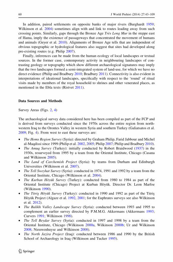
Survey Areas (Figs. 2, 4)
The archaeological survey data considered here has been compiled as part of the FCP and
is derived from surveys conducted since the 1970s across the entire region from north-
western Iraq to the Orontes Valley in western Syria and southern Turkey (Galiatsatos et al.
2009; Fig. 4). From west to east these surveys are:
• The Homs Region Survey (Syria): directed by Graham Philip, Farid Jabbour and Michel
al-Maqdissi since 1999 (Philip et al. 2002, 2005; Philip 2007; Philip and Bradbury 2010).
• The Amuq Survey (Turkey): initially conducted by Robert Braidwood (1937) in the
1930s, resurveyed from 1995 by a team from the Oriental Institute, Chicago (Casana
and Wilkinson 2005).
• The Land of Carchemish Project (Syria): by teams from Durham and Edinburgh
Universities (Wilkinson et al. 2007).
• The Tell Sweyhat Survey (Syria): conducted in 1974, 1991 and 1992 by a team from the
Oriental Institute, Chicago (Wilkinson et al. 2004).
• The Kurban Hoyuk Survey (Turkey): conducted from 1980 to 1984 as part of the
Oriental Institute (Chicago) Project at Kurban Hoyuk. Director Dr. Leon Marfoe
(Wilkinson 1990).
• The Titris Hoyuk Survey (Turkey): conducted in 1990 and 1992 as part of the Titris
Hoyuk Project (Algaze et al. 1992, 2001; for the Euphrates surveys see also Wilkinson
et al. 2012).
• The Balikh Valley Landscape Survey (Syria): conducted between 1993 and 1995 to
complement an earlier survey directed by P.M.M.G. Akkermans (Akkermans 1993;
Curvers 1991; Wilkinson 1998).
• The Tell Beydar Survey (Syria): conducted in 1997 and 1998 by a team from the
Oriental Institute, Chicago (Wilkinson 2000a, Wilkinson 2000b; Ur and Wilkinson
2008; Nieuwenhuyse and Wilkinson 2008).
• The North Jazira Project (Iraq): conducted between 1986 and 1990 by the British
School of Archaeology in Iraq (Wilkinson and Tucker 1995).
60 J World Prehist (2014) 27:43–109
123
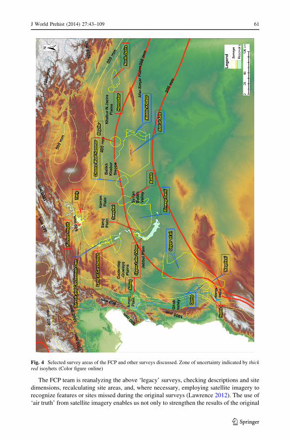
The FCP team is reanalyzing the above ‘legacy’ surveys, checking descriptions and site
dimensions, recalculating site areas, and, where necessary, employing satellite imagery to
recognize features or sites missed during the original surveys (Lawrence 2012). The use of
‘air truth’ from satellite imagery enables us not only to strengthen the results of the original
Fig. 4 Selected survey areas of the FCP and other surveys discussed. Zone of uncertainty indicated by thickred isoyhets (Color figure online)
J World Prehist (2014) 27:43–109 61
123

Ta
ble
2H
yp
oth
etic
alex
amp
leo
fte
mp
ora
ltr
end
sin
dic
atin
gh
ow
dif
fere
nt
chro
nolo
gie
sar
ev
isu
aliz
edin
too
ne
chro
no
logic
alfr
amew
ork
Tim
e B
lock
s (1
00 y
ears
)0
–100
100–
200
200–
300
300–
400
400–
500
500–
600
600–
700
700–
800
800–
900
900
–10
0010
00–1
100
1100
–120
0
Surv
ey 1
Pha
ses
AB
CD
Surv
ey 1
Cou
nts
512
159
Surv
ey 2
Pha
ses
EF
GH
Surv
ey 2
Cou
nts
1121
713
Surv
ey 3
Pha
ses
IJ
KL
MN
Surv
ey 3
Cou
nts
25
1419
1310
62 J World Prehist (2014) 27:43–109
123
surveys, many of which were conducted without the benefit of aerial images, but also to
encompass more meaningful areas, such as ancient polities or city regions.
Scale is fundamental to landscape archaeology because of the need to deal with indi-
vidual sites and archaeological surveys that cover areas of variable size. In the case of the
FCP, survey areas are located in several different countries and some even extend over
international frontiers (Fig. 4). Multiple sources of satellite imagery of various ages and
resolutions have also been included (Galiatsatos et al. 2009).
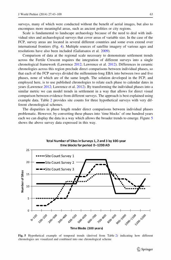
Comparison of data at the regional scale necessary to demonstrate settlement trends
across the Fertile Crescent requires the integration of different surveys into a single
chronological framework (Lawrence 2012; Lawrence et al. 2012). Differences in ceramic
chronologies across this region preclude direct comparisons between individual phases, so
that each of the FCP surveys divided the millennium-long EBA into between two and five
phases, none of which are of the same length. The solution developed in the FCP, and
employed here, is to use published chronologies to relate each phase to calendar dates in
years (Lawrence 2012; Lawrence et al. 2012). By transforming the individual phases into a
similar metric we can model trends in settlement in a way that allows for direct visual
comparison between evidence from different surveys. The approach is best explained using
example data. Table 2 provides site counts for three hypothetical surveys with very dif-
ferent chronological schemes.
The disparities in phase length render direct comparisons between individual phases
problematic. However, by converting these phases into ‘time blocks’ of one hundred years
each we can display the data in a way which allows the broader trends to emerge. Figure 5
shows the above survey data expressed in this way.
Fig. 5 Hypothetical example of temporal trends (derived from Table 2) indicating how differentchronologies are visualized and combined into one chronological scheme
J World Prehist (2014) 27:43–109 63
123

Despite the chronological differences within the surveys there is clearly an overall trend
of expansion and contraction of settlement over the 1,200-year period, and this trend would
have been very hard to extract from the data as expressed in phases. The time-block graphs
used in this article display total settled area by 100-year increments, reflecting the degree of
precision currently available in the date attributions for each phase. Synthetic chronologies
for western Syria along with those recently published for the Middle Euphrates (Porter
2007; Cooper 2006) and the Jazira (Lebeau 2000; Pfalzner 2001, 2010) provide the basis for
these comparisons, coupled with limited re-evaluation of the ceramics from the surveys.
Case Studies
In the following case studies, the terminology of the chronological units follows those
employed by the projects themselves: for example, the chronology of the Khabur–Balikh
steppe follows the Early Jazira (EJ) chronology used by Kouchoukos (1998), rather than
the more general chronology of Lebeau (2000) (Table 1). The chronologies of expansion
and contraction of the major sites are those published by the excavators, and are expressed
in centuries on Figs. 8, 10, 12, 13 and 16.
Northwest Iraq and Northeast Syria (Figs. 6, 7, 8)
In the northeastern part of North Mesopotamia a long-term pattern of dispersed villages
evident from the Neolithic to the Late Chalcolithic culminated in the emergence of large-
scale urban centres during the fourth millennium BC. In the NJS, the early EBA Ninevite V
period (c. 3000–2500 BC) sees a radical shift away from the relatively dense rural set-
tlement pattern characteristic of the LC—dominated by the single mass of Tell al-Hawa—
to the abandonment of the southern and western parts of the survey area (Figs. 6, 7). The
three-level settlement hierarchy that developed in the east of the area was characteristic of
the entire third and part of the second millennium BC. The opening up of the southern and
western parts of the area has been interpreted as stemming from the reorganisation of
settlement and land-use to provide pastureland (Wilkinson and Tucker 1995), but whether
this was the result of a deliberate policy of opening the landscape or a by-product of
settlement agglomeration is not clear.
However, abandonment of sites in the south and west was not associated with a sig-
nificant decline in overall settlement. Instead, the time-block graphs (Fig. 8) demonstrate
that although the total number of sites plummeted from over 70 to under 40, the aggregate
settled area remained fairly stable, because those sites that remained grew in size (Fig. 8).
This implies that any populations released were incorporated into growing nucleated sites
within the same region. Moreover, settlement expansion at both Hamoukar and Hawa
appears to have been fuelled, in part, by the abandonment of smaller outlying sites, perhaps
as populations were sucked into the growing centres (cf. Adams 1981). Roughly con-
temporary with the abandonment of the south and west, agricultural intensification
occurred in the north and east of the region, as demonstrated by the presence of off-site
sherd scatters and radial patterns of hollow ways around the larger sites (Wilkinson 1994,
pp. 491–493; Ur 2010b, pp. 65–85). Over the course of the third millennium, settlement
began to impinge on the abandoned zone but the area remained a discrete ‘pastoral
enclave’ within the larger zone of dense settlement around urban centres at Tell al Hawa
and Tell Hamoukar. The proximity of Hamoukar to this unsettled land implies that the
open area may either have been a shared resource between the two centres, or perhaps
64 J World Prehist (2014) 27:43–109
123
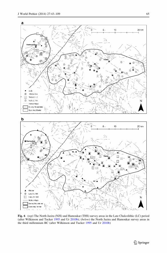
Fig. 6 (top) The North Jazira (NJS) and Hamoukar (THS) survey areas in the Late Chalcolithic (LC) period(after Wilkinson and Tucker 1995 and Ur 2010b); (below) the North Jazira and Hamoukar survey areas inthe third millennium BC (after Wilkinson and Tucker 1995 and Ur 2010b)
J World Prehist (2014) 27:43–109 65
123

acted as a boundary between the two polities, depending on the phase (Fig. 7). In contrast
to the expansion of settlement in the Middle Euphrates (below), settlement in the area of
the North Jazira Project underwent a process of reorganisation which resulted in intensified
agricultural production around urban centres and managed pastoral resources in close
proximity.
The Khabur–Balikh Steppe (Figs. 9, 10)
The dry marginal steppe located between the Balikh and Khabur river systems, although
forming a broad rolling plain, does not constitute one of the main agricultural ‘core’ areas
as outlined above; rather, it is one of those areas into which settlement expanded during the
third millennium BC. This region is known for the distinctive large sites, which belong
either to the double-walled site type commonly referred to as Kranzhugel, or to a class of
citadel cities typified by central tells and surrounding ramparts (Oppenheim 1964; Zettler
1997; Cooper 2006, pp. 74–78; Meyer 2010a). Also known as the Western Jazira, not only
does this area present a unique settlement pattern from the fourth to the early second
millennium BC, it is overwhelmingly situated in the agro-pastoral high-risk zone of
uncertainty, between the 200 and 300 mm precipitation isohyets (Fig. 9). Archaeological
investigations in this region have been scarce, yet those that have been conducted provide a
picture of settlement processes that complements the picture from the core areas. Human
occupation of the region is evident from the Palaeolithic onwards, mostly in the form of
small, often temporary sites, with more permanent settlements forming in the Halaf and
Ubaid periods. Yet this general, albeit slow, trend toward a greater number of larger and
more complex sites came to a halt in the Late Chalcolithic period, when the overall number
and individual sizes of settlements fell dramatically. Unlike the fertile river valleys to the
Fig. 7 The North Jazira and Hamoukar survey areas, showing the approximate area of potential pasturelandas inferred from the retreat of settlement around 3000 BC (based on Wilkinson and Tucker 1995; Ur 2010b)
66 J World Prehist (2014) 27:43–109
123

east and west, the Western Jazira experienced a dearth of human occupation during the
fourth millennium until the EJ 2 period (c. 2800–2650 BC, Table 1).
In the northwest of this region the Wadi Hamar survey, centred on the mainly third
millennium site of Tell Kharab Sayyar, covers 680 km2. This survey identified 6 sites
covering a total area of 18 ha (including the 7.5 ha Tell Tawila) from the Ubaid period, yet
not a single definite small site from the succeeding Late Chalcolithic (Pruß 2005; Kudlek,
Fig. 8 North Jazira Survey (NJS) (Iraq); top settled area of Hawa, medium sites and small sites 6000–1000BC; bottom settled area of Hawa, count of other sites 6000–1000BC. Note the significant decline in thenumber of sites around 3000 BC as the western region was abandoned and Hawa developed into a nucleatedtown
J World Prehist (2014) 27:43–109 67
123

2006) (Fig. 10). While some scatters of LC pottery exist, none constitutes a great enough
concentration to suggest long-term occupation except at the main site of Tell Chuera,
which, in very recent excavations, has shown some evidence of this (Dohmann-Pfalzner
Fig. 9 Main sites discussed in the Khabur–Balikh steppe (rainfall isohyets in mm per annum). TAS TellAbu Shakhat, Agh ’Aghila, TBG Tell Barabra Gharbi, Bey Tell Beydar, Bug Tell Buga, TCh Tell Chuera,TDa Tell Dakhliz, TGK Tell Ghajar el-Kebir, THS Tell Hammam Sharqi, Kha Tell Khanzir, KhS TellKharab Sayyar, TMG Tell Mabtuh Gharbi, TMS Tell Mabtuh Sharqi, Mag Tell el-Maghar, Mal Tell Malhat,Mat Tell Matin, TMu Tell Muazzar, Taw Tell Tawila
Fig. 10 Settlement area (in ha) in the Wadi Hamar survey area (Khabur–Balikh steppe) plotted accordingto 100-year time blocks
68 J World Prehist (2014) 27:43–109
123
and Pfalzner 2002, pp. 13–14). Nevertheless, this small occupation was nowhere near the
size reached by the site during the EBA, beginning in the early EJ 2 (c. 2800 BC) with the
construction of the central mound (43 ha) and initial city wall, and continuing with the
establishment of a concentric lower town and outer wall in the late EJ 2 (c. 2650 BC; total
65 ha). Concurrent with the settlement expansion on the main tell, the surrounding land-
scape saw a significant increase in small settlements; the survey identified 12 sites with a
combined area of 120 ha from this period (Fig. 10). Additionally, several large tell set-
tlements (over 10 ha each) were established, including Tell Dakhliz, Tell Ghajar el-Kebir,
and ’Aghila (Fig. 9). This density of occupation continued for much of the third millen-
nium BC, but both Tell Chuera and the smaller settlements appear to have been abandoned
in the late third millennium (EJ 4–5). By the MBA, just two sites, with a combined area of
7 ha, can be identified. In the Chuera area, settlement therefore expanded very significantly
and collapsed again, all between 2700 and 2200 BC (EJ 2–4).
On the eastern side of the Western Jazira, the Jebel Abd al-Aziz survey, covering an
area of nearly 6,000 km2 around the eponymous mountain range, provides a similar picture
(Kouchoukos 1998; Hole 1997). Here, Ubaid occupation is less than around Tell Chuera,
with a total of 5 small settlements covering a combined area of 9 ha, which are then
reduced to a mere 3 sites of indeterminate or negligible area during the LC. No large sites
with fourth millennium occupation are known to exist in this area. As in the Chuera region,
the Jebel Abd al-Aziz sees a surge in the number of sites and their areas around the middle
of the EBA (EJ 3), with several large tells of over 10 ha each (e.g. Muazzar, Mabtuh Sharqi
and Gharbi, Maghar, Hamam Sharqi) being settled on previously unoccupied sites (Fig. 9).
In total, 36 sites from the mid third millennium (EJ 3) have been identified, and as in the
Chuera area there is little evidence of substantial occupation by the late third millennium,
with most sites being abandoned some time after EJ 3B (c. 2400–2300 BC; Kouchoukos
1998).
These settlement patterns, observed in geographically diverse areas of the Western
Jazira, imply that the rapid and substantial increase in settled population at the start of the
third millennium cannot have been drawn from any local sedentary source. Furthermore,
the large sites of this period, which either belong to the double-walled Kranzhugel, or to
citadel cities (as defined above), exhibit a greater level of social and infrastructural
complexity than can reasonably be expected of nomadic peoples of the fourth millennium
BC (Meyer 2010b).
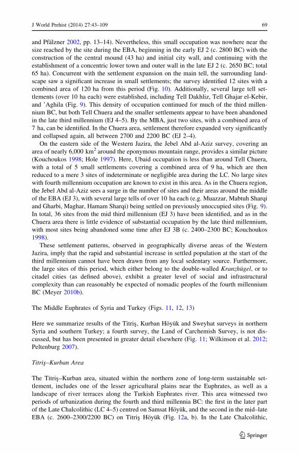
The Middle Euphrates of Syria and Turkey (Figs. 11, 12, 13)
Here we summarize results of the Titris, Kurban Hoyuk and Sweyhat surveys in northern
Syria and southern Turkey; a fourth survey, the Land of Carchemish Survey, is not dis-
cussed, but has been presented in greater detail elsewhere (Fig. 11; Wilkinson et al. 2012;
Peltenburg 2007).
Titris–Kurban Area
The Titris–Kurban area, situated within the northern zone of long-term sustainable set-
tlement, includes one of the lesser agricultural plains near the Euphrates, as well as a
landscape of river terraces along the Turkish Euphrates river. This area witnessed two
periods of urbanization during the fourth and third millennia BC: the first in the later part
of the Late Chalcolithic (LC 4–5) centred on Samsat Hoyuk, and the second in the mid–late
EBA (c. 2600–2300/2200 BC) on Titris Hoyuk (Fig. 12a, b). In the Late Chalcolithic,
J World Prehist (2014) 27:43–109 69
123

when 15 ha Samsat was dominant, the remaining settlement was concentrated at small tells
along the Euphrates river valley and a sparse scatter of settlements away from the river
(Wilkinson 1990; Algaze et al. 1992; Wilkinson et al. 2012). During the early EBA
(3100–2650 BC), Samsat did not expand but new sites, including the 5 ha main tell at
Titris, developed on the previously sparsely-settled plain south of the Euphrates. Settle-
ment increased dramatically in this zone during the middle and late EBA (2650–2200 BC),
with Titris growing from 5 to 40 ha through the development of a substantial lower city
and a halo of newly founded smaller sites (Algaze et al. 1992, 2001), along with an
expansion of medium-sized ‘town’ sites, including larger tells along the river such as
Fig. 11 Main sites and survey areas in the Turkish–Syrian Middle Euphrates (Color figure online)
70 J World Prehist (2014) 27:43–109
123
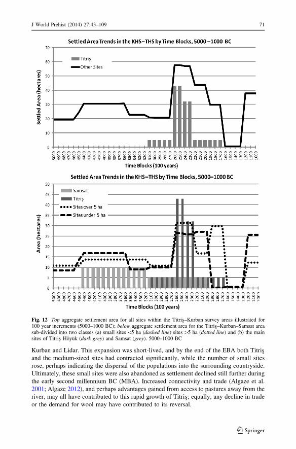
Kurban and Lidar. This expansion was short-lived, and by the end of the EBA both Titris
and the medium-sized sites had contracted significantly, while the number of small sites
rose, perhaps indicating the dispersal of the populations into the surrounding countryside.
Ultimately, these small sites were also abandoned as settlement declined still further during
the early second millennium BC (MBA). Increased connectivity and trade (Algaze et al.
2001; Algaze 2012), and perhaps advantages gained from access to pastures away from the
river, may all have contributed to this rapid growth of Titris; equally, any decline in trade
or the demand for wool may have contributed to its reversal.
Fig. 12 Top aggregate settlement area for all sites within the Titris–Kurban survey areas illustrated for100 year increments (5000–1000 BC); below aggregate settlement area for the Titris–Kurban–Samsat areasub-divided into two classes (a) small sites \5 ha (dashed line) sites [5 ha (dotted line) and (b) the mainsites of Titris Hoyuk (dark grey) and Samsat (grey). 5000–1000 BC
J World Prehist (2014) 27:43–109 71
123

Sweyhat Region
Further south around Tell es-Sweyhat—situated within an area of broad river terraces
firmly within the agro-pastoral zone of uncertainty—the difference between Late Chal-
colithic and EBA settlement is even more marked (Wilkinson et al. 2012). Only three very
minor sites were occupied during the Late Chalcolithic, with a further possible occupation
at Tell Hajji Ibrahim during the Uruk and early EBA periods (Danti and Zettler 2007).
Early EBA settlement expansion is attested by 11 sites distributed across the plain,
including the newly founded tell at Sweyhat (Fig. 13), which grew to some 15 ha in the
middle EBA (c. 2650–2300 BC), and by the late EBA (c. 2300–1950 BC) had reached
42 ha. Like Titris, Sweyhat was therefore surrounded by a halo of smaller sites and a
scatter of battered sherds, the latter suggestive of manuring and intensification of agri-
cultural production (Wilkinson et al. 2004). Alongside the urban development at Sweyhat,
the 56 ha settlement at Tell Hadidi also reached its greatest extent at some point during the
second half of the EBA (2650–1950 BC); however, due to chronological uncertainties, it is
unclear whether this coincided with the rise of Sweyhat or pre-dated it. If the two sites
were fully occupied simultaneously, this area would represent the most significant urban
agglomeration west of the Upper Balikh and Khabur plains. However, the expansion of
settlement and urban development did not survive the EBA–MBA transition and settlement
declined significantly after the abandonment of Sweyhat itself (Cooper 2006; Danti and
Zettler 2007).
Sweyhat therefore represents the rapid growth and decline of an urban centre and the
attendant settlement system, with evidence for intensive agricultural production in a cli-
matically marginal environment. However, unlike Hawa and Hamoukar (above), but more
Fig. 13 The Tell es-Sweyhat Survey (SS), including Tell es-Sweyhat and other sites in the immediatesurvey area: 5000–1000 BC
72 J World Prehist (2014) 27:43–109
123
like the Khabur–Balikh steppe (above), rather than drawing upon any surrounding popu-
lation for its growth, Sweyhat appears to have developed rapidly, attaining a size con-
siderably greater than could have been achieved on the basis of any pre-existing local
population. This implies that population to fuel the growing city was drawn in from an
unknown area or unknown areas further afield.
In the Middle Euphrates as a whole, the Titris, Land of Carchemish and Sweyhat
surveys indicate that EBA settlement, rather than consisting simply of a strip along the
Euphrates as suggested in earlier studies (Cooper 2006), was augmented by a consistent
hinterland of small and medium-sized sites in the tributary valleys and across the plateaus
away from the river (Wilkinson et al. 2012).
The Western Plains, Orontes and Homs Areas (Figs. 14, 15, 16)
The Orontes Valley around Homs consists of three main physical regions: the Orontes
Valley proper, the marl agricultural plain which extends eastwards from the river until it
merges with the limestone geology closer to the steppe, and an undulating basaltic region
west of the river. The marl landscape slopes gently from southeast to northwest, and is cut
by a number of shallow wadi systems which flow towards the Orontes (Philip et al. 2002,
p. 5; Fig. 14); annual rainfall ranges between 500 mm and 300 mm, providing a viable
agricultural base.
Chalcolithic
The local Late Chalcolithic is characterized by distinctive chaff-tempered pottery, first
identified at Tell Nebi Mend (Matthias 2000, p. 419, fig. 23.3). Radiocarbon dates indicate
that this material had appeared on the site by c. 4000 cal BC, and continued in use for much
of the fourth millennium. In the marl landscape, Chalcolithic sites, mainly of 1–3 ha in
extent, are concentrated along the Orontes or on tributary wadis. The two largest sites
appear to be Tell Nebi Mend south of Homs, and SHR 94 (SHR = Settlement in the Homs
Region), located on a terrace east of the Orontes, 8 km north of Homs—and like Nebi
Mend, located where a tributary stream joins the Orontes. SHR 94 was around 5 ha in
extent, while at Nebi Mend the recovery of Late Chalcolithic architecture within the single
deep sounding excavated through the overlying 9 ha tell suggests an occupation in the
5–9 ha range.
The Early Bronze Age
A recently identified body of ‘EBA’ ceramics that is distinct from both the Late Chalco-
lithic and the EB IV (Matthias 2000, pp. 422–425), appeared around 3400/3300 cal BC,
according to recent (as yet unpublished) radiocarbon dates. This period (termed simply
generic EBA to distinguish it from EB IV—finer distinctions are not yet possible), wit-
nessed the crystallization of the pattern of tell settlements that was to dominate the local
landscape from the third millennium BC until the Roman period (Fig. 15). The strong
continuity of settlement, from the ‘EBA’ into EB IV, represents little more than a con-
solidation and modest augmentation of regional settlement. As the time-block plot reveals
(Fig. 16), the situation in EB IV is one of stability, with Tell Nebi Mend perhaps attaining
something close to its later size of 9 ha, and forming the main regional centre (Fig. 16).
J World Prehist (2014) 27:43–109 73
123

The Chalcolithic–EBA periods are also marked by settlement activity of modest scale in
the basalt landscape west of the Orontes. Along the main water courses this takes the form
of small, c. 1 ha, settlements of unclear morphology, frequently buried below later tells or
modern villages, and groups of stone enclosures on the higher ground (Philip and Bradbury
2010).
There is a clear contrast between the Orontes Valley and the adjacent plains, and areas
further to the east: in the former the basic settlement structure took shape during the fourth
millennium BC, and was modified incrementally during the third millennium. East of
Homs, beyond the 300 mm isohyet and in the steppe margins northeast of Hama, there is
little evidence for settlement activity between the sixth and the mid third millennium BC,
but a very marked expansion of activity during EB IV (al-Maqdissi 2007; Castel 2007;
Castel and Peltenburg 2007, p. 613; Geyer and Calvet 2001; Geyer et al. 2007; Morandi
Bonacossi 2007). While Qatna itself receives around 350 mm of rainfall annually, other
Fig. 14 The Homs area (SHR) showing the main Late Chalcolithic (LC) and Early Bronze Age (EBA) sites
74 J World Prehist (2014) 27:43–109
123
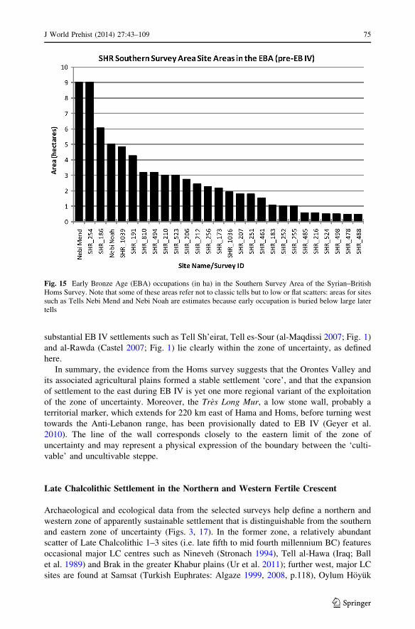
substantial EB IV settlements such as Tell Sh’eirat, Tell es-Sour (al-Maqdissi 2007; Fig. 1)
and al-Rawda (Castel 2007; Fig. 1) lie clearly within the zone of uncertainty, as defined
here.
In summary, the evidence from the Homs survey suggests that the Orontes Valley and
its associated agricultural plains formed a stable settlement ‘core’, and that the expansion
of settlement to the east during EB IV is yet one more regional variant of the exploitation
of the zone of uncertainty. Moreover, the Tres Long Mur, a low stone wall, probably a
territorial marker, which extends for 220 km east of Hama and Homs, before turning west
towards the Anti-Lebanon range, has been provisionally dated to EB IV (Geyer et al.
2010). The line of the wall corresponds closely to the eastern limit of the zone of
uncertainty and may represent a physical expression of the boundary between the ‘culti-
vable’ and uncultivable steppe.
Late Chalcolithic Settlement in the Northern and Western Fertile Crescent
Archaeological and ecological data from the selected surveys help define a northern and
western zone of apparently sustainable settlement that is distinguishable from the southern
and eastern zone of uncertainty (Figs. 3, 17). In the former zone, a relatively abundant
scatter of Late Chalcolithic 1–3 sites (i.e. late fifth to mid fourth millennium BC) features
occasional major LC centres such as Nineveh (Stronach 1994), Tell al-Hawa (Iraq; Ball
et al. 1989) and Brak in the greater Khabur plains (Ur et al. 2011); further west, major LC
sites are found at Samsat (Turkish Euphrates: Algaze 1999, 2008, p.118), Oylum Hoyuk
Fig. 15 Early Bronze Age (EBA) occupations (in ha) in the Southern Survey Area of the Syrian–BritishHoms Survey. Note that some of these areas refer not to classic tells but to low or flat scatters: areas for sitessuch as Tells Nebi Mend and Nebi Noah are estimates because early occupation is buried below large latertells
J World Prehist (2014) 27:43–109 75
123

(Afrin Valley, Turkey: Ozgen and Helwing 2003) and Imar al-Sharqi (Amuq, Turkey:
Casana and Wilkinson 2005). The additional presence of LC 1–2 Khirbet al-Fakhar (Ha-
moukar, northeast Syria), with its compelling evidence for a 300 ha node in the obsidian
trade, attests to the significance of connectivity for the development of proto-urban centres
(al-Quntar et al. 2011; Khalidi et al. 2009). To the west, a rather weakly-defined zone of
Late Chalcolithic settlement appears to have extended along the Orontes Valley. Overall,
however, the archaeological record can be interpreted as suggesting that in the fourth
millennium BC, urbanization was only evident in the Khabur basin and adjacent areas, not
in the middle or upper Euphrates nor the upper Tigris regions (Frangipane 2010, p. 82;
Frangipane 2012, pp. 34–35). Within drier marginal areas, pre-third millennium settlement
was rare, the most noteworthy concentrations being the intrusive southern Uruk centres of
Sheikh Hassan, Habuba Kabira and Jebel Aruda in the Middle Euphrates Valley, as well as
the 12.5 ha Chalcolithic mound of Tell Zeydan in the lower Balikh (Stein 2012).
Overall, a band of fourth millennium BC settlement can be distinguished across the
northern Fertile Crescent (Fig. 17). The following estimates (in terms of sites per 100 km2)
are based on the sample survey areas, cross-checked where possible with other relevant
surveys (Fig. 18):
1. Dense LC settlement predominates within the greater Khabur plains, extending west to
Tell Beydar where site densities, although somewhat lower, remain significant (see
Stein 2012, p. 147, for similar trends).
Fig. 16 Aggregate settlement area for the Southern Survey Area of the Syrian–British Homs Survey6000–1000 BC, sub-divided into two classes (a) small sites\5 ha (dashed line) and sites over 5 ha (dottedline). There is a well-documented gap in occupation at Tell Nebi Mend during the mid sixth–late fifthmillennium BC. Settlement remains fairly stable through Late Chalcolithic and EBA, and shows only amodest increase in EB IV. This contrasts with the situation in the zone of uncertainty to the east of Homs,where the EB IV is a period of major settlement expansion
76 J World Prehist (2014) 27:43–109
123
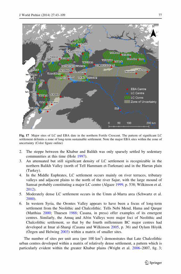
2. The steppe between the Khabur and Balikh was only sparsely settled by sedentary
communities at this time (Hole 1997).
3. An attenuated but still significant density of LC settlement is recognizable in the
northern Balikh Valley (north of Tell Hammam et-Turkman) and in the Harran plain
(Turkey).
4. In the Middle Euphrates, LC settlement occurs mainly on river terraces, tributary
valleys and adjacent plains to the north of the river Sajur, with the large mound of
Samsat probably constituting a major LC centre (Algaze 1999, p. 538; Wilkinson et al.
2012).
5. Moderately dense LC settlement occurs in the Umm al-Marra area (Schwartz et al.
2000).
6. In western Syria, the Orontes Valley appears to have been a focus of long-term
settlement from the Neolithic and Chalcolithic. Tells Nebi Mend, Hama and Qarqur
(Matthias 2000; Thuesen 1988; Casana, in press) offer examples of its emergent
centres. Similarly, the Amuq and Afrin Valleys were major foci of Neolithic and
Chalcolithic settlement, so that by the fourth millennium BC major centres had
developed at Imar al-Sharqi (Casana and Wilkinson 2005, p. 36) and Oylum Hoyuk
(Ozgen and Helwing 2003) within a matrix of smaller sites.
The number of sites per unit area (per 100 km2) demonstrates that Late Chalcolithic
urban centres developed within a matrix of relatively dense settlement, a pattern which is
particularly evident within the greater Khabur plains (Wright et al. 2006–2007, fig. 3;
Fig. 17 Major sites of LC and EBA date in the northern Fertile Crescent. The pattern of significant LCsettlement delimits a zone of long-term sustainable settlement. Note the major EBA sites within the zone ofuncertainty (Color figure online)
J World Prehist (2014) 27:43–109 77
123

Fig. 18). There is also a correlation between the size of the largest site in any survey region
and the density of LC sites per 100 km2 (Fig. 19). These are shown in Fig. 19 in terms of
the ‘normalized’ and ‘raw’ data; the former has been recalculated to take into account the
area of the surveys in question. Although the correlation is high, one anomaly, namely
Khirbet al-Fuqar, is an unusual site (al-Quntar et al. 2011). However, when the mounded
area of the site (31 ha) is employed instead of the area of artefact spread and soil dis-
colouration (280–300 ha), the correlation is higher (0.88 on Fig. 19). It is particularly
Fig. 19 Correlation between the density of LC sites and the area of the largest LC site in each survey area(for normalized data as indicated on Fig. 18). Note that the size of the Hamoukar southern site is taken as31 ha (namely the mounded area). The correlation coefficient of the regression line (R2) is 0.8805
Fig. 18 Chart showing the density of Late Chalcolithic sites per 100 km2 and the area of the largest site inany one survey area. Survey areas are indicated from east (NJP) to west (Homs); grey bars indicate thenumber of sites per 100 km2 in each survey area (raw data: without allowance for the different lengths ofceramic periods); dark grey bars indicate the number of sites per 100 km2 normalized to a standard length ofthe LC period of 1,400 years. The line indicates the size of the largest site (ha) in each survey area. For theAmuq, ‘core, 2008’ refers to estimates for the core area of the Amuq, from Gerritsen et al. 2008; ‘2005’ isfrom Casana and Wilkinson 2005. N Jazira Proj. (Lup. LC 1–3) refers to Lupton (1996)
78 J World Prehist (2014) 27:43–109
123

distinctive of this phase of urbanization that (a) the main sites are distinguishable by their
sheer bulk [in other words, they are both spatially extensive (c. 15–50 ha) and high with
steep sides, implying that mounds grew large, but at a relatively steady pace]; and (b) some
mounds, such as Tell Brak, display a surrounding scatter of low outer mounds which were
not contained within a clearly defined city wall (Ur et al. 2011). Similarly, Hawa appears to
have had an extensive lower town, although this is less evident because it is mainly
obscured by the modern village (Ball et al. 1989, pp. 39–40, fig. 9).
Because of the various periodizations employed for the Late Chalcolithic, estimated site
densities vary according to how finely the period has been sub-divided by the surveyors.
Where the period has been sub-divided into only two phases, namely LC 1–3 and LC 4–5
(Uruk) (as was the case in the NJS; Lupton 1996), settlement density appears higher,
whereas with further sub-division, there are fewer settlements of any one phase, with the
result that settlement density appears lower (Brustolon and Rova 2007, figs 9–12). Because
not all survey records have been divided in accordance with the full LC 1–5 sub-divisions,
we have chosen here, as far as possible, to plot settlement density of phases LC 1–3, which
provides a reasonable estimate of ‘local’ Late Chalcolithic settlement (Table 1). Overall,
within the greater Khabur plains, the Late Chalcolithic appears to have been a period of
relatively dense settlement, consisting of a wide range of small, medium and large set-
tlements dispersed across the plains to form a two or three level settlement hierarchy. West
of Tell Beydar, LC settlement becomes attenuated or limited to minor valleys and tribu-
taries of the Euphrates and associated upland plains, largely (but not entirely) restricted to
the northern part of the rain fed zone (Figs. 2, 4). This distribution outlines what can be
described as a zone of sustainable settlement to the north and west, and the zone of
uncertainty to the south and east, where LC settlement is sparse or absent. The significance
of this will become evident below.
In the upper Khabur plains, LC proto-urban settlements developed within a moderately
dense matrix of rural settlement, which provided the context for the fourth millennium BC
phase of urbanization. Similar arguments for the development of early cities have been
made by Boserup (1983, pp. 68–69) as well as Drennan and Peterson (2012, p. 74). In fact
the latter, building on the earlier arguments of Boserup, suggest that where population
densities are high, ‘costs’ of interaction are lower because there are more people available
within any given area to interact with. High population densities encourage not only
interaction but conflict (Carneiro 1970). This model, which is probably also applicable to
the North Jordan Valley in the late fourth millennium BC, assumes that under conditions of
circumscription aggressive chiefs or kings enlarged political units into larger polities
(Carneiro 1970; Flannery 1999). It is therefore possible that recent evidence for mass
graves at both Brak and Hamoukar in northeastern Syria may result from such conflicts
(Reichel 2006–2007; Lawler 2006; McMahon et al. 2011; Algaze 2008, p. 70; Stein 2012,
p. 141). Although moderately dense rural settlement may have prevailed within parts of the
Khabur plains, most other parts of the northern Fertile Crescent were more sparsely
populated. In such locations the growth of centres such as Samsat, Oylum Hoyuk or Imar
al-Sharqi may either have been driven by factors such as increased regional connectivity,
or developed where local pockets of higher population density existed.
For the subsequent LC 4–5, significant Uruk activity demonstrably occurred within the
densely occupied LC settlement zone of the upper Khabur plains, but also in the less
populated regions to the south. Specifically, southern Uruk material culture is particularly
evident within the Uruk ‘enclave’ of the Middle Euphrates of Habuba Kabira South
(Strommenger 1980); Jebel Aruda (van Driel and van Driel-Murray 1983); and Tell Sheikh
Hassan (Boese 1995; Algaze 1993). In other words, rather than forming part of the
J World Prehist (2014) 27:43–109 79
123
‘colonial expansion’ characteristic of the Habuba Kabira area, settlements in the Khabur
region can be described as Uruk-related, with a mix of local and southern types (Schwartz
2001, p. 255). Therefore evidence from archaeological surveys supports the suggestion by
Schwartz that the Uruk cluster around Habuba Kabira in the Middle Euphrates developed
to the south of the main zone of Late Chalcolithic settlement, perhaps in order to avoid this
zone (Schwartz 2001, p. 260; Wilkinson et al. 2012, pp. 159, 170–172). However, the
location of these colonies might also be explained by the high connectivity of the area,
commanding the bend of the Euphrates, and by the attractiveness of the marginal zone for
opportunistic sheep husbandry (Wilkinson et al. 2012, fig. 25). Similarly, Algaze points out
that Habuba and neighbouring sites developed in ‘carefully selected locations near his-
torical fording places in the Euphrates bend’, which made ideal collection and transship-
ment points (Algaze 1993, 2008, p. 72). The presence of such major loci of Uruk activity
underscores the significance of marginal or ‘sub-optimal’ areas, which should not therefore
be evaluated upon their perceived agricultural potential alone.
Settlement and Landscape in the Third Millennium BC in the Northern FertileCrescent
The pattern of dense Late Chalcolithic settlement and associated urbanism gave way,
during the Ninevite V period of the early third millennium BC, to a phase of reduced social
complexity (Rova and Weiss 2003; Akkermans and Schwartz 2003, pp. 231–232). In the
extensive agricultural plains of northern Syria, Ninevite V was followed by a new phase of
urban-scale settlement during the mid and late EBA (2600–2000 BC), characterized by
Akkermans and Schwartz (2003, pp. 253–262) as the ‘second urban revolution’ and cor-
responding to Ur’s second phase of urbanization (Ur 2010a, pp. 404–412). During this
phase, which begins around the mid third millennium BC, within the extensive agricultural
lowlands of northern Syria settlements grew to some 100–120 ha, in association with a
distinctive settlement hierarchy. In contrast, in the valleys of the Euphrates and its tribu-
taries, sites are clustered on river terraces or extend up tributary valleys either as align-
ments or in the form of muted hierarchies (Wilkinson et al. 2012). North of an alignment
following the Sajur River and the east end of the Jebel Sinjar (Fig. 4), settlement shows
evidence of being long-term and potentially sustainable, whereas to the south in the
marginal agro-pastoral zone or zone of uncertainty, settlement was more scattered and of
attenuated duration (Lewis 1987, p. 16). Archaeological surveys demonstrate that in the
moister zone of North Mesopotamia and western Syria, most EBA settlements are typically
small, 1–3 ha, tells (Philip 2007; Wilkinson et al. 2012). In North Mesopotamia, when
large settlements did develop they frequently grew rapidly during the mid–late third
millennium BC into either extensive ‘citadel cities’ or Kranzhugel (as discussed above).
Whereas the pattern of citadel city development is less evident in western Syria, in the
climatically marginal steppe between the Khabur and Balikh Rivers both citadel cities and
Kranzhugel formed a distinctive feature of the settlement landscape for much of the third
millennium BC (Fig. 17). Particularly noteworthy is that, as discussed above, many
enlarged sites were located further south than might have been expected on the basis of
agricultural productivity alone, and lay within the zone of uncertainty in areas which posed
a higher risk for sustainable cereal cultivation. This is evident on Fig. 20, which indicates
settlement size (in ha) in relation to the mean annual rainfall.
Noteworthy sites within the zone of uncertainty include Banat-Bazi (30 ha); Sweyhat
(40 ha); Hadidi (56 ha); Umm al-Marra (25 ha); Tell es-Seman (c. 50 ha); and Khoshi
80 J World Prehist (2014) 27:43–109
123
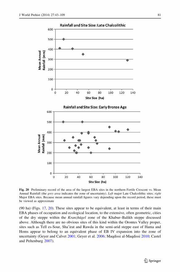
(90 ha) (Figs. 17, 20). These sites appear to be equivalent, at least in terms of their main
EBA phases of occupation and ecological location, to the extensive, often geometric, cities
of the dry steppe within the Kranzhugel zone of the Khabur–Balikh steppe discussed
above. Although there are no obvious sites of this kind within the Orontes Valley proper,
sites such as Tell es-Sour, Sha’irat and Rawda in the semi-arid steppe east of Hama and
Homs appear to belong to an equivalent phase of EB IV expansion into the zone of
uncertainty (Geyer and Calvet 2001; Geyer et al. 2006; Maqdissi al-Maqdissi 2010; Castel
and Peltenburg 2007).
Fig. 20 Preliminary record of the area of the largest EBA sites in the northern Fertile Crescent vs. MeanAnnual Rainfall (the grey area indicates the zone of uncertainty). Left major Late Chalcolithic sites; rightMajor EBA sites. Because mean annual rainfall figures vary depending upon the record period, these mustbe viewed as approximate
J World Prehist (2014) 27:43–109 81
123
In the mid third millennium BC, urbanization therefore took a very different form from
the large bulky mounds of the Late Chalcolithic. Former LC centres such as Brak and
Hawa saw urbanization spill outwards to form ill-defined outer settlements (Ball et al.
1989; Ur 2012). In other cases, tells of modest scale grew rapidly into large citadel cities,
extending over 30–120 ha. Therefore the form, context and dynamics of the secondary
urbanism of the mid third millennium BC contrast markedly with the preceding Late
Chalcolithic. Not only were EBA centres such as Hamoukar, Leilan, Brak and Hawa
developed within a dense matrix of rural settlement (Figs. 6, 8), some were also associated
with settlement reorganization. Thus in the case of Tell al-Hawa, a distinctive settlement
hierarchy developed at the same time as the western region was deserted (Fig. 6). Else-
where, citadel cities such as Tell es-Sweyhat and those in the Khabur–Balikh steppe
developed in previously under-populated areas; their growth can therefore hardly be
ascribed to the existence of high local population densities, as in Boserup’s earlier models
(1983, pp. 68–69). This point emerges strikingly on the time-block plots (Figs. 10, 13).
Even where expanded citadel cities such as Titris Hoyuk are found in relatively verdant
areas of ‘sustainable settlement’ they appear to have developed away from the main
pockets of denser LC settlement (in this case on the Euphrates near Samsat), and, again,
their growth may therefore have been fuelled by adventitious factors (Algaze 1999, p. 555;
Wilkinson et al. 2012). Further discussion of third millennium BC urbanism in the southern
Levant follows below.
An Integrated Model of Agriculture Cores and Pastoralism
Settlement Expansion Out of Core Areas
In the Middle Euphrates and the Khabur–Balikh steppe, the initial expansion of settlement
into the zone of uncertainty and on to the steppe, as well as the opening up of previously
settled land in the North Jazira plain, took place around 3000 BC (the Ninevite V period),
that is, during a period of reduced social complexity. Excavations at Tell Chuera (above)
and Tell es-Sweyhat (Danti and Zettler 2007, pp. 167–169) suggest that this initial
occupation took place around 2800–2900 BC, or slightly earlier during LC 5 (i.e. the late
Uruk period, towards the close of the fourth millennium BC). In contrast, settlement of the
central Syrian steppe at al-Rawda was significantly later, during EB IV (c. 2400 BC; Castel
and Peltenburg 2007, p. 602). Within the North Jazira of Iraq, the opening up of the
formerly settled landscape of the western survey area around 3000 BC (Figs. 6, 7) suggests
a significant need for grazing land, perhaps in response to the growing interest in wool and
textiles throughout greater Mesopotamia and the northern Fertile Crescent. This require-
ment for pasture would have intensified because the area of Hawa and Hamoukar was
relatively densely settled during the fourth millennium and there would have been little
open land accessible for grazing and hunting. In contrast, those settled in areas in the
vicinity of open lands such as the Khabur–Balikh steppe would have been in a position first
to use that land as pasture, and then, subject to existing claims and local power relation-
ships, to claim such lands for more sustained settlement. Although the precise chrono-
logical relationships between Ninevite V settlement in the agricultural lowlands and the
settlement of the steppe of northern Syria are still uncertain, it is plausible that the colo-
nization of the Khabur–Balikh steppe and neighbouring marginal steppe built upon an
earlier phase of minimal sedentary occupation and ancestral pastures that had been in use
during the fourth and perhaps early third millennium BC. Therefore any apparent stasis or
82 J World Prehist (2014) 27:43–109
123
decline in the Ninevite V settlement zone may simply be a result of the movement of
population from the Ninevite V heartland of northwestern Iraq and northeastern Syria into
the steppe (Kouchoukos 1998). A similar expansion out of a core area might be apparent in
the Homs region and the southern Orontes Valley, where there is a marked contrast
between the ‘landscapes of tells’ near the Orontes and Qatna, and the eastern steppe, where
a later phase of short-term settlement is evident in EB IV (Geyer and Calvet 2001, Geyer
et al. 2007; Philip 2007, p. 239). However, the sheer scale of activity during EB IV
suggests that the population of the west Syrian steppe may have drawn upon areas well
beyond the Orontes Valley.
The Role of Ancestral Pastures
The apparent expansion on to the steppe, and its colonization by large-scale sedentary
communities, raises the immediate question: why were such seemingly inhospitable areas
selected for settlement? Emerging evidence from several areas suggests that it is possible
to infer earlier phases of land use, perhaps as pasture. For example, reinterrogation of the
field records of the Tell es-Sweyhat survey suggests that occasional sparse scatters of
chaff- and coarse-tempered ceramics occurred on the plain around Sweyhat. Although not
datable with precision, these scatters may be the remains of temporary encampments of
communities that were using the area, perhaps for grazing purposes (Wilkinson et al.
2012). In other words, the rapid urbanization phase in the third millennium BC may have
been preceded by a phase of extensive grazing combined with transitory settlement. Such
activity would have given the communities some ties and perhaps claims to the land.
Such arguments are particularly compelling where monumental tombs occur, as is the
case in the Euphrates Valley (Cooper 2006; Porter 2002, 2012); the basalt landscapes of the
Homs region (Philip and Bradbury 2010, p. 163; Bradbury and Philip 2011, pp. 176–177;
Bradbury 2011); or the upland regions of the southern Levant (Philip 2003). Similarly, the
basalt plateau west of Tell Beydar (Wilkinson 2002) shows abundant evidence for
‘marking’ of the landscape, in this case via rock art (Van Berg and Picalause 2003). Such
marking may plausibly have been connected with ancestral claims to that land, a model
that can be applied to other areas that were seemingly unoccupied during the fourth
millennium. For example, in both the Khabur–Balikh steppe and central Syria, formerly
open areas of land ideal for pasture or hunting may have been within the bounds of selected
communities that were long-term residents elsewhere, either within the zone of sustain-
ability or beyond. Such ‘ancestral pastures’ would then have become the locus of sedentary
settlement in a later phase, that is, when economic circumstances changed in the third
millennium BC. However, the tenure of such ancestral pastures and the duration of any
associated local memories remains difficult to gauge.
Pastoral Practices
The practice of ‘opportunistic stocking’, in which animal numbers would have been
allowed to rise well beyond the subsistence requirements of local communities, might have
required relatively low investment and therefore could have been practised by relatively
small scale communities. In the case of Ebla, investment in flocks could have come from
the state or members of the elite who would also have to bear the cost of their adminis-
tration, and to absorb any losses incurred. This would have been relatively easy for a state
such as Ebla, which not only received a considerable income from trade, especially of
metals, but was also in a position to benefit from the rewards of arable cropping, olive
J World Prehist (2014) 27:43–109 83
123
production and the textile industry (Bachhuber 2013, pp. 500–502; Milano 1995, p. 1226).
The numbers of sheep at Ebla perhaps therefore resulted from the investment of surplus
wealth into large scale livestock holdings by the royal household and other elite families.
Although the cereal-based staple economy of Ebla and related cities would have provided
the basic under-pinning for the economy, the wealth created by the increased connectivity
and associated trade of the mid third millennium BC could have provided surplus for
investment in livestock, and would have borne any risk of losses as well. In short, the
system was sustainable as long as the vegetation resources of the steppe could be
maintained.
Whether Ebla and other north Syrian cities had access to ‘ancestral pastures’ can only
be inferred from the negative evidence for early third millennium BC settlement within the
zone of uncertainty to the south and southeast. However, the occupation of the Khabur–
Balikh, mid Euphrates and central Syrian steppe by expanded citadel cities or geometric
settlements argues for a broad and formalized process of settlement and colonization of
lands that were ideal for extensive herd management.
As argued by Danti (2000), settlements in the zone of uncertainty, such as those around
Tell es-Sweyhat, were probably not simply supported by a high-risk staple economy.
Instead, they may have been agro-pastoral communities that profited from a combination of
interregional exchange and sheep husbandry. A significant amount of the agricultural land
surrounding such sites may have been devoted to fodder crops (Danti 2000; McCorriston
and Weisberg 2002, p. 495), such as stubble straw, barley grain, Vicia or Lathyrus.
Moreover, as noted above, sheep husbandry and barley production probably co-evolved, so
that when feed supplies for flocks of sheep were insufficient, barley-based agriculture
would develop and grow within the zone of uncertainty. As a result, sedentary commu-
nities would have developed both to tend the fields and to manage the flocks testified by the
Ebla archives. As indicated by the growth of the modern day livestock industry, climati-
cally marginal areas of central Syria, although not capable of supporting long-term self-
sufficient sedentary settlement, are capable of producing cereal crops in many years, either
to supply feed or as part of staple production, However, this operates to greatest effect
when the region is connected to an appropriate wider economy.
In climatically marginal areas such as the zone of uncertainty, the inhabitants could, by
adopting strategies of mobility, maintain higher total livestock populations than would be
the case if herds were confined to any one climatic zone (Behnke and Scoones 1993,
pp. 14–15). Adoption of such strategies would therefore result in a significant increase in
the production of meat and wool. The cities of the zone of uncertainty might therefore be
seen as nodes in a structured network of mobile pasturing strategies, as well as supply
stations for animal feed and for travellers and trade caravans.
Although perhaps not on such a large scale as in the north, other areas also appear to
have experienced a growth in activity during the fourth and third millennia BC. A case in
point is the basalt region west of Homs (Philip and Bradbury 2010). Here we emphasize
that such developments were not part of a broad and uniform spread of agro-pastoralism,
but rather showed considerable regional variation depending upon local circumstances and
opportunities.
Comparisons with the Southern Levant
As a central aim of the FCP is to consider fourth–third millennium BC settlement at a
regional scale, it is appropriate to investigate the extent to which the above model of
84 J World Prehist (2014) 27:43–109
123

settlement cores and a zone of uncertainty might shed light upon developments in other
regions, specifically the southern Levant (Israel and the Palestinian territories, Jordan and
southern Syria/Lebanon: see Fig. 1 for site locations). This region, while not included
within the primary FCP dataset, is of interest for a number of reasons:
1. In the absence of substantive data on EBA settlement in the Damascus area, the
southern Levant comprises the next significant focus of EBA settlement south of
Homs. Accordingly, developments there should clarify the extent to which settlement
trends in western Syria sit wholly within a northern sequence of development, or share
aspects of those detectable in more southerly regions.
2. EBA settlement in the region has been relatively well studied in recent decades (Esse
1991; Getzov et al. 2001; Greenberg 2002; Joffe 1993; Philip 2003, 2008), thus
providing a ready dataset for comparison.
3. The Chalcolithic and EBA archaeology of the southern Levant has traditionally been
studied separately from that of Syria and Mesopotamia, and communication between
researchers working on the northern and southern evidence has been uneven (Prag
2009). As a result, the two regions have had rather different research priorities and
assumptions. Therefore, while the differences between the material culture and the
social and economic structures of the southern Levant and the Syro–Mesopotamian
world during the fourth and third millennia BC have been well documented (Chesson
and Philip 2003; Greenberg 2002; Joffe 1993; Philip 2008), it is worth asking whether
the typological and organizational distinctions might conceal deeper structural
similarities.
It is particularly appropriate to re-examine this topic now, because the long-established
dataset around which the traditional accounts have grown has recently been modified by
two important developments. Firstly, the ‘standard’ chronology of the EBA of the southern
Levant has been questioned by a review of the radiometric evidence (Regev et al. 2012).
The key outcomes relevant to this study are as follows:
1. The date of the EB I/II transition may vary regionally, but appears to lie close to the
end of the fourth millennium BC (Regev et al. 2012, p. 558); see also Bourke et al.
(2009, p. 910), who publish radiocarbon dates that place the EB IB/II transition at
Pella at around 3200–3100 BC.
2. EB II, where it can be defined as a distinct phase, is relatively short, with the EB II/III
transition falling around 2900 cal BC (Regev et al. 2012, pp. 558–559).
3. The EB III period had ended by 2500 BC (Regev et al. 2012, p. 559).
In short, Late EB I (or EB IB) material falls in the later fourth millennium BC, which
overlaps with the Uruk Phase (LC 5) in northern Syria (Table 1). Material assigned to
traditional EB II–III should fall in the very late fourth and the first half of the third
millennium BC, while material assigned to the EB IV (or Intermediate Bronze Age) could
fall anywhere in the second half of the third millennium BC. The scale of this revision
should come as no great surprise, as problems with the assumptions underlying the tra-
ditional chronological framework have been pointed out previously (e.g. Dessel and Joffe
2000; Philip and Millard 2000).
Another important point that arises from the revised chronology is the realization that
the large EB III public buildings evidenced at sites like Khirbet Kerak and Tel Yarmouth
(Greenberg et al. 2012, p. 104; de Miroschedji 1999, 2006) had probably ceased to function
before 2500 cal BC. As these structures and the associated walled settlements belong in the
first half of the third millennium, they pre-date—by some time—the EB IV world of
J World Prehist (2014) 27:43–109 85
123
western Syria, typified by Palace G at Ebla. Therefore, the current assumption that the
absence of rich burials, writing and other administrative paraphernalia from the major EBA
II–III centres of the southern Levant necessarily indicates that these societies were ‘less
developed’ than their Syrian contemporaries (e.g. Philip 2008, p. 163) is no longer tenable.
Rather, the appropriate Syrian comparisons for Tel Yarmouth and Khirbet Kerak lie not in
the world of Ebla as depicted in the texts from Palace G, but in the less well-documented,
and we might suspect less highly-developed, pre-palace phase at Ebla (Dolce 2010) and the
Ninevite V period of northwestern Iraq and northeastern Syria noted above.
In addition, we now have a refined, and well-dated, understanding of climate change in
the region. This arises through a combination of high-resolution proxy climate data from
Soreq Cave near Jerusalem (Bar-Matthews and Ayalon 2011), and the demonstration by
Black et al. (2011, p. 18, fig. 2.5) that present-day annual rainfall is quite well correlated,
within broad environmental zones, over distances of up to 100 km (r = 0.7), and mod-
erately well correlated at up to 200 km (r = 0.5). Because a radius of 100 km from Soreq
Cave encompasses much of that part of the southern Levant in which EBA walled set-
tlements existed, it seems reasonable to use the Soreq Cave climate data as a framework
within which to interpret EBA settlement change.
For the southern Levant, bringing the climatic and chronological data together suggests
the following scenarios (see Bar-Matthews and Ayalon 2011, fig. 6):
1. EB I (late) can be equated with a gradual increase in precipitation during the latter
centuries of the fourth millennium cal BC.
2. EB II–III coincides with a clearly-defined moist phase which covers most of the first
half of the third millennium cal BC, peaks around 2750 cal BC, and then declines back
to late fourth millennium levels by 2400 BC.
3. The EB IV period coincides with a continuation of the trend towards aridity down to
around 2200 cal BC, followed by a short phase of even greater aridity during the last
two centuries of the third millennium cal BC.
Having outlined the key changes that warrant a re-examination, we now return to the
detailed evidence.
As explained by Joffe (1993, pp. 25–26), the physical affordances of the southern
Levant are rather different from those of Syria. Much of Syria is covered by open agri-
cultural plains; in contrast, the southern Levant is more complex, with zones of quite
different geography and ecology located in close proximity. Fertile lowland basin lands are
interspersed through a greater area of upland terrain, much of which is well-suited to
horticulture, being well positioned with respect to rain-bearing westerly winds. However,
the presence of these uplands means that under circumstances resembling those of the
recent past, precipitation declines rapidly on the east side of the Jordan Valley, with the
exception of the Hauran region of southwestern Syria. In northern Transjordan, the area
receiving more than 200 mm annual precipitation extends no more than 50 km east of the
River Jordan; much of it is dissected upland terrain. Further south it is closer to 25 km in
width. In contrast to the extensive zone of uncertainty of north and west Syria therefore, the
equivalent terrain in the southern Levant is much smaller, and shows marked local topo-
graphic and environmental variability (Fig. 3).
The Chalcolithic
The densest distributions of Chalcolithic settlement are in the northern Negev and the
Jordan Valley (Bourke 2008, pp. 114–115; Rowan and Golden 2009, pp. 15, 27). While the
86 J World Prehist (2014) 27:43–109
123

best-known concentration of settlement is that in the northern Negev, its prominence in the
literature may reflect the high surface visibility of those sites and their accessibility to
excavation, perhaps itself a symptom of the collapse of this system during the early fourth
millennium BC, coincident with a marked phase of aridity (Bar-Matthews and Ayalon
2011, fig. 6). In the Jordan Valley, the larger Chalcolithic sites, some of which extend over
10 ha or more, are generally located along the alluvial fans where side wadis enter the
valley (Bourke 2008, pp. 114–115). While Teleilat Ghassul, located just north of the Dead
Sea, was abandoned after the Chalcolithic, the larger Chalcolithic settlements further north
are buried beneath substantial EBA occupations: Beth Shan and Pella are good examples
(Braun 2004; Bourke 2008, p. 127). Evidence for substantial Chalcolithic occupation in the
Jezreel Valley, including a settlement at Megiddo of around 7 ha (Finkelstein et al. 2006,
pp. 720, 763) suggests that it too provided an important settlement core.
Chalcolithic site clusters also exist in the Irbid–Ramtha plain on the north Jordan
plateau, and smaller sites are positioned along the various lesser wadi systems (Bourke
2008, p. 115). Recent fieldwork, and analysis of settlement data from the Jordan Valley and
surrounding uplands (Lovell 2008; Lovell and Bradley 2011, p. 277) and the Jaulan
(Bradbury 2011), suggests that upland sites, apparently associated with horticulture, were
more common in the Chalcolithic than had previously been understood, although at lower
intensity than in the subsequent EBA. That said, upland sites are relatively small and there
is no evidence for large central sites or local settlement hierarchies (Gophna and Tsuk
2005; Rowan and Golden 2009, p. 28). The Jordan Valley is, in effect, the main settlement
core for the southern Levant during the fifth millennium BC. However, Chalcolithic set-
tlements in the Jordan Valley differ from those of the northern Fertile Crescent in several
respects, including the much higher density of rural settlements in the north; the sheer bulk
of the major northern sites (as described above); and in a few cases, their spatial extent—
for example, the 300 ha site of Hamoukar South, which appears to have been involved in
obsidian manufacture (al-Quntar et al. 2011).
Later Fourth Millennium
The probable significance of the northern lowland valleys (i.e. the Jezreel and Jordan
Valleys) as a settlement core has been noted many times (e.g. Getzov et al. 2001,
pp. 23–24; Joffe 1993, pp. 73–76), and it is likely that some of the larger tell sites in these
areas provided chronological continuity between Chalcolithic and EB I occupations, of a
kind that does not exist in the northern Negev (Braun 2004; Finkelstein et al. 2006,
fig. 40.17). Less clear until very recently, however, has been the existence of a number of
(possibly undefended) settlements of late fourth millennium BC date and 20–35 ha extent
in the Jezreel and Jordan valleys (EB IB or late EB I in local terms) (Table 3).
While the size of some of these sites may have been exaggerated by a degree of
horizontal displacement over time, the modest duration of the EB IB period
(300–350 years) suggests that they should still represent major concentrations of popula-
tion and economic activity. Sites of this size would be considered large during any phase of
the Bronze Age in the region (Broshi and Gophna 1984, 1986), and, for that matter, in
comparison to sites currently documented in Western Syria. Their presence in locations
offering possibilities for floodwater irrigation (Philip 2008, pp. 170–171) places them
comfortably within the category of fourth millennium BC settlement cores discussed
above. The presence of facilities for capturing and storing seasonal run-off water in
association with activity dating to the late fourth millennium—early third millennium BC
at sites in the arid-zone, such as Jawa and Khirbet el-Umbashi (Braemer et al. 2009, 2010;
J World Prehist (2014) 27:43–109 87
123
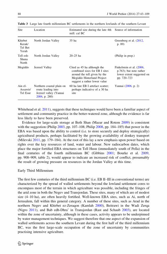
Whitehead et al. 2011), suggests that these techniques would have been a familiar aspect of
settlement and community practice in the better-watered zone, although the evidence is far
less likely to have been preserved.
Evidence for large-scale storage at Beth Shan (Mazar and Rotem 2009) is consistent
with the suggestion (Philip 2003, pp. 107–108; Philip 2008, pp. 184–185) that power in the
EBA was based upon the ability to control (i.e. to store securely and deploy strategically)
agricultural products, perhaps facilitated by the growing availability of donkey transport
(Milevski 2011, pp. 179–184). At the root of this lay a new emphasis upon power based on
rights over the key resources of land, water and labour. New radiocarbon dates, which
place the major fortified EBA structures on Tell Husn (immediately south of Pella) in the
final centuries of the fourth millennium BC (Gibbins 2001; Bourke et al. 2009,
pp. 908–909, table 2), would appear to indicate an increased risk of conflict, presumably
the result of growing pressure on resources in the Jordan Valley at this time.
Early Third Millennium
The first few centuries of the third millennium BC (i.e. EB II–III in conventional terms) are
characterized by the spread of walled settlements beyond the lowland settlement cores to
encompass most of the terrain in which agriculture was possible, including the fringes of
the arid zone in both the Negev and Transjordan. These sites, many of which are of modest
size (4–10 ha), are often heavily fortified. Well-known EBA sites, such as Ai, north of
Jerusalem, fall within this general category. A number of these sites, such as Arad in the
northern Negev and Khirbet ez-Zeraqon (Kamlah 2000), Beitrawi in the Wadi Zerqa
(Nigro 2011), and Bab edh-Dhra’ in Transjordan (Rast and Schaub 2003), are located
within the zone of uncertainty, although in these cases, activity appears to be underpinned
by water management techniques. We suggest therefore that one aspect of the expansion of
walled settlements across the southern Levant during the first half of the third millennium
BC, was the first large-scale occupation of the zone of uncertainty by communities
practising intensive agriculture.
Table 3 Large late fourth millennium BC settlements in the northern lowlands of the southern Levant
Site Location Estimated size during the late 4thmill. cal BC
Source of information
KhirbetKerak/Tel BetYerah
North Jordan Valley 35 ha Greenberg et al. (2012,p. 89)
Tell esh-ShunaNorth
North Jordan Valley 20–25 ha (Philip in prep.)
Megiddo Jezreel Valley Cited as 45 ha although thecombined sizes for EB I sitesaround the tell given by theMegiddo Hinterland Projectsuggest a rather lower value
Finkelstein et al. (2006,p.763); but note ratherlower extent suggested onpp. 720–723
Ain el-Assawir/Tel Esur
Northern coastal plain onroute leading intoJezreel valley (Yannai2006, p. 280)
60 ha late EB I artefact scatter;perhaps indicative of a 30 hasite
Yannai (2006, p. 2)
88 J World Prehist (2014) 27:43–109
123
The growth of substantial settlements at the previously sparsely-settled northern sites of
Tel Dan and Hazor during EB II (Greenberg 2002, p. 35) may also form part of this general
intensification of landscape usage, while a comparable process is documented in southern
Syria, where the Hauran shows a clear increase in settlement and the appearance of small
walled centres (usually\4 ha in size) during EBII–III (Criaud and Rohmer 2010, p. 52). In
fact, Khirbet ez-Zeraqon in northern Transjordan and Labwe in southern Syria (Braemer
et al. 2010) both show evidence of substantial planning and appear to represent variations
upon what Douglas (2011, p. 6) has termed the ‘single-main-period site’. Taken as a whole,
these sites appear to stress defence, storage of agricultural produce, and water security
(Braemer et al. 2009; Douglas 2011; Philip 2008, Nigro 2011).
While the occupational sequences differ between individual sites and regions, with each
case reflecting specific local environmental and socio-political conditions (e.g. Dessel and
Joffe 2000; Greenberg 2002, 2003; Nigro 2011), these differences should not cloud our
view of the overall process. In light of evidence for increased precipitation in the earlier
third millennium BC (Bar-Matthews and Ayalon 2011), and the absence of significant
Middle or Late Bronze Age activity at many of these locations, the expansion of walled
settlements beyond the lowland basin cores may represent an opportunistic response to
increasing precipitation, which by permitting an intensification of agricultural production
increased the possibilities for the collection and control of agricultural products by
incipient elites. In fact, the appearance of substantial public architecture during EB II–III at
the larger walled settlements such as Tel Yarmouth and Khirbet Kerak (EB III) (de
Miroschedji 1999, 2006; Greenberg et al. 2012, pp. 101–102; Mazar 2001) might indicate
that the emergence of elites was focused upon a limited number of larger regional centres.
The Jordan Valley itself witnessed an interesting set of developments around the end of
the fourth millennium BC. While sites such as Khirbet Kerak, Tell Abu al-Kharaz, and
Pella were fortified (Bourke et al. 2009; Fischer 2008, p. 345; Gibbins 2001; Greenberg
et al. 2012, pp. 92–93), others such as Tell esh-Shuna and Beth Shan appear to have
undergone either temporary abandonments or marked reductions in activity (Mazar 2012,
pp. 23–24). The broad contemporaneity of decline at some sites, and the construction of
fortifications at others is consistent with a period of competition for resources between the
large EB I centres in the north Jordan Valley. The outcome, it would appear, was that some
communities came to control land that had previously been worked by others (e.g. Tell esh-
Shuna, Beth Shan). The reoccupation of the latter sites appears to be marked by the
presence in quantity of the distinctive Khirbet Kerak ware (KKW), a class of ceramics
probably to be associated with the settlement of people with a habitus quite distinct from
that of the local EB II–III population, and with clear connections to more northerly regions
(Greenberg 2011; Iserlis 2009; Zuckerman et al. 2009). However, at other sites, such as
Khirbet Kerak itself, KKW occurs alongside ‘local’ ceramic forms (Greenberg et al. 2012,
p. 102).
While KKW was traditionally ascribed to EB III, the revised chronology discussed
above places this development around 2900 cal BC, that is, not long after the demise of the
late EB I occupations at Shuna and Beth Shan and the construction of the first fortifications
at Khirbet Kerak and Pella (Bourke et al. 2009; Greenberg et al. 2012, p. 90). The
appearance of quantities of KKW stratified above deposits containing typical late EB I
material might therefore indicate that the surviving polities in the Jordan Valley sought to
revive agricultural production by introducing immigrants who would work the land but
(unlike the previous inhabitants) would have no direct claim to its ownership. Seen in this
light, the settlement of populations using KKW in the Jordan Valley, and the expansion of
walled settlements across hitherto lightly occupied zones in the early third millennium BC,
J World Prehist (2014) 27:43–109 89
123
might be seen as context-specific responses to the same need, that of increasing agricultural
production.
The main exception to the above developments is in the central coastal plain, which was
lightly occupied during EB II–III. As Faust and Ashkenazy (2009) argue, this may reflect
the negative impact of increased precipitation upon the habitability of a poorly-drained
region. This suggestion draws support from evidence showing an increase in the extent of
marsh vegetation around Ain el-Assawir during the centuries leading up to the abandon-
ment of the site towards the end of the Late EB I period (Horowitz 2006, p. 268).
Early Bronze IV
In the southern Levant, the EB IV period (now re-dated to the second half of the third
millennium BC) witnessed the virtual abandonment of large defended sites. However, in
contrast to the image of invading pastoralists put forward by Kenyon (1966, 1979,
pp. 119–147), it is clear that the area saw continued sedentary occupation in the form of
small agro-pastoralist communities operating a subsistence economy (Prag 1974; Palumbo
1991; Mazar 2006, pp. 116–115): ’Ein el-Hilu in the Jezreel is one example (Covello-Paran
2009).
According to the revised chronology, many walled EB II–III settlements would have
been abandoned by 2500 BC. However, the Soreq Cave evidence (Bar-Matthews and
Ayalon 2011) suggests that precipitation around 2500–2400 cal BC, while some way
below the peak value of the early third millennium, was still higher than in the late fourth
millennium cal BC. While the incision of wadi systems as a result of greater water power
in the early third millennium BC may have rendered floodwater irrigation difficult in some
areas (Donahue 2003; Rosen 1995) this cannot provide a universal explanation for the
decline.
A marked decline in settlement in the southern Levant during EB IV is in clear contrast
to the situation in north and west Syria outlined above, where decline occurred primarily
during the final quarter of the third millennium BC (McMahon 2012, pp. 664–667; Ku-
zucuoglu and Marro 2007; Wossink 2009). However, survey data from southern Syria
suggest that during EB IV the region witnessed both a reduction in site numbers and a shift
to small agro-pastoral settlements generally less than 1 ha in size (Criaud and Rohmer
2010, p. 56, fig. 6). The Beq’a Valley also saw a substantial reduction in settlement
numbers from EB II–III to EB IV, although in this area, EB IV settlement was focused on a
subset of those tells which had been occupied during EB II–III (Marfoe 1995, p. 98;
Marfoe 1998, pp. 154–155). During EB IV, both the Hauran and the Beq’a appear to
demonstrate changes in settlement more akin to those seen in the southern Levant than
those of western Syria.
We suggest that the collapse of the walled centres of the southern Levant by 2500 cal
BC came about through a combination of factors. Firstly, the documented decrease in
rainfall during the second quarter of the third millennium would have slowly diminished
the possibility of creating agricultural surpluses. This would have been exacerbated by the
number of walled settlements that were located in the zone of uncertainty, while the
importance of hydrological management at many EB II–III sites (Philip 2008,
pp. 170–171) underscores its role in ensuring the long-term viability of at least some of
these communities.
The second factor is the absence, from the southern Levant, of a local equivalent to the
large and hitherto under-exploited northern zone of uncertainty characteristic of much of
Syria. Not only did the southern Levant offer a ‘zone’ that was much smaller than that of
90 J World Prehist (2014) 27:43–109
123

Syria (Fig. 3b), but because of the successful expansion during the earlier third millennium
BC, the prime niches and key wadi systems within this zone had already been occupied.
The southern landscape, therefore, simply could not offer the kind of new opportunities
that were available in the ‘pristine’ steppe landscape of Syria.
Moreover, the Syrian steppe formed an important communications route between
western Syria, the Euphrates Valley, and North Mesopotamia, as witnessed by the inter-
actions described in the Ebla texts (Archi and Biga 2003). In the case of the southern
Levant, despite the growing evidence for pastoral nomadic activity in the steppe regions of
Jordan during the Chalcolithic–EBA, perhaps connected to the acquisition of resources
such as flint (Abu Azizeh 2011, 2013; Muller-Neuhof 2006; Quintero et al. 2002), there
was no major political entity at the eastern side of the steppe with whom to interact, and so
the value of the steppe as a network of communication between competing polities was
markedly reduced. Equally, the large distances between EBA polities of the southern
Levant and those developing in Syria, and the clear orientation of the political relations of
Ebla towards the north and east (Biga 2008), suggest that southern polities would have
struggled to develop the kind of political and economic relationships that could have driven
and sustained competitive interactions of the kind documented between Syrian polities.
Thus the explanation for the inability of centres like Tel Yarmouth and Khirbet Kerak to
make the transition to polities equivalent to those of EB IV Syria may lie in a combination
of declining rainfall, the limited size of agricultural plains, and the absence of an under-
exploited zone of uncertainty. The lack of the last named would have deprived elites in
southern communities of the substantial additional (pastoral) resources necessary to sup-
port the increase in the scale and complexity of major polities that is evident in Syria from
2500 BC onwards. The apparently rapid collapse of the southern polities may reflect the
impact on a finely balanced system of a relatively moderate reduction in precipitation,
which nevertheless undermined the intensive agricultural model upon which the regional
economy was based. In turn, the absence of an extensive zone of uncertainty meant that
this could not be circumvented by developing new modes of economic activity.
It is probably not by chance that the best example of a site which maintained its walled
status into EB IV is Khirbet Iskander in Transjordan. This site was located on a major
perennial wadi (Cordova and Long 2010, pp. 30–31) and in a region in which it would have
been difficult to attain the levels of complexity posited for EB II–III communities in more
northerly and western regions (Philip 2008, p. 210; Richard and Long 2009). As a result,
Iskander—and perhaps other communities in similar locations—was able to adjust more
readily to the new circumstances than its more developed counterparts in the northern and
western regions of the southern Levant. The similarity of EB IV developments in other
variegated, spatially constrained environments, such as the Beq’a, Homs basalt and
Hauran, to the situation in Israel, the Palestinian territories and Transjordan may well
reflect the limited zone of uncertainty in those areas too.
This reconstruction has interesting implications for our understanding of social and
economic developments in the EB IV period, and its distinctive material culture. Bun-
imovitz and Greenberg (2006) have described the way in which scholarly views on the EB
IV period have followed shifting paradigms in wider disciplinary thinking. For example,
studies in the 1980s (Dever 1980; Richard 1980) emphasized the strong connection of EB
IV ceramics to those of the local EB III. As a result, the evidence for the adoption of items
of material culture of Syrian inspiration, including those ceramic and metal forms that had
shaped Kenyon’s concept of ‘Amorite’ invaders (e.g. Kenyon 1966) were somewhat
underplayed. More recently, both Bunimovitz and Greenberg (2004) and Prag (2009) have
noticed that those EB IV ceramic forms which suggest connections with Syria appear
J World Prehist (2014) 27:43–109 91
123

linked to the consumption of food and drink, while metal forms mostly take the form of
weapons or personal ornaments, and generally occur in graves. Taken together these
features hint at the adoption, in the south, of some of the material culture items that were
associated with practices of burial and status-marking documented in EB IV Syria (Archi
2012, pp. 20–24), and perhaps some aspects of the associated systems of representation.
Building on the discussion above, we suggest that one result of the disappearance of the
EB II–III walled centres in the southern Levant would have been a decline of the systems
of representation associated with that particular social and economic order. On the other
hand, knowing the importance of livestock raising, and wool in particular, to Syrian centres
such as Ebla, we suggest that the EB IV agro-pastoral communities of the southern Levant
may, at least peripherally, have been involved in the resourcing or seasonal management of
the vast animal herds that occupied the rangelands of the Syrian steppe in EB IV. While
this may have involved the supply of young animals, or breeding stock, there may also
have been a demand for significant quantities of human labour. In this light, the apparent
contradiction between the clear derivation of the bulk of the EB IV ceramic repertoire of
the southern Levant from local EB III forms (Richard 1980; D’Andrea 2012) and the
adoption of a very specific subset of Syrian material culture by the same communities
becomes comprehensible. This occurs through a situation characterized by Bunimovitz and
Greenberg (2006, p. 29) as one of ‘semi-nomadic pastoralists perhaps straddling the
interface between Canaan and the urban centres of central Syria’. It is noteworthy that the
first appearance in southern Syria of ceramic forms that are of clear northern derivation,
such as decorated goblets, occurs within EB IV assemblages at Moumassakhin north of
Damascus, and the Hauran (Braemer 2002, p. 15). Together, these hint at an increase in the
extent of communications across the steppe running southwards from Tadmor (Palmyra)
and the Homs region to Damascus, the Hauran, and ultimately the southern Levant, and
underscores the importance of connectivity—fueled by animal herding—to shaping soci-
eties across the region in the later third millennium BC.
Of particular interest in this regard is the presence of a ‘gap’ at Sahl al-Mafid, the
southernmost point on the Tres Long Mur, which gave access to a depression running
between the Anti-Lebanon and Palmyrid ranges and offered a convenient route for the
movement of animals to and from Damascus (Geyer et al. 2010, p. 64, fig. 10). This
suggests the emergence of new, south-facing, networks of communication. In the absence
of significant southern power centres during EB IV, such a process would presumably
reflect the gradual reorientation of communities in the southern Levant towards a northern
sphere, through the opportunities offered by this new and physically distant core.
Discussion and Conclusions
Our review of the development of fourth and third millennium BC settlement using key
sample areas drawn from the northern Fertile Crescent has indicated the existence of
several distinctive settlement structures and diachronic trajectories (Table 4). Within the
northern Fertile Crescent, evidence from the Khabur plains suggests that both site mor-
phology and the demographic context of the fourth and third millennium phases of
urbanization were very different. Whereas most of the largest LC settlements grew within a
moderately dense matrix of rural settlement, those of the mid–late third millennium grew
in both densely settled and sparsely populated areas. Moreover, in contrast with the gradual
growth and decline of the major LC centres, towns of the third millennium exhibited a
rapid arc of growth, followed by a crest and then decline. The quantified evidence for the
92 J World Prehist (2014) 27:43–109
123
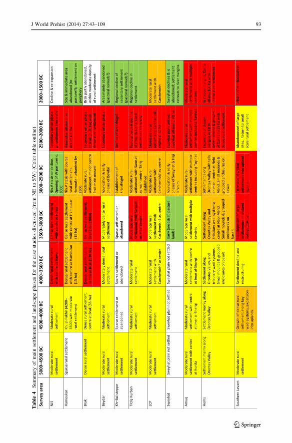
Ta
ble
4S
um
mar
yo
fm
ain
sett
lem
ent
and
lan
dsc
ape
ph
ases
for
the
case
stud
ies
dis
cuss
ed(f
rom
NE
toS
W)
(Co
lor
tab
leo
nli
ne)
J World Prehist (2014) 27:43–109 93
123
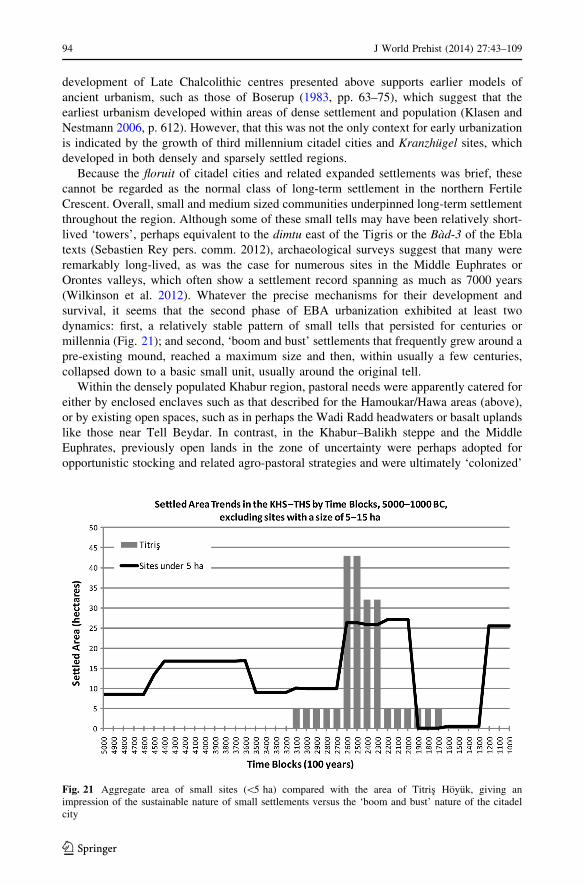
development of Late Chalcolithic centres presented above supports earlier models of
ancient urbanism, such as those of Boserup (1983, pp. 63–75), which suggest that the
earliest urbanism developed within areas of dense settlement and population (Klasen and
Nestmann 2006, p. 612). However, that this was not the only context for early urbanization
is indicated by the growth of third millennium citadel cities and Kranzhugel sites, which
developed in both densely and sparsely settled regions.
Because the floruit of citadel cities and related expanded settlements was brief, these
cannot be regarded as the normal class of long-term settlement in the northern Fertile
Crescent. Overall, small and medium sized communities underpinned long-term settlement
throughout the region. Although some of these small tells may have been relatively short-
lived ‘towers’, perhaps equivalent to the dimtu east of the Tigris or the Bad-3 of the Ebla
texts (Sebastien Rey pers. comm. 2012), archaeological surveys suggest that many were
remarkably long-lived, as was the case for numerous sites in the Middle Euphrates or
Orontes valleys, which often show a settlement record spanning as much as 7000 years
(Wilkinson et al. 2012). Whatever the precise mechanisms for their development and
survival, it seems that the second phase of EBA urbanization exhibited at least two
dynamics: first, a relatively stable pattern of small tells that persisted for centuries or
millennia (Fig. 21); and second, ‘boom and bust’ settlements that frequently grew around a
pre-existing mound, reached a maximum size and then, within usually a few centuries,
collapsed down to a basic small unit, usually around the original tell.
Within the densely populated Khabur region, pastoral needs were apparently catered for
either by enclosed enclaves such as that described for the Hamoukar/Hawa areas (above),
or by existing open spaces, such as in perhaps the Wadi Radd headwaters or basalt uplands
like those near Tell Beydar. In contrast, in the Khabur–Balikh steppe and the Middle
Euphrates, previously open lands in the zone of uncertainty were perhaps adopted for
opportunistic stocking and related agro-pastoral strategies and were ultimately ‘colonized’
Fig. 21 Aggregate area of small sites (\5 ha) compared with the area of Titris Hoyuk, giving animpression of the sustainable nature of small settlements versus the ‘boom and bust’ nature of the citadelcity
94 J World Prehist (2014) 27:43–109
123

by a range of expanded sites during the first half of the third millennium BC. A similar
argument can also be made for the central Syrian steppe, but somewhat later, during EB IV
(Geyer et al. 2007). Because communities in such semi-arid lands cannot be supported by
conventional rain-fed staple-based production, we argue that aggrandizing states such as
Ebla adopted high-risk livestock production in tandem with rain-fed barley production to
support a large-scale agro-pastoral economy. This resulted in the extension of settlement
into the marginal steppe lands of central Syria, in part to service the needs of livestock
management but also to secure the important networks of communication (Fig. 22). In
contrast, in the southern Levant such settlement appears to have been inhibited both
because the local zone of uncertainty was less extensive than in Syria, and because much of
it had already been occupied as part of an intensification of agricultural activity during the
early third millennium BC, and so could not offer the opportunities for large-scale agro-
pastoral settlement that were available in the northern Fertile Crescent. In the southern
Levant, reorientation towards northern networks, as demonstrated by the elements of
Syrian material culture described above, took place only following the demise of the local
polities around 2500 BC.
Although such extensions into the steppe may have resulted from the policies of
aggrandizing states, not all parts of the region can be regarded as the domain of elites or
royal households and within the penumbra of state development. Although similar agro-
pastoral economies may have persisted, their impact on the landscape would have been
different. For example, the basalt region west of Homs shows a rather different landscape
signature from that of central and northern Syria, one which reflects a local small-scale
shift in agro-pastoral practice but still designed to take advantage of land with good grazing
potential.
Fig. 22 Agricultural cores and zones of secondary settlement in Syria and neighbouring areas
J World Prehist (2014) 27:43–109 95
123

The interactions between agricultural cores, opportunistic agro-pastoralism and con-
nectivity allow the following conclusions to be drawn for the Early Bronze Age landscape
of the northern Fertile Crescent:
• The zone of uncertainty, together with sub-optimal zones, provided productive
economic niches, as long as certain conditions prevailed, and the scale of the economic
system was such that there was sufficient ‘insurance’ in place to buffer some of the
risks and uncertainties. In other words, the size of the regional polity modifies the risk.
Developments in these areas were probably linked to wider economic structures, and
may well reflect growing connections with more prosperous regions.
• Risk, and perceptions of uncertainty, can play an important role in the development of
agrarian practices—no single model can be applied to these landscapes. Herding
practices can vary and be adopted in different ways depending upon local
circumstances.
• Any increase in the numbers of sheep may require a commensurate increase in the
amount of feed, because the large flocks that arguably prevailed during parts of the
EBA could not necessarily have been provisioned from pastures alone, hence the
increase in evidence for fodder crops in the third millennium BC (Van Lerberghe 1996,
p. 121; McCorriston and Weisberg 2002, p. 495). In fact, the observation that
traditionally, during dry years, sheep can graze ‘failed’ cereal crops (Nordblom 1983)
demonstrates that in agro-pastoral lands there is no sharp division between sedentary
cultivation and pastoralism.
• A significant proportion of the Kranzhugel sites and citadel cities, which have come to
be viewed as characteristic of North Mesopotamia and northern Syria in the third
millennium BC appear to have developed in the context of a temporally restricted
phase of agro-pastoral activity in the zone of uncertainty, a point which explains both
their prominence in the landscape and the accessibility of EBA deposits to archaeology.
• However, many others, including the largest sites in the 80–120 ha range, developed
within the moister zone, in which settlement was more sustainable. These sites,
although developed in densely settled areas, again showed a rather abbreviated
trajectory of growth and decline from a pre-existing minor tell of 300–500 years
duration (Pfalzner 2010; Danti and Zettler 2007).
• Connectivity must have been a key factor in the development of the settlement and
economic landscape of the Fertile Crescent. This is particularly significant for the
growth of urban-scale settlements which, arguably, were both centres of innovation and
nodes for the transmission of ideas (Pumain et al. 2009; Matney 2012, p. 574). Not only
do the patterns of hollow ways suggest that both local and inter-regional connections
underpinned early urbanization, the considerable width of these features argues in
favour of their having been drove roads for large numbers of sheep and goats
(Wilkinson et al. 2010; Casana 2013).
It also follows that the agro-pastoral communities of the zone of uncertainty during the
later third millennium BC put in place the foundations—economic, socio-political and
symbolic—for the Amorite states that followed during the early second millennium, which
are well represented in the Mari letters (Fleming 2004; Porter 2012). However, the fragile
practices within the zone of uncertainty would only have persisted as long as rainfall was
sufficient for flocks to be fed and barley to be grown, or while the resources of the royal
household or state could provide a buffer. Rainfall variations probably had different
impacts in different regions of the Fertile Crescent. In climatically marginal areas of the
north, not only did large settlements grow up rapidly, but some appear to have grown
96 J World Prehist (2014) 27:43–109
123

during periods of increased rainfall, whereas others, such as Tell es-Sweyhat, apparently
grew and declined during phases when the data from both Van and Soreq (Lemcke and
Sturm 1997; Bar-Matthews and Ayalon 2011) suggest that rainfall was declining. Within
the moister parts of the Khabur plains, the relationship between settlement growth or
decline and climate change is also unclear (Zettler 2003; Pfalzner 2010; McMahon 2012,
pp. 664–667). These examples suggests that the relationship between climate and set-
tlement growth was not necessarily linear. The complexity of human–climate relations is
also mentioned by Riehl (2012, p. 119), who suggests that differences in eco-geography,
as well as the political and cultural composition of a population, may have caused the
effects of climatic change on human populations to be very diverse (and these effects
may themselves have interacted in complex ways). Such complexities seem to have been
in operation throughout the southern Levant and Fertile Crescent, and specifically within
the zone of uncertainty, where the strength and spatial extent of states may have changed
not only the perceptions of risk, but also the way that elites or their clients were able to
wrestle with or override climatic fluctuations. If rainfall diminished significantly, trade
patterns were disrupted, or the resources of the state were reduced, then high-risk agro-
pastoralism within the zone of uncertainty would have become less attractive and the
area would have been abandoned. In contrast, the sustainable zone in the north and
northwest would not have participated to the same degree in the high-risk/high-profit
economies of the zone of uncertainty. Overall, it appears that the structured agro-pastoral
strategies that prevailed during the late third millennium BC within the zone of uncer-
tainty may have paved the way for the rather different pastoral and sedentary commu-
nities of the Amorites and the Mari letters, a point which we plan to revisit in detail in a
future article.
Acknowledgments We are very grateful to the following for providing fundamental support for theresearch: the Arts and Humanities Research Council (AHRC), grant number AH/F010095/1, for a majorgrant to the FCP; the Council for British Research in the Levant and the British Academy for funding thefieldwork elements of the Settlement and Landscape Development in the Homs Region (SHR) and Landof Carchemish Projects; and The Leverhulme Trust (Grant F00128/AR: The Vanishing Landscape ofSyria), which supported analysis of the data from SHR. Thanks also go to Durham University and itsDepartment of Archaeology for sponsoring the Informatics Laboratory which was crucial for the analysespresented here. Our colleagues from the FCP: Emma Cunliffe, Michelle de Gruchy, and Louise Raynealso deserve thanks for discussion and input, as well as Jason Ur, for data on the Hamoukar region. Wealso wish to thank the relevant departments of antiquities in Syria, Iraq and Turkey, and the directors ofthe named projects discussed in the text for providing the support for the original surveys. In Syria, theSHR and Land of Carchemish Projects benefitted significantly from permissions, help, and advice suppliedby the Directorate of Antiquities and Museums in Damascus, Aleppo and Homs. We specifically wish tothank Dr Bassam Jamous, Director, Directorate General of Antiquities and Museums and Dr Michael al-Maqdissi, Director of Excavations, Directorate General of Antiquities and Museums, for graciouslyfacilitating fieldwork in the areas of Homs and Carchemish. We are also grateful to Drs Nadim Fakesh,Sa’ir Yarta and Yusuf Kanjo and Mr Mohammed Ali in Aleppo, who gave their continued support to theLand of Carchemish Project, and to our Syrian collaborators Farid Jabbour, Maryam Bachich and theircolleagues in the Homs office of the DGAM, for their active involvement in SHR. Many thanks to theanonymous reviewers for providing helpful comments, and to the editors, Timothy Taylor and SarahWright, for their assistance throughout the editorial process. The Fragile Crescent Project data used in thisarticle is available from the authors.
Open Access This article is distributed under the terms of the Creative Commons Attribution Licensewhich permits any use, distribution, and reproduction in any medium, provided the original author(s) and thesource are credited.
J World Prehist (2014) 27:43–109 97
123
References
Abu Azizeh, A. (2011). Structures cultuelles et funeraires des IVe et IIIe millenaires dans le sud jordaniendesertique: L’occupation de la region d’ al-Thulaythuwat. In T. Steimer-Herbet (Ed.), Pierres levees,steles anthropomorphes et dolmens [Standing stones, anthropomorphic stelae and dolmens] (pp.21–39). Oxford: BAR (International Series 2317)/Lyon: Maison de l’Orient et de la Mediterranee JeanPouilloux.
Abu Azizeh, A. (2013). The southeastern Jordan’s Chalcolithic—Early Bronze Age pastoral nomadiccomplex: Patterns of mobility and interaction. Paleorient, 39, 149–176.
Adams, R. Mc C. (1981). Heartland of cities. Chicago: University of Chicago Press.Adams, R. Mc C. (2006). Shepherds at Umma in the Third Dynasty of Ur: Interlocutors with a world beyond
the ordered field of scribal vision. Journal of the Economic and Social History of the Orient, 49(2),133–169.
Akkermans, P. M. M. G. (1993). Villages in the steppe. Ann Arbor: International Monographs in Prehistory.Akkermans, P. M. M. G., & Schwartz, G. M. (2003). The archaeology of Syria: From complex hunter-
gatherers to early urban societies (ca. 16,000–300 BC). Cambridge: Cambridge University Press.Algaze, G. (1993). The Uruk world system: The dynamics of expansion of early Mesopotamian civilization.
Chicago: University of Chicago Press.Algaze, G. (1999). Trends in the archaeological development of the Upper Euphrates Basin of southeastern
Anatolia during the Late Chalcolithic and Early Bronze Ages. In G. del Olmo Lete & J.-L. MonteroFenollos (Eds.), Archaeology of the Upper Syrian Euphrates: The Tishrin dam area. Aula OrientalisSupplement 15 (pp. 535–572). Barcelona: Editorial Ausa.
Algaze, G. (2001). Initial social complexity in southwestern Asia: The Mesopotamian advantage. CurrentAnthropology, 43, 199–233.
Algaze, G. (2008). Ancient Mesopotamia at the dawn of civilization. Chicago: University of Chicago Press.Algaze, G. (2012). Titris Hoyuk: The nature and context of third millennium B.C.E. urbanism in the Upper
Euphrates Basin. In S. R. Steadman & G. McMahon (Eds.), The Oxford handbook of ancient Anatolia:10,000–323 B.C.E (pp. 993–1011). Oxford: Oxford University Press.
Algaze, G., Dinckan, G., Hartenburger, B., Matney, T., Pournelle, J., Rainville, L., et al. (2001). Research atTitris Hoyuk in southeastern Turkey: The 1999 season. Anatolica, 27, 1–84.
Algaze, G., Misir, A., & Wilkinson, T. J. (1992). Sanliurfa Museum/University of California excavationsand surveys at Titris Hoyuk 1991: A preliminary report. Anatolica, 18, 1–60.
Allentuck, A. (2004). Production, distribution and consumption of animals at Early Bronze Age TitrisHoyuk, southeastern Turkey: A zooarchaeological approach. Unpublished MA Thesis, University ofManitoba.
al-Maqdissi, M. (2007). Notes d’archeologie levantine X. Introduction aux travaux archeologiques syriens aMishrifeh/Qatna au nord-est de Homs (Emese). In D. Morandi Bonacossi (Ed.), Urban and naturallandscapes of an ancient Syrian capital: Settlement and environment at Tell Mishrifeh/Qatna and incentral-western Syria. Proceedings of the international conference held in Udine, 9–11 December2004 (pp. 19–27). Udine: Forum Editrice 1.
al-Maqdissi, M. (2010). Materiel pour l’etude de la ville en syrie (deuxieme partie): Urban planning in Syriaduring the second urban revolution (mid third millennium BC). In K. Ohnuma (Ed.), Formation oftribal communities. Integrated research in the Middle Euphrates, Syria (pp. 131–146). Special Issue ofal-Rafidan. Hiroshima: LetterPress Co.
al-Quntar, S., Khalidi, L., & Ur, J. (2011). Proto-urbanism in the late 5th millennium BC: Survey andexcavations at Khirbet al-Fakhar (Hamoukar), Northeast Syria. Paleorient, 37(2), 151–175.
Andersson, E., Felluca, E., Nosch, M. L., & Peyronel, L. (2010). New perspectives on the Bronze Agetextile production in the eastern Mediterranean: The first results with Ebla as the pilot study. In P.Matthiae, N. Marchetti, L. Nigro & F. Pinnock (Eds.), Proceedings of the 6th annual congress on thearchaeology of the ancient Near East, May 5th–10th 2008, ‘La Sapienza’–Universita di Roma (Vol. 1,pp. 159–176). Wiesbaden: Harrasowitz.
Archi, A. (1990). Agricultural production in the Ebla region. Les Annales Archeologiques Arabes Syriennes,40, 51–55.
Archi, A. (2011). In search of Armi. Journal of Cuneiform Studies, 63, 5–34.Archi, A. (2012). Cult of the ancestors and funerary practices at Ebla. In P. Pfalzner, H. Niehr, E. Pernicka &
A. Wissing (Eds.), (Re-) Constructing funerary rituals in the ancient Near East: Proceedings of thefirst international symposium of the Tubingen Post-Graduate School ‘Symbols of the Dead’ in May2009. Qatna Studien Supplementum 1 (pp. 5–31). Wiesbaden: Harrassowitz.
Archi, A., & Biga, M. G. (2003). A victory over Mari and the fall of Ebla. Journal of Cuneiform Studies, 55,1–44.
98 J World Prehist (2014) 27:43–109
123
Bachhuber, C. (2013). Sumer, Akkad, Ebla and Anatolia. In H. Crawford (Ed.), The Sumerian world (pp.498–516). London: Routledge.
Ball, W., Tucker, D., & Wilkinson, T. J. (1989). The Tell al-Hawa Project: Archaeological investigations inthe north Jazira 1986–87. Iraq, 51, 1–66.
Bar-Matthews, M., & Ayalon, A. (2011). Mid-Holocene climate variations revealed by high-resolutionspeleothem records from Soreq Cave, Israel and their correlation with cultural changes. Holocene,21(2), 163–172.
Behnke, R. H., & Scoones, I. (1993). Rethinking rangeland ecology: Implications for rangeland managementin Africa. In R. H. Behnke & I. Scoones (Eds.), Rangeland ecology at disequilibrium: New models ofnatural variability and pastoral adaptation in African savannas. London: Overseas DevelopmentInstitute.
Biga, M. G. (2008). Au-dela des frontieres: Guerre et diplomatie a Ebla. Orientalia, 77(4), 289–334.Biga, M. G. (2010). Textiles in the administrative texts of the royal archives of Ebla (Syria, 24th Century
BC) with particular emphasis on coloured textiles. In C. Michel & M.-L. Nosch (Eds.), Textileterminologies in the ancient Near East and Mediterranean from the third to the first Millennia BC (pp.146–172). Oxford: Oxbow.
Black, E., Hoskins, B., Slingo, J., & Bradshaw, D. (2011). The present-day climate of the Middle East. In S.J. Mithen & E. Black (Eds.), Water, life and civilisation: Climate, environment and society in theJordan Valley (pp. 13–24). Cambridge: Cambridge University Press.
Boese, J. (1995). Ausgrabungen in Tell Sheikh Hassan I. Saarbrucken: Saarbrucker Druckerei und Verlag.Boserup, E. (1983). Population and technology. Oxford: Blackwell.Bourke, S. J. (2008). The Chalcolithic period. In R. Adams (Ed.), The archaeology of Jordan: A reader (pp.
109–160). London: Equinox.Bourke, S. J., Zoppi, U., Meadows, J., Hua, Q., & Gibbins, S. (2009). The beginnings of the Early Bronze Age
in the North Jordan Valley: New 14C determinations from Pella in Jordan. Radiocarbon, 51(3), 905–913.Bradbury, J. (2011). Landscapes of burial? The Homs basalt, Syria in the 4th–3rd millennia BC. PhD thesis,
Dept of Archaeology, Durham University.Bradbury, J., & Philip, G. (2011). The world beyond the tells: Pre-classical activity in the basalt landscape of
the Homs region, Syria. In T. Steimer-Herbet (Ed.), Pierres levees, steles anthropomorphes et dolmens[Standing stones, anthropomorphic stelae and dolmens] (pp. 169–179). Oxford: BAR (InternationalSeries 2317)/Lyon: Maison de l’Orient et de la Mediterranee Jean Pouilloux.
Braemer, F. (2002). La ceramique du Bronze ancien en Syrie du sud. In M. al-Maqdissi, V. Matoıan & C.Nicolle (Eds.), Ceramique de l’age du bronze en Syrie 1: La Syrie du sud et la vallee de l’Orontes.Bibliotheque archeologique et historique 161 (pp. 9–21). Beirut: Institut francais d’archeologie duProche-Orient.
Braemer, F., Genequand, D., Dumond Maridat, C., Blanc, P.-M., Dentzer, J.-M., et al. (2009). Long-termmanagement of water in the Central Levant: The Hawran case (Syria). World Archaeology, 41(1), 36–57.
Braemer, F., Geyer, B., Castel, C., & Abdulkarim, M. (2010). Conquest of new lands and water systems inthe western Fertile Crescent (central and southern Syria). Water History, 2(2), 91–114.
Braidwood, R. J. (1937). Mounds in the Plain of Antioch. Chicago: Oriental Institute.Braun, E. (2004). Early Beth Shan (strata XIX–XIII): G. M. Fitzgerald’s deep cut on the tell. Philadelphia:
University of Pennsylvania Museum of Archaeology and Anthropology.Bridgland, D. R., Westaway, R., Romieh, M. A., Candy, I., Daoud, M., Demir, T., et al. (2012). The River
Orontes in Syria and Turkey: Downstream variation of fluvial archives in different crustal blocks.Geomorphology, 165, 25–49.
Broshi, M., & Gophna, R. (1984). The settlements and population of Palestine during the Early Bronze AgeII–III. Bulletin of the American Schools of Oriental Research, 253, 41–53.
Broshi, M., & Gophna, R. (1986). Middle Bronze Age II Palestine: Its settlements and population. Bulletinof the American Schools of Oriental Research, 261, 73–90.
Brustolon, A., & Rova, E. (2007). The Late Chalcolithic period in the Tell Leilan region: A report on theceramic material of the 1995 Survey. Kaskal (Rivista di storia, ambienti e culture del Vicino OrienteAntico), 4, 1–42.
Bunimovitz, S., & Greenberg, R. (2004). Revealed in their cups: Syrian drinking customs in intermediateBronze Age Canaan. Bulletin of the American Schools of Oriental Research, 334, 19–31.
Bunimovitz, S., & Greenberg, R. (2006). Of pots and paradigms: Interpreting the Intermediate Bronze Agein Israel/Palestine. In W. G. Dever, S. Gitin, J. E. Wright, & J. P. Dessel (Eds.), Confronting the past:Archaeological and historical essays on ancient Israel in honor of William G. Dever (pp. 23–31).Winona Lake, IN: Eisenbrauns.
Burghardt, A. F. (1959). The location of river towns in the central lowland of the United States. Annals ofthe Association of American Geographers, 49, 305–323.
J World Prehist (2014) 27:43–109 99
123
Carneiro, R. L. (1970). A theory of the origin of the state. Science, 169, 733–738.Casana, J. (2007). Structural transformations in settlement systems of the northern Levant. American
Journal of Archaeology, 111, 195–221.Casana, J. (2013). Radial route systems and agro-pastoral strategies in the Fertile Crescent: New discoveries
from western Syria and southwestern Iran. Journal of Anthropological Archaeology, 32, 257–273.Casana, J. (in press). Results of the 2010 season of excavation by the American Expedition to Tell Qarqur.
Les Annales Archeologiques Arabes Syriennes.Casana, J., & Wilkinson, T. J. (2005). Settlement and landscapes in the Amuq region. In K. Aslihan Yener
(Ed.), The archaeology of the Amuq Plain (pp. 25–65, 203–280). Chicago: Oriental Institute Publi-cations 131.
Castel, C. (2007). Strategies de subsistance et modes d’occupation de l’espace dans la micro-region d’al-Rawda au Bronze ancien final (Shamiyeh). In D. Morandi Bonacossi (Ed.), Urban and naturallandscapes of an ancient Syrian capital: Settlement and environment at Tell Mishrifeh/Qatna and incentral-western Syria (pp. 283–294). Proceedings of the international conference held in Udine, 9–11December 2004. Udine: Forum Editrice.
Castel, C., & Peltenburg, E. (2007). Urbanism on the margins: Third millennium BC al-Rawda in the aridzone of Syria. Antiquity, 81, 601–616.
Charles, M., Pessin, H., & Hald, M. M. (2010). Tolerating change at Late Chalcolithic Tell Brak: Responsesof an early urban society to an uncertain climate. Environmental Archaeology, 15(2), 183–198.
Chesson, M. S. (2003). Households, houses, neighborhoods and corporate villages: Modeling the EarlyBronze Age as a house society. Journal of Mediterranean Archaeology, 16(1), 79–102.
Chesson, M. S., & Philip, G. (2003). Tales of the city? ‘Urbanism’ in the Early Bronze Age Levant fromMediterranean and Levantine perspectives. Journal of Mediterranean Archaeology, 16(1), 3–16.
Cocks, P. L. (1988). Degradation and rehabilitation of agricultural land in north Syria. Aleppo: ICARDAreport.
Cooper, L. (2006). Early urbanism on the Syrian Euphrates. London: Routledge.Cooper, L. (2010). States of hegemony: Early forms of political control in Syria during the third millennium
BC. In D. Bolger & L. Maguire (Eds.), The development of pre-state communities in the ancient NearEast: Studies in honour of Edgar Peltenburg (pp. 87–94). Oxford: Oxbow Books.
Cooper, P., & Bailey, E. (1990). An assessment of risk associated with increasing sheep and feed supplies inSyria: Current and alternative strategies. In ICARDA report, Farm resource management programme(pp. 289–316). Aleppo: ICARDA Annual report for 1989.
Cordova, C. E., & Long, J. C. J. (2010). Khirbat Iskandar and its modern and ancient environment. In S.Richard, J. C. J. Long, P. Holdorf & G. Peterman (Eds.), Khirbat Iskandar: Final report on the EarlyBronze IV Area C gateway and cemeteries. ASOR archaeological reports 14 (pp. 21–35). Boston, MA:American Schools of Oriental Research.
Covello-Paran, K. (2009). Socio-economic aspects of an Intermediate Bronze Age village in the JezreelValley. In P. J. Parr (Ed.), The Levant in transition: Proceedings of a conference held at the BritishMuseum on 20–21 April 2004 (pp. 9–20). Leeds: Maney.
Criaud, H., & Rohmer, J. (2010). Schemas d’occupation d’une enclave semi-aride: Le Leja (Syrie du sud) del’age du Bronze a la veille de l’annexion a Rome (3600 av. J.-C. –fin du Ier s. ap. J.-C.). In H. Alarashi,M.-L. Chambrade, S. Gondet, A. Jouvenel, C. Sauvage & H. Tronchere (Eds.), Regards croises surl’etude archeologique des paysages anciens: Nouvelles recherches dans le Bassin mediterraneen, enAsie centrale et au Proche et au Moyen-Orient (pp. 43–65). Lyon: Maison de l’Orient et de laMediterranee Jean Pouilloux.
Cribb, R. (1991). Nomads in archaeology. Cambridge: Cambridge University Press.Curvers, H. H. (1991). The Balikh Drainage in the Bronze Age. PhD dissertation, University of Amsterdam,
Faculty of Letters.D’Andrea, M. (2012). The Early Bronze IV period in south-central Transjordan: Reconsidering chronology
through ceramic technology. Levant, 44, 17–50.Danti, M. D. (2000). Early Bronze Age settlement and land use in the Tell es-Sweyhat region, Syria. PhD
dissertation, University of Pennsylvania, Department of Anthropology.Danti, M. D., & Zettler, R. (2007). The Early Bronze Age in the Syrian northwest Jezireh: The Tell es-
Sweyhat region. In E. Peltenburg (Ed.), Euphrates River Valley settlement: The Carchemish sector inthe third millennium BC. Levant Supplementary Series 5 (pp. 164–183). Oxford: Oxbow.
de Miroschedji, P. (1999). Yarmuth: The dawn of city-states in southern Canaan. Near Eastern Archaeology,62(1), 2–19.
de Miroschedji, P. (2006). At the dawn of history: Sociopolitical developments in southwestern Canaan inEarly Bronze Age III. In A. M. Maier & P. de Miroschedji (Eds.), ‘I will speak the riddle of ancient
100 J World Prehist (2014) 27:43–109
123
times’: Archaeological and historical studies in honor of Amihai Mazar on the occasion of his sixtiethbirthday (pp. 55–78). Winona Lake, IN: Eisenbrauns.
Deckers, K. (2011). Riverine development in the Tell Hamidi surroundings. In K. Deckers (Ed.), Holocenelandscapes through time in the Fertile Crescent. Subartu 27 (pp. 85–96). Turnhout: Brepols.
Deckers, K., & Riehl, S. (2007). Fluvial environmental contexts for archaeological sites in the Upper Khaburbasin. Quaternary Research, 67, 337–348.
Deckers, K., & Riehl, S. (2008). Resource exploitation of the Upper Khabur Basin (NE Syria) during thethird millennium BC. Paleorient, 34(2), 173–189.
Demir, T., Seyrek, A., Westaway, R., Bridgland, D., & Beck, A. (2008). Late Cenozoic surface upliftrevealed by incision by the River Euphrates at Birecik, southeast Turkey. Quaternary International,186, 132–163.
Dessel, J. P., & Joffe, A. H. (2000). Alternative approaches to Early Bronze Age pottery. In G. Philip & D.Baird (Eds.), Ceramics and change in the Early Bronze Age of the southern Levant (pp. 31–58).Sheffield: Sheffield Academic Press.
Dever, W. G. (1980). New vistas on the EBIV (MBI) horizon in Syria–Palestine. Bulletin of the AmericanSchools of Oriental Research, 237, 35–64.
Dobney, K., Jaques, D., & Van Neer, W. (2003). Diet, economy and status: Evidence from the animal bones.In R. Matthews (Ed.), Excavations at Tell Brak. Volume 4: Exploring an Upper Mesopotamianregional centre (pp. 417–430). Cambridge: McDonald Institute Monographs/British Institute ofArchaeology in Iraq.
Dohmann-Pfalzner, H., & Pfalzner, P. (2002). Untersuchungen zur Urbanisierung Nordmesopotamiens im 3.Jt. v. Chr. am Beispiel des Tall Chuera, Syrien. In R. Eichmann (Ed.), Ausgrabungen und Surveys imVorderen Orient I. OrA 5 (pp. 1–22). Rahden: Leidorf.
Dolce, R. (2010). Ebla and its origins—A proposal. In P. Matthiae, F. Pinnock, L. Nigro & N. Marchetti(Eds.), Proceedings of the 6th international congress of the archaeology of the ancient Near East 1 (pp.245–260). Wiesbaden: Harrassowitz.
Doll, K. (2010). Meat, traction, wool: Urban livestock in Tell Mozan. In K. Deckers, M. Doll, P. Pfalzner &S. Riehl (Eds.), Development of the environment, subsistence and settlement of the city of Urkes and itsregion. Studien zur Urbanisierung Nordmesopotamiens 3A (pp. 191–360). Wiesbaden: Harrassowitz.
Donahue, J. (2003). Geology and geomorphology. In W. E. Rast & R. T. Schaub (Eds.), Bab edh-Dhra:Excavations at the town site (1975–81) (pp. 18–55). Winona Lake, IN: Eisenbrauns.
Douglas, K. (2011). Beyond the city walls: Life activities outside the city-gates in the Early Bronze Age inJordan: Evidence from Khirbet ez-Zeraqon. In M. S. Chesson (Ed.), Daily life, materiality, andcomplexity in early urban communities of the southern Levant: Papers in Honor of Walter E. Rast andR. Thomas Schaub (pp. 3–22). Winona Lake, IN: Eisenbrauns.
Drennan, R. D., & Peterson, C. E. (2012). Challenges for comparative studies of complex societies. In M.E. Smith (Ed.), The comparative archaeology of complex societies (pp. 62–87). Cambridge: CambridgeUniversity Press.
Emberling, G. (2003). Urban social transformations and the problem of the ‘first city’: New research fromMesopotamia. In M. L. Smith (Ed.), The social construction of ancient cities (pp. 254–268). Wash-ington, DC: Smithsonian Institution Press.
Esse, D. L. (1991). Subsistence, trade and social change in Early Bronze Age Palestine. Chicago: OrientalInstitute of the University of Chicago.
Faust, A., & Ashkenazy, Y. (2009). Settlement fluctuations and environmental changes in Israel’s coastalplain during the Early Bronze Age. Levant, 41(2), 19–39.
Finkelstein, I., Halpern, B., Lehmann, G., & Niemann, H. M. (2006). The Megiddo Hinterland Project. In I.Finkelstein, D. Ussishkin & B. Halpern (Eds.), Megiddo IV: The 1998–2002 seasons (pp. 705–776).Tel Aviv, 24. Tel Aviv: Institute of Archaeology, Tel Aviv University.
Fischer, P. M. (2008). Tell Abu al-Kharaz in the Jordan Valley, 1: The Early Bronze Age, Denkschriften derGesamtakademie, 48. Vienna: Verlag der Osterreichischen Akademie der Wissenschaften.
Flannery, K. V. (1999). Process and agency in early state formation. Cambridge Archaeological Journal,9(1), 3–21.
Fleming, D. E. (2004). Democracy’s ancient ancestors: Mari and early collective governance. Cambridge:Cambridge University Press.
Frangipane, M. (2010). Different models of power structuring at the rise of hierarchical societies in the NearEast: Primary economy versus luxury and defence management. In D. Bolger & L. Maguire (Eds.), Thedevelopment of pre-state communities in the ancient Near East: Studies in honour of Edgar Peltenburg(pp. 79–86). Oxford: Oxbow Books.
Frangipane, M. (2012). Fourth millennium Arslantepe: The development of a centralised society withouturbanisation. Origini, 34, 19–40.
J World Prehist (2014) 27:43–109 101
123

Galiatsatos, N., Wilkinson, T. J., Donoghue, D. N. M, & Philip, G. (2009). The Fragile Crescent Project(FCP): Analysis of settlement landscapes using satellite imagery. Computer applications to archae-ology, 2009 Williamsburg, Virginia, USA. March 22–26, 2009. http://www.caa2009.org/articles/Galiatsatos_Contribution365c.pdf.
Gelb, I. J. (1986). Ebla and Lagash: Environmental contrast. In H. Weiss (Ed.), The origins of cities in dry-farming Mesopotamia in the third millennium BC (pp. 157–167). Guilford, CT: Four Quarters.
Gerritsen, F., de Giorgi, A., Eger, A., Ozbel, R., & Vorderstrasse, T. (2008). Settlement and landscapetransformations in the Amuq Valley, Hatay: A long-term perspective. Anatolica, 34, 241–314.
Getzov, N., Paz, Y., & Gophna, R. (2001). Shifting urban landscapes during the Early Bronze Age in theland of Israel. Tel Aviv: Ramot.
Geyer, B. (2009). Pratiques d’acquisition de l’eau et modalites de peuplement dans les marges arides de laSyrie du nord. In M. Mouton & M. al-Dbiyat (Eds.), Strategies d’acquisition de l’eau et societe auMoyen-Orient depuis l’Antiquite: Etudes de cas. Bibliotheque archeologique et historique 186 (pp.25–44). Beirut: Institut Francais du Proche-Orient.
Geyer, B., al-Dbiyat, M., Awad, N., Barge, O., Besancon, J., Calvet, Y., & Jaubert, B. (2007). The aridmargins of northern Syria: Occupation of the land and modes of exploitation in the Bronze Age. In D.Morandi Bonacossi (Ed.), Urban and natural landscapes of an ancient Syrian capital: Settlement andenvironment at Tell Mishrifeh/Qatna and in central-western Syria. Proceedings of the internationalconference in Udine, 9–11 December 2004 (pp. 269–281). Udine: Forum Editrice.
Geyer, B., Awad, N., al-Dbiyat, M., Calvet, Y., & Rousset, M.-O. (2010). Un «tres longue mur» dans lasteppe syrienne. Paleorient, 36(2), 57–72.
Geyer, B., Besancon, J., & Rousset, M. O. (2006). Les peuplements anciens. In R. Jaubert & B. Geyer(Eds.), Les marges arides du croissant fertile: Peuplements, exploitation et controle des ressources enSyrie du Nord (pp. 55–69). Lyon: Maison de l’Orient et de la Mediterranee Jean Pouilloux.
Geyer, B., & Calvet, O. (2001). Les steppes arides de la Syrie du Nord au Bronze Ancien ou «la premiereconquete de l’est». In B. Geyer (Ed.), Conquete de la steppe et appropriation des terres sur les margesarides du Croissant fertile (pp. 55–68). Lyon: Maison de l’Orient et de la Mediterranee Jean Pouilloux.
Gibbins, S. (2001). Early Bronze Age fortifications on Tell Husn (Pella). In A. Walmsley (Ed.), Australiansuncovering ancient Jordan: Fifty years of Middle Eastern archaeology (pp. 89–94). Sydney: ResearchInstitute for Humanities and Social Sciences, University of Sydney/Department of Antiquities ofJordan.
Gophna, R., & Tsuk, T. (2005). Chalcolithic settlements in the western Samaria foothills. Tel Aviv, 32(1),3–19.
Greenberg, R. (2002). Early urbanizations in the Levant: A regional narrative. New York: LeicesterUniversity Press.
Greenberg, R. (2003). Early Bronze Age Megiddo and Bet Shean: Discontinuous settlement in sociopoliticalcontext. Journal of Mediterranean Archaeology, 16(1), 17–32.
Greenberg, R. (2011). Life in the city: Tel Bet Yerah in the Early Bronze Age. In M. S. Chesson (Ed.), Dailylife, materiality, and complexity in early urban communities of the southern Levant: Papers in honor ofWalter E. Rast and R. Thomas Schaub (pp. 41–54). Winona Lake, IN: Eisenbrauns.
Greenberg, R., Paz, S., Wengrow, D., & Iserlis, M. (2012). Tel Bet Yerah: Hub of the Early Bronze AgeLevant. Near Eastern Archaeology, 75(2), 88–107.
Grigson, C. (2007). Culture, ecology and pigs from the fifth to the third millennium BC around the FertileCrescent. In U. Albarella, K. Dobney, A. Ervynck, & P. Rowley-Conwy (Eds.), Pigs and humans:10,000 years of interaction (pp. 83–108). Oxford: Oxford University Press.
Hald, M. M. (2010). Distribution of crops at late Early Bronze Age Titris Hoyuk, southeast Anatolia:Towards a model for the identification of consumers of centrally organised food distribution. Vege-tation History and Archaeobotany, 19, 69–77.
Hazell, P., Oram, P., & Chaherli, N. (2001). Managing droughts in the low-rainfall areas of the Middle Eastand North Africa. EPTD Discussion Paper No. 78. Washington, DC: Environment and ProductionTechnology Division, International Food Policy Research Institute.
Hole, F. (1997). Evidence for mid-Holocene environmental change in the western Khabur drainage,northeastern Syria. In H. Dalfes, H. Nuzhet, G. Kukla & H. Weiss (Eds.), Third millennium BC climatechange and Old World collapse. NATO ASI Series: Global Environmental Change, 49 (pp. 67–106).Berlin: Springer.
Horden, P., & Purcell, N. (2000). The corrupting sea: A study of Mediterranean history. Oxford: Blackwell.Horowitz, A. (2006). Palynology at ’En Esur: The advance of marshes as a possible cause for settlement
desertion. In E. Yannai (Ed.), ’En Esur (’Ein Asawir) 1: Excavations at a protohistoric site in thecoastal plain of Israel (pp. 267–268). Jerusalem: Israel Antiquities Authority.
102 J World Prehist (2014) 27:43–109
123
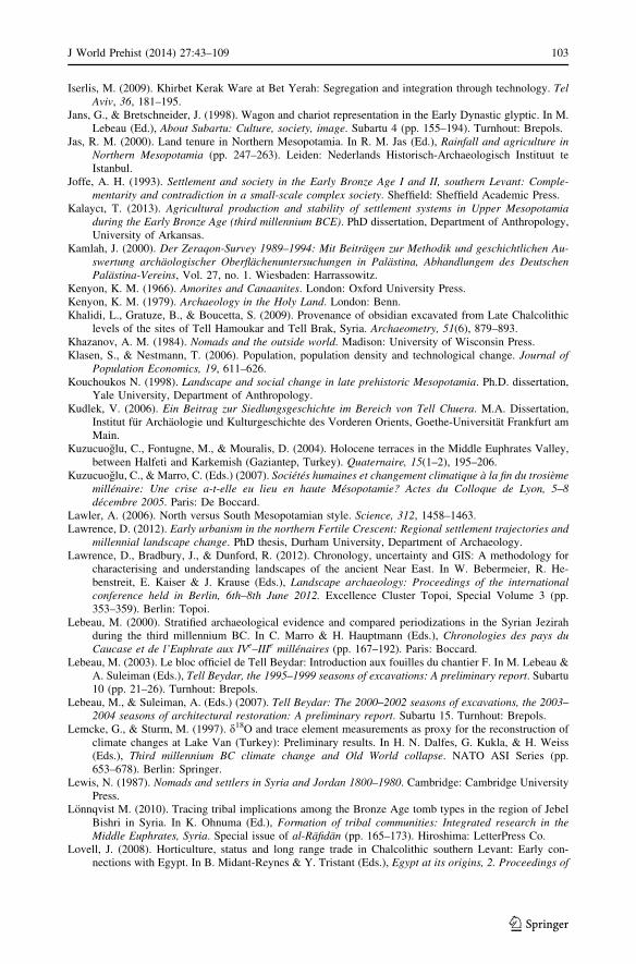
Iserlis, M. (2009). Khirbet Kerak Ware at Bet Yerah: Segregation and integration through technology. TelAviv, 36, 181–195.
Jans, G., & Bretschneider, J. (1998). Wagon and chariot representation in the Early Dynastic glyptic. In M.Lebeau (Ed.), About Subartu: Culture, society, image. Subartu 4 (pp. 155–194). Turnhout: Brepols.
Jas, R. M. (2000). Land tenure in Northern Mesopotamia. In R. M. Jas (Ed.), Rainfall and agriculture inNorthern Mesopotamia (pp. 247–263). Leiden: Nederlands Historisch-Archaeologisch Instituut teIstanbul.
Joffe, A. H. (1993). Settlement and society in the Early Bronze Age I and II, southern Levant: Comple-mentarity and contradiction in a small-scale complex society. Sheffield: Sheffield Academic Press.
Kalaycı, T. (2013). Agricultural production and stability of settlement systems in Upper Mesopotamiaduring the Early Bronze Age (third millennium BCE). PhD dissertation, Department of Anthropology,University of Arkansas.
Kamlah, J. (2000). Der Zeraqon-Survey 1989–1994: Mit Beitragen zur Methodik und geschichtlichen Au-swertung archaologischer Oberflachenuntersuchungen in Palastina, Abhandlungem des DeutschenPalastina-Vereins, Vol. 27, no. 1. Wiesbaden: Harrassowitz.
Kenyon, K. M. (1966). Amorites and Canaanites. London: Oxford University Press.Kenyon, K. M. (1979). Archaeology in the Holy Land. London: Benn.Khalidi, L., Gratuze, B., & Boucetta, S. (2009). Provenance of obsidian excavated from Late Chalcolithic
levels of the sites of Tell Hamoukar and Tell Brak, Syria. Archaeometry, 51(6), 879–893.Khazanov, A. M. (1984). Nomads and the outside world. Madison: University of Wisconsin Press.Klasen, S., & Nestmann, T. (2006). Population, population density and technological change. Journal of
Population Economics, 19, 611–626.Kouchoukos N. (1998). Landscape and social change in late prehistoric Mesopotamia. Ph.D. dissertation,
Yale University, Department of Anthropology.Kudlek, V. (2006). Ein Beitrag zur Siedlungsgeschichte im Bereich von Tell Chuera. M.A. Dissertation,
Institut fur Archaologie und Kulturgeschichte des Vorderen Orients, Goethe-Universitat Frankfurt amMain.
Kuzucuoglu, C., Fontugne, M., & Mouralis, D. (2004). Holocene terraces in the Middle Euphrates Valley,between Halfeti and Karkemish (Gaziantep, Turkey). Quaternaire, 15(1–2), 195–206.
Kuzucuoglu, C., & Marro, C. (Eds.) (2007). Societes humaines et changement climatique a la fin du trosiememillenaire: Une crise a-t-elle eu lieu en haute Mesopotamie? Actes du Colloque de Lyon, 5–8decembre 2005. Paris: De Boccard.
Lawler, A. (2006). North versus South Mesopotamian style. Science, 312, 1458–1463.Lawrence, D. (2012). Early urbanism in the northern Fertile Crescent: Regional settlement trajectories and
millennial landscape change. PhD thesis, Durham University, Department of Archaeology.Lawrence, D., Bradbury, J., & Dunford, R. (2012). Chronology, uncertainty and GIS: A methodology for
characterising and understanding landscapes of the ancient Near East. In W. Bebermeier, R. He-benstreit, E. Kaiser & J. Krause (Eds.), Landscape archaeology: Proceedings of the internationalconference held in Berlin, 6th–8th June 2012. Excellence Cluster Topoi, Special Volume 3 (pp.353–359). Berlin: Topoi.
Lebeau, M. (2000). Stratified archaeological evidence and compared periodizations in the Syrian Jezirahduring the third millennium BC. In C. Marro & H. Hauptmann (Eds.), Chronologies des pays duCaucase et de l’Euphrate aux IVe–IIIe millenaires (pp. 167–192). Paris: Boccard.
Lebeau, M. (2003). Le bloc officiel de Tell Beydar: Introduction aux fouilles du chantier F. In M. Lebeau &A. Suleiman (Eds.), Tell Beydar, the 1995–1999 seasons of excavations: A preliminary report. Subartu10 (pp. 21–26). Turnhout: Brepols.
Lebeau, M., & Suleiman, A. (Eds.) (2007). Tell Beydar: The 2000–2002 seasons of excavations, the 2003–2004 seasons of architectural restoration: A preliminary report. Subartu 15. Turnhout: Brepols.
Lemcke, G., & Sturm, M. (1997). d18O and trace element measurements as proxy for the reconstruction ofclimate changes at Lake Van (Turkey): Preliminary results. In H. N. Dalfes, G. Kukla, & H. Weiss(Eds.), Third millennium BC climate change and Old World collapse. NATO ASI Series (pp.653–678). Berlin: Springer.
Lewis, N. (1987). Nomads and settlers in Syria and Jordan 1800–1980. Cambridge: Cambridge UniversityPress.
Lonnqvist M. (2010). Tracing tribal implications among the Bronze Age tomb types in the region of JebelBishri in Syria. In K. Ohnuma (Ed.), Formation of tribal communities: Integrated research in theMiddle Euphrates, Syria. Special issue of al-Rafidan (pp. 165–173). Hiroshima: LetterPress Co.
Lovell, J. (2008). Horticulture, status and long range trade in Chalcolithic southern Levant: Early con-nections with Egypt. In B. Midant-Reynes & Y. Tristant (Eds.), Egypt at its origins, 2. Proceedings of
J World Prehist (2014) 27:43–109 103
123

the international conference ‘Origin of the state, Pre-dynastic and Early Dynastic Egypt’. Toulouse(France), 5th–8th September 2005 (pp. 741–762). Leuven: Peeters.
Lovell, J., & Bradley, A. (2011). The influence of water on Chalcolithic and Early Bronze Age settlementpatterns in the southern Levant. In S. J. Mithen & E. Black (Eds.), Water, life and civilisation: Climate,environment and society in the Jordan Valley (pp. 269–288). Cambridge: Cambridge University Press.
Lupton, A. (1996). Stability and change: Socio-political development in north Mesopotamia and southeastAnatolia 4000–2700 BC. Oxford: BAR International Series 627.
Marfoe, L. (1995). Kamid el-Loz 13: The prehistoric and early historic context of the site. Bonn: RudolfHabelt.
Marfoe, L. (1998). Kamid el-Loz 14: Settlement history of the Biq’aa up to the Iron Age. Bonn: RudolfHabelt.
Marston, J. M. (2011). Archaeological markers of agricultural risk management. Journal of AnthropologicalArchaeology, 30(2), 190–205.
Matney, T. (2012). Northern Mesopotamia. In D. T. Potts (Ed.), A companion to the archaeology of theancient Near East (pp. 556–574). Oxford: Blackwell.
Matthias, V. T. (2000). The Early Bronze Age pottery of Tell Nebi Mend in its regional setting. In G. Philip& D. Baird (Eds.), Ceramics and change in the Early Bronze Age of the southern Levant (pp.411–427). Sheffield: Academic Press.
Mazar, A. (2001). On the significance of the Early Bronze III granary building at Beit Yerah. In S. R. Wolff(Ed.), Studies in the archaeology of Israel and neighboring lands in Memory of Douglas L. Esse (pp.447–63). Chicago: Oriental Institute of the University of Chicago/Atlanta: American Schools ofOriental Research.
Mazar, A. (2006). Tel Beth-Shean and the fate of mounds in the intermediate Bronze Age. In W. G. Dever,S. Gitin, J. E. Wright & J. P. Dessel (Eds.), Confronting the past: Archaeological and historical essayson ancient Israel in honor of William G. Dever (pp. 105–118). Winona Lake, IN: Eisenbrauns.
Mazar, A. (2012). Excavations at Tel Beth-Shean: 1989–1996. Volume 4, the fourth and third millenniaBCE. Jerusalem: Israel Exploration Society.
Mazar, A., & Rotem, Y. (2009). Beth Shean during the EB IB period: Evidence for social complexity in thelate fourth millennium BC. Levant, 42(2), 131–153.
McCorriston, J. (1997). The fiber revolution: Textile extensification, alienation, and social stratification inancient Mesopotamia. Current Anthropology, 38, 517–549.
McCorriston, J., & Weisberg, S. (2002). Spatial and temporal variation in Mesopotamian agriculturalpractices in the Khabur Basin, Syrian Jazira. Journal of Archaeological Science, 29, 485–498.
McMahon, A. (2012). The Akkadian period: Empire, environment and imagination. In D. T. Potts (Ed.), Acompanion to the archaeology of the ancient Near East (Vol. II, pp. 649–667). Oxford: Wiley-Blackwell.
McMahon, A. (2013). North Mesopotamia in the third millennium BC. In H. Crawford (Ed.), The Sumerianworld (pp. 462–477). London: Routledge.
McMahon, A., Soltysiak, A., & Weber, J. (2011). Late Chalcolithic mass graves at Tell Brak, Syria, andviolent conflict during the growth of early city-states. Journal of Field Archaeology, 36(3), 201–220.
Menze, B. H., & Ur, J. A. (2012). Mapping patterns of long-term settlement in Northern Mesopotamia at alarge scale. Proceedings of the National Academy of Sciences, 109(14), E778–E787.
Metral, F. (2000). Managing risk: Sheep-rearing and agriculture in the Syrian steppe. In M. Mundy & B.Musallam (Eds.), The transformation of nomadic society in the Arab East (pp. 123–144). Cambridge:Cambridge University Press.
Meyer, J.-M. (2010a). Versuch einer historischen Einordnung von Tell Chuera in die politisch-historischeEntwicklung Nordostsyriens im 3. Jt. v.Chr. In J.-W. Meyer (Ed.), Tell Chuera: Vorberichte zu denGrabungskampagnen 1998 bis 2005. VFMOS 2 II (pp. 11–34). Wiesbaden: Harrassowitz.
Meyer, J.-M. (2010b). Tribal community and state: The change of settlements and settlement patterns inUpper Mesopotamia during the third millennium BC—A re-evaluation. In K. Ohnuma (Ed.), For-mation of tribal communities: Integrated research in the Middle Euphrates, Syria. Special issue of al-Rafidan (pp. 203–214). Hiroshima: LetterPress Co.
Milano, L. (1995). Ebla: A third millennium city-state in ancient Syria. In J. Sasson (Ed.), Civilizations ofthe ancient Near East, 2 (pp. 1219–1230). New York: Scribners/Macmillan.
Milevski, I. (2011). Early Bronze Age goods exchange in the southern Levant: A Marxist perspective.Sheffield: Equinox.
Miller N. F. (1997). Farming and herding along the Euphrates: Environmental constraint and cultural choice(fourth to second millennia BC). In R. Zettler (Ed.), Subsistence and settlement in a marginal envi-ronment: Tell es-Sweyhat, 1989–1995 preliminary report. MASCA research papers in science andarchaeology, 14 (pp. 123–132). Philadelphia: University of Pennsylvania, University Museum.
104 J World Prehist (2014) 27:43–109
123
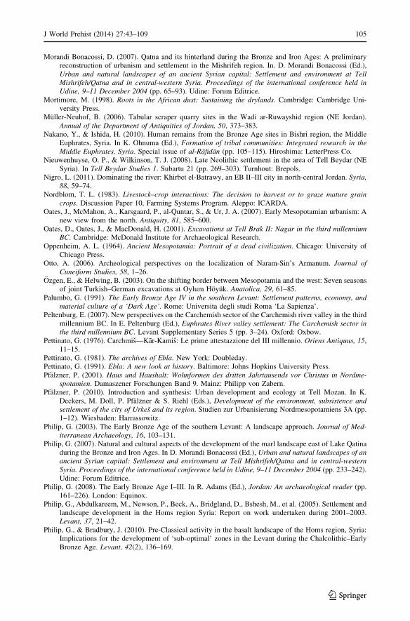
Morandi Bonacossi, D. (2007). Qatna and its hinterland during the Bronze and Iron Ages: A preliminaryreconstruction of urbanism and settlement in the Mishrifeh region. In. D. Morandi Bonacossi (Ed.),Urban and natural landscapes of an ancient Syrian capital: Settlement and environment at TellMishrifeh/Qatna and in central-western Syria. Proceedings of the international conference held inUdine, 9–11 December 2004 (pp. 65–93). Udine: Forum Editrice.
Mortimore, M. (1998). Roots in the African dust: Sustaining the drylands. Cambridge: Cambridge Uni-versity Press.
Muller-Neuhof, B. (2006). Tabular scraper quarry sites in the Wadi ar-Ruwayshid region (NE Jordan).Annual of the Department of Antiquities of Jordan, 50, 373–383.
Nakano, Y., & Ishida, H. (2010). Human remains from the Bronze Age sites in Bishri region, the MiddleEuphrates, Syria. In K. Ohnuma (Ed.), Formation of tribal communities: Integrated research in theMiddle Euphrates, Syria. Special issue of al-Rafidan (pp. 105–115). Hiroshima: LetterPress Co.
Nieuwenhuyse, O. P., & Wilkinson, T. J. (2008). Late Neolithic settlement in the area of Tell Beydar (NESyria). In Tell Beydar Studies 1. Subartu 21 (pp. 269–303). Turnhout: Brepols.
Nigro, L. (2011). Dominating the river: Khirbet el-Batrawy, an EB II–III city in north-central Jordan. Syria,88, 59–74.
Nordblom, T. L. (1983). Livestock–crop interactions: The decision to harvest or to graze mature graincrops. Discussion Paper 10, Farming Systems Program. Aleppo: ICARDA.
Oates, J., McMahon, A., Karsgaard, P., al-Quntar, S., & Ur, J. A. (2007). Early Mesopotamian urbanism: Anew view from the north. Antiquity, 81, 585–600.
Oates, D., Oates, J., & MacDonald, H. (2001). Excavations at Tell Brak II: Nagar in the third millenniumBC. Cambridge: McDonald Institute for Archaeological Research.
Oppenheim, A. L. (1964). Ancient Mesopotamia: Portrait of a dead civilization. Chicago: University ofChicago Press.
Otto, A. (2006). Archeological perspectives on the localization of Naram-Sin’s Armanum. Journal ofCuneiform Studies, 58, 1–26.
Ozgen, E., & Helwing, B. (2003). On the shifting border between Mesopotamia and the west: Seven seasonsof joint Turkish–German excavations at Oylum Hoyuk. Anatolica, 29, 61–85.
Palumbo, G. (1991). The Early Bronze Age IV in the southern Levant: Settlement patterns, economy, andmaterial culture of a ‘Dark Age’. Rome: Universita degli studi Roma ‘La Sapienza’.
Peltenburg, E. (2007). New perspectives on the Carchemish sector of the Carchemish river valley in the thirdmillennium BC. In E. Peltenburg (Ed.), Euphrates River valley settlement: The Carchemish sector inthe third millennium BC. Levant Supplementary Series 5 (pp. 3–24). Oxford: Oxbow.
Pettinato, G. (1976). Carchmis—Kar-Kamis: Le prime attestazzione del III millennio. Oriens Antiquus, 15,11–15.
Pettinato, G. (1981). The archives of Ebla. New York: Doubleday.Pettinato, G. (1991). Ebla: A new look at history. Baltimore: Johns Hopkins University Press.Pfalzner, P. (2001). Haus und Haushalt: Wohnformen des dritten Jahrtausends vor Christus in Nordme-
spotamien. Damaszener Forschungen Band 9. Mainz: Philipp von Zabern.Pfalzner, P. (2010). Introduction and synthesis: Urban development and ecology at Tell Mozan. In K.
Deckers, M. Doll, P. Pfalzner & S. Riehl (Eds.), Development of the environment, subsistence andsettlement of the city of Urkes and its region. Studien zur Urbanisierung Nordmesopotamiens 3A (pp.1–12). Wiesbaden: Harrassowitz.
Philip, G. (2003). The Early Bronze Age of the southern Levant: A landscape approach. Journal of Med-iterranean Archaeology, 16, 103–131.
Philip, G. (2007). Natural and cultural aspects of the development of the marl landscape east of Lake Qatinaduring the Bronze and Iron Ages. In D. Morandi Bonacossi (Ed.), Urban and natural landscapes of anancient Syrian capital: Settlement and environment at Tell Mishrifeh/Qatna and in central-westernSyria. Proceedings of the international conference held in Udine, 9–11 December 2004 (pp. 233–242).Udine: Forum Editrice.
Philip, G. (2008). The Early Bronze Age I–III. In R. Adams (Ed.), Jordan: An archaeological reader (pp.161–226). London: Equinox.
Philip, G., Abdulkareem, M., Newson, P., Beck, A., Bridgland, D., Bshesh, M., et al. (2005). Settlement andlandscape development in the Homs region Syria: Report on work undertaken during 2001–2003.Levant, 37, 21–42.
Philip, G., & Bradbury, J. (2010). Pre-Classical activity in the basalt landscape of the Homs region, Syria:Implications for the development of ‘sub-optimal’ zones in the Levant during the Chalcolithic–EarlyBronze Age. Levant, 42(2), 136–169.
J World Prehist (2014) 27:43–109 105
123
Philip, G., Jabour, F., Beck, A., Bshesh, M., Grove, J., Kirk, A., et al. (2002). Settlement and landscapedevelopment in the Homs Region, Syria: Research questions, preliminary results 1999–2000 and futurepotential. Levant, 34, 1–23.
Philip, G., & Millard, A. R. (2000). Khirbet Kerak ware in the Levant: The implications of radiocarbonchronology and spatial distribution. In C. Marro (Ed.), Chronologies des pays du Caucase et del’Euphrate aux IVe–IIIe millenaires (pp. 279–296). Paris: Boccard.
Porter, A. (2002). The dynamics of death: Ancestors, pastoralism, and the origins of a third-millennium cityin Syria. Bulletin of the American Schools of Oriental Research, 325, 1–36.
Porter, A. (2007). ‘You say potato, I say…’ : Typology, chronology and the origins of the Amorites. In C.Kuzucuoglu & C. Marro (Eds.), Societes humaines et changement climatique a la fin du trosiememillenaire: Une crise a-t-elle eu lieu en haute Mesopotamie? Actes du Colloque de Lyon, 5–8decembre 2005(pp. 69–115). Paris: De Boccard.
Porter, A. (2012). Mobile pastoralism and the formation of Near Eastern civilizations: Weaving togethersociety. Cambridge: Cambridge University Press.
Prag, K. (1974). The intermediate Early Bronze–Middle Bronze Age: An interpretation of the evidence fromTransjordan, Syria and Lebanon. Levant, 6, 69–116.
Prag, K. (2009). The late third millennium in the Levant: A reappraisal of the north–south divide. In P.J. Parr (Ed.), The Levant in transition: Proceedings of a conference held at the British Museum on 20–21 April 2004 (pp. 80–89). Leeds: Maney.
Pruß, A. (2005). Wadi Hamar-Survey: Zur Besiedlungsentwicklung der Region um Tell Chuera. AlterOrient Aktuell, 6, 12–14.
Pumain, D., Paulus, F., & Vacchiani-Marcuzzo, C. (2009). Innovation cycles and urban dynamics. In D.Lane, D. Pumain, S. E. van der Leeuw, & G. West (Eds.), Complexity perspectives in innovation andsocial change (pp. 237–260). Dordrecht: Springer.
Quintero, L. A., Wilke, P. J., & Rollefson, G. O. (2002). From flint mine to fan scraper: The Late PrehistoricJafr industrial complex. Bulletin of the American Schools of Oriental Research, 327, 17–48.
Rast, W. E., & Schaub, R. T. (Eds.). (2003). Bab edh-Dhra’a’: Excavations at the town site (1975–1981).Reports of the expedition to the Dead Sea Plain, Jordan. Winona Lake, IN: Eisenbrauns.
Regev, J., de Miroschedji, P., Greenberg, R., Braun, E., Greenhut, Z., & Boaretto, E. (2012). Chronology ofthe Early Bronze Age in the south Levant: New analysis for a high chronology. Radiocarbon, 54,525–566.
Reichel, C. D. (2006–2007). Hamoukar. Oriental Institute Annual Report (pp. 59–68). Chicago: OrientalInstitute, University of Chicago.
Rey, S. (2012). Poliorcetique au Proche-Orient a l’Age du Bronze, BAH 197. Beirut: IFAPO.Richard, S. L. (1980). Towards a consensus of opinion on the end of the Early Bronze Age in Palestine–
Transjordan. Bulletin of the American Schools of Oriental Research, 237, 5–34.Richard, S., & Long, J. C. J. (2009). Khirbet Iskander, Jordan and Early Bronze IV studies: A view from a
Tell. In P. J. Parr (Ed.), The Levant in transition: Proceedings of a conference held at the BritishMuseum on 20–21 April 2004 (pp. 90–100). Leeds: Maney.
Riehl, S. (2010). Plant production in a changing environment: The archaeobotanical remains from TellMozan. In K. Deckers, M. Doll, P. Pfalzner & S. Riehl (Eds.), Development of the environment,subsistence and settlement of the city of Urkes and its region. Studien zur Urbanisierung Nordmeso-potamiens 3A (pp. 13–158).Wiesbaden: Harrassowitz.
Riehl, S. (2011). Ostracods and seed remains from the Hamidi sequence. In K. Deckers (Ed.), Holocenelandscapes through time in the Fertile Crescent, Subartu 28 (pp. 97–106). Turnhout: Brepols.
Riehl, S. (2012). Variability in ancient Near Eastern environmental and agricultural development. Journal ofArid Environments, 86, 113–121.
Ristvet, L. (2011). Travel and the making of North Mesopotamian polities. Bulletin of the American Schoolsof Oriental Research, 361, 1–31.
Rosen, A. M. (1995). The social response to environmental change in Early Bronze Age Canaan. Journal ofAnthropological Archaeology, 14, 26–44.
Rova, E., & Weiss, H. (Eds.) (2003). The origins of North Mesopotamian civilization: Ninevite 5 chro-nology, economy, society. Subartu 9. Turnhout: Brepols.
Rowan, Y. M., & Golden, J. (2009). The Chalcolithic period of the southern Levant: A synthetic review.Journal of World Prehistory, 22(1), 1–92.
Rufolo, S. (2011). Specialized pastoralism and urban process in third millennium BC Northern Mesopo-tamia: A treatment of zooarchaeological data from the Khabur Basin of Syria. Ph.D. dissertation,Department of Near Eastern Studies, The Johns Hopkins University, Baltimore.
Sandford, S. (1983). Management of pastoral development in the Third World. Chichester: Wiley.Sanlaville, P. (2000). Le Moyen-Orient arabe: Le milieu et l’homme. Paris: Armand Colin.
106 J World Prehist (2014) 27:43–109
123
Schloen, J. D. (2001). The house of the father as fact and symbol: Patrimonialism in Ugarit and the ancientNear East. Studies in the archaeology and history of the Levant. Cambridge, MA: Harvard SemiticMuseum.
Schwartz, G. (2001). Syria and the Uruk expansion. In M. Rothman (Ed.), Uruk Mesopotamia and itsneighbors: Cross-cultural interactions in the era of state formation (pp. 233–264). Santa Fe, NM:School of American Research Press.
Schwartz, G. M., Curvers, H. H., Dunham, S. S., Stuart, B., & Weber, J. A. (2006). A third millennium BCelite mortuary complex at Umm al-Marra, Syria: 2003 and 2004 seasons. American Journal ofArchaeology, 110, 603–641.
Schwartz, G. M., Curvers, H. H., Gerritsen, F. A., MacCormack, J. A., Miller, N. F., & Weber, J. A. (2000).Excavation and survey in the Jabbul Plain, Western Syria: The Umm al-Marra project 1996–1997.American Journal of Archaeology, 104, 419–462.
Schwartz, G. M., & Falconer, S. E. (1994). Rural approaches to social complexity. In G. M. Schwartz & S.E. Falconer (Eds.), Archaeological views from the countryside: Village communities in early complexsocieties (pp. 1–9). Washington DC: Smithsonian Institution Press.
Sollberger, E. (1986). Administrative texts chiefly concerning textiles. Archivi reali di Ebla testi 8. Rome:Missione Archeologica Italiana in Siria.
Stein, G. (1987). Regional economic integration in early state societies: Third millennium BC pastoralproduction at Gritille, southeast Turkey. Paleorient, 13(2), 101–111.
Stein, G. (1999). Rethinking world systems: Diasporas, colonies, and interaction in Uruk Mesopotamia.Tucson: University of Arizona Press.
Stein, G. (2004). Structural parameters and socio-cultural factors in the economic organization of NorthMesopotamian urbanism in the third millennium BC. In G. M. Feinman & L. M. Nichols (Eds.),Archaeological perspectives on political economies (pp. 61–78). Salt Lake City: University of UtahPress.
Stein, G. (2005). ‘Invisible’ social sectors in Early Mesopotamian state societies. In V. L. Scarborough(Ed.), A catalyst for ideas: Anthropology and archaeology and the legacy of Douglas W. Schwartz.Advanced Seminar Series (pp. 121–148). Santa Fe, NM: School of American Research Press.
Stein, G. (2012). The development of indigenous social complexity in Late Chalcolithic Upper Mesopo-tamia In the fifth–fourth millennia BC: An initial assessment. Origini, 34, 125–151.
Stein, G., & Wattenmaker, P. (1990). The 1987 Tell Leilan regional survey: Preliminary report. In N. Miller(Ed.), Economy and settlement in the Near East: Analysis of ancient sites and materials. MASCAresearch papers in science and archaeology 7 (supplement) (pp. 8–18). Philadelphia: MASCA, Uni-versity Museum.
Strommenger, E. (1980). Habuba Kabira: Eine Stadt vor 5000 Jahren. Mainz: Philipp von Zabern.Stronach, D. (1994). Village to metropolis: Nineveh and the beginnings of urbanism in Northern Meso-
potamia. In S. Mazzoni (Ed.), Nuove fondazioni nel Vicino Oriente antico: Realta e ideologia (pp.85–114). Pisa: Giardini.
Sudo, H. (2010). The development of wool exploitation in Ubaid-period settlements of North Mesopotamia.In R. Carter & G. Philip (Eds.), Beyond the Ubaid: Transformation and integration in the lateprehistoric societies of the Middle East. SAOC 63 (pp.169–179). Chicago: Oriental InstitutePublications.
Thalen, D. C. P. (1979). Ecology and utilization of desert shrub rangelands in Iraq. The Hague: Junk.Thuesen, I. (1988). Hama I: The pre- and protohistoric periods. Fouilles et recherches 1931–1938.
Copenhagen: Nationalmuseet.Treacher, T. T. (2000). Linkages between livestock and agricultural systems in Syria. In M. Mundy & B.
Musallam (Eds.), The transformation of nomadic society in the Arab East (pp. 187–196). Cambridge:Cambridge University Press.
Ur, J. A. (2003). CORONA satellite photography and ancient road networks: A Northern Mesopotamiancase study. Antiquity, 77, 102–115.
Ur, J. A. (2010a). Cycles of civilization in northern Mesopotamia, 4400–2000 BC. Journal of Archaeo-logical Research, 18, 387–431.
Ur, J.A. (2010b). Urbanism and cultural landscapes in northeastern Syria: The Tell Hamoukar survey,1999–2001. Oriental Institute Publications 137. Chicago: University of Chicago.
Ur, J.A. (2012). Landscapes of movement in the ancient Near East. In R. Matthews & J. Curtis (Eds.),7ICAANE: Proceedings of the seventh international congress on the archaeology of the ancient NearEast, London, April 2010 (pp. 167–184). Wiesbaden: Harrassowitz.
Ur, J. A., Karsgaard, P., & Oates, J. (2007). Urban development in the ancient Near East. Science, 317, 1188.Ur, J. A., Karsgaard, P., & Oates, J. (2011). The spatial dimensions of early Mesopotamian urbanism: The
Tell Brak suburban survey, 2003–2006. Iraq, 73, 1–17.
J World Prehist (2014) 27:43–109 107
123
Ur, J. A., & Wilkinson, T. J. (2008). Settlement and economic landscapes of Tell Beydar and its hinterland.In M. Lebeau & A. Suleiman (Eds.), Beydar Studies 1. Subartu 21 (pp. 305–327). Turnhout: Brepols.
Van Berg, P.-L., & Picalause, V. (2003). Structures archeologiques et art rupestre a Khisham (Hassake,Syrie): Campagne 1999. In M. Lebeau & A. Suleiman (Eds.), Tell Beydar, the 1995–1999 seasons ofexcavations: A preliminary report. Subartu 10 (pp. 555–568). Turnhout: Brepols.
van Driel, G. (2000). The Mesopotamian north: Land use, an attempt. In R. M. Jas (Ed.), Rainfall andagriculture in northern Mesopotamia (pp. 265–299). Leiden: Nederlands Historisch-ArchaeologischInstituut te Istanbul.
van Driel, G., & van Driel-Murray, C. (1983). Jebel Aruda, the 1982 season of excavations. Akkadica, 33,1–26.
Van Lerberghe, K. (1996). The Beydar tablets and the history of the northern Jazirah. In F. Ismail, W.Sallerberger, P. Tallon, & K. Van Lerberghe (Eds.), Administrative documents from Tell Beydar,Subartu 2 (pp. 119–122). Turnhout: Brepols.
Van Liere, W. J., & Lauffray, J. (1954–1955). Nouvelle prospection archeologique dans la Haute JazirehSyrienne. Les Annales Archeologiques Arabes Syriennes, 4/5, 129–148.
Vetter, S. (2005). Rangelands at equilibrium and non-equilibrium: Recent developments in the debate.Journal of Arid Environments, 62(2), 321–341.
Wachholtz, R. (1996). Socio-economics of Bedouin farming systems in dry areas of northern Syria. Kiel:Wissenschaftsverlag Vauk Kiel.
Wattenmaker, P. (1998). Household and state in Upper Mesopotamia: Specialized economy and the socialuses of goods in an early complex society. Washington, DC: Smithsonian Institution Press.
Wattenmaker, P. (2009). States, landscapes and the urban process in Upper Mesopotamia: Inter-polityalliances, competition and ritualized exchange. In S. E. Falconer & C. L. Redman (Eds.), Polities andpower: Archaeological perspectives on the landscapes of early states (pp. 106–124). Tucson: Uni-versity of Arizona Press.
Weber, J. (1997). Faunal remains from Tell es-Sweyhat and Tell Hajji Ibrahim. In R. Zettler (Ed.), Sub-sistence and settlement in a marginal environment: Tell es-Sweyhat, 1989–1995 preliminary report.MASCA research papers in science and archaeology 14 (pp. 133–168). Philadelphia: University ofPennsylvania, University Museum.
Weiss, H. (1986). The origins of Tell Leilan and the conquest of space in third millennium Mesopotamia. InH. Weiss (Ed.), The origins of cities in dry-farming Syria (pp. 71–108). Guilford, CT: Four Quarters.
Weiss, H. (1989). Tell Leilan 1989: New data for mid third millennium urbanization and state formation.Mitteilungen der Deutschen Orient-Gesellschaft zu Berlin, 122, 193–218.
Weiss, H., Courty, M. A., Wetterstrom, W., Guichard, F., Senior, L., Meadow, R. A., et al. (1993). Thegenesis and collapse of third millennium north Mesopotamian civilization. Science, 261, 995–1004.
Whitehead, P., Smith, S., & Wade, A. (2011). Modelling water resources and climate change at the BronzeAge site of Jawa in northern Jordan: A new approach utilising stochastic simulation techniques. In S.J. Mithen & E. Black (Eds.), Water, life and civilisation: Climate, environment and society in theJordan Valley (pp. 289–301). Cambridge: Cambridge University Press.
Wilkinson, T. J. (1990). Town and country in SE Anatolia, vol. 1: Settlement and land use at Kurban Hoyuk andother sites in the lower Karababa basin. Oriental Institute Publications 109. Chicago: University ofChicago.
Wilkinson, T. J. (1993). Linear hollows in the Jazira, Upper Mesopotamia. Antiquity, 67, 548–562.Wilkinson, T. J. (1994). The structure and dynamics of dry farming states in Upper Mesopotamia. Current
Anthropology, 35(1), 483–520.Wilkinson, T. J. (1998). Water and human settlement in the Balikh valley, Syria: Investigations from
1992–1995. Journal of Field Archaeology, 25, 63–87.Wilkinson, T. J. (1999). Holocene valley fills of southern Turkey and NW Syria: Recent geoarchaeological
contributions. Quaternary Science Reviews, 18, 555–572.Wilkinson, T. J. (2000a). Regional approaches in Mesopotamian archaeology. Journal of Archaeological
Research, 8, 219–267.Wilkinson, T. J. (2000b). Settlement and land use in the zone of uncertainty in Upper Mesopotamia. In R.
Jas (Ed.), Rainfall and agriculture in northern Mesopotamia (pp. 3–35). Leiden: Nederlands Histor-isch-Archaeologisch Instituut te Istanbul.
Wilkinson, T. J. (2002). Archaeological survey of the Tell Beydar Region, Syria, 1997: A preliminaryreport. In K. Vanlerberghe (Ed.), Tell Beydar: Environmental and technical studies. Subartu 6 (pp.1–37). Turnhout: Brepols.
Wilkinson, T. J. (2003). Archaeological landscapes of the Near East. Tucson: University of Arizona Press.
108 J World Prehist (2014) 27:43–109
123

Wilkinson, T. J. (2007). Archaeological regions in the neighbourhood of Carchemish. In E. Peltenburg (Ed.),Euphrates River Valley settlement—The Carchemish sector in the third millennium BC. LevantSupplementary Series 5 (pp. 27–42). Oxford: Oxbow.
Wilkinson, T. J. (2010). The tell: Social archaeology and territorial space. In D. Bolger & L. Maguire (Eds.),The development of pre-state communities in the ancient Near East: Studies in Honour of EdgarPeltenburg (pp. 55–62). Oxford: Oxbow.
Wilkinson, T. J., French, C., Ur, J. A., & Semple, M. (2010). The geoarchaeology of route systems innorthern Syria. Geoarchaeology, 25(6), 745–771.
Wilkinson, T. J., Galiatsatos, N., Lawrence, D., Ricci, A., Dunford, R., & Philip, G. (2012). Late Chal-colithic and Early Bronze Age landscapes of settlement and mobility in the Middle Euphrates: A re-assessment. Levant, 44(2), 139–185.
Wilkinson, T. J., Miller, N. F., Reichel, C. D., & Whitcomb, D. (2004). On the margin of the Euphrates:Settlement and land use at Tell es-Sweyhat and in the Upper Lake Tabqa area, Syria. Oriental InstitutePublications 124. Chicago: University of Chicago.
Wilkinson, T. J., Peltenburg, E., McCarthy, A., Wilkinson, E. B., & Brown, M. (2007). Archaeology in theland of Carchemish: Landscape surveys in the area of Jerablus Tahtani, 2006. Levant, 39, 213–247.
Wilkinson, T. J., & Tucker, D. J. (1995). Settlement development in the North Jazira, Iraq: A study of thearchaeological landscape. Warminster: Aris & Phillips.
Wirth, E. (1971). Syrien, eine geographische Landeskunde. Darmstadt: Wissenschaftliche Buchgesellschaft.Witcher R. (1999). GIS and landscapes of perception. In M. Gillings, D. Mattingly & J. Van Dalen (Eds.),
Geographical information systems and landscape archaeology. Archaeology of MediterraneanLandscapes 3 (pp. 13–22). Oxford: Oxbow.
Wossink, A. (2009). Challenging climate change: Competition and cooperation among pastoralists andagriculturalists in northern Mesopotamia (ca. 3000–1600 BC). Leiden: Sidestone.
Wright, R. (2013). Sumerian and Akkadian industries: Crafting textiles. In H. Crawford (Ed.), The Sumerianworld (pp. 395–418). London: Routledge.
Wright, H. T., Rupley, E. S. A., Ur, J. A., Oates, J., & Ganem, E. (2006–2007). Preliminary report on the2002 and 2003 seasons of the Tell Brak Sustaining Area Survey. Les Annales Archeologiques ArabesSyriennes, 49–50, 7–21.
Yannai, E. (2006). ‘En Esur (‘Ein Asawir) 1: Excavations at a protohistoric site in the coastal plain ofIsrael. Jerusalem: Israel Antiquities Authority.
Yoffee, N. (2005). Myths of the archaic state: Evolution of the earliest cities, states and civilizations.Cambridge: Cambridge University Press.
Yoffee, N., Matthews, R., Trigger, B. G., Kohl, P. L., Webster, D., & Schreiber, K. (2005). Review feature:‘Myths of the archaic state’ by Norman Yoffee. Cambridge Archaeological Journal, 15(2), 251–268.
Zeder, M. (1995). The archaeobiology of the Khabur basin. Bulletin of the Canadian Society for Meso-potamian Studies, 29, 21–32.
Zeder, M. (1998). Environment, economy, and subsistence on the threshold of urban emergence in northernMesopotamia. In M. Fortin & O. Aurenche (Eds.), Espace naturel, espace habite en Syrie du Nord(10e–2e millenaires av. J-C.). Bulletin 33 (pp. 55–67). Quebec: Canadian Society for MesopotamianStudies.
Zeder, M. (2003). Food provision in urban societies: A view from northern Mesopotamia. In M. L. Smith(Ed.), The social construction of ancient cities (pp. 156–183). Washington, DC: Smithsonian Insti-tution Press.
Zettler, R. L. (1997). Surface collection and excavations in the lower town and lower town south. In R.L. Zettler (Ed.), Subsistence and settlement in a marginal environment: Tell es-Sweyhat, 1989–1995preliminary report. MASCA research papers in science and archaeology 14. Philadelphia: Universityof Pennsylvania, University Museum.
Zettler, R. L. (2003). Reconstructing the world of ancient Mesopotamia: Divided beginnings and holistichistory. Journal of the Economic and Social History of the Orient, 46, 3–45.
Zuckerman, S., Ziv-Esudri, Z., & Cohen-Weinberger, A. (2009). Production centres and distribution patternsof Khirbet Kerak ware in the southern Levant: A typological and petrographic perspective. Tel Aviv,36(2), 135–180.
J World Prehist (2014) 27:43–109 109
123