Drilling Infrastructure Construction Challenges in ...
13
Proceedings World Geothermal Congress 2020+1 Reykjavik, Iceland, April - October 2021 1 Drilling Infrastructure Construction Challenges in Geothermal Exploration Project in Eastern Indonesia Dorman Purba 1,2 , Vicky R. Chandra 1,3 , Ferdino R. Fadhillah 1,4 , Rakhmawati D. Wulan 1,4 , Agus Soedarsa 5 , Daniel W. Adityatama 1,6 , Mukhamad F. Umam 7 1 Enerka Bhumi Pratama, Kawasan Komersial Cilandak Gudang 410, Jakarta Selatan 12560, Indonesia; 2 Geonergi Solusi Indonesia, Cibis Nine 11 th Floor, Jakarta Selatan 12560, Indonesia; 3 Geo Dipa Energi, Aldevco Octagon, Jakarta Selatan 12740, Indonesia; 4 Geoscience Department, Faculty of Mathematics and Natural Science University of Indonesia, Depok 16424, Indonesia; 5 Cipta Bangun Nusantara, Graha Pratama Building 18 th Floor, Jakarta 12810, Indonesia; 6 Rigsis Energi Indonesia, Equity Tower 49 th Floor, SCBD, Jakarta 12520, Indonesia; 7 PPSDM Migas Cepu, Jl Sorogo No.1, Cepu, Jawa Tengah 58315, Indonesia [email protected]; [email protected] Keywords: geothermal, exploration challenges, drilling, infrastructure, geohazard, wellpad, construction, Indonesia ABSTRACT In an attempt to achieve a national target of geothermal energy development, it is crucial to have all geothermal exploration projects run as per schedule. However, as an archipelago nation, Indonesia faces wide ranges of challenges in developing geothermal energy, especially those located in Eastern Indonesia. The lack of infrastructure development and the connection between the main islands are the main challenges. Another challenge is that most of Indonesia's geothermal prospects are associated with volcanic activities and lies in high-relief terrain, creating many geohazards. Moreover, other typical challenges such as community rejection, regulation, and environmental issues make it more difficult for any developer to run a geothermal exploration project in Eastern Indonesia, especially constructing the drilling infrastructures. This study aims to summarize several potential challenges that are most likely will be encountered by the geothermal developer in constructing drilling infrastructure during the exploration phase in Eastern Indonesia and several mitigation options based on the literature review and the author's experiences. 1. INTRODUCTION 1.1 Electricity and Geothermal Energy in Indonesia Indonesia is facing a huge electricity demand challenge (PWC, 2018; Soegianto, 2018). However, existing infrastructure is insufficient to meet the entire current demand before considering growth in the coming decade. In terms of access to the grid, the electrification ratio in the western and eastern parts of the country, where the eastern part of the country is as low as 59.84% (NTT). The low electrification ratio in NTT (East Nusa Tenggara) is contradictory to the fact that this province has high geothermal energy potential (Figure 1). Figure 1: Map of geothermal area prospect in Indonesia (EBTKE, 2017a) As an archipelago nation, the availability of affordable off-grid solutions is a key driver in increasing electrification rates in rural areas. As a nation with several islands, Indonesia makes it challenging to supply affordable electricity to certain areas (PWC, 2018).
Transcript of Drilling Infrastructure Construction Challenges in ...

Proceedings World Geothermal Congress 2020+1
Reykjavik, Iceland, April - October 2021
1
Drilling Infrastructure Construction Challenges in Geothermal Exploration Project in
Eastern Indonesia
Dorman Purba1,2, Vicky R. Chandra1,3, Ferdino R. Fadhillah1,4, Rakhmawati D. Wulan1,4, Agus Soedarsa5, Daniel W.
Adityatama1,6, Mukhamad F. Umam7
1Enerka Bhumi Pratama, Kawasan Komersial Cilandak Gudang 410, Jakarta Selatan 12560, Indonesia;
2Geonergi Solusi Indonesia, Cibis Nine 11th Floor, Jakarta Selatan 12560, Indonesia;
3Geo Dipa Energi, Aldevco Octagon, Jakarta Selatan 12740, Indonesia;
4Geoscience Department, Faculty of Mathematics and Natural Science University of Indonesia, Depok 16424, Indonesia;
5Cipta Bangun Nusantara, Graha Pratama Building 18th Floor, Jakarta 12810, Indonesia;
6Rigsis Energi Indonesia, Equity Tower 49th Floor, SCBD, Jakarta 12520, Indonesia;
7PPSDM Migas Cepu, Jl Sorogo No.1, Cepu, Jawa Tengah 58315, Indonesia
[email protected]; [email protected]
Keywords: geothermal, exploration challenges, drilling, infrastructure, geohazard, wellpad, construction, Indonesia
ABSTRACT
In an attempt to achieve a national target of geothermal energy development, it is crucial to have all geothermal exploration projects
run as per schedule. However, as an archipelago nation, Indonesia faces wide ranges of challenges in developing geothermal energy,
especially those located in Eastern Indonesia. The lack of infrastructure development and the connection between the main islands
are the main challenges. Another challenge is that most of Indonesia's geothermal prospects are associated with volcanic activities
and lies in high-relief terrain, creating many geohazards. Moreover, other typical challenges such as community rejection, regulation,
and environmental issues make it more difficult for any developer to run a geothermal exploration project in Eastern Indonesia,
especially constructing the drilling infrastructures.
This study aims to summarize several potential challenges that are most likely will be encountered by the geothermal developer in
constructing drilling infrastructure during the exploration phase in Eastern Indonesia and several mitigation options based on the
literature review and the author's experiences.
1. INTRODUCTION
1.1 Electricity and Geothermal Energy in Indonesia
Indonesia is facing a huge electricity demand challenge (PWC, 2018; Soegianto, 2018). However, existing infrastructure is
insufficient to meet the entire current demand before considering growth in the coming decade. In terms of access to the grid, the
electrification ratio in the western and eastern parts of the country, where the eastern part of the country is as low as 59.84% (NTT).
The low electrification ratio in NTT (East Nusa Tenggara) is contradictory to the fact that this province has high geothermal energy
potential (Figure 1).
Figure 1: Map of geothermal area prospect in Indonesia (EBTKE, 2017a)
As an archipelago nation, the availability of affordable off-grid solutions is a key driver in increasing electrification rates in rural
areas. As a nation with several islands, Indonesia makes it challenging to supply affordable electricity to certain areas (PWC, 2018).
Purba et al.
2
At present, the islands in the eastern part of Indonesia are experiencing an increase in electricity demand, where geothermal power
plants are a very promising alternative solution because they are local and available in sufficient quantities. Unfortunately, these
geothermal energy potentials have not yet been utilized optimally by Indonesia. For example, from the demand side, Flores Island in
East Nusa Tenggara province, in the last 5 years, has an average economic growth of around 5.3% per year (ESDM, 2017). East Nusa
Tenggara has various types of natural resources, such as the manganese mine on Timor Island and the developing fisheries and
tourism sectors, where various sectors have the potential to increase electricity demand. In addition, the sale of PLN electricity in the
region has increased by around 12.5% per year in the last 5 years, where most of the electricity demand came from the housing sector,
which consumed around 58.64% of total electricity. Based on these conditions, PLN projects that electricity demand in the province
will increase by about 8.9% per year in the next decade (ESDM, 2017).
On the contrary, from the supply side, the electricity supply in East Nusa Tenggara is still insufficient, one of which is due to the
delayed construction of power and transmission projects. One of the supposed causes is a logistic problem that leads to difficulty in
sending tools, material, and equipment to eastern Indonesia. It also leads to the increasing cost of geothermal energy development
projects in the eastern part of Indonesia. This logistic problem is often associated with the infrastructure condition, which will be
discussed in the following sub-chapters.
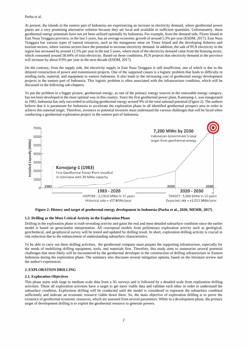
To put the problem in a bigger picture, geothermal energy, as one of the primary energy sources in the renewable energy category,
has not been developed in the most optimal way in this country. Since the first geothermal power plant, Kamojang-1, was inaugurated
in 1983, Indonesia has only succeeded in utilizing geothermal energy around 9% of the total national potential (Figure 2). The authors
believe that it is paramount for Indonesia to accelerate the exploration phase in all identified geothermal prospect area in order to
achieve this national target. Therefore, investors or potential investors must understand the various challenges that will be faced when
conducting a geothermal exploration project in the eastern part of Indonesia.
Figure 2: History and target of geothermal energy development in Indonesia (Purba et al., 2020; MEMR, 2017)
1.2. Drilling as the Most Critical Activity in the Exploration Phase
Drilling in the exploration phase is truth-revealing activity and gains the real and most detailed subsurface condition since the earlier
model is based on geoscientist interpretation. All conceptual models from preliminary exploration activity such as geological,
geochemical, and geophysical survey will be tested and updated by drilling result. In short, exploration drilling activity is crucial in
risk reduction due to the enhancement of understanding subsurface characteristics.
To be able to carry out these drilling activities, the geothermal company must prepare the supporting infrastructure, especially for
the needs of mobilizing drilling equipment, tools, and materials first. Therefore, this study aims to summarize several potential
challenges that most likely will be encountered by the geothermal developer in the construction of drilling infrastructure in Eastern
Indonesia during the exploration phase. The summary also discusses several mitigation options, based on the literature review and
the author's experiences.
2. EXPLORATION DRILLING
2.1. Exploration Objectives
This phase starts with large to medium scale data from a 3G surveys and is followed by a detailed scale from exploration drilling
activities. Those all exploration activities have a target to get more viable data and validate each other in order to understand the
subsurface condition. Exploration drilling will be conducted until the model is considered to represent the subsurface condition
sufficiently and indicate an economic resource viable down there. So, the main objective of exploration drilling is to prove the
existence of geothermal economic resources, which are assessed from several parameters. While in a development phase, the primary
target of development drilling is to exploit the geothermal resource to generate powers.

Purba et al.
3
2.2. Well Types in Geothermal
In Indonesia, there are four types of well often used by geothermal developers in the exploration phase (Figure 3). Purba D. P.,
Adityatama, Umam, & Muhammad in 2019 have discussed the comparison between the applications of these four wells. One of the
paper's key takeaways is the bigger the drilling rig, the more drilling infrastructure needs to be prepared. This is the main reason why
it is important to understand the exploration objectives and the potential challenges prior to deciding on choosing the exploration well
type, which directly impacts the drilling infrastructure effort at the beginning of the project.
Figure 3: Illustration of typical well schematic commonly used in geothermal exploration (modified from (Purba D. P.,
Adityatama, Umam, & Muhammad, 2019))
2.3 Drilling Infrastructures
Before jumping into the various challenges associated with the construction of drilling infrastructure, this paper will first discuss the
various facilities commonly required to support exploration drilling projects in Indonesia.
2.3.1 Access road
The access road is one of the most important components in any energy development project. Land acquisition at the beginning of
the project is generally focused on opening road access from existing roads, usually built by the government, to the area of interest
where drilling will be conducted, which is often called a drilling pad or well pad.
In general, the width of land required for access roads in geothermal projects ranges from 8 to 15 meters that might cover access
roads and streamline. The minimum width of 8 meters is based on 6 meters for the road body and 2 meters for drainage construction
on both sides of the road. This road width must accommodate heavy equipment mobility such as trucks, cranes, grader, etc. The
standard width for trucks is about 2 - 3 meters for low bed and high bed trailer. If considering the need for future steam pipe
construction, then the cleared land may reach a width of 15 meters. Another aspect that should be considered is the road strength
since drilling equipment has massive tonnage that can affect the road condition. Table 1 has summarized the road classification based
on Indonesia Regulation UU no.22/2009. The road requirement for drilling rig mobilization will be discussed in detail in the next
chapter.
Drilling activity involved large amounts of equipment with various dimensions and tonnage. For example, the draw work and mud
pump could reach 30 - 35 tons of each other carried by truck and use two cranes with 50-ton capacity in total for loading and unloading
process. These examples, only two of a hundred rig loads of geothermal drilling depend on the requirement and drilling plan. This
aspect must be considered to prepare the infrastructure availability during mobilization, such as port, road, and bridge capacity
requirements.
Table 1: Road and bridge classification
Indonesian Road Classification (UU No 22/2009) Indonesian Bridge Classification
Class
Maximum Dimension (m) Maximum Tonnage per
axis
Class Maximum Width (m Maximum Tonnage
(%) Vehicle Length
Vehicle Width
Vehicle Height
Class I 18 2.5 4.2 10 A 7 100
Class II 12 2.5 4.2 8 B 6 100
Class III 9 2.1 3.5 8 C 3.5 70
2.3.2 Well pad
Well pad or drilling site (Figure 4) is one of the major infrastructure components since it facilitates the wells as the main asset in
geothermal development projects. The area of land needed for the well pad depends on the type of well to be constructed. The total
depth and well diameter will affect the type of drilling rig used and ultimately affect the required well pad area. For geothermal wells,
we also have to consider space for water ponds that could provide high water demand during drilling due to the High Temperature
and High Pressure (HTHP) zone. Well location also at least 100 meters from housings, roads, and public construction (BSN, 2002).
In comparison, between the size and layout of the typical well pad, both types of exploration wells are also shown in Figure 4.

Purba et al.
4
Figure 4: Left: construction of a drilling pad or well pad in one of the geothermal areas in the eastern part of Indonesia
(Umam et al., 2019). Middle: well pad footprint size of slim hole well. Right: well pad footprint size of the standard hole
(right) ( (Purba D. P., Adityatama, Umam, & Muhammad, 2019)
2.3.3. Basecamp, Warehouse, and Site office
In the early stages of a geothermal project, the basecamp, warehouse, and site office (Figure 5), should be integrated into one location
to facilitate monitoring and communication among personnel. Basecamp is an area for living facilities consisting of containers
equipped with beds and bathrooms for site personnel from outside the region.
A warehouse is used for storage of all drilling materials such as casing, liner, wellhead, cementing material, drilling fluid material.
In contrast, a site office is a working space established near the project site.
The area of land required for basecamp, warehouse, and site office depends mainly on:
• The number of drilling rigs operated - the more rig is operating in the same period, the higher the number of personnel to be
facilitated so that the basecamp area will also increase.
• The stock of drilling materials, especially casings to avoid downtime due to wait-on-material. The higher number of casing stock
stored in the warehouse, the wider basecamp is required.
Figure 5: Photos of basecamp, warehouse, site office, and casing storage area in one of the geothermal exploration projects
in Indonesia
2.3.4. Staging Area
This facility is used as temporary storage of various materials used for well construction or drilling operation. Usually, the staging
area location is selected in the flat area between the well pad and the basecamp closer to the well pad than the basecamp. The area of
land needed for the staging area is usually much smaller than the basecamp and well pad area, which ranges between 1,000-5,000
m2.
Some of the expected benefits of a staging area are:
• Minimize well pad area, that can be optimized for drilling equipment and materials to be used within 1-2 days ahead only. Other
materials that will not be used in 2 days can be stored in the staging area.
• Reduce the risk of downtime or non-productive time (NPT) due to wait-on-material. Often basecamps, warehouses, and site
offices are located close to the city center or seaport.
Purba et al.
5
2.3.5. Soil Disposal Site
Indonesia's geothermal systems are typically located in high-relief terrain and are associated with volcanic activities (Utami, 2010).
This condition often makes earthwork on a site more difficult to achieve a cut-to-fill balance, as shown in Figure 7. It is likely that
more soil or dirt will be unused and require a facility or site to dump the excess dirt.
2.3.6. Drilling Water Supply
Unlike oil and gas, drilling a deep well in a geothermal environment requires a significant amount of water supply during its operation,
1.000-1,500 gallon per minute (GPM) in specific. The freshwater is used as drilling fluid circulated from the surface to the bottom
hole and back to the surface while lifting the drill cuttings/soil from the bottom. This water is also required to be available onsite to
anticipate steam kick or well control issues during drilling. The significant amount of water required is due to geothermal drilling
aimed for faults and fractures that cause loss circulation during drilling, which means the water pumped down from surface to bottom
will disappear to the lost circulation zone and not go back to the surface.
Unfortunately, finding water in volcanic areas is not an easy task, especially in most parts of eastern Indonesia. Furthermore, the
freshwater available in the geothermal area is usually already consumed by the local villagers on a daily basis, meaning geothermal
developers may only be able to take small amounts of the remaining water that is usually not adequate to support the drilling operation.
This kind of situation will force geothermal developers or drilling contractors to look for other water sources that might be located
far from the drilling site and many times in the form of acidic water (pH 2-5). Based on the author's experiences, in East Nusa
Tenggara (NTT), there is one example where geothermal developers need to construct a water pipeline as long as 13 kilometers with
4 staging areas to get 1,000-1,200 GPM of acidic water with pH 2-3. This pH level is due to the near freshwater source already
consumed by the local villagers and farmers for domestic use and plantation.
3. DRILLING INFRASTRUCTURE CHALLENGES IN EASTERN PART OF INDONESIA
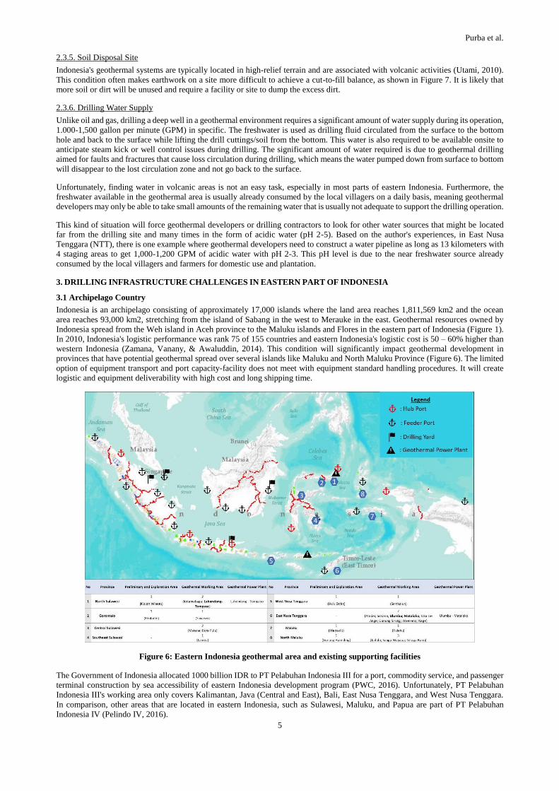
3.1 Archipelago Country
Indonesia is an archipelago consisting of approximately 17,000 islands where the land area reaches 1,811,569 km2 and the ocean
area reaches 93,000 km2, stretching from the island of Sabang in the west to Merauke in the east. Geothermal resources owned by
Indonesia spread from the Weh island in Aceh province to the Maluku islands and Flores in the eastern part of Indonesia (Figure 1).
In 2010, Indonesia's logistic performance was rank 75 of 155 countries and eastern Indonesia's logistic cost is 50 – 60% higher than
western Indonesia (Zamana, Vanany, & Awaluddin, 2014). This condition will significantly impact geothermal development in
provinces that have potential geothermal spread over several islands like Maluku and North Maluku Province (Figure 6). The limited
option of equipment transport and port capacity-facility does not meet with equipment standard handling procedures. It will create
logistic and equipment deliverability with high cost and long shipping time.
Figure 6: Eastern Indonesia geothermal area and existing supporting facilities
The Government of Indonesia allocated 1000 billion IDR to PT Pelabuhan Indonesia III for a port, commodity service, and passenger
terminal construction by sea accessibility of eastern Indonesia development program (PWC, 2016). Unfortunately, PT Pelabuhan
Indonesia III's working area only covers Kalimantan, Java (Central and East), Bali, East Nusa Tenggara, and West Nusa Tenggara.
In comparison, other areas that are located in eastern Indonesia, such as Sulawesi, Maluku, and Papua are part of PT Pelabuhan
Indonesia IV (Pelindo IV, 2016).
Purba et al.
6
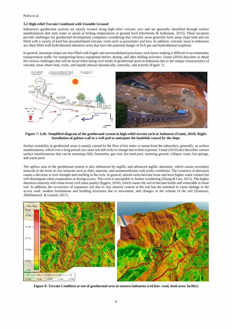
3.2 High-relief Terrain Combined with Unstable Ground
Indonesia's geothermal systems are mostly located along high-relief volcanic arcs and are generally identified through surface
manifestations that emit water or steam at boiling temperatures at ground level (Hochstein & Sudarman, 2015). These locations
provide challenges for geothermal development companies considering that volcanic areas generally have steep slope land and are
filled with a variety of hard but unconsolidated volcanic rocks such as pyroclastic and lava. In addition, volcanic areas in Indonesia
are often filled with hydrothermal alteration areas that have the potential danger of H2S gas and hydrothermal eruptions.
In general, mountain slopes are also filled with fragile and unconsolidated pyroclastic rock layers making it difficult to accommodate
transportation traffic for transporting heavy equipment before, during, and after drilling activities. Utami (2010) describes in detail
the various challenges that will be faced when doing civil works in geothermal areas in Indonesia due to the unique characteristics of
volcanic areas where heat, rocks, and liquids interact dynamically, naturally, and actively (Figure 7).
Figure 7: Left: Simplified diagram of the geothermal system in high-relief terrain such as Indonesia (Utami, 2010). Right:
Installation of gabion wall in a well pad to anticipate the landslide caused by the slope.
Surface instability in geothermal areas is mainly caused by the flow of hot water or steam from the subsurface, generally, as surface
manifestations, which over a long period can cause soil and rocks to change due to heat exposure. Utami (2010) also describes various
surface manifestations that can be steaming cliffs, fumaroles, gas vent, hot mud pool, steaming ground, collapse crater, hot springs,
and warm pool.
The upflow area of the geothermal system is also influenced by argillic and advanced argillic alteration, which causes secondary
minerals in the form of clay minerals such as illite, smectite, and montmorillonite with acidic conditions. The existence of alteration
causes a decrease in rock strength and swelling in the rock. In general, altered rocks become loose and have higher water content but
will disintegrate when evaporation or drying occurs. This rock is susceptible to further weathering (Zhang & Guo, 2011). The higher
alteration intensity will create lower rock mass quality (Eggers, 2016), which causes the soil to become brittle and vulnerable to loose
soil. In addition, the occurrence of expansive soil due to clay mineral content in the soil has the potential to cause damage to the
access road, weaken foundations and building structures due to movement, and changes in the volume of the soil (Zumrawi,
Abdelmarouf, & Gameil, 2017).
Figure 8: Terrain Condition at one of geothermal area in eastern Indonesia (red line: road, dash area: facility)
Purba et al.
7
Unlike petroleum fields, which are generally located in the lowlands and close to the oceans, well pads for geothermal projects in
Indonesia are often located on slopes up to 25%, as shown in Figure 7 and Figure 8, also associated with activities volcanic and
hydrothermal, as previously described in Figure 4. This makes the investment or the cost of civil works in a geothermal drilling
project bigger in order to achieve adequate stability for the safety of all drilling equipment that will sit in the well pad.
The cut-and-fill method is usually used where half of the drilling site to be constructed is filled with filler material or soil material to
compensate for the excavated area so that a flat surface is formed. In addition, the construction of an adequate drainage system must
be made to provide a way for rainwater to minimize the potential of landslides. Another method commonly used in the construction
of drill sites in geothermal areas is the manufacture of gabion walls or retaining walls (Figure ), aiming to maintain slope stability
(Barrios et al., 2011).
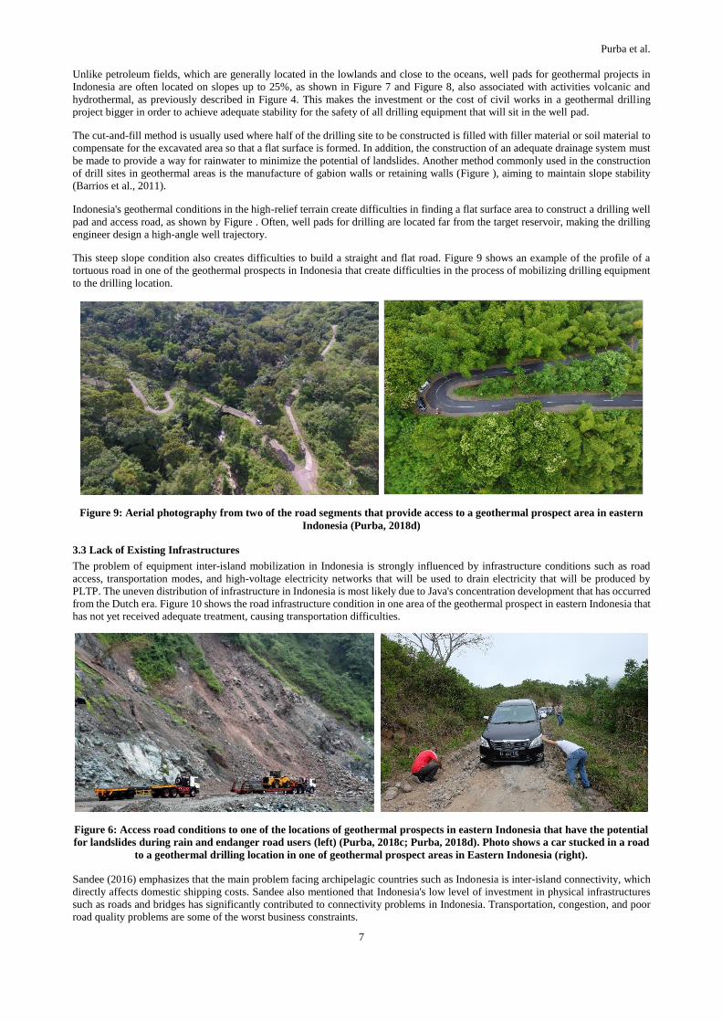
Indonesia's geothermal conditions in the high-relief terrain create difficulties in finding a flat surface area to construct a drilling well
pad and access road, as shown by Figure . Often, well pads for drilling are located far from the target reservoir, making the drilling
engineer design a high-angle well trajectory.
This steep slope condition also creates difficulties to build a straight and flat road. Figure 9 shows an example of the profile of a
tortuous road in one of the geothermal prospects in Indonesia that create difficulties in the process of mobilizing drilling equipment
to the drilling location.
Figure 9: Aerial photography from two of the road segments that provide access to a geothermal prospect area in eastern
Indonesia (Purba, 2018d)
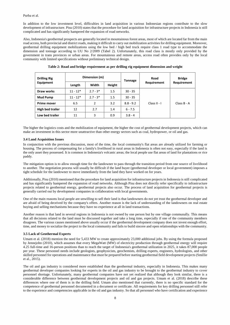
3.3 Lack of Existing Infrastructures
The problem of equipment inter-island mobilization in Indonesia is strongly influenced by infrastructure conditions such as road
access, transportation modes, and high-voltage electricity networks that will be used to drain electricity that will be produced by
PLTP. The uneven distribution of infrastructure in Indonesia is most likely due to Java's concentration development that has occurred
from the Dutch era. Figure 10 shows the road infrastructure condition in one area of the geothermal prospect in eastern Indonesia that
has not yet received adequate treatment, causing transportation difficulties.
Figure 6: Access road conditions to one of the locations of geothermal prospects in eastern Indonesia that have the potential
for landslides during rain and endanger road users (left) (Purba, 2018c; Purba, 2018d). Photo shows a car stucked in a road
to a geothermal drilling location in one of geothermal prospect areas in Eastern Indonesia (right).
Sandee (2016) emphasizes that the main problem facing archipelagic countries such as Indonesia is inter-island connectivity, which
directly affects domestic shipping costs. Sandee also mentioned that Indonesia's low level of investment in physical infrastructures
such as roads and bridges has significantly contributed to connectivity problems in Indonesia. Transportation, congestion, and poor
road quality problems are some of the worst business constraints.
Purba et al.
8
In addition to the low investment level, difficulties in land acquisition in various Indonesian regions contribute to the slow
development of infrastructure. Pisu (2010) states that the procedure for land acquisition for infrastructure projects in Indonesia is still
complicated and has significantly hampered the expansion of road networks.
Also, Indonesia's geothermal prospects are generally located in mountainous forest areas, most of which are located far from the main
road access, both provincial and district roads, making it difficult to carry out mobilization activities for drilling equipment. Moreover,
geothermal drilling equipment mobilizations using the low bed / high bed truck require class 1 road type to accommodate the
dimension and tonnage according to UU No 2/2009 (Tabel 2). Unfortunately, this road class is mostly only provided by the
government in trans provinces or urban areas. For mountainous and remote areas, access road often provides only by the local
community with limited specifications without preliminary technical design.
Table 2: Road and bridge requirement as per drilling rig equipment dimension and weight
Drilling Rig Equipment
Dimension (m) Tonnage
Road Requirement
Bridge Requirement
Length Width Height
Draw works 11 - 12* 2.7 - 3* 1.5 30 - 35
Class II - I Class B - A
Mud Pump 11 - 12* 2.7 - 3* 1.5 30 - 35
Prime mover 6.5 2 3.2 8.8 - 9.2
High bed trailer 12 2.7 1.4 6 - 7.5
Low bed trailer 11 3 0.9 3.8 - 4
The higher the logistics costs and the mobilization of equipment, the higher the cost of geothermal development projects, which can
make an investment in this sector more unattractive than other energy sectors such as coal, hydropower, or oil and gas.
3.4 Land Acquisition Issues
In conjunction with the previous discussion, most of the time, the local community's flat areas are already utilized for farming or
housing. The process of compensating for a family's livelihood in rural areas in Indonesia is often not easy, especially if the land is
the only asset they possessed. It is common in Indonesia's volcanic areas; the local people use flat areas of land for plantations or rice
paddy.
The mitigation option is to allow enough time for the landowner to pass through the transition period from one source of livelihood
to another. The negotiation process will usually be difficult if the land buyer (geothermal developer or local government) imposes a
tight schedule for the landowner to move immediately from the land they have worked on for years.
Additionally, Pisu (2010) mentioned that the procedure for land acquisition for infrastructure projects in Indonesia is still complicated
and has significantly hampered the expansion of road networks. Although Pisu does not directly refer specifically to infrastructure
projects related to geothermal energy, geothermal projects also occur. The process of land acquisition for geothermal projects is
generally carried out by development companies in collaboration with local governments.
One of the main reasons local people are unwilling to sell their land is that landowners do not yet trust the geothermal developer and
are afraid of being deceived by the company's offers. Another reason is the lack of understanding of the landowners on real estate
buying and selling mechanisms because they have no experience at all in land transactions.
Another reason is that land in several regions in Indonesia is not owned by one person but by one village communally. This means
that all decisions related to the land must be discussed together and take a long time, especially if one of the community members
disagrees. The various causes mentioned above usually occur if the geothermal development company does not invest enough effort,
time, and money to socialize the project to the local community and fails to build sincere and open relationships with the community.
3.5 Lack of Geothermal Experts
Umam et al. (2018) mention the need for 5,433 MW to create approximately 23,000 additional jobs. By using the formula proposed
by Jennejohn (2010), which assumes that every MegaWatt (MW) of electricity production through geothermal energy will require
4.25 full-time and 16-person positions than to reach the target of Indonesia's geothermal utilization in 2025, it takes 87,000 people
per year. These personnel needs include geologists, geophysicists, geochemists, drilling experts, engineers, hydrologists, and other
skilled personnel for operations and maintenance that must be prepared before starting geothermal field development projects (Smillie
et al., 2015).
The oil and gas industry is considered more established than the geothermal industry, especially in Indonesia. This makes many
geothermal developer companies looking for experts in the oil and gas industry to be brought to the geothermal industry to cover
personnel shortage. Unfortunately, many geothermal companies have not yet realized that although they look similar, there is a
considerable difference between geothermal development projects and oil and gas projects. Umam et al. (2018) describe these
differences where one of them is in the drilling field. Umam also mentioned that currently, there is no specific standard for the
competence of geothermal personnel documented in a document or certificate. All requirements for key drilling personnel still refer
to the experience and competencies applicable in the oil and gas industry. So that all personnel who have certification and experience
Purba et al.
9
in the oil and gas industry can work directly in geothermal projects without realizing there are some differences between the two
industries that could threaten worker safety and the environment.
3.6 Lack of Public Understanding on Geothermal Project
This is one of the challenges in developing geothermal projects that have not been widely discussed in various scientific journals or
seminar, which may be caused by the difficulty of measuring or quantifying the level of public understanding of a geothermal
development project. Another possible cause is that developers and local governments often feel that the task of educating people
living in the geothermal prospect area is not their responsibility.
The lack of public understanding of geothermal projects' importance often leads to rejection, which ultimately ends with delays in
geothermal development projects. This situation mainly occurs when geothermal projects are still in the exploration stage where local
governments, development companies, and local communities are still in the stage of recognizing each other and have not yet
developed trust between each party.
This, of course, has been known by geothermal developers, especially with the amount of news in the mass media regarding the
community's rejection of geothermal projects in Indonesia. However, companies have often not conducted education or counseling
in a sustainable and comprehensive manner. Usually, socialization events or public consultations are carried out only once at the
beginning of the project. The duration of one occasion is 3-6 hours, and the community is expected to understand all aspects of the
geothermal project.
Ideally, the education and counseling process for geothermal projects is carried out 3-6 months before the first physical activity at
the site begins with an increase in the frequency of the socialization in stages which is adjusted to the level of community acceptance.
To be able to build long-term relationships, all public doubts must be answered properly and openly.
3.7 Security Issues
Eastern Indonesia has security issues related to terrorist groups on Sulawesi and Papua island. This issue is important because natural
resources have been an aspect of 40% conflict in the last 60 years, including the Aceh and Papua conflict (UNEP, 2009). The Central
Sulawesi area with 2 Working Areas and 20 potential geothermal spots has problems with security disturbances from terrorist groups
in the Poso mountains. Terrorist disturbances in this area led to the closure of the Lore Lindu National Park, which had a location of
86 MW geothermal potential in 2016 (Lidiawati, 2016; PSDMBP, 2017; KOMPAS, 2020). Also, Papua region, which has high
natural resource potential, including 75 MW of speculative geothermal resources, faces conflicts related to natural resources since
1969 (UNEP, 2009; PSDMBP, 2017). Terrorist groups in Papua have been proven to have disturbed the Trans Papua road's
construction process, which indirectly also hampered construction related to the exploration of the Papua area.
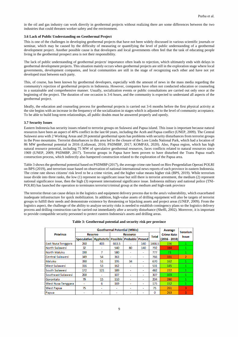
Table 3 shows the geothermal potential based on PSDMBP (2017), the average crime rate based on Biro Pengendalian Operasi POLRI
on BPS (2019), and terrorism issue based on observation of national-international news reports of each province in eastern Indonesia.
The crime rate shows citizens' risk level to be a crime victim, and the higher value means higher risk (BPS, 2019). While terrorism
issue divide into three ranks, the low (1) represent no significant issue but still there is terrorist arrestment, the medium (2) represent
national significance issue, then the high (3) represent international significance issue. Indonesia military and national police (TNI-
POLRI) has launched the operation to terminates terrorist/criminal group at the medium and high-rank province
The terrorist threat can cause delays in the logistics and equipment delivery process due to the area's vulnerability, which exacerbated
inadequate infrastructure for quick mobilization. In addition, high-value assets of drilling equipment will also be targets of terrorist
groups to fulfill their needs and demonstrate existence by threatening or hijacking assets and project areas (UNEP, 2009). From the
logistics aspect, the challenge of the ability to analyze security risks is needed to establish contingency plans so the logistics delivery
process and drilling construction can be carried out immediately after a security disturbance (Sheffi, 2002). Moreover, it is important
to provide compatible security personnel to protect eastern Indonesia's assets and drilling areas.
Table 3: Geothermal potential and security risk per province
Purba et al.
10
4. MITIGATION OPTIONS
4.1 Slimhole Utilization in the Exploration Strategy
To overcome the lack of infrastructure and access in relatively remote geothermal locations, exploration drilling might consider using
the slim hole drilling method. Slim hole methods use rigs that are much smaller than rigs for standard hole drilling, so they have a
smaller footprint, so costs can be cheaper. This method is suitable for use during exploration because it has more flexibility to adjust
to land conditions (Purba et al., 2018a; Purba et al., 2018b; Purba et al., 2019).
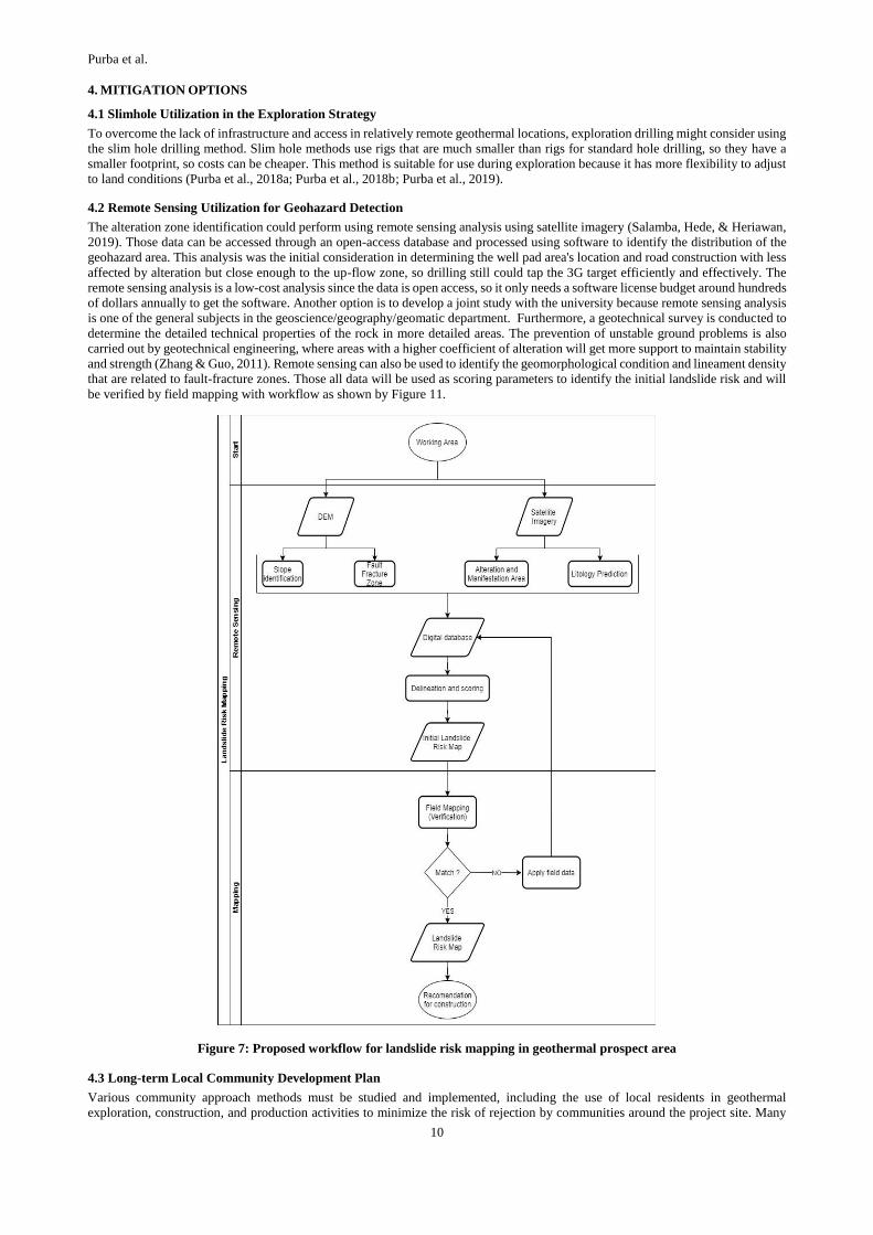
4.2 Remote Sensing Utilization for Geohazard Detection
The alteration zone identification could perform using remote sensing analysis using satellite imagery (Salamba, Hede, & Heriawan,
2019). Those data can be accessed through an open-access database and processed using software to identify the distribution of the
geohazard area. This analysis was the initial consideration in determining the well pad area's location and road construction with less
affected by alteration but close enough to the up-flow zone, so drilling still could tap the 3G target efficiently and effectively. The
remote sensing analysis is a low-cost analysis since the data is open access, so it only needs a software license budget around hundreds
of dollars annually to get the software. Another option is to develop a joint study with the university because remote sensing analysis
is one of the general subjects in the geoscience/geography/geomatic department. Furthermore, a geotechnical survey is conducted to
determine the detailed technical properties of the rock in more detailed areas. The prevention of unstable ground problems is also
carried out by geotechnical engineering, where areas with a higher coefficient of alteration will get more support to maintain stability
and strength (Zhang & Guo, 2011). Remote sensing can also be used to identify the geomorphological condition and lineament density
that are related to fault-fracture zones. Those all data will be used as scoring parameters to identify the initial landslide risk and will
be verified by field mapping with workflow as shown by Figure 11.
Figure 7: Proposed workflow for landslide risk mapping in geothermal prospect area
4.3 Long-term Local Community Development Plan
Various community approach methods must be studied and implemented, including the use of local residents in geothermal
exploration, construction, and production activities to minimize the risk of rejection by communities around the project site. Many
Purba et al.
11
studies have offered various alternative approaches, one of which is the direct use of geothermal resources for tourism, drying of
agricultural products, etc. which are expected to help develop the economy around the geothermal project area and involve the
surrounding community on an ongoing basis (Adityatama et al., 2018).
4.4 Develop a More Effective Communication Mechanism Between Stakeholders
Land acquisition is a crucial problem in developing geothermal energy in Indonesia, considering the development of supporting
infrastructure will always require land as a foothold. Therefore, cross-ministerial coordination and communication between the
regional government and the company must be increased concerning the issue of land acquisition
4.5 Develop a Competency Standard for Geothermal Personnel
A competency standard is needed for geothermal labor, especially in the drilling section. With the existence of a clear competency
standard, it is expected that the transition from oil and gas drilling workers can take place well and be able to minimize the risk of
work safety due to environmental differences between geothermal and oil and gas.
Table 4 summarizes several solution options that were discussed by the authors during the writing of this paper.
Table 4: Summary of mitigation options for drilling infrastructure challenges
Challenges Problem
keywords
Mitigation options
High-relief
terrain
Geohazards,
thermal manifestations,
soil instability
● Develop a national standard or guideline for geohazard assessment.
● Conduct remote sensing analysis for geohazard identification
● Start to develop education institute, training, and certification center in Indonesia's eastern islands
(NTT, Maluku, and Sulawesi) focusing on geohazard assessment, soil stability investigation, thermal manifestations, and civil construction to produce a skilled workforce from local communities within
the geothermal area.
● Local governments initiate collaboration with academic communities and geothermal developers to
conduct geohazard mapping in geothermal areas (WKP) in relation to drilling infrastructure construction.
● Socialization of geohazard risks to all stakeholders by Indonesia central government through seminar,
workshop, conferences, articles and social media.
Land
acquisition issues
Community
rejection, farming area,
socialization
issue
● Developing the direct-use facilities to bring economic impact to local communities while serve as
geothermal education media. This campaign is suggested to be conducted in the very early phase of the
exploration project to increase local community awareness of the geothermal exploration project before the project itself commenced.
● Start to develop an education institute, training, and certification center in the eastern islands of
Indonesia (NTT, Maluku, and Sulawesi) to create a skilled workforce from local communities. They are expected to obtain knowledge and skill in areas such as geothermal direct-use, civil construction,
machinery, health and safety, project administration, and drilling. This way, the risk of local
community rejection may be minimized since they have become part of the project instead of only become a spectator.
● Geothermal developers and local government may start a community engagement team consist of a
mixture of experienced staff and the local community. This team is expected to be able to cultivate
positive interaction and open communication process between geothermal developers and the local community.
● Indonesia needs to develop a standard or guideline for land acquisition, specifically for a geothermal
project in Indonesia's eastern part. It will be challenging to use the same guideline for all provinces in
Indonesia since Indonesia is very diverse in terms of ethnic, culture, language, and religion.
● Geothermal developers need to have the mindset of building a long-term relationship with the local
community from the day-1 of the project. This can be done by proactively listen to local community
complain and needs instead of dictating the urgency of a geothermal project in their village.
● Indonesia or local government may start to establish a certification program for community engagement officer to standardize how they engage the local community.
Lack of public understanding
of geothermal project
Community rejection, the
community engagement
mechanism
Archipelago
countries
Connectivity
between islands, road
infrastructures, landslides
● Since the infrastructure in the geothermal project (roads, bridges, ports, etc.) can be considered as
public facilities, geothermal developers may have to communicate intensively with the local government on the planning process of drilling infrastructure construction.
● Start to develop an education institute, training, and certification center in the eastern islands of
Indonesia (NTT, Maluku, and Sulawesi) to create a skilled workforce from local communities. They
are expected to obtain knowledge and skill in areas such as geothermal direct-use, civil construction, machinery, health and safety, project administration, and drilling. This way, geothermal developers
will not have to import a skilled workforce from outside.
● Start to encourage and educate local entrepreneurs to provide raw material or any resources needed by
geothermal developers in executing exploration projects. This way, geothermal developers do not have to worry about difficulties bringing materials, equipment, or tools from outside of the geothermal area.
Lack of
existing
infrastructures

Purba et al.
12
Lack of
geothermal
experts
The training
center, academic
involvement,
local capacity
building
● This issue needs to be mitigated at the national level by the Government of Indonesia. However, at this
time of writing this report, the authors found that most geothermal education centers located on Java
island, which means geothermal exploration projects in Indonesia's eastern part must import personnel from Java island.
● Start to develop education institute, training, and certification center in eastern islands of Indonesia
(NTT, Maluku, and Sulawesi) to produce skilled workforce from local communities that expected to obtain knowledge and skill in areas such as geothermal direct-use, civil construction, machinery,
health and safety, project administration, and drilling once graduated from the education center.
● The government can collaborate with geothermal developers to provide incentives for a geothermal
expert to come to NTT, Maluku, and Sulawesi as lecturers.
Security issue Project-logistic
threatening and hijacking,
● The mitigation can start earlier from the Indonesia government by terminates the criminal
groups/terrorists at the high potential of natural resource area and surroundings ● Provide compatible security personnel during the project to make sure the project (asset and personnel)
in a safe condition
● Develop good communication with the community, government, and state-security personnel (TNI-POLRI) to prevent conflict due to misunderstanding of the project. It also creates a suitable environment
for information gathering that related to conflict possibilities
● Development of communication skills for field personnel as the frontline of the project to be able to explain the project to the local community when there is a minor threat during a project, so they could
prevent bigger threats.
5. CONCLUSIONS
This paper has discussed several challenges that potentially faced by geothermal developers in constructing drilling infrastructures
for drilling exploration project, especially in Eastern Indonesia. Based on the complexity of the various challenges that has been
mentioned, authors attempt to gather various options that can be used to prevent those challenges. Authors believe that the
development of drilling infrastructure is the most important milestone in any geothermal exploration drilling project in Indonesia. It
is clear that all mitigation options proposed in this study require communication and collaboration among all stakeholders. At the
end, the goal is to increase the speed of exploring geothermal prospect areas in order to achieve Indonesia geothermal utilization
target.
Finally, the authors hope this paper can motivate the input from readers to improve the quality of further research related to this topic
that will be carried out in the future.
REFERENCES
Adityatama, D. W., Purba, D. P., & Kristianto, B. (2018). Integrated Geothermal Direct Use Facility as an Alternative Approach in
Community Engagement at Early Exploration Phase in Indonesia. Proceedings 7th ITB International Geothermal Workshop
2018. Bandung, Indonesia.
Barrios, L., Hernandez, B., Quezada, A., Pullinger, C. (2011). Geological hazards and geotechnical aspects in geothermal areas, the
El Salvador experience. Short Course on Geothermal Drilling, Resource Development and Power Plants 2011 by UNU-GTP
and LaGeo. Santa Tecla, El Salvador.
BPS. (2019). Statistik Kriminal. Badan Pusat Statistik. Jakarta, Indonesia
BSN. (2002). Standar Nasional Indonesia: Operasi Pemboran Darat dan Lepas Pantai yang Aman di Indonesia. Badan Standarisasi
Nasional. Jakarta, Indonesia
EBTKE (2017a). Potensi panas bumi Indonesia. Jakarta: Direktorat Jendral Energi Baru, Terbarukan dan Konservasi Energi.
ESDM (Ministry of Energy and Mineral Resources, Indonesia) (2017). Rencana Usaha Penyediaan Tenaga Listrik PT. Perusahaan
Listrik Negara (Persero) Tahun 2017 s.d. 2026 [Electricity Power Supply Business Plan PT. Perusahaan Listrik Negara (Persero)
2017-2026]. Retrieved from http://www.djk.esdm.go.id/pdf/RUPTL/RUPTL%20PLN%202017-2026
Eggers, M. (2016). Engineering Geological Modelling for Open Pit Slope Design in The Porphyry Copper-Gold Deposits in Southeast
Asia. 1st Asia Pacific Slope Stability in Mining. Perth: Australia Centre for Geomechanics
Hochstein, M. P., & Sudarman, S. (2015, April). Indonesian volcanic geothermal systems. In Proceedings World Geothermal
Congress, Melbourne, Australia (pp. 19-25). ba
Jennejohn, D. (2010). Green Jobs through Geothermal Energy. Geothermal Energy Association. Pennsylvania, Washington, D.C.
Retrieved from http://www.geo-energy.org/pdf/reports/GreenJobs_Through_Geothermal_Energy_Final_Oct2010.pdf
KOMPAS. (2020, 08 16). Memburu Kelompok Teroris MIT di Poso, Kapolda Sulteng: Ada di Hutan Pegunungan. (M. A.
Wismabrata, Ed.) Jakarta, DKI Jakarta, Indonesia. Retrieved 10 26, 2020, from
https://regional.kompas.com/read/2020/08/16/08410041/memburu-kelompok-teroris-mit-di-poso-kapolda-sulteng--ada-di-
hutan?page=all
Lidiawati, E. D. (2016, 01 19). Polisi Kejar Teroris, Jalur Pendakian di Taman Nasional Masih Ditutup. Retrieved 10 26, 2020, from
kompas.com:
https://regional.kompas.com/read/2016/01/19/16373991/Polisi.Kejar.Teroris.Jalur.Pendakian.di.Taman.Nasional.Masih.Ditutup
Purba et al.
13
MEMR (2017). Pemerintah optimis capai target kapasitas terpasang panas bumi pada tahun 2017.Press Release: The government is
optimistic to achieve geothermal installed capacity target in 2017. Ministry of Energy and Mineral Resource
Pelindo IV. (2016). Peta Wilayah Operasi PT Pelabuhan Indonesia IV (Persero). Retrieved 11 14, 2020, from
https://inaport4.co.id/pelabuhan
Pisu, M. (2010), "Tackling the Infrastructure Challenge in Indonesia", OECD Economics Department Working Papers, No. 809,
OECD Publishing, Paris.http://dx.doi.org/10.1787/5km5xvc1kk47-en
Purba, D., Adityatama, D. W., Agustino, V., Fininda, F., Alamsyah, D., & Muhammad, F. (2020). Geothermal Drilling Cost
Optimization in Indonesia: A Discussion of Various Factors. 45th Workshop on Geothermal Reservoir Engineering.
California: Standford University.
Purba, D. P., Adityatama, D. W., Umam, M. F., & Muhammad, F. (2019). Key Considerations in Developing Strategy for Geothermal
Exploration Drilling Project in. 44th Workshop on Geothermal Reservoir Engineering. California: Stanford University.
Purba, D.P., Dimwani, W., & Adityatama, D.W. (2018a). Basic Considerations in Minimizing the Uncertainty During Developing
Geothermal Exploration Drilling Strategy in Indonesia. Proceedings 7th ITB International Geothermal Workshop 2018.
Bandung, Indonesia.
Purba, D. P. (2018b). Investigation on Geothermal Resource Assessment Methods in Reducing Exploration Risk in Indonesia
Geothermal System. Final Project Master of Energy Program, University of Auckland. Auckland, New Zealand.
Purba, D.P. (2018c). Challenges in Drilling Preparation and Operation in Indonesia Geothermal Exploration Project. Geothermal
Forum ITB, Geothermal Master Program Institut Teknologi Bandung. Bandung, Indonesia.
Purba, D. P., Adityatama, D.W., Hasymi, S. P., Chandra, V. R. (2018d). Land Acquisition Process and Challenges in Geothermal
Exploration Project in Indonesia. Proceedings 6th Indonesia International Geothermal Conference and Exhibition 2018. Jakarta,
Indonesia.
PSDMBP. (2017). Potensi Panas Bumi Indonesia Jilid 2 (Vol. 1). Jakarta, Indonesia: Kementerian Energi dan Sumber Daya Mineral
Republik Indonesia. Retrieved 10 26, 2020, from http://igis.esdm.go.id/igis/img/Buku_Potensi_Jilid_2.pdf
PWC. (2016). Indonesia Infrastructure: Stable Foundation for Growth. PWC Indonesia.
https://www.pwc.com/id/en/cpi/asset/indonesian-infrastructure-stable-foundations-for-growth.pdf
PWC (2018). Oil and gas in Indonesia: Investment and taxation guide. May 2018, 9th edition.
Sandee, H. (2016). Improving Connectivity in Indonesia: The Challenges of Better Infrastructure, Better Regulations, and Better
Coordination. Asian Economic Policy Review (2016) 11, 222–238.
Salamba, K. E., Hede, A. N., & Heriawan, M. N. (2019). Identification of alteration zones using a Landsat 8 image of densely
vegetated area of the Wayang Windu Geothermal Field, West Java, Indonesia. IOP Conference Series: Earth and
Environmental Science. doi:10.1088/1755-1315/254/1/012004
Soegianto, W. (2018, July). Positive Outlook for Indonesia Geothermal Sector. Retrieved from PEFINDO:
https://www.pefindo.com/fileman/file/695
Sheffi, Y. (2002). Supply Chain Management Under the Threat of International Terrorism. International Journal of Logistic
Management. doi:10.1108/09574090110806262
Smillie A., Satar S., Saptadji N., Aminzadeh F., Setianingsih R. (2015). Capacity Building in the Geothermal Sector in Indonesia, a
Unique Collaboration. Indonesian Geothermal Association. Retrieved from http://cgs.usc.edu/assets/002/94801.pdf
Umam, M. F. (2018). Geothermal Human Resource Development in Indonesia: Utilizing the Advances of the Oil and Gas Industry.
Master Thesis. University of Auckland. Auckland.
UNEP. (2009). From Conflict to Peacebuilding; The Role of Natural Resources and Environment. Nairobi: United Nation. Retrieved
10 26, 2020, from https://www.iisd.org/publications/conflict-peacebuilding-role-natural-resources-and-environment
Undang Undang Republik Indonesia Nomor 22 Tahun 2009 Lalu Lintas dan Angkutan Jalan. Jakarta
Utami, P. (2010). High-temperature Geothermal Area and its Challenges for Civil Engineering Works. Pertemuan Ilmiah Tahunan
XIV HATTI 2010. Yogyakarta, Indonesia.
Zamana, M. B., Vanany, I., & Awaluddin, D. (2014). Connectivity Analysis of port in Eastern Indonesia. Elsevier, 118 - 127.
Zhang, Y., & Guo, C. (2011). Engineering geological properties of altered rocks and implications for railway construction in the
Sanjiang orogenic belt, Southwest China. Bulletin of Engineering Geology and the Environment, 143 - 152. doi:DOI
10.1007/s10064-010-0294-y
Zumrawi, M., Abdelmarouf, A. O., & Gameil, A. E. (2017). Damage of Buildings on Expansive Soil: Diagnosis and Avoidance.
Researchgate