


Bahasa
Halaman
Hukum

1
(for detailed summaries, see Klengel 1969: 178–299; Izreåel and Singer 1990; Singer 1991: 135–95).Amurru was initially a small highland kingdom sit-uated in the mountainous regions on the westernslopes of Mount Lebanon and along Nahr el-Kebir.During the Amarna period, the kingdom graduallyexpanded. In its high days it covered the territory
between Tripoli on the Lebanese coast and theMiddle Orontes area of western Syria. Amurru ˜rstemerged under a certain Abdi-Ashirta, who was ableto expand his territory and conquer cities in hisneighborhood. After his death the kingdom was ledby his son Aziru, who continued his father’s oˆen-sive and expanded the territory of his realm to theOrontes basin.
Several problems related to the “Amurru ˜le” inthe Amarna archive, such as the sequence of some
The Expansion of the Kingdom ofAmurru According to the Petrographic Investigation of the Amarna Tablets
Y
UVAL
G
OREN
Institute of ArchaeologyTel Aviv University
P.O.B. 39040Ramat Aviv, Tel Aviv 69978
I
SRAEL
F
INKELSTEIN
Institute of ArchaeologyTel Aviv University
P.O.B. 39040Ramat Aviv, Tel Aviv 69978
Israel˜[email protected]
N
ADAV
N
A
å
AMAN
Department of Jewish HistoryTel Aviv University
Ramat Aviv, Tel Aviv 69978Israel
A petrographic investigation of the Amarna tablets has been carried out by theauthors since 1997. Over 300 tablets have so far been examined, including 14 letterssent by the rulers of Amurru. The petrographic data makes it possible to trace the ter-ritorial expansion of the kingdom of Amurru in the days of Abdi-Ashirta and Aziru. TheAmurru letters fall into four distinct petrographic groups. The ˜rst includes two letters,which were sent from the mountainous area east of Tripoli, the core area of the kingdom.The second includes four letters, which were probably dispatched from the city ofArdata in the foothills. Five letters were sent from Tell Çrqa. This seems to indicate thatafter consolidating his reign, Aziru transferred his capital to Irqata in the çAkkar Plain.Finally, three of Aziru’s letters were sent from the Egyptian center of Sumur.
No Amurru letter was sent from the city of Tunip, which was also captured by Aziru.The analysis of the letter of the citizens of Tunip supports the identi˜cation of this impor-tant city at Tell çAsharneh northwest of Hama. This city was too remote from the mainarena of Aziru’s operations, which was focused on the Lebanese coast.
T
he early history of the kingdom of Amurruhas been examined by many scholars eversince the discovery of the Amarna letters
2 GOREN, FINKELSTEIN, AND NAÅMAN BASOR 329
of the events depicted by the letters, have been re-solved in scholarly research. Other issues, such asthe location of the capital of Amurru’s rulers at var-ious stages of their careers and the sequence ofevents in the time of Aziru, are still being debated.Another major question is the identi˜cation of thecity of Tunip, mentioned in four of Aziru’s letters(EA {=El Amarna} 161, 165–67) and in a letter sentby the citizens of Tunip to the Pharaoh (EA 59).Research on these problems has reached an impassewhich may be broken only by new data.
These questions were put high on the agendaof our project of petrographic investigation of theAmarna letters, which has been ongoing since 1997.In the course of the project we conducted miner-alogical and chemical analyses of samples from over300 tablets kept in museums in Berlin, London, Ox-ford, and Paris, including the tablets related toAmurru and Tunip.
1
In this article we report the re-sults concerning the Amurru letters. Tunip will bediscussed elsewhere.
METHOD
Various physical and chemical techniques areemployed for analyzing the composition of ceramicartifacts. The former identify the minerals in the clayand temper and de˜ne the fabric of the sherd. Thelatter use diverse analytical techniques to measurethe concentrations of the elements in the clay. In an-alyzing pottery, petrography is the physical methodof choice, whereas neutron activation analysis (NAA)is the most commonly used chemical method. Petro-graphic analysis is particularly eˆective for exam-ining coarse, poorly ˜red ceramics, while NAA isgenerally considered to be more accurate for prove-nance determinations, being fully quantitative andthus more precise. Usually, petrography is applied to
1
We wish to thank B. Salje and J. Marzahn from the
Vorder-asiatisches Museum
in Berlin; J. Curtis, S. Bowman, C. Walker,and A. Middleton from the British Museum; P. R. S. Moorey andH. Whitehouse from the Ashmolean Museum; and A. Caubet andB. Andr
é
-Salvini from the Mus
é
e du Louvre for their invaluablehelp. The ICP analyses were made in the Geological Survey ofIsrael. This study was supported by the Center for Collaborationbetween Natural Sciences and Archaeology of the WeizmannInstitute of Science, and the Fund for Internal Researches of TelAviv University. We thank I. Freestone, S. Gassner, M. Huges,A. Middleton, N. Porat, I. Segal, A. Shimron, and L. Smith fortheir useful comments on speci˜c topics discussed in this article.
a large number of items, and the results are used toselect samples for further chemical analysis. Whencuneiform tablets are analyzed, the sampling mustbe nondestructive and only restricted analyses canbe applied. Consequently, chemical methods mayseem more appropriate because of the smaller sam-ple that they require.
When the objective is to assign a provenance toan artifact, the quality of the interpretation dependson the availability of comparative materials. Claytypes used to produce tablets are not necessarily thesame as those from which vessels are manufactured.This may preclude the use of routine chemical pro-cedures in which a database containing the ele-mental composition of standard pottery from knownsites is compared with the samples examined. Con-versely, petrography has the advantage of being in-dependent, since the results can be interpreted on thebasis of detailed and usually available geologicaldata (and comparative material from investigationsof pottery assemblages). Therefore, petrography hasbeen selected as a primary method for our researchand has been applied on over 300 Amarna tablets.
Micropalaeontological study of the clay matrixwas also deployed, using the foraminifera index toidentify the age (and hence the possible geologicalformation and origin) of the clay. Foraminifera con-stitute one of the main groups of the unicellularorganisms Protozoa. The main bulk live in marineenvironments, although there are also some inlandand freshwater species. Marine foraminifera are di-vided into two main groups: those living in the watermass (planctonic) and those living on the sea ˘oor(bentonic). Our identi˜cations were made in the Geo-logical Survey of Israel. In many cases they eithercon˜rmed or oriented the petrographic and chemicalinterpretations into a narrower range of options.
CERAMIC ECOLOGY ANDPETROGRAPHIC REFERENCES
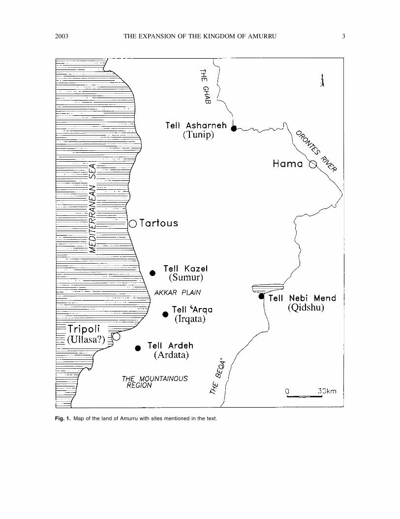
The area where the Amurru correspondence takesplace may be enclosed by a schematic rectangle thatlies between the Tripoli–Tartous line in the west, andthe Tell Nebi Mend (Qedesh)–Aleppo line in the east(˜g. 1). This area may be divided into four broadgeographic and geologic units, each with a fewsubdivisions: (1) The coast: from Tripoli to Nahrel-Çrqa; the Çkkar Plain from Nahr el-çArqa toSimerian; and from the northern limits of the çAkkar
SHORT
2003 THE EXPANSION OF THE KINGDOM OF AMURRU 3
Fig. 1.
Map of the land of Amurru with sites mentioned in the text.
4 GOREN, FINKELSTEIN, AND NAÅMAN BASOR 329
up to Tartous. (2) The western mountainous range:the northern part of the Lebanon Mountains; the TellKalah volcanic area; Jebel Ansariyeh and the Shinvolcanic plateau. (3) The inner valleys: the northernBeqaç and the area of Homs; the Middle OrontesValley and the Ghab. (4) The eastern mountainousrange: the Salamiyeh Plateau and Jebel Zawiye.Diˆerent geological environments that are expectedto yield diˆerent petrofabrics characterize each ofthese geographical units.
No petrographic work has been published so faron sites in the region, such as Tell Kazel, Tell Çrqa,Hama, and Tell Mishrife. We were able to examineold collections of pottery from the region. Whencombined with the geological data, these collectionssupplied a reasonable dataset that allowed us todraw many important conclusions.
An important source of data is the geologicalmapping of the area, drawn ˜rst by Dubertret (1949;
1951a; 1951b) and later supplemented by others(Ponikarov 1964: sheets I-36–XXIV; I-37–XIX;Ponikarov et al. 1967; Kozlov, Artyemov, and Kalis1966; Shatsky, Kazima, and Kulakov 1966; San-laville 1977; Sanlaville et al. 1993). On the largescale, it enables us to distinguish among variousgeographical zones within this broad area: the Oron-tes basin and the northern Beqaç, Mount Lebanon,the Jebel Ansariyeh ridge, and the coastal plain.Within each area the lithological landscape is varie-gated enough to permit a higher resolution of diˆer-entiation among smaller units. Thus, the geologicalmapping supplied the basic information that can becorrelated with the petrographic data obtained fromthe tablets.
In certain cases the geological literature suppliesdetailed information that may be used for even moreprecise identi˜cation of places mentioned in theAmurru correspondence. This applies, ˜rst and fore-
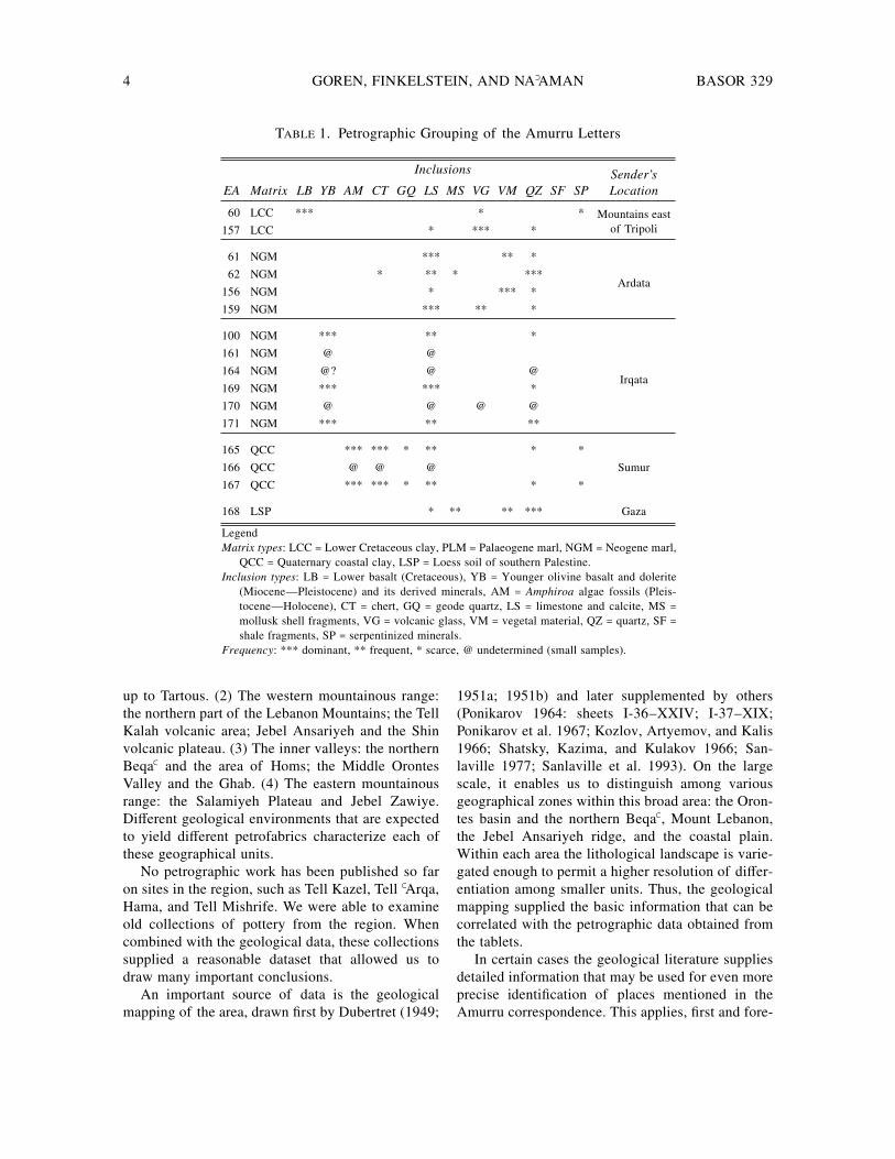
T
ABLE
1. Petrographic Grouping of the Amurru Letters
EA Matrix
Inclusions Sender ’sLocationLB YB AM CT GQ LS MS VG VM QZ SF SP
60 LCC *** * * Mountains eastof Tripoli157 LCC * *** *
61 NGM *** ** *
Ardata62 NGM * ** * ***
156 NGM * *** *
159 NGM *** ** *
100 NGM *** ** *
Irqata
161 NGM @ @
164 NGM @? @ @
169 NGM *** *** *
170 NGM @ @ @ @
171 NGM *** ** **
165 QCC *** *** * ** * *
Sumur166 QCC @ @ @
167 QCC *** *** * ** * *
168 LSP * ** ** *** Gaza
Legend
Matrix types
: LCC = Lower Cretaceous clay, PLM = Palaeogene marl, NGM = Neogene marl,QCC = Quaternary coastal clay, LSP = Loess soil of southern Palestine.
Inclusion types
: LB = Lower basalt (Cretaceous), YB = Younger olivine basalt and dolerite(Miocene—Pleistocene) and its derived minerals, AM =
Amphiroa
algae fossils (Pleis-tocene—Holocene), CT = chert, GQ = geode quartz, LS = limestone and calcite, MS =mollusk shell fragments, VG = volcanic glass, VM = vegetal material, QZ = quartz, SF =shale fragments, SP = serpentinized minerals.
Frequency
: *** dominant, ** frequent, * scarce, @ undetermined (small samples).
2003 THE EXPANSION OF THE KINGDOM OF AMURRU 5
most, to the coastal plain, and especially to the ÇkkarPlain and the mouth of Nahr el-Kebir (Sanlaville1977; Kozlov, Artyemov, and Kalis 1966). Publisheddata containing micropalaeontological identi˜cations,combined with very detailed geological literatureconcerning the lithostratigraphy of the Palaeogene(Luterbacher 1986; Krasheninnikov, Golovin, andMiravyov 1996) and the Neogene (Dubertret 1945;Buchbinder 1975), supply enough information to setthe clay types used by the scribes in their chrono-stratigraphic context.
RESULTS
Petrographically, the Amurru letters can be di-vided into four groups (see table 1). In other words,they were dispatched from four diˆerent places.
2
Letters Sent from the Mountainous Area Eastof Tripoli
The ˜rst group of letters to be discussed includesEA 60 and 157. The former was sent by Abdi-Ashirtaand the latter by Aziru.
The matrix of these tablets is argillaceous anddevoid of carbonate minerals, yellow to yellowish-orange in plane-polarized light (PPL) with speckledto striated b-fabric
3
and strong optical orientation. Itis mottled with common bodies of clay in variouscolors sizing up to 250
m
m, seemingly the alterationproducts of various minerals, constituting nearly 5percent of the matrix. These include yellow throughorange to dark red clay, frequently optically active,tuˆ and iddingsite. Opaque minerals, usually angu-lar at the ˜ner fraction and subrounded to sphericalat the coarser, are also widespread, forming about3–4 percent of the matrix, sizing up to 60–70
m
m.Some of the larger opaque or nearly opaque particlesare oolitic. Silt, essentially of quartz but with acces-
2
The only Amurru letter that does not belong to any of thefour groups discussed below is EA 168. It belongs to a group oftablets that were made in the southern coastal plain, most proba-bly at the important Egyptian administrative center of Gaza(Goren, Finkelstein, and Naåaman in press).
3
b-fabric: birefringent fabric, the optical behavior of the clayminerals within the matrix when they are found in parallel align-ment, hence causing the matrix to behave as a birefringent matterbetween crossed polarizers. Speckled b-fabric: random birefrin-gent zones of a few microns in size. Striated b-fabric: elongatedbirefringent streaks (after Whitbread 1995: 382–83).
sory plagioclase (sometimes twinned), forms approx-imately 2–3 percent of the matrix. Dark reddish-tan,ferruginous shales that are frequently microlami-nated and silty (approximately 2–3 percent) appearas massive bodies reaching millimeter size. Othershale fragments are of yellowish clay, with speckledb-fabric.
The inclusions are composed of the following:
• Basaltic minerals: Dominant, including roundedglobules of glassy phases, yellow to orange inPPL, ˜brous with undulose extinction in crossedpolarizers, sizing up to 100
m
m. These are mostlikely serpentinized minerals. Few clinopyroxenecrystals and very few iddingsite particles alsoappear.
• Alkali basalt: A few fragments of ˜nely crystal-line alkali basalt (up to 350
m
m) of trachytic tex-ture with elongated and oriented plagioclase laths.The pyroxene is partly or entirely serpentinized.
• Vegetal material: These include fragments ofplant tissues.
The petrographic features of EA 60 and 157 arecharacteristic of Lower Cretaceous clay and shales,with many of the attributes unique to these forma-tions. This petrographic group has been discussed indetail by Greenberg and Porat (1996) and Goren(1992; 1995; 1996). The presence of basalt and/ortuˆ in the inclusions suggests a nearby exposure ofthe basal Lower Cretaceous volcanics, whereas thepresence of diversi˜ed shales points to the use ofshales from the Lower Cretaceous sandstone units.Trachytic textures and an alteration of the olivineinto chlorite characterize the basalts of the LowerCretaceous section (Mimran 1972; Amiran and Po-rat 1984), as opposed to the Miocene-Pleistocenebasalts (to be discussed below in the Irqata section).
The lower formations of the Levantine LowerCretaceous lithological section outcrop widely inMount Lebanon, along the slopes of Mount Hermonand less frequently in the Anti-Lebanon. Geologi-cally, they are included in the Lower Cretaceousbasal unit, namely the
Gr
à
s de Base
or C1 units(e.g
.
, Dubertret 1949), recently termed the ChoufSandstone Formation (Walley 1997).
The presence of basalt and pyroclastic materialamong the inclusions may be related to the proxim-ity of the clay source to an exposure of the LowerCretaceous or Upper Jurassic volcanic complex (ba-salte cr
é
tac
é
, equivalent to the Tayasir volcanics ofIsrael). These layers are widely exposed in Mount
6 GOREN, FINKELSTEIN, AND NAÅMAN BASOR 329
Lebanon. The distribution of the Aptian formationsin Lebanon is limited to a belt that extends betweenMount Hermon in the south and the Çkkar Plain inthe north, covering the upper parts of Mount Leba-non and their slopes (Dubertret 1962). A narrowstripe of this formation is exposed along this ridge,from Merj çAyyun northeastward. The largest expo-sure appears in the area between Zahle in the Beqaçand Aaley on the western slopes of Mount Lebanon.In the Anti-Lebanon, a stripe is exposed betweenRashiya el-Fukhar and the Zebedani. However, thevolcanics appear in signi˜cant exposures only inMount Lebanon, north of the Beirut-Zahle line.
We therefore suggest that the origin of these twotablets should be sought in the mountainous areasoutheast of the Çkkar Plain, but not in or around it.Lower Cretaceous exposures, including outcrops ofthe basalte cr
é
tac
é
, occur along the slopes of theJebel Neghas, about 10 km southeast of Arde (Du-bertret 1949).
In sum, the mountainous area east of Tripoli isthe most likely source for the clay of these twotablets.
Letters Sent from Ardata
This group of letters includes EA 61 and 62,which were sent by Abdi-Ashirta, and EA 156 and159, which were dispatched by Aziru.
The matrix of these tablets is carbonatic, lightyellowish-tan in PPL, containing infrequent badlypreserved foraminifers and more commonly theirfragments. It is rather silty (about 2 percent) andvery rich in opaque iron minerals that appear at arange of sizes from a few micrometers to about 30–40
m
m. Under higher magni˜cations (> 200X) thematrix is ˜brous, with speckled b-fabric and weakoptical orientation. Foraminifera are abundant in thematrix; they include the following benthonic andplanctonic genii:
Bryozoa
,
Bulimina
,
Catapsydrax
,
Globigerina
,
Globigerinoides
,
Globorotalia
, and
Or-bulina
. Apart from occasionally added vegetal mate-rial, the inclusions appear to be naturally detritalwithin the reworked clay of the matrix and not inten-tionally mixed by the artisan. These include frequent(and sometimes dominant) limestone and calcite asrounded grains, sizing up to around 250
m
m. Quartzappears as a secondary component, usually as sub-angular grains sizing up to 100
m
m.By its petrofabric and palaeontology, the matrix
of these tablets indicates the use of Neogene marl.
Such marls, dating to the Miocene or the Pliocene,do not appear in the Levant south of the Lebanesecoast. In Lebanon, their outcrops are restricted mainlyto exposures east and south of Tripoli (Dubertret1951b) and to a lesser extent in patches betweenTripoli and Beirut. Notable among them is the out-crop of Nahr el-Awdeh, including the site of TellArde (ancient Ardata), which is the only signi˜cantmound near any of these exposures that is found inan entirely sedimentary area (as opposed to Irqata, tobe discussed below). Tell Arde is a medium-sizedsite of about 3.5 ha located 8 km from the coast; itoverlooks the area east of Tripoli (for the site, itslocation, and trial excavations, see Salam
é
-Sarkis1972; 1973; Izreåel and Singer 1990: 119–20, withearlier literature).
Because Tell Arde is situated over 12 km down-hill from the nearest Lower Cretaceous exposure ofMount Lebanon (see the ˜rst group above), we sug-gest a distinction between the group of tablets de-scribed here, which was probably sent from Ardata,and the ˜rst group discussed above (EA 60 and157), which was dispatched from the neighboringmountainous area.
Letters Sent from Irqata
This group includes EA 161, 164, and 171, whichwere sent by Aziru; EA 169, possibly dispatched byBaçluya, Aziru’s elder son (Naåaman 1996: 256); andEA 170, sent from Baçluya and Bet-ili to Aziru inEgypt.
4
Signi˜cantly, this group also includes EA100, which was sent by the elders of Irqata, identi-˜ed with Tell Çrqa in the Çkkar Plain—the mostimportant Bronze Age mound between Tell Kazel(Sumur) and Tripoli (possibly the location of Ul-lasa;
5
for the excavations of Tell Çrqa, see Thal-mann 1991, with earlier literature).
The matrix of these tablets is carbonatic, yellow-ish-tan in PPL, rich in cloudy, badly sorted carbon-ate micrite (about 20 percent). It is extremely rich(approximately 7 percent) in opaque to reddish-taniron minerals that appear at a range of sizes from a
4
Several scholars suggested that the same scribe wrote EA169 and 170 (Moran 1992: 257, n. 1, with additional references).The petrographic data seems to support this hypothesis, althoughthe sample size of EA 170 does not allow a semi-quantitativeanalysis of the inclusions.
5
Galling 1954: 100; for other suggestions see Klengel 1970:12, 25–26 n. 32; Liverani 1998: 201–2 n. 115. For Late Bronzeremains in Tripoli, see Salam
é
-Sarkis 1973: 94.
2003 THE EXPANSION OF THE KINGDOM OF AMURRU 7
few micrometers to about 30–40
m
m, which are an-gular; the translucent minerals tend to be sphericaland rounded. Iron minerals also appear as in˜llingswithin foraminifers. EA 169 and 171, the best andlargest samples belonging to this petrographic group,feature abundant benthonic and planctonic foramin-ifera of the following genii:
Bolivina
,
Bulimina
,
Glo-bigerina
,
Globigerinoides
, and
Globorotalia;
theyall belong to the Neogene to Holocene ages. Theinclusions are composed of moderately sorted sand,dominated by alkali olivine basalt and dolerite, sizingup to 1.2 mm. Secondary components include sub-rounded, micritic, and sparitic limestone, up to 800
m
m in size. Added vegetal material is uncommon.In terms of the clay used, this group presents marl
with typical cloudy micrite fragments that denselyoccupy it. The inclusions are typi˜ed by a signi˜-cant basic igneous content, usually of basalts and sel-dom of dolerite, together with limestone and somequartz.
The lithological combination that is presentedhere may be limited speci˜cally to the Çkkar Plainnear the Nahr el-Kebir channel, the only area wherePliocene marine deposits and volcanics appear to-gether (Kozlov, Artyemov, and Kalis 1966: 33). Theonly signi˜cant site in this area is Tell Çrqa.
Tell Çrqa is situated in the southern ˘ank ofthe Çkkar Plain, near Nahr el-Çrqa which drainsthe mountainous area to the southeast of the plain.The site is located on a plain of Pliocene argils andmarl, near the lower terrace of quaternary colluviumthat collects its materials from the Turonian andCenomanian calcareous formations and the volcanicterrain east of Halba (Sanlaville 1977: 25, 243–80,map 1). The Nahr el-Çrqa channel collects sedimentsfrom the plateau to the east and the plains north andsouth of Tell Çrqa. In these areas, Cenomanian-Turonian limestone series, Senonian chalk and chert,Lower Cretaceous sandstones and marls, and Juras-sic limestones are exposed. To the northeast, Pliocenevolcanics contribute the basalt component.
Based on these petrographic traits and on the factthat EA 100, which belongs to this petrofabric, wassent by the elders of Irqata, we are inclined to assignthe tablets of this group to Tell Çrqa.
Letters Sent from the Egyptian Center of Sumur
This group includes EA 165, 166, and 167, whichare identical petrographically and were sent byAziru. It also includes EA 96, the letter of an Egyp-
tian army commander to Rib-Hadda of Gubla, andEA 103, a letter sent by Rib-Hadda to the Pharaoh.
The matrix of these tablets is argillaceous, carbon-atic, orange-tan to tan in PPL with scarce foraminifers.Opaque minerals are rather common (approximately2 percent), sizing up to 100
m
m. Quartz silt occurs(approximately 1 percent) together with a smalleramount of plagioclase. The carbonate crystals withinthe matrix are dense (15 percent), usually sizingaround 10
m
m but occasionally reaching 20
m
m–30
m
m. The matrix includes the following foraminifera:
Brizalina
spathulata
,
Globigerina
, and
Globorotalia;
they all belong to the Pliocene to Pleistocene age.The inclusions are composed of frequent roundedfragments of fossiliferous coastal limestone (beach-rock) and more commonly separate fossils, sizing upto 650
m
m. The fossils consist predominantly ofarticulated fragments of the calcareous corallineanalgae
Amphiroa
, together with some mollusk shellfragments. Chert is also common, usually appearingas rounded, smoky to brown stained replacementchert with local intergrowth of chalcedony, reach-ing millimeter size. Subrounded to subangular frag-ments of micritic limestone with common localizedbrownish staining, and subangular to subroundedquartz grains (including fragments of geode quartzwith common liquid and mineral inclusions) appearas secondary components. Angular grains (up to 380
m
m) of serpentinized mineral crystals, most likelyalteration products of ma˜c minerals (pyroxene orolivine), appear in minor quantities.
In the Levantine coast corallinean algae of thegenus
Amphiroa
occur in Quaternary bioclastic sed-iments of the Pleshet, Hefer, and Kurdane formationsof Israel (Buchbinder 1975; Almagor and Hall 1980;Sivan 1996). So far no equivalent geological termi-nology has been formalized for the coast of Lebanon,but similar traits are recorded from the contemporaryand analogous beachrocks and sands found there(Sanlaville 1977: 161–77; Almagor and Hall 1980;Walley 1997). In the eastern Mediterranean this algaappears only in beach sediments dating from thePleistocene and onward (Buchbinder 1975). On thebasis of its dominance within the inclusions of EA165–67, we can suggest that this group should berelated with Quaternary beach deposits.
The other components represent diˆerent unitswithin the Levantine lithostratigraphic section. Chertis almost always related to formations of Santonian-Campanian or Eocene age, and geode quartz is typ-ical of the Cenomanian–Turonian transition. The
8 GOREN, FINKELSTEIN, AND NAÅMAN BASOR 329
igneous ma˜c minerals (serpentine, olivine, pyrox-ene) and the volcanic rock fragments that appear asdetrital but rather large grains can represent Pliocene-Pleistocene basalt ˘ows, or earlier Lower Cretaceousbasalts that are generally scarcer in extent.
In sum, the source of the materials for the tabletsof this group should be sought in an area where ex-posures of chalk appear together with Pleistocene-to-recent beach deposits of mainly calcareous character,chert and occasional basalt exposures. While in thesouthern Levant the coastal sediments are dominatedby quartzitic sand, which originally comes from theNile, in the northern coast of Israel (from Akkonorthward) this type of sand diminishes and thesediment becomes increasingly calcareous. A sys-tematic examination of thin sections made from Ho-locene coastal sand from various localities along thecoast indicates that quartz is the dominant compo-nent as far north as Haifa Bay. North of Akko thebeach sand is composed almost exclusively of car-bonates (Nir 1989: 12–15). This implication is sig-ni˜cant, because it indicates that our samples shouldbe related a priori to the coastal area north of Akko.Furthermore, Pliocene marine deposits appear onlyon the Lebanese coast.
Other components within the inclusion assem-blage may further limit the possibilities. In the Le-vantine lithostratigraphy, chert is related either withSenonian or Eocene exposures. Such exposures arefound predominantly between Tyre and Sidon, andagain north of Tripoli. When serpentine and weath-ered volcanic rock fragments appear, they can belinked to an inland area where volcanic rock types areexposed. The only area where Quaternary beach de-posits, Senonian or Eocene chert, and ma˜c mineralsof volcanic origin may appear together is the coastalarea of the Çkkar Plain between Tripoli and Tartous.The ma˜c minerals were most likely dragged therefrom the basaltic ˘ows of Nahr el-Kebir, where vol-canic elements are embedded in the local sediments.Therefore, the origin of the tablets belonging to thisgroup should be sought in the area of the ÇkkarPlain, not far from the seashore.
Considering the archaeological evidence, the onlysigni˜cant site in this area, where Late Bronze re-mains are reported, is Tell Kazel. The area to itsnorth is characterized by Pliocene brown alluvialsoils, limestone, chert and basalt pebbles, and Qua-ternary marine deposits (Kozlov, Artyemov, and Ka-lis 1966: 43–44; Sanlaville 1977: 270–84, map 1).
Basalts appear on the ridges east of the plain, andtheir derived minerals and alteration products aredrained by Nahr el-Abrash which passes near thesite. Thus, the combination of all the petrographicelements, the textual evidence, and the archaeologi-cal background point to Tell Kazel as the most likelyorigin of this group of tablets. Tel Kazel is widelyaccepted as the location of the ancient city of Sumur(for the excavations of the site, see Badre et al. 1990;1994; for the location and history of Sumur, seeKlengel 1995).
This conclusion is supported by EA 96, writtenby an Egyptian army commander, and EA 103, sentby Rib-Hadda of Gubla. Both belong to this grouppetrographically, and both include textual evidencefor having been dispatched from Sumur.
HISTORICAL CONCLUSIONS
The petrographic data makes it possible to tracethe political developments in Amurru and its territo-rial expansion in the time of the Amarna correspon-dence. The earliest letters, including those of Abdi-Ashirta and the early letters of Aziru, originatedfrom two closely related locations: the mountainousarea east of Tripoli and the city of Ardata in the foot-hills east of Tripoli. We therefore suggest that in theearly days of the Amarna period, the seat of Abdi-Ashirta was located in the mountainous area east ofTripoli, and that this was the core area of the king-dom of Amurru. No signi˜cant Late Bronze site hasbeen recorded thus far in this area. EA 60 and 157could have been sent from a small mountain strong-hold—possibly the hometown and place of origin ofthe family. This con˜rms the notion that Amurruwas initially a small highland kingdom situated onthe slopes of Mount Lebanon, on both sides of Nahrel-Kebir, and inhabited by farmers, pastoral groups,and uprooted elements (Liverani 1965a; 1965b;Klengel 1969: 245–53; Mendenhall 1973: 130–35).
EA 61, 62, 156, and 159 were sent from the cityof Ardata (Tell Arde), which was located in the foot-hills, not too far from the Egyptian harbor-centerof Ullasa (modern Tripoli). Initially, Ardata wasgoverned by its own ruler (EA 139:15; 140:12). Itwas then captured by Abdi-Ashirta (EA 88:5; seeEA 75:30–31) and held by his heir, Aziru, in hisearly years (EA 104:10). In light of the petro-graphic analysis, we suggest that Ardata was the
SHORT
2003 THE EXPANSION OF THE KINGDOM OF AMURRU 9
capital of Amurru during the later years of Abdi-Ashirta and the early years of Aziru. The fact thatboth Abdi-Ashirta and Aziru dispatched letters fromboth the mountainous area and Ardata indicates thatthe Amurru correspondence in the Amarna archivestarts
after
the takeover of Ardata.EA 161, 164, 169, 170, and 171 were sent from
Irqata (=Tell Çrqa). It seems that after consolidatinghis reign, Aziru transferred his capital to Irqata,which was initially governed by a local ruler namedAduna. He was murdered at the initiative of Abdi-Ashirta (EA 75:32–33; 139:15; 140:10) who tookpossession of the city (EA 62:13, 17, 22; 88:6). Afterthe death of Abdi-Ashirta, the elders of Irqata senta letter to the Pharaoh in which they explained theirdeeds and expressed their loyalty to Egypt (EA 100;for interpretation of the letter, see Moran 1992: 173n. 6). The loyalty of Irqata to Egypt is also mentionedin a letter sent by Rib-Hadda of Gubla (Byblos) atroughly the same time (EA 103:11–13, 34–36). How-ever, shortly afterward Irqata was seized by Aziru.This is indicated by EA 109:9–15: “Now the sons ofAbdi-Ashirta . . . have taken the cities of the kingand the cities of his mayors, just as they please; theyare the ones that [took Irqa]ta (sic!) for themselves.
6
And you did nothing about their [actions] when youheard that they have taken Ullasa.” The capture ofIrqata by Aziru is con˜rmed by the letters of Ili-rapih, Rib-Hadda’s successor at Gubla (EA 139:15;140:10).
Irqata served as Aziru’s capital until the end of theAmarna period. Letter 170, sent by Aziru’s brotherand son while Aziru was in Egypt, was dispatchedfrom this city. EA 161—probably Aziru’s latest let-ter written after his return from Egypt and after hisconquest of Tunip—was also sent from Irqata.
According to the “General’s letter,” Irqata func-tioned as the headquarters of the army that held theterritory of the kingdom of Amurru against an im-pending attack of Egyptian troops (Izre’el and Singer1990: 117–21). Ardata was probably an advance postof the general’s troops, thus located near the southernborder of Amurru. The letter was written not longafter the end of the Amarna period, thus re˘ecting
6
Moran (1992: 183) and Liverani (1998: 212) restored in line12 [
Arda
]
ta
. But according to EA 104:10 Ardata was already inthe hands of Aziru. Restoring it [
Irqa
]
ta
is in line with EA103:11–13, 34–36, which indicates that Irqata fell into the handsof Aziru at a somewhat later time.
the post-Amarna stage in the political developmentof the kingdom of Amurru. It is not clear whetherIrqata was still Amurru’s capital at that time, orwhether Aziru moved his capital to another, moresecure place. The answer to this question might befound in future petrographic research, when the laterletters of Amurru discovered in Ugarit and Hattushawill be analyzed.
EA 165, 166, and 167 were sent by Aziru fromSumur.
7
These three letters were written at the sametime to the Pharaoh and to two high o¯cials in hiscourt. Aziru might have arrived there to meet Hatip,the Egyptian messenger, and on that occasion wrotethese letters. Soon afterward he went to Egypt, ac-companied by Hatip, probably by a ship that sailedfrom Sumur (see EA 168). The paucity of letterssent from Sumur indicates that although Aziru con-quered the city, he avoided turning it into his perma-nent seat. Aziru might have visited Sumur on otheroccasions (e.g., the situation described in EA 161:11–16), but his letters were written from his resi-dence at Irqata.
It is noteworthy that no Amurru letter was sentfrom Tunip. Although Aziru captured the city, atleast in the Amarna period it did not serve as hiscapital. The petrographic study of the Amarna let-ters con˜rms the identi˜cation of Tunip with TellçAsharneh northwest of Hama (Courtois 1973: 55n. 5; Klengel 1995; Liverani 1998: 298 n. 42;Naåaman 1999; Goren, Finkelstein, and Naåaman inpress). Tunip was therefore too remote from the ma-jor arena in which Aziru operated. For military andeconomic reasons, the coast of Lebanon remainedhis main concern. The post-Amarna “General letter”fully illustrates this.
In sum, the petrographic analysis proves to be anindispensable tool for analyzing certain aspects ofthe history of Amurru that cannot be approached byconventional historical research. It enables us to es-tablish the sequence of political centers of the king-dom of Amurru and its development from a smallmountainous entity, ruled from a highland strong-hold, to a large territorial kingdom extending up tothe Orontes Valley, whose capital remained near thecoast, not far away from the dynasty’s hometownand place of origin.
7
Izreåel and Singer (1990: 138; Singer 1991: 152) proposedthat the three letters were sent from Tunip.
10 GOREN, FINKELSTEIN, AND NAÅMAN BASOR 329
Almagor, G., and Hall, J. K.1980 Morphology of the Continental Margine of
Northern Israel and Southern Lebanon.
IsraelJournal of Earth Sciences
29: 245–52.Amiran, R., and Porat, N.
1984 The Basalt Vessels of the Chalcolithic Periodand Early Bronze Age I.
Tel Aviv
11: 11–19.Badre, L.; Gubel, E.; al-Maqdissi, M.; and Sader, H.
1990 Tell Kazel, Syria: Excavations of the AUB Mu-seum, 1985–1987, Preliminary Report.
Berytus
38: 9–124.Badre, L.; Gubel, E.; Capet, E.; and Panayot, N.
1994 Tell Kazel (Syrie), Rapport pr
é
liminaire sur les4
e
–8
e
campagnes de fouilles (1988–1992).
Syria
71: 259–346.Buchbinder, B.
1975 Stratigraphic Signi˜cance of the Alga
Amphi-roa
in Neogene–Quaternary Bioclastic Sedi-ments from Israel.
Israel Journal of
EarthSciences
24: 44–48.Courtois, J.-C.
1973 Prospection arch
é
ologique dans la moyennevall
é
e de l’Oronte (El Ghab et Er Roujd—Syriedu nord-ouest).
Syria
50: 53–99.Dubertret, L.
1945
Carte g
é
ologique au 50.000
e
feuille de Ham-diye
. Beirut: Minist
è
re des Traveaux Publics.1949
Carte g
é
ologique au 200.000
e
feuille de Trip-oli
. Beirut: Minist
è
re des Traveaux Publics.1951a
Carte g
éologique au 50.000e feuille de Bey-routh. Beirut: Ministère des Traveaux Publics.
1951b Carte géologique au 50.000e feuille de Tripoli.Beirut: Ministère des Traveaux Publics.
1962 Carte geologique Liban, Syrie et bordure despays voisins. Paris: Musée National d’HistoireNaturelle.
Galling, K.1954 Das Deutsche Evangelische Institut für Alter-
tumswissenschaft des Heiligen Landes imJahre 1953. Zeitschrift des Deutschen Paläs-tina-Vereins 70: 97–103.
Goren, Y.1992 Petrographic Study of the Pottery Assemblage
from Munhata. Pp. 329–60 in The Pottery As-semblages of the Shaçar Hagolan and RabahStages of Munhata (Israel), by Y. Gar˜nkel.Les Cahiers du Centre de recherche français deJerusalem 6. Paris: Association Paléorient.
1995 Shrines and Ceramics in Chalcolithic Israel:The View through the Petrographic Micro-scope. Archaeometry 37: 287–305.
1996 The Southern Levant in the Early Bronze AgeIV: The Petrographic Perspective. Bulletin ofthe American Schools of Oriental Research303: 33–72.
Goren, Y.; Finkelstein, I.; and Naåaman, N.In press Inscribed in Clay: Petrographic Investigation
of the Amarna Tablets. Tel Aviv: Institute ofArchaeology, Tel Aviv University.
Greenberg, R., and Porat, N.1996 A Third Millennium Levantine Pottery Produc-
tion Center: Typology, Petrography, and Prov-enance of the Metallic Ware of Northern Israeland Adjacent Regions. Bulletin of the Ameri-can Schools of Oriental Research 301: 5–24.
Izreåel, S., and Singer, I.1990 The General’s Letter from Ugarit: A Linguis-
tic and Historical Reevaluation of RS 20.33(Ugaritica V, No. 20). Tel Aviv: Tel AvivUniversity.
Klengel, H.1969 Geschichte Syriens im 2. Jahrtausend v.u.Z.,
Vol. 2: Mittel- und Südsyrien. Deutsche Akad-emie der Wissenschaften zu Berlin, Institut fürOrientforchung, Veröˆentlichung 70. Berlin:Akademie.
1970 Geschichte Syriens im 2. Jahrtausend v.u.Z.,Vol. 3: Historische Geographie und allgemeineDarstellung. Deutsche Akademie der Wissen-schaften zu Berlin, Institut für Orientforchung,Veröˆentlichung 40. Berlin: Akademie.
1995 Tunip und andere Probleme der historischenGeographie Mittelsyriens. Pp. 125–34 in Immi-gration and Emigration within the Ancient NearEast, eds. K. van Lerberghe and A. Schoors.Orientalia Lovaniensia Analecta 65. Leuven:Peeters.
Kozlov, V. V.; Artyemov, A. V.; and Kalis, A. F.1966 The Geological Map of Syria, Scale 1:200,000,
Sheets I-36–XVIII, I-37, XIII (Trablus, Homs),Explanatory Notes. Moscow: Technoexport.
Krasheninnikov, V. A.; Golovin D. I.; and Miravyov, V. I.1996 The Paleogene of Syria—Stratigraphy, Lithol-
ogy, Geochronology. Geologisches Jahrbuch86: 3–136.
Liverani, M.1965a Implicazioni sociali nella politica di Abdi-
Ashirta di Amurru. Rivista degli Studi Orien-tali 40: 267–77.
1965b Il fuoruscitismo in Siria nella tarda eta delbronzo. Rivista Storica Italiana 77: 315–36.
1998 Le lettere di el-Amarna 1–2. Brescia: Paideia.
REFERENCES
2003 THE EXPANSION OF THE KINGDOM OF AMURRU 11
Luterbacher, H. P. 1986 Paleogene. Paper presented at a conference on
Planktonic Foraminifera as Stratigraphic Tools:Workdesk on Planktonic Foraminifera, Febru-ary 17–22, 1986, Tübingen.
Mendenhall, G. E.1973 The Tenth Generation: The Origins of the
Biblical Tradition. Baltimore: Johns HopkinsUniversity.
Mimran, Y.1972 The Tayasir Volcanics, a Lower Cretaceous
Formation in the Shomeron, Central Israel.Geological Survey of Israel Bulletin 52: 1–9.
Moran, W. L.1992 The Amarna Letters. Baltimore: Johns Hopkins
University.Naåaman, N.
1996 Ammishtamru’s Letter to Akhenaten (EA 45)and Hittite Chronology. Aula Orientalis 14:251–57.
1999 Qarqar = Tell çAsharneh. Nouvelles Assyri-ologiques Brèves et Utilitaires 1999, no. 4: 89–90.
Nir, Y.1989 Sedimentological Aspects of the Israel and
Sinai Mediterranean Coasts. Jerusalem: Geo-logical Survey of Israel (Hebrew).
Ponikarov, V. P., ed.1964 The Geological Map of Syria, 1:200,000 (20
sheets with geological cross sections and ex-plenatory notes). Moscow: Technoexport.
Ponikarov, V. P.; Kazmin V. G.; Mikhailov, I. A.; Razva-liayev, A. V.; Krasheninnikov, V. A.; Kozlov,V. V.; Sulidi-Kondratev, E. D.; Mikhailov,K. Y.; Kulakov, V. V.; Faradzhev, V. A.; andMirzayev, K.
1967 The Geology of Syria, Explanatory Notes onthe Geological Map of Syria, Scale 1:500,000,Vol. 1: Stratigraphy, Igneous Rocks and Tec-tonics. Damascus: Syrian Arab Republic, Min-istry of Industry, Department of Geologicaland Mineral Research.
Salamé-Sarkis, H.1972 Ardata-Ardé dans le Liban-Nord: Une nouvelle
cité Cananéenne identi˜ée. Mélanges de l’Uni-versité Saint-Joseph 47: 123–45.
1973 Chronique archéologique du Liban-Nord II:1973–1974. Bulletin du Musée de Beyrouth 26:91–102.
Sanlaville, P.1977 Étude géomorphologique de la région littorale
du Liban. Section des études géographiques 1.2 vols. Beirut: Université Libanaise.
Sanlaville, P.; Besançon, J.; Copeland, L.; and Muhe-sen, S.
1993 Le Paléolithique de la valleé moyenne del’Oronte (Syrie): Peuplement et environnement.BAR International Series 587. Oxford: TempusReparatum.
Shatsky, V. N.; Kazima, V. G.; and Kulakov, V. V.1966 The Geological Map of Syria, Scale 1:200,000,
Sheets I-37–XIX, I-36, XXIV, ExplanatoryNotes. Moscow: Technoexport.
Singer, I.1991 A Concise History of Amurru. Pp. 134–95 in
Amurru Akkadian: A Linguistic Study, Vol. 2,by S. Izreåel. Harvard Semitic Studies 41.Atlanta: Scholars.
Sivan, D.1996 Paleogeography of the Galilee Coastal Plain
during the Quaternary. Report of the GeologicalSurvey of Israel GSI/11/96; PhD dissertation,Hebrew University of Jerusalem. Jerusalem:Geological Survey.
Thalmann, J.-P.1991 L’Âge du Bronze à Tell Çrqa: bilan et perspec-
tives (1981–1991). Berytus 39: 21–38.Walley, C.
1997 The Lithostratigraphy of Lebanon, A Review.Lebanese Science Bulletin 10: 81–108.
Whitbread, I. K..1995 Greek Transport Amphorae: A Petrological and
Archaeological Study. Fitch Laboratory Occa-sional Paper 4. Athens: British School at Athens.

Top Related
Copyright © 2022 FDOKUMEN

