


Bahasa
Halaman
Hukum

PLEASE SCROLL DOWN FOR ARTICLE
This article was downloaded by: [Engel, Zbynek]On: 14 February 2011Access details: Access Details: [subscription number 933442997]Publisher Taylor & FrancisInforma Ltd Registered in England and Wales Registered Number: 1072954 Registered office: Mortimer House, 37-41 Mortimer Street, London W1T 3JH, UK
Hydrological Sciences JournalPublication details, including instructions for authors and subscription information:http://www.informaworld.com/smpp/title~content=t911751996
The Amazon River headstream area in the Cordillera Chila, Peru:hydrographic, hydrological and glaciological conditionsBohumír Janskýa; Zbyněk Engela; Jan Kocuma; Luděk Šefrnaa; Julius Česáka
a Department of Physical Geography and Geoecology, Faculty of Science, Charles University inPrague, Czech Republic
Online publication date: 13 February 2011
To cite this Article Janský, Bohumír , Engel, Zbyněk , Kocum, Jan , Šefrna, Luděk and Česák, Julius(2011) 'The AmazonRiver headstream area in the Cordillera Chila, Peru: hydrographic, hydrological and glaciological conditions',Hydrological Sciences Journal, 56: 1, 138 — 151To link to this Article: DOI: 10.1080/02626667.2010.544257URL: http://dx.doi.org/10.1080/02626667.2010.544257
Full terms and conditions of use: http://www.informaworld.com/terms-and-conditions-of-access.pdf
This article may be used for research, teaching and private study purposes. Any substantial orsystematic reproduction, re-distribution, re-selling, loan or sub-licensing, systematic supply ordistribution in any form to anyone is expressly forbidden.
The publisher does not give any warranty express or implied or make any representation that the contentswill be complete or accurate or up to date. The accuracy of any instructions, formulae and drug dosesshould be independently verified with primary sources. The publisher shall not be liable for any loss,actions, claims, proceedings, demand or costs or damages whatsoever or howsoever caused arising directlyor indirectly in connection with or arising out of the use of this material.
138Hydrological Sciences Journal – Journal des Sciences Hydrologiques, 56(1) 2011
The Amazon River headstream area in the Cordillera Chila, Peru:hydrographic, hydrological and glaciological conditions
Bohumír Janský, Zbynek Engel, Jan Kocum, Ludek Šefrna & Julius Cesák
Department of Physical Geography and Geoecology, Faculty of Science, Charles University in Prague, Albertov 6, 128 43 Prague 2,Czech [email protected]
Received 12 January 2010; accepted 5 October 2010; open for discussion until 1 August 2011
Citation Janský, B., Engel, Z., Kocum, J., Šefrna, L. & Cesák, J. (2011) The Amazon River headstream area in the CordilleraChila, Peru: hydrographical, hydrological and glaciological conditions. Hydrol. Sci. J. 56(1), 138–151.
Abstract The source of the world’s largest river has fascinated scientists and adventurers for a long time. Extensivestudies have been undertaken in the unexplored Llogueta River valley, Cordillera Chila, to identify the mainstream of the Amazon River. Analysis of the Lloqueta River network and measurements of its hydrographic andhydrometric characteristics are presented in this study. On the basis of the acquired data, the northern hillsideof the Cordillera Chila massif, concretely the basins of four mountainous courses—the Carhuasanta, Apacheta,Ccaccansa and Sillanque rivers—should be regarded as the headwaters territory of the Amazon River. Factorsinfluencing the river system—glaciers and soils—were examined for each catchment. Glacier retreat in the last50 years has left perennial snowfields only in the highest part of the study area, resulting in modification of theheadwater runoff regimes. Preliminary results are afforded by the continual automatic water-level monitoring ofthe Lloqueta River since June 2008. Our investigations have determined that all types of soil in the area could beclassified into two main categories: hydromorphic soils or poorly developed cryic soils.
Key words Amazon River sources; headwaters; Cordillera Chila; deglaciation; runoff regime; automatic water-level gauge;discharge measurement
La région source du Fleuve Amazone dans la Cordillère Chila, Pérou: conditions hydrographiques,hydrologiques et glaciologiquesRésumé La source du plus grand fleuve du monde a fasciné les scientifiques et les aventuriers pendant longtemps.Des études approfondies ont été menées dans la vallée inexplorée de la Rivière Llogueta, dans la Cordillère Chila,afin d’identifier le cours principal du Fleuve Amazone. L’analyse du réseau de la Rivière Lloqueta, et la mesure deses caractéristiques hydrographiques et hydrométriques sont présentées dans cette étude. Sur la base des donnéesacquises, le versant nord du massif de la Cordillère Chila, concrètement les bassins de quatre cours d’eau demontagne—les rivières Carhuasanta, Apacheta, Ccaccansa et Sillanque—doivent être considérés comme étant leterritoire supérieur de l’Amazone. Les facteurs ayant une influence sur le système hydrographique—les glaciers etles sols—ont été examinés pour chaque bassin versant. Le recul des glaciers au cours des 50 dernières années n’alaissé des champs de neige pérennes que dans la partie haute de la zone d’étude, ce qui entraîne la modificationdes régimes d’écoulement amont. Des résultats préliminaires sont permis grâce à la surveillance hydrométriqueautomatique continue de la Rivière Lloqueta depuis Juin 2008. Nos enquêtes ont établi que tous les types de solsde la région peuvent être classés en deux catégories principales: des sols hydromorphes et des sols peu développéscryiques.
Mots clefs sources du Fleuve Amazone; têtes de bassin; Cordillère Chila; déglaciation; régime d’écoulement; mesurehydrométrique automatique; mesure des débits
INTRODUCTION
Up until the 1950s the Amazon River headstream areawas primarily thought to be in the Marañon River basin(Fig. 1). Since 1707, the map drawn by the Czech Jesuit,
Samuel Fritz, had been widely recognized as valid,locating the Amazon River headwaters at LauricochaLake, Cordillera Raura, part of the Peruvian westernAndes (Gicklhorn & Gicklhorn, 1943; Janský et al.2008). This lake is also stated as the main source of the
ISSN 0262-6667 print/ISSN 2150-3435 online© 2011 IAHS Pressdoi: 10.1080/02626667.2010.544257http://www.informaworld.com
Downloaded By: [Engel, Zbynek] At: 12:24 14 February 2011
The Amazon River headstream area in the Cordillera Chila, Peru 139
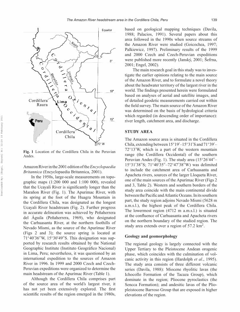
Fig. 1 Location of the Cordillera Chila in the PeruvianAndes.
Amazon River in the 2001 edition of the EncyclopaediaBritannica (Encyclopaedia Britannica, 2001).
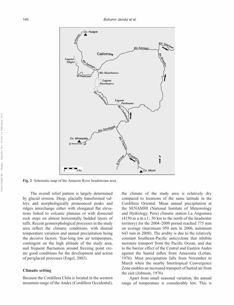
In the 1950s, large-scale measurements on topo-graphic maps (1:200 000 and 1:100 000), revealedthat the Ucayali River is significantly longer than theMarañon River (Fig. 1). The Apurímac River, withits spring at the foot of the Huagra Mountain inthe Cordillera Chila, was designated as the longestUcayali River headstream (Fig. 2). Further progressin accurate delineation was achieved by Peñaherreradel Águila (Peñaherrera, 1969), who designatedthe Carhuasanta River, at the northern foothills ofNevado Mismi, as the source of the Apurímac River(Figs 2 and 3); the source spring is located at71◦40′36′′W, 15◦30′49′′S. This designation was sup-ported by research results obtained by the NationalGeographic Institute (Instituto Geográfico Nacional)in Lima, Peru; nevertheless, it was questioned by aninternational expedition to the sources of AmazonRiver in 1996. In 1999 and 2000 Czech and Czech-Peruvian expeditions were organized to determine themain headstream of the Apurímac River (Table 1).
Although the Cordillera Chila comprises partof the source area of the world’s largest river, ithas not yet been extensively explored. The firstscientific results of the region emerged in the 1980s,
based on geological mapping techniques (Davila,1988; Palacios, 1991). Several papers about thisarea followed in the 1990s when source streams ofthe Amazon River were studied (Goicochea, 1997;Palkiewicz, 1997). Preliminary results of the 1999and 2000 Czech and Czech-Peruvian expeditionswere published more recently (Janský, 2001; Šefrna,2001; Engel, 2002).
The main research goal in this study was to inves-tigate the earlier opinions relating to the main sourceof the Amazon River, and to formulate a novel theoryabout the headwater territory of the largest river in theworld. The findings presented herein were formulatedbased on analyses of aerial and satellite images, andof detailed geodetic measurements carried out withinthe field survey. The main source of the Amazon Riverwas determined on the basis of hydrological criteriawhich regarded (in descending order of importance):river length, catchment area, and discharge.
STUDY AREA
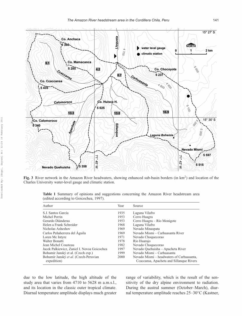
The Amazon source area is situated in the CordilleraChila, extending between 15◦19′–15◦31′S and 71◦39′–72◦13′W, which is a part of the western mountainrange (the Cordillera Occidental) of the southernPeruvian Andes (Fig. 1). The study area (15◦26′44′′–15◦31′38′′S; 71◦40′35′′–72◦47′38′′W) was delimitedto include the catchment area of Carhuasanta andApacheta rivers, sources of the larger Lloqueta River,one of the main sources of the Apurímac River (Figs 2and 3, Table 2). Western and southern borders of thestudy area coincide with the main continental dividebetween the Pacific and Atlantic Oceans. In its southernpart, the study region adjoins Nevado Mismi (5628 ma.m.s.l.), the highest peak of the Cordillera Chila.The lowermost region (4712 m a.m.s.l.) is situatedat the confluence of Carhuasanta and Apacheta riverson the northern boundary of the studied region. Thestudy area extends over a region of 57.2 km2.
Geology and geomorphology
The regional geology is largely connected with theUpper Tertiary to the Pleistocene Andean orogenicphase, which coincides with the culmination of vol-canic activity in this region (Hardolph et al., 1995).The study area consists of three different volcanicseries (Davila, 1988): Miocene rhyolitic lavas (theIchocollo Formation of the Tacaza Group), whichdominate in the region; Pliocene pyroclastics (theSencca Formation); and andesitic lavas of the Plio-pleistocene Barroso Group that are exposed in higherelevations of the region.
Downloaded By: [Engel, Zbynek] At: 12:24 14 February 2011
140 Bohumír Janský et al.
Fig. 2 Schematic map of the Amazon River headstream area.
The overall relief pattern is largely determinedby glacial erosion. Deep, glacially transformed val-leys and morphologically pronounced peaks andridges interchange either with elongated flat eleva-tions linked to volcanic plateaus or with dissectedrock steps on almost horizontally bedded layers oftuffs. Recent geomorphological processes in the studyarea reflect the climatic conditions, with diurnaltemperature variation and annual precipitation beingthe decisive factors. Year-long low air temperature,contingent on the high altitude of the study area,and frequent fluctuation around freezing point cre-ate good conditions for the development and actionof periglacial processes (Engel, 2002).
Climatic setting
Because the Cordillera Chila is located in the westernmountain range of the Andes (Cordillera Occidental),
the climate of the study area is relatively drycompared to locations of the same latitude in theCordillera Oriental. Mean annual precipitation atthe SENAMHI (National Institute of Meteorologyand Hydrology, Peru) climatic station La Angostura(4150 m a.m.s.l.; 30 km to the north of the headwaterterritory) for the 2004–2009 period reached 775 mmon average (maximum 950 mm in 2006, minimum643 mm in 2008). The aridity is due to the relativelyconstant Southeast-Pacific anticyclone that inhibitsmoisture transport from the Pacific Ocean, and dueto the barrier effect of the Central and Eastern Andesagainst the humid influx from Amazonia (Lettau,1976). Most precipitation falls from November toMarch when the nearby Intertropical ConvergenceZone enables an increased transport of humid air fromthe east (Johnson, 1976).
Apart from small seasonal variation, the annualrange of temperature is considerably low. This is
Downloaded By: [Engel, Zbynek] At: 12:24 14 February 2011
The Amazon River headstream area in the Cordillera Chila, Peru 141
Fig. 3 River network in the Amazon River headwaters, showing enhanced sub-basin borders (in km2) and location of theCharles University water-level gauge and climatic station.
Table 1 Summary of opinions and suggestions concerning the Amazon River headstream area(edited according to Goicochea, 1997).
Author Year Source
S.J. Santos García 1935 Laguna VilafroMichel Perrin 1953 Cerro HuagraGerardo Diánderas 1953 Cerro Huagra – Río MonigoteHelen a Frank Schreider 1968 Laguna VilafroNicholas Asheshov 1969 Nevado MinaspataCarlos Peñaherrera del Águila 1969 Nevado Mismi – Carhuasanta RiverLoren Mc Intyre 1971 Nevado ChoquecoraoWalter Bonatti 1978 Río HuarajoJean Michel Cousteau 1982 Nevado ChoquecoraoJacek Palkiewicz, Zaniel I. Novoa Goicochea 1997 Nevado Quehuisha – Apacheta RiverBohumír Janský et al. (Czech exp.) 1999 Nevado Mismi – CarhuasantaBohumír Janský et al. (Czech-Peruvian
expedition)2000 Nevado Mismi – headwaters of Carhuasanta,
Ccaccansa, Apacheta and Sillanque Rivers
due to the low latitude, the high altitude of thestudy area that varies from 4710 to 5628 m a.m.s.l.,and its location in the classic outer tropical climate.Diurnal temperature amplitude displays much greater
range of variability, which is the result of the sen-sitivity of the dry alpine environment to radiation.During the austral summer (October–March), diur-nal temperature amplitude reaches 25–30◦C (Kastner,
Downloaded By: [Engel, Zbynek] At: 12:24 14 February 2011
142 Bohumír Janský et al.
Table 2 Hydrographic parameters of the Amazon River headstream area.
Stream Length (m) Length tothe beginningof LloquetaRiver (m)
Source tospringelevation(m a.m.s.l.)
River basin area(except for otherinter-catchments)(km2)
Source tocatchmentboundarydistance (m)
Source/springcoordinates
Carhuasanta Riversource from Bohemia Lake
8138.4 – 5150 16.9 2130 15◦30′43′ ′S;71◦42′05′ ′W
Apacheta Riverdownstream of the confluencewith Carhuasanta River
8134.2 – 5169 35.4 1050 15◦31′15′ ′S;71◦45′42′ ′W
Ccaccansa Riverdownstream of the confluencewith Apacheta River
6772.2 8926.1 5177 9.1 590 15◦27′26′ ′S;71◦46′55′ ′W
Sillanque Riverdown to the confluence withApacheta River
4683.6 5920.2 5039 13.0 1200 15◦30′25′ ′S;71◦44′41′ ′W
2008), and is even greater during the winter season(April–September).
METHODS
The lengths of all streams forming the LloquetaRiver network (the Ccaccansa, Apacheta, Sillanqueand Carhuasanta rivers, Fig. 3) were measuredusing a Jenoptik LEM TM 30 laser distance gauge.Measurements were taken up the river towards themajor spring in order to reflect all meanders. Thelength of the streams was determined along the chan-nel centre line, i.e. the centre of the river bed. Basedon the measured elevations, longitudinal profiles wereconstructed to allow analysis of the gradient ratiosof particular streams and rivers. Geographical coordi-nates and elevation marks of all springs and sourceswere determined using GPS and a barometric altimeter.
River discharges were measured using the OTTMesstechnik C20 and C31 hydrometric propellers.A discharge regime was calculated based on actualdaily measurements and correlated with ambient tem-perature changes. The same measurements were per-formed in the aforementioned profiles to determinethe flow rate. The climatic conditions and hydro-logical regime of the studied areas was describedand assessed using the measuring set from Fiedler-Mágr Company including registering and controllingunit and hydrostatic pressure sensor from June 2008.Hydrological gauges continually monitor water lev-els at 30-min intervals with 1 mm accuracy. Theclimatic station (observing precipitation, air temper-ature and humidity, solar radiation, wind speed anddirection, and soil temperature) included a satellitemodule for data transmission of daily sums. Data
transmission allowed an operative solution of meteo-rological and hydrological situations and also a reg-ular control of the whole measuring set function.In given profiles with installed water-level gauges,periodical discharge measurements were carried out,using the above-mentioned hydrometric propellers, inorder to construct accurate rating (stage–discharge)curves and to calculate corresponding discharges. Therunoff regime within a day was also determined forboth research periods.
The field survey and investigations in 1999,2000, 2007, 2008, 2009 and 2010 were carriedout mainly during the winter time of the SouthernHemisphere. Apart from the fact that, during thisperiod, temperatures fall to the lowest values,precipitation also reaches its lowest volume. Theseconditions are important for the hydrographic analy-sis, as any water stream with a permanent flow rate inthe driest seasons could be considered as a perennialstream.
The extent of glaciers was reconstructed forfour different periods. The oldest one was createdusing aerial photographs acquired by the NationalAerographical Institution (Instituto AerofotográficoNacional), Peru, in 1955. Glacier positions from1986, 1999 and 2007 were constructed from satelliteimages taken by the LANDSAT 5, and the QuickBird,respectively. Mapping the extent of glaciers for theseperiods enabled an evaluation of the rate of glacierretreat since 1955.
Soil mapping, description, and sampling werecarried out within the field survey using standardanalytical methods. Laboratory analyses were usedfor quantification of gravel content, porosity andwater-holding capacity of soils. Radiocarbon dating(14C) was applied to organic matter from buried soil
Downloaded By: [Engel, Zbynek] At: 12:24 14 February 2011
The Amazon River headstream area in the Cordillera Chila, Peru 143
horizons at the valley-floor of Apacheta and Caccansariver valleys.
RESULTS
Hydrography
Carhuasanta River The Carhuasanta Riverbasin has a drainage area of 16.9 km2 (Fig. 3) whichrepresents approximately 30% of the entire headwaterarea. An average slope of the river basin is 22.3%. TheCarhuasanta River has two sources. The highest pointboth in the Carhuasanta River basin and in the entireheadstream area, Nevado Mismi, is 2130 m from boththe left branch and the fissure spring. The overalllength of the Carhuasanta River, from its right sourcedown to the confluence with the Apacheta River, is7799.3 m. The Carhuasanta River runs through asymmetrical valley representing an advanced erosioncycle (with one of the valley closures formed by cliffsat the northern hillside of Nevado Mismi and a stonefield at its foot) due to the middle stream accumula-tion and downstream intensive erosion. The erosioneffect forms a balanced gradient profile of the stream.
The left stream springs from Lake “Bohemia”(accepted by the National Geographic Institute, Lima,Peru) with its level at the altitude of 5150 m a.m.s.l.The water runs over a rock step 15 m high. The overalllength of the Carhuasanta River from the left headwa-ters stream to the confluence with the Apacheta Riveris 8138.4 m. The lake basin has been curved by aglacier into the compact andesite lava at the northwestfoothills of the Nevado Mismi massif. Due to inten-sive frost weathering, landslides and avalanches, thelake basin is blocked. Apart from mechanical block-ing, the lake basin volume is also decreased byintensive growth of the vegetation called “champa”(Distichia muscoides). Depth measurements verifiedthat champa grows through the entire water columndown to the lake basin bed. According to the resultsof bathymetric measurements in July 2000, verified inOctober 2009, the lake area reaches up to 1554.30 m2,on average, in both studied years, while the maxi-mum depth in the centre of the lake basin reacheda value of 4.1 m in 2000 (3.9 m in 2009). However,within 9 years, the lake basin volume of retained waterdecreased by 135.4 m3 (4.8%) as a result of the abovementioned causes (2795.5 m3 in 2000, reported byCesák & Janský, 2008, and 2660.1 m3 in 2009).
The right sourcing stream of the CarhuasantaRiver springs out under a 36-m-high cliff at an alti-tude of 5155 m a.m.s.l. The cliff is penetrated by asignificant vertical fissure which stretches far up the
hill. The spring is clearly fed by melting ice and snowat the northern foothills of the Nevado Mismi massif.At present, after the total glacier disappearance, thespring is fed only by snow (see Table 2).
Apacheta River The length of the ApachetaRiver from its confluence with the Carhuasanta Riverto the spring is 8134.2 m. The area of the ApachetaRiver basin upstream of the confluence with theCcaccansa River amounts to 13.3 km2, comprisingapproximately 23% of the entire headwater area.However, if the overall area of the river basin,including the tributaries, the Sillanque and Ccaccansarivers, is taken into account, then the resultant fig-ure amounts to 35.4 km2. The average slope of theriver basin down to the confluence with the CcaccansaRiver is 18.8%.
Ccaccansa River The Ccaccansa River has thelongest regular stream (8926 m) and the highest ele-vated spring (5177 m a.m.s.l.). In contrast to the othersources, the Ccaccansa River is defined as a springarea because a single unique spring cannot be definedunambiguously. The watershed area of the CcaccansaRiver basin alone, down to the confluence with theApacheta River, is only 9.1 km2, which makes up only16% of the entire headwater area (the smallest riverbasin among the four sources of the Lloqueta River).Significant differences in elevation between the water-shed ridge and the valley floor are also implied by thelarge average gradient of the river basin of 22.8%,the highest gradient throughout the Lloqueta Riverheadwaters. As regards the volume of water flow, theCcaccansa River is the smallest river in comparisonwith the other Lloqueta sources.
Sillanque River The spring of the SillanqueRiver lies at 5039 m a.m.s.l. and is located in thebasin of a former glacial lake whose floor is coveredwith mass wasting debris. The lake basin was alsolikely clogged by aeolian activity which transportedlow-resistant volcanic tuffs. At present, the former lakebottom is inhabited by champa-type vegetation whichretains a large amount of water in the headwaters. TheSillanque River catchment area extends up to 13.0 km2.The average slope of the basin (15.9%) represents thelowest value within the entire headstream area.
Runoff regime
Besides the hydrographic analysis, determination ofthe basic characteristics of the runoff regimes was
Downloaded By: [Engel, Zbynek] At: 12:24 14 February 2011
144 Bohumír Janský et al.
carried out to compare the runoff balance of eachsource and to assess the runoff reaction to recentdeglaciation. All sources of runoff in the study areaare included: rainfall, glaciers and perennial snowcover, periodical snow cover and underground water.
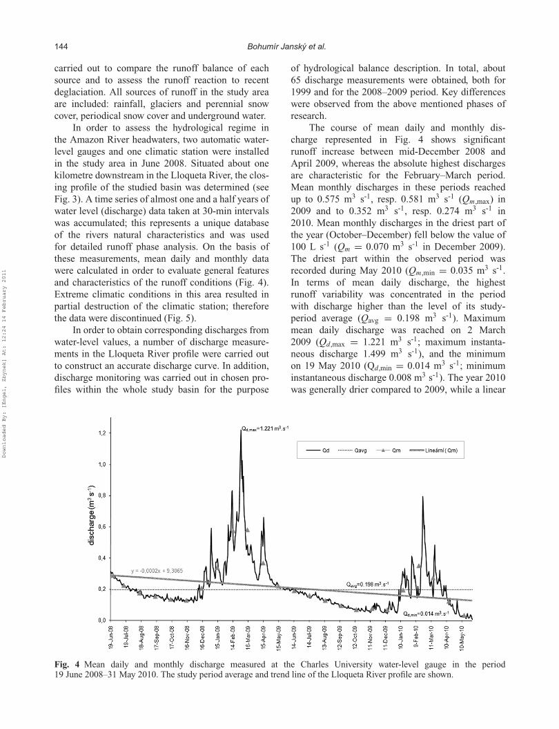
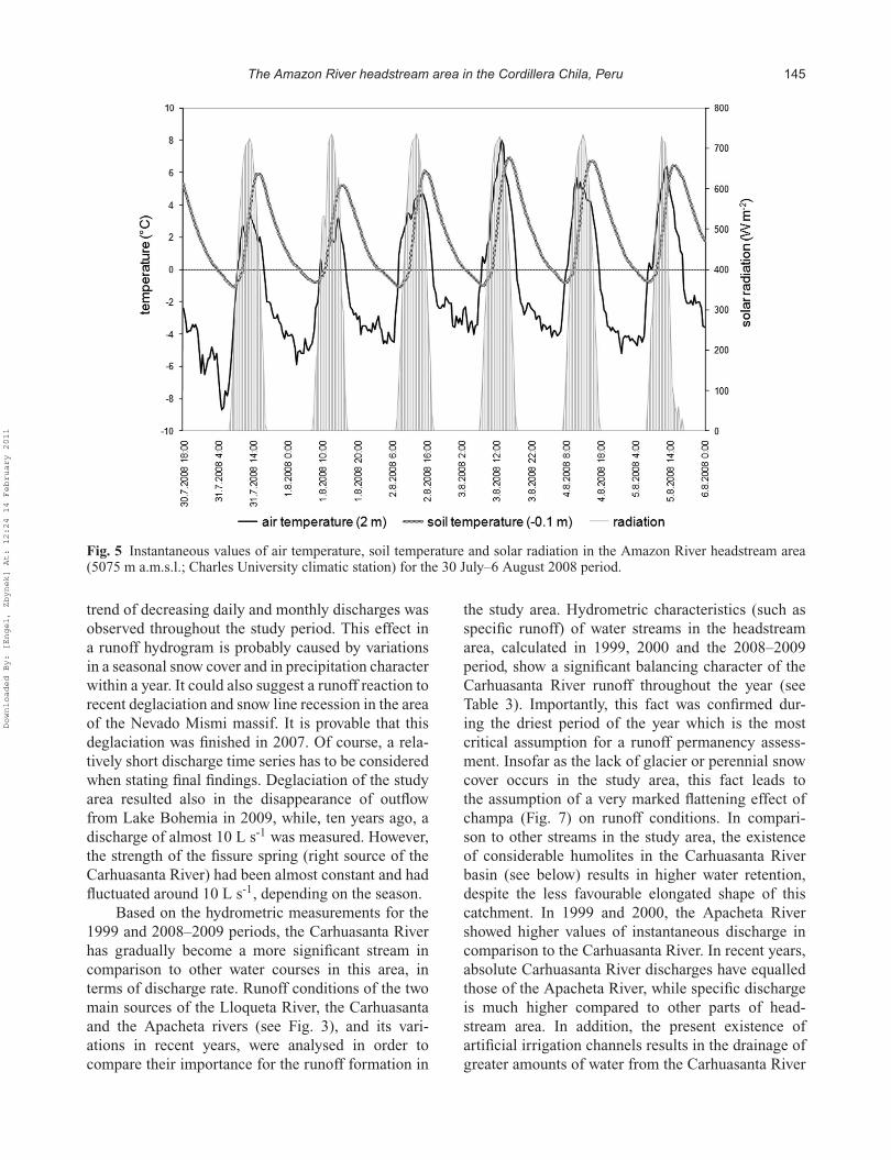
In order to assess the hydrological regime inthe Amazon River headwaters, two automatic water-level gauges and one climatic station were installedin the study area in June 2008. Situated about onekilometre downstream in the Lloqueta River, the clos-ing profile of the studied basin was determined (seeFig. 3). A time series of almost one and a half years ofwater level (discharge) data taken at 30-min intervalswas accumulated; this represents a unique databaseof the rivers natural characteristics and was usedfor detailed runoff phase analysis. On the basis ofthese measurements, mean daily and monthly datawere calculated in order to evaluate general featuresand characteristics of the runoff conditions (Fig. 4).Extreme climatic conditions in this area resulted inpartial destruction of the climatic station; thereforethe data were discontinued (Fig. 5).
In order to obtain corresponding discharges fromwater-level values, a number of discharge measure-ments in the Lloqueta River profile were carried outto construct an accurate discharge curve. In addition,discharge monitoring was carried out in chosen pro-files within the whole study basin for the purpose
of hydrological balance description. In total, about65 discharge measurements were obtained, both for1999 and for the 2008–2009 period. Key differenceswere observed from the above mentioned phases ofresearch.
The course of mean daily and monthly dis-charge represented in Fig. 4 shows significantrunoff increase between mid-December 2008 andApril 2009, whereas the absolute highest dischargesare characteristic for the February–March period.Mean monthly discharges in these periods reachedup to 0.575 m3 s-1, resp. 0.581 m3 s-1 (Qm,max) in2009 and to 0.352 m3 s-1, resp. 0.274 m3 s-1 in2010. Mean monthly discharges in the driest part ofthe year (October–December) fell below the value of100 L s-1 (Qm = 0.070 m3 s-1 in December 2009).The driest part within the observed period wasrecorded during May 2010 (Qm,min = 0.035 m3 s-1.In terms of mean daily discharge, the highestrunoff variability was concentrated in the periodwith discharge higher than the level of its study-period average (Qavg = 0.198 m3 s-1). Maximummean daily discharge was reached on 2 March2009 (Qd,max = 1.221 m3 s-1; maximum instanta-neous discharge 1.499 m3 s-1), and the minimumon 19 May 2010 (Qd,min = 0.014 m3 s-1; minimuminstantaneous discharge 0.008 m3 s-1). The year 2010was generally drier compared to 2009, while a linear
Fig. 4 Mean daily and monthly discharge measured at the Charles University water-level gauge in the period19 June 2008–31 May 2010. The study period average and trend line of the Lloqueta River profile are shown.
Downloaded By: [Engel, Zbynek] At: 12:24 14 February 2011
The Amazon River headstream area in the Cordillera Chila, Peru 145
Fig. 5 Instantaneous values of air temperature, soil temperature and solar radiation in the Amazon River headstream area(5075 m a.m.s.l.; Charles University climatic station) for the 30 July–6 August 2008 period.
trend of decreasing daily and monthly discharges wasobserved throughout the study period. This effect ina runoff hydrogram is probably caused by variationsin a seasonal snow cover and in precipitation characterwithin a year. It could also suggest a runoff reaction torecent deglaciation and snow line recession in the areaof the Nevado Mismi massif. It is provable that thisdeglaciation was finished in 2007. Of course, a rela-tively short discharge time series has to be consideredwhen stating final findings. Deglaciation of the studyarea resulted also in the disappearance of outflowfrom Lake Bohemia in 2009, while, ten years ago, adischarge of almost 10 L s-1 was measured. However,the strength of the fissure spring (right source of theCarhuasanta River) had been almost constant and hadfluctuated around 10 L s-1, depending on the season.
Based on the hydrometric measurements for the1999 and 2008–2009 periods, the Carhuasanta Riverhas gradually become a more significant stream incomparison to other water courses in this area, interms of discharge rate. Runoff conditions of the twomain sources of the Lloqueta River, the Carhuasantaand the Apacheta rivers (see Fig. 3), and its vari-ations in recent years, were analysed in order tocompare their importance for the runoff formation in
the study area. Hydrometric characteristics (such asspecific runoff) of water streams in the headstreamarea, calculated in 1999, 2000 and the 2008–2009period, show a significant balancing character of theCarhuasanta River runoff throughout the year (seeTable 3). Importantly, this fact was confirmed dur-ing the driest period of the year which is the mostcritical assumption for a runoff permanency assess-ment. Insofar as the lack of glacier or perennial snowcover occurs in the study area, this fact leads tothe assumption of a very marked flattening effect ofchampa (Fig. 7) on runoff conditions. In compari-son to other streams in the study area, the existenceof considerable humolites in the Carhuasanta Riverbasin (see below) results in higher water retention,despite the less favourable elongated shape of thiscatchment. In 1999 and 2000, the Apacheta Rivershowed higher values of instantaneous discharge incomparison to the Carhuasanta River. In recent years,absolute Carhuasanta River discharges have equalledthose of the Apacheta River, while specific dischargeis much higher compared to other parts of head-stream area. In addition, the present existence ofartificial irrigation channels results in the drainage ofgreater amounts of water from the Carhuasanta River
Downloaded By: [Engel, Zbynek] At: 12:24 14 February 2011
146 Bohumír Janský et al.
Table 3 Chosen instantaneous values of discharge and specific runoff measured in the LloquetaRiver water-level gauge profile and in different profiles of its sources in 1999, 2000, 2008 and2009.
Stream Profile Date Time Discharge Specific runoff(L s-1) (L s-1 km-2)
Lloqueta River Water-level gauge 21.06.1999 13:00 535.9 9.0813.07.2000 09:15 234.4 3.9713.07.2000 12:30 381.0 6.4619.06.2008 11:10 257.5 4.3614.10.2009 13:30 56.6 0.96
Carhuasanta River Confluence withApacheta River
24.06.1999 09:30 168.6 9.9806.07.2000 10:15 161.4 9.5519.06.2008 11:45 109.0 6.4514.10.2009 14:15 33.9 2.01
Apacheta River Confluence withCarhuasanta River
23.06.1999 09:10 205.9 5.1106.07.2000 10:45 280.4 6.9619.06.2008 12:00 141.8 3.5214.10.2009 14:30 28.1 0.70
Confluence withCcaccansa River
08.07.2000 10:50 115.3 8.6714.10.2009 15:40 25.2 1.89
Sillanque River Outfall 08.07.2000 11:50 83.2 6.5514.10.2009 15:10 2.2 0.17
Ccaccansa River Outfall 08.07.2000 10:25 45.0 4.9514.10.2009 15:30 5.4 0.59
basin compared to the Apacheta River (12.5 L s-1,resp. 7.4 L s-1 on 14 October 2009). That is whyin July 2000, the discharge of the Carhuasanta Riverdecreased by 30–50 L s-1.
In the 18 June–9 September 2008 period, par-tial meteorological data were acquired from the cli-matic station (operated by the Charles Universityin Prague) located on the slightly inclined (10◦)western slope of Nevado Mismi at an altitude of5075 m a.m.s.l. (see Fig. 3). The outcome of theair temperature, soil temperature and solar radia-tion monitoring (Fig. 5) shows the course of theseparameters for the period 30 July–6 August 2008.Characteristic air temperature fluctuation within aday (amplitude 8–12◦C) is accompanied by verysignificant soil temperature fluctuation at 10 cmbelow surface (amplitude 7–8◦C). At night (between20:00 and 06:00 h) the air temperature was vary-ing around –4◦C, while the highest values were up to4–6◦C at around 14:00–15:00 h (mean air tempera-ture in the studied period was 0.7◦C). The highest soiltemperatures were deferred by approximately 1–2 h,and reached up to around 6◦C, the lowest values ofaround –1◦C occurred between 08:00 and 09:00 h(mean soil temperature was 3.4◦C). The course of soiltemperature was generally more gradual. The lowesttemperature in the studied period (–8.7◦C) occurredon 31 July 2008 in the morning, the highest oneon 21 August 2008 in the afternoon (11.3◦C). Solar
radiation fluctuated between 0 and 956 W m-2 (aver-age value was 184.7 W m-2) and showed a typicaldaily course. The wind of 0–16 m s-1 speed wasmostly in a 184◦ direction.
Glacier recession
In 1955 there were six glaciers in the study region,covering about 3.8 km2 (Table 4). These weresmall glaciers of irregular shape without typicallydeveloped cirques. The glaciers were restricted tothe highest parts of mountain slopes and structuralplateaus oriented to northern and southern quadrants.A surface covered by firn and glaciers was almost
Table 4 Development of glaciation in the Amazon Riverheadwaters between 1955 and 2007.
Glacier Area (km2): Maximumaltitude (m)
Orientation
1955 1986 2000 2007
Mismi 0.57 0.50 0.45 – 5628 NWChayco 0.72 – – – 5200 NWQuehuisha 0.97 0.20 0.20 – 5358 NCalomoroco 0.42 – – – 5340 NECcaccansa 0.66 0.60 0.51 – 5435 SCututi 0.50∗ 0.40 0.38 – 5360 STotal 3.84 1.70 1.54 0.00
∗Estimation from the aerial photo; other data from 1955 areadapted from Ames (1989). All characteristics are related to thoseparts of the glaciers that are situated within the studied area.
Downloaded By: [Engel, Zbynek] At: 12:24 14 February 2011
The Amazon River headstream area in the Cordillera Chila, Peru 147
continuous along the continental dividing range. Inaddition, limited glaciers have been distinguishedon Cerro Mamacanca and Cerro Chocoyota peaks(Fig. 3). In 1955, firn and glaciers covered almost theentire area above 5200 m a.m.s.l.
Over the following 30 years (1955–1986), theglaciated area rapidly decreased. Initially, the nearlycontinuous firn and ice cover of the divide fellinto small centres of glaciation, and those fromCerro Mamacanca and Cerro Chocoyota vanishedcompletely. The Calomoroco and Chayco glaciersdiminished substantially; however, the remainder stillsupplied water to the tributaries of the Apacheta andSillanque rivers. On the major part of the NevadoQuehuisha summit plateau (Fig. 3), a glacier stillexisted in this period. Extensive fields of firn alsoappeared on the dividing range between the NevadoQuehuisha and Nevado Mismi summits (Fig. 3). TheMismi Glacier with adjacent snowfields covered anarea between Nevado Mismi and Cerro Ajocolluna.
During the period 1986–1999, the glaciated areahas continued to decay. The largest decrease occurredwithin the Calomoroco and Chayco glaciers. Thesehad persisted only on favourably oriented southernslopes that are located beyond the study region bound-ary. The Quehuisha Glacier had decreased signifi-cantly, and the glaciated area in the Nevado Mismihas disintegrated into two parts. The total area ofglaciers in 2000 was about 1.5 km2. The snowline wasdetermined at 5300 m a.m.s.l. using the glaciation-threshold method (Engel, 2002).
Progressive glacier recession at the beginningof the 21st century and subsequent deglaciation inthe study region is consistent with the global trend.Glaciers have disappeared completely and fields ofperennial snow persist in the highest areas only. Thelargest firn and ice surface (0.3 km2) appears on thenorthern slope of Nevado Mismi, where the low-ermost occurrence (5400 m a.m.s.l.) of continuousperennial snowfield was observed in 2007. In October2009 the area of the perennial snow was alreadyimponderable.
Soils
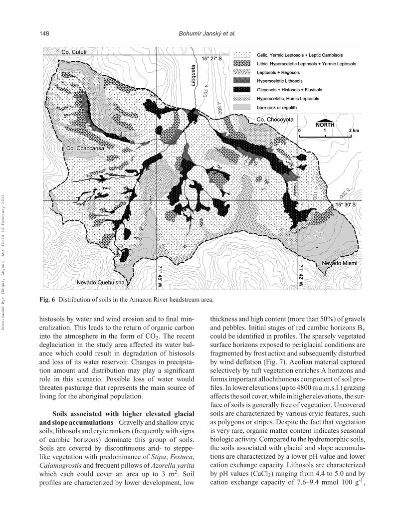
In the Carhuasanta and Apacheta river basins, 10 soilprofiles were identified, as shown in Fig. 6. Thesesoils represent the main vegetation formation, parentmaterial and relief, and may be divided into two maincategories according to their spatial distribution:
The association of hydromorphic soils Soilsare characterized by aquatic moisture regime, thepresence of peaty horizons and formation of diag-nostic horizons in oxidizing and reducing conditionsof mineral-rich material. Hydromorphic mineral soils(fluvisols and gleysols) associated with histosols cre-ate various soil groups. Profiles are generally deepand slightly gravelly, with lithological stratificationfeatures, resulting from fluvial and wind accumula-tion processes. These processes are still active accord-ing to the existence of slightly decayed organic matterbeneath the mineral horizons of various thicknesses.Rhythmic layering of fibric, mesic and humic organichorizons and mineral horizons in deep profiles ofhistosols indicate highly dynamic geomorphologicalprocesses, such as erosion, mudflows or landslides.Cryoturbation of horizons is rare because of the pro-tective influence of champa vegetation. Only lowercategories of soil classification reflect (in the formof diagnostic features) the influence of seasonal frostaction. However, the ground is frozen only during thecoldest months and soils developed in non-permafrostconditions recently. Resulting soil groups are local-ized to valley-floor and slope depressions. Histosolsof champa type vegetation rank among valley bogswith predominance of Dystichia muscoides.
Soil properties were determined using labora-tory analyses. These studies found that the gravelcontent in homogeneous organic layers ranged from15 to 20%. Porosity ranged from 96 to 97% andvery low bulk density (0.05 g cm-3) resulted in highwater-holding capacity of soils. The percentage of drymatter and maximal water-holding capacity thereforereached 60%. In the study area the soil associations ofdescribed physical properties were recorded up to thedepth of 12 m, considering the fact that depth variessubstantially as the result of irregular accumulation ofaeolian and fluvial sediments. On the basis of depthmeasurements at 40 sites the mean depth of organiclayer was calculated to be 1.5 m. Using this value,the total amount of organic matter in the area wascalculated (24 × 106 m3), along with carbon content(15·103 kg) and maximum capacity of water reten-tion (21–23 × 106 m3). According to radiocarbon datafrom the Apacheta River valley, the uppermost part ofthe hydromorphic soil (1.5 m deep) originated since2200 years BP.
Histosols in champa formation are a very impor-tant landscape element for sequestration of organiccarbon. Loss of living photosynthesizing plantscaused by drying leads to progressive destruction of
Downloaded By: [Engel, Zbynek] At: 12:24 14 February 2011
148 Bohumír Janský et al.
Fig. 6 Distribution of soils in the Amazon River headstream area.
histosols by water and wind erosion and to final min-eralization. This leads to the return of organic carboninto the atmosphere in the form of CO2. The recentdeglaciation in the study area affected its water bal-ance which could result in degradation of histosolsand loss of its water reservoir. Changes in precipita-tion amount and distribution may play a significantrole in this scenario. Possible loss of water wouldthreaten pasturage that represents the main source ofliving for the aboriginal population.
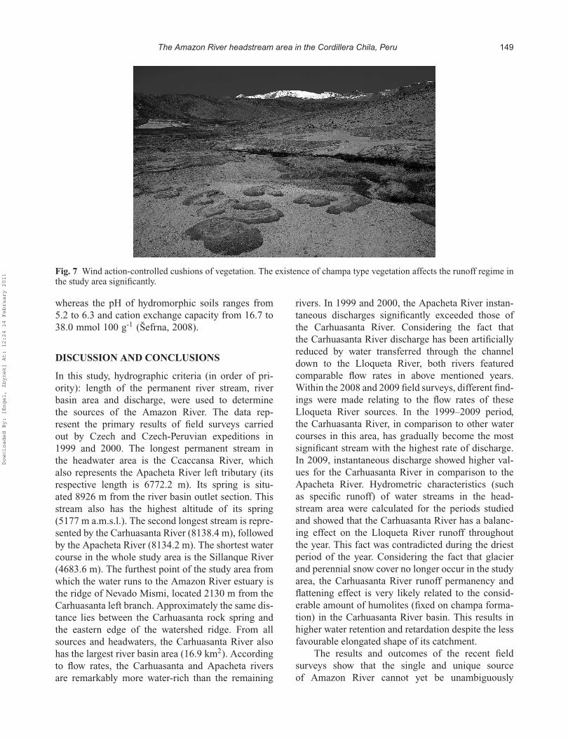
Soils associated with higher elevated glacialand slope accumulations Gravelly and shallow cryicsoils, lithosols and cryic rankers (frequently with signsof cambic horizons) dominate this group of soils.Soils are covered by discontinuous arid- to steppe-like vegetation with predominance of Stipa, Festuca,Calamagrostis and frequent pillows of Azorella yaritawhich each could cover an area up to 3 m2. Soilprofiles are characterized by lower development, low
thickness and high content (more than 50%) of gravelsand pebbles. Initial stages of red cambic horizons Bv
could be identified in profiles. The sparsely vegetatedsurface horizons exposed to periglacial conditions arefragmented by frost action and subsequently disturbedby wind deflation (Fig. 7). Aeolian material capturedselectively by tuft vegetation enriches A horizons andforms important allochthonous component of soil pro-files. In lower elevations (up to 4800 m a.m.s.l.) grazingaffects the soil cover,while inhigherelevations, the sur-face of soils is generally free of vegetation. Uncoveredsoils are characterized by various cryic features, suchas polygons or stripes. Despite the fact that vegetationis very rare, organic matter content indicates seasonalbiologic activity. Compared to the hydromorphic soils,the soils associated with glacial and slope accumula-tions are characterized by a lower pH value and lowercation exchange capacity. Lithosols are characterizedby pH values (CaCl2) ranging from 4.4 to 5.0 and bycation exchange capacity of 7.6–9.4 mmol 100 g-1,
Downloaded By: [Engel, Zbynek] At: 12:24 14 February 2011
The Amazon River headstream area in the Cordillera Chila, Peru 149
Fig. 7 Wind action-controlled cushions of vegetation. The existence of champa type vegetation affects the runoff regime inthe study area significantly.
whereas the pH of hydromorphic soils ranges from5.2 to 6.3 and cation exchange capacity from 16.7 to38.0 mmol 100 g-1 (Šefrna, 2008).
DISCUSSION AND CONCLUSIONS
In this study, hydrographic criteria (in order of pri-ority): length of the permanent river stream, riverbasin area and discharge, were used to determinethe sources of the Amazon River. The data rep-resent the primary results of field surveys carriedout by Czech and Czech-Peruvian expeditions in1999 and 2000. The longest permanent stream inthe headwater area is the Ccaccansa River, whichalso represents the Apacheta River left tributary (itsrespective length is 6772.2 m). Its spring is situ-ated 8926 m from the river basin outlet section. Thisstream also has the highest altitude of its spring(5177 m a.m.s.l.). The second longest stream is repre-sented by the Carhuasanta River (8138.4 m), followedby the Apacheta River (8134.2 m). The shortest watercourse in the whole study area is the Sillanque River(4683.6 m). The furthest point of the study area fromwhich the water runs to the Amazon River estuary isthe ridge of Nevado Mismi, located 2130 m from theCarhuasanta left branch. Approximately the same dis-tance lies between the Carhuasanta rock spring andthe eastern edge of the watershed ridge. From allsources and headwaters, the Carhuasanta River alsohas the largest river basin area (16.9 km2). Accordingto flow rates, the Carhuasanta and Apacheta riversare remarkably more water-rich than the remaining
rivers. In 1999 and 2000, the Apacheta River instan-taneous discharges significantly exceeded those ofthe Carhuasanta River. Considering the fact thatthe Carhuasanta River discharge has been artificiallyreduced by water transferred through the channeldown to the Lloqueta River, both rivers featuredcomparable flow rates in above mentioned years.Within the 2008 and 2009 field surveys, different find-ings were made relating to the flow rates of theseLloqueta River sources. In the 1999–2009 period,the Carhuasanta River, in comparison to other watercourses in this area, has gradually become the mostsignificant stream with the highest rate of discharge.In 2009, instantaneous discharge showed higher val-ues for the Carhuasanta River in comparison to theApacheta River. Hydrometric characteristics (suchas specific runoff) of water streams in the head-stream area were calculated for the periods studiedand showed that the Carhuasanta River has a balanc-ing effect on the Lloqueta River runoff throughoutthe year. This fact was contradicted during the driestperiod of the year. Considering the fact that glacierand perennial snow cover no longer occur in the studyarea, the Carhuasanta River runoff permanency andflattening effect is very likely related to the consid-erable amount of humolites (fixed on champa forma-tion) in the Carhuasanta River basin. This results inhigher water retention and retardation despite the lessfavourable elongated shape of its catchment.
The results and outcomes of the recent fieldsurveys show that the single and unique sourceof Amazon River cannot yet be unambiguously
Downloaded By: [Engel, Zbynek] At: 12:24 14 February 2011
150 Bohumír Janský et al.
identified. Particular criteria support two of the fourheadstreams, namely the Carhuasanta and Ccaccansarivers, as being the more likely sources. When com-pared, the Carhuasanta River has a prevailing role as ithas the largest river basin area and flow rate. The fur-thest point from which the water flows down to theAtlantic Ocean, is also situated in its basin. On theother hand, the permanent stream of the CcaccansaRiver is the longest. As the main source of theAmazon River cannot be unambiguously determined,we suggest that the northern hillside of the CordilleraChila massif, with an area of 57.1 km2, and theconfluence of four courses (Carhuasanta, Apacheta,Ccaccansa and Sillanque rivers) feeding the LloquetaRiver, should be regarded as the headwater territoryof the Amazon River.
In order to assess the possible reaction of runoffconditions to recent deglaciation and snow line reces-sion in this area, linear trend analysis of dailyand monthly discharges was determined throughoutthe monitored period. Decreasing effect in a runoffhydrogram is probably caused by seasonal snow covervariations and precipitation character. This fact couldalso support the hypothesis that runoff conditionsreflect the recent deglaciation (finished in 2007) andsnow line recession in the area of the Nevado Mismimassif. Undoubtedly, the relatively short dischargetime series has to be considered while stating finalfindings. The present network of automatic hydrolog-ical and meteorological gauges in this area representsvery favourable conditions for the detailed analysesof the runoff ascending and descending phases andrelated partial goals.
Since 1955, the glaciers in the observed areahave undergone rapid retreat: glaciers experienceda 60% decrease in surface area over the 20th cen-tury disappearing completely between 2000 and 2007.The deglaciation of the study area is consistent withobservations of glacier retreat in other regions of thePeruvian Andes. The rate of glacier recession overthe 20th century is similar to the retreat of glaciersin the Cordillera Blanca, where 60% decrease inglaciated area was observed between 1962 and 1999(Mark, 2002). The progressive melting of glaciersin the study area at the beginning of the 21st cen-tury coincides with accelerated rates of glacier retreatthat are well documented at high altitude through-out the tropics (Georges, 2004; Thompson et al.,2006).
Climatic and geomorphological conditions arethe most decisive factors of the soil development.The variability in soil texture reflects aeolian and
fluvial transport of the weathering products andeasily decaying parent material (tuffs). Soils arepredominantly sandy to loamy and pH decreases fromwatershed areas towards valley floors. Champa-typevegetation and more or less developed histosols con-tain significant amounts of organic matter and rep-resent a vast water retention space. Soils could beranked among two different associations: (a) cryicsoils, organic soils, fluvisols and transitional groupsof these soils tied to water saturated relief depres-sions; and (b) cryic soils, lithosols and cryic rankerson slopes and convex surfaces of landscape includinglower elevated watershed plateaus.
Acknowledgements This research was funded by theCzech Science Foundation Project “Natural Hazardsof the Amazon River Source Territory Caused by theGlobal Climatic Changes” (205/07/831) and by theCzech Ministry of Education Project “GeographicalSystems and Risk Processes in the Context ofGlobal Change and European Integration” (MSM0021620831), Czech Republic.
REFERENCES
Ames, A. (ed.) (1989) Glacier Inventory of Peru. Part II . Huaraz:Hidrandina S.A.
Cesák, J. & Janský, B. (2008) Laguna “Bohemia”. In: Los Orígenesdel Amazonas (B. Janský, ed.), 231–232. Praha: OttovoNakladatelství.
Davila, M. D. (1988) Geología del Cuadrángulo de Cailloma (Hoja31-s). Lima: INGEMET, Boletín no. 40, Serie A.
Engel, Z. (2002) Geomorphology of the Amazon source area in theCordillera Chila. Acta Montana Ser. A 19(123), 91–108.
Encyclopaedia Britannica (2001) Chicago: Macropaedia.Georges, C. (2004) 20th-century glacier fluctuations in the tropical
Cordillera Blanca, Peru. Arctic, Antarctic, and Alpine Res. 35,100–107.
Gicklhorn, J. & Gicklhorn, R. (1943) In Kampf um denAmazonenstrom. (Das Forschungschicksal des P. Samuel Fritz).Praha: Noebe & Co.
Goicochea, Z. I. N. (1997) El Origen del Río Amazonas. Lima:Pontificia Universidad Católica del Perú.
Hardolph, A. W., Alan, H. C., Edward, F. & Robert, J. L. (1995)Grenvillian granulite-facies metamorphism in the ArequipaMassif, Peru: a Laurentia-Gondwana link. Earth and Planet.Sci. Let. 132, 63–73.
Janský, B. (2001) Nuevo levantamiento geodésico—hidrográfico delos orígenes del Amazonas. Rev. Geogr. 128, 151–164.
Janský, B., Castro, D. D., Cesák, J., Engel, Z., Jakeš, P., Kastner, J.,Korínek, V., Kupcík, I., Penaherrera del Águila, C. &Šefrna, L. (2008) Los Orígenes del Amazonas. Praha: OttovoNakladatelství.
Johnson, A. M. (1976) The climate of Peru, Bolivia and Ecuador. In:Climates of Central and South America (W. Schwerdtfeger, ed.),147–218. Amsterdam: Elsevier.
Kastner, J. (2008) Condiciónes climáticas. In: Los Orígenesdel Amazonas (B. Janský, ed.), 208–213. Praha: OttovoNakladatelství.
Downloaded By: [Engel, Zbynek] At: 12:24 14 February 2011
The Amazon River headstream area in the Cordillera Chila, Peru 151
Lettau, H. (1976) Dynamic and energetic factors which cause andlimit aridity along South America’s Pacific coast. In: Climates ofCentral and South America. (W. Schwerdtfeger, ed.), 188–192.Amsterdam: Elsevier.
Mark, B. (2002) Observations of modern deglaciation and hydrol-ogy in the Cordillera Blanca. Acta Montana Ser. A 19(123),23–36.
Palacios, M. O. (1991) Geología del Cuadrángulo de Chivay. Lima:INGEMET, Boletín no. 42, Serie A. Hoja 32-s.
Palkiewicz, J. (1997) Towards the Origin—In Search of the Amazon,the Most Extraordinary Rriver on Earth. Lima: El Dorado.
Peñaherrera, C. (1969) Geografía General del Perú. Tomo I,.Aspectos Físicos. Lima: Editorial Ausonia Talleres Graficos.
Šefrna, L. (2001) Pramen Amazonky (Amazon sources). Vesmír80(2), Prague, 95–101 (in Czech).
Šefrna, L. (2008) Los suelos y la biósfera en la región de las nacientesdel Amazonas. In: Los Orígenes del Amazonas (B. Janský, ed.),196–207. Praha: Ottovo Nakladatelství.
Thompson, L. G., Mosley-Thompson, E., Brecher, H., Davis, M. E.,Léon, B., Les, D., Lin, P. N., Mashiotta, T. A. & Mountain, K.(2006) Abrupt tropical climate change: Past and present. PNAS103(28), 10536–10543.
Downloaded By: [Engel, Zbynek] At: 12:24 14 February 2011
Top Related
Copyright © 2022 FDOKUMEN

