TV to Angola - International Hydrographic Organization
23
IHO Capacity Building Programme The State of Hydrography and Nautical Charting in the Republic of Angola September 2018
-
Upload
khangminh22 -
Category
Documents
-
view
2 -
download
0
Transcript of TV to Angola - International Hydrographic Organization

IHO Capacity Building Programme
The State of
Hydrography and Nautical Charting
in the
Republic of Angola
September 2018

2
INTENTIONALLY BLANK

3
Contents
Contents ...................................................................................................................................................3
Abbreviations ..........................................................................................................................................4
Executive Summary ...............................................................................................................................5
1. Introduction ...................................................................................................................................7
2. IHO Technical Visit .......................................................................................................................7
3. Assessment of the Previous Technical Visit .................................................................................8
4. Angola Hydrographic Assessment ...............................................................................................9
4.1 National Hydrographic Awareness ............................................................................................ 9
4.2 National Hydrographic Authority and Infrastructure ................................................................ 9
4.3 Maritime Safety Information (MSI) ............................................................................................ 9
4.4 Hydrographic Surveying .......................................................................................................... 10
4.5 Nautical Charting ..................................................................................................................... 10
4.6 Hydrographic Resources .......................................................................................................... 10
4.7 Additional stakeholders .......................................................................................................... 101
5. A Way Ahead .............................................................................................................................111
5.1 Maritime Safety Information .................................................................................................. 111
5.2 National Hydrographic Surveying and Charting ................................................................... 112
5.3 Bilateral Arrangements for Surveying and Charting ............................................................. 122
5.4 National Hydrographic Committee ........................................... Error! Bookmark not defined.2
5.5 National Hydrographic Capability Development ................................................................... 122
6. Technical Visit Conclusions ......................................................................................................133
7. Technical Visit Recommended Actions ...................................................................................133
Annexes
A-Technical Visit Programme .............................................................................................................16
B- Workshop Programme ....................................................................................................................17
C-List of Contacts .................................................................................................................................18
D-C-55 Input from Portugal ................................................................................................................19
E-Charting Analysis of Angola Waters ............................................................................................211

4
Abbreviations
AN Angolan Navy
CBSC Capacity Building Sub-Committee
DH Angolan Navy Direction of Hydrography
DHN Brazilian Directorate of Hydrography and Navigation
EEZ Exclusive Economic Zone
ENC Electronic Navigational Chart
IH Portugal Hydrographic Institute
IHO International Hydrographic Organization
IHSMA Hydrography and Marine Signalization Institute of Angola
IMO International Maritime Organization
IMPA Maritime and Harbours Institute of Angola
MBES Multi-Beam Echo Sounder
MPM Ministry of Fishery and Sea
MRMP Ministry of Mineral Resources and Petroleum
MSI Maritime Safety Information
MT Angolan Ministry of Transports
NHS National Hydrographic Service
NHC National Hydrographic Committee
NtMs Notice to Mariners
PCA Primary Charting Authority
RHC Regional Hydrographic Commission
RNC Raster Navigational Chart
SAIHC Southern African & Islands Hydrographic Commission
SBES Single Beam Echo Sounder
SOLAS United Nations Convention for the Safety of Life at Sea
UKHO United Kingdom Hydrographic Office
UNCLOS United Nations Convention on the Law of the Sea
WMO World Meteorological Organization
WWNWS Worldwide Navigation Warning Service

5
Executive Summary
The Hydrography and Marine Aids to Navigation Institute of Angola (IHSMA), from Republic of
Angola, sent an invitation to IHO requesting a technical visit to assess the current status of nautical
charting and hydrography in the country and to provide advice to the government and to stakeholders
on a way ahead. The visiting team was defined to be comprised by Brazil and the International
Hydrographic Organization (IHO) Secretariat.
The Republic of Angola received a previous IHO Technical Visit in 2008. Report of this visit may be
viewed on the IHO website at http://www.iho.int/mtg_docs/CB /CBA_TechnicalVisits.htm.
The Republic of Angola has been a member of the International Maritime Organization (IMO) since
1977 and is a signatory to the SOLAS Convention, but is not a member of the International Hydrographic
Organization (IHO). It has associated member status within the SAIHC. In general, there is small
awareness in Angola regarding the obligations and provisions under SOLAS Chapter V, Regulations 4
and 9 to ensure that appropriate hydrographic and charting services are made available. IHSMA is trying
to raise this level by several means including the Workshop held on 27 September, during the Technical
Visit.
The Government of Angola, through its various agencies, does not have an adequate level of awareness
of the current state of hydrography and nautical charting in their country and the benefits of modern
hydrography for economic growth, safety of navigation and protection of the marine environment.
Awareness was heightened at the working level by the visit of the IHO Technical Team.
IHSMA was created in 2003 and implemented in 2011. It assumed main responsibility for national
hydrography and nautical cartography development in Angola. The IHO Team considers that IHSMA
staff, in all levels, is fully aware of the national responsibility and takes intense effort in its successful
delivery. However, IHSMA does not have trained hydrographic surveyors nor nautical cartographers.
Angola has currently no national capability for nautical chart production. Portugal Hydrographic
Institute (IH) has produced Nautical Charts for the region and ENCs have been produced by UKHO.
The nautical charts have not been updated with new surveys and coastline and bathymetric information
in the charts are generally outdated. A comprehensive resurvey and chart updating programme is
required so to contribute to a modern maritime and port infrastructure and to allow Angola to fulfil its
international obligations in accordance with Regulations 4 and 9 of Chapter V of the SOLAS
Convention. No formal agreement was identified between IHSMA, IH and UKHO.
There are some recent surveys in the country, conducted in the last years, by private companies, mainly
to address the needs of National Ports and Offshore Companies. However, not all of them were
promulgated for mariners nor have updated nautical charts. Regulation and its implementation are
needed to guarantee that relevant information is forwarded to IHSMA in order to update nautical
documents and for dissemination of maritime safety information (MSI). Training is also needed in order
for IHSMA to be able to process data that can be collected by its survey boats.
IHSMA is the National Maritime Safety Information (MSI) coordinator in Angola. It receives reports
from Angola´s Maritime Authority, the Maritime and Harbours Institute of Angola (IMPA), about
navigational information and from INAMET (National Institute of Meteorology) about meteorological
information. Although it sends some information to NAVAREA VII coordinator and IH as Primary
Charting Authority (PCA) of the area, there is no broadcast of MSI by NAVTEX. The capacity of local
warnings broadcast was lost with the change of local legislation in the last 20 years that did not establish
a competent structure to be responsible for this service. This means that mariners may not be aware of
new navigationally significant information before they arrive in Angola nor do the existing charts
contain these information. The establishment of local and coastal warnings broadcast structure should
be considered a high priority in the development of MSI in Angola, but until this has been achieved all
local and coastal warnings should be transmitted to the NAVAREA VII coordinator for promulgation.
It was evident to the visiting team that Angola already possesses some hydrographic capability,
awareness and willingness, and the effective cooperation and coordination of the national activities will

6
prove a positive step towards Angola to build a solid maritime infrastructure to support the safety of
navigation and economic growth.

7
REPORT
1. Introduction
The International Hydrographic Organization (IHO) is an intergovernmental international organization,
currently comprising 89 Member States. The IHO seeks to ensure that all States with coastlines and
maritime interests provide adequate and timely hydrographic data, products and services, thereby
advancing maritime safety and efficiency in support of the protection and sustainable use of the marine
environment. The United Nations recognizes the IHO as the competent authority for hydrography and
nautical charting. The Secretariat of IHO is based in Monaco. The Republic of Angola is not currently
a member of IHO.
The IHO has encouraged the establishment of Regional Hydrographic Commissions (RHCs) to
coordinate hydrographic activity and cooperation at the regional level. Full Members of RHCs are IHO
Member States; however, other States can also participate as Associate Members or Observers. RHCs
work in close cooperation with the Organization to help further achieve its goals and programs. RHCs
meet at regular intervals to coordinate hydrographic and chart production, plan joint survey operations,
and resolve schemes for International Chart coverage in their regions. Angola is an Associate Member
of the Southern Africa and Islands Hydrographic Commission (SAIHC).
This report has been written with the express intention of assisting the Government of Angola, in
particular its National Hydrographic Service, IHSMA, to strengthen and develop its hydrographic
capability to meet its current and future needs and its international maritime obligations under the UN
Convention for the Safety of Life at Sea (SOLAS). The report comprises a description of the visit, major
conclusions and a number of recommended actions for consideration by the relevant organizations.
The report is supported by various Annexes providing detailed information obtained in the visit, an
analysis of the existing charting situation and surveys, and recommendations for the strengthening of
national hydrography in the Republic of Angola.
2. IHO Technical Visit
A request for a high-level visit to the Republic of Angola by IHO was made by IHSMA Letter
0132/14.03/2018, dated 4 July 2018 to support the development of the national infrastructure of Angola
in order to: meet the obligations arising from the SOLAS Convention, Chapter V, to ensure the
preservation of the marine environment and to support the national economic development. The visit
was confirmed by IHO letter S1/4630, dated 6 July 2018, establishing the period 25 to 28 September for
the visit that would also be used for a technical visit for the country funded by the Capacity Building
Sub-Committee (CBSC).
The IHO Team first called on the Director General of IHSMA, Mr Manuel Narciso. The main meetings
were held at IHSMA facilities, and headquarters of the visit stakeholders in Luanda.
The meetings enabled the IHO Team to build up a picture of the conspicuous features of the
hydrographic activities. The meetings also facilitated the appreciation of data availability and data
sharing amongst the national representatives. It was clear to the visiting team that most of stakeholders
that were visited were well prepared for the meetings and able to actively interact with the team.

8
This resulting report has been written with the express intention of assisting the Government of Angola
to develop and strengthen its hydrographic capability to meet its current and future needs and also its
international maritime obligations under the SOLAS Convention. The report comprises a description of
the visit, a brief assessment of the current situation and an analysis of the nation’s hydrographic needs,
major conclusions and a number of recommended actions for consideration by the relevant authorities.
Annex A to this report presents the Technical Visit Programme. Annex B contains the Workshop
Programme held by IHSMA during the visit. Annex C describes the points of contact of the
organizations visited and considered during the period.
3. Assessment of the Previous Technical Visit
The Republic of Angola received a previous IHO Technical Visit in 2008. The Report of this visit may
be viewed on the IHO website at https://www.iho.int/mtg_docs/CB/Assessment_Reports.htm [accessed
15 Jul 2018]. The report generated from this visit has been consulted in the preparation of this report.
Recommendations that have been made following previous technical visit to Angola are summarized
under the key headings below with an assessment of progress made with each item.
• National Hydrographic Committee: The visiting team strongly recommended the creation of a
National Hydrographic Committee. Although IHSMA and its responsibilities were well established
by law in 2015, the need of coordination with other governmental institutions and the lack of
regulation of how IHSMA will handle its hydrographical responsibilities still keep the establishment
of a National Hydrographical Committee as a prime necessity in Angola.
• Maritime Safety Information (MSI): It was recommended the development of a plan for
implementation of a robust organization for MSI and GDMSS. Until this moment no progress was
made in this regard. IHSMA still needs to take the necessary steps to nominate a National
Coordinator to liaise with the NAVAREA VII Coordinator and to establish procedures for updating
charts and nautical documents.
• Hydrographic Survey related capabilities: The report recommended IHSMA should take the
responsibility to be the national manager of all hydrographic data collected in Angolan waters and
establish a data management system. It also recommended IHSMA to create a small survey team to
gain experience in hydrographic surveying. Although a law has established IHSMA as the national
manager for all hydrographic data in 2015, no implementation of regulation that allows the survey
data to be received by IHSMA, or progress in a data management system was made. Survey boats
and equipment had been acquired, but there still remain the need of more expertise to achieve its
purpose of a well-established small survey team. There are still huge requirements related with
coordination regarding use and installation of tide gauges in Angola.
• Training: The need for training remains one of the issues of Hydrography in Angola. IHSMA has
requested the Brazilian Hydrographic Service, Directorate of Hydrography and Navigation (DHN)
for 4 places in hydrographic courses in Brazil during 2019 in order to train its personnel.
• Funding: The report stated that IHSMA, in order to be fully operational in its activities, would
require comprehensive economical support from the Angolan Government/ Ministry of Transport
(MoT) for several years. Some investments were made by the acquisition of buoys and survey
vessels. There is still need of legal arrangements to allow IHSMA to receive money related to its
activities, such as lighthouses fees. Some of the fees are still been received by other Angolan
institutions, such as IMPA, that were previously responsible for IHSMA tasks before its creation.
4. Angola Hydrographic Assessment
The following is a general assessment of the situation in Angola regarding hydrography and nautical
charting services.
4.1 National Hydrographic Awareness
9
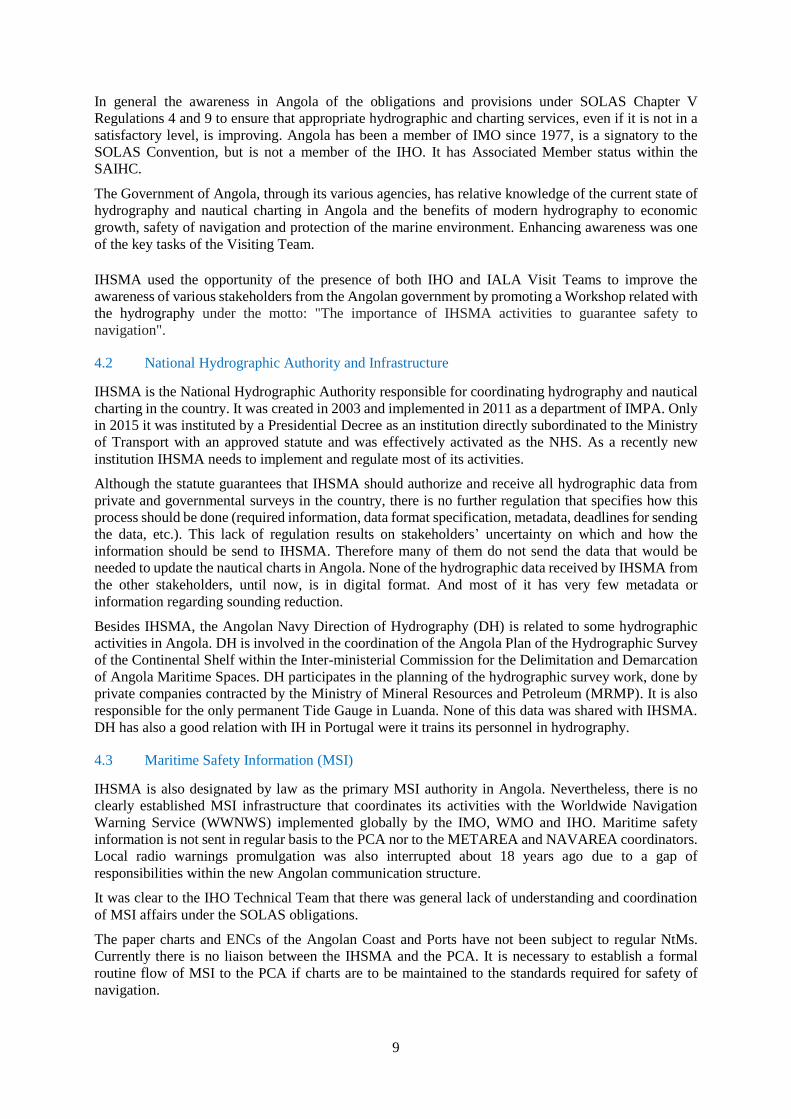
In general the awareness in Angola of the obligations and provisions under SOLAS Chapter V
Regulations 4 and 9 to ensure that appropriate hydrographic and charting services, even if it is not in a
satisfactory level, is improving. Angola has been a member of IMO since 1977, is a signatory to the
SOLAS Convention, but is not a member of the IHO. It has Associated Member status within the
SAIHC.
The Government of Angola, through its various agencies, has relative knowledge of the current state of
hydrography and nautical charting in Angola and the benefits of modern hydrography to economic
growth, safety of navigation and protection of the marine environment. Enhancing awareness was one
of the key tasks of the Visiting Team.
IHSMA used the opportunity of the presence of both IHO and IALA Visit Teams to improve the
awareness of various stakeholders from the Angolan government by promoting a Workshop related with
the hydrography under the motto: "The importance of IHSMA activities to guarantee safety to
navigation".
4.2 National Hydrographic Authority and Infrastructure
IHSMA is the National Hydrographic Authority responsible for coordinating hydrography and nautical
charting in the country. It was created in 2003 and implemented in 2011 as a department of IMPA. Only
in 2015 it was instituted by a Presidential Decree as an institution directly subordinated to the Ministry
of Transport with an approved statute and was effectively activated as the NHS. As a recently new
institution IHSMA needs to implement and regulate most of its activities.
Although the statute guarantees that IHSMA should authorize and receive all hydrographic data from
private and governmental surveys in the country, there is no further regulation that specifies how this
process should be done (required information, data format specification, metadata, deadlines for sending
the data, etc.). This lack of regulation results on stakeholders’ uncertainty on which and how the
information should be send to IHSMA. Therefore many of them do not send the data that would be
needed to update the nautical charts in Angola. None of the hydrographic data received by IHSMA from
the other stakeholders, until now, is in digital format. And most of it has very few metadata or
information regarding sounding reduction.
Besides IHSMA, the Angolan Navy Direction of Hydrography (DH) is related to some hydrographic
activities in Angola. DH is involved in the coordination of the Angola Plan of the Hydrographic Survey
of the Continental Shelf within the Inter-ministerial Commission for the Delimitation and Demarcation
of Angola Maritime Spaces. DH participates in the planning of the hydrographic survey work, done by
private companies contracted by the Ministry of Mineral Resources and Petroleum (MRMP). It is also
responsible for the only permanent Tide Gauge in Luanda. None of this data was shared with IHSMA.
DH has also a good relation with IH in Portugal were it trains its personnel in hydrography.
4.3 Maritime Safety Information (MSI)
IHSMA is also designated by law as the primary MSI authority in Angola. Nevertheless, there is no
clearly established MSI infrastructure that coordinates its activities with the Worldwide Navigation
Warning Service (WWNWS) implemented globally by the IMO, WMO and IHO. Maritime safety
information is not sent in regular basis to the PCA nor to the METAREA and NAVAREA coordinators.
Local radio warnings promulgation was also interrupted about 18 years ago due to a gap of
responsibilities within the new Angolan communication structure.
It was clear to the IHO Technical Team that there was general lack of understanding and coordination
of MSI affairs under the SOLAS obligations.
The paper charts and ENCs of the Angolan Coast and Ports have not been subject to regular NtMs.
Currently there is no liaison between the IHSMA and the PCA. It is necessary to establish a formal
routine flow of MSI to the PCA if charts are to be maintained to the standards required for safety of
navigation.

10
The Technical Team recommended that a regulation and definition of how MSI will flow to both PCA
and NAVAREA coordinator is an urgent issue that has to be solved and that Angola may benefit from
valuable MSI training opportunities of the IHO Capacity Building Programme.
4.4 Hydrographic Surveying
Although some Angolan waters have been surveyed by IHSMA with modern standards, these surveys
were not saved in digital or analogic files that can be used for nautical charting.
Private companies have been conducting multi-beam echo sounder surveys in support of oil and gas
offshore activities. Also the MRMP has contracted hydrographic surveys to support Angola´s claim to
the Commission on the Limits of the Continental Shelf. Currently, there is no formal mechanism in place
to ensure that this data is brought to the attention of and made available to IHSMA and other relevant
stakeholders.
The current state of surveys as summarized in IHO Publication C-55 "Status of Hydrographic Surveying
and Nautical Charting Worldwide" (updated by IH in 02 May 2016) is in the table below:
Survey Coverage A B C
Depths < 200m 50 48 2
Depths > 200m 3 10 87
A= percentage which is adequately surveyed.
B= percentage which requires re-survey at larger scale or to modern standards.
C= percentage which has never been systematically surveyed.
Annex D presents the complete table of C-55 related information as organized by IH.
4.5 Nautical Charting
Angola has no national capability for nautical chart or publication production at this stage. The Angolan
coast is currently covered by Portuguese and British charts, with data compiled from Portuguese Charts,
and twenty ENCs which are produced by Portugal (1), United Kingdom (16) and South Africa (3). The
existing charts published and maintained by the IH and UKHO do not necessarily contain the latest
navigationally significant information. The data from which the charts are compiled is noted as being in
many cases old, imperfect and with undefined geodetic reference systems.
Annex D presents the summary of the cartographic information (C-55) and Annex E the analysis of the
charts of the Angolan Waters.
4.6 Hydrographic Resources
IHSMA has very few trained hydrographers and nautical cartographers. Its personnel was trained more
than 2 decades ago and did not receive any further extensive training since then. IHSMA has requested
the Brazilian Hydrographic Service, Directorate of Hydrography and Navigation (DHN) for 4 places in
its hydrographic courses in Brazil, during 2019, in order to train its personnel.
Other trained personnel are in the Angolan Navy Direction of Hydrography (DH), which recently sent
people for courses in IH in Portugal. It is also responsible for keeping the only permanent tide gauge
installed in the country, but no data from it is shared with IHSMA.
IHSMA has recently acquired two boats for hydrographic purposes. The most important is Catamaran
KUANDA, received in 2017 and equipped with Kongsberg EM 2040C Multi-beam Echo Sounder
System with the full suite of supporting devices. The other one is a small motor boat that also can be
equipped with a portable Kongsberg EM 2040C Multi-beam Echo Sounder, owned by IHSMA that is
used in Luanda Port area surveys. Both of them are well manned and maintained.

11
Even if IHSMA has the resources for the surveys, it has no capability to archive and process the survey
data.
(1) The Angolan Ministry of Fishery and Sea will receive, at the end of 2018, the 74 meters scientific
research vessel BAIA FARTA equipped, besides other scientific gear, with a Kongsberg EM 122 Multi-
beam Echo Sounder. It is recommended that IHSMA should arrange a bilateral agreement with MPM
in order to allow the use of this research vessel also for the Angolan hydrographic needs.
4.7 Additional stakeholders
IMPA, as the National Maritime Authority, is another major stakeholder. It is responsible to receive and
concentrate all the information from the national ports that should update the nautical charts. A
regulation is needed to guarantee that this information will flow and reach IHSMA for this purpose.
5. A Way Ahead
5.1 Maritime Safety Information
Maritime Safety Information (MSI) is considered by the IHO as the first phase in hydrographic capacity
building and whilst the IHO Technical Team could see that progress has been made in this area it has
concerns that the national MSI system is not efficiently operating.
The IHO recommends that every coastal State should designate a national MSI coordinator. It is
recommended that IHSMA regulates how the MSI information will flow and the responsibilities
regarding this matter. In addition it is essential that IHSMA establish a focal point of contact to act as
the national MSI coordinator and a deputy point of contact to act as the national MSI coordinator during
the post holder’s absence and to assume the post in due course. Both persons will require the necessary
training which is frequently provided under IHO CB training activities. To assist in this the SAIHC CB
Coordinator should submit the MSI training requirement of Angola in the next CBSC meeting.
However, as all hydrographic and maritime stakeholders have an interest and input to MSI, a local
seminar should be organized to all these stakeholders enhancing awareness of what is MSI, how it is
disseminated and what their role is in this process.
The IHO Technical Team strongly recommends that a formal working relationship should be established
between the NAVAREA VII coordinator in South Africa and the national MSI coordinator. This
relationship should include regular contacts, allowing the NAVAREA VII coordinator to know that the
link is being maintained and become aware of the situation in Angola. It is also recommended that
IHSMA should seek the re-establishment of Luanda Radio for promulgating the local and coastal
warnings by radio.
The following contact information refers to the Navarea VII Coordinator:
NAVAREA Contact Information:
Address: South African Navy Hydrographic Office
Private Bag X1 Tokai
Cape Town 7966
South Africa
Contact details:
Operational Point of Contact of NAVAREA VII Coordinator:
Tel: / +27 21 787 2445 / +27 787 2408
5.2 National Hydrographic Surveying and Charting
The Republic of Angola has extensive hydrographic surveying needs. Surveys are inadequate and not
compliant to modern standards. The existing charts published and maintained do not necessarily contain

12
the latest navigationally significant information. The data from which the charts are compiled is noted
as being in many cases old, out-dated and on undefined geodetic reference systems. To assist in this
matter, IHO Technical Team recommended IHSMA to establish a Charting Plan and a Priority Survey
Plan. IHSMA may seek assistance from a well-established Hydrographic Service through a bilateral
agreement as an interim solution until the in-house survey, including data processing and storage, and
charting capacity is available.
5.3 Bilateral Arrangements for Surveying and Charting
Bilateral agreements with established hydrographic services are a valuable means of fulfilling SOLAS
obligations for countries with a limited and or developing hydrographic capability. Angola’s charts are
currently produced and published by IH and UKHO but the visiting team could not identify any formal
arrangement. It is recommended to Angola to formally designate the PCA and to establish a formal
bilateral agreement as an interim solution until the in-house chart production is established.
5.4 National Hydrographic Committee
It was evident to the visiting team that Angola, through IHSMA, already possesses hydrographic
capability, awareness and willingness. Effective cooperation and coordination with other national
agencies and stakeholders will prove a positive step towards the establishment of a formal regulation
regarding how hydrographic information should flow to IHSMA and will help Angola to build a solid
maritime infrastructure to support the safety of navigation and economic growth.
To coordinate hydrographic effort for the effective execution of SOLAS responsibilities and the efficient
management of a State's maritime area the IHO recommends the establishment of a National
Hydrographic Committee, possibly headed or secretariat by IHSMA as the national hydrographic
service, to provide input to future regulation and coordination of the hydrographic programme and
setting national charting and surveying priorities. In this way, the stakeholders are in a position to assist
in the continuing maintenance of the charts, longer term planning and perhaps also to the programme
budget.
All hydrographic stakeholders need to be involved in contributing to Angola national hydrographic
programme. This is not only to identify and prioritise national requirements, but also to contribute to the
execution of the programme. This could be through contributions in-kind, such as the provision of boats,
personnel or through contributions to enlist contract support – for example surveying areas targeted for
development. All stakeholders should be aware of the importance to forward all relevant hydrographic
information to the national coordinator for hydrography and charting, IHSMA.
The need for coordination of the national hydrographic effort was clearly demonstrated to the IHO
Technical Team. It is recommended that the regular meetings of the stakeholders are held as allowed
for in its terms of reference to make best use of Angola’s valuable hydrographic assets.
5.5 National Hydrographic Capability Development
Angola and IHSMA has significant national hydrographic resources but lacks a coordinated approach
to develop its staff and obtain the best results from the equipment available. There are people that studied
hydrography in DH but very few in IHSMA. Even though IHSMA has recently required seats in
Brazilian DHN courses, it is strongly recommended that NHS proposes a medium and long term
coordinated plan to ensure the formation of a satisfactory number of Category B hydrographic surveyors.
Such plan would provide the necessary professional experience to fulfil Angola´s hydrographic needs.
In addition it is recommended that, at least in the short term, using the National Hydrographic
Committee, all trained hydrographic governmental staff is considered as a national resource pool and
engage in survey operations that are taking place within the country – government and private ones – to
ensure that their professional development is maintained.
There are limited opportunities for international hydrographic training. A list of courses is contained in
IHO publication C-47 - Training Courses in Hydrography and Nautical Cartography, freely available

13
from the IHO website. The list of the FIG/IHO/ICA recognized programmes in Hydrography and
Nautical Cartography can be found in the IHO website under "Capacity Building". Short courses in the
fundamentals of hydrographic data gathering are available through the IHO Capacity Building
Programme for member states.
An additional source of capacity building is to include clauses in commercial survey contracts in the
country to include capacity building. This can be achieved by amending national regulations that control
surveys in the national territorial waters and the EEZ.
6. Technical Visit Conclusions
Based on discussions and the facts obtained, the following principal conclusions have been reached:
(1) There is limited relative awareness on the importance of hydrography in Angola and efforts are
been made to improve it.
(2) The Angolan existent hydrography related regulation is insufficient for IHSMA to effectively
implement and execute all the activities that are legally under its responsibility.
(3) An effective MSI service needs to be put in place in order to support the safety of navigation, the
safety of life at sea and the protection of the marine environment.
(4) IHSMA has well manned, maintained and equipped boats capable of meeting most of the nation’s
hydrographic immediate requirements. The Ministry of Fishery and Sea is acquiring a research vessel
that will be capable of deeper water surveys. IHSMA should arrange a bilateral agreement with MPM
in order to allow the use of this research vessel also for the Angolan hydrographic needs.
(5) A capacity building plan is necessary in order to provide the human resources for an effective
operation of IHSMA and achieve the goals it has envisioned.
(6) The charts covering Angola could be improved with data held by private companies and a better
coordination with relevant government stakeholders.
(7) The establishment of the National Hydrographic Committee, led by IHSMA, can provide the
framework to enhance cooperation amongst the various stakeholders.
(8) The Angolan government and in particular IHSMA have committed significant resources to the
establishment and maintenance of new hydrographic resources for the safety of navigation in Angola’s
waters and the economic development of the nation.
(9) Angola does not produce or maintain its paper charts and ENCs and has no formal agreement
with any PCA.
(10) IHSMA is going through a period of staff qualification and equipment acquisition which will
need careful handling to allow the organization to maintain its output and prepare for the future.
7. Technical Visit Recommended Actions
(1) IHSMA to establish the necessary regulation to meet the requirements for the collection and
circulation of nautical information, necessary to maintain existing charts and publications up to date.
This is the phase 1 of the capacity building and should be done as an immediate action,
(2) IHSMA to notify the SAIHC Chair the relevant contact information about the national coordinator
for MSI,
(3) SAIHC Chair to communicate to the NAVAREA VII Coordinator the relevant contact
information of the Angolan national coordinator for MSI,
(4) IHSMA to establish the necessary workflow with the NAVAREA VII coordinator and assure a
permanent flow of information,

14
(5) IHSMA to establish with IMPA a procedure on how to submit the relevant MSI to the National
MSI Coordinator,
(6) IHSMA to develop a National Maritime Safety Information Plan as a matter of priority and ensure
its execution,
(7) IHSMA to establish a MSI page on its website to publish the relevant MSI and Notices to Mariners
(NtMs),
(8) IHSMA to liaise with the PCA and other chart production nations to ensure that new
navigationally significant information is forwarded and included in existing charts of Angola;
(9) IHSMA to establish a formal agreement with MPM in order to employ the scientific research
vessel BAIA FARTA for hydrographic surveys, including the establishment of procedures to allow data
acquisition to modern standards, acquisition of software and hardware,
(10) IHSMA to establish a formal agreement within the Inter-ministerial Commission for the
Delimitation and Demarcation of Angola Maritime Spaces and MRMP to allow it to access and use past
hydrographic survey data used by both of these institutions.
(11) IHSMA to establish, a programme for the revision of all the published charts of Angola and a
priority programme for the surveys, and keep the chart producers informed,
(12) IHSMA to create a national programme to encourage all mariners and other interested parties to
report discrepancies on existing charts,
(13) IHSMA to coordinate the establishment of a network of tide gauges in the main ports and relevant
areas,
(14) IHSMA to promote the establishment of National Hydrographic Committee at the Government
level and constantly engage with the relevant stakeholders in order to coordinate the hydrographic
activities in a national level while contributing to the high level awareness,
(15) IHSMA to conduct a survey to identify all the relevant stakeholders that could potentially be part
of the NHC and those that can be beneficiaries of the hydrographic services and products,
(16) IHSMA to continue the effort to liaise with the foreign affairs Ministry of the Government of
Angola to send a letter to Government of Monaco to accede to the Convention on the IHO,
(17) IHSMA to allocate regular funding and travel support to fulfill the duties of the Service and to
represent Angola in appropriate international forums, and in particular, to attend relevant meetings of
IHO,
(18) IHSMA to apply to the SAIHC for the short term assistance of an established hydrographic service
to develop the national hydrographic infrastructure for Angola and the participation in a MSI course in
the following years,
(19) IHSMA to develop and monitor a coordinated training plan such that staff of the hydrographic
service and involved personal in the government can gain the necessary training and professional
experience,
(20) SAIHC CB coordinator to inform IHSMA regarding the CB training opportunities in the region
and elsewhere, especially if some is conducted in Portuguese language,
(21) IHSMA to profit from the training opportunities as approved in the IHO CB Work Programme,
especially those related to phase 1,

15
(22) IHSMA to request that national hydrographic services with staff experienced in MBES methods
be invited to Angola to review survey practices,
(23) IHSMA to establish a formal bilateral agreement with a well-established Hydrographic Service,
to be the PCA,
(24) IHSMA to make use of the IHO Publication M-2 (The Need for National Hydrographic Services)
for raising awareness throughout the country.

Annex B
16
Technical Visit Programme
MONDAY
(24.09.2018)
TUESDAY
(25.09.2018)
WEDNESDAY
(26.09.2018)
THURSDAY
(27.09.2018)
FRIDAY
(28.09.2018)
TIME ACTIVITY LOCAL ACTIVITY LOCAL ACTIVITY LOCAL ACTIVITY LOCAL ACTIVITY LOCAL
MORNING
MEETING WITH
IHSMA, ANGOLA
TELECOM AND
NAVY DH
IHSMA
VISITS TO THE PORT OF
LUANDA AND
TERMINALS
PORT
OF
LUANDA
MEETING WITH THE
MOMR, MPM AND
LOCAL MARITIME
AUTHORITY OF THE
PORT OF LUANDA
IHSMA/
PORT OF
LUANDA
WOKSHOP: THE IMPORTANCE OF
IHSMA ACTIVITIES IN THE
GUARANTEE FROM SAFE
NAVIGATION
PORT
OF
LUANDA
MEETING WITH STAFF
FOR FINAL BALANCE IHSMA
AFTERNOON
LABOR MEETING
WITH IMPA
FIELD VISIT (MARITIME
PASSENGER TERMS AND
NAVIGATION CHANNELS)
MT

Annex B
17
Workshop Program
08:30 - RECEPTION AND ACCOMMODATION OF GUESTS;
08:50 - ENTRY OF THE NATIONAL ANTHEM
09:00 - WELCOME - PCA OF THE PORT OF LUANDA
09:10 - OPENING ADDRESS OF IHSMA GENERAL DIRECTOR
09:30 - ACT CULTURE
09:50 – IHO PRESENTATION
10:40 - COFFE BREAK;
11:10 – IALA PRESENTATION
11:40 – BRAZILIAN DHN PRESENTATION
12:20 NEW CHALLENGES OF IHSMA AGAINST MARITIME PROJECTS, IT
S TECHNICAL AND HUMAN CAPACITY PRESENTATION
13:00 – THE BLUE ECONOMY PRESENTATION
13:40 - ADDRESS OF CLOSURE OF IHSMA GENERAL DIRECTOR;
14:00 - LUNCH;
END

Annex C
18
List of Contacts
Name Organization Telephone
Mobile or Fax
Postal Address
Email Address
Manuel Narciso
Instituto de Hidrografia e Sinalização Marítima de
Angola – General Diretor
+244 923562943 [email protected]
Hélder Rufino da Conceição Instituto de Hidrografia e Sinalização Marítima de
Angola – Adjunct General Director
+244 997612790 [email protected]
Doroteia Bonda Instituto de Hidrografia e Sinalização Marítima de
Angola – Head of Department of Oceanograhy
+244 933659202 [email protected]
Engrácia Manuel Instituto de Hidrografia e Sinalização Marítima de
Angola – Head of Adm. and Gen. Services Dep.
+244 941239762 [email protected]
Manuel Nazareth Neto Instituto Marítimo e Portuário de Angola – General
Director
+244 923659761 [email protected]
Henrique da Conceição Pedro Instituto Marítimo e Portuário de Angola – Capitania
do Porto de Luanda
+244 923429204 [email protected]
Sansão Pitra
Port of Luanda – Administrator of Engineering and
Technical Área
+ 244 926158198 [email protected]
Manuel Xavier Júnior
Ministry of Mineral Resources and Petroleum –
National Direction of Saftey, Quality, Emergency
And Environment
+ 244 226421360 [email protected]
Adilson Santos
Angola Telecom +244 222311288 [email protected]

Annex D
19
C-55 Input from Portugal

Annex D
20

Annex E
21
Charting Analysis of Angola Waters
1. Angola Chart Coverage
The Republic of Angola does not have a chart production capability and relies historically on the IH to
fulfil this function. The resume of chart coverage for Angola shown in IHO Publication C-55 - Status of
Nautical Charting (updated 02 May 2016) is shown in the table below, as updated by IH. There are no
significant gaps in coverage.
Chart Type % Covered by
INT Charts
% Covered by
RNCs
% Covered by
ENCs
Small Scale: Offshore Passage 100 0 N/A
Medium Scale: Landfall, Coastal Passage 60 0 N/A
Large Scale: Approaches and Ports 100 0 N/10
IHO C-55 Status of Chart Coverage
While C-55 shows that Angola is well covered by paper charts, it must be noted that the quality of the
underlying data is not adequate. The surveys were not done to modern standards. Even if there is no
information about ENCs in C-55, Angolan waters and ports are covered mostly by ENCs made by
UKHO.
2. IH Charts
The published charts and current state of maintenance is shown in the table below. Percentage of WGS84
charts are %17 and the percentage of metric charts are %100 of the portfolio.
IH Chart Title Scale Published
(Last Edition)
312 Ponta Albina à Foz do Cunene 1/200.000 -
334 Lucala à Pedra do Feitiço (Rio Zaire) 1/40.000 1975
334-A Lucala à Ponta Quiombe (Rio Zaire) 1/20.000 1972
334-B Ponta do Quiombe à Ponta das Palmeiras
(Rio Zaire) 1/20.000 1973
334-C Ponta das Palmeiras à Pedra do Feitiço (Rio
Zaire) 1/20.000 1973
333 Fuma-Fuma à Lucala (Rio Zaire) 1/40.000 1973
333-A Pendi à Lucala (Rio Zaire) 1/20.000 1972
332-A Baía de Diogo Cão (Rio Zaire) 1/15.000 1991
332 Foz ao Fuma-Fuma (Rio Zaire) 1/40.000 1991
356 Porto de Ambrizete 1/15.000 1955
357 Porto do Ambriz 1/10.000 1970
358 Enseada de Capulo 1/10.000 1955
359 Baía do Dande 1/15.000 1954
360 Porto de Luanda 1/15.000 1971
341 Baía do Dande ao Porto de Luanda 1/60.000 1992
342 Barras da Chicala e Corimba 1/15.000 1972
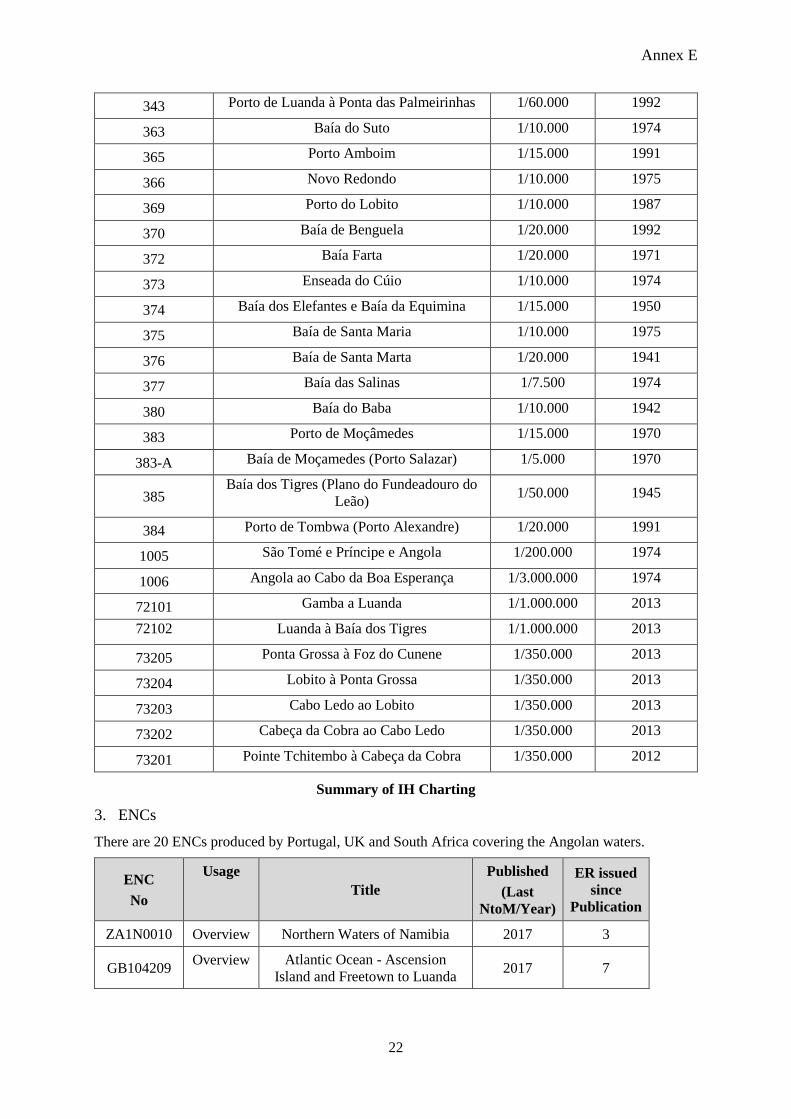
Annex E
22
343 Porto de Luanda à Ponta das Palmeirinhas 1/60.000 1992
363 Baía do Suto 1/10.000 1974
365 Porto Amboim 1/15.000 1991
366 Novo Redondo 1/10.000 1975
369 Porto do Lobito 1/10.000 1987
370 Baía de Benguela 1/20.000 1992
372 Baía Farta 1/20.000 1971
373 Enseada do Cúio 1/10.000 1974
374 Baía dos Elefantes e Baía da Equimina 1/15.000 1950
375 Baía de Santa Maria 1/10.000 1975
376 Baía de Santa Marta 1/20.000 1941
377 Baía das Salinas 1/7.500 1974
380 Baía do Baba 1/10.000 1942
383 Porto de Moçâmedes 1/15.000 1970
383-A Baía de Moçamedes (Porto Salazar) 1/5.000 1970
385 Baía dos Tigres (Plano do Fundeadouro do
Leão) 1/50.000 1945
384 Porto de Tombwa (Porto Alexandre) 1/20.000 1991
1005 São Tomé e Príncipe e Angola 1/200.000 1974
1006 Angola ao Cabo da Boa Esperança 1/3.000.000 1974
72101 Gamba a Luanda 1/1.000.000 2013
72102 Luanda à Baía dos Tigres 1/1.000.000 2013
73205 Ponta Grossa à Foz do Cunene 1/350.000 2013
73204 Lobito à Ponta Grossa 1/350.000 2013
73203 Cabo Ledo ao Lobito 1/350.000 2013
73202 Cabeça da Cobra ao Cabo Ledo 1/350.000 2013
73201 Pointe Tchitembo à Cabeça da Cobra 1/350.000 2012
Summary of IH Charting
3. ENCs
There are 20 ENCs produced by Portugal, UK and South Africa covering the Angolan waters.
ENC
No
Usage
Title
Published
(Last
NtoM/Year)
ER issued
since
Publication
ZA1N0010 Overview Northern Waters of Namibia 2017 3
GB104209 Overview Atlantic Ocean - Ascension
Island and Freetown to Luanda 2017 7

Annex E
23
GB104203 Overview South Atlantic Ocean - Saint
Helena and Lobito to Walvis Bay 2017 9
ZA2N0010 General Kunene River to Palgrave Point 2011 1
PT271101 General Lendana to BaIa dos Tigres 2017 3
GB200311 General Africa - West Coast - Pointe
Kouango to Pointe-Noire 2017 2
ZA3N0010 Coastal Kunene River to Sand Table Hill 2011 1
GB300310 Coastal Ponta Grossa to Kunene River 2017 2
GB300309 Coastal Lobito to Ponta Grossa 2016 2
GB300308 Coastal Angola - Cabo Sao Braz to Ponta
do Egito 2016 2
GB300307 Coastal Angola - N'zeto to Cabo Ledo 2017 5
GB300306
Coastal Congo - Angola and Congo
(Democratic Republic) - N'Kossa
Terminals to Cabeca da Cobra
2017 8
GB41215H Approach Africa - West Coast - Angola -
Enseada do Cuio 2016 3
GB41215G Approach Africa - West Coast - Angola -
Gunza-Kabolo (Novo Redondo) 2016 3
GB41215F Approach Africa - West Coast - Angola -
Baia de Santa Maria 2016 3
GB41215E Approach Angola - Porto do Lobito 2016 6
GB41215D Approach Africa - West Coast - Angola -
Porto Amboim 2016 4
GB41215C Approach Africa - West Coast - Angola -
Baia Farta 2016 3
GB41215B Approach Africa - West Coast - Angola -
Porto Alexandre 2016 3
GB41215A Approach Africa - West Coast - Angola -
Baia de Santa Marta 2016 3
Summary of ENC