


Bahasa
Halaman
Hukum


www.elsevier.com/locate/jgeoexp
Journal of Geochemical Exploration 84 (2004) 53–64
Strong arsenic enrichment in sediments
from the Elqui watershed, Northern Chile: industrial
(gold mining at El Indio–Tambo district) vs. geologic processes
R. Oyarzuna,*, J. Lillob, P. Higuerasc, J. Oyarzund, H. Maturanae
aDepartamento de Cristalografıa y Mineralogıa, Facultad de Ciencias Geologicas, Universidad Complutense de Madrid,
Ciudad Universidad avda/Complutense, 28040 Madrid, SpainbEscuela Superior de Ciencias Experimentales y Tecnologıa, Universidad Rey Juan Carlos, Tulipan s/n, 28933 Mostoles Madrid, SpaincDepartamento de Ingenierıa Geologica y Minera, Escuela Universitaria Politecnica de Almaden, Universidad de Castilla-La Mancha,
Plaza M. Meca 1, 13400 Almaden, SpaindDepartamento de Minas, Facultad de Ingenierıa and CEAZA, Universidad de La Serena, Casilla 554, La Serena, Chile
eDepartamento de Minas, Facultad de Ingenierıa, Universidad de La Serena, Casilla 554, La Serena, Chile
Received 1 October 2003; accepted 12 March 2004
Available online 10 May 2004
Abstract
Sediments from the Elqui watershed river system (9800 km2; northern Chile) are highly enriched in arsenic. The river
system initiates in the high altitude domain of the Andes (3500–4000 m) and drains important hydrothermal alteration zones
and epithermal deposits, including the copper-, and arsenic-rich gold veins of the well-known El Indio–Tambo district. In order
to study the extent, source, and age of contamination, we carried out a geochemical survey of stream sediments and older, Early
Holocene lacustrine sediments. The results reveal very high contents of arsenic in both, the stream (55–485 ppm As) and
lacustrine sediments (119–2344 ppm As). As shown by the ESEM-EDX study, arsenic is associated with the iron oxide mineral
phase. Given that arsenic is enriched in both the stream sediments and the Early Holocene sequence, we suggest that
contamination is not only industrial derived (mining operations), but also a major geological process, related to long-lived
erosion of the As-rich epithermal ores and alteration zones. Erosion in this realm is particularly important during El Nino years,
when increased activity of the Westerly winds brings intense rains, with catastrophic consequences in the Elqui watershed,
including the massive removal of sediments in the form of large debris flows.
D 2004 Elsevier B.V. All rights reserved.
Keywords: Arsenic; Chile; Elqui; Erosion; Contamination; Sediments; Gold mining; El Indio; El Nino
1. Introduction regarding human health. We present the results of a
Arsenic is one of the most toxic elements found in
nature, and constitutes one of the main concerns
0375-6742/$ - see front matter D 2004 Elsevier B.V. All rights reserved.
doi:10.1016/j.gexplo.2004.03.002
* Corresponding author. Tel.: +34-2437195.
E-mail address: [email protected] (R. Oyarzun).
stream sediment geochemical survey carried out in the
Coquimbo Region of Chile, that was aimed to study
the extent, source, and age of arsenic contamination in
the Elqui watershed (Fig. 1). The watershed covers an
area of about 9800 km2, and its main river (the Elqui)
constitutes one of the few water resources of this hilly,

Fig. 1. The Elqui watershed and sampling stations ESS 1–8 (stream sediments), including location of HLS samples (Holocene lacustrine sequence). ESS and HLS boxes: mean values
for As, Cu, and Zn (in ppm) and data for pH and dissolved oxygen (DO; in mg l-1). The shaded sector on the right corresponds to the area depicted in Fig. 2.
R.Oyarzu
net
al./JournalofGeochem
icalExploratio
n84(2004)53–64
54

R. Oyarzun et al. / Journal of Geochemical Exploration 84 (2004) 53–64 55
semiarid region of Chile. The Elqui watershed has
severe environmental problems regarding heavy metal
and arsenic contents in the stream sediments and
water (Maturana et al., 2001), but is not the only case
of arsenic contamination in northern Chile. The Loa
river, some 800 km to the north (Antofagasta Region),
displays even worse contamination problems, which
are enhanced by the extremely arid conditions of the
deep Atacama desert (e.g., Smedley and Kinniburgh,
2002; Romero et al. 2003; among others). Arsenic
contamination in the Elqui watershed, in both water
and sediments, has been assumed to be related to the
high-altitude mining operations of the El Indio–
Tambo district. However, as observed in other mining
districts (e.g., the mercury district of Almaden, Spain),
contamination is usually a combination of both natural
and anthropogenic processes (Higueras et al., 2003).
In the case of the Elqui watershed, there are two
probable sources of arsenic: (1) the mining activities
developed upstream along the high-altitude tributaries
(e.g., the Cu–As-rich gold ores from El Indio–Tambo
district); and (2) a high-altitude, 20-km-wide N–S
belt of hydrothermal alteration zones developed in
volcanic rocks, that is eroded by the high altitude
tributaries to the main river Elqui. The results of this
study follow.
2. Physiography and climate
The El Indio deposits and alteration zones occur
within a mountainous landscape in the heart of the
Andes (Figs. 1, 2 and 3A), an area comprising peaks
such as the Dona Ana (5690 m), or the Tortolas (6330
m). Some of the mining works at El Indio reach 4400
m above sea level (Siddeley and Araneda, 1986), and
are only 125 km away from the coast, which creates a
strong gradient of altitude. Precipitation (rain + snow)
in this high altitude Andean realm is of about 180 mm
(average of last 20 years), with a minimum of 27 mm
in 1981 and a maximum of 740 mm in 1987 (Matur-
ana et al., 2001). However, from a geological time
perspective, the whole region encompassing the so-
called Norte Chico of Chile (27–33jS) has been
subjected to major climatic changes during the Holo-
cene. In turn, these changes have been the result of the
strong variability of the Westerly winds (Veit, 1996).
Increased activity of the Westerlies, with more frontal
activity during winter, is well correlated to El Nino
years. For example, at least eight very important El
Nino flood events have been observed during the last
50 years (Jenny et al., 2002). Increased influence of
the Westerlies in the Norte Chico has been suggested
for the following periods: prior to 7300, 5000–3700,
and 3000–1800 years BP (Veit, 1996). These periods
are only to be regarded as major wet cycles, which in
turn comprise minor, however numerous dry–wet
series. A strong El Nino year usually has catastrophic
consequences for the Elqui watershed, such as those
of 1997, when roads and bridges were cut by huge
debris flows, moving sediments and boulders, literally
isolating the region from the rest of Chile.
The El Indio mine is crosscut by the river Malo
(malo = bad) (Fig. 2) which is one of the easternmost
tributaries of the Elqui watershed. The Malo is part of
a high-altitude fluvial system (HAFS) of tributary
rivers, comprising among others the Toro river, which
together with the river La Laguna converge into the
Turbio. The latter in turn is one of the main tributaries
of the main river Elqui (Figs. 1 and 2). The HAFS is
particularly relevant to the environmental setting of
the Elqui watershed, because these rivers crosscut a
Miocene hydrothermal alteration belt, and epithermal
ore deposits/prospects such as El Indio, Tambo, or
Vacas Heladas (Fig. 2). In other words, the HAFS
drains a source area extremely rich in arsenic and
heavy metals.
3. Geologic and metallogenic setting
The geology of the Elqui watershed includes a
variety of rock units ranging in age from Paleozoic to
Quaternary. At a more local scale, the high-altitude
domain of the region comprises a series of volcanic
sequences of Tertiary age, among which two are
particularly important from a metallogenic point of
view (Maksaev et al., 1984): the Dona Ana Formation
(Upper Oligocene–Lower Miocene), with rhyolites,
rhyolitic tuffs, andesites and basaltic andesites, and
the so-called Infiernillo Unit (Lower Miocene) (Fig.
2). The latter unit intrudes the Dona Ana Formation,
and consists of small bodies of granite, granodiorite,
monzodiorite, and andesite porphyries. These intru-
sions triggered widespread hydrothermal processes
leading to formation of precious metal epithermal

Fig. 2. Location of hydrothermal alteration zones, epithermal Au–Ag deposits, and prospects (after Maksaev et al., 1984).
R. Oyarzun et al. / Journal of Geochemical Exploration 84 (2004) 53–6456
deposits (e.g., El Indio–Tambo) (Figs. 2 and 3). More
than 30 large alteration zones with spectacular colors
(red, green, yellow) can be defined within a N–S belt
of f 200� 20 km, part of which is displayed in Fig.
2. Many of these zones comprise advanced argillic
alteration mineral assemblages, with kaolinite, alunite,
and silica jaspers. The Miocene history of hydrother-
mal processes in this realm is long and complex
(Bissig et al., 2002a), including barren events span-
ning from about 20–10 Ma, and a main episode of
mineralization at 9.4–6.2 Ma. The barren period
include both high- and low-sulfidation episodes,
whereas mineralization was accompanied by mostly
high sulfidation episodes. Bissig et al. (2002a) indi-
cate that the high-sulfidation, premineralization epi-
sodes in the main districts developed before incision
of the pediment, whereas mineralization took place
during formation of a major pediplain. Although the
main hydrothermal episodes ended up by Late Mio-
cene, magmatic activity continued until Late Pliocene
(Bissig et al., 2002b). Another relevant feature in the
study zone is a sequence of varved Early Holocene
lacustrine sediments (HLS; 9640F 40 years BP, AMS
radiocarbon date, Beta Analytic 175328; sample:
HLS-17), which occur as perched outcrops in the
mountain slopes, flanking the river Turbio for about

Fig. 3. The El Indio mining site. (A) General view of the works from the east; the arrows indicate earth movement works. (B) The El Indio roaster (view from the north).
R.Oyarzu
net
al./JournalofGeochem
icalExploratio
n84(2004)53–64
57

R. Oyarzun et al. / Journal of Geochemical Exploration 84 (2004) 53–6458
3 km (Figs. 1 and 4). This + 10-m-thick, As-rich
sequence (up to 2344 ppm As) comprises varved,
alternating light colored clay–gypsum beds and dark
carbon- and gypsum-rich horizons, representing sea-
sonal drier and wetter episodes. This unit represents
the remnants of a small Early Holocene lake that most
probably formed in response to extremely humid
periods, associated landslides, and subsequent dam-
ming of the paleoriver system, a rather common
process recorded in other sectors of the Andean realm
(Trauth et al., 2000).
Fig. 4. The Early Holocene varved lacustrine sequence. (A) General
view. (B) Detail view of the sediments.
4. Industrial setting
The El Indio–Tambo deposits (Figs. 1, 2 and 3A)
have a mining history (Lagos and Velasco, 1998) that
initiates during the 1960s. However, the early mining
works were of small scale and no important mining
took place until 1975 when the St. Joe Gold acquired
the rights to the deposits. The deposits changed hands
several times during the 1980s being first acquired by
the Fluor (1981), then by the Alan Bond Group
(1987), and finally by the Lac Minerals (now Barrick
Gold). The El Indio mine (Lagos and Velasco, 1998)
has been exploited both by open pit and underground
works, whereas Tambo is an open-pit operation. Both
mines are now closing. The extracted dry ore is sent to
a plant with a capacity of 2600 t/day (1988). The
mineral undergoes cyanidation and flotation. The
copper concentrate (mainly from enargite flotation)
contains 20% Cu, 50 g/t Au, 300 g/t Ag, and 8% As.
The concentrate is later treated in a roaster furnace to
remove the arsenic (Fig. 3B). The gas generated
passes through two cyclones and is mixed with air
to allow total oxidation of As and S. The gas even-
tually passes through an electrostatic precipitator and
it is mixed with cool air, which leads to precipitation
of arsenic trioxide (As2O3). The tailings of this first
stage are then prepared for cyanidation to recover gold
and silver.
5. The survey
Although the access to the Malo is not possible
because the river is within the mining properties of El
Indio, the Toro, Turbio, La Laguna, and Elqui rivers
provide more than enough geochemical information
regarding the high (HAFS) and low altitude realms of
the Elqui watershed. We took 14 samples of stream
sediments (ESS) and 14 from the Holocene lacustrine
sediments (HLS) (Fig. 1). The ESS samples (f 5 kg)
were collected from the shores of the rivers, focusing
on the silty fraction, and stored in plastic bags. Since
previous studies (Maturana et al., 2001) had shown
that chemical elements that might be of interest (e.g.,
Pb, Cd, Hg, Ba, Co, Cr, Ni) did not show significant
variations in the watershed, and displayed normal
values, we concentrated our efforts on As, Cu, and
Zn, and Fe. Both vertical (different beds) and hori-
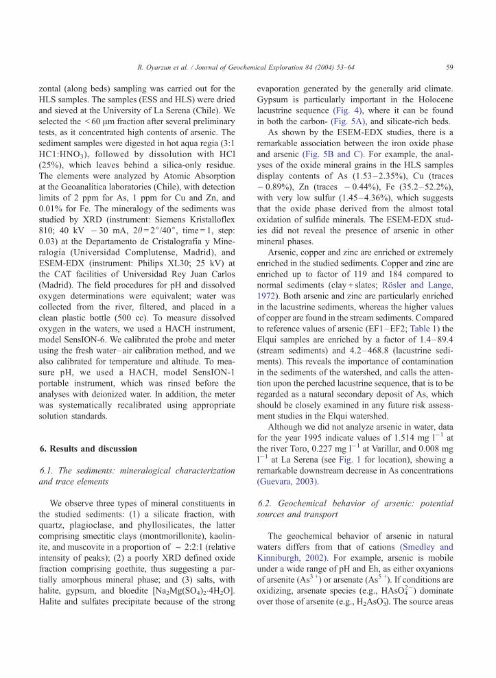
R. Oyarzun et al. / Journal of Geochemical Exploration 84 (2004) 53–64 59
zontal (along beds) sampling was carried out for the
HLS samples. The samples (ESS and HLS) were dried
and sieved at the University of La Serena (Chile). We
selected the < 60 Am fraction after several preliminary
tests, as it concentrated high contents of arsenic. The
sediment samples were digested in hot aqua regia (3:1
HC1:HNO3), followed by dissolution with HCl
(25%), which leaves behind a silica-only residue.
The elements were analyzed by Atomic Absorption
at the Geoanalıtica laboratories (Chile), with detection
limits of 2 ppm for As, 1 ppm for Cu and Zn, and
0.01% for Fe. The mineralogy of the sediments was
studied by XRD (instrument: Siemens Kristalloflex
810; 40 kV � 30 mA, 2h = 2j/40j, time = 1, step:
0.03) at the Departamento de Cristalografıa y Mine-
ralogıa (Universidad Complutense, Madrid), and
ESEM-EDX (instrument: Philips XL30; 25 kV) at
the CAT facilities of Universidad Rey Juan Carlos
(Madrid). The field procedures for pH and dissolved
oxygen determinations were equivalent; water was
collected from the river, filtered, and placed in a
clean plastic bottle (500 cc). To measure dissolved
oxygen in the waters, we used a HACH instrument,
model SensION-6. We calibrated the probe and meter
using the fresh water–air calibration method, and we
also calibrated for temperature and altitude. To mea-
sure pH, we used a HACH, model SensION-1
portable instrument, which was rinsed before the
analyses with deionized water. In addition, the meter
was systematically recalibrated using appropriate
solution standards.
6. Results and discussion
6.1. The sediments: mineralogical characterization
and trace elements
We observe three types of mineral constituents in
the studied sediments: (1) a silicate fraction, with
quartz, plagioclase, and phyllosilicates, the latter
comprising smectitic clays (montmorillonite), kaolin-
ite, and muscovite in a proportion of f 2:2:1 (relative
intensity of peaks); (2) a poorly XRD defined oxide
fraction comprising goethite, thus suggesting a par-
tially amorphous mineral phase; and (3) salts, with
halite, gypsum, and bloedite [Na2Mg(SO4)2�4H2O].
Halite and sulfates precipitate because of the strong
evaporation generated by the generally arid climate.
Gypsum is particularly important in the Holocene
lacustrine sequence (Fig. 4), where it can be found
in both the carbon- (Fig. 5A), and silicate-rich beds.
As shown by the ESEM-EDX studies, there is a
remarkable association between the iron oxide phase
and arsenic (Fig. 5B and C). For example, the anal-
yses of the oxide mineral grains in the HLS samples
display contents of As (1.53–2.35%), Cu (traces
� 0.89%), Zn (traces � 0.44%), Fe (35.2–52.2%),
with very low sulfur (1.45–4.36%), which suggests
that the oxide phase derived from the almost total
oxidation of sulfide minerals. The ESEM-EDX stud-
ies did not reveal the presence of arsenic in other
mineral phases.
Arsenic, copper and zinc are enriched or extremely
enriched in the studied sediments. Copper and zinc are
enriched up to factor of 119 and 184 compared to
normal sediments (clay + slates; Rosler and Lange,
1972). Both arsenic and zinc are particularly enriched
in the lacustrine sediments, whereas the higher values
of copper are found in the stream sediments. Compared
to reference values of arsenic (EF1–EF2; Table 1) the
Elqui samples are enriched by a factor of 1.4–89.4
(stream sediments) and 4.2–468.8 (lacustrine sedi-
ments). This reveals the importance of contamination
in the sediments of the watershed, and calls the atten-
tion upon the perched lacustrine sequence, that is to be
regarded as a natural secondary deposit of As, which
should be closely examined in any future risk assess-
ment studies in the Elqui watershed.
Although we did not analyze arsenic in water, data
for the year 1995 indicate values of 1.514 mg l�1 at
the river Toro, 0.227 mg l�1 at Varillar, and 0.008 mg
l�1 at La Serena (see Fig. 1 for location), showing a
remarkable downstream decrease in As concentrations
(Guevara, 2003).
6.2. Geochemical behavior of arsenic: potential
sources and transport
The geochemical behavior of arsenic in natural
waters differs from that of cations (Smedley and
Kinniburgh, 2002). For example, arsenic is mobile
under a wide range of pH and Eh, as either oxyanions
of arsenite (As3 +) or arsenate (As5 +). If conditions are
oxidizing, arsenate species (e.g., HAsO42�) dominate
over those of arsenite (e.g., H2AsO3-). The source areas
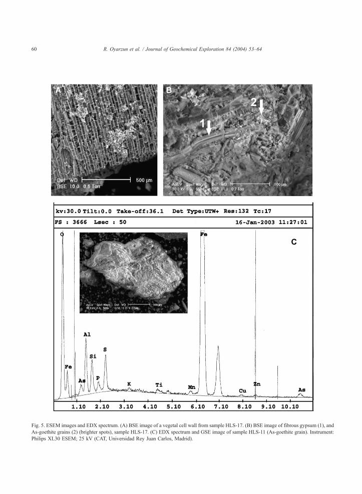
Fig. 5. ESEM images and EDX spectrum. (A) BSE image of a vegetal cell wall from sample HLS-17. (B) BSE image of fibrous gypsum (1), and
As-goethite grains (2) (brighter spots), sample HLS-17. (C) EDX spectrum and GSE image of sample HLS-11 (As-goethite grain). Instrument:
Philips XL30 ESEM; 25 kV (CAT, Universidad Rey Juan Carlos, Madrid).
R. Oyarzun et al. / Journal of Geochemical Exploration 84 (2004) 53–6460

Table 1
Results for samples Elqui stream sediments (ESS) and Holocene
lacustrine sediments (HLS)
Sample As
(ppm)
As
(EF1)
As
(EF2)
Cu
(ppm)
Zn
(ppm)
Fe
1(%)
ESS-1(a) 327 11.5 65.4 550 98 4.5
ESS-1(b) 485 17.1 97.0 405 129 9.4
ESS-1(d) 150 5.3 30.0 638 129 4.9
ESS-2(a) 231 8.1 46.2 4293 558 4.8
ESS-2(b) 122 4.3 24.4 1281 331 4.0
ESS-2(c) 347 12.2 69.4 660 1511 5.4
ESS-3(a) 138 4.9 27.6 3832 491 3.6
ESS-3(b) 168 5.9 33.6 6129 647 4.7
ESS-3(c) 447 15.7 89.4 6789 1166 4.8
ESS-4(a) 108 3.8 21.6 2949 460 2.9
ESS-5 146 5.1 29.2 4973 609 3.4
ESS-6 39 1.4 7.8 365 139 4.7
ESS-7(ll) 55 1.9 11.0 30 165 6.5
ESS-8(ll) 59 2.1 11.8 36 140 4.9
Mean 202 7.1 40.3 2352 470 4.9
S.D. 145 5.1 28.9 2415 423 1.6
HLS-1(25) 647 22.8 129.4 524 1770 4.2
HLS-4 354 12.5 70.8 253 728 3.8
HLS-5 909 32.0 181.8 599 1427 4.9
HLS-7 1122 39.5 224.4 1390 4066 9.1
HLS-9 455 16.0 91.0 312 951 3.9
HLS-10 119 4.2 23.8 111 518 3.1
HLS-11 2344 82.5 468.8 685 1810 11.0
HLS-12 487 17.1 97.4 583 8143 6.7
HLS-13 557 19.6 111.4 889 3868 1.1
HLS-14 577 20.3 115.4 1590 14765 4.8
HLS-15 302 10.6 60.4 401 2285 4.0
HLS-16 597 21.0 119.4 742 8907 4.6
HLS-16(a) 629 22.1 125.8 214 650 6.2
HLS-17 1393 49.0 278.6 1462 412 5.5
Mean 749 26.4 149.9 697 3593 5.2
S.D. 544 19.9 112.9 460 4056 2.4
Enrichment factor for As (EF) = sample/reference value; EF1: 28.4
ppm As, North American Shale Composite (NASC) (Gromet et al.,
1984); EF2: 5 ppm As, world average river sediments (Smedley and
Kinniburgh, 2002). Standard deviation (S.D.). The EF1 and EF2
reference values are composite data that include a number of
different analytical procedures, applied to relatively different types
of samples having in common to be fine grained.
R. Oyarzun et al. / Journal of Geochemical Exploration 84 (2004) 53–64 61
of arsenic are varied, although the main ones are
related to geothermal fields and mineral deposits
(natural sources) and mining operations (anthropo-
genic sources). Not only arsenic minerals such as
arsenopyrite (FeAsS), enargite (Cu3AsS4), or tennan-
tite [(Cu,Fe)12As4S13], are to be regarded as potential
sources of arsenic, because pyrite (FeS2) can be also
extremely rich in this element (up to 7.7%) (Smedley
and Kinniburgh, 2002). Although the igneous rocks
are generally poor in arsenic, the volcanic ash deposits
(tuffs) may be implied in the generation of high-As
waters (Smedley et al., 2002). These features are
particularly relevant to the Elqui watershed case,
because of the important units of Miocene pyroclastic
(ash type) deposits. Additionally, the whole high-
altitude belt of alteration zones (Fig. 2) was the result
of large-scale, time-persistent geothermal activity dur-
ing the Miocene (Bissig et al., 2002a). Furthermore,
arsenic is a typical element associated with epithermal
processes of the acid-sulfate type (high-sulfidation
systems), and occurs in mineral assemblages of the
type enargite–pyrite (Heald et al., 1987). This is
particularly relevant to the case of El Indio, which
hosts two types of veins (Siddeley and Araneda,
1986): (1) massive sulfides (enargite–pyrite) and (2)
quartz–gold. The massive sulfide veins (before min-
ing) were up to 200 m long and 0.5–12 m thick, and
had grades of 6–12% Cu, 4–10 g/t Au, 60–120 g/t
Ag. The quartz–gold veins (before mining) were up
to 200 m long and 0.5–6 m thick. These veins were
extremely rich in gold, including an early exploration
assay yielding 3500 g t�1 Au, which actually gave
name to one of the lodes (the 3500 vein). However,
the latter veins were not devoid of arsenic and sulfur,
which reached mean values of 1.7% As and 7.4% S
(Siddeley and Araneda, 1986).
Oxidation and leaching of arsenic ores in the
superficial environment of pyrite–enargite veins lead
to formation of H3AsO4 (e.g., Escobar et al., 1997):
Cu3AsS4 þ 5:5Fe2ðSO4Þ3 þ 4H2O ! 3CuSO4
þ 11FeSO4 þ 4Sþ H3AsO4 þ 2:5H2SO4
However, as pH increases, H3AsO4 becomes unstable,
and the dominant arsenic species is H2AsO4� (pH>2;
Smedley and Kinniburgh, 2002). On the other hand,
the oxidation process of pyrite is a net producer of
goethite:
4FeS2 þ 10H2Oþ 15O2 ! 4FeOðOHÞþ 16Hþ þ 8SO�2
4
Colloidal goethite has a net positive charge (e.g.,
Seaman et al., 1997) in acid media, which binds
arsenic complex ions by adsorption. However, these

R. Oyarzun et al. / Journal of Geochemical Exploration 84 (2004) 53–6462
complex ions may remain strongly bound to goethite
up to higher pH values of 8.0–8.5 (Smith, 1999;
Smedley and Kinniburgh, 2002). Desorption of arse-
nic from goethite may occur by competition between
negative charges for the positive colloid, a reduction
of the iron oxide mineral phase (Meng et al., 2002), or
high pH values (>8.5). Given the Eh–pH conditions
of the superficial environment of the supergene alter-
ation zones (As source area), we may rule out the
second and third possibility. Those As complex ions
which are not adsorbed by goethite will migrate in
solution either as H2AsO4- at pH 2–7 or as HAsO4
2� at
pHz 7 (Smedley and Kinniburgh, 2002). Since the
observed pH in our field stations 1–6 varies from 4.5
to 6.5 (Fig. 1), we may infer that the dominant
aqueous As species is H2AsO4�.
Given the mountainous landscape, the high-altitude
character of the tributary rivers of the study region,
and the periodic development of high-intensity El
Nino rain storms (once every 2–7 years; average:
3–4 years), we may assume that the As-, goethite-rich
regolith in the alteration zones is easily washed down
to the rivers, and transported as particles of different
sizes. On top of these natural mechanisms of arsenic
leaching-transport in the study area, we have to add
those triggered by the mining operations at the El
Indio–Tambo district for the last 25 years, including
open-pit works, road construction, and others of
similar characteristics involving earth moving (e.g.,
Lagos and Velasco, 1998) (Fig. 3A). Thus, we may
infer at least two main mechanisms of arsenic input
into the river system in the study area: (1) as unbound
complex ions of the type H2AsO4�; and (2) as
adsorbed As species to iron oxides removed from
the mountain slopes by erosion and mining works.
While reducing environments lead to desorption of
arsenic from iron oxide minerals (Smedley and Kin-
niburgh, 2002), the Elqui watershed provides oxidiz-
ing conditions (5.15–6.70 mg l�1 of dissolved O2;
Toro, Turbio, and Elqui rivers; stations 1–6) (Fig. 1)
allowing the existence of goethite phases that bind the
arsenic species. In turn, this mineral phase is rapidly
incorporated to the sediments, thus removing part of
the arsenic dissolved in the waters. This assumption is
supported by the high As contents present in the
sampled stream sediments. Station 6 (immediately
after the Puclaro dam) (Fig. 1) records the lowest
value of As, which may be the result of sedimentation
of the silt fraction and iron oxides in the bottom of the
water reservoir.
6.3. Industrial vs. geologic process
This survey may provide some useful insights into
the problem of evaluating the actual risk derived from
mining operations. Given the nature of the mining
works at El Indio–Tambo district, it is relatively easy
at first sight, to find a ‘clear culprit’ regarding the
ultimate source of As contamination in the Elqui
watershed. However, we must take into account that
once erosion starts, the unroofing of a mineral deposit
(a process enhanced in the high-altitude environment)
may lead to the massive and sustained leaching of
metals, and therefore, to long-lived ‘natural contam-
ination’ of rivers. The longer the process, the greater
the effect. As shown by the arsenic contents of the
Early Holocene sequence, we believe that the Elqui
watershed proves this rule to be true. Does this mean
that the mining operations at El Indio–Tambo have
nothing to do with the arsenic contamination in the
Elqui watershed? Hardly, it would be unreasonable to
think that preparation of the mining areas (involving
important road construction works), and the develop-
ment of open pit mining and metallurgical operations
(Fig. 3) did not contribute with some arsenic to the
river system.
7. Conclusions
In the absence of the Holocene sequence of lacus-
trine sediments, it would have been difficult to study
the relative importance of industrial and natural pro-
cess. However, the high levels of arsenic displayed by
these Early Holocene sediments, together with their
high position respect to the river, suggest that con-
tamination in the Elqui watershed (both water and
sediments) is a well-established geological phenome-
non, predating human activities in the area. Further-
more, the sediment samples from La Laguna river
(samples ESS-7–8) (Fig. 1) show that the El Indio–
Tambo sector is not the only source of arsenic in this
realm.
Taking into account the 14C age (9640 years BP) of
the lacustrine sequence, we may infer that sedimen-
tation started right after the sudden ending (10,000

R. Oyarzun et al. / Journal of Geochemical Exploration 84 (2004) 53–64 63
C14 years BP) of the Younger Dryas (global arid and
cold period), which in turn coincides with the onset of
the milder and wetter conditions that led to the so-
called Holocene Optimum. Under these new global
climatic conditions, the rain and temperatures in-
creased, and the ice sheets began to melt. In the case
of the Elqui area, this period also coincides with an
increased influence of the Westerly winds (Veit,
1996), which bring most of the winter rain to central
and southern Chile (e.g., Jenny et al., 2002). This
climatic scenario may explain the sudden appearance
of the As-rich lacustrine facies in the ‘paleo Elqui’
system. Intense rain (and snowfall), coupled to rapid
snowmelts, and earthquakes (the region is very seis-
mically active; Pardo et al., 2002) would explain two
major points: (1) increased erosion of the higher
mountains, and therefore, important transport of arse-
nic from the hydrothermally altered zones; and (2)
damming phenomena during the Holocene in the river
system and storage of the sediments in lacustrine
sediments.
Acknowledgements
This work was funded by the Spanish International
Agency for Cooperation (AECI), the Bureau of
International Cooperation of the University of Castilla
La Mancha, and Grant BFM2000-0572-Nj9137(DGICYT). Angel Paton helped with sample collec-
tion and preparation. Belen Soutullo (UCM-DCM)
and Gilberto del Rosario (URJC-CAT) assisted with
the XRD and ESEM-EDX analyses respectively. This
manuscript benefited from the comments of Dr. B.
Olander and an anonymous referee.
References
Bissig, T., Clark, A.H., Lee, J.K.W., Hodgson, C.J., 2002a. Mio-
cene landscape evolution and geomorphologic controls on epi-
thermal processes in the El Indio –Pascua Au–Ag–Cu belt,
Chile and Argentina. Econ. Geol. 97, 971–996.
Bissig, T., Clark, A.H., Lee, J.K.W., 2002b. Cerro del Vidrio rhyo-
litic dome: evidence for Late Pliocene volcanism in the central
Andean flat-slab region, Lama-Veladero district, 29j20VS, SanJuan province, Argentina. J. South Am. Earth Sci. 15, 571–576.
Escobar, B., Huenupi, E., Wiertz, J.V., 1997. Chemical and biolog-
ical leaching of enargite. Biotechnol. Lett. 19, 719–722.
Gromet, L.P, Dymek, R.F., Haskin, L.A., Korotev, R.L., 1984. The
North American shale composite: its compilation, major and
trace element characteristics. Geochim. Cosmochim. Acta 48,
2469–2482.
Guevara, S., 2003. Distribucion y comportamiento de metales pesa-
dos en las aguas del rıo Elqui y sus tributarios. Graduation
Project. Universidad de La Serena, La Serena, Chile, p. 255.
Heald, P., Foley, N.K., Hayba, D., 1987. Comparative anatomy of
volcanic-hosted epithermal deposits: acid sulfate and adularia–
sericite types. Econ. Geol. 82, 1–26.
Higueras, P., Oyarzun, R., Biester, H., Lillo, J., Lorenzo, S., 2003.
A first insight into mercury distribution and speciation in soils
from the Almaden mining district, Spain. J. Geochem. Explor.
80, 95–104.
Jenny, B., Valero-Garces, B.L., Urrutia, R., Kelts, K., Veit, H.,
Appleby, P.G., Geyh, M., 2002. Moisture changes and fluctua-
tions of the Westerlies in mediterranean Central Chile during the
last 2000 years: the Laguna Aculeo record (33j50VS). Quat. Int.87, 3–18.
Lagos, G., Velasco, P., 1998. Environmental policies and practices
in Chilean Mining. In: Warhurst, A. (Ed.), Mining and the En-
vironment (on-line version), International Development Re-
search Centre (IDRC), Ottawa, http://www.idrc.ca/books/focus/
828/chapter3.html.
Maksaev, V., Moscoso, R., Mpodozis, C., Nasi, C., 1984. Las uni-
dades volcanicas y plutonicas del Cenozoico Superior en la alta
cordillera del Norte Chico (29j–31VS): geologıa, alteracionhidrotermal y mineralizacion. Rev. Geol. Chile 21, 11–51.
Maturana, H., Oyarzun, J., Pasieczna, A., Paulo, A., 2001. Geo-
quımica de los sedimentos del rıo Elqui (Coquimbo, Chile):
manejo de relaves y cierre de minas. Final Proc. 7th Argentinian
Congr. Econ. Geol. Salta, Asociacion Geologica Argentina.
Buenos Aires, Argentina, pp. 155–161.
Meng, X., Korfiatis, G.P., Bang, S., Bang, K.W., 2002. Combined
effects of anions on arsenic removal by iron hydroxides. Tox-
icol. Lett. 133, 103–111.
Pardo, M., Comte, D., Monfret, T., Boroshek, R., Astroza, M.,
2002. The October 15, 1997 Punitaqui earthquake (Mw= 7.1):
a destructive event within the subducting Nazca plate in central
Chile. Tectonophysics 345, 199–210.
Romero, L., Alonso, H., Campano, P., Fanfani, L., Cidu, R., Dadea,
C., Keegan, T., Thornton, I., Farago, M., 2003. Arsenic enrich-
ment in waters and sediments of the Rio Loa (Second Region,
Chile). Applied Geochemistry 18, 1399–1416.
Rosler, H.J., Lange, H., 1972. Geochemical tables. Elsevier,
Amsterdam. 468 pp.
Seaman, J.C., Bertsch, P.M., Strom, R.N., 1997. Characterization of
colloids mobilized from southeastern coastal plains sediments.
Environ. Sci. Technol. 31, 2782–2790.
Siddeley, G., Araneda, R., 1986. The El Indio–Tambo gold deposits.
In: Macdonald, A.J. (Ed.), Gold’ 86, International Symposium on
the Geology of Gold. Balkema, Amsterdam, pp. 3–22.
Smedley, P.L., Kinniburgh, D.G., 2002. A review of the source,
behaviour and distribution of arsenic in natural waters. Appl.
Geochem. 17, 517–568.
Smedley, P.L., Nicolli, H.B., Macdonald, D.M.J., Barros, A.J., Tul-
lio, J.O., 2002. Hydrogeochemistry of arsenic and other inor-

R. Oyarzun et al. / Journal of Geochemical Exploration 84 (2004) 53–6464
ganic constituents in groundwaters from La Pampa, Argentina.
Appl. Geochem. 17, 259–284.
Smith, K.S., 1999. Metal sorption on mineral surfaces: an
overview with examples relating to mineral deposits. In:
Plumlee, G.S., Logsdon, M.J. (Eds.), The Environmental
Geochemistry of Mineral Deposits. Reviews in Economic Geo-
logy, vol. 6A. Society of Economic Geologists, Chelsea, Mich-
igan, pp. 161–182.
Trauth, M.H., Alonso, R.A., Haselton, K.R., Hermanns, R.L.,
Strecker, M.R., 2000. Climate change and mass movement
in the NW Argentine Andes. Earth Planet. Sci. Lett. 179,
243–256.
Veit, H., 1996. Southern Westerlies during Holocene deduced
from geomorphological and pedological studies in Norte
Chico, northern Chile. Palaeogeogr. Palaeoclimatol. Palaeoe-
col. 123, 107–119.
Top Related
Copyright © 2022 FDOKUMEN

