


Bahasa
Halaman
Hukum

Available online at www.sciencedirect.com
tters 263 (2007) 288–308www.elsevier.com/locate/epsl
Earth and Planetary Science Le
Primary Carboniferous and Permian paleomagnetic results from theYili Block (NW China) and their implications on the geodynamic
evolution of Chinese Tianshan Belt
Bo Wang a,b,⁎, Yan Chen b, Sheng Zhan b,c, Liangshu Shu a, Michel Faure b,Dominique Cluzel b, Jacques Charvet b, Sébastien Laurent-Charvet d
a Department of Earth Sciences, Nanjing University, 210093, Nanjing, Chinab Institut des Sciences de la Terre d'Orléans, UMR CNRS 6113, Université d'Orléans, 45067, Orléans, France
c Key Laboratory of Orogenic Belts and Crustal Evolution, Peking University, 100871, Beijing, Chinad Institut Géologique Albert-de-Lapparent, 95092, Cergy-Pontoise, France
Received 28 July 2006; received in revised form 19 April 2007; accepted 27 August 2007
Available online
Editor: C.P. Jaupart
18 September 2007
Abstract
In order to better understand the tectonic role of the Yili Block on the Paleozoic evolution of the Chinese Tianshan Belt, weperformed a primary paleomagnetic study on Carboniferous and Permian rocks from different areas in the Yili Block, NWof China.More than 320 sedimentary and volcanic samples were collected from 39 sites. Except for the Ordovician samples showing a weakand unstable magnetic remanence, the majority of this collection presents characteristic remanent magnetization carried bymagnetite and hematite. In the study area, though positive fold test has been observed on the Early Carboniferous rocks, a generalre-magnetization of these rocks has been identified and attributed to the Late Carboniferous magmatism. Moreover, all Early andLate Carboniferous samples from the interior of the Yili Block yield stable and coherent magnetic directions with exhaustivelyreverse magnetic polarity. The Late Carboniferous (C2) is considered as the magnetic remanence age since these rocks are coveredor intruded by synchronous magmatic rocks of the Yili arc, which lasted until to ∼310 Ma. The C2 paleomagnetic pole is thereforecalculated at 68.6°N, 290.6°E with A95=6.4° and n=15. The Late Carboniferous rocks located close to a deformation zone presenta consistent magnetic inclination but significant different declination with respect to other areas and are suspected to have probablyexperienced a local rotation. Although no fold test can be performed due to the monoclinal bedding, stable magnetic componentsare isolated from Late Permian (P2) red beds in the interior of the Yili Block with also a solo reverse magnetic polarity, the P2paleomagnetic pole of the Yili Block has been, therefore, calculated from the characteristic remanent magnetization: 79.7°N,172.0°E with A95=11.3° and n=5. Keeping important uncertainties in mind, comparisons of the C2 and P2 paleomagnetic poles ofthe Yili Block with available coeval poles of Junggar, Tarim and Siberia indicate (1) no significant relative motion between the Yiliand Junggar blocks since the Late Carboniferous, (2) no significant or weak latitudinal relative motion occurred since the LateCarboniferous among these blocks, but (3) the 46.2°±15.1° and the 31.6°±15.1° counterclockwise rotations of the Yili–Junggarblocks with respect to Tarim and Siberia took place during C2 to P2. These rotations are accommodated by the Permian dextral
⁎ Corresponding author. Department of Earth Sciences, Nanjing University, 210093, Nanjing, China. Tel.: +86 25 8359 2921; fax: +86 25 8368 6061.E-mail addresses: [email protected], [email protected] (B. Wang).
0012-821X/$ - see front matter © 2007 Published by Elsevier B.V.doi:10.1016/j.epsl.2007.08.037
289B. Wang et al. / Earth and Planetary Science Letters 263 (2007) 288–308
strike–slip faults along the northern and southern sides of Tianshan Belt and sinistral strike–slip faulting along the Erqishi Fault ofAltay Belt, resulting in about 1000 km and 600 km lateral displacements in the Tianshan and Altay belts, respectively.© 2007 Published by Elsevier B.V.
Keywords: Yili Block; Tianshan Belt; Paleozoic; paleomagnetism; rotation; strike–slip faulting
1. Introduction
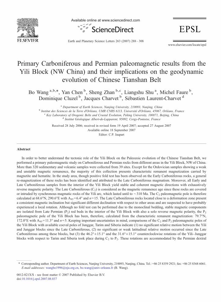
The “Yili Block” represents a triangular shapesandwiched within the Tianshan Belt and wideningwestwards into Kazakhstan and Kyrgyzstan (Fig. 1a;Enkin et al., 1991). It is considered as a microcontinentwith a Precambrian basement separating the Tianshan Beltinto northern and southern branches (Allen et al., 1992;Chen et al., 1999;Wang et al., 2006, 2007). TheYili Block,therefore, occupies an important position for the under-standing of the tectonic evolution of the Tianshan Belt. It iswidely accepted that the Tianshan Belt is a Paleozoicorogenic belt due to multi-phase accretion and amalgam-ation of various microcontinents, and magmatic arcs(Coleman, 1989; Shi et al., 1994; Shu et al., 2000, 2002).However, there are still controversies on procedures ofamalgamation and chronological constraints. The Paleo-zoic Tianshan Belt is considered to be formed bysubduction–collision processes (Windley et al., 1990;Allen et al., 1992; Gao et al., 1998; Chen et al., 1999), i.e.the Yili Block and the Central Tianshan microcontinents(Fig. 1b) were rifted from the Tarim Plate in the Cambrian,and were reaccreted to Tarim during Ordovician to EarlyCarboniferous due to the multi-phase subduction ofoceanic crust. A southward subduction of an oceaniccrust beneath the Yili Block during the Late Devonian tothe Late Carboniferous terminated the convergent phasesof mountain building in the Tianshan Belt. Nevertheless,some authors considered the Tianshan Belt as a part of theAltaids, which was mainly produced by strike–slipfaulting (Sengör et al., 1993; Sengör and Natal'in, 1996).Recently, some workers suggested that an oceanic crustexisted in the southern Tianshan until the end of Permianon the basis of radiolarians found in South Tianshanophiolitic mélange (Li et al., 2002, 2005). Besides, a LateCarboniferous to Early Permian continental rifting is alsoproposed according to geochemical and isotopic studies onthe volcanic rocks in the Tianshan Belt (Xia et al., 2004).These results suggest a divergent tectonics and asubsequent renewed convergence in the Tianshan areafrom Carboniferous to Permian, and therefore arise acontroversy on the final evolution of the Tianshan Belt.
In addition, Permian transcurrent faulting is widelyobserved, especially ductile strike–slip faults are geolog-icallywell documented in thewhole northernXinjiang area
(Allen et al., 1995; Shu et al., 1999; Laurent-Charvet et al.,2002, 2003;Wang et al., 2006), including twomain dextralstrike–slip faults along the northern and the southern sidesof the Tianshan Belt, and a sinistral strike–slip fault, theErqishi Fault, in theAltayBelt. However, the southern faultof the Tianshan Belt was previously interpreted as asinistral strike–slip fault (Sengör et al., 1993; Burtman,1975), which is also suggested on the basis of a significantwestward deflection of magnetic declination (Bazhenovet al., 1993, 1999), but this is not consistent with thegeological and kinematic observations from ChineseTianshan area (Yin and Nie, 1996; Wang et al., in review),where no paleomagnetic data are available up to now toconstrain this event and consequent lateral displacement.
In order to improve the understanding of the finalorogenic procedures, this paleomagnetic study wascarried out on Ordovician to Permian rocks from theYili Block. The comparison of paleomagnetic data fromthis study with the previous results from Junggar, Tarimand Siberia blocks will better constrain the tectonicevolution of the Chinese Tianshan Belt during the LatePaleozoic time.
2. Geological setting and paleomagnetic sampling
The Western Chinese Tianshan Belt is divided intoseveral subunits, namely North Tianshan domain, BoleBlock, Yili Block, Central Tianshan domain and SouthTianshan mélange zone (Fig. 1b). In the Yili Block, thePrecambrian basement is composed of Meso- to Neopro-terozoic carbonates, clastic rocks and amphibolite faciesmetamorphic rocks developing along its northern andsouthern boundaries (XBGMR, 1993; Chen et al., 2000).Early Paleozoic rocks consist of Cambrian to Ordoviciancarbonates and clastic rocks, and Silurian flysch in north ofYining area (Fig. 2a). The Devonian is mainly representedby terrigeneous rocks and arc-derived granitoids.
The Lower Carboniferous is, a ca. 3500 m-thick seriesof limestone, sandstone and shale with subordinatevolcanic rocks, and the Upper Carboniferous consists oflimestone intercalated with volcanoclastic sandstone andmassive volcanic rocks (Fig. 2). Both Lower and UpperCarboniferous rocks are coeval with granitoids. Severalgeochronological studies on the volcanic and graniticrocks provide zircon U–Pb (SHRIMP and LA-ICPMS)
Fig. 1. (a) Tectonic sketch map of Central Asia (modified after Enkin et al., 1991) showing the main tectonic blocks including the Yili Block,(b) structural map of Chinese Tianshan Belt and its adjacent areas. Paleozoic sutures, Permian strike–slip faults and Cenozoic thrusts are shown.Abbreviations: NTF, North Tianshan Fault; NF, Nalati Fault; MTSZ, Main Tianshan Shear Zone; QF, Qingbulake Fault.
290 B. Wang et al. / Earth and Planetary Science Letters 263 (2007) 288–308
ages ranging from 361 Ma to 309 Ma (Zhu et al., 2005;Wang et al., 2006). Geochemical and isotopic studiessuggest that the Yili Block was an active continentalmargin during the Late Devonian to Late Carboniferous(Zhu et al., 2005; Wang et al., 2007).
In the whole Western Chinese Tianshan Belt, Permianterrestrial sandstone and conglomerate unconformablyoverlie the older rocks (Fig. 2). Lower to Upper Permianbimodal volcanic and plutonic rocks are widespread
throughout the Yili Block but form small occurrences(Fig. 2a; XBGMR, 1993; Allen et al., 1995; Zhou et al.,2001; Shu et al., 2005). Strike–slip shear faults over-printed the Paleozoic sutures during Permian andunderwent multi-phase reactivation during the earlyMesozoic (Shu et al., 1999; Laurent-Charvet et al.,2002, 2003; Shu et al., 2003). The Tianshan Belt isreactivated again by the Cenozoic intra-continentaldeformation and subsequently uplifted in response to
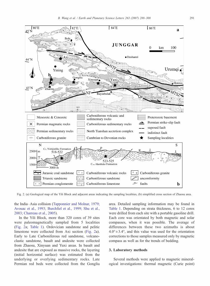
Fig. 2. (a) Geological map of the Yili Block and adjacent areas indicating the sampling localities, (b) simplified cross section of Zhaosu area.
291B. Wang et al. / Earth and Planetary Science Letters 263 (2007) 288–308
the India–Asia collision (Tapponnier and Molnar, 1979;Avouac et al., 1993; Burchfiel et al., 1999; Shu et al.,2003; Charreau et al., 2005).
In the Yili Block, more than 320 cores of 39 siteswere paleomagnetically sampled from 5 localities(Fig. 2a; Table 1). Ordovician sandstone and peliticlimestone were collected from Axi section (Fig. 2a).Early to Late Carboniferous red sandstone, volcano-clastic sandstone, basalt and andesite were collectedfrom Zhaosu, Xinyuan and Yuxi areas. In basalt andandesite that are exposed as massive rocks, the layering(initial horizontal surface) was estimated from theunderlying or overlying sedimentary rocks. LatePermian red beds were collected from the Gongliu
area. Detailed sampling information may be found inTable 1. Depending on strata thickness, 6 to 12 coreswere drilled from each site with a portable gasoline drill.Each core was orientated by both magnetic and solarcompasses, when it was possible. The average ofdifferences between these two azimuths is about4.0°±3.4°, and this value was used for the orientationcorrections to those samples measured only by magneticcompass as well as for the trends of bedding.
3. Laboratory methods
Several methods were applied to magnetic mineral-ogical investigations: thermal magnetic (Curie point)
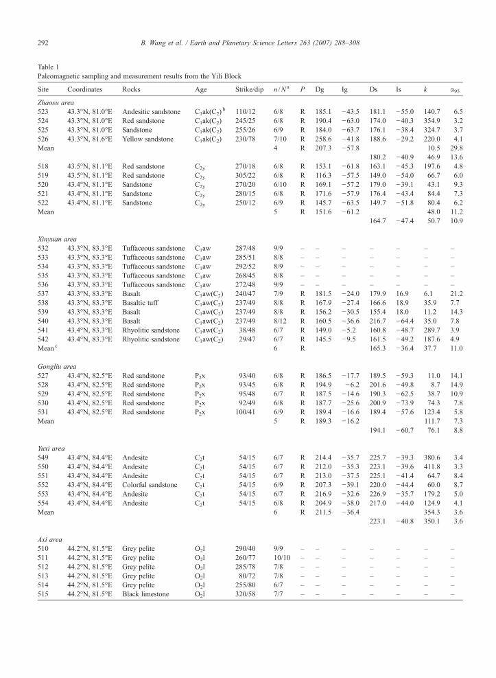
Table 1Paleomagnetic sampling and measurement results from the Yili Block
Site Coordinates Rocks Age Strike/dip n /N a P Dg Ig Ds Is k α95
Zhaosu area523 43.3°N, 81.0°E Andesitic sandstone C1ak(C2)
b 110/12 6/8 R 185.1 −43.5 181.1 −55.0 140.7 6.5524 43.3°N, 81.0°E Red sandstone C1ak(C2) 245/25 6/8 R 190.4 −63.0 174.0 −40.3 354.9 3.2525 43.3°N, 81.0°E Sandstone C1ak(C2) 255/26 6/9 R 184.0 −63.7 176.1 −38.4 324.7 3.7526 43.3°N, 81.6°E Yellow sandstone C1ak(C2) 230/78 7/10 R 258.6 −41.8 188.6 −29.2 220.0 4.1Mean 4 R 207.3 −57.8 10.5 29.8
180.2 −40.9 46.9 13.6518 43.5°N, 81.1°E Red sandstone C2y 270/18 6/8 R 153.1 −61.8 163.1 −45.3 197.6 4.8519 43.5°N, 81.1°E Red sandstone C2y 305/22 6/8 R 116.3 −57.5 149.0 −54.0 66.7 6.0520 43.4°N, 81.1°E Sandstone C2y 270/20 6/10 R 169.1 −57.2 179.0 −39.1 43.1 9.3521 43.4°N, 81.1°E Sandstone C2y 280/15 6/8 R 171.6 −57.9 176.4 −43.4 84.4 7.3522 43.4°N, 81.1°E Sandstone C2y 250/12 6/9 R 145.7 −63.5 149.7 −51.8 80.4 6.2Mean 5 R 151.6 −61.2 48.0 11.2
164.7 −47.4 50.7 10.9
Xinyuan area532 43.3°N, 83.3°E Tuffaceous sandstone C1aw 287/48 9/9 – – – – – – –533 43.3°N, 83.3°E Tuffaceous sandstone C1aw 285/51 8/8 – – – – – – –534 43.3°N, 83.3°E Tuffaceous sandstone C1aw 292/52 8/9 – – – – – – –535 43.3°N, 83.3°E Tuffaceous sandstone C1aw 268/45 8/8 – – – – – – –536 43.3°N, 83.3°E Tuffaceous sandstone C1aw 272/48 9/9 – – – – – – –537 43.3°N, 83.3°E Basalt C1aw(C2) 240/47 7/9 R 181.5 −24.0 179.9 16.9 6.1 21.2538 43.3°N, 83.3°E Basaltic tuff C1aw(C2) 237/49 8/8 R 167.9 −27.4 166.6 18.9 35.9 7.7539 43.3°N, 83.3°E Basalt C1aw(C2) 237/49 8/8 R 156.2 −30.5 155.4 18.0 11.2 14.3540 43.3°N, 83.3°E Basalt C1aw(C2) 237/49 8/12 R 160.5 −36.6 216.7 −64.4 35.0 7.8541 43.4°N, 83.3°E Rhyolitic sandstone C1aw(C2) 38/48 6/7 R 149.0 −5.2 160.8 −48.7 289.7 3.9542 43.4°N, 83.3°E Rhyolitic sandstone C1aw(C2) 29/47 6/7 R 145.5 −9.5 161.5 −49.2 187.6 4.9Mean c 6 R 165.3 −36.4 37.7 11.0
Gongliu area527 43.4°N, 82.5°E Red sandstone P2x 93/40 6/8 R 186.5 −17.7 189.5 −59.3 11.0 14.1528 43.4°N, 82.5°E Red sandstone P2x 93/45 6/8 R 194.9 −6.2 201.6 −49.8 8.7 14.9529 43.4°N, 82.5°E Red sandstone P2x 95/48 6/7 R 187.5 −14.6 190.3 −62.5 38.7 10.9530 43.4°N, 82.5°E Red sandstone P2x 92/49 6/8 R 187.7 −25.6 200.9 −73.9 74.3 7.8531 43.4°N, 82.5°E Red sandstone P2x 100/41 6/9 R 189.4 −16.6 189.4 −57.6 123.4 5.8Mean 5 R 189.3 −16.2 111.7 7.3
194.1 −60.7 76.1 8.8
Yuxi area549 43.4°N, 84.4°E Andesite C2t 54/15 6/7 R 214.4 −35.7 225.7 −39.3 380.6 3.4550 43.4°N, 84.4°E Andesite C2t 54/15 6/7 R 212.0 −35.3 223.1 −39.6 411.8 3.3551 43.4°N, 84.4°E Andesite C2t 54/15 6/7 R 213.0 −37.5 225.1 −41.4 64.7 8.4552 43.4°N, 84.4°E Colorful sandstone C2t 54/15 6/9 R 207.3 −39.1 220.0 −44.4 60.0 8.7553 43.4°N, 84.4°E Andesite C2t 54/15 6/7 R 216.9 −32.6 226.9 −35.7 179.2 5.0554 43.4°N, 84.4°E Andesite C2t 54/15 6/8 R 204.9 −38.0 217.0 −44.0 124.9 4.1Mean 6 R 211.5 −36.4 354.3 3.6
223.1 −40.8 350.1 3.6
Axi area510 44.2°N, 81.5°E Grey pelite O2l 290/40 9/9 – – – – – – –511 44.2°N, 81.5°E Grey pelite O2l 260/77 10/10 – – – – – – –512 44.2°N, 81.5°E Grey pelite O2l 285/78 7/8 – – – – – – –513 44.2°N, 81.5°E Grey pelite O2l 80/72 7/8 – – – – – – –514 44.2°N, 81.5°E Grey pelite O2l 255/80 6/7 – – – – – – –515 44.2°N, 81.5°E Black limestone O2l 320/58 7/7 – – – – – – –
292 B. Wang et al. / Earth and Planetary Science Letters 263 (2007) 288–308
Table 1 (continued)
Site Coordinates Rocks Age Strike/dip n /N a P Dg Ig Ds Is k α95
Axi area516 44.2°N, 81.5°E Black limestone O2l 320/58 8/8 – – – – – – –517 44.2°N, 81.5°E Red pelite O2l 320/45 6/8 – – – – – – –
Abbreviations: P, polarity; R, reversed; O2l, Ordovician Lelengeledaban Formation (Fm); C1ak and C1aw are Early Carboniferous Akeshake Fm andAwulale Fm; C2y and C2t are Late Carboniferous Yishijilike Fm and Tuergong Fm; P2x, Late Permian Xiaoshansayi Fm; Dg, Ig, Ds, Is are declination(D) and inclination (I) in geographic (g) and stratigraphic (s) coordinates, k is the best estimate of the precision parameter, α95 is the radius that meandirection lies within 95% confidence.a n, measured sample number; N, collected sample number.b Ages within the parentheses represent the age of remanence.c Locality-mean direction calculated with 4 in-situ directions of Sites 537–540 and 2 tilt-corrected directions of sites 541 and 542.
293B. Wang et al. / Earth and Planetary Science Letters 263 (2007) 288–308
experiment, the acquisition of Isothermal RemanentMagnetization (IRM) and the measurements of Anisot-ropy of Magnetic Susceptibility (AMS) carried out inLaboratoire de Magnétisme des Roches d'Orléans(LMRO), and magnetic hysteretic curves in Laboratoiredu Paléomagnétisme of Institut de Physique du Globe deParis (IPGP) at St Maur.
At least 6 cores were chosen from each site to carryout thermal and/or alternating magnetic field (AF)demagnetization in LMRO and IPGP. About 15 stepshave been applied to progressive magnetic remanencecleaning with intervals varying from 20 to 150 °C forthermal and 1 to 20 mT for AF demagnetization.
The magnetic remanent directions were isolated byprincipal component analysis (Kirschvink, 1980), themean directions were computed by Fisher (1953)spherical statistics using paleomagnetic softwarepackages offered by Cogné (2003) and PMGSC(version 4.2) by R. Enkin (unpublished).
4. Measurement results
4.1. Zhaosu area
Two Carboniferous formations were sampled: EarlyCarboniferous Akeshake Formation (C1ak) exposed inthe south and Late Carboniferous Yilishijilike Forma-tion (C2y) (XBGMR, 1979a) exposed in the north of theZhaosu area (Fig. 2b; Table 1).
4.1.1. C1ak Akeshake FormationIts lithology is composed of red sandstone occasion-
ally bearing andesitic volcanic clasts, and yellowsandstone (Fig. 2b; Table 1). IRM measurement showsan abrupt increase with the total saturation at about200 mT (Fig. 3a-1 and a-2), indicating predominantlylow-coercivity magnetic minerals in rocks. Thermalmagnetic measurements display a sharp drop of mag-netic susceptibility of sandstone and andesite at around580 °C (Fig. 4a), showing the existence of titanium-poor
magnetite. Two components were isolated from 22 out of25 measured samples. The low temperature componentsup to about 150 °C show dispersed directions. Only areverse polarity has been revealed from the high tem-perature component isolated from 250–300 to 580 °C,indicating that the magnetic remanence in these rocks ismainly carried by magnetite. Fig. 5b, c and Table 1present site-mean directions in geographic (g) andstratigraphic (s) coordinates and an age-mean directionwas calculated for this locality: Dg=207.3°, Ig=−57.8°,k=10.5, α95 g=29.8° and Ds=180.2°, Is=−40.9°,k=46.9, α95 s=13.6° with n=4 (Table 1). Enkin's(2003) DC fold test gives a positive answer to thisformation with the maximum k value at 74.4%±49.7%.
4.1.2. C2y Yilishijilike FormationFive sites of red sandstones were sampled from a
monoclinal section of about 200 m in stratigraphicthickness. IRM and magnetic hysteresis measurementsof C2y red sandstone (Figs. 3a-3 and 6a) suggest theoccurrence of both low and high coercive magneticminerals in the rocks. Thermal magnetic experimentalso shows an evident drop of magnetic susceptibilityfrom 550–620 °C during the heating process (Fig. 4b)with two blocking temperatures at around 580 °C and680 °C (Fig. 5d–f), implying the presence of bothmagnetite and hematite. An age-mean direction has beencalculated for this locality: Dg=151.6°, Ig=−61.2°,kg=48.0, α95 g =11.2°, and Ds=164.7°, Is=−47.4°,ks=50.7, α95 s=10.9° with n=5 (Table 1). No fold testcould be concluded because of similar bedding, thoughthe precision parameters (k) are improved after tilt-corrections.
4.2. Xinyuan area
Volcanoclastic sandstone and basalt of the EarlyCarboniferous Awulale Formation (C1aw) (XBGMR,1975) were collected from 11 sites in the south ofXinyuan County (Fig. 2a). Low-coercivity magnetic
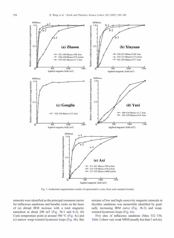
Fig. 3. Isothermal magnetization results of representative cores from each sampled locality.
294 B. Wang et al. / Earth and Planetary Science Letters 263 (2007) 288–308
minerals were identified as the principal remanent carrierfor tuffaceous sandstone and basaltic rocks on the basisof (a) abrupt IRM increase with a total magneticsaturation at about 200 mT (Fig. 3b-1 and b-2), (b)Curie temperature point at around 580 °C (Fig. 4c) and(c) narrow wasp-waisted hysteresis loops (Fig. 6b). But
mixture of low and high coercivity magnetic minerals inrhyolitic sandstone was meanwhile identified by grad-ually increasing IRM curve (Fig. 3b-3) and wasp-waisted hysteresis loops (Fig. 6c).
Five sites of tuffaceous sandstone (Sites 532–536,Table 1) showveryweakNRM(usually less than 1mA/m).

Fig. 4. Results of thermomagnetic Curie temperature analyses on representative lithologies of the Yili Block.
295B. Wang et al. / Earth and Planetary Science Letters 263 (2007) 288–308
Demagnetization onmost of samples displays an importantviscous component that may be cleaned up to 350 °C andclose to Present Earth Field (PEF; Fig. 7a). After theremoval of themagnetic viscosity, most of specimens showrandom directions due to weak remanent intensity and fewspecimens show “stable” directions, which are also not farfrom PEF (Fig. 7b). So, no mean-site directions could becalculated.
Four sites of basalts (Sites 537 to 540, Table 1) showrelatively stable and reverse magnetic componentsisolated at about 90∼110 mT or 580 °C carried mainlyby the titanium-poor magnetite (Fig. 7c and d; Table 1).Tilt corrected directions are, however, much less
clustered than in-situ directions with a ratio of 0.06 forks/kg, indicating a negative fold test (Fig. 7e and f).
The remaining 2 sites of red rhyolitic sandstone(Sites 541 and 542) show two blocking temperatures ataround 580 °C and 680 °C (Fig. 7g and h), implying thepresence of the association of magnetite and hematite. Agood consistency may be observed between hightemperature components isolated from magnetite andhematite. No fold test may be applied as their bedding isconstant. The directions isolated from high temperaturecomponent are more consistent in stratigraphic coordi-nates with those of basalt than in geographic ones(Table 1), a locality-mean has been, therefore, calculated
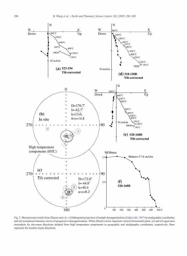
Fig. 5. Measurement results from Zhaosu area. (a–c) Orthogonal projection of sample demagnetization (Zijderveld, 1967) in stratigraphic coordinatesand (d) normalized intensity curves of progressive demagnetization. White (black) circles represent vertical (horizontal) plans. (e) and (f) equal-areastereoplots for site-mean directions isolated from high temperature components in geographic and stratigraphic coordinates, respectively. Starsrepresent the locality-mean directions.
296 B. Wang et al. / Earth and Planetary Science Letters 263 (2007) 288–308
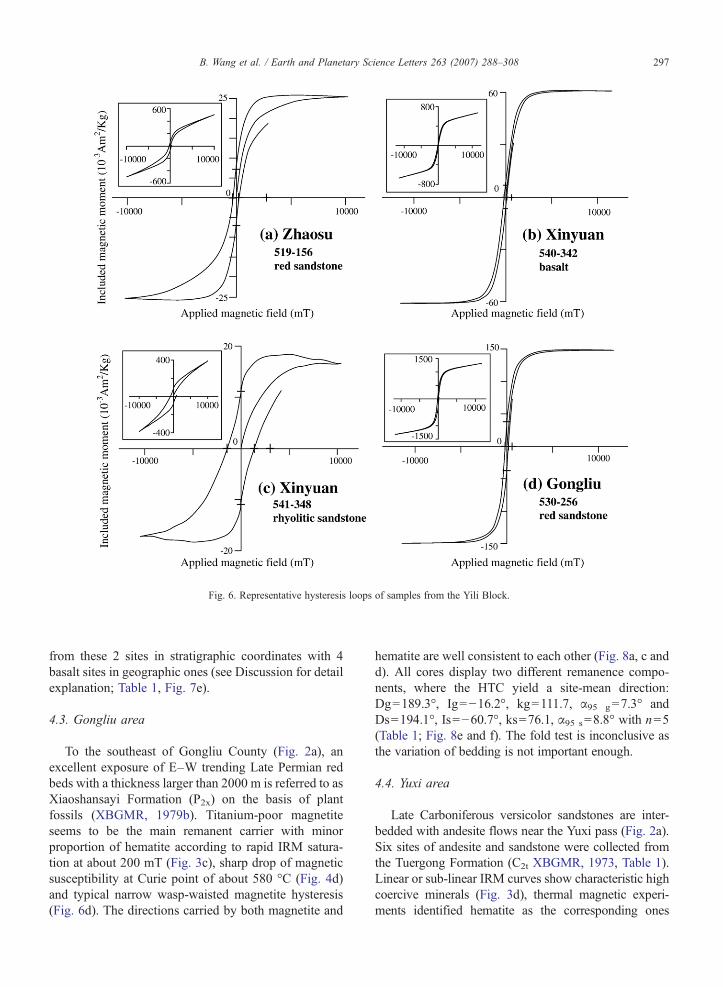
Fig. 6. Representative hysteresis loops of samples from the Yili Block.
297B. Wang et al. / Earth and Planetary Science Letters 263 (2007) 288–308
from these 2 sites in stratigraphic coordinates with 4basalt sites in geographic ones (see Discussion for detailexplanation; Table 1, Fig. 7e).
4.3. Gongliu area
To the southeast of Gongliu County (Fig. 2a), anexcellent exposure of E–W trending Late Permian redbeds with a thickness larger than 2000 m is referred to asXiaoshansayi Formation (P2x) on the basis of plantfossils (XBGMR, 1979b). Titanium-poor magnetiteseems to be the main remanent carrier with minorproportion of hematite according to rapid IRM satura-tion at about 200 mT (Fig. 3c), sharp drop of magneticsusceptibility at Curie point of about 580 °C (Fig. 4d)and typical narrow wasp-waisted magnetite hysteresis(Fig. 6d). The directions carried by both magnetite and
hematite are well consistent to each other (Fig. 8a, c andd). All cores display two different remanence compo-nents, where the HTC yield a site-mean direction:Dg=189.3°, Ig=−16.2°, kg=111.7, α95 g=7.3° andDs=194.1°, Is=−60.7°, ks=76.1, α95 s=8.8° with n=5(Table 1; Fig. 8e and f). The fold test is inconclusive asthe variation of bedding is not important enough.
4.4. Yuxi area
Late Carboniferous versicolor sandstones are inter-bedded with andesite flows near the Yuxi pass (Fig. 2a).Six sites of andesite and sandstone were collected fromthe Tuergong Formation (C2t XBGMR, 1973, Table 1).Linear or sub-linear IRM curves show characteristic highcoercive minerals (Fig. 3d), thermal magnetic experi-ments identified hematite as the corresponding ones
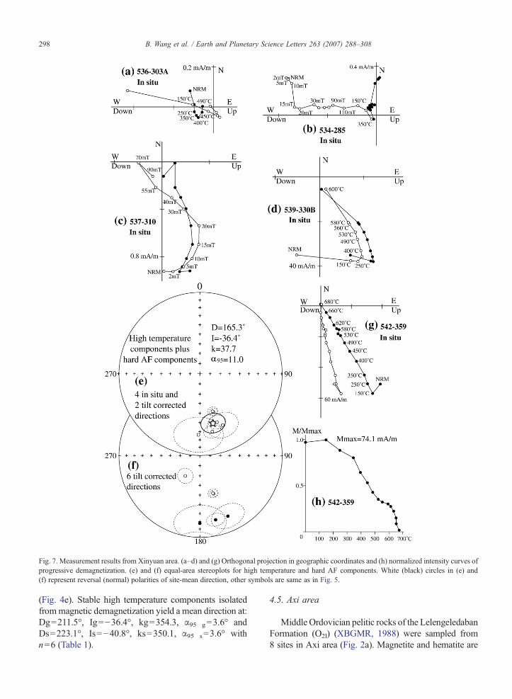
Fig. 7. Measurement results from Xinyuan area. (a–d) and (g) Orthogonal projection in geographic coordinates and (h) normalized intensity curves ofprogressive demagnetization. (e) and (f) equal-area stereoplots for high temperature and hard AF components. White (black) circles in (e) and(f) represent reversal (normal) polarities of site-mean direction, other symbols are same as in Fig. 5.
298 B. Wang et al. / Earth and Planetary Science Letters 263 (2007) 288–308
(Fig. 4e). Stable high temperature components isolatedfrommagnetic demagnetization yield a mean direction at:Dg=211.5°, Ig=−36.4°, kg=354.3, α95 g=3.6° andDs=223.1°, Is=−40.8°, ks=350.1, α95 s=3.6° withn=6 (Table 1).
4.5. Axi area
Middle Ordovician pelitic rocks of the LelengeledabanFormation (O2l) (XBGMR, 1988) were sampled from8 sites in Axi area (Fig. 2a). Magnetite and hematite are
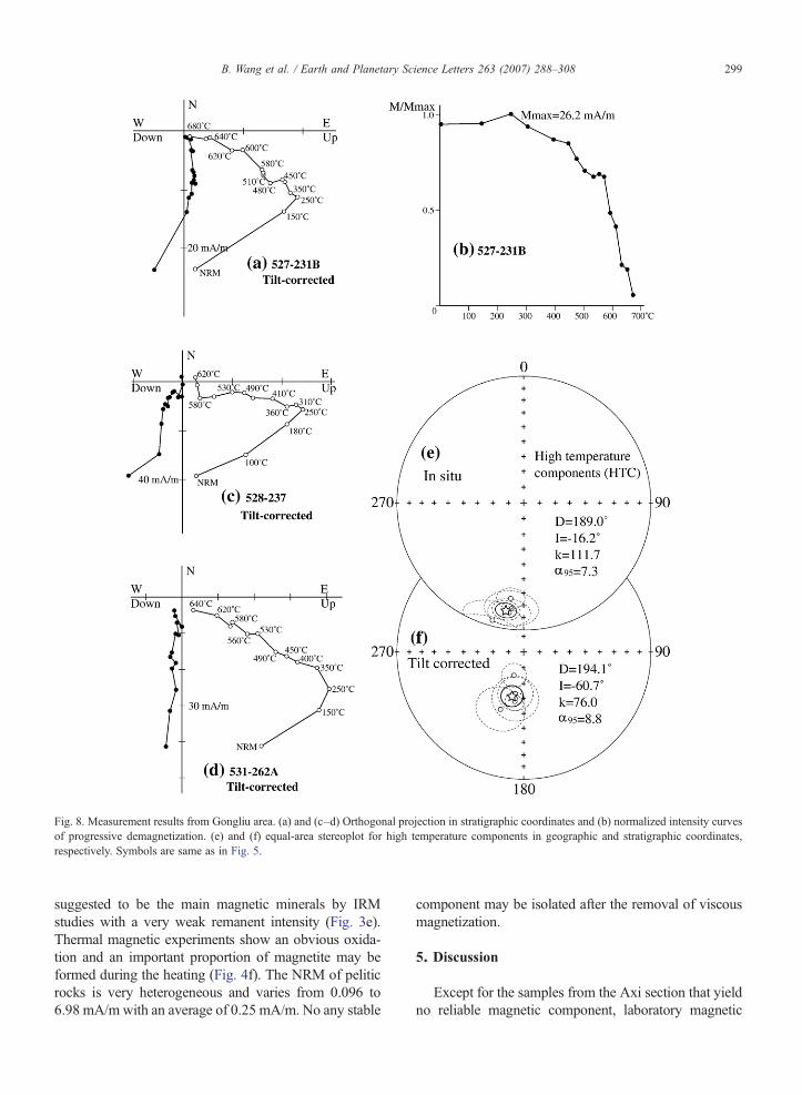
Fig. 8. Measurement results from Gongliu area. (a) and (c–d) Orthogonal projection in stratigraphic coordinates and (b) normalized intensity curvesof progressive demagnetization. (e) and (f) equal-area stereoplot for high temperature components in geographic and stratigraphic coordinates,respectively. Symbols are same as in Fig. 5.
299B. Wang et al. / Earth and Planetary Science Letters 263 (2007) 288–308
suggested to be the main magnetic minerals by IRMstudies with a very weak remanent intensity (Fig. 3e).Thermal magnetic experiments show an obvious oxida-tion and an important proportion of magnetite may beformed during the heating (Fig. 4f). The NRM of peliticrocks is very heterogeneous and varies from 0.096 to6.98 mA/m with an average of 0.25 mA/m. No any stable
component may be isolated after the removal of viscousmagnetization.
5. Discussion
Except for the samples from the Axi section that yieldno reliable magnetic component, laboratory magnetic
300 B. Wang et al. / Earth and Planetary Science Letters 263 (2007) 288–308
mineralogical analyses and thermal/AF demagnetizationshave successfully isolated two magnetic components,namely viscous and characteristic remanent magnetiza-tions from 4 out of 5 Late Paleozoic sections. The viscousone clearly records the recent geomagnetic field with anegative fold test (Dg=348.4°, Ig=67.1°, kg=15.9,α95 g = 3.1° and Ds= 350.2°, Is = 52.9°, ks = 3.3,α95 s=7.9° with n=185 samples). However, the stabletitanium-poor magnetite and hematite have been identi-fied as principal magnetic remanent carriers for thecharacteristic remanent magnetization. The followingevidences strengthen our argument that the ChrM canbe used for tectonic implications: (1) the positive fold testobserved from Zhaosu area; (2) the solo reversed polaritywith significantly distinguishable mean directions fromPEF as well other Mesozoic and Cenozoic ones (Chenet al., 1992, 1993). However, as mentioned above, thisarea has experienced multi-phase tectonic and magmaticevents. Before putting forward their tectonic implicationsof these new paleomagnetic data, their reliability andmagnetic remanence age should be discussed.
5.1. Reliability and magnetic remanence age
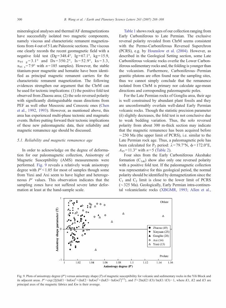
In order to acknowledge on the degree of deforma-tion for our paleomagnetic collection, Anisotropy ofMagnetic Susceptibility (AMS) measurements wereperformed. Fig. 9 reveals a relatively weak anisotropydegree with P′b1.05 for most of samples though somefrom Yuxi and Axi seem to have higher and heteroge-neous P′ values. This observation indicates that thesampling zones have not suffered severe latter defor-mation at least at the hand-sample scale.
Fig. 9. Plots of anisotropy degree (P′) versus anisotropy shape (T) of magneticits adjacent areas. P′=exp{2[(lnK1− lnKm)2+ (lnK2− lnKm)2+ (lnK3− lnKmprincipal axes of the magnetic fabrics and Km is their average.
Table 1 shows rock ages of our collection ranging fromEarly Carboniferous to Late Permian. The exclusivereversal polarity revealed from ChrM seems consistentwith the Permo-Carboniferous Reversed Superchron(PCRS), e.g. by Hounslow et al. (2004). However, asdescribed in the Geological Setting section, some LateCarboniferous volcanic rocks overlie the Lower Carbon-iferous sedimentary rocks and, the folding is younger thanthe volcanism. Furthermore, Carboniferous–Permiangranitic plutons are often found near the sampling sites,thus we cannot simply conclude that the remanenceisolated from ChrM is primary nor calculate age-meandirections and corresponding paleomagnetic poles.
For the Late Permian rocks of Gongliu area, their ageis well constrained by abundant plant fossils and theyare unconformably overlain well-dated Early Permianvolcanic rocks. Though the statistic precision parameter(k) slightly decreases, the fold test is not conclusive dueto weak bedding variation. Thus, the solo reversedpolarity from about 300 m-thick section may indicatethat the magnetic remanence has been acquired before∼250 Ma (the upper limit of PCRS), i.e. similar to theLate Permian rock age. Thus, a paleomagnetic pole hasbeen calculated for P2 period: λ=79.7°N, ϕ=172.0°E,A95=11.3° with n=5 (Table 2).
Four sites from the Early Carboniferous Akeshakeformation (C1ak) show also only one reversed polaritywith a positive fold test. If the paleomagnetic collectionwas representative for this geological period, the normalpolarity should be identified by demagnetization since theC1 and C2 limit is close to the lower limit of PCRS(∼325 Ma). Geologically, Early Permian intra-continen-tal volcaniclastic rocks (XBGMR, 1993; Allen et al.,
susceptibility for volcanic and sedimentary rocks in the Yili Block and)2]1/2}, and T=2ln(K2 /K3) / ln(K1 /K3)−1, where K1, K2 and K3 are
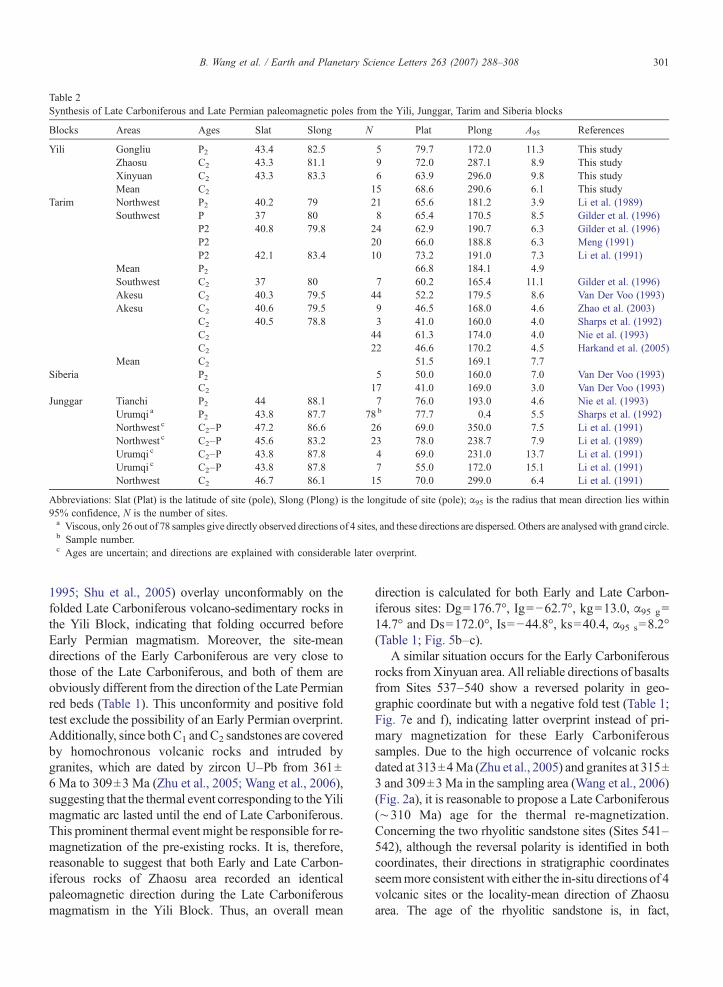
Table 2Synthesis of Late Carboniferous and Late Permian paleomagnetic poles from the Yili, Junggar, Tarim and Siberia blocks
Blocks Areas Ages Slat Slong N Plat Plong A95 References
Yili Gongliu P2 43.4 82.5 5 79.7 172.0 11.3 This studyZhaosu C2 43.3 81.1 9 72.0 287.1 8.9 This studyXinyuan C2 43.3 83.3 6 63.9 296.0 9.8 This studyMean C2 15 68.6 290.6 6.1 This study
Tarim Northwest P2 40.2 79 21 65.6 181.2 3.9 Li et al. (1989)Southwest P 37 80 8 65.4 170.5 8.5 Gilder et al. (1996)
P2 40.8 79.8 24 62.9 190.7 6.3 Gilder et al. (1996)P2 20 66.0 188.8 6.3 Meng (1991)P2 42.1 83.4 10 73.2 191.0 7.3 Li et al. (1991)
Mean P2 66.8 184.1 4.9Southwest C2 37 80 7 60.2 165.4 11.1 Gilder et al. (1996)Akesu C2 40.3 79.5 44 52.2 179.5 8.6 Van Der Voo (1993)Akesu C2 40.6 79.5 9 46.5 168.0 4.6 Zhao et al. (2003)
C2 40.5 78.8 3 41.0 160.0 4.0 Sharps et al. (1992)C2 44 61.3 174.0 4.0 Nie et al. (1993)C2 22 46.6 170.2 4.5 Harkand et al. (2005)
Mean C2 51.5 169.1 7.7Siberia P2 5 50.0 160.0 7.0 Van Der Voo (1993)
C2 17 41.0 169.0 3.0 Van Der Voo (1993)Junggar Tianchi P2 44 88.1 7 76.0 193.0 4.6 Nie et al. (1993)
Urumqi a P2 43.8 87.7 78 b 77.7 0.4 5.5 Sharps et al. (1992)Northwest c C2–P 47.2 86.6 26 69.0 350.0 7.5 Li et al. (1991)Northwest c C2–P 45.6 83.2 23 78.0 238.7 7.9 Li et al. (1989)Urumqi c C2–P 43.8 87.8 4 69.0 231.0 13.7 Li et al. (1991)Urumqi c C2–P 43.8 87.8 7 55.0 172.0 15.1 Li et al. (1991)Northwest C2 46.7 86.1 15 70.0 299.0 6.4 Li et al. (1991)
Abbreviations: Slat (Plat) is the latitude of site (pole), Slong (Plong) is the longitude of site (pole); α95 is the radius that mean direction lies within95% confidence, N is the number of sites.a Viscous, only 26 out of 78 samples give directly observed directions of 4 sites, and these directions are dispersed. Others are analysedwith grand circle.b Sample number.c Ages are uncertain; and directions are explained with considerable later overprint.
301B. Wang et al. / Earth and Planetary Science Letters 263 (2007) 288–308
1995; Shu et al., 2005) overlay unconformably on thefolded Late Carboniferous volcano-sedimentary rocks inthe Yili Block, indicating that folding occurred beforeEarly Permian magmatism. Moreover, the site-meandirections of the Early Carboniferous are very close tothose of the Late Carboniferous, and both of them areobviously different from the direction of the Late Permianred beds (Table 1). This unconformity and positive foldtest exclude the possibility of an Early Permian overprint.Additionally, since bothC1 andC2 sandstones are coveredby homochronous volcanic rocks and intruded bygranites, which are dated by zircon U–Pb from 361±6 Ma to 309±3 Ma (Zhu et al., 2005; Wang et al., 2006),suggesting that the thermal event corresponding to theYilimagmatic arc lasted until the end of Late Carboniferous.This prominent thermal event might be responsible for re-magnetization of the pre-existing rocks. It is, therefore,reasonable to suggest that both Early and Late Carbon-iferous rocks of Zhaosu area recorded an identicalpaleomagnetic direction during the Late Carboniferousmagmatism in the Yili Block. Thus, an overall mean
direction is calculated for both Early and Late Carbon-iferous sites: Dg=176.7°, Ig=−62.7°, kg=13.0, α95 g=14.7° and Ds=172.0°, Is=−44.8°, ks=40.4, α95 s=8.2°(Table 1; Fig. 5b–c).
A similar situation occurs for the Early Carboniferousrocks fromXinyuan area. All reliable directions of basaltsfrom Sites 537–540 show a reversed polarity in geo-graphic coordinate but with a negative fold test (Table 1;Fig. 7e and f), indicating latter overprint instead of pri-mary magnetization for these Early Carboniferoussamples. Due to the high occurrence of volcanic rocksdated at 313±4Ma (Zhu et al., 2005) and granites at 315±3 and 309±3Ma in the sampling area (Wang et al., 2006)(Fig. 2a), it is reasonable to propose a Late Carboniferous(∼310 Ma) age for the thermal re-magnetization.Concerning the two rhyolitic sandstone sites (Sites 541–542), although the reversal polarity is identified in bothcoordinates, their directions in stratigraphic coordinatesseemmore consistent with either the in-situ directions of 4volcanic sites or the locality-mean direction of Zhaosuarea. The age of the rhyolitic sandstone is, in fact,
302 B. Wang et al. / Earth and Planetary Science Letters 263 (2007) 288–308
questionable. No any direct age constraint has beendocumented from this formation although referred to asEarly Carboniferous (XBGMR, 1993; XBGMR, 1975). Inthe point of view of regional tectonics and stratigraphiccorrelation, it is clear that the age of the rhyolitic sandstoneis younger than that of the basalt dated at 354±5Ma (zirconU–Pb SHRIMP by Zhu et al., 2005). Moreover, no anydirect contact between these two lithostratigraphic units canbe observed in the field, stratigraphic and structuralknowledge allows us to exclude a syncline structure andto favour an unconformable contact. According to theabove arguments, it is not unreasonable to consider that therhyolitic sandstone is Late Carboniferous in age. Thus, 4 in-situ paleomagnetic directions of basalts and 2 tilt-correcteddirections of rhyolitic sandstones are used to calculate anaverage direction at: D=165.3°, I=−36.4°, k=37.7,α95=11.0° for the Late Carboniferous magnetization fromXinyuan area (Table 1; Fig. 7e).
As to paleomagnetic results from Yuxi area, 6 LateCarboniferous sites present well-grouped reversal direc-tions without fold test due to monoclinal attitude of thebedding (Table 1). The magnetic inclinations from thislocality are consistent with those from Zhaosu andXinyuan areas, but this area shows a significant differentdeclination with respect to the other two. As this samplinglocality is situated close to a tectonic zone (Fig. 2a), thedifference in declination may be explained by a localrotation of the Yuxi sampling zone with respect to the YiliBlock.
According to above direction analyses and geologicarguments, a C2 paleomagnetic polemay be calculated forthe Yili Block from Zhaosu and Xinyuan areas:λ=68.6°N, ϕ=290.6°E, A95=6.1° with n=15 (Table 2).
5.2. Comparisons of the paleomagnetic data from Yiliwith other adjacent blocks
Up to now, no paleomagnetic data were documentedfrom the Yili Block, except some data obtained fromCarboniferous–Permian rocks in the western Tianshan ofKyrgyzstan (Bazhenov et al., 1993, 1999, 2003). Most ofthese data were derived from the deformation belt, e.g.“North Tianshan tectonic zone” located in the extremelynorthwestern part of the Tianshan Belt (Fig. 1a). Thesestudied areas cannot be considered as a part of a rigidblock, some deflections of declination with respect to thereference blocks (e.g. Tarim and Siberia) may be,therefore, interpreted as the result of strike–slip faultingwithin the orogenic belt, rather than the representativerotation of a rigid body (Bazhenov et al., 1999). In fact,the Yili Block is accepted as a microcontinent with aPrecambrian basement (Allen et al., 1992; Gao et al.,
1998; Chen et al., 1999; Wang et al., 2006, 2007), itextends westwards into Kazakhstan with an unclearboundary, and its eastern boundaries are the southern andnorthern branches of the Tianshan range (Fig. 1). Theseboundaries were highly deformed during the Tianshanorogeny, but the interior of the block is much lessdeformed. This agrees well with the good consistencybetween the C2 paleomagnetic results from Zhaosu andXinyuan areas located near to the center of the Yili Blockbut distant from about 200 km (Figs. 2a, 5f and 7e). Thus,the paleomagnetic poles derived from these areas arerepresentative for the whole Yili block (Table 2).
In order to understand the kinematic relationshipsduring the Late Paleozoic between the Yili Block andadjacent ones, previous paleomagnetic results on theTarim, Junggar and Siberia blocks are analysed and listedin Table 2. Late Carboniferous and Late Permian poles ofthe TarimBlock have beenwell documented by numerousstudies (Cheng et al., 1983; Bai et al., 1987; Li et al., 1988;McFadden et al., 1988; Zhai et al., 1988; Fang et al., 1990,1996; Meng and Zheng, 1990; Meng, 1991; Gilder et al.,1996), these data are very consistent with each otherwithin the relatively weak uncertainty (Table 2), the LateCarboniferous and Late Permian mean poles are recalcu-lated at 51.5°N, 169.1°E, A95=7.7° and 66.8°N, 184.1°E,A95=4.9, respectively. Van der Voo (1993) presented LateCarboniferous and Late Permian paleomagnetic poles ofSiberia Block (Table 2). As for the Junggar Block, fewresults have been reported from the Urumqi area and thenorthwestern Junggar basin (Fig. 1b; Li et al., 1989, 1991;Sharps et al., 1992; Nie et al., 1993), but the available dataare quite dispersed, and the ages of magnetization areoften undetermined (Table 2). For example, the paleo-magnetic results from the southern and northwestern partsof the Junggar basin by Li et al. (1991) are not consistent,an important second overprint is proposed, the ages of theprimary or secondarymagnetization are roughly restrictedbetween Late Carboniferous and Permian, i.e. a long andvariable interval from 20 to 75Ma. Such an uncertainty inage and variability in paleomagnetic pole make themunfeasible to compare with those from other blocks. Onlyone relatively reliable paleomagnetic pole derived fromthe northwestern part of the Junggar basin (Li et al., 1991)may be considered for the Late Carboniferous period(Table 2). Concerning the Late Permian period, twopaleomagnetic poles have been obtained from Urumqi(Sharps et al., 1992) and Tianchi areas (Nie et al., 1993)(Table 2). However, the former study shows that only 26(4 sites) out of 78 samples from Urumqi display directlyobservable directions, and the other samples are analysedby the grand circle technique with an importantuncertainty. In addition, magnetic remanence of these
303B. Wang et al. / Earth and Planetary Science Letters 263 (2007) 288–308
Late Permian sediments is viscous, magnetic directionsare relatively dispersed within and among sites, thepaleomagnetic pole is calculated with specimens instead
of by site-mean directions. Paleomagnetic directionsderived from the Tianchi section seem to be relativelystable, and passed a positive fold test, therefore, theselatter results are accepted for the Late Permian paleo-magnetic pole of the Junggar block (Table 2).
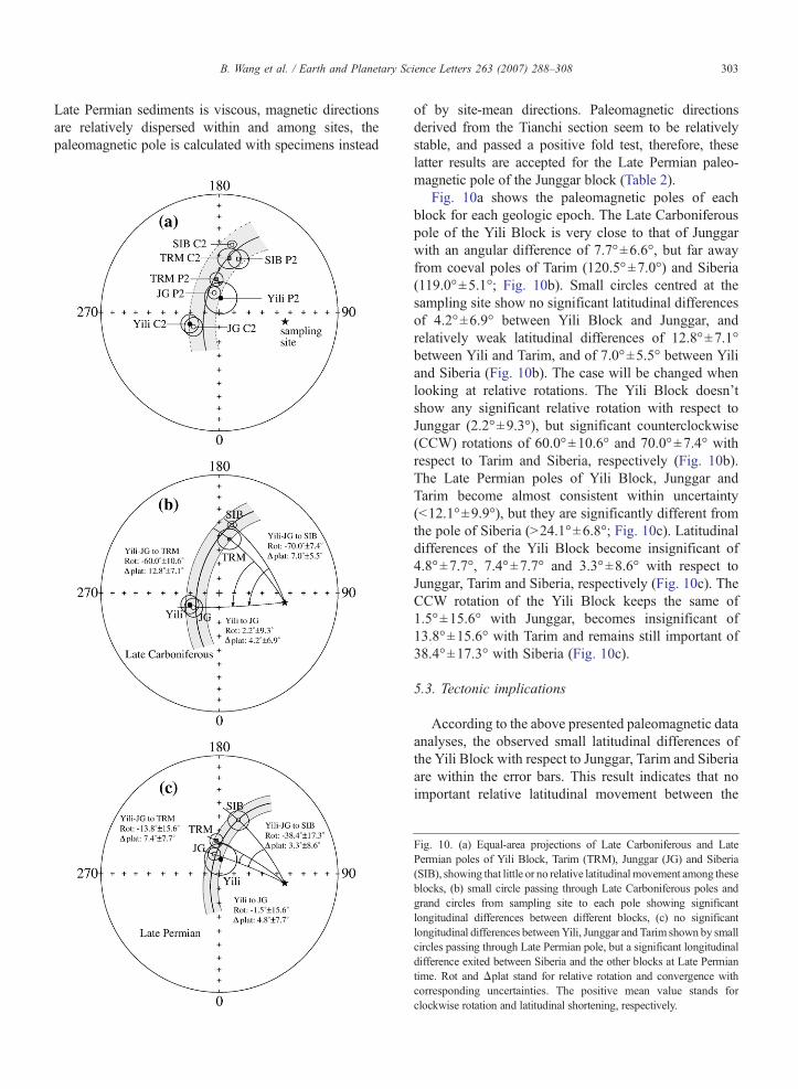
Fig. 10a shows the paleomagnetic poles of eachblock for each geologic epoch. The Late Carboniferouspole of the Yili Block is very close to that of Junggarwith an angular difference of 7.7°±6.6°, but far awayfrom coeval poles of Tarim (120.5°±7.0°) and Siberia(119.0°±5.1°; Fig. 10b). Small circles centred at thesampling site show no significant latitudinal differencesof 4.2°±6.9° between Yili Block and Junggar, andrelatively weak latitudinal differences of 12.8°±7.1°between Yili and Tarim, and of 7.0°±5.5° between Yiliand Siberia (Fig. 10b). The case will be changed whenlooking at relative rotations. The Yili Block doesn'tshow any significant relative rotation with respect toJunggar (2.2°±9.3°), but significant counterclockwise(CCW) rotations of 60.0°±10.6° and 70.0°±7.4° withrespect to Tarim and Siberia, respectively (Fig. 10b).The Late Permian poles of Yili Block, Junggar andTarim become almost consistent within uncertainty(b12.1°±9.9°), but they are significantly different fromthe pole of Siberia (N24.1°±6.8°; Fig. 10c). Latitudinaldifferences of the Yili Block become insignificant of4.8°±7.7°, 7.4°±7.7° and 3.3°±8.6° with respect toJunggar, Tarim and Siberia, respectively (Fig. 10c). TheCCW rotation of the Yili Block keeps the same of1.5°±15.6° with Junggar, becomes insignificant of13.8°±15.6° with Tarim and remains still important of38.4°±17.3° with Siberia (Fig. 10c).
5.3. Tectonic implications
According to the above presented paleomagnetic dataanalyses, the observed small latitudinal differences ofthe Yili Block with respect to Junggar, Tarim and Siberiaare within the error bars. This result indicates that noimportant relative latitudinal movement between the
Fig. 10. (a) Equal-area projections of Late Carboniferous and LatePermian poles of Yili Block, Tarim (TRM), Junggar (JG) and Siberia(SIB), showing that little or no relative latitudinalmovement among theseblocks, (b) small circle passing through Late Carboniferous poles andgrand circles from sampling site to each pole showing significantlongitudinal differences between different blocks, (c) no significantlongitudinal differences betweenYili, Junggar and Tarim shown by smallcircles passing through Late Permian pole, but a significant longitudinaldifference exited between Siberia and the other blocks at Late Permiantime. Rot and Δplat stand for relative rotation and convergence withcorresponding uncertainties. The positive mean value stands forclockwise rotation and latitudinal shortening, respectively.
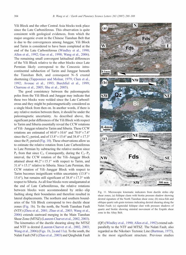
Fig. 11. Microscopic kinematic indicators from ductile strike–slipshear zones, (a) feldspar clasts with biotite pressure shadow showingdextral signature of the North Tianshan shear zone; (b) mica-fish andoblique quartz sub-grain textures indicating dextral shearing along theNalati Fault; (c) sigmoidal feldspar clast with pressure shadows ofquartz and biotite showing sinistral movement of the Erqishi shearzone in the Altay Belt.
304 B. Wang et al. / Earth and Planetary Science Letters 263 (2007) 288–308
Yili Block and the other Central Asia blocks took placesince the Late Carboniferous. This observation is quiteconsistent with geological evidences, from which themajor orogenic event in the Chinese Tianshan Belt thatis due to the convergences among Junggar, Yili Blockand Tarim is considered to have been completed at theend of the Late Carboniferous (Windley et al., 1990;Allen et al., 1992; Gao et al., 1998; Wang et al., 2006).The remaining small convergent latitudinal differencesof the Yili Block relative to the other blocks since LatePermian likely correspond to the Cenozoic intra-continental subduction of Tarim and Junggar beneaththe Tianshan Belt, and consequent N–S crustalshortening (Tapponnier and Molnar, 1979; Chen et al.,1992; Avouac et al., 1993; Burchfiel et al., 1999;Charreau et al., 2005; Shu et al., 2005).
The good consistency between the paleomagneticpoles from the Yili Block and Junggar may indicate thatthese two blocks were welded since the Late Carbonif-erous and they might be paleomagnetically considered asa single block from then on. In another words, if there isany relative motion between them, it should be under thepaleomagnetic uncertainty. As described above, thesignificant polar differences of the Yili Block with respectto Tarim and Siberia essentially reveal the CCW rotationsof Yili–Junggar related to Tarim and Siberia. These CCWrotations are estimated of 60.0°±10.6° and 70.0°±7.4°since the C2 period, and of 13.8°±15.6° and 38.4°±17.3°since the P2 period (Fig. 10). These observations allow usto estimate the relative rotation from Late Carboniferousto Late Permian by subtracting the relative motion sinceP2 from that since C2. Consequently, during the C2–P2interval, the CCW rotation of the Yili–Junggar Blockattained about 46.2°±15.1° with respect to Tarim, and31.6°±15.1° relative to Siberia. Since Late Permian, thisCCW rotation of Yili–Junggar Block with respect toTarim becomes insignificant within uncertainty (13.8°±15.6°), but remains still significant of 38.4°±17.3° withrespect to Siberia. As all four blocks were amalgamated atthe end of Late Carboniferous, the relative rotationsbetween blocks were accommodated by strike–slipfaulting along their boundaries and therefore resulted inlateral displacements. The northern and southern bound-aries of the Yili Block correspond to two ductile shearzones (Fig. 1b). To the north, the North Tianshan Fault(NTF) (Zhou et al., 2001; Zhao et al., 2003; Wang et al.,2006) extends eastward merging in the Main TianshanShear Zone (MTSZ) (Laurent-Charvet et al., 2002, 2003).The kinematics of the ductile shearing along the MTSZand NTF is dextral (Laurent-Charvet et al., 2002, 2003;Wang et al., 2006) (Figs. 1b, 2a and 11a). To the south, theNalati Fault (NF) (Zhao et al., 2003) and Qingbulak Fault
(QF) (Windley et al., 1990; Allen et al., 1992) extend sub-parallelly to the NTF and MTSZ. The Nalati Fault, alsoregarded as the Nikolaev Tectonic Line (Burtman, 1975),is the most significant structure. Previous studies
305B. Wang et al. / Earth and Planetary Science Letters 263 (2007) 288–308
proposed a left-lateral slip (Sengör et al., 1993; Allenet al., 1995; Bazhenov et al., 1999), but field structuralanalyses based on kinematic indicators suggest a right-
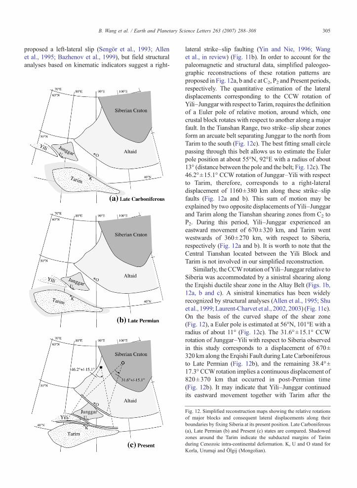
lateral strike–slip faulting (Yin and Nie, 1996; Wanget al., in review) (Fig. 11b). In order to account for thepaleomagnetic and structural data, simplified paleogeo-graphic reconstructions of these rotation patterns areproposed in Fig. 12a, b and c at C2, P2 and Present periods,respectively. The quantitative estimation of the lateraldisplacements corresponding to the CCW rotation ofYili–Junggar with respect to Tarim, requires the definitionof a Euler pole of relative motion, around which, onecrustal block rotates with respect to another along a majorfault. In the Tianshan Range, two strike–slip shear zonesform an arcuate belt separating Junggar to the north fromTarim to the south (Fig. 12c). The best fitting small circlepassing through this belt allows us to estimate the Eulerpole position at about 55°N, 92°E with a radius of about13° (distance between the pole and the belt; Fig. 12c). The46.2°±15.1° CCW rotation of Junggar–Yili with respectto Tarim, therefore, corresponds to a right-lateraldisplacement of 1160±380 km along these strike–slipfaults (Fig. 12a and b). This sum of motion may beexplained by two opposite displacements of Yili–Junggarand Tarim along the Tianshan shearing zones from C2 toP2. During this period, Yili–Junggar experienced aneastward movement of 670±320 km, and Tarim wentwestwards of 360±270 km, with respect to Siberia,respectively (Fig. 12a and b). It is worth to note that theCentral Tianshan located between the Yili Block andTarim is not involved in our simplified reconstruction.
Similarly, the CCWrotation ofYili–Junggar relative toSiberia was accommodated by a sinistral shearing alongthe Erqishi ductile shear zone in the Altay Belt (Figs. 1b,12a, b and c). A sinistral kinematics has been widelyrecognized by structural analyses (Allen et al., 1995; Shuet al., 1999; Laurent-Charvet et al., 2002, 2003) (Fig. 11c).On the basis of the curved shape of the shear zone(Fig. 12), a Euler pole is estimated at 56°N, 101°E with aradius of about 11° (Fig. 12c). The 31.6°±15.1° CCWrotation of Junggar–Yili with respect to Siberia observedin this study corresponds to a displacement of 670±320 km along the Erqishi Fault during Late Carboniferousto Late Permian (Fig. 12b), and the remaining 38.4°±17.3° CCWrotation implies a continuous displacement of820±370 km that occurred in post-Permian time(Fig. 12b). It may indicate that Yili–Junggar continuedits eastward movement together with Tarim after the
Fig. 12. Simplified reconstruction maps showing the relative rotationsof major blocks and consequent lateral displacements along theirboundaries by fixing Siberia at its present position. Late Carboniferous(a), Late Permian (b) and Present (c) states are compared. Shadowedzones around the Tarim indicate the subducted margins of Tarimduring Cenozoic intra-continental deformation. K, U and O stand forKorla, Urumqi and Ölgij (Mongolian).

306 B. Wang et al. / Earth and Planetary Science Letters 263 (2007) 288–308
Permian (Fig. 12b and c). This motion essentially endedup before the Cretaceous because Cretaceous paleomag-netic data from Junggar, Mongolia as well as Siberia donot show significant differences among them (Chen et al.,1993; Harkand et al., 2005).
Ar–Ar geochronological studies on the ductile de-formed rocks from shear zones indicate that Tianshandextral strike–slip faulting took place during290∼240 Ma (Yin and Nie, 1996; Zhou et al., 2001;Laurent-Charvet et al., 2002, 2003). Erqishi sinistralstrike–slip faulting was also proposed to occur from290 Ma to 240 Ma (Laurent-Charvet et al., 2003), andcontinued through Triassic to Early Jurassic (Allen et al.,1995). Such large-scale and contemporaneous displace-ments along the southern right-lateral and northern left-lateral boundaries of Yili–Junggar blocks enable us tosuggest an eastward wedging of Yili–Junggar blocksbetween Tarim and Siberia. Meanwhile, further paleo-magnetic and geological studies on Early Permian of theYili and Junggar blocks are needed to better constrain thetiming of relative motions as well as the mechanism ofsuch tectonics.
6. Conclusions
This first paleomagnetic study is performed onsedimentary and volcanic rocks from the Yili Block.Magnetic mineralogical analyses show titanium-poormagnetite and hematite as the principal remanencecarriers. Except the samples from the Axi area showingweak and unstable magnetic remanence, most of samplesdemagnetized by thermal and AF techniques demonstrateboth viscous and stable components, the former gives amagnetic direction close to PEF and the latter presentscharacteristic remanent magnetization. The reversalpolarity is exhaustively obtained from these Early andLate Carboniferous rocks and Late Permian red beds. Ageneral re-magnetization of Early Carboniferous rockshas been observed due to the Late Carboniferous Yili arcmagmatism. Two paleomagnetic poles of Late Carbonif-erous and Late Permian ages for the Yili Block arecalculated from stable directions. Keeping in mind theimportant uncertainties, comparisons of both poles to theavailable coeval poles of Tarim, Junggar and Siberiaindicate that (1) the consistency of poles from Yili andJunggar implies no or small relativemotion between themsince the Late Carboniferous; (2) no significant or smallrelative latitudinal movement occurred between these 4blocks since Late Carboniferous; (3) 46.2°±15.1° and31.6°±15.1° counterclockwise rotations of the Yili–Junggar blocks with respect to Tarim and Siberia,respectively, took place from Late Carboniferous to Late
Permian. These rotations correspond to the eastwardmotions of Yili–Junggar Block with respect to Tarim(1160±380 km) along the dextral strike–slip faults in theTianshan Belt and to Siberia (670±320 km) along the left-lateral Erqishi Fault in the Altay belt. These conclusionsare supported by both field structural and kinematicobservations as well as geochronologic studies in thesetectonic zones.
Acknowledgement
This study has been supported by the National BasicResearch Program of China (973 Programs) (Nos.2007CB411301 and2001CB409804) andFrench–ChineseAdvanced Research Program (PRA T05-02, Y. CHEN &Q.C. WANG). French Embassy in Beijing is appreciatedfor financing part of research of the first author in France.Constructive suggestions provided by an anonymousreviewer and the editors have significantly improved theoriginal manuscript.
References
Allen, M.B., Sengör, A.M.C., Natal'in, B.A., 1995. Junggar, Turfanand Alakol basins as Late Permian to ?Early Triassic extensionalstructures in a sinistral shear zone in the Altaid orogenic collage,Central Asia. J. Geol. Soc. (Lond.) 152, 327–338.
Allen, M.B., Windley, B.F., Zhang, C., 1992. Paleozoic collisionaltectonics and magmatism of the Chinese Tien Shan, Central Asia.Tectonophysics 220, 89–115.
Avouac, J.P., Tapponnier, P., Bai, M., You, H., Wang, G., 1993. Activethrusting and folding along the northern Tien Shan and LateCenozoic rotation of the Tarim relative to Dzungaria andKazakhstan. J. Geophys. Res. 98 (B4), 6755–6804.
Bai, Y.H., Cheng, G.L., Sun, Q.G., Sun, Y.H., Li, Y.G., Dong, Y.J.,Sun, D.J., 1987. Late Paleozoic polar wander path for the Tarimplatform and its tectonic significance. Tectonophysics 139,145–153.
Bazhenov, M.L., Burtman, V.S., Dvorova, A.V., 1999. Permianpaleomagnetism of the Tien Shan fold belt, Central Asia: Post-collisional rotation and deformation. Tectonophysics 312 (2–4),303–329.
Bazhenov, L.M., Chauvin, A., Audibert, M., Levashova, N.M., 1993.Permian and Triasic paleomagnetism of the southwestern TienShan: timing and mode of tectonic rotations. Earth Planet. Sci.Lett. 118, 195–212.
Bazhenov, L.M., Collins, A.Q., Degtyarev, K.E., Levashova, N.M.,Mikolaichuk, A.V., Pavlov, V.E., Van der Voo, R., 2003. Paleozoicnorthward drift of the North Tianshan (Central Asia) as revealed byOrdovician and Carboniferous paleomagmatism. Tectonophysics366, 113–141.
Burchfiel, B.C., Brown, E.T., Deng, Q.D., Feng, X.Y., Li, J., Molnar,P., Shi, J.B., Wu, Z.M., You, H.C., 1999. Crustal shortening on theMargins of the Tien Shan, Xinjiang, China. Int. Geol. Rev. 41,665–700.
Burtman, V.S., 1975. Structural geology of variscan Tien Shan, USSR.Am. J. Sci. 275 (A), 157–186.
307B. Wang et al. / Earth and Planetary Science Letters 263 (2007) 288–308
Charreau, J., Chen, Y., Gilder, S., Dominguez, S., Avouac, J.P., Sen, S.,Sun, D.J., Li, Y.A., Wang, W.M., 2005. Magnetostratigraphy androck magnetism of the Neogene Kuitun He section (northwestChina): implications for Late Cenozoic uplift of the Tianshanmountains. Earth Planet. Sci. Lett. 230 (1–2), 177–192.
Chen, Y., Cogné, J.P., Courtillot, V., 1992. New Cretaceouspaleomagnetic poles from the Tarim Basin, Northwestern China.Earth Planet. Sci. Lett. 114, 17–38.
Chen, Y., Courtillot, V., Cogné, J.P., Besse, J., Yang, Z., Enkin, R., 1993.The configuration of Asia prior to the collision of India: Cretaceouspaleomagnetic constraints. J. Geophys. Res. 98, 21 927–21 941.
Chen, Y.B., Hu, A.Q., Zhang, G.X., Zhang, Q.F., 2000. Zircon U–Pbage of granitic gneiss on Duku highway in western Tianshan ofChina and its geological implications. Chin. Sci. Bull. 45 (7),649–653 (in Chinese with English abstract).
Chen, C.M., Lu, H.F., Jia, D., Cai, D.S., Wu, S.M., 1999. Closinghistory of the southern Tianshan oceanic basin, western China: anoblique collisional orogeny. Tectonophysics 302, 23–40.
Cheng, G.L., Bai, Y.H., Li, Y.A., 1983. Paleomagnetism of LowerPermian in the Wushi–Aksu area of Xinjiang. Seismol.Geol. 5 (4),12 (In Chinese).
Cogné, J.P., 2003. A MacintoshTM application for treating paleo-magnetic data and making plate reconstructions. Geochem.Geophys. Geosyst. 4 (1). doi:10.1029/2001GC000227.
Coleman, R.G., 1989. Continental growth of northwest China.Tectonics 8 (3), 621–635.
Enkin, R.J., 2003. The direction–correction tilt test: an all-purpose tilt/fold test for paleomagnetic studies. Earth Planet. Sci. Lett. 212,151–166.
Enkin, R.J., Chen, Y., Courtillot, V., Besse, J., Xing, L., Zhang, Z.,Zhuang, Z., Zhang, J., 1991. A Lower Cretaceous pole from SouthChina and the Mesozoic hairpin turn of the Eurasian apparent polarwander path. J. Geophys. Res 96, 4007–4028.
Fang, D.J., Chen, H.L., Jin, G.H., Guo, Y.B.,Wang, Z.L., Tan, X.D., Yin,S.H., 1990. Late Paleozoic and Mesozoic paleomagnetism andtectonic evolution of Tarim terrane. In: Wiley, T.J., Howell, D.G.,Wong, F.L. (Eds.), Terrane analysis of China and the Pacific rim,Houston (USA), Circum-Pacific Council for Energy and MineralResources. Earth Sci. Ser., vol. 13, pp. 251–255.
Fang, D.J., Jin, G.H., Jiang, L.P., Wang, P.Y., Wang, Z.L., 1996.Paleozoic paleomagnetic results from Tarim basin and their tectonicimplication. Acta Geophys. Sin. 39 (4), 522–531 (in Chinese).
Fisher, R., 1953. Dispersion on a sphere. Proc. R. Soc. London, Ser. A217, 295–305.
Gao, J., Li, M.S., Xiao, X.C., Tang, Y.Q., He, G.Q., 1998. Paleozoictectonic evolution of the Tianshan orogen, northwestern China.Tectonophysics 287, 213–231.
Gilder, S., Zhao, X.X., Coe, R.S., Meng, Z., Courtillot, V., Besse, J.,1996. Paleomagnetism and tectonics of the southern Tarim basin,northwestern China. J. Geophys. Res. 101, 22 015–22 031.
Harkand, F., Cogné, J.P., Kravchinsky, V., 2005. A new LateCretaceous paleomagnetic pole for the west of Amuria block(Khurmen Uul, Mongolia). Earth Planet. Sci. Lett. 236, 359–373.
Hounslow, M.W., Davydov, V.I., Klootwijk, C.T., Turner, P., 2004.Magnetostratigraphy of the Carboniferous: a review and futureprospects. Newsl. Carbonifer. Stratigr. 22, 35–40.
Kirschvink, J.L., 1980. The least squares line and the analysis ofpaleoamgnetic data. Geophys. J. R. Astron. Soc. 62, 699–718.
Laurent-Charvet, S., Charvet, J., Monie, P., Shu, L.S., 2003. LatePaleozoic strike–slip shear zones in eastern Central Asia (NWChina): new structural and geochronological data. Tectonics 22 (2),1099–1101.
Laurent-Charvet, S., Charvet, J., Shu, L.S., Ma, R.S., Lu, H.F., 2002.Palaeozoic late collisional strike–slip deformations in Tianshan andAltay, eastern Xinjiang, NW China. Terra Nova 14 (4), 249–256.
Li, Y.P., McWilliams, M., Cox, A., Sharps, R., Li, Y.A., Gao, Z.J.,Zhang, Z.K., Zhai, Y.J., 1988. Late Permian paleomagnetic polefrom dikes of the Tarim craton, China. Geology 16, 275–278.
Li, Y.P., Sharps, R., McWilliams, M., Li, Y.G., Li, Q., Zhang, W.,1991. Late Paleozoic Paleomagnetic results from the Junggarblock, Northwestern China. J. Geophys. Res. 96, 16 047–16 060.
Li, Y.P., Sharps, R., McWilliams, M., Nur, A., Li, Y.G., Li, Q., Zhang,W., 1989. Paleomagnetic results from Late Paleozoic dikes fromthe northwestern Junggar block, Northwestern China. Earth Planet.Sci. Lett. 94, 123–130.
Li, Y.J., Sun, L.D., Wu, H.R., Zhang, G.Y., Wang, G.L., Huang, Z.B.,2005. Permo-Carboniferous radiolarians from the Wupata'erkangroup, Western South Tianshan, Xinjiang, China. Acta Geol. Sin.79 (1), 16–23.
Li, Y.J., Wang, Z.M., Wu, H.R., Huang, Z.B., Tan, Z.J., Luo, J.C.,2002. Discovery of radiolarian fossils from the Aiketik group at thewestern end of the South Tianshan Mountains of China and itsimplications. Acta Geol. Sin. 76 (2), 146–154.
McFadden, P.L., Ma, X.H., McElhinny, M.W., Zhang, Z.K., 1988.Permo-Triassic magnetostratigraphy in China: northern Tarim.Earth Planet. Sci. Lett. 87, 152–160.
Meng, Z., 1991. Palaeomagnetic study of Upper Palaeozoic erathemalong the southwestern margin of Tarim block, China. ActaSedimentol. Sin. 9, 105–109 (in Chinese with English abstract).
Meng, Z., Zheng, J., 1990. Palaeomagnetic investigations of theApparent Polar Wander path of Tarim and relative motionsbetween sub-tectonic units. In: Zhou, Q., Zheng, J. (Eds.), TectonicSynthesis of Tarim. Science Press, Beijing, pp. 50–87 (in Chinesewith English abstract).
Nie, S.Y., Rowley, D.B., Van der Voo, R., Li, M.S., 1993.Paleomagnetism of Late Paleozoic rocks in the Tianshan, North-western China. Tectonics 12, 568–579.
Sengör, A.M.C., Natal'in, B.A., 1996. Palaeotectonics of Asia:Fragments of a synthesis. In: Yin, A., Harrison, M. (Eds.), Thetectonic evolution of Asia, Rubey Colloquium. CambridgeUniversity Press, Cambridge, pp. 486–640.
Sengör, A.M.C., Natal’in, B.A., Burtman, V.S., 1993. Evolution of theAltaid tectonic collage and Paleozoic crust growth in Eurasia. Nature364, 299–307.
Sharps, R., Li, Y.P., McWilliams, M., Li, Y.G., 1992. Paleomagneticinvestigation of Upper Permian sediments in the South JunggarBasin, China. J. Geophys. Res. 97, 1753–1765.
Shi, Y.S., Lu, H.F., Jia, D., Howell, D.G., 1994. Paleozoic platetectonic evolution of the Tarim and western Tianshan Regions,Western China. Int. Geol. Rev. 36, 1058–1066.
Shu, L.S., Charvet, J., Guo, L.Z., Lu, H.F., Laurent-Charvet, S., 1999.A large-scale Palaeozoic dextral ductile strike–slip zone: theAqqikkudug–Weiya zone along the northern margin of the CentralTianshan belt, Xinjiang, NW China. Acta Geol. Sin. 73 (2),148–162.
Shu, L.S., Charvet, J., Lu, H.F., Laurent-Charvet, S., 2002. Paleozoicaccretion–collision events and kinematics of ductile deformation inthe central-southern Tianshan Belt, China. Acta Geol. Sin. 76 (3),308–323.
Shu, L.S., Lu, H.F., Charvet, J., Laurent-Charvet, S., Yin, D.H., 2000.Paleozoic accretionary terranes in Northern Tianshan, NW China.Chin. Geochem. 19 (3), 193–202.
Shu, L.S., Wang, B., Yang, F., Lu, H.F., Charvet, J., Laurent-Charvet, S.,2003. Polyphase Tectonic Events and Mesozoic–Cenozoic Basin-
308 B. Wang et al. / Earth and Planetary Science Letters 263 (2007) 288–308
Range Coupling in the Chinese Tianshan belt. Acta Geol. Sin. 77 (4),457–467.
Shu, L.S., Zhu, W.B., Wang, B., Faure, M., Charvet, J., Cluzel, D.,2005. The post-collision intracontinental rifting and olistostromeon the southern slope of Bogda Mountains, Xinjiang. Acta Petrol.Sin. 21 (1), 25–36 (in Chinese with English abstract).
Tapponnier, P., Molnar, P., 1979. Active faulting and Cenozoictectonics of the Tienshan, Mongolia and Baykal regions.J. Geophys. Res. 84, 3425–3459.
Van der Voo, R., 1993. Paleomagnetism of the Atlantic, Tethys andIapetus Oceans. Cambridge University Press, Cambridge.
Wang, B., Faure, M., Cluzel, D., Shu, L.S., Charvet, J., Meffre, S.,2006. Late Paleozoic tectonic evolution of the northern WestTianshan, NW China. Geodin. Acta 19 (3–4), 237–247.
Wang, B., Shu, L.S., Cluzel, D., Faure, M., Charvet, J., 2007.Geochemical Constraints on Carboniferous Volcanic rocks of YiliBlock (Xinjiang, NW China); implication on tectonic evolution ofWestern Tianshan. J. Asian Earth Sci. 29, 148–159.
Wang, B., Faure, M., Shu, L.S., de Jong, K., Cluzel, D., Charvet, J.,Meffre, S., Ruffet, G., Tectonics of the Yili Block in the southernpart of the Western Chinese Tianshan, and its Paleozoicgeodynamic evolution, Tectonics, in review.
Windley, B.F., Allen, M.B., Zhang, C., Zhao, Z.Y., Wang, G.R., 1990.Paleozoic accretion and Cenozoic redeformation of the ChineseTien Shan range, Central Asia. Geology 18, 128–131.
XBGMR (Xinjiang Bureau of Geology and Mineralogy Resources),Geological map (scale 1:200000), Zhaosu sheet (K-44-10), 1979a.
XBGMR, Geological map (scale 1:200000), Gongliu sheet (K-44-5),1979b.
XBGMR, Geological map (scale 1:200000), Xinyuan sheet (K-44-10),1975.
XBGMR, Regional geology of Xinjiang Uygur Autonomy Region.Geology Publishing House, Beijing (in Chinese with Englishabstract).
XBGMR, Geological map (scale 1:200000), Sailimuhu sheet (K-44-34),1988.
XBGMR, Geological map (scale 1:200000), Tuokuzi, Kumalak sheet(K-45-1), 1973.
Xia, L.Q., Xu, X.Y., Xia, Z.C., Li, X.M., Ma, Z.P., Wang, L.S., 2004.Petrogenesis of Carboniferous rift-related volcanic rocks in theTianshan, northwestern China. Bull. Geol. Soc. Am. 116 (3–4),419–433.
Yin, A., Nie, S.Y., 1996. A Phanerozoic palinspastic reconstruction ofChina and its neighboring regions. In: Yin, A., Harrison, M. (Eds.),The Tectonic Evolution of Asia, Rubey Colloquium. CambridgeUniversity Press, Cambridge, pp. 442–485.
Zhai, Y.J., Zhang, Z.K., Li, Y.P., Li, Q., Li, Y., McWilliams,M., Cox, A.,Sharps, R., 1988. A study of Upper Carboniferous paleomagnetismfor the Tarim block. Geosciences 2, 43–56.
Zhao, J.M., Liu, G.D., Lu, Z.X., Zhang, X.K., Zhao, G.Z., 2003.Lithospheric structure and dynamic processes of the Tianshanorogenic belt and the Junggar basin. Tectonophysics 376, 199–239.
Zhou, D., Graham, S.A., Chang, E.Z., Wang, B.Y., Hacker, B., 2001.Paleozoic tectonic amalgamation of the Chinese Tianshan: Evidencefrom a transect along theDushanzi–Kuqa highway. In: Hendrix,M.S.,Davis, G.A. (Eds.), Paleozoic and Mesozoic tectonic evolution ofcentral Asia: from continental assembly to intracontinental deforma-tion, Boulder, Colorado. Geol. Soc. Am. Mem., vol. 194, pp. 23–46.
Zhu, Y.F., Zhang, L.F., Gu, L.B., Guo, X., Zhou, J., 2005. The zirconSHRIMP chronology and trace element geochemistry of theCarboniferous volcanic rocks in western Tianshan Mountains. Chin.Sci. Bull. 50 (19), 2201–2212 (in Chinese with English abstract).
Zijderveld, J.D.A., 1967. A.C. demagnetization of rocks: analysis ofresults. In: Collinson, D.W., Creer, K.M., Runcorn, S.K. (Eds.),Methods on Paleomagnetism. Elsevier, New York, pp. 245–286.
Top Related
Copyright © 2022 FDOKUMEN

