


Bahasa
Halaman
Hukum

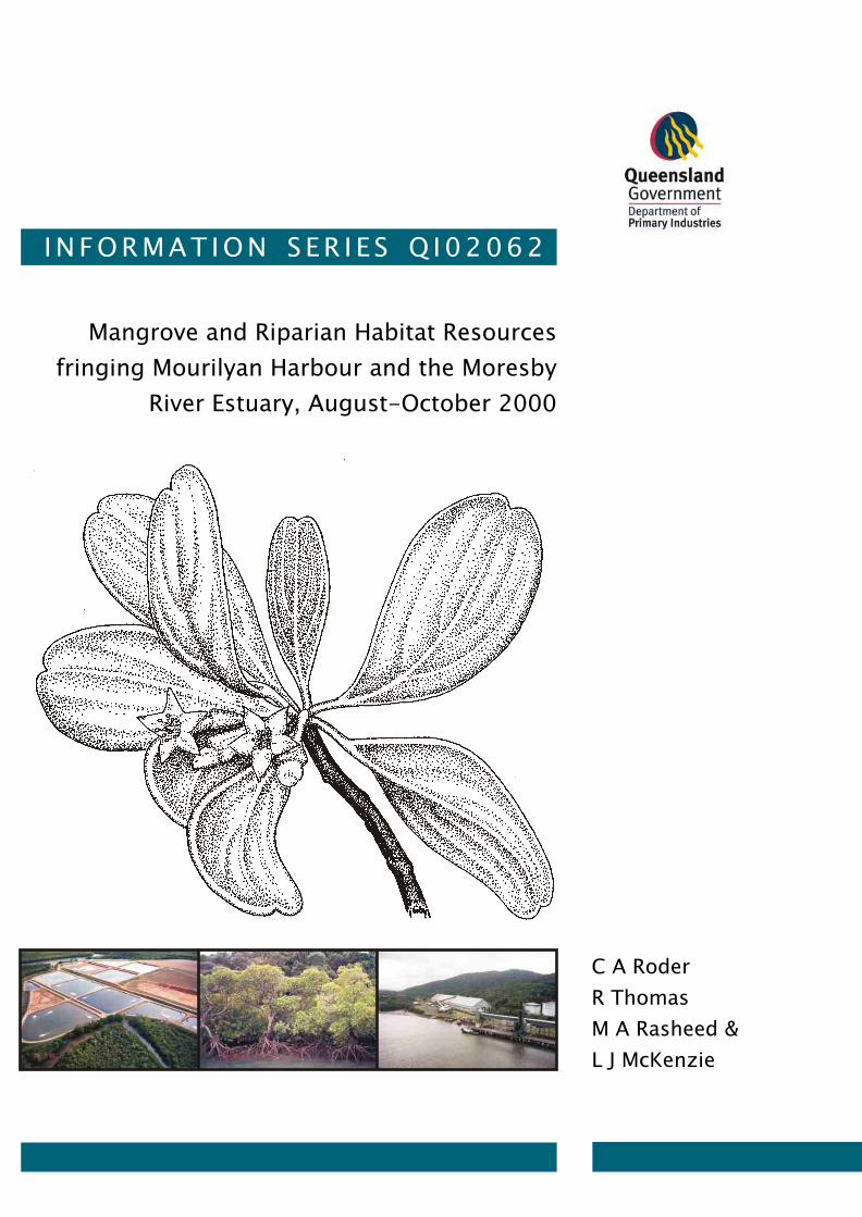
Mangrove and Riparian Habitat Resources
fringing Mourilyan Harbour and the Moresby
River Estuary, August-October 2000
I N F O R M A T I O N S E R I E S Q I 0 2 0 6 2
C A Roder
R Thomas
M A Rasheed &
L J McKenzie
Mangro
ve and R
iparia
n H
abita
t Reso
urces
Fringin
g M
ourilya
n H
arb
our a
nd th
e Moresb
y River E
stuary, A
ugust-O
ctober 2
00
0
INFO
RM
AT
ION
SER
IES Q
I02
06
2

DPI Information Series QI02062
Mangrove and Riparian Habitat
Resources Fringing Mourilyan Harbour and the Moresby River
Estuary, August-October 2000
AUTHORS:
Chantal Roder Ross Thomas
Michael Rasheed Len McKenzie
Queensland Fisheries Service Northern Fisheries Centre
Department of Primary Industries PO Box 5396 Cairns QLD 4870
- ii -
QI02062 ISSN 0727-6273 First Published 2002 © The State of Queensland, Department of Primary Industries, 2002. Copyright protects this publication. Except for purposes permitted by the Copyright Act, reproduction by whatever means is prohibited without the prior written permission of the Department of Primary Industries, Queensland. Disclaimer: The Department of Primary Industries, Queensland has taken all reasonable steps to ensure the information contained in this publication is accurate at the time of the surveys. Marine plant habitat distribution and abundance can change between years, and readers should ensure they make appropriate inquiries to determine whether new information is available. The correct citation of this document is: Roder, C.A., Thomas, R., Rasheed, M.A. and McKenzie, L.J. (2002). Mangrove and Riparian Habitat Resources Fringing Mourilyan Harbour and the Moresby River Estuary, August-October 2000. DPI Information Series no. QI 02062 (Queensland Fisheries Service, Northern Fisheries Centre, Cairns), 31pp. Produced by: Marine Plant Ecology Group, Queensland Fisheries Service, Northern Fisheries Centre, Cairns, 2002. Enquiries should be directed to: Chantal Roder Northern Fisheries Centre PO Box 5396 Cairns, QLD 4870 Australia. Acknowledgments: CRC-Reef Research Centre Critical Habitat Program and the Ports and Shipping Program funded this project. We thank Anthony Roelofs, Sophie King, and Warren Lee Long for their assistance with field surveys.
- iii -
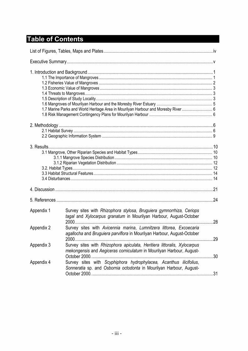
Table of Contents
List of Figures, Tables, Maps and Plates............................................................................................... iv Executive Summary...............................................................................................................................v 1. Introduction and Background.............................................................................................................1
1.1 The Importance of Mangroves ............................................................................................................ 1 1.2 Fisheries Value of Mangroves ............................................................................................................ 2 1.3 Economic Value of Mangroves ........................................................................................................... 3 1.4 Threats to Mangroves......................................................................................................................... 3 1.5 Description of Study Locality............................................................................................................... 3 1.6 Mangroves of Mourilyan Harbour and the Moresby River Estuary ..................................................... 5 1.7 Marine Parks and World Heritage Area in Mourilyan Harbour and Moresby River ............................. 6 1.8 Risk Management Contingency Plans for Mourilyan Harbour ............................................................ 6
2. Methodology ......................................................................................................................................6
2.1 Habitat Survey .................................................................................................................................... 6 2.2 Geographic Information System ......................................................................................................... 9
3. Results...............................................................................................................................................10
3.1 Mangrove, Other Riparian Species and Habitat Types....................................................................... 10 3.1.1 Mangrove Species Distribution ............................................................................................. 10 3.1.2 Riparian Vegetation Distribution ........................................................................................... 12
3.2. Habitat Types..................................................................................................................................... 12 3.3 Habitat Structural Features ................................................................................................................. 14 3.4 Disturbances....................................................................................................................................... 14
4. Discussion .........................................................................................................................................21 5. References ........................................................................................................................................24 Appendix 1 Survey sites with Rhizophora stylosa, Bruguiera gymnorrhiza, Ceriops
tagal and Xylocarpus granatum in Mourilyan Harbour, August-October 2000........................................................................................................................28
Appendix 2 Survey sites with Avicennia marina, Lumnitzera littorea, Excoecaria agallocha and Bruguiera parviflora in Mourilyan Harbour, August-October 2000........................................................................................................................29
Appendix 3 Survey sites with Rhizophora apiculata, Heritiera littoralis, Xylocarpus mekongensis and Aegiceras corniculatum in Mourilyan Harbour, August-October 2000. .........................................................................................................30
Appendix 4 Survey sites with Scyphiphora hydrophylacea, Acanthus ilicifolius, Sonneratia sp. and Osbornia octodonta in Mourilyan Harbour, August-October 2000. .........................................................................................................31

- iv -
List of Figures, Tables, Maps and Plates Figure 1 Mourilyan Harbour locality map................................................................................................. 4 Map 1 Location of fringing habitat survey sites in Mourilyan Harbour and Moresby River,
August-October 2000 ................................................................................................................ 8 Map 2 Fringing mangrove community of Mouilyan Harbour, Walter Creek, Armit Creek,
Bradshaw Island, Lily Island and Maizie Island, August-October 2000.................................. 19 Map 3 Fringing mangrove community of Moresby River, Mourilyan Creek and an
unamed tributary, August-October 2000 ................................................................................. 20 Plate 1 Rhizopohora stylosa dominated foreshore.............................................................................. 11 Plate 2 Rhizopohora stylosa and R. apiculata dominated foreshore with a single
Avicennia marina tree.............................................................................................................. 11 Plate 3 Mangrove mistletoe (Amyema mackayense) growing in Bruguiera gymnorrhiza. ................. 13 Plate 4 Mixed mangrove species and open bank, with terrestrial forest including
Casuarina sp. at the rear. ........................................................................................................ 13 Plate 5 Steep, undercut mud bank with mixed mangrove species. .................................................... 16 Plate 6 Large area of open bank and weeds associated with disturbance from an
aquaculture farm and powerlines ............................................................................................ 16 Plate 7 Complex structural habitat (�snags�) formed from mixed mangrove species. ....................... 17 Plate 8 Rocky foreshore dominated by terrestrial forest with a few mangroves trees. ....................... 17 Plate 9 Existing disturbances within the Mourilyan Harbour survey area. .......................................... 18 Table 1 Habitat type determination......................................................................................................... 9 Table 2 Mangrove species, percentage of sites where they occurred and mean percent
cover at sites where they occurred, August-October 2000. .................................................... 10 Table 3 Non-mangrove species and vegetation types, percentage of sites where they occurred
and mean percent cover at sites where they occurred, August-October 2000....................... 12 Table 4 Mangrove and riparian habitat types and lineal extent in Mourilyan Harbour and
Moresby River survey area, August-October 2000................................................................. 14

- v -
Executive Summary This report provides results of a mangrove and riparian vegetation survey of Mourilyan Harbour and Moresby River estuary conducted between August and October 2000. This study gives an account of the habitat types fringing the estuarine influenced sections of the Port of Mourilyan and the Moresby River. Seventeen species of mangrove were recorded in the survey area. Rhizophora stylosa had the widest distribution and tended to be the dominant species at sites where it occurred. Bruguiera gymnorrhiza, Ceriops tagal and Xylocarpus granatum were also widely distributed throughout the survey area but were less dominant at sites where they occurred. Diversity of mangrove species was highest upstream of Maizie Island and in smaller creeks off the main Harbour. Mangrove communities around the port and harbour area were less diverse and the mangrove fringe was dominated by Rhizophora stylosa. The harbour mangrove community, although less diverse, provided extensive and complex structural habitat. Other vegetation types present included terrestrial forest, grasses, vines and marine grasses. The mangrove and riparian vegetation surveyed was likely to provide important fisheries habitat, with similar communities in Queensland known to support both commercial and recreational species. The majority of the riparian zone was intact and largely undisturbed in Mourilyan Harbour and the Moresby River estuary. Some sections of the survey area however were heavily impacted by activities and developments associated with port infrastructure, agriculture and aquaculture. This study focused on mangroves and vegetation in the area fringing the river and banks of the estuary as these areas were likely to be most impacted by oil or chemical spills within the port and were easily accessible. Zonation of mangrove species along tidal gradients (from shore to upper banks) was not directly measured in this study but observations recorded in the field indicated that distinct zonation of species typical in tropical mangrove communities occurred in the Moresby River estuary. Describing the zonation of mangroves and riparian vegetation along salinity, sulphide, sediment, and tidal gradients would require further field investigations. The Geographic Information System (GIS) of fringing riparian habitats may assist in the risk management of and response to marine accidents in the Port of Mourilyan. The presence of mangroves along the majority of the estuary means the majority of the port environment has a high environmental sensitivity to oil/ fuel spills as has been recognised in the oil spill contingency plan for the port. The consequences of oil spreading to the upstream reaches of the Moresby River or the creeks that flow in to the harbour may be more severe due to the greater diversity of species occurring in these areas. The study area is also subject to several threats other than shipping or port accidents. The Moresby River catchment has been heavily influenced by human activities that may affect water quality and mangrove health. The results of this survey provide baseline information of fringing mangrove communities from which future mangrove monitoring can be developed.


Mangrove and Riparian Habitat Resources Fringing Mourilyan Harbour and the Moresby River Estuary, August-October 2000
1
1. Introduction and Background
CRC Reef Research Centre Ltd is committed to understanding the diversity and abundance of Queenslands Great Barrier Reef World Heritage Area (GBRWHA) coastal systems. The Department of Primary Industries Queensland Fisheries Service (QFS) as a partner in the CRC Reef has developed a program to identify and monitor critical fisheries habitats within and adjacent to the GBRWHA. Critical habitat information is being collected in areas that are sensitive to existing or potential developments. Many of Queensland�s tropical ports contain important marine habitat and these areas have the potential to be impacted by port and shipping activities and developments.
Critical habitat information collected within ports will be utilised in planning for port development and maintenance programs that will have a minimal impact on the marine environment. The Port of Mourilyan is known to contain important marine habitats such as seagrass (see McKenzie et al. 1998) and mangroves. This report documents the mangrove and riparian habitat fringing Mourilyan Harbour and the Moresby River estuary and will be used to assist in the risk management of and response to marine accidents in the port. The report is intended to be incorporated into the port�s oil spill response plan. This study will contribute to a better understanding of the biodiversity of mangrove and riparian resources fringing the Port of Mourilyan and Moresby River estuary. Objectives of this survey were to:
1) Determine the mangrove species diversity fringing the banks of Mourilyan Harbour and the
Moresby River estuary; 2) Identify mangrove community types in Mourilyan Harbour and the Moresby River estuary;
and 3) Provide a GIS of mangrove communities and other fisheries habitat features to assist in risk
management and response to port and shipping accidents.
1.1 The Importance of Mangroves Mangroves are a taxonomically diverse group of predominantly tropical shrubs and trees growing in the intertidal zone between Mean Sea Level (MSL) and Highest Astronomical Tide (HAT) bordering the banks of estuaries and foreshores along protected parts of the coastline (Duke 1992). 34 species of mangrove and 4,600 square kilometres of mangrove forests exist in Queensland (Lovelock 1993). Approximately 90% of Queensland�s mangrove forests lie in the tropics (Robertson and Alongi 1995). Queensland�s tropical mangrove forests are among the most productive of any mangrove system world-wide (Hutchings and Saenger 1987). Areas of deposition of mud and silt at the mouths of rivers and creeks and in the lee of larger offshore islands protected from strong wave action support the most extensive mangrove communities (Dowling and McDonald 1982). Mangroves can tolerate a wide range of sediment types, water temperatures, flow rates, salinity, nutrient and oxygen levels. Mangroves vary in their tolerance of these environmental factors, and a pattern of species zonation occurs (Lovelock 1993). Mangroves form complex systems in coastal waters providing physical, biological and ecosystem functions which include: (1) Habitat, shelter and structural complexity for resident and transient birds, fish, crustaceans and
reptiles. Many prawns and fish that inhabit mangroves are of commercial and recreational importance or important to traditional fishing communities (Rönnbäck 1999);
(2) Providing a major marine source of carbon for complex food webs through direct grazing or through detrital pathways (Clough 1992);
(3) Assisting in the stabilisation of coastlines, assimilating wastes, mitigating flood water by controlling the outflow, buffering pollution and storms and reclaiming land (i.e. helping in the formation of islands and the extension of shorelines) (Beumer et al. 1997);

Mangrove and Riparian Habitat Resources Fringing Mourilyan Harbour and the Moresby River Estuary, August-October 2000
2
(4) Providing for human uses, including recreational (fishing, photography, wildlife observation and boating) and indigenous uses (food, medicine, weapons and other tools).
Mangrove roots, debris, and other vegetational structures provide structural complexity in intertidal habitat. The structural complexity that mangrove roots and debris form are often referred to as �snags�, and enhances the refuge aspect of the marine environment. Mangroves provide a sub-surface shelter by trapping soft muds suitable for burrowing (Rönnbäck 1999). Mangroves also have the hydrodynamic ability to retain immigrating fish, crustacean and mollusc larvae and juveniles. Spatio-temporal variations in the availability of food and shelter, and retention capacity, affect the quality of individual mangrove microhabitats for fish and shellfish (Rönnbäck 1999). The presence of wetland vegetation improves water quality of estuaries and near-shore waters through nutrient storage in plant tissues and their regulated release into the surrounding water, and also by removal of water-borne contaminants (e.g. heavy metals and pesticides) and suspended sediments (Beumer et al. 1997). Extensive tidal wetlands also stabilise channel banks and protect shorelines from erosion and store and dissipate the energy of floodwaters (Beumer et al. 1997). Mangroves add a total of about 3.5 million tonnes of carbon annually to Queensland estuarine and marine waters (Robertson and Lee Long 1991). A study from a mangrove forest in north-eastern Australia has found that mangrove primary productivity and associated leaf litterfall can be substantial (Clough 1992). The annual litterfall has been estimated at 8-10t dry weight per ha, with a maximum of up to 20t dry weight per hectare (Clough 1992). The mangrove crab can consume or store 30-80% of this litterfall (Robertson et al. 1992). These crabs are subsequently consumed by fishes and therefore constitute an important link at the primary consumer level in food webs, beginning with mangrove plant production and leading to higher level consumers harvested by humans. The importance of mangroves as environmental indicators in Australia has been documented (Ward et al., 1998; Australian State of the Environment Committee, 2001). Ward et al. (1998) point out that mangroves can be used as bioindicators for habitat extent (total area) and mangrove species composition as an indicator of habitat quality. No mangrove species are considered threatened, and mangrove area may be increasing. Possible reasons for the increase in mangrove area include sea level rise, growth in areas of accreting mud banks, and incursion into saltmarsh systems (Australian State of the Environment Committee, 2001; Duke pers comm.). Blasco et al. (1996) suggest mangroves live in ecological conditions that are at their limit of tolerance with regard to the salinity of the water and soil and the inundation regime. If the duration of daily immersion were to be modified by tectonic, sedimentological or hydrological events, mangroves either readjust to the new conditions or succumb to unsuitable conditions. While some changes in mangrove communities may be occurring without human influence, all changes are a cause for closer scrutiny (Australian State of the Environment Committee, 2001, Blasco et al. 1996, Duke pers. comm.).
1.2 Fisheries Value of Mangroves Mangrove communities have long been recognised for their value to fisheries production (Bruinsma et al. 1999). Queensland�s extensive coastline and inland waterways support commercial and recreational fishing industries estimated to be valued at more than $800 million per annum (Williams 1997). Previous QDPI research (Quinn 1993) has estimated that approximately 75% (by weight) of all seafood landed commercially in Queensland is from species dependent on estuarine habitats during part of their life cycle. Similarly a high proportion of species targeted by the recreational fishing sector and indigenous fishers is dependent on estuarine and freshwater habitats during part or all of their life cycles (Beumer et al. 1997). One study of a mangrove forest in north-eastern Australia estimated that the marketed value of commercial fish species utilising mangroves as habitat ranges from US1990$475 to US1990$5330 ha/year (Morton 1990), while a global study estimated a fisheries value between US1999$750 and US1999$16750 per hectare (Rönnbäck 1999).
Mangrove and Riparian Habitat Resources Fringing Mourilyan Harbour and the Moresby River Estuary, August-October 2000
3
Mangrove habitat (particularly Rhizophora stylosa) is important as a feeding and nursery area for fish species that contribute to fisheries values (Halliday and Young 1996). Fishes inhabiting tropical mangroves (eg sardines and herring) eat plankton and small bottom-dwelling prey and support fisheries indirectly by providing a food source for larger pelagic species (eg mackerel, tuna, trevally and sharks) that may not use the forest directly (McPherson 1987, Cappo 1995, Halliday and Young 1996). In recognition of their importance to fisheries, all marine plants including mangroves, seagrasses, saltcouch and samphire species are protected in Queensland, under Section 51 of the Fisheries Act 1994. A permit is required to remove, destroy or damage any marine plant. This regulation will help ensure the long-term sustainability of Queenslands fisheries habitat resources.
1.3 Economic Value of Mangroves
The economic value of natural products and ecosystem services generated by mangrove forests is generally underestimated (Saenger et al. 1983). As a consequence mangrove ecosystems have become prime candidates for conversion into large-scale development activities such as agriculture, aquaculture, forestry, salt extraction and infrastructure. More than 50% of the world�s mangroves have been removed (World Resources Institute 1996).
It has been estimated that the total value to ecosystem services per hectare of mangroves is US1994$9990, with a large portion of this value from waste treatment, food production, and recreation provision (Costanza et al. 1997). The value of ecosystem goods (such as food) and services (such as waste assimilation) represent the benefits human populations derive, directly or indirectly, from ecosystem functions.
1.4 Threats to Mangroves
Mangroves form an interface between terrestrial and marine environments. Harmful land use and marine activities can threaten mangrove distribution and abundance. Potential threats to mangrove populations include: natural sources (pathogens, violent storms, fluctuations in rainfall and climatic patterns); land uses (habitat modifications, excess nutrients, toxic chemical leachate, pesticides, herbicides, algicides and insecticides); or marine activities (oil and other contaminant spills) (Duke et al. 2001).
Small-scale modifications to the physical structure of mangrove forests can lead to significant effects on the diversity and abundance of macro benthic organisms in mangrove habitats (Skilleter and Warren 2000). Such modifications have the potential to cause cascading effects at higher trophic levels with deterioration in the value of these habitats as nursery and feeding grounds (Skilleter and Warren 2000).
1.5 Description of Study Locality
Mourilyan Harbour is at the mouth of the Moresby River catchment, situated 90 kilometres south of Cairns (Figure 1). The Moresby River is about 20 km long and the catchment size is 147 km2. A large proportion of the Moresby catchment (27.5%) consists of wetlands (Russell et al. 1996). The majority of the wetlands (71%) are tidal and comprised mainly of mangroves, while rainforest occupies the steep slopes around the port (Russell et al. 1996). Large areas of the Moresby catchment are under sugar cane production and there are currently 6 licensed aquaculture facilities (including prawn farms, barramundi farms and barramundi hatcheries). The catchment has no major secondary industries and no sewage treatment plants.

Mangrove and Riparian Habitat Resources Fringing Mourilyan Harbour and the Moresby River Estuary, August-October 2000
4
RiverRiverRiverRiverRiverRiverRiverRiverRiver
17°38' S17°38' S17°38' S17°38' S17°38' S17°38' S17°38' S17°38' S17°38' S
Mourilyan CreekMourilyan CreekMourilyan CreekMourilyan CreekMourilyan CreekMourilyan CreekMourilyan CreekMourilyan CreekMourilyan Creek
MoresbyMoresbyMoresbyMoresbyMoresbyMoresbyMoresbyMoresbyMoresby
Armit CreekArmit CreekArmit CreekArmit CreekArmit CreekArmit CreekArmit CreekArmit CreekArmit Creek
000000000
Walter CreekWalter CreekWalter CreekWalter CreekWalter CreekWalter CreekWalter CreekWalter CreekWalter Creek Port of MourilyanPort of MourilyanPort of MourilyanPort of MourilyanPort of MourilyanPort of MourilyanPort of MourilyanPort of MourilyanPort of Mourilyan
146°07' E146°07' E146°07' E146°07' E146°07' E146°07' E146°07' E146°07' E146°07' E
CampCampCampCampCampCampCampCampCampPointPointPointPointPointPointPointPointPoint
!
MourilyanMourilyanMourilyanMourilyanMourilyanMourilyanMourilyanMourilyanMourilyan
HarbourHarbourHarbourHarbourHarbourHarbourHarbourHarbourHarbour
MaizieMaizieMaizieMaizieMaizieMaizieMaizieMaizieMaizieIslandIslandIslandIslandIslandIslandIslandIslandIsland
Lily Is.Lily Is.Lily Is.Lily Is.Lily Is.Lily Is.Lily Is.Lily Is.Lily Is.
SeaforthSeaforthSeaforthSeaforthSeaforthSeaforthSeaforthSeaforthSeaforthValleyValleyValleyValleyValleyValleyValleyValleyValley
CoralCoralCoralCoralCoralCoralCoralCoralCoral
SeaSeaSeaSeaSeaSeaSeaSeaSea
111111111kilometreskilometreskilometreskilometreskilometreskilometreskilometreskilometreskilometres
222222222
Queensland
KarumbaCairns
Cooktown
Townsville
STUDYAREA
Coral
Sea
LEGENDMarine Park (Estuarine Conservation Zone)
Marine Park (National Park Zone)
Figure 1 Mourilyan Harbour locality map. Mourilyan has a tropical climate and a tropical monsoon rainfall pattern, with a mean annual rainfall of 3340mm, the majority of which falls between January and April (South Johnstone Exp. Stn.). Mean daily minimum temperatures in the area range from 14.9°C in July to 22.6°C in February, and maximums from 23.7°C in July to 31.1°C in January (73.5 year average, Australian Bureau of Meteorology 2001). The Port of Mourilyan exports agricultural products from the Innisfail and Babinda districts. In 2000/2001 the Port of Mourilyan processed 26 ships handling sugar, molasses (from the Babinda and Innisfail sugar growing districts) and livestock of 523 thousand tonnes (22.7% down on the last financial year), with an export value of $95.6 million (Qld Transport 2002). Poor seasonal conditions continue to reduce exports, with the port of Mourilyan experiencing the lowest throughput in 10 years in 2001 (Qld Transport 2002). Currently the cargo destinations for exports out of Mourilyan Harbour include Korea and Malaysia with new export opportunities being sought to support regional development (PCQ 2002). The commercial facilities in the harbour consist of a bulk sugar and molasses terminal, with an enclosed conveyor to a single shiploader and a single loading berth within a sheltered natural harbour (PCQ 2002). Bulk Sugar Terminal Organisation (BSTO) operates the terminal under agreement with Ports Corporation of Queensland (PCQ). No imports have occurred at the port over the past 5 years (Qld Transport 2002). Other facilities within the harbour include a pilot boat jetty, Coast Guard jetty, public jetty, boat ramp and commercial vessel mooring piles. The harbour accommodates a number of fishing and recreational vessels depending on the time of year and season.
Mangrove and Riparian Habitat Resources Fringing Mourilyan Harbour and the Moresby River Estuary, August-October 2000
5
The channel depth of the port is 9.6 metres, while the berth depth is 10.0 metres, accepting ships up to 185 metres in length (PCQ 2002). A tug is based within the port and supporting tugs can travel from Cairns when necessary. In recent times, the PCQ dredged the port entrance and carried out significant upgrading of the wharf (PCQ 2002). Given the location of its ports in sensitive coastal areas, PCQ manages a significant environment program, which seeks to minimise environmental impacts while allowing port operations and development to continue efficiently and cost effectively. As part of the environment program at the Port of Mourilyan, seagrasses and their associated faunal communities were found to be suitable for monitoring the condition of the ports environment (McKenzie et al.1996). Regular monitoring of seagrass meadows in Mourilyan Harbour has been ongoing since 1993 (McKenzie et al 1996 and 1998, Thomas & Rasheed 2001 and 2002). Other studies have found that Mourilyan Harbour and the Moresby River support both recreational and commercial fisheries for a wide range of target species including barramundi (Lates calcarifer), mangrove jack (Lutjanus argentimaculatus), grunter (Pomadasys spp.), flathead (Platycephalus spp.) and bream (Acanthopagarus spp) (McKenzie et al. 1996; Russell et al. 1996). A total of 44 species of fish and 8 species of prawns were caught in beam trawls in December 1993 and July 1994 (McKenzie et al. 1996), while 86 species of fish were recorded in the Moresby River catchment in 1994-1995 (Russell et al. 1996). King prawns (Melicertus latisulcatus and Melicertus longistylus) and Banana prawns (Fenneropenaeus indicus and Fenneropenaeus merguiensis) which rely on mangrove habitat for some part of their life cycle were absent from the catches, however the study was aimed at sampling the secondary productivity of seagrass meadows specifically (McKenzie et al. 1996).
1.6 Mangroves of Mourilyan Harbour and the Moresby River Estuary
Mangroves in Mourilyan Harbour were surveyed on land held and managed by PCQ (220 ha of land, including the western side of the harbour from Armit Creek north to the sugar terminal, and on the eastern side from Seaforth Valley to Camp Point (Figure 1) by Natural Resource Assessments (NRA) in 1996 (NRA 1997). Mangrove communities recorded by NRA included Rhizophora stylosa dominated areas, with Avicennia marina, and occasional R. apiculata, Heriteiera littoralis, Bruguiera spp., Ceriops spp, Xylocarpus spp, and Hibiscus tiliaceus.
Russell et al. (1996) mapped the extent of mangrove area from aerial photographs, and assessed stream habitat structure aspects deemed important to fish ecology, however individual mangrove species and community types were not identified.
Bunt et al. (1982) found the Moresby River estuary mangrove community was similar to other Northern Queensland estuaries such as the Bloomfield, Daintree, Endeavour McInvor/Morgan Rivers, Mulgrave River, Murray River and the Tully River.
Macnae (1966) considered that the densest Australian mangroves were located in the vicinity of Innisfail, including the Moresby River estuary. Macnae (1966) suggested that rainfall was the important factor for mangrove species distribution and density and this area has the highest rainfall in Australia. This view has been disputed by Bunt et al. (1982) who concluded that the densest mangroves were located at the tip of Cape York.
There have been no previous attempts to describe the mangrove species distribution and community types along the fringe of the entire Moresby estuary and Mourilyan Harbour.

Mangrove and Riparian Habitat Resources Fringing Mourilyan Harbour and the Moresby River Estuary, August-October 2000
6
1.7 Marine Parks and World Heritage Area in Mourilyan Harbour and Moresby River
The majority of the coastal wetland areas in the study area are listed as part of the World Heritage Wet Tropics Estate or State Marine Park (Figure 1). Parts of the rainforest in the Moresby and Basilisk Ranges are also listed Wet Tropics World Heritage Area. The GBRWHA covers the waters to low water mark along the coastline in the region. Mourilyan Harbour is not included in this protected area because these are internal waters of the State, but the remainder of the waters are within port limits. No Fish Habitat Areas are declared in this catchment. The closest FHA�s are at Tully heads to the South and Cairns to the North.
The Moresby River catchment is within the 18,497km2 biogeographical region of �Wet Tropics�, described as �Tropical wet coastal ranges and plains; rainforest and forests� (Thackaway and Cresswell 1995).
1.8 Risk Management Contingency Plans for Mourilyan Harbour The Ports Corporation of Queensland have developed an oil spill response contingency plan to minimise the impact of an oil spill, from any source, upon the environment of Mourilyan and areas adjacent to port limits (PCQ 1999). Mangroves of Mourilyan Harbour, fringing Moresby River and associated tributaries and creeks with rich diversity of aquatic habitats have been identified as sites of extreme and high sensitivity. This high sensitivity is taken in to account when prioritising protection and clean up responses, acknowledging that all creeks in the region contain mangrove and saltmarsh habitats of significant fisheries value as they are important fish/ crustacean nursery areas (PCQ 1999). Oil spills in port waters could result from a variety of sources including groundings, collisions and sinking of vessels; illegal discharges from vessels; accidents when transferring waste oil to storage facilities on shore and accidents when refuelling vessels (PCQ 1999). Contingency plans take into account: prevailing winds, tides, likely trajectory of the spill, quantity of oil spilled, human and other resources required for a pro-active response. Tiers of responses are based on credible spill scenarios for marine incidents in the area (PCQ 1999). The greatest threat to the mangroves of the Moresby River estuary is an oil spill under the influence of a flood tide. Tidal booms are one method mentioned to corral or to deflect oil away from biologically sensitive areas, including mangroves (PCQ 1999). The contingency plan explicitly states that dispersant may not be used, due to the damaging affects that it would have on the marine plant communities. Other potential environmental damage from port activities which could be risk managed in a similar way to potential oil spills include: discharges from shore-based industries, discharges from aquaculture and agricultural operations (responsibility for the control of the environmental performance of these upstream industries rests with either the EPA or Johnstone Shire Council); Marine Waste and Contaminants (including TBT), ballast water discharges, acid sulphate soils (high risk with the low elevation), and dredging. This study concentrated on documenting the fringing mangrove and riparian vegetation along river/ creek banks as these resources were considered to be at greatest risk from water borne impacts.
2. Methodology
2.1 Habitat Survey
An assessment of the habitat features, mangrove species and riparian vegetation of Mourilyan Harbour, the Moresby River and Walter, Armit and Mourilyan Creeks was conducted over three surveys on 1st and 15th of August and 16th of October 2000. Surveys were conducted from a small research vessel, and the survey area included fringing riverbanks from the mouth of Mourilyan

Mangrove and Riparian Habitat Resources Fringing Mourilyan Harbour and the Moresby River Estuary, August-October 2000
7
Harbour to 17 km upstream into the Moresby River (as far as could be accessed by boat). Smaller creeks were also surveyed where boat access was possible, and included Walter, Armit, Mourilyan Creeks and an unnamed tributary (Map 1).
Survey sites were selected on both sides of the river and creeks approximately every 300m or where a significant change in the vegetation occurred (Map 1). Each survey site incorporated a 10m section of river frontage to a visual depth of approximately 20m inland (depending on type of mangrove community).
The mangrove or terrestrial plant community was observed and recorded as a percentage composition that each mangrove species occupied of the survey site area (10m river frontage x 20m perpendicular into the forest). All mangroves at each site were identified to species level in the field according to Lovelock (1993). Other riparian vegetation was identified as far as possible in the field. Where positive field identifications could not be made, voucher specimens of species were collected to confirm field identifications and catalogued into a herbarium located at Northern Fisheries Centre, Cairns. Vegetation types present were described including terrestrial forest, grasses and vines, marine grasses and mangrove vines. The percentage of each site comprised by each species and/or vegetation type was estimated and recorded.
At each site, data on bank sediment, bank angle, snags, structural habitat features (mudbanks, rock outcrops, deep holes, sand-bars) and anthropogenic disturbances were recorded. The location of existing anthropogenic structures and disturbances was recorded using differential Global Positioning System (dGPS), with a description made and photographs taken of each site. Bank sediment was assessed from the boat. Field descriptions of sediment type recorded for each site included rock, sand and mud (and combinations of these). Bank angle was recorded as the gradient from the water edge to where the bank plateaued, and was recorded as a range, 0-15°, 15-30°, 30-45°, 45-60°, 60-90°. Open or bare bank and other significant features were included in descriptions of each site. A description of the zonation of vegetation and general site characteristics was recorded and a photographic record taken of each site. All observations recorded were made or validated by 4 observers from the boat. All site information was recorded on a habitat assessment form developed by Sheppard and Helmke (1999).
This site-selection method enabled the description of a variety of vegetation species, types and habitat features. dGPS was used to locate each survey site for mapping purposes.

¸̧̧̧̧̧̧̧̧̧̧̧̧̧̧̧̧̧̧̧̧̧̧̧̧̧̧̧̧̧̧̧̧̧̧̧̧̧̧̧̧̧̧̧̧̧̧̧̧
MA
P 1
Loca
tion
of fr
ingi
ng h
abita
t sur
vey
site
s an
d ph
ysic
al d
istu
rban
ces
in M
ouril
yan
Har
bour
and
Mor
esby
Riv
er,
Augu
st -
Oct
ober
200
0
146.
06o
-17.
6o
Stud
y Ar
ea
LEG
END
Frin
ging
hab
itat s
urve
y si
te
Sour
ce: R
oder
, C.A
., Th
omas
, R.,
Ras
heed
, M.A
. and
McK
enzi
e, L
.J. (
2002
) M
angr
ove
and
Rip
aria
n H
abita
t Res
ourc
es F
ringi
ng M
ouril
yan
Har
bour
and
th
e M
ores
by R
iver
Est
uary
, Aug
ust -
Oct
ober
200
0.
DPI
Info
rmat
ion
Serie
s N
o. Q
I020
62
Sam
plin
g da
tes:
1st
and
15t
h of
Aug
ust,
and
16th
Oct
ober
200
0.
Th
e St
ate
of Q
ueen
slan
d, th
roug
h th
e D
PI Q
ueen
slan
d (2
002)
an
d th
e C
RC
for E
colo
gica
lly S
usta
inab
le D
evel
opm
ent
of th
e G
reat
Bar
rier R
eef.
Prod
uced
by
the
Mar
ine
Plan
t Eco
logy
Gro
up,
DPI
, Nor
ther
n Fi
sher
ies
Cen
tre, C
airn
s, 2
002.
0 0 00 00 0 00
Kilo
met
res
Kilo
met
res
Kilo
met
res
Kilo
met
res
Kilo
met
res
Kilo
met
res
Kilo
met
res
Kilo
met
res
Kilo
met
res
1 1 11 11 1 112 2 22 22 2 22
0 0 00 00 0 00
Kilo
met
res
Kilo
met
res
Kilo
met
res
Kilo
met
res
Kilo
met
res
Kilo
met
res
Kilo
met
res
Kilo
met
res
Kilo
met
res
500
500
500
500
500
500
500
500
500
1000
1000
1000
1000
1000
1000
1000
1000
1000
Mou
rilya
n H
arbo
ur
8
C 8
Parti
ally
sub
mer
ged
ship
wre
ck
Con
cret
e po
sts
Port
faci
litie
s an
d pu
blic
acc
ess
Aqua
cultu
re p
ipel
ines
¸̧̧̧̧̧̧̧̧̧̧̧̧̧̧̧̧̧̧̧̧̧̧̧̧̧̧̧̧̧̧̧̧̧̧̧̧̧̧̧̧̧̧̧̧̧̧̧̧Pu
blic
Boa
t Ram
p
Boat
Moo
rings

Mangrove and Riparian Habitat Resources Fringing Mourilyan Harbour and the Moresby River Estuary, August-October 2000
9
2.2 Geographic Information System
All survey data were entered into the Geographic Information System (GIS) MapInfo for presentation of mangrove and riparian habitat species distribution. A GIS base map was generated using a topographic map (1:50000), which was rectified and projected using Latitude/Longitude Australian Geodetic Datum 1984 (AGD 84).
Fringing mangrove and riparian community type polygons was created using all information collected at each survey site. Habitat community types were described as briefly as possible without compromising the features that define the community and follow a nomenclature developed for marine plant assessment of the Queensland region (Table 1).
Table 1. Habitat type determination
HABITAT TYPE % COMPOSITION
Species A Species A is 90-95% of composition
Species A with Species B Species A is between 60-89 % of composition
Species A/Species B Species A is 50-59% of composition
Mixed species No species composition greater than 40% of total

Mangrove and Riparian Habitat Resources Fringing Mourilyan Harbour and the Moresby River Estuary, August-October 2000
10
3. Results
3.1 Mangrove, other riparian species and habitat types
162 sites were surveyed in Mourilyan Harbour, the Moresby River and Walter, Armit, Mourilyan Creeks and an unnamed tributary between 1st August and 16th October 2000 (Map 1). 52.06km of Mourilyan Harbour and Moresby River frontage (linear) was surveyed.
3.1.1 Mangrove species distribution
Seventeen species of mangrove were recorded in the survey area (Table 2). Rhizophora stylosa, Bruguiera gymnorrhiza, Ceriops tagal and Xylocarpus granatum were the most common mangroves encountered and had the widest distribution in the survey area, occurring throughout the harbour, Moresby River and creeks (Table 2; Appendix 1). Where R. stylosa occurred it also tended to be the dominant species (Table 2; Appendix 3; Maps 2 and 3; Plates 1 and 2). Avicennia marina, Lumnitzera littorea, Excoecaria agallocha, Bruguiera parviflora and Rhizophora apiculata were also widely distributed, but generally comprised a smaller component of the sites where they occurred (Table 2; Appendicies 2 and 3). Other species more narrowly distributed in the upper reaches of the Moresby River and Mourilyan Creek included Heritiera littoralis, Xylocarpus mekongensis, Aegiceras corniculatum, Scyphiphora hydrophylacea, Acanthus ilicifolius, and Sonneratia sp. (Table 1; Appendix 3 and 4). Osbornia octodonta was found at only one site at the entrance to Mourilyan Harbour (Table 1; Appendix 4). The native hibiscus (Hibiscus tiliaceus) was present at 8% of survey sites and was typically found near the junction of mangrove and terrestrial forests growing along or above the high tide mark (Appendix 4).
Table 2. Mangrove species, percentage of sites where they occurred and mean percent cover at sites where they occurred, August-October 2000.
Mangrove species % of sites
where species occurred
Mean % cover at sites where species
occurred ( ±SE)
Distribution (refer to
Appendix no.) Rhizophora stylosa 85 58.1 ±3.1 1 Bruguiera gymnorrhiza 54 21.9 ±1.6 1 Ceriops tagal 40 26.0 ±2.5 1 Xylocarpus granatum 33 14.0 ±1.5 1 Avicennia marina 16 12.2 ±2.6 2 Lumnitzera littorea 16 22.8 ±3.9 2 Excoecaria agallocha 14 10.9 ±1.5 2 Bruguiera parviflora 11 10.4 ±2.7 2 Hibiscus tiliaceus 8 13.8 ±3.6 4 Rhizophora apiculata 7 29.3 ±7.4 3 Heritiera littoralis 7 9.4 ±2.1 3 Xylocarpus mekongensis 6 10.4 ±2.9 3 Aegiceras corniculatum 5 13.75 ±3.9 3 Scyphiphora hydrophylacea 3 26.0 ±8.3 4 Acanthus ilicifolius 2 15.0 ±7.6 4 Sonneratia sp. 1 20.0 4 Osbornia octodonta 1 5.0 4

Mangrove and Riparian Habitat Resources Fringing Mourilyan Harbour and the Moresby River Estuary, August-October 2000
11
Plate 1 Rhizopohora stylosa dominated foreshore.
Plate 2 Rhizopohora stylosa and R. apiculata dominated foreshore with a single Avicennia
marina tree.

Mangrove and Riparian Habitat Resources Fringing Mourilyan Harbour and the Moresby River Estuary, August-October 2000
12
3.1.2 Riparian vegetation distribution
The mangrove fern (Acrostichum speciosum) was found inhabiting mangrove forest floors at 6% of survey sites. The mangrove mistletoe (Amyema mackayense) was identified growing in mangrove trees at 3% of survey sites. Mistletoe was commonly identified in the mangrove Bruguiera gymnorrhiza (Plate 3).
Other species including Pandanus sp., mangrove vines, basket ferns (Drynaria rigidula), marine grasses and native paperbark trees (Melaleuca sp.) were identified but did not commonly occur throughout the survey area. These species, particularly marine grasses and Melaleuca sp. tended to occur in the landward zone associated with higher freshwater input. Non-mangrove vegetation was recorded in the Mourilyan Harbour and Moresby River survey area, with terrestrial vegetation types including forest, grasses and vines. Terrestrial plant species were identified as far as possible particularly when they occurred as an individual plant or species at a site (Table 3). Terrestrial vegetation often extended onto or near riverbanks and where present was commonly found in conjunction with mangroves or other marine species (Plate 4). Terrestrial forest and grasses were found at 4% of sites, and comprised up to 33% of the cover at these sites. Table 3 Non-mangrove species and vegetation types, percentage of sites where they occurred
and mean percent cover at sites where they occurred, August-October 2000.
Non-mangrove species/vegetation type
% of sites where species/vegetation
type occurred
Mean % composition at sites where
species/vegetation type occurred ( ±SE)
Open/bare bank 16 32.0 ±5.8 Acrostichum speciosum 6 4.7 ±0.8 Terrestrial forest 5 32.4 ±9.9 Terrestrial grasses 3 33.0 ±12.4 Amyema mackayense 3 3.3±1.0 Pandanus sp. 3 6.5 ±2.2 Terrestrial vine 3 6.2 ±1.7 Casuarina sp. 1 6.5 ±3.5 Mangrove vine 1 10.0 Drynaria rigidula 1 1.0 Marine grasses 1 60.0 Melaleuca sp. 1 25.0
3.2 Habitat Types
12 major mangrove and riparian habitat types were mapped in the survey area (Table 4). Mourilyan Harbour, and Bradshaw, Lily and Maizie Islands were entirely comprised of Rhizophora spp. monospecific or multispecific mangrove stands, while less extensive stands were found in the upper reaches of the Moresby River, all creeks and the tributary. Rhizophora spp. monospecific or multispecific mangrove stands, were found along 27.28km (52.4%) of the total survey area (Table 4, Maps 2 and 3), and tended to dominate low angle mud banks and foreshores.
Bruguiera gymnorrhiza with Rhizophora spp., and B. gymnorrhiza with mixed mangrove spp, occurred upstream beyond Maizie Island covering a total of 6.5 km (12.5%) of fringing habitat (Map 3). Ceriops tagal with mixed spp. occurred mostly along the eroding side of creek bends upstream of Lily Island and in Walter and Armit Creeks covering a total of 5.5 km (10.5%) (Map 3). Xylocarpus granatum/ Rhizophora stylosa habitat was only found in the upper reaches of the Moresby River.

Mangrove and Riparian Habitat Resources Fringing Mourilyan Harbour and the Moresby River Estuary, August-October 2000
13
Plate 3 Mangrove mistletoe (Amyema mackayense) growing in Bruguiera gymnorrhiza.
Plate 4 Mixed mangrove species and open bank, with terrestrial forest including Casuarina sp. at
the rear.
AAmmyyeemmaa mmaacckkaayyeennssee
Mangrove and Riparian Habitat Resources Fringing Mourilyan Harbour and the Moresby River Estuary, August-October 2000
14
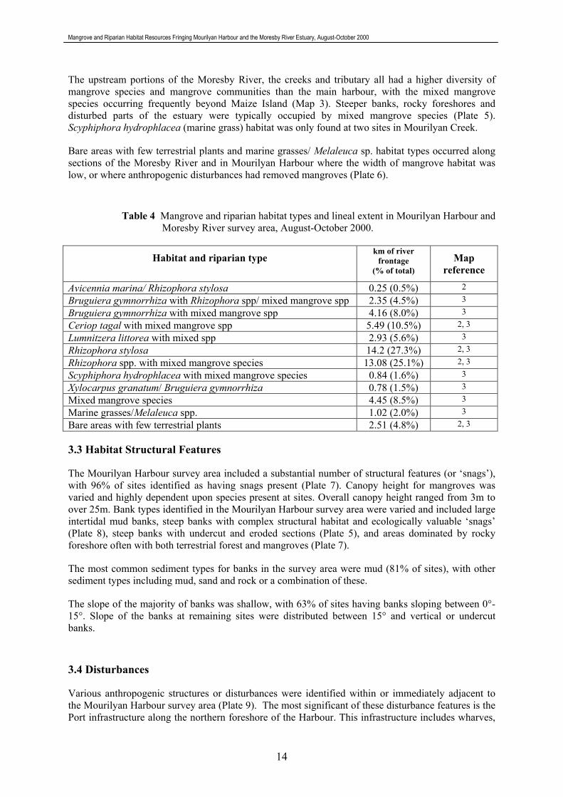
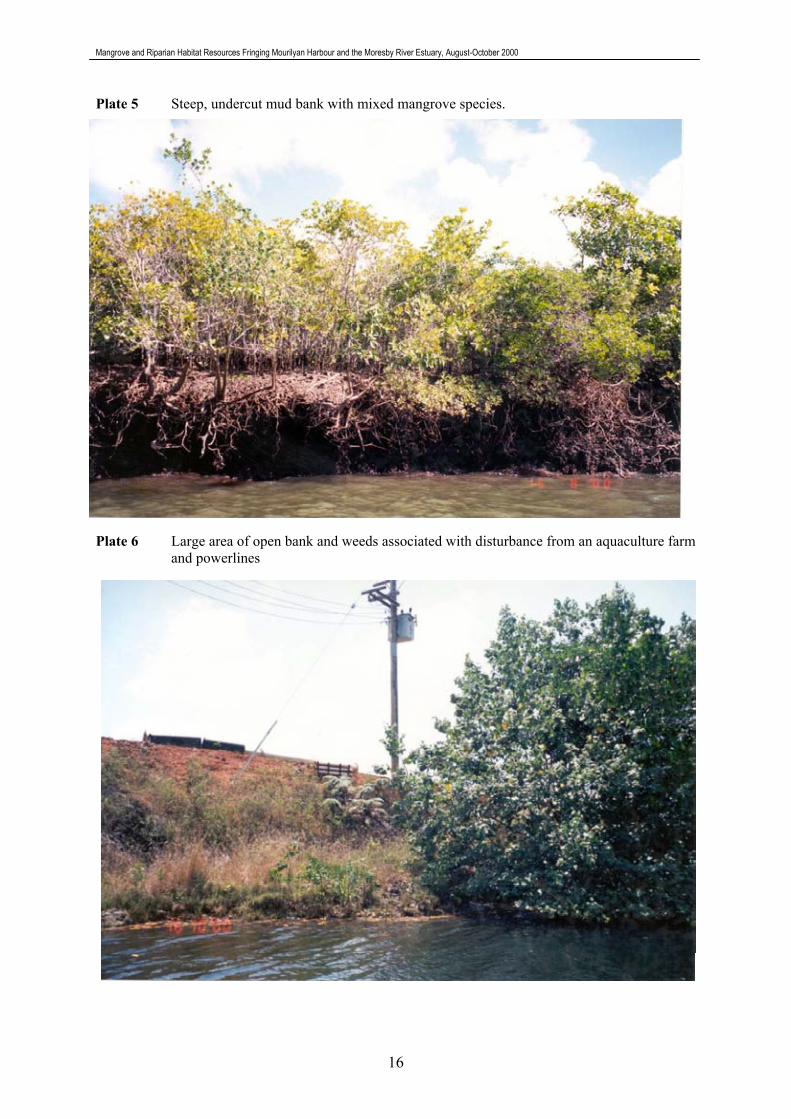
The upstream portions of the Moresby River, the creeks and tributary all had a higher diversity of mangrove species and mangrove communities than the main harbour, with the mixed mangrove species occurring frequently beyond Maize Island (Map 3). Steeper banks, rocky foreshores and disturbed parts of the estuary were typically occupied by mixed mangrove species (Plate 5). Scyphiphora hydrophlacea (marine grass) habitat was only found at two sites in Mourilyan Creek.
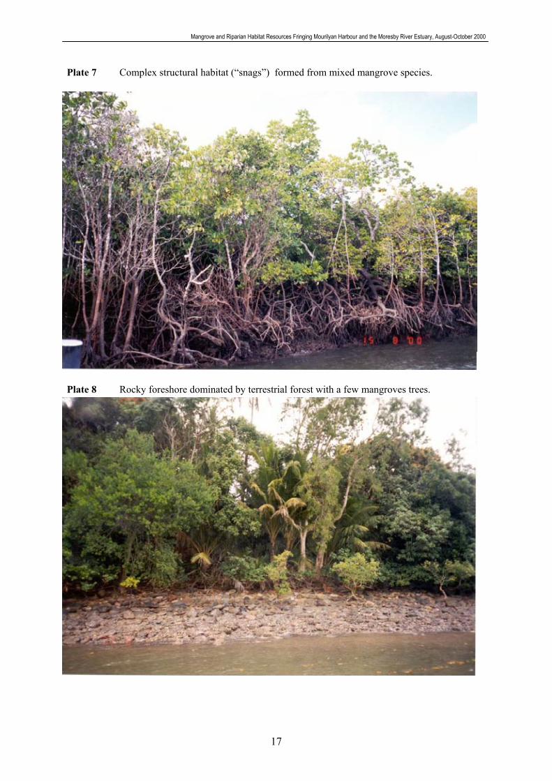
Bare areas with few terrestrial plants and marine grasses/ Melaleuca sp. habitat types occurred along sections of the Moresby River and in Mourilyan Harbour where the width of mangrove habitat was low, or where anthropogenic disturbances had removed mangroves (Plate 6).
Table 4 Mangrove and riparian habitat types and lineal extent in Mourilyan Harbour and Moresby River survey area, August-October 2000.
Habitat and riparian type km of river
frontage (% of total)
Map reference
Avicennia marina/ Rhizophora stylosa 0.25 (0.5%) 2 Bruguiera gymnorrhiza with Rhizophora spp/ mixed mangrove spp 2.35 (4.5%) 3 Bruguiera gymnorrhiza with mixed mangrove spp 4.16 (8.0%) 3 Ceriop tagal with mixed mangrove spp 5.49 (10.5%) 2, 3 Lumnitzera littorea with mixed spp 2.93 (5.6%) 3 Rhizophora stylosa 14.2 (27.3%) 2, 3
Rhizophora spp. with mixed mangrove species 13.08 (25.1%) 2, 3 Scyphiphora hydrophlacea with mixed mangrove species 0.84 (1.6%) 3 Xylocarpus granatum/ Bruguiera gymnorrhiza 0.78 (1.5%) 3 Mixed mangrove species 4.45 (8.5%) 3 Marine grasses/Melaleuca spp. 1.02 (2.0%) 3 Bare areas with few terrestrial plants 2.51 (4.8%) 2, 3
3.3 Habitat Structural Features
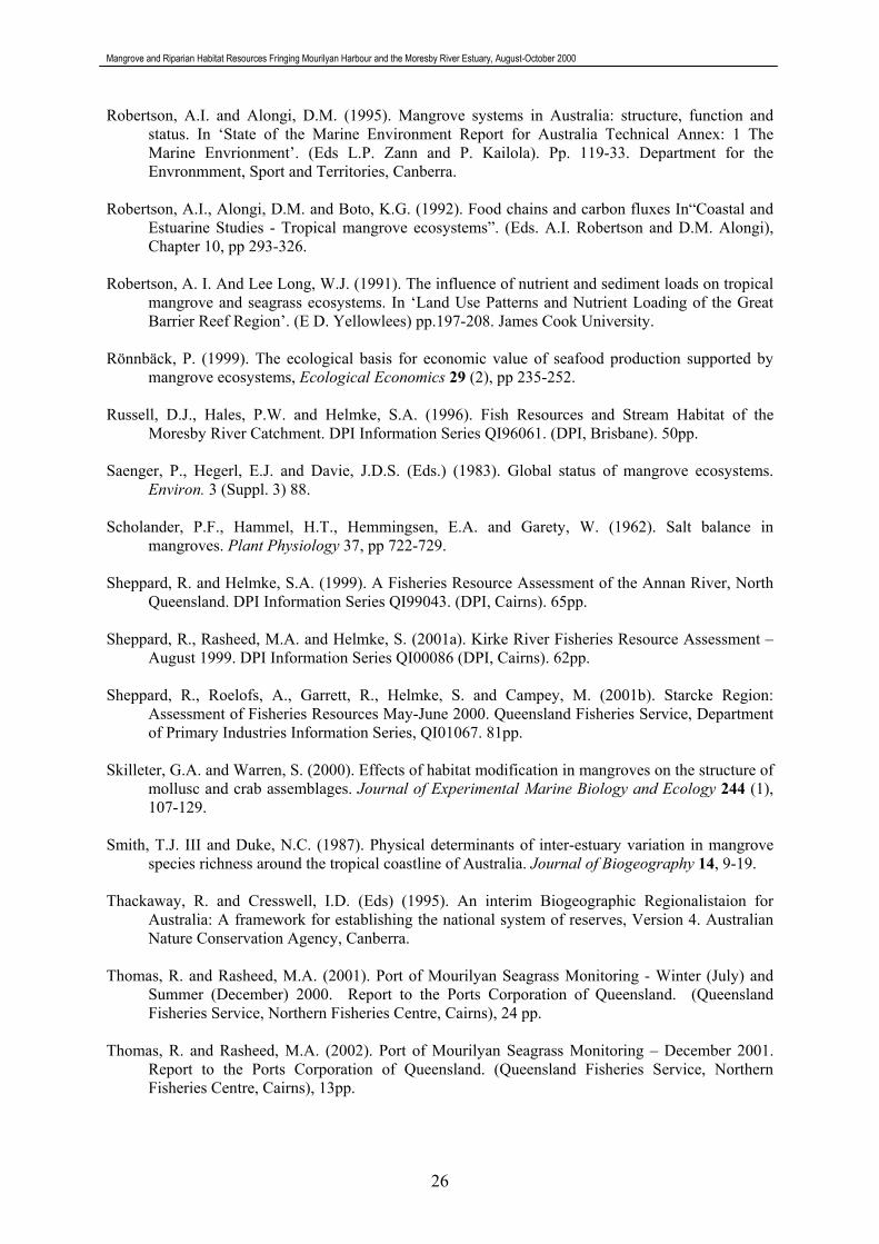
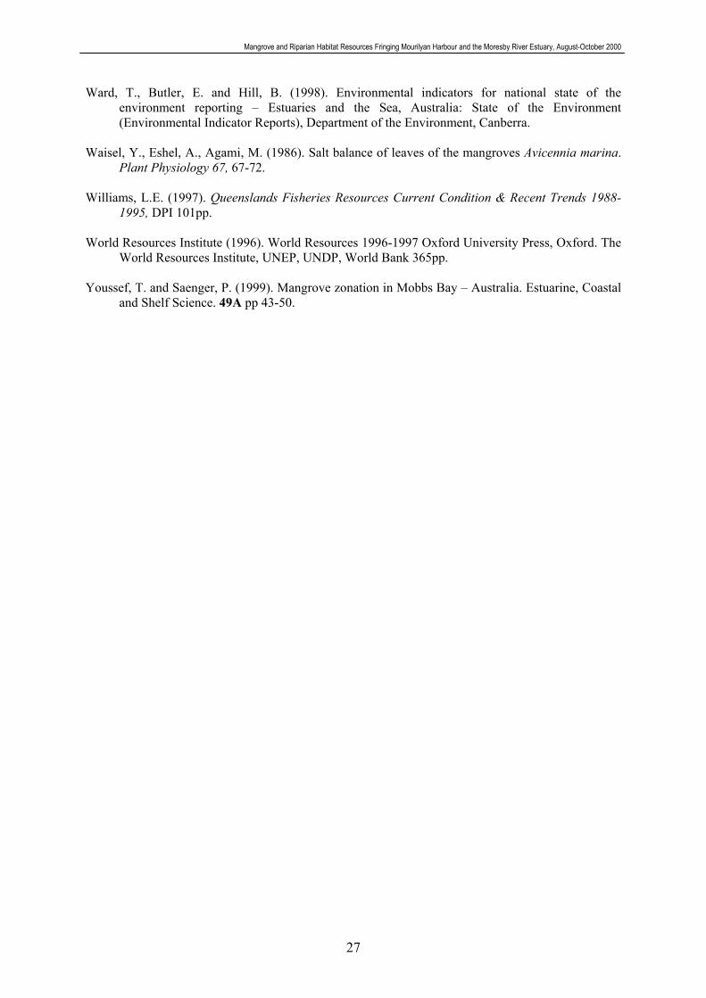
The Mourilyan Harbour survey area included a substantial number of structural features (or �snags�), with 96% of sites identified as having snags present (Plate 7). Canopy height for mangroves was varied and highly dependent upon species present at sites. Overall canopy height ranged from 3m to over 25m. Bank types identified in the Mourilyan Harbour survey area were varied and included large intertidal mud banks, steep banks with complex structural habitat and ecologically valuable �snags� (Plate 8), steep banks with undercut and eroded sections (Plate 5), and areas dominated by rocky foreshore often with both terrestrial forest and mangroves (Plate 7).
The most common sediment types for banks in the survey area were mud (81% of sites), with other sediment types including mud, sand and rock or a combination of these.
The slope of the majority of banks was shallow, with 63% of sites having banks sloping between 0°-15°. Slope of the banks at remaining sites were distributed between 15° and vertical or undercut banks.
3.4 Disturbances
Various anthropogenic structures or disturbances were identified within or immediately adjacent to the Mourilyan Harbour survey area (Plate 9). The most significant of these disturbance features is the Port infrastructure along the northern foreshore of the Harbour. This infrastructure includes wharves,
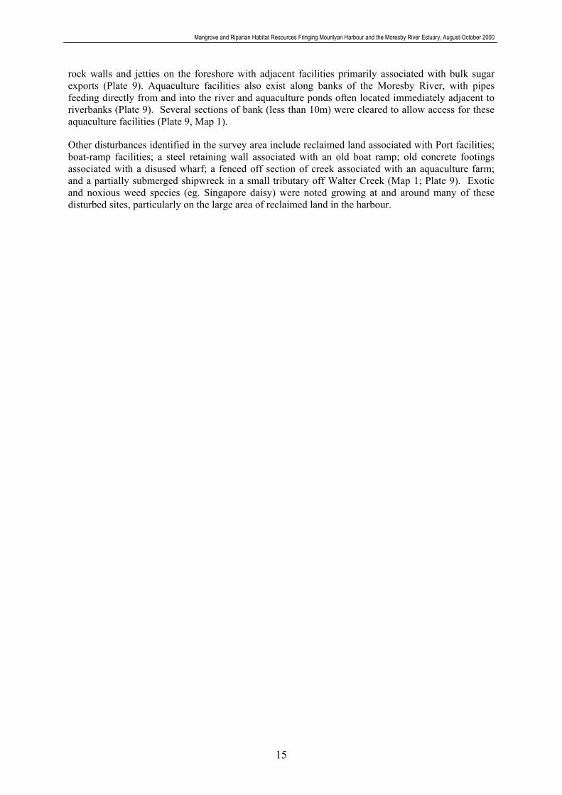
Mangrove and Riparian Habitat Resources Fringing Mourilyan Harbour and the Moresby River Estuary, August-October 2000
15
rock walls and jetties on the foreshore with adjacent facilities primarily associated with bulk sugar exports (Plate 9). Aquaculture facilities also exist along banks of the Moresby River, with pipes feeding directly from and into the river and aquaculture ponds often located immediately adjacent to riverbanks (Plate 9). Several sections of bank (less than 10m) were cleared to allow access for these aquaculture facilities (Plate 9, Map 1).
Other disturbances identified in the survey area include reclaimed land associated with Port facilities; boat-ramp facilities; a steel retaining wall associated with an old boat ramp; old concrete footings associated with a disused wharf; a fenced off section of creek associated with an aquaculture farm; and a partially submerged shipwreck in a small tributary off Walter Creek (Map 1; Plate 9). Exotic and noxious weed species (eg. Singapore daisy) were noted growing at and around many of these disturbed sites, particularly on the large area of reclaimed land in the harbour.
Mangrove and Riparian Habitat Resources Fringing Mourilyan Harbour and the Moresby River Estuary, August-October 2000
16
Plate 5 Steep, undercut mud bank with mixed mangrove species.
Plate 6 Large area of open bank and weeds associated with disturbance from an aquaculture farm and powerlines
Mangrove and Riparian Habitat Resources Fringing Mourilyan Harbour and the Moresby River Estuary, August-October 2000
17
Plate 7 Complex structural habitat (�snags�) formed from mixed mangrove species. Plate 8 Rocky foreshore dominated by terrestrial forest with a few mangroves trees.

Mangrove and Riparian Habitat Resources Fringing Mourilyan Harbour and the Moresby River Estuary, August-October 2000
18
Plate 9 Existing disturbances within the Mourilyan Harbour survey area. a) Fenced creek b) Concrete posts
c) Boat ramp d) Aquaculture pipelines
e) Aquaculture farm f) Port infrastructure
g) National Park sign h) Partially submerged shipwreck

MAP 2 Mangrove community fringing southern Mourilyan Harbour, Walter Creek, Armit Creek, Bradshaw Island, Lily Island and Maize Island, August - October 2000
Rhizophora stylosa
Rhizophora stylosawith mixed spp.
monospecific stand
Ceriops tagalwith mixed spp.
LEGEND Source: Roder, C.A., Thomas, R., Rasheed, M.A. and McKenzie, L.J. (2002) Mangrove and Riparian Habitat Resources Fringing Mourilyan Harbour and the Moresby River Estuary, August - October 2000. DPI Information Series No. QI02062
Sampling dates: 1st and 15th of August, and 16th October 2000.
The State of Queensland, through the DPI Queensland (2002) and the CRC for Ecologically Sustainable Development of the Great Barrier Reef. Produced by the Marine Plant Ecology Group, DPI, Northern Fisheries Centre, Cairns, 2002.
19
MaizeMaizeMaizeMaizeMaizeMaizeMaizeMaizeMaizeIslandIslandIslandIslandIslandIslandIslandIslandIsland
LilyLilyLilyLilyLilyLilyLilyLilyLilyIslandIslandIslandIslandIslandIslandIslandIslandIsland
BradshawBradshawBradshawBradshawBradshawBradshawBradshawBradshawBradshawIslandIslandIslandIslandIslandIslandIslandIslandIsland
Avicennia marina/Rhizophora stylosa
Bare area withfew terrestrial plants
0
Kilometres
0.3 0.6

MA
P 3
Man
grov
e co
mm
unity
frin
ging
the
Mor
esby
Riv
er, M
ouril
yan
Cre
ek, a
nd a
n un
amed
trib
utar
y, A
ugus
t - O
ctob
er 2
000
Rhi
zoph
ora
styl
osa
Rhi
zoph
ora
styl
osa
with
mix
ed m
angr
ove
spp.
mon
ospe
cific
sta
nd
Cer
iops
taga
lw
ith m
ixed
man
grov
e sp
p.
Mix
ed
man
grov
e sp
p.Lu
mnn
itera
litto
rea/
with
mix
ed m
angr
ove
spp.
LEG
END
Sour
ce: R
oder
, C.A
., Th
omas
, R.,
Ras
heed
, M.A
. and
McK
enzi
e, L
.J. (
2002
) M
angr
ove
and
Rip
aria
n H
abita
t Res
ourc
es F
ringi
ng M
ouril
yan
Har
bour
and
the
Mor
esby
Riv
er E
stua
ry, A
ugus
t - O
ctob
er 2
000.
DPI
Info
rmat
ion
Serie
s N
o.Q
I020
62
Sam
plin
g da
tes:
1st
and
15t
h of
Aug
ust,
and
16th
Oct
ober
200
0.
T
he S
tate
of Q
ueen
slan
d, th
roug
h th
e D
PI Q
ueen
slan
d (2
002)
and
the
CR
C
for E
colo
gica
lly S
usta
inab
le D
evel
opm
ent o
f the
Gre
at B
arrie
r Ree
f. Pr
oduc
ed b
y th
e M
arin
e Pl
ant E
colo
gy G
roup
, DPI
, Nor
ther
n Fi
sher
ies
Cen
tre, C
airn
s, 2
002.
20
Brug
uier
a gy
mno
rrhiz
a/R
hizo
phor
a st
ylos
a
Brug
uier
a gy
mno
rrhiz
a/w
ith m
ixed
man
grov
e sp
p.Ba
re a
rea
with
few
Scyp
hiph
ora
hydo
phyl
acea
w
ith m
ixed
man
grov
e sp
p.
0
Kilo
met
res
0.5
1
Mar
ine
gras
ses/
Mel
aleu
ca tr
ees
terre
stria
l pla
nts
Xylo
carp
us g
rana
tum
/Br
ugui
era
gym
norrh
iza
Mai
zie
Isla
ndM
ores
by R
iver
Mourilyan Creek
Unn
amed
tri
buta
ry

Mangrove and Riparian Habitat Resources Fringing Mourilyan Harbour and the Moresby River Estuary, August-October 2000
21
4. Discussion
True mangroves dominated the riparian vegetation of Mourilyan Harbour and the Moresby River estuary and associated creeks. This habitat appeared healthy with no observed dieback as reported from other nearby localities (eg Mackay). Other vegetation (including terrestrial grasses, vines and trees) was present but not common.
The diversity of mangrove species was highest in the major creeks feeding into Mourilyan Harbour and upstream of Maizie Island. Complex and diverse habitat also existed within Mourilyan Harbour with seagrass beds, sand banks and fringing Rhizophora stylosa habitat providing a valuable and important fisheries resource.
Rhizophora stylosa had the most extensive distribution, was the most abundant species and tended to dominate habitat types along the banks of the harbour and estuary. Generally, Rhizophora stylosa is a pioneering species that is often found on mud flats and on islands in tidal estuaries. Bunt and Williams (1980) found that Rhizophora spp. emerged as predominant close to the lower tidal limit, while this study found Rhizphora stylosa and R. apiculata common throughout the marine reaches of the Moresby River Estuary. Rhizphora stylosa is often associated with Avicennia marina, Ceriops spp. and Bruguiera spp. (Claridge and Burnett 1993), as was found in the present study. Lumnitzera littorea was also found associated with Rhizophora spp. The extensive and dominant distribution of Rhizophora stylosa in Mourilyan Harbour and the Moresby River Estuary is similar to other mangrove communities experiencing large freshwater input in tropical North Queensland (Sheppard et al. 2001a; Portefaix 1993; Dowling and McDonald 1983).
Rhizophora spp. contributes greatly to primary productivity in estuaries through litter fall (Conacher et al. 1996), and secondary productivity, with prop roots contributing complex structural habitat, or �snags�. Snags provide suitable habitat for many juvenile fish (protection from predatory fish) and adult fish (hiding spaces for ambush). 76 species of fish have previously been identified inhabiting the tidal reaches of the Moresby River estuary (Russell et al. 1996).
Bruguiera gymnorrhiza had a wide distribution and was common along the fringe of the estuary in this survey. Bunt and Williams (1980) found distribution of Bruguiera gymnorrhiza extended to the waters edge where there was a strong freshwater influence but was restricted to the upper tidal zone in areas with low freshwater influence.
Avicennia marina was not as common in the study area as in other north Queensland locations. A. marina was found at only 16% of all sites, and formed a small community at the northern part of the Harbour. In the Kirke River, western Cape York A. marina was the most common species recorded (62% of all sites) (Sheppard et al. 2001a). A. marina has efficient salt secreting mechanisms and tends to be more dominant in higher salinity areas (Scholander et al. 1962; Waisel, et al. 1986). The strong freshwater influence in the Moresby River Estuary may contribute to the lower abundance of this species. The closed Rhizophora stylosa forest that dominated the estuary may also inhibit the establishment of A. marina.
Avicennia marina could potentially be an indicator species for herbicide damage (particularly diuron) in estuaries. Avicennia marina has undergone extensive dieback in the cane growing Pioneer catchment, and preliminary studies have found that diuron, a pre-emergent herbicide, could be damaging this species by travelling through a gap in the Caspian strip at the root tip (Duke et al. 2001; Duke, pers communication). Early detection of problems would contribute directly and significantly to minimising damage and the cost of restoration (Duke et al. 2001). There was no evidence of recent Avicennia marina dieback in Mourilyan Harbour or the Moresby River.
Other mangrove species (including Xylocarpus granatum, X. mekongensis, Bruguiera parviflora, Heritiera littoralis, Excoecaria agallocha, Lumnitzera littorea and Aegiceras corniculatum) were most commonly found upstream of Maizie Island. The upstream environment was more protected

Mangrove and Riparian Habitat Resources Fringing Mourilyan Harbour and the Moresby River Estuary, August-October 2000
22
from wave energy and currents. Most of the species mentioned above require some freshwater input, or grow along the landward edge or margin of mangrove forests (Claridge and Burnett 1993; Dowling and McDonald 1982).
Ceriops tagal and Lumnitzera littorea habitat types often occurred at higher elevations along the eroding banks of the Moresby River and associated creeks, while Rhizophora stylosa dominated lower elevations along the depositing mud banks. This vertical zonation has also been observed in the Kirke and Starcke river systems in north-east Queensland (Sheppard et al. 2001a; 2001b). Ceriops tagal has limited root stability, with a small area of buttress root, and is often one of the first species of mangroves to fall with sediment disturbance.
Hibiscus tiliaceus was recorded generally in thin bands of mangrove forest, on mud and/or rock substrate, and at the interface between mangroves and terrestrial vegetation in this study area. This is consistent with findings of other studies where Hibiscus tiliaceus regularly occurs at the landward edge of mangrove forests (Sheppard et al. 2001a&b; Claridge and Burnett 1993).
Youssef and Saenger (1999) suggested that specific segregation of species is the outcome of the cumulative interaction between different environmental gradients on one-hand and tolerance boundaries of each species to each particular gradient on the other. Zones of mangroves species are a response of individual mangrove species to the gradients of inundation frequency, waterlogging, nutrient availability and soil salt concentrations across the intertidal area (Hutchings and Saenger, 1987). The zonation of mangroves from shore to inland reaches in Mourilyan Harbour and the Moresby River estuary however could not be fully explored, as this study was limited to vessel access along fringing mangrove habitat. Further investigation of the mangroves from mean sea level to highest astronomical tide, and a suite of physical parameters would assist in understanding the zonation of mangroves in Mourilyan Harbour and the Moresby River Estuary.
The number of mangrove species recorded in this study (17) was low compared with north-east Queenslands larger wetland systems. 22 species of true mangroves (excluding mangrove ferns) were recorded in Trinity Inlet, Cairns (Dowling 1983) and 30 mangrove species were recorded north of the Daintree River (Claridge and Burnett 1993). The lower diversity of mangrove species found in this survey could be due to a number of reasons. Only the fringing mangroves of the river and creeks were surveyed, so mangrove species growing along the more landward edges of wide bands of mangrove forests or high tide regions could have been missed. The survey did not extend into the freshwater reaches of the Moresby River so species preferring more brackish to freshwater habitat such as the freshwater mangrove (Barringtonia racemosa), or mangrove palm (Nypa fruticans) may have been present.
The relatively small size of the Moresby River catchment and estuary may also explain the lower species diversity for this system. Smith and Duke (1987) found that catchment size and estuary length were associated with mangrove species richness in north-eastern Australia with estuaries that were long and had large catchments tending to have more species than short estuaries with small catchments such as the Moresby River.
The Geographic Information System (GIS) of fringing riparian habitats of Mourilyan Harbour and the Moresby River estuary developed in this study may assist in the risk management of and response to marine accidents in the port. The presence of mangroves lining the majority of the estuary means the majority of the port environment has a high environmental sensitivity to oil spills as has been recognised in the oil spill contingency plan. The consequences of oil spreading to the upstream reaches of the Moresby River or the creeks that flow into the harbour may be more severe due to the greater diversity of species occurring in these areas. The oil spill contingency plan for the port suggests that booms could be employed to prevent oil from entering the creeks and to deflect oil from mangroves in the harbour that are under threat. The results of this survey suggest that booming of oil away from these areas should be a high priority in any response.

Mangrove and Riparian Habitat Resources Fringing Mourilyan Harbour and the Moresby River Estuary, August-October 2000
23
While this survey indicates that the riparian zone of the Moresby River estuary and Mourilyan Harbour appears to be relatively healthy, the area is subject to several threats other than shipping or port accidents. The Moresby River catchment has been heavily influenced by human activities that may affect water quality and mangrove health. Russell et al. (1996) found 37% of sites surveyed in the Moresby River catchment were classified as either having a high or extreme level of disturbance. The results of the riparian survey reported here provide a baseline of fringing mangrove communities from which future comparisons can be made and a monitoring program developed. Future monitoring could include additional techniques to better establish zonation of vegetation along salinity, sulphide, sediment, and tidal gradients. A better understanding of the system would assist in distinguishing between impacts associated with port activities, anthropogenic catchment inputs and climatic changes.

Mangrove and Riparian Habitat Resources Fringing Mourilyan Harbour and the Moresby River Estuary, August-October 2000
24
5. References Australian Bureau of Meterology (2001). Australian climate averages and extremes.
http//www.bom.gov.au/climate/averages/ Australian State of the Environment Committee (2001). Coasts and Oceans. Australian State of the
Environment Report 2001. CSIRO publishing on behalf of the Department of Environment and Heritage, Canberra.. http://www.ea.gov.au/soe/
Beumer, J., Carseldine, L. and Zeller, B. (1997). Declared Fish Habitat Areas in Queensland. DPI
Information Series QI 97004 178pp. Blasco, F., Saenger, P and Janodet, E. (1996). Mangroves as Indicators of Coastal Change. Cantena,
27 pp 167-178. Bruinsma, C. Danaher, K., Treloar, P. and Sheppard, R. (1999). Coastal Wetland Vegetation
Investigation of the Bowen Region: Cape Upstart to Gloucester Island. DPI, Brisbane. Bunt, J.S. (1982). Studies of Mangrove Litter Fall in Tropical Australia. In �Mangrove Ecosystems in
Australia, Structure, function and management�. (Ed BF Clough) pp. 223-237. Australian Institute of Marine Science and Australian National University Press, Canberra .
Bunt, J.S. and Williams, W.T. (1980). Studies in the analysis of data from Australian tidal forests
(�Mangroves�). I. Vegetational sequences and their graphic representation. Australian Journal of Ecology 5, pp 385-390.
Bunt, J.S., Williams, W.T. and Duke, N.C. (1982). Mangrove distributions in north-east Australia.
Journal of Biogeography 9: 111-120. Cappo, M. (1995). Bays, bait and Bowling Green - Pilchards and Sardines. Part 2. Sportfish
Australia, Winter/ Spring 1995, pp. 14-19. Claridge, D. and Burnett, J. (1993). Mangroves in Focus. Wet Paper. 160pp. Clough, B.F. (1992). Primary productivity and growth of mangrove forests. In �Coastal and Estuarine
Studies - Tropical mangrove ecosystems�(Eds. A.I. Robertson and D.M. Alongi), Chapter 8, pp 225-250.
Conacher, C.A., O�Brien, C., Horrocks, J.L. and Kenyon, R.K. (1996). Litter production and
accumulation in stressed mangrove communities in the Embley River Estuary, north-eastern Gulf of Carpentaria, Australia Marine and Freshwater Research 47 (5), pp 737-743.
Costanza, R, D'Arge, R., de Groot, R., Farber, S. Grasso, M., Hannon, B. Limburg, K. Naeem, S.,
O'Neill, R.V., Paruelo, J. Raskin, R.G.; Sutton, P. and van den Belt, M. (1997). The value of the world's ecosystem services and natural capital. Nature 387 (15 May), 253-260.
Dowling, R.M. and McDonald, T.J. (1982). Mangrove Communities of Queensland In �Mangrove
Ecosystems of Australia � Structure, function and management� (Ed B.F. Clough) Chapter 5, pp 81-93.
Dowling, R.M. (1983). The Mangrove Communities. In �Biological resources of Trinity Inlet and Bay
Queensland� (H.F. Olsen) Queensland Department of Primary Industries Bulletin QB83004. Appendix A pp 23-28.

Mangrove and Riparian Habitat Resources Fringing Mourilyan Harbour and the Moresby River Estuary, August-October 2000
25
Duke, N.C. (1992). Mangrove floristic biogeography. In �Coastal and Estuarine Studies - Tropical
mangrove ecosystems�. (Eds A.I. Robertson and D.M. Alongi) Chapter 4, pp 63-100. Duke, N.C., Roelfsema, C., Tracey, D. and Godson, L. (2001). Preliminary investigation into dieback
of mangroves in the Mackay region. Report to Queensland Fisheries Service, Northern Region (DPI) and the Communtiy of the Mackay Region. 15 May 2001. 81 pp.
Halliday, I.A. and Young, W.R. (1996). Density, biomass and species composition of fish in a
subtropical Rhizophora stylosa mangrove forest. Marine and Freshwater Research 47(4) pp 609-615.
Hutchings, P. and Saenger, P. (1987). Ecology of Mangroves. Queensland University Press, 388pp. Lovelock, C. (1993). Field Guide to Mangroves in Queensland. Australian Institute of Marine
Science. 72pp. Macnae, W. (1966). Mangroves in eastern and southern Australia. Australian. Journal of Botany 14 :
67-104. McKenzie, L.J., Rasheed, M.A., Lee Long, W.J. and Coles, R.G. (1996). Port of Mourilyan Seagrass
Monitoring, Baseline Surveys � Summer (December) 1993 and Winter (July) 1994. Ports Corporation EcoPorts Monograph Series No. 2. (PCQ Brisbane) 52pp.
McKenzie, L.J., Lee Long, W.J., Roelofs, A.J., Roder, C.A., and Coles, R. G. (1998). Port of
Mourilyan Seagrass Monitoring � First Four Years. Ecoports Monograph Series No. 15. (Ports Corporation of Queensland, Brisbane) 30pp.
McPherson, G.R. (1987). Food of narrow barred Spanish mackerel in north Queensland waters, and
their relevance to the commercial troll fishery. Qld Journal of Agricultural and Animal Sciences, 44, 69-73.
Morton, R.M. (1990). Community structure, density and standing crop of fished in a subtropical
Australian mangrove area. Marine Biology 105, 385-94 Natural Resource Assessment (1997). Ports of Lucinda and Mourilyan Vegetation Masterplans. (Ports
Corporation of Queensland, Brisbane). PCQ (1999). Port of Mourilyan Oil Spill Contingency Plan. Prepared by Response Tech Pty. Ltd and
WBM Oceanics Australia for Ports Corporation of Queensland, Brisbane. PCQ (2002). Ports Corporation of Queensland. http://www.pcq.com.au/ Portefaix, M. (1993). The development of a Resource Information System for Trinity Inlet Catchment.
Report submitted to Trinity Inlet Management Plant Steering Committee 33pp. Queensland Transport (2002). Trade statistics for Queensland Ports, for the 5 years ending 30 June,
2001. ISSN 1032-9595 Quinn, R.H. (1993). What is the importance of wetlands and estuarine habitats? The Queensland
Fisherman 11 (5): 27-30.
Mangrove and Riparian Habitat Resources Fringing Mourilyan Harbour and the Moresby River Estuary, August-October 2000
26
Robertson, A.I. and Alongi, D.M. (1995). Mangrove systems in Australia: structure, function and status. In �State of the Marine Environment Report for Australia Technical Annex: 1 The Marine Envrionment�. (Eds L.P. Zann and P. Kailola). Pp. 119-33. Department for the Envronmment, Sport and Territories, Canberra.
Robertson, A.I., Alongi, D.M. and Boto, K.G. (1992). Food chains and carbon fluxes In�Coastal and
Estuarine Studies - Tropical mangrove ecosystems�. (Eds. A.I. Robertson and D.M. Alongi), Chapter 10, pp 293-326.
Robertson, A. I. And Lee Long, W.J. (1991). The influence of nutrient and sediment loads on tropical
mangrove and seagrass ecosystems. In �Land Use Patterns and Nutrient Loading of the Great Barrier Reef Region�. (E D. Yellowlees) pp.197-208. James Cook University.
Rönnbäck, P. (1999). The ecological basis for economic value of seafood production supported by
mangrove ecosystems, Ecological Economics 29 (2), pp 235-252. Russell, D.J., Hales, P.W. and Helmke, S.A. (1996). Fish Resources and Stream Habitat of the
Moresby River Catchment. DPI Information Series QI96061. (DPI, Brisbane). 50pp. Saenger, P., Hegerl, E.J. and Davie, J.D.S. (Eds.) (1983). Global status of mangrove ecosystems.
Environ. 3 (Suppl. 3) 88. Scholander, P.F., Hammel, H.T., Hemmingsen, E.A. and Garety, W. (1962). Salt balance in
mangroves. Plant Physiology 37, pp 722-729. Sheppard, R. and Helmke, S.A. (1999). A Fisheries Resource Assessment of the Annan River, North
Queensland. DPI Information Series QI99043. (DPI, Cairns). 65pp. Sheppard, R., Rasheed, M.A. and Helmke, S. (2001a). Kirke River Fisheries Resource Assessment �
August 1999. DPI Information Series QI00086 (DPI, Cairns). 62pp. Sheppard, R., Roelofs, A., Garrett, R., Helmke, S. and Campey, M. (2001b). Starcke Region:
Assessment of Fisheries Resources May-June 2000. Queensland Fisheries Service, Department of Primary Industries Information Series, QI01067. 81pp.
Skilleter, G.A. and Warren, S. (2000). Effects of habitat modification in mangroves on the structure of
mollusc and crab assemblages. Journal of Experimental Marine Biology and Ecology 244 (1), 107-129.
Smith, T.J. III and Duke, N.C. (1987). Physical determinants of inter-estuary variation in mangrove
species richness around the tropical coastline of Australia. Journal of Biogeography 14, 9-19. Thackaway, R. and Cresswell, I.D. (Eds) (1995). An interim Biogeographic Regionalistaion for
Australia: A framework for establishing the national system of reserves, Version 4. Australian Nature Conservation Agency, Canberra.
Thomas, R. and Rasheed, M.A. (2001). Port of Mourilyan Seagrass Monitoring - Winter (July) and
Summer (December) 2000. Report to the Ports Corporation of Queensland. (Queensland Fisheries Service, Northern Fisheries Centre, Cairns), 24 pp.
Thomas, R. and Rasheed, M.A. (2002). Port of Mourilyan Seagrass Monitoring � December 2001.
Report to the Ports Corporation of Queensland. (Queensland Fisheries Service, Northern Fisheries Centre, Cairns), 13pp.
Mangrove and Riparian Habitat Resources Fringing Mourilyan Harbour and the Moresby River Estuary, August-October 2000
27
Ward, T., Butler, E. and Hill, B. (1998). Environmental indicators for national state of the environment reporting � Estuaries and the Sea, Australia: State of the Environment (Environmental Indicator Reports), Department of the Environment, Canberra.
Waisel, Y., Eshel, A., Agami, M. (1986). Salt balance of leaves of the mangroves Avicennia marina.
Plant Physiology 67, 67-72. Williams, L.E. (1997). Queenslands Fisheries Resources Current Condition & Recent Trends 1988-
1995, DPI 101pp. World Resources Institute (1996). World Resources 1996-1997 Oxford University Press, Oxford. The
World Resources Institute, UNEP, UNDP, World Bank 365pp. Youssef, T. and Saenger, P. (1999). Mangrove zonation in Mobbs Bay � Australia. Estuarine, Coastal
and Shelf Science. 49A pp 43-50.
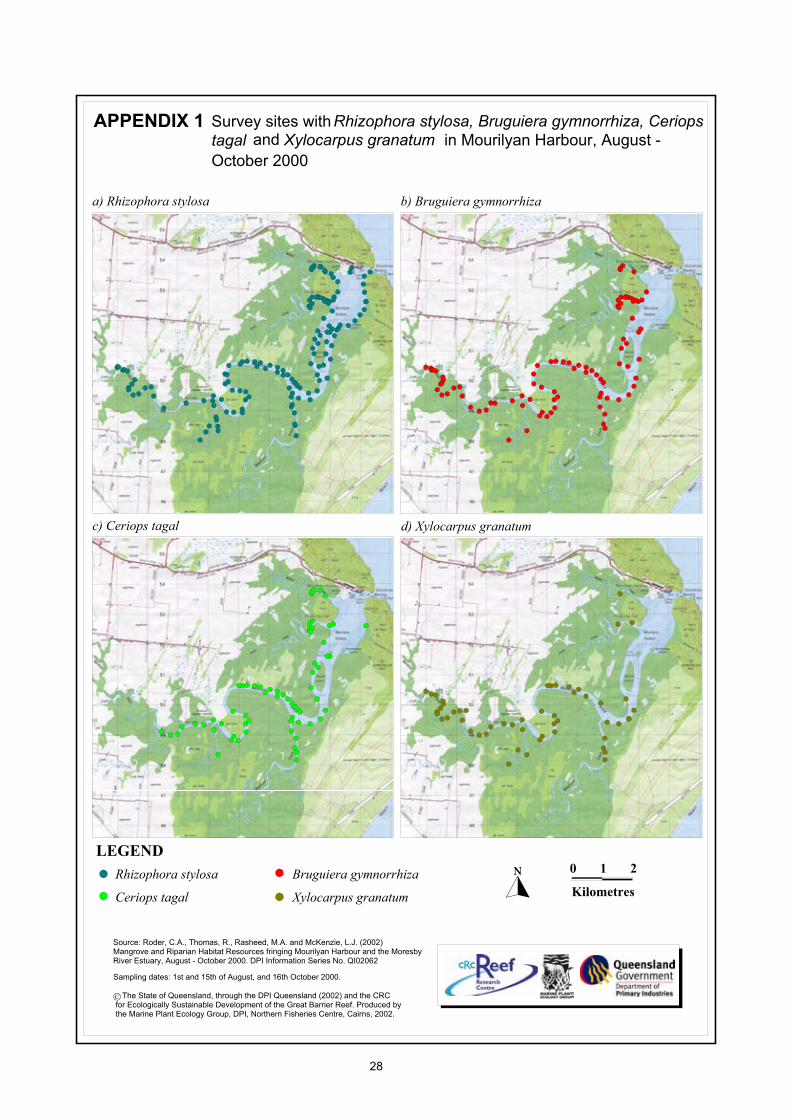
LEGENDRhizophora stylosa
Rhizophora stylosa, Bruguiera gymnorrhiza, CeriopsAPPENDIX 1
!!!!!!!!!!!!!!!!!!!!!!!!!!!!!!!!!!!!!!!!!!!!!!!!!!!!!!!!!!!!!!!!!Ceriops tagal
Bruguiera gymnorrhiza
Xylocarpus granatum
c) Ceriops tagal
a) Rhizophora stylosa b) Bruguiera gymnorrhiza
d) Xylocarpus granatum
0000000000000000000000000000000000000000000000000
KilometresKilometresKilometresKilometresKilometresKilometresKilometresKilometresKilometresKilometresKilometresKilometresKilometresKilometresKilometresKilometresKilometresKilometresKilometresKilometresKilometresKilometresKilometresKilometresKilometresKilometresKilometresKilometresKilometresKilometresKilometresKilometresKilometresKilometresKilometresKilometresKilometresKilometresKilometresKilometresKilometresKilometresKilometresKilometresKilometresKilometresKilometresKilometresKilometres
1111111111111111111111111111111111111111111111111 2222222222222222222222222222222222222222222222222
Survey sites withtagal and Xylocarpus granatum in Mourilyan Harbour, August -
Source: Roder, C.A., Thomas, R., Rasheed, M.A. and McKenzie, L.J. (2002) Mangrove and Riparian Habitat Resources fringing Mourilyan Harbour and the Moresby River Estuary, August - October 2000. DPI Information Series No. QI02062
Sampling dates: 1st and 15th of August, and 16th October 2000.
The State of Queensland, through the DPI Queensland (2002) and the CRC for Ecologically Sustainable Development of the Great Barrier Reef. Produced by the Marine Plant Ecology Group, DPI, Northern Fisheries Centre, Cairns, 2002.
October 2000
28
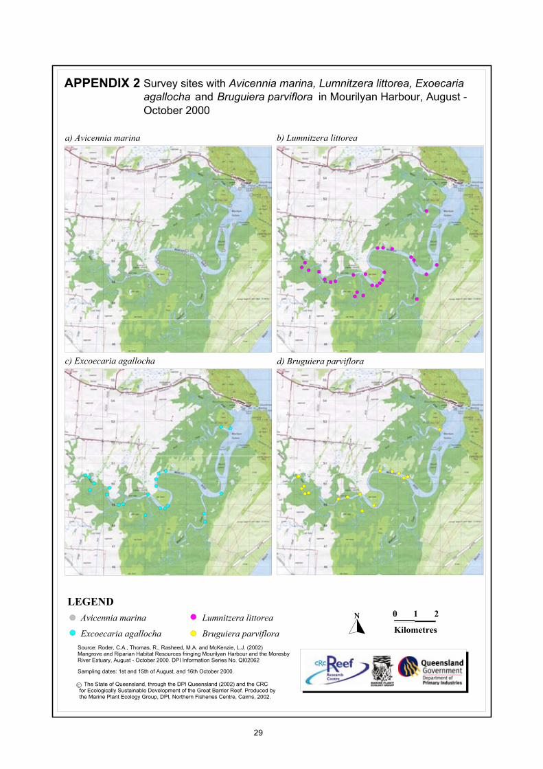
LEGENDAvicennia marina !!!!!!!!!!!!!!!!!!!!!!!!!!!!!!!!!!!!!!!!!!!!!!!!!!!!!!!!!!!!!!!!!Excoecaria agallocha
Lumnitzera littorea
Bruguiera parviflora
c) Excoecaria agallocha
a) Avicennia marina b) Lumnitzera littorea
d) Bruguiera parviflora
0000000000000000000000000000000000000000000000000
KilometresKilometresKilometresKilometresKilometresKilometresKilometresKilometresKilometresKilometresKilometresKilometresKilometresKilometresKilometresKilometresKilometresKilometresKilometresKilometresKilometresKilometresKilometresKilometresKilometresKilometresKilometresKilometresKilometresKilometresKilometresKilometresKilometresKilometresKilometresKilometresKilometresKilometresKilometresKilometresKilometresKilometresKilometresKilometresKilometresKilometresKilometresKilometresKilometres
1111111111111111111111111111111111111111111111111 2222222222222222222222222222222222222222222222222
Avicennia marina, Lumnitzera littorea, Exoecaria APPENDIX 2 Survey sites withagallocha and Bruguiera parviflora in Mourilyan Harbour, August -
Source: Roder, C.A., Thomas, R., Rasheed, M.A. and McKenzie, L.J. (2002) Mangrove and Riparian Habitat Resources fringing Mourilyan Harbour and the Moresby River Estuary, August - October 2000. DPI Information Series No. QI02062
Sampling dates: 1st and 15th of August, and 16th October 2000.
The State of Queensland, through the DPI Queensland (2002) and the CRC for Ecologically Sustainable Development of the Great Barrier Reef. Produced by the Marine Plant Ecology Group, DPI, Northern Fisheries Centre, Cairns, 2002.
October 2000
29
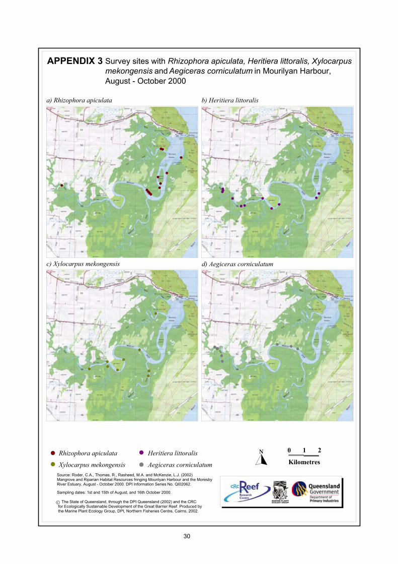
LEGEND
Rhizophora apiculata !!!!!!!!!!!!!!!!!!!!!!!!!!!!!!!!!!!!!!!!!!!!!!!!!!!!!!!!!!!!!!!!!Xylocarpus mekongensis
Heritiera littoralis
Aegiceras corniculatum
c) Xylocarpus mekongensis
a) Rhizophora apiculata b) Heritiera littoralis
d) Aegiceras corniculatum
0000000000000000000000000000000000000000000000000
KilometresKilometresKilometresKilometresKilometresKilometresKilometresKilometresKilometresKilometresKilometresKilometresKilometresKilometresKilometresKilometresKilometresKilometresKilometresKilometresKilometresKilometresKilometresKilometresKilometresKilometresKilometresKilometresKilometresKilometresKilometresKilometresKilometresKilometresKilometresKilometresKilometresKilometresKilometresKilometresKilometresKilometresKilometresKilometresKilometresKilometresKilometresKilometresKilometres
1111111111111111111111111111111111111111111111111 2222222222222222222222222222222222222222222222222
Rhizophora apiculata, Heritiera littoralis, Xylocarpus APPENDIX 3 Survey sites withmekongensis and Aegiceras corniculatum in Mourilyan Harbour,
Source: Roder, C.A., Thomas, R., Rasheed, M.A. and McKenzie, L.J. (2002) Mangrove and Riparian Habitat Resources fringing Mourilyan Harbour and the Moresby River Estuary, August - October 2000. DPI Information Series No. QI02062.
Sampling dates: 1st and 15th of August, and 16th October 2000.
The State of Queensland, through the DPI Queensland (2002) and the CRC for Ecologically Sustainable Development of the Great Barrier Reef. Produced by the Marine Plant Ecology Group, DPI, Northern Fisheries Centre, Cairns, 2002.
August - October 2000
30
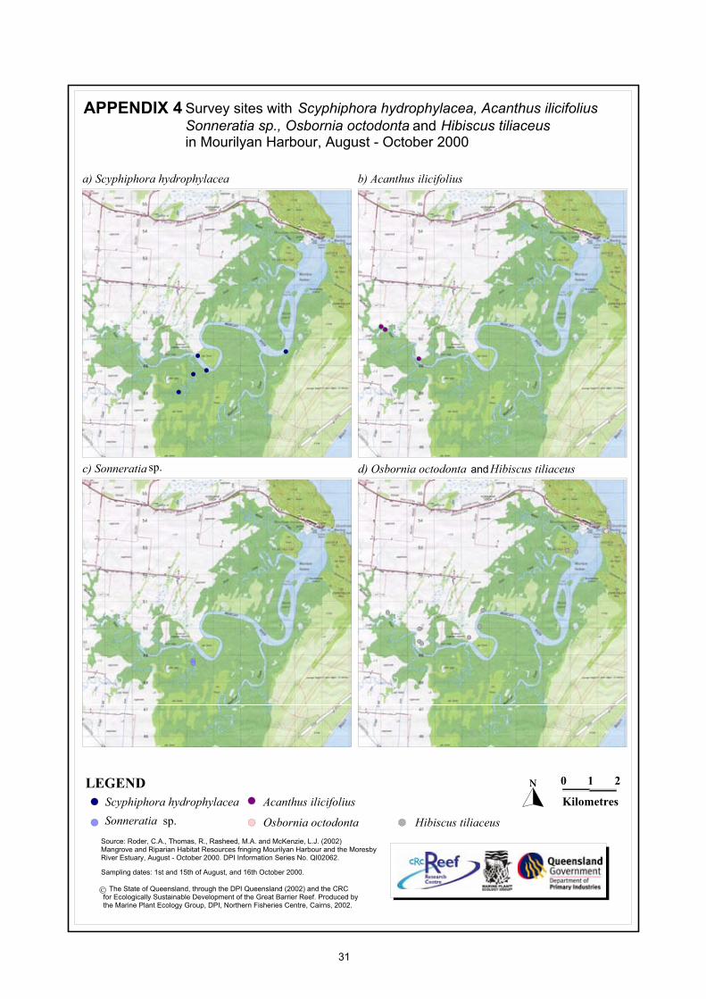
LEGENDScyphiphora hydrophylacea !!!!!!!!!!!!!!!!!!!!!!!!!!!!!!!!!!!!!!!!!!!!!!!!!!!!!!!!!!!!!!!!!Sonneratia
Acanthus ilicifolius
Osbornia octodonta
c) Sonneratia
a) Scyphiphora hydrophylacea b) Acanthus ilicifolius
d) Osbornia octodonta Hibiscus tiliaceus
0000000000000000000000000000000000000000000000000
KilometresKilometresKilometresKilometresKilometresKilometresKilometresKilometresKilometresKilometresKilometresKilometresKilometresKilometresKilometresKilometresKilometresKilometresKilometresKilometresKilometresKilometresKilometresKilometresKilometresKilometresKilometresKilometresKilometresKilometresKilometresKilometresKilometresKilometresKilometresKilometresKilometresKilometresKilometresKilometresKilometresKilometresKilometresKilometresKilometresKilometresKilometresKilometresKilometres
1111111111111111111111111111111111111111111111111 2222222222222222222222222222222222222222222222222
sp.
sp.
and
Hibiscus tiliaceus
Scyphiphora hydrophylacea, Acanthus ilicifolius APPENDIX 4 Survey sites withSonneratia sp., Osbornia octodonta and Hibiscus tiliaceusin Mourilyan Harbour, August - October 2000
Source: Roder, C.A., Thomas, R., Rasheed, M.A. and McKenzie, L.J. (2002) Mangrove and Riparian Habitat Resources fringing Mourilyan Harbour and the Moresby River Estuary, August - October 2000. DPI Information Series No. QI02062.
Sampling dates: 1st and 15th of August, and 16th October 2000.
The State of Queensland, through the DPI Queensland (2002) and the CRC for Ecologically Sustainable Development of the Great Barrier Reef. Produced by the Marine Plant Ecology Group, DPI, Northern Fisheries Centre, Cairns, 2002.
31
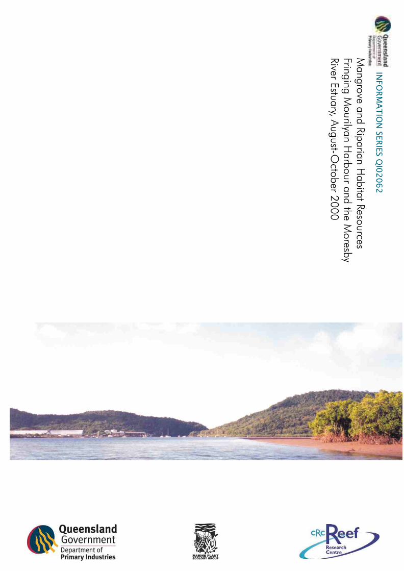
Mangrove and Riparian Habitat Resources
fringing Mourilyan Harbour and the Moresby
River Estuary, August-October 2000
I N F O R M A T I O N S E R I E S Q I 0 2 0 6 2
C A Roder
R Thomas
M A Rasheed &
L J McKenzie
Mangro
ve and R
iparia
n H
abita
t Reso
urces
Fringin
g M
ourilya
n H
arb
our a
nd th
e Moresb
y River E
stuary, A
ugust-O
ctober 2
00
0
INFO
RM
AT
ION
SER
IES Q
I02
06
2
Top Related
Copyright © 2022 FDOKUMEN

