


Bahasa
Halaman
Hukum

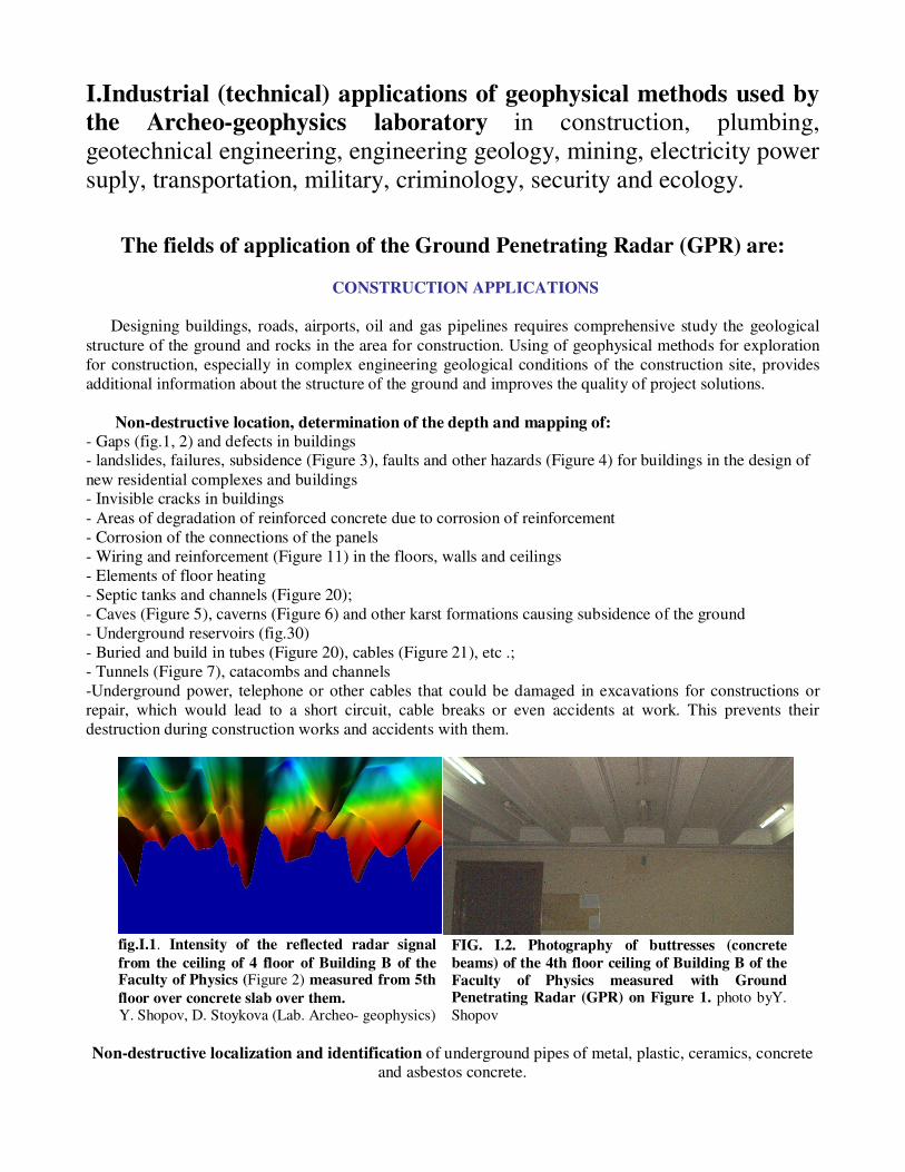
I.Industrial (technical) applications of geophysical methods used by
the Archeo-geophysics laboratory in construction, plumbing,
geotechnical engineering, engineering geology, mining, electricity power
suply, transportation, military, criminology, security and ecology.
The fields of application of the Ground Penetrating Radar (GPR) are:
CONSTRUCTION APPLICATIONS
Designing buildings, roads, airports, oil and gas pipelines requires comprehensive study the geological
structure of the ground and rocks in the area for construction. Using of geophysical methods for exploration
for construction, especially in complex engineering geological conditions of the construction site, provides
additional information about the structure of the ground and improves the quality of project solutions.
Non-destructive location, determination of the depth and mapping of:
- Gaps (fig.1, 2) and defects in buildings - landslides, failures, subsidence (Figure 3), faults and other hazards (Figure 4) for buildings in the design of
new residential complexes and buildings - Invisible cracks in buildings
- Areas of degradation of reinforced concrete due to corrosion of reinforcement
- Corrosion of the connections of the panels
- Wiring and reinforcement (Figure 11) in the floors, walls and ceilings
- Elements of floor heating
- Septic tanks and channels (Figure 20);
- Caves (Figure 5), caverns (Figure 6) and other karst formations causing subsidence of the ground
- Underground reservoirs (fig.30)
- Buried and build in tubes (Figure 20), cables (Figure 21), etc .;
- Tunnels (Figure 7), catacombs and channels
-Underground power, telephone or other cables that could be damaged in excavations for constructions or
repair, which would lead to a short circuit, cable breaks or even accidents at work. This prevents their
destruction during construction works and accidents with them.
fig.I.1. Intensity of the reflected radar signal
from the ceiling of 4 floor of Building B of the Faculty of Physics (Figure 2) measured from 5th
floor over concrete slab over them. Y. Shopov, D. Stoykova (Lab. Archeo- geophysics)
FIG. I.2. Photography of buttresses (concrete
beams) of the 4th floor ceiling of Building B of the
Faculty of Physics measured with Ground Penetrating Radar (GPR) on Figure 1. photo byY.
Shopov
Non-destructive localization and identification of underground pipes of metal, plastic, ceramics, concrete and asbestos concrete.
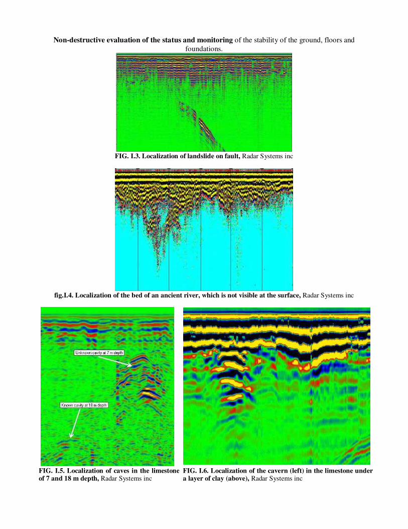
Non-destructive evaluation of the status and monitoring of the stability of the ground, floors and
foundations.
FIG. I.3. Localization of landslide on fault, Radar Systems inc
fig.I.4. Localization of the bed of an ancient river, which is not visible at the surface, Radar Systems inc
FIG. I.5. Localization of caves in the limestoneof 7 and 18 m depth, Radar Systems inc
FIG. I.6. Localization of the cavern (left) in the limestone under a layer of clay (above), Radar Systems inc
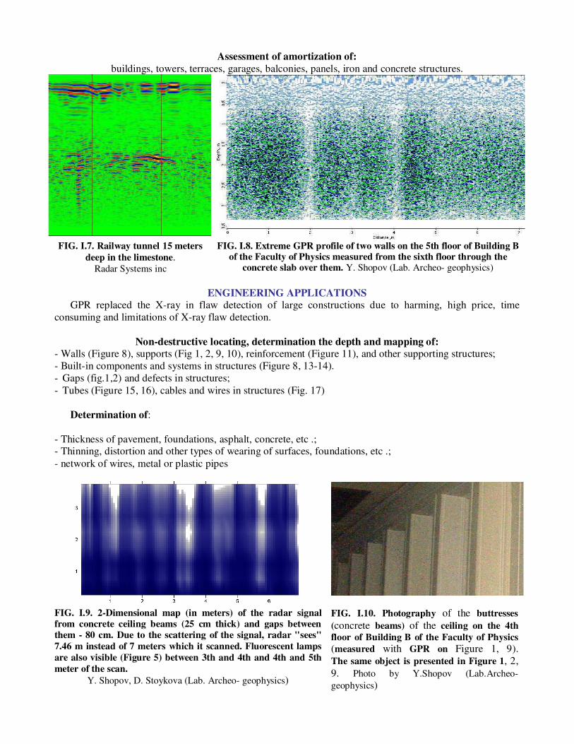
Assessment of amortization of:
buildings, towers, terraces, garages, balconies, panels, iron and concrete structures.
FIG. I.7. Railway tunnel 15 meters
deep in the limestone. Radar Systems inc
FIG. I.8. Extreme GPR profile of two walls on the 5th floor of Building B of the Faculty of Physics measured from the sixth floor through the
concrete slab over them. Y. Shopov (Lab. Archeo- geophysics)
ENGINEERING APPLICATIONS
GPR replaced the X-ray in flaw detection of large constructions due to harming, high price, time
consuming and limitations of X-ray flaw detection.
Non-destructive locating, determination the depth and mapping of:
- Walls (Figure 8), supports (Fig 1, 2, 9, 10), reinforcement (Figure 11), and other supporting structures;
- Built-in components and systems in structures (Figure 8, 13-14).
- Gaps (fig.1,2) and defects in structures;
- Tubes (Figure 15, 16), cables and wires in structures (Fig. 17)
Determination of:
- Thickness of pavement, foundations, asphalt, concrete, etc .; - Thinning, distortion and other types of wearing of surfaces, foundations, etc .;
- network of wires, metal or plastic pipes
FIG. I.9. 2-Dimensional map (in meters) of the radar signal
from concrete ceiling beams (25 cm thick) and gaps between
them - 80 cm. Due to the scattering of the signal, radar "sees"
7.46 m instead of 7 meters which it scanned. Fluorescent lamps
are also visible (Figure 5) between 3th and 4th and 4th and 5th
meter of the scan.
Y. Shopov, D. Stoykova (Lab. Archeo- geophysics)
FIG. I.10. Photography of the buttresses
(concrete beams) of the ceiling on the 4th
floor of Building B of the Faculty of Physics (measured with GPR on Figure 1, 9).
The same object is presented in Figure 1, 2,
9. Photo by Y.Shopov (Lab.Archeo-
geophysics)

FIG. I.11. Locating of fitting in reinforced concrete floor. Radar Systems inc
FIG. I.12. Profiling of the lake from the bottom of a plastic
boat. Several metal objects are localized, which are very
well visible in the silt layer as hyperbola. Radar Systems inc
FIG. I.13. The radar signal from the two
concrete beams in the middle of the ceiling of the basement of the building B of the Physics
department, measured at 17,11-17.38 m depth
from the 5th floor, through 5 concrete slabs with
a total thickness of 3.25 m! This depth is 70%
greater than the manufacturer's specified
maximum working depth of the device !!! Y. Shopov, D. Stoykova (Lab. Archeo- geophysics)
FIG. I.14. Photography of the buttresses (concrete beams)
at the ceiling of the basement of Building B of the Faculty of Physics, measured with GPR on Figure 13.
Photo by. Y. Shopov (Lab. Archeo- geophysics)
Non-destructive testing, evaluation of the situation and monitoring of: pavement, platforms, foundations, plates, supporting and bearing constructions and others structures.
COMMUNICATIONS, OIL AND GAS LINES, PIPELINES, WATER-CONDUIT AND SEWERAGE
Non-destructive locating, determination of the depth and mapping of:
- Buried and build in tubes (Figure 15, 16), channels (fig.16,18), cables (Figure 17), tunnels (Figure 7),etc.;
- Underwater pipes, cables, etc.
- Leaks in pipes (water, gas, etc.).
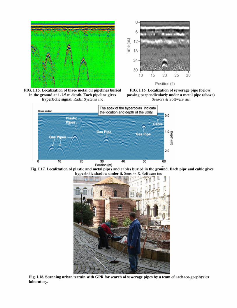
FIG. I.15. Localization of three metal oil pipelines buried
in the ground at 1-1.5 m depth. Each pipeline gives hyperbolic signal. Radar Systems inc
FIG. I.16. Localization of sewerage pipe (below)
passing perpendicularly under a metal pipe (above) Sensors & Software inc
Fig. I.17. Localization of plastic and metal pipes and cables buried in the ground. Each pipe and cable gives hyperbolic shadow under it. Sensors & Software inc
Fig. I.18. Scanning urban terrain with GPR for search of sewerage pipes by a team of archaeo-geophysics
laboratory.
APPLICATIONS IN TRANSPORT
Non-destructive locating, determination of the depth and mapping of: - Cracks, collapses, cavities and other defects in the foundation and pavement of roads, runways, railway
lines and other transportation constructions; - Cracks, collapses, cavities and other defects in tunnels and tunnel structures;
- Thinning, distortion, cracks, voids, and other defects in bridges and bridge constructions.
Non-destructive thickness measurement of:
bridge roadways, pavements, new and old asphalt, foundations, drainage and others.
Non-destructive testing, evaluation and monitoring of the state of:
roads, runways, railway lines, tunnels, bridges, etc. constructions.
Evaluation of amortization of bridges, runways, tunnels, overpasses, multi- level parking, etc.
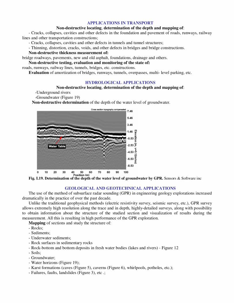
HYDROLOGICAL APPLICATIONS
Non-destructive locating, determination of the depth and mapping of:
-Underground rivers
-Groundwater (Figure 19)
Non-destructive determination of the depth of the water level of groundwater.
Fig. I.19. Determination of the depth of the water level of groundwater by GPR. Sensors & Software inc
GEOLOGICAL AND GEOTECHNICAL APPLICATIONS
The use of the method of subsurface radar sounding (GPR) in engineering geology explorations increased
dramatically in the practice of over the past decade.
Unlike the traditional geophysical methods (electric resistivity survey, seismic survey, etc.), GPR survey
allows extremely high resolution along the trace and in depth, highly-detailed surveys, along with possibility
to obtain information about the structure of the studied section and visualization of results during the
measurement. All this is resulting in high performance of the GPR exploration. Mapping of sections and study the structure of:
- Rocks; - Sediments;
- Underwater sediments; - Rock surfaces in sedimentary rocks
- Rock-bottom and bottom deposits in fresh water bodies (lakes and rivers) - Figure 12 - Soils;
- Groundwater; - Water horizons (Figure 19);
- Karst formations (caves (Figure 5), caverns (Figure 6), whirlpools, potholes, etc.);
- Failures, faults, landslides (Figure 3), etc .;
Non-destructive stratification and stratigraphic mapping of:
- Sediments; - Soils;
- Water horizons (Figure 19); Detection and mapping of the structural discontinuities in a section (karst, tectonic discontinuities,
contact between lithological different rocks, areas of wedging of the rock layers, rock inclusions in sedimentary environment, etc.);
Sounding and measurement of peat and sapropel deposits
Non-destructive testing, evaluation and monitoring of the status of groundwater resources, geological
and hydrogeological situation
Non-destructive determination of:
- Thickness and density of the snow and ice cover
- Depth of bedrock
Characterization of cracks and faults
MINING APPLICATIONS
Non-destructive localization and mapping:
- Hazardous areas in open pits and mine galleries.
- Old underground mining galleries.
- Coal layers; - Ore deposits;
- Salt deposits; - Bauxites;
Non-destructive testing, evaluation and monitoring of the deposits and hazardous areas.
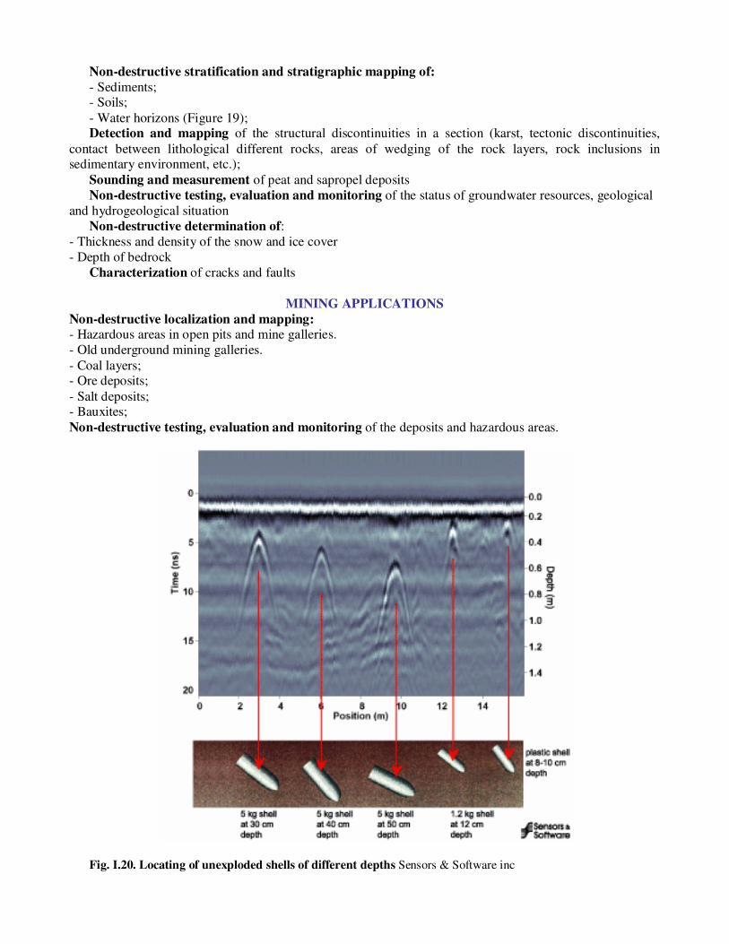
Fig. I.20. Locating of unexploded shells of different depths Sensors & Software inc
MILITARY APPLICATIONS
Non-destructive locating, determination of the depth and mapping of: - Bunkers, shelters, underground warehouses, caves and other strategic underground sites;
- Anti-infantry and antitank mines; - Unexploded mines, shells (Figure 20) and grenades;
- Defects in bunkers, polygons, tunnels, roads, runways, bridges, etc. strategic sites - Cables (Figure 17), pipelines (fig.15-16) tunnels (Figure 7) and other communications;
Geophysical methods are applied effectively even in intelligence!
CRIMINOLOGY (FORENSIC) AND SECURITY APPLICATIONS
Non-destructive locating, determination of the depth and mapping of:
- Walled in safes, (Figure 21) and hideouts
- Hidden single and mass graves (Figure 22, 23);
-Tunnels dug under banks, prisons, vaults, galleries, museums, warehouses (Figure 24) and other
buildings for robbery or escape from prison
- Buried, built in, and otherwise hidden clues, weapons (Figure 25), ammunition (Figure 20), hazardous
substances and others.
- bugging devices
Non-destructive testing, evaluation and monitoring of the status of objects, subject to criminal investigation or special security measures.
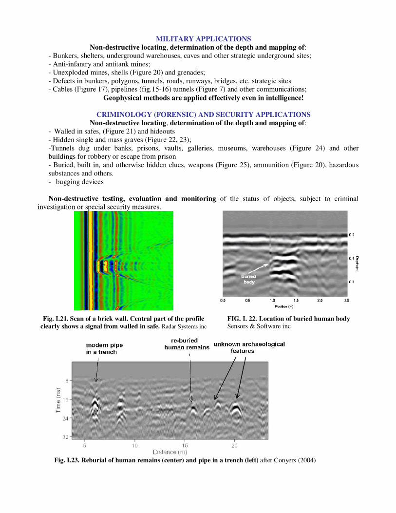
Fig. I.21. Scan of a brick wall. Central part of the profile
clearly shows a signal from walled in safe. Radar Systems inc
FIG. I. 22. Location of buried human body Sensors & Software inc
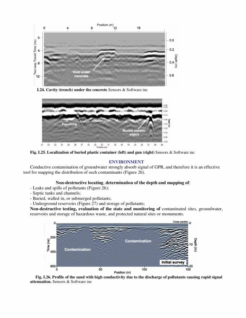
Fig. I.23. Reburial of human remains (center) and pipe in a trench (left) after Conyers (2004)
I.24. Cavity (trench) under the concrete Sensors & Software inc
Fig. I.25. Localization of buried plastic container (left) and gun (right) Sensors & Software inc
ENVIRONMENT
Conductive contamination of groundwater strongly absorb signal of GPR, and therefore it is an effective
tool for mapping the distribution of such contaminants (Figure 26).
Non-destructive locating, determination of the depth and mapping of:
- Leaks and spills of pollutants (Figure 26); - Septic tanks and channels;
- Buried, walled in, or submerged pollutants; - Underground reservoirs (Figure 27) and storage of pollutants;
Non-destructive testing, evaluation of the state and monitoring of contaminated sites, groundwater, reservoirs and storage of hazardous waste, and protected natural sites or monuments.
Fig. I.26. Profile of the sand with high conductivity due to the discharge of pollutants causing rapid signal attenuation. Sensors & Software inc
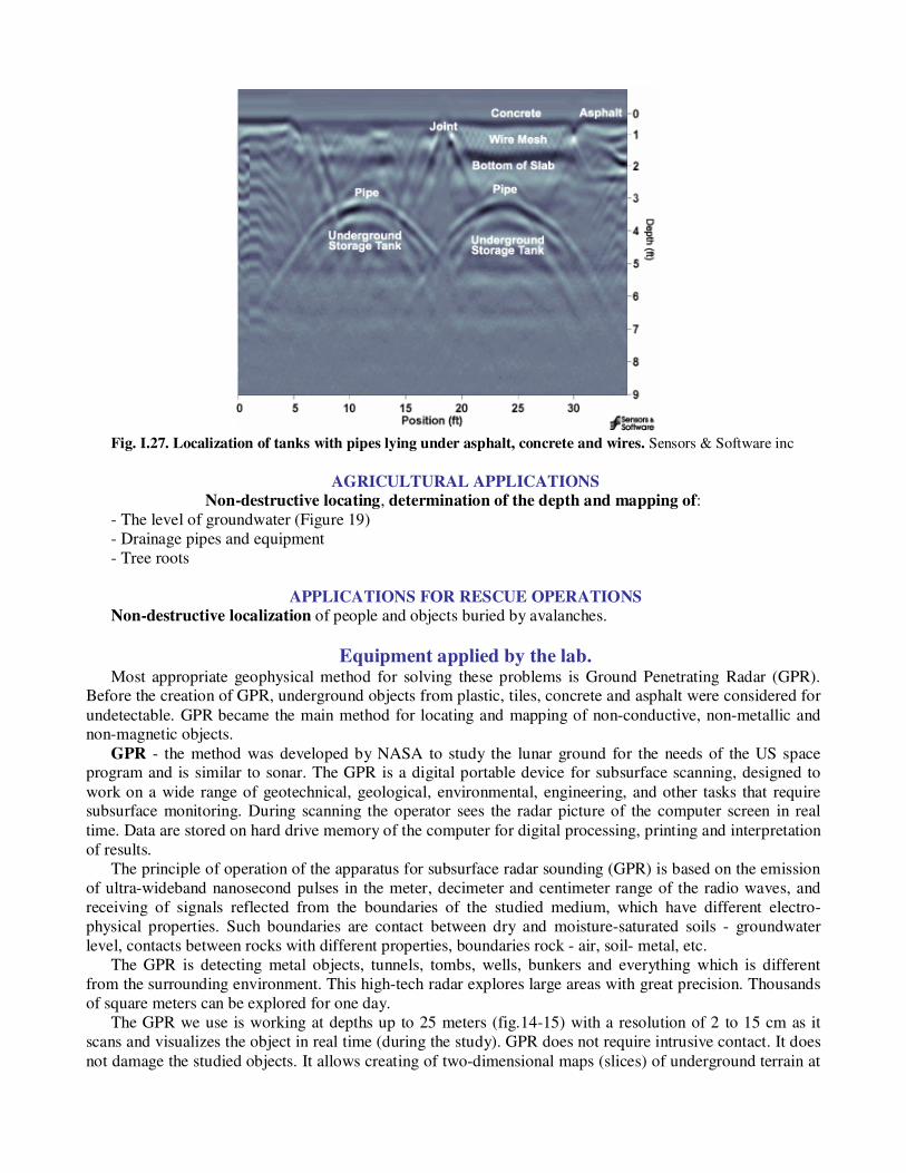
Fig. I.27. Localization of tanks with pipes lying under asphalt, concrete and wires. Sensors & Software inc
AGRICULTURAL APPLICATIONS
Non-destructive locating, determination of the depth and mapping of:
- The level of groundwater (Figure 19)
- Drainage pipes and equipment
- Tree roots
APPLICATIONS FOR RESCUE OPERATIONS
Non-destructive localization of people and objects buried by avalanches.
Equipment applied by the lab. Most appropriate geophysical method for solving these problems is Ground Penetrating Radar (GPR).
Before the creation of GPR, underground objects from plastic, tiles, concrete and asphalt were considered for
undetectable. GPR became the main method for locating and mapping of non-conductive, non-metallic and non-magnetic objects.
GPR - the method was developed by NASA to study the lunar ground for the needs of the US space program and is similar to sonar. The GPR is a digital portable device for subsurface scanning, designed to
work on a wide range of geotechnical, geological, environmental, engineering, and other tasks that require subsurface monitoring. During scanning the operator sees the radar picture of the computer screen in real
time. Data are stored on hard drive memory of the computer for digital processing, printing and interpretation
of results.
The principle of operation of the apparatus for subsurface radar sounding (GPR) is based on the emission
of ultra-wideband nanosecond pulses in the meter, decimeter and centimeter range of the radio waves, and
receiving of signals reflected from the boundaries of the studied medium, which have different electro-
physical properties. Such boundaries are contact between dry and moisture-saturated soils - groundwater
level, contacts between rocks with different properties, boundaries rock - air, soil- metal, etc.
The GPR is detecting metal objects, tunnels, tombs, wells, bunkers and everything which is different
from the surrounding environment. This high-tech radar explores large areas with great precision. Thousands
of square meters can be explored for one day.
The GPR we use is working at depths up to 25 meters (fig.14-15) with a resolution of 2 to 15 cm as it
scans and visualizes the object in real time (during the study). GPR does not require intrusive contact. It does
not damage the studied objects. It allows creating of two-dimensional maps (slices) of underground terrain at

different depths below the surface by additional computer processing. In addition, it allows for creating of
three-dimensional reconstructions (3D image) of the exact shape and depth of underground structures. The GPR is ideal for locating underground electric cables, pipes, channels, gaps, and to determine the
thickness of the slab or pavement at study of roads, bridges, sewerage, electric power supply, telephone lines, for tracing underground waterways (natural and artificial), as well as for mapping of urban communication
necessary during construction work. It works effectively in locating underground objects and measuring the stability of the ground before the start of excavation work for construction or repair.
The GPR used at our Archaeo-geophysics laboratory can be used for underwater research in
freshwater bodies. It is a powerful modern apparatus that can be used for many different applications, and
for resolving of comprehensive exploration problems.
Top Related
Copyright © 2022 FDOKUMEN

