


Bahasa
Halaman
Hukum


KAIVALYA –An Institute for RAS - UDAIPUR 9358419320 WWW.KAIVALYARAS.COM Page 0
INDEX – 02E
Topic Page 1. Introduction Naming of Rajasthan Position of Rajasthan Expansion of Rajasthan Regional System 2. Geographical by names in Rajasthan 3. Physiographic divisions of Rajasthan Western Desert region Aravali range and Hilly region Eastern Plains South-East plateau region 4. Lakes of Rajasthan 5. Drainage system Inland drainage system Drainage system of Bay of Bengal Arabian sea drainage system 6. River Valley Projects of Rajasthan Chambal river valley project Mahi River Valley Project Beas River Valley Project Rajasthan Canal Gang Canal Narmada Canal Project Raviv Gandhi Sidhmukh And Nohar Project Bisalpur dam project 7. Climate Climatic zones in Rajasthan Agro climatic zones of Rajasthan 8. Soil Resources 9. Forest resources and wildlife sanctuaries in Rajasthan 10. Mineral Resources 11. Conventional and Non Conventional sources of energy 12. Animal Resources in Rajasthan
1 1 2 3 8 10 12 14 21 29 33 35 38 38 40 45 48 52 54 54 55 59 60 60 60 62 68 70 74 82 95 111 116-131
KAIVALYA –An Institute for RAS - UDAIPUR 9358419320 WWW.KAIVALYARAS.COM Page 1
Rajasthan Geography
Naming of Rajasthan :
“George Thomas” for the first time used the word “Rajputana” for the sate of Rajasthan in 1800
A.D.
- This is mentioned in “William Franklin‟s” book “Military Members Of Mister George Thomas”
(1805 A.D.)
“Colonel James Todd” for the first time used the word Rajasthan for Rajasthan in his
book “Annals and Antiquities of Rajasthan” (1829 A.D.)
For the present state of Rajasthan the word was first used on 25 March 1948 for “Rajasthan
Union”.
Unification of Rajasthan was almost complete by “30 march 1949 A.D. “ On this day four large
princely states of Jaipur, Jodhpur, Jaisalmer and Bikaner were merged in “Greater Rajasthan”.
- For this reason 30 March is celebrated as Rajasthan Foundation Day.
- On 26 January 1950 the word “Rajasthan” was given to our state in Indian constitution.
- On 01 November 1950 unification of Rajasthan was concluded and the post of Rajpramukh
was abolished and replaced with Governor.
First governor of Rajasthan : Sardar Gurmukh Nihal Singh and he was sworn in by Maharaja
Sawai man Singh II of Jaipur.
Shape of Rajasthan : Rhombus Quadrilateral (Kite Shape)
Rajasthan is situated in north western part of India and its total area is 3,42,239 Square KM.
which is 10.41% (1/10) of India‟s total area.
Rajasthan is the largest state of India and this position is acquired by the state after the
separation of Chhatisgarh from Madhya Pradesh on 01 November 2000.
(- 09 Nov – Uttarakhand from U.P. „, 15 Nov – Jharkhand from Bihar and Telangana on 02 June
2014)
KAIVALYA –An Institute for RAS - UDAIPUR 9358419320 WWW.KAIVALYARAS.COM Page 2
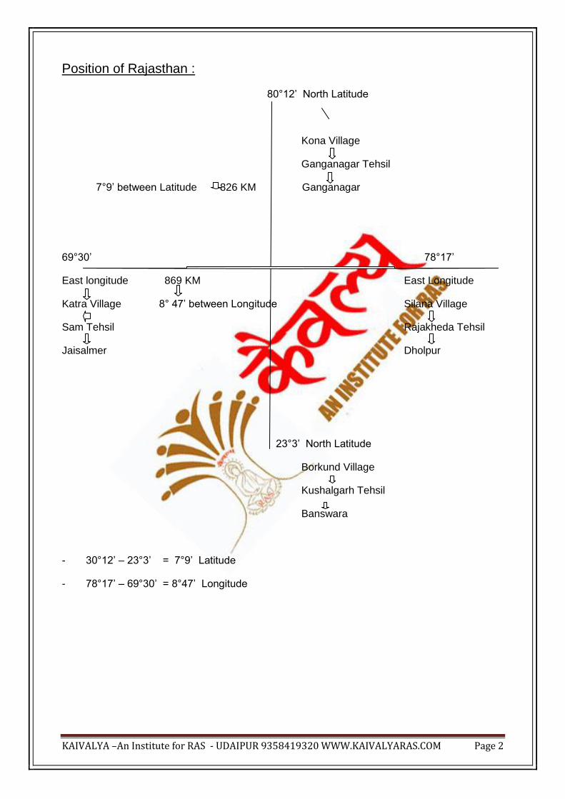
Position of Rajasthan :
80°12‟ North Latitude
Kona Village
Ganganagar Tehsil
7°9‟ between Latitude 826 KM Ganganagar
69°30‟ 78°17‟
East longitude 869 KM East Longitude
Katra Village 8° 47‟ between Longitude Silana Village
Sam Tehsil Rajakheda Tehsil
Jaisalmer Dholpur
23°3‟ North Latitude
Borkund Village
Kushalgarh Tehsil
Banswara
- 30°12‟ – 23°3‟ = 7°9‟ Latitude
- 78°17‟ – 69°30‟ = 8°47‟ Longitude

KAIVALYA –An Institute for RAS - UDAIPUR 9358419320 WWW.KAIVALYARAS.COM Page 3
Expansion of Rajasthan :
Total surface border : 5920 Km (1070 Km International and 4850 km Interstate )
Redcliff line
. Ganganagar
. Bikaner
. Jaisalmer
. Barmer
KAIVALYA –An Institute for RAS - UDAIPUR 9358419320 WWW.KAIVALYARAS.COM Page 4
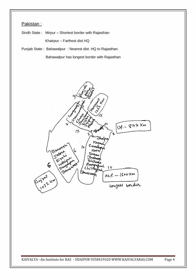
Pakistan :
Sindh State : Mirpur – Shortest border with Rajasthan
Khairpur – Farthest dist HQ
Punjab State : Bahawalpur : Nearest dist. HQ to Rajasthan.
Bahawalpur has longest border with Rajasthan

KAIVALYA –An Institute for RAS - UDAIPUR 9358419320 WWW.KAIVALYARAS.COM Page 5
Border districts of Haryana :
1.) Rewari
2.) Gurugram (Gurgaon)
3.) Mahendragarh
4.) Bhiwani
5.) Hisaar
6.) Sirsa
7.) Fatehabad
Border districts of U.P. : Agra and Mathura
Border districts of Madhya Pradesh :
1.) Jhabua
2.) Ratlam
3.) Mandsore
4.) Shyopur
5.) Neemuch
6.) Rajgarh
7.) Guna
8.) Shivpuri
9.) Shahjapura
10.) Muraina
Border districts of Gujarat :
1.) Kutch
2.) Banaskantha
3.) Sabarkantha
4.) Dahod
5.) Panchmahal
KAIVALYA –An Institute for RAS - UDAIPUR 9358419320 WWW.KAIVALYARAS.COM Page 6
Border districts of Punjab :
1.) Firozpur
2.) Muktsar
1.) Punjab - Longest border - Hanumangarh
Shortest border – Ganganagar
2.) Haryana - Longest border - Hanumangarh
Shortest border – Jaipur
3.) U.P. - Longest border - Bharatpur
Shortest border – Dholpur
4.) M.P. - Longest border - Jhalawar
Shortest border – Bhilwara
5.) Gujarat - Longest border - Udaipur
Shortest border – Barmer
Note :
1.) Overall Jhalawar has the longest interstate border and Barmer has shortest.
2.) Hanumangarh - Punjab, Haryana
Bharatpur - Haryana and U.P.
Dholpur - U.P. and M.P.
Banswara - M.P. and Gujarat
3.) Two districts of Rajasthan which has both international and interstate borders
a.) Ganganagar
b.) Barmer
KAIVALYA –An Institute for RAS - UDAIPUR 9358419320 WWW.KAIVALYARAS.COM Page 7
Internal districts of Rajasthan :- 8
1.) Jodhpur
2.) Nagore
3.) Ajmer
4.) Tonk
5.) Bundi
6.) Pali
7.) Rajsamand
8.) Dausa
There are 33 districts in present Rajasthan – (23 – with states + 4 with Pakistan + 8 – internal
- 2 both states and Pak)
1 Nov 1956 - Ajmer – 26th district (separated from Jaipur)
15 April 1982 - Dholpur - 27th dist. (from Bharatpur)
10 April 1991 – Baran - 28th “ (from Kota)
- Dausa – 29th “ (from Jaipur)
- Rajsamand – 30th “ (from Udaipur)
12 July 1994 - Hanumangarh - 31st district (from Ganganagar)
19 July 1997 - Karauli - 32nd dist (from Sawaimadhopur and Bharatpur)
26 January 2008 - Pratapgarh 33rd dist (from Udaipur, Banswara and Chittorgarh)
KAIVALYA –An Institute for RAS - UDAIPUR 9358419320 WWW.KAIVALYARAS.COM Page 8
Regional System :
Regional System was introduced in Rajasthan in 1949 A.D. and there were 5 Regions during
that time.
On 01 November 1956 Ajmer was made 6th Region after the unification.
In 1962 A.D. Mohanlal Sukhadiya abolished regional system in Rajasthan and in 1987 it was
reintroduced by Harideo Joshi government.
On 04 June 2005 Bharatpur was made new region constituting districts of Bharatpur, Dholpur
(taken from Jaipur region) and Karauli, Sawaimadhopur (taken from Kota region)
Bikaner Region : Bikaner, Ganganagar, hanumangarh, Churu
Jodhpur : Jodhpur, Jaisalmer, Barmer, Sirohi, Jalore, Pali
Ajmer : Ajmer, Nagore, Tonk, Bhilwara
Udaipur : Udaipur, Banswara, Pratapgarh, Dungarpur, Rajsamand, Chittorgarh

KAIVALYA –An Institute for RAS - UDAIPUR 9358419320 WWW.KAIVALYARAS.COM Page 9
Kota : Kota, Bundi, Jhalawar, Baran
Jaipur : Jaipur, Alwar, Sikar, Jhunjhunu, Dausa
Bharatpur : Bharatpur, Karauli, Sawaimadhopur, Dholpur
Largest region in terms of Area : Jodhpur
Smallest : Bharatpur
Largest region in terms of Population : Jaipur
Smallest : Kota
Largest region in terms of Literacy : Jaipur
Smallest : Jodhpur
KAIVALYA –An Institute for RAS - UDAIPUR 9358419320 WWW.KAIVALYARAS.COM Page 10
Largest region in terms of Gender Ratio : Udaipur
Smallest : Bharatpur
Largest region in terms of Population density : Jaipur
Smallest : Jodhpur
Region with highest population growth : Jodhpur
Region with highest effectual population : Udaipur
Geographical by names in Rajasthan
1.) Chhappan ka Maidan (region) : Group of 56 villages with streams and small rivers along the
shores of Mahi river in the districts of Banswara and Pratapgarh.
2.) Kanthal : Area around the shores of Mahi river in the district of Pratapgarh.
3.) Uparmaal : Elevated landscape between Bijolia (Bhilwara) aand Bhainsroadgarh
(Chittorgarh) is known as Uparmaal due to its elevation from surrounding region.
4.) Deshharo : Area between the hills of Jarga and Raga in Udaipur district is known as
Deshharo as it remains green throughout the year.
5.) Girwa : Saucer shaped basin surrounding Udaipur is known as Girwa (girdle oh hills) in local
language.
6.) Mewal : Small hills around Dungarpur and Banswara are known as Mewal.
KAIVALYA –An Institute for RAS - UDAIPUR 9358419320 WWW.KAIVALYARAS.COM Page 11
7.) Torawati : Area around Kantli river in Shekhawati region is known as Torawati.
8.) Bhomat : Plateau region of Sirohi, Udaipur and Dungarpur is known as Bhomat.
9.) Bhakhar : Steep slope of the eastern part of Sirohi.
10.) Shivi-Kivi : Area around Udaipur is known as Shivi-Kivi in Mewar.
- In this part of the land Shivi clan made “Madhyamika “ as their capital, which in present day
known as “Nagri” situated in Chittorgarh.
11.) Marwar : Parts of present day Jodhpur, Bikaner, Barmer, Pali and Nagore.
12.) Mewar : Udaipur+ Rajsamand + Chittorgarh + Bhilwara + Pratapgarh
13.) Haroti :Kota + Bundi + Baran + Jhalawar
14.) Mewat Region : Alwar + Bharatpur
15.) Jangal Desh : Bikaner + Jodhpur
16.) Medpaat : Udaipur
17.) Kurupradesh : Alwar
18.) Dhundar : Region around Dhundh river in jaipur district.
19.) Shursen : Bharatpur and Dholpur
20.) Gopalpal : Karauli
21.) Nali area : Ganganagar, hanumangarh
22.) Shekhawati : Sikar, Churu, Jhunjhunu
23.) Ahirwati : Alwar
24.) Mand area : Jaisalmer, Bikaner
25.) Thali : Border area of Jaisalmer, Barmer and Bikaner.

KAIVALYA –An Institute for RAS - UDAIPUR 9358419320 WWW.KAIVALYARAS.COM Page 12
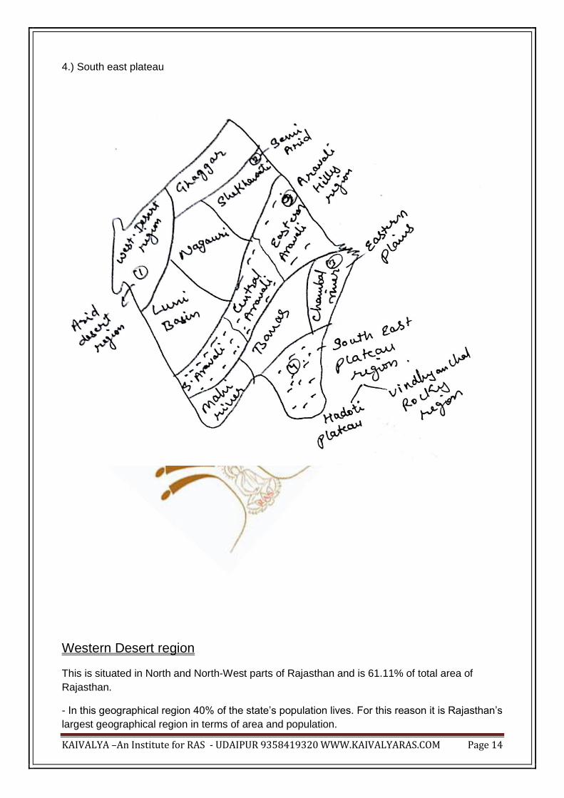
Physiographic Divisions of Rajasthan
Physical regions of Rajasthan were for the first time classified by Professor B.C. Mishra in his
book Geography of Rajasthan (1967-68). In this book Rajasthan was divided in seven parts.

KAIVALYA –An Institute for RAS - UDAIPUR 9358419320 WWW.KAIVALYARAS.COM Page 13
Father of Geography – Hecataeus
On the basis of its geographical formation Rajasthan is divided in 4 main parts.
1.) Western desert region
Tethys Sea
2.) Eastern plains
3.) Hilly Region of Aravali
Gondwana Land
KAIVALYA –An Institute for RAS - UDAIPUR 9358419320 WWW.KAIVALYARAS.COM Page 14
4.) South east plateau
Western Desert region
This is situated in North and North-West parts of Rajasthan and is 61.11% of total area of
Rajasthan.
- In this geographical region 40% of the state‟s population lives. For this reason it is Rajasthan‟s
largest geographical region in terms of area and population.

KAIVALYA –An Institute for RAS - UDAIPUR 9358419320 WWW.KAIVALYARAS.COM Page 15
- Politically this region is spread over 13 districts of Rajasthan :
1.) Sikar
2.) Churu
3.) Jhunjhunu
4.) Ganganagar
5.) Hanumangarh
6.) Bikaner
7.) Jaisalmer
8.) Barmer
9.) Jalore
10.) Jodhpur
11.) Nagore
12.) Pali
13.) Sirohi
- Western Desert Region of Rajasthan if formed by the deposition brought by the rivers in
Tethys sea.
For this reason this regions lacks deposits of metallic minerals and there is abundance of
Natural gas and oil.
- Average rainfall of this region is 25-50 CM, vegetation – desert and tropical thorn forests, soil
– sandy and brown sandy, altitude – 150 Mts from sea level, rivers – Ghaggar, Luni, Kakney,
Kantli etc and Desert national Park is situated here.
Thar Desert
This desert is believed as eastern part of the Sahara desert of Africa which is a desert with
highest population density and biodiversity.
- For this reason Dr. Ishwari Prasad titles this region as “Rukshakshetra”.
- This desert is spread over parts of Pakistan and in Indian states of Rajasthan, Gujarat, Punjab
and Haryana.
- Total area of this Thar desert is 8,33000 square km out of this 1,75000 sq KM in Rajasthan.
- Huen Tsang calls this region as “Gurjaratra”.
- Temperature : Summer – 49°C, Winter – 3°C and Average – 22°C
KAIVALYA –An Institute for RAS - UDAIPUR 9358419320 WWW.KAIVALYARAS.COM Page 16
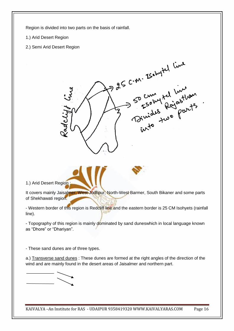
Region is divided into two parts on the basis of rainfall.
1.) Arid Desert Region
2.) Semi Arid Desert Region
1.) Arid Desert Region :
It covers mainly Jaisalmer, West Jodhpur, North-West Barmer, South Bikaner and some parts
of Shekhawati region.
- Western border of this region is Redcliff line and the eastern border is 25 CM Isohyets (rainfall
line).
- Topography of this region is mainly dominated by sand duneswhich in local language known
as “Dhore” or “Dhariyan”.
- These sand dunes are of three types.
a.) Transverse sand dunes : These dunes are formed at the right angles of the direction of the
wind and are mainly found in the desert areas of Jaisalmer and northern part.

KAIVALYA –An Institute for RAS - UDAIPUR 9358419320 WWW.KAIVALYARAS.COM Page 17
b.) Longitudinal / Seif Sand dunes : These dunes are formed parallel to the direction of the
wind. These types of dunes are mainly found in the dry deserts.
c.) Barchans sand dunes
They are crescent shaped, highly mobile and most destructive type of sand dunes. In
Rajasthan they are mainly found in Shekhawati region.
Note : Out of the total desert area of Rajasthan in 60% part sand dunes are found and all the
three types of sand dunes can be seen in Jodhpur district.
* Rocky Desert / Hamada
Area around Jaisalmer in the range of 65 KM is known as rocky desert.
Its highlights :
i) In this region Rajasthan‟s best quality “Steel Grade Limestone” is found in Sanu.
ii.) Yellow stone is abundantly found here. (For this reason The Fort and the Havelis of
Jaisalmer are made of this Yellow colour stone. )
Sonargarh fort is the second largest residential fort (First is Chittorgarh).
iii.) In the western part this rocky region from Pokaran to Mohangarh there is a 60KM long
water belt which is known as Lathi Series.
Sewan Grass ( Lasiurus scindicus) is produced in this Lathi Series.
iv) In its southern part there is Akal village. Here “Akal wood fossil park” is situated.
Wooden fossils of millions of years old (Jurassic Age) are kept here.
v.) Near Akal village in Jaisalmer there is “Chandan Tube well” which is also known as “Pot of
the Thar”.
2.) Semi Arid desert

KAIVALYA –An Institute for RAS - UDAIPUR 9358419320 WWW.KAIVALYARAS.COM Page 18
Its western border is made by 25 CM rainfall line and its eastern boundary is drawn by Aravali
Range (50 CM rainfall line)
- Rainfall in this region is between 25 and 50 cm and the climate is semi arid.
- There are mainly Tropical thorn forests in this region.
- It is mostly spread over Shriganganagar, Hanumangarh, Sikar, Churu, Jhunjhunu, Nagore,
Pali and Jalore.
- It is mainly divided into 4 parts.
A.) Luni Basin : Drained by Luni and its tributaries and spread in the districts of Pali, jalore,
barmer and Jodhpur.
- The area is also known as “Godwad”.
- It is also known as Dry Farming region (Agriculture based on rainfall).
- Largest water reservoir of this region is Ummed Sagar (Jawai dam) , which is also titled as
“Nector Pool of Marwar” (Marwar ka Amrit Sarovar).
- Important canal project of this region is Narmada Canal Project, Jalore and Barmer in
Rajasthan are benefitted by this.
- Rohi Plains : - In the Luni Basin the fertile area between Luni river and Aravali mountains is
known as Rohi plains.
B.) Nagauri Uplands : Situated in the North of Luni basin main spread over Nagaur district.
- Soil in this area is enriched with Sodium Chloride so the area is most unfertile.
- Most of the saline lakes of Rajasthan are found in this region. (Deedwana, Degana,
Kuychaman, Nawa, Sambhar)
- Monsoon from Arabian sea is considered as main source for the high salinity of this region.
- Hump Belt (Kubad Patti) : This is situated on the borders of Nagore and Ajmer.
- Due to presence of fluoride in water fluorosis disease is widespread in this region. (Bones
are disfigured in the old age)
C.) Shekhawati basin : Mainly spread over the districts of Sikar, Churu and Jhunjhunu.
- Kantli is the major river of this area.
- This area is known as inland region.
- Local small ponds and raw wells in this area are known as „Johad‟
D.) Ghaggar Basin : Formed by the river Ghaggar and mainly spread in Shriganganagar and
Hanumangarh districts.

KAIVALYA –An Institute for RAS - UDAIPUR 9358419320 WWW.KAIVALYARAS.COM Page 19
** The banks of Ghaggar river in this area are known as Nali and for this reason variety of
Sheep Nali is found here.
- This is highly productive part of Rajasthan and this area has highest land under canal
irrigation.
** Traditional sources of water in western Rajasthan which are now becoming extinct –
i.) Aagor / Taanka (Tanks) : In western Rajasthan tanks are built in the courtyard of houses to
collect rainwater. These tanks are known as Aagor or Taanka.
ii.) Taat / Ran : Swampy field formed by accumulation of rain water between two sand dunes is
known as Taat or Ran.
- iii.) Naadi : Uneven surfaces formed due to natural processes in western Rajasthan where
rain water accumulates is known as Naadi.
- This water is used for animals and daily requirements.
iv.) Johad : Small local ponds and un paved wells in Shekhawati area are known as Johad.
v.) Palaya Lake : These are formed due to accumulation of rainwater in the lowlands between
two sand dunes.
- Sometimes these lakes become saline and are known as Salina.
Rain water
----------------------- ------------------
vi.) Talli / Pokhar : Lowland between two sand dunes is known as Talli or Pokhar.
vii) Bavri (Step well) : Normally square shaped and ponds provided with stairs are known as
Bavri (Step well).
** Important facts about western Rajasthan :
i.) Sam Village : This village in Jaisalmer district is completely devoid of vegetation.
- This is places in Rajasthan with lowest rainfall.
KAIVALYA –An Institute for RAS - UDAIPUR 9358419320 WWW.KAIVALYARAS.COM Page 20
- Many films are picturised on the dunes and presently it is also a very popular tourist
destination.
Tourism is given status of Industry (Handicraft industry) on 4 march 1989 (Mohammad Yunus
committee)
ii.) Pot of the Thar : Chandan tube well in Akal village of Jaisalmer is known as Pot of the Thar.
iii.) Peevna : Very poisonous snake found in western parts of the desert.
- Its colour resembles to the colour of sand.
- Length 1 foot
- It is believed that this snake does not bite but releases it poison into the breathe of a person
leading to death.
iv.) Expansion of the desert (March past of the desert): The slow expansion of the desert in
Rajasthan due to which the soil is becoming infertile day by day.
- Besides Rajasthan this desert is also expanding in other states like Gujarat, Punjab, Haryana.
v.) Sar / Sarovar : Small ponds or water bodies in Shekhawati area and in western parts of the
desert in Rajasthan are known as Sar or Sarovar. For example :
Parbatsar – Nagaur
Lunkaransar – Bikaner
vi.) Mavath / Mahavath : Winter rainfall in India caused due to Mediterranean sea cyclones
(Western disturbances) is known as Mavath in Rajasthan.
- It is very beneficial for wheat crops and for this reason it is known as “Nector of Rabi”.
vii.) Malani region : The middle part of Luni basin is known as Malani region which is mainly
spread over Jalore and Balotara (Barmer).
- Cows and Horses of Malani are popular.
Q. State types of vegetation and area in western desert region of Rajasthan.
Answer :
1.) Xerophytes (Desert vegetation) : This vegetation is primarily found in western desert region
whose roots are deep and thorny leaves. Eg. Khejri (Prosopis cineraria), Kair (Capparis
deciduas), Babul (Acacia milotica), Ber (Ziziphus).

KAIVALYA –An Institute for RAS - UDAIPUR 9358419320 WWW.KAIVALYARAS.COM Page 21
2.) Chandan tube well : It is situated near Akal village and the soil around is fertile.
3.) Oasis : In western desert region vegetations are mainly found as per the availability of
water. Like :
Chandan tube well
Kolayat Lake – Bikaner
Ashram of Kapil Muni (fair is held on full moon of Kartik month – Pushkar)
4.) Talli / Marho / Balsan / Pokhar
5.) Taat / Ran
6.) Palaya Lake / Saline Lake / Salina
7.) Lathi series
8.) Baggi – Ganganagar Hanumangarh area (fertile area)
Conclusion : In this desert we find higher density of vegetation, animals and human population.
For this reason Thar desert is the area with highest biodiversity in the world.
Copyright © 2022 FDOKUMEN

