


Bahasa
Halaman
Hukum

1 23
Rendiconti LinceiSCIENZE FISICHE E NATURALI ISSN 2037-4631 Rend. Fis. Acc. LinceiDOI 10.1007/s12210-011-0161-1
Holocene environmental evolution of thecostal sector in front of the Poseidonia-Paestum archaeological area (Sele plain,southern Italy)
Vincenzo Amato, Pietro Patrizio CiroAucelli, Bruno D’Argenio, SimoneDa Prato, Luciana Ferraro, GerardoPappone, Paola Petrosino, et al.

1 23
Your article is protected by copyright and
all rights are held exclusively by Springer-
Verlag. This e-offprint is for personal use only
and shall not be self-archived in electronic
repositories. If you wish to self-archive your
work, please use the accepted author’s
version for posting to your own website or
your institution’s repository. You may further
deposit the accepted author’s version on a
funder’s repository at a funder’s request,
provided it is not made publicly available until
12 months after publication.
LAND SEA INTERACTION IN CAMPANIA (ITALY)
Holocene environmental evolution of the costal sector in frontof the Poseidonia-Paestum archaeological area (Sele plain,southern Italy)
Vincenzo Amato • Pietro Patrizio Ciro Aucelli • Bruno D’Argenio •
Simone Da Prato • Luciana Ferraro • Gerardo Pappone • Paola Petrosino •
Carmen Maria Rosskopf • Elda Russo Ermolli
Received: 15 June 2011 / Accepted: 28 December 2011
� Springer-Verlag 2012
Abstract The Sele river plain is located along the wes-
tern Tyrrhenian margin of the southern Apennine Chain
and is confined seaward by a straight sandy coast formed
during the Last Interglacial and the Holocene. The coastal
plain is characterised by beach-dune ridges which inter-
finger landwards with lagoon and fluvio-palustrine depos-
its. This belt, which progressively grew up, represents the
evolution of a barrier–lagoon system alternatively shifting
landwards and seawards. The knowledge on the Holocene
evolution of the Sele river coastal plain, along the coast
of the Poseidonia-Paestum archaeological area, was
improved by the drilling of two new cores and the col-
lection of several archaeo-tephro-stratigraphic data. The
area experienced the Holocene marine transgression which
cut high cliffs in the travertine deposits. During the second
half of the Holocene, the shoreline shifted seawards and a
lagoon–beach bar system (Fossa Lupata-Laura) formed.
The archaeological remains (VI cent. B.C.) and the Agnano
Monte Spina tephra layer (4.1 ky BP) constrain chrono-
logically this morpho-sedimentary system. After the VI
cent. B.C., and mostly after the deposition of the 79 A.D.
tephra layer, the shoreline shifted seawards and an addi-
tional beach ridge formed, while the flat area at the back
(Fossa Lupata) was rapidly aggraded and dried up.
Keywords Sea level changes � Barrier–lagoon system �Greek–Roman times � Tephrostatigraphy � Facies analysis
1 Introduction
The Holocene glacio-eustatic sea level rise after the Last
Glacial Maximum led to a worldwide flooding of shelf
areas and controlled the evolution of marine embayments,
fluvial mouths and rocky coasts, while its significant
deceleration in mid-Holocene times resulted in the over-
compensation by sediment yields and shoreline prograda-
tion in many Mediterranean alluvial-coastal plains
(Pirazzoli 1996; Galili et al. 2005; Antonioli et al. 2007;
Amorosi et al. 2009; Primavera et al. 2011). The shoreline
shifts forced ancient societies to continuously adapt their
lives and settlements to the changing natural patterns. Such
This paper is an outcome of the FISR project Vulnerability of the
Italian coastal area and marine Ecosystem to Climate changes and
their role in the Mediterranean carbon cycles (VECTOR), subproject
Vulnerability of Coastal environments to climate changes
(VULCOST) on Land–sea interaction and costal changes in the Sele
River plain, Campania.
V. Amato (&) � C. M. Rosskopf
Dipartimento di Scienze e Tecnologie per l’Ambiente e il
Territorio, Universita del Molise, C.da Fonte Lappone,
86090 Pesche, IS, Italy
e-mail: [email protected]
P. P. C. Aucelli � G. Pappone
Dipartimento di Scienze per l’Ambiente, Universita di Napoli
Parthenope, Centro Direzionale, Isola C4, 80143 Naples, Italy
B. D’Argenio � L. Ferraro
Istituto per l’Ambiente Marino Costiero, CNR,
Calata Porta di Massa, 80133 Naples, Italy
S. Da Prato
Istituto di Geoscienze e Georisorse, CNR, Via Moruzzi 1,
56124 Pisa, Italy
P. Petrosino
Dipartimento di Scienze della Terra, Universita degli Studi
‘‘Federico II’’ di Napoli, Largo S. Marcellino 10,
80138 Naples, Italy
E. R. Ermolli
Dipartimento ARBOPAVE, Universita degli Studi ‘‘Federico II’’
di Napoli, Via Universita 100, 80055 Portici, Italy
123
Rend. Fis. Acc. Lincei
DOI 10.1007/s12210-011-0161-1
Author's personal copy
rapid changes in sedimentary environments have been
investigated in detail throughout the Mediterranean, com-
bining methods and research projects including a great
number of disciplines such as geomorphology, geology,
paleobiology and archaeology (e.g., Schmiedt 1971; Kraft
et al. 1975; Pirazzoli 1976, 1996; Laborel et al. 1994;
Leoni and Dai Pra 1997; Morhange et al. 2001; Lambeck
et al. 2004, 2005). These studies assert that the Holocene
sea level rise first caused a general marine transgression in
the alluvial-coastal plains of the Mediterranean Sea, and
then a strong progradational trend of shorelines. The
coastal progradation is linked to the decrease in the rate of
sea level rise and to the increase in the sediment load of
rivers. In the last 2.5 ky the latter was enhanced by the
increase in man-induced impact on vegetation and rivers
(Vita-Finzi 1969; Bradley 1999; Messerli et al. 2000;
Amato 2006). The alluvial-coastal plain of the Sele river
was interested by the same morpho-sedimentary phases
with a shoreline transgressive trend during the early
Holocene and a progradational trend starting from middle
Holocene (Cinque 1986; Brancaccio et al. 1987, 1988;
Barra et al. 1998, 1999; I.S.P.R.A a cura di Cinque A 2009
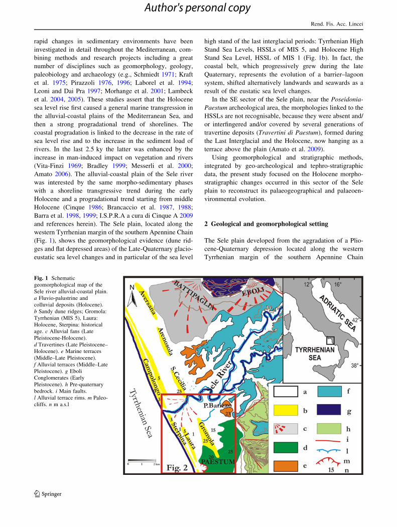
and references herein). The Sele plain, located along the
western Tyrrhenian margin of the southern Apennine Chain
(Fig. 1), shows the geomorphological evidence (dune rid-
ges and flat depressed areas) of the Late-Quaternary glacio-
eustatic sea level changes and in particular of the sea level
high stand of the last interglacial periods: Tyrrhenian High
Stand Sea Levels, HSSLs of MIS 5, and Holocene High
Stand Sea Level, HSSL of MIS 1 (Fig. 1b). In fact, the
coastal belt, which progressively grew during the late
Quaternary, represents the evolution of a barrier–lagoon
system, shifted alternatively landwards and seawards as a
result of the eustatic sea level changes.
In the SE sector of the Sele plain, near the Poseidonia-
Paestum archeological area, the morphologies linked to the
HSSLs are not recognisable, because they were absent and/
or interfingered and/or covered by several generations of
travertine deposits (Travertini di Paestum), formed during
the Last Interglacial and the Holocene, now hanging as a
terrace above the plain (Amato et al. 2009).
Using geomorphological and stratigraphic methods,
integrated by geo-archeological and tephro-stratigraphic
data, the present study focused on the Holocene morpho-
stratigraphic changes occurred in this sector of the Sele
plain to reconstruct its palaeogeographical and palaeoen-
vironmental evolution.
2 Geological and geomorphological setting
The Sele plain developed from the aggradation of a Plio-
cene-Quaternary depression located along the western
Tyrrhenian margin of the southern Apennine Chain
Fig. 1 Schematic
geomorphological map of the
Sele river alluvial-coastal plain.
a Fluvio-palustrine and
colluvial deposits (Holocene).
b Sandy dune ridges; Gromola:
Tyrrhenian (MIS 5), Laura:
Holocene, Sterpina: historical
age. c Alluvial fans (Late
Pleistocene-Holocene).
d Travertines (Late Pleistocene–
Holocene). e Marine terraces
(Middle–Late Pleistocene).
f Alluvial terraces (Middle–Late
Pleistocene). g Eboli
Conglomerates (Early
Pleistocene). h Pre-quaternary
bedrock. i Main faults.
l Alluvial terrace rims. m Paleo-
cliffs. n m a.s.l
Rend. Fis. Acc. Lincei
123
Author's personal copy
(Fig. 1). It is about 400 km2 wide and shows a triangular
outline which is defined seawards by a straight sandy coast
stretching. The boundaries of the plain are defined by NW–
SE and NE–SW trending faults which were active during
the Early and the Middle Pleistocene. The easternmost
portion of this structural depression was characterised since
the Late Pliocene–Early Pleistocene by continental condi-
tions as testified by the huge sedimentary aggradation of
the ‘‘Eboli Conglomerates’’ auct., which compensated the
Quaternary tectonic subsidence (Bartole et al. 1984;
Lippmann-Baggioni and Gars 1984; Cinque 1986; Cinque
et al. 1988; Zuppetta and Sava 1992). Further seaward, a
strip of coastal plain formed during the Last Interglacial
(MIS 5) is characterised by the presence of three orders of
beach-dune ridges which interfinger landward with lagoon
and fluvio-palustrine deposits (Fig. 1). Only the youngest
and most external Tyrrhenian coastal ridges still have a
clear morphological evidence (Gromola-Arenosola paleo-
ridges). The present elevation above sea level (a.s.l.) of
such Tyrrhenian deposits proves that the plain has been
moderately uplifted since the Last Interglacial period
(Cinque 1986; Brancaccio et al. 1988; Barra et al. 1998,
1999; I.S.P.R.A. 2009).
Between the Tyrrhenian sandy-coastal ridges and the
present shoreline, a younger coastal sector occurs, which is
elevated up to 5 m a.s.l. This sector progressively devel-
oped and represents the evolution of a barrier–lagoon
system shifted alternatively landward and seaward during
the Holocene. It includes a composite sandy ridge which is
partly exposed along the present coast and disappears
inland under a muddy flat depression. After being exposed
to subaerial conditions during the Last Glacial regression,
this belt gradually entered brackish conditions at the
beginning of the Holocene, when a transgressive trend
occurred, due to the effect of rapid sea level rise. The
inversion of tendency, from retrogradational to prograda-
tional, may be ascribed to the fall in the rate of sea level
rise under the threshold of balance with the progradation
due to fluvial sedimentation. The progradational trend was
interrupted by at least three phases of formation of sandy
coastal ridges, known as Laura ridge (dated from 5.3 to
3.6 ky BP) and Sterpina ridges (I and II, dated before 2.6
and about 2.0 ky BP, respectively; Brancaccio et al. 1986,
1988; Barra et al. 1998, 1999). During these intervals, the
flat depression behind the ridges witnessed palustrine
conditions which persisted partially until very recent times,
when the plain underwent man-induced reclamations.
In the southern sector of the Sele plain, near the Greek–
Roman archaeological area of Poseidonia-Paestum, lobate
and self-terraced morphologies of the ‘‘Travertini di
Paestum’’ are found (Fig. 2), generated by the carbonate
waters flowing from the springs located at the base of the
Soprano Mt and by the Capodifiume river. The recognised
lithofacies of travertine (stromatolitic, microhermal, phy-
tohermal, phytoclastic and calcareous tufa) allowed the
depositional system of ‘‘Travertini di Paestum’’ to be
referred to fluvial marshy conditions that favored the
emergence of a large sector hanging above the surrounding
plain (D’Argenio et al. 1999; Amato et al. 2009).
Recently, Amato et al. (2009) have provided a detailed
chronological reconstruction of the various stages of the
Travertini di Paestum depositional system, based on
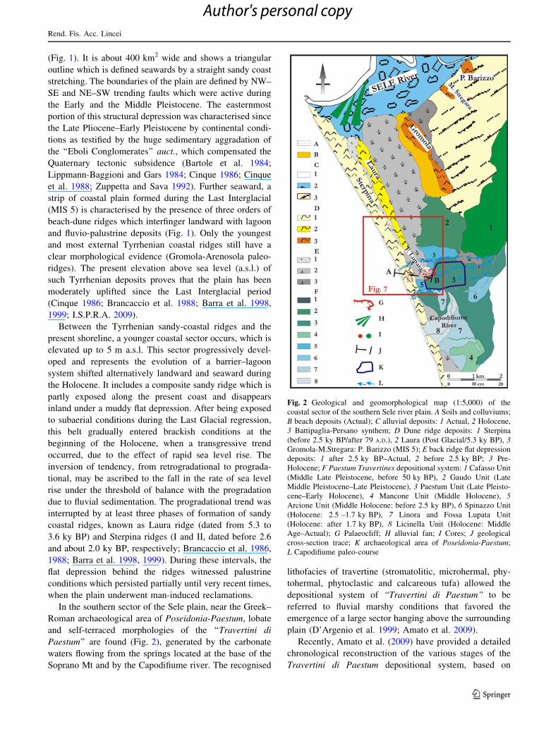
Fig. 2 Geological and geomorphological map (1:5,000) of the
coastal sector of the southern Sele river plain. A Soils and colluviums;
B beach deposits (Actual); C alluvial deposits: 1 Actual, 2 Holocene,
3 Battipaglia-Persano synthem; D Dune ridge deposits: 1 Sterpina
(before 2.5 ky BP/after 79 A.D.), 2 Laura (Post Glacial/5.3 ky BP), 3Gromola-M.Stregara: P. Barizzo (MIS 5); E back ridge flat depression
deposits: 1 after 2.5 ky BP–Actual, 2 before 2.5 ky BP; 3 Pre-
Holocene; F Paestum Travertines depositional system: 1 Cafasso Unit
(Middle Late Pleistocene, before 50 ky BP), 2 Gaudo Unit (Late
Middle Pleistocene–Late Pleistocene), 3 Paestum Unit (Late Pleisto-
cene–Early Holocene), 4 Mancone Unit (Middle Holocene), 5Arcione Unit (Middle Holocene: before 2.5 ky BP), 6 Spinazzo Unit
(Holocene: 2.5 –1.7 ky BP), 7 Linora and Fossa Lupata Unit
(Holocene: after 1.7 ky BP), 8 Licinella Unit (Holocene: Middle
Age–Actual); G Palaeocliff; H alluvial fan; I Cores; J geological
cross-section trace; K archaeological area of Poseidonia-Paestum;
L Capodifiume paleo-course
Rend. Fis. Acc. Lincei
123
Author's personal copy
radiometric dating, archaeo-tephro-stratigraphic data and
geomorphological constraints (Fig. 2). The age of the
deposits suggests that the depositional systems have
migrated from NE to S from the Pleistocene to the Holo-
cene, to form thick travertine successions in the Capodifi-
ume valley even in modern times. In particular, the
deposition was active during the Last Interglacial (Tyr-
rhenian) and the early Holocene until about 5000 BP, and
in the historical period during the Late-Ancient and Middle
Ages (V–IX century A.D.).
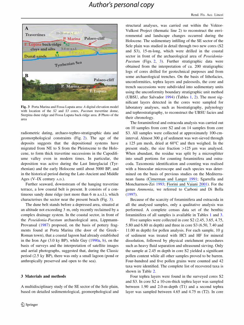
Further seaward, downstream of the hanging travertine
terrace, a low coastal belt is present. It consists of a con-
tinuous sandy dune ridge (not more than 6 m a.s.l.), which
characterises the sector near the present beach (Fig. 3).
The dune belt stands before a depressed area, situated at
an altitude not exceeding 3 m, only recently reclaimed by a
complex drainage system. In the coastal sector, in front of
the Poseidonia-Paestum archaeological area, Lippmann-
Provansal (1987) proposed, on the basis of pottery frag-
ments found at Porta Marina (the door of the Greek–
Roman town), that a coastal lagoon had already established
in the Iron Age (3.0 ky BP), while Guy (1990a, b), on the
basis of surveys and the interpretation of satellite images
and aerial photographs, suggested that, during the Classic
period (2.5 ky BP), there was only a small lagoon (pond or
anthropically preserved and open to the sea).
3 Materials and methods
A multidisciplinary study of the SE sector of the Sele plain,
based on detailed sedimentological, geomorphological and
structural analyses, was carried out within the Vektor-
Vulkost Project (thematic line 2) to reconstruct the envi-
ronmental and landscape changes occurred during the
Holocene. The sedimentary infilling of the SE sector of the
Sele plain was studied in detail through two new cores (S2
and S3), 15-m-long, which were drilled in the coastal
sector in front of the archaeological area of Poseidonia-
Paestum (Figs. 2, 3). Further stratigraphic data were
obtained from the interpretation of ca. 200 stratigraphic
logs of cores drilled for geotechnical purposes and from
some archaeological trenches. On the basis of lithofacies,
unconformities, tephra layers and paleosoils, the core and
trench successions were subdivided into sedimentary units
using the unconformity boundary stratigraphic unit method
(UBSU, after Salvador 1994) (Tables 1, 2). The most sig-
nificant layers detected in the cores were sampled for
laboratory analyses, such as biostratigraphy, palynology
and tephrostratigraphy, to reconstruct the UBSU facies and
their chronology.
The foraminiferal and ostracoda analysis was carried out
on 10 samples from core S2 and on 14 samples from core
S3. All samples were collected at approximately 100-cm-
interval. Almost 300 g of sediment was wet-sieved through
a 125 lm mesh, dried at 60�C and then weighed. In the
present study, the size fraction [125 lm was analysed.
When abundant, the residue was split by a microsplitter
into small portions for counting foraminifera and ostra-
coda. Taxomonic identification and counting was realised
with a binocular microscope and each species was deter-
mined on the basis of previous studies on the Mediterra-
nean fauna (Cimerman and Langer 1991; Sgarrella and
Moncharmon-Zei 1993; Fiorini and Vaiani 2001). For the
genus Ammonia, we referred to Carboni and Di Bella
(1997).
Because of the scarcity of foraminifera and ostracoda in
all the analysed samples, only a qualitative analysis was
performed. A complete census data set of the benthic
foraminifera of all samples is available in Tables 1 and 3.
Five samples were collected in core S2 (2.45, 3.65, 4.75,
5.80 and 6.80 m depth) and three in core S3 (6.50, 7.40 and
11.00 m depth) for pollen analysis. For each sample, 10 g
of sediment was treated with HCl and HF for mineral
dissolution, followed by physical enrichment procedures
such as heavy fluid separation and ultrasound sieving. Only
the sample at 2.45 m depth in core S2 yielded a significant
pollen content while all other samples proved to be barren.
Four-hundred and five pollen grains were counted and 42
taxa were identified. The complete list of recovered taxa is
shown in Table 2.
Four tephra layers were found in the surveyed cores S2
and S3. In core S2 a 10-cm-thick tephra layer was sampled
between 1.90 and 2.0-m-depth (T1) and a second tephra
layer was sampled between 4.65 and 4.75 m (T2). In core
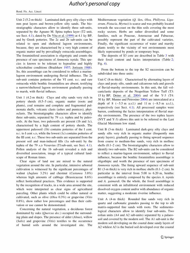
Fig. 3 Porta Marina and Fossa Lupata area: A digital elevation model
with location of the S2 and S3 cores, Paestum travertine dome,
Sterpina dune ridge and Fossa Lupata back-ridge area. B Photo of the
area
Rend. Fis. Acc. Lincei
123
Author's personal copy
S3, a 10-cm-thick tephra layer was sampled between 8.10
and 8.20-m-depth (T3) and a second tephra layer was
sampled between 11.10 and 11.20 m (T4). All samples
were altered mainly within the glassy matrix, generally
presenting a clayey consistence, due to partial to complete
argillification. To eliminate the clayey fraction, samples
were repeatedly washed in deionised water keeping the
water-sample mixture for at least 24 h on an oscillating
platform. During each washing step, the suspended fraction
was removed. The final mixture was washed in an ultra-
sonic tank for 6 h and repeatedly rewashed in deionised
water. The residual solid material was ovendried for 24 h
and finally sieved at 1u intervals. The single grain size
classes were carefully investigated under a binocular
microscope. Major-element analysis on glass fragments
was performed on a SEM JEOL JSM 5310 (15 kV, ZAF
Correction Routine) with EDS at Centro Interdipartimen-
tale di Servizio per Analisi Geomineralogiche (CISAG) at
the University of Naples Federico II. Instrument calibration
was based on the international mineral and glass standards.
Individual analyses of glass shards with total oxide sums
lower than 95% were excluded. Table 3 reports the
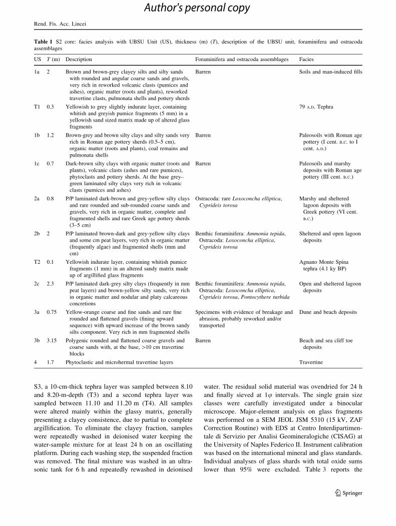
Table 1 S2 core: facies analysis with UBSU Unit (US), thickness (m) (T), description of the UBSU unit, foraminifera and ostracoda
assemblages
US T (m) Description Foraminifera and ostracoda assemblages Facies
1a 2 Brown and brown-grey clayey silts and silty sands
with rounded and angular coarse sands and gravels,
very rich in reworked volcanic clasts (pumices and
ashes), organic matter (roots and plants), reworked
travertine clasts, pulmonata shells and pottery sherds
Barren Soils and man-induced fills
T1 0.3 Yellowish to grey slightly indurate layer, containing
whitish and greyish pumice fragments (5 mm) in a
yellowish sand sized matrix made up of altered glass
fragments
79 A.D. Tephra
1b 1.2 Brown-grey and brown silty clays and silty sands very
rich in Roman age pottery sherds (0.5–5 cm),
organic matter (roots and plants), coal remains and
pulmonata shells
Barren Paleosoils with Roman age
pottery (I cent. B.C. to I
cent. A.D.)
1c 0.7 Dark-brown silty clays with organic matter (roots and
plants), volcanic clasts (ashes and rare pumices),
phytoclasts and pottery sherds. At the base grey–
green laminated silty clays very rich in volcanic
clasts (pumices and ashes)
Barren Paleosoils and marshy
deposits with Roman age
pottery (III cent. B.C.)
2a 0.8 P/P laminated dark-brown and grey-yellow silty clays
and rare rounded and sub-rounded coarse sands and
gravels, very rich in organic matter, complete and
fragmented shells and rare Greek age pottery sherds
(3–5 cm)
Ostracoda: rare Loxoconcha elliptica,
Cyprideis torosaMarshy and sheltered
lagoon deposits with
Greek pottery (VI cent.
B.C.)
2b 2 P/P laminated brown-dark and grey-yellow silty clays
and some cm peat layers, very rich in organic matter
(frequently algae) and fragmented shells (mm and
cm)
Benthic foraminifera: Ammonia tepida,
Ostracoda: Loxoconcha elliptica,
Cyprideis torosa
Sheltered and open lagoon
deposits
T2 0.1 Yellowish indurate layer, containing whitish pumice
fragments (1 mm) in an altered sandy matrix made
up of argillified glass fragments
Agnano Monte Spina
tephra (4.1 ky BP)
2c 2.3 P/P laminated dark-grey silty clays (frequently in mm
peat layers) and brown-yellow silty sands, very rich
in organic matter and nodular and platy calcareous
concretions
Benthic foraminifera: Ammonia tepida,
Ostracoda: Loxoconcha elliptica,
Cyprideis torosa, Pontocythere turbida
Open and sheltered lagoon
deposits
3a 0.75 Yellow-orange coarse and fine sands and rare fine
rounded and flattened gravels (fining upward
sequence) with upward increase of the brown sandy
silts component. Very rich in mm fragmented shells
Specimens with evidence of breakage and
abrasion, probably reworked and/or
transported
Dune and beach deposits
3b 3.15 Polygenic rounded and flattened coarse gravels and
coarse sands with, at the base, [10 cm travertine
blocks
Barren Beach and sea cliff toe
deposits
4 1.7 Phytoclastic and microhermal travertine layers Travertine
Rend. Fis. Acc. Lincei
123
Author's personal copy
chemical analysis of the glass fragments extracted from the
volcaniclastic layers. Their chemical composition was
classified according to the total alkali–silica diagram (TAS:
Le Bas et al. 1986, Fig. 5).
4 Main morpho-stratigraphic features
The coastal strip in front of the archaeological area of
Paestum shows a very articulated landscape, consisting in
an inner area located at an altitude between 10 and 20 m
a.s.l., some meters higher than the average level of the
plain, that does not exceed 5 m a.s.l. (Figs. 2, 3). Such
morphological high, slightly sloping towards the sea, is
composed of polyphasic depositional travertine bodies,
generated during the late Quaternary, now forming self-
terraced bodies hanging above the average level of the
plain. The travertine terrace developed above the tracks
and remains of archaeological settlements, particularly
those of the Greek–Roman town of Poseidonia-Paestum.
Landward, the hanging travertine bodies are connected to
the piedmont belt and seaward to the coastal strip by a
steep escarpment cut into travertine, whose remains are
still visible at Porta Marina. This steep escarpment gently
downgrades to a depressed area, located at an altitude of
about 4 m a.s.l. (Fossa Lupata), behind a large sand dune
ridge which reaches an altitude of about 6 m a.s.l., ca.
1 km from Porta Marina (Fig. 3).
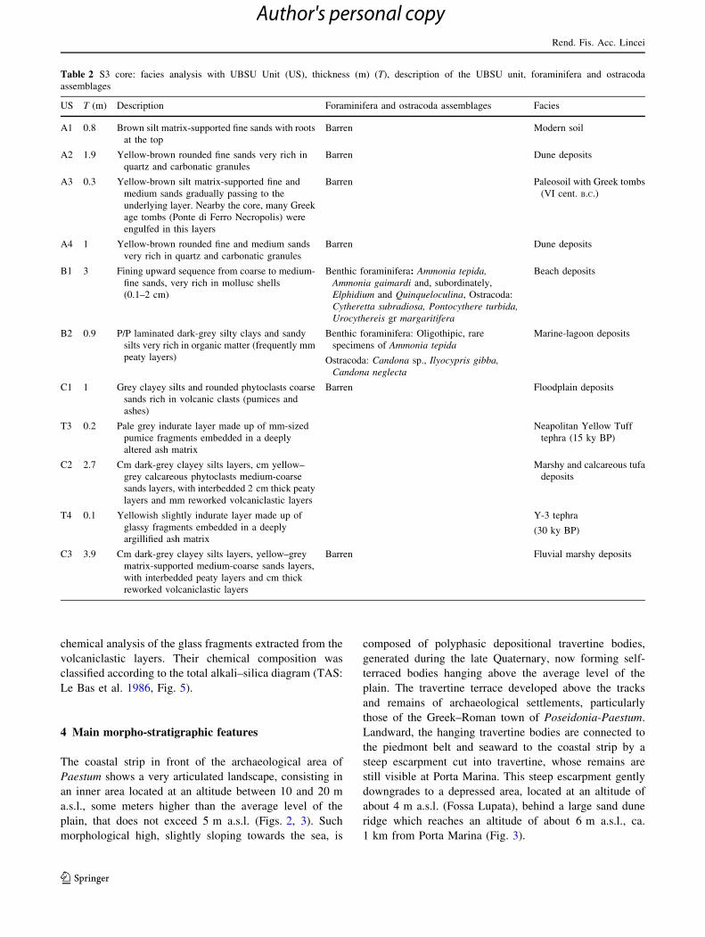
Table 2 S3 core: facies analysis with UBSU Unit (US), thickness (m) (T), description of the UBSU unit, foraminifera and ostracoda
assemblages
US T (m) Description Foraminifera and ostracoda assemblages Facies
A1 0.8 Brown silt matrix-supported fine sands with roots
at the top
Barren Modern soil
A2 1.9 Yellow-brown rounded fine sands very rich in
quartz and carbonatic granules
Barren Dune deposits
A3 0.3 Yellow-brown silt matrix-supported fine and
medium sands gradually passing to the
underlying layer. Nearby the core, many Greek
age tombs (Ponte di Ferro Necropolis) were
engulfed in this layers
Barren Paleosoil with Greek tombs
(VI cent. B.C.)
A4 1 Yellow-brown rounded fine and medium sands
very rich in quartz and carbonatic granules
Barren Dune deposits
B1 3 Fining upward sequence from coarse to medium-
fine sands, very rich in mollusc shells
(0.1–2 cm)
Benthic foraminifera: Ammonia tepida,Ammonia gaimardi and, subordinately,
Elphidium and Quinqueloculina, Ostracoda:
Cytheretta subradiosa, Pontocythere turbida,Urocythereis gr margaritifera
Beach deposits
B2 0.9 P/P laminated dark-grey silty clays and sandy
silts very rich in organic matter (frequently mm
peaty layers)
Benthic foraminifera: Oligothipic, rare
specimens of Ammonia tepida
Ostracoda: Candona sp., Ilyocypris gibba,Candona neglecta
Marine-lagoon deposits
C1 1 Grey clayey silts and rounded phytoclasts coarse
sands rich in volcanic clasts (pumices and
ashes)
Barren Floodplain deposits
T3 0.2 Pale grey indurate layer made up of mm-sized
pumice fragments embedded in a deeply
altered ash matrix
Neapolitan Yellow Tuff
tephra (15 ky BP)
C2 2.7 Cm dark-grey clayey silts layers, cm yellow–
grey calcareous phytoclasts medium-coarse
sands layers, with interbedded 2 cm thick peaty
layers and mm reworked volcaniclastic layers
Marshy and calcareous tufa
deposits
T4 0.1 Yellowish slightly indurate layer made up of
glassy fragments embedded in a deeply
argillified ash matrix
Y-3 tephra
(30 ky BP)
C3 3.9 Cm dark-grey clayey silts layers, yellow–grey
matrix-supported medium-coarse sands layers,
with interbedded peaty layers and cm thick
reworked volcaniclastic layers
Barren Fluvial marshy deposits
Rend. Fis. Acc. Lincei
123
Author's personal copy
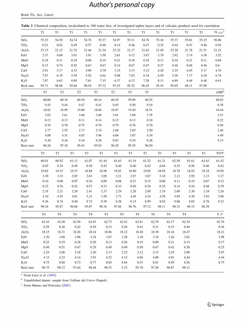
Table 3 Chemical composition, recalculated to 100 water free, of investigated tephra layers and of volcanic products used for correlation
T1 T1 T1 T1 T1 T1 T1 T1 T1 T1 T1 T1 79 A.D.a
SiO2 55.33 54.58 54.74 54.76 55.37 54.97 55.11 54.76 55.16 55.37 55.01 55.25 56.06
TiO2 0.21 0.62 0.49 0.57 0.46 0.14 0.46 0.47 0.35 0.44 0.47 0.46 0.45
Al2O3 23.13 21.12 21.32 21.44 21.24 23.32 21.17 21.62 21.49 23.20 21.78 21.51 21.21
FeO 2.37 4.68 3.91 3.91 3.58 2.61 4.12 3.87 3.79 2.92 3.74 4.38 3.52
MnO 0.18 0.11 0.18 0.06 0.19 0.21 0.18 0.10 0.13 0.18 0.21 0.11 0.04
MgO 0.13 0.74 0.55 0.63 0.67 0.14 0.67 0.47 0.27 0.46 0.68 0.46 0.6
CaO 2.91 5.17 4.33 5.09 4.70 3.15 5.13 5.12 4.20 5.25 4.45 5.17 4.76
Na2O 7.87 6.35 5.59 5.92 6.62 9.08 7.03 6.34 6.50 5.29 7.17 6.18 6.74
K2O 7.87 6.62 8.89 7.61 7.15 6.37 6.12 7.26 8.11 6.89 6.48 6.48 6.61
Real sum 95.71 96.88 95.66 98.54 97.32 97.43 95.32 96.45 95.54 95.65 98.11 97.98
T2 T2 T2 T2 T2 T2 T2 AMSb
SiO2 60.06 60.10 60.10 60.14 60.25 59.89 60.25 60.82
TiO2 0.43 0.44 0.47 0.41 0.45 0.50 0.54 0.38
Al2O3 18.82 18.99 19.00 18.84 18.97 19.20 18.51 18.44
FeO 3.65 3.61 3.66 3.68 3.61 3.60 3.78 3.51
MnO 0.12 0.13 0.11 0.14 0.12 0.13 0.10 0.22
MgO 0.76 0.70 0.75 0.78 0.79 0.76 0.70 0.56
CaO 2.77 2.55 2.73 2.74 2.68 2.65 2.50 2.46
Na2O 4.08 4.31 4.03 3.96 4.06 3.87 4.34 4.49
K2O 9.30 9.16 9.16 9.30 9.07 9.39 9.28 9.15
Real sum 96.26 97.18 95.43 95.83 96.29 95.55 96.50
T3 T3 T3 T3 T3 T3 T3 T3 T3 T3 T3 T3 NYTc
SiO2 60.91 60.92 61.13 61.07 61.44 61.63 61.19 61.52 61.21 62.50 61.61 61.63 61.42
TiO2 0.45 0.16 0.49 0.38 0.43 0.46 0.40 0.43 0.64 0.35 0.56 0.46 0.42
Al2O3 19.02 19.33 19.33 18.88 18.98 19.01 18.90 19.05 18.92 18.78 18.93 19.34 19.05
FeO 3.39 3.33 2.85 3.63 3.09 3.21 2.97 3.07 3.18 3.12 2.95 3.13 3.17
MnO 0.10 0.00 0.07 0.10 0.09 0.08 0.21 0.15 0.00 0.11 0.19 0.07 0.12
MgO 0.32 0.76 0.42 0.57 0.33 0.33 0.49 0.36 0.35 0.14 0.24 0.48 0.39
CaO 2.35 2.21 2.29 2.41 2.37 2.29 2.20 2.09 2.19 2.08 2.30 2.18 2.26
Na2O 4.10 4.55 4.01 3.23 3.58 3.71 4.49 4.34 4.59 3.85 4.20 3.92 3.96
K2O 9.36 8.74 9.40 9.72 9.70 9.28 9.15 8.99 8.92 9.06 9.02 8.78 9.22
Real sum 98.36 95.87 96.66 95.87 98.16 97.46 96.76 97.12 98.11 98.32 96.15 96.29
T4 T4 T4 T4 T4 T4 T4 T4 T4 T4 Y-3c
SiO2 62.44 62.48 62.56 62.83 62.73 62.42 62.81 62.79 62.37 62.34 62.76
TiO2 0.29 0.26 0.42 0.29 0.33 0.26 0.43 0.31 0.33 0.48 0.36
Al2O3 18.15 18.31 18.26 18.24 18.06 18.12 18.28 18.30 18.16 18.47 18.21
FeO 3.30 3.09 2.96 3.24 3.07 3.28 3.10 3.18 3.26 3.01 2.98
MnO 0.23 0.19 0.28 0.20 0.13 0.26 0.19 0.00 0.21 0.14 0.17
MgO 0.49 0.51 0.47 0.29 0.49 0.49 0.50 0.47 0.42 0.58 0.25
CaO 2.24 2.06 2.18 2.20 2.13 2.22 2.12 2.15 2.29 2.00 2.07
Na2O 4.12 4.22 4.14 3.93 4.22 4.12 4.04 4.00 4.01 4.44 4.44
K2O 8.75 8.88 8.73 8.77 8.85 8.84 8.53 8.81 8.95 8.56 8.75
Real sum 96.75 98.12 97.64 96.44 96.53 5.32 95.78 97.56 96.87 98.11
a From Lirer et al. (1993)b Unpublished datum: sample from Vallone del Corvo (Napoli)c From Munno and Petrosino (2007)
Rend. Fis. Acc. Lincei
123
Author's personal copy
In addition to the numerous data from archaeological
excavations and stratigraphic logs, two new cores (Vektor
S2 and S3) were drilled down to 15-m depth. S2 and S3
were drilled, respectively, in the area immediately west-
wards of the travertine escarpment of Porta Marina (5.5 m
a.s.l.) and in the outer dune ridge, behind the coastal road
(2.5 m a.s.l.; for location see Figs. 2, 3). The escarpment is
largely erosional, except that of the western side of the
door, where the scarp corresponds to sub-vertical waterfall
travertine deposits.
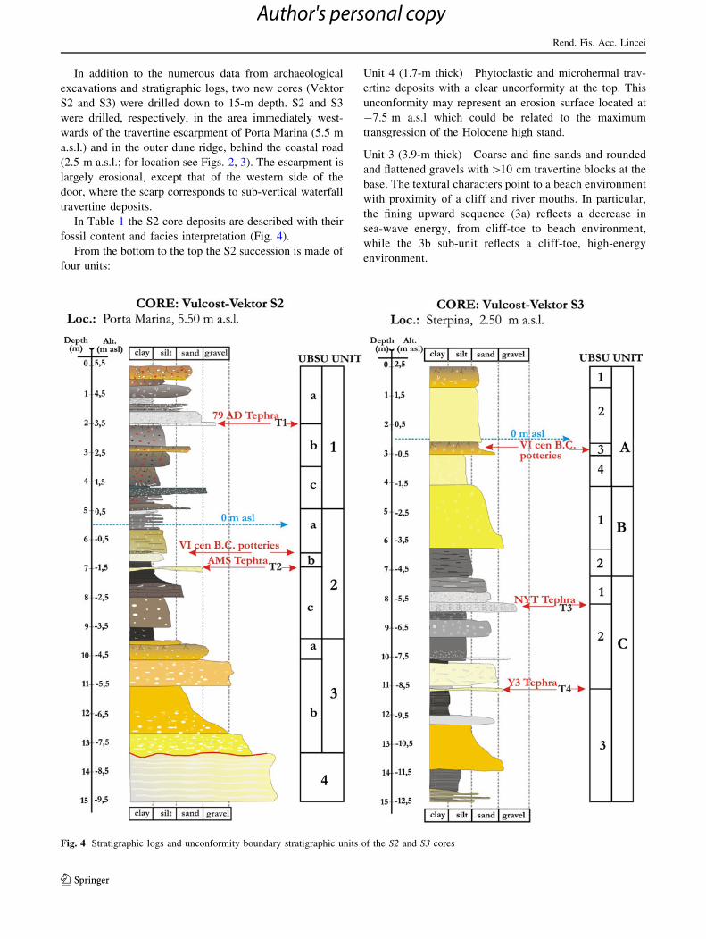
In Table 1 the S2 core deposits are described with their
fossil content and facies interpretation (Fig. 4).
From the bottom to the top the S2 succession is made of
four units:
Unit 4 (1.7-m thick) Phytoclastic and microhermal trav-
ertine deposits with a clear uncorformity at the top. This
unconformity may represent an erosion surface located at
-7.5 m a.s.l which could be related to the maximum
transgression of the Holocene high stand.
Unit 3 (3.9-m thick) Coarse and fine sands and rounded
and flattened gravels with[10 cm travertine blocks at the
base. The textural characters point to a beach environment
with proximity of a cliff and river mouths. In particular,
the fining upward sequence (3a) reflects a decrease in
sea-wave energy, from cliff-toe to beach environment,
while the 3b sub-unit reflects a cliff-toe, high-energy
environment.
Fig. 4 Stratigraphic logs and unconformity boundary stratigraphic units of the S2 and S3 cores
Rend. Fis. Acc. Lincei
123
Author's personal copy
Unit 2 (5.2-m thick) Laminated dark-grey silty clays with
mm peat layers and brown-yellow silty sands. The bio-
stratigraphic characters allow to identify three sub-units,
separated by the Agnano M. Spina tephra layer (T2 unit,
see Sect. 4.1), dated by De Vita et al. (1999) at 4.1 ky BP,
and by Greek potteries. The 2c and 2b sub-units can be
related to open and sheltered lagoon environments,
because, they are characterised by a very high content of
organic matter and by prevailingly ostracoda assemblages.
The foraminiferal association is oligotypic and counts the
presence of rare specimens of Ammonia tepida. This spe-
cies is known to be tolerant to hypoaline and highly
schizohaline conditions (Bradshaw 1957; Jorissen 1988).
So, this assemblage can be considered to reflect a marine-
lagoon environment undergoing fluvial influence. The 2a
sub-unit contains potteries of the VI cent. B.C. and rare
ostracoda while benthic foraminifera are absent, testifying
a narrow/sheltered lagoon environment gradually passing
to marsh, with fluvial influxes.
Unit 1 (4.2-m thick) Clays and silty sands very rich in
pottery sherds (0.5–5 cm), organic matter (roots and
plants), coal remains and complete and fragmented pul-
monata shells, volcanic clasts (ashes and pumices), phyt-
oclasts. The biostratigraphic characters allow to identify
three sub-units, separated by 79 A.D. tephra and by paleo-
soils. At the base, two paleosoils are present (1b and 1c),
characterised by a high content of pottery sherds. The
uppermost paleosoil (1b) contains potteries of the I cent.
B.C. to I cent A.D, while the lowest (1c) contains potteries of
the III cent. B.C. These two sub-units are separated from the
present soil and man-induced fills (1a sub-unit) by the
tephra of the 79 A.D Vesuvius (T1sub-unit, see Sect. 4.1).
Pollen analysis of the 1b sub-unit revealed a rich and
diversified association, image of a typical cultural land-
scape of Roman times.
Clear signs of land use are mixed to the natural
vegetation around the site. In particular, intensive arboreal
cultivation is witnessed by the significant percentages of
walnut (Juglans 3.2%) and chestnut (Castanea 3.8%)
whereas high amounts of cabbage (Brassicaceae 8.6%)
reflect horticultural practices. This evidence is supported
by the recognition of tracks, in a wide area around the site,
which were interpreted as clear signs of agricultural
parceling. Other plants which could be either natural or
cultivated, such as olive (Olea 0.3%) or grapevine (Vitis
0.8%), show rather low percentages and thus their culti-
vation or use cannot be demonstrated.
Concerning the natural vegetation, a deciduous forest
dominated by oaks (Quercus dec.) occupied the surround-
ing plain and slopes. The presence of alder (Alnus), willow
(Salix) and grapevine (Vitis) testifies to the occurrence
of humid soils around the investigated site. The
Mediterranean vegetation (Q. ilex, Olea, Phillyrea, Ligu-
strum, Pistacia, Myrtus) is scarce and was probably located
towards the sea-coast on the thin soils covering the most
rocky sectors. Herbs are rather diversified and some
families, such as Poaceae, Asteraceae and Fabaceae,
possibly represent the part of the cultivated varieties.
Finally, the significant occurrence of water and marshy
plants testify to the vicinity of wet environments most
likely represented by ponds or temporary bogs.
The deposits of S3 core are described in Table 3 with
their fossil content and facies interpretation (Table 2;
Fig. 4).
From the bottom to the top the S2 succession can be
subdivided into three units:
Unit C (8-m thick) Characterised by alternating layers of
clays and peaty silts, sands and calcareous tufa and gravels
of fluvial-marshy environments. In this unit, the fall vol-
caniclastic deposits of the Neapolitan Yellow Tuff (T3:
15 ky BP, Deino et al. 2004) and of the Y-3 (T4:
30 ky BP, Munno and Petrosino 2004) are intercalated at a
depth of 8 (-5.5 m a.s.l.) and 11 m (-8.5 m a.s.l.),
respectively (see Sect. 4.1). All processed samples were
barren, confirming the facies interpretation of fluvial mar-
shy environments. The presence of the two tephra layers
(NYT and Y-3) allows this unit to be referred to the Last
Glacial Maximum low stand.
Unit B (3-m thick) Laminated dark-grey silty clays and
sandy silts very rich in organic matter (frequently mm
peaty layers), gradually passing to fining upward sequence
from coarse to medium-fine sands, very rich in mollusc
shells (0.1–2 cm). The biostratigraphic characters allow to
identify two sub-units. The B2 sub-units can be considered
to reflect a marine-lagoon environment, subject to fluvial
influence, because the benthic foraminifera assemblage is
oligothipic and worth the presence of rare specimens of
Ammonia tepida. The fining upward sequence of sub-unit
B1 (3-m thick) is very rich in mollusc shells (0.1–2 cm). In
particular in the interval from 5.00 to 6.20 m, benthic
assemblage is entirely composed by the species A. tepida
and A. gaimardi. On the whole, the fossil assemblage is
consistent with an infralittoral environment with reduced
dissolved oxygen content and/or with abundance of organic
matter, suggesting a moderate riverine influence.
Unit A (4-m thick) Rounded fine sands very rich in
quartz and carbonatic granules passing to the top to silt
matrix-supported fine sands with roots. The sedimento-
logical characters allow to identify four sub-units. Two
eolian units (A4 and A2 sub-units) separated by a palaeo-
soil and covered by the modern soil. The A1 sub-unit is the
modern soil developing on the coastal dune sandy layers of
A2 whilest A3 is the buried soil developed over the coastal
Rend. Fis. Acc. Lincei
123
Author's personal copy
dune sandy layers of A4. In some archaeological excava-
tions very close to the S3 core (Ponte di Ferro Necropolis,
Fig. 3), the A3 paleosoil separating the eolian sands con-
tains archaeological materials of the VI–V cent. B.C. and is
partly covered by the fall deposits of the 79 A.D. eruption.
So, the unit A may represent two depositional phases of
coastal eolian sands (A2 and A4) formed before the VI–V
cent. B.C. and after the 79 A.D., respectively.
4.1 Tephrostratigraphy
The occurrence of distal tephra layers embedded to the
sedimentary sequences surveyed in the Poseidonia-Paes-
tum area represents an added value aiming at defining the
chronostratigraphy of the investigated subset of the Sele
plain. When distal tephra layers, in fact, can be related to a
well-known and precisely dated eruptive event, they rep-
resent one of the best chronological constraints to be used
for paleogeographical reconstructions. Aiming at identify-
ing the eruption that emplaced the tephra layers, we ana-
lyzed componentry and chemical composition of juvenile
fragments and compared them to those of the products of
well known explosive events aged Late Pleistocene-Holo-
cene, possibly emplaced in the Posidonia-Paestum area.
The single grain size classes analysis of the four tephra
layers found in the cores S2 (T1 and T2) and S3 (T3 and
T4) led to the following characterisation of componentry:
T1 The juvenile fraction is represented by grey vesicu-
lated pumice fragments, containing leucite microcrystals.
The loose fraction contains feldspar and clinopyroxene
crystals, together with minor lava and limestone lithic
fragments.
T2 The juvenile fraction of this layer is very poorly
preserved, being represented by fragile tiny jagged
pumice fragments. The washed residual solid material
contains a good deal of feldspar, brown and green
clinopyroxene crystals, together with rare lithic
fragments.
T3 The well-preserved juvenile fraction of this tephra
layer after pretreatment results made up of pumice
fragments with ovoidal vesicles and glass shards both
platy and Y-shaped. The crystal fraction is mainly made
up of feldspar and clinopyroxene grains. Very rare lava
lithic fragments can be detected.
T4 The juvenile fraction of this tephra layer is made up
of very fragile vesiculated pumice fragments, deeply
altered. The layer contains feldspar and clinopyroxene
crystals.
The results of the componentry analyses made it possi-
ble to identify the Campi Flegrei and Somma-Vesuvio
volcanoes as the possible sources of the tephra layers found
in the drilled sequences.
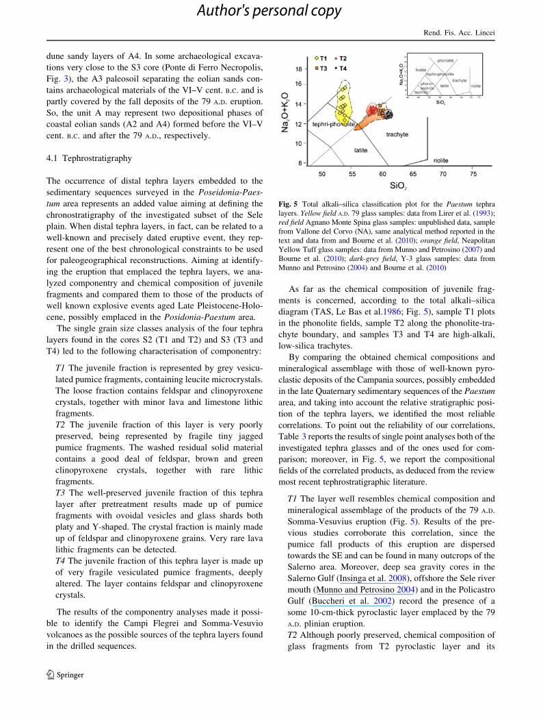
As far as the chemical composition of juvenile frag-
ments is concerned, according to the total alkali–silica
diagram (TAS, Le Bas et al.1986; Fig. 5), sample T1 plots
in the phonolite fields, sample T2 along the phonolite-tra-
chyte boundary, and samples T3 and T4 are high-alkali,
low-silica trachytes.
By comparing the obtained chemical compositions and
mineralogical assemblage with those of well-known pyro-
clastic deposits of the Campania sources, possibly embedded
in the late Quaternary sedimentary sequences of the Paestum
area, and taking into account the relative stratigraphic posi-
tion of the tephra layers, we identified the most reliable
correlations. To point out the reliability of our correlations,
Table 3 reports the results of single point analyses both of the
investigated tephra glasses and of the ones used for com-
parison; moreover, in Fig. 5, we report the compositional
fields of the correlated products, as deduced from the review
most recent tephrostratigraphic literature.
T1 The layer well resembles chemical composition and
mineralogical assemblage of the products of the 79 A.D.
Somma-Vesuvius eruption (Fig. 5). Results of the pre-
vious studies corroborate this correlation, since the
pumice fall products of this eruption are dispersed
towards the SE and can be found in many outcrops of the
Salerno area. Moreover, deep sea gravity cores in the
Salerno Gulf (Insinga et al. 2008), offshore the Sele river
mouth (Munno and Petrosino 2004) and in the Policastro
Gulf (Buccheri et al. 2002) record the presence of a
some 10-cm-thick pyroclastic layer emplaced by the 79
A.D. plinian eruption.
T2 Although poorly preserved, chemical composition of
glass fragments from T2 pyroclastic layer and its
Fig. 5 Total alkali–silica classification plot for the Paestum tephra
layers. Yellow field A.D. 79 glass samples: data from Lirer et al. (1993);
red field Agnano Monte Spina glass samples: unpublished data, sample
from Vallone del Corvo (NA), same analytical method reported in the
text and data from and Bourne et al. (2010); orange field, Neapolitan
Yellow Tuff glass samples: data from Munno and Petrosino (2007) and
Bourne et al. (2010); dark-grey field, Y-3 glass samples: data from
Munno and Petrosino (2004) and Bourne et al. (2010)
Rend. Fis. Acc. Lincei
123
Author's personal copy
mineralogical assemblage corresponds well with those of
the Agnano Monte Spina Campi Flegrei explosive event,
occurred at 4.1 ky (de Vita et al. 1999) (Fig. 5). Inasmuch,
the Agnano Monte Spina eruption is the highest VEI event
of Campi Flegrei recorded in the last 5 ky, and its products
spread towards the NE, have been found in many deep sea
cores from the Adriatic Sea (Calanchi and Dinelli 2008;
Bourne et al. 2010). This is the first signal of the AMS
products along the Tyrrhenian coast, although not incom-
patible with the wide dispersal of the Monte Spina 2
phase. De Vita et al. (1999), in fact, report dispersal area
larger than 700 km2 for the pyroclastic fall products of the
phase D of the AMS eruption. The AMS products,
however, were found in the Monticchio maar lacustrine
sequence by Wulf et al. (2004).
T3 This layer is the best preserved out of the four found
in the Paestum area. As to the chemical composition of
juvenile fragments and mineralogical assemblage, it
correlates well with the tephra layer emplaced by the
Neapolitan Yellow Tuff (Fig. 5), a high-size explosive
event occurred at Campi Flegrei slightly before the end
of Late Pleistocene. The occurrence of the Neapolitan
Yellow Tuff at Paestum is well corroborated by the
presence of this marker tephra layer in the Monticchio
core (Wulf et al. 2004), in the San Gregorio Magno
lacustrine sequence (Munno and Petrosino 2007) and in
many deep sea gravity cores of the Tyrrhenian Sea
(Paterne et al. 1988).
T4 The chemical composition and mineralogical assem-
blage of this poorly preserved tephra layer were
paralleled with those of the Y-3 tephra layer (Fig. 5), a
ca. 30 ky tephra (Zanchetta et al. 2008) originating at
Campi Flegrei, possibly by explosive event with vent
located in the Soccavo area (Di Vito et al. 2008).
Previous papers record the presence of Y-3 in the Sele
river mouth offshore (Munno and Petrosino 2004), in the
Policastro Gulf (Buccheri et al. 2002) and in many deep
sea cores of the Tyrrhenian Sea (Paterne et al. 1988). On
land, it has been found in some outcrops of the Punta
Licosa area (Marciano et al. 2008), in the Monticchio
maar (Wulf et al. 2004) and in the San Gregorio Magno
lacustrine sequence (Munno and Petrosino 2007).
The results of the proposed correlations were integrated
with geoarcheological and stratigraphic data to support the
reconstruction of the paleogeographical evolution of the
Posidonia-Paestum sector of the Sele plain.
5 Discussion
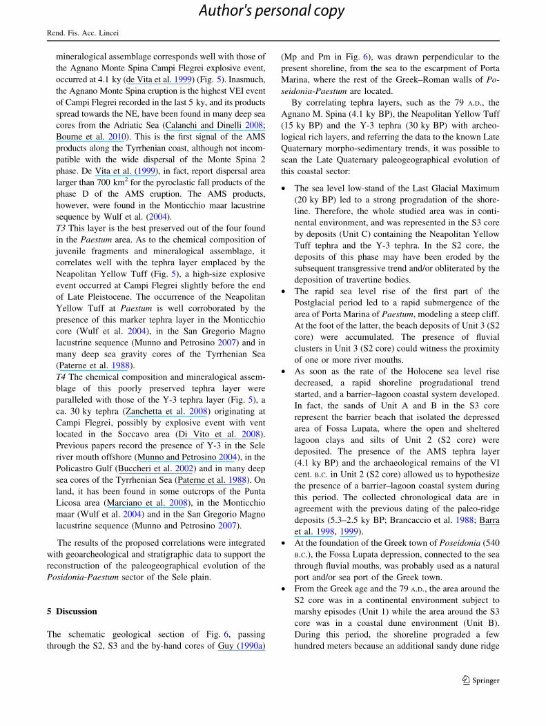
The schematic geological section of Fig. 6, passing
through the S2, S3 and the by-hand cores of Guy (1990a)
(Mp and Pm in Fig. 6), was drawn perpendicular to the
present shoreline, from the sea to the escarpment of Porta
Marina, where the rest of the Greek–Roman walls of Po-
seidonia-Paestum are located.
By correlating tephra layers, such as the 79 A.D., the
Agnano M. Spina (4.1 ky BP), the Neapolitan Yellow Tuff
(15 ky BP) and the Y-3 tephra (30 ky BP) with archeo-
logical rich layers, and referring the data to the known Late
Quaternary morpho-sedimentary trends, it was possible to
scan the Late Quaternary paleogeographical evolution of
this coastal sector:
• The sea level low-stand of the Last Glacial Maximum
(20 ky BP) led to a strong progradation of the shore-
line. Therefore, the whole studied area was in conti-
nental environment, and was represented in the S3 core
by deposits (Unit C) containing the Neapolitan Yellow
Tuff tephra and the Y-3 tephra. In the S2 core, the
deposits of this phase may have been eroded by the
subsequent transgressive trend and/or obliterated by the
deposition of travertine bodies.
• The rapid sea level rise of the first part of the
Postglacial period led to a rapid submergence of the
area of Porta Marina of Paestum, modeling a steep cliff.
At the foot of the latter, the beach deposits of Unit 3 (S2
core) were accumulated. The presence of fluvial
clusters in Unit 3 (S2 core) could witness the proximity
of one or more river mouths.
• As soon as the rate of the Holocene sea level rise
decreased, a rapid shoreline progradational trend
started, and a barrier–lagoon coastal system developed.
In fact, the sands of Unit A and B in the S3 core
represent the barrier beach that isolated the depressed
area of Fossa Lupata, where the open and sheltered
lagoon clays and silts of Unit 2 (S2 core) were
deposited. The presence of the AMS tephra layer
(4.1 ky BP) and the archaeological remains of the VI
cent. B.C. in Unit 2 (S2 core) allowed us to hypothesize
the presence of a barrier–lagoon coastal system during
this period. The collected chronological data are in
agreement with the previous dating of the paleo-ridge
deposits (5.3–2.5 ky BP; Brancaccio et al. 1988; Barra
et al. 1998, 1999).
• At the foundation of the Greek town of Poseidonia (540
B.C.), the Fossa Lupata depression, connected to the sea
through fluvial mouths, was probably used as a natural
port and/or sea port of the Greek town.
• From the Greek age and the 79 A.D., the area around the
S2 core was in a continental environment subject to
marshy episodes (Unit 1) while the area around the S3
core was in a coastal dune environment (Unit B).
During this period, the shoreline prograded a few
hundred meters because an additional sandy dune ridge
Rend. Fis. Acc. Lincei
123
Author's personal copy
formed seawards. The progradation could be responsi-
ble for palaeoenvironmental changes recorded in the
Fossa Lupata depression, from open/sheltered lagoon to
fluvial-marshy.
• After the 79 A.D. and up to the present, the shoreline
progradational trend was emphasised through the
addition of another sandy dune ridge, testified in the
S3 core by the deposits of sub-Unit A2. In the area of
the S2 core, a strong aggradation of the ground level
took place due to man-induced fills, reworked volca-
niclastic deposits of the 79 A.D. and historical deposi-
tion of travertines.
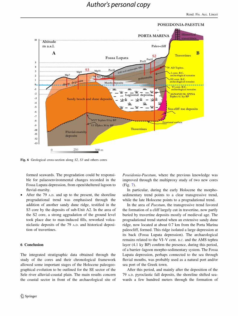
6 Conclusion
The integrated stratigraphic data obtained through the
study of the cores and their chronological framework
allowed some important stages of the Holocene paleogeo-
graphical evolution to be outlined for the SE sector of the
Sele river alluvial-coastal plain. The main results concern
the coastal sector in front of the archaeological site of
Poseidonia-Paestum, where the previous knowledge was
improved through the multiproxy study of two new cores
(Fig. 7).
In particular, during the early Holocene the morpho-
sedimentary trend points to a clear transgressive trend,
while the late Holocene points to a progradational trend.
In the area of Paestum, the transgressive trend favored
the formation of a cliff largely cut in travertine, now partly
buried by travertine deposits mostly of medieval age. The
progradational trend started when an extensive sandy dune
ridge, now located at about 0.7 km from the Porta Marina
paleocliff, formed. This ridge isolated a large depression at
its back (Fossa Lupata depression). The archaeological
remains related to the VI–V cent. B.C. and the AMS tephra
layer (4.1 ky BP) confirm the presence, during this period,
of a barrier–lagoon morpho-sedimentary system. The Fossa
Lupata depression, perhaps connected to the sea through
fluvial mouths, was probably used as a natural port and/or
sea port of the Greek town.
After this period, and mainly after the deposition of the
79 A.D. pyroclastic fall deposits, the shoreline shifted sea-
wards a few hundred meters through the formation of
Fig. 6 Geological cross-section along S2, S3 and others cores
Rend. Fis. Acc. Lincei
123
Author's personal copy
another dune ridge (Sterpina ridge). The Fossa Lupata
depression, no longer connected to the sea, was filled with
fluvial-marshy deposits and slowly dried up.
Aknowledgements Authors wish to thank the Soprintendenza Ar-
cheologica of Avellino-Salerno (Paestum Office), in particular, Dr.
Marina Cipriani for having kindly granted the permission for the
coring within the Porta Marina archaeological area, and Dr. Alfonso
Santoriello of the Salerno University (Beni Culturali Department) for
the interpretation of the ceramic materials of the cores.
References
Amato V (2006) La risposta di alcuni tipici sistemi morfodinamici
della Campania (Italia meridionale) alle variazioni climatiche
oloceniche. Ph.D. thesis, pp 1–406 http://www.fedoa.unina.it
Amato V, Avagliano G, Cinque A, Cipriani M, Di Paola G,
Pontrandolfo A, Rosskopf CM, Santoriello A (2009) Geomor-
phology and geoarchaeology of the Paestum area: modification
of the physical environment in historical times. Mediterranee
112:129–135
Amorosi A, Lucchi MR, Rossi V, Sarti G (2009) Climate change
signature of small-scale parasequences from Lateglacial–Holo-
cene transgressive deposits of the Arno valley fill. Palaeogeogr
Palaeoclimatol Palaeoecol 273:142–152
Antonioli F, Anzidei M, Lambeck K, Auriemma R, Gaddi D, Furlani
S, Orru‘ P, Solinas E, Gaspari A, Karinja S, Kovacic V, Surace L
(2007) Sea-level change during the Holocene in Sardinia and in
the northeastern Adriatic (central Mediterranean Sea) from
archaeological and geomorphological data. Q Sci Rev 26:2463–
2486
Barra D, Calderoni G, Cinque A, De Vita P, Rosskopf CM, Ermolli
ER (1998) New data on the evolution of the Sele River coastal
plain (southern Italy) during the Holocene. Il Quaternario
11:287–299
Barra D, Calderoni G, Cipriani M, De La Geniere’ J, Fiorillo L, Greco
G, Lippi MM, Secci MM, Pescatore T, Russo B, Senatore MR,
Sciarelli GT, Thorez J (1999) Depositional history and palae-
ogeographic reconstruction of Sele coastal plain during Magna
Grecia settlement of Hera Argiva (southern Italy). Geologica
Romana 35:151–166
Bartole R, Savelli C, Tramontana M, Wezel F (1984) Structural and
sedimentary features in the Tyrrhenian margin of Campania,
southern Italy. Mar Geol 55:163–180
Bourne A, Lowe J, Trincardi F, Asioli A, Blockley S, Wulf S,
Matthews I, Piva A, Vigliotti L (2010) Distal tephra record for
the last ca 105,000 years from core PRAD 1–2 in the central
Adriatic Sea: implications for marine tephrostratigraphy. Q Sci
Rev 29(23–24):3079–3094
Bradley RS (1999) Palaeoclimatology. International geophysic series
64. Harcourt Academic Press, p 245
Bradshaw JS (1957) Laboratory studies on the rate of growth of the
foraminifer Streblus beccarii (Linne) var tepida (Cushman).
J Paleontol 31(6):1138–1147
Fig. 7 Holocene paleo-geographical and paleo-environmental evo-
lution sketches of the coastal area in front of the Paestum site.
a Alluvial deposits: b fluvial-marshy deposits, c marshy deposits,
d lagoonal deposits, e Sterpina dunal ridge deposits, f Laura dunal
ridge deposits, g Arcione travertine unit, h Linora travertine unit,
i Paestum travertine deposits, j Cafasso travertine unit, k paleo-
courses, l palaeocliff
b
Rend. Fis. Acc. Lincei
123
Author's personal copy
Brancaccio L, Cinque A, Belluomini G, Branca M, Delitala L (1986)
Isoleucine epimerization dating and tectonic significance of
upper Pleistocene sea level features of the Sele Plain (southern
Italy). Zeit Geomorph N F 62(Suppl Bd):159–166
Brancaccio L, Cinque A, D’angelo G, Russo F, Santangelo N, Sgrosso
I (1987) Evoluzione tettonica e geomorfologica della Piana del
Sele (Campania, Appennino meridionale). Geografia Fisica e
Dinamica Quaternaria 10:47–55
Brancaccio L, Cinque A, Russo F, Santangelo N, Alessio M, Allegri
L, Improta S, Belluomini G, Branca M, Delitala L (1988) Nuovi
dati cronologici sui depositi marini e continentali della Piana del
F. Sele e della costa settentrionale del Cilento (Campania,
Appennino meridionale). Atti del 74� Congresso Nazionale della
Societa Geologica Italiana A:55–62
Buccheri G, Bertoldo M, Coppa MG, Munno R, Pennetta M, Siani G,
Valente A, Vecchione C (2002) Evoluzione sedimentaria e
paleoclimatologia tardo-quaternaria della scarpata continentale
del Golfo di Policastro (Mar Tirreno meridionale). Bollettino
della Societa Geologica Italiana 121:187–210
Calanchi N, Dinelli E (2008) Tephrostratigraphy of the last 170 ka in
sedimentary successions from the Adriatic Sea. J Volcanol
Geotherm Res 177:81–95
Carboni MG, Di Bella L (1997) The Plio-Pleistocene of the Anzio
coast (Rome). Bollettino della Societa Paleontologica Italiana
36:135–159
Cimerman F, Langer MR (1991) Mediterranean Foraminifera. Slov-
enska Academia Znanosti in Umetnosti, Ljubljania, pp 1–119
Cinque A (1986) Guida alle escursioni geomorfologiche (Penisola
Sorrentina, Capri, Piana del Sele e Monti Picentini). Riunione
annuale del Gruppo Nazionale Geografia Fisica e Geomorfolo-
gia, Amalfi 1986. Pubbl. n. 33 del Dipartimento di Scienze della
Terra, Universita Federico II di Napoli. p 119
Cinque A, Guida F, Russo F, Santangelo N (1988) Dati cronologici e
stratigrafici su alcuni depositi continentali della Piana del Sele
(Campania): i ‘‘Conglomerati di Eboli’’. Geografia Fisica e
Dinamica Quaternaria 11:39–44
D’Argenio B, Ferreri V, Violante C (1999) Travertine in the rise and
decline of the ancient town of Paestum (2500–1000 BP).
Eurobasin School, Event IX, Naples and Benevento, p 10
de Vita S, Orsi G, Civetta L, Carandente A, D’Antonio M, Deino A,
di Cesare T, Di Vito MA, Fisher RV, Isaia R, Marotta E, Necco A,
Ort M, Pappalardo L, Piochi M, Southon J (1999) The Agnano-
Monte Spina eruption (4100 years BP) in the restless Campi
Flegrei caldera (Italy). J Volcanol Geotherm Res 91:269–301
Deino AL, Orsi G, de Vita S, Piochi M (2004) The age of the
Neapolitan Yellow Tuff caldera-forming eruption (Campi
Flegrei caldera, Italy) assessed by 40Ar/39Ar dating method.
J Volcanol Geotherm Res 133(1–4):157–170
Di Vito MA, Sulpizio R, Zanchetta G, D’Orazio M (2008) The late
Pleistocene pyroclastic deposits of the Campanian Plain: new
insights into the explosive activity of Neapolitan Volcanoes.
J Volcanol Geotherm Res 177:19–48
Fiorini F, Vaiani SC (2001) Benthic foraminifers and transgressive-
regressive cycles in the Late Quaternary subsurface sediments of
the Po Plain near Ravenna (northern Italy). Bollettino della
Societa Paleontologica Italiana 40:357–403
Galili E, Zvieli D, Weinstein-Evron M (2005) Holocene sea level
changes and landscape evolution on the northern Carmel coast
(Israel). Mediterranee 104:79–86
Guy M (1990a) La costa, la laguna e l’insediamento di Poseidonia-
Paestum. In: Paestum: La citta e il territorio. Quaderno di
documentazione dell’Istituto della Enciclopedia Italiana Trecca-
ni, pp 67–77
Guy M (1990b) Le rivage maritime et la « lagune » de Poseidonia-
Paestum. In: Livadie CA, Widemann F (Eds) Volcanologie et
Archeologie. PACT 25:257–270
Insinga D, Molisso F, Lubritto C, Sacchi M, Passariello I, Morra V
(2008) The proximal marine record of Somma-Vesuvius volca-
nic activity in the Naples and Salerno bays, Eastern Tyrrhenian
Sea, during the last 3 kyrs. J Volcanol Geotherm Res
177:170–196
I.S.P.R.A. (2009) Note illustrative della Carta Geologica d’Italia alla
scala 1:50.000. Foglio 486, Foce Sele. A cura di: Cinque A.
Servizio Geologico Nazionale, pp 1–205
Jorissen FJ (1988) Benthic foraminifera from the Adriatic Sea:
principles for phenotypic variation. Utrecht Micropalentol Bull
37:1–176
Kraft JC, Rapp G Jr, Aschenbrenner SE (1975) Late Holocene
palaeogeography of the coastal plain of the Gulf of Messenia,
Greece, and its relationships to archaeological settings and
coastal change. Geol Soc Am Bull 86:1191–1208
Laborel J, Morhange R, Lafont R, Le Campion J, Laborel-Deguen F
(1994) Biological evidence of sea level rise during the last
4500 years on the rocky coasts of continental France and
Corsica. Mar Geol 120:203–223
Lambeck K, Antonioli F, Purcell A, Silenzi S (2004) Sea level change
along the Italian coast for the past 10,000 years. Quat Sci Rev
23:1567–1598
Lambeck K, Anzidei M, Antonioli F, Benini A, Esposito A (2005)
Sea level in Roman time in the Central Mediterranean and
implications for recent change. Earth Planet Sci Lett 224:563–
575
Le Bas MJ, Le Maitre RW, Streckeisen A, Zanettin B (1986) A
chemical classification of volcanic rocks based on the total
alkali–silica diagram. J Petrol 27:745–750
Leoni G, Dai Pra G (1997) Variazioni di livello del mare nel tardo
Olocene lungo la costa del Lazio in base ad indicatori
geoarcheologici. ENEA Tech. Rep. RT/AMB/97/8, Rome,
pp 1–127
Lippmann-Baggioni M, Gars G (1984) La bordure sud des Monts
Picentini: un jalon dans l’evolution neotectonique et paleocli-
matique de l’Apennin Meridional. Geografia Fisica e Dinamica
Quaternaria 7:49–58
Lippmann-Provansal M (1987) L’Apennin Campanien meridional
(Italie). Etude Geomorphologique. These de Doctorat d’Etat.
Univ. Aix-Marseille, p 486
Lirer L, Munno R, Petrosino P, Vinci A (1993) Tephrostratigraphy of
the A.D. 79 pyroclastic deposits in perivolcanic areas of Mt.
Vesuvio (Italy). J Volcanol Geotherm Res 58:133–149
Marciano R, Munno R, Petrosino P, Santangelo N, Santo A, Villa I
(2008) Late Quaternary tephra layers along the Cilento coastline
(southern Italy). J Volcanol Geotherm Res 177:227–243
Messerli B, Grosjean M, Hofer T, Nunez L, Pfister C (2000) From
nature-dominated to human-dominated environmental changes.
Quat Sci Rev 19:459–479
Morhange C, Laborel J, Hesnard A (2001) Changes of relative sea
level during the past 5000 years in the ancient harbor of
Marseilles. SouthFrance Palaeogeogr Palaeoclim Palaeoecol
166(3–4):319–329
Munno R, Petrosino P (2004) New constraints on the occurrence of
Y-3 upper Pleistocene tephra marker layer in the Tyrrhenian sea.
Il Quaternario 17(1):11–20
Munno R, Petrosino P (2007) Tephra layers in the S. Gregorio Magno
lacustrine succession. J Quat Sci 22(3):247–266
Paterne M, Guichard F, Labeyrie J (1988) Esplosive activity of the
south Italian volcanoes during the past 80,000 years as deter-
mined by marine tephrochronology. J Volcanol Geotherm Res
34:153–172
Pirazzoli PA (1976) Sea level variations in the northwest Mediter-
ranean during Roman times. Science 194:519–521
Pirazzoli PA (1996) Sea-level changes. the last 20.000 years. Wiley,
Chinchester, pp 1–211
Rend. Fis. Acc. Lincei
123
Author's personal copy
Primavera M, Simone O, Fiorentino G, Caldara M (2011) The
palaeoenvironmental study of Alimini Piccolo lake enables a
reconstruction of Holocene sea-level changes in southeast Italy.
The Holocene 21:553–563
Salvador A (1994) International stratigraphic guide: a guide to
stratigraphic classification, terminology and procedure. In: The
International Union of Geological Sciences and The Geological
Society of America (Eds), p 156
Schmiedt G (1971) Antichi porti d’Italia. L’Universo XLVI
2:297–353
Sgarrella F, Moncharmon-Zei M (1993) Benthic foraminifera in the
Gulf of Naples (Italy): systematic and autoecology. Bollettino
della Societa Paleontologica Italiana 32:145–264
Vita-Finzi G (1969) The mediterranean valleys: geological changes in
historical times. Cambridge University Press, p 165
Wulf S, Kraml M, Brauer A, Kellerc J, Negendank FW (2004)
Tephrochronology of the 100 ka lacustrine sediment record of
Lago Grande di Monticchio (southern Italy). Quat Intern
122:7–30
Zanchetta G, Sulpizio R, Giaccio B, Siani G, Paterne M, Wulf S,
D’Orazio M (2008) The Y-3 tephra: a stratigraphic marker for
the Last Glacial successions of the Central Mediterranean Basin.
J Volcanol Geotherm Res 177:145–154
Zuppetta A, Sava A (1992) Pleistocene brittle deformation in the
Eboli Conglomerates (Sele plain: Campanian Apennines). Bol-
lettino della Societa Geologica Italiana 111:273–281
Rend. Fis. Acc. Lincei
123
Author's personal copy
Top Related
Copyright © 2022 FDOKUMEN

