


Bahasa
Halaman
Hukum

GROUND WATER BROCHURE OF SULTANPUR DISTRICT, U.P.
By
J.P. Gautam Scientist 'B'
CONTENTS
Chapter Title Page No.
DISTRICT AT A GLANCE
..................2
1. INTRODUCTION
..................5
2. RAINFALL & CLIMATE
..................6
3. GEOMORPHOLOGY & SOIL
..................7
4. GROUND WATER SCENARIO
..................7
5. GROUND WATER MANAGEMENT STRATEGY
..................11
6. GROUND WATER RELATED ISSUES AND PROBLEMS
..................11
7. RECOMMENDATIONS
..................12
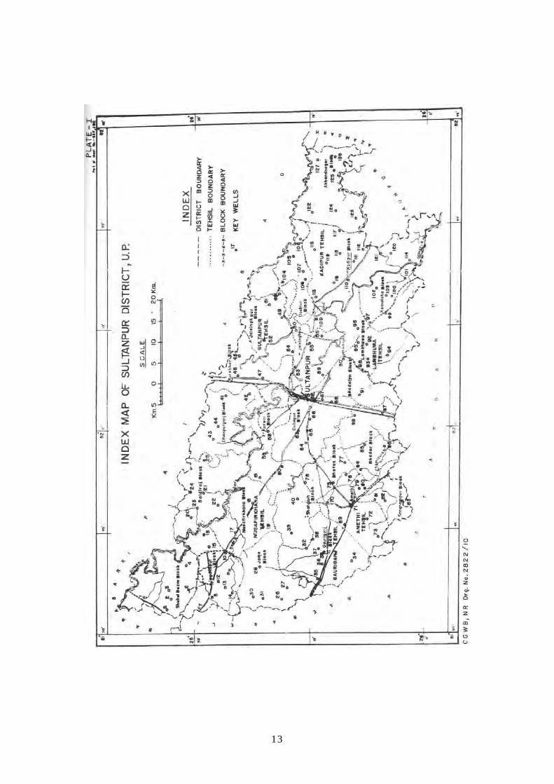
PLATES: I. INDEX MAP / ADMINISTRATIVE MAP OF SULTANPUR DISTRICT,
U.P.
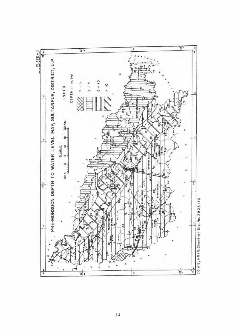
II. DEPTH TO WATER LEVEL MAP (PRE-MONSOON) OF SULTANPUR
DISTRICT, U.P.
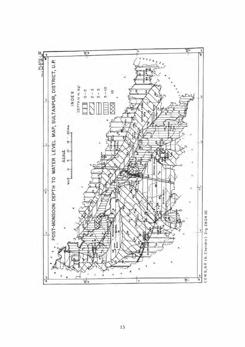
III. DEPTH TO WATER LEVEL MAP (POST-MONSOON) OF SULTANPUR
DISTRICT, U.P.
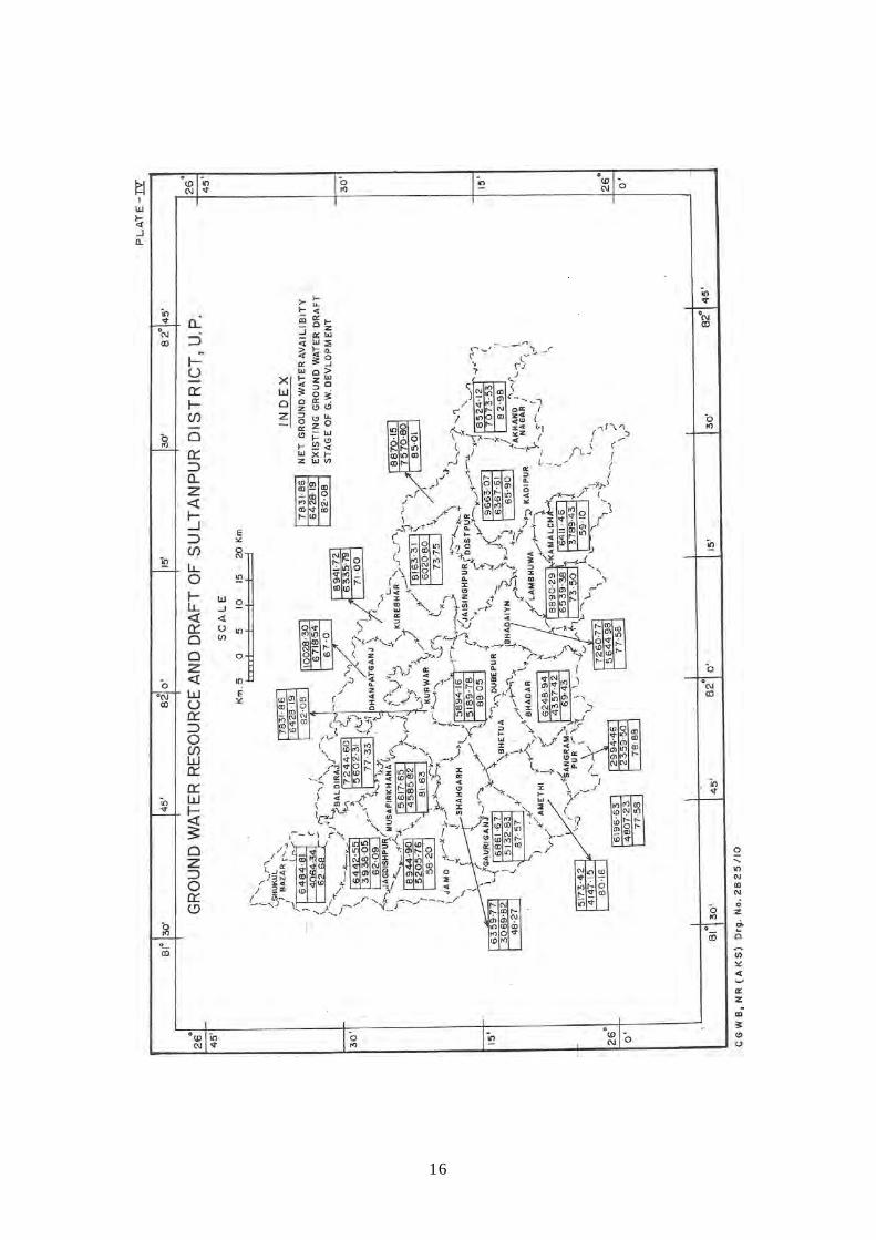
IV. GROUND WATER RESOURCE AND DRAFT OF SULTANPUR
DISTRICT, U.P.
2
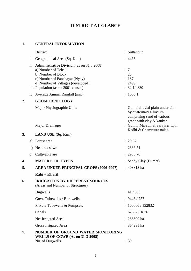
DISTRICT AT GLANCE
1. GENERAL INFORMATION
District : Sultanpur
i. Geographical Area (Sq. Km.) : 4436
ii. Administrative Division (as on 31.3.2008) a) Number of Tehsil b) Number of Block c) Number of Panchayat (Nyay) d) Number of Villages (developed)
: : : :
7 23 187 2499
iii. Population (as on 2001 census) : 32,14,830
iv. Average Annual Rainfall (mm) : 1005.1
2. GEOMORPHOLOGY
Major Physiographic Units : Gomti alluvial plain underlain by quaternary alluvium comprising sand of various grade with clay & kankar
Major Drainages : Gomti, Majauli & Sai river with Kadhi & Chamraura nalas.
3. LAND USE (Sq. Km.)
a) Forest area : 20.57
b) Net area sown : 2836.51
c) Cultivable are : 2933.76
4. MAJOR SOIL TYPES : Sandy Clay (Dumat)
5. AREA UNDER PRINCIPAL CROPS (2006-2007)
Rabi + Kharif
: 408813 ha
6. IRRIGATION BY DIFFERENT SOURCES (Areas and Number of Structures)
Dugwells : 41 / 853
Govt. Tubewells / Borewells
Private Tubewells & Pumpsets
:
:
9446 / 757
160860 / 132832
Canals : 62887 / 1876
Net Irrigated Area : 233309 ha
Gross Irrigated Area : 364295 ha
7. NUMBER OF GROUND WATER MONITORING WELLS OF CGWB (As on 31-3-2008)
No. of Dugwells : 39
3
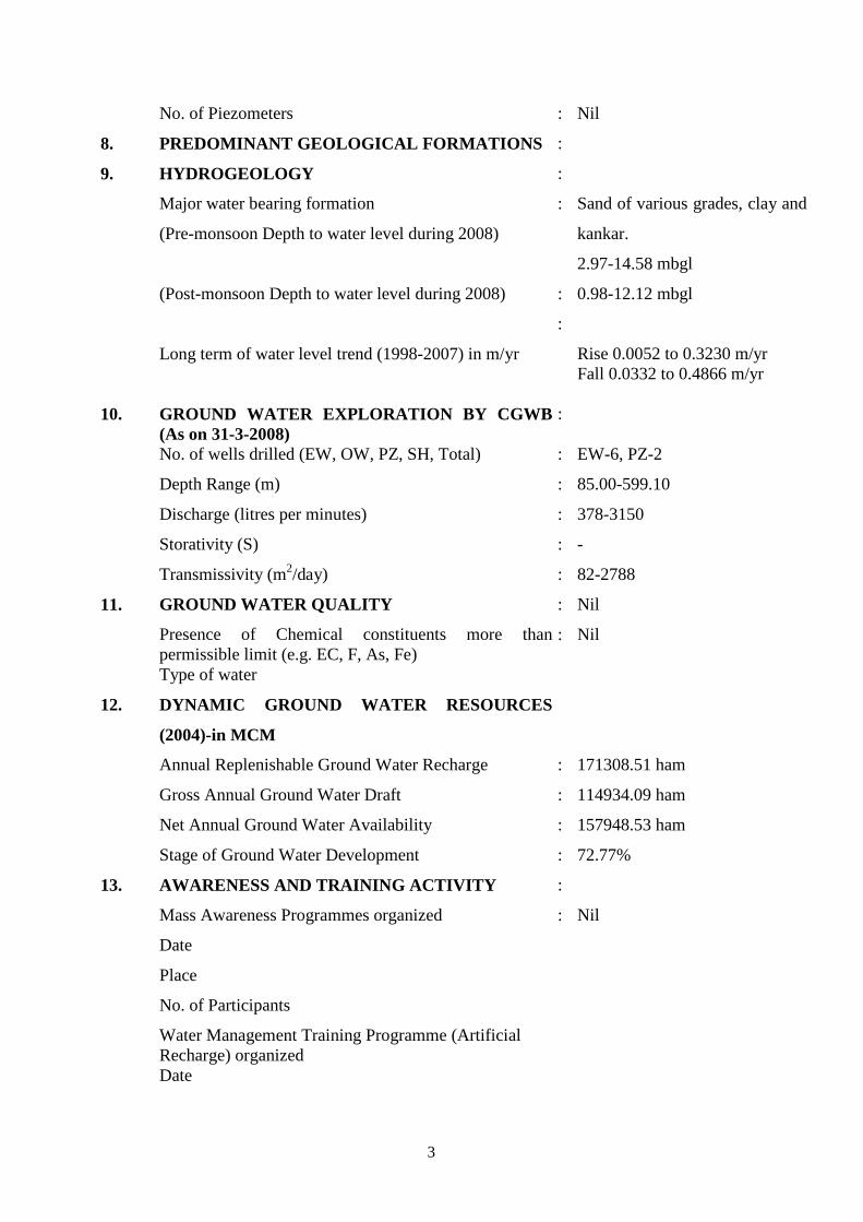
No. of Piezometers : Nil
8. PREDOMINANT GEOLOGICAL FORMATIONS :
9. HYDROGEOLOGY :
Major water bearing formation
(Pre-monsoon Depth to water level during 2008)
: Sand of various grades, clay and
kankar.
2.97-14.58 mbgl
(Post-monsoon Depth to water level during 2008) :
:
0.98-12.12 mbgl
Long term of water level trend (1998-2007) in m/yr
Rise 0.0052 to 0.3230 m/yr Fall 0.0332 to 0.4866 m/yr
10. GROUND WATER EXPLORATION BY CGWB (As on 31-3-2008)
:
No. of wells drilled (EW, OW, PZ, SH, Total) : EW-6, PZ-2
Depth Range (m) : 85.00-599.10
Discharge (litres per minutes) : 378-3150
Storativity (S) : -
Transmissivity (m2 : /day) 82-2788
11. GROUND WATER QUALITY : Nil
Presence of Chemical constituents more than permissible limit (e.g. EC, F, As, Fe)
: Nil
Type of water
12. DYNAMIC GROUND WATER RESOURCES
(2004)-in MCM
Annual Replenishable Ground Water Recharge : 171308.51 ham
Gross Annual Ground Water Draft : 114934.09 ham
Net Annual Ground Water Availability : 157948.53 ham
Stage of Ground Water Development : 72.77%
13. AWARENESS AND TRAINING ACTIVITY :
Mass Awareness Programmes organized : Nil
Date
Place
No. of Participants
Water Management Training Programme (Artificial Recharge) organized
Date
4
Place
No. of Participants
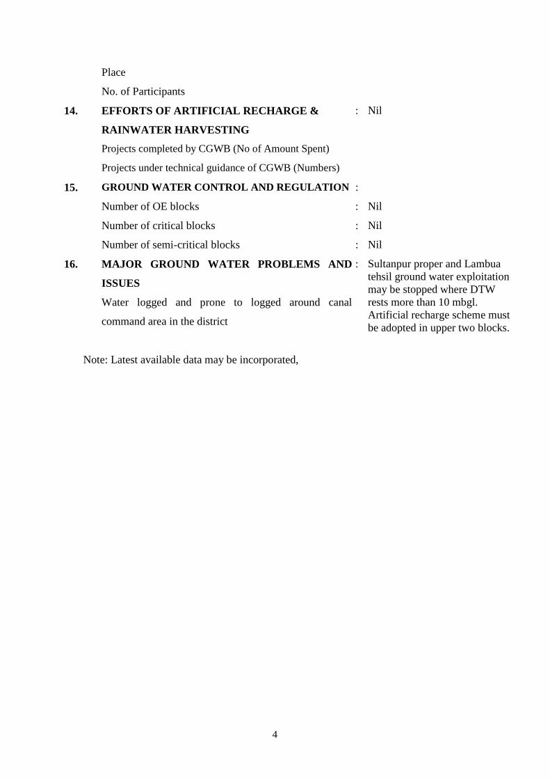
14. EFFORTS OF ARTIFICIAL RECHARGE &
RAINWATER HARVESTING
: Nil
Projects completed by CGWB (No of Amount Spent)
Projects under technical guidance of CGWB (Numbers)
15. GROUND WATER CONTROL AND REGULATION :
Number of OE blocks : Nil
Number of critical blocks : Nil
Number of semi-critical blocks : Nil
16. MAJOR GROUND WATER PROBLEMS AND
ISSUES
Water logged and prone to logged around canal
command area in the district
: Sultanpur proper and Lambua tehsil ground water exploitation may be stopped where DTW rests more than 10 mbgl. Artificial recharge scheme must be adopted in upper two blocks.
Note: Latest available data may be incorporated,
5
GROUND WATER BROCHURE OF SULTANPUR DISTRICT, U.P.
By
J.P. Gautam Scientist 'B'
1.0 INTRODUCTION
Sultanpur district lies between 25058’ to 26040’ north latitude and 81033’ to
82040’ east longitude. Total geographical area of the district is 4436 sq. km. District
headquarter is at Sultanpur having 7 (seven) number tehsils and 23 (twenty three)
number of blocks. As per 2001 census district has population 3214830 of which
1623820 males and 1591010 females. Rural population is 3062570 and urban
population is 152260. Scheduled caste population is 715300 and scheduled tribe is
470 only. Geologically the area comprises quarternary alluvium. Alluvial formation
consists of clay. Kankar and granular material comprising medium to coarse sand and
gravel which by and large forms the principal aquifer. The river Gomti divides the
district into two unequal tracts, the larger lying in south & smaller in the north. Each
of these tracts has the same natural divisions running almost parallel to the rivers.
Physiographically the area can be divided into the following three sub-units:
1. Gentle Plain south & north of Gomti river
2. Gentle undulating tract roughly parallel to the coarse of Gomti river.
3. Gomti Valley
The main source of irrigation in the district is canals and tubewells. The total
net irrigated area is 233000 ha. And the net area sown (culturable) is 284000 ha,
which shows that about 82% area is irrigated and the rest area depends on rainfall.
Length of canal in the district is 1876 km. and number of government tubewell is 757.
The number of private tubewell and pumpset is 132844.
6
Sultanpur district is mainly drained by Gomti which is perennial and its
tributaries. Gomti river flows through the district from north-west to south-east. Kadhi
Nala, a tributary of Gomti river and Chamraura Nala a tributary of Sai river drain the
south-western part of the district. The north-eastern part of the district is drained by
Majauli river, which is a tributary of Tons river form the north-eastern boundary of
the district.
The district was covered under the hydrogeology and ground water potential
of Sultanpur district by Shri Ram Pratap, Jr. Hydrogeologist in 1979. The
hydrogeological investigation also done by Shri S. Mukherjee, Sc. 'D' in 1991, the
report titled hydrogeological framework and ground water development potential of
Sultanpur district. Recently in A.A.P. 2001-02 the undersigned carried out ground
water management studies in Sultanpur district.
2.0 RAINFALL & CLIMATE
The average annual rainfall is 1005.1 mm. The climate is sub-humid and it is
characterised by a hot summer and a pleasant cold season, About 89% of rainfall
takes place from June to September. During monsoon surplus water is available for
deep percolation to ground water.
May is generally the hottest month with mean daily maximum at 410C, the
mean daily minimum at 260C and maximum temperature reaches upto 480C. With the
advance of the monsoon by about middle of June there is appreciable drop in the day
temperature but the nights continue to be warm. January is usually the coldest month
with the mean daily maximum temperature at 22.40C and mean daily minimum at
8.80C. The mean monthly maximum temperature is 32.40C and mean monthly
minimum temperature is 19.0
The potential evapotranspiration is 1519.7 mm
C.
The relative humidity is high during the southwest monsoon season, after
withdrawal of the monsoon, humidities decreases and by summer which is driest part
of the year. The mean monthly maximum relative humidity is 65% and mean monthly
minimum relative humidity is 51%.
Winds are generally light to moderate with some strengthening during later
part of summer and monsoon season. The mean wind velocity is 4.4 Kmph.
7
3.0 GEOMORPHOLOGY & SOIL
3.1 GEOMORPHOLOGY:
River Gomti divides the district into two unequal tracts, the larger lying in
south and smaller in the north. Each of these tracts has the same natural divisions
running almost parallel to the rivers. These divisions are Gomti valley, central level
land and low-lying tract having general slope towards south east.
3.2 SOIL:
In Sultanpur district chief variations of soil are Dumat or loam which is a
mixture of sand and clay in various proportions, Matiyar or clay and Bhur or sand.
Pre-dominant soil of the district is loam or Dumat occurring in central leval land.
Matiyar occurs in low lying areas while Bhur is found along the river Gomti. The
low-lying land consists of paddy land with patches of "Usar" swamps and marshes.
4.0 GROUND WATER SCENARIO
Sultanpur district is underlain by quaternary alluvial deposits. The formation
are chiefly composed of sand, sandy clay, clay with varying amount of kankar. The
older alluvium generally occupies a large part of the area away from the flood plain of
Gomti river where as newer alluvium occupies the low lying areas and is restricted to
flood plains mainly in the narrow belt, along the coarse of rivers. However the
lithological character of both of the units are more or less similar.
4.1 HYDROGEOLOGY:
On the basis of hydrogeological information a three tier aquifer system has
noticed in the area.
i) Uper Ist
It generally occurs between the depth range of 25.00 & 130.00 mbgl and
constitutes the most potential aquifer group covering almost the entire area below the
Aquifer Group:
8
soil capping. The aquifer material is fine to medium sand, kankar variably occurs with
clay formations. Ground water occurs under unconfined to confined conditions. The
quality of the formation water is fresh and potable.
ii) The Middle / Second Aquifer Group:
This aquifer group is separated with the overlying shallow aquifer group by a
thick clay and occurs between the depth range of 80 & 240 mbgl. Geoelectrical
logging down to 450 mbgl in boreholes reveals in general, that upper fresh aquifer
over lies a saline / brackish aquifer which in turn is underlain by a fresh confined
ground water system. The source of saline ground water might be the result of sea
water intrusion into the aquifer in the geological past. Ground water in this aquifer
generally occurs under confined condition, the confining layers being thick
impermeable clay layers. The clay content in this zone varies between 70% & 88%.
This zone is not being tapped by tubewell construction due to its enrichment in salt
content in water.
iii) The Lower / Deep Aquifer Group:
This fresh aquifer system occurring below the saline counterpart, has been
tapped in the deeper exploratory tubewell structures constructed by CGWB. Depth
limit of this potential aquifer system from land surface is 180 m to 410 mbgl. The
aquifer material is fine to medium sand.
DEPTH TO WATER LEVEL:
As per depth to water level data of 39 permanent ground water monitoring
stations of the year 2008. Pre-monsoon water level varies from 2.97 (Gortabad) to
14.58 mbgl (Sikrabad Para). In post-monsoon period depth to water level varies from
0.98 to 12.12 mbgl. Water level fluctuation varies from 1.78 (Nagaupur Bhajan) to
4.25 m (Musafirkhana). Shallow water level observed at canal command / network
area and the deeper water level was noticed at central part NW to SE of the area along
Gomti river.
The shallow water level (0.00-3.00 mbgl) observed in the form of small pocket
in western part of the district in Jamo block. The water level gradually increases
towards Gomti river.
9
LONG TERM WATER LEVEL TREND:
Long term water level records in the area from 43 NHS from 1998 to 2007 (10
years). After calculation & compilation of water level, it is found that only 5 NHS are
showing rising trend and rest of 38 NHS are showing decline trend. The rising of
water level varies from 0.0052 (Goriabad) to 0.3230 m/year (Ahimani) and falling
trend showing from 0.0332 (Jaisinghpur) to 0.4866 m/year (Amethi)
In Sultanpur district CGWB constructed two piezometers (1 deep & 1
shallow) and seven exploratory wells at depth range from 82.59 mbgl to 430.97 mbgl
with a discharge of 378 to 3150 lpm constructed during 1959 to 1984. The
transmissivity varies from 68.50 m2/day to 2308 m2/day.
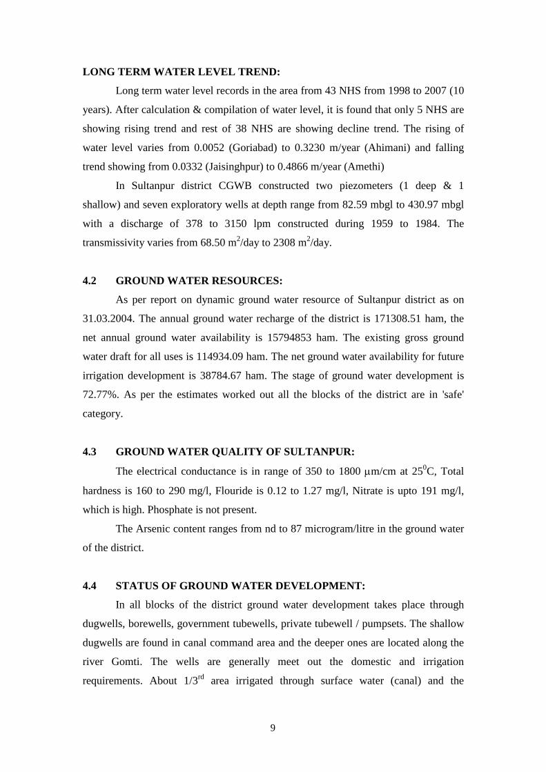
4.2 GROUND WATER RESOURCES:
As per report on dynamic ground water resource of Sultanpur district as on
31.03.2004. The annual ground water recharge of the district is 171308.51 ham, the
net annual ground water availability is 15794853 ham. The existing gross ground
water draft for all uses is 114934.09 ham. The net ground water availability for future
irrigation development is 38784.67 ham. The stage of ground water development is
72.77%. As per the estimates worked out all the blocks of the district are in 'safe'
category.
4.3 GROUND WATER QUALITY OF SULTANPUR:
The electrical conductance is in range of 350 to 1800 µm/cm at 250
In all blocks of the district ground water development takes place through
dugwells, borewells, government tubewells, private tubewell / pumpsets. The shallow
dugwells are found in canal command area and the deeper ones are located along the
river Gomti. The wells are generally meet out the domestic and irrigation
requirements. About 1/3
C, Total
hardness is 160 to 290 mg/l, Flouride is 0.12 to 1.27 mg/l, Nitrate is upto 191 mg/l,
which is high. Phosphate is not present.
The Arsenic content ranges from nd to 87 microgram/litre in the ground water
of the district.
4.4 STATUS OF GROUND WATER DEVELOPMENT:
rd area irrigated through surface water (canal) and the
10
remaining 2/3rd area irrigated through ground water. There are 757 numbers of state
tubewells, irrigates 9446 ha area. The maximum numbers of state tubewells found in
Kadipur block (79 Nos.) & minimum in Gauriganj block (3 Nos.). The private
tubewell are 132832 in the district irrigates 160860 ha area of the district. The
minimum number of private tubewells are in Sangrampur block (2627 Nos.) &
maximum number are in Akhand Nagar block (11122 Nos). The canal is 1876 km in
the district irrigates 62887 ha area. It shows that 2/3rd area irrigated by ground water
& 1/3rd
Sl. No.
area irrigated by surface water.
CGWB constructed 6 no. tubewells & 2 no. Pz under exploratory programme.
The yield of tubewell is 378 to 3150 lpm with drawdown 6.1 to 25.66 m. The total
number of 2499 handpumps constructed in the district showing one handpump in each
village.
DYNAMIC GROUND WATER RESOURCES OF SULTANPUR
(As on 31.03.2004)
Assessment Units-Blocks
Annual Ground Water
Recharge (in ham)
Net Annual Ground Water
Availability (in ham)
Existing Gross
Ground Water Draft For All Uses
(in ham)
Net Ground Water
Availability For Future Irrigation
Development (in ham)
Stage of Ground Water
Development (in %)
Category of Block
1. Akhand Nagar 8972.76 8524.12 7073.53 1371.67 82.98 Safe
2. Amethi 5445.71 5173.43 4147.15 877.14 80.16 Safe
3. Baldirai 7625.90 7244.60 5602.31 1394.40 77.33 Safe
4. Bhadar 6577.83 6248.94 4357.42 1707.11 69.73 Safe
5. Bhadiyan 7642.92 7260.77 5644.98 1384.69 77.75 Safe
6. Bhetua 6885.15 6196.63 4807.23 1184.34 77.58 Safe
8. Dhanpatganj 10556.11 10028.30 6718.54 3118.51 67.00 Safe
9. Dostpur 9337.00 8870.15 7540.80 1108.38 85.01 Safe
10. Dubeypur 6549.06 5894.16 5189.78 436.56 88.05 Safe
11. Jagdishpur 7047.28 6342.55 3938.05 2164.80 62.09 Safe
12. Jaisinghpur 9070.34 8163.31 6020.80 1867.83 73.75 Safe
13. Jamo 9938.77 8944.90 5205.76 3556.56 58.20 Safe
14. Kadipur 10736.74 9663.07 6367.61 3073.18 65.90 Safe
15. Kuribhar 9935.24 8941.72 6355.79 2364.25 71.08 Safe
16. Kurwar 8702.18 7831.96 6428.19 1083.13 82.08 Safe
11
Sl. No.
Assessment Units-Blocks
Annual Ground Water
Recharge (in ham)
Net Annual Ground Water
Availability (in ham)
Existing Gross
Ground Water Draft For All Uses
(in ham)
Net Ground Water
Availability For Future Irrigation
Development (in ham)
Stage of Ground Water
Development (in %)
Category of Block
17. Lambhua 9358.20 8890.29 6534.38 2181.85 73.50 Safe
18. Musafirkhana 6241.83 5617.65 4585.82 928.74 81.63 Safe
19. Pratappur 6748.91 6411.46 3789.43 2454.61 59.10 Safe
20. Sangrampur 3152.06 2994.46 2359.55 492.89 78.80 Safe
21. Shahgarh 7066.41 6359.77 3069.82 3213.33 48.27 Safe
22. Shukul Bazar 7205.13 6484.61 4064.34 2243.38 62.68 Safe
TOTAL 171308.51 157948.53 114934.09 38784.67 72.77
5.0 GROUND WATER MANAGEMENT STRATEGY
5.1 GROUND WATER DEVELOPMENT:
The stage of ground water development in the district is 72.77%. The
maximum stage of ground water development is in the Dubeypur block (88.05%) and
minimum stage of development is in Shahgarh block (48.27%). All the 23 blocks of
Sultanpur district are in 'Safe' category.
5.2 WATER CONSERVATION STRUCTURE & ARTIFICIAL RECHARGE:
The southern part of the district especially Sultanpur proper and Lambua tehsil
where water level is more than 10.00 mbgl. Artificial recharge to the ground water
may be implemented through roof top rain water harvesting method.
6.0 GROUND WATER RELATED ISSUES AND PROBLEMS
In western part of the district especially in Jamo and Gauriganj block water
logged prone to logged and salinity problem was noticed. In those blocks water level
recorded around 2.00 to 3.00 mbgl.
12
8.0 RECOMMENDATIONS
(1) In southern part of district mainly in Sultanpur proper and in Lambua tehsil
the water level recorded more than 10.00 mbgl. In those 6 tehsils artificial
recharge of ground water through roof top rain water harvesting must be
adopted.
(2) The network of canal must be discouraged at the western part of district (Jamo
and Gauriganj block) where depth to water level is around 2.00 mbgl. At these
places water logging & associated salinity is a common problem. The canal
network must be encouraged at southeastern part of the district where water
level is >10.00 mbgl. It will help in recharge of ground water.
13
14
15
16
Copyright © 2022 FDOKUMEN

