


Bahasa
Halaman
Hukum

33
EXCAVATIONS ON THE ISLAND OF KLOOSTRISAAR. SOME REFLECTIONS ON THE STONE AGE SETTLEMENT PATTERN IN SOUTH ESTONIA
KRISTIINA JOHANSON Tartu Ülikool, Ajaloo ja arheoloogia instituut, Arheoloogia osakond (University of Tartu, Institute of History and Archaeology, Department of Archaeology), Jakobi 2, 51014 Tartu, Estonia; [email protected]
ULLA KADAKASMuinsuskaitseamet (National Heritage Board), Uus 18, 10111 Tallinn, Estonia
MARI TÕRV Tartu Ülikool, Ajaloo ja arheoloogia instituut, Arheoloogia osakond (University of Tartu, Institute of History and Archaeology, Department of Archaeology), Jakobi 2, 51014 Tartu, Estonia; Zentrum für Baltische und Skandinavische Archäologie, Stiftung Schleswig-Holsteinische Landesmuseen, Schloss Gottorf, D-24837 Schleswig, Germany
ANDRES VINDITartu Ülikool, Ajaloo ja arheoloogia instituut, Arheoloogia osakond (University of Tartu, Institute of History and Archaeology, Department of Archaeology), Jakobi 2, 51014 Tartu, Estonia
PROLOGUEKloostrisaar (Eng. ‘Monastery Island’) is an island in Lake Pühajärv which is situ-ated in the Otepää Heights in South Estonia. The island with an area of 11520 m2 has 8 m high shores. According to folklore text a monastery, which was destroyed during a huge war, was situated on the island (Rebane 1929, 7–8).1 in 2012 Andres Vindi and Tõnis Türna visited the island with two purposes in mind: first, to check the oral tradition, and second, out of growing interest in the possible Stone Age set-tlement on islands in small inland lakes (Vindi 2012). They found flint flakes, pieces of burnt bone and three sherds of handmade pottery2 from the lower sandy plateau in the northern part of the island (ibid.). Since the pottery was not earlier than the Iron Age, the site was implicitly titled as a Mesolithic settlement site and an Iron Age find place. Motivated by the interest in possible Stone Age settlement sites on islands in small lakes it was decided to conduct smallscale archaeological excavations on
ArchAeologicAl Fieldwork in estoniA 2013, 33–44
1 There used to be a monastery once on Kloostrisaar in Pühajärv and monks lived there. The nobles did not like them and wanted to get rid of them. Then a big war came. For ten years war was waged from mornings till evenings on the shores of Pühajärv. There were so many dead people that even now the churchyard of Otepää is filled with bones to the depth of many fathoms. Many bones have been found also elsewhere around Lake Pühajärv – all the monks were killed on the island. Only three of them, who were not local, could hide themselves in the thatches by the lake and thus survived (Rebane 1929, 7–8; translated by Kristiina Johanson).2 Finds TÜ 2165.
34
KRISTIINA JOHANSON et al.
Kloostrisaar in 2013. The excavations had two purposes: 1) to determine the charac-ter and extent of the Mesolithic habitation on the island, 2) since relatively few exca-vations have been made on Stone Age sites on hilly areas and even these have been a side product of the excavations from later periods (e.g. Tsiistre in Haanja Upland, Viljandi Castle of Livonian Order), we hoped that the excavation on Kloostrisaar would offer comparative material to the Mesolithic sites that are usually situated on lower areas on the shores of rivers and inland lakes. The present article summarises the excavation results of Kloostrisaar. The more or less simultaneous occupation sites from South Estonia, which will be discussed in the second part of the article, form a wider background to the settlement history on Kloostrisaar.
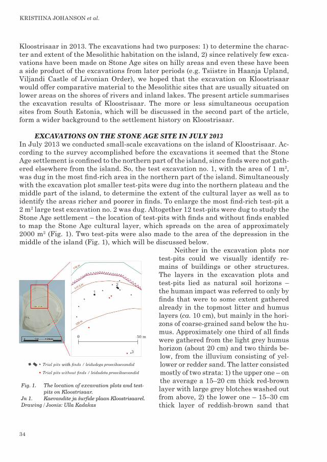
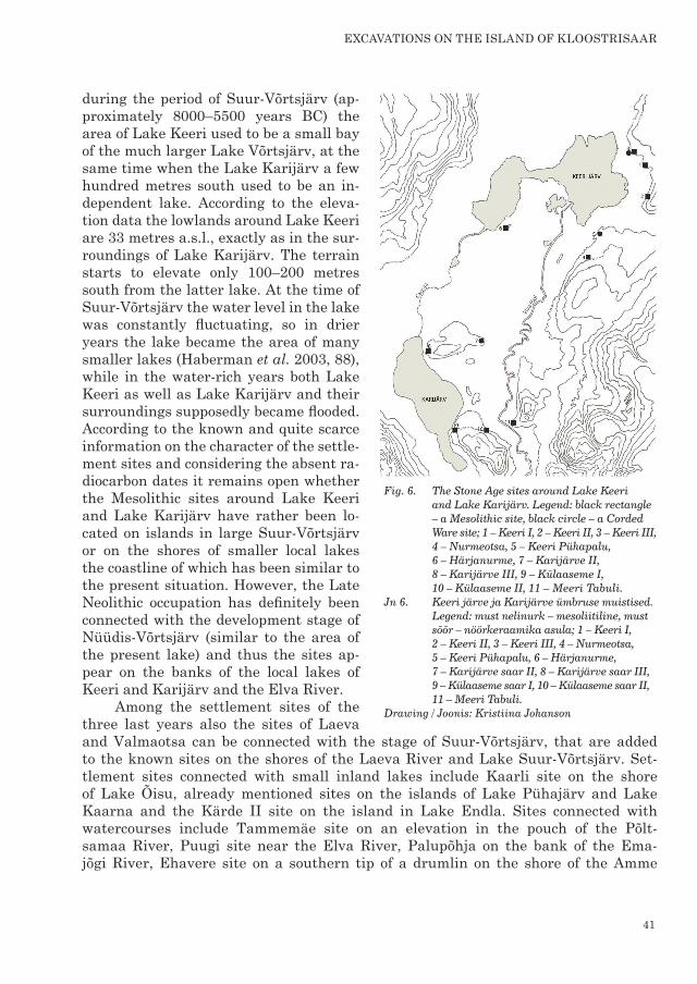
EXCAVATIONS ON THE STONE AGE SITE IN JULY 2013In July 2013 we conducted smallscale excavations on the island of Kloostrisaar. Ac-cording to the survey accomplished before the excavations it seemed that the Stone Age settlement is confined to the northern part of the island, since finds were not gath-ered elsewhere from the island. So, the test excavation no. 1, with the area of 1 m2, was dug in the most findrich area in the northern part of the island. Simultaneously with the excavation plot smaller testpits were dug into the northern plateau and the middle part of the island, to determine the extent of the cultural layer as well as to identify the areas richer and poorer in finds. To enlarge the most findrich testpit a 2 m2 large test excavation no. 2 was dug. Altogether 12 testpits were dug to study the Stone Age settlement – the location of testpits with finds and without finds enabled to map the Stone Age cultural layer, which spreads on the area of approximately 2000 m2 (Fig. 1). Two testpits were also made to the area of the depression in the middle of the island (Fig. 1), which will be discussed below.
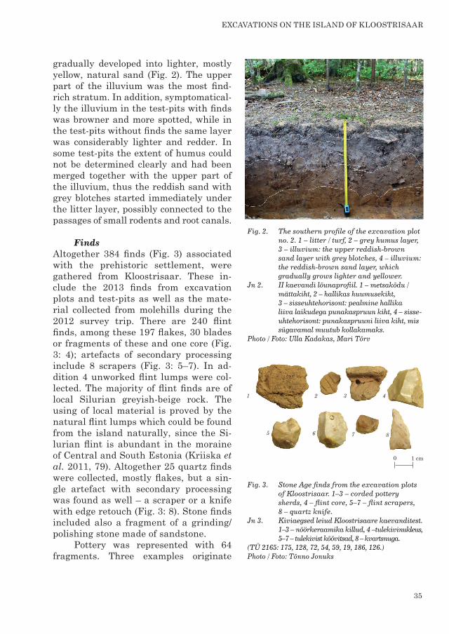
Neither in the excavation plots nor testpits could we visually identify re-mains of buildings or other structures. The layers in the excavation plots and testpits lied as natural soil horizons – the human impact was referred to only by finds that were to some extent gathered already in the topmost litter and humus layers (ca. 10 cm), but mainly in the hori-zons of coarsegrained sand below the hu-mus. Approximately one third of all finds were gathered from the light grey humus horizon (about 20 cm) and two thirds be-low, from the illuvium consisting of yel-lower or redder sand. The latter consisted mostly of two strata: 1) the upper one – on the average a 15–20 cm thick redbrown layer with large grey blotches washed out from above, 2) the lower one – 15–30 cm thick layer of reddishbrown sand that
Fig. 1. The location of excavation plots and test- pits on Kloostrisaar.Jn 1. Kaevandite ja šurfide plaan Kloostrisaarel. Drawing / Joonis: Ulla Kadakas
35
gradually developed into lighter, mostly yellow, natural sand (Fig. 2). The upper part of the illuvium was the most findrich stratum. In addition, symptomatical-ly the illuvium in the testpits with finds was browner and more spotted, while in the testpits without finds the same layer was considerably lighter and redder. In some testpits the extent of humus could not be determined clearly and had been merged together with the upper part of the illuvium, thus the reddish sand with grey blotches started immediately under the litter layer, possibly connected to the passages of small rodents and root canals.
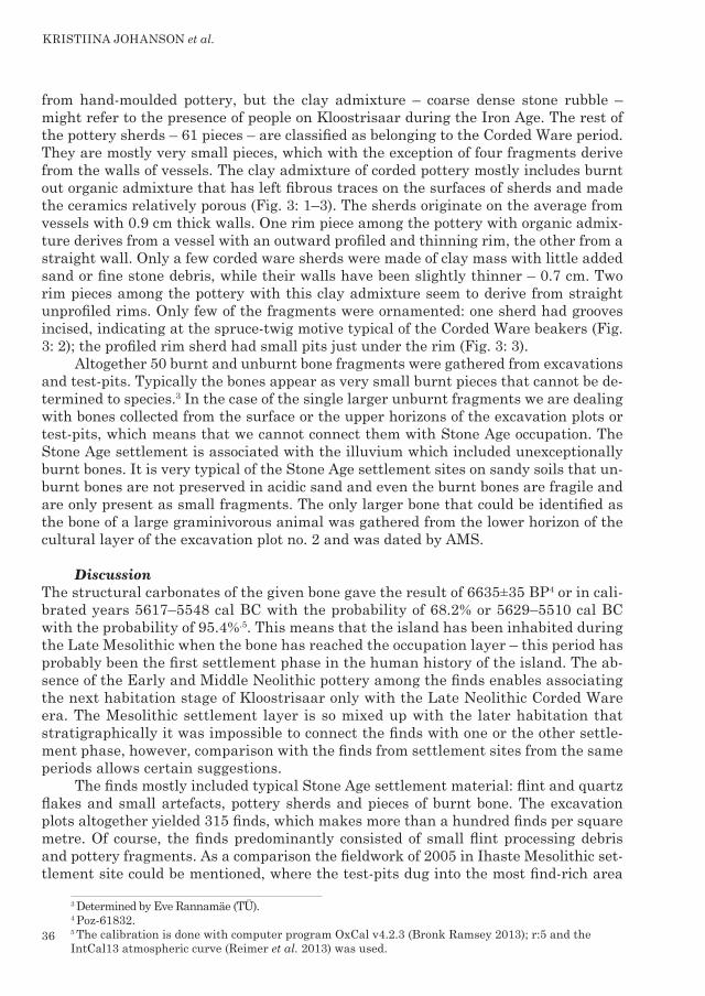
FindsAltogether 384 finds (Fig. 3) associated with the prehistoric settlement, were gathered from kloostrisaar. these in-clude the 2013 finds from excavation plots and testpits as well as the mate-rial collected from molehills during the 2012 survey trip. There are 240 flint finds, among these 197 flakes, 30 blades or fragments of these and one core (Fig. 3: 4); artefacts of secondary processing include 8 scrapers (Fig. 3: 5–7). In ad-dition 4 unworked flint lumps were col-lected. The majority of flint finds are of local Silurian greyishbeige rock. The using of local material is proved by the natural flint lumps which could be found from the island naturally, since the Si-lurian flint is abundant in the moraine of central and south estonia (kriiska et al. 2011, 79). Altogether 25 quartz finds were collected, mostly flakes, but a sin-gle artefact with secondary processing was found as well – a scraper or a knife with edge retouch (Fig. 3: 8). Stone finds included also a fragment of a grinding/polishing stone made of sandstone.
Pottery was represented with 64 fragments. Three examples originate
eXcAVAtions on the islAnd oF kloostrisAAr
Fig. 2. The southern profile of the excavation plot no. 2. 1 – litter / turf, 2 – grey humus layer, 3 – illuvium: the upper reddish-brown sand layer with grey blotches, 4 – illuvium: the reddish-brown sand layer, which gradually grows lighter and yellower. Jn 2. II kaevandi lõunaprofiil. 1 – metsakõdu / mättakiht, 2 – hallikas huumusekiht,
3 – sisseuhtehorisont: peal mine hallika liiva laikudega punakaspruun kiht, 4 – sisse- uhtehorisont: punakaspruuni liiva kiht, mis sügavamal muutub kollakamaks. Photo / Foto: Ulla Kadakas, Mari Tõrv
Fig. 3. Stone Age finds from the excavation plots of Kloostrisaar. 1–3 – corded pottery sherds, 4 – flint core, 5–7 – flint scrapers, 8 – quartz knife.Jn 3. Kiviaegsed leiud Kloostrisaare kaevanditest. 1–3 – nöörkeraamika killud, 4 –tulekivinukleus, 5–7 – tulekivist kõõvitsad, 8 – kvartsnuga.(TÜ 2165: 175, 128, 72, 54, 59, 19, 186, 126.) Photo / Foto: Tõnno Jonuks
36
from handmoulded pottery, but the clay admixture – coarse dense stone rubble – might refer to the presence of people on Kloostrisaar during the Iron Age. The rest of the pottery sherds – 61 pieces – are classified as belonging to the Corded Ware period. They are mostly very small pieces, which with the exception of four fragments derive from the walls of vessels. The clay admixture of corded pottery mostly includes burnt out organic admixture that has left fibrous traces on the surfaces of sherds and made the ceramics relatively porous (Fig. 3: 1–3). The sherds originate on the average from vessels with 0.9 cm thick walls. One rim piece among the pottery with organic admix-ture derives from a vessel with an outward profiled and thinning rim, the other from a straight wall. Only a few corded ware sherds were made of clay mass with little added sand or fine stone debris, while their walls have been slightly thinner – 0.7 cm. Two rim pieces among the pottery with this clay admixture seem to derive from straight unprofiled rims. Only few of the fragments were ornamented: one sherd had grooves incised, indicating at the sprucetwig motive typical of the Corded Ware beakers (Fig. 3: 2); the profiled rim sherd had small pits just under the rim (Fig. 3: 3).
Altogether 50 burnt and unburnt bone fragments were gathered from excavations and testpits. Typically the bones appear as very small burnt pieces that cannot be de-termined to species.3 In the case of the single larger unburnt fragments we are dealing with bones collected from the surface or the upper horizons of the excavation plots or testpits, which means that we cannot connect them with Stone Age occupation. The Stone Age settlement is associated with the illuvium which included unexceptionally burnt bones. It is very typical of the Stone Age settlement sites on sandy soils that un-burnt bones are not preserved in acidic sand and even the burnt bones are fragile and are only present as small fragments. The only larger bone that could be identified as the bone of a large graminivorous animal was gathered from the lower horizon of the cultural layer of the excavation plot no. 2 and was dated by AMS.
DiscussionThe structural carbonates of the given bone gave the result of 6635±35 BP4 or in cali-brated years 5617–5548 cal BC with the probability of 68.2% or 5629–5510 cal BC with the probability of 95.4%.5. this means that the island has been inhabited during the Late Mesolithic when the bone has reached the occupation layer – this period has probably been the first settlement phase in the human history of the island. The ab-sence of the Early and Middle Neolithic pottery among the finds enables associating the next habitation stage of Kloostrisaar only with the Late Neolithic Corded Ware era. The Mesolithic settlement layer is so mixed up with the later habitation that stratigraphically it was impossible to connect the finds with one or the other settle-ment phase, however, comparison with the finds from settlement sites from the same periods allows certain suggestions.
The finds mostly included typical Stone Age settlement material: flint and quartz flakes and small artefacts, pottery sherds and pieces of burnt bone. The excavation plots altogether yielded 315 finds, which makes more than a hundred finds per square metre. Of course, the finds predominantly consisted of small flint processing debris and pottery fragments. As a comparison the fieldwork of 2005 in Ihaste Mesolithic set-tlement site could be mentioned, where the testpits dug into the most findrich area
3 Determined by Eve Rannamäe (TÜ).4 Poz-61832.5 The calibration is done with computer program OxCal v4.2.3 (Bronk Ramsey 2013); r:5 and the IntCal13 atmospheric curve (Reimer et al. 2013) was used.
KRISTIINA JOHANSON et al.
37
yielded 30–40 flint finds and 60 burnt bone pieces. Roughly calculated, it makes 300–400 finds per square metre (comp. Johanson & Kriiska 2007, 146). The find density on Estonian islands is 18–797 finds per square metre (Kriiska 2003, 36), which depends on whether we are dealing with the central part or the periphery of the site, but also on the length of the habitation. Judging by the find density of testpits on Kloostrisaar we can conclude that the most intensive habitation is confined to the northern plateau of the island at and around the excavation plots. Considering that we are dealing with the settlement from at least two different periods, the find density of Kloostrisaar prob-ably refers to shortterm and/or episodic habitation stages.
The flint finds include altogether eight black translucent Cretaceous flint flakes, which makes 3.3% of all flint finds. The kind of flint, that has been imported to the site probably from the South Lithuanian flint outcrops, is found from the settlement sites of all Stone Age periods, but is most abundant during the Early and Middle Meso-lithic (Kriiska & Tvauri 2002, 44). In addition we should mention the share of flint blades – 8% of all flint finds. The presence of blades has been suggested as one of the characteristics of the Mesolithic settlement sites (Kriiska & Lõugas 2009, 172), while in the Neolithic, and especially Late Neolithic Corded Ware settlement sites flint is very scarce and stone finds mostly form a very small part among the finds, especially when compared to the share of pottery (e.g. in case of Riigiküla XIV (Kriiska 2000, 63)). The share of blades is relatively similar to several other sites from the second half of the Mesolithic – an analogous percentage of blades among finds has occurred in SindiLodja (14.1%) (Kriiska et al. 2002, 33–34), Kivisaare (11.4%) (Kriiska et al. 2003, 36) and Kavastu (20.1%) (Tvauri & Johanson 2006, 42) (but e.g. comp. with the Early Mesolithic sites in Pulli (40.1%) or Ihaste (28.3%) (Moora et al. 2006, 154)), which con-firms the suggestion that during the Mesolithic the share of blades gradually decreases (Jussila et al. 2012, 20).
Considering the described transformation of Mesolithic flint industry with time, the share of blades should gradually decrease further and be much smaller in the Neo-lithic sites. At the moment the hypothesis is difficult to be checked, since the Neolithic Comb Ware sites with largescale excavations during the last years have been settle-ments where the majority of finds are of quartz – e.g. in Jägala (11.2% of blades among the finds of 2005) (Johanson & Veldi 2006, 36) or Vabaduse Square site in Tallinn (18% of blades) (Kadakas 2013, 445). But the sites with quartz cannot be equally treated, since the fracturing of quartz differs from flint and thus the principles of its knap-ping are different as well. In the case of Comb Ware settlements with flint majority we mostly refer to the excavations of Richard Indreko and Lembit Jaanits, the results of which should not be treated on equal bases as well, since e.g. in the case of Kunda Lammasmägi it has been shown that the find density of the excavations of Indreko and Jaanits was considerably smaller than in the excavations of 2013 and 2014 (Sander 2014, 32ff); here the number of finds has probably increased on the account of unim-pressive flakes, that in Indreko’s and Jaanits’ case would convert the share of blades artificially higher than it really is. However, examples of this ‘Neolithic tendency’ can be found from the NarvaJõesuu IIA settlement site, where the 247 finds from two test excavations of 2010 only included 25 stone finds with only 3 flint finds, while the major-ity of finds were pottery of the Comb Ware period (Kriiska & Nordqvist 2012a, 23). The
eXcAVAtions on the islAnd oF kloostrisAAr
38
tendency is very clear in the case of the Corded Ware sites. In Estonia, only two sites have revealed the habitation traces of singularly this Late Neolithic period – Riigiküla XIV and Ruhnu Valgi. In the material of Riigiküla XIV stone finds are basically absent – next to almost 2000 pottery sherds only few quartz flakes were gathered (Kriiska 2000, 63); in Ruhnu Valgi site only few flint flakes were gathered (Kriiska & Nordqvist 2012b, 12–14).
So, the bone date of Kloostrisaar has confirmed the suggestion formed during the analysis of finds that the site was inhabited in two different periods, where the majority of flint finds have been left behind from the Mesolithic occupation, whereas the pottery sherds and probably only a few flint finds can be associated with the Late Neolithic Corded Ware period.
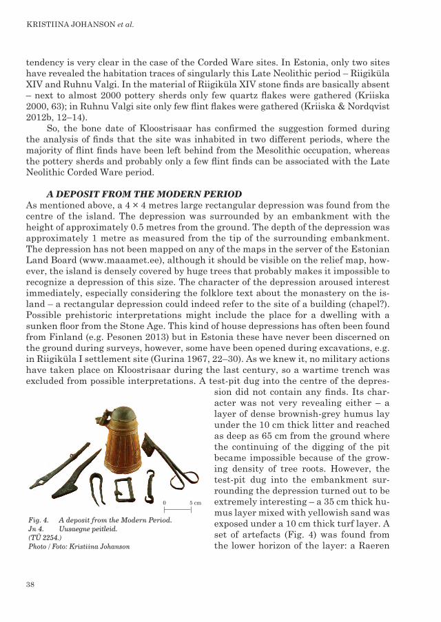
A DEPOSIT FROM THE MODERN PERIODAs mentioned above, a 4 × 4 metres large rectangular depression was found from the centre of the island. The depression was surrounded by an embankment with the height of approximately 0.5 metres from the ground. The depth of the depression was approximately 1 metre as measured from the tip of the surrounding embankment. The depression has not been mapped on any of the maps in the server of the Estonian Land Board (www.maaamet.ee), although it should be visible on the relief map, how-ever, the island is densely covered by huge trees that probably makes it impossible to recognize a depression of this size. The character of the depression aroused interest immediately, especially considering the folklore text about the monastery on the is-land – a rectangular depression could indeed refer to the site of a building (chapel?). Possible prehistoric interpretations might include the place for a dwelling with a sunken floor from the Stone Age. This kind of house depressions has often been found from Finland (e.g. Pesonen 2013) but in Estonia these have never been discerned on the ground during surveys, however, some have been opened during excavations, e.g. in Riigiküla I settlement site (Gurina 1967, 22–30). As we knew it, no military actions have taken place on Kloostrisaar during the last century, so a wartime trench was excluded from possible interpretations. A testpit dug into the centre of the depres-
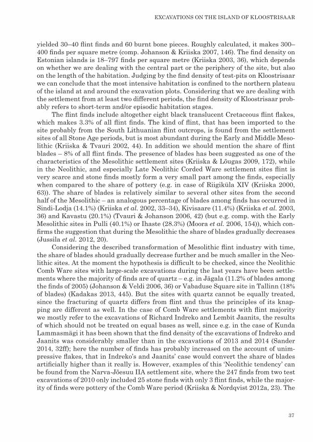
sion did not contain any finds. Its char-acter was not very revealing either – a layer of dense brownishgrey humus lay under the 10 cm thick litter and reached as deep as 65 cm from the ground where the continuing of the digging of the pit became impossible because of the grow-ing density of tree roots. However, the testpit dug into the embankment sur-rounding the depression turned out to be extremely interesting – a 35 cm thick hu-mus layer mixed with yellowish sand was exposed under a 10 cm thick turf layer. A set of artefacts (Fig. 4) was found from the lower horizon of the layer: a Raeren
Fig. 4. A deposit from the Modern Period.Jn 4. Uusaegne peitleid. (TÜ 2254.)Photo / Foto: Kristiina Johanson
KRISTIINA JOHANSON et al.
39
stoneware tankard and six iron artefacts – candle wick trimmers, a belt buckle, two iron door details and two fragments of bridles. The type of stoneware was produced in Raeren in 1550–1620 (Russow 2006, 57). So, the burying of these items could have taken place approximately in this period, possibly during the PolishSwedish wars (1600–1629). Finding a reason to the deposition is much more complicated and we leave the issue to the hands of the specialists of the Modern Period.
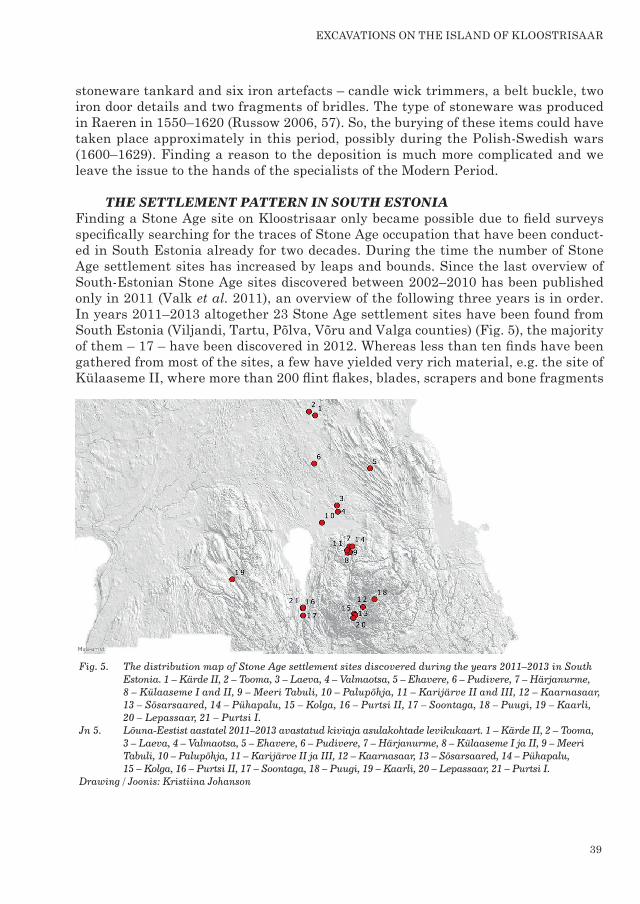
THE SETTLEMENT PATTERN IN SOUTH ESTONIAFinding a Stone Age site on Kloostrisaar only became possible due to field surveys specifically searching for the traces of Stone Age occupation that have been conduct-ed in South Estonia already for two decades. During the time the number of Stone Age settlement sites has increased by leaps and bounds. Since the last overview of SouthEstonian Stone Age sites discovered between 2002–2010 has been published only in 2011 (Valk et al. 2011), an overview of the following three years is in order. In years 2011–2013 altogether 23 Stone Age settlement sites have been found from South Estonia (Viljandi, Tartu, Põlva, Võru and Valga counties) (Fig. 5), the majority of them – 17 – have been discovered in 2012. Whereas less than ten finds have been gathered from most of the sites, a few have yielded very rich material, e.g. the site of Külaaseme II, where more than 200 flint flakes, blades, scrapers and bone fragments
Fig. 5. The distribution map of Stone Age settlement sites discovered during the years 2011–2013 in South Estonia. 1 – Kärde II, 2 – Tooma, 3 – Laeva, 4 – Valmaotsa, 5 – Ehavere, 6 – Pudivere, 7 – Härjanurme, 8 – Külaaseme I and II, 9 – Meeri Tabuli, 10 – Palupõhja, 11 – Karijärve II and III, 12 – Kaarnasaar, 13 – Sõsarsaared, 14 – Pühapalu, 15 – Kolga, 16 – Purtsi II, 17 – Soontaga, 18 – Puugi, 19 – Kaarli, 20 – Lepassaar, 21 – Purtsi I. Jn 5. Lõuna-Eestist aastatel 2011–2013 avastatud kiviaja asulakohtade levikukaart. 1 – Kärde II, 2 – Tooma, 3 – Laeva, 4 – Valmaotsa, 5 – Ehavere, 6 – Pudivere, 7 – Härjanurme, 8 – Külaaseme I ja II, 9 – Meeri Tabuli, 10 – Palupõhja, 11 – Karijärve II ja III, 12 – Kaarnasaar, 13 – Sõsarsaared, 14 – Pühapalu, 15 – Kolga, 16 – Purtsi II, 17 – Soontaga, 18 – Puugi, 19 – Kaarli, 20 – Lepassaar, 21 – Purtsi I. Drawing / Joonis: Kristiina Johanson
eXcAVAtions on the islAnd oF kloostrisAAr
40
were collected from sandy forest path. The majority of the sites (18) can be connected with the Mesolithic period: Laeva, Valmaotsa, Pudivere, Ehavere, Härjanurme, Kü-laaseme I and II, Meeri, Palupõhja, Karijärve III, the island of Kaarnasaar, the is-land of Sõsarsaar, Kolga, Purtsi II, Soontaga, Puugi. Several of the sites also yielded handmade pottery, which rather derives from some Iron Age period. From the re-maining five sites corded pottery was gathered in addition to stone finds. In case of only one of these we could talk about the twolayered settlement as in Kloostrisaar – a few sherds of corded pottery were gathered from the Purtsi I settlement site in addition to abundant flint flakes and blades, which rather refer to the Mesolithic oc-cupation. The other sites with Stone Age pottery – Tooma, Keeri Pühapalu, Kaarli, Lepassaar, Karijärve II – have yielded so few stone finds which might confirm the poverty in stone finds of the sites of the Corded Ware period. But it should be admit-ted that in order to draw wider conclusions more finds should be gathered from the same sites. The excavations on Kloostrisaar showed clearly how it is impossible to adequately assess the usage period of settlement sites only on the basis of the finds from survey trips.
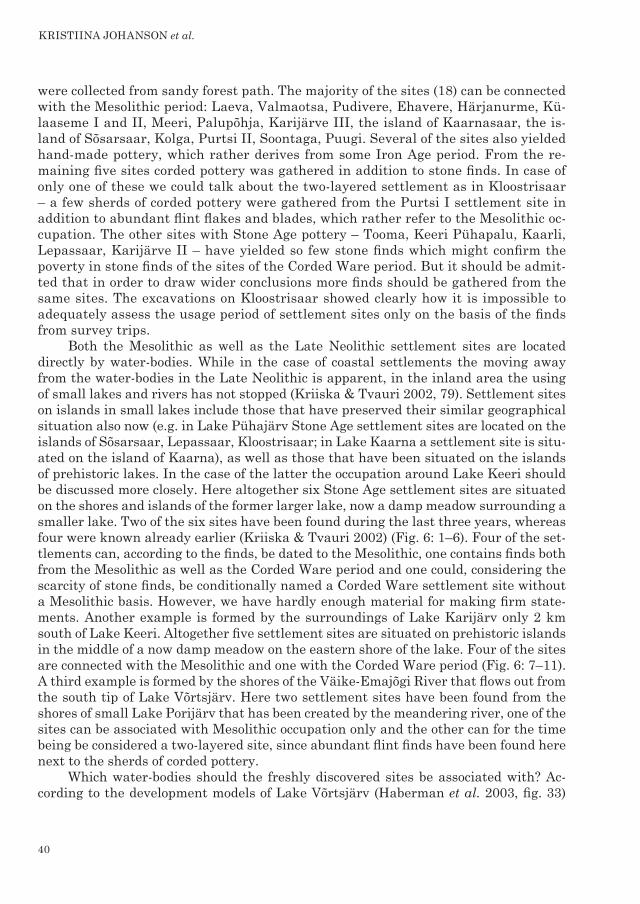
Both the Mesolithic as well as the Late Neolithic settlement sites are located directly by waterbodies. While in the case of coastal settlements the moving away from the waterbodies in the Late Neolithic is apparent, in the inland area the using of small lakes and rivers has not stopped (Kriiska & Tvauri 2002, 79). Settlement sites on islands in small lakes include those that have preserved their similar geographical situation also now (e.g. in Lake Pühajärv Stone Age settlement sites are located on the islands of Sõsarsaar, Lepassaar, Kloostrisaar; in Lake Kaarna a settlement site is situ-ated on the island of Kaarna), as well as those that have been situated on the islands of prehistoric lakes. In the case of the latter the occupation around Lake Keeri should be discussed more closely. Here altogether six Stone Age settlement sites are situated on the shores and islands of the former larger lake, now a damp meadow surrounding a smaller lake. Two of the six sites have been found during the last three years, whereas four were known already earlier (Kriiska & Tvauri 2002) (Fig. 6: 1–6). Four of the set-tlements can, according to the finds, be dated to the Mesolithic, one contains finds both from the Mesolithic as well as the Corded Ware period and one could, considering the scarcity of stone finds, be conditionally named a Corded Ware settlement site without a Mesolithic basis. However, we have hardly enough material for making firm state-ments. Another example is formed by the surroundings of Lake Karijärv only 2 km south of Lake Keeri. Altogether five settlement sites are situated on prehistoric islands in the middle of a now damp meadow on the eastern shore of the lake. Four of the sites are connected with the Mesolithic and one with the Corded Ware period (Fig. 6: 7–11). A third example is formed by the shores of the VäikeEmajõgi River that flows out from the south tip of Lake Võrtsjärv. Here two settlement sites have been found from the shores of small Lake Porijärv that has been created by the meandering river, one of the sites can be associated with Mesolithic occupation only and the other can for the time being be considered a twolayered site, since abundant flint finds have been found here next to the sherds of corded pottery.
Which waterbodies should the freshly discovered sites be associated with? Ac-cording to the development models of Lake Võrtsjärv (Haberman et al. 2003, fig. 33)
KRISTIINA JOHANSON et al.
41
during the period of SuurVõrtsjärv (ap-proximately 8000–5500 years BC) the area of Lake Keeri used to be a small bay of the much larger Lake Võrtsjärv, at the same time when the Lake Karijärv a few hundred metres south used to be an in-dependent lake. According to the eleva-tion data the lowlands around Lake Keeri are 33 metres a.s.l., exactly as in the sur-roundings of Lake Karijärv. The terrain starts to elevate only 100–200 metres south from the latter lake. At the time of SuurVõrtsjärv the water level in the lake was constantly fluctuating, so in drier years the lake became the area of many smaller lakes (haberman et al. 2003, 88), while in the waterrich years both Lake Keeri as well as Lake Karijärv and their surroundings supposedly became flooded. According to the known and quite scarce information on the character of the settle-ment sites and considering the absent ra-diocarbon dates it remains open whether the Mesolithic sites around lake keeri and Lake Karijärv have rather been lo-cated on islands in large SuurVõrtsjärv or on the shores of smaller local lakes the coastline of which has been similar to the present situation. However, the Late Neolithic occupation has definitely been connected with the development stage of NüüdisVõrtsjärv (similar to the area of the present lake) and thus the sites ap-pear on the banks of the local lakes of Keeri and Karijärv and the Elva River.
Among the settlement sites of the three last years also the sites of Laeva and Valmaotsa can be connected with the stage of SuurVõrtsjärv, that are added to the known sites on the shores of the Laeva River and Lake SuurVõrtsjärv. Set-tlement sites connected with small inland lakes include Kaarli site on the shore of Lake Õisu, already mentioned sites on the islands of Lake Pühajärv and Lake Kaarna and the Kärde II site on the island in Lake Endla. Sites connected with watercourses include Tammemäe site on an elevation in the pouch of the Põlt-samaa River, Puugi site near the Elva River, Palupõhja on the bank of the Ema-jõgi River, Ehavere site on a southern tip of a drumlin on the shore of the Amme
Fig. 6. The Stone Age sites around Lake Keeri and Lake Karijärv. Legend: black rectangle – a Mesolithic site, black circle – a Corded Ware site; 1 – Keeri I, 2 – Keeri II, 3 – Keeri III, 4 – Nurmeotsa, 5 – Keeri Pühapalu,
6 – Härjanurme, 7 – Karijärve II, 8 – Karijärve III, 9 – Külaaseme I, 10 – Külaaseme II, 11 – Meeri Tabuli. Jn 6. Keeri järve ja Karijärve ümbruse muistised.
Legend: must nelinurk – mesoliitiline, must sõõr – nöörkeraamika asula; 1 – Keeri I, 2 – Keeri II, 3 – Keeri III, 4 – Nurmeotsa,
5 – Keeri Pühapalu, 6 – Härjanurme, 7 – Karijärve saar II, 8 – Karijärve saar III,
9 – Külaaseme saar I, 10 – Külaaseme saar II, 11 – Meeri Tabuli. Drawing / Joonis: Kristiina Johanson
eXcAVAtions on the islAnd oF kloostrisAAr
42
River, and both Purtsi sites on the shore of the VäikeEmajõgi River. The ma-jority of the Stone Age sites, both Mesolithic and Neolithic, discovered in South Estonia during the last three years, are located very logically in the context of the Stone Age (the shores and islands of Lake SuurVõrtsjärv, shores and islands of small lakes, banks of rivers), that can be followed also in the present landscape. However, Pudivere site has probably been situated on the shore of some more marginal watercourse or a spring that has been drained during the melioration and is no longer visible. The lat-ter is a good example of a Stone Age settlement site which location is illogical in the present landscape.
The settlement site on Kloostrisaar fits well into the general picture of Stone Age habitation in south estonia. the co-existence of the Mesolithic and corded ware settle ment site, whether in exactly the same place (e.g. in Kloostrisaar, Purtsi, Keeri iii) or at least in the same area (e.g. in the surroundings of lake keeri and lake kari-järv, the damp meadow in Pikasilla area) is interesting and intriguing, and we cannot connect it only with the research situation (comp. with Comb Ware settlements that have very rarely been discovered during the last years). Maybe the sites of the Corded Ware period were rather shortterm sites, e.g. fishing camps, that namely for this rea-son were situated in the same area with the Mesolithic foraging sites, while the larger mother villages have rather been situated somewhere inland. In the case of the coastal areas and islands the sites habitable during the Mesolithic were situated already far away from the coastline during the Late Neolithic. However, in the cases described in this article, the shoreline of the islands and banks of small lakes have not changed at all or have altered only slightly, so all the discovered Corded Ware sites are situated in the areas with continuing good foraging potential. Of course, microlevel studies for all the discussed sites are in order and should be done in the future.
SUMMARYThe excavations in Kloostrisaar, although smallscale, have shed light on the Stone Age habitation on the island, but also raised questions about the nature of the sites of the Corded Ware period and the habitation pattern of different Stone Age periods. In addition, Kloostrisaar is remarkable by the deposition from the Modern Period that has raised many speculations and interpretations.
Acknowledgements: We wish to thank Tõnno Jonuks and Villu Kadakas for their in-dispensable assistance during the excavation and fruitful discussion, Aivar Kriiska for valuable comments and all the members of the expedition for their time and effort. Special thanks go to Eve Rannamäe for the identification of animal bones. The writing of this paper was supported by the European Union through the European Regional Development Fund (Centre of Excellence in Cultural Theory (CECT)).
KRISTIINA JOHANSON et al.
43
REFERENCESBronk Ramsey, C. 2013. OxCal (computer program). Version 4.2. http://c14.arch.ox.ac.uk/oxcal/OxCal.htmlGurina, N. N. 1967 = Гурина, Н. Н. Из истории древних племен западных областей СССР: (по материалам Нарвской экспедиции). – Материалы и исследования по археологии СССР, 144. Moсква-Ленинград.Haberman, J., Raukas, A. & Pihu, E. (eds.). 2003. Võrtsjärv: loodus, aeg, inimene. Tallinn.Johanson, K. & Veldi, M. 2006. Archaeological excavations at Jägala Hillfort. – AVE, 2005, 29–40.Johanson, K. & Kriiska, A. 2007. Archaeological research on ihaste Mesolithic site. – AVe, 2006, 143–160.Jussila, T., Kriiska, A. & Rostedt, T. 2012. Saarenoja 2 – an Early Mesolithic site in SouthEastern Finland: preliminary results and interpretations of studies conducted in 2000 and 2008–10. – Fennoscandia Archaeologica, XXiX, 3–27.Kadakas, U. 2013. research into the stone Age use of quartz in Estonia. Preliminary results of the quartz finds from the Vabaduse Square settlement site. – Man, his time, artefacts, and places: collection of articles dedicated to richard indreko. Ed. by K. Johanson & M. Tõrv. Muinasaja Teadus, 19. tartu, 427–462.Kriiska, A. 2000. corded ware culture sites in NorthEastern Estonia. – De temporibus antiquissimis ad honorem Lembit Jaanits. Ed. by V. Lang & A. Kriiska. Muinasaja Teadus, 8. Tallinn, 59–79.Kriiska, A. 2003. Colonisation of the west Estonian archipelago. – Mesolithic on the move: papers presented at the sixth International Conference on the Mesolithic in Europe, Stockholm, 2000. Ed. by L. Larsson, H. Kindgren & K. Knutsson. Oxford, 20–28.Kriiska, A. & Tvauri, A. 2002. eesti muinasaeg. tallinn.Kriiska, A., Saluäär, U., Lõugas, L., Johanson, K. & Hanni, H. 2002. Archaeological excavations in sindi-lodja. – AVe, 2001, 27–40.Kriiska, A., Johanson, K., Saluäär, U. & Lõugas, L. 2003. the results of research of Estonian Stone Age. – AVE, 2002, 25–41.Kriiska, A. & Lõugas, L. 2009. stone Age settlement sites on an environmentally sensitive coastal area along the lower reaches of the River Pärnu (southwestern Estonia), as indicators of changing settlement patterns, technologies and economies. – Mesolithic Horizons. Papers presented at the Seventh International Conference on the Mesolithic in Europe, Belfast 2005. Ed. by P. Woodman, G. Warren, R. Schulting & S. McCartan. Oxford, 167–175.
Kriiska, A., Hertell, E. & Manninen, M. A. 2011. Stone Age flint technology in SouthWestern Estonia: Results from the Pärnu Bay area. – Mesolithic Interfaces: Variability in Lithic Technologies in Eastern Fennoscandia. Ed. by t. rankama. Monographs of the Archaeological Society of Finland. helsinki, 64–93.Kriiska, A. & Nordqvist, K. 2012a. Arheo-loogilised väljakaevamised NarvaJõesuu IIa neoliitilisel asulakohal 2010. aastal. – Märgilised mälestised. Uurimusi Narva piirkonna ajaloost. Ed. by A. Kriiska & M. Ivask. Narva Muuseumi toimetised, 12. Narva, 14–37.Kriiska, A. & Nordqvist, K. 2012b. Årets arkeologiska utgräving: Det fanns kanske Runöbor redan på stenåldern. – Kustbon. Förbindelselänk för Estlands svenskar, 4 (69), 12–14.Moora, T., Vissak, R. & Jaanits, K. 2006. Archaeological excavations in Ihaste, Tartu. – AVE, 2005, 141–160.Pesonen, P. 2013. Stratigraphy and chronology of a Stone Age pithouse in Raahe, northern ostrobothnia. – Man, his time, artefacts, and places: collection of articles dedicated to Richard Indreko. Ed. by K. Johanson & M. Tõrv. Muinasaja Teadus, 19. Tartu, 517–545. Rebane, L. 1929. Otepää. Asjalised mälestused. (Manuscript in EKM.)Reimer, P. J., Bard, E., Bayliss, A., Beck, J. W., Blackwell, P. G., Bronk Ramsey, C., Grootes, P. M., Guilderson, T. P., Haflidason, H., Hajdas, I., Hatte, C., Heaton, T. J., Hoffmann, D. L., Hogg, A. G., Hughen, K. A., Kaiser, K. F., Kromer, B., Manning, S. W., Niu, M., Reimer, R. W., Richards, D. A., Scott, E. M., Southon, J. R., Staff, R. A., Turney, C. S. M. & van der Plicht, J. 2013. intcal13 and Marine13 Radiocarbon Age Calibration Curves 0–50,000 Years cal BP. – Radiocarbon, 55, 1111–1150.Russow, E. 2006. Importkeraamika LääneEesti linnades 13.–17. sajandil. tallinn.Sander, K. 2014. Kunda Lammasmäe kiviaja asulakoht: magistritöö. Tartu. (Manuscript in TÜAK.)Tvauri, A. & Johanson, K. 2006. Archaeological research on Kavastu Mesolithic and Early Modern settlement site. – AVE, 2005, 41–46.Valk, H., Johanson, K. & Tvauri, A. 2011. LõunaEesti arheoloogia 2002–2010. – Tartu Ülikooli LõunaEesti keele ja kultuuriuuringute keskuse aastaraamat, iX–X. tartu, 11–47.Vindi, A. 2012. Inspektsioon Otepää kihelkonnas asuvale Pühajärve Kloostrisaarele 7.08.2012. (Manuscript in TÜAK.)
eXcAVAtions on the islAnd oF kloostrisAAr
44
KAEVAMISED PÜHAJÄRVE KLOOSTRISAAREL NING ÄÄREMÄRKUSIKIVIAEGSE ASUSTUSPILDI KOHTA LÕUNA-EESTISKristiina Johanson, Ulla Kadakas, Mari Tõrv ja Andres Vindi
Pühajärves asuv Kloostrisaar on 10 m kõrguste kallastega 11520 m² pindalaga saar, millel rahvapärimuse kohaselt paiknes suure sõja ajal hävinud klooster. 2012. aasta inspektsioonil leiti saare põhjaosa mada-lamalt liivaselt platoolt tulekivikilde, põlenud luukilde ning kolm käsitsikeraamika kildu. Kiviaegse ke-raamika puudumisel dateeriti koht mesoliitiliseks asula ning rauaaegseks leiukohaks. 2013. aastal vii-di Kloostrisaarel läbi väikesemahulised probleemkaevamised eesmärgiga selgitada arvatava mesoliitilise asustuse iseloomu ja ulatust ning koguda võrdlusmaterjali seni vähe uuritud kõrgustike aladel paiknevatele asulatele.
Kaevamistele eelnenud pinnaseire käigus tuvastati, et kiviaegne asustus piirdub saare põhjaosaga, kuhu rajati proovikaevand I (1 m²) ning 14 šurfi, mis ulatusid saare keskosani ning millest kaheksa sisaldasid leide (jn 1). Leiurohkeima šurfi laiendamiseks rajati 2 m² suurune proovikaevand II (jn 1). Uuringute tule-musel võib öelda, et kiviaegne kultuurkiht laiub umbes 2000 m2 alal.
Kaevandites ja šurfides paljandunud stratigraafia ei võimaldanud kultuurkihti selgelt piiritleda ega teha vahet eriaegsetel ladestustel (jn 2). Nagu enamasti liivastel kiviaja asulatel, oli kõige peal metsakõdu ja huumusekiht ning selle all punakaspruun liiv (sisseuhtehorisont), antud juhul ka kiviaegne kultuurkiht.
Muinasaegse asustusega seonduvaid leide saadi Kloostrisaarelt 384 (jn 3), millest enamuse moodustavad 240 tulekivileidu (killud – 197, laastud/nende katked – 30, nukleus – 1 (jn 3: 4), kõõvitsad – 8 (jn 3: 5–7), ka-makad – 4). Suurem osa neist on kohalikust Siluri ladestu hallikasbeežikast toormest, ent saadi ka kaheksa musta läbikumava kriidiladestu tulekivi kildu. Kvartsileide oli 25, millest vaid üks oli teisese töötlusega ese (jn 3: 8). Saadi ka üks lihvimiskivi katke. Keraamikat koguti 64 katket, millest 61 liigituvad nöörkeraamika alla (jn 3: 1–3). Valdavalt on tegemist väga väikeste kildudega, mis nelja erandiga pärinevad nõu seinast. Ülejää-nud kolm, suure ja tiheda kivipurruga keraamika katket, võivad viidata inimese kohalolule saarel ka rauaajal.
Kaevanditest ja šurfidest koguti 50 põlenud ja põlemata luufragmenti. Suures osas on tegemist väga väikeste põlenud luukildudega, mida liigini määrata ei saa. Ainus suurem, küll mitte liigini määratav, aga suurte rohusööjate hulka liigituv luuleid saadi II kaevandi kultuurkihi alumisest horisondist. Selle põlenud luu struktuursete karbonaatide vanusemäärang (6635±35 BP (Poz61832) või 5617–5548 kal. eKr (68.2%) või 5629–5510 kal. eKr (95.4%)) dateerib saare esmaasustuse hilismesoliitikumi. Vara ja keskneoliitiliste keraamikastiilide puudumine leiumaterjalis võimaldab Kloostrisaare järgmise asustusetapi siduda hilis-neoliitilise nöörkeraamikaga. Leide ei ole stratigraafia alusel võimalik eristada, küll aga aitab mõningast selgust luua võrdlus teiste samalaadsete asulatega.
Kiviaegne asulakoht leiti Kloostrisaarel üksnes tänu kiviaegsetele asustusjälgedele keskenduvale maas-tikuseirele. Viimase kolme aastaga (2011–2013) on LõunaEestist leitud 23 asulakohta, millest 17 lisandu-sid 2012. aastal (jn 5). Enamikku neist (18) võib kiviaja lõikes siduda mesoliitikumiga, mitmest on leitud metalliajal kasutatud käsitsikeraamikat. Kuuest kohast on lisaks kivileidudele saadud ka nöörkeraamikat. Neist vaid ühe puhul võib Kloostrisaare eeskujul rääkida kahekihilisest asulast (Purtsi I). Asulate paikne-misel ilmneb selge orienteeritus veekogule. Nöörkeraamika kultuuri aegse viljelusmajandusega kaasnev asustusnihe sisemaa pisijärvede ja jõgede kasutamises ei kajastu. Klassikaliste järvesaarte asulatena eris-tuvad sellised, mis on praegugi järvesaartel (nt Pühajärves paiknevad asulad Sõsarsaarel, Lepassaarel, Kloostrisaarel, Kaarna järves asuval Kaarnasaarel) ning need, mis on asunud kunagiste muinasjärvede saartel (nt Keeri järve (jn 6: 1–6), Karijärve (jn 6: 7–11), Porijärve ümbrus).
Lisaks kiviaegsele asustustele lokaliseeriti saare keskosas 4 × 4 m suurune, 0,5 m valliga ümbritsetud nelinurkne lohk, mille sügavus vallilt ulatus 1 meetrini. Lohu olemuse kindlaks tegemiseks rajati kaks šurfi. Lohku ümbritsenud valli kaevatud šurfis paljandus 10 cm paksuse kamara all 35 cm tüsedune kollaka liivaga segunenud huumusekiht, mille alumisest horisondist leiti esemete kogum. Lisaks tinast kaanega Raereni tüüpi kivikeraamilisele kannule saadi kuus rauast eset – küünlakustutamiseks mõeldud tahitan-gid, vööpannal, mõned rauast ukse detailid ja suitsekatked (jn 4). Raereni kannu valmistamise dateering võimaldab esemete matmise paigutada hilisemaks 16. sajandi lõpust – 17. sajandi algusest, tõenäoliselt PoolaRootsi sõdade aega (1600–1629).
Kloostrisaare asula sobib hästi kiviaegsete asulate üldpilti. Mesoliitilise ja nöörkeraamika kultuuri asu-la kooseksisteerimine on huvitav ja intrigeeriv küsimus ja vajab edasist analüüsi. Võimalik, et vaadeldud nöörkeraamika kultuuri asulate puhul on tegemist lühiajaliste peatuspaikadega, samas kui nn emakülad paiknesid kusagil sisemaal. Igal juhul on Kloostrisaare kaevamised heitnud valgust saare kiviaegsele asus-tusele ja andnud uusaegse peitleiu.
ArchAeologicAl Fieldwork in estoniA 2013, 33–44
Top Related
Copyright © 2022 FDOKUMEN

