


Bahasa
Halaman
Hukum


CLOUDS
CLOUDS
“An aggregation of minute drops of water suspended in the air at higher altitudes” is
called as cloud. A cloud is a visible aggregate of tiny water droplets and/or ice crystals
suspended in the atmosphere and can exist in a variety of shapes and sizes. Some clouds are
accompanied by precipitation; rain, snow, hail, sleet, even freezing rain. Clouds can occur at
any level of the atmosphere wherever there is sufficient moisture to allow condensation to take
place. The layer of the atmosphere where almost all cloud exists is the troposphere, although
the tops of some severe thunderstorms occasionally pierce the tropopause.
A cloud can be defined as hydrometeor consisting of minute particles of liquid water or
ice, or of both, suspended in the free air and usually not touching the ground. It may also
include larger particles of liquid water or ice as well as non-aqueous or solid particles such as
those present in fumes, smoke or dust.
DEVELOPMENT OF CLOUDS
Water is known to exist in three different states; as a solid, liquid or gas.
Clouds, snow, and rain are all made of up of some form of water. A cloud is comprised
of tiny water droplets and/or ice crystals, a snowflake is an aggregate of many ice crystals, and
rain is just liquid water.

Water existing as a gas is called water vapor. When referring to the amount of moisture
in the air, we are actually referring to the amount of water vapor. If the air is described as
"moist", that means the air contains large amounts of water vapor. Moisture is a necessary
ingredient for the production of clouds and precipitation
All clouds are a form of water. Clouds are condensed atmospheric moisture in the form
of minute water droplets or ice crystals. The creation of a cloud begins at ground level. The sun
heats the earth's surface, the warm ground heats the air, which rises. The air contains variable
amounts of water, as vapor, that has evaporated from bodies of water and plants. Air at ground
level is denser than air higher up, and as the warm air rises, it expands and becomes less
dense.
Air rises for three main reasons
• Sunshine – heat from the sun or warm ground warms the air and makes it lighter. It
therefore rises into the sky.
• The terrain – air may rise as it is forced upwards due to changes in the terrain
(landscape). This often occurs when wind blows air either over mountains, or over cliffs
onto land from the sea.
• A front – air can also rise at a weather front. At cold fronts, cold air is pushed under
warm air, forcing it upwards and at a warm front, warm moist air is forced up and over
the cold air.

Expansion cools the air and as the air cools, the water vapor that is present in the air,
condenses into tiny microscopic droplets. Cloud formation depends on how much water is in the
atmosphere, the temperature, the air current, and topography. If there is no water, no clouds
can form. If condensation occurs below the freezing point, the cloud is made of ice crystals.
Warm and cold air fronts, as well as topography can control how air rises. Clouds that form
during vigorous uplift of air have a tall, stacked appearance and clouds formed by gentle uplift of
air currents have a flat or stratified appearance. One can make short-term forecasts by
observing clouds, as any change in the way a cloud looks indicates a change in the weather.
After cloud droplets (or ice crystals) form, then what happens to them? One of two things. Either
they collide with each other and grow by joining together to such a large size that they fall to the
ground as rain or snow, or they evaporate and change back into water vapor. It is estimated
that, on average, about one-half of all cloud material eventually falls to the Earth as
precipitation, while the other half re-evaporates back into water vapor.
DROP SIZE AND CLOUD APPEARANCE
The smaller the drops in a cloud the brighter the tops appear (and the darker the bases).
Smaller droplets scatter more sunlight, while large drops allow more sunlight to pass through.
This explains why the heavily raining part of a shower cloud or thunderstorm is usually brighter
than just the cloudy part. The cloud droplets have combined into large raindrops, which allow
more sunlight to pass through them.
CLOUD CLASSIFICATION
A) A scheme of distinguishing and grouping clouds according to their
appearance, and, where possible, to their process of formation.
The one in general use, based on a classification system introduced by Luke Howard in
1803, is that adopted by the World Meteorological Organization and published in the
International Cloud Atlas (1956). This classification is based on the determination:
1) genera - the main characteristic forms of clouds
2) species - the peculiarities in shape and differences in internal structure of clouds
3) varieties - special characteristics of arrangement and transparency of clouds
4) supplementary features and accessory clouds - appended and associated minor
cloud forms and
5) mother-clouds - the origin of clouds if formed from other clouds.
The ten cloud genera are cirrus, cirrocumulus, cirrostratus, altocumulus, altostratus,
nimbostratus, stratocumulus, stratus, cumulus, and cumulonimbus.
The fourteen cloud species are fibratus, uncinus, spissatus, castellanus, floccus,
stratiform, nebulosus, lenticularis, fractus, humilis, mediocris, congestus, calvus, and
capillatus.
The nine cloud varieties are intortus, vertebratus, undulatus, radiatus, lacunosus,
duplicatus, translucidus, perlucidus, and opacus.
The nine supplementary features and accessory clouds are incus, mamma, virga,
praecipitatio, arcus, tuba, pileus, velum, and pannus. (Note: Although these are Latin

words, it is proper convention to use only the singular endings, e.g., more than one
cirrus cloud is cirrus, not cirri.)
B). A scheme of classifying clouds according to their usual altitudes.
Three classes are distinguished: high, middle, and low. High clouds include cirrus,
cirrocumulus, cirrostratus, occasionally altostratus, and the tops of cumulonimbus. The middle
clouds are altocumulus, altostratus, nimbostratus and portions of cumulus and cumulonimbus.
The low clouds are stratocumulus, stratus and most cumulus and cumulonimbus bases, and
sometimes nimbostratus.
C) A scheme of classifying clouds according to their particulate composition, namely,
water clouds, ice-crystal clouds, and mixed clouds.
The first are composed entirely of water droplets (ordinary and/or supercooled), the
second entirely of ice crystals, and the third a combination of the first two. Of the cloud genera,
only cirrostratus and cirrus are always ice-crystal clouds; cirrocumulus can also be mixed; and
only cumulonimbus is always mixed. Altostratus is nearly always mixed, but can occasionally be
water. All the rest of the genera are usually water clouds, occasionally mixed; altocumulus,
cumulus, nimbostratus, and stratocumulus.
WMO cloud classification
The World Meteorological Organisation (WMO) classified the clouds according to their
height and appearance into 10 categories. From the height, clouds are grouped into 4
categories (viz., family A, B, C and D) as stated below and there are sub- categories in each of
these main categories.
The 4 clouds families, which are in different heights of the troposphere are
High level clouds (altitudes of 5-13 km)
Medium level clouds (2-7 km)
Low level clouds (0-2 km) and
Clouds with large vertical extending (0-13 km)

Family A
The clouds in this category are high. The mean lower level is 7 kilometers and the mean
upper level is 12 kilometers in tropics and sub-tropics. In this family there are three sub-
categories.
1. Cirrus (Ci)
In these clouds ice crystals are present.
Looks like wispy and feathery. Delicate, desist, white fibrous, and silky appearance.
Sun rays pass through these clouds and sunshine without shadow.
Does not produce precipitation.
2. Cirrocumulus (Cc)
Like cirrus clouds ice crystals are present in these clouds also.
Looks like rippled sand or waves of the sea shore.
White globular masses, transparent with no shading effect.
Meckerel sky.
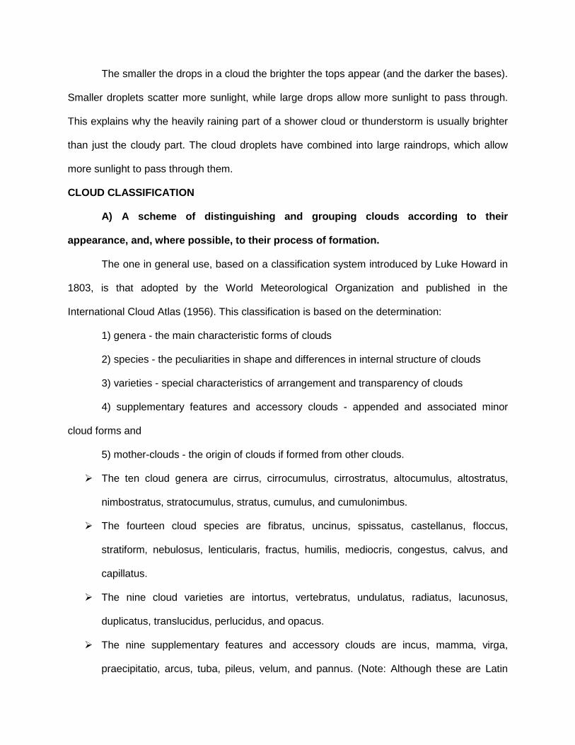
3. Cirrostratus (Cs)
Like the above two clouds ice crystals are present in these clouds also.
Looks like whitish veil and covers the entire sky with milky white appearance.
Produces “Halo”.
CIRRUS AND CIRROSTRATUS
Cirrus clouds are higher level clouds that develop in filaments or patches. They are
virtually brilliant white attributed to their ice crystal composition. However, they lack in contrast
between the top and base. They occur in flat sheets with a low height to base ratio and are
usually isolated with large breaks of sky. Cirrus also vary dramatically in 'shape' or patterns they
portray but these represent the fluctuating wind flow at that level both in the horizontal and
vertical direction.
Cirrostratus represent clouds that are more widespread than cirrus but containing some
similar features. Like cirrus, they are brilliant white and lack in contrast. Sunlight can pass
through cirrostratus but this again depends on the varying thickness of the clouds.
Both cirrus and cirrostratus clouds vary in thickness. The sun can easily be observed
through both types of clouds although the intensity of light that is observed depends on the
thickness of their layers. In their thickest form, cirrus and cirrostratus will allow a similar intensity
of light to pass through to that of thin altostratus. They do not only develop in one complete
layer. It may be difficult to observe because of the lack of contrast but these clouds can consist
of several thin layers.
Cirrus and cirrostratus tend to move in the direction of the wind at that level which differ
to that at the surface. The most common direction of motion of these clouds are from a westerly
direction. This varies with factors such as the latitude, weather conditions and time of the year.
Their apparent velocities are relatively slow as compared to lower clouds.
Both cirrus and cirrostratus can occur in conjunction with any of the other cloud types.
Obviously, all the lower and middle level clouds will obscure the view of the higher level clouds,
appear to move faster and appear less defined. They can only be observed above other clouds
when breaks in the clouds occur. Any type of higher level clouds can develop simultaneously.
Cirrus clouds tend to develop on days with fine weather and lighter winds at the surface.
cirrostratus can develop on days with light winds but normally increasing in strength. Although
both cirrus and cirrostratus tend to develop in fine weather conditions, they also acts as a sign
of approaching changes in the weather conditions. Such changes could include any of the
various types of cold front situations, thunderstorms or developing and advancing troughs of low
pressure, normally with preceding cloud masses.
Except in the latter case, cirrus and cirrostratus will typically precede any other types of
clouds as part of a cloud band. In fact cirrus normally precedes cirrostratus. Nevertheless, the
higher level clouds will persist until the actual change in the weather occurs. The higher clouds
can develop from a few hours up to a few days before an actual change in the weather
conditions occurs. They may develop during one afternoon and dissipate but redevelop the next
day and so on until the actual change occurs. If the amount of moisture in the lower layers of the
atmosphere increases, other lower clouds may also develop changing the appearance of the
cirrus or the cirrostratus clouds as well as partially or totally hiding them from view. The same
situation occurs in the case where cirrus develop ahead of thunderstorms. Cirrus normally

precede cirrostratus which are then followed by the anvil of the approaching thunderstorm. In
fact, cirrus and cirrostratus in this case are the remnants downwind of the weakening anvil.
Both cirrus and cirrostratus can develop and persist after a change has passed through
a certain location. In this situation, cloud will decrease within a few hours up to a few days
following the change. If it persists for longer periods, a jet stream cloud mass may be involved.
Another situation where cirrus and cirrostratus can be observed is when lower cloud
breaks or clears during days with showers or rain. This case is far less common but can indicate
a few situations. The higher clouds may be the remnants of the cloud mass that produced the
actual wet weather. They can also be developing ahead of other cloud masses associated with
another system, leading to the situation already discussed above. It all depends on the weather
situation at that time but the observation of the movement of the higher level clouds can be
critical in determining what weather may follow.
Cirrus generally does not produce precipitation except when it results from dissipating
thunderstorms. Precipitation from such cirrus usually consists of larger droplets and the cloud
normally dissipates and vanishes completely. cirrostratus does not produce precipitation.
Cirrus and cirrostratus can develop and persist at any time of the day despite the
perception that it tends to occur during the day. This perception arises because it is much easier
to observe cirrus during the day as compared to night time. The background darkness and the
fact that the stars can easily be observed through cirrus and cirrostratus as thin layers allows
them to camouflage from the view of the observer.
Cirrocumulus
Cirrocumulus is a higher level cloud that is brilliant white but with a spotty appearance
created by the many small turrets. The turrets indicate vertical turbulence within the cloud.
Despite this spotty appearance, cirrocumulus contains many features associated with
cirrostratus discussed above. It moves in directions similar to that of the other higher clouds.
This cloud can develop in conjunction with any other clouds as well as with cirrostratus
clouds. In Sydney, cirrocumulus is not as common as the other high clouds and mainly develops
during the winter times with west to south westerly air streams. The development of
cirrocumulus sometimes occurs in conditions similar to those associated with the development
lenticular altocumulus. cirrocumulus clouds do not produce precipitation and are normally
associated with fine weather.
Family B
The clouds in this category are middle clouds. Middle level clouds are those clouds that
develop in the middle layers of the atmosphere. These clouds are brighter and less fragmented
in appearance due to their distance from the ground and the higher composition of ice crystals.
Middle level clouds vary in thickness from relatively flat sheets of cloud to a more cumuliform
appearance. In fact, the sun (and moon) can be observed through some thin middle level
clouds. The mean lower level is 2.5 kilometers and the mean upper level is 7 kilometers in
tropics and sub-tropics.
Middle level clouds tend to have apparent speeds slower than the lower level clouds.
They move in the direction of the wind at that level which does not necessarily be the same of
that at the surface.
In this family there are 2 sub-categories as details below:
1. Altocumulus (Ac)
In these clouds ice water is present.
Greyish or bluish globular masses.
Looks like sheep back and also known as flock clouds or wool packed clouds.

2. Alto-stratus (As)
In these clouds water and ice are present separately.
Looks like fibrous veil or sheet and grey or bluish in colour.
Produces coronos and cast shadow.
Rain occurs in middle and high latitudes.
Altocumulus
Altocumulus refers to the middle level cloud that exhibit to some extent the features
normally associated with cumulus. This includes cumuliform tops and bases that are usually
relatively darker than the tops. This cloud type can be widespread or patchy depending on the
conditions. It can vary in appearance from broken to smooth, and vary in thickness.
Altocumulus can vary in its apparent movement (speed) depending on the wind and
direction at that level. However, since altocumulus (like most other cloud types) represents an
ever changing system, an observer must be careful in determining cloud motion. On some days,
altocumulus continuously develop as it moves in the direction of the wind. Upstream, more
altocumulus may develop giving the impression that the cloud is progressing slower than its
actual speed. This process can occasionally create an illusion in terms of direction. Considering
an example of altocumulus observed moving to the south east, because of development on the
north and north-eastern side of the cloud band, the apparent direction may be more to the east.
Altocumulus can develop in more than one layer and also in conjunction with other cloud types.
The lower layer will obscure part or all of the higher altocumulus cloud layer. This situation also
applies to higher level clouds. Higher level clouds will be obscured by the altocumulus. Lower
level clouds, however, will obscure part or all of the altocumulus cloud layer.
ALTOSTRATUS
Altostratus refers to middle level cloud that appears as a flat, smooth dark grey sheet.
These clouds are most often observed as large sheets rather than isolated areas. However, in
the process of development, altostratus may develop in smaller filaments and rapidly develop to
larger sheets. These types of clouds in certain conditions normally indicate an approaching
cloud mass associated with a cold front, a trough system or a jet stream.
Altostratus can develop into a thick or thin layer. As a thin layer, the sun can be
observed through the cloud. In its thinner form, the developing altostratus can sometimes be
confused with approaching cirrostratus. In its thicker form, the sun can only occasionally be
observed through the thinner sections if not at all. Obviously, the thicker the altostratus, the
darker it becomes. When observed closely, it becomes apparent that altostratus is not just one
complete layer but a composition of several thin layers.
Altostratus can produce precipitation. It will normally develop and then thicken. The
precipitation is observed as relatively thick dark sections since precipitation cascades are very
difficult to observe with the same colour in the background. In this situation, rain will develop as
a light shower and gradually increase to showers, light rain or moderate rain.
Family C
The clouds in this category are lower clouds. The height of these clouds extends from
ground to upper level of 2.5 kilometers in tropics and sub-tropics. Lower level clouds consist of

those clouds in the lower layers of the atmosphere. Because of the relatively low temperatures
at this level of the atmosphere, lower level clouds usually reflect lower amounts of light and
therefore usually exhibit low contrast. The clouds at this level also appear not as well defined.
When observed closely, it is easy to observe the turbulent motions and hence the ever-
changing structure.
Being closer to the ground, lower level clouds appear to move or progress faster than
other clouds. The clouds generally move in the direction of the wind very similar to the direction
of the wind on the ground.
The most efficient method used to recognise lower clouds is when observed in
conjunction with other clouds. The lower clouds will obscure part or all the view of the upper
level clouds if they pass in between the observer's line of sight. In other words, all the observer
can see is the lower clouds as well as parts of the higher level clouds through breaks of the
lower clouds. In this family, like high clouds, there are 3 sub-categorises.
1. Strato cumulus (Sc)
These clouds are composed of water.
Looks soft and grey, large globular masses and darker than altocumuls.
Long parallel rolls pushed together or broken masses.
The air is smooth above these clouds but strong updrafts occur below.

2. Stratus (St)
These clouds are also composed of water.
Looks like for as these clouds resemble grayish white sheet covering the entire portion
of the sky (cloud near the ground).
Mainly seen in winter season and occasional drizzle occurs.
3. Nimbostratus (Ns)
These clouds are composed of water or ice crystals.
Looks thick dark, grey and uniform layer which reduces the day light effectively.
Gives steady precipitation.
Sometimes looks like irregular, broken and shapeless sheet like.

Stratocumulus
Stratocumulus are low clouds that generally move faster than cumulus and are not as
well defined in appearance (recall the techniques of observing clouds). They tend to spread
more horizontally rather than vertically.
Depending on the weather conditions, stratocumulus can appear like cumulus since
stratocumulus can develop from cumulus. They may also appear as large flat areas of low, grey
cloud. Sometimes stratocumulus appear in the form of rolling patches of cloud aligned parallel
to each other. Stratocumulus can also appear in the form of broken clouds or globules. The sun,
moon and generally the sky can be observed through the breaks in broken stratocumulus
clouds. Of course, this depends on how large the breaks are, how high the clouds rise and the
angle of elevation of the breaks with respect to the observer. This generally applies to all clouds
but is more notable with clouds in broken form.
Stratocumulus mostly develop in wind streams moving in the direction of the wind similar
to the direction of the wind at the surface. The friction created by the earth causes turbulence in
the form of eddies. With sufficient moisture, condensation will occur in the lower layers of the
atmosphere visible as clouds. The amount of stratocumulus covering the sky depends on the
amount of moisture concentrated at that level of the atmosphere. The speed that the cloud
moves varies according to the wind
Stratus
Stratus is defined as low cloud that appears fragmented and thin. It can also occur in the
form of a layer or sheet. The sun, moon and generally the sky can usually be observed through
stratus clouds, especially at a steep angle of elevation. Stratus lacks the vertical growth of
cumulus and stratocumulus, and therefore lacks the contrast. This is more evident when
observed as one layer as compared to patchy stratus. Being closest to the ground, stratus
clouds normally move fairly rapidly in the direction of the wind depending of course on the wind
speed.

Like stratocumulus, stratus develops under several conditions or weather situations.
Stratus mostly develop under the influence of wind streams where moisture condenses in the
lower layers of the atmosphere. Wind changes during the summer months often lead to the
development of stratus as the wind evaporates moisture from the ocean and condensing as
turbulence mixes the surface air with the cooler air above. In these conditions, stratus develop
in patches and gradually may become widespread forming into stratocumulus.
Family D
These clouds form due to vertical development i.e., due to convection. The mean low
level is 0.5 and means upper level goes up to 16 kilometers.
In this family two sub-categories are present.
1. Cumulus (Cu)
These clouds are composed of water with white majestic appearance with flat base.
Irregular dome shaped and looks like cauliflower with wool pack and dark appearance
below due to shadow.
These clouds usually develop into cumuolo-nimbus clouds with flat base.
2. Cumulonimbus (Cb)
The upper levels of these clouds possess ice and water is present at the lower levels.
These clouds have thunder head with towering envil top and develop vertically.

These clouds produce violent winds, thunder storms, hails and lightening, during
summer.
Cumulus
Cumulus are cauliflower-shaped low level clouds with dark bases and bright tops. When
observing cumulus, you are actually observing the condensation process of rising thermals or
air bubbles at a certain level in the atmosphere known as the condensation level.
The air rising above this level condenses and cloud is observed. Since the height of this
level is fairly constant at any particular time, then the bases of cumulus are usually flat.
PRECIPITATION
When cloud particles become too heavy to remain suspended in the air, they fall to the
earth as precipitation. Precipitation occurs in a variety of forms; hail, rain, freezing rain, sleet or
snow.
Rain
Rain develops when growing cloud droplets become too heavy to remain in the cloud
and as a result, fall toward the surface as rain. Rain can also begin as ice crystals that collect
each other to form large snowflakes. As the falling snow passes through the freezing level into
warmer air, the flakes melt and collapse into rain drops. Rain is precipitation of liquid water
particles either in the form of drops having diameter greater than 0.5 mm or in the form of
smaller widely scattered drops. When the precipitation process is very active, the lower air is
moist and the clouds are very deep, rainfall is in the form of heavy downpour. On occasions,
falling raindrops completely evaporate before reaching the ground.
Drizzle: It is fairly uniform precipitation composed of fine drops of water having diameter less
than 0.5 mm small and uniform size and seems to be floated in the air, it is referred as drizzle. If
the drops in a drizzle completely evaporates before reaching the ground, the condition is
referred to as ‘mist’.
Hail
Hail is a large frozen raindrop produced by intense thunderstorms, where snow and rain
can coexist in the central updraft. As the snowflakes fall, liquid water freezes onto them forming
ice pellets that will continue to grow as more and more droplets are accumulated. Upon
reaching the bottom of the cloud, some of the ice pellets are carried by the updraft back up to
the top of the storm.
As the ice pellets once again fall through the cloud, another layer of ice is added and the
hail stone grows even larger. Typically the stronger the updraft, the more times a hail stone
repeats this cycle and consequently, the larger it grows. Once the hail stone becomes too heavy
to be supported by the updraft, it falls out of the cloud toward the surface. The hail stone
reaches the ground as ice since it is not in the warm air below the thunderstorm long enough to
melt before reaching the ground.
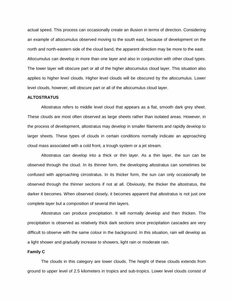
Freezing rain
Supercooled droplets freezing on impact
Ice storms can be the most devastating of winter weather phenomena and are often the
cause of automobile accidents, power outages and personal injury. Ice storms result from the
accumulation of freezing rain, which is rain that becomes supercooled and freezes upon impact
with cold surfaces. Freezing rain is most commonly found in a narrow band on the cold side of a
warm front, where surface temperatures are at or just below freezing.
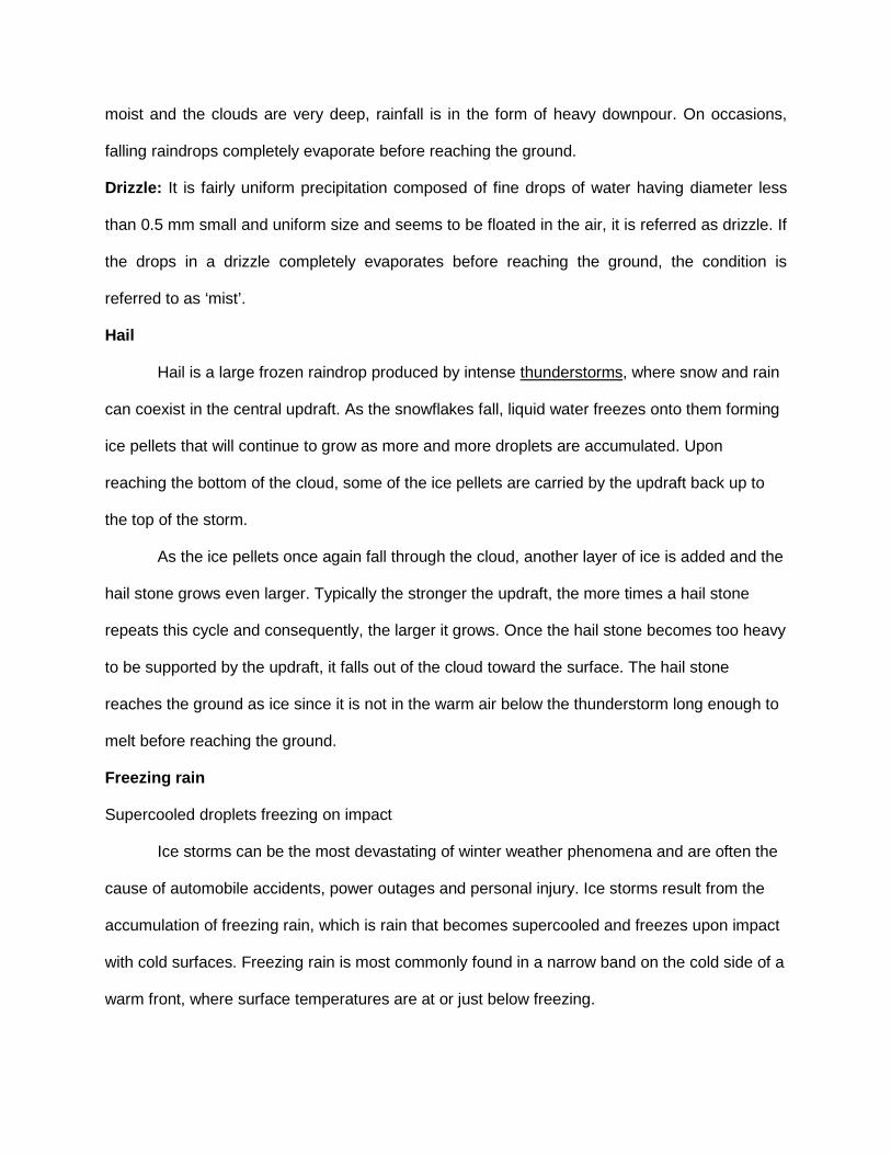
The diagram below shows a typical temperature profile for freezing rain with the red line
indicating the atmosphere's temperature at any given altitude. The vertical line in the center of
the diagram is the freezing line. Temperatures to the left of this line are below freezing, while
temperatures to the right are above freezing.
Freezing rain develops as falling snow encounters a layer of warm air deep enough for
the snow to completely melt and become rain. As the rain continues to fall, it passes through a
thin layer of cold air just above the surface and cools to a temperature below freezing. However,
the drops themselves do not freeze, a phenomena called supercooling (or forming "supercooled
drops"). When the supercooled drops strike the frozen ground (power lines, or tree branches),
they instantly freeze, forming a thin film of ice, hence freezing rain.
Snow
It is the precipitation of white and opaque grains of ice. Snow is the precipitation of solid
water mainly in the form of branched hexagonal crystals of stars. In winter, when temperatures
are below freezing in the whole atmosphere, the ice crystals falling from the Altostratus do not
melt and reach the ground as snow.
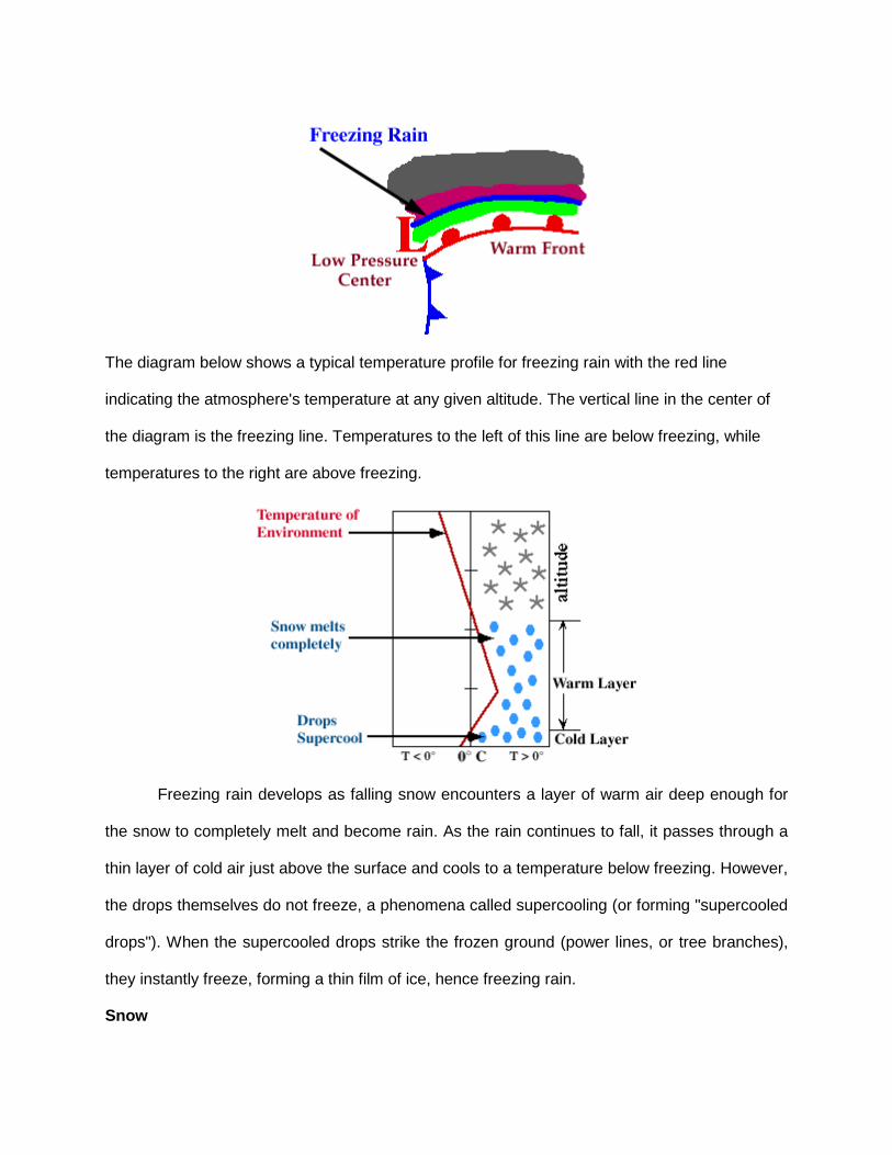
Sleet - frozen raindrops that bounce on impact with the ground
Progressing further ahead of the warm front, surface temperatures continue to decrease
and the freezing rain eventually changes over to sleet. Areas of sleet are located on the colder
side (typically north) of the freezing rain band.
It refers to precipitation in the form of a mixture of rain and snow. It consists of small
pellets of transparent ice, 5 mm or less in diameter. It refers to a frozen rain that forms when
rain falling to the earth passing through a layer of cold air and freezes. This happens when
temperature is very low. It is not commonly seen in India expect high ranges, that too in winter,
in extreme north and northeast India.
Sleet is less prevalent than freezing rain and is defined as frozen raindrops that bounce
on impact with the ground or other objects. The diagram below shows a typical temperature
profile for sleet with the red line indicating the atmosphere's temperature at any given altitude.
The vertical line in the center of the diagram is the freezing line. Temperatures to the left of this
line are below freezing, while temperatures to the right are above freezing.
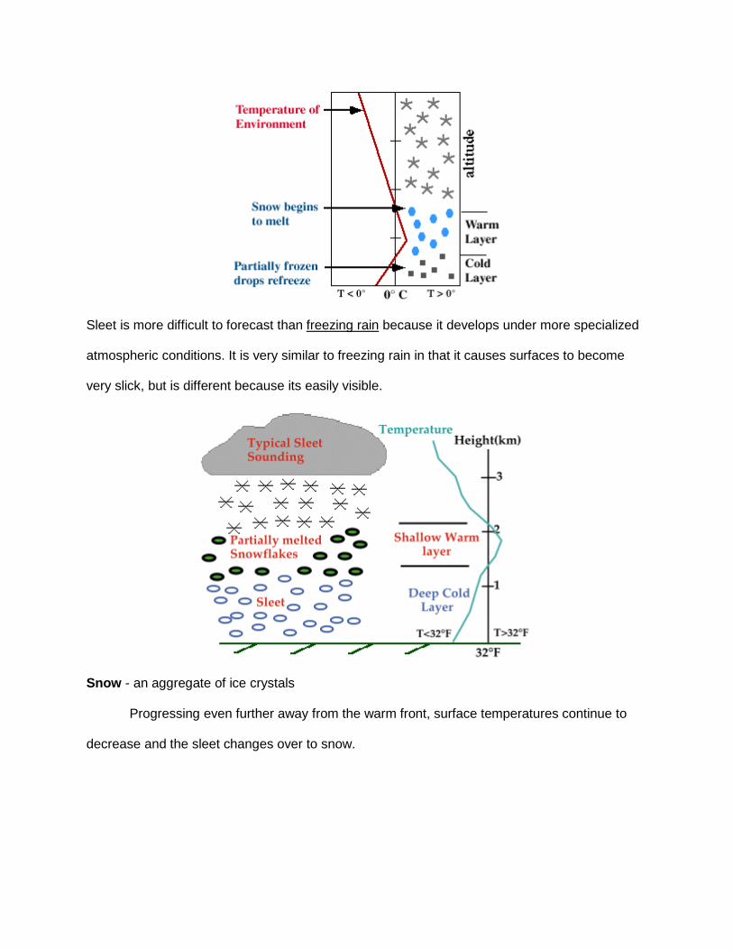
Sleet is more difficult to forecast than freezing rain because it develops under more specialized
atmospheric conditions. It is very similar to freezing rain in that it causes surfaces to become
very slick, but is different because its easily visible.
Snow - an aggregate of ice crystals
Progressing even further away from the warm front, surface temperatures continue to
decrease and the sleet changes over to snow.

Snowflakes are simply aggregates of ice crystals that collect to each other as they fall
toward the surface. The diagram below shows a typical temperature profile for snow with the red
line indicating the atmosphere's temperature at any given altitude. The vertical line in the center
of the diagram is the freezing line. Temperatures to the left of this line are below freezing, while
temperatures to the right are above freezing.
Since the snowflakes do not pass through a layer of air warm enough to cause them to
melt, they remain intact and reach the ground as snow.
Hail
Precipitation of small pieces of ice with diameter ranging from 5 to 50 mm or something
more is known as hail. Hailstorms are frequent in tropics. In India, the period from March to May

offers the ideal condition for hailstorms. It is the most dreaded and destructive form of
precipitation produced in thunderstorms or cumulonimbus clouds.
Isohyets
Isohyets are the lines connecting various locations, having an equal amount of
precipitation.
Top Related
Copyright © 2022 FDOKUMEN

