


Bahasa
Halaman
Hukum


ASOR Syrian Heritage Initiative (SHI): Planning for Safeguarding Heritage Sites in Syria1
NEA-‐PSHSS-‐14-‐001
Weekly Report 13 – November 3, 2014
Michael D. Danti, Cheikhmous Ali, and Kurt W. Prescott
Heritage Timeline November 2, 2014 Sotaliraq published a story detailing efforts by the Iraqi
Ministry of Tourism and Antiquities to halt various sales of antiquities on the international market stolen by Islamic State. Iraqi antiquities officials verified IS theft/looting was widespread at that antiquities sales were an important source of revenue for the organization. http://www.sotaliraq.com/mobile-‐news.php?id=173730#ixzz3Hw98U5f5
November 1, 2014 DGAM posted a report on damage to the Artaban Tomb at the
UNESCO World Heritage Site, Ancient City of Palmyra, SHI Incident Report SHI14-‐073. http://www.dgam.gov.sy/?d=314&id=1483
October 31, 2014 APSA posted five photos of the Maarat al-‐Numan Museum,
courtesy of Sieve Magazine [Al-‐Gherbal]. October 29, 2014 APSA posted two videos and 37 photos of the illicit excavations
at Tell Hizareen. SHI Incident Report SHI14-‐072. http://www.apsa2011.com/index.php/en/provinces/idlib/sit
es/1011-‐idlib-‐tell-‐hizareen.html • DGAM posted a short report (along with two photos) on their
website about the destruction of Sufi Shrines in the Aleppo countryside. SHI Incident Report SHI14-‐071.
http://www.dgam.gov.sy/index.php?d=314&id=1478 October 27, 2014 DGAM posted a report on damage to the Ayn al-‐Arab [Kobani]
area. SHI Incident Report SHI14-‐070. http://www.dgam.gov.sy/?d=314&id=1475
1 This report is based on research conducted by the “Syria Preservation Initiative: Planning for Safeguarding Heritage Sites in Syria.” Weekly reports reflect reporting from a variety of sources and may contain unverified material. As such, they should be treated as preliminary and subject to change.

Military and Political Context During the reporting period2, the primary theaters of military engagement and insurgent activity in Syria were:
1) Marea north of Aleppo, where rebel forces clashed with Islamic State; 2) Jobar area of Damascus, where SARG conducted new bombardments and alleged CW attacks against rebel forces;
3) JN and Jund al-‐Aqsa gained new territory in the Jebel Zawiua in southern Idlib Governorate. Syrian Revolutionary Front lost its last remaining stronghold in Deir Sunbul as did Harakat Hazm in Khan Sibel. This is a serious blow to moderate forces in Syria;
4) Islamic State attacked the Tiyas military airbase west of Palmyra, retook the Sha’er and Juhar gas fields northwest of Palmyra, and raided the town of Salamiyeh on a key desert highway linking the Homs to Aleppo — a regime supply line;
5) Kobani was reinforced by KRG Peshmerga to bolster depleted YPG forces; 6) Continued U.S./Coalition airstrikes around Kobani and Deir ez-‐Zor and in Iraq in the area of Baiji , Fallujah, and ar-‐Rutbah.
A truce was established between Jabhat al-‐Nusra, Jabhat Ansar al-‐Din, Harakat Hazm, Islamic Front and other rebel groups for the mutual defense of Aleppo against SARG. Broad tribal and rebel coalitions are now the trend in the Aleppo area among Sunni groups to meet threats posed by Islamic State and SARG. This continues a trend of military consolidation seen among the tribal resistance in recent months, especially among the She’tat tribe of the Euphrates region in and around Deir ez-‐Zor, who announced they would fight IS in the Euphrates valley from Raqqa to the Iraqi border. Free Syrian forces lost their last remaining significant strongholds in Idlib Governorate. Their forces are allegedly defecting to extremist groups or are in retreat. Although the full extent of these developments remains to be ascertained, the reduced territory and capacity of free forces will likely adversely impact humanitarian/cultural heritage efforts in northwest Syria just prior to the onset of harsh winter weather. Islamic State offensives in eastern Homs Governorate in the area of Palmyra and Salamiyeh are interpreted as attempts by IS to bolster its efforts to capture Deir ez-‐Zor and its important military airbase still controlled by SARG. IS uses raids in the desert to disrupt SARG supply lines to Aleppo and Deir ez-‐Zor. Key Heritage Recommendations and Actions 1) DGAM reporting on the Ayn al-‐Arab mentions the use of landmines on archaeological sites that have been fortified (SHI Incident Report SHI14-‐070) — this was likely carried out by SARG forces.
2 For coverage of weekly events see Kozak, Christopher and Jennifer Cafarella Syria Update October 29–November 04, 2014 (Institute for the Study of War).

*Information on the use of land mines on or near archaeological sites should be carefully documented to aid in future mine removal efforts and for risk management. 2) There is now clear evidence of the looting of sites using metal detectors given the recent APSA report on Tell Hizareen. *Monitoring groups should focus on investigating whether there is an upsurge in the marketing of metal artifacts of probable Syrian provenance. 3) Organized looting has occurred at Palmyra in several locations during the use of the site as a SARG military outpost. Palmyrene material, particularly funerary sculpture, is stylistically distinctive. The sculptures stolen from Tomb N5 are well documented, which leads to the hypothesis that the thieves may be operating to acquire antiquities “on order” from middlemen and collectors. These sculptures would not be trafficked to the open market. *All possible measures should be taken to prevent material from leaving Syria via Turkey, Jordan, Lebanon, and Iraq, to raise public awareness of the plight of Syrian and Iraqi cultural heritage, and to increase the capacity of monitoring efforts aimed at tracking and recovering illicit antiquities.

Incident Reports SHI14-‐070
Report Date: November 2, 2014 Site Name: Kobani/Ayn al-‐Arab District — Tell Badaya, Tell Shuyukh Tahtani, Tell Ahmar, Tell al-‐Abr, Tell Der Kanhsari, Tell Kamlaq. Dates of Incident: Various episodes in 2014 Location: Northeastern Aleppo Governorate, various locations Coordinates: Central Kobani Lat. 36.892671, Lon. 38.355971 — see various SHI reports for individual site locations and details
Site Description: The DGAM report provides a data on the status of various sites in the general Kobani area. Referring to earlier DGAM condition reporting, the report specifies,
During January to June 2014 [a] Large number of Tells were in a good condition including: Tell Ahmar – Tell al Aber-‐Tell Der Kanshari and Tell al Kamlaq. Both Tell Shuyukh Tahtani and Tell al Bidaya were subject to illegal buildings on the top of the Tells and within the buffer-‐zone.
Damage to Tell Badaya and Shuyukh Tahtani has been documented by SHI co-‐director Jesse Casana, and the damage to these tells was detailed in SHI Weekly Report 9. The DGAM report provides an update on current conditions in the area,
Starting on May 2014 the Ayn al-‐Arab District transferred to battlefield which caused severe damages to the archaeological sites. Tell Shuyukh Tahtani, Tell Shuyukh Fouqani and Tell al Bidaya were subject to diggings by using bulldozers, defenses trenches were opened along the slope at the foot of the tells (depth 3m) destroying the archaeological evidence. The foot of the Tells were fortified by Mines to avoid approaching and climbing.
The DGAM does not attribute the damage to a particular belligerent in the conflict. The use of mines is highly suggestive of SARG forces. Site Dates: Various. Source of Destruction: Military installations, looting, combat damage, min fields.
Pattern: The destruction of archaeological mounds in the key theater of operations for all belligerents in the Syrian conflict.

Monitoring Recommendations and Mitigation Measures: This entire region is a high priority monitoring area for SHI. Damage in this area tends to be reported given the proximity of these sites to the Turkish border. The mention of landmines in the DGAM report is distressing and will doubtless have long-‐term effects on cultural heritage management in this area. Should the practice of using landmines on archaeological mounds spread — mounds are regularly used for military installations by all belligerents — there will be serious long-‐term humanitarian consequences akin to the Iraqi Kurdistan Region. Sources:
Online Reporting: DGAM Website http://www.dgam.gov.sy/?d=314&id=1475 Scholarly: Various. See SHI bibliography.

SHI14-‐071
Report Date: November 2, 2014 Site Name: Sufi Shrines in Aleppo Countryside — Maqam Sheikh Aqil, Menbij; shrines in the vicinity of an unspecified church near Qalaat Najm, six Mamluk tombs beside Qalaat Najm; Sufi tombs at Tell A’zaz, Tell Sarwan, Tell Sheikh Rieh, Tell Dabiq, Tell Akhtarin, and the Tomb of Nebi Daoud in Douwaibeq. Also possibly unspecified tombs in Bab District, Zerba Nahiyah, Hader, Atareb, Tell al-‐Daman, Maskanah, Al-‐Khafsa, and Deir Hafr. Date of Incident: Unspecified Location: Aleppo Governorate, Menbij area Coordinates: Undetermined Site Description: Various Sufi shrines and tombs Site Date: Medieval to Recent Source of Destruction: According to a report by the DGAM, 90% of the Sufi Muslim shrines and tombs in the countryside of Aleppo have been destroyed. These include all the shrines in Manbij (on the eastern Aleppo plateau in northern Aleppo), such as Meqam Shiekh Aqil al Manbaji, all the shrines around the Byzantine church located on the road to Najim Castle, and the six Mamluki tombs in front of the castle. Moreover, all the shrines in Ezaz [Azzaz] have also been destroyed, including the Sufi tombs at Tell Ezaz, Tell Sarwan, Tell Shiekh Rieh, Tell Dabiq, Tell Akhtarin, and the Tomb of Nabi Daoud in Dwebek Village. Further reports suggested that the tombs in al Bab district, Zerba nahiyah, Hader, Atareb, Tell al Daman, Maskanh, al Khasfa, and Deir Hafir were completely destroyed. Note that some of these intentional destruction have been previously documented by SHI (See SHI Incident Reports SHI14-‐002, 022, 030).
Pattern: Likely Islamic State destruction of Sufi shrines and tombs as well as Sunni tombs deemed inappropriate to IS Salafist ideology. Monitoring Recommendations and Mitigation Measures: As time allows, SHI will disambiguate this data, verify the details and acquire additional information, and attempt to determine exact geographic coordinates of each of these destructions. SHI is currently gathering data on IS intentional destructions of heritage places in Syria and Iraq. Sources:
Online Reporting:

• DGAM Website
o http://www.apsa2011.com/index.php/en/provinces/idlib/sites/1011-‐idlib-‐tell-‐hizareen.html
Scholarly:
Image of the Maqam Sheikh Aqil al-‐Manbij (DGAM)
Image of the Maqam Sheikh Aqil al-‐Manbij (DGAM)

SHI14-‐072
Report Date: October 29, 2014 Site Name: Tell Hizareen Date of Incident: Unspecified during 2014 but recent based on vegetation conditions Location: Idlib Governorate, 2.5 km southwest of modern Kafr Nabl Coordinates: Lat. 35.597779, Lon. 36.5406744 Site Description: Large tell Site Date: Early, Middle, and Late Bronze Ages, possible early Iron Age Source of Destruction: Based on a recent site visit by APSA, the site of Tell Hizareen has been subject to extensive illegal excavations. Numerous looters have been using metal detectors to explore the site, while more than fifty pits have been dug in different parts of the site. Looters have unearthed potsherds and terracotta figurines from multiple time periods.
Pattern: Large-‐scale looting using metal detectors Monitoring Recommendations and Mitigation Measures: SHI may request new satellite imagery of the mound as well as neighboring sites. This pattern of looting with metal detectors is reportedly widespread across Syria. Sources:
Online Reporting:
• APSA Website o http://www.apsa2011.com/index.php/en/provinces/idlib/sit
es/1011-‐idlib-‐tell-‐hizareen.html Scholarly:

Tell Hizareen (Google Earth)
Tell Hizareen (APSA)
Looter excavations on the slopes of Tell Hizareen in 2014 (APSA).
Looter excavations on the slopes of Tell Hizareen in 2014 (APSA).

Looter excavations on the slopes of Tell Hizareen in 2014 (APSA).
Looter excavations on the slopes of Tell Hizareen in 2014 (APSA).

Looters using metal detectors at Tell Hizareen in 2014 (APSA).
Looters using metal detectors at Tell Hizareen in 2014 (APSA).

Looters using metal detectors at Tell Hizareen in 2014 (APSA).
Looters using metal detectors at Tell Hizareen in 2014 (APSA).

Looter excavations at Tell Hizareen in 2014 (APSA).
Looter excavations at Tell Hizareen in 2014 (APSA).

Looter excavations at Tell Hizareen in 2014 (APSA).
Looter excavations at Tell Hizareen in 2014 (APSA).

Looter excavations at Tell Hizareen in 2014 (APSA).
Looter excavations at Tell Hizareen in 2014 (APSA).

Looter excavations at Tell Hizareen in 2014 (APSA).
Looter excavations at Tell Hizareen in 2014 (APSA).

Looter excavations at Tell Hizareen in 2014 (APSA).
Looter excavations at Tell Hizareen in 2014 (APSA).

Looter excavations at Tell Hizareen in 2014 (APSA).
Looter excavations at Tell Hizareen in 2014 (APSA).

Looter excavations at Tell Hizareen in 2014 (APSA).
Looter excavations at Tell Hizareen in 2014 (APSA).

Site disturbance at Tell Hizareen in 2014 (APSA).
Looter excavations at Tell Hizareen in 2014 (APSA).

Looter excavations at Tell Hizareen in 2014 (APSA).
Surface sherd from Tell Hizareen (APSA).

Looter excavations at Tell Hizareen in 2014 (APSA).
Surface collection from Tell Hizareen in 2014 (APSA).

Surface collection from Tell Hizareen in 2014 (APSA).
Looter excavations at Tell Hizareen in 2014 (APSA).

Looter excavations on the slopes of Tell Hizareen in 2014 (APSA).
Looter excavations on the slopes of Tell Hizareen in 2014 (APSA).

Looters using metal detectors at Tell Hizareen in 2014 (APSA).
Looter excavations on the slopes of Tell Hizareen in 2014 (APSA).

Terracotta figurines from Tell Hizareen.

SHI14-‐073
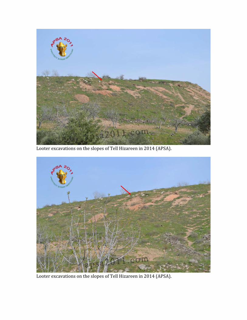
Report Date: November 2, 2014 Site Name: Artaban Tomb, Palmyra Date of Incident: Reported November 1, 2014 Location: Homs Governorate, UNESCO World Heritage Site, Ancient City of Palmyra Coordinates: Site Description: DGAM provides the following report on their recent assessment of Tomb N5 at Palmyra,
Antiquities of Palmyra were able to reach the Southeast Necropolis in the Archaeological site and assessed the damage in the underground Artaban Tomb (Tomb n 5) which was discovered on 1985 and restored by the national excavation mission between 1964-‐1999. At the beginning of the crises on 2011 the DGAM undertook protective measures against vandalism and theft in the tomb by reinforced its gate and covered the tomb with soil. According to the DGAM team the looters remove the soil, broke into a tomb by took off and expanded the air vent over the gate. The thieves stole 22 funeral bust and child head stone represented in the Scene funerary feast.
Ross Burns provides the following details on the tomb3,
The southeast necropolis area lies south of the main oasis. Most noteworthy is the Tomb of Artaban (second half of the first century AD), discovered in 1957 during construction of an oil pipeline under which you descend to gain entry. The main gallery leads off into four main side ones and is covered by a cradle vault. Fifty six niches each contained five loculi.
Site Date: First century AD Source of Destruction: Looting during military occupation by SARG.
Pattern: An emerging pattern of the looting of sites occupied by military forces, particularly sites of the Hellenistic, Roman, and Byzantine periods. Monitoring Recommendations and Mitigation Measures: Palmyra is already a high priority site for SHI monitoring and evaluation. The antiquities market is being monitored for Pamyrene material, and these efforts will be expanded in coming months.
3 Burns, Ross. 2009. Syria, A Historical and Architectural Guide. (I.B. Tauris), p. 220.

Sources:
Online Reporting: DGAM website http://www.dgam.gov.sy/?d=314&id=1483 Scholarly:
Burns, Ross. 2009. Syria, A Historical and Architectural Guide. (I.B. Tauris), p. 220.
Entrance to the looted Artaban Tomb, Palmyra (DGAM)

Locations of funerary sculptures looteded from the Artaban Tomb, Palmyra (DGAM)
Locations of funerary sculptures looted from the Artaban Tomb, Palmyra (DGAM)
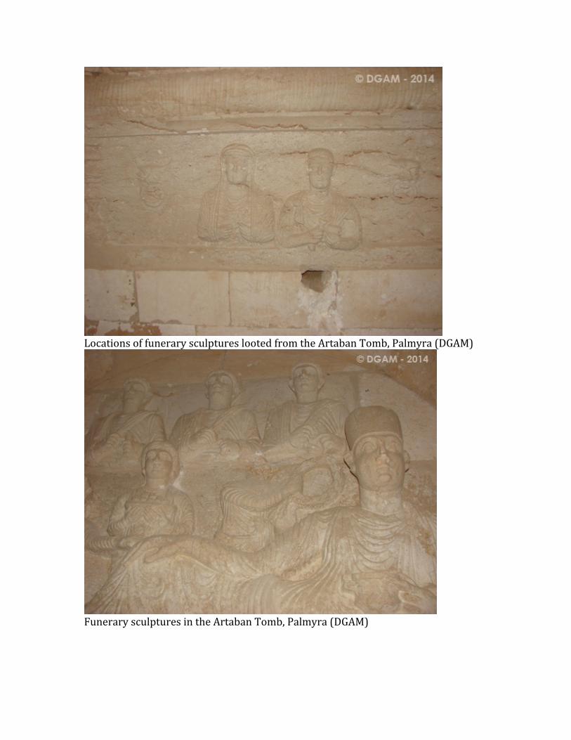
Locations of funerary sculptures looted from the Artaban Tomb, Palmyra (DGAM)
Funerary sculptures in the Artaban Tomb, Palmyra (DGAM)

Loculi in the Artaban Tomb, Palmyra — sculptural elements looted (DGAM)
Funerary sculptures in the Artaban Tomb, Palmyra (DGAM)

Locations of funerary sculptures looted from the Artaban Tomb, Palmyra (DGAM)
Loculi in the Artaban Tomb, Palmyra — sculptural elements looted (DGAM)
Top Related
Copyright © 2022 FDOKUMEN

