ASOR Syrian Heritage Initiative (SHI): Planning for Safeguarding Heritage Sites in Syria...
69
ASOR Syrian Heritage Initiative (SHI): Planning for Safeguarding Heritage Sites in Syria 1 NEAPSHSS14001 Weekly Report 9 – October 6, 2014 Michael D. Danti, Cheikhmous Ali, Jesse Casana, and Kurt W. Prescott Heritage Timeline October 5, 2014 APSA posted Syria’s Cultural Heritage: APSAreport01 September 2014. This report includes the individual APSA reports detailed in SHI Weekly Reports 3–9. http://www.apsa2011.com/index.php/en/apsa rapports/987apsareportseptember2014.html October 3, 2014 APSA posted photos from journalist Shady Hulwe showing the total destruction of the Khusruwiye Madrasa and Mosque and the damage to the Khan al Shouna in the UNESCO World Heritage Site, Ancient City of Aleppo. SHI Incident Report SHI14054. • The New York Times published “Antiquities Lost, Casualties of War. In Syria and Iraq, Trying to Protect a Heritage at Risk,” by Graham Bowley. http://www.nytimes.com/2014/10/05/arts/design/in syriaandiraqtryingtoprotectaheritageat risk.html?_r=0 October 2, 2014 APSA posted several photographs taken by Syrian journalist Shady Hulwe showing damage to the Hittite temple of the weathergod on the Aleppo Citadel in the UNESCO World Heritage Site, Ancient City of Aleppo. SHI Incident Report SHI14039. October 1, 2014 APSA posted a video to their website showing a fire at the Great Umayyad Mosque in the UNESCO World Heritage Site, Ancient City of Aleppo. SHI Incident Report SHI14040. http://www.apsa2011.com/index.php/en/provinces/a leppo/greatumayyadmosque/975alepomeyyades 2.html 1 This report is based on research conducted by the “Syria Preservation Initiative: Planning for Safeguarding Heritage Sites in Syria.” Weekly reports reflect reporting from a variety of sources and may contain unverified material. As such, they should be treated as preliminary and subject to change.
Transcript of ASOR Syrian Heritage Initiative (SHI): Planning for Safeguarding Heritage Sites in Syria...

ASOR Syrian Heritage Initiative (SHI): Planning for Safeguarding Heritage Sites in Syria1
NEA-‐PSHSS-‐14-‐001
Weekly Report 9 – October 6, 2014
Michael D. Danti, Cheikhmous Ali, Jesse Casana, and Kurt W. Prescott
Heritage Timeline October 5, 2014 APSA posted Syria’s Cultural Heritage: APSA-‐report-‐01
September 2014. This report includes the individual APSA reports detailed in SHI Weekly Reports 3–9. http://www.apsa2011.com/index.php/en/apsa-‐rapports/987-‐apsa-‐report-‐september-‐2014.html
October 3, 2014 APSA posted photos from journalist Shady Hulwe
showing the total destruction of the Khusruwiye Madrasa and Mosque and the damage to the Khan al-‐Shouna in the UNESCO World Heritage Site, Ancient City of Aleppo. SHI Incident Report SHI14-‐054.
• The New York Times published “Antiquities Lost,
Casualties of War. In Syria and Iraq, Trying to Protect a Heritage at Risk,” by Graham Bowley. http://www.nytimes.com/2014/10/05/arts/design/in-‐syria-‐and-‐iraq-‐trying-‐to-‐protect-‐a-‐heritage-‐at-‐risk.html?_r=0
October 2, 2014 APSA posted several photographs taken by Syrian
journalist Shady Hulwe showing damage to the Hittite temple of the weather-‐god on the Aleppo Citadel in the UNESCO World Heritage Site, Ancient City of Aleppo. SHI Incident Report SHI14-‐039.
October 1, 2014 APSA posted a video to their website showing a fire at
the Great Umayyad Mosque in the UNESCO World Heritage Site, Ancient City of Aleppo. SHI Incident Report SHI14-‐040.
http://www.apsa2011.com/index.php/en/provinces/aleppo/great-‐umayyad-‐mosque/975-‐alep-‐omeyyades-‐2.html
1 This report is based on research conducted by the “Syria Preservation Initiative: Planning for Safeguarding Heritage Sites in Syria.” Weekly reports reflect reporting from a variety of sources and may contain unverified material. As such, they should be treated as preliminary and subject to change.

September 30, 2014 DGAM released Initial Damages Assessment for Syrian Cultural Heritage During the Crises covering the period July 7, 2014 to September 30, 2014.
http://dgam.gov.sy/archive/docs/File/downloads/damage_assessment_table%20july_september%20en.pdf
• APSA released a report on the state of the Ma’arat al-‐
No’man Museum, including two videos and twenty-‐seven photographs. SHI Incident Report SHI14-‐041.
http://www.apsa2011.com/index.php/en/provinces/idlib/museums/973-‐maaret-‐musee-‐2.html
• DGAM released an initial damage assessment of the
UNESCO World Heritage Site, Ancient City of Bosra, including sixteen photos. SHI Incident Report SHI14-‐042.
http://www.dgam.gov.sy/index.php?d=314&id=1436 September 26, 2014 The Washington Post published “How an ancient tomb
is a fault line in Syria’s brutal civil war,” by Ishaan Tharoor detailing the events surrounding the Tomb of Suleyman Shah (1236 AD), a Turkish monument within Syria threatened by Islamic State.

Military and Political Context During the reporting period2, the primary theaters of military engagement and insurgent activity in Syria were:
1) Ayn al-Arab/Kobani, where a slow, steady advance by Islamic State (IS) threatens the town, despite ongoing U.S./Coalition airstrikes and stiff resistance from Kurdish YPG ground forces; 2) Deraa, where Opposition and Jubhat al-Nusra (JN) forces repeatedly clashed and rebel forces turned back a SARG offensive against Deir al-Adas; 3) U.S./Coalition airstrikes in the region of Deir ez-Zor, Raqqa, Hasaka, and Aleppo aimed at degrading IS tactical and logistical capabilities, command and control, and revenues from petroleum refineries. 4) Damascus, where SARG captured the Adra district of eastern Ghouta.
Since mid-‐September, we have seen something of a shift in the main operational theaters, with a decline in operations around Hama and central western Syria as well as a lull in Islamic State advances on the Deir ez-‐Zor Airbase. Concomitantly, there has been a surge in activity around Damascus, in Deraa Governate, and in northwestern Syria. Analysts3 interpret a recent wave of assassinations and attempted assassinations directed at rebel leaders across western Syria as ultimately benefitting JN, IS, and SARG and undermining the Syrian Opposition and other rebel and insurgent groups. No single group appears responsible for these attacks, but the benefits for JN and IS tentatively implicate these extremists — these same extremists may be benefitting from negative public opinion in Syria against U.S./Coalition airstrikes.4 With regard to cultural heritage, the fast-‐evolving situation poses several challenges for monitoring, assessment, mitigation, and preservation efforts. Key Heritage Recommendations and Actions 1) The conflict’s increasing scope requires concomitant increases in incident monitoring, verification, and assessment. * SHI is adding capacity to monitor, evaluate, and report on Syrian cultural heritage and will be expanding its efforts to include northern Iraq.
2 For coverage of weekly events see Cafarella, Jennifer. Syria Update September 24–October 2, 2014 (Institute for the Study of War). 3 Cafarella, Jennifer. 2014. Syria Update September 24–October 2, 2014 (Institute for the Study of War). 4 Cafarella, Jennifer. 2014. Local Dynamics Shift in Response to U.S.-‐Led Airstrikes in Syria (Institute for the Study of War).

2) The heightened complexity of the conflict — characterized by constantly shifting arrays of extremist groups, highly fluid alliances between the combatants specific to operational theaters, and rapidly evolving power structures — introduces a high degree of ambiguity and uncertainty to the determination of control of terrain at any given time, assessing the veracity and motives of in-‐country and expatriate sources, and ascribing heritage incidents to specific agents. *SHI’s remote sensing/GIS team, headed by SHI Co-‐Directors Dr. Scott Branting and Dr. Jesse Casana, is working to gain access to additional geospatial datasets to increase our ability to provide timely and accurate information. In this same vein, SHI is expanding its network of in-‐country and expatriate Syrian sources to incorporate multiple perspectives, lower time to incident verification/debunking, and improve geographic coverage. 3) The effects of increased airstrikes on heritage remains to be determined, but the potential for collateral damage must be incorporated into weekly monitoring efforts over a large geographic area. * See actions/recommendations related to No. 2 above. Widespread Looting and Destruction Across Syria Preliminary results of analyses conducted by SHI Co-‐Director Dr. Jesse Casana and his team at the University of Arkansas show widespread looting and conflict-‐related damage and destruction across Syria. In a sample of 100 well-‐known archaeological sites, Casana identified looting in at least 24% of the sample (minor 8%, moderate 5%, severe 11%) and other damage, such as military earthworks or recent construction, at 27% of sites. SHI is producing Incident Reports for all these locations. We provide 10 Incident Reports (SHI 14-‐043 to SHI 14-‐053) on major sites with evidence of looting and/or damage in this report, including Mari, Tell Sheikh Hamad, Qalaat al-‐Shmemis, Tell Leilan, Tell Mohammad Diab, Tell Hamidiya, Tell Badaye, Tell Shair, Tell Shioukh Tahtani, and Tell Bia. Prioritized Monitoring List The ASOR SHI developed a prioritized site list for monitoring, threat assessment, geospatial data acquisition, and compiling documentation. Inclusion in this list stems from an assessment of site significance, threat level, damage assessment, and current trends in the Syrian conflict. In order of prioritization, the list includes Apamea, Dura-‐Europus, Palmyra, Aleppo, Serjilla, Ebla, Mari, St. Simeon, and Raqqa. Algherbal Coverage of Syrian Heritage Issues As reported by SHI member Dr. Chiekhmous Ali and SHI Co-‐Director Dr. Abdulrazzaq Moaz, the magazine Algherbal (http://www.algherbal.com) has published a number of informative and timely articles on Syrian heritage. Most recently, two articles covered:
•The use of tunnel bombs — Algherbal Staff. “Tunnels: The next underground nightmare,” Algherbal 22: 6–7.

•Damage to the Ma’arat al-‐Noman Museum — Dr. Chiekhmous Ali “Ma'arrat Numan Museum: The largest museum of mosaics in the Middle East is threatened with destruction,” Algherbal 22: 7–9.
Previous volumes have included articles on:
•Shinsharah (Khirbet Hass), Dead Cities in Algherbal 17: 16–17. http://www.algherbal.com/2013/10/12/1120/ •Ebla (Tell Mardikh) in Algherbal 18: 18–19. http://www.algherbal.com/2013/11/19/1200/ •Apamea in Algherbal 19: 18–19. http://www.algherbal.com/2014/03/23/1288/ •A two part article entitled “Syrian archaeological heritage has become a hostage: How can we protect it?” Part 1 Algherbal 20: 18–19. http://www.algherbal.com/2014/04/05/1375/ Part 2 Algherbal 21: 18–19. http://www.algherbal.com/2014/06/15/1447/

Incident Reports SHI 14-‐039
Report Date: October 3, 2014 Site Name: Hittite Temple of the Weather God, UNESCO WHS, Ancient City of Aleppo Date of Incident: Prior to October 2, 2014 Location: Aleppo Citadel Coordinates: Lat. 36.19947, Lon. 37.1626 Site Description: This temple of the storm-‐god Adda lies immediately west of the outdoor theater and north of the Ayyubid Palace. The temple was discovered by a joint Syrian-‐German excavation (1996–2009) headed by Kay Kohlmeyer (Berlin University of Applied Sciences), and is best known for its Neo-‐Hittite basalt sculptures.
Site Date: Early Bronze Age to Early Iron Age (9th century BC) with Hellenistic disturbance Source of Destruction: Reportedly rocket fire and likely also neglect during the conflict. The steel roof protecting the excavated remains has collapsed and the sculptures are exposed. The site is beginning to disintegrate.
Pattern: Urban combat in the UNESCO WHS, Ancient City of Aleppo. Monitoring Recommendations and Mitigation Measures: Monitoring is ongoing given this is a SHI high priority site. Mitigation is inadvisable until combat in this area abates. Sources:
Online Reporting: • APSA Website
http://www.apsa2011.com/index.php/en/provinces/aleppo/monuments/980-addad-2.html
Scholarly:
Gonnella, Julia, et al. 2005. Die Zitadelle von Aleppo und der Tempel des Wettergottes: neue

Forschungen und Entdeckungen. Rhema-Verlag. Khayyata, Wahid, and Kay Kohlmeyer. 1998. "Die Zitadelle von Aleppo-Vorläufiger Bericht über die Untersuchungen 1996 und 1997." Damaszener Mitteilungen 10: 69–95. Kohlmeyer, Kay. 2009. "The Temple of the Storm God in Aleppo during the Late Bronze and Early Iron Ages." Near Eastern Archaeology 72/4: 190–202. _____. 2000. Der Tempel des Wettergottes von Aleppo. Rhema.
Before and after images of the Temple to the Storm God in Aleppo (APSA)

SHI 14-‐040
Report Date: October 3, 2014 Site Name: Great Umayyad Mosque, UNESCO WHS, Ancient City of Aleppo Date of Incident: October 1, 2014 Location: Aleppo Coordinates: Lat. 36.19931, Lon. 37.15687 Site Description: According to Ross Burns5,
The Great Mosque of Aleppo, with its vast expanse of paved courtyard surrounded by arcades, bears an initial resemblance to the Umayyad Mosque in Damascus. The resemblance is no superficial one, for the Aleppo Mosque too was founded by the Umayyads in 715, only ten years after the one in Damascus. It was also built in the courtyard of a Byzantine church, which in turn was probably on the site of a Roman temple temenos — again a similar pedigree to the Umayyad Mosque in Damascus. But there the resemblance ends, for the Great Mosque in Aleppo has been destroyed so repeatedly that only the plan survives of the original Umayyad building. Indeed the oldest part of it standing is probably the remarkable minaret [now destroyed], which dates from the Seljuk restoration of the mosque in 1090.
An architectural overview is also provided by Gaube and Wirth6,
Anfang des 8. Jahrhunderts errichtet, 962 durch die Byzantiner zerstört, bis 967 wieder aufgebaut, 1094 um das schöne, heute noch erhaltene Minarett bereichert, 1174 gründlich erneuert und im Südosten erweitert, vor 1290 mit den heutigen Deckengewölben versehen, die hölzerne Dächer ersetzten, und danach standing restauriert und verschönert, ist die Große Moschee das Heiligtum der Aleppiner Muslime.
Site Date: Early Islamic to modern era. Founded 715 AD. Source of Destruction: Fire related to urban combat.
Pattern: Urban combat in the UNESCO WHS, Ancient City of Aleppo. Monitoring Recommendations and Mitigation Measures: Monitoring is ongoing given this is a SHI high priority site. Mitigation is inadvisable until combat in this area abates.
5 Burns, Ross. 2010. The Monuments of Syria: A Guide (I.B. Taruis), p. 157. 6 Gaube, Heinz and Eugen Wirth. 1984. Aleppo. (Ludwig Reichert), p. 357.

Sources:
Online Reporting: • APSA Website
o Video of the Great Umayyad Mosque burning: https://www.youtube.com/watch?v=ExKr8Zngilo&feature=youtu.be
Scholarly: See bibliography in Gaube, Heinz and Eugen Wirth. 1984. Aleppo. (Ludwig Reichert).
Image of the Great Umayyad Mosque in Aleppo burning (APSA)

SHI 14-‐041
Report Date: October 1, 2014 Site Name: Ma’arrat al-‐Numan Museum Date of Incident: Unspecified Location: More specifically the Ma’arrat al-‐ Numan Museum in the Khan Murad Pasha
Coordinates: 35°38'57.50"N, 36°40'47.35"E Site Description: According to Ross Burns7,
[The Maarat al-‐Numan Museum] contains an interesting collection of objects including mosaics and pottery from many periods…The mosaics have been transferred from nearby sites including a fifth century mosaic from as far as Homs… In the centre of the courtyard is a tekkiye or foundation for the instruction of initiates to the Dervish sect. A doorway to the left once led to the hammam and suq attached to the khan (now managed separately). Opposite the museum is another Ottoman khan, the Khan Assad Pasha al-‐Azem.
Site Date: Early 16th century Source of Destruction: The APSA report (which includes a video and numerous photos) describes heavy damage to the museum, which it attributes to daily and massive aerial bombardments. The adjacent museum (Khan al-‐Qashlah) was allegedly converted into a military retrenchment by the official army until August 2011, whereupon the free army assumed control of the complex, which remains the case today. The APSA report claims that a MIG dropped a bomb near the museum in early October 2012, resulting in shattered doors, windows, display cases, and earthenware objects. Some of the mosaic panels on the building have suffered bullet damage, while other panels exhibit more severe destruction. The APSA report also describes potential looting of the museum, including approximately thirty coins, jars, terracotta figurines, glass vases, and a variety of small objects dating to the Islamic Period (the museum director is cited as the source here). There are unconfirmed reports that Turkish police near Antioch have confiscated items that were looted from Ma’arrat al-‐Nu’man.
7 Burns, Ross. 2010. The Monuments of Syria: A Guide (I.B. Tauris), p. 195.

Pattern: Urban warfare in the area of this museum. See also SHI Incident Report SHI14-‐016. Monitoring Recommendations and Mitigation Measures: Mitigation would be feasible and cost effective if combat has abated in the town and the security situation permits. Measures could be taken to protect the mosaics and other fixed, large exhibits in the museum as well as important architectural elements within the khan. Sources:
Online Reporting: • APSA Website
o http://www.apsa2011.com/index.php/en/provinces/idlib/museums/973-maaret-musee-2.html
o Video of Ma’arat al-No’man: https://www.youtube.com/watch?feature=player_embedded&v=9eqVTqVwHPE
o Video of Ma’arat al-No’man Mosaics: https://www.youtube.com/watch?v=A0GwERGgKtU
• The DGAM Annual Report 2013 also discusses damage to the museum. See Abdulkarim, Maamoun. 2013. Annual Report: January 2013. Damascus.
Scholarly: See SHI bibliography

Blueprints of the Khan Murad Pasha (APSA)
Image of Ma’arat al-No’man (APSA)

Image of Ma’arat al-No’man (APSA)
Image of Ma’arat al-‐No’man (APSA)

Image of Ma’arat al-‐No’man (APSA)
Image of Ma’arat al-‐No’man (APSA)

Image of Ma’arat al-‐No’man (APSA)
Image of Ma’arat al-‐No’man (APSA)

Image of Ma’arat al-‐No’man (APSA)
Image of Ma’arat al-‐No’man (APSA)

Image of Ma’arat al-‐No’man (APSA)
Image of Ma’arat al-‐No’man (APSA)
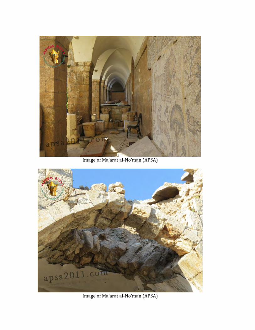
Image of Ma’arat al-‐No’man (APSA)
Image of Ma’arat al-‐No’man (APSA)

Image of Ma’arat al-‐No’man (APSA)
Image of Ma’arat al-‐No’man (APSA)

Image of Ma’arat al-‐No’man mosaics (APSA)
Image of Ma’arat al-‐No’man mosaics (APSA)

Image of Ma’arat al-‐No’man mosaics (APSA)
Image of Ma’arat al-‐No’man mosaics (APSA)

Image of Ma’arat al-‐No’man mosaics (APSA)
Image of Ma’arat al-‐No’man mosaics (APSA)

Image of Ma’arat al-‐No’man mosaics (APSA)
Image of Ma’arat al-‐No’man mosaics (APSA)

Image of Ma’arat al-‐No’man mosaics (APSA)
Image of Ma’arat al-‐No’man mosaics (APSA)

Image of Ma’arat al-‐No’man mosaics (APSA)

SHI 14-‐042
Report Date: October 1, 2014 Site Name: Ancient City of Bosra Date of Incident: Unspecified Location: Bosra, 140 kilometers south of Damascus, Daraa Governorate Coordinates: Lat. 32.518406°, Lon. 36.482017° Site Description: See individual entries. For a general introduction consult the UNESCO WHS website http://whc.unesco.org/en/list/22. Site Date: Bosra dates to primarily to the Nabataean, Roman, Byzantine, Islamic Periods Source of Destruction: The DGAM were able to assess damage in several historical buildings in the Ancient City of Bosra:
• Mabrak Mosque, Bosra (Lat. 32.52285, Lon. 36.48697) — Several stones have collapsed on the eastern part. See SHI Weekly Report 8.
• Al-Omari Mosque (Lat. 32.52156, Lon. 36.4829) — The Minarets
of the mosque have been damaged, while minor damage also appeared in the artificial zinc roof, walls, and floors. Several stones in the east area arch were destroyed. See SHI Weekly Report 8.
• Bab al Hawa – Temporary block walls were built in front of the
western façade and in the western gate of the old city. The DGAM also reports vandalism and graffiti on the ancient walls.
Pattern: Urban warfare. Monitoring Recommendations and Mitigation Measures: Fighting in the south of Syria has been particularly heavy and well documented in international media, much like Aleppo in the north. SHI has prioritized ancient Bosra for monitoring and evaluation.
Sources:
Online Reporting: • DGAM Website

o http://www.dgam.gov.sy/index.php?d=314&id=1436 Scholarly: Numerous. See especially the basic bibliography provided in Ross Burns 2010. Burns, Ross. 2010. The Monuments of Syria. A Guide. (I.B. Tauris), pp. 78–87.
Image of the Mabrak Mosque in the Ancient City of Bosra (DGAM)

Image of the Mabrak Mosque in the Ancient City of Bosra (DGAM)
Image of the Mabrak Mosque in the Ancient City of Bosra (DGAM)

Image of the Mabrak Mosque in the Ancient City of Bosra (DGAM)

Image of the al-‐Omari Mosque in the Ancient City of Bosra (DGAM)

Image of the al-‐Omari Mosque in the Ancient City of Bosra (DGAM)

Image of the al-‐Omari Mosque in the Ancient City of Bosra (DGAM)

Image of the al-‐Omari Mosque in the Ancient City of Bosra (DGAM)

Image of the al-‐Omari Mosque in the Ancient City of Bosra (DGAM)

Image of the al-‐Omari Mosque in the Ancient City of Bosra (DGAM)

Image of the al-‐Omari Mosque in the Ancient City of Bosra (DGAM)

Image of the al-‐Omari Mosque in the Ancient City of Bosra (DGAM)

Image of the al-‐Omari Mosque in the Ancient City of Bosra (DGAM)

Image of the al-‐Omari Mosque in the Ancient City of Bosra (DGAM)

Image of the al-‐Omari Mosque in the Ancient City of Bosra (DGAM)
Image of the temporary block wall at Bab al-‐Hawa (DGAM)

SHI 14-‐043 Report Date: September 30, 2014 Site Name: Resafa (ancient Sergiopolis) Date of Incident: 2011 Location: Raqqa Governate, 30 km south of Raqqa Coordinates: Lat. 35.629428, Lon. 38.758071
Site Description: See Burns’ description8 for an overview of the city.
Site Date: Byzantine Source of Destruction: Looting Pattern: Pre-‐conflict looting Monitoring Recommendations and Mitigation Measures: — Sources:
Scholarly: • Casana Satellite Imagery
Online Reporting: • Ross Burns
Scholarly: Numerous. See SHI bibliography.
8 Burns, Ross. 2010. The Monuments of Syria: A Guide (I.B. Tauris), pp. 195–198.

Resafa in 2011 (Digital Globe®, Casana)
Resafa in 2009 (Digital Globe®, Casana)

SHI 14-‐044
Report Date: September 30, 2014 Site Name: Mari (Tell Hariri), UNESCO WHS Tentative List Date of Incident: 2011–2014 Location: 12 kilometers west-‐northwest of Abu Kemal (Syria-‐Iraq border), Deir ez-‐Zor Governorate Coordinates: Lat. 34.550839, Lon. 40.88905 Site Description: See overview in Burns9
Site Date: Early/Middle Bronze Age Source of Destruction: Satellite images show moderate looting at the site. Pattern: Looting during the conflict. Monitoring Recommendations and Mitigation Measures: — Sources:
Online Reporting: Scholarly:
• Casana Satellite Imagery • Numerous. See SHI bibliography
9 Burns, Ross. 2010. The Monuments of Syria: A Guide (I.B. Tauris), pp. 208–210.

Satellite image of Mari in 2011 (Digital Globe®, Casana)
Satellite image of Mari from 2014 showing moderate looting (Digital Globe®, Casana)

SHI14-‐045
Report Date: September 30, 2014 Site Name: Sheikh Hamad (ancient Dur-‐Katlimmu) Date of Incident: January 2011 to March 2014 Location: Lower Khabur Coordinates: Lat. 35.643517, Lon. 40.740403 N Site Description: See the Tell Sheikh Hamad website http://www.schechhamad.de
Site Date: Late Bronze Age, Iron Age Source of Destruction: Satellite imagery shows looting, which heavily increased at the site after 2012. Pattern: Looting during the conflict Monitoring Recommendations and Mitigation Measures: Sources:
Online Reporting: http://www.schechhamad.de Scholarly:
• Casana Satellite Imagery • Numerous. See SHI bibliography.

Sheikh Hamad in January 2012 (Digital Globe®, Casana)
Sheikh Hamad in March 2014 showing severe looting (Digital Globe®, Casana)

SHI 14-‐046
Report Date: September 30, 2014 Site Name: Qalaat al-‐Shmemis Date of Incident: March 8, 2012 to April 10, 2012 Location: 30 km southeast of Hama Coordinates: Lat. 35.036883, Lon. 37.013639 Site Description: Castle built atop an extinct volcano originating in the 1st century BC. Destroyed by Khosrau II in 613 AD and subsequently rebuilt by Assad ud-‐Din Shirkoh (1229 AD) under the Ayyubids and destroyed by the Mongols in 1260 and Timurid forces in 1401 and again rebuilt.
Site Date: Hellenistic, Roman, Fatimid/Ayyubid/Ottoman Source of Destruction: Road-‐like feature built between March and April of 2012. Bulldozing also evident t the site. Pattern: Damage during the conflict Monitoring Recommendations and Mitigation Measures: — Sources:
Scholarly: • Casana Satellite Imagery
Online Reporting:

Qalaat al-‐Shmemis, March 8, 2012 (Digital Globe®, Casana)
Qalaat al-‐Shmemis, April 10, 2012, showing bulldozing (Digital Globe®, Casana)

SHI14-‐047
Report Date: September 30, 2014 Site Name: Tell Leilan (ancient Shubat Enlil) Date of Incident: March 2011 to February 2014 Location: Al-‐Hasakah Governate Coordinates: Lat. 36.958044, Lon. 41.505240 Site Description: See esp. Harvey Weiss, Harvey. 1985. “Tell Leilan and Shubat Enlil,” Mari, Annales de Recherches Interdisciplinaires 4, pp. 269–92.
Site Date: 5000 BC–1726 BC Source of Destruction: Garrison built after July 2013 Pattern: Damage during conflict Monitoring Recommendations and Mitigation Measures: — Sources:
Scholarly: • Casana Satellite Imagery
Online Reporting: Numerous. See SHI bibliography

Tell Leilan, March 2011 (Digital Globe®, Casana)

Satellite image of Tell Leilan (February 2014) showing the construction of a military garrison (Digital Globe®, Casana)

SHI14-‐048
Report Date: September 30, 2014 Site Name: Mohammed Diyab Date of Incident: April 2013 to February 2014 Location: 7 km southeast of Tell Leilan Coordinates: Lat. 36.924469, Lon. 41.5643 Site Description: See synopsis of excavation results provided in Akkermanns, P. and G. Schwartz. 2003. The Archaeology of Syria. (Cambridge), pp. 312, 321, 348, 350, 359.
Site Date: Middle Bronze Age, Late Bronze Age, Source of Destruction: Massive damage occurred at the site after April 8, 2013. Pattern: Damage during the conflict Monitoring Recommendations and Mitigation Measures: — Sources:
Scholarly: • Casana Satellite Imagery • Numerous. See SHI bibliography.
Online Reporting: —

Satellite image of Mohammed Diyab taken in April 2013 (Digital Globe®, Casana)
Satellite image of Mohammed Diyab (February 2014) showing the
construction of a military garrison (Digital Globe®, Casana)

SHI14-‐049
Report Date: September 30, 2014 Site Name: Tell Hamidiya (ancient Taide?) Date of Incident: February 2013 to April 2014 Location: Upper Khabur, South of Qamishli Coordinates: Lat. 36.816702, Lon. 41.165162 Site Description: See synopsis of excavation results provided in Akkermanns, P. and G. Schwartz. 2003. The Archaeology of Syria. (Cambridge), pp. 347, 350, 382.
Site Date: LBA, Early Iron Age Source of Destruction: Roads and garrisons were constructed on the site. APSA reports ISIS control and illegal digging. Pattern: Damage during the conflict Monitoring Recommendations and Mitigation Measures: — Sources:
Scholarly: • Casana Satellite Imagery • Numerous. See SHI bibliography
Online Reporting:

Satellite image of Hamidiya taken in February 2013 (Digital Globe®, Casana)
Satellite image of Hamidiya (April 2014) showing the construction of a
military garrison (Digital Globe®, Casana)
SHI14-‐050
Report Date: September 30, 2014 Site Name: Tell Badaye Date of Incident: March 2013 to April 2014 Location: Left bank of the Euphrates Valley in the Tishreen, Aleppo Governate, south of Jerablus Coordinates: Lat. 36.732492, Lon. 38.119467 Site Description: Large unexcavated multi-‐period mound. Badaye has been covered by surveys.
Site Date: Various. Bronze Age, Iron Age, Byzantine Source of Destruction: Evidence of looting on February 8, 2014 Pattern: Looting during the conflict Monitoring Recommendations and Mitigation Measures: — Sources:
Scholarly: • Casana Satellite Imagery •
Online Reporting:

Satellite image of Badaye taken in March 2013 (Digital Globe®, Casana)
Satellite image of Badaye (April 2014) showing the construction of a military garrison (Digital Globe®, Casana)

SHI 14-‐051
Report Date: September 30, 2014 Site Name: Tell Shair Date of Incident: February 2013 to April 2014 Location: On Turkish border in Aleppo Governate, just south of Yumurtalik, Turkey and immediately west of Ayn al-‐Arab/Kobani Coordinates: Lat. 36.902422, Lon. 38.302092 Site Description: Large unexcavated circular/conical mound.
Site Date: ? Source of Destruction: Evidence of construction Pattern: Damage during conflict Monitoring Recommendations and Mitigation Measures: Sources:
Scholarly: • Casana Satellite Imagery
Online Reporting:

Satellite image of Tell Shair taken in February 2013 (Digital Globe®, Casana)
Satellite image of Tell Shair (April 2014) showing construction (Digital Globe®, Casana)

SHI 14-‐052
Report Date: September 30, 2014 Site Name: Shioukh Tahtani Date of Incident: April 2014 to September 2014 Location: Tishreen Dam area, Euphrates, Aleppo Governate Coordinates: Lat. 36.754322, Lon. 38.083944 Site Description: See synopsis of excavation results provided in Akkermanns, P. and G. Schwartz. 2003. The Archaeology of Syria. (Cambridge), pp. 226, 306, 344.
Site Date: Bronze Age Source of Destruction: Bulldozing Pattern: Damage during the conflict Monitoring Recommendations and Mitigation Measures: — Sources:
Scholarly: • Casana Satellite Imagery • Numerous. See SHI bibliography
Online Reporting:

Satellite image of Shioukh Tahtani taken in April 2014 (Digital Globe®, Casana)
Satellite image of Shioukh Tahtani taken in September 2014 showing bulldozing (Digital Globe®, Casana)

SHI 14-‐053
Report Date: September 30, 2014 Site Name: Tell Bi’a (ancient Tuttul) Date of Incident: October 2013 to June 2014 Location: Outskirts of modern Raqqa, Raqqa Governate Coordinates: Lat. 35.957867, Lon. 39.047439 Site Description: See synopsis of excavation results provided in Akkermanns, P. and G. Schwartz. 2003. The Archaeology of Syria. (Cambridge), pp. 255–256. Site Date: Bronze Age Source of Destruction: Looting occurred before 2011, while two small buildings were built in the northwest part of the site. Soil was removed from the southeastern part. Pattern: Looting before the conflict and damage during the conflict Monitoring Recommendations and Mitigation Measures: — Sources:
Scholarly: • Casana Satellite Imagery • Numerous. See SHI bibliography
Online Reporting:

Satellite image of Tell Bia taken in October 2013 (Digital Globe®, Casana)
Satellite image of Tell Bia taken in June 2014 showing construction (Digital Globe®, Casana)

SHI 14-‐054
Report Date: Site Name: Madrasa Khusruwiye and Khan al-‐Shouna, UNESCO World Heritage Site, Ancient City of Aleppo Date of Incident: October 3, 2014 (three tunnel bombs) and September 2, 2014 (two tunnel bombs) Location: Aleppo Coordinates: Madrasa Khusruwiye (36°11'49.33"N, 37° 9'38.51"E): Site Description: See SHI Incident Reports SHI14-‐004 and SHI14-‐024
Site Date: See SHI Incident Reports SHI14-‐004 and SHI14-‐024 Source of Destruction: Damage caused by two series of tunnel bombings. The Khusruwiye complex has been completely destroyed and the Pattern: Tunnel bombs in Old City of Aleppo. See SHI Weekly Reports 2 and 5 Monitoring Recommendations and Mitigation Measures: SHI has already designated this a high priority area for monitoring. Mitigation efforts are not feasible until an abatement of hostilities in the area. Sources:
Scholarly: Numerous. See SHI bibliography
Online Reporting: APSA Website
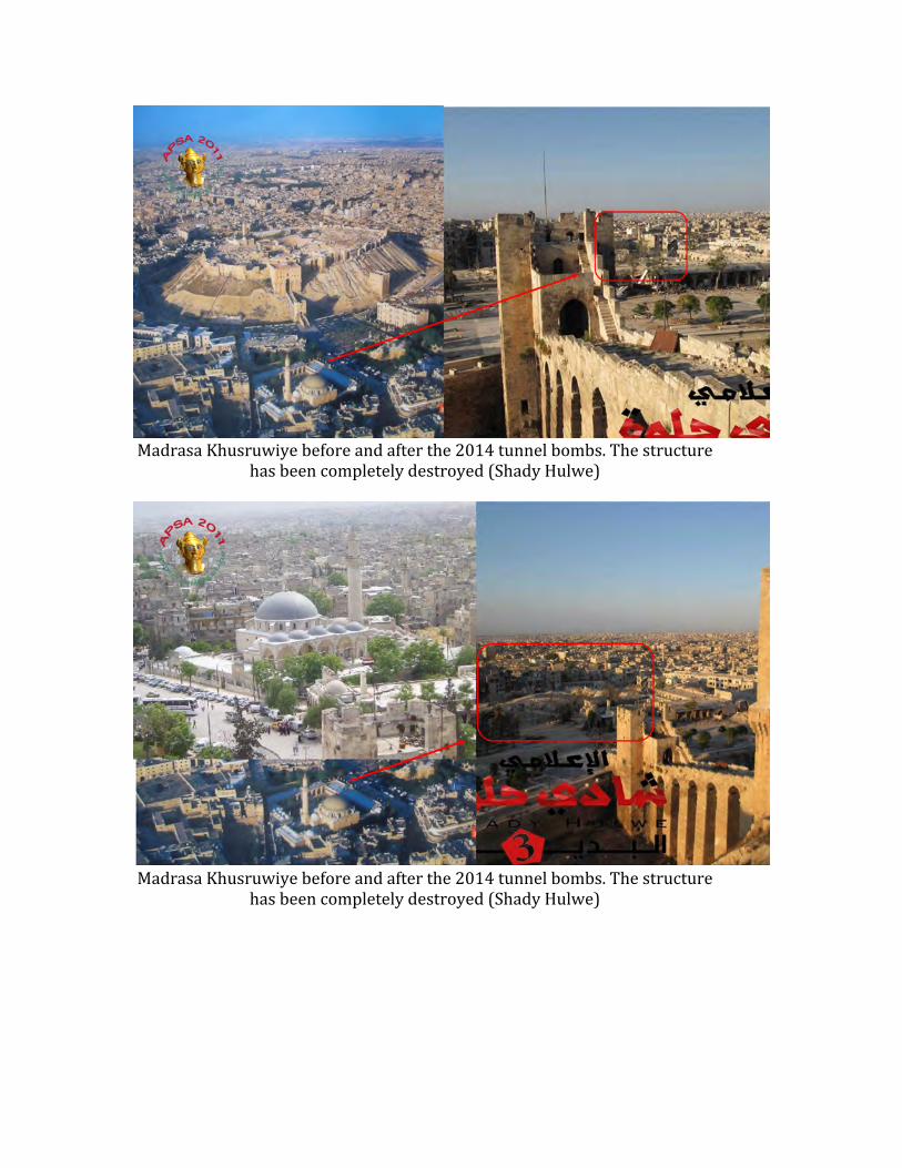
Madrasa Khusruwiye before and after the 2014 tunnel bombs. The structure
has been completely destroyed (Shady Hulwe)
Madrasa Khusruwiye before and after the 2014 tunnel bombs. The structure
has been completely destroyed (Shady Hulwe)
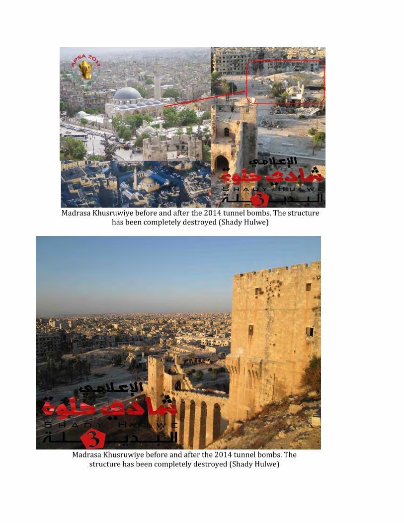
Madrasa Khusruwiye before and after the 2014 tunnel bombs. The structure
has been completely destroyed (Shady Hulwe)
Madrasa Khusruwiye before and after the 2014 tunnel bombs. The
structure has been completely destroyed (Shady Hulwe)

Madrasa Khusruwiye before and after the 2014 tunnel bombs. The structure has
been completely destroyed (Shady Hulwe)

Madrasa Khusruwiye before and after the 2014 tunnel bombs. The
structure has been completely destroyed (Shady Hulwe)

Madrasa Khusruwiye before and after the 2014 tunnel bombs. The
structure has been completely destroyed (Shady Hulwe)