


Bahasa
Halaman
Hukum


1
Climatic Change, 2005, v71, 43-73. DOI: 10.1007/s10584-005-5956-6
Running title: Regional integrated assessment in the UK: II. Results
A regional, multi-sectoral and integrated assessment of the impacts of
climate and socio-economic change in the UK: Part II. Results
I.P. Holman1, R.J. Nicholls2, P.M. Berry3, P.A. Harrison3, E. Audsley4 S. Shackley5 and M.D.A.
Rounsevell6
1 Institute of Water & Environment, Cranfield University, UK2 School of Civil Engineering and the Environment, University of Southampton, UK3 Environmental Change Institute, University of Oxford, UK4 Silsoe Research Institute, UK5 Tyndall Centre for Climate Change Research, University of Manchester, UK6 Université catholique de Louvain, Belgium
Corresponding author: I.P. Holman
Cranfield University
Silsoe
Bedford MK45 4DT
United Kingdom
Tel: +44 (0)1525 863000
Fax: +44 (0)1525 863344
Email: [email protected]
Abstract
The ‘Regional Climate Change Impact and Response Studies in East Anglia and North West
England’ (RegIS) Integrated Assessment investigated climate and socio-economic impacts and
adaptation options, and cross-sectoral interactions between four major sectors driving landscape
change (agriculture, biodiversity, coastal zones and water resources). The baseline and two
contrasting climate change scenarios (with and without regional socio-economic change scenarios)
were investigated. RegIS showed that climate change, without policy adaptation, could lead to severe

2
flood impacts in East Anglia, and significant agricultural abandonment. Despite yield changes,
cropping is generally insensitive to climate, but very sensitive to socio-economic change. There is
increased seasonality to river flows, compounded by increased urbanisation and irrigation demand.
The responses of biodiversity to climate change are regional, habitat and species-specific, but much of
the future of biodiversity in these regions will depend on planned adaptation in the other sectors.
Numerous examples of public engagement with the global change sphere represent the real outward
value of RegIS, due to the significant uncertainties and limitations to knowledge in this first regional
IA which prevented results of the detail, specificity and confidence that decision-makers required.
However, with further investment and refinement, regional IA’s will increasingly provide such output.
[Words=198; Maximum allowed = 200 words]
1. Introduction
Efforts to observe, model and assess climate change and other environmental stresses have
principally, to date, taken a global or national (e.g. Parson et al. 2003; Harrison et al., 2001)
perspective. However, there is a widespread view that the next generation of studies should focus at
the sub-national (regional) scale, on specific, coherently defined regions, as these represent an
important and underexplored geographical and political foci for analysing the impacts of, and
responses to, global change (e.g. McKenzie-Hedger et al 2000; IPCC 2001; Parson et al. 2003).
Two beliefs or rationales underpin this regional emphasis. Firstly, that stakeholders will engage more
effectively with climate change if the impacts can be demonstrated at the local-regional scale with
which they interact, rather than if impacts are only presented at national or international scales. And
secondly, that much of the policy response can, and should, be developed and implemented at local
and regional scales rather than at the national scale. Such a regional scale should allow studies to seek
advanced integrated understanding of linked environmental systems and stresses in the region, with
both the process detail and spatial resolution necessary to inform regional decision makers. Holman
et al. (Submitted) describes the methodological development of such a sub-national study in the UK-
the ‘Regional Climate Change Impact and Response Studies in East Anglia and North West England’
(RegIS) study. This paper describes: the results of RegIS for the two study regions, how and to what
extent adaptation (autonomous and planned) was considered, and discusses the usefulness of the
model results.
2 The case study regions
Two contrasting regions within England were chosen (Figure 1) to allow the diversity of the problems

3
and approaches to be examined within the RegIS sub-national scale study.
East Anglia, in the east of England, is approximately 155 km (east-west) by 115 km (north-south). It
is the least hilly part of Britain, with most land below 60 m above sea level (masl), and appreciable
areas, such as the Fens, below sea level. The climate of East Anglia is influenced by low relief and its
proximity to the continent. Compared with other regions of Britain, it is least affected by the
moderating influence of the sea, so rainfall is lower and there is a greater daily or monthly
temperature range than elsewhere. Rainfall (average annual = 550 - 750 mm) is more or less equally
distributed throughout the year. As a consequence of its relatively dry climate and low-lying
topography it is one of the most intensively cultivated areas, with an emphasis on arable agriculture.
The region is well known for its scenic coastal areas, such as in north Norfolk and important nature
conservation areas such as The Broads National Park. The area has a relatively low level of
urbanization, with the exception of key urban centres such as Cambridge and Norwich, which are also
a foci for the high tech industry.
The North West of England is the larger of the two regions at approximately 95 km (east-west) by 255
km (north-south). It is dominated by the higher (up to about 900 masl) land in the north and along its
eastern boundary, although lower land is found in the west and south of the region. The proximity of
the North Atlantic provides a moderating influence on the climate, producing generally milder and
wetter climate (average annual rainfall = 650 - 3200 mm), allowing for the effects of altitude. The
diversity of the physical environment produces a range of farming systems, from rough grazing for
sheep in the uplands, permanent grassland for sheep and cattle in the lower hills to mixed arable and
dairy farming in the lowlands. Urban development is focussed in the south of the region, around the
conurbations of Liverpool and Manchester, and coastal resorts such as Blackpool along the west
coast. The Lake District, in the north of the region, is an important National Park whilst other areas
have important landscape value.
2.3 Input Scenarios
2.3.1 Climate change scenarios
The climate change scenarios developed on behalf of the United Kingdom Climate Impacts
Programme (UKCIP), known as the UKCIP98 scenarios are reported elsewhere (Hulme and Jenkins,
1998), but are briefly described for the two regions. Two of the UKCIP98 climate change scenarios
based on the HadCM2 global climate model were applied in the RegIS integrated assessment: the
Low and High scenarios for the 2050s. These represent the lower and upper boundaries of change

4
from the UKCIP98 core scenarios, which account for uncertainties in future global warming rates
attributable to different climate sensitivities and greenhouse gas emissions scenarios.
Changes in mean annual temperature of +0.9 and +2.3 °C are projected for the Low and High
scenarios for the 2050s, respectively, based on the HadCM2 2.5 ° latitude x 3.75 ° longitude grid cell
encompassing East Anglia. The corresponding figures for the North West region are +0.8 and +2.1
°C (based on the mean of the two HadCM2 grid cells encompassing this region). Seasonal changes in
temperature are similar to the annual projections. Annual rainfall changes of +1 and +2 % are
projected for East Anglia and changes of +3 and +4 % are projected for the North West for the Low
and High scenarios, respectively. Seasonal differences in rainfall changes are much greater than for
temperature, with increases generally projected in winter, autumn and spring and decreases in
summer. Decreases in summer rainfall are greater in the East Anglia region (up to 18%) than in North
West England (up to 11%). Annual potential evapotranspiration increases by 14 and 29 % in East
Anglia and by 9 and 22 % in the North West for the Low and High scenarios for the 2050s,
respectively. Increases in atmospheric carbon dioxide (CO2) concentrations from the 1961-90
average of 334 ppmv to 467 and 528 ppmv by the 2050s (increases of 40 and 58 %) are
associated with the projections of climate change from the UKCIP98 Low and High scenarios,
respectively. The climate change scenarios were downscaled to a 5km x 5km spatial resolution for
the two regions as described in Holman et al (In Prep.).
2.3.2 Regional socio-economic scenarios
It was only feasible to run two of the regional socio-economic scenarios through the integrated impact
models, due to resource and time constraints (Holman et al., in prep). The Regional Enterprise
scenario was selected because it represents a socio-economic future which is desired by many
regional stakeholders and potentially imposes a high level of stress upon the environment and natural
resources (relative to other scenarios). Hence, combining this socio-economic scenario with the High
climate change scenario described above generates a future which is likely to be a 'higher
environmental change / stress' scenario. The diagonal matching scenario for Regional Enterprise is
Global Sustainability, reflecting a world where socio-economic pressures on environmental systems
and natural resources are less pronounced. This was combined with the Low climate change scenario
to generate a 'lower environmental change / stress' future.
The Regional Enterprise scenario is the most economically 'bullish' of the scenarios, suggesting
vibrant, semi-autonomous regions, keen to promote and maintain their distinctive qualities in a highly
competitive world. The Regional Enterprise scenario suggests a greater degree of economic and

5
political autonomy than presently. Certain sectors, such as agriculture, will be much more exposed to
the market and could decline as a result, although there would be economic support where this
promotes regional cohesiveness. A high degree of devolution to regional government will encourage
considerably more political control and involvement in planning, development, investment and
resource management than is currently the case. The environment is seen as a commodity which can
be traded, although this does not necessarily imply degradation or loss of resources; where direct
economic gain can be demonstrated, then assets will be highly valued.
East Anglia under the Regional Enterprise scenario has a higher growth rate than the North West
and a higher incoming population. Development pressures are, therefore, greater in East Anglia than
in the North West and occur especially in the Cambridgeshire sub-region, along key transport
corridors, and around Norwich. In the North West, the main focus of development will be in the
'crescent' between Manchester, Liverpool and north Cheshire, and further northwards along key
transport corridors. The coastline will be quite extensively developed in East Anglia. Certain sites of
high biodiversity value will be protected in East Anglia and the North West, but the less important
sites will generally become less protected and more open to development than at present. Agricultural
subsidies will be reduced, which will expose agricultural production to more global markets.
In the Global Sustainability scenario, the global approaches to achieving sustainable development
take precedence over regional responses. The World is seen as an interconnected whole, functionally
and morally, with a concentration on the wider impacts of individual actions. Through the reformed
European Common Agricultural Policy, agriculture is directed towards that which is most suitable to
be grown locally in the context of a continental scale landmass. Subsidy payments and environmental
taxation are used to move agriculture away from intensification. Development patterns reflect a
desire to conserve greenfield resources and cities, therefore, become more compact than at present,
their character transformed through city greening and the establishment of pedestrian-oriented
enclaves. Nevertheless, new greenfield settlements are developed, where these can demonstrate a
high degree of self-containment and the enhancement of the landscape into which they are placed.
Equity considerations are likely to be increasingly important in general. Biodiversity resources - and
priorities for conservation and improvement - are seen in a broad spatial context, at the European and
global scales. Water resources are managed as a national-level resource. Coastal protection policy is
directed to the most vulnerable regions considered in a national context.
Under the Global Sustainability scenario, there is widespread dispersal of development across the
East Anglian region (though at a low level compared to the Regional Enterprise scenario), which
stimulates the growth of locally based solutions to aiding global sustainability, such as co-operative
ventures, farmers’ markets and increased self-governance. In the North West, nearly all new
6
development is concentrated within existing urbanised areas and on brown land and only very limited
new coastal development is permitted. As a key vulnerable coastline in Europe, East Anglia's
coastline receives particular attention, including planning restrictions and efforts towards managed
realignment. Significant parts of the coastal plains of north west and north east Norfolk might be
allowed to revert to Fenland habitat, also enhancing sustainable flood control.
3 Results
The integrated impact models were applied on a common 5km x 5km spatial grid within the two study
regions. Five runs were undertaken for each region:
(i) Baseline (1961-90) conditions;
(ii) Low climate change scenario for the 2050s coupled with current (1990) socio-economic
conditions- hereafter referred to as the 2050s Low climate scenario;
(iii) High climate change scenario for the 2050s coupled with current (1990) socio-economic
conditions- hereafter referred to as the 2050s High climate scenario;
(iv) Low climate change scenario coupled with the Global Sustainability socio-economic
scenario for the 2050s- hereafter referred to as the 2050s Low (Global Sustainability)
future;
(v) High climate change scenario coupled with the Regional Enterprise socio-economic
scenario for the 2050s- hereafter referred to as the 2050s High (Regional Enterprise)
future.
We discuss the key findings for each region looking at each sector in turn, before analysing adaptation
options in response to impacts. Results are summarised in Tables 1 to 4 for the East Anglian and
North West England regions in terms of qualitative plausible futures for the 2050s under the Low
climate change scenario linked with the Global Sustainability socio-economic scenario and under the
High climate change scenario linked with the Regional Enterprise socio-economic scenario. Example
spatially-explicit quantitative model output from the integrated impact models is illustrated in Figure
2. More detailed analyses for both regions are presented below by sector.
3.1 Sectoral results
3.1.1 Coasts and floodplains
The global sea-level rise scenarios provided by GCM’s need to be converted to relative sea-level rise
scenarios (Table 5) for regional impact analyses to reflect the effects of regional land movement.
Hulme and Jenkins (1998) suggest that sea levels will rise 10 % more than the global-mean rise on the

7
UK coast due to climate change-induced regional oceanic changes within the Atlantic. However, the
changes in these regional components of sea-level rise are less certain than the global components and
have not been included in the analysis. The relative sea level rise obtained from the UKCIP98 Low
scenario is similar to the continuation of observed trends, while that obtained from the UKCIP98 High
scenario represents a four-fold and seven-fold acceleration in East Anglia and the North West,
respectively. Changes in river flooding are considered via assumed uniform increases in the 1 in 100-
year flood flows of 5 % and 20 % for the 2050s Low and 2050s High climate scenarios, respectively.
These assumed values are derived from model studies of the impact of climate change on peak flows
in the Rivers Severn and Thames (Reynard et al., 1999) in the absence of better data. However, the
catchment modelling conducted within RegIS is consistent with an increase in flood risk along rivers,
particularly in the North West (see Section 3.1.3).
The 2050s High (Regional Enterprise) future includes increased development in coastal and flood
plain developments as well as a focus on “hold the line” in shoreline management. Therefore, there is
little interest in policies, such as managed realignment, which would allow declining saltmarshes to
migrate landward. The 2050s Low (Global Sustainability) future also sees increased development in
both regions, but with careful land use planning steering these developments away from flood-prone
areas. There is also significant habitat re-creation to maintain and enhance natural and semi-natural
habitats within areas such as the Fens, and widespread managed realignment along the coast.
Climate change has profound implications for coastal areas and river valleys, especially in East
Anglia. The effect of the relative sea-level rise scenarios on coastal flooding, as given by raising the
surge heights as determined by Dixon and Tawn (1997) by the magnitude of sea-level rise, is shown
in Table 6 for the case of the 100-year event. It shows that the increases in sea level given in Table 5
will significantly increase the frequency of flooding, unless flood defences are raised. Flooding in the
2050s is enhanced by all the climate change scenarios, but the impacts are much greater under the
2050s High climate scenario. Sea defences, which presently provide protection to a 1 in 100 year
standard, would be reduced to the range of a 2- to 8-year standard by the 2050s under this scenario.
(By the 2080s, many of these defences would be at or below a 1-year standard under this scenario).
Without adaptation, the interaction of sea-level rise, increased river floods and ongoing
subsidence/peat oxidation could lead to severe and extensive flood impacts in the Fens of East Anglia,
leading to the large-scale abandonment of this prime agricultural area. Significant flood impacts
would also occur in the Norfolk Broads in East Anglia and the Lancashire coastal plainin the North
West. Under the 2050s High climate scenario, analysis suggests that arable agriculture would be
precluded by the high frequency of flooding over 86 % of the Fens, 10 % of the remainder of East
Anglia, and 7 % of the North West. Most of this land is expected to revert to grazing marsh, while in
the Fens it is expected to revert to a mixture of grazing marsh and fenland, although this will also

8
depend on the land management regime (e.g. amount of grazing). Existing allowances for future sea-
level rise in flood defence project guidance (MAFF 1999) would more than compensate for the
limited impacts of the 2050s Low climate scenario, but would only reduce the flood impacts of the
2050s High climate scenario.
Order-of-magnitude calculations of average annual flood damage to properties at the region-scale are
given in Table 7 for two protection scenarios defined by Halcrow Maritime et al. (2000):
1. Maintaining present levels of protection (consistent with the RegIS assumptions); and
2. Meeting indicative standards (upgrading some substandard defences to the indicative
standard, and then maintaining these defence elevations).
They show that all climate change scenarios increase damages. However, raising all flood defences to
the present indicative standard would more than counter the impacts of the 2050s Low climate
scenario. In contrast, the 2050s High climate scenario significantly increases average annual flood
damages, with coastal damages increasing 20-fold in East Anglia. Collectively, the total losses in the
Anglian (i.e. a bigger region than assessed in RegIS) and North West regions of the Environment
Agency could exceed £700 million and £400 million/year, respectively. The 2050s High (Regional
Enterprise) future will enhance these impacts due to increased exposure to flooding. The annual
damages would increase by an additional 35 to 42 %, so that the main factor increasing flood damage
is the more frequent flooding of areas which have already been developed. Therefore, flood impacts
could be significantly enhanced by climate change, while socio-economic changes could produce
important additional impacts.
The area of saltmarsh and coastal grazing marsh will change in response to climate and non-climate
change, with both losses and gains being possible. However, much coastal grazing marsh is a man-
made habitat which depends on artificial flood defence as it occupies former intertidal areas. There
are limited coastal areas for grazing marsh creation, so losses are likely to predominate. Sea-level rise
may produce losses of saltmarsh, while planned and unplanned coastal realignment will produce gains
of saltmarsh and associated intertidal habitats. Thus, gains of saltmarsh will often produce losses of
coastal grazing marsh, which is expected to decline in area under all scenarios. At the local scale,
adaptation options are limited, as there is little suitable space to create replacement habitat within the
coastal zone. A balance may need to be struck to sustain coastal grazing marsh as a habitat, or
alternatively grazing marsh will need to be created in more sustainable, non-coastal locations. At the
regional scale, replacement freshwater habitats might be recreated at more inland locations. This
habitat creation could be part of innovative approaches to fluvial flood management, and hence tackle
multiple problems.

9
Under the 2050s Low climate scenario, saltmarsh losses are confined to the Suffolk coast, while under
the 2050s High climate scenario, saltmarsh losses occur around the entire East Anglian coast. These
losses are further exacerbated under the 2050s High (Regional Enterprise) future due to reduced
sediment availability. Although sea-level rise threatens existing saltmarshes, managed realignment,
and/or possible coastal abandonment of low value areas that are flooded frequently, could lead to no
net change or even a substantial net gain in the area of saltmarsh habitats. The saltmarshes in the
North West are predicted to remain stable under all the climate change scenarios, which is a function
of the high tidal range in this region. Unplanned retreat and coastal abandonment in response to sea-
level rise could even lead to net saltmarsh gains. However, additional saltmarsh losses could occur in
both regions due to processes other than sea-level rise: increased wave action due to increased
storminess is one possible driver. Under the 2050s Low (Global Sustainability) future there is
significant saltmarsh and intertidal habitat gain in both regions and a consequent coastal grazing
marsh decline. Compensating habitat creation in non-coastal locations could occur in river valleys
and coastal lowlands such as the Fens. In conclusion, for coastal ecosystems, climate change has
important impacts for biodiversity (See Section 3.1.4), but human management of the coast also has
an important control on the evolution of habitat.
3.1.2 Agriculture
The crop model shows yield changes are sensitive to the climate scenarios. In the 2050s Low climate
scenario, yields of crops generally increase, mainly due to the increased CO2, but yield increases are
less with the higher temperatures under the 2050s High climate scenario as crops begin to suffer
moisture stress in the summer, particularly in the drier East Anglian region, and earlier maturity
reduces the amount of solar radiation received. For example, the decrease in intercepted radiation and
increased droughtiness means that in most years there is a 10 % reduction in wheat yield in the 2050s
High climate scenario compared to 1995. However, this is more than compensated for by the CO2
fertilisation effect, which increases yields by approximately 17 %. The yield of grass shows a
different pattern and does not increase as much as arable crops in the 2050s Low climate scenario but
continues to increase in the 2050s High climate scenario as most growth occurs early in the season
before soil moisture restrictions develop. Yields increase by 30% in nearly all areas under the 2050s
High climate scenario. The yields of irrigated potato and sugar beet also increase, but show the same
trend as wheat, with greater increases under the 2050s Low climate scenario compared to the 2050s
High climate scenario.
The farm model indicates that the distribution of cropping in the East Anglian region shows little
change in type of cropping except due to socio-economic change. In the East Anglian region under
10
the 2050s High climate scenario, there is a large area deemed no longer suitable for arable agriculture
due to increased flooding as shown in Figures 2 and 3. The area of grass has also increased to almost
double its current area under the 2050s High climate scenario, although it is still a low proportion of
the total. The majority of this increase is due to land changing from arable to pastoral agriculture due
to the risk of flooding. However, despite the crop yield changes, the distribution of cropping shows
that when the socio-economic scenario is unchanged, the major cropping is also little changed.
Irrigated potatoes, however, which are not currently widespread, double in area. The area of sugar
beet using 200mm irrigation also increases, particularly in the 2050s Low climate scenario.
Elsewhere the distribution of cropping is very sensitive to the socio-economic scenarios, consistent
with the results of Abler et al (2002), with both socio-economic scenarios producing substantial
changes. In the East Anglian region, the proportion of the area in winter crops reduces under all
scenarios, due to corresponding increases in spring crops, sugar beet and potatoes. For the given
prices in the socio-economic scenarios, the results suggest that the area of irrigated potato fields
would double. The yields of sugar beet and potatoes increase most in the crop simulation. The
largest increase in potatoes is in the south of the region. The overall level of irrigation required in the
East Anglian region increases from 23 to 30 mm/ha/yr (Figure 4). The increased cost of water in the
socio-economic scenarios has little effect on reducing the amount of water used for irrigation, but the
improved technology of the Global Sustainability scenario has a substantial effect on water use..
The distribution of cropping in the North West region also shows little change in cropping type with
climate change and the current socio-economic scenario, but both socio-economic scenarios generate
a large increase in arable cropping, due to the reduced competitiveness of dairy farming. Switching
from grass to arable, as suggested in the North West, is a major capital change which is not easy to
reverse. In the short term, very few farms will change, but as the viable area expands and the relative
profitability of arable agriculture in the scenarios continues, more farms will do so. The distribution of
arable cropping shows changes which largely mirror those in the East Anglian region. The increase in
temperature means that most of the lowland (lower than 200 m above sea level) and upland (between
200 m and 300 m above sea level) areas are now suitable in terms of maturity for winter wheat, sugar
beet and potatoes, in agreement with Davies et al. (1997). As occurs in the East Anglian region,
cropping in the 2050s High (Regional Enterprise) future is dominated by cereals, sugar beet and
potatoes, because all other break crops loose their subsidies. This is almost certainly not an
economically sustainable position and prices would adjust. The 2050s Low (Global Sustainability)
future is almost the reverse of this situation with peas, beans, linseed and oilseed rape providing one
third of the arable cropping.
In the North West region, the proportion of the area in sugar beet shows a large increase throughout
the lowland areas and penetration northwards, though in this region most of it is unirrigated. The

11
overall level of irrigation required in the North West region is, in the highest scenario, only about 6
mm/ha/yr. There is the potential for sugar beet, and the increase suggests that by the 2050s there will
be a case for a sugar beet factory in this region, although the crop is probably still too sparse to justify
a factory in the extreme north. However, the need for a processing factory would depend on the
national demand for sugar. In the upland areas, the area of farmed grass only reduces from 95 % to 93
% of the area in the 2050s High climate scenario, but under the 2050s High (Regional Enterprise)
future this reduces to 83 % of the upland area. There is also a very large reduction in farmed grass in
the lowland areas in this scenario. It has been assumed that the Hill areas (higher than 300 m above
sea level) which are unsuitable for arable cropping remain as rough grazing.
The crop nitrogen requirement in East Anglia is almost unchanged for all the scenarios except for the
2050s High (Regional Enterprise) future, in which the large increase in the yields of the crops means
that there are correspondingly large increases in the economic optimum level of nitrogen to be
applied. Combined with the change in cropping this amounts to an increase of over 60 %. However,
the estimate of nitrate-nitrogen leaching is almost unchanged in all the climate-only scenarios,
although it increases by over 20 % in the two combined climate and socio-economic scenarios.
3.1.3 Water resources
The UKCIP98 climate change scenarios show an increase in annual average rainfall in all 2050s
scenarios (in comparison to the baseline) with the winters becoming wetter, partly at the expense of
the summer. The more clement climate in East Anglia and the North West leads to an increase in the
length of the growing season. It takes longer for the soils to wet up in the autumn and they start
drying out sooner in the spring, so that there is a median decrease in the recharge period in East
Anglia of 0.5 and 2.5 weeks in the 2050s Low and 2050 High climate scenarios, respectively.
Whether the increase in rainfall in a given area leads to an increase in hydrologically effective rainfall
(HER), depends upon a balance between the increase in winter rainfall, the decrease in the length of
the recharge period and the increase in winter evapo-transpiration (consistent with Hulme & Jenkins,
1998). HER is likely to decrease in most of East Anglia (with the exception of coastal areas) and the
lowland areas of the North West in all scenarios. For most of the hydrological indicators, the regional
patterns of change are similar under all scenarios but with a greater magnitude of change under the
2050s High climate change scenario combined with the Regional Enterprise socio-economic scenario.
The socio-economic scenarios affect the average annual HER predictions in two ways. Firstly,
increased urbanisation and area of hard surfaces (concrete, asphalt etc.) decreases evapo-transpiration
and consequently leads to locally increased HER. Secondly, the socio-economic scenarios can cause

12
regional changes in land use and resulting evapo-transpiration. For example, in the 2050s High
(Regional Enterprise) future compared to the2050s High climate scenario in East Anglia there is a
small (median of 1%) regional increase in average annual HER, which appears to result from an
increase in the cultivation of spring cereals and spring-sown crops (especially sugar beet), at the
expense of autumn-sown crops.
The gross groundwater resource (which supports the baseflow in rivers and most wetlands and, where
aquifers are present, supports abstraction) decreases slightly over much of East Anglia with the 2050s
Low scenario, with the exception of the coastal water resource units where droughty (sandy and very
thin chalk) soils dominate. In the 2050s Low climate scenario and 2050s Low (Global Sustainability)
future, low flows in East Anglia are predicted to remain virtually unchanged. Under the 2050s High
climate scenario low flows generally decrease in most catchments, by up to 25%, but under the 2050s
High (Regional Enterprise) future, the low flows increase in a number catchments. Most catchments
in the North West show a small increase of up to 5% in low flows under the 2050s Low climate
scenario (with the exception of those in the Lancashire coastal plain and the south-east of the RegIS
area where flows decrease by up to 5%), but a regional decrease under the 2050s High climate
scenario, this decrease tending to increase from about -5% in the north to -20% in the south.
Although domestic and industrial water consumption patterns have not been modelled within RegIS,
the combination of the simulated decrease in gross groundwater resource over most of East Anglia
and the decrease in low flows in many catchments with the changes in urbanisation and water demand
envisaged under the 2050s High (Regional Enterprise) future scenario, suggests that changes to the
water supply/transfer infrastructure or the implementation of demand-side adaptation, may be
required in some areas. The reduction in low flows may lead to an increased risk of saline incursion
in the lower reaches of coastal rivers beyond the current upper tidal limit, especially under the 2050s
High climate scenario. The risk will be greatest in East Anglia, due to the general lower flows, flatter
topography and greater sea level rise, although it may still be important in some North Western
catchments around the Mersey and Ribble estuaries.
Although high flows are not expected to increase greatly in East Anglia, the maximum simulated
weekly flow increases in many catchments. This suggests that fluvial flooding, without the influence
of the tides, is likely to increase in East Anglia, supporting the use of increased peak flows in the
flooding analysis. Many of the catchments where high flows are predicted to increase are located in
coastal areas. If the timing of high flows coincides with the higher tide levels associated with sea
level rise and / or increased storminess (tidal surges), there may be a significantly increased likelihood
of fluvial flooding in downstream areas. This particular increase in flood risk in coastal catchments is
consistent with the UK Foresight flood results (Watkinson et al., 2003) Fluvial flooding is

13
increasingly likely in the North West, due to the increased winter precipitation and hydrologically
effective rainfall. There is a general increase in the 5th percentile weekly flow of up to 5% in the
2050s Low climate scenario and 2050s Low (Global Sustainability) future and up to 10% in the 2050s
High climate scenario and 2050s High (Regional Enterprise) future. However, as the models do not
include snow melt, the future flood risk in catchments that currently experience flooding primarily
due to snow melt in the spring may be less in 2050s, due to the raised winter temperatures and
consequently lower snow accumulation.
Under all scenarios and futures, there is little change (of up to ± 1 mg/l) in the median groundwater
nitrate-N concentration, except for in The Broads, coastal Suffolk and the Fens under the 2050s High
climate scenario and 2050s High (Regional Enterprise) future, where the median concentrations
decrease greatly, as the increased flood risk has caused a land use change from arable to permanent
grassland and an associated reduction in leaching. A similar pattern of little change (of up to ± 1
mg/l), except for areas of increased flood risk, is observed in median surface water nitrate-N
concentrations in East Anglia. Under all scenarios and futures, the predicted surface water median
nitrate-N concentration decreases by up to 0.5 mg/l) in almost all of the catchments in the North West
Not all water quality indicators will behave in a similar manner to the changes brought about by
climate change. The increased average air temperatures throughout the year expected with climate
change will lead to similar (though lower) increases in water temperature. The dissolved oxygen
content of water is inversely related to water temperature so that there may be increased risks of low
dissolved oxygen content in some rivers, especially when low flows are particularly predicted to
decrease.
Future water quality with regard to pesticide pollution is less clear for two main reasons. Firstly,
pesticides are continually being developed with higher adsorption potential and shorter half lives, so
that their environmental losses are much lower than older compounds. In addition, the shortening of
the ‘recharge’ period will provide agricultural users with a longer time-window, after the autumn
applications of pesticide, before run-off occurs. Pesticide degradation may therefore be greater.
However, the potential for rapid by-pass flow may increase in some areas due to the likely increased
cracking of soils because of the warmer summers. If intense rain events occur soon after pesticide
applications in the autumn, then there will remain the scope for high, short duration, losses.
3.1.4 Biodiversity
Twenty eight species associated with four habitats in each region, which were important due to
dominance, sensitivity, or conservation designation, were chosen by the regional stakeholders.
14
Changes in the potential distribution of suitable climate space are summarized in Table 6 and
presented in full in Berry et al. (2001). The results provide further evidence that species, despite
having apparently similar initial distributions, respond individually to climate change leading to
totally new distributions and habitat composition (Huntley et al., 1995; Cannon, 1998; Bale et al.,
2002). In general, southern species, such as Plebejus argus (Silver-studded blue butterfly) and
Scandix pecten-veneris (Shepherd’s needle), exhibit a potential to expand their range northwards, as
conditions for their growth and reproduction become more favourable. The range of northern species,
such as Blysmus rufus (Flat sedge) and Alchemilla alpina (Alpine lady’s mantle), contracts, as
climatic conditions for survival become less favourable. Only one species (Erebia epiphron,
Mountain ringlet) of the 28 modelled could lose all suitable climate space.
The consequences of climate change for the different habitats depends on the sensitivity of the
component species (Berry et al, 2002). Where the trend for component species is consistent, as is the
case for the Arctic-Alpine and coastal grazing marsh habitats, then it could be assumed that they
would retract or expand their range respectively. This assumption is based on other component
species showing a similar response. Elsewhere, the future of the habitat appears to depend much more
on the species under consideration. If the dominants continue to find suitable climate space, as is the
case in upland hay meadows, blanket and raised bog and cereal field margins, then it could be
assumed that the habitat would continue in existence, but with a slightly different species
composition. Saltmarsh and fens, however, show a mixed species’ response. In these cases, additional
modelling of a wider range of species would help to test the above assumptions.
The North West is a critical area for climate change impact studies, because within it lies the climatic
divide between the warmer, drier, south east of Britain and the cooler, wetter, north west of the
country (Rodwell, 1998). Species here, therefore, are particularly sensitive to climate change,
especially if they are near their range margins. The Arctic-Alpine habitat is the most sensitive as all
species lose suitable climate space. In East Anglia all the selected species should continue to find
suitable climate space, except Puccinellia maritima (Common saltmarsh grass), chosen as part of the
saltmarsh habitat in the North West, which could lose suitability in East Anglia under the 2050s High
climate scenario. This scenario also shows that two fen species, Epipactis palustris (Marsh
helleborine) and Valeriana dioica (Marsh valerian) could start to experience a contraction in their
climate space in the region. This is most likely due to increasing soil moisture deficits. Balanced
against this there is the potential for two lowland heathland species, Plejebus argus (Silver-studded
blue butterfly) and Silene otites (Spanish catchfly), to expand their ranges, such that the former could
find suitable climate space in the North West region.

15
The future of both species and habitats are not only affected by their direct response to climate
change, but also depend on the impacts of climate change and socio-economics on the other sectors.
The integration of the SPECIES outputs with those from the other sectors showed that although
coastal grazing marsh species could expand their ranges, nevertheless, the localized existence of the
habitat could be threatened by losses due to sea level rise, particularly under the 2050s High (Regional
Enterprise) future in East Anglia. Some areas of saltmarshes in East Anglia could also be lost to sea
level rise and this, combined with the loss of potential climate space for some species, could mean
that the habitat undergoes significant changes in the future. Lowland heathland in East Anglia should
be able to maintain its species composition, but its existence is under pressure from agriculture. The
cereal field margin species, however, are more dependent on cropping practices. The upland hay
meadows would be affected by moves away from low intensity agriculture in the North West,
particularly under the 2050s High (Regional Enterprise) future which shows a reduction in farmed
grass and a large increase in arable cropping. Changing water levels are an issue for both blanket and
raised bogs and fens, with changes for the latter habitat exacerbating simulated stresses from the
direct effects of climate change for certain species. Impacts are summarised for each habitat:
Upland hay meadows: the dominant species, Anthoxanthum odoratum and Cynosurus cristatus,
will not lose climate space, but Geranium sylvaticum, another characteristic, but sensitive, plant
might. They are all susceptible to changes in agricultural practices, particularly intensification
and changing grazing regimes.
Blanket and raised bogs: the dominant species, Eriophorum vaginatum and Myrica gale, will
continue to find suitable climate space over most of Great Britain. There is a potential for this to
increase for Rhynchospora alba, but Coenonympha tullia, the more sensitive of the species, is
likely to have an increasingly restricted distribution. Changes in water levels, frequency of
flooding and water quality could have adverse effects on all the species.
Saltmarshes: individual species show differing sensitivities to climate change, such that in the
North West their composition may be altered by the potential loss of Blysmus rufus under the
2050s High climate scenario, but overall their existence appears unlikely to be threatened by
climate change. In parts of East Anglia, however, there is a loss of suitable climate space for all
of the other modelled species (Atriplex portulacoides, Puccinellia maritima and Suaeda
maritima). This is compounded under some scenarios by a loss of habitat.
Arctic-Alpine: this habitat is the most sensitive to climate change, but the species modelled may
not necessarily lose all suitable climate space under the 2050s Low climate scenario, except in the
case of Erebia epiphron. Further, even under the 2050s High climate scenario the other species
(Rubus chamaemorus, Salix herbacea and Alchemilla alpina) should be able to survive, but with
very restricted distributions.

16
Lowland heath: all species (Erica tetralix, Silene otites and Plebejus argus) continue to find
suitable climate space in the region and Silene otites, a rare species, could even expand.
However, habitat availability is very dependent on any changes in the area of agriculture, which is
unlikely to increase under most scenarios.
Cereal field margins: all species (Galium aparine, Papaver rhoeas and Scandix pecten-veneris)
continue to find suitable climate space in the region, and could benefit slightly from the possible
increases both in arable cropping in East Anglia (excluding the Fens) and in the greater proportion
of spring crops. The benefits of the latter, however, may be compromised by the nature of the
crops.
Fens: parts of East Anglia could become unsuitable under the 2050s High climate scenario for all
the species (Epipactis palustris, Ranunculus scleratus and Valeriana dioica), except Glyceria
maxima, a dominant, and water levels in summer could become critical for their survival. In the
Fens and The Broads, these species may be able to benefit from the increased flooding, but near
the coast they may have to show a certain salt tolerance.
Coastal grazing marsh: all species (Ranunuculus baudotii, Ranunculus sardous and Trifolium
fragiferum) could expand their potential climate range, but will be dependent on habitat
availability. Most scenarios show habitat losses due to saltmarsh movement inland, but gains
could come from flooding of arable land and re-creation.
The SPECIES model only shows where there would be potentially suitable climate space in the
future; it does not show actual future distributions. Where the occupation of this space would involve
large-scale movement outside a species’ current range, as is the case for Atriplex portucaloides, Silene
otites, Plejebus argus and Scandix pecten-veneris, then questions must be asked about the ability of
the species to realise such climate space. Atriplex portucaloides may be able to fill its potential future
climate space because it is a saltmarsh species that can be distributed by ocean currents, but the
others, which are dependent on terrestrial migration, are unlikely to be able to emulate this in the
time-scales involved. Habitat availability will also be important in affecting the migrational ability of
such terrestrial species. The next step, therefore, is to combine the distributions of future climate
space with models of species dispersal and habitat availability (Pearson et al. 2004).
4 Discussion of the results
4.1 Adaptation issues
The final stage of the DPSIR framework that has guided the RegIS analysis is the ‘response’ to
environmental impacts, which refers to the possibility of adaptation to specific changes in the state of

17
a system. In terms of the IPCC guidelines for climate impact assessment (Carter et al., 1994; Parry
and Carter, 1998) these adaptation responses are of two general types: autonomous adaptation (e.g.
the spontaneous or habitual responses and decisions of natural systems, individuals and organisations
to change their day-to-day actions or management in response to changing circumstances) and policy
implementation (e.g. the political decision to regulate against an adverse outcome or to support certain
development pathways).
Like other recent assessments (e.g. Parson et al. 2003), RegIS identified many potential adaptation
options to reduce climate impacts, but was unable to conduct systematic assessment of these options
due to resource and time constraints and gaps in existing data and analysis. Autonomous adaptation is
implicit in the agricultural model and partially in the biodiversity model. Although no policy
implementation was explicitly modelled, RegIS also more implicitly addressed the potential for
adaptation based on policy by examining the consequences of the different socio-economic scenarios
that were based on alternative visions of future societal attitudes.
4.1.1 Sector-specific adaptation strategies
Coasts
The results assumed no adaptation to climate change and so, identified the worst-case impacts.
Adaptation to the increased flood risk include raising flood defences, avoiding development on flood
plains and managed realignment, implemented within a strategic approach to coastal management.
Proactive adaptation is already in evidence in the UK, including shoreline management planning,
implemented since 1995 (DEFRA, 2001; Cooper et al., 2002). Since 1989, MAFF has provided
guidance on an allowance for accelerated sea-level rise in the design of new tidal flood defences of 6
mm/yr in East Anglia and 4 mm/yr in the North West. This is more than sufficient to counter the Low
climate change scenario, but under the High climate change scenario there might still be a seven-fold
increase in average annual flood damages by the 2050s. Therefore, it is important to monitor actual
changes in sea level around the British Isles, so that the timing and magnitudes of any acceleration
can be observed and factored into flood defence policy. Similarly, the possibility of increased
storminess under climate change needs further investigation and continuous monitoring, as the
impacts described above might be generated by the combination of sea-level rise and increased
storminess, rather than sea-level rise alone.
The Fens in East Anglia present particular problems in terms of responding to the identified flood
problems. Raising flood defences will be very expensive due to soil conditions. Therefore, wider
18
river channels might be more appropriate, although this will be very costly, possibly combined with
storm surge barriers to keep surges at bay. At the same time, there is great interest in habitat re-
creation in the Fens, and it might be possible to combine flood management and habitat creation if
there is more strategic planning. Other issues that should be urgently considered are land use
planning so that the necessary corridors for flood management are kept open. The Fens are the largest
coastal lowland in Britain and a strategic Fens plan on flood management, analogous to the open-
coast shoreline management plans would seem a prudent measure. Such a plan should include the
entire Fens, and would necessarily extend beyond the RegIS area.
While saltmarsh is threatened by sea-level rise around much of the coast, there seems to be sufficient
scope for habitat re-creation, via managed realignment, to sustain saltmarsh if that objective is agreed.
The management issue is more concerned with coastal grazing marsh and related freshwater habitats
such as at key locations along the North Norfolk and Suffolk coastline. Climate change and coastal
management are moving in the same direction and a decline in coastal grazing marsh seems almost
inevitable. This raises the question of the strategic replacement of these coastal habitats with non-
coastal grazing marsh. Regional or national scale plans to accomplish this goal would seem to be
prudent.
Agricultural land use
The results suggest that even in the extreme climate change scenario considered, substantial increases
in yields of staple crops, such as wheat, are likely. This could be regarded as a problem of even more
over production or an advantage of more produce to export to areas potentially in need. In the former
case, more land will need to be taken out of production or alternative uses found. It should be noted
that this study has not considered horticultural crops and whether there are possibilities for a longer
growing season so that locally grown UK produce might replace produce currently imported from the
Mediterranean areas. In the latter case, there will be increased fertiliser inputs required as these are
largely correlated with output and there will be the usual need to cope with any remaining differences
between European and world prices and the storage implications of fluctuations in production.
However, there seems little difference between this and current problems of increased yield due to
technology.
The comparison of the economic effect and the climate effect, suggests that most problems due to
climate change will occur to a much greater magnitude due to economic and technical changes.
Switching from grass to arable, as suggested in the North West, is a major change which is not easy to
reverse. The models do not address the issue of major capital changes required when switching
between types of farming, instead determining the type that is profitable within the economic scenario
19
presented. This represents the probability that a farm will change type and the greater the difference
in profit, the greater the chance. In the short term, very few farms will change, but as the relative
profitability continues more farms will. Expansion of the areas where arable crops are viable must put
pressure on grassland as it represents an alternative that did not previously exist. Periods of low
prices for grass-based products over the next 50 years, which will always occur from time to time,
combined with quality of life considerations, will thus inevitably cause a gradual change from grass to
arable in the North West.
The modelling results suggest that many new areas will be capable of growing viable crops of sugar
beet, if only there were a factory. This is likely to lead to a fall in price paid to UK farmers under the
national sugar beet quota system. However, this could be balanced by greater export demand for UK
sugar beet due to southern areas in continental Europe losing production. The need for greater
irrigation in East Anglia to maintain yields under climate change, and its limited availability, may
push the viability to the North West. It may therefore be more efficient to encourage a factory sited in
the North West e.g. Cheshire, than to encourage reservoirs for irrigation in East Anglia or pipelines to
import water from outside of the region. However, significant capital investment would be required
by farmers and contractors in the North West. Similar questions relate to potatoes, although there is
less concentration of potato factories for crisps and chips.
Although sunflower was the only crop to be considered in the modelling that is not currently widely
grown in the UK, it seems likely that grain maize and soybean will also gradually become viable.
Certainly as other crops become over produced because of the increased yield and the expansion of
viable production areas, these might become best choices, as appeared to occur in the cases where
they were selected. The gradual introduction of these crops seems likely to need some knowledge
support by government research and development and agronomy providers. Many of these crops are
already imported and processed but some storage, markets and processing facilities in appropriate
places may need to be encouraged. Negotiations with the European Community or World Trade
Organization should not exclude the future possibility of these crops being grown in the UK as
mainstream crops.
Water
It is likely that the potential demand for water will increase in the future. Herrington (1996) predicted
that the aggregate demand for water in the south and east of England for 2021 will increase in all
sectors, with the overall increase dominated by the domestic sector and irrigation. The results of the
RegIS modelling for the 2050s time-period, suggest that significant parts of East Anglia and the

20
southern part of the North West will experience reduced groundwater recharge, whilst many of the
rivers in both regions will have decreased summer flows. The resulting reduced availability of water
in both regions and the increased aggregate demand have the potential, therefore, to place strains on
water users and the water environment. However, the magnitude of the impacts of climate change
will depend on the nature of the physical infrastructure and the ability of the institutions managing
water to adapt (Arnell, 1996; 2000). Adaptation can occur in the:
Supply side e.g. the use of water transfer schemes, the construction of new reservoirs, more
efficient exploitation of existing resources such as through artificial recharge of aquifers or
conjunctive use schemes, reallocation of licences and resources amongst different users according
to altered priorities and increased use of grey water;
Demand side e.g. water conservation measures, abstraction licence restrictions, hosepipe bans,
water supply metering, differential water pricing.
Other options within a catchment context include changes in the methods by which the land is
managed, in order to increase the infiltration of rainfall and reduce run-off (for example by direct
drilling rather than conventional autumn cultivation on some soil types).
Within the context of the future worlds investigated within RegIS, the RegIS socio-economic
scenarios and the results of the modelling suggest the following may occur:
2050s High (Regional Enterprise) future
• There will be increase overall demand for water due to increased population and domestic water
demand (especially for East Anglia and Cumbria) and increased irrigation demand, for sugar beet and
potatoes in East Anglia, despite increased price of water. Water management will be increasingly
focussed at regional as opposed to national or EU level and while water transfers out of the regions
(especially East Anglia) will cease, water transfers into these relatively affluent regions will be
investigated. However, demand management will be favoured over major infrastructure
developments, e.g. new reservoir, due to lower costs.
2050s Low (Global sustainability) future
• There will be less pressure on water resources as there is little change in population in the two RegIS
regions and irrigation demand will decrease due to land use change and increased usage efficiency.
Water resources will be managed at the national and EU level. There will be a strong focus on
demand management, such as leakage reduction, in the two regions to control increased potential
demand and water transfers out of region will be dependent on demand management in receiving
regions.

21
Within both the 2050s High (Regional Enterprise) and 2050s Low (Global sustainability) futures, it is
likely that restrictions on nitrate application to land (such as the Nitrate Vulnerable Zone designation
under the current EC Nitrates Directive) will continue to be required in East Anglia to control nitrate
concentrations in surface and groundwaters.
Changes in water management tend to come about through both a series of small, incremental
adjustments based upon accumulated experience and more drastic, crisis-oriented responses
(Riebsame, 1988; Arnell, 1996). It is likely, therefore, that the adaptive responses for water
management will be based on flexible, integrated strategies incorporating both supply and demand
management, rather than relying on the financially, environmentally and politically contentious large
infrastructure schemes.
Species distributions
The possibility of autonomous adaptation due to a species expanding its range into new potential
climate space depends on its dispersal ability and the role of long-distance dispersal (Higgins and
Richardson, 1999). Coastal species should be able to spread on ocean currents, but other species have
variable migrational ability. Most plant species are unlikely, in the time-scale under consideration, to
be able to fulfil their total new potential climate space where this represents an increase in their range
northwards, even if long-distance dispersal occurs. Other taxa may have greater dispersal ability.
Most butterflies disperse short distances, although it is possible that individuals may be blown longer
distances, but their survival then depends on them finding a suitable habitat.
Species which are losing suitable climate space nationally e.g. Arctic-Alpines and regionally e.g.
Eriophorum vaginatum and Puccinellia maritima in East Anglia, are more likely to be in equilibrium
with their contracting climate space, but populations may be able to persist in microhabitats, for
example Arctic-Alpines on north-facing slopes. There is probably little that can be done for the
former set of species, other than reducing any known additional stresses. Local losses are less
significant providing the species has adequate climate space elsewhere, but may be of concern where
it is an important component of a habitat. Salt marshes in East Anglia, for example, may experience
considerable changes in species composition, but there are species that could substitute, although it
might lead to decreased diversity, at least in the short-term.
Increasing the size of habitat by expanding designated/protected areas will help in the continuance of
a species in a particular location, with a focus perhaps on reserves towards or immediately beyond the
22
northern edge of the species’ current range. The effectiveness of corridors is unproven for most
species, but at least trying to minimise large east-west barriers is helpful. For example, the Cheshire
Wildlife Forum suggested that north-south green corridors remained in the Liverpool-Manchester area
in order to facilitate species movement.
Much of the movement will be across managed land and here more environmentally friendly
management techniques, at least in selected areas, could be helpful e.g. minimising spraying adjacent
to verges, banks and hedges and leaving small areas of unmanaged land. Policies like Nitrate
Vulnerable Zones (NVZs), and set aside do make a contribution.
Policy adaptation issues include:
The continuance or expansion of agri-environment schemes, such as Environmentally Sensitive
Areas (ESAs) and Countryside Stewardship could be helpful in all the habitats, except Arctic-
Alpine and saltmarshes where it is not directly relevant;
The integration of conservation into wider countryside management. This could include buffer
zones around protected sites and viewing biodiversity as a positive resource;
Translocation is an option for consideration where a population is reaching a low level. It is,
however, an uncertain and expensive method of trying to ensure the continuance of a species;
Coastal habitats could benefit from managed retreat or a laissez-faire approach;
UK nature conservation policy needs to change such that the conservation objectives of
Biodiversity Action Plans (BAPs) and wider countryside schemes take account of the impacts of
climate change (Hossell et al., 2001);
The interpretation and implementation of EC nature conservation legislation needs to be
considered in the light of climate change, as this will affect the UK’s ability to meet or sustain
current obligations. International co-operation will be required to achieve any modification of
European and international wildlife conservation treaties to account for climate change impacts.
Much of the future of biodiversity in these regions will depend on planned adaptation in the other
sectors investigated.
4.2 The usefulness and interpretation of model results
It is axiomatic of the definition of Integrated assessment (IA) as “an interdisciplinary process that
combines, interprets, and communicates knowledge from diverse scientific disciplines from the
natural and social sciences to investigate and understand causal relationships within and between

23
complicated systems” (IPCC, 2001) that IA should provide information suitable for decision making
(Harremoes and Turner, 2001). It is therefore worth reviewing the results from the RegIS study in
this light.
At a sectoral level, there was a difference in the extent to which the results from the RegIS project
were considered by technical ‘experts’ to be useful within the narrow confines of their sectors /
regions. The use of regional analyses in the UK are rare in the case of agriculture and relatively
uncommon in coastal and biodiversity applications. A regional framework for water resource
assessment is far better developed and resourced for regulatory purposes. The perceived utility of the
RegIS results tended to be higher where regional tools and analyses are less common. Furthermore,
not all the regional tools and analyses currently used in regional decision-making are available to the
wider audience of interested stakeholders. Hence, RegIS provides an independent and publicly
available source of information to the latter.
At the local operational decision-making level, there is a tendency to compare model results either
against local scale knowledge of a location / catchment etc or against the data requirements and
confidence/uncertainty needed to make a technical decision. In both cases, it is inevitable that the
results of regional studies such as RegIS will not provide the location-specific information to match
these technical needs. For example, decisions on future coastal flood defence or water supply
management require more detailed, site specific investigations. However, this is less true of the
biodiversity sector, where the results were seen as being indicative of species at risk and were
consistent with those from the national MONARCH study (Harrison et al., 2001).
Where the results of the RegIS project were useful to a non scientific audience was in the field of
public engagement with science. The results from RegIS were presented at a wide range of non-
technical events in the UK and widely circulated following the production and publication of a
colourful ‘plain English’ summary report (Holman et al., 2001). It is considered by the RegIS Team
that the presentation of the results tended to engender lively discussion for a number of reasons:
It was the first time that the implications of the inter-connectedness of the environment on
climate change impacts was demonstrated and explored. Many non-technical stakeholders
have an innate understanding that the environment is not divided into a series of isolated
compartments, but that they are linked with the potential for knock-on effects to occur;
The scale of the assessment gave the confidence to stakeholders to debate, or even challenge,
the results. The ability to locate their own area in the project’s output allowed some people to
stand up and disagree with the results or the interpretation. This was seen by the project team
as a positive outcome, as the results merely represented possible futures rather than probable
outcomes. It can be easy for people to passively accept the outcome of any study, but to

24
actively engage (even if it is to express disagreement) represents a step forward. The next
step should be to translate that initial engagement into an improvement in the manner in
which the IA represents their system;
Previous climate change studies have tended to focus on the effects of climate change in
isolation. The explicit recognition given to the socio-economic scenarios in RegIS
demonstrated that we are not on a defined ‘conveyor belt’ to the future but that society has the
potential to shape the future, through adaptation and mitigation. That society is not
inexorably progressing towards a preordained future, but still maintains an element of self
direction and management was a powerful message.
The significant uncertainties and limitations to knowledge present in this first regional IA meant that
results of the detail, specificity and confidence that decision-makers require could not be provided.
With further investment and refinement, regional IA’s should increasingly provide such output,
though even the present IA modelling does provide useful understanding of potential interactions
between sectors which should be used in informing regional policymaking. The above elements of
public engagement are considered one of the major real benefits of RegIS, but it is clear that RegIS
also has value for the increased understanding that future regional studies should seek to advance.
Subsequently to the completion of the RegIS project, results have found application in several high
level processes, such as the Foresight Assessment of Flood and Coastal Defence over the next 30 to
100 years (Watkinson et al., 2003).
5 Conclusions
The ‘Regional Climate Change Impact and Response Studies in East Anglia and North West
England’ (RegIS) is the first regional integrated assessment study in the UK. It demonstrated that the
major sectors driving landscape change (agriculture, biodiversity, coasts and floodplains and water
resources) will be differentially impacted by climate and socio-economic change. The study showed
that climate change, without adaptation, could lead to severe flood impacts in East Anglia, and
significant agricultural abandonment. Despite yield changes, cropping is generally insensitive to
climate, but very sensitive to socio-economic change. There is increased seasonality to river flows,
compounded by increased urbanisation and irrigation demand. The species modelling showed the
individual nature of species’ response to climate change. Those on their northern range margins could
expand and those on their southern margin retreat and possibly be lost from the chosen regions. The
ability of species to respond is also dependent on changes in the other sectors and this may be an
overriding influence, particularly in the short-term..

25
The significant uncertainties and limitations to knowledge associated with this first regional IA have
limitted the direct use of its output in specific regional decision and policy making, though the results
have provided an independent ‘sounding board’ against which decision-makers could compare their
own results in those sectors where regional analyses are less common. The scientific community
should seek to exploit the outputs of such studies to engender public engagement with the global
change sphere, whilst at the same time utilising the increased system understanding which has been
developed to further the field of regional IA.
6 Acknowledgements
RegIS was funded by the Department of Environment, Food and Rural Affairs (Project No. CC0337)
and the UK Water Industries Research within the UK Climate Impacts Programme. Contributions in
kind were also provided to the project by the Environment Agency and English Nature.
The RegIS partners are extremely grateful to the large number of stakeholders who freely gave of
their time and expertise during the course of the project. The important contributions of Prof. Peter
Loveland (project co-ordinator), Diana Wilkins (DEFRA project manager) and Dr Merylyn McKenzie
Hedger (former Head of UKCIP) to the success of RegIS are gratefully acknowledged.
Finally the contributions of Janet Annetts, Kerry Pearn and Anton De Baets (Silsoe Research
Institute), Terence Dawson and Richard Pearson (Environmental Change Institute, University of
Oxford), Theresa Wilson (Flood Hazard Research Centre, Middlesex University), Robert Wood
(University of Manchester), Pablo Navarro (Cranfield University), Isabelle Reginster (Université
catholique de Louvain) and George Cojocaru (Research Institute for Soil Science and Agrochemistry,
Romanian Academy of Sciences) are gratefully acknowledged.
7 References
Abler, D., Shortle, J., Carmichael, J. and Horan, R.: 2002. Climate change, agriculture and water
quality in the Chesapeake Bay Region. Climatic Change 55, 339-359.
Arnell, N: 2000. Water Resources. In Parry, M.L. (ed). Assessment of Potential Effects and
Adaptations for Climate Change in Europe: The Europe ACACIA Project. Jackson Environment
Institute, University of East Anglia, Norwich.

26
Arnell, N.: 1996. Global Warming, River Flows and Water Resources. J Wiley & Sons, Chichester,
p 224.
Bale, J. S., Masters, G. J., Hodkinson, I. D., Awmack, C., Bezemer, T. M., Brown, V. K., Butterfield,
J., Buse, A., Coulson, J. C., Farrar, J., Good, J. E. G., Harrington, R., Hartley, S., Jones, T. H.,
Lindroth, R. L., Press, M. C., Symmioudis, I., Watt, A. S and Whittaker, J.B.: 2002. Herbivory in
global change research: direct effects of rising temperatures on insect herbivores. Global Change
Biology, 8, 1-16.
Berry, P.M., Dawson, T.P., Harrison, P.A., and Pearson, R.G.: 2002. Modelling potential impacts of
climate change on the bioclimatic envelope of species in Britain and Ireland. Global Ecology and
Biogeography 11(6), 453-462
Berry, P.M., Harrison, P.A., Dawson, T.P. and Pearson, R.: 2001a. Integrated impacts on biodiversity.
In: I.P. Holman and P.J. Loveland (eds.) Regional Climate Change Impacts in East Anglia and the
North West (the RegIS project). Final report of MAFF Project No. CC0337 (available from
www.ukcip.org.uk), pp.192-265.
Cannon, R. J. C.: 1998. The implications of predicted climate change for insect pests in the UK, with
emphasis on non-indigenous species. Global Change Biology, 4, 785-796.
Carter, T.R., Parry, M.L., Harasawa, H. and Nishioka, S.: 1994. Technical guidelines for assessing
climate change impacts and adaptations with a summary for policy makers and a technical
summary. Department of Geography, University College London, UK and the Centre for Global
Environmental Research, National Institute for Environmental Studies, Japan. Available from
IPCC Secretariat.
Cooper NJ, PC Barber, MC Bray, DJ Carter: 2002. Shoreline management plans: a national review
and an engineering perspective. Proceedings of the Institution of Civil Engineers, Water and
Maritime Engineering, 154, 221-228.
Davies, A, Shao, J, Jenkins, T, Carson, I, Pike, A, Polock, C.J. and Parry, M.L.: 1997. Mapping the
geographic and economic response of agricultural systems in England and Wales to climate
change. MAFF Contract Report CSA 2524.
DEFRA: 2001 Shoreline Management Plans: A Guide for Coastal Defence Authorities, Department
for Environment, Food and Rural Affairs, (downloadable at
http://www.defra.gov.uk/environ/fcd/pubs/)
Dixon, M.J. and Tawn, J.A.: 1997. Spatial Analyses for the UK Coast. Proudman Oceanographic
Laboratory Internal document No. 112. NERC.
Halcrow Maritime, HR Wallingford and Flood Hazard Research Centre: 2000. National appraisal of
assets at risk from flooding and coastal erosion. Report to MAFF.

27
Harremoes, P., and Turner, R.K.: 2001. Methods for integrated assessment. Regional Environment
change 2, 57-65.
Harrison, P. A., Berry, P.M. and Dawson, T. P.:2001. Climate Change and Nature Conservation in the
UK and Ireland: Modelling natural resource responses to climate change (the MONARCH
project). UKCIP Technical Report, Oxford (downloadable at www.ukcip.org.uk)
Higgins K. and Richardson D.M.: 1999. Predicting plant migration rates in a changing world: the role
of long-distance dispersal. The American Naturalist, 153, 464-475.
Holman, I.P., Rounsevell, M.D.A., Shackley, S., Harrison, P.A., Nicholls, R.J., Berry, P.M., Audsley,
E.: Submitted. A regional, multi-sectoral and integrated assessment of the impacts of climate and
socio-economic change in the UK: I Methodology. Climatic Change
Holman, I.P., Loveland, P.J., Nicholls, R.J., Shackley, S., Berry, P.M., Rounsevell, M.D.A., Audsley,
E., Harrison, P.A., and Wood, R.: 2001. RegIS – Regional Climate Change Impact Response
Studies in East Anglia and North West England. DEFRA, London, p.20, (downloadable at
www.ukcip.org.uk).
Hossell, J.E., Macgillivray, A., Hepburn, I.R., Ellis, N. and Harley, M.: 2001. Implications for policy
needs and future research. In: P.A. Harrison, P.M. Berry and T.P. Dawson (eds.) Climate Change
and Nature Conservation in Britain and Ireland. Final report of the MONARCH project (available
from www.ukcip.org.uk) pp. 257-271.
Hulme, M. and Jenkins, G.J.: 1998. Climate Change Scenarios for the United Kingdom: Scientific
Report. UK Climate Impacts Programme Technical Report No. 1, Climatic Research Unit,
Norwich, p. 80.
Huntley, B., Berry, P.M., Cramer, W. and Mcdonald, A.P.: 1995. Modelling present and potential
future ranges of some European higher plants using climate response surfaces. Journal of
Biogeography, 22, 967-1001. I
IPCC: 2001. Technical Summary. Climate change 2001: Impacts, Adaptation, and Vulnerability. A
Report of Working Group II of Intergovernmental Panel on Climate Change Cambridge University
Press, New York, p. 1000.
McKenzie-Hegder, M., Gawith, M., Brown, I., Connell, R. and Downing, T. (eds.): 2000. Climate
Change: Assessing the Impacts- Identifying Responses- The first three years of the UK Climate
Impacts Programme. UKCIP and DETR, Oxford.
Ministry of Agriculture, Fisheries and Food: 1999. Flood and Coastal Defence Project Appraisal
Guidance. MAFF flood and Coastal Defence Division, London.
Parry, M.L. and Carter, T.R.: 1998. Climate Impact and Adaptation Assessment: A Guide to the
IPCC Approach. Earthscan Publications Limited, London, UK, 166 pp.

28
Parson, E.A., Corell, R.W. Barron, E.J. Burkett, V. Janetos, A. Joyce, L. Karl, T.R. MacCracken,
M.C. Melillo, J. Morgan, M.G. Schimel, D.S. and Wilbanks, T.: 2003. Understanding climatic
impacts, vulnerabilities, and adaptation in the United States: Building a capacity for assessment.
Climatic Change, 57, 9-42
Pearson, R.G., Dawson, T.P. and Lui, C.: 2004. Modelling species distributions in Britain: a
hierarchical integration of climate and land-cover data. Ecography: in press.
Reynard, N, Prudhomme, C. and Crooks, S.: 1999. Climate change impacts for fluvial flood defence.
Institute of Hydrology report to MAFF.
Riebsame, W.E.: 1988. Adjusting water resources management to climate change. Climatic Change
28, 45-64.
Rodwell, J.: 1998. Climate Change and Vegetation in the North West of England. Ill winds and Silver
Linings. Views on Climate Change in the North West England: Impacts, Risks, Responses and
Opportunities. Produced for the North West Regional Association and the North West Business
Leadership Team by Lancaster University Centre for the Study of Environmental Change, p. 14.
Watkinson A, Arnell N, Conlan K, Coker A, Gill J, Ledoux L, Nicholls R, Sear D, Tinch R: 2003
Assessment of environmental impacts of future flood risk. Foresight Flood and Coastal Defence
Project preliminary paper, Office of Science and Technology, Department of Trade and Industry,
London (downloadable at http://www.foresight.gov.uk/)
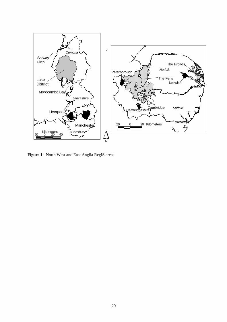
29
#
Manchester
#
Liverpool
#
Morecambe Bay
#
SolwayFirth
#
Norwich
#
The Broads
# The Fens
# Cambridge
#
Peterborough
20 0 20 40Kilometers
Cumbria
Cheshire
Lancashire
#
LakeDistrict
N
20 0 20 Kilometers
Suffolk
Norfolk
Cambridgeshire
Figure 1: North West and East Anglia RegIS areas

30
Figure 2: Illustrative output from the integrated impact models for East Anglia in the 2050s: (left)
Low climate change scenario linked with the Global Sustainability socio-economic scenario; and
(right) High climate change scenario linked with the Regional Enterprise socio-economic scenario

31
0
2000
4000
6000
8000
10000
12000
14000
Baseline 2050sLow
2050sLow(GS)
2050sHigh
2050sHigh(RE)
Are
a(k
m2)
Setaside
Grass
Arable_other
Sugar Beet & Potatoes
Cereals
Other
Urban area
Forestry
0
2000
4000
6000
8000
10000
12000
14000
16000
Baseline 2050s Low 2050s Low(GS)
2050sHigh
2050sHigh (RE)
Are
a(k
m2)
Grass
Arable
Other
Urban area
Forestry
Figure 3: Land use areas in (top) East Anglia and (bottom) the North West under the Low and High
climate change scenarios for the 2050s both with and without changes in future socio-economic
conditions. [GS = Global Sustainability socio-economic scenario; RE = Regional Enterprise socio-
economic scenario.]

32
Figure 4: Effect of climate on nitrate application, nitrate leaching and irrigation requirement in the
East Anglia under the Low and High climate change scenarios for the 2050s both with and without
changes in future socio-economic conditions. [GS = Global Sustainability socio-economic scenario;
RE = Regional Enterprise socio-economic scenario.]
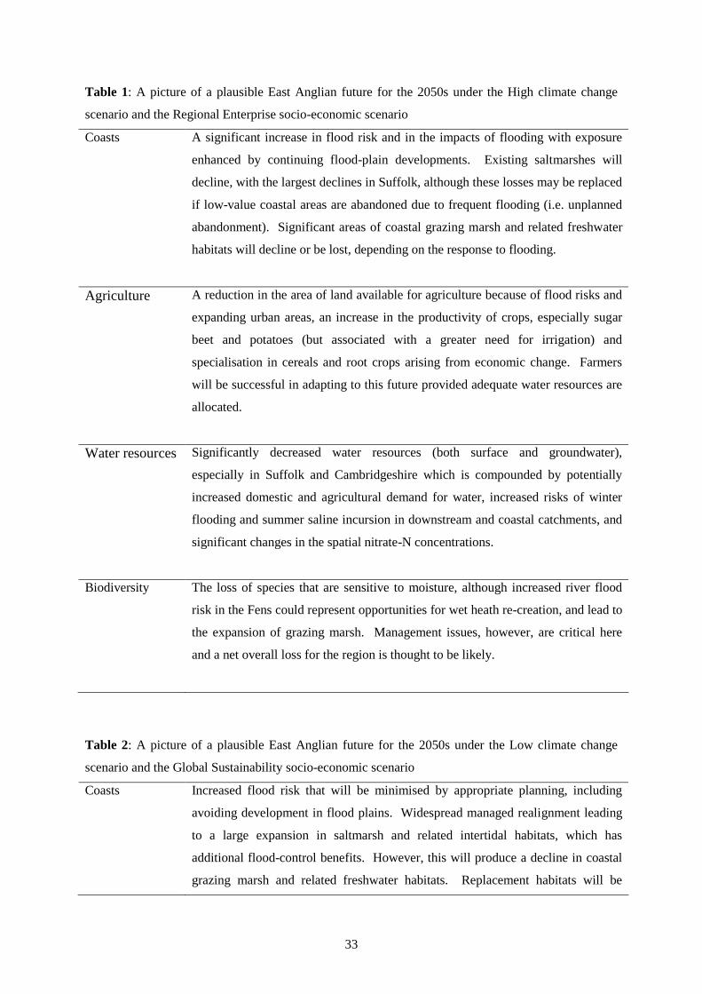
33
Table 1: A picture of a plausible East Anglian future for the 2050s under the High climate change
scenario and the Regional Enterprise socio-economic scenario
Coasts A significant increase in flood risk and in the impacts of flooding with exposure
enhanced by continuing flood-plain developments. Existing saltmarshes will
decline, with the largest declines in Suffolk, although these losses may be replaced
if low-value coastal areas are abandoned due to frequent flooding (i.e. unplanned
abandonment). Significant areas of coastal grazing marsh and related freshwater
habitats will decline or be lost, depending on the response to flooding.
Agriculture A reduction in the area of land available for agriculture because of flood risks and
expanding urban areas, an increase in the productivity of crops, especially sugar
beet and potatoes (but associated with a greater need for irrigation) and
specialisation in cereals and root crops arising from economic change. Farmers
will be successful in adapting to this future provided adequate water resources are
allocated.
Water resources Significantly decreased water resources (both surface and groundwater),
especially in Suffolk and Cambridgeshire which is compounded by potentially
increased domestic and agricultural demand for water, increased risks of winter
flooding and summer saline incursion in downstream and coastal catchments, and
significant changes in the spatial nitrate-N concentrations.
Biodiversity The loss of species that are sensitive to moisture, although increased river flood
risk in the Fens could represent opportunities for wet heath re-creation, and lead to
the expansion of grazing marsh. Management issues, however, are critical here
and a net overall loss for the region is thought to be likely.
Table 2: A picture of a plausible East Anglian future for the 2050s under the Low climate change
scenario and the Global Sustainability socio-economic scenario
Coasts Increased flood risk that will be minimised by appropriate planning, including
avoiding development in flood plains. Widespread managed realignment leading
to a large expansion in saltmarsh and related intertidal habitats, which has
additional flood-control benefits. However, this will produce a decline in coastal
grazing marsh and related freshwater habitats. Replacement habitats will be

34
encouraged in more sustainable inland locations, but the full implications of this
change are not currently understood.
Agriculture An agricultural sector with increasing productivity of sugar beet and potatoes, and
a greater need for irrigation, with more break crops arising from the economic
change. Farmers will be successful in adapting to this future provided adequate
water resources are available.
Water resources Slightly decreased water resources (both surface and groundwater), slightly
increased seasonality in river flows (lower in the summer, higher in the winter
especially in coastal catchments) and slightly improved water quality with respect
to nitrate-N concentration
Biodiversity Fairly stable biodiversity with only small habitat changes, with the exception of
salt marsh and coastal grazing marsh, where managed realignment could lead to
significant habitat gains and losses, respectively.
Table 3: A picture of a plausible North West for the 2050s under the High climate change scenario
and the Regional Enterprise socio-economic scenario
Coasts A significant increase in the extent and impacts of flooding: significant areas of
21st Century developments are in the flood plain and hence exposed to these
problems. Existing saltmarshes are stable at the regional scale, although there are
likely to be localised gains and losses. Significant areas of low-lying, low-value
coast will be flooded more than once per year. This suggests that these areas will
be abandoned leading to unplanned saltmarsh gains. These areas contain coastal
grazing marsh and related freshwater habitats which will decline or be lost,
depending on the human response to the flooding.
Agriculture An agricultural sector with increasing areas under sugar beet and potatoes that
have little need of irrigation, but which will require suitable market outlets, and a
change from grassland to arable arising from the reduced competitiveness of dairy
farming due to the economic scenario, but also due to the increased availability of
arable options arising from climate change. Even in the uplands, the arable area
35
may increase from 8% to 18%.
Water resources Slightly increased surface water resources, but increased seasonality in river flows
(lower in the summer, higher in the winter) which is compounded by an increased
population and potentially higher domestic water demand, especially in the south
of the region and in parts of Cumbria.
Biodiversity A loss of biodiversity because of the sensitivity to climate change of Arctic-Alpine
habitat and other species with a northern distribution, although this loss will be
balanced by species migrating northwards or to higher altitudes. Upland hay
meadows, however, will be under increasing pressure from agriculture, and bogs
in the southern part of the region may experience lower water availability,
although salt marshes will not be adversely affected.
Table 4: A picture of a plausible North West future for the 2050s under the Low climate change
scenario and the Global Sustainability socio-economic scenario
Coasts An increasing flood risk, which is minimised by appropriate planning, including
avoidance of development in flood plains. There will be managed realignment
along the coasts, leading to a large expansion in saltmarsh and related intertidal
habitats at the expense of coastal grazing marsh and related freshwater habitats.
The full implications of this change are not currently understood, including what
might be required in terms of replacement habitat.
Agriculture An agricultural sector with a large reduction in the area of permanent grass, which
becomes arable cropping (5% arable land use becomes 17%). The profitability of
break crops relative to cereals, however, means that the increased arable area is
taken-up by peas, beans, rape, sugar beet and linseed. The sugar beet has little
need of irrigation, but will require suitable market outlets. As a proportion of the
total arable area, there is a considerable reduction in cereals but the proportion of
wheat, which is now the most profitable cereal crop, is largely unchanged. In the
upland areas 8% arable becomes 24% arable.
Water resources Little change in water resources, with the exception of the southern part of the
region and the northern fringe of the Lake District where there will be slight
decreases and slightly improved surface water quality with respect to nitrate-N

36
concentration.
Biodiversity A loss of biodiversity because of the sensitivity to climate change of Arctic-Alpine
habitat and other species with a northern distribution, although this loss will be
balanced by species migrating northwards or to higher altitudes. On the whole,
biodiversity will prosper with favourable conditions for upland hay meadows,
bogs and, particularly, salt marshes.
Table 5: Relative sea-level rise scenarios (cm) referenced to the base year of 1990 (adapted from
Hulme and Jenkins, 1998).
Scenario North
West
East
Anglia
Low 09 16
High 64 71
Table 6: Regional averages of return periods calculated for the present 100-year event.
East Anglia North WestGlobal sea-level
rise scenario Average (years) Range (years) Average (years) Range (years)
2050s Low 72 64 - 78 68 63 - 71
2050s High 5 2 - 8 6 3 - 8
Table 7: Order of magnitude effects of the scenarios on average annual damages to properties in the
North West and Anglian Regions of the Environment Agency (based on Halcrow Maritine et al.,
2000) under the Low and High climate change scenarios for the 2050s both with and without changes
in future socio-economic conditions. GS = Global Sustainability socio-economic scenario; RE =
Regional Enterprise socio-economic scenario...
Protection Region Flood Average Annual Damages to Properties (£millions/yr)

37
Scenario Type 1990s 2050s
Low
2050s
Low
GS
2050s High 2050s
High
RE
Fluvial 55 69 69 275 380
Sea/Tidal 22 30 30 430 574
Anglian
Total 77 99 99 705 954
Fluvial 19 24 24 96 145
Sea/Tidal 19 28 28 313 438
Maintaining
present levels
of protection
North
West
Total 38 52 52 409 583
Fluvial 31 39 39 155 214
Sea/Tidal 8 11 11 162 216
Anglian
Total 39 50 50 317 430
Fluvial 7 9 9 35 53
Sea/Tidal 3 4 4 45 63
Meeting
indicative
standards
North
West
Total 10 13 13 80 116
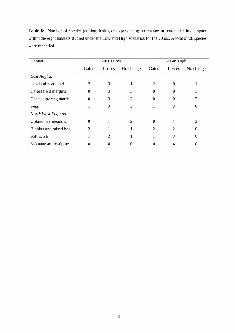
38
Table 8: Number of species gaining, losing or experiencing no change in potential climate space
within the eight habitats studied under the Low and High scenarios for the 2050s. A total of 28 species
were modelled.
Habitat 2050s Low 2050s High
Gains Losses No change Gains Losses No change
East Anglia:
Lowland heathland 2 0 1 2 0 1
Cereal field margins 0 0 3 0 0 3
Coastal grazing marsh 0 0 3 0 0 3
Fens 1 0 3 1 3 0
North West England:
Upland hay meadow 0 1 2 0 1 2
Blanket and raised bog 2 1 1 2 2 0
Saltmarsh 1 2 1 1 3 0
Montane arctic-alpine 0 4 0 0 4 0
Top Related
Copyright © 2022 FDOKUMEN

